ninth annual gulf of mexico information transfer meeting
TRANSCRIPT

via oiuay M M S 89-0060
Proceedings: Ninth Annual Gulf of Mexico Information Transfer Meeting
October 1988
I ) i i
-- j
g ~ AL 4 ,, I
l
TX ~ LA ` --r -_-
FL No~phlet p 2 O `~;(M) ~:
:B . (P) ,
. v wv 3 -Ty,, w.
I `1
<, ; x ; . . k`~~~`r F vc,< STR &STRAT
5
6
SCALE o So ,00 M,~, p _ o 0 BO 40 KiM-
FUTURE HYDROCARBON POTENTIAL
- - -- U.S . Department of the Interior //R Minerals Management Service II/ "K7 Gulf of Mexico OCS Region

OCS Study MMS 89-0060
Proceedings : Ninth Annual Gulf of Mexico Information Transfer Meeting
October 1988
Doubletree Hotel New Orleans
October 25-27, 1988
Compiler
Geo-Marine, Inc .
Prepared under MMS Contract 14-12-0001-30305 by Geo-Marine, Inc. 1316 14th Street Plano, Texas 75074
Published by
U.S . Department of the Interior Minerals Management Service New Orleans Gulf of Mexico OCS Regional Office December 1989

DISCLAIMER
This report was prepared under contract between the Minerals Management Service (MMS) and Geo-Marine, Inc . This report has been technically reviewed by the MMS and approved for publication . Approval does not signify that contents necessarily reflect the views and policies of the Service, nor does mention of trade names or commercial products constitute endorsement or recommendation for use . It is, however, exempt from review and compliance with MMS editorial standards .
REPORT AVAILABILITY
Preparation of this report was conducted under contract between the MMS
and Geo-Marine, Inc . Extra copies of this report may be obtained from the Public Information Unit (Mail Stop OPS-3-4) at the following address :
U.S . Department of the Interior Minerals Management Service Gulf of Mexico OCS Regional Office 1201 Elmwood Park Boulevard New Orleans, Louisiana 70123-2394
Attention : Public Information Unit (OPS-3-4)
(Telephone Number : (504) 736-2519)
CITATION
This study should be cited as :
Minerals Management Service . 1989 . Proceedings : ninth annual Gulf of Mexico information transfer meeting, October 1988 . U .S . Dept . of
the Interior . Minerals Management Service . New Orleans, La . MMS Contract No . 14-12-0001-30305 . OCS Study/MMS 89-0060 . 430 pp .
ABOUT THE COVER
Cover artwork is from the abstract presented by Dr . Pulak Ray, Minerals Management Service, Gulf of Mexico OCS Regional office, at the Ninth Annual Information Transfer Meeting, October 1988 . The original figure appears on page 12 in the following proceedings .
iii

PREFACE
This Proceedings volume presents summaries of the presentations and discussions of the Ninth Annual Information Transfer Meeting (ITM) held on October 25-27, 1988, in New Orleans, Louisiana . These ITM's have been sponsored by the Minerals Management Service (MMS), Gulf of Mexico Regional OCS Office, annually since 1980 in support of the OCS oil and gas program to foster exchange of information among participants, including MMS staff ; invited speakers from academic institutions, Federal and State agencies, industry, conservation groups, and knowledgeable individuals ; contractors for MMS-funded environmental and socioeconomic studies ; and the audience of general invitees . This volume includes session overviews by the respective session chairpersons, each of which is followed by short accounts of presentations by the authors .
The Minerals Management Service wishes to thank all ITM participants : the MMS staff responsible for planning and conducting the meeting ; the invited speakers who have given their time and energies to share information with all attendees ; and to the staffs of Geo-Marine, Inc . and the Doubletree Hotel, who have provided excellent logistical support for the meeting . The Minerals Management Service also thanks Geo-Marine, Inc . and the Economic Development Council and its Petroleum Committee of the Chamber of Commerce/New Orleans and River Parishes, who each provided attendees with an enjoyable reception .
The Minerals Management Service invites comment and constructive criticism on the annual Information Transfer Meetings and the resulting Proceedings documents .
v

TABLE OF CONTENTS
Page
Preface
List of Figures
List of Tables xiii
SESSION 1 - Opening Plenary Session : Dr . Richard Defenbaugh and Mr . Ruben G . Garza, Co-Chairs 1
SESSION 2 - Wetlands Concerns : Dr . Robert M. Rogers, Dr . Norman Froomer, and Mr . Patrick Mangan, Co-Chairs 17
SESSION 3 - Oil Spill Control and Cleanup : Mr . Gerard H . Schonekas, Ms . Darice K. Breeding, and Ms . Susan Gaudry, Co-Chairs 41
SESSION 4 - Marine Mineral Resources in the Northern Gulf of Mexico : Mr . Gary L . Lore and Dr . Chacko J . John, Co-Chairs 71
SESSION 5 - Contributed Papers : Current Gulf of Mexico Marine Research : Dr . Richard Defenbaugh, Dr . Nancy N. Rabalais, and Dr . Ann Scarborough Bull, Co-Chairs 117
SESSION 6 - Chemosynthetic Communities : Dr . Robert M. Avent, Dr . Robert S . Carney, and Mr . Gary D . Goeke, Co-Chairs 163
SESSION 7 - Risk Perception, Assessment, and Management : Mr . J . Kenneth Adams, Mr . Joseph Christopher, and Mr . John Rodi, Co-Chairs 201
SESSION 8 - Marine Ecosystems Studies : Dr . Robert M . Rogers, Mr . Charles Hill, and Mr . Gary Goeke, Co-Chairs 263
SESSION 9 - Geographic Information Systems (GIS) and Data Sources : Mr . Joe K. Perryman, Ms . Janice Blake, and Ms . Bonnie Johnson, Co-Chairs 293
SESSION 10 - Indirect Economic Impacts of Gulf of Mexico Hydrocarbon Activity Decline on Nonhydrocarbon Industry Sectors : Mr . John Rodi, Ms . Bonnie Johnson, Ms . Janet Reinhardt, and Ms . Vicki Zatarain, Co-Chairs 321
SESSION 11 - Mississippi/Alabama Shelf Marine Ecosystems Study : Dr . Robert M. Rogers, Mr . Charles Hill, and Dr . Ann Scarborough Bull, Co-Chairs 383
LIST OF ATTENDEES 405
vii

List of Figures
No . Paste
1 .1 History of exploration and development of OCS Gulf of Mexico
1 .2 Production trends OCS Gulf of Mexico 9
1 .3 Future hydrocarbon potential of the OCS Gulf of Mexico 12
2 .1 Comparison of the relative concentrations of selected compounds detected in a produced water discharge from the Bayou Rigaud study area 29
2 .2 Bayou Rigaud location map with total PAH saturated hydrocarbon concentrations for October 1987 31
2.3 Number of individuals of macroinfauna and number of species of macroinfauna for Bayou Rigaud, October 1987 32
3 .1 The "mast shadow" artifact caused by the mounting of the radar unit just forward and starboard of the ship's mast 52
3 .2 A five-barrel slick is visible at 11 o'clock (350 degrees relative) 52
3 .3 A slick is clearly visible from 6 to 7 o'clock (180-200 degrees relative) even though partially obscured by the mast shadow 53
3 .4 The mast artifact from 6 to 7 o'clock (180-200 degrees relative) 53
4 .1 Two distinct growth rate intervals identified for sand and gravel and crushed stone during 1948-1987 84
4 .2 Map of the EEZ for the conterminous U .S . showing the occurrence of marine sand and gravel 95
4 .3 Map of the northwestern Gulf of Mexico continental shelf and slope 95
4.4 Location of the USGS/I4SS southwest Louisiana and southeast Louisiana and Mississippi seismic data sets 100
4 .5 Location of 14 seismic and vibracores surveys in southcentral and southeast Louisiana collected cooperatively by the U .S . Geological Survey and Louisiana Geological Survey 100
4 .6 Sediment distribution map of the study area 105
ix

List of Figures (cont'd)
No . Page
5 .1 Surface chlorophyll values (mg- m3) at individual stations were up to twenty times greater in frontal water than in plume or shelf waters 131
5 .2 Total ichthyoplankton catch per 10 min neuston tow at frontal water, plume water, and shelf water stations along a typical transect of the turbidity front 132
5 .3 Sampling stations for larval gulf menhaden otolith analysis 135
5 .4 Linear least squares regressions of larval gulf menhaden age versus total length in millimeters for the combined January through April 1982 data from western Louisiana and for March 1986 data from the eastern part of the State 137
5 .5 Clustering of LOOP bongo samples 140
5 .6 Clustering of LOOP plankton taxa 140
5 .7 Locations, sizes, and orientations of Gulf of Mexico study areas 144
5 .8 Sea turtle and platform locations in Study Area 1 144
5 .9 Mean number of individuals per collection date at four stations off southeastern Louisiana from June 1985 through August 1986 149
5 .10 Change in composition of five dominant species at station C5 from June 1985 through August 1986 150
5 .11 Relationship between number of species per core and bottom water dissolved oxygen concentration at time of sample collection 152
5 .12 Temperature contours across the western eddy 156
5 .13 Temperature contours across the eastern eddy 158
5 .14 Distribution of zooplankton <333p across the western eddy 159
5 .15 Distribution of chlorophyll A across the western eddy 159
5 .16 Distribution of larval fish across the western eddy 160
x

List of Figures (cont'd)
No . Page
5 .17 Distribution of fish eggs <333p across the western eddy 160
5 .18 Distribution of zooplankton <333p across the eastern eddy 161
5 .19 Distribution of chlorophyll A across the eastern eddy 161
6 .1 Anchor and chain impact areas 198
6 .2 Typical anchor pattern 199
7 .1 Risk/benefit information 212
7 .2 Paths of risk communication 213
7 .3 Ladder of citizen participation 227
7 .4 Classical risk analysis method 230
7 .5 Evolution of safety studies 231
7 .6 Gullfaks A platform 234
7 .7 AIM approach to requalifications of existing platforms 236
7 .8 Example drilling and production platform 238
7 .9 Reliability based assessment of future demands (hurricane lateral forces) 240
7 .10 Reliability based assessment of platform capacities for different AIM alternatives 240
7 .11 Commercial evaluation of alternatives 241
7 .12 Regulatory evaluation of alternatives 241
7 .13 Example of qualitative hazards/risks categorization (MIL-STD-8) 259
7 .14 Outline and interactions of risk management responsibilities 260
8 .1A Bathymetric map of the Marquesas Keys area west of Key West, Florida, showing locations of old well sites discussed in text 270
xi

List of Figures (cont'd)
No . Page
8 .1B General bathymetry and location of two wells drilled in Charlotte Harbor area off west coast of Florida 270
8 .2 Previous studies and suspected communities in and near study area 276
8 .3 Location of 19 permanent seagrass growth monitoring stations 278
8 .4 Study area for the synthesis effort 281
8 .5 Locations of hardbottom study areas 284
8 .6 Mean percent change at Gulf of Mexico mussel watch sites for selected contaminants between Years I and II 289
10 .1 U .S . oil market outlook 340
10 .2 Simple 14-equation model developed to illustrate the mechanics and nuances of an energy-driven economy 346
10 .3 Scenario I--oil prices rise and remain at high levels 347
10 .4 Scenario II--oil prices rise and then fall to previous levels 349
10 .5 Scenario III--oil prices rise so as to keep employment constant 350
10 .6 Retail sales vs . oil price--Texas 355
10 .7 Retail sales vs . oil price--Louisiana 357
11 .1 The Mississippi-Alabama study area indicating sampling transects 389
xii

List of Tables
No . Paste
2 .1 Six mayor concerns of the government agencies regulating marsh management 37
4 .1 Main research elements of USGS marine program 93
4.2 Estimates of sand and gravel resources within part of the U .S . exclusive economic zone 96
5 .1 Gulf of Mexico study area characteristics 145
5 .2 Estimated densities of a few marine animals 145
5 .3 Station location for transect #1 across the western eddy and transect #2 across the eastern eddy 156
6 .1 Published d 13C values for some hydrothermal-vent, hydrocarbon-seep, and other vesicomyids and vestimentiferans with chemosynthetic symbionts 186
7 .1 Credit Score = Odds 253
7 .2 Risk management modeling techniques 254
8 .1 Well sites for the Florida Keys diving survey 271
8 .2 Mussel watch Years I and II average concentrations in oysters and sediments 288
9 .1 Existing systems 305
9 .2 List of contact persons and systems 310
9 .3 MARIS GIS data elements 313
9 .4 Data available through TNRIS 317
10 .1 Trends in hotel occupancy and room rates in Louisiana and Texas cities 380
11 .1 Sediment analyses 397
11 .2 Location of study area for side scan coverage and selective video reconnaissance of topographic features 402
xiii

OPENING PLENARY SESSION

Session : OPENING PLENARY SESSION
Co-Chairs : Dr . Richard Defenbaugh Mr . Ruben G . Garza
Date : October 25, 1988
Presentation Author/Affiliation
Opening Plenary Session Overview Dr . Richard Defenbaugh Minerals Management Service Gulf of Mexico OCS Region
Gulf of Mexico Production Trends and Deepwater Potential
Deepwater Oil and Gas Developments
Dr . Pulak Ray Minerals Management Service Gulf of Mexico OCS Region
Mr . Don Howard Minerals Management Service Gulf of Mexico OCS Region
3

Opening Plenary Session Overview
Dr . Richard Defenbaugh Minerals Management Service Gulf of Mexico OCS Region
The primary purposes of the Opening Plenary Session are to welcome attendees to the Information Transfer Meeting (ITM) and to initiate the meeting with one or two major presentations that are of interest to a broad cross-section of meeting attendees, and are pertinent to the interests of the Minerals Management Service's (MMS) Gulf of Mexico Outer Continental Shelf (OCS) Regional Office .
The ITM was called to order by Mr . Garza, who welcomed attendees, introduced the staff responsible for meeting logistical support, made appropriate housekeeping announcements, and introduced Dr . Defenbaugh who discussed the purposes and functions of the ITM and introduced subsequent speakers .
The primary purposes of the ITM are to provide a forum for "scoping" topics of current interest or concern relative to environmental assessments or studies in support of offshore oil and gas activities in the Gulf of Mexico OCS Region ; to present the accomplishments of the MMS Environmental Studies Program for the Gulf of Mexico and of other MMS research programs or study projects ; to foster an exchange of information of regional interest among scientists, staff members, and decisionmakers from MMS, other federal or state governmental agencies, regionally important industries, and academia ; and to encourage opportunities for attendees to meet and develop or
nurture professional acquaintances and peer contacts .
The ITM agenda is planned and coordinated each year by the MMS Gulf of Mexico OCS Regional Office staff around the three themes mentioned above--issues of current interest to the Region or the MMS oil and gas program ; accomplishments of the agency ; and regional information exchange . All presentations are invited, through personal contacts between session chairpersons and the speakers, and meeting support funding is provided through the MMS Environmental Studies Program . All meeting logistical support is provided by a contractor (Geo-Marine, Inc .) and subcontractors selected through the usual federal procurement process . A proceedings volume is prepared for each ITM, based on abstracts or brief technical papers submitted by each speaker and on session overviews prepared by each session chairperson .
Mr . Pearcy, Regional Director of the MMS Gulf of Mexico OCS Region, formally welcomed the audience on behalf of the MMS and extended a special welcome to members of the MMS OCS Advisory Board's Gulf of Mexico Regional Technical Working Group and Scientific Committee, and to participants in the MMS Managerial Development Program .
Our two Plenary speakers were Dr . Pulak Ray and Mr . Don Howard, both of the MMS Gulf of Mexico OCS Regional Office, who spoke on differing aspects of the future of offshore oil and gas operations in the Gulf of Mexico, in "deepwater" areas .
Dr . Ray presented an excellent overview of OCS oil and gas production, including a brief
5

summary of historic milestones and of production statistics, and an illustrated discussion of current production trends for U.S . OCS Gulf of Mexico waters . On the continental shelf, the areas of greatest industry interest are found near the outer shelf or the shelf/slope break in the western and central Gulf (the Corsair and Flexure Trends, offshore Texas and Louisiana), and shelfwide in the Eastern Gulf OCS planning area (the Norphlet Trend, offshore Mississippi, Alabama, and the Florida Panhandle) . The other areas of high petroleum potential are in deepwater (greater than 600 ft water depth), especially offshore Texas and Louisiana . Dr . Ray's presentation clearly demonstrated that the Gulf of Mexico has been the mayor area of U.S . OCS oil and gas production for decades and will continue to be a major producer for decades to come .
Mr . Howard described and discussed the technology now in place, and now being developed for exploration, development, and production of oil and gas from deepwater areas of the Gulf of Mexico . He briefly recapped information on Gulf of Mexico deepwater areas of high oil and gas potential, then presented slides of the various structures and engineering systems the offshore industry is using or developing for use in these areas . He illustrated semisubmersible and drillship exploratory drilling platforms and four types of production platforms developed for sites with water depths ranging from about 1,000 to about 2,400 ft . The engineering technology showcased by Mr . Howard is very impressive and ambitious and demonstrates the offshore industry's ability to develop
technologies appropriate to an environment far from shore and very deep .
Plenary Session attendees learned from Dr . Ray and Mr . Howard that the future of oil and gas exploration and development for the Gulf of Mexico lies in the deepwater areas of the outer continental shelf and of the upper continental slope, that there seem to be significant oil and gas resources located in these areas, and that the offshore industry is today developing the technology to bring the resources of these areas "on-line" in the near future .
Dr . Richard Defenbaugh is Chief of the Environmental Studies Section of the MMS Gulf of Mexico OCS Regional Office . His graduate work on the natural history and ecology of continental shelf invertebrates at Texas A&M University lead to a M.S . in 1970 and a Ph .D . in 1976 . He has been involved with the MMS/BLM environmental studies and assessment programs since 1975 .
Gulf of Mexico Production Trends and Deepwater Potential
Dr . Pulak Ray Minerals Management Service Gulf of Mexico OCS Region
INTRODUCTION
The history of the exploration and development of the Gulf of Mexico dates back to the 1920's . Since the introduction of federal OCS lease sales in 1954, more than 25,000 wells have been drilled . Currently close to 20 million acres are under lease . The introduction of areawide lease sales in 1983,
6

the lowering of minimum bids to $25 .00 per acre in 1987, the extension of lease terms for deep-water tracts from five to ten years, and passage of the National Gas Policy Act (1978) have had a significant cumulative positive impact on the leasing and exploration activity of the Gulf . Before the implementation of areawide lease sales, 95% of the tracts were leased in water depths less than 600 ft . Since 1984, only 50 to 60% of the tracts leased in the western and central Gulf were in less than 600 ft water depth . The number of tracts leased in water depths between 600-3,000 ft stabilized at around 10$ in the central Gulf . The percentage of tracts leased in deeper water (>3,000 ft) has steadily increased, both in the central and western Gulf of Mexico . Even though extensive exploration and development have taken place, a significant portion of the geologic column (>12,000 ft) and geographic area (>600 ft water depth) still needs to be fully explored . Undiscovered resources from the partially, sparsely, and unexplored areas (Figure 1 .1) are expected to hold significant resources . A review of the production trends of the Continental Shelf and Upper Slope, and the potential of the deeper water areas, is presented in this paper .
PRODUCTION TRENDS
Pearcy and Ray (1986) presented the well-established shore-parallel production trends of the central and western Gulf of Mexico . These trends include Miocene, Pliocene, and Pleistocene sediments . The Pliocene trend is present only in the central Gulf (Figure 1 .2) . Of more than 12,000 reservoirs studied, the majority are of Upper
Miocene, Pliocene, and Pleistocene age in the central Gulf, and Middle Miocene and Pleistocene age in the western Gulf . In the central Gulf, even though the younger reservoirs predominate, they are smaller in size (<6,000 acre-ft per reservoir) than the older Miocene reservoirs . The recoverable reserves of liquid (oil and condensate) in the western Gulf are primarily contributed by the Pleistocene reservoirs (about 355 million barrels), Lower and Middle Miocene reservoirs account for 50 and 60 million barrels (mmbbls) each, and the Upper Miocene contributes 13 mmbbls . In the central Gulf, the Pleistocene, Pliocene, and Upper Miocene reservoirs contribute about evenly between 3-3 .6 billion barrels each, while Middle and Lower Miocene account for less than 1 billion barrels . The recoverable gas reserves of the western Gulf are contributed primarily by Pleistocene, Middle Miocene, and Lower Miocene reservoirs . Pleistocene being the dominant contributor (about 9 trillion cubic ft), Pliocene and Upper Miocene account for less than 1 trillion cubic ft (TCF) of gas reserves . In the central Gulf, while Pleistocene reservoirs are the dominant contributor to the total recoverable reserve, Pliocene, Upper Miocene, and Middle Miocene account for 16 to 22 TCF each . Less than 3 TCF of gas is contributed by the Lower Miocene reservoirs .
Some of the hottest plays of the Continental Shelf and Upper Slope of the Gulf of Mexico include the Corsair trend of the western Gulf, Flexure trend of the central Gulf, and Jurassic Norphlet trend of the eastern Gulf . The Corsair trend is a Middle Miocene geopressured gas play where production depth
7

00
Figure 1.1 . History of exploration and developssnt of OCS Gulf of Mexico .
---- Syr.Term-~Byr.Termf--tOyr,Term -----'---'

34
MISSISSIPPI ALABAMA _--
-' _ ~ I `0U'S'""" MESOZOIC PROVINCE
300- N JURASSIC
CRETACEOUS MIOCENE AND OLDER
t NNI N".
OW POTENTIAL FLORIDA L FLORID
PLIOCENE RETACEOUS AND OLDER
PLEISTOCENE SHELF IGH POTENTIA
IA
%0 280-
PLEISTOCENE SLOPE
/
M C
WESTERN CENTRAL EASTERN MIOC
,r
ENEI I LOW PLANNING AREA PLANNING AREA PLANNING AREA POTENTIALI 10 LO I
260- kLOWER CRETACEOUS
SUNNILAND
r CENOZOIC PROVINCE
GULF OF MEXICO cues 1"
98° 96° 94° 92° 90° 88° 86° 84° 82°
Figure 1.2 . Production trends OCS Gulf of Mexico .

ranges from 8,000 to 16,000 ft . The reserve has been variously estimated at about 2 TCF . The plays of the Corsair trend are associated with paleoshelf margin deltaic deposits present on the downthrow side of a listric growth fault system . The exploration and development activities are plagued with the high cost of deep drilling, falling gas prices, and corrosive gas content . The first discoveries of the Jurassic Norphlet trend were made in the state waters of Alabama . In the federal waters thicknesses of reservoir quality sand up to 1,000 ft have been encountered . The depth of expected producing horizons range from 16,000 to 21,000 ft . The first discovery of the Norphlet trend in the federal waters was announced in 1988 in Destin Dome Block 111 (Amoco) followed by the discovery of Destin Dome Block 56 (Chevron) . The Flexure trend, which is located on the Upper Continental Slope, is both a gas and oil play . A total of 72 wells have been qualified as producible . Fifty-five fields have already been established . The Pliocene and Pleistocene pay thickness of this play ranges from 75 ft to in excess of 200 ft at a depth of 8,000 to 18,000 ft . The first discovery in this trend was the Cognac field located in Mississippi Canyon Block 194 (Shell) . The Flexure trend is characterized by an intense episodic salt activity which includes both vertical and lateral movement .
DEEPWATER POTENTIAL
The Continental Slope of the northern Gulf of Mexico represents an area of high hydrocarbon potential . Exploration of the shallow water portion of the slope
has met with extreme success . At least 16 oil and/or gas fields have been discovered in this area between East Breaks and Viosca Knoll at water depths between 600 to 1,500 ft . Recent drilling at water depths exceeding 7,500 ft clearly indicates that the exploration of the entire Continental Slope is well within technological limitations .
The reservoir rocks in the slope area are Cenozoic clastics, consisting of turbidite sands, slump, and other mass wasting deposits and intraslope blocked canyon sediments . Reservoir quality sediments are expected to be present in the entire geologic column from the Mesozoic to Quaternary . However, the Quaternary section, except in the Mississippi fan area, thins considerably in the deeper water areas . The Lower Miocene and Early Tertiary sections in the east central Gulf are also extremely thin and totally absent in some cases . The Mesozoic reservoir rocks are expected to be reefs, reef talus, limestone, and dolomites .
Dolan (1986) presented a cursory look at the structural styles and traps of the Continental Slope of the northern Gulf Basin . He indicated that the structures of the area between East Breaks to western Green Canyon are related to intense vertical and lateral salt movements . He also emphasized the importance of stratigraphic traps in the Mississippi Canyon area . Based on the interpretation of thousands of miles of CDP seismic lines, limited releasable well logs, and published literature, certain generalizations can be made regarding the future
10

hydrocarbon prospects for the Gulf of Mexico slope (Figure 1 .3) .
The future hydrocarbon prospects for the East Breaks area may range from Miocene to Pleistocene in age . Structures related to dip reversal near the mid-to-upper slope seem to be very prospective . The Alaminos Canyon area contains large-scale structures . Foote et al . (1983), in describing the Perdido Fold Belt, suggested Oligocene to Miocene as the time of uplifting of these structures . Presence of possible Middle Miocene submarine canyons in the Brazos area, as interpreted from seismic data, suggests possible conduits of reservoir-quality deep water sands for the Alaminos Canyon area . Even though both suitable structures and reservoir rocks are present, the hydrocarbon exploration of the upper slope area of Garden Banks has not been as successful as in the Green Canyon and Mississippi Canyon areas . Future discovery potential of hydrocarbons from Mississippi Canyon, Green Canyon and Atwater Valley areas is high . Both suitable structures and reservoir rocks are believed to be present in these areas . In addition to structural traps, stratigraphic traps are of equal importance in this area . In the lower slope portion of this area, the section below salt tongues may also have high potential .
CONCLUSIONS
Even though the Gulf of Mexico OCS has had a long history of exploration and development, a significant portion of the stratigraphic section and geographic area still remains to be explored . Expected resource discovery from the unexplored area
may be of significant importance . The area of high hydrocarbon potential includes the deeper water (>600 ft) Pliocene, Pleistocene, and Miocene sediments ; deep lower Middle Miocene and Lower Miocene sediments of the inner shelf ; and shallow bright-spot-associated shelf sediments .
REFERENCES
Dolan, P . 1986 . Deep water (200-1,800 meters) hydrocarbon potential of the U .S . Gulf of Mexico . AAPG Memoir 40 . pp . 243-268 .
Foote, R.Q ., R . G . Martin, and R. B . Powers . 1983 . Oil and gas potential of the maritime boundary portion in the central Gulf of Mexico . Bulletin AAPG 67(7) :1047-1065 .
Pearcy, J.R . and P .K . Ray . 1986 . The production trends of the Gulf of Mexico : exploration and development . Gulf Coast Association of Geological Societies Transactions 36 :263-273 .
Dr . Pulak Ray is supervisor of the Development Evaluation Unit of the Geological and Geophysical Section of the Gulf of Mexico OCS Region's Resource Evaluation Office . He received his Ph .D . in geology from Louisiana State University in 1971 . He has taught at the University of South Carolina, and at the State University of New York . He has worked for the MMS since 1981 .
11

r N
Figure 1 .3 . Future hydrocarbon potential of the OCS Gulf of Mexico . D .S .(P)(?i) refers to area of bright spot potential of Ylio-lleistocene (Y) and Miocene (M) age . Sigh potential areas are shaded .

Deepwater Oil and Gas Developments
Mr . Don Howard Minerals Management Service Gulf of Mexico OCS Region
In the past several years the offshore oil and gas industry has shown extreme interest in deepwater exploration in the Gulf of Mexico . The industry has established record after record for drilling and production operations in water depths greater than 600 ft, which is what has been considered "deepwater ."
Prior to conducting exploration activities in the Gulf of Mexico, the operators must lease the mineral rights from the Federal Government . The first lease sale was held in 1954 and the most recent, held in August of 1988, was the 60th . Currently 1,658 deepwater tracts have been leased, encompassing over 6 million acres . The majority of these tracts have been leased since 1983 when areawide leasing was instituted .
The primary area of interest for the operators is the "flexure trend," which runs from the east central Gulf through the western Gulf in 600 ft to 7,500 ft of water . To date there have been over 70 discoveries made in the flexure trend . Seventeen of these discoveries currently have platforms installed or plans to install one in the near future .
In order to explore these deepwater tracts, mobile offshore drilling units (MODU's) of two types have been employed . The semisubmersible MODU has been the workhorse of deepwater exploration . It is a floating drilling platform built
on pontoons for buoyancy and ease of transporting . Once over the desired location, it is lowered to its working position by flooding ballast chambers and moored in place using eight to ten mooring lines connected to anchors . The other type of vessel used for deepwater exploration is the drillship . It resembles a conventional ship with a drilling rig centered on it . It can be anchored to the bottom in the same manner as a semisubmersible or held on location using six to eight thrusters attached to the ship's hull .
There are four unique types of structures being used in the Gulf of Mexico today .
The first is the guyed tower installed by Exxon in the late 1970's in Mississippi Canyon Block 28 in 1,025 ft of water . The guyed tower, known as the "Lena, " is a trussed structure that rests on the seafloor, extends upward to a deck supported above the waves, and is held in position by multiple guy lines . The unique mooring system holds the tower and platform almost completely stationary during typical operational sea states and allows the tower to move or become compliant in heavy seas . The tower is still being used to support production and workover operations in Mississippi Canyon Block 28 .
The second type of structure is exemplified by Shell Offshore Inc .'s 1,353 ft Green Canyon Block 65 "Bullwinkle" project . The jacket was constructed at Ingleside Point near Corpus Christi, Texas . The jacket was towed 332 miles to the site and installed on May 31, 1988 . The deck sections were completely installed on October 5, 1988 . Currently, Shell Rig 12 is
13

being installed which is the first of the two rigs planned for installation . With the two rigs installed, the entire structure will stand approximately 1,615 ft tall . It will be the tallest structure in the world, surpassing the Sears Tower in Chicago by 161 ft . Development drilling will begin in the first quarter of 1989 and is scheduled to be completed in late 1990 . Peak oil production is expected in 1991 at 50,000 barrels of oil per day (BOPD) and peak natural gas production in 1992 at 90 million standard cubic ft per day (SCFD) .
The third structure discussed is Placid Oil Company's floating production system (FPS) located in Green Canyon Block 29 and its shallow water central processing platform (CPP) in Ship Shoal Block 207 . The FPS system began production in the first half of October 1988 when satellite Well No . 1 in Ewing Bank Block 999 in 1,460 ft of water was put on line . The FPS system consists of subsea trees, a subsea production template, a production riser flowlines/pipelines, a semisubmersible drilling production facility, a mooring system, and the shallow water CPP . To date, the entire system has been installed with three satellite subsea wells connected to the subsea production template . Currently, one satellite well is on production with a second well in 2,437 ft of water scheduled to be placed on production the last week of October 1988 . This will set a new world water depth record for production .
The fourth project currently under construction for deepwater use to be discussed was Conoco Inc .'s tension leg well platform (TLWP) . The TLWP is to be located in Green
Canyon Block 184 . This TLWP was designed to do only those functions that are absolutely necessary at the deepwater site . All other functions will be performed at a second shallow water central processing platform . The drilling template was installed in June 1987 . The TLWP can accommodate 16 wells connected from the drilling template by rigid risers . The TLWP base template was installed in the fall of 1988 . Currently, a semisubmersible is drilling one of the planned 16 wells . The TLWP will be available for installation in May 1989 when the drilling of the production wells is scheduled to be completed . The entire system is scheduled to be completed in September 1989 for the start of oil and gas production . Peak production is expected to be 35, 000 BOPD and 50 million SCFD .
Alternative structures for deepwater drilling and production activities which are currently in the development stage are now being developed .
The project that is farthest along is the Ocean El Dorado being designed by Odeco . It is unique in the fact that it is a floating system with rigid risers and conventional surface trees . The El Dorado relies on the hydrodynamic performance of its hull to remain relatively transparent to the seaway . It will be a symmetrically-shaped, six column semisubmersible . Its operating draft will be 180 ft as compared to a 70 ft draft for a typical semisubmersible . This will reduce the hydrodynamic forces acting on the lower hull and increase the mass or displacement of the vessel thus making it harder to move . It is being designed for 30 wells and will be capable of
14

simultaneous drilling and production in water depths ranging from 1,000 ft to 8,000 ft .
Designs of various types of compliant towers are also being investigated . Examples are :
o Buoyant Tower - A tall slender tower fixed to the seabed with skirt piles and gaining stability by means of large buoyancy tanks attached near the top .
o Rosean Tower - A tall slender tower fixed to the seabed with skirt piles and gaining stability by means of large water masses trapped inside boxes built into the platform near the water surface (about 200 ft down) .
o Compliant Pile Tower - A tall slender tower fixed to the seabed with very long skirt piles (attached to the platform about 1/2 way up) and gaining stability from the spring effect of the long piles (piles stretch and compress as platform moves with the waves) .
Modif icat ions of FPS' s , TLWPIs, and fixed platforms are also being considered .
Mr . Don Howard is Supervisor of the Platform/Pipeline Unit of the Plans, Platforms, and Pipeline Section of the Gulf of Mexico OCS Region's Field Operations Office . He received his Bachelor of Industrial Engineering from Georgia Institute of Technology, and his M .S . in petroleum engineering from Tulane University . He has worked for the MMS for approximately 5-1/2 years, including positions as District Drilling Engineer and District Production Engineer, for
the MMS Gulf of Mexico OCS Region's Houma District Office .
15

WETIANDS CONCERNS

Session : WETLANDS CONCERNS
Co-Chairs : Dr . Robert M . Rogers Dr . Norman Froomer Mr . Patrick Mangan
Date : October 25, 1988
Presentation Author/Affiliation
Wetlands Concerns : Session Overview
Dr . Robert M . Rogers Minerals Management Service Gulf of Mexico OCS Region
Impacts of OCS-Related Activities on Sensitive Coastal Habitats
Impacts of OCS-Related Activities on Coastal Habitats : Produced Waters
One Company's Experiences with Wetlands Conservation
Wetlands Mitigation : A Study of Marsh Management
The Disappearing Mississippi River Delta
Dr . Karen M. Wicker Coastal Environments, Inc .
Dr . Nancy N. Rabalais Dr . Donald F . Boesch Louisiana Universities Marine
Consortium ; Mr . Charles S . Milan, Mr . Charles B . Henry, Mr . Jay C . Means, Mr . Robert P . Gambrell, and Mr . Edward B . Overton, Louisiana State University
Mr . W.L . Berry and Mr . G .J . Voisin The Louisiana Land and Exploration Company
Dr . Charles G . Groat Dr . Donald R. Cahoon Louisiana Geological Survey ; Mr . Darryl R. Clark Louisiana Department of Natural
Resources ; and Mr . James Wilkins Louisiana State University
Mr . H . Leighton Steward and Mr . Bill Berry The Louisiana Land and Exploration Company
19

Wetlands Concerns : Session Overview
Dr . Robert M . Rogers Minerals Management Service Gulf of Mexico OCS Region
The impacts of Federal Outer Continental Shelf (OCS) oil and gas activities related to onshore alterations in the coastal central Gulf of Mexico have been a concern of the Minerals Management Service (MMS) for a number of years . In the light of a declining economy from oil- and gas-related activities and accelerated wetlands loss affecting the habitat of valuable biological resources, many unsubstantiated claims were being made on who was responsible for the loss and who should be addressing the problem . In this emotional atmosphere, study planning was initiated in 1984 to investigate what factors contribute to wetlands loss and specifically what percentage of this loss is due to the approximately 125 OCS pipelines, several navigation canals, and a number of OCS support facilities located in wetland areas .
In September 1985, MMS contracted with the Center for Wetland Resources of Louisiana State University (LSU) to conduct a comprehensive study entitled "OCS Development and Potential Coastal Habitat Alteration ." This study was completed in early 1988 and has gone a long way toward describing the complex processes and interactions at work in the wetlands . Definitive partitioning of causes of wetland losses has been effectively accomplished and a groundwork has been laid for further testing hypotheses and
facing the problem of accelerated wetlands loss .
In October 1986, MMS contracted with Coastal Environments, Inc . to conduct a two-part study to determine the impacts of selected OCS activities on sensitive coastal habitats . The first part of this study was designed to research the impacts of Federal OCS pipelines and associated facilities and navigation channels on barrier beaches and barrier islands along the Gulf of Mexico from Cameron County, Texas to Bay County, Florida and on coastal wetlands within this region, except those areas addressed in the aforementioned wetlands loss study . Information obtained from this study was designed to predict impacts of future OCS activities in the region and to document measures that have been successful in mitigating impacts for specific habitats and environmental conditions . The second part of the study was a reconnaissance-level assessment of the impacts of OCS-produced water discharges in coastal wetlands, primarily Louisiana wetlands . This aspect of the study carried out by the Louisiana Universities Marine Consortium (LUMCON) and LSU Institute for Environmental Studies was designed to extend, update, and improve on an existing record inventory approach and provide a field assessment of the hypothesis that there are existing conditions that may have a locally severe adverse impact . This study is presently nearing completion with distribution of a final report scheduled for January 1989 .
A third study recently initiated by MMS to address the concern of wetlands loss has been "A Study of Wetlands Mitigation : Marsh
21

Management ." This study is being carried out by Cooperative Agreement with the Louisiana Department of Natural Resources . The primary focus of this study is to determine the most efficient marsh management techniques in light of a wide array of environmental conditions that may exist at a given site . This will be accomplished by a study of the overall coastal marsh environment in Louisiana and an examination of specific sites in a variety of physiographic settings within the study area . This study effort will extend for two years with completion scheduled for April 1990 .
The Wetlands Concerns session focused on these latter two studies as well as recent efforts by industry to manage and conserve their coastal lands . Vast quantities of Louisiana's wetlands are owned by oil and gas concerns and the stewardship of their lands will be instrumental in determining the fates of the coastal marshes .
Dr . Robert K. Rogers is a marine biologist on the Environmental Studies Staff of the MMS Gulf of Mexico OCS Regional Office . He has served as Contracting Officer's Technical Representative on a number of wetlands-related studies . Dr . Rogers received his B.S . and M .S . degrees in zoology from Louisiana State University and his Ph .D . in marine biology from Texas A&M University .
Impacts of OCS-Related Activities on Sensitive
Coastal Habitats
Dr . Karen M . Wicker Coastal Environments, Inc .
OBJECTIVE
The primary objective of this study is to research the type, extent, and cause of impacts of Outer Continental Shelf (OCS) related activities on sensitive coastal habitats . Coastal Environments, Inc . conducted that portion of the study involving OCS pipelines, navigation channels, and related facilities . Louisiana Universities Marine Consortium (LUMCON) investigated the effect of the discharge of OCS produced waters into coastal areas .
The area of study stretched from Cameron County, Texas to Bay County, Florida . The type of habitats investigated for evidence of impact included marshes and aquatic grassbeds in selected areas and all barrier islands and beaches .
The study sought to identify correlations between type of construction, environmental conditions at the construction site, and the type and magnitude of environmental impact associated with a particular OCS activity . This information, in addition to information on existing regulations governing activities in coastal areas, was used to predict future onshore impacts of OCS activities related to production in frontier areas of the Mississippi to Florida coast .
22

METHODOLOGY
Research consisted of four mayor tasks : (1) literature review and inquiries regarding identification, location, and description of OCS activities and physical, biological, and cultural conditions within the study area ; (2) air photo interpretation and quantification of parameters chosen to document impacts where they exist, such as shoreline change, canal width change, and habitat change between pipeline or navigation channel right-of-way (ROW) and control sites ; (3) investigations of differences or similarities between selected geologic, hydrologic, and vegetative parameters at the ROW and control sites for selected pipeline and navigation channels within each of the four coastal systems (i .e ., Texas Barrier Islands, Strand - Chenier Plain, Mississippi Deltaic Plain, and North Central Gulf Coast) ; and (4) documentation of Federal, State and local regulations presently governing installation of new facilities .
DISCUSSION OF PIPELINE IMPACTS
A review of literature identified at least eleven direct and fourteen indirect impacts attributed to non-backfilled and/or backfilled canals . This study was designed to investigate six of these direct impacts : (1) immediate habitat change and/or landloss, (2) alteration of preexisting drainage networks, (3) segmentation of natural physiographic units or forms, (4) breaching of foredunes and removal of vegetation, (5) creation of sediment sinks, and (6) creation of weak section in island at ROW . Four of the indirect impacts were investigated : (1)
erosion along canal banks and adjacent wetlands, (2) impoundment and flooding of marshland, (3) alteration and/or disruption of longshore drift, and (4) subsequent breaching of island or beach at ROW .
The type of construction technique, including mitigation measures taken to lessen environmental impacts, was thought to be a major factor influencing the type and magnitude of impact . Historically, there have been three major emplacement techniques : (1) upland trenching (higher area of barrier islands), (2) flotation canal (very unconsolidated wetland and shallow water bodies), and (3) push-pull canal (for relatively short, straight ROW in wetlands capable of supporting marsh buggies) .
Recently, a fourth technique, i .e ., directional drilling, has been utilized for short segments of line where environmental or socioeconomic conditions dictate the use . Such conditions include areas to be avoided : sensitive habitats ; areas where restoration costs are more expensive ; or areas with a conglomeration of cultural features such as roads, foreign pipelines, utilities, or preeminent utilization of site .
The method of canal closure can also influence impact . Types of closures include : (1) backfilling flotation and push-pull canals ; (2) damming all canals at Gulf, all water body crossings, and regular intervals along the flotation canal ; (3) double ditching for backfill ; (4) recontouring of ROW to preexisting contour ; and (5) replanting backfilled and recontoured area .
23

Major environmental parameters which were studied in order to quantify impacts and explain variations in type or magnitude of impacts by coastal system and/or construction technique include : (1) shoreline change rate, (2) type of shoreline (i .e ., transgressive or regressive), (3) nearshore energy level, (4) land use, (5) form and composition of beach-barrier island, (6) susceptibility of site to change, such as saltwater intrusion via canal in saline versus freshwater wetland, and (7) elevational equilibrium of area, if known .
FIELD STUDY AREAS
There are approximately 162 pipelines with OCS products making landfall along the Gulf Coast : 6$ in the Texas Barrier Island System, 34$ in the Strand-Chenier Plain, 57$ in the Mississippi Deltaic Plain, and 3$ in the North Central Gulf Coast System . Of these, 71$ cross or pass between barrier island-beach systems .
Eleven pipelines were studied in detail using air photo interpretation and field sampling techniques . These lines are characterized by coastal system .
Texas Barrier Island System
Two gas pipelines, 30-in and 36-in, were installed across Matagorda Peninsula, East Matagorda Bay, and the mainland in 1971 and 1985, respectively . The beach here is transgressive with sand, shell, and rock fragments, and a local erosion rate of about 8 ft/yr . Tides are 1 to 1 .5 ft and the Pleistocene surface lies about 40 ft below the island . Marshes are saline . Installation of both lines involved flotation canals in the bay but
only the 30-in line was installed in a flotation canal through the backside of the island . Push-pull canals were used for the remaining portions of the 30-in line and both ROW were backfilled and recontoured but not replanted .
Strand - Chenier Plain System
Two gas pipelines, both 26-in, were installed in 1958 and 1968 respectively, using flotation canals at the beach crossings . Both canals were dammed at the beach . The first canal continued as a flotation canal across the marsh and had dams at regular intervals and continuous spoil banks on both sides . The second canal was dammed inland at the point where the push-pull installation technique began . The third line was a 4-in oil line, also installed in a push-pull canal which was backfilled . A cattle walkway-levee was constructed on top of the backfill using material obtained from borrow pits dug on alternating sides of the levee . The beach in this area is classified as a transgressive barrier with sand beach ridges, marsh, and mudflats . The depth to Pleistocene strata ranges from 30 to 68 ft . The tidal range is 1 .5 to 2 ft and shoreline erosion rates average 18 ft/yr for the zone .
Mississippi Deltaic Plain System
Of the three lines investigated here, one was a 16-in gas line installed in 1961, in a flotation canal with continuous spoil banks on both sides . The canal was dredged west of Belle Pass and dammed at the beach and at regular intervals, including all waterway crossings . The second line was a 6-in oil line installed in 1973, apparently in a push-pull canal
24

leading toward the Fourchon terminal . Both lines crossed transgressive barrier beaches where the average erosion rates were 39 to 57 ft/yr . Shoreline here consisted of marsh-bay mudsfronted by a thin sandy beach and tides ranged from 1 to 1 .5 ft .
The third line was a 20-in gas line installed in 1956 in a flotation canal, having continuous spoil banks on both sides, and being aligned parallel to the backbay side of Grand Terre . Grand Terre is also a transgressive barrier island with an average retreat rate of 39 ft/yr . Depth to Pleistocene strata along all three lines is over 490 ft .
North Central Gulf Coast System
One pipeline in this area was a 20-in gasoline line installed in 1970 using a push-pull canal which was backfilled . The other two lines were 30- and 36-in gas lines installed in 1958 and 1965, respectively, in canals adjacent and parallel to each other . The canals had continuous spoil banks on the east and west sides and a thin bank between them . After the second line was installed, one continuous dam was installed across both canals about 600 ft from the Sound . All three lines stretched through a saline to brackish marsh and a relict beach ridge (Campbell Island) before continuing into upland areas . The shoreline here is classified as a transgressive barrier beach but consists of marsh and mudflats . Tidal range is 1 .5 to 2 ft and the Pleistocene strata is very near the surface .
RESULTS
Texas Barrier Islands System
The ROW for the 30-in line installed in 1971 was completely revegetated by the time of the field investigation in 1987 except for that portion of the backfilled flotation canal entering from East Matagorda Bay . The 36-in ROW had not revegetated to any extent two years after construction, but the elevation had been restored to a level comparable to that of surrounding marsh and dune areas . There was no evidence of beach erosion nor had blowouts or tidal passes formed . No dams or erosion control measures were undertaken at the Gulf .
Strand - Chenier Plain System
There was no evidence of accelerated erosion, blowouts, or formation of tidal passes along the ROW of either of the two 26-in or the 4-in lines . The flotation and push-point canals were plugged naturally at the Gulf shore with material resembling that of adjacent areas in both composition and form . The flotation can was also filled with sediment for 600 ft inland from the Gulf and half of this distance nearshore was vegetated by salt marsh . The push-point canal was only 380 ft long and had shoaled to less than 2 ft deep as a result of trapping sediment from the eroding shorefront . The flotation canal increased in width, from 74 to 82 ft between 1974 and 1980, before it completely filled in . The push-point canal also increased in width from 83 to 106 ft between 1974 and 1985 . The push-pull canal north of the push-point canal was filled but unvegetated in 1987 . It was about 26 ft wide and had round
25

spoil mounds lining the canal banks . The levee over the backfilled,push-pull ditch for the 4-in line, was about 50 ft wide, 2 ft high, and covered with shrubs and cattle trails . Borrow pits near the beach were filled and vegetated by oyster grass .
Mississippi Deltaic Plain System
Shoreline changes along the 16-in line installed in 1961 were influenced by construction of a pipeline perpendicular to the line and parallel to the Gulf, and by construction and maintenance of the Belle Pass Navigation Channel . The normal rate of shoreline retreat has been offset by shoreline accretion since 1974 due to periodic deposition of channel dredge material west of the jetty . The width of the canal near the reconstructed dam north of the Belle Pass wing levee increased from 84 ft in 1974 to 130 ft in 1985 for an erosion rate of 4 ft/yr .
There is no evidence of the 6-in line at the beach southwest of the Fourchon terminal . Shoreline change in this area, while one of the highest in the United States, has been influenced in recent years by Belle Pass maintenance dredging and shoreline measures undertaken immediately east of the line .
Most of the 20-in pipeline ROW on the backside of Grand Terre has shallowed to less than 2 ft in depth, but the canal has also widened from 66 ft in 1955/56 (at the time of construction) to 100 ft in 1987 . A central portion of this ROW has completely filled and become vegetated by salt marsh . Between 1932 and 1983, Grand Terre decreased in size from 899 ac to 704 ac . The percentage of the
island covered by the 20-in canal-spoil complex has increased slightly from 2 .2% in 1971 to 2 .8% in 1983 .
North Central Gulf Coast System
While the two flotation canals are clearly distinguishable on the landscape, the backfilled, push-pull canal is barely visible . It is now completely revegetated . However, the plant composition in the ROW is oyster grass, rather than blackrush, the dominant plant in this marsh . The backfilled ROW is also slightly less consolidated that the adjacent marsh when trod upon . There has been no accelerated erosion at the Sound shoreline .
The two flotation canals have averaged about 1 ft of bank erosion per year . The older canal (dredged in 1958) increased in width from 59 ft to 74 ft between 1969 and 1985 . During the same period the younger canal (dredged in 1965) increased from 75 to 90 ft in width . There appears to be some impounding of adjacent marsh on the northern portion of the line, southeast of Campbell Island where spoil obliterated a preexisting drainage network . No impounding appears along the southern two-thirds of the line . Erosion has occurred around the west end of the dam near the Sound where it is exposed to wave action .
SUMMARY
These case studies have illustrated a few of the variations in pipeline emplacement techniques within the four major coastal systems of the Gulf Coast . Impacts have been shown to vary, in some cases because of construction techniques such as in the case of the three
26

lines installed east of the North Central Gulf Coast system . In other areas, such as the Chenier Plain, impacts to the beach have been short-lived as a result of transported material healing the cut .
In general, pipelines crossing the Texas Barrier System appear to have the least observable impacts because of a combination of the environmental factors and proper installation techniques . Pipeline impacts in the Mississippi Deltaic Plain System can be mitigated by suitable construction techniques, but lines through this region have the potential for least damage only if there is an extensive, healthy marsh behind the beach .
Dr . Karen K. Wicker received a B.A . in American studies from Mary Washington College and an M . S . and Ph .D . in geography from Louisiana State University . She is presently Director of Applied Science Division of Coastal Environments, Inc . Her research experience includes habitat mapping, air-photo interpretation, and the application of scientific research principals to the solution of environmental and social problems, such as land loss, property ownership, property damage, management of wetlands for multiple uses, and mitigation of habitat loss resulting from development .
Impacts of OCS-Related Activities on Coastal
Habitats : Produced Waters
Dr . Nancy N . Rabalais Dr . Donald F . Boesch
Louisiana Universities Marine Consortium ;
Mr . Charles S . Milan, Mr . Charles B . Henry,
Mr . Jay C . Means, Mr . Robert P . Gambrell,
and Mr . Edward B . Overton
Louisiana State University
Studies of the impacts of OCS produced waters on sensitive coastal habitats were funded by the Minerals Management Service (MMS) through Coastal Environments, Inc . The project has been completed and the draft final report (Boesch and Rabalais 1989) submitted to MMS . The objectives of one part of this study were to (a) quantify the location and characteristics of Outer Continental Shelf (OCS) produced waters into coastal environments of the Gulf of Mexico, and (b) provide an assessment of the environmental fate and effects of selected discharges . An inventory of produced water discharges based on records of regulatory agencies in Texas and Louisiana was compiled . The other Gulf States (Mississippi, Alabama, and Florida) do not permit the discharge of produced water into surface waters . A field assessment provided a general delimitation of the scope and nature of the impacts .
During the production of oil or gas, water that is trapped within permeable sedimentary rock may also be brought to the surface . This water is called produced water, formation water, connate water, or
27

oilfield brine . These waters may have dissolved solids levels, or salinity, in excess of sea water . In coastal Louisiana, the salinity of produced water ranges from 50 to 150 parts per thousand (ppt), and varies depending on the depth of the formation or proximity to a salt diapir . In addition to elevated salinity, produced water also contains elevated levels of various inorganic compounds trace metals, sulfides, and elemental sulfur) and organic compounds (petroleum hydrocarbons and partially oxidized organics) . Produce waters contain high concentrations of volatile aromatics, phenols, aliphatic acids, saturated alkanes, and low molecular weight polynuclear aromatic hydrocarbons (PAH) (Figure 2 .1) . The amount of produced water generated also varies greatly with an older field, with declining petroleum reserves yielding a high ratio of water to oil .
To transport and use the petroleum product, water must be removed, as completely as possible . This is conventionally done by depressurization and gravity separation . The produced waters are then reinjected into the well or discharged into surface waters . If discharged to surface waters, the solution may be held additional time in tanks or ponds to reduce the oil grease content of the effluent .
There is a variability among produced water discharges . The hydrocarbon content of those examined in our study varied from 10 to 55 parts per million (ppm), alkanes from 6 to 55 ppm, and aromatic hydrocarbons from 2 .5 to 6 ppm . Concentrations of the organic constituents may depend on
the separation and treatment technologies employed .
The discharge of produced waters is a widespread practice in estuarine and marine environments of the northwestern Gulf of Mexico . In addition, discharge of produced water into freshwater distributaries of the Mississippi and Atchafalaya Rivers and some intermittent streams leading to Texas estuaries is currently allowed . Data assembled indicates that 3 .4 million barrels per day are discharged into the estuarine, coastal, and continental shelf environments in the Gulf of Mexico . Approximately 70$ of these discharges enter the estuarine systems of Louisiana and Texas . Produced water discharges are more numerous and voluminous in southeastern Louisiana and on the upper Texas coast . The database compiled also allowed us to determine the estuarine basin and the habitat type (fresh marsh, brackish marsh, saline marsh, open bay, and offshore) into which the effluent was discharged . Of the produced waters generated on the OCS, 38% are piped ashore for separation and disposal in Louisiana coastal waters . Furthermore, approximately 23$ of produced water discharged into Louisiana coastal and estuarine waters emanates from the OCS .
There have been previous studies of produced water discharges, some quite exhaustive . None, however, have examined large-volume discharges such as OCS-generated produced waters discharged in coastal Louisiana, nor into more confined bodies of water . Three sites representing large volumes into different hydrological conditions were selected for field assessments : Bayou Rigaud, behind
28

Concentration, ng/mL (ppb)
BENZENE
TOLUENE
ETHYLBENZENE
XYLENES
PHENOL
p-CRESOL
m,o-CRESOL
PENTANOIC ACID
HEXANOIC ACID
HEPTANOIC ACID
BENZOIC ACID
METHYLBENZOIC ACID
METHYLBENZOIC ACID
OCTANOIC ACID
NONANOIC ACID
DECANOIC ACID
3-METHYLOCTANDIOIC ACID
NAPHTHALENE
C-1 NAPHTH.
C-2 NAPHTH.
C-3 NAPHTH.
FLUORENE
DIBENZOTHIOPHENE
C-1 DIBENZOTH .
C-2 DIBENZOTH .
C-3 DIBENZOTH .
PHENANTHRENE
C-1 PHEN.
C-2 PHEN.
C-3 PHEN.
ANTHRACENE
00
Figure 2 .1 . Comparison of the relative concentrations of selected compounds detected in a produced mater discharge from the Bayou Rigaud study area .
29
N W A M 0 C1
O O O O O O

Grand Isle ; Pass Fourchon ; and the bay of East Timbalier Island .
Produced water effluents act as a dense plume upon discharge into estuarine waters . Elevated levels of salinity and volatile organics were found dust above the bottom near discharges in Bayou Rigaud and Pass Fourchon . In Bayou Rigaud, where bottom currents are swift, sufficient turbulence is generated to mix the bottom hugging plume . At Pass Fourchon, on the other hand, tidal flows are much less energetic because of the dead-end nature of the closed pass . The dense plume retained its identity until mixing at a point 1 km from the discharge where the pass meets a canal and tidal energy is intensified .
Contaminated sediments were typified by : (1) the presence of petroleum-derived PAH ; (2) alkyl-substituted homologs at higher concentrations than unalkylated parents ; and (3) a fossil fuel pollution index which indicated that more than one-half of the PAH were of petroleum origin (FFPI>0.05) . Sediments well removed from the discharges contained trace or non-detectible levels of petroleum-derived hydrocarbons and an FFPI<0 .3 . PAH in these sediments, if detected, were usually pyrogenic in origin . Concentrations of PAH in sediments exceeded apparent background levels by over an order of magnitude (Figure 2 .2) . Sediments within several hundred meters and up to one kilometer from the produced water discharges studied exhibited evidence of petroleum contamination . The effect is more extensive than reported for other produced water discharges which have been studied, because of the lower physical dispersion in the
bayous and canals into which the discharges take place and the large volumes of produced water discharged .
The degree of contamination of bottom sediments by trace metals contained in the produced waters is far less than that for petroleum hydrocarbons .
The data on contaminants in biota must be interpreted with great caution because of the limited number of samples on which the results are based . The metals results are ambiguous, and the differences in concentrations between produced water sites and control sites are not great . Results from hydrocarbon analyses, however, demonstrate the clear potential for uptake of produced water-associated hydrocarbons by filter feeding molluscs in the vicinity of the discharge .
The environments which were studied and received produced water discharges are presently disturbed benthic habitats even without the effects of produced water contaminants . Consequently, the benthic fauna is of low diversity and is composed of opportunistic species . Still, at locations closest to the discharge, where bottom sediments were heavily contaminated, the macrobenthic fauna is essentially eliminated (Figure 2 .3) . Low densities of organisms and few species were found under conditions of moderate hydrocarbon contamination of sediments .
REFERENCES
Boesch, D .F . and N .N . Rabalais, eds . 1989 . Produced waters in sensitive coastal habitats : an analysis of impact, Central coastal
30

Total PAHs 25000
a 20000 a a
c 15000 0
10000 Y Y
v 5000
0
1RIA BAY
i I .Bq_5~ V
BAY DES ILETTES ~ r I
BR -1 B R-2
-,3 BR-3
d 6~ 0
,5p z'
\5~ GULF OF MEXICO
CAMINADA BAY
OTlkm
Total Saturated Hydrocarbons
i50000~~
i2oaooo~ a a a
900000
A 600000,
0 C1 C
V 300000
O
BARWRIA BAY
I .BR.s~
BAY DES ILETTES y
~llA~2 eR .i RR-2/j;
BR-3 1 ~, ~~GP
\J i
eP BR-4
CAMif BA'
GULF OF MEXICO
P
0 0.5 I km
Figure 2.2 . Bayou Rigaud location map with total PAH saturated hydrocarbon concentrations for October 1987 (from Boesch et al . 1988) .
31

I DO
80
60
ao -
20
w N
0-
Vumber of Individuals 0 Number of Species 1o
I BAY DES ILETTES
CAMINADA BAY
r
GAP
GULF OF MEXICO
0 0.5 I k m
8 "
6-
4-
2-
0 .
Figure 2 .3 . Number of individuals of macroinfauna and number of species of macroinfauna for Bayou Rigaud, October 1987 .
gP'

Gulf of Mexico . OCS Report/MMS 89-0031 . U .S . Dept . of the Interior, Minerals Management Service, Gulf of Mexico OCS Regional Office, New Orleans, Louisiana . 157 pp .
Dr . Nancy N. Rabalais holds concomitant positions as Assistant Professor at the Louisiana Universities Marine Consortium, Cocodrie, Louisiana ; Department of Marine Sciences, Louisiana State University, Baton Rouge ; and the University of Southwestern Louisiana, Lafayette . Her research interests focus on processes in biological and physical oceanography . Dr . Rabalais received her B.S . and M.S . in biology from Texas A&M University and her Ph .D . in zoology from the University of Texas at Austin .
Dr . Donald F. Boesch is the Executive Director of the Louisiana Universities Marine Consortium .
One Company's Experiences with Wetlands Conservation
Mr . W.L . Berry and
Mr . G .J . Voisin The Louisiana Land and Exploration Company
The Louisiana Land and Exploration Company (LL&E) has owned in fee simple since the 1920's some 600,000 acres of land in south Louisiana, mainly wetlands . Over 33 years ago, LL&E (1) recognized the significance of the erosion occurring on these properties, (2) evaluated means to combat the problem, and (3) initiated on its own, pioneering efforts to preserve Louisiana's marshlands . In April 1954, the first "water control
structure" (weir) to be used for that purpose in the United States was installed . Since then the company has installed 400 such structures, totalling almost five miles in length . In addition to the multimillions of dollars in construction costs, LI.&E currently spends over $1,000,000 annually for maintenance .
Furthermore, actions considered detrimental to the wetlands are restricted in contracts involving LL&E property . Lessees have been required to construct hundreds of additional water control structures, dams, and bulkheads, and to take other actions to prevent the loss of wetlands . Such restrictions predate current regulatory requirements .
LL&E has also entered into an agreement with the U .S . Soil Conservation Service (SCS) whereby SCS conducts studies of existing conditions in various areas and recommends means to prevent further land loss . Based on SCS recommendations three marsh management units containing approximately 20,000 acres have been permitted . A number of additional so-called "Marsh Management Plans" have been completed and are ready to be permitted .
Investigations by LL&E in recent years have shown that LL&E's program has produced results beyond expectations . With improved conditions in the protected areas, they have become, in effect, nursery grounds for fish, shrimp, and other marine life and sanctuaries for waterfowl and fur-bearing animals . The positive results of such activities also have been documented in the
33

literature . These results will be detailed in the paper .
The paper also will cover : (1) concerns with the present regulatory scheme for permitting "Marsh Management Plans," such as (a) inordinate time periods required to obtain plan approval, (b) the burden of onerous monitoring requirements being placed on landowners as permit conditions, and (c) inadequate permit terms which are even inconsistent between state and federal agencies ; and (2) the need for tax incentive to encourage landowners to take measures to protect their property from erosion .
Finally, LL&E recommends that the use of the much maligned term "Marsh Management" be dropped and replaced with "Wetlands Conservation," which is considerably more descriptive of a landowners goal in preserving his property .
Mr . tiT.L . Berry has been the Director of Environmental Affairs & Safety for The Louisiana Land & Exploration Company since June 1987 . Prior to that he worked for Shell Oil Company for 32 years in various E&P oil and gas assignments . Since 1971 his experience has been related mainly to environmental and safety matters . He received a B .S . degree in chemical engineering from the University of Missouri in June 1955 .
Wetlands Mitigation: A Study of Marsh Management
Dr . Charles G. Groat Dr . Donald R. Cahoon
Louisiana Geological Survey ; Mr . Darryl R. Clark
Louisiana Department of Natural Resources ;
and Mr . James Wilkins
Louisiana State University
INTRODUCTION
A Wetlands Mitigation Study is being undertaken for the Minerals Management Service by the Louisiana Department of Natural Resources (DNR) through the offices of the Louisiana Geological Survey and the Coastal Management Division, with the assistance of the Sea Grant Legal Program of Louisiana State University . The purpose of this two-year study is to determine the suitability of marsh management practices for mitigating wetland loss in the varied habitats of coastal Louisiana . The study will result in seven reports summarizing the essential aspects of marsh management in Louisiana - the administrative framework within which it occurs, public interest goals, engineering and construction techniques, annotated literature review, environmental conditions within which it occurs, monitoring, and ecological consequences . During the first seven months of the project, work on project design and methodology development was completed while data acquisition, data synthesis, and data reporting were commenced .
34

PROJECT ACCOMPLISHMENTS
Administrative Concerns
A draft report has been completed of the legal framework of marsh management . The legal aspects of marsh management activities in Louisiana are affected by both state and federal laws dealing with property ownership, mariculture operations, water pollution control, and protection of navigation, coastal wetlands, endangered or threatened species, and fisheries . Marsh management activities are regulated by many agencies acting under authority of laws with widely varying purposes . There appears to be no uniformly accepted policy as to desired goals and the best techniques that should be used to achieve them . Consequently, marsh management operators feel either they are overregulated or that various agencies with cross purposes are not doing enough .
Public Interest Goals
A draft report has been completed of the public interest goals (i .e . , policies) of marsh management . The public interest goals surrounding marsh management are often widely divergent . While marsh management is considered by some to further certain public goals such as land loss prevention and increasing biological productivity, it is considered by others to impede the attainment of those same goals and other goals such as public access and state property ownership . The dispute stems, in large part, from a lack of scientific data on some subjects and disagreement over existing data . Policy of the various regulatory agencies toward marsh management is evolving as understanding of the coastal land
loss problem advances, and decisions are made on the inevitable trade-offs . Some key policy issues being debated concern the effect of marsh management on landloss prevention, estuarine organism access (e .g ., fisheries), and public access and property ownership rights . Other key issues include the use of mariculture in marsh management operations and for monoculture of target species . The necessity for monitoring the effectiveness of marsh management (an expensive activity required of the landowner) is being openly debated, as is the concern that marsh management activities may interfere with freshwater and sediment diversion projects designed to restore wetlands .
Annotated Literature Review
More than 700 literature sources have been reviewed with 100 identified as directly relating to marsh management practices . The bibliography will be computerized with a retrieval code that allows users to access citations by state, basin, marsh type, management orientation, resource (e .g ., ducks), and reference source .
General Study Area Conditions
Approximately 130 applications have been submitted to DNR to manage nearly 198,000 hectares (16$) of the wetland habitat in coastal Louisiana . Of these, 95 have been permitted, encompassing slightly more than 9% of the wetland area . At present, only 7% of the coastal area is under private management because only 52 of the permitted marsh management plans have been implemented . State and federal management areas and refuges encompass an additional 160,000 hectares . An atlas has been
35

prepared showing the location of the private and public marsh management areas . The atlas will be updated to include 40 additional plans prepared by the U .S . SCS and all plans permitted solely by the U.S . Army Corps of Engineers (COE) .
Most applications for private plans have been submitted in Cameron, Terrebonne, and Lafourche Parish . Most plans are intended to manage fresh to intermediate marsh (45%) and brackish marsh (39%) . Over two-thirds of the plans involve structural control of water levels . A profile of permitted private marsh management plans is being compiled from file data . A list of variables has been compiled that includes descriptive variables (e .g ., habitats, salinity, operation schedules) not contained in current databases . COE permit file data will be included in the profile and a system has been established for exchanging information with the COE .
All of the 1956 and 1978 habitat maps for coastal Louisiana have been gridded to a 25-meter-square cell size and converted to ERDAS GIS format . This will enable us to produce maps and digital data for statistical comparison of habitats in the entire Louisiana coastal zone . In order to save time and computer storage space, the Cowardin habitat codes are being aggregated into 19 categories . Aggregation of the 1956 data is complete while aggregation of the 1978 data is ongoing .
The hydrologic and geologic conditions of the coastal zone are being described for each hydrologic basin . The types and rates of natural and man-induced changes will be documented as well as
baseline environmental data presented and evaluated .
Monitoring Program
The design of the monitoring program has been completed and monitoring work has commenced . The monitoring program will be completed in two parts . All monitoring data submitted by landowners as required by their marsh management permit is being reviewed and synthesized . In addition, new field data is being acquired . Historical change in habitat for 16 select management plans is being determined through analysis of aerial photographs from 1956, 1978, 1981 or 1983, 1985, and 1988 . Changes within the managed area are being compared to nearby unmanaged areas . At two of the 16 sites (and their control-unmanaged areas) intensive field data collection (i .e ., monitoring) will commence in November to address the six major concerns of the regulatory agencies who must approve every marsh management plan . The concerns are related to the influence of marsh management of marsh loss, fisheries, wildlife, habitat change, water quality, and cumulative effects (Table 2 .1) . The intensive monitoring will take place at the Tenneco-La Terre marsh management site and the Rockefeller Wildlife Refuge and Game Preserve . The influence of marsh management on hydrology, vegetation dynamics, soil erosion-accretion, sediment-nutrient dynamics, soil parameters, and fisheries will be investigated .
Dr . Charles G . Groat is State Geologist and Director of the Louisiana Geological Survey (LGS) . He is project director for the Wetlands Mitigation Study being conducted by the Louisiana
36

Table 2 .1 . Six mayor concerns of the government agencies regulating marsh management .
I. To what extent will the marsh management plan influence marsh loss and marsh health?
II. To what extent will the marsh management plan impact fisheries?
III. To what extent will the marsh management plan impact wildlife?
IV. To what extent will the marsh management plan change marsh type?
V. What is the impact of the marsh management plan on water quality as related to vegetation, fish, and wildlife?
VI. Will the marsh management plan contribute to off-site cumulative effects?
37

Department of Natural Resources through LGS and the Coastal Management Division, with the assistance of the LSU Sea Grant Legal Program . Dr . Groat, a geologist, holds a B .S . from the University of Rochester, an M.S from the University of Massachusetts and a Ph .D . from the University of Texas at Austin .
Dr . Donald R. Cahoon is an Assistant Professor-Research at the Louisiana Geological Survey . He is project manager for the Wetlands Mitigation Study and is charged with coordinating all project efforts . He is experienced in coastal regulatory affairs and is actively involved in scientific research into the causes of wetland loss in Louisiana . Dr . Cahoon, a wetlands ecologist, received a B .A . from Drew University in botany and an M. S . and Ph .D . in plant ecology from the University of Maryland .
Mr . Darryl R. Clark is Chief of the Wetland Resources Sections of the Coastal Management Division, Louisiana Department of Natural Resources (DNR) . He is part of the DNR management team that will perform the suitability analysis . He is supervising all mapping and computer-related efforts for the Wetlands Mitigation Study . He has over seven years experience in regulatory affairs related to marsh management . Mr . Clark, an aquatic biologist, received a B .S . in biology from the University of Southwestern Louisiana and an M.S . from USL in aquatic zoology .
Mr . James Wilkins is a staff attorney for the Sea Grant Legal Program at Louisiana State University specializing in environmental and coastal natural resources law . He is preparing the reports on Administrative Concerns
and Public Interest Goals for the Wetlands Mitigation Study . He was formerly employed as a Coastal Resource Analyst at the Coastal Management Division, Louisiana Department of Natural Resources and as Research Associate at the Center for Wetland Resources at LSU . Mr . Wilkins received a B .S . in biology from Centenary College of Louisiana, an M.S . in biology from Texas A&M University, and a Juris Doctor from Louisiana State University Law School .
The Disappearing Mississippi River Delta
Mr . H . Leighton Steward and
Mr . Bill Berry The Louisiana Land and Exploration Company
The Mississippi River Delta lies in the northern Gulf of Mexico . It is extremely important to Louisiana and the entire Nation--about 40$ of the lower 48 states' wetlands are located here . These wetlands are the breeding grounds and habitat for tremendous quantities of aquatic life, fur-bearing and other animals, and waterfowl and song birds ; all of which are important to many industries, inhabitants of the lower Gulf Coast, and the entire country . This presentation addresses the formation of the Mississippi River Delta and the natural destruction of portions of several of its major lobes, that has occurred in approximately the last 6,000 years .
During this time period a total of 14,000 square miles of new land extending into the Gulf has been deposited . Yet only 7,000 square
38

miles or 50% remains today and it is disappearing rapidly, mainly from natural causes--at a rate estimated as high as 60 square miles a year . The natural destructive forces include compaction, subsidence, and wave action .
While most of the new land disappeared before man set foot on the northern coast of the Gulf of Mexico, he has contributed to the destructive cycle . By leveeing the lower Mississippi River to prevent the loss of life and property from periodic flooding, he has channeled the sediment-rich Mississippi River water into the deep waters of the Gulf of Mexico where it builds no new land . Previously, the Mississippi commonly overflowed its banks and spilled a lot of sediment which replenished low-lying areas . The new sediment previously kept the land in the lower Mississippi Delta above sea level--but not anymore .
Other activities of man, such as navigation and oil field canals, have undoubtedly contributed to the wetlands loss noted today in coastal Louisiana . However, by far the two dominant factors involved are : (1) the natural forces of nature and (2) the leveeing of the Mississippi and the resulting lack of sediment replenishment .
Mr . H. Leighton Steward is President of The Louisiana Land & Exploration Company (LL&E) and Chief Operating Officer and Director since January 1985 . He joined LL&E in August 1982 as Senior Vice President, Exploration and Production . His previous experience in the oil and gas industry encompassed 20 years with
Shell Oil Company, Burlington Northern, and Kilroy Company of Texas . Mr . Steward is a Director of the American Petroleum Institute and is currently Chairman of the General Committee of Exploration Affairs of API . He is also Chairman of the Louisiana Division of the Mid-Continent Oil and Gas Association . He received B .S . and M .S . degrees in geology from Southern Methodist University .
Mr . Bill L. Berry has been the Director of Environmental Affairs & Safety for The Louisiana Land & Exploration Company since June 1987 . Prior to that he worked for Shell Oil Company for 32 years in various E&P oil and gas assignments . Since 1971 his experience has been related mainly to environmental and safety matters . He received a B .S . degree in chemical engineering from the University of Missouri in June 1985 .
39

OIL SPILL CONTROL AND CLEANUP

Session : OIL SPILL CONTROL AND CLEANUP
Co-Chairs : Mr . Gerard H . Schonekas Ms . Darice K. Breeding Ms . Susan Gaudry
Date : October 25, 1988
Presentation Author/Affiliation
Oil Spill Control and Cleanup Session Overview
Mr . Gerard H. Schonekas and Ms . Darice K. Breeding Minerals Management Service Gulf of Mexico OCS Region
Logistics Requirements for Oil Spill Contingency Planning and Equipment
Grounding and Oil Spill of the GDM 264 in the Mississippi Sound, August 1988
Oil Spill Contingency Planning, Logistics for Oil Spill Response
On-Site Spill Drills and Cleanup Techniques on the Pacific Offshore Continental Shelf
Contingency Planning - Getting Ready for the Spill
Mr . E.J . Tennyson Minerals Management Service Technical Assessment and Research Program
Lt . Cmdr . J .J . Kichner, P .E . U .S . Coast Guard
Mr . Jim O'Brien 0'Brien's Oil Pollution Service,
Inc .
Mr . Bill E . Kohut Minerals Management Service Pacific OCS Region
Mr . Harry N. Young, Jr . Texas A&M University
43

Oil Spill Control and Cleanup :
Session Overview
Mr . Gerard H . Schonekas and
Ms . Darice K . Breeding Minerals Management Service Gulf of Mexico OCS Region
Pursuant to 30 CFR 250 .42, all lessees in the Gulf of Mexico (GOM) are required to submit an Oil Spill Contingency Plan prior to Minerals Management Service (MMS) plan approval for oil and gas operations . This requirement, as well as the oil and gas industry's expansion into previously undeveloped areas of the GOM, requires MMS to address issues relating to oil spill response equipment needs, time frames for initiating response, logistics for response, and equipment capabilities . Consequently, advances and/or developments in oil spill contingency planning and response are of great interest to MMS . This session was initiated to provide input on these issues .
The first presentation was given by Mr . Edward Tennyson of the Technology Assessment and Research Branch of MMS . Mr . Tennyson's talk included discussions on open ocean oil spill response criteria and MMS accomplishments in recent open ocean oil spill research including the evaluation of shipboard navigational radar as an oil spill tracking tool during the 1987 Newfoundland oil spill experiment . The discussion of open ocean oil spill response criteria provided detailed information on time frames for initiating response ; equipment needs ; logistics of notification, containment, and recovery, storage, transportation, disposal, equipment
storage, training, and vessel support ; and drills, dispersant equipment, and equipment capabilities .
The utility of shipboard navigational radar as an oil spill tracking tool was evaluated in a wide range of sea states during an intentional oil spill exercise off Nova Scotia, in September 1987 . Specially tuned ship's navigational radar on board the Canadian Coast Guard Cutter "Mary Hitchens" was able to detect slicks of five barrels of spilled crude oil during periods of fog, rain, and darkness . Slicks were detectable in winds ranging from less than 19 knots to over 30 knots . There appeared to be a correlation between slick thickness and the capability for radar detection .
Lt . Cmdr . Kichner, Chief of Port Operations, U.S . Coast Guard, Marine Safety Office, Mobile, Alabama, provided a detailed overview of the operational aspects of the response to the oil spill resulting from a barge hitting a submerged object on August 11, 1988, in the Mississippi Sound . A barge reported missing in the aftermath of hurricane Florence on August 8, 1988, was discovered submerged 1 .4 miles east of the Gulfport ship channel at 3 AM on August 11, 1988, when struck by two Midstream barges hooked up stern to stern . The grounded barges were loaded with approximately 18,000 barrels of crude oil . The immediate goals of the cleanup effort were to (1) stop the source of pollution and (2) clean up the existing slick (3 mi long x 1 mi wide) which was slowly heading in a southwesterly direction . Weather conditions were generally favorable throughout the cleanup effort . Containment and cleanup of the oil
45

before it hit the beaches was an immediate concern due to the environmental sensitivity of the area's coastline and the barrier islands (i .e ., Ship Island, Cat Island) in proximity . Most of the oil leaking from the grounded barge prior to its offloading was contained by boom deployed around the barge by Peterson-Reidel and removed by sorbent pads . During this time the wind shifted direction to the advantage of the cleanup operations, moving the spilled oil between Ship and Cat Islands . With the wind picking up, the oil slick dispersed and the threat to these barrier islands was avoided . Skimming operations were deemed unnecessary at this point . No oil was reported on the shoreline of these barrier islands as a result of this spill .
Mr . Jim O'Brien, president and owner of 0'Brien's Oil Pollution Service (OOPS), a company involved in developing oil spill response plans for various segments of the oil and gas industry, discussed oil spill contingency planning and logistics for oil spill response . Regulatory requirements and/or considerations, available equipment listings, as well as how logistics are considered in oil spill response were reported on during this presentation . Equipment listings mentioned by Mr . O'Brien included the Spill Cleanup Inventory System (SKIM) maintained by the U .S . Coast Guard, the Marine Industry Group (MIRG) Resource and Logistics Directories, various telephone yellow page directories, as well as publications such as the World Catalog of Oil Spill Response Products .
An important part of the logistics of oil spill response concerns the packaging of the equipment so that
it can be rapidly transported by a variety of transportation modes . The development of a planning checklist for use by the on-scene coordinator in selecting equipment for use in an oil spill incident and the development of tables that address logistical requirements for a cleanup methodology are some of the various efforts which have been undertaken to ensure that the logistical aspects are addressed during an actual spill response action . In summary, Mr . O'Brien stressed that logistics are the single most important aspect of any oil spill response operation and in almost any instance will determine the success of the cleanup .
Mr . Bill Kohut of MMS, Pacific OCS Region, reported on the onsite drills and cleanup techniques utilized in the Pacific OCS Region . Oil spill contingency planning for this region is based on three levels of oil spill response . The first level of response is the responsibility of the facility operators and includes onsite equipment capable of containing small spills up to ten barrels . The second level of response provided by the two oil spill cooperatives located in southern California is designated to take care of any spill the onsite equipment is unable to handle . A third level of response provided by the U.S . Coast Guard Strike Force located near San Francisco is available as backup . In order to ensure that operators are in compliance with their approved oil spill contingency plan in the Pacific OCS Region, an MMS representative witnesses an unannounced oil spill response drill of its first-level response equipment at least once a year at each platform and at least once
46

during the course of drilling each exploratory well from a mobile drilling unit .
Spills are simulated by the use of sorbent pads as targets during the drills . Each hypothetical spill scenario is specified by the MMS representative and the operator is expected to respond by deploying equipment, containing the target pads, and setting up spill logistics as though it were an actual spill event . Effective operation of the onsite equipment was reported to be limited to the four- to six-ft sea range ; however, this response capability is adequate for the environmental conditions in this area as 75-80$ of the time the Santa Barbara Channel experiences less than a 5-knot wind . During a drill, the operator is generally expected to have the hypothetical oil spill contained within one hour .
The final presentation was given by Mr . Harry Young, program coordinator of Texas A&M University's Oil Spill Control School . Mr . Young expressed the opinion that between the various contingency plans in existence, there was perhaps a need to determine how all of these documents fit together . He further identified resources available for use in oil spill response including the MIRG directories and the U.S . Coast Guard and Clean Gulf Associates equipment and capabilities . The need for training was stressed, particularly the need for conducting oil spill response exercises to test (1) communications, (2) lines of authority, and (3) the capabilities of the operations center in both table-top and full-scale exercises . Mr . Young also mentioned that more interest was being expressed by
governmental offices at a local level, and as a result the possibility that problems may be encountered when local contingency plans differ from federal response plans should be considered . Great progress was cited over the last ten years, particularly in the area of planning for the use of dispersants .
Mr . Gerald H. Schonekas is a petroleum engineer in the Technical Assessment and Operations Support Section of the MMS . He has 15 years of industry experience as well as 15 years of Federal Government service relating to the oil and gas industry . He was previously employed by Schlumberger Well Surveying Corporation as a well logging and completion engineer and by Avondale Shipyards as an oil rig design and test engineer . He received his B .S . degree in mechanical engineering from Tulane University .
Ks . Darice R. Breeding is a Physical Scientist in Leasing and Environment, Environmental Operations Section of the MMS Gulf of Mexico OCS Regional Office . Her responsibilities include the research, assessment, and reporting on the interrelationship of the OCS oil and gas program in the Gulf of Mexico Region with oil spill response and contingency planning issues .
47

Logistics Requirements for Oil Spill Contingency Planning and Equipment
Mr . E .J . Tennyson Minerals Management Service
Branch of Technology Assessment and Research
Headquarters Office
CRITERIA FOR EMERGENCY OIL SPILL RESPONSE
PLANNING
The benefits of emergency oil spill response preplanning are significant as once an incident occurs it's too late to plan . The U.S . Coast Guard (USCG) Commandant Notice included in the Marine Safety Manual at 5740 .6 provides specific guidelines on spill response capabilities for the preparation of Oil Spill Contingency Plans (OSCP) required of Outer Continental Shelf (OCS) oil and gas lessees/operators . An OSCP is required to be submitted for approval prior to the Minerals Management Service (MMS) granting a permit to conduct oil and gas operations on the OCS . In the Gulf of Mexico (GOM) Region, regional OSCP's covering more than one area of operations are generally submitted . This is also the case in the Pacific Region, with some exceptions ; however, in the Alaska Region, due to limited drilling activity, OSCP's generally cover only one area of operations . The MMS is charged with the responsibility for overseeing oil spill response planning by the OCS lessee before a response is needed while the USCG's responsibilities include overseeing an actual spill response .
A review of the oil spill events occurring on the OCS over the past
20 years (most of which have occurred as a result of tanker operations) has indicated two main problem areas which significantly reduce the cleanup capability at a spill site : (1) the ability to be onscene in a timely manner, and (2) storage and disposal capacity once and if the oil is recoverable .
Timeliness in spill responses is of utmost importance . The time frame for initiating response is generally dependent upon a predone trajectory analysis indicating the amount of time it would take for a spill to leave a predesignated launch site and impact or reach a specific resource . The time frame for initiating response is generally 6-12 hours ; however, this time frame may be shorter or longer dependent upon the results indicated by the trajectory analysis . In the GOM, due to the distance of some activities to shore, a standard response time of 6-12 hours may be too short a time frame for response in some instances . Response times are approved or disapproved for each lease block or proposed activity by the Regional Director (RD) .
The USCG guidelines call for initial response equipment to an offshore spill to have 1,000 bbls/day fluid (oil and gas) recovery capacity . Some OCS regions accomplish this with a tiered process combining the use of a small amount of onsite equipment with backup equipment that is available within the indicated response time . The guidelines also call for the identification of equipment and personnel, as well as the location and the logistics for the transport of this equipment, which is capable of responding on a continuous basis to spills greater than 1,000
48

bbls/day . This equipment may be required to be onsite within 48 hours of a spill report .
Historically, one of the greatest problem areas in emergency oil spill response is logistics . Logistical problems can occur during notification ; containment and recovery ; storage ; transportation ; and disposal of spilled oil . Aspects regarding equipment storage, personnel training, and vessel support can also produce logistical problems . In the event that a spill of reportable significance occurs, immediate notification is required by the responsible party to MMS, the USCG, and various other entities on a regional basis . Sufficient equipment should be onsite within the designated response times to process the required 1,000 bbls/day of recovered fluids . Routinely in a response mode there is a minimum of a one to one oil/water ratio . One of the biggest logistical problems has been the storage of the recovered oil . Storage capacities must correlate with spill recovery rates so that recovery of fluids can continue at the 1,000 bbls/day rate . Additionally, methods must be identified for the transportation of recovered fluids to an approved disposal facility . Approved disposal facilities capable of receiving and processing recovered fluids for recovery rates of 1000 bbl/day and higher should also be identified at the preplanning stage .
Generally, oil spill response equipment is stored at centrally located depositories from which the equipment can be brought onsite and the cleanup effort initiated within the time frame approved by the RD .
In some cases equipment may be located onsite as well . This stored equipment should be inspected periodically and selected equipment should be deployed during drills . Equipment should be maintained in accordance with manufacturer's or contractor's schedules to assure proper performance . Operators are depended upon to maintain their own equipment . This aspect is normally reviewed by MMS during inspections and drills .
Training is a key issue . It is essential that personnel be trained in the use of the equipment that they will be expected to use . In addition, a hierarchy of personnel to oversee the spill situation and the personnel familiar with equipment deployment, recovery, and operation should be identified at the preplanning stage .
Tow, recovery, and transport vessels must be identified to operate the containment, recovery, storage, and transportation aspects of the response and should be available within the designated response time . Vessels involved in containment and recovery must be able to effectively maneuver while towing containment booms at relative speeds of less than 5 knots .
The USCG guidelines recommend that drills be conducted at least annually to exercise all components of the plan including selected equipment . This correlates with MMS requirements for annual drills (30 CFR 250 .43(b)) . Preplanned and/or unannounced drills may be required by MMS .
Regarding preplanning for dispersant usage, it is recommended that proper dispersants be
49

available in sufficient quantities to be applied within the response time frame . Sufficient application equipment should be identified and maintained as part of the spill response effort . Trained personnel should also be identified . One of the biggest problems with dispersant usage has historically been the dispersant application rate . Another problem area involves the length of time it takes to get permission for dispersant use in some situations . As the optimum response time for mechanical or dispersant usage is within the first six hours, efforts are currently underway to shorten the amount of time it would take to get permission for dispersant use in some areas/situations .
Examination of the available database indicates that equipment capability is essentially undocumented over sea state 3-4, containment booms lose oil at relative velocities greater than 0 .5 knots, and the maximum wind speeds for dynamic upwind recovery are 15-20 knots .
SHIPBOARD NAVIGATIONAL RADAR AS AN OIL SPILL
TRACKING TOOL
Introduction
The capabilities of two x-band shipborne navigational radar units to detect oil slicks were evaluated during a joint Environment Canada-Minerals Management Service cruise offshore of Nova Scotia, Canada, in September 1987 . Two series of spills were conducted ; each consisted of five releases of five imperial barrels of Alberta Sweet Blend Mix (ASBM) crude and ASBM to which Bunker C had been added . The behavior of these slicks was monitored until the slicks had
visually dissipated . Radar was used to track these slicks and the radar images were compared with visual observations when conditions permitted . Winds ranged from less than 10 to over 30 knots during the radar elevation . Weather ranged from fog to rain to clear conditions .
The application of airborne x-band and synthetic aperture radar for slick detection is a proven technique with a number of worldwide operational units routinely available . Previous evaluation of shipborne radar (Axelsson 1974) indicated that detection ranges for oil slicks were limited to approximately 1 kilometer even though the radar unit evaluated had a maximum range of 75 nautical miles . Discussions of factors influencing radar imagery conventionally describe a critical viewing angle of at least 20 degrees for sufficient reflection to yield a discernible pattern of sea surface conditions (Simonett 1983) . One evaluation of optimal antenna viewing angles (C-Core 1981) indicated that 30° to 45° from the vertical angle would be required . This lends credence to the findings of Axelsson and appears to explain the previously reported limited range of shipborne radar . However, evaluations during this cruise indicated that clear depictions of slicks are possible at ranges of 12 nautical miles or more .
Field Experiment
The joint Environment Canada-Minerals Management Service cruise to evaluate two oil spill chemical additives was conducted from the Canadian Coast Guard Cutter "Mary Hitchens" on September 9-10, 1987, offshore of Nova Scotia, Canada .
50

Two shipboard radar units were used coincidentally to track and monitor each of the ten 5-imperial-barrel oil spills during this exercise . It should be noted that an unidentified freighter transited the restricted exercise area and discharged an oil slick approximately 50 m wide from horizon to horizon . The results of the evaluation of the chemical additives are reported elsewhere in these proceedings .
The two radars evaluated were the Sperry MK-340 and the Decca 914 with a Bright Track repeater . The Sperry MK-340 is an x-band radar with a horizontal beam width of 1.9° and nominal ranges of 0 .24, 0 .5, 0 .75, 1 .5, 3, 6, 12, 14, 24, 48, and 120 nautical miles . The radar is a 50 kilowatt unit with its antenna approximately 50 ft above the ocean surface . The Decca 914 is also an x-band radar with nominal ranges of 0 .25, 0 .5, 0 .75, 1 .5, 3, 6, 12, 24, 48, and 60 nautical miles . The horizontal beam width is 1 .9° . The radar is a 25 kilowatt unit with an antenna height of approximately 40 ft above the ocean surface .
Results
Initial attempts to track the first five of the 5-barrel slicks over a range up to 12 nautical miles were unsuccessful with both units operating in standard navigational mode . Both radar units had sophisticated interference filters to reduce sea return and interference from rain . Approximately two hours were initially required to adjust the gain and sea and rain clutter filters to optimize the representation of the sea return . Once a relatively homogeneous sea return was available on the radar,
the observer analyzed areas of diminished sea return representing short wave damping due to the oil slick . The radar could subsequently be returned to navigational or slick detection mode by activating and deactivating the automatic filter program . The Decca did not offer the resolution of the Sperry and was less sophisticated so that initial adjustment for optimal sea surface return was more easily accomplished .
No photographic capabilities existed for the Sperry radar screen . The Decca Bright Track Unit allowed a wide range of screen brightness control, and the following photographs were taken with this unit (Figures 3 .1-3 .4) .
The Decca Unit did not have the resolution of the Sperry ; therefore, the photographs do not offer the detail observed during the evaluations of the Sperry .
The presence of large swells coupled with breaking wind-driven waves obscured the slicks when winds exceeded 30 knots . It is unclear whether relatively advanced and confused sea states, or the rapid dissipation of the slick under these conditions, was responsible for the loss of detection . Perhaps both contributed to the apparent inability of either radar to find slicks in confused breaking seas . Fog and rain had no effect on the detection capabilities of either radar .
There was an apparent correlation between the observed thicker portion of the slicks and the radar image . As the slick dispersed into sheen thickness, the radar image became more indistinct . This
51

Figure 3 .1 .
Figure 3 .2 .
The "mast shadow" artifact caused by the mounting of the radar unit just forward and starboard of the ship's mast . This pie-shaped hole in t},- one rc t77Yn 477C flTT9YCTt at a1l timPc
A five-barrel slick (Slick No . 3) is visible at 11 o'clo degrees relative) . Range-3 nautical miles, winds 15-20 The slick had deteriorated with patches of thick oil and surrounded by sheen . The freighter's slick is visible at 9 (270 degrees relative) .
ck (350 knots . mousse o'clock
52

Figure 3 . A slick is clearly visible from 6 to 7 o'clock (180-200 degrees relative) even though partially obscured by the mast shadow . The slick is very light, mostly sheen, winds less than 10 knots . The range is 3 nautical miles .
Figure 3 .4 . The mast artifact from 6 to 7 o'clock (180-200 degrees relative) . The slick from the freighter is visible at 4 o'clock and 9 o'clock (110 and 270 degrees relative) and was a continuous slick . A heavily dissipated sheen is visible at 12 o'clock (360 degrees relative) . The range is 12 nautical miles ; winds are 25-30 knots .
53

technique apparently discerns thicker (more recoverable) slicks from less recoverable portions and could be used to guide recovery vessels, reducing unproductive efforts in slicks too thin for effective recovery .
One explanation of how the radar receives returns from the ocean surface is through backscattering . Microwave backscattering from the ocean surface may be due to Bragg scattering by the short (approximately 5 cm) waves for x-band radar causing a resonance in the microwave return to the antenna . This constructive interference is apparently necessary for discernable depiction of differences in sea surface texture except when breaking waves are present (Milgram, personal communication, 1988) . Bragg scattering is also a function of antenna viewing angle .
This evaluation of shipborne radar was predicated on the damping of short period waves by the slick and the ability of radar to detect and represent differences in the short period wave field .
Conclusions
Shipborne x-band radar can readily detect oil spills in a range of sea conditions if properly tuned .
Slicks were clearly detectable in winds up to 30 knots as long as major swells (8 to 10 ft) were not also present .
Slicks were detectable in 5-10 knot winds, which were the minimum observed during the exercise .
Requirements for tuning the radar to optimize sea return vary with the sophistication of the unit .
The higher the sophistication the more difficult the initial tuning .
Radar is a readily available tool to most responders, and its use can expand slick tracking and can eliminate many of the detection problems associated with fog, rain, darkness, and relatively high sea states .
Further evaluation with a range of oils and sea states is required to quantify the limits of this technique .
ENHANCEMENT OF OIL SPILL RECOVERY OPERATIONS BY USE OF A VISCO-ELASTIC
ADDITIVE
An intentional oil spill of 18,000 U .S . gallons was conducted on September 24, 1987, offshore of St . John's Newfoundland to evaluate the containment and recovery capability of three booms and skimmers . The spill also provided an opportunity to verify a nonpolluting performance evaluation procedure for offshore oil containment booms . Results of this experiment have been fully reported by Tennyson and Whittaker (1988) . The spill was conducted approximately 25 nautical miles east of St . John's . Ocean dumping permit requirements included south southwest currents and westerly winds to minimize chance of shoreline contact ; water depths of at least 100 m; the site had to be at least 25 nautical miles from shore ; and the area had to be within 2 to 3 hours steaming from St . John's . The center of the area selected was 47°40'N and 52°03'W .
A crude similar to the typical high wax Grand Banks crude was unavailable . Brent crude from the North Sea was treated by adding 1$
54

slack wax by volume to yield an oil of similar physical properties to the Grand Banks crudes . The modified oil was to have a density of 839 .8 kg/m3 and a viscosity of 20 m Pas at 12°C (Ross 1987a) .
Meteorological data conditions were recorded on the Canadian Coast Guard (CCG) Cutter Grenfell at 15 minute intervals . These include corrected wind velocities and air and water temperatures .
A wave rider was deployed at the test site but failed to function during the exercise . Consequently, sea conditions were estimated, with reasonable agreement, by various trained observers .
The test plan called for the deployment of three booms as follows . A 250-m length of the specially instrumented Oil and Hazardous Material Simulated Environmental Test Tank (OHMSETT) boom would be deployed in normal catenary . Approximately 18,000 gallons of treated Brent Crude would be spilled by the command/recovery ship Terra Nova Sea into the catenary . The oil would be held in the boom for approximately 1 hour while freeboard and draft data and visual observations of oil retention were recorded . During this period, 200 m of the Canadian Coast Guard's RO-BOOM would be deployed behind the OHMSETT boom . The tow speed would be increased to significant loss speed (0 .5-1 .0 knot) . One end of the boom would then be released and the oil discharged into the RO-BOOM . Oil would be held in the RO-BOOM for approximately 1 hour while the oil retention capabilities were observed . The St . John's Coast Guard Vikoma Ocean Pack boom (400 m) would be deployed behind the RO-BOOM during the observation period .
The last procedure involving lost tow speeds would be repeated with the RO-BOOM, and the oil would be released into the Vikoma .
Oil would be retained in the Vikoma for approximately 1 hour . The Terra Nova Sea would then commence skimmer evaluations . Two skimmers, the Framo ACW400 and an innovative Coast Guard Heavy Oil Skimmer (HOS), would be evaluated for 20 minutes each, and the remaining contained oil would be recovered by the skimmer with the better performance (Ross 1987b) .
The intent of the OHMSETT boom deployment would be to verify the hypothesis that a boom's ability to contain oil is correlated with its ability to seakeep or comply with wave-induced surface motion . If this hypothesis could be verified and quantified, future performance evaluations of offshore containment booms could be restricted to measuring seakeeping capabilities in a range of sea states . No further spills of the 20,000 gallon size of light and heavy oils would be required, in a range of sea states, to evaluate each type of boom . Ocean dumping permits are difficult to obtain and intentional oil spill exercises of this magnitude approach the million dollar funding level . Intentional spills also constitute a risk of potential damage to the immediate environment . Clearly a cost-effective and nonpolluting evaluation procedure for offshore equipment is necessary to develop a predictive capability for the performance of offshore response equipment . Wind conditions desired were sea state 2 to 4, and winds from 10 to 20 knots .
Conduct of the experiment included a practice run as well as the
55

actual oil spill containment and recovery experiment . At completion of the skimmer evaluation trial, measures were taken to ensure recovery of the remaining contained oil because the weather was deteriorating and night was falling . Accordingly, approximately 7 pounds of the visco-elastic agent "Elastol" were spread from an 8-ounce Styrofoam coffee cup into the estimated 7,400 gallons of oil and oil water emulsion in the containment boom . "Elastol" was added because previous research funded by the Minerals Management Service and Environment Canada had shown that the elastic and adhesive properties of the oil could be increased by addition of the agent, thus making the oil more readily capturable with these types of skimmers . The Framo ACW-400 was retrieved from the slick as the "Elastol" was added and because of the operational constraints on the recovery operation, due to the weather and lateness of the day, the skimmer was not redeployed .
The weir-type skimmer, Pharos Marine GT-185, was deployed into the treated slick and recovered near capacity rates of 85 gallons per minute of oil and oil emulsion with no free water . This recovery rate was higher than anticipated and may have been even higher if the oil had been untreated . Treatment significantly increased the viscosity of the oil .
The HOS skimmer when deployed yielded a recovery rate of 50 gallons per minute with a portion of the oleophilic fabric on one of its two drums damaged . Visual observations on the amount of oil adhering to the oleophilic fabric of the HOS skimmer indicated that recovery rates were significantly
increased by the addition of "Elastol ."
Operations were suspended because of the advancing sea states and increasing darkness .
An overflight of the area, by helicopter, was carried out during the skimming operation . This revealed a sheen approximately 2 .5 by 0 .5 nautical miles with 3 patches of brown oil . It is estimated that no more than 260 gallons of oil remained in the thick patches . A further flight 18 hours later showed that only small brown patches and sheen remained, and this was rapidly dispersing .
Lessons Learned or Relearned
o Thorough proficiency with the recovery equipment to be used is essential . Routine practice is required .
o Large volumes of oil are necessary to realistically evaluate performance of offshore response equipment .
o The use of helicopters to direct the placement of tow vessels and the use of small vessels to monitor and advise on boom conditions are essential to maximize the efficiency of conventional recovery operations .
o Accurate measurements of the meteorological and sea conditions are necessary for accurate analysis of equipment performance .
o The requirements for slow-speed towing and maneuvering of large containment booms necessitate the use of vessels with variable pitched propellers, thrusters, and good seamen in control .
56

o It was not possible to form a recovery configuration with two vessels while towing upwind despite two attempts during the practice run . The third vessel was necessary for recovery in normal catenary .
o Upwind collection proved impossible when winds approached 15 knots . This is consistent with most past observations for containment operations conducted upwind .
o The upper meteorological and sea state limits for downwind containment and recovery were not reached during this test .
o Tankage should be available for recovery of several times as much fluid as discharged to account for the oil and water emulsions and free water recovered .
o Analysis of the correlation of the ability of a boom to seakeep with its ability to contain oil indicates that the nonpolluting test protocol has been verified .
o Recovery of high wax oils similar to Newfoundland crudes in 10°C water is significantly enhanced by use of "Elastol ."
ACKNOWLEDGEMENTS
This preliminary assessment was supported by the Minerals Management Service . Logistical support was provided by the Canadian Coast Guard through excellent cooperation with Environment Canada .
DISCLAIMER
The mention of specific products in this report does not constitute or imply an endorsement by the Minerals Management Service or the author .
REFERENCES
Aaelsson, S . 1974 . Remote sensing of oil slicks-results from a field experiment in the Baltic Sea . Saab-Scania AB, Missile Electronics Section . September .
C-Core . 1981 . Microwave systems for detecting oil slicks in ice-infested waters : phase 1, literature review and feasibility study . Environment Canada, Economics and Technical Review Report EPS 3-EC-81-3 . Ottawa, Ontario .
Ross, S .L . 1987a . Offshore testing of booms and skimmers . Environmental Research Limited, Ottawa, Ontario .
Ross, S .L . 1987b . Test protocol for offshore boom trials . 3rd Draft . Environmental Research Limited, Ottawa, Ontario .
Simonett, D . 1983 . Manual of remote sensing, Volume II, interpretation and applications . American Society of Photography . Falls Church, Virginia .
Tennyson, E .J . and H. Whittaker . 1988 . The 1987 Newfoundland oil spill experiment, pp . 853-856 . In Oceans 88 Proceedings, Volume 3 . IEEE Catalog No . 88 . Chapters 2585-8 .
Mr . E.J . Tennyson is a senior staff scientist in the Technology Assessment and Research Branch of the MMS . His duties comprise the origination and management of projects pertaining to oil spill mitigation, well control, and well fire suppression . Since 1970, Mr . Tennyson has participated in the evaluation of oil spill response equipment and procedures, in
57

addition to research management . He has served in the U.S . Coast Guard in the capacity now known as On-Scene Coordinator . Mr . Tennyson received his M.S . in zoology from the George Washington University and has done additional graduate work in oceanography at the University of Virginia .
Grounding and Oil Spill of the GDM 264 in the
Mississippi Sound, August 1988
Lt . Cmdr . J .J . Kichner, P .E . U .S . Coast Guard
The zone of responsibility of the Marine Safety Office Mobile, Alabama stretches along the coast from St . Marks, Florida to Long Beach, Mississippi and inland north along the Tenn Tom waterway to the Aliceville Lock and Dam in Mississippi . This zone includes over 500 miles of coastline and 1,700 miles of navigable inland rivers . Included in this zone are five major coastal ports : Gulfport, Mississippi ; Pascagoula, Mississippi ; Mobile, Alabama ; Pensacola, Florida ; and Panama City, Florida . Within these ports commerce includes the trans-shipment of containers, and bulk oil and chemical products . By the Gulf Intercoastal and the Tenn Tom Waterway, Mobile, Alabama serves as the focal point of the shipment of many products into and out of the heartland of America .
The Commanding Officer of the Marine Safety Office located in Mobile, Alabama has a dual role of Officer in Charge of Marine Inspection and Captain of the Port . In these roles he is responsible for commercial vessel safety and overall port safety and security,
including the investigation of casualties involving commercial traffic . Along with these responsibilities, under the Clean Water Act, he is the designated Federal On-scene Coordinator for oil and hazardous material releases in the coastal zone . The office is staffed by 24 officers, 30 enlisted personnel and 3 civilians .
August was going to be a busy month for the Marine Safety Office (MSO) , even without response to a major casualty . The MSO, for close to a year now, was planning a mayor Field Training Exercise (FTX) which was going to test the Coast Guard's organization and duties in time of national crisis . This exercise was large in terms of demands on manpower and time . The MSO Mobile was supposed to receive an additional 190 reserve Coast Guard personnel for a two-week period starting on the 21st of August 1988 to participate in this FTX . Simultaneously, in April of 1988, the MSO was taken to provide waterside security to a Joint Chiefs of Staff Conference at NAS Pensacola, Florida . The dates of that security zone coincided with the upcoming FTX . An additional 160 personnel and floating assets from as far away as Buffalo, New York were assigned . Needless to say, the MSO's normal duties were on the backburner and all efforts were being directed toward FTX SOUTHERN TEMPEST 88 and POTENT ARCHER 88 .
Hurricane Florence struck the Louisiana and Mississippi coast on the 5th of August 1988 . Although spared any large-scale destruction, the Captain-of-the-Port, as a normal precaution, closed the harbors of Gulfport and Pascagoula, Mississippi and Mobile, Alabama pending the survey of channel
58

conditions by the appropriate pilot organizations, the U.S . Army Corps of Engineers and the Coast Guard Aids to Navigation teams . This involved checking the channels for silting and for the destruction or movement offstation of any aids to navigation . Mobile, Alabama and Pascagoula, Mississippi were re-opened within a few hours after a quick survey . The Gulfport, Mississippi pilots, however, recommended that the channel remain closed until a very thorough survey was completed . This was due to the fact that a local dredging company working on deepening the ship channel reported losing a large amount of dredge pipe sections . The pipe sections were approximately 30 ft in length and 20 in . in diameter . Since a collision with the pipe sections could have caused substantial damage to an unsuspecting vessel, the Port of Gulfport, Mississippi remained closed to deep draft traffic until Monday morning, after all of the dredge pipe was located .
Among the many routine calls that come into the office concerning the normal problems encountered with the day-to-day operations of the marine industry, the Captain-of-the-Port receives some calls concerning lost or sunken vessels . One such call was for a barge being towed by the M/V "Susan Vizier," an uninspected hopper barge filled with scrap iron called the AGS 521 . As reported by the owner, the barge had come loose from the tow on or about the 8th of August in approximate position 30°17'N, 88°33'W or in the vicinity of the Morse Alpha buoy northwest of Little Dog Keys Pass . The owner had planned to obtain the services of an aircraft to overfly the area and try to locate the barge . The Coast Guard Station in Gulf port,
Mississippi issued a Hazard Navigation report and the Eighth Coast Guard District issued a Notice to Mariners on the missing barge .
At 3 :40 a . m . on the 11th of August, 1988, the Command Duty Officer, MSO Mobile received a call from Midstream Fuel Services, Inc ., stating that their M/V "Brooke" with two oil barges in tow had struck a submerged object and was aground at Mile 74 of the Intercoastal Waterway, about 1 .4 miles east of the Gulf port Ship Channel . The lead barge, the GDM 264, loaded with 18,000 bbls of crude oil, was holed and leaking product into the Mississippi Sound . The second barge, the TTT102 was neither aground nor damaged .
The GDM 264 was a standard type barge common in the fleets throughout the Gulf Coast . It was 264 ft in length and 50 ft in width, 1,192 gross tons, certified by the Coast Guard for the carriage of grade B and below petroleum products over a route of lakes, bays, and sounds . It had ten tanks with a total capacity of 35,000 bbls . (Writers note : For interest, 1 barrel (1 bbl) is equivalent to 42 gallons) .
The MSO was manned at approximately 4 :30 a.m . and plans were being put into place to effectively mitigate the situation ; personnel were being recalled and the movement of assets on scene was being planned . As per the company's Oil Spill Contingency Plan, notifications were being made to state and local government agencies . Midstream Fuel maintained responsibility for the spill and hired Petersen-Riedel Services as the pollution cleanup contractor . The MSO's role was to act as an overseer and to ensure
59

that Federal interests were protected, that proper steps were being taken to mitigate the pollution, and that life and property were being protected . As per normal procedures the Atlantic Area Strike Team was placed on standby . An overflight by Coast Guard aircraft was arranged to oversee the area and the extent of pollution . Up to this time, because of darkness, there was no accurate measure of the extent of the damage, nor of the amount of oil escaping from the ruptured tanks .
At approximately 6 :00 a .m ., Midstream reported that the port tanks Nos . 1, 2, 3, and 4 all seemed to be holed and leaking product . At this time, the MSO 32-ft PWB (Ports & Waterways Boat) got underway for Gulfport ; the estimated time of arrival was 6 hours . An overflight by an HU-25 Falcon Jet, was arranged with the Commanding Officer of the MSO, Captain Bill Loefstedt, on board . An MSO port safety team also headed for Gulfport via vehicle with the intention of using the Coast Guard Gulfport Station's 41-ft Utility Boat (UTB) to reach the incident area . The National Response Center was advised of a potential mayor oil spill in the Mississippi Sound .
Preliminary reports from the Commanding Officer on the HU-25 Falcon Jet, along with other sources in the area, indicated a black slick of oil heading toward Ship Island . Due to the speed and operating characteristics of the bet aircraft, it was impossible to linger onstation or get very low for a close look . Therefore, helicopter support was requested from the Coast Guard Air Station in New Orleans, Louisiana to allow
for a better assessment of the situation .
The Chief, Port Operations Department, and a representative from the Atlantic Area Strike Team were onscene via helicopter at approximately 10 :30 a .m . to ascertain the best means of mitigating the pollution . As a result of that flight and lessons learned from other oil spills, it was decided to stage Strike Team equipment at Station Gulfport for use if necessary . This equipment included a Viscous Oil Pump System or VOPS, a 32-ft Munson boat, and a Side Mounted Skimming Barrier or SMSB . The plan formulated was two pronged ; first, to stop the pollution coming from the barge, and second, as nearly simultaneously as manpower would permit, to monitor the track of the oil spilled and to clean as much up as possible prior to it coming ashore on any of the barrier islands or on the Mississippi coast . Since it was felt that most of the damage to the barge occurred along the bottom, this plan called for removing the oil from the damaged tanks, establishing a water bottom, and therefore, stop the escape of oil through those openings . This lightering operation would then naturally proceed to the undamaged tanks, removing the cargo until the barge could float free from the obstruction below . At 11 :00 a .m . two Atlantic Area Strike Team trailers, loaded with equipment, departed Mobile, Alabama enroute to Station Gulfport .
The VOPS system consists of an hydraulic pump powered by a 4-cylinder Detroit Allison Diesel as prime mover . This hydraulic pump is able to drive two submersible pumps simultaneously . The pump
60

assembly chosen was a single-stage centrifugal weighing approximately 265 lbs with a capacity to pump 1,300 gpm . It was specifically designed to fit into Butterworth openings on a tank vessel and to deploy for lightening disabled tankships/barges . Along with it came a stripping pump with the ability to clean oil out to the near bottom .
The SMSB was of a prototype design for use on a vessel of opportunity as small as 80 ft . It has the operational characteristics of an open water oil containment recovery system barrier and consists of a 45-ft outrigger ; 14 struts with 6 skimming weirs, capable of being towed up to 7 knots . In 2- to 4-ft seas a recovery efficiency of 74-84$ was advertised . Skimmers available from the Navy in Pensacola, Florida also were being considered for use, if necessary .
Until the divers hired by Midstream arrived on scene at approximately 8 :30 a .m ., there was no indication as to what type of obstruction the GDM 264 had encountered . The GDM 264 was located within the boundaries of the channel of the Intercoastal Waterway and was loaded to the proper draft . Whatever it hit was hard, and in the words of the Captain of the M/V "Brooke," caused his tow to quickly come to a dead stop from a speed of advance of 7 knots . Divers confirmed that the GDM 264 had come hard aground over the missing AGS 521 .
The location of the grounding and the resulting pollution was in an area of high environmental sensitivity . The Mississippi Sound is rich in various species of fish, oysters, and shrimp . The Mississippi coast east of Gulf port
is a designated tern-nesting area and is also famous for its oyster beds dust offshore . Cat Island is abundant with ecologically delicate salt marshes, sea grass beds, and estuarine waters . Its white sandy beaches serve as nesting areas for endangered bird species . Ship Island to the east has more of the same . It was a definite conclusion among all concerned that getting the oil out of the water prior to its impacting these beaches was the most prudent thing to do .
At 11 :45 a .m ., Peterson-Riedel Services placed an 18-inch boom around the GDM 264 and, due to the favorable weather conditions, it was able to contain the oil . Absorbent pads were used to pick up the oil trapped within the boom . Coast Guard and Midstream personnel on the scene estimated that the rate of seepage through the damaged areas was about 20 to 30 gallons per minute . A diver survey revealed damage to numerous areas along the bottom of the GDM 264 . The GDM 264 had come to rest directly over the AGS 521 with the AGS 521 lying in a relationship of approximately a 45° angle running from the GDM 264's port bow to starboard quarter .
The Strike Team equipment arrived at Gulfport at 1 :15 a .m . The prevailing winds were light from the east, the seas were flat, the sky was partly cloudy, and temperatures were in the low to mid 80's : a beautiful August day . The helicopter overflight earlier in the morning had revealed a large slick of black oil 1 .5 to 4 miles in diameter, 4 miles west of the grounded barge . The slick's southern boundary was almost 4 miles north of Cat Island, its nearest potential landfall . Constant monitoring of that slick,
61

luckily coupled with the favorable weather conditions, revealed that the oil was not moving in any one direction at any appreciable speed ; therefore, time was on our side . Weather predictions for the next 24 hours indicated more of the same, with the wind shifting to the southwest and increasing in speed to 10 to 15 knots that afternoon or evening . Combined with the prevailing rotary currents in the area, it was a good possibility that the oil would stay in its present general vicinity for at least the next 24 hours .
The Mississippi Department of Natural Resources (DNR) arrived on the scene and brought with them experts on the ecology of the area . A meeting between the Coast Guard, the Mississippi DNR, and Midstream resulted in the decision that arrangements would be made to obtain booms to seal off sensitive estuaries, should the need arise, to protect them from intrusion by oil . Beach patrols by the Gulf Islands National Seashore park rangers were started on a regular basin at Ship and Cat Islands . The salvage plans for the GDM 264 were agreed upon and finalized between Midstream and the Coast Guard . A barge needed to lighter the GDM 264, luckily owned by Midstream, was dust completing transfer operations at Pascagoula, Mississippi . The estimated time of arrival on the scene would be at approximately 5 :00 a .m . Although smaller than the GDM 264, it was felt that it would hold enough product to allow the refloating of the grounded barge .
Equipment was needed in place ready for transfer operations to begin upon the arrival of the lightening barge . As Petersen-Riedel Services could not have its transfer
equipment onscene until 11 :00 p .m . that evening, another meeting between the Coast Guard and Midstream was held . The Coast Guard cannot interfere with a commercial enterprise in providing pollution cleanup or salvage equipment and personnel as long as the owner is taking adequate steps to mitigate a pollution situation . However, in this particular situation, a complicating but important factor was that low tide was predicted for 11 :00 p .m . that evening . By waiting for Petersen-Riedel's equipment to arrive, it was felt that, although the tidal range in the area was only two ft, a loss of the water bottom by a drop in the tide could increase the rate of pollution . Therefore, the owner decided to use the Strike Teams VOPS equipment . The Coast Guard OSC federalized the spill, requesting and receiving $10,000 from the 311 K fund, an oil pollution cleanup revolving fund, authorizing use of the equipment with final costs to be reimbursed back to the fund by Midstream after the salvage and clean up was complete . At 7 :00 p .m . lightening operations started utilizing the Atlantic Area Strike Team equipment .
Another helicopter overflight was conducted at dusk with the Mississippi DNR . Observation of the oil revealed minimal changes in slick size and position ; however, more oil was now being emulsified due to increased wind and wave action . Television and newspaper media interest was high . A Coast Guard boat was used to transport reporters on the scene and allow them a chance to see the situation first hand . Public affairs support was provided by the Eighth Coast Guard District in New Orleans . All media requests were
62

handled out of the Command Post set up at Station Gulfport . The story made the 6 o'clock and 10 o'clock news from Mobile, Alabama to New Orleans, Louisiana .
At 10 :00 p .m . that evening, the wind shifted around to the southwest and increased to 15 knots as predicted . The sheen trailing from the barge now headed out to the northeast . With lightening operations in full swing the rate of oil seeping from the barge was decreasing and the boom in place was holding its own . Pads were being replaced as needed . With the change in wind and data from the helicopter overflight, it was felt that oil might impact the Mississippi coastline sometime the following morning . Conditions of the slick were right for skimming recovery and with the owner's concurrence, it was decided to start skimming operations at first light . The skimmers from the Naval Air Station at Pensacola, Florida were requested and it was expected that this equipment would be onscene at approximately 10 :00 a .m . the next day . At 4 :30 a .m . on the morning of the 12th, 10,000 barrels of oil were removed and the GDM 264 was refloated . It was then moved away from the obstruction where it was anchored and lightening operations were continued to remove the rest of the oil from the damaged tanks . Another helicopter overflight was ordered for first light . The amount of oil seepage from the damaged tanks was now negligible .
The wind and seas had steadily picked up throughout the night, and at first light the wind was back out of the northeast at 18 knots with a good chop of 2-3 ft in the Mississippi Sound . The helicopter overflight revealed that the oil
was now in the channel between Ship and Cat Islands . What had been a heavy solid slick had now broken up into furrows of oil, and, due to the increased wind and wave conditions, was being quickly emulsified . Skimming was not feasible with any efficiency of pickup ; therefore, the request for the skimmers from Pensacola was cancelled . Extensive coverage of the beaches by air showed no oil had made it ashore either on the islands or on the Mississippi coast . Checking with the Gulf Islands National Seashore park rangers verified that fact . It was felt with good confidence that the oil would be completely emulsified prior to landing on any beach .
At 9 :00 a .m . on the 12th, lightening operations from the damaged tanks were finished . A complete survey of the barge as to its seaworthiness for transit to a repair facility was conducted by the Coast Guard . A repair requirement commonly known as a CG-835 was issued by the Coast Guard to the owners of the GDM 264, requiring complete repairs to all damages prior to any further cargo transfer operations . It was then allowed to continue to New Orleans, Louisiana for drydocking . A bottom survey during that drydocking revealed extensive damage to the bottom and along the bilge knuckle . A number of tanks had been breached with long tears .
On final calculation an estimated 20,000 to 25,000 gallons of oil were lost . An estimated 5,000 gallons of oil were recovered using absorbent pads . No oil was reported washing up on the beaches at any time .
Due to the excellent cooperation between the Coast Guard, Midstream
63
Fuel Services, Petersen-Riedel Services, and the State of Mississippi, a potentially worse situation was mitigated and the impact on the sensitive environment in and around the area of the Mississippi Sound was made minimal .
LESSONS LEARNED
Staging of Equipment
I feel that it is better to overreact and stage equipment and then stand down from an overreaction as the situation develops, than to scurry to try to obtain equipment to compensate . I believe that this medium-sized spill (defined as 10, 000 to 100, 000 gallons in a coastal area) could have easily turned into a major pollution incident (defined as >100,000 gallons) if the barge hadn't been lightered as quickly as it was . A large amount of oil was removed from the damaged tanks prior to low tide that evening, increasing the water bottom and thereby lessening the rate of pollution . If the equipment hadn't been available, loss of the water bottom could have significantly increased that rate . Also, with the increasing wind and seas, the boom placed around the barge may not have been able to contain that oil . The Coast Guard does not charge the responsible party for staging equipment as a reimbursable expense . The charge to the responsible party is for the actual use of the equipment in the pollution cleanup . Actual hourly rate charges are available on request from the Strike Team . As previously stated, the Coast Guard cannot compete with the commercial industry and must allow the commercial contractor every opportunity to provide his services . However, if the
situation becomes one of necessary immediate action, Coast Guard equipment can be utilized .
Working with the Media
Media relations and control, I feel, are as important as the actual cleanup ; or almost so . Effectively controlling the media and providing them with timely and accurate information are as important as the actual cleanup ; or almost so, and are important tasks . On large spills which impact a huge segment of the population, or have the potential to do so, and/or impact environmentally highly sensitive areas, a person or persons should be dedicated to that responsibility on a full-time basis . In this particular situation, media interest was very high and reporting was very favorable to the efforts of all involved in the salvage and cleanup operations .
NOTE : The opinions stated in this paper are those of the author and not necessarily those of the United States Coast Guard .
Lt . Cmdr . J.J . Richner is a 1974 graduate of the U.S . Coast Guard (USCG) Academy with a B .S . in chemistry and a 1982 graduate of the University of Maryland with an M.S . in chemical engineering . He presently serves as Chief of the Operations Department of the USCG Marine Safety Office in Mobile, Alabama . Past work experience includes that of assistant professor of chemistry at the USCG Academy in New London, Connecticut from 1983 to 1987 ; staff chemical engineer in the Marine Technical and Hazardous Materials Division at the USCG headquarters office in Washington D .C . from 1981 to 1983 ;
64

Assistant Chief of the Inspection Department/Hazardous Materials Officer at the USCG Marine Safety Office in Boston, Massachusetts from 1977 to 1979 ; Commanding Officer at the USCG Jordan C Station, Kuse Island, Hawaii from 1976 to 1977 ; and navigator and operations officer, USCGC, CHASE, WHEC 718, Boston, Massachusetts . He is a member of the American Institute of Chemical Engineers, chairman of the Hazard Assessment subcommittee for Mobile County (EPC), and a member of the Advisory Board of the University of South Alabama, CERT .
Oil Spill Contingency Planning, Logistics for
Oil Spill Response
Mr . Jim O'Brien 0'Brien's Oil Pollution
Service, Inc .
Webster's New Collegiate Dictionary defines logistics as the aspect of military science dealing with the procurement, maintenance, and transportation of military material, facilities, and personnel . The work is considered synonymous with the term strategy . Historically, the need for adequate logistical planning has been recognized by all concerned as a valid and valuable component of oil spill contingency plans .
A more complete definition of the term logistics, for oil spill response purposes, would include the necessary support activities associated with operating machinery and specialized equipment in a severe marine environment, i .e ., operators, fuels, spare parts, and the requirements for conducting a particular cleanup method .
This paper will divide the subject of logistics into three separate categories for the purpose of discussion as follows :
o regulatory requirements and/or considerations
o equipment listings o spill response considerations
Until recently, the regulations were silent on the subject of logistics as it related to spill response operations and contingency planning . This is not to suggest that it was not previously a concern, only that governments had not specifically addressed the issue in a formal manner .
o Federal Requirement : 30 CFR 250 .42 Oil spill contingency plans - requires that an inventory of applicable equipment, materials, and supplies which are available locally and regionally be included as a section of the plan .
o State Considerations : Although not a formal regulation, the State of Florida, Office of the Governor, has established under the document outline for the development of "Considerations for an Oil Spill Contingency Plan" the need for the General Oil Spill Response Plan to contain a section related strictly to logistics . This plan must be filed with the State when seeking consistency agreement under the Coastal Zone Management Program for offshore drilling and/or production in zones that might impact the waters .
The most common means for satisfying the logistics concerns
65

of an oil spill response activity has been the development of equipment listings in various formats . This is a valid approach when the listing is updated and the equipment totals and operating conditions are validated on a regular basis . A brief description of some of the systems presently in place is as follows :
o The Spill Cleanup Inventory (SKIM) system is available to help Federal Onscene Coordinators and Regional Response Teams and private parties gain rapid information on the location of response and support equipment . The inventory includes private, commercial, and government resources . The U.S . Coast Guard (USCG) is responsible for maintaining and updating the system . The system is computerized and can be accessed through the National Response Center and the USCG 's Federal Onscene Coordinators (Federal system) .
o Marine Industry Group (MIRG) Resource and Logistics Directories are a series of directories that contain a listing of services and equipment available from the commercial, private, industry, and government sectors in 49 separate categories . The directories include the major port cities in the five-state Gulf of Mexico region . The information is validated and updated on an annual basis by an independent consultant . The effort is funded by a consortium of nine (9) major oil companies . This type of system has been established on the east and west coasts as well . Recent enhancements include converting the
directories to a computer database while also maintaining the catalog format .
o Commercial equipment listings are available in the form of various telephone yellow page directories as well as publications such as the World Catalog of Oil Spill Response Products .
Several different and distinct efforts have been undertaken to ensure that the logistics aspect is addressed during an actual spill response action . The most elementary of these is the development of planning checklists for use by the onscene coordinator in selecting equipment for use on an oil spill incident .
A partial checklist for selecting a skimmer is offered below :
o Selections made for : - vessels : number? type?
additional interim storage requirements? extra on-board handling equipment?
- appropriate skimming equipment for above vessels?
- barges or other towable bulk storage receivers? 1 . pumps and/or hoses? 2 . personnel protection
aboard barge? - staging sites
1 . loading equipment? 2 . suitable for vessel
draft? - recovered oil offloading
sites? 1 . supplementary pumping
equipment? 2 . tank trucks? 3 . storage tanks? 4 . disposal site? 5 . debris handling?
- surveillance methods?
66

l . aircraft? 2 . vessels? 3 . specialized equipment
for weather conditions? - personnel
1 . skimmer crews? 2 . surveillance crews? 3 . barge crews? 4 . other?
Some tables have been developed that address the logistical requirements for a particular cleanup methodology . The common elements in these tables include a description of the type of equipment to be employed, an estimate of the number of pieces of equipment necessary to complete a defined task, personnel requirements, support requirements, and access requirements .
Additionally, organizations such as Clean Gulf Associates (CGA) have realized the importance of logistics related to delivery of equipment and have devoted substantial monies and efforts to ensuring that the equipments are packaged to be delivered by a variety of shipping modes .
CONCLUSION
Logistics is the single most importance aspect of any oil spill response operation and in almost every instance will determine the success of the cleanup .
Mr . Jim O'Brien is the president and owner of 0'Brien's Oil Pollution Service, Inc . (OOPS) . His company is involved in developing oil spill response plans for various segments of the industry including exploration and production . Mr . O'Brien has 18 years experience in oil spill response and has served in various
capacities in over 200 major spill incidents .
On-Site Spill Drills and Cleanup Techniques on
the Pacific Offshore Continental Shelf
Mr . Bill E . Kohut Minerals Management Service
Pacific OCS Region
Oil Spill Contingency Plans established in the Pacific OCS Region are comprehensive documents which detail the lessees' commitment to cleaning up any substance which causes a sheen on the water . The plans are based on three levels of readiness . Each level of readiness depends on spill size, environmental threat, equipment, and personnel .
The first level is the responsibility of the facility operator . Equipment and personnel are required to be onscene in an hour or less in order to handle small spills up to 10 barrels and to provide initial containment for larger spills .
The second level of response is provided by oil spill cooperatives . These cooperatives, of which there are two in Southern California (Clean Seas and Clean Coastal Waters), have large vessels with equipment of the highest capability for open-ocean response . There are four of these full-time vessels stationed in central and southern California .
The third level of response is in the U .S . Coast Guard National Strike Force which has one of its three teams located near San Francisco . This team also has
67

open-ocean containment and recovery equipment .
In order to verify that operators are in compliance with their approved Oil Spill Contingency Plan, a Minerals Management Service (MMS) representative witnesses a surprise oil spill response exercise at least once a year at each platform and at least once during the course of each exploratory well drilled from mobile drilling units .
After landing unannounced by helicopter on the platform or drilling vessel, the MMS representative advises the operator of a spill scenario . If the drill is for 10 barrels or less, only the on-site crews and equipment are used for the drill . If the drill is for over 10 barrels of spilled oil, Clean Seas or Clean Coastal Waters are called for assistance .
A hypothetical spill is marked by throwing 18-inch square sorbent pads in the water to be used as targets . The operator is expected to respond as if it were an actual spill, of the size and type specified by the MMS representative .
Except under unusual circumstances, such as rough weather, the response team is expected to have the spill targets contained and the skimmer inside the contained area and operating within two hours from the start of the exercise .
Drills are occasionally observed by the U .S . Coast Guard or representatives of other federal or state agencies .
Mr . Bill E. Kohut graduated in petroleum engineering from the
University of California at Berkeley . He joined MMS in the Pacific Region in 1979 and is presently employed as a Staff Production Engineer in the Ventura District . His responsibilities include the review of oil spill contingency plans for the Ventura District . He has witnessed over 100 oil spill drills conducted in the Santa Barbara Channel .
Contingency Planning -Getting Ready for the Spill
Mr . Harry N . Young, Jr . Texas A&M University
It became obvious during the preparation for this session that a lot of contingency planning has been done . In fact, so much contingency planning has been done that there may be a need to take stock and relate the impact of one plan on another .
ADMINISTRATIVE PLANS
These are plans which assign responsibilities and authority during a spill situation . They may be area specific (i .e ., regional or state), but usually are not site specific . Some examples of administrative contingency plans which could be involved during a spill are : the National Oil and Hazardous Substances Pollution Contingency Plan, Environmental Protection Agency (EPA) Regional Contingency Plans, U .S . Coast Guard District Standard Operating Procedures (SOP) on Port Security and State Contingency Plans .
Site-specific contingency plans address a particular geographic area and should identify and allocate specific resources to
68

protect specific areas . They should be detailed enough to allow the effective initiation of a spill response to a particular spill . Examples of site-specific plans include U .S . Coast Guard local contingency plans, company contingency plans, facility spill prevention and countermeasure plans, facility operations manuals, emergency action plans for combatting oil spills, Minerals Management Service (MMS) oil spill contingency plans, and dispersant application plans .
Additionally, local political entities, or "districts," many of which previously had no hazardous materials contingency plans, are now required, as of October 19, 1988, to have a Local Hazardous Materials Emergency Response Plan (Superfund Amendment and Reauthorization Act of 1986--SARA Title III) . These plans are prepared by Local Emergency Planning Committees (LEPC) . The LEPC must include elected state and local officials, police, fire, civil defense, public health professionals, environmental, hospital, and transportation, as well as representatives of facilities subject to emergency planning requirements, community groups, and the media . LEPC are supposed to review other contingency plans and coordinate their plans with existing plans .
There are plans and operation manuals for organizations which, while not official contingency plans, sometimes behave as such and certainly influence the implementation of contingency plans . These include the Clean Gulf Associates Operations Manual, Interagency memorandums of agreement, the U .S . Coast Guard Spill Cleanup Inventory "Skim"
Information System, the EPA Dispersant Use Decision Tree, American Society for Testing and Materials Dispersant Application Guidelines, the Marine Industry Research Group S . L . Ross Dispersant Use Decisionmaking Model, environmental sensitivity maps, etc .
Site specific contingency plans should name specific equipment and personnel resources which are to be used during a spill . In the case of the production and exploration companies operating in the Gulf of Mexico, it is believed that all are members and rely upon Clean Gulf Associates as a source of oil spill response equipment .
In addition to the equipment available from Clean Gulf Associates, the U.S . Coast Guard Strike Teams, Louisiana Offshore Port, other companies operating in the Gulf, and a number of contractors maintain stockpiles of oil spill response equipment . Various types of aerial dispersant spraying systems are available from contractors at diverse locations in the United States and Canada .
Trained personnel are required to operate their equipment and to act in a supervisory capacity during a spill . Minerals Management Service regulations (30 CFR 250 .43) require hands-on training classes at least annually in the deployment of assigned equipment . Supervisory personnel are required to be knowledgeable about the location and intended use of available response equipment, spill reporting procedures, and deployment strategies for the facilities under their jurisdiction . Such supervisory personnel shall be trained in directing the deployment and use of all response equipment .
69

Simulation exercises in training programs can pave the way for a coordinated and effective spill response activity . In light of the numerous and proliferating information sources, operating procedures, and interrelated and multilevel contingency plans, the supervisory personnel in a spill response, particularly to a "significant" event, may be presented with more information and be forced to deal with many more levels and types of regulatory personnel and other involved parties than previously anticipated . It is uncertain that all of this additional involvement may be beneficial to a smooth, efficient, and cost-effective response .
Since limiting the number and involvement of many of these entities is probably beyond the control of the responder to a spill, it would be well to consider the impact of other contingency plans during annual revisions and updates to a company's own oil spill contingency plan . The potential involvement of any additional "players" may be identified and lines of communication, authority, and responsibility be delineated . By so doing, an efficient spill response can be maintained, while allowing those with statutory responsibility for involvement in a spill response to fulfill their obligations .
To see how a spill response will work, a number of different types of simulation exercises have been developed--orientation and tabletop exercises for sorting out the details of a contingency plan and management simulation and functional exercise or command post exercises where the players are
brought together and forced to make decisions in a highly stressed environment . The culmination of the exercise program is a full-scale exercise where the command post or emergency response center is activated, and men and equipment are moved to respond to a particular event .
The cost of a full-scale exercise is very high and the preparation time and level of effort are also very high . However, it is probably the only way (other than a real event) to teach the workings of the entire response system .
As you can see, the planning has been done in a number of areas and many of the plans may overlap . New entities have been charged with responsibilities in hazardous material response incidents, which, under some interpretation, could include oil spills . Equipment and resources to combat a spill exist and personnel have been trained to utilize these resources . The question remains as to how well all of these will function together should a significant spill incident occur .
Mr . Harry N. Young, Jr . is program coordinator for Texas A&M University Oil Spill School in Galveston, Texas . He received a BBA degree in finance at the University of Miami in 1968 . Prior work experience includes his responsibilities as a Research Associate in the Environmental Engineering Department at Texas A&M University and as the Chief of the Environmental Protection Branch for the U.S . Coast Guard Base located in New Orleans, Louisiana . He has attended numerous conferences and workshops relating to oil spill control .
70

MARINE MINERAL RESOURCES IN THE NORTHERN GULF OF MEXICO

Session : MARINE MINERAL RESOURCES IN THE NORTHERN GULF OF MEXICO
Co-Chairs : Mr . Gary L . Lore Dr . Chacko J . John
Date : October 25, 1988
Presentation Author/Affiliation
Marine Mineral Resources in the Mr . Gary L . Lore Northern Gulf of Mexico : Session Minerals Management Service Overview Gulf of Mexico OCS Region
and Dr . Chacko J . John Louisiana Geological Survey
An Overview of MMS Strategic and International Minerals Program
Mr . James W. Workman Minerals Management Service Office of Strategic and
International Minerals
The New Marine Minerals Technology Center - A National Perspective
Current and Future Needs of the U.S . Construction Aggregates Industries
Shallow Geologic Framework and Hard Mineral Resource Potential of the Inner Continental Shelf -Atlantic and Gulf of Mexico Regions
Preliminary Evaluation of Aggregate Mineral Resources, Offshore Louisiana
Dr . J . Robert Woolsey The Mississippi Mineral Resources
Institute
Mr . Valentin V . Tepordei U.S . Bureau of Mines
Mr . S . Jeffress Williams U.S . Geological Survey and Mr . Shea Penland Louisiana Geological Survey
Mr . Shea Penland, Dr . Chacko J . John, Mr . John R . Suter, Ms . Karen E . Ramsey, Mr . Randolph A. McBride, Mr . David L . Pope, Dr . Charles G . Groat, Louisiana Geological Survey and Mr . S . Jeffress Williams U .S . Geological Survey
73

Session : MARINE MINERAL RESOURCES IN THE NORTHERN GULF OF MEXICO (cont'd)
Presentation Author/Affiliation
Data Applicable to Hard Mineral Exploration on the Alabama Outer Continental Shelf
Mr . Steven J. Parker Geological Survey of Alabama
Assessment of Nonenergy Minerals in the Exclusive Economic Zone, Offshore Mississippi
Preliminary Assessment of Nonfuel Minerals on the Texas Continental Shelf
Ms . Robin G . Cranton* and Dr . J . Robert Woolsey The Mississippi Mineral Resources
Institute
Mr . Jeffrey G . Paine, Dr . Robert A . Morton, and Mr . William A . White The University of Texas at Austin
*Paper presented by Ms . Katherine Walton
74

Marine Mineral Resources in the Northern Gulf of Mexico :
Session Overview
Mr . Gary L . Lore Minerals Management Service Gulf of Mexico OCS Region
and Dr . Chacko J . John
Louisiana Geological Survey
On December 31, 1986, Secretary of the Interior Donald P . Hodel and the Governors of Alabama, Mississippi, Louisiana, and Texas announced an agreement to establish a joint Federal/State task force to study the occurrence, location, and economic feasibility of developing marine mineral resources offshore in those states . The task force is jointly co-chaired by representatives from the Alabama Geological Survey, the Mississippi Mineral Resources Institute (MMEtI), the Louisiana Geological Survey, and the Texas Bureau of Economic Geology .
The task force has spent the past year developing an inventory of the publicly available geologic and geophysical data, identifying mineral commodities and particular areas of potential commercial interest, and performing a preliminary economic feasibility study . A draft report is scheduled for late October 1988, and a final report with recommendations for further action to the Secretary of the Interior and the governors in late December 1988 .
The objectives of this session were to provide :
o an opportunity to disseminate information regarding the preliminary findings of the task force to the public,
industry, academia, and other interested parties ;
o an overview of the Strategic and International Minerals Program of Minerals Management Service (MMS) ; its goals, objectives, and recent activities ;
o an opportunity for others doing research related to marine minerals to share their work .
Presentations were heard from eight speakers representing state members of the task force, Department of the Interior bureaus performing marine minerals research and the Marine Minerals Technology Center (MMTC) .
The session began with a presentation by Mr . James Workman, Director of MMS' Office of Strategic and International Minerals (OSIM) . Mr . Workman reviewed the goals and objectives of the program . He stated that OSIM was established in 1983 to provide policy guidance and direction to the national initiative announced in the President's March 1983 Exclusive Economic Zone proclamation to develop the United States marine mineral resources . It was emphasized that key elements to OSIM's approach were to cooperate and coordinate closely with the coastal states through joint federal/state task forces and to provide a regulatory framework under the authority of the Outer Continental Shelf (OCS) Lands Act that was conducive to industry while at the same time providing due protection of the environment . Mr . Workman next briefly reviewed the activities of each of the joint federal/state marine minerals task forces and provided an update on the status of the rulemaking
75

pertaining to marine mineral prospecting, leasing, and operations .
Following Mr . Workman's presentation, Dr . J . Robert Woolsey (Director, MMRI) reviewed the operations of the recently established MMTC administered by the U.S . Bureau of Mines (BOM) . riMRI administers the activities associated with nearshore marine minerals . The MMTC hopes to function as a focal point and catalyst for the transfer of information and technology linking universities, research institutions, and industry in a cooperative effort . Dr . Woolsey stated that additionally the objectives of the MMTC were to develop equipment for exploration and exploitation, to perform resource economic evaluations, to maintain an environmental systems engineering design program, and to provide technical training support . He then provided details of a recent successful cooperative project to develop a new technology for the cost effective acquisition of geologic core data related to gold placer deposits in the Norton Sand off Alaska .
Mr . Valentin V. Tepordei, BOM, reviewed the historical production of construction aggregate materials and current BOM forecasts of demand . During the last 40 years annual production of sand and gravel has risen to 896 million tons, representing an average annual growth rate of 2 .7% and crushed stone to 1 .2 billion tons, an average annual growth rate of 4 .4$ . Since a boom period between 1948 and 1966, when significant reductions occurred in construction work related to the interstate highway system, the annual growth rates have been only 0 and 1 .9%,
respectively . At the request of MMS, the BOM recently undertook economic reconnaissance study of several sand and gravel deposits within the OCS . In the Gulf Coast Region they studied the Houston-Galveston Area and concluded that aggregate material reserves onshore in the area were large, in excess of 1 billion tons, and thus anticipated no supply shortages in the near- to mid-term . They further anticipated foreign supplies entering the market to further discourage commercial offshore development .
Mr . S . Jeffress Williams next briefly reviewed the U .S . Geological Survey's coastal activities within the marine geology research program and summarized the results of studies to date along the inner continental shelves of the Atlantic and Gulf of Mexico . He characterized the most prospective targets for sand and gravel resources as being buried tributary and distributary stream channels, shoals, drowned shorelines, and sheet deposits . Williams emphasized the relative paucity of data and information available until recently in the Gulf of Mexico as compared to the Atlantic margin where research, primarily in the North and Mid-Atlantic regions, has been active for years .
The remainder of the session was devoted to presentations by each of the states participating in the Gulf Task Force . Messrs . Shea Penland (Louisiana Geological Survey), Steven J. Parker (Geological Survey of Alabama), Jeffrey G . Paine (Texas Bureau of Economic Geology), and Ms . K . Walton (rQiRI presenting for Ms . Robin G . Cranton) presented the results of their respective
76

activities related to the task force effort . Mr . Penland discussed the dramatic wetlands loss and coastal erosion problems affecting Louisiana and the State's efforts in identifying potential offshore sand deposits for beach nourishment projects and in understanding the full range of effects associated with these activities .
Texas and Mississippi expressed similar interest in the utilization of offshore sand deposits for beach replenishment at South Padre Island, Galveston Island, and the Biloxi area . Several speakers noted the potential of significant heavy mineral deposits particularly off Alabama, Mississippi, and South Texas . Each speaker recognized that while significant sand resources exist offshore the mid-term potential for exploitation as a source of construction aggregate was highly improbable due to the abundance of low-cost resources available onshore near major markets . Several speakers emphasized the scarcity of data available over large areas of the Continental Shelf and encouraged funding for the systematic gathering, on a regional basis, of high resolution seismic data by the U.S . Geological Survey, as well as geologic sampling with analyses of heavy mineral content .
Mr . Gary L. Lore received his B .S . and M.S . degrees in geology from Rensselaer Polytechnic Institute in 1973 and 1974, respectively . He worked as a soils engineer prior to joining the U.S . Geological Survey in 1975 . During his career with the U .S . Geological Survey and MMS he has worked in the Gulf of Mexico and Pacific Regions performing reservoir studies and
simulations related to production plans, unitization proposals, and reserve estimates . From late 1978 through early 1988 Mr . Lore held numerous positions at headquarters in Reston, Virginia where he was primarily responsible for the direction of bureauwide activities associated with the resource appraisal and resource economic evaluation of OCS oil and gas . He has developed several resource assessment and discounted cash flow simulation models . Since April 1988, Mr . Lore has been the Regional Supervisor for Resource Evaluation and Federal co-chair of the Gulf Task Force . He is a member of the American Association of Petroleum Geologists, the Society of Petroleum Engineers, and several local professional societies .
Dr . Chacko J. John received his B.S . and M.S . degrees in geology from the University of Nagpur, India, in 1966 and 1968, respectively . He then worked as an instructor in geology at the University of Kerala in Trivandrum, India, and as Geologist-in-Charge of English India Clay Mines, also located at Trivandrum, India . He later attended the University of Delaware in Newark, Delaware, and obtained his M.S . and Ph .D . degrees in geology . Prior to joining the Louisiana Geological Survey in April 1987, where he serves as Research Associate and Project Coordinator for the Gulf Task Force, Dr . John worked as advanced geologist with Marathon Oil Company at Lafayette and Houston for six years in development and exploration . He is a member of numerous professional organizations and has a number of publications to his credit .
77

An Overview of MMS Strategic and International Minerals Program
Mr . James W. Workman Minerals Management Service Office of Strategic and International Minerals
It is noteworthy that the Gulf Information Transfer Meeting (ITM) is devoting a full afternoon session to marine mineral resources . It is a substantive session as well, with reports by Louisiana, Alabama, Mississippi, and Texas on the results of the preliminary economic reconnaissance studies they have been working on since the summer of 1987 . These studies, and the recommendations of the joint Federal/multi-State task force formed to coordinate them, will largely determine the future direction of our marine minerals activities in the Gulf .
I was pleased to accept the invitation to open the session with an overview of the Minerals Management Service's (MMS) Strategic and International Minerals Program . I will take the opportunity to explain how the program came into existence, why we think it is so important, the goals we seek to achieve, and the approach we are taking . I will also provide a brief summary of the various project activities .
The Office of Strategic and International Minerals was established in 1983 as a Headquarters' program office to provide policy and direction to the national initiative to develop the marine mineral resources of the U.S . Outer Continental Shelf (OCS) . This was in support of the President's March 1983 Exclusive Economic Zone proclamation,
extending U .S . ocean jurisdiction to 200 miles, and the policy behind it asserting the national security significance and importance to the U .S . economy of this area as a future source of strategic and other minerals . For the Outer Continental Shelf (OCS) marine minerals initiative to be successful, it was important to have a focused and cohesive program, access to top management of the Interior Department, and the ability to muster and coordinate varied and diverse MMS and department resources .
The overall goals of the program are :
o to develop the potential of U .S . offshore lands as a minerals supply source, with particular but not exclusive emphasis on strategic and critical minerals ;
o to encourage development of a visible ocean mining industry, compatible with other uses of the sea ;
o to assure protection of the ocean and U .S . coastal environments ; and
o to provide a new source of revenue for the U .S . Treasury, assuring receipt of fair market value for the mineral rights granted .
There are five key elements to our approach :
o providing a regulatory climate and certainty conducive to industry initiative while protective of the environment ;
o cooperating and coordinating with coastal states through point Federal/State task forces to identify and
78

resolve issues early in the process ;
o assuring effective communications with the public ;
o using available program resources efficiently and effectively by focusing where there is highest probability of commercial feasibility and where there is industry and state interest ; and
o coordinating with other federal agencies to facilitate all related Federal decisions, reduce regulatory burdens, and maximize the efficient use of the collective resources available .
Current MMS project activities, which all involve federal/state task forces or similar coordination arrangements, include : the Gulf States' economic reconnaissance studies ; the completion of a technical assessment with Oregon and Washington of Gorda Ridge polymetallic sulfide deposits ; the environmental impact study of possible future development of cobalt-rich manganese crusts offshore of Hawaii and Johnston Island ; an economic feasibility study of mining for phosphorites offshore of North Carolina ; a similar economic feasibility study of phosphorites and heavy mineral placers offshore of Georgia ; preparation and coordination of an environmental impact statement for a proposed gold placer lease sale offshore of Alaska in Norton Sound ; and a new initiative with Oregon to examine the strategic minerals in offshore black sand placer deposits .
From a programmatic perspective, MMS is concluding the rulemaking process it began over four years ago to put in place a regulatory
regime, under the Outer Continental Shelf Lands Act, tailored to the requirements of marine mining . On August 4, 1988, the first of a three-part series of regulations took effect . This part dealt with prelease prospecting . The two latter parts--regulations dealing with leasing and postlease operations--were formally proposed on August 18 . The extended public comment periods close on both these rules on November 2, and publication of the final rules is anticipated in early 1989 .
Mr . James W. Workman, Program Director of the Office of Strategic and International Minerals, is responsible for OCS marine minerals policy and programs of the U.S . Minerals Management Service . Prior to appointment to his current position in March 1988, he served three years as Deputy Director of the Interior Department's Office of Surface Mining .
Mr . Workman's Federal career began in 1961 with the Naval Ship Research and Development Center . In the early 1970's, he was a Staff Assistant to the Assistant Secretary of the Interior for Water and Power . He has held several key positions in 10 years of service with the U.S . Department of Energy and its forerunner, the Energy Research and Development Administration . He was Director of the Economic Regulatory Administration's Office of Fuels Programs from 1981 to 1985, managing all of that agency's coal conversion, oil, natural gas, and electricity programs . Mr . Workman has a B .S . in electrical engineering from Virginia Polytechnic Institute and State University and an M .S . in
79

engineering administration from George Washington University .
The New Marine Minerals Technology Center -
A National Perspective
Dr . J . Robert Woolsey The Mississippi Mineral Resources Institute
INTRODUCTION
The Marine Minerals Technology Center (MMTC) was established by Congress in fiscal year (FY) 1988 as part of the Mineral Institutes Program, administered by the U.S . Bureau of Mines under the auspices of the Department of the Interior . The primary objective of the MMTC is to provide the focus and guidance necessary to assure an orderly development of the mineral resources of the United States with due regard for the protection and conservation of the environment . As a national research center, the MMTC brings together leading scientists and engineers in the field of marine minerals and ocean mining, thus linking universities, research institutions, and industry . The MMTC will also function as a training center and an information and reference center, particularly with regard to the transfer of technological developments to industry as part of the cooperative effort .
Because of the broad spectrum of study encompassed by the field of ocean mining and mineral resources, the MMTC is organized to include separate divisions for deep ocean and nearshore research within the U.S . Exclusive Economic Zone . The Ocean Basins Division is administered by the Center for
Ocean Resources Technology (CORT) and the Pacific Ore Resources Technology Group (PORT) of the University of Hawaii at Manoa . The Continental Shelf Division (CSD) is administered by the Mississippi Mineral Resources Institute (ZQiRI) of the School of Engineering at the University of Mississippi .
The CSD is presently administered through offices on the campus at the University of Mississippi and maintains an office facility, workshop, and research vessel in Biloxi, Mississippi . Interconnected through the Division are a number of representatives from government, academia, and industry . Various university departments ; research institutes ; state and federal agencies ; and mining construction, equipment, and consulting companies from around the United States have expressed interest in the CSD and have offered their support in its endeavors .
PROGRAM GOALS
The primary resources of interest of the CSD include phosphorites, sand, gravel, shell, and the placer deposits of titanium, gold, platinum, and rare earths . Continuing program objectives of the Continental Shelf Division are as follows : (1) to develop tools, equipment, and techniques for the characterization, recovery, and processing of continental shelf mineral resources ; (2) to acquire data and information on continental shelf mineral resources ; (3) to carry out economic evaluation of continental shelf mineral deposits ; (4) to maintain a program of environmental systems engineering design ; (5) to train scientists and engineers and to provide student support ; and (6) to facilitate the
80

transfer of technology through cooperative research projects .
AREAS OF RESEARCH AND DEVELOPMENT ACTIVITY
Remote Sensing and Sampling Systems
The most costly and time-consuming phase of a marine minerals survey involves core sampling, which is critical to both the engineering and economic assessment of any project . Preliminary geochemical and geophysical reconnaissance techniques are often used in such surveys in order to cut down on the number of core samples required on a given prospect, thereby accelerating the project and cutting overall cost . Existing techniques have a number of limitations however and the development of advanced, more rapid, geochemical and geophysical methods is necessary to aid in regional reconnaissance surveys of the mineral commodities of interest . Improved geotechnical systems for sampling undersea mineral deposits are also needed and must be individually designed for maximum efficiency with regard to the various types of mineral occurrences and sediment types .
Mining Systems
As offshore resource development progresses, conceptual designs of mining systems will be required . Technological applications and adaptations will depend on many factors including the type of deposit, lithologic associations, prevailing oceanographic conditions, and depth of burial . Several different mining technologies presently in existence lend themselves well to offshore adaptations, but the specific
modifications required will depend on the type and location of the commodity being mined .
Mineral Processing Systems
Processing of marine minerals to a practical level of concentration at sea will draw heavily on existing onshore processing technology, modified for offshore operation . The beneficiation or preconcentration of marine minerals on offshore platform or mobile units must be considered in order to reduce the cost of transporting large quantities of ore to land-based facilities . Design adaptations will have to compensate for the inherent instability of processing on mobile platforms, the unique minerals associations that are found in the marine environment, and numerous environmental restrictions . New technological concepts in beneficiation must also be considered for offshore use .
Environmental Concerns
As mining systems are developed, the potential environmental effects of resource development will have to be carefully considered . The probability and severity of the impact of exploration and mining operations will depend on site-specific characteristics that will have to be identified for each project . Little research has been devoted to these problems in the past, but as exploration and development of marine resources proceeds, a comprehensive program for environmental protection will be developed in compliance with Environmental Protection Agency (EPA) regulations .
81

Technology Transfer
Because one of the primary functions of the MMTC is to develop a technological base for the offshore mineral resource industry ; the acquisition, storage, and transmittal of data will be of prime importance to the success of the division's activities . Maintaining a competitive technological base will require equipment and programs of training for skilled personnel . Students should be actively involved in research projects funded through the Center and should receive educational grants for studies in ocean minerals research .
CONCLUSION
Although the need to develop the nation's continental shelf mineral resources has been recognized, technology is currently underdeveloped in the field of ocean mining . The efficient and environmentally compatible exploration of these resources requires the development of techniques and systems that address the unique problems of the offshore environment . Research and development in this new frontier must be encouraged, particularly with regard to those commodities useful in the maintenance of reasonable foreign trade balances and in the prevention of emergency shortages of strategic materials .
The CSD hopes to serve as a catalyst for industrial involvement in marine resource development of the Continental Shelf by focusing its activities largely on current and projected industrial needs . Cooperative research, exploration, and educational efforts on a cost-sharing basis will benefit the marine minerals community as a
whole and will foster growth in this field .
Dr . J . Robert Voolsey is an exploration geologist with principal experience in the reconnaissance and evaluation of shallow marine mineral deposits . His background includes work with the United Nations and private industry in North and South America, Europe, Africa, Southeast Asia, and the South Pacific involving the exploration and development of both industrial and precious minerals . Dr . Woolsey presently serves as Director of The Mississippi Mineral Resources Institute and the Continental Shelf Division of The Marine Minerals Technology Center, University, Mississippi .
Current and Future Needs of the U.S . Construction Aggregates Industries
Mr . Valentin V. Tepordei U.S . Bureau of Mines
Sand and gravel and crushed stone are by far the largest nonfuel mineral commodities, by volume, produced in the United States, supplying some of the most important construction materials . In 1987, a total of 2 .1 billion tons of crushed stone and sand and gravel valued at $8 .3 billion of f .o .b .plant were reported produced by the two industries . Of this total, 1 .2 billion tons (57%) was crushed stone, and 896 million tons (43$) was sand and gravel . Construction sand and gravel is the only mineral commodity produced in all 50 states, while crushed stone is produced in 49 states . Their
82

average unit value is one of the lowest of all mineral commodities .
The production of aggregates in a particular area is a function of the availability of natural resources, the size of the population, and the economy of the area . In 1987, most of the crushed stone was produced in (1) the South Atlantic, (2) East North Central, and (3) West South Central regions ; while most of the construction sand and gravel was produced in the (1) Pacific, (2) East North Central, and (3) the Mountain regions . The leading states in order of production of crushed stone were Pennsylvania, Texas, Florida, Georgia, and Virginia ; while for sand and gravel they were California, Texas, Michigan, Arizona, and Ohio . In the Gulf area, the leading states in production of crushed stone were Texas, Florida, and Georgia ; while for sand and gravel they were Texas, Florida, and Mississippi . While not a Gulf State, Georgia was included because some Georgia producers supply crushed stone and sand and gravel to some Gulf States .
The sand and gravel and crushed stone industries are represented by a large number of companies and operations . A total of 6,113 companies operating 9,354 sand and gravel pits and crushed stone quarries were active in 1986-1987 in the U.S . In the Gulf States and Georgia, 267 companies operated 439 crushed stone quarries, while 449 companies operated 582 sand and gravel pits . While there are significantly less companies and operations producing crushed stone than sand and gravel, their total as well as individual operation production is considerably higher
than that of sand and gravel operations .
PRODUCTION AND GROWTH
In the last 40 years, the crushed stone and sand and gravel production registered a significant growth : from 319 million tons in 1948 to 896 million tons in 1987 for sand and gravel, which represents an average annual growth rate of 2 .7$ ; and from 224 million tons in 1948 to 1.2 billion tons in 1987 for crushed stone at an average annual growth rate of 4 .4% .
During this time period, two distinct growth rate intervals can be identified (Figure 4 .1) .
o sand and gravel : - 1948-1966 with an average
annual growth rate of 6$, and
- 1966-1987 with an annual growth rate of 0$
o crushed stone : - 1948-1966 with an average
annual growth rate of 7 .4%, and
- 1966-1987 with an annual growth rate of only 1 .9$ .
A major reason for the low growth rate or lack of it since 1967 for both industries was a significant reduction in the late 1960's in construction work under the Interstate Highway Program . The sand and gravel industry showed an even lower growth rate than crushed stone in the last two decades, mainly because it became more difficult to develop new operations, largely as a result of restrictive zoning regulations and increased land values . The record production levels in the two industries were reached in 1978 for sand and gravel with a total of 963
83

1948 - 198? PRODUCTION cruWwd SW9 smW mW Gmvei
1
1200 "--- 6.096 -No. 1 "--- 1 .996 ---t r
1000 \.r ̂ i
.' 000*t =woo
800-1 0000 .0, J .00- 600- / ~ *+#.
400 i moot 200-r t--- 7.496 ---t 1 t--- 096 ---t
1948 1953 1958 1963 1968 1973 1978 1983 1 Figure 4.1 . Two distinct growth rate intervals identified for sand and
gravel and crushed stone during 1948-1987 .

million tons, and in 1987 for crushed stone with a total of 1 .2 billion tons .
As the number of operations and their size increased over the years, so did their share of the market . In 1948, 49% of the total sand and gravel produced in the U .S . came from operations reporting between 50,000 and 300,000 short tons, while 11$ of the total came from operations larger than 1 million short tons . In 1986, 34$ of the total sand and gravel production came from operations reporting between 100,000 and 400,000 short tons, while 24% of the total production came from operations larger than 1 million short tons . An even larger increase occurred among the crushed stone producers . In 1948, 36$ of the total crushed stone production came from operations reporting between 100,000 and 400,000 short tons, while 26$ of the total came from operations larger than 900,000 short tons . In 1987, 25% of the total production came from operations reporting between 100,000 and 500,000 short tons, while 44$ came from operations larger than 1 million short tons .
The significant growth registered by the construction aggregates industry in the last 40 years, also generated some of the major problems facing it today . Urbanization, which cannot occur without abundant availability of aggregates, is one of the mayor factors limiting the growth or even the existence of sand and gravel and crushed stone industries in some areas . Sources of construction aggregates are still sufficient for most of the country, but more and more metropolitan areas are experiencing supply difficulties . Consequently,
operations are moving farther and farther from consumer markets . Being a low-value, high-volume mineral commodity, the prices of aggregates are dramatically affected by transportation distances . In cities like Boston, New York, Houston, Los Angeles, and San Francisco, shipping distances of 50 to 100 miles are not at all unusual .
Urbanization has routinely occurred atop unmined aggregate deposits without adequate recognition of their existence or an analysis of the impact of their loss . The social and economic consequences of such inadequate planning have as a result of high consumer costs, environmental damage, and create an adversarial relationship between the aggregate industry and the community . The impact of premature loss of mineral resources for the future development of an area was recognized by the California Department of Conservation early in the 1970's . The problem was later recognized by the California Legislature which established the Surface Mining and Reclamation Act of 1975, commonly known as SMARA . While many states and the Federal Government had previously enacted mined land reclamation laws, California was the first to address the issue of long-term mineral resource availability .
Under SMARA, local governments retain all land-use decisionmaking authority relative to the granting of mining permits, while responsibility for preparing an accurate, objective, and quantified aggregate resource inventory is given to the state . More than 50 billion short tons of high-quality aggregate resources have been identified and designated under SMARA, a program that appears to
85

be working well in California, and may serve as an example to other areas of the country (Beeby 1988a) .
The existence of sand and gravel deposits on the continental shelf has been known for decades . However, their exploitation has been limited to a few places, mainly due to the availability of land deposits which are relatively low in price and in close proximity to the point of use . As the land-based deposits of aggregates become exhausted or their exploitation is more and more limited by environmental and/or zoning restrictions, the search for new sources intensifies . The increased interest in producing hard minerals from the Outer Continental Shelf (OCS) resulted in the establishment by the United States in 1983 of the Exclusive Economic Zone (EEZ) that brought new responsibilities for the Interior's Minerals Management Service (MMS) . To assist the MMS in their selection of specific offshore deposits for consideration as near-term lease offerings, the Bureau of Mines (BOM) undertook two studies of selected hard mineral deposits occurring within the EEZ . One of the two studies, entitled "An Economic Reconnaissance of Selected Sand and Gravel Deposits in the U .S . Exclusive Economic Zone," investigated seven offshore areas near Boston, MA, New York, NY, San Juan, PR, Houston, TX, Los Angeles, CA, San Francisco, CA, and Honolulu, HI (Beeby 1987) .
The Houston Metropolitan Area (HMA) is situated within the geomorphic province known as the Northwest Gulf of Mexico . Surface geology consists of Pleistocene- and Holocene-age sedimentary deposits, mainly alluvial, deltaic, estuarine, and marine sediments . The main sediment type nearshore
in the Houston- Galveston area is a mixture of silt and clay, part of which comes from the Mississippi Delta . Sand in the area is predominantly quartz, but fine- to very fine-grained (0 .0002 to 0 .01 in), making it unsuitable for construction applications . Also, much of the sand is intermixed and interlayered with silt and clay which would make it relatively expensive to mine and process .
After reviewing the demand/supply relationship in the Houston Metropolitan Area for land-based deposits, the BOM report concludes that "overall, combined sand and gravel crushed stone resources of the major suppliers to the HMA and its adjoining counties are large, in excess of a billion short tons . Therefore, no significant supply shortages are anticipated in the foreseeable future . However, high delivered prices of aggregates encourage market incursions by producers from outside the area ." The report also concludes that "aggregate deposits suitable for near-term commercial use apparently do not exist in the Houston-Galveston offshore region . Large onshore resources and emerging foreign supplies--Mexico, Jamaica, Canada, and Scotland--combine to further discourage any possibility of commercial operations" offshore in this area . Deposits suitable for beach replenishment may exist but at depths difficult to mine with today's technology .
IMPORTS OF CONSTRUCTION AGGREGATES
The widespread distribution and abundance of domestic sand and gravel and stone deposits and the existence of large production capacity in the United States for years have limited the imports of
86

aggregates, mostly to local transactions across the international boundaries . But this situation is changing . The imports of crushed stone for use as construction aggregates increased from 869,000 tons in 1983 to 2 .2 million tons in 1987 ; while total imports of crushed stone, which include limestone for cement manufacturing, increased from 2 .3 to 3 .6 million tons for the same period . The imports of construction sand and gravel also increased from 123,000 tons in 1983 to 494,000 in 1987 . While these imports represent less than 0 .5% of the U.S . production of both sand and gravel or crushed stone, the new trend is important and should not be overlooked . Since 1985, Lone Star Industries has produced crushed stone in Nova Scotia and shipped it to the United States, mostly to the east coast ; while Foster Yeoman Ltd . of Somerset, United Kingdom, has been shipping crushed granite from Scotland to Houston, Texas, since 1985 . At the same time, other companies are planning or already developing similar operations . The Newfoundland Resources & Mining Company, owned by Explaura Holdings PLC of the U.K ., is developing a limestone quarry on the Port au Port Peninsula, in Newfoundland, that will produce between 1 and 2 million tons of crushed stone a year . The quarry is scheduled to begin producing in 1989, and most of its production will be shipped to the East Coast of the United States . Vulcan Materials Company of Birmingham, Alabama, is developing a limestone quarry in the Yucatan peninsula of Mexico that is scheduled to begin producing in 1989, while Dravo Basic Materials Co . of Mobile, Alabama, is in the advanced planning stage of a similar
operation, also in Mexico . Both operations will produce crushed stone that will be marketed in the Southern United States .
PUBLIC WORKS : PAST AND PRESENT
Between 80% and 95$ of the aggregates produced in the U.S . are used for construction purposes like highways, roads, airports, buildings, dams, and in concrete products . The public works projects represent a very significant part of the construction activities in most areas of the country .
The importance of public works for promoting national defense and economic development has been recognized since the founding of this Nation . The construction of the first interstate highway, the Cumberland Road, today's Route 40, was financed by the Federal Government . Other construction projects followed, and the Federal Government became a mayor partner with the states in the development of the infrastructure of the Nation . By the 1830's, 11$ of the Federal budget was devoted to such construction projects that developed new areas and promoted national unity . Much of the basic infrastructure in use today in America's older cities was put in place dust after the turn of the century . The post-World War II period also witnessed several mayor public works initiatives . In 1956, the U .S . Congress designated the National System of Interstate and Defense Highways and created the Highway Trust Fund to finance its construction and maintenance . The project was intended to promote interstate commerce, maintain the United States' international competitiveness, and strengthen the national defense . It became
87

the largest single public works project ever undertaken by a nation .
A period of constant growth and rapid economic development followed in the 1970's . As the construction of the Interstate Highway System approached completion, the construction activity decreased and the aggregates industry became much more sensitive to the ups and downs of the economy . The roads and highways built in the 1960's and 1970's were used by more cars and heavier trucks than originally expected and designed for . The volume of maintenance and expansion work needed by these roads could no longer be adequately supported by the old Federal Highway Trust Fund . Recognizing this fact, the U.S . Congress approved the Surface Transportation Assistance Act of 1982 that increased the Federal fuel tax from 4 to 9 cents per gallon, increased other fees paid by highway users, and extended the Federal Highway Trust Fund to September 1988 . This long-overdue adjustment of the Federal fuel tax provided the highest-ever funding for highways and mass transportation and was responsible for the significant increase in the demand for aggregates in the last five years . Last year, the Surface Transportation Assistance Act of 1987 was approved by the U.S . Congress . This legislation extended the Federal-Aid Highway Program for another five years and allocated a total of $68 billion, with an annual authorization ranging between $13 .6 and $13 .9 billion .
"But the Nation's highways and roads are not the only part of the infrastructure that is recognized as being important for the development of the country, a
critical index of its economic vitality . Reliable transportation, clean water, and safe disposal of wastes are basic elements of a civilized society and productive economy" (Beeby 1988b) . Recognizing these facts, the U .S . Congress passed the Public Works Improvement Act of 1984 that created the National Council on Public Works Improvement . The Council was requested to prepare and submit to the President and the Congress a report on the state of the Nation's infrastructure and develop guidelines with respect to public works improvements .
The final report of the Council, entitled "Fragile Foundations : A Report of America's Public Works," was released on February 1988 . Eight key categories of public works were analyzed and a report card that grades each one of them was produced by the Council . According to the report card, "the quality of America's infrastructure today is barely adequate to meet current requirements and insufficient to meet the demands of and support future economic growth and development ." The grades on the report card are :
Report Card on the Nation's Public Works
Subject Category Grade
Highways C+ Mass Transit C_ Aviation B- Water Resources B Water Supply B- Wastewater C Solid Waste C_ Hazardous Waste D
The Council concludes that the causes for the poor state of the Nation's infrastructure are largely
88

monetary . The overall investment in public works has slowed in the past 10-15 years, in absolute terms and in relation to the demands generated by economic growth and increased environmental concerns . Total public spending for the infrastructure dropped from 3 .6$ of the Gross National Product (GNP) in 1960 to 2 .6$ in 1985 . Spending for operations and maintenance has remained relatively steady, but costs have increased . Capital spending has dropped dramatically, from 2 .3$ of the GNP in 1960 to dust l .l$ in 1985 . Public works, as a proportion of total spending at all levels of government, dropped from nearly 20$ in 1950 to less than 7% in 1984 .
A declining infrastructure inevitably will jeopardize the productivity of our economy and our quality of life . Failure to reverse this decline will impose a high price on the Nation in the future, both in the cost of deferred investment and reduced economic competitiveness . "Therefore, the Council recommends a national commitment, shared by all levels of government, the private sector, and the public, to vastly improve America's infrastructure . Such a commitment could require an increase of up to 100 in the amount of capital the Nation invests each year in new and existing public works . In 1985, this amount was approximately $45 billion . The Council also recommends that state and local governments continue to play their traditional leadership roles in the construction and management of the Nation's infrastructure, and that the Federal Government must be a full and responsible partner on a long-term basis in the national effort to increase and sustain public capital investment ."
FUTURE DEMAND FOR CONSTRUCTION AGGREGATES
In today's economy, no significant decisions regarding business or government planning are made without using some form of forecasting . The basic question is not if forecasting should be used in the decisionmaking process, but what approach and which indicator should be used to make a better forecast .
The forecasting of demand of mineral commodities done by the BOM every five years has two major components :
o a statistical projection based on regression analyses made against several economic indicators with high correlation factors for that commodity ; and
o a contingency analysis of the factors that could cause demand for that commodity to deviate from its historical trend line .
Based on these components, a forecast range is determined with a "probable value" as the best estimate .
In 1984 the BOM derived the latest forecasted demands for construction sand and gravel and crushed stone for 1990 and 2000 . These forecasts are published in the Bureau of Mines Mineral Facts and Problems, 1985 edition . The expected values of probable U .S . demand for construction sand and gravel estimated at that time were 750 million short tons in 1990 and 1 billion tons in 2000, at an average growth rate of 2 .9% per year . For crushed stone, the expected values of probable demand were 1 billion short tons in 1990 and 1 .3 billion
89

tons in 2000, at an average growth rate of 2 .4$ per year . It should be noted that the forecasts for both commodities had base years with a very low production : 593 million tons for sand and gravel in 1982, and 863 million tons for crushed stone in 1983 . If these forecasts were made today, assuming 1987 as a base year, the projections would be somewhat different . At the same time, the contingency factors that would be taken into consideration today would be significantly different from those used in 1984 . One of the major contingency factors that would influence such a forecast today is the impact that the final recommendations of the National Council on Public Works Improvement will have on the two industries, and to what extent the recommendations would be acted upon by our legislators .
Despite the fact that most of the long-range forecasts are very difficult to produce, they are still being made because the users, government agencies, industry, and academia, need them . But for all practical purposes, the short-range local forecasts are much more important and more accurate, especially for commodities that represent local industries like sand and gravel and crushed stone .
Recognizing the increased need for more and better information at the local level, the BOM reporting system for crushed stone and sand and gravel production within each state has been redesigned . The new system, implemented for the first time with the publication of the 1985 crushed stone production data, subdivides 40 states into several BOM districts by grouping adjacent counties . In defining the districts, factors like the number
of aggregate producers, the size and the location of markets and mayor industries, and the existing road system were considered . Consequently, most of the districts represent local market areas . The new reporting system provides production information by major uses within each district--a significant amount of detailed information that was not available in the past . By using the counties as the basic building block of the districts, the economic indicators presently available from other sources--such as the Census Bureau, the Federal Highway Administration, or McGraw Hill's F .W . Dodge--can be used in conjunction with BOM data .
The demand for construction aggregates in the U .S . will continue to grow, especially in and around large metropolitan areas . The Census Bureau's population projections indicate that the U.S . population in the year 2000 will reach 268 millions, an increase of 12$ compared to 1985 . These projections also indicate that the population in general will decline or will stagnate in most of the northern states, while it will increase in most of the southern states . The largest increases in population are expected to occur in Arizona (23 .1%), Nevada (21 .1%), New Mexico (20 .5$), Florida (20 .3%), and Georgia (19 .4%) . Significant increases are also expected to occur in some states with large populations, like California (15 .0$), and Texas (14 .10 .
Based on population projections as well as the projections of the growth of the economy, the U.S . Department of Commerce estimates that infrastructure use by industry alone will increase by 30$ over the
90

next decade . If we also add to these projections the increase in the volume of public works that will occur in the next decade as the result of the recommendations made by the National Council on Public Works Improvement in its final report to the President and the U .S . Congress, recommendations that suggest "an increase of up to 100$ in the amount of capital invested each year in new and existing public works," we begin to have a better picture of the size of the demand for construction aggregates in the next decade .
Therefore, the demand as well as the prices of aggregates are expected to grow, especially in mayor metropolitan areas . At the same time, land-based sources of aggregates will continue to diminish and as a result, the search of new sources will intensify . The offshore mining of sand and gravel will become a reality and an important alternate source of aggregates, at least in some areas of the country, much sooner than we anticipate today .
REFERENCES
Beeby, D . J . 1987 . An economic reconnaissance of selected sand and gravel deposits in the U .S . Exclusive Economic Zone, Bureau of Mines, Open File Report 3-87 . 113
PP .
Beeby, D . J . 1988a . Aggregate resources - California's effort under SMARA to ensure their continued availability . Mining Engineering 40(1) :42-45 .
Beeby, D.J . 1988b . Fragile foundations : a report on America's public works . National Council on Public Works Improvement, Final Report to the President and the
Congress . National Council on Public Works Improvement . 30 pp .
Mr . Valentin O. Tepordei holds a Master's degree in geological engineering from the Institute of Petroleum, Gas, and Geology, in Bucharest, Romania, and a M.S . in administration from Central Michigan University . During his career abroad in the 1960's and in the United States since 1970, he worked primarily for consulting engineering companies, mostly as a geological engineer . His last assignment in the private sector was between 1974 and 1979 as the geological engineer and assistant project engineer for the General Soil Consultant of the Washington D.C . Subway System . Mr . Tepordei has been associated with the U .S Bureau of Mines since 1979 as the Sand and Gravel Specialist, and in 1982 became the Crushed Stone Specialist as well .
Shallow Geologic Framework and Hard Mineral Resource Potential of the Inner
Continental Shelf - Atlantic and Gulf of Mexico Regions
Mr . S . Jeffress Williams U.S . Geological Survey
and Mr . Shea Penland
Louisiana Geological Survey
MARINE GEOLOGY RESEARCH PROGRAM
The U .S . Geological Survey (USGS) has over the past three decades carried out a broad spectrum of geologic studies and research in marine areas of the Exclusive Economic Zone (EEZ) around the U.S . and its territories, as well as in the Great Lakes region . Regional
91

and topical investigations have been undertaken throughout the entire range of marine environments : estuarine, wetlands, coastal, shelf, slope, and the deep ocean basins .
The USGS' marine research program comprises the four elements shown in Table 4 .1 . The first consists of studies using interpretations of bathymetry, seismic reflection and sidescan sonar data, and analyses of sediment grab samples and cores to develop a general understanding of the geologic framework . Information on the geologic setting, as well as the subbottom structure and stratigraphic relationships, and the geologic history and evolution of the areas surveyed is an important part of the program objectives .
A second element entails carrying out quantitative studies of the sedimentary processes that control the origin and evolutionary development of marine sedimentary deposits and shape the morphology of the coastlines and sea floor . Oceanographic measurements of waves, currents, and suspended-sediment concentrations, combined with direct observations and acoustic imaging lead to an increased understanding of the erosional and depositional processes and events .
The third research element in the USGS marine program is locating, characterizing, and assessing marine energy and nonenergy mineral formations and deposits . Surveys are conducted to collect the information with which to measure the three-dimensional geometry of such deposits, and resource potentials are derived from the maps and cross sections
constructed . A mayor focus is on the processes by which mineral deposits originate, how the deposits may be modified or remobilized through time, and what controls preservation of mineral deposits .
Each of these three main elements have parts that interrelate with each other . Maximum scientific productivity comes from blending the results and interacting closely with other federal agencies, coastal states, and with university research scientists .
The last element, as shown in Table 4 .1, is that of presenting the scientific results from the various investigations in forms that can be understood and used in an applied manner to address immediate or short-term problems . Ultimate users include the research community, state, and local agencies, and private industry .
GEOLOGIC FRAMEWORK AND HARD MINERAL RESOURCES
This paper summarizes the results of studies that have been conducted on the inner continental shelves, including areas under the jurisdiction of both the state and federal governments . As the title suggests, the emphasis is on the shallow subbottom geology, generally Quaternary-age sediments that extend from the sea floor to perhaps 50 m below the seabed, and on the assorted hard minerals (e .g ., sand, gravel, shell, placer heavy minerals) .
The continental shelves of the Atlantic and Gulf of Mexico regions have been greatly affected by a combination of glacio-fluvial, coastal and estuarine, and marine processes operating over the past
92

Table 4.1 . Main research elements of USGS marine program .
o DECIPHER GEOLOGIC FRAMEWORK OF SEAFLOOR AND SUBBOTTOM
- bathymetry - seismic reflection - sidescan sonar - sediment samples (grabs, cores)
o BETTER UNDERSTAND AND QUANTIFY SEDIMENTARY PROCESSES
- measure waves, currents, sediment concentrations - rates of change in relative sea level - effects of storms on the coast and nearshore - identify sediment sources
o LOCATE, ASSESS, CHARACTERIZE MARINE HARD MINERAL RESOURCES
- 3-dimensional geometry - resource potential - processes of origin and preservation
o APPLICATION AND TRANSFER OF RESULTS
- reports - maps - seminars
93

several million years . These include four or more mayor advances of glacial ice sheets in northern latitudes, accompanied by crustal deformation due to ice loading, and worldwide lowering of sea level in excess of 100 m . During mayor lowstands, all of the mayor rivers extended across the then-exposed shelf and the shorelines were many kilometers seaward, near what is now the shelf edge (McKelvey 1986) .
The combination of rivers that transported large volumes of terrestrial coarse sediment onto exposed shelf areas and the repeated transgressions and regressions of coastal barriers has resulted in the formation and preservation of large sand bodies (Williams 1986) . These sand deposits vary greatly in vertical and horizontal scales : some are only a meter or less in thickness, others measure as much as 50 km in length . The most promising targets for sand and gravel appear to be buried tributary and distributary stream and river channels, shoals (e .g ., relict deltas, drowned barrier shorelines, linear shoals), and blanket-like sheet deposits (Williams, in press) . Figure 4 .2 shows the location of sand and gravel resources identified from offshore studies conducted to date, as well as places where sand and gravel deposits are likely to be found based on more limited information . The north Atlantic region (Maine to Long Island, N.Y . contains an estimated 340 billion cubic meters (Table 4 .2) of sand and gravel resources, much of which is an admixture of gravel-size and fine-grained material due to its glacial history .
In contrast to northern shelf areas, the middle Atlantic region (New Jersey to South Carolina) has
an estimated 190 billion cubic meters consisting of largely sand (Table 4 .2) . Gravel in this region is very scarce and patchy in occurrence, and it is mostly restricted to ancestral fluvial channels and deltas . Linear and ebb-tide shoals, the most promising deposits, are composed generally of medium to coarse sand and have textural properties similar to sediments on the adjacent shorelines .
Our limited knowledge of nearshore regions in offshore South Carolina and Georgia is reflected in Figure 4.2 and Table 4 .2 . Most of the sand and gravel resources, estimated to be 220 billion cubic meters, are based on early surveys on the eastern inner shelf of Florida by the Corps of Engineers .
In contrast to the Atlantic shelf, very little attention had been focused on hard mineral resources in the Gulf of Mexico until the last several years (Figure 4 .3) . Cooperative programs between the USGS and Louisiana Geological Survey have been underway since 1981 and have resulted in detailed isopath maps and cross sections constructed from densely-spaced seismic profiles and 12-m-long vibracores of the mayor sand bodies (Suter and Penland 1987) . Many of the shoals in the Gulf are composed of fine sand, and the seismic and coring evidence suggests that they originated when barrier islands were submerged due to rapid sea-level rise and a lack of sediment at the coast . The estimate of sand and gravel resources for the Gulf of Mexico, 269 billion cubic meters in Table 4 .2, is conservative based on only limited studies performed offshore at Galveston, Texas (Williams et al . 1979), the Louisiana delta plain (Suter and
94

I~ir i)AV 120v IiOV IIItIV 916 v RI EXPLANATION
Known Llksly J~= ~J- occurrence occurre
50- Sand and gravel
CANADA `~~` I
1 .ov \"l I~` sow
1 ` - ~
- . . . - . . . . i . ~ - .. . , i o:~: ----7 _. ATLANTIC
O OCEAN . 4 PACIFIC
OCEAN ' V ~ ~i.'' " 1 r1 MEXICO '~~~+ p~ ~ ..
'b 20n ~, GULF OF MEXICO ~-~~~~~~s _
a~~ r~~
l1
129v 116 . 10AV 90r BOV 70 .
800-is 0 400
7S0 1600"aore*a .s
Figure 4.2 . Map of the EEZ for the conterminous U.S . shoaling the occurrence of marine sand and gravel (modified fry Williams 1916) .
ao- as 9z' 90' 88'
I 1 I I / MISS. ; 1 ALA .
LOUISIANA ~ . ~ Mobile TEXAS
New t0° l Awl Orleans
ALABAMA I
River SHELF t : :' Houston
Galveston i' "-
j~XAS _ LOUISIANA SHELF
to
Mississippi 40 60
Trough r
!6° ~ 1080
.Corpus '~z1pp1 ~1000 .r' 9 r~ r1~ Cdristi
SS~SgIQQ~ F PN / LOU 1SlANA SLOPE \~J + EXASv ~
~ M,
000
SIGSBEE FS : , l/
C'4RPMENT ,' 41
(after van den Bob et al., 19a7)
r-igure 4 . J . map of the northwestern Gulf of Mexico continental shelf and slope (modified from Martin and Bouma 1978) .
95
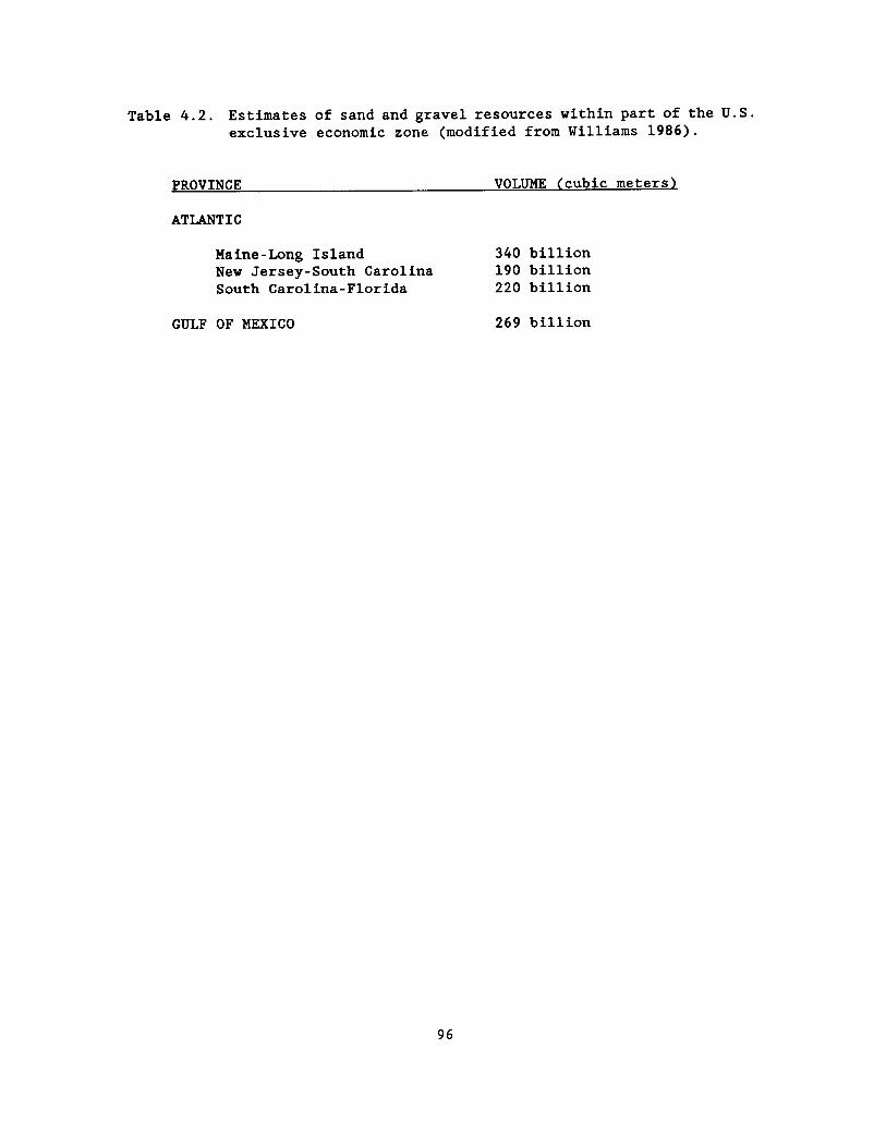
Table 4.2 . Estimates of sand and gravel resources within part of the U .S . exclusive economic zone (modified from Williams 1986) .
PROVINCE VOLUME (cubic meters)
ATLANTIC
Maine-Long Island 340 billion New Jersey-South Carolina 190 billion South Carolina-Florida 220 billion
GULF OF MEXICO 269 billion
96

Penland 1987), and along parts of the Florida western shelf and panhandle .
In conclusion, while it appears from Figure 4 .3 that a large number of marine studies have been conducted on Atlantic and Gulf of Mexico continental shelf areas of the U.S . , the EEZ covers vast areas in which existing information on the geologic framework and potential hard mineral resources is sparse and coverage is not nearly adequate . Only through a well-coordinated national program of mapping and research involving federal agencies working in close cooperation with the states and universities, can we expect to gain the information needed to manage and protect the Nation's resources .
REFERENCES
McKelvey, V.E . 1986 . Subsea mineral resources, chapter A. In Mineral and petroleum resources of the ocean . U.S . Geological Survey Bulletin 1689 .
Suter, J .R . and Penland, S . 1987 . Louisiana nearshore sand resource inventory . In Penland, S . and Suter, J .R . eds . Barrier shoreline geology, erosion, and protection in Louisiana . American Society of Civil Engineers, Coastal Sediments 87 Symposium .
Williams, S . J . 1986 . Sand and gravel deposits within the United States Exclusive Economic Zone -resource assessment and uses . Offshore Technology Conference, 18th Proceedings, Houston, Texas . V . 2, pp . 377-386 .
Williams, S .J . 1989 . Sand and gravel -an enormous offshore resource within the United States Exclusive Economic Zone . In J .H .
DeYoung and J . Hammarstron, eds . Contributions to commodity geology research : U.S . Geological Survey Bulletin 1877 . In press .
Williams, S .J ., Prins, D .A ., and Meisburger, E.P . 1979 . Sediment distribution, sand resources, and geologic character of the inner continental shelf off Galveston County, Texas . Coastal Engineering Research Center, Miscellaneous Report 79-4 . 159 pp .
Mr . S . Jeffress Williams, a marine geologist specializing in coastal and inner continental shelf areas, has worked for 20 years on marine research topics dealing with exploration of hard mineral resources, coastal processes and erosion, and geologic origins and evolution of coastal margins and continental shelves . Mr . Williams has directed or participated in more than 45 geological field investigations along the Atlantic, Pacific, and Gulf of Mexico Coasts and the Great Lakes in the United States, as well as in Great Britain . He has authored more than 50 technical and scientific papers and publications . His undergraduate and graduate degrees are in geology and oceanography from Allegheny College and Lehigh University .
Mr . Williams currently serves as a senior research staff geologist and Associate Manager of the Coastal Program with the U.S . Geological Survey, Office of Energy and Marine Geology in Reston, Virginia . He previously held positions with the Corps of Engineers, Coastal Engineering Research Center ; as a visiting scientist with the Institute of Oceanographic Sciences in Taunton, England ; and the Exxon Oil Company .
97

Mr . Shea Penland is Chief Coastal Geologist of the Coastal Geology Section of the Louisiana Geological Survey . He received his B .S . in geography from Jacksonville University in Jacksonville, Florida, and an M .S . in geography from Louisiana State University . He is currently working on a Ph .D . in geography at Louisiana State University . Mr . Penland is the author of numerous publications and technical reports dealing with the geology of the coastline and continental shelf of Louisiana and the Gulf of Mexico and has been the recipient of several national research awards .
Preliminary Evaluation of Aggregate Mineral Resources,
Offshore Louisiana
Mr . Shea Penland, Dr . Chacko J . John, Mr . John R. Suter,
Ms . Karen E . Ramsey, Mr . Randolph A. McBride,
Mr . David L. Pope, Dr . Charles G. Groat
Louisiana Geological Survey and
Mr . S . Jeffress Williams U .S . Geological Survey
INTRODUCTION
The Louisiana continental shelf stretches 450 km between Sabine Bank east to the St . Bernard shoals . It is the broadest portion of the northwest Gulf of Mexico continental shelf and is 240 km wide south of Holly Beach, Louisiana . An inventory of existing geophysical data supplemented by more than 15,000 km of high-resolution seismic profiles and 400 vibracores collected cooperatively by the
Louisiana Geological Survey (LGS) and U .S . Geological Survey (USGS) since 1981 indicates that a wide range of aggregate minerals occurs on the continental shelf in a variety of depositional settings . The distribution of these deposits is controlled by the geometry of the preexisting fluvial and deltaic channel systems and the stratigraphic signature of the Holocene transgression across these features . The geology of coastal and offshore Louisiana is tied to the depositional history of the Mississippi River (Coleman 1988) . The physiography of this region can be divided into the chenier plain and the delta plain . Offshore of the chenier plain, three types of aggregate mineral sources can be identified : (1) undifferentiated sand shoals, (2) Late Wisconsinan fluvial channels, and (3) Holocene fluvial channels (Suter et al . 1987) . Offshore of the delta plain, five types of aggregate sources can be identified : (1) inner shelf shoals, (2) submerged barrier islands, (3) tidal inlets, (4) distributary channels, and (5) barrier platforms (Penland et al . 1988a) . This paper briefly describes the geology of offshore Louisiana, the available geophysical data sets, and the distribution of aggregate mineral resources .
REGIONAL GEOLOGY
At the end of the Late Wisconsinan 18,000 yrs B . P . , sea level stood about 130 m lower than at present, with the shoreline withdrawn below the shelf break (Suter et al . 1987) . The surface of the continental shelf at this time represented a lowstand subaerial erosion surface . As the continental glaciers melted, the Holocene transgression drove the
98

sea landward, submerging and reworking the coastal zone . Sea level rise was not constant ; instead the rise was punctuated by a series of stillstands and accelerations before reaching its current highstand about 3,000 yrs B .P . The delta plain is composed of a series of smaller delta complexes and the chenier plain is composed of a series of shore-parallel alternating linear ridges separated by marshes clustered between submerged river valleys .
Offshore of the delta plain lies a series of the stacked Holocene shelf-phase delta plains of the Mississippi River, which represent submerged transgressive systems tracts (Boyd et al . 1988) . Along the ancient shoreline of each of these delta plains is a submerged sand shoal trend . As a consequence, the shallow subsurface is made up of 5-10 m-thick regressive delta sequences lying on a ravinement surface and overlain by a 5-10 m-thick transgressive shoreline sequence (Penland et al . 1987) . The individual delta plains are stacked en echelon landward . Offshore of the chenier plain the sediment supply is limited compared to that offshore of the delta plain . Here the Holocene transgression produced a regional ravinement surface that truncated the preexisting Late Wisconsin lowstand surface and generated a series of transgressive sand shoals (Suter et al . 1987) .
OFFSHORE DATA SETS
On the Louisiana continental shelf, three extensive seismic survey grids have been developed by the Louisiana Geological Survey, U.S . Geological Survey, and the U.S . Minerals Management Service . These seismic surveys represent the best
regional coverage in offshore Louisiana and include : (1) southwest Louisiana shelf collected in 1981 (U . S . Geological Survey and Minerals Management Service), (2) southeast Louisiana shelf collected in 1981-1987 (Louisiana Geological Survey and U .S . Geological Survey), and (3) LAMS/AL shelf collected in 1981 (Louisiana Geological Survey, U .S . Geological Survey, and Minerals Management Service) .
The southwest Louisiana shelf data set consists of 20,000 km of 5 .5 km x 5 .5 km (3 mi) spaced high-resolution seismic profiles between 90° and 92°N longitude (Suter 1986a) . Minisparker and 3 .5-kHZ subbottom profiler were the primary tools used (Figure 4 .4) . The southeast Louisiana shelf data set consists of 14 surveys containing more than 15,000 km of high-resolution seismic profiles between 88°30' and 92°30'N longitude (Figure 4.5) . Data were collected at variable spacing and using ORE Geopulse, EGG Uni-boom, 3 .5-kHZ Datasonics subbottom profiler, and 3 .5-kHz ORE subbottom profiler seismic systems (Figure 4 .5) . The LAMS/AL shelf data set consist of 3,200 km of 5 .5 km x 5 .5 km spaced profiles (3 mi) between 88° and 89°N longitude (Figure 4 .4) . Minisparker and 3 .5 kHZ subbottom profiler were the primary tools used (Kindinger, in press) .
Two university-industrial shelf consortiums have compiled known sources of existing nonproprietary geophysical information . Moslow and Pope (1986) collected information on the existing geophysical data between 90° and 92°N longitude . Coleman et al . (1986) built and interpreted a large data set which covered the entire Louisiana continental shelf . Emphasis in the Coleman et al .
99

.1 1
l
.}S
y~ ; _, ;,, fyJ.
Southwest Louisiana
Shelf
:err :, . .
Southeast Louisiana, Mississippi,
and Alabama Shelf
Figure 4 .4 . Location of the USGS/ZMS southwest Louisiana and southeast Louisiana and Mississippi seismic data sets (Suter et al . 1987 ; Kindinger, in press) .
DATA BASE
1 J~ \ _, .
I _-
--'' ~ 'Hollo Beach
i ~' ''Sabine ~ l S fee Bank
^' Trinliy l
DATA ACQUISITION
Sx5 km Grid space end Vibracores \\ hoi~
5x5 Item Grid Space
3xJ km Grid Spice and Vibrecorcs en
Louisiana Geological Survey Vlbncores
Corps of Engineers Vibracores
LGS &COE ViAracores
t
t'1 a
O .,
P ~ ~ F
Isle
:. s ~ . .- U
0 Nl~ 40
r'--~~ o Ku-... w
Figure 4 .5 . Location of 14 seismic and vibracores surveys in southcentral and southeast Louisiana collected cooperatively by the U.S . Geological Survey and Louisiana Geological Survey .
LA l MS ~ AL ~) . r ̀` . .`
~``l~
e
100

(1986) report was on the correlation of Quaternary depositional sequences with oxygen isotope stages .
OFFSHORE CHENIER PLAIN
Offshore of the southwestern Louisiana chenier plain lie undifferentiated sand shoals, late Wisconsin fluvial channels, and Holocene fluvial channels . Sabine Bank and its associated retreat path of shore-parallel sand shoals are a surficial deposit of medium to coarse sand . Thicknesses reach 7 .5 m at Sabine Bank and decrease towards the south to 2-3 m. Sabine Bank is 70 km long and 15 km wide, and it lies 30 km offshore (Suter et al . 1987) . Little is known about the facies of this sand body . Late Wisconsinan fluvial channels represent a shallow subsurface source for coarse sand . Suter (1986b) has mapped the late Wisconsinan channel pattern from the shoreline to the shelf break using high resolution seismic profiles . Generally, these channels coalesce and become larger and fewer offshore . Typical thicknesses of these channel sequences range from 10-20 m in the north to 40-60 m at the shelf break . Lying within the Holocene section of the chenier plain are isolated fluvial channels . The channels are 5-10 m thick and the texture is highly variable . At Holly Beach, an ancient course of the Calcasieu River is found exposed on the shoreface .
OFFSHORE DELTA PLAIN
Offshore of the southeastern Louisiana delta plain one finds submerged barrier islands, distributaries, shelf reefs, inner shelf shoals, tidal inlets, beach ridge plains, and barrier platforms
(Figure 4 .5) . West to east along the delta plain lies Trinity Shoal, an ancient submerged barrier island associated with the late Holocene delta plain (Suter and Penland 1987) . This feature is 30 km long, 10 km wide, and 8 m thick . The texture of Trinity Shoal is very fine sand and is estimated to contain some 2 billion m3 of material . Between Marsh Island and Sandy Point, the LGS documented 55 nearshore sand resource targets, ranging in size from 2 km2 to greater than 400 km2 with estimated volumes of available sand varying from less than 2 million m3 to greater than 1 .6 billion m3 (Penland et al . 1988b ; Suter et al . 1987 ; Louisiana Geological Survey 1988) . The most prospective resources found are the huge sand bodies of Ship Shoal and associated distributaries, Cat Island Pass tidal channels and associated tidal deltas, and Barataria Pass/Grand Terre tidal channels and associated tidal deltas (Penland et al 1986 ; Suter and Penland 1987) . East of the mouth of the Mississippi River are the Chandeleur Islands, where LGS identified seven major sand resource targets truncated barrier-spit and tidal inlet deposits, submerged beach ridges, and distributaries associated with abandoned St . Bernard delta complexes (Penland and Suter 1985 ; Penland et al . 1985 ; Suter et al . 1988) .
SUMMARY
Abundant sand resources can be found in offshore Louisiana . Many of the sand bodies contain heavy minerals, but their concentration and distribution is unknown . Other potential sand resources not yet adequately explored include Sabine Bank, the Outer Shoal, and the St . Bernard shoals . The sand resources
101

are best documented offshore of the delta plain . Offshore of the chenier plain, the locations of potential targets have been documented, but the facies architecture and texture are unknown . The utilization of these resources either as borrow material for beach nourishment or for industrial use will depend upon the economics of dredging at their offshore locations and the potential environmental effects resulting from altering existing continental shelf geomorphological and biological conditions .
REFERENCES
Boyd, R., J.R . Sister, and S . Penland . 1988 . Implications of modern sedimentary environments for sequence stratigraphy, pp . 33-36 . In D .P . James and D .A . Leckie, eds . Sequences, stratigraphy, sedimentology : surface and subsurface . Canadian Society of Petroleum Geologists, Memoir 15 .
Coleman, J .M . 1988 . Dynamic changes and processes in the Mississippi River delta . Geological Society of America Bulletin, V. 100 . 17 pp .
Coleman, J .M ., H .H . Roberts, and T .F . Moslow . 1986 . Sedimentary sequences and seismic responses related to sea level cycles : Louisiana continental shelf . Report to the Gulf of Mexico research consortium, Louisiana State University, Baton Rouge, Louisiana . Unpubl . data .
Kindinger, J .L . Depositional history of the Lagniappe delta in the northern Gulf of Mexico . Geomarine Letters . 24 pp . In press .
Louisiana Geological Survey . (Contributors : E.J . Maciasz, R.A . McBride, T.M . McLaughlin, S . Nakashima, S . Penland, K .E . Ramsey, D.B . Scott, J .R . Suter, B .G . Taylor, and K.A . Westphal) . 1988 . Database compilation for nearshore sand resources : Marsh Island to Sandy Point . Technical report to Louisiana Department of Natural Resources, Contract No . 21940-86-22 . 89 pp .
Martin, R. G . and A . H . Bouma . 1978 . Physiography of the Gulf of Mexico, pp . 3-19 . In A . H . Bouma, G. T . Moore, and J .M . Coleman, eds . Framework, facies, and oil-trapping characteristics upper continental margin . American Association of Petroleum Geologists, Studies in Geology No . 7 . Tulsa, Okla . 326 PP .
Moslow, T .F . and D .L . Pope . 1986 . Geophysical, geological, and paleontological non-proprietary database listing : report for the shelf-slope industrial consortium, Louisiana Geological Survey, Baton Rouge, Louisiana . Unpubl . data .
Penland, S., R . Boyd, and J .R . Suter . 1988a . The transgressive depositional systems of the Mississippi delta plain : a model for barrier shoreline and shelf sand development . Journal of Sedimentary Petrology 58(6) :932-949 .
Penland, S . and J.R . Suter . 1985 . Nearshore sand resources in the eastern Isles Dernieres . Louisiana Geological Survey Coastal Geology Open File Report . 154 pp .
Penland, S ., J.R . Suter, and R. Boyd . 1985 . Barrier island arcs along abandoned Mississippi River deltas . Marine Geology 63 :197-233 .
102

Penland, S., J .R . Suter, and R.A . McBride . 1987 . Delta plain development and sea level history in the Terrebonne coastal region, Louisiana, pp . 1689-1705 . In American Society of Civil Engineers, Coastal Sediments 1987 Symposium . Proceedings of a speciality conference on advances in understanding of coastal sediment processes, N .C . Kraus, ed . American Society of Civil Engineers, New York .
Penland, S ., J .R . Suter, and R.A . McBride . 1988b . Reconnaissance investigation of shoreface and inner-shelf sand resources in Terrebonne Parish : Point Au Fer to Timbalier Island . Louisiana Geological Survey Open-File Series No . 88-06 . 73 pp .
Penland, S ., J .R . Suter, and T.F . Moslow . 1986 . Holocene geology of ship shoal region, northern Gulf of Mexico . Unpubl . report . Louisiana Geological Survey .
Suter, J .R . 1986a . Late Quaternary facies and sea level history, southwest Louisiana continental shelf . Ph .D . dissertation . Louisiana State University, Baton Rouge .
Suter, J . R . 1986b . Buried late Quaternary fluvial channels on Louisiana continental shelf, USA, pp . 27-37 . In P.A . Pirazzoli and J .R . Suter, eds . Late Quaternary sea changes and coastal evolution . Journal of Coastal Research, Special Publication .
Suter, J .R ., H.L . Berryhill, Jr ., and S . Penland . 1987 . Late Quaternary sea level fluctuations and depositional sequences, southwest Louisiana continental shelf, pp . 199-219 . In 0 . Pilkey, P . Howard, and D. Nummedal, eds .
Stratigraphic record of sea level changes . Special Publication . Society of Economic Paleontologist and Mineralogists, Tulsa, Okla .
Suter, J .R . and S . Penland . 1987 . A preliminary assessment of the sand and aggregate resources of three areas of the Louisiana inner continental shelf : Timbalier Island, Chandeleur Island, and Trinity Shoal . Louisiana Geological Survey Open-File Series No . 87-04 . Louisiana Geological Survey, Baton Rouge .
Suter, J .R ., S . Penland, J . Williams, and J.L . Kindinger . 1988 . Transgressive evolution of the Chandeleur Islands, Louisiana, pp . 315-322 . In A. Weidie, B . Kohl, and R . Fillon, eds . Transactions Gulf Coast Association of Geological Societies V. 38 .
Mr . Shea Penland is the Chief Coastal Geologist of the Coastal Geology Section of the Louisiana Geological Survey . Dr . Chacko J . John is the Chief Geologist of the Energy and Minerals Section of the Louisiana Geological Survey . Dr . John R. Suter is a Senior Marine Geologist in the Coastal Geology Section of the Louisiana Geological Survey . Ks . Karen E. Ramsey is a Research Associate in the Coastal Geology Section of the Louisiana Geological Survey . Mr . Randolph A. McBride is a Research Associate in the Coastal Geology Section of the Louisiana Geological Survey . Mr . David L. Pope is a Research Associate in the Coastal Geology Section of the Louisiana Geological Survey . Dr . Charles G . Groat is State Geologist and Director of the Louisiana Geological Survey . Mr . S . Jeffress Williams is a Research Geologist in the Coastal Program of the U .S . Geological Survey .
103

Data Applicable to Hard Mineral Exploration on the Alabama Outer Continental Shelf
Mr . Steven J . Parker Geological Survey of Alabama
INTRODUCTION
Recently, the Minerals Management Service (MMS) has initiated studies to assess the potential of hard mineral resources within the Exclusive Economic Zone (EEZ) . These studies involve joint efforts by federal and state agencies and are aimed primarily at the reconnaissance of sand and gravel, heavy minerals, precious metals, and other economic nonenergy minerals . Joint efforts by agencies of the States of Alabama, Mississippi, Louisiana and Texas (Gulf Task Force) are aimed at providing MMS with preliminary evaluation of the occurrence, economic potential, and mining feasibility for developing nonenergy resources in the northern Gulf of Mexico .
The objective of this study is to evaluate available data applicable to the assessment of hard mineral resources in the EEZ in offshore Alabama to make a preliminary assessment of the occurrence, economic potential, and mining feasibility for developing these resources within this area . This study encompasses the area offshore of Alabama under Federal jurisdiction from the state-Federal boundary to the 200-m isobath .
MINERAL RESOURCES
Hard mineral resources identified in the Alabama offshore area include sand, gravel, heavy mineral placers, and carbonate rock rubble .
The occurrence of these resources in the Alabama offshore area is due to the formation and migration of estuarine, marine, and fluvial systems on the shelf during the Quaternary period as the result of sea-level fluctuations . Holocene transgression allowed marine processes to rework and modify sediments and geomorphic features associated with these environments ; however, preserved buried fluvial channels have been identified in the offshore Alabama area . In addition, large bedforms,which are in equilibrium with the current hydraulic regime, consist of reworked sediments and are potential sites for hard mineral deposits .
Previous reports, sidescan sonar data, and bottom-sampling data indicated that sand covers most of the Alabama offshore area (Figure 4 .6) . Overall, sand deposits are typically fine- to medium-grained and consist of greater than 75$ quartz sand . Sand deposits that accumulate on the seaward sides of offshore ridges contain greater than 90% quartz sand . Shell gravel deposits, containing up to 70$ gravel-sized particles, occur on the landward sides of offshore ridges . These deposits may be over 100 m wide and extend several kilometers along the ridge . Terrigenous gravel has not been identified in the offshore Alabama area ; however, geophysical records indicate numerous buried channels which are potential sites for sand and gravel deposits .
Offshore heavy mineral resources have not been well delineated . Several economic minerals, including zircon, rutile, ilmenite, leucoxene, kyanite, sillimanite, and monazite, have been identified in the Alabama offshore area . The
104

Dauphin Island -~ Morgan
~ 10 ~
20 State-Federal Boundary
40
Resource
Figure 4 .6 .
D > 75% Sand < 25% carbonate Sand and Gravel
75-90% Sand
> 50% silt and clay < 50% sand and
x' carbonate sand "' 0 5 10 15 Km 10-25% Carbonate and gravel Sand and Gravel, _ Hardbottom Sites silt and clay
0 5 10 Mi
Sediment distribution map of the study area (modified from Ludwick 1964, Upshaa at al . 1966) .
105
20
AIL
Bathymetric Contour Intervals 10, 50, 100 meters

possibility exists for commercial concentrations of these minerals to occur in the EE2, offshore Alabama . In heavy mineral studies of offshore Florida, westward increases in heavy mineral concentrations were observed (Arthur et al . 1986) . In addition, potential economic deposits of these minerals have been identified in the nearshore and barrier island environments south of Alabama . Mechanisms which concentrate these minerals in the nearshore area were active on the shelf during periods of lower sea levels . This observation indicates that similar deposits may occur in the Alabama offshore area .
Carbonate rock rubble consists of algal limestone and carbonate cemented sandstone, mudstone, and coquinas . These deposits occur along the continental shelf break and in scattered localities in the central portion of the Alabama offshore area (Figure 4 .6) .
RESOURCE APPRAISAL
Data on the occurrence of hard mineral resources are sparse, thus, accurate estimations of the volume of these resources are difficult . Because of these limitations, quantity estimates are classified as inferred resource estimates .
Based on the preliminary evaluations, the potential exists for the occurrence of significant deposits of nonenergy minerals in the study area . Inferred resource estimates indicate that over 35 billion short tons of quartz sand occurs within recoverable depths in the EEZ in offshore Alabama . The most promising uses for these generally fine-grained sands are beach replenishment, the manufacture of glass, and foundry
applications . Size specifications for use in the construction industry, which usually require coarser-grained sand, may limit the use of this resource for construction applications . Shell gravel deposits potentially may be utilized as sources for lime and aggregate in road construction . Although sand and gravel are apparently in good supply in the EEZ of offshore Alabama, onshore supplies of these resources probably preclude the exploration for offshore supplies in the near future . As demand increases and accessible onshore deposits are depleted, marine mining of offshore sand and gravel may become economically attractive .
Heavy minerals of economic interest have been identified in the sediments in the study area . At present, insufficient data are available for identification of specific sites containing possible commercial concentrations of these commodities . Interpretations of geophysical data, along with sedimentary history of the study area, suggest that concentrations of heavy minerals comparable to those in the nearshore areas could exist further offshore . Preliminary estimates suggest the occurrence of 400 million to 1 .4 billion short tons of heavy minerals in bottom and subbottom sediments off the Alabama offshore area . Environmental factors concerning natural hardbottom and reef areas must be given thorough consideration in mining feasibility studies of these areas . The feasibility of mining minerals in the study area cannot be addressed fully based on presently available data . Studies by the U.S . Bureau of Mines in other areas of the U .S . suggest that dredge mining may be possible in the Gulf of Mexico to
106

depths of about 130 ft . Available data are insufficient for inference or identification of specific geographic areas suitable for mining feasibility study for mining on a commercial (economic) basis .
REFERENCES
Arthur, J.D ., J . Applegate, S . Melkote, and T .M . Scott . 1986 . Heavy minerals reconnaissance off the coast of the Appalachicola River Delta, northwest Florida . Florida Geological Survey, Report of Investigation No . 95 . Tallahassee, FL . 61 pp .
Ludvick, J .C . 1964 . Sediments in northeastern Gulf of Mexico, pp . 204-238 . In Marine Geology . Macmillan Co ., New York, New York .
Stow, S . H . , S . E . Drummond, and C . D . Haynes . 1975 . Occurrence and distribution of heavy minerals, offshore Alabama and Mississippi . Society of Mining Engineers-AIME Transactions 260 :75-77 .
IIpshav, C . F . , W . B . Creath, and F . L . Brooks . 1966 . Sediments and macrofauna off the coast of Mississippi and adjacent states . Mississippi Geological Survey Bulletin 106 . 127 pp .
Mr . Steven J . Parker is a geologist in the Coastal and Marine Geology Division of the Geological Survey of Alabama . Parker has completed course work for an M .S . degree in geology and is currently completing thesis work toward this degree . His area of research includes sedimentation and mineral resource assessment of coastal and offshore Alabama .
Assessment of Nonenergy Minerals in the Exclusive Economic Zone, Offshore
Mississippi
Ms . Robin G . Cranton and
Dr . J . Robert Woolsey The Mississippi Mineral
Resources Institute
As a member of The Minerals Management Services' Gulf Task Force, the Mississippi Mineral Resources Institute prepared a data inventory and summary of information relevant to the occurrence, distribution, and feasibility of developing nonenergy mineral resources of the Exclusive Economic Zone, offshore Mississippi . Minerals of interest were identified as sand, gravel, shell, and heavy minerals .
DATA SUMMARY
Sand and Gravel
Mississippi's offshore areas have been studied extensively with respect to sediment composition and distribution ; however, comprehensive studies have not been directed toward resource evaluation . In general, Mississippi Sound sediments are predominantly estuarine silts and clays, with sands occurring marginally along the mainland and barrier island trend . These marginal sands have been dredged in the past for beach replenishment purposes . Inner shelf surficial sediments range from the Chandeleur sand deposits in the western part of the study area, to the centrally located delta front silts and silty clays, and finally to the Mississippi-Alabama sand facies found over most of the Alabama
107

shelf, extreme western Florida, and extending dust into the offshore Mississippi study area, south of the easternmost barrier islands . This sand sheet, though not known in its vertical extent, is thought to be less than 50 ft thick . Ancient channel deposits have been located through seismic interpretation just west of the Chandeleur Island area (Kindinger et al . 1982) . These channels indicate possible areas of interest with respect to sand, gravel, and heavy mineral accumulation ; however, they appear to be covered by relatively thick deltaic silts and clays .
Heavy Minerals
Heavy minerals occur in two distinct suites or provinces in sediments offshore of Mississippi . The Eastern Province typically contains abundant ilmenite, kyanite, staurolite, zircon, and tourmaline . These minerals are thought to be derived from the Cretaceous and younger sediments of the Appalachians . The Western Province, composed chiefly of pyroxenes, amphiboles, epidote, ilmenite, and biotite, is believed to be derived from the drainage basin of the Mississippi River . Those minerals of economic interest include ilmenite, rutile, kyanite, staurolite, zircon, monazite, and xenotime . Many of these occur in potentially economic quantities in laminae in the foreshore and backshore of the barrier islands ; however, these deposits are not accessible in Petit Bois, Horn, and Ship islands as they are a part of the Gulf Island National Seashore . It has been suggested that economic concentrations of heavies exist in surficial sediments between Petit Bois Island and the western end of Dauphin Island, extending seaward
for about six miles (Van Andel and Poole 1960) . However this suggestion has not been substantiated and in fact has been disputed by several authors (Stow et al . 1976, Wimberly 1985, Woolsey 1984, Woolsey et al . 1985) .
Shell
Four reef areas have been identified within Mississippi Sound which have the potential of providing 1,870,396 cubic yards of shell (Demoran 1979) . The amount of overburden ranges from 0 to 3 ft . Water depth around these deposits ranges from 7 to 27 ft, deep enough to allow conventional trailing suction dredges to approach the deposits .
Through seismic record interpretation, Kindinger et al . (1982) identified buried oyster reefs dust southeast of the Chandeleur Island chain . These reefs appear to be blanketed by thick deltaic deposits .
CONCLUSIONS AND RECOMMENDATIONS FOR
FURTHER STUDY
Sand for beach replenishment has been dredged successfully from within the confines of Mississippi Sound . Apparently the sand is of sufficient size, however fine-grained, to provide adequate protection from beach erosion in those low-energy settings, as replenishment endeavors have only been repeated approximately every twenty years . It is desirable, however, that periodic beach nourishment be carried out on a regular basis, at least every five years . To do this, a comprehensive study of Mississippi Sound sediments must be undertaken in order to fully characterize the
108

occurrence and distribution of sands suitable for beach replenishment purposes . Once attained, these data can be considered relative to pertinent environmental and socioeconomic information for optimum selection of future borrow sites .
Ancient river channels, identified by Kindinger et al . 1982, could indicate the presence of economic sand, gravel, or heavy mineral deposits, but much more data would be required in order to make an adequate assessment . Detailed grain size analyses should be performed on sediment samples from these channel areas . Additionally, subsurface sediments beneath the large Mississippi-Alabama sand facies should be analyzed extensively . The amount and type of overburden for each area also should be characterized, as removing the overburden, beyond the determined acceptable overburden ration, can drive the cost of dredging operation beyond economic limits . All other conditions, physical, environmental, and economic, being favorable, current technology would easily allow exploitation of these potential resources out to a water depth of as much as 100 m.
Heavy mineral analyses could be carried out concurrently with the sedimentologic analyses . Emphasis should again be placed on the offshore channels and subsurface sediments beneath the Mississippi -Alabama sand facies . The heavy mineral deposits of Mississippi Sound and the barrier island chain are not presently considered to be of economic value, partially because of the status of the islands as a national seashore, but also because environmental constraints would not allow
economic extraction without further technological improvements to present mining and processing methods .
These barrier island heavy mineral deposits are nevertheless interesting from an academic standpoint . The combined effects of longshore drift and long-period waves move the heavies shoreward and deposit them on the Gulf side of the barrier islands . Wind and wave action effectively transport them across the islands where they are deposited as wash-over and blow-over sands adjacent to the leeward shore in the relatively calm lagoonal environment of Mississippi Sound . The Mississippi Mineral Resources Institute plans to conduct an extensive seismic survey of the Sound followed by a comprehensive drill sampling program in an effort to describe the characteristics of this low-energy environment .
Reef shell resources within Mississippi Sound can be mined by the use of available technology and with little disturbance to the environment . However, similar safeguards must be incorporated into any mining plan as in any other mining scheme . Onboard processing would require that silts be washed back down into the water column most assuredly causing a turbidity plume . Coping with environmental regulations may render the venture uneconomic .
REFERENCES
Demoran, W .J . 1979 . A survey and assessment of reef and shell resources in Mississippi Sound . Report of Investigations No . 794 . Mississippi Mineral Resources Institute . 19 pp .
109

Kindinger, J .L ., R.J . Miller, C.E . Stelting, and A.H . Bouma . 1982 . Depositional history of Louisiana-Mississippi outer continental shelf . U.S . Geological Survey Open-file Report No . 82-1077 .
Stour, S . H . , S . E . Drummond, and C . D . Haynes . 1976 . Occurrence and distribution of heavy minerals, offshore Alabama and Mississippi . Transactions Society of Mining Engineers 260:75-77 .
Dan Andel, T.H . and D .M . Poole . 1960 . Sources of recent sediments in the northern Gulf of Mexico . Journal of Sedimentary Petrology 30 (1) :91-122 .
iTimberly, W.J . 1985 . Heavy minerals of the recent sands south of the Mississippi Sound barrier islands . M.S . Thesis . University of Mississippi . 116 pp .
iloolsey, J.R . 1984 . Preliminary reconnaissance for industrial minerals in Mississippi Sound and adjacent offshore territories of Mississippi . Open-file Report 83-135 . Mississippi Mineral Resources Institute . 21 pp .
Woolsey, J.R ., W .R . Reynolds, and D .L . Bargeron . 1985 . Exploration for industrial minerals in Mississippi Sound and adjacent offshore territories of Mississippi and Alabama . Final Report to the Mississippi-Alabama Sea Grant Consortium, Project R/ER-11 . 192
PP .
Ms . Robin G . Cranton received the B.S . degree in biological sciences in 1979 from Southwestern Oklahoma State University and the M.S . degree in geological sciences in 1985 from The University of Mississippi . Since joining the
staff of The Mississippi Mineral Resources Institute in 1984, she has served as participant on the Mississippi Technical Task Force for studying ecological effects associated with the construction of a geologic repository for high level nuclear waste . She has also been involved in the Institute's offshore program which is devoted to the development of innovative marine mineral exploration and sampling equipment . Ms . Cranton currently serves as Environmental Geologist for the Continental Shelf Division of the new Marine Minerals Technology Center, University, Mississippi .
Dr . J . Robert Woolsey is an exploration geologist with principal experience in the reconnaissance and evaluation of shallow marine mineral deposits . His background includes work with the United Nations and private industry in North and South America, Europe, Africa, Southeast Asia, and the South Pacific involving the exploration and development of both industrial and precious minerals . Dr . Woolsey presently serves as Director of the Mississippi Mineral Resources Institute and the Continental Shelf division of the Marine Minerals Technology Center, University, Mississippi .
110

Preliminary Assessment of Nonfuel Minerals on the Texas
Continental Shelf
Mr . Jeffrey G . Paine, Dr . Robert A. Morton,
and Mr . William A . White
The University of Texas at Austin
The primary objective of this study was to prepare a preliminary assessment of nonfuel mineral resources of the Texas Exclusive Economic Zone (EEZ) from the Gulf shoreline to near the shelf edge (approximately 200 m water depth) . Several steps were required to satisfy this objective, including (1) inventory available geological information ; (2) locate potentially economic offshore deposits (prospects) using available data ; (3) characterize these prospects as accurately as possible with existing data, including areal extent, thickness, and sediment composition and texture ; and (4) if sufficient data exist, determine whether exploitation of the prospect is economically feasible .
Several types of data have been collected by various researchers that can be used to directly or indirectly determine the distribution, texture, and composition of surface and shallowly-buried shelf sediments . These data, including surface samples, pipe and box cores, foundation borings, and high-resolution seismic lines, each have advantages and disadvantages in terms of assessing nonfuel mineral resources . More surface samples have been taken from the Texas Continental Shelf than any other type of sediment sample, but penetration is only a few centimeters and little information
on the vertical extent of potential nonfuel mineral deposits can be gained from these samples . Pipe cores achieve grater penetration (up to a few meters), but are not as widespread as grab samples . Foundation borings, commissioned by petroleum companies in preparation for drilling or production activities, are perhaps best suited for determinations of vertical sediment distribution because they extend 100 m or more into the subsurface . However, uneven distribution across the Texas continental shelf and generalized visual descriptions of sediment reduce their usefulness . High-resolution seismic profiles are most useful in locating structural elements and constructing three-dimensional models of depositional systems, but they provide only indirect lithological information .
Currently, little deposition of economically important minerals takes place on the shelf beyond the nearshore zone . However, significant concentrations of sand and gravel occur far offshore . These relict deposits owe their placement to large-scale fluctuations in sea level during the Quaternary . Most important for this study are (1) shelf-margin deltas deposited during the last sea-level lowstand (late Wisconsinan), (2) fluvial sands and gravels deposited along stream courses during the lowstand and the subsequent sea-level rise (late Wisconsinan and early to middle Holocene), and (3) post-lowstand transgressive sheet sand and shore-parallel strandline deposits .
Many of the nonfuel mineral prospects on the Texas continental shelf are too distant from potential markets to economically
111

compete with abundant onshore deposits . However, two nonfuel resources that could be economically competitive in the future are sand for beach nourishment and sand and gravel for use in the construction industry . Long-term erosional trends of Texas beaches and heavy beach use near population centers makes beach nourishment an attractive alternative to other methods of shoreline stabilization . Beach nourishment has been considered for Galveston Island to recreate a beach that once existed seaward of the Galveston seawall, to offset high rates of erosion (averaging up to 3 m/yr since the 1850's ; Morton 1974) on beaches west of the seawall, to replace an estimated 760,000 m3 of sand eroded from the western part of the island during a recent hurricane (Morton and Paine 1985), and to replace contaminated beach sand removed from the island after oil from the wrecked tanker "Alvenus" washed ashore in 1984 . Elsewhere, recent development along southern Padre Island has placed hotels, residences, and businesses near a beach that is eroding rapidly . Since 1867, average annual rates of erosion at the southern tip of Padre Island have been as high as 5 m/yr (Morton and Pieper 1975) ; recent rates as high as 6 m/yr (Paine and Morton 1988) indicate that erosion is continuing if not increasing . Because the principal industry in this area is tourism, beach nourishment will likely be chosen to mitigate erosion .
Potential sources of beach-compatible sands occur offshore from Padre Island and Galveston Island . Sand is particularly abundant off Padre Island, where the post-lowstand sea-level rise has caused reworking of the Rio
Grande delta and produced a sand sheet across much of the south Texas shelf . Sand is not as abundant near Galveston, yet potential sources such as Heald Bank (65 km distant) and Sabine Bank (95 km distant) do exist . These banks, interpreted as shoreline and shallow marine sands, are located 40 to 50 km offshore of the upper Texas coast in water depths of 6 to 17 m. Sands associated with these banks cover more than 1,000 km2 and range up to 8 m thick . Cores and seismic records indicate an average thickness of about 3 m; estimated sediment volume is more than 3 billion m3 . The deposits are composed dominantly of fine to very fine sand (Nelson and Bray 1970), similar to most Texas beach sand (Bullard 1942) .
By far the largest sand and gravel market on the coast of Texas is the Houston Metropolitan Area (HMA) . During 1985, the HMA consumed an estimated 19 .3 to 25 .0 million tons of aggregate (Bureau of Mines 1987) . Other Texas population centers that consume smaller but substantial quantities of aggregate are Corpus Christi on the central coast and Brownsville on the southern coast . As abundant local supplies of sand and gravel are exhausted, each of these may look to nearby offshore sources of sand and gravel .
Houston, Corpus Christi, and Brownsville are all located within mayor stream basins (Trinity/San Jacinto, Nueces, and Rio Grande) . Fluvial sand and gravel similar to deposits found along these streams on land can also be found offshore along the downstream continuations of these streams . Many of these drowned stream courses have been located by seismic surveys ; the
112

presence of sand and gravel has been verified in some areas by coring . A promising gravel deposit was encountered in a foundation boring located about 8 km offshore of Mustang Island in 16 m of water . This boring penetrated 12 m of sandy gravel underneath 16 m of a fining-upward sequence that included 12 m of dominantly silty fine sand . These deposits represent basal transgressive valley-fill deposits near the confluence of ancestral Nueces, Aransas, and possibly Mission rivers, which were located through interpretation of high-resolution seismic reflection surveys conducted by the U.S . Geological Survey (Berryhill 1981) . Although nearby foundation borings located off the axes of these stream courses did not encounter gravel, it is likely that similar deposits exist both upstream and downstream from this boring . Numerous sand and gravel quarries are operating in similar deposits along the Nueces River near Corpus Christi .
Despite the probable abundance of near surface sand and gravel on the Texas continental shelf, these deposits must be competitive with equally abundant sand and gravel on land . In a recent study of the potential for offshore sand and gravel production in the Houston area, it was estimated that despite the large consumption rate, more than 40 years of onland supply remained (Bureau of Mines 1987) . Similar abundances in areas of lower demand, such as Corpus Christi and Brownsville, will last even longer .
Deltas constructed on the outer shelf and upper continental slope during the late Pleistocene lowstand of sea level contain significant accumulations of sand
that might be used for beach nourishment, construction, or industry . Four mayor shelf-margin deltas have been located in the Texas offshore, from the ancestral Rio Grande delta to the south to deltas 'A', 'B', and 'C' to the east (Berryhill 1987 ; Berryhill and Suter 1987 ; Morton and Price 1987 ; Suter and Berryhill 1985) . Although each delta covers hundreds of square kilometers and represents a large sand resource, each also contains abundant silt and clay . Sand is most likely to be found near the top of the deposits and also in the more shallow proximal deltaic areas . All of the deltas are too far from potential sand markets to be economically mined at present .
The only systematic determination of heavy mineral content of Texas shelf sediments was conducted by the U.S . Geological Survey on the south Texas outer continental shelf (Berryhill 1976) . Heavy mineral concentrations determined during this study ranged from a trace to 32$ by weight . Concentrations increased southward toward the Rio Grande delta, with the highest concentrations (greater than 2%) recorded 16 to 72 km offshore of southern Padre Island in water depths of 20 to 100 m. The thickness of these sediments is not known because grab samples only penetrate a few centimeters below the seafloor . However, the deposits are probably relatively thin (less than one meter) because they occur in transgressive sandy sediments that cap the Rio Grande deltaic complex . The heavy mineral suite is dominated by hornblende, epidote, zircon, and garnet (Van Andel and Poole 1960) . Minor amounts of staurolite, tourmaline, and kyanite are also present .
113

It is not anticipated that nonfuel minerals on the Texas continental shelf (principally sand and gravel) will become generally economic in the near future because the onshore supply is adequate for many years . As long as this remains true, demand for offshore deposits will be low . However, specific local accumulations, such as sand suitable for nearby beach nourishment, could become economic at any time . Uneven distribution of sediment samples, cores, and high-resolution seismic coverage makes a comprehensive inventory of offshore nonfuel minerals impossible, but has led to the discovery of some potentially economic deposits .
ACKNOWLEDGMENTS
This research was partly supported by the Minerals Management Service, Department of the Interior, under MMS Agreement No . 14-12-0001-30404 .
REFERENCES
Berryhill, H.L ., Jr . 1976 . Environmental studies, south Texas Outer Continental Shelf, 1976-Geology . Report PB 277-337/AS . National Technical Information Service, Springfield, VA . 625 pp .
Berryhill, H .L ., Jr . 1981 . Map showing paleogeography of the continental shelf during the low stand of sea level, Wisconsinan glaciation, Corpus Christi 1° x 2° quadrangle . U.S . Geological Survey, Map I-1287-E . Scale 1:250,000 .
Berryhill, H.L ., Jr . 1987 . The continental shelf off south Texas, pp . 11-79 . In H.L . Berryhill, Jr ., ed . Late Quaternary facies and structure northern Gulf of Mexico : interpretations from seismic data .
American Association of Petroleum Geologists, Studies in Geology #23 . Tulsa, Okla .
Berryhill, H.L ., Jr ., and J .R . Suter . 1987 . Deltas, pp . 131-190 . In H .L . Berryhill, Jr ., ed . Late Quaternary facies and structure, northern Gulf of Mexico : interpretations from seismic data . American Association of Petroleum Geologists, Studies in Geology #23 . Tulsa, Okla .
Bullard, F .M . 1942 . Source of beach and river sands on gulf coast of Texas . Geological Society of America Bulletin 53 :1021-1044 .
Bureau of Mines . 1987 . An economic reconnaissance of selected sand and gravel deposits in the U .S . Exclusive Economic Zone . Bureau of Mines, Open File Report OFR 3-87 . 113 pp .
Morton, R . A . 1974 . Shoreline changes on Galveston Island (Bolivar Roads to San Luis Pass), an analysis of historical shoreline changes of the Texas Gulf shoreline . Bureau of Economic Geology, Geological Circular 74-2 . The University of Texas at Austin . 34 pp .
Morton, R .A . and J .G . Paine . 1985 . Beach and vegetation-line changes at Galveston Island, Texas : erosion, deposition, and recovery from Hurricane Alicia . Bureau of Economic Geology, Geological Circular 85-5 . The University of Texas at Austin . 39 pp .
Morton, R.A . and M.J . Pieper . 1975 . Shoreline changes on Brazos Island and south Padre Island (Mansfield Channel to mouth of the Rio Grande) : an analysis of historical changes of the Texas Gulf shoreline . Bureau of Economic
114

Geology, Geological Circular 75-2 . The University of Texas at Austin . 39 pp .
Gorton, R.A . and W.A . Price . 1987 . Late Quaternary sea-level fluctuations and sedimentary phases of the Texas coastal plain and shelf, pp . 181-198 . In D . Nummedal, O .H . Pilkey, and J .D . Howard, eds . Sea level fluctuations and coastal evolution . Society of Economic Paleontologists and Mineralogists, Tulsa, OK . Special Publication No . 41 .
Nelson, H.F . and E .E . Bray . 1970 . Stratigraphy and history of the Holocene sediments in the Sabine-High Island area, Gulf of Mexico, pp . 48-77 . In J . P . Morgan and R. H . Shaver, eds . Deltaic sedimentation, modern, and ancient . Society of Economic Paleontologists and Mineralogists Special Publication 15 . Tulsa, OK .
Paine, J .G . and R.A . Morton . 1988 . Shoreline and vegetation-line movement, Texas gulf coast, 1974 to 1982 . Bureau of Economic Geology, Geological Circular 88-5 . The University of Texas at Austin . In press .
Suter, J.R . and H .L . Berryhill, Jr . 1985 . Late Quaternary shelf-margin deltas, northwest Gulf of Mexico . American Association of Petroleum Geologists Bulletin 69 :77-91 .
Van Andel, T .H . and D .M . Poole . 1960 . Sources of recent sediments in the northern Gulf of Mexico . Journal of Sedimentary Petrology 30 :91-122 .
Mr . Jeffrey G. Paine is a research scientist associate at the Bureau of Economic Geology, the University
of Texas at Austin . He has worked on coastal problems such as beach erosion and hurricane effects . His current research interests include Holocene sea level and Quaternary stratigraphy of the Texas coastal zone . He received his B .S . degree from the University of Texas at Austin and his M. S . degree from the University of Wisconsin .
Dr . Robert A. Morton is a senior research scientist at the Bureau of Economic Geology . There he coordinates projects related to the regional geology of coastal and offshore Texas . His current research focuses on nearshore processes and sediment transport as well as the genetic stratigraphy and petroleum potential of the western Gulf Coast Basin . Dr . Morton received his B .A . degree from the University of Chattanooga and his M. S . and Ph . D . degrees from West Virginia University .
Mr . William A. White is a research associate with the Bureau of Economic Geology . Over the past several years he has coordinated the Submerged Lands of Texas Project, which is a comprehensive inventory of sediment textures, geochemistry, benthic macro invertebrates, and associated wetlands located in State-owned lands . Recent studies have also included coastal processes and shoreline changes in bay-estuary-lagoonal systems . He received his B .S . and M.S . from the University of Texas at Austin .
115

CONTRIBUTED PAPERS : CURRENT GULF OF MEXICO MARINE RESEARCH

Session : CONTRIBUTED PAPERS : CURRENT GULF OF MEXICO MARINE RESEARCH
Co-Chairs : Dr . Richard Defenbaugh Dr . Nancy N . Rabalais Dr . Ann Scarborough Bull
Date : October 26, 1988
Presentation Author/Affiliation
Contributed Papers : Current Gulf of Mexico Marine Research : Session Overview
Oceanographic Processes on Continental Shelves Influenced by Large Rivers
Phytoplankton Potential Growth Limitations in the Northern Gulf of Mexico Continental Shelf Waters
Dr . Nancy N. Rabalais Louisiana Universities Marine
Consortium, Dr . Ann Scarborough Bull and Dr . Richard Defenbaugh Minerals Management Service Gulf of Mexico OCS Region
Louisiana State University ; Dr . R . Twilley University of Southwestern
Louisiana ; Mr . J . Govoni National Marine Fisheries
Service ; Dr . S . Lohrenz University of Southern Mississippi ;
and Dr . T . Whitledge University of Texas
Dr . Michael Dagg, Dr . Quay Dortch, Mr . B . McKee, Dr . Nancy N . Rabalais Louisiana Universities Marine
Consortium ; Mr . C . Adams, Dr . J . Fleeger, Mr . L . Rouse, Dr . R . Shaw, Dr . R.E . Turner
Dr . R . Eugene Turner Louisiana State University
119

Session : CONTRIBUTED PAPERS : CURRENT GULF OF MEXICO MARINE RESEARCH (cont'd)
Presentation Author/Affiliation
Biomass, Trophic Structure, and Nitrogen Limitation across Salinity Fronts in the Plume of the Mississippi River
Aggregation of Ichthyoplankton about the Mississippi River Plume Front : Potential Importance of the Plume to Recruitment
Growth Responses of Larval Gulf Menhaden from the Continental Shelf Waters of East and West Louisiana
Community Structure of Louisiana's Coastal Zooplankton
Preliminary Results : Are Marine Animals Associated with Areas of Petroleum Producing Platforms?
The Effects of Hypoxic Water on the Benthic Fauna of the Continental Shelf off Southeastern Louisiana
Seasonal Flow on the Louisiana-Mississippi-Alabama Inner Continental Shelf
Dr . Quay Dortch Louisiana Universities Marine
Consortium
Dr . Churchill Grimes National Marine Fisheries Service
Dr . Richard F . Shaw, Dr . Naresh Das, Louisiana State University ; and Dr . James H. Cowan, Jr . University of Maryland
Dr . James H. Power Louisiana State University and Mr . Glenn G . Zieske Louisiana Department of Wildlife and Fisheries
Dr . Ren Lohoefener, Mr . Wayne Hoggard, Mr . Keith Mullin, Ms . Carol Roden, and Ms . Carolyn Rogers National Marine Fisheries Service
Dr . Nancy N . Rabalais, Ms . Lorene E . Smith, and Dr . Donald F . Boesch, Louisiana Universities Marine
Consortium
Mr . Scott P . Dinnel and Dr . William J . Wiseman, Jr . Louisiana State University
120

Session : CONTRIBUTED PAPERS : CURRENT GULF OF MEXICO MARINE RESEARCH (cont'd)
Presentation Author/Affiliation
Description of a Cold-Core Ring Formation on the Mississippi-Alabama-Florida Continental Shelf During the Winter of 1988
Dr . John P . Steen, Jr ., Gulf Coast Research Laboratory, Dr . Rex C . Herron, National Marine Fisheries
Service, and Dr . C .E . Eleuterius, Gulf Coast Research Laboratory
121

Contributed Papers : Current Gulf of Mexico Marine Research :
Session Overview
Dr . Nancy N . Rabalais Louisiana Universities
Marine Consortium, Dr . Ann Scarborough Bull
and Dr . Richard Defenbaugh
Minerals Management Service Gulf of Mexico OCS Region
The Minerals Management Service solicited contributed presentations for the 1988 Information Transfer Meeting pertaining to the ecology of Gulf coastal or marine communities or species . The response to this open call for papers was successful with several speakers identifying research programs currently being conducted in the northern Gulf of Mexico . Several of these programs focused on the Mississippi River plume and the influence of the Mississippi River effluent on the adjacent Gulf of Mexico waters and benthos . Others identified larger field responses to the influence of the Mississippi and Atchafalaya Rivers . The coupling of estuarine inputs, the coastal boundary layer, and the continental shelf environments was addressed in several of the presentations . Aspects of the physical oceanography of the Louisiana-Mississippi-Alabama inner continental shelf, continental shelf, and upper slope areas were presented, with further discussion of the potential effects on pelagic system biological productivity . Current research programs presented cover both physical and biological oceanography . The variety of research programs was broad, including trophic links, plankton populations, nutrient limitations, benthic communities, and marine
turtles and mammals, to name a few . The session was well attended . Those in attendance through the day came away with a broadened knowledge of the variety of research programs currently underway in the northern Gulf of Mexico, of the multidisciplinary nature of many of these programs, and of the interrelatedness of the various programs to each other .
Dr . Mike Dagg presented preliminary results from a program funded by the Louisiana Board of Regents Education Quality Support Fund . The program is a multi-institutional, multi-investigator, and multidisciplinary study in the second year of a projected five-year cycle . To date, two research cruises have been completed : one in July of 1987 and one in April of 1988 . These cruises provide the opportunity for the various researchers to examine the biological, physical, and geochemical processes at the frontal zone between Mississippi River plumes and open Gulf of Mexico water . Both water column and benthic processes in the delta region have been examined .
Dr . Gene Turner presented data from several years of research in the northern Gulf of Mexico . He has determined phytoplankton potential growth limitations using addition/deletion bioassays (N, P, C, trace metals, EDTA, and vitamins) of natural populations in continental shelf surface waters . Conditions limiting potential growth change from light limitations in riverine samples, to a suite of several nutrients in the mixing zone, to nitrogen at the seaward end . Chemical indicators (e .g ., N :P ratios) are not sufficient to characterize nutrient limitations in surface
123

waters, and nutrient limitations in samples from estuaries and coastal boundary layer waters are not always coincidental in time and space . Seasonal and annual changes exist as well .
Dr . Quay Dortch presented data from two cruises off the Mississippi River which showed transitions in the Mississippi River plume in nutrient concentrations, particularly silicate and total dissolved nitrogen . She also presented preliminary data on chlorophyll/protein ratios and intracellular pools of free amino acids as indicators of whether the phytoplankton community was nitrogen limited or not . Sharp gradients were seen in transects across the Mississippi River plume in these variables as well as differences in trophic pyramids .
Dr . Churchill Grimes presented the results of studies of both biological and physical processes conducted by NMFS during the summer of 1986 and 1987 . Surface drifters were used to measure hydrodynamic convergence at turbidity fronts associated with the Mississippi River plume . Differences in stations presenting "plume," "shelf," and "front" conditions were seen in surface chlorophyll concentrations and in concentrations of larval and postlarval fishes . Detailed studies of king and Spanish mackerel were discussed .
Dr . Rick Shaw presented data on the age structure and growth rates of larval gulf menhaden collected off the Texas-Louisiana border in 1982 and off Timbalier Island in 1986 . Growth rates for menhaden larvae were significantly higher off Timbalier Island than off the Texas-Louisiana border . These
results were discussed in relationship to differences in phytoplankton standing stock, nutrient chemistry, and water temperature, which appeared to reflect a decreasing gradient in a downstream direction from the Mississippi and Atchafalaya River effluents and along the inner west Louisiana continental shelf .
Dr . Jim Power presented the results of a Bray-Curtis cluster analysis on data from plankton samples collected as part of an environmental monitoring program for the Louisiana Offshore Oil Port, Inc . project . The analysis provided groupings that indicated seasonal patterns in the plankton community as well as mayor taxonomic assemblages which were representative of the seasons identified .
Dr . Ren Lohoefener presented results of a jointly sponsored project funded by the Minerals Management Service and the National Marine Fisheries Service . Five species of sea turtles are found in the northwestern Gulf of Mexico, each listed as either Federally endangered or threatened . Concern exists as to whether explosive detonations used for platform removal could injure or kill nearby sea turtles . He presented preliminary data from five study areas to determine if sea turtles were randomly or otherwise distributed and if these distributions were correlated with oil platform areas . Additional data for marine mammals and other vertebrates, such as menhaden schools, sharks, and dolphins, were also presented .
Dr . Nancy Rabalais presented a benthic macroinfauna data from a series of stations off
124

Terrebonne/Timbalier Bays which represent various conditions of hypoxic bottom waters in the summer months . Numbers of individuals were lower at the most offshore station which was regularly and severely impacted by low dissolved oxygen concentrations . The relatively small size of the individuals, the predominance of juveniles, and the dominance of the community by a few opportunistic polychaete species indicated an environment regularly stressed by hypoxic events and/or organic enrichment of the bottom sediments .
Mr . Scott Dinnel presented data from current meter deployments of the Louisiana-Mississippi-Alabama shelf, for early winter, spring, and summer seasons . Wind stress measured at Dauphin Island, Alabama was matched to the current meter records . Variations in the three seasonal records indicated primarily, an along-isobath flow . Mean flow in the early winter record was to the west-northwest, in the spring record the mean is generally onshore, and in the summer record the mean is eastward .
The session was completed by Dr . John Steen who discussed the formation of cold-core rings on the continental shelf of the northeastern Gulf of Mexico . Satellite images showed the formation of the rings and the variation in the depth and strength of the temperature gradient across the structures . Differences were found in chlorophyll concentrations and in zooplankton and larval fish abundances in certain areas of the two rings examined . Implications of biological productivity within the ring and the transport of materials across the shelf by the processes associated with the ring were also discussed .
Dr . Nancy N. Rabalais holds concomitant positions as Assistant Professor at the Louisiana Universities Marine Consortium ; Department of Marine Sciences, Louisiana State University, Baton Rouge ; and the University of Southwestern Louisiana, Lafayette . Her research interests focus on processes in biological and physical oceanography .
Dr . Ann Scarborough Bull is a Marine Biologist in the Office of Leasing and Environment, Minerals Management Service, New Orleans . She received her M.Sc . and Ph .D . from Louisiana State University, Baton Rouge, and performed her graduate research at the Marine Biological Laboratory, Woods Hole . Prior to joining MMS, she held positions as a Research Associate in Fisheries at Johns Hopkins University and as a Biologist at the Marine Research Laboratory of the Louisiana Department of Wildlife and Fisheries .
Dr . Richard Defenbaugh is Chief of the Environmental Studies Section of the MMS Gulf of Mexico OCS Regional Office . His graduate work on the natural history and ecology of continental shelf invertebrates at Texas A&M University led to an M.S . in 1970 and a Ph .D . in 1976 . He has been involved with the MMS/BLM environmental studies and assessment programs since 1975 .
125

Oceanographic Processes on Continental Shelves Influenced
by Large Rivers
Dr . Michael Dagg, Dr . Quay Dortch,
Mr . B . McKee, Dr . Nancy N. Rabalais Louisiana Universities
Marine Consortium, Mr . C . Adams,
Dr . J . Fleeger, Mr . L . Rouse, Dr . R . Shaw,
Dr . R.E . Turner Louisiana State University,
Dr . R . Twilley University of Southwestern
Louisiana, Mr . J . Govoni
National Marine Fisheries Service,
Dr . S . Lohrenz University of Southern
Mississippi, and
Dr . T . Whitledge University of Texas
About two years ago, the State of Louisiana provided several local marine scientists with a modest level of support to develop one or more coordinated research programs in the northern Gulf of Mexico . We decided to focus our efforts on the interactions between the Mississippi River plumes and the pelagic and benthic regimes of the continental shelf .
To date, we have had two cruises of about 10 days duration each . The first was during July 1987 and the second was in April 1988 . Our general goals were :
o to provide an initial characterization of the plume/ocean boundaries, and to describe some of the
processes occurring at these interfaces ;
o to characterize some of the benthic processes in the region affected by river plume inputs .
Prior to each cruise, we obtained some information about the location and size of river plumes from satellite (AVHRR) images . These are helpful in orienting us to the scope of our proposed cruise activities, but their resolution is insufficient to provide us with information on the scale we require . In addition they do not provide information on phytoplankton pigments . We are currently developing a cooperative program with NASA's Earth Resources Laboratory, which operates a Lear bet with a remote sensing device called Calibrated Airborne Multispectral Scanner (CAMS) . In late September, we had a ground-truthing exercise to assist them in calibration of CAMS and in the development of their algorithms .
Shipboard studies during our two cruises have concentrated on regions within a few hundred km from Southwest Pass . During both cruises, river flow was low ; about average for the summertime during the July 1987 cruise, but greatly below average in April 1988 . On average, April is the month of maximum flow for the Mississippi system but 1988 was a year of abnormally low flow .
During the 1987 cruise, estimates of the hydrodynamic convergence at the plume front were made by deploying and tracking surface drifters . This work has continued on other vessels .
The physical structure of the plume and surrounding waters is
126

determined by deployment of LUMCON's CTD/rosette system . At each station, water is collected from several depths for the measurement of nutrient concentrations (nitrate, nitrite, ammonium, silicate, and phosphate), for weight of suspended particulate materials, for ATP concentrations, for chlorophyll and phaeopigment concentrations, and for abundance of copepod nauplii . For each cruise, this basic hydrographic, chemical, and biological information is available in the form of a data report (Murrell and Dagg 1987, 1988) .
Additional water column measurements made during our cruises include primary production rates, light, ichthyoplankton abundance and distribution, and bacterial activity rates .
A grid of benthic stations was occupied during both cruises to quantify downplume and depth-related effects of the Mississippi River .
Both long-term average and short-term (3 months) average sedimentation rates have been measured using various isotopes, primarily Thorium 234 and Lead 210
distributions within the sediments .
Macrofauna abundance and distributions have been measured by bottom grabs and by X-radiography . The distribution of phytoplankton pigments on the bottom has been monitored during these cruises .
The effect of riverine inputs on meiofauna abundance and distribution has been measured .
Nutrient fluxes at the benthic/pelagic interface have been measured .
Some initial results from these cruises were presented at the Minerals Management Service (MMS) Information Transfer Meeting in New Orleans on October 26, 1988 .
REFERENCES
Murrell, M. and M. Dagg . 1987 . LaSER oceanography : data report . no . 1 . RV Pelican cruise, July 21-August 1, 1987 . Louisiana Universities Marine Consortium Data Report No . 4 . Chauvin, Louisiana .
Murrell, M . and M. Dagg . 1988 . LaSER oceanography : data report no . 2 . RV Pelican cruise, April 16-24, 1988 . Louisiana Universities Marine Consortium Data Report No . 5 . Chauvin, Louisiana .
Dr . Michael Dagg holds concomitant positions as Professor at the Louisiana Universities Marine Consortium and the departments of Marine Sciences, and Zoology and Physiology, Louisiana State University . His research interests focus on zooplankton and its interaction with physical and biological processes .
Phytoplankton Potential Growth Limitations in the Northern Gulf of Mexico Continental
Shelf Waters
Dr . R . Eugene Turner Louisiana State University
Phytoplankton potential growth limitations have been determined using addition/deletion bioassays (N, P, C, Trace Metals, EDTA, and
127

Vitamins) of natural populations in continental shelf surface waters of the northern Gulf of Mexico . Conditions limiting potential growth change from light limitation in riverine samples, to a suite of several nutrients in the mixing zone, to nitrogen at the seaward end . Chemical indicators (e .g ., N:P ratios) are not sufficient to characterize nutrient limitations in surface waters . Nutrient limitation in samples from estuaries and coastal boundary layer waters are not always coincidental in time and space . Seasonal and annual changes exist, as well . Changes in the Mississippi River water quality this century have probably increased phytoplankton primary production rates and fueled, to an unquantified degree, the formation of extensive areas of hypoxic water masses .
Dr . R . Eugene Turner is a Professor of Marine Sciences in the Center for Wetland Resources, Louisiana State University . Dr . Turner received his Ph .D . from the University of Georgia .
Biomass, Trophic Structure, and Nitrogen Limitation across Salinity
Fronts in the Plume of the Mississippi River
Dr . Quay Dortch Louisiana Universities
Marine Consortium
During this research, which was conducted as part of the program, Oceanographic Processes on Continental Shelves Influenced by Large Rivers (Dagg et al . 1988), funded by the State of Louisiana, two hypothesis were tested : (1)
despite high and increasing nutrient inputs from the river, phytoplankton growth in the plume is ultimately nutrient (probably nitrogen) limited ; and (2) there is a sharp gradient between eutrophic and oligotrophic conditions from the river plume to the Gulf of Mexico waters in which there will be a marked change from a normal biomass pyramid (more plant than nonplant biomass) to an inverted pyramid (more nonplant than plant biomass) .
On two cruises in the plume of the Mississippi River, in April 1988 and July 1987, hydrography, nutrient (nitrate, nitrite, ammonium, silicate, and phosphate) and chlorophyll concentrations were measured (Murrell and Dagg 1987, 1988) . Phytoplankton nitrogen limitation was assessed from concentrations of intracellular free amino acids, which are accumulated by nitrogen-sufficient algae but depleted during nitrogen starvation (Dortch et al . 1984) . Potential for limitation by silicate and phosphate was suspected when concentrations of the nutrient in question were low and the rations of nutrients remaining in the water indicated that nutrients would run out first . The trophic structure was inferred from chlorophyll a/protein rations (plant biomass/total biomass), as described in Dortch and Packard (in press) .
Nutrient concentrations were highest in the low salinity core of the plume and in the spring . As river water mixes with high salinity water from offshore and moves away from the river mouth, nutrients decrease and chlorophyll increases . Nitrate is utilized rapidly and ammonium becomes the major nitrogen source . This
128

sequence is very similar to the conveyor belt hypothesis proposed for very productive upwelling areas (Wilkerson and Dugdale 1987) . Near the river mouth, there was indirect evidence that light limited algal growth, but on the periphery of the plume nitrogen, phosphorus, and/or silicate could limit phytoplankton growth . The latter is particularly interesting because Officer and Ryther (1980) hypothesized that on continental shelves impacted by rivers with high nutrient loads, silicate limitation may exacerbate the occurrence of low dissolved oxygen, a phenomenon already observed on the Louisiana shelf (Turner et al . 1987), and silicate concentrations in the river may be decreasing (Turner et al . 1987) .
The trophic structure changes quite drastically in the river plume . Near the core 50-100$ of the total biomass is plants, but just a short distance away (10 km), plants often comprise as little as 10$ of the total . At present it is not clear what kinds of organisms (bacteria, microzooplankton, zooplankton) make up the nonplant biomass, but such drastic changes in trophic structure and the generally low plant biomass in much of the plume, as well as further off shore, must have implications for the high fish production in the region .
REFERENCES
Dagg, M ., Q . Dortch, B . McKee, N. Rabalais, C . Adams, J . Fleeger, L . Rouse, R . Shaw, E . Turner, J . Govoni, S . Lohrenz, and T. Whitledge . 1988 . Oceanographic processes on continental shelves influenced by large rivers . Paper presented at MMS Gulf of Mexico OCS Region, Ninth Annual Information Transfer Meeting, October 25-27, 1988 .
Dortch, Q . , J . R . Clayton, Jr ., S . S . Thoreson, and S .I . Ahmed . 1984 . Species differences in the accumulation of nitrogen pools in phytoplankton . Mar . Biol . 81 :237-250 .
Dortch, Q . and T.T . Packard . Differences in biomass structure between oligotrophic and eutrophic marine ecosystems . Deep-Sea Res . In press .
Murrell, M . and M. Dagg . 1987 . LaSER oceanography : data report no . 1 . R/V Pelican cruise, July 21-August 1, 1987 . Louisiana Universities Marine Consortium Data Report No . 4 . Chauvin, Louisiana .
Murrell, M . and M. Dagg . 1988 . LaSER oceanography : data report no . 2 . R/V Pelican cruise, April 16-24, 1988 . Louisiana Universities Marine Consortium Data Report No . 5 . Chauvin, Louisiana .
Officer, D.B . and J .H . Ryther . 1980 . The possible importance of silicon in marine eutrophication . Mar . Ecol . Prog . Ser . 3 :83-91 .
Turner, R.E ., R . Kaswad3i, N .N . Rabalais, and D .F . Boesch . 1987 . Long-term changes in the Mississippi River water quality and its relationship to hypoxic continental shelf water, pp . 261-266 . In Estuarine and coastal management--tools of the trade . Proceedings of the Tenth National Conference of the Coastal Society . Oct . 12-15, 1986 .
Qilkerson, F .P . and R.C . Dugdale . 1987 . The use of large shipboard barrels and drifters to study the effect of coastal upwelling on phytoplankton dynamics . Limon . Oceanogr . 32 :368-382 .
129

Dr . Quay Dortch is an Assistant Professor at Louisiana Universities Marine Consortium . She received her M.S . in chemistry from Indiana University in 1973 and her Ph .D . in oceanography from the University of Washington in 1980 . Her primary research interests are the biochemistry and physiology of phytoplankton nutrient utilization in the lab and assessing nutrient limitation of algal growth in natural environments .
Aggregation of Ichthyoplankton about the Mississippi River
Plume Front : Potential Importance of the
Plume to Recruitment
Dr . Churchill Grimes National Marine Fisheries Service
Studies of both biological and physical processes conducted by NMFS, Panama City and Beaufort labs during the summer of 1986 and 1987 have yielded data relevant to understanding recruitment processes . Surface drifters were used to measure hydrodynamic convergence at turbidity fronts associated with the plume . Convergence velocities of shelf and plume water were variable, ranging from 0 .15-0 .35 m" sec-1, but usually were greater than potential convergence velocities (0 .1 - 0 .21 m"sec-1) calculated from horizontal density gradients (Govoni et al . in press) . Highest convergences were usually measured on ebbing tides where strong tidal currents produced tidal shear along the front .
Primary production was higher in frontal water than in adjacent shelf or plume waters . Surface chlorophyll values (mg " M-3 ) at
individual stations were up to twenty times greater in frontal water than in plume or shelf waters (Figure 5 .1) . Analysis of variance (ANOVA) of loge transformed surface chlorophyll data showed significantly (P = 0 .0026) higher values in plume waters and at stations off South Pass, where fresh water discharge is greatest . The high primary production may be due to convergent accumulation of phytoplankton at the front, and/or enhanced phytoplankton growth conditions created by the juxtaposition of nutrient rich plume water and clear shelf water .
Larval and postlarval fishes were also concentrated in summer plume fronts . Total ichthyoplankton catch per 10 min neuston tow at frontal water, plume water, and shelf water stations along typical transects show that the catches were two to tenfold greater at the front (Figure 5 .2) . ANOVA of loge of catch per neuston tow at all stations showed significantly higher catches at frontal stations and off South Pass . The aggregation of young fish at the front is probably attributable to accumulation by hydrodynamic convergence along the front, and highest off South Pass where river flow volume is greatest .
Ichthyoplankton samples collected in frontal water were composed of the most common fish families found in shelf and plume water . This would be expected if physical convergence were simply accumulating organisms near the front . The most commonly occurring families were Carangidae, Clupeidae, Engraulidae, Hemiramphidae, and Tetraodontidae, collectively accounting for over 75$ of the young fishes collected at frontal stations .
130

100
10
1
0 .1
0 .01
I ' I
CHLOROPHYII-
mg/mom
E
PLUME SHEL-F FRONT
Figure 5 .1 . Surface chlorophyll values (mg " 2-3) at individual stations mere up to twenty times greater in frontal mater than in plume or shelf waters .
131

600 TRANSECT 1
FRONT
400
3 O \ 300
I U F- 200 Q U
soo PLUME
SHELF
O
1 2 3 STATION
TRANSECT 2 soo
FRONT
Boo
O 400
I 300
U F-Q 200
U
soo
O
PLUME
SHELF
6 7 STATION
Figure 5 .2 . Total ichthyoplankton catch per 10 min neuston tom at frontal mater, plume vater,and shelf mater stations along a typical transact of the turbidity front .
132

Among fish families found in plume samples were several containing species of economic importance (e .g ., Sciaenidae, Mugilidae, and Scombridae) . Among the most important were the king mackerel, (Scomberomorus cavalla), and Spanish mackerel, (S . maculatus) . Thirty-three king mackerel and 112 Spanish mackerel were taken in 150 samples in September 1986 . While these catches may not appear significant, they must be evaluated in light of the knowledge that young mackerels have been rare in ichthyoplankton samples in the Gulf of Mexico (Grimes et al . 1988) . The numbers of king mackerel represent over 30$ of all (larval and postlarval) mackerel collected in thousands of SEAMAP and NMFS samples since 1983 (Grimes et al . 1988) . Preliminary results from September 1987 samples show that king mackerel larvae and postlarvae were located at the surface only at night, and were at 10-20 m depth during the day .
The diet of larval and postlarval king mackerel consists almost entirely of other fish larvae, notably members of the same fish families best represented in summer neuston samples (Finucane et al . 1988) . Therefore, the plume front may offer enhanced feeding opportunities for piscivores like young king mackerel by concentrating their prey .
Growth studies on larval and postlarval king and Spanish mackerel using otolith microstructure demonstrate that it is possible to age them from otoliths and suggests that young king mackerel may be availing themselves of enhanced feeding opportunities and growing at high rates . Fish collected off the Mississippi Delta in 1986 grew
significantly faster than those from all other sampling locations (mean growth for Mississippi Delta = 0 .91-mm d-1, N = 41 ; mean for all other locations = 0 .78 mm-d-1, n = 9 ; ANOVA, P = 0.098) (DeVries et al . in press) .
REFERENCES
DeVries, D .A ., K . L . Lang, D. B . White, and C .B . Grimes . Age and growth of larval and juvenile king and Spanish mackerel off southeastern United States . Env . Biol . of Fishes . In press .
Finucane, J .H ., C .B . Grimes, and S . P . Naughton . 1988 . Diet of young king and Spanish mackerel in the Gulf of Mexico and Atlantic Ocean off the Southeastern United States . Unpublished MS, Nat . Mar . Fish . Serv ., Panama City, FL .
Govoni, J .J ., D.E . Hoss, and D.R . Colby . Spatial distribution of larval fishes about the Mississippi River plume . Limnol . and Oceanog . In press .
Grimes, C .B ., J.H . Finucane, and L.A . Collins . 1988 . Distribution and occurrence of young king mackerel, Scomberomorus cavalla , in the Gulf of Mexico . Unpublished MS, Nat . Mar . Fish . Serv ., Panama City, FL .
Dr . Churchill Grimes is Leader of Biological Investigations for the National Marine Fisheries Service, Panama City, Florida . Previous to joining the National Marine Fisheries Service, Dr . Grimes held a position as Assistant Professor in Marine Fisheries at Rutgers University . His main interests lie in marine fish life history and population dynamics . His most
133

recent research focuses on recruitment processes .
Growth Responses of Larval Gulf Menhaden from the Continental
Shelf Waters of East And West Louisiana
Dr . Richard F . Shaw, Dr . Naresh Das,
Louisiana State University and
Dr . James H. Cowan, Jr . University of Maryland
The northern Gulf of Mexico supports several of the mayor U .S . commercial fisheries, including that for gulf menhaden ( Brevoortia patronus ) which is consistently in the top two by pounds landed . Yet, surprisingly there has been very little otolith analysis done generating age and growth estimates for wild-caught larvae (Warlen 1988) . Like many other commercially important fall-winter spawners in the Gulf of Mexico, menhaden spawn over the continental shelf before eventually being transported into estuarine nursery grounds . It is on these shelf larvae that we performed otolith analyses with the initial intent of developing an estimate of "average" growth rate for larval gulf menhaden from the continental shelf waters of Louisiana . Gulf menhaden, like Atlantic menhaden (B . tyrannus ), have had their otolith daily-increment-formation validated (Hettler 1984 ; Simoneaux and Warlen 1987) .
Ichthyoplankton samples were analyzed from two different locations during two different years . The first sampling effort occurred along five transects off the Texas-Louisiana border
(Louisiana Continental Shelf System Working Group 1982) . The two outer transects extended to the continental shelf break, while the three inner transects extended out to the 18-m contour, 65-km offshore (Figure 5 .3) . Otolith samples were taken from stepped-oblique plankton collections taken during four cruises from January to April 1982 at stations indicated by the solid circles on the left-hand side of Figure 5 .3 . The second sampling effort occurred along a transect off Timbalier Island extending out to the 30-m isobath, approximately 110 m to the west of the Southwest Pass of the Mississippi River Delta . Ichthyoplankton samples were collected from stepped-oblique plankton tows on 6 March 1986 from stations with depths ranging from 10-16 m as seen on the right-hand side of the map . As with the collections off southwestern Louisiana, larval fish samples were stored in 95$ isopropanol at sea and changed again when returned to the lab . Vertical profiles of temperature, salinity, nutrient chemistry, and chlorophyll a were taken with a CSTD equipped with the rosette sampler .
Saccular otoliths were removed under a dissecting microscope using polarized light, mounted in Permount on a glass slide, and placed under a cover slip . We then enumerated concentric increments along a radius in the saggital plane from the core area to the edge at 1000 x magnification with a polarized oil-immersion light microscope . Each otolith was independently read by two readers without knowledge of date of capture or length of specimen . We used the mean of the resulting counts and discarded any otolith where the two readers were unable to agree within 10$ . This resulted
134

r w
Figure 5 .3 . Sampling stations (solid circles) for larval gulf menhaden otolith analysis . Transects A through E were occupied during four monthly cruises from January through April 1982 . The three solid circles to the right were occupied in March 1986 .

in dropping five readings . A five-day interval was added to each increment count to adjust for time to first feeding, which has been associated with first ring formation .
An analysis of covariance was run on length, age, and years to test for differences in slope (growth rate) and intercept of the least squared regression lines generated within the model for all data combined, for the 1982 data, and for the March 1986 data . In all instances the regressions were highly significant and the slopes were significantly different (Figure 5 .4) .
Preliminary results from these least squares regressions are presented . We also looked at exponential, Gompertz, and polynomial growth functions but found that the linear regressions gave us the best fit over the domain of the data we had . Growth rates for menhaden larvae were significantly higher off Timbalier Island than off the Texas-Louisiana border . These results are presented in light of differences in phytoplankton standing stock, nutrient chemistry, and temperature, which appear to reflect a decreasing gradient in a downstream direction from the Mississippi and Atchafalaya River Deltas and along the inner west Louisiana shelf . Additional work is presently underway to look at this apparent gradient coastwide within a given year and to address variability between years .
REFERENCES
Hettler, W.F . 1984 . Description of eggs, larvae, and early juveniles of gulf menhaden, Brevoortia patronus , and
comparisons with Atlantic menhaden, B . tyrannus , and yellowfin menhaden, B . smithi . Fish . Bull . 82 : 85-95 .
Louisiana Continental Shelf System Working Group . 1982 . Evaluation of the brine disposal from the West Hackberry site : the regional impact on menhaden resources . Final report to the U.S . Department of Energy Strategic Petroleum Reserve Project Management Office, New Orleans LA ., prepared by the Center for Wetland Resources, Louisiana State University, Baton Rouge, LA . Two volumes .
Simoneauz, L.F . and S .M . Warlen . 1987 . Occurrence of daily growth increments in otoliths of juvenile Atlantic menhaden, pp 443-451 . In R . C . Summerfelt and G . E . Hall, eds . The age and growth of fish, The Iowa State University, Press, Ames Iowa .
iTarlen, S .M . 1988 . Age and growth of larval gulf menhaden Brevoortia patronus , in the northern Gulf of Mexico . Fish . Bull . 86 :77-90 .
Dr . Richard F. Shaw holds a dual position as an Assistant Professor in the Departments of Marine Sciences and the Coastal Fisheries Institute at Louisiana State University, Baton Rouge .
Dr . Naresh Das held a postdoctoral appointment in the Department of Marine sciences, Louisiana State University, Baton Rouge . He now holds a position as a Fisheries Biologist and resides in Orissa, India .
Dr . James H. Cowan holds a postdoctoral fellowship at the Chesapeake Biological Lab,
136

Gulf Menhaden
Jan. - Apr . 1982
(N -_ 73)
Mar. 1986
(N -_ 113)
Figure 5 .4 . Linear least squares regressions of larval gulf menhaden age versus total length in millimeters for the combined January through April 1982 data from western Louisiana and for March 1986 data from the eastern part of the State .
137

University of Maryland, Solomons Island .
Community Structure of Louisiana's Coastal Zooplankton
Dr . James H . Power Louisiana State University
and Mr . Glenn G . Zieske
Louisiana Department of Wildlife and Fisheries
The coastal and estuarine waters of Louisiana are widely regarded as one of the State's most important assets . The zooplankton and ichthyoplankton inhabitants of these waters are especially important . Many economically valuable species, such as menhaden, red drum, and shrimp, are members of the plankton community during their early life history stages . Additionally, the zooplankton community is a fundamental component of the coastal ecosystem, and as part of the food web they support many species of direct benefit to man . Louisiana Offshore Oil Port Inc . (LOOP) has contracted with the Louisiana Department of Wildlife and Fisheries to conduct environmental monitoring to ensure that the terminal and pipeline operations do not adversely affect the coastal environment . The monitoring was done within Barataria Bay, Timbalier Bay, and adjacent coastal waters . This area, west of the Mississippi River delta, has been termed the Mississippi River Bight .
The data examined in this study included plankton catch information and water chemistry parameters taken in conjunction with the plankton tows . The plankton were collected using a 60-cm bongo
sampler towed at the surface, midwater, and bottom in the vicinity at the LOOP brine diffuser . Because of the large numbers of organisms in the samples they were frequently split multiple times, and only one or two of the subsamples were examined . The taxa occurring in these samples were examined, and those representing "rare" taxa (those occurring in less than 10% of the samples) were eliminated . The data from the six plankton net samples collected at a station and date were then combined to form a pooled sample considered to be representative of the water column's plankton community at that date and location . The result was 90 "water column" samples collected on 14 different dates . This data set was further examined, and only taxa identified to the generic or specific level were retained to ensure that only unambiguous taxonomic identities were included in the final data set . The result was 76 different taxa included in the analysis .
The square root transformation was applied to the abundances to minimize the effects of overly-abundant species, and the resulting values for the 76 taxa in the 90 samples were cast in a data matrix . This matrix was then used as the fundamental data matrix for computing Bray-Curtis dissimilarities and then clustering these dissimilarities . The Bray-Curtis index is computed for samples as follows : if Xia represents the abundance of taxon i in sample a, and Xib represents the abundance of taxon i in sample b, then the Bray-Curtis dissimilarity index for comparing two samples is defined as :
1IXia Xib I / L (xia + Rib
138

where the summation occurs over the i samples (in this case the 76 taxa) . Two samples that are completely identical in taxonomic abundances will have a computed dissimilarity of zero, while two samples sharing no taxa in common will have dissimilarity of one . The computation of Bray-Curtis dissimilarities for taxa is similar, and the computations use abundances of taxa a and b in the i samples . the two approaches result in : (1) a pairwise ranking of samples that are more or less dissimilar ; and (2) a pairwise ranking of taxonomic groupings that more or less frequently co-occurred in the samples .
The clustering proceeds by examining all these pairwise scores, and combining the most similar two samples or taxons into a single group . The pairwise indices are recomputed to take this joining into account, and again the two most similar groups are joined . This clustering proceeds iteratively, and successive group 3oinings are usually represented using a dendrogram that reveals the structural relationships among samples or taxa . For the clustering of samples the abundances were standardized relative to the maximum abundance in each sample . The flexible agglomerative clustering algorithm, with R = - .25, was used for the clustering (Legendre and Legendre 1983) . To facilitate comparisons of abundances among taxa the abundances of each taxonomic group were standardized so as to have zero mean and unit variance . Again the taxa were clustered using the flexible agglomerative clustering with R - .25
The resulting dendrograms from the clustering of the bongo samples are
presented in Figure 5 .5, and that of the taxonomic clustering in Figure 5 .6 . Space considerations prevent a legible labeling for each initial branch of the dendrograms . Comparing the listing of the sample stations and dates with the corresponding dendrogram (Figure 5 .5) revealed the reassuring fact that station samples collected on the same day ,joined almost immediately in the dendrogram, or in other words that samples collected on the same day were similar both in their taxonomic composition and the taxon abundances . The bongo stations were in close proximity to one another, and this indicated that among the stations there was little small-scale spatial variation in the plankton community . We also interpreted this as a validation of the Bray-Curtis clustering methodology, and indicative that the approach can effectively discriminate among similar and dissimilar plankton samples .
Examining the larger clusters in a dendrogram required that one make a subjective decision as to how many larger clusters one will accept and interpret . It seemed best to interpret the sample dendrogram as indicating three primary groupings of the plankton samples, and these have been labeled S1, S2, and S3 . These groupings naturally partition into three seasons on the basis of sampling date . Group S1 was the largest, and represented samples taken during a prolonged "summer" season of late April through early September . Group S2 represented fall samples, and included all samples collected during the months of October, November, and December of both 1981 and 1982 . Cluster group S3 indicated a wintertime grouping of plankton samples,
139

70 N
7 C
N d
E 0 N
40
30
20
10
70
so V E
50 c
0 x 0
Ip
30
20
to
0
I I ~ S2
I
0 0.4 0.e 1 .2 1 .6 2 24 2 .e 32 Ecdopeal da0na
Figure 5 .5 . Clustering of LOOP bongo samples .
T4 I z3 t-
I T2
T1 I I I
0 0 .4 0.e 1 .2 1 .6 2 24 2.8 Ecdopcal dasia
Figure 5 .6 . Clustering of LOOP plankton taxa .
140

containing the January and February 1982 samples .
Again, examining the taxon dendrogram (Figure 5 .6) the decision was made that the four highest clusters of taxa represented an appropriate classification . Each of these clusters can be viewed as representing a taxonomic assemblage of organisms that frequently co-occur . It seemed probable that group T4 was an artifact, as it was a small group of four genera that are represented in the other groupings . Group T4 probably represented organisms that were not fully identified to species, but probably would cluster with one of the other groups if such an identification had been made . Interpretations of the remaining major clusters are as follows :
o The taxa included in taxonomic group T1 represented ubiquitous, "background" organisms that are present in Louisiana coastal waters year-round . These taxa were collected in 67$ to 82$ of the sample period (S1, S2, S3) collections, and were caught in 79$ of the samples overall . During the summer period (S1) these taxa were generally present in average abundance . Their numbers seemed to be slightly elevated in the fall, and, although they were still frequently collected during winter (S3), their abundances were much reduced . In other words, these taxa were present in the plankton year-round, but showed an annual cycle in their absolute abundances .
o The taxa in group T2 represented more rare organisms, always collected in fewer than half of the
samples . In contrast with group T1, both groups T2's presence and numerical abundance were reduced in the fall (S2) when compared with the summer, and were still further reduced in the winter (S3) .
o The taxa in group T3 were rarely captured during the summer months (13$ of the samples) . They were collected more commonly during the fall, and then were frequently captured during the winter (S3) period . They were usually present at "average" abundances, regardless of season .
o With the exception of group T3, all taxa were at much reduced abundances during the winter (S3) period .
REFERENCES
Barrett, B .B ., J .L . Merrell, T .P . Morrison, M .C . Gillespie, E .J . Ralph, and J .F . Burdon . 1978 . A study of Louisiana's major estuaries and adjacent offshore waters . Louisiana Department of Wildlife and Fisheries Seafood Division . Technical Bulletin No . 27 .
Ditty, J.G . 1986 . Ichthyoplankton in neritic waters of the northern Gulf of Mexico off Louisiana : composition, relative abundance, and seasonality . Fishery Bulletin 84 :935-946 .
Gillespie, M.C . 1971 . Cooperative Gulf of Mexico estuarine inventory study, Louisiana . Phase IV, Biology . Analysis and treatment of zooplankton of estuarine waters of Louisiana . Louisiana Wildlife and Fisheries Commission, New Orleans . pp . 107-175 .
141

Legendre, L. and P . Legendre . 1983 . Numerical Ecology . Elsevier, Amsterdam . 419 pp .
Perret, W.S . 1971 . Cooperative Gulf of Mexico estuarine inventory study, Louisiana . Phase IV, Biology . Louisiana Wildlife and Fisheries Commission, New Orleans . pp . 33-105 .
Turner, R . E . and R. L . Allen . 1982 . Bottom water oxygen concentration in the Mississippi River Delta Bight . Contributions in Marine Science 25 :161-172 .
Dr . James H. Power holds a dual position as Assistant Professor-Research in the Departments of Marine Sciences and the Coastal Fisheries Institute at Louisiana State University, Baton Rouge . He received a Ph .D . from the University of Maine, Orono, where his dissertation concerned the computer modeling of fisheries oceanography . His interests lie in the physical processes as they effect marine organism distribution and abundance .
Mr . Glenn G . Zieske is a biologist and computer technician in the Seafood Division of the Louisiana Department of Wildlife and Fisheries .
Preliminary Results : Are Marine Animals Associated with Areas of Petroleum Producing Platforms?
Dr . Ren Lohoefener, Mr . Wayne Hoggard, Mr . Keith Mullin, Ms . Carol Roden,
and Ms . Carolyn Rogers
National Marine Fisheries Service
INTRODUCTION
Five species of sea turtles, each listed as either Federally endangered or threatened, inhabit the northern Gulf of Mexico . At least occasionally, sea turtles, especially the loggerhead sea turtle (Caretta caretta), frequent underwater platform structures (for instance, Hastings et al . 1975) . Explosive detonation of platform supports could injure or kill nearby sea turtles . However, to what extent sea turtles may be at risk is unknown .
For sea turtles and other marine animals, our study was designed to investigate whether : (1) their spatial distributions are influenced by the presence of platforms ; (2) their densities and spatial distributions change among different Gulf habitats ; and (3) their densities and spatial distributions seasonally change . Only data from the first three months of a 12-month study are available . Except for sea turtles, we only present illustrative results for a few of the more commonly observed animals . These results must be considered preliminary and may change as sample sizes increase .
142

STUDY AREAS
Five study areas in the Gulf of Mexico offshore of Louisiana were selected (Figure 5 .7) . Areas of platforms in each study area range from none to very dense . Each study area has different water depths and sediment types (Table 5 .1) . Study area 1 is east of the Mississippi River and directly offshore of the Chandeleur Islands . These islands are known to be used by nesting loggerheads . The other study areas are west of the Mississippi River . No major turtle nesting is known to occur along the western Louisiana coast .
STUDY METHODS
Observers and a high resolution color video camera collected data on marine animals observed from a low and slow flying aircraft . Side bubbles and a camera port provided trackline visibility . Variables describing the environment, weather, and marine animals, along with the time and Loran C location for each data entry, were recorded with a portable computer . Each study area was surveyed four or five times a month . Each survey consisted of a series of systematic transects from a single random starting point .
ANALYTICAL METHODS
Perpendicular distances from the transect trackline to the marine animal provided the data for density estimates (Burnham et al . 1981) . We used Johnson and Zimmer's (1985) and Eberhardt's (Hines and Hines 1979) methods to test whether the distributions of marine animals were regular, random, or aggregated . We used Kendall's measure of rank correlation (Upton and Fingleton
1985) and Hamill and Wright's (1986) test to investigate whether marine animals were attracted, repulsed, or not correlated with platforms .
RESULTS AND DISCUSSION
Sea Turtles
In this paper, we consider loggerhead, green (Chelonia mvdas), Kemp's ridley (Lepidochelvs kempi), and hawksbill (Eretmochelys imbricata ) sea turtles as "hardshelled" sea turtles . Hardshelled sea turtles were most common in area 1 and rarely observed in area 5 (Table 5 .2) . Hardshells were randomly distributed in area 1 (Figure 5 .8), but turtle and platform locations were positively associated (P < 0 .006) . More hardshells than expected were within 2000 m of a platform . Turtles may prefer some environmental factor in the southern part of the study area or turtles may be radiating out from platforms during the daylight hours .
Sea turtles (both hardshell and leatherback [ Dermochelvs coriacea ]) in area 2 were aggregated (P < 0 .01) and turtles were repulsed from platform locations (P < 0 .025) . Sea turtles in areas 3 and 4 were randomly distributed in the study areas and turtle locations were not correlated with platform locations . Too few sea turtles have been observed in area 5 for meaningful analysis .
Leatherback sea turtles have been most abundant in study area 2 , rare in area 5, and not observed in areas 1, 3, and 4 (Table 5 .2) . Leatherbacks in area 2 were usually associated with cannonball jellyfish ( Stromobolus meleagris) .
143

30
29
0
9
28 28 92 91 90 89 BB
Figure 5 .7 . Locations, sizes, and orientations of Gulf of Mexico study areas .
30 :
29:
00 UV °° +0 8B : 3
n m a m
C
e M
m ~ 4 a
e
40 ~ ~ .0
e
" 0 . 0 0
o ~ SEA TURTLE e . ~ STRUCTURE LOCATION
1: 00
89: 00 so 40 BB: 3 ..9: 30 0
Figure 5 .8 . Sea turtle and platform locations in Study Area 1 .
c a 1 ~JU C`J CC
. .ten ~? .
s ~ . .
LOUISIANA
. . . . ..i .~ .'b3 . ~' . Y .~
.L
STUDY AREA PLATFORM
144

Table 5 .1 . Gulf of Mexico study area characteristics . -------- Study W
------------ ater Depths
------------ Sediment
---------------------------- Gulf of Mexico
Area (fathoms) Types General Location --------
1 ----
3 -------- to 12
--- -------- sandy
---------------------------- 2 to 15 NM offshore of the Chandeleur islands
2 9 to 22 sandy 6 to 8 NM offshore of Timbalier Island
3 1 to 5 muddy 3 to about 13 NM offshore of "Oyster Bayou"
4 7 to 38 sandy & 21 to 49 NM southeast of muddy "Raccoon Point"
5 34 to 65 sandy 55 to 76 NM southeast of
-------- ---- -------- ------------ "Raccoon Point"
---------------------------
Table 5.2 . Estimated densities of a fern marine animals . Data was collect ed in June, July, and August 1988 . "D" is the estimated density per 100 NMZ and "se" is the estimated sta ndard error of the densi ty estimate .
-------------- -----Y---- F---- ----- --------------------------
Study Area Marine Animal 1 2 3 4 5 -------------- "Hardshelled"
----- D
---------- 10 .30
----- 1 .72
---------- 2 .06
-------- 2 .06
-------- 0 .34
Sea Turtles se 1 .72 0 .69 1 .72 1 .37 0 .31
Leatherback D 0 1 .72 0 0 .34 0 Sea Turtles se 0 .69 0 .27
Bottlenose D 11 .07 13 .06 12 .03 10 .30 3 .78 Dolphin Herds se 2 .75 2 .75 3 .09 2 .97 1 .03
Manta Rays D 29 .56 5 .16 1 .72 4 .47 0 .34 se 15 .12 1 .03 0 .65 2 .72 0 .20
"Unknown" D 22 .34 44 .34 16 .84 18 .22 5 .50 Sharks se 5 .84 16 .51 5 .84 9 .62 1 .95
"Hammerheads D 11 .03 24 .75 0 8 .59 16 .16 Sharks se 4 .81 12 .03 4 .12 5 .84
Blue Runner D 32 .31 40 .90 1 .72 5 .84 0 .34 Schools se 12 .71 12 .03 0 .68 2 .99 0 .29
Menhaden D 0 0 549 .97 0 0 Schools
-------------- se ----- ---------- -----
170 .83 ---------- -------- --------
14s

Bottlenose Dolphin Herds
Bottlenose dolphin ( Tursiops truncatus) herds were uncommon in study area 5 . Estimated herd densities were similar in the other four study areas (Table 5 .2) . However, numbers of dolphins (rather than herds) were not similar, ranging from 124 bottlenose dolphins (study area 4) to 52 dolphins (area 3) per 100 square nautical miles (NM) . About 32 bottlenose dolphins per 100 NM2 were estimated to occur in study area 5 .
In study area 1, herds were aggregated (P < 0 .01) and somewhat repulsed from platform locations, In study area 2, herds seemed to be randomly distributed and herd locations were not correlated with platform locations .
Manta Rays
Manta rays (Manta birostris) have been most abundant in study area 1 (Table 5 .2), where they seem to be both aggregated (P < 0 .001) and associated with platform locations (P < 0 .01) . However, these results were probably unduly influenced by one survey when the rays were exceedingly abundant, causing apparent, but perhaps not real, aggregation .
Unknown Sharks
Unidentified sharks have been most common in study area 2 (Table 5 .2), more or less equally abundant in study areas 1, 3, and 4, and least abundant in study area 5 . Shark schools were also most common in study area 2 . Sharks seemed to be randomly distributed in each study area .
Fish Schools
Surface feeding blue runner ( Caranx fusus ) schools have been common in areas 1 and 2 and rare in areas 3 and 5 (Table 5 .2) . In both areas 1 and 2 the schools have been aggregated (P < 0 .01), but their locations were not correlated with platform locations . Menhaden ( Brevoortia sp .) schools have only been observed in area 3, where they have been very abundant (Table 5 .2) . Menhaden schools have been aggregated (P < 0 .001) in the shallow waters .
REFERENCES
Burnham, K.P ., D .R . Anderson, and J .L . Laake . 1981 . Estimation of density from line transect sampling of biological populations . Wildl . Monogr . 72 :1-202 .
Hamill, D .N . and S .J . Wright . 1986 . Testing the dispersion of juveniles relative to adults : a new analytic method . Ecology 67 :952-957 .
Hastings, R.W ., L.H . Ogren, and M . T . Mabry . 1975 . Observations on the fish fauna associated with offshore platforms in the northeastern Gulf of Mexico . Fish . Bull . 74 :387-402 .
Hines, W .G .S . Hives . 1979 . statistic and nonrandomness distributions . 79 .
and R.J . O'Hara The Eberhardt
the detection of of spatial point Biometrika 66 :73-
Johnson, R.B . and W.J . Zimmer . 1985 . A more powerful test for dispersion using distance methods . Ecology 66 :1669-1675 .
Upton, G.J .G . and B . Fingleton . 1985 . Spatial data analysis by
146

example . John Wiley & Sons, New York, NY . 410 pp .
ACKNOWLEDGEMENTS
This study is being funded by MMS as part of the MMS Environmental Studies Program . NOAA pilots are greatly assisting our work .
Dr . Ren Lohoefener is an Ecologist with the National Marine Fisheries Service, Pascagoula, Mississippi . He received a Ph .D . in ecology from Mississippi State University .
Mr . Qayne Haggard, Mr . Keith Mullin, Ks . Carol Roden, and Ks . Carolya Rogers are biologists with the National Marine Fisheries Service Pascagoula Lab . They specialize in serial surveys for marine mammals .
The Effects of Hypoaic Water on the Benthic Fauna of the Continental Shelf off
Southeastern Louisiana
Dr . Nancy N. Rabalais, Ms . Lorene E . Smith,
and Dr . Donald F. Boesch
Louisiana Universities Marine Consortium
Hypoxia, or dissolved oxygen concentrations less than 2 mg/1, regularly occur in bottom waters on the continental shelf off Louisiana . On a shelf-wide basis, the areas of oxygen deficient bottom waters are large in area and volume . Off the southeastern Louisiana coast, hypoxia is regularly found in mid-June through mid-August, and intermittently as early as mid-April and as late as mid-October . Movements of the
hypoxic water masses inshore and offshore are in response to local wind conditions . In conjunction with hydrographic surveys along a transect off Terrebonne/Timbalier Bays in 1985-1986, the benthic macroinfauna were examined .
The four stations studied were in 8, 11, 13, and 15 m water depth . The sediments were primarily muddy with some stations being sandy for parts of the year . There were slight gradients with distance offshore for bottom water temperature and bottom water salinity . The most notable onshore-offshore differences were in surface chlorophyll levels (not consistent between years) and in bottom-water-dissolved oxygen . Dissolved oxygen concentrations were lowest at stations C4 and C5, and hypoxia persisted there through the summer .
Stations C2 and C3 were most similar to each other and showed the greatest variability in bottom water salinity and temperature . These stations were within the coastal boundary layer, had higher levels of plant pigments in surface waters compared to C4 and C5 in the summer of 1985, and had a better mixed water column . These stations were in and out of hypoxic conditions, with more frequent occurrences at station C3 than at C2 .
Stations C4 and C5 were most similar to each other with less variability in bottom water temperature and salinity, were generally outside the coastal boundary layer, and were stratified systems in the warmer months of the year . Both were consistently oxygen deficient in the summer of 1985 . Station C4 was not hypoxic in June of 1986, while station C5
147

was hypoxic for the entire summer of 1986 . Surface plant pigment levels were generally two to three times greater in early summer of 1986 at stations C4 and C5 than during the same period in 1985 .
Numbers of individuals and species at all stations were low in the winter, followed by a peak in spring recruitment, moderate in summer, and sometimes followed by slight a recruitment period in the fall .
For the 15-month study period, the number of individuals was significantly lower at station C5 than the other three stations (Figure 5 .9) . No differences were found among station's mean abundances from October through March . Mean abundances differed among the remaining collection dates . In the summer of 1985, the consistently hypoxic stations C4 and C5 ranked lowest in mean abundance . When hypoxia began to breakup in September 1985, station C4 no longer differed from stations C2 and C3 . At station C5, however, the mean abundance remained low . In June 1986, a Ma eQ lona bloom resulted in a significantly higher number of individuals at station C4 . Although hypoxic conditions were present at all station in August 1986, stations C4 and CS had high densities due to the abundance of this polychaete .
The polychaete Ma era sp . H was unusual among the organisms collected in this study in its ability to tolerate low oxygen conditions . Gaston (1985) noted that Magelona increased at most of his study sites off Cameron during a hypoxic event in 1981 . Harper et al . (1981), however, reported the reduction of Magelona
populations during hypoxia off Freeport, Texas .
During the 15-month collection period, stations C2 and C3 had significantly higher number of species than stations C4 and C5 . This was attributed entirely to differences seen in October through May among the four stations . Again, the number of species remained lower at station C5 than at station C4 following breakup of the hypoxia in September 1985 .
The samples were dominated by polychaetes . The numerically dominant species were Magelona sp . H, Paraprionospio pinnata , and Sabellides sp . A, tubicolous surface deposit feeders ; Mediomastus ambiseta , a motile subsurface nonselective deposit feeder ; and Sigambra tentaculata , a motile omnivore . There were few pericarideans or larger crustaceans . Nonpolychaetes were bivalves, gastropods, nemerteans, phoronids, and sipunculans, which were present primarily during the spring recruitment period and to some extent during the fall recruitment period . Most of the individuals collected in this study were extremely small or were juveniles . Seldom were any larger or mature individuals collected .
Figure 5 .10 illustrates the change in community composition at station C5 . In April numbers of four of the five most dominant species increased, followed by peak abundances of Ma eg lone sp . H and Paraprionospio pinnate in May . Numbers were reduced in June, July, and August with the exception of Magelona sp . H in 1986 . The numbers of Magelona sp . H were higher during the summer of 1986 and 1985 . These differences may be attributed to dissolved oxygen
148

so
60
0 0 40 r
X
04 20 E
L
a N o cis 7
: a° o c '- r o so L N
7 C 40
C W 41 E 20
Station 2
Station 4
0
JUN 1985 DEC/JAN
Figure 5 .9 . Mean number stations off August 1986 . water hypoxii
80
60
40
20
0
so
so
40
zo
Station 3
Station 5
0
1986 AUG JUN 1985 DEC/JAN 1986
of individuals per collection date at four southeastern Louisiana from June 1985 through Vertical stipple indicates periods of bottom
AUG

Station 5
m O V
d a d
C C d E
so
40
30
20
10
+r Magelona + Mediomastua
Paraprionospio + Sabellides t Sigambra
Figure 5 .10 . Change in composition of five dominant species at station CS from June 1985 through August 1986 . Vertical stipple indicates periods of bottom water hypoxia .
150
0 JUN 1985 DEC/JAN 1986 AUG

levels which were lower in the hypoxic period of 1985 compared to 1986 and/or to the amount of surface plant pigments which was greater in 1986 compared to 1985 .
No significant relationships were found between either the numbers of individuals or species and sediment texture characteristics . Bottom water oxygen concentrations at the time of sample collection (no running average) compared to numbers of species (Figure 5 .11) and individuals showed two populations of samples : those in extremely low oxygen concentrations (0 .5 mg/1 or <7% oxygen concentration) and those in more oxygenated waters of 26 to > 100$ oxygen saturation) . Numbers of individuals and species in samples where oxygen concentrations were below 0 .5 mg/1 were positively correlated with bottom water oxygen . In the more oxygenated waters these parameters were more correlated with other hydrographic parameters such as bottom water temperature .
In summary, we can characterize the macrobenthic community on the southeastern Louisiana continental shelf with muddy sediments, high organic inputs, and consistently and persistently low oxygen conditions in bottom waters during the summer months . The benthic community is typified by low macroinfaunal biomass . The number of species is low . If the dissolved oxygen concentrations are extremely low for a long enough time, then there will be a dramatic reduction in the number of individuals . If the oxygen concentrations are below 2 mg/1, but not close to anoxia, and there are high organic inputs to the sediments, greater numbers of
individuals of opportunist species characterize the benthic community .
REFERENCES
Gaston, G .R . 1985 . Effects of hypoxia on macrobenthos of the inner shelf off Cameron, Louisiana . Estuar . Coastal Shelf Sci . 20 :603-613 .
Harper, D .E ., Jr ., L .D . McKinney, R.R . Salzer, and R.J . Case . 1981 . The occurrence of hypoxic bottom water off the upper Texas coast and its effects on the benthic biota . Contr . Mar . Sci . 24 :53-79 .
Dr . Nancy N. Rabalais holds concomitant positions as Assistant Professor at the Louisiana Universities Marine Consortium ; Department of Marine Sciences, Louisiana State University, Baton Rouge ; and the University of Southwestern Louisiana, Lafayette . Her research interests focus on processes in biological and physical oceanography .
Ks . Lorene E . Smith is a research assistant at the Louisiana Universities Marine Consortium .
Dr . Donald F. Boesch is the Executive Director of the Louisiana Universities Marine Consortium .
Seasonal Flow on the Louisiana-Mississippi-Alabama Inner
Continental Shelf
Mr . Scott P . Dinnel and
Dr . William J . Wiseman, Jr . Louisiana State University
Current meter records from the Louisiana-Mississippi-Alabama inner
151

14 N L
v 12 L
CL 10
Q. U)
6 Y- 0
4 d
N .G
2 3 C
C p c0 N E
-2
-1
Figure 5 .11 . Relationship between number of species per core and bottom water dissolved oxygen concentration at time of sample collection .
0 1 2 3 4 5 6 7 8 9 1 0
bottom water oxygen (mg/1)

shelf were analyzed . We estimate flow statistics, rotary sutospectra, and cross-spectra . Complex empirical orthogonal function analyses were also performed . Three deployments, 4 November to 28 December 1980, 21 March to 12 May 1981, and 15 July to 27 August 1981, measured current speed, direction, temperature, and salinity for early winter, spring, and summer seasons . Wind stress from Dauphin Island, Alabama was matched to the current meter records . Eight moorings, with two current meters on each mooring, were located between 11 and 22 meters water depths on the inner shelf . The upper meters were 3 .0 meters below the sea surface and the lower meters were 1 .8 meters above the sea bed . Wind stress and current velocity components were determined for along-shelf (positive east) and across-shelf (positive north) directions . The general inner shelf bathymetry is east-west in this area . Subtidal records were determined for the current and wind stress records with a 40-hour low pass filter . All subsequent analyses and discussion deals with the subtidal records .
Variations in the three seasonal records indicate, primarily, along-isobath flow . Mean flow in the early winter record is the west-northwest, in the spring the record mean is generally onshore, and in the summer record the mean is eastward . Total variance mayor axes are oriented west-northwest and east-southeast in all seasons, minor axes are of nearly equal magnitude in early winter, but are much smaller in spring and summer . Lower meter mean flows and total variances are oriented to the left of the upper meters in all three seasons . Episodes of upper meter
velocities of ± 0 .3 m/s and lower meter velocities of ± 0 .1 m/s in both along-shelf and across-shelf directions characterize the early winter and spring records, the summer record has upper meter along-shelf flows of ± 0 .45 m/s and lower meter across-shelf flows of ± 0 .2 m/s .
Seasonal rotary current autospectra indicates rectilinear flow at frequencies between 0 .2 to 0 . 1 cpd, but primarily counterclockwise rotating phaser dominate at frequencies less than 0 .1 cpd . Upper and lower current meters at the same mooring are usually not significantly coherent, the highest coherence values are at frequencies less than 0 .2 cpd .
Wind stress autospectra are dominated by broad plateaus of counterclockwise spectrum levels over frequencies less than 0 .1 cpd, and peaks in the clockwise spectrum at frequencies corresponding to cold front passages, usually near 0 .2 cpd . Coherence squared between wind stress and currents is low in the winter deployment, only marginally significant coherence (95% level) occurs over frequencies less than 0 .1 cpd . The spring and summer records have statistically significant coherence squared values near frequencies associated with wind stress autospectrum peaks, near 0 .2 cpd, and at the lowest frequencies, less than 0 .1 cpd . In all three records the currents lead the wind stress at the statistically coherent frequencies .
Complex empirical orthogonal function analyses were performed with both currents and wind stress as inputs . The primary mode in each season describes a barotropic, rectilinear along-shelf pattern of
153

variation, the early winter and summer wind stress inputs have little individual variance described by this mode . The secondary mode, usually 40-50$ of the primary mode, is baroclinic and rotational over all the deployments . The largest individual wind stress variances are described by the second mode in the early winter and summer . The spring deployment is described by an additional mode that is barotropic and rotational . All three modes of the spring deployment describe approximately the same percentage of the variance in the wind stress .
REFERENCES
Chuang, W-S ., W.W . Schroeder, and W.J . Wiseman, Jr . 1982 . Summer current observations off the Alabama coast . Contributions in Marine Science 25 :121-131 .
Huh, O.K ., W .J . Wiseman, Jr ., and L.J . Rouse, Jr . 1981 . Intrusion of Loop Current waters onto the west Florida continental shelf . Journal of Geophysical Research 86 :4186-4192 .
Huh, O .K ., L.J . Rouse, and N.D . Walker . 1984 . Cold-air outbreaks over the northwest Florida continental shelf : heat flux processes and hydrographic changes . Journal of Geophysical Research 89 :717-726 .
R3erfve, B . 1983 . Analysis and synthesis of oceanographic conditions in Mississippi Sound, April through October 1980 . U.S . Army Corps of Engineers, Mobile District, Final Report . 436 pp .
Kjerfve, B . and J.E . Speed . 1984 . Analysis and synthesis of oceanographic conditions in the
Mississippi Sound offshore region . U.S . Army Corps of Engineers, Mobile District, Final Report, Vol . 1 and 2 .
Murray, S .P . 1972 . Observations on wind, tidal, and density driven currents in the vicinity of the Mississippi River Delta, pp . 127-142 . In D.J .P . Swift, D. B . Duane, and H. Pilkey, eds . Shelf sediment transport, Dowden, Hutchinson, and Ross, Stroudsburg, Pa .
Schroeder, W.W . and W.J . Wiseman, Jr . 1985 . An analysis of the winds (1974-1984) and sea level elevations (1973-1983) in coastal Alabama . MASGP-84-024, Mississippi-Alabama Sea Grant Consortium . 102 pp .
Schroeder, W.W ., O .K . Huh, L.J . Rouse, Jr ., and W .J . Wiseman, Jr . 1985 . Satellite observations of the circulation east of the Mississippi Delta : cold-air outbreak conditions . Remote sensing of Environment 18 :49-58 .
Schroeder, W.W ., S . P . Dinnel, W. J . Wiseman, Jr . , and W. J . Merrell, Jr . 1987 . Circulation patterns inferred from the movement of detached buoys in the eastern Gulf of Mexico . Continental Shelf Research 7 :883-894 .
Seim, H .E ., B . Kjerfve, and J .E . Speed . 1987 . Tides of Mississippi Sound and adjacent continental shelf . Estuarine, Coastal and Shelf Science 25 :143-156 .
Viseman, W . J . , Jr . and S . P . Dinnel . 1988 . Shelf currents near the Mississippi delta . Journal of Physical Oceanography 18(9) :1287-1291 .
154

Mr . Scott P . Dinnel, graduate student at Louisiana State University, will receive a Ph .D . in December 1988 . His dissertation title is "Circulation and Transport Processes on the Louisiana-Mississippi-Alabama Continental Shelf ."
Dr . William J. iTiseman, Jr ., is a Professor at the Coastal Studies Institute, and a Professor and Chairman of the Department of Geology and Geophysics, Louisiana State University, Baton Rouge . He received a Ph .D . from Johns Hopkins University . Dr . Wiseman's interests are coastal and estuarine transport processes .
Description of a Cold-Core Ring Formation on the
Mississippi-Alabama-Florida Continental Shelf During
the Winter of 1988
Dr . John P . Steen, Jr . Gulf Coast Research Laboratory,
Dr . Rex C . Herron National Marine Fisheries
Service, and
Dr . C .E . Eleuterius Gulf Coast Research Laboratory
The dynamics of populations of animals indigenous to the continental shelf are dependent, in part, upon the circulation of the shelf waters . The transport of many of the young of the animals is directly tied to the current regime . Animals entrained along with shelf waters by formation and movement of eddies, may be advected off the shelf or may be rapidly transported across the shelf to possible estuarine nurseries . The hydrodynamic character of the continental shelf of the northern
Gulf of Mexico is highly variable (Drennan 1968) . Eddies are frequently observed over or in the vicinity of the shelf .
In the period January 27-28, 1988, twin eddies were observed to form south of Mobile Bay and Pensacola, Florida at about 29°30' latitude . A sequence of AVHRR imagery of sea surface temperatures from the NOAA 9 satellite for that time period shows the formation of two eddies . A filament of warm Gulf water appears to be bisected by the seaward movement of shelf waters . The enveloped shelf waters became the core water of the eddies .
A combined effort by the National Marine Fisheries Service and Gulf Coast Research Laboratory was launched to study the physical structure and the zooplankton composition of the eddies . A transect was made by the R/V Tommy Munro through each of the eddies (Table 5 . 3) . The path of the first transect, made from north to south along the 88°W line of longitude, appears to have cut a chord through the eastern part of the west eddy that missed all but a small portion of the core waters .
The temperature data obtained, although limited, revealed the vertical and lateral extent of the eddy . The surface temperatures (Figure 5 .12) ranged between 16 .5°C and 20 .0°C with the lower values located shoreward and in the center of the eddy . The vertical cross section of the thermal structure shows a mass of 20°C Gulf water approximately 100 m thick extending shoreward, with the upper surface at first dipping beneath the eddy core and then again rising to a depth of 30 m shoreward of the core . The 19°C - 17°C isothermal surfaces turn upward in the
155
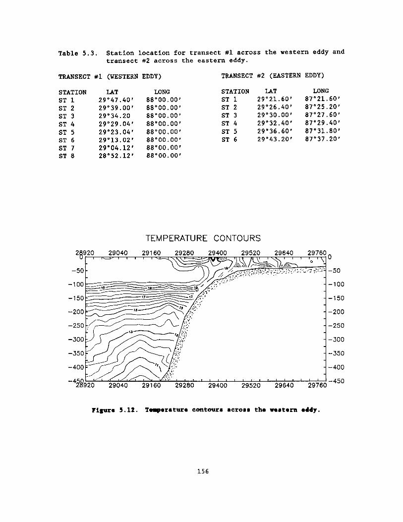
Table 5 .3 . Station location for transect #1 across the western eddy and transect #2 across the eastern eddy .
TRANSECT #1 (WESTERN EDDY) TRANSECT #2 (EASTERN EDDY)
STATION LAT LONG STATION LAT LONG ST 1 29° 47 .40' 88° 00 .00' ST 1 29° 21 .60' 87° 21 .60' ST 2 29° 39 .00' 88° 00 .00' ST 2 29° 26 .40' 87° 25 .20' ST 3 29° 34 .20 88° 00 .00' ST 3 29° 30 .00' 87° 27 .60' ST 4 29° 29 .04' 88° 00 .00' ST 4 29° 32 .40' 87° 29 .40' ST 5 29° 23 .04' 88° 00 .00' ST 5 29° 36 .60' 87° 31 .80' ST 6 29° 13 .02' 88° 00 .00' ST 6 29° 43 .20' 87° 37 .20'
ST 7 29° 04 .12' 88° 00 .00' ST 8 28° 52 .12' 88° 00 .00'
TEMPERATURE CONTOURS 2$920 29040 29160 29280 29400 29520 29640 29760
-50
0
-1 50
-200
-250
-300
-350
-400
-4
-~ 17 17
13
n\ 1
/S
L
0
-50
-100
-150
-200
-250
-300
-350
-400
28920 29040 29160 29280 29400 29520 29640 29760 -450
Figure 5.12 . Tewperature contours across the western eddy .
156

vicinity of the shelf break and reach the surface forming part of the shoreward side of the eddy . Along this transect, the eddy extends to a depth of f if ty meters . A lens of less saline water in the surface layer marks the location of the core .
A second transect made to the east of the first bisected the other eddy . The surface temperatures (Figure 5 .13) ranged from 17 .0°C to 18 .6°C with cooler waters appearing in the core of the eddy . Although this 17 .0°C water may also have had a source at the surface, it appears to be the result of the upward movement of the subsurface waters in the proximity to the shelf break . The tongue of low temperature water shown moving up the slope supports this contention . This eddy, like the other, appears to extend to a depth of 50 m.
Population densities for zooplankton and larval fish were greatest in the western eddy in areas that were identified as the cooler shelf water . The largest chlorophyll a concentrations were in the cooler shelf water entrained in the center of the eddy . Fish eggs were found to be concentrated in the shelf waters and in the northern extensions of the warmer Gulf water filaments (Figures 5 .14-5 .17) . Information from the eastern eddy are less clear concerning its biological structure (Figures 5 .18 and 5 .19) . Station position was not as successful in targeting different water types in the eastern eddy .
The two eddies that formed in January 1988 were not well organized structurally from what could be determined based solely upon temperature data . Because of this seemingly weak organization,
the eddies would tend to be more ephemeral phenomena than what is normally associated with an eddy . In no way does this underrate their importance in shelf circulation . In fact, these relatively short-lived eddies are evidently an important mechanism that plays an important role in the entrainment, mixing, and advection of productive shelf waters .
REFERENCES
Drennan, K.L . 1968 . Hydrographic studies in the northeast Gulf of Mexico . Project Report . Gulf South Research Institute .
Flierl, G .R . and J .S . Wroblewski . 1985 . The possible influence of warm core gulf stream rings upon shelf water larval fish distribution . Fish . Bull . 83 :313-330 .
Nelson, D .M ., H.W . Ducklow, G .L . Hitchcock, M.A . Brzezinski, T .J . Cowles, C . Garside, R.W . Gould, Jr ., T .M . Joyce, C . Landgon, J .J . McCarthy, and C.H . Yentsch . 1985 . Distribution and composition of biogenic particulate matter in a Gulf Stream warm core-ring . Deep-Sea Res . 32 :1347-1369 .
Olson, D . and R.H . Backus . 1985 . The concentrating of organisms at fronts : cold-water fish and a warm-core Gulf Stream ring . J . of Mar . Res . 43 :113-137 .
Bichardson, K. 1985 . Plankton distribution and activity in the North Sea\Skagerrak-Kattegat frontal area in April 1984 . Mar . Ecol . Prog . Ser . 26 :233-244 .
Dr . John P . Steen, Jr . holds a position as Assistant Zooplanktologist at the Gulf Coast Research Laboratory, Ocean Springs,
157

TEMPERATURE CONTOURS - TRAN . 2 0 400 8.00 1200 16.00 2 .00 2400 28.00 3200
0 ~ r. ~/1 11 1
:__~_ ~ -20 -40 -60 -80 -100
-120 -140 -160
-180 -200
D
-20 -40
-60 -80 -100 -120 -140 -160
-180
0 400 800 12!00 16:00 2000 2400 2800 3200 200
Figure 5 .13 . Temperature contours across the eastern eddy .
158

MIL mPLaaa am - NM =
Von m In MW
5 4
F Y, ROM
91 ST2 m 94 so M SP
Figure 5 .14 . Distribution of zooplankton <333p across the western eddy .
asmuma a aavimi A AM uis
um um His mw
L
l
z
i
$71 517 $U $74 m S11 sV on
Figure 5 .15 . Distribution of chlorophyll A across the western eddy .

N w 0
t
~~~ SNELF WATER
/~~/ OCEANIA HATER
6
i 0 u
f
z
IISIIUMOK OF IfMl F191 - IfSf IJIi
00 IM xpf, MW
.. . a . as SN m $I{ 97 Sri
Figure 5 .16 . Distribution of larval fish across the western eddy .
IISIII1N1a1 ff i191 IM - mm RIK
mom 1911 Wi 191f
IS
12
i
Figure 5 .17 . Distribution of fish eggs <331p across the western eddy .

r r
,m. firdalm YOLK 4AR ~ IRKS um elm mm
z
2 0
u
i
NJ
C /, all
; i i
�;� � �� �� ~� , 1 "' H+ o~~ Al a$
Figure 5 .18 . Distribution of zooplankton <333p across the eastern eddy .
c
.NOM... MAWAU A -M d. rya nr ar aw
s
i
I
a
. . " au an so $16
Figure 5 .19 . Distribution of chlorophyll A across the eastern eddy .

MI . He received a doctorate in biology from the University of Mississippi, Oxford .
Dr . Rez C . Herron specializes in satellite imagery for the National Marine Fisheries Service, Slidell Computer Complex in Louisiana .
Dr . C .E . Eleuterius is a physical oceanographer at the Gulf Coast Research Laboratory . His interests lie with the hydrographic processes occurring in the northern Gulf of Mexico .
162

CHEMOSYNTHETIC COMMUNITIES

Session : CHEMOSYNTHETIC COMMUNITIES
Co-Chairs : Dr . Robert M. Avent Dr . Robert S . Carney Mr . Gary D. Goeke
Date : October 26, 1988
Presentation Author/Affiliation
Chemosynthetic Communities : Session Overview
Dr . Robert M. Avent Minerals Management Service Gulf of Mexico OCS Region
Chemosynthetic Organisms--Discoveries and Implications
Chemical Ecology and Distribution of Chemosynthetic Communities in the Gulf of Mexico and Elsewhere
Death Assemblage Formation by Petroleum Seep Assemblages
Structure and Functions of "Chemosynthetic Invertebrates"
Florida Escarpment Sea Communities
MMS Operational Requirements for Chemosynthetic Communities
Chemosynthetic Communities : "The Industry Perspective"
Dr . Robert S . Carney Louisiana State University
Dr . James M. Brooks, Dr . Mahlon C . Kennicutt II, and Dr . Robert R. Bidigare Texas A&M University
Dr . Eric N . Powell Texas A&M University
Dr . Charles R. Fisher University of California at Santa
Barbara
Mr . Craig Cary Scripps Institution of Oceanography
Mr . Gary D . Goeke Minerals Management Service Gulf of Mexico OCS Region
Mr . John C . Farris Placid Oil Company
165

Chemosynthetic Communities : Session Overview
Dr . Robert M. Avent Minerals Management Service Gulf of Mexico OCS Region
Dr . Robert Avent, Minerals Management Service (MMS), Gulf of Mexico Region, delivered some opening remarks, introduced co-chairs, and reviewed the structure and purpose of this session . The session consisted of formal presentations followed by an informal discussion on Gulf chemosynthetic communities . The purpose of this session on chemosynthetic communities was to review the status of knowledge of these remarkable assemblages in general, and discuss the implications of recent discoveries in the Gulf of Mexico, in particular, to the government and industry .
Oceanographers have recently found a cold seep community at the foot of the Florida Escarpment in waters over 3 km deep, and several upper slope communities associated with hydrocarbon seeps in the northern Gulf . The latter are of considerable concern to the MMS as they fall well within the deep drilling and operational capabilities of the petroleum industry . The MMS has instituted offshore operational restrictions through Notices to Lessees (NTL's) to minimize or eliminate physical disruption of these communities .
The first speaker, Dr . Robert S . Carney of Louisiana State University, in his paper "Chemosynthetic Communities : Discoveries and Implications," reviewed the historical notions and theories of deep-sea biology and
the difficulties in studying the fauna . Faunal biomass decreases dramatically in response to reduced food resources but biological diversity increases significantly . The patterns of "zonation," zoogeography, and diversity were discussed briefly in light of theories of competition, niches, and deep-sea homogeneity . Scientific interest in the deep-sea, roughly 100 years old, increased in the 1960's . The first environmental concern in the deep-sea was the dumping of radionuclides (it was assumed that the deep-sea was a virtual desert and little biological harm would result) . A major field of investigation, seafloor spreading, prompted scientists to obtain submersible time to study areas of active plate tectonics where geothermal processes could be observed . Some of these dives brought back remarkable samples and photographs of animals later confirmed to be chemosynthetic, i .e ., dependent upon reduced chemical compounds issuing from hydrothermal vents near spreading centers . Dr . Carney recounted the sequence of discoveries and the phenomenal interest and research effort showed by numerous scientists since these first discoveries in the Pacific about a decade ago . Chemosynthetic animals are those which are not generally dependent on organic detrital energy derived from primary production which drifts down from the surface, sunlit waters . In contrast to most forms, these live in association with, and depend at least partially upon, dissolved gases which emanate from the bottom into oxygenated waters . There are several geological and geochemical processes which have been identified which can account for the production of these
167

compounds . Symbiotic bacteria provide a critical energetic link between the environment and the animals . With increased energy supplies, they may form dense aggregations with orders-of-magnitude greater biomass than the surrounding fauna (supporting the hypothesis that the deep-sea fauna is food-limited) . Dr . Carney feels that the Gulf communities are important as a natural laboratory, shallow and close enough to land for intensive, logistically-feasible, and economical investigations . The Gulf communities are well developed and harbor forms dependent on both methane and sulfide . Finally, they are the only communities within the potentially destructive forces of industry .
Dr . James Brooks described the results of research conducted by his team of investigators at Texas A&M University in the presentation, "Chemical Ecology and Distribution of Chemosynthetic Communities in the Gulf of Mexico and Elsewhere ." This presentation reviewed four years of interdisciplinary research on chemosynthetic communities beginning with the 1984 discovery of these animals in trawl nets . The Louisiana hydrocarbon seep communities are similar in faunal composition to other deeper finds (at mayor taxon level), but are unique in their shallow depth distribution and accessibility for scientific study . Follow-up chemical, biological, geological, and ecological studies documented a close linkage between hydrocarbon seepage, water-column chemistry, and increased biomass at these locations . Carbon, sulfur, and nitrogen isotope studies further confirmed these interactions and revealed three nutritional strategies : heterotrophy, and
methane-based and sulfide-based chemoautotrophy . Mussels, clams, and tubeworms were shown to contain dietary carbon from hydrocarbon seepage . Isotope analyses suggested a transfer of energy from the seep animals to other background fauna (through carnivores?) . The composition and spatial distribution of the chemosynthetic animals is quite complex and correlates significantly with water or sediment hydrocarbon concentrations (mussels and tubeworms, respectively) . At least five overlapping but distinct assemblages have been identified with shared dependance on chemosynthetic processes . Additional biochemical studies showed, for example, that a wide variety of seep organisms exhibit the presence of mixed-function oxidase which mediates hydrocarbon metabolism . A chemical environment very similar to the Louisiana sites has been identified off California and it was suggested that seep communities may be widespread through the oil-containing regions of the world . The ecological significance of chemosynthetic processes in the deep-sea needs to be resolved and quantified through further interdisciplinary studies .
Dr . Eric Powell of Texas A&M University reviewed his findings from taphonomic research on the northern Gulf assemblages in a presentation, "Death Assemblage Formation by Petroleum Sea Assemblages ." The taphonomic approach which has become an important tool in paleoecological analysis, assumes that each type of environment is characterized by a unique set of physical, chemical, and biological processes which imprint a predictable signature on a death assemblage (e .g ., shell
168

accumulations) . Dr . Powell has applied this approach to several environments including northern Gulf petroleum seep areas . Seep mussels and clams are forming the only substantial autochthonous shell accumulations on the northwest Gulf shelf and slope . Variability in shell orientation, articulation, and physical condition suggest that lucinid beds (which form beneath the sediment surface) and vesicomyid beds (which form at the surface) have very different taphonomic histories despite formation under similar environmental conditions .
Dr . Charles Fisher, in his presentation, "Structure and Function of Chemosynthetic Invertebrates," discussed the physiological, anatomical, and ecological characteristics of chemosynthetic animals ; animals which rely on chemoautotrophic bacteria to convert in situ supplies of reduced chemical compounds (e .g ., methane and hydrogen sulfide) into energy and/or tissue components . In every species studied, highly specific adaptations allow life in, indeed take advantage of, local seep conditions . Vestimentiferan tubeworms, Riftia and Lamellibrachia for example, have no mouth, gut, or anus . The anterior obturacular area has a branchial plume for gas exchange, below which is a trunk containing gonads and the trophosome . The latter holds the endosymbiotic bacteria . The supply of nutrients to the internal bacteria requires a hemoglobin which carries oxygen and sulfide simultaneously . This requires a dynamic environment in which both gases are constantly supplied . The bivalves, Vesicomva and Calyptogena spp., contain their bacteria near their large gill's
surfaces, and have sulfide-binding blood suitable for existence in a variety of reducing habitats . Chemosynthetic animals are generally resistant to conditions which could well be toxic to some other forms . The mobile Calyptogena may actually move to suitable sites . The Louisiana seep mussel contains abundant bacteria which mediate the metabolism of methane, the first known of three such examples . The shallow Louisiana communities provide valuable, exciting natural laboratory conditions . They are in many ways similar to other parallel communities, but are close enough to the surface and shore to be accessible to interested researchers .
Mr . Craig Cary of the Scripps Institution of Oceanography presented a paper, "Florida Escarpment Sea Communities ." He described recent researches on a chemosynthetic community associated with hypersaline cold-water seeps at depths greater than 3,000 m. Here, the base of the nearly vertical escarpment, the western margin of the Florida-Bahamas Platform, meets the abyssal sediments of the Gulf of Mexico . Brine seeps flow out from the wall in localized channels . While difficult to analyze the brines (they flow close to this substrate), it has been suggested that they carry sulfide and methane formed deep within the Platform . Although the geology of the Florida Escarpment is very different from that of Pacific hydrothermal vents, the sustained availability of reduced compounds supports the growth of bacteria and macrofauna in both systems . The community is dominated by a large, undescribed seep mussel, and a vestimentiferan tubeworm, Escarpia laminata . Large
169

turrid gastropods, small transparent shrimp, and small purplish-pink anemones are common among the mussels . The fauna bears greater resemblance to the Pacific hydrothermal communities than to those of the Mid-Atlantic Ridge . Microscopic, enzymatic, and isotopic investigations of Florida mussels and tubeworms showed that they harbor endosymbiotic chemoautotrophic bacteria similar to those forms found elsewhere . Isotopic analyses of sediment pore water showed the presence of ammonia, methane, and hydrogen sulfide, the latter from in situ bacterial activity and the escarpment . Escarpia laminata and the mussel rely on sulfide and methane, respectively .
Mr . Gary Goeke, MMS, Gulf of Mexico Region, described the present requirements imposed on the petroleum industry in areas of the Gulf with conditions potentially suited to the existence of high-biomass, high-diversity chemosynthetic communities . The ecological role of these communities and their contribution to deep-sea food webs are poorly understood . The wishes of MMS to conserve these assemblages centers upon the agency's mandate to conserve valuable marine resources . The species in question are not considered to be endangered and appear to be broadly distributed across the northern Gulf . Yet they have been deemed a valuable resource and MMS has established mitigative measures to protect them . Numerous petroleum activities, primarily those which physically disrupt the bottom (e .g . , the laying of pipe, anchors, templates, and chains), have the potential to harm chemosynthetic communities . Random impingement of such activities is unlikely,
even without mitigation, and industry attempts to avoid such sites with potential geohazards . The effects of drilling muds and cuttings are considered minimal in the depths (>400 m) where the communities are found . Another potential impact, it has been suggested, is the withdrawal of petroleum from subsurface reservoirs, reducing reservoir pressure and flow of hydrocarbons and sulfides to the surface . This is still considered conjecture, however . The MMS' current interim guidelines have been in place since 1985 . These require, upon review of plans of exploration and development, that leases in depths >400 m which show any geophysical evidence of seep conditions to be photographed to document the presence or absence of any "lush" communities . If these exist the operator is required to take measures to avoid physical damage to communities in the vicinity . The MMS is currently reviewing the need for any additional MMS funded studies .
Mr . John C . Farris of Placid Oil Company represented the Offshore Operators Committee (OOC) with a presentation titled "Chemosynthetic Communities : The Industry Perspective ." Following the MMS' instituting requirements that companies operating in potentially sensitive areas provide photo-reconnaissance evidence of the presence or absence of chemosynthetic animals, the OOC created an ad hoc committee to address the problem . The OOC initiated a dialogue with the MMS to clarify MMS expectations, and discuss the implications of these communities on Outer Continental Shelf (OCS) exploration and production . These discussions prompted the OOC to provide
170

technical and financial support for a study on community distribution, hopefully to expedite a regional solution to the problem which they viewed as potentially costly--both in time and money . With the OOC contracting with Texas A&M University, Geochemical and Environmental Research Group (GERG), a study was begun in February 1986 . The purpose of this program was to determine the level of correlation between the presence of geophysical "wipe-out" zones, sediments with evidence of oil and hydrogen sulfide, delta 13°C anomalies, and other features, with the presence of chemosynthetic animals . Thirty-nine selected sites (chosen on the basis of geophysical signatures) were sampled with trawls and piston corers . Additional submersible observations were conducted . The OOC recognizes the potential hazards to the communities, mostly those physically disruptive (deployment of anchors, chains, production templates, footings, etc.) . However these were calculated to affect only very small areas of a lease block (<I%) . This fact, added to MMS regulations and industry safety measures which require the avoidance of geohazards, leads the OOC to conclude that deepwater activity should impact the communities minimally, if at all .
The session concluded with discussions on the need for additional studies, as it concerns MMS' mandate to protect valuable resources and manage minerals extraction in federal waters . While there are many unknown details of the lives of chemosynthetic communities and animals, there are serious questions as to how much must be known for management purposes .
Certainly, any new information streamlining management decisions would be welcome . Some of the central questions remaining are :
o What are the effects of petroleum extraction on seepage?
o How permanent or ephemeral are the communities?
o What is the precise range of environmental variables which are required for life? Are the organisms fragile or robust?
o What is the impact recovery potential? If destroyed, how long would resettlement and growth re-establish the communities in suitable areas? How are larvae dispersed and how far? What are the reproduction rates?
Dr . Robert K. Avent received the M.S . and Ph .D . degrees in biological oceanography from Florida State University in 1970 and 1973 . His main fields of interest include marine physiological ecology and deep-sea biology . He has pursued investigations on the biological effects of hydrostatic pressure, animal zonation, and reef morphology . He has worked in the consulting industry and for state government . He came to the Bureau of Land Management/MMS in 1981 from the National Marine Fisheries Service .
171

Chemosynthetic Organisms--Discoveries and Implications
Dr . Robert S . Carney Louisiana State University
Continental slope chemosynthetic communities associated with hydrocarbon seeps off Louisiana and Texas are similar to communities associated with hydrothermal activity and polymetallic sulfide deposits . In each case potential environmental impact must be considered in conjunction with any plan to utilize the mineral resources . Unlike deep seafloor mining, which is still in the planning phase, progressively deeper petroleum production is now a reality . Therefore, a higher priority should be assigned to determining the sensitivity of petroleum seep communities .
It is the purpose of this brief review to suggest a course of action that will assure an appropriate level of environmental protection for the unique deep-sea chemosynthetic communities associated with petroleum seeps . Rather than considering these communities in isolation, it is important that they be treated as special cases in the larger problem of preventing unacceptable impact in the deep-sea . When this larger perspective is taken, we quickly find that assumptions borrowed from shallow water experiences are inappropriate . Fundamental questions about these deep systems, especially the reeflike chemosynthetic communities remain unanswered . Efforts to assess sensitivity of impact must be designed to answer some very basic questions .
Concern over environmental impact at depths over 1,000 m is a relatively new facet of marine environmental protection which has gained a higher priority with deeper oil exploration and the discovery of polymetallic sulfides within the U.S . Economic Exclusion Zone (EEZ) . Since an experienced and reasonably effective federal system is in place for the protection of shallower marine environments, it is understandable that designs for looking at deep systems might resemble designs appropriate for shallow systems . However, when we take a critical look at the real substance of impact work at shelf depths, the underlying assumptions are found to be inappropriate for the deep-sea .
In spite of an increasing emphasis upon understanding ecological processes in marine systems, the most important assumption which still underlies the vast majority of marine impact work is that species censusing is the best means of assessing both the potential for and the actual existence of impact . The persistence of this approach implies that the fundamental ecological processes of the systems are so well understood, that census data can be placed in a process-oriented context without mayor investigations of those processes . An excellent example of this can be seen in Outer Continental Shelf (OCS) surveys and monitoring, where benthic sampling is done to the virtual exclusion of water column studies . There is absolutely no effort made to describe the tropic structure of these systems (Boesch and Rabalais 1987) .
Of course, the continued emphasis on faunal censuses, is not based
172

upon a profound ignorance of contemporary ecology . It is, rather, a cost-effective compromise made when studying systems in which the fundamental processes are thought to be reasonably well known . Applied to the deep-sea, there are insidious consequences . We really know very little about the deep-sea (Rove 1983) .
With respect to the deep-sea trophic structure, we know only that biomass decreases markedly with depth . We still do not know the rates and routes which link carbon flux, sedimentary detritus, and the biota . The potential for impacting this system remains unknown . With respect to basic community composition, we know only that species diversity can be extraordinarily high . We can not explain what factors allow for such high diversity, and we know nothing of what would constitute a potential threat to these communities . Even with respect to simple species distribution, we do not know what causes the conspicuous bathymetric changes in faunal composition . Therefore, it is a mistake to assume that deep-sea census data can be evaluated within an appropriate context of well understood ecological processes . Prudent investigation of the potential for impact in the deep-sea must be based upon first learning about basic processes .
I hope that it has been established that in the planning stages of any deep-sea impact work, we must address a profound level of ignorance . When we encounter a deep-sea chemosynthetic community, an even greater level of complexity is achieved . Embedded in a detritus feeding ecosystem, we have a dense chemosynthetic "reef ." The ecology of these communities
is far less well understood than the biology of the key species .
Recent discoveries in the northern Gulf of Mexico are dramatically altering our understanding of the geological, chemical and biological processes which control the overall ecology of the continental slope . In the geological area, high resolution profiling has increasingly shown that salt tectonism and related processes dominate mesoscale topography and produce islands of hard substrate in a predominantly mud environment (Roberts et al . 1987) . Active and widespread geochemical systems involving hydrocarbons at or near the deep-sea sediment-water interface were first confirmed by the discovery of oil-stained cores and thermogenic hydrates by the Texas A&M University Geochemical and Environmental Research Group (Brooks et al . 1984) . Trawling in these areas later revealed that a fauna utilizing chemosynthetic symbionts was associated with these systems (Kennicutt et al . 1985, papers herein) . Clearly, as resource development of the EEZ progresses beyond the shelf break, concepts of Gulf of Mexico slope ecology developed prior to 1985 can not be used for management decisions .
The Louisiana continental slope chemosynthetic communities associated with hydrocarbon seeps are one of a series of discoveries of functionally and taxonomically related assemblages in the deep-sea . All of these communities share the common feature of being associated with sources of methane or hydrogen sulfide in an oxygenated environment . The underlying geological processes supplying these reduced compounds vary from site to site . These
173

communities are the focus of intense international research, and many of the questions to be asked in the Gulf of Mexico have already been identified and are being addressed .
o What are the detailed geological, chemical, and ecological processes whereby seeping hydrocarbons support distinct communities?
o How do these communities persist, and to what degree do physical-chemical and biological factors interact on different spatial and temporal scales?
o How do the component species reproduce, disperse, and then successfully recruit into new or existing communities?
In the Gulf of Mexico, these basic scientific questions assume an applied importance, since we are faced with the question of environmental impact upon a fauna that is uniquely associated with exploitable hydrocarbon reserves . It is important that we understand how these communities persist in the natural environment, and the extent to which they will be resilient in the face of petroleum-related activities .
Preconceptions about possible impacts (i .e ., they have either a low or high probability), all depend upon how the chemosynthetic communities are envisioned, rather than specific findings . For example, if the authegenic carbonate hard substrates and the associated tubeworms, mussels, solitary corals, soft corals, etc . are considered to be a simple variation of a live bottom, then protection is a simple matter . As with any live bottom, sensitivity to petroleum activities would be
determined, and appropriate limits placed on the proximity of activities .
Petroleum seep communities can not simply be treated as live bottoms . Rather, in addition to the usual live bottom concerns, it is important to determine what the unique links among geology, geochemistry, and biology are . Informed management decisions can only be made when the possible effects of petroleum activities on these critical (and possibly complex) linkages are identified .
When the geological -geochemical-biological linkages are considered, the appropriate management goal should be to determine to what extent the Gulf of Mexico deep water petroleum seeps fit into two possible categories : a robust or fragile community .
o A Robust Community--Since these communities are associated with petroleum and degradation processes, then they may be uniquely immune from impact by hydrocarbons . They may, in effect, be "weeds" capable of rapidly locating and colonizing numerous sites which afford the correct geological-geochemical setting . In such a case, simple restrictions to prevent mechanical damage might be sufficient when combined with regulations which preserve some habitat areas .
o A Fragile Community--Alternately, it can be argued that these communities occupy a relatively rare and narrow niche associated with different phases of petroleum degradation . Being so very highly specialized, the narrow
174

range of environmental conditions which support these communities might be very easily altered by drilling and production activities . Indeed, production may result in a loss of the very energy source required by these communities .
Determination of the extent to which the hydrocarbon seep communities are robust or fragile entails coordinated geological, geochemical, and ecological efforts that will develop an understanding of the spatial and temporal linkage pattern between hydrocarbon seepage and chemosynthetic community development on the seafloor . These investigations must determine how communities are established and persist within the particular geological and geochemical environments which support them (Sibuet et al . 1988) . As stated above, the key to understanding potential impacts lies in understanding how the processes of geology, geochemistry, and biology interact .
While resource exploitation beyond the continental shelf is relatively rare, there are a few ongoing programs within the U . S . which deal with the issue of potential damage to sensitive deep-sea communities . To a certain extent, these can serve as models for work on the chemosynthetic communities in the Gulf of Mexico and other OCS areas . Of particular relevance is the concern over environmental impact associated with deep-sea mining of polymetallic sulfides . These deposits have associated chemosynthetic fauna and fall under the authority of Minerals Management Services (MMS) .
The Gorda Ridge is a deep-sea geological structure within the Economic Exclusion Zone (EEZ) off the coasts of Washington, Oregon, and California . It is an area in which seafloor hydrothermal activity results in the deposition of potentially valuable deposits of polymetallic sulfide minerals . The unique chemical environment associated with ore deposition also supports chemosynthetic communities very similar to those on the Louisiana-Texas continental shelf . The draft environmental impact statement (DEIS) prepared by Minerals Management Services (MMS 1983) established three very important points concerning resource development in regions where deep-sea chemosynthetic communities are found . First, these communities are of considerable scientific value and warrant efforts at preservation . Second, these communities may be more ecologically sensitive than the more typical, heterotrophic deep-sea fauna . Third, the most appropriate means of protection might be to prohibit mining in the vicinity of communities .
Due to a critical lack of information on the potentially impacted systems discussed in the Gorda Ridge DEIS, strongly negative public opinion lead to the formation of the Gorda Ridge Technical Task Force . This point federal-state research coordination effort, has grown into a major Department of Interior, National Oceanographic and Atmospheric Administration, U .S . Navy cooperative program (McMurray 1986) . The recommendations of an NOAA sponsored workshop chaired by Dr . Robert Hessler of the Scripps Institution of Oceanography (Hessler 1983) have played a central role in directing the
175

research of the Task Force . It was recommended that population dynamics of communities be studied, and that long-term monitoring be initiated . Unlike the Gulf of Mexico situation where the location of some communities is very well known, a major exploratory effort has been initiated on the Gorda Ridge to locate systems for study (McMurray 1985) .
To a certain extent, the concerns and recommendations with respect to polymetallic sulfide mining were based upon earlier consideration of the potential impacts associated with deep-sea nodule mining . In order to protect the fauna associated with nodule rich environments, federal legislation mandates the establishment of stable reference areas (SRA) within which no mining activity would be allowed . A committee formed by the National Research Council of the National Academy of Sciences reviewed this approach, found it scientifically valid, and outlined a course of research in 1984 (R . Heath, overall chairman, R.S . Carney, chairman ecological workshop) . The central theme of research is to determine the distance at which the bottom fauna receives no impact from mining . Once this distance is known, it will be possible to establish areas large enough to protect the fauna and small enough to avoid unneeded restrictions upon development .
AN EFFECTIVE APPROACH TO PETROLEUM SEEP COMMUNITIES
The overall design of seep systems studies must be based upon a careful consideration of the state of knowledge of other deep-sea chemosynthetic communities, the concerns about impact to those systems within the U.S . EEZ, unique
aspects of the Louisiana-Texas communities, and our own considerable experience in the Gulf and elsewhere . If the hydrocarbon seep communities are to receive appropriate protection, it will be necessary to determine those factors most important for the establishment and persistence of the communities . As will be detailed in the following sections, we feel that such information can be developed in a hierarchical fashion employing submersible survey, sampling, experimentation, and monitoring .
First, what is the nature and distribution of geological structures with which such communities are associated?
Second, within the appropriate geological setting, what is the nature and distribution of the geochemical environment which can support chemosynthetic communities?
Third, within the appropriate geological and geochemical settings, what factors regulate the establishment, persistence, and resilience of chemosynthetic communities?
Finally, with what confidence can faunal survey, geochemical survey, and/or topographic survey provide, in a cost-effective manner, the information needed to locate and protect these communities?
In understanding such an investigation, we are well aware of the slow rate of progress in some aspects of deep-sea community ecology . While our tasks are not trivial, they are obtainable because the Louisiana-Texas slope communities afford three special opportunities which we will exploit .
176

1 . These sites are relatively shallow (less than 1,000 m) . As a result, a wider variety of technologies can be employed than in deeper systems .
2 . There is considerable information available on the geology and geological processes of the region .
3 . There are obvious management needs which will result in the appropriate priorities focusing upon the geological-geochemical-ecological link .
REFERENCES
Boesch, D.F . and N .N . Rabalais (eds) . 1987 . Long-term environmental effects of offshore oil and gas development . Elsevier Applied Science . 708 pp .
Brooks, J .M ., M.C . Kennicutt II, R.A . Fay, T .J . McDonald, and R.A . Sassen . 1984 . Thermogenic gas hydrates in the Gulf of Mexico . Science 225 :409-411 .
Hessler, R.R . 1983 . Geological, geochemical, and biological research needs with environmental and timing concerns, pp . 93-103 . In M.B . Hatem, ed . Marine polymetallic sulfides : a national overview and future needs . Maryland Sea Grant Publication No . UM-SG-TS-83-04 .
Kennicutt, M.C ., J . M . Brooks, R. R . Bidigare, R.R . Fay, T .L . Wade, and T.J . MacDonald . 1985 . Vent-type taxa in a hydrocarbon seep region of the Louisiana slope . Nature 317 :351-353 .
McMurray, G . 1985 . Environmental considerations for the development of metalliferous sulfides . Marine Technology Society Journal 19 :57-61 .
McMurray, G . 1986 . The Gorda Ridge technical task force : a cooperative federal-state approach to offshore mining issues . Marine Mining 5 :467-475 .
Minerals Management Service . 1983 . Draft Environmental Impact Statement : proposed polymetallic sulfide lease offering . Prepared by MMS Headquarters Office, 12203 Sunrise Valley Drive, Reston, Va . 22091 . J.P . Zippin Coordinator . 580 pp .
Roberts, H.H . , R . Sassen, and P . Aharons . 1987 . Carbonates of the Louisiana continental slope . Offshore Technology Conference Report 5463 . pp . 373-382 .
Rowe, G .T . 1983 . The sea, Volume 8 : deep-sea biology . Wiley-Interscience . New York . 560 pp .
Sibuet, M. , S .K . Juniper, and G. Pautot . 1988 . Cold-seep benthic communities in the Japanese subduction zone : geological control of community structure . Journal of Marine Research 46 :333-348 .
Dr . Robert S . Carnep received his M .S . (1969) and Ph .D . (1977) degrees in biological oceanography from Texas A&M University and Oregon State University, respectively . His mayor research interests are deep-sea benthic ecology, animal-sediment interactions, and evolution and adaptation of sediment-feeding organisms . He is presently Chairman of the Department of Marine Sciences and Director of the Coastal Ecology Institute at Louisiana State University . He has held academic and management appointments at the Smithsonian Institution, the National Science
177

Foundation, and at other universities and laboratories . He has been a member of many national policy and editorial boards, panels, committees, and commissions, and has published extensively on deep-sea biology .
Chemical Ecology and Distribution of
Chemosynthetic Communities in the Gulf of Mexico
and Elsewhere
Dr . James M. Brooks, Dr . Mahlon C . Kennicutt II,
and Dr . Robert R. Bidigare Texas A&M University
A trawl retrieval of nearly two tons of organisms and shell debris in 500 m of water at a known location of natural petroleum seepage in the Gulf of Mexico in 1984 marked the beginning of four years of interdisciplinary studies (Kennicutt et al . 1985) . It was soon recognized that the assemblage of organisms recovered was similar to that reported at the hydrothermal vents in the late 1970's and at the Florida Escarpment dust a few months before (Ballard 1977 ; Corliss and Ballard 1977 ; Paull et al . 1984) . These and other discoveries have now come to be referred to as the contrasting ecological niches of "hot" and "cold" vent/seep communities . "Hot" vent areas are characterized by elevated temperatures due to the recirculation of seawater through zones heated by magmatic intrusions . No temperature anomalies are apparent at the "cold" seep sites but the commonality between sites is the supply of reduced compounds
creating a tenuous balance between oxic and anoxic conditions (Paull et al . 1984, 1985 ; Suess et al . 1985 ; Cavanaugh 1985) . Early studies at both types of sites revealed that the enhanced productivity and biomass associated with these communities was directly linked to mutually beneficial symbiotic relationships between bacteria and invertebrates . The uniqueness of the Gulf of Mexico petroleum seep sites are their relatively shallow depths which allow for extensive and repeated samplings and also provide for the retrieval and maintenance of living organisms for shore-based laboratory study . The abyssal depths associated with previous discoveries limited the scientists' ability to retrieve live animals for study . The Louisiana seep sites provide a near continuous supply of organisms whose only requirements are maintenance at bottom-water temperatures (5-7°C) and a supply of reduced compounds and dissolved oxygen . The location of these communities has made them readily accessible to study and sampling by submersibles such as the Johnson Sea-Link and the U .S . Navy submersible NR-1 .
As at the hydrothermal vents, the isotopic analysis of organisms' tissue has been especially useful in understanding the dynamics of these chemosynthesis-based communities (Kennicutt et al . 1985 ; Childress et al . 1986 ; Brooks et al . 1987) . Initial results showed that clam and tubeworm tissues were isotopically light, with d 13C values indicative of sulfide-utilizing endosymbionts . The tubeworms were very enriched in 12C as compared to the hydrothermal vent tubeworms . This difference is as yet unexplained, though C02 limitation has been invoked as a
178

cause for 13C enrichment (Rau 1981, 1985) . Further samplings recovered a species of mussel that was very enriched in 12 C and its 613C (6 13C
_ -40 to -55°/00) values approached those of the Florida Escarpment mussel (Paull et al . 1984, 1985) . While the use of methane by endosymbionts had been suggested for organisms collected at the Florida and Oregon sites, no supporting biochemical studies were available . Extensive enzymatic, electron microscopic and 14CH4-uptake studies conclusively demonstrated the occurrence of a methane-based endosymbiotic relationship between a bacterium and a molluscan (Childress et al . 1986 ; Brooks et al . 1987) . Laboratory studies suggest the symbiosis may potentially be able to entirely satisfy the mussels' carbon needs solely from methane oxidation (Childress et al . 1986 ; Cary et al . 1988) .
Follow up chemical, biological, geological, and ecological studies documented a close linkage between hydrocarbon seepage, water column chemistry, and the presence of enhanced biomass at these locations . Additional isotope measurements (1°C, 634 S and d 15N) further confirmed these interactions (Brooks et al . 1987) . Carbon isotope ratios differentiated three distinct nutritional strategies : (1) heterotrophic, (2) sulfide-based, and (3) methane-based . Mussels, clams, and tubeworms were shown to contain mostly "dead" carbon, indicating that their dietary carbon is largely derived from seeping oil and/or gas . Isotopically light sulfur (d 3°S < 0°/00) was present in the sulfide-based organisms and the light nitrogen isotope values (8 15N <0°/00) measured for the mussels
suggested the presence of nitrogen fixing bacteria (Rau 1985 ; Fry et al . 1983 ; Brooks et al . 1987) . Other organisms, believed to be carnivorous, reflect the isotopic values of their diets and provide a mechanism for the transfer of chemosynthetic carbon into the background fauna .
Ecologically, the composition and spatial distribution of seep faunal assemblages are much more complex than previously realized . Mussel density significantly correlates with water methane levels and tubeworm cover correlates with sediment petroleum loading (MacDonald et al . 1989) . At least five basic assemblages have been recognized including mussel beds, tubeworm clumps, clam beds, epifaunal brachipod-solitary coral assemblages, and gorgonian fields . These assemblages overlap spatially and have some shared dependence on chemosynthetic processes .
The presence of abundant biota at these sites provides an in situ laboratory for studying the responses of organisms to potentially toxic compounds . Initial results suggest that the biochemical basis for these communities requires an intimate contact with high levels of known toxic compounds, such as polynuclear aromatic hydrocarbons (PAH's) and hydrogen sulfide (Kennicutt et al . 1989a ; MacDonald et al . 1989 ; Wade et al . 1989) . A variety of seep organisms exhibit the presence of a mixed function oxidase (MFO) mediated hydrocarbon metabolism, with mussels having the highest activity . Within the mussels only the gills exhibit significant MFO activity, suggesting an association with the methylotrophic symbiotic bacteria (i .e ., co-oxidation of hydrocarbons
179

during the oxidation of CH4 ; Brooks et al . 1988) . Mussel hydrocarbon tissue loading is variable with respect to location and tissues . Gill tissue contain the highest aromatic hydrocarbon content in several cases (Wade et al . 1989) . Various species also exhibit activity for oxygen detoxificatory enzymes, catalase, and superoxide dismutase with mussels again showing the highest activity . Inhibitory studies showed the catalases to be normal catalases and not those associated with sulfur dependent metazoans (Brooks et al . 1988) .
The recent retrieval of sulfide-based endosymbiont-containing bivalves on the northern California slope suggests that hydrocarbon seep communities may be widespread in the mayor offshore oil containing regions of the world (Kennicutt et al . 1989b) . A chemical environment very similar to that of the Louisiana site (including the presence of gas seepage and hydrates) was documented for the California site (water depth 420-600 m) . These reports confirm that the deep-sea chemical environment is an important factor controlling the distributions of these communities, and that the mechanism maintaining the oxic/anoxic conditions can be highly variable and occurs quite frequently in the world's oceans . The ecological significance of chemosynthetic processes in the deep ocean needs to be resolved and quantified through further interdisciplinary studies . The results of the initial studies summarized here have advanced our understanding of the complex interactions among chemical, biological, and geological processes at these unique, hydrocarbon-rich environments .
REFERENCES
Ballard, R.D . 1977 . Notes on a major oceanographic find . Oceanus 20 :35-44 .
Brooks, J .M ., M.C . Kennicutt II, C .R . Fisher, S .A . Macko, K. Cole, J .J . Childress, R.R . Bidigare, and R.D . Vetter . 1987 . Deep-sea hydrocarbon seep communities : evidence for energy and nutritional carbon sources . Science 238 :1138-1142 .
Brooks, J.M ., E .N . Powell, M .C . Kennicutt II, R .S . Carney, I . Rosman, S .J . McDonald, R .R . Bidigare, and T.L . Wade . 1988 . Gulf of Mexico Hydrocarbon Seep Ecosystem Studies . In NOAA Symp . Series for Undersea Research 6(2) . In press .
Cart', S .G ., C.R . Fisher, and H . Felbeck . 1988 . Mussel growth supported by methane as a sole carbon and energy source . Science 240 :78-80 .
Cavanaugh, C .M . 1985 . Symbioses of chemoautotrophic bacteria and marine invertebrates from hydrothermal vents and reducing sediments, pp . 373-388 . In M.L . Jones, ed . The hydrothermal vents of the eastern Pacific : an overview . Bull . Biol . Soc . Wash . Vol . 6 .
Childress, J.J ., C .R . Fisher, J .M . Brooks, M.C . Kennicutt II, R.R . Bidigare, and A. Anderson . 1986 . A methanotrophic marine molluscan (Bivalvia Mytilidae) symbioses : mussels fueled by gas . Science 233 :1306-1308 .
Corliss, J .B . and R.D . Ballard . 1977 . Oases of life in the cold abyss . National Geographic 152 :441-453 .
180

Fry, B., H . Gest, and J .H . Hayes . 1983 . Sulfur isotopic composition of deep-sea hydrothermal vent organisms . Nature 305 :1078-1079 .
Kennicutt, M.C ., II, J.M . Brooks, R.R . Bidigare, R.A . Fay, T .L . Wade, and T.J . McDonald . 1985 . Vent type taxa in a hydrocarbon seep region on the Louisiana slope . Nature 317 :351-353 .
Rennicutt, M.C ., II, J.M . Brooks, R.R . Bidigare, and G .J . Denoux . 1989a . Gulf of Mexico hydrocarbon seep communities : I . Regional distribution of hydrocarbon seepage and associated fauna . Deep-Sea Res . In press .
Kennicutt, M.C ., II, J .M . Brooks, R.R . Bidigare, S .J . McDonald, and D .L . Adkinson . 1989b . An upper slope "cold" seep community : northern California . Limnol . Oceanogr . (submitted) .
MacDonald, I ., J . S . Baker, G. S . Boland, J. M . Brooks, M . C . Kennicutt II, and R.R . Bidigare . 1989 . Gulf of Mexico hydrocarbon seep communities : II . Seep organisms and hydrocarbons at Bush Hill . Mar . Biol . In press .
Paull, C.K . , B . Hecker, R . Commeau, R.P . Freeman-Lynde, C . Newman, W .P . Corso, S . Golubic, J.E . Hook, E . Sikes, and J. Curray . 1984 . Biological communities at the Florida Escarpment resemble hydrothermal vent taxa . Science 226 :965-967 .
Paull, C .K ., A.J .T . Jull, L.J . Tollin, and T. Linick . 1985 . Stable isotope evidence for chemosynthesis in an abyssal seep community . Nature 317 :709-711 .
Rau, G.H . 1981 . Hydrothermal vent clam and tubeworm 13C/12C : further
evidence of non-photosynthetic food sources . Science 213 :338-340 .
Bau, G . 1985 . 13C/12 C and 15N/1`'N in hydrothermal vent organisms : ecological and biogeochemical significance . Biol . Soc . Wash . Bull . 6 :243-247 .
Suess, E . , B . Carson, S . Rilger, J.C . Moore, M.L . Jones, L.D . Kulm, and G .R . Cochrabe . 1985 . Biological communities at vent sites along the subduction zone off Oregon . Bull . Biol . Soc . Wash . 6 :475-484 .
`lade, T.L ., M . C . Kennicutt, and J .M . Brooks . 1989 . Gulf of Mexico hydrocarbon seep communities III . Hydrocarbon burdens of organisms from oil seep ecosystems . Mar . Environ . Res . In press .
Dr . James K. Brooks is a Senior Research Scientist in the Department of Oceanography at Texas A&M University and head of the Geochemical and Environmental Research Group . He has 80 publications dealing with marine and environmental chemistry . He is currently a Minerals Management Service (MMS) subcontractor for the Gulf of Mexico slope study .
Dr . Mahlon C. Kennicutt II is an Associate Research Scientist in the Department of Oceanography at Texas A&M University . He has more than 30 publications dealing with environmental, geochemical, and marine chemistry research . Dr . Kennicutt is currently a MMS subcontractor for the Gulf of Mexico slope study .
Dr . Robert 8. Bidigare is a physiological ecologist with the Geochemical and Environmental Research Group . He received his
181

Ph .D . in oceanography in 1981 from Texas A&M University . He is the author of 30 publications and 35 presentations .
Death Assemblage Formation by Petroleum Seep Assemblages
Dr . Eric N. Powell Texas A&M University
The utilization of taphonomic information to formulate biostratinomic models for modern and ancient assemblages has become an important and potentially powerful tool in paleoecologic analysis . This approach uses the hypothesis that taphonomic alteration varies in a predictable way with depositional setting . In other words, each specific environment (e .g ., low-salinity muddy bay, storm-dominated clastic shelf) is characterized by a unique suite of physical, chemical, and biological processes . These processes imprint a unique and predictable "taphonomic signature" on the death assemblage . A general biostratinomic model delineating taphofacies is difficult today because a general consensus on the quantitative evaluation of taphonomic criteria does not exist . To describe and compare the various types of taphofacies, a uniform quantitative description of taphonomic criteria is required as well as unbiased, independent apportionment of sedimentary strata, samples, or depositional environments (depending on the scale of analysis) into groups that can be described quantitatively . Otherwise stochastic variation in taphonomic attributes cannot be distinguished from those of real depositional importance and important local, regional, and
basin wide comparisons among taphofacies of various types are not possible .
We have developed a semiquantitative approach to taphofacies analysis and applied it to a variety of depositional environments in the Gulf of Mexico including petroleum seeps . Most of the taphonomic attributes are properties of the shell material itself independent of the sedimentary framework . Some describe the relationship of the shells to one another and the sedimentary framework . A semiquantitative approach allows for greater flexibility in defining characters and permits erection of finer subdivisions when desired (e .g . , a fractional (10$, 25$, 75$) grading scheme versus presence/absence), but does not require specialized equipment or techniques, such as scanning electron microscopy, that might not be generally available or which take too much time to permit analysis of a large amount of shell material .
Unique assemblages of clams and mussels associated with petroleum seepage of the Louisiana continental slope are forming the only substantial autochthonous shell accumulations on the northwestern Gulf of Mexico shelf and slope . Lucinid and vesicomyid clam beds offer the best chance of preservation . Despite essentially undisturbed accumulation in quiet water below storm wave base, concavity ratios rarely differ from 1 :1 and frequency of articulation is low . Reports of dominantly concave-up valves in quiet water may result from man's fishing activities . Significant variability in shell orientation, the frequency of articulation, and
182

concavity ratio exists between adjacent samples suggesting the need to use many individual stratigraphically-equivalent samples in any taphofacies analysis of autochthonous assemblages . Lucinid and vesicomyid beds differed significantly in most taphonomic attributes suggesting that sutochthonous beds primarily formed beneath the sediment surface (lucinids), and surface accumulations (vesicomyids) have very different taphonomic histories despite contemporaneous formation under similar environmental conditions .
Dr . Eric N. Powell is a professor of oceanography at Texas A&M University . He has conducted research on the effects of drilling muds on corals, metabolic adaptations to sulfide stress in thiobics, death assemblage formation in Texas bays, and the metabolic and ecological effects of parasitism in oysters . Powell is one of the investigators in the Gulf of Mexico group of National Oceanic and Atmospheric Administration's Status and Trends program and the Texas Sea Grant Program to study parasitism in oyster populations . He is currently conducting research on the ecology and paleoecology of petroleum seeps and the Texas continental shelf .
Structure and Functions of "Chemosynthetic Invertebrates"
Dr . Charles R . Fisher University of California at
Santa Barbara
Shortly after the discovery of the deep-sea hydrothermal vents in 1977
biologists realized that the major sessile species contained chemoautotrophic bacterial symbionts within their tissues (Cavanaugh et al . 1981 ; Felbeck 1981) . In subsequent years similar symbioses were discovered in a large number of related animals, as well as in other invertebrate groups from a variety of reducing habitats (reviewed by Cavanaugh 1985) . Until the discovery of "vent-like" communities associated with hydrocarbon seeps in the Gulf of Mexico (Kennicutt et al . 1985) the energy source for all of the chemosutotrophic symbioses appeared to be reduced sulfur compounds . The stable carbon isotopic content of the tissues of the animals associated with the hydrocarbon seeps were significantly more negative than the values previously reported for related species at the hydrothermal vents (Brooks et al . 1987 ; Table 6 .1) . Two of the groups of "chemosynthetic invertebrates" found at both sites are highly adapted for chemoautotrophic,sulfur-oxidizing symbionts : the vestimentiferan tube worms and vesicomyid clams .
The first described symbiotic association between chemoautotrophic symbionts and an animal host was Riftia pachyptila , the giant hydrothermal vent tube-worm . Vestimentiferans have no mouth, gut, or anus . At the anterior end of the worm is the obturacular region which consists of a central supporting structure, the obturaculum, and the branchial plume, which is highly vascularized and functions as a gas exchange organ . Posterior to the plume is a muscular region termed the vestimentum which serves both to anchor the animal in its tube when the plume is extended and to secrete the tube as the animal
183

grows . Below the vestimentum is a region which makes up the bulk of the worm, the trunk . Inside the trunk is a pair of coelomic cavities separated by a medial mesentary . Between mesentaries, running the length of the trunk, are gonads and the trophosome . The trophosome consists primarily of symbiont-containingbacteriocytes, associated cells, and blood vessels . In R . pachyptila the trophosome accounts for about 16$ of the animals wet weight (Childress et al . 1984) . The levels of RuBP carboxylase (the primary carbon-fixing enzyme in most sutotrophic organisms, including green plants) found in vestimentiferan trophosome are comparable to the levels found in fresh spinach leaves (Felbeck 1981) . The vestimentifera are all found in habitats characterized by active venting or seepage of pore waters . The reasons for this restricted habitat maybe explained by the animal's anatomy . Unlike bivalves or the smaller pogonophora and annelids the symbionts in the vestimentifera are situated deep in the interior of a relatively large animal with no close connection to the outside environment . Therefore, the supply of all nutrients to the endosymbiotic bacteria must be by way of the blood which contains an abundant hemoglobin that binds both oxygen and sulfide simultaneously and reversibly (Arp and Childress 1983) . Also unlike other animals with endosymbiotic chemoautotrophs the vestimentifera are presumably immobile once they have settled . The vest imentiferans must therefore be exposed to both sulfide and oxygen simultaneously . As sulfide and oxygen do not persist when both are present in a static environment the tube worm must live in an environment where sulfide and
oxygen are constantly being supplied . There is a high degree of vascularization throughout the trophosome so that the bacteria in the trophosome are all in a position to be well supplied with nutrients and substrates transported by the blood . Transversely, the products of either bacterial translocation or digestion can be readily transported to other host tissues from the trophosome . All of the vestimentifera which have been examined to date for the presence of symbiotic, sulfur-oxidizing chemoautotrophic bacteria have been shown to contain them, including the two species from the Louisiana Slope hydrocarbon seep communities (Brooks et al . 1987 ; Fisher et al . 1988a) . Considering the worms' anatomy, blood properties, and the level of integration between the symbiont and the hosts, it is highly probable that all vestimentifera harbor chemosynthetic, sulfur-oxidizing symbionts in their trophosome .
The vesicomyidae are a deep-sea family of bivalves . All of the species which have been examined of the two genera, Calvptogena and Vesicomva , contain intracellular, symbiotic chemoautotrophic bacteria in their large fleshy gills . The gills account for 13-22$ of the body wet weight of C . magnifica (the "giant hydrothermal-vent clam") and the blood accounts for another 24-44$ (Fisher et al . 1988b) . Vesicomyids are also characterized by a short simple gut, small labial palps, and a reduced feeding grove on the ventral margin of the gills (Turner 1985) . Vesicomyids have been collected from a variety of habitats, all apparently characterized by at least moderate levels of sulfide contained in, or
184

issuing from, the substrate . These habitats include hydrothermal vents, subduction zones, saline seeps, hydrocarbon seeps, and other deep-sea reducing sediments (Kulm et al . 1985 ; Kennicutt et al . 1985 ; Fisher et al . 1988b) . The blood of C . magnifica contains a moderate oxygen affinity hemoglobin in erythrocytes and an extracellular sulfide-binding component which can accumulate sulfide from the environment by a factor greater than an order of magnitude (Arp et al . 1984) . Experiments with C . elongata , and the two species from the Louisiana slope, C . Ponderosa and Vesicomva chordata , indicate that their blood has similar properties and can also accumulate sulfide from the environment (J . J . Childress and A.J . Arp, personal communication) . Vesicomyids apparently take up sulfide across their foot (which is well vascularized and supplied with blood) and transport the sulfide in the blood to the symbionts in their gills, while oxygen is taken up across the gills from the ambient sea water (Arp et al . 1984) . Calyptogena ponderosa and Vesicomva chordata are two vesicomyids found on the Louisiana slope associated with hydrocarbon seep sites and like all other vesicomyids examined contain endosymbiotic chemoautotrophic bacteria (Brooks et al . 1987) . These clams burrow through the surface of the soft substrate in their environments, leaving characteristic trails of up to 205 cm) behind them (Rosman et al . 1987) . This mobile mode of life may be an effort to provide a constant source of sulfide for the endosymbionts from an environment where the sulfide is not replenished in any given area fast enough to meet the clams' needs . Further evidence of this living
bridge between two environments (oxic and anoxic) can be seen in examination of the shells from freshly collected living specimens of C . ponderosa . On the external surface of the shells, on the margin where the siphons extend, there are usually a few aerobic encrusting organisms . These organisms are absent from the portion of the shell which is buried in situ . Also on the outside of the shell is an orange line, apparently iron oxide deposits at what would be the interface between the substrate and overlying sea water . On the inside of the shell, opposite the orange line on the outside of the shell, there is a fagged dark black line . This black line is evidently a reduced substance in the shell as it disappears within a few days after removal of the living tissue (and exposure of it to air) .
Methanotrophic symbioses have been suggested for two species of vesicomyids and one vestimentiferan tube worm, based solely on measurements of tissue S13C (Kulm et al . 1985 ; Boulegue et al . 1987) . However, our studies of the Louisiana Slope vesicomyids and vestimentiferans indicate that these d13C values are not anomalous for clams or worms with sulfur-oxidizing symbionts (Brooks et al . 1987 ; Table 6 .1) . Therefore, based on : (1) the d 13C values of the Louisiana Slope animals ; (2) our present general knowledge of vestimentiferan and vesicomyid physiology, biochemistry, and ecology ; and (3) information concerning the specific habitats involved, there is no reason to postulate a new type of association in a family of clams and phylum of worms highly evolved for chemoautotrophic(sulfur-oxidizing) symbionts .
185

Table 6 .1 . Published S13C values for some hydrothermal-vent, hydrocarbon-seep, and other vesicomyids and vestimentiferans with chemosynthetic symbionts .
Species Collection Site S13C value (n) ref.
Vesicomyids Vesicomva chordate Hydrocarbon Seeps Calyptogena ma n~ Hydrothermal Vents C. ponderosa Hydrocarbon Seeps C. ma nifica** Oregon Subduction Zone C. phaseoliformis** Japan Subduction Zone
Vestimentiferans Rifria nachyprila Hydrothermal vents Escarpia sp . Hydrocarbon seeps Lamellibrachia barhami Hydrocarbon seeps L. barhami** Oregon subduction Zone
-39.8%0 (1) 4 -31 .4 to -34.4%0 (54) 1,5 -31 .2 to -39.1%0 (7) -35.7%0, -51.6%0 (2) 2 -37.8 to -40.1%0 (4) 3
-9.0 to -15.0°100 (50) 1,6 -36.4 to -41 .0°100 (7) 4 -27 to -43.2%0 (5) 4 -31.9%0 (1) 2
**Suggested to contain methanotrophic symbionts . References: 1) Rau 1981 ; 2) Kulm et al . 1985; 3) Boulegue et al . 1987; 4) Brooks et al . 1987; 5) Fisher et al . 1988b; 6) Fisher et al . 1988c .
186

The other abundant invertebrate found in the "chemosynthetic communities" on the Louisiana Slope is an as yet unidentified species of mussel, now commonly known as the "hydrocarbon-seep mussel ." In 1986 our group published the first documented evidence of a methanotrophic symbiosis in this mussel (Childress et al . 1986) . The current evidence for "a mussel fueled by gas" includes : methane consumption with concomitant increase in oxygen consumption and C02 production in both isolated gill tissue and whole animals ; activity of methanol dehydrogenase (an enzyme necessary in the oxidation pathway of methane) ; oxidation of 14C-methane to 14C_
organic carbon compounds and 14C02~ tissue S 13C values that reflect S13C values of the source methane ; shell growth with methane as sole carbon and energy source ; and the presence of abundant symbiotic bacteria in the gills with an internal structure characteristic of type I methanotrophic bacteria (Childress et al . 1986, Brooks et al . 1987 ; Fisher et al . 1987 ; Cary et al . 1988) . Two other symbioses with methanotrophs have since been demonstrated, one in another mussel found associated with saline seeps at the base of the Florida Escarpment (Cavanaugh et al . 1987) and the other in a small pogonophoran tube worm (Schmaljohann and Flugel 1987) .
The "chemosynthetic communities" associated with hydrocarbon-seeps on the Louisiana Slope are a unique resource . Although there are closely related species found at a variety of other sites, the relatively inexpensive submersibles and surface support can be used for in situ studies and collection of animals into temperature-insulated recovery containers . Because the
animals are collected from only 700 m, all of the "chemosynthetic species" will live on board ship for at least several days without special pressure aquaria . We have now kept the seep mussel alive in our laboratory at the University of California in Santa Barbara for well over a year . This allows in-depth study of the physiology of these animals (the worms and clams as well as the mussels) using approaches not feasible with their deeper living relatives . Additionally, the seep-mussel represents a novel type of symbiosis, whose biochemical characteristics will allow us to address a variety of fundamental questions concerning invertebrate-bacterial (and invertebrate -algal) symbioses in an unambiguous way .
REFERENCES
Arp, A.J . and J .J . Childress . 1983 . Sulfide binding by the blood of the hydrothermal vent tube worm Riftia pachyptila . Science 219 :295-297 .
Arp, A . J . , J .J . Childress, and C .R . Fisher . 1984 . Metabolic and blood gas transport characteristics of the hydrothermal vent bivalve Calyptogena magnifica . Physiol . Zool . 57 :648-662 .
Boulegue, J., E.L . Benedetti, D . Dron, A. Mariotti, and R . Letolle . 1987 . Geochemical and biogeochemical observations on the biological communities associated with fluid venting in Nankai Trough and Japan Trench subduction zones . Earth Planet . Sci . Let . 83 :343-355 .
Brooks, J.M ., M . C . Kennicutt II, C .R . Fisher, S .A . Macko, K . Cole, J .J . Childress, R.R . Bidigare, and R.D . Vetter . 1987 . Deep-sea hydrocarbon seep communities :
187

evidence for energy and nutritional carbon sources . Science 238 :1138-1142 .
Cart', S .C ., C .R . Fisher, and H . Felbeck . 1988 . Mussel growth supported by methane as sole carbon and energy source . Science 240 :78-80 .
Cavanaugh, C.M ., S .L . Gardiner, M. L . Jones, H . W . Jannasch, and J . B . Waterbury . 1981 . Prokaryotic cells in the hydrothermal vent tube worm Riftia pachyptila Jones : possible chemoautotrophic symbionts . Science 213 :340-342 .
Cavanaugh, C.M . 1985 . Symbioses of chemoautotrophic bacteria and marine invertebrates from hydrothermal vents and reducing sediments, pp . 373-388 . In M.L . Jones, ed . The hydrothermal vents of the eastern pacific : an overview . Bull . Biol . Soc . Washington Vol . 6 .
Cavanaugh, C .M ., P .R . Levering, J .S . Maki, R . Mitchell, and M.E . Lidstrom . 1987 . Symbiosis of methylotrophic bacteria and deep-sea mussels . Nature 325 :346-348 .
Childress J.J ., A.J . Arp, and C .R . Fisher Jr . 1984 . Metabolic and blood characteristics of the hydrothermal vent tube-worm Riftia pachyptila . Mar . Biol . 83 :109-124 .
Childress, J.J ., C .R . Fisher, J.M . Brooks, M.C . Kennicutt II, R.R . Bidigare, and A.E . Anderson . 1986 . A methanotrophic marine molluscan (Bivalvia, Mytilidae) symbiosis : mussels fueled by gas . Science 233 :1306-1308 .
Felbeck, H . 1981 . Chemoautotrophic potential of the hydrothermal vent tube worm, Riftia
pachyptila Jones (Vestimentifera) . Science 213 :336-338 .
Fisher, C.R ., J .J . Childress, R.S . Oremland, and R.R . Bidigare . 1987 . The importance of methane and thiosulfate in the metabolism of the symbionts of two deep-sea mussels . Marine Biology 96 :59-71 .
Fisher, C .R ., J.J . Childress, and N .K . Sanders . 1988a . The role of vestimentiferan hemoglobin in providing an environment suitable for chemoautotrophic sulfide-oxidizing endosymbionts . Symbiosis . In Press .
Fisher, C .R ., J.J . Childress, A.J . Arp, J .M . Brooks, D . Distel, J.A . Dugan, H. Felbeck, L.W . Fritz, R . Hessler, K.S . Johnson, M .C . Kennicutt II, R .A . Lutz, S .A . Macko, A . Macko, A. Newton, M .A . Powell, G.N . Somero, and T. Soto . 1988b . Variation in the hydrothermal-vent clam, Calyptogena magnifica , at the Rose Garden vent on the Galapagos spreading center . Deep Sea Research . In Press .
Fisher, C .R ., J .J . Childress, A.J . Arp, J.M . Brooks, D . Distel, J .A . Favuzzi, S .A . Macko, A. Newton, M.A . Powell, G.N . Somero, and T . Soto . 1988c . Physiology, morphology, and composition of Riftia pachyptila at Rose Garden 1985 . Deep Sea Research . In Press .
Rennicutt II, M.C ., J .M . Brooks, R .R . Bidigare, R.R . Fay, T.L . Wade, and T .J . McDonald . 1985 . Vent-type taxa in a hydrocarbon seep region on the Louisiana slope . Nature 317 :351-353 .
Rulm, L.D ., E . Suess, J .C . Moore, B .Carson, B.T . Lewis, S .D . Ritger, D .C . Kadko, T.M . Thornburg, R.W . Embley, W.D . Rugh, G .J . Massoth,
188

M.G . Langsith, G.R . Cochrane, and R.L . Scamman . 1985 . Oregon subduction zone : venting, fauna, and carbonates . Science 231 :561-566 .
Rau, G.H . 1981 . Hydrothermal vent clam and tube worm 13C/12C : Further evidence of nonphotosynthetic food sources . Science 213 :338-340 .
Rosman, I., G .S . Boland, and J.S . Baker . 1987 . Epifaunal aggregations of Vescomyidae on the continental slope off Louisiana . Deep-Sea Res . 34 :1811-1820 .
Schmaljohann, R . and H . J . Flugel . 1987 . Methane-oxidizing bacteria in pogonophora . Sarsia 72 :91-98 .
Turner, R.D . 1985 . Notes on mollusks of deep-sea vents and reducing sediments . Am . Mal . Bull . Special Ed . #1 :23-34 .
Dr . Charles Fisher is currently an Assistant Research Biologist with the Marine Science Institute of the University of California at Santa Barbara (UCSB) . He received his Ph .D . from UCSB in February of 1985 . He has worked on algal-invertebrate symbioses since 1977 and with chemoautotrophic symbioses virtually since their discovery in 1980 . He has published 19 papers dealing with various aspects of these symbiotic associations in peer-reviewed, scientific journals and is currently writing an invited review paper for CRC Press entitled "Chemoautotrophic and methanotrophic symbioses ."
Florida Escarpment Sea Communities
Mr . Craig Cary Scripps Institution of
Oceanography
Dense biological communities were recently discovered at the base of a near vertical escarpment (>3,000 m) which forms the western edge of the Northern Florida-Bahamas Platform (Paull et al . 1984) . While many of the animals in these communities are morphologically similar to symbiont-bearing species found at the hydrothermal vents of the eastern Pacific, the sources of energy for the Florida community are not fully known . Highly saline brines seep out at the base of the Florida escarpment in localized channels (Paull et al . 1984 ; Commesu et al . 1987) . It has been suggested that the brines carry reduced substrates such as sulfide and methane which are formed deep within the platform . While sediment porewater samples clearly contain high levels of ammonia, methane, and sulfide, the concentrations of reduced substrates in the undiluted brine have been difficult to measure and the contribution of local sediment microbial processes has not been considered .
Due to the density of the brines, the reduced compounds appear to be confined to the sediments with little measurable diffusion into the water column above . This differs dramatically from the hydrothermal vent systems where thermal advection drives geothermally-produced hydrogen sulfide out of the substratum into the overlying water (Orr 1975) . Although the geology of the Florida escarpment communities is
189

completely different from that of the hydrothermal vents, in both systems the sustained availability of reduced compounds supports rapid growth of chemosynthetic bacteria and large macrofauna (Hecker 1985) .
The biological community that surrounds the hypersaline cold water brine seeps is dominated by two macrofaunal species : an undescribed bivalve of the family Mytilidae and the vestimentiferan tube worm, Escarpia laminata . In addition, large turrid gastropods, small transparent shrimp, and small purplish-pink anemones are abundant among the mussel clumps . At present the fauna more closely resemble the communities at the hydrothermal vents in the Pacific Ocean than those in the Atlantic associated with the Mid-Atlantic Ridge . Microscopic, enzymatic, and isotopic analyses of mussels and the tube worms taken from the Florida escarpment communities showed that they contain endosymbiotic chemoautotrophic bacteria similar to their hydrothermal vent analogs . However, the endosymbionts residing in the gills of the mussel are type 1 methylotrophs (Cavanaugh et al . 1987) apparently utilizing methane generated within the escarpment . Recent stable isotopic analyses of pore water indicate that there are two sources of sulfide : the first is geothermal sulfide carried in groundwater leaching from the base of the escarpment, and the second is microbial sulfide produced in situ . The vestimentiferan, E . laminata , and the mytilid bivalve (seep mussel) live contiguously but rely on different substrates for chemoautotrophy . Enzyme assays, patterns of elemental sulfur storage, and stable isotopic analyses indicated that E . laminata relies on sulfide oxidation and the
seep mussel on methane oxidation for growth .
REFERENCES
Cart', S .C ., C .R . Fisher, and H. Felbeck . 1988 . Mussel growth supported by methane as sole carbon and energy source . Science 240 :78-80 .
Cavanaugh, C .M ., R .R . Levering, J .S . Maki, R. Mitchell, and M.E . Lidstrom . 1987 . Symbiosis of methylotrophic bacteria and deep-sea mussels . Nature . Lond . 325 :346-348 .
Childress, J .J ., C .R . Fisher, J .M . Brooks, M. C . Kennicutt II, R . B . Bidigare, and A. E . Anderson . 1986 . A methanotrophic marine molluscan (Bivalvia : Mytilidae) symbiosis : mussels fueled by gas . Science 233 :1306-1308 .
Commeau, R.F ., C .K . Paull, J .A . Commeau, and L.J . Poppe . 1987 . Pyrite mineralization at a passive margin sulfide brine seep : Abyssal Gulf of Mexico . Earth Plant Sci . L . 82 :62-74 .
Fisher, C .R ., J.J . Childress, R.S . Oremland, and R .R . Bidigare . 1987 . The importance of methane and thiosulfate in the metabolism of the bacterial symbionts of two deep-sea mussels . Mar . Biol . 96 :59-71 .
flecker, B . 1985 . Fauna from a cold sulfur-seep in the Gulf of Mexico : comparison with hydrothermal vent communities and evolutionary implications, pp . 465-473 . In M .L . Jones, ed . The hydrothermal vents of the eastern Pacific : an overview . Bull . Biol . Soc . Wash . Vol . 6 .
190

Orr, W . L . 1975 . Geologic and geochemical controls on the distribution of hydrogen sulfide in natural gas, pp . 571-597 . In Campos, R. and J. Goni, eds . Advances in organic geochemistry, 7th International Meeting on Organic Geochemistry, Enadisma, Madrid .
Paull, C .K ., B . Hecker, R . Commeau, R.P . Freeman-Lynde, C . Newmann, W .P . Corso, S . Golubic, J . E . Hook, E . S ike s , and J . Curray . 1984 . Biological communities at the Florida escarpment resemble hydrothermal vent taxa . Science 226 :965-967 .
Paull, C.K ., A .J .T . Jull, L.J . Toolin, and T . Linick . 1985 . Stable isotope evidence for chemoautotrophy in an abyssal seep community . Nature 317 :709-711 .
Paull, C .K . and A .C . Neumann . 1987 . Continental margin brine seeps : Their geological consequences . Geology 15 :545-548 .
Mr . Craig Cary is presently a graduate student in marine biology at Scripps Institution of Oceanography, San Diego, California . His mayor research interests include investigating the biochemical interaction between host and symbiont in animals inhabiting hydrothermal vent and cold brine seepage communities . He participated on the most recent research cruise to the Florida Escarpment where he has investigated the geochemistry of this complicated system and its link to the organisms residing there .
bMS Operational Requirements for Chemosynthetic Communities
Mr . Gary D . Goeke Minerals Management Service Gulf of Mexico OCS Region
The recent discovery of chemosynthetic organisms on the upper continental slope of the Gulf of Mexico presents a unique opportunity to the regulatory agencies involved in the offshore oil and gas industry . The protection of these organisms and the appropriate level of protection is a consideration which must be addressed and affects both the regulatory agencies and industry . However, because of the relatively recent nature of the discovery, a great deal of information remains to be gathered regarding the role of these animals in the deep-sea . A wide variety of problems regarding these chemosynthetic communities still faces the regulatory agencies .
Some of the most pressing problems faced by the regulatory agencies center around the distribution of the community types in the Gulf of Mexico, adequate methodologies for their detection and protection, reproductive rates, recovery potential, and the identification of the immediate and long-term dangers . A separate issue is the protection of these community types : why should they be protected at all?
The answer lies in the status of the knowledge of these groups of animals . The ecological role of these organisms and the relationship of the groups to deep-sea food webs are poorly understood . Current research will lead to a better understanding of
191

some of the basic biological functions of these communities and their interrelationship with the deep-sea ecosystem .
For the purpose of the involvement of the Minerals Management Service (MMS), the rationale which mandates the protection of many of the types of organisms found at the seep sites centers primarily around the agency's mandate to conserve valuable resources . The species which compose the communities at the seep sites are not considered to be endangered, according to the legal definition set forth in the Endangered Species Act, and appear to be broadly distributed across the northern Gulf of Mexico . However, the communities represent a valuable resource and mitigative measures have been established to protect them .
A consideration which must be addressed from the perspective of the regulatory agencies is the level of protection to be afforded the chemosynthetic organism . Studies funded by the Offshore Operators Committee, the MMS, and information gathered during the day-to-day operational functions of the Environmental Operations Section of MMS have shown the potential for chemosynthetic organisms to be widespread through the northern Gulf of Mexico .
Numerous oil and gas activities on the outer continental shelf have the potential for impacting the vitality of the chemosynthetic communities . In general, exploratory activities for offshore oil and gas center around remote sensing of sea-floor features and the subbottom . These techniques most often employ air guns, side-scan sonar, pingers, and other non-invasive techniques . The
infrequent use of small coring devices (approximately 5 inches in diameter) does not represent a significant danger to these communities . None of these techniques are considered to be of significant immediate or long-term danger to the community .
The placement of rigs in the deeper waters of the Gulf of Mexico represents a significant potential impact to chemosynthetic communities . Placement of a rig or structure on the site of a plush chemosynthetic community is highly unlikely, as these assemblages are often associated with carbonate outcroppings which would pose a hazard . Thus, the locating of rigs on the ocean floor is not considered a significant danger and in-place mitigation serves to reduce this factor even more .
The periodic discharge of cuttings and muds in water depths of 400 m or more is not considered an immediate or long-term danger as dispersal and dilution of the open gulf waters reduces any potential to minimal levels .
The use of semisubmersible drilling rigs in the deeper waters of the Gulf of Mexico may endanger the health and vitality of the chemosynthetic communities primarily through the deployment of anchors . These anchors often sink to 100 ft into the soft sediment before tension is placed on the cable . The use of the normal eight anchors and clump weights associated with semisubmersible rigs obviously may have both short- and long-term serious impact upon any community with which they come into contact .
A method of avoiding the destruction of communities with
192

anchor emplacement is the use of dynamically-positioned drillships . However, use of these drillships is very expensive and the supply is very low . At this time in the Gulf of Mexico, a single drillship is being operated in deep waters .
One of the most potentially damaging of all impacts to these communities is the withdrawal of their food sources, the hydrocarbons . These organisms have been conclusively shown to be dependent on the presence of hydrocarbons and associated materials in the surface sediments . It has been widely conjectured that the withdrawal of the economically recoverable hydrocarbons would stop or drastically reduce the flow of the essential materials to the surface sediments . This reduction in the flow of materials may be immediate, short-term, or unnoticeable in its effect on the chemosynthetic communities . Studies have been proposed which would address this problem . However, at this time, the effect of the withdrawal of the hydrocarbons on the chemosynthetic communities is conjecture .
The discovery of chemosynthetic organisms in the offshore waters of Louisiana dates back to 1984 . This discovery followed close on the heels of the find of an assemblage at the base of the Florida Escarpment in deeper waters and was immediately compared to the spectacular finds in the vent areas of the Pacific Ocean . The wide exposure of this new community type in the popular press, the shallow nature of these new communities, and potential for direct impact from oil and gas activities led to the development of an interim policy by the MMS . This interim policy was used on the
most current information and was updated and modified as necessary for new plans and developments on the Outer Continental Shelf (OCS) . The first chemosynthetic review was accomplished by the staff biologist of MMS in November 1985 . At that time, guidelines for photodocumentation were drawn up and transmitted to the lessee .
Since that initial effort, 63 additional reviews have been performed by the staff biologist at MMS which have incorporated all or part of over 109 blocks deeper than 400 m . The chemosynthetic review is now an integral part of all plans which are submitted for activities in water depths exceeding 400 m. These reviews rely heavily on the basic biological information gathered through the Environmental Studies Program, independent scientists, and on the site-specific information developed by the operator through geophysical techniques .
Short of photodocumentation, no method of remote sensing will document the presence, absence, or development of a chemosynthetic community . The purpose of the chemosynthetic review is to evaluate the environment found at all surface sites which are likely to be impacted . This includes the locations of the proposed wells and anchor-impact zones, inside and outside of the leased block . This evaluation identifies areas which may be conducive to the growth and support of plush chemosynthetic communities .
The standard procedures for the review of all applications for activities in water depths greater than 400 m are as follows :
193

When any oil and gas-related activities are planned on the OCS, numerous copies of the plan and supporting documentation are forwarded to the Field Operations Branch of the MMS for review . Copies of the plan and associated documentation are then transferred to the Environmental Operations Branch of MMS . If proposed activities are in certain environmentally sensitive regions of the Gulf of Mexico, or in water depths grater than 400 m, a copy of the plan is automatically sent to the U.S . Fish and Wildlife Service . In the instance of potential chemosynthetic communities, copies of selected portions of the detailed geophysical survey are also transmitted to support their review process . The detailed geophysical report contains textural descriptions of the block and additional data most often synthesized into a bathymetry map, a shallow isopath map, a deep-structures map, and a shallow-hazards or anomaly map . This latter chart contains data regarding surface sediment characteristics, distribution of seafloor features, and is most often the map with the greatest amount of information pertaining to the potential presence or absence of chemosynthetic creatures . This map is used in conjunction with the textural information, coring data, previous chemosynthetic reviews in adjacent blocks, and any appropriate data from outside sources . These data elements are evaluated separately by staff biologists for the U.S . Fish and Wildlife Service and the MMS . If the coordinated review results in the designation of the region as having the potential for development or support of these
community types, the operator is advised of a potential conflict in the surface location of the proposed activity . At this point, the operator has the option of presenting additional data which will show that the area of concern has a low potential for supporting chemosynthetic communities or conducting a photodocumentation s u r v e y . I f t h e photodocumentation shows a significant community, the operator must avoid the region . Otherwise, the operator is clear to proceed (from a biological standpoint) .
For regulatory purposes, future research needs center around additional basic information which may address some of the issues presented at the beginning of this document . Basic distributional data on both chemosynthetic organisms and communities would be of primary interest . In addition, biological information regarding the environmental requirements, ecological niche, reproduction rates, impact recovery potential, and a definition of the sensitivity of the various chemosynthetic communities to the above-listed potential impacts would be beneficial .
Mr . Gary D. Goeke has a M .S . in marine biology from the University of South Alabama in Mobile and has worked for various private, State, and Federal agencies . He now works in the Environmental Assessment Section of Leasing and Environment for the MMS and maintains an active research interest in crustacean taxonomy and marine ecology .
194

Chemosynthetic Communities : "The Industry Perspective"
Mr . John C . Farris Placid Oil Company
Minerals Management Service (MMS) concerns regarding newly discovered chemosynthetic organisms in the deepwater Gulf of Mexico prompted the refection of several Green Canyon Plans of Exploration in November and December 1985 . Investigations conducted through the MMS environmental studies program had revealed the potential existence of unique benthic communities not previously identified as a specific concern in the gulf slope area at the time of initial areawide lease offerings . Companies operating in this potentially sensitive area were subsequently requested by the MMS to provide photographic reconnaissance data documenting the absence or presence of these benthic communities . Companies were asked to demonstrate a policy or program in future proposals which would not adversely impact the organisms . The MMS noted in 1985 that the presence of unique communities could require "measures deemed economically, environmentally, and technically feasible, to protect the organism" as a condition of POE approval .
The Offshore Operators Committee (OOC), following notification by member companies of the proposed MMS actions, initiated a preliminary dialogue in January 1986 . The regionally extensive area of consideration and the potential financial and exploratory impact of the chemosynthetic investigation prompted the creation of an OOC Ad Hoc committee to address the chemosynthetic problem .
Thirteen member companies provided support to the program through technical and financial contributions in an effort to expedite a regional solution acceptable on a "gulf-wide" basis .
The committee's responsibilities were twofold :
1 . Clarification of MMS guidelines and requirements for continued POE and site clearance .
2 . The assessment of the long-range impact of benthic chemosynthetic organisms on Outer Continental Shelf (OCS) exploration and development activities .
A regional and permanent solution to this issue in the Gulf of Mexico was considered critical to continuing exploration and development programs . The Ad Hoc committee ultimately chose a program drafted by the Geochemical and Environmental Research Group (GERG) of Texas A&M University . The OOC acceptance of the proposal in February 1986, was endorsed in principle by MMS officials two days later . The study, which included the sampling of 39 regional sites, began three days later on February 17, 1986 . Several criteria were used in reaching the final decision, including a recognition of and familiarity with the chemosynthetic issue, experience with data acquisition in the deepwater gulf, and availability of previously acquired data which could expedite results, the availability of biologic support personnel, and an acceptable program cost .
The four-phase program, which began with sample collection by trawl method, also included carbon
195

isotope dating of organisms, geochemical analysis of extensive piston core sampling, regional documentation of Gulf of Mexico hydrocarbon seepage, and detailed site-specific submarine observation and sample collection .
Acoustically amorphous, or seismic "wipeout," zones were the initial focus of evaluation and collection efforts, based upon early MMS guidelines and directives . Thirty-nine trawls were taken in or near seismic anomalies identified and documented by oil industry study participants . Shallow seismic zones of no data response or "wipeout" have long been used as indication of gas-charged and/or hydrocarbon-containing sediments . It should be noted that the abrupt velocity changes indicative of shallow wipeout can also be caused by sedimentary features, unconsolidated channel fill, or sources of formation complexity, such as faults or collapse zones, which can cause energy scatter .
Piston coring was also a key aspect of the program . A total of 39 cores, 30 taken in conjunction with the trawl sampling, were utilized in Phases 1 and 2 of the study . Organisms were recovered in areas containing moderate levels of hydrocarbon in the sediment ; in addition, seven of 39 cores were visibly oil stained . All trawl samples at the seven oil-stained sites contained at least one species of chemosynthetic organism . These core data, in combination with previous regional gulf data sets, prompted the Geochemical and Environmental Research Group to conclude : "based upon thousands of cores on the Louisiana Slope, that oil stained and high extractable organic matter containing sediment indicative of
upward migrated oil, are common in Green Canyon and other lease areas of the northern gulf . Furthermore, this widespread occurrence of hydrocarbon seepage indirectly suggests that the associated chemosynthetic communities are also widespread in the gulf slope ."
One aspect of the core study utilized an oil seepage index, based upon gas chromatography and total scanning fluorescence, used extensively by GERG for a qualitative ranking of piston core data . A 12-15 index indicates significant or "massive" seepage, with 0 representative of no detectable seepage . It should be noted that only oil, not gas, seepage is considered in this evaluation . A low ranking of 6 was noted in a Mississippi Canyon lease area ; however, the large percentage of cores ranked in the very high category between 12 and 15 .
No chemosynthetic organisms were recovered in areas with a confirmed oil seepage evaluation ranking of 10 or less . Conversely, chemosynthetic organisms were recovered in 83$ of the areas with a rating of 13 or greater . 100$ of the locations with a ranking of 15 yielded chemosynthetic species .
The A&M research scientists concluded that the widespread occurrence of hydrocarbon seepage in the gulf indirectly suggested the chemosynthetic communities were also widespread . The OOC agreed that, based upon the study reports, chemosynthetic organisms appear to be a relatively widespread phenomena, especially on the Louisiana Slope . They urged the MMS to take a more moderate position regarding site documentation and industry
196
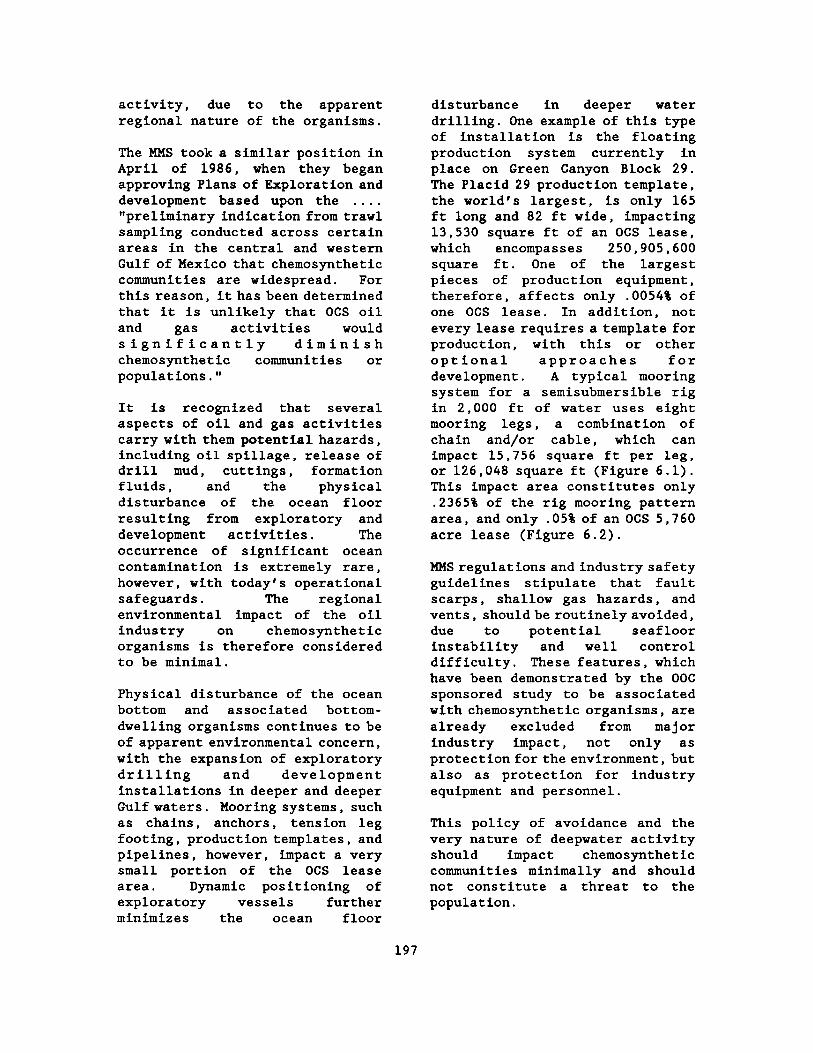
activity, due to the apparent regional nature of the organisms .
The MMS took a similar position in April of 1986, when they began approving Plans of Exploration and development based upon the . . . . "preliminary indication from trawl sampling conducted across certain areas in the central and western Gulf of Mexico that chemosynthetic communities are widespread . For this reason, it has been determined that it is unlikely that OCS oil and gas activities would significantly diminish chemosynthetic communities or populations ."
It is recognized that several aspects of oil and gas activities carry with them potential hazards, including oil spillage, release of drill mud, cuttings, formation fluids, and the physical disturbance of the ocean floor resulting from exploratory and development activities . The occurrence of significant ocean contamination is extremely rare, however, with today's operational safeguards . The regional environmental impact of the oil industry on chemosynthetic organisms is therefore considered to be minimal .
Physical disturbance of the ocean bottom and associated bottom-dwelling organisms continues to be of apparent environmental concern, with the expansion of exploratory drilling and development installations in deeper and deeper Gulf waters . Mooring systems, such as chains, anchors, tension leg footing, production templates, and pipelines, however, impact a very small portion of the OCS lease area . Dynamic positioning of exploratory vessels further minimizes the ocean floor
disturbance in deeper water drilling . One example of this type of installation is the floating production system currently in place on Green Canyon Block 29 . The Placid 29 production template, the world's largest, is only 165 ft long and 82 ft wide, impacting 13,530 square ft of an OCS lease, which encompasses 250,905,600 square ft . One of the largest pieces of production equipment, therefore, affects only .0054$ of one OCS lease . In addition, not every lease requires a template for production, with this or other optional approaches for development . A typical mooring system for a semisubmersible rig in 2,000 ft of water uses eight mooring legs, a combination of chain and/or cable, which can impact 15,756 square ft per leg, or 126,048 square ft (Figure 6 .1) . This impact area constitutes only .2365$ of the rig mooring pattern area, and only .05$ of an OCS 5,760 acre lease (Figure 6 .2) .
MMS regulations and industry safety guidelines stipulate that fault scarps, shallow gas hazards, and vents, should be routinely avoided, due to potential seafloor instability and well control difficulty . These features, which have been demonstrated by the OOC sponsored study to be associated with chemosynthetic organisms, are already excluded from mayor industry impact, not only as protection for the environment, but also as protection for industry equipment and personnel .
This policy of avoidance and the very nature of deepwater activity should impact chemosynthetic communities minimally and should not constitute a threat to the population .
197

3507'
1995' CATENARY DISPLACEMENT
RIG
r oa
3 1/8" ANCHOR CHAIN / CRAM MNPACT / WITH 15 TON STEVPRIS =6" WOE X 1512' ANCHOR ( 18' LONG X 20' WIDE X 10' HIGH) =756 FT 2 ANCHOR IMPACT
=50' WIDE X 300' = 1 5000 FT Z
TOTAL IMPACT .16,768 FT 2
IMPACT AREAS TYPICAL MOORING
WATER DEPTH = 2000'
Figure 6 .1 . Anchor and chain impact areas .

ANCHOR LEG IMPACT =15,756 FT 2
RIG MOORING PATTERN AREA = 7300' X 7300' = 53,290,000 FT 2
r
NCHOR
XTOTAL PATTERN IMPACT ANCHOR & CHAIN "ANCHOR LEG IMPACT'
PATTERN AREA
15.756 X 8 ANCHORS 53,290,000
X 100
= .2365%
oo
TYPICAL ANCHOR PATTERN
WATER DEPTH 2000'
Figure 6 .2 . Typical anchor pattern .

REFERENCES
Brooks, J.M ., M .C . Kennicutt II, L.A . Barnard, G. J . Denoux, and B . D . Carey . 1983 . Application of total scanning fluorescence to exploration geochemistry, pp . 393-400 . In Procedures of Offshore Technology Conference 4624 .
Brooks, J.M ., M .C . Kennicutt II, R.A . Fay, T.J . McDonald, and R .A . Sassen . 1984 . Thermogenic gas hydrates in the Gulf of Mexico . Science 225 :409-411 .
Brooks, J.M ., H .B . Cox, T .J . McDonald, and M . C . Kennicutt II, 1986 . The relationship between oil, gas seepage, and gas hydrates in the Gulf of Mexico . Organic Geochemistry . In press .
Faber, E . and W. Stahl . 1983 . Analytical procedures and results of an isotope geochemical survey in an area of the British North Sea, pp . 51-64 . In J . Brooks, ed . Petroleum geochemistry, and exploration of Europe . Blackwell Scientific Pub .
Gervirtz, E ., B . D . Carey, Jr ., and S .R . Blanco . 1983 . Surface geochemical exploration in the North Sea, pp . 35-50 . In J . Brooks, ed . Petroleum geochemistry, and exploration of Europe . Blackwell Scientific Pub .
Horvitz, L. 1972 . Vegetation and geochemical prospecting for petroleum bull . AAPG 5 :925-940 .
Horvitz, L . 1985 . Geochemical exploration for petroleum . Science 229 :821-827 .
Kennicutt, M.C ., II and J .M . Brooks . 1983 . Relationship between pelagic tar, fluorescence, and biological markers in the South
Atlantic Ocean . Marine Pollution Bulletin 14 :335-342 .
Sackett, W.M . 1977 . Use of hydrocarbon sniffing in offshore exploration . J . Geochemical Exploration 7 :243-254 .
Mr . John C . Fanis joined Placid Oil Company in 1977 . He is the Exploration Manager of Placid's New Orleans District (June 1984 to present) and the Offshore Operators Committee Ad Hoc Chairman on Chemosynthetic Organisms .
200

RISK PERCEPTION, ASSESSMENT, AND MANAGEMENT

Session : RISK PERCEPTION, ASSESSMENT, AND MANAGEMENT
Co-Chairs : Mr . J . Kenneth Adams Mr . Joseph Christopher Mr . John Rodi
Date : October 26, 1988
Presentation Author/Affiliation
Risk Perception, Assessment, and Mr . J . Kenneth Adams, Management : Session Overview Mr . Joseph A. Christopher,
and Mr . John Rodi Minerals Management Service Gulf of Mexico OCS Region
The Risk Assessment--Risk Management Interface
Dr . D . Warner North Decision Focus Incorporated and
Stanford University
Risk Perception, A Scientific Perspective
Social Factors in Risk Communication
The Role of Compensation and Mitigation in Coping with Environmental Risk Perceptions
Risk Communication and Public Participation
Risk Analysis and Risk Management of Offshore and Onshore Installations in Europe
Reliability Considerations in Requalifications of Existing Offshore Platforms
Risk Assessment and Environmental Issues
Oil Spills and OCS Development How to Assess Economic Risk?
Risk Management in the Environmental Impairment Liability Insurance Industry
Dr . John F. Ahearne Resources for the Future
Dr . William R . Freudenburg University of Wisconsin
Mr . Ken Richards Council of Economic Advisors
Ms . Caron Chess Rutgers University
Dr . R . Anthony Cox Technica Ltd .
Dr . Robert G . Bea University of California,
Berkeley
Dr . Robin K . White Oak Ridge National Laboratory
Dr . Thomas Grigalunas University of Rhode Island
Mr . William M. Auberle, P .E . Yates & Auberle, Ltd .
203

Session : RISK PERCEPTION, ASSESSMENT, AND MANAGEMENT (cont'd)
Presentation Author/Affiliation
Risk Management in the Credit Industry
Mr . Paul Adams American Management Systems
Risk Management in the Space Program
Mr . Ben Buchbinder NASA
204

Risk Perception, Assessment, and Management : Session Overview
Mr . J . Kenneth Adams, Mr . Joseph A . Christopher,
and Mr . John Rodi
Minerals Management Service Gulf of Mexico OCS Region
In leasing and regulating the exploration and development of Outer Continental Shelf (OCS) oil and gas resources, program managers in the Minerals Management Service (MMS) must analyze the risks involved, take these into account for resource management decisions and communicate them to the public . The risks of interest to the MMS which are associated with OCS activities include : the risk of not finding oil and gas on a particular prospect, which is of interest for economic evaluation ; the risk of default on financial obligations, which is of interest for setting bond amounts ; the risk of failure of engineered structures, which is of interest for environmental impact analysis ; and other related risks . The purpose of this Information Transfer Meeting (ITM) session was to educate the attendees concerning the evolving fields of risk assessment, risk management, and risk communication . Since MMS is in an early stage of learning about these fields, it was deemed that overviews of these subjects would be most appropriate prior to consideration of greater utilization of particular techniques . Therefore, a rather broad search for experts in these fields was begun, and MMS was very fortunate to enlist the aid of the group of speakers whose ITM presentation summaries follow . At
t h e r is k o f g r o s s oversimplification, the following is a summary of the mayor lessons learned from this brief introduction to these fields :
o For quantitative risk assessment, proven methods exist but depend upon availability of the proper data . Also, one may not always know the proper data a priori .
o Risk management uses risk assessment to better understand the likely outcomes of management options . Furthermore, intelligent risk management monitors the effectiveness of risk assessment .
o Risk communication must recognize the psychological basis of risk perception . Finally, such communication must take place early and often .
In all of these endeavors, the importance of feedback cannot be overstated . As we go forward in our consideration of applying the tools and techniques of these fields, MMS will look back with gratitude to these speakers who gave of their time and expertise to guide and illuminate our way .
Mr . J . Kenneth Adams is the Deputy Regional Supervisor in the MMS Gulf of Mexico OCS Regional Office of Leasing and Environment . His responsibilities include the overall management and direction of that office's offshore lease sale program, which encompasses the supervision of activities necessary for the preparation of required pre- and post-lease environmental and socioeconomic analyses . He holds a B .A . in biology from Carey
205

College, an M.S . in marine biology from the University of West Florida, and a J .D . from Loyola University, New Orleans . In addition to his current MMS experience, he has worked as an ecologist with the U.S . Fish and Wildlife Service and a biologist with both the U.S . Bureau of Land Management and the Environmental Protection Agency .
Mr . John Rodi is a Staff Economist in the MMS Gulf of Mexico OCS Regional Office of Leasing and Environment . He holds a B.A . in economics from Tulane University and an M.A . in economics from the University of New Orleans . Prior to employment with MMS, he was an economist with the New Orleans District of the U .S . Army Corps of Engineers . His current research and analysis centers on regional economic impacts associated with offshore oil and gas activity as well as the economic impacts of leasing requirements on the oil and gas industry .
Mr . Joseph A. Christopher is Chief of the Offshore Unit of the Environmental Assessment Section in the MMS Gulf of Mexico Regional Office of Leasing and Environment . His responsibilities include coordination of the preparation of Environmental Impact Statements on Gulf of Mexico OCS Oil and Gas Lease Sales . He holds a B.A . in geography from the University of New Orleans and an M.A . in management and supervision from Central Michigan University .
The Risk Assessment-Risk Management Interface
Dr . D . Warner North Decision Focus Incorporated
and Stanford University
The 1983 National Academy of Sciences report, Risk Assessment in the Federal Government : Managing the Process (Committee on the Institutional Means for Assessment of Risks to Public Health 1983), used the terms "risk assessment" and "risk management ." During the last five years these terms have been increasingly popular in describing analysis supporting regulatory decisions, especially those involving environmental protection . The definitions from the Committee on the Institutional Means for Assessment of Risks to Public Health for risk assessment and risk management are as follows :
o Risk assessment is the characterization of the potential adverse health effects of human exposures to environmental hazards .
o Risk management is the process of evaluating alternative regulatory actions and selecting among them .
Recognizing that the primary focus of the Committee was regulatory decisions on chemical carcinogens, it may be appropriate to broaden the definition of risk assessment to include consequences to the environment other than those to humans . The Environmental Protection Agency (EPA)(U.S . EPA 1984, North and Yosie 1987) and other regulatory agencies use risk assessment in this broader sense . Many engineers, business
206

executives, and insurance executives also use the terms risk assessment and risk management to mean the description of uncertain consequences and management decisions affecting these consequences .
Decisionmakers face the necessity of making difficult decisions in the face of uncertainty, and they usually have to explain their choices to those who have given them the decision responsibility . This is especially true in regulatory agencies, where legal challenges to agency decisions are common . The interface between risk assessment and risk management is most readily understood in this context of how to assist the decisionmakers (1) in understanding the complexities and uncertainties in applicable fields of science and engineering, and (2) in explaining the rationale for their decisions . The process is not simply a matter of communicating numbers, but rather providing insight on the basis for choice . The value judgments on which decisions are made are part of the risk management process . The risk assessment process involves value judgments on modeling and on appropriate means to deal with uncertainty, but risk assessment is fundamentally a process of characterizing the state of knowledge available as the basis for decision . The separation of risk assessment and risk management as distinct stages in decisionmaking helps to clarify the importance of scientific issues and distinguish them from the often controversial values and goals that are the decision criteria .
Four examples from the author's experience as an analyst illustrated that process . The
first was an analysis of the decision to apply cloud seeding technology to hurricanes that was carried out in the early 1970's (Howard et al . 1972) . Uncertainty in the variation of hurricane intensity had to be separated from the uncertainty in the effect of seeding, and both scientists and decisionmakershad to recognize the importance of liability issues when government considered taking action to alter a "natural disaster ."
The second example was the analysis o f s y n t h e t i c f u e l s commercialization strategy carried out under the Ford Administration in 1975 (Synfuels Interagency Task Force 1975) . The President had stated a national goal of developing a million-barrel-per-day synfuel industry within a decade, but the value of such a program depended on many uncertain factors, including the world oil price, the cost of synthetic fuel production, and the extent of U.S . oil and gas resources . These uncertainties were explicitly assessed and combined with judgments on national costs and benefits to arrive at a recommended program .
The third example is an environmental issue from the space program : protecting Mars from biological contamination as a result of the Viking landings that took place in 1976 (North et al . 1975) . Both the U .S . and the U .S .S .R . had agreed that the probability of biological contamination was to be kept below one chance in a thousand in the period of unmanned exploration . The analysis was an audit to determine if the Viking Mission would violate this agreement . Assessment of the contamination probability was a challenge in
207

structuring complex uncertainties with little data, but the insights from the analysis were persuasive to the scientists who had raised the concern about possible U.S . violation of the agreement .
The fourth example concerns a widely used chlorinated solvent that is known to be an animal carcinogen at high dose levels (North 1988) . What is the extent of human risk at low levels of exposure, and how should such chemicals be regulated? The same principles of clearly specifying uncertainties and separating them from the decision criteria should also apply in this example .
The lesson from these examples is that risk assessment and risk management should both be viewed as a process for communicating with decisionmakers and others concerned with regulatory decisions . Risk assessment does not provide a formula for calculating risk numbers, and risk management is far more complex than a judgement as to whether some risk number is acceptable . The analysis process in both risk assessment and risk management is one of making assumptions explicit and testing the effect of alternate assumptions, of identifying the critical assumptions, of communicating these insights to the decisionmakers and other interested parties, and documenting the basis for decisions . The process of analysis and of communicating across the risk assessment-risk management interface can help scientists, decisionmakers, and interested parties among the public have a better basis for making decisions and for understanding how decisions are being made on their behalf .
REFERENCES
Committee on the Institutional Means for Assessment of Risks to Public Health . 1983 . Risk assessment in the Federal government : managing the process . National Academy Press, Washington, D.C .
Howard, R.A ., J .E . Matheson, and D. W . North . 1972 . The decision to seed hurricanes . Science 176 :1191-1202 .
Manne, A.S . , R . G . Richels, and J . P . Weyant . 1979 . Energy policy modeling : a survey . Operations Research 27 :1-36 .
North, D .W . 1988 . Decision analysis for cancer risk management . Presented to the symposium, Human Cancer Risk Assessment Based on Experimental Data, Wrightsville Beach, North Carolina, May .
North, D . W . , B . R . Judd, and J . P . Pezier . 1975 . New methodology for assessing the probability of contaminating Mars . Life Sciences and Space Research . XII :103-109 . Akademie-Verlag, Berlin .
North, D .W . and T.F . Yosie . 1987 . Risk assessment : what it is, how it works ." EPA Journal 13 :13-15 .
Synfuels Interagency Task Force . 1975 . Recommendations for a synthetic fuels commercialization program . U .S . Government Printing Office, Washington, D .C .
U.S . Environmental Protection Agency . 1984 . Risk assessment and management : framework for decisionmaking . EPA 600/9-85-002 .
208

Dr . D . Warner North is a Principal with Decision Focus Incorporated of Los Altos, California and a Consulting Professor in the Department of Engineering-Economic Systems at Stanford University . Over the past 20 years Dr . North has carried out applications of risk assessment and decision analysis to a wide variety of public policy issues, including weather modification, wildland fire protection, space program planning, energy policy, and regulation of toxic substances . Dr . North has served on the Science Advisory Board of the U .S . Environmental Protection Agency, the Subcommittee on Risk Assessment since 1979 and the Environmental Health Committee since 1982 . Dr . North has been a participant in seven National Academy of Sciences studies dealing with environmental issues, including Risk Assessment in the Federal Government : Manse Process (1983), and the current National Academy Study on Risk Perception and Risk Communication .
Dr . North is a member of the National Council of the Society for Risk Analysis and a past president of the Northern California chapter . He received his B .S . in physics from Yale in 1962 and his Ph .D . in operations research from Stanford .
Risk Perception, A Scientific Perspective
Dr . John F . Ahearne Resources for the Future
From the point of view of technologists, the general public does not know much about science, does not know much about engineering, and does not know much about general technology . Many
scientists and technologists believe the public just does not care about things technical . Perhaps what this audience might need most is a perspective from a scientist, and I used to be one, regarding the problems that technologists have in talking to the public .
Scientists, engineers, and other technologists can be separated into those who know in depth the science and engineering associated with a given policy ; those who know a lot of science or engineering but are not experts on the specific issues in dispute ; and those who operate high-technology systems but do not truly understand the technology they are using . Many true experts cannot communicate their knowledge . They are not able to simplify their discussions so that they can be translated by the media or understood by lay people .
Some good scientists do work at communication but do not deal effectively with the media . Many scientists are quite properly reluctant to say more than they know . What a scientist can be positive about is often not what the lay person is interested in . This difficulty faces all scientists and engineers who try to deal with the media . Nevertheless, most representatives of the media will take the time to try to understand if it is obvious that the technologist is making an effort to help them understand .
Failure to communicate well also can be connected, however, with an overestimation or overevaluation of one's own expertise . Some express the belief that controversy would disappear if only the public became as well informed as they believe themselves to be .
209

Sometimes they act as though the solution to conflict is simply for the public to trust them and what they claim .
The attitude that education is the answer to everything was apparent in articles in the 1970's that importuned the public to understand "true risks" and to rank those risks relative to one another . The attempt to address technological risk management by ranking risks for different hazards has led to an attempt to define acceptable risk . However, many of these efforts have failed to be effective with the general public because "the acceptable risk formulation has provided increasingly elaborate and precise answers to the wrong question ." The questions are wrong because they do not arise from sustained dialogue with the concerned public .
Those who are engaged in managing or operating high-technology systems often have had substantial technical training . Their chronic weakness is complacency, and their failings lead the public to question the competence and judgement of the scientists and engineers who design such systems .
Complacency can be reflected in many ways : a lack of recognition by management that increased attention needs to be given to technologies whose use has potentially serious consequences ; inadequate attention by operators, based upon a belief that the technology is so well developed that monitoring is not really needed ; a belief that it is not important to understand the technology ; and a lack of attention to mundane matters such as regular maintenance .
Some people are against all technology ; some are afraid of technologies they do not understand ; and some are opposed only to the technologies that affect the local environment . Many concerned citizens, however, try sincerely to understand confusing and complex issues .
People who are against technology or against anything new tend to be the most dedicated opponents of projects . They sincerely believe that technology is wrecking our culture . People who are afraid of technology, essentially because they do not understand it, tend not to trust anyone who argues the citizen should not be worried, whether or not they understand the argument . The corollary is that they tend to believe anyone who says things are worse than they seem . Organizations that lobby against local waste dumps or nuclear power plants include many individuals who belong to this group . They believe they are being asked to accept on faith the safety of a technology .
Perhaps the largest group of concerned citizens is the last--the people who do not fully understand the technologies at issue and are skeptical about strong claims by participants on either side of the debate . They do not believe that technology is automatically bad, nor do they believe government is automatically wise . These people will enter a proceeding or hearing with reasonably open minds . They will listen to arguments . They will value substance more than the appearance of sincerity . They will focus more on rationality than on rhetoric . In the end, they will be forced to reach a decision based on incomplete information . And
210

they will decide . This subgroup of concerned citizens has not been well served by many technologists .
Making decisions is hard ; making complex decisions is very hard . It is important to note some of the key pieces of information that a decisionmaker should have, when he or she is addressing a decision in which risk and benefits are significant factors . Figure 7 .1 gives a list of that information .
Obviously, a lot of information will have to be collected in order to provide answers to these questions . And sometimes the information has considerable uncertainty in it and sometimes the information will not be available before a decision has to be made . But a decisionmaker should be sensitive of the need for this information and skeptical of advocates who press the decision without addressing these questions .
In this process of making a decision, decisionmakers must realize that the public is a significant factor and an interaction with the public is critical to good decisionmaking . I see risk communication as a smart circuit with feedback loops ; in communication technology, I should label the path as a channel . Figure 7 .2 describes this process . Figure 7 .2 has the decisionmaker on one side, separated from the communication channel by a buffer . At the other end of the channel, there is another buffer . And on the far side of that buffer are recipients . Some decisionmakers and some communications people see the channel and the buffers as one-way transmission devices . I see the buffers as two-way and the smart channel as providing information back to the
decisionmaker . This information feedback can improve decisions by letting the decisionmakers know what the recipients think about proposed actions, about what are they angry, what are their concerns, what information do they want, etc .
A mayor difficulty in risk communication today is that the risks involve very complex science or engineering issues . For the communications channel to be a smart channel, a communicator must understand the technology . A concerned public will attempt to communicate via the channel, but a dumb channel cannot become a two-way smart channel . For example, in public meetings, frustration arises when some of the public start asking questions of the communicator .
Informing is necessary to maintain credibility . Although credibility is not necessary and sufficient, it is necessary for successful communication . A large problem for people in government is that they lack credibility . Credibility is easily lost and very slowly restored and once lost, is never restored completely . But maintaining credibility requires continuing efforts to be accurate and complete . Each of those requires understanding the technology involved .
Representatives of public groups note there is a serious deficiency in the United States in that the public does not know where it can get reliable numbers . On the other hand, as Chauncey Starr noted this past summer, "It is hard to use numbers . The public uses them as a test to see if this person is an expert even though the public doesn't understand the numbers ."
211

1 . WHAT ARE THE HAZARDS, BENEFITS?
2 . WHAT IS THE EXPOSURE? .
3 . WHAT ARE THE PROBABILITIES?
4. WHAT ARE THE DISTRIBUTIONS?
5. WHAT ARE THE SYNERGISMS?
6 . WHAT ARE THE TOTAL RISKS/BENEFITS?
Figure 7 .1 . Risk/bonef it information .
212

r
DECI SION MAKER
Ply BRIG MEDIA
DOVE R N M EN1
Figure 7 .2 . Paths of risk communication .

Having spent many years trying to make controversial, technical decisions and interacting with the public, I advise three simple rules . First, learn as much as you can about the facts and the matter at hand . Second, insist on objectivity . Be very skeptical of advocates . Third, maintain honesty at all times . Honesty really is the best policy .
REFERENCES
Ahearne, J .F . 1988 . Addressing public concerns in science . Physics Today . September . pp . 36-42 .
Morgan, G. 1981a . Choosing and managing technology-induced risk . IEEE Spectrum . December . pp . 53-60 .
Morgan, G. 1981b . Probing the question of technology-induced risk . IEEE Spectrum . November . pp . 58-64 .
Slovic, P ., B . Fischhoff, and S . Lichtenstein . 1975 . Rating the risks . Environment April . pp . 14-39 .
Starr, C . 1969 . Social benefit versus technological risk . Science . September . pp . 1232-1238 .
Wilson, R . 1980 . Risk/benefit analysis for toxic chemicals . Ecotoxicology and Environmental Safety . 4:370-383 .
Dr . John F. Aheame is Vice President and Senior Fellow for Resources for the Future, an independent, nonprofit research organization specializing in natural resources, energy, and the environment . In addition, Dr .
Ahearne is Chairman of the Department of Energy Advisory Committee on Nuclear Facility Safety ; Chairman of the National Research Council Committee on Risk Perception and Communication ; and is on the National Research Council Steering Committee for the Workshop on Chemical Processes and Products in Severe Reactor Accidents .
Formerly, Dr . Ahearne served in varying posts as Deputy Assistant Secretary of Defense for General Purpose Programs ; Principal Deputy Assistant Secretary of Defense for Manpower and Research Affairs, including Acting Assistant Secretary ; Assistant to the Secretary of Energy ; Deputy Assistant Secretary of Energy for Power Applications ; and Commissioner and Chairman of the Nuclear Regulatory Commission . Recent publications include "Nuclear Power after Chernobyl," in Science ; and "Three Mile Island and Bhopal : Lessons Learned and Not Learned," in Hazards : Technology and Fairness . Dr . Ahearne received his Ph .D . in physics from Princeton University .
Social Factors in Risk Communication
Dr . William R . Freudenburg University of Wisconsin
I'm going to start by giving you a preview of my conclusion . This is an Information Transfer Meeting, but in the area of understanding the public, there is really very little "information" currently available to "transfer ."
The reason is straightforward . There are some social scientists who have been studying the public,
214

usually on a shoestring, and there is an increasing movement in that direction, but we still don't have as much of an information base as we should . Too often, even if we spend a lot of money studying the biological and physical science aspects of an issue, we'll forget there is such a thing as the scientific method when it comes to understanding human behavior . Instead, the tendency is either to give up on understanding the human environment, or else to decide, "Now the problem is dust to convince the public that we're right ."
While recent years have seen some movement in a more positive direction, and the Minerals Management Service (MMS) in particular deserves recognition for beginning to grapple with the issue of risk, there's still a great deal of room for improvement . Accordingly, what I'd like to do today is to provide an overview of some issues that ought to be considered in responding to the "risk" component of MMS' charge to understand its impacts on the human environment . My overall thrust will be that we should expect social scientists to play by the same rules as physical or biological scientists . Perhaps the key rule is that you need real data to answer questions--you don 'tj us t make things up .
Beyond that, my talk will make three points . First, it's important to realize that the actual socioeconomic impacts of facilities depend on "the facts" that get through to the public, not dust those that are believed in the agencies . Second, what appear to be scientific statements actually often contain values and uncertainties, not dust "facts ."
Third, in some ways, the "irrational" public may be more prudent than we think .
Actual impacts depend on the facts that actually get through to the public, not just those that are believed in the agency . This point should be sufficiently straightforward that it scarcely needs to be belabored, but it does need to be stated . If you think for a minute about the kinds of things that the public sees about technology, it becomes quite clear that much of what gets through from the media will convey the image that, while technology is powerful, it has the potential to do considerable harm . Those who read my remarks later won't be able to see the photos I'm showing you now, which were put together hurriedly from the covers of Time, Newsweek, and US News . I could have come up with images at least as graphic as these photos of the "Challenger" and the Bhopal disaster if I were to have used the evening news telecasts ; these photos come from the news magazines largely for reasons of convenience . What I ask is that you reflect for a moment on the number of pictures, images, and stories indicating the potential for technology to do harm . Some of the headlines, moreover, really are emotionally loaded, carrying connotations of something that is sinister, evil, or not quite right, dust below the surface .
Second, scientific statements often contain not just facts, but value judgments and uncertainties--including uncertainties that we don't always recognize at the time . To illustrate this point, I'm going to quote a physical scientist who was expressing his frustration to an environmentalist, an opponent
215

of a nuclear waste dump . I understand this scientist is quite a rational man and quite highly respected in the field ; in a way, he seemed to be speaking for his fellow scientists in the room, most of whom seemed to agree with what he was saying . Perhaps you've either heard or said things like this yourself, but I ask you to think about it a bit more analytically today . His statement was as follows :
"You have to be reasonable . Nothing is perfectly safe . You can't get the kinds of absolute guarantees you're looking for . I live here, too, and I'd be trying to stop this thing if I didn't have confidence we'd be able to take care of any problems that might arise . The real danger isn't technology--it's this NIMBY syndrome, with everybody saying 'Not In My Back Yard .' That's just irresponsible . If it keeps up, it's going to bring progress to a standstill in this country."
This was selected precisely because it's a fairly common kind of statement from a scientist--hardly an extreme viewpoint . But let's look at the comment a bit more closely .
According to the scientist, "You have to be reasonable . Nothing is perfectly safe ." I suspect if you were to ask the environmentalist, he might have seen something a bit different as being "reasonable," such as : "Companies have proved they can't be trusted . Look at the things that your friends in industry have screwed up in the past ."
The scientist continued, "You can't get the kinds of absolute
guarantees you're looking for ." He was probably right ; still, the environmentalist might also have been right if he would have responded, as some have, "Why have you scientists been producing all that nuclear waste if you can't guarantee that the disposal technology would be safe? The problem isn't that the public is looking for certainty in an uncertain world ; the problem is that you scientists don't know for sure that the dump would be safe, and that's irresponsible ." I'm stating the environmentalist's position in terms I suspect he might have used, but doing so in blunt, value-laden terms ; the purpose is to illustrate the point that there are value judgments on the "scientist's" side, too . While it's often easy to see other people's value judgments, the need here is to realize that those of us who are in the scientific community also have values of our own, and that our statements often reflect our values .
"I live here, too, and I'd be trying to stop this thing if I didn't have confidence we'd be able to take care of any problems that might arise," continued the scientist . I think he really did have that confidence ; on the other hand, he was a "member of the club," unlike the environmentalist he was addressing . He spoke as someone who had been able to influence policy in the past, who had encountered pretty good luck in influencing decisions and taking care of problems . This particular environmentalist would have had very little luck in getting into the meetings where key decisions were made, let alone influencing those decisions ; is it any wonder he might not share the scientist's
216

confidence that problems would be properly dealt with?
The scientist continued, "The real danger we face isn't technology--it's this NIMBY syndrome, with everybody saying 'Not in My Back Yard .' That's just irresponsible ." It may be, and it may not be . In some cases, for example, we've put in waste dumps with leak-proof liners that leaked . In fact, if you're familiar with almost any industry, you'll know that even a lifetime spent in the study of natural laws is not sufficient to repeal any of those natural laws--and that may include Murphy's Law . This is a point to which I'll return ; for now, I simply want to raise the possibility that a person who objects to a potentially hazardous facility is not necessarily "irresponsible ."
The scientist's conclusion was that, if the NIMBY syndrome "keeps up, it's going to bring progress to a standstill in this country." Those of you who've been faced with hostile reactions should have little difficulty understanding his feelings, but I ask you instead to reflect on a different point : By definition, "progress" has to do with movement toward something we see as desirable--and the very notion of desirability is one that makes sense only in terms of the personal values we hold . To the environmentalist, "progress" presumably has something to do with making his community more free of contamination--not adding a nuclear waste dump to it . Clearly, there were valid reasons for the scientist to have felt as he did, but there were valid reasons for the environmentalist's views as well ; the differences between them actually may have more to do with
their values than with the facts involved .
In addition, "scientific" statements often incorporate not dust values but judgments and uncertainties . Uncertainty is a necessary condition of life in the real world ; for the scientist, the usual moral of the story is the need to learn from one's mistakes . The public learns from mistakes, too--but they tend to learn something different from what scientists learn . To stick with the nuclear waste illustration, here is a statement from the 1959 Annual Report to Congress from the Atomic Energy Commission : "Nuclear waste problems have proved completely manageable in the operations of the Commission . . . . There is no reason to believe that the proliferation of wastes will become a limiting factor on future development of atomic energy for peaceful purposes" (U .S . Atomic Energy Commission 1960) . In fairness, the Atomic Energy Commission and its successor agencies (the Department of Energy and the Nuclear Regulatory Commission) deserve some points for consistency ; thirty years have passed, and they're still saying there's no reason for concern . But in similar fairness to the public, I hope you can also understand that people would start to get suspicious after hearing for thirty years that nuclear wastes present "no problem," especially when at least some other scientists are saying that the wastes have been a problem all along . As another example that may be a bit more graphic, this is a picture taken early in this century of some land reclamation efforts in Louisiana ; this next picture shows you what the area looks like today : open water . Presumably the best minds
217

of the time thought the dikes would work, but it turns out that scientists, like other members of the public, are sometimes wrong . In fact, we scientists turn out to be prone to a number of judgmental problems, such as overconfidence and the failure to take Murphy's Law fully into account . As a personal example, I have almost never written a paper that actually got done as soon as I thought it would get done . Even when I make my worst-case estimate, trying to err on the conservative side and build in all the delays that could possibly be imagined, almost invariably I need to double that estimate and go to the next unit of measurement . If I think it will take two weeks to finish a paper, in fact it winds up taking closer to four months--and that's after enough years of writing these sorts of things that I should know better .
I can see quite a few of you nodding in recognition of that example, so I suspect you've had some similar experiences yourselves . The problem we encounter is that some mistakes, while understandable, also turnout to be more serious than humorous and so are the responses . When technology doesn't work, or when things fail to work as advertised, people sometimes get irritated ; sometimes when people get irritated, they band together and take some form of collective action .
Sometimes the irritation and the concerns are warranted--but even when the concerns turn out to be unnecessary, the public reactions may not be as irrational as they first appear . Sometimes even what appear to be vivid headlines are appropriate ones . To look again
at this US News cover, you'll note that the question at the bottom asks, "Why So Many Disasters?" In some ways, that may be one of the right questions for the media--and the public--to be asking .
As a way of illustrating that point, I'd like to have you stop thinking for a moment about the general public, the 240 million people out there, and think instead about the very select groups of people who make up the Boards of Directors and Boards of Trustees of the biggest companies in America . These are the people who are expected to exercise prudence in managing the affairs of some of society's most important organizations . I'd like to ask you to think about what you'd expect a Board of Directors to know about the technologies that are used by their complicated, multinational, multibillion-dollar corporations . Do you expect the Board of Directors of General Motors, for example, to have much technical knowledge about the differences between the brake systems used in one set of cars and those used in another? Probably not . In fact, people who study organizations get worried if the boards of directors know much about the technical details ; there's always a potential problem that the folks who are running the organizations will get so caught up in the details that they'll fail to keep their eye on the big picture . The captain of the ship is supposed to be setting the course of the ship--he's not supposed to be on the deck with the hands, and he's certainly not supposed to be down in the engine room, working with the mechanics .
What I've done along these lines is to talk to a couple dozen policymakers, people who are at
218

very high positions, and ask them what kinds of things cause them concern in the information and advice they get from their technical experts . This discussion is drawn from my recent article in Science (Freudenburg 1988) ; the basic question is : When do you buy your experts' recommendations, and when don't you? Their answers identified several characteristics of specialists and several characteristics of situations that tend to raise flags of caution . This is a relatively simple sampling, not by any means comprehensive, but the pattern of responses was fairly consistent .
To start with the characteristics of specialists, first, the policymakers said they get worried when the experts giving them the advice have a direct interest in the outcome . When a chair of one department wants more money than all the other departments on campus combined, the Board of Regents will tend to get suspicious . Second, these policymakers tended to worry when the activities or recommendations of the experts have broader implications for the organization . Third, they worry if a given expert has been wrong in the past . Fourth, the policymakers worry when other experts--people from other branches of the organization, or experts that they happen to know socially, for example--say there is something to worry about .
They also identified several characteristics of situations that cause them extra concern . Situations that have a large element of the unknown, for example, or that get the organization into situations that it hasn't coped with in the past, tend to inspire more concern than
when the organization is on familiar turf . Policymakers also tend to get worried when the potential consequences of a mistake could be especially severe . How much difference will it make for the larger organization, in a word, if the expert winds up being wrong? Finally, they worry more if errors have the potential to be irreversible if they do occur .
Assuming you agree that these are reasonable things for boards of directors to worry about, I'd like to ask you now to stop thinking about the board of directors and go back to thinking about the general public . I'm going to be the last to defend the scientific literacy of the general public, and in the midst of all the campaign advertising that goes on in an election year, I'm going to be cautious about defending the public at all . Still, if you accept the argument that what the broader public "ought" to know about science is basically similar to what a Board of Directors "ought" to know about the scientific work carried out by a very large organization--say one that involves about 240 million people--the level of "scientific illiteracy" may not seem quite as high as it might if you were to focus on specifics . The broader public tends to pay attention not to the scientific details, but to these broader kinds of "policymaker" questions--which may be dust the kinds of questions that "ought" to get their attention . If the public raises broad or philosophical questions instead of focusing on technical ones, in short, that may not be all bad .
219

CONCLUDING REMARKS
Before I quit, I need to emphasize again that this is only a preliminary conclusion, not one that's based on extensive evidence . We don't have the base of evidence we need ; the task before us is to build that base .
In the social sciences, just as in the biological and physical sciences, the way to answer a question is by looking at it systematically, building on relevant information, not just assertion . I'd like to suggest, however, that we not begin by asking, "why are these people doing such dumb things?" or "why don't they make any sense?" Instead, the question we may need to ask is, "why does this protest make sense, at least to this person?"
When we study sea turtles, we don't say, "Well, if they're too dumb to get off the platforms before we blow them up, it's dust too bad for sea turtles"--or at least we don't say that publicly . We may sometimes express our frustrations about how dumb the sea turtles are, but eventually, we do a study of the ways in which sea turtles do in fact behave . What I am suggesting here is that we need to take that same approach when we're looking at the general public . We need to study what factors really do influence attitudes . We need to find out what really is going on in people's heads, and in the actual communities where the protests are erupting . Only then will it be possible either to communicate what the Minerals Management Services' point of view might be, or to respond adequately to the MMS' legal charge to understand this important component of the impacts of offshore
development "on the human, marine, and coastal environments ." Recognizing the problem by holding this session is an important step ; the next step is to begin building the kind of information base that will allow us to begin dealing with the problem . Thank you .
REFERENCES
Freudenburg, W.R . 1988 . Perceived risk, real risk : social science and the art of probabilistic risk assessment . Science 242 :44-49 .
U.S . Atomic Energy Commission . 1960 . Annual report to Congress of the Atomic Energy Commission for 1959 . U.S . Government Printing Office, Washington, D.C .
Dr . William 8. Freudenburg is an Associate Professor of Rural Sociology and a member of the graduate faculty at the University of Wisconsin at Madison . He has a Ph . D . in sociology, a Master of Philosophy, and an M .A . from Yale University as well as a B.A . in communications from the University of Nebraska-Lincoln .
The Bole of Compensation and Mitigation in Coping with
Environmental Risk Perceptions
Mr . Ken Richards Council of Economic Advisors
This paper will discuss the role of compensation and mitigation in the siting of environmentally risky facilities . In particular, it will illustrate that while compensation may be a necessary condition for gaining local cooperation in siting a facility, it is not a sufficient condition .
220

TWO PARADIGMS
Historically, a common approach to siting a facility was the Decide, Announce, Defend (DAD) method which tacitly acknowledged the superior understanding of the professional engineering and planning community . The opinions of the public were neither valued nor accepted . Only the legal minimum of community involvement was sought . This type of approach is becoming increasingly difficult as local communities realize their political power .
The economist, in contrast, would simply suggest that if a community has not accepted a facility, if they refuse to negotiate over the possibility, they simply have not been offered enough compensation . Case studies, surveys, and laboratory experiments would suggest that this view is also flawed .
RESULTS ON RISK PERCEPTION
Experimental results have consistently shown that, all things being equal, people are much less willing to accept the imposition of risk if that risk is (1) involuntary or unfair, (2) unfamiliar, (3) controlled by others, (4) nondetectable (e .g ., latent carcinogens), (5) dramatic and memorable, and (6) highly uncertain (i .e ., experts disagree as to the level of risk) . It is important to remember these as we consider the siting process and people's reaction to it .
Preliminary results of our research suggest that there are two steps in the successful siting process . In the first step, which we call "Getting to Maybe," the community makes the decision whether to even
discuss the possibility of hosting the facility . In the second step, "Getting to Yes," the community enters into dialogue to weigh the benefits and costs of accepting the risky facility .
GETTING TO MAYBE
There appear to be four "screening criteria" that must be satisfied before a community will seriously entertain an offer to host a facility . First, the residents must be convinced that the facility can be made acceptably safe . For the sake of brevity, we will not elaborate on this aspect . Suffice it to say, we need to understand a great deal more about what constitutes an "acceptable" level of risk or safety .
Second, they must be satisfied that the decision process is acceptable . In siting hazardous facilities there are four basic types of siting decision processes : (1) market processes in which the facility is given to the community that offers the most favorable economic package, (2) administrative processes in which a planner uses "objective" criteria such as risk, economic impact, transportation corridors, and environmental impacts to choose the "optimal" site, (3) constitutional choice processes in which a group of communities or states band together to develop a mutually agreeable siting process that leads to an unpredictable outcome, and (4) consensual approaches in which potential hosts negotiate with the siting agency regarding conditions under which they would accept a facility . While the first three approaches emphasize representative democracy, the last is more apt to be participatory in nature .
221

Regardless of the process chosen, the decision procedure generally raises four basic questions : (1) Is it rigged? Is it designed to produce a predetermined outcome? (2) Is the agreed upon process being observed? Is the agency following the spirit of the agreement? (3) Does the process afford the opportunity for local representation/public involvement? Can the local community affect the outcome of the decision within the context of the process? (4) Will the procedure result in the choice of the "best" site?
Third, the community must be satisfied with the communication process . There are five basic reasons why an agency would communicate with the residents of the potential host community : (1) to comply with legal requirements for notice, (2) to persuade the local community of a certain point of view, (3) to "educate" the local community, (4) to build trust, and (5) to empower the community . Case studies and theory indicate that only the final reason--empowering the local community to make an informed and considered decision as to whether to accept the facility--constitutes legitimate and constructive communication . The first three motives will often be perceived as self-serving on the part of the siting agency and lead to resistance by the local residents . The fourth reason will automatically be satisfied as the community sees the agency making an honest effort to share the decisionmaking power .
Paul Slovic, building on the work of others, suggests the following eight rules of risk communication :
1 . Accept and involve the public as a legitimate partner .
2 . Plan carefully and evaluate performance .
3 . Listen to your audience . 4 . Be honest, frank, and open . 5 . Coordinate and collaborate
with other credible sources . 6 . Meet the needs of the media . 7 . Speak clearly and with
compassion . 8 . Don't trade dollars for lives .
The format of the communications activity says a great deal about the motives of the siting agency . Exclusive use of public hearings, written notice, "public education" programs, and overly positive literature would indicate that the agency or developer is interested in achieving its own ends almost to the exclusion of the interests of the local community . At the same time, the free flow of information, funding of local task forces, advisory panels, public workshops and provision of independent consultants would all signal the developer's sincere interest in allowing the community to answer its own questions and arrive at its own conclusions .
Finally, the community must believe that there is a genuine need for the facility . This is an issue that often "blind-sides" the siting agency, but should be intuitively obvious . What motive is there for the community to accept a localized risk if the facility is not necessary? More than one facility has been opposed (at least ostensibly) for the reason that it was not socially beneficial .
GETTING TO YES
Once a community has decided to consider hosting a facility--that is it has said "Maybe"--the siting agency has two more policy tools at its disposal, mitigation and
222

compensation . Mitigation measures are those actions that are taken to prevent or ameliorate adverse impacts or perceived impacts of the facility, or to make undesirable occurrences less likely . Presumably, the facility is going to be designed to proper engineering specifications in any case, so mitigation measures are those that are tailored to cope with the local perceptions and demands . Compensation involves actions that are taken to "make whole," to make up for unavoidable or unanticipated impacts . There is ex ante compensation, used to counter actual damage that is unavoidable, such as increased traffic, stigma effects, psychological impacts, and aesthetic degradation ; and ex post compensation, used to compensate for unanticipated impacts, such as accidents and declines in property values .
Mitigation measures are of two basic types, engineering measures and institutional measures . The former are generally design specification alterations or additions that are provided in order to address public concern about a specific kind or source of risk . They are used to reduce the predicted level of engineering risk . In the area of hazardous waste this would include, for example, landfill liner thickness, waste canister impact resistance, or addition of buffer zones around a repository .
Institutional mitigation measures are those actions that increase local control of the risk, thereby reducing perceptions of risk . These include local review of engineering design, citizen advisory review committees, environmental monitoring and
cooperation, and contingency agreements . While these measures are often ignored by planners/engineers, they have consistently surfaced as one of the primary demands of local communities .
Because it is impossible to mitigate all adverse effects of a risky facility, compensation is used to address the residual impacts and in some cases to leave the local population better off than before the facility was sited . There is a real danger, however, that compensation will be construed as bribery--in some cases rightly so . There are four general rules that can help avoid this problem . First, address the "screening" concerns before discussing potential compensation programs . Second, speak in terms of "benefit sharing" rather than payments or compensation ; this acknowledges the service the local population is performing on behalf of the wider society . Third, proposals for compensation should emanate from the local population to the extent possible . This lends credibility to the program and assures that the compensation measures will address the local needs . Finally, whenever possible trade commodities : that is, trade risk reduction in one area for risk increases in another, pollution reductions for pollution increases, new park land for lost park land, prestige building activities for stigma effects .
Compensation measures can come in many forms . Among these are (1) direct monetary payments to substitute for loss of development potential, (2) in-kind payments to improve quality-of-life and to replace lost local amenities, (3) contingency funds and insurance to assure the local community of the
223

facility's ability to meet future obligations, (4) property value guarantees, (5) economic participation guarantees to assure the community that the local economy will benefit from the project, and (6) legal arrangements that will set individuals on a more even footing in case of legal conflicts .
SIX LESSONS FOR THE SITING PROCESS
1 . There are many factors that influence an individual's or community's perceptions of risk . Even if this perception is not highly correlated to that of the risk analysts, there is still social benefit to be gained from dealing with the perceived risk .
2 . Potential host communities will offer more resistance to siting procedures that (1) appear biased toward producing a predetermined outcome, (2) are not strictly observed in implementation, (3) do not provide an opportunity for public participation, and (4) will lead to choosing a technically undesirable site .
3 . Communication does not constitute the siting procedure, but it is a necessary element of a successful procedure . And an acceptable procedure is a prerequisite to proper communication . If stakeholders feel the procedure is fundamentally flawed they will not be willing to communicate about the siting .
4 . Well funded task forces, local advisory panels, and citizen's participation groups are among the most effective communication tools .
5 . Compensation should only enter the siting process after all the "screening" criteria are satisfied .
6 . It may be in the best interest of the siting agency or developer to surrender some of its discretion or power to the local community in order to signal its intentions and to reduce the community's defensiveness .
REFERENCES
O'Hare, M., L . Bacow, and D . Sanderson . 1983 . Facility siting and local public opposition . Van Nostrand Reinhold, New York .
Peelle, E . and R. Ellis . 1987 . Hazardous waste management outlook : are there ways out of the 'not-in-my-backyard' impasse . Forum for Applied Research and Public Policy . September .
Sandman, Peter . 1986 . Getting to maybe : some communications aspects of siting hazardous waste facilities . Seton Hall Legislative Journal . 9(2) .
Sorenson, J ., J . Soderstrom, and S . Carnes . 1984 . Sweet for the sour : incentives in environmental mediation . Environmental Management . 8(4) :287-294 .
Susskind, L . and J . Cruikshank . 1987 . Breaking the impasse -consensual approaches to resolving public disputes . Basic Books, New York .
Qillard, D. and M. Swenson . 1984 . Why not in your backyard? Scientific data and nonrational decisions about risk . Environmental Management . 8 :2 .
224

Kr . Ken Richards has a BSCE/MSCE in environmental engineering and planning and a B .A . in botany from Duke University . He is currently working with the President's Council of Economic Advisors while on leave from Wharton School at the University of Pennsylvania where he has been pursuing a Ph .D ./J .D . in environmental policy and law . Mr . Richards has previously served as National Energy Planner for the Cook Islands and Consultant to the Risk and Decision Processes Center, studying risk perception related to the High Level Nuclear Waste Repository in Nevada .
Risk Communication and Public Participation
Ms . Caron Chess Rutgers University
Faced with increasingly complex problems and growing tensions with those outside the agency, government agencies often burrow into the technical aspects of environmental management . When they emerge they expect, not unreasonably, that the technical judgments they are paid to render will be welcomed . Instead, they too often find that those outside the agency are gunning for them .
In the face of this type of public reaction, agencies might prefer to limit their interactions with those hostile to the agency . But there are at least three reasons why more interaction rather than less is called for .
1 . Current avvroaches to dealin with the public are not working . "Environmental gridlock" describes the paralysis which results from
the trapping of initiatives, regulations, and policies in conflicts among agencies, communities, and competing interest groups . Imposing solutions on the public will increase rather than decrease opposition and subsequent gridlock . Research suggests that communities not only resent the risks that are imposed on them but also the management decisions that they feel are made without their input . In fact, battles between government agencies and the public often have as much to do with how the agencies treat people as the substance of the issues .
As one grassroots activist commented to a Cornell researcher, "I got into it because of my kids . I stayed in it because I got so angry . " This statement exemplifies the view of those who see government representatives as arrogant about the rightness of their technical findings and policies and indifferent to people's questions and concerns . Does this mean that government representatives are callous and indifferent? No . But it does mean they are often perceived that way .
Signs of increasing environmental gridlock suggest the need for another way out of the dam . People's resistance to decisions imposed on them calls for more equitable decisionmaking .
2 . Dialogue is integral to democratic volicv debate . While it is tempting to want a magic wand to cure people of their opposition, in a
225

democracy issues such as offshore drilling belong as part of a policy debate . Data and technical considerations should not be the sole determinants of policy . Just as national defense policy is not determined solely by the Pentagon's data, drilling policy needs to balance competing needs and values as well as be responsive to data . While agencies do need to pay greater attention to explaining the science, people are more likely to listen if they are not forced to bend to the weight of the agencies' data .
3 . Dialogue can lead to better decisions . Involving those outside the agency can often lead to the surfacing of constructive ideas--often ideas that agency representatives might not have considered on their own . Agencies do not necessarily have a corner on the solutions market .
If people resent having decisions imposed on them, the alternative is more collaborative decisionmaking . This approach differs greatly from the traditional notion of public participation which involves an agency laboring over policies and proposals while the community waits for an opportunity to comment . When the time comes for the public hearing, the agency essentially says "After months of study and reflection by our top minds, we have developed 200 pages of documentation that explains why our approach is the soundest . Do you have any comments?" This "decide, announce, defend" strategy preempts the ability of outside
parties to have meaningful input and denies the agency the opportunity to hear concerns early when they can be addressed more easily .
There is an important distinction to be made between a government agency asking for input and not really wanting to listen--and asking people for input and really intending to listen (see Figure 7 .3) . People know the distinction, and they resent being asked for input when they know an agency doesn't really intend to listen .
Operationally early input can function on federal, regional, or local levels, depending on the interest in the policy . It should involve not only the people you don't mind talking to but also the people you least like dealing with . They are the people who are most likely to have objections to your policy . If you don't meet with them, they will have good grounds for objecting not only to your policies but also to your decisionmaking processes .
There are many different constructs for what input can look like from task forces that bring together the various--often conflicting--constituencies to separate, informal meetings with interest groups .
Regardless of the method for obtaining input, the process involves identifying the key audiences which should be involved, soliciting their input, and then responding to it . This response does not necessarily need to conform to the input, but it must, at minimum, indicate that the input was heard and explain why the agency decided to take a different approach .
226

THE STATE UNIVERSITY OF NEW JERSEY
RUTGEIRNSO Environmental Communication Research Program A program of the Agrlcultural Experiment Station
Cook College " 122 Ryders Lane " New Brunswick . New Jersey 08903 . 201/932-8795
LADDER of CITIZEN PARTICIPATION
Citizens act without " volunteer fire department ;
Citizen Power communicating with ' citizen investigation ; " citizen development and
government implementation of programs
Citizens and government Power-Sharing I solve problems together
" funding of citizen groups to hire technical consultants and/or implement projects;
" citizen oversight and monitoring ;
" meetings called jointly by government and citizen groups
Government asks citizens " citizen advisory committees ; COItSlllt 2 for meaningful input and " informal meetings;
intends to listen ' on-going dialogue; " some public hearings
" most public hearings; Government asks citizens . most requests for responses to
Constdt I for limited input and formal proposals; would prefer not to listen " pro-forma meetings and
advisory committees
L
Inform
" some public meetings ; Government talks ; " press releases and other
citizens listen informational strategies : newsletters, brochures, etc .
Government acts without communicating with ' some investigations ;
Government Power S " legal and enforcement actions citizens
Figure 7 .3 . Ladder of citizen participation .
227

If you involve people and give them input it does not necessarily follow that they are then going to agree with you and let you make your decisions in peace . However, if people feel the agency's door is closed to them, they will spend considerable energy knocking it down . If you open the door and invite them to sit down early in the process, you are more likely to deal with substantive issues rather than anger in response to what is perceived as agency arrogance . However, if your concepts are deficient or your science is weak, that message will be as loud as ever .
Note : This presentation and subsequent abstract are based, in part, on Improving Dialogue with Communities : A Risk Communication Manual for Government by Billie Jo Hance, Caron Chess, and Peter Sandman .
Ks . Caron Chess is Associate Director of the Environmental Communication Research Program based at Rutgers University . The program conducts research, provides consulting services, and holds training workshops concerning how to communicate effectively with the public about environmental health issues . Ms . Chess co-authored Improving Dialogue with Communities : A Risk Communication Manual for Government and has given a variety of workshops and presentations about the subject . Before moving to academia, she coordinated programs for both advocacy organizations and government . She played a central leadership role in the campaign for the country's first Right-to-Know Law, giving the public access to information about toxic hazards, and has written a book and many
articles about the development of Right-to-Know laws . As Right-to-Know Coordinator for the New Jersey Department of Environmental Protection, Ms . Chess took a lead role in implementing the State's new Right-to-Know Law . She also laid the groundwork for New Jersey's innovative Risk Communication Unit .
Risk Analysis and Risk Management of Offshore and
Onshore Installations in Europe
Dr . R . Anthony Cox Technica Ltd .
MAJOR ACCIDENTS IN EUROPE
An important factor in the general awareness of chemical hazards and offshore safety in Europe has been a series of incidents which have drawn attention to the nature and scale of the potential hazards . The most influential events for onshore plants were the unconfined vapor cloud explosion at Flixborough, England in 1974, the toxic discharge at Seveso, Italy in 1976, and the very severe propylene BLEVE at San Carlos de la Rapita, Spain in 1978 . In the offshore field, the loss of the flotel "Alexander Keilland" in Norway and most recently, the Piper A platform in the United Kingdom (UK) have prompted major efforts in risk management .
In the UK, the incident that triggered this growing awareness was the release and explosion of cyclohexane at Flixborough . That disaster was caused by inadequate management allowing a substandard plant modification . A protracted public inquiry revealed many shortcomings in the organization
228

of plant operations and a total unpreparedness for the magnitude of the potential hazard involved . Following this accident, a pioneering risk analysis study was carried out for the LNG importation terminal and refineries at Canvey Island .
The incident at Seveso was a similar turning point for Europe as a whole . This was a release of a highly toxic by-product of a runaway reaction (the dioxin TCDD) from an emergency vent . The consequences of this were mainly social, economic, and political as there was a prolonged evacuation of population and severe health effects, although no fatalities .
LEGISLATIVE RESPONSE
In the UK, policy has steadily developed, particularly in the area of mayor chemical hazards, with requirements for 'Notification' of hazardous installations well advanced, and systematic safety studies at all stages in the design and operation of chemical plants becoming a reality in several sectors of the industry .
The so-called "Seveso Directive" of the European Community has now been agreed to and requires all member states to institute routine reporting and analysis of process industry installations having a large hazard potential .
In the Norwegian sector of the North Sea, probability criteria have been built into 'guidelines' for operators and designers to use in the submission of permit applications for offshore installations .
RISK ANALYSIS
Developments such as these have led to an increasing use of risk analysis techniques as a means of evaluation of new or existing plants and, in a sense, as a common language for communication between the industries and the regulatory authorities about risk issues . Figure 7 .4 shows the basic methodology of risk analysis .
In the 1970's, due to the recognition of the need to continue operating existing process plants with large hazard potential in the vicinity of populated areas, and indeed to build more of such installations, the need arose for an analytical tool to help decisionmakers address such questions as : the suitability of a particular site for a process industry development ; the allowable proximity between a chemical plant and residential areas ; and the scale of provision of local emergency services which is necessitated by the presence of the industry . Risk analysis was developed as an analytical tool to help decisionmakers address these questions . Figure 7 .5 shows the evolution of risk analysis studies for both onshore plant and offshore platforms in Europe .
More recently, the same philosophy has been applied to offshore installations in the Norwegian sector of the North Sea, and after Piper Alpha is expected to be used much more extensively in the UK sector .
It has emerged in recent years that risk analysis is not only useful for addressing regulatory issues relating to the oil and chemical industries, but also in assisting the design process itself,
229

Identification of Failure Cases
Frequency I ' Consequence Analysis Anelvsis
Risk summation I
Targets, ~- ~ Evaluation, Criteria I ~ 1 Recommendations
Figure 7 .4 . Classical risk analysis method .
230

UK ~C HOLLAND NORTH SEA CANVEY SCOTTISH LNG (UK + NORWAY)
CAS PLANTS IMPORT (TNO) I
"COVO" TN O PLATFORM STUDY "YELLOW CnNCEPTUA
(ROTTERDAM) BOOK" DESIGN SAFETY EVALUTION
LPG V ;F "INTEGRAL" PLATFORM
LNG AT ~TNn) " TOTAL ZEEBRUGGE EEMSHAVEN
SAFETI PACKAGE
RISK ANALYSIS"
MANY ROTTERDAM NH3 RISK ANALYSIS USED OTHER NH3 + CR2 'INTEGRAL' AS A TOOL FOR
CHEMICAL TRANSPORT DETAIL DESIGN PLANTS
ROUTINE STUDIES FOR THE FUTURE
HSE
Figure 7 .5 . Evolution of safety studies .
231

sometimes at a very detailed level . In this mode, risk analysis is used to provide an index of merit of alternative designs, in which design features which aim to reduce the consequences of accidents can be weighed properly against those which aim to reduce the probability . The use of risk analysis in this way is not a rare and exceptional event ; it probably accounts for about half the risk analyses currently being carried out, as far as the present author is aware .
It is very important to recognize that risk analysis is a "neutral" or unbiased technique . It is neither a "weapon of the industries" nor a "weapon of the environmentalists," although the author has heard it described in both of these conflicting ways by various people .
RISK ASSESSMENT CRITERIA
Criteria have been suggested whereby risks calculated in these ways can be fudged . This is a subject in itself and cannot be examined extensively in this paper, except to way that almost all of the criteria so far proposed are based on the concept of comparability with the general existing risk background . More recently, cost/benefit and 'risk perception' arguments have been advanced but these have not yet developed to the point where they take a practical and accepted form for use in risk analysis by either government or industry .
RISK ANALYSIS OF NORTH SEA OIL AND GAS PLATFORMS
Guidelines for the approach to be adopted in carrying out safety evaluations in the Norwegian North
Sea have been published and these are firmly based in the concept of risk analysis, although adapted so as to maximize the direct usefulness of the analysis to the platform designers .
The objective of this approach is to divide the complete list of failures or 'accidental events' as they are called in Norway, into two groups :
1 . A group of 'Design Accidental Events' whose consequences must be small enough to allow safe evacuation of all personnel not in the immediate vicinity of the event ;
2 . A group of 'Residual Accidental Events' whose consequences may be so severe as to exclude them from group 1 but whose total expected frequency must not exceed a stated level (of the order of 10-4 to 10-3 per year depending on the interpretation .
EXPERIENCE OF PRACTICAL APPLICATIONS IN THE NORTH SEA
A summary is given below of the extent of practical applications of the techniques discussed above in the offshore North Sea area, so far as the author is aware .
Full Risk Analyses
At least four such studies have been completed, all commissioned by industry and all for internal use (i .e ., not prepared for submission to government) . The purposes of these studies were all the same--to obtain an overview of the risk picture and to use it both to enhance safety on the project itself and to learn something useful for the next project . Subjects of study included major-
232

and medium-sized production platforms and a platform/pipeline system . One platform for which a risk analysis was carried out is Gullfaks A (Figure 7 .6) . This platform is the longest yet built in the world and has exceptionally good layout and other 'survival' features such as blast walls and free-fall lifeboats .
Concept Safety Evaluations
About twenty of these rather specific studies have been completed to date, all commissioned by industry but in many cases primarily for submission to the Norwegian Petroleum Directorate . Subjects have included mayor integrated drilling - production -quarters platforms with steel and concrete structures ; small riser platforms ; a mayor water injection, drilling, and quarters platform ; advanced deep water concepts ; and semisubmersibles .
It is generally agreed that the CSE methodology is effective in injecting a strong safety influence at the formative stage of a project, and both industry and government agree that it provides a suitable basis for design which is neither too strict nor too lax . There is no doubt that it has caused designers to take account of both the probabilities and consequences of events in a systematic way and there is every reason to expect that the resulting designs will, indeed, have great reserves of 'survival capability', as was the main original intention .
HAZOP
Although at first resisted, on the (spurious) grounds that it added nothing to the existing practice of API RP14C, HAZOP has recently
become very widely used in the North Sea offshore industry in all national sectors . Process departments appreciate HAZOP for its ability to stimulate creative thought and for its broad range of applicability, relative to RP14C -although the latter is easier to use .
Dr . & . Anthony Coa is the Chief Executive Officer of Technica Ltd . and as such has overall managerial responsibility for the Technica group of companies which includes offices in Los Angeles and Columbus, Ohio . He has served as Project Manager for several of the company's major projects, notably :
o conducting risk analysis of the Gullfaks A oil and gas production platform (Statoil, Norway) ;
o conducting risk analysis for the ethane and ethylene pipelines from Mossmorran to Grangemouth (for Esso Chemical Ltd.) ;
o providing evidence to the Public Inquiry into the Sizewell B Pressurized Water Reactor, on probabilistic risk analysis techniques in reactor safety assessment ;
o conducting safety engineering studies for Marathon's mayor new gas/condensate production platform in the UK North Sea, including sub-tasks in the fields of system reliability, platform evacuation, Hazard and Operability study, and human factors in control system design and procedure manuals .
Dr . Cox holds an M.A . in mechanical sciences from the University of Cambridge and a Ph .D . in air pollution science from Imperial
233

Process
Living quartet
Figure 7 .6 . Cullfaks A platform .
234
Low hazard area Drilling modules \, ~ area

College, University of London . He is a Chartered Engineer, a Member of the Institute of Energy, and Fellow of the Safety and Reliability Society .
Reliability Considerations in Requalifications of Existing
Offshore Platforms
Dr . Robert G . Bea University of California,
Berkeley
INTRODUCTION - THE AIM APPROACH
Since 1985, the Minerals Management Service as a member of a joint industry-government sponsored project has been developing a practical engineering procedure for requalifying defective offshore platforms (Bea et al . 1985, 1987, 1988) . The requalification approach has been founded on three principal elements, identified as the AIM triangle (Figure 7 .7) .
o A--Assessment : those engineering appraisals intended to evaluate present and future platform serviceability, and determine the desirable characteristics of present and future platform performance . Alternative platform maintenance and rehabilitation programs are focused on developing acceptable serviceability characteristics, while preserving essential safety, economic, and environmental objectives .
o I--Inspection : those engineering and operations programs directed toward detection and documentation of defects in a platform that
can lead to significant reduction in serviceability characteristics . This element includes definition of what should be inspected, when and how, and achieving the results for future AIM cycles .
o M--Maintenance : those engineering and operations programs developed and implemented to preserve or enable a platform to develop acceptable serviceability characteristics . This element includes consideration of a wide variety of maintenance programs intended to reduce and mitigate hazards or risks, i .e ., load reductions, structure strengthening, reducing operations exposures, and increasing maintenance effectiveness .
The AIM approach (Figure 7 .7) is divided into three primary phases . First is a screening phase that consists of selection of a candidate platform (i .e ., one that could be representative of a fleet of similar structures) based on its defect and consequence potentials, performing a condition survey to determine its present characteristics, and then determining if the structure has significant defects that warrant mitigation .
Second is a detailed evaluation phase that is entered if it is determined that there are potentially significant defects that need remedial measures . Various alternatives for making the platform meet serviceability requirements are identified and evaluated . The best remedial alternative for the current AIM cycle is selected based on acceptability criteria .
235

OPERATOR DENTFES CANDIDATE
PLATFOii f .: :..:
\--,
~~ - CONDITION SURVEY/ NSPEC710N
NO POTENTIALLY POTENTIALLY SK1rFICANT 31(3WICANT DEFECTS ASSES DEFECTS
DESIGN NEXT I /MITIOATIOt1' INSPECTION b
YES ~ NECESSARY
CYCLE EVALUATE ALTERNATIVES I
0 STRUCTURE
LOADN09 OPEFATIONS INSPECTION
WEMENT MITIGATION
Figure 7 .7 . AIII approach to roqvaliticatians of existing platforms.
236

Third is an implementation phase that is initiated by designing or engineering the remedial alternative, implementing it, recording the results, and then defining the next AIM cycle .
RELIABILITY METHODS IN REQUALIFICATIONS
In the evolution of engineering procedures for design of offshore platforms and pipelines, reliability methods have played an important background role (Bea 1979, 1980) . Recently, these methods have found an important role in assisting development of engineering procedures for requalifications of existing structures . Specifically, reliability methods have been applied to evaluations of and management of uncertainties associated with :
o environmental and operational loadings (demands) ;
o platform resistances (capacities) ;
o platform performances (likelihoods of failure) ; and
o Selection of AIM maintenance programs .
Uncertainties have been organized into three categories . The first are inherent or natural variabilities (randomness) . The second are uncertainties in the parameters, modeling or analytical uncertainties or imperfections, and uncertainties in the states of systems or conditions . The third are human errors .
In the AIM approach, controls are exerted on demands and capacities to assist in management of the first category of uncertainties . Inspections, condition surveys, and other similar data gathering
programs are used to assist in management of the second category . Training, testing, and verification measures, and in some cases, automation are used to assist in the management of the third category .
To illustrate applications of reliability methods in requalifications of existing offshore platforms, results from a recent platform study in the Gulf of Mexico will be summarized .
CASE HISTORY
The case history platform (Figure 7 .8) is a 5-leg (4 corner, 1 center), tender-assisted, fixed drilling, and production platform located in a water depth of 150 ft in the central Gulf of Mexico . The platform was designed in 1960-1961 and installed in 1962 . It is representative of a large number of platforms constructed during this period .
The platform was designed for a 46-ft wave (25-year storm criteria) . Nine gas wells were completed on the platform . It is unmanned . Based on present production estimates and profitability guidelines, the platform is proposed for a 10-year remaining life .
Recent underwater inspections have disclosed a wide variety of structural defects (Figure 7 .8) that range from missing diagonal braces to cracked points . The first phase of the AIM approach has been completed, and it has been determined that the defects are significant and that mitigation is warranted .
A first application of reliability methods is in the characterization
237

*so'
150'W . D .
CENTRAL GULF OF MEXICO
5 LEO/PILES
9 CONDUCTORS
FNS
PLAN
liturgy 7 . " . Example drilling and production platform .
238

of future potential demands that could act on the platform (Figure 7 .9) . These demands are characterized by the total lateral loadings that could be generated by intense hurricanes . Uncertainties in storm characteristics and forces exerted on the platform are reflected in the Return Periods (RP, years) associated with various potential magnitudes of loading .
A second application is in the analyses of potential capacities developed by the platform, given alternative AIM programs (Figure 7 .10) . The platform capacity or Ultimate Limit State strength (ULS) is expressed through a non-dimensional index, the Reserve Strength Ratio (RSR = ratio of platform capacity to a current minimum reference force) . The reference condition is the platform in its present condition (as is) . Uncertainties are introduced by examining the ranges in capacities implied by alternative maintenance programs . The influences of time (fatigue degradation in capacity) and repair (upside and downside possible outcomes of repair operations) are examined similarly .
A third application is in the evaluations of the desirability of alternative AIM programs . The likelihood of the platform not being serviceable (Pf, probability of failure) is taken to the reciprocal of the demand (storm loading) Return Period that brings the platform to its capacity (Pf = 1/RP) .
The likelihood of the platform not being serviceable is used in the calculation of expected costs associated with each of the alternative AIM programs (Figure 7 .11) . The total expected cost
(EC) is taken as the sum of the expected initial cost of a given AIM program (EI), and the probability-weighted expected future consequences costs (EF) . The expected future consequences costs are taken as the product of the potential costs associated with loss of platform serviceability (C) and the likelihood of such an occurrence (EF = C x Pf) .
Two criteria are used to evaluate the suitability of the alternative AIM programs . The first is a commercial-industrial evaluation of costs . The objective of this evaluation is to identify the AIM alternative that will bring the total costs to the lowest possible level . If the projected income from the platform can justify the AIM maintenance cost, then the investments are warranted . If not, then salvage or removal of the structure is indicated .
The second is a public-regulatory evaluation of suitability for service . In the AIM approach, this evaluation has been expressed as an assessment of the capacity of the platform as established by the proposed AIM program (expressed through the Reserve Strength Ratio, RSR) related to three categories of potential consequences associated with the structure's loss of serviceability (Figure 7 .12) .
The low category of consequences refer to unmanned structures that pose no significant likelihoods of loss of resources or pollution (Category I structures) . The high category of consequences refer to manned or intermittently manned structures that could pose substantial likelihoods of resource loss or pollution potential (Category III structures) . The
239

a Y
O
O J
3
w a 3
Figure 7 .9 . Reliability based assessment of future demands (hurricane lateral forces) .
150.00
120 .00
0
a 90 .00
60 .00
30 .00
0 00
AL1 3 - ~~ ~~S 1200 KPS 1100 KPS
~t 2-F~~yDP~
WAVE N 1000 KP9
DECK t t
WnTE ups
0 .00 0 .20 0 .40 0 .80 0 .80 1 .00 1 .20 1 .40 1 .80
DECK DISPLACBAERT FT .)
Figure 7 .10 . Reliability based assessment of platform capacities for different AIlI alternatives .
240
2 3 4 5 10 20 33 50 100 500 1000
RETURN PERIOD

12 .0
10 .0
8.0
V
8.0
4.0
2 .0
INITIAL COSTS
FUTURE COSTS
F o
j % %. ~l a t
1 REPLACE % j
NO REPLACE j OPTION
L 0 11 ~NII~11 ~11~// I~YfNYI I
1 2 3 4 NOTFRJO REPAIR REPAIR"OROUT REPAIR .RAISE
AIM ALTERNATIVE
Figure 7.11 . Comiiiaercial evaluation of alternatives .
o
J
yyyHJJJ
v 3 0 J
0.e 1 .0 1 .6 2 .0 2 .6 3 .0
RESERVE STRENGTH RATA - R9R
Figure 7 .12 . Regulatory evaluation of alternatives .
241

intermediate category falls in between these two ranges of potential consequences (Category II structures) .
The AIM program for a given platform must place adequate controls on both the strength or capacity of the structure (expressed through the Reserve Strength Ratio), and the potential consequences associated with a potential loss of serviceability (e .g ., evaluation of personnel, down-hole shut-in equipment, and pollution abatement measures) .
REFERENCES
Bea, R .G . 1979 . Earthquake and wave design criteria for offshore platforms . American Society of Civil Engineers, Journal of the Structural Engineering Division 105(ST2) .
Bea, R . G . 1980 . Reliability considerations in offshore platform criteria . American Society of Civil Engineers, Journal of the Structural Division 106(ST9) .
Bea, R.G ., R .W . Litton, and A .K . Vaish . 1985 . Requalification of existing platforms . Proceedings, 17th Offshore Technology Conference, OTC Paper No . 4858 .
Bea, R . G . , F . J . Puskar, C . E . Smith, and J .R . Spencer . 1988 . Development of AIM programs for fixed and mobile platforms . Proceedings, 20th Offshore Technology Conference, OTC Paper No . 5703 .
Bea, R .G . and C .E . Smith . 1987 . AIM (Assessment, Inspection, Maintenance) and reliability of offshore platforms . Proceeding, Marine Structural Reliability Symposium, Society of Naval
Architects and Marine Engineers, SY-23 .
Dr . Robert G. Bea is a professor of ocean engineering at the University of California, Berkeley . During the past 32 years, he has worked on a worldwide spectrum of offshore engineering problems . His reliability applications began in the early 1960's in development of design criteria for Gulf of Mexico and North Sea Drilling and Production Platforms . Most recently, he has been leading a joint industry-government project addressing reliability based on evaluations of existing offshore platforms .
Risk Assessment and Environmental Issues
Dr . Robin K. White Oak Ridge National Laboratory
The Oak Ridge National Laboratory, Office of Risk Analysis is a multi-disciplinary group engaged in research and development of the science of risk analysis and in its practical application in dealing with today's tough environmental problems . As a part of these efforts, we are working on developing and implementing risk assessment strategies for use at hazardous waste sites . These hazardous waste risk assessments are designed with two primary purposes in mind : (1) to help identify and characterize the human health risks posed by a particular site, and (2) to aid in selection of appropriate clean-up or remedial strategies .
Such risk assessment strategy is useful in hazardous waste
242

management for several reasons . First, it is mandated by and compatible with the current regulatory framework . These regulatory programs include risk assessment in their guidance and directives in an effort to more clearly characterize the risks posed by the site and to provide perspective on the relative importance of hazardous waste impacts and problems . Further, these strategies aid in the choice between remedial alternatives . By analyzing the reduction in risks or the protectiveness of a given "menu" of alternatives, risk managers can choose intelligently between these options . Such an approach enables decisionmakers to be protective, responsible, and cost-effective . Finally, the use of risk assessment provides excellent documentation of the decision process and the factors which play a part in alternative selection .
Risk analysis is actually a tri-partite process involving risk assessment, risk management, and risk communication . The risk assessment segment has been defined as the "characterization of the probability of potentially adverse health effects from human exposures to environmental hazards" (Office of Science and Technology Policy 1985, U.S . Environmental Protection Agency 1984, National Academy of Sciences 1983) . This step of the process may provide :
o a characterization of the types of health effects expected from the site ;
o an estimate of the probability (risk) of occurrence of these health effects ;
o an estimate of the number of cases with these health effects ; and/or
o a suggested acceptable concentration of a toxicant in air, water, soil, or food .
Risk management will then use the results of the risk assessment along with information on available control technology, cost-benefit analysis, concepts of acceptable risk, policy analysis, and other social/political factors to evaluate and select site-specific alternatives . Risk communication completes the process by transmitting the appropriate information to various audiences interested in the site . At hazardous waste sites, the appropriate utilization of and interface among the risk assessment, risk management, and risk communication elements are vital .
The investigation, assessment, and management of hazardous waste sites may occur under a number of environmental regulations, e .g ., the Resource Conservation and Recovery Act (RCRA and its amendments), the Comprehensive Environmental Response and Liability Act (CERCLA and its amendments), state environmental statutes, etc . Under any of these regulations, assessment and management of a specific hazardous waste site involve steps that are similar to those identified under the EPA's Superfund Process :
o STEP 1--Sites are identified with preliminary indications that a sufficient problem exists to warrant remedial investigation and possibly some sort of corrective action ;
o STEP 2--Based on some established priority, specific plans are devised for investigating site history,
243
environmental setting, contamination, and risks ;
o STEP 3--Site investigations are carried out, involving varying data gathering activities : environmental or biological sampling -monitoring ; studies of contaminant behaviors ; characterization of environmental media, etc . ;
o STEP 4--Environmental sampling data and information are used to decide whether corrective, remedial, or removal measures are necessary;
o STEP S--Proposed alternatives are studied in light of protectiveness, cost, technical feasibility, public/regulatory acceptance ;
o STEP 6--The appropriate alternative is selected .
o STEP 7--Remedial action is designed and implemented .
Risk analysis involvement begins early in this process in helping to identify data needs, focus investigative energies on most s ignif scant concerns , and guide the process toward the wise selection of alternatives . In the early steps (1-3), risk assessment helps to focus and guide planning and preparation for the remedial investigation . Once the remedial investigation is completed, then a risk assessment is performed on the baseline conditions (conditions without remediation) at the site .
The waste site risk assessment begins by evaluating all information gathered on the site during the remedial investigation . This information should include physiographic information, site history and operations, environmental characterization, contaminant characterization (includes sampling and monitoring
data gathered during Remedial Investigation), exposure and receptor information, and preliminary lists of clean-up goals and possible alternatives . Any data gaps or additional needs should be identified as early in the process as possible .
Once the site data and information have been evaluated, the contaminants of concern at the site should be identified . This phase should attempt to focus only on those contaminants most likely to pose health risks at the site . It should also involve a review of the data quality in order to assure that the environmental sampling has been representative, complete, and adequate . Contaminants of concern should be selected on the basis of magnitude of contamination, spatial and temporal distribution, background concentration, and available health and environmental standards .
Having identified the contaminants of concern at the site, the risk assessment next concentrates on identifying the environmental pathways by which the contamination may be moved through the environmental media, away from its point of release . Specific transport, transferral, or transformation mechanisms should be identified for each affected environmental medium : ground water, surface water, soils, food chain, etc . Along with the environmental pathways, the risk assessment also examines the human exposure pathways through which the contamination may be passed to humans .
Finally, the human exposure which may be occurring at the site under the baseline conditions (no action being taken at the site) may be
244

evaluated ; all routes of ingestion, inhalation, and dermal contact are analyzed for plausibility, magnitude, frequency, and duration of occurrence . Further, the specific populations which may be exposed by each of these routes of exposure and factors which could enhance or mitigate exposure opportunities are also identified and enumerated to the extent possible . Estimates of doses should be made and compared with available health guidelines and standards in order to gain perspective on the relative severity of the exposure . Risks of both carcinogenic and noncarcinogenic effects are calculated to gain further insight on the public health implications of the site in its current status .
Should this analysis indicate that the risks present are unacceptable and some correction or remediation is necessary in order to reduce, mitigate, or eliminate those risks, then risk assessments are performed on each of the proposed alternatives for the site . The proposed alternatives are analyzed for their effects on : (1) volume, distribution, mobility, and toxicity of contaminants ; (2) environmental and human exposure pathways ; (3) mitigation or elimination of exposure potential ; and (4) reduction of resulting risks and health impacts . These analyses should identify the magnitude of risk reduction that would be gained by each alternative .
The results of the risk analysis are then typically correlated with the cost and technical feasibility of each alternative, and a feasible corrective measure for the site is selected .
Thus, use of risk assessment strategies in the management of risks posed by hazardous waste sites provides a clear framework for remediation decisions . Systematic analysis of the health impacts posed by hazardous wastes sites allows managers to identify both the sites with greatest potential for adverse impacts and the corrective measures which can most cost-effectively reduce or mitigate those risks .
REFERENCES
National Academy of Sciences . 1983 . Risk assessment in the Federal government : managing the Process . National Academy Press . Washington, D .C .
Office of Science and Policy . 1985 . carcinogens : a revi science and its principles . Federal 50 :10372-10442 .
Technology Chemical
ew of the associated Register .
U.S . Environmental Protection Agency . 1984 . Proposed guidelines for carcinogen risk assessment . Federal Register . 49 :46296-46301 .
U.S . Environmental Protection Agency . 1988 . Superfund and ATSDR . Presented to the ATSDR Health Assessment Training Workshop, October 18, 1988, Atlanta, GA .
Dr . Robin R. White currently is a contractor to the Department of Energy's Oak Ridge National Laboratory . At Oak Ridge, Dr . White works in the Health and Safety Research Division, Office of Risk Analysis, heading a group which is involved in the application of risk assessment techniques to hazardous waste
245

investigations . Dr . White has helped in the development of risk assessment guidance and methodologies for performing health risk assessments at Superfund sites and for investigating hazardous waste sites at DOE facilities . She has also conducted training seminars in hazardous waste risk assessment for employees of the Agency of Toxic Substances and Disease Registry and various state health departments . In addition, Dr . White's team is involved in numerous projects utilizing risk assessment in site evaluation and alternative selection .
Oil Spills and OCS Development : How to Assess Economic Risk?
Summary of Presentation by Dr . Thomas Grigalunas
University of Rhode Island
Prepared by John Rodi Session Co-Chair
In general, economic risk assessment includes the evaluation of a proposal's expected economic return, and involves the analysis of both benefits and costs . In particular regard to the Minerals Management Service (MMS) Federal offshore oil and gas program, such an assessment is conducted for each 5-Year plan, and addresses the social benefits and costs of oil and gas lease sale proposals . While the measurement of those social benefits has not been a significant problem in the past, the evaluation of social costs, especially environmental, have been much more difficult to quantify . This presentation will discuss the economic risk assessment of large oil spills, one of many impact-
producing factors of importance related to Federal offshore oil and gas leasing in the Gulf of Mexico (GOM) .
Despite being rare in occurrence, the concern with large oil spills which might result from Federal offshore leasing and subsequent production is great . Evidence of this concern is reflected in the Outer Continental Shelf Lands Act through the establishment of the Oil Spill Pollution Fund and its associated oil spill liability requirements . In addition, the MMS spends much effort, including manpower, money, and time, on the risk assessment of large oil spills in each offshore lease sale environmental impact statement (EIS) . For example, 42$ of the pages in the environmental consequences section of the most recent GOM EIS deal with large oil spills . If you remove the discussion of scenarios analyzed in that section, 70$ of the pages deal with the analysis of large oil spills . Furthermore, the large oil spill risk assessment currently found in the EIS primarily centers on the probability of additional large oil spills as a result of the proposed action as well as the probability of such spills contacting identified resources of concern . This paper will address the next step in this large oil spill assessment process, which is the attachment of economic measurement to resources which have been contacted by such, and how we can improve the current methods .
For illustrative purposes, actual data from a past MMS EIS will be used in this discussion, keeping in mind that the results of the economic risk analysis discussed herein do not represent a full or final evaluation of economic
246

impacts related to offshore oil and gas lease sales . The analysis will concentrate on only one impact-producing factor, large oil spills, as well as be based on damage assessment assumptions and procedures in need of improvement .
The objectives of this discussion are threefold . First, define the data requirements needed for a full economic risk assessment of large oil spills from domestic offshore production in the GOM ; second, explore the data available for the problem at hand ; and third, discuss the results with appropriate qualifications and caveats of one framework for performing an economic risk assessment of such spills .
Regarding data requirements associated with economic risk assessment of large oil spills from offshore production in the GOM, one must know about the oil resources of the area . MMS has data for almost 2,000 geological prospects and performs detailed analyses of these prospects in the GOM . The analyst must understand the transportation modes and routes in the GOM because this information must be used in combination with spill rate and spill size assumptions based on past safety records, which differ between tanker versus pipeline modes . One must estimate where spills may occur and travel, as well as have information on sites and resources both offshore and onshore to be affected by the spills . The analyst must then measure the economic damages of the estimated oil spill contacts . Finally, an important step which is often neglected in public debate of oil spill impacts is the recognition that domestic offshore oil production replaces oil
importation, and that the average size spill from foreign tankers is considerably larger than from domestic production structures . Thus, the real economic risk of domestic activity must be a net result which accounts for damages avoided by the reduction of oil imports .
Given these full data requirements, let us discuss the actual data used in the example analyzed and discussed in this presentation . Oil resource estimates for the central, eastern, and western planning areas of the GOM were derived from the recent 5-Year plan . Such resources are based on $28 per barrel oil, which is important due to the sensitivity of oil production estimates to price expectations, and these estimates were prepared around mid-1987 . Transportation modes were derived from a recent MMS EIS which interestingly assumed that oil produced in the eastern GOM would be transported via pipeline to shore and then transported by tanker to other points in the GOM . This assumption will have an important effect on the results of this analysis, and will be subsequently discussed . Spill rates and sizes were also taken from MMS EIS data, and are based on information for imports versus tankers . On the average, the mean spill size from foreign tankers were 50$ larger than from domestic production . Oil production over time was simulated based on the technological and economic parameters applicable in the GOM . This information was available from MMS and generally shows that the GOM production timeframe is generally sooner and shorter than in offshore southern California, the other producing area under MMS jurisdiction . Natural resource
247

damages were based on the Natural Resource Damage Assessment Model (NRDAM), which is used for assessing damages from spills of oil or hazardous substances in coastal and marine environments under CERCLA and the Clean Water Act, as amended . In truth, this model is intended for small spill analysis . Large oil spills are much more complex and the model is not ideally suited for large oil spills . Furthermore, NRDAM does not include all the potential natural resource damages which could result from a large offshore oil spill since it only deals with damages to publicly controlled natural resources, e .g . fisheries or water quality, and not private losses, such as tourism . On the other hand, no model is ideal, especially when dealing with estimates of activities over the next two or three decades, and there is frankly no other integrated disciplinary model available for the task at hand . Finally, this analysis did not include any adjustment for reduction of oil importation due to increased domestic production .
Given these data and through use of NRDAM with all the caveats and qualifications previously mentioned, the expected value of damages from large offshore oil spills associated with domestic production range from $0 .6 million per billion barrels of oil produced to $3 million per billion barrels of oil produced, and are largest for the eastern GOM and smallest for the western GOM . These results are frankly quite small in relation to the value of a billion barrels of oil produced . Also, the high relative value in the eastern GOM is probably due to the transportation mode assumption, which in essence doubles the
transportation risk one would ordinarily expect .
Before reaching any conclusions from these results, one must remember the following qualifications . This analysis only dealt with large oil spills as opposed to all spills, large and small, and was based on a model, NRDAM, which only analyzed a subset of total damages, i .e ., damages to publicly controlled resources versus private resources . These two qualifications would reduce the assessment results in comparison to results from a more ideal and complete analysis . On the other hand, reduced imports due to domestic production as well as reduced spills due to lesser imports were not incorporated in this analysis . This qualification would increase this assessment's results in comparison to those from a more complete analysis .
Furthermore, no cleanup of oil was assumed in this analysis, which would also increase this assessment's comparative results over the ideal case . Given all of these caveats and their varying effects on the analysis conclusions, one should not rely on the absolute damage assessment results . At best, one can only conclude that the economic risk assessment of large oil spills indicates that damages tend to be small in comparison to the total value of oil produced . Finally, this result is primarily based on the rare occurrence of large oil spills from domestic offshore production in the past, and given the excellent safety record, should be of no surprise to the analyst .
Dr . Thomas Grigalunas has a Ph .D . in economics from the University
248

of Maryland and is currently a professor and former chairman of the Department of Resource Economics at the University of Rhode Island . He is the immediate past-chairman of the Scientific Committee of the OCS Advisory Board ; a member of the National Academy of Sciences Contaminated Marine Sediments Committee ; the economist on the Federal Review Panel on Oil Spill Research ; and a member of the U.S . delegation on oil spills to Paris, France .
Risk Management in the Environmental Impairment
Liability Insurance Industry
Mr . William M . Auberle, P.E . Yates & Auberle, Ltd .
THE POLLUTION LIABILITY INSURANCE ASSOCIATION (PLIA)
PLIA is a pollution liability reinsurance pool that provides 100$ reinsurance and administrative and technical services to its member insurance companies . It has created an availability of coverage where there was none . But perhaps its real value is an ongoing analysis of how to provide pollution liability coverage at a profit while helping insureds avoid costly pollution problems in the future . Since inception, PLIA has continued to expand its vast experience with pollution liability coverage and its specialized underwriting and engineering expertise . Member insurers provide pollution liability coverage, and PLIA stands behind them with full reinsurance support .
ENVIRONMENTAL IMPAIRMENT LIABILITY INSURANCE
A discussion of environmental risk management in the insurance industry today is quite easy . Insurers' prevailing opinions are :
o We don't understand environmental risks ; therefore
o We can't quantify our potential liabilities (exposures) ; therefore
o We can't establish actuarial data ; therefore
o We can't establish limits, deductibles and premiums ; therefore
o We won't offer you insurance!
This position, by a large segment of the traditional insurance market, makes risk management easy . We accept no risk! What's to manage? But even among this most cautious of industries, the economic forces of the U.S . and the laws of supply and demand are beginning to work . We are beginning to see some policies that actually say "Environmental Impairment Liability"--often abbreviated EIL . In fact, the insurance industry has almost as many alphabetical abbreviations as the federal government . For every DOI, DOE, MMS, and DOD, the insurance people counter with a J and H, A and A, CNA, and M and M . My youngest son tells me that if you add dust the London insurers to those in the U .S ., there are more acronyms than Congress has conceived . But back to EIL--Environmental Impairment Liability-these policies are now appearing as serious products . What do I mean by "serious products?"
For a number of years we have heard a few insurance companies promote their "pollution policies ." Let
249

me simplify a couple of examples of policy language we have seen in recent years .
o Policy covers third party bodily injury and property damage with endorsements .
At first blush that doesn't sound so bad, except as some of you know "endorsement" in insurance jargon actually means exclusions to most of the English speaking world . In other words--read on .
o Policy covers third party bodily injury and property damage except with respect to such effects as may be caused by : asbestos, design or operation of waste water treatment systems, management of hazardous waste, non-hazardous waste, or hazardous material, release of toxic or noxious air pollutants or other damage to the health of humans, flora, fauna, or other components of the ecosystem .
In short, you could purchase a document that said EIL insurance, but it took a high-powered microscope to find what your policy really covered .
We have also seen EIL policies in recent years that provided the purchaser $1 million in coverage ; but they also required a deductible of $1 million . In other words, again you had a piece of paper that said you had Environmental Impairment Liability Insurance . In fact, you had purchased a policy with no potential for compensation .
I cite this recent history as demonstration of what a very young industry we have in pollution liability insurance . One of the reasons that it is so new and that
insurance carriers are tiptoeing into it so gingerly is that, in spite of the many good words from this seminar and others on this same theme, our environmental risk assessment skills are relatively primitive, and our ability to manage these risks is untested . The result is an insurance industry of Nervous Nellies .
But things are changing! Not very quickly ; but progress is being made, in large part because we as risk analysts and risk managers are doing better at our fobs and equally importantly we are becoming more effective risk communicators .
The age-old question posed in corporate board rooms, around the kitchen table in our homes, and as we're discussing today, within insurance companies is this : What is acceptable risk? Insurance companies are in the risk business . They answer this question perhaps most simply with : Anything that results in collecting more dollars in premiums than are paid out in claims and operating costs is an acceptable risk .
As persons or companies seek to manage our risks effectively and perhaps obtain insurance to cover us where we have uncertainties, we try to gain sufficient information to make comfortable management decisions . If we analyze and manage our environmental risks effectively and can document and communicate our risk management plan to insurers, we can get insurance . But the insurers insist on several things . One such requirement is a technically sound risk assessment . Insurance companies often call this a "Loss Control Evaluation ." These hopefully objective examinations of any processing, storage, or
250

transportation facility or whatever I'm managing, should all have the same basic components :
o An analysis of each pollution pathway ; - air ; - water ; - soil ;
o An examination of previous activities at the site (Who did what to this property before I got here?) ;
o A tracking to ultimate disposition of any wastes I may have shipped to a disposal facility . After all it's still my waste . Am I expecting my insurance company to buy into what may be a Superfund site next year?
o Finally, and most importantly, clear recommendations with priorities as to what can be done to reduce risks .
As an aside, many of us recognize that a ramification of this process is a great demand for environmental risk managers in industry as well as insurance . These hybrid professionals are ideally part engineer, part environmental scientist, knowledgeable of thousands of industrial processes, fuels management, agricultural practices, and countless others ; plus skilled writer and effective speaker . If you fill the bill the insurance industry is ready to bid for your talent . Back to risk management .
If you have a good risk assessment and after you have carefully considered costs of addressing shortcomings, you can and should be able to formulate a risk management plan that you're ready to take to the insurance market . Insurance carriers will scrutinize your plan, almost certainly ask
questions and suggest modifications and hopefully present you with a policy which becomes another part of your risk management plan . Insurers are often viewed as de facto regulators .
I'll conclude with two things . First this quote from William Ruckelshaus which is most applicable to environmental risk management . "No amount of data is a substitute for judgement ." Second, a personal observation that the wild west of a century ago has nothing on the wide open environmental insurance industry as it is trying to grow up from the crib and highchair days where it is now . I'm having great fun watching it and being part of it . I hope some of you are too .
Mr . William Ii . Auberle, P.E . is a principal and co-founder of Yates & Auberle, Ltd ., consulting engineers with offices in Oak Brook, Illinois ; Denver, Colorado ; and The Meadowlands, New Jersey . He has spent more than twenty years as an environmental manager in government, industry, and technical consulting . In addition, he has taught or lectured at many colleges throughout the United States . Mr . Auberle received his B .S . and M.S . degrees in engineering from West Virginia University with continuing studies in engineering and management at the University of Missouri and Columbia University . He is an active member of the National Society of Professional Engineers, Air and Waste Management Association, Society for Risk Analysis, and the American Academy of Environmental Engineers . Since 1986, Mr . Auberle's firm has served as principal engineering consultants to the Pollution Liability Insurance Association .
251

8isk Management in the Credit Industry
Mr . Paul Adams American Management Systems
Risk management in the credit industry is based on either judgmental or statistical processes . Both processes assume that the future will resemble the past, compare applicants to past experience, and aim to grant credit to acceptable risks . Statistical evaluation has added value in that it (1) ranks risk, (2) enables monitoring, and (3) permits strategic adjustments .
In the past, credit institutions exclusively used judgmental lenders, people who use their lending experience to determine creditworthiness of individuals . They use past performance to determine future performance . In a number of organizations the collections side of the bank will always have a classic horror story of the highest charge-off amount that they ever had . If, for example, it was a painter, it's very likely that the next 35 painters to apply at that bank got turned down for credit and occupation was not cited as the reason . Also, such decisions may be personal or emotional for a banker since their customer relations are important to them . Whether bank card, auto loan, checking account, or the recently popular home equity loan, anyone who has ever been turned down for a credit product, knows about the interesting letters received giving reasons for denial of credit . These are difficult decisions for bankers . Credit institutions more and more cover larger geographic areas where they may in fact not
be that familiar with the credit worthiness of the general population .
Modern-day risk management in the credit industry involves credit-scoring . The credit-scoring process gives credit institutions the ability to rank order individual applicants for consumer credit by risk . Credit scoring first appeared about 1956 as a spinoff of research conducted at Stanford Research Institute, when the same modelling technique used to assess the probability of the outcome of a nuclear attack was applied to the credit industry . Credit scoring presents an assessment of risk, an odds quote ; nothing more, nothing less (Table 7 .1) .
The basis for quantitative credit scoring is statistical analysis . The most common and some evolving techniques in this area are listed in Table 7 .2 . However, all of these techniques still use the same data .
Risk consultants to credit institutions go into their records and extract historical data samples . These are analyzed to distinguish profitable customers from unprofitable ones . So with definable certainty we can look at their existing judgmental screening process to determine how many of the people in that population that they are accepting are good and bad risks . An applicant that misses a payment or two but pays late charges is probably the most profitable customer the banker has . Timely payments do not yield additional interest income . The challenge, the really hard part of the lender's job is to decide which applicants will pay late . That is a very fine line . That additional
252

Table 7 .1 . Credit Score - Odds .
N
W
ams Credit Score = Odds (Risk)
S RE ODDS
240 = 85/1
220 -
200 = 23/1
190 - -
180 = 11/1

Table 7 .2 . Risk management modeling techniques .
N
amp
Empirical Techniques
Evolving Techniques
Risk Management Modeling Techniques
Methodology Advantages
" Discriminant Analysis " Intercorrelation " Smaller Database " Flexibility
" Segmentation
" Optimization
" Expert Systems
" Neural Networks
" Interaction " Profitability " Dynamic
" Tailored To Approval Rate
" Complex Decisions " No Database

fee, the late charge, the annual finance charge or revolving charge, and frequency of use of credit cards yields profits .
We at American Management Systems, as well as a number of other companies, do not have a problem showing the credit institutions exactly who they have approved and who they have declined . Of those approved, who was a good or bad credit risk . Some of the applicants approved by their existing process thought to be good risks certainly did not turn out that way . Also, some of those rejected are probably good customers . We help to infer what the performance would have been of the applicants they have been turning down . This is done with a very straightforward regression analysis . The difficultly involves the compilation of sufficient data .
The trend in credit applications is to require less and less information of the applicant . By using predictive models, a lender can come up with the specific predictive data appropriate to a particular credit product . Using the statistical approach, specific application data is considered : occupation, credit reference, length of employment, time at residence . Also important is coapplicant data . In a revolving charge world, lenders typically look dust at the applicant not at the coapplicant ; but for car and other such loans, there may also be a coapplicant, or "fool with a pen," to cosign . Income is fairly predictive but it is also subject to change . In an economic inflationary period or during economic turmoil, we won't rely on income data . Occupation and other such data may be difficult to explain to rejected clients . Other
predictors that are not as controversial are better to use in models . In some applications, the data can be biased . The essence of the relationship between a car dealer and a banker is that the dealer likes to sell cars and the banker likes to loan money . But the dealer likes to sell cars more than the credit institutions like to loan money . Moving that Cadillac is the primary focus, not necessarily creditworthiness . Therefore, lenders have to be careful abut the dealer-supplied information . The dealer can affect the application data by recommending, "don't put less than two years on the fob, put two years, the bank likes two years on the fob," or if you're a painter, "put construction manager, banks like that ." This is the reason we see more and more credit bureau information coming into these models, because the credit bureau file is more factual .
Credit bureau data is very useful in formulating predictive models . There are five credit bureau's in the United States : TRW, Credit Bureau Incorporated (CBI), Trans Union (TU), Chilton, and Pinger (ATF) . These credit bureaus have information on almost every American, any American that has ever had credit . Typically in our statistical analysis we are looking at the following information : What trade lines are used? (Sears, Penney's, Bank of America credit card, an oil card-Shell, Chevron?) What type of retail shops are used? What number of bank cards? Whether you have a travel and entertainment card? (Diners Club, for example) . The type of inquiries, i.e ., who is looking at your credit file? If it's people who could solicit you for additional credit that's probably very positive, but a
255

collection agency trying to find out where you are living now ; that's a very negative inquiry . These are the factors that would come into play and combinations of these . For example, there is a factor called utilization that is generated by considering credit lines and current balances . Credit institutions want you to utilize the credit card and they would love to have you pay those revolving finance charges . Certainly you are profitable at a certain level as long as you pay those finance charges .
By looking at these factors and combining this information with the lender's own remarkable data sources, credit scorers can determine predictive characteristics . The applicant need now give only name and address . The credit report and statistical analysis does the rest . Based on credit scoring a credit card with a certain line amount is issued .
Credit scorers did not invent their process on a dart board, which is some bankers' assessment of the process . It is actually through regression, determining the weights of evidence . For credit bureau information : whether you had a file, whether the information was derogatory and to what degree, whether there were three or four satisfactory ratings, whether paid as agreed . The weights applied to these different fields is kept secure because it is the key to obtaining credit . If the weights of certain answers were known, a noncreditworthy individual could manipulate the information to his advantage . Most companies use a computer when taking your application data and it is keyed in and the score is generated
automatically ; even the people that are taking the application do not know what these weights are .
Scoring systems are fairly expensive but they also produce results and credit institutions like the results . Though they still use some of the traditional character or judgmental reviews and factors, the best predictor of debtor performance is credit score .
After a scoring system is in place it can be used to look back at results . Credit portfolios with results that are rank ordered by risk can determine strategies for future lending . Perhaps a particular credit institution does not want to loan under any terms to anyone that scores 160 but if they are a large bank holding company that own finance companies that charge 36$ interest they may want to "crossover" such applicants .
The captives, which are the manufacturer's financiers such as General Motors, Chrysler Finance, and Ford Credit are getting to a position where, through credit scoring, they will never deny credit to anyone trying to buy their brand of car or refrigerator . By being able to finance and spot deliver that car, they feel that they have a mayor competitive advantage . What they will do is change the percentage of down payment or some other factor . If you make a 50$ down payment on that car the risk of that deal is very different than a person putting a 10$ down payment on a car . They may in fact custom fit the terms of the loan to an applicant's situation and require a higher down payment or will charge, instead of the teaser rate of 3 .3$ or 9 .9$,
256

18% . This is going to be a highly competitive business in the future .
Mr . Paul Adams is a National Account Executive with American Management Systems of Arlington, Virginia . He has over 15 years experience in computer applications to risk assessment . He is currently responsible for software and statistical modeling support to major financial institutions throughout the United States .
Risk Management in the Space Program
Mr . Ben Buchbinder NASA
Prior to the Challenger accident the culture in the National Aeronautics and Space Administration (NASA) was not much in tune with risk management and risk assessment . The current risk management program in NASA came about as a direct result of that accident . NASA's current risk management policy is to do the appropriate level of risk analysis and management for each application, in order to support risk disposition decisionmaking, and to improve safety and performance .
Risk disposition decisions occur in dealing with every risk of interest to a particular program or facility manager . The manager has to decide if each identified risk is acceptable at the current level, needs to be reduced in order to be acceptable, or has to be completely eliminated . These decisions are based on risk assessments . Risk assessment models are used in a second phase
of decisionmaking as well, in deciding among alternatives for risk mitigation .
It is not practical or necessary to be completely quantitative in all risk assessments . NASA needs to know how to use all methods, and to choose the appropriate method for each application . The appropriateness of a particular approach is difficult to define in general, because that determination requires an understanding of : a system's vulnerabilities to failure, the adequacy of current knowledge, the importance of the risk, the availability of data for quantitative analysis, and the costs involved .
NASA has tasked the headquarters office with providing three risk management functions : (1) to develop policy and guidance, (2) to provide assistance, and (3) to provide oversight through review and independent assessment .
The policy and guidance development activities will include risk management policies for manned and unmanned flight programs and for research facilities, and handbooks on tools and techniques and on roles and responsibilities . Each program must develop a structured process for supporting decisions on risk . The responsibility for risk management lies with the program manager, although guidance and policy emanate from headquarters . Two draft handbooks are in preparation for guidance . One is a tools and techniques compendium, and the other one is an expansion of the management instruction on policy which further defines roles and responsibilities within NASA .
257
Figure 7 .13 is a page from the methods handbook and it is a Department of Defense Standard for qualitative categorization of risk . It simply says that one can categorize hazards by frequency of occurrence and by severity of the consequences, thus defining when risk might be acceptable (low frequency and low consequences), unacceptable (high frequency and high consequences), or when the decision is in doubt .
Although qualitative assessment may be adequate to support some risk decisions, it has limitations . One should not assign arbitrary numerical values to categories . Also, such techniques cannot account for the fact that the consequence of an accident may be severe but it also may be slight . However, qualitative risk assessment does provide insight and identify those cases wherein quantitative assessment is required to support risk disposition decisionmaking .
Figure 7 .14 is from the roles and responsibilities handbook . It shows the different functions that relations between the different need to take place on the engineering and programmatic side (on the left), in the Safety Reliability and Quality Assurance Organizations (in the middle), and in a newly defined function called Risk Management Assurance and Support (RMAS) (on the right) . The staffing of RMAS varies among programs, from a dedicated staff for major programs to parttime use of safety and reliability personnel for smaller programs .
NASA is not planning a full-blown quantitative risk assessment for the Space Shuttle, because it is a mature program . However,
quantitative methods are being used when appropriate . On the other hand, for the Space Station, we have an opportunity to help develop risk management structure early in the program . There's a big integration problem from the outset with four major contractors, run by four NASA centers and with European, Canadian, and Japanese partners . Thus, a comprehensive risk management structure will facilitate systems integration .
NASA is moving into a new era in risk assessment, with methods selected as appropriate . The initial response to the new policies is largely positive, but most sweeping changes will be made on new programs . The success of formal risk assessment will depend on the success in communicating to management its utility in improving decisionmaking and improving the safety and performance of systems and facilities .
Mr . Ben Buchbinder is responsible for the risk management program for NASA . He holds a B.A . in mathematics from Brooklyn College and an M.S . in statistics and computer science from the University of Pennsylvania . He has served as Adjunct Professor at the University of Florida teaching graduate courses in probability, statistics, and experimental design . His experience in both the public and private sectors includes risk assessment, statistical analysis, systems analysis, reliability and decision analysis applied to a wide variety of areas including fire safety, nuclear power plant safety, public health, aerospace, and defense and h a z a r d o u s m a t e r i a l s transportations . His management positions include Chief, Risk
258

HAZARD CATEGORIES FREQUENCY OF OCCURENCE I II III IV
CATASTROPHIC CRITICAL MARGINAL NEGLIGIBLE
(A) FREQUENT 1A 2A 3A
- '
4A
(B) PROBABLE 1 B 2B 1
8 71
413
(C) OCCASIONAL 1 C 2C 3C 4C
(D) REMOTE ~ 1 D 2D 3D 4D
(E) IMPROBABLE 1 E 2E 3E 4E
N
1 A, 1 B, 1 C, 2A, 2B, 3A
1 D, 2C, 2D, 3B, 3C
1 E, 2E, 3D, 3E, 4A, 4B
4C, 4D, 4E
Suaaested Criteria (but Program
Unacceptable
Undesirable (Management Decision Required)
Acceptable with Review by Management
Acceptable without Review
Figure 7 .13 . Example of qualitative hazards/risks categorisation (MIL-STD-8) .

PHOGRAMlFACILITY 8 OA M S R RISK MANAGEMENT
ENGINEER NJGJOPEAATIONS , , . ASSURANCE/SUPPORT
y Z Y HAZARDS ANALYSIS
~n v ENGIN ..~OPS . DATA DEVEL . FMEA/OTHER RELIAB . ANAL . TEST DATA DEVEI. MAINTAINABILITY ANAL . VERIFY ADEQUACY ¢~
a Z CONFIG . DOC . SUPPORT HUMAN RELIAB. ANAL . < o QUALITY CRITERIA DEVEL. x-
> o MISHAPS SEVERRIES Q Cn S
SIS EVALUATION PROVIDE METHODS SUPPORT
1 r y cr 0
ENGINJOPS ANALY CONTRIBUTING CAUSE ES
ASSURE CORRECTNESS C 7 EVENTS FREQUENCI
EVALUATION
U
ASSURE APPROPRIATENESS OF A VS B SELECTIONS
RISKS DISPOSITION DECISION- > O < Y C
MAKING ANALYSIS SUPPORT AND ASSURE CORRECTNESS
t cn ~ " ACCEPTANCE vs MITIGATION CONCURRENCE < CC (L
p DELINEATION OF MRIGATIONS " MRIGATIONS EVALUATION
4_1
PROVIDE METHODS SUPPORT
~ o ASSURE ADEQUACY
" ENGINIOPS . ANALYSES ANALYSIS SUPPORT AND ASSURE CORRECTNESS
" MRIGATIONS SELECTION CONCURRENCE
v U Z ENGINJOPS ANALYSIS RISKS ESTIMATION (((
< C/3 PROVIDE METHODS SUPPORT J ~ RISK ACCEPTANCE CRRERIA RISK ACCEPTANCE CRITERIA _
l ASSURE ADEQUACY ~ ¢ n DEFINITION EVALUATION
D
RISKS DISPOSITION DECISION-
p MAKING
ANALYSIS SUPPORT AND ASSURE CORRECTNESS P: " ACCEPTANCE vs MITIGATION CONCURRENCE
F- T O " DELINEATION OF MRIGATIONS PROVIDE METHODS SUPPORT Cr a- MRIGATIONS EVALUATION ASSURE ADEQUACY
~
" ENGINJOPS.ANALYSES ANALYSIS SUPPORT AND ASSURE CORRECTNESS " MRIGATIONS SELECTION CONCURRENCE
U c
z3 U) 5 FACILITY PROGRAM/ SRMdaA MANAGEMENT INDEPENDENT ASSESSMENTS
MANAGEMENT REVIEWS REVIEWS AND CONCURRENCE (AS APPROPRIATE) 0 z O Z VERIFY ACCEPTED RISKS Q Z Y INDEPENDENTLY TRACK ASSURE ADEQUACY AND 0 ~_ v
~n 2 VERIFY RISKS TOLERATED DECISION RESULTS, INDEPENDENCE OF
U w ~ THROUGH WAIVERS EVALUATE, AND REPORT TO EVALUATIONS o W o VERIFY EFFICACY OF SRM84A MANAGEMENT
MRIGATIONS
NOTE : Arrows indicate direction from support to primary responsibility ; double-headed arrows indicate shared responsibility and mutual support
Figure 7 .14 . Outline and interactions of risk management responsibilities .
260

Methodology and Data Branch of the Nuclear Regulatory Commission, the Head of Fire Hazard Analysis for the National Bureau of Standards (NBS), and Associate Director of the Center for Fire Research at NBS . He has a strong interest in the communication of risk assessment results to decisionmakers .
261

MARINE ECOSYSTEMS STUDIES

Session : MARINE ECOSYSTEMS STUDIES
Co-Chairs : Dr . Robert M . Rogers Mr . Charles Hill Mr . Gary Goeke
Date : October 27, 1988
Presentation Author/Affiliation
Marine Ecosystems Studies : Session Overview
Dr . Robert M. Rogers Minerals Management Service Gulf of Mexico OCS Region
Observations on Eight Offshore Well Sites
The Southwest Florida Nearshore Benthic Habitat Study
Offshore Texas and Louisiana Marine Ecosystems Data Synthesis
Hardbottom Features on the Inner-Continental Shelf Off Alabama and Northwest Florida
NOAA Status and Trends Mussel Watch Monitoring Program for the Gulf of Mexico
Dr . Eugene A. Shinn U .S . Geological Survey and Dr . Phillip Dustan College of Charleston, NC
Mr . M . John Thompson Continental Shelf Associates, Inc .
Dr . Bela M. James and Dr . Neal W. Phillips Continental Shelf Associates, Inc .
Dr . W .W . Schroeder, Dr . A .W . Schultz The University of Alabama, Mr . M .R . Dardeau Dauphin Island Sea Lab, and Dr . P . Fleischer Naval Ocean Research and Development Activity
Dr . Terry L . Wade and Dr . James M . Brooks Texas A&M University
265

Marine Ecosystems Studies : Session Overview
Dr . Robert M. Rogers Minerals Management Service Gulf of Mexico OCS Region
The purpose of this session was to report on the progress of a number of Minerals Management Service (MMS) marine ecological studies, as well as two studies sponsored by other federal agencies in related fields of interest . A large component of the MMS Environmental Studies Program is the marine ecological studies series . Since the inception of the studies program in 1974, approximately $50 million have been spent in the Gulf of Mexico on marine ecological studies .
As oil and gas development proceeds in the gulf, environmental issues of concern are identified by state and federal agencies, industrial managers, and the environmentally-concerned public . Marine studies are then designed with these concerns in mind . Recently these studies have centered about such environmentally sensitive areas as the Mississippi/Alabama outer continental shelf and Pinnacle Trend area, the Louisiana/Texas continental shelf, live bottoms and sea grass communities off South Florida, and the recovery of impacted environments in the vicinity of exploratory drilling sites .
The first speaker in this session was Dr . Eugene Shinn of the Fisher Island Station, U .S . Geological Survey . Drs . Shinn and Phillip Dustan have conducted surveys of eight exploratory drill sites located on the shallow South Florida continental shelf and
abandoned some 20 to 30 years ago . Divers were used in the shallow tropic waters for surveying mechanical impacts and observing biological diversity . At two deep water sites, submersible observations were made .
This information will be important in documenting the long term impacts from drilling operations in shallow tropical waters near coral reefs . Generally, no chemi-cal effects were noted . Mechani-cal modifications were observed still to be present at some sites . Some of these modifications produced an enhancement effect by increasing habitat diversity .
The second speaker was Mr . John Thompson of Continental Shelf Associates, Inc . (CSA) . In September 1987, the MMS contracted with CSA to carry out a habitat mapping project of the Southwest Florida continental shelf . The study area extends from Sanibel Island southward to Florida Bay and westward to the Dry Tortugas . The objectives of this study are to map and inventory seagrass beds using a combination of aerial photography and shipboard ground-truthing, to determine the seaward extent of mayor seagrass beds, and to classify and delineate major benthic habitats in the study area .
Remote sensing, carried out by Martel Laboratories, Inc ., was completed in October 1987 . Ground-truthing was delayed until the 1988 seagrass growing season . Work presently is proceeding to look at the seasonal patterns of lush growth followed by senescence of the offshore seagrass beds . A series of survey cruises will continue through November and December to document the winter "die-back" of seagrass beds .
267

Progress is proceeding on schedule with draft deliverables scheduled for completion in April 1989 .
The next speakers were Dr . Bela James and Dr . Neal Phillips of CSA . In September 1987, CSA was awarded a contract by MMS to synthesize available environmental information relating to the Louisiana/Texas continental shelf . Results of this effort will be useful in the design of a planned multiyear field effort proposed to gain a more complete understanding of the ecological processes in this area . The study consisted first of locating literature and data sources, annotating references, and synthesizing the information .
Available environmental and socioeconomic information was organized into disciplines for synthesis : marine geology, physical oceanography and meteorology, marine chemistry, marine biology, and socioeconomics . This project has recently been completed (September 1988) with release of a final report anticipated for the end of the year (1988) .
Dr . Will Schroeder reported on a research project that he and a number of investigators are carrying out on the hardbottom features of the Alabama continental shelf . This research is being sponsored in part by the NOAA Office of Sea Grant, the Mississippi-Alabama Sea Grant Consortium, University of Alabama ; the Marine Environmental Sciences Consortium of Alabama ; and the Naval Ocean Research and Development Activity, Stennis Space Center, Mississippi . This work complements the Pinnacle Trend survey being carried out under the
MMS-sponsored Mississippi/Alabama Marine Ecosystems Study .
A number of features are being investigated utilizing side-scan sonar, underwater TV video, conventional surface vessel sampling, and scuba diving operations . Early results indicate that hardbottom substrates appear to be a common component of the generally soft sediment benthic habitats along offshore Alabama and northwest Florida in intermediate water depths . The geological and biological aspects of these features are being investigated in this ongoing project .
The last speaker of this session was Dr . James Brooks of the Geochemical and Environmental Research Group (GERG), Texas A&M University . GERG is conducting the NOAA Status and Trends Mussel Watch program in the coastal Gulf of Mexico . The objectives of this program are to monitor contaminant concentrations in bays and estuaries . Oysters and sediment are being collected from 51 sites around the Gulf of Mexico and analyzed for PAH, DDT, PCB, and selected trace metal concentrations . Collections have been carried out for the winters of 1986 to 1988 .
Dr . Brooks discussed a number of trends in concentrations that have been noted in the program so far . He also stressed the flexibility in the program designed to accommodate the incorporation of new potential environmental contaminants . The antifouling paint active ingredient tributyltin (TBT) is such a contaminant . Concentrations of TBT found in oysters varied both spatially and temporally . Interpretations of this long-term monitoring program
268

will be critical in assessing the current conditions of coastal areas and in determining whether these conditions are getting better or worse .
Dr . Robert N. 8ogers is a member of the Environmental Studies Staff of the MMS Gulf of Mexico OCS office . He has served as Contracting Officer's Technical Representative (COTR) on numerous marine ecosystem studies . Recently, this has included a study of seagrass habitats off Southwest Florida and the Mississippi/Alabama Marine Ecosystems study . Dr . Rogers received his B.S . and M .S . degrees in zoology from Louisiana State University and Ph .D . in marine biology from Texas A&M University .
Observations on Eight Offshore Well Sites
Dr . Eugene A . Shinn U.S . Geological Survey
and Dr . Phillip Dustan
College of Charleston, NC
SUMMARY
Fourteen exploratory oil wells were drilled in the Florida Keys beginning at about the time oil was discovered at the Sunniland field (Florida) in 1943 . Of the 14 wells, seven were drilled offshore between 1958 and 1961, two of them on coral reef bottom . Because of recent concerns about possible environmental effects of drilling in tropical waters near coral reefs, a study of six of the seven shallow-water wells was initiated to determine if any long-term effects had resulted . This work
was followed by a less rigorous inspection via submersible at two deep-water sites (175 and 230 ft deep, or 53 and 70 m) drilled in the 1980's under more restrictive regulations than existed previously .
Locations of the well sites examined are shown in Figure 8 .1 . The Florida Keys' sites were drilled before Loran C navigation existed, so they had to be relocated using a magnetometer survey . Once located, divers ground-truthed the sites and Loran C TDs were recorded . Loran C data were available for the two deep-water wells drilled off the west coast of Florida ; thus, a time-consuming magnetometer survey was not necessary . The Loran C TDs, latitude and longitude, plus name of company, drilling time, and water depths are shown in Table 8 .1 .
Site 826Y
Three wells were drilled adjacent to the Marquesas Keys west of Key West (Figure 8 .1) . The well labeled 826Y (see Figure 8 .1 and Table 8 .1) was located on a barren bottom in 16 ft (5 m) of water, where a few centimeters of carbonate sand moves as sand ripples during each tidal change . Underlying Pleistocene limestone is periodically exposed when the sand is moved by tidal currents . As a result of shifting sands, the area surrounding the drill site is relatively barren . The site consists of more than a ton of scrap iron and pieces of 4-in-diameter (10 cm) core discarded during and after drilling . The debris forms an ecological island, i .e ., artificial reef, for more than a dozen fish species . Two species of corals, numerous species
269

413
0
0
oo oa
0
D 00 J
A 0.0
SATHYMETRY 00
Figure 8 . 1A . Bathymetric map of the Marquasas Keys area west of Key West, Florida, showing locations of old well sites discussed in text . Wall site f is just off the sap to the left, indicated by arrow .
FLORIDA
roo -(~Gu111981 r l `'
` . °Mrers
b
Shell 198
p 8 . ml 30
O km so
Figure 8 .13 . General bathymetr7 and location of two yells drilled in Charlotte Harbor area off west coast of Florida . Date well was drilled is shown~~xt to company name . ~

Table 8 .1 . well sites for the Florida Rays diving survey .
Well Loran C Latitude/ Date Rig Water Well Name TDs Longitude Drilled Type Depth (ft) Depth (ft) Lessee
*A 13845 .7 24°27'10" 1960 Jackup 35-40 15,294 Offshore Co . 43826 .8 82°21'67"
B 13809 .8 24°25'22" 1961 Barge 62 or 100 4,687 Gulf 6 Calif . Co .
43903 .0 82°36'03"
C 13826 .4 24°26'02" 1961 Jackup 55-60 7,871 Offshore Drilling 43867 .9 82°29'30"
*D 13887 .9 24°32'11" 1961 Barge 15 7,723 California Co .
43748 .5 82°06'42"
*E-1 13887 .9 24°32'11" 1962 Pontoon 15 12,850 California Co . 43748 .5 82°06'42"
*826Y 13905 .4 24°37'08" 1959 Unknown 15-18 14,702 Gulf Oil Corp .
43729 .1 82°02'23"
No .1 ' 13854 .67 26°18'37 .98" 1986 Jackup 230 10,550 Shell Oil Co .
OCS-G4950 30348 .52 83°42'10.99
Po.1 13978 .88 26°49'27 .19" 1981 Jackup 175 11,365 Gulf 011 Corp . OCS-G3906 30587 .78 83°24'33 .20"
*Well sites located by U . S . Geological Survey in October 1987 . Loran C TDs, latitude/ longitude, and water depths are actual and true coordinates/measurements .
271
of fleshy algae, and some sponges adhere to the metal debris . These species are absent on the surrounding bottom .
Site D/E-1
The other two Florida Keys wells, located closer to the Marquesas and designated Site D/E-1, were drilled almost on top of each other . Well D was initially drilled unsuccessfully from the same drill ship that drilled Site B and was later (1961) drilled by a unique kind of pontoon rig .
The drilling required leveling the bottom with a barge load of pea gravel, which elevated the bottom as much as 5 ft (1 .5 m) in places . The area covered by pea gravel is on the order of an acre or more . The actual well head was covered with several dozen bags of cement that hardened into cement pillows . Cores and numerous pieces of debris, including a tricone drill bit were discarded over the 16-ft-deep (5 m) site . Statistical chain transects revealed eight species of coral growing attached to the cement bags, which also created a habitat for 24 species of reef fish . The pea gravel bottom surrounding the cement bags supported a modified community consisting mainly of fleshy algae and the calcified alga Halimeda . Two types of sea grass, yringodium and Thalassia , live mixed with the fleshy algae . Immediately off the pea gravel pile, where there is a natural sediment, the bottom is dominated by Thalassia , and where there is no sediment, gorgonians, sponges, and occasional corals take over . The gorgonian bottom is considered the normal community for this area and was used as a control . The bottom at Site D/E-1 has been permanently altered by
dumping of the pea gravel and cement bags, which have in turn changed the structure of the bottom community . Few fish were seen on the hardbottom gorgonian community surrounding the site .
Site A
Site A, in 36 ft (12 m) of water, was where a 15,000-ft well (4,662 m) was drilled in 1960 using a 14-leg jackup rig . The well was drilled on hard limestone bottom, which supports abundant small coral (less than 1 ft or 30 cm in diameter), large basket sponges, and numerous octocorals or sea whips .
Bottom modification here was caused by the 14 legs of the rig, each of which produced geometrically arranged 15-ft-diameter (3 m) sand-filled "footprints ." In the 28 years since the well was drilled, coral has not populated the 6- to 12-inch-deep (15-30 cm) circular sand holes . A fifteenth sand hole of the same diameter marks the actual borehole .
Two quadrats, 10 m on a side, were laid out, one adjacent to the borehole and the other beneath the area that had been covered by the rig platform . Each quadrat was in a position where the bottom was alternately downcurrent from the well head each time the tide changed . Two additional 10-m control quadrats were laid out approximately one-quarter mile away in the same water depth . Quantitative surveys, using the 10-cm chain method, and measurements and identification of all coral within the control quadrats were compared with similar data from quadrats at the drill site . The Shannon species diversity index showed slightly greater diversity
272

at the drill site a few feet from the borehole . Increased diversity there was due to an abundance of discarded cables and scrap iron that provided additional surface area . Disregarding the surface area provided by old cables, all the sites can be considered equal in species diversity and number . Cuttings were not visible, and again, the principal effect was mechanical ; the imprints of the drill legs and borehole amount to 2,600 ft2 (242 m2) of sandy bottom where corals have not recruited for 28 years .
Site C
Site C was drilled with the same 14-leg backup rig, but on a coarse sand bottom in 75 ft (22 m) of water . The location consists of a single, horizontal, 77-ft-long (232 m), 36-in-diameter (0 .9 m) conductor pipe containing a 20-in (50 cm) casing whose annulus is filled with cement . One end of the pipe is broken and bent downward into the bottom and is considered the actual borehole . The other end is cleanly cut and has two eye holes for lifting . A few feet from the bent end is a 3-ft (0 .9 m) cube of cement with eye ring for a buoy line . There were no footprints preserved in the sand and debris was absent . At this site, the casing pipe serves as an ecological island supporting eight species of coral and numerous sponges . Only a few species of fleshy algae live on the surrounding sand bottom . There are no coral on the surrounding sand bottom .
Site B
Site B was drilled unsuccessfully with the same floating drill ship that unsuccessfully drilled Site D. The site is near the crest of
a 65-ft-deep (20 m) coral patch surrounded by sand bottom 100 ft (30 m) or more deep . At night, the surrounding sand area is dragged by shrimpers nets . By day, shrimp boats use the hard reef bottom as an anchorage . Due to coral growth, the actual well head could not be located, but two lengths of 36-in-diameter (0 .9 m) casing and iron and cable scraps identified the general drill area . Chain transects were run on the pipes as well as on the adjacent bottom and revealed no statistical difference . In spite of shrimp boat anchor damage, we considered the bottom unaltered by the drilling, although some where surrounding the site there may be anchor scars grown over by coral during the past 28 years .
RECENT DEEP-WATER SITES OBSERVED FROM RESEARCH SUBMERSIBLE
Sites examined include the Shell Charlotte Harbor No . 1, Block 622, drilled in June 1986 and the Gulf Charlotte Harbor No . l, Block 144, drilled in June 1981 .
Shell Well No . 1
The well was drilled from a three-legged jackup rig in 230 ft (70 m) of water . The bottom consists of course carbonate sand covered with a thin crustose-algae community . Principal algae are several species of Halimeda and the green alga Caulerua . Small, bright orange starfish are scattered between red-and maroon-colored crustose algae and nodules . There are occasional orange ball sponges . The community is unattached to the unstable substrate and is physically easy to disrupt .
273

An area approximately 75 ft (23 m) in diameter has been physically modified . The locus of modification is the borehole . Grouting used to seal the conductor pipe hardened and formed a 2-ft-high (0 .6 m) mushroom about 6 ft (1 .8 m) in diameter . The drill hole is in the center . Fine-grained sediment slopes away from the well hole, forming a ring 30 to 40 ft (9-12 m) in diameter . Small lumps of grouting or hardened drill mud are scattered on the pile along with a 2-ft (0 .6 m) pipe wrench and hundreds of discarded drilling rods . Within the zone of modification is a 6-ft (1 .8 m) length of 10-in-diameter (25 cm) pipe, a 3- by 5-ft (0 .9-1 .5 m) section of steel grating, two buckets, and a discarded deck chair . The site is also characterized by schools of bait fish and numerous small tropical fish around manmade objects . Two large groupers occupy the well hole . Beyond 75 ft (23 m) from the well head site, the bottom looks the same as at a distance of 500 ft (152 m) and fish are absent .
Gulf Well No . 1
This well was drilled on a bottom covered by a few centimeters of coarse sand overlying hard limestone . Around the site, hard limestone is occasionally exposed allowing establishment of rich hardground bottom communities . The actual borehole penetrated a sand-free hardground and created a smooth circular hole approximately 3 ft (0 .9 m) in diameter . There is no grouting or pipe visible in the hole . Fish have hollowed out an area between hard limestone beds about 7 ft (2 m) downhole . Two large (20 and 60 lbs) groupers presently live in the hole . Hard ground surrounding the hole is
heavily encrusted by sponges and crustose algae and supports a huge quantity of colorful tropical fish . Welding rods were scattered within 75 ft (23 m) of the drill hole, as were several pieces of scrap iron and monofilament fishing lines . Neither cuttings nor drill mud were visually detectable . At both deep-water sites, clouds of fish, including several 60-1b amberjack, were the clues that led the submarine pilot directly to the well hole .
CONCLUSIONS
No two of the eight well sites examined were alike . What they shared in common was lack of any measurable effects other than those caused by mechanical factors . Cuttings were not detected at any site, although they were probably present mixed in the natural sands . The most modified sites were where the pea gravel had been spread to level the bottom at Site D/E-1 and where the backup rig at Site A had crunched into the reef substrate . Where debris or an open hole had been left, ecological islands formed .
Dr . Eugene A. Shine, Project Chief, U.S . Geological Survey, Fisher Island Station since 1974, was born in Key West, Florida, and grew up in Miami and the Florida Keys . Dr . Shine graduated from the University of Miami, then worked as a research geologist in Florida, Holland, the Persian Gulf, West Texas, Houston, and New Orleans, and was an employee of Shell Development Company and Shell Oil Company for 15 years . Dr . Shine is former Vice President of the Society of Economic Paleontologists and Mineralogists (SEPM) and is a Fellow of the Geological Society
274

of America . His primary research has been in limestone deposition and diagenesis with short forays into coral reef biology and environmental matters . He has dived the Florida Keys' reefs for the past 30 years .
Dr . Phillip Dustan is presently Associate Professor in the College of Biology, College of Charleston, North Carolina . Before joining the College in 1981, he was a research biologist at Scripps Institute of Oceanography for five years . Before that he was Director of the Smithsonian Harbor Branch Foundation Florida Keys Coral Reef Project in Key Largo, Florida . Dr . Dustan graduated from Adelphi University in Garden City, New Jersey and pursued graduate work in ecology and evolution at the State University of New York at Stony Brook . His research interests range from coral reef ecology to use of remote sensing to restoring antique sail boats . He has been diving the Caribbean Sea and has logged 1,000 miles of water as an oceanographer from the Antarctic to the North Pacific .
The Southwest Florida Nearshore Benthic
Habitat Study
Mr . M . John Thompson Continental Shelf Associates, Inc .
In September of 1987, Continental Shelf Associates, Inc . (CSA) and Martel Laboratories, Inc . were awarded the Southwest Florida Nearshore Benthic Habitat Study by the Minerals Management Service (MMS) . Objectives of this contract were :
o Map and inventory seagrass beds along the southwest Florida continental shelf using a combination of aerial imagery and shipboard ground -truthing ;
o Determine the seaward extent and seasonal distribution of seagrass growth within the study area ; and
o Classify and delineate mayor benthic habitats in the study area .
Figure 8 .2 outlines the study area . Previous studies mapped habitats adjacent to this study area and some work delineating offshore habitats touched its outer edge (Figure 8 .2) . No previous work has mapped seagrass distribution or quantified habitats in any systematic manner within this portion of the southwest Florida continental shelf .
Five marine grass species are seen along the western coast of Florida . Turtle grass (Thalassia testudinum ) is the largest, closely followed in size, but not in blade width, by manatee grass (Syringodium filiforme) . These two species, turtle and manatee grass, form the large dense seagrassbeds typically thought of as "seagrass meadows ." Their roots or rhizomes form large, dense growths which stabilize the bottom and provide an important habitat for many species of fish and invertebrates . Such seagrass beds are long-term features in the environment and are of tremendous biological and geological significance in the areas where they occur .
Shoal grass (Halodule wrightii), the third largest seagrass species seen off west Florida, is approximately half the height of the species dust discussed . It typically grows both on the inshore
275

lr---t-----~
SOUTHWEST FLORIDA SHELF REGIONAL BIOLOGICAL COMMUNITIES SURVEY 1886
l'
-,-NAPLES
o . :
QO.
SEAORASS AND . . "":.Q
SOFT CORAL FLATS ,` --1
1
1 1 1 1
~.
i
20 10
UNSURVEYED AREA
`t UNSURYEYED
AREA LINE NATIONAL PARK SERVICE MAP (1987)
"'" CORAL AND SEAC3RAS3 HABITAT
DAVIS .~Na '' 1878
MAP
------- ---- ------- ----------
KEY MARSZLEK WEST 1884 MAPS
LEGEND
---- = BOUNDARY OF STUDY AREA p 20 STATUTE
MILES
Figure 8 .2 . Previous studies and suspected communities in and near study area .
276

and offshore side of the turtle/manatee seagrass beds, and in some areas it stabilizes the sediments allowing turtle or manatee grass to take root . Because of this characteristic it is sometimes considered a pioneer species .
Two additional seagrass species, Halophila decipiens and H. englemanni , have no universally recognized common names . They are much smaller in size, and until recently were thought to grow only around the edges of beds formed by the larger seagrass species . Both these species can be called "fringing species" because they grow on the fringes of mayor seagrass beds . Fringing species by definition inhabit less desirable, outlying habitats where the larger, climax species do not do well . Fringing species continue to survive because they can tolerate more stringent environmental conditions than the neighboring climax species .
The ecology and distribution of these two fringing seagrass species has recently become an important issue in the leasing of areas for petroleum exploration along the Florida continental shelf for two reasons :
o The Florida Big Bend Seagrass Habitat Study (Continental Shelf Associates, Inc . and Martel Laboratories, Inc . 1985) demonstrated that these species cover a much greater area on the northwest Florida continental shelf, over 1 .2 million acres, than was previously supposed and therefore, may play a much more significant role in the overall productivity of that
shelf area than originally thought ; and
o A Sohio Petroleum monitoring program of a well drilled in the Big Bend area showed that although there were no long-term effects, H . decipiens was particularly sensitive to effects from drilling effluent discharges during its annual growth cycle (Thompson et al ., in press) .
Assessing the seasonal distribution and density of these species on the southwest Florida continental shelf, was therefore one of the primary objectives of this research program .
Remote sensing for this research program was completed in early October 1987 . Unfortunately ground-truthing efforts, scheduled to immediately follow collection of the remote data, were delayed first by the passage of a minor hurricane, and then by a major tropical depression . When the ground-truthing team entered the field in mid-November they discovered the deep H. decipiens seagrass beds had already disappeared for the 1987 growing season . This forced the postponement of the mayor ground-truthing field effort until September 1988, but allowed the initiation of a series of short cruises in early 1988 to assess the seasonal growth of this seagrass species in various depth ranges across the southwest Florida continental shelf .
Seasonal growth surveys at a series of 19 stations off Naples, Florida were begun in early June 1988 and continued at monthly intervals throughout the summer (Figure 8 .3) . These data captured the seasonal growth cycle of H . decipiens from
277

tJ V
g LEGEND
12 " = STATIONS SELECTED FROM 10 AERIAL DATA
"= STATIONS SELECTED BY DEPTH
25°30~
0 6 10 15 MILES
0 6 10 16 20 KILOMETERS
11
Figure 8 .3 . Location of 19 permanent seagrass growth monitoring stations . fJ~
- 8230' 8
1 20 C"NAPLES
^`"
.,, . 26° 1
-- ------------- 2 19 100 ft 66 ft
3 ,
9 4 rE'
7 ,.e V 5 . .
00
18
16 CAPE ROMANO AREA SHOWN
6 -15
7 14
130 ft 13

its first appearance through the height of the growing season in August and, when coupled with the data collected during the mayor imagery-verification field survey of September 1988, yielded a fairly continuous picture of the growth rate for this species at varying depths across the shelf .
The mayor ground-truthing survey, conducted during the last two weeks of September 1988, sampled 95 preselected stations and photographed the distribution of habitats over 130 miles of seafloor along 10 transects . Halophila englemanni was not found anywhere in the study area, but H. decipiens was found to be widespread across the entire shelf . Repeated bounce dives established the outer depth limits of H. decipiens growth along the southwest Florida continental shelf to be approximately 122 ft . The species was seen frequently between 120 and 122 ft but never observed deeper .
Analysis of the quantitative data collected during this and the earlier seasonal surveys is underway and two additional short surveys of the 19 repetitive stations off Naples, Florida have been authorized by the MMS . These cruises will be conducted in late November and late December, respectively, and should allow us to chart the decline and "die out" phase of the growth season .
Our revised contract schedule calls for draft map and narrative products to be delivered to the MMS on 1 April 1989, and at the present time we anticipate completion on schedule . In addition to providing maps and quantitative data on benthic habitats across the southwest
Florida continental shelf, this study will :
o Provide data on the distribution and seasonal rate of growth for deep water H. decipiens beds in terms of :
a) leaves per m2, and b) biomass per m2 ;
o Determine the rate of increase and decrease in seasonal biomass ; and
o Determine the rate of seasonal change in seagrass density and biomass with depth across this portion of the continental shelf .
This data is important to resource managers and decisionmakers concerned with offshore oil exploration because it quantifies an important environmental resource, and when coupled with existing modeling programs for drilling effluent dispersion, will allow calculation of zones of impact and the evaluation of mitigative procedures for a variety of drilling effluent discharge scenarios before permits are issued (Thompson et al ., in press) . Operators will also find this data useful in planning seasonal drilling "windows" in which no, or minimal impacts, to the deep seagrasses can be expected .
REFERENCES
Continental Shelf Associates, Inc . and Martel Laboratories, Inc . 1985 . Florida Big Bend Seagrass Habitat Study narrative report . A final report by Continental Shelf Associates, Inc . submitted to the Minerals Management Service, Metairie, LA . Contract No . 14-12-0001-30188 .
Thompson, M. J . , A.D . Hart and C . W . Kerlin . 1988 . Exposure of deep
279

seagrass beds off the west coast of Florida to discharged drilling effluents . In : F.R . Engelhardt, J.P . Ray and A. H . Gillam, eds . Drilling Wastes . Proceedings of the 1988 International Conference on Drilling Wastes . Calgary, Alberta, Canada, 5-8 April 1988 . Elsevier Applied Science Publishers Ltd ., London, England . In press .
Mr . M . John Thompson is a marine ecologist with Continental Shelf Associates, Inc . He has over 18 years experience as a working marine scientist and is well known for his work with remote sensing and resource mapping of seagrass and coral reef communities .
Offshore Texas and Louisiana Marine Ecosystems
Data Synthesis
Dr . Bela M. James and
Dr . Neal W. Phillips Continental Shelf Associates, Inc .
Award of a contract was made on 28 September 1987 for a 12-month study designed to provide a synthesis of available environmental information on the continental shelf from the shallow sublittoral to a depth of 500 m for the area between Corpus Christi Bay, Texas and the Mississippi River Delta (Figure 8 .4) . This is an area of valuable natural resources that could potentially be affected by historic and future Outer Continental Shelf (OCS) leasing and subsequent production activities . Results of this synthesis may be used to aid in the design of a separate one-to three-year field study to obtain missing information needed for a
more complete understanding of the ecological processes in the area . The goals of the study were : (1) to collect, review, annotate, and computer catalog pertinent literature ; (2) to produce a synthesis report describing the physical, chemical, geological, socioeconomic, and biological settings of the area ; (3) to integrate, through conceptual modeling, these findings among themselves and with likely relationships, causes, and effects of oil and gas operations ; and (4) to identify mayor information gaps and recommend field studies to fill the gaps .
The following were key scientific personnel and their areas of responsibilities :
o Continental Shelf Associates, Inc . . - Dr . Bela James, Program
Manager Editor Dr . Neal Phillips, Editor, Conceptual Modeling
- Mr . David Snyder, Information Collection
- Mr . Donald Deis, Information Collection
o Texas A&M University : - Dr . Richard Rezak, Marine
Geology - Dr . James Brooks, Marine
Chemistry - Dr . Bobby Presley, Marine
Chemistry - Dr . Paul Boothe, Marine
Chemistry - Mr . Frank Kelly, Physical
Oceanography and Meteorology - Dr . Rezneat Darnell, Marine
Biology, Conceptual Modeling - Dr . David Schmidly,
Endangered Species - Dr . Thomas Linton,
Socioeconomics
280

IV a r
97~ 960 950
!V TEXAS
0 25 SO NAUTICAL MILES 300
SO 100 KILOMETERS HOUSTON
Legend GALVEST iu\l"., -Study Area $I n
B Y
290
COR Corpus
C
HA
CENTRAL PLANNING AREA
'ziY WESTERN o PLANNING AREA
.` p
zooo m
r
0
LOUISIANA
" . L 7~" r " ""r" 'F
i. NEW
Figure 8 .4 . Study area for the synthesis effort .

The study consisted of two tasks : (1) information collection and annotation, and (2) synthesis . In the first task, a literature search was conducted, and an annotated bibliography of approximately 1,600 references was assembled . The bibliography was compiled through a combination of computer searches, telephone contacts, library visits, and submissions from chapter authors . The final products consist of : (1) a printed bibliography sorted by author and date ; and (2) a set of data files, on IBM-compatible floppy disks, that have been indexed with a computer program (FYI 3000 Plus) to allow searching by author, date, topic, and geographic keywords, or words in the title, source, or annotation . Word Perfect (a word processing program) was used for initial entry and text formatting . This combination of programs has the advantage of easy keyboard entry, complete control of formatting, spelling check capability, and fast indexing of the resulting text files .
In the second task, the available environmental and socioeconomic information was synthesized in separate chapters devoted to marine geology, physical oceanography and meteorology, marine chemistry, marine biology, and socioeconomics . At the end of each chapter is a discussion of data gaps and information needs .
The main subject chapters are followed by a chapter devoted to conceptual modeling of the study area's mayor ecosystems . The main focus of this modeling is the environmental effects of oil and gas operations ; however, other human activities are also discussed to provide perspective . Oil and gas activities are grouped into
four main phases : evaluation, exploration, development and production, and postproduction . Each phase involves a number of activities that may affect, either directly or indirectly, the biota and ecosystems of the continental shelf . Activities that were modeled include : boat and ship traffic, seafloor disturbance, noise, explosions, presence of structures, drilling mud discharges, produced water discharges, other liquid waste discharges, release of soil debris, oil spills, and dredging and channelization .
The final chapter summarizes data gaps and information needs and presents suggestions for future field studies . Suggestions for future field studies were made based upon information needs identified in the various chapters . Recommended sampling transects are delimited with due consideration of information needs on the shelf and the complementary data sets of past and ongoing deep-sea investigations . Because of the dynamic nature of the Texas-Louisiana continental shelf and the interrelationships of its biological, chemical, geological, and physical environments, it is strongly suggested that any large-scale study be an integrated data collection program . Concurrent collection of data within these different disciplines will ensure the maximum usefulness of the data sets produced . In general, the biological, chemical, geological, and physical data should be collected at the same transects and stations, with some exceptions for special studies that may be needed in each discipline .
282

Dr . Bela M. James is a Senior Scientist with Continental Shelf Associates, Inc ., College Station, Texas . He received a B . S . in biological sciences from Tarleton State University and a M.S . and Ph .D . in oceanography from Texas A&M University . He has been author or co-author of over 50 environmental publications and reports and has served as Program Manager for over 30 multidisciplinary studies, many of which were conducted in the northwestern Gulf of Mexico .
Dr . Neal Y. Phillips is a Senior Scientist with Continental Shelf Associates, Inc., Jupiter, Florida . He received a B .A . in biological sciences and a M.S . in marine studies from the University of Delaware and a Ph .D . in ecology from the University of Georgia . He has been author or editor of several articles and reports concerning the effects of oil and gas activities on the marine environment .
Hardbottom Features on the Inner-Continental Shelf
Off Alabama and Northwest Florida
Dr . W .W . Schroeder, Dr . A.W . Schultz
The University of Alabama, Mr . M.R . Dardeau
Dauphin Island Sea Lab, and
Dr . P . Fleischer Naval Ocean Research and
Development Activity
INTRODUCTION
The existence of previously unknown hardbottoml features has recently been reported by Schroeder et al .
(1988a,b) . An interdisciplinary, multi-institutional investigation of these hardbottom environments has been in place since April 1987 . The study plan incorporates methodology ranging from side-scan sonar and underwater TV video to conventional surface vessel and scientific scuba diving operations . To date, a total of 31 cruises have been undertaken in support of this current research project : 10 side-scan ; 12 u/w TV, dredge and grab ; and 9 scientific diving (scuba) operations . The principal sites at which research is presently being conducted are : (1) in the southeast corner of Southeast Banks area ; (2) in the southwest corner of Southwest Rock area ; and (3) at 17 Fathom Hole (Figure 8 .5) . Two additional sites that are of secondary importance are Southwest Rock, located in the northeast corner of Southwest Rock area, and Big Rock, located in the southern portion of the Trysler Grounds area (Figure 8 .5) . For a complete review of previous work and related literature see Schroeder et al . (1988a,b) .
GEOLOGICAL ASPECTS
Hardbottom substrates appear to be a common component of seafloor sediments along offshore Alabama and northwest Florida in water depths of 18 to 40 m. The areas investigated to date (Figure 8 .5) include : (1) surficial rock and shell rubble with little or no relief (Southeast Banks area) ; (2) moderately sloping ridges of rock rubble and shell hash (Southwest Rock and Southeast Banks areas) ; and (3) reef-like outcrops with up to 2 m of relief above the surrounding seafloor (17 Fathom Hole, Southwest Rock, and Big Rock) .
283

aoonn~ B8°30' 88°00' 87°30' 87°00' 30°30'
30°00'
T OIIILF BAY t~'
n .
SEA LAB A _ r--10 1
st Banks Big Rock/ Trysler 3c
Grounds Area,/
ZS°30' -`
MISSISSIPPI DELTA C
Z9°00'
Depth in motors
!~+
-*;-, I
i
~---'~ . . nussissirPi . . tiO~N~~ NIN IS
Southwest Rock Are ~ r
U-
17 Fathom H r W
2
Figure 8 .5 . Locations of hardbotton study areas .
284

Four types of hardbottom rock have been identified : (1) slabby aragonite-cemented coquina and sandstone occur in the central part of this shelf region, both as rubble associated with ridges of shell hash and sand, and on relatively flat bottoms of sand ; (2) dolomitic sandstone occurs in small irregular outcrops (Southwest Rock site ; Figure 8 .5), and is compositionally related to (1) ; (3) massive to nodular sideritic sandstones and mudstones are widely distributed in the central and western portions of the shelf ; and (4) calcite-cemented algal calcirudite occurs in reef-like knobs at the southeastern site (Big Rock ; Figure 8 .5) . In all but (4) , mineralogy and isotope ratios suggest that cementation took place via marine rather than fresh waters, and that methane and plant detritus served as carbon sources .
Several of the mappable hardbottom areas are rubble zones on northeast-facing slopes of gentle, moderate- to low-relief, shore-oblique ridges . Thus present-day extent of these hardbottoms is thought to be a function not only of original depositional and cementation patterns, but also represents a response to modern shelf processes such as energetic storm events .
BIOLOGICAL ASPECTS
Two soft corals (gorgonians), Lophogorgia hebes and Leptogorgia virgulata , dominate the biological assemblages associated with these shallow inner-shelf hardbottom habitats . Less obvious epifaunal components include the hard coral, Oculina diffusa , hydroids, bryozoans, and barnacles . Mobile invertebrates observed at these sites include the sea urchins,
Arbacia punctulata and Lvtechinus varie ag tus , and a variety of portunid crabs .
Growth rings have been identified in both species of soft corals and a graduate student at the University of Alabama, Ms . Naomi Mitchell, is in the process of verifying the periodicity of these rings as part of her Master's thesis . Initial field measurements indicate that Lophogorgia are significantly smaller (average height = 14 .3 cm) at the 20 m Southwest Rock area study site than at the 25 m Southeast Banks area site (average height = 46 .7 cm) . Too few measurements are available from the 30-32 m 17 Fathom Hole site for comparison at this time .
The Leptogorgia/Lophogorszia community has been reported as common on the inner- to middle-shelf off South Carolina (Wenner et al . 1983) as well as off central western Florida (Bright et al . 1981) and there is evidence that year-to-year variation in the abundance of soft corals results from the seasonal fluctuations in temperature and light characteristics of the continental shelf environment (Peckol and Searles 1984) . Storm waves, current regimes, and turbidity also undoubtedly play a role in mortality caused by scour and shifting sediment (Grigg 1977 ; Farrant 1987 ; Gotelli 1988) . When complete, accurate estimates of age-frequency distributions at our different study sites across the shelf should yield valuable information on the chronology of colonization and extinction events in hardbottom habitats ; a form of environmental hindcasting .
285

ACKNOWLEDGEMENTS
This work is the result of research sponsored in part by NOAH Office of Sea Grant, Department of Commerce under Grant No . NA85AA-D-SG005 (Projects R/ER-19-PD and R/ER-19) ; the Mississippi-Alabama Sea Grant Consortium, the University of Alabama ; the Marine Environmental Sciences Consortium of Alabama ; and the Naval Ocean Research and Development Activity, NSTL, Mississippi .
Footnote 1 : The term "hardbottom" is defined as a generic term that describes any seafloor feature or deposit with a hard or indurated surface . Therefore, there are no qualifications or restrictions placed on the origin (lithogenous, biogenous, or hydrogenous), size (shell hash and gravel to boulders to outcrops and reefs), or morphology (debris fields, platforms, ridges, banks, or pinnacles) of hardbottom substrates (Schroeder et al . 1988a) .
REFERENCES
Bright, W.J ., W . Jaap, and C . Cashman . 1981 . Ecology and management of coral reefs and organic banks . In : D.K . Atwood, ed . Environmental research needs in the Gulf of Mexico . Vol IIB . NOAA/ERL Atl . Oceanog . Meteorol . Lab . Miami, FL . pp . 53-160 .
Farrant, P .A . 1987 . Population dynamics of the temperate Australian soft coral Capnella gaboensis . Mar . Biol . 96 :401-407 .
Gotelli, N .J . 1988 . Determinants of recruitment, juvenile growth and spatial distribution of a shallow-water gorgonian . Ecol . 69 :175-166 .
Grigg, R. W . 1977 . Population dynamics of two gorgonian corals . Ecol . 58 :278-290 .
Peckol, P . and R. B . Searles . 1984 . Temporal and spatial patterns of growth and survival of invertebrate and algal populations of a North Carolina continental shelf community . Estuarine, Coastal and Shelf Sci . 18 :133-143 .
Schroeder, W.W ., A.W . Schultz and J.J . Dindo . 1988a . Inner-shelf hardbottom areas, Northeastern Gulf of Mexico . Gulf Coast Assoc . Geol . Soc ., Transactions of the 38th Annual Meeting, New Orleans, LA, Oct . 19-21, 1988 . pp . 535-541 .
Schroeder, W .W ., A.W . Schultz, P . Fleischer, K.B . Briggs, and J .J . Dindo . 1988b . Geological aspects of hardbottom environments on the inner-continental shelf off Alabama . In : Proceedings Eighth Annual Information Transfer Meeting, Dec . 1987, U.S . Depart . Interior, MMS, New Orleans, LA . pp . 105-108 .
Qenner, E.L ., D .M . Knott, R.F . van Dolah, and V.G . Burrell, Jr . 1983 . Invertebrate communities associated with hardbottom habitats in the south Atlantic Bight . Estuarine Coastal and Shelf Sci . 17 :143-158 .
Dr . W.iT . Schroeder is a Professor of Marine Science in the Marine Science Program, University of Alabama . He received a Ph .D . in oceanography from Texas A&M University in 1971 .
Dr . A.W . Schultz is an Assistant Professor of Geology at the University of Alabama . He received his Ph .D . in geology from Indiana University in 1986 .
286

Mr . K.x. Dardeau is a marine scientist and curator of collections at the Dauphin Island Sea Lab . He has an M. S . degree from the University of South Alabama which he received in 1982 .
Dr . P . Fleischer is a geologist with the Naval Ocean Research & Development Activity . He received a Ph .D . in geology in 1970 from the University of Southern California .
NOAH Status and Trends Mussel Watch Monitoring
Program for the Gulf of Mexico
Dr . Terry L. Wade and
Dr . James M. Brooks Texas A&M University
INTRODUCTION
The NOAA Status and Trends (NS&T) Mussel Watch program being conducted by the Geochemical and Environmental Research Group (GERG) at Texas A&M University provides baseline environmental contaminant information for coastal Gulf of Mexico sites . The NS&T program was created to establish and maintain a regular updated database on the spatial distribution of contaminant concentrations in tissues of marine "sentinel" organisms and sediments from selected U.S . coastal sites . Samples have been collected in the winters of 1986, 1987, and 1988 .
The purpose of the Mussel Watch Program is to determine the long-term temporal and spatial trends of selected environmental contaminant concentrations in bays and estuaries . The key questions in this regard are : (1) what is the current condition of the
Nation's coastal zone? ; and (2) are these conditions getting better or worse? This report summarizes the first two years of data from a multiyear program . Only the first question can be addressed in detail at this time .
METHODS
The methods for sample collection and analyses have been detailed elsewhere (Wade et al . 1988 ; Brooks et al . 1987, 1988) and only pertinent information will be given here . Sediments and oysters were collected from 51 sites in the U .S . Gulf of Mexico . Sites were chosen to give representative coverage and were removed from known point sources of input . Three stations were collected at each site and analyzed separately . Sediments represent the top 1 cm at each station . Twenty oysters from each station were collected and pooled for analyses . Site locations are given elsewhere (Brooks et al . 1987) .
RESULTS AND DISCUSSION
One way to summarize the large data set is to determine average values for selected contaminant concentrations . This is presented for total PAH, DDT, PCB, and selected trace metals measured for sediments and oysters (Table 8 .2) . Also included are the ranges of values encountered and the ratio of the mean concentrations in the oysters and sediment . The average concentrations detected are low when compared to areas of known contaminant input .
The mean percent change for selected contaminants between Years I and II are shown in Figure 8 .6) . Bars indicate the mean $ increase (positive) or $ decrease
287

Table 8 .2 . Mussel vetch Years I and II average concentrations in oysters and sediments .
EPAH EDDT EPCB Cu Hg Pb ~ Zn (PPb) (PPb) (PPb) (PPM) (PPM) (PPm) (PPM)
OYSTER
Mean Year 1 525 44 173 129 124 0 .52 1923 Year 11 320 67 134 136 138 0 .69 1820
Range Year I <20-18620 2 .4-395 16 .1-4024 13-450 21-600 0 .02-2 .8 260-10000 Year II <20-4740 2 .0-3568 12 .0-1734 19-559 10-506 0 .18-5 .1 262-6983 N
ao 00
SEDIMENT
Mean Year 1 510 6 .1 9 .8 9 .2 50 15 .4 52 .4 Year 11 590 32 .1 55 .7 11 .7 71 20 .2 57 .4
Range Year I <5-36700 <0 .01-454 <0 .01-189 0 .5-30 10-240 0 .9-100 1-240 Year II <5-10692 <0 .01-3266 0 .3-3728 1 .3-50 11-975 0 .6-155 5-140
RATIO Year 1 '1 .1 7 .2 17 14 2 .5 0 .03 37 Year 11 0 .5 2 .1 2 .4 12 1 .9 0 .03 32

100
w 0 Z Q 2 U 0
0
Z m w
-100
ANALYTE
Figure 8.6 . ?lean percent change at Gulf of Mexico mussel watch sites for selected contaminants between Years I and II .
PAH DDT PCB Cu Hg Pb Zn

(negative) . Oyster mean total PAH, PCB, and Zn show a decrease in concentration in Year II, while the remaining mean concentrations show increases in Year II . These increases are probably not significant unless they continue over several years .
While the concentration of the sum of PAH's in sediments and oysters is nearly the same for Year I (mean 510 and 525 ng/g, respectively), the molecular distributions are quite different . Oysters predominantly accumulate lower molecular weight PAH's while sediments accumulate higher molecular weight PAH's . It is possible that lower molecular weight, more water-soluble, PAH's are available to the oysters in higher concentrations . In Year II the concentration of total PAH was higher in sediments than in oysters (590 and 320 ng/g, respectively) but the distribution is similar to Year I . The PAH distributions for both years indicate a predominantly pyrogenic origin with only minor contributions from unaltered petroleum .
All of the chlorinated hydrocarbons and PCB's accumulate to a greater extent in the oysters than in the surrounding sediments (ratios greater than 1 in Table 8 .2) . The distribution of PCB's indicate that there may be a slight fractionation by oysters between higher and lower molecular weight compounds . This may reflect the greater availability of the lower molecular weight compounds for uptake by the oysters .
On average, chlorinated hydrocarbons are present in low ppb to sub-ppb concentrations in sediments . The most abundant chlorinated hydrocarbons in
sediments are the PCB and DDT compounds . In general, the concentration found in Year II are within the range of earlier measurements along the Gulf Coast and are in reasonable agreement with Year I averages .
Moderately elevated concentrations of pesticides and PCB appear along the central Louisiana coast (possibly associated with Mississippi River discharge) and at isolated stations in Matagorda Bay and Galveston Bay (Texas) . Maximum concentrations of chlorinated hydrocarbons are observed along the Mississippi-northern Florida coast and at stations in Tampa Bay . Some particularly large increases in chlorinated hydrocarbon sediment concentrations between Years I and II were observed . These increases appear to reflect a different source of sediment since different areas were sampled during the two years .
The most abundant chlorinated hydrocarbons in Gulf of Mexico oysters are PCB's, DDT's, chlordanes, and dieldrin . Data on organochlorines in oysters reported here is in general agreement with earlier surveys along the Gulf coast and with data collected during Year I . Overall, the geographical trends in organochlorine contaminant concentration in oysters follow those observed in sediments . In general there appears to be a remarkable consistency between Years I and II in the regional distribution of the concentrations of chlorinated hydrocarbons in oysters along the Gulf coast .
Trace metal concentrations in both sediments (metal to A1 ratios) and oysters commonly showed variations
290

of 2- to 30-fold from site to site along the Gulf of Mexico coastline . However, a few sites showed deviations from average values of 5- to 10-fold for some metals . The variations are more pronounced for some toxic metals, such as Cd, Hg, and Pb, than for Fe . It has not been possible to identify specific point sources that may be responsible for these variations . At many sites, concentrations in sediment and oysters change little from Years I and II, but changes of a factor of two were common, and larger changes were found at a few sites . So many factors control trace metal enrichment of sediment and oysters that both data sets are needed to recognize trends .
One of the goals of the National Status and Trends Mussel Watch Program is to be flexible enough to address incorporation of new potential environmental contaminants to the list of analytes . This was the case for the antifouling paint active ingredient, tributyltin (TBT) . Tributyltin is of environmental concern due to its toxicity to nontarget organisms, including oysters and mussels . Therefore, TBT was analyzed at 36 sites for selected mussels and oysters for the East, Gulf of Mexico, and West Coast as well as one sample from Hawaii .
Oysters and mussels from U.S . coastal waters are contaminated with TBT's and its less toxic breakdown products (dibutyltin and monobutyltin) . The concentration of TBT's range from <5 to 1560 ng/g dry weight as tin and accounts on average for 75$ of the tin present as butyltins . Replicate oyster samples from a specific site concentrate TBT's to the same level . Concentration of TBT's
found in oysters varied both spatially and temporally . Oysters and mussels are excellent sentinel organisms to monitor the environmental levels of TBT available to marine organisms .
REFERENCES
Brooks, J .M ., T .L . Wade, E .L . Atlas, M.C . Kennicutt, II, B .J . Presley, R.R . Fay, E.N . Powell, and G . Wolff . 1987 . Analysis of bivalves and sediments for organic chemicals and trace elements . Annual Report for NOAA's National Status and Trends Program, Contract No . 50-DGNC-5-00262 .
Brooks, J .M ., T.L . Wade, E.L . Atlas, M.C . Kennicutt, II, B.J . Presley, R.R . Fay, E.N . Powell, and G . Wolff . 1988 . Analysis of bivalves and sediments for organic chemicals and trace elements . Second Annual Report for NOAA's National Status and Trends Program, Contract No . 50-DGNC-5-00262 .
Wade, T .L ., E .L . Atlas, J .M . Brooks, M. C . Kennicutt, II, R . G . Fox, J . Sericano, B . Garcia, and D . DeFreitas . 1988 . NOAA Gulf of Mexico Status and Trends Program : Trace organic contaminant distribution in sediments and oysters . Estuaries, Vol . II :171-179 .
Dr . Terry L. Wade, Assistant Research Scientist at Texas A&M University, received his Ph .D . (1978) in chemical oceanography from the University of Rhode Island . Dr . Wade has over 30 publications .
Dr . James K. Brooks, Senior Research Scientist and Head of the Geochemical and Environmental Research Group, received his Ph .D .
291

(1975) from Texas A&M University in chemical oceanography . Dr . Brooks has over 90 publications .
292

GEOGRAPHIC INFORMATION SYSTEMS (GIS) AND DATA SOURCES

Session : GEOGRAPHIC SOURCES
Co-Chairs : Mr . Joe K. Ms . Janice Ms . Bonnie
Date : October 27
INFORMATION SYSTEMS (GIS) AND DATA
Perryman Blake Johnson
1988
Presentation Author/Affiliation
Geographic Information Systems Mr . Joe K. Perryman, (GIS) and Data Sources : Session Ms . Janice Blake, Overview and
Ms . Bonnie Johnson Minerals Management Service Gulf of Mexico OCS Region
Development of a GIS Center of Excellence : Contract Overview
Dr . Bruce E . Davis Jackson State University
Overview of Florida GIS Systems and Data Sources
Overview of Louisiana GIS
Implementation and Ongoing Operation of the Mississippi Automated Resource Information System (MARIS)
Overview of Texas Data Sources and GIS Activities
Mr . Kenneth D. Haddad Florida Department of Natural Resources
Mr . J .H . (Bo) Blackmon Louisiana Department of Natural Resources
Mr . Paul Davis Mississippi Automated Resource Information System
Dr . Charles Palmer University of Florida at Gainesville
295

Geographic Information Systems (GIS) and Data
Sources : Session Overview
Mr . Joe K. Perryman, Ms . Janice Blake,
and Ms . Bonnie Johnson
Minerals Management Service Gulf of Mexico OCS Region
The Minerals Management Service (MMS) is presently entering into the second year of a multiyear cooperative agreement with Jackson State University in Jackson, Mississippi . At the heart of this agreement are two main objectives : (1) to help the MMS establish and implement Geographic Information Systems (GIS) and (2) to establish at Jackson State a Center of Excellence for GIS and remote sensing technology, which will benefit staff and students at the University as well as meeting MMS needs . The first year was spent acquiring software, additional hardware, and staff training on the new systems . At the same time, MMS staff reviewed and evaluated data sets for use as initial "benchmark"-type projects to give both MMS and Jackson State a feel for levels of effort involved . With this sufficiently accomplished, both parties are now preparing to develop databases and methods of implementation to assist the MMS in preparing environmental analyses for the Federal Outer Continental Shelf (OCS) .
Realizing that the MMS is a newcomer to a relatively well-established technology, a mayor portion of the second year's efforts will be directed toward identifying other entities around the Gulf which are already applying GIS and remote sensing to projects
similar to those at MMS . Upon completion, this should benefit both the MMS/Jackson State effort and those identified, existing efforts . Existing activities can serve as guides to help MMS avoid the pitfalls of establishing this type of system, while MMS and Jackson State can apply their resources in ways that will best benefit all interested parties . For this to work successfully it is essential that all major GIS activities in the Gulf of Mexico region be identified and two-way communication be established .
This session served as the first attempt to discover what data is currently available in the region and where mutual needs exist . Dr . Bruce Davis of Jackson State first addressed the meeting to establish the scope of capabilities that can be offered by MMS and Jackson State . He was followed by representatives from four of the five Gulf States who provided an overview of the activities and capabilities available within their respective states .
The recently established Center for Spatial Data Analysis and Applications at Jackson State will have a variety of GIS and remote sensing capabilities available in-house . Dr . Bruce Davis, as its director, explained how the multiyear cooperative agreement, grant monies from NASA's Earth Resources Laboratory at Stennis Space Center, and Jackson State's own needs and efforts have combined to develop this center . A wide variety of in-house hardware, ranging from a cluster of Vax minicomputers to AT&T and IBM microcomputers, and including Tektronix work stations, a large format Calcomp digitizing tablet, and Calcomp 9100 color
297

electrostatic plotter, are all available to the center . Software will include a Vax version of Arc-Info, ELAS/LIPS running on a Gould DeAnza system and up to ten ERDAS micro-work-stations . Along with the in-house systems are systems and expertise available through the Mississippi Automated Resource Information System (MARIS), a statewide cooperative effort which will be addressed by Mr . Paul Davis as the speaker for that State . Initial projects for MMS include converting tapes of the CIA coastline and lease block grid generated on the MMS Perkin-Elmer minicomputer to Arc-Info, defining the structure of a block-oriented database, and digitizing live bottom and shallow geology maps . Jackson State is also beginning to work with the Alaska MMS Region on similar projects . Other projects defined by Jackson State include a land use analysis of Jackson, Mississippi, developing a GIS database to address Mississippi's geologic resources statewide, and an investigation of potential GIS applications in third world nations . An interdisciplinary academic program will be started in the spring with the addition of a new faculty position .
Mr . Ken Haddad of the Department of Natural Resources (DNR) for the State of Florida pointed out how two mayor pieces of legislation strongly encouraged the development of GIS capabilities at the state and local level in Florida . The Comprehensive Growth Management Act, passed in 1985, requires the development of a comprehensive plan, from the state level on down, for future growth and development . Secondly, the Surface Water Improvement Management Act (SWIM) of 1987 requires all state agencies
and five water management districts to address surface water management problems and estuary problems dealing with surface water management . These two acts have helped to point out the need for and usefulness of GIS technology, and have led to the development of the technology in a wide variety of state agencies, as well as within the Regional Planning Councils, the Water Management Districts, and a variety of county and local agencies . However, this rapid growth has led to a diversity of systems with no central control within the State . As a result, the Information Resource Commission, an arm of the Governor's Office, has combined resources with the Growth Management Data Network Council, a planning body encompassing all the agencies as well as the Governor's Office, to address issues of duplication of effort, spending monies in a more directed sense, and to address data compatibility . While the State is directing considerable effort toward developing statewide standards, particularly in data accuracy and communication between systems, there is no current plan to develop a single, statewide database . Independent development to address specific needs with an eye toward data compatibility is the State's preferred approach . Of particular interest in the area of data communication is DNR's ability to perform two-way data transfers with databases set up in dBase III Plus . Data can be pulled from dBase data files and merged interactively with GIS data sets, as well as updating fields in the dBase files from GIS analyses .
Louisiana is also experiencing a rapid growth in GIS and remote sensing technologies within state
298

and local agencies and offices . Mr . J . H . "Bo" Blackmon, Technical Services Manager for the Coastal Management Division of the Department of Natural Resources, discussed information collected by contacting as many as 40 different GIS/remote sensing users around the State . Currently there is not any effort statewide to document GIS activities, but this is expected to occur within the next year . Considerable activity has centered in a variety of departments and labs at the Louisiana State University (LSU) campus in Baton Rouge . For example, the Remote Sensing and Image Processing Lab, using Intergraph as a digitizing system and ELAS for GIS/image processing, has been involved in such projects as the Lafourche Parish wetlands overlays and an MMS land loss study . The Computer Assisted Design-Geographic Information System Lab (CADGIS), associated with the College of Design in the Department of Geography, is using Intergraph on Vax systems and is planning to develop a universal translator between such major state systems as Intergraph, ELAS, MOSS and Arc-Info . Several facilities at LSU as well as a number of state agencies have addressed concerns with wetlands loss and coastal and barrier island erosion . In addition to the above mentioned labs and the Coastal Studies Institute at LSU, such state agencies as the Louisiana Geological Survey and the Coastal Management Division of DNR have also developed databases to address these issues . The Coastal Management Division uses 1 :24,000-scale habitat maps along with Landsat Thematic Mapper data to monitor permit consistences and violations . To further these efforts NASA will be conducting an
overflight of the coast from Texas to Florida in early November 1988 .
The State of Mississippi has taken a different approach to development of GIS systems by state and local agencies . The Mississippi Automated Resource Information System (MARIS) serves as a central point from which users can obtain data and technical support or be directed to other sources within the State . As its director, Mr . Paul Davis explained the structure and function of this statewide consortium . The objective of MARIS is to facilitate the achievement of agencies' responsibilities concerning development management, and the protection of natural, cultural, and socioeconomic resources, as well as encouraging compatibility of systems as they develop . The MARIS is comprised of an executive committee and a policy committee, composed of upper management from the approximately 25 participating agencies, and a task force made up of two or more mid-management or project-level personnel from these agencies . These task force members are the technical representatives that serve as liaison between the capabilities of MARIS and their own agency's needs . Its members have established an administrative group and meet once a month . The technical center provides advice and assistance in development and acquisition of GIS systems ; assists in data collection, conversion and exchange ; and has operated a minicomputer-based version of ERDAS GIS and image processing software since 1983 . Plans are also underway to implement a vector-based graphic intelligent capability by early 1989 . Because of the nature of the agencies involved and the extent of their involvement in the MARIS project,
299

an extensive collection of data sets covering a broad spectrum of environmental concerns are either currently held by the MARIS staff or are available through its participating agencies .
Dr . Charles Palmer, manager of the Texas Natural Resources Information System (TNRIS), explained how the State of Texas implemented the concept of a natural resource data clearinghouse some years earlier than Mississippi's MARIS efforts . In fact, Mr . Paul Davis stated in his presentation that the TNRIS served as a model for the MARIS . The TNRIS is an operational unit of the Texas Water Development Board whose policies and guidelines are set by an interagency task force of representatives from 15 of the State's natural resource agencies . The TNRIS has historically inventoried both hard copy and computerized natural resource data throughout the State . These inventories have included not only its member agencies but also private companies, universities, libraries, and a variety of other entities . The System serves as a lending library for remote sensing data and also as a distribution center for USGS map data . While TNRIS has provided a number of services such as Geographic Names Coordinator for the State, offering technical support for various state projects, and sponsoring symposia and workshops, its primary responsibility has been to provide data indexing and retrieval . In the early 1970's TNRIS began developing its own mainframe-based GIS software . While highly useful and offering functions still considered advanced, this system cannot match the flexibility and ease of use offered by current commercial GIS software . Because of this, TNRIS has recently begun
to upgrade to new PC-based software, and the task force is currently reconsidering the role of TNRIS as agencies move to new systems . It is likely that TNRIS will function in an educational and advisory capacity while also offering technical support and data exchange capabilities . In addition to TNRIS, there are a variety of other state agencies developing GIS capabilities . The Texas State Department of Highways and Public Transportation and the Railroad Commission of Texas are two examples, along with several Regional Councils of Government (COGS) and a variety of city governments .
Mr . Joe R. Perryman is a member of the Leasing Activities Staff of the MMS Gulf of Mexico OCS Regional office . He is currently serving as the Contracting Officer's Technical Representative on the Coastal and Offshore Environmental Analysis Study . Mr . Perryman received his B .S . degree in biology from the University of South Alabama .
Ks . Janice Blake is an Environmental Studies Program Specialist in the MMS Gulf of Mexico OCS Regional Office of Leasing and Environment . She is currently serving as Contracting Officer's Technical Representative for the Workshop on Gulf of Mexico Sea Turtles and Marine Mammals . Ms . Blake has worked in the Environmental Studies Section since August 1987 .
Ks . Bonnie Johnson is a Physical Scientist on the Leasing and Environment staff of the HMS Gulf of Mexico OCS Regional Office . She holds a B.A . in geography from the University of New Orleans . Her
300
current research and analysis centers on coastal zone management environmental issues related to offshore oil and gas operations .
Development of a GIS Center of Excellence :
Contract Overview
Dr . Bruce E. Davis Jackson State University
Jackson State University, in Jackson, Mississippi, is developing a Center of Excellence in Spatial Data Management . A Center for Spatial Data Research and Applications is central to the effort and to an academic program in Geographic Information Systems (GIS) . Remote sensing and spatial analysis are under design . An introductory GIS course has been offered, approximately twelve graduate projects have been undertaken, one GIS thesis has been completed, and two theses are underway, one of which concerns the Gulf of Mexico .
At the core of the Center is a cluster Vax-based Arc-Info GIS, a powerful mapping analysis graphics system integrated with a relational database . They are linked to several Tektronix intelligent work stations and eight other remote stations . A Gould DeAnza 8500 image processing system hosts ELAS and LIPS remote sensing analysis packages . Five ERDAS GIS and image processing microcomputers are being added in December . Two small Tektronix color ink bet printers and a 42" Calcomp color electrostatic plotter form the hardcopy support . A plethora of hardware (micro to mainframe) and software is available for
statistical, graphics, text, and systems support .
Personnel include several Ph .D's . in both systems (computer science) and applications (geography) . Six full-time faculty are attached to the Center and are supported by a lab manager, three systems technicians, four work-study assistants, a secretary, and the Academic Research Computing Center . Twenty-six graduate and undergraduate research assistantships are supported by the NASA program .
The primary catalyst for development of the Center has been from the Minerals Management Service . In 1987 a multiyear grant was awarded to JSU to help establish GIS as a primary tool in MMS research and applications . Support from NASA to develop remote sensing capabilities has added additional strength . MMS is taking a multitask approach but the guideline theme is to provide an environmental database for the Gulf of Mexico and to assist other projects in the employment of GIS . Current tasks include :
o Mapping of biologically-sensitive sites in the Gulf of Mexico--digitized from various scaled maps in several coordinate systems (different state plans and UTM) the sites and numerous attributes have been entered into a common database for subsequent custom mapping and combining with other features for environmental analysis .
o Mapping of lease blocks--from digital tapes, entry of coordinate-designated (R-Y) corner points to construct the grid of blocks in the Gulf . To be used as a base map for
301

0
0
a variety of mapping and analytical tasks . As a base map or digital coverage, the grid forms the medium through which most graphic and text-based queries for information extraction are to be made . Arc-Info is capable of holding very large databases and to query via graphic or text designation . Conversion of multiple-media digital information into Arc-Info and Moss--tapes in Moss, ASCII, EBCDIC, SVF, and other formats must be rendered compatible to Arc-Info . In turn, all Arc-Info digital data eventually must be convertible to Moss for use by MMS . Transformation and modification of data have been undertaken and procedures for "canned" conversions are being constructed . Construction of a Base Map Atlas--to accommodate a variety of needs, from very small- to very large-scale projects, a set of base maps and mapping standards are to be constructed . Because of the range of MMS research interests, from localized phenomena to Gulf-wide mapping, a single "base map" for data entry and display is not practical . A set of scales and accuracy standards to guide investigators in input and output format is being established . An "atlas" of coverages is to be made, ranging from a 1 :5,000,000 Gulf map to examples of 1 :1,000 charts . Associated database and mapping features also will be included, e .g ., forms of thematic presentation, statistical output, overlays, corridor analysis, etc . The atlas is
to be a model for the GIS capabilities of the Center .
o Linkages with the Alaska Region MMS--the Alaska MMS office recently acquired Arc-Info and is interested in employing it for their mapping and database construction . For example, they are establishing a North Shore lease block grid and we are assisting in design and production . Other tasks are projected .
o Mapping and database construction of shallow geology--currently, shallow geology data are presented in a series "Geology of the Continental Shelf Edge and Upper Continental Slope Off Southwest Louisiana," multiple multicolored maps (up to a dozen per 1 :250,000 quad), with a variety of superimposed information . Upon digitizing the maps we will separate the various geologic units, enter into a database, map each theme individually, and then mosaic the maps and themes to make a large mapping database, from which any variety of themes can be extracted and displayed in individually designed ways . In addition, other features may be included, e .g ., bathymetry, archaeology, etc . Some bathymetry maps for selected blocks have been received and discussion with MMS personnel on their use is underway .
o Marine GIS--the MMS project has stimulated theoretical and practical examination of the use of GIS in marine studies . There seems to be no established theoretical base for or even recognized existence of a marine GIS subfield . Consequently, we
302

are building the necessary exams and principles to develop useful doctrines . One paper has been written and a presentation at an up-coming national GIS meeting is scheduled .
Other projects are in preliminary planning or formative stages . They include :
0
0
0
Mapping of cultural features and potential archaeological sites--using large-scale post-lease survey data, paleo-river channels and plausible locations for cultural sites can be located . Also, known features, such as shipwrecks, will be compiled and entered into a common database for use with other physical and cultural information . Digitizing of seismic and magnetic anomaly data--from a variety of sources (tape and maps), seismic and magnetic data can be entered into the database as components to be used with other information . Some data are not clearly defined or designated and solutions for data entry are being developed . A number of non-MMS related projects are in various stages of development, including GIS in Third World development, networking of transportation systems for nuclear waste transfer, a world database, etc . A Jackson metropolitan land use study is underway and an urban energy efficiency project is pending .
Dr . Bruce E . Davis is the director of the Center for Spatial Data Research and Applications at
Jackson State University in Jackson, Mississippi .
Overview of Florida GIS Systems and Data Sources
Mr . Kenneth D. Haddad Florida Department of
Natural Resources
Geographic Information System (GIS) development is growing at a rapid pace in Florida . GIS technologies are relatively new to Florida but local, regional, and state governments and private entities have made serious commitments to utilizing GIS . In the context of this discussion, a GIS is considered to be a computer and software capable of manipulating and analyzing multiple layers of spatial data through an interactive user query process . Computer Aided Design (CAD) systems have been used extensively in Florida for many years, but they are only data sources for GIS databases and will not be discussed .
GIS technologies have expanded in the State for a number of reasons, all of which relate to an unprecedented population growth and the need for accessing large amounts of spatial data in a form amenable to decisionmaking . Two mayor legislative mandates have addressed growth issues and stimulated interest in GIS . The 1985 Comprehensive Growth Management Act addressed the growth-planning process from state to local perspectives ; natural resource, water resource, and infrastructure planning and management are some of the factors catalyzing the need for GIS . The 1987 Surface Water Improvement and Management Act (SWIM) has been an
303

influence at regional and state levels . This legislation directs the water management districts and state agencies to address surface water management issues from a watershed perspective . Although these and other legislation may have catalyzed GIS development, the technology is now recognized as having applications in many aspects of research, planning, and management .
EXISTING SYSTEMS
A summary of existing state and regional GIS' is presented in Table 9 .1 . Many county and local governments and various consulting firms have implemented systems but they will not be presented . Also, regional planning councils have implemented GIS technologies from MUNMAP and Arc/Info to ERDAS .
GIS installations are planned this year for the Florida Department of Environmental Regulation (FDER), the Department of Agriculture and Consumer Services, and the Florida Game and Freshwater Fish Commission . In addition, many of the agencies listed in Table 9 .1 are expanding their existing capabilities . Most agencies operate in a mainframe or mini-computer environment, but micro-computer work stations are beginning to proliferate .
AGENCY COORDINATION
As GIS implantation expands, system compatibilities and data exchange are becoming issues . The Information Resource Commission (IRC) within the Governor's office is responsible for statewide computer implementation and has begun addressing GIS issues . The Growth Management Data Network Coordinating Council (GMDNCC),
consisting of the Executive Office of the Governor and appointed state agency members, is also working to address GIS issues . The GMDNCC has concluded that "geographical information is critical to managing growth and may be the common denominator for management decisionmaking by organizations at all level ." State-level GIS workshops have included regional and local GIS interests . Through this effort, a state GIS user's group has been formed . No plans exist to centralize GIS development, and issues being discussed include data types and needs, data accuracy, and data compatibility . Although no formal state guidelines have been instituted, communication is good among current GIS users and many of the data issues are being addressed as the need for data exchange becomes evident to individual users . Federal agencies are also active within the state, often requiring GIS data exchange or development with various state agencies . These include the U.S . Fish and Wildlife Service, NOAA, U .S . National Park Service, Soil Conservation Service, U.S . Army Corps of Engineers, and the U.S . Geological Survey .
DATA SOURCES
Although GIS development has been occurring in Florida for the past ten years, very few comprehensive databases exist . Some of the most comprehensive and are at the regional level Water Management Districts, but in many cases the data are not comprehensive are in the process of being updated . The Florida Department of Transportation (FDOT) creates GIS-oriented data ranging from county road maps to local project land use and vegetation cover . The Florida
304

Table 9 .1 . Existing systems .
AGENCY
Florida Department of Natural Resources
Florida Department of Transportation
St . Johns Water Management District (WMD)
South Florida WMD
South West Florida WMD
Suwannee River WMD
North West Florida
SOFTWARE
Arc-Info, ERDAS, ELAS
Atlas (Delta Data Systems)
Arc-Info, HAS
Computer Vision, ERDAS, Arc-Info
Arc-Info
Arc-Info
Arc-Info
305

Game and Freshwater Fish Commission has contracted FDOT to map nongame wildlife habitat (20 categories) as the first data layer in their GZS development phase . Ancillary data types are generally sporadically developed and dare project oriented . Many agencies house large attribute (point source) data that can be spatially attached to a GIS . The data vary from agency to agency, and spatial identifiers range from addresses and zip codes to latitude/longitude and UTM coordinates .
MARINE RESOURCE GEOGRAPHIC INFORMATION SYSTEM
The FDNR Marine Resources Geographic Information System (MRGIS) is an example of GIS development in Florida . The MRGIS was developed in 1982 as an image-processing facility (NOAA funded) and has evolved into a GIS . The system was developed as a tool for marine fisheries habitat research and management but has proven a valuable digital data source for many aspects of coastal management . The primary data layer and map base is an inventory of estuarine and marine fisheries habitat interpreted from a combination of LANDSAT TM imagery and aerial photography . The data are in a 1 :24,000 UTM raster format and include distribution of mangroves, saltmarshes, and seagrasses . Ancillary data include land-use, jurisdictional boundaries, soils, flood zones, bathymetry, topography, and fisheries data, but these data are specific to local projects . The MRGIS ties into statewide attribute data, including manatee sitings and mortalities and the Florida Natural Areas Inventory (endangered, threatened, and rare species and habitat locations) . Interfacing with the Florida
Department of Regulations' dredge and fill and point source discharge permit system is planned for 1989 . Much of this type of interfacing is being accomplished in the microcomputer environment due to the ease of interfacing with differing mainframes and micro-computers that house this type of data .
The MRGIS operates in both a raster and vector mode and the data are interconvertible . This flexibility allows the MRGIS to communicate with most GIS's, and we feel that this is paramount in a successful GIS development . The MRGIS is a research tool, but we handle as many as 30 outside requests per month for digital, hard copy, and tabulated data or for database development information . Even though this system has been in existence for seven years, its utility and potential in the management structure is only now being realized .
SUMMARY
GIS development in Florida is expanding at a rapid rate . The only existing comprehensive statewide natural resource database is for marine fisheries habitat assessment . Many other databases are being developed, and the State should have mayor, accessible databases within five years . There is an effort to coordinate database development for data exchange and analyses . The ability to exchange and access outside data should be a prime consideration in GIS development .
Mr . Kenneth Haddad is currently working for the Florida Department of Natural Resources in St . Petersburg, Florida .
306

Overview of Louisiana GIS
Mr . J.H . (Bo) Blackmon Louisiana Department of
Natural Resources
Louisiana has several geographic information systems (GIS) in operation among state and federal agencies, universities, and private companies . For this presentation, an attempt was made to interview someone associated with each state, federal, and university system . As each interview was made, new systems and contact persons were discovered . Because of this new information, it was impossible to contact every GIS-user in the state, or every GIS-user outside the state, working with Louisiana databases . This presentation will provide information on most of the operational systems within the state .
Considerable GIS activity occurs at Louisiana State University in Baton Rouge . The Remote Sensing and Image Processing Laboratory (RSIP) does a large amount of GIS work with Earth Resources Lab Application Software (ELAS), a satellite multispectral scanner (MSS) image processing system with GIS capabilities . RSIP is utilizing an Intergraph digitizing system and will soon acquire sun versions of Arc-Info and Geographic Resource Analysis Support System (GRASS) . Some notable projects have been extensive work on Lafourche parish with a series of historic and recent overlays, a Minerals Management Service (MMS) study of three large areas for land loss, an analysis of land use change for the Amite River Basin, Cameron-Creole watershed land loss, and barrier island landform change .
The CADGIS Laboratory at LSU is a joint effort of the College of Design, the Geography Department, and the Agricultural Colleges . Their primary GIS is Intergraph, but they also have PC Earth Resources Data Analysis System (ERDAS), another image processing system with GIS capabilities . CADGIS has worked with land use and water body segments for the Louisiana Department of Environmental Quality, has transferred soils and land use data for the Louisiana Department of Natural Resources (DNR), and is putting U .S . Fish and Wildlife Service (FWS) Ecological Characterization (habitat) map data from the CMD GIS into Intergraph format . CADGIS has developed an historic statewide commodity database and is working with climatology and is beginning work with ground water .
These above-mentioned groups along with the Coastal Studies Institute process and classify satellite and aircraft MSS data which, after classification, becomes GIS data .
Associated with both the university and state government is the Louisiana Geological Survey (LGS) which uses the Intergraph system . LGS is working to establish historic and recent barrier island and chenier plain shorelines .
The Louisiana Department of Transportation and Development (DOTD) has an extensive Intergraph GIS state database concerned primarily with road building and repair . This includes the state USGS 7 .5 minute quadrangle map index ; state, parish, and city boundaries ; state roads by type ; 1980 population data ; and railroads . DOTD also has extensive location and attribute data in a
307
nongeographic database that can be used to build maps in the Intergraph system .
The Louisiana Department of Wildlife and Fisheries (LDWF) is using DNR GIS (to be discussed later) to create 1:100,000 base maps from the 1978 USFWS habitat maps to update the Chabreck-Linscomb Vegetative Type Map . LDWF is also doing coastal state refuge and management area habitat change and land loss analysis, creating work maps for the same areas, and is active in adding Louisiana Natural Heritage Program (LNHP) data for special animals, plants, and habitats to the DNR system .
DNR's Coastal Management Division (CMD) has interactive Map Overlay Statistical System (MOSS) and ERDAS . Other agencies within DNR are currently developing applications around this software and DIGICAD . CMD's main databases consist of 1956, 1978, and twenty-three 1983 FWS habitat maps of the Louisiana coastal zone . Eleven 1985 maps of this type will soon be added to the system . Also, the CMD database contains 15 elements of the FWS EcoAtlas maps of the deltaic plain (chenier plain maps in production as a joint state and federal effort), soil associations, land use, Coastal Use Permits, Consistencies, Violations, LNHP data, and Landsat Thematic Mapper (TM) Winter 1984 classified database, with some data from winter 1985 and 1988 .
CMD is working with LGS on an extensive MMS project to evaluate wetland management practices in Louisiana, has developed an automated specific area impact analyses in MOSS, has provided environmental and cultural data for Special Management Area proposals,
has produced computer Wetland Management Atlases for nine areas in the Coastal Zone, is attempting to update areas of the 1978 FWS habitat map databases with Landsat TM data, has provided a combination TM and FWS habitat map database to an NOAA consultant for an Oil Spill Habitat Sensitivity Atlas, and will contract work on a computerized Wetland Sensitivity Index to aid in comparing wetland areas for regulatory and management purposes .
Several Federal agencies are heavily involved in GIS work . The FWS uses the Prime version of MOSS and Arc-Info to produce many coastal-related projects in many states including Louisiana . FWS produced the 1956 and 1978 habitat map databases and is planning production of some 1988 habitat maps .
The Corps of Engineers' New Orleans District developed the Amite River Basin database at RSIP and have supervised a project at the Waterways Experiment Station in Vicksburg that created sixty 1 :62,500 maps of the coastal area depicting land loss from 1935 to 1983 . The maps were scan-digitized to yield land loss information . Other maps are being prepared for different dates to yield land loss rate curves from the WES GIS .
The MMS is involved in several studies that require GIS data manipulation and computer map-making through contractors . The MMS does have MOSS in its New Orleans Office but the present system is fairly inactive .
In the past, several groups at the Stennis Space Center, including NASA, have developed Louisiana
308

databases primarily on ELAS software .
In conclusion, not every GIS active in Louisiana has been discussed here, nor have all the databases or the merits of each different system ; however, a general overview has been provided . Several groups are in the evaluation and planning stages to acquire systems, and others to transform existing data to their systems . For further information, a list of contact persons and systems has been provided in Table 9 .2 . The general feeling, as expressed by the interviewees, is that Louisiana is breaking into the GIS technology, but much planning and coordination is needed to insure that systems, software, and databases are carefully selected to give Louisiana the most for its investment and which insure compatibility of data for all systems, applications, and GIS-users .
Mr . J.H . (Bo) Blackmon is a Section Manager with the Louisiana Department of Natural Resources Coastal Management Division responsible for the computer GIS and regulatory record tracking system . He is also responsible for Public Information/Education . He has been active in all phases of GIS management from planning to operation since 1981 .
Implementation and Ongoing Operation of the Mississippi Automated Resource Information
System (MARIS)
Mr . Paul Davis Mississippi Automated Resource
Information System
INTRODUCTION
In an effort to minimize natural resource data management problems in the Mississippi state government, the Mississippi Automated Resource Information System was established . MARIS serves as a central point from which users can obtain data or be directed to sources of existing data . The system focuses on natural resource-related information and is available to all public and private organizations, but gives priority to Mississippi state agencies . MARIS has approached its mission through the :
o establishment of a statewide geographic information system with related modeling capabilities ;
o development of remote sensing data analysis capabilities ; and
o creation of specialized databases and products as required by users .
ORGANIZATIONAL STRUCTURE
MARIS is a consortium of approximately 21 State agencies in Mississippi . Staff of these member organizations participate in the administrative structure of MARIS which consists of three committees that serve advisory, communication, and policy functions for the organization .
309

Table 9 .2 . List of Contact Persons and Systems .
Group System Contact Phone
LSU-RSIP ELAS, Arc-info, GRASS Jack Hill 504-388-6826
LSU-CADGIS Intergraph Ferrell Jones 504-388-
LSU-LGS Intergraph Randy McBride 504-388-5436
LSU Coastal Studies Oscar Huh 504-388-2952
LSU Ag . Center Intergraph Wayne Wilkerson 504-388-6134
DNR MOSS, ERDAS Bo Blackmon 504-342-7591
DOTD Intergraph Jackie Brewer 504-379-1610
LDWF DNR MOSS, ERDAS James Manning 504-765-2821
FWS MOSS, Arc-Info Jimmy Johnston 504-646-7305
MMS MOSS Joe Perryman
COE RSIP, ELAS Falcolm Hull 504-862-2539
310

The largest committee is the MARIS Task Force which consists of two or more delegates from each MARIS organization . These members are technical representatives who serve as a liaison between the technical capabilities of MARIS and the needs of their own agencies . They must have a thorough knowledge of the agency's data needs and continually evaluate ways in which MARIS can complement the agency's activities . The task force has become very active and is making strides towards attaining the system goals . Its members have established an administrative structure and begun to meet on a monthly basis . Each meeting includes a presentation by a task force member and a discussion of current projects and related data requirements .
MARIS is supported by a technical center located at the Education and Research Center . The current staff of the MARIS Technical Center consists of a project director, three resource analysts, a systems manager, a systems analyst, and a secretary . In 1983, a minicomputer-based system was purchased from the Earth Resources Data Analysis Systems Corporation (ERDAS) . This provides MARIS with an in-house computer system that greatly expands the system's analytic capability .
SYSTEM FACILITIES
The MARIS in-house computer facility consists of a Digital Equipment Corporation (DEC) PDP 11-24 minicomputer with 1 .5 M-bytes of main memory and a set of peripheral equipment tailored to the needs of a geographic information system such as MARIS . These peripherals include the following items :
0 one 121 M-byte fixed disk drive
o two 320 M-byte removable Winchester disk drives
o two 10 M-byte removable disk drives
0 one 9-track, 1600 BPI tape drive
o five user terminals (one with graphics capability)
0 one 19-in high resolution color monitor with interactive joystick
0 one Calcomp 8-pen plotter capable of making color plots up to 36 in wide
0 one 36 in by 48 in Calcomp 9000 digitizing table mounted on a power base
o five 2400 baud modems 0 one 1200 baud modem o Printronix dot matrix printer o Tandy 1200 HD personal
computer with color monitor, disk drive, and printer
Software packages which permit MARIS staff to utilize this equipment include :
o FORTRAN 77 compiler and MACRO-11 assembly languages
o RSX-11M operating system o Earth Resource Data Analysis
System (ERDAS) software for GIS and Landsat analysis
o Radian Contour Plotting System CPS/PC, on the Tandy PC
o RDM Relational Database on the PDP-11
In-house software has been developed for a number of applications including :
o calculations of multivariate data for special matrix report generation
o contour interpolation o geographic coordinate
conversion 0 16 bit file utilities
311

o land records database management
o water resources database inventory
o plotter and printer output o digitizing subroutines
This software is supported by system and user documentation, some of which is available for general distribution . Specific information may be obtained by contacting the MARIS staff .
The MARIS system allows users to access various databases via menus . The user can scan existing data, create reports based on user-defined criteria, and enter or update new data . These databases can be accessed by multiple users . Data are protected from accidental deletion and changes by a password security system . Users are screened before being issued a password to determine their level of accessibility into the database system . Future plans include increasing the number of phone lines and adding high speed lease lines for use by heavy volume users .
ERDAS SOFTWARE
The focal point of MARIS is the ERDAS corporation's software used by the technical center staff in project activities . ERDAS provides a menu-driven software package for the analysis of Landsat satellite and geographic information system (GIS) data . The Landsat portion of the software gives users the capability to display, enhance, geographically reference, and classify both thematic mapper (TM) and multispectral scanner (MSS) data . Geographic databases can be analyzed through a set of routines that permit users to model GIS files in a variety of ways . ERDAS
designed their software with the objective of making it relatively easy to integrate Landsat data with GIS data . This aspect has proved to be valuable in a number of MARIS projects . In order to meet the increasingly sophisticated demands of the user community, a vector-based graphic intelligent capability will be installed in early 1989 .
MISSISSIPPI STATE DATABASE
Mississippi State Database (MSDB) is a statewide GIS that forms an important part of the MARIS operation . It contains a series of natural resource-related data files that system users have applied to a variety of projects and problems throughout Mississippi . MSDB is geographically referenced to the Universal Transverse Mercator system and uses square grid cells which measure 500 m x 500 m. Each cell, therefore, represents 25 hectares or 61 .8 acres of actual surface area . New elements are continuously added to the state database usually on an as-needed basis for project work . Table 9 .3 illustrates the mayor data elements resident in the state database .
MARIS has established a state trust lands database for these three coastal counties of Mississippi : Jackson, Harrison, and Hancock . This project was developed as a cooperative effort between MARIS and four state agencies for the purpose of identifying land ownership status, mineral leasing rights, monitoring of historic uses, and purchasing land with unique ecological characteristics . MARIS serves as the focal point to consolidate much of the state's widely scattered and diverse water data into unified databases
312

Table 9 .3 . MARIS GIS data elements .
Public conservation lands Preservation areas National forest areas Private lands in national forest proclamation areas Sanitary landfills Lakes and reservoirs--by size Drainage areas Drainage--mayor and minor streams Streams with seven-day Q10 low-flow rates greater than 45 cubic ft/second 100-year flood zones Hydrologic unit boundaries Aquifers Coastal wetlands Navigable waterways and deepwater ports Water well locations--by public supply and quality Highways Highways by weight class Railroads--by ownership Airports Zip code--locations Incorporated municipalities--by population Census tracts County boundaries Counties Mayor land resource areas Land use Soil units Hydrologic soil groups Land capability units--soil units Soil slopes Soils subject to flooding Prime agricultural soils Erosion potential Soil limitations for commercial-industrial development Soil timber ratings Soil limitations for septic tanks Soil limitations for picnic grounds Soil limitations for playgrounds Soil limitations for trail development Soil limitations for campgrounds Economic minerals Areas of special environmental concern Recreational facilities Oil pipelines--by size Natural gas pipelines--by size Hazardous substance facilities Underground storage tanks--in progress Surveyed archaeological sites Median income--by county Population density--by county
313

Table 9 .3 . MARIS GIS data elements (cont'd) .
Per capita income Percentage of families in poverty Numerous site-specific and regional databases are also maintained in the system
314

accessible to all interested users . An inventory of state water data users, as well as several water quality databases, have been completed and all attributes are in the MARIS computer .
PROJECT AND APPLICATIONS
MARIS has engaged in a wide variety of projects for a number of clients . Some of these projects are listed below and provide an idea of some potential applications of MARIS . Many of the listed projects were developed based upon MSDB . Others, however, required that special purpose databases be built to meet project needs . In such cases, the database usually covered a relatively small area and used grid cells smaller than the 500 m x 500 m cells of the state database, with some projects using grid cells as small as 10 ft x 10 ft . The following is not an exhaustive listing of applications, but rather the starting point for a number of possibilities .
o Statewide pulp mill site location model
o Five community automated flood warning models
o Soil Conservation Service soil/land use/K-factor modeling
o Statewide conservation use land suitability model
o Pike County solid waste disposal site study
o Gas plant site location model o Hazardous waste disposal site
location model o Landsat-based classification
of land use and selected crop types--Upper Pearl, Tombigbee, Tuscombia, Tibbee, Lower Big Black, and Bowie River Basins, southern and southwest Mississippi
o State trust lands database management system
o Corps of Engineers Southwest Mississippi natural resource inventory
o Statewide fish species database management system and GIS
o Roll steel mill site location model
o River basin inventories and sensitivity models
o Oil Pipelines--by size o Natural Gas Pipelines--by size o Hazardous Substance Facilities o Underground Storage Tanks--in
progress o Surveyed Archaeological Sites o Median Income--by county o Population Density--by county o Per Capita Income o Percentage of Families in
Poverty o Numerous Site-Specific and
Regional Databases are also maintained in the system
Mr . Paul Davis is director of the Mississippi Automated Resource Information system (MARIS) . He has 17 years of experience with remote sensing and GIS technology and has administered the MARIS for the state government since 1984 . He received his B .A . in geography from California State University at Hayward and an M.S . in geography from the University of Southern Mississippi .
315

Overview of Texas Data Sources and GIS Activities
Dr . Charles Palmer University of Florida
at Gainesville
INTRODUCTION
The State of Texas has many diverse sources of natural resource and environmental data . To facilitate access to these data sources, Texas lawmakers established a natural resource data clearinghouse known as the Texas Natural Resources Information System (TNRIS) .
TNRIS is an operational unit of the Texas Water Development Board and for all administrative and managerial purposes it is a part of that agency . Its policies and guidelines, however, are set by an interagency task force composed of representatives from 15 of the State's natural resource agencies . Funding for TNRIS is provided by the State legislature through the Water Development Board . A seven-member staff, known as TNRIS Systems Central, conducts the day-to-day activities of the system, handling requests for data and implementing new capabilities to support the participating state agencies . The staff includes individuals trained in the natural and computer sciences . TNRIS supplies data to government, academia, and the private sector . Systems Central offices are located on the fourth floor of the Stephen F . Austin State Office Building, 1700 North Congress Avenue in Austin .
DATA INVENTORIES/DATA LIBRARY
Through the years, the TNRIS staff has conducted inventories of computerized and nonautomated natural resource data housed in Texas state agencies . Inventories of aerial photography and map holdings of private companies, universities, libraries, and other entities have been an important part of this activity . The staff indexes the information into TNRIS for use in supporting user requests . The indexes refer users to data which is housed in other agencies as well as to data files available in-house .
TYPES OF DATA AND OTHER SERVICES
In addition to providing information about data availability, TNRIS maintains a library of data which can be accessed directly . For example, the System has a lending library of remote sensing data which includes aerial photography and satellite imagery of the entire state . TNRIS also serves as a distribution center for U.S . Geological Survey maps (for government entities only) and has numerous other map collections available for in-house use or reproduction . Computerized files available through TNRIS pertain to water resources, meteorology, biological resources, geology, and Census data (Table 9 .4) .
TNRIS fills a number of additional roles such as serving as Geographic Names Coordinator for the state, providing staff support for the Texas Mapping Advisory Committee, offering technical support for state agency projects, and sponsoring symposia and workshops . The core of the system's responsibilities, however, is data
316

Table 9 .4 . Data available through TNRZS .
o Aerial Photography and Satellite Imagery
- Indexes of photography held by Texas state agencies, federal agencies, and private entities .
- Assistance in locating and ordering aerial photography of Texas . - Photo lending library consisting principally of 9" black-and-white
prints covering most of Texas . This photography dates from the late 1930's to the 1980's .
- 2000 rolls of serial film for viewing in-house and for making prints . - Digital and hard copy Landsat images for copying or loan . Assistance
in ordering satellite imagery including Apollo, Gemini, Skylab, and space shuttle .
- Light tables, stereoscopes, Zoom Transfer Scopes and other photo-interpretation equipment for public use .
- Limited photo-interpretation assistance .
o Maps - U .S . Geological Survey topographic maps* - U .S . Geological Survey land use maps - U .S . Geological Survey historical topographic maps on microfilm - U .S . Fish and Wildlife Service Wetland Maps - National Geodetic Survey horizontal and vertical data index maps - Water well location maps - Surface water development maps - Major and minor aquifer maps - Texas Forest Service maps - Texas Parks and Wildlife Department vegetation maps - and many more
* Copies are available at no charge to state and local government . Other maps are available for in-house use or for reproduction .
o Water Data/Water Models - Water-level measurements for monitored wells in all Texas counties - Water-quality analyses for monitored wells in all Texas counties - Water well drillers logs and well schedules - Surface-water data (streamflow measurements and water-quality
analyses) - Municipal and industrial water use - Coastal zone water-quality data - Water study publications - Reservoir data - Computer models developed by the Texas Water Development Board and
the Texas Water Commission to simulate the physical, chemical, and biological characteristics of Texas streams, rivers, lakes, and bays
o Meteorological Data - Precipitation - Maximum and minimum temperature - Evaporation
317

Table 9 .4 . Data available through TNRIS (cont'd) .
- Wind movement - Air quality - Relative humidity - Fire weather reports (to forecast fire hazards) - Daily, hourly, monthly climatological file (includes days with
hail, sleet, snowfall, sandstorm, and frost)
o Biological - Geological/Land Data
- Game animal harvest data - Oyster harvest areas - Bird banding recovery - Coastal zone biological information - Basic soil data - Open pit mines in Texas - Natural gas production statistics - Oil spill data - Oil and gas allowable data - Isolation well data (East Texas) - Oil, gas, and other mineral production and royalty records - Mineral lease information on state-owned lands) - Veterans land data
Most of the files under #5 are held by one or more of the participating agencies . TNRIS staff can help find the appropriate agency and person to contact .
o Census Data
- 1970 data on computer tapes 1st through 5th counts including tract, enumeration district, and block group total school district data
- 1980 data on computer tapes summary tape files 1 through 5 school district data congressional district data master area reference file (MARF) GBF-DIME file for all Texas SMSAs
- Census geography maps 1970 county maps 1980 SMSA block maps 1980 selected county maps
- Agricultural censuses - Economic censuses - Population projections - Census publications
The above is a partial listing of TNRIS data types . For a complete listing of TNRIS data files see the TNRIS File Description Report .
318

indexing and retrieval . The primary purpose of TNRIS is to make data quickly and reliably available to the data users .
THE TNRIS GEOGRAPHIC INFORMATION SYSTEM
A geographic information system can be thought of as a synthesizer and organizer of data and information . From this perspective, it is understandable that an organization such as TNRIS, which deals with a great variety of data types, should become involved in this new and challenging technology . This involvement is almost inevitable, given the wide acceptance, decreasing prices, greater power, and user friendliness of the new systems .
In the early 1970's TNRIS began development of a mainframe-based computer mapping system, and over the years the system provided support to state agencies in numerous projects . For a number of years the TNRIS computer mapping system was virtually the "only game in town ." The centralized, mainframe system was expensive to use and extremely "unfriendly," yet it attracted users from throughout Texas state government . Times have changed drastically, however, with the advent of microcomputer-driven GIS systems which can be installed not only in the different agencies, but throughout their field offices as well .
In 1987, TNRIS acquired a rudimentary computer mapping system based on AutoCAD software and an IBM-AT microcomputer . Currently, TNRIS is upgrading its computer mapping capability through the acquisition of microcomputer-based GIS software (PC ARC-INFO) installed in an AT&T 6386E Work
Station . This work station will be networked to a Sun-IV mini-computer . The exact role(s) which TNRIS will play regarding this new technology is being considered by the TNRIS Task Force . It is likely that TNRIS will become involved in providing the agencies with GIS-related information and advice, in organizing workshops and short courses, in providing some level of assistance in reformatting data files, and in providing technical assistance for projects . TNRIS will likely be actively involved in the manipulation and distribution of Census-related map products from the 1990 U .S . Census, which has been designed with a strong emphasis on computer mapping .
OTHER TEXAS GIS AND COMPUTER MAPPING ACTIVITIES
Several government entities in Texas are involved in computer mapping and GIS activities . The Texas State Department of Highways and Public Transportation, for example, is converting its highway maps into digital form . The Railroad Commission of Texas (RRC) has undertaken an ambitious program to computerize the State's original survey lines and its hundreds of thousands of oil and gas well locations . The Texas General Land Office (GLO) has been involved for several years in digital mapping of state-owned lands and is investigating the possibility of a major effort to adopt uniform standards for a computerized system of land parcel identification . Several other state agencies also have computer mapping systems and others are currently evaluating systems for possible purchase in the near future .
319

Several of the state's regional councils of government (COGS), tax appraisal districts, and city governments, are well advanced in GIS development . The North-Central Texas Council of Government (Dallas area) and the Capital Area Council of Government (Austin area) are examples of Texas COGS which are using GIS for regional planning . The Austin city government has recently approved purchase of GIS software which will be used to help coordinate its disparate computer mapping activities . Several other cities have either purchased systems or are considering doing so .
Considerable GIS research and development is conducted in the state's universities . While a number of universities have GIS programs, with several offering GIS courses, Texas A&M is currently the most active in this area with GIS programs in its Forest Science, Landscape Architecture, and Entomology Departments .
With the proliferation of these systems and the increasing demand for digital data, it is likely that TNRIS will be called upon to serve as a middleman or facilitator for data acquisition and data sharing .
TNRIS is a constantly changing organization taking on new responsibilities and acquiring new types of data in response to the needs of its users . The multi-agency organizational framework has proven to be sound and reliable . Interaction with its 15 participating agencies and with numerous other entities from all levels of government, academia, and the private sector, provides unique opportunities for a wide range of cooperative activities . TNRIS remains receptive to new ideas as
to how its unique position can be further utilized to promote the well-being of the state and of its citizens .
Dr . Charles Palmer is a geographer with a Ph .D . from the University of Florida in Gainesville . In the early 1970's he worked for the USGS Land Use Mapping Program . He has been with the Texas Natural Resources Information System (TNRIS) since 1976 and is currently the TNRIS manager .
320

INDIRECT ECONOMIC IMPACTS OF CUIX OF HEX CO HYDROCARBON ACTIVITY DECLINE ON NONHYDROCARBON INDUSTRY SECTORS

Session : INDIRECT ECONOMIC IMPACTS OF GULF OF MEXICO HYDROCARBON ACTIVITY DECLINE ON NONHYDROCARBON INDUSTRY SECTORS
Co-Chairs : Mr . John Rodi Ms . Bonnie Johnson Ms . Janet Reinhardt Ms . Vicki Zatarain
Date : October 27, 1988
Presentation Author/Affiliation
Indirect Economic Impacts of Gulf of Mexico Hydrocarbon Activity Decline on Nonhydrocarbon Industry Sectors : Session Overview
Mr . John Rodi, Ms . Bonnie Johnson, Ms . Janet Reinhardt, and Ms . Vicki Zatarain Minerals Management Service Gulf of Mexico OCS Region
Demography of the Central and Western Gulf of Mexico Coastal Analysis Areas Since 1960
Total Effects of the Decline on the Louisiana Economy
The Effects of the Decline of Oil and Gas Prices on Oil Services Manufacturing
Regional Economic Cycles and the Oil Price Shock
The Effects of the Decline in Offshore Oil and Gas Exploration on the Financial Institutions of the Gulf South
Effect of the Decline in Oil Prices on Trade and Services
Mr . Lawrence S . McKenzie, III Applied Technology Research
Corporation
Dr . Loren C . Scott Louisiana State University
Mr . Stafford J. Menard McDermott Incorporated
Mr . Albert J . Ballinger, Dr . Barton A. Smith, and Dr . Janet E . Kohlhase University of Houston
Mr . Peter W. Tuz Howard, Weil, LaBouisse,
Friedrichs, Inc .
Ms . Michelle M. Foss Rice Center
323

Session : INDIRECT ECONOMIC IMPACTS OF GULF OF MEXICO HYDROCARBON ACTIVITY DECLINE ON NONHYDROCARBON INDUSTRY SECTORS (cont'd)
Presentation Author/Affiliation
The Effect of Decline in Louisiana's Hydrocarbon Activity on the Commercial Seafood Industry
Dr . Walter R. Keithly Louisiana State University
Oil and Taxes : The Effect of the Oil and Gas Industry on Louisiana State Tax Revenues
Effect of the Decline on Institutions of Higher Learning
Effects of the Declining Oil and Gas Industry on Elementary and Secondary Education
Effects of the Decline in the Offshore Oil and Gas Industry on Human Services
Oil and Gas Industry : Serving the Arts in Hard Times
Indirect Economic Effects of the Offshore Oil and Gas Industry on the Health Services Industry
The Oil Bust and Business Travel
Dr . Timothy P . Ryan University of New Orleans
Dr . Donald Davis Nicholls State University
Ms . Shelby Boudreaux Louisiana Department of Education
Mr . Gary Ostroske United Way for the Greater New
Orleans Area, Mr . Neal Allen YMCA of Greater New Orleans, and Mr . Paul Hufnagel Family Services of Greater New
Orleans
Mr . R . Thomas Fetters CNG Producing Co .
Dr . Jack Finn Metropolitan Hospital Council of
New Orleans
Dr . Eddystone C . Nebel, III University of New Orleans
324

Indirect Economic Impacts of Gulf of Mexico
Hydrocarbon Activity Decline on Nonhydrocarbon
Industry Sectors : Session Overview
Mr . John Rodi, Ms . Bonnie Johnson, Ms . Janet Reinhardt,
and Ms . Vicki Zatarain
Minerals Management Service Gulf of Mexico OCS Region
The Minerals Management Service (MMS) is currently in the process of collecting data to quantify indirect economic impacts of the declining hydrocarbon industry on nonhydrocarbon sectors . Therefore, "The Indirect Economic Impacts of the Gulf of Mexico Hydrocarbon Activity Decline on Nonhydrocarbon Sectors" Session of the Minerals Management Service's Ninth Annual Information Transfer Meeting was particularly informative as it offers a qualitative (as well as quantitative) analysis of these impacts on other industries, some of which directly and some of which indirectly relate to oil and gas exploration . The implications of the decline in oil and gas activity, as illustrated in the following overview, and are far reaching and often unexpected . Having experts associated with the various industries present the impacts of the oil and gas decline offers MMS insights not easily attainable from pure quantification of the indirect economic effects .
Mr . Lawrence McKenzie of Applied Technology Research Corporation presented the first topic dealing with the demography of the central and western Gulf of Mexico coastal analysis areas . Specifically, this
presentation dealt with an overview of select aspects of demographic changes--population changes, net migration, and mining industry fobs--which have occurred within the study area since 1960 .
Data obtained from the U .S . Bureau of the Census and the U .S . Bureau of Economic Analysis illustrates the radical change in the coastal area's population growth rate since 1982, reflective of the impact of hydrocarbon activity decline .
Population change and net migration exhibit the attractability of the area . During the period of increasing high oil prices the population change rate was nearly four times that of the national average and net migration was positive . However with the decline in hydrocarbon activity, some coastal areas experienced a net loss in population and net migration for the entire region was negative .
Jobs in the mining industry reached a peak in 1982 . Data for 1986 indicate over a 28$ decrease in mining industry jobs from the peak in 1982 .
The reversal in the region's role as a population attractor when the mining industry jobs were increasing to the source of an exodus contributes to the detrimental economic situation which has resulted from the hydrocarbon activity decline .
Presenting the effect of the decline of hydrocarbon activity on the Louisiana economy was Dr . Loren Scott, Chairman of the Department of Economics for Louisiana State University .
325

Louisiana's economy is almost wholly reliant on oil- and gas-related industries . Its industrial sector is very undiversified . Therefore, when energy prices headed downward in 1982, Louisiana suffered a major economic blow .
Grouping the state's eight metropolitan statistical areas along their ties to the petroleum industry, three groups emerge .
o Group 1 includes the cities of Baton Rouge, Monroe, and Alexandria which have very little in the way of mining activities in their geographic regions . This group felt mild losses (2 .5$) of employment from peak to trough .
o Group 2 includes the cities of New Orleans and Shreveport which serve as corporate headquarters for the oil and gas industry . This group was immediately hit by the recession, losing 8 .5 to 10$ of employment during the decline in hydrocarbon activity .
o Group 3 includes the cities of Lake Charles, Lafayette, and Houma-Thibodaux which felt the most devastating effects of the decline . These cities lie along the Gulf Coast with strong ties to offshore drilling and well servicing . Employment losses in these cities were in the 25$ range .
However, the Louisiana economy as measured by employment and personal income began to grow again in November of 1987, with October 1988 marking the eleventh straight month of employment growth .
Mr . Stafford Menard, with McDermott Marine Construction, presented the effects of the decline of oil and
gas prices on oil services manufacturing .
McDermott services the oil and gas industry in the manufacturing area by building and installing offshore platforms and laying marine pipelines . McDermott's chief goal during the years of low oil prices has been to reduce costs . This was achieved in two principle ways : (1) reduction in the size of the workforce to a level that is more in line with the existing market ; and (2) the introduction of new technology to become more productive .
Currently there is an increased use of robotics for completing tasks, such as welding, which formerly required the labor force . Data to drive automated equipment is derived from computer models .
In addition to consolidation of operations and the addition of high levels of new technology, McDermott has sought new markets . These include government markets, defense markets, salvage markets, subsea markets, and the markets to use the highly flexible software that has been developed . Diversification in markets means new commitments for resources formerly dedicated to the service of the oil and gas industry .
Mr . Albert Ballinger with the Center for Public Policy of the University of Houston presented "Regional Economic Cycles and the Oil Price Shock" illustrating the effects of the decline in hydrocarbon activity on construction and real estate .
The drop in oil prices has led to more than a 75$ reduction in domestic exploration, resulting in enormous layoffs in oil- and gas-
326

related industries . While most policy attention has been given to the problems of the energy industries per se and of the potential threat to national security and long run stability of domestic prices, an equally important issue involves the economic health and viability of communities that have become heavily dependent upon their energy sector .
Since early 1982, energy-dependent regions have suffered serious economic difficulties and in some cases experienced unprecedented economic reversals . The regions have been plagued with high unemployment, mass net outmigration, the near collapse of real estate markets, and hosts of social problems .
In most energy-dependent regions, energy-related and exploratory-oriented manufacturing constituted the greatest single growth sector and is now the primary source of lost fobs . Employment growth was mostly found in firms exploring for fossil fuels and in the firms that produce the capital equipment for exploration . Yet this part of the energy industry functions and is impacted significantly differently from other parts of the industry .
The essential elements of a comprehensive model of an energy-driven economy must include the following : (1) the role of the expected values of exogenous variables as opposed to current values only ; (2) the influence of stock adjustment cycles ; (3) the impact of potential wealth effects upon households and governments ; and, (4) the nature of construction sector responses to exogenous
stimuli from oil and gas price changes .
A 14 equation model was developed for which alternative assumptions of exogenous changes (including changes in the price of oil) could be tracked . This model illustrates that even had actual oil prices and the rig count stabilized at their 1980 highs, regional economies such as Houston's would have experienced a downturn . To maintain total employment levels generated when oil first reached $30 per barrel, oil prices had to continue to increase, moving toward $37 per barrel at a decreasing rate .
The model also provides some basis for optimism, even if oil prices do not recover soon to 1980 levels . It helps to explain the severe contraction of the construction sector of all energy-driven regional economies and why those sectors will help fortify an economic rebound without oil prices necessarily recovering .
Mr . Peter Tuz with Howard, Weil, Labouisse, Friedrichs, Inc . presented the effect of the decline in offshore oil and gas exploration on the financial institutions of the Gulf south .
The financial institutions in the southeast have been faced over the past few years with three problems agriculture, energy, and real estate .
The first problem, agriculture, basically affected only the smaller banks in the oil patch . Those were the banks primarily in small towns dependent largely on agriculture as the main business .
The second problem, energy, was a significant problem . The reason
327

why energy loans became a problem was unrealistic oil and gas price forecasts . Banks lent money to oil and gas companies without adequate safeguards, always with the idea that the collateral, the value of the minerals in the ground, would only go up .
The third problem, real estate, compounded the impact of the oil and gas collapse on financial institutions . Again the problem was delusion . Bankers made real estate loans like the situation would go on forever .
Louisiana banks have fared better than those in Texas . The reason is aversion to risk . Texas bankers have always been risk takers, Louisiana bankers have not . This is evidenced in the actions of the Louisiana banks over recent years .
Banking in Louisiana has changed somewhat as a result of the collapse in oil prices ; and banking in Texas will never be the same . But the banking system weathered this storm much better than it weathered the depression years . The problem basically has improved without a tremendous amount of personal tragedy .
Ms . Michelle Michot Foss of Rice Center with Rice University presented the effects of the decline in the oil and gas industry on wholesale and retail trade and services .
The price of oil and more importantly price expectations have played a great role in the economies of the States of Louisiana and Texas . Outside of the Houston area, Texas' durable manufacturing is linked to other nonenergy industries and has not
felt the decline in nonbasic industries as heavily as Louisiana .
The basic industries in the region are those in the mining sector, particularly oil and gas extractions, and in manufacturing, particularly those industries tied to drilling activity and oil servicing . These basic industries exhibit a strong influence on non-basic industries such as retail and wholesale trade and services .
Population growth and personal income are areas critical to retail trade . With the decline in hydrocarbon activity came severe outmigration in areas with strong ties to the oil and gas industry . With the loss of mining fobs came decreased purchasing power which drives sectors such as retail sales dependent on consumer spending .
However, retail firms enter the market with a delay and appear to be more resilient in a decline . Improvements due to the firming of oil prices have been shown for the last quarter of 1987 and the first quarter of 1988 .
Dr . Walter Keithly with the Center for Wetland Resources associated with Louisiana State University presented the effects of the decline in hydrocarbon activity on the commercial seafood industry .
The commercial seafood industry has been growing at unprecedented rates . The year 1986 has seen a significant growth in edible landings and value . Shrimp is Louisiana's top species in that regard . Employment in this industry has grown since the inception of the decline of the oil and gas industry . The commercial seafood industry has provided additional employment in depressed
328

areas of Louisiana . Among the higher valued species landed in the state, almost all have experienced increased catches since the latest decline in the State's coastal economic activity .
The processing and wholesaling of seafood are seen as key components of growth in future years . these aspects of the commercial seafood industry have experienced mayor growth in recent years as the value of processed fishery products increased . However, as compared to neighboring states, Louisiana lags as a processor of fishery products . Thus, there is room for expansion in the seafood processing sector .
Dr . Timothy Ryan, of the University of New Orleans, gave the opening presentation for the afternoon session, illustrating the effect of the oil and gas industry on Louisiana state tax revenues .
Louisiana taxes the extraction of oil and natural gas through a severance tax . In addition to the severance tax, the State derives a great deal of state revenues through rental payments, royalties, and bonuses for drilling on state-owned lands and waters .
Revenues from all mineral sources reached a peak in 1982 at $1 .6 billion . In the 1987-1988 fiscal year, total mineral revenues were $700 million . Thus, during 1987-1988, the State lost almost $1 billion in oil- and gas-related revenues .
Total state tax revenue over time has shown a dependence on the price of oil and activity in the oil and gas industry . From 1984 to 1988, revenues from all nonmineral sources (sales taxes, income taxes,
and the like) declined by over $300 million . Louisiana raised tax rates during years of low or declining oil prices .
It is clear that the State of Louisiana relies very heavily on the oil and gas industry to finance state government . That dependency reached a high of 53$ of all revenues . Since 1982 and the advent of the oil glut and the natural gas bubble, that historical dependence has caused fiscal crisis after fiscal crisis . Long-term declining production dictates that the State must seek new revenue sources .
Dr . Donald Davis of Nicholls State University gave the next presentation dealing with the effect of the decline on institutions of higher learning .
Until the oil and gas industry's recent slump, unemployment was minimal ; and the desire for an education was limited . High school graduates, and those that dropped out, looked to the industry for jobs . There was no apparent need for an education, particularly a university degree . Individuals could make more money offshore than university graduates outside of the industry . Many state and private trade schools in Louisiana had programs to assist people obtain a marketable skill in the oil and gas industry . With the downturn, these schools have suffered, since they cannot guarantee their students employment opportunities after they have completed the program . Also young people began to see the value of a university degree outside of disciplines that traditionally support the petroleum profession .
329

Faced with huge deficits, Texas and Louisiana have been forced to take belt-tightening measures which affect educational institutions . They must seek a broader economic base . When oil prices first began to decrease, it became apparent, particularly to the citizens of Texas, that it was time to consider diversification . The best way out of the state's dilemma was to improve its educational system, then use the expertise and knowledge of colleges and universities to create new investment opportunities .
Texas has taken an aggressive approach to diversifying its economy . Efforts are underway to improve the state's education system and use brain power to diversify the economy . This approach resulted in many of Texas' schools seeking special niches in developing high-technology industries .
Recently, Louisiana has asked its colleges and universities to actively seek ways in which the State can diversify . Corporate agreements between the universities and various investment interests are being formed . The process has begun, but it is still in its infancy . The region needs economic development through innovative, competitive, and entrepreneurial efforts .
The next speaker was Ms . Shelby Boudreaux of the Louisiana Board of Elementary and Secondary Education presenting the effects of the declining oil and gas industry on elementary and secondary education .
Louisiana's education budget is funded through the state's general fund as approved by the legislature
plus a small portion of federal movies . Of the state's general fund, 32$ is allocated for education . Local school systems are funded through federal, state, and local revenues . Local funding for school systems is generated by leases and royalties on state lands, local sales tax, ad valorem tax, and interest revenues . Federal movies have remained constant .
The reduced drilling activity which is directly tied to the price of oil affects the land leases and royalties as a source of local revenue . With the reduction of oil and field activity comes a rise in unemployment which leads to less consumer spending which affects the sales tax revenue . As people begin to move out of areas where unemployment is high, assessed property values being to decrease which affects the ad valorem revenue . The entire state's economy has affected the revenues at the state level in much the same way as the local level . Therefore, every aspect of funding for elementary and secondary education has been affected by the effects the decline in oil and gas exploration has had on the economy of Louisiana . While budget figures do not reflect a tremendous change in funding, the allocations and sources of funding do reflect tremendous change . In keeping the budget fairly stable, creative financing such as additional sales taxes or property taxes has been required . At the same time, school systems have streamlined programs and operations to ensure as few personnel layoffs as possible and to avoid affecting classroom instruction .
On the positive side, now that we are having to pay more through
330

sales or property tax for education, the taxpayers feel more ownership and responsibility for education . Public relations programs and partnerships have been formed . Endowments and groups seeking grants and outside financial support have been organized . Local businesses are offering incentive programs to students who exhibit achievement . Public support for public education is beginning to rally and is certain to enhance Louisiana's school systems .
Business, industry, civic groups, concerned citizens, and parents are working together with educators to create a strong educational system . Only through an educated populace can Louisiana hope to compete with other states to attract business and industry which will enable the rebuilding of a strong economy .
The next topic of the effects of the decline of the oil and gas industry on human services was presented by three speakers : Mr . Gary Ostroske, President of the United Way ; Mr . Neal Allen, President of the YMCA of Greater New Orleans ; and Mr . Paul Hufnagel, with Family Services of Greater New Orleans .
The effect of the economy has been minimal on the United Way . The United Way has experienced no slack in support from the oil industry . From 1977 to 1987, growth in support from the oil industry has been increasing parallel to growth in the overall United Way campaign . There has actually been an increase in charitable giving . Despite the hard economic times and the reduction in workforce, the oil and oil-support industries and their employees have given more .
The YMCA's community mission has been and is greatly enhanced by the high level of involvement by oil and gas corporations and employees . In the late 1970's and early 1980's, when growth forecasts projected uninterrupted expansion of the New Orleans economy, the YMCA embarked on a path to keep pace with the growing city . Responding to demand from the community, many new facilities were built . The outlook called for thriving new YMCA's with lots of new members, all across bustling New Orleans . Then the price of oil dropped . Thousands of fobs were lost and suddenly, thousands of prospective YMCA users were leaving town in search of employment . The YMCA had to pay off loans incurred in the expansion with a drastically reduced membership base .
Thus, there is a mayor need to reduce a capital debt crisis that threatens not only individual programs, but whole branches with extinction . Through efficient management and a skeletal staff, the YMCA of Greater New Orleans has operated in a balanced position in recent years . However, it continues to bear an increasingly serious debt burden brought on by the oil crunch and the community dependence on the oil and gas industry .
It is the human service agencies that pick up the slack as more and more of our community falls through the cracks . Service agencies are answering the challenge with innovative, cost-efficient programs, and committee volunteers who are the last line of defense for many of our neighbors .
The Family Service Agency, which provides counseling, educational, and advocacy services to families
331

under stress, has observed the decline in hydrocarbon activity and its ever-widening effect on a large number of people . When the oil and gas industry was thriving, great expectations were created . Career expectations were unrealistic about what the market could provide . When the decline came, the disillusionment, anger, and depression that resulted from the loss of opportunity and economic support provided by the oil and gas industry impacted and sent shock waves through the family structure .
Because Louisiana was a state almost exclusively dependent on oil and gas, the effect of the decline was naturally more severe . The challenge of human service providers in a declining economy is to perform a certain alchemy, i.e ., to do more with less . The needs of families for services such as counseling, career resources, and advocacy continues to increase . Creative and effective solutions to the increased demand for human services are necessary .
Mr . R . Thomas Fetters, of CNG Producing, presented the impact of the decline of the oil and gas industry on cultural organizations .
The decline in oil prices has forced corporations to take a new look at philanthropy . They have less to give ; so they must give more prudently . Corporations make their contributions go further by giving advice as well as money, by offering expertise in management as well as dollars .
Realistically, revenue sources for cultural organizations have declined . According to a survey by the Mid-Continent Oil and Gas Association, responding companies donated $2 .8 million dollars less
to charitable causes in Louisiana in 1988 from the peak in 1983 .
In spite of this, the oil and gas industry is dong a great deal to support the performing arts . Although the industry is donating less monetarily, the industry has other things to offer . Business expertise is given to cultural organizations to assist in their adapting to budget constraints and thus minimizing the sacrifice of artistic integrity . Many corporations are getting more mileage from their advertising dollar through institutional advertising . Another method used to assist cultural organizations is through underwriting the cost of printed materials such as membership brochures .
Because of the impact of the arts on the local economy and the quality of life, industry can't afford to abandon their support of the arts . But since there is less to give now, industry must give more efficiently, giving time and expertise as well as money and selectively choosing which cultural organizations to support .
Dr . Jack Finn of the Metropolitan Hospital Council presented the impact of the decline of hydrocarbon activity on the health services industry .
The effect of the decline on the medical sector has been threefold : private, public, and indigent .
When oil prices were increasing and the economy was experiencing high employment, there was an increased demand for neurologic, orthopedic, and transportation services . To meet the demands associated with the growing economy of 1980-1981 came plans for new hospitals and
332

expansion of medical schools in the region .
Although there has been a reversal in the economy, the health industry's infrastructure cannot be easily reversed . There are few alternative uses of hospitals and much of the expansion of medical schools is still underway . The bust has resulted in increased competition among old and newer hospitals, promoting quality and specialized services . Therefore, hospitals have suffered serious financial losses .
Another aspect of the decline in hydrocarbon activity's effect on the health industry has been on indigent care . With state funding declining, the private sources have had to take up the slack . The decline of the economy has been largely accountable for the cutbacks in private and public health care and the expansion of indigent care needs in Louisiana .
Furthermore, with the outmigration of population associated with a declining economy also came an outmigration of nurses . Additionally, many of the most marketable doctors were leaving the region due to the economy .
Dr . Ed Nebel of the University of New Orleans presented the effect of the decline of the oil and gas industry on business travel .
The oil bust nearly busted the hotel business in southern Texas and Louisiana, and its effects are still being felt . The hotel industry relies on business travel for a significant portion of its occupancy . Hotels are single purpose structures . They have few alternative uses should room demand be chronically low . Unprofitable
hotels often continue to operate as long as revenues are sufficient to cover operating costs and a portion of debt service . Thus, room supply does not easily shrink when room demand decreases . The result can produce long periods of depressed occupancies and room rates as is illustrated in the experience of the hotel industry in New Orleans and Lafayette in Louisiana and Houston in Texas during much of the 1980's .
Over time the supply of rooms will adjust to demand ; older hotels will be closed ; unprofitable hotels will be sold ; and alternative uses will be found for some properties . The hotel industry in the region will improve as hotels begin to orient themselves away from the traditional business traveler and more toward tourism, conventions, and the business meetings markets . Room rates will adjust to market realities . The process can take years, and the hotel industry that emerges can be quire different from what existed before .
In conclusion, there are some common themes found throughout the presentations of this session . Price expectations play as big a role as current prices in affecting economic change . Unrealistic price forecasts of the early 1980's prompted overbuilding in general and the overbuilding of hotels, hospitals, and retail establishments in particular, as well as the overextension of financial institutions in the region . It is this lag in adjusting to market realities that has exacerbated the decline . Additionally, diversification both industrywide and industry-specific is a key factor towards economic recovery for the region . Also diversification of the tax base is
333

essential in attracting nonenergy industries and distancing the State from its reliance on oil- and gas-related revenues . There are some positive aspects of the decline in hydrocarbon activity . Diversification is currently underway, more attention is being paid to the value of education, and despite the times, support in some form is still being offered to charitable causes and the more efficient cultural organizations .
Mr . John Bodi is a staff Economist in the MMS Gulf of Mexico OCS Regional Office of Leasing and Environment . He holds a B .A . in economics from Tulane University and an M.A . in economics from the University of New Orleans . Prior to employment with MMS, he was an economist with the New Orleans District of the U.S . Army Corps of Engineers . His current research and analysis centers on regional economic impacts associated with offshore oil and gas activity as well as the economic impacts of leasing requirements on the oil and gas industry .
Ms . Bonnie Johnson is a Physical Scientist on the Leasing and Environment staff of the MMS Gulf of Mexico Outer Continental Shelf Regional Office . She holds a B .A . in geography from the University of New Orleans . Her current research and analysis centers on coastal zone management environmental issues related to offshore oil and gas operations .
Ms . Janet Reinhardt is an Environmental Protection Specialist on the Leasing and Environment staff of the MMS Gulf of Mexico OCS Regional Office . She holds a B .A . in geography from the University of New Orleans . Her current
research and analysis centers on coastal Gulf of Mexico socioeconomic activity with a concentration on beach-related tourism .
Ms . Vicki Zatarain is an Economist in the MMS Gulf of Mexico OCS Regional Office of Leasing and Environment . She holds a B .S . in marketing and M.A . in economics from the University of New Orleans and a B.A . in computer information systems from Tulane University . Prior to employment with MMS, she was an economist with the New Orleans District of the U.S . Army Corps of Engineers and a teacher of computer information systems . Her current research and analysis centers on regional economic impacts associated with offshore oil and gas activity as well as design and maintenance of MMS in-house leasing databases .
Demography of the Central and Western Gulf of Mexico Coastal Analysis Areas
Since 1960
Mr . Lawrence S . McKenzie, III Applied Technology
Research Corporation
Applied Technology Research Corporation is presently conducting a study for the Minerals Management Service to determine the demographic, social, and economic impacts of the current price-related decline in outer continental shelf oil and gas activities and to evaluate the impacts of a secular decline related to dwindling resources .
The impact area includes the Central Gulf of Mexico Coastal Analysis Area consisting of four
334

coastal areas (C-1 through C-4) covering twenty-six parishes and counties in the States of Alabama, Louisiana, and Mississippi ; and the Western Gulf of Mexico Coastal Analysis Area which includes two coastal areas (W-1 and W-2) covering twenty-three Texas counties . The forty-nine counties and parishes in the study area include coastal counties and parishes and inland counties and parishes where offshore oil and gas support centers are known to exist and where offshore-related petroleum industries are established .
From 1960 to 1986, the population of the United States increased from 179 .3 million to 241 .1 million, an increase of 34 .5$ . During that period, the population within the study area increased from 4 .8 million to 8 .4 million, an increase of 72 .9$ .
During the 1960's the population of the United States increased at an average annual rate of 1 .33$ . In the study area, the average annual growth rate was 2 .08$ .
The growth rate in the study area accelerated during the 1970's, a trend which continued in 1982 . During the 1970's, the population growth rate in the study area was more than double the national average (2 .79$ versus 1 .15$) .
From 1981 to 1982, the population in the Central and Western Gulf of Mexico Coastal Analysis Areas increased at a rate of nearly four times the national average (4 .01 versus 1 .03$) . The growth rate in 1983 was still double the national average, but by 1984 it had declined to one-half the national population growth rate (0 .48% versus 0 .94$) .
Similar trends in the annual percentage change in population occurred in the States of Louisiana and Texas from 1960 through 1986 . The change within the study area was, however, much more pronounced with a sharp decrease occurring after 1982 .
Population change rates for select coastal areas further evidence the dramatic reversal of growth trends in counties and parishes in the Gulf of Mexico region . From 1981 to 1982, the population in coastal area C-1 (southwest Louisiana) was increasing over three times the national average . Two years later, the area was experiencing a net loss in population . In southeast Texas, the percentage change in population from 1981 to 1982 was approximately five times the national average, but was reduced to one-third the national average by 1985 .
From 1960 to 1970, twenty-three of the forty-nine counties and parishes in the study area experienced negative net migration ; there were more people moving out than moving into these counties and parishes . The number of study area counties and parishes experiencing negative net migration decreased to five in 1981 . By 1984, thirty-five of the forty-nine counties and parishes were again experiencing negative net migration .
Peak positive net migration occurred between 1981 and 1982 when 208,324 people moved into the study area . From 1982 to 1983, the number of people moving into the area decreased to 63,972 . The following year, 60,978 people moved out of the study area . The negative net migration continued through 1986 .
335

Net migration trends for coastal areas C-1 and W-2 are representative of the radical change experienced . From 1981 to 1982 the population of southwest Louisiana (C-1) increased by 8,627 due to in-migration . From 1983 to 1984, 7,084 people moved out of the area . A similar pattern of greater magnitude occurred in southeast Texas (W-2) . Over 153,000 people moved into southeast Texas between 1981 and 1982 . The net negative migration began between 1983 and 1984 and continued through 1986 .
The number of private-sector jobs in the study area has decreased since 1982 . From 1982 to 1983, the number of jobs decreased by 4 .16$ .
Jobs in the mining industry reached a peak of 231,768 in 1982 . From 1982 to 1983, jobs in mining decreased by 12 .52 . Data for 1986 indicate that only 165,403 jobs existed in the mining industry, a 28 .63$ decrease from 1982 .
In 1982, mining industry jobs accounted for 6 .5$ of the total private-sector jobs in the study area . By 1986, 4 .86$ of the private-sector jobs were in the mining industry .
The decrease in mining jobs as a percent of total private-sector jobs is noted for all coastal areas .
The radical change in the coastal area's population growth rate since 1982 is reflective of the impact of hydrocarbon activity decline . The reversal in the region's role as a population attractor to the source of an exodus contributes to the detrimental economic situation which has resulted from the activity decline .
Mr . Lawrence S . McRenz ie , III i s president of Applied Technology Research Corporation, a private consulting firm located in Baton Rouge, Louisiana . He is a 1972 graduate of Louisiana State University with a M .S . in geography . His thesis research on fluvial geomorphology was conducted on the Alaskan north slope in 1971 . He has been a research consultant since 1973 . He presently serves as the project director on a Minerals Management Service study entitled "Socioeconomic Impacts of Declining Outer Continental Shelf Oil and Gas Activities in the Gulf of Mexico ."
Total Effects of the Decline on the
Louisiana Economy
Dr . Loren C . Scott Louisiana State University
Louisiana is an unusual state . Despite its small size, it is the number three producer of oil and the number two producer of natural gas in the United States . Offshore energy production is especially large in Louisiana . Remarkably, 70$ of the oil and 90$ of the natural gas produced from United States offshore waters has been taken from offshore Louisiana . The State has the oldest, most mature offshore petroleum fields in the world .
Unfortunately, the state's economy is almost wholly reliant on oil-and gas-related industries . Its industrial sector is very undiversified . Hence, when energy prices headed downward in 1982, Louisiana suffered a major economic blow .
336

When oil prices were rising rapidly during the 1973-1981 period, the Louisiana economy enjoyed a bonanza . Employment grew almost twice as fast as the national average as workers from all over the United States came to Louisiana to work in the high-wage offshore area .
Then in 1982-1983, the price of Louisiana sweet crude fell from near $35 to $27 per barrel, and the State went into its first slide . Employment in oil and gas extraction alone declined from 102,000 to 75,000 .
Then there was an 18-month period from late 1983 through 1984 when the price of oil remained high and stable on the $26-$27 per barrel range . Entrepreneurs returned to the oil patch, and employment actually grew modestly in 1984 .
In 1985, oil prices slipped a bit to $25 . Then in 1986 the crash came . At one point, the price of Louisiana sweet hit $10.50 on the spot market . That year, the State lost a total of over 81,000 fobs--the worst year in its recorded history . The employment decline continued throughout 1987 . By the end of that year, Louisiana's wage and salary employment was 148,000 jobs below its peak in 1981 .
Because the State's eight metropolitan statistical areas (MSA's) have widely different ties to the petroleum industry, they have each been hit very differently by the 1981-1987 recession . The eight MSA's can be divided into three groups .
The cities of Baton Rouge, Monroe, and Alexandria (Group 1) have very little in the way of mining
activities in their geographic regions . Baton Rouge continued to grow until the fourth quarter of 1984 and lost 2 .5$ of its fobs from peak to trough . Monroe also lost 2 .5$ of its jobs, though it peaked later--in the fourth quarter of 1985 . Alexandria has almost totally escaped any recessionary impacts . Located in the central area of the State with little to no oil and gas activity, it has grown throughout the 1975-1987 period .
The cities of New Orleans and Shreveport (Group 2) were hit intermediately by the recession . New Orleans peaked way back in 1981 and lost 8 .5$ of its fobs over the next six years . Shreveport continued to grow through most of 1985, then it went into a tailspin that resulted in a loss of almost 10$ of its employment . A non-trivial part of Shreveport's decline was nonpetroleum related . The AT&T plant there laid off 6,000-plus workers in late 1985 and early 1986 .
The most devastating effects fell on those cities lying along the Gulf Coast area with strong ties to offshore drilling and well servicing (Lake Charles, Lafayette, Houma, and Thibodawc) . Lake Charles was the first to head downward, peaking in the third quarter of 1981 . Not all of the city's decline was directly related to oil and gas, since Lake Charles' chemical industry also suffered during this period . However, the 17 .3$ fob loss was heavily tied to petroleum .
The worst hit cities were Lafayette and Houma-Thibodaux where employment losses were an almost unbelievable 23$ and 27$, respectively . The economies of
337

both cities are almost wholly tied to petroleum and petroleum-related activities . When petroleum suffered, their economies were like unopened parachutes . There simply was no safety net of other industries around to hold their economies up .
Naturally, employment declines are going to have a mayor impact on income in the State . This was indeed the case . Income grew very rapidly from 1975-1982 . Then from 1982-1987 there was a distinct correction in the growth path to a much flatter pattern . Things were so bad in 1986 that nominal income actually fell by 0 .2% . It is little wonder that state and local governments ran into budgetary difficulties during this period as income and sales tax collections absolutely declined .
Of course, nominal income figures may hide the full impacts because nominal data include the effects of inflation . When nominal income figures have been adjusted for inflation to show real personal income growth, the results of the recession become much clearer . Real personal income peaked in 1981 and then began a radical reversal . Indeed, real personal income has actually fallen absolutely in four of the eight years of this decade . It should be of little surprise to learn, as a consequence, that retail sales, services, state, and local government revenue collections, real estate, and the financial sectors all went into a serious slide during this period .
Finally, any time an economy experiences the real income pattern indicated above, one of the predictable things that happens is some folks get on the first stage out of Dodge ; that is population
stops growing . This is clearly illustrated in Louisiana where, after growing strongly during the 1960-1983 period, the population stabilized . Things actually were so bad at the trough of the business cycle in 1987 that the state's population actually fell for the first time since 1945!
The oil price decline of the 1981-1987 period had a devastating effect on the Louisiana economy . During this period the State saw employment growth in only one year--1984 .
The good news is that the economy finally has made the turn . It began to grow again in November of 1987 and at this writing (October 1988) is in its eleventh straight month of employment growth . Hopefully, the worst is over .
Dr . Loren C. Scott, a professor of economics and Chairman of the Economics Department at Louisiana State University, is a graduate of Texas Tech University and received his Ph .D . from Oklahoma State University . He teaches courses in managerial economics and labor theory . Dr . Scott's research interests are centered on energy economics and the state of the economy--topics which he covers in numerous public speaking engagements each year . He is a member of the Board of Directors of the Great American Corporation, the holding company for the seventh largest bank in Louisiana ; is on the advisory board for Business Reports magazine ; and is the Economics Editor for WBRZ-TV, Channel 2, in Baton Rouge .
338

The Effects of the Decline of Oil and
Gas Prices on Oil Services Manufacturing
Mr . Stafford J. Menard McDermott Incorporated
McDermott services the oil and gas industry in the manufacturing area by building and installing offshore platforms and laying marine pipelines . This is an assessment of the oil and gas situation as it affects the Gulf Coast and the United States, and a description of how we have adapted to the chronic low oil and gas prices and low demand for our services .
Consideration of production, consumption and imports from 1970, projected to the year 2000, as depicted in Figure 10 .1, indicates the U.S . consumption has increased while production has decreased and our dependence on foreign oil has increased . Added to this is the complication of drawing down our reserves . This situation puts the country in a precarious position should there be an interruption in imports at any time in the near future .
McDermott's chief goal during the years of low oil prices has been to reduce costs . This was achieved in two principle ways : we reduced the size of our workforce to a level that is more in line with the existing market ; and we became more productive by introducing new technology .
McDermott's worldwide marine construction headcount has gone from 25,000 in 1982 to about 8,000 today . In Morgan City, employment is less than 3,000 people .
The Morgan City Complex contains the fabrication and shipyard operations, as well as the docking area for offshore construction equipment . This complex is located on 1,100 acres about 60 miles southwest of New Orleans . It is 19 miles from the Gulf of Mexico by water . More than 350 acres of the site are developed--the rest is available for expansion should that ever be required .
The Morgan City yard has long been the leading offshore fabrication facility on the Gulf of Mexico, which has been and is expected to continue being the most productive offshore province . This yard has been producing platforms since 1956 . Structures fabricated here have gone to the Gulf , Atlantic and Pacific Oceans, Alaska, Southeast Asia, the Middle East, and West Africa . They have been the largest for their times, such as Cognac, and breakthroughs in design and fabrication technology, such as Cerveza and Cerveza Ligera .
Today, the Morgan City yard has some of the best equipped fabrication facilities in the world . Data to drive our automated equipment is derived from the computer models developed using McDermott's CADAD system . CADAD was developed to provide uniform data to everyone involved in a project, ensuring accuracy and efficiency in design .
Data and drawings are electronically available to our engineers and draftsmen, our offices and our clients and to the fabrication yard and construction ,job sites . CADAD is also part of a complex network that includes Artemis, a project management system providing immediate access to all elements in the project
339

Figure 10 .1 . U.S . oil market outlook .
340

database for special planning, monitoring, and reporting required to manage projects .
The CADAD electronic data transmissions to automated equipment replace paper templates for fabricating large tubular and structural intersections, ensuring accurately made parts, fewer retrofits, and lower assembly expenses .
In McDermott's brace fabrication facility, a numerically controlled robot using oxy and plasma fuels cuts and bevels components . The structural fabrication has a numerically controlled plasma machine to cut plate on a water table . This facility also includes a robotic welder, a beam line, a plate girder line, a complete plate shop, with bending, cutting, and boring equipment, and a robotic welder for assemblies such as stairs and ladders .
Completed subassemblies for decks and other modular components are moved into one of two large covered fabrication areas to complete the onshore portion of the building process . Each of the two buildings has eight 100 by 400 ft construction bays . This allows work to proceed in any type of weather .
The Offshore Division, which installs structures and assembles at sea the deck components fabricated in Morgan City, has the equipment to transport and launch packets, set decks, and lay pipelines .
As part of McDermott's push to increase productivity through new technology, we have upgraded the lift capacity of our derrick barges . They range from 750 tons
to 5,000 tons, with a 13,000-ton barge based in the North Sea on call if needed . This allows McDermott to build larger, more complete modules onshore in protected areas, then install them in shorter times offshore . This cuts exposure time at sea . McDermott has also combined derrick and pipelaying barges into single vessels, adding to the flexibility of the fleet .
McDermott's shipyard division has traditionally served the oil and gas industry building many types of seagoing support vessels . In a departure from building vessels that support oil- and gas-related offshore work, during the decline we took on a variety of new projects . Among the large vessels built by the shipyard are a 350-ft container barge, a 418-ft single-hopper coal barge, a 294-ft split hulled hopper dredge, and 270-ft passenger ferry . Currently, the shipyard is at work on the U .S . Navy's prototype SWATH (Small Water-plane Area, Twin Hull) ship, and three specialized torpedo test craft .
This adjustment by the shipyard is representative of another tack McDermott has taken to survive the decline--diversification .
In addition to consolidation of operations and adding a high level of new technology, we have sought new markets . They include government markets, defense markets, salvage markets, subsea markets, and the markets to use the highly flexible software we've developed .
Have these strategies worked?
The Office of Technology Assessment in its report to Congress in June
341

of this year, "An Analysis of the 'Buy America' Proposals for Offshore Drilling Rigs and Production Facilities" found there "was almost no cost differential between Gulf Coast and foreign builders for standard packet-and-pile platforms ." So McDermott has succeeded in the conventional area .
However, foreign competition in this area is a growing concern . The changeable factors that keep foreigners out of our area are the relative weakness of the dollar and the geographical distances to foreign yards . Still, when deepwater designs become more prevalent, we expect an intensification of competition from foreign yards .
The wage differential between U .S . and foreign workers is substantial as well as the cost of maintaining the workforces here . Another factor at play since the decline in oil prices is the permanent damage done by the loss of skilled workers to other industries and the closing of many facilities . Now there are fewer U.S . firms to fill orders if they do rise .
In addition to this, diversification in markets means new commitments for resources formerly dedicated to the service of the oil and gas industry . Unlike the situation before the decline, these new commitments mean manufacturing resources can no longer be exclusively devoted to oil and gas projects .
In summary, eventually the manufacturing market must pick up for those who service the oil and gas industry . McDermott feels that it would be in the best interest of the country if it did so sooner rather than later . Increased,
well-planned development in the Gulf will be one of the best investments for our country's energy future, the most sensible way to prevent a crisis situation which could come from increasing dependence on foreign oil .
Mr . Stafford J . Menard is the general manager of marketing for McDermott Incorporated covering North, Central, and South America and West Africa . Mr . Menard is a civil engineer who graduated from the University of Southwestern Louisiana . He has been working in the marine construction segment of McDermott for 16 years . Mr . Menard has managed mayor deepwater projects on the west coast in the Gulf of Mexico .
Regional Economic Cycles and the Oil Price Shock
Mr . Albert J . Ballinger, Dr . Barton A. Smith,
and Dr . Janet E . Kohlhase University of Houston
The drop in energy prices has led to more than a 75$ reduction in domestic exploration, resulting in enormous layoffs in oil- and gas-related industries . While most policy attention has been given to the problems of the energy industries per se and of the potential threat to national security and long run stability of domestic prices, an equally important issue involves the economic health and viability of communities that have become heavily dependent upon their energy sector . Houston's economic base, for example, was approximately 80% energy dependent in 1982 and more
342

than 85$ of Houston's growth during the oil boom period of 1973-1981 was attributable to expansion in the energy sectors . The same can also be said of Tulsa, Oklahoma and Midland-Odessa, Texas . While the degree of energy dependence is less for cities like Denver, Oklahoma City, and New Orleans, and for states like Alaska, Wyoming, and Louisiana, their economic growth in the 1970's and early 1980's can be primarily attributed to the energy sector boom .
Since early 1982, however, these energy dependent regions have suffered serious economic difficulties and in some cases experienced unprecedented economic reversals . The regions have been plagued with high unemployment, mass net outmigration, the near collapse of real estate markets, and hosts of social problems previously unexperienced by these relatively young communities . A barometer of the regional devastation is the number of bankruptcy filings by businesses and consumers . Over the period 1982 to 1986 the U .S . as a whole experienced increases in business and nonbusiness bankruptcies of 35$ and 29$ . The oil-based economies in Alaska, Colorado, Louisiana, Oklahoma, Texas, and Wyoming suffered disproportionately more . Over the same time period increases in business bankruptcies exceeded 100$ in five of the six states, with Oklahoma enduring a 270$ rise . Five of the six states had increases in nonbusiness bankruptcies of over 100$ . In fact, the portion of business bankruptcies occurring in the three States of Louisiana, Texas, and Oklahoma more than doubled from 8 to 16$ of total U .S . filings .
As the Nation's energy sector contracts, the consolidation will not be geographically neutral . Many firms will choose to ride out the rough times in areas of high concentration of energy activity and business . This means that much of the oil and gas industries of Wyoming, Louisiana, Oklahoma, Colorado, and West Texas may permanently disappear leaving economic scars proportional to those industries' relative importance to the overall local economy . Between April 1982 and July 1983, Houston lost more than 20$ of the total employment in its economic base and in 1986 lost another 10$ . As a consequence, total employment fell by 2,000,000 Sobs below its 1982 peak ; unemployment rose to double digit levels ; population has declined from outmigration that at one point exceeded 50,000 annually ; real estate values fell by an average of 28$ ; and foreclosures and bankruptcies increased to 20-times the previous decade's rate . This is now generating a fiscal crisis that is particularly difficult to handle .
In most energy-dependent regions, energy-related and exploratory-oriented manufacturing constituted the greatest single growth sector and now is the primary source of lost fobs . Indeed, the modern energy industry cannot be analyzed with the more traditional analytic approaches to resource-based regional economies . During the last 15 years, growth in energy sectors was primarily concentrated in those industries active in the high cost exploration boom stimulated by the tenfold increase in oil prices, i .e ., employment growth was mostly found in firms exploring for fossil fuels and in the firms that produce the capital
343

equipment for exploration . Yet this part of the energy industry functions and is impacted significantly differently from other parts of the industry .
In the case of energy-driven economies at least two subsectors must be separately considered : the downstream sectors and the upstream sectors . The former constitutes those industries that produce final product--"refining and petrochemicals" and the transportation of final product . The latter constitutes all industries directly involved in the exploration and recovery of the raw natural resource--"oil and gas production and exploration ."
Upstream energy sectors are more labor intensive . While they include a large service element, a mayor part of upstream activity is focused in the manufacture of capital equipment . Excellent indicators of upstream activity are measures of exploration activity such as the U .S . rig count, the number of seismic crews, or the feet of drilling . However, all of these measures are endogenous variables . Ultimately, upstream activity is tied to the profitability of exploration and production which is directly related to the price of oil and natural gas .
Upstream activity is essentially based upon stock adjustment needs . New oil field equipment is required to replace retired equipment and to respond to stock demand that exceeds current stock supply . As such, upstream activity cannot be adequately modeled within the linear framework of a standard export base demand equation . Instead, an accelerator-type stock
adjustment model is required to properly describe this sector .
Analysis of downstream energy sector activity is more amenable to traditional export-base demand driven modeling . However, simple linear demand equations fail to capture the full impact of changes in downstream production . Downstream activity is extremely capital intensive . The relationship between employment and production is different than the relationship between new (marginal) employment and new production levels . Sharply increased production and profits at times of excess capacity can result in little regional economic expansion . Typically, downstream energy sectors only significantly impact regional economies during expansion phases when new capital must be installed . Thus, even the analysis of this part of an energy economy must incorporate elements of accelerator-type stock adjustment models .
Aside from the direct impact energy prices can have on energy-driven sectors themselves, they also impact local regional economies in indirect ways as well . Economic participants of energy-driven economies are often owners of energy assets such as reserves . Fluctuations in the values of these oil and gas assets affect household wealth, spending, saving, and investment . In addition, to the extent that government taxes either production and/or energy assets, fluctuations in oil and gas prices can have significant fiscal implications . Finally, in order to capture the full significance of falling oil prices to energy-driven economies, the construction sector must be properly modeled as well . This remodeling effort
344

should be considered an essential part of a long-term agenda for introducing more short-run supply considerations to regional economic analysis . Falling interest rates and an expanding national economy mean nothing to the construction sector of a regional economy that is overbuilt . Such a consideration cannot be handled by shift-share or ad hoc adaptation . Instead, a properly specified stock adjustment model of the local construction industry is required to capture the nonlinear behavior of employment to exogenous stimuli .
In summary, the essential elements of a comprehensive model of an energy-driven economy must include the following in addition to the traditional multiplier effect of demand-driven exogenous change : (1) the role of the expected values of exogenous variables as opposed to current values only ; (2) the influence of stock adjustment (accelerator) cycles ; (3) the impact of potential wealth effects upon households and governments ; and, (4) the nature of construction sector responses to exogenous stimuli from oil and gas price changes .
To illustrate the mechanics and nuances of an energy-driven economy a simple 14-equation model (Figure 10 .2) was developed for which alternative assumptions of exogenous changes could be tracked . The model includes two economic base sectors : an energy-driven durable goods-producing sector, the durable base and a national economy-driven "nondurable base sector ." Similarly, the secondary sectors of the economy are divided into three components : a capital-goods producing sector, the construction sector, and noncapital secondary sector services . The 14-
equation model includes six identities and eight structural equations that are either production functions, demand functions, or both combined . The durable base sector is a stock adjustment model driven by oil prices through its effect on the demand for "rigs ." The nondurable base sector is a simple traditional linear demand (and production function) model tied to real national GNP . The noncapital secondary sector incorporates both a traditional multiplier effect and a less traditional wealth effect on both households and government of changes in oil prices . The capital goods secondary sector or "construction sector" is portrayed in the context of a capital stock adjustment model . The two stock adjustment equations include lags, while the noncapital sector equation depends upon floating averages of its dependent variables . The nondurable base sector equations assume instantaneous adjustment, in other words regional growth simultaneous with nationwide growth .
There are two exogenous variables : the international price of oil and the national level of real GNP . In the simulations reported here, real GNP is kept constant so that the impact of changing oil prices can be isolated .
Three simple scenarios are simulated . In the first case the price of oil rises to $30 per barrel and then stays at that level (Figure 10 .3) . In this case the economic base (durable base, since real GNP remains constant) rises sharply, overshoots the mark in typical accelerator fashion and than falls back to its long-run equilibrium level . Growth in base and total employment stimulates
345

TOTAL ECONOMY IDENTITIES :
Total Employment . Total Base + Total Secondary
Total Base Employment . Durable Base + Nondurable Base (2)
Total Secondary Employment . Capital Secondary + Noncapital Secondary (3)
SECONDARY CAPITAL SECTOR :
Capital Secondary Employment - 0.70(Capital Production) + 0.02 (total Employment) (4)
Capital Production* - 0.05(Capital Stock) - 200(Vacancy Rate t " i) - 200(Vacancy Rate t . 2 ) + Capital Demand . 1 ((Capital Demand t - i " Capital Demand t . 2)/Capital Demand t - 2) + 50 (5)
Vacancy Rate = (Capital Stock - Capital Demand)/Capital Stock (6)
Capital Stock - 0.95(Capftal Stock t _ i) + Capital Production (7)
Capital Demand = E Total Employment t . . . t . 3 /4 (D)
SECONDARY NONCAPITAL SECTOR :
Noncapftal Secondary Employment = 1 .80(E Total Base t . . . t - 4 / 5) + 2.5(109 Pace t " t . . . t - 2) (9)
REGIONAL SPECIFIC BASE:
Durable Base Employment = 50 + 500(Rig Production) (10)
Rig Production* = 0.50(Rig Demand - Rig Stock) + 0.10(Rig Stock) + 0.10(Rig Demand t - i - Rig Stock t - 1) (11)
Rig Stock = 0.90(Rig Stock i .,) + Rig Production (t2)
Rig Demand a 0.111 [0 .10(011 Price -10) + 0.90(Op Price t - i -10)J (13)
NATIONAL BASE :
Nondurable Base Employment - 150(GNP) (14)
Exogenous: Gross National Product (GNP), 00 Price .
* Capital Production and Rig Production constrained to a0
Figure 10 .2 . Simple 14-equation model developed to illustrate the mechanics and nuances of an energy-driven economy .
346

PRICE OF OIL
u
s.
s.
i
0.9 0 .9 O. 0.2 0: Oa 04 Oa 0.s Oi 0
.i
0.%
0.~
0.1
0.1
0
.' 0.,
0 .1 0.1
0.1
CAPITAL CONSTRUCTION RIGS BUILT
120
»a
Sao
oa
ea
u
ECONOMIC BASE EMPLOYMENT 48
47
13
M
43
42
41
40
36
10
,7
1 .6
to
Ia
i,
t .
t
Figure 10 .3 . Scenario I--oil prices rise and remain at high levels .
347
TOTAL EMPLOYMENT CONSTRUCTION EMPLOYMENT
CAPITAL VACANCY RATE

the demand for secondary capital (real estate) driving vacancy rates down and stimulating the secondary construction sector . The construction sector also overshoots the mark as expected from a stock adjustment model . Interestingly, despite the fact that oil prices remain at the new higher levels, construction employment actually falls temporarily back below post-shock levels and then finally moves toward long-run equilibrium through a series of moderating cycles (after shocks) . The impact on total employment is moderated by steady levels of the nonenergy base and by the slow-to-respond noncapital secondary sector . Nonetheless, total employment falls back nearly 10% from its boom high despite constant oil prices and returns to steady-state equilibrium levels through modest secondary cycles .
The second case (Figure 10 .4) more closely parallels the recent U .S . experience . While oil prices haven't actually returned to 1973 real dollar levels, the return to original real dollar oil prices here is very instructive . Once again the durable base overshoots the market . Only this time the contraction of the base is not only sharp but overextended on the downside . Temporarily, the base falls to a level 15$ less than original levels, despite the fact that oil prices do not slip below their old levels . Furthermore, the energy-driven durable base experiences a "recovery" despite steady oil prices . The construction sector is rocketed about even more violently . Construction employment soars during the boom, falls all the way down to minimum levels during the contraction, and then experiences a secondary boom almost equivalent
to the first boom despite constant real oil prices . In this scenario, even total employment experiences both an upswing overkill and a downswing overkill . Nearly 200,000 fobs (almost 20$ of the total) are added to the economy with oil prices constant at original levels .
The final scenario (Figure 10 .5) examines the circumstances required for total employment to stay at the levels generated when oil first reached $30 per barrel . To maintain total employment levels at approximately 1 .575 million fobs, oil prices had to continue to increase, moving toward $37 per barrel at a decreasing rate . The lesson learned from this scenario is that even had actual oil prices and the rig count stabilized at their 1980 highs, regional economies such as Houston's and Tulsa's would have experienced a downturn . And while these economies are most susceptible to accelerator swings, even Alaska, which is mostly impacted through the fiscal wealth effect upon government, would have eventually experienced some accelerator contraction through the private construction sector .
While the model to date is still incomplete, it does help explain some important anomalies . It explains why Houston lost 160,000 fobs when the price of oil fell only $4 a barrel and only lost 80,000 fobs when prices plummeted from $30 to less than $10 . It explains why Tulsa and Houston were so hard hit in 1982-1983, while Denver and Anchorage were unaffected . It explains why Denver's woes came so late and why they are not yet over . The model also provides some basis for optimism, even if oil prices do not recover soon to 1980 levels . It
348

s.
u
s.
u u
a 0
0
o., 0.
PRICE OF OIL
CAPITAL. CONSTRUCTION arcs auur
a
~ ' .
v b
1
6
0 1090 1070 1080 1080 4000
.~
o.
0.
0
2G10 2020
.«
3O(
TOTAL EMPLOYMENT .a 11G
lOG 0C
K
7t
a
x
to
la
1r
Figure 10 .4 . Scenario II--oil prices rise and than tall to previous levels .
349
CAPITAL VACANCY RATE
ECONOMIC BASE EMPLOYMENT
CONSTRUCTION EMPLOYMENT

PRICE OF OIL
i see w w saz tat too i sze $ze $20 - Q5
crl $21 szo do io ao ia~o toeo teeo sooo so,n
CAPITAL CONSTRUCTION
0.31 RGS MALT 0.3-
029 -028 -027 -0-16 -025 -0.24 -023 . 0.22 -021 - 02 0.10 0.10 0.17 0.1d 0.15 0.14O.13 -0.12 - F 0.11
CONSTRUCTION EMPLOYMENT
1u
1a
r
CAPITAL VACANCY RATE
i
"7C
saa 450 w
430
420
" 1C
40G
.16C
97C
Figure 10 .5 . Scenario III--oil prices rise so as to keep employment constant .
350
ECONOMIC BASE EMPLOYMENT
TOTAL EMPLOYMENT

helps to explain the severe contraction of the construction sector of all energy-driven regional economies and why those sectors will help fortify an economic rebound without oil prices necessarily recovering .
Perhaps most important, the model provides a theoretical framework from which empirical analyses can legitimately begin . Simple linear Ordinary Least Squares fits of the data will be abandoned in favor of a more proper nonlinear system specification . Energy-driven region parameters will differ by region, and relative weights among sectors will vary . In Alaska the durable base sector will be minimal . The role of the wealth effect and its impact on construction will dominate the picture . In Houston, the fiscal implications of oil prices are not nearly as important as the impact upon oil field equipment manufacturing, the durable base . With the same basic model estimated for all energy-driven economies, further regional specific calibration can lead not only to a greater understanding of the recent experience in the "oil patch, " but of the potential future direction of those economies under a wide set of alternative scenarios .
Mr . Albert J . Ballinger obtained his B.S . and M.A . degrees from the University of Houston . He has been associated with the Center for Public Policy since 1985 .
Dr . Barton A. Smith obtained his Ph .D . in economics from the University of Chicago . He is currently the Chairman of the department of Economics at the University of Houston .
Dr . Janet E. Rohlhase obtained her Ph .D . in economics from Penn State University . She is an Assistant Professor of Economics at the University of Houston .
The Effects of the Decline in Offshore Oil
and Gas Exploration on the Financial
Institutions of the Gulf South
Mr . Peter W. Tuz Howard, Weil, LaBouisse,
Friedrichs, Inc .
The decline in oil and gas exploration and the related problems it caused financial institutions has been nothing short of devastating . The following numbers illustrate the severity of the situation . In 1987 there were 184 bank failures and 19 assisted mergers, i .e ., mergers that occurred because federal banking officials provided financial help to the buyer . This was up from 134 failures in 1986 .
Of the 184 failures in 1987, 66 were in Texas, 14 were in Louisiana, 31 were in Oklahoma, and 13 were in Colorado, another oil patch state .
Thus far, 1988 appears as if it is going to be another record . Through September 30, there have been 160 bank failures . Again, the great majority have been in oil patch states . This does not include the assisted takeovers of three Texas banks .
The thrift industry has been experiencing similar problems . In 1987 there were 66 thrift closings . Thus far, 1988 has seen at least
351

that number . The cost of closing the troubled thrifts is currently estimated at $50 billion .
The problems faced by the financial institutions in the Southeast have been threefold : agriculture, oil and gas, and real estate .
Problem number 1, agriculture, basically affected only the smaller banks in the oil patch . Those were the banks primarily in small towns dependent largely on agriculture as the main business .
Problem number 2, energy, was the first severe problem to many of the oil patch financial institutions . The reason why energy loans became a problem was unrealistic oil and gas price forecasts . Banks lent money to oil and gas companies without adequate safeguards, always with the idea that the collateral, the value of the minerals in the ground, would only go up .
While oil patch bankers ignored the law of supply and demand the rest of the world did not . People did conserve energy . Oil prices fell and drilling for oil and gas slowed down considerably .
Although the oil and gas collapse hit the banking industry hard, it was the collapse in real estate that ultimately devastated the industry . Again, the problem was delusion . Bankers thought the situation would go on forever .
This is clearly illustrated in the history of Texas Commerce Bank from 1984 to 1986 . Texas Commerce was the stellar performer of Texas banks in 1984 . It was the largest, the most profitable, and the most conservative . To cite some figures in the bank's 1984 report, Texas Commerce was : the 25th largest
bank in the Nation ; the first of the 25 in earnings growth ; the first in return on assets, a key measure of bank profitability ; and, the first in return on equity, another key profitability measure . The bank's stock was as high as $48 1/4 for the year and it earned $183 million . Texas Commerce credited its record performance to its people and to its location .
However, in 1985 earnings fell from $183 million to $43 million . The bank's senior management blamed declining oil prices and overbuilding in real estate markets for the drop in earnings . Yet management clearly thought the problem was temporary, or to use their words "near term challenges ."
In 1986 the bank's earnings fell to $20 million, 1/9th the level of two years earlier . Loan quality problems increased so much that the best course of action was for Texas Commerce to find a merger partner which it did in New York-based Chemical Bank .
The following figures detailed the severity of the loan quality problems :
o In 1982, bad loans were 1 .8$ of total loans, spread evenly among various industry groups .
o In 1984, bad loans were 2 .7$ of total loans, energy was the largest category .
o In 1986, bad loans were 7 .3$ of total loans, with real estate being 50$ of the problem and energy 30% .
Today, M Corporation, another Texas bank on the brink of an assisted merger, has bad loans equal to about 15$ of total loans .
352

The important thing to remember about Texas Commerce was that it was the best of the Texas banks . The other Texas banks also fell . And most suffered far worse fates than Texas Commerce whose shareholders received about $15 in Chemical Bank Stock . Most of the shareholders of the other Texas banks received less than $1 by the time their institutions were taken over .
In the past two years : Texas Commerce has been acquired by Chemical Bank ; Allied Bank has been acquired by First Interstate, a California bank ; First City Bank in Houston was recapitalized ; Interfirst Bank in Dallas became part of First Republic Bank, now the ward of the FDIC and being run by North Carolina National Bank ; and, MCorp dust reported a $500 million loss and needs federal assistance if it is to remain open .
Contrasting the situation between Texas and Louisiana, the six top Texas banks are basically out-of-business, while of the six largest Louisiana banks, only one is likely to close .
A brief summary of the status of the six Louisiana banks follows : Hibernia Corporation, the largest, has posted record profits year after year ; Premier Bancorp ., based in Baton Rouge and the most Texas-like of the Louisiana banks, is having difficulties but appears to be a survivor ; the Whitney Holding Company is showing reasonable levels of profits throughout the period ; Commercial National Bank, a small bank in Shreveport, has some difficulties ; and, Baton Rouge-based Great American Corp ., a $600 million bank is very likely to be acquired in an assisted transaction .
The difference in performance in the Louisiana banks is aversion to risk . Texans have always been risk takers, Louisiana residents have not . This has been illustrated in the actions of the Louisiana banks during the past three years .
Hibernia is run by people who began their careers in North Carolina . They looked at the boom in the energy industry with a grain of salt and put only a limited amount of loans into that area .
Commercial real estate behaved similarly . Most of the newer high-rise office buildings in New Orleans were financed by mayor money center banks, Louisiana banks were too cautious and too small to participate .
Louisiana banks have had their problems . Premier bank is going to have this third successive money-losing year and many small banks have shut their doors . But it looks like there is light at the end of the tunnel .
Banking in Louisiana has changed somewhat as a result of the collapse in oil prices and banking Texas will never be the same . However, the problem has basically been solved without a significant amount of personal tragedy . The banking system weathered this storm much better than in the depression years .
Mr . Peter iT . Tuz is a securities analyst with Howard, Weil, LaBouisse, Friedrichs, Incorporated, a brokerage firm based in New Orleans .
353

Effect of the Decline in Oil Prices on Trade
and Services
Ms . Michelle M. Foss Rice Center
After enjoying rapid growth and development during the 1970's and until 1982, the U.S . Gulf Coast region was devastated by the effects of falling oil prices and the resultant decline in domestic oil and gas activity . This paper examines the impact of events in the energy markets on the trade and service sectors in the region, using Texas and Louisiana as case studies .
From 1978 to 1981, total wage and salary employment in Texas grew between 5$ and 6$ per year . In Louisiana, growth rates of approximately 4$ per year were achieved . These increases were in response to a surge in world oil prices during this time period ; domestic prices rose from $9 .60 to $33 .70, in nominal terms . Beginning in 1982, oil prices plunged in two cycles as increased world production in response to higher prices flooded markets . The first, from 1982 to 1984, brought domestic prices to the $26-$27 range . After a period of relative stability in 1984-1985, prices tumbled by 50$ in 1986 .
The result was massive job losses in the two states . Based on annual average employment, 65,000 Sobs were lost in Louisiana in 1981-1983 and 119,000 in 1984-1986, after a period of fob gains in 1983-1984 . For Texas, nearly 70,000 jobs were lost in 1982-1983 and 165,000 in 1985-1987 . Contraction in wage and salary employment was particularly acute in metro areas in each state .
Most of the fobs lost were in the mining and manufacturing sectors . These sectors constituted activities associated with exploration and production of oil and gas, principally the manufacture of drilling equipment and parts and provision of drilling services (both on- and offshore, with the latter most critical to Louisiana) .
The implications of these recessionary cycles for trade and services in the two states were manifested in two ways . First, lost fobs translated into lost income, so that consumer and commercial demand for retail goods and an array of services (business, personal, health, legal, entertainment, and lodging) declined . Second, fewer employment opportunities in Texas and Louisiana caused an outmigration of population, so that even less income was available for spending . Diminished spending triggered fob losses in trade and services, aggravating the overall decline in economic activity .
The multiplicative effects of fob creation or loss in oil and gas extraction in the two states is substantial . Using U.S . Bureau of Economic Analysis data, it is estimated that $1 million in new output delivered to final demand in oil and gas extraction generates 11 jobs across all industrial sectors in Louisiana . The impact on retail trade and services is 3 .8 jobs . For Texas, the multipliers are 12 and 4 .2, respectively .
The impact of the two price collapses on the level and timing of total gross retail sales can best be illustrated graphically using monthly data . Figures 10 .6
354

90.OX
8O.OX
70.OX
60.OX
50.OX
40.OX bt
30*OX
20.OX
10.OX
0 O.OX
-
10.OX
-20.OX
-30.OX
-40.OX
-50.OX
-60.OX
-70.OX
Trend Line
1981 1982 1983 1984 1985 1986
Tot Retail Sales
Figure 10 .6 . Retail sales vs . oil price--Texas .
1987
$Oil
1988

and 10 .7 depict year-over-year percent change in average domestic oil prices and total retail sales in Texas and Louisiana . During the time frame in these graphics, monthly retail sales in Texas ranged from a low of $5 billion to a high of $10 .8 billion . In Louisiana, the comparable range was $1 .6 billion and $2 .7 billion . A trend line is provided in each figure for ease of interpretation . Texas fared better than Louisiana with losses in sales that were less deep and prolonged . In both states, the greatest retrenchment was in durable goods, as consumers delayed mayor purchases in response to difficult economic times . Texas has also recovered more quickly from the most recent period of contraction in 1986, while Louisiana just began to recover, with real gains in year-over-year sales, in 1988 .
A most interesting aspect of response in the retail and service sectors in Texas and Louisiana is the resistance in those sectors to contraction as deep and strong as we experienced in mining and manufacturing . In both states, and in the major metropolitan areas of Houston and New Orleans , mining and manufacturing constitute the bulk of "basic" employment, i .e . those industries export goods and services and import income, creating jobs and additional income in the process . Economic base theory suggests that increases or decreases in basic employment trigger accompanying increases or decreases in "nonbasic" employment, in sectors such as retail and services . In Texas, again using annual average employment data, fob losses in the retail or service sectors between 1982 and 1987 were minimal or nonexistent . In Houston, some job losses occurred,
but in general for both Houston and the state retail and service employment continued to expand as job losses in mining and manufacturing mounted . To a lesser degree, the same is true for Louisiana and New Orleans (a very slight downward trend in retail and service employment in New Orleans is apparent since 1984) .
Several theories could be put forth to explain these patterns .
o Jobs lost in mining and manufacturing were replaced in retail and services .
o Retail and service employment typically lag basic employment sectors, and the correction may not yet have occurred . In Texas and Louisiana, employment in these sectors peaked a year later than employment in mining and manufacturing .
o An increasing proportion of service employment may actually be "exporting" (by "importing" consumers from beyond the region) and so r e p r e s e n t s o m e diversification in Texas and Louisiana .
o Firms in these sectors, expanding or entering the market later, may have "resisted" contraction . Evidence from research in Evanston, Wyoming, a community also impacted by accelerating and then contracting oil and gas activity in the Rocky Mountain region, suggests this may occur . In Evanston, retail and service firms continued to enter the Evanston market and existing firms to expand even as oil and gas operations rapidly declined . The situation was
356

V
90.OR
80.OR
70.OR
60.0
50.OR
.. 40.OX k `r 30.OR
20.OR
10.OR
OR O . I
-10.OR
-30.OR
-40.OR
-50.OR
-60.OR
-70.OR 1981
Tot Retail Sales O Oil
Figure 10 .7 . Retail sales vs . oil price--Louisiana .
1982 1983 1984 1985 1986 1987 1988

exacerbated by high levels of temporary construction employment at two mayor natural gas plants near Evanston . Business operators and managers cited a myriad of reasons for continuing operations, such as preferences for living in Evanston, desire to see their investment through, and perceptions of Evanston as a regional center . The same phenomenon may have occurred to some extent in Texas and Louisiana .
REFERENCES
Employment data cited from U.S . Bureau of Labor Statistics . Retail sales data from U.S . Bureau of the Census . Oil price data from U.S . Energy Information Administration .
Foss, M.M . 1985 . An analysis of secondary market response in energy impact situations . Colorado School of Mines, Thesis . 360 pp .
U.S . Department of Commerce, Bureau of Economic Analysis . 1986 . Regional multipliers : a user handbook for the regional input-output modeling system (RIMS II) . Washington D .C ., Supt . of Documents . 131 pp .
Ms . Michelle I4 . Foss is a Senior Associate with Rice Center in Houston, Texas . Ms . Foss is project manager for the Jesse H. Jones Center for Economic and Demographic Forecasting, a division of Rice Center . Her areas of specialty are regional economic analysis and modeling and linkages between regional growth and energy development . Ms . Foss holds an M.S . in mineral economics from Colorado School of Mines and a B .S .
from the University of Southwestern Louisiana .
The Effect of Decline in Louisiana's Hydrocarbon
Activity on the Commercial Seafood Industry
Dr . Walter R . Keithly Louisiana State University
As the Nation's leading fisheries producer in poundage and second only to Alaska in value, Louisiana achieves its relative standing through diversity . Due in part to its vast estuarine systems, the State currently leads the Nation in production of shrimp (117 .7 million pounds heads-on in 1987), menhaden (1 .6 billion pounds), oysters (12 .0 million pounds), and blue crabs (52 .3 million pounds) . Louisiana's total commercial fisheries landings in 1987 weighed in at 1 .85 billion pounds and were valued at $337 .3 million .
Without doubt, the decline in economic activities associated with the oil-and-gas sector has greatly affected Louisiana's economy and has subsequently placed additional pressure on the state's fisheries . For each dollar that is no longer being spent by the oil-and-gas sector, at least $2 .00 are forgone in the coastal economies . Such losses are realized in reduced consumer sales and services and less demand for industry-related services . Depressed business activities and reduced tax bases have led to increased unemployment . This, along with lay-of fs directly in the oil- and gas-industry, have compounded the unemployment problem throughout Louisiana's coastal communities .
358

Between 1981 and 1986, for instance, the average price of U .S crude oil dropped well over 50$ per barrel . Simultaneously, the unemployment rate in Vermilion Parish, an oil-and-gas dependent community, rose from 8 . 9$ to 20 . 7% . Given similar unemployment problems in other coastal communities and the increasing demand for seafood, greater exploitation pressures have been placed on the state's fisheries . Though the extent is difficult to quantify, it is thought to be significant . An examination of a few simple trends will attest to this .
Louisiana's total edible seafood landings (basically all landings less menhaden) averaged about 151 million pounds during the 1980-1984 period and were valued at $171 million dockside . By 1987, the landings had increased almost 65% to 248 million pounds while the dockside value increased to $282 million .
Among the higher valued species landed in the State, almost all have experienced increased catches since the latest decline in the state's coastal economic activity . The state's harvest of shrimp, for instance, averaged 95 million pounds during 1980-1984 compared to 116 million pounds in 1985, 147 million pounds in 1986, and 118 million pounds in 1987 . The state's production of oysters during 1985-1987 averaged 17$ more than during the previous five-year period . Landings of blue crabs, one of the state's easier and less expensive commercial fisheries to enter, have increased significantly in the last couple of years . The 1987 blue crab landings of 52 million pounds represent more than a doubling of the 20 million pounds annually landed during 1980-1984 .
Growth in Louisiana's aquaculture sector has also been impressive in recent years . Acreage devoted to crawfish production has risen from about 66,000 in 1982 to 135,000 in 1987 . Catfish acreage has increased about six-fold ; from 1,065 acres in 1982 to 6,146 acres in 1987 . Interest in the cultivation of several finfish species, such as redfish and hybrid bass, is also peaking .
The increasing commercial catches associated with many of Louisiana's more popular species reflect, to a large extent, increasing effort . This increasing effort, in turn, is largely in response to a decline in other coastal Louisiana job opportunities . Commercial blue crab licenses issued by the State, for instance, increased from about 1,200 in 1982 to almost 3,000 in 1987 . Oyster dredging license sales increased from about 400 in 1983 to more than 1,000 in 1987 . Shrimping activities are known to have increased significantly though the extent of the increase cannot be documented due to a change in licensing requirements .
In addition to an increase in Louisiana's harvesting activities, the State has also witnessed a large increase in seafood-processing activities . The number of Louisiana companies processing seafood equalled 162 in 1986 compared to 121 in 1981 while the number of seafood wholesalers equalled 167 in 1986 compared to 123 in 1981 . These increased processing activities have generated additional employment opportunities in the depressed coastal regions of the State .
In summary, the decline in Louisiana's coastal oil-and-gas sector has impacted the state's
359

seafood industry . Though the extent of this impact is unknown, it is generally thought to be large . Though not a solution to all of the state's economic problems, the seafood industry has provided job opportunities in the coastal region of the State where alternative job opportunities are few .
Dr . Walter R. Keithly is an Assistant Professor in the Center for Wetland Resources at Louisiana State University . He holds a Ph .D . in food and resource economics from the University of Florida .
Oil and Taxes : The Effect of the Oil and
Gas Industry on Louisiana State Tax Revenues
Dr . Timothy P . Ryan University of New Orleans
From October 2 to October 25, 1988, the Louisiana State Legislature met in special session to debate fiscal reform . The main issue in this debate was to reduce reliance of state government on the oil and gas industry . Although fiscal reform did not muster the necessary two-thirds vote of both Houses of the Legislature, it is still the highest priority of Governor Buddy Roemer . In his message to the voters after the session, Governor Roemer stated, "Fiscal reform is the key to a better Louisiana . At present this State goes from crisis to crisis, slave to the price of oil, unable to achieve the standards of quality education or meet the needs of essential state services, and without a plan to attract fobs ." This paper
documents that dependance on oil and gas that the Governor referred to .
Louisiana is one of the United States' largest producers of oil and natural gas . Like most states that produce great amounts of oil and gas, the state taxes the extraction of these minerals through a severance tax . In addition to the severance tax, the State derives a great deal of state revenues through rental payments, royalties, and bonuses for drilling on state-owned lands and waters .
Louisiana has different methods of taxing the two resources . Oil is taxed at a rate of 12 .5$ of the total value of the oil extracted . Only the State of Alaska taxes oil resource at a higher rate . With respect to taxation of natural gas, Louisiana taxes on a volume basis at the rate of 7 cents per million cubic ft . At the current price of natural gas, this amounts to a rate of about 4$ of the total value . With the exception of California, this is the lowest rate of the mayor gas-producing states . It should be noted that Governor Roemer has proposed to change the natural gas severance tax to a value basis (at 4 .5$ of value) as a part of fiscal reform .
Revenues from all mineral sources, oil severance taxes, natural gas severance taxes, rental payment, royalties, and bonuses, reached a peak in 1982 at $1 .6 billion . In the 1987-1988 fiscal year, total mineral revenues were $700 million . Thus, during that period, the State lost almost $1 billion in oil- and gas-related revenues .
Oil prices were stable from 1960 to the early 1970's, and then began to rise after the first OPEC
360

embargo ; prices really took off in the late seventies and peaked in 1982 . From 1984 to the present, prices have fallen steadily .
It is not surprising that oil severance taxes follow this same pattern since that tax is based on value . Since natural gas is taxed as a percentage of volume, changes in the price do not have the same effect on revenues . Natural gas production peaked in 1975 and has declined ever since at a rate of about 3 to 5$ per year . This has continued even during the period since 1984 when natural gas prices have decreased drastically .
Oil production peaked in 1969 at a total production of 728 million barrels per year . Production has declined ever since . The current production level is around 150 million barrels per year, barely 21% of 1969 levels . The annual rate of decline from 1969 to the present is 9 .3% per year . The production declines in oil and gas gives us an indication of the future of oil and gas taxation in the State . Even if prices increase in the future, these declines in production will severely limit the revenue productivity of oil and gas for the State of Louisiana .
The maximum dependence of the State on mineral sources over time, measured as a percentage of total state tax revenue, occurred in 1955 . In that year mineral revenues amounted to 53$ of state tax revenue . The ratio remained at about 50$ until 1970 ; after that, the ratio dropped until the first OPEC embargo in 1973 . It dropped again and rose during the second embargo for the late 1970's . From 1982, Louisiana's dependence on mineral revenues has fallen from 49% to 20% in 1988 . This figure
will be much lower in the 1988-1989 fiscal year .
Although these data are rather startling, they do not tell the complete story . Oil and gas revenues are not the only Louisiana revenue sources that are dependent on the price of oil and activity in the oil and gas industry . For state tax revenues, a slow but steady increase occurred during the 1950's and 1960's, a faster growth during the 1970's, a phenomenal growth during the early 1980's, and decline has taken place since then .
Total tax revenue was adjusted by subtracting out all tax rate increases and subtracting out all mineral revenues . It has been a fact of life in Louisiana that during years of low or declining oil prices, the State has raised tax rates . In 1971, the sales tax rate was raised from 2$ to 3% ; in 1984, the sales tax rate was raised to 4$, the corporate franchise tax was doubled, and the gasoline tax rate was doubled ; in 1986, exemptions for food, drugs, utilities, and the like were eliminated for 1$ of the sales tax . After taking out the effect of these tax rate increases, we see that pattern more strikingly . From 1984 to 1988, revenues from all nonmineral sources (sales taxes, income taxes, and the like) declined by over $300 million .
It is clear that the State of Louisiana relies very heavily on the oil and gas industry to finance state government . That dependency reached as high as 53$ of all revenues . Since 1982 and the advent of the oil glut and the natural gas bubble, that historical dependence has caused fiscal crisis after fiscal crisis . Long-term
361

declining production dictates that the State seek new revenue sources .
REFERENCES
Richardson, J . 1987 . Louisiana's fiscal alternatives . LSU Press, Baton Rouge .
Louisiana Department of Natural Resources . 1987 . Louisiana energy statistics, 1960-1985 . Louisiana Department of Natural Resources, Baton Rouge .
State of Louisiana . Annual financial report . (Various years) .
Dr . Timothy P. Ryan is a Professor of Economics at the University of New Orleans where he is also the Director of the Division of Business and Economic Research . He served as co-chair of Governor Roemer's Economic Development Advisory Panel . Dr . Ryan has made presentations at several past Information Transfer Meetings on the economics of the oil and gas industry in Louisiana .
Effect of the Decline on Institutions of Higher
Learning
Dr . Donald Davis Nicholls State University
"Oil is the tail that wags the whole economy ." . . .
Bernard Weinstein Southern Methodist
University
Discovery in 1901 of marketable hydrocarbons in south Louisiana was considered a major event . It marked not only the industry's beginning within the region, but also
produced sensational socioeconomic change . These social issues were accelerated after 1947, when the first producing well out of sight of land was completed off Louisiana's coast . Following movement offshore, an economic boom was focused on "The Pelican State's" lower tier of parishes . Change was unavoidable . Economic and sociopsychological impacts were obvious and subtle--and an integral part of developing the Nation's aquatic-related mineral fluids .
As long as oil prices kept pace with increased production cost, industrial activity was booming . Between 1978 and the early 1980's, $35 a barrel oil was a reality . The meteoric rise collapsed . Business executives were faced with $10 a barrel oil--well below production cost . The industry was strained . Employees were laid off . Negativism prevailed as companies were forced to "phase-out" key personnel . In 1986, Louisiana had the country's highest unemployment .
To be profitable, $25 a barrel oil is necessary to precipitate an upturn . Oil selling for $15 is not quite adequate . Everyone suffers as the impact ripples through the economy . As the drilling shutdown "turns around," specialized personnel will be in short supply . They will not be replaced easily . Technological advancements have changed job descriptions . For instance, measurement-while-drilling operators require a petroleum engineer . Five years ago, an upgraded directional driller could fill this vacancy . That is no longer the case .
Aggressive and flexible university programs, working in conjunction with venture capitalists, will aid in filling employment vacancies .
362

In addition, new educational programs will help diversify these states' economies . Changing educational programs are quite evident in Texas . Louisiana, currently, has no firm educational focus to counteract its one-industry economy . Where state budgets are written and rewritten to cover general fund deficits, university budgets are being redefined constantly . These financial "short falls" are forcing retrenchment and program reassessment . Administrators rethink their budgets to try and resolve their deficits continuously .
THE AQUATIC RESOURCE
From a rather inauspicious beginning hydrocarbon exploration grew rapidly, exceeding everyone's expectations . Expansion of oil and gas exploration during the last 40 years placed an entirely different demand on the coastal zone's high-and-dry real estate . Undersea mining operations cannot function without logistic support facilities . As soon as man moves his mining operation into open water, he is at a disadvantage . Equipment cannot be imported easily ; it must be built locally and shipped to exploration and/or development sites . Consequently, virtually every community with direct access to the Gulf of Mexico serves one or more support services .
With that elaborate infrastructure has come jobs and people . The population base increased dramatically between 1950 and the early 1980's . In cities, now considered mayor support centers, population expanded by as much as 50% . Men were hired to operate equipment and meet production
schedules . As the region never had a history of mineral exploitation, petroleum entrepreneurs used individuals from other areas . Locals were added gradually to the labor pool .
To foster education among petroleum industry employees, tuition was often paid, in full, by these companies . This program assisted in underwriting part of the cost for an undergraduate or graduate degree . To aid offshore employees, those that worked seven days "on" and seven days "off," special curricula were designed to help these individuals attend university classes .
THE BOOM/BUST CYCLES
Families that were at one time dependent on renewable resources were making a good living from a nonrenewable resource . They encouraged their children to go to college . These young people were in many instances, first generation high school graduates . Their parents wanted to see first generation college/university graduates . Universities prospered --oil-related business provided scholarships, matching funds, and grants to aid in underwriting basic and applied research . Programs that supported the petroleum infrastructure prospered . Their graduates prospered ; the region prospered . The boom benefited everyone .
Bust cycles were particularly difficult, as the population and region do not have a diversified economy . Consequently, when one has lost his fob it is like dying--except the individual does not stop breathing . His source of motivation is, however, gone . One must learn to cope with the absence
363

of routine, friends, and the sustained feeling of refection . Since the early 1980's more than 250,000 people have received their pink slips in Texas and Louisiana . These unemployed individuals are frustrated . Divorce, absenteeism, delinquency, crime, mental illness, wife and child abuse, and drug and alcohol abuse are now an integral part of the human tragedy of mineral-extraction unemployment . As a result of the current economic slump, all of these issues appear to be increasing . With these problems have come increased enrollment of "nontraditional" students in university curricula . Recently divorced women must learn to cope with being a single parent without alimony or child support . An education is the solution . Since the downturn, there has been a marked increase in this type of student . Unemployed males enroll to improve their skills and marketability .
High school graduates cannot find fobs, so they turn their attention to a university education . It is their only hope ; there are few semiskilled fobs available . In some instances, freshmen enrollment has increased dramatically, prompting some universities to limit enrollment by requiring applicants to have completed at least 17 1/2 specified school units .
After a prolonged period, an unemployed person is isolated and frustrated . He or she may not go looking for work . He changes his focus towards an education, realizing this approach may lead to a new fob in a different field, thereby, overcoming the emotional effects of unemployment .
THE DOWNTURN'S INFLUENCE ON EDUCATION
In analyzing the offshore industry's positive and negative socioeconomic effects in higher education, several points need to be emphasized . On this positive side we need to recognize the employment opportunities provided by mineral resources produced offshore . In good years, unemployment rates were low . High school graduates, and those that dropped out, looked to the industry for jobs . They simply abandoned the idea of going to school . There was no apparent need for an education, particularly a university degree . They could make more money offshore than university graduates outside of the industry . Trade schools, those operated by the state and privately, taught welding, pipe fitting, or emphasized the licensing of personnel for offshore vessels . These programs and others were a viable alternative to college .
The Louisiana Marine and Petroleum Institute (Houma), for example, provided courses and programs designed especially for the petroleum industry . In addition, 47 State and private trade schools in Louisiana have programs to assist people obtain a marketable skill . With the downturn, these schools have suffered, since they cannot guarantee their students employment opportunities after they have completed the program . The traditional areas of emphasis focused on air conditioning and repair, auto mechanics, business administration, carpentry, clerical/clerk typist, computer operations/data processing, culinary arts, drafting, diesel mechanics, electronics, and nursing/dental assisting . If on-
364

the-job training did not provide the necessary skills, then a trade school was a logical alternative .
Until the industry's recent slump, onshore support centers were moderately recession proof . Unemployment was minimal, and the desire for an education was limited . After the industry's collapse, young people began to see the value of a university degree . Even so, in disciplines that traditionally support the petroleum profession--geology, petroleum engineering, chemistry, and physics--enrollments have "cratered ." Few universities have more than 20 students in their undergraduate petroleum-related programs . Fear grips these departments as they contemplate their fates in states working to balance delicate budgets .
Petroleum has been the driving force behind Louisiana's and Texas' economies . Oil-related money is drying up, and the associated upheaval is leaving social and psychological scars . Among the despair, Texas has taken an aggressive approach to diversifying its economy . Efforts are under way to improve the state's education system and use brain power to diversify the economy .
Faced with huge deficits, Texas and Louisiana have been forced to take belt-tightening measures . They must seek a broader economic base . When oil prices first began to move down, it became apparent, particularly to the citizens of Texas, that it was time to consider diversification . The best way out of the state's dilemma was to improve its educational system, then use the expertise and knowledge of colleges and universities to create new
investment opportunities . They pushed aggressively for an alliance between business and education .
This approach resulted in many of Texas' schools seeking special niches in developing high-technology industries . At San Antonio, the University of Texas Health Science Center has established a Biotechnology Institute, while the University of Texas at Arlington has an Advanced Robotics Research Institute . The Permian Basin campus of the University of Texas has set up a Center for Energy Alternatives and Economic diversification . At E1 Paso, the University of Texas branch has established an Advanced Manufacturing and Material Science Center . The Geotechnology Research Institute at the Houston Area Research Center was established to find ways to make the state's oil-and-gas industry more competitive . At Texas A&M, a program called INVENT-Institute for Ventures in New Technology was created to spawn new businesses, preferably high-tech companies . The approach is simply to use the state's universities to provide the leadership into a more diversified economy .
Louisiana State University has established research units that specialize in : hazardous waste, environmental studies, coastal resource, biomedical research, water resources, energy research, and several new units devoted to business and economic development . Only recently has the State asked its colleges and universities to actively seek ways in which Louisiana can diversify . Cooperative agreements between the universities and various investment interests are being formed . The process has begun, but it is still
365

in its infancy . The region needs economic development through innovative, competitive, and entrepreneurial efforts .
REFERENCES
Business meek . 1982 . Oil-field suppliers : the crash after a boom, an uncertain future . Business Week, September 27 (2758) :66-70 .
Crabbe, M. 1987 . Texas oil production : impact of the oil price slump . Petroleum Economist 54 :131-32 .
Fritz, S . 1980 . The human tragedy of unemployment . U .S . News & World Report 88 :68-69 .
Rahley, W.J . and G .A . Uceda . 1986 . Louisiana : the worst may be over . Federal Reserve Bank of Atlanta, n/d :47-60 .
Offshore . 1987 . Boom or bust -what's ahead for offshore activity . Offshore 47 :39 .
Petroleum Economist . 1986 . The impact of $15 a barrel oil . Petroleum Economist 53 :115-118 .
Trafford, A. 1982 . New health hazard : being out of work . U .S . News & World Report 92 :81-82 .
Dr . Donald Davis is a Distinguished Service Professor of Geography in the Earth Science Department (P .O . Box 2189) at Nicholls State University in Thibodaux, Louisiana (70310) . He received his undergraduate education from California State University, Hayward and his Masters and Ph .D . from Louisiana State University . He has worked in south Louisiana's alluvial wetlands for 20 years with his research career focusing on
man's activities in Louisiana's coastal zone . In this regard, he has presented nearly 40 professional papers and authored or coauthored nearly 80 papers and monographs on a number of coastal-related topics .
Effects of the Declining Oil and Gas Industry on Elementary and Secondary
Education
Ms . Shelby Boudreaux Louisiana Department
of Education
To blame the decline in oil and gas activity for the total problem of Louisiana's elementary and secondary education would be ludicrous . Nonetheless, it would also be absurd to disdain totally the negative effects the decline of this integral portion of the Louisiana economy has played in the daily operations of not only the state's elementary and secondary schools but also the State Department of Education, whose role it is to implement the policies of the State Board of Elementary and Secondary Education as well as to provide service and leadership functions . This summary is a brief description of how our schools are funded and the rippling effects of declining revenues at the state and local levels .
The state's education budget is funded through the state's general fund as approved by the legislature plus a small portion of federal monies . Of the state's general fund, 32$ is allocated for education . Local school systems are funded through federal, state, and local revenues . Because of the state's centralized financing,
366

historically, Louisiana public elementary and secondary schools have relied quite heavily on state funding . To operate public schools, local education agencies have depended largely upon the allocations awarded to them through the Minimum Foundation Program . The 67 local agencies (64 parish, 2 city, and Special School District #1) have received monies based upon an annual formula adopted yearly by the State Board of Elementary and Secondary Education and approved by the Louisiana Legislature .
The Minimum Foundation Program, known as the MFP, has provided school systems monies to implement instructional program items such as teachers' and related personnels' mandated salary schedules and benefits, and support service expense for such items as general operating costs, materials and supplies, transportation, and textbooks . These allocations are based on student membership .
In addition to the MFP, the mayor funding source, local funding for school systems is generated by leases and royalties on 16th section lands, local sales tax, ad valorem tax, and interest revenues . These monies, unless otherwise dedicated, go into a general accounting fund at the local level to supplement the state teacher salary schedule, to employ additional staff-teachers, administrators, support personnel, capital outlay programs, general operating costs, additional equipment, materials, and supplies, just to name a few .
The reduced drilling activity, which is directly tied to the price of oil, affects the land leases and royalties as a source of local
revenue . With the reduction of oil field activity comes a rise in unemployment which leads to less consumer spending which affects the sales tax revenue . As people begin to move out of the areas where unemployment is high, assessed property values begin to decrease which affects the ad valorem revenue . Needless to say, the entire state's economy has affected the revenues at the state level in much the same way as the local level .
Therefore, every aspect of funding for elementary and secondary education has been affected by the effects the decline in oil and gas exploration have had on the economy of Louisiana . While budget figures do not reflect a tremendous change in funding, the allocations and sources of funding do reflect tremendous change . The Minimum Foundation Program cannot be reduced without a 2/3 vote by the legislature . Therefore, all cuts to education were taken from the State Department of Education or administrative budget which has been severely cut . Over the past four years, 450 positions have been lost to layoffs and through attrition . For every one person laid off, two other employees were affected by bumping .
Many programs formerly administered by the State Department of Education have been shifted to a block funding through the MFP for local school systems to administer at their discretion . Among these programs are transportation, textbooks, and school nurses . Several programs offering technical assistance to school systems, such as SPUR (Special Plan for Upgrading Reading) and SAPE (Substance Abuse and Prevention Education) have been eliminated . Tuition exemption, a
367

teacher assistance and incentive program for returning to college to continue one's education was terminated in July, 1985 but was reinstated on a very limited basis in 1987 . The Louisiana Employees Professional Improvement Program (PIP) offered educators an opportunity to earn an additional $1200 to $3700, depending upon completion of a five-year professional improvement program . Although educators completing the program will maintain their earned increase, no new employees were able to enter the program after 1984 as it began its phase out . Both the state testing and remediation programs were also eliminated by the budget axe .
Furthermore, the State Department of Education has traditionally not only been the vehicle for disbursing funds and regulations but also the provider of technical assistance through vital inservice education and current educational information . However, budget restraints and reduction in personnel have greatly reduced both efforts .
Funding figures reflect that, on the average, local funding sources have been maintained at approximately the same level . The means for doing so have required creative financing . Many school systems have had to ask its citizenry to vote to levy an additional sales tax or property tax millage to compensate for the decline in sales tax, royalties, and assessed property values . In addition to new taxes, school systems have had to dip into their invested reserves to make up the difference in funding levels . Besides the struggle with local revenues, direct state aid through the MFP has been reduced by
$60,000,000 over the past two years . At the same time, school systems have streamlined programs and operations to ensure as few personnel layoffs as possible and to avoid affecting classroom instruction . Capital outlay programs are nonexistent except in one parish where consolidation will enable them to reduce their costs . Some of the measures local school systems have taken to reduce expenditures in the program and instructional realm include the elimination of specialized teachers in physical education, art, music, and counseling in the elementary school ; curriculum coordinators ; classroom aides ; substitute teachers except for extended absences ; field trips ; and professional leave time and/or reimbursement . On the administrative and operational side, central office or administrative personnel, lunchroom workers, custodial staff, and bus drivers have been reduced through attrition creating greater work loads for those remaining . Transportation routes are in some cases longer or make fewer stops or several loads . Transportation provided to local universities has been eliminated . Energy conservation programs have been enacted to reduce utility bills .
Since local funding enables systems to hire additional personnel and contribute salary supplements to the state's base salary scale, reduced funding sources caused many systems to increase class size and reduce or freeze salaries over the past three years . It wasn't until the 1988 legislature passed the Children First Act, that teachers were assured of a 5$ salary increase for the 1988-1989 school year and an additional 14$ increase over the next three years, which
368

will help bring Louisiana up to the Southeast average .
Textbook allocations which also encompass materials and supplies have been reduced to $24 per pupil . The average cost of a math textbook at the fifth grade level is approximately $16 and a high school science book is $24 . It is easy to see why the full implementation of newly adopted textbooks is difficult if not impossible .
Surprisingly, most school systems report little change in enrollment . This could be due to many students who previously attended nonpublic schools moving back to the public school for financial reasons . It has been noted that a number of nonpublic schools have closed in the past several years . In some of our southern school systems, a decline in the dropout rates has been noted . This may be attributed to the lack of opportunity to work in the oil field which previously lured many students from school .
For every cloud there is a silver lining . The prosperous times which our oil and gas monies provided us with were "free monies"--we didn't have to work for them . Generally speaking, when anything is free, we learn to take it for granted . Now that we are having to pay more through sales or property tax for education, we, the taxpayers, feel more ownership and responsibility for education . Many local schools systems report Chambers of Commerce, businesses, concerned citizens, and parents organizing to support local public education . Public relations programs and partnerships have been formed . Endowments and groups seeking grants and outside financial support have been organized . Local businesses are offering incentive
programs to students who exhibit achievement . Public support for public education is beginning to rally and is certain to enhance our school systems .
Business, industry, civic groups, concerned citizens, and parents are working together with educators to create a strong educational system . Only through an educated populace can Louisiana hope to compete with other states to attract business and industry which will enable the rebuilding of a strong economy .
Ks . Shelby Boudreauz is presently employed by the Louisiana Department of Education in Baton Rouge . She is a Program Manager in the Bureau of Elementary Education . She has a Master's degree in curriculum and instruction with additional hours in supervision and administration . She was a classroom teacher in grades two through eight for 17 years in Mississippi, Hawaii, and Louisiana .
Effects of the Decline in the Offshore Oil and Gas Industry on
Human Services Part 1
Mr . Gary Ostroske United Way for the
Greater New Orleans Area
Illustrating the United Way experience, the effect of the economy has been minimal . The United Way has experienced no slack in support from the oil industry . From 1977 to 1987, growth in support from the oil industry has been increasing parallel to growth in the overall United Way campaign .
369

There has actually been an increase in charitable giving . Despite the hard economic times and the reduction in workforce, the oil and oil support industries and their employees have given more .
Mr . Gary Ostroske is president and Chief Professional Officer of United Way for the Greater New Orleans Area . He received a B .A . (with honors) in psychology from the University of Vermont and a M.S .W . from the University of Connecticut, School of Social Work, Community Organization, and Group Work . He has spent the last 15 years working for the United Way in Louisiana, North Carolina, Rhode Island, and Connecticut .
Effects of the Decline in the Offshore Oil and Gas Industry on
Human Services Part 2
Mr . Neal Allen YMCA of Greater New Orleans
Corporations and individuals related to the oil and gas industry have been good citizens of New Orleans and the State of Louisiana . They have been particularly involved with the YMCA, contributing time, talent, and treasure . Our ability to continue performing our mission has been, and is greatly enhanced by, the high level of involvement by oil and gas corporations and employees .
The truth of the matter is that many are not able to maintain their same level of commitment today as 4 or 5 years ago . Oil and gas companies have had to change the way they do business .
Consequently, the YMCA of Greater New Orleans and most other human service agencies have changed the way they do business .
In the late seventies and early eighties when growth forecasts projected uninterrupted expansion of the New Orleans economy, the YMCA embarked on a path to keep pace with the growing city . Responding to demand from the community, YMCAs were built at the Superdome , in Kenner and Buras , and an operation started in West St . Tammany . The first two phases of renovation at Lee Circle got underway . The outlook called for thriving new YMCAs with lots of new members all across bustling New Orleans .
The price of oil dropped from $32 to near $10 a barrel . Thousands of fobs were lost and suddenly thousands of prospective YMCA-users were leaving town in search of employment . The YMCA had to pay off loans incurred in the expansion with a drastically reduced membership base . The results : intractable debt .
There wasn't a single thing the YMCA could do about the price of oil . The agency got hit like the community got hit . And now it has this mountain to deal with, even though operations are very successful .
In addition to facilities, there are a number of important programs awaiting funding . Youth programs are in a holding pattern . Programs for target populations such as the handicapped, seniors, and inner-city youth are also on hold .
A major need is to reduce a capital debt crisis that threatens not only individual programs, but whole
370

branches with extinction . Through efficient management and a skeletal staff, the YMCA of Greater New Orleans has operated in a balanced position in recent years . The YMCA is paying its way . However, it continues to bear an increasingly serious debt burden brought on by the oil crunch and the community dependence on the oil and gas industry .
The YMCA has been in New Orleans for 135 years . From the yellow fever epidemic of 1878 to the economic crisis of 1988, the YMCA has been a human services agency that held back the tide of physical, mental, and spiritual deprivation .
It is the human service agencies that pick up the slack as more and more of our community falls through the cracks : whether it is senior citizens getting hot meals ; children having a place to go after school ; or tackling the city's illiteracy problem head-on with Operation Mainstream, service agencies like Traveler's Aid, Family Services, Catholic Charities, and the YMCA are answering the challenge with innovative, cost-efficient programs, and committee volunteers who are the last line of defense for many of our neighbors .
Mr . Neal Allen received a B .S . degree from Florida State University in 1965 in recreation and education . Since that time, he has been associated with the YMCA in a leadership capacity . Currently, Mr . Allen is the President of the YMCA of Greater New Orleans .
Effects of the Decline in the Offshore Oil and Gas Industry on
Human Services Part 3
Mr . Paul Hufnagel Family Services of Greater New Orleans
If ever there was a question regarding the importance of employment and economic support for the family and its health, then the recent decline in the oil and gas industry is truth of this interdependence . The family needs the workplace and the workplace needs the family . For the many dramas and stories that can be told of failed worksites, there are ten times, one hundred times that many family dramas about how the loss of employment and economic support from the oil and gas industry affected personal lives .
As human service providers we are in a unique position to look at the full range of needs . As a Family Service Agency providing counselling, educational, and advocacy services to families under stress, we observed how the decline had and has had an ever widening effect on a large number of people . The boom times created great expectations . A high school drop-out could earn $40,000 a year as an offshore welder . When the decline came, he was earning $3 .50 an hour pumping gas . Career expectations were unrealistic about what the market could provide . The disillusionment, anger, and depression that resulted from the loss of opportunity and economic support provided by the oil and gas industry impacted the family structure . Self esteem and self-confidence hit bottom as men were
371

unable to find work ; wives had to go to work at lower paying fobs ; divorces and separations increased ; alcoholism and substance abuse began emerging in families and with this came abuse and violence as the insidious self-blaming feelings searched for an outlet ; families uprooted leaving familiar neighborhoods and extended families ; foreclosures, bankruptcies, and defaults escalated ; stress-related physical problems and illnesses, heart attacks, and high blood pressure increased .
Because Louisiana was a state almost exclusively dependent on oil and gas, the effect of the decline was naturally much more severe . This is no longer the land of the dreams and the tough employment realities facing families continues to create great anxiety and instability . As human service providers in a declining economy, our challenge is to perform a certain alchemy, i .e ., to do more with less . The needs of families for services such as counselling and career resources promises to increase . It then becomes incumbent on those of us in the human service profession to provide creative and effective solutions to the increased demand for our services .
Mr . Paul Hufnagel is a Board Certified Clinical Social Worker . He received his masters in social work from Tulane School of Social Work in 1975 . His undergraduate degree is in philosophy . Mr . Hufnagel has been employed at Family Services of Greater New Orleans since 1976 and currently is the administrator of this agency's large East Jefferson Branch Office . Mr . Hufnagel is a
Certified Substance Abuse Counselor and has been the chairman of the NASW Occupational Social Work Committee . He is a parttime faculty member at the Tulane School of Social Work and conducts a part-time private practice in psychotherapy specializing in marital, family, and substance abuse problems .
Oil and Gas Industry : Serving the Arts in
Hard Times
Mr . R . Thomas Fetters CNG Producing Co .
A commonly held opinion in the Gulf Coast region today is that when the oil and gas industry suffers, the whole local community suffers . To be specific, it's the service sector that supports the domestic energy industry which has been hardest hit, while those oil companies with established downstream segments, such as refining and marketing, have shown continued profit growth due to the availability of low cost crude from foreign sources . Most of those companies, however, are headquartered outside the Gulf Coast region, having only local exploitation offices .
An even more fundamental point is that Louisiana has had a natural gas- not oil-based economy . There has been a buildup and decline in the state's natural gas production over a thirty-year period . The decline was caused by a lack of state-controlled incentives to producers and other adverse legislation rather than by a lack of resource potential . The resulting loss of severance and income tax revenue, coupled with
372

an absence of tax reform, has fostered a relatively non-productive, stagnant economy . Therefore, the whole community, including cultural organizations and quality of life, suffers . There has not been a preparation for nor adaptation to change .
In spite of these factors, the oil and gas industry is doing a great deal to support the performing arts . The question of "What else needs to be done?" is, however, very important and needs to be looked at from the following standpoints :
o as donors such as oil- and gas-producing companies with foundation budgets ;
o as participants in the day-to-day struggle for survival of arts organizations through chairperson or board membership for major arts institutions ;
o as employers who know that a community's cultural assets are crucial to its quality of life, which is so vital to attracting and keeping high calibre employees ; and
o as parents who want their children to be exposed to something more than cartoons and video games .
In answer to this question, one reaches a conclusion that is brutally realistic . Yes, revenue sources for arts organizations have declined . The oil and gas industry can't give as much as it used to or as much as it wants . According to a survey by the Mid-Continent Oil and Gas Association, 33 responding companies donated $10 .2 million to charitable causes in Louisiana in 1986 and $9 .5 million in 1987 . That's down from the boom
years when, for example, contributions were $12 .3 million in 1983 . Of course, the total for all the oil and gas companies doing business in Louisiana would certainly be higher . But what's important here is the trend . From 1986 to 1987, charitable contributions dropped by 7$, and there's nothing to suggest they won't drop again in 1988 .
Although the oil and gas industry has less money to give, it has other things to offer such as business expertise . In the past few years, the industry has learned to do more with less out of necessity . Now, cultural organizations are facing similar challenges . Such tough times call for tough decisions . Nonprofits cannot afford to be non-businesslike . To survive, the opera, symphony, ballet, and theater may have to down-size . That will mean cutbacks in staff, cutbacks in expenditures, and cutbacks in performances . The oil and gas industry can give cultural organizations the management skills to assist in this decisionmaking . It can help organizations adapt to budget constraints and minimize sacrifice of artistic integrity, and can show them how to get more leverage out of every dollar .
One excellent leverage technique is for a corporation to underwrite a fundraising campaign . National trends show that charitable contributions by corporations have been leveling off in recent years, but charitable contributions by individuals have been rising rapidly . By underwriting a fundraising campaign one can target the individual contributor, educate the public about the importance of the arts, and let people know that government and business can no
373

longer foot the bill . Thus, individuals will have to pick up the tab . That's important information to get across because even though individuals are donating more than ever before, there's a lot of competition for their money . Nationwide, the arts rank fourth in terms of total contributions, behind health, education, and human services . Given the needs and priorities of society, that ranking isn't likely to change . But, if public awareness of the arts can be increased, then public support of the arts can also increase .
For example, CNG Producing is doing exactly that . The company is underwriting a fund-raising campaign for the New Orleans Ballet . The money to sponsor the campaign came, not from the CNG foundation budget, but from the marketing and advertising budget . Not only is CNG able to use its dollars to generate more dollars for the ballet, but the campaign will generate exposure and goodwill for CNG itself . As a sponsor of this highly visible campaign, CNG is seen as a good corporate citizen and a company that cares about its community . One can't put a price tag on that kind of public relations .
But even in purely monetary terms, institutional advertising is a great way to get more mileage for your advertising dollar . Most magazines, television, radio stations, and billboard companies will give a client more space for its money when the advertising is linked to a worthwhile community effort . The client may get twice the exposure it could afford to otherwise buy .
Of course, institutional advertising doesn't always have to be a direct appeal for funds . For example, in a recent eye-catching ad, F . Edward Hebert Hospital of New Orleans used a scene from Rigoletto to underscore its mission of rebuilding lives after tragedy . The sixty-word ad gets the hospitals message across in a clever way, focuses attention on the New Orleans Opera Association, and identifies the hospital as a sponsor of the opera . Also, ads like this have a ripple effect . They stimulate other companies to spend their advertising dollars in institutional statements . More businesses help more cultural organizations, and the whole community benefits .
Another way to help cultural organizations get their message out is to underwrite the cost of printed materials such as membership brochures . The goal is to help the organization build its core of loyal supporters and thus achieve greater self-sufficiency .
Does the public really care about the arts? By aligning your corporation with a cultural organization are you really aligning yourself with a winner? Research by my company says YES to these questions . In 1986, a public opinion poll of the New Orleans metropolitan area was commissioned . Approximately 500 people were interviewed, 65% said the arts have a positive impact on the local economy and 78% said the arts have a positive impact on the quality of life .
More and more, people are realizing how important the arts are, i .e . how they enrich our lives and, on a more practical level, how they enrich our economy . A recent study
374

by the Greater New Orleans Marketing Committee showed that cultural attractions are the primary reason tourists come to New Orleans and the primary reason they come back . Last year, the New Orleans Jazz Fest alone generated almost $32 million, an amount equal to what the Sugar Bowl or NCAA Final Four brings in . Arts-related activities in this metropolitan area resulted in nearly $25 million in tax revenues in 1986 .
Clearly, businesses can't afford to abandon support of the arts , but since the oil and gas industry has less to give now, it must give more efficiently . It must give time and expertise as well as money, and it must restrict monetary gifts to specific projects . By doing that, it can educate the cultural organization to be more fiscally responsible and to spend the money where it will have the greatest return on investment . Above all, the industry must be selective in choosing which cultural organizations to support . As in any business decision, probing questions must be asked .
o Does the organization have an aggressive outreach program aimed at developing new markets? Is it offering its benefits to the entire community? Has it formed links with the schools to increase arts awareness among our youth and nurture tomorrow's audience? Is the organization being managed as a public trust or a social possession of a few citizens?
o How do attendance and subscription sales compare with those of similar organizations? The New Orleans Opera Association, for example, is above the
national average for opera companies in both these categories . That's a good sign for it shows community support . If an organization has low attendance or lack of community support, any attempt on the part of a corporation to save it will probably be a wasted effort .
o Is the organization striving to become self-sufficient? Are corporate donations used to defray expenses for fundraising events and thus to put the organization in a stronger financial position? Or, are donations totally consumed by everyday operating costs?
o What is the ratio of earned income to unearned income? Earned income should account for a minimum of 40$ of the budgeted revenues, with a majority of that coming from ticket and subscription sales and about 10$ coming from fundraising events . If more than 50% of the revenues come from donations and corporate contributions, that could be a sign of management problems .
o Does the organization provide rewards and recognition for its corporate donors? It's not that the corporations want accolades, but a recognition program inspires other businesses to contribute their support and thus expands the financial base . Employee support of these programs is essential .
If a corporation has to give its support to only one cultural organization , which would it pick? Corporate Philanthropy Report , a publication of the Public Management Institute, recently
375

asked that question of corporate leaders throughout America . Opera was the winner, followed by ballet, and symphony . The rationale behind the choice was that opera incorporates the greatest number of artistic elements, including classical music, choral and individual song, drama, dance, costume, and scene design . Ballet incorporates all those except the chorus, in most cases . Symphony has the fewest number of artistic elements . This does not suggest that one establish this order of priority or adopt this rationale . Frankly, all the arts should be fully supported . But as businesses, oil and gas corporations have to examine business-like considerations before investing their money . For example, a corporation would be more inclined to sponsor a membership drive than a performance by a guest artist since the money would help the organization gain more membership, more attendance, more support . However, if an appearance by a guest artist will actually help raise attendance and membership, then that becomes a priority project . One has to weigh this as one would any business investment and determine which project offers the greatest return . A corporation would also be partial to educational programs, such as Young Audiences, where a corporate contribution is spent either to bring students into the performance halls, or to bring the performers to the schools . The arts won't survive long unless the children of our community have an artistic appreciation instilled within them .
Finally, an oil and gas corporation should be prepared to make a long-term commitment . It really is the most effective way to allocate money for it gives the cultural
organization the opportunity to do some long-range planning rather than frantic, day-to-day scrambling . It allows the staff to act, rather than react . Once you've chosen the organizations that meet your criteria, make a 3-to 5-year commitment . Become a working partner with those organizations, and put partnership agreements in writing . Specify exactly how money will be spent, and build in ways to measure the effectiveness of the contribution .
Summarily, the decline in oil prices has forced the oil and gas industry to take a new look at corporate philanthropy . Companies have less money to give, so they give more wisely . Contributions must include advice and expertise in management as well as dollars . Donors must be wiser, and arts organizations must be better managers . Meanwhile, oil and gas corporations can and should help the arts survive as Louisiana shifts from an energy-based economy to a value-added economy because without such support, the arts are history .
Mr . R . Thomas Fetters is President of CNG Producing Company, headquartered in New Orleans, and a subsidiary of CNG (Consolidated Natural Gas Company of Pittsburgh, Pennsylvania) . He joined Consolidated Natural Gas Company (Pittsburgh) as General Manager, Planning & Technology in May of 1983 ; transferred to CNG Producing Company (New Orleans) in November 1983 as Vice President, Exploration & Development ; and become President of the company in March of 1984 . He is a graduate of the University of Tennessee (B .S . and M.S . geology), and has two decades of exploration experience, both
376

overseas and domestic . Before joining CNG, he was Exploration Department Planning Manager with Exxon U.S .A . in Houston, Texas . In addition to his position as President of CNG Producing Company, he is also Chairman of the Louisiana Cultural Alliance and Chairman of the Board for the New Orleans City Ballet .
Indirect Economic Effects of the Offshore Oil and Gas Industry on the
Health Services Industry
Dr . Jack Finn Metropolitan Hospital Council
of New Orleans
SUMMARY
To fully understand the effect of the oil and gas industry's decline on our area's health service industry, one must understand the effect of the boom before the effect of the bust can be understood .
There is little unique in the oil and gas industry's consumption of health services . It requires a little more orthopedic and neurologic services and it does require a special emergency transport service . This is not the source of any effect . The source is the economic effect of our mayor industry going from a very hot "boom" to a very cold "bust . " Even when steel mills were closing in steel-making cities such as Youngstown, Ohio, the effect was not as great because it was not as sudden .
During the boom period, our region had a significant rise in population . Expectations were for
continued rapid expansion . Hospitals foresaw a need for expansion to meet the needs of the future population . Since expansion of hospital capacity requires lengthy planning, efforts to expand were initiated in the late 1970's and early 1980's but did not come to fruition until the mid 1980's . By this time the boom was over but it was far too late to reverse the process . In addition, our boom period made our region an attractive market and drew a number of health-related companies to our area . This also added to our oversupply since some of these added to care capacity and some drew patients out of hospitals .
During the boom, medical schools also foresaw needs for more graduates and moved to address these needs . The nursing schools and schools of allied health professionals did not expand . Since the boom was attracting many professionals to our area, these schools assumed the in-migration of health professionals would continue .
When the bust period of the oil and gas industry occurred, all of these health sectors were affected .
Hospitals had added over 1,000 new beds but the anticipated population growth did not materialize . Competition for paying patients was heightened .
Medical schools found that the market for their graduates was evaporating . Many of the top graduates left the area .
Nursing schools and schools of allied health professions found that the in-migration of the professionals had reversed . Many ere now leaving the state . The
377

demand for their graduates rose rapidly and substantially . However, they were thwarted in their efforts to expand since the funds from the state were shrinking .
Government could have mitigated the effects of many of these developments if it could have developed programs, implemented controls, and provided funds for expansion of needed efforts . But the state was dependent on tax revenues from the oil and gas industry and therefore was in no position to do hardly anything in response to the problems .
The State had to slash its budget in response to its loss of revenues . At least two mayor cuts were in the health area . The State's Charity Hospital system, a system designed to care for the uninsured, had to absorb several major cuts . Indigent access to care was reduced . Some of this social cost was assumed by private providers . In addition, the Medicaid program was provided limited funds, making payments under that program limited and slow . Thus, the oil and gas industry's personnel who lost their jobs found that the system of providing health care to the poor was cut back for the same reason that their fobs were cut .
In this scenario, fierce competition developed for health care clients . However, this was largely competition over quality of service and technology . Little was true price competition . This resulted from the Federal Government's cut backs of the Medicare program which indirectly shifted the costs of health care from the elderly over to the private pay . This made hospital
financial margins so tight that "deep discounts" were rarely attempted . Slowly the business sector is realizing what is happening to them as a result of these Federal Medicare cuts and many are allying themselves with senior citizen groups and the health industry and demanding a cessation to constant additional cuts .
In conclusion, the bust period of the oil and gas industry on the health sector was particularly negative and severe for three reasons :
1 . the speed of the collapse of a mayor employer ;
2 . the double-whammy effect that collapse produced through the severe reduction of state tax revenues ; and
3 . the unfortunate timing of the collapse, coinciding as it did with major federal cuts in Federal health programs .
Dr . Jack Finn is the current President of the Metropolitan Hospital Council of New Orleans . He holds a Ph .D . in health economics from the State University of New York . He is an adjunct faculty member of Tulane University, Russell Sage College, and Long Island University .
The Oil Bust and Business Travel
Dr . Eddystone C . Nebel, III University of New Orleans
The oil bust nearly ruined the hotel business in southern Texas and Louisiana, and its effects are
378

still being felt . This paper will describe what happened in South Louisiana and Texas in terms of changes in hotel occupancies and room rates during much of the 1980's .
Table 10 .1 presents occupancy and average room-rate statistics compiled by the accounting firm Pannell, Kerr, Forster . New Orleans and Lafayette in Louisiana and Houston, Texas have been chosen for comparison . Although data before 1982 are not available for New Orleans and Lafayette, the author's recollection of hotel activity in these two cities will be used to fill in the narrative . Data are not available to break hotel occupancy into its various constituents of business travel, convention travel, pleasure travel, etc . It is quite likely, however, that much of the occupancy fluctuations shown on Table 10 .1 are due to changes primarily in business travel .
Beginning with Houston, it can be seen that 1980 and 1981 were pretty good years, with occupancies remaining steady while room rates increased . Even though oil prices fell in 1981, there was no dramatic effect on the hotel industry in that year . Signs of trouble could be seen in 1982 . Although average room rates inched up by slightly over $2 .00, occupancy levels fell significantly from 66$ to 59$ . Hotels planned during the early 1980's were still under construction, thus adding to Houston's inventory of rooms in the face of slackening demand . By 1983 the full extent of the problem was evident . Occupancies fell again by a full 6$ to 53$ and room rates also decreased by $4 .00 to $46 .41 . Although rates rebounded in 1984 to an average of nearly $54,
occupancy was mired in the low fifties . The years 1985 and 1986 were really depressed, with occupancy falling both years to a low of 44 .26 in 1986 . Room rates also softened to $41.33 in 1986 . Although occupancy improved by 7 .44$ in 1987, room rates continued to slide, again dropping below $50.00 . Average room rates in Houston in 1987 were slightly below their average in 1982 . Taking into account the rate of inflation during this five-year period, it is fair to say that room rates in 1987 were roughly 25$ below their 1982 level in real terms .
The latest statistics available are for 1988 through the month of August . These statistics for Houston are encouraging . Occupancy is up to 57 .49%, nearly 9$ over the 1987 year-to-date figures and the highest level since 1982 . Also encouraging is the fact that average room rates have rebounded to $52 .28, a 6 .4$ increase over 1987 year-to-date averages . Although not yet healthy, the Houston hotel industry may have begun to recover from a slide that began several years ago .
Lafayette, Louisiana was the state's most visible oil industry boom town of the 1970's and early 1980's . Articles in national publications heralded its growing economy, population, and the number of oil-produced millionaires living there . During the late 1970's and early 1980's the hotel business in Lafayette flourished along with everything else . New hotels and motels were built including, in the early 1980's, two mayor hotels of a size and luxury previously unknown in Lafayette . Unfortunately, these hotels and some of their less luxurious counterparts opened just prior to
379

Table 10 .1 . Trends in hotel occupancy and room rates in Louisiana and Texas cities .
12 Months Ending December
New Orleans Occ . Avg . $ Room
Rate
Lafayette Occ . Avg . $ Room
Rate
Houston Occ . Avg . $ Room
Rate
1980
1981
1982
1983
1984
1985
1986
1987
1988 (Aug .)
66 .35 $43 .58
66 .00 48 .39
70 .18 $66 .94 60 .65 $39 .97 58 .98 50 .51
64 .30 69 .69 49 .72 37 .65 53 .01 46 .41
66 .61 71 .97 51 .90 37 .99 52 .55 53 .96
52 .34 69 .69 52 .26 39 .22 46 .21 53 .93
54 .81 67 .38 42 .16 37 .98 44 .26 51 .33
62 .10 70 .27 46 .43 36 .02 51 .70 49 .82
66 .78 76 .80 51 .43 35 .95 57 .49 52 .28
Source : Pannell, Kerr, Forster Certified Public Accounting . Trends in the Hotel Industry . 1980 through 1988 . Houston, Texas .
380

or after the oil bust . Rooms in the new luxury properties that had been selling for $75 per night were now vacant and could not be sold at any price . Since Lafayette had little convention and tourist business, and no other mayor industry except oil and gas, there was little left to support the hotel industry .
Occupancies plummeted as did room rates . Nineteen eight-two was the last more or less healthy year for Lafayette, with occupancies of 60 .65$ and average room rates of $40 . By 1983, however, the hotel industry in Lafayette was distressed . Occupancies fell by 12 percentage points to under 50$ while average room rates dropped by $2 .32 per room to $37 .65 . From 1983 through August of 1988, nearly six years, there have been few signs of recovery . Although occupancies are somewhat up in 1988 over 1987, room rates are about the same and remain about $4 lower than in 1982 . It appears that the recovery of the hotel industry in Lafayette still awaits a turnaround in oil and gas .
The hotel industry flourished in New Orleans during the 1970's for a number of reasons . Tourism was increasing, the convention business was growing and the oil and gas industry was driving business travel . Nineteen eighty was one of New Orleans' best years for the hotel industry, with occupancies well in excess of 70$ in 1982 and average room rates $67 . There was still much optimism in the early 1980's . It was based on three factors : (1) the presumed long-term strength of the oil and gas industry ; (2) the construction of a 400,000-square-ft convention center ; and (3) the stimulus that would be caused to tourism by the
1984 World Fair . Numerous new hotels and expansions of existing hotels were announced in the early 1980's . Their completion was timed to coincide with the opening of the World Fair, but the long-run feasibility of the new hotels was based on the continued health of oil and gas and the new convention center . These new hotel rooms did not affect 1983 operating results which, to say the least, were quite disappointing . Although room rates increased slightly, occupancies skidded nearly six points to 64 .3$ . This decrease parallels what was happening in Houston and Lafayette .
In late 1983 and early 1984 over 5,000 new hotel rooms were added to New Orleans' inventory dust before the opening of the World Fair . Without the Fair, occupancies for 1984 would have plummeted . The Fair kept this from happening . Pannell, Kerr, Forster statistics for 1984 exclude the new hotels that opened in late 1983 and early 1984 . As Table 10 .1 demonstrates, occupancies of existing hotels increased 2 .3 percentage points in 1984 over 1983 and room rates went up $2 .28 per room to $71 .97 . Even though the Fair was a financial failure, the New Orleans hotel industry had a good year because of it .
By 1985, however, the continuing deterioration of the oil and gas industry and the increased inventory of hotel rooms in New Orleans caused occupancies to plunge . Even the extremely successful opening of the 400,000-square-ft New Orleans Convention Center in January of 1985 could not keep the bottom from falling out . Occupancies fell to 52$ and room rates softened to slightly below $70 . Nineteen eighty-six saw little improvement . Even though
381

the new convention center was operating at close to capacity, the lack of oil and gas business travel kept occupancies at a depressed 54 .8$ while room rates dipped again to $67 .38 .
The New Orleans hotel industry has improved in 1987 and 1988 as hotels began to orient themselves away from the traditional business traveler and more toward tourism, conventions, and the business meetings markets . From the lows of 1985 and 1986, both occupancies and average room rates have shown encouraging improvements in 1987 and 1988 . Through August of 1988, occupancies have improved to nearly 67$ and room rates are approaching $77 . Part of this improvement is because of a particularly strong August due of course, to the Republican National Convention held in New Orleans . Citywide occupancies were 19 .3 higher in August 1988 over 1987 and average room rates were 38 .6 greater . As of this writing, 1989 looks like an average year for the New Orleans hotel industry that might not quite come up to 1988, but will be somewhat better than 1987 . It is important to remember, however, that the growth that has occurred has taken place because of the industry's ability to reorient itself toward new markets . If 1987 is taken as more typical than 1988, it should be noted that occupancies are still in the low sixties and average room rates are only about $3 higher than they were in 1982 . In real terms room rates in New Orleans, as in Houston, are still below their 1982 averages .
The hotel industry relies, of course, on business travel for a significant portion of its occupancy . Hotels are single purpose structures : they have few
alternative uses should room demand be chronically low . Unprofitable hotels often continue to operate as long as revenues are sufficient to cover operating costs and a portion of debt service . Thus, room supply does not easily shrink when room demand decreases . The result, as we have seen, can produce long periods of depressed occupancies and room rates .
Over time, of course, the supply of rooms will adjust to demand, older hotels will be closed, unprofitable hotels will be sold (at a loss) and alternative uses will be found for some properties . Room rates will adjust to market realities and the industry will recover . As we have seen, the process can take years, even a decade, and the hotel industry that emerges can be quite different from what existed before .
REFERENCES
Pannell, Kerr, Forster Certified Public Accountants . 1980 through 1988 . Trends in the Hotel Industry . Houston, Texas .
Dr . Eddystone C. Nebel, III , Ph . D . , is a Professor in the School of Hotel, Restaurant, and Tourism Administration at the University of New Orleans (UNO) . He was the founding director of UNO's Hotel school in 1975, was Assistant Dean of UNO's College of Business, and taught at Emory University's Graduate School of Business . He has degrees in engineering, business, and economics from Tulane University . Dr . Nebel is the author of numerous articles and research reports dealing with a wide variety of hospitality industry issues .
382

MISSISSIPPI/ALABAMA. SHELF MARINE ECOSYSTEMS STUDY

Session : MISSISSIPPI/ALABAMA SHELF MARINE ECOSYSTEMS STUDY
Co-Chairs : Dr . Robert M . Rogers Mr . Charles Hill Dr . Ann Scarborough Bull
Date : October 27, 1988
Presentation Author/Affiliation
Mississippi/Alabama Shelf Marine Ecosystems Study : Session Overview
Dr . Robert M. Rogers Minerals Management Service Gulf of Mexico OCS Region
Mississippi/Alabama Shelf Marine Ecosystems Study
Mississippi/Alabama Marine Ecosystem Program : Sediment Hydrocarbon Analyses
Physical Oceanography Characterization
Geological Characterization
Biological Characterization of Topographic Features in the Mississippi/Alabama Marine Ecosystems Study Area
Dr . James M. Brooks, Dr . Charles P . Giammona, and Dr . Rezneat M . Darnell Texas A&M University
Dr . Mahlon C . Kennicutt, II Texas A&M University
Mr . Frank Kelly and Dr . Charles P . Giammona Texas A&M University
Dr . Richard Rezak and Mr . W.W . Sager Texas A&M University
Dr . Stephen R. Gittings, Mr . Thomas J. Bright, and Mr . Ian R. MacDonald Texas A&M University
385

Mississippi/Alabama Shelf Marine Ecosystems Study :
Session Overview
Dr . Robert M. Rogers Minerals Management Service Gulf of Mexico OCS Region
The Mississippi/Alabama Outer Continental Shelf is of historic and current interest to oil and gas exploration in the Gulf of Mexico . A geologic feature, the Tuscaloosa Trend, extends from southern Louisiana into the offshore waters of the Chandeleur Islands, eastward to the DeSoto Canyon, and has proven to be highly productive in terms of recoverable oil and natural gas reserves . The waters adjacent to the Chandeleur Islands and within Breton Sound and the Mississippi Sound also support a significant recreation and commercial fishery . A portion of this area lies within the Breton National Wildlife Refuge, part of the National "Wildlife Preservation System," and Gulf Islands National Seashore of the National Park Service .
Many scientific investigations have been conducted in the coastal waters of Louisiana, Mississippi, and Alabama, and have included all or part of the Tuscaloosa Trend study area within their project boundaries . Some of the major studies were conducted by other federal agencies, such as the U.S . Army Corps of Engineers, National Oceanic and Atmospheric Administration, U.S . National Marine Fisheries Service, and the U.S . Environmental Protection Agency . State agencies and academic institutions have also contributed significantly to existing knowledge of this area . Most studies were designed and
conducted to fill project-specific data gaps and were not necessarily coordinated between agencies . Because of industry interest and the potential for future ecological impact by accelerated OCS oil and gas activities, the Tuscaloosa Trend region is an important area for environmental characterization .
In October 1986, the MMS contracted with Texas A&M University to carry out a multidisciplinary study of the continental shelf and topographic features located in the deeper areas of the shelf . The first year effort consisted of a regional description of the study area . Included in this concept were analyses of trophic relationships among dominant biologic components of the ecosystem and a description of current movement within the area . On the continental slope, prominent topographic features were located and evaluated as to their biological sensitivity and need for further description .
The second year, which is presently in progress, continues the ecosystem description with an emphasis on special communities and ecological processes . A biological reconnaissance of topographic features (pinnacles) has been carried out . The third year will emphasize summary and synthesis with a minimal field effort as required to investigate areas of special interest and concern .
The purpose of this ITM session was to report on the progress of the ongoing project . It should be emphasized that this material is at a draft stage of development and is subject to a great deal of further interpretation and synthesis .
387

Dr . Robert M. Rogers is a marine biologist on the Environmental Studies Staff of the MMS Gulf of Mexico OCS Regional Office . He has served as Contracting Officer's Technical Representative on a number of marine-ecosystems related studies . Dr . Rogers received his B . S . and M. S . degrees in zoology from Louisiana State University and his Ph .D . in marine biology from Texas A&M University .
Mississippi/Alabama Shelf Marine Ecosystems Study
Dr . James M . Brooks, Dr . Charles P . Giammona,
and Dr . Rezneat M. Darnell Texas A&M University
The primary goal of the "Mississippi/Alabama Marine Ecosystem Program" is to describe the existing ecosystem and interrelate dominant natural processes in a way that can be used to understand the impacts of man's activities in the area . This relatively small area is important to the adjacent states because of the multiple use of the natural resources by a variety of groups . The first year of the "Mississippi/Alabama Marine Ecosystem Program" (known as the Tuscaloosa Trend Regional Data Search and Synthesis Study) was completed in the summer of 1985 and consisted of identifying all information sources that made reference to this area .
The program phase following the literature search involves a field effort to fill data gaps identified by the Minerals Management Service (MMS) . The field effort is being followed by a comprehensive
synthesis effort that integrates the results of the literature study and field sampling phases of the program . Field sampling has been designed to characterize dominant physical and chemical processes on the OCS and provide a basis for further investigations of spatial and temporal variations in biologic populations . Included in this study phase are analyses of trophic relationships among dominant biologic components of the ecosystem, descriptions of current movements, and descriptions of geologic features such as hard bottom areas that may be biologically sensitive or unique compared to surrounding habitats .
The survey area includes the edge of the continental shelf south of Mississippi and Alabama (Figure 11 .1) . Subbottom profiler records indicate that the shelf edge is built upon delta-front forest beds that were truncated by erosion during the last low stand of sea level in the Pleistocene . Holocene sediments 0-15 m thick cap the erosional surface and the topographic features of primary interest to this study were constructed on top of these sediments . The Holocene sediments are thickest in the central part of the survey area, perhaps indicating a small delta lobe that has been or was deposited in that area .
Interesting geologic features were found throughout the survey area . The variations between high and low sediment reflectivity occurred in waves and patches of varying size and complexity . Topographic features were of three types : (1) pinnacles, (2) linear ridges, and (3) enigmatic features . The first two categories account for most of the observed features, and many of
388

w a
Mobile
MISSISSIPPI
. LOUISIANA NI L Mo bi~e B ay
.~ . ~ .
MIssrss Lake
~ . Ponchartrain -r- . q~ 20R
. . ~t Lake Boigne
~--+x re CHANDEL EUR
~ I . New Orleans SOUN D . ~ . , . y I
00 I
~ oc . _ ~ ~ BRETON
r saysso ..' :~~ SOUND I c .
. . '' FLORIDA
ALABAMA . - ;
m I\ 0 0
0 7
80m ,:9~~ ti0pr� sue .!' ~ .
/ 200 meters
00
o~
Figure 11 .1 . The Mississippi-Alabama study area indicating sampling transacts .

these are located along an isobath approximately 40 fathoms (73 m) deep . This line is believed to be related to a stillstand in the recent post-glacial rise in sea level .
Following the acquisition of side-scan and subbottom data from two cruises the data were analyzed in a preliminary manner in order to determine which areas should be visited using the Remotely-Operated Vehicle (ROV) during the scheduled ROV cruise during September 1988 . This preliminary analysis was done prior to the compilation of the mosaic and is being constructed using the records .
The results of the preliminary side scan and subbottom data analysis indicated a surprisingly diverse habitat . The features in this area, the locations of which can be seen on the chart, included :
o wave field (closely spaced, low relief waves on bottom)
o spaced ridges (spaced approximately 100 m apart, if troughs exist, most seem to be infilled with fine sediments)
o "pox" fields (areas of patchy hard bottom)
o shorelines? (these may be previous stillstand erosional features)
o "boulder fields" o extensive hard bottom areas
(black side scan records) o low topographic features
(including "footprint" features, which may be depressions in the bottom)
o moderate topographic features o mayor topographic features
(some with over 15 m relief) o wrecks/sunken oil platforms 0 oil platform (standing)
The primary objectives of the physical oceanography component are to characterize the circulation of the outer shelf, to identify exchange processes of the shelf with the deep ocean, and to synthesize existing data and new data to develop a coherent description of the hydrography and circulation of the study area . The measurement program for Year I includes three mooring arrays (30, 60, and 430 m) collecting information on current speed and direction, temperature, conductivity and pressure, CTD/transmissivity vertical profiles at designated stations, and satellite imagery . The measurement program for Year II will be the same with the exception that two additional mooring arrays will be added . The mooring arrays for Year I were deployed in late December 1987 . All instruments are functioning properly except for the near surface current meter at the 60 m shelf mooring, which had approximately a two-week data loss at the end of the record . All three moorings were changed out in August 1988 . The Year I summary report includes all CTD/transmissivity data collected through 19 March 1988 (four cruises) and all data retrieved from the two shelf mooring arrays on 17-19 March 1988 .
The satellite component of the physical oceanography investigation is responsible for monitoring and surveying the surface temperature expressions of the major physical features in the eastern Gulf of Mexico . The NOAH-9 and NOAA-10 satellite Advanced Very High Resolution Radiometers were used to obtain infrared sensings of upwelling radiance from the sea surface in the channel four or 11-micron band . Eighty-three scenes
390

have been purchased from NOAA NESDIS SDSD between 30 September 1987 and 29 May 1988 .
The purpose of the satellite survey is to monitor the position of the Loop Current and mesoscale features in the Gulf . Accordingly, the positions of fronts associated with the Loop Current, warm core eddy, warm intrusions reaching into the region from the top of the Loop, warm intrusions from the Loop, and a cold ridge extending southward from the study area were observed . Frontal analyses that cover the entire eastern Gulf region have been prepared to show their development .
Sediments in the study area contain a mixture of biological and petroleum hydrocarbons . Biological hydrocarbons are predominantly plant biowaxes (n-C23 - n-C33) with a minor planktonic input (n-C15 -n-C19) possible . Petroleum hydrocarbdns are present as polynuclear aromatic compounds (PAH's), a complete suite of n-alkanes, and an unresolved complex mixture . Sediment PAH's on the shelf are on average six times lower than PAH's analyzed in sediments in adjacent bays . High hydrocarbon concentrations are generally at the seaward ends of the transects between the 100- and 200-m isobaths with the stations closest to the delta containing the highest concentration of hydrocarbons . Large variations in sediment chemistry were observed between samplings, apparently related to the influx of riverine material . One possible scenario is a large episodic influx of riverine material followed by slow biological mixing by bioturbation to dilute the input . It is also possible that active currents on the shelf scour the organic matter
out of the sediments, transport it offshore, and deposit the organic rich material in a band along the shelf break . Shelf sediment PAH's are typical of unprocessed petroleum as contrasted to adjacent bay sediment PAH's which are predominantly of a pyrogenic origin . Pyrogenic sources include fossil fuel combustion, carbonization of coal, and forest fires . The bay sediments were intentionally sampled away from point sources of pollution such as large urban areas and industrial complexes as part of the Status and Trends Program . In general, higher hydrocarbon concentrations were associated with finer grained, organic rich sediments, but the association was weak .
The elements silver (Ag), arsenic (As), barium (Ba), cadmium (Cd), chromium (Cr), copper (Cu), iron (Fe), mercury (Hg), manganese (Mn), nickel (Ni), lead (Pb), antimony (Sb), selenium (Se), tin (Sn), thallium (T1) and zinc (Zn) have been determined on all samples collected on the first three cruises . Twelve stations were sampled and sediment from the upper 5 cm of three different box cores was combined to produce a composite sample for each station .
All elements showed considerable variability from station to station and, for the shallow waters stations, from cruise to cruise . The values were with few exceptions, however, about what would be expected for uncontaminated Gulf of Mexico sediment . This is best illustrated by looking at metal to iron ratios because, like iron, most metals are high in clay-rich samples and low in sand- and carbonate-rich samples . As expected, the outer
391

(deeper water) samples were more iron- and trace metal-rich .
Assemblages of benthic organisms are, in part determined by composition of the substrate in which or on which the organisms live . Field observations indicate the study area has a great diversity of substrate types .
0
0
Macroinfauna--Polychaeteswere the dominant taxon, both in terms of numbers of species and numbers of individuals . However, unlike many assemblages in the western Gulf of Mexico, no single species appeared to dominate the community . Nor were there any discernable patterns of diversity or abundance that could be attributed to inshore-offshore or east-west gradients . This lack of dominance and patterns is expected to change as data from more recent cruises are analyzed . Macroepifauna--Data on composition and abundance of organisms collected by trawl indicates that the largest numbers of species were collected at stations in 100-m depths and the largest numbers of individuals were collected at the 150- and 200-m depth stations . The data gathered and analyzed thus far are not adequate to construct even a rough estimation of infaunal and epifaunal community structure and distributional patterns . In fact it is possible, in light of the varied nature of the substrates being sampled, that even with multiple data sets, it may only be possible to describe the community structure in general terms .
Judgement on this must be deferred pending completion of more recent collections .
There was considerable variation in fish species composition among the three shallowest stations . The most abundant species were Bregmaceros atlanticus , Siphoeroides parvus , MicropoQOnias undulatus , Haemulon surolineatum , Anchoa cubana , and Diplectrum bivittatum . There was less variation in the species composition among the mid-shelf stations . The most abundant species were Halieutichthvs aculeatus , Syacium gunteri , Synodus
op eyi , and Syacium payillosum .
Variation in species composition between the two outer shelf stations was similar to that of the midshelf stations . The most abundant species were Halieutichthvs aculeatus , Serranus atrobranchus , and Prionotus paralatus .
There was considerable variation in species composition between the two upper slope stations . The most abundant species were Pontinus longispinus , Bathygadus macrops , Macrorhamphosus gracilus , and Zalieutes mcgintyi .
The results of preliminary fish food habit analysis of one species is given in this first report . Eighty-four specimens of the longspine porgy ( Stenomotomus caprinus ) have been examined, of which 52 contained food . These represent 10 habitat/size-class groups . Polychaetes were the dominant food groups followed by small crustaceans . Trace amounts of nematodes, molluscs, and echinoderms were present . Organic detritus, which was the mayor category by volume, apparently consisted of mucous from
392

polychaetes mixed with small amounts of organic material from other sources . Trace amounts of silt and sand were encountered . The number of specimens examined within each habitat/size class is too small for discussion of habitat or size class implications .
Dr . James K. Brooks is a Senior Research Scientist in the Department of Oceanography at Texas A&M University and head of the Geochemical and Environmental Research Group . He has over 80 publications dealing with marine environmental chemistry . Dr . Brooks is presently Program Manger for the MMS sponsored Mississippi/Alabama Marine Ecosystem Study .
Dr . Charles P. Giammona is an Associate Professor and Associate Head of Environmental Engineering of the Civil Engineering Department, Texas A&M University . Dr . Giammona received his B .A . in biology from St . Mary's College (1970) and Ph .D . in oceanography from Texas A&M University (1978) .
Dr . Rezneat M. Damell is Professor of Oceanography at Texas A&M University . He has investigated ecosystem composition and dynamics of streams, estuaries, and continental shelves . Most recently he has studied the distribution of demersal fish and penaeid shrimp populations of the U.S . Gulf of Mexico continental shelf to discern the structure of shelf communities and to develop appropriate management implications . Dr . Darnell received his B .S . in biology from Southwestern College (Memphis, Tennessee), his M.A . in biology from Rice University, and his Ph .D . in zoology from the University of Minnesota .
Mississippi/Alabama Marine Ecosystem Program:
Sediment Hydrocarbon Analyses
Dr . Mahlon C . Kennicutt, II Texas A&M University
Sediment samples from six replicate box cores were taken at four locations along three transects during the first three of five scheduled cruises . The replicates were combined and analyzed for aliphatic and aromatic hydrocarbons . Extractable organic matter (EOM) values ranged from 7 to 262 ppm and averaged 63 .6 ppm . EOM has a source in both biological debris and petroleum . In general the EOM was variable between locations within a single sampling and between samplings at a single location . The unresolved complex mixture (UCM) varied from 1 to 32 ppm, averaged 11 ppm, and generally paralleled the EOM distributions . The UCM is believed to be primarily due to petroleum though in non-purified extracts a portion of the UCM may be biological in origin . Total alkane concentration ( T n-C15 to n-C32) varied from 144 to 2,091 ppb and averaged 1,088 ppb . The dominant alkanes were the odd carbon number alkanes with 23 to 31 carbons presumably derived from terrigenous plant biowaxes . Significant amounts of n-alkanes with 15 to 21 carbons were also present and have a dual source in petroleum and marine plankton . Marine planktonic inputs were difficult to unambiguously identify . Total polynuclear aromatic hydrocarbons (PAH's) ranged in concentration from below the method limit of quantification to 514 ppb . PAH's are a major constituent of petroleum and have little or no source in biological materials . The aromatic compounds
393

were evenly distributed among 2-, 3-, 4-, and 5-ring aromatics typical of unprocessed petroleum as compared to adjacent bay sediments that contain predominantly pyrogenic PAH's . This interpretation is confirmed by the absence of anthracene at most sites, a constituent of pyrogenic hydrocarbons . Unprocessed petroleum can result from natural seepage, urban runoff, industrial complexes, offshore oil production, and shipping or tanker activities . Large variations in PAH concentrations were observed between samplings . In general the highest hydrocarbon concentrations were in sediments from the deeper water stations and those closest to the Mississippi River delta system .
Sediments in the study area contain a mixture of biological and petroleum hydrocarbons . Biological hydrocarbons are predominantly plant biowaxes (n-C23 - n-C33) with a minor planktonic input (n-Cl., -n-C19) possible . Petroleum hydrocarbons are present as polynuclear aromatic hydrocarbons (PAH's), a complete suite of n-alkanes, and an unresolved complex mixture . Sediment PAH's on the shelf are on average six times lower than PAH's analyzed in sediments in adjacent bays . High hydrocarbon concentrations are generally at the seawards ends of the transects between the 100- and 200-m isobaths with the stations closest to the delta containing the highest concentration of hydrocarbons . Large variations in sediment chemistry were observed between samplings, apparently related to the influx of riverine material . One possible scenario is an episodic influx of riverine material followed by slow biological mixing by bioturbation
to dilute the input . It is also possible that active currents on the shelf scour the organic matter out of the sediments, transport it offshore, and deposit the organic rich material in a band along the shelf break . Shelf sediment PAH's are typical of unprocessed petroleum as contrasted to adjacent bay sediment PAH's which are predominantly of a pyrogenic origin . Pyrogenic sources include fossil fuel combustion, carbonization of coal, and forest fires . The bay sediments were intentionally sampled away from point sources of pollution, such as large urban areas or industrial complexes, as part of the Status and Trends Program . In general, higher hydrocarbon concentrations are associated with finer-grained, organic rich sediments, but the association was weak . Normalization of hydrocarbon data to grain size or organic matter content did not significantly reduce data variability .
It is recommended that future samplings include the analysis of hydrocarbons in replicate sediment samples at several locations to determine if the variations observed between samplings exceeds the inhomogeneities within a site . A few samples closer to the Mississippi Delta may help resolve whether riverine influxes or currents scouring shelf sediments are responsible for the enriched sediments occurring along the 100-to 200-m isobaths .
Dr . Mahlon C . Kennicutt II is an associate research scientist in the Geochemical and Environmental Research Group (GERG) within Texas A&M University's Oceanography Department . Dr . Kennicutt's dissertation involved the water
394

column hydrocarbon data from the last few years of the BLM MAFIA Program . Dr . Kennicutt was also responsible for the hydrocarbon portion of the MMS Gulf of Mexico Slope Benthic Ecology study . He is also presently involved in environmental chemistry programs for EPA, MMS, NOAH, and ONR .
Physical Oceanography Characterization
Mr . Frank Kelly and
Dr . Charles P . Giammona Texas A&M University
The primary objectives of the physical oceanography component are to characterize the circulation of the outer shelf, to identify exchange processes of the shelf with the deep ocean, and to synthesize existing data and new data to develope a coherent description of the hydrography and circulation of the study area . The measurement program for Year I includes three mooring arrays (30, 60, and 430 m) collecting information on current speed and direction, temperature, conductivity and pressure, CTD/transmissivity vertical profiles at designated stations, and satellite imagery . The measurement program for Year II will be the same with the exception that two additional mooring arrays will be added . The mooring arrays for Year I were deployed in late December 1987 . The two shelf moorings were changed-out on 17-19 March 1988 . All three moorings were in August 1988 . The Year I summary report includes all CTD/transmissivity data collected through 19 March 1988 (four cruises) and all data retrieved
from the two shelf mooring arrays on 17-19 March 1988 .
Both the hydrographic data from the March 1988 cruise and satellite imagery indicate that a filament from a Loop Current eddy entered the study area between stations C4 and M4 and wrapped clockwise to the northeast . The filament contained water with higher temperature, salinity, and dissolved oxygen values both near the surface and bottom . A southwestward return flow, with opposite water mass characteristics occurred in the southeast part of the study area .
Mr . Frank Kelly presently serves as Physical Oceanography Leader on the Mississippi/Alabama Marine Ecosystems study . He is an Assistant Research Scientist in the Environmental Engineering Division of the Civil Engineering Department, Texas A&M University . His technical interest include the circulation, dynamics, and general oceanography of the Gulf of Mexico and its continental shelves . Mr . Kelly received his B .A . in physics from the University of California, Berkeley and M.S . in oceanography from Texas A&M University . He is presently working on his Ph .D . in oceanography .
Dr . Charles P. Giammona is an Associate Professor and Associate Head of Environmental Engineering of the Civil Engineering Department, Texas A&M University . Dr . Giammona received his B .A . in biology from St . Mary's College (1970) and Ph .D . in oceanography from Texas A&M University (1978) .
395

Geological Characterization
Dr . Richard Rezak and
Mr . W .W . Sager Texas A&M University
SEDIMENT FACIES
Ludwick (1964) described the following five sediment facies on the Mississippi-Alabama Outer Continental Shelf :
1 . Chandeleur Facies 2 . St . Bernard Prodelta Facies 3 . Mississippi-Alabama Sand
Facies 4. Mississippi-Alabama Reef and
Interreef Facies 5 . Mississippi Prodelta Facies
The Chandeleur Facies is a fine grained, well sorted, quartz sand . The Chandeleur Islands have resulted from the redistribution of St . Bernard sub-delta sand (Otvos 1985) . After abandonment of a delta lobe, bay fill sedimentation stops, subsidence and coastal retreat become the principal natural process . Coarse sediments become reworked by wave action and barrier islands and bars may develop near the fringes of the once active delta lobe (Penland and Boyd 1981) .
The St . Bernard Prodelta Facies lies as a broad arc on the western part of the shelf . The sediment consists of a homogeneous silty clay that is overlain to the west by the Chandeleur Facies and other remnants of the abandoned St . Bernard delta lobe . To the east, the prodelta sediments overlie the Mississippi-Alabama Sand Facies . Between the two facies, there is a transition zone varying in width from a few to about 10 miles .
The Mississippi-Alabama Sand Facies consists predominantly of a well sorted, fine grained, clean, quartz sand . Shelly sands occur locally but these usually contain black to brown stained mollusc shells that in many places include disarticulated oysters that must have grown in protected brackish water environments .
The Mississippi-Alabama Reef and Interreef Facies lies to the southeast of the relict quartz sand facies . Beginning adjacent to DeSoto Canyon and running to the west along the shelf break, the reefs, described by Ludwick and Walton (1957) appear to have developed due to the growth of coralline algae . Sediments in the areas of reef growth are composed of a mixture of about 70$ carbonate skeletal material and the remainder terrigenous sediment primarily in the silt and clay size range . No samples have been received from this facies during the present study .
Sediments in the Mississippi Prodelta Facies are clay and silt size material that are either deposited very rapidly at the shelf edge or carried westward by the prevailing surface currents . The sediment that is not transported seaward or westward is deposited on the older sediments of the Chandeleur and St . Bernard Prodelta Facies as a clastic wedge .
One hundred sixty-six sediment textural analyses were conducted, on samples collected during Cruises #1 and #2 . Samples from Cruise #0 have been located and are currently being analyzed . Table 11 .1 lists the percent gravel, sand, silt, and clay for the composite sample from each station . The sediment samples taken on transect "C,11 'IM," and
396

Table 11 .1 . Sediment analyses .
Sediment Station Gravel Sand Silt Clay Type
C-1 0.37 54 .72 24 .60 16 .37 Slightly gravelly Muddy very fine sand
C-2 0 .27 26 .13 42 .30 29 .62 Sandy mud
C-3 0.00 2.75 45 .37 51 .64 Mud
C-4 0 .00 0 .44 41 .88 57 .66 Mud
M - 1 0 .40 97 .27 0.55 1 .69 Slightly gravelly Medium fine sand
M-2 3.38 91 .92 1 .29 3.34 Slightly gravelly Medium fine sand
M - 3 0.34 70 .12 10 .40 18 .88 Slightly gravelly Muddy sand
M-4 0 .01 4 .91 79 .39 15 .43 Mud
D-1 0.12 98 .34 0.22 1 .25 Slightly gravelly Medium fine sand
D-2 0 .34 97 .95 0 .27 1 .29 Slightly gravelly Medium fine sand
D-3 15 .57 74 .22 6.02 4 .14 Gravelly, muddy fine sand
D-4 0.00 11 .15 53 .07 35 .19 Fine, sandy mud
397

"D" have not yielded any great surprises . The only departures from the published sediment distribution (Barry A. Vittor & Associates 1985) were found at station C-1 and D-3 . Station C-1 is located close to the boundary between the St . Bernard Prodelta Facies and the Mississippi-Alabama Sand Facies but within the sand facies . Boone (1973) states the transition (mixing) zone between these two facies averages about 7 miles in width but may be as much as 10 miles wide . This would explain the apparent anomalous presence of mud in the samples from this station . Station D-3 lies in an area reported to have a silty sand bottom . Our textural analyses show the sediment to be a gravelly sand . Examination of the coarse fraction under a microscope using reflected light reveals that the clasts are derived from a nearby pinnacle . The coarse fraction consists of weathered lithoclasts and weathered and stained skeletal fragments, consisting of coralline algae, coral, worm tubes, and large foraminifers . Admixed with that material are relatively fresh bryozoans, coralline algae, and foraminifers . Many of the samples from both of the sandy facies contained black shell fragments and many black sand grains of unknown origin . No large mollusc shells were present in the samples ; most of the whole clam shells were less than a centimeter in long dimension .
Ludwick's (1964) description of the occurrence of corroded and coated disarticulated oyster shells close to the southern margin of the Mississippi-Alabama Sand Facies, together with our own sediment analyses, our mapping and side-scan data, the direct observation of the seafloor by W. W Schroeder (personal
communication), and my own observations of the sediments in the vicinity of Southwest Rock off the mouth of Mobile Bay are convincing evidence that the sediments on the Mississippi-Alabama OCS are relict Holocene to Recent deposits that have been modified in varying degrees by the rise in sea level since they were originally deposited . The presence of stained mollusc shells, including blackened and brownish oysters, and the occurrences of calcite cemented and siderite cemented quartz sands found at several different water depths in this facies suggests, according to W .W . Schroeder (personal communication), that the post-Pleistocene history of this shelf is punctuated by a series of sea level stillstands that created barrier islands and protected brackish water lagoonal areas similar to the modern day Mississippi Sound .
The variation of sediment texture in this facies reported by Pyle et al . (1975), is most probably due to the fact that it is a relict deposit representing several different environments . The lagoonal deposits, being typically muddy as are the modern Mississippi Sound sediments, were easily eroded as sea level rose leaving a lag deposit of blackened shell hash with more resistant, exhumed, blackened oyster reefs standing as shoals on the otherwise featureless seafloor . The sands of the old barrier islands were then smeared out over the seafloor covering the old lagoon with a thin veneer of sand as new barrier islands were formed by some of the same older sands plus newly arrived quartz sands from the east . However, not enough sand was available to completely bury the high relief
398

oyster reefs leaving them as low relief pinnacles or flat areas of high reflectance as seen on the side-scan records .
GEOPHYSICS
Four detailed surveys were conducted during the month of August 1988 . Areas selected for these surveys were a "boulder" field located at 29°26 .5'N latitude and 87°35'W longitude in Lease Block 530, the Forty Fathom Fishing Reef located at approximately 29°26 .3'N latitude and 87°35'W longitude in Lease Block 532, forty fathom shoreline features located about 29°25 .5'N latitude and 87°54 .25'W longitude in Lease Block 222, and West Reef located at approximately 29°23 .5'N latitude and 87°58 .8'W longitude in Lease Block 223 . Track lines were spaced 100 m apart and the side-scan sonar was set for a 100-m swath, 50 m on each side of the track line . Ground truth was obtained in these areas by ROV with both color VCR and 35mm color still photography . These data are reported by Steven Gittings .
The features we had been tentatively calling boulder fields are in fact areas of dense concentrations of patch reefs . West Reef is about 600 m in diameter and has a relief of about 6 m. The shoreline features are parallel ridges that resemble the cemented bases of coastal dunes that have been eroded by rising sea level leaving behind their cemented crossbeds . The Forty Fathom Fishing Bank is a very large flat-topped reef that is associated with the 40-m shoreline . The sonar signature of the reef is very similar to that of the reefs in the northwestern Gulf of Mexico . It has a relief of about 8 m .
REFERENCES
Barry s. Vittor & Associates, Inc . 1985 . Tuscaloosa trend regional data search and synthesis study (Volume I - Synthesis Report) . Final Report submitted to Minerals Management Service, New Orleans, LA . Contract No . 1412000130048 . xxvi+4 77 pp .
Boone, P . A . 1973 . Depositional systems of the Alabama, Mississippi, and western Florida coastal zone, pp . 266-277 . In Gulf Coast Assoc . Geol . Soc ., Transactions V . 23 .
Ludwick, J .C . 1964 . Sediments in the northeastern Gulf of Mexico, pp . 204-238 . In R.L . Miller, ed . Papers in marine geology . Shepard Commemorative Volume, Macmillan, New York .
Ludwick, J.C . and W .R . Walton . 1957 . Shelf edge calcareous prominences in northeastern Gulf of Mexico, pp . 2054-2101 . In Amer . Assoc . Petrol . Geol . Bull . V . 41 .
Otvos, E .G . 1985 . Coastal evolution Louisiana to northwest Florida . AAPG Field Trip Guidebook, The New Orleans Geological Society, Louisiana . 91 pp . + 42 text figures .
Penland, S . and R . Boyd . 1981 . Shoreline changes on the Louisiana barrier coast . Oceans . pp . 209-219 .
Pyle, T .E ., V .J . Henry, J.C . McCarthy, R.T . Giles, and T.W . Neurauter . 1975 . Baseline monitoring studies, Mississippi, Alabama, Florida, outer continental shelf, 1975-1976 . V . 5 . Geophysical investigations for biolithologic mapping of the MAFLA-OCS lease area . Bureau of Land
399

Management, Washington, D .C . BLM/ST-78/34 . 267 pp .
Dr . Richard Bezak is a Professor in the Department of Oceanography at Texas A&M University, where he has taught since 1967 . He received his Ph .D . in geology from Syracuse University in 1957 . Dr . Rezak has led numerous research projects for the Bureau of Land Management, Minerals Management Service, the Office of Naval Research, and the National Science Foundation . His primary interests include calcareous algae, carbonate sediments and digenesis, and environmental interpretation of carbonate rocks .
Biological Characterization of Topographic Features in the Mississippi/Alabama Marine
Ecosystems Study Area
Dr . Stephen R. Gittings, Dr . Thomas J.Bright,
and Mr . Ian R. MacDonald Texas A&M University
INTRODUCTION
Rock, hard-bottom outcrops have been reported in several areas off Mississippi, Alabama, and eastern Louisiana . The distribution of some of these was mapped in a report of the M/V OREGON (Cruise No . 72, 7 December 1960) . In nearshore waters south of Mobile Bay, there are extensive areas of low relief, calcareous outcrops of unknown origin, known locally as "broken bottoms" or "ragged bottoms" (W . Schroeder, personal communication) . Additional rocky outcrops have been reported to occur in depths of 40 to 200 fms in the area from south
of Mobile Bay (Ludwick and Walton 1957 ; Ballard and Uchupi 1970) and eastward toward the DeSoto Canyon (Shipp and Hopkins 1978) . At least some hard-bottoms on the outer continental shelf off Mississippi and Alabama may represent "drowned reefs" or "paleo-reefs" (Ludwick and Walton 1957 ; Ballard and Uchupi 1970) . It is not known whether any reefs in the region are actively growing .
Ludwick and Walton (1957) used echo sounding to survey the outer continental shelf between the Mississippi River and Cape San Blas, Florida . They noted a zone of prominences they call "pinnacles" that was one mile wide and discontinuous, with 10- to 25-mile gaps, in depths from 40-55 fms . The average relief of the pinnacles was 10 m, but some were found to be over 15 m tall . These pinnacles are thought to be biogenic calcareous structures that formed during the lower sea level stands of the Pleistocene . Biological sampling of some of the pinnacles to be surveyed in the present study has been carried out using rock dredges (Ludwick and Walton 1957) and combinations of dredges and television and still cameras (Woodward-Clyde Consultants 1979 ; Continental Shelf Associates 1985 ; Schroeder, unpublished data) . Biotic assemblages on these reefs were found to be of tropical Atlantic origin and dominated by ahermatypic (i .e . non-reef-building) hard corals (e .g ., Madrepora Carolina ), octocorals, crinoids, and hydroids . Other organisms included antipatharians, various crabs, asteroids, ophiuroids, and a number of fish commonly associated with hard-bottom habitats in the Gulf of Mexico . The biotic assemblage on the pinnacle reefs was considered
400

by Continental Shelf Associates (CSA) (1985) to be comparable to that of the "transitional antipatharian zone" described by Rezak et al . (1985) at depths below 82 m at the Flower Garden Banks off Texas . Both the Flower Gardens and the pinnacles surveyed by CSA have a number of species in common, including the Bank butterflyfish, Chaetodon ava ; the Roughtongue bass, Holanthias martinicensis ; the antipatharians, Antipathesfurcata and Cirrhipathes sp ., a number of alcyonarians ; and some ahermatypic corals, among other taxa .
Though surveys have been carried out on some of the larger reefs within the boundaries of the Mississippi-Alabama Marine Ecosystems Study, little is known of the nature or extent of hard-bottom communities on smaller reefs, outcrops, and other topographic features in the area . Minerals Management Service requested complete side-scan coverage and selective video reconnaissance of topographic features in an area, which consists of a number of sites of known or suspected hard-bottoms (Table 11 .2) .
METHODS
Two cruises were made aboard the R/V TOMMY MUNRO (14-28 July 1988 and 21-27 September 1988), chartered from the Gulf Coast Research Laboratory, to the 362-square-mile-area, 47-58 miles south of Mobile Bay . Underwater video and photographic surveys were carried out on these features in an attempt to ground truth side-scan sonar records, and to determine biotic assemblages, habitat characteristics, zonation, community condition, and environmental controls .
The survey was performed using a Benthos RPV-2000, medium-sized, remotely operated underwater vehicle (ROV) owned by the Texas A&M Department of Oceanography . The camera capability of the unit consisted of a Subsea Model CM-8 low light sensitive S .I .T . black-and-white video camera, one strobe, three banks of two flood lights each, a 3-CCD Photosea 3000 series color video camera, and a Photosea 2000 Series 35-mm stereo camera . The color video camera is a modified Sony DXC-3000 3-CCD video unit . Two underwater optical lasers were installed adjacent to the color video/stereo package in a parallel configuration at a prescribed spread, allowing for size and scale determinations on video and stereo images . The ROV presently has a depth capability of 600 m. It is acoustically tracked with ultra-short baseline navigation using a Ferranti/ORE Trackpoint II system .
For ROV surveys, we have found that a two-point anchoring operation is preferable to drift surveys in rugged areas and to single or three-point anchoring . The optimal ship orientation is cross-current with the current coming from the starboard if operating from the port side .
PRELIMINARY RESULTS
The results of the preliminary side-scan and subbottom data analysis indicated a surprisingly diverse study area . Video tapes and biological collections from surveys carried out on the various geologic features have been analyzed in only a preliminary fashion . The findings presented here do not represent the final interpretation of this information . The features in this area and some
401
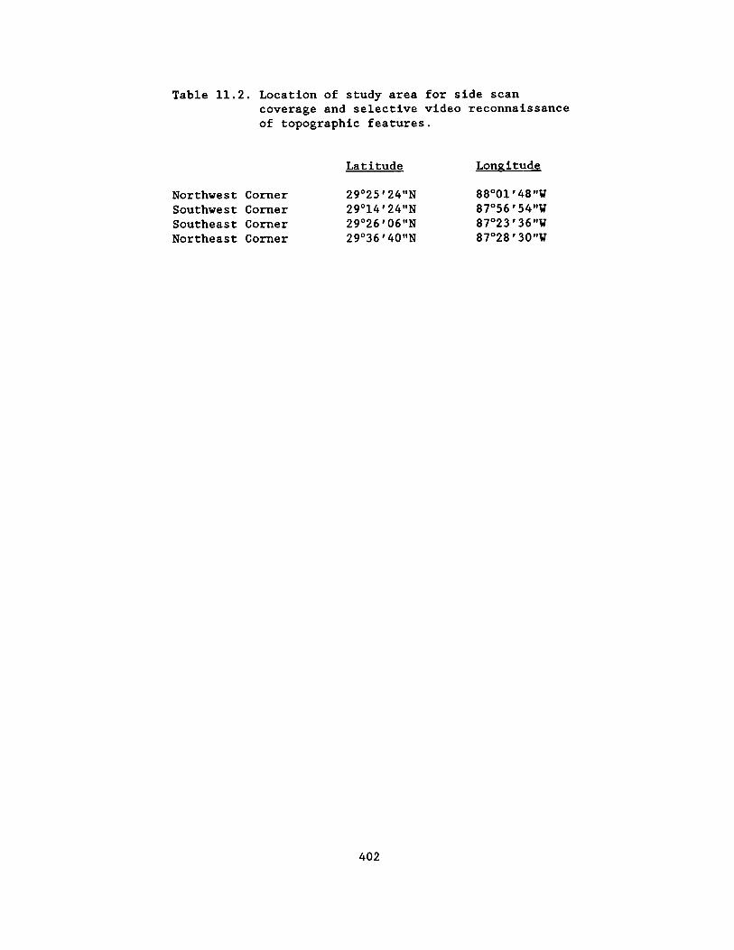
Table 11 .2 . Location of study area for side scan coverage and selective video reconnaissance of topographic features .
Latitude
Northwest Corner 29°25'24"N Southwest Corner 29°14'24"N Southeast Corner 29°26'06"N Northeast Corner 29°36'40"N
Longitude
88°01'48"W 87°56'54"W 87°23'36"W 87°28'30"W
402

community characteristics, included the following :
o Wave Fields (closely spaced, low-relief waves on bottom ; silty sand bottom with considerable bioturbation ; night survey with ROV revealed much biological activity ; especially active were squid, ophichthid eels, moray eels, and bottom fish) ;
o Spaced ridges or Sand Waves (spaced 100-200 m apart ; if troughs exist, most seem to be infilled with soft sediments ; silty sand bottom ; ROV survey did not reveal nature of differences between waves and troughs) ;
o Areas of Patchy Strong Sonar Returns (silty sand bottom ; ROV survey did not reveal differences between areas of weak and strong returns) ;
o Ridges or Paleo-Shorelines (these may be still-stand erosional features ; these areas are called "ragged" or "broken" bottoms by fisherman ; low-relief, rugged outcrops harboring a low to moderate abundance of hard-bottom organisms) ;
o Fields of Patch-Reef-Like Features (most seem to have vertical sides and rounded tops, 1 to 4 m tall and 2 to 10 m wide ; at one ROV site, we encountered 14 such reefs in an area of approximately 3000 m2, harboring moderate numbers of hard-bottom organisms ; sediment between reefs appears to be coarse carbonate sand) ;
o Fields of Apparent Small Depressions in the Bottom (sandy silt bottom ; ROV survey did not reveal the presence or nature of depressions ;
turbidity was quite high during survey) ;
o Features of Low Topographic Relief (very small outcrops of rocks showing up on side scan records ; hard-bottom organisms in low abundance) ;
o Features of Moderate Topographic Relief (outcrops 1-3 m tall, some 10-15 m across, harboring moderate hard-bottom communities ; on one reef surveyed shallower than 60 m, coralline algae appeared to be common) ;
o Features of Mayor Topographic Relief (some over 15 m tall ; some are smooth topped, some knobby ; some broad and some spire-like ; hard-bottom fauna ranges from depauperate on the vertical sides and in sand flats on top of some reefs to lush on the broad, flat reef-top areas and on parts of rugged reefs and pinnacles)
From a habitat perspective, the geologic features observed in the study area on side-scan records range from silty sand bottoms to reefal structures with over 20 m relief . The tallest features in the area are the pinnacles, described by Ludwick and Walton (1957), that rise in some cases from nearly 110 m to 89 m . However, the largest reefs in the region, by area, rise from around 78 m depth to peak at approximately 63 m . These reefs have extensive flat tops, the origin of which is uncertain .
The sides of the pinnacles and other reefs in the study area are in many places vertical . The vertical sides of reefs were typically dominated by ahermatypic corals, including the solitary black coral, Rhizopsammia manuelensis , branching hard corals
403

(e .g ., Madrevora caroling and possibly Oculina), and a number of octocorals . Reefs that had extensive flat, reeftop areas harbored lush octocoral - sponge -crinoid communities distinct from the assemblage on the sides of these structures and from reefs that lacked extensive reef tops .
The impression obtained during ROV surveys, without subsequent analysis of video tapes and photographs, was that hard-bottom community species composition is similar from one site to another within the study area, and that community richness (the number of species present) and biomass are dependent in part upon the amount of hard-bottom in a given area . Differences between communities, especially with respect to the relative abundance of the various species, may also be attributable to differences in structural characteristics of the various reefs . Furthermore, the presence of permanent or semipermanent masses of turbid water might influence community composition and abundance . Both richness number of species and population levels on hard-bottoms covered by layers of fine silt appeared to be low .
REFERENCES
Ballard, R.D . and E . Uchupi . 1970 . Morphology and Quaternary history of the continental shelf of the Gulf coast of the United States . Bull . Mar . Sci . 20(3) :547-559 .
Continental Shelf Associates, Inc . 1985 . Live-bottom survey of drillsite locations in Destin Dome Area Block 617 . Rep . to Chevron U.S .A ., Inc . 40 pp . + Appendices .
Ludwick, J .C . and W.R . Walton . 1957 . Shelf-edge, calcareous prominences in northeastern Gulf of Mexico . Bull . AAPG 41(9) :2054-2101 .
Rezak, R., T.J . Bright and D.W . McGrail . 1985 . Reefs and Banks of the Northwestern Gulf of Mexico : Their Geological Biological, and Physical Dynamics . John Wiley and Sons, New York . 259 pp .
Shipp, R.L . and T .S . Hopkins . 1978 . Physical and biological observations of the northern rim of the DeSoto Canyon made from a research submersible . N .E . Gulf Sci . 2(2) :113-121 .
Woodward-Clyde Consultants . 1979 . Eastern Gulf of Mexico marine habitat study . Report to U .S . Dept . of Interior, Bureau of Land Management, OCS Office, New Orleans, Louisiana . Contract No . AA551-CT3-22 .
Dr . Stephen R. Gittings is a Research Associate at Texas A&M University with special interest in coral reefs, hard-bottom ecosystems, and human impacts in these environments .
Dr . Thomas J. Bright is a professor at Texas A&M and Director of the Texas A&M Sea Grant College Program . His principal research interests have been in the area of coral reefs and biological communities on the reefs and banks of the northwest Gulf of Mexico .
Mr . Ian MacDonald is a Research Assistant at Texas A&M University who, in addition to studying the hard-bottom communities described here, is involved in research on the ecology of oil seeps on the continental slope of the northwest Gulf of Mexico .
404

LIST OF ATTENDEES

Mr . Steve Absher Mobil Exploration & Producing New Orleans Division 1250 Poydras Street New Orleans, LA 70113-1892
Mr . Paul Adams American Management Systems Credit Management System 1777 North Kent Street Arlington, VA 22209
Mr . Adnan A. Ahmed Minerals Management Service Gulf of Mexico OCS Region-FO 1201 Elmwood Park Boulevard New Orleans, LA 70123-2394
Mr . Neal Allen YMCA 920 St . Charles Street New Orleans, LA 70130
Mr . Robert Ancelet Louisiana Department
and Fisheries Seafood 400 Royal Street New Orleans, LA 70130
Mr . J . Kenneth Adams Minerals Management Service Gulf of Mexico OCS Region-LE 1201 Elmwood Park Boulevard New Orleans, LA 70123-2394
Dr . John F . Ahearne Resources For The Future 1616 P Street NW Washington, DC 20036
Mr . G . G . Alabi State of Alabama Conservation Department 64 North Union Street Montgomery, AL 36130
Mr . Alex Alvarado Minerals Management Service Gulf of Mexico OCS Region-FO 1201 Elmwood Park Boulevard New Orleans, LA 70123-2394
Ms . Cheryl Anderson of Wildlife Minerals Management Service
Offshore Environmental Assessment Division
12203 Sunrise Valley Drive Reston, VA 22091
Ms . Eileen Angelico Minerals Management Service Gulf of Mexico OCS Region-ORD 1201 Elmwood Park Boulevard New Orleans, LA 70123-2394
Dr . L . E . Aten National Park Service P.O . Box 37127 Washington, DC 20013
Mr . Bill Auberle Yates & Auberle, Ltd . 2211 York Road, #208 Oak Brook, IL 60521
Mr . Rik Anuskiewicz Minerals Management Service Gulf of Mexico OCS Region-LE 1201 Elmwood Park Boulevard New Orleans, LA 70123-2394
Dr . David H . Attaway National Sea Grant College Program 6010 Executive Boulevard Rockville, MD 20852
Dr . Don Aurand Minerals Management Service Headquarters Office 12203 Sunrise Valley Drive Reston, VA 22091
407

Dr . Robert M . Avent Minerals Management Service Gulf of Mexico OCS Region-LE 1201 Elmwood Park Boulevard New Orleans, LA 70123-2394
Ms . Barbara Bailey Chevron U.S .A ., Inc . Eastern Region 935 Gravier Street New Orleans, LA 70112
Mr . A1 Ballinger University of Houston Center For Public Policy 4800 Calhoun Street Houston, TX 77204-5341
Mr . James Barkuloo U.S . Fish and Wildlife 1612 June Avenue Panama City, FL 320405
Dr . L . F . Baehr Corps of Engineers New Orleans District P .O . Box 60267 New Orleans, LA 60267
Mr . Claude Baker Mobil Exploration & Producing New Orleans Division 1250 Poydras Street New Orleans, LA 70118
Dr . Hugh Banon Exxon Production Research P .O . Box 2189 Houston, TX
Mr . Clarence E. Barmore Service Conoco, Inc .
North American Exploration P .O . Box 2197 Houston, TX 2197
Ms . Mary Bartz Minerals Management Service Gulf of Mexico OCS Region-LE 1201 Elmwood Park Boulevard New Orleans, LA 70123-2394
Mr . Robert Baumann Louisiana State University Center for Energy Studies Baton Rouge, LA 70808
Dr . Robert Bea Ocean Engineering Services University of California at
Berkeley 412 O'Brien Berkeley, CA 94720
Mr . Joe Benigno National Marine Fisheries Service P .O . Drawer 1207 Pascagoula, MS 39568-1207
Ms . Patricia Basco Texaco, Inc . 400 Poydras Street New Orleans, LA 70130
Mr . Tony Bazile Conoco, Inc . 600 North Dairy Ashford Street Houston, TX 77079
Mr . Charles A. Bedell International Association of
Drilling Contractors P .O . Box 4287 Houston, TX 77210
Mr . Richard Bennett Minerals Management Service Gulf of Mexico OCS Region-LE 1201 Elmwood Park Boulevard New Orleans, LA 70123-2394
408

Mr . Homer Benton Minerals Management Service Gulf of Mexico OCS Region-LE 1201 Elmwood Park Boulevard New Orleans, LA 70123-2394
Mr . Leron E. Bielak Minerals Management Service Office of Strategic and International Minerals
1951 Kidwell, Suite 601 Vienna, VA 22180
Ms . Jennifer B3ork National Park Service Padre Island National Seashore 9405 South Padre Island Drive Corpus Christi, TX
Ms . Janice Blake Minerals Management Service Gulf of Mexico OCS Region-LE 1201 Elmwood Park Boulevard New Orleans, LA 70123-2394
Ms . Shelby Boudresux Louisiana Department of Education P.O . Box 94064 Baton Rouge, LA 70804-9064
Ms . Paula Bowman Minerals Management Service 1110 Herndon Parkway Herndon, VA 22070
Mr . Randy Bradford Freeport-McMoran, Inc . McMoran Oil & Gas Co . P .O . Box 60004 New Orleans, LA 70160
Ms . Darice Breeding Minerals Management Service Gulf of Mexico OCS Region-LE 1201 Elmwood Park Boulevard New Orleans, LA 70123-2394
Mr . Bill Berry Louisiana Land & Exploration Co . Environmental Affairs & Safety P .O . Box 60350 New Orleans, LA 70160
Mr . Alex Bisso Conoco, Inc . Production Headquarters P .O . Box 2197 (PR 2078) Houston, TX 77252
Mr . J . H . "Bo" Blaclanon State of Louisiana Department of Natural Resources P .O . Box 44487 Baton Rouge, LA 70804-4487
Ms . Pat Blandford Reading Offshore Regulatory
Service 1800 West Loop South, Suite 1620 Houston, TX 77027
Mr . Daniel Bourgeois Minerals Management Service Gulf of Mexico OCS Region-FO 1201 Elmwood Park Boulevard New Orleans, LA 70123-2394
Mr . Cary V . Bradford Kerr-McGee Corp . E&P Gulf of Mexico Region P .O . Box 39400 Lafayette, LA 70592
Mr . Jerry Brashier Minerals Management Service Gulf of Mexico OCS Region-LE 1201 Elmwood Park Boulevard New Orleans, LA 70123-2394
Mr . Autry Britton Minerals Management Service Gulf of Mexico OCS Region-FO 1201 Elmwood Park Boulevard New Orleans, LA 70123-2394
409

Dr . James Brooks Texas A&M University Geochemical & Environmental Research Group
10 South Graham Road College Station, TX 77843
Dr . William R. Bryant Texas A&M University Department of Oceanography College Station, TX 77843
Mr . Ben Buchbinder NASA Safety Office Risk Management Program NASA Headquarters, Codes QS Washington, DC 20546
Dr . Donald R . Cahoon Louisiana Geological Survey Department of Natural Resources P.O . Box G, University Station Baton Rouge, LA 70893
Dr . Robert S . Carney Louisiana State University Center for Wetland Resources Baton Rouge, LA 70803-7503
Mr . Craig Cary Scripps Institute of Oceanography/UCSD
La Jolla, CA 92093
Mr . Don Cassidy University of New Orleans Geography Department Lakefront Campus New Orleans, LA
Dr . D . W . Chamberlain ARCO Environmental Protection 515 South Flower Street Los Angeles, CA 90071
Dr . Murray Brown Minerals Management Service Gulf of Mexico OCS Region-LE 1201 Elmwood Park Boulevard New Orleans, LA 70123-2394
Ms . Pat Bryars Minerals Management Service Gulf of Mexico OCS Region-LE 1201 Elmwood Park Boulevard New Orleans, LA 70123-2394
Mr . Richard Burger Jackson State University 1400 Lynch Street Jackson, MS 39206
Mr . Timothy G . Carlin U.S . Coast Guard Atlantic Area Strike Team, NSF Mobile, AL 36608
Mr . Jim Carson National Park Service Jean Lafitte National Park 7400 Highway 45 Marrero, LA 70072
Ms . Phyllis Casey Minerals Management Service Alaska OCS Region 949 East 36th Avenue Anchorage, AK 99508-4302
Mr . Jack Chailer Mobil Oil 9 Greenway Plaza, Suite 2700 Houston, TX 77046
Mr . Danny F . Charlton Shell Offshore, Inc . Public Affairs P .O . Box 61933 New Orleans, LA 70161
410

Dr . Edward Chesney Louisiana Universities
Consortium Star Route Box 541 Chauvin, LA 70344
Mr . Dennis Chew Corps of Engineers New Orleans District P .O . Box 60267 New Orleans, LA 70160
Ms . Caron Chess Marine Rutgers University
4923 Morris Street Philadelphia, PA 19144
Mr . Fred J. Christadore Texaco, Inc . P .O . Box 60252 New Orleans, LA 70160
Mr . Raymond P . Churan Department of the Interior Environmental Project Review P .O . Box 649 Albuquerque, NM 87103
Mr . Bruce Coffland NASA-AMES Research Center Data Facility MS 240-12 Moffett Field, CA 94035
Mr . Joseph Christopher Minerals Management Service Gulf of Mexico OCS Region-LE 1201 Elmwood Park Boulevard New Orleans, LA 70123-2394
Mr . Clark Darryl Louisiana Department of Natural Resources
Coastal Management Division P .O . Box 44487 Baton Rouge, LA 70804
Mr . Ben Cole Louisiana Universities
Consortium Star Route Box 541 Chauvin, LA 70357
Dr . Sneed Collard Marine University of West Florida
Department of Biology 11000 University Parkway Pensacola, FL 32514
Mr . Barney Congdon Minerals Management Service Gulf of Mexico OCS Region-ORD 1201 Elmwood Park Boulevard New Orleans, LA 70123-2394
Mr . Jim Corthay Exxon Company U .S .A . Offshore/Alaska Division P.O . Box 4279 Houston, TX 77210-4279
Dr . R . A . (Tony) Cox Technica Ltd . Lynton House 7/12 Tavistock Square London WC1H 9LT ., England
Mr . Laurence J . Conkerton Louisiana Department of Transport and Development
Offshore Terminal Authority P .O . Box 94245 Baton Rouge, LA 70804-9245
Mr . Vincent Texaco, Inc . New Orleans 400 Poydras New Orleans,
F . Cottone
Operations Street LA 70130
Dr . Michael Dagg Louisiana Universities Marine
Consortium Star Route Box 541 Chauvin, LA 70344
411

Dr . Larry Danek Hunter-ESE P.O . Box 1703 Gainsville, FL 32602
Dr . Bruce E. Davis Jackson State University Center for Spatial Data Research Box 18739 Jackson, MS 39217
Ms . D . K . Davis Exxon Research Student Corpus Christi, TX 78411
Ms . Debbi Davison University of West Florida Department of Biology 11000 University Parkway Pensacola, FL 32514-5751
Ms . Monica Defenbaugh 4708 Chastant Street Metairie, LA 70006
Mr . Steve Dessauer Minerals Management Service Gulf of Mexico OCS Region-PD 1201 Elmwood Park Boulevard New Orleans, LA 70123-2394
Dr . Blaine Dinger Tenneco Oil E&P Western Gulf P .O . Box 39300 Lafayette, LA 70503
Mr . Kent Dirlam Minerals Management Service Offshore Leasing Management
Division 18th & C Streets NW Washington, DC 20240
Mr . Les Dauterive Minerals Management Service Gulf of Mexico OCS Region-LE 1201 Elmwood Park Boulevard New Orleans, LA 70123-2394
Dr . Don Davis Nicholls State University Department of Earth Sciences P .O . Box 2189 Thibodaux, LA 70130
Dr . Paul Davis Mississippi State Institute of
Higher Learning 5866 Canton Park Drive Jackson, MS 39211
Mr . Rick Dawson National Park Service Southeast Regional Office 75 Spring Street, SW Atlanta, GA 30303
Dr . Richard E . Defenbaugh Minerals Management Service Gulf of Mexico OCS Region-LE 1201 Elmwood Park Boulevard New Orleans, LA 70123-2394
Mr . Omar DeWald Minerals Management Service Gulf of Mexico OCS Region-LE 1201 Elmwood Park Boulevard New Orleans, LA 70123-2394
Mr . Scott P . Dinnel Louisiana State University Center for Wetland Resources Baton Rouge, LA 70803-7503
Dr . Robert B . Ditton Texas A&M University Department of Wildlife and
Fisheries College Station, TX 77843
412

Mr . Mark W. Dobin Mobil Oil 1250 Poydras Street New Orleans, LA 70130
Mr . Michael Dorner Minerals Management Service Gulf of Mexico OCS Region-OPS 1201 Elmwood Park Boulevard New Orleans, LA 70123-2394
Mr . Tom Dowie Zapata Gulf Marine P .O . Box 802 Harvey, LA 70059
Mr . L . G . Durio Amoco Region Exploration P .O . Box 802 Harvey, LA 70059
Dr . Curt Ebbesmeyer Evans-Hamilton, Inc . Western Region 6306 21st Avenue NE Seattle, WA 98115
Mr . Doug Elvers Minerals Management Service Gulf of Mexico OCS Region-LE 1201 Elmwood Park Boulevard New Orleans, LA 70123-2394
Mr . Charles R . Erwin Enserch Exploration, Inc . Offshore Exploration 1601 Elm Street, Suite 1283 Dallas, TX 75201
Dr . Roger Fay Texas A&M University Geochemical & Environmental
Research Group 10 South Graham Road College Station, TX 77840
Mr . C . E . Dokey, Jr . Freeport-McMoran, Inc . McMoran Oil & Gas Co . P .O . Box 60004 New Orleans, LA 70160
Dr . Quay Dortch Louisiana Universities Marine
Consortium Star Route 541 Chauvin, LA 70344
Mr . John Duggar John R. Duggar & Associates Carribean Marine Research Center P .O . Box 740084 New Orleans, LA 70174
Mr . Dan Durrett University of West Florida Department of Biology 11000 University Parkway Pensacola, FL 32514-5751
Mr . Richard L. Ehrhart Environmental Protection Agency Industrial Permits 1445 Ross Avenue Dallas, TX 75202-2733
Mr . Allan B . Ensminger Wetlands & Wildlife Management
Company Box 158 Belle Chase, LA 70037
Mr . John Farris Placid Oil Company 1440 Canal Street, Suite 1900 New Orleans, LA 70112
Mr . Thomas R . Fetters CNG Producing Company Canal Place 1, Suite 3100 New Orleans, LA 70130-9990
413

Dr . John Finn Metropolitan Hospital Council 3340 Severn Avenue, Suite 206 Metairie, LA 70448
Dr . Charles R. Fisher University of California at
Santa Barbara Department of Biology Santa Barbara, CA 93106
Mr . Mark Flora National Park Service Water Resources Division P .O . Box 25287 Denver, CO 80225
Mr . Frank Fraker Texaco, Inc . P.O . Box 60252 New Orleans, LA 70160
Dr . William Freudenburg University of Wisconsin Department of Rural Sociology Madison, WI 53706
Ms . Laura Gabanski NOAA National Marine Pollution Program 11400 Rockville Pike Rockville, MD 20852
Dr . Donald K . Gartman Columbia Gas System Environmental Affairs 20 Montchanin Road Wilmington, DE 19807
Ms . Mary Alice Garza Geo-Marine, Inc . 1316 14th Street Plano, TX 75074
Dr . Marion Fischel Shell Oil Company Environmental Affairs P .O . Box 4320 Houston, TX 77210
Mr . John E . Flipse Texas A&M University Offshore Technology Research
Center P .O . Box 3400 College Station, TX 77843
Ms . Michelle Michot Rice Center One Greenway Plaza, Suite 1100 Houston, TX 77046
Ms . Donna Franklin NOAA Ecology and Conservation 14th & Constitution Avenue NW Washington, DC 20230
Dr . Norman Froomer Minerals Management Service Gulf of Mexico OCS Region-LE 1201 Elmwood Park Boulevard New Orleans, LA 70123-2394
Mr . Terry N. Gardner Exxon Production Research Company P .O . Box 2189 Houston, TX 77252-2189
Ms . Loretta C . Gartman Delaware Natural Areas Council 2003 Oak Lane Road Wilmington, DE 19803
Mr . Ruben G . Garza Geo-Marine, Inc . 1316 14th Street Plano, TX 75074
414

Ms . Julie Gauthier Louisiana Universities
Consortium Star Route Box 541 Chauvin, LA 70344
Dr . David Gettleson Continental Shelf Associates, Inc .
767 Parkway Street Jupiter, FL 33458
Mr . Jamie Gerbrecht Marine Exxon Company U .S .A .
Offshore Division P .O . Box 60626 New Orleans, LA 70160
Dr . Dian J. Gifford Louisiana Universities Marine
Consortium Star Route Box 541 Chauvin, LA 70344
Dr . Steve Gittings Texas A&M University Department of Oceanography College Station, TX 77843
Mr . John Goll Minerals Management Service Offshore Environmental
Assessment Division 12203 Sunrise Valley Drive Reston, VA 22091
Mr . Frederick C . Gray Minerals Management Service Atlantic Region 1951 Kidwell Drive Vienna, VA 22180
Ms . Lynn Griffin Florida Department of Environmental Regulation
Water Management 2600 Blair Stone Road Tallahassee, FL 32301
Dr . Churchill Grimes National Marine Fisheries Service Panama City Laboratory 3500 Delwood Beach Road Panama City, FL 32407
Dr . Charles Giammona Texas A&M University Department of Civil Engineering College Station, TX 77843
Ms . Martha Banks Gittings 742 Garden Acres Bryan, TX 77802
Mr . Gary Goeke Minerals Management Service Gulf of Mexico OCS Region 1201 Elmwood Park Boulevard New Orleans, LA 70123-2394
Mr . Ken Graham Minerals Management Service Gulf of Mexico OCS Region-LE 1201 Elmwood Park Boulevard New Orleans, LA 70123-2394
Mr . Larry B . Green Freeport-McMoran, Inc . Sulphur Division P .O . Box 61520 New Orleans, LA 70161
Dr . Thomas Grigalunas University of Rhode Island Department of Resource Economics Kingston, RI 02881
Dr . Charles Groat Louisiana Geological Survey P .O . Box G, University Station Baton Rouge, LA 70893
415

Mr . Mike Guido Louisiana Department of Wildlife and Fisheries
Seafood-Freshwater Diversion 400 Royal Street New Orleans, LA 70130
Dr . Norman Guinasso, Jr . Texas A&M University Department of Oceanography 10 South Graham Road College Station, TX 77840
Mr . Sheldon R. Hall Geo-Marine, Inc . 1316 14th Street Plano, TX 75074
Mr . Max Hancock National Park Service Padre Island National Seashore 9405 South Padre Island Drive Corpus Christi, TX 78418-5597
Ms . Ann Hanks Minerals Management Service Gulf of Mexico OCS Region-ORD 1201 Elmwood Park Boulevard New Orleans, LA 70123-2394
Mr . James C . Harris BHP Petroleum (Americas) Inc . 5847 San Felipe, Suite 3600 Houston, TX 77057
Mr . Richard Hartman Louisiana Geological Survey Environmental Research P.O . Box G, University Station Baton Rouge, LA 70893
Mr . Charles R . Havnen Offshore Marine Service Association
1440 Canal Street, Suite 1709 New Orleans, LA 70112
Mr . John L. Guidry Minerals Management Service Gulf of Mexico OCS Region-FO 1201 Elmwood Park Boulevard New Orleans, LA 70123-2394
Mr . Ken Haddad Florida Department of Natural Resources
Marine Resources Institute 100 8th Avenue Southeast St . Petersburg, FL 33701
Dr . Myron P . Hamer Pan American University Arts & Sciences Department 1614 Ridgely Road Brownsville, TX 78520
Mr . Lawrence R. Handley U .S . Fish and Wildlife Service National Wetlands Research Center 1010 Gause Boulevard Slidell, LA 70458
Dr . Donald E. Harper, Jr . Texas A&M University at Galveston Marine Biology Department 5007 Avenue U Galveston, TX 77551
Mr . David Hart New Orleans City Planning
Commission City Hall-Room 9W New Orleans, LA 70112
Mr . George Hasseltine CNG Producing Company One Canal Place, Suite 3100 New Orleans, LA 70130-9990
Dr . Ken Havran Minerals Management Service Offshore Environmental Assessment
Division 12203 Sunrise Valley Drive Reston, VA 22092
416

Dr . Barbara Hecker Mr . Richard E . Heffner Lamont Doherty Geological Atwater Consultants, Ltd .
Observatory 318 Camp Street Route 9W New Orleans, LA 70130 Palisades, NY 10964
Mr . Jason Henderson Mr . Russell J . Henderson RJH, Inc . RJH, Inc . P .O . Box 15030 P .O . Box 15030 New Orleans, LA 70175 New Orleans, LA 70175
Mr . Larry Henry Mr . Charles Hill Chevron, U.S .A . Minerals Management Service Eastern Region Gulf of Mexico OCS Region-LE 935 Gravier Street 1201 Elmwood Park Boulevard New Orleans, LA 70112 New Orleans, LA 70123-2394
Ms . Roxanna Hinzman Mr . Bob J . Hoff University of West Florida TDI 213 Bayou Boulevard 10375 Richmond, Suite 1175 Pensacola, FL 32503 Houston, TX 77042
Mr . Wayne Hoggard Mr . Samuel Holder National Marine Fisheries Service Parish of Jefferson P .O . Drawer 1207 Environmental Department Pascagoula, MS 39568-1207 P.O . Box 10007
Jefferson, LA 70121
Mr . Joe Holmes Mr . Chuck Hopson Louisiana Geological Survey Minerals Management Service P.O . Box G, University Station Gulf of Mexico OCS Region-LE Baton Rouge, LA 70893 1201 Elmwood Park Boulevard
New Orleans, LA 70123-2394
Mr . Don Howard Minerals Management Service Gulf of Mexico OCS Region-FO 1201 Elmwood Park Boulevard New Orleans, LA 70123-2394
Mr . Paul Hufnagel Family Service of Greater New Orleans
East Jefferson/Employee Assistance Program
201 Evans Road, Suite 311 Harahan, LA 70123
Mr . John D . Hunter Mr . Norman Hurwitz National Park Service Minerals Management Service Padre Island National Seashore Headquarters Office 9405 South Padre Island Drive 12203 Sunrise Valley Drive Corpus Christi, TX 78418 Reston, VA 22091
417

Mr . William C . Hutton Maxus Energy Environmental Affairs 717 North Harwood Dallas, TX 75201
Ms . Patricia Ice Texaco, Inc . 400 Poydras Street New Orleans, LA 70130
Ms . Denise M. Jamison Geo-Marine, Inc . 1754 Whitney Avenue New Orleans, LA 70114
Ms . Bonnie Johnson Minerals Management Service Gulf of Mexico OCS Region-LE 1201 Elmwood Park Boulevard New Orleans, LA 70123-2394
Dr . Jimmy Johnston U.S . Fish and Wildlife Service National Wetlands Research Center 1010 Gause Boulevard Slidell, LA 70458
Mr . David A . Jones Technica International Software Sales North America 1440 North Harbor Boulevard Suite 800 Fullerton, CA 92635
Mr . Mike Joseph Minerals Management Service Gulf of Mexico OCS Region-FO 1201 Elmwood Park Boulevard New Orleans, LA 70123-2394
Dr . Walter Keithly Louisiana State University Center for Wetland Resources Baton Rouge, LA 70803
Mr . William H . Ibarra Conoco, Inc . New Orleans Division 3500 General Degaulle Drive New Orleans, LA 70141
Dr . Bela James Continental Shelf Associates, Inc .
7607 Eastmark Drive, Suite 250 College Station, TX 77840
Dr . Chacko J . John Louisiana Geological Survey Louisiana State University P .O . Box G, University Station Baton Rouge, LA 70893
Mr . Jay A. Johnson Conoco, Inc . New Orleans Division 3500 General Degaulle Drive New Orleans, LA 70141
Mr . Bill Johnstone Minerals Management Service Gulf of Mexico OCS Region-LE 1201 Elmwood Park Boulevard New Orleans, LA 70123-2394
Dr . James I . Jones Mississippi/Alabama Sea Grant P .O . Box 7000 Ocean Springs, MS 39504-7000
Lt . Stephen Kantz U .S . Coast Guard OCS Branch 1440 Canal Street New Orleans, LA 70112-2711
Mr . Brian Kelly U .S . Coast Guard Eighth District 500 Camp Street New Orleans, LA 70130
418

Mr . Frank Kelly Texas A&M University Department of Oceanography College Station, TX 77843
Dr . Mahlon C . Kennicutt, Texas A&M University Geochemical/Environmental Research Group
10 South Graham Road College Station, TX 77840
LCMDR Jerry Kichner, P .E . U .S . Coast Guard Marine Safety Office 150 North Royal Street Mobile, AL 36652
Mr . Mike Kinsella Kinsella, Cook, &
Associates, Inc . 6461 Siegen Lane Baton Rouge, LA 70809
Ms . Carolyn Kennedy University of Southern Mississippi
Center For Marine Science 8910 Maili Way Bay St . Louis, MS 39520
II Dr . S . E . Kibbee Standard Oil Offshore Business Unit 9401 Southwest Freeway Houston, TX 77074
Mr . Maurice G . Knight St . Bernard Planning Commission Coastal Zone Management 8201 West Judge Perez Drive Chalmette, LA 70043
Mr . Joe Kuchin U.S . Coast Guard Marine Safety 500 Camp Street New Orleans, LA 70130
Dr . Cornell Ladner Mississippi Department of
Wildlife Conservation Bureau of Marine Resources P.O . Drawer 959 Long Beach, MS 29560
Mr . Greg Laiche Louisiana Department of Wildlife and Fisheries
Seafood-Freshwater Diversion 400 Royal Street New Orleans, LA 70130
Ms . Dorothy Kimbrough Geo-Marine, Inc . 8323 Plum Street New Orleans, LA 70118
Mr . Mark Klimowicz Texaco, Inc . New Orleans Operations P .O . Box 60252 New Orleans, LA 70160
Mr . Bill E . Kohut Minerals Management Service Pacific OCS Region 145 North Brent Street Ventura, CA 93003
Dr . Herb Kumpf DOC/NOAA/NMFS Panama City Laboratory 3500 Dellwood Beach Road Panama City, FL 32408
Ms . Lynne Lahare Minerals Management Service Gulf of Mexico OCS Region-LE 1201 Elmwood Park Boulevard New Orleans, LA 70123-2394
Ms . Connie Landry Minerals Management Service Gulf of Mexico OCS Region-LE 1201 Elmwood Park Boulevard New Orleans, LA 70123-2394
419

Mr . Ray Landry 4300 Page Drive Metairie, LA 70003
Mr . Paul Lankford Anadarko Petroleum Corporation 16801 Greenspoint Park Drive Houston, TX 77060
Mr . Douglas Leal Geo-Marine, Inc . 7148 Parkside Court New Orleans, LA 70127
Mr . Griff C . Lee Griff Lee, Inc . P .O . Box 70787 New Orleans, LA 70172
Mr . Giuseppe Libri Agip Petroleum Co ., Inc . 2950 North Loop West Houston, TX 77092
Ms . Dianne Lindstedt Louisiana Geological Survey P.O . Box G, University Station Baton Rouge, LA 70893
Ms . Gail T . Lloyd Geo-Marine, Inc . 1316 14th Street Plano, TX 75074
Mr . Gary L. Lore Minerals Management Service Gulf of Mexico OCS Region-RE 1201 Elmwood Park Boulevard New Orleans, LA 70123-2394
Mr . Bob Lutz Louisiana Universities Marine
Consortium Star Route Box 541 Chauvin, LA 70344
Dr . Bill Lang Minerals Management Service Headquarters Office 12203 Sunrise Valley Drive Reston, VA 22091
Mr . Robert Lanza Minerals Management Service Operations 77 Doescher Harahan, LA 70123
Ms . Gail Rainey LeBlanc Minerals Management Service Gulf of Mexico OCS Region 1201 Elmwood Park Boulevard New Orleans, LA 70123-2394
Mr . William R. Leek Robert J . Meyers & Associates 14441 Cornerstone Village Drive Suite 207 Houston, TX 77014
Dr . John A. Lindsay NOAA/HAZMAT 345 Courtland Street Atlanta, GA 30065
Mr . Surya N . Lingamallu Minerals Management Service Gulf of Mexico OCS Region-FO 1201 Elmwood Park Boulevard New Orleans, LA 70123-2394
Mr . Ren Lohoefener National Marine Fisheries Service P .O . Drawer 1207 Pascagoula, MS 39568-1207
Mr . J . B . Lowenhaupt Minerals Management Service Gulf of Mexico OCS Region-ORD 1201 Elmwood Park Boulevard New Orleans, LA 70123-2394
Mr . R . Michael Lyons Mid-Continent Oil & Gas Association
Louisiana Division 333 Laurel Street, Suite 740 Baton Rouge, LA 70801
420

CDR . D . M . Maguire U.S . Coast Guard, Marine Safety Inspection Department 1440 Canal Street, Room 935 New Orleans, LA 70112-2711
Mr . Buddy Mansfield U.S . Coast Guard Atlantic Area Strike Team ATC Mobile, AL 36608
Ms . Bethlyn McCloskey 5113 Bissonet Drive Metairie, LA 70003
Dr . Don L. McGregor Exxon Company U.S .A . Offshore/Alaska Division P .O . Box 4279 Houston, TX 77210-4279
Mr . Lawrence McKenzie Applied Technology Research Corporation
727 Spain Street Baton Rouge, LA 70802
Mr . Richard D . Melton Walk, Haydel & Associates, Inc . Environmental/Engineering/
Oil & Gas 600 Carondolet Street New Orleans, LA 70130
Dr . Scott Mettee Alabama Geological Services Biological Resources 420 Hackberry Lane Tuscaloosa, LA 35486
Ms . Debbie Milonski The University of West Florida Department of Biology 11000 University Parkway Pensacola, FL 32514-5751
Mr . Patrick Mangan Minerals Management Service Gulf of Mexico OCS Region-LE 1201 Elmwood Park Boulevard New Orleans, LA 70123-2394
Mr . Rex Mars Macrea Piping Repair
Systems, Inc . P .O . Box 429 Belle Chasse, LA 70037
Mr . Terry McGovern McDermott, Inc . P .O . Box 60035 New Orleans, LA 70160
Dr . Brent McKee Louisiana Universities Marine
Consortium Star Route Box 541 Chauvin, LA 70344
Mr . Richard D. McNally Petroleum Engineering Magazine P .O . Box 1589 Dallas, TX 75221
Mr . Stafford Menard McDermott, Inc . P .O . Box 60035 New Orleans, LA 70160
Mr . Robert J . Meyers Robert J . Meyers & Associates 14441 Cornerstone Village Suite 207 Houston, TX 77014
Mr . Mike Mire Shell Offshore, Inc . Coastal Division P .O . Box 61122, Room 2218 New Orleans, LA 70161
421

Mr . Neil A. Mock SOI-Coastal 106 Avant Garde Circle Kenner, LA 70065
Mr . John Moore Shell Offshore, Inc . P .O . Box 60159 New Orleans, LA
Mr . Tim Morton National Marine Fisheries Service P.O . Drawer 1207 Pascagoula, MS 39568-1207
Mr . Keith Mullin National Marine Fisheries Service P .O . Drawer 1207 Pascagoula, MS 39568-1207
Mr . Chuck Neal 821 West Temperance Street Ellettsville, IN 47429
LCDR . Chris J . Nelson NOAA Hazmat 500 Camp Street New Orleans, LA 70130
Dr . George E. Neusaenger National Park Service Resource Management/ Jean Lafitte
423 Canal Street, Room 210 New Orleans, LA 70130-2341
Dr . Warner D . North Decision Focus Inc . 4984 El Camino Real Los Altos, CA 94022
Dr . Jim O'Hara ECS/Normandeau P .O . Box 1393 Aiken, SC 29801
Mr . Donald Moore National Marine Fisheries Service 4700 Avenue U Galveston, TX 77551
Mr . Robert M. Moore Minerals Management Service Gulf of Mexico OCS Region-PD 1201 Elmwood Park Boulevard New Orleans, LA 70123-2394
Mr . Melvin Mouton Tenneco, Central Gulf Area P .O . Box 39100 Lafayette, LA 70503
Mr . Michael Murrell Louisiana Universities Marine
Consortium Star Route Box 541 Chauvin, LA 70344
Dr . Eddystone Nebel University of New Orleans School of Hotel, Restaurant & Tourism
New Orleans, LA
Mr . Dennis Nethington Mobil Oil Exploration & Producing 1250 Poydras Street New Orleans, LA 70113
Mr . Walter Niebuhr Mobil Exploration & Producing New Orleans Division 1250 Poydras Street, Room 1557 New Orleans, LA 70113
Mr . Jim O'Brien OOPS, Inc . 557 Brookmeade Drive Gretna, LA 70056
Mr . Ray Oliver UNOCAL Gulf Region Operations 4635 Southwest Freeway, Suite 900 Houston, TX 77027
422

Mr . Tom Oliver K.C . Offshore 6461 Siegen Lane Baton Rouge, LA 70809
Mr . Mike Ong Minerals Management Service Gulf of Mexico OCS Region-FO 1201 Elmwood Park Boulevard New Orleans, LA 70123-2394
Mr . Gary Ostroske United Way 2515 Canal Street New Orleans, LA 70119
Mr . Jeffrey G . Paine University of Texas at Austin Bureau of Economic Geology University Station, Box X Austin, TX 78713
Dr . Charles Palmer Texas Natural Resources Information System
P .O . Box 13231, Capital Station Austin, TX 78711
Mr . Michael Parker Exxon Company U .S .A . Offshore Division P.O . Box 60626 New Orleans, LA 70161
Mr . James Parrish Minerals Management Service Gulf of Mexico OCS Region-ORD 1201 Elmwood Park Boulevard New Orleans, LA 70123-2394
Mr . Frank Pausina Minerals Management Service Gulf of Mexico OCS Region-FO 1201 Elmwood Park Boulevard New Orleans, LA 70123-2394
Mr . Rich Olsen Roch Exploration Company 650 Poydras Street, Suite 2050 New Orleans, LA 70130
Dr . Keith Ortiz Minerals Management Service Offshore Technology Assessment & Research
3200 West Westridge Tucson, Arizona 85745
Mr . Chris Oynes Minerals Management Service Gulf of Mexico OCS Region-ORD 1201 Elmwood Park Boulevard New Orleans, LA 70123-2394
Ms . Judith Paine Arco Oil & Gas Company Engineering Geophysics Group 2300 West Plano Parkway Plano, TX 75075
Mr . Robert D . Palmore Dravo Basic Materials Company P .O . Box 2068 Mobile, AL 36652
Mr . Steven J . Parker Geological Survey of Alabama P .O . Box 0 University Station Tuscaloosa, AL 35486
Ms . Lorna Patrick U .S . Fish and Wildlife Service Ecological Services 1612 June Avenue Panama City, FL 32405
Mr . J . Rogers Pearcy Minerals Management Service GOM OCS Regional Director 1201 Elmwood Park Boulevard New Orleans, LA 70123-2394
423

Ms . Patricia Pecora Minerals Management Service Headquarters Office 12203 Sunrise Valley Drive Reston, VA 22091
Mr . Adam Perez Schlumberger Gulf Coast Unit 365 Canal Street, Suite 2400 New Orleans, LA 70130
Mr . Edward Peterson AMOCO Production 1340 Poydras Street New Orleans, LA 70112
Dr . Neal W. Phillips Continental Shelf Associates, Inc .
758 Parkway Street Jupiter, FL 33477
Dr . Eric N. Powell Texas A&M University Department of Oceanography College Station, TX 77843
Mr . Jim Quigel AMOCO Production Company P .O . Box 3092 Houston, TX 77253
Mr . Tom Randolph Shell Offshore, Inc . Environmental P.O . Box 61122 New Orleans, LA 70161
Dr . Jim Ray Shell Oil Company Environmental Affairs P.O . Box 4320 Houston, TX 77388
Mr . Gary Pekarek Mobil Oil New Orleans 1250 Poydras Street New Orleans, LA 70113
Mr . Joe K. Perryman Minerals Management Service Gulf of Mexico OCS Region-LE 1201 Elmwood Park Boulevard New Orleans, LA 70123-2394
LT . Gary Petrae NOAA Hazardous Material Response
Branch 1600 Port Boulevard Miami, FL 33132
Mr . Clay Pilie' Rock Exploration Company 650 Poydras Street Suite 2050 New Orleans, LA 70130
Dr . James H. Power Louisiana State University Center for Wetland Resources Baton Rouge, LA 70803-7503
Dr . Nancy N. Rabalais Louisiana Universities Marine
Consortium Star Route Box 541 Chauvin, LA 70344
Dr . Pulak Ray Minerals Management Service Gulf of Mexico OCS Region-RE 1201 Elmwood Park Boulevard New Orleans, LA 70123-2394
Ms . Cynthia Raymond Minerals Management Service Gulf of Mexico OCS Region-LE 1201 Elmwood Park Boulevard New Orleans, LA 70123-2394
424

Dr . Denise J . Reed Louisiana Universities Marine
Consortium Star Route Box 541 Chauvin, LA 70344
Mr . Jim Reilly Enserch Exploration Offshore Division 1601 Elm Street, Suite 1283 Dallas, TX 75201
Dr . Richard Rezak Texas A&M University Department of Oceanography College Station, TX 77843
Mr . G . Ed Richardson Minerals Management Service Gulf Of Mexico OCS Region-LE 1201 Elmwood Park Boulevard New Orleans, LA 70123-2394
Mr . William M. Riley U .S . Coast Guard Marine Safety Office 1440 Canal Street New Orleans, LA 70112-2711
Mr . Reginald Rogers Environmental Protection Agency Water Management Division 345 Courtland Street Northeast Atlanta, GA 30365
Mr . Michael Ronan University of West Florida 11000 University Parkway Pensacola, FL 32514
Mr . Mark Rouse Minerals Management Headquarters Office 18th & C Streets NW Washington, DC 20240
Mr . Villere Reggio Minerals Management Service Gulf of Mexico OCS Region-LE 1201 Elmwood Park Boulevard New Orleans, LA 70123-2394
Ms . Janet L. Reinhardt Minerals Management Service Gulf of Mexico OCS Region-LE 1201 Elmwood Park Boulevard New Orleans, LA 70123-2394
Mr . Ken Richards Council of Economic Advisors Room 330 Old Executive Office Building Washington, DC
Mr . David Ridge Minerals Management Service Royalty/Systems Management Building 41 Denver Federal Center Lakewood, CO 80228
Mr . John Rodi Minerals Management Service Gulf of Mexico OCS Region-LE 1201 Elmwood Park Boulevard New Orleans, LA 70123-2394
Dr . Robert M. Rogers Minerals Management Service Gulf of Mexico OCS Region-LE 1201 Elmwood Park Boulevard New Orleans, LA 70123-2394
Mr . Ben Ross Louisiana Department of Economic Development
Office of International Trade, Finance, and Development
101 France Street 1 Maritime Plaza Baton Rouge, LA 70804-9185
Mr . T . John Rowland Service Minerals Management Service
Office of Strategic and International Minerals
6203 Maple Run Court Clifton, VA 22024
425

Mr . John D . Rullman Dr . Timothy Ryan Exxon Company U .S .A . University of New Orleans Offshore Division Business and Economic Research P .O . Box 60626 Lakefront Campus New Orleans, LA 70160 New Orleans, LA 70148
Mr . Ken Salzer Ms . Ann Scarborough Bull McDermott, Inc . Minerals Management Service External Communications Gulf of Mexico OCS Region-LE 1010 Common 1201 Elmwood Park Boulevard New Orleans, LA 70114 New Orleans, LA 70123-2394
Ms . Janet Schmitt Mr . Gerard H . Schonekas National Park Service Minerals Management Service Branch of Environmental Gulf of Mexico OCS Region-FO
Coordination 1201 Elmwood Park Boulevard P.O . Box 728 New Orleans, LA 70123-2394 Santa Fe, NM 87504-0728
Dr . Will Schroeder Dr . Loren Scott University of Alabama Louisiana State University Dauphin Island Sea Lab Department of Economics P .O . Box 369 Baton Rouge, LA 70803 Dauphin Island, AL 36528
Mr . T . C . Scott Mr . Glenn B . Sekavec Kerr McGee Corporation Department of the Interior Gulf of Mexico Region Office of Environmental Review P .O . Box 39400 P .O . Box 649 Lafayette, LA 70593-9400 Albuquerque, NM 87103
Ms . Deborah M . Settoon Dr . Richard F . Shaw Texaco, U .S .A . Louisiana State University New Orleans Operations Center for Wetland Resources P.O . Box 60252 Baton Rouge, LA 70803-7503 New Orleans, LA 70160
Ms . Cathy Shepherd Dr . David P . Shepherd P.O . Box 829, SLU Southeastern Louisiana University Hammond, LA 70402 Department of Biology
P .O . Box 829, SLU Hammond, LA 70402
Dr . Eugene Shinn Mr . Robert W. Short U .S . Geological Survey Hughes Eastern Petroleum, Inc . Fischer Island Station Production Miami Beach, FL 33139 1515 Poydras Street, Suite 2270
New Orleans, LA 70112
426

Mr . H . P . Sieverding Minerals Management Service Gulf Of Mexico OCS Region-LE 1201 Elmwood Park Boulevard New Orleans, LA 70123-2394
Ms . Virginia Simons The Chamber/New Orleans Economic Development Council P.O . Box 30240 New Orleans, LA 70190
Ms . Lorene E. Smith Louisiana Universities
Consortium Star Route Box 541 Chauvin, LA 70344
Mr . Emile Simoneaux Minerals Management Service Gulf Of Mexico OCS Region-FO 1201 Elmwood Park Boulevard New Orleans, LA 70123-2394
Ms . Dorothy Smith Greenpeace Ocean Ecology 1436 U Street NW Washington, DC 20009
Dr . Brent Smith Marine Minerals Management Service
Gulf of Mexico OCS Region-LE 1201 Elmwood Park Boulevard New Orleans, LA 70123-2394
Ms . Kim Smith CNG Producing Company Canal Place 1, Suite 3100 New Orleans, LA 70130-9990
Dr . Tom Soniat University of New Orleans Department of Biology New Orleans, LA 70148
Mr . Mark Spaeth Minerals Management Service Gulf of Mexico OCS Region-FO 1201 Elmwood Park Boulevard New Orleans, LA 70123-2394
Mr . Ted Stechmann Minerals Management Service Gulf of Mexico OCS Region-LE 1201 Elmwood Park Boulevard New Orleans, LA 70123-2394
Mr . Harvey Stern City Planning Commission 9W City Hall New Orleans, LA 70130
Mr . Robert A. Socha Zapata Gulf Marine Marketing P .O . Box 802 Harvey, LA 70059
Dr . L . 0 . Sorensen Pan American University Arts & Sciences Department 1614 Ridgely Road Brownsville, TX 78520
Mr . James Stanczak Diamond M Company Sales Division 111 Veterans Highway, Suite 756 Metairie, LA 70005
Dr . John P . Steen, Jr . Gulf Coast Research Laboratory P .O . Box 7000 Ocean Springs, MS 39564-7000
Mr . David A. Stewart PMB Engineering, Inc . 24 Greenway Plaza Suite 1303 Houston, TX 77046
427

Mr . H . Leighton Steward Louisiana Land & Exploration
Company Environmental Affairs & Safety P .O . Box 60350 New Orleans, LA 70160
Ms . Karen 0 . Strawn Chevron U .S .A ., Inc . Eastern Region 935 Gravier Street New Orleans, LA 70112
Mr . Pete Swarzenski Louisiana Universities Marine
Consortium Star Route Box 541 Chauvin, LA 70344
Mr . Valentin Tepordei U.S . Bureau of Mines 2401 E Street NE Washington, DC 22041
Mr . Michael Tolbert Minerals Management Service Gulf of Mexico OCS Region-FO 1201 Elmwood Park Boulevard New Orleans, LA 70123-2394
Ms . Debby Tucker Florida Governor's Office The Capital Tallahassee, FL 32399-0001
Ms . Mary Ann Turner Minerals Management Service Headquarters Office 12203 Sunrise Valley Drive Reston, VA 22091
Mr . Greg Ulrich AMOCO Production Company New Orleans Region 1340 Poydras Street New Orleans, LA 70150
Mr . George A. Strain Continental Land & Fur
Company, Inc . 909 Poydras Street, Suite 2100 New Orleans, LA 70112
Mr . Dan Sullivan McDermott Offshore P .O . Box 188 Morgan City, LA 70381
Mr . Edward J . Tennyson Minerals Management Service 12203 Sunrise Valley Drive Reston, VA 22091
Mr . John Thompson Continental Shelf Associates, Inc .
759 Parkway Street Jupiter, FL 33477
Mr . John Trowbridge Louisiana Universities Marine
Consortium Star Route Box 541 Chauvin, LA 70344
Dr . R . Eugene Turner Louisiana State University Center for Wetland Resources Coastal Ecology Institute Baton Rouge, LA 70803-7503
Mr . Peter Tuz Howard Weil Financial Corporation 1100 Poydras Street New Orleans, LA 70163
Dr . Sandra Vargo Florida Institute of Oceanography 830 First Street South St . Petersburg, FL 33701
428

Dr . Van Waddell Science Applications
International Corporation Marine Science and Engineering 4900 Waters Edge Drive Raleigh, NC 27606
Mr . Edward J . Wall Minerals Management Service Office of Program Review 18th & C Streets NW Washington, DC 20240
Mr . Michael 0. Waguespack Walk, Haydel & Associates, Inc . 600 Carondelet Street New Orleans, LA 70130
Mr . Steve Walton Freeport-McMoran, Inc . McMoran Oil & Gas Company P.O . Box 60004 New Orleans, LA 70160
Ms . Katherine H. Walton Dr . Jerry Wermund Mississippi Mineral Resources University of Texas
Institute Bureau of Economic Geology Marine Minerals Technology Center Box X, University Station 202 Old Chemistry Austin, TX 78713 University, MS 38677
Dr . Robin White Mr . Daric White Oak Ridge National Laboratory University of West Florida P .O . Box 2008 11000 University Parkway Oak Ridge, TN 37831 Pensacola, FL 32504
Dr . Karen Wicker Coastal Environments, Inc . 1260 Main Street Baton Rouge, LA 70802
Dr . Denis A. Wiesenburg Texas A&M University 10 South Graham Road College Station, TX 77840
Ms . Ann Wiggin Minerals Management Service Office of Strategic and
International Minerals 1951 Kidwell, Suite 601 Vienna, VA 22180
Ms . Carol Williams Minerals Management Service Gulf of Mexico OCS Region-FO 1201 Elmwood Park Boulevard New Orleans, LA 70123-2394
Mr . Randall M. Williams Tenneco Oil Company Eastern Gulf Division 39200 Ambassador Caffery Lafayette, LA 70501
Mr . James G . Wilkins Louisiana State University Sea Grant Legal Program Center For Wetland Resources 170 Paul Hebert Law Center Baton Rouge, LA 70803
Mr . S . Jeffress Williams U .S . Geological Survey 914 National Center Reston, VA 22092
Mr . Wallace Williams Minerals Management Service Gulf of Mexico OCS Region-LE 1201 Elmwood Park Boulevard New Orleans, LA 70123-2394
429
Mr . Warren Williamson Minerals Management Service Gulf Of Mexico OCS Region-FO 1201 Elmwood Park Boulevard New Orleans, LA 70123-2394
Ms . Alice Wilmore Minerals Management Service Gulf of Mexico OCS Region-LE 1201 Elmwood Park Boulevard New Orleans, LA 70123-2394
Mr . Rich Winnor Mr . Lloyd Wise Minerals Management Service Environmental Protection Agency Offshore Environmental Assessment Water Division
Division 345 Courtland Street 20305 Highland Hall Atlanta, GA 30365 Gaithersburg, MD 20879
Dr . William Wiseman Louisiana State University Coastal Studies Institute Baton Rouge, LA 70803
Mr . Mark Witten Chevron U.S .A ., Inc . Eastern Production Division P.O . Box 6056 New Orleans, LA 70174
Mr . John W. Woollen Kerr-McGee Corporation E&P Gulf of Mexico Region P .O . Box 39400 Lafayette, LA 70593
Mr . Jeff Wooters University of West Florida 9975 University Parkway, Apt . 39 Pensacola, FL 32514
Ms . Pam Xander Applied Technology Research
Corporation 727 Spain Street Baton Rouge, LA 70802
Ms . Vicki Zatarain Minerals Management Service Gulf of Mexico OCS Region-LE 1201 Elmwood Park Boulevard New Orleans, LA 70123-2394
Mr . Steve Zrake Amerada Hess Corporation 1201 Louisiana, Suite 700 Houston, TX 77002-5681
430
Dr . J . Robert Woolsey Mississippi Mineral Resources
Institute 202 Old Chemistry Building University, MS 38677
Mr . James Workman Minerals Management Service Office of Strategic and
International Minerals 1951 Kidwell Drive, Suite 601 Vienna, VA 22180
Mr . Harry Young Texas A&M University Oil Spill Control School P.O . Box 1675 Galveston, TX 77553-1675
Mr . Furcy Zeringue, II Louisiana State University Louisiana Geological Survey 6955 Whitlaw Drive Baton Rouge, LA 70808
* U S GOVERNMENT PRINTING OFFICE : 1969 ' 7 6 6 - 2 3 7 ' 0

QPPS~EHT OF ty~, The Department of the Interior Mission
o`` ' , y9 As the Nation's principal conservation agency, the Department of the Interior has responsibility for most of our nationally owned public lands and natural resources. This includes fostering sound use of our land and water resources; protecting our fish, wildlife, and biological diversity; preserving the environmental and cultural values of our national parks and historical places ;
~4ACH 3 ~$A9 and providing for the enjoyment of life through outdoor recreation . The Department assesses our energy and mineral resources and works to ensure that their development is in the best interests of all our people by encouraging stewardship and citizen participation in their care . The Department also has a major responsibility for American Indian reservation communities and for people who live in island territories under U.S . administration .
V`°' The Minerals Management Service Mission O~ ~4
As a bureau of the Department of the Interior, the Minerals Management Service's (MMS) primary responsibilities are to manage the mineral resources located on the Nation's Outer Continental Shelf (OCS), collect revenue from the Federal OCS and onshore Federal and Indian s lands, and distribute those revenues .
HAGEe~bt~
Moreover, in working to meet its responsibilities, the Offshore Minerals Management Program administers the OCS competitive leasing program and oversees the safe and environmentally sound exploration and production of our Nation's offshore natural gas, oil and other mineral resources. The MMS Minerals Revenue Management meets its responsibilities by ensuring the efficient, timely and accurate collection and disbursement of revenue from mineral leasing and production due to Indian tribes and allottees, States and the U.S . Treasury .
The MMS strives to fulfill its responsibilities through the general guiding principles of : (1) being responsive to the public's concerns and interests by maintaining a dialogue with all potentially affected parties and (2) carrying out its programs with an emphasis on working to enhance the quality of life for all Americans by lending MMS assistance and expertise to economic development and environmental protection .