new insights into the 21 november 2000 tsunami in west greenland from analyses of the tree−ring...
TRANSCRIPT
New insights into the 21 November 2000 tsunami inWest Greenland from analyses of the tree−ring structure
of Salix glauca
Agata BUCHWAŁ 1, 2, Witold SZCZUCIŃSKI 3*, Mateusz C. STRZELECKI 4
and Antony J. LONG 5
1 Instytut Geoekologii i Geoinformacji, Uniwersytet im. Adama Mickiewicza,ul. Dzięgielowa 27, 61−680 Poznań, Poland
<[email protected]>2 Department of Biological Sciences, University of Alaska Anchorage, Ecosystem and Biomedical
Lab, 3151 Alumni Loop, Anchorage, Alaska 99508, USA3 Instytut Geologii, Uniwersytet im. Adama Mickiewicza,
ul. Maków Polnych 16, 61 606 Poznań, Poland<[email protected]>
4 Zakład Geomorfologii, Uniwersytet Wrocławski, pl. Uniwersytecki 1, 50 137 Wrocław, Poland<[email protected]>
5 Department of Geography, Durham University, Lower Mountjoy, Durham DH1 3LE, UK<[email protected]>
* corresponding author
Abstract: We test the application of dendrochronological methods for dating and assessingthe environmental impacts of tsunamis in polar regions, using an example of the 21 Novem−ber 2000 landslide−generated tsunami in Vaigat Strait (Sullorsuaq Strait), West Greenland.The studied tsunami inundated a c. 130 m−wide coastal plain with seawater, caused erosionof beaches and top soil and covered the area with an up to 35 cm−thick layer of tsunami de−posits composed of sand and gravel. Samples of living shrub, Salix glauca (greyleaf wil−low) were collected in 2012 from tsunami−flooded and non−flooded sites. The tree−ringanalyses reveal unambiguously that the tsunami−impacted area was immediately colonizedduring the following summer by rapidly growing shrubs, whilst one of our control site spec−imens records evidence for damage that dates to the time of the tsunami. This demonstratesthe potential for dendrochronological methods to act as a precise tool for the dating of Arc−tic paleotsunamis, as well as rapid post−tsunami ecosystem recovery. The reference siteshrubs were likely damaged by solifluction in the autumn 2000 AD that was triggered byhigh seasonal rainfall, which was itself a probable contributory factor to the tsunami−gener−ating landslide.
Key words: Arctic, Greenland, tsunami, dendrochronology, Salix glauca, plant colonization.
Pol. Polar Res. 36 (1): 51–65, 2015
vol. 36, no. 1, pp. 51–65, 2015 doi: 10.1515/popore−2015−0005
Brought to you by | Uniwersytet im. A. MickiewiczaAuthenticated
Download Date | 3/25/15 5:51 PM
Introduction
Tsunamis are long waves that pose a serious hazard to coastal environments.Their most common generating mechanisms are earthquake−induced vertical move−ments of the seafloor, volcanic activity and landslides. A key point in assessing tsu−nami hazard is the identification, size estimation and dating of former tsunamievents (i.e. paleotsunami). The standard approach is to study tsunami deposits pre−served in coastal depositional environments. However, this is a complex task, whichrequires multidisciplinary approaches with the application of various criteria, as wellas the careful consideration of local contexts (Goff et al. 2012). Moreover, the tsu−nami deposits are usually difficult to date and provide little or no information onpost−tsunami ecosystem recovery.
To date, the effects of tsunami have been mainly reported from tropical andtemperate regions. The paucity of reported tsunami in polar regions may partly re−flect the very low population densities, the short written history and limited coastalgeological research focused on the sedimentary record of paleotsunamis (Ruffmanand Murty 2006). Polar region tsunamis have been mostly recorded in fjords,which may amplify wave heights due to their constraining topography and are par−ticularly prone to hazards associated with landslide−generated tsunamis. For in−stance, in 1958 in Lituya Bay (Alaska), a tsunami reached the historical worldwidemaximum run−up of 516 m a.s.l. (Miller 1960). Polar regions are also affected byfar−field tsunami. The best documented example of this is the Storegga tsunamiabout 8200 years BP that is recorded along many of the coastlines of the northernAtlantic, including east Greenland (e.g. Dawson et al. 1988; Bondevik et al. 1997;Wagner et al. 2007; Romundset and Bondevik 2011).
Dendrochronological analyses provide a valuable means to date and identifytsunami events and coastal processes (Alestalo 1971; Schweingruber 1996; Jacobyet al. 1997; Goff et al. 2004). In polar regions, trees are present in a dwarf form astundra shrubs, e.g. willow (Salix spp.), which form annual growth rings that can beused for dating purposes (Schweingruber and Poschlod 2005; Myers−Smith et al.2011b; Schweingruber et al. 2013; Myers−Smith et al. 2015). The potential of theshrub Salix spp. for dendrochronological studies has been known for some time(e.g. Polunin 1955; Beschel and Webb 1963; Savile 1979), however their broaderuse in studies of climate and environmental change has become increasingly com−mon in the last two decades (Woodcock and Bradley 1994; Zalatan and Gajewski2006; Forbes et al. 2010; Block et al. 2011; Myers−Smith et al. 2011a; Buchwal etal. 2013). For example, changes in Salix tree−rings growth and/or wood anatomyhave been used in various dendrogeomorpholgical applications, including in thestudy of gelifluction lobes (Jakob 1995), rock glaciers (Gärtner−Roer et al. 2013),debris flows (Owczarek 2010) and flood plains (Owczarek et al. 2014).
Here we provide an example of the first application of dendrochronologicalanalysis for tsunami research in the Arctic. We use Salix glauca, a common tundra
52 Agata Buchwał et al.
Brought to you by | Uniwersytet im. A. MickiewiczaAuthenticated
Download Date | 3/25/15 5:51 PM
Tsunami in West Greenland 53
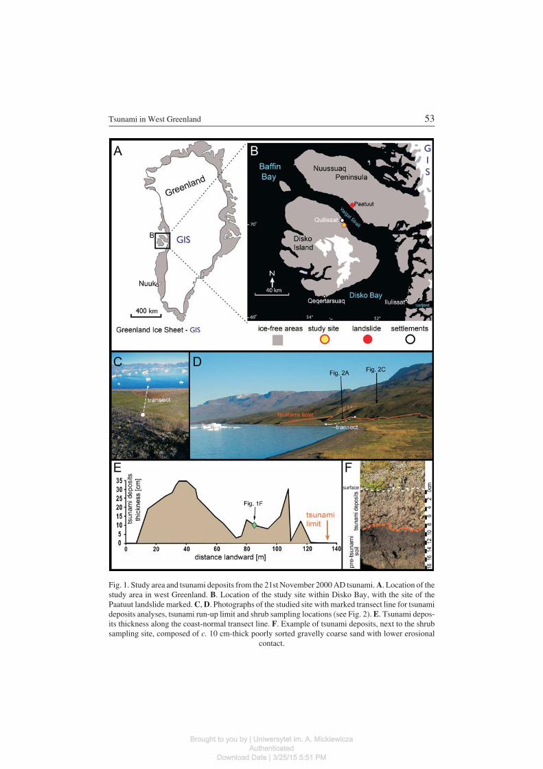
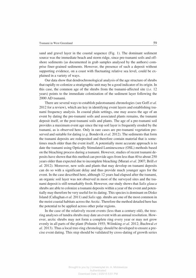
Fig. 1. Study area and tsunami deposits from the 21st November 2000 AD tsunami. A. Location of thestudy area in west Greenland. B. Location of the study site within Disko Bay, with the site of thePaatuut landslide marked. C, D. Photographs of the studied site with marked transect line for tsunamideposits analyses, tsunami run−up limit and shrub sampling locations (see Fig. 2). E. Tsunami depos−its thickness along the coast−normal transect line. F. Example of tsunami deposits, next to the shrubsampling site, composed of c. 10 cm−thick poorly sorted gravelly coarse sand with lower erosional
contact.
Brought to you by | Uniwersytet im. A. MickiewiczaAuthenticated
Download Date | 3/25/15 5:51 PM
shrub, collected from a coastal plain that was inundated by a landslide−generatedtsunami in November 2000, which occurred in Vaigat Strait, west Greenland. Theobjectives of this pilot study are twofold: (1) to test the potential usefulness ofSalix glauca growth rings in paleotsunami studies in arctic regions and; (2) to as−sess the natural recovery of arctic coastal plain ecosystems following extreme sea−water flooding.
Study area and tsunami
A large rock avalanche and landslide of approximately 90 million m3 of rocktook place at Paatuut (Vaigat Strait or Sullorsuaq Strait, Fig. 1) in the mid−after−noon of 21st November 2000 and triggered a tsunami with a reported maximum lo−cal run−up height of up to 50 m (Dahl−Jensen et al. 2004). Tsunami generated dam−age was described by local authorities from sites as much as 180 km from Paatuut.Anomalous weather conditions, notably warming followed by cooling that causedwater freezing in cracks during the days prior to the slide are thought to havecaused failure of the steep mountain side (Dahl−Jensen et al. 2004). Although rockavalanches and landslides are common in the area, the size of the tsunami was con−sidered to be the largest during at least the last 500 years (Dahl−Jensen et al. 2004).
The impact area of the tsunami studied in this paper is the c. 100 m−widecoastal plain of northeast Disko Island, which is characterized by sand and gravelbeaches that are backed by relatively steep vegetated slopes (Fig. 1). The presentcoastal plain was formed during the mid and late Holocene as relative sea−level felltens of meters to reach present due to glacio−isostatic rebound (Long et al. 2011).The area is located in the arctic maritime climate zone and the nearest meteorologi−cal station Qeqertarsuaq (Fig. 1) recorded an average annual air temperature forthe period 1991–2000 of −4.4�C (Nielsen et al. 2001) and an average annual pre−cipitation (1991–2004) of 436 mm (Hansen et al. 2006). The area is in the perma−frost zone and the maximum thickness of the active layer observed in sandy coastalsediments, as measured at Qeqertarsuaq (Fig. 1), was reported to reach 180 cm inlate September (Humlum 1998). The site is located in the Southern Arctic TundraZone (Elvebakk et al. 1999; Walker et al. 2002).
Methods
We conducted a field survey to document the impacts of the Paatuut tsunami inJuly 2012 along c. 20 km of the Vaigat Strait. For the purpose of this study we use arepresentative shore−normal transect to document the extent and nature of tsunamideposits and to assess the impacts of the tsunami on vegetation communities. Wedescribe the tsunami deposits from 28 closely spaced trenches that were hand−dug.
54 Agata Buchwał et al.
Brought to you by | Uniwersytet im. A. MickiewiczaAuthenticated
Download Date | 3/25/15 5:51 PM
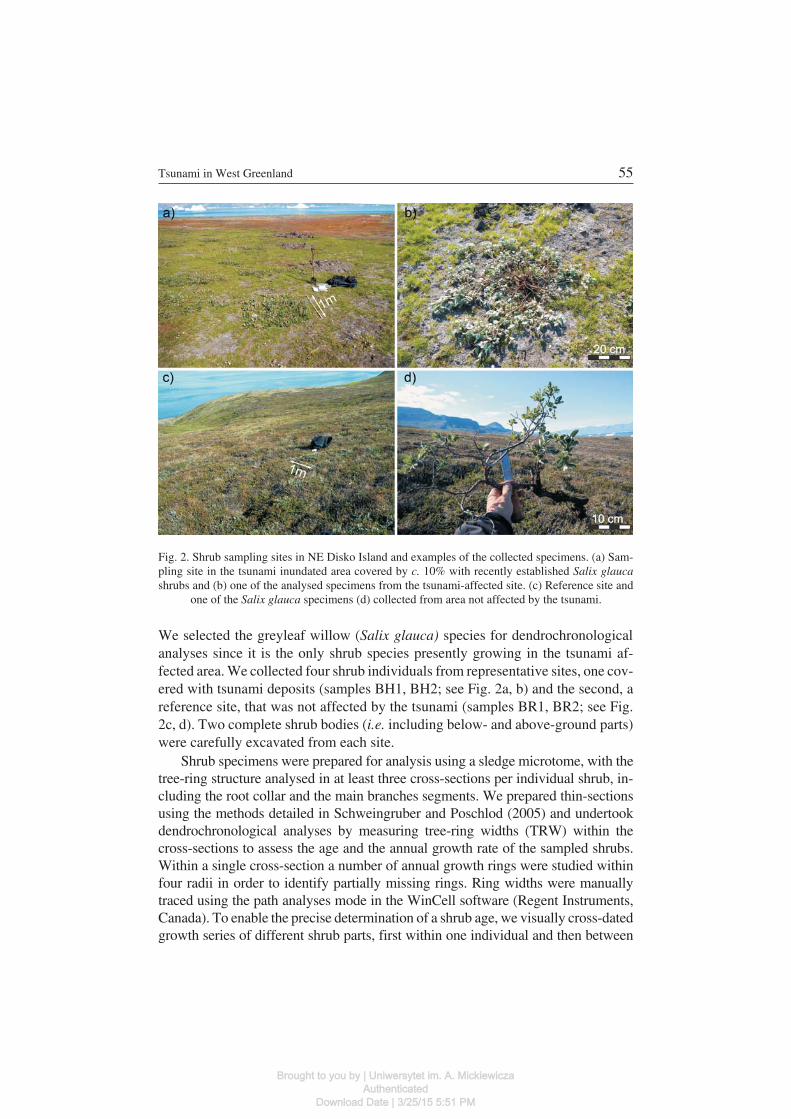
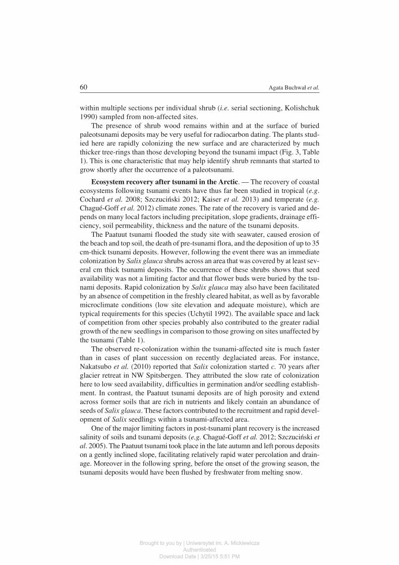
We selected the greyleaf willow (Salix glauca) species for dendrochronologicalanalyses since it is the only shrub species presently growing in the tsunami af−fected area. We collected four shrub individuals from representative sites, one cov−ered with tsunami deposits (samples BH1, BH2; see Fig. 2a, b) and the second, areference site, that was not affected by the tsunami (samples BR1, BR2; see Fig.2c, d). Two complete shrub bodies (i.e. including below− and above−ground parts)were carefully excavated from each site.
Shrub specimens were prepared for analysis using a sledge microtome, with thetree−ring structure analysed in at least three cross−sections per individual shrub, in−cluding the root collar and the main branches segments. We prepared thin−sectionsusing the methods detailed in Schweingruber and Poschlod (2005) and undertookdendrochronological analyses by measuring tree−ring widths (TRW) within thecross−sections to assess the age and the annual growth rate of the sampled shrubs.Within a single cross−section a number of annual growth rings were studied withinfour radii in order to identify partially missing rings. Ring widths were manuallytraced using the path analyses mode in the WinCell software (Regent Instruments,Canada). To enable the precise determination of a shrub age, we visually cross−datedgrowth series of different shrub parts, first within one individual and then between
Tsunami in West Greenland 55
Fig. 2. Shrub sampling sites in NE Disko Island and examples of the collected specimens. (a) Sam−pling site in the tsunami inundated area covered by c. 10% with recently established Salix glaucashrubs and (b) one of the analysed specimens from the tsunami−affected site. (c) Reference site and
one of the Salix glauca specimens (d) collected from area not affected by the tsunami.
Brought to you by | Uniwersytet im. A. MickiewiczaAuthenticated
Download Date | 3/25/15 5:51 PM
the sampled plants. Each cross−section was carefully inspected and wood anatomicalfeatures such as cambial injuries and reaction wood (i.e. tension wood) were noted.
Results
Field observations. — The Paatuut tsunami inundation extended inland at thestudy area by at least 135 m, as marked by driftwood and salt−damaged vegetationthat was clearly visible in the field, albeit 12 years after the event itself. Tsunamideposits extended inland from the present coast by c. 120 m (Fig. 1). The depositswere sheet−like and massive in structure, composed of gravelly sand and sandygravel that are typical of present−day beach and beach ridge sediments. Their lowercontacts with the pre−tsunami soil were sharp and in most cases erosional, withvery rare occurrences of pre−tsunami plants. The deposits thickness had two max−ima, the first (35 cm) c. 40 m from the shoreline and the second (30 cm) in front ofthe steep slope at the landward limit of the coastal plain (Fig. 1e). The total volumeof tsunami deposits along a 1 m wide transect line was about 18 m3.
The tsunami deposits were sparsely vegetated with c. 10% of average plantcoverage density compared to areas not impacted by the event (Fig. 2b). The onlyshrub species present within the site flooded by tsunami was Salix glauca, which isrepresented by semi−erect canopies <15 cm of height. The diameter of an individ−ual shrub patch typically ranged between 0.5 to 1.5 m, with shrubs being dispersed,healthy and characterized by flexible branches.
The investigated shrubs that were impacted by the tsunami were at about 4 ma.s.l., and the reference site was located about 40 m a.s.l.. The latter sample wascollected from a densely vegetated area, supporting a diversity of species that in−cluded shrubs of Salix glauca and Betula nana (Fig. 2c). The patches of Salix herewere smaller (<0.25 m, Table 1), less frequent and some specimens were charac−terized by rigid branches.
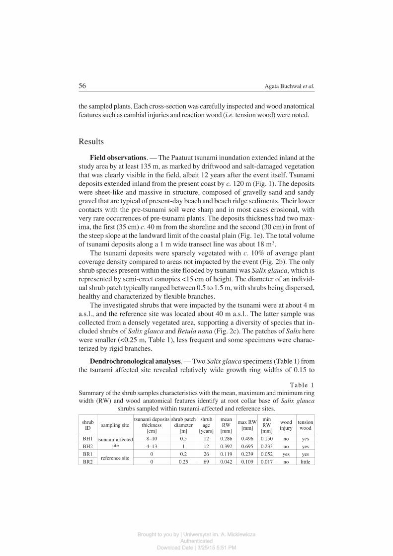
Dendrochronological analyses. — Two Salix glauca specimens (Table 1) fromthe tsunami affected site revealed relatively wide growth ring widths of 0.15 to
56 Agata Buchwał et al.
Table 1Summary of the shrub samples characteristics with the mean, maximum and minimum ringwidth (RW) and wood anatomical features identify at root collar base of Salix glauca
shrubs sampled within tsunami−affected and reference sites.
shrubID sampling site
tsunami depositsthickness
[cm]
shrub patchdiameter
[m]
shrubage
[years]
meanRW
[mm]
max RW[mm]
minRW
[mm]
woodinjury
tensionwood
BH1 tsunami−affectedsite
8–10 0.5 12 0.286 0.496 0.150 no yes
BH2 4–13 1 12 0.392 0.695 0.233 no yes
BR1reference site
0 0.2 26 0.119 0.239 0.052 yes yes
BR2 0 0.25 69 0.042 0.109 0.017 no little
Brought to you by | Uniwersytet im. A. MickiewiczaAuthenticated
Download Date | 3/25/15 5:51 PM
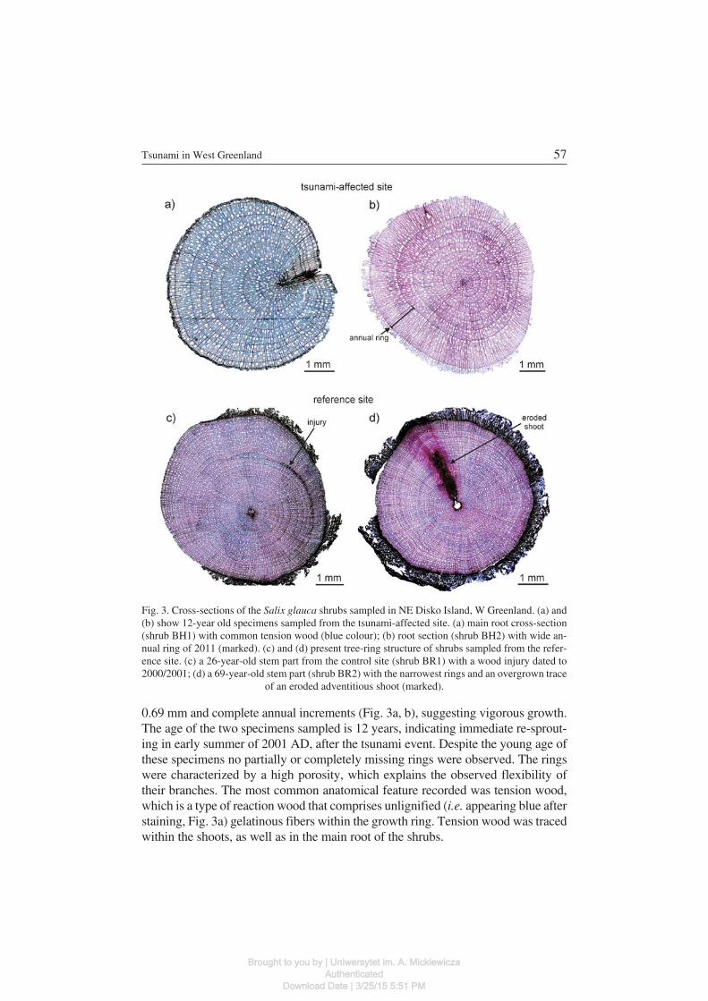
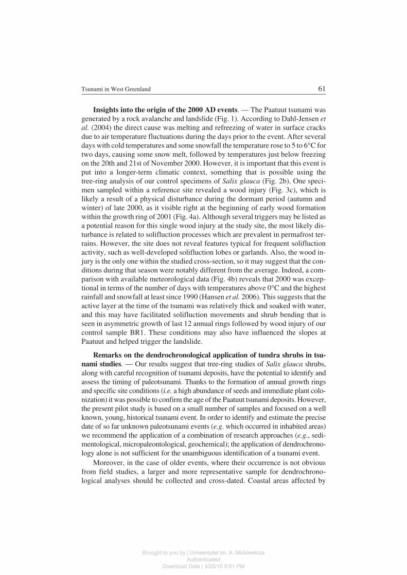
0.69 mm and complete annual increments (Fig. 3a, b), suggesting vigorous growth.The age of the two specimens sampled is 12 years, indicating immediate re−sprout−ing in early summer of 2001 AD, after the tsunami event. Despite the young age ofthese specimens no partially or completely missing rings were observed. The ringswere characterized by a high porosity, which explains the observed flexibility oftheir branches. The most common anatomical feature recorded was tension wood,which is a type of reaction wood that comprises unlignified (i.e. appearing blue afterstaining, Fig. 3a) gelatinous fibers within the growth ring. Tension wood was tracedwithin the shoots, as well as in the main root of the shrubs.
Tsunami in West Greenland 57
Fig. 3. Cross−sections of the Salix glauca shrubs sampled in NE Disko Island, W Greenland. (a) and(b) show 12−year old specimens sampled from the tsunami−affected site. (a) main root cross−section(shrub BH1) with common tension wood (blue colour); (b) root section (shrub BH2) with wide an−nual ring of 2011 (marked). (c) and (d) present tree−ring structure of shrubs sampled from the refer−ence site. (c) a 26−year−old stem part from the control site (shrub BR1) with a wood injury dated to2000/2001; (d) a 69−year−old stem part (shrub BR2) with the narrowest rings and an overgrown trace
of an eroded adventitious shoot (marked).
Brought to you by | Uniwersytet im. A. MickiewiczaAuthenticated
Download Date | 3/25/15 5:51 PM
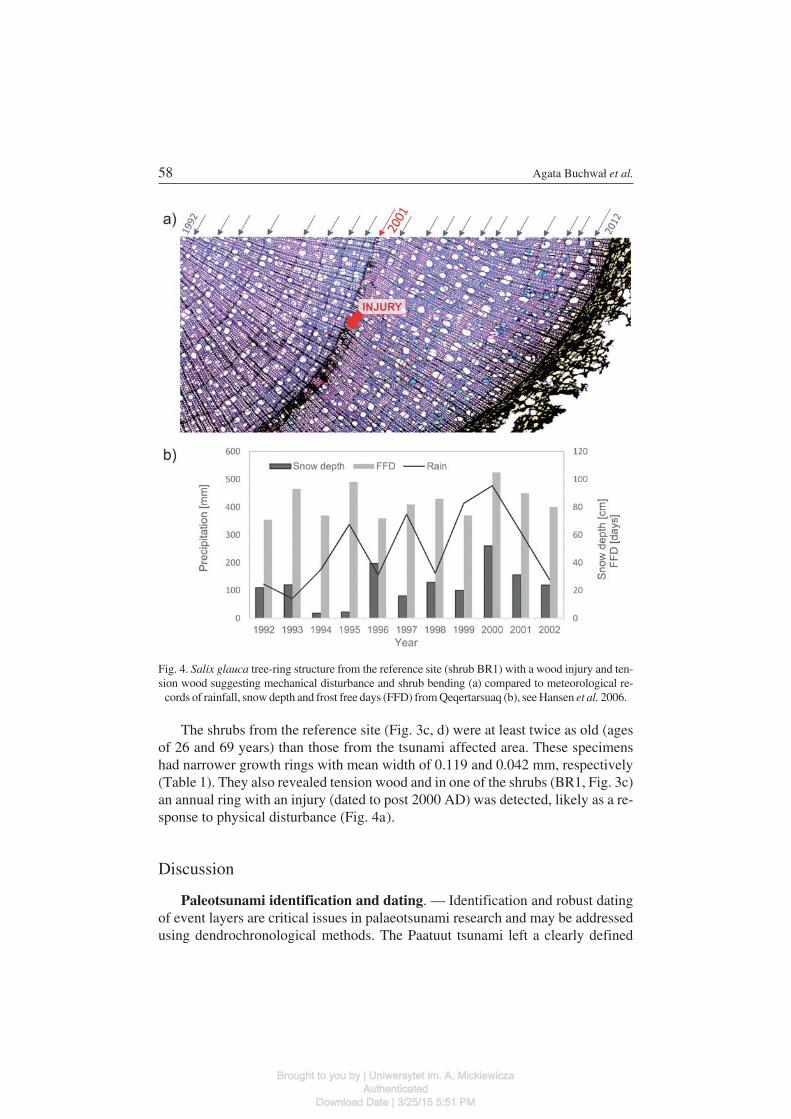
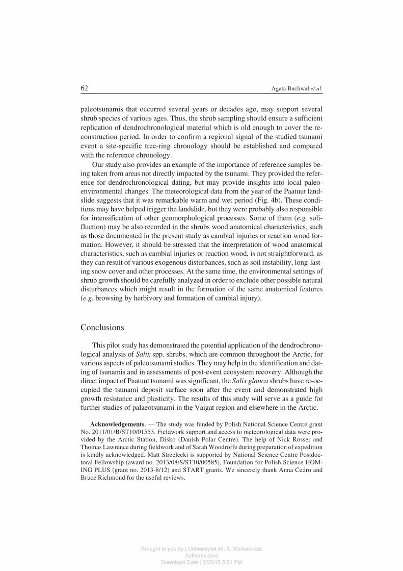
The shrubs from the reference site (Fig. 3c, d) were at least twice as old (agesof 26 and 69 years) than those from the tsunami affected area. These specimenshad narrower growth rings with mean width of 0.119 and 0.042 mm, respectively(Table 1). They also revealed tension wood and in one of the shrubs (BR1, Fig. 3c)an annual ring with an injury (dated to post 2000 AD) was detected, likely as a re−sponse to physical disturbance (Fig. 4a).
Discussion
Paleotsunami identification and dating. — Identification and robust datingof event layers are critical issues in palaeotsunami research and may be addressedusing dendrochronological methods. The Paatuut tsunami left a clearly defined
58 Agata Buchwał et al.
Fig. 4. Salix glauca tree−ring structure from the reference site (shrub BR1) with a wood injury and ten−sion wood suggesting mechanical disturbance and shrub bending (a) compared to meteorological re−
cords of rainfall, snow depth and frost free days (FFD) from Qeqertarsuaq (b), see Hansen et al. 2006.
Brought to you by | Uniwersytet im. A. MickiewiczaAuthenticated
Download Date | 3/25/15 5:51 PM
sand and gravel layer in the coastal sequence (Fig. 1). The dominant sedimentsource was the immediate beach and storm ridge, since pre−tsunami soils and off−shore sediments (as documented in grab samples analysed by the authors) com−prise finer−grained sediments. However, the presence of such a deposit withoutsupporting evidence, on a coast with fluctuating relative sea level, could be ex−plained in a variety of ways.
Our data show that dendrochronological analysis of the age structure of shrubsthat rapidly re−colonize a stratigraphic unit may be a good indicator of its origin. Inthis case, the common age of the shrubs from the tsunami−affected site (i.e. 12years) points to the immediate colonization of the sediment layer following the2000 AD tsunami.
There are several ways to establish paleotsunami chronologies (see Goff et al.2012 for a review), which are key in identifying event layers and establishing tsu−nami frequency analysis. In coastal plain settings, one may assess the age of anevent by dating the pre−tsunami soils and associated plants remains, the tsunamideposit itself, or the post−tsunami soils and plants. The age of a pre−tsunami soilprovides a maximum event age since the top soil layer is frequently eroded by thetsunami, as is observed here. Only in rare cases are pre−tsunami vegetation pre−served and suitable for dating (e.g. Bondevik et al. 2012). The sediments that formthe tsunami deposits are redeposited and therefore contain material that is some−times much older than the event itself. A potentially more accurate approach is todate the tsunami using Optically Stimulated Luminescence (OSL) methods basedon the bleaching process during a tsunami. However, studies of recent tsunami de−posits have shown that this method can provide ages from less than 40 to about 250years older than expected due to incomplete bleaching (Murari et al. 2007; Brill etal. 2012). Moreover, new soils and plants that may develop on tsunami depositscan do so with a significant delay and thus provide much younger ages for theevent. In the case described here, although 12 years had elapsed after the tsunami,an organic soil layer was not observed in most of the surveyed sites and the tsu−nami deposit is still remarkably fresh. However, our study shows that Salix glaucashrubs are able to colonize a tsunami deposits within a year of the event and poten−tially may therefore be very useful for its dating. This species is dominant on DiskoIsland (Callaghan et al. 2011) and Salix spp. shrubs are one of the most common inthe moist coastal habitats across the Arctic. Therefore the method detailed here hasthe potential to be applied across other polar regions.
In the case of the relatively recent events (less than a century old), the tree−ring analyses of tundra shrubs may date an event with an annual resolution. How−ever, arctic shrubs may not form a complete ring every year or may not growevenly in all parts of the plant (Polunin 1955; Wilmking et al. 2012; Buchwal etal. 2013). Thus a local tree−ring chronology should be developed to ensure a pre−cise event dating. This step should be validated by cross−dating of growth series
Tsunami in West Greenland 59
Brought to you by | Uniwersytet im. A. MickiewiczaAuthenticated
Download Date | 3/25/15 5:51 PM
within multiple sections per individual shrub (i.e. serial sectioning, Kolishchuk1990) sampled from non−affected sites.
The presence of shrub wood remains within and at the surface of buriedpaleotsunami deposits may be very useful for radiocarbon dating. The plants stud−ied here are rapidly colonizing the new surface and are characterized by muchthicker tree−rings than those developing beyond the tsunami impact (Fig. 3, Table1). This is one characteristic that may help identify shrub remnants that started togrow shortly after the occurrence of a paleotsunami.
Ecosystem recovery after tsunami in the Arctic. — The recovery of coastalecosystems following tsunami events have thus far been studied in tropical (e.g.Cochard et al. 2008; Szczuciński 2012; Kaiser et al. 2013) and temperate (e.g.Chagué−Goff et al. 2012) climate zones. The rate of the recovery is varied and de−pends on many local factors including precipitation, slope gradients, drainage effi−ciency, soil permeability, thickness and the nature of the tsunami deposits.
The Paatuut tsunami flooded the study site with seawater, caused erosion ofthe beach and top soil, the death of pre−tsunami flora, and the deposition of up to 35cm−thick tsunami deposits. However, following the event there was an immediatecolonization by Salix glauca shrubs across an area that was covered by at least sev−eral cm thick tsunami deposits. The occurrence of these shrubs shows that seedavailability was not a limiting factor and that flower buds were buried by the tsu−nami deposits. Rapid colonization by Salix glauca may also have been facilitatedby an absence of competition in the freshly cleared habitat, as well as by favorablemicroclimate conditions (low site elevation and adequate moisture), which aretypical requirements for this species (Uchytil 1992). The available space and lackof competition from other species probably also contributed to the greater radialgrowth of the new seedlings in comparison to those growing on sites unaffected bythe tsunami (Table 1).
The observed re−colonization within the tsunami−affected site is much fasterthan in cases of plant succession on recently deglaciated areas. For instance,Nakatsubo et al. (2010) reported that Salix colonization started c. 70 years afterglacier retreat in NW Spitsbergen. They attributed the slow rate of colonizationhere to low seed availability, difficulties in germination and/or seedling establish−ment. In contrast, the Paatuut tsunami deposits are of high porosity and extendacross former soils that are rich in nutrients and likely contain an abundance ofseeds of Salix glauca. These factors contributed to the recruitment and rapid devel−opment of Salix seedlings within a tsunami−affected area.
One of the major limiting factors in post−tsunami plant recovery is the increasedsalinity of soils and tsunami deposits (e.g. Chagué−Goff et al. 2012; Szczuciński etal. 2005). The Paatuut tsunami took place in the late autumn and left porous depositson a gently inclined slope, facilitating relatively rapid water percolation and drain−age. Moreover in the following spring, before the onset of the growing season, thetsunami deposits would have been flushed by freshwater from melting snow.
60 Agata Buchwał et al.
Brought to you by | Uniwersytet im. A. MickiewiczaAuthenticated
Download Date | 3/25/15 5:51 PM
Insights into the origin of the 2000 AD events. — The Paatuut tsunami wasgenerated by a rock avalanche and landslide (Fig. 1). According to Dahl−Jensen etal. (2004) the direct cause was melting and refreezing of water in surface cracksdue to air temperature fluctuations during the days prior to the event. After severaldays with cold temperatures and some snowfall the temperature rose to 5 to 6�C fortwo days, causing some snow melt, followed by temperatures just below freezingon the 20th and 21st of November 2000. However, it is important that this event isput into a longer−term climatic context, something that is possible using thetree−ring analysis of our control specimens of Salix glauca (Fig. 2b). One speci−men sampled within a reference site revealed a wood injury (Fig. 3c), which islikely a result of a physical disturbance during the dormant period (autumn andwinter) of late 2000, as it visible right at the beginning of early wood formationwithin the growth ring of 2001 (Fig. 4a). Although several triggers may be listed asa potential reason for this single wood injury at the study site, the most likely dis−turbance is related to solifluction processes which are prevalent in permafrost ter−rains. However, the site does not reveal features typical for frequent solifluctionactivity, such as well−developed solifluction lobes or garlands. Also, the wood in−jury is the only one within the studied cross−section, so it may suggest that the con−ditions during that season were notably different from the average. Indeed, a com−parison with available meteorological data (Fig. 4b) reveals that 2000 was excep−tional in terms of the number of days with temperatures above 0�C and the highestrainfall and snowfall at least since 1990 (Hansen et al. 2006). This suggests that theactive layer at the time of the tsunami was relatively thick and soaked with water,and this may have facilitated solifluction movements and shrub bending that isseen in asymmetric growth of last 12 annual rings followed by wood injury of ourcontrol sample BR1. These conditions may also have influenced the slopes atPaatuut and helped trigger the landslide.
Remarks on the dendrochronological application of tundra shrubs in tsu−nami studies. — Our results suggest that tree−ring studies of Salix glauca shrubs,along with careful recognition of tsunami deposits, have the potential to identify andassess the timing of paleotsunami. Thanks to the formation of annual growth ringsand specific site conditions (i.e. a high abundance of seeds and immediate plant colo−nization) it was possible to confirm the age of the Paatuut tsunami deposits. However,the present pilot study is based on a small number of samples and focused on a wellknown, young, historical tsunami event. In order to identify and estimate the precisedate of so far unknown paleotsunami events (e.g. which occurred in inhabited areas)we recommend the application of a combination of research approaches (e.g., sedi−mentological, micropaleontological, geochemical); the application of dendrochrono−logy alone is not sufficient for the unambiguous identification of a tsunami event.
Moreover, in the case of older events, where their occurrence is not obviousfrom field studies, a larger and more representative sample for dendrochrono−logical analyses should be collected and cross−dated. Coastal areas affected by
Tsunami in West Greenland 61
Brought to you by | Uniwersytet im. A. MickiewiczaAuthenticated
Download Date | 3/25/15 5:51 PM
paleotsunamis that occurred several years or decades ago, may support severalshrub species of various ages. Thus, the shrub sampling should ensure a sufficientreplication of dendrochronological material which is old enough to cover the re−construction period. In order to confirm a regional signal of the studied tsunamievent a site−specific tree−ring chronology should be established and comparedwith the reference chronology.
Our study also provides an example of the importance of reference samples be−ing taken from areas not directly impacted by the tsunami. They provided the refer−ence for dendrochronological dating, but may provide insights into local paleo−environmental changes. The meteorological data from the year of the Paatuut land−slide suggests that it was remarkable warm and wet period (Fig. 4b). These condi−tions may have helped trigger the landslide, but they were probably also responsiblefor intensification of other geomorphological processes. Some of them (e.g. soli−fluction) may be also recorded in the shrubs wood anatomical characteristics, suchas those documented in the present study as cambial injuries or reaction wood for−mation. However, it should be stressed that the interpretation of wood anatomicalcharacteristics, such as cambial injuries or reaction wood, is not straightforward, asthey can result of various exogenous disturbances, such as soil instability, long−last−ing snow cover and other processes. At the same time, the environmental settings ofshrub growth should be carefully analyzed in order to exclude other possible naturaldisturbances which might result in the formation of the same anatomical features(e.g. browsing by herbivory and formation of cambial injury).
Conclusions
This pilot study has demonstrated the potential application of the dendrochrono−logical analysis of Salix spp. shrubs, which are common throughout the Arctic, forvarious aspects of paleotsunami studies. They may help in the identification and dat−ing of tsunamis and in assessments of post−event ecosystem recovery. Although thedirect impact of Paatuut tsunami was significant, the Salix glauca shrubs have re−oc−cupied the tsunami deposit surface soon after the event and demonstrated highgrowth resistance and plasticity. The results of this study will serve as a guide forfurther studies of palaeotsunami in the Vaigat region and elsewhere in the Arctic.
Acknowledgements. — The study was funded by Polish National Science Centre grantNo. 2011/01/B/ST10/01553. Fieldwork support and access to meteorological data were pro−vided by the Arctic Station, Disko (Danish Polar Centre). The help of Nick Rosser andThomas Lawrence during fieldwork and of Sarah Woodroffe during preparation of expeditionis kindly acknowledged. Matt Strzelecki is supported by National Science Centre Postdoc−toral Fellowship (award no. 2013/08/S/ST10/00585), Foundation for Polish Science HOM−ING PLUS (grant no. 2013−8/12) and START grants. We sincerely thank Anna Cedro andBruce Richmond for the useful reviews.
62 Agata Buchwał et al.
Brought to you by | Uniwersytet im. A. MickiewiczaAuthenticated
Download Date | 3/25/15 5:51 PM
References
ALESTALO J. 1971. Dendrochronological interpretation of geomorphic processes. Fennia 105: 1–140.BESCHEL R.E. and WEBB D. 1963. Growth ring studies on arctic willows. Axel Heiberg Island: Pre−
liminary report 1961–1962. McGill University, Montreal: 189–198.BLOCK D., SASS−KLAASSEN U., SCHAEPMAN−STRUB G., HEIJMANS M.M.P.D., SAUREN P. and
BERENDSE F. 2011. What are the main climate drivers for shrub growth in Northeastern Siberiantundra? Biogeosciences 8: 1169–1179 .
BONDEVIK S., STORMO S.K. and SKJERDAL G. 2012. Green mosses date the Storegga tsunami to thechilliest decades of the 8.2 ka cold event. Quaternary Science Reviews 45: 1–6.
BONDEVIK S., SVENDSEN J.I. and MANGERUD J. 1997. Tsunami sedimentary facies deposited by theStoregga tsunami in shallow marine basins and coastal lakes, western Norway. Sedimentology44: 1115–1131.
BRILL D., KLASEN N., BRÜCKNER H., JANKAEW K., SCHEFFERS A., KELLETAT D. and SCHEFFERS
S. 2012. OSL dating of tsunami deposits from Phra Thong Island, Thailand. Quaternary Geo−chronology 10: 224–229.
BUCHWAL A., RACHLEWICZ G., FONTI P., CHERUBINI P. and GÄRTNER H. 2013. Temperture modu−lates intra−plant growth of Salix polaris from a high Arctic site (Svalbard). Polar Biology 36:1305–1318.
CALLAGHAN T.V., CHRISTIANSEN T.R. and JANTZE E.J. 2011. Plant and vegetation dynamics onDisko island, West Greenalnd: Snapshots separated by over 40 years. Ambio 40: 624–637.
CHAGUÉ−GOFF C., NIEDZIELSKI P., WONG H.K.Y., SZCZUCIŃSKI W., SUGAWARA D. and GOFF J.2012. Environmental impact assessment of the 2011 Tohoku−oki tsunami on the Sendai Plain.Sedimentary Geology 282: 175–187.
COCHARD R., RANAMUKHAARACHCHI S.L., SHIVAKOTI G.P., SHIPIN O.V., EDWARDS P.J. andSEELAND K.T. 2008. The 2004 tsunami in Aceh and Southern Thailand: A review on coastalecosystems, wave hazards and vulnerability. Perspectives in Plant Ecology, Evolution and Sys−tematics 10: 3–40.
DAHL−JENSEN T., LARSEN L.M., PEDERSEN S.A.S., PEDERSEN J., JEPSEN H.F., PEDERSEN G.K.,NIELSEN T., PEDERSEN A.K., VON PLATEN−HALLERMUND F. and WENG W. 2004. Landslideand tsunami 21 November 2000 in Paatuut, West Greenland. Natural Hazards 31: 277–287.
DAWSON A.G., LONG D. and SMITH D.E. 1988. The Storegga Slides: evidence from Eastern Scot−land for a possible tsunami. Marine Geology 82: 271–276.
ELVEBAKK A., ELVEN R. and RAZZHIVIN V.Y. 1999. Delimitation, zonal and sectorial subdivisionof the Arctic for the Panarctic Flora Project. In: I. Nordal, V.Y. Razzhivin (eds) The Species Con−cept in the High North – A Panarctic Flora Initiative. The Norwegian Academy of Science andLetters, Oslo: 375–386.
FORBES B.C., FAURIA M.M. and ZETTERBERG P. 2010. Russian Arctic warming and ‘greening’ areclosely tracked by tundra shrub willows. Global Change Biology 16: 1542–1554.
GÄRTNER−ROER I., HEINRICH I. and GÄRTNER H. 2013. Wood anatomical analysis of alpine shrubsgrowing on creeping mountain permafrost. Dendrochronologia 31: 97–104.
GOFF J., CHAGUÉ−GOFF C., NICHOL S., JAFFE B. and DOMINEY−HOWES D. 2012. Progress inpalaeotsunami research. Sedimentary Geology 243–244: 70–88.
GOFF J., WELLS A., CHAGUÉ−GOFF C., NICHOL S.L. and DEVOY R.J.N. 2004. The elusive AD 1826tsunami, South Westland, New Zealand. New Zealand Geographer 60: 14–25.
HANSEN B.U., ELBERLING B., HUMLUM O. and NIELSEN N. 2006. Meteorological trends (1991–2004)at Arctic Station, Central West Greenland (69�15’N) in a 130 years perspective. GeografiskTidsskrift, Danish Journal of Geography 106: 45–55.
HUMLUM O. 1998. Active layer thermal regime 1991–1996 at Qeqertarsuaq, Disko Island, CentralWest Greenland. Arctic Alpine Research 30: 295–305.
Tsunami in West Greenland 63
Brought to you by | Uniwersytet im. A. MickiewiczaAuthenticated
Download Date | 3/25/15 5:51 PM
JAKOB M. 1995. Dendrochronology to measure average movement rates of gelifluction lobes. Dendro−chronologia 13: 141–146.
JACOBY G.C., BUNKER D.E. and BENSON B.E. 1997. Tree−ring evidence for an A.D. 1700 Cascadiaearthquake in Washington and northern Oregon. Geology 25: 99–102.
KAISER G., BURKHARD B., RÖMER H., SANGKAEW S., GRATEROL R., HAITOOK T., STERR H. andSAKUNA−SCHWARTZ D. 2013. Mapping tsunami impacts on land cover and related ecosystemservice supply in Phang Nga, Thailand. Natural Hazards Earth System Sciences 13: 3095–3111.
KOLISHCHUK V. 1990. Dendroclimatological study of prostrate woody plant. In: E.R. Cook and L.A.Kairiukstis (eds) Methods of dendrochronology applications in the environmental sciences.Kluwer Academic Publishers, Dordrecht: 394 pp.
LONG A.J., WOODROFFE S.A., ROBERTS D.H. and DAWSON S. 2011. Isolation basins, sea−levelchanges and the Holocene history of the Greenland Ice Sheet. Quaternary Science Reviews 30:3748–3768.
MILLER D.J. 1960. Giant waves in Lituya Bay Alaska. Geological Survey Professional Paper 354C:249 pp.
MURARI M.K., ACHYUTHAN H. and SINGHVI A.K. 2007. Luminescence studies on the sedimentslaid down by the December 2004 tsunami event: prospects for the dating of palaeo tsunamis andfor the estimation of sediment fluxes. Current Science 92: 367–371.
MYERS−SMITH I.H., HIK D.S., KENNEDY C., COOLEY D., JOHNSTONE J.F., KENNEY A.J. and KREBS
C.J. 2011a. Expansion of canopy−forming willows over the twentieth century on Herschel Is−land, Yukon Territory, Canada. Ambio 40: 610–623.
MYERS−SMITH I.H., HIK D.S., FORBES B.C., WILMKING M., HALLINGER M., LANTZ T., BLOK D.,SASS−KLAASSEN U., TAPE K.D., MACIAS−FAURIA M., LÉVESQUE E., BOUDREAU S., ROPARS
P., HERMANUTZ L., TRANT A., COLLIER L.S., WEIJERS S., ROZEMA J., RAYBACK S.A.,SCHMIDT N.M., SCHAEPMAN−STRUB G., WIPF S., RIXEN C., MÉNARD C.B., VENN S., GOETZ
S., ANDREU−HAYLES L., ELMENDORF S., RAVOLAINEN V., WELKER J., GROGAN P. andEPSTEIN H.E. 2011b. Shrub expansion in tundra ecosystems: dynamics, impacts and researchpriorities. Environmental Research Letters 6 (4): 045509.
MYERS−SMITH I.H., HALLINGER M., BLOK D., SASS−KLAASSEN U., RAYBACK S.A., WEIJERS S.,TRANT A., TAPE K.D., NAITO A.T., WIPF S., RIXEN C., DAWES M.A., WHEELER J., BUCHWAL A.,BAITTINGER C., MACIAS−FAURIA M., FORBES B.C., LÉVESQUE E., BOULANGER−LAPOINTE N.,BEIL I., RAVOLAINEN V. and WILMKING M. 2015. Methods for measuring arctic and alpine shrubgrowth: a review. Earth−Science Reviews 140: 1–13.
NAKATSUBO T., FUJIYOSHI M., YOSHITAKE S., KOIZUMI H. and UCHIDA M. 2010. Colonization ofthe polar willow Salix polaris on the early stage of succession after glacier retreat in the HighArctic, Ny−Ålesund, Svalbard. Polar Research 29: 385–390.
NIELSEN N., HUMLUM O. and HANSEN B.U. 2001. Meteorological observations in 2000 at the ArcticStation, Qeqertarsuaq (69�15’N), central West Greenland. Geografisk Tidsskrift, Danish Journal ofGeography 101: 155–158.
OWCZAREK P. 2010. Dendrochronological dating of geomorphic processes in the High Arctic.Landform Analyses 14: 45–56.
OWCZAREK P., NAWROT A., MIGAŁA K., MALIK I. and KORABIEWSKI B. 2014. Flood−plain re−sponses to contemporary climate change in small High−Arctic basins (Svalbard, Norway).Boreas 43 (2): 384–402.
POLUNIN N. 1955. Attempted dendrochronological dating of ice Island T−3. Science 122: 1184–1186.ROMUNDSET A. and BONDEVIK S. 2011. Propagation of the Storegga tsunami into ice−free lakes
along the southern shores of the Barents Sea. Journal of Quaternary Science 26: 457–462.RUFFMAN A. and MURTY T. 2006. Tsunami hazards in the Arctic regions of North America, Green−
land and the Norwegian Sea. In: Program and Abstracts, International Tsunami Society ThirdTsunami Symposium. Honolulu, HI, May 23–25.
64 Agata Buchwał et al.
Brought to you by | Uniwersytet im. A. MickiewiczaAuthenticated
Download Date | 3/25/15 5:51 PM
SAVILE D.B.O. 1979. Ring counts in Salix arctica from northern Ellesmere Island. Canadian Field−Naturalist 93 (1): 81–82.
SCHWEINGRUBER F.H. 1996. Tree rings and environment dendroecology. Haupt, Bern StuttgartWien: 609 pp.
SCHWEINGRUBER F.H. and POSCHLOD P. 2005. Growth rings in herbs and shrubs: life span, age de−termination and stem anatomy. Forest Snow and Landscape Research 79 (3): 195–415.
SCHWEINGRUBER F.H., HELLMANN L., TEGEL W., BRAUN S., NIEVERGELT D. and BÜNTGEN U.2013. Evaluating the wood anatomical and dendroecological potential of arctic dwarf shrubcommunities. IAWA Journal 34 (4): 485–497.
SZCZUCIŃSKI W. 2012. The post−depositional changes of the onshore 2004 tsunami deposits on theAndaman Sea coast of Thailand. Natural Hazards 60: 115–133.
SZCZUCIŃSKI W., NIEDZIELSKI P., RACHLEWICZ G., SOBCZYŃSKI T., ZIOŁA A., KOWALSKI A.,LORENC S. and SIEPAK J. 2005. Contamination of tsunami sediments in a coastal zone inundatedby the 26 December 2004 tsunami in Thailand. Environmental Geology 49: 321–331.
UCHYTIL R.J. 1992. Salix glauca. In: Fire Effects Information System. U.S. Department of Agricul−ture, Forest Service, Rocky Mountain Research Station, Fire Sciences Laboratory. Available on−line at http://www.fs.fed.us/database/feis/
WAGNER B., BENNIKE O., KLUG M. and CREMER H. 2007. First indication of Storegga tsunami de−posits from East Greenland. Journal of Quaternary Science 22: 321–325.
WALKER D.A., GOULD W.A., MAIER H.A. and RAYNOLDS M.K. 2002. The Circumpolar ArcticVegetation Map: AVHRR−derived base maps, environmental controls, and integrated mappingprocedures. International Journal of Remote Sensing 23 (21): 4551–4570.
WILMKING M., HALLINGER M., VAN BOGAERT R., KYNCL T., BABST F., HAHNE W., JUDAY G.P.,DE LUIS M., NOVAK K. and VÖLLM C. 2012. Continuously missing outer rings in woody plantsat their distributional margins. Dendrochronologia 30 (3): 213–222.
WOODCOCK H. and BRADLEY R.S. 1994. Salix arctica (Pall.): its potential for dendroclimatologicalstudies in the High Arctic. Dendrochronologia 12: 11–22.
ZALATAN R. and GAJEWSKI K. 2006. Dendrochronological potential of Salix alaxensis from theKuujjua River area, Western Canadian Arctic. Tree−Ring Research 62 (2): 75–82.
Received 17 February 2015Accepted 10 March 2015
Tsunami in West Greenland 65
Brought to you by | Uniwersytet im. A. MickiewiczaAuthenticated
Download Date | 3/25/15 5:51 PM