neuse river basin flood risk management - wilmington district
TRANSCRIPT
Army Corps of Engineers ®
Wilmington District
DRAFT
Neuse River Basin Flood Risk Management
Integrated Feasibility Report andEnvironmental Assessment
22 April 2022

Page Intentionally Left Blank
EXECUTIVE SUMMARY 1. Introduction
This draft Integrated Feasibility Report and Environmental Assessment (IFR/EA) analyzed a series of alternatives designed to reduce on-going flood risks throughout the Neuse River Basin. These alternatives included a no action plan, as well as various combinations of structural and nonstructural measures.
The study area comprised the entire Neuse River Basin in North Carolina. The basin begins in the Piedmont of North Carolina and extends 248 miles southeast through the Coastal Plain and flows into the Pamlico Sound, covering approximately 6,200 square miles. The study encompassed all or part of 18 counties. Population centers in the Neuse River Basin include the cities of Durham, Raleigh, Wilson, Smithfield, Goldsboro, Kinston, and New Bern, NC and are shown on Figure 1-2, Chapter 1 of this draft IFR/EA.
The non-Federal sponsor is the North Carolina Department of Environmental Quality (NCDEQ).
2. Purpose and Need
The purpose of the Neuse River Basin Flood Risk Management Feasibility Study is to assess and recommend Federal actions to reduce risk and damages caused by flooding along the Neuse River and its tributaries. Flood damages have ranged from more frequent riverine flooding to severe and widespread impacts like those sustained during Hurricane Matthew in 2016 and Hurricane Florence in 2018.
Recurring flooding within the basin results in considerable economic damages to homes, businesses, industry, and public infrastructure. For example, Hurricane Matthew is estimated to have caused over $180 million in damage to residential, non-residential, and public structures (NCEM and NCDOT, 2018). Inundation of structures and roadways also resulted in increased life safety risks both during and following flood events.
In response to recent flooding that occurred as a result of Hurricanes Matthew (2016) and Florence (2018), North Carolina received funding through the Federal 2019 Additional Supplemental Appropriations for Disaster Relief Act (H.R. 2157) to conduct a feasibility study to assess and recommend actions to reduce flood and storm damage risk and increase resiliency within the Neuse River Basin. This draft IFR/EA analyzed a series of alternatives designed to reduce flood risks throughout the basin.
i
3. Plan Formulation
Due to the large size of the study area, having a logical plan to develop and evaluate possible solutions was recognized as especially critical. The general strategy for this study identified separate focus areas within the basin that were typically population centers in the vicinity of the Neuse River with notable flood risk. Each of these focus areas was formulated individually to identify measures that would address at least one of the study objectives. Then, through the formulation process, viable measures were combined into alternative plans for that specific area. Rural areas within the floodplain were also considered, although structural measures were less likely to be economically viable due to less concentrations of development. It was also recognized that some large-scale measures could have a regional impact, for example, a large water detention structure. These large-scale measures were considered “basinwide” measures.
Finally, viable plans were selected from individual focus areas and combined across the basin, resulting in a set of system-wide alternatives. Figure 3-1, Chapter 3 of this IFR/EA illustrates this strategy.
The U.S. Army Corps of Engineers’ (USACE) project delivery team developed an extensive list of structural and nonstructural flood risk management measures throughout the basin to address one or more of the planning objectives. These measures were carried through a series of screenings using an increasing level of detail. This resulted in a preliminary array of alternatives for each viable focus area which included combinations of both structural and nonstructural alternatives. These preliminary alternatives by focus area were screened and then combined into the following final array of viable basinwide alternatives that would provide flood risk management within the study area:
Alternative 1: No Action Alternative 2: Structure Elevation and Floodproofing (draft Recommended Plan) Alternative 3: Property Buyouts (includes all structures and associated land)
4. Draft Recommended Plan
The draft Recommended Plan for the Neuse River Basin Flood Risk Management Study, as shown in Figure 5-1, Chapter 5 of this draft IFR/EA, includes the following:
a. Structure Elevation – 419 structures
b. Structure Dry Floodproofing – 127 structures
c. Structure Wet Floodproofing – 222 structures
ii
Nonstructural features would be constructed within separate contiguous areas for an estimated 768 structures. Only habitable structures were eligible for structure elevation and floodproofing. The draft Recommended Plan includes elevating 14 structures and floodproofing 6 structures along Hominy Swamp Creek in the City of Wilson; elevating 38 structures and floodproofing 21 structures along Crabtree Creek in the City of Raleigh; elevating 2 structures and floodproofing 7 structures along Big Ditch in the City of Goldsboro; and elevating 365 structures and floodproofing 315 structures along the mainstem of the Neuse River in Wayne and Johnston Counties, all in North Carolina.
Structure elevation raises a house or building so that the lowest floor is above the 1% annual exceedance probability (AEP) flood event level. Dry floodproofing makes the structure watertight below this level by preventing floodwaters from entering the structure. Wet floodproofing uses flood-damage-resistant materials and construction techniques to minimize flood damage to areas below the flood protection level of a structure, which is intentionally allowed to flood but with modifications which minimize flood damage.
The draft Recommended Plan also includes flood warning system enhancements with installation of stream gages in two locations (one in each location). The first location is in the Eno River at the North Roxboro Street crossing in Durham County (USGS 02085070 Eno River Near Durham, NC). This would consist of updating an existing stream gage to improve the accuracy of water volume estimations. The second location is in the Neuse River mainstem at the NC-43 (River Road) crossing, approximately 9 miles upstream of the City of New Bern. A new stream gage would be added in this location where none currently exists to improve warning times by providing flood stage data to the downstream communities in Craven County and the City of New Bern. Finally, development of public education materials highlighting residual, or remaining, flood risks throughout the Neuse River Basin will also be included in the Plan.
The total estimated project cost of the draft Recommended Plan is $133,000,000 at Fiscal Year (FY) 2022 price levels and includes the cost of constructing nonstructural measures; lands, easements, rights-of-way, relocations and disposal areas (LERRDs); preconstruction engineering and design (USACE’s cost for final detailed design otherwise known as PED); and construction management (USACE’s cost to manage implementation of the project) support activities. The non-Federal cost for LERRDs is currently limited to real estate administrative and Uniform Relocation Assistance benefits, as applicable, and is currently estimated at $5,835,000. This draft plan would be cost-shared at approximately 65% Federal ($86,450,000) and 35% non-Federal ($46,550,000), in accordance with the cost-sharing provisions specified for nonstructural projects in Section 103(b) of the Water Resources Development Act of 1986, as amended. This plan is economically justified with a benefit-to-cost ratio of 1.6, generating $1.60 in benefits for every $1 spent.
iii
All economics analyses of the draft Recommended Plan presented in this draft IFR/EA are based on the total estimated project cost of $133,000,000 at FY 2022 price levels. The economics analyses will be updated in the final IFR/EA using the final Recommended Plan estimated total project first costs at FY 2023 price levels, as required for decision documents in accordance with USACE policy guidance.
The current working estimate (CWE) for the draft Recommended Plan is $151,455,000, also at FY 2022 price levels, which reflects recent increases in construction materials, labor and establishment of contractor’s field offices; PED; and construction management costs not included elsewhere in this draft IFR/EA. The draft Recommended Plan continues to be economically justified with a BCR above one using the CWE. The CWE is only provided at this time to provide insight into the latest cost estimate.
The construction start date is estimated to begin with award of the first of a series of contracts in FY 2027 with an implementation period of approximately 12 years and 3 months, assuming 100 percent homeowner participation, subject to receipt of project construction authorization in FY 2024 and appropriation of funds in FY 2027.
The Federal government is responsible for preparing and providing an Operation, Maintenance, Repair, Replacement, and Rehabilitation (OMRR&R) manual to the sponsor as the final Recommended Plan is being implemented. OMRR&R costs associated with a nonstructural plan such as this are considered ‘de-minimis’ (requiring only periodic surveillance by the non-Federal sponsor). Each individual property owner is ultimately responsible for maintenance of their elevated or floodproofed structure/home.
5. Significant Resources/Environmental Considerations
The draft Recommended Plan is environmentally acceptable. Coordination with resource agency representatives was initiated early in the study and there are not expected to be any impacts to threatened and endangered species and associated critical habitat. The draft Recommended Plan includes only nonstructural measures to structures located within the floodplain.
This draft IFR/EA comply with the National Environmental Policy Act of 1969, as amended (NEPA). A separate EA is not required because the study document is a fully integrated report that complies with both NEPA requirements and those of the USACE water resources planning process. All coordination required for compliance with Section 7 of the Endangered Species Act will be conducted for the draft Recommended Plan before a final IFR/EA is completed. Communication with USFWS suggests that this project will not need a formal Section 7 consultation, but that consultation will most likely be completed through an informal Section 7 consultation process. The final
iv
decision from USFWS on which consultation process is needed will be made during the review of the draft IFR/EA. A Clean Water Act Section 401 Water Quality Certification will not be required for the proposed project. Additionally, any HTRW Phase 1 assessments that would be needed prior to structural elevating and floodproofing individual structures as part of the draft Recommended Plan will be completed by the non-Federal sponsor during the PED phase. During PED, if it’s determined that an area of 1 acre or more would be disturbed, a Sediment and Erosion Control Permit and potentially a Storm Water Management Plan Permit would be obtained prior to start of construction.
Similarly, a Programmatic Agreement (PA) will be executed in accordance with 36 CFR 800.14(b)(3) that outlines the process to identify and evaluate historic properties and avoid, minimize, and where possible, mitigate for any adverse impacts in accordance with Section 106 of the NHPA and implementing regulations 36 CFR 800. The PA will allow the USACE to complete the necessary historic and archaeological surveys during the follow-on PED phase of the project, once the nonstructural measures and identified properties have been confirmed.
6. Plan Implementation
A Nonstructural Implementation Plan has been developed and is provided in Appendix I. This plan describes a process of specific Federal and non-Federal responsibilities including, but not limited to, Federal award and oversight of a series of construction contracts to elevate or floodproof contiguous groups of eligible structures, non-Federal sponsor leadership in verification of property title and negotiation and execution of individual nonstructural agreements with all individual property owners. Award schedule risks include achieving project authorization in the potential Water Resources Development Act of 2024 and new start Federal funding in an Energy and Water Development Appropriations Act in FY 2026. The non-Federal sponsor supports implementation of this nonstructural project. Additional details about the plan implementation process are available in Chapter 6 of this IFR/EA.
7. Views of the Public, Agencies, Stakeholders, and Tribes
During the first year of this study, numerous onsite and virtual information events were held with town, city, county, and state officials. These events contributed to study products by providing existing information about past flood risk studies, mapping, and other technical data to support technical analyses. Three virtual public information meetings were held in early 2021 that indicated strong interest in this study and included discussions of potential measures that could be evaluated to reduce flood risk within this basin. The U.S. Fish and Wildlife Service, the U.S. Environmental Protection Agency, National Marine Fisheries Service’s Habitat Conservation Division (HCD), and
v
the Federal Emergency Management Agency are cooperating agencies for this study. Other Federal agencies, non-Federal agencies, and tribes are part of the ongoing overall coordination process. Formal views of the public, agencies, stakeholders, and tribes will be obtained after the draft IFR/EA is released for review and comment. The results of this review will be published in the final IFR/EA.
8. Reviews
Only a District Quality Control (DQC) review has been conducted in the preparation of this Integrated Feasibility Report and EA. Upcoming reviews of the draft IFR/EA will include public, agency, policy and legal, and Agency Technical Review.
9. Unresolved Issues/Areas of Controversy
There are no issues or areas of controversy identified at this time.
vi
TABLE OF CONTENTS
TABLE OF CONTENTS................................................................................................................................... vii
APPENDICES ............................................................................................................................................... xiii
ATTACHMENTS (CHAPTER 14).................................................................................................................... xiii
LIST OF ACRONYMS AND ABBREVIATIONS ................................................................................................. xv
Overview ......................................................................................................................................1
Introduction ...........................................................................................................................................1
USACE Planning Process.........................................................................................................................1
Study Authority ......................................................................................................................................2
Study Area and Scope ............................................................................................................................2
Prior Studies and Reports.......................................................................................................................5
Purpose and Need for Action.................................................................................................................6
Problems and Opportunities ..................................................................................................................7
Objectives and Constraints ....................................................................................................................7
1.8.1. Objectives........................................................................................................................................7
1.8.2. Constraints and Considerations ......................................................................................................8
EXISTING AND FUTURE WITHOUT PROJECT CONDITIONS ...........................................................9
Planning Horizon ....................................................................................................................................9
Without-Project Analysis – Key General Assumptions...........................................................................9
Without-Project Analysis – Sea Level Change Assumptions ..................................................................9
Existing and Future Without-Project Climate & Weather....................................................................11
Existing and Future Without-Project Flood Risk ..................................................................................14
Existing and Future Without-Project Environmental Conditions.........................................................15
2.6.1. Water Quality ................................................................................................................................16
2.6.2. Threatened and Endangered Species............................................................................................16
Existing and Future Without-Project Cultural Resources.....................................................................16
Existing and Future Without-Project Socioeconomic Conditions ........................................................18
Life-Safety Assessment.........................................................................................................................25
Existing and Future Without-Project Conditions – General Conclusions...........................................25
vii
PLAN FORMULATION AND EVALUATION OF ALTERNATIVES .....................................................27
Study Strategy ......................................................................................................................................27
Study Assumptions...............................................................................................................................29
Environmental Operating Principles ....................................................................................................30
Formulation and Evaluation Criteria ....................................................................................................30
Management Measure Identification and Screening ..........................................................................33
Alternative Formulation.......................................................................................................................40
3.7 Alternative Evaluation and Comparison ...............................................................................................63
3.7.1. Preliminary Alternatives by Separable Area .................................................................................63
3.7.2. Final Basinwide Alternatives Array ...............................................................................................67
3.7.3. Economic Assessment of Final Array of Alternatives....................................................................72
3.7.3.1 Alternative 2 Benefits..............................................................................................................72
3.7.3.2 Alternative 3 Benefits..............................................................................................................75
3.7.3.3 Costs ........................................................................................................................................75
3.7.3.4 Benefit-Cost Analysis...............................................................................................................76
3.7.4. Principles and Guidelines Benefit Accounts.................................................................................77
3.7.4.1 National Economic Development (NED) account. ..................................................................78
3.7.4.2 Regional Economic Development (RED) account....................................................................78
3.7.4.3 Environmental Quality (EQ) account.......................................................................................78
3.7.4.4 Other Social Effects (OSE) account..........................................................................................78
3.7.4.5 Comprehensive Documentation of Four Benefit Accounts ....................................................79
3.7.5. Principles and Guidelines Criteria .................................................................................................82
3.7.6. Ability to Meet Planning Objectives..............................................................................................83
3.7.6.1 Ability to Meeting Planning Objectives Summary & Comparison...........................................84
3.8. Plan Selection.......................................................................................................................................85
3.8.1. Selection of Draft Recommended Plan .........................................................................................85
3.8.2. Rationale for No Structural Plans in the Final Array ....................................................................85
3.8.3. Identification of a Locally Preferred Plan......................................................................................86
3.8.4. Value Engineering .........................................................................................................................86
AFFECTED ENVIRONMENT AND ENVIRONMENTAL CONSEQUENCES........................................87
Physical Resources ...............................................................................................................................89
viii
4.1.1. Geology and Sediments ................................................................................................................89
4.1.2. Water Quality ................................................................................................................................90
4.1.2.1 Wetlands and Floodplains.......................................................................................................90
4.1.2.2 Water Quality .........................................................................................................................93
4.1.3. Land Use & Associated Impacts ....................................................................................................96
4.1.3.1 Hazardous, Toxic, and Radioactive Wastes (HTRW) ..............................................................96
4.1.3.2 Air Quality...............................................................................................................................98
4.1.3.3 Prime and Unique Farmland ..................................................................................................99
4.1.3.4 Noise.....................................................................................................................................100
4.1.4. Sea Level Change.........................................................................................................................101
Biological Resources...........................................................................................................................102
4.2.1. Vegetation...................................................................................................................................102
4.2.2. Wildlife ........................................................................................................................................105
4.2.3. Threatened and Endangered Species..........................................................................................106
4.2.4. Essential Fish Habitat (EFH).........................................................................................................114
Cultural Resources .............................................................................................................................115
Aesthetic and Recreational Resources...............................................................................................117
Socioeconomics..................................................................................................................................118
4.5.1. Health and Safety ........................................................................................................................119
4.5.2. Economic Vitality.........................................................................................................................120
4.5.3. Social Connectedness..................................................................................................................121
4.5.4. Identity ........................................................................................................................................122
4.5.5. Social Vulnerability and Resiliency..............................................................................................123
4.5.6. Participation ................................................................................................................................124
4.5.7. Summary of Social Vulnerability .................................................................................................126
Cumulative Effects .............................................................................................................................126
Identification of Significant Resources...............................................................................................126
Past Actions........................................................................................................................................127
Present Actions ..................................................................................................................................128
Reasonably Foreseeable Future Actions..........................................................................................129
Draft Recommended Plan Cumulative Impacts Analysis and Determination..................................129
ix
THE DRAFT RECOMMENDED PLAN ..........................................................................................137
Plan Details.........................................................................................................................................137
Economic Analysis ..............................................................................................................................141
Design, Construction & Environmental Considerations.....................................................................141
Real Estate Considerations.................................................................................................................142
Operation and Maintenance Considerations.....................................................................................142
Environmental Justice ........................................................................................................................143
Evaluation of Risk & Uncertainty .......................................................................................................146
5.7.1. Residual Risks ..............................................................................................................................146
5.7.2. Risk and Uncertainty in Economics .............................................................................................146
5.7.3. Risk and Uncertainty in Project Costs .........................................................................................146
5.7.4. Risk and Uncertainty in Flood Events..........................................................................................148
PLAN IMPLEMENTATION..........................................................................................................151
Project Schedule.................................................................................................................................151
Division of Plan Responsibilities.........................................................................................................151
6.2.1. General........................................................................................................................................151
6.2.2. Cost Sharing.................................................................................................................................151
6.2.3. Financial Analysis ........................................................................................................................153
6.2.4. Project Partnership Agreement ..................................................................................................153
6.2.5. Terms of Local Cooperation ........................................................................................................153
Views of the Non-Federal Sponsor ....................................................................................................155
COMPLIANCE WITH ENVIRONMENTAL REQUIREMENTS .........................................................157
Clean Water Act of 1972, as Amended ..............................................................................................158
7.1.1. Section 401 of Clean Water Act of 1977 .....................................................................................158
7.1.2. Section 404 of Clean Water Act of 1977 .....................................................................................158
Magnuson-Stevens Fishery Conservation and Management Act (Essential Fish Habitat) ................159
Fish and Wildlife Coordination Act of 1958, as Amended .................................................................159
Section 7 of the Endangered Species Act of 1973..............................................................................159
Section 106 of the National Historic Preservation Act of 1966, as Amended ...................................160
North Carolina Coastal Zone Management Program.........................................................................160
x
SUMMARY OF AGENCY AND PUBLIC INVOLVEMENT...............................................................161
Scoping ...............................................................................................................................................161
Cooperating Agencies ........................................................................................................................161
Coordination of this Document..........................................................................................................161
Recipients of this Document ..............................................................................................................162
CONCLUSIONS ..........................................................................................................................165
DISTRICT ENGINEER’S RECOMMENDATIONS .........................................................................167
POINT OF CONTACT................................................................................................................169
REFERENCES ...........................................................................................................................171
LIST OF PREPARERS ................................................................................................................175
ATTACHMENTS .......................................................................................................................177
LIST OF TABLES
Table 1-1 Population of Key Communities within Study Area ..........................................................................3 Table 2-1 Study Area and Comparison Area Population Trends.....................................................................23 Table 2-2 Selected Population Characteristics................................................................................................24 Table 2-3 Household Demographics ...............................................................................................................24 Table 2-4 Income Demographics 2019............................................................................................................25 Table 3-1 Study Strategy Process....................................................................................................................29 Table 3-2 Screening Criteria during Iterations 1 through 3 ............................................................................30 Table 3-3 Screening Criteria during Iterations 4 and 5 ...................................................................................32 Table 3-4 Management Measures Identification and Screening....................................................................35 Table 3-5 Measures Considered for Alternatives by Separable Area .............................................................40 Table 3-6 Legend for Descriptions of Alternatives..........................................................................................41 Table 3-7 Economic Assessment of Alternatives for Hominy Swamp Creek (Wilson)....................................64 Table 3-8 Economic Assessment of Alternatives for Crabtree Creek (Raleigh) ..............................................64 Table 3-9 Economic Assessment of Alternatives for Big Ditch (Goldsboro) ...................................................65 Table 3-10 Economic Assessment of Alternatives for Neuse River Mainstem ...............................................65 Table 3-11 Evaluation of Separable Area Alternatives with Principles and Guidelines Screening Criteria ....66 Table 3-12 Alternative 2 Measures Summary.................................................................................................69 Table 3-13 Alternative 3 Measures Summary.................................................................................................71 Table 3-14 Hominy Swamp Creek Average Annual Benefits, FY 2022 Price Levels ........................................73 Table 3-15 Crabtree Creek Average Annual Benefits, FY 2022 Price Levels ...................................................73 Table 3-16 Big Ditch Average Annual Benefits, FY 2022 Price Levels .............................................................74 Table 3-17 Neuse River Mainstem Average Annual Benefits, FY 2022 Price Levels .......................................74
xi
Table 3-18 Alternative 2, Total Average Annual Benefits, FY 2022 Price Levels.............................................74
Table 3-22 Alternatives 2 and 3, Benefit Cost Analysis, FY 2022 Price Levels, 2.25% Discount Rate, 50-year
Table 3-24 Comparison of Alternatives with Respect to the Four Criteria Established in the Principles and
Table 6-2 Draft Recommended Plan, Cost Allocation and Apportionment, October 2021 (FY 2022) Price
Table 3-19 Alternative 3, Total Average Annual Benefits, FY 2022 Price Levels.............................................75 Table 3-20 Alternatives 2 and 3, Project Costs, FY 2022 Price Levels.............................................................76 Table 3-21 Alternatives 2 and 3, Net Benefit Comparison, FY 2022 Price Levels, 2.25% Discount Rate, 50-year Period of Analysis....................................................................................................................................77
Period of Analysis............................................................................................................................................77 Table 3-23 Factors Evaluated for the Four Benefit Accounts .........................................................................80
Guidelines (USACE 1983) ................................................................................................................................83 Table 3-25 Summary of Final Array of Alternatives ........................................................................................85 Table 4-1 Threatened and Endangered Species and Critical Habitat found in the project area ..................109 Table 4-2 November 2020 Election Voter Turnout (source: North Carolina State Board of Elections) .......125 Table 4-3 Breakout of Total Number of Structures Included in Draft Recommend Plan by Location..........128 Table 4-4 Qualitative EQ Account Evaluation of Final Basinwide Alternatives Array ...................................130 Table 5-1 Benefit Cost Analysis, FY 2022 Price Levels, 2.25% Discount Rate, 50-year Period of Analysis....141 Table 5-2 Residual Expected Annual Damages, FY 2022 Price Levels...........................................................146 Table 6-1 Preliminary Project Implementation Schedule .............................................................................151
Levels.............................................................................................................................................................153 Table 7-1 The Relationship of the Draft Recommended Plan to Federal Laws and Policies ........................158 Table 13-1 List of Preparers ..........................................................................................................................175
LIST OF FIGURES
Figure 1-1 Neuse River Basin Quick Facts .........................................................................................................3 Figure 1-2 Neuse River Basin Study Area Map..................................................................................................4 Figure 2-1 Planning Horizon for the Neuse River Basin Flood Risk Management Feasibility Study .................9 Figure 2-2 Location of Beaufort, NC Gage 8656483 .......................................................................................11 Figure 2-3 Estimated Relative Sea Level Change Projection Curves Beaufort, NC Gage 8656483 .................11 Figure 2-4 Population Count by Census Tract, ACS 2019 5-year Estimates....................................................19 Figure 2-5 Median Household Income in 2015 Inflation Adjusted Dollars vs Household Size .......................20 Figure 2-6 Non-White Population Count by Census Tract, ACS 2019 5-year Estimates .................................21 Figure 2-7 Percent of Population Age 65 Years or Older, ACS 2019 5-year Estimates ...................................22 Figure 2-8 Percent of Population under Poverty Line by Census Tract, 2015 ACS 5-year Estimates .............23 Figure 3-1 Conceptual Illustration of the Study Strategy of the Neuse FRM Feasibility Study.......................28 Figure 3-2 Conceptual Cross-section of a Channel Bench...............................................................................41 Figure 3-3 Hominy Swamp Creek, Wilson, NC Structural Alternatives HS-S1 and HS-S2 ...............................42 Figure 3-4 Structure Elevation Conceptual Illustration...................................................................................44 Figure 3-5 Structure Dry Floodproofing Conceptual Illustration ....................................................................44
xii
Figure 3-6 Hominy Swamp Creek, Wilson, NC Nonstructural Alternatives HS-NS3 and HS-NS4....................45
Figure 3-12 Neuse River Mainstem, Wayne and Johnston Counties, NC Nonstructural Alternative MS-NS2
Figure 3-15 Mainstem Neuse River Upstream of New Bern, NC Nonstructural Alternative F2, Stream Gage
Figure 3-7 Hominy Swamp Creek, Wilson, NC Alternative HS-C5...................................................................47 Figure 3-8 Crabtree Creek, Raleigh, NC Structural Alternatives CTC-S3, CTC-S4, and CTC-S5........................49 Figure 3-9 Crabtree Creek, Raleigh, NC Nonstructural Alternative CTC-NS6..................................................51 Figure 3-10 Big Ditch, Goldsboro, NC Nonstructural Alternatives BD-NS1 and BD-NS2.................................53 Figure 3-11 Neuse River Mainstem, Kinston, NC Structural Alternative MS-S1 .............................................55
.........................................................................................................................................................................57 Figure 3-13 Neuse River Mainstem, Lenoir County, NC Nonstructural Alternative MS-NS3..........................59 Figure 3-14 Eno River, Durham, NC Nonstructural Alternative F2, Stream Gage #1......................................61
#2.....................................................................................................................................................................62 Figure 3-16 Example of Structure Elevation for Flood Risk Management......................................................70 Figure 3-17 Illustrations of Structure Floodproofing ......................................................................................71 Figure 4-1 Neuse Basin Water Classifications Overview Map ........................................................................95 Figure 4-2 Location of Draft Recommended Plan Evaluated Under Section 7 of the ESA............................108 Figure 4-3 Southeast United States Atlantic Sturgeon Critical Habitat ........................................................111 Figure 5-1 Neuse River Basin Draft Recommended Plan Flood Risk Management Measures .....................140
APPENDICES Appendix A: Hydrology and Hydraulics
: Economics Appendix BAppendix C: Cost Engineering
: Real Estate Plan Appendix DAppendix E: Geotechnical Engineering Appendix F: Correspondence
: Cultural Resources Appendix GAppendix H: Information for Planning and Consultation (IPAC) Appendix I: Nonstructural Implementation Plan
ATTACHMENTS (CHAPTER 14) 1 – Draft Finding of No Significant Impact (FONSI)
xiii

Page Intentionally Left Blank
xiv
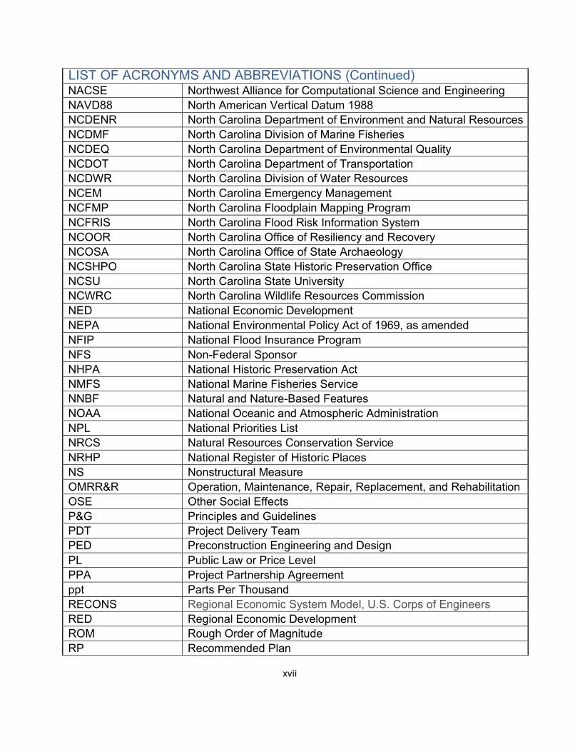
LIST OF ACRONYMS AND ABBREVIATIONS ACHP Advisory Council on Historic Preservation ACS American Community Survey AEP Annual Exceedance Probability APE Area of Potential Effects ASA-CW Assistant Secretary of the Army - Civil Works ATR Agency Technical Review BCR Benefit-Cost Ratio BD Big Ditch, Goldsboro, NC BiOp Biological Opinion BOEM Bureau of Ocean Energy Management CBRA Coastal Barrier Resources Act CBRS Coastal Barrier Resources System CDC Council for Disease Control and Prevention CEQ Council on Environmental Quality CERCLA Comprehensive Environmental Response, Compensation, and
Liability Act CFR Code of Federal Regulations CSRM Coastal Storm Risk Management CSRA Cost Schedule Risk Assessment CTC Crabtree Creek, Raleigh, NC CWCCIS Civil Works Construction Cost Index System CWE Current Working Estimate cy Cubic Yards DPS Distinct Population Segment DQC District Quality Control EA Environmental Assessment EAD Expected Annual Damage EC Engineer Circular ECB Engineering and Construction Bulletin EFH Essential Fish Habitat EJ Environmental Justice EO Executive Order EP Engineer Pamphlet EQ Environmental Quality EP Engineer Pamphlet ER Engineer Regulation ERDC Engineer Research and Development Center ESA Endangered Species Act
xv
LIST OF ACRONYMS AND ABBREVIATIONS (Continued) FEMA Federal Emergency Management Agency FMC Regional Fisheries Management Councils FMP Fisheries Management Plan FRM Flood Risk Management FRM-PCX Flood Risk Management Center of Expertise FPPA Farmland Protection Policy Act FWOP Future Without Project FWP Future With Project FY Fiscal Year GCM Global Circulation Model GIS Geographic Information System HAZUS Hazards United States, FEMA HEC-FDA Hydrologic Engineering Center-Flood Damage Analysis Model HEC-HMS Hydrologic Engineering Center-Hydrologic Modeling System Model HEC-RAS Hydrologic Engineering Center-River Analysis System Model HTRW Hazardous, Toxic and Radioactive Wastes HUC Hydrological Unit Codes HCD Habitat Conservation Division HWY Highway IDC Interest During Construction IFR Integrated Feasibility Report LERRDs Lands, Easements, Right-of-Ways, Relocations, and Disposal
Areas IPAC Information for Planning and Consultation LifeSim Life Loss Simulation Model LPP Locally Preferred Plan mg/l Milligram Per Liter MHW Mean High Water MLLW Mean Lower Low Water MMT Million Metric Tons MS Neuse River Mainstem MSA Magnuson-Stevens Act MSFCMA Magnuson-Stevens Fishery Conservation and Management Act MSL Mean Sea Level NAAQS National Ambient Air Quality Standards
xvi
LIST OF ACRONYMS AND ABBREVIATIONS (Continued) NACSE Northwest Alliance for Computational Science and Engineering NAVD88 North American Vertical Datum 1988 NCDENR North Carolina Department of Environment and Natural Resources NCDMF North Carolina Division of Marine Fisheries NCDEQ North Carolina Department of Environmental Quality NCDOT North Carolina Department of Transportation NCDWR North Carolina Division of Water Resources NCEM North Carolina Emergency Management NCFMP North Carolina Floodplain Mapping Program NCFRIS North Carolina Flood Risk Information System NCOOR North Carolina Office of Resiliency and Recovery NCOSA North Carolina Office of State Archaeology NCSHPO North Carolina State Historic Preservation Office NCSU North Carolina State University NCWRC North Carolina Wildlife Resources Commission NED National Economic Development NEPA National Environmental Policy Act of 1969, as amended NFIP National Flood Insurance Program NFS Non-Federal Sponsor NHPA National Historic Preservation Act NMFS National Marine Fisheries Service NNBF Natural and Nature-Based Features NOAA National Oceanic and Atmospheric Administration NPL National Priorities List NRCS Natural Resources Conservation Service NRHP National Register of Historic Places NS Nonstructural Measure OMRR&R Operation, Maintenance, Repair, Replacement, and Rehabilitation OSE Other Social Effects P&G Principles and Guidelines PDT Project Delivery Team PED Preconstruction Engineering and Design PL Public Law or Price Level PPA Project Partnership Agreement ppt Parts Per Thousand RECONS Regional Economic System Model, U.S. Corps of Engineers RED Regional Economic Development ROM Rough Order of Magnitude RP Recommended Plan
xvii
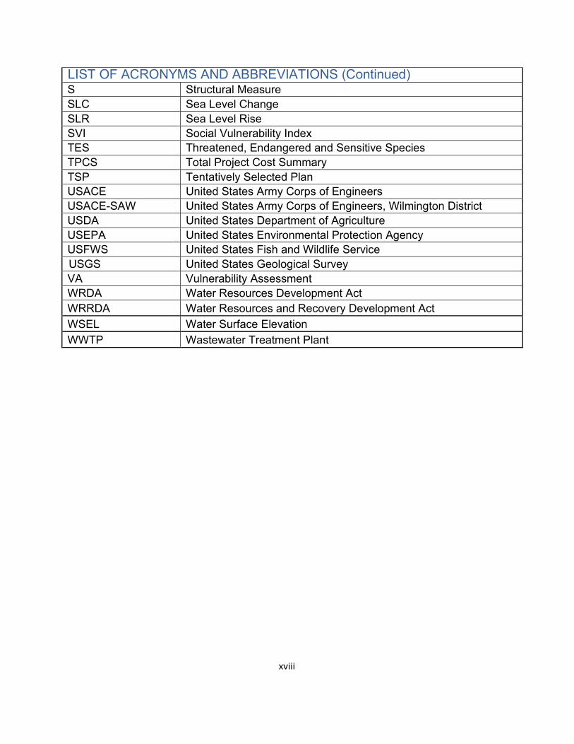
LIST OF ACRONYMS AND ABBREVIATIONS (Continued) S Structural Measure SLC Sea Level Change SLR Sea Level Rise SVI Social Vulnerability Index TES Threatened, Endangered and Sensitive Species TPCS Total Project Cost Summary TSP Tentatively Selected Plan USACE United States Army Corps of Engineers USACE-SAW United States Army Corps of Engineers, Wilmington District USDA United States Department of Agriculture USEPA United States Environmental Protection Agency USFWS United States Fish and Wildlife Service USGS United States Geological Survey VA Vulnerability Assessment WRDA Water Resources Development Act WRRDA Water Resources and Recovery Development Act WSEL Water Surface Elevation WWTP Wastewater Treatment Plant
xviii
Overview
Introduction
This feasibility study was conducted by the U.S. Army Corps of Engineers – Wilmington District (USACE-SAW) in partnership with the North Carolina Department of Environmental Quality (NCDEQ). The study identified, evaluated, and compared alternatives for flood risk management, consistent with the U.S. Army Corps of Engineers (USACE) policy and regulations, within the Neuse River Basin for the purpose of reducing risk and damages caused by flooding along the Neuse River and its tributaries.
USACE Planning Process
The USACE planning process, which was used in this study, follows the six-step process defined in the U.S. Water Resources Council Principles and Guidelines (P&G) (USACE 1983). This process is a structured approach to problem solving which provides a rational framework for sound decision-making. The six-step process is used for all planning studies conducted by the USACE. The six steps are:
o Step 1 - Identifying problems and opportunities o Step 2 - Inventorying and forecasting conditions o Step 3 - Formulating alternative plans o Step 4 - Evaluating alternative plans o Step 5 - Comparing alternative plans o Step 6 - Selecting a plan
USACE decision-making is generally based on the accomplishment and documentation of all these steps. It is important to stress the iterative nature of this process. As more information is acquired and developed, it may be necessary to reiterate some of the previous steps. The six steps, though presented and discussed in a sequential manner for ease of understanding, usually occur iteratively and sometimes concurrently. Iterations of steps are conducted as necessary to formulate efficient, effective, complete, and acceptable plans.
The structure of this report generally follows these 6 steps. This report includes an integrated environmental assessment (EA) in accordance with the 1969 National Environmental Policy Act (NEPA) version of the Council on Environmental Quality (CEQ) regulations (40 Code of Federal Regulations (CFR) parts 1500- 1508). Additionally, this study began prior to the implementation of the updated (CEQ) NEPA 2020 regulations.
1
Study Authority
This feasibility study was authorized by House Resolution 2532 and adopted by the Committee on Transportation and Infrastructure of the United States House of Representatives on July 23, 1997. House Resolution 2532 authorized an analysis of measures and alternative plans for reducing flood and storm damage to the Neuse River Basin within the study area that begins in the Piedmont of North Carolina and extends 248 miles southeast through the Coastal Plain and flows into the Pamlico Sound, covering approximately 6,200 square miles.
Title IV of the Additional Supplemental Appropriations for Disaster Relief Act, 2019, authorized the Government to conduct the study at full Federal expense to the extent that appropriations provided under the Investigations heading of the FY 19 Supplemental were available and used for such purpose.
Study Area and Scope
The study area included the entire Neuse River Basin, which is entirely located in North Carolina. This area began in the Piedmont section of North Carolina and extended 248 miles southeast through the Coastal Plain which flows into the Pamlico Sound, covering approximately 6,200 square miles. The Neuse River is the longest river in North Carolina, and at its mouth is the widest river in the United States at 6 miles. The Neuse River Basin includes numerous small to moderately sized tributaries that join the Neuse River mainstem at a consistent interval throughout its delineation. Major confluences within the Neuse are located near Raleigh, Smithfield, Goldsboro, Grifton, and New Bern. Its headwater tributaries rise in the hilly Piedmont section of North Carolina, then flow through a belt, or zone, known as the “Fall Line”, where the streams flatten in slope as they reach the Coastal Plain. Streams in the lower reaches of the Coastal Plain tend to be sluggish in flow, and swamp and marshes are predominant (USACE, 1960). The study encompassed all or part of 18 counties. Population centers in the Neuse River Basin included the cities of Durham, Raleigh, Wilson, Smithfield, Goldsboro, Kinston, and New Bern, NC.
Table 1-1 provides the population of key communities located near the Neuse River or major tributaries and Figure 1-1 provides some quick facts about the Neuse River Basin. Figure 1-2 displays the Neuse River Basin study area:
2
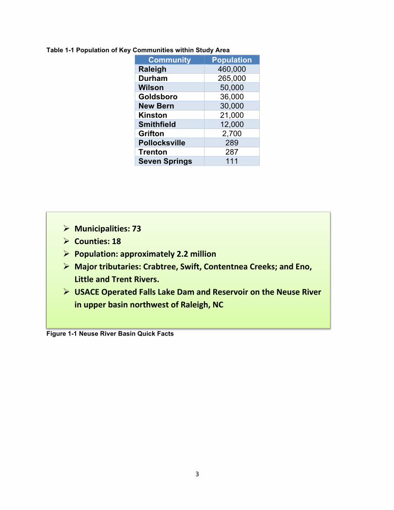
Table 1-1 Population of Key Communities within Study Area Community Population
Raleigh 460,000 Durham 265,000 Wilson 50,000 Goldsboro 36,000 New Bern 30,000 Kinston 21,000 Smithfield 12,000 Grifton 2,700 Pollocksville 289 Trenton 287 Seven Springs 111
Municipalities: 73 Counties: 18 Population: approximately 2.2 million Major tributaries: Crabtree, Swift, Contentnea Creeks; and Eno,
Little and Trent Rivers. USACE Operated Falls Lake Dam and Reservoir on the Neuse River
in upper basin northwest of Raleigh, NC
Figure 1-1 Neuse River Basin Quick Facts
3
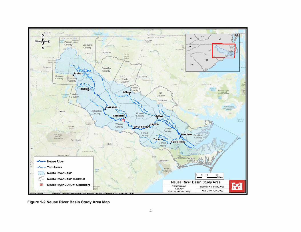
Figure 1-2 Neuse River Basin Study Area Map
4
Prior Studies and Reports
House Document 89-175, 1965. Neuse River Basin, North Carolina. This generalized plan for development for the Neuse River Basin was authorized in the Flood Control Act of 1965 as a guide for immediate and future development of 13 multi-purpose reservoirs within the basin. The Falls Lake and Reservoir project, completed in 1981, was the only feature recommended in this report for immediate construction in the interest of flood control, water supply, water quality control and recreation. To date, none of the remaining 12 reservoir projects have been constructed by the Federal government; however, one project, Buckhorn Reservoir on Contentnea Creek, was constructed by the City of Wilson in 1974 and subsequently expanded in 1999.
U.S. Army Corps of Engineers, Wilmington District, 1991, Neuse River, NC Final Survey Report. This report was authorized to review water resources needs of the Neuse River Basin, with reference to the feasibility of constructing the Wilson Mills, Buckhorn, and Beulahtown Dams and Reservoirs. The findings in this report concluded there was no Federal interest in reservoir development in the basin at that time.
U.S. Army Corps of Engineers, Wilmington District, 1995, Detailed Project Report and Environmental Assessment, Adkin Branch, City of Kinston, NC. This report was prepared under the authority of Section 205 of the 1948 Flood Control Act, as amended, and established an economically feasible plan of 8,700 feet of channel improvements on Adkin Branch to reduce riverine flood damages. If this project was implemented within the funding limits of the Continuing Authorities Program, no additional Federal construction authorization would be needed. However, no non-Federal sponsor was identified to cost share the implementation of this project.
U.S. Army Corps of Engineers, Wilmington District, 2012. Neuse River Basin Integrated Feasibility Report and Environmental Assessment, NC. This report recommended implementation of water quality improvements in the overall Neuse River basin ecosystem in partnership with the North Carolina Division of Environment and Natural Resources. The project was authorized for implementation under the Water Resources Development Act of 2014. However, no non-Federal sponsor was identified to cost share the implementation of this project.
North Carolina Division of Emergency Management and Department of Transportation, 2018. Neuse River Basin Flood Analysis and Mitigation Strategies Study. The objectives of this study in the Neuse River basin were to identify the primary sources of flooding and identify and assess possible mitigation strategies to prevent future flood damage in the wake of Hurricane Matthew. This report provides assessments of
5
flooding sources, structural flood impact, and planning level mitigation strategies for this basin.
Doll, Barbara, PhD, PE, et. al., 2020. Evaluating the Capacity of Natural Infrastructure for Flood Abatement at the Watershed Scale: Goldsboro, NC Case Study. Prepared for the NC Department of Transportation, this report evaluated the impacts of expanding natural infrastructure in two case study watersheds in Goldsboro, NC, where local stakeholders have reported multiple streams prone to flooding that impact property and transportation infrastructure.
Doll, Barbara, PhD, PE, et. al., 2020. Flood Abatement Assessment for Neuse River Basin. Prepared for the NC Department of Transportation, the objectives of this assessment were to better understand the sources and nature of riverine flooding, test potential measures to mitigate flooding, improve early warning systems for transportation-related infrastructure, evaluate future storm severity, and identify potential improvements to local floodplain ordinances. This assessment also included identification and prioritization of tributary state highway crossing improvements within the basin.
Purpose and Need for Action
Communities within the Neuse River Basin, North Carolina have a long history of flooding, both from impactful localized rainfall events, and from less frequent major rainfall and hurricanes. Specific to hurricanes, many communities within the basin have experienced major recurring flood events over the past 37 years associated with Hurricanes Gloria (1985), Fran (1996), Bonnie (1998), Floyd (1999), Matthew (2016) and Florence (2018)—the last three of which rank among the most destructive storms in state history. Recurring flooding within the basin has resulted in considerable economic damages to homes, businesses, industry, and public infrastructure. For example, Hurricane Matthew is estimated to have caused over $180M in damage to residential, non-residential, and public structures (NCEM and NCDOT, 2018). Inundation of structures and roadways also resulted in increased life safety risks both during and following flood events.
In response to recent flooding that occurred as a result of Hurricanes Matthew (2016) and Florence (2018), USACE received funding through the 2019 Additional Supplemental Appropriations for Disaster Relief (H.R. 2157) to conduct this feasibility study to assess and recommend actions that reduce flood and storm damage risk and increase resiliency within the Neuse River Basin. This integrated feasibility study and environmental assessment analyzed a series of alternatives designed to reduce the on-going flood risks throughout the basin, including a no action plan, as well as various combinations of structural and nonstructural measures.
6
Problems and Opportunities
Identifying the problems and opportunities within the study area is an important initial step in the planning process. Once the problems and opportunities are described, then objectives may be properly identified that guide efforts to select actions which contribute to addressing the problems and realizing the opportunities. The problems and opportunities identified for the Neuse River Basin flood risk management study are described below.
Two problems were identified:
1. Economic damage resulting from flood inundation o Expected annual damages (EAD) over $43 million for the study area over
the 50-year period of analysis including the Hominy Swamp Creek in Wilson, NC, Crabtree creek in Raleigh, NC, Big Ditch in Goldsboro, NC and Neuse River
o Structure and infrastructure damaged throughout study area o Impacts to homes, transportation, and damage to public/critical
infrastructure 2. Risks to life-safety associated with flood inundation
o Elevated risk to vulnerable populations within the floodplain o Limitations on travel due to inundation of transportation infrastructure o Risk of life loss due to inundation of occupied vehicles on roadways
The following opportunities were identified within the study area:
Maintain or improve environmental habitat Improve resiliency and sustainability Address at-risk socially vulnerable populations Improve recreational opportunities Increase awareness of and preparedness for flood risk
Objectives and Constraints
1.8.1. Objectives
The following study objectives were developed to address identified problems while maximizing the potential to realize identified opportunities:
Reduce economic damage associated with inundation (residential, non-residential, socially vulnerable communities, critical facilities and public infrastructure) throughout the basin over the period of analysis (2029-2079)
7
Reduce life-safety risk associated with inundation of structures (residential, non-residential, socially vulnerable communities, transportation, critical facilities) and public infrastructure throughout the basin over the period of analysis (2029-2079)
1.8.2. Constraints and Considerations
Constraints are restrictions which limit the planning process. The following policy constraint was identified: Policy: USACE Engineering Regulation (ER) 1165-2-21 limited the scope of
studies being conducted under a flood risk management authority to flooding along natural streams and/or modified natural waterways within urbanized basins characterized by a drainage area of greater than 1.5 square miles and river discharges greater than 800 cubic feet per second for the 10% annual exceedance probability (AEP) flood event
Study-specific: No study-specific constraints were identified
There are several other considerations that informed the planning process, including:
Plans should avoid or minimize transferring flood risk to other areas Plans should not reduce performance of existing flood risk management projects
in the study area Plans should not induce development in the floodplain Plans should avoid negative impacts to endangered species and other protected
environmental resources to the extent practicable and minimize and/or mitigate any negative impacts
Plans should avoid negative impacts to cultural/archeological resources
8
EXISTING AND FUTURE WITHOUT PROJECT CONDITIONS
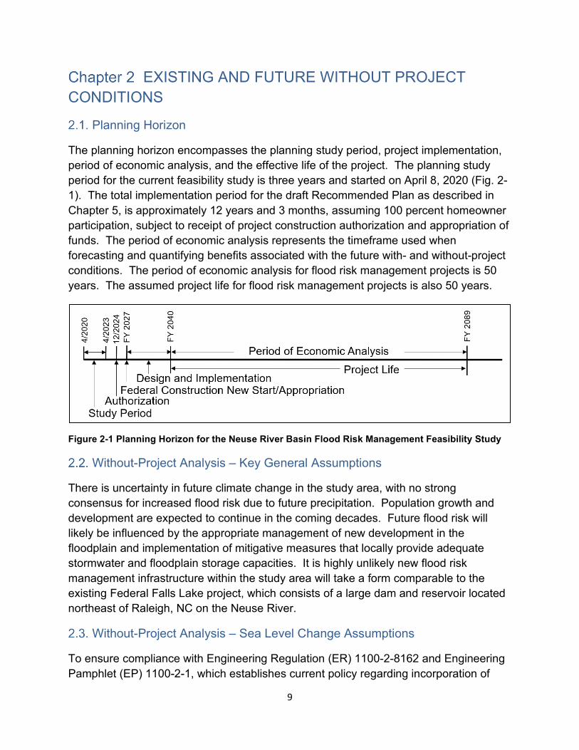
Planning Horizon
The planning horizon encompasses the planning study period, project implementation, period of economic analysis, and the effective life of the project. The planning study period for the current feasibility study is three years and started on April 8, 2020 (Fig. 2-1). The total implementation period for the draft Recommended Plan as described in Chapter 5, is approximately 12 years and 3 months, assuming 100 percent homeowner participation, subject to receipt of project construction authorization and appropriation of funds. The period of economic analysis represents the timeframe used when forecasting and quantifying benefits associated with the future with- and without-project conditions. The period of economic analysis for flood risk management projects is 50 years. The assumed project life for flood risk management projects is also 50 years.
Figure 2-1 Planning Horizon for the Neuse River Basin Flood Risk Management Feasibility Study
Without-Project Analysis – Key General Assumptions
There is uncertainty in future climate change in the study area, with no strong consensus for increased flood risk due to future precipitation. Population growth and development are expected to continue in the coming decades. Future flood risk will likely be influenced by the appropriate management of new development in the floodplain and implementation of mitigative measures that locally provide adequate stormwater and floodplain storage capacities. It is highly unlikely new flood risk management infrastructure within the study area will take a form comparable to the existing Federal Falls Lake project, which consists of a large dam and reservoir located northeast of Raleigh, NC on the Neuse River.
Without-Project Analysis – Sea Level Change Assumptions
To ensure compliance with Engineering Regulation (ER) 1100-2-8162 and Engineering Pamphlet (EP) 1100-2-1, which establishes current policy regarding incorporation of
9
future sea level changes into USACE projects, an analysis of the project impacts relative to increased sea levels over the life of the Neuse River Basin study was conducted. This guidance requires that “Potential relative sea-level change must be considered in every USACE coastal activity as far inland as the extent of estimated tidal influence.” The analysis included development of relative sea level rise projection curves, identification of potential impact areas and associated risks, and establishing adaptive measures to adjust to future sea level rise.
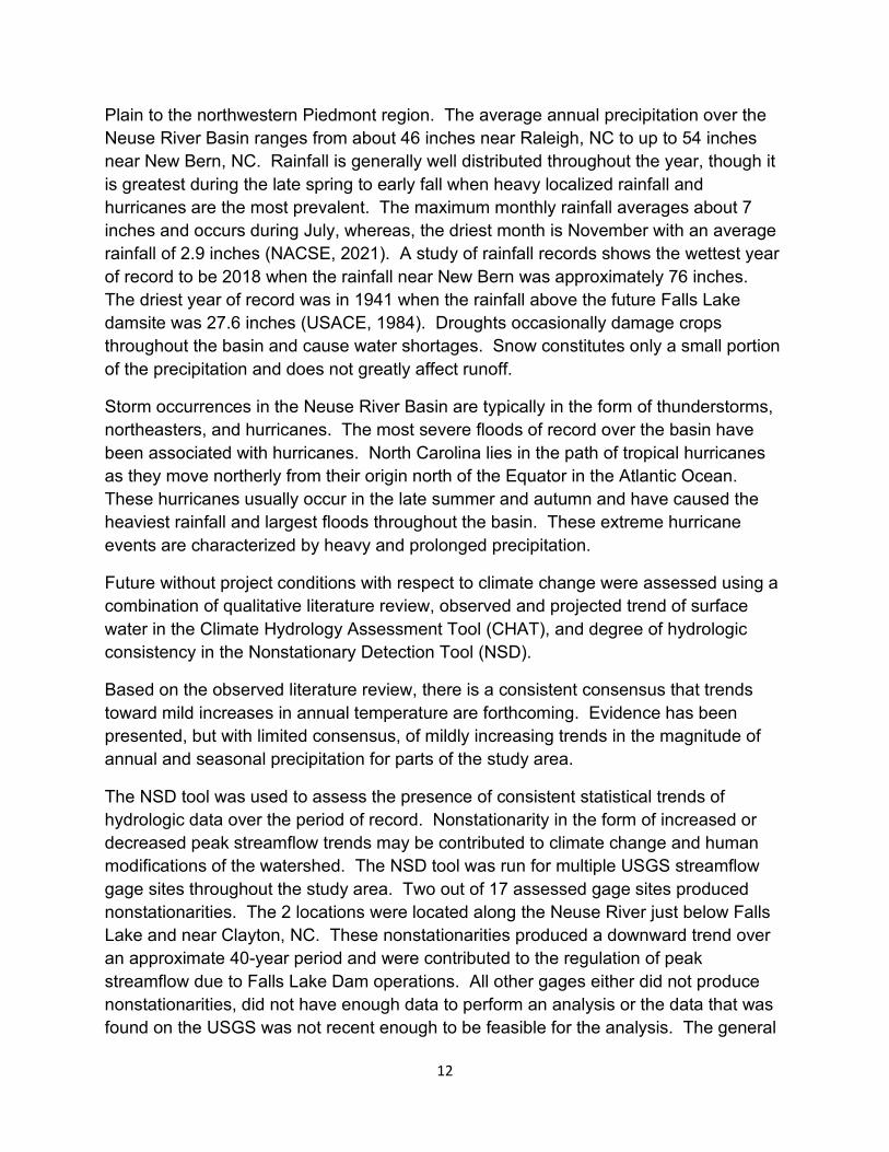
Using the methods published in ER 1100-2-8162, the relative sea level rise curves were developed for “low,” “intermediate,” and “high” rates of future sea-level change. The “low” sea level change curve is simply an extrapolation of the observed sea-level trend obtained by averaging the sea level rise rates from a local gage. The “intermediate” curve represents sea level rise using the National Research Council (NRC) Curve I and the “high” curve represents NRC Curve III. In addition to these required curves, an additional intermediate curve was developed between NRC Curves I and III which represented NRC Curve II.
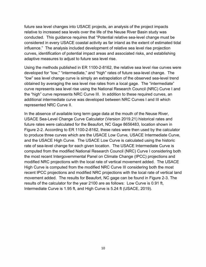
In the absence of available long term gage data at the mouth of the Neuse River, USACE Sea-Level Change Curve Calculator (Version 2019.21) historical rates and future rates were calculated for the Beaufort, NC Gage 8656483, location shown in Figure 2-2. According to ER 1100-2-8162, these rates were then used by the calculator to produce three curves which are the USACE Low Curve, USACE Intermediate Curve, and the USACE High Curve. The USACE Low Curve is calculated using the historic rate of sea-level change for each given location. The USACE Intermediate Curve is computed from the modified National Research Council (NRC) Curve I considering both the most recent Intergovernmental Panel on Climate Change (IPCC) projections and modified NRC projections with the local rate of vertical movement added. The USACE High Curve is computed from the modified NRC Curve III considering both the most recent IPCC projections and modified NRC projections with the local rate of vertical land movement added. The results for Beaufort, NC gage can be found in Figure 2-3. The results of the calculator for the year 2100 are as follows: Low Curve is 0.91 ft, Intermediate Curve is 1.95 ft, and High Curve is 5.24 ft (USACE, 2019).
10
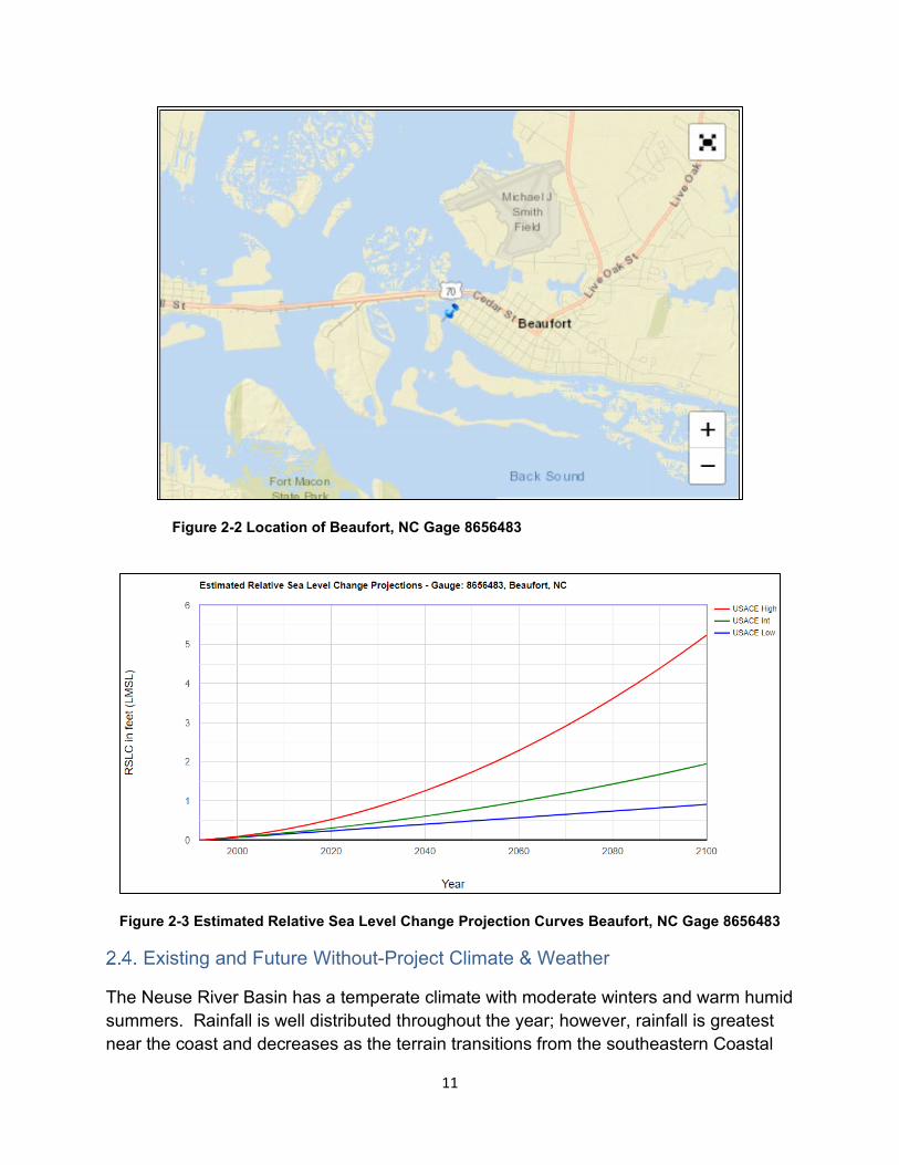
Figure 2-2 Location of Beaufort, NC Gage 8656483
Figure 2-3 Estimated Relative Sea Level Change Projection Curves Beaufort, NC Gage 8656483
Existing and Future Without-Project Climate & Weather
The Neuse River Basin has a temperate climate with moderate winters and warm humid summers. Rainfall is well distributed throughout the year; however, rainfall is greatest near the coast and decreases as the terrain transitions from the southeastern Coastal
11
Plain to the northwestern Piedmont region. The average annual precipitation over the Neuse River Basin ranges from about 46 inches near Raleigh, NC to up to 54 inches near New Bern, NC. Rainfall is generally well distributed throughout the year, though it is greatest during the late spring to early fall when heavy localized rainfall and hurricanes are the most prevalent. The maximum monthly rainfall averages about 7 inches and occurs during July, whereas, the driest month is November with an average rainfall of 2.9 inches (NACSE, 2021). A study of rainfall records shows the wettest year of record to be 2018 when the rainfall near New Bern was approximately 76 inches. The driest year of record was in 1941 when the rainfall above the future Falls Lake damsite was 27.6 inches (USACE, 1984). Droughts occasionally damage crops throughout the basin and cause water shortages. Snow constitutes only a small portion of the precipitation and does not greatly affect runoff.
Storm occurrences in the Neuse River Basin are typically in the form of thunderstorms, northeasters, and hurricanes. The most severe floods of record over the basin have been associated with hurricanes. North Carolina lies in the path of tropical hurricanes as they move northerly from their origin north of the Equator in the Atlantic Ocean. These hurricanes usually occur in the late summer and autumn and have caused the heaviest rainfall and largest floods throughout the basin. These extreme hurricane events are characterized by heavy and prolonged precipitation.
Future without project conditions with respect to climate change were assessed using a combination of qualitative literature review, observed and projected trend of surface water in the Climate Hydrology Assessment Tool (CHAT), and degree of hydrologic consistency in the Nonstationary Detection Tool (NSD).
Based on the observed literature review, there is a consistent consensus that trends toward mild increases in annual temperature are forthcoming. Evidence has been presented, but with limited consensus, of mildly increasing trends in the magnitude of annual and seasonal precipitation for parts of the study area.
The NSD tool was used to assess the presence of consistent statistical trends of hydrologic data over the period of record. Nonstationarity in the form of increased or decreased peak streamflow trends may be contributed to climate change and human modifications of the watershed. The NSD tool was run for multiple USGS streamflow gage sites throughout the study area. Two out of 17 assessed gage sites produced nonstationarities. The 2 locations were located along the Neuse River just below Falls Lake and near Clayton, NC. These nonstationarities produced a downward trend over an approximate 40-year period and were contributed to the regulation of peak streamflow due to Falls Lake Dam operations. All other gages either did not produce nonstationarities, did not have enough data to perform an analysis or the data that was found on the USGS was not recent enough to be feasible for the analysis. The general
12
consensus was the overwhelming effects of flow regulation due to Falls Lake Dam were driving linear trends in the study area, and not due to climate change, long-term natural climate trends, or land use/land cover changes.
Based on the projected literature review, strong consensus exists for increased air temperatures in the study area. There is agreement that by the latter half of the 21st century, air temperatures will have increased by approximately 2 to 4 ºC. Sources of this temperature increase include variations in the sun’s energy reaching Earth, changes in the reflectivity of Earth’s atmosphere and surface, and changes in the greenhouse effect, which affects the amount of heat retained by Earth’s atmosphere.
Greenhouse gases come from a variety of human activities including: burning fossil fuels for transportation, heat and energy, clearing forests, fertilizing crops, storing waste in landfills, raising livestock, and producing some kinds of industrial products (https://www.epa.gov/ghgemissions/overview-greenhouse-gases). A review of the U.S. Environmental Protection Agency’s analysis for climate change for North Carolina titled, “What Climate Change Means for North Carolina,” (https://19january2017snapshot.epa.gov/sites/production/files/2016-09/documents/climate-change-nc.pdf) states:
• Most of North Carolina has warmed 0.5-1.0 degrees Fahrenheit in the last 100 years. The southeastern United States has warmed less than most of the nation.
• Tropical storms and hurricanes have become more intense during the past 20 years. Hurricane wind speeds and rainfall rates are likely to increase as the climate continues to warm.
• Increased rainfall may further exacerbate flooding in some coastal areas. Since 1958, the amount of precipitation during heavy rainstorms has increased by 27 percent in the southeast, and the trend toward increasingly heavy rainstorms is likely to continue.
Precipitation projections are less certain. The outcome of these climate tools can carry high uncertainty, such as accuracy related to Global Circulation Models (GCM). GCM simulates the transportation of heat through world-wide winds that circulate through the atmospheric troposphere layer. Spread of model results as time moves away from model initiation points, and accuracy of hydrologic models are also sources of uncertainty.
The USACE Vulnerability Assessment (VA) tool was utilized to provide a screening level, comparative assessment of how vulnerable the Neuse River study area was to the impacts of climate change relative to other large watersheds within the continental
13
United States (CONUS). The tool allowed for assessment of the USACE business line “Flood Risk Management.” Flood risk management was the most relevant business line for the Neuse River Basin Feasibility Study and the primary business line analyzed with the USACE Climate Vulnerability Assessment Tool. The tool assessed four scenarios; a “wet” and “dry” scenario for a 30-year epoch centered at year 2050, and a “wet” and “dry” scenario centered at year 2085.
Results from the tool showed that for the Flood Risk Management business line, the Hydrologic Unit Code (HUC) 0302 Neuse-Pamlico Basin is not within the top 20% of vulnerable watersheds within the CONUS for any of the four scenarios. Regarding the Flood Risk Management business line, the primary indicators driving vulnerability within the watershed were the flood magnification factor, and the large elasticity between rainfall and runoff. The flood magnification factor represented how the monthly flow exceeded 10% of the time is predicted to change in the future. The rainfall/runoff elasticity measures the tendency for small changes in precipitation to result in large changes in runoff. While the project area is not within the top 20% of vulnerable HUCs nationally, that does not imply that vulnerability to climate change does not exist. The VA tool indicates that the change in cumulative flood runoff, combined with the acres of urban area within the flooding extents caused by the 0.2% AEP flood event, are driving flood risk reduction vulnerability.
Existing and Future Without-Project Flood Risk
The wide variety of land use and land cover throughout the large study area exposes the population to multiple forms of flood risk. In urban, high density population centers such as Raleigh, NC, flood risk may be realized quickly in the form of flash flooding. In these areas, lag times between rainfall and runoff are short and partially due to high percentages of impervious area such as dense zones designated for commercial infrastructure. These areas don’t allow for adequate ground infiltration that would naturally help to slow the runoff process. The natural terrain can also exacerbate flooding problems, as in upper portions of the basin where streams are typically characterized by steep gradients with high, narrow banks.
In the middle and lower portions of the basin, a significant percentage of floodplain land cover is utilized for agricultural purposes. There is a shift away from densely populated development, especially within segments of the Neuse River mainstem floodplain that can expand to a width of several miles. As the river traverses through these segments that transition between the Piedmont and Coastal Plain regions, more of the study area becomes exposed to significant weather events that originate from tropical systems. As noted earlier, tropical storms and hurricanes have historically impacted the middle and lower portions of the study area. The impact duration of these events is highly conditional on secondary frontal systems as well, that in some cases such as during
14
Hurricane Florence in 2018, create slow moving systems that lead to intense precipitation.
When flood events also include major tributaries to the Neuse River, it can result in prolonged flood stages that take multiple weeks to recede back to a normal condition. Significant structural and economic damages are associated with this flood risk scenario.
Characteristic of the majority of the study area are flooding issues related to constrictions to flow, either by temporary debris dislodged upstream during a flood event that eventually becomes trapped at a road crossing or created by historically undersized bridge spans or culvert openings.
The future without project condition flood risk appears to be driven by several important factors: land use changes, changes in stormwater management, enforcement and growth of floodplain management, public education of flood risks, and climate change. The Environmental Protection Agency’s (EPA) Integrated Climate and Land-Use Scenarios tool was used to assess the degree of potential land use changes in the future. The dataset of estimated percent impervious surface (version 1.3) was used to estimate the future land use conditions of the basin. This dataset uses population projections through the end of the century, reflecting different assumptions about fertility, mortality, and immigration to determine the demand for new homes, and estimates the amount of impervious surface that can be expected. The results of the analysis show that predicted changes in land use for this basin were not associated with significant increases in impervious areas.
Multiple active communities in FEMA’s National Flood Insurance Program have placed progressive requirements for development within the floodplain. This acknowledgment coupled with community stormwater management plans that share a core regulation that post-hydrology shall mimic pre-construction hydrology appear to shape a future of improved flood risk management for the Neuse River Basin. Continued collaboration between state agencies, such as NCDOT, NCEM, and NCFMP, is likely to lead to further technical enhancements such as the North Carolina Flood Risk Information System (NCFRIS) tool, and comprehensive hydrologic studies, such as the recent Tar-Pamlico River, Neuse River, and Lumber River basins’ flood analysis and mitigation strategies efforts.
Existing and Future Without-Project Environmental Conditions
The existing environmental conditions of the project are briefly discussed here in this section of this report, and again in Chapter 4 – Affected Environment and Environmental Consequences. The following subsections detail the future without-project conditions of
15
several environmental resources that likely would be impacted without a flood risk management project (e.g. no Federal action).
2.6.1. Water Quality
More frequent flood events could negatively impact water quality within the Neuse River Basin with sedimentation from these flood events causing increases in suspended sediments and pollution in the water column throughout the river basin.
2.6.2. Threatened and Endangered Species
The increase in the sedimentation from more frequent flood events can cause increases in suspended sediments and pollution in the waters of the basin which are designated Critical Habitat for endangered species located in the area. These include species such as the Atlantic Sturgeon and the Neuse River Waterdog.
Existing and Future Without-Project Cultural Resources
The Neuse River Basin contains prehistoric and historic period sites reflecting more than 12,000 years of human discovery and settlement. Prehistoric sites within the basin range from the typically limited physical remains of Paleo-Indian hunter-gatherers (~12,000 B.C.) to the extensive collections recovered from large agricultural villages that came to dominate the floodplain and terraces by the 1400s. Heavy precipitation events and associated erosion adversely affect buried resources and artifacts.
European explorers arriving at the eastern sounds first encountered Algonquian tribes. These Native Americans were the southernmost of the eastern Algonquian language family, which extended northward to the maritime provinces of Canada. The Carolina branch of the Algonquian occupied the central Tidewater region of North Carolina from the Neuse River north to the Chesapeake Bay. To the west of the Carolinas lived the Iroquoian-speaking Tuscarora, Meherrin, and Nottaway. At the western extremity of the basin, the influential Occoneechee controlled trade and served as intermediaries between early European explorers and other Native American tribes.
The Neuse River also reflects an area of distinction between earlier prehistoric groups of differing cultures. Archaeologists generally recognize stylistic differences in the early pottery styles of two sub-regions evident within the basin, and those differences are attributed to culturally distinct influences emanating from South Carolina and Georgia on the west and the Mid-Atlantic on the east. The distinctions seem to date back to the Late Archaic Period, around 3,000 years ago, when the region saw the emergence of the earliest pottery styles, the rise of regional agriculture, and the establishment of more or less permanent, defended, ethnic territories.
16
Although Raleigh, Durham, Hillsborough, Cary, Apex, and Wake Forest are currently the largest municipalities in the Neuse River Basin, in the late 18th and early 19th
centuries, New Bern, James City, and Kinston had among the highest resident populations of cities included in the study area. New Bern is the second-oldest city in North Carolina, served as the colonial and state capital from 1746-1792, and it boasts the well-known Tryon Palace and New Bern Historic District. Tryon Palace was the state’s first capital building, built in 1767-70 by royal governor William Tryon. Less well known are the historic archaeological ruins that have been unearthed in various parts of the city. Across the Trent River from New Bern is James City, one of North Carolina’s better-known Freedmen Towns. Freedmen Towns were established by freed African American slaves after the Civil War. Kinston is known for the Confederate States Navy (CSS) Neuse Museum, with its famous full-scale reconstruction of this Confederate gunboat. Also, the remains of the CSS Neuse are on display at this museum. New Bern, James City, and Kinston all contain recognized historic districts, historic properties eligible for listing on the National Register of Historic Places (NRHP), or both (NC Department of Natural and Cultural Resources, 2021).
Less well known are the earlier explorations of an Englishman named John Lawson. John Lawson visited Indian villages in the winter of 1700-1701 and provided valuable insights to historians and archaeologists attempting to reconstruct Native American history and the era of European contact. Lawson and his party were captured when they stumbled upon the Tuscarora and other tribes preparing to wage war on English settlers in North Carolina. Lawson was well known by his captors and was inexplicably executed, though his associate was spared. That tumultuous time is recounted at several sites in the basin and northward in the neighboring Roanoke River basin. Displaced tribes traveled great distances to escape European conflict and, in some cases, were not welcomed by those Indians already established in a local territory, who had to face their own struggles with Europeans.
Based on information presented in the USACE’s May 29, 2020 scoping letter, the North Carolina State Historic Preservation Office’s (SHPO) records indicated that there were 6,689 archaeological sites recorded within the area of interest (Appendix G – Cultural Resources). Of these, fifteen (15) were listed in theNRHP, while one hundred and thirty-one (131) had been determined eligible for listing in the NRHP. An additional two (2) sites had been placed on the state study list, an internal listing process that occurs before being nominated to the NRHP. Two thousand six hundred and sixty-seven (2,667) sites had been determined not eligible, while the remaining three thousand eight hundred and seventy-four (3,874) were either unassessed or did not have their eligibility status recorded in SHPO’s GIS database. The SHPO also provided a link to their GIS website (NC Department of Natural and Cultural Resources, 2021), to further aid in assessing study impacts.
17
Since receiving this information from the SHPO, the Recommended Plan footprint described in Chapter 5 has been refined and reduced (Figure 5-1). The footprint currently includes the cities of Goldsboro and Wilson. The City of Goldsboro contains eight properties listed in the NRHP and one National Park Service-certified historic district. Similarly, the City of Wilson contains five properties listed in the NRHP, one property considered eligible for listing, and five historic districts (NC Department of Natural and Cultural Resources, 2021).
The Neuse River Basin continues to grow and develop the human environment at a rate similar to that of the greater United States. Although predicted land use changes are not associated with significant increases in impervious areas, future development will somewhat reduce the floodplain’s natural ability to mitigate negative flooding and erosion effects associated with storm events. As future storm events may increase in frequency and severity, negative effects to prehistoric and historic cultural resources in terms of erosion and inundation risk may continue at least to the degree currently experienced, without project implementation.
Existing and Future Without-Project Socioeconomic Conditions
This section describes demographic characteristics for the population at risk. The total estimated population count in the Neuse River Basin was approximately 2.2 million as of 2019. The following figures display the distribution of the population by census tract, and other socio-economic and demographic factors that impact the population at risk in the study area. Demographic data for the following maps was taken from American Community Survey (ACS) 2019 5-year estimates available on census.gov, unless otherwise indicated.
18
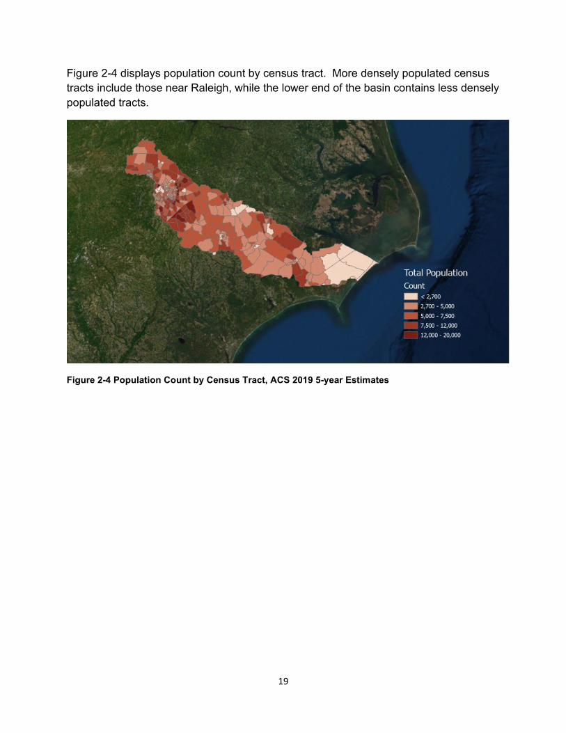
Figure 2-4 displays population count by census tract. More densely populated census tracts include those near Raleigh, while the lower end of the basin contains less densely populated tracts.
Figure 2-4 Population Count by Census Tract, ACS 2019 5-year Estimates
19
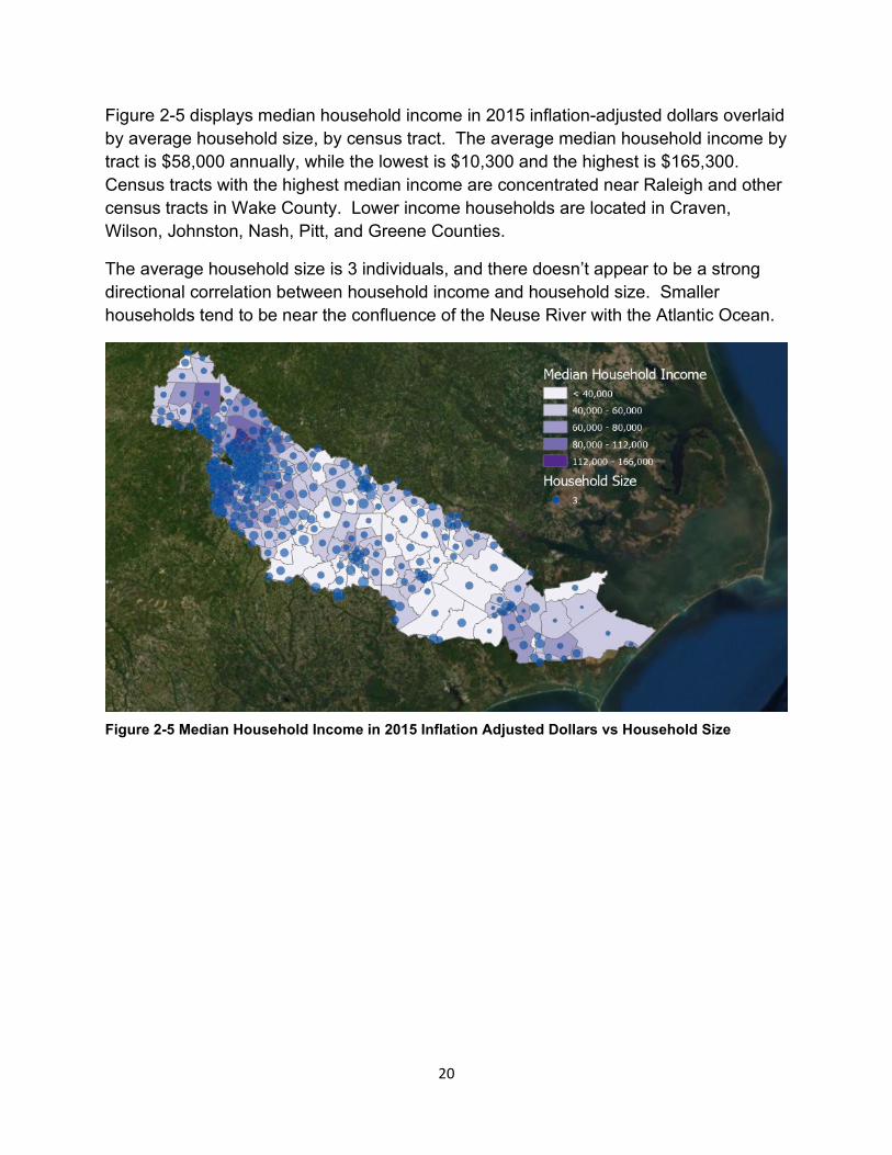
Figure 2-5 displays median household income in 2015 inflation-adjusted dollars overlaid by average household size, by census tract. The average median household income by tract is $58,000 annually, while the lowest is $10,300 and the highest is $165,300. Census tracts with the highest median income are concentrated near Raleigh and other census tracts in Wake County. Lower income households are located in Craven, Wilson, Johnston, Nash, Pitt, and Greene Counties.
The average household size is 3 individuals, and there doesn’t appear to be a strong directional correlation between household income and household size. Smaller households tend to be near the confluence of the Neuse River with the Atlantic Ocean.
Figure 2-5 Median Household Income in 2015 Inflation Adjusted Dollars vs Household Size
20
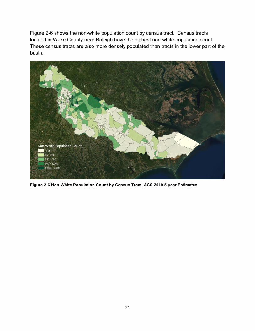
Figure 2-6 shows the non-white population count by census tract. Census tracts located in Wake County near Raleigh have the highest non-white population count. These census tracts are also more densely populated than tracts in the lower part of the basin.
Figure 2-6 Non-White Population Count by Census Tract, ACS 2019 5-year Estimates
21
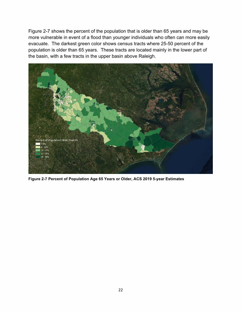
Figure 2-7 shows the percent of the population that is older than 65 years and may be more vulnerable in event of a flood than younger individuals who often can more easily evacuate. The darkest green color shows census tracts where 25-50 percent of the population is older than 65 years. These tracts are located mainly in the lower part of the basin, with a few tracts in the upper basin above Raleigh.
Figure 2-7 Percent of Population Age 65 Years or Older, ACS 2019 5-year Estimates
22
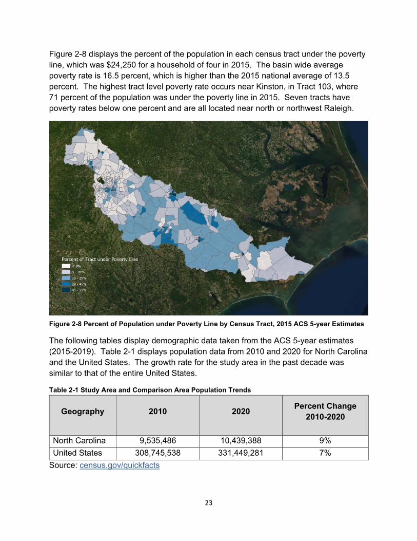
Figure 2-8 displays the percent of the population in each census tract under the poverty line, which was $24,250 for a household of four in 2015. The basin wide average poverty rate is 16.5 percent, which is higher than the 2015 national average of 13.5 percent. The highest tract level poverty rate occurs near Kinston, in Tract 103, where 71 percent of the population was under the poverty line in 2015. Seven tracts have poverty rates below one percent and are all located near north or northwest Raleigh.
Figure 2-8 Percent of Population under Poverty Line by Census Tract, 2015 ACS 5-year Estimates
The following tables display demographic data taken from the ACS 5-year estimates (2015-2019). Table 2-1 displays population data from 2010 and 2020 for North Carolina and the United States. The growth rate for the study area in the past decade was similar to that of the entire United States.
Table 2-1 Study Area and Comparison Area Population Trends
Geography 2010 2020 Percent Change 2010-2020
North Carolina 9,535,486 10,439,388 9% United States 308,745,538 331,449,281 7%
Source: census.gov/quickfacts
23
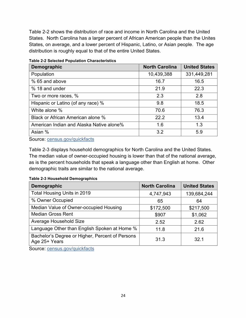
Table 2-2 shows the distribution of race and income in North Carolina and the United States. North Carolina has a larger percent of African American people than the Unites States, on average, and a lower percent of Hispanic, Latino, or Asian people. The age distribution is roughly equal to that of the entire United States.
Table 2-2 Selected Population Characteristics Demographic North Carolina United States Population 10,439,388 331,449,281 % 65 and above 16.7 16.5 % 18 and under 21.9 22.3 Two or more races, % 2.3 2.8 Hispanic or Latino (of any race) % 9.8 18.5 White alone % 70.6 76.3 Black or African American alone % 22.2 13.4 American Indian and Alaska Native alone% 1.6 1.3 Asian % 3.2 5.9
Source: census.gov/quickfacts
Table 2-3 displays household demographics for North Carolina and the United States. The median value of owner-occupied housing is lower than that of the national average, as is the percent households that speak a language other than English at home. Other demographic traits are similar to the national average.
Table 2-3 Household Demographics
Demographic North Carolina United States Total Housing Units in 2019 4,747,943 139,684,244 % Owner Occupied 65 64 Median Value of Owner-occupied Housing $172,500 $217,500 Median Gross Rent $907 $1,062 Average Household Size 2.52 2.62 Language Other than English Spoken at Home % 11.8 21.6 Bachelor’s Degree or Higher, Percent of Persons Age 25+ Years 31.3 32.1
Source: census.gov/quickfacts
24
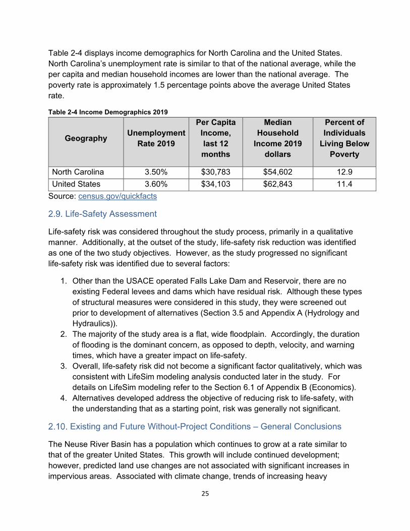
Table 2-4 displays income demographics for North Carolina and the United States. North Carolina’s unemployment rate is similar to that of the national average, while the per capita and median household incomes are lower than the national average. The poverty rate is approximately 1.5 percentage points above the average United States rate.
Table 2-4 Income Demographics 2019
Geography Unemployment Rate 2019
Per Capita Income, last 12 months
Median Household
Income 2019 dollars
Percent of Individuals
Living Below Poverty
North Carolina 3.50% $30,783 $54,602 12.9 United States 3.60% $34,103 $62,843 11.4
Source: census.gov/quickfacts
Life-Safety Assessment
Life-safety risk was considered throughout the study process, primarily in a qualitative manner. Additionally, at the outset of the study, life-safety risk reduction was identified as one of the two study objectives. However, as the study progressed no significant life-safety risk was identified due to several factors:
1. Other than the USACE operated Falls Lake Dam and Reservoir, there are no existing Federal levees and dams which have residual risk. Although these types of structural measures were considered in this study, they were screened out prior to development of alternatives (Section 3.5 and Appendix A (Hydrology and Hydraulics)).
2. The majority of the study area is a flat, wide floodplain. Accordingly, the duration of flooding is the dominant concern, as opposed to depth, velocity, and warning times, which have a greater impact on life-safety.
3. Overall, life-safety risk did not become a significant factor qualitatively, which was consistent with LifeSim modeling analysis conducted later in the study. For details on LifeSim modeling refer to the Section 6.1 of Appendix B (Economics).
4. Alternatives developed address the objective of reducing risk to life-safety, with the understanding that as a starting point, risk was generally not significant.
Existing and Future Without-Project Conditions – General Conclusions
The Neuse River Basin has a population which continues to grow at a rate similar to that of the greater United States. This growth will include continued development; however, predicted land use changes are not associated with significant increases in impervious areas. Associated with climate change, trends of increasing heavy
25

rainstorms and more intense tropical storms and hurricanes are expected to continue, along with associated economic damages. At the same time, trends in improved enforcement and floodplain management, as well as interagency initiatives to manage flood risk within the basin, appear to shape a future of improved flood risk management.
26
PLAN FORMULATION AND EVALUATION OF ALTERNATIVES
Study Strategy
In the very early stages of this study, a strategy was developed in coordination with the USACE’s Flood Risk Management Planning Center of Expertise (FRM-PCX) and shared with the vertical USACE team and state partners at an in-progress review meeting on September 15, 2020. Due to the large size of the study area, having a logical plan to develop and evaluate possible solutions was recognized as especially critical.
The general study strategy identified separate focus areas within the basin typically population centers in the vicinity of the Neuse River with notable flood risk. Each of these focus areas were formulated individually to identify measures to address at least one of the study objectives, and through the formulation process combine potentially viable measures into alternative plans for that specific focus area. Rural areas within the floodplain were also considered, although structural measures were less likely to be economically viable due to less concentrations of development.
It was also recognized that some larger measures could have a regional impact, for example a new dam and reservoir. These were considered “basinwide” measures. Finally, viable plans were selected from individual focus areas and combined across the basin and resulted in a final array of system-wide alternatives. Figure 3-1 on the following page provides a conceptual illustration of the overall strategy.
27
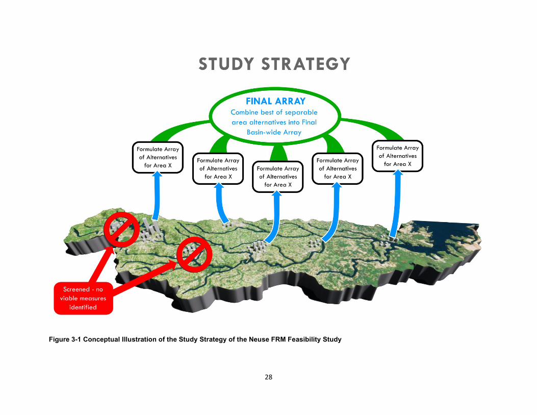
Figure 3-1 Conceptual Illustration of the Study Strategy of the Neuse FRM Feasibility Study
28
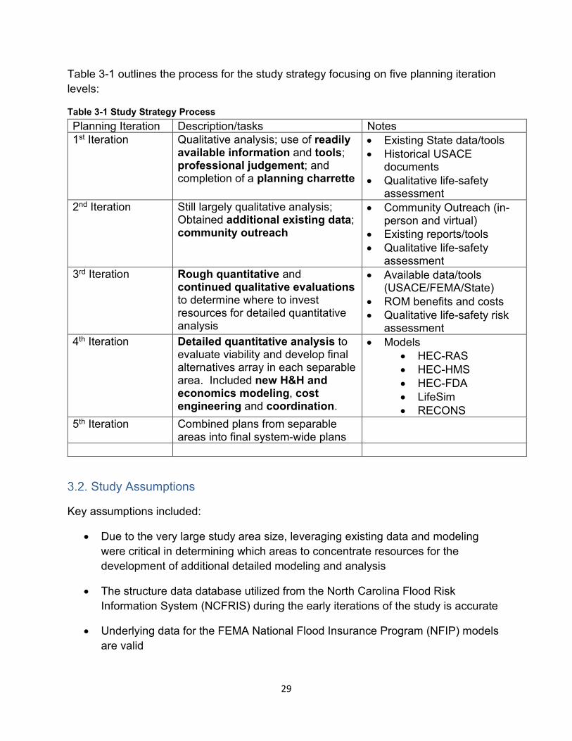
Table 3-1 outlines the process for the study strategy focusing on five planning iteration levels:
Table 3-1 Study Strategy Process Planning Iteration Description/tasks Notes 1st Iteration Qualitative analysis; use of readily
available information and tools; professional judgement; and completion of a planning charrette
• Existing State data/tools • Historical USACE
documents • Qualitative life-safety
assessment 2nd Iteration Still largely qualitative analysis;
Obtained additional existing data; community outreach
• Community Outreach (in-person and virtual)
• Existing reports/tools • Qualitative life-safety
assessment 3rd Iteration Rough quantitative and
continued qualitative evaluations to determine where to invest resources for detailed quantitative analysis
• Available data/tools (USACE/FEMA/State)
• ROM benefits and costs • Qualitative life-safety risk
assessment 4th Iteration Detailed quantitative analysis to
evaluate viability and develop final alternatives array in each separable area. Included new H&H and economics modeling, cost engineering and coordination.
• Models • HEC-RAS • HEC-HMS • HEC-FDA • LifeSim • RECONS
5th Iteration Combined plans from separable areas into final system-wide plans
Study Assumptions
Key assumptions included:
• Due to the very large study area size, leveraging existing data and modeling were critical in determining which areas to concentrate resources for the development of additional detailed modeling and analysis
• The structure data database utilized from the North Carolina Flood Risk Information System (NCFRIS) during the early iterations of the study is accurate
• Underlying data for the FEMA National Flood Insurance Program (NFIP) models are valid
29
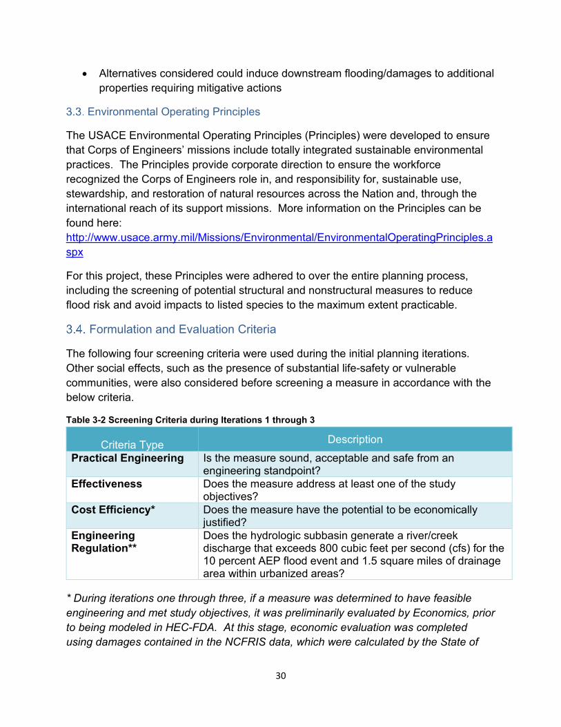
• Alternatives considered could induce downstream flooding/damages to additional properties requiring mitigative actions
Environmental Operating Principles
The USACE Environmental Operating Principles (Principles) were developed to ensure that Corps of Engineers’ missions include totally integrated sustainable environmental practices. The Principles provide corporate direction to ensure the workforce recognized the Corps of Engineers role in, and responsibility for, sustainable use, stewardship, and restoration of natural resources across the Nation and, through the international reach of its support missions. More information on the Principles can be found here: http://www.usace.army.mil/Missions/Environmental/EnvironmentalOperatingPrinciples.a spx
For this project, these Principles were adhered to over the entire planning process, including the screening of potential structural and nonstructural measures to reduce flood risk and avoid impacts to listed species to the maximum extent practicable.
Formulation and Evaluation Criteria
The following four screening criteria were used during the initial planning iterations. Other social effects, such as the presence of substantial life-safety or vulnerable communities, were also considered before screening a measure in accordance with the below criteria.
Table 3-2 Screening Criteria during Iterations 1 through 3
Criteria Type Description Practical Engineering Is the measure sound, acceptable and safe from an
engineering standpoint? Effectiveness Does the measure address at least one of the study
objectives? Cost Efficiency* Does the measure have the potential to be economically
justified? Engineering Regulation**
Does the hydrologic subbasin generate a river/creek discharge that exceeds 800 cubic feet per second (cfs) for the 10 percent AEP flood event and 1.5 square miles of drainage area within urbanized areas?
* During iterations one through three, if a measure was determined to have feasible engineering and met study objectives, it was preliminarily evaluated by Economics, prior to being modeled in HEC-FDA. At this stage, economic evaluation was completed using damages contained in the NCFRIS data, which were calculated by the State of
30

North Carolina using FEMA’s HAZUS model. Measures were screened in areas with very low damages, where the likelihood of Federal interest in a project was deemed to be zero.
** Engineering Regulation (ER) 1165-2-21 was used as an initial criterion for screening and resulted in a substantial number of measures in urbanized areas located on tributaries of the Neuse River to be eliminated from consideration. These measures may still be viable efforts for other entities to investigate further but were not carried forward as part of this feasibility study.
Measures which were still considered viable after the initial 3 iterations were carried forward into the 4th iteration for more detailed quantitative analysis, and screened against the following four planning criteria:
31
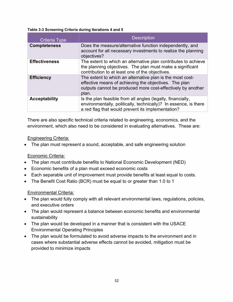
Table 3-3 Screening Criteria during Iterations 4 and 5
Criteria Type Description Completeness Does the measure/alternative function independently, and
account for all necessary investments to realize the planning objectives?
Effectiveness The extent to which an alternative plan contributes to achieve the planning objectives. The plan must make a significant contribution to at least one of the objectives.
Efficiency The extent to which an alternative plan is the most cost-effective means of achieving the objectives. The plan outputs cannot be produced more cost-effectively by another plan.
Acceptability Is the plan feasible from all angles (legally, financially, environmentally, politically, technically)? In essence, is there a red flag that would prevent its implementation?
There are also specific technical criteria related to engineering, economics, and the environment, which also need to be considered in evaluating alternatives. These are:
Engineering Criteria: • The plan must represent a sound, acceptable, and safe engineering solution
Economic Criteria: • The plan must contribute benefits to National Economic Development (NED) • Economic benefits of a plan must exceed economic costs • Each separable unit of improvement must provide benefits at least equal to costs. • The Benefit Cost Ratio (BCR) must be equal to or greater than 1.0 to 1
Environmental Criteria: • The plan would fully comply with all relevant environmental laws, regulations, policies,
and executive orders • The plan would represent a balance between economic benefits and environmental
sustainability • The plan would be developed in a manner that is consistent with the USACE
Environmental Operating Principles • The plan would be formulated to avoid adverse impacts to the environment and in
cases where substantial adverse effects cannot be avoided, mitigation must be provided to minimize impacts
32
Management Measure Identification and Screening
A management measure is defined by this study as an action that is intended to contribute to meeting the study objectives.
The process of developing measures consisted of several factors, as follows:
• Use of extensive existing data, models, and reports • Professional judgement • Planning Charrette meeting held to inform potential flood risk management
measures • Public outreach to affected counties and municipalities • State and local government coordination • Supplemental technical modeling
Measures were considered in three categories, as follows:
• Structural • Nonstructural • Natural and Nature-based Features
Structural Measures (S) – Measures that reduce or avoid flood damages by modifying the nature or extent of the flood hazard.
Nonstructural Measures (NS) – Measures that reduce or avoid flood damages, without significantly modifying the nature or extent of flooding. This is done by changing the use made of floodplains or accommodating existing uses to the flood hazard.
Natural and Nature-based Features (NNBF) – Use of natural features, or features created by human design, engineering, and construction that work in concert with natural processes or that mimic natural conditions in the area absent human changes to the landscape or hydrology. NNBFs can be structural or nonstructural in nature.
As described in Section 3.1, Study Strategy, five planning iterations were conducted. Many measures were identified in the first iteration through a combination of reviewing existing reports, studies, and data, as well as coordinating with the sponsor and stakeholders in combination with professional judgement. As measures were identified, they were categorized as either basinwide measures, or site-specific measures within each focus area. The majority of measures identified were site-specific.
33

The following table shows the measures considered and the screening process for each (Table 3-4). Additional details on all structural measures evaluated in the following table are further described in Appendix A (Hydrology and Hydraulics):
34
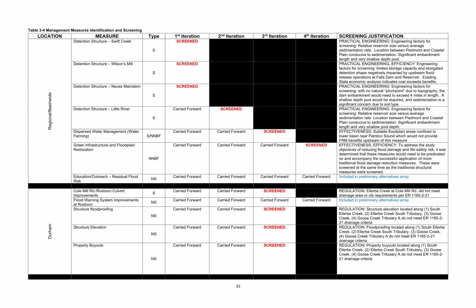
Table 3-4 Management Measures Identification and Screening LOCATION MEASURE Type 1st Iteration 2nd Iteration 3rd Iteration 4th Iteration SCREENING JUSTIFICATION
Reg
iona
l/Bas
inw
ide
Detention Structure – Swift Creek
S
SCREENED PRACTICAL ENGINEERING: Engineering factors for screening: Relative reservoir size versus average sedimentation rate. Location between Piedmont and Coastal Plain conducive to sedimentation. Significant embankment length and very shallow depth pool.
Detention Structure – Wilson’s Mill
S
SCREENED PRACTICAL ENGINEERING, EFFICIENCY: Engineering factors for screening: limited storage capacity and elongated detention shape negatively impacted by upstream flood release operations at Falls Dam and Reservoir. Existing State economic analysis indicates cost exceeds benefits.
Detention Structure – Neuse Mainstem
S
SCREENED PRACTICAL ENGINEERING: Engineering factors for screening: with no natural “pinchpoint” due to topography, the dam embankment would need to exceed 4 miles in length. A shallow depth pool would be required, and sedimentation is a significant concern due to soil type.
Detention Structure – Little River
S
Carried Forward SCREENED PRACTICAL ENGINEERING: Engineering factors for screening: Relative reservoir size versus average sedimentation rate. Location between Piedmont and Coastal Plain conducive to sedimentation. Significant embankment length and very shallow pool depth.
Dispersed Water Management (Water Farming) S/NNBF
Carried Forward Carried Forward SCREENED EFFECTIVENESS: Suitable floodplain areas confined to lower basin near Pamlico Sound which would not provide FRM benefits upstream of this measure
Green Infrastructure and Floodplain Restoration
NNBF
Carried Forward Carried Forward Carried Forward SCREENED EFFECTIVENESS, EFFICIENCY: To address the study objectives of reducing flood damage and life-safety risk, it was determined that these measures would need to be predicated on and accompany the successful application of more traditional flood damage reduction measures. These were screened at the same time as the traditional structural measures were screened.
Education/Outreach – Residual Flood Risk NS Carried Forward Carried Forward Carried Forward Carried Forward Included in preliminary alternatives array
Dur
ham
Cole Mill Rd./Roxboro Culvert Improvements S Carried Forward Carried Forward SCREENED REGULATION: Ellerbe Creek at Cole Mill Rd. did not meet
drainage area or cfs requirements per ER 1165-2-21 Flood Warning System Improvements at Roxboro NS Carried Forward Carried Forward Carried Forward Carried Forward Included in preliminary alternatives array
Structure floodproofing
NS
Carried Forward Carried Forward SCREENED REGULATION: Structure elevation located along (1) South Ellerbe Creek, (2) Ellerbe Creek South Tributary, (3) Goose Creek, (4) Goose Creek Tributary A do not meet ER 1165-2-21 drainage criteria
Structure Elevation
NS
Carried Forward Carried Forward SCREENED REGULATION: Floodproofing located along (1) South Ellerbe Creek, (2) Ellerbe Creek South Tributary, (3) Goose Creek, (4) Goose Creek Tributary A do not meet ER 1165-2-21 drainage criteria
Property Buyouts
NS
Carried Forward Carried Forward SCREENED REGULATION: Property buyouts located along (1) South Ellerbe Creek, (2) Ellerbe Creek South Tributary, (3) Goose Creek, (4) Goose Creek Tributary A do not meet ER 1165-2-21 drainage criteria
35
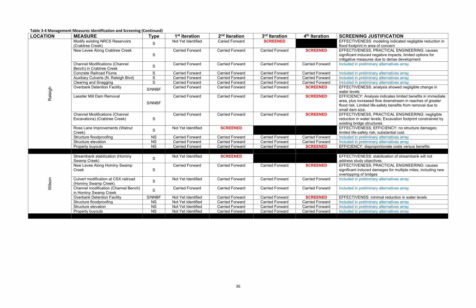
Table 3-4 Management Measures Identification and Screening (Continued) LOCATION MEASURE Type 1st Iteration 2nd Iteration 3rd Iteration 4th Iteration SCREENING JUSTIFICATION
Ral
eigh
Modify existing NRCS Reservoirs (Crabtree Creek) S Not Yet Identified Caried Forward SCREENED EFFECTIVENESS: modeling indicated negligible reduction in
flood footprint in area of concern New Levee Along Crabtree Creek
S Carried Forward Carried Forward Carried Forward SCREENED EFFECTIVENESS, PRACTICAL ENGINEERING: causes
significant induced negative impacts, limited options for mitigative measures due to dense development
Channel Modifications (Channel Bench) in Crabtree Creek S Carried Forward Carried Forward Carried Forward Carried Forward Included in preliminary alternatives array
Concrete Railroad Flume S Carried Forward Carried Forward Carried Forward Carried Forward Included in preliminary alternatives array Auxiliary Culverts (N. Raleigh Blvd) S Carried Forward Carried Forward Carried Forward Carried Forward Included in preliminary alternatives array Clearing and Snagging S Carried Forward Carried Forward Carried Forward Carried Forward Included in preliminary alternatives array Overbank Detention Facility S/NNBF Carried Forward Carried Forward Carried Forward SCREENED EFFECTIVENESS: analysis showed negligible change in
water levels Lassiter Mill Dam Removal
S/NNBF
Carried Forward Carried Forward Carried Forward SCREENED EFFICIENCY: Analysis indicates limited benefits in immediate area, plus increased flow downstream in reaches of greater flood risk. Limited life-safety benefits from removal due to small dam size.
Channel Modifications (Channel Excavations) (Crabtree Creek) S
Carried Forward Carried Forward Carried Forward SCREENED EFFECTIVENESS, PRACTICAL ENGINEERING: negligible reduction in water levels; Excavation footprint constrained by existing bridge structures.
Rose Lane Improvements (Walnut Creek) S Not Yet Identified SCREENED EFFECTIVENESS; EFFICIENCY: no structure damages;
limited life-safety risk; substantial cost. Structure floodproofing NS Carried Forward Carried Forward Carried Forward Carried Forward Included in preliminary alternatives array Structure elevation NS Carried Forward Carried Forward Carried Forward Carried Forward Included in preliminary alternatives array Property buyouts NS Carried Forward Carried Forward Carried Forward SCREENED EFFICIENCY: disproportionate costs versus benefits
Wils
on
Streambank stabilization (Hominy Swamp Creek) S Not Yet Identified SCREENED EFFECTIVENESS: stabilization of streambank will not
address study objectives. New Levee Along Hominy Swamp Creek S
Carried Forward Carried Forward Carried Forward SCREENED EFFECTIVENESS; PRACTICAL ENGINEERING: causes significant induced damages for multiple miles, including new overtopping of bridges
Culvert modification at CSX railroad (Hominy Swamp Creek) S Not Yet Identified Carried Forward Carried Forward Carried Forward Included in preliminary alternatives array
Channel modification (Channel Bench) in Hominy Swamp Creek S Carried Forward Carried Forward Carried Forward Carried Forward Included in preliminary alternatives array
Overbank Detention Facility S/NNBF Not Yet Identified Carried Forward Carried Forward SCREENED EFFECTIVENSS: minimal reduction in water levels Structure floodproofing NS Not Yet Identified Carried Forward Carried Forward Carried Forward Included in preliminary alternatives array Structure elevation NS Not Yet Identified Carried Forward Carried Forward Carried Forward Included in preliminary alternatives array Property buyouts NS Not Yet Identified Carried Forward Carried Forward Carried Forward Included in preliminary alternatives array
36
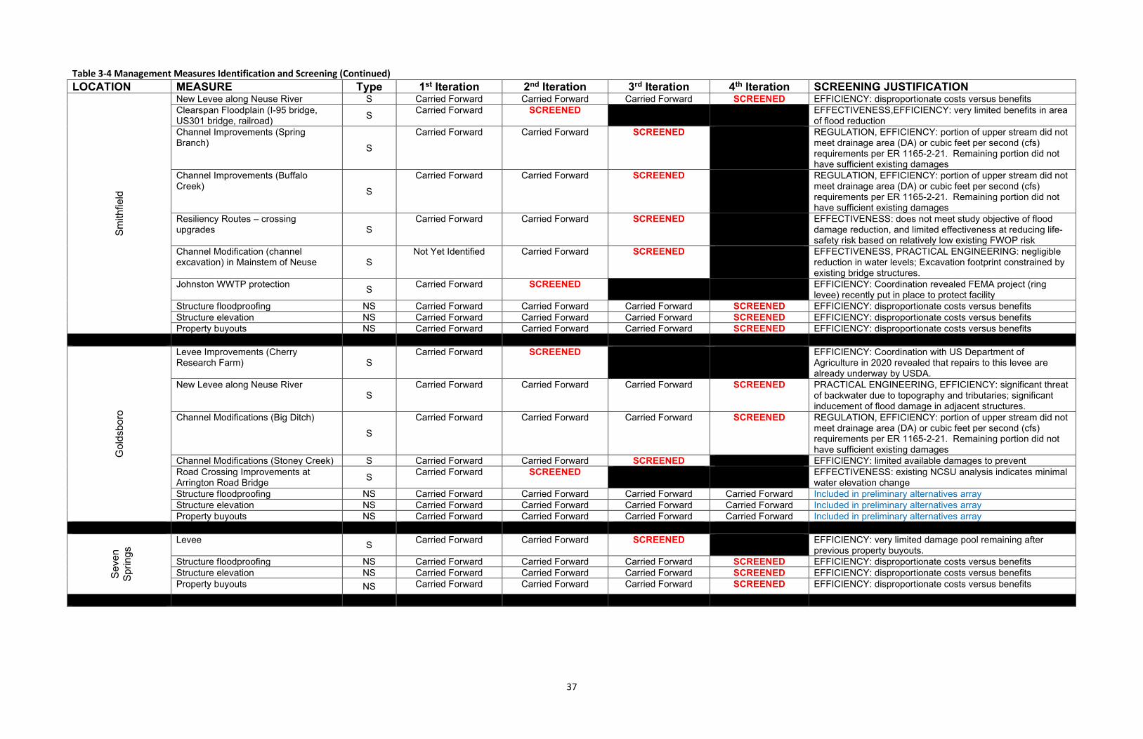
Table 3-4 Management Measures Identification and Screening (Continued) LOCATION MEASURE Type 1st Iteration 2nd Iteration 3rd Iteration 4th Iteration SCREENING JUSTIFICATION
Smith
field
New Levee along Neuse River S Carried Forward Carried Forward Carried Forward SCREENED EFFICIENCY: disproportionate costs versus benefits Clearspan Floodplain (I-95 bridge, US301 bridge, railroad) S Carried Forward SCREENED EFFECTIVENESS,EFFICIENCY: very limited benefits in area
of flood reduction Channel Improvements (Spring Branch) S
Carried Forward Carried Forward SCREENED REGULATION, EFFICIENCY: portion of upper stream did not meet drainage area (DA) or cubic feet per second (cfs) requirements per ER 1165-2-21. Remaining portion did not have sufficient existing damages
Channel Improvements (Buffalo Creek) S
Carried Forward Carried Forward SCREENED REGULATION, EFFICIENCY: portion of upper stream did not meet drainage area (DA) or cubic feet per second (cfs) requirements per ER 1165-2-21. Remaining portion did not have sufficient existing damages
Resiliency Routes – crossing upgrades S
Carried Forward Carried Forward SCREENED EFFECTIVENESS: does not meet study objective of flood damage reduction, and limited effectiveness at reducing life-safety risk based on relatively low existing FWOP risk
Channel Modification (channel excavation) in Mainstem of Neuse S
Not Yet Identified Carried Forward SCREENED EFFECTIVENESS, PRACTICAL ENGINEERING: negligible reduction in water levels; Excavation footprint constrained by existing bridge structures.
Johnston WWTP protection S Carried Forward SCREENED EFFICIENCY: Coordination revealed FEMA project (ring levee) recently put in place to protect facility
Structure floodproofing NS Carried Forward Carried Forward Carried Forward SCREENED EFFICIENCY: disproportionate costs versus benefits Structure elevation NS Carried Forward Carried Forward Carried Forward SCREENED EFFICIENCY: disproportionate costs versus benefits Property buyouts NS Carried Forward Carried Forward Carried Forward SCREENED EFFICIENCY: disproportionate costs versus benefits
Gol
dsbo
ro
Levee Improvements (Cherry Research Farm) S
Carried Forward SCREENED EFFICIENCY: Coordination with US Department of Agriculture in 2020 revealed that repairs to this levee are already underway by USDA.
New Levee along Neuse River S
Carried Forward Carried Forward Carried Forward SCREENED PRACTICAL ENGINEERING, EFFICIENCY: significant threat of backwater due to topography and tributaries; significant inducement of flood damage in adjacent structures.
Channel Modifications (Big Ditch)
S
Carried Forward Carried Forward Carried Forward SCREENED REGULATION, EFFICIENCY: portion of upper stream did not meet drainage area (DA) or cubic feet per second (cfs) requirements per ER 1165-2-21. Remaining portion did not have sufficient existing damages
Channel Modifications (Stoney Creek) S Carried Forward Carried Forward SCREENED EFFICIENCY: limited available damages to prevent Road Crossing Improvements at Arrington Road Bridge S Carried Forward SCREENED EFFECTIVENESS: existing NCSU analysis indicates minimal
water elevation change Structure floodproofing NS Carried Forward Carried Forward Carried Forward Carried Forward Included in preliminary alternatives array Structure elevation NS Carried Forward Carried Forward Carried Forward Carried Forward Included in preliminary alternatives array Property buyouts NS Carried Forward Carried Forward Carried Forward Carried Forward Included in preliminary alternatives array
Seve
n Sp
rings
Levee S Carried Forward Carried Forward SCREENED EFFICIENCY: very limited damage pool remaining after previous property buyouts.
Structure floodproofing NS Carried Forward Carried Forward Carried Forward SCREENED EFFICIENCY: disproportionate costs versus benefits Structure elevation NS Carried Forward Carried Forward Carried Forward SCREENED EFFICIENCY: disproportionate costs versus benefits Property buyouts NS Carried Forward Carried Forward Carried Forward SCREENED EFFICIENCY: disproportionate costs versus benefits
37
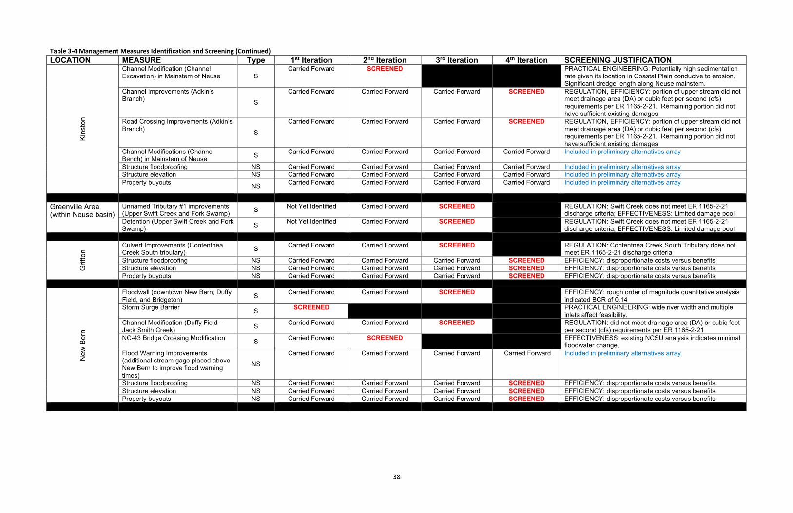
Table 3-4 Management Measures Identification and Screening (Continued) LOCATION MEASURE Type 1st Iteration 2nd Iteration 3rd Iteration 4th Iteration SCREENING JUSTIFICATION
Kins
ton
Channel Modification (Channel Excavation) in Mainstem of Neuse S
Carried Forward SCREENED PRACTICAL ENGINEERING: Potentially high sedimentation rate given its location in Coastal Plain conducive to erosion. Significant dredge length along Neuse mainstem.
Channel Improvements (Adkin’s Branch) S
Carried Forward Carried Forward Carried Forward SCREENED REGULATION, EFFICIENCY: portion of upper stream did not meet drainage area (DA) or cubic feet per second (cfs) requirements per ER 1165-2-21. Remaining portion did not have sufficient existing damages
Road Crossing Improvements (Adkin’s Branch) S
Carried Forward Carried Forward Carried Forward SCREENED REGULATION, EFFICIENCY: portion of upper stream did not meet drainage area (DA) or cubic feet per second (cfs) requirements per ER 1165-2-21. Remaining portion did not have sufficient existing damages
Channel Modifications (Channel Bench) in Mainstem of Neuse S Carried Forward Carried Forward Carried Forward Carried Forward Included in preliminary alternatives array
Structure floodproofing NS Carried Forward Carried Forward Carried Forward Carried Forward Included in preliminary alternatives array Structure elevation NS Carried Forward Carried Forward Carried Forward Carried Forward Included in preliminary alternatives array Property buyouts NS Carried Forward Carried Forward Carried Forward Carried Forward Included in preliminary alternatives array
Greenville Area (within Neuse basin)
Unnamed Tributary #1 improvements (Upper Swift Creek and Fork Swamp) S Not Yet Identified Carried Forward SCREENED REGULATION: Swift Creek does not meet ER 1165-2-21
discharge criteria; EFFECTIVENESS: Limited damage pool Detention (Upper Swift Creek and Fork Swamp) S Not Yet Identified Carried Forward SCREENED REGULATION: Swift Creek does not meet ER 1165-2-21
discharge criteria; EFFECTIVENESS: Limited damage pool
Grif
ton
Culvert Improvements (Contentnea Creek South tributary) S Carried Forward Carried Forward SCREENED REGULATION: Contentnea Creek South Tributary does not
meet ER 1165-2-21 discharge criteria Structure floodproofing NS Carried Forward Carried Forward Carried Forward SCREENED EFFICIENCY: disproportionate costs versus benefits Structure elevation NS Carried Forward Carried Forward Carried Forward SCREENED EFFICIENCY: disproportionate costs versus benefits Property buyouts NS Carried Forward Carried Forward Carried Forward SCREENED EFFICIENCY: disproportionate costs versus benefits
New
Ber
n
Floodwall (downtown New Bern, Duffy Field, and Bridgeton) S Carried Forward Carried Forward SCREENED EFFICIENCY: rough order of magnitude quantitative analysis
indicated BCR of 0.14 Storm Surge Barrier S SCREENED PRACTICAL ENGINEERING: wide river width and multiple
inlets affect feasibility. Channel Modification (Duffy Field – Jack Smith Creek) S Carried Forward Carried Forward SCREENED REGULATION: did not meet drainage area (DA) or cubic feet
per second (cfs) requirements per ER 1165-2-21 NC-43 Bridge Crossing Modification S Carried Forward SCREENED EFFECTIVENESS: existing NCSU analysis indicates minimal
floodwater change. Flood Warning Improvements (additional stream gage placed above New Bern to improve flood warning times)
NS
Carried Forward Carried Forward Carried Forward Carried Forward Included in preliminary alternatives array.
Structure floodproofing NS Carried Forward Carried Forward Carried Forward SCREENED EFFICIENCY: disproportionate costs versus benefits Structure elevation NS Carried Forward Carried Forward Carried Forward SCREENED EFFICIENCY: disproportionate costs versus benefits Property buyouts NS Carried Forward Carried Forward Carried Forward SCREENED EFFICIENCY: disproportionate costs versus benefits
38
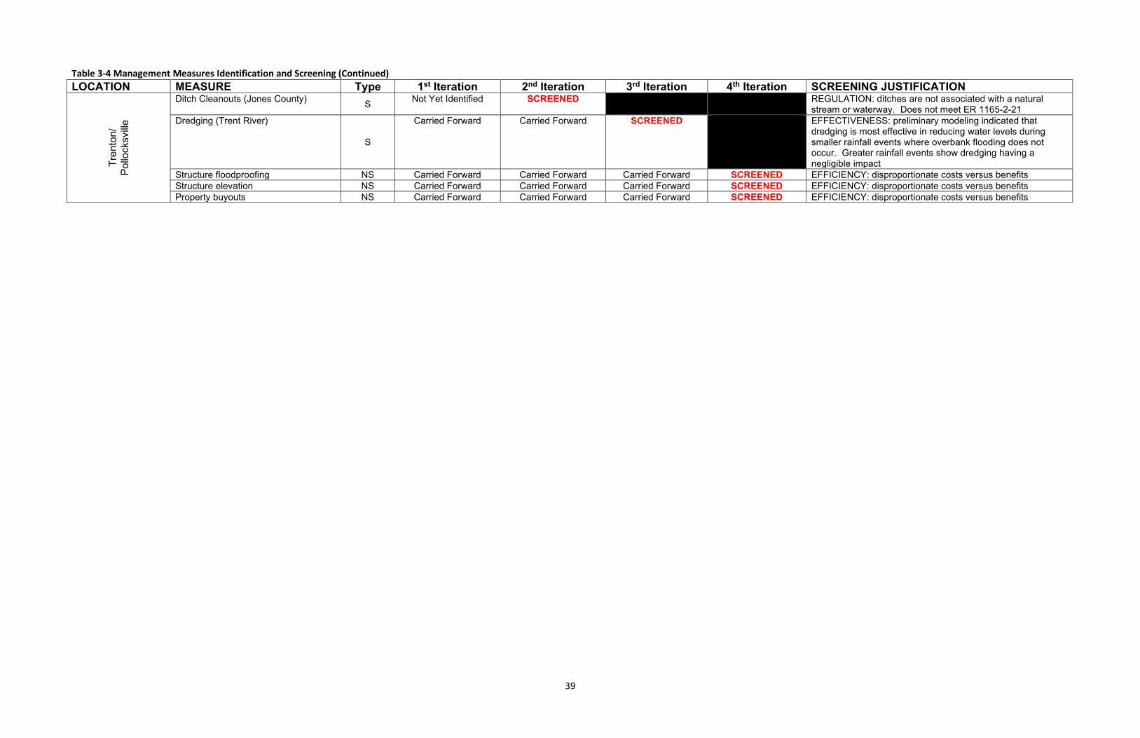
Table 3-4 Management Measures Identification and Screening (Continued) LOCATION MEASURE Type 1st Iteration 2nd Iteration 3rd Iteration 4th Iteration SCREENING JUSTIFICATION
Tren
ton/
Pollo
cksv
ille
Ditch Cleanouts (Jones County) S Not Yet Identified SCREENED REGULATION: ditches are not associated with a natural stream or waterway. Does not meet ER 1165-2-21
Dredging (Trent River)
S
Carried Forward Carried Forward SCREENED EFFECTIVENESS: preliminary modeling indicated that dredging is most effective in reducing water levels during smaller rainfall events where overbank flooding does not occur. Greater rainfall events show dredging having a negligible impact
Structure floodproofing NS Carried Forward Carried Forward Carried Forward SCREENED EFFICIENCY: disproportionate costs versus benefits Structure elevation NS Carried Forward Carried Forward Carried Forward SCREENED EFFICIENCY: disproportionate costs versus benefits Property buyouts NS Carried Forward Carried Forward Carried Forward SCREENED EFFICIENCY: disproportionate costs versus benefits
39
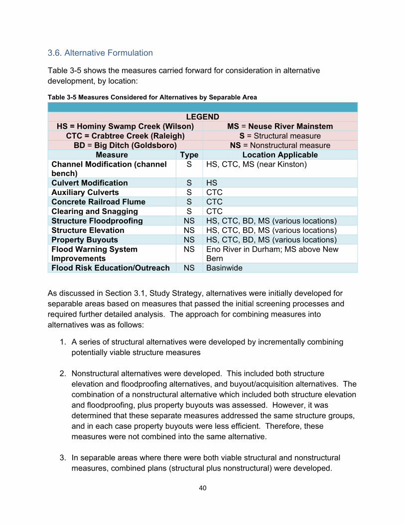
Alternative Formulation
Table 3-5 shows the measures carried forward for consideration in alternative development, by location:
Table 3-5 Measures Considered for Alternatives by Separable Area
LEGEND HS = Hominy Swamp Creek (Wilson) MS = Neuse River Mainstem
CTC = Crabtree Creek (Raleigh) S = Structural measure BD = Big Ditch (Goldsboro) NS = Nonstructural measure
Measure Type Location Applicable Channel Modification (channelbench)
S HS, CTC, MS (near Kinston)
Culvert Modification S HS Auxiliary Culverts S CTC Concrete Railroad Flume S CTC Clearing and Snagging S CTC Structure Floodproofing NS HS, CTC, BD, MS (various locations) Structure Elevation NS HS, CTC, BD, MS (various locations) Property Buyouts NS HS, CTC, BD, MS (various locations) Flood Warning SystemImprovements
NS Eno River in Durham; MS above New Bern
Flood Risk Education/Outreach NS Basinwide
As discussed in Section 3.1, Study Strategy, alternatives were initially developed for separable areas based on measures that passed the initial screening processes and required further detailed analysis. The approach for combining measures into alternatives was as follows:
1. A series of structural alternatives were developed by incrementally combining potentially viable structure measures
2. Nonstructural alternatives were developed. This included both structure elevation and floodproofing alternatives, and buyout/acquisition alternatives. The combination of a nonstructural alternative which included both structure elevation and floodproofing, plus property buyouts was assessed. However, it was determined that these separate measures addressed the same structure groups, and in each case property buyouts were less efficient. Therefore, these measures were not combined into the same alternative.
3. In separable areas where there were both viable structural and nonstructural measures, combined plans (structural plus nonstructural) were developed.
40
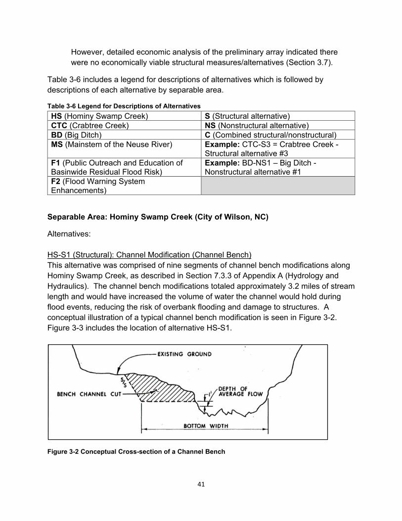
However, detailed economic analysis of the preliminary array indicated there were no economically viable structural measures/alternatives (Section 3.7).
Table 3-6 includes a legend for descriptions of alternatives which is followed by descriptions of each alternative by separable area.
Table 3-6 Legend for Descriptions of Alternatives HS (Hominy Swamp Creek) S (Structural alternative) CTC (Crabtree Creek) NS (Nonstructural alternative) BD (Big Ditch) C (Combined structural/nonstructural) MS (Mainstem of the Neuse River) Example: CTC-S3 = Crabtree Creek -
Structural alternative #3 F1 (Public Outreach and Education of Basinwide Residual Flood Risk)
Example: BD-NS1 – Big Ditch -Nonstructural alternative #1
F2 (Flood Warning System Enhancements)
Separable Area: Hominy Swamp Creek (City of Wilson, NC)
Alternatives:
HS-S1 (Structural): Channel Modification (Channel Bench) This alternative was comprised of nine segments of channel bench modifications along Hominy Swamp Creek, as described in Section 7.3.3 of Appendix A (Hydrology and Hydraulics). The channel bench modifications totaled approximately 3.2 miles of stream length and would have increased the volume of water the channel would hold during flood events, reducing the risk of overbank flooding and damage to structures. A conceptual illustration of a typical channel bench modification is seen in Figure 3-2. Figure 3-3 includes the location of alternative HS-S1.
Figure 3-2 Conceptual Cross-section of a Channel Bench
41
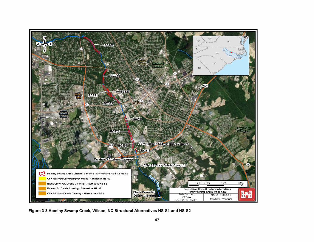
Figure 3-3 Hominy Swamp Creek, Wilson, NC Structural Alternatives HS-S1 and HS-S2
42
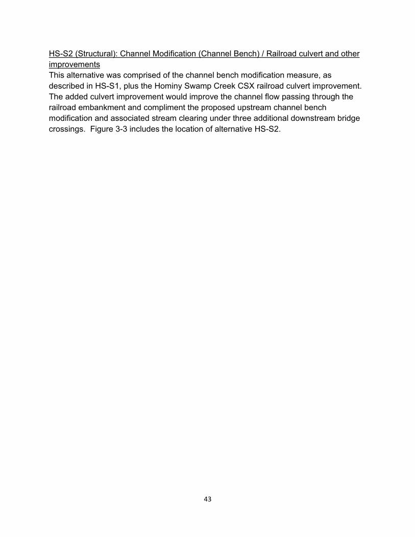
HS-S2 (Structural): Channel Modification (Channel Bench) / Railroad culvert and other improvements This alternative was comprised of the channel bench modification measure, as described in HS-S1, plus the Hominy Swamp Creek CSX railroad culvert improvement. The added culvert improvement would improve the channel flow passing through the railroad embankment and compliment the proposed upstream channel bench modification and associated stream clearing under three additional downstream bridge crossings. Figure 3-3 includes the location of alternative HS-S2.
43
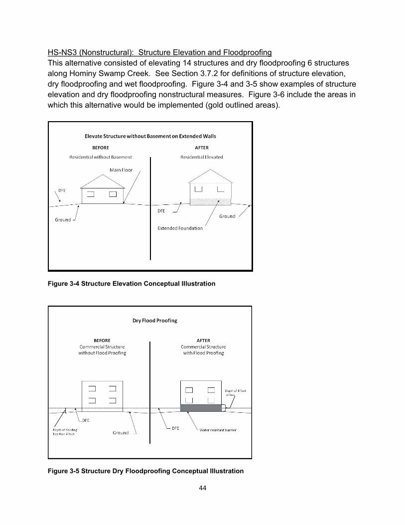
HS-NS3 (Nonstructural): Structure Elevation and Floodproofing This alternative consisted of elevating 14 structures and dry floodproofing 6 structures along Hominy Swamp Creek. See Section 3.7.2 for definitions of structure elevation, dry floodproofing and wet floodproofing. Figure 3-4 and 3-5 show examples of structure elevation and dry floodproofing nonstructural measures. Figure 3-6 include the areas in which this alternative would be implemented (gold outlined areas).
Figure 3-4 Structure Elevation Conceptual Illustration
Figure 3-5 Structure Dry Floodproofing Conceptual Illustration
44
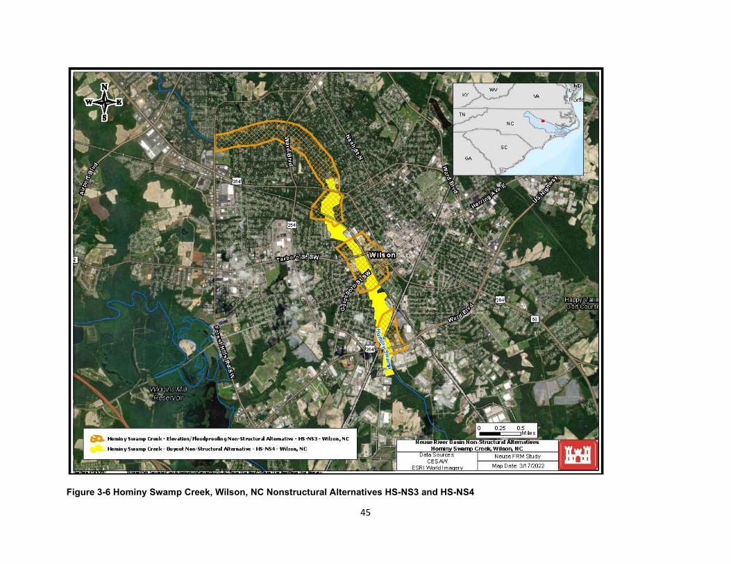
Figure 3-6 Hominy Swamp Creek, Wilson, NC Nonstructural Alternatives HS-NS3 and HS-NS4
45
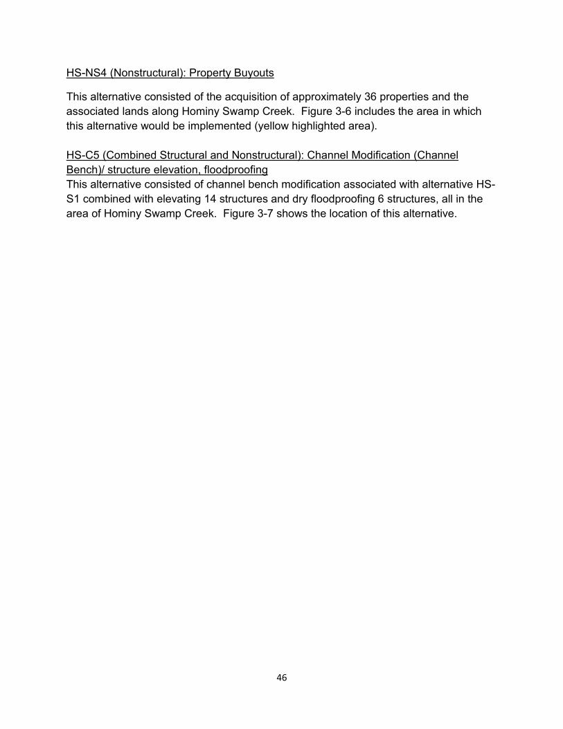
HS-NS4 (Nonstructural): Property Buyouts
This alternative consisted of the acquisition of approximately 36 properties and the associated lands along Hominy Swamp Creek. Figure 3-6 includes the area in which this alternative would be implemented (yellow highlighted area).
HS-C5 (Combined Structural and Nonstructural): Channel Modification (Channel Bench)/ structure elevation, floodproofing This alternative consisted of channel bench modification associated with alternative HS-S1 combined with elevating 14 structures and dry floodproofing 6 structures, all in the area of Hominy Swamp Creek. Figure 3-7 shows the location of this alternative.
46
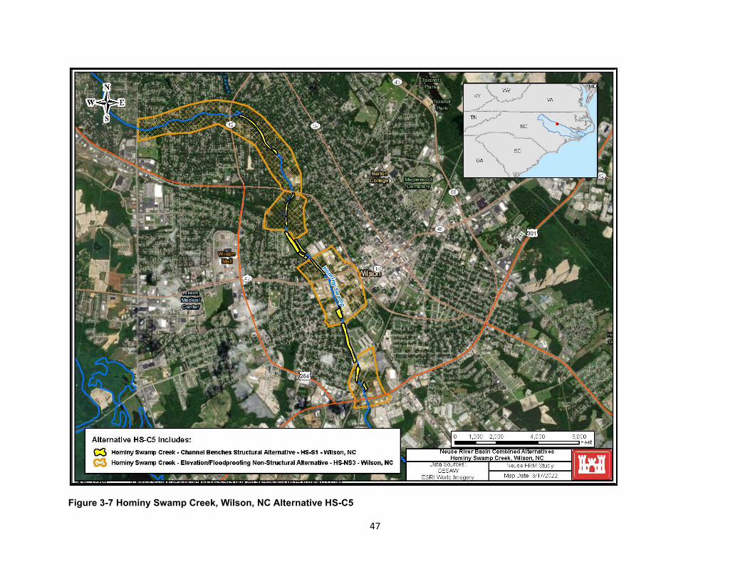
Figure 3-7 Hominy Swamp Creek, Wilson, NC Alternative HS-C5
47
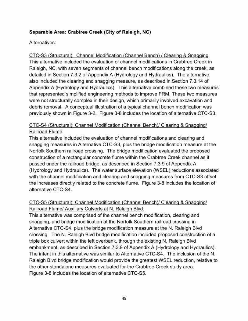
Separable Area: Crabtree Creek (City of Raleigh, NC)
Alternatives:
CTC-S3 (Structural): Channel Modification (Channel Bench) / Clearing & Snagging This alternative included the evaluation of channel modifications in Crabtree Creek in Raleigh, NC, with seven segments of channel bench modifications along the creek, as detailed in Section 7.3.2 of Appendix A (Hydrology and Hydraulics). The alternative also included the clearing and snagging measure, as described in Section 7.3.14 of Appendix A (Hydrology and Hydraulics). This alternative combined these two measures that represented simplified engineering methods to improve FRM. These two measures were not structurally complex in their design, which primarily involved excavation and debris removal. A conceptual illustration of a typical channel bench modification was previously shown in Figure 3-2. Figure 3-8 includes the location of alternative CTC-S3.
CTC-S4 (Structural): Channel Modification (Channel Bench)/ Clearing & Snagging/ Railroad Flume This alternative included the evaluation of channel modifications and clearing and snagging measures in Alternative CTC-S3, plus the bridge modification measure at the Norfolk Southern railroad crossing. The bridge modification evaluated the proposed construction of a rectangular concrete flume within the Crabtree Creek channel as it passed under the railroad bridge, as described in Section 7.3.9 of Appendix A (Hydrology and Hydraulics). The water surface elevation (WSEL) reductions associated with the channel modification and clearing and snagging measures from CTC-S3 offset the increases directly related to the concrete flume. Figure 3-8 includes the location of alternative CTC-S4.
CTC-S5 (Structural): Channel Modification (Channel Bench)/ Clearing & Snagging/ Railroad Flume/ Auxiliary Culverts at N. Raleigh Blvd. This alternative was comprised of the channel bench modification, clearing and snagging, and bridge modification at the Norfolk Southern railroad crossing in Alternative CTC-S4, plus the bridge modification measure at the N. Raleigh Blvd crossing. The N. Raleigh Blvd bridge modification included proposed construction of a triple box culvert within the left overbank, through the existing N. Raleigh Blvd embankment, as described in Section 7.3.9 of Appendix A (Hydrology and Hydraulics). The intent in this alternative was similar to Alternative CTC-S4. The inclusion of the N. Raleigh Blvd bridge modification would provide the greatest WSEL reduction, relative to the other standalone measures evaluated for the Crabtree Creek study area. Figure 3-8 includes the location of alternative CTC-S5.
48
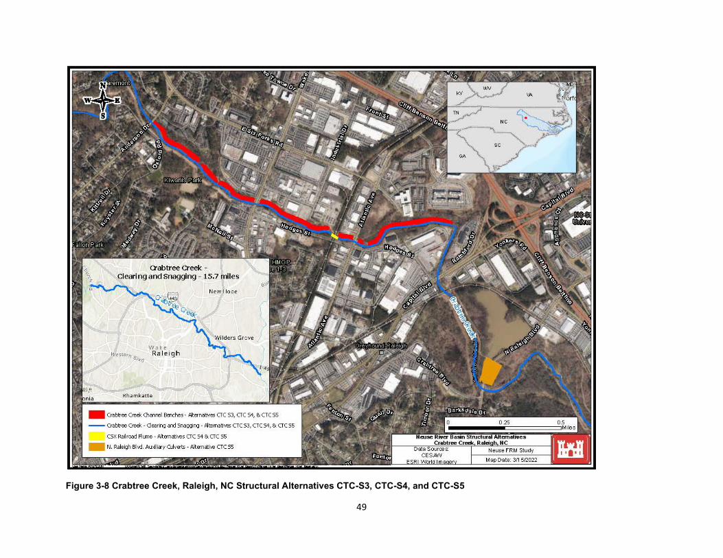
Figure 3-8 Crabtree Creek, Raleigh, NC Structural Alternatives CTC-S3, CTC-S4, and CTC-S5
49

CTC-NS6 (Nonstructural): Structure Elevation and Floodproofing This alternative consisted of elevating 38 structures, the wet floodproofing of 10 structures, and the dry floodproofing of 11 structures along Crabtree Creek in Raleigh. See Section 3.7.2 for definitions of structure elevation, dry floodproofing and wet floodproofing. Figures 3-4 and 3-5 show examples of structure elevation and dry floodproofing nonstructural measures. Figure 3-9 show the areas in which this alternative would be implemented.
50
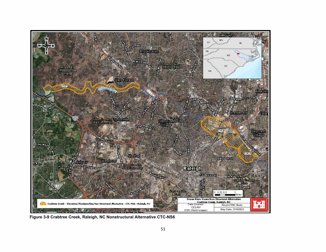
Figure 3-9 Crabtree Creek, Raleigh, NC Nonstructural Alternative CTC-NS6
51
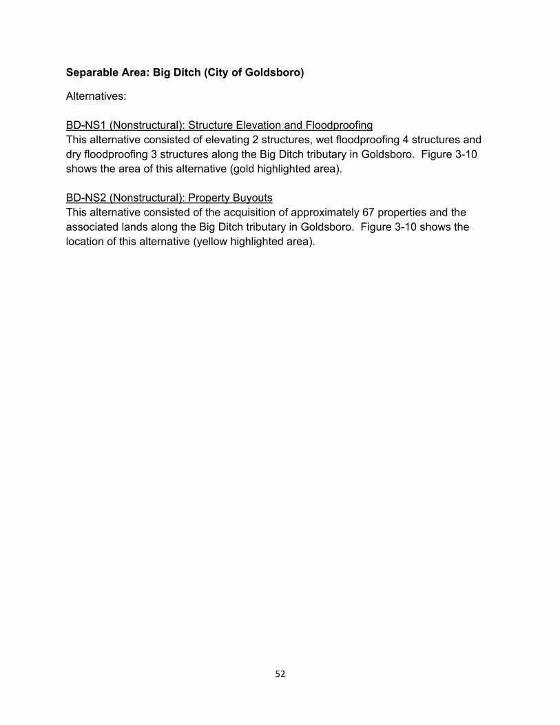
Separable Area: Big Ditch (City of Goldsboro)
Alternatives:
BD-NS1 (Nonstructural): Structure Elevation and Floodproofing This alternative consisted of elevating 2 structures, wet floodproofing 4 structures and dry floodproofing 3 structures along the Big Ditch tributary in Goldsboro. Figure 3-10 shows the area of this alternative (gold highlighted area).
BD-NS2 (Nonstructural): Property Buyouts This alternative consisted of the acquisition of approximately 67 properties and the associated lands along the Big Ditch tributary in Goldsboro. Figure 3-10 shows the location of this alternative (yellow highlighted area).
52
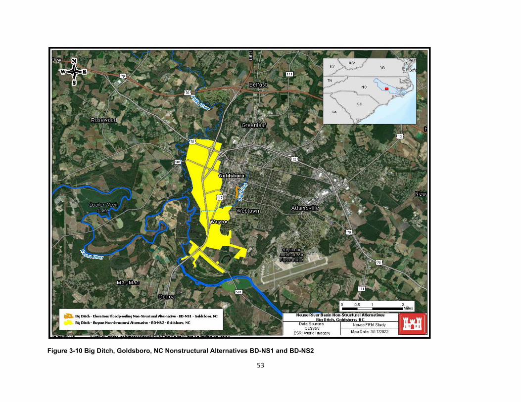
Figure 3-10 Big Ditch, Goldsboro, NC Nonstructural Alternatives BD-NS1 and BD-NS2
53
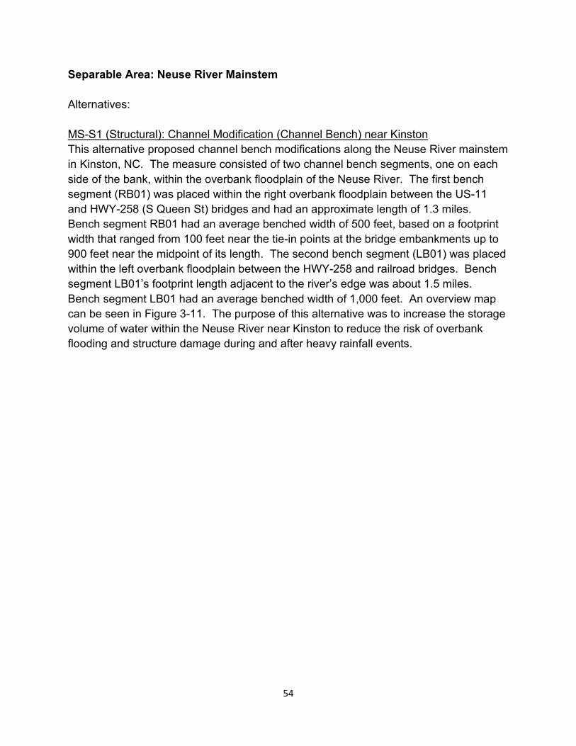
Separable Area: Neuse River Mainstem
Alternatives:
MS-S1 (Structural): Channel Modification (Channel Bench) near Kinston This alternative proposed channel bench modifications along the Neuse River mainstem in Kinston, NC. The measure consisted of two channel bench segments, one on each side of the bank, within the overbank floodplain of the Neuse River. The first bench segment (RB01) was placed within the right overbank floodplain between the US-11 and HWY-258 (S Queen St) bridges and had an approximate length of 1.3 miles. Bench segment RB01 had an average benched width of 500 feet, based on a footprint width that ranged from 100 feet near the tie-in points at the bridge embankments up to 900 feet near the midpoint of its length. The second bench segment (LB01) was placed within the left overbank floodplain between the HWY-258 and railroad bridges. Bench segment LB01’s footprint length adjacent to the river’s edge was about 1.5 miles. Bench segment LB01 had an average benched width of 1,000 feet. An overview map can be seen in Figure 3-11. The purpose of this alternative was to increase the storage volume of water within the Neuse River near Kinston to reduce the risk of overbank flooding and structure damage during and after heavy rainfall events.
54
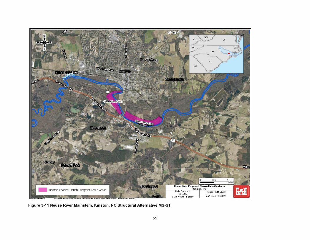
Figure 3-11 Neuse River Mainstem, Kinston, NC Structural Alternative MS-S1
55

MS-NS2 (Nonstructural): Structure Elevation and Floodproofing
This alternative consisted of elevating approximately 365 structures, and floodproofing approximately 315 structures along the Neuse River mainstem for an estimated total of 680 structures. Figure 3-12 shows the location in which this alternative would be implemented in Wayne and Johnston Counties.
56
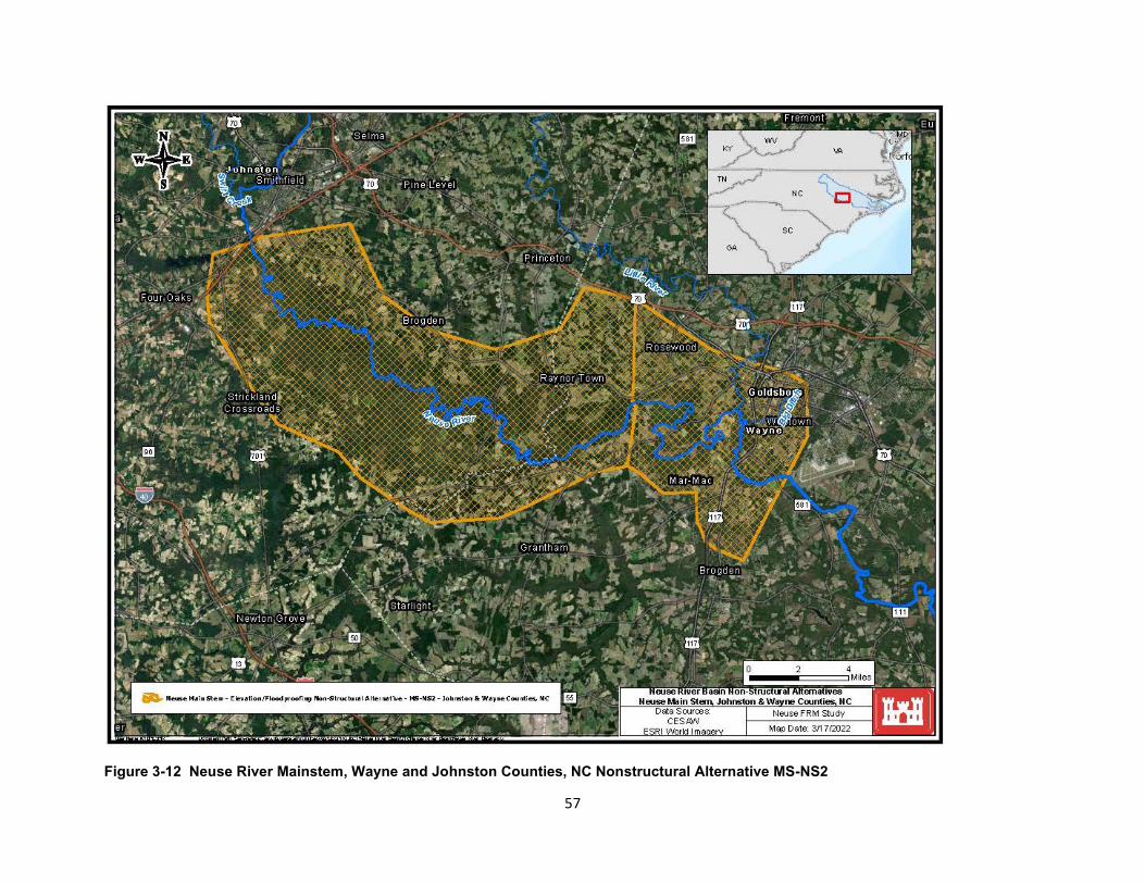
Figure 3-12 Neuse River Mainstem, Wayne and Johnston Counties, NC Nonstructural Alternative MS-NS2
57

MS-NS3 (Nonstructural): Property Buyouts This alternative consisted of acquisition of approximately 61 properties in Kinston and 67 properties in Goldsboro, for an estimated total of 128 properties, all located along the Neuse River mainstem. Figure 3-10 previously showed the location in which this alternative would be implemented west of Goldsboro, BD-NS2 (yellow highlighted area). Figure 3-13 shows the location in which this alternative would be implemented south of Kinston.
58
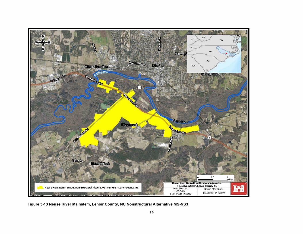
Figure 3-13 Neuse River Mainstem, Lenoir County, NC Nonstructural Alternative MS-NS3
59
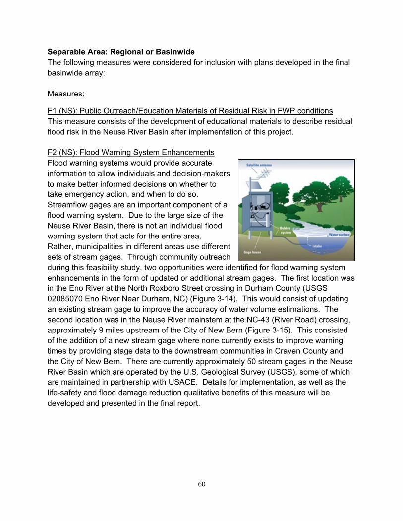
Separable Area: Regional or Basinwide The following measures were considered for inclusion with plans developed in the final basinwide array:
Measures:
F1 (NS): Public Outreach/Education Materials of Residual Risk in FWP conditions This measure consists of the development of educational materials to describe residual flood risk in the Neuse River Basin after implementation of this project.
F2 (NS): Flood Warning System Enhancements Flood warning systems would provide accurate information to allow individuals and decision-makers to make better informed decisions on whether to take emergency action, and when to do so. Streamflow gages are an important component of a flood warning system. Due to the large size of the Neuse River Basin, there is not an individual flood warning system that acts for the entire area. Rather, municipalities in different areas use different sets of stream gages. Through community outreach during this feasibility study, two opportunities were identified for flood warning system enhancements in the form of updated or additional stream gages. The first location was in the Eno River at the North Roxboro Street crossing in Durham County (USGS 02085070 Eno River Near Durham, NC) (Figure 3-14). This would consist of updating an existing stream gage to improve the accuracy of water volume estimations. The second location was in the Neuse River mainstem at the NC-43 (River Road) crossing, approximately 9 miles upstream of the City of New Bern (Figure 3-15). This consisted of the addition of a new stream gage where none currently exists to improve warning times by providing stage data to the downstream communities in Craven County and the City of New Bern. There are currently approximately 50 stream gages in the Neuse River Basin which are operated by the U.S. Geological Survey (USGS), some of which are maintained in partnership with USACE. Details for implementation, as well as the life-safety and flood damage reduction qualitative benefits of this measure will be developed and presented in the final report.
60
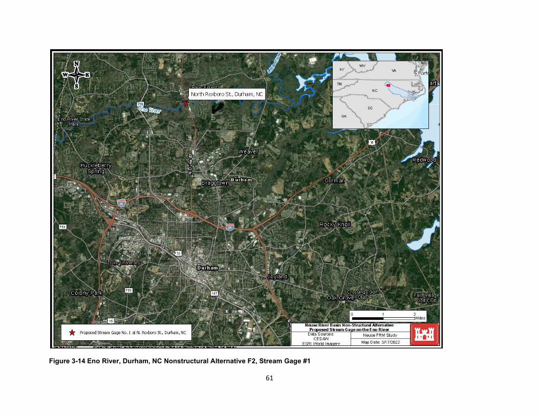
Figure 3-14 Eno River, Durham, NC Nonstructural Alternative F2, Stream Gage #1
61
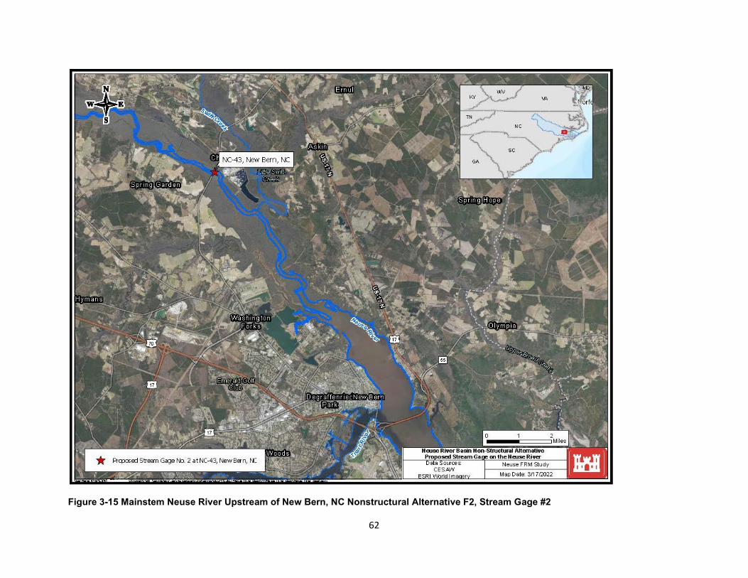
Figure 3-15 Mainstem Neuse River Upstream of New Bern, NC Nonstructural Alternative F2, Stream Gage #2
62
3.7 Alternative Evaluation and Comparison
3.7.1. Preliminary Alternatives by Separable Area
The alternatives developed for each separable area were evaluated against the four planning criteria of Completeness, Effectiveness, Efficiency, and Acceptability, as described in Section 3.4. For the Efficiency criteria, an economic assessment of costs and benefits was conducted and is summarized in Tables 3-7, 3-8, 3-9 and 3-10. Any alternative that did not meet the four planning criteria was removed from consideration in the final array of basinwide alternatives, as summarized in Table 3-11.
63
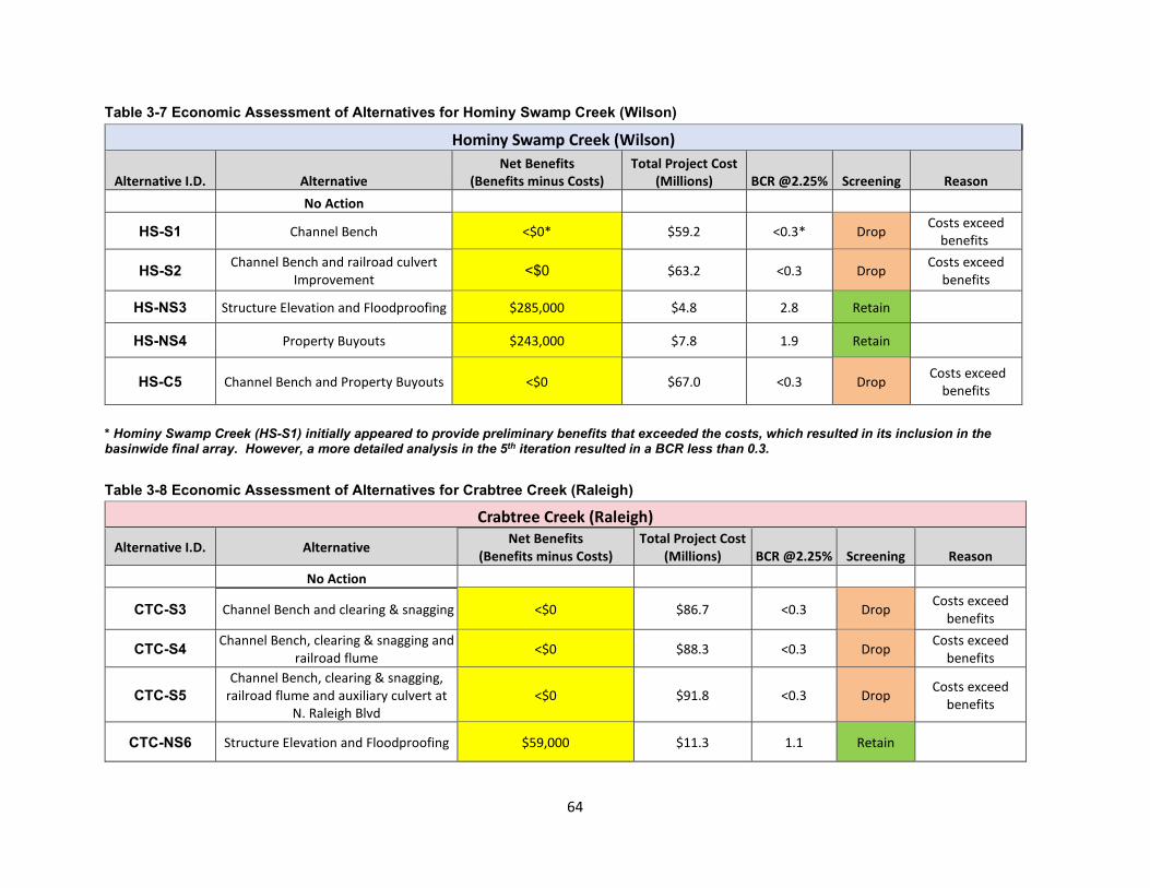
Table 3-7 Economic Assessment of Alternatives for Hominy Swamp Creek (Wilson)
Hominy Swamp Creek (Wilson)
Alternative I.D. Alternative Net Benefits
(Benefits minus Costs) Total Project Cost
(Millions) BCR @2.25% Screening Reason No Action
HS-S1 Channel Bench <$0* $59.2 <0.3* Drop Costs exceed benefits
HS-S2 Channel Bench and railroad culvert Improvement <$0 $63.2 <0.3 Drop Costs exceed
benefits
HS-NS3 Structure Elevation and Floodproofing $285,000 $4.8 2.8 Retain
HS-NS4 Property Buyouts $243,000 $7.8 1.9 Retain
HS-C5 Channel Bench and Property Buyouts <$0 $67.0 <0.3 Drop Costs exceed benefits
* Hominy Swamp Creek (HS-S1) initially appeared to provide preliminary benefits that exceeded the costs, which resulted in its inclusion in the basinwide final array. However, a more detailed analysis in the 5th iteration resulted in a BCR less than 0.3.
Table 3-8 Economic Assessment of Alternatives for Crabtree Creek (Raleigh)
Crabtree Creek (Raleigh)
Alternative I.D. Alternative Net Benefits (Benefits minus Costs)
Total Project Cost (Millions) BCR @2.25% Screening Reason
No Action
CTC-S3 Channel Bench and clearing & snagging <$0 $86.7 <0.3 Drop Costs exceed benefits
CTC-S4 Channel Bench, clearing & snagging and railroad flume <$0 $88.3 <0.3 Drop Costs exceed
benefits
CTC-S5 Channel Bench, clearing & snagging,
railroad flume and auxiliary culvert at N. Raleigh Blvd
<$0 $91.8 <0.3 Drop Costs exceed benefits
CTC-NS6 Structure Elevation and Floodproofing $59,000 $11.3 1.1 Retain
64
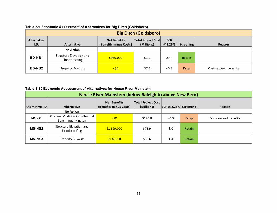
Table 3-9 Economic Assessment of Alternatives for Big Ditch (Goldsboro)
Big Ditch (Goldsboro) Alternative Net Benefits Total Project Cost BCR
I.D. Alternative (Benefits minus Costs) (Millions) @2.25% Screening Reason No Action
BD-NS1 Structure Elevation and Floodproofing $950,000 $1.0 29.4 Retain
BD-NS2 Property Buyouts <$0 $7.5 <0.3 Drop Costs exceed benefits
Table 3-10 Economic Assessment of Alternatives for Neuse River Mainstem
Neuse River Mainstem (below Raleigh to above New Bern)
Alternative I.D. Alternative Net Benefits
(Benefits minus Costs) Total Project Cost
(Millions) BCR @2.25% Screening Reason No Action
MS-S1 Channel Modification (Channel Bench) near Kinston <$0 $190.8 <0.3 Drop Costs exceed benefits
MS-NS2 Structure Elevation and Floodproofing $1,399,000 $73.9 1.6 Retain
MS-NS3 Property Buyouts $932,000 $30.6 1.4 Retain
65
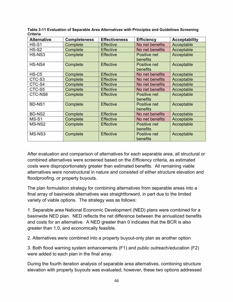
Table 3-11 Evaluation of Separable Area Alternatives with Principles and Guidelines Screening Criteria Alternative Completeness Effectiveness Efficiency Acceptability HS-S1 Complete Effective No net benefits Acceptable HS-S2 Complete Effective No net benefits Acceptable HS-NS3 Complete Effective Positive net
benefits Acceptable
HS-NS4 Complete Effective Positive net benefits
Acceptable
HS-C5 Complete Effective No net benefits Acceptable CTC-S3 Complete Effective No net benefits Acceptable CTC-S4 Complete Effective No net benefits Acceptable CTC-S5 Complete Effective No net benefits Acceptable CTC-NS6 Complete Effective Positive net
benefits Acceptable
BD-NS1 Complete Effective Positive net benefits
Acceptable
BD-NS2 Complete Effective No net benefits Acceptable MS-S1 Complete Effective No net benefits Acceptable MS-NS2 Complete Effective Positive net
benefits Acceptable
MS-NS3 Complete Effective Positive net benefits
Acceptable
After evaluation and comparison of alternatives for each separable area, all structural or combined alternatives were screened based on the Efficiency criteria, as estimated costs were disproportionately greater than estimated benefits. All remaining viable alternatives were nonstructural in nature and consisted of either structure elevation and floodproofing, or property buyouts.
The plan formulation strategy for combining alternatives from separable areas into a final array of basinwide alternatives was straightforward, in part due to the limited variety of viable options. The strategy was as follows:
1. Separable area National Economic Development (NED) plans were combined for a basinwide NED plan. NED reflects the net difference between the annualized benefits and costs for an alternative. A NED greater than 0 indicates that the BCR is also greater than 1.0, and economically feasible.
2. Alternatives were combined into a property buyout-only plan as another option
3. Both flood warning system enhancements (F1) and public outreach/education (F2) were added to each plan in the final array.
During the fourth iteration analysis of separable area alternatives, combining structure elevation with property buyouts was evaluated; however, these two options addressed
66
some of the same structures, and the structure elevation and floodproofing option resulted in greater net benefits for each separable area.
Separable area alternatives were combined as follows into a final array of basinwide alternatives. The flood risk reduction measures for each of the alternative codes listed below are described in Tables 3-7, 3-8, 3-9 and 3-10 and the separable area codes and type of alternative are repeated below:
Alternative 1: No Action
Alternative 2: HS-NS3 + CTC-NS6 + BD-NS1 + MS-NS2 + F1 + F2
Alternative 3: HS-NS4 + BD-NS2 + MS-NS3 + F1 + F2
Table 3-6 Legend for Descriptions of Alternatives (Repeated) HS (Hominy Swamp Creek) S (Structural alternative) CTC (Crabtree Creek) NS (Nonstructural alternative) BD (Big Ditch) C (Combined structural/nonstructural) MS (Mainstem of the Neuse River) Example: CTC-S3 = Crabtree Creek -
Structural alternative #3 F1 (Public Outreach and Education of Basinwide Residual Flood Risk)
Example: BD-NS1 – Big Ditch -Nonstructural alternative #1
F2 (Flood Warning System Enhancements)
3.7.2. Final Basinwide Alternatives Array
This section describes the alternatives in the final basinwide array. Definitions associated with the plans are provided prior to the alternative descriptions:
Definitions:
Nonstructural Measures - Permanent or contingent measures applied to a structure and/or its contents that reduce the risk of damages that could result from flooding. Nonstructural measures differ from structural measures (i.e., levees, floodwalls, etc.) in that they focus on reducing the consequences of damages from riverine flood risks instead of focusing on reducing the probability of damages from riverine flooding. Nonstructural measures include:
Structure Elevation - Raising a house or building so that the lowest habitable floor is above the 1% annual exceedance probability (AEP) flood event level. This can be done by elevating the entire structure, including the floor, or by leaving the structure in its existing position and constructing a new elevated floor within the house. Structure elevation is a well-recognized measure for reducing flood risk (Figure 3-4).
67
Floodproofing - Any combination of structural and nonstructural additions, changes, or adjustments to structures which reduce the risk of flood damage to improved real property, water and sanitary facilities, structures and their contents (Figure 3-5) including:
Dry floodproofing makes the structure watertight below the level for which flood risk management is provided by preventing floodwaters from entering the structure. Dry floodproofing may include one or more of the following methods: using waterproof membranes or sealants to reduce seepage of floodwater through walls; use of watertight shields for doors and windows; and/or installing measures to prevent sewer backup.
Wet floodproofing. The use of flood-damage-resistant materials and construction techniques to minimize flood damage to areas below the flood protection level of a structure, which is intentionally allowed to flood but with modifications which minimize flood damage. “Floodvent” is a form of wet floodproofing whereby floodwaters are allowed to enter a structure. This requires that all construction materials are water resistant, and all utilities must be elevated. Flood vents are installed in the walls to allow floodwaters into the building to equalize the hydrostatic forces.
Acquisition (Property buyouts) – Acquisition, also referred to as property buyouts, refers to buying the structure and the associated land to manage risk in the floodplain. The building is either demolished or sold to others and relocated outside of the floodplain. Land acquisition can be in the form of fee title or permanent easement with fee title. After acquisition, the land must be maintained as open space through deed restrictions that prohibit any type of development that can sustain flood damages or restrict flood flows. Land acquired as part of a nonstructural project can be converted to a new use such as ecosystem restoration and/or recreation that is consistent with open space restrictions. Examples could include trails, shoreline access, and interpretive markers.
Final Basinwide Array:
Alternative 1 – No Action
The without-project condition, or the no-action plan, is Alternative 1. This alternative is the scenario that would most likely occur in the absence of a federal plan. The no action plan would likely result in repeated flooding in an area where hurricanes, extreme tropical storms and other potential events bring heavy rainfall each year. Under this alternative, structures would continue to be inundated as outlined in Sections 1.6 and 1.7 of this report or Section 6 of Appendix B (Economics).
68
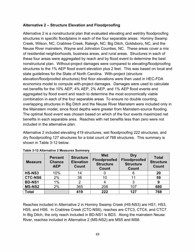
Alternative 2 – Structure Elevation and Floodproofing
Alternative 2 is a nonstructural plan that evaluated elevating and wet/dry floodproofing structures in specific floodplains in each of the four separable areas: Hominy Swamp Creek, Wilson, NC; Crabtree Creek, Raleigh, NC; Big Ditch, Goldsboro, NC, and the Neuse River mainstem, Wayne and Johnston Counties, NC. These areas cover a mix of residential neighborhoods, business areas, and rural areas. Structures in each of these four areas were aggregated by reach and by flood event to determine the best nonstructural plan. Without-project damages were compared to elevating/floodproofing structures to the 1% AEP flood event elevation plus 2 feet. This was based on local and state guidelines for the State of North Carolina. With-project (structure elevation/floodproofed structures) first floor elevations were then used in HEC-FDA economics model to compute with-project damages. Damages were used to calculate net benefits for the 10% AEP, 4% AEP, 2% AEP, and 1% AEP flood events and aggregated by flood event and reach to determine the most economically viable combination in each of the four separable areas To ensure no double counting, overlapping structures in Big Ditch and the Neuse River Mainstem were included only in the Mainstem model, since flood depths were greater from Mainstem-source flooding. The optimal flood event was chosen based on which of the four events maximized net benefits in each separable area. Reaches with net benefits less than zero were not included in the alternative plan.
Alternative 2 included elevating 419 structures, wet floodproofing 222 structures, and dry floodproofing 127 structures for a total count of 768 structures. This summary is shown in Table 3-12 below.
Table 3-12 Alternative 2 Measures Summary
Measure Percent Chance
AEP
Structure Elevation
Count
Wet Floodproofed
Structure Count
DryFloodproofed
Structure Count
Total Structure
Count HS-NS3 10% 14 0 6 20 CTC-NS6 2% 38 10 11 59 BD-NS1 1% 2 4 3 9 MS-NS2 2% 365 208 107 680 Total 419 222 127 768
Reaches included in Alternative 2 in Hominy Swamp Creek (HS-NS3) are HS1, HS3, HS5, and HS6. In Crabtree Creek (CTC-NS6), reaches are CTC3, CTC4, and CTC7. In Big Ditch, the only reach included in BD-NS1 is BD3. Along the mainstem Neuse River, reaches included in Alternative 2 (MS-NS2) are MS5 and MS6.
69
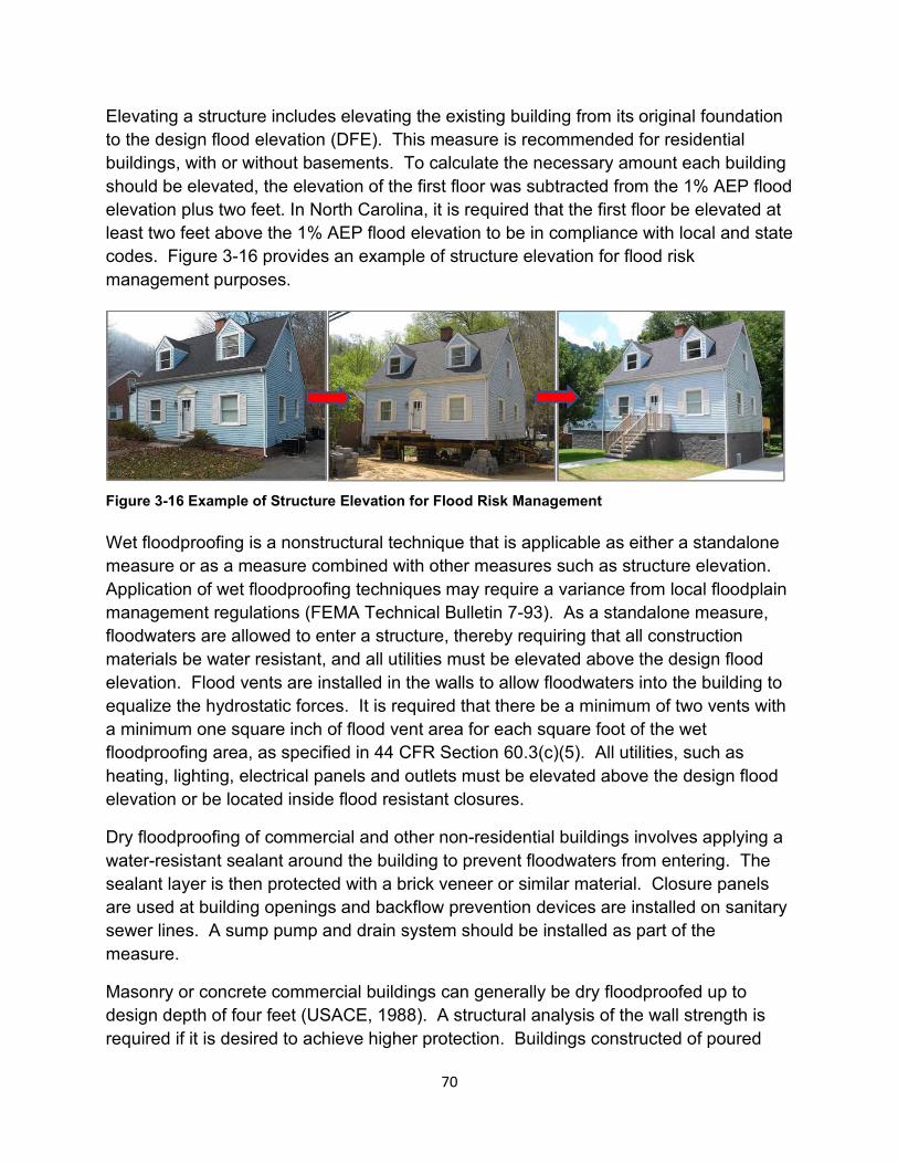
Elevating a structure includes elevating the existing building from its original foundation to the design flood elevation (DFE). This measure is recommended for residential buildings, with or without basements. To calculate the necessary amount each building should be elevated, the elevation of the first floor was subtracted from the 1% AEP flood elevation plus two feet. In North Carolina, it is required that the first floor be elevated at least two feet above the 1% AEP flood elevation to be in compliance with local and state codes. Figure 3-16 provides an example of structure elevation for flood risk management purposes.
Figure 3-16 Example of Structure Elevation for Flood Risk Management
Wet floodproofing is a nonstructural technique that is applicable as either a standalone measure or as a measure combined with other measures such as structure elevation. Application of wet floodproofing techniques may require a variance from local floodplain management regulations (FEMA Technical Bulletin 7-93). As a standalone measure, floodwaters are allowed to enter a structure, thereby requiring that all construction materials be water resistant, and all utilities must be elevated above the design flood elevation. Flood vents are installed in the walls to allow floodwaters into the building to equalize the hydrostatic forces. It is required that there be a minimum of two vents with a minimum one square inch of flood vent area for each square foot of the wet floodproofing area, as specified in 44 CFR Section 60.3(c)(5). All utilities, such as heating, lighting, electrical panels and outlets must be elevated above the design flood elevation or be located inside flood resistant closures.
Dry floodproofing of commercial and other non-residential buildings involves applying a water-resistant sealant around the building to prevent floodwaters from entering. The sealant layer is then protected with a brick veneer or similar material. Closure panels are used at building openings and backflow prevention devices are installed on sanitary sewer lines. A sump pump and drain system should be installed as part of the measure.
Masonry or concrete commercial buildings can generally be dry floodproofed up to design depth of four feet (USACE, 1988). A structural analysis of the wall strength is required if it is desired to achieve higher protection. Buildings constructed of poured
70
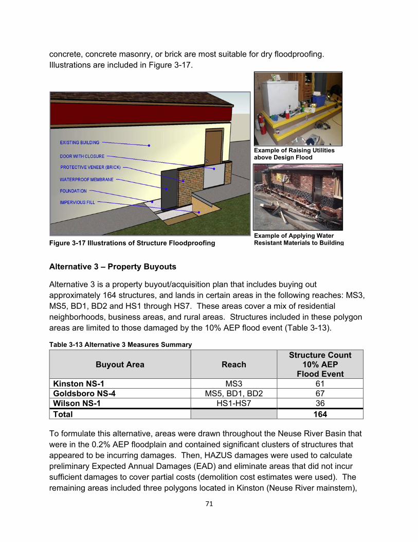
concrete, concrete masonry, or brick are most suitable for dry floodproofing. Illustrations are included in Figure 3-17.
Example of Raising Utilitiesabove Design Flood
Example of Applying WaterResistant Materials to Building Figure 3-17 Illustrations of Structure Floodproofing
Alternative 3 – Property Buyouts
Alternative 3 is a property buyout/acquisition plan that includes buying out approximately 164 structures, and lands in certain areas in the following reaches: MS3, MS5, BD1, BD2 and HS1 through HS7. These areas cover a mix of residential neighborhoods, business areas, and rural areas. Structures included in these polygon areas are limited to those damaged by the 10% AEP flood event (Table 3-13).
Table 3-13 Alternative 3 Measures Summary
Buyout Area Reach Structure Count
10% AEP Flood Event
Kinston NS-1 MS3 61 Goldsboro NS-4 MS5, BD1, BD2 67 Wilson NS-1 HS1-HS7 36 Total 164
To formulate this alternative, areas were drawn throughout the Neuse River Basin that were in the 0.2% AEP floodplain and contained significant clusters of structures that appeared to be incurring damages. Then, HAZUS damages were used to calculate preliminary Expected Annual Damages (EAD) and eliminate areas that did not incur sufficient damages to cover partial costs (demolition cost estimates were used). The remaining areas included three polygons located in Kinston (Neuse River mainstem),
71
Goldsboro (Neuse River mainstem), and Wilson (Hominy Swamp Creek). Additionally, HAZUS damages were used to calculate preliminary aggregate EAD for each census tract in the basin. Damage estimates for census tracts were compared to partial costs (demolition costs were used) across 188 census tracts. Only one census tract, in Seven Springs, had damages that were higher than demolition costs. This tract was added to the buyout polygon areas but was later removed due to the projected State of North Carolina property buyouts in this area.
Once damages were modeled in the HEC-FDA economics model, damages for the identified areas for the 1% AEP and 10% AEP flood events were evaluated with full costs for buyout and acquisition. Structures damaged by the 10% AEP flood event in these areas were kept in the final alternative, since this maximized net NED benefits.
Property buyouts consisted of buying the structure and the associated land as defined above.
3.7.3. Economic Assessment of Final Array of Alternatives
3.7.3.1 Alternative 2 Benefits
Benefits are displayed for the reaches included in the final array. Other flood events are shown for comparison only. As previously mentioned, all combinations of reaches and the four flood events shown were analyzed and the reach and flood event combination that maximized net benefits were selected for inclusion in the final array.
In Hominy Swamp Creek, Wilson, NC, the 10% AEP flood event maximized net benefits and is included in the final array. Total average annual benefits for Hominy Swamp Creek are approximately $459,000 (Table 3-14).
72
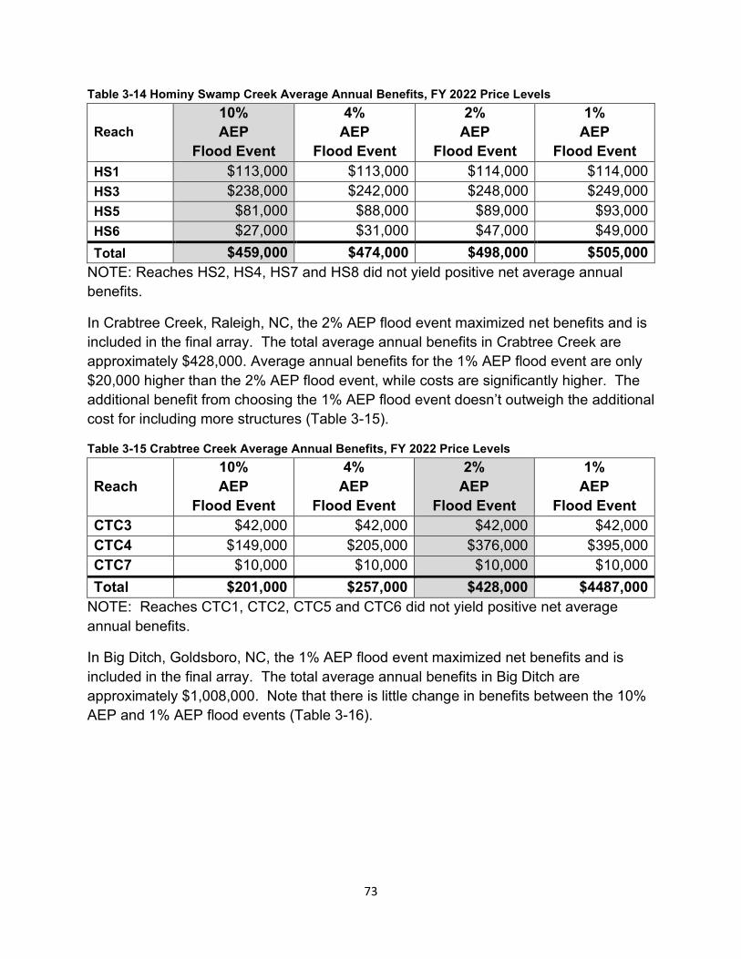
Table 3-14 Hominy Swamp Creek Average Annual Benefits, FY 2022 Price Levels
Reach 10% AEP
Flood Event
4% AEP
Flood Event
2% AEP
Flood Event
1% AEP
Flood Event HS1 $113,000 $113,000 $114,000 $114,000 HS3 $238,000 $242,000 $248,000 $249,000 HS5 $81,000 $88,000 $89,000 $93,000 HS6 $27,000 $31,000 $47,000 $49,000 Total $459,000 $474,000 $498,000 $505,000
NOTE: Reaches HS2, HS4, HS7 and HS8 did not yield positive net average annual benefits.
In Crabtree Creek, Raleigh, NC, the 2% AEP flood event maximized net benefits and is included in the final array. The total average annual benefits in Crabtree Creek are approximately $428,000. Average annual benefits for the 1% AEP flood event are only $20,000 higher than the 2% AEP flood event, while costs are significantly higher. The additional benefit from choosing the 1% AEP flood event doesn’t outweigh the additional cost for including more structures (Table 3-15).
Table 3-15 Crabtree Creek Average Annual Benefits, FY 2022 Price Levels
Reach 10% AEP
Flood Event
4% AEP
Flood Event
2% AEP
Flood Event
1% AEP
Flood Event CTC3 $42,000 $42,000 $42,000 $42,000 CTC4 $149,000 $205,000 $376,000 $395,000 CTC7 $10,000 $10,000 $10,000 $10,000 Total $201,000 $257,000 $428,000 $4487,000
NOTE: Reaches CTC1, CTC2, CTC5 and CTC6 did not yield positive net average annual benefits.
In Big Ditch, Goldsboro, NC, the 1% AEP flood event maximized net benefits and is included in the final array. The total average annual benefits in Big Ditch are approximately $1,008,000. Note that there is little change in benefits between the 10% AEP and 1% AEP flood events (Table 3-16).
73
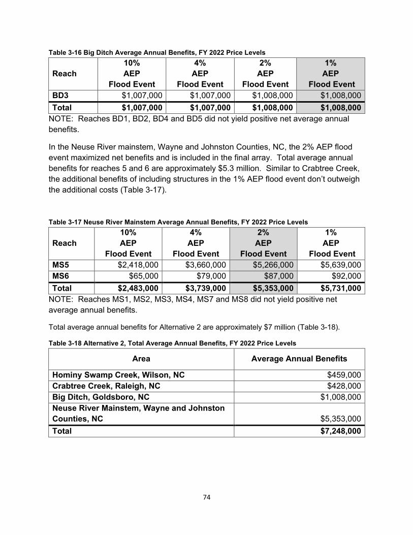
Table 3-16 Big Ditch Average Annual Benefits, FY 2022 Price Levels
Reach 10% AEP
Flood Event
4% AEP
Flood Event
2% AEP
Flood Event
1% AEP
Flood Event BD3 $1,007,000 $1,007,000 $1,008,000 $1,008,000 Total $1,007,000 $1,007,000 $1,008,000 $1,008,000
NOTE: Reaches BD1, BD2, BD4 and BD5 did not yield positive net average annual benefits.
In the Neuse River mainstem, Wayne and Johnston Counties, NC, the 2% AEP flood event maximized net benefits and is included in the final array. Total average annual benefits for reaches 5 and 6 are approximately $5.3 million. Similar to Crabtree Creek, the additional benefits of including structures in the 1% AEP flood event don’t outweigh the additional costs (Table 3-17).
Table 3-17 Neuse River Mainstem Average Annual Benefits, FY 2022 Price Levels
Reach 10% AEP
Flood Event
4% AEP
Flood Event
2% AEP
Flood Event
1% AEP
Flood Event MS5 $2,418,000 $3,660,000 $5,266,000 $5,639,000 MS6 $65,000 $79,000 $87,000 $92,000 Total $2,483,000 $3,739,000 $5,353,000 $5,731,000
NOTE: Reaches MS1, MS2, MS3, MS4, MS7 and MS8 did not yield positive net average annual benefits.
Total average annual benefits for Alternative 2 are approximately $7 million (Table 3-18).
Table 3-18 Alternative 2, Total Average Annual Benefits, FY 2022 Price Levels
Area Average Annual Benefits
Hominy Swamp Creek, Wilson, NC $459,000 Crabtree Creek, Raleigh, NC $428,000 Big Ditch, Goldsboro, NC $1,008,000 Neuse River Mainstem, Wayne and Johnston Counties, NC $5,353,000 Total $7,248,000
74
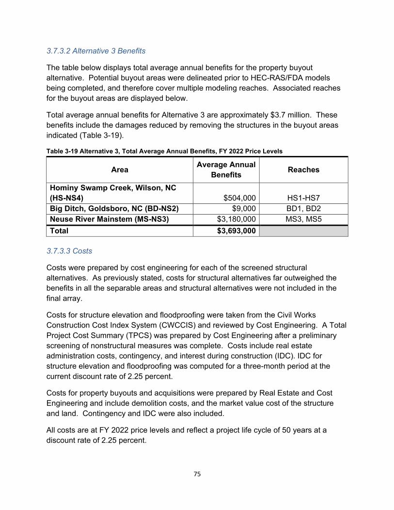
3.7.3.2 Alternative 3 Benefits
The table below displays total average annual benefits for the property buyout alternative. Potential buyout areas were delineated prior to HEC-RAS/FDA models being completed, and therefore cover multiple modeling reaches. Associated reaches for the buyout areas are displayed below.
Total average annual benefits for Alternative 3 are approximately $3.7 million. These benefits include the damages reduced by removing the structures in the buyout areas indicated (Table 3-19).
Table 3-19 Alternative 3, Total Average Annual Benefits, FY 2022 Price Levels
Area Average Annual Benefits Reaches
Hominy Swamp Creek, Wilson, NC (HS-NS4) $504,000 HS1-HS7 Big Ditch, Goldsboro, NC (BD-NS2) $9,000 BD1, BD2 Neuse River Mainstem (MS-NS3) $3,180,000 MS3, MS5 Total $3,693,000
3.7.3.3 Costs
Costs were prepared by cost engineering for each of the screened structural alternatives. As previously stated, costs for structural alternatives far outweighed the benefits in all the separable areas and structural alternatives were not included in the final array.
Costs for structure elevation and floodproofing were taken from the Civil Works Construction Cost Index System (CWCCIS) and reviewed by Cost Engineering. A Total Project Cost Summary (TPCS) was prepared by Cost Engineering after a preliminary screening of nonstructural measures was complete. Costs include real estate administration costs, contingency, and interest during construction (IDC). IDC for structure elevation and floodproofing was computed for a three-month period at the current discount rate of 2.25 percent.
Costs for property buyouts and acquisitions were prepared by Real Estate and Cost Engineering and include demolition costs, and the market value cost of the structure and land. Contingency and IDC were also included.
All costs are at FY 2022 price levels and reflect a project life cycle of 50 years at a discount rate of 2.25 percent.
75
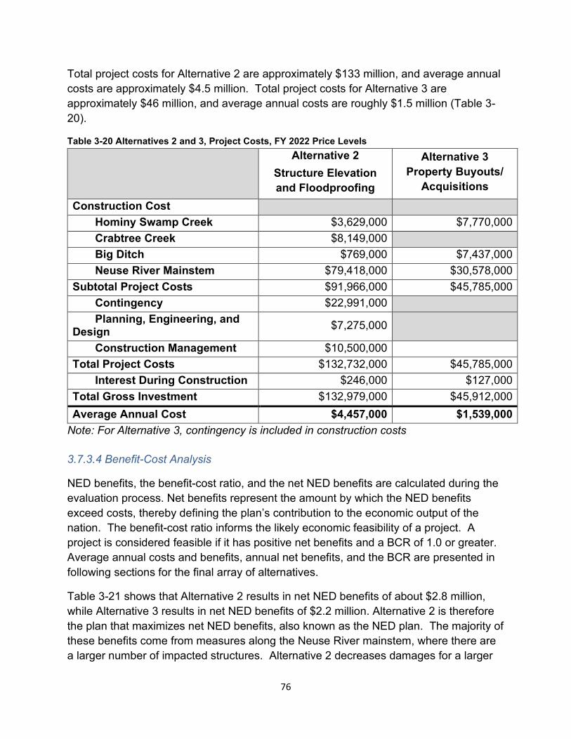
Total project costs for Alternative 2 are approximately $133 million, and average annual costs are approximately $4.5 million. Total project costs for Alternative 3 are approximately $46 million, and average annual costs are roughly $1.5 million (Table 3-20).
Table 3-20 Alternatives 2 and 3, Project Costs, FY 2022 Price Levels Alternative 2
Structure Elevation and Floodproofing
Alternative 3 Property Buyouts/
Acquisitions Construction Cost
Hominy Swamp Creek $3,629,000 $7,770,000 Crabtree Creek $8,149,000 Big Ditch $769,000 $7,437,000 Neuse River Mainstem $79,418,000 $30,578,000
Subtotal Project Costs $91,966,000 $45,785,000 Contingency $22,991,000 Planning, Engineering, and
Design $7,275,000
Construction Management $10,500,000 Total Project Costs $132,732,000 $45,785,000
Interest During Construction $246,000 $127,000 Total Gross Investment $132,979,000 $45,912,000 Average Annual Cost $4,457,000 $1,539,000
Note: For Alternative 3, contingency is included in construction costs
3.7.3.4 Benefit-Cost Analysis
NED benefits, the benefit-cost ratio, and the net NED benefits are calculated during the evaluation process. Net benefits represent the amount by which the NED benefits exceed costs, thereby defining the plan’s contribution to the economic output of the nation. The benefit-cost ratio informs the likely economic feasibility of a project. A project is considered feasible if it has positive net benefits and a BCR of 1.0 or greater. Average annual costs and benefits, annual net benefits, and the BCR are presented in following sections for the final array of alternatives.
Table 3-21 shows that Alternative 2 results in net NED benefits of about $2.8 million, while Alternative 3 results in net NED benefits of $2.2 million. Alternative 2 is therefore the plan that maximizes net NED benefits, also known as the NED plan. The majority of these benefits come from measures along the Neuse River mainstem, where there are a larger number of impacted structures. Alternative 2 decreases damages for a larger
76
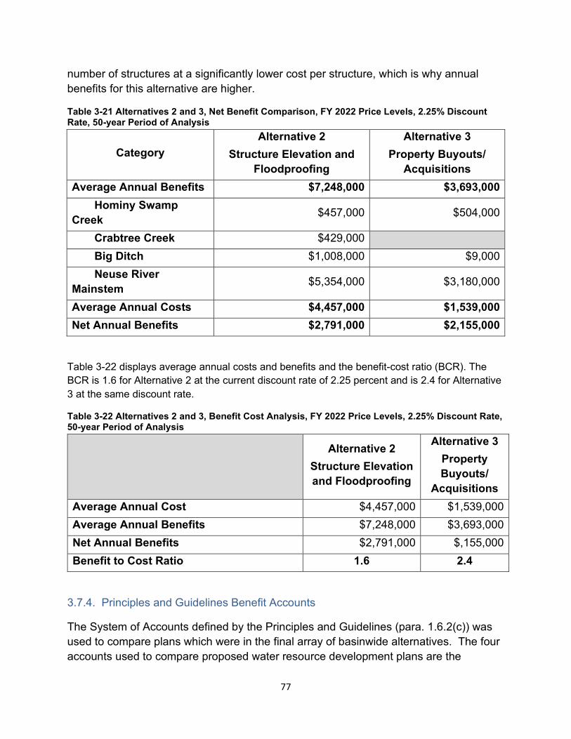
number of structures at a significantly lower cost per structure, which is why annual benefits for this alternative are higher.
Table 3-21 Alternatives 2 and 3, Net Benefit Comparison, FY 2022 Price Levels, 2.25% Discount Rate, 50-year Period of Analysis
Category Alternative 2
Structure Elevation and Floodproofing
Alternative 3 Property Buyouts/
Acquisitions Average Annual Benefits $7,248,000 $3,693,000
Hominy Swamp Creek $457,000 $504,000
Crabtree Creek $429,000 Big Ditch $1,008,000 $9,000 Neuse River
Mainstem $5,354,000 $3,180,000
Average Annual Costs $4,457,000 $1,539,000 Net Annual Benefits $2,791,000 $2,155,000
Table 3-22 displays average annual costs and benefits and the benefit-cost ratio (BCR). The BCR is 1.6 for Alternative 2 at the current discount rate of 2.25 percent and is 2.4 for Alternative 3 at the same discount rate.
Table 3-22 Alternatives 2 and 3, Benefit Cost Analysis, FY 2022 Price Levels, 2.25% Discount Rate, 50-year Period of Analysis
Alternative 2 Structure Elevation and Floodproofing
Alternative 3 Property Buyouts/
Acquisitions Average Annual Cost $4,457,000 $1,539,000 Average Annual Benefits $7,248,000 $3,693,000 Net Annual Benefits $2,791,000 $,155,000 Benefit to Cost Ratio 1.6 2.4
3.7.4. Principles and Guidelines Benefit Accounts
The System of Accounts defined by the Principles and Guidelines (para. 1.6.2(c)) was used to compare plans which were in the final array of basinwide alternatives. The four accounts used to compare proposed water resource development plans are the
77
National Economic Development (NED), Regional Economic Development (RED), Environmental Quality (EQ) and Other Social Effects (OSE) accounts.
3.7.4.1 National Economic Development (NED) account.
The NED Account represents increases in the net value of the national output of goods and services, expressed in monetary units, and are the direct net benefits that accrue in the planning area, and the rest of the Nation. The benefits, average annual cost and total cost were based on the monetary costs or damages prevented and were ranked accordingly. Additional information can be found in Appendix B (Economics).
3.7.4.2 Regional Economic Development (RED) account
The Regional Economic Development (RED) account registers changes in the distribution of regional economic activity that result from each alternative plan. The RED account displays information not analyzed in other accounts in the integrated feasibility report/EA that could have a material bearing on the decision-making process. Regional economic impacts and contributions are measured as economic output, jobs, income, and value added, based on multipliers that require construction dollars to be spent in order for a regional economic impact to occur. For the complete RED analysis, refer to Appendix B (Economics).
3.7.4.3 Environmental Quality (EQ) account
The Environmental Quality (EQ) account is an assessment of favorable or unfavorable ecological, aesthetic and cultural or natural resources changes. This review is being conducted with the participation of agencies, local governments, and stakeholders through an on-going and engaging series of scoping meetings, public input meetings, agency and stakeholder meetings, and on-site meetings, and will continue through the Preconstruction Engineering and Design (PED) study phase and coordination of the project through State and Agency reviews.
3.7.4.4 Other Social Effects (OSE) account
The Other Social Effects (OSE) account considers the effects of alternative plans in areas not already contained in the NED and RED accounts. The categories of effects contained within the OSE account include: urban and community impacts; displacement; long-term productivity; and public health and safety. Additional information can be found in Appendix B (Economics).
78
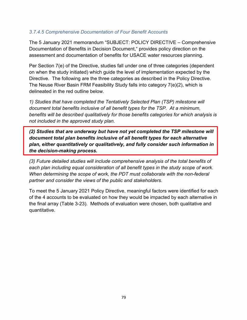
3.7.4.5 Comprehensive Documentation of Four Benefit Accounts
The 5 January 2021 memorandum “SUBJECT: POLICY DIRECTIVE – Comprehensive Documentation of Benefits in Decision Document,“ provides policy direction on the assessment and documentation of benefits for USACE water resources planning.
Per Section 7(e) of the Directive, studies fall under one of three categories (dependent on when the study initiated) which guide the level of implementation expected by the Directive. The following are the three categories as described in the Policy Directive. The Neuse River Basin FRM Feasibility Study falls into category 7(e)(2), which is delineated in the red outline below.
1) Studies that have completed the Tentatively Selected Plan (TSP) milestone will document total benefits inclusive of all benefit types for the TSP. At a minimum, benefits will be described qualitatively for those benefits categories for which analysis is not included in the approved study plan.
(2) Studies that are underway but have not yet completed the TSP milestone will document total plan benefits inclusive of all benefit types for each alternative plan, either quantitatively or qualitatively, and fully consider such information in the decision-making process.
(3) Future detailed studies will include comprehensive analysis of the total benefits of each plan including equal consideration of all benefit types in the study scope of work. When determining the scope of work, the PDT must collaborate with the non-federal partner and consider the views of the public and stakeholders.
To meet the 5 January 2021 Policy Directive, meaningful factors were identified for each of the 4 accounts to be evaluated on how they would be impacted by each alternative in the final array (Table 3-23). Methods of evaluation were chosen, both qualitative and quantitative.
79
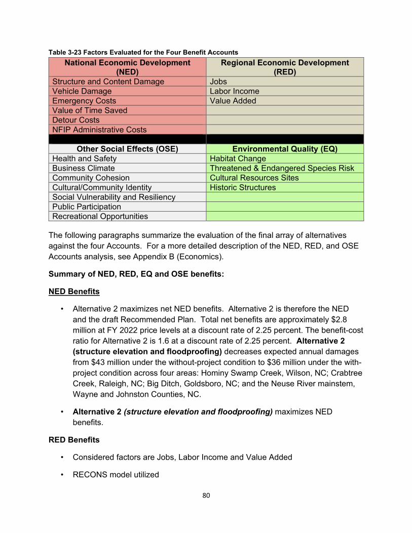
Table 3-23 Factors Evaluated for the Four Benefit Accounts National Economic Development
(NED) Regional Economic Development
(RED) Structure and Content Damage Jobs Vehicle Damage Labor Income Emergency Costs Value Added Value of Time Saved Detour Costs NFIP Administrative Costs
Other Social Effects (OSE) Environmental Quality (EQ) Health and Safety Habitat Change Business Climate Threatened & Endangered Species Risk Community Cohesion Cultural Resources Sites Cultural/Community Identity Historic Structures Social Vulnerability and Resiliency Public Participation Recreational Opportunities
The following paragraphs summarize the evaluation of the final array of alternatives against the four Accounts. For a more detailed description of the NED, RED, and OSE Accounts analysis, see Appendix B (Economics).
Summary of NED, RED, EQ and OSE benefits:
NED Benefits
• Alternative 2 maximizes net NED benefits. Alternative 2 is therefore the NED and the draft Recommended Plan. Total net benefits are approximately $2.8 million at FY 2022 price levels at a discount rate of 2.25 percent. The benefit-cost ratio for Alternative 2 is 1.6 at a discount rate of 2.25 percent. Alternative 2 (structure elevation and floodproofing) decreases expected annual damages from $43 million under the without-project condition to $36 million under the with-project condition across four areas: Hominy Swamp Creek, Wilson, NC; Crabtree Creek, Raleigh, NC; Big Ditch, Goldsboro, NC; and the Neuse River mainstem, Wayne and Johnston Counties, NC.
• Alternative 2 (structure elevation and floodproofing) maximizes NED benefits.
RED Benefits
• Considered factors are Jobs, Labor Income and Value Added
• RECONS model utilized
80
• Regional Economic Development is quantified by the RECONS model. The total number of full-time equivalent jobs created in the state is estimated at 1,874. Total value added at the state level exceeds $133 million. In the absence of a federal project, regional economic development will likely decline due to repeated flooding in the area.
• Alternative 2 (Structure Elevation and Floodproofing) has the largest RED impact.
EQ Benefits
• See Chapter 4, Affected Environment and Environmental Consequences for a more thorough discussion of potential impacts to environmental and cultural resources associated with each alternative.
• Considered factors are Habitat Change, TES Risk, Cultural Resources Sites and Historic Structures
• Qualitative evaluation
• Alternative 1 (No Action) is expected to have some negative impacts on environmental and cultural resources associated with continued erosion and flood events.
• Alternative 2 (Structure Elevation and Floodproofing) could have a positive effect on cultural resources by reducing their risk to flood damage through structure elevation and floodproofing. Environmental resources would still have the same negative impacts as No Action from continued erosion and flood events.
• Alternative 3 (Property Buyouts) would have some positive impacts, albeit minimal, to the floodplain, water quality, and biological resources through the removal of structures from the floodplain, and the return of vegetative buffers. There is potential for negative impacts on cultural resources if historic structures were to be bought out and demolished.
• Alternative 3 is identified as the preferable EQ alternative.
OSE Benefits
• Considered factors are Health and Safety, Business Climate, Community Cohesion, Cultural/Community Identity, Social Vulnerability and Resiliency, Public Participation, and Recreational Opportunities
81
• Per Center for Disease Control (CDC) data, the project area has many highly vulnerable populations.
• Other Social Effects includes life-safety risk and social vulnerability for the future without-project condition and future with project condition. Social vulnerability is reduced by the draft Recommended Plan by floodproofing structures that would otherwise be damaged in event of a flood in four separable areas throughout the basin. Furthermore, social cohesion is preserved by Alternative 2, which allows residents to remain in their current houses and communities, rather than relocate outside the floodplain. In the absence of a federal project, socially vulnerable individuals will continue to suffer from the effects of repeated flooding.
• Alternative 2 (Structure Elevation and Floodproofing) - while benefiting Health and Safety, this alternative could produce positive impacts to OSE associated with Community Cohesion and Cultural/Community Identity.
• Alternative 3 (Property Buyouts) - while benefiting Health and Safety, this alternative could produce negative impacts to OSE associated with Community Cohesion and Cultural/Community Identity.
• Alternative 2 is identified as the preferred OSE alternative.
The 5 January 2021 Policy Directive further states that each study must include, at a minimum, the following plans in the final array of alternatives for evaluation:
1. The “No Action” alternative
2. A plan that maximizes net total benefits across all benefit categories (Alternative 2)
3. A plan that maximizes net benefits consistent with the study purpose (NED for this study) (Alternative 2)
4. For flood-risk management studies, a nonstructural plan (Alternative 2)
5. There is no locally preferred plan
3.7.5. Principles and Guidelines Criteria
This section summarizes and compares the final array of basinwide alternatives with respect to the four Principles and Guidelines criteria.
Completeness: Alternatives 2 (Structure Elevation and Floodproofing) and 3 (Property Buyouts) are complete in that they account for all necessary investments or other actions to ensure the realization of the planned effects (Table 3-24). Alternative 1 (No
82
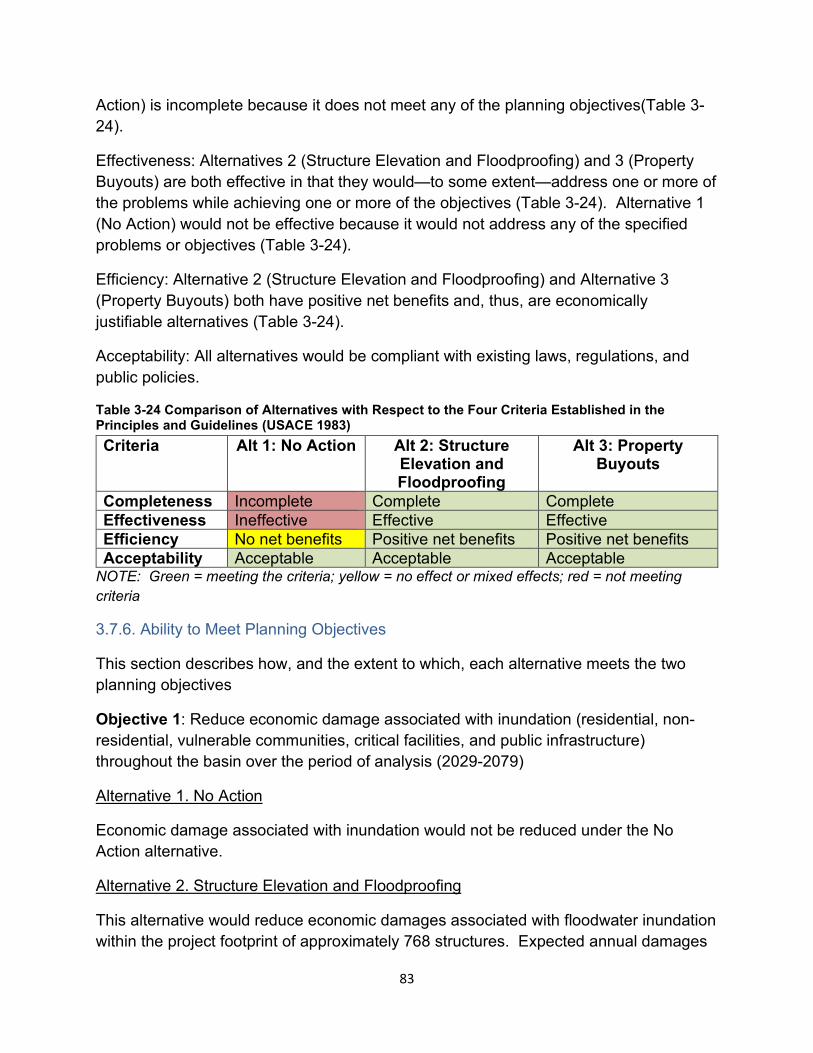
Action) is incomplete because it does not meet any of the planning objectives(Table 3-24).
Effectiveness: Alternatives 2 (Structure Elevation and Floodproofing) and 3 (Property Buyouts) are both effective in that they would—to some extent—address one or more of the problems while achieving one or more of the objectives (Table 3-24). Alternative 1 (No Action) would not be effective because it would not address any of the specified problems or objectives (Table 3-24).
Efficiency: Alternative 2 (Structure Elevation and Floodproofing) and Alternative 3 (Property Buyouts) both have positive net benefits and, thus, are economically justifiable alternatives (Table 3-24).
Acceptability: All alternatives would be compliant with existing laws, regulations, and public policies.
Table 3-24 Comparison of Alternatives with Respect to the Four Criteria Established in the Principles and Guidelines (USACE 1983) Criteria Alt 1: No Action Alt 2: Structure
Elevation and Floodproofing
Alt 3: PropertyBuyouts
Completeness Incomplete Complete Complete Effectiveness Ineffective Effective Effective Efficiency No net benefits Positive net benefits Positive net benefits Acceptability Acceptable Acceptable Acceptable
NOTE: Green = meeting the criteria; yellow = no effect or mixed effects; red = not meeting criteria
3.7.6. Ability to Meet Planning Objectives
This section describes how, and the extent to which, each alternative meets the two planning objectives
Objective 1: Reduce economic damage associated with inundation (residential, non-residential, vulnerable communities, critical facilities, and public infrastructure) throughout the basin over the period of analysis (2029-2079)
Alternative 1. No Action
Economic damage associated with inundation would not be reduced under the No Action alternative.
Alternative 2. Structure Elevation and Floodproofing
This alternative would reduce economic damages associated with floodwater inundation within the project footprint of approximately 768 structures. Expected annual damages
83
would be decreased from $43 million under the without-project condition to $36 million under the with-project condition across four areas where this action is proposed: Hominy Swamp Creek, Wilson, NC; Crabtree Creek, Raleigh, NC; Big Ditch, Goldsboro, NC; and the Neuse River mainstem, Wayne and Johnston Counties, NC. There would be no change in inundation risk for at-risk structures outside of the project footprint.
Alternative 3. Property Buyouts
Property buyouts would eliminate economic damages associated with floodwater inundation of approximately 164 structures in the 10% AEP floodplain across three areas: Hominy Swamp Creek, Wilson, NC; Big Ditch, Goldsboro, NC; and the Neuse River mainstem, Lenoir County, NC.
Objective 2: Reduce life-safety risk associated with inundation of structures and public infrastructure throughout the basin over the period of analysis (2029-2079)
Alternative 1. No Action
Risk to life-safety associated with inundation of structures and public infrastructure would not be reduced under the No Action alternative.
Alternative 2. Structure Elevation and Floodproofing
Structure elevation and floodproofing would reduce floodwater inundation and associated life and safety risk associated with the 768 structures across four areas: Hominy Swamp Creek, Wilson, NC; Crabtree Creek, Raleigh, NC; Big Ditch, Goldsboro, NC; and the Neuse River mainstem, Wayne and Johnston Counties, NC. However, as noted in Section 2.9 and in Section 6 of Appendix B (Economics), there is limited life-safety risk in the study area. There would be no change to life and safety risk outside of the project footprint.
Alternative 3: Property Buyouts
Property buyouts would eliminate life-safety risk associated with floodwater inundation of approximately 164 structures in the 10% AEP floodplain across three areas: Hominy Swamp Creek, Wilson, NC; Big Ditch, Goldsboro, NC; and the Neuse River mainstem, Lenoir County, NC. However, as noted in Section 2.9 and in Section 6 of Appendix B (Economics), there is limited life-safety risk in the study area.
3.7.6.1 Ability to Meeting Planning Objectives Summary & Comparison
Objective 1: Both action alternatives would result in reduced flood risk associated with inundation of structures and/or roadways and, thus, would meet objective 1.
84
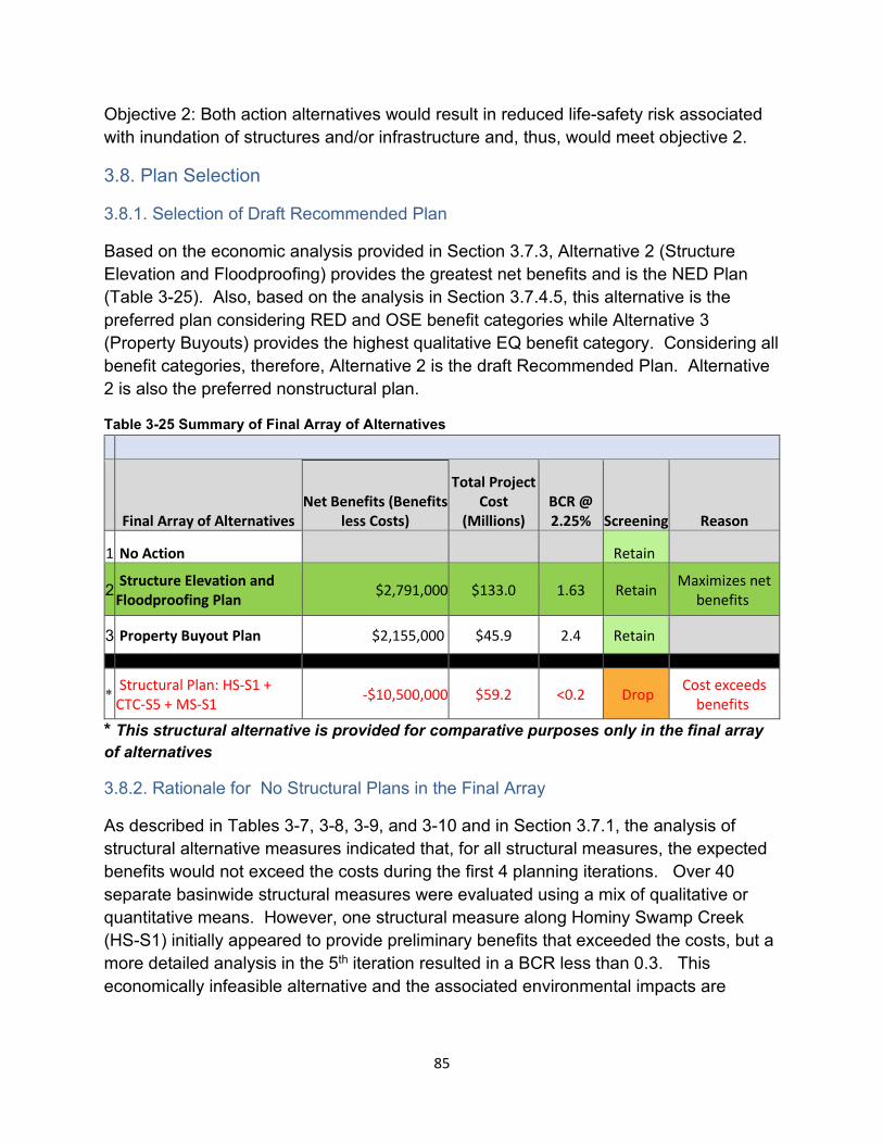
Objective 2: Both action alternatives would result in reduced life-safety risk associated with inundation of structures and/or infrastructure and, thus, would meet objective 2.
3.8. Plan Selection
3.8.1. Selection of Draft Recommended Plan
Based on the economic analysis provided in Section 3.7.3, Alternative 2 (Structure Elevation and Floodproofing) provides the greatest net benefits and is the NED Plan (Table 3-25). Also, based on the analysis in Section 3.7.4.5, this alternative is the preferred plan considering RED and OSE benefit categories while Alternative 3 (Property Buyouts) provides the highest qualitative EQ benefit category. Considering all benefit categories, therefore, Alternative 2 is the draft Recommended Plan. Alternative 2 is also the preferred nonstructural plan.
Table 3-25 Summary of Final Array of Alternatives
Neuse River Basin (Basinwide)
Final Array of Alternatives Net Benefits (Benefits
less Costs)
Total Project Cost
(Millions) BCR @ 2.25% Screening Reason
1 No Action Retain
2 Structure Elevation and Floodproofing Plan $2,791,000 $133.0 1.63 Retain Maximizes net
benefits
3 Property Buyout Plan $2,155,000 $45.9 2.4 Retain
* Structural Plan: HS-S1 + CTC-S5 + MS-S1 -$10,500,000 $59.2 <0.2 Drop Cost exceeds
benefits
* This structural alternative is provided for comparative purposes only in the final array of alternatives
3.8.2. Rationale for No Structural Plans in the Final Array
As described in Tables 3-7, 3-8, 3-9, and 3-10 and in Section 3.7.1, the analysis of structural alternative measures indicated that, for all structural measures, the expected benefits would not exceed the costs during the first 4 planning iterations. Over 40 separate basinwide structural measures were evaluated using a mix of qualitative or quantitative means. However, one structural measure along Hominy Swamp Creek (HS-S1) initially appeared to provide preliminary benefits that exceeded the costs, but a more detailed analysis in the 5th iteration resulted in a BCR less than 0.3. This economically infeasible alternative and the associated environmental impacts are
85
described here to demonstrate the exhaustive nature of the plan formulation process required to identify the most feasible measures as part of a final Recommended Plan.
From an environmental impact perspective, this proposed measure to construct 9 channel bench segments along the banks of Hominy Swamp Creek would have required mitigation, likely in the form of payment into the State of North Carolina’s in lieu fee program for impacts to the stream and associated wetlands. The estimated length of stream to be impacted with the construction would be ~10,562 linear feet along with an estimated ~ 13 acres of wetlands. Although large areas of adjacent riparian wetlands were not identified during the site visit in November 2021, it was conservatively assumed that small riparian wetlands likely were present in some areas. The estimate of wetlands present was based on aerial maps, soil surveys, and National Wetland Inventory maps data, which was available in GIS. The construction of the channel bench segments would not have resulted in negative impacts to threatened or endangered species.
Proposed Hominy Swamp Creek channel bench locations would require systematic archaeological surveys to ensure compliance with Section 106 of the National Historic Preservation Act (NHPA). Again, citing field observations made during the November 2021 site visit, riparian vegetative composition at several proposed channel bench locations included large trees. The size of these trees (i.e., height, canopy cover, and diameter at breast height) suggested that construction-related ground disturbance in their immediate vicinity had not occurred in many decades and, perhaps, had never occurred. It is reasonable to presume that archaeological evidence of prehistoric Native American use may exist in proposed channel bench areas. According to the NC Office of State Archaeology (NCOSA) records, the majority of proposed channel bench areas have not been previously surveyed in accordance with Section 106 of the NHPA. Proposed channel bench footprints would require cultural resources survey prior to any construction or ground disturbance and would be coordinated with the NCOSA / NC State Historic Preservation Office in accordance with the NHPA, Section 106 programmatic agreement developed for this project (Appendix G – Cultural Resources).
3.8.3. Identification of a Locally Preferred Plan
The non-Federal sponsor supports moving forward with the draft Recommended Plan (Alternative 2). There is no Locally Preferred Plan.
3.8.4. Value Engineering
Value Engineering will not be addressed during this feasibility study. The entire project will be evaluated during individual construction contracts.
86
AFFECTED ENVIRONMENT AND ENVIRONMENTAL CONSEQUENCES
This section begins with descriptions of the three alternatives in the final array, which includes the No Action alternative. These descriptions are followed by discussions of the affected environment and environmental consequences evaluated against the three alternatives.
Final Basin-Wide Array of Alternatives:
Alternative 1 - No Action
The without-project condition, or the no-action plan, is Alternative 1. This alternative is the scenario that would most likely occur in the absence of a federal plan. The No Action plan would likely result in repeated flooding in an area where hurricanes, extreme tropical storms and other events bring heavy rainfall each year. Under this alternative, structures would continue to be inundated as outlined in Chapter 2.
Alternative 2 – Draft Recommended Plan - Structure Elevation and Floodproofing
Alternative 2 is a nonstructural plan that evaluated elevating and wet/dry floodproofing of structures in specific floodplains in each of the four separable areas: Crabtree Creek, Wilson, NC; Hominy Swamp Creek, Raleigh, NC; Big Ditch, Goldsboro, NC; and Neuse River mainstem in Wayne and Johnston Counties, NC.
Alternative 2 includes elevating 419 structures, dry floodproofing 127 structures, and wet floodproofing 222 structures. Only habitable structures are eligible for structure elevation and floodproofing. The total implementation period for this alternative is approximately 12 years and 3 months, assuming 100 percent homeowner participation.
The specific nonstructural measures will be reviewed and refined in the Preconstruction Engineering and Design (PED) phase to ensure that the proposed measures, and the applicable population is appropriately identified. Structure modification will be based on structure type and condition. While each eligible structure will be evaluated for the most cost-effective nonstructural measure, the government reserves the right to determine which measure shall be implemented at each structure location. In the case of structure elevation, structures would be raised to 2 feet above the 1% AEP flood level. Land clearing and/or grading is not anticipated, however, further evaluation will be done during the PED phase of the project. Likewise, although tree cutting is not anticipated, it may be necessary in situations where it is required in order to access the structure. The non-Federal sponsor will be the responsible party for identifying underground storage tanks (USTs) and above ground storage tanks (ASTs) located within the project area. Location of USTs and ASTs will be completed during the PED phase of the project.
87
USTs (including septic systems will be capped and covered and left in place), ASTs will be strapped down and secured in the floodway. Retrofitting of the USTs and ASTs will be designed in accordance with the FEMA guidance: Engineering Principles and Practices for Retrofitting Flood-Prone Residential Structures (2012). Each structure elevation and floodproofing action would require approximately 90 days to complete. The entire foundations of structures would be lifted and placed on new foundations (i.e., columns, piers, posted or raised foundation walls) so that the lowest habitable finished floors are at or above the target design elevation. All utilities and mechanical equipment, including air conditioners and hot water heaters, will also be raised to the required elevation. Property owners may choose to raise the structure, utilities, and/or mechanical equipment in excess of the target design elevation; however, costs attributable to structure elevation in excess of the minimum requirements would be performed at the sole cost, risk, and expense of the property owner(s).
Alternative 2 also includes flood warning system enhancements with installation of stream gages in two locations (one in each location). The first location is in the Eno River at the North Roxboro Street crossing in Durham County (USGS 02085070 Eno River Near Durham, NC). This would consist of updating an existing stream gage to improve the accuracy of water volume estimations. The second location is in the Neuse River mainstem at the NC-43 (River Road) crossing, approximately 9 miles upstream of the City of New Bern. A new stream gage would be added in this location where none currently exists to improve warning times by providing stage data to the downstream communities in Craven County and the City of New Bern. Finally, development of public education materials highlighting residual, or remaining, flood risks throughout the Neuse River Basin will also be included in the plan. Visual examples of a structure elevation and floodproofing is shown in Figures 3-6 and 3-7.
Alternative 3 - Property Buyouts
Alternative 3 is a property buyout/acquisition plan that includes buying out 164 structures and their associated land in certain areas along the main stem of the Neuse River near Goldsboro and Kinston, and along Hominy Swamp Creek in Wilson. The total implementation period for this alternative is approximately 2 years with 100 percent homeowner participation.
Structures would be either demolished or sold to others and relocated to a location external to the floodplain. Demolition would take approximately one to two months for each structure. Debris would be hauled and disposed of at the county landfill. Further evaluation would be done during PED to determine if any land grading will be required if this alternative measure becomes part of the draft Recommended Plan, of which it currently is not. The non-Federal sponsor will be the responsible party for identifying underground storage tanks (USTs) and above ground storage tanks (ASTs) located
88
within the project area. Location of USTs and ASTs will be completed during the PED phase of the project. USTs (including septic will be capped and covered and left in place), ASTs will be strapped down and secured in the floodway. Retrofitting of the USTs and ASTs will be designed in accordance with the FEMA guidance: Engineering Principles and Practices for Retrofitting Flood-Prone Residential Structures (2012). After acquisition, the land must be maintained as open space through deed restriction that prohibits any type of development that can sustain flood damages or restrict flood flows. Land acquired as part of a nonstructural project can be converted to a new use such as ecosystem restoration and/or recreation that is consistent with open space restrictions, such as trails, shoreline access, and interpretive markers.
Alternative 3 also includes flood warning system enhancements with installation of stream gages in two locations (one in each location). The first location is in the Eno River at the North Roxboro Street crossing in Durham County (USGS 02085070 Eno River Near Durham, NC). This would consist of updating an existing stream gage to improve the accuracy of water volume estimations. The second location is in the Neuse River mainstem at the NC-43 (River Road) crossing, approximately 9 miles upstream of the City of New Bern. A new stream gage would be added in this location where none currently exists to improve warning times by providing stage data to the downstream communities in Craven County and the City of New Bern. Finally, development of public education materials highlighting residual, or remaining, flood risks throughout the Neuse River Basin will also be included in this alternative.
Physical Resources
This section provides a description of the physical resources in the areas of the Neuse River Basin potentially affected by the final array of alternatives.
4.1.1. Geology and Sediments
The Neuse River Basin is in the Piedmont and Coastal Plain regions of North Carolina. Soils within the Piedmont region typically consist of residual soils above Metamorphic or Igneous bedrock. Soils within the Coastal Plain typically consist of alluvial sands and clays with intermittent layers of sedimentary rock. Human placed materials, existing organic materials, and/or surficial deposits may overlay the residual and Coastal Plain soils.
Sedimentation and erosion within the study area is typically caused by bare soil being exposed to wind and water. In some cases, the velocity and volume of the wind and water can be high enough to cause soil erosion and transportation even if the soil is covered with vegetation or rock. In areas where excavation occurs and the soil is exposed, erosion and sediment transport are likely to occur. Erosion control measures should be put in place to help prevent the erosion and transportation of sediment.
89
Alternative 1 - No Action
The No Action plan assumes that no excavation activities will occur and there would be minimal changes to geology and sediment. Erosion and sedimentation could still be caused by flood events. Areas within the basin that do not have adequate surficial cover, either with vegetation or rock, would still be prone to erosion and sedimentation caused by wind and surface water.
Alternative 2 - Draft Recommended Plan - Structure Elevation and Floodproofing
Excavation around the existing structure is anticipated in order to elevate the structure. Soil exposed during the excavation will be prone to erosion and sedimentation. Silt fences can be placed around the exposed/excavated soils to reduce the amount of soil transportation. After the structure is elevated, the disturbed soils should be properly compacted and regraded, as approved by the Geotechnical Engineer of Record, to allow proper drainage and water flow away from the structure. The regraded soil should be covered with approved vegetation to reduce the amount of erosion and sedimentation. After construction is complete, it is anticipated the erosion and sedimentation will be similar to the No Action plan.
Alternative 3 - Property Buyouts
Structures included in the buyout areas would be demolished or relocated from the property and the land would be returned to a natural state. Erosion and sedimentation could occur as a result of soil being exposed during the demolition activities. After demolition activities, the exposed soil can be covered with approved vegetation to limit the amount of erosion and sedimentation. Silt fences can be used during the demolition activities to reduce the amount of soil transportation.
For a more detailed description of the regional geology, please refer to Appendix E (Geotechnical Engineering).
4.1.2. Water Quality
4.1.2.1 Wetlands and Floodplains
Wetlands are those areas that are inundated or saturated by surface or ground water at a frequency and duration sufficient to support, and that under normal circumstances do support, a prevalence of vegetation typically adapted for life in saturated soil conditions (33 C.F.R. § 328.3). Wetlands possess three essential characteristics: hydrophytic vegetation, hydric soils, and wetland hydrology. Within the floodplain, wetland hydrology is defined as inundation or saturation by surface or groundwater at a frequency and duration sufficient to support a prevalence of hydrophytic vegetation
90
typically adapted for life in saturated soil conditions. Although a wetland can still occur without the presence of explicit hydrology, there is typically distinct evidence in the soils and vegetation that hydrology has and does exist for extended periods of time within an area (USDA,2011). Various types of wetlands are present within the Neuse River Basin. Some of the more common wetland types found in the basin include: bottomland hardwood swamp, pocosin, freshwater marsh, riverine forested swamp, forested/shrub, brackish marsh, and tidal marsh (NCDWR, 2021).
The 1% AEP floodplain is established by the Federal Emergency Management Agency (FEMA) and is identified on Federal Insurance Rate Maps. Base flood elevations for flood zones and velocity zones are also identified by FEMA, as are designated floodways. Some portions of the Neuse River Basin project area are located within the 1% AEP floodplain.
Executive Order 11988 requires Federal agencies to avoid to the extent possible the long and short-term adverse impacts associated with the occupancy and modification of floodplains and to avoid direct and indirect support of floodplain development wherever there is a practicable alternative. In accomplishing this objective, "[e]ach agency shall provide leadership and shall take action to reduce the risk of flood loss, to minimize the impact of floods on human safety, health, and welfare, and to restore and preserve the natural and beneficial values served by flood plains in carrying out its responsibilities…"
Alternative 1 - No Action
The No Action plan will result in no changes to wetlands or hydrology, and no impacts to the floodplain.
Alternative 2 - Draft Recommended Plan - Structure Elevation and Floodproofing
The draft Recommended Plan will result in insignificant changes throughout the basin and therefore will not alter the existing hydrology in the floodplain. Additionally, this alternative will not result in significant impacts to wetlands within the project areas. The impacts that will occur relating to minor ground disturbance and any minor tree/vegetation removal needed to access property with respect to Alternative 2 will not be fully developed until the PED stage of the project where each structure can be evaluated in further detail to determine if structure elevation or floodproofing is best. At this stage in development, it is our assumption that since most of the impacts will be occurring on previously disturbed ground it is not likely new impacts will occur outside of the previously disturbed footprint of the structure site, but this will need to be evaluated during the PED phase. Wetland impacts and additional floodplain impacts are expected to be avoided.
91
The eight steps discussed in E.O. 11988 are addressed as follows:
1. Floodplain and/or wetland determination.
Some of the project will occur within the 1% AEP floodplain. At this stage in development, it is our assumption that since most of the impacts will be occurring on previously disturbed ground it is not likely new impacts will occur outside of the previously disturbed footprint of the structure site, but this will need to be evaluated during the PED phase. Wetland impacts and additional floodplain impacts will be avoided.
The draft Recommended Plan will not adversely impact any floodplains or wetlands, upstream, within, or downstream of the project.
2. Public notification.
Public involvement began with scoping and will continue throughout the NEPA process. This report will be provided to the public for comment. All comments received will be considered during development of the final EA.
3. Identify and evaluate practicable alternatives to locating in the base floodplain.
The integrated Feasibility Report and Environmental Assessment (report) discusses all practicable alternatives and since the draft Recommended Plan involves structure elevation and floodproofing structures which are already constructed/exist within the flood zone, there is no alternative outside the floodplain.
4. Identify the impacts of the draft Recommended Plan.
Impacts of the Proposed Action are fully discussed in this report and are compared in the Qualitative Environmental Quality (EQ) Account Evaluation of Final Basinwide Alternatives Array, Table 4-4.
5. Evaluate measures to reduce potential adverse impacts of the proposed action.
The draft Recommended Plan has evaluated potential measures to reduce adverse impacts. The Qualitative EQ Account Evaluation of Final Basinwide Alternatives Array, Table 4-4, contains a thorough analysis of all positive and negative impacts.
6. Re-evaluate the alternatives.
All alternatives were thoroughly evaluated during the USACE Planning process and are presented in Chapter 3 of this report.
7. Make the final determination and present the decision.
92
The final determination and presentation of the draft Recommended Plan will be contained in the final report, following public review.
8. Implement the action.
Implementation of the draft Recommended Plan will result in no significant impacts to floodplains or wetlands. The existing hydrology of the floodplain will not be changed. The draft Recommended Plan complies with Executive Order 11988.
Alternative 3 - Property Buyouts
This alternative would provide nonstructural flood risk management in the form of acquisition of structures and associated lands for up to approximately 164 structures in multiple locations throughout the Neuse River Basin located adjacent to Hominy Swamp Creek in Wilson, Big Ditch in Goldsboro and Neuse River mainstem. Structures included in the buyout areas would be demolished or relocated from the property and the land would be returned to a natural state. This alternative would have a positive impact on the floodplain by removing structures currently located within the floodplain and allowing more natural vegetative areas to regenerate in place of the existing homes/structures. The buyout alternative would result in an insignificant, negligible change to existing wetlands found within the project area.
4.1.2.2 Water Quality
The Neuse River Basin covers about 6,200 square miles and contains 14 separate sub-basins located throughout parts of 18 counties. The basin is centrally located within North Carolina with the headwaters starting northwest of Raleigh, NC and flowing approximately 275 miles to the river mouth located southeast of New Bern, NC.
The Clean Water Act regulations at 40 CFR 131 require that the surface waters of each state be classified according to designated uses. Those uses are defined by the classifications assigned to the water body. Surface Water Classifications are designations applied to surface water bodies, such as streams, rivers, and lakes. These classifications define the best uses to be protected within these waters (for example swimming, fishing, drinking water supply) and carry with them an associated set of water quality standards to protect those uses.
The NC Division of Water Resources (NCDWR) primary freshwater and saltwater surface water classifications are:
• Class C and SC: For uses with aquatic life propagation/protection and secondary recreation.
• Class B and SB: Uses are primary recreation and Class C uses.
93
• Class SA*: Waters which are classified for commercial shellfish harvesting.
• WS: Water Supply Watershed. There are five additional classifications within this WS classification which provide a range of protection with WS-I being the highest protection and WS-IV being the least protected. Additionally, there is a Critical Area (CA) designated within half a mile and draining to the water supply intake or reservoir where the intake is located.
*Primary classifications beginning with a “S” are assigned to saltwaters.
The Neuse River has some areas that are classified as “WS” for Water Supply Watershed water bodies above and around the City of Raleigh area in sub-basin 03-04-01 and 03-04-02, also WS waters are identified to the northwest of Goldsboro in watershed 03-04-06 and 03-04-12. Additionally, some “SA” areas for commercial shellfish harvesting are located to the east of Havelock and Oriental in watersheds 03-04-10, 03-04-14, and 03-04-13. A figure from the NCDWR Neuse Basinwide Water Quality Plan (Figure 4-1) shows a water quality classification map for the Neuse River Basin from the 2002 NCDWR Neuse Basinwide Water Quality Plan.
94
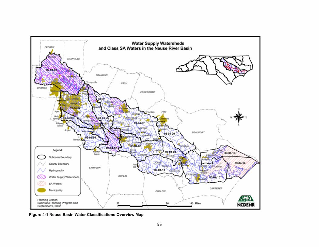
Figure 4-1 Neuse Basin Water Classifications Overview Map
95
In the 2009 Neuse River Basinwide Water Quality Plan, NCDWR identified major sources of water quality impacts to the Neuse River as having impaired biological integrity, low dissolved oxygen levels, and elevated turbidity for the freshwater portions. Also identified were elevated chlorophyll a and high pH (due to elevated nutrients), turbidity and bacteria (fecal coliform and enterococci) levels. Additionally, the NCDWR’s report details that urban development is a concern causing alteration to the watershed hydrology, creating downstream flooding, streambank erosion, channel incision, increased turbidity and degrading of the aquatic and biological habitat.
Alternative 1 - No Action
The No Action plan will result in water quality within the Neuse River Basin that is continuing to be negatively affected by erosion issues and increased suspended sediments and runoff related to frequent high flooding events within the basin.
Alternative 2 - Draft Recommended Plan – Structure Elevation and Floodproofing
The draft Recommended Plan will have effects similar to Alternative 1 - the no action plan. Alternative 2 will not reduce erosion, sedimentation or stormwater runoff within the basin and therefore is not expected to impact water quality.
Alternative 3 - Property Buyouts
The buyout alternative may result in minimal improvements to water quality within the Neuse River Basin by removing structures currently located within the floodplain and allowing the natural vegetation to grow creating additional vegetated buffer in some areas. Natural river buffers are a known way to improve water quality by absorbing and filtering out nutrients and suspended sediments. Riparian buffers also slow down river discharges from a heavy rainfall, reducing the impacts of flooding.
4.1.3. Land Use & Associated Impacts
4.1.3.1 Hazardous, Toxic, and Radioactive Wastes (HTRW)
The Neuse River Basin Study is comprised of mostly moderately sized cities and small towns scattered amongst a mostly rural landscape with larger areas of land being used for agriculture or remaining undeveloped. According to the EPA website, there are three superfund sites pursuant to the Comprehensive Environmental Response Compensation and Liability Act (CERCLA) reported in Wake County, none of these sites was listed on the National Priorities List (NPL). The Wake County CERCLA sites included: Koppers Co., Inc. (Morrisville Plant) (ID: NCD003200383); NC State University (Lot 86, Farm Unit 1) (ID: NCD980557656); Ward Transformer (ID: NCD003202603). Additionally, within the Neuse River Basin, but outside of the identified FRM project area
96
was an NPL located at Cherry Point Marine Corps Air Station (NC1170027261). No other HTRW sites were identified in the project vicinity or in the Neuse River Basin.
Alternative 1 - No Action
The No Action alternative would not adversely impact hazardous and toxic materials located in the proximity of the proposed project area, nor would it produce new hazardous and toxic materials within the Neuse River Basin.
Alternative 2 - Draft Recommended Plan - Structure Elevation and Floodproofing
The draft Recommended Plan will require the Sponsor to be the responsible party for identifying underground storage tanks (USTs) and above ground storage tanks (ASTs) located within the project area. Location of USTs and ASTs will be completed during the PED phase of the project. USTs (including septic systems will be capped and covered and left in place), ASTs will be strapped down and secured in the floodway. Retrofitting of the USTs and ASTs will be designed in accordance with the FEMA guidance: Engineering Principles and Practices for Retrofitting Flood-Prone Residential Structures (2012). Additionally, during the PED phase the Sponsor will conduct asbestos and lead based paint investigations as part of the Phase 1 review of each property to be elevated or floodproofed. Any property containing asbestos or lead based paint would be abated and disposed of properly. Alternative 2 would not adversely impact hazardous and toxic materials located in the proximity of proposed project area, nor would it produce new hazardous and toxic materials within the Neuse River Basin.
Alternative 3 - Property Buyouts
Alternative 3 would require the Sponsor to be the responsible party for identifying underground storage tanks (USTs) and above ground storage tanks (ASTs) located within the project area. Location of USTs and ASTs will be completed during the PED phase of the project. USTs (including septic systems will be capped and covered and left in place), ASTs will be strapped down and secured in the floodway. Retrofitting of the USTs and ASTs will be designed in accordance with the FEMA guidance: Engineering Principles and Practices for Retrofitting Flood-Prone Residential Structures (2012). Additionally, during the PED phase the Sponsor will conduct asbestos and lead based paint investigations as part of the Phase 1 review of each property to demolished or relocated as part of a buyout. Any property containing asbestos or lead based paint would be abated and disposed of properly. Alternative 3 would not adversely impact hazardous and toxic materials located in the proximity of proposed project area, nor would it produce new hazardous and toxic materials within the Neuse River Basin.
97
4.1.3.2 Air Quality
The Clean Air Act requires the US Environmental Protection Agency (EPA) to establish health and science-based standards for air pollutants that have the highest levels of potential harm to human health or the environment. These National Ambient Air Quality Standards (NAAQS) are in place for six air pollutants, also referred to as criteria pollutants. The six criteria pollutants are Ozone, Sulfur Dioxide, Particulate Matter, Lead, Nitrogen Dioxide, and Carbon monoxide. Of the six current criteria pollutants, particle matter and ozone have the most widespread health threats, but they all have the potential to cause damage to human health and the environment. Areas of the country which persistently exceed the NAAQS are designated as “nonattainment” areas and those which meet or exceed the standards are designated “attainment” areas. There are 18 counties within the Neuse River Basin. The ambient air quality for the 7 counties surrounding the project area have all been determined to be in compliance with the National Ambient Air Quality Standards and are designated as attainment areas.
Greenhouse gases absorb infrared radiation, thereby trapping heat and making the planet warmer. The most important greenhouse gases directly emitted by humans include carbon dioxide (CO2), methane (CH4), nitrous oxide (N2O), and several other fluorine-containing halogenated substances. Although CO2, CH4, and N2O occur naturally in the atmosphere, human activities have changed their atmospheric concentrations. From the pre-industrial era (i.e., ending about 1750) to 2017, concentrations of these greenhouse gases have increased globally by 45, 164, and 22 percent, respectively.
Gases in the atmosphere can contribute to climate change both directly and indirectly. Direct effects occur when the gas itself absorbs radiation. Indirect radiative forcing occurs when chemical transformations of the substance produce other greenhouse gases, when a gas influences the atmospheric lifetimes of other gases, and/or when a gas affects atmospheric processes that alter the radiative balance of the earth.
In 2019, total gross United States greenhouse gas emissions were 6,558 MMT, or million metric tons, of carbon dioxide. Total United States emissions have decreased by 1.7 percent from 1990 to 2019, and greenhouse gas emissions in 2019 were 13 percent below 2005 (levels after accounting for sequestration from the land sector - Inventory of US Greenhouse Gas Emissions and Sinks: 1990-2019).
Alternative 1 - No Action
There is no effect to air quality with the No Action Alternative. The No Action alternative would not involve construction or any other actions that could potentially increase emissions or contribute to increased greenhouse gases.
98
Alternative 2 - Draft Recommended Plan - Structure Elevation and Floodproofing
The draft Recommended Plan may result in a very small, localized increase in CO2 air emissions from vehicular traffic and heavy machinery utilized to execute the structure elevation and floodproofing of the selected structures. Alternative 2 includes elevating 419 structures, wet floodproofing 222 structures, and dry floodproofing 127 structures. The timeframe for the structure elevation and floodproofing of each structure would take approximately three-months. The total implementation period for this alternative is approximately 12 years and 3 months, assuming 100 percent homeowner participation. Increases in air pollutants or greenhouse gases from the use of construction equipment would be minor, temporary and localized to the immediate area of construction. There would be no large-scale permanent air quality or greenhouse gas impacts associated with the draft Recommended Plan and no air quality permits would be required.
Alternative 3 - Property Buyouts
This alternative would result in very minimal impacts to air quality or greenhouse gases. There is the potential for a minor, localized increase in CO2 air emissions from vehicular traffic and heavy machinery utilized to execute the removal of the selected structures from the floodplain. There would be no expansive air quality impacts with the Alternative 3 and no air quality permits would be required. The impacts to any associated air quality or greenhouse gases during the actual demolition or relocating of the structure would be temporary and limited to approximately one to two months for the removal of each structure. The time frame for removal of all 164 structures considered in Alternative 3 was estimated at two years.
4.1.3.3 Prime and Unique Farmland
The Farmland Protection Policy Act (FPPA) requires federal agencies to minimize the conversion of prime and unique farmland to non-agricultural uses. Prime and unique farmlands are designations assigned by the United States Department of Agriculture (USDA). Prime farmland is land that has the best combination of physical and chemical characteristics for producing food, feed, forage, fiber, and oilseed crops. The land is also used as cropland, pastureland, rangeland, forest land, or other land, but cannot be used as urban built-up land or a water feature. Unique farmland is land other than prime farmland that is used for the production of specific high value food and fiber crops. Such land has a special combination of soil quality, location, growing season, and moisture supply that is required to economically produce sustained high quality of a specific crop when treated and managed according to acceptable farming methods. A review of the US Department of Agriculture (USDA) Natural Resources Conservation Service (NRCS) Web Soil Survey (https://websoilsurvey.sc.egov.usda.gov/App/WebSoilSurvey.aspx ) shows that there
99
are soils which can be classified as prime farmland soils within the project area. Although there are soils that are classified as prime and unique farmland soils within the project area, they are occurring in areas that already contain homes and other existing structures on previously disturbed ground. No prime or unique farmland soils will be altered as part of this project.
Alternative 1 - No Action, Alternative 2 - Draft Recommended Plan - Structure Elevation and Floodproofing and Alternative 3 - Property Buyouts
All three of the alternatives would not adversely impact prime and unique farmland soils located in the proposed project area. There are no new land disturbing activities proposed with any of the alternatives and any project would occur on previously disturbed residential or commercial property. No prime or unique farmland soils will be altered as part of this project.
4.1.3.4 Noise
North Carolina counties have the authority to regulate noise, pursuant to North Carolina General Statute 153A-133, which grants counties the general power to enact ordinances, stating that “[a] county may by ordinance define, regulate, prohibit, or abate acts, omissions, or conditions detrimental to the health, safety, or welfare of its citizens and the peace and dignity of the county; and may define and abate nuisances.”
Noise levels in the vicinity of the Neuse River Basin project area are variable and often include vehicle traffic from adjacent roads, heavy machinery from ongoing construction projects in the area, and seasonal agricultural activities. The areas around the project are primary rural or suburban consisting mostly agricultural or open lands with small residential communities and associated small town businesses.
Alternative 1 - No Action
The No Action plan will have no effect to ambient noise levels with the project area. The no action alternative would not involve construction within Neuse River Basin so there would be no increases in noise levels.
Alternative 2 - Draft Recommended Plan - Structure Elevation and Floodproofing
The proposed action could cause noise levels to be temporarily elevated during construction activities. The proposed project construction is expected to comply with the various county ordinances for noise. Alternative 2 includes elevating 419 structures, wet floodproofing 222 structures, and dry floodproofing 127 structures. Elevated noise levels due to construction activity will be temporary, all work would be executed during standard daylight working hours, with no after hour or night work expected and the
100
construction on each structure should take approximately 3 months to complete. The total implementation period for this alternative is approximately 12 years and 3 months, assuming 100 percent homeowner participation. No significant, long-term increases in noise levels are expected.
Alternative 3 - Property Buyouts
There are no long-term negative effects to noise anticipated. Impacts to noise with Alternative 3 would be very similar to what is described Alternative 2 involving construction equipment needed to remove the home/structures from the floodplain property. There would be no significant, long-term permanent negative increases in noise anticipated. There could be a long-term positive effect with the decrease of residential noise once the buyouts are completed and the structures are removed, leaving the areas with less traffic and noise generated from previous homes and structures. The impacts to any associated construction noise during the actual demolition or relocating of the structure would be temporary and limited to approximately one to two months for the removal of each structure. Any construction completed for this alternative would be executed during standard daylight working hours, with no after hour or night work expected. The total time frame for removal of all 164 structures considered in Alternative 3 was estimated at two years.
4.1.4. Sea Level Change
As described in Section 2.3, sea level change assumptions consistent with ER 1100-2-8162 and EP 1100-2-1 described Low and High Curve scenarios that resulted in relative increases in water levels at the mouth of the Neuse River between 0.9 feet and 5.2 feet, respectively, for the year 2100. These water level increases were transferred directly from the analyzed Beaufort, NC gage site to the Neuse River Basin study area. Presently, the Pamlico Sound estuary and barrier islands serve to dampen the tidal influence felt along the southeastern side of the outer banks that faces the Atlantic Ocean. Future sea level change may alter this buffering effect and lead to increases in tide fluctuation experienced in the New Bern area as well as increase the distance upstream that it is felt.
Impacts from future sea level change would be most felt by those communities nearest the Pamlico Sound estuary. Projected sea-level change may lead to permanent changes in land use and land cover due to alterations in hydrologic loading within the natural floodplain of the affected area. The amount of development within the floodplain will also exacerbate the effects of sea level change.
Persistent increased water levels within the estuary would cause changes in the flow regime for the lower Neuse River and its nearby tributaries. This regime may negatively impact the river’s efficiency in adequately draining floodwaters following major storm
101
events. Flood events may occur further inland, within the middle and upper portions of the basin and still affect this change. The existing balance between fresh and saltwater concentration within the Pamlico Sound and lower Neuse would be shifted inland under permanently higher water levels. There is uncertainty in the range of future sea-level rise presented, and due to the lack of relief in terrain near the Pamlico Sound, the range of impacts between the low, intermediate and high sea level change curves may be substantially different.
Currently, the location of the draft Recommended Plan is far enough inland from the coastal region such that the effects from permanent sea level and tidal influence are negligible.
Alternative 1 - No Action
The Recommend Plan focuses on locations along the Hominy Swamp Creek in Wilson; Crabtree Creek in Raleigh; Big Ditch in Goldsboro; and the Neuse River mainstem in Wayne and Johnston Counties, all in North Carolina. These locations are at least 50 river miles upstream from the influence of current sea level conditions and historical flooding has been caused by riverine mechanisms only. The projected sea level change is not expected to change the current riverine flooding characteristics of these focus areas. Therefore, under the No Action alternative, the existing identified vulnerable infrastructure would remain at risk for flooding but would not be impacted by sea level change.
Alternative 2 - Draft Recommended Plan - Structure Elevation and Floodproofing and Alternative 3 – Property Buyouts
Identified locations for implementing the structure elevation and/or floodproofing components of Alternative 2 or the property buyouts of Alternative 3 appear to fall beyond the footprint of sea-level change impact that would originate from the most downstream portion of the Neuse River Basin. Therefore, the sea-level change impacts that would be experienced under Alternative 2 or 3 would be similar to Alternative 1 – No Action.
Biological Resources
4.2.1. Vegetation
Within the project area, the Neuse River Basin passes through two distinctive regions, the Piedmont and Coastal Plain of North Carolina which can have some overlapping vegetation characteristics, but also offers some distinctions as the river gets closer to the coast. The North Carolina Natural Heritage Program has identified several natural community types within the Neuse River Basin. These include Dry Oak – Hickory,
102
Mesic mixed hardwood (coastal and piedmont), Mesic pine flatwoods, Coastal plain heath bluff, Pine/scrub oak sandhill, and Xeric sandhill scrub (Natural Heritage Program 2012). Forests in the upland portion of the Piedmont are typically vegetated with an overstory of loblolly pine (Pinus taeda) and long-leaf pine (Pinus palustris), southern red oak (Quercus falcate) and white oak (Quercus alba), yellow poplar (Liriodendron tulipifera), and hickory (Carya spp.) and an understory of dogwood (Cornus florida), sourwood (Oxydendrum arboreum), American holly (Ilex opaca), and red cedar (Juniperus virginiana). Longleaf pines are native to the area. Coastal Plain forests are vegetated with an overstory of sweetgum (Liquidambar styraciflua) and red maple (Acer rubrum). The understory consists of dogwood (Cornus florida), sassafras (Sassafras albidum), and greenbrier (Smilax spp.) (NCDENR 2009). Herbaceous species may include pineland threeawn (Aristida stricta), western brackenfern (Pteridium aquilinum), pineland scalypink (Stipulicida setacea), Spotted Wintergreen (Chimaphila maculate), Littlebrownjug (Hexastylis arifolia), and Christmas fern (Polystichum acrostichoides) (NCDENR 2009).
The Neuse River Basin project area also includes multiple invasive plant species which can be found growing along the bank of the mainstem of the Neuse, as well as in many other locations throughout the river basin. They include: Chinese privet (Ligustrum sinense), Chinaberry (Melia azedarach), Mimosa tree (Albizia julibrissin), Multifloria rose (Rosa multiflora), Japanese stiltgrass (Microstegium vimineum), Chinese wisteria (Wisteria sinensis), Chinese kudzu (Pueraria montana), and lespedeza (Lespedeza bicolor). Executive Order 13112 (Invasive Species), called upon executive departments and agencies to take steps to prevent the introduction and spread of invasive species, and to support efforts to eradicate and control invasive species that are established.
Large trees and other deep-rooted vegetation are vital to the health of the Neuse River Basin by reducing soil erosion along stream banks and filtering out storm water runoff. With the establishment of the Neuse River Buffer Rules, the State of North Carolina established that a vegetive riparian buffer of 50 feet is required to be maintained around all streams, rivers, lakes, and estuaries within the Neuse River Basin.
Alternative 1 - No Action
The No Action plan will result in continued frequent flood events within the Neuse River Basin that have some level of negative effects on vegetation. The negative effects are compounding from years of streambank loss that result from continued erosion issues and stream incision in some parts of the basin. Invasive species will continue to grow and exist throughout the basin and the project areas.
103
Alternative 2 – Draft Recommended Plan – Structure Elevation and Floodproofing
The impacts that will occur relating to any minor tree/vegetation removal needed to access property with respect to Alternative 2 will not be fully developed until the PED phase of the project where each structure can be evaluated in further detail to determine if structure elevation or floodproofing is best. At this stage in development, it is our assumption that since most of the substantial impacts will be occurring on previously disturbed ground, it is not likely new impacts will occur outside of the previously disturbed footprint of the structure site, but this will need to be evaluated during the PED phase. If there were any minor tree/vegetation removal or trimming needed it would be for access to the property for equipment needed to complete the structure elevating and floodproofing, any vegetation trimmed or removed would be allowed to regenerate after construction is completed making the impact mostly temporary in nature. Neuse River buffer rule impacts are unlikely but would not be fully known until PED. Any impacts to vegetation surrounding the construction sites for the structure elevation and floodproofing of individual structures would be temporary and last approximately 90 days. The total estimated implementation time for Alternative 2 is 12 years and 3 months for all structures in the project with 100 percent owner participation. Although no cutting or trimming of vegetation is planned at this stage of the study, Alternative 2 does not include replanting of any native species at the structure elevation or floodproofing site so there could be the potential for additional invasive species to regrow within elevation/floodproofing areas which could have a long-term negative impact to surrounding native vegetation, though minor.
Alternative 3 – Property Buyouts
Property buyouts may result in minimal improvements to vegetation within the Neuse River Basin by removing structures currently located within the floodplain and allowing the vegetation to regrow creating additional vegetated buffer. Natural river buffers are a known way to improve water quality by absorbing and filtering out nutrients and suspended sediments which could improve the river habitat which is considered critical habitat for the Carolina Madtom and the Atlantic Sturgeon. Riparian buffers also slow down the flow of water from a heavy rainfall, lessening the habitat reducing impacts caused by erosion from frequent flooding. Invasive species could potentially regrow in the buyout areas where homes or structures are removed from the floodplain property, the current Alternative 3 does not include replanting of any native species at the buyout site after structure removal. The potential for additional invasive species to regrow within the buyout areas would have a long-term minor impact to surrounding native vegetation.
104
4.2.2. Wildlife
Wildlife present within the Neuse River Basin includes a mix of mammals, birds, reptiles and amphibians common to the North Carolina Piedmont and Coastal Plain Regions. Mammals common throughout the river basin include: grey squirrels (Sciurus carolinensis), Eastern cottontail rabbit (Sylvilagus floridanus), white-tailed deer (Odocoileus virginianus), raccoon (Procyon lotor), grey fox (Urocyon cinereoargenteus), red fox (Vulpes vulpes), nutria (Myocaster coypus), river otter (Lontra Canadensis), muskrat (Ondatra zibethicus), beaver (Castor canadensis), black bear (Ursus americanus), coyote (Canis latrans) and opossum (Didelphis virginiana) (NCWRC, 2022).
Birds frequently found within the Neuse River Basin include a mixture and variety of waterfowl, songbirds, and raptors, with many species being seasonal migratory birds. Waterfowl frequently seen in the basin include: black duck (Anas rubripes), mallard (Anas platyrhynchos), wood duck (Aix sponsa), ruddy duck (Oxyura jamaicensis), Canada goose (Branta canadensis), double-crested cormorant (Nannopterum auritum), great blue heron (Ardea herodias), great egret (Ardea alba), and white ibis (Eudocimus albus). A variety of common songbirds in the basin consist of: northern cardinal (Cardinalis cardinalis), Carolina chickadee (Poecile carolinensis), tufted titmouse (Baeolophus bicolor), summer tanager (Piranga rubra), cedar waxwing (Bombycilla cedrorum), American robin (Turdus migratorius), downy woodpecker (Dryobates pubescens), song sparrow (Melospiza melodia), American crow (Corvus brachyrhynchos), blue jay (Cyanocitta cristata), and mourning dove (Zenaida macroura). Predominate raptors found in the basin are: red-shouldered hawk (Buteo lineatus), red-tailed hawk (Buteo jamaicensis), turkey vulture (Cathartes aura), bald eagle (Haliaeetus leucocephalus), Cooper’s hawk (Accipiter cooperii), barred owl (Strix varia), great horned owl (Bubo virginianus), and Eastern screech-owl (Megascops asio) (NCWRC, 2022 and LeGrand,H, et al., 2022). The swamp, flood-plain, and river located within the basin study area are all very important habitats for many of various species of birds listed above.
The Neuse River includes many unique and diverse amphibians and reptiles. Some notable ones include two species of giant aquatic salamanders the federally listed Neuse River waterdog (Necturus lewisis) and the dwarf waterdog (Necturus punctatus). Both giant aquatic salamanders can be found within the vicinity of the mainstem of the Neuse River and some of its tributaries. Some reptiles found within the Neuse basin include: the American alligator (Alligator mississippiensis), slender glass lizard (Ophisaurus attenuates), green anole (Anolis carolinensis), five-lined skink (Eumeces (Plestiodon) fasciatus), brown water snake (Nerodia taxispilota), eastern kingsnake (Lampropeltis getula), rough green snake (Opheodrys aestivus), cottonmouth (Agkistrodon piscivorus), and copperhead (Agkistrodon contortrix) (NCWRC, 2022).
105
Alternative 1 - No Action
The No Action plan will result in continued frequent flood events within the Neuse River Basin that would have some level of negative effects on wildlife. The negative effects are compounding from years of habitat loss that result from continued erosion issues caused by stream bank loss and incision, decreased water quality due to increased sedimentation and pollution, loss of habitat, and lower food abundance.
Alternative 2 – Draft Recommended Plan – Structure Elevation and Floodproofing
The impacts that could occur relating to any minor habitat loss due to tree/vegetation removal or ground disturbance needed to access property with respect to Alternative 2 will not be fully developed until the PED stage of the project where each structure can be evaluated in further detail to determine which measure of Alternative 2 is best. At this stage in development, it is our assumption that since most of the impacts will be occurring on previously disturbed ground it is not likely new impacts will occur outside of the previously disturbed footprint of the structure site, but this will need to be evaluated during the PED stage. Any impacts to tree/vegetation trimming or removal or ground disturbance that would be needed for equipment to gain access to the site would be minor and temporary and the site around the property to be elevated or floodproofed would be allowed to regenerate after construction. Additionally, each house to be elevated or floodproofed is expected to be completed in 90 days. The total estimated implementation time for Alternative 2 is 12 years and 3 months for all structures in the project with 100 percent owner participation. The impacts of any noise or air quality effects from the construction of the elevated structures and floodproofing would be minor and temporary to local wildlife within each of the identified areas.
Alternative 3 – Property Buyouts
Property buyouts may result in minimal improvements to habitat for wildlife within the Neuse River Basin by removing structures currently located within the floodplain and allowing the vegetation to regrow creating additional cover and foraging area for fauna. There could be temporary minor negative impacts to wildlife with associated construction noise and air quality effects during the actual removal of any structure on the property, but none of those impacts would be permanent.
4.2.3. Threatened and Endangered Species
Pursuant to Section 7 of the Endangered Species Act, the USACE coordinated with the United States Fish and Wildlife Service (USFWS) and the National Marine Fisheries Service (NMFS) to identify endangered and threatened species that might be present in the vicinity of the project area (Figure 4-2). Species that are currently Federally listed as endangered or threatened (as well as Federal Species of Concern), which may or do
106

occur in the Neuse River Basin project area, and which may be subject to impacts from the proposed project are listed in Table 4-1 which follows the study area map below.
107
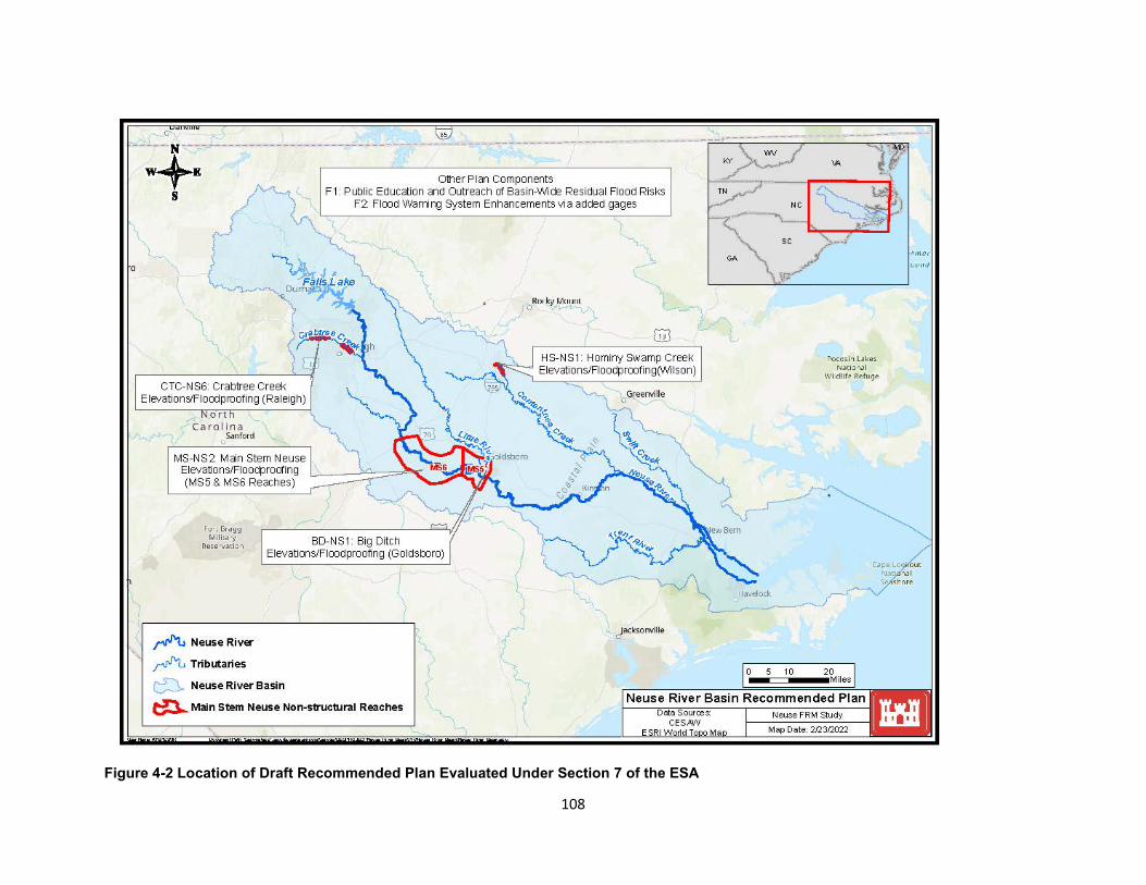
Figure 4-2 Location of Draft Recommended Plan Evaluated Under Section 7 of the ESA
108
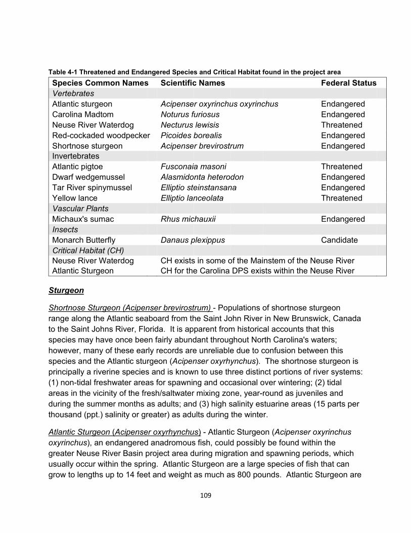
Table 4-1 Threatened and Endangered Species and Critical Habitat found in the project area Species Common Names Scientific Names Federal Status Vertebrates Atlantic sturgeon Acipenser oxyrinchus oxyrinchus Endangered Carolina Madtom Noturus furiosus Endangered Neuse River Waterdog Necturus lewisis Threatened Red-cockaded woodpecker Picoides borealis Endangered Shortnose sturgeon Acipenser brevirostrum Endangered Invertebrates Atlantic pigtoe Fusconaia masoni Threatened Dwarf wedgemussel Alasmidonta heterodon Endangered Tar River spinymussel Elliptio steinstansana Endangered Yellow lance Elliptio lanceolata Threatened Vascular Plants Michaux's sumac Rhus michauxii Endangered Insects Monarch Butterfly Danaus plexippus Candidate Critical Habitat (CH) Neuse River Waterdog CH exists in some of the Mainstem of the Neuse River Atlantic Sturgeon CH for the Carolina DPS exists within the Neuse River
Sturgeon
Shortnose Sturgeon (Acipenser brevirostrum) - Populations of shortnose sturgeon range along the Atlantic seaboard from the Saint John River in New Brunswick, Canada to the Saint Johns River, Florida. It is apparent from historical accounts that this species may have once been fairly abundant throughout North Carolina's waters; however, many of these early records are unreliable due to confusion between this species and the Atlantic sturgeon (Acipenser oxyrhynchus). The shortnose sturgeon is principally a riverine species and is known to use three distinct portions of river systems: (1) non-tidal freshwater areas for spawning and occasional over wintering; (2) tidal areas in the vicinity of the fresh/saltwater mixing zone, year-round as juveniles and during the summer months as adults; and (3) high salinity estuarine areas (15 parts per thousand (ppt.) salinity or greater) as adults during the winter.
Atlantic Sturgeon (Acipenser oxyrhynchus) - Atlantic Sturgeon (Acipenser oxyrinchus oxyrinchus), an endangered anadromous fish, could possibly be found within the greater Neuse River Basin project area during migration and spawning periods, which usually occur within the spring. Atlantic Sturgeon are a large species of fish that can grow to lengths up to 14 feet and weight as much as 800 pounds. Atlantic Sturgeon are
109
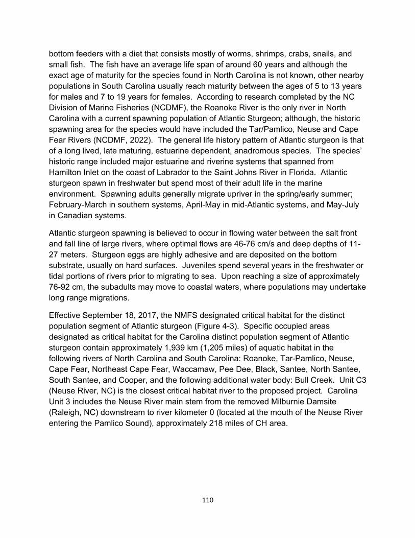
bottom feeders with a diet that consists mostly of worms, shrimps, crabs, snails, and small fish. The fish have an average life span of around 60 years and although the exact age of maturity for the species found in North Carolina is not known, other nearby populations in South Carolina usually reach maturity between the ages of 5 to 13 years for males and 7 to 19 years for females. According to research completed by the NC Division of Marine Fisheries (NCDMF), the Roanoke River is the only river in North Carolina with a current spawning population of Atlantic Sturgeon; although, the historic spawning area for the species would have included the Tar/Pamlico, Neuse and Cape Fear Rivers (NCDMF, 2022). The general life history pattern of Atlantic sturgeon is that of a long lived, late maturing, estuarine dependent, anadromous species. The species’ historic range included major estuarine and riverine systems that spanned from Hamilton Inlet on the coast of Labrador to the Saint Johns River in Florida. Atlantic sturgeon spawn in freshwater but spend most of their adult life in the marine environment. Spawning adults generally migrate upriver in the spring/early summer; February-March in southern systems, April-May in mid-Atlantic systems, and May-July in Canadian systems.
Atlantic sturgeon spawning is believed to occur in flowing water between the salt front and fall line of large rivers, where optimal flows are 46-76 cm/s and deep depths of 11-27 meters. Sturgeon eggs are highly adhesive and are deposited on the bottom substrate, usually on hard surfaces. Juveniles spend several years in the freshwater or tidal portions of rivers prior to migrating to sea. Upon reaching a size of approximately 76-92 cm, the subadults may move to coastal waters, where populations may undertake long range migrations.
Effective September 18, 2017, the NMFS designated critical habitat for the distinct population segment of Atlantic sturgeon (Figure 4-3). Specific occupied areas designated as critical habitat for the Carolina distinct population segment of Atlantic sturgeon contain approximately 1,939 km (1,205 miles) of aquatic habitat in the following rivers of North Carolina and South Carolina: Roanoke, Tar-Pamlico, Neuse, Cape Fear, Northeast Cape Fear, Waccamaw, Pee Dee, Black, Santee, North Santee, South Santee, and Cooper, and the following additional water body: Bull Creek. Unit C3 (Neuse River, NC) is the closest critical habitat river to the proposed project. Carolina Unit 3 includes the Neuse River main stem from the removed Milburnie Damsite (Raleigh, NC) downstream to river kilometer 0 (located at the mouth of the Neuse River entering the Pamlico Sound), approximately 218 miles of CH area.
110
Figure 4-3 Southeast United States Atlantic Sturgeon Critical Habitat
Alternative 1 - No Action
The No Action plan will result in continued frequent flood events within the Neuse River Basin that have some level of negative effects on threatened and endangered species and critical habitat which is located within tributaries and the Neuse River mainstem. The critical habitat is being negatively affected by streambank loss and incision, which is causing excess sedimentation within the water column and covering gravel or rocky areas along the river bottom which are essential for species such as the Atlantic sturgeon and the Neuse River waterdog which rely on this type of habitat for spawning or shelter. The negative effects are compounding from years of habitat loss that result from continued erosion issues caused by stream bank loss and incision, decreased water quality due to increased sedimentation and pollution, loss of habitat, and lower food abundance.
111
Alternative 2 - Draft Recommended Plan – Structure Elevation and Floodproofing
The impacts that could occur relating to any minor habitat loss due to tree/vegetation removal or ground disturbance needed to access property with respect to Alternative 2 will not be fully developed until the PED stage of the project where each structure can be evaluated in further detail to determine which measure of Alternative 2 is best. At this stage in development, it is our assumption that since most of the impacts will be occurring on previously disturbed ground it is not likely new impacts will occur outside of the previously disturbed footprint of the structure site, but this will need to be evaluated during the PED stage. Any impacts to tree/vegetation trimming or removal or ground disturbance that would be needed for equipment to gain access to the site would be minor and temporary and the site around the property to be elevated or floodproofed would be allowed to regenerate after construction. Additionally, each house to be elevated or floodproofed is expected to be completed in 90 days. The total estimated implementation time for Alternative 2 is 12 years and 3 months for all structures in the project with 100 percent owner participation. The impacts from the construction of the elevated structures and floodproofing would be minor and temporary within each of the identified areas.
The Atlantic sturgeon, Carolina madtom, Neuse River Waterdog, shortnose sturgeon, Atlantic pigtoe, Dwarf wedgemussel, Tar River spinymussel, and Yellow lance are federally listed as threatened or endangered and may be present in rivers and tributaries located in the Neuse River Basin project area. However, these species are highly mobile and are not likely to be adversely affected by the proposed action which will take place on high ground outside of the river and tributary areas where these species are most likely to occur. Additionally, the proposed action will not take place in any river or tributary so there will be no effect to the listed Critical Habitat for the Neuse River waterdog or Atlantic Sturgeon. Likewise, the federal and State listed, endangered red-cockaded woodpecker is a highly mobile species and is not currently known to roost or forage in the proposed project area vicinity which includes currently inhabited homesites located within the floodplain. Also, tree cutting or land clearing is not being is not proposed as part of the draft Recommended Plan. The draft Recommended Plan is not likely to adversely affect the red-cockaded woodpecker.
Moreover, the project will take place on previously disturbed ground where existing structures and homes are already present with no additional clearing being proposed. Michaux’s sumac generally is found in dry, rocky or sandy soils, not indictive of the floodplain soils present within this project area; and in open cleared areas, free from tree overstory such as open fields, roadside ditches, and maintained utility right of ways. Although there is Michaux’s Sumac documented in Wake County, the closest known areas of occurrence occur at William B. Umstead State Park and an area in Knightdale both which are located outside of our project area; there are no known occurrences of
112
this plant within the other county project sites. Alternative 2 will have no effect on the endangered Michaux’s Sumac. The monarch butterfly is a candidate species and not yet listed or proposed for listing, currently there are generally no Section 7 requirements for candidate species. However, since there are no new areas of clearing or construction proposed, Alternative 2 should have no effect on the monarch butterfly which relies on open fields and access to Milkweed (primarily Asclepias spp.) species plants in order to lay eggs.
Overall, floodproofing and elevating structures will have insignificant, if any, impacts on all ESA species found within the project area.
Alternative 3 – Property Buyouts
Property buyouts may result in minimal improvements to threatened and endangered species within the Neuse River Basin by removing structures currently located within the floodplain and allowing the natural vegetation to regrow creating additional vegetated river buffer along with habitat in some areas. Natural river buffers are a known way to improve water quality by absorbing and filtering out nutrients and suspended sediments which could improve the river habitat which is considered critical habitat for the Carolina Madtom and the Atlantic Sturgeon. Riparian buffers also slow down the flow of water from a heavy rainfall, lessening the habitat reducing impacts caused by erosion from frequent flooding.
The Atlantic sturgeon, Carolina madtom, Neuse River Waterdog, shortnose sturgeon, Atlantic pigtoe, Dwarf wedgemussel, Tar River spinymussel, Yellow lance are federally listed as threatened or endangered and may be present in rivers and tributaries located in the Neuse River Basin project area. However, these species are not likely to be adversely affected by Alternative 3 which will take place on high ground outside of the river and tributary areas where these species are most likely to occur. Additionally, Alternative 3 will not take place in any river or tributary so there will be no effect to the listed Critical Habitat for the Neuse River waterdog or Atlantic Sturgeon. Likewise, the federal and State listed, endangered red-cockaded woodpecker is a highly mobile species and is not currently known to roost or forage in the Alternative 3 vicinity areas which includes currently inhabited homesites located within the floodplain. Also, tree cutting or land clearing is not being proposed as part of the buyout plan. This alternative is not likely to adversely affect the red-cockaded woodpecker. Moreover, the project will take place on previously disturbed ground where existing structures and homes are already present with no additional clearing being proposed. Michaux’s sumac generally is found in dry, rocky or sandy soils, not indictive of the floodplain soils present within this project area; and in open cleared areas, free from tree overstory such as open fields, roadside ditches, and maintained utility right of ways. Although there is Michaux’s Sumac documented in Wake County, the closest known areas of
113
occurrence occur at William B. Umstead State Park and an area in Knightdale both which are located outside of our project area; there are no known occurrences of this plant within the other county project sites. Alternative 3 will have no effect on the endangered Michaux’s Sumac. The monarch butterfly is a candidate species and not yet listed or proposed for listing, currently there are generally no Section 7 requirements for candidate species. However, since there are no new areas of clearing or construction proposed, Alternative 3 should have no effect on the monarch butterfly which relies on open fields and access to Milkweed (primarily Asclepias spp.) species plants in order to lay eggs.
4.2.4. Essential Fish Habitat (EFH)
The National Marine Fisheries Service (NMFS) is responsible for enforcing the Magnuson-Stevens Fishery Conservation and Management Act (MFCMA), (1996 amendments) (MSA), which, is intended to promote sustainable fisheries. To implement the MSA, the NMFS and the eight regional Fishery Management Councils have identified and described EFH for each managed fish species. EFH can consist of both the water column (pelagic) and the underlying surface (seafloor) of a particular area. Areas designated as EFH contain habitat essential to the long-term survival and health of our nation’s fisheries.
There are not any known habitats or areas identified as essential fish habitat (EFH) located directly within the project area. In compliance with Section 305(b)(2) of the MSA, this report includes an assessment of the potential effects of the proposed alternatives on nearby EFH. Correspondence received from NMFS on 17 June 2020 during scoping mentioned that there is an area downstream of New Bern, in the Neuse River and the associated creeks that provides essential fish habitat (EFH) for a number of NOAA-trust resource species, such as bluefish (Pomatomus saltatrix), summer flounder (Paralichthys dentatus), brown shrimp (Farfantepenaeus aztecus), and white shrimp (Litopenaeus setiferus).
Alternative 1 - No Action, Alternative 2 - Draft Recommended Plan - Structure Elevation and Floodproofing and Alternative 3 - Property Buyouts
There would be no impact to EFH associated with any of the three alternatives. Since none of the plans have structural elements that would alter any of the floodplain, the Neuse River or associated tributaries there would be no change or impact to downstream EFH with any of the alternatives. Additionally, positive changes potentially gained from increased vegetation within the Neuse River Buffer or improved water quality from decreased erosion would be so minor in scale and extremely localized, it would be very unlikely to have any noticeable effect on EFH located downstream of New Bern.
114
Cultural Resources
Initial coordination has been conducted with the North Carolina Office of State Archaeology (NCOSA) and the North Carolina State Historic Preservation Office (NCSHPO) to discuss the study’s goals, scope, and proposed compliance with Section 106 of the NHPA. Coordination to date includes examination of data inventories in the area of potential effect (APE) as defined during the study’s scoping period. The draft Recommended Plan includes elevating 419 structures, dry floodproofing 127 structures and wet floodproofing 222 structures. At least 14 buildings, structures and objects that are listed in, determined eligible or potentially eligible for listing in the NRHP and 4 historic districts either listed in, or determined potentially eligible for listing in the NRHP are also located within the project areas. Documentation of NCOSA/NCSHPO coordination to date is included in Appendix G (Cultural Resources). Following initial scoping-level discussions with the NCOSA/NCSHPO, the APE has been refined and is currently depicted as five distinct areas shown in Figure 5-1, now synonymous with the project area. The nearest cities to the project area are Raleigh, Goldsboro, and Wilson, all in North Carolina. The City of Goldsboro contains eight properties listed in the NRHP and one National Park Service-certified historic district. Similarly, the City of Wilson contains five properties listed in the NRHP, one property considered eligible for listing, and five historic districts (NC Department of Natural and Cultural Resources 2021).
Informal reconnaissance level cultural resource surveys of the upper Hominy Swamp Creek portion of the study area (near Wilson, NC) were conducted on November 3, 2021 during a multi-agency site visit that included representation from the NCOSA. Reconnaissance level survey recommendations were that Phase I surveys may be required during the Study’s PED phase in areas subject to ground disturbing activity, aligning with compliance actions proposed in the draft Programmatic Agreement (Appendix G – Cultural Resources). Although land clearing and/or grading is not anticipated, further evaluation will be performed during the PED phase of the project. Due to project milestones and schedule, the USACE cannot conduct surveys, should they be necessary, to identify and evaluate cultural resources and determine effects of the project on historic properties prior to completion of the integrated feasibility study and environmental assessment. For this reason, a Programmatic Agreement will be required to comply with Section 106 of the NHPA. All Section 106-related correspondence to date is included in Appendix G (Cultural Resources).
Alternative 1 - No Action
Erosion in areas subject to high water velocities (e.g., streambanks) may be expected to increase. Where erosion is most severe, cultural resources, especially prehistoric archaeological resources, in the project area may eventually be lost. Over time, additional historic structures are likely to meet the NRHP requirements for eligibility
115
evaluation. Future flooding effects may increase as compared to those currently realized due to expected increases in population and infrastructure, impervious surfaces in the watershed, and incidence and severity of storm events in the study area. Increased flooding may imperil historic structures. The No Action alternative would have negative impacts of ranging severity on cultural resources in the study area, due to variability in storm intensities and associated flooding and erosion.
Alternative 2 - Draft Recommended Plan - Structure Elevation and Floodproofing
Alternative 2 has the potential to cause adverse effects to historic properties; however, net effects of Alternative 2 would be positive. Referencing 36 CFR § 800.5, adverse effects could be physical damage to all or part of a property, change of the character of a property’s use or physical features, introduction of visual elements that diminish significant historic features, etc. Structure elevation and floodproofing measures will conform to the Nonstructural Implementation Plan (Appendix I). The Programmatic Agreement developed for the project identifies the process by which USACE will determine which of the participating buildings and structures are historic properties (Appendix G – Cultural Resources). This process also includes conducting archaeological investigations associated with buildings and structures determined to be historic properties and identifying mitigation requirements, if necessary. The investigations, coordination, and consultation required by the Programmatic Agreement, and any resulting mitigation, will be conducted during the project’s PED phase and after participating buildings and structures are identified but before implementation of Alternative 2 begins. This alternative would have net positive impacts upon NRHP-eligible or -listed structures in the project area, although erosion-based impacts to archaeological resources are expected to remain similar to those of the No Action alternative. Any qualified historic structures would be protected rather than being continually subjected to flood risk. Floodproofing and elevation would conform to The Secretary of the Interior's Standards for Rehabilitation, published at 36 CFR Part 67.
Alternative 3 - Property Buyouts
Property buyouts would include flood risk management in the form of acquisition of structures and associated lands for a total of 164 structures in Kinston, Goldsboro and Wilson, all in North Carolina. Structures included in the buyout areas would be demolished or relocated from the property and the land would be returned to a natural state. At least 14 buildings, structures and objects that are listed in, determined eligible or potentially eligible for listing in the NRHP and four historic districts either listed in, or determined potentially eligible for listing in, the NRHP are also located within the proposed areas for property buyouts. The Programmatic Agreement developed for the project identifies the process by which USACE will determine which of the participating buildings and structures are historic properties (Appendix G – Cultural Resources). This
116
alternative would have negative impacts of ranging severity on cultural resources in the project area due to variability in storm intensities and associated flooding and erosion. Property buyouts alone would not change flood or erosion risk regarding archaeological resources or NRHP-eligible or -listed structures as compared to No Action conditions. Furthermore, this alternative would have significant negative impacts upon NRHP-eligible or -listed structures should demolition occur. Demolition of eligible or listed structures may require mitigation, to be coordinated with the NCSHPO and Advisory Council on Historic Preservation (ACHP) in accordance with the Programmatic Agreement (Appendix G – Cultural Resources).
Aesthetic and Recreational Resources
Hunting, fishing, bird and wildlife watching are popular activities within the Neuse River Basin and add millions of dollars to the economy through license fees and sales of equipment and supplies. These revenues are directly dependent on the ability to maintain and enhance the natural resources of North Carolina. According to the 2011 National Survey of Fishing, Hunting, and Wildlife-Associated Recreation in North Carolina, 1,307,000 residents identified as anglers, 317,000 residents identified as hunters, and 2,124,000 residents identified as wildlife watchers (USFWS, US Census rev. 2018). North Carolina residents spent $1,537,074,000 in the United States on fishing related activities during 2011; with the average angler spending $1,176. Hunters and wildlife watchers also reported spending about $2,017 per hunter and $586 per wildlife watcher. With the Neuse River Basin being a prime location for avid hunters, anglers, and bird/wildlife watching enthusiast, preserving natural land, including wetlands, forest, and natural rivers is important to preserve as a resource for recreation.
In addition to hunting and fishing, the Neuse River Basin offers many opportunities for other outdoor recreation activities such as hiking, camping, picnicking, wildlife photography, swimming, boating, and kayaking. Some larger parks located within the basin include: Cliffs of the Neuse State Park, Neuse River Recreational Area within the Croatan National Forest, Falls Lake State Recreation Area, and William B. Umstead State Park. The Neuse River has not been designated as a “Wild and Scenic” river nor categorized in any manner by a Federal or State entity.
Within the selected project area some examples of recreation areas include: William B. Umstead State Park, located near Crabtree Creek in Raleigh, NC; Goldsborough Bridge Battlefield and Busco Beach, located in just off the Neuse in Goldsboro, NC; Wilson Botanical Gardens, located in Wilson, NC; and Neuseway Nature Park, located in Kinston, NC. Additionally, there are many small community parks and recreational sports fields located within the various project areas.
117
Alternative 1 - No Action, Alternative 2 - Draft Recommended Plan - Structure Elevation and Floodproofing and Alternative 3 - Property Buyouts
There would be No Effect to aesthetics or recreation with any of the 3 listed alternatives. None of the alternatives would involve new construction within Neuse River Basin so there would be no changes to the current aesthetics or the available land to use for recreation.
Socioeconomics
This section presents indicators of social vulnerability that can be used as qualitative metrics to evaluate the array of alternatives under the OSE account. These indicators include Health and Safety, Economic Vitality, Social Connectedness, Identity, Social Vulnerability and Resiliency, and Participation.
Demographic data is displayed in Section 2.8 for the study area. These statistics show that the study area has a similar age distribution, poverty rate, education level, and household size relative to the national average. Median household income, and median home value are slightly lower in the study area compared to the rest of the nation.
Alternative 1 – No Action Plan
In the absence of a federal project, it is estimated that flood events will continue to impact the population at risk. Groups that will be disproportionately impacted by these flood events include the population living under the poverty line, and those with lower median household incomes and larger household sizes, as shown in Figures 2-5 and 2-8. Flood events will continue to impact local businesses, causing temporary closures and loss of wages.
Alternative 2 – Draft Recommended Plan – Structure Elevation and Floodproofing
Under Alternative 2, the risk of flooding will be reduced for structures that are floodproofed and elevated. The proposed measures would not cause disproportionately high and adverse impacts on minority populations or low-income populations as described in Section 5.6, and there would be no induced flooding in any areas. Residents will remain in their current communities and economic growth will be sustained. Alternative 2 will result in an estimated 1,436 jobs created in the local economy, and an estimated increase in labor income of $85 million in the local economy. These regional economic impact estimates are described in more detail in Section 7 of Appendix B (Economics).
118
Alternative 3 – Property Buyouts
Under Alternative 3, the risk of flooding will be eliminated for homes that are bought out and removed from the floodplain. The proposed measures will not impact water surface elevations or cause induced flooding. This alternative will not cause disproportionately high and adverse impacts on minority or low-income populations as described in Section 5.6. Local economies may experience economic transfers to other areas as residents move outside of the floodplain. Alternative 3 will result in an estimated 106 jobs created in the local economy and will result in an estimated increase in labor income of about $6 million in the local economy. These regional economic impact estimates are directly related to the costs spent on structure demolition and removal and are described in more detail in Section 7 of Appendix B (Economics).
4.5.1. Health and Safety
The health and safety of a community can be negatively impacted by flooding, and these effects can continue for many years after the event. Elderly individuals can be the most affected by flooding, especially in regard to their health, longevity, and safety. Studies have shown that older residents are more likely to experience depressive symptoms after natural disasters, especially when their community lacks cohesion because of these events (Chao, 2016). However, all individuals are affected by flooding disasters and may experience major psychological trauma that can include post-traumatic stress disorder, anxiety, depression, and worsened existing related psychological conditions (Fernandez et al. 2015, Goldmann et al. 2014, Hetherington et al. 2018).
Alternative 1 - No Action
Under the no action alternative, flooding can present a serious hazard to residents’ safety outside of psychological conditions. Flooding may continue to claim lives each year as people are unable to evacuate or climb to safety. When floodwaters threaten a community, local officials disseminate a warning to their residents who must first receive such a warning, understand its implications, and act quickly. It is generally assumed residents can get out of harm’s way by evacuating (on foot, car, or likewise) or by climbing to higher elevation (like ascending to the second or third level of a home). These options both carry risks. Physical evacuation can lead to overcrowded roads, where fleeing residents are left trapped in their cars if floodwaters arrive. Climbing to a higher elevation may provide some level of safety from floodwaters, however residents are left stranded in their structure until the floodwaters recede. Further, elderly residents may have trouble climbing stairs/ladders that can offer protection from rising floodwaters. Under Alternative 1, risks associated with evacuation and negative impacts to health and safety will persist.
119
Alternative 2 – Draft Recommended Plan – Structure Elevation and Floodproofing
Under Alternative 2, the protected communities will likely be healthier and safer from impending floodwaters. Structure elevation and floodproofing measures designed to reduce damage to homes and their contents create a safer environment for the communities they help. Most importantly, these measures will keep residents above the floodwaters. Residents will not have to risk evacuating on foot or by car and getting trapped in moving waters. When homes are floodproofed, they are less likely to become inundated during a flood, preventing possible disease associated with post-flood structures (Ohl and Tapsell, 2000). Mental health and psychological safety will also be protected by these measures. Residents will be less likely to worry about rebuilding following a flood event. They will be less likely to worry about temporary relocations and the loss of their personal belongings while the floodwaters remain high.
Alternative 3 – Property Buyouts
Under Alternative 3, the protected communities will likely be healthier and safer from impending floodwaters. Removing structures and residents from the floodplain will eliminate flooding to these structures and prevent residents from getting caught by floodwaters in event of a flood-induced evacuation.
Mental health and psychological safety could be better or similar to the no action plan. Residents will not need to worry about rebuilding following a flood event. However, residents may suffer stress or a sense of loss of community by leaving their communities and current homes.
4.5.2. Economic Vitality
Many of the reaches in the study area are characterized by high poverty rates and unemployment, as shown in tables and figures in Section 2.8. Flood events can increase poverty rates and unemployment when businesses are required to close due to floodwaters. This can result in individuals experiencing losses in income.
Alternative 1 - No Action
Under the no action plan, disruption to the economy, business losses, and loss of wages may negatively impact the local economy for some time after flood events and contribute to a gradual deterioration of the economy (Cavallo et al. 2013). Further, many of the communities in the study area do not have large employers that give residents a reason to remain in the community. North Carolina’s economy has maintained a strong growth rate, so residents may relocate to other areas within the state to avoid flooding and potential job losses. The communities they leave behind are
120
more likely to see stagnant growth as residents choose other regions with greater housing and occupational stability.
Residents who believe they are greatly affected by a flooding disaster are more likely to have a reduced perception of their community’s recovery (Bergsrand et al. 2020). In this case, the effects of hazards within the physical environment translate into negative perceptions about the local economy. This can lead to a downward spiral among residents where they feel trapped in their community
Alternative 2 - Draft Recommended Plan - Structure Elevation and Floodproofing
Under Alternative 2, residents can remain in their homes and have a reduced level of flood risk. This will allow them to stay in their community and work in their traditional occupations. By remaining in the community, they can create a positive attitude about their community’s recovery and help their neighbors (Bergstrand and Mayer, 2020). The local economy is intrinsically tied to its members’ health. When residents can remain in their occupations following a flood, they are likely to be healthier, both immediately and in the long run. Residents can contribute to their local economic growth and provide a quick restart to local production and consumption, thus helping the other members of their community.
Alternative 3 - Property Buyouts
Economic vitality under Alternative 3 in the immediate community will decrease. Local businesses may suffer when residents permanently relocate to another area and residential structures are bought out and demolished. Additionally, relocating residents may impact their jobs, and potentially cause individuals to choose jobs outside of their original communities. Local and regional economic growth may decline as a result of property buyouts and acquisitions.
4.5.3. Social Connectedness
Natural disasters including flood events influence the social structure of a community and impact the growth and sustainability of a community. Social connectedness determines how a community responds and recovers from a significant flood event.
Alternative 1 - No Action
Under the no action alternative, flood events will persist. As communities deal with a disaster, they may lose or gain social connectedness, however, this can vary depending on the existing social structure of the community. Communities with many close bonds may have higher cohesion following a flood. At the individual level, those who remain in the community to volunteer and participate are more likely to experience positive community cohesion (Luden et al. 2019). However, residents who were marginalized or
121
did not participate prior to a flood are not likely to remain in the community and help build this community cohesion. In areas with many transient workers or impoverished residents, these effects will be especially pronounced.
Further, the level of existing organizations, such as volunteer groups, non-profits, and community outreach programs can help to mitigate the negative effects of flooding on social connectedness. This allows community members to connect as they begin the rebuilding process. Many of the impact areas within this study have a variety of these programs in place that could be a source of support following a flood. For example, the Crabtree Creek reach has several of these organizations including the Salvation Army, the Food Bank of Central and Eastern North Carolina, and Wake County Public Health Center. However, in areas with more persons living below the poverty level, there are fewer of these programs available.
Alternative 2 - Draft Recommended Plan - Structure Elevation and Floodproofing
Under Alternative 2, residents of flood-prone communities would be more likely to feel social connectedness after a flood because of the reduction in risk to individuals and their homes. While social connectedness can fray following a disaster, when residents team up to help each other out, they are more likely to feel like they belong to a part of a community. When residents’ homes are protected from floodwaters, they are more likely to participate in the community and help their neighbors out. Residents can participate when they feel they are a part of the long-term community. If homes and residents’ belongings are undamaged, they can help each other clean up debris and repair other damages caused by flooding.
Alternative 3 - Property Buyouts
Social connectedness is likely to be negatively impacted by Alternative 3. Residents in flood-prone communities that are forced to relocate and leave their communities may experience a loss of friendships, and a loss of a sense of belonging until they form bonds in their new communities.
4.5.4. Identity
Residents’ identity with their community can suffer from the effects of flooding. Conversely, when residents are not subject to floodwaters and can remain in their communities, their identity within the community remains intact.
Alternative 1 - No Action
When residents are detached prior to a disaster, they are more likely to lose any identity they had with their community (Tapsell et al. 2002). However, in communities that have strong bonds prior to flooding, these ties are at risk of being frayed by stress and
122
disagreement over post-disaster decisions. While a serious flooding event may cause residents to question their identity to the community; living in a floodplain with the constant threat of flooding can cause detachment. The constant threat of flooding means community members are aware their home and/or place of work may be temporary, leading residents to view their position in the community as temporary. If residents develop this assumption, it becomes more difficult for community ties to develop, which could lead individuals to create a more cohesive identity within the community.
Alternative 2 - Draft Recommended Plan - Structure Elevation and Floodproofing
Similar to improvements in social connectedness, floodproofing projects may increase residents’ identity within the community allowing them to stay longer and contribute to the social fabric and economy. Structure elevation and floodproofing measures are likely to help residents feel that they are protected against potential flooding events, creating a sense of resiliency that is helpful following a flood (Redshaw et al. 2018). Because structure elevation and floodproofing visibly helps the members of the community with homes in the path of flooding, they are more likely to contribute to their community’s well-being.
Alternative 3 - Property Buyouts
Similar to social connectedness, a sense of identity may be negatively impacted by Alternative 3. Residents whose homes are bought out and relocate to other communities may experience a loss of identity from leaving their communities and the homes they had previously lived in.
4.5.5. Social Vulnerability and Resiliency
Social vulnerability is the susceptibility of social groups to the adverse impacts of natural hazards. These impacts may include loss of life, injury, or disruption of livelihood. Resiliency determines how communities prepare for and respond to disruptions from natural hazards, including flood events.
Alternative 1 - No Action
Under the no action alternative, socially vulnerable populations are especially affected by natural disasters and flooding events. As discussed previously, the elderly have an increased risk of developing depressive disorders from flooding events while at the same time, the elderly are more likely to struggle with evacuation and post-flood cleanup. Young children, while not as physically limited as elderly residents, may also experience psychological hardships because of damage caused by flooding events. The tables in Section 2.8 show the percent minority and households below the federal
123
poverty line within the study area. These populations face more hardship when rebuilding from disasters. Such communities are especially vulnerable to economic changes and social fraying.
Alternative 2 – Draft Recommended Plan – Structure Elevation and Floodproofing
The structure elevation and floodproofing plan proposed in this project will reduce the risk to socially vulnerable populations by including certain homes within the study areas for floodproofing measures. It will help these community members remain resilient in the face of flooding by providing them with a reduced level of flood risk they would not otherwise have. Elderly residents will feel safer in their current homes and reduce their level of concern over losing their homes and belongings which can take many years to replace. These floodproofing measures will allow residents in racial minority groups to feel more attached to their communities through increased safety measures. The addition of two stream gages as described in Sections 3.6 and Chapter 4 will improve flood warning times and provide more accurate estimates of water volumes for the areas associated with each of those gages. Outreach and education components of the alternative will better inform the public of their risks associated with flooding.
Alternative 3 – Property Buyouts
Property buyouts and acquisitions will remove the risk of flooding to homes that are selected for participation. Individuals who have high social vulnerability metrics, including the elderly, low-income, and minority populations, will benefit from the reduced risk of flooding. The addition of two stream gages as described in Sections 3.7 and Chapter 4 will improve flood warning times and provide more accurate estimates of water volumes for the areas associated with each of those gages. Outreach and education components of the alternative will better inform the public of their risks associated with flooding.
4.5.6. Participation
Civic participation is an indicator of community engagement and social cohesion and is often measured by electoral participation. Participation in the community may be influenced by natural disasters, including flood events.
Alternative 1 - No Action
The development of flood damage reduction strategies offers opportunities for increasing local participation and creation of trust. Communities with high levels of participation from residents may be better off following a flood compared to communities with lower participation rates. One measure of community participation is voter turnout. Table 4-2 shows the voter turnout for counties within the study area.
124
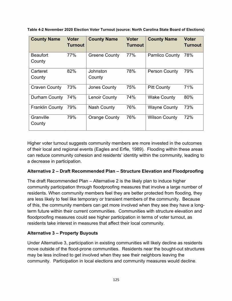
Table 4-2 November 2020 Election Voter Turnout (source: North Carolina State Board of Elections)
County Name Voter Turnout
County Name Voter Turnout
County Name Voter Turnout
Beaufort County
77% Greene County 77% Pamlico County 78%
Carteret County
82% Johnston County
78% Person County 79%
Craven County 73% Jones County 75% Pitt County 71%
Durham County 74% Lenoir County 74% Wake County 80%
Franklin County 79% Nash County 76% Wayne County 73%
Granville County
79% Orange County 76% Wilson County 72%
Higher voter turnout suggests community members are more invested in the outcomes of their local and regional events (Eagles and Erfle, 1989). Flooding within these areas can reduce community cohesion and residents’ identity within the community, leading to a decrease in participation.
Alternative 2 – Draft Recommended Plan – Structure Elevation and Floodproofing
The draft Recommended Plan – Alternative 2 is the likely plan to induce higher community participation through floodproofing measures that involve a large number of residents. When community members feel they are better protected from flooding, they are less likely to feel like temporary or transient members of the community. Because of this, the community members can get more involved when they see they have a long-term future within their current communities. Communities with structure elevation and floodproofing measures could see higher participation in terms of voter turnout, as residents take interest in measures that affect their local community.
Alternative 3 – Property Buyouts
Under Alternative 3, participation in existing communities will likely decline as residents move outside of the flood-prone communities. Residents near the bought-out structures may be less inclined to get involved when they see their neighbors leaving the community. Participation in local elections and community measures would decline.
125
4.5.7. Summary of Social Vulnerability
This OSE analysis describes adverse effects from flooding for the future No Action alternative as well as the beneficial social effects from Alternatives 2 and 3. Public health and safety are negatively affected by flooding under the future without project condition. The study area in North Carolina has a long history of flooding – one that has the potential to impact and harm its citizenry. Alternative 2 would mitigate this impact by reducing the likelihood of flood damage and decreasing floodwater inundation. Economic vitality will also be adversely affected from flooding under the No Action alternative. Community cohesion, participation, and identity will be negatively impacted under the No Action alternative. Finally, social vulnerability will be at risk under the No Action plan and individuals vulnerable to economic loss will feel greater stress from flooding. Under the draft Recommended Plan - Alternative 2, individuals will be less likely to lose employment, income, and be impacted by stress related to flood events.
Under Alternative 3, economic vitality, social connectedness, identity, and community participation would be negatively impacted since residents would be leave their homes and move to other communities. The health and safety of the community would be positively impacted since residents would be physically removed from flood-prone areas. Highly vulnerable populations including the elderly, low income, and minority populations, would be moved to communities with lower flood risk and not experience the difficulties of recovering from repeated flood events.
Cumulative Effects
The Federal Executive Branch’s Council on Environmental Quality defines cumulative impact as “the impact on the environment that results from the incremental impact of an action when added to other past, present, and reasonably foreseeable future actions regardless of what agency (Federal or non-Federal) or person undertakes such other actions” (40 CFR 1508.7, National Environmental Policy Act of 1969, as amended).
Similarly, the Advisory Council on Historic Preservation (ACHP), an independent federal agency established by the National Historic Preservation Act (NHPA) of 1966, oversees the implementation of the Section 106 process and requires undertakings to consider cumulative effects. “Adverse effects may include reasonably foreseeable effects caused by the undertaking that may occur later in time, be farther removed in distance or be cumulative” (36 CFR Part 800.5).
Identification of Significant Resources
During the scoping process no potentially significant cumulative impacts issues were identified. The most significant issue identified during scoping was the need for improved water quality in the mainstem of the Neuse River by reducing frequency of
126
flood flows and sedimentation from erosion entering into the Neuse River. The scoping process established the geographic focus areas for the project area, species of interest located in the area and critical habitat and identified other actions affecting resources and the surrounding ecosystem. The geographic project area considered for this cumulative effects analysis is the Neuse River Basin with the specific proposed project focus areas surrounding the population centers of Raleigh, Goldsboro, and Wilson. The time frame for this analysis is 50 years. During scoping, the following resources or issues of concern were identified:
• Wetlands
• Anadromous fish critical habitat
• Floodplains
• Endangered and threatened species
• Wildlife habitat
Past Actions
Past actions within the Neuse River Basin include the Goldsboro, Neuse River, NC Federal Project, which was authorized by the Flood Control Act of 1941. This project was constructed shortly after authorization and includes a cutoff channel, 12 feet deep, 20 feet wide, and about 6,400 feet long across the bend in the Neuse River south of Goldsboro, NC. The primary purpose of the Neuse River cutoff was to alleviate flooding along a 7.1 mile stretch of the Neuse River to agricultural and urbanized areas in Goldsboro, NC. The Neuse River cutoff project was recently modified under the authority of Section 1135 of the Water Resources Development Act of 1986 for the improvement of ecosystem restoration at the cutoff and main channel. Construction was completed in 2021. Operation and maintenance of the modified project is now the responsibility of the non-Federal sponsor, the City of Goldsboro.
Another past action in the analysis area is the Falls Lake Dam and Reservoir. Falls Dam is located in the upper Neuse River immediately upstream of the village of Falls in Wake County, NC. The dam is located approximately198 miles upstream from New Bern, NC, 47 miles above Smithfield, NC and about 10 miles north of Raleigh, NC. The main body of the lake is in Wake and Durham counties, but some of the embayments extend into Granville County. The Falls Lake project is authorized for flood control, water supply, water quality and recreation. Falls Lake Dam is an earthen structure having a top elevation of 291.5 feet, msl and an overall length of 1,915 feet. The height above the streambed is 92.5 feet. Falls Lake extends 28 miles up the Neuse River to just above the confluence of the Eno and Flat Rivers. At the top of the conservation
127
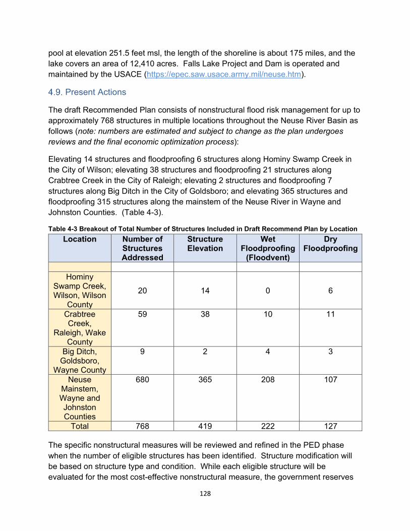
pool at elevation 251.5 feet msl, the length of the shoreline is about 175 miles, and the lake covers an area of 12,410 acres. Falls Lake Project and Dam is operated and maintained by the USACE (https://epec.saw.usace.army.mil/neuse.htm).
Present Actions
The draft Recommended Plan consists of nonstructural flood risk management for up to approximately 768 structures in multiple locations throughout the Neuse River Basin as follows (note: numbers are estimated and subject to change as the plan undergoes reviews and the final economic optimization process):
Elevating 14 structures and floodproofing 6 structures along Hominy Swamp Creek in the City of Wilson; elevating 38 structures and floodproofing 21 structures along Crabtree Creek in the City of Raleigh; elevating 2 structures and floodproofing 7 structures along Big Ditch in the City of Goldsboro; and elevating 365 structures and floodproofing 315 structures along the mainstem of the Neuse River in Wayne and Johnston Counties. (Table 4-3).
Table 4-3 Breakout of Total Number of Structures Included in Draft Recommend Plan by Location Location Number of
Structures Addressed
Structure Elevation
Wet Floodproofing
(Floodvent)
DryFloodproofing
Hominy Swamp Creek, Wilson, Wilson
County
20 14 0 6
Crabtree Creek,
Raleigh, Wake County
59 38 10 11
Big Ditch, Goldsboro,
Wayne County
9 2 4 3
Neuse Mainstem, Wayne and Johnston Counties
680 365 208 107
Total 768 419 222 127
The specific nonstructural measures will be reviewed and refined in the PED phase when the number of eligible structures has been identified. Structure modification will be based on structure type and condition. While each eligible structure will be evaluated for the most cost-effective nonstructural measure, the government reserves
128
the right to determine which measure shall be implemented at each structure location. In the cases of structure elevation, structures would be raised to 2 feet above the 1% AEP flood level.
Additionally, the plan would include flood warning system enhancements with installation of stream gages in two locations (one in each location). The first location is in the Eno River at the North Roxboro Street crossing in Durham County (USGS 02085070 Eno River Near Durham, NC). This would consist of updating an existing stream gage to improve the accuracy of water volume estimations. The second location is in the Neuse River mainstem at the NC-43 (River Road) crossing, approximately 9 miles upstream of the City of New Bern. A new stream gage would be added in this location where none currently exists to improve warning times by providing stage data to the downstream communities in Craven County and the City of New Bern. Finally, development of public education materials highlighting residual, or remaining, flood risks throughout the Neuse River Basin will also be included in this plan.
Reasonably Foreseeable Future Actions
Currently, there are no known reasonably foreseeable future actions planned in the proposed project areas or surrounding areas in the described portion of the Neuse River that would contribute to cumulative impacts. The project will be constructed in areas along the floodplain where homes and business currently exist on previously disturbed land. The draft Recommended Plan would structurally elevate or floodproof existing homes/structures but there is no reason to believe that these actions will lead to future residential or commercial development in these areas.
Draft Recommended Plan Cumulative Impacts Analysis and Determination
Impacts associated with the draft Recommended Plan will be minor and temporary and of relatively short duration. The magnitude of potential impacts to the resources of concern listed above is so small that the proposed action will have no adverse cumulative influence. The proposed action is expected to result in an overall improvement for the homeowners whose houses/structures would be floodproofed or elevated. Mitigation, monitoring, or adaptive management will not be required for implementation of the proposed action.
Impacts of the proposed action are qualitatively discussed in below in Table 4-4.
129
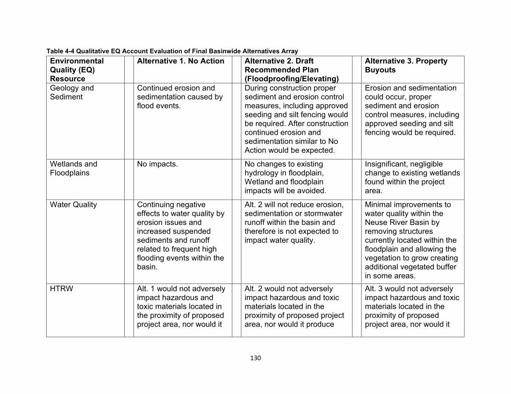
Table 4-4 Qualitative EQ Account Evaluation of Final Basinwide Alternatives Array Environmental Quality (EQ)Resource
Alternative 1. No Action Alternative 2. Draft Recommended Plan (Floodproofing/Elevating)
Alternative 3. Property Buyouts
Geology and Continued erosion and During construction proper Erosion and sedimentation Sediment sedimentation caused by
flood events. sediment and erosion control measures, including approved seeding and silt fencing would be required. After construction continued erosion and sedimentation similar to No Action would be expected.
could occur, proper sediment and erosion control measures, including approved seeding and silt fencing would be required.
Wetlands and No impacts. No changes to existing Insignificant, negligible Floodplains hydrology in floodplain,
Wetland and floodplain impacts will be avoided.
change to existing wetlands found within the project area.
Water Quality Continuing negative effects to water quality by erosion issues and increased suspended sediments and runoff related to frequent high flooding events within the basin.
Alt. 2 will not reduce erosion, sedimentation or stormwater runoff within the basin and therefore is not expected to impact water quality.
Minimal improvements to water quality within the Neuse River Basin by removing structures currently located within the floodplain and allowing the vegetation to grow creating additional vegetated buffer in some areas.
HTRW Alt. 1 would not adversely impact hazardous and toxic materials located in the proximity of proposed project area, nor would it
Alt. 2 would not adversely impact hazardous and toxic materials located in the proximity of proposed project area, nor would it produce
Alt. 3 would not adversely impact hazardous and toxic materials located in the proximity of proposed project area, nor would it
130
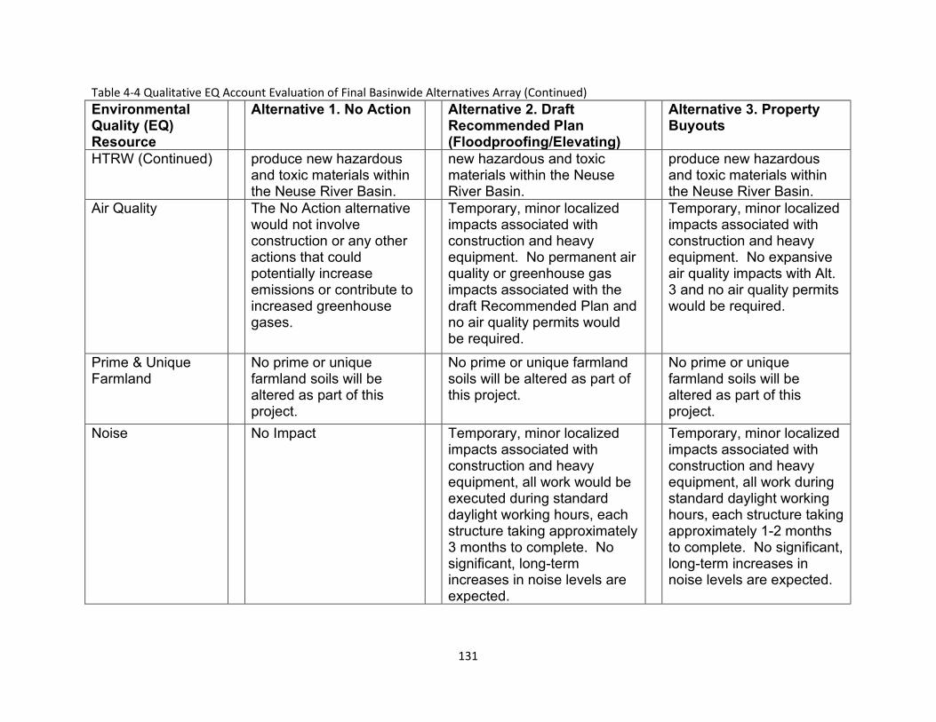
Table 4-4 Qualitative EQ Account Evaluation of Final Basinwide Alternatives Array (Continued) Environmental Quality (EQ)Resource
Alternative 1. No Action Alternative 2. Draft Recommended Plan (Floodproofing/Elevating)
Alternative 3. Property Buyouts
HTRW (Continued) produce new hazardous and toxic materials within the Neuse River Basin.
new hazardous and toxic materials within the Neuse River Basin.
produce new hazardous and toxic materials within the Neuse River Basin.
Air Quality The No Action alternative would not involve construction or any other actions that could potentially increase emissions or contribute to increased greenhouse gases.
Temporary, minor localized impacts associated with construction and heavy equipment. No permanent air quality or greenhouse gas impacts associated with the draft Recommended Plan and no air quality permits would be required.
Temporary, minor localized impacts associated with construction and heavy equipment. No expansive air quality impacts with Alt. 3 and no air quality permits would be required.
Prime & Unique No prime or unique No prime or unique farmland No prime or unique Farmland farmland soils will be
altered as part of this project.
soils will be altered as part of this project.
farmland soils will be altered as part of this project.
Noise No Impact Temporary, minor localized impacts associated with construction and heavy equipment, all work would be executed during standard daylight working hours, each structure taking approximately 3 months to complete. No significant, long-term increases in noise levels are expected.
Temporary, minor localized impacts associated with construction and heavy equipment, all work during standard daylight working hours, each structure taking approximately 1-2 months to complete. No significant, long-term increases in noise levels are expected.
131
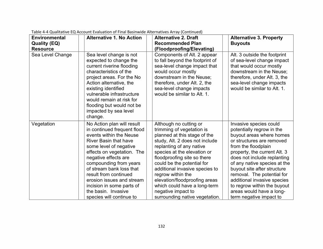
Table 4-4 Qualitative EQ Account Evaluation of Final Basinwide Alternatives Array (Continued) Environmental Quality (EQ)Resource
Alternative 1. No Action Alternative 2. Draft Recommended Plan (Floodproofing/Elevating)
Alternative 3. Property Buyouts
Sea Level Change Sea level change is not expected to change the current riverine flooding characteristics of the project areas. For the No Action alternative, the existing identified vulnerable infrastructure would remain at risk for flooding but would not be impacted by sea level change.
Components of Alt. 2 appear to fall beyond the footprint of sea-level change impact that would occur mostly downstream in the Neuse; therefore, under Alt. 2, the sea-level change impacts would be similar to Alt. 1.
Alt. 3 outside the footprint of sea-level change impact that would occur mostly downstream in the Neuse; therefore, under Alt. 3, the sea-level change impacts would be similar to Alt. 1.
Vegetation No Action plan will result in continued frequent flood events within the Neuse River Basin that have some level of negative effects on vegetation. The negative effects are compounding from years of stream bank loss that result from continued erosion issues and stream incision in some parts of the basin. Invasive species will continue to
Although no cutting or trimming of vegetation is planned at this stage of the study, Alt. 2 does not include replanting of any native species at the elevation or floodproofing site so there could be the potential for additional invasive species to regrow within the elevation/floodproofing areas which could have a long-term negative impact to surrounding native vegetation.
Invasive species could potentially regrow in the buyout areas where homes or structures are removed from the floodplain property, the current Alt. 3 does not include replanting of any native species at the buyout site after structure removal. The potential for additional invasive species to regrow within the buyout areas would have a long-term negative impact to
132
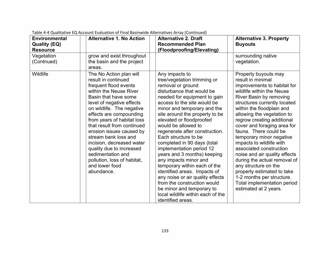
Table 4-4 Qualitative EQ Account Evaluation of Final Basinwide Alternatives Array (Continued) Environmental Quality (EQ)Resource
Alternative 1. No Action Alternative 2. Draft Recommended Plan (Floodproofing/Elevating)
Alternative 3. Property Buyouts
Vegetation (Contnued)
grow and exist throughout the basin and the project areas.
surrounding native vegetation.
Wildlife The No Action plan will result in continued frequent flood events within the Neuse River Basin that have some level of negative effects on wildlife. The negative effects are compounding from years of habitat loss that result from continued erosion issues caused by stream bank loss and incision, decreased water quality due to increased sedimentation and pollution, loss of habitat, and lower food abundance.
Any impacts to tree/vegetation trimming or removal or ground disturbance that would be needed for equipment to gain access to the site would be minor and temporary and the site around the property to be elevated or floodproofed would be allowed to regenerate after construction. Each structure to be completed in 90 days (total implementation period 12 years and 3 months) keeping any impacts minor and temporary within each of the identified areas. Impacts of any noise or air quality effects from the construction would be minor and temporary to local wildlife within each of the identified areas.
Property buyouts may result in minimal improvements to habitat for wildlife within the Neuse River Basin by removing structures currently located within the floodplain and allowing the vegetation to regrow creating additional cover and foraging area for fauna. There could be temporary minor negative impacts to wildlife with associated construction noise and air quality effects during the actual removal of any structure on the property estimated to take 1-2 months per structure. Total implementation period estimated at 2 years.
133
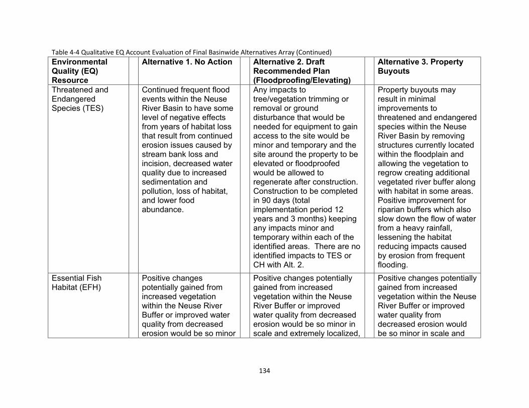
Table 4-4 Qualitative EQ Account Evaluation of Final Basinwide Alternatives Array (Continued) Environmental Quality (EQ)Resource
Alternative 1. No Action Alternative 2. Draft Recommended Plan (Floodproofing/Elevating)
Alternative 3. Property Buyouts
Threatened and Continued frequent flood Any impacts to Property buyouts may Endangered events within the Neuse tree/vegetation trimming or result in minimal Species (TES) River Basin to have some
level of negative effects from years of habitat loss that result from continued erosion issues caused by stream bank loss and incision, decreased water quality due to increased sedimentation and pollution, loss of habitat, and lower food abundance.
removal or ground disturbance that would be needed for equipment to gain access to the site would be minor and temporary and the site around the property to be elevated or floodproofed would be allowed to regenerate after construction. Construction to be completed in 90 days (total implementation period 12 years and 3 months) keeping any impacts minor and temporary within each of the identified areas. There are no identified impacts to TES or CH with Alt. 2.
improvements to threatened and endangered species within the Neuse River Basin by removing structures currently located within the floodplain and allowing the vegetation to regrow creating additional vegetated river buffer along with habitat in some areas. Positive improvement for riparian buffers which also slow down the flow of water from a heavy rainfall, lessening the habitat reducing impacts caused by erosion from frequent flooding.
Essential Fish Positive changes Positive changes potentially Positive changes potentially Habitat (EFH) potentially gained from
increased vegetation within the Neuse River Buffer or improved water quality from decreased erosion would be so minor
gained from increased vegetation within the Neuse River Buffer or improved water quality from decreased erosion would be so minor in scale and extremely localized,
gained from increased vegetation within the Neuse River Buffer or improved water quality from decreased erosion would be so minor in scale and
134
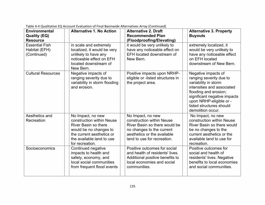
Table 4-4 Qualitative EQ Account Evaluation of Final Basinwide Alternatives Array (Continued) Environmental Quality (EQ)Resource
Alternative 1. No Action Alternative 2. Draft Recommended Plan (Floodproofing/Elevating)
Alternative 3. Property Buyouts
Essential Fish in scale and extremely it would be very unlikely to extremely localized, it Habitat (EFH) localized, it would be very have any noticeable effect on would be very unlikely to (Continued) unlikely to have any
noticeable effect on EFH located downstream of New Bern.
EFH located downstream of New Bern.
have any noticeable effect on EFH located downstream of New Bern.
Cultural Resources Negative impacts of ranging severity due to variability in storm flooding and erosion.
Positive impacts upon NRHP-eligible or -listed structures in the project area.
Negative impacts of ranging severity due to variability in storm intensities and associated flooding and erosion; significant negative impacts upon NRHP-eligible or -listed structures should demolition occur.
Aesthetics and No Impact, no new No Impact, no new No Impact, no new Recreation construction within Neuse
River Basin so there would be no changes to the current aesthetics or the available land to use for recreation.
construction within Neuse River Basin so there would be no changes to the current aesthetics or the available land to use for recreation.
construction within Neuse River Basin so there would be no changes to the current aesthetics or the available land to use for recreation.
Socioeconomics Continued negative impacts to health and safety, economy, and local social communities from frequent flood events
Positive outcomes for social and health of residents' lives. Additional positive benefits to local economies and social communities.
Positive outcomes for social and health of residents' lives. Negative benefits to local economies and social communities.
135

Page Intentionally Left Blank
136
THE DRAFT RECOMMENDED PLAN
Plan Details
The draft Recommended Plan (Figure 5-1) for the Neuse River Basin Flood Risk Management Study includes the following nonstructural features:
a. Structure Elevation – 419 structures
b. Structure Dry Floodproofing – 127 structures
c. Structure Wet Floodproofing – 222 structures
Nonstructural features would be constructed within separate areas for an estimated 768 properties. Only habitable structures would be eligible for structure elevation and floodproofing. The draft Recommended Plan proposes elevating 14 structures and floodproofing 6 structures along Hominy Swamp Creek in the City of Wilson; elevating 38 structures and floodproofing 21 structures along Crabtree Creek in the City of Raleigh; elevating 2 structures and floodproofing 7 structures along Big Ditch in the City of Goldsboro; and elevating 365 structures and floodproofing 315 structures along the mainstem of the Neuse River in Wayne and Johnston Counties, all in North Carolina.
Structure elevation raises a house or building so that the lowest habitable floor is above the 1% AEP flood level. Dry floodproofing makes the structure watertight below this level by preventing floodwaters from entering the structure. Wet floodproofing uses flood-damage-resistant materials and construction techniques to minimize flood damage to areas below the flood protection level of a structure, which is intentionally allowed to flood but with modifications which minimize flood damage.
The draft Recommended Plan also includes flood warning system enhancements with installation of stream gages in two locations (one in each location). The first location was in the Eno River at the North Roxboro Street crossing in Durham County (USGS 02085070 Eno River Near Durham, NC). This would consist of updating an existing stream gage to improve the accuracy of water volume estimations. The second location was in the Neuse River mainstem at the NC-43 (River Road) crossing, approximately 9 miles upstream of the City of New Bern. A new stream gage would be added in this location where none currently exists to improve warning times by providing flood stage data to the downstream communities in Craven County and the City of New Bern. Finally, development of public education materials highlighting residual, or remaining, flood risks throughout the Neuse River Basin will also be included in the plan.
137
The environmental impacts of the draft Recommended Plan are minor, temporary and will occur in previously disturbed areas. Therefore, implementation of the draft Recommended Plan will not result in significant impacts requiring mitigation.
The total estimated project cost of the draft Recommended Plan is $133,000,000 at Fiscal Year (FY) 2022 price levels and includes the cost of constructing nonstructural measures; lands, easements, rights-of-way, relocations and disposal areas (LERRDs); preconstruction engineering and design (USACE’s cost for final detailed design otherwise known as PED); and construction management (USACE’s cost to manage implementation of the project) support activities. The non-Federal cost for LERRDs is currently limited to real estate administrative and Uniform Relocation Assistance benefits, as applicable, and is currently estimated at $5,835,000. This draft plan would be cost-shared at approximately 65% Federal ($86,450,000) and 35% non-Federal ($46,550,000), in accordance with the cost-sharing provisions specified for nonstructural projects in Section 103(b) of the Water Resources Development Act of 1986, as amended. This plan is economically justified with a benefit-to-cost ratio of 1.6, generating $1.60 in benefits for every $1 spent.
All economics analyses of the draft Recommended Plan presented in this draft IFR/EA are based on the total estimated project cost of $133,000,000 at FY 2022 price levels. The economics analyses will be updated in the final IFR/EA using the final Recommended Plan estimated total project first costs at FY 2023 price levels, as required for decision documents in accordance with USACE policy guidance.
The current working estimate (CWE) for the draft Recommended Plan is $151,455,000, also at FY 2022 price levels, which reflects recent increases in construction materials, labor and establishment of contractor’s field offices; PED; and construction management costs not included elsewhere in this draft IFR/EA. The draft Recommended Plan continues to be economically justified with a BCR above one using the CWE. The CWE is only provided at this time to provide insight into the latest cost estimate.
The construction start date is estimated to begin with award of the first of a series of contracts in Fiscal Year (FY) 2027 with an implementation period of approximately 12 years and 3 months, assuming 100 percent homeowner participation, subject to receipt of project construction authorization and appropriation of funds.
The Federal government is responsible for preparing and providing an OMRR&R manual to the sponsor as the final Recommended Plan is being implemented. OMRR&R costs associated with a nonstructural plan such as this are considered ‘de-minimis’ (requiring only periodic surveillance by the non-Federal sponsor). Each
138

individual property owner is ultimately responsible for maintenance of their elevated or floodproofed structure/home.
139
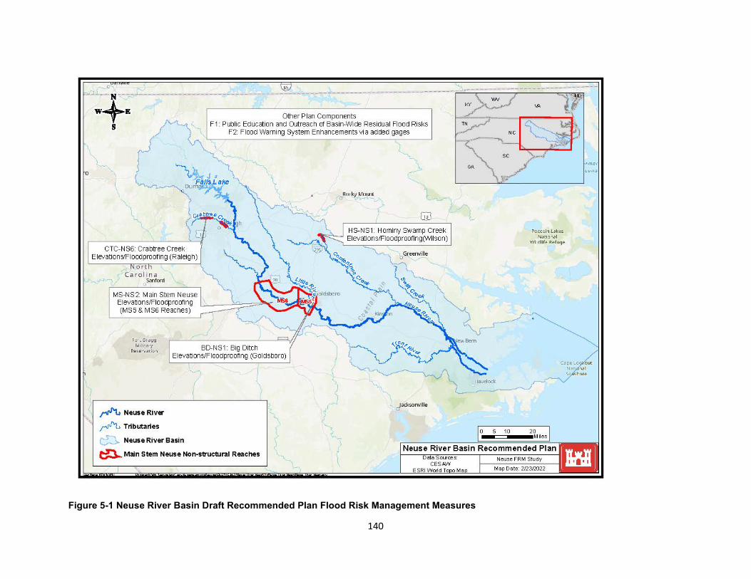
Figure 5-1 Neuse River Basin Draft Recommended Plan Flood Risk Management Measures
140
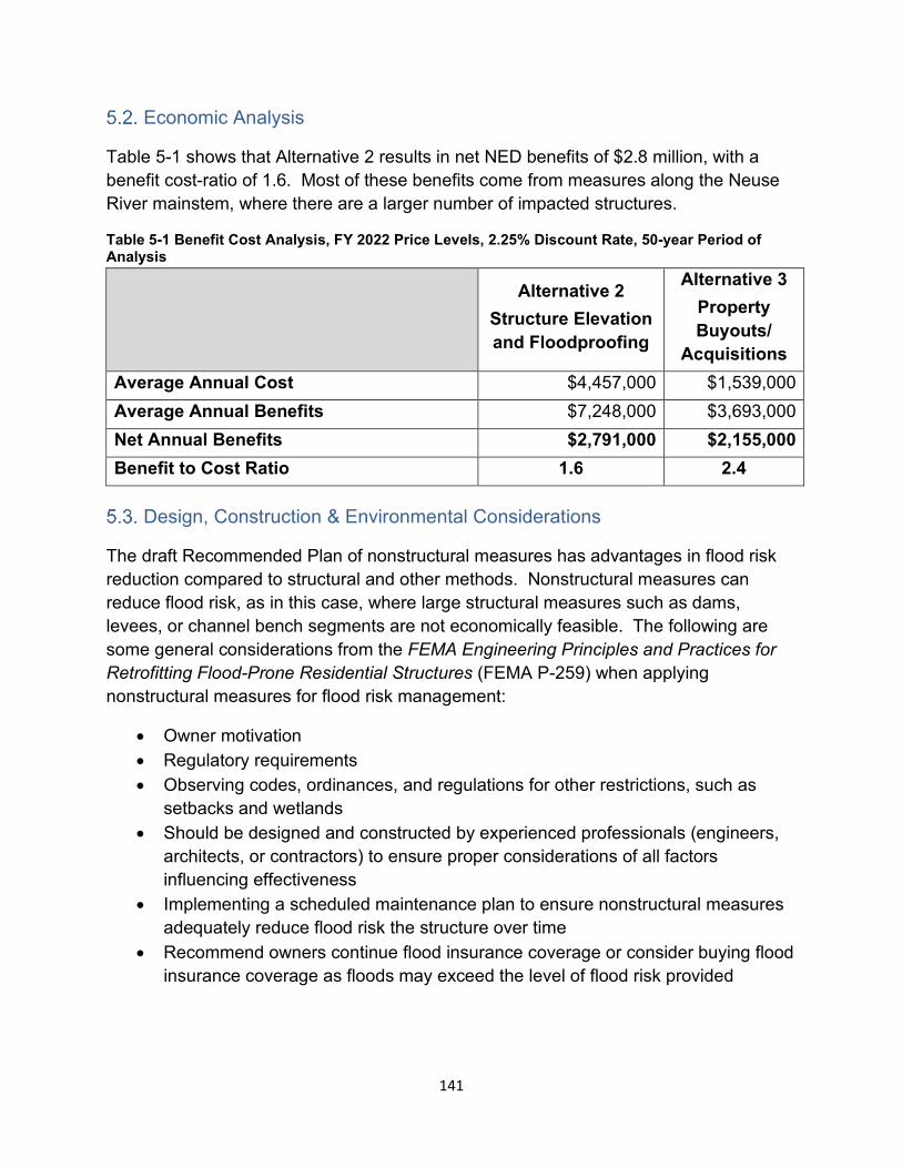
Economic Analysis
Table 5-1 shows that Alternative 2 results in net NED benefits of $2.8 million, with a benefit cost-ratio of 1.6. Most of these benefits come from measures along the Neuse River mainstem, where there are a larger number of impacted structures.
Table 5-1 Benefit Cost Analysis, FY 2022 Price Levels, 2.25% Discount Rate, 50-year Period of Analysis
Alternative 2 Structure Elevation and Floodproofing
Alternative 3 Property Buyouts/
Acquisitions Average Annual Cost $4,457,000 $1,539,000 Average Annual Benefits $7,248,000 $3,693,000 Net Annual Benefits $2,791,000 $2,155,000 Benefit to Cost Ratio 1.6 2.4
Design, Construction & Environmental Considerations
The draft Recommended Plan of nonstructural measures has advantages in flood risk reduction compared to structural and other methods. Nonstructural measures can reduce flood risk, as in this case, where large structural measures such as dams, levees, or channel bench segments are not economically feasible. The following are some general considerations from the FEMA Engineering Principles and Practices for Retrofitting Flood-Prone Residential Structures (FEMA P-259) when applying nonstructural measures for flood risk management:
• Owner motivation • Regulatory requirements • Observing codes, ordinances, and regulations for other restrictions, such as
setbacks and wetlands • Should be designed and constructed by experienced professionals (engineers,
architects, or contractors) to ensure proper considerations of all factors influencing effectiveness
• Implementing a scheduled maintenance plan to ensure nonstructural measures adequately reduce flood risk the structure over time
• Recommend owners continue flood insurance coverage or consider buying flood insurance coverage as floods may exceed the level of flood risk provided
141
Real Estate Considerations
There are no requirements for the acquisition of lands, easements, rights-of-way and relocations, and disposal/borrow areas (LERRDs) associated with the nonstructural measures of this project except for real estate administrative and Uniform Relocation Assistance benefits, as applicable. As of the date of this report, there are approximately seven hundred sixty-eight (768) structures proposed for structure elevation and floodproofing measures.
In the Preconstruction Engineering and Design Phase, all willing property owners will be asked to grant a standard right-of-entry for survey and exploration to USACE and the non-Federal Sponsor (NFS) to enter upon the property to conduct property and structural investigations deemed necessary to determine final eligibility for participation in the draft Recommended Plan. These investigations may include, structural inspections, surveys, limited environmental testing and site assessments, verifying current structure elevation and determining elevation requirements, and conducting such other activities deemed necessary by USACE and the NFS to make a final determination of a structure’s eligibility.
Once the structure has been determined eligible and prior to construction, the landowner will be required to execute a Nonstructural Floodproofing Agreement with the NFS. The agreements will be recorded in the local records and will include a restriction of future construction on the site below a stated elevation as well as saving the NFS and the Government harmless from any damages or injuries resulting either directly or indirectly from any structure elevation or floodproofing work conducted on the property.
The total estimated real estate cost for the project is $7,300,000 and includes a 25% contingency as well as estimated tenant relocation benefits allowed under PL 91-646. Further details are provided in Appendix D (Real Estate).
Operation and Maintenance Considerations
The Federal government is responsible for preparing and providing an OMRR&R manual to the sponsor as the final Recommended Plan is being implemented. OMRR&R costs associated with this nonstructural draft Recommended Plan are considered ‘de-minimis’ (requiring only periodic surveillance by the non-Federal sponsor). Each individual property owner is ultimately responsible for maintenance of their elevated or floodproofed structure/home.
142
Environmental Justice
Background and Definitions
Executive Order 12898, dated February 11, 1994, mandates that “each federal agency shall make achieving environmental justice part of its mission by identifying and addressing, as appropriate, disproportionately high and adverse human health or environmental effects of its programs, policies, and activities on minority populations and low-income populations.”
The Council on Environmental Quality (CEQ) has oversight of the federal government’s compliance with EO 12898 and NEPA. CEQ, in consultation with the US Environmental Protection Agency (EPA) and other affected agencies, developed NEPA guidance for addressing requirements of the EO (CEQ, 1997). This guidance was developed to further assist federal agencies with their NEPA procedures so that environmental justice (EJ) concerns are effectively identified and addressed.
The CEQ has also identified six general principles for consideration in identifying and addressing EJ in the NEPA process which include: (1) area composition (demographics); (2) data (concerning cumulative exposure to human health or environmental hazards); (3) interrelated factors (recognize the interrelated cultural, social, occupational, or economic factors); (4) public participation; (5) community representation; and (6) tribal representation.
The following definitions are used by the CEQ in guidance on key terms of the EO:
• Low-income population: Low-income populations in an affected area should be identified with the annual statistical poverty thresholds from the Bureau of the Census’ Current Population Reports, Series P-60 on Income and Poverty. In identifying low income populations, agencies may consider as a community either a group of individuals living in geographic proximity to one another, or a set of individuals (such as migrant workers or Native Americans), where either type of group experiences common conditions of environmental exposure or effect.
• Minority: Individual(s) who are members of the following population groups: American Indian or Alaskan Native; Asian or Pacific Islander; Black, not of Hispanic origin; or Hispanic.
• Minority population: Minority populations should be identified where either: (a) the minority population of the affected area exceeds 50 percent or (b) the minority population percentage of the affected area is meaningfully greater than the minority population percentage in the general population or other appropriate unit
143
of geographic analysis. In identifying minority communities, agencies may consider as a community either a group of individuals living in geographic proximity to one another, or a geographically dispersed/transient set of individuals (such as migrant workers or Native American), where either type of group experiences common conditions of environmental exposure or effect. The selection of the appropriate unit of geographic analysis may be a governing body’s jurisdiction, a neighborhood, census tract, or other similar unit that is to be chosen so as not to artificially dilute or inflate the affected minority population. A minority population also exists if there is more than one minority group present and the minority percentage, as calculated by aggregating all minority persons, meets one of the above-stated thresholds.
• Disproportionately high and adverse human health effects: When determining whether human health effects are disproportionately high and adverse, agencies are to consider the following three factors to the extent practicable:
o Whether the health effects, which may be measured in risks and rates, are significant (as employed by NEPA), or above generally accepted norms. Adverse health effects may include bodily impairment, infirmity, illness, or death.
o Whether the risk or rate of hazard exposure by a minority population, low-income population, or Indian tribe to an environmental hazard is significant (as employed by NEPA) and appreciably exceeds or is likely to appreciably exceed the risk or rate to the general population or other appropriate comparison group.
o Whether health effects occur in a minority population, low-income population, or Indian tribe affected by cumulative or multiple adverse exposures from environmental hazards.
• Disproportionally high and adverse environmental effects: When determining whether environmental effects are disproportionately high and adverse, agencies are to consider the following three factors to the extent practicable:
o Whether there is or will be an impact on the natural or physical environment that significantly (as employed by NEPA) and adversely affects a minority population, low-income population, or Indian tribe. Such effects may include ecological, cultural, human health, economic, or social impacts on minority communities, low-income communities, or Indian tribes when those impacts are interrelated to impacts on the natural or physical environment.
144
o Whether environmental effects are significant (as employed by NEPA) and are or may be having an adverse impact on minority populations, low-income populations, or Indian tribes that appreciably exceeds or is likely to appreciably exceed those on the general population or other appropriate comparison group.
o Whether the environmental effects occur or would occur in a minority population, low-income population, or Indian tribe affected by cumulative or multiple adverse exposures from environmental hazards. (Ibid. Appendix A (Hydrology and Hydraulics), pp. 25-27).
Analysis and Conclusions
USACE conducted an EJ analysis by determining whether EJ populations are present and whether the proposed action would result in a disproportionately high and/or adverse effect on these populations.
For purposes of the EJ analysis, the area of effect is the area impacted by the draft Recommended Plan, and conclusions were made based on census tract data. At this time, data regarding owners of specific structures identified as part of the draft Recommended Plan is unknown. Using the Center for Disease Control (CDC) Social Vulnerability Index (SVI) by census tract, the draft Recommended Plan (Alternative 2 – Structure elevation and floodproofing) as identified in Section 5.1 would be associated with the following populations, and have the following effects:
Structure Elevation and Floodproofing Area (Crabtree Creek (Raleigh), Hominy Swamp Creek (Wilson), Big Ditch (Goldsboro) and Neuse River Mainstem Reaches 5 and 6:
Minority Population: Varies from low to high, but most proposed areas of impact received a CDC CVI ranking exceeding 0.5 for the minority status and language category, signifying that 50% of the tracts in North Carolina are less vulnerable than these identified tracts based on minority & English-speaking status.
Per Capita Income: Overwhelmingly low-income
SVI Overall Percentile ranking: Overwhelming majority of the population that is affected is in the “Highest Vulnerability” category.
Impacts to the above populations due to the draft Recommended Plan are anticipated to be positive, as a result of reduced flood risk to residential and commercial structures. There are no expected significant adverse impacts to EJ populations.
145
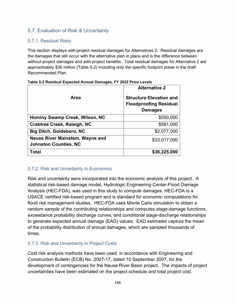
Evaluation of Risk & Uncertainty
5.7.1. Residual Risks
This section displays with-project residual damages for Alternatives 2. Residual damages are the damages that still occur with the alternative plan in place and is the difference between without-project damages and with-project benefits. Total residual damages for Alternative 2 are approximately $36 million (Table 5-2) including only the specific footprint areas in the draft Recommended Plan.
Table 5-2 Residual Expected Annual Damages, FY 2022 Price Levels
Area
Alternative 2
Structure Elevation and Floodproofing Residual
Damages Hominy Swamp Creek, Wilson, NC $550,000 Crabtree Creek, Raleigh, NC $581,000 Big Ditch, Goldsboro, NC $2,077,000 Neuse River Mainstem, Wayne and Johnston Counties, NC
$33,017,000
Total $36,225,000
5.7.2. Risk and Uncertainty in Economics
Risk and uncertainty were incorporated into the economic analysis of this project. A statistical risk-based damage model, Hydrologic Engineering Center-Flood Damage Analysis (HEC-FDA), was used in this study to compute damages. HEC-FDA is a USACE certified risk-based program and is standard for economic computations for flood risk management studies. HEC-FDA uses Monte Carlo simulation to obtain a random sample of the contributing relationships and computes stage-damage functions, exceedance probability discharge curves, and conditional stage-discharge relationships to generate expected annual damage (EAD) values. EAD estimates capture the mean of the probability distribution of annual damages, which are sampled thousands of times.
5.7.3. Risk and Uncertainty in Project Costs
Cost risk analysis methods have been used, in accordance with Engineering and Construction Bulletin (ECB) No. 2007-17, dated 10 September 2007, for the development of contingencies for the Neuse River Basin project. The impacts of project uncertainties have been estimated on the project schedule and total project cost.
146
Project Risks
A Risk Register Model was developed for input into the project’s Cost Schedule Risk Assessment. Risks that were considered by the Project Development Team Include the following:
1.) Post COVID-19 effects on construction material pricing and labor costs, as well as market pricing volatility caused by other influencing factors.
2.) Construction access to individual sites may not be adequate.
3.) Adverse conditions with the original design, construction, or existing damage to the foundations, footings, structural walls, or framing systems, may be identified during the structure elevation and floodproofing efforts.
4.) Mechanical Equipment for services, such as: electric heating, ventilation, plumbing, and air conditioning, may be identified at the sites which may require structure elevation and floodproofing beyond what is anticipated in the base scope of the project.
5.) Electrical service to the structure may require additional work to be relocated above the base flood elevation.
6.) Additional design fees may be required for structure elevation and floodproofing of structures where existing damage, or existing design or construction deficiencies, or concerning sub-grade conditions are identified.
7.) Sites may be identified where the existing structure is built from materials that are generally permeable to floodwaters, or where the materials may be damaged. If the structures were intended for dry-floodproofing, structure elevation of the structure may be necessary as the only technically viable alternative.
8.) Hazardous materials, such as lead paint, or asbestos, or potentially hazardous contaminants from past flooding events, could be identified during the course of structure elevation and floodproofing work.
9.) Volatility in fuel costs is evident with recent projects. Increases in fuel costs can contribute to increases in construction costs.
10.) Weather events such as hurricanes and tropical storms could cause project delays.
11.) The project is not fully funded. Project delays and costs could be experienced due to inadequate project funding during implementation.
147
12.) The acquisition strategy for the construction stage of the project has not yet been determined. Due to the number of sites to implement structure elevation and floodproofing measures with potentially limited resources, the acquisition strategy could have an effect that limits competition and increases construction contract costs.
13.) A project scope and cost opportunity were identified and added to the cost schedule risk analysis. Based on USACE experience with structure elevation and floodproofing projects, not all eligible homeowners in the project area will participate in the project. The effect could potentially reduce the construction scope and duration.
14.) In the project’s PED phase, adverse effects to historic properties may be identified. In accordance with the draft Programmatic Agreement (Appendix G – Cultural Resources), additional cultural resources-related costs may be required in association with necessary surveys and/or mitigation for adverse effects.
Cost Schedule Risk Analysis Results
The Neuse River Basin Study Cost Schedule Risk Analysis (CSRA) model was run with risks and opportunities built into the risk register as above. The model calculations identified that to achieve an 80% confidence level in the project costs a 25% cost contingency is required. The model calculations identified that to achieve an 80% confidence level in the project schedule a 29% schedule contingency is required. The CSRA model outputs are included in the Appendix C (Cost Engineering), for reference. Mitigating actions to reduce project risk were identified while developing the CSRA model. These actions are documented in the CSRA Risk Register and have been incorporated into the project scope going forward.
5.7.4. Risk and Uncertainty in Flood Events
In terms of flood risk, the Neuse River Basin has been recently exposed to repeated severe flooding within a relatively short time span. Hurricane Matthew in 2016 and Hurricane Florence in 2018 resulted in rainfall and streamflow estimates greater than previously seen at multiple locations within the study area. Sources that incorporate historical flood risk into useable products to the public, such as in FEMA Flood Insurance Studies, have been questioned in response to these back-to-back significant flood events. The hydrology and hydraulic analyses performed as part of the Neuse River Basin FRM study have utilized historic data related to the recent hurricane events to best provide future conditions of flood risk in the basin.
Uncertainty in flood risk management has been described within this study through multiple means, such the use of projected future development within the floodplain and the magnitude of its hydrologic impact. The effects of climate change on local and basinwide hydrology have also been assessed. Uncertainty related to simulation of
148

flood events that provide a mechanism for determining plan performance has included frequency and sensitivity analyses. Their results have been leveraged to gain confidence in intended project design as well as acknowledgement of residual risk and uncertainty that will persist in future conditions.
149

Page Intentionally Left Blank
150
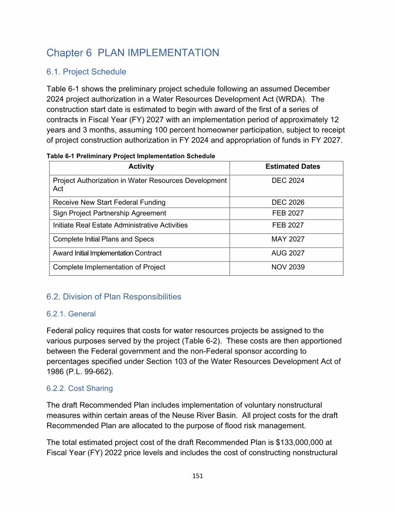
PLAN IMPLEMENTATION
Project Schedule
Table 6-1 shows the preliminary project schedule following an assumed December 2024 project authorization in a Water Resources Development Act (WRDA). The construction start date is estimated to begin with award of the first of a series of contracts in Fiscal Year (FY) 2027 with an implementation period of approximately 12 years and 3 months, assuming 100 percent homeowner participation, subject to receipt of project construction authorization in FY 2024 and appropriation of funds in FY 2027.
Table 6-1 Preliminary Project Implementation Schedule Activity Estimated Dates
Project Authorization in Water Resources Development Act
DEC 2024
Receive New Start Federal Funding DEC 2026 Sign Project Partnership Agreement FEB 2027 Initiate Real Estate Administrative Activities FEB 2027
Complete Initial Plans and Specs MAY 2027
Award Initial Implementation Contract AUG 2027
Complete Implementation of Project NOV 2039
Division of Plan Responsibilities
6.2.1. General
Federal policy requires that costs for water resources projects be assigned to the various purposes served by the project (Table 6-2). These costs are then apportioned between the Federal government and the non-Federal sponsor according to percentages specified under Section 103 of the Water Resources Development Act of 1986 (P.L. 99-662).
6.2.2. Cost Sharing
The draft Recommended Plan includes implementation of voluntary nonstructural measures within certain areas of the Neuse River Basin. All project costs for the draft Recommended Plan are allocated to the purpose of flood risk management.
The total estimated project cost of the draft Recommended Plan is $133,000,000 at Fiscal Year (FY) 2022 price levels and includes the cost of constructing nonstructural
151
measures; lands, easements, rights-of-way, relocations and disposal areas (LERRDs); preconstruction engineering and design (USACE’s cost for final detailed design otherwise known as PED); and construction management (USACE’s cost to manage implementation of the project) support activities. The non-Federal cost for LERRDs is currently limited to real estate administrative and Uniform Relocation Assistance benefits, as applicable, and is currently estimated at $5,835,000. This draft plan would be cost-shared at approximately 65% Federal ($86,450,000) and 35% non-Federal ($46,550,000), in accordance with the cost-sharing provisions specified for nonstructural projects in Section 103(b) of the Water Resources Development Act of 1986, as amended. This plan is economically justified with a benefit-to-cost ratio of 1.6, generating $1.60 in benefits for every $1 spent.
All economics analyses of the draft Recommended Plan presented in this draft IFR/EA are based on the total estimated project cost of $133,000,000 at FY 2022 price levels. The economics analyses will be updated in the final IFR/EA using the final Recommended Plan estimated total project first costs at FY 2023 price levels, as required for decision documents in accordance with USACE policy guidance.
The current working estimate (CWE) for the draft Recommended Plan is $151,455,000, also at FY 2022 price levels, which reflects recent increases in construction materials, labor and establishment of contractor’s field offices; PED; and construction management costs not included elsewhere in this draft IFR/EA. The draft Recommended Plan continues to be economically justified with a BCR above one using the CWE. The CWE is only provided at this time to provide insight into the latest cost estimate.
The Federal government is responsible for preparing and providing an OMRR&R manual to the sponsor as the final Recommended Plan is being implemented. OMRR&R costs associated with a nonstructural plan such as this are considered ‘de-minimis’ (requiring only periodic surveillance by the non-Federal sponsor). Each individual property owner is ultimately responsible for maintenance of their elevated or floodproofed structure/home.
Current Federal policy requires that, unless there are other, overriding considerations, the NED plan would be the plan recommended for implementation. No Locally Preferred Plan has been identified, as the non-Federal sponsor is in support of moving forward with the draft Recommended Plan. Cost-sharing for the draft Recommended Plan is shown in Table 6-2 at October 2021 (FY 2022 price levels).
152
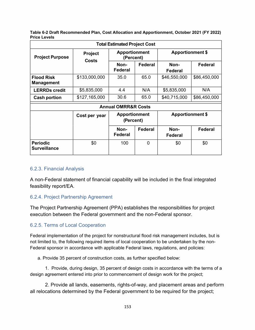
Table 6-2 Draft Recommended Plan, Cost Allocation and Apportionment, October 2021 (FY 2022) Price Levels
Total Estimated Project Cost
Project Purpose Project Costs
Apportionment(Percent)
Apportionment $
Non-Federal
Federal Non-Federal
Federal
Flood Risk Management
$133,000,000 35.0 65.0 $46,550,000 $86,450,000
LERRDs credit $5,835,000 4.4 N/A $5,835,000 N/A Cash portion $127,165,000 30.6 65.0 $40,715,000 $86,450,000
Annual OMRR&R Costs
Cost per year Apportionment (Percent)
Apportionment $
Non-Federal
Federal Non-Federal
Federal
Periodic Surveillance
$0 100 0 $0 $0
6.2.3. Financial Analysis
A non-Federal statement of financial capability will be included in the final integrated feasibility report/EA.
6.2.4. Project Partnership Agreement
The Project Partnership Agreement (PPA) establishes the responsibilities for project execution between the Federal government and the non-Federal sponsor.
6.2.5. Terms of Local Cooperation
Federal implementation of the project for nonstructural flood risk management includes, but is not limited to, the following required items of local cooperation to be undertaken by the non-Federal sponsor in accordance with applicable Federal laws, regulations, and policies:
a. Provide 35 percent of construction costs, as further specified below:
1. Provide, during design, 35 percent of design costs in accordance with the terms of a design agreement entered into prior to commencement of design work for the project;
2. Provide all lands, easements, rights-of-way, and placement areas and perform all relocations determined by the Federal government to be required for the project;
153
3. Provide, during construction, any additional contribution necessary to make its total contribution equal to at least 35 percent of construction costs;
b. Prevent obstructions or encroachments on the project (including prescribing and enforcing regulations to prevent such obstructions or encroachments) that might reduce the level of flood risk reduction the project affords, hinder operation and maintenance of the project, or interfere with the project’s proper function;
c. Inform affected interests, at least yearly, of the extent of risk reduction afforded by the flood risk management features; participate in and comply with applicable Federal floodplain management and flood insurance programs; prepare a floodplain management plan for the project to be implemented not later than one year after completion of construction of the project; and publicize floodplain information in the area concerned and provide this information to zoning and other regulatory agencies for their use in adopting regulations, or taking other actions, to prevent unwise future development and to ensure compatibility with the project;
d. Operate, maintain, repair, rehabilitate, and replace the project or functional portion thereof at no cost to the Federal government, in a manner compatible with the project’s authorized purposes and in accordance with applicable Federal laws and regulations and any specific directions prescribed by the Federal government;
e. Give the Federal government a right to enter, at reasonable times and in a reasonable manner, upon property that the non-Federal sponsor owns or controls for access to the project to inspect the project, and, if necessary, to undertake work necessary to the proper functioning of the project for its authorized purpose;
f. Hold and save the Federal government free from all damages arising from design, construction, operation, maintenance, repair, rehabilitation, and replacement of the project, except for damages due to the fault or negligence of the Federal government or its contractors;
g. Perform, or ensure performance of, any investigations for hazardous, toxic, and radioactive wastes (HTRW) that are determined necessary to identify the existence and extent of any HTRW regulated under the Comprehensive Environmental Response, Compensation, and Liability Act (CERCLA), 42 U.S.C. 9601-9675, and any other applicable law, that may exist in, on, or under real property interests that the Federal government determines to be necessary for construction, operation, and maintenance of the project;
h. Agree, as between the Federal government and the non-Federal sponsor, to be solely responsible for the performance and costs of cleanup and response of any HTRW regulated under applicable law that are located in, on, or under real property interests required for construction, operation, and maintenance of the project, including the costs of any studies and investigations necessary to determine an appropriate
154
response to the contamination, without reimbursement or credit by the Federal government;
i. Agree, as between the Federal government and the non-Federal sponsor, that the non-Federal sponsor shall be considered the owner and operator of the project for the purpose of CERCLA liability or other applicable law, and to the maximum extent practicable shall carry out its responsibilities in a manner that will not cause HTRW liability to arise under applicable law; and
j. Comply with the applicable provisions of the Uniform Relocation Assistance and Real Property Acquisition Policies Act of 1970, Public Law 91-646, as amended, (42 U.S.C. 4630 and 4655) and the Uniform Regulations contained in 49 C.F.R Part 24, in acquiring real property interests necessary for construction, operation, and maintenance of the project including those necessary for relocations, and placement area improvements; and inform all affected persons of applicable benefits, policies, and procedures in connection with said act.
Views of the Non-Federal Sponsor
The non-Federal sponsor, the North Carolina Department of Environmental Quality, fully supports the draft Recommended Plan. A Letter of Intent acknowledging the non-Federal sponsor’s intent to support project implementation will be included in the final integrated feasibility report/EA.
155

Page Intentionally Left Blank
156
COMPLIANCE WITH ENVIRONMENTAL REQUIREMENTS
This draft integrated feasibility report/EA has been prepared in accordance with the 1969 version of the Council on Environmental Quality (CEQ) regulations (40 Code of Federal Regulations (CFR) parts 1500- 1508). Additionally, this study began prior to the implementation of the updated CEQ NEPA 2020 regulations. To ensure the EA included an assessment of impacts on all significant resources in the project area, the Wilmington District circulated a scoping letter by email dated 29 May 2020, to local, state, tribal, and federal resource agencies and interested parties for a 30-day comment period.
Additionally, a virtual scoping meeting was conducted 7 July 2020. Comments were received from USFWS, USEPA, NMFS, Advisory Council on Historic Preservation (ACHP), NCSHPO, NCWRC, NC Division of Coastal Management (NCDCM), NCDMF, NC Division of Parks, Pitt County, Jones County, Cherokee Tribe, and American Rivers. Concerns voiced were predominantly related to construction of new dams/reservoirs or large structural water control features such as levees or channel modifications, additional concerns included the impacts to existing cultural resources, wetlands, fish and wildlife, and natural habitat adjacent to the river. All identified agency and stakeholder concerns were considered during the development of this EA. The draft feasibility study and EA are currently being released to the public and resource agencies for a 30-day review will start in April 2022. In addition, a virtual public information meeting will be conducted during the 30-day review period. Comments received on this draft integrated feasibility report/EA and USACE responses will be included in an appendix in the final integrated feasibility report/EA.
The relationship of the draft Recommended Plan to federal laws and policies is described below and summarized in table 7-1.
157
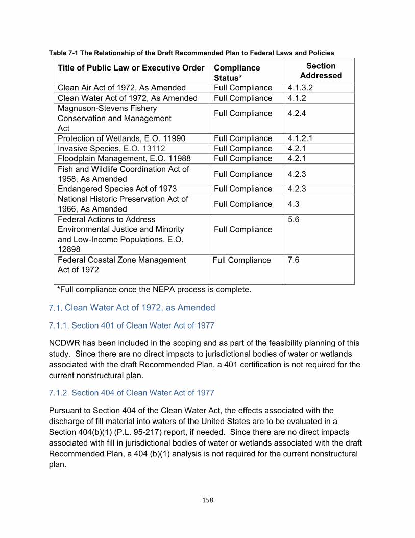
Table 7-1 The Relationship of the Draft Recommended Plan to Federal Laws and Policies
Title of Public Law or Executive Order Compliance Status*
Section Addressed
Clean Air Act of 1972, As Amended Full Compliance 4.1.3.2 Clean Water Act of 1972, As Amended Full Compliance 4.1.2 Magnuson-Stevens Fishery Conservation and Management Act
Full Compliance 4.2.4
Protection of Wetlands, E.O. 11990 Full Compliance 4.1.2.1 Invasive Species, E.O. 13112 Full Compliance 4.2.1 Floodplain Management, E.O. 11988 Full Compliance 4.2.1 Fish and Wildlife Coordination Act of 1958, As Amended Full Compliance 4.2.3
Endangered Species Act of 1973 Full Compliance 4.2.3 National Historic Preservation Act of 1966, As Amended Full Compliance 4.3
Federal Actions to Address Environmental Justice and Minority and Low-Income Populations, E.O. 12898
Full Compliance 5.6
Federal Coastal Zone Management Act of 1972
Full Compliance 7.6
*Full compliance once the NEPA process is complete.
Clean Water Act of 1972, as Amended
7.1.1. Section 401 of Clean Water Act of 1977
NCDWR has been included in the scoping and as part of the feasibility planning of this study. Since there are no direct impacts to jurisdictional bodies of water or wetlands associated with the draft Recommended Plan, a 401 certification is not required for the current nonstructural plan.
7.1.2. Section 404 of Clean Water Act of 1977
Pursuant to Section 404 of the Clean Water Act, the effects associated with the discharge of fill material into waters of the United States are to be evaluated in a Section 404(b)(1) (P.L. 95-217) report, if needed. Since there are no direct impacts associated with fill in jurisdictional bodies of water or wetlands associated with the draft Recommended Plan, a 404 (b)(1) analysis is not required for the current nonstructural plan.
158
Magnuson-Stevens Fishery Conservation and Management Act (Essential Fish Habitat)
Potential project effects on EFH species and their habitats have been evaluated and are addressed in Section 4.2.4 of this document. It has been determined that the proposed action would not have a significant adverse effect on such resources. The draft integrated feasibility report/EA will be submitted to the NMFS along with a letter requesting review and EFH concurrence. Although not anticipated with the nonstructural elements of the draft Recommended Plan and compliance obligations related to EFH provisions of the 1996 congressional amendments to the MSFCMA (P.L. 94-265), any assessment and reporting requirements would be fulfilled before initiation of the proposed action.
Fish and Wildlife Coordination Act of 1958, as Amended
The Fish and Wildlife Coordination Act, as amended (16 U.S.C. 661, et seq), requires that USACE coordinate and obtain comments from the USFWS, the NMFS, where applicable, and appropriate State fish and wildlife agencies.
Coordination with NMFS, NCDMF, NCWRC, and USFWS was conducted throughout the study process. Coordination included receiving written scoping comments, a virtual scoping meeting, and an onsite field visit to Hominy Swamp Creek where, at one point during the feasibility study, multiple channel bench features were being studied as part of a structural measure but was later determined to be not economically feasible and removed from consideration in the draft Recommended Plan.
Section 7 of the Endangered Species Act of 1973
Pursuant to Section 7 of the Endangered Species Act, the USACE has been in communication with the U.S. Fish and Wildlife Service (USFWS) during the development of the Neuse River Basin FRM study. Currently, the draft Recommended Plan only features nonstructural elements including: structure elevation and floodproofing, public education of flood risks, and installation of two river flood gages. As discussed earlier, the proposed action is not likely to adversely affect any listed species or critical habitats. USACE will send USFWS a letter requesting concurrence with that affects assertion as part of the ongoing informal consultation process, along with a copy of the draft integrated feasibility report and EA when it goes out for 30-day public review.
It is not anticipated that the Neuse River Basin FRM project will have any impacts with the nonstructural plan that will require Section 7 consultation with NMFS for impacts to ESA marine species covered by NMFS Office of Protected Resources. The NMFS Office of Protected Resources will receive a copy of the draft integrated feasibility report and EA when it goes out for 30-day public review, but consultation will not be requested since no impacts to resources have been identified.
159
Section 106 of the National Historic Preservation Act of 1966, as Amended
Consultation with the North Carolina State Historic Preservation Office (NCSHPO) is ongoing. Detailed surveys of historic structures and areas under the draft Recommended Plan have been deferred until the PED phase. Consultation with NCSHPO will be completed prior to initial construction. A programmatic agreement among the USACE, Advisory Council on Historic Preservation, NCSHPO, Wake County, NC, and the City of Wilson, NC is being prepared. No federally recognized North Carolina Indian Tribes have areas of interest overlapping with the study area; however, the Eastern Band of Cherokee Indians, the Cherokee Nation of Oklahoma, and the United Keetoowah Band of Cherokee Indians were invited to participate in the Section 106 Programmatic Agreement process as concurring parties. See Appendix G (Cultural Resources) for a copy of the draft Programmatic Agreement and associated Section 106 correspondence.
North Carolina Coastal Zone Management Program One element of the draft Recommended Plan (stream gage installation) would be installed within Craven County which is a designated coastal county in North Carolina. Pursuant to the Federal Coastal Zone Management Act of 1972, as amended (P.L. 92-583), Federal activities are required to be consistent, to the maximum extent practicable, with the federally approved coastal management program of the State in which their activities will occur. A Federal Consistency was sent to the North Carolina Division of Coastal Management (NCDCM) on 15 March 2022.
160
SUMMARY OF AGENCY AND PUBLIC INVOLVEMENT
Scoping
Scoping for the project was completed in order to ensure the report included an assessment of impacts on all significant resources in the project area. The Wilmington District provided a scoping letter by email on 29 May 2020, to local, state, tribal, and federal resource agencies and interested parties for a 30-day comment period. Additionally, a virtual scoping meeting was conducted on 7 July 2020. Comments were received from USFWS, USEPA, NMFS, Advisory Council on Historic Preservation (ACHP), NCSHPO, NCWRC, NC Division of Coastal Management (NCDCM), NCDMF, NC Division of Parks, Pitt County, Jones County, Cherokee Tribe, and American Rivers.
Based on information presented in the USACE’s 29 May 2020 scoping letter, the North Carolina NCSHPO records indicated that there were 6,689 archaeological sites recorded within the area of interest (Appendix G – Cultural Resources). Of these, fifteen (15) were listed in the NRHP, while one hundred and thirty-one (131) had been determined eligible for listing in the NRHP.
Cooperating Agencies
Pursuant to Section 1005 of WRRDA 2014, the USACE requested that the other agencies serve as a cooperating agency during the planning process. On 26 June 2020 a cooperating agency letter was mailed out to NMFS, USFWS, EPA, and FEMA. As noted in the letter, invited agencies were considered a coordinating agency unless correspondence was received to state otherwise. The NMFS sent a letter dated 15 July 2020 to the USACE Wilmington District stating that their organization did not have the resources or staffing to be a cooperating agency on the Neuse River Basin FRM study. Other agencies did not respond, so they are cooperating agencies.
Coordination of this Document
The draft Integrated Feasibility Report and Environmental Assessment is scheduled to be released to the public and resources agencies for a 30-day review starting in May 2022. In addition, virtual public information meeting(s) will be conducted during the 30-day review period. Comments received on this draft integrated feasibility report/EA and USACE responses will be included as an appendix in the final integrated feasibility report/EA.
161
Recipients of this Document
Tribes
Eastern Band of Cherokee Indians Cherokee Nation of Oklahoma United Keetoowah Band of Cherokee Indians
Federal Agencies
Advisory Council on Historic Preservation U.S. Environmental Protection Agency U.S. National Marine Fisheries Service U.S. Fish and Wildlife Service U.S. Department of Agriculture - National Resources Conservation Service North Carolina Department of Environment and Natural Resources North Carolina Division of Marine Fisheries North Carolina Department of Environmental Quality North Carolina Department of Transportation North Carolina Division of Water Resources North Carolina Emergency Management North Carolina Office of State Archaeology North Carolina State Historic Preservation Office North Carolina State University North Carolina Wildlife Resources Commission
State Agencies
N.C. Department of Natural and Cultural Resources, State Historic Preservation Office N.C. Department of Water Resources N.C. Division of Coastal Management N.C. Division of Marine Fisheries N.C. Office of State Archaeology N.C. Wildlife Resources Commission N.C. Office of Recovery and Resiliency
162
Local Governments
Craven County, County Manager City of New Bern, City Manager Jones County, County Manager Local Governments (Continued)
Town of Pollocksville, Mayor Town of Trenton, Mayor Lenoir County, County Manager City of Kinston, City Manager Town of Seven Springs, Mayor Town of Grifton, Mayor Pitt County, County Manager Wilson County, County Manager City of Wilson, City Manager Wayne County, County Manager City of Goldsboro, City Manager Johnston County, County Manager Town of Smithfield, City Manager Wake County, County Manager City of Raleigh, City Manager and Director of Public Works Durham County, County Manager City of Durham, City Manager and Director of Public Works
Elected Officials
Rep. Butterfield, NC-1 Rep. Ross, NC-2 Rep. Murphy, NC-3 Rep. Price, NC-4 Rep. Manning, NC-6 Rep. Rouzer, NC-7 Sen. Burr,NC Sen. Tillis, NC
163

Conservation Groups/Recreation Groups
American Rivers The Nature Conservancy National Audubon Society National Wildlife Federation Sierra Club
164
CONCLUSIONS
The flood risk management problems and needs of the study area have been reviewed and evaluated with regard to the Federal and non-Federal interests and with consideration of engineering, economic, environmental, social, and cultural concerns. The conclusions of the study are summarized as follows:
a)The Neuse River Basin is susceptible to major damage from multiple causes including riverine flooding.
b)The draft Recommended Plan consists solely of nonstructural measures. Measures include the structure elevation and floodproofing of approximately 768 flood-prone structures adjacent to Crabtree Creek in the city of Raleigh, Hominy Swamp Creek in the city of Wilson, Big Ditch in the city of Goldsboro and the Neuse River within both Wayne and Johnston Counties, all in North Carolina. This plan also includes flood warning system enhancements with installation of stream gages at two locations and development of public education materials highlighting residual flood risks throughout the Neuse River Basin.
c) The draft Recommended Plan is feasible on the basis of engineering and economic criteria, and is acceptable by environmental, cultural, and social laws and standards.
d) The draft Recommended Plan is the NED Plan and maximizes net benefits across all benefit categories (NED, RED, EQ and OSE).
e) The draft Recommended Plan is supported by the non-Federal sponsor, the North Carolina Department of Environmental Quality. The sponsor has the capability to provide the necessary non-Federal requirements identified and described in Chapter 6, Plan Implementation.
The total estimated project cost of the draft Recommended Plan is $133,000,000 at Fiscal Year (FY) 2022 price levels and includes the cost of constructing nonstructural measures; lands, easements, rights-of-way, relocations and disposal areas (LERRDs); preconstruction engineering and design (USACE’s cost for final detailed design otherwise known as PED); and construction management (USACE’s cost to manage implementation of the project) support activities. The non-Federal cost for LERRDs is currently limited to real estate administrative and Uniform Relocation Assistance benefits, as applicable, and is currently estimated at $5,835,000. This draft plan would be cost-shared at approximately 65% Federal ($86,450,000) and 35% non-Federal ($46,550,000), in accordance with the cost-sharing provisions specified for nonstructural projects in Section 103(b) of the Water Resources Development Act of 1986, as
165
amended. This plan is economically justified with a benefit-to-cost ratio of 1.6, generating $1.60 in benefits for every $1 spent.
All economics analyses of the draft Recommended Plan presented in this draft IFR/EA are based on the total estimated project cost of $133,000,000 at FY 2022 price levels. The economics analyses will be updated in the final IFR/EA using the final Recommended Plan estimated total project first costs at FY 2023 price levels, as required for decision documents in accordance with USACE policy guidance.
The current working estimate (CWE) for the draft Recommended Plan is $151,455,000, also at FY 2022 price levels, which reflects recent increases in construction materials, labor and establishment of contractor’s field offices; PED; and construction management costs not included elsewhere in this draft IFR/EA. The draft Recommended Plan continues to be economically justified with a BCR above one using the CWE. The CWE is only provided at this time to provide insight into the latest cost estimate.
The construction start date is estimated to begin with award of the first of a series of contracts in Fiscal Year (FY) 2027 and last approximately 12 years and 3 months, assuming 100 percent homeowner participation, subject to receipt of project construction authorization and appropriation of funds.
The Federal government is responsible for preparing and providing an OMRR&R manual to the sponsor as the final Recommended Plan is being implemented. OMRR&R costs associated with a nonstructural plan such as this are considered ‘de-minimis’ (requiring only periodic surveillance by the non-Federal sponsor). Each individual property owner is ultimately responsible for maintenance of their elevated or floodproofed structure/home.
166
DISTRICT ENGINEER’S RECOMMENDATIONS
On the basis of the conclusions of this study, I recommend the implementation of the Recommended Plan, which consists solely of nonstructural measures. Measures include the structure elevation and floodproofing of an estimated 768 flood-prone structures adjacent to Crabtree Creek in the city of Raleigh, Hominy Swamp Creek in the city of Wilson, Big Ditch in the city of Goldsboro and the Neuse River within both Wayne and Johnston Counties, all in North Carolina. This plan also includes flood warning system enhancements with installation of stream gages at two locations and development of public education materials highlighting residual flood risks throughout the Neuse River Basin.
The recommendations contained herein reflect the information available at this time and current departmental policies governing formulation of individual projects. They do not reflect program and budgeting priorities inherent in the formulation of a national Civil Works construction program nor the perspective of higher review levels within the Executive Branch. Consequently, the recommendations may be modified before they are transmitted to higher authority as proposals for authorization and implementation funding. However, prior to transmittal to higher authority, the sponsor, the states, interested federal agencies, and other parties will be advised of any modifications and will be afforded an opportunity to comment further.
Benjamin A. Bennett Colonel, EN Commanding
167

Page Intentionally Left Blank
168
POINT OF CONTACT
Any comments or questions regarding this Integrated Feasibility Report and Environmental Assessment should be addressed to the U.S. Army Corps of Engineers, Wilmington District, 69 Darlington Avenue, Wilmington, NC 28403, ATTN: Jason Glazener, Lead Planner.
169

Page Intentionally Left Blank
170
REFERENCES
Bergstrand, K., & Mayer, B. (2020). “The Community Helped Me:” Community Cohesion and Environmental Concerns in Personal Assessments of Post-Disaster Recovery. Society & Natural Resources, 33(3), 386-405.
Cavallo, E., Galiani, S., Noy, I., & Pantano, J. (2013). Catastrophic natural disasters and economic growth. Review of Economics and Statistics, 95(5), 1549-1561.
Chao, S. F. (2016). Outdoor activities and depressive symptoms in displaced older adults following natural disaster: Community cohesion as mediator and moderator. Aging & mental health, 20(9), 940-947.
Eagles, M., & Erfle, S. (1989). Community cohesion and voter turnout in English parliamentary constituencies. British Journal of Political Science, 19(1), 115-125.
Federal Emergency Management Agency (FEMA). 2012. Engineering Principles and Practices for Retrofitting Flood-Prone Residential Structures (Third Edition) FEMA P-259. Retrieved from website 12 January 2021. https://www.fema.gov/sites/default/files/2020-08/fema259_complete_rev.pdf
Fernandez A, Black J, Jones M, et al. (2015). Flooding and mental health: a systematic mapping review. PloS One.;10(4):e0119929.
Goldmann E, Galea S. (2014) Mental health consequences of disasters. Ann. Rev Public Health. 35:169-183.
Hetherington, E., McDonald, S., Wu, M., & Tough, S. (2018). Risk and protective factors for mental health and community cohesion after the 2013 Calgary flood. Disaster medicine and public health preparedness, 12(4), 470-477.
LeGrand, H., J. Haire, N. Swick, and T. Howard. 2022. Birds of North Carolina: their Distribution and Abundance [Internet]. Raleigh, NC: North Carolina Biodiversity Project and North Carolina State Parks. Retrieved from website 6 January 2022. http://ncbirds.carolinabirdclub.org .
Ludin, S. M., Rohaizat, M., & Arbon, P. (2019). The association between social cohesion and community disaster resilience: A cross-sectional study. Health & social care in the community, 27(3), 621-631.
NACSE, PRISM Climate data. 30-Year Normal Precipitation: Annual dataset. http://prism.oregonstate.edu/normals/. Accessed: 2021
Natural Heritage Program. 2012. Guide to the Natural Communities of North Carolina Fourth Approximation. Retrieved from website 21 Jan 2022. https://www.ncnhp.org/media/2/open
171
North Carolina State Board of Elections
North Carolina Code of Regulations. Chapter 153A-133. https://www.ncleg.net/EnactedLegislation/Statutes/PDF/ByChapter/Chapter_153 A.pdf
North Carolina Department of Environmental Quality (NCDEQ), Division of Marine Fisheries (NCDMF). 2022. Atlantic Sturgeon. Retrieved from website 21 Jan 2022. http://portal.ncdenr.org/web/mf/atlantic-sturgeon#Fisheries
North Carolina Department of Environmental Quality (NCDEQ), Division of Water Resources (DWR). Raleigh, NC. 2002. Neuse River Basin-wide Water Quality Plan. https://files.nc.gov/ncdeq/Water%20Quality/Planning/BPU/BPU/Neuse/Neuse%2 0Plans/2002%20Plan/Neuse%20July%202002%20final.pdf
North Carolina Department of Environmental Quality (NCDEQ), Division of Water Quality (NCDWR). Raleigh, NC. 2009. Neuse River Basin-wide Water Quality Plan. https://files.nc.gov/ncdeq/Water%20Quality/Planning/BPU/BPU/Neuse/Neuse%2 0Plans/2009%20Plan/NR%20Basinwide%20Plan%202009%20-%20Final.pdf .
North Carolina Department of Natural and Cultural Resources. 2021 May 28. NC Historic Preservation Office’s HPOWEB 2.0. NC Department of Natural and Cultural Resources; [accessed 2022 Jan 21]. https://nc.maps.arcgis.com/home/group.html?id=d56ec9c8aa77423b931f4d359f1 03ae6%2Fhpoweb%2Fdefault.htm&view=list&categories=%5B%22%2FCategori es%2FHPOWEB%22%5D#content/hpoweb/default.htm
North Carolina Division of Water Resources (NC DWR), 2009. Neuse River Basinwide Water Quality Plan. https://deq.nc.gov/about/divisions/water-resources/water-planning/basin-planning/river-basin-plans/neuse .
North Carolina Division of Water Resources (NC DWR), Water Sciences Section. 2018-2021. North Carolina Wetlands Information. https://www.ncwetlands.org .
North Carolina Wildlife Resources Commission (NCWRC), 2022. Species. Retrieved from website 6 January 2022. https://www.ncwildlife.org/Learning/Species .
Ohl, C. A., & Tapsell, S. (2000). Flooding and human health: the dangers posed are not always obvious. Bmj, 321(7270), 1167-1168.
172
Redshaw, S., Ingham, V., McCutcheon, M., Hicks, J., & Burmeister, O. (2018). Assessing the impact of vulnerability on perceptions of social cohesion in the context of community resilience to disaster in the Blue Mountains. Australian journal of rural health, 26(1), 14-19.
Tapsell, S. M., Penning-Rowsell, E. C., Tunstall, S. M., & Wilson, T. L. (2002). Vulnerability to flooding: health and social dimensions. Philosophical transactions of the royal society of London. Series A: Mathematical, Physical and Engineering Sciences, 360(1796), 1511-1525.
United States Army Corps of Engineers (USACE), Reconnaissance Report, Neuse River Basin, NC. 1984. USACE Wilmington District
United States Army Corps of Engineers (USACE). 1983. Economic and Environmental Principles and Guidelines for Water and Related Land Resources Implementation Studies, USACE, Washington, DC.
United States Army Corps of Engineers (USACE) (2014). Responses to Climate Change. Website. Accessed July 24, 2014: https://corpsclimate.us/.
United States Army Corps of Engineers (USACE), Vulnerability Assessment (VA) Tool and User Guide. Version 1.1. Issued November 2016.
United States Army Corps of Engineers (USACE), Time Series Toolbox, Trend Analysis and Nonstationarity Detection. 2018.
United States Army Corps of Engineers (USACE), Sea-Level Change Curve Calculator (Version 2019.21)
United States Department of the Interior, U.S. Fish and Wildlife Service (USFWS) and U.S. Census Bureau, 2018. 2011 National Survey of Fishing, Hunting, and Wildlife – Associated Recreation – North Carolina. Retrieved from website 27 Jan 2022. https://www2.census.gov/programs-surveys/fhwar/publications/2011/fhw11-nc.pdf
United States Environmental Protection Agency (USEPA). 2016. EPA 430-F-16-035; What Climate Change Means for North Carolina. Retrieved from website 13 Dec 2021. https://19january2017snapshot.epa.gov/sites/production/files/2016-09/documents/climate-change-nc.pdf .
United States Environmental Protection Agency (USEPA). 2017. Updates to the Demographic and Spatial Allocation Models to Produce Integrated Climate and Land-Use Scenarios (ICLUS). Version 2. Environmental Protection Agency.
173
United States Environmental Protection Agency (USEPA). 2021. Overview of Greenhouse Gases. Retrieved from website 13 Dec 2021. https://www.epa.gov/ghgemissions/overview-greenhouse-gases.
United States Environmental Protection Agency (USEPA). 2021. Inventory of U.S. Greenhouse Gas Emissions and Sinks. Retrieved from website 13 Dec 2021. https://www.epa.gov/ghgemissions/inventory-us-greenhouse-gas-emissions-and-sinks
United States Environmental Protection Agency (USEPA). 2022. National Priorities List and Superfund Alternative Approach Sites. Retrieved from website 27 Jan 2022. https://www.epa.gov/superfund/search-superfund-sites-where-you-live#map
174
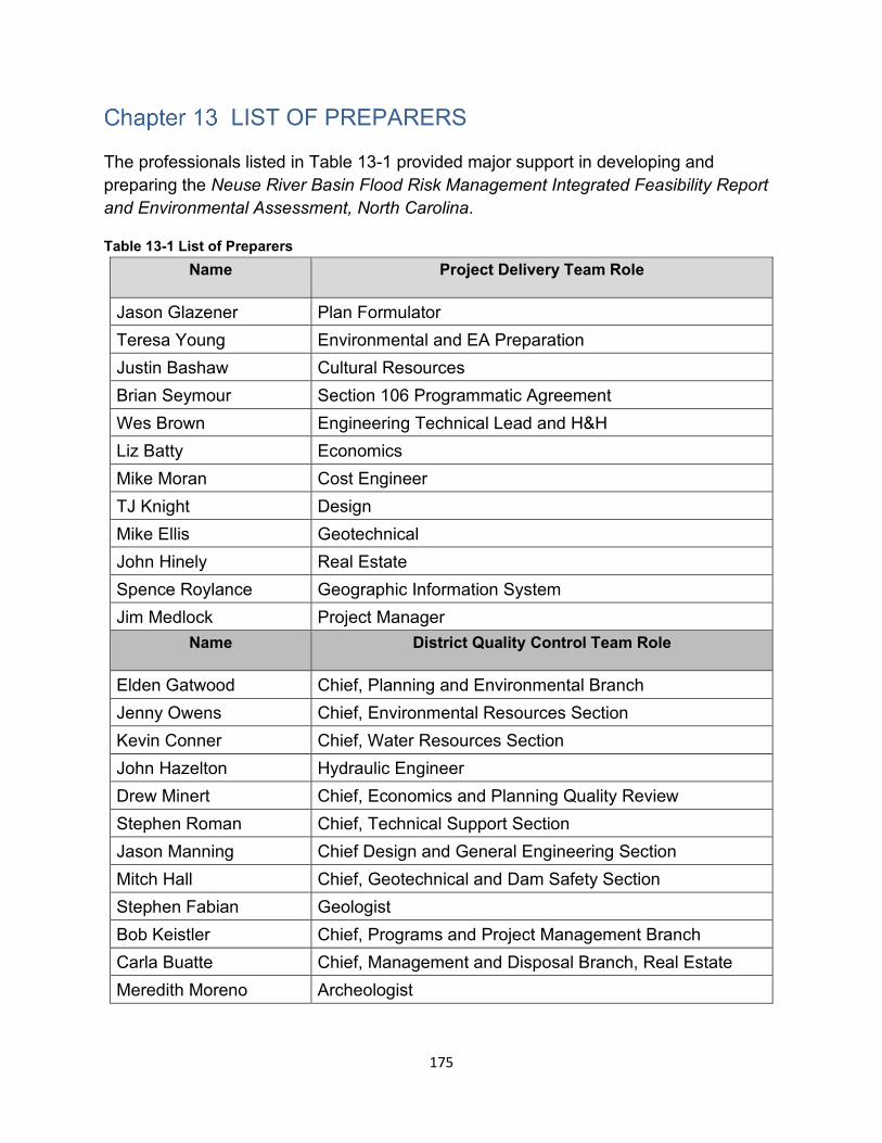
LIST OF PREPARERS
The professionals listed in Table 13-1 provided major support in developing and preparing the Neuse River Basin Flood Risk Management Integrated Feasibility Report and Environmental Assessment, North Carolina.
Table 13-1 List of Preparers Name Project Delivery Team Role
Jason Glazener Plan Formulator Teresa Young Environmental and EA Preparation Justin Bashaw Cultural Resources Brian Seymour Section 106 Programmatic Agreement Wes Brown Engineering Technical Lead and H&H Liz Batty Economics Mike Moran Cost Engineer TJ Knight Design Mike Ellis Geotechnical John Hinely Real Estate Spence Roylance Geographic Information System Jim Medlock Project Manager
Name District Quality Control Team Role
Elden Gatwood Chief, Planning and Environmental Branch Jenny Owens Chief, Environmental Resources Section Kevin Conner Chief, Water Resources Section John Hazelton Hydraulic Engineer Drew Minert Chief, Economics and Planning Quality Review Stephen Roman Chief, Technical Support Section Jason Manning Chief Design and General Engineering Section Mitch Hall Chief, Geotechnical and Dam Safety Section Stephen Fabian Geologist Bob Keistler Chief, Programs and Project Management Branch Carla Buatte Chief, Management and Disposal Branch, Real Estate Meredith Moreno Archeologist
175

Page Intentionally Left Blank
176

ATTACHMENTS
177

Page Intentionally Left Blank
178
DRAFT FINDING OF NO SIGNIFICANT IMPACT
NEUSE RIVER BASIN FLOOD RISK MANAGEMENT (FRM)
NORTH CAROLINA
The U.S. Army Corps of Engineers, Wilmington District (Corps) has conducted an environmental analysis in accordance with the National Environmental Policy Act of 1969, as amended. The final Integrated Flood Risk Management Report and Environmental Assessment (FRM Report/EA) dated DATE OF REPORT/EA, for the Neuse River Flood Risk Management Project evaluates flood risk management opportunities within the Neuse River Basin of North Carolina. The final recommendation is contained in the report of the Chief of Engineers, dated DATE OF CHIEF’S REPORT.
The Final Neuse River Basin FRM Report/EA, incorporated herein by reference, evaluated various alternatives that would reduce the adverse economic effects from flooding within the Neuse River Basin, while protecting the Nation’s environment in the study area. The Recommended Plan is the National Economic Development (NED) Plan and includes nonstructural flood risk management for up to approximately 768 structures in multiple locations throughout the Neuse River Basin as follows:
• Elevation of 38 structures and floodproofing of 21 structures along Crabtree Creek in the City of Raleigh
• Elevation of 14 structures and floodproofing of 6 structures along Hominy Swamp Creek in the City of Wilson
• Elevation of 2 structures and floodproofing of 7 structures along Big Ditch in the City of Goldsboro
• Elevation of 365 structures and floodproofing of 315 structures along the main stem of the Neuse River in Wayne and Johnston Counties.
• The addition of 2 stream gages (one in Wake County and one in Craven County) as well as public outreach and education materials regarding residual flood risk within the Neuse River Basin.
The specific nonstructural measures will be reviewed and refined in the Preconstruction Engineering and Design (PED) phase to ensure that the proposed measures and the applicable population are appropriately identified. Structure modification will be based on structure type and condition. While each eligible structure will be evaluated for the most cost-effective nonstructural measure, the government reserves the right to determine which measure shall be implemented at each structure location. In the cases of elevation, structures would be raised to 2 feet above the 1% annual exceedance
179
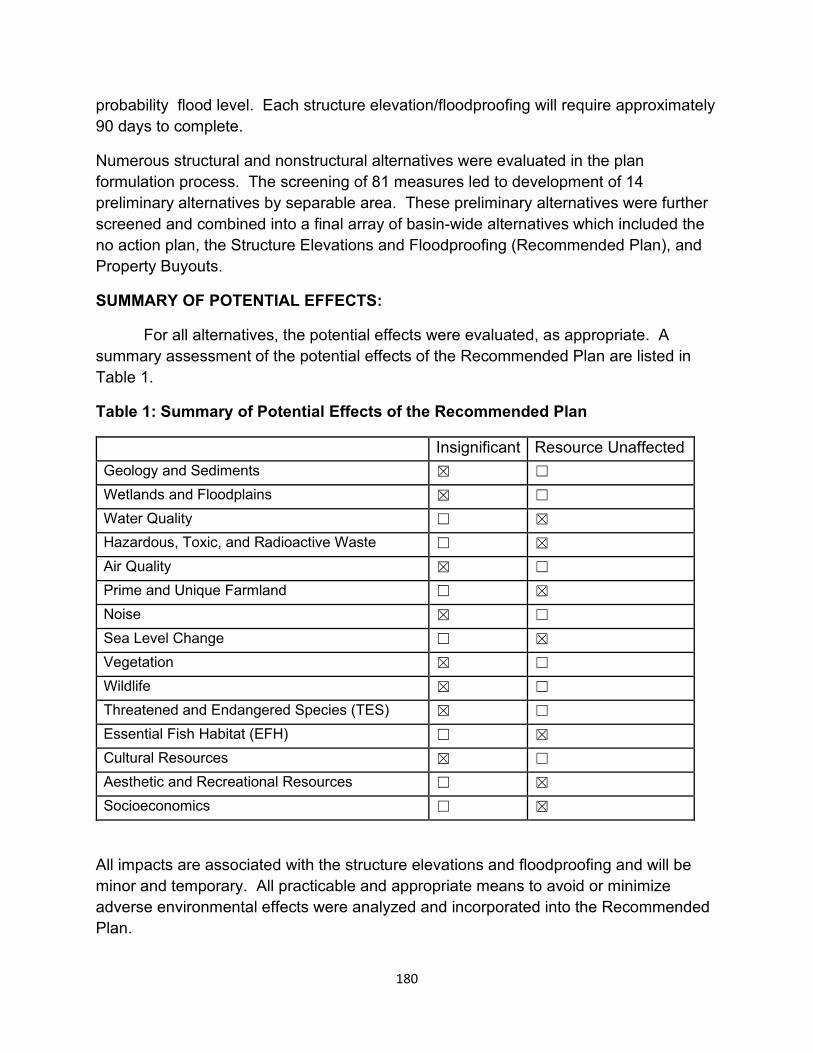
probability flood level. Each structure elevation/floodproofing will require approximately 90 days to complete.
Numerous structural and nonstructural alternatives were evaluated in the plan formulation process. The screening of 81 measures led to development of 14 preliminary alternatives by separable area. These preliminary alternatives were further screened and combined into a final array of basin-wide alternatives which included the no action plan, the Structure Elevations and Floodproofing (Recommended Plan), and Property Buyouts.
SUMMARY OF POTENTIAL EFFECTS:
For all alternatives, the potential effects were evaluated, as appropriate. A summary assessment of the potential effects of the Recommended Plan are listed in Table 1.
Table 1: Summary of Potential Effects of the Recommended Plan
Insignificant Resource Unaffected Geology and Sediments ☒ ☐
Wetlands and Floodplains ☒ ☐
Water Quality ☐ ☒
Hazardous, Toxic, and Radioactive Waste (HTRW)
☐ ☒
Air Quality ☒ ☐
Prime and Unique Farmland ☐ ☒
Noise ☒ ☐
Sea Level Change ☐ ☒
Vegetation ☒ ☐
Wildlife ☒ ☐
Threatened and Endangered Species (TES) ☒ ☐
Essential Fish Habitat (EFH) ☐ ☒
Cultural Resources ☒ ☐
Aesthetic and Recreational Resources ☐ ☒
Socioeconomics ☐ ☒
All impacts are associated with the structure elevations and floodproofing and will be minor and temporary. All practicable and appropriate means to avoid or minimize adverse environmental effects were analyzed and incorporated into the Recommended Plan.
180
No compensatory mitigation or adaptive management is required or recommended as part of the Recommended Plan.
Public review of the draft FRM Report/EA and FONSI was completed on DATE DRAFT EA AND FONSI REVIEW PERIOD ENDED. All comments submitted during the public review period were responded to in the Final FRM REPORT /EA and FONSI. A 30-day state and agency review of the Final FRM Report /EA was completed on DATE AR PERIOD ENDED. Comments from state and federal agency review did not result in any changes to the final FRM Report/EA.
Pursuant to Section 7(a)(2)/7(d) of the Endangered Species Act of 1973, as amended, the U.S. Army Corps of Engineers determined that the Recommended Plan may affect, not likely to adversely affect the following federally listed species:
• Atlantic pigtoe • Atlantic Sturgeon • Carolina Madtom • Dwarf wedgemussel • Neuse River Waterdog • Red Cockaded Woodpecker • Shortnose sturgeon • Tar River spinymssel • Yellow lance
Additionally, it was determined that the Recommended Plan will have no effect on Michaux’s sumac, the monarch butterfly, Atlantic Sturgeon Critical Habitat and Carolina Madtom Critical Habitat.
The PICK THE APPROPRIATE AGENCY(USFWS/NMFS) concurred with the Corps’ determination on DATE OF CONCURRENCE LETTER
Pursuant to Section 106 of the National Historic Preservation Act of 1966, as amended, the U.S. Army Corps of Engineers determined that the Recommended Plan has XXX effect on historic properties.
The Recommended Plan will not require any dredge or fill material into jurisdictional waters or wetlands.
OTHER SIGNIFICANT ENVIRONMENTAL COMPLIANCE:
ADD BRIEF DISCUSSION IF OTHER ISSUES WERE RAISED RELATIVE TO OTHER ENVIRONMENTAL LAWS AND/OR EOs SUCH AS ENVIRONMENTAL JUSTICE,
181
CLEAN AIR ACT, PRIME OR UNIQUE FARMLANDS, MARINE MAMMAL PROTECTION ACT, ESSENTIAL FISH HABITAT, WILD AND SCENIC RIVERS, OR COASTAL BARRIER RESOURCES ACT.
Technical, environmental, and economic criteria used in the formulation of alternative plans were those specified in the Water Resources Council’s 1983 Economic and Environmental Principles and Guidelines for Water and Related Land Resources Implementation Studies. All applicable laws, executive orders, regulations, and local government plans were considered in evaluation of alternatives. Based on this report, the reviews by other Federal, State and local agencies, Tribes, input of the public, and the review by my staff, it is my determination that the Recommended Plan would not cause significant adverse effects on the quality of the human environment; therefore, preparation of an Environmental Impact Statement is not required.
___________________________ ___________________________________
Date Benjamin A. Bennett Colonel, EN Commanding
182