muskeg field program: mer bleue peat bog
TRANSCRIPT
Publisher’s version / Version de l'éditeur:
Vous avez des questions? Nous pouvons vous aider. Pour communiquer directement avec un auteur, consultez la
première page de la revue dans laquelle son article a été publié afin de trouver ses coordonnées. Si vous n’arrivez pas à les repérer, communiquez avec nous à [email protected].
Questions? Contact the NRC Publications Archive team at
[email protected]. If you wish to email the authors directly, please see the first page of the publication for their contact information.
https://publications-cnrc.canada.ca/fra/droits
L’accès à ce site Web et l’utilisation de son contenu sont assujettis aux conditions présentées dans le site
LISEZ CES CONDITIONS ATTENTIVEMENT AVANT D’UTILISER CE SITE WEB.
Internal Report (National Research Council of Canada. Division of Building Research), 1964-09-01
READ THESE TERMS AND CONDITIONS CAREFULLY BEFORE USING THIS WEBSITE.
https://nrc-publications.canada.ca/eng/copyright
NRC Publications Archive Record / Notice des Archives des publications du CNRC :https://nrc-publications.canada.ca/eng/view/object/?id=167b6e81-605c-4527-81a4-6b14f0a90009
https://publications-cnrc.canada.ca/fra/voir/objet/?id=167b6e81-605c-4527-81a4-6b14f0a90009
NRC Publications ArchiveArchives des publications du CNRC
For the publisher’s version, please access the DOI link below./ Pour consulter la version de l’éditeur, utilisez le lien DOI ci-dessous.
https://doi.org/10.4224/20338038
Access and use of this website and the material on it are subject to the Terms and Conditions set forth at
Muskeg field program: Mer Bleue peat bogMacFarlane, I. C.
NATIONAL RESEMCH COUNCIL
CANADA
DIVISION OF BUILDING RESEmGH
MUSKEG FIELD PROGRAM - MER B m U E PEAT BOG
b.$r
Ivan @. MacParlane
Internal Report No. 384
of the
Division sf Building Research
OTTAWA
September 1964
PREFACE
The value of laboratory studies of the properties of
undisturbed peat is limited by the complexity sf the material and
by sampling difficulties. There is consequently a real need for
full-scale f i e ld testing far strength and csmpreeeibility sf the
natural peat. Fortunately, the Mer B l e w peat bog, which is
located within a reasonable distance of the Building Research
Centre, contains a rather c~rnrnon class 0% peat and is therefore
an ideal location for field studies. As a first step in such etudies
a portion of the bog has been surveyed and sounded, Tkie r epork
describes the area, indicates the most suitable location far study,
and oratBPnes the nature of the proposed t e s t s .
The author of this report is a civil engineer in the
Soil Mechanics Section whose w o r k with the Division concerns
research on organic terrain,
oetaw %I
September 1 96 4 R. F, Legget
Director
TABLE OF CONTENTS
Page
PHTRODUCTION . . . . . . . . . . . . . . . . . . . . . . . . . . . . . . . . . . . . . . . . . . . . . P
PROPOSED FIELD TEST PROGRAM . . . . . . . . . . . . . . . . . . . . . . . . . . 2
CONCLUSIONS AND RECB NDATZBNS . . . . . . . . . . . . . . . . . . . . . 6
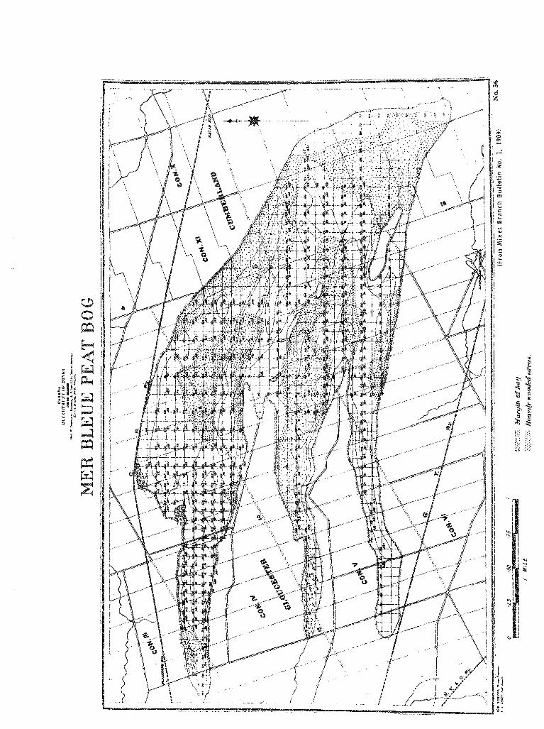
WPENBIX A . NOTES ON THE MER B U U E PEAT BOG FROM MINES BRANCH BULLETIN No . 1. 1909
MUSKEG FTSLD PROGRAM - MER BLEUE PEAT BOG
The Mer Bleue Peat Bog is a Sgc~w%inedBe muskeg area
approximately 8 eqaare milee in size, located about 9. 5 miles east
of the centre sf the City s f Ottav~a. Situated on the northwest edge 0 4
the bog is the hamlet s f Blackburn Statism, and on the southeast edge
i s located the village of Garlisbad Springs. The Canadian Pacific
Railway main line t s hIIoatreak ski r t s the northern edge of the bog and
the Canadian National Railway line is located wear the southern edge.
The bag is bisected by the Gloucester -Cumbarland Township line
(Figure I ) .
The Mer Bletle Peat Bog is m z h l y wasteland and at
present is not being utilized t o any great extent. Aerial photsgraphs
(Figure 2) show that some of the fa rms on the periphery have
encroached on i t very slightly, t o the extent of a. few acres . The
central par t of the bog is the property sf the Department of National
Defence and during the Second World War an a r e a one mike in diameter
was used by the EX. C. A. F. as a bsmbing rar-gee A large p a t of the
west end of the bog is now par t of the National Capital Commission
Green Bekt a r e a and is t o become a bird sanctuary and game r e s e r v e (%I . The eas tern pa r t of the bog is individuaP8y owned by severa l 08 the
bed % B F ~ B I S .
F i r e s have occurred regularly on the bog in the past 58
years and recently, during the s u m m e r of 1955, a rather extensive
f i re occurred. This f i re as well as sporadic f i r e s which occurred
since thew burned a Barge a r e a of %Be bog. Nevertheless, it has been
noted that fairly la rge expanses of the bog still show no signs of recent
f i res , so evidently were not affected by the 1955 conflagration,
although were probably burned over by earl ier fires, There is ass
doubt, therefore, that the present surface vegetation more or less
ref lects the f i re his tory of the bog.
The elevation of the edge s f the Mer BHeue Pea t Bag is about
225 ft above sea Bevel. Local geology indicates t h a ~ the bog is deposited
in the depression of a former r ive r channel QactuaPfy, a delta). Ridges along both the north and south extremities sf the bog a r e quite evidently
beach lines. 1t is a so-called Pshighmcps%r38 type bog, with the centre being of oPightHy higher elevation than the edges. T o reach the $02, it is necessary t o wade for several feet through a water -filled, low-lying
a r e a around the periphery ( h o w as a "lagg") until the higher level is attained.
Soma of the Mer Bleue is treeless, but a fairly large
proportion of the area, particularly a& the centre, is quite heavily
wooded. Much of this tree growth is scrub, up to 15 %t hi&, but
there are some areas where the trees are dense in growth and wel l
over % 5 bt high. In the open areas the predominant vegetation is low
woody shrubs (less than 2 ft highband m o s s e s . Incidentally, the name
of the Mer Bleue Peat Bog apparently springs from the fact that during the blueberry season it is veritably a "blue sea, D B for blueberry bu~hes
are owe of the predominant vegetative features of these open areas,
Generally, the moss, which is knee-deep in places, 9s fairly humrn~cky
and '8epringyit so that walking is quite difficult until onme acquires the
technique of the &bog trotting gait. @ Occasisnal patches $of faiz1y
limited area) of short grass and mses also occur, so the area offers
a fairly good range of muskeg types.
Drainage Pattern
As can be noted f r o m Figures B and 2, the Mer BPeue Peat
Bog is naturally drained at the west end by several small streams and
at the east end by two extensive man-made ditches draining into Bear
Brook. It is understood that these ditches w e r e dug during the 1 9 3 0 e s
as a '%make-work" project &a alleviate local unempls%p~9lean$ rather thaw
as a serious attempt to reclaim the area. The cost is reputed to have
been $ 6 0 , O O O , This work has wow been undone by beavers. The long
ditch adjacent to t h e township line was observed to be %argely choked with
shrubs and bushes at the south end, and at the north end to be compketdy
filed wi th water. This ditch is about 4 ft deep, with sloping sides, and
is about 10 ft wide at the tap,
PROPOSED FIELD TEST PROGRAM
A laboratory test program to determine the engineering characteristics of peat has been underway at the Division s f Building
Research for some time. It is not always possible, however, $0
extrapolate laboratory results to fit field conditions. It wae considered,
therefore, that it would be useful to set up a field test program so that
model and full-scale shear strength and settlement tests could be carried
out concurrent with the laboratory program, to check orat the latter
results. This field program will be carried out in three stages:
The objectives wi l l be to:
1. 85tain a vehicle for access, such as a DeMuekeg Buggy, " 8%~t'8 or s n W ~ a s e h . $'

2, G a t r y out a survey of the M a r BPeue Peat Boge
(a) Lay out s proposed line for 3 survey, pf sferably a north- easreh, east-wee& grid system; grid p ~ f n t ~ $ mils apart.
(b] Probe fst depth and type of peat at the grid points. Determine
t y p e of u~%$erlyHng mineral soill. G l e e sbf y surface vegetation.
3. Select areas of various muskeg type8 for vane shear and cone
penetrometer testing.
[a) Conduct vane ehear smd eons pesetresmster t es t s 1x1 these areas.
(b) Obtain peat samples for water content, or ganfc content and ~ p e c i f i c gravity determinations.
4 Select an area for the proposed detailed t e ~ t program. Fence it
off if necessary.
The program will be continued as %a%Bows:
1. From within the large test area, select a specific area (or areas) far proposed load teete.
2. Gsaadaect load tests an the muskeg, using tanlee filled with watep on
gravel pads, or a similar loading system.
(a$ Obeerve load-deflection -time.
($1 U s e various load increments.
{ c ) Use variou~ sizes of loaded area.
More detailed t e a t s w i l l %a carried out:
1 , Second series s f load teats.
[a) ImstaBI pfezometere to measure pare-water pressures,
(b) 1nezstal.l lateral movement gauges.
( c ) Install settlement plates at various depths in the peat.
(d) Conduct load t e s t s as for Stage 11.
2 , Field shear tests.
fa) Load peat to failure - in different muskeg types, if possible.
(b) Analyze the failure, Check calculated shear values with vane shear, cone pe~etrometer and labor ator y values.
arUndiaturbed'D peat samples will be sbtained throughout the
profile of the deposit %or laboratory cornpressHon and sheer teetfng, for routine index teats, B&C.
STAGE I: SUMhAER 1962 - FIELD WORK
Vehicle
After considerable investigatieaw it was learned that a
Bombardier B. B. Carrier (amphibious) awned by the National Research
Cauncill, Divisf on sf Mechanical Engineering, coab%d be obtained on loan,
This vehicle provided generally eatisfacterr y transportation over the
bog but it had variolas defect8 which might militate against the purchaee of this particular model by the Division of Building Reeeareh. Csnsf der - able maintenance was requfr ed, particularly to the eHectricai gystem, The motor H B compBete1y enclosed in a watertight compartment, making
access for repaire very difficult. The motor also had a tendency $0
overheat, e s that the vehicle could be driven only Psr an hour or 80 at the most before it had to be allowed to cod off. To its advantageB however,
is the track system, which gave little trouble, even when travelling o%*er
burned-over terrain containing tree stumps. Nevertheless, it was necessary to clean the tracks of moss and other debris at least once
each day and often more frequently, depending upon the type of terrain.
Arrangemente were made to leave the vehicle overnight and
weekends in the farmyard of Mr. John Lauthier, a tenant in the last
house an the Dolman Ridge Road,
Survev of Mer Bleue Peat Boa
The Mer Bleue Bog wae found to be more heavily wooded than originally anticipated, ss that it was not possible to adhere strictly
$0 the $-mile grid system - at least withoat extensive bush work. Although the vehicle could negotiate in fairly heavy bush, quite
extensive areas had tree growth too large for the Bcsmbardier to get
through, In addition, past fires had left forests of dead tree trunks and
stumps which were extremely hard and brittle. These areas were an e%Bective sftank traps' and it was considered expedient to avoid them for
dear 0% track damage or puncturing of tires. As it was, on one excursion into the fringe of a burned-aver area, a dead tree got caught in the track, backlashed, and crashed through the windshield of the B~mbardier.
Consequently, it w a s found necessary to scale dawn some-
what the actual extent 0% the surveyg and to vary the distances between the grid points where appropriate. An attempt wae made to tie in gr id
points with some location easily Identifiable from aer ia l photographs.
In general, gr id points were maintained in a north-aorrth and east -west
relationship ueing a simple compass. Distances were measured by
counting the t rack rev04~tions af the Born4CBba.r dier. Figure 1 indicates
the %ocat%an of the points where depth probes were made, and Table I surnmarisee the field fnf~rrnation obtained, Figures 3 to 'I portray
typicah areaka sf the PA@$ BBeue Peat Bogo
Time did not permit s complete survey of the Bog during
the ~ u m m e r e The eelobelc between Balman and Bortbwick Ridges on the
w e s t and the large expanee sf bog between the two ditches on the east end were untouched. In both cases, access w a s difficult from the
"sheadquarters" a rea on Dolman Ridge. Heavy t ree growth prevented
easy accesa in the case of the lobe of bog between the t w o ridges; the
width and depth of water in the ditch at the west and retarded access to
that area. The Bobe'sf bog to the north of Dolman Ridge also is bisected
by a ditch which can create difficulty for the Bsmbardier, even though
it is not very deep or wide. Since this survey w a s carried out, It haa
been learned that a eimilar survey was conducted in 1908 (29. The
resulte of this early survey provide vary useful confirmatory information
and are included as Appendix A s f this report.
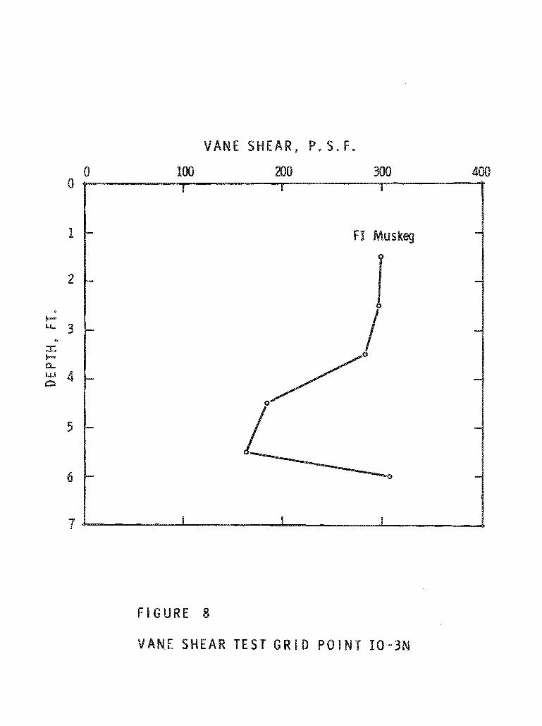
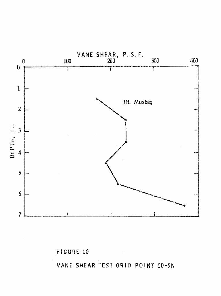
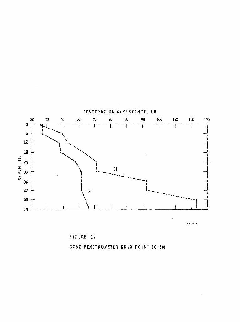
Vane Shear and Cone Penetrometer Tests
A series of vane shear and cone penetrometer tests were
carried out in a single muskeg type, at two grid points: 10-3N and
18-5M, 1% w a s originally intended to conduct such measurements at
other grid points in various muskeg t y p e s , but time did nst permit this.
The results s f theee tests a r e shown in Figures 8 to Bl. The vane used
was a medium-size vane as deecribed 3x1 a previoue paper (31, Fr ie t~sn
corrections were made for these t e s t s , but w e r e found to be. insignificant
for the depths involved for this particular type of muskeg. The cone
penetrometer is a Soiltest rnodei CN-970, with a cone size as follows:
diameter at base - 2.84 c m , height = 5. Bb cm. Penetrometer readings were taken where limited muskeg a reas Qa few square feet in size] of
different coverage types were adjacent to each sther. Depth of cone penetrometer meaeearementa were limited by the length of the rods
available. Vane teste were carried out only in the predominant vegetative
type.
Figur e e 8 and I 8 show the vane shear -depth relationship for predominantly amon-woody fine-fibroue peate. An increase in shear strength with depth i s observed dawn to a depth of about 2* f t , followed
by a decline in strength. The shear strength increases again at the transitional zone between the peat and the mineral sail substratum.
The cone penetrometer tests are hardly extensive enough
t o permit any definite eonaclueione to be drawn. Nevertheless, it was
possible to make a preliminary assesamen$ sf this instrument. It is
mach simpler and fzster ts use than $8 the vane, and in this r e g a r d it
has to commend it. It does nots however, reflect sxact1y tb.e
same trend of ahease strength with depth ae does the vane. A continuing
increase in cane penetration P eeistance is indicated somewhat beyond
that point at which the vane ~ h e a r ~ t a s t e show a deerease in strength.
Assuming that the vane apparatus i s an adequar-,a device for refleeting the conditions that actually exist, it m a y wel l be that the cone pane-
treatmeter - at least of the small sf ze used - may not be appropriate far all peat conditions. Further csmparat-kva tests will have to be carried
out to ~o~afbrm this.
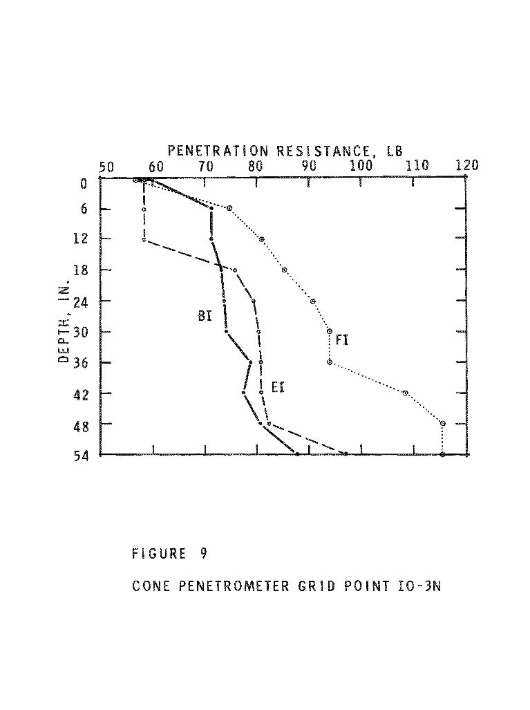
Figure 9 indicates the cone penetration reaiatance in three
different muskeg t y p e s . These curves represent an average of the
results of three t e s t s in the same area. The greatest rssietance to
penetration i s indicated for the PI muskeg, the least for BI, with EI intersmediate. This is opposite to what might normally be expected.
The relationship in Figure B O is more logical, however, except that
the va;buee for the EH area ape abnormally high, which indicate the
poseibilbty 0% a log (or heavy root mesh) below the 36-in. depth.
60NC EUSIONS AND RECOMMENDATIONS
From this greliminar y survey, it appears that the most appropriate location for a proposed test site would be immediately
north s f the Dolman Ridge Road, in the vicinity of gr id point EO -2E -1 5, where the depth to minerah soil is 18 ft. This i s an EI muekeg azea,
and is easily accessible from the road. Far a possible t e s t site in FH muskeg, the a rea immediately east of Dolman Ridge would be appropriate
(Figure 21. Finah choice of a suitable site, however, slkaodd await
completion of the sulrvey.
Ira the vicinity of the above-mentioned sites there would be
little difficulty in obtaining a building to ehelter a vehicle, znd even one for a field keadwarter s, Many of the houses along the Dolman
Ridge Road are empty and a re offered for rent. They are s m e d by
the National Capitall Csmmissioaa who have expropriated the land for the Green Belt. E%ectricity and telephone services w~uldl also be eanven-
iently available. All faci%i&iee would have $0 be negotiated for with the
NCC.
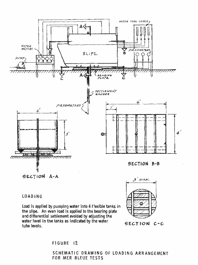
The method of load application for the f ie ld settlement teats muet essentially be simple and portable, yet effective, The use
of a t e s t f i l l sf gravel or s a ~ a d may be an u%tima%a poesibility, but it
is advisable to utilize initially a simpler method of load appliestisn.
It is suggested that a farm of "sPfpan5 could poesibly be used, which could act both as a rneane of carrying equipment, when attached to a vehicle, and IB a method of appP$Pi;ng a Load. It hecsa9%d be designed t o aeeommsdate flexible tanks of water so theht the load cauld be varied. The bearing surface could be a plate, e. g. a 36-in. diameter, 3 -in. thick plywood plate, reinforced by aluminum alloy channel@,
Other platee of larger diameter could also be uaed. If the ~ 1 f p e is ~IBD
sf a BPghtwei&t aluminum alloy, it esuld be attached t c s the plate and left in that position for the duration of the %a&. A pump would supply
wafer to four tanks fn the ~Bipe, with the water being metered to p a ~ m i t
control sf the exact weight desired. Water tube levels attached to each
corner of the ~ l p e , and leading to an adjacent control panel, wokpPd
help to assuss the operator of an even dietribution sf the load. A small hole in the bearing plate and fn the bottom 0% the dipe would give access 4,s eattlernent gauges and to piezometers, For future guidance, a schematic drawing incorporating theee euggeetione is shown in Figjar e % 2.
References
(1) Montreal Gazette? 24 Jane 196%.
(2) ~ ~ e t r k ! r n , E, and S. A, Anrep, Investigatisn of Canada during the
season 1908-1909. Canada Dept, of Mines, Mines Branch,
Bulletin No. 1 {Report #SO), Ottawa, 1909,
) MacFarlane, I. G. and A, Rutka, An evaluation of pavement
performance over rnea~lleeg in Northern Ontario. Highway Research Board Bulletin NQ. 316, 1962, p. 32-43,
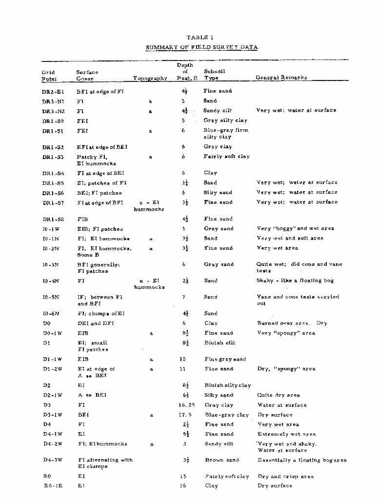
TABLE 1
T OF FIELD SUWYE Y DATA
Depth
Grid Surface of Slabsoil
DRZ-EL BFE at edge af FK 4 Fins sand
BR3-Nk F9 a 3 Sand
DR3-%.89 FI a $4 Bandy able Very wet; water at eurkce
5 Gray silty clay
a 6 Blue -gray firm ri l ty cloy
EFIat edge of BEI Gray eHay
Fairly soft clay Patchy TI, a
EI hummocks
C l a y
Sand
Silty sand
Fine sand
Very wet; water at surfsee
Very wet; water at surface
Very wet; wzter at aurfaee
El; patches of Ff
BE%; FH patches
F i n s eand
Gray sand
Sand
Fine sand
Very lpboggylC and wet aeea
Vary wet and soft zrea
Very wet srea
FI; El h u m r n o ~ k ~ a
Quite wet; did cone and vane t a r t s
Gray sand
Shaky - Bike a floating bog Sand
IF; between FI and BFH
BParxt: and cone t e s t s carried
out
Sand
Clay
Fine sand
Bluish silt
DEI and DFE Burned ever area. Dry
V e r y Dssp~ngyit &re%
El; small FP pateke8
Fine gray tiand
Fine earad Dry, 'vspowgy" area EI at edge of L
A e BE%
Bluish etPty clay
Silty aand Quf.te dry af ea
1 6 . 2 5 Gray clay Water at surface
a 17. 5 Blue-gray clay Dry rsrxrface
29 Fine sand V e r y wet area
5% Fine sand Extremely w e t ares
D4-ZW F1; EI hummocks a 3 Sandy silt 'Vary wet and shaky. W a t e r at surface
D4-3W Ff alternating with
EH clumpm
32. Brown sand Essentially a floating bog area
RO EH 15 Fairly soft chagr Dry and crisp area
RB -lE EI ! 6 Clay Dry surface
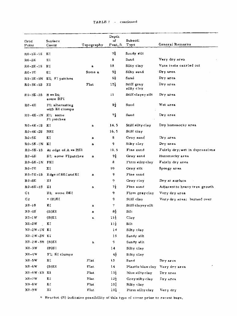
TABLE 1 - continued
DepeX
Gafd Surface s f Subsoil P% ~iiPLt Cover Topagraphy Peat, f t Twe General Remarks
RO-3E-BN El; FI patches
BO-3E-BS EI
RO-3E -2s B * Dl;
ssms D F I
RQ -4E FI; alternating with El clumps
RO-4E-1N EX; eoma FE patches
WO-6E EI; earns FIpatcAes
RO-66-PM FEI
80 -4E El
RB-tE-1S Edge of BEIandEH
RO -8E EI
RO-8E-19 EP
G P El; some BET
C 2 * (B)EX
X 0 - I S E I
xc -0s O ~ E I
XO-IW (B)EI
X8-2W EE
XO-ZW-IN El
XQ-2W-2N EE
XO-2W-3N (B)EI
XQ-3W (B)EI
XO-4W F%;EIePurnps
x0-5W EII
XO-6W (B)EI
XO-SW-PN EI
XO-7%' E P
XO-8%: EI
XO-9W EP
8
Some
7) Bandy milt
8 Band Very dry area
B 8 Silty clay Vane tes ts carried out
a 94 Silty sand Dry area
fJ$
Flat 17*
Flat
9 and
Stiff gray eilty clay
Stiff c l a y e y silt
Stiff eilty elay
Stiff clay
Gray sand
Silty cPay
Fine sand
Gray sand
Firm eilty slay
Gray sfit
Fine sand
Gray clay
Fins sand
Firm gray clay
Stiff elay
Stiff clayey sfat
Silt
Clay
Silt
Silty clay
Sandy sitt
Sandy ai i t
Silty clay
Silty clay
Sand
Dry area
Dry area
Dry area
W e t area
Dry hummocky area
Dry area
Dry area
Zairly dry; wet in depseesfim~
Wummctcky area
Fairly dry area
Spongy area
Ds y at surface
Adjacentto heavy tsee growth
Vary dry area
Very dry area; burwed over
Dry area
Flat 1 4 Plastic blue clay Very dry area
Flat Blue siltyelay Dry area
Flat 12i Greysiltyclay Day area
Flat 10; Si l tyclay
Flat l0-f Firm silty clay V e r y dry
* Bracket (B) indicates possibility of this & ) ~ e of cover prior to recent burn.
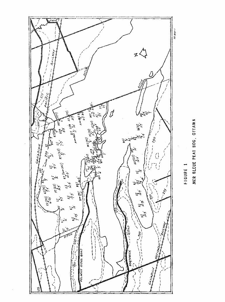
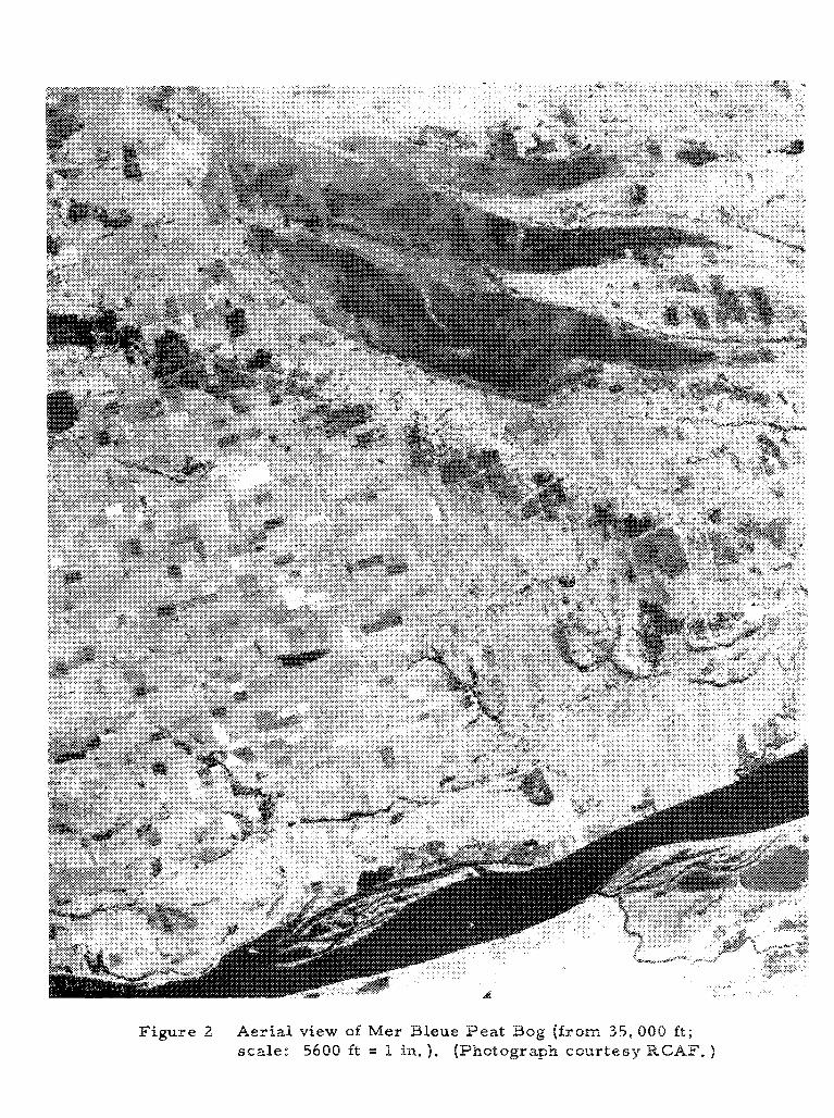
Figure 2 Aerial view sf Mes Bleue Peat Bog (from 3 5 , 000 f t ;
scale: 5600 ft = 1 in. $. (Photograph courtesy RGAF.
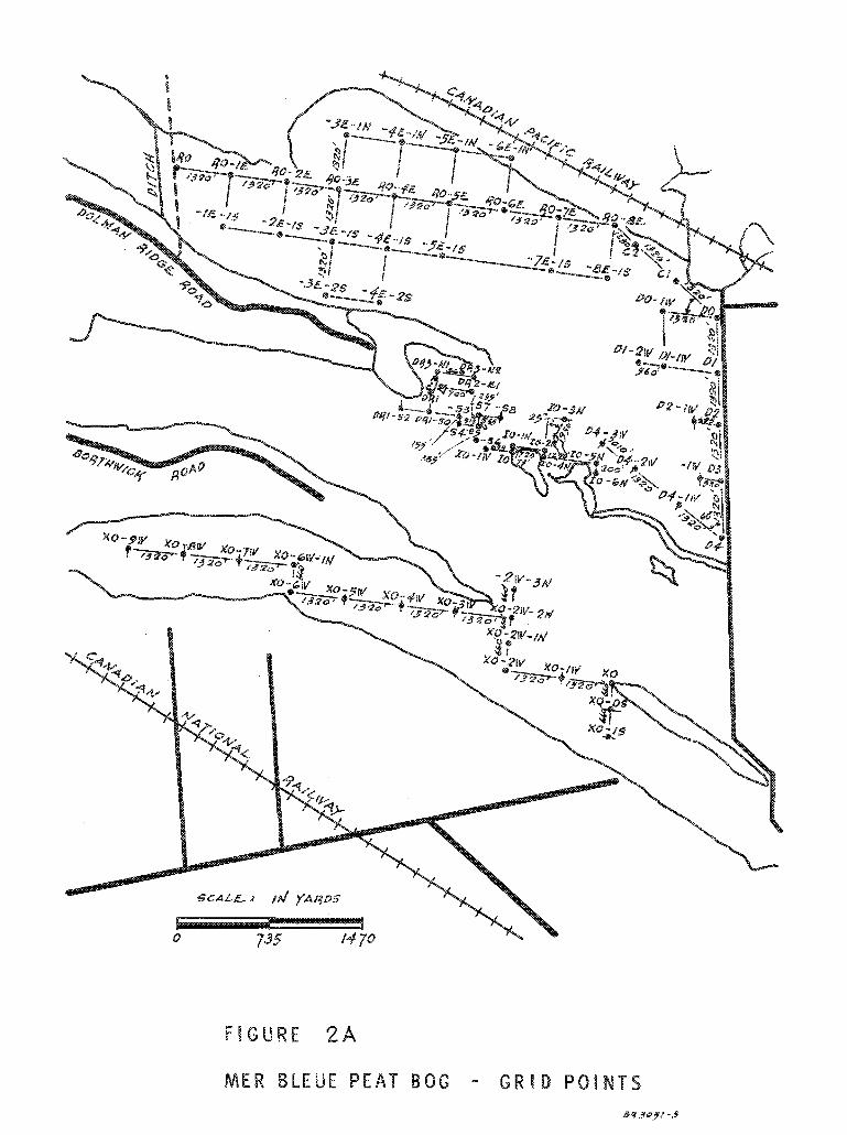
F I G U R E 2 8
MER BLEUE P E A T B O G - G W I D POINTS
8a3Qyl-3
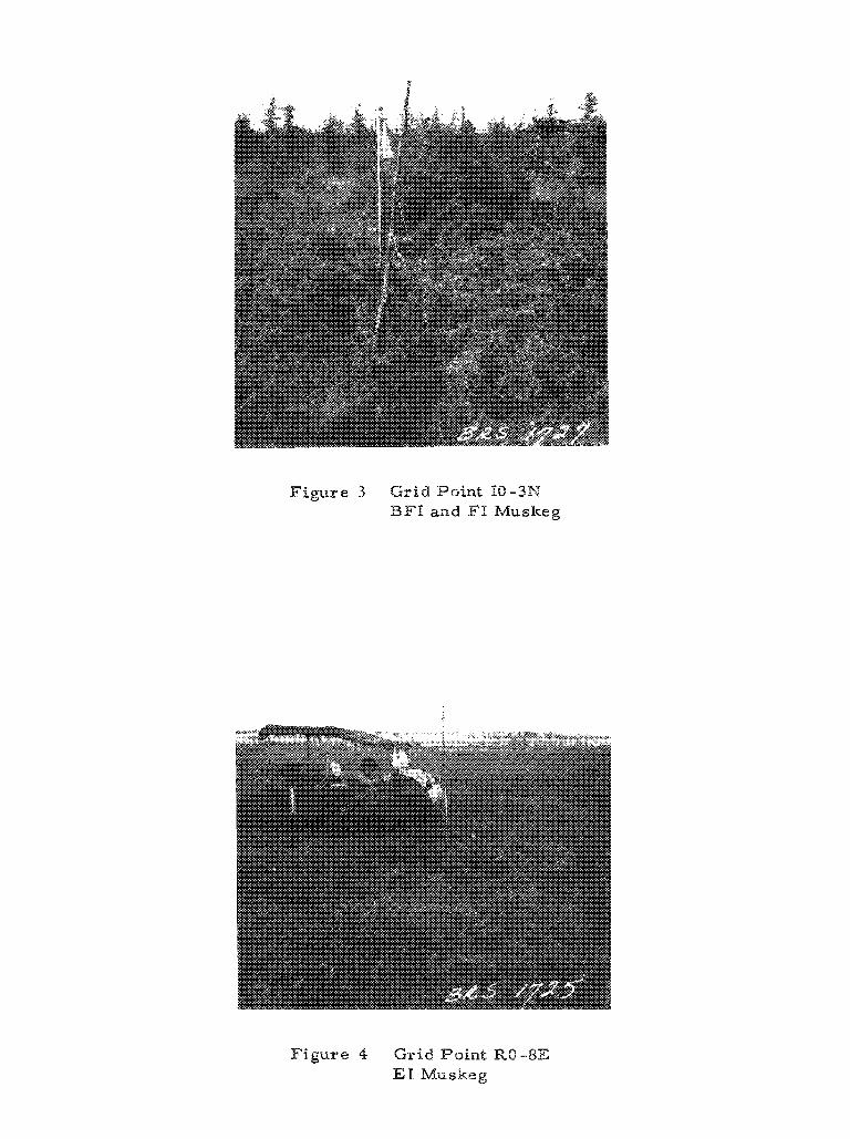
Figure 3 G r i d Point 16 -3N
BFE and PI Muskeg
Figure 4 G r i d Point RO -8E E% Muskeg
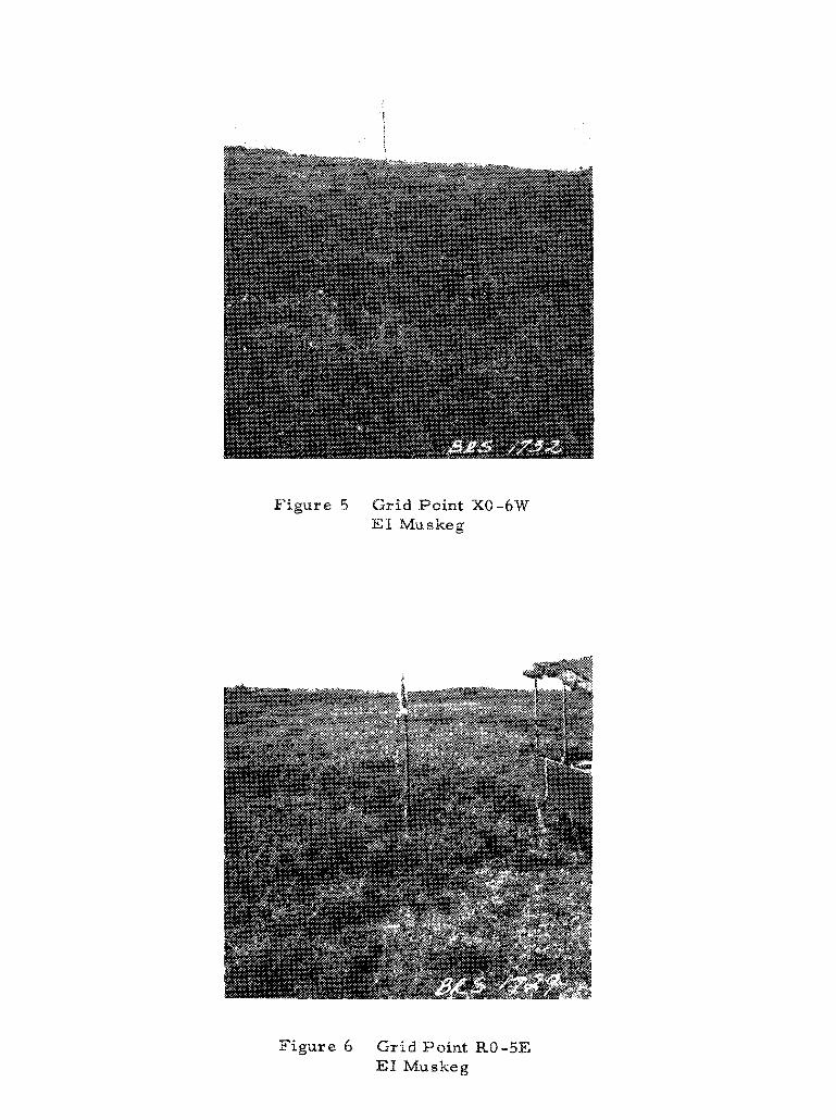
Figure 5 Grid Point X6-6W 23% Muskeg
Figure 6 G r i d Point RO -5E E% Muskeg
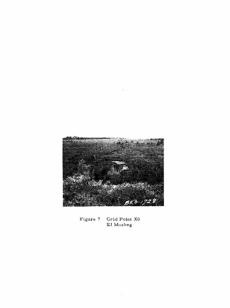
Figure 47 GridPo i rn t XO EP Muskeg
VANE S H E A R , P. S . F .
FE Muskeg
F I G U R E 8
V A N E S H E A R T E S T G R I D P O I N T 1 0 - 3 N
P E N E T R A T I O N R E S I S T A N C E , LB 60 70 80 90 100 110 120
F I G U R E 9
C O N E P E N E T R O M E T E R G R I D P O INT 10-3N
V A N E S H E A R , P. S . F . 100 rn 300
F I G U R E 1s
V A N E S H E A R T E S T G R I D P O I N T 10-5N
P E N E T R A T I O N R E % % S T A N C E , kB
20 3 40 50 70 a 93 100 110 120 1%
F I G U R E 11
C O N E PENETROMETER G R % D P O I N T 18-5N
L O A D I M G
Load fs applld by pumping water into 4 f lexlble tanks In the slipe. An even load i s applied to the bearing plate and differential se3Sement avoidtd by adjusting the water Bevel In the tanks as indicated by the water e~k levels. s e ~ 9 g - l ~ ~ C - c
F I G U R E 12
S C H E M A T l C D R A W I N G O F L O A D I N G A R R A N G E M E N T FOR MER B L E U E T E S T S
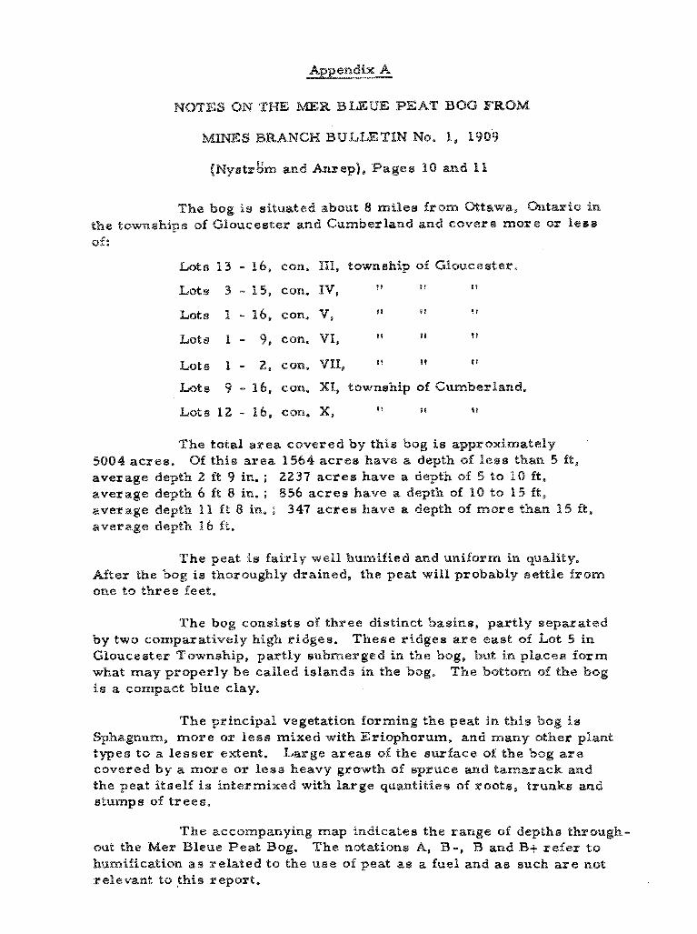
NOTES ON THE BAER BLEUE PEAT 886 FROM
M p m S BRANCH BULLETIN No. 1, 1969
[ ~ y a t r & m and Anrep], Fagee 10 and 1 1
The bog is situated about 8 milee from Ottawa, Ox~tarEo BW
the townships of GPsucester and Cambarland and covere more or %ese
sf:
Lots 6 3 - 16, con. 111, township of GPouceeter.
Lots 3 - 25, con, %V, 9 t s l ? s
Lets h - 16, con. V, I L 8 ? ? !
Lote 1 - 2 , eon, VII, w 1 8 1 D F
Lots 9 - 16, con. XI, township of Cumberland.
kote 12 - 16, con. X, D I Tt 6 I
The total area covered by this bog is approximately '
5684 acres. 8% this area 1564 acres have a depth of leas than 5 ft ,
average depth 2 ft 9 in. ; 2237 acres have a depth of 5 to P O ft ,
average depth 6 ft 8 in. ; 856 ac r e s have a depth of 10 to $ 5 ft,
average depth 1 II f t 8 in. ; 347 acres have a depth of more than 15 ft,
average depth 16 f t *
The peat is fairly well humified and unifsrm in quality.
After the bog is thoroughly drained, the peat will probably settle from
one to three feet.
The bog consists of three distinct basins, partly separated
by two eomparative2y high ridges. These ridges are east oi $gat 5 in
GPoucester Township, partly submerged in the bog, but in places fa rm
what may properly be called islands in the bog. The bottom s f the bog
is a compact blue clay.
The principal vegetation forming the peat in this bog is
Sphagnum, more os: l e s s mixed with Eriopkorum, and many sther plant
types to a lesser extent. Large a r ea s 0% the surface of the bog a r e covered by a more or l e a s heavy growth of spruce and tamarack and
the peat itself is intermixed with large quantities of rerate, trunks and stumps of trees.
The accompanying map indicates the range of depths thrsugh-
out the Mer Bleue Peat Bog. The notations A, B -, B and B+ refer $0
humifirsatican a s related to the use of peat as a fuel and as such a r e not
r ePevawt to this r epoxt.