middle to late bronze age transition in the southern urals (russia): a settlement pattern...
TRANSCRIPT


TABLE OF CONTENTS
List of Tables ....................................................................................................................... iii
List of Figures...................................................................................................................... iv
1 Introduction ................................................................................................................. 1
1.1 Purpose of the study and the expected results .................................................... 1
1.2 Southern Urals: geography, ecology, and climate ................................................ 2
2 Russian vs. American archaeology .............................................................................. 6
2.1 Historical trajectories ............................................................................................ 6
2.1.1 North America ........................................................................................... 6
2.1.2 Russia ......................................................................................................... 8
2.2 Comparison of the two schools of thought ........................................................ 11
2.3 Differences in motivations and methodological practices ................................. 12
2.4 Conclusion ........................................................................................................... 13
3 Settlement pattern studies and Geographic Information Systems (GIS) ................ 15
3.1 Theoretical and methodological perspectives in settlement pattern research . 15
3.2 Role of GIS in regional settlement pattern research .......................................... 19
3.3 GIS and environmental determinism .................................................................. 22
3.4 Conclusion ........................................................................................................... 24
4 Southern Urals during the Bronze Age...................................................................... 25
4.1 Archaeological “culture”: history and definition ................................................ 25
4.2 Bronze Age archaeological cultures of the Southern Urals ................................ 27
4.2.1 Early Bronze Age...................................................................................... 28
4.2.2 Middle Bronze Age................................................................................... 29
4.2.3 Late Bronze Age........................................................................................ 32
4.3 Subsistence base and metal production in the Southern Urals.......................... 35
4.4 Conslusion ........................................................................................................... 38
5 MBA LBA transition in the Southern Urals ............................................................. 39
5.1 Prevalent hypotheses in archaeological literature ............................................. 39
i

5.1.1 Archaeological culture genesis and the Sintashta Alakul transition ....... 39
5.1.2 Role of migration diffusion processes in the MBA LBA transition........... 42
5.1.3 Climatic shifts during the Bronze Age in the Southern Urals................... 45
5.2 Role of metallurgy in shaping the Southern Urals society.................................. 50
5.2.1 Craft specialization and social structure ................................................. 51
5.2.2 Metallurgists and social status in the Bronze Age .................................. 53
5.2.3 Spread of metallurgical knowledge during the LBA period ..................... 54
5.3 Conclusion ........................................................................................................... 58
6 Case study: MBA LBA settlement patterns in the Kyzil Area, Southern Urals ........ 59
6.1 Kyzil Area: geography and brief description ....................................................... 59
6.2 Data used in the case study ................................................................................ 60
6.3 Case study methodology..................................................................................... 62
6.3.1 GIS techniques ......................................................................................... 62
6.3.2 Burial vs. settlement evidence .................................................................. 66
6.4 Research questions ............................................................................................. 68
6.5 Findings ............................................................................................................... 69
6.5.1 Paleodemographic estimates ............................................................................ 69
6.5.2 Autonomous development vs. outside influence..................................... 73
6.5.3 Proto towns and the urbanization hypothesis ........................................ 74
6.5.4 New social order: collective control over resources ................................ 85
6.5.5 Spatial distribution of kurgan cemeteries ............................................... 95
7 Conclusions .............................................................................................................. 105
References ...................................................................................................................... 108
Appendices ..................................................................................................................... 120
Appendix A: Attribute data of LBA/FBA sites.............................................................. 120
Appendix B: Attribute data of MBA sites .................................................................... 123
ii

iii
List of Tables
Table 5.1 Climatic fluctuations in the Eurasian Steppes............................................................... 48
List of Figures
Figure 1.1 Southern Urals ............................................................................................................... 3
Figure 1.2 The Eurasian Steppes..................................................................................................... 4
Figure 4.1MBA cultures of the Volgo Urals and Western Siberia ............................................... 30
Figure 4.2 Late Bronze Age archaeological cultures of the steppes............................................. 33
Figure 5.1 Seima Turbino sites ..................................................................................................... 56
Figure 6.1 Trans Ural ‘peneplen’ .................................................................................................. 60
Figure 6.2 Distribution of Bronze Age settlements in the Kyzil Area ........................................... 68
Figure 6.3 Plan of the Arkaim fortified settlement....................................................................... 76
Figure 6.4 Unrestricted peer polity interaction sphere................................................................ 79
Figure 6.5 ‘Country of Towns’ as an unrestricted interaction sphere.......................................... 79
Figure 6.6 LBA settlement densities and the largest LBA sites..................................................... 82
Figure 6.7 Cumulative viewshed of LBA/FBA sites ....................................................................... 84
Figure 6.8 Distribution of the MBA fortified settlements ............................................................ 88
Figure 6.9 Viewshed from the Kuysak site.................................................................................... 89
Figure 6.10 Viewsheds from Kuysak and Sarim Sakli sites ........................................................... 90
Figure 6.11MBA Least Cost Paths (LCP’s) .................................................................................... 92
Figure 6.12 Kernel Density distribution of the LBA/FBA unfortified settlements ........................ 94
Figure 6.13 Kernel Density of Bronze Age kurgan cemeteries ..................................................... 98
Figure 6.14 Kernel Density of Bronze Age settlements ................................................................ 98
Figure 6.15 Kernel Density of kurgans and LCP’s between MBA sites ....................................... 100
Figure 6.16 Plan of the Kizilskoe settlement .............................................................................. 101
iv

1 Introduction
1.1 Purpose of the study and the expected results
The following paper addresses the period of transition from the Middle Bronze Age
(MBA), 2500 1800BC, to the Late Bronze Age (LBA), 1800 1500BC, (Koryakova and Epimakhov
2007) in the Southern Urals region of Russia (see Figure 1.1) by relying on settlement pattern
data. The Bronze Age, being a pivotal period in many aspects of the Eurasian Steppes’
prehistory, had served as a precursor to the emergence of social complexity in the region
(Renfrew 2009:XV). The MBA LBA transition is a period characterized by significant changes in
many aspects of life for the dwellers of the steppes, in general, and of the Southern Urals
region, in particular. In culture historical terms, the MBA Sintashta archaeological culture got
replaced by the LBA Srubnaya Alakul cultural complex, with Petrovka cultural development
representing a transitional stage between the two (Koryakova and Epimakhov 2007). One
major change taking place in the region during this part of the Bronze Age has to do with
settlement practices. The following analysis aims to shed light on the MBA LBA transition by
examining the changing types and locational distributions of the Southern Urals’ Bronze Age
settlements.
Most of the archaeological data dealing with the Bronze Age in the Eurasian Steppes
comes from the burial context (Kohl 2007:16), which is due in part to the historical traditions of
Russian archaeological school. The following study examines the MBA LBA transition from a
slightly different perspective when compared to most of the archaeological literature published
on the subject to date. Examining settlement (vs. burial) evidence through employing
methodologies such as Geographic Information Systems (GIS), is relatively new to the
archaeology of the Southern Urals. The settlement pattern analysis of Bronze Age settlements
in the Southern Urals has been limited to identifying individual sites through areal photography
remote sensing technique and creating basic regional settlement distribution maps (Zdanovich
et. al 2003). Utilization of GIS, a leading interdisciplinary tool capable of interpreting, analyzing
and displaying spatial data, offers a great potential for expanding the analytical component of
the settlement pattern research in the Southern Urals. The ability of GIS’ techniques to
1
integrate various theoretical developments in archaeology into spatial analysis, such as
postprocessual notions of landscape phenomenology, combined with tremendous quantitative
and graphical capabilities of this digital tool, can add to our understanding of the Eurasian
Bronze Age prehistoric dynamics.
The following work compares the historical trajectories of the Russian vs. American
schools of archaeological thought; examines the changing perspectives in settlement pattern
research and GIS based spatial analysis; outlines the overall Bronze Age dynamics in the
Southern Urals; and highlights the hypotheses put forward by other archaeologists regarding
the MBA LBA transition in the region. Finally, this paper focuses on the Kyzil Area case study,
which employs a number of GIS based methodologies to analyze the MBA LBA transition from a
settlement pattern perspective.
Among the specific research questions addressed in this thesis are : the level of
directness of cultural and demographic continuity between the MBA Sintashta Petrovka and
the LBA Srubnaya Alakul populations through paleodemographic estimates based on
settlement evidence; the level of possible ‘proto city’ formation or urbanization processes
taking place in the Southern Urals at various stages of the Bronze Age; the influence of regional
natural resource distribution patterns on Bronze Age settlement location choices. Finally, the
Kyzil Area case study, outlined in chapter six of the thesis, evaluates the possible roles played
by kurgans (burial mounds) in the lives of the people of the steppes by examining the
distribution patterns of this ritual landscape component in the Kyzil Area.
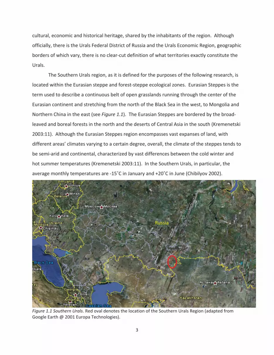
1.2 Southern Urals: geography, ecology, and climate
The Southern Urals region is located in present day southern Russia. The region
encompasses territories adjacent to the southern part of the Ural Mountain range, which
stretches through the northern part of the Eurasian continent, bordering on the West Siberian
Plain in the east and the North European Plain in the west (see Figure 1.2). Although purely
nominal in nature and lacking a distinctive boundary, the geographic area surrounding the Ural
Mountains is oftentimes referred to as “the Urals”, with the term being used in various
contexts. The term “Urals” is generally imbedded with a certain level of common geographic,
2
cultural, economic and historical heritage, shared by the inhabitants of the region. Although
officially, there is the Urals Federal District of Russia and the Urals Economic Region, geographic
borders of which vary, there is no clear cut definition of what territories exactly constitute the
Urals.
The Southern Urals region, as it is defined for the purposes of the following research, is
located within the Eurasian steppe and forest steppe ecological zones. Eurasian Steppes is the
term used to describe a continuous belt of open grasslands running through the center of the
Eurasian continent and stretching from the north of the Black Sea in the west, to Mongolia and
Northern China in the east (see Figure 1.1). The Eurasian Steppes are bordered by the broad
leaved and boreal forests in the north and the deserts of Central Asia in the south (Kremenetski
2003:11). Although the Eurasian Steppes region encompasses vast expanses of land, with
different areas’ climates varying to a certain degree, overall, the climate of the steppes tends to
be semi arid and continental, characterized by vast differences between the cold winter and
hot summer temperatures (Kremenetski 2003:11). In the Southern Urals, in particular, the
average monthly temperatures are 15 C in January and +20 C in June (Chibilyov 2002).
Russia
Figure 1.1 Southern Urals. Red oval denotes the location of the Southern Urals Region (adapted fromGoogle Earth @ 2001 Europa Technologies).
3
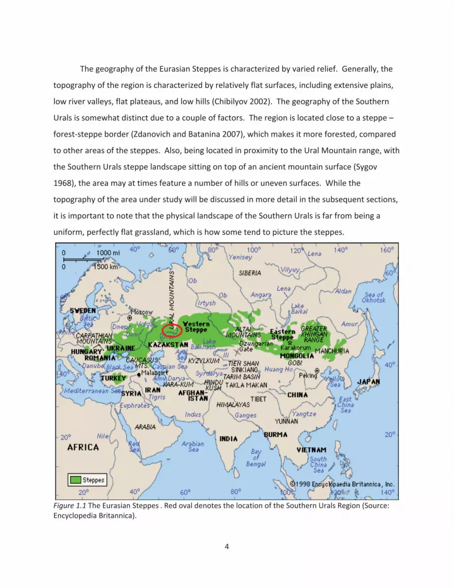
The geography of the Eurasian Steppes is characterized by varied relief. Generally, the
topography of the region is characterized by relatively flat surfaces, including extensive plains,
low river valleys, flat plateaus, and low hills (Chibilyov 2002). The geography of the Southern
Urals is somewhat distinct due to a couple of factors. The region is located close to a steppe –
forest steppe border (Zdanovich and Batanina 2007), which makes it more forested, compared
to other areas of the steppes. Also, being located in proximity to the Ural Mountain range, with
the Southern Urals steppe landscape sitting on top of an ancient mountain surface (Sygov
1968), the area may at times feature a number of hills or uneven surfaces. While the
topography of the area under study will be discussed in more detail in the subsequent sections,
it is important to note that the physical landscape of the Southern Urals is far from being a
uniform, perfectly flat grassland, which is how some tend to picture the steppes.
Figure 1.1 The Eurasian Steppes . Red oval denotes the location of the Southern Urals Region (Source:Encyclopedia Britannica).
4
The Urals, both the mountains as well as the adjacent steppes, are famous for high
concentrations of minerals, including ores (iron, copper, gold) and a variety of semiprecious
stones (jasper, crystal, malachite, agate, etc.) (Koryakova and Epimakhov 2007:4). The copper
ore deposits of the Southern Urals were mined by the local populations since the prehistoric
times. The Southern Urals Kargaly mine, for instance, which will be discussed in more detail in
later chapters, according to Chernykh (1997a) was the biggest metallurgical complex in
prehistoric Northern Eurasia. The mineral wealth of the Urals was part of the reason why the
archaeological heritage of the region became available to western scholars fairly recently, with
the region being a closed Soviet military zone until 1991 (Koryakova and Epimakhov 2007:XXI).
5
2 Russian vs. American archaeology
Most of the archaeological work done in the Southern Urals has been done by the
Soviet, and later Russian scientists. Needless to say that Russia and the United States are as
unsimilar as any two countries can be, with differences oftentimes crossing over into the realm
of academic disciplines, such as archaeology. Since this paper is written by a bearer of Western
archaeological tradition, it is important to be aware of the vast differences between the
American and Russian schools of archaeological thought. Relying on Russian archaeological
literature and at the same time utilizing Western theoretical concepts and methods calls for a
heightened awareness of what archaeology means and how it is practiced in both countries.
The following chapter provides a brief overview of the discipline’s historical trajectories in
Russia and in the United States, outlining the resulting differences in theoretical perspectives
and methodological practices between the two schools of thought. Special attention is paid to
the implications of different methodologies in the Eurasian Steppe region in general, and the
Southern Urals in particular.
2.1 Historical trajectories
2.1.1 North America
When discussing the archeology of the Unites States, it is important to note that many
of its features are characteristic of the Anglo American theoretical paradigm, prevalent on most
English speaking nations, including the United Kingdom, Canada, and Australia, among others
(Kohl 2007:3). Throughout history, American and British archaeologists, in particular, have
been involved in a great deal of theoretical dialogue, thereby building the foundation for what
today is referred to as ‘Western’ archaeological thought. This process of scholarly exchange
and playing off each other’s ideas is still taking place today, although archaeological research in
each Anglo American country is carried out in the political context of a given nation (Kohl
2007:3). While the following section focuses on the trajectory of archaeological thought in the
United States, many theoretical developments discussed below are characteristic of Western
archaeology in general.
6
Early archaeological pursuits in the Unites States start in the late 1700s early 1800s with
the excavations of Native American “Mounbuilder culture” sites. At that time Americans of
European descent were expanding westward and seizing resources from the native
populations, who were seen as evolutionarily inferior and aggressive people who must have
wiped out the earlier mythical ‘Moundbuilder’ civilization (Trigger 2009:161). The theoretical
stance at the time was that of antiquarianism mixed with a unilinear evolutionary paradigm
that justified the colonial expansion.
Archaeologists in the United States adopted the cultural historical approach at the start
of the 20th century (Trigger 2009:278). American archeologists started geographically and
temporally outlining distinct material culture manifestations. At the time, the Boasian
approach that stressed cultural relativism and opposed racism, started being applied to how
Native Americans were viewed throughout prehistory, although, overall, American archaeology
did remain “colonial in spirit” (Trigger 2009:290). In the United Stated 19th century cultural
historical archaeology differed from that practiced in Europe at the time in that nationalist
rivalries played no role in the concept of the archaeological culture in the United States.
Functionalist archaeology in the United States started in the 19th century with attempts
to determine functions of specific artifacts through the use of direct historical approaches, such
as ethnographic accounts and comparative studies (Trigger 2009:362). After World War II,
processual approaches, namely ecological ones, started being practiced by American
interdisciplinary teams. Steward pioneered the cultural ecology approach to human behavior in
the United States, while Willey carried out the first regional settlement pattern study, setting
the stage for New or Processual school of thought in archaeology (Trigger 2009:372).
In the 1960s and 1970s, the processual movement, influenced by British scholars, such
as D. Clarke, and headed by Lewis Binford in the United States, began taking off in the West.
This approach viewed culture as people’s extrasomatic means of adaptation and saw cultural
change as a product of rational human response to environmental factors. Processual
approaches emphasized similarities and regularities across cultural systems, stressing scientific
method, sampling, and ethnographic comparisons (Trigger 2009:405).
7
Starting in the late 1970s and early 1980s, largely influenced by the social anthropology
and the broader postmodernist social movement, archaeologists in the United States began
employing various postprocessual approaches in their works. Postprocessualist approaches
emphasized the role played by human consciousness in shaping society and viewed people as
active agents, rather than passive objects influenced by external factors (Trigger 2009:445).
The concept of relativism, and the notion that knowledge and truth are subjective and
multifaceted, lay at the foundation of postmodernist anthropology. Postmodernism places the
emphasis on subjective interpretations and viewpoints, which come from individual members
of society, including minorities, women, and other groups that have been disadvantaged
throughout human history. Postprocessualism is a blanket term that encompasses various
theoretical approaches such as Neo Marxism, Post Positivism, Critical Theory, Structuralism,
Phenomenology, and others (Johnson 1999). Currently, many American archaeologists, to one
degree or another, operate under the guise of the postprocessual school of thought.
2.1.2 Russia
The mid and late 19th century was the time of rapid development of archaeology in
Russia, with the Russian government establishing a commission assigned to safeguard
archaeological remains and archaeology becoming a university discipline (Trigger 2009:231). In
the late nineteenth century, Russian archaeology shifted from antiquarianism to being a
scientific pursuit, with the nature of research comparable to that done elsewhere in Europe
(Trigger 2009:230). The ‘scientific approach’ to archaeology in Russia in the 19th century
entailed the systemization of typological archaeological ‘culture’ attributes under the culture
historical paradigm. During the nineteenth century, Russian archaeology seemed to have gone
from antiquarianism directly to the culture history phase, bypassing the evolutionary stage of
archaeological theory prevalent in other European countries (Trigger 2009).
During the Soviet era, every aspect of human life and social interaction was immersed in
Marxist ideology, more specifically,Marxism/Leninism the official state ideology of the Soviet
Union. Marxism heavily influenced university subjects such as political science, economics, and
philosophy, as well as deeply impacted most humanity related disciplines, including
archaeology. According to the Marxist framework, all human cultures tend to follow a four
8

step unilinear evolutionary trajectory, based on different production modes: primitive (pre
class society), ancient (Asiatic/slave holding), feudal bourgeois (capitalist), and classless
(communism) (Marx and Engles 1967). One of the main questions that Soviet archaeologists
and historians were concerned with, or at least what the prevalent ideology of the time
dictated them to be concerned with, was: what Marxist evolutionary stage did a given society
operate under?
In the words of Marx himself, “instruments of labor … are indicators of the social
conditions under which labor is carried on“ (Marx 1906:200). According to Marx (1906), forces
and relations in production shape society’s superstructure. Soviet archaeologists were forced
to strictly adhere to the Marxist analysis of material remains in the way that the Communist
Party leaders understood it. The positive outcomes of such an approach were the interest in
the underlying social structures of a given society and the emphasis on production processes,
including experimental archeology. Some argue that Soviet archaeologists were pioneers
when, in the 1920s, they began placing the emphasis on the internal social and economic
conditions, rather than external factors, such as ecology, to explain culture change (Trigger
2009:384). The downfall was that Marxist approach and synthesis of material remains was the
only one allowed, with no room for diversity.
Soviet Marxist archaeology advocated a materialistic approach to prehistory, with the
material base assumed to be the primary driving force behind the operations of a society (Kohl
2007a:XVI). A materialistic approach assumes that ideologies and other aspects of the
superstructure prevalent in a given society can be reconstructed from the material base
available to archaeologists. In other words, people’s thoughts and ideas are traceable through
various economic and technological activities (Hodder 1986:18). Even though a materialist
approach to culture worked great within the Marxist framework during the Soviet era, it left
little room for idealist archaeological interpretations that did not necessarily see a direct,
deterministic relationship between the material organization of resources, on one hand, and
people’s ideas and values, on the other, in a given society (Hodder 1986:21).
Another distinguishing feature of Soviet, and in some cases post Soviet, archaeology
was the notion and importance of “ethnos” or “ethnicity” in the context of archaeological
9
cultures (Frachetti 2008:35). Soviet archaeologists attempted to trace the locational
distributions and movements of various ethnic groups through prehistory based on artifact
typologies. Conflicts between European nation states throughout the first half of the 20th
century heightened the need to build national pride by reconstructing the life ways of heroic
ancestors. To counter Nazi claims of Aryan superiority, Russian archaeologists set out to prove
that Slavs were not inferior to their Germanic neighbors, reinforcing the view that
archaeological cultures equated to specific ethnicities (Trigger 2009:236).
After the fall of the Soviet Union, Russia experienced a period of economic decline and
social instability. These social changes greatly influenced the discipline of archaeology.
Government funding was cut drastically, students flocked into more “practical” fields, like
business and economics, while arts and humanities enrollment rates declined. After the Soviet
censorship system collapsed, there was no strict ideological control or guidance on how to
analyze and interpret archaeological remains. Some archaeologists chose not to change their
theoretical stance or incorporate new methodologies into their work, while others, the few that
were bilingual and more open to change, started exposing themselves to overwhelming
amounts of western archaeological literature that they did not have access to before. This
process resulted in Russian archaeologists selectively incorporating various aspects and
fragments of western archaeological theory into their work.
Although present day Russian archaeological literature features certain processual and
postprocessual theoretical perspectives, it, for the most part, remains cultural historical in
nature. According to Kohl (2007:17), the tendency to identify archaeological cultures as
ancestors of later historical ethnic groups remains very much alive in Russian archaeological
research. In his foreword to “The Urals and Western Siberia in the Bronze and Iron Ages”
written by Russian archaeologists L. Koryakova and A. Epimakhov in 2007, Philip Kohl points out
that “western readers may be struck by occasional ethnic, linguistic, and even racial attributions
of specific archaeological cultures” (Kohl 2007a:XVI). There are also cases in Russian
archaeological literature of craniometrics, or the systematic measurement and comparison of
certain cranial phenotypes, along with the comparison of other biological traits, being used to
link or differentiate archaeological cultures from one another (Frachetti 2008:45). Terms such
10
as “Caucazoid”, “Europoid” or “Mongoloid” are being used to this day by some Russian
archaeologists. With a significant number of Russian archaeologists receiving their professional
training during the Soviet Union times, many features of the Soviet school of thought outlined
above are still characteristic of the present day archaeological research in Russia.
2.2 Comparison of the two schools of thought
While archaeology in North America has been a part of the anthropology discipline, in
Russia, archaeology has been tightly linked to history, and general historical analysis was
applied to archaeological remains, with no need seen for the development of unique
archaeological theoretical frameworks (Trigger 2009:342). The historical vs. anthropological
orientation of archaeology is where one of the main distinctions in the two schools of thought
lies, with the primary goal of Russian archaeology being the production of national history and
prehistory. The anthropological approach practiced by American archaeologists, on the other
hand, entails the adoption of anthropological theories into the study of material culture.
While archaeology in the United States was going through shifts from the culture
historical phase to functional, processual, and post processual approaches, Soviet
archaeological thought changed little and adhered to the strict Marxist interpretation of
material remains, combined with the culture historical approach. While it would seem that
American archaeologists who utilize a postprocessual Marxist approach arrived at the
theoretical framework practiced by Soviet archaeologists since the 1920s, the two “Marxisms”
are qualitatively different. As already mentioned, Soviet Marxism was more “orthodox” and
strictly adhered to Marx’s writings (Trigger 2009:444), a small portion of which dealt with pre
class societies; while postprocessual Marxist anthropology uses Marx’s writings as a launching
platform for novel concepts and ideas. The historical trajectories of the two schools of thought
illustrate how, over the years, archaeological thought has been a reflection of political and
ideological atmospheres in each country.
11
2.3 Differences in motivations and methodological practices
Besides the vast differences between the two countries in the histories of archaeological
theory outlined above, there are other methodological and political factors that make American
archaeology different from its Russian counterpart. Prehistoric American archaeologists
working in the United States excavate the remains of Native Americans whose descendants
occasionally sue the scientists and reclaim artifacts and human remains. European
archaeologists, on the other hand, feel they excavate the remains of, if not their direct
ancestors, then prehistoric human groups very closely connected to themselves. This notion of
historical continuity between prehistoric cultures and present day populations is occasionally
used in politically motivated contexts both in both Europe and North America.
According to Trigger, the cultural historical approach “can be used to bolster the pride
and morale of nations or ethnic groups … who feel thwarted or threatened … by stressing
specific periods in history and assigning particular ethnic identities to archaeological finds”
(Trigger 2009:261). The Eurasian Steppes are located on the border of Europe and Asia, and
historically have been the area where various “European” and “Asian” ethnic groups traded,
intermixed, waged war on each other, and competed for territory. It is not a coincidence that
the “European” looking facial reconstructions of the Yamnaya, Sintashta, or the later Saka
people appear in publications concerning the region and are being displayed in the museums,
located on the present day border of Russia and Central Asia. Evidently, it is important to some
whether the Sintashta people were “Europoids”, and therefore looked more like Russians,
rather than their Kazakh, Bashkir, or Tatar neighbors. Now, after the collapse of the Soviet
Union, when every one of the newly emerged fifteen republics is trying to build a sense of
national pride, justify its present day borders, and prove that its contribution to the prehistory
of the region is not inferior to that of its neighbors, archaeology has the potential to be used in
political and territorial disputes. Even though archaeology is used politically in the United
States by Native American groups in recourse or territory claims, in Russia this process can
potentially have international implications.
Other differences between Russian and American archaeology lie in methodological
practices. Soviet archaeologists, working in the Eurasian Steppes, primarily have been
12

interested in ‘kurgans’ (earthen burial mounds) thousands of which have been excavated since
the 1970s during numerous CRM type salvage projects (Kohl 2007:15). Since the collapse of the
Soviet Union, Russian archaeology has been severely underfunded, thus influencing the
methodological strategies employed by Russian scientists. With a lot of the excavation
equipment dating back to the times of the Soviet Union and with, oftentimes costly, remote
sensing techniques being out of financial reach, it made practical sense for Russian
archaeologists to excavate kurgans, which are fairly easy to locate in the steppe landscape. This
“kurgan archaeology” (Kohl 2007:16) results in the archaeological data, available to
researchers, being skewed toward one type of evidence (i.e., burial).
Also, the fact that many of the field reports from past excavations in the steppes are
either in paper format (i.e., not digitized in any way) or unpublished makes them hard to access
and analyze by Western or other Russian archaeologists. Another issue is that archaeologists
created countless divisions and subdivisions of various archaeological cultures, with specific
names and terminology sometimes not being uniform due to the lack of coordination and
communication between archaeologists working in different regions of the former Soviet Union
(Kohl 2007:16).
2.4 Conclusion
Russian archaeology still seems to be heavily influenced by the cultural historical
theoretical paradigm, and it is important to keep in mind that most of the academic material
dealing with the Southern Urals during the Bronze Age is written from the perspective of this
theoretical framework. Applying a wide array of Western theoretical approaches to the
analysis of the MBA LBA transition in the Southern Urals may help see the prehistory of the
region in a different light. Methodologically, GIS based settlement pattern research, outlined in
the later chapters of this thesis, is different from the ‘kurgan archaeology’, largely relied upon
by Russian archaeologists thus far. Although the Bronze Age settlement patterning of the
Southern Urals region has been analyzed by Russian archaeologists to some degree, burial
evidence seems to hold sway across regional scholarly publications. By incorporating various
spatial analysis techniques as well as recent theoretical developments of the Anglo American
13
school of thought into the archaeological analysis of the Southern Urals, GIS based settlement
pattern research can add to and possibly alter our understanding of the Eurasian Steppe
prehistory.
The original research, outlined in chapter six of this thesis heavily relies on the culture
historical typologies developed by Russian archaeologists in order to describe and understand
the cultural developments taking place in the Southern Urals during the Bronze Age. The Kyzil
Area case study incorporates processual theoretical approaches into the analysis by evaluating
settlement locations in relation to environmental resources and reconstructing regional
paleodemographic dynamics based on quantitative settlement data. The utilization of the
Anglo American postprocessual approaches is evident in the incorporation of the GIS
techniques that address phenomenological aspects of landscape perception, such as the
Visibility and Cost Surface Analyses, which will be discussed in detail in the following chapter.
The examination of the role played by metallurgical craft specialization in the MBA LBA
transition could be, at least in part, attributed to the Marxist approach, utilized by Soviet as well
as Anglo American post processual archaeologists. Thereby, theoretical and methodological
approaches characteristic of both Russian and Anglo American archaeological thought are
incorporated into the following analysis in an attempt to address specific research questions
pertaining to the MBA LBA transition in the Southern Urals region.
14
3 Settlement pattern studies and Geographic Information Systems (GIS)
Since the original research, outlined in chapter six of this thesis, essentially represents a
GIS based regional settlement pattern study, it is useful to discuss the roles of settlement
pattern studies and Geographic Information Systems (GIS) in archaeology. The following
chapter focuses on the history and the present state of theoretical perspectives behind the
regional settlement pattern research, as well as the use of GIS as a scientific, archaeological
tool. More specifically, the following chapter outlines how changing theoretical perspectives
have influenced landscape archeology, evaluates the role of GIS in regional settlement pattern
studies, and discusses how archaeologists are addressing the environmental determinism
criticisms leveled at GIS archaeological applications.
3.1 Theoretical and methodological perspectives in settlement pattern research
Settlement pattern studies represent an increasingly important component of
archaeological investigations, with the American Antiquity publications indicating a ten fold
increase over the past four decades in the percentage of lead articles dealing with settlement
pattern themes (Alcock and Cherry 2004:2). The first settlement pattern survey in the Americas
was carried out in 1946 by Gordon Willey and James Ford in the Viru Valley of Peru. The goal
was to record all of the archaeological sites in the region, describe their geographical and
geological position, outline their function and sequence of development, reconstruct cultural
institutions prevalent at these sites, and compare the settlement history of the Viru Valley
region to other regions of Peru (Willey 1953:1). Although changing theoretical perspectives
have definitely altered the nature of settlement pattern investigations, present day regional
settlement pattern studies still adhere to the general guidelines outlined by Willey in 1946.
Archaeologists saw little value in settlement pattern studies up until the 1960s. That
was when the interest in using regional settlement surveys grew (Billman 1999:2), with regional
surveys of the time addressing a variety of functional and processual issues. Archaeologists
began to realize that this approach is essential when recreating prehistoric political institutions,
social stratification systems, warfare dynamics, and subsistence strategies in a given region.
Individual sites began being viewed as representative of a particular culture or region, rather
15
than ends in themselves (Trigger 2009:377), which worked very well with a systems based
approach to examining past societies. Regional surveys gave archaeologists an opportunity to
hypothesize about demographic, social, and political changes on both inter and intra regional
scales.
When discussing ‘regional’ settlement pattern studies, it is important to examine the
concepts of regions and regional archaeology as they are understood today by the
archaeological community. The concepts of ‘regional archaeology’ and ‘settlement pattern
archaeology’ are often conflated and used interchangeably. Kantner (2007:43) argues that
settlement pattern studies are more narrowly focused on generating quantifiable data, while
regional archeological pursuits are able to address a wider variety of anthropological problems.
Defining what constitutes a region in particular, and spatial archaeological unit in general, is
highly subjective and is “more an art than an empirical process” (Kantner 2007:44).
Geographical features, modern day political borders, the level of material culture continuity,
along with a host of other factors, are utilized by researchers in determining the appropriate
scale of the archaeological ‘region’ being studied. Depending on the specific research questions
addressed in the study and the theoretical perspectives employed by the researcher, the
definition of what constitutes a ‘region’ may fluctuate greatly (Kantner 2007:41).
Regional settlement pattern studies now fall under the rubric of landscape archaeology,
which aims to analyze the relations between human actions and the surrounding landscape by
combining ecological and social approaches (Barker and Mattingly 1999:IX). A number of
settlement pattern studies in the latter half of the 20th century sought to find causal linkages
between environmental factors, such as agricultural land productivity or the presence of
natural resources, to the distributions of settlements. As more such studies were carried out,
archaeologists noticed the increasing implausibility of such an approach in a number of
instances. While critiques of environmental determinism and economic rationality are leveled
at the earlier settlement pattern studies, some argue they helped overcome the strict
ecological adaptation framework and illustrated that other social and cultural factors played a
significant role in shaping human settlement (Trigger 2009:376).
16
Postprocessual developments in archaeology, stressing qualitative and
phenomenological perspectives, have had a great influence on landscape archaeology in
general, and settlement pattern studies in particular. Archaeologists now recognize that
landscapes are socially constructed, subjectively experienced and qualitative, as well as
economic and quantitative in nature (Witcher 1999:13). Social, ritual and cognitive aspects of
landscape are now being incorporated into archaeology (Witcher 1999:15), contributing to the
‘humanization’ of the landscape concept and altering settlement pattern research strategies.
Such concepts as ‘landscapes of power’ (Cherry 1978:164 166), ‘ritual landscapes’ (Renfrew
1984), and ‘mental maps’ (Downs and Stea 1977) have been used in archaeological literature
for some time now.
It is important to note the influence that the discipline of geography has had on the
archaeological scientific pursuit. Phenomenological approaches to landscape analysis were first
developed by human geographers, such as Ted Relph (1976) and Yi Fu Tuan (1974); while New
Archaeology was strongly influenced by New Geography, aimed to move beyond descriptive
synthesis by developing various measurement and comparison techniques (Connoly and Blake
2006:208 209). Viewing regions as continuous processes rather than objective entities is also a
concept that originated from the theoretical developments in the field of geography mentioned
above (Connoly and Blake 2006:209).
Postprocessual notions of individual agency and relativistic landscape perception have
also found their way into settlement pattern research. Can we treat all sites as having equal
significance, or ‘equal value’ and simply count the points on the map to help decide what role
certain areas played in the prehistory of a given region? Assuming the subjective nature of
landscape perception by individuals, can we make generalizations about the significance and
meaning of a particular site to the aggregate community? These are some of the questions that
settlement pattern archaeologists currently attempt to address by altering the existing research
strategies and incorporating new methodologies into their work (Witcher 1999:17).
Regional archaeological analysis is a diverse academic pursuit, informed by a variety of
theoretical paradigms dealing with human space interaction (Kantner 2007:62). Regional
settlement pattern research, in particular, seems to be differentiated based on the type of
17
source data used – ecological or social, with the resulting analysis privileging environmental or
cultural information, respectively (Wheatley and Gillings 2002:236). Although the current trend
is toward the dissolution of barriers between the environmental and humanistic approaches, a
certain level of divide still exists between the two theoretical frameworks, especially in
settlement pattern studies.
Since regional surveys oftentimes serve as foundations for settlement pattern studies,
certain methodological aspects of survey work are worth discussing in some detail. There are
no widely agreed upon procedures for carrying out or analyzing survey datasets. According to
Alcock and Cherry (2004:4), at the outset of the 21st century “we are faced with an influx of
regionally based archaeological data of unprecedented diversity from hundreds of individual
survey projects”. Although characteristics of individual settlement pattern studies tend to vary,
overall, two emerging trends are currently being emphasized to a greater extent.
One trend has to do with the increase in the scale of regional surveys, by either
combining the results of individual studies or carrying out larger surveys to begin with. The
scale of a regional settlement pattern survey can greatly alter the results of a study. Micro
level surveys might yield different social, economic, and political relations than the larger scale
regional data. Using micro regional surveys as a form of a probability sampling methodology,
advocated by the processual school of thought, is not always appropriate for identifying
regional spatial patterning (Lock et al. 1999:55). Therefore, a regional perspective, as it
pertains to archaeological analysis, aims to combine smaller scale studies and interpret various
archaeological material in a wider regional context. The focus on the increase in scale is
perfectly illustrated in a number of archaeological studies carried out at a ‘supra regional’ scale
that are oftentimes informed by the world system theory and long distance migration
processes (Geib 2000; Smith and Montiel 2001).
When discussing the scale of regional surveys and settlement pattern studies, it is
worthwhile to mention site catchment analysis – a technique that analyzes the locations of
archaeological sites in relation to available economic resources. In such studies, the scale of
the survey, corresponding to the site’s exploitation territory or catchment, is determined
empirically by analyzing the corresponding cost surface surrounding the site (Wheatley and
18
Gillings 2002:159,160). Therefore, the scale of a survey in site catchment studies is pre
determined by the extent of the catchment zone.
The other trend in settlement pattern studies is the focus on the intensity of survey
coverages, with labor intensive pedestrian reconnaissance being the prevalent methodology in
many parts of the world (Alcock and Cherry 2004:3). Due to a number of regional studies
illustrating a great level of settlement pattern diversity and complexity even at the smallest
scale, the oftentimes costly ‘full coverage’ surveys are almost universally preferred to various
sampling approaches, previously advocated by the processual school of thought (Kantner
2007:47).
Even though the trends noted above seem mostly methodological, they are theoretical
in nature as well. Do we, as archaeologists place greater emphasis on reconstructing large
scale processes taking places over vaster territorial expanses, or do we want to spend more
time and resources toward a detailed micro level analysis of smaller settlement networks? In
the perfect world, archaeologists would like to do both, but in reality each surveyor chooses
which aspect, scale or intensity, to dedicate more of the available resources to. Surveys, like
excavation records, are never impartial, with different people producing different accounts of
the same landscape (Alcock and Cherry 2004:47). Most archaeologists today seem to strive for
the increase in scale, with the prevalent opinion being that it is much safer to decode and
handle a few large scale surveys than lots of small ones, which often do not have the sufficient
‘critical mass’ to allow us to understand broader regional processes (Alcock and Cherry
2004:47).
3.2 Role of GIS in regional settlement pattern research
Geographic Information Systems (GIS) is a combination of software technologies and
digital tools used in collecting, storing, transforming, displaying, and analyzing various spatial
data (Wheatley and Gillings 2002:9). With GIS first appearing in Canada in the 1960s as a
natural recourse inventory system (Wheatley and Gillings 2002:14), it is now used in a wide
variety of contexts ranging from forestry and flood control to city planning and transportation
services. The debate still goes on whether GIS is a science in of itself, or a theoretically neutral
19

tool fit for use in a wide variety of applications, including social sciences (Lock 2000:29).
Although in the geosciences field, the distinction is made between the Geographic Information
Systems (GIS) a combination of computer hardware and software, and the Geographic
Information Science (GISci) a multidisciplinary scientific field behind the GIS technology, for
researchers utilizing GIS outside of the geosciences realm the definition of GIS still seems to
entail a combination of the two concepts (Longley et al. 2005).
It has been recognized for some time that the disciplines of archaeology and geography
overlap to some degree in their focus on the relationship between spatial structures and
human action, with the history of intellectual traffic between the two fields dating back as far
as the 16th century (Connoly and Lake 2006:208). The notion of mapping prehistoric
settlements in relation to environmental variables started in England in the beginning of the
20th century by anthro geographers such as Crawford and Fox (Wheatley and Gillings 2002:5).
While for the majority of the 20th century spatial archaeological data has been recorded by
hand, beginning in the 1960s, with the processual quantitative shift in archaeology, various
computer tools, dealing with graphical representations and statistical analyses, began being
incorporated into archaeological research. The use of GIS, in particular, began in the early
1980s in the United States in the context of various New Archaeology approaches (Wheatley
and Gillings 2002:18).
Over the last two decades the rise of GIS based approaches in archaeological research
has been tremendous (Lock 2000:1). Since archaeology deals with the interpretation of
geographically located material, it seems natural for GIS a leading technological tool dealing
with any and everything spatial, to be one of the leading methods used in spatially oriented
archaeological research. Since its introduction into the discipline more than three decades ago,
archaeologists have found GIS very useful when dealing with geographic locations or spatial
relations of sites, features, structures, and individual artifacts.
It is useful to say a few words about the archaeological interpretation of space and how
GIS ties into and facilitates archeological spatial analysis. Most of the data archaeologists
recover is spatial in nature or has an important spatial component (Wheatley and Gillings
2002:3). Artifacts and sites all have an absolute geographic or relative locations, and it is these
20
locational or spatial relationships that GIS helps archaeologists examine. Spatial relationships
of archaeological features with respect to each other or relative to other environmental,
cosmological, or ritual variables may help archaeologists reconstruct important aspects of past
human lifeways.
From the outset of its use in archaeology, GIS was used to create distribution maps that
would analyze human activities as guided mainly by environmental factors, with space being
viewed as neutral, quantifiable and static (Wheatley and Gillings 2002:7 8). With the arrival of
postprocessualism, space began to be viewed as culturally constructed, subjective, and
experienced, rather than external and uniform (Wheatley and Gillings 2002:8). Christopher
Tilley (1994), for instance, with his phenomenological approach to landscape analysis, saw
space as shaped and transformed through cultural activity, with the individual being the
primary vehicle for experiencing and understanding space in the past. These theoretical
developments called for the introduction of new GIS techniques into archaeological spatial
analysis, which will be discussed in detail later in this section.
GIS research, as it pertains to archaeology, can be broadly divided into regional and
intra site studies, with the research arena being almost totally dominated by the regional
landscape projects (Wheatley and Gillings 2002:235). Since the 1990s the use of GIS in regional
landscape studies became “sedimented within archaeological practice” (Wheatley and Gillings
2002:1). According to Wheatley and Gillings (2002:235), “most would now be surprised to see a
regional archaeological project that did not claim to utilize it [GIS]”.
How exactly do archaeologists utilize GIS in the context of regional settlement pattern
studies? Regions, whether natural, socio political, or subjectively constructed, can be
generated in GIS as polygons or series of distinctly coded cells, and then further manipulated to
help archaeologists address various research questions (Connoly and Lake 2006). Settlements,
natural features, ritual aspects, along with an infinite variability of other attributes, are then
incorporated into regional maps to help archaeologists identify what factors influenced the
patterning of settlements within a given region, thereby making GIS a leading analytical tool in
this field of archaeology.
21
3.3 GIS and environmental determinism
Concepts of environmental determinism and cultural ecology, oftentimes associated
with New Archaeology, are based on the idea that environmental factors shape culture and
guide human behavior. The concept of cultural ecology, in particular, was introduced by Julian
Steward, who saw ecological adaptation to environmental factors as the main driving force
behind people’s decision making in the past (Johnson 1999:144). While criticized for being
formalist, driven by Western capitalist ideology, and inappropriate for explaining the economic
choices of past societies (Johnson 1999:146), environmental determinism has been closely
associated with GIS based research. Since GIS was originally created to work with ecological
and environmental data in the context of geography based research, it was easy for the
anthropologists who pioneered the use of this tool in the field of archaeology to carry the
environmental focus into their studies. Prior to postprocessual developments in archaeology,
GIS was mainly used to create distribution maps of archaeological sites with attempts to find
causal linkages between site locations and environmental variables (Wheatley and Gillings
2002:5). Predictive modeling GIS applications, in particular, oftentimes relied upon in CRM
projects, have been criticized for utilizing various characteristics of the natural environment in
attempts to model settlement choices in the past (Wheatley and Gillings 2002:165,179). While
in order to address certain research questions it is essential to consider the locations of
environmental resources, one has to be careful not to reduce people to simple rational
optimizers, concerned only with economic wellbeing.
Since the early use of computer tools in archaeology was associated with the processual
school of thought, some postprocessual archaeologists, who placed a heavy emphasis on
humanistic theories, did not consider computer a well suited tool for archaeological
interpretations (Lock 2000:30). Postprocessual thought rejects the idea that natural science
methodologies are appropriate for the study of social life, and to those viewing GIS as a science
rather than a tool, it keeps being associated with objectivist natural science approaches. Some
argue that to date, the use of GIS has largely represented positivist traditions and the
quantitative treatment of archaeological data through GIS has been “to the detriment of
advances made by post processualist thinkers” (Lock 2000:XVI).
22
Another criticism leveled at GIS is that hegemonic powers imbedded in this technology
result in spatial determinism, limiting archaeological data to points, lines, and polygons while
excluding some important qualitative data (Lock 200:XVII). To the critics, GIS is associated with
an absolute model of space, which creates representations of landscapes that are not
compatible with the views and perceptions of people in the past. Some argue that the use of
western analytical techniques and computer technologies creates a biased representation of
space, imbedded in the views of present day western society.
Contrary to the criticisms outlined above, since the 1980s, the use of GIS in archaeology
has morphed into something new, and archaeologists still continue to develop “new insights
into the spatial structure of cultural remains” with the help of GIS (Wheatley and Gillings
2002:233). Some recent techniques addressing the subjective aspects of experiencing past
landscapes are visibility and cost surface analyses (Witcher 1999:15). These techniques can
potentially give archaeologists insight into how individuals experienced their environment
through the sense of vision or through movement across the landscape. These approaches
advocate the notion of experiencing past terrain from within, making landscapes more relative
and qualitative in nature (Witcher 1999:15). Therefore, we see how specific GIS techniques like
visibility (view shed) and cost surface analyses feed into the postprocessual approach, which
advocates the notion that human action can be best understood from the perspective of those
performing the action.
Another approach in GIS, addressing the postprocessual agenda is the concept of
‘sensuous geographies’, which stresses the multisensual component of experiencing
landscapes. Archaeologists are now trying to incorporate other senses, besides vision, like
touch, smell, or hearing (Witcher 1999:16) into GIS analysis; and concepts such as ‘auditory
landscapes’ are starting to be used in landscape archaeology studies. Variables such as
security, status, power, and ritual are also being utilized by landscape archaeologists in creating
‘mental maps’ which would guide past human environment interactions. “If we can map
physical landscapes, why can we not give cartographic form to more abstract landscapes?”
(Witcher 1999:18).
23
Overall, the current trend in GIS based archaeological studies is toward the
incorporation of a wide array of archaeological theory developments into the analysis, creating
a more theoretically informed GIS. Spatial component is being incorporated into social theory
studies at an increasing rate, with concepts such as “political landscape” (Smith 2003:6)
contributing toward the creation of a more spatially engaged social theory. With respect to
archaeological research, environmental and ecological variables are more easily measurable,
compared to the more ‘humanistic’ aspects of landscape (Connoly and Lake 2006:180), which is
part of the reason why a number of settlement pattern studies remain overly environmentally
deterministic. Although the use of GIS still makes it easy to overemphasize the impact of
environmental factors on cultural activity, by integrating the social and cultural variables into
the analysis, archaeologists are moving toward the collapse of environmental vs. humanistic
dichotomy (Wheatley and Gillings 2002:237). Archaeologists need to be aware that without a
proper body of theory to guide it, GIS will continue to emphasize economic rationality and
environmental determinism (Witcher 1999:15).
3.4 Conclusion
While from the start of settlement pattern studies through the 1980s, the
environmental or ecological approaches dominated the field, humanistic approaches,
emphasizing cultural and social factors of human existence, are now being incorporated into
settlement pattern research at an increasing rate. GIS, a leading technological tool in spatial
analysis, has played a tremendous role in regional settlement pattern research over the years.
Recent GIS techniques aim to incorporate postprocessual trends in archaeological theory into
regional landscape analysis, and diffuse the humanistic vs. ecological dichotomy in settlement
pattern research. The Kyzil Area case study, outlined in chapter six of this thesis utilizes GIS in
an effort to combine environmental, as well as humanistic approaches to human settlement
and, thereby, reflect a broad range of theoretical approaches associated with the field of
landscape archaeology today.
24
4 Southern Urals during the Bronze Age
When describing the Eurasian Steppes during the Bronze Age (3300 800 BC) (Koryakova
and Epimakhov 2007:19), one, almost inevitably, has to write or speak in terms of numerous
“archaeological cultures”. As already mentioned, Russian archaeology is cultural historical in
nature, and almost all of the archaeological material, accumulated and published about the
Eurasian Steppe prehistory thus far, contains numerous names of distinct archaeological
cultures. When one learns about Eurasian Steppe prehistory, one learns it in terms of these
various cultures; it is the language by which Russian archaeologists communicate and transmit
archaeological knowledge to each other as well as to their foreign colleagues. The following
chapter examines the history and meaning of the “archaeological culture” concept in
anthropological literature, followed by a brief description of the Bronze Age cultures of the
Southern Ural steppes. The purpose of this chapter is to provide the reader with an overall
picture of the Southern Urals during the Bronze Age.
4.1 Archaeological “culture”: history and definition
The history of the term “archaeological culture” starts in the late nineteenth century,
when the increasing competition for markets and resources due to spreading industrialization
ultimately resulted in nationalistic moods sweeping through Europe. An increasing amount of
attention started being paid to the concept of ethnicity as an important factor in shaping
human history (Trigger 2009:211). European nation states were viewed as “political
expressions of ethnic identity” (Trigger 2009:212), where states were identified with, for the
most part, one ethnic group and archaeologists were encouraged to study the origins of that
group. Nationalistic politics, aimed at strengthening the solidarity within a state, greatly
influenced and encouraged the development of early cultural historical archaeology.
Increasing industrialization also required more land to be cleared off for agriculture and
other development projects, so massive amounts of archaeological materials surfaced, groups
of which seemed to constantly reoccur together. Thus, an early definition of archaeological
culture was born: “certain types of remains – pots, implements, ornaments, burial rites, house
forms – constantly recurring together” (Childe 1929:V VI). Some European archaeologists at
25
the time attributed archaeological cultures to distinct ethnic groups and attempted to trace
their migrations and interactions through space and time. For example, German archaeologist
Kossina and his followers believed that similarities and differences in material culture
correlated with similarities and differences in ethnicity (Trigger 2009:237). Also, in the early
cultural historical paradigm, a lot of attention was being paid to the concepts of migration and
diffusion as the primary factors driving cultural change. According to this view, cultures,
technologies, and ideas spread from core zones to new areas via migrations of distinct ethnic
groups or diffusion processes (Trigger 2009:217).
While for some, archaeological cultures translated into ethnicities, others, like Childe
expressed doubts in the archaeologists’ ability to trace specific peoples in the archaeological
record (Trigger 2009:246). Recent research has revealed that archaeological cultures are not a
reliable source of information about specific ethnicities (Hudson 2006; Demoule 1999), since
the latter are highly dynamic entities which can form or disassemble rapidly. Although
considered by many not to make significant use of philosophical concepts and to serve the
needs of nation building, the cultural historical approach remains a dominant school of
archaeological thought in many countries (Trigger 2009: 261).
Since the area of interest (Southern Urals) is located in Russia, formerly a part of the
Soviet Union, it is useful to discuss the Soviet archaeologists’ attitude toward the concept of
archaeological culture. In the Soviet literature, archaeological culture is defined as “an
aggregate of archaeological features, similar to each other with a coherent repetition of styles
and characteristics and differentiated from other archaeological features” (Sorokin and
Gryaznov 1966:5). Archaeological cultures were seen as indicators of social, ethnic, and
linguistic relationships between specific populations. Spatially outlined “culture zones” were
associated with distinctive groups of people based on material culture typologies, with special
attention paid to the regional migrations and population expansions across the zones and the
resulting ethno linguistic diffusion processes (Frachetti 2008:34).
Also, in the archaeological literature dealing with the prehistory of the Eurasian Steppes
there is a lot of attention being paid to the concept of culture genesis, where archaeologists
attempt to draw direct links between various archaeological cultures to determine how they
26
are connected genetically. As will be discussed in more detail later, the MBA LBA transition in
the Southern Urals, in cultural historical terms, has to do with the disappearance of the
Sintashta culture and the appearance of the Srubnaya Alakul cultural complex, with Petrovka
cultural development likely representing the transitional stage between Sintashta and Alakul
(subset of Andronovo). The continuity in material culture traditions, coupled with the
stratigraphic evidence in burial and settlement contexts, confirms that the Alakul culture is a
direct successor of the Petrovka culture, a slightly younger relative of the Sintashta cultural
tradition (Anthony 2007:448; Koryakova and Epimakhov 2007:138).
Although originally used for the purposes of classifying, characterizing, and comparing
various sets of material remains, the cultural historical approach may have serious social and
political implications when misused. For example, in the case of the Southern Urals, the
tendency to draw genetic connections between archaeological cultures has led a number of
archaeologists to associate the Sintashta people with the Aryans, a religious elite living in
modern day Iran and India during the second millennium BC. This link is based on the
numerous similarities between the Rig Veda and Avesta religious texts and the Sintashta burial
practices (Anthony 2007). Although not an ethnic connection per se, for those linking
archaeological cultures to specific ethnicities, this theory may perpetuate the view of present
day ethnicities residing in Sintashta, Petrovka, and Andronovo territories as somehow
genetically connected to the mythical Aryans. Certain individuals or groups, inclined to
manipulate archaeological and historical knowledge to serve their purposes, may use such a
“genetic” connection in nationalistic pursuits or racial superiority claims.
4.2 Bronze Age archaeological cultures of the Southern Urals
The Bronze Age was a very important period in Eurasian prehistory, during which major
political, technological, cultural, and linguistic changes took place throughout the region. In the
archaeological literature, the Eurasian Bronze Age is sub divided into four periods: the Early
Bronze Age (3300 2600BC), the Middle Bronze Age (2500 1800BC), the Late Bronze Age (1800
1500BC), and the Final Bronze Age (1400 800BC) (Koryakova and Epimakhov 2007:19). The
chronology outlined above is based on a series of radiocarbon dates collected from various sites
27
across the Eurasian Steppes and the overall “similarity of the cultural processes” taking place
across different landscape zones (Koryakova and Epimakhov 2007:18). The concept of
‘metallurgical provinces’, or technological networks based on groupings of technologically and
morphologically similar objects, outlined by Chernykh (1978), has also played a great role in the
division of the Bronze Age into the periods outlined above. Recently established radiocarbon
dates may alter the Bronze Age chronology for a given region, such as the AMS dating project
undertaken by Hanks, Epimakhov and Renfrew (2007), which has created a more coherent
absolute chronology of the Southern Urals region. This project has established clear
chronological relationships among various Bronze Age cultures and has pushed back the dates
of many cultural sequence developments pertaining to the period (Hanks et al. 2007). Although
there is some disagreement among archaeologists in regards to the exact dates of a given
period, the dates outlined above provide the reader with a general picture of the Bronze Age
chronology. The following section provides a brief overview of prehistoric developments that
took place the Southern Urals region during various stages the Bronze Age. Special attention is
paid to the role played by metallurgy in the lives of the Bronze Age steppe populations.
4.2.1 Early Bronze Age
The Early and Middle Bronze Ages in the Urals and the surrounding steppes are
characterized by the eastward spread of the Yamnaya and Abashevo cultural complexes.
Yamnaya archaeological culture originated in the Eneolithic (Copper Age) and covered a vast
territory stretching from the north shores of the Black Sea to the Trans Urals, with the latter
area being the eastern periphery of the Yamnaya cultural complex. The prevalent hypothesis
about the nature of subsistence of Yamnaya people is that they were nomadic pastoralists with
a sheep herding focus (Koryakova and Epimakhov 2007:54), who utilized wagons for
transportation and constructed “kurgans” (burial mounds) to commemorate their dead. No
long term settlements associated with this culture are known in the Southern Urals, pointing to
the likelihood of Yamnaya stock breeders leading a mobile lifestyle (Koryakova and Epimakhov
2007:54). Metal objects, mostly tools, made out of pure copper are found in Yamnaya burials
and are hypothesized to indicate the inheritent nature of the metallurgic craft specialization
becoming socially significant during the Early Bronze Age (Koryakova and Epimakhov 2007:49).
28
Yamnaya metalsmiths were among the first ones to explore and utilize local copper ore
resources in the Southern Urals, specifically, the Kargaly mine (Anthony 2007:336). Yamnaya
cultural horizon is also hypothesized play a pivotal role in the spread of wagon technology and
Proto Indo European languages across the steppes during the 4th millennium BC (Anthony
2007:277).
4.2.2 Middle Bronze Age
The Abashevo culture, which originated at the very beginning of the second millennium
BC, occupied the forest steppe landscapes from the Don River basin in the east to the Trans
Urals in the west (see Figure 4.1). Some archaeologists identify Abashevo as the predecessor of
the later Sintashta culture based on its priority in metalworking and continuity in pottery styles
(Koryakova and Epimakhov 2007:57). Abashevo archaeological sites, besides burial grounds,
include settlements and in some cases simple fortifications, which are not seen in the earlier
Yamnaya culture. Livestock breeding, with a heavy focus on cattle (68 78% of faunal remains) is
hypothesized to be the main form of subsistence of the Abashevo culture (Koryakova and
Epimakhov 2007:64). Within the Abashevo archaeological complex, archaeologists recognized
the emergence of animal sacrifice in burial contexts, as well as the evidence of inter tribal
warfare, with a prime example being the Pepkino kurgan containing the remains of 28
massacred young males (Koryakova and Epimakhov 2007:63). Abashevo settlements contain
materials associated with copper and bronze production such as metalworking tools, waste
items, and ores.
29

Figure 4.1 MBA cultures of Volgo Urals and Western Siberia. Source: (Koryakova and Epimakhov2007:58).
During the final period of Middle Bronze Age we see the appearance of “one of the most
vibrantly debated prehistoric developments in the Eurasian steppes” (Hanks 2009:146) the
Sintashta archaeological culture dating between 2100BC and 1800BC. Settlement evidence
points to the existence of a system of closed fortifications, oftentimes referred to as “The
Country of Towns”, containing from one to four building horizons and enclosing areas from
6,000 to 35,000 square meters (Koryakova and Epimakhov 2007:68). One intriguing piece of
evidence is that many houses within the fortified settlements contained traces of metal
production (Koryakova and Epimakhov 2007:72). Another distinguishing feature of the
Sintashta culture is the appearance of light chariots, which radiocarbon date as far back as
2000BC, making them the oldest chariots in the world (Anthony 2007). Burial goods, such as
weapons, associated with almost every male burial, and, in some cases entire chariots, indicate
the military focus of the Sintashta society. Lavish burial sacrifices of livestock animals also set
Sintashta apart from other Bronze Age cultures in the steppes. Pastoral livestock breeding was
30
the basis of the Sintashta subsistence, supplemented by hunting and gathering (Koryakova and
Epimakhov 2007:86). All sites without exception yield a great variety of sheep, horse, and cattle
bones, indicating a mixed type of pastoralism. Although there is indirect evidence of
agriculture, like sickles (or sickle shaped knives) and grinding stones in the settlement context,
“strong evidence for agricultural production at any time during the Bronze Age is nearly
nonexistent in the steppes” (Frachetti 2008:50). It is known that throughout the Bronze Age,
the dwellers of the Volga Ural steppes actively incorporated wild seeds of Chenoposium
(goosefoot), Amaranthus, Brassica, Eragrosis, Palygonum, and Galium into their diet (Anthony
2007:326; Popova 2006:299). Therefore, it seems that intensive seasonal gathering, rather
than cultivated grain agriculture, was practiced by the populations of the steppes to a varying
degree throughout the Bronze Age.
The interpretations of Sintashta sites are numerous, including: military fort, proto city,
ceremonial/religious center, administrative center, and temple (Koryakova and Epimakhov
2007:90). Architecturally similar circular fortified settlements dating to roughly the same time
period are known to exist in other parts of the world, such as the Early Bronze Age
Demircihuyuk settlement in Turkey (Korfmann 1983). Some scholars stress the mythological
component of Sintashta settlements’ architecture, comparing them to the temple fortresses of
Choresmia and Afghanistan (Pyankov 2002). Whether the MBA settlements in the Southern
Urals were occupied seasonally or year round is also unclear, which makes reconstructing the
functional aspects of the sites along with the nature of Sintashta’s subsistence economy more
difficult.
At this point of the culture historical analysis of the MBA LBA transition on the Southern
Urals, it is essential to discuss the Petrovka cultural development that, as mentioned earlier,
likely represented an intermediate stage between the MBA Sintashta and LBA Alakul cultures.
The architecture of Petrovka fortified settlements, which chiefly occupied the Tobol Ishim
watershed a region lying to the east of the Southern Urals, is comparable to those of
Sintashta, although characterized by a decrease in structural complexity (Koryakova and
Epimakhov 2007:95,126). Although Petrovka culture, which slightly postdated the Sintashta
development, was very similar to its predecessor, a few material culture correlates set the two
31

cultures apart. Linear settlement layout plans of Petrovka fortifications exhibit a decline in
architectural sophistication when compared to Sintashta sites (Koryakova and Epimakhov
2007:82). Pottery making techniques and burial mound construction practices also differ
among the two cultures. Another important distinction has to do with metal processing
practices, with Petrovka metalsmiths beginning to produce tin bronze items, characteristic of
the later Andronovo culture horizon and pointing to the utilization of Central Kazakhstan ore
sources (Koryakova and Epimakhov 2007:83). Although Koryakova and Epimakhov (2007:126)
include Petrovka into the Andronovo cultural ‘family’, the specific nature of the Sintashta
Petrovka Alakul (Andronovo subset) cultural continuity will be discussed in the following
chapter.
4.2.3 Late Bronze Age
During the Late Bronze Age, the Southern Urals were situates on the border of two of
the biggest Bronze Age cultures (in terms of territory) in the Eurasian Steppes: the Srubnaya,
and the Andronovo cultural groups. The Urals were at the eastern periphery of the Srubnaya
archaeological culture, with its western limits spreading as far as modern day Ukraine
(Koryakova and Epimakhov 2007:112). Srubnaya settlements were unfortified, more dispersed
and smaller in terms of the area covered and the number of housing depressions, when
compared to the earlier Sintashta culture. Although Srubnaya settlements, overall, displayed a
high level of variability in size, a lot of them contained only a few houses, and looked “modest”,
“monotone”, ”poor” (Koryakova and Epimakhov 2007:120) and highly standardized in terms of
material culture. Srubnaya subsistence was based on localized livestock breeding in
combination with gathering (Anthony 2007:439). There is evidence of metal processing
activities throughout the Srubnaya settlements with mining assumed to be concentrated in
mining camps, rather than dispersed through individual settlements.
32

Figure 4.2 Late Bronze Age archaeological cultures of the steppes. An Andronovo culture; Sr Srubnayaculture; Sr/An Srunaya Andronovo cultural complex. Source: (Chernykh 2009:137).
The Andronovo “family” of archaeological cultures dominated the eastern Eurasian
Steppes during the Late Bronze Age, stretching from the Volga Ural watershed in the west to
the Minusinsk Basin in the east. Alakul is the name of the western variant of the Andronovo
culture, while Fedorovo culture comprises the eastern variant (Koryakova and Epimakhov
2007:124). Since the area under study represents the western periphery of the Andronovo
cultural complex I will describe the Alakul variant in more detail.
Before proceeding to the discussion of the Alakul culture, however it is important to
examine the term “family” as it pertains to a conglomerate of archaeological cultures, such as
Andronovo. Besides indicating the presence a more or less unified material culture continuum,
the term “family” may also be associated with the notion of a shared ethnic origin among the
populations associated with such an archaeological culture complex. Overall, the spread of the
Andronovo cultural horizon or ‘family’ was associated with the appearance of permanent
settlements relying on mixed livestock herding subsistence economy in the eastern part of the
Eurasian Steppes (Anthony 2007:449).
33

Archaeological remains of the Alakul culture include cemeteries and settlements, which
are usually located in the low river valleys, do not exceed 10,000 square meters in area, and are
assumed to have been populated by no more than several hundred people (Koryakova and
Epimakhov 2007:128). Alakul settlements consist of rows of uniform rectangular post frame
houses, containing wells, storage pits and fireplaces, some of which are characterized as
metallurgical furnaces. Weaponry finds are rare, burial goods in the kurgan context are few,
oftentimes limited to pottery (Koryakova and Epimakhov 2007:130). Although animal sacrifices
still took place in the large kurgan burials, whole animals were replaced with disarticulated
animal bones. Decreases in horse sacrifices and horse bridle objects in burial contexts indicate
a decline in the chariotry practice during the Late Bronze Age in the Ural Steppes. The
subsistence strategy of the Alakul population does not change drastically from the preceding
periods, with a focus on cattle dominated livestock breeding. Late Bronze Age archaeological
remains from the steppes still show no direct evidence of plant cultivation, although sickles and
grinding stones found in Alakul settlements suggest some level of grain processing, possibly
resulting from seasonal intensive gathering. Weaving, leather processing, wood processing,
and metallurgy were among the productive economies of the Alakul culture (Koryakova and
Epimakhov 2007:147). Since the material correlates of both Srubnaya and Alakul archaeological
cultures are observed in the area under study, the term “Srubnaya Alakul cultural complex” is
used in archaeological literature when describing the Southern Urals during the Late Bronze
Age period.
Overall, the Late Bronze Age in the Eurasian Steppes appears to be a period of
“stabilization and colonization” (Koryakova and Epimakhov 2007:150). The absence of
fortresses or defensible settlements, the decline in chariotry and weapon production, and the
reduced significance of elaborate grave goods wealth displays, could all point to a more stable
socio political environment in the region. During the Late Bronze Age archaeologists also start
seeing a high level of uniformity in funeral and religious practices over vast territories. Some
argue for the presence of more egalitarian and less stratified social structures in the Late
Bronze Age steppes, compared to the Middle Bronze Age (Kohl 2007:178). In Russian
archaeological literature, the MBA LBA transition in the Southern Urals is commonly referred to
34
as the “de evolution” of the Sintashta cultural phenomenon, based on the unilinear
evolutionary notion of human society development (Epimakhov 2002:69). The MBA LBA
transition from ‘simple’ or middle range society to a yet less complex one is deemed
“paradoxical” by some (Epimakhov 2002:62).
4.3 Subsistence base and metal production in the Southern Urals
As outlined in the previous section, the main source of subsistence for all Bronze Age
cultures in the steppes was livestock breeding in combination with hunting and possible
agriculture or intensive wild grain gathering. A few questions arise when evaluating the
subsistence practices of the Bronze Age communities. The first question concerns whether the
permanent nature of settlements during the Middle and Late Bronze Ages in the steppes is
compatible with a subsistence strategy that relies almost exclusively on pastoralism. A number
of exclusively pastoralist cultures are known to migrate, at least semi annually (Frachetti 2008),
and the issue of possible pasture overgrazing has been brought up in the context of Bronze Age
‘sedentary’ cultures of the steppes (Kuzmina 2000). The second question has to do with how
large scale metal processing activities observed in the region played into the subsistence
economy of the communities living in the Urals and the surrounding steppes.
Recent excavations in the steppes suggest the feasibility of non agricultural pastoralist
communities living in year round permanent settlements. The excavations of the
Krasnosamarskoe settlement in the Samara river valley illustrated that permanent settlement
strategy on the border of the steppe and forest steppe environments was not incompatible
with a mixed pastoralist focused subsistence base, coupled with the utilization of wild
resources (Popova 2006). The Sintashta area is on the steppe – forest steppe border as well,
and was even more so during the Middle Bronze Age when the region was more heavily
forested (Zdanovich and Batanina 2007), which leads to the possibility of Sintashta people
having a self sufficient livestock subsistence base.
Multiple hypotheses have been put forward about the nature of Sintashta settlements,
and in particular, the ways metallurgy played into Sintashta’s subsistence economy. First of all,
what was the level of the Sintashta communities’ direct involvement in various stages of the
35
metallurgical production process? The lack of mining or quarrying sites near the settlements
and the location of arsenical copper mines on the peripheries of the “country of towns” (Hanks
2009:153) raise questions about the extent of involvement of Sintashta people into the mining
process. The quarrying sites located within the “country of towns” territory (like Vorovskaya
Yama) do not yield any Sintashta ceramics, but do contain Srubnaya Alakul sherds, pointing to
the possibility of the existence of temporary work camps there during the Late Bronze Age
(Hanks 2009:153). Furthermore, recent excavations have pointed to the possibility of Sintashta
metallurgical tradition being a segmented process, with only final steps of metal production
taking place at the sites (Hanks and Doonan 2009:349). The findings mentioned above raise the
question of whether Sintashta populations were directly involved in mining the ores or did they
trade for unprocessed or partially processed metal (ingots)?
There is evidence of arsenical bronze from the Southern Urals being used in the Middle
Volga region (Peterson 2009:190), located to the west of the Urals, right at the time of
Sintashta’s existence. If there was metallurgical inter regional exchange, it was probably
limited to the copper ores or unprocessed bronze, rather than finished products, since the
Middle Volga cultures, like Potapovka, created their own bronze finished pieces and maintained
their own local metal pools by recycling bronze and copper (Peterson 2009:191).
There is also indirect evidence pointing to the possible exchange of copper/ bronze
material between the Southern Urals and Central Asian cultures during the Bronze Age. Bactria
Margiana Archaeological Complex (BMAC) is characterized as sedentary cultures that existed
just south of the Aral Sea during the Bronze Age. Anthony (Anthony 2007:421) suggests trade
between the BMAC and Sintashta cultures, with the latter exporting bronze either as a raw
material or in a processed form. Anthony (Anthony 2007:420) argues that the sharp increase in
demand, which stimulated large scale copper/bronze production in the steppes during the
Middle Bronze Age, came from outside the Urals, with Central Asia being a likely source. One
piece of evidence Anthony (2007) uses in his argument has to do with the fact that during the
period of intensification of bronze production in the Urals (2100 2000BC), we witness the
appearance of horses in the BMAC area, which are not native to the region, but are native to
the Eurasian Steppes. The fact that simultaneously with the appearance of horses in the region,
36
BMAC starts to export bronze objects in massive quantities south, into the Iranian Plateau,
suggests possible metal and horse trade between the Sintashta communities and their southern
neighbors (Anthony 2007:421). Archaeological evidence pointing to a reciprocal trade between
the two regions, is quite limited in the Southern Urals. Pottery design motifs in the shape of a
stepped pyramid, a wire made of pure lead, a lapis lazili bead from Afghanistan, and a Bactrian
handled bronze mirror all found at Sintashta sites are cited by Anthony (2007:433,434) as
evidence of BMAC Southern Urals reciprocal trade.
While archaeologists are not sure about how metal extraction and production tied into
the economy of the Sintashta culture, there is evidence from Late Bronze Age settlements
pointing to the presence of metallurgical labor specialization. The Srubnaya settlement of
Gorny (dating to 2000 1700BC), located within the Kargaly mining complex exhibits evidence of
massive amounts of livestock (predominantly cattle) being traded in exchange for copper ores
(Chernykh 2002:88; see Kohl 2007:174 for overview in English). The Kargaly mine, located in
the Southern Urals, has been utilized since the Early Bronze Age (starting in the early third
millennium BC) and well into historical times. Although it is estimated that millions of tons of
copper ore have been extracted from the mine, which share of the mineral extraction was done
during the Bronze Age is unclear. It is hypothesized that Gorny miners lived at the site year
round, consumed meat and milk products, and traded copper ores for livestock (Chernykh
1997b:69 71; see Kohl 2007:176 for overview in English).
The presence of other Srubnaya permanent settlements, besides Gorny, in the Kargaly
area, coupled with the fact that Srubnaya pottery sherds were found in the shafts of the mine,
point to the large scale exploitation of the Kargaly mining complex during the Late Bronze Age
(Chernykh 1997b; see Frachetti 2008:49 for overview in English). There are other quarrying
sites pointing to the existence of mining camps in the southern Urals during the Late Bronze
Age. One of them is the Vorovskaya Yama mine located within the “country of towns” territory,
the excavations of which yielded numerous Srubnaya Alakul type ceramics (Hanks 2009:153).
Late Bronze Age settlements across the steppes exhibit the “persuasive evidence for
local metal working” (Kohl 2007:177), where nearly every household seems capable of working
metal to some degree. It is possible that the ore obtained at mining camps was disbursed,
37

either in a raw or partially processed form, to individual households in the Urals for further
processing or south into Central Asia as a trade item. The vast territories covered by the Late
Bronze Age cultural complexes, the high level of uniformity in material culture, and the
centralization of copper ore extraction activities have led some to hypothesize about the
presence of a despotic totalitarian state (Kohl 2007:177), which would coordinate economic
activities over large territories and organize gulag like labor camps, such as Gorny. No
archaeological evidence supporting Kohl’s hypothesis outlined above exists in the Southern
Urals.
4.4 Conclusion
Overall, during the Bronze Age there are a few trends taking place in the Eurasian
Steppes in general, and the southern Urals in particular. One is the transition from a mobile
lifestyle to living in permanent settlements. The other is the development of metallurgy, with it
being limited to specialized craftspeople during the Early Bronze Age (i.e., Yamnaya and
Abashevo cultures), to metallurgy being practiced by specific communities (Sintashta), to
virtually everyone knowing how to process metal to some degree (Late Bronze Age cultures).
Another transformation taking place in the steppes during the Bronze Age is the increasing level
in the uniformity of material culture over vast territories. While during the Middle Bronze we
find a larger number of distinct archaeological cultures occupying smaller territories, by the
Late Bronze Age there are only two cultural complexes in the steppes (Andronovo and
Srubnaya), occupying vast expanses of land. There are many ways to interpret and analyze
these transitions and that is what Russian and Western archaeologists will continue doing for
some time to come. The following chapter of the thesis along with the subsequent case study
focus on the MBA LBA transitional period in the Southern Urals.
38
5 MBA LBA transition in the Southern Urals
As stated previously, this paper attempts to explore the nature and the possible
underlying causes of the MBA LBA transition in the Southern Urals, characterized by the
replacement of the Sintashta culture by the Srubnaya Alalkul cultural complex. Sintashta was a
chiefdom like society of metalsmiths and warriors, who controlled local metallurgical resources
and exercised their influence on the neighboring tribes. Srubnaya Alakul was a less warfare
oriented society composed of pastoralists and craftspeople. Territorially, the Sintashta
archaeological complex was very compact, while the Srubnaya and Andronovo cultures (Alakul
being a subset of the latter) occupied virtually the entire Eurasian Steppes. Sintashta culture
existed for nearly 300 years while the Srubnaya and Anrdonovo cultural traits extended into the
Final Bronze Age, which brings the total period of their existence to almost one thousand years.
Sintashta settlements housed a couple thousand people while the Srubnaya Alakul settlements
were oftentimes comprised of only a few households.
What was behind this archaeological culture shift from Sintashta to Srubnaya
Anrdonovo in the Southern Urals? Why did people alter the rituals they practiced, settlement
structures they lived in, ceramics they used, along with the tools and weapons they utilized on
the daily basis? Were these even the same people? The following chapter summarizes what
has been said about the MBA LBA transition in various archaeological literature sources in an
attempt to develop some hypotheses which can later be tested in the case study, presented in
chapter six of this thesis.
5.1 Prevalent hypotheses in the archaeological literature
5.1.1 Archaeological culture genesis and the Sintashta Alakul transition
Soviet archaeologists have done extensive work over the years in an attempt to
establish the level of connection between various archaeological cultures of the Eurasian
Steppes. Throughout history and prehistory, this region has been characterized by relatively
drastic shifts in material culture traditions. Russian scholars, by relying on massive amounts of
archaeological remains accumulated over many years of excavations and comparing pottery
styles, burial practices, along with many other aspects of past human existence, have come up
39
with a sort of a ‘family tree’ of archaeological cultures. This ‘family tree’ indicates which
cultures are genetically connected, by establishing the descendant ancestor, as well as other
kinship type links. The issues of migration vs. autonomous development are important in this
type of archaeological culture analysis in determining the level of influence of certain cultures
over others. Let us examine what relationships Russian scholars were able to establish
between the MBA and LBA archaeological cultures of the Southern Urals.
Stratigraphic observations from settlements as well as kurgan burials have led to a
nearly unanimous opinion among Russian (Tkachev 2007; Koryakova and Epimakhov 2007) and
Western (Anthony 2007) scholars about Sintashta Petrovka Alakul cultural continuity.
Petrovka, being a younger relative of the Sintashta culture, is also manifested in a series of
fortified settlements, which are slightly less elaborate than those of the Sintashta culture and
are oftentimes built right on top of the earlier Sintashta settlements (Tkachev 2007:25).
Although no Petrovka sites are known in the Kyzil Area and therefore the settlement patterns
of this culture will not be examined in the case study, it is important to know that Petrovka type
settlements existed in other parts of the Southern Urals. Alakul archaeological culture
settlements were not fortified, like the Petrovka or Sintashta ones, but other aspects of
material culture and burial practices point to this culture’s close relation to its two earlier
analogues mentioned above. Due to the close correspondence in Petrovka and Alakul material
culture complexes, a number of Russian archaeologists have even proposed to classify the
Petrovka culture as “Early Alakul” (Kuzmina and Sharafutdinova 1995:216;Tkachev 2007).
Another important line of evidence used by Russian scholars in establishing genetic links
between archaeological cultures is the practice of additional burials of the later archaeological
cultures in the kurgans of the earlier ones, with the common logic being that human groups
would not bury their dead in the burial mounds of people whom they did not consider their
ancestors (Tkachev 2007:26). To summarize, in the Sintashta Petrovka Alakul cultural
transition, along with similarities in material culture, we see all three cultures oftentimes
occupying the same burial sites and building their settlements on top of those built by their
earlier predecessors.
40

The situation described above is not as straight forward as it seems. Russian scholars
debate over which and how many cultures exactly participated in the formation of a given
cultural complex. The variations are numerous. For example, Potemkina (1985) states that
Petrovka was born out of interaction between the Sintashta, Abashevo, Poltavka (late Yamnaya
variant) cultures with the local populations of the southern Trans(east of and beyond) Urals
and northern Kazakhstan. Grigoryev (2000) suggests that Alakul formed as a result of the
interaction between Abashevo and Sintashta in the Cis(Western) Urals and then migrated
eastward.
The genetic ancestry of Sintashta itself is beyond the scope of this paper, since the
possible combinations of this archaeological culture’s ‘parents’ mentioned in Russian
archaeological literature are quite numerous. Various combinations of virtually all
archaeological cultures of the preceding periods from all regions bordering on the Southern
Urals have been speculated to participate in the formation of this cultural complex (Epimakhov
2002:71; Kuznetsov 1996:40 43). Among many other possible genetic links, the Sintashta
culture is assumed to be connected to the Abashevo culture, with the former being a
descendant of the latter. The level of the directness of this descent is unclear. According to
Tkachev (2007:100), “in most of the Sitashta sites we observe Abashevo components of the
material complex in a modified state, which leads to the conclusion of the passing down of
cultural traditions”. Epimakhov (2002:71), on the other hand, when summarizing the works of
Russian scholars pertaining to the genesis of the Sintashta culture, states that the consensus
among archaeologists is reached only in regard to the non local nature of Sintashta’s cultural
roots.
Taking a step back from the Bronze Age family tree of archaeological cultures,
oftentimes arbitrarily created by modern archaeologists, let us get back to the issue at hand –
the transition from the MBA to the LBA in the Southern Ural steppes as it pertains to various
aspects of human existence. What factors could have caused the major changes associated
with this transition period? In order to answer this question, it is useful to review the
archaeological publications pertaining the MBA LBA transition in the Southern Urals.
41

5.1.2 Role of migration diffusion processes in the MBA LBA transition
When a relatively drastic shift in the material culture takes place in an area, two lines of
analysis are utilized by archaeologists: autonomous development or outside influence,
oftentimes associated with migration processes. In other words, in culture historical terms,
one archaeological culture can replace another due to a foreign non local group of people
physically migrating into the area; outside group(s) influencing local population indirectly
through trade and other activities; the local population altering their material culture tradition
autonomously through internal development; or the combination of these factors.
One of the reasons why the Sintashta culture draws so much international attention is
its possible connections to the Aryans, a religious elite that resided on the territories of
modern day Iran and India starting in the second millennium BC. As previously mentioned, this
link is based on numerous similarities between the rituals described in the Rig Veda and Avesta
religious texts and the Sintashta burial practices (Anthony 2007:409). Without delving into this
topic too deep, for the purposes of this paper this link is important because it proposes a
possible route of migration of the Sintashta people through Central Asia into Iran and India.
Considering that Rig Veda was compiled into books around 1500BC, the underlying materials
for which had been created some time earlier (Anthony 2007:408), was it possible that the
Sintashta culture disappeared due to the massive migrations of its people to the south into
Central Asia and further into Iran and India?
The spread of chariots into south eastern Europe and China has been hypothesized, at
least in part, to be resulting from population movements of the bearers of the Sintashta culture
(Anthony 2007:411). According to Epimakhov (2002:77), during the Late Bronze Age (LBA) we
see a process of large scale expansion eastward and westward of the Sintashta cultural
“nucleus” or core, which results in the formation of “new cultural stereotypes” such as
Petrovka to the east (northern Kazakhstan) and Potapovka to the west (Middle Volga). After
the appearance of the Sintashta culture in the steppes of the Southern Urals, other
communities surrounding the ‘country of towns’ gradually begin to adopt various cultural
attributes of Sintahsta. In the forests to the north, for instance, the hunter gatherer cultures
located along the eastern slopes of the Urals start practicing metallurgy and producing pottery
42
decorated with designs similar to those of Abashevo and Sintashta after 2100BC (Anthony
2007:389). Could these cultural transformations be due to migration processes? According to
Epimakhov (2002:77), LBA migration processes represented movements of distinct smaller
groups, compared to the massive migration waves of the MBA, which played a great role in the
formation of Sintashta culture.
As mentioned in the preceding chapter of this paper, there are numerous pieces of
evidence pointing to the possible trade connections between the Urals and the BMAC culture
located in Central Asia. The appearance of horses in the Iranian plateau of Mesopotamia
shortly after 2000BC could also be attributed, at least partially, to the population movements of
the Sintashta people. Abashevo like decoration designs and Sintashta type pottery making
technology are observed on shreds found at the Central Asian BMAC sites starting around
2100BC (Anthony 2007:428). Pottery from the steppes becomes more widespread at BMAC
sites by around 1800BC. Finally, Tugai, which Anthony claims to be a Petrovka settlement,
containing two copper smelting ovens and “at least one dwelling” appears in Central Asia by
1800BC (Anthony 2007:429). Horse cheek pieces and parts of horse skeletons also start to
appear in some of the local burials around the same time (Anthony 2007:429).
Overall, archaeologists writing about the Eurasian Steppes tend to place a rather heavy
emphasis on the role played by migration processes in the MBA LBA transition in the Southern
Urals. The archaeological evidence outlined above could point to the Sintashta strongholds
gradually fading out of the Southern Urals steppes due to the Sintashta populations migrating
out of the area: south into Central Asia, east into Northern Kazakhstan, and west into Ukrainian
and South Russian steppes. Eventually, these migration vectors go as far as Iran and India in
the south, and southern Europe in the west.
Since there are different opinions in the archaeological community on the migration
diffusion theoretical paradigm, let us examine the modern Western archaeological thought’s
outlook on the role played by migration processes in prehistory. With the start of New
Archaeology, the migration explanations behind changes in material culture of a given society
have been criticized and, for the most part, abandoned in much of the western archeological
literature. European archaeologists, on the other hand, continued to consider it a useful
43
concept when explaining cultural change (Hakenbeck 2008:9). New archaeologists’ criticisms of
the ‘migration diffusion’ paradigm have been, for the most part, leveled at the association of
archaeological cultures with specific ethnicities and with factors, other than migration, having
substantial long term effects on shaping a given culture (Hakenbeck 2008:14). Although the
pre New Archaeology explanations of material culture change due to swift massive migrations
of entire ethnic groups have been discounted, the interest in human mobility processes in
prehistory has started to re emerge among western scholars since the 1990s (Anthony 1990;
Burmeister 2000). Throughout recorded history, various kinds of human migration waves have
been known to take place throughout the world. The question is: to what degree can
archaeologists trace possible migrations through the material record? There are different kinds
of migrations and many theories explaining various instances of this phenomenon.
To the majority of Western archaeologists, the migration diffusion explanation behind
the spread of ideas and technologies during the Bronze Age throughout the steppes, utilized by
Russian archaeologists, tends to be more descriptive, rather than analytical in nature.
According to the migration diffusion framework, pottery or certain types of weapons appeared
in certain regions because a particular group physically migrated into the region or influenced
the local population indirectly. In the lengthy cultural historical chronicles of the Soviet
archaeological literature little attempt is made to explain why the lives of the people residing in
the steppes have changed. But can the migration phenomenon be totally disregarded when
analyzing prehistory?
When considering the Southern Urals region, it is useful to note the relatively mobile
way of life of pastoralist groups in general, and certain Bronze Age cultures of the Eurasian
steppes, in particular. The concepts of human mobility and migration are closely related, and
discounting the idea of large scale human group movements in the ‘open’ steppes of the
Bronze Age could entail overlooking an important component of human existence. Of course,
the changes in material culture of the Southern Urals during the MBA LBA transition cannot be
explained by migratory processes alone. The transformations and differences in material
culture observed in the Southern Urals at various stages of the Bronze Age might have resulted
from trade, diffusion, autonomous development, as well as migratory processes. In his review
44

of works on migration in archaeology, Burmeister (2000:540) concludes that mass migrations
are extremely rare and that recent research suggests the replacement of mass migration
frameworks with the notion of gradual infiltration processes taking place over centuries.
“Under normal circumstances, established societies or social groups do not migrate as a whole;
usually the group of migrants represents a more or less clearly defined segment of the
aggregate population” (Burmeister 2000:543).
The Sintashta society seemed to be doing more than fine economically judging from
elaborate sacrifices and feasting activities. Also, physical anthropological studies have indicated
the absence of poor health/diet indicators among the MBA population of the Southern Urals
(Kovachik and Judd 2008). Population pressure was not a likely factor in the scarcely populated
steppes of the Bronze Age. Climate during the MBA LBA transition seemed to be the best it had
been in centuries. Considering the reasons for migrations include environmental shifts,
economic, or population pressures (Burmeister 2000:544), Sintashta people had little reason to
up and leave their homes in the steppes of the Southern Urals.
Without a doubt, smaller scale migrations played a role in the formation and
transformation of the archaeological cultures of the Southern Urals during the Bronze Age. The
vast expanses of the Eurasian steppes became more open and accessible during the Bronze
Age, compared to the preceding periods, due to the spreading practice of horseback riding.
Human populations, encouraged by various possible stimuli began to move around, explore
new territories, and, in some cases, migrate at faster rates and on a larger scale than before.
Trying to reconstruct which groups migrated from where exactly and in what proportion is a
laborious task, which, even if achieved, will merely describe rather than explain the processes
associated with a given time period. The following sections will evaluate other plausible
explanations put forward by archaeologists about the MBA LBA material culture transition in
the Southern Urals.
5.1.3 Climatic shifts during the Bronze Age in the Southern Urals
The following section focuses on the climatic shifts taking place in the region during the
Bronze Age and how these environmental changes might have influenced the MBA LBA
transition in the Southern Urals. As in many other parts of the world, the climatic environment
45
was far from stable in the steppe and forest steppe belt of Eurasia during the Holocene.
Kremenetski (2003), by using well dated sections of lakes, peatlands and archaeological sites
was able to reconstruct the climatic changes which took place in various parts of the Eurasian
Steppe belt during the Bronze Age.
Numerous climatic oscillilations took place in the Eurasian Steppes between 3200 and
600BC, resulting in sudden changes in climate and vegetation (Kremenetski 2003:11). The
period between 4800BC and 2800BC was characterized by a maximum spread of broad leaved
forests in the river valleys and in the forest steppe belt of Eurasia (Kremenetski 2003:11).
During this period the climate in the steppes became more benign (i.e., winters got slightly
warmer while summers became cooler) and precipitation increased (Kremenetski 2003:14).
The period between 2800BC and 2000BC is characterized by a drop in precipitation
levels, with aridity reaching maximum levels in 2000BC. The forest cover got reduced while the
climate in the steppes became drier and more continental. The period between 1700BC and
900BC is dubbed the “climatic optimum” by Kremenetski (2003:15), with the climate shifting to
a moister and milder phase, compared to the preceding periods. The precipitation levels were
100mm higher than they are today and broad leaved forests expanded in the forest steppe
zone of Eurasia (Kremenetski 2003:11).
Ivanov and Chernyanski (1996) provide a detailed reconstruction of the Eurasian
Steppes climate over the past 6 millennia based on various paleogoegraphic data. Sub boreal, a
climatic stage of the Holocene which lasted from 3000BC to 500BC, is sub divided into three
stages: SB1, SB2, and SB3. Second and third quarters of the second millennium BC (1750
1250BC) are characterized by the peak of climatic warming taking place during the SB2
‘Thermic Optimum’ (see Table 5.1); while the period of aridity, which reached its maximum in
the Early and Middle Bronze Ages, was replaced by the moistening phase in the middle of the
second millennium BC.
Based on the analysis of paleosoil samples from the MBA and LBA settlement contexts,
Zdanovich and Batanina (2007:35) conclude that the part of the Sub boreal period (SB2), during
which the Sintashta culture existed, was the most arid and warm period in the Southern Urals
throughout the Holocene. The disappearance of the Sintashta archaeological culture and the
46

later formation of the Late Bronze Age cultures in the Urals took place during the moister and
“more favorable” climatic conditions of the SB3 period (Zdanovich and Batanina 2007:35).
Although there are minor disagreements in the reconstruction of the Eurasian Steppe
climate during the Bronze Age, some of which might result from the scale of a given study, a
few pivotal climatic shifts are evident from the above mentioned research. The time of the
Sintashta culture’s existence in the Southern Urals steppes (2100BC 1800BC) is proceeded by
an 800 year arid climatic phase, the peak of which falls on 2000BC. The Sintashta culture’s
disappearance and the appearance of LBA Srubnaya Alakul cultural complex take place during a
moister climatic phase. The above mentioned researchers disagree on whether the climate
during the MBA LBA transition is yet warmer than the preceding phase (Ivanov and Chernyanski
1996), “milder” (Kerementski 2003), or “more favorable” (Zdanovich and Batanina 2007:35),
with the latter two characteristics being somewhat subjective and unclear. Therefore, overall,
we see the Sintashta culture developing and existing during an arid and warm climatic phase
and declining during a moister period. The ‘Thermic Optimum” of the SB2 period, by combining
the warmness and humidity, seems so be the most favorable climatic period of the Bronze Age.
One point worth mentioning is that the climatic data, outlined above, points to the moister
climatic phase starting between 1700BC 1500BC, the time period during which the Sintashta
cultural complex already disappeared from the area.
The climatic shifts mentioned above are hypothesized to play a role in the formation of
Middle and Late Bronze Age cultures of the Urals. Anthony (2007:390), for instance, argues
that due to the steppes becoming dryer, herder populations started building strongholds near
the shrinking marshes vital for winter pasturing. These strongholds in the dry Southern Ural
steppes subsequently gave rise to the Sintashta fortifications. To support his point Anthony
(Anthony 2007:390) draws attention to the fact that most Sintashta settlements were built on
the river terraces overlooking marshy floodplains. By constructing fortifications near marshy
meadows, the Middle Bronze Age populations of the Southern Urals protected and secured
access to a critical resource necessary for survival.
47
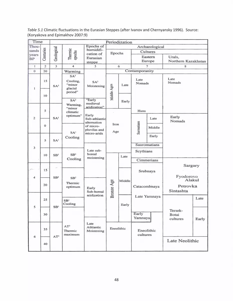
Table 5.1 Climatic fluctuations in the Eurasian Steppes (after Ivanov and Chernyansky 1996). Source:(Koryakova and Epimakhov 2007:9)
48
An important question is how sudden or catastrophic were the climatic shifts mentioned
above, and were they actually noticeable by the dwellers of the steppes leading their everyday
lives? For instance, in the Volga river region, which borders on the southern Urals, the arid
phase of the SB2 period ends around 1800BC in the Middle Volga while in the Lower Volga
moister climatic phase does not start until 1500BC (Popova 2006:166). What this example
illustrates is how gradual the prehistoric temperature/humidity changes were and that the
arrival of climatic phases varied greatly over relatively short distances. Although the climatic
shifts in the steppes were not of a catastrophic character, they still required a certain level of
adjustment by the local populations.
The question is: can archaeologists predict how people in the past reacted to climatic
shifts? Although ecological explanations behind human actions are oftentimes dubbed
‘environmentally deterministic’, numerous archaeological works utilize climatic data in
explaining human adaptation to changing local environmental conditions over time. In the case
of the Eurasian Steppes, for example, Koryakova and Epimakhov (2007:8) concluded that Asiatic
populations of the steppes tended to adhere more to the migration model, while the Eastern
European populations tended to lean toward the adaptation framework, based on climatic data
(Koryakova and Epimakhov 2007:8). In their analysis the authors relied on the fact that
compared to the Eastern European part of the steppe belt, the magnitude of climatic
fluctuations during the Holocene were greater in the Asiatic or eastern part of the region
(Koryakova and Epimakhov 2007:8). Therefore, due to the tendency of entire ecological zones
and landscapes being displaced in the eastern part of the steppes, Asiatic populations tended to
adhere more to the migration model, while less volatile climatic conditions allowed the Eastern
European populations to adapt to their environment without resorting to large scale
migrations.
Zhang and colleagues (Zhang et al. 2007:19214) in their examination of the effect of
long term climate change on the outbreaks of war and demographic fluctuations during the
preindustrial era have found that worldwide war peace, population, and price cycles in the
recent centuries have been driven by long term climate change. Based on the results of this
study, Zhang et al. concluded that “climate change may thus have played a more important role
49

and imposed a wider ranging effect on human civilization than has so far been suggested”
(2007:19214). A number of cases in Asia and Europe over the last millennium, which were
evaluated in this study, pointed to the fact that war outbreaks and population decline cycles
occurred during cold and arid climatic phases (Zhang et al. 2007:19218).
Although the ecologically based explanations of social prehistorical dynamics can seem
overly environmentally deterministic, they cannot be totally discounted. The idea that warfare
can serve as an adaptive mechanism for human societies when faced with environmental shifts
or resource scarcity has been expressed by a number of scientists (Webster 1975; Galloway
1986). Unlike animals, who respond to environmental stress through migration, dietary change
or population reduction through starvation, humans have a wider array of adaptation
techniques to choose from, one of which is population control through warfare (Zhang et al.
2007:19214). Although warfare is a very complex phenomenon, which cannot be explained by
environmental factors alone, the aridity of the SB2 climatic stage may have had a significant
impact on the people of the steppes who relied on natural vegetation to feed their livestock.
5.2 Role of metallurgy in shaping the Southern Urals society
During the MBA, even though other cultures of the steppes produced copper and
bronze items, Sintashta culture possessed significant technological and locational competitive
advantage over their neighbors. On a wide regional scale, cultures occupying the forest zone of
the Urals and Western Siberia to the north of the Southern Urals subsided on hunting/fishing
and utilized lithic technology, with the use of copper (not yet bronze) being extremely rare at
any point during the 3rd millennium BC (Koryakova and Epimakhov 2007:104). To the east, in
the steppes of the northern and central Kazakhstan (see Figure 5.1), the spread of Petrovka
culture (Sintashta variant) marks the spread of bronze technologies into the region (Koryakova
and Epimakhov 2007:98). Abashevo culture, occupying the areas to the west and north of the
Sintashta territory, did practice bronze metallurgy during the MBA, but did not have access to
the rich copper ore resources of the Southern Urals. Abashevo metallurgists along with utilizing
local sandstone outcrops (Koryakova and Epimakhov 2007:34), imported a substantial part of
their arsenical copper from the Southern Urals (Tash Kazgan deposit) (Chernykh 1992).
50

Furthermore, Abashevo settlements do not contain the remains of smelting furnaces, pointing
to the presence of primitive smelting constructions that would not leave a solid archaeological
trace behind. In other words, Sintashta Petrovka culture, with its advanced metal producing
technology (furnaces, two part bellows, horizontal chimneys) (Koryakova and Epimakhov
2007:37) combined with access to superior mineral resources had no real competition in the
surrounding steppes. The only real competition, in terms of metal processing technology, came
from the forest and forest steppe zones to the north in the form of the Seima Turbino
metallurgical impulse, which will be discussed in detail shortly.
On the local scale, populations residing in the Sintashta Petrovka fortified settlements
were the only known metal producers in the steppes of the Southern Urals during the MBA.
Other aboriginal mobile pastoralist and hunter gatherer groups, which later comprised the
Srubnaya and Alakul populations of the Southern Urals lived in the local steppes during the
MBA as well, but did not produce bronze. These populations converted to a sedentary mode of
living and began practicing metallurgy on a wide scale during the LBA, when relatively high
quality metal processing began being performed not by distinct communities, like Sintashta, but
by virtually every village autonomously.
5.2.1 Craft specialization and social structure
Epimakhov (2002:77) put forward a hypothesis about the Sintashta culture, in the
process of migrating into the Southern Urals, transforming the nature of metal production from
a sub culture within a society into a “system shaping” characteristic of an entire society.
According to Epimakhov (2002:77), the control over metal production knowledge and
metallurgical resources is what, in a lot of ways, shaped Sintashta. During the occupation of
new territories, Sintashta society became highly “militarized”, with warrior elites ultimately
controlling the monopoly over the exclusive knowledge and resources necessary for metal
production. Sintashta strongholds were concentrated in the Southern Urals in order to control
access to copper ore, while the fortified settlements themselves kept the exclusive secretive
metal producing knowledge from spreading to the neighboring tribes. In this context, Sintashta
is viewed as a society in of itself and also as a segment of a larger Southern Urals community.
51

Metal producing knowledge was widely spread (universal) within the Sintashta society but its
spread was restricted to other groups residing in the steppes of the Southern Urals.
The tendency to keep the process of bronze item production, especially weapons,
secretive is also observed in the later Seima Turbino phenomenon, which will be discussed in
detail in the following section. Chernykh (1992:231) believes that this warrior bronze smith
culture of the LBA practiced a strict taboo on the distribution of its weapons among foreign
tribes. In the regions through which the supposed Seima Turbino migration swept through,
their metal processing technology was not adapted right away by the local tribes but after a
significant time period had elapsed (Chernykh 1992:231).
Epimakhov’s hypothesis about metallurgy being an important factor in shaping the
Sintashta society finds parallels among other metal producing societies of the world. A prime
example is the Barongo society of iron producers in Africa. Barongo is the name of a group of
iron smelters and forgers in Africa who identify themselves as separate from other tribes in the
area and use a distinct lexicon (Schmidt 1996:77). Although not an ethnicity per se, as a lot of
western ethnographers have supposed for a long time; the Barongo group possesses a distinct
cultural identity that stems from the practice of iron smelting. Barongo reside and work deep
in the forest and are seen as mysterious and dangerous by the neighboring tribes (Schmidt
1996:79). While the Barongo groups keep their technology secret by living deep in the forest,
the Sintashta culture constructed fortified settlements to keep the process of metal production
out of the view of curious neighbors.
Furthermore, the process of iron production is surrounded by mysticism and is a highly
ritualized activity in a number of African societies (Schmidt 1996:16). The access to the
technical and ritualistic knowledge connected with the metallurgical activities is restricted by
kinship ties, clan membership, gender, age, and other criteria (Schmidt 1996:14). Iron smelters
in traditional African societies possess a significant amount of wealth and power, compared to
people practicing other trades. Social groups restrict access to the metal processing knowledge
in order to maintain a certain level of monopoly over an important economic enterprise
(Schmidt 1996:14). Without a doubt, Sintashta smiths also enjoyed a great level of wealth and
power stemming from their bronze smelting technological knowledge. It is possible that once
52
the monopoly over metallurgical knowledge started crumbling due to the appearance of
alternative ore sources and the development of alternative metal processing techniques,
Sintashta society started losing its power and eventually ceased to exist altogether.
According to the Marxist framework, relations in production shape a given society. “As
individuals express their life, so they are” (Marx and Engles 1967:42). Technology is a
combination of practical, or material, knowledge with the esoteric knowledge, which
encompasses people’s beliefs and general world views (Dobres 2000:104). Society is an
integrated system, where the technological, symbolic, and ritual aspects cannot be examined as
separate from each other, with technological practices and end products expressing world
views and cultural values (Dobres 2000:100). In other words, specialized craft production was
more than a mere economic activity for the metallurgists of the steppes. Technological
expertise and production activities connected with metal production must have played a great
role in shaping Bronze Age societies of the Eurasian Steppes.
5.2.2 Metallurgists and social status during the Bronze Age
The phenomenon of elite craft specialization and production is known to have been
taking place in the Classic Maya society (Inomata 2001:321), where stone carvings, polychrome
ceramics, and shell ornaments were produced by the elites. Inomata (2001:321) concludes in
his study of the Classic Maya society that “skilled crafting, along with the privileged knowledge
encoded in the products, formed an important part of the high culture that served to
distinguish the elite from the rest of the society”. Considering the Middle Bronze Age was a
period during which metal processing technology was still developing and spreading through
various parts of Eurasia, Sintashta bronze smiths must have held a high, or even elite status
compared to the other groups residing in the Southern Urals.
Cultural and ideological aspects can play a great role in the formation and the
sustainability of a given elite group (Inomata 2001:324). Throughout prehistory, ideology and
cultural values were oftentimes expressed through specific objects. By controlling the exclusive
technological knowledge associated with the production of such objects, elite groups were able
to obtain or sustain power in a given region. In the case of the Sintashta culture, such objects
probably included various warrior attributes, such as chariots and bronze weapons found in
53
kurgan burials. Besides the obvious military power stemming from the possession of advanced
warfare technologies, warrior like items must have been associated with a high social status
and possessed a certain level of ritual significance, judging from their inclusion in burials during
the Bronze Age. By keeping the exclusive knowledge necessary to produce these ‘objects of
power’ contained within the fortified production centers, Sintashta elite group was able to
sustain its power in the region.
Through prehistorical as well as historical times, folk custom has often associated metal
making with magic and ritual (Budd and Taylor 1995:133). Various definitions of the word
‘metallurgy’ exist; oftentimes referring to it as art, science, or craft, emphasizing a wide range
of meanings metal production is still associated with in our collective consciousness. Budd and
Taylor (1995:134) hypothesize about the earliest metal makers possessing “a generalized kind
of politico religious power” with individual smiths assuming the role of a craftsman, political
leader, and magician all in one person. These characteristics of how early craft technologies
played into prehistoric power dynamics seem, at least in part, to be reflected in the Bronze Age
cultures of the Southern Urals.
While during the MBA, Sintashta populations possessed a great amount of power and
wealth stemming from the exclusive, ritualized metal production knowledge, the LBA witnesses
the emergence of massive industrial like mining centers with little room left for exclusive
craftsmanship. LBA metal processing tends to assume a form of generic production rather than
craft specialization, with, as Kohl put it, “nearly every household seeming capable of working
metal to some degree” (Kohl 2007:177). Besides being influenced by other factors, the key to
the MBA LBA transition seem to lie in Sintashta’s loss of control over the exclusive technical
knowledge associated with the production of high status warrior items.
5.2.3 Spread of metallurgical knowledge in the Eurasian Steppes during the LBA
As previously mentioned, the MBA LBA transition in the Eurasian Steppes was
associated with the spread of the metallurgical knowledge. The Sintashta warrior elites
gradually lost their dominating position in the steppes due to the strategic factors, which were
previously controlled by these strongholds, losing their significance. From a worlds systems
54
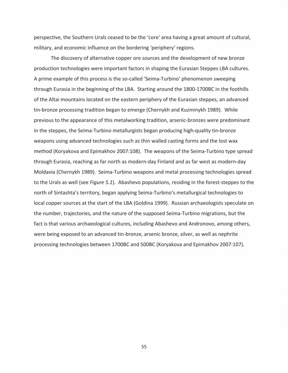
perspective, the Southern Urals ceased to be the ‘core’ area having a great amount of cultural,
military, and economic influence on the bordering ‘periphery’ regions.
The discovery of alternative copper ore sources and the development of new bronze
production technologies were important factors in shaping the Eurasian Steppes LBA cultures.
A prime example of this process is the so called ‘Seima Turbino’ phenomenon sweeping
through Eurasia in the beginning of the LBA. Starting around the 1800 1700BC in the foothills
of the Altai mountains located on the eastern periphery of the Eurasian steppes, an advanced
tin bronze processing tradition began to emerge (Chernykh and Kuzminykh 1989). While
previous to the appearance of this metalworking tradition, arsenic bronzes were predominant
in the steppes, the Seima Turbino metallurgists began producing high quality tin bronze
weapons using advanced technologies such as thin walled casting forms and the lost wax
method (Koryakova and Epimakhov 2007:108). The weapons of the Seima Turbino type spread
through Eurasia, reaching as far north as modern day Finland and as far west as modern day
Moldavia (Chernykh 1989). Seima Turbino weapons and metal processing technologies spread
to the Urals as well (see Figure 5.1). Abashevo populations, residing in the forest steppes to the
north of Sintashta’s territory, began applying Seima Turbino’s metallurgical technologies to
local copper sources at the start of the LBA (Goldina 1999). Russian archaeologists speculate on
the number, trajectories, and the nature of the supposed Seima Turbino migrations, but the
fact is that various archaeological cultures, including Abashevo and Andronovo, among others,
were being exposed to an advanced tin bronze, arsenic bronze, silver, as well as nephrite
processing technologies between 1700BC and 500BC (Koryakova and Epimakhov 2007:107).
55
Figure 5.1 Seima Turbino sites (represented by rhombic signs). Ab Abashevo culture; Si Sintashtaculture; Pe Petrovka culture. Source: (Chernykh 2009:133).
Recent radiocarbon dating project, based on samples from 40 archaeological sites
located in the Southern Urals (Hanks et al. 2007), has pushed back the dates of the Seima
Turbino cultural development. Although based on a single bone sample and requiring
additional dating (Hanks et al. 2007:359), the Seima Turbino organic material dates as far back
as 2140 BC (cal.), which definitely alters the ‘conventional’ chronological scenario outlined
above. In his recent publication, Chernykh (2009:136) also pushed back the dates of the Seima
Turbino culture to 2200 1700 BC. The skillfully crafted Seima Turbino tin bronze items might
have influenced the Sintashta populations to move east into central Kazakhstan, closer to the
local tin deposits, and improve their metallurgical technologies, thereby forming the Petrovka
culture. Bigger ovens, new closed molds, new heat treatment methods, new weapons and
tools, characteristic of Petrovka settlements (Koryakova and Epimakhov 2007:41 42), might
have been ways in which Sintashta Petrovka metal smiths attempted to sustain the competitive
advantage over the Seima Turbino technologies. Again, Seima Turbino material correlates are
found in the forest steppes and forest (taiga) areas to the north (see Figure 5.1), a cultural and
56
ecological environment very different from the steppes, so the level of directness of
competition or interaction between the two alternative technologies is under question.
During the LBA, the control over the metal processing knowledge and access to the
mines did not benefit the Sintashta society to the degree it did in the MBA, because now there
were alternative sources of both. Although a number of ancient copper mines are known to be
located beyond the Sintashta territory, mainly right outside of its western periphery (Hanks and
Doonan 2009), no direct evidence of any MBA mining activities at these locations has been
found. According to Chernykh (1992:190) the Late Bronze Age is characterized by the discovery
of hundreds of new copper ore, tin ore, and other ore deposits in the Urals, Sayano Altai,
Northern Kazakhstan, Central Asia, and Eastern Ukraine: virtually all over the Eurasian Steppes.
“The huge scale of mining in a number of mines is astonishing” (Chernykh 1992:190). The
mining and smelting traditions in the areas mentioned above serve as building blocks for the so
called “Eurasian Metallurgical Province” (Chernykh 1992:190), which emerged in the steppes
during the LBA and was characterized by distinct metal processing technologies. Even though
in the LBA the Urals and central Kazakhstan remained large scale exporters of copper ore to the
western steppes, many local metallurgical sources and traditions began springing up
throughout the steppes. In the Urals, for instance, western Ural cultures began utilizing local
copper bearing sandstones, rather than import all of their copper from Trans Urals (Chernykh
1992:206).
Another LBA trend entailed the overall increase in the scale of metallurgical activities.
Along with the Kargaly mining complex of the Southern Urals, mentioned in the preceding
chapter, specialized settlements of miners and metallurgists also began to appear further east,
in central Kazakhstan (Chernykh 1992:212). The settlement of Atasu, believed to be a large
center for copper smelting and the manufacture of bronze items, utilized ore transported in
from the Kenkazgan mine, located over 80km away (Chernykh 1992:213). While Kargaly in the
Southern Urals represented a large scale mining operation, Atasu of central Kazakhstan, on the
other hand, was a regional ore processing center.
In addition to the processes mentioned above, it appears that the Eurasian Steppes are
becoming more “open” during the LBA period both culturally and economically. As stated
57
previously, bronze weapons of the Seima Turbino type, made using identical forging
technologies and ore sources, sweep through vast expanses of land at astonishing speeds.
According to Chernykh (1992:194), a thousand kilometer tin trade route extended from Rudny
Altay west into the steppes. The high level of economic and ideological interconnection among
the Eurasian Steppe communities during the LBA is also evident in the high level of material
culture uniformity, to the degree at which it becomes “difficult for archaeologists to distinguish
individual cultures” (Chernykh 1992:194).
5.3 Conclusion
Climatic shifts and migration processes, outlined in the archaeological literature dealing
with the MBA LBA transition, did play a role in the Sintashta – Srubnaya Alakul cultural
transformation, but were not the only factors influencing this pivotal transition period. The key
to the MBA LBA transition seems to lie in the spread of the metallurgical knowledge and the
discovery of alternative copper ore sources. The exclusive control over natural resources and
craft production knowledge was replaced by a new social order – one characterized by the
collective control over resources and the presence of an open exchange oriented economic
network. While the MBA social organization in the Southern Ural steppes had to be reinforced
by warfare activities and aggrandizing ritual feasting behavior; the LBA, on the contrary, was a
period characterized by a relatively peaceful economic exchange between disbursed pastoral
communities.
58
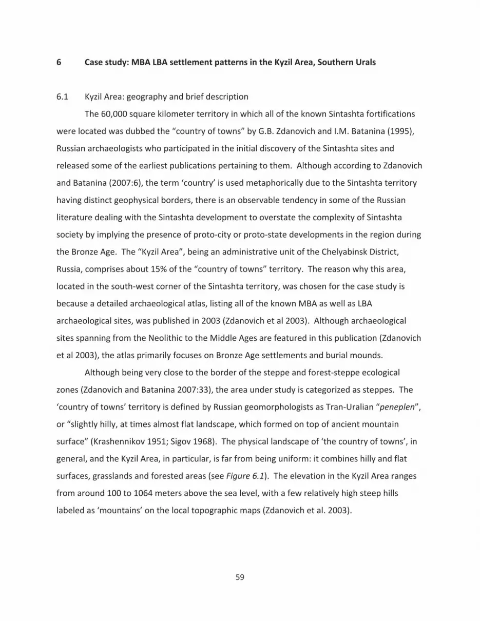
6 Case study: MBA LBA settlement patterns in the Kyzil Area, Southern Urals
6.1 Kyzil Area: geography and brief description
The 60,000 square kilometer territory in which all of the known Sintashta fortifications
were located was dubbed the “country of towns” by G.B. Zdanovich and I.M. Batanina (1995),
Russian archaeologists who participated in the initial discovery of the Sintashta sites and
released some of the earliest publications pertaining to them. Although according to Zdanovich
and Batanina (2007:6), the term ‘country’ is used metaphorically due to the Sintashta territory
having distinct geophysical borders, there is an observable tendency in some of the Russian
literature dealing with the Sintashta development to overstate the complexity of Sintashta
society by implying the presence of proto city or proto state developments in the region during
the Bronze Age. The “Kyzil Area”, being an administrative unit of the Chelyabinsk District,
Russia, comprises about 15% of the “country of towns” territory. The reason why this area,
located in the south west corner of the Sintashta territory, was chosen for the case study is
because a detailed archaeological atlas, listing all of the known MBA as well as LBA
archaeological sites, was published in 2003 (Zdanovich et al 2003). Although archaeological
sites spanning from the Neolithic to the Middle Ages are featured in this publication (Zdanovich
et al 2003), the atlas primarily focuses on Bronze Age settlements and burial mounds.
Although being very close to the border of the steppe and forest steppe ecological
zones (Zdanovich and Batanina 2007:33), the area under study is categorized as steppes. The
‘country of towns’ territory is defined by Russian geomorphologists as Tran Uralian “peneplen”,
or “slightly hilly, at times almost flat landscape, which formed on top of ancient mountain
surface” (Krashennikov 1951; Sigov 1968). The physical landscape of ‘the country of towns’, in
general, and the Kyzil Area, in particular, is far from being uniform: it combines hilly and flat
surfaces, grasslands and forested areas (see Figure 6.1). The elevation in the Kyzil Area ranges
from around 100 to 1064 meters above the sea level, with a few relatively high steep hills
labeled as ‘mountains’ on the local topographic maps (Zdanovich et al. 2003).
59
Figure 6.1 Trans Ural ‘peneplen’. View from the “Cheka Mountain” located in the Kyzil Area. Source:(Zdanovich and Batanina 2007:46).
6.2 Data used in the case study
The data utilized in the following case study is obtained from the “The Archaeological
Atlas of Chelyabinsk District” (Zdanovich et al. 2003), published in Russian language. In the
creation of “The Archaeological Atlas of Chelyabinsk District” (subsequently referred to as
Atlas), researchers utilized aerial photography as the primary remote sensing method to locate
settlements, burial mounds, and other archaeological sites in the Kyzil Area (Zdanovich et al.
2003:47). Aerial photographs, in some cases taken over the course of several decades, were
examined in detail or ‘decoded’ to reveal archaeological sites. Follow up helicopter flyovers,
pedestrian reconnaissance activities, as well as partial excavations were performed to confirm
the presence of and determine the types of individual sites (Zdanovich et al. 2003:47).
The data in the Atlas represents a detailed map of settlements, cemeteries, camps and
mines ranging in time from the Neolithic to the Middle Ages. Archaeological sites, depicted on
the Atlas maps are accompanied by brief descriptions, the level of detail of which varies. Due
60

to the variability in the extent of analysis of a given site, the degree of detail concerning a site’s
chronology or typology varies: i.e. certain sites are assigned approximate or exact dates and
others are not. The Kyzil Area is a rural region of one of the most scarcely populated countries
in the world, so the level of the anthropogenic influence on most of the sites is relatively
minimal, compared to other parts of the world. Due of the unique nature of the MBA and LBA
dwellings and the absence of permanent settlements in the region during the EBA, the
identification and chronological dating of the settlements is relatively complete and reliable.
It is important to note that the landscape of the southern Urals was different during the
Bronze Age from what it is today. According to Kremenetski (2003:16), the overall vegetation
cover of the Eurasian Steppes and forest steppes became similar to that of today around
500BC. This coincided with the end of the Bronze Age in the Eurasian Steppes, which means
that present day vegetation cover of the Kyzil Area might not necessarily reflect the ecological
situation of the MBA and the LBA periods. Massive influence of human activity, whether Iron
Age large scale pasturing or the Industrial Era’s agriculture and development, on the Eurasian
landscape over the past two and a half millennia also needs to be accounted for. By studying
the soil erosion of the Chelyabinsk district using high resolution remote sensing imagery,
Russian scientists concluded that great masses of forests have been cut down in a number of
areas, most of which were located along the left bank of the Ural river, which runs through the
Kyzil Area (Zdanovich and Batanina 2007:35). On high resolution images taken by satellites,
such areas of eroded mineralized soil show up as bright colored spots, which by means of
subsequent soil analyses from the test pits, have been confirmed to be characteristic of
deforestation processes (Zdanovich and Batanina 2007:34). Some scientists (Filrose 1999) go as
far as stating that the Southern Urals qualified as a forest steppe, rather than steppe prior the
massive anthropogenic impact on the landscape. The issue of possible deforestation processes
in connection with Bronze Age metallurgy has been brought up by researchers working in other
areas of the Southern Urals. A palynological study at Kargaly, for instance, has revealed a
probable connection between over exploitation of local timber resources and a decline in large
scale smelting activities around 1400BC (Vicent et al. 2006).
61

6.3 Case study methodology
6.3.1 GIS techniques
Besides basic GIS techniques necessary for the digitization of the data presented in the
Atlas, a few GIS tools were relied upon to a greater extent in the analysis of the MBA LBA
transition in the Southern Urals. These GIS techniques are Kernel Density Estimation (KDE),
Visibility (or viewshed) analysis, and the generation of Least Cost Paths (LCP) based on Cost
Surface Analysis. The aim of the study was to combine environmental and ‘humanistic’ factors
into the analysis of the MBA LBA settlement patterns during this transition. Out of the GIS
tools utilized in the Kyzil Area case study, the Visibility and the Cost Surface Analysis techniques
are more closely associated with the postprocessual approach to human action that advocates
analyzing past landscape from the perspective of the individual agents performing the action.
The KDE, Viewshed, and LCP techniques, which are discussed in detail below, are utilized in the
analysis of settlement and kurgan distributions, with special attention paid to their relative
locations to environmental resources (i.e., copper ore, wood, and water) essential for metal
processing activities carried out by Bronze Age communities.
Various sites, features, or artifacts are oftentimes represented as points on
archaeological maps. In terms of settlement pattern studies, analyzing the distribution patterns
of such points may, among other things, help establish the level of competition among
settlements and identify emerging polities or regional centers in the area of study (Connoly and
Lake 2006:163). Since this research evaluates the emergence of early complex societies in the
region by utilizing settlement evidence, it is useful to examine what GIS techniques are useful in
identifying point distribution patterns.
Kernel Density calculates the density of features in a neighborhood around those
features (Longley et al. 2005:391). The KDE feature in GIS can be used to calculate and depict
the density distribution of any point or line data, such as the density of houses, crime incident
locations, roads, wildlife concentrations, etc. Density analysis allows archeologists to analyze
the locational distribution of archaeological sites, features or artifacts by identifying at which
locations the archaeological material tends to cluster (Connoly and Lake 2006:173). When a
62
substantially large quantity of target map features makes identifying individual clusters difficult,
it is useful to measure the changing frequency or intensity of observations over a given area.
KDE is one of the possible density analysis techniques available through GIS. It is a
sophisticated density measure, which produces smoother and more readily interpreted results
than more simple density techniques (Connoly and Lake 2006:175). KDE replaces point or line
data by placing a two dimensional probability density function, referred to as kernel over the
observed data points to create a smooth approximation of its distribution from the center of
the point outward (Connoly and Lake 2006:175). The radius of the kernelmay be manipulated
to create a more smoothed or peaked distribution. KDE is essentially represents an
interpolation technique that aims to ‘fill in the gaps’ between observations to create a
continuous surface.
The Kyzil Area case study examines 113 settlements and 215 kurgan cemeteries,
depicted as point data on the aerial Atlas map. Since hundreds of settlements and burial
mounds are spread over a relatively small area, the locations where these sites cluster or
concentrate are difficult to identify without utilizing some sort of a density analysis technique.
By identifying the frequency of occurrence of a given variable (i.e., settlements, burial mounds,
etc.) over a specified areal unit and subsequently classifying those frequencies in a manageable
number of categories, the KDE tool is able produce an easy to read distribution map showing
the areas of high/low variable concentrations.
Another GIS technique used to a great extent in the Kyzil Area case study is the
viewshed analysis. As mentioned earlier, viewshed analysis feeds into the post processual
theoretical framework by examining the way a given landscape was perceived by people in the
past through the sense of vision (Witcher 1999:15). Postprocessual developments in
archaeology of the 1980’s and 1990’s that stressed the role of the individual as an active
purposeful agent served as a precursor to incorporating the sense of vision into archaeological
research (Wheatley and Gillings 2000:204). Tilley’s phenomenological approach (1994:73), in
particular, viewed perception as being bodily centered and stressed the importance of bodily
movement through landscape. Viewhsed analysis has also been used in establishing regional
63
power relationships. In terms of the MBA LBA transition case study, viewhsed likely played an
important role in the strategic locations of the fortified settlements.
In terms of GIS, the viewshed of a point is the set of target cells that can be seen from
that viewpoint, usually assuming any two points within the viewshed are intervisible (Connoly
and Lake 2006:226). The intervisiblity or viewshed analysis is very popular within the
archaeological research, with studies focusing on the reciprocity of view between and within
monuments, defensible constructions, burial mounds, as well as other archaeological sites
(Connoly and Lake 2006:225; Jones 2006; Kay and Sly 2001). The Kyzil Area case study utilizes
two types of viewshed analysis: a single viewshed and a cumulative viewshed. A single
viewshed, being the simplest result of a viewshed analysis, marks target raster cells which are
visible or not visible from a given point. A multiple or cumulative viewshed, being a union of
two or more viewshed maps, produces an output map which contains the cells which are either
visible from one or more viewpoints or not visible from any viewpoint (Connoly and Lake
2006:227).
There are numerous computational, experimental, theoretical, and substantive issues
with GIS based visibility analysis (Connoly and Lake 2006:228). Without delving into these
criticisms in too much detail, a couple of issues concerning visibility analysis are worth
mentioning, as they pertain to the Kyzil Area case study. One theory related criticism seems to
undermine the viewshed analysis’ association with landscape perception and, therefore, post
processual framework. Connoly and Lake (2006:232) argue that the existence of a line of site
between points has little to do with perception and viewshed based studies have frequently
failed to move beyond simply establishing whether certain points are intervisible. A more of a
methodological issue has to do with the so called ‘tree factor’ (Wheatley and Gillings 2000:5),
which refers to the presence of substantially tall palaeovegetation having a significant impact
on intervisibily. While the ‘tree factor’ is minimal in the flat grasslands of the steppes, the fact
that the Southern Urals region was more heavily forested during the Bronze Age could possibly
alter the viewshed analysis outlined in the Kyzil Area case study.
The third GIS technique utilized in the Kyzil Area case study is the generation of Least
Cost Paths (LCP’s). Physical landscape of the earth is rarely a flat, uniform surface, where the
64

easiest route between any two given points is a straight line. In GIS based routeway modeling,
slope is usually one of the factors which is considered costly in terms of movement, with
steeper slope associated with a greater movement cost in terms of energy (Chapman
2006:107). Least Cost Path (LCP) analysis entails assigning different costs to each raster cell
based on certain criteria and then calculating the easiest fastest route between the source
point and the destination. Out of all possible routes between the two points, the LCP will
identify a pathway which incurs the least cumulative value in relation to the cost surface
(Chapman 2006:108). According to Chapman, traditionally, “the principal factor used in the
construction of cost surfaces has been slope” (2006:108). Although other factors likely
influenced the cumulative cost of traveling through the area, for the sake of simplicity, the cost
surface used in the creation of Least Cost Paths in the Kyzil Area utilizes slope as the primary
variable affecting movement across the landscape.
The LCP techniques in GIS have been criticized for their occasional inability to replicate
or predict prehistorical routes due to a number of methodological and theoretical issues
(Connoly and Lake 2006:254). The issues that apply to the Kyzil Area LCP analysis are worth
examining in more detail. One is the accountability for various barriers or transformational
obstacles (other than slope) that could impede movement. One such barrier in the steppes
could possibly be rivers. Rivers considered as significant obstacles since all rivers in the Kyzil
Area are relatively shallow and narrow, i.e. easily crossable by horseback riders or pedestrians
possessing any kind of swimming skills. While during the hot summer months crossing rivers
could be looked upon as an incentive, during the long Eurasian winters rivers in the Urals are
frozen over, which makes crossing them not an obstacle.
Wheatly and Gillings (2002:157) also discuss how most cost surface algorithms use a
hydrology based framework, where least cost paths are ultimately modeled after how a drop of
water placed in each cell of the raster surface would move to the lowest ‘drainage point’ of the
study area. In terms of the Kyzil Area case study, a person on horseback is a lot different from a
drop of water for a number of reasons, and the hydrology based LCP’s, which will tend to
gravitate toward natural paths used by rivers, could fail to predict how a human would move
through the landscape. People in the past might have not utilized the LCP’s generated by
65
archaeologists for a variety of reasons. Traveling on horseback, in particular, may entail
building a specialized cost surface appropriate for this mode of transportation, which can
greatly alter the direction of ‘basic’ LCPs based on slope.
6.3.2 Burial vs. settlement evidence
The Kyzil Area case study utilizes settlement evidence in an attempt to analyze the MBA
LBA transition in the Southern Urals. How is utilizing this line of evidence different form the
prevalent methodology characteristic of the Eurasian Steppe archaeological research? As
previously mentioned, Russian ‘kurgan archaeology’ has been preoccupied with analyzing
mortuary material evidence, which can limit our understanding of the societies being studied.
There are many ways to interpret burial archaeological evidence, and as with any other
archaeological technique, mortuary archaeology is accompanied by criticism and uncertainties.
Some have speculated that burial ritual may reflect an idealized or mythical representation of
reality and social relationships (Lindstrom 1994), while others have noted an important artistic
or creative component of mortuary practices (Zdanovich 1997). Some researchers have
expressed concern about archaeologists’ ability to link mortuary complexity to social
complexity, with status differences possibly being masked or manipulated through the
mortuary ritual (Pearson 1995:1047). While being a rich potential source of data on
paleodemography, social stratification, religion, cosmological interpretations and ritual
practices, among other things, mortuary evidence needs to be supplemented by other forms of
archaeological analyses in order to provide researchers with a more complete picture of past
societies.
Settlement pattern research, carried out at varying scales, can add to the archaeologists’
understanding of the social structure of a given society by using spatial relationships (Trigger
1967:152). The individual household analysis can provide archaeologists with insights about
nuclear family structure, class division, and craft specialization. The study of an entire
settlement plan can help reconstruct communal organization structure, general community
patterning, identify the presence of social institutions, and examine the nature of economic
relationships within the community (Trigger 1967:152). And, finally, spatial relationships
66

between different communities may provide some insights into the political organization and
economic relationships on a regional scale (Trigger 1967:152).
Since the Kyzil Area case study, among other things, attempts to reconstruct general
paleodemographic aspects of the MBA LBA transition, it is worthwhile mentioning certain
aspects of paleodemographic reconstructions based on mortuary remains. Paleodemographic
reconstructions based on mortuary remains have been subject to a number of critiques over
the last few decades, including sampling biases and measurement issues. These critiques also
include fundamental analytical problems, such as the non stationary nature of the population
and the selective mortality paradigms (Millner et al. 2000).
As far as reconstructing the paelodemographic situation based on mortuary evidence
within the Southern Ural Bronze Age societies, certain quantitative discrepancies are observed,
which are speculated to either entail the presence of alternative burial practices or call for the
reconsideration of the nature of permanent settlement sites (Epimakhov 2002:61,62). For
instance, the inhumation burial statistics point to one in 8 25 people (depending on which
Sintashta settlement population estimates are used) being buried in the kurgans (Epimakhov
2002:61). Epimakhov (2002:63) speculates that either forms of burial ritual other than
inhumation were widely practiced by the Sintashta society, or the settlements of MBA were not
permanently occupied but occasionally acted as centers of concentration of dispersed
populations. The relatively low density of artifacts and the thin “cultural sediment layer” in the
settlement context may also suggest seasonal occupation of the sites (Epimakhov 2002; Kohl
2007).
What the above cited analysis illustrates is that burial evidence alone may limit
archaeologists’ ability of reconstructing paleodemographic dynamics of a given time period. A
more complete picture of the Southern Urals societies tends to emerge when burial data is
supplemented by settlement evidence. The following sections will summarize the findings of
the settlement pattern research of the Kyzil Area based on the data obtained from the
“Archaeological Atlas of the Chelyabinsk District”.
67

6.4 Research questions
Among the specific research questions addressed in the Kyzil Area case study are: the
level of directness of cultural and demographic continuity between the MBA Sintashta Petrovka
and the LBA Srubnaya Alakul populations through paleodemographic estimates based on
settlement evidence; the level of possible ‘proto city’ formation or urbanization processes
taking place in the Southern Urals at various stages of the Bronze Age; the influence of regional
natural resource distribution patterns on Bronze Age settlement location choices. Finally, the
case study evaluates the possible roles played by kurgans in the lives of the people of the
steppes by examining the distribution patterns of this ritual landscape component in the Kyzil
Area.
Figure 6.2 Distribution of Bronze Age settlements in the Kyzil Area
68
6.5 Findings
The map below (Figure 6.2) shows the distributions of settlements in the Kyzil Area
during the MBA and the LBA periods. Without any type of in depth analysis, what the MBA and
LBA settlement distribution map shows is that there are a lot more LBA than MBA settlements
and that they are more evenly distributed throughout the region. This map represents the
basic summary of the settlement data provided in the Archaeological Atlas of Chelyabinsk
District. The following section discusses my findings/conclusions regarding the MBA LBA
transition in the Southern Urals.
6.5.1 Paleodemographic estimates
As discussed, the Sintashta culture existed in the Southern Urals between 2100BC and
1800 BC (Koryakova and Epimakhov 2007), while the Srubnaya Alakul cultural complex existed
roughly from 1800BC to the start of the Final Bronze Age, when it began to be replaced by the
Sargary culture around 1200BC (Koryakova and Epimakhov 2007:162). Since no Petrovka sites
are known in the Kyzil Area, all of the fortified settlements discussed in the case study are
Sintashta sites. The exact chronologies of when the specific cultures, mentioned above, existed
and to what degree they coincided temporarily are debated and are still being developed
(Hanks et al. 2007). For instance, recent AMS dates indicate that Sintashta, Petrovka, Alakul,
and Srubnaya might have coexisted during portions of the Middle and Late Bronze Ages in the
Southern Urals (Hanks et al. 2007:362), which would alter the ‘simplified’ picture of the MBA
LBA settlement transition outlined in this study. Since the following study evaluates a period
covering at least one millennium and full chronological control would require having
radiocarbon dates from every site in the Atlas, certain chronological simplifications and
assumptions are allowed in order to facilitate the analysis. Overall, the MBA LBA transition in
settlements in the Southern Urals was characterized by the transition from Sintashta Petrovka
fortified settlements to the Srubnaya Alakul unfortified sites, and that is what the following
spatial analysis focuses on.
The brief description for the overwhelming majority of the unfortified settlements in the
Atlas provides “Bronze Age” as an estimated chronology. A number of unfortified settlements
in the Kyzil Area that were excavated yielded ceramics typical of the LBA and FBA cultures, with
69

stratigraphic evidence pointing to the re occupation of certain sites during various stages of the
Bronze Age (Zdanovich et al. 2003:208). The distinct nature of Middle Bronze Age sites (i.e.,
fortifications) and the absence of permanent settlements in the region during the Early Bronze
Age indicate that all of the unfortified sites listed in the Atlas belong to either the Late Bronze
Age or the Final Bronze Age (FBA) periods. Therefore, the period over which the unfortified
settlements, outlined in the Atlas were built extends to the end of the Bronze Age (800 BC).
Consequently, the fortified MBA settlements ceased to exist by 1800BC and gradually got
replaced by the LBA FBA unfortified settlements listed in the Atlas over the following 1000 year
period.
The following analysis attempts to make a rough paleodemographic comparison
between the MBA and LBA periods based on settlement data. More specifically, the total living
space of fortified settlements is compared to the total living space of the LBA FBA unfortified
settlements. A few assumptions underlying this type of analysis are worth elaborating on
before proceeding to the quantitative estimates. One issue has to do with the fact that
comparing the total living space, measured as the cumulative area of housing depressions in a
given settlement, does not necessarily translate into comparing the total number of people
living in a settlement. The population density of the MBA settlements might have been greater,
as indicated by a more compact spatial pattern of adjacent households within the ‘towns’ when
compared to the LBA settlements. Also, a number of ethnographic and historical accounts
indicate the increase in average population density among groups involved in warfare (Hodder
1986:112; McKay 1968:38). Sintashta culture of the MBA could, undoubtedly, be described as
one such group to a greater extent than the subsequent Srubnaya Alakul population.
Another issue stems from the huge time spans during which the MBA, LBA, and FBA
cultures built and occupied their settlements in the Kyzil Area. What is known is that the MBA
sites were built sometime between 2100BC and 1800BC and the LBA FBA unfortified
settlements were built and occupied sometime between 1800BC and 800BC. What portions of
these settlements were occupied contemporarily and at which stages of the periods mentioned
above is unknown. While the issues mentioned above are significant, the following
70

paleodemographic analysis is still quite useful when understanding the MBA LBA transition in
the Southern Urals.
According to the data contained in the Atlas, the total living area of the MBA Sintashta
settlements in the Kyzil Area is 9,915 square meters, while the total living area of the later LBA
and FBA settlements is 201,069 square meters, which represents roughly a 20 fold or a 1,900%
increase in total living space over roughly 1000 year period. The total living area of MBA and
LBA settlements was calculated by adding the areas of all individual housing depressions at
each settlement. Using the McEvedy and Jones (1978:259) estimates of the world population
of 27million in 2000BC and 50million in 1000BC, we see an 85% increase in the world
population over this 1000 year period. Autonomous population growth of the Sintashta
community, which would result in a 20 fold population increase over a millennium, is highly
improbable. The only comparable population growth rate over a 1000 year period, which
yields almost identical percentage increase in world population (around 1,900%) is over the last
millennium, from AD 1000 to AD 2000 (McEvedy and Jones 1978:259). Considering the
tremendous economic, technological, and medical advances of the last millennium, it is highly
improbable that the Southern Urals experienced the same rate of population growth as the
world has in the last ten centuries. These types of growth rates were simply unprecedented in
any parts of the world during the second millennium BC.
How does settlement data mentioned above coincide with mortuary paleodemographic
reconstructions based on mortuary evidence? It is now a widely accepted consensus in the
paleodemography field that the ages at death distributions tend to primarily indicate fertility,
rather than mortality rates (Milner et al. 2000:479). Positive population growth rates increase
the number of deaths at early ages relative to those at later ages (Milner et al. 2000:481). High
child mortality rates, as in the case of the Sintashta burials, may indicate that birth cohorts are
becoming successively bigger, indicating the process of population growth.
Sintashta burials are characterized by a high percentage of child (up to age 15) burials,
which comprise on average 63.2% of the total burials (Zdanovich 1997). These child mortality
parameters exceed the average percentage of child burials in prehistoric necropolises, which
according to Romanova (1989:70), comprise 36.6% from the total burials. The 36.6% average is
71
based on the paleodemographic data from over thirty ancient cemeteries from various regions
of Eurasia ranging temporally from the Neolithic to the Middle Ages (Romanova 1989:70).
Assuming that quantitative prevalence of child burials can be indicative of high birth rates, we
may assume that the Sintashta society’s population grew at rates as much as 70% higher than
the surrounding groups.
If the Sintashta population grew at rates 70% higher than the rates of the population
growth for the rest of the world at the time (i.e., 85% increase), that amounts to roughly a
150% increase. The LBA FBA cultures existed in the region and built their settlements over a
time period that was three times longer, when compared to Sintashta (i.e., 1000 vs. 300 years).
Also, as already mentioned, the MBA fortified settlements might have been more densely
settled than the LBA FBA sites. Considering the MBA and LBA cultures were characterized by
identical subsistence practices, similar material culture complexes (Koryakova and Epimakhov
2007), and oftentimes coinciding housing depression sizes (Zdanovich et al. 2003), the
population density per square meter was probably not drastically different among the Sintashta
and Srubnaya Alakul cultures.
All three MBA fortified settlements of the Kyzil Area were partially rebuilt and occupied
during the LBA period (Zdanovich et al. 2003). Out of the four unfortified settlements
excavated on the territory of the Kyzil Area, two yielded ceramics and other artifacts
characteristic of LBA as well as FBA cultures (Zdanovich et al. 2003:208). This fact is indicative
of a tendency of the Southern Urals Bronze Age populations to occupy the same housing
dwellings for extensive periods of time and reduces the possibility of people building new
settlements, unless necessary. This line of evidence adds credibility to the paleodemographic
estimates, outlined above, by increasing the chances of contemporaneous settlement
occupation of the unfortified settlements.
Epimakhov (2009:98) sites a figure of 50 years as being a possible time interval of a
given settlement’s occupation phase based on the average life span of a “carcass pillar”
construction. This estimate may suggest the settlement distribution of the LBA/FBA
settlements being a result of a group occupying about 5 settlements at a time moving every 50
years. Even though this scenario is highly unlikely, it is important to recognize that the LBA
72
populations could have moved at regular intervals and construct or reoccupy settlements at
new locations. But so could the MBA populations, and since the aim of the study is to compare
the two periods, this tendency to relocate should be reflected equally (besides the time
difference in each culture’s existence) in the cumulative settlement areas of both cultures
Accounting for the demographic growth estimates (1.5 fold increase), the time span
difference (3 fold increase), and possible population density difference (3 5 fold increase) still
leaves the rest of the 20 fold increase in the total living space unexplained by the autonomous
population growth. What the above mentioned statistics suggest is that the increase in the
total living space of permanent housing structures was due to external demographic processes,
other than autonomous population growth, taking place over the second millennium BC in the
Southern Ural steppes. Such processes could have included the adoption of sedentary lifestyle
by people who priory practiced a mobile lifestyle in and around the Southern Urals region, as
well as in migrations from the neighboring regions during the MBA LBA transition.
6.5.2 Autonomous population growth vs. outside influence
Archaeologists have expressed the idea that the MBA settlements in the steppes did not
house the entire population of the Southern Urals on a year round basis, due to a significant
part of the population still practicing a mobile lifestyle (Epimakhov 2002; Kohl 2007). The
populations that archaeologists associate with the Sintashta material culture were not the only
dwellers of the Southern Ural steppes during the MBA; they definitely co existed with other
groups. The Abashevo archaeological culture, for instance, which existed through the end of
the LBA, extended partly into the Trans Urals (Koryakova and Epimakhov 2007:57). Other
western or eastern neighboring mobile pastoralist / hunter gatherer groups might have passed
through the Southern Ural steppes during their seasonal migration routes. Except for kurgans,
mobile pastoralist groups tend not to leave much archaeological evidence behind, compared to
the sedentary groups, like Abashevo or Sintashta. The relative lack of material evidence left
behind by nomads makes it hard to rule out the presence of mobile populations in the Southern
Ural steppes during the MBA LBA transition. Also, if Sintashta populations were the only
people occupying the region, who were they guarding against by building fortifications?
73
The existence of cultural groups other than Sintashta in the region explains the, at first
glance, abnormal post Sintashta population growth in the Kyzil Area in terms of the settlement
evidence. The mobile pastoralist / hunter gatherer groups, residing in the Southern Urals
began adopting sedentary lifestyle, making the MBA LBA transition not an autonomous
development taking place within the Sintashta culture, but a more complex process in which a
number of other cultural groups took part. In other words, the populations that resided in the
fortified settlements during the MBA could not have grown into the LBA sedentary populations:
people who did not live in any kind of permanent settlements during the MBA (nomads) settled
down during the LBA.
6.5.3 Proto cities and the urbanization hypothesis
The term ‘country of towns’, referring to Sintashta cultural development, in of itself
influences the way one pictures the Southern Urals during the Bronze Age. Was there a country
consisting of towns during the MBA, which collapsed and was replaced by the Srubnaya Alakul
villages during the LBA? Considering in Russian language there is no distinction between the
concepts of ‘town’ or ‘city’, with both of these words translating as ‘gorod’, it is worthwhile
examining the level of possible early urbanization in the Southern Urals during the various
stages of the Bronze Age. These are the questions which the following section attempts to
address.
Ethnographic studies indicate the population size of 30 50 people to be characteristic of
a kinship group, while populations consisting of over 100 people may be indicative of a tribal
social structure (Romanova 1989:74). While the definitions of what constitutes a ‘tribe’ or a
‘kinship group’ are somewhat problematic and cannot be applied universally, generally, there is
a correlation between population size and social complexity (Cohen 1985; Keeley 1988).
Population estimates for the Sintashata type fortified settlements vary, from 800 900 to 2000
3000 per settlement (Epimakhov 2002:58). The low estimate is based on the absence of
diseases associated with highly dense human settlements among Sintashta skeletal remains,
while the high one is based on the absolute maximum capacity of people able to reside in the
settlements (Epimakhov 2002:58). Berezkin (1995), on the other hand, estimates the total
realistic population of Arkaim settlement, in particular, to be 400 people, basing his conclusion
74
on the 180 200 people/hectare population density, considered ‘optimal’ for the steppes.
Srubnaya Alakul settlements range from being comprised of a few houses to, in rare cases,
being comparable to the Sintashta fortifications in terms of total living space. Pure Srubnaya
type settlements of the Volga region (as opposed to the Srubnaya Alakul ‘hybrid’ present in the
Southern Urals), for instance, are estimated to house from 120 to 150 people (Vasilyev
1989:81).
These data point to the LBA Srubnaya Alakul population of the Southern Urals likely
being comprised of multiple kinship/tribal groups, with one or two kinship groups residing in a
given settlement, while the Sintashta demographic estimates indicate the presence of a
chiefdom social structure in the Southern Urals during the MBA. Kinship based community
organization pattern is generally associated with a village, while the formation of a town, and
let alone a city, entails the presence of a sufficiently large and diverse population group
(McIntosh 1991:203). Although population estimates do not necessitate the presence or
absence of a ‘proto city’ development, the above mentioned statistics do illustrate the
difference in the social structures of the two cultures, with Sintashta sites more likely qualifying
as towns when compared to the Srubnaya Alakul settlements.
While the definitions of what constitutes a prehistoric ‘city’ or a ‘town’ vary, they all
entail an increasing population density at a certain location. In the case of Mesopotamian Ur
and Uruk, considered to be the earliest urban centers in the world, religious temples seemed to
attract rural populations from the surrounding areas (Price and Feinman 2008:440). This
process of population concentration at a set location was associated with a number of
economic, social, and cultural dynamics, which are today associated with city formation and the
urbanization processes. While some argue that definitions of early ‘cities’ based on the
Southwest Asian model are unilinear and monothetic in nature (Miksic 2000:106), the general
principle of prehistoric urbanization entails the concentration of rural populations around
temples, administrative centers, trade posts, or other socially or culturally significant territorial
markers.
As mentioned above, the exact nature of the Sintashta sites is unclear and whether the
MBA fortified settlements of the Southern Urals were towns or proto cities is a subject of
75
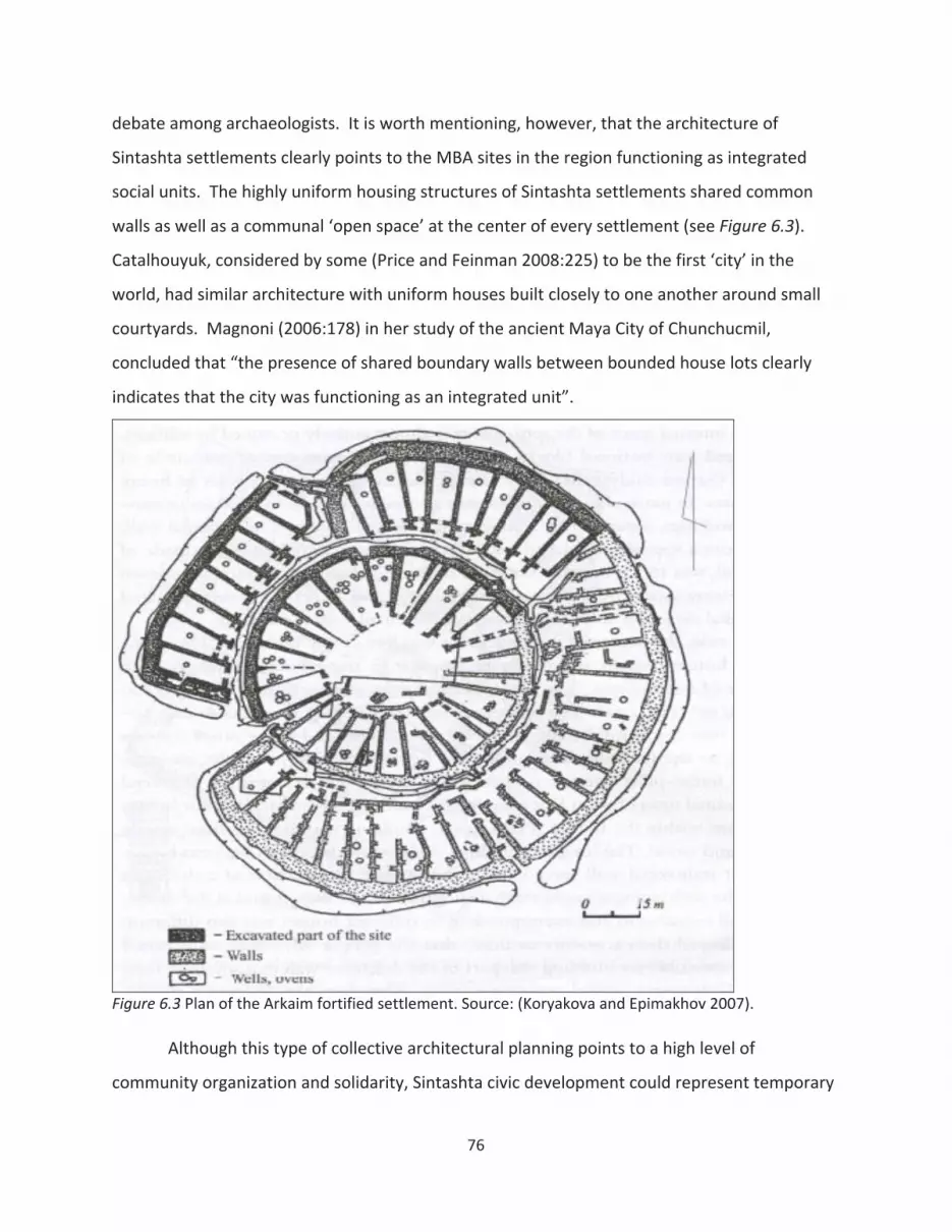
debate among archaeologists. It is worth mentioning, however, that the architecture of
Sintashta settlements clearly points to the MBA sites in the region functioning as integrated
social units. The highly uniform housing structures of Sintashta settlements shared common
walls as well as a communal ‘open space’ at the center of every settlement (see Figure 6.3).
Catalhouyuk, considered by some (Price and Feinman 2008:225) to be the first ‘city’ in the
world, had similar architecture with uniform houses built closely to one another around small
courtyards. Magnoni (2006:178) in her study of the ancient Maya City of Chunchucmil,
concluded that “the presence of shared boundary walls between bounded house lots clearly
indicates that the city was functioning as an integrated unit”.
Figure 6.3 Plan of the Arkaim fortified settlement. Source: (Koryakova and Epimakhov 2007).
Although this type of collective architectural planning points to a high level of
community organization and solidarity, Sintashta civic development could represent temporary
76

clustering of households in the face of a growing threat or danger, rather than the tendency
toward urbanization and the development of ‘proto cities’. African tribes, such as the Sonjo
group residing in the Masai region if Tanzania, whose villages are normally thinly spread over
the African plains, are known to group themselves into large communal villages consisting of
100 200 families when fearing attacks from neighboring tribes (McKay 1968:38). In the
Eurasian Steppes region, Anthony (2007:281) explains the formation of the enormous Tripolye
type settlements in the 4th millennium BC and their subsequent abandonment by the warfare
dynamics of the period, with population concentration being a “standard response to increased
warfare”.
On the regional level, the similarity in size, function, and wealth (as observed in the
burial context) of the Sintashta sites point to the possible presence of a number of distinct peer
polities in the region. The ‘peer polity’ interaction sphere, as outlined by Renfrew and Cherry
(1986) presumes the presence of a number of structurally similar, autonomous social groups or
communities within a region, submerged in a complex web of rivalry and cooperation
relationships. In Sintashta’s case, the rivalries might have taken a form or armed conflict or
economic warfare activities manifested in elaborate feasting and burial sacrifice rituals among
various chief aggrandizers. The cooperation among the town polities, on the other hand,
entailed the sharing of limited copper ore resources present in the area. While a peer polity
interaction sphere is usually associated with decentralized state like formations (Renfrew and
Cherry 1986), and the ‘country of towns’ did not by any means constitute a state, a few
characteristics of prehistoric decentralized states are worth mentioning as they relate to the
Sintashta development. According to Iannone (2002:69), among other archeological correlates,
early ‘segmentary’ states are characterized by: (1) economic, political, and ritual redundancy;
(2) widespread use of similar ritual or cult items; (3) strong emphasis on ancestor veneration
rituals and other ideological practices that reaffirm lineage membership; (4) defense as the
principal reason for the integration of larger kin groups. The correspondence between the
characteristics of early city states outlined above and the Sintahsta culture’s material correlates
point to a possibility of the presence of a peer polity interaction sphere in the Southern Urals
during the MBA.
77

Furthermore, the distribution pattern of the MBA settlements in the area, points to the
possible existence of an “open” or “unrestricted” peer polity interaction sphere, as outlined by
Clark and Blake (2000:256), with the community territories bordering on the territories of two
to six neighboring groups (see Figure 6.4). The ‘country of towns’ territory may qualify as an
‘unrestricted’ interaction sphere due to the non linear nature of the distribution of its
settlements, as well as the absence of natural barriers in the area (i.e., mountains, major water
bodies, etc.) that could restrict the level of interaction among polities.
Theoretically, more centrally located polities within such an interaction sphere are in a
more advantageous position due to a greater possibility for inter community contact and
alliance formation (Clark and Blake 2000:256). At the scale of the Kyzil Area case study, this
hypothesis seems to hold up, with the larger two of the three MBA settlements being located
closer to the imagined ‘center’ of the ‘country of towns’ (see Figure 6.5). On the regional level,
however, settlement size does not seem to correlate with proximity to the ‘center’ of the
interaction sphere. The fact that the Sintashta sites do not completely adhere to the Clark and
Blake’s model does not mean that a peer polity interaction sphere did not exist in the Southern
Urals during the MBA. Many other factors, besides the proximity to the imagined ‘center’, could
make some settlements more economically or politically successful than others. It is also
important to note that the ‘country of towns’ architectural tradition combined at least three
distinct building horizons (Zdanovich and Batanina 2007) and one should be cautious when
viewing the Sintashta culture territory as a monolithic entity consisting of co existing sites.
The evaluation of all possible hypotheses about the nature of the Sintashta sites is
beyond the scope of this paper. What this research focuses on, however, is the transition
between the MBA and LBA periods regarding the level of possible urbanization with the help of
GIS. The ‘average nearest neighbor’ spatial analysis points to a clustered distribution of the LBA
unfortified sites, which is not surprising because the sites do seem to be adjacent to water
sources (rivers), rather than evenly disbursed throughout the area. The ‘average nearest
neighbor’ analysis shows less than 1% chance of the LBA sites being randomly distributed. The
rest of this section attempt to determine the possible tendency of the Srubnaya Alakul sites
toward urbanization by examining the LBA settlement concentration patterns.
78

Figure 6.4 Unrestricted peer polity interaction sphere (after Clarke and Blake 2000)
Figure 6.5 ‘Country of Towns’ as an unrestricted interaction sphere.
79

While the MBA settlements in the Southern Urals had the potential to qualify as ‘proto
cities’, the LBA unfortified settlements did not satisfy any parameters of early urban centers.
Does that mean we can safely rule out the possibility of early urbanization processes taking
place in the region during the LBA period? The beginning of urbanism in West Africa (first
century BC) and China (Bronze Age) was associated with the process of “urban clustering”,
where previously undifferentiated rural communities would form spatial clusters, consisting of
physically discrete communities located in close proximity to each other (McIntosh 1991:199).
Opposed to the ‘traditional’ urbanization models associated with early cities, at the initial stage
of urbanization these community clusters functioned as a whole to provide various services to a
wider hinterland, only later transforming into monolithic urban entities. Could the spatial
distributions of the LBA unfortified settlements in the Southern Urals possibly qualify as early
“urban clusters”?
As previously mentioned, the LBA period is characterized by the centralization of mining
activities, indicated by the presence of large scale mining complexes, such as Kargaly in the
Southern Urals (Kohl 2007; Koryakova and Epimakhov 2007). Putting aside the somewhat far
fetched possibility of the presence of a “totalitarian state” in control of “gulag type labor
camps” in the area, mentioned by Kohl (2007:177), it is not unreasonable to assume that
certain elite groups could have been in control of the mining activities and the resulting metal
trade. Following the ‘conventional’ Southwest Asian urbanization pattern, the settlements
where these elites resided and accumulated wealth would ultimately attract the surrounding
local populations, eventually growing into cities.
Along with other criteria, such as the presence of monumental architecture, settlement
size is often used to establish prehistoric settlement hierarchy (Blanton et al. 1982; Sanders et
al. 1979; Turner et al. 1981), with larger higher ranked settlements assumed to be able to
provide a wider variety of goods and services to those at the lower level. A number of
settlement pattern studies of the Olmec in the Gulf Coast Lowlands of Mesoamerica, for
instance, have utilized a rank size ordering system to subdivide the settlements into tiers or
types to be used for further analysis (Stanley et al. 1997; Symonds and Lunagomez 1997). That
is not to say that settlements occupying larger living spaces are necessarily more important or
80
powerful, but in the cases of early urban centers, settlement size does seem to be positively
correlated with military and economic power.
Popova (Popova 2006:310), in her study of the Middle Volga region, located just to the
west of the Southern Urals, concluded that Late Bronze Age permanent settlements acted as
ritual, political, and economic focal points, where pastoral elites resided, organized seasonal
festivals, and determined land tenure. Assuming that large LBA settlements in the Southern
Urals could have also served as local administrative or political centers for the rest of the
population residing in the area, the ‘standard’ urbanization scenario would call for the gradual
concentration or clustering of smaller settlements around larger ones. In the case of the early
Mesopotamian cities, for instance, craftsmen and traders aimed to locate themselves closer to
the places where wealth was concentrated, in order to take advantage of the growing demand
for their services (Price and Feinman 2008:442). According to Kellett and Napier (1995:8),
“throughout history, the poor have constructed their settlements around the urban centers of
the rich and powerful”.
Figure 6.6 illustrates the overall density of the LBA FBA sites in relation to the location of
the five largest unfortified sites, which are in the upper 20th percentile of the distribution in
terms of the total site living area (see Appendix A). What can be concluded from this map is
that the largest sites are not located in the more densely settled areas (except for Site 4,
possibly Site 1), meaning smaller sites do not tend to cluster around larger settlements.
Therefore, Figure 6.6 indicates that there was no apparent trend toward urbanization or
centralization in the Kyzil Area during the LBA period, where larger settlements would act as
administrative or political centers in control of local resources. The assumptions about the
presence of any kind of administrative elite in the area is also undermined by the high level of
uniformity in settlement, burial, and other material correlates among the Srubnaya Alakul
culture (Koryakova and Epimakhov 2007). “Settlements and burials look modest, similar, and
poor in terms of material culture” (Koryakova and Epimakhov 2007:120).
On the individual settlement level, in contrast to the highly organized MBA fortifications
consisting of uniform houses, the LBA sites consisted of households that varied in size (from 15
to 270 sq. m.) (Koryakova and Epimakhov 2007:114,128) and did not appear to be spatially
81
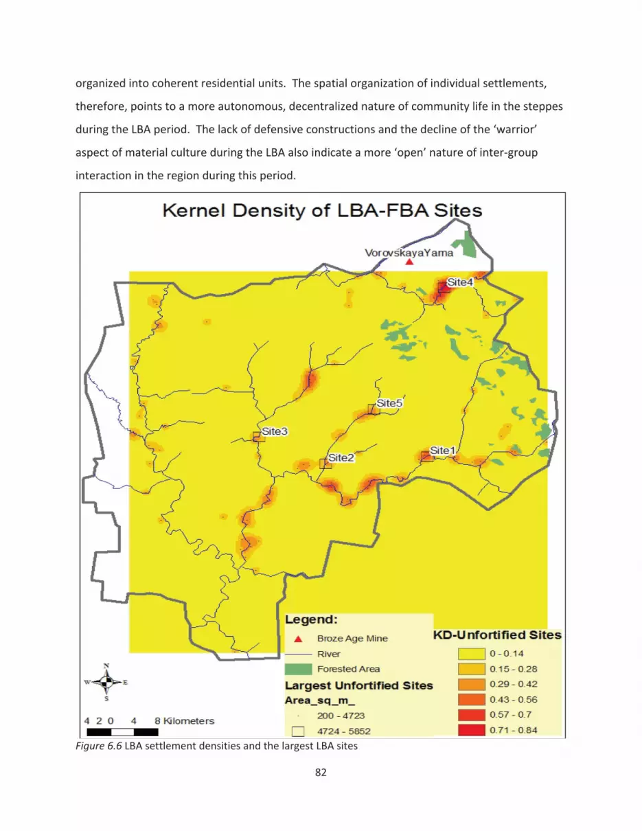
organized into coherent residential units. The spatial organization of individual settlements,
therefore, points to a more autonomous, decentralized nature of community life in the steppes
during the LBA period. The lack of defensive constructions and the decline of the ‘warrior’
aspect of material culture during the LBA also indicate a more ‘open’ nature of inter group
interaction in the region during this period.
Figure 6.6 LBA settlement densities and the largest LBA sites
82
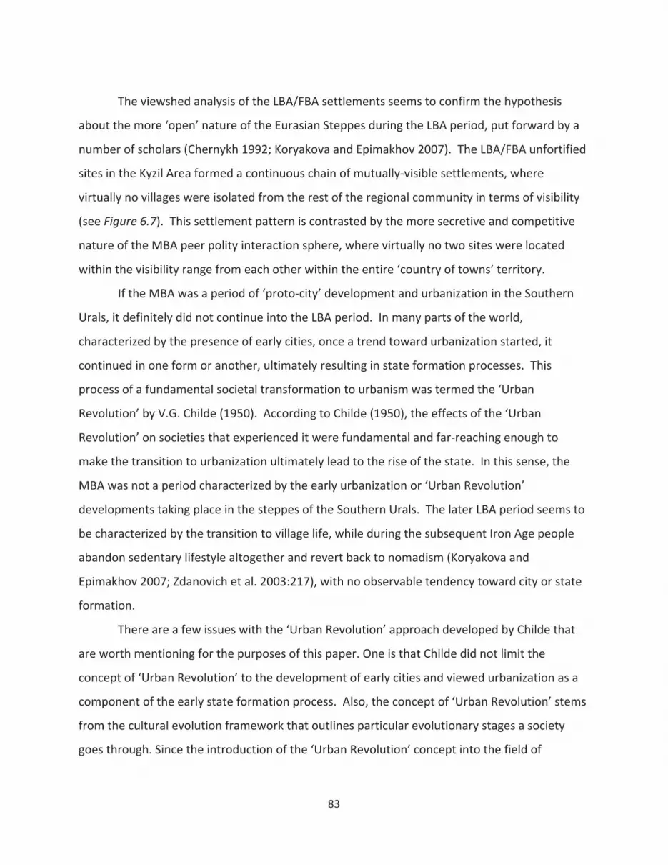
The viewshed analysis of the LBA/FBA settlements seems to confirm the hypothesis
about the more ‘open’ nature of the Eurasian Steppes during the LBA period, put forward by a
number of scholars (Chernykh 1992; Koryakova and Epimakhov 2007). The LBA/FBA unfortified
sites in the Kyzil Area formed a continuous chain of mutually visible settlements, where
virtually no villages were isolated from the rest of the regional community in terms of visibility
(see Figure 6.7). This settlement pattern is contrasted by the more secretive and competitive
nature of the MBA peer polity interaction sphere, where virtually no two sites were located
within the visibility range from each other within the entire ‘country of towns’ territory.
If the MBA was a period of ‘proto city’ development and urbanization in the Southern
Urals, it definitely did not continue into the LBA period. In many parts of the world,
characterized by the presence of early cities, once a trend toward urbanization started, it
continued in one form or another, ultimately resulting in state formation processes. This
process of a fundamental societal transformation to urbanism was termed the ‘Urban
Revolution’ by V.G. Childe (1950). According to Childe (1950), the effects of the ‘Urban
Revolution’ on societies that experienced it were fundamental and far reaching enough to
make the transition to urbanization ultimately lead to the rise of the state. In this sense, the
MBA was not a period characterized by the early urbanization or ‘Urban Revolution’
developments taking place in the steppes of the Southern Urals. The later LBA period seems to
be characterized by the transition to village life, while during the subsequent Iron Age people
abandon sedentary lifestyle altogether and revert back to nomadism (Koryakova and
Epimakhov 2007; Zdanovich et al. 2003:217), with no observable tendency toward city or state
formation.
There are a few issues with the ‘Urban Revolution’ approach developed by Childe that
are worth mentioning for the purposes of this paper. One is that Childe did not limit the
concept of ‘Urban Revolution’ to the development of early cities and viewed urbanization as a
component of the early state formation process. Also, the concept of ‘Urban Revolution’ stems
from the cultural evolution framework that outlines particular evolutionary stages a society
goes through. Since the introduction of the ‘Urban Revolution’ concept into the field of
83
archaeology, it has been recognized that the generalizations and regularities of the cultural
evolution framework cannot be applied universally (Smith 2009:5).
Figure 6.7 Cumulative viewshed of LBA/FBA sites
It is important to distinguish cultural evolution, a concept referring to social change
through time, from neo evolutionism, which attempts to uniformly apply developmental stages
or categories to various societies in order to measure the level of their progressiveness (Yoffee
2005:6). Does the fact that the fortified settlements of the Southern Urals did not fit into a
84
neo evolutionary trajectory of urbanization and state development mean they were not ‘proto
cities’? Early cities and states were dynamic entities that could transform or disassemble pretty
rapidly. Marcus (1992), for instance, emphasized the spatial and temporal fluctuations
between centralization and decentralization in the ancient Maya state. Yoffee (2005:137)
discusses the constant restructuring of the countryside and the changing power dynamics
between rural communities and urban centers in the context of early states. But there was no
state formation in the Southern Urals in the Bronze Age and whether using Childe’s definition
of ‘Urban Revolution’ or any other characteristics of early urban centers, the MBA fortified
settlements were not cities. Whether they were ‘proto cities’ that could have eventually
developed into full fledged urban centers remains a historical speculation.
Although urbanism took many forms in different parts of the world and there is no
widely agreed upon definition of what exactly constitutes a city, the analysis outlined above
does point to certain conclusions regarding the possibility of urbanization processes taking
place in the Southern Urals during the MBA LBA transition. The MBA settlements in the
Southern Urals do not appear to be the manifestations of early cities or urban centers, but
rather temporary organized clusters of households, which disassembled once the political and
economic situation in the region had changed. The individual settlement size, the internal
spatial organization of settlements, and the territorial distribution of individual sites all suggest
against the presence of a ‘proto city’ development in the Southern Urals during the LBA.
Furthermore, the LBA settlements in the Southern Urals do not seem to adhere to the early
“urban cluster” model of West Africa and China, since the key to the urbanization
developments in these regions connected with craft specialization at the community level
(McIntosh 1991:206), which was not observed among the Srubnaya Alakul settlements
(Koryakova and Epimakhov 2007). Therefore, the MBA LBA transition in the Southern Urals
was characterized by the disassemblement of individual town peer polities and the formation of
an open network of decentralized pastoralist villages.
6.4.4 New social order: collective control over resources
As stated above, neither the MBA nor the LBA settlements appear to be randomly
distributed throughout the Kyzil Area. While all of the Bronze Age sites, with a few exceptions,
85
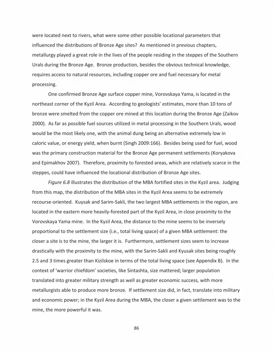
were located next to rivers, what were some other possible locational parameters that
influenced the distributions of Bronze Age sites? As mentioned in previous chapters,
metallurgy played a great role in the lives of the people residing in the steppes of the Southern
Urals during the Bronze Age. Bronze production, besides the obvious technical knowledge,
requires access to natural resources, including copper ore and fuel necessary for metal
processing.
One confirmed Bronze Age surface copper mine, Vorovskaya Yama, is located in the
northeast corner of the Kyzil Area. According to geologists’ estimates, more than 10 tons of
bronze were smelted from the copper ore mined at this location during the Bronze Age (Zaikov
2000). As far as possible fuel sources utilized in metal processing in the Southern Urals, wood
would be the most likely one, with the animal dung being an alternative extremely low in
caloric value, or energy yield, when burnt (Singh 2009:166). Besides being used for fuel, wood
was the primary construction material for the Bronze Age permanent settlements (Koryakova
and Epimakhov 2007). Therefore, proximity to forested areas, which are relatively scarce in the
steppes, could have influenced the locational distribution of Bronze Age sites.
Figure 6.8 illustrates the distribution of the MBA fortified sites in the Kyzil area. Judging
from this map, the distribution of the MBA sites in the Kyzil Area seems to be extremely
recourse oriented. Kuysak and Sarim Sakli, the two largest MBA settlements in the region, are
located in the eastern more heavily forested part of the Kyzil Area, in close proximity to the
Vorovskaya Yama mine. In the Kyzil Area, the distance to the mine seems to be inversely
proportional to the settlement size (i.e., total living space) of a given MBA settlement: the
closer a site is to the mine, the larger it is. Furthermore, settlement sizes seem to increase
drastically with the proximity to the mine, with the Sarim Sakli and Kyusak sites being roughly
2.5 and 3 times greater than Kizilskoe in terms of the total living space (see Appendix B). In the
context of ‘warrior chiefdom’ societies, like Sintashta, size mattered; larger population
translated into greater military strength as well as greater economic success, with more
metallurgists able to produce more bronze. If settlement size did, in fact, translate into military
and economic power; in the Kyzil Area during the MBA, the closer a given settlement was to the
mine, the more powerful it was.
86
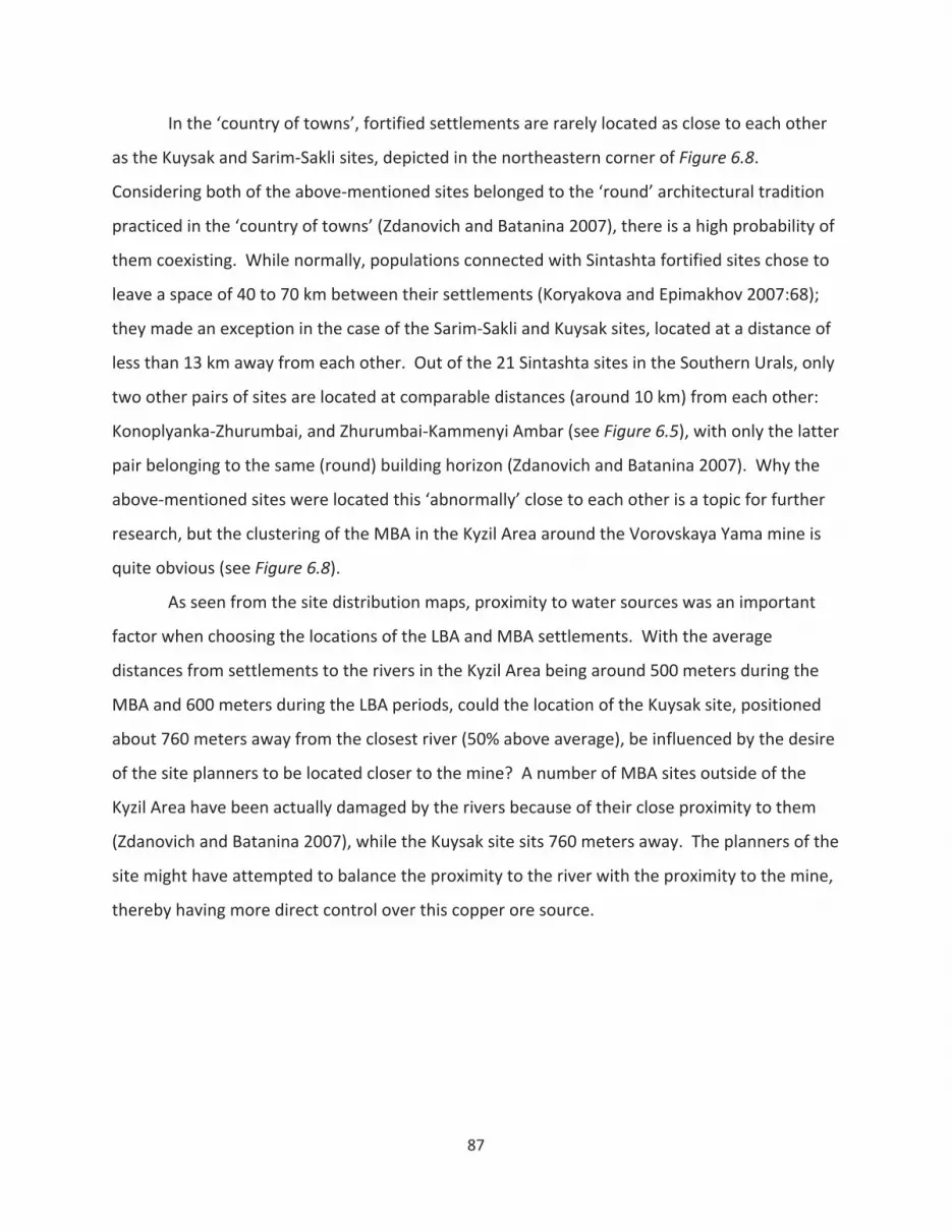
In the ‘country of towns’, fortified settlements are rarely located as close to each other
as the Kuysak and Sarim Sakli sites, depicted in the northeastern corner of Figure 6.8.
Considering both of the above mentioned sites belonged to the ‘round’ architectural tradition
practiced in the ‘country of towns’ (Zdanovich and Batanina 2007), there is a high probability of
them coexisting. While normally, populations connected with Sintashta fortified sites chose to
leave a space of 40 to 70 km between their settlements (Koryakova and Epimakhov 2007:68);
they made an exception in the case of the Sarim Sakli and Kuysak sites, located at a distance of
less than 13 km away from each other. Out of the 21 Sintashta sites in the Southern Urals, only
two other pairs of sites are located at comparable distances (around 10 km) from each other:
Konoplyanka Zhurumbai, and Zhurumbai Kammenyi Ambar (see Figure 6.5), with only the latter
pair belonging to the same (round) building horizon (Zdanovich and Batanina 2007). Why the
above mentioned sites were located this ‘abnormally’ close to each other is a topic for further
research, but the clustering of the MBA in the Kyzil Area around the Vorovskaya Yama mine is
quite obvious (see Figure 6.8).
As seen from the site distribution maps, proximity to water sources was an important
factor when choosing the locations of the LBA and MBA settlements. With the average
distances from settlements to the rivers in the Kyzil Area being around 500 meters during the
MBA and 600 meters during the LBA periods, could the location of the Kuysak site, positioned
about 760 meters away from the closest river (50% above average), be influenced by the desire
of the site planners to be located closer to the mine? A number of MBA sites outside of the
Kyzil Area have been actually damaged by the rivers because of their close proximity to them
(Zdanovich and Batanina 2007), while the Kuysak site sits 760 meters away. The planners of the
site might have attempted to balance the proximity to the river with the proximity to the mine,
thereby having more direct control over this copper ore source.
87
Figure 6.8 Distribution of the MBA fortified settlements
The Vorovskaya Yama mine almost falls within the viewshed of the Kuysak location (see
Figure 6.9). The vewsheds, or visibility range of both Kuysak and Sarim Sakli sites are depicted
in the Figure 6.10. Judging from Figure 6.10, the residents of the Kuysak and Sarim Sakli
settlements probably controlled access to the mine and could have military forces on site in a
short period of time in case of an unauthorized mining attempt by the neighboring tribes.
88

Figure 6.9 Viewshed from the Kuysak site
89
Figure 6.10 Viewshed from Kuysak and Sarim Sakli sites
The Least Cost Paths (LCPs) based on elevation data, point to the possibility of the
Kyusak settlement being located in a strategically advantageous position at the crossing of
Bronze Age communication/trade routes (see Figure 6.11). Assuming the MBA sites’
90
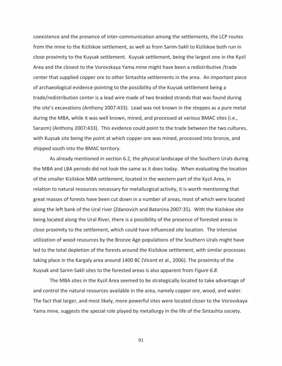
coexistence and the presence of inter communication among the settlements, the LCP routes
from the mine to the Kizilskoe settlement, as well as from Sarim Sakli to Kizilskoe both run in
close proximity to the Kuysak settlement. Kuysak settlement, being the largest one in the Kyzil
Area and the closest to the Vorovskaya Yama mine might have been a redistributive /trade
center that supplied copper ore to other Sintashta settlements in the area. An important piece
of archaeological evidence pointing to the possibility of the Kuysak settlement being a
trade/redistribution center is a lead wire made of two braided strands that was found during
the site’s excavations (Anthony 2007:433). Lead was not known in the steppes as a pure metal
during the MBA, while it was well known, mined, and processed at various BMAC sites (i.e.,
Sarazm) (Anthony 2007:433). This evidence could point to the trade between the two cultures,
with Kuysak site being the point at which copper ore was mined, processed into bronze, and
shipped south into the BMAC territory.
As already mentioned in section 6.2, the physical landscape of the Southern Urals during
the MBA and LBA periods did not look the same as it does today. When evaluating the location
of the smaller Kizilskoe MBA settlement, located in the western part of the Kyzil Area, in
relation to natural resources necessary for metallurgical activity, it is worth mentioning that
great masses of forests have been cut down in a number of areas, most of which were located
along the left bank of the Ural river (Zdanovich and Batanina 2007:35). With the Kizilskoe site
being located along the Ural River, there is a possibility of the presence of forested areas in
close proximity to the settlement, which could have influenced site location. The intensive
utilization of wood resources by the Bronze Age populations of the Southern Urals might have
led to the total depletion of the forests around the Kizilskoe settlement, with similar processes
taking place in the Kargaly area around 1400 BC (Vicent et al., 2006). The proximity of the
Kuysak and Sarim Sakli sites to the forested areas is also apparent from Figure 6.8.
The MBA sites in the Kyzil Area seemed to be strategically located to take advantage of
and control the natural resources available in the area, namely copper ore, wood, and water.
The fact that larger, and most likely, more powerful sites were located closer to the Vorovskaya
Yama mine, suggests the special role played by metallurgy in the life of the Sintashta society.
91
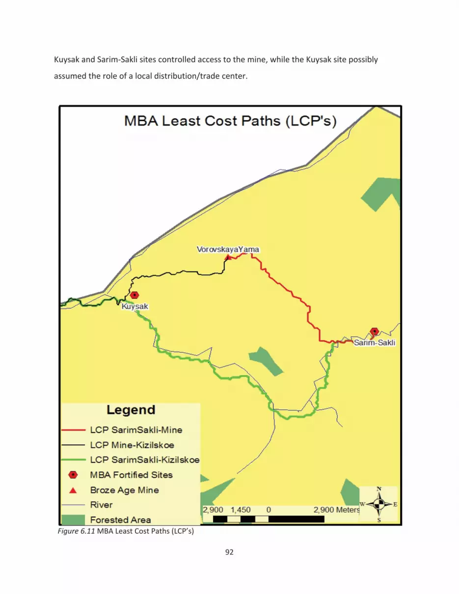
Kuysak and Sarim Sakli sites controlled access to the mine, while the Kuysak site possibly
assumed the role of a local distribution/trade center.
Figure 6.11MBA Least Cost Paths (LCP’s)
92

Figure 6.12 shows the kernel density distribution of the LBA and FBA unfortified
settlements. This density map shows the highest concentration of sites in the northeast corner
of the Kyzil area, just south of the known Bronze Age Mine (Vorovskaya Yama) and in close
proximity to the forested areas (Area 1). Overall, the LBA/FBA sites tend to be more evenly
disbursed throughout the region, when compared to the MBA sites, pointing to the decreased
focus on the control over natural resources, such as copper ore and wood. Numerous sites
outside Area 1 still process metal and use wood for fuel and construction material, but they do
not need to be in close proximity to these resources in order to take advantage of them.
The less resource oriented location of the LBA settlements is also illustrated by the
greater distances from the sites to water sources (rivers) when compared to the MBA sites,
with the LBA settlements, on average, being 100 meters farther from the closest river. The LBA
sites, some of which are located more than a kilometer away from rivers still use water, but the
site planners do not feel they need to be closer to water sources to take advantage of them;
the access to this resource is shared. Again, the tendency of physical proximity to a resource
being a factor determining access to the resource seems to be less pronounced during the LBA
period.
The shift from a restricted to a more shared form of control over resources (i.e.,
decrease in the competition over resources) is also illustrated by the overall LBA settlement
distribution pattern. The Ilchamus (or Njemps) people of Kenya, for example, went from living
in huge defended, densely packed villages to disbursed individual homesteads around AD 1900
(Hodder 1986:111). Among other reasons for this shift in settlement patterns, Hodder
(1986:112) sites the moratorium on inter tribal cattle raids, enforced by the British. Of course,
the British did not regulate the Southern Urals during the MBA LBA transition, but the level of
competition over resources seemed to decrease during that period, as evidenced by the decline
in the warfare aspect of the material culture. The assumption that warfare can be equated
with competition over resources stems from the fact that throughout human history, the
ultimate purpose of any warfare activity, while disguised by various ideological, religious, or
other motives, seemed to entail some form of competition for economic resources (i.e., land,
labor, capital).
93
Figure 6.12 Kernel Density distribution of the LBA/FBA unfortified settlements
The spatial analysis outlined above may indicate the presence of some social
mechanism, other than warfare, ensuring the distribution of resources throughout the Kyzil
Area during the LBA period. The Srubnaya Alakul populations did not rely on physical proximity
94
to resources (i.e., copper ore, wood, water) to the level that the Sintashta population did during
the MBA period, when determining settlement locations. Proximity to the mine, for example,
did not seem to influence settlement size during the LBA period. Overall, the analysis outlined
above seems to confirm the hypothesis that argues for the changing nature of control over
natural resources (namely, metal ores) as one of the primary driving forces behind the MBA
LBA transition.
6.5.5 Spatial distribution of kurgan cemeteries
Eurasian steppe cultures built earthen mounds ranging from 10 m to 110 m in diameter,
called kurgans, on top of burials (Anthony 2007:329). Kurgans, found lone standing as well as in
groups, vary in size and location, and are generally associated with burials, sacrifices, and
ritualistic activity. This form of burial was also practiced in the Kyzil Area. Numerous Bronze
Age kurgans, which contributed to the creation of the local ritual landscape, were located close
to settlements, along rivers, as well as in the open steppe. Besides being tombs built to house
the dead, did kurgans play other roles in the lives of the people living in the Southern Urals
region?
Kurgans, which undoubtedly stood out from the monotonous physical landscape of the
steppes and took considerable time and energy to build, were among the earliest monuments
constructed in the steppes. Monumental architecture is “defined not only by what is built but
also by the interpretations – and therefore the intentions – of those who build and use it”
(Richards 2000:542). According to Kantner (2007:59), a monument is a construct of human
perception of space and place, meaning and memory. Monuments, which influenced the
spatial and temporal rhythms of human life, are referred to by Julian Thomas as “forces of
social stability and the maintenance of tradition” and “means by which landscape was
socialized” (Thomas 2001: 177). Undoubtedly, kurgans fulfilled all of the above mentioned
functions to some degree.
Earthen mounds, associated with the Native American “mound building” tradition,
some of which, like kurgans, were essentially conically shaped burial mounds, are speculated to
have reflected secular and cosmological beliefs, marked territory, and reinforced ideologies
(Pauketat and Alt 2003:151). According to Pauketat and Alt, earthen mounds belonging to the
95

Mississippian tradition were imbued with cosmological symbolism and served as “inscriptions
of social memory in space” (2003:161). Kurgan burials in the steppes must have also been
associated with a high degree of symbolic meaning and played a role in how ritual landscape
was constructed and perceived by the local populations.
Anthony (2007:332) notes that the biggest kurgans in the Eurasian Steppes were not
always built over the richest graves, with more numerous and more elaborate burial goods
frequently occurring in smaller kurgans. This fact indicates a possible broader socio ritualistic
function of these constructions than simply a status marker of elite individuals buried in them.
Anthony discusses kurgans possibly functioning as a claim to territory, and indicating the
transition of pastures from being “wild and free” to “cultured and owned” resources (Anthony
2007:323).
Figure 6.13 illustrates the Kernel Density Estimation (KDE) distribution of the groups of
Bronze Age kurgans, while Figure 6.14 depicts the KDE distribution of all of the Bronze Age
settlements in the Kyzil Area. Overall, the density distribution of settlements does not seem to
correspond to the density distribution of kurgan cemeteries, except for Area 1. Figures 6.13
and 6.14 illustrate that kurgan burials were not necessarily cemeteries in the modern western
sense, which would entail them being conveniently located close to the settlements. The use
of criteria other than the proximity to the settlements in choosing the locations for kurgan
burials may indicate kurgans serving functions other than community cemeteries, such as
territorial markers, or the presence of a belief system where the realm of the dead was to be
kept at some distance from the domain of the living.
The domestication of the horse added a great level of dynamism to the Eurasian Steppe
landscape. The patterns of movement between and around monuments probably played a
major role in how the ritual landscape of the steppes was constructed and perceived. How do
the Bronze Age kurgans fit into the possible communication/trade routes present in the Kyzil
Area?
Figures 6.13makes it apparent that Bronze Age kurgan cemeteries in the Kyzil Area
seem to cluster around rivers. Rivers are great navigational devices and it is possible that
prehistoric communication routes ran along these water bodies. If a person followed a river,
96

97
knowing that the next settlement is located along it, it would have been hard to get lost,
whether in the day or night time. The people of the Yurok Native American tribe, for instance,
spatially place everything in terms of rivers, where up or down the river are the primary
directions (Campbell 1999:45). The Evenk people of Southeastern Siberia also practice an
orientation system where the sense of direction is tied to rivers (Lavrillier 2005).
If traveling over long distances on horseback or in a chariot through the arid steppe,
which the MBA as well as LBA people of the Southern Urals undoubtedly did, it made sense to
stay along water bodies to hydrate your horse(s). Horses need to drink between five to ten
gallons of water on the daily basis, with hydration becoming crucial for a horse after continuous
exercise (Nyman 2002). Thereby, the territories adjacent to rivers, aside from being the life
arteries of the steppe with respect to the settlement distribution, might have served the
function of Bronze Age roads.
The least costly paths between the MBA fortified settlements obtained through running
the Least Cost Path (LCP) analysis in GIS, which calculated the least costly route to travel with
respect to slope, seem to, for the most part, run along rivers. Assuming that the MBA sites
coexisted and there was a certain level of communication among the fortified settlements, it
could be useful to examine the possible pathways between the Sintashta settlements in the
Kyzil Area and how they relate to kurgan cemeteries. Figure 6.15 depicts the LCP routes
between the three MBA settlements and the Vorovskaya Yama mine with respect to the Kernel
Density distribution of kurgan cemeteries in the Kyzil Area.
With respect to kurgan distributions, one feature of the LCP routes, depicted in Figure
6.15, is peculiar. All three of the LCP routes between the three MBA settlements run through
two of the most dense kurgan clusters in the Kyzil Area, pointing to the possibility that the
Bronze Age cultures located their cemeteries along roads. Furthermore, archaeological data
from the Atlas seems to confirm the possibility of the existence of routes connecting Kizilskoe
settlement with the Vorovskaya Yama mine or other MBA settlements. Figure 6.16 does not
only indicate the presence of ancient roads starting at the Kizilskoe settlement and running in
the northward direction, but also the fact that at least one of these roads went directly through
the kurgan cemetery.

Figu
re6.13
KernelDen
sity
ofBron
zeAge
kurgans
Figu
re6.14
KernelDen
sity
ofBron
zeAge
settlemen
ts
98
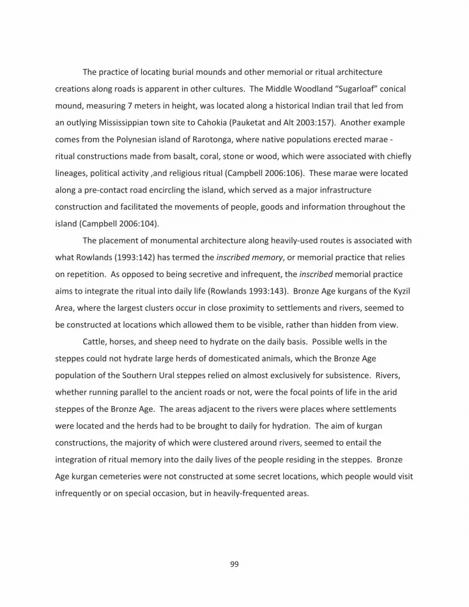
The practice of locating burial mounds and other memorial or ritual architecture
creations along roads is apparent in other cultures. The Middle Woodland “Sugarloaf” conical
mound, measuring 7 meters in height, was located along a historical Indian trail that led from
an outlying Mississippian town site to Cahokia (Pauketat and Alt 2003:157). Another example
comes from the Polynesian island of Rarotonga, where native populations erected marae
ritual constructions made from basalt, coral, stone or wood, which were associated with chiefly
lineages, political activity ,and religious ritual (Campbell 2006:106). These marae were located
along a pre contact road encircling the island, which served as a major infrastructure
construction and facilitated the movements of people, goods and information throughout the
island (Campbell 2006:104).
The placement of monumental architecture along heavily used routes is associated with
what Rowlands (1993:142) has termed the inscribed memory, or memorial practice that relies
on repetition. As opposed to being secretive and infrequent, the inscribedmemorial practice
aims to integrate the ritual into daily life (Rowlands 1993:143). Bronze Age kurgans of the Kyzil
Area, where the largest clusters occur in close proximity to settlements and rivers, seemed to
be constructed at locations which allowed them to be visible, rather than hidden from view.
Cattle, horses, and sheep need to hydrate on the daily basis. Possible wells in the
steppes could not hydrate large herds of domesticated animals, which the Bronze Age
population of the Southern Ural steppes relied on almost exclusively for subsistence. Rivers,
whether running parallel to the ancient roads or not, were the focal points of life in the arid
steppes of the Bronze Age. The areas adjacent to the rivers were places where settlements
were located and the herds had to be brought to daily for hydration. The aim of kurgan
constructions, the majority of which were clustered around rivers, seemed to entail the
integration of ritual memory into the daily lives of the people residing in the steppes. Bronze
Age kurgan cemeteries were not constructed at some secret locations, which people would visit
infrequently or on special occasion, but in heavily frequented areas.
99
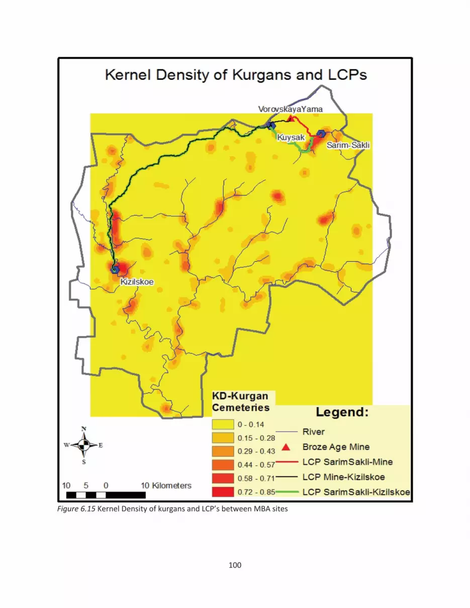
Figure 6.15 Kernel Density of kurgans and LCP’s between MBA sites
100
Figure 6.16 Plan of the Kizilskoe settlement. 1 – defensive walls; 2 – moat; 3 – earlier housingdepressions; 4 – later period housing depressions; 5 – kurgans of the Kizilskoe kurgan cemetery; 6 –stone/rock wall; 7 – ancient roads; 8 – oval linear ground depressions; 9 – internal moat. Source:(Zdanovich and Batanina 2007).
101
The “groups of kurgans” or “kurgan cemeteries”, the density distribution of which is
depicted in Figure 6.13, are accompanied by an estimated ‘Bronze Age’ chronological
attribution in the Atlas. Therefore, it is not known at this point, during which part of the Bronze
Age a particular group of kurgans was erected. Considering the Southern Urals was a peripheral
territory of the Yamnaya culture during the Early Bronze Age, and the population was
progressively more dense in the MBA and the LBA periods (as indicated by the settlement
evidence and general population growth estimates); the majority of kurgans depicted in Figure
6.15 were probably erected at the time of the existence of the Sintashta and Srubnaya Alakul
cultures. According to Epimakhov, massive intrusion of the kurgan ritual into the Southern
Urals region took place during the MBA period, with earlier Yamnaya kurgans cemeteries being
rare exceptions (Epimakhov 2002:34). Furthermore, due to a relatively short period of the
Sintashta culture’s presence in the area, a substantial portion of these kurgans were probably
erected during the Late and Final Bronze Age periods.
As already mentioned, the density distribution of Bronze Age kurgan groups does not
seem to fit the density distribution of Bronze Age settlements, over 90% of which belong to the
LBA and FBA periods. According to Koryakova and Epimakhov (2007:75), Sintashta burial
grounds adhered to the model “one settlement – one cemetery”, with MBA kurgan burials,
such as Bolshekaraganski Mogilnik, located at a distance of about one kilometer away from the
fortified settlement of Arkaim. If the LBA cultures of the Southern Urals adhered to the similar
spatial pattern of burial ground location, the distribution of Bronze Age kurgans would look
different from that depicted in the Figure 6.13. The largest cluster of kurgan cemeteries seems
to be located close to the Kizilskoe MBA settlement (see Figure 6.15). This settlement likely
was the oldest permanent settlement in the Kyzil Area, since it belonged to the “oval” building
horizon of the Sintashta culture, which based on stratigraphic observations, is considered to be
the earliest out of the three MBA architectural traditions (Zdanovich and Batanina 2007:184).
With the massive kurgan burial ritual being introduced into the Southern Urals during the MBA
period (Epimakhov 2002), and the Sintashta culture constructing their cemeteries close to
settlements, the earliest kurgans in the Kyzil Area were probably erected close to the Kizilskoe
settlement. Therefore, it seems Srubnaya Alakul population recognized Sintashta as ancestors
102
and kept adding their kurgans to the earlier kurgan cemeteries, which already existed in the
area, thereby gradually forming the largest kurgan cluster, located in the western part of the
Kyzil Area close to the Kizilskoe settlement (Area 2, Figure 6.13) .
Monument construction implies commitment to memory and to interact with
monuments from the past is to engage in the act of remembrance (Campbell 2006:102).
Monumental architecture, while universally linked to memory creation, may play an important
role in establishing genealogy and self identification links (Tilley 1996). In the case of
Rarotonganmarae, constructed along the main island road, monumental architecture was
linked to Tangi’ia – the common ancestor of all islanders (Campbell 2006:107). The possibility
of the LBA populations adding their kurgans to the existing MBA cemeteries may indicate a
certain level of cultural continuity between the two cultures, with the Srubnaya Alakul
populations recognizing Sintashtians as revered ancestors.
The Kizilskoe settlement is located at the western periphery of the ‘country of towns’
(see Figure 6.5). Beyond Kizilskoe, further west laid a territory belonging to the neighboring
potentially hostile tribes. The clustering of kurgans along the western Sintashta ‘border’ might
not be coincidental. If burial mounds did serve as territory markers or claim to property as
suggested by some (Anthony 2007; Pauketat and Alt 2003), it would make sense for
Sintashtians to build a chain of kurgan cemeteries along the borders of the ‘country of towns’
to let the neighboring populations know who the territory belonged to. Area 2 in Figure 6.13
might represent such a ‘kurgan border’. Although the distribution of cemeteries during the
MBA is assumed to follow a “one settlement one cemetery” pattern (Epimakhov 2002), most of
the kurgans in the Kyzil Area are unexcavated and it is possible that this ‘rule’ does not hold up
in some instances. The presence of another large cluster of kurgans (largest in the area) next to
the Stepnoe, northern most Sintashta settlement (see Figure 6.5), confirms the possibility of
kurgans serving as territorial markers. While the chronological attribution of the kurgans
composing Area 2 (see Figure 6.13) is unknown; the ‘territorial marker’ hypothesis would
suggest most of them belonging to the MBA period, which cannot be outruled until these
kurgans are excavated. Considering the possibility of most of these burial mounds belonging to
the LBA or FBA populations, Sintashta’s descendants might have still attempted to maintain the
103

territorial sovereignty of the “country of towns” or simply continue adding their burials to the
existing kurgan cemeteries.
In conclusion, the spatial analysis of kurgan cemeteries in the Kyzil Area confirms a
certain level of cultural continuity between the Sintashta and Srubnaya Alakul cultures, which,
in turn, undermines a strictly migration based explanation for Sintashta culture’s disappearance
from the Southern Urals. Kurgan cemeteries, which were erected with the intention to be seen
by the local, as well as neighboring populations, possibly served as territorial or border markers.
These early monuments of the steppes, a significant portion of which was likely constructed
along ancient communication routes, aimed to integrate ancestral memory into the daily lives
of Bronze Age populations of the Southern Urals.
104

7 Conclusions
Previous explanations behind the MBA LBA transition in the Southern Urals included
climate shifts and large scale migration processes. The MBA settlements were assumed to be
manifestations of early urban centers in the region, as indicated by the terms ‘country of towns’
and ‘proto city’ used to describe the Sintashta cultural development in various archaeological
literature sources. Although the increase in the intensity of the exploitation of metallurgical
resources during the MBA LBA transition has been documented throughout the Eurasian
Steppes by Russian scholars (Chernykh 1992), the changing nature of control over natural
resources during this period has not been examined from a settlement pattern perspective.
Kurgans were assumed to serve the purpose of cemeteries or necropolises, with any other
possible explanations of these monumental phenomena remaining at the level of speculation.
This thesis, and the Kyzil Area case study in particular, have attempted to address all of
the issues mentioned above in an empirical manner. Various methodological and theoretical
approaches associated with both Russian and Anglo American schools of archaeological
thought have been incorporates into the analysis to a varying degree. The culture historical
typologies developed by Russian archaeologists have been relied upon to a great extent in the
analysis of cultural developments taking place in the Southern Urals throughout the Bronze
Age. The Kyzil Area case study incorporated processual theoretical approaches into the analysis
by evaluating settlement locations in relation to environmental resources and reconstructing
regional paleodemographic dynamics based on quantitative settlement data. The utilization of
the Anglo American postprocessual approaches is evident in the incorporation of the GIS
techniques that address phenomenological aspects of landscape perception, such as the
Visibility and Cost Surface Analyses. The examination of the role played by metallurgical craft
specialization in the MBA LBA transition could be, at least in part, attributed to the Marxist
approach, utilized by Soviet as well as Anglo American post processual archaeologists.
What the Kyzil Area GIS based analysis illustrated is that the transformation of the
Sintashta archaeological culture into the Srubnaya Alakul cultural complex could not have been
a result of autonomous demographic growth processes. Paleodemographic estimates based on
settlement evidence indicate that populations, which lived either in the “country of towns” or
105

in the neighboring regions as mobile pastoralists during the MBA, adopted sedentary lifestyle
during the LBA period. In other words, groups other than the ones associated with the
Sintashta culture participated in the formation of the Srubnaya Alakul LBA population in the
Kyzil Area; and the MBA LBA transition, in settlement terms, entailed more than people moving
out of the fortified towns into unfortified villages.
The settlement evidence also points to a decreased focus on control over natural
resources by individual sites during the MBA LBA transition. Proximity to and control over
natural resources, namely copper ore and wood, seemed to play a large of a role in determining
settlement locations during the MBA period, with physical proximity to resources influencing
the size and economic success of MBA sites. The LBA period was characterized by a more open
access to natural resources, with proximity to a resource not being a decisive factor
determining site location, settlement size, or economic success of a given LBA settlement.
Furthermore, the MBA settlements in the Southern Urals do not appear to be the
manifestations of early cities or urban centers, nor is there any observable trend toward
urbanization or administrative centralization in the region during the LBA. Settlement
evidence, outlined in the Kyzil Area case study, points the MBA LBA transition in the Southern
Urals being characterized by the disassemblement of competitive town peer polities and the
formation of an open network of decentralized pastoralist villages.
The spatial analysis of kurgan cemeteries in the Kyzil Area confirms a certain level of
cultural continuity between the Sintashta and Srubnaya Alakul cultures, which, in turn,
undermines a migration based explanation for Sintashta culture’s disappearance from the
Southern Urals. In culture historical terms, kurgan distributions in the Kyzil Area suggest a
possible ‘genetic’ continuity between Sintashta and the subsequent LBA FBA cultures residing
in the Southern Urals. Kurgan monumental constructions likely served as territorial or border
markers and were constructed along ancient communication routes, thereby integrating
ancestral memory into the daily lives of Bronze Age populations.
While climatic shifts and migration processes played a role in the lives of the Southern
Urals populations, what, for the most part, drove the MBA LBA transition was the spread of
metallurgical knowledge and the discovery of alternate copper ore resources in various regions
106
of the Eurasian Steppes. Sintashta fortified settlements ceased to exist because they lost their
monopoly over technical knowledge and resources necessary for bronze production. Social
mechanisms other than warfare began playing a bigger role in resource distribution activities
during the MBA LBA transition.
The data, relied upon in this work, is somewhat incomplete and could definitely be
expanded upon for the purposes of future follow up research. One aspect has to do with the
methodology utilized in creating the Archaeological Atlas of Chelyabinsk District. The methods
used in locating archaeological sites, other than kurgans, in the Southern Urals have been, for
the most part, aerial photographs confirmed by subsequent helicopter flyovers and on the
ground follow up inspections (Koryakova and Epimakhov:XVII). The use of other remote
sensing techniques and carrying out pedestrian surveys can possibly lead to the discovery of
new sites, thereby altering or adding to our understanding of the region’s archaeological
heritage. Also, partial excavations or detailed inspections of certain sites listed in the Atlas
could help clear up some speculations and assumptions, relied upon in the settlement pattern
analysis of the Kyzil Area, thereby providing us with a more accurate picture of the Bronze Age
in the Southern Urals.
107
References:
Alcock S. E. and Cherry J.F. (editors)2004 Side by Side Survey: Comparative Regional Studies in the Mediterranean World. OxbowBooks, Oxford.
Anthony, D.W.1990 Migration in archaeology: The baby and the bath water. American Anthropologist 92:
895 914.
Anthony, D.W.2007 The Horse, the Wheel, and the Language: How Bronze Age Riders from the EurasianSteppes Shaped the Modern World. Princeton University Press.
Barker, G. and Mattingly, D. (editors)1999 The Archaeology of Mediterranean Landscapes, Vol. 3. Oxbow Books, Oxford.
Berezkin, Y. E.1995 Arkaim kak zeremonialnyi zentr: vzgyad amerikanista. Arheologicheskiye Izyskaniya, 25:29 39.
Billman, Brian R.1999 Settlement Pattern Research in the Americas: Past, Present, and Future. InSettlement Pattern Studies in the Americas. Billman, B.R. and Feinman, G.M. eds. pp 1 9.Smithsonian Institution Press, Washington.
Blanton R.E., Kowalewski, S.A., Feinman G.M., and Appel, J.1982 Monte Alban’s Hinterland, part I: The Prehispanic Settlement Patterns of theCentral and Southern Oaxaca, Mexico. Memoirs of the Museum of Anthropology, 15.University of Michigan, Ann Arbor.
Budd, P. and Taylor, T.1995 The Faerie Smith Meets the Bronze Industry: Magic Versus Science in the Interpretationof Prehistoric Metal Making. World Archaeology 27 (1): 133 143.
Burmeister, S.2000 Archaeology and migration: approaches to an archaeological proof of migration.Current Anthropology 42(4): 539 567.
Campbell P.D.1999 Survival Skills of Native California. Gibbs Smith Publishing, Utah.
108

Campbell, M.2006 Memory and monumentality in the Rarotongan landscape. Antiquity, 80(307): 102 117.
Chapman, H.2006 Landscape Archaeology and GIS. Tempus Publishing, Great Britain.
Chernykh, E.N.1978 Mettalurgicheskiye provintsiyi I periodizatsiya epokhi rannego metalla na territoriyiSSSR. Sovetskaya Arkheologiya 4: 53 81.
Chernykh , E.N. and Kuzminykh S.V.1989 Drevnyaya metallurgiya Severnoi Evrazii (seiminsko turbinskij fenomen). NaukaPublishing, Moscow.
Chernykh, E.N.1989 Metall I drevniye kulturi: uzloviyje problem issledovaniya. Nauka Publishing, Moscow.
Chernykh, E.N.1992 Ancient metallurgy in the USSR: The Early Metal Age. Cambridge UniversityPress, New York.
Chernykh, E. N.1997a Kargaly: Krupneiishii Gornometallurgicheskii Kompleks Severnoi Evrazii V Drevnosti,Rossiiskaia Arkheologiia, 1:21 36.
Chernykh, E. N.1997b Kargaly: Zabytyi Mir. Nokh Publishing, Moscow.
Chernykh, E.N.2002 The kagaly Phenomenon: Some Paradoxes and a Functional Interpretation. In KargalyInternational Field Symposium, pp. 87 88.
Chernykh, E.N.2009 Formation of the Eurasian Steppe Belt cultures: viewed through the lens ofarchaeometallurgy and radiocarbon dating. In Social Complexity in Prehistoric Eurasia:Monuments, Metals, and Mobility, edited by Hanks, B.K. and Linduff, K.M., pp. 115 146.Cambridge University Press, New York.
Cherry J.F.1987 Power in space: archaeological and geographical studies of the state. In Landscape andculture: geographical and archaeological perspectives, edited by Wagstaff, J.M., pp. 146172. Blackwell Publishing, Oxford.
109

Chibilyov A.A.2002 Steppe and Forest Steppe. In The Physical Geography of Northern Eurasia, ed. M.Shahdehanova, 248 66. New York: Oxford University Press.
Childe, V.G.1929 The Danube in Prehistory. Oxford University Press, Oxford.
Childe, V.G.1950 The Urban Revolution. Town Planning Review, 21:3 17.
Clark J.E. and Blake, M.1994 The power of prestige: Competitive generosity and the emergence of rank societies inLowland Mesoamerica. In Factional competition and political development in the NewWorld, edited by Brumfiel, E. M. and Fox, J. W., pp. 17–30. Cambridge Univ. Press,Cambridge.
Cohen, M. N.1985 Prehistoric hunter gatherers: the meaning of social complexity. In Prehistoric HunterGatherers: The Emergence of Cultural Complexity, edited by T.D. Price and J.A. Brown pp.99 119. New York: Academic Press.
Connoly, J. and Lake, M.2006 Geographic Information Systems in Archaeology. Cambridge University Press,Cambridge.
Demoule, J.1999 Ethnicity, culture and identity: French archaeologists and historians. ANTIQUITY,73(279), 190 198.
Dobres, M.A.2000 Technology and Social Agency. Blackwell Publishers. Oxford, UK.
Downs R. and Stea D.1977 Maps in mind: reflections on cognitive mapping. Harper Row, New York.
Epimakhov, A. V.2002 Yuzhnoe Zauralye v Epohu Sredney Bronzi (Southern Urals during the Middle BronzeEpoch). Izdatelstvo YUUrGU, Chelyabinsk, Russia.
Epimakhov, A.V.2009 : .
, . 3: 92 104.
110
Filrose, E.M.1999 Forests of museum/national park Arkaim: ecological systems of the Southern Urals.Museum “Arkaim”, Chelyabinsk, Russia.
Frachetti, M. D.2008 Pastoralist Landscapes and Social Interaction in Bronze Age Eurasia. University ofCalifornia Press.
Galloway, P. R.1986 Long term fluctuations in climate and population in the preindustrial era. Populationand Development Review 12:1 24.
Geib, P. R.2000 Sandal types and Archaic prehistory on the Colorado Plateau. American Antiquity 65:509–524.
Goldina, R.D.1999 Drevnyaya I srednevekovaya istoriya udmurtskogo naroda. Udmurt State University,Izhevsk.
Grigoryev, S.A.2002 The Sintashta Culture and Indo European Problem. In Complex Societies of CentralEurasia from the 3rd to the 1st Millennium BC. Jones Bley, K. and Zdanovich D. Institute forStudy of Man, Washington D.C.
Hakenbeck, S.2008 Migration in archaeology: are we nearly there yet? Archaeological Review fromCambridge, 23(2): 9 26.
Hanks, B. , Epimakhov, A. , & Renfrew, A.2007 Towards a refined chronology for the bronze age of the southern Urals, Russia.Antiquity, 81 (312):353 367.
Hanks, B.K.2009 Late Prehistoric Mining, Metallurgy, and Social Organization in North Central Eurasia.In Social Complexity in Prehistoric Eurasia: Monuments, Metals, and Mobility, edited byHanks, B.K. and Linduff, K.M., pp. 146 168. Cambridge University Press, New York.
Hanks, B. and Doonan, R.2009 From Scale to Practice: A New Agenda for the Study of Early Metallurgy on the EurasianSteppe. Journal of World Prehistory, 22:329–356.
111

Hodder, I.1986 Reading the past: current approaches to interpretation in archaeology. CambridgeUniversity Press, Cambridge.
Hudson, M.2006 Pots not people ethnicity, culture and identity in postwar Japanese archaeology.Critique of Anthropology, 26(4), 411 434.
Iannone, G.2002 Annales History and the Ancient Maya State: Some Observations on the "DynamicModel". American Anthropologist, 104 (1): 68 78.
Inomata, T.2001 The power and ideology of artistic creation: elite craft specialists in Classic Mayasociety. Current Anthropology, 42(3): 321 349.
Ivanov, I.V., and Chernyansky S.S.1996 Obschiye sakonomernosti razvitiya chernozemov. Izdatelstvo YUUrGU, Chelyabinsk,Russia.
Johnson, M.1999 Archaeological Theory: An Introduction. Blackwell Publishing, Oxford.
Jones, E.2006 Using Viewshed Analysis to Explore Settlement Choice: A Case Study of the OnondagaIroquois," American Antiquity, 71(3):523 538.
Kantner, J.2007 The Archaeology of Regions: From Discrete Analytical Toolkit to Ubiquitous SpatialPerspective, Journal of Archaeological Research, 16:37–81.
Kay, S. , & Sly, T.2001 An application of cumulative viewshed analysis to a medieval archaeological study: Thebeacon system of the Isle of Wight, United Kingdom. Archeologia E Calcolatori, 12:167 179.
Keeley, L.H.1988 Hunter gatherer economic complexity and “population pressure”: a cross culturalAnalysis, Journal of Anthropological Archaeology 7(4): 373 411.
Kellett, P. and Napier, M.1995 Squatter architecture? A critical examination of vernacular theory and spontaneoussettlement with reference to South America and South Africa. Traditional Dwellings andSettlement Review, 6: 7 24.
112
Kohl, P.H.2007 The Making of Bronze Age Eurasia. Cambridge University Press, New York.
Kohl, P.H.2007a Foreword. In The Urals and Western Siberia in the Bronze and Iron Ages. ByKoryakova, L. and Epimakhov, A.V., pp. XV XIX. Cambridge University Press, New York.
Kremenetski, K.V.2003 Steppe and forest steppe belt of Eurasia: Holocene environmental history. InPrehistoric steppe adaptation and the horse, edited by Levine, M., Renfrew C., and Boyle,K.V. pp. 11 21. McDonald Institute monographs, Cambridge UK.
Koryakova, L. and Epimakhov, A.V.2007 The Urals and Western Siberia in the Bronze and Iron Ages. Cambridge University Press,New York.
Korfmann M.1983 Demircihuyuk. Die Ergebnosse der Ausgrabungen 1975 1978. Verlag Phillip von Zaben,Mainz am Rhein.
Kovacik, M. E., & Judd M.2008 Health at Kamennyi Ambar 5. Unpublished Report, University of Pittsburgh,Department of Anthropology.
Krashennikov I.M.1951 Iz istorri razvitiya landshavtov Yuzhnogo Urala. Chelyabinsk, Russia.
Kuzmina O.V. and Sharafutdinova E.S.1995 Problemi Perehoda ot Epokhi Sredney Bronzi k Epokhe Pozdney Bronzi v VolgoUrale: Khronika Seminara (Problems of Transition from the Middle Bronze Age to the LateBronze Age in the Volgo Urals: Seminar Chronicle). In Drevniye indoiranskiye kulturi VolgoUralya (II tis. do n.e.). pp. 208 230. Izdatelstvo SamGPU, Samara, Russia.
Kuzmina E.E.2000 The Eurasian Steppes: the transition from early urbanism to nomadism. In Kurgans,Ritual Sites, and Settlements: Eurasian Bronze and Iron Age, edited by J. Davis Kimball etal., 118 25. Archaeopress, London.
Kuznetsov P.F.1996 Problemy migrazyi v razvitom bronzovom veke Volgo Uralya. In Drevnosti VolgoDonskih stepei, pp. 40 43. Peremena Publishing, Volgograd.
113
Lavrillier, A.2005 Rivers as spatial, social and ritual system of orientation among the Evenks ofSoutheastern Siberia. Etudes Mongoles Et Sibériennes, Centrasiatiques Et Tibétaines, 36:95 138.
Lindstrom, R.W.1994 Physical characteristics of paleopopulations of the Sintashta culture. ChelGU,Chelyabinsk, Russia.
Lock, G., Bell, T. and Lloyd, J.1999 Towards a Methodology for Modeling Surface Survey Data: The Sangro Valley Project.In Geographic Information Systems and Landscape Archaeology, edited by Gillings, M. etal., pp. 55 65. Oxbow Books, Oxford.
Lock, G. (editor)2000 Beyond the map: Archaeology and Spatial Technologies. NATO Science Series,Amsterdam.
Longley P.A., Goodchild M.F., Maguire D.J., and Rhind D.W.2005 Geographic Information Systems and Science, 2nd ed. John Wiley & Sons Publishing.
Marcus, J.1992 Political Fluctuations in Mesoamerica. National Geographic Research and Exploration8:393 411.
MARX, K.1906 Capital: A Critique of Political Economy. Random House Publishing, New York.
Marx, K. and Engles, F.1967 Capital: A critique of Political Economy. New York: International Publishers.
McEvedy, C. and Jones, R.1978 Atlas of World Population History. Blackwell Publishing, New York.
McIntosh, R.J.1991 Early urban clusters in China and Africa: the arbitration of social ambiguity. Journal ofField Archaeology, 18(2), 199 212.
McKay, J.1968 A review of rural settlement studies for Tanzania. East African Geographic Review, 6:37 49.
114

Milner, G. R.,Wood J. W., Boldsen J. L.2000 Paleodemography. In Biological Anthropology of the Human Skeleton, Edited byKatzenberg M. A. and Saunders S. R. John Wiley and Sons Inc., New Jersey.
Miksic, J.2000 Heterogenetic cities in premodern Southeast Asia. World Archaeology, 32(1): 106 120.
Nyman, S.2002 Water intake and fluid shifts in horses : effects of hydration status during two exercisetests. Equine Veterinary Journal, 34 (2): 133 142.
Pearson, M.1995 Return of the living dead: Mortuary analysis and the new archaeology revisited.Antiquity, 69(266): 1046 1048.
Pauketat, T.R. and Alt, S.M.2003 Mounds, Memory, and Contested Missisipian History. In R.M. VanDyke and S.E. Alcock,Archaeologies of Memory, 151 179.
Peterson, D.L.2009 Production and Social Complexity: Bronze Age Metalworking in the Middle Volga. InSocial Complexity in Prehistoric Eurasia: Monuments, Metals, and Mobility, edited byHanks, B.K. and Linduff, K.M., pp. 187 215. Cambridge University Press, New York.
Popova, L. M.2006 Political pastures: navigating the steppe in the middle Volga region (Russia) during theBronze Age. PhD Dissertation, Department of Anthropology, University of Chicago.
Potemkina, T.M.1985 Bronzovyi vek lesostepnogo Pritoboly’a. Nauka Publishing, Moscow
Pyankov, I.V.2002 Arkaim and Indo Iranian Var. In Complex Societies of Central Eurasia from the 3d to the1st Millenium BC, edited by K. Jones Bley and D. Zdanovich. Institute for Study of Man,Washington D.C.
Price, D.T. and Feinman G.M.2008 Images of the Past. 5th Edition. McGraw Hill Publishing, New York, NY.
Relph, E.1976 Place and Placelessness. Pion, London.
Renfrew, C.1984 Approaches to social archaeology. Edinburgh University Press, Edinburgh.
115
Renfrew, C. and Cherry J.F., eds.1986 Peer polity Interaction and Socio Political Change, Cambridge: Cambridge UniversityPress.
Renfrew, C.2009 From myth to method: advances in the archaeology of the Eurasian Steppe. In SocialComplexity in Prehistoric Eurasia: Monuments, Metals, and Mobility, edited by Hanks, B.K.and Linduff, K.M., pp. XV XX. Cambridge University Press, New York.
Richards, C.2000 (1993) Monumental Choreography: Architecture and Spatial Representation in LateNeolithic Orkney. Reprinted in Thomas J. (ed.), Interpretative Archaeology: A Reader, 541560.
Romanova, G.P.1989 Opyt paleodemograficheskoga analiza usloviy zhizni naseleniya stepnih rayonov.Voprosi Antropologii, 82: 67 77.
Sanders, W.T., Parsons, J.R., and Satney, R.S.1979 The Basin of Mexico: Ecological Processes in the Evolution of a Civilization. AcademicPress, New York.
Smith, M. E., and Montiel, L.2001 The archaeological study of empires and imperialism in pre Hispanic central Mexico,Journal of Anthropological Archaeology, 20: 245–284.
Smith, A.2003 The political landscapes: constellations of authority in early complex polities. Universityof California Press, Los Angeles.
Smith M.E.2009 V. Gordon Childe and the Urban Revolution: a historical perpective on a revolution inurban studies. Town Planning Review, 80 (1): 3 29.
Schmidt P.R. (editor)1996 The Culture and Technology of African Iron Production, University Press of Florida,Gainesville, FL.
Sigov A.P.1968 Geomorfologiya Urala. In Geologiya SSSR, XII.M.
Singh S.2009 Physics 10: Longman Science. Pearson Education, India.
116

Sorokin V.S. and Gryaznov M.P.1966 Andronovskaya cultura. Leningrad: Nauka.
Stanley, R.S., Arnold, P.J., Barrett, T.P.1997 Formative period Settlement patterns in the Tuxtla Mountains. In Olmec to Aztec,edited by Stark, B.L. and Arnold, T.P., pp. 174 206. University of Arizona Press, Tucson.
Symonds, S.C. and Lunagomez, R.1997 Settlement System and Population Development at San Lorenzo. In Olmec to Aztec,edited by Stark, B.L. and Arnold, T.P., pp. 144 174. University of Arizona Press, Tucson.
Thomas, J.2001 Archaeologies of Place and Landscape. In Hodder I. (ed.) Archaeological Theory Today,165 181.
Tilley, C.1994 A phenomenology of landscape – places, paths and monuments. Oxford: Berg.
Tilley, C.1996 Powers of Rocks: Topography and Monument Construction on Bodmin Moor.WorldArchaeology, 28 (2): 161 176.
Tkachev V.V.2007 Stepi Yuzhnogo Priuralya i Zapadnogo Kazakhstana na Rubezhe Epokh Sredney IPozdney Bronzi (The Steppes of the Southern Urals and Western Kazakhstan during theTransition from the Middle to Late Bronze Ages). Russian Academy of Sciences, Aktobe,Kazakhstan.
Turner, E.S., Turner, N.I, Adams R.E.1981 Volumetric Assessment, Rank Ordering, and Maya Civic Centers. In Lowland MayaSettlement patterns, edited by W. Ashmore, pp. 71 88. University of New Mexico Press,Albuquerque.
Trigger, B.G.1967 Settlement Archaeology: Its Goals and Promise. American Antiquity, 32 (2): 149 160.
Trigger, B.G.2009 A History of Archaeological Thought. 2nd ed. Cambridge University Press, New York.
Tuan, Y.F.1974 Space and place: humanistic perspective. In Progress in Geography 6, edited by Board,C., Chorley R.J., pp. 211 252. Edward Arnold, London.
117
Vasilyev, I.B.1989 U istokov istorii Samarskogo Povolzhya. Kuibyshevskoe knizhnoe izd vo, Kuibyshev,Russia.
Vicent, J., Ormeno, S., Martinez Navarrete, M. I., & Delgado, J.2006 The Kargaly Project: modeling Bronze Age landscapes in the steppe. In Fromspace to place: 2nd International conference on remote sensing in archaeology, edited by S.Campana & M. Forte, pp. 279–284. BAR, Oxford.
Webster, D.1975 Warfare and the evolution of the state: a reconsideration. American Antiquity, 40(4):464 470.
Wheatley, D. and Gillings, M.2002 Spatial Technology and Archaeology. Taylor & Francis, New York.
Willey, G.R.1953 Prehistoric Settlement Patterns in the Viru Valley, Peru. In Bureau of AmericanEthnology Bulletin, Vol. 155. Washington, D.C.: Smithsonian Institution.
Witcher, R.1999 GIS and Landscapes of Perception. In Geographic Information Systems and LandscapeArchaeology, edited by Gillings, M. et al., pp13 23. Oxbow Books, Oxford.
Zaikov, V.V.2000 Vorovskaya Yama – noviy rudnik bronzovogo veka na Yuzhnom Urale. In Arheolog:istochnik I modelirovanie drevnih technologiy, edited by Zaikov, V.V., Zdanovich G.B.,Yuminov A.M. pp. 112 129. Museum Arkaim, Chelyabinsk.
Zhang, D. , Brecke, P. , Lee, H. , He, Y. , & Zhang, J.2007 Global climate change, war, and population decline in recent human history.Proceedings of the National Academy of Sciences of the United States of America, 104(49):19214 19219.
Zdanovich D.G.1997 Sintashtinskoe obshestvo: sozialniye osnovi “kvazigorodskoy” kultury YuzhnogoZauralya epokhi Sredney Bronzi. Chelyabinsk, Russia.
Zdanovich, G.B. and Batanina, I.M.1995 Atrana Gorodov – ukreplenniye poseleniya epohi Bronzi XVIII XVII v. do n. e. YuzhnoUralskoe Knizhnoe Izdatelstvo, Chelyabinsk, Russia.
118
Zdanovich, G.B. , Batanina I.M., Levit N.V., Batanin S.A.2003 Arheologicheskii Atlas Chelyabinskoi Oblasti (Archaeological Atlas of ChelyabinskDistrict). Yuzhno Uralskoe Knizhnoe Izdatelstvo, Chelyabinsk, Russia.
Zdanovich, G.B. and Batanina, I.M.2007 Arkaim – Strana Gorodov: Prostranstvo I Obrazi (Arkaim – Country of Towns: Spaceand Symbols). Yuzhno Uralskoe Knizhnoe Izdatelstvo, Chelyabinsk, Russia.
Yoffee, N.2005 Myths of the Archaic State: Evolution of the Earliest Cities, States, and Civilizations.Cambridge University Press, UK.
119

Appendices
Appendix A: Attribute data of LBA/FBA sites (total living space and number of housingdepressions). Arranged by cumulative living area.
120

121

122

123
Appendix B: Attribute data of MBA sites (total living space and number of housing depressions).