maritime archaeology of the arctic ocean and bering sea
TRANSCRIPT
▶Little, Barbara J.
▶Muckelroy, Keith (Underwater and Maritime
Archaeology)
▶Noel Hume, Ivor
▶North America (USA): Historical Archaeology
▶Oral Sources and Oral History
▶Orser, Jr., Charles E.
▶ Plantation Archaeology
▶ Plimoth Plantation: Public Archaeology
▶ Post-Medieval Archaeology
▶ Society for Historical Archaeology (SHA)
(Historical Archaeology)
▶ Society of the Ship
▶ South, Stanley A.
▶Western Europe: Historical Archaeology
References
BROWN III, M. 1978. The use of oral and documentary
sources in historical archaeology: ethnohistory at the
Mott Farm. Ethnohistory 20: 347–360.FEINMAN, G.M. 1997. Thoughts on new approaches to com-
bining the archaeological and historical records. Jour-nal of Archaeological Method and Theory 4: 367–377.
FONTANA, B. 1965. On the meaning of historic sites archae-
ology. American Antiquity 31: 83–89.HARRINGTON, J.C. 1952. Historic site archaeology in the
United States, in J.B. Griffin (ed.) Archaeology of theeastern United States: 295–315. Chicago: Universityof Chicago Press.
- 1955. Archaeology as an auxiliary science of American
history. American Anthropologist 57: 1121–30.HOOVER, R.L. 1977. Ethnohistoric Salinan acculturation.
Ethnohistory 24: 261–8.LITTLE, B.J. (ed.) 1992. Text-aided archaeology. Boca
Raton (FL): CRC Press, Inc.
- 2007. Historical archaeology, why the past matters.Walnut Creek (CA): Left Coast Press.
NEWLAND, J.D. 1997. The disciplinary viewpoint from
history and its application to historical archaeology.
Proceedings of the Society for California Archaeology10: 110–5.
ORSER, JR., C.E. 2004. Historical archaeology. Upper
Saddle River (NJ): Pearson, Prentice Hall.
PEASE, T.C. & R.C. WERNER. 1934. Statement of account
for Illinois trade. The French Foundations,1680–1693: 162–75. Springfield (IL): Illinois State
Historical Library.
REITZ, E.J. & M. SCARRY. 1985. Reconstructing historicsubsistence with an example from sixteenth-centurySpanish Florida (Special Publication series 3).
Glassboro (NJ): Society for Historical Archaeology.
PERISSINOTTO, G. 1998.Documenting everyday life in earlySpanish California: the Santa Barbara Presidio
Memorias y Facturas, 1779–1810. Santa Barbara
(CA): Santa Barbara Trust for Historic Preservation.
SCHUYLER, R.L. 1970. Historical and historic sites archae-
ology as anthropology: basic definitions and relation-
ships. Historical Archaeology 4: 83–9.- 1977. The spokenword, thewrittenword, observed behav-
ior and preserved behavior: the contexts available to the
archaeologist, in R. Schuyler (ed.) Historical archaeol-ogy: a guide to substantive and theoretical contributions:269–77. Farmingdale (NY): Braidwood Publishing.
SKOWRONEK, R.K. 1992. Empire and ceramics: the chang-
ing role of illicit trade in Spanish America. HistoricalArchaeology 26: 109–18.
SKOWRONEK, R.K & E. THOMPSON. 2006. Situating MissionSanta Clara de Asıs: 1776–1851, documentary andmaterial evidence of life on the Alta California fron-tier: a timeline. Berkeley (CA): Academy of American
Franciscan History.
SKOWRONEK, R.K. & G.R. FISCHER. 2009. HMS Fowey lost. . . and found! Gainesville (FL): University Presses of
Florida.
SOUTH, S.A. 1977.Method and theory in historical archae-ology. New York: Academic Press.
TROUILLOT, M.-R. 1995. Silencing the past: power and theproduction of history. Boston: Beacon Press.
Further ReadingLYON, E. 1984. Santa Elena: a brief history of the colony,
1566–1587 (Research Manuscript series 193). Colum-
bia: University of South Carolina, Institute of Archae-
ology and Anthropology.
Arctic Ocean and Bering Sea:Maritime Archaeology
Jason Rogers1,2 and Evguenia Anichtchenko3,4
1Department of Archaeology, University of
Exeter, Exeter, UK2Northern Land Use Research, Inc, Anchorage,
AK, USA3Centre for Maritime Archaeology, University of
Southampton, UK4Anchorage Museum, Anchorage, AK, USA
Introduction and Definition
Physical Geography, Oceanography, and
Climate
The Arctic Ocean is a unique place, with no
analogue elsewhere on the planet. As the world’s
largest confined ocean, its permanent sea-ice
Arctic Ocean and Bering Sea: Maritime Archaeology 495 A
A
cover creates a hostile and difficult environment
for human research and occupation, but is
a crucial component of global climate and the
ecology of the world ocean. The region’s ocean-
ographic characteristics, climate regime, and
human adaptations are not matched by any
other, and these factors have been emphasized
in recent years as indicators of global warming
bring dramatic changes to the Arctic.
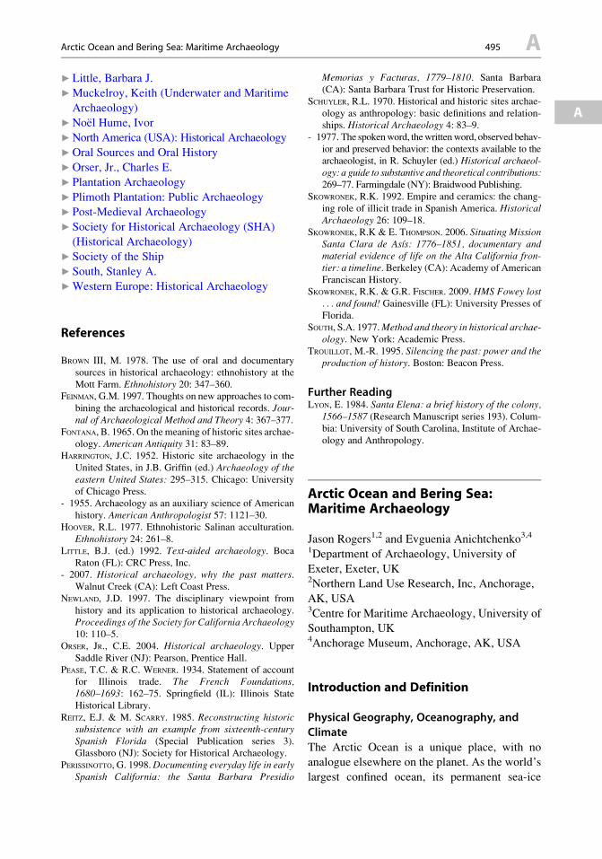
Oceanographers consider the Arctic Ocean and
its bordering seas to be the body of water sur-
rounding the North Pole and bordered by Europe,
Siberia, Alaska, Canada, and Greenland, occupy-
ing an area of approximately 14 million km2
(Fig. 1). Major island groups are found off the
European and Siberian coasts (Svalbard, Franz
Josef Land, Novaya Zemlya, Severnaya Zemlya,
and the New Siberian Islands) and throughout
Canada’s Arctic archipelago. Bordering seas are
the Barents, Kara, Laptev, East Siberian, Chukchi,
Beaufort, Greenland, and Norwegian Seas. Broad
and shallow continental shelves extend from the
European and Siberian coasts and beneath the
Chukchi Sea, but are narrower and deeper off
Arctic Ocean and Bering Sea: Maritime Archaeology, Fig. 1 Map of the Arctic Ocean and Bering Sea (Image
courtesy of Arctic Biodiversity Data Center)
A 496 Arctic Ocean and Bering Sea: Maritime Archaeology

Greenland and North America (approximately
30 % of the surface area of the Arctic Ocean is
underlain by continental shelves). Maximum
depths are attained in the two main subbasins of
the Arctic Basin (the Eurasian and Canadian, with
depths of c. 4,200 and 3,800 m, respectively). The
Arctic Ocean is connected to the North Atlantic
Ocean through Baffin Bay and the Greenland and
Norwegian Seas and to the Bering Sea and North
Pacific Ocean through Bering Strait. The largest
rivers flowing into the Arctic Ocean are the Ob,
Yenisei, Lena (Siberia), and the Mackenzie
(Canada).
The Bering Sea is bounded by Siberia on the
west, Alaska to the east, and the Aleutian Islands
chain to the south. The Bering Sea has its own
special oceanographic characteristics, being nei-
ther Arctic nor temperate, with a fairly free
exchange of water through the Aleutian arc with
the North Pacific and a quite restricted exchange
with the Arctic Ocean through the narrow and
shallow Bering Strait (c. 85 km wide and 45 m
deep). In a typical winter sea ice extends south to
the Pribilof Islands, but retreats north past Bering
Strait during the summer. The Bering Sea is one
of the most productive marine ecosystems on
earth, especially along its extensive continental
shelves.
The Arctic climate zone can be defined in
a number of different ways. Two of the most
prevalent are by latitude (above 66.56� N, the
“Arctic Circle”) and by temperature (the region
bounded by the 10� C summer isotherm) (both
shown in Fig. 1). The climate of the Arctic is
characterized by strong seasonality: long, cold,
and dark winters and short summers with long
daylight hours (Nuttall & Callaghan 2000). The
climate of the ocean itself is shaped by the year-
round presence of the Arctic pack ice and by the
physical processes of freezing and thawing of
river, lake, and sea ice. The presence of ice
cover has major influences on physical and bio-
logical processes within the ocean and atmo-
sphere, as well as implications for human use
and occupation. The Arctic Ocean is almost
entirely ice-covered during the winter, while
minimum ice extent is attained in late summer.
However, Arctic sea-ice cover has undergone
significant changes in the past two decades, with
five record minima attained between 2001 and
2007 and a small expansion in 2008–2011, but
with the lowest value ever recorded in September
2012. The trend is towards shorter ice-cover sea-
sons and thinner ice cover in general. These data
have raised speculation that the Arctic Ocean
may see entirely ice-free summers as soon as
2030 (Stroeve et al. 2012). Rapidly changing
climate conditions in the Arctic have important
ramifications for human presence and research,
as well as the archaeological record of the region.
Historical Background
Exploration and settlement of the Arctic is a very
recent endeavor in terms of overall human his-
tory, coming essentially at the tail end of over
a million years of human dispersal from Africa.
In the later Pleistocene, between approximately
45,000 and 25,000 years ago, modern humans
expanded north and east across Eurasia into new
regions. These previously unexplored habitats
included Siberia up to approximately
60� N (and potentially further on a seasonal
basis). These areas were, however, largely aban-
doned during the peak of the Last Glacial Maxi-
mum (LGM, c. 20,000–18,000 years ago)
(Hoffecker 2005). In Western Europe, the
Fenno-Scandinavian glaciers began to retreat
around 12,000 BCE, and the earliest occupations
of northern Norway are dated to c. 10,000 BP.
Many of the regional cultures arising in Scandi-
navia during the Mesolithic show a clear orienta-
tion towards maritime subsistence. The vast
expanse of Northern Eurasia was also reoccupied
during the climatic amelioration following LGM,
with a variety of Late Pleistocene and Early
Holocene cultures arising across most of Siberia.
The growth of polar ice caps and continental
glaciations during the Pleistocene resulted in sea
levels lowered as much as 120 m below those of
the modern era. During much of the Middle and
Late Pleistocene, the shallow continental shelf
between Siberia and Alaska was thus exposed as
dry land. The exposed land connection is often
referred to as the “Bering Land Bridge,” and the
Arctic Ocean and Bering Sea: Maritime Archaeology 497 A
A
region from eastern Siberia to the Yukon Terri-
tory, encompassing the now-submerged Bering
Land Bridge, is called “Beringia” (Hadleigh
West 1996).
The existence of a land bridge between Asia
and North America (and adjacent areas of
exposed continental shelf) is of paramount
importance for understanding theories of human
colonization of the Americas. Although the pos-
sibility of a maritime migration has been pro-
posed (Dixon 1999), prevailing theories favor
an overland route for the first humans in North
America. The oldest archaeological sites in
Alaska date to c. 15,000 BP, and by c. 4,500 BP
Paleo-Eskimo peoples had settled in north
Greenland.
Successful settlement of the Arctic was depen-
dent on a number of specialized technologies and
adaptations, especially those designed and used
for maritime subsistence (such as skin boats and
toggling harpoons). Tools such as the needle (for
use in tailored clothing and sewing skin boat
covers) were prerequisites for survival in the
Arctic. Equally important was a deep and intense
knowledge of the Arctic marine environment,
especially sea ice. A succession of cultures can
be seen across the North American Arctic, from
Paleo-Eskimo to Dorset and finally Thule peoples.
The Thule migration from Alaska across the
Canadian Arctic to Greenland around 1300 CE is
remarkable for its speed and distance – nearly
4,000 km from Bering Strait to Greenland, occur-
ring over a single generation, and possibly over
just a few seasons! One possible impetus for this
“dash across the top of the world” may have
been trade in metals and other goods with
Norse inhabitants of Greenland. Archaeological
investigations of sites in Canada and Greenland
show undoubted contact between Norse and
indigenous inhabitants of the Arctic. The cul-
tural affiliation of the people who encountered
the Norse in Newfoundland and Labrador is not
certain, but in the northern areas they were met
by Thule Eskimos – the ancestors of modern
Inuit peoples. The nature of these interactions
is a fascinating topic, explored by archaeologists
in Canada and Greenland (see Fitzhugh & Ward
2000; Maschner et al. 2009).
The oldest maritime sites in the Arctic
are camps and settlements of prehistoric
maritime cultures. The faunal remains discovered
in these sites suggest use of a wide variety of
maritime resources: from intertidal mollusks
and fish to seals, walrus, and whales. Construc-
tion of reliable watercraft was both a necessity
and a challenge in the treeless circumpolar envi-
ronment. Most indigenous peoples in the coastal
Arctic used skin boats: open (umiaks) and decked
(kayaks). The frames of both umiaks and kayaks
were constructed of driftwood and covered, as
a rule, with marine mammal skins. Ivory, bone,
or antler frame members were also occasionally
used, and in some cultures the cover was made of
caribou and even polar bear skins. The frames
were lashed with baleen and sinew.
The overall chronology of skin boat develop-
ment in circumpolar regions remains uncertain.
As a key element of subsistence, skin boat tech-
nology has arguably been used since the very
beginning of human population in the region.
Recent maritime migration theories suggest that
skin boats might have been a vehicle of human
expansion across Beringia c. 20,000–10,000 BP
(Dixon 1999). The oldest archaeological evi-
dence for skin boats is a wooden rib from
a kayak-like vessel excavated at the 4,000-year-
old Saqqaq site, West Greenland. Two-thousand-
year-old ivory models from the Ekven cemetery
near East Cape, Siberia, represent both umiaks
and kayaks. Birch bark miniatures of umiaks and
kayaks as well as fragments of skin boat frames
from the Miyowagh and Hillside sites on St.
Lawrence Island in the Bering Strait are within
the same date range. Skin boat parts were
recorded at the Birnirk site in the vicinity of
Point Barrow (500–1300 CE), at the Deering
site in Kotzebue Sound (821–1200 CE), at the
Qilalukan site on Baffin Island, and in cave sites
on Kagamil and Kanaga Islands in the Aleutian
chain (890–1667 CE). On Labrador, remains of
kayak frames and paddles have been discovered
in late prehistoric/early contact period graves at
various sites. Skin boat frame finds have also
been recorded in archaeological sites of both
west and east Greenland (Gulløv 1997). All
archaeological skin boat components have been
A 498 Arctic Ocean and Bering Sea: Maritime Archaeology
found in terrestrial sites; no underwater remains
have been discovered to date. The presence of
boat fragments in house remains and middens
indicates reuse of wooden components and sug-
gests a ritualistic significance of skin watercraft.
Ethnographic data show that fragments of both
kayaks and umiaks were kept as amulets ensuring
prosperity and long life. In Greenland, ivory line
holders from old kayaks were worn as protective
charms on amulet belts. Stem and stern posts
were often taken from older, dilapidated vessels
and used in the construction of new boats, thus
transferring the expertise of the previous genera-
tion in both physical and metaphysical senses.
Boat elements among grave finds may also indi-
cate that skin boats were considered necessary in
the afterlife of the deceased.
Although important, all these finds provide
only fragmentary information about the construc-
tional details of circumpolar skin boats. Intact
skin boat assemblages are rare in the circumpolar
archaeological record. About one third of a kayak
frame with associated implements was discov-
ered in 1921 in Washington Land, north Green-
land. Found on a hill slope, 40 m. above the sea,
the kayak had been put there for future use some-
time in the sixteenth or seventeenth century. The
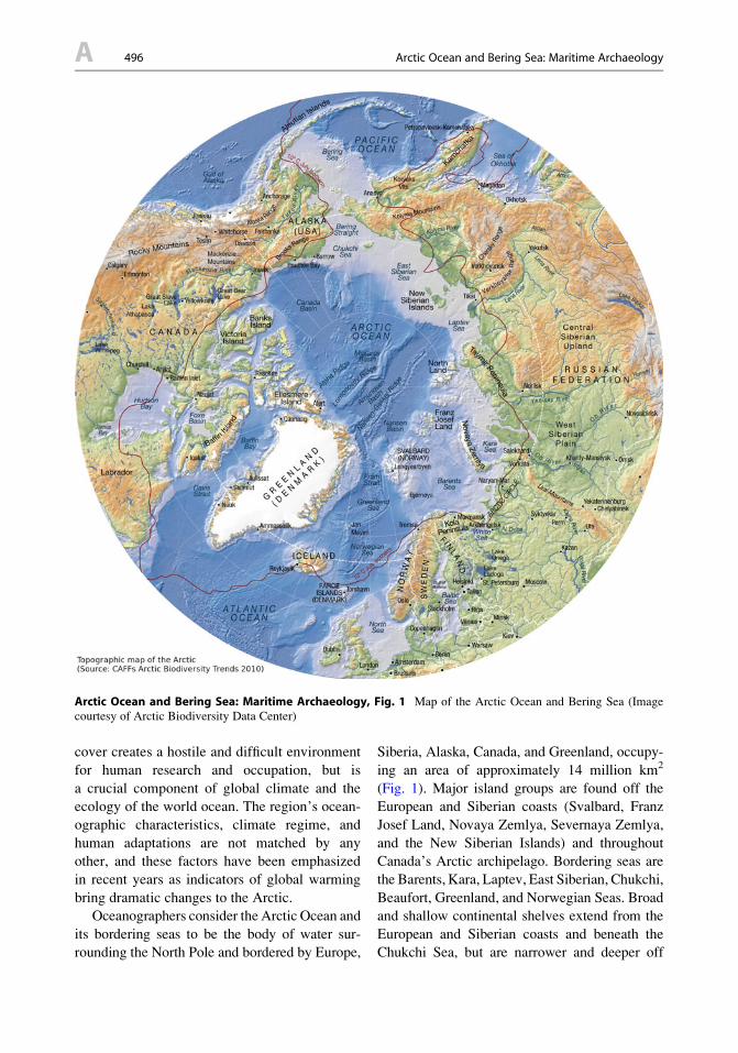
Pearyland umiak, the oldest complete circumpo-
lar skin boat known today from the archaeologi-
cal record, was deposited in similar
circumstances (Fig. 2). Discovered by a Danish
expedition to Pearyland, northeast Greenland, in
1949, it dates to the fifteenth century CE
(Petersen 1986). Iron fasteners and an oak timber
indicate that the makers of Pearyland umiak were
in contact with the Norse. Contact with nonnative
explorers, settlers, and whalers in the Arctic had
significant impacts on many aspects of indige-
nous life, including watercraft. Shifts in technol-
ogy and subsistence resulting from newly
introduced materials and trading opportunities,
as well as from the decline of human and whale
populations, changed skin boat construction and
use. Today only a handful of native communities
in the circumpolar north maintain traditional skin
boat building.
The historical exploration of the Arctic is
a topic that has fascinated the public (especially
the race for “firsts” in polar exploration and
achievement). The history of Arctic exploration
by European nations has its roots in the six-
teenth-century push for easier and more direct
routes between Europe and Asia. Three routes
were considered or attempted at various times:
a route directly across the Arctic Ocean, the
“Northwest Passage” through the Davis Strait
and the Canadian Arctic Archipelago, and the
“Northeast Passage” along the northern coasts of
Scandinavia and Eurasia. Numerous expeditions,
including those of Martin Frobisher (1576–1578),
John Davis (1585), and William Baffin (1616),
ventured into the eastern Arctic in search of routes
across the top of North America (Delgado 1999).
TheNortheast Passagewas also tried, for example,
by Willem Barentsz in 1596. Others attempted to
find the western terminus of the Northwest Pas-
sage by sailing through Bering Strait (i.e., James
Cook, in 1778). Various traces of these expedi-
tions, including remains of vessels, camps, and
gravesites, have been investigated by archaeolo-
gists in the high Arctic.
Arctic Ocean and Bering Sea: Maritime Archaeology,Fig. 2 Pearyland umiak (Photo by Justin Hays)
Arctic Ocean and Bering Sea: Maritime Archaeology 499 A
A
The first attempt to find a sea route from
Europe to Asia via the Northwest Passage was
undertaken by Martin Frobisher in 1576–1578.
Frobisher reached Baffin Bay and established
a camp on Baffin Island, where the expedition
prospected for gold. Frobisher’s account is
among the earliest written records of European-
Inuit interaction. The Frobisher camp on Baffin
Island has been excavated by joint Smithsonian
Institution/Canadian Museum of Civilization
project (the “Meta Incognita” project). The pro-
ject also collected Inuit oral traditions relating to
the Frobisher expedition (McGhee 2001).
Among the earliest attempts to sail the North-
east Passage was the voyage undertaken by
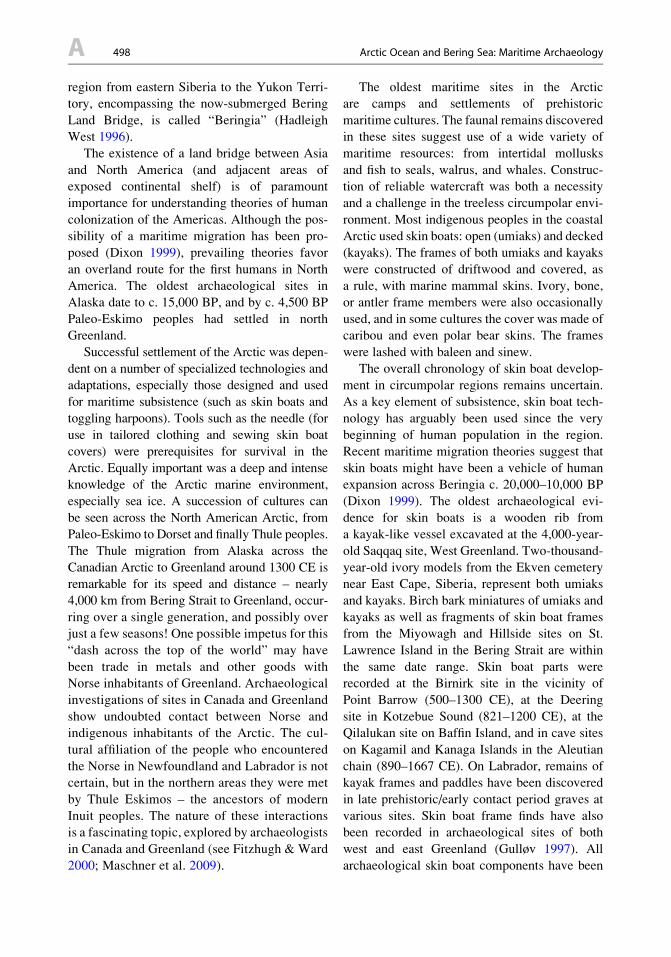
Dutchman Willem Barentsz in 1596. Barentsz
and his crew were forced to spend a winter on
the northeastern tip of the island of Novaya
Zemlya after their ship was crushed by ice in
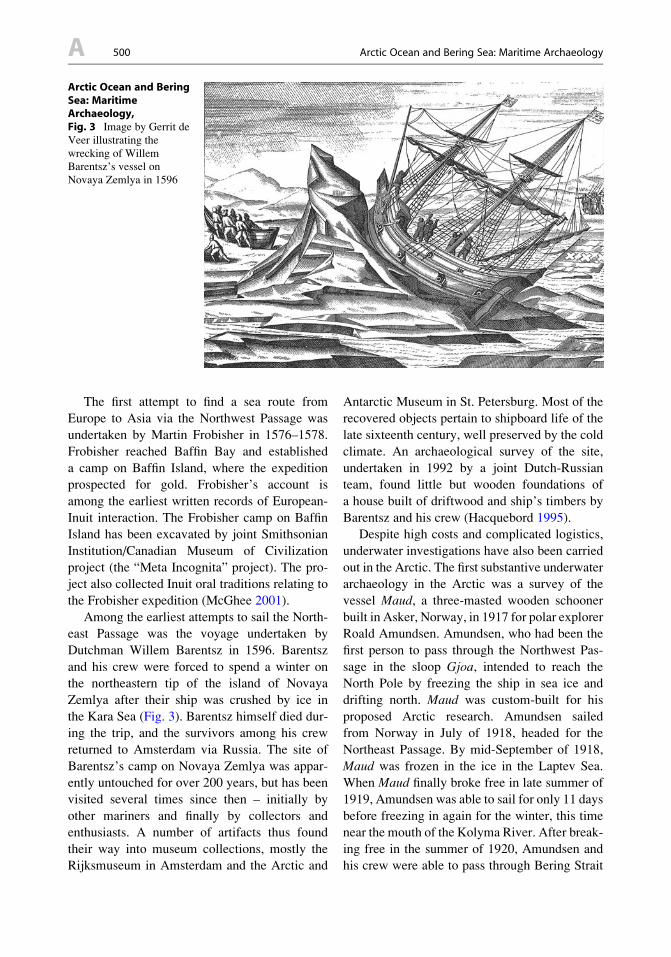
the Kara Sea (Fig. 3). Barentsz himself died dur-
ing the trip, and the survivors among his crew
returned to Amsterdam via Russia. The site of
Barentsz’s camp on Novaya Zemlya was appar-
ently untouched for over 200 years, but has been
visited several times since then – initially by
other mariners and finally by collectors and
enthusiasts. A number of artifacts thus found
their way into museum collections, mostly the
Rijksmuseum in Amsterdam and the Arctic and
Antarctic Museum in St. Petersburg. Most of the
recovered objects pertain to shipboard life of the
late sixteenth century, well preserved by the cold
climate. An archaeological survey of the site,
undertaken in 1992 by a joint Dutch-Russian
team, found little but wooden foundations of
a house built of driftwood and ship’s timbers by
Barentsz and his crew (Hacquebord 1995).
Despite high costs and complicated logistics,
underwater investigations have also been carried
out in the Arctic. The first substantive underwater
archaeology in the Arctic was a survey of the
vessel Maud, a three-masted wooden schooner
built in Asker, Norway, in 1917 for polar explorer
Roald Amundsen. Amundsen, who had been the
first person to pass through the Northwest Pas-
sage in the sloop Gjoa, intended to reach the
North Pole by freezing the ship in sea ice and
drifting north. Maud was custom-built for his
proposed Arctic research. Amundsen sailed
from Norway in July of 1918, headed for the
Northeast Passage. By mid-September of 1918,
Maud was frozen in the ice in the Laptev Sea.
When Maud finally broke free in late summer of
1919, Amundsen was able to sail for only 11 days
before freezing in again for the winter, this time
near the mouth of the Kolyma River. After break-
ing free in the summer of 1920, Amundsen and
his crew were able to pass through Bering Strait
Arctic Ocean and BeringSea: MaritimeArchaeology,Fig. 3 Image by Gerrit de
Veer illustrating the
wrecking of Willem
Barentsz’s vessel on
Novaya Zemlya in 1596
A 500 Arctic Ocean and Bering Sea: Maritime Archaeology
and put into Nome, Alaska. Maud was thus the
second vessel to navigate the Northeast Passage
(after N.A. Nordenskjold’s Vega), and Amund-
sen became the first to pass through both the
Northeast and Northwest Passages. Amundsen
made two more attempts to freeze Maud in pack
ice and drift to the pole, but was thwarted each
time, and the project eventually ran out of funds.
Maud was seized by creditors in Seattle in 1922
and sold at auction to the Hudson’s Bay Com-
pany. The new owners renamed the vessel
Baymaud and sent it to resupply company out-
posts in the Western Arctic.
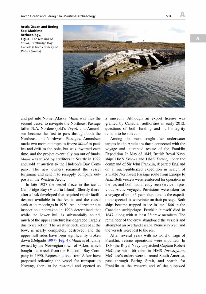
In late 1927 the vessel froze in the ice at
Cambridge Bay (Victoria Island). Shortly there-
after a leak developed that required repair facili-
ties not available in the Arctic, and the vessel
sank at its moorings in 1930. An underwater site
inspection undertaken in 1996 determined that
while the lower hull is substantially sound,
much of the upper structure has degraded, largely
due to ice action. The weather deck, except at the
bow, is nearly completely destroyed, and the
upper hull sides have been significantly broken
down (Delgado 1997) (Fig. 4).Maud is officially
owned by the Norwegian town of Asker, which
bought the wreck from the Hudson’s Bay Com-
pany in 1990. Representatives from Asker have
proposed refloating the vessel for transport to
Norway, there to be restored and opened as
a museum. Although an export license was
granted by Canadian authorities in early 2012,
questions of both funding and hull integrity
remain to be solved.
Among the most sought-after underwater
targets in the Arctic are those connected with the
voyage and attempted rescue of the Franklin
Expedition. In May of 1845, British Royal Navy
ships HMS Erebus and HMS Terror, under thecommand of Sir John Franklin, departed England
on a much-publicized expedition in search of
a viable Northwest Passage route from Europe to
Asia. Both vessels were reinforced for operation in
the ice, and both had already seen service in pre-
vious Arctic voyages. Provisions were taken for
a voyage of up to 3 years duration, as the expedi-
tion expected to overwinter on their passage. Both
ships became trapped in ice in late 1846 in the
Canadian archipelago. Franklin himself died in
1847, along with at least 23 crew members. The
remainder of the crew abandoned the vessels and
attempted an overland escape. None survived, and
the vessels were lost to the ice.
After several years with no word or sign of
Franklin, rescue operations were mounted. In
1850 the Royal Navy dispatched Captain Robert
McClure with 66 men in HMS Investigator.McClure’s orders were to round South America,
pass through Bering Strait, and search for
Franklin at the western end of the supposed
Arctic Ocean and BeringSea: MaritimeArchaeology,Fig. 4 The remains of
Maud, Cambridge Bay,
Canada (Photo courtesy of
Parks Canada)
Arctic Ocean and Bering Sea: Maritime Archaeology 501 A
A
Northwest Passage. Once in the Western Arctic,
McClure recognized Melville Island and realized
that he had connected with parts of the archipel-
ago previously reached from the east. After freez-
ing in at Mercy Bay on Banks Island, the crew
endured two harrowing winters before
abandoning the ship and sledging east. McClure
and his crew were eventually rescued by other
Royal Navy ships and on their return to England
were credited with the official discovery of the
Northwest Passage.
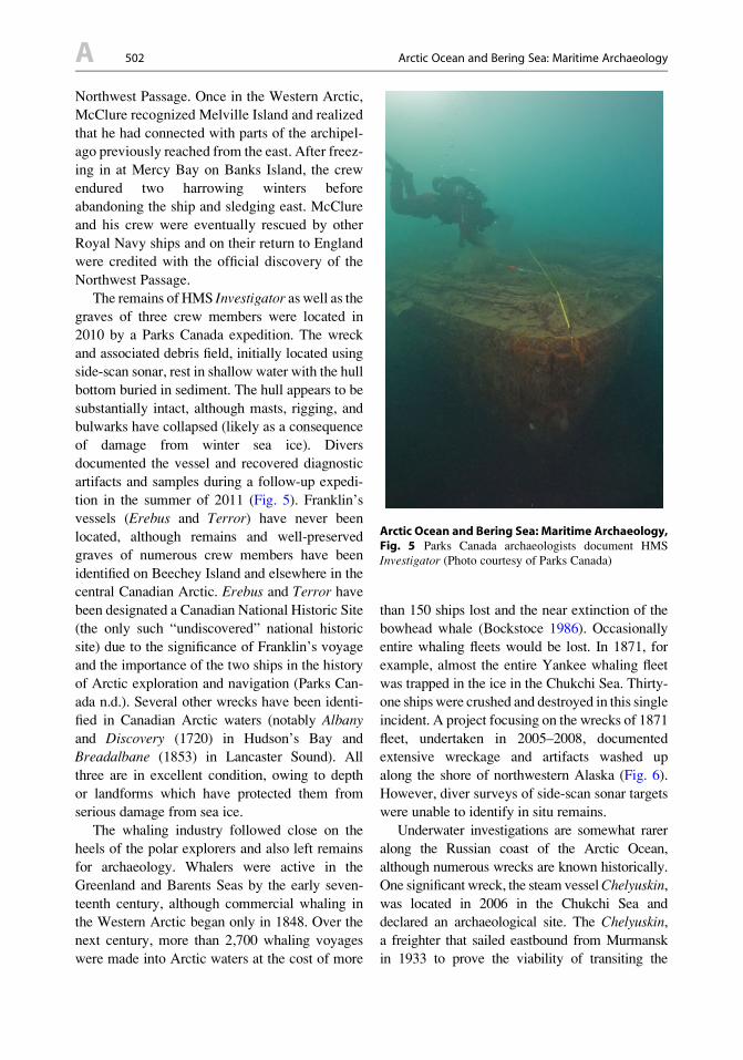
The remains of HMS Investigator as well as thegraves of three crew members were located in
2010 by a Parks Canada expedition. The wreck
and associated debris field, initially located using
side-scan sonar, rest in shallow water with the hull
bottom buried in sediment. The hull appears to be
substantially intact, although masts, rigging, and
bulwarks have collapsed (likely as a consequence
of damage from winter sea ice). Divers
documented the vessel and recovered diagnostic
artifacts and samples during a follow-up expedi-
tion in the summer of 2011 (Fig. 5). Franklin’s
vessels (Erebus and Terror) have never been
located, although remains and well-preserved
graves of numerous crew members have been
identified on Beechey Island and elsewhere in the
central Canadian Arctic. Erebus and Terror have
been designated a Canadian National Historic Site
(the only such “undiscovered” national historic
site) due to the significance of Franklin’s voyage
and the importance of the two ships in the history
of Arctic exploration and navigation (Parks Can-
ada n.d.). Several other wrecks have been identi-
fied in Canadian Arctic waters (notably Albany
and Discovery (1720) in Hudson’s Bay and
Breadalbane (1853) in Lancaster Sound). All
three are in excellent condition, owing to depth
or landforms which have protected them from
serious damage from sea ice.
The whaling industry followed close on the
heels of the polar explorers and also left remains
for archaeology. Whalers were active in the
Greenland and Barents Seas by the early seven-
teenth century, although commercial whaling in
the Western Arctic began only in 1848. Over the
next century, more than 2,700 whaling voyages
were made into Arctic waters at the cost of more
than 150 ships lost and the near extinction of the
bowhead whale (Bockstoce 1986). Occasionally
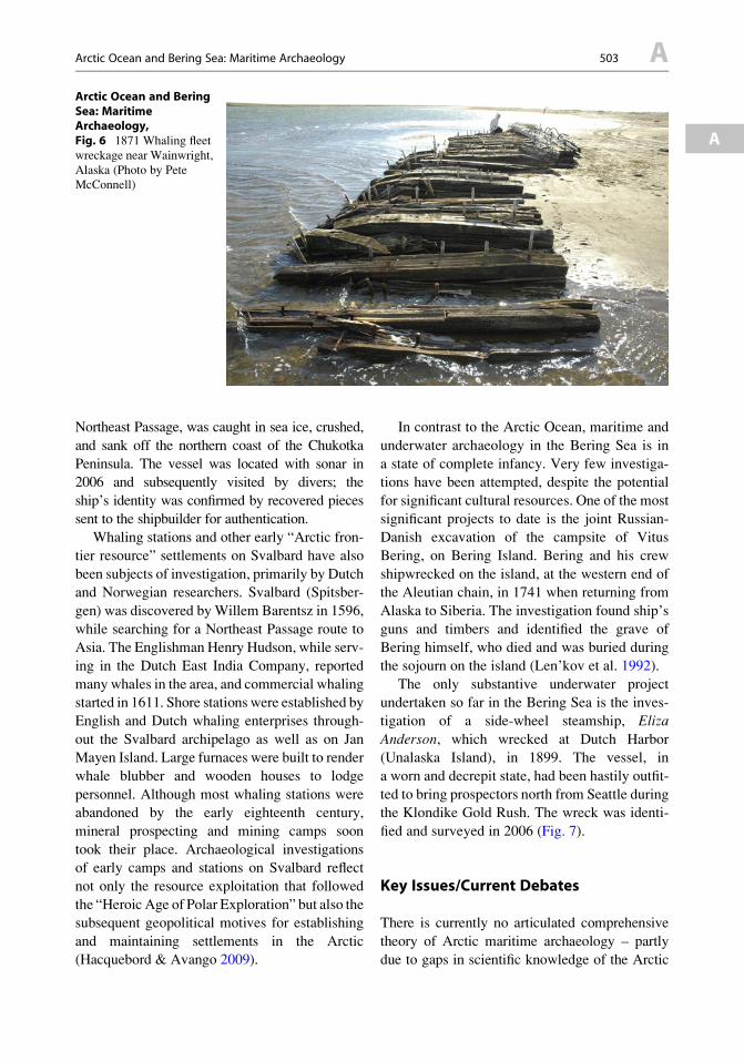
entire whaling fleets would be lost. In 1871, for
example, almost the entire Yankee whaling fleet
was trapped in the ice in the Chukchi Sea. Thirty-
one shipswere crushed and destroyed in this single
incident. A project focusing on the wrecks of 1871
fleet, undertaken in 2005–2008, documented
extensive wreckage and artifacts washed up
along the shore of northwestern Alaska (Fig. 6).
However, diver surveys of side-scan sonar targets
were unable to identify in situ remains.
Underwater investigations are somewhat rarer
along the Russian coast of the Arctic Ocean,
although numerous wrecks are known historically.
One significant wreck, the steam vesselChelyuskin,
was located in 2006 in the Chukchi Sea and
declared an archaeological site. The Chelyuskin,
a freighter that sailed eastbound from Murmansk
in 1933 to prove the viability of transiting the
Arctic Ocean and Bering Sea: Maritime Archaeology,Fig. 5 Parks Canada archaeologists document HMS
Investigator (Photo courtesy of Parks Canada)
A 502 Arctic Ocean and Bering Sea: Maritime Archaeology
Northeast Passage, was caught in sea ice, crushed,
and sank off the northern coast of the Chukotka
Peninsula. The vessel was located with sonar in
2006 and subsequently visited by divers; the
ship’s identity was confirmed by recovered pieces
sent to the shipbuilder for authentication.
Whaling stations and other early “Arctic fron-
tier resource” settlements on Svalbard have also
been subjects of investigation, primarily by Dutch
and Norwegian researchers. Svalbard (Spitsber-
gen) was discovered byWillem Barentsz in 1596,
while searching for a Northeast Passage route to
Asia. The Englishman Henry Hudson, while serv-
ing in the Dutch East India Company, reported
many whales in the area, and commercial whaling
started in 1611. Shore stations were established by
English and Dutch whaling enterprises through-
out the Svalbard archipelago as well as on Jan
Mayen Island. Large furnaces were built to render
whale blubber and wooden houses to lodge
personnel. Although most whaling stations were
abandoned by the early eighteenth century,
mineral prospecting and mining camps soon
took their place. Archaeological investigations
of early camps and stations on Svalbard reflect
not only the resource exploitation that followed
the “Heroic Age of Polar Exploration” but also the
subsequent geopolitical motives for establishing
and maintaining settlements in the Arctic
(Hacquebord & Avango 2009).
In contrast to the Arctic Ocean, maritime and
underwater archaeology in the Bering Sea is in
a state of complete infancy. Very few investiga-
tions have been attempted, despite the potential
for significant cultural resources. One of the most
significant projects to date is the joint Russian-
Danish excavation of the campsite of Vitus
Bering, on Bering Island. Bering and his crew
shipwrecked on the island, at the western end of
the Aleutian chain, in 1741 when returning from
Alaska to Siberia. The investigation found ship’s
guns and timbers and identified the grave of
Bering himself, who died and was buried during
the sojourn on the island (Len’kov et al. 1992).
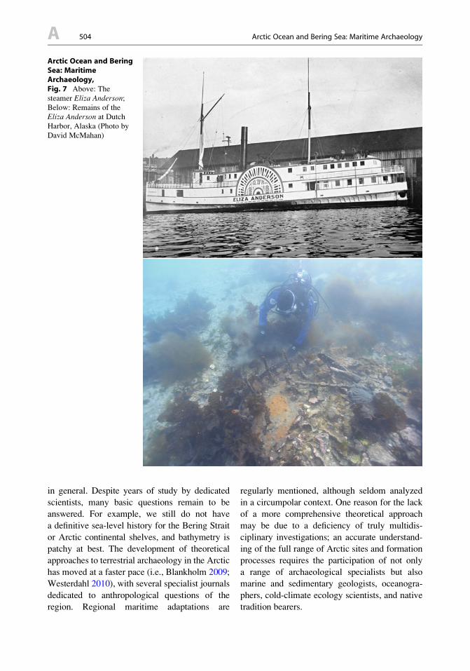
The only substantive underwater project
undertaken so far in the Bering Sea is the inves-
tigation of a side-wheel steamship, Eliza
Anderson, which wrecked at Dutch Harbor
(Unalaska Island), in 1899. The vessel, in
a worn and decrepit state, had been hastily outfit-
ted to bring prospectors north from Seattle during
the Klondike Gold Rush. The wreck was identi-
fied and surveyed in 2006 (Fig. 7).
Key Issues/Current Debates
There is currently no articulated comprehensive
theory of Arctic maritime archaeology – partly
due to gaps in scientific knowledge of the Arctic
Arctic Ocean and BeringSea: MaritimeArchaeology,Fig. 6 1871 Whaling fleet
wreckage near Wainwright,
Alaska (Photo by Pete
McConnell)
Arctic Ocean and Bering Sea: Maritime Archaeology 503 A
A
in general. Despite years of study by dedicated
scientists, many basic questions remain to be
answered. For example, we still do not have
a definitive sea-level history for the Bering Strait
or Arctic continental shelves, and bathymetry is
patchy at best. The development of theoretical
approaches to terrestrial archaeology in the Arctic
has moved at a faster pace (i.e., Blankholm 2009;
Westerdahl 2010), with several specialist journals
dedicated to anthropological questions of the
region. Regional maritime adaptations are
regularly mentioned, although seldom analyzed
in a circumpolar context. One reason for the lack
of a more comprehensive theoretical approach
may be due to a deficiency of truly multidis-
ciplinary investigations; an accurate understand-
ing of the full range of Arctic sites and formation
processes requires the participation of not only
a range of archaeological specialists but also
marine and sedimentary geologists, oceanogra-
phers, cold-climate ecology scientists, and native
tradition bearers.
Arctic Ocean and BeringSea: MaritimeArchaeology,Fig. 7 Above: The
steamer Eliza Anderson;Below: Remains of the
Eliza Anderson at Dutch
Harbor, Alaska (Photo by
David McMahan)
A 504 Arctic Ocean and Bering Sea: Maritime Archaeology
Underwater site formation processes specifi-
cally may require a much broader assimilation of
geophysical knowledge than heretofore assem-
bled. For example, coastal erosion dynamics,
vegetation regimes, and other ecological param-
eters are unlike those of any other region on earth
and require investigation and definition. How-
ever, the most complex element of the Arctic
maritime environment (and potentially most sig-
nificant for the preservation of submerged cul-
tural remains) is the cyclical growth and
movement of sea ice.
Ice formation and extent along Arctic coasts is
seasonally variable. Ice formation generally begins
in October and reaches an annual maximum in
February or March; melting begins in May or
June and pack ice retreats during July and August.
Most of the Arctic continental shelf is therefore
under ice cover for 7–10 months each year. Pack
ice is subject to immense wind fields, generated
over a large area. The convergence of fields of
moving pack ice (or pack ice impacting with
shorefast ice) results in linear deformation features
called pressure ridges. The intense pressures even-
tually build up ice masses both above the water’s
surface (ice sails) and below (ice keels). Ice goug-
ing occurs where ice keels are driven into the
seabed and are moved by the accumulated energies
of the encompassing pack ice structure. The
resulting furrows or tracks in the seafloor are called
ice gouges or ice scour (Wadhams 2000). Ice
grounding and gouging is common in all Arctic
coastal waters, from the sea’s edge to considerable
depths. Deep gouges tend to produce high flanking
ridges to either side, creating combined vertical
relief of up to 8 m. The highest gouge densities
are in water between 20 and 40 m deep, as are
maximum gouge depths. Gouges in water deeper
than about 55 m are assumed by some researchers
to be relict from periods of lower sea level, as
modern ice features do not generally have keels
extending beyond 60 m deep.
No comprehensive study has been undertaken
regarding the potential effects of ice gouging on
submerged archaeological sites and the conse-
quent ramifications for site formation processes.
Regarding the Chukchi Sea, the US Minerals
Management Service has concluded that
“shipwrecks are likely to have survived in the
area, especially those that may be at a depth
beyond intensive ice gouging” (MMS 2007).
Archaeological investigations of historic period
shipwrecks near Wainwright on the Alaskan
Chukchi coast found considerable amounts of
nineteenth-century wreckage in the beach and
intertidal zones, presumably gouged from the
seafloor and washed ashore. Investigations of
shipwrecks in the Canadian Arctic have similarly
concluded that wrecks would survive only if
protected from pack ice. When considering the
potential for archaeological resources along the
Arctic Ocean margins, the effects of the ocean’s
dynamic and complex environmental processes
must be taken into account (Fig. 8).
International Perspectives
Since the earliest European attempts to find
northern sea routes to Asia and claim Arctic
lands, the region has been a focus of geopolitical
maneuvering and intrigue. The situation has only
intensified as climate change opens Arctic waters
and resource exploration increases.While there is
a regular high-level intergovernmental forum of
Arctic nations (the Arctic Council), many issues
remain to be resolved. Maritime borders are
unsettled or in dispute. As of 2011 not a single
Arctic nation had ratified the United Nations
Convention on the Protection of the Underwater
Cultural Heritage (and several were actively
opposed to the convention). International collab-
oration on scientific projects is common in the
Arctic, but it remains to be seen whether such
cooperation will be extended in the future to
underwater archaeological investigations.
Future Directions
Archaeology in the Arctic Ocean faces two major
interrelated sets of challenges in the near future:
climate change and human impacts. As described
in a recent article by Hans Peter Blankholm
(2009), much recent concern and attention has
been focused on environmental and ecological
Arctic Ocean and Bering Sea: Maritime Archaeology 505 A
A
implications of climate change, while culture-
historical issues have been relatively neglected.
However, archaeological resources, both terres-
trial and submerged, will undoubtedly be affected
by changes now occurring in the Arctic.
The warming climate is resulting in pro-
nounced reductions in sea ice, seasonal snow,
permafrost, and glacial features, with
a corresponding shift in landscape processes.
What does this mean for archaeological resources
in the affected areas? Continuing widespread loss
of discontinuous permafrost and increase in
the active layer of remaining permafrost will
trigger erosion and subsidence of ice-rich land-
scapes and change local and regional hydrologic
processes. Coastlines are increasingly exposed
to wave action and storm surge. Direct impacts
from coastal erosion as well as the loss of stable
preservation (frozen site matrices) will be vary-
ing degrees of resource exposure, degradation,
and destruction of buried/frozen cultural mate-
rial. The effects on submerged archaeological
sites are less clear, although reduced sea ice
may result in reduced potential for damage from
ice scour.
The other major factor likely to impact Arctic
archaeological resources (especially in
a submerged environment) is a dramatically
increased human presence in the region. Approx-
imately four million people currently live in the
Arctic. Increased accessibility and intensified
resource exploitation will likely bring a larger
number of people into the far north. Oil and gas
drilling on Arctic continental shelves is already
intensifying in Alaska’s Chukchi and Beaufort
Seas, Norway’s Barents Sea, and elsewhere.
Impact to submerged archaeological sites is pos-
sible from extraction and transportation facilities,
pipelines, and related infrastructure. Reduced sea
ice will create opportunities for increased open-
water transportation (especially cargo shipping
but also cruise tourism) (Nuttall & Callaghan
2000). As the Arctic enters this uncertain phase,
protection and responsible investigation of the
region’s cultural heritage is a key concern.
Cross-References
▶Greenland: Approaches to Historical Norse
Archaeology
▶ Indigenous Archaeologies
▶ Indigenous Peoples, Working with and for
▶Maritime Landscapes
▶Maritime History
▶ Parks Canada: Historical Archaeology
▶ Peopling of the Americas
▶ Polar Exploration Archaeology (North)
▶ Submerged Prehistoric Landscapes
▶Underwater Archaeology
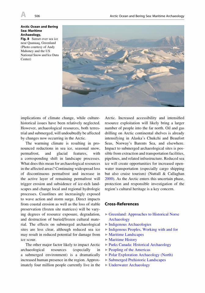
Arctic Ocean and BeringSea: MaritimeArchaeology,Fig. 8 Sunset over sea ice
near Qaanaaq, Greenland
(Photo courtesy of Andy
Mahoney and the US
National Snow and Ice Data
Center)
A 506 Arctic Ocean and Bering Sea: Maritime Archaeology
▶Underwater Cultural Heritage: International
Law Regime
▶Underwater Sites in Archaeological
Conservation and Preservation
References
BLANKHOLM, H.P. 2009. Long-term research and cultural
resource management strategies in light of climate
change and human impact. Arctic Anthropology46(1-2): 17-24.
BOCKSTOCE, J.R. 1986 Whales, ice, & men: the history ofwhaling in the western Arctic. Seattle: University of
Washington Press.
DELGADO, J.P. 1997. Made for the ice: a report on thewreck of the Hudson’s Bay Company ship Baymaud,ex-Polarskibet Maud. Vancouver: Vancouver Mari-
time Museum and Underwater Archaeology Society
of British Columbia.
- 1999. Across the top of the world: the quest for theNorthwest Passage. New York: Checkmark Books.
DIXON, E.J. 1999. Bones, boats & bison: archaeology andthe first colonization of western North America. Albu-querque: University of New Mexico Press.
FITZHUGH, W.W. & E.I. WARD. (ed.) 2000. Vikings: theNorth Atlantic saga. Washington: Smithsonian Insti-
tution Press.
GULLØV, H.C. 1997. From middle ages to colonial times:
archaeological and ethnohistorical studies of the Thule
culture in South West Greenland 1300-1800 AD.
Meddelelser om Grønland, Man and Society 23.
Copenhagen: National Museum of Denmark.
HACQUEBORD, L. 1995. In search of Het Behouden Huys:
a survey of the remains of the house of Willem
Barentsz on Novaya Zemlya. Arctic 48(3): 248-56.HACQUEBORD, L. & D. AVANGO. 2009. Settlements in an
Arctic resource frontier region. Arctic Anthropology46(1-2): 25-39.
HADLEIGH WEST, F. (ed.) 1996. American beginnings: theprehistory and paleoecology of Beringia. Chicago:
University of Chicago Press.
HOFFECKER, J. 2005. A prehistory of the North, humansettlement of the higher latitudes. New Brunswick
and London: Rutgers University Press.
LEN’KOV, V.D., G.L. SILANT’EV & A.K. STANIUKOVICH.
1992. The Komandorskii Camp of the Bering Expedi-tion. Translated by K. Arndt, edited by O. Frost.
Anchorage: Alaska Historical Society.
MASCHNER, H., O. MASON & R. MCGHEE. (ed.) 2009. Thenorthern world, AD 900-1400. Salt Lake City: Univer-sity of Utah Press.
MCGHEE, R. 2001. The Arctic voyages of Martin Frobi-sher: an Elizabethan adventure. Seattle: University of
Washington Press.
MINERALS MANAGEMENT SERVICE (MMS). 2007. Alaskacontinental shelf Chukchi Sea planning area. Oil andgas lease sale 193 and seismic surveying activities in
the Chukchi Sea. Final environmental impact state-ment: 1-3. Anchorage: Minerals Management Service,
Alaska OCS Region.
NUTTALL, M. & T.V. CALLAGHAN. (ed.) 2000. The Arctic:environment, people, policy. Amsterdam: Harwood
Academic Publishers.
Parks Canada. n.d. Available at http://www.pc.gc.ca/culture/
franklin/sec02.aspx (accessed January 18, 2013).
PETERSEN, H.C. 1986. Skinboats of Greenland. Roskilde:The Viking Ship Museum.
STROEVE, J.C., M.C. SERREZE, M.M. HOLLAND, J.E. KAY,
J. MALANIK & A.P. BARRETT. 2012. The Arctic’s
rapidly shrinking sea ice cover: a research synthesis.
Climate Change 110: 1005-27.WADHAMS, P. 2000. Ice in the ocean. Amsterdam: Gordon
and Breach Science Publishers.
WESTERDAHL, C. (ed.) 2010. A circumpolar reappraisal:the legacy of Gutorm Gjessing (1906-1979) (BAR
International series 2154). Oxford: Archaeopress.
Further ReadingANISIMOV, O., D.G. VAUGHAN, T.V. CALLAGHAN, C. FURGAL,
H. MARCHANT, T.D. PROWSE, H. VILHJALMSSON & J.E.
WALSH. 2007. Polar regions (Arctic and Antarctic), in
M.L. Parry, O.F. Cranziani, J.P. Palutikof, P.J. Van
Der Linden &C.E. Hanson (ed.)Climate change 2007:impacts, adaptation and vulnerability. Contribution ofworking group II to the fourth assessment report of theIntergovernmental Panel on Climate Change:653-685. Cambridge: Cambridge University Press.
BARR, W. 2007. Discovery of the wreck of the Soviet
steamer Chelyuskin on the bed of the Chukchi Sea.
Polar Record 43: 67-70.
COACHMAN, L.K., K. AAGAARD & R.B. TRIPP. 1975. BeringStrait: the regional physical oceanography. Seattleand London: University of Washington Press.
COMISO, J.C., C.L. PARKINSON, R. GERSTEN & L. STOCK.
2008. Accelerated decline in the Arctic Sea ice cover.
Geophysical Research Letters 35. doi:10.1029/
2007GL031972
FITZHUGH, W.W. (ed.) 1975. Prehistoric maritime adapta-tions of the circumpolar zone. The Hague: Mouton
Publishers.
FLADMARK, K. 1979. Routes: alternative migration
corridors for early man in North America. AmericanAntiquity 44: 55-69.
GRØNNOW, B. 1994. Qeqertasussuk – the archaeology of
a frozen Saqqaq site in Disko Bugt, West Greenland, in
D. Morrison & J.-L. Pilon (ed.) Threads of Arcticprehistory: papers in honor of William E. Taylor,Jr. (Archaeological Survey of Canada, Mercury series
149): 197-238. Hull (QC): Canadian Museum of
Civilization.
HERMAN, Y. (ed.) 1989. The Arctic Seas: climatology,oceanography, geology, and biology. New York: Van
Nostrand Reinhold Company.
HOPKINS, D.M., J.V. MATTHEWS, JR., C.E. SCHWEGER & S.B.
YOUNG. (ed.) 1982. Paleoecology of Beringia.New York: Academic Press.
Arctic Ocean and Bering Sea: Maritime Archaeology 507 A
A
KOZLOWSKI, J. & H. BANDI. 1984. The paleohistory of
circumpolar Arctic colonization. Arctic 37(4): 358-72.KRUPNIK, I., C. APORTA, S. GEARHEARD, G.L. LAIDLER &
L.K. HOLM. (ed.) 2010. SIKU: Knowing our ice –
documenting Inuit sea-ice knowledge and use.Dordrecht: Springer.
MADSEN, D.B. (ed.) 2004. Entering America: NortheastAsia and Beringia before the Last Glacial Maximum.Salt Lake City: University of Utah Press.
ROGERS, J.S. 2009. The Eliza Anderson: an early Puget
Sound steamer shipwrecked in Dutch harbor, Alaska.
The Sea Chest, Journal of the Puget Sound MaritimeHistorical Society 43(2): 51-61.
SAVOURS, A. 1999. The search for the North West Passage.New York: St. Martin’s Press.
Argentina: Maritime Archaeology
Dolores Elkin
Consejo Nacional de Investigaciones Cientıficas
y Tecnicas and Instituto Nacional de
Antropologıa y Pensamiento Latinoamericano,
Buenos Aires, Argentina
Introduction
Despite its long-standing tradition in archaeology
and its vast maritime littoral and other water-
ways, the study of the relationship between
humans and water through material remains has
not had much development in Argentina.
The traditional focus has been in pre-Hispanic
societies, either nomadic or sedentary, and almost
exclusively from a land perspective. The few
cases when water was considered within the
cultural system under study was usually triggered
by the presence of artifacts (like harpoons or
other fishing devices) or ecofacts (such as fish,
shellfish, or sea mammals remains) in the
archaeological record. Until recently topics such
as navigation and watercrafts per se, whether
prehistoric or more recent, have been almost
absent in the Argentinean archaeological
research projects. Let alone venturing into the
water to study submerged archaeological remains
of any sort.
Since the mid-1990s, however, the fields of
maritime and underwater archaeology have been
steadily growing, leading to a number of research
projects and various other activities dealing with
the country’s underwater cultural heritage.
Definition
As the discipline of maritime archaeology
continues to develop, so does its definition and
the debate on the various topics of study it can
comprise (Catsambis et al. 2011). In general
terms, however, it could be defined as the study,
through material remains, of past human cultures
in their relation with the sea and occasionally
with inland waters. Typical examples of the latter
have to do with seafaring, given that oceans,
rivers, and lakes are frequently connected and
are navigated without distinction.
It is in that broad sense that the concept of
maritime archaeology is used in this entry.
Besides, although ships are not the only subjects
of study, they were chosen to be the focus here
not only because of their direct association with
water but also because they are good representa-
tives of maritime archaeology in Argentina.
Historical Background
Prior to the development of maritime and
underwater archaeology with scientific standards,
there had been various instances in which sub-
merged archaeological remains were dealt with
(see Elkin 2002; Ciarlo 2008). In the first decades
of the twentieth century, they mostly had to do
with isolated finds of shipwreck elements which
ended up in museum or private collections, in
most cases lacking contextual information.
By the 1970s archaeologist Jorge Fernandez
became involved in the extraction of a wooden
canoe from a lake in Patagonia by guiding from
the surface the work performed by professional
divers and by later describing and interpreting the
find (Fernandez 1978).
The 1980s was characterized by several
activities conducted by an ICOMOS-Argentina
working group, mainly comprised by architects-
divers, who had the initiative of building capacity
A 508 Argentina: Maritime Archaeology