manor farm, church road kessingland suffolk - reports archive
TRANSCRIPT
for: KRG Healthcare Ltd
CA Project: SU0173 CA Report:SU0173_1
OASIS ID: cotswold2-402220 HER Ref: KSS 141
October 2020
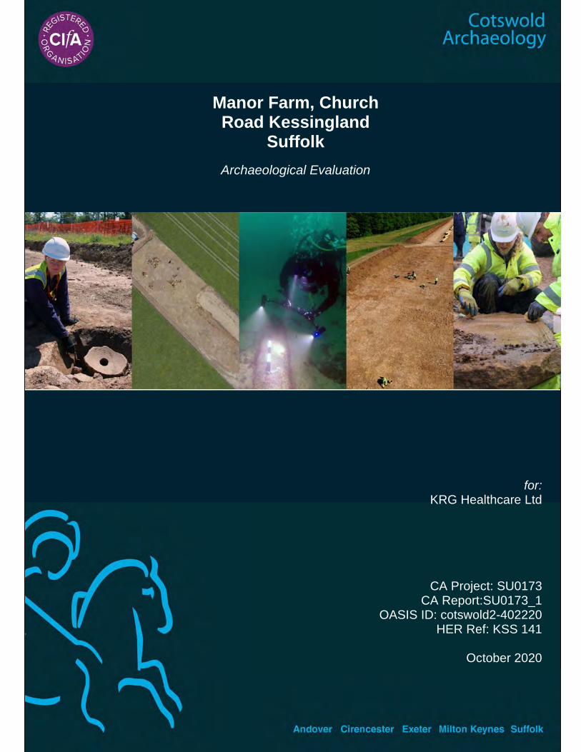
Manor Farm, Church Road Kessingland
Suffolk
Archaeological Evaluation


Manor Farm, Church Road
Kessingland Suffolk
Archaeological Evaluation
CA Project: SU0173 CA Report: SU0173_1
OASIS ID: cotswold2-402220 HER reference: KSS 141
Document Control Grid
Revision Date Author Checked by Status Reasons for revision
Approved by
A 12/11/2020 S. Picard S. Boulter Draft Internal review S. Boulter
This report is confidential to the client. Cotswold Archaeology accepts no responsibility or liability to any third party to whom this report, or any part of it, is made known. Any such party relies upon this report entirely at their
own risk. No part of this report may be reproduced by any means without permission.
Cirencester Building 11 Kemble Enterprise Park Cirencester Gloucestershire GL7 6BQ t. 01285 771 022
Milton Keynes Unit 8, The IO Centre Fingle Drive Stonebridge Milton Keynes Buckinghamshire MK13 0AT t. 01908 564 660
Andover Stanley House Walworth Road Andover Hampshire SP10 5LH t. 01264 347 630
Exeter Unit 1, Clyst Units Cofton Road Marsh Barton Exeter EX2 8QW t. 01392 573 970
Suffolk Unit 5, Plot 11 Maitland Road Lion Barn Industrial Estate Needham Market Suffolk IP6 8NZ t. 01449 900 120

1
Manor Farm, Church Road, Kessingland, Suffolk: Archaeological Evaluation © Cotswold Archaeology
CONTENTS
SUMMARY ............................................................................................................................... 5
1. INTRODUCTION ........................................................................................................ 7
2. ARCHAEOLOGICAL BACKGROUND ....................................................................... 8
3. AIMS AND OBJECTIVES .......................................................................................... 9
4. METHODOLOGY ....................................................................................................... 10
5. RESULTS .................................................................................................................. 11
6. THE FINDS ................................................................................................................ 21
7. THE BIOLOGICAL EVIDENCE .................................................................................. 31
8. DISCUSSION ............................................................................................................. 34
9. CA PROJECT TEAM ................................................................................................. 36
10. REFERENCES........................................................................................................... 36
APPENDIX A: CONTEXT DESCRIPTIONS ............................................................................ 39
APPENDIX B: THE FINDS ...................................................................................................... 49
APPENDIX C: THE PALAEOENVIRONMENTAL EVIDENCE ................................................ 59
APPENDIX D: HER SEARCH RESULTS ................................................................................ 61
APPENDIX E: OASIS REPORT FORM ................................................................................... 67
APPENDIX F: WRITTEN SCHEME OF INVESTIGATION ...................................................... 70

2
Manor Farm, Church Road, Kessingland, Suffolk: Archaeological Evaluation © Cotswold Archaeology
3
Manor Farm, Church Road, Kessingland, Suffolk: Archaeological Evaluation © Cotswold Archaeology
LIST OF ILLUSTRATIONS
Fig. 1 Site location plan (1:25,000)
Fig. 2 Selected HER entries surrounding site (1:7,500)
Fig. 3 Trench location plan (1:750)
Fig. 4 Trench 1: plan, sections and photograph (1:100 and 1:20)
Fig. 5 Trench 1: sections and photographs (1:20)
Fig. 6 Trench 2: plan and photographs (1:100)
Fig. 7 Trench 2: sections and photographs (1:20)
Fig. 8 Trench 2: sections and photographs (1:20)
Fig. 9 Trench 3: plan, sections and photographs (1:100 and 1:20)
Fig. 10 Trench 3: sections and photographs (1:20)
Fig. 11 Trench 4: plan, section and photograph (1:100 and 1:20)
Fig. 12 Trench 5: plan, sections and photograph (1:100 and 1:20)
Fig. 13 Trench 5: section and photograph (1:20)
Fig. 14 Trench 6: plan, sections and photograph (1:100 and 1:20)
Fig. 15 Trench 7: plan, sections and photograph (1:100 and 1:20)

4
Manor Farm, Church Road, Kessingland, Suffolk: Archaeological Evaluation © Cotswold Archaeology
5
Manor Farm, Church Road, Kessingland, Suffolk: Archaeological Evaluation © Cotswold Archaeology
SUMMARY
Project name: Manor Farm, Church Road
Location: Kessingland, Suffolk
NGR: 552622 286237
Type: Evaluation
Date: 5–9 October 2020
Planning reference: DC/16/2868/FUL
OASIS ID: cotswold2-402220
Location of Archive: To be deposited with Suffolk County Council Archaeolgical Service
(SCCAS) and the Archaeology Data Service (ADS)
Site Code: KSS 141
In October 2020, Cotswold Archaeology carried out an archaeological evaluation at Manor
Farm, Church Road, Kessingland, Suffolk. A total of eight trenches were excavated with
archaeological deposits, comprising twelve possible postholes, ten pits and twenty-one
ditches, recorded in seven of those. A relatively large assemblage of pottery suggested was
collected from a number of features showing continuing domestic occupation from the early
medieval through to the post medieval periods with small quantities of residual prehistoric
worked flint also recovered from these later features. Seven environmental samples were
taken from ditches, pits and layers with plant macrofossils recovered from four of them.

6
Manor Farm, Church Road, Kessingland, Suffolk: Archaeological Evaluation © Cotswold Archaeology
7
Manor Farm, Church Road, Kessingland, Suffolk: Archaeological Evaluation © Cotswold Archaeology
1. INTRODUCTION
In October 2020, Cotswold Archaeology (CA) carried out an archaeological
evaluation at Manor Farm, Church Road, Kessingland (centred at NGR 552622
286237; Fig. 1). This evaluation was undertaken for KRG Healthcare Ltd.
Planning permission has been granted for the construction of new care home
buildings within the grounds of an existing care home on the condition that a
programme of archaeological is carried out (planning ref: DC/16/2868/FUL).
The scope of the evaluation was defined in Brief prepared by James Rolfe of Suffolk
County Council Archaeological Service (SCCAS), the archaeological advisor to East
Suffolk Council. The evaluation was carried out in accordance with a Written Scheme
of Investigation (WSI, Appendix F) prepared by Stuart Boulter (CA 2019) and
approved by James Rolfe.
The evaluation was also in line with, Standard and guidance: Archaeological field
evaluation (CIfA 2014; updated June 2020), the SCC Requirements for Trenched
Archaeological Evaluation (SCCAS 2019), the Management of Research Projects in
the Historic Environment (MORPHE): Project Planning Note 3 (English Heritage
2008), the Management of Research Projects in the Historic Environment
(MORPHE): Project Manager’s Guide (EH 2006).
The site
The site covers c.0.85 hectare and lies at approximately 18m AOD on a shallow south
facing slope overlooking the flood plain of the Hundred River which flows south-
eastwards c.1km to the south. The site is bounded by open fields to the south and
west, farm buildings to the east and Church Road to the north.
Geologically, the site lies close to the junction between two distinctly different
superficial deposits, both of which potentially could be encountered. To the north,
Lowestoft Formation - Diamicton formed up to two million years ago in the Quaternary
Period in a local environment previously dominated by ice age conditions. These
sedimentary deposits are glacigenic in origin, detrital, created by the action of ice and
meltwater. They can form a wide range of deposits and geomorphologies associated
with glacial and inter-glacial periods during the Quaternary. To the south, the Aldeby
Sand and Gravel Member - Sand And Gravel could be encountered. These deposits
also formed up to two million years ago in a local environment previously dominated
8
Manor Farm, Church Road, Kessingland, Suffolk: Archaeological Evaluation © Cotswold Archaeology
by ice age conditions. These sedimentary deposits are glacigenic in origin, detrital,
created by the action of ice and meltwater, they can form a wide range of deposits
and geomorphologies associated with glacial and inter-glacial periods during the
Quaternary Period. The underlying bedrock comprises Lewes Nodular Chalk
Formation, Seaford Chalk Formation, Newhaven Chalk Formation And Culver Chalk
Formation (undifferentiated) – Chalk, a sedimentary rock formed approximately
seventy-two to ninety-four million years ago in the Cretaceous Period in a local
environment previously dominated by warm chalk seas; they are shallow-marine in
origin, biogenic and detrital, generally comprising carbonate material (coccoliths),
forming distinctive beds (BGS 2020). On site the superficial deposits presented as
mid orange slightly clayey sand with occasional mixed stones and patches of mid
orange sand and gravel.
2. ARCHAEOLOGICAL BACKGROUND
The Suffolk Historic Environment Record (HER, invoice no. 9241075) records
seventy-five entries within 1km of the site, full summaries of which are shown in
Appendix D, Table 15, and entries within 500m of the site are shown on Figure 2.
Manor Farm is the subject of seven entries on the HER, ranging in date from the
Mesolithic through to the medieval periods. Scatters of worked flint and tools,
including blades, microliths and tranchet axeheads, dated to the Mesolithic period are
recorded (HER refs. KSS 001 and KSS 005) alongside Neolithic flint, including
blades, leaf-shaped and barbed and tanged arrowheads, as well as broken chipped
axes (KSS 001, 004 and 005, and further to the south, KSS 025). The cropmark of
an oval enclosure, measuring c.70m long and c.35m wide, has also been identified
in the vicinity of these artefact scatters (KSS 062). A possible early Anglo-Saxon bone
point (KSS 003) as well as scatters of thirteenth to fourteenth century pottery (KSS
004 and 115, and further west, KSS 023) attest to activity on the site from the early
medieval period. Manor Farm itself is recorded as being a farmstead with a detached
farmhouse set away from the yard and visible on the First Edition Ordnance Survey
map of 1884 (KSS 138).
The site is within the medieval core of Kessingland and is situated to the south of
Church Road, c.100m to the west of the medieval Church of St. Edmund (KSS 022),
with construction begun in c.1450. A medieval clay and flint built structure and
possible ovens or corn driers along with associated pits and postholes were recorded
9
Manor Farm, Church Road, Kessingland, Suffolk: Archaeological Evaluation © Cotswold Archaeology
by archaeological evaluation and excavation at The Nordalls (KSS 113), c.300m to
the east north-east of the site.
A number of cropmarks are recorded within 500m of the site, both to the south and
west. Linear ditches and rectilinear enclosures to the south have been interpreted, in
part because of their arrangement and also supported by artefactual evidence, as a
possible Romano-British villa complex (KSS 090). Further cropmarks of ditches and
possible enclosures to the north (KSS 091) and north-east (KSS 092) have
subsequently been interpreted as possibly being associated with the putative villa,
although it is also noted they also appear on the First Edition OS map and may well
be medieval to post medieval in origin with a similar medieval to post medieval date
assigned to cropmarks both to the west of the site (KSS 089) and the north (KSS
100). Also recorded on the First Edition OS map, but now visible to the south of the
site as a cropmark, was a post medieval pond (KSS 008).
Twenty of the entries on the HER relate to the two world wars, mainly associated with
coastal defence, with a First World War pillbox recorded to the east of the site (KSS
084) and Second World War pillboxes and barbed wire compounds recorded to both
the east (KSS 084) and the south (KSS 093).
3. AIMS AND OBJECTIVES
The general objective of the evaluation was to provide further information on the likely
archaeological resource within the site, including its presence/absence, character,
extent, date and state of preservation. This information will enable SCCAS to identify
and assess the particular significance of any archaeological heritage assets within
the site, consider the impact of the proposed development upon that significance and,
if appropriate, develop strategies to avoid or minimise conflict between heritage asset
conservation and the development proposals, in line with the National Planning Policy
Framework (MHCLG 2019).
The specific objectives of the evaluation set out in the Brief were to:
Identify the date, approximate form and purpose of any archaeological
deposit, together with its likely extent, localised depth and quality of
preservation.
10
Manor Farm, Church Road, Kessingland, Suffolk: Archaeological Evaluation © Cotswold Archaeology
Evaluate the likely impact of past land uses, and the possible presence of
masking colluvial/alluvial deposits.
Establish the potential for the survival of environmental evidence.
Provide sufficient information to construct an archaeological conservation
strategy, dealing with preservation, the recording of archaeological deposits,
working practices, timetables and orders of cost.
4. METHODOLOGY
The evaluation fieldwork comprised the excavation of eight trenches (Fig. 3):
1no 34m x 1.9m trenches;
3no 33m x 1.9m trenches;
3no 30m x 1.9m trenches; and
1no 20m x 1.9m trench.
The trenches were located to provide a representative sample of the site. Some
variations were made to the agreed trench plan with the approval of Matthew Baker
of SCCAS. Trench 1 was moved c.10m to the south to avoid the removal of
established plants and trees, Trench 2 was moved c.5m to the north, turned to be
aligned north-west south-east and shortened by c.10m in order to fit within the
available space, the 10m lost on this trench were added to Trenches 4, 5, 6 and 8.
Trench 3 was turned to be aligned north-east south-west in order to avoid
encroaching into current car parking space.
Trenches were set out on OS National Grid co-ordinates using Leica GPS.
Overburden was stripped from the trenches by a mechanical excavator fitted with a
toothless ditching bucket. All machining was conducted under archaeological
supervision to the top of the natural substrate or the surface of the archaeological
layers, whichever was encountered first.
Archaeological features/deposits were investigated, planned and recorded in
accordance with CA Technical Manual 1: Fieldwork Recording Manual.
Deposits were assessed for their palaeoenvironmental potential and samples were
taken in accordance with CA Technical Manual 2: The Taking and Processing of
Environmental and Other Samples from Archaeological Sites.
11
Manor Farm, Church Road, Kessingland, Suffolk: Archaeological Evaluation © Cotswold Archaeology
Artefacts were processed in accordance with CA Technical Manual 3: Treatment of
Finds Immediately after Excavation.
CA will make arrangements with SCCAS for the deposition of the project archive and,
subject to agreement with the legal landowner(s), the artefact collection. A digital
archive will also be prepared and deposited with the Archaeology Data Service
(ADS). The archives (museum and digital) will be prepared and deposited in
accordance with Standard and guidance for the creation, compilation, transfer and
deposition of archaeological archives (CIfA 2014; updated June 2020).
A summary of information from this project, as set out in Appendix D, will be entered
onto the OASIS online database of archaeological projects in Britain.
5. RESULTS
This section provides an overview of the evaluation results. Detailed summaries of
the recorded contexts are given in Appendix A. Details of the artefactual material
recovered from the site are given in Section 6 and Appendix B. Details of the
environmental samples (palaeoenvironmental evidence) are given in Section 7 and
Appendix C.
Archaeological deposits were identified in seven of the eight trenches with twelve
possible postholes, ten pits and twenty-one ditches recorded along with nine other
deposits, not including topsoil, subsoil and the natural substrate. The topsoil ranged
from 0.3m to 0.35m thick closer to the road to the north to 0.45m thick further south
into the garden. The depth to the natural substrate was generally around 0.6m but
was as little as 0.36m in Trench 2 where the topsoil was directly over the
archaeological level. Trenches 1, 2 and 3 were located close to the road while
Trenches 7 and 8 were furthest from the road close to the southern property
boundary. A relatively large assemblage of pottery was recovered, almost exclusively
from Trenches 1 and 2, and generally dating to the 12th to 16th centuries but with a
residual presence of Middle to Late Anglo-Saxon wares.
Trench 1 (Figs. 3, 4 and 5)
This trench was moved to the south in order to avoid extant trees and shrubs. It
measured 30m long, 1.9m wide and was north north-east south south-west aligned.
The topsoil, 0100, was dark brownish grey sandy silt and was from 0.3m thick at the
southern end of the trench to 0.45m thick at the northern end where it was directly
12
Manor Farm, Church Road, Kessingland, Suffolk: Archaeological Evaluation © Cotswold Archaeology
over the archaeological level. Subsoil, 0101, a mid greyish brown slightly clayey silty
sand up to 0.4m thick, was present in the southern half of the trench overlying the
naturally derived mid orange slightly clayey sand with gravel patches, 0102. Medieval
pottery, dating from the eleventh to fourteenth centuries, was recovered from three
of the four pits and two of the seven ditches identified in the trench, while pottery
dating from the fifteenth to sixteenth centuries was collected from the upcast topsoil.
Pit 0103 was at the northern end of the trench and continued under its eastern edge,
measuring c.2.2m long and extending 1.2m into the trench. It had very steeply sloping
sides, which became vertical and slightly undercut in places, and was excavated to
a depth of 0.75m before being augered a further 0.5m. Six filling deposits were
identified during excavation with a clay layer c.01m thick (0117) overlying three
similar dark brownish grey silty sand deposits (0104, 0105 and 0106) with a small
amount of slumping of the naturally derived clayey sand recorded on the north-
western edge (0118). A deposit of pale grey clay flecked with red fired clay and very
pale yellowish grey mortar was excavated but did not show in section (0107). This pit
cut a small shallow pit on its south-western edge, pit 0110. This was small, shallow
and filled with mid grey firm silty clay and may be naturally derived. Pottery dating
from the 12th to 14th centuries was collected from all of the filling deposits of pit 0103
with the exception of the overlying clay and the slumping natural.
Approximately 1m to the south was gully 0112. This was 0.67m wide, 0.23m deep
and north south aligned with moderately sloping sides and a narrow, rounded base.
It was filled with dark grey firm silty clayey sand (0113) and produced seven sherds
of early medieval pottery dated to the 11th to 12th centuries. It extended under the
western trench edge but was cut by pit 0121 before it reached the eastern edge where
it was recorded as 0119. Pit 0121 extended across the trench from east to west,
measured c.3m north to south and, where it was recorded as 0114, was excavated
to 0.4m before being augered to an overall depth of 0.9m. A layer of pale yellowish
brown sandy clay 0.2m thick (0116) was recorded over a main filling deposit of firm
mid grey silty sandy clay (0115). Twenty-nine sherds of medieval pottery were
recovered from this pit.
A fourth pit, 0123, was identified extending under the western limit of excavation to
the north of pit 0114 and to the west of gully 0112, This measured c.2m north to south,
extended into the trench approximately 0.8m and was 0.54m deep with almost
vertical, straight sides and a sharp break of slope to a slightly rounded base. It was
13
Manor Farm, Church Road, Kessingland, Suffolk: Archaeological Evaluation © Cotswold Archaeology
filled with mid brownish grey silty sandy clay (0124) which produced a mixed
assemblage of mainly early medieval but also later and post medieval pottery.
Approximately 5m to the south of this group of pits were a pair of perpendicularly
arranged ditches. Ditch 0125 was north south orientated, 0.8m wide, 0.32m deep and
was filled with mid brownish grey friable silty sand (0126) which produced no
artefactual material. It extended across the trench and could be seen continuing in
Trench 3 as 0336. Ditch 0125 shared a stratigraphic relationship with ditch 0133
however their intersection was too close to the western extent of the trench for a
relationship section to be viable. Ditch 0133 was east west orientated and was very
broad and shallow at 1.48m wide and 0.22m deep with a gradually rounded profile. It
was filled with pale grey friable silty sand (0134); again, no dating evidence was
recovered.
At the southern end of the trench was another pair of perpendicular ditches, 0127
and 0135. Ditch 0135 was aligned east west and extended across the trench while
ditch 0127 was north south orientated and extended northwards from the western
edge of the into 0135 but did not continue out the other side, forming a T junction.
Both ditches were filled with dark brownish grey friable silty sand (0128 and 0136)
and had similar gradually sloping rounded profiles, ditch 0135 was slightly wider and
deeper at 0.5m and 0.18m compared to 0.38m and 0.15m, however, it is reasonable
to assume, with no obvious relationship visible, that these ditches were
contemporary. Five sherds of medieval pottery were recovered from ditch 0127. Both
ditches shared relationships with wider and deeper ditch terminuses c.0.8m from their
T junction. Ditch 0129 was, like 0127, north south aligned, it measured 0.7m wide
and 0.4m deep and had moderately steep rounded sides and a rounded base. Ditch
0131 was east west aligned, measured approximately 1m wide and 0.22m deep with
a gradually sloping rounded profile. Both ditches were filled with similar dark brownish
grey friable silty sand (0130 and 0132) and no relationships could be seen between
either 0127 and 0129 or 0131 and 0135, it was therefore unclear whether these
opposing terminuses super-ceded or were super-ceded by the T junction.
Trench 2 (Figs. 3, 6, 7 and 8)
Trench 2 was in the north of the site approximately 5m to the south of Church Road
and was also moved from its original position in order to fit in the available space. It
measured 20m long, 1.9m wide and was orientated north-west south-east, not quite
parallel with the west north-west east south-east aligned road. The topsoil, 0200, was
14
Manor Farm, Church Road, Kessingland, Suffolk: Archaeological Evaluation © Cotswold Archaeology
dark brownish grey sandy silt and was from 0.3m to 0.4m thick. Subsoil, 0221, was
mid brown silty sand, up to 0.3m thick, but was only present for c.5m at the southern
end of the trench with the topsoil directly over the archaeological deposits for the
remainder of the trench. The mid orange naturally derived clayey sand, 0222, was
only seen for approximately 2.5m towards the southern end of the trench. Five
sondages were excavated in a series of possible occupation layers recorded in the
north-western half of the trench, while the south-eastern end was dominated by a
large pit; a small gully was also recorded crossing the trench. Where it was unclear
whether deposits represented fills of cut features or layers of material, they were
recorded simply as deposits.
Deposit 0201 was a very dark brownish grey firm slightly clayey silty sand with
occasional to moderate charcoal, degraded bone, oyster shell and chalk flecks, up to
0.18m thick. This deposit was encountered directly below the topsoil extending for
c.2.5m from the north-western end of the trench and into it for up to c.1.25m from its
southern edge. Thirty-seven sherds of generally late medieval, but including both
early medieval and also post medieval, pottery as well as butchered animal bone and
oyster shell were recovered from this deposit along with an incomplete bone comb
and fragments of painted medieval glass. This possible occupation layer overlaid a
thin spread, up to 0.05m but generally only 0.01m thick, of mixed orange and grey
clay with chalk and very small pink fired clay flecks with occasional lenses of dark
greyish brown silty sand, 0207, which produced ten sherds of generally late medieval
pottery and two fragments of animal bone. This layer appeared to seal posthole 0210
which was sub-circular, 0.22m in diameter and 0.13m deep, with steeply sloping
rounded sides and a rounded base with mid brownish yellow firm clay (0211) forming
possible post packing around a dark brownish grey friable silty sand post pipe (0212).
Deposit 0207 also overlaid a layer of mid orange clay with occasional patches of dark
brownish grey silty sand, 0.12m thick, 0208, possibly laid down as a floor surface.
This extended for c.3.5m along the trench from its north-western end and into the
trench by c.1m from its northern edge, although its true extent was unclear as it also
continued below deposit 0201. This layer also did not appear to continue far enough
to the south-west to reach posthole 0210 in the excavated sondage. Below layer
0208, and cut by posthole 0210, was a deposit of mid grey friable silty sand with
occasional small stones, chalk, degraded shell and bone flecks, 0209. This deposit
was excavated to a depth of 0.34m, and augered a further 0.42m, and could be seen
extending for approximately 3m southwards. Twenty-one sherds of mainly 13th to
15
Manor Farm, Church Road, Kessingland, Suffolk: Archaeological Evaluation © Cotswold Archaeology
14th century pottery, seven fragments of animal bone and two oyster shells along
with an iron nail were collected from this deposit. Deposit 0225, a pale to mid grey
friable silty sand, up to 0.16m thick, was similar to 0209. It was identified in section
over clay deposit 0208 and below the topsoil, no relationship with either 0201 or 0207
was visible.
Deposit 0223, a pale to mid grey friable silty sand which produced four sherds of
medieval pottery, an iron nail and a fragment of ceramic building material (CBM), was
recorded in a sondage excavated c.5m from the north-west end of the trench and
was likely the same as 0225, although its full extent to the north was unclear in plan
as it was very similar in appearance to deposit 0209, lower in the stratigraphic
sequence and extending southwards from below deposit 0208. Below 0223, and
sealed by it, was 0206 which comprised of a mid orangey brown clay with flecks and
small fragments of creamy yellow chalky mortar. Within the clay and possibly loosely
bonded with the mortar were a number of small to medium sized rounded cobbles,
although wet conditions made it difficult to determine the bonding more definitively.
Adjacent to this was 0224, a pale brownish yellow clay with lenses of dark greyish
brown, mid brown and very dark brownish grey silty sand. This was possibly oval in
shape with a straight side and rounded end and may have been a pit rather than a
surface, although its true form and extent was unknown due to it continuing under the
south-western limit of excavation. It measured c.3.75m long, extended up to 0.7m
into the trench and was shown in section to be directly below the topsoil and at least
0.2m thick. Both 0206 and 0224 could be seen in plan to be truncating and therefore
later than deposit 0209.
Extending for c.5.75m was a dark to very dark brownish grey friable silty sand deposit,
0213, which contained occasional small stones and occasional to moderate amounts
of chalk and shell flecks, particularly higher up in the deposit, these inclusions
becoming occasional to very occasional lower down. A sondage was excavated into
the deposit to a depth of 0.6m without reaching its base, with subsequent augering
showing it to be 1.35m deep. Animal bone and oyster shell and a piece of lead window
came were recovered from this sondage along with twenty-nine sherds of mostly late
medieval pottery. A second sondage excavated to the south showed this deposit to
likely have been the fill of a large pit or ditch, 0215, with a moderately steeply sloping
slightly rounded edge, although it should be noted that this sondage was only
excavated to a depth of 0.4m.
16
Manor Farm, Church Road, Kessingland, Suffolk: Archaeological Evaluation © Cotswold Archaeology
A small north south orientated gully, 0202, was identified crossing the trench
approximately 1m to the south of 0215. This was 0.36m wide and 0.12m with
moderately steeply sloping straight sides and a narrow rounded base and was filled
with very dark brownish grey firm silty sand (0203) which produced three sherds of
early medieval pottery. This gully shared an unclear relationship with another small
feature, 0204, at the south-western edge of the trench, however as this feature only
extended into the trench by 0.2m it was unclear whether it was a pit or another small
gully.
Pit 0216 was immediately to the south-east of gully 0202 and extended for c.4.4m
before continuing under the north-eastern, south-eastern and south-western limits of
the trench at its south-eastern end, with its only visible edge being rounded. Its sides
and base remain unknown as the pit was excavated as far as the top of filling deposit
0220. Four distinct deposits were identified during excavation. Its upper fill was a mid
brown silty sand (0217) which produced four sherds of medieval pottery and was over
a layer of mixed re-deposited naturally derived mid orange clay mottled with mid to
dark brownish grey silty sand (0218) which varied in thickness. This was
stratigraphically later than a mid to dark brownish grey silty sand (0219), which
produced twenty-seven sherds of mainly 13th to 14th century pottery, an iron nail and
a piece of worked flint. However, this fill was only recognised on the upper western
edge of the pit and generally the clay deposit overlay a mixed pale to mid brownish
grey silty sand with heat-altered reddened silty sand varying from slightly reddish grey
to very rich red and pale pink (0220). Although this appeared to be dumped material
rather than direct evidence for in situ burning and no structure could be discerned,
excavation of the pit was halted at the top of this fill.
Trench 3 (Figs. 3, 9 and 10)
Trench 3 was turned from its original location to be north-east south-west aligned and
measured 30m long and 1.9m wide. The topsoil, 0300, comprised a dark brownish
grey sandy silt, 0.35m thick, and overlaid a mid greyish brown slightly clayey silty
sand subsoil deposit, generally 0.2m thick, 0301, which was over the naturally derived
mid orange slightly clayey sand with sand and gravel patches, 0302. Five ditches,
four of which could be seen continuing in Trench 1, were recorded in this trench along
with two pits, one of which was modern, and ten possible postholes.
Most of the postholes were small, shallow and sub-circular with moderately steeply
sloping sides and concave bases and confined to the north-eastern end of the trench;
17
Manor Farm, Church Road, Kessingland, Suffolk: Archaeological Evaluation © Cotswold Archaeology
some were more convincing than others. Posthole 0304 was 0.26m in diameter and
0.16m deep with more steeply sloping sides than most of the others and was filled
with dark greyish brown silty sand (0305). It also cut, and was therefore later than,
north south aligned ditch 0342 which could be seen continuing in Trench 1 as 0125
and was also the same ditch as 0336 and 0340. Posthole 0304 also formed a line,
orientated east west, with three other, less convincing, possible postholes: 0306,
0308 and 0310. Both 0306 and 0308 were similarly sized, 0.34m and 0.3m in
diameter and 0.12m and 0.1m deep respectively, and were filled with mid brown silty
sand (0307 and 0309) while 0310 was slightly larger and deeper, 0.44m in diameter
and 0.18m deep, and filled with mid to dark brown silty sand (0311) and was perhaps
slightly more convincing. These three postholes were close together, with 0308
0.06m to the west of 0310 and 0306 being 0.15m to the west of 0308; posthole 0304
was more separate at 0.8m west of 0306. Approximately 0.5m to the north of this line
were postholes 0312 and 0314. These were 0.1m apart and were slightly smaller
than those to the south, 0.23m and 0.18m in diameter and 0.12m and 0.13m deep,
with steeper sides and more narrow rounded bases and were both filled with mid to
dark brown silty sand (0313 and 0315). Posthole 0338, to the south of the line of four
postholes, also cut, and was therefore later than, ditch 0340. It was 0.32m in
diameter, 0.21m deep and was filled with dark greyish brown silty sand (0339). The
other three postholes were in the northern corner of the trench; 0322 was 0.21m in
diameter, 0.09m deep with moderately steeply sloping sides and a rounded base and
was 0.04m to the south of 0324. This was 0.3m in diameter and 0.05m deep with
gradually sloping sides and a rounded base and was unconvincing. The most
convincing of these three postholes was 0326, this was larger at 0.38m in diameter
and 0.18m deep with more steeply sloping sides and a rounded base. All three of
these postholes were filled with mid to dark brown friable silty sand (0323, 0325 and
0327). No dating evidence was recovered from any of the postholes in the trench with
the exception of 0314 which produced a single sherd of 13th to 14th century pottery.
Two pits were also recorded in this trench, 0316 and 0328. Pit 0328 was sub-circular,
0.45m in diameter and 0.17m deep with steeply sloping sides and a rounded base.
Its upper fill (0329) was mid brownish grey friable silty sand with very occasional
charcoal flecks. This was over a layer of very dry and firm dark greyish brown sandy
silt up to 0.05m thick (0330) which covered the entirety of the pit. Bulk samples were
taken of both these deposits but nothing of any note was recovered from them. A
third, lower fill was also present (0331), a mid brownish grey friable silty sand very
18
Manor Farm, Church Road, Kessingland, Suffolk: Archaeological Evaluation © Cotswold Archaeology
similar to the upper fill (0329). No dating evidence was recovered from any of these
fills.
The second pit, 0316, was at the very north-eastern end of the trench continuing
outside the limit of excavation. It was modern and could be seen cutting to the base
of the topsoil and was filled with very dark brownish grey loose silty sand (0317). It
also cut north south orientated ditch 0318. This was at least 0.64m wide and 0.2m
deep with gradually sloping rounded sides and a rounded base. It was filled with mid
to dark grey friable silty sand (0319) and could be seen continuing in Trench 1 to the
north as 0112. It also cut, and was therefore later than, east west aligned ditch 0320.
This was 0.62m wide and 0.16m deep with gradually sloping rounded sides and a
rounded base and was filled with pale to mid grey friable silty sand (0321). It could
be seen continuing to the west as ditch 0135. No dating evidence was recovered from
either of these ditches.
Approximately 4m to the south were ditches 0334 and 0336, mentioned above. Ditch
0334 was 0.79m wide, 0.15m deep and was orientated east west. It had gradually
sloping rounded sides, a rounded base and was filled with dark grey silty sand (0335).
It was the only ditch in the trench that did not continue in other trenches and could
also be seen cutting north south aligned ditch 0336. Also cut by postholes 0304 and
0338, as mentioned above, this ditch was 0.85m wide and 0.33m deep with
moderately steeply sloping straight sides and a rounded base and was filled with mid
grey silty sand (0337). No dating evidence was recovered from either of these
ditches.
The final ditch in Trench 3 was 0332, c.8m to the south-west, it was also the most
westerly feature in the trench. It was north north-west south south-east aligned and
could be seen continuing to both the north as 0129, to the south as 0403 and also
possibly 0505 and 0703. It was at its largest in this trench, measuring 1.5m wide and
0.4m deep, with moderately steeply sloping sides and a rounded base and was filled
with mid grey silty sand with occasional small stones (0333). Four sherds of pottery
dating from the 11th to 12th centuries was recovered from this ditch although a bulk
sample taken from this ditch did not contain any material of interest.
Trench 4 (Figs. 3 and 11)
Trench 4 was north south orientated and measured 33m long and 1.9m wide. The
topsoil, 0400, comprised a dark brownish grey sandy silt, 0.45m thick, and overlaid a
19
Manor Farm, Church Road, Kessingland, Suffolk: Archaeological Evaluation © Cotswold Archaeology
pale to mid brown silty sand subsoil deposit, generally 0.15m thick, 0401, which was
over the naturally derived mid orange slightly clayey sand with sand and gravel
patches, 0402.
A single ditch, 0403, aligned north north-west south south-east, ran through this
trench. It was 0.7m wide and 0.27m deep with moderately sloping straight sides and
a narrow, rounded base and was filled with mid brownish grey friable silty sand with
occasional small stones (0404). No dating evidence was recovered.
Trench 5 (Figs. 3, 12 and 13)
This trench was east west aligned and measured 34m long and 1.9m wide. The
topsoil, 0500, comprised a dark brownish grey sandy silt, 0.35m thick, and overlaid a
pale to mid brown silty sand subsoil deposit, 0501, generally 0.3m thick, which was
over the naturally derived mid orange slightly clayey sand with sand and gravel
patches, 0502. Three ditches and one pit were recorded in this trench, but no dating
evidence was recovered from any of them.
Small pit, or possible posthole, 0503 was sub-circular, measuring 0.33m in diameter
and 0.25m deep, with steeply sloping rounded sides and a narrow, rounded base,
and was filled mid greyish brown friable silty sand (0504). It was adjacent to the
western edge of north north-west south south-east aligned ditch 0505. This was 1m
wide and 0.35m deep with a profile similar to 0403 to the north and was filled with a
similar deposit, mid brownish grey friable silty sand (0506).
Ditch 0507 entered the trench from under its eastern edge and was aligned east west.
It was 0.6m wide and 0.1m deep with a gradually rounded profile and was filled with
mid brownish grey friable silty sand (0508). Recorded as a ditch terminus, and
possible opposing butt end to ditch 0509, also 0.6m wide but only 0.05m deep with a
very shallow profile and also filled with mid brownish grey friable silty sand (0510).
Approximately 1m to the west this ditch appeared to be turning to the north,
excavated as 0511, although as this apparent turn continued under the northern
trench edge it is difficult to be certain. Given the very shallow nature of both these
ditches, it is perhaps more likely that this was a single, continuous, ditch which,
because of an undulation in its base, had been truncated.
Trench 6 (Figs. 3 and 14)
This trench measured 33m long and 1.9m wide and was north south orientated. The
topsoil, 0600, comprised a dark brownish grey sandy silt, 0.35m thick, and overlaid a
20
Manor Farm, Church Road, Kessingland, Suffolk: Archaeological Evaluation © Cotswold Archaeology
pale to mid brown silty sand subsoil deposit, generally 0.35m thick, 0601, which was
over the naturally derived mid orange slightly clayey sand with sand and gravel
patches, 0602. Two ditches were recorded crossing this trench with a sherd of
medieval pottery collected from one, 0603, and eight sherds of post medieval to
modern pottery collected from the other, 0605.
Ditch 0603 was east north-east west south-west aligned and had very gradually
sloping straight sides with a central deepening where the base was gently rounded.
It was 1.36m wide and 0.28m deep and was filled with pale brownish grey friable silty
sand (0604) and was likely a continuation of 0507 to the west. Approximately 2m to
the south was modern ditch 0605. This was east west aligned with steeply sloping
rounded sides and a broad rounded base and could be seen cutting the subsoil to
the base of the topsoil. It was found in section to be 1.76m wide and 0.47m deep and
was filled with dark brownish grey friable silty sand (0606).
Trench 7 (Figs. 3 and 15)
This trench was east west aligned and measured 30m long and 1.9m wide. The
topsoil, 0700, comprised a dark brownish grey sandy silt, 0.45m thick, and overlaid a
pale to mid brown silty sand subsoil deposit, 0701, generally 0.35m thick, which was
over the naturally derived mid orange slightly clayey sand with sand and gravel
patches, 0702. Two ditches were excavated in this trench, but no dating evidence
was recovered from either.
Ditch 0703 was north north-west south south-east aligned and was likely a
continuation of 0505 to the north. It was 0.88m wide and 0.36m deep with moderately
steeply sloping straight sides and a slightly rounded base and was filled with pale
brownish grey friable silty sand (0704).
Ditch 0705 was aligned north-east south west and crossed the far eastern end of the
trench and was 1.58m wide and up to 0.29m deep. It had moderately sloping sides
and an uneven base, possibly suggesting the ditch had been re-cut a number of
times, although only one filling deposit was distinguishable, a mid to dark greyish
brown friable silty sand (0706).
21
Manor Farm, Church Road, Kessingland, Suffolk: Archaeological Evaluation © Cotswold Archaeology
Trench 8 (Fig. 3)
This trench was aligned north north-east south south-west and measured 33m long
and 1.9m wide. The topsoil, 0800, comprised a dark brownish grey sandy silt, 0.45m
thick, and overlaid a pale to mid brown silty sand subsoil deposit, 0801, generally
0.2m thick, which was over the naturally derived mid orange slightly clayey sand with
sand and gravel patches, 0802. A single natural feature was present in the trench,
recorded in plan only, 0803.
6. THE FINDS
Small quantities of mainly residual struck flints of a potentially early date were
identified from the evaluation along with undiagnostic fragments which cannot be
dated beyond the prehistoric period. A relatively large and interesting pottery
assemblage was recovered of wide-ranging date. Some sherds of Middle Saxon date
were identified, as well as twenty-nine fragments of Late Saxon ware which were
residual. Pottery dating to the early medieval period was present, as well as medieval
coarsewares which could have continued into the 15th century. The early post-
medieval wares show some Low Countries influence, perhaps reflecting the
settlement of immigrants in this coastal area. The registered artefacts are limited in
their scope but include some fragments of painted window glass which may have
come the church nearby.
Table 1: Summary of finds type by quantity
Pottery
Introduction and recording method
Post-Roman pottery (304 sherds, 2784g) was collected from twenty-seven contexts.
Quantification was carried out using sherd count, weight and estimated vessel
equivalent (eve). The minimum number of vessels (MNV) within each context was
also recorded, but cross-fitting was not attempted unless particularly distinctive
vessels were observed in more than one context. A full quantification by fabric,
Finds Type No. Wt (g) Pottery 304 2784 CBM 4 447 Fired clay 8 19 Worked flint 7 62 Post-medieval glass 4 15 Iron nails 3 68 Animal bone 79 574 Shell 9 46
22
Manor Farm, Church Road, Kessingland, Suffolk: Archaeological Evaluation © Cotswold Archaeology
context and feature is available in archive. All fabric codes were assigned from the
Suffolk post-Roman fabric series (Anderson forthcoming). Form terminology for
medieval pottery is based on MPRG (1998). The results were input directly onto an
Access database, which forms the archive catalogue.
The assemblage
The post-Roman assemblage includes largely early to late medieval wares, although
some earlier and later material was also recovered. The pottery is generally in fair
condition with varying degrees of abrasion.
Fabric Code Date range No Wt/g Eve MNV 'Sandy' Ipswich Ware (Group 1) SIPS L.7th-M.9th c. 3 41 3 Unidentified UNID Mid/Late Saxon? 2 23 2 Saxo-Norman Wares (general) SXNO 850-1150 1 40 0.30 1 Thetford-type ware THET L.9th-11th c. 29 258 27 'Early medieval' sandwich wares EMSW 11th c. 2 12 2 Early medieval ware EMW 11th-12th c. 35 99 0.19 27 Waveney Valley early medieval ware WVEMW 11th-12thc. 2 8 2 Early medieval ware East Suffolk EMWES 11th-13th c. 1 5 1 EMW micaceous EMWM 11th-13th c. 4 25 4 Yarmouth-type ware YAR M.11th–12th c. 2 4 2 Yarmouth-type non-calcareous YARN M.11th-12th c.? 1 5 1 Local medieval unglazed LMU L.11th-14th c. 1 4 1 Andenne ware ANDN 12th-13th c. 1 2 1 Medieval coarseware micaceous MCWM 12th-14th c. 1 8 1 MCWM, SE Suffolk type MCWMSE 12th-14th c. 1 7 1 Medieval East Suffolk coarseware MESCW 12th-14th c. 3 29 0.06 3 Medieval East Suffolk coarseware chalky MESCWC 12th-14th c. 1 1 1 Waveney Valley Sandy Ware WVSW 12th-14th c. 62 577 0.65 42 Scarborough ware Phase I SCAR1 M./L.12th-E.13th c. 1 2 1 Unprovenanced glazed UPG L.12th-14th c. 3 37 0.10 3 Waveney Valley coarseware micaceous WVCWM 13th-14th c.? 30 296 0.54 29 South Cove medieval coarseware SCVMCW 13th-14th c.? 32 279 0.23 29 Waveney Valley glazed wares WVGW 13th-14th c.? 7 40 5 Hollesley coarseware HOLL L.13th-14th c. 13 116 12 Hollesley glazed ware HOLG L.13th-E.14th c. 5 73 5 York glazed ware YORK Medieval 1 1 1 Late medieval and transitional coarse fabric LMTG M.14th-15th c.? 6 35 0.15 4 Langerwehe Stoneware LANG L.14th-15th c. 1 4 1 Late medieval and transitional wares LMT 15th-16th c. 32 567 0.70 24 Unprovenanced late medieval NLLM 15th-16th c. 1 2 1 Dutch-type redwares DUTR 15th-17th c. 8 72 6 Raeran/Aachen Stoneware RAER L.15th-16th c. 1 34 1 Local early post-medieval wares LEPM 16th c. 1 1 1 Glazed red earthenware GRE 16th-18th c. 2 35 2 English Stoneware ESW 17th-19th c. 1 4 1 Late post-medieval unglazed earthenwares LPME 18th-20th c. 6 32 0.10 6 Yellow Ware YELW L.18th-19th c. 1 6 1 Totals 304 2,784 255
Table 2: Post-Roman pottery quantities in approximate date order.
23
Manor Farm, Church Road, Kessingland, Suffolk: Archaeological Evaluation © Cotswold Archaeology
Middle to Late Saxon
Three sherds of sandy Ipswich ware were found in topsoil 0200. All were body sherds
and one was relatively thin. They were identified based on the fabric and finish, but it
is possible that they could be later.
There were twenty-nine sherds of Thetford-type ware in ‘standard’ fine to medium
sandy fabrics, plus two sherds of ‘early medieval’ sandwich ware which is a common
variant of Thetford-type ware in Norfolk and north Suffolk. All were body or base
sherds, including several large pieces of flat bases. One of these, from pit fill 0115,
had been burnt and was fully oxidised; it also showed rubbing of the broken edges,
presumably for re-use in a secondary function after breakage.
A fragment of a jar of Saxo-Norman type did not appear to be a local Thetford-type
ware product as the rim was unusually short, and may be a North French blackware
or possibly Torksey ware. It was black with a reddish brown core, sandy with
occasional red (ferrous/clay pellets) inclusions.
Two unidentified wares may also be Middle or Late Saxon. One of these was a
handmade (or possibly slow-wheelmade) body sherd with a fabric similar to the Saxo-
Norman body sherd, and was burnished externally. The other was a large body sherd
from a small globular vessel in a very fine orange to dark red fabric which had small
spots of clear ?glaze on both surface and was sooted and potentially burnt.
Medieval
Forty-five sherds of handmade early medieval wares were found. Most were in fine
to medium sandy fabrics typical of north Suffolk and Norfolk (EMW, EMWM,
WVEMW, EMWES, YARN), but there were also two fine calcareous sherds of
Yarmouth-type ware. No shelly wares were present. Three jar rims were found, all
simple everted types in EMW.
Medieval coarsewares included a range of fine to medium sandy wares, mostly fully
reduced. One jar rim sherd in MESCW, of everted beaded type and probably dating
to the 12th/13th century, was one of the few exceptions, being reddish brown in
colour. The majority of sherds were Waveney Valley types, although these form part
of a medium sandy tradition which appears to have been produced across much of
east Suffolk. The Waveney Valley sandy wares tend to be finer than the overall
MESCW group, however, and in this assemblage all were reduced to a pale grey or
whitish fabric. The Waveney Valley micaceous wares are much finer and tend to be
24
Manor Farm, Church Road, Kessingland, Suffolk: Archaeological Evaluation © Cotswold Archaeology
darker grey. Very fine wares appear to have been made at a possible production site
at South Cove, and these tend to be very pale grey. Hollesley-type wares are also
relatively fine and smooth. These fine greyware types are superficially very similar,
and sherds can only really be distinguished microscopically – as such they form a
tradition of fine greyware manufacture which appears to have operated in the second
half of the medieval period along the Suffolk coast north of Ipswich and inland as far
as Halesworth and Framlingham.
Overall, the medieval coarsewares included rims of fourteen jars and two bowls. The
forms are not the same as 13th/14th-century forms found to the south and east in
Suffolk, with no square-beaded bowl rims or jar rims present. Overall, the rims forms
are more reminiscent of Norfolk types and include thickened everted forms
comparable with developed LMU jar rims from Norwich, as well as everted rims with
an added everted flat-topped or sloping ‘flange’. One WVSW jar was complete in
profile and had a flaring rim. Collared rims were also present.
Sixteen glazed ware vessels were represented by eighteen sherds. The Waveney
Valley and Hollesley-type glazed wares are very similar and some may have been
misidentified. This group formed the majority of the glazed assemblage. Three sherds
of three vessels were in a gritty red fabric with self-slipped external surfaces and may
be non-local; one was a plain jug rim sherd with heavy sooting. The fabric contained
occasional shell, sandstone and small rounded calcareous fragments (probably not
oolites); these may be Lincolnshire products. One small fragment of Scarborough
ware and a tiny fragment of a speckled green glazed ?York whiteware were also
found, and there was one imported ware, a small sherd of Andenne type.
Late medieval
The late medieval group comprised fifty-one sherds, most of which were in local LMT
fabrics, supplemented by local ‘early post-medieval’ wares, German stonewares and
Dutch redwares. A non-local sherd in a fine pale buff fabric with yellow/green
speckled glaze on both surfaces and fine girth-grooving may be a German product.
The few identifiable vessels comprised three LMT jugs, a cistern, two jars and two
possible skillets. Several of the Dutch redwares were base fragments with heavy
sooting and were probably parts of cauldrons or other cooking vessels.
25
Manor Farm, Church Road, Kessingland, Suffolk: Archaeological Evaluation © Cotswold Archaeology
Post medieval
There were two sherds of glazed red earthenware, including a horizontal strap
handle, both from layers in Trench 2.
All modern pottery was from ditch fill 0606 and comprised fragments of six plantpots,
a yellow ware body sherd with banded slip decoration, and a body fragment of
?English stoneware.
Pottery by context
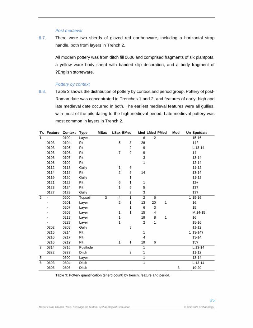
Table 3 shows the distribution of pottery by context and period group. Pottery of post-
Roman date was concentrated in Trenches 1 and 2, and features of early, high and
late medieval date occurred in both. The earliest medieval features were all gullies,
with most of the pits dating to the high medieval period. Late medieval pottery was
most common in layers in Trench 2.
Tr. Feature Context Type MSax LSax EMed Med LMed PMed Mod Un Spotdate
1 - 0100 Layer 6 2 15-16
0103 0104 Pit 5 3 26 14?
0103 0105 Pit 2 9 L.13-14
0103 0106 Pit 7 9 9 14
0103 0107 Pit 3 13-14
0108 0109 Pit 1 12-14
0112 0113 Gully 1 6 11-12
0114 0115 Pit 2 5 14 13-14
0119 0120 Gully 1 11-12
0121 0122 Pit 6 1 1 12+
0123 0124 Pit 1 5 5 13?
0127 0128 Gully 2 3 13?
2 - 0200 Topsoil 3 4 1 2 6 1 15-16
- 0201 Layer 2 1 13 20 1 16
- 0207 Layer 1 6 3 15
- 0209 Layer 1 1 15 4 M.14-15
- 0213 Layer 1 19 8 1 16
- 0223 Layer 1 2 1 15-16
0202 0203 Gully 3 11-12
0215 0214 Pit 1 1 13-14?
0216 0217 Pit 4 13-14
0216 0219 Pit 1 1 19 6 15?
3 0314 0315 Posthole 1 L.13-14
0332 0333 Ditch 3 1 11-12
5 0500 Layer 1 13-14
6 0603 0604 Ditch 1 L.13-14
0605 0606 Ditch 8 19-20
Table 3: Pottery quantification (sherd count) by trench, feature and period.
26
Manor Farm, Church Road, Kessingland, Suffolk: Archaeological Evaluation © Cotswold Archaeology
Discussion
As a relatively large quantity of pottery from an evaluation, this assemblage suggests
concentrated activity in the areas of at least two of the trenches. The assemblage
ranges in date from potentially Middle Saxon to late medieval, with minimal post-
medieval and modern components. There is limited evidence for Late Saxon and
early medieval activity, and all Late Saxon pottery was residual. A few features may
date to the early medieval period. Sherds which can be confidently dated to the
12th/13th-century are relatively rare, with the majority of greywares probably
belonging to the 13th/14th centuries or later (see below).
A comparable assemblage was excavated to the north of this site at The Nordalls,
although it has only reached assessment at the time of writing and full analysis is
awaited (Anderson 2017). Due to time constraints, it was not possible to identify the
coarsewares at that site, although the presence of several Waveney Valley wares
was noted, and the main coarseware was a fine sandy fabric with sparse to moderate
mica, comparable with the Manor Farm group. As with that group, it seems likely that
the finer greywares may have continued in use into the 15th century in this area, and
the Trench 2 assemblage appears to confirm this, with many unabraded greywares
occurring in association with local LMT. As such, they were probably contemporary
with the ‘late medieval reduced’ (LMR) types found in the east and southern Midlands,
although they have little else in common with them. They may be more related to
Dutch greywares, which continued in use into this period on the Continent. It is
interesting that several Dutch redwares were recovered from the site, and that a
number of LMT vessels were similarly decorated with orange glaze – these vessels
can be paralleled at Covehithe (examples in Lowestoft Museum), which may have
been a production centre for orange-glazed LMT wares. These could have been
made to appeal to local Dutch immigrants, of which there were several in Kessingland
according to the tax assessment of 1440 (York Univ. 2020).
As noted above, some of the rim forms in this assemblage are more like Norfolk than
Suffolk types, and none of the typical square-bead rimmed bowls and jars of the 13th
and 14th centuries are present. They did, however, occur with relatively frequency at
The Nordalls, so potentially there is something ‘different’ about this site in terms of
pottery use. There are very few bowls for a rural site, these being significantly
outnumbered by jars (cooking pots). However, this is only an evaluation sample, and
27
Manor Farm, Church Road, Kessingland, Suffolk: Archaeological Evaluation © Cotswold Archaeology
there is potential for a much larger assemblage from any future excavation to help in
answering some of these questions.
Lithics
A total of seven flint flakes, two of which are broken, was recorded from the hand-
excavation and bulk soil sampling of five deposits (Appendix B Table 10). All were
residual in topsoil or in features where they were associated with pottery of medieval
or post-medieval date, with the exception of the flake from fill 333 of ditch 332. The
proximal flake fragment from fill 113 of medieval-dated gully 112 has been removed
using a ‘soft’ hammer. Such technology is typical of the Mesolithic and Early Neolithic
periods. The remainder of the flakes do not display chronologically diagnostic
features and are broadly prehistoric in date.
Ceramic Building Material (CBM)
Four fragments (447g) of CBM were collected from four contexts in two trenches. The
assemblage was quantified (count and weight) by fabric and form. Fabrics were
identified on the basis of macroscopic appearance and main inclusions. The width,
length and thickness of bricks and floor tiles were measured, but roof tile thicknesses
were only measured when another dimension was available. A catalogue by context
is included in Appendix B Table 9.
Two fragments of bricks were recovered. One (24g) from layer 0213 was a possible
medieval brick in a pale orange estuarine clay fabric, dating to the later 13th to 15th
centuries, and found in association with late medieval pottery. A larger fragment
(365g) from layer 0223 was a post-medieval, handmade, red-firing brick in a medium
sandy fabric with ferrous oxide and flint inclusions, and measured 55mm thick,
suggesting a 16th–18th-century date.
Two fragments of pantile of post-medieval date were found. From topsoil 0200 there
was a 17th/18th-century black-glazed fragment (39g) of the curving edge, in a fine
sandy fabric. A small fragment from ditch fill 0606 was in a fine sandy micaceous
fabric and was probably of 19th/20th-century date.
Fired clay
Fifty-five fragments (107g) of fired clay were recovered from seven contexts in two
trenches. The fired clay was quantified by context, fabric and type, using fragment
count and weight in grams. The presence and form of surface fragments and
28
Manor Farm, Church Road, Kessingland, Suffolk: Archaeological Evaluation © Cotswold Archaeology
impressions were recorded. Data were input into an MS Access database and a
catalogue by context is included as Appendix B Table 8.
Thirty-seven fragments were recovered from three pit fills (0106, 0115, 0124) and a
gully fill (0113) in Trench 1, the majority from the latter. All but one were in a fine
sandy fabric with chalk inclusions, fired to a bright orange colour, with buff surfaces
where these had survived. Surfaces were generally flattish or slightly convex and
there were occasional grass impressions. A tiny fragment in a medium sandy fabric
with coarse quartz inclusions came from 0124, was also buff-orange in colour and
appeared to have a convex surface. Similar small fragments (total 5) to the majority
from Trench 1 were found in layer 0201 and gully fill 0203 in Trench 2, possibly with
convex surfaces. All of these fragments were found in association with medieval
pottery and are likely to be the remains of hearth or oven domes, although there were
no diagnostic features to prove this.
Twelve small fragments (10g) in a very friable silty fabric with large rounded voids
were collected in sample <7> from heat-affected pit fill (0220). The function and date
of these is unknown.
Post medieval glass
Three pieces of modern transparent window glass were found in fill 0606 of ditch
0605, together with a fragment of green bottle glass of post-medieval date.
Registered artefacts
Introduction
A total of twenty-eight items was recovered from Trenches 2 and 6 and recorded as
eight registered artefacts. The objects were collected from deposit layers and ditch
and pit fills; one of the objects is of copper alloy; eight are glass; three are lead;
thirteen are bone and the remainder are iron. They have been fully recorded and
catalogued with the assistance of low powered magnification, but without the
assistance of radiographs. A complete catalogue listing is provided in Appendix B
Table 11.
The overall condition of the objects is poor; the objects are fragmentary with the
metalwork exhibiting corrosion products. The medieval window glass is weathered
with iridescence and laminating on the surfaces; it is stored in damp, cool conditions
29
Manor Farm, Church Road, Kessingland, Suffolk: Archaeological Evaluation © Cotswold Archaeology
to mitigate further degradation. The artefacts are packed in perforated bags and
stored in airtight boxes with silica gel where appropriate.
Late medieval
Five of the registered artefacts are of later medieval date; three are associated with
glazing from a building; one artefact is a dress accessory and the fourth is an item
associated with personal grooming.
Ra 1, retrieved from deposit 0201, is an incomplete double-sided simple bone comb
with differentiated teeth. It is a one-piece construction. The thickness of the teeth on
one side is 2.4mm, spaced 1.2mm apart. On the opposing edge the teeth are 1mm
thick and spaced 0.8mm apart. It is comparable to Type 14b combs of late medieval
and post-medieval date (Ashby 2007, 6) that are generally of smaller construction
and often referred to as nit combs. This type of comb is relatively common in the
British Isles (ibid., 6). Further fragments were identified with the animal bone
assemblage.
Ra 5, collected from deposit 0223, is a copper alloy square, sheet mount with two
circular rivets for attachment, one of which still has the surviving copper alloy rove.
Square mounts were often used for decorating belt straps such as London examples
recovered in deposits of c.1400 – 1450 date (Egan and Pritchard 2002, 199, nos.
1061 and 1062); those with domed centres, such as Ra 5, were also used as book
cover mounts (Howsam 2016, 44). The positioning of the rivets, however, argues
against this latter possibility for Ra 5.
Ra’s 2, 3 and 7 are objects associated with glazing. Five pieces of window glass
collected from deposit 0201, four of which are painted, comprise Ra 2. A further three
pieces of window glass, Ra 7, were collected from ditch fill 0606 in Trench 6; none
appear painted. All the glass fragments are now completely opaque so their original
colour cannot be ascertained. The degraded condition of the glass is typical of ‘forest
glass’ composition; a potash rich glass that first appears in the 10th century becoming
more common by the 14th century (Tyson 2017, 35). The thickness of the window
glass fragments, ranging from 3.1mm to 3.8mm, is typical of glass of 14th century or
earlier (ibid.). The reverse of the glass fragments is pitted, due to weathering,
indicating that the quarries, of which they were part, were in use within the windows
over a long period of time. Four of the glass shards have bands of red paint, possibly
flashed ruby, on the external surfaces.
30
Manor Farm, Church Road, Kessingland, Suffolk: Archaeological Evaluation © Cotswold Archaeology
In addition to the window glass, a twisted piece of window leading was collected
during the evaluation: Ra 3 from deposit 0213. The fragment comprises a cast, H-
sectioned piece of leading with the casting flash scraped away; this would suggest
the cames is either of Type B or C (King 1987, 39). There is also a possible lead
tie/cross piece with solder attached.
Uncertain date
Seven hand forged iron nails were collected weighing a total of 127g. Three were
recovered from the bulk finds: one each from deposits 0209 and 0223 and fill 0219
of pit 0216; an additional three were collected during the processing of environmental
Sample 6 from deposit 0201. A single nail was recorded as Ra 4, recovered from fill
0214 of pit 0215. Hand forged nails alter little over time: the shank width and diameter
of the nail heads suggests that three are of small to medium size and may have been
used for joined objects of furniture or boxes. The nail collected from deposit 0209 has
a larger head, measuring 35.5mm in width, more indicative of nails utilised for
strengthening doors or chests (Margeson 1983, 147, fig. 108, nos. 1089 and 1090).
Two additional iron objects are potential fixtures or fittings of uncertain date and
function: Ra 6 is a hooked object retrieved from deposit 0223; Ra 8 is a cruciform
shaped object with one looped terminal collected from ditch fill 0606. The hook, Ra
6, may have been utilised as a structural fixture or as part of kitchen hearth furniture;
Ra 8 was possibly part of a harness or cart fitting. Radiographs of these objects could
assist with their identification.
Discussion
The small assemblage of registered artefacts and bulk metalwork is of limited value
in assisting with dating or in understanding the function of the site. The medieval
glass and window cames are significant in that they are often a sign of a high-status
building or one that is ecclesiastical in nature. Given the relative proximity of the
medieval church 50m to the east of the site it is probable that this evidence for glazing
originated there and could relate to refurbishments or even deliberate destruction.
The copper alloy mount and bone comb fragments are the only objects reflecting
personal possessions during the later medieval period.
It is recommended that if further work is undertaken on the site, selected metalwork
should undergo radiography.
31
Manor Farm, Church Road, Kessingland, Suffolk: Archaeological Evaluation © Cotswold Archaeology
7. THE BIOLOGICAL EVIDENCE
The animal bone assemblage was fragmentary but provided data confirming the
presence of cow, sheep, horse and pig, with the additional remains of fish and bird
bone. The plant macrofossils and other remains showed evidence of cereal grains,
beans and other legumes, and plants such as mustard. There is also some indication
of metalworking activity. All these remains are likely to represent material deposited
into pits and ditches from the clearing out of domestic waste in the vicinity during the
medieval and late medieval to early post-medieval periods.
Animal bone
Animal bone amounting to seventy-nine fragments (574.5g) was recovered from
eleven deposits. Artefactual material dating to the medieval period was also
recovered (Table 12, Appendix C). The material was highly fragmented but well
preserved enough to identify a limited amount of cattle (Bos taurus), sheep/goat (Ovis
aries/Capra hircus), pig (Sus scrofa sp.) and horse (Equus callabus) from a mixture
of both meat-rich and meat-poor skeletal elements. Occupation layer 0201 produced
the most bone with fifty-one fragments (149.5g) recovered. Much of this material
consisted of fish bone together with the occasional fragment of bird bone. However
due to the fragmentary nature of the assemblage, it was not possible to make an
identification to species level. A complete humerus of a mole (Talpa europaea) was
also recovered from this layer which, due to the burrowing nature of this animal, is
more than likely to be intrusive. No cut marks or impact damage indicative of butchery
waste were observed which, when coupled with the low recovery, limits what can be
said about this assemblage in terms of site economy and animal husbandry.
However, each of these species is to be expected in an assemblage of this period
and their recovery from either pit fills or occupation layers is suggestive of an origin
in butchery waste.
Shell
Nine fragments of shell weighing 46g were recovered. All the shell was oyster. A table
of the shell by context is shown in Appendix C Table 13.
Plant macrofossils
Introduction and methods
Seven bulk samples were taken from pits, ditches and layers, mostly dating to the
medieval period. The samples were processed in full in order to assess the quality of
32
Manor Farm, Church Road, Kessingland, Suffolk: Archaeological Evaluation © Cotswold Archaeology
preservation of plant remains and their potential to provide useful data as part of
further archaeological investigations.
The samples were processed using manual water flotation/washover and the flots
were collected in a 300µm mesh sieve. The dried flots were scanned using a
binocular microscope at x10 magnification and the presence of any plant remains or
ecofacts are noted in Appendix C Table 14. Identification of plant remains is with
reference to New Flora of the British Isles, (Stace 1995).
The non-floating residues were collected in a 1mm mesh and sorted when dry. All
artefacts/ecofacts were retained for inclusion in the finds total.
Quantification
For the purpose of this initial assessment, items such as seeds, cereal grains and
small animal bones have been scanned and recorded quantitatively according to the
following categories # = 1-10, ## = 11-50, ### = 51+ specimens. Items that cannot
be easily quantified such as charcoal, magnetic residues and fragmented bone have
been scored for abundance + = rare, ++ = moderate, +++ = abundant.
Discussion
Three samples failed to produce any flot, pit 0328 (Sample 2) and (Sample 3) and
ditch 0332 (Sample 4), and therefore, as no charred plant remains were recovered
these samples will not be included in the discussions below. The remaining samples
produced flots ranging from 30ml to 60ml; they have all been rapid scanned in full for
the purposes of this report.
Trench 1, pit 103 (Sample 1) and ditch 112 (Sample 5)
Charred cereals grains were common within both flots. Both barley (Hordeum sp.)
and bread wheat (Triticum sp.) were present with barley being dominant. Possible
oat/rye (Avena/Secale sp.) grains were rare. A large number of the cereal grains
present were too fragmented and abraded to be positively identified. Legume
fragments were also present in both samples in moderate numbers. Both peas
(Pisum sp.) and beans (Vicia sp.) were observed, however, a large number of legume
fragments were too abraded to identify and can only be recorded as ‘small legumes’.
Charred seeds of mustard family (Brassicaeae) were present in both samples in low
numbers, along with a single possible sedge (Carex sp.) in pit fill 0106 (Sample 1)
and a single knotweed family (Polygonum sp.) within ditch fill 0113 (Sample 5).
33
Manor Farm, Church Road, Kessingland, Suffolk: Archaeological Evaluation © Cotswold Archaeology
Fragments of highly vitrified organic material were present in small quantities within
ditch fill 0113 (Sample 5). This material is black and highly vitrified most likely the
result of being exposed to high temperatures. It is possible this material represents
food waste or other domestic waste disposed of within a fire.
Small number of what appear to be knots of possible charred twine or thread were
recovered from pit fill 0106 (Sample 1). These have not been positively identified for
the purposes of this report.
Ferrous flakes were recovered from the non-floating fraction of pit fill 0106, Sample
1. The presence of flake hammerscale indicates that metal working, such as
smithying, may have been taking place in the vicinity of the site.
Trench 2, layer 201 (sample 6) and pit 216 (sample 7)
The remains recovered from the sampled features within Trench 2 were similar to the
material described above for Trench 1. Charred cereal grains were moderately
common in both, with bread wheat being dominant within layer 0201 (Sample 6) and
barley being dominant within pit fill 0220 (Sample 7). Legume fragments were rare
within layer 0201, however, both beans and peas were present in low numbers along
with indeterminate legume fragments within fill 0220 (Sample 7).
Charred weed seeds were rare, grasses (Poaceae) seeds and a single culm node
were present in pit fill 0220 (Sample 7) along with a single knotgrass family
(Polygonum sp.) seed.
Fish bones and bird bones were present in very low numbers within the flots of both
samples, this material was observed during scanning under magnification and
although they are recorded here, they were either too sparse or too small to require
examination by the relevant specialist. The presence of bone fragments suggests
household waste, from domestic activities such as food preparation, has become
incorporated within the archaeological contexts sampled.
Ferrous flakes were present in both the flot and the non-floating residue from layer
0201 (Sample 6), again these remains may indicate the presence of metal working in
the vicinity of the site.
34
Manor Farm, Church Road, Kessingland, Suffolk: Archaeological Evaluation © Cotswold Archaeology
Conclusions and recommendations for further work
In general, the samples examined were fair in terms of identifiable material although
the abraded and fragmented nature of the some of the remains made identification
difficult to impossible. The presence of cereal grains, legumes and vitrified material
that may be associated with food waste, is indicative of domestic activities, such as
food preparation, taking place in the vicinity. The mixed nature of the waste within the
archaeological features suggests domestic waste may have been incorporated with
other refuse, prior to or on deposition within the archaeological features excavated.
The small number of legumes observed may not be representative of the importance
of pulses within the diet. As pulses do not need to be processed using heat, in the
way some cereals do, they are less likely to be exposed to chance preservation
through charring and so are often under-represented within archaeological deposits.
The presence of legumes may indicate that either small scale garden-type production
of food crops or larger crop rotation was taking place nearby.
The limited nature of the interventions mean to it is impossible to say with any
certainty the source of the material recovered from these samples. It is likely that this
material represents domestic waste, material used as fuel or chance loss in the oven
or hearth. The magnetic residues also suggest metal working may have taken place
in the vicinity. The remains recovered indicate the domestic, horticultural, agricultural,
and light industrial activities were taking place in the area.
If further interventions are carried out on this site it is recommended that bulk samples
should be taken from any well sealed and well dated context, in order to investigate
the nature of the domestic and household waste material. Additional plant
macrofossils may provide an insight into to utilisation of local plant resources,
agricultural activity and economic evidence from the site.
8. DISCUSSION
The evaluation has shown that the level of preservation of heritage assets across the
site is good with overburden generally c.0.6m thick, and up to 0.8m thick towards the
rear of the property and away from the road, with both topsoil and subsoil deposits
present. However, to the north of the development area, and close to Church Road,
the depth of material is significantly less with topsoil only 0.35m thick directly over the
archaeological level in both Trenches 1 and 2. Despite this, modern intrusion appears
to be limited to one pit in Trench 3 and a ditch aligned roughly parallel with the road
35
Manor Farm, Church Road, Kessingland, Suffolk: Archaeological Evaluation © Cotswold Archaeology
to the rear of the property. Archaeological deposits were recorded in seven of the
eight trenches with only one of those trenches having just one feature, with as many
as seventeen features recorded in Trench 3. As would perhaps be expected, the
incidence of archaeological features was greater closer to the road with occupation
layers and possible surfaces present closest to the road, possible structures and
backyard rubbish pits giving way to less dense ditches possibly demarcating field
boundaries further to the south. The potential for environmental evidence to survive
within the development area has been shown with some of the samples collected on
site containing charred seed remains further suggesting domestic occupation.
As with previous unstratified finds recorded on the HER, transient prehistoric activity
within the vicinity of the site was shown through residual worked flint finds, with one
piece in particular showing technology dated to either the Mesolithic or Early
Neolithic.
The relatively large pottery assemblage collected suggests fairly continuous
occupation on or around the site from the 7th century through to the post medieval
period with residually present Middle and Late Saxon domestic pottery recovered
from later medieval features. The majority of the artefactual material recovered came
from the two trenches close to the road which, along with Trench 3, showed the
densest distribution of archaeological deposits with thirteen ditches, eight pits and
eleven postholes shared amongst them along with up to eight deposits. Occupation
layers, including a potential laid floor surface and an associated posthole, were
identified in Trench 2, within 10m of the road. The artefactual evidence recovered
from this trench suggests that these layers likely date from the Late Medieval period
and potentially contemporary with the construction of the church, c.50m to the east.
Trench 1, c.25m to the west, was further from the road, at least 25m, and the nature
of the features here was different with large possible rubbish pit, supporting the
assertion that this trench, and Trench 3, possibly occupy the rear yard or garden
space associated with possible roadside buildings or structures. The majority of the
possible postholes excavated in Trench 3 follow the same east west alignment as the
ditch that they cut, perhaps suggesting the continuation and evolution of a rear
property boundary, supported by the significant drop in the incidence of
archaeological deposits to the south of the ditch.
36
Manor Farm, Church Road, Kessingland, Suffolk: Archaeological Evaluation © Cotswold Archaeology
A number of ditches could be seen continuing from one trench to another, aligned
both east west and also perpendicular, suggesting a continuation of the rectilinear
field systems recorded as cropmarks around the site. One ditch in particular, which
was seen crossing the site from north to south, can also potentially be seen to be
continuing in the cropmarks to the south of the site, perhaps supporting the assertion
that these field systems are medieval in origin.
It is clear from the results of the evaluation that a significant amount of medieval
archaeology is present in the north of the site with the potential for structural remains
to be present.
9. CA PROJECT TEAM
Fieldwork was undertaken by Simon Picard, assisted by Nigel Byram and Matt
Stevens. This report was written by Simon Picard and edited by Stuart Boulter. The
finds reports were written by Sue Anderson (pottery, fired clay and CBM), Jacky
Somerville (flint), and Ruth Beveridge (registered artefacts). The biological reports
were written by Andy Clarke and Anna West, animal bone and plant macrofossils
respectively. The report illustrations were prepared by Ryan Wilson. The project
archive has been compiled and prepared for deposition by Clare Wootton. The project
was managed for CA by Stuart Boulter.
10. REFERENCES
Anderson, S., 2017, The Nordalls, Kessingland (KSS133): post-Roman pottery.
Archive report for NPS.
Anderson, S., 2019, Suffolk Fabric Series. Access database, unpublished.
Ashby,S. 2007 Bone and antler combs: Datasheet 40. Finds Research Group
AD700-1700.
British Geological Survey 2019 Geology of Britain Viewer
http://www.bgs.ac.uk/discoveringGeology/geologyOfBritain/viewer.html
Accessed 15 October 2020
Brooks, R. 2017 Guildhall Feoffment primary school, Bury St Edmunds, Suffolk.
Archaeological assessment report, SACIC Report No. 2016/020.
Cotswold Archaeology 2020 Manor Farm Care Home, Kessingland, Suffolk: Written
Scheme of Investigation for an Archaeological Evaluation
37
Manor Farm, Church Road, Kessingland, Suffolk: Archaeological Evaluation © Cotswold Archaeology
Egan, G. and Pritchard, F. 2002 Dress Accessories c.1150 – 1450. Medieval finds
from excavations in London: 3. Woodbridge: Boydell Press.
Howsam, C.L. 2016 Book fastenings and furnishings: an archaeology of late
medieval books. Unpublished PhD thesis submitted to University of
Sheffield. Available:
https://etheses.whiterose.ac.uk/13105/1/C%20Howsam%20eThesis.pdf
[accessed 14/10/2020].
King, D.J. 1987 ‘The window glass and lead’ in Rogerson et al. 1987, 32-40
Margeson, S., 1993 Norwich Households: Medieval and Post-Medieval Finds from
Norwich Survey Excavations 1971-78. East Anglian Archaeology 58.
MPRG, 1998, A Guide to the Classification of Medieval Ceramic Forms. Medieval
Pottery Research Group Occasional Paper 1.
Rogerson, A., Ashley, J.A., Williams, P. and Harris, A. 1987 Three Norman
Churches in Norfolk. East Anglian Archaeology No. 32
Stace C. 1995, New Flora of the British Isles, 2nd Ed, Bury St Edmunds, Cambridge
University Press.
Tyson, R. 2017 ‘The medieval window glass and glass bead’ in Brooks, 2017, 34-36
York Univ., 2020, England’s Immigrants 1330–1550,
http://www.englandsimmigrants.com/

38
Manor Farm, Church Road, Kessingland, Suffolk: Archaeological Evaluation © Cotswold Archaeology
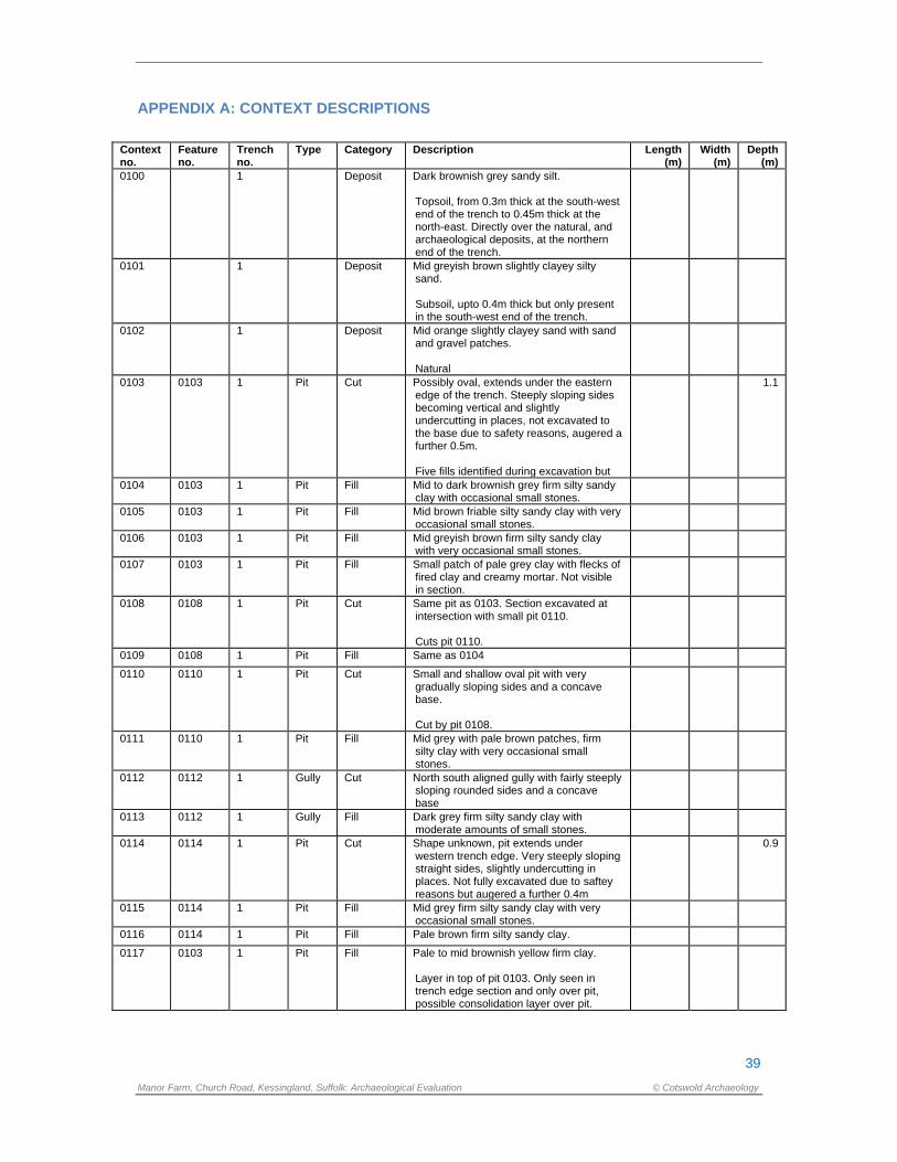
39
Manor Farm, Church Road, Kessingland, Suffolk: Archaeological Evaluation © Cotswold Archaeology
APPENDIX A: CONTEXT DESCRIPTIONS
Context no.
Feature no.
Trench no.
Type Category Description Length (m)
Width (m)
Depth (m)
0100 1 Deposit Dark brownish grey sandy silt. Topsoil, from 0.3m thick at the south-west end of the trench to 0.45m thick at the north-east. Directly over the natural, and archaeological deposits, at the northern end of the trench.
0101 1 Deposit Mid greyish brown slightly clayey silty sand. Subsoil, upto 0.4m thick but only present in the south-west end of the trench.
0102 1 Deposit Mid orange slightly clayey sand with sand and gravel patches. Natural
0103 0103 1 Pit Cut Possibly oval, extends under the eastern edge of the trench. Steeply sloping sides becoming vertical and slightly undercutting in places, not excavated to the base due to safety reasons, augered a further 0.5m. Five fills identified during excavation but
1.1
0104 0103 1 Pit Fill Mid to dark brownish grey firm silty sandy clay with occasional small stones.
0105 0103 1 Pit Fill Mid brown friable silty sandy clay with very occasional small stones.
0106 0103 1 Pit Fill Mid greyish brown firm silty sandy clay with very occasional small stones.
0107 0103 1 Pit Fill Small patch of pale grey clay with flecks of fired clay and creamy mortar. Not visible in section.
0108 0108 1 Pit Cut Same pit as 0103. Section excavated at intersection with small pit 0110. Cuts pit 0110.
0109 0108 1 Pit Fill Same as 0104
0110 0110 1 Pit Cut Small and shallow oval pit with very gradually sloping sides and a concave base. Cut by pit 0108.
0111 0110 1 Pit Fill Mid grey with pale brown patches, firm silty clay with very occasional small stones.
0112 0112 1 Gully Cut North south aligned gully with fairly steeply sloping rounded sides and a concave base
0113 0112 1 Gully Fill Dark grey firm silty sandy clay with moderate amounts of small stones.
0114 0114 1 Pit Cut Shape unknown, pit extends under western trench edge. Very steeply sloping straight sides, slightly undercutting in places. Not fully excavated due to saftey reasons but augered a further 0.4m
0.9
0115 0114 1 Pit Fill Mid grey firm silty sandy clay with very occasional small stones.
0116 0114 1 Pit Fill Pale brown firm silty sandy clay.
0117 0103 1 Pit Fill Pale to mid brownish yellow firm clay. Layer in top of pit 0103. Only seen in trench edge section and only over pit, possible consolidation layer over pit.
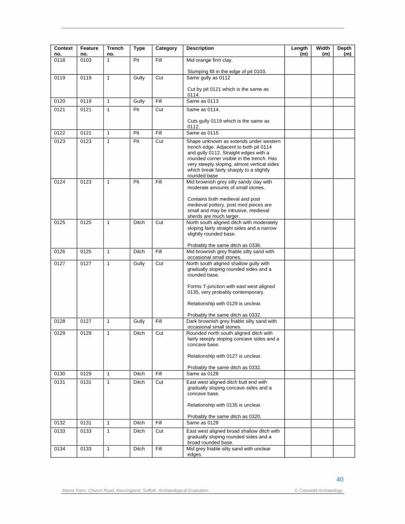
40
Manor Farm, Church Road, Kessingland, Suffolk: Archaeological Evaluation © Cotswold Archaeology
Context no.
Feature no.
Trench no.
Type Category Description Length (m)
Width (m)
Depth (m)
0118 0103 1 Pit Fill Mid orange firm clay. Slumping fill in the edge of pit 0103.
0119 0119 1 Gully Cut Same gully as 0112 Cut by pit 0121 which is the same as 0114.
0120 0119 1 Gully Fill Same as 0113
0121 0121 1 Pit Cut Same as 0114. Cuts gully 0119 which is the same as 0112.
0122 0121 1 Pit Fill Same as 0115
0123 0123 1 Pit Cut Shape unknown as extends under western trench edge. Adjacent to both pit 0114 and gully 0112. Straight edges with a rounded corner visible in the trench. Has very steeply sloping, almost vertical sides which break fairly sharply to a slightly rounded base
0124 0123 1 Pit Fill Mid brownish grey silty sandy clay with moderate amounts of small stones. Contains both medieval and post medieval pottery, post med pieces are small and may be intrusive, medieval sherds are much larger.
0125 0125 1 Ditch Cut North south aligned ditch with moderately sloping fairly straight sides and a narrow slightly rounded base. Probably the same ditch as 0336.
0126 0125 1 Ditch Fill Mid brownish grey friable silty sand with occasional small stones.
0127 0127 1 Gully Cut North south aligned shallow gully with gradually sloping rounded sides and a rounded base. Forms T-junction with east west aligned 0135, very probably contemporary. Relationship with 0129 is unclear. Probably the same ditch as 0332.
0128 0127 1 Gully Fill Dark brownish grey friable silty sand with occasional small stones.
0129 0129 1 Ditch Cut Rounded north south aligned ditch with fairly steeply sloping concave sides and a concave base. Relationship with 0127 is unclear. Probably the same ditch as 0332.
0130 0129 1 Ditch Fill Same as 0128
0131 0131 1 Ditch Cut East west aligned ditch butt end with gradually sloping concave sides and a concave base. Relationship with 0135 is unclear. Probably the same ditch as 0320.
0132 0131 1 Ditch Fill Same as 0128
0133 0133 1 Ditch Cut East west aligned broad shallow ditch with gradually sloping rounded sides and a broad rounded base.
0134 0133 1 Ditch Fill Mid grey friable silty sand with unclear edges.
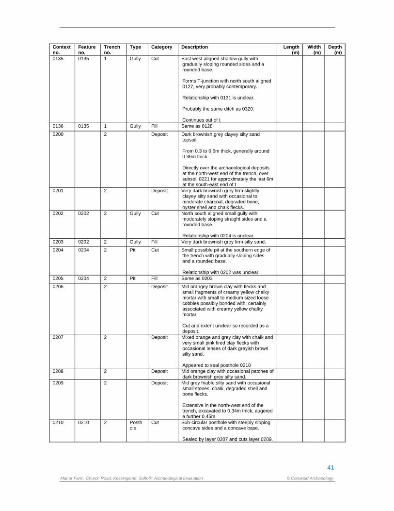
41
Manor Farm, Church Road, Kessingland, Suffolk: Archaeological Evaluation © Cotswold Archaeology
Context no.
Feature no.
Trench no.
Type Category Description Length (m)
Width (m)
Depth (m)
0135 0135 1 Gully Cut East west aligned shallow gully with gradually sloping rounded sides and a rounded base. Forms T-junction with north south aligned 0127, very probably contemporary. Relationship with 0131 is unclear. Probably the same ditch as 0320. Continues out of t
0136 0135 1 Gully Fill Same as 0128
0200 2 Deposit Dark brownish grey clayey silty sand topsoil. From 0.3 to 0.6m thick, generally around 0.36m thick. Directly over the archaeological deposits at the north-west end of the trench, over subsoil 0221 for approximately the last 6m at the south-east end of t
0201 2 Deposit Very dark brownish grey firm slightly clayey silty sand with occasional to moderate charcoal, degraded bone, oyster shell and chalk flecks.
0202 0202 2 Gully Cut North south aligned small gully with moderately sloping straight sides and a rounded base. Relationship with 0204 is unclear.
0203 0202 2 Gully Fill Very dark brownish grey firm silty sand.
0204 0204 2 Pit Cut Small possible pit at the southern edge of the trench with gradually sloping sides and a rounded base. Relationship with 0202 was unclear.
0205 0204 2 Pit Fill Same as 0203
0206 2 Deposit Mid orangey brown clay with flecks and small fragments of creamy yellow chalky mortar with small to medium sized loose cobbles possibly bonded with, certainly associated with creamy yellow chalky mortar. Cut and extent unclear so recorded as a deposit.
0207 2 Deposit Mixed orange and grey clay with chalk and very small pink fired clay flecks with occasional lenses of dark greyish brown silty sand. Appeared to seal posthole 0210
0208 2 Deposit Mid orange clay with occasional patches of dark brownish grey silty sand.
0209 2 Deposit Mid grey friable silty sand with occasional small stones, chalk, degraded shell and bone flecks. Extensive in the north-west end of the trench, excavated to 0.34m thick, augered a further 0.45m.
0210 0210 2 Posthole
Cut Sub-circular posthole with steeply sloping concave sides and a concave base. Sealed by layer 0207 and cuts layer 0209.
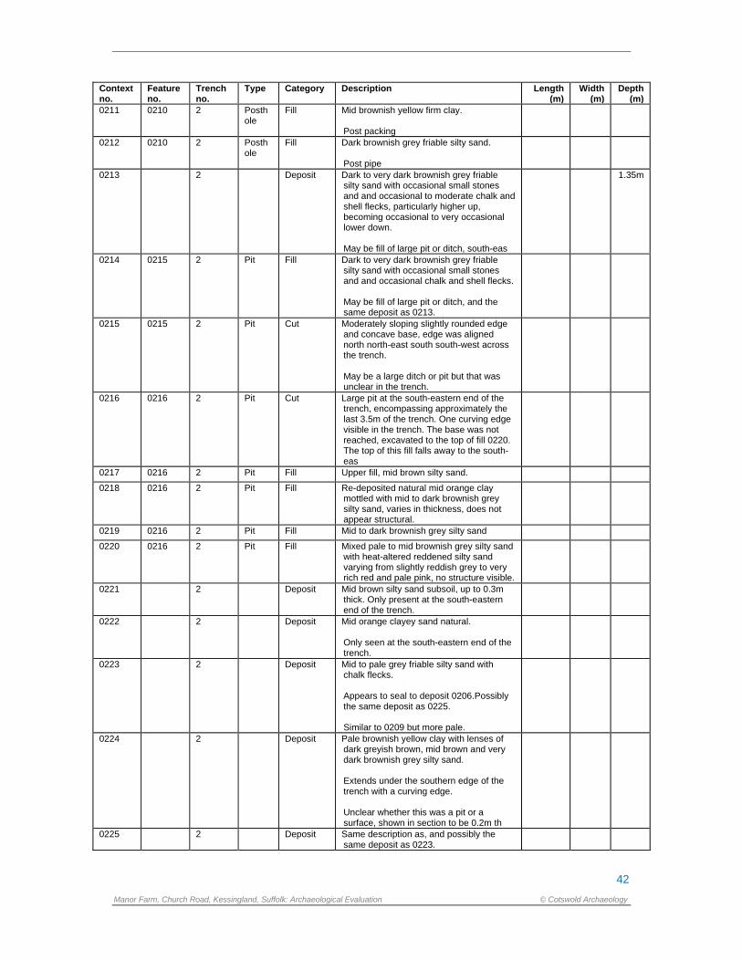
42
Manor Farm, Church Road, Kessingland, Suffolk: Archaeological Evaluation © Cotswold Archaeology
Context no.
Feature no.
Trench no.
Type Category Description Length (m)
Width (m)
Depth (m)
0211 0210 2 Posthole
Fill Mid brownish yellow firm clay. Post packing
0212 0210 2 Posthole
Fill Dark brownish grey friable silty sand. Post pipe
0213 2 Deposit Dark to very dark brownish grey friable silty sand with occasional small stones and and occasional to moderate chalk and shell flecks, particularly higher up, becoming occasional to very occasional lower down. May be fill of large pit or ditch, south-eas
1.35m
0214 0215 2 Pit Fill Dark to very dark brownish grey friable silty sand with occasional small stones and and occasional chalk and shell flecks. May be fill of large pit or ditch, and the same deposit as 0213.
0215 0215 2 Pit Cut Moderately sloping slightly rounded edge and concave base, edge was aligned north north-east south south-west across the trench. May be a large ditch or pit but that was unclear in the trench.
0216 0216 2 Pit Cut Large pit at the south-eastern end of the trench, encompassing approximately the last 3.5m of the trench. One curving edge visible in the trench. The base was not reached, excavated to the top of fill 0220. The top of this fill falls away to the south-eas
0217 0216 2 Pit Fill Upper fill, mid brown silty sand.
0218 0216 2 Pit Fill Re-deposited natural mid orange clay mottled with mid to dark brownish grey silty sand, varies in thickness, does not appear structural.
0219 0216 2 Pit Fill Mid to dark brownish grey silty sand
0220 0216 2 Pit Fill Mixed pale to mid brownish grey silty sand with heat-altered reddened silty sand varying from slightly reddish grey to very rich red and pale pink, no structure visible.
0221 2 Deposit Mid brown silty sand subsoil, up to 0.3m thick. Only present at the south-eastern end of the trench.
0222 2 Deposit Mid orange clayey sand natural. Only seen at the south-eastern end of the trench.
0223 2 Deposit Mid to pale grey friable silty sand with chalk flecks. Appears to seal to deposit 0206.Possibly the same deposit as 0225. Similar to 0209 but more pale.
0224 2 Deposit Pale brownish yellow clay with lenses of dark greyish brown, mid brown and very dark brownish grey silty sand. Extends under the southern edge of the trench with a curving edge. Unclear whether this was a pit or a surface, shown in section to be 0.2m th
0225 2 Deposit Same description as, and possibly the same deposit as 0223.
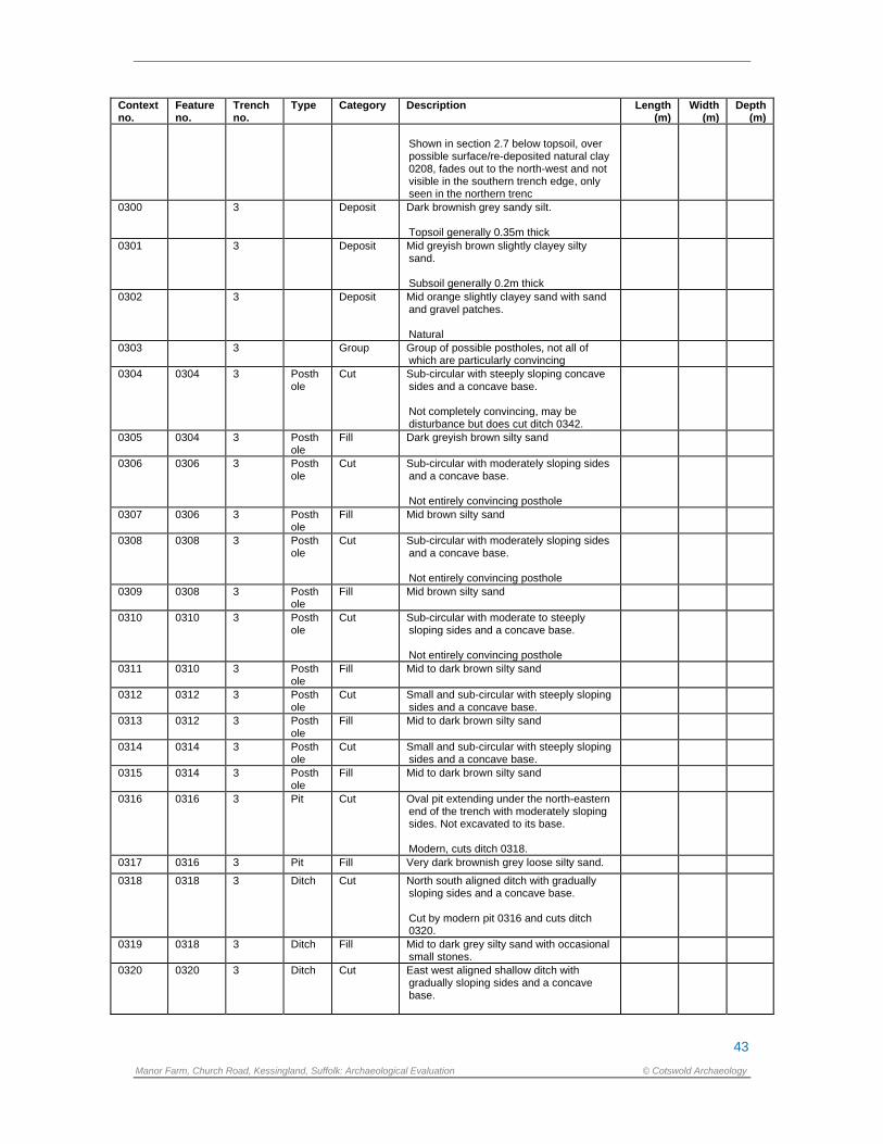
43
Manor Farm, Church Road, Kessingland, Suffolk: Archaeological Evaluation © Cotswold Archaeology
Context no.
Feature no.
Trench no.
Type Category Description Length (m)
Width (m)
Depth (m)
Shown in section 2.7 below topsoil, over possible surface/re-deposited natural clay 0208, fades out to the north-west and not visible in the southern trench edge, only seen in the northern trenc
0300 3 Deposit Dark brownish grey sandy silt. Topsoil generally 0.35m thick
0301 3 Deposit Mid greyish brown slightly clayey silty sand. Subsoil generally 0.2m thick
0302 3 Deposit Mid orange slightly clayey sand with sand and gravel patches. Natural
0303 3 Group Group of possible postholes, not all of which are particularly convincing
0304 0304 3 Posthole
Cut Sub-circular with steeply sloping concave sides and a concave base. Not completely convincing, may be disturbance but does cut ditch 0342.
0305 0304 3 Posthole
Fill Dark greyish brown silty sand
0306 0306 3 Posthole
Cut Sub-circular with moderately sloping sides and a concave base. Not entirely convincing posthole
0307 0306 3 Posthole
Fill Mid brown silty sand
0308 0308 3 Posthole
Cut Sub-circular with moderately sloping sides and a concave base. Not entirely convincing posthole
0309 0308 3 Posthole
Fill Mid brown silty sand
0310 0310 3 Posthole
Cut Sub-circular with moderate to steeply sloping sides and a concave base. Not entirely convincing posthole
0311 0310 3 Posthole
Fill Mid to dark brown silty sand
0312 0312 3 Posthole
Cut Small and sub-circular with steeply sloping sides and a concave base.
0313 0312 3 Posthole
Fill Mid to dark brown silty sand
0314 0314 3 Posthole
Cut Small and sub-circular with steeply sloping sides and a concave base.
0315 0314 3 Posthole
Fill Mid to dark brown silty sand
0316 0316 3 Pit Cut Oval pit extending under the north-eastern end of the trench with moderately sloping sides. Not excavated to its base. Modern, cuts ditch 0318.
0317 0316 3 Pit Fill Very dark brownish grey loose silty sand.
0318 0318 3 Ditch Cut North south aligned ditch with gradually sloping sides and a concave base. Cut by modern pit 0316 and cuts ditch 0320.
0319 0318 3 Ditch Fill Mid to dark grey silty sand with occasional small stones.
0320 0320 3 Ditch Cut East west aligned shallow ditch with gradually sloping sides and a concave base.
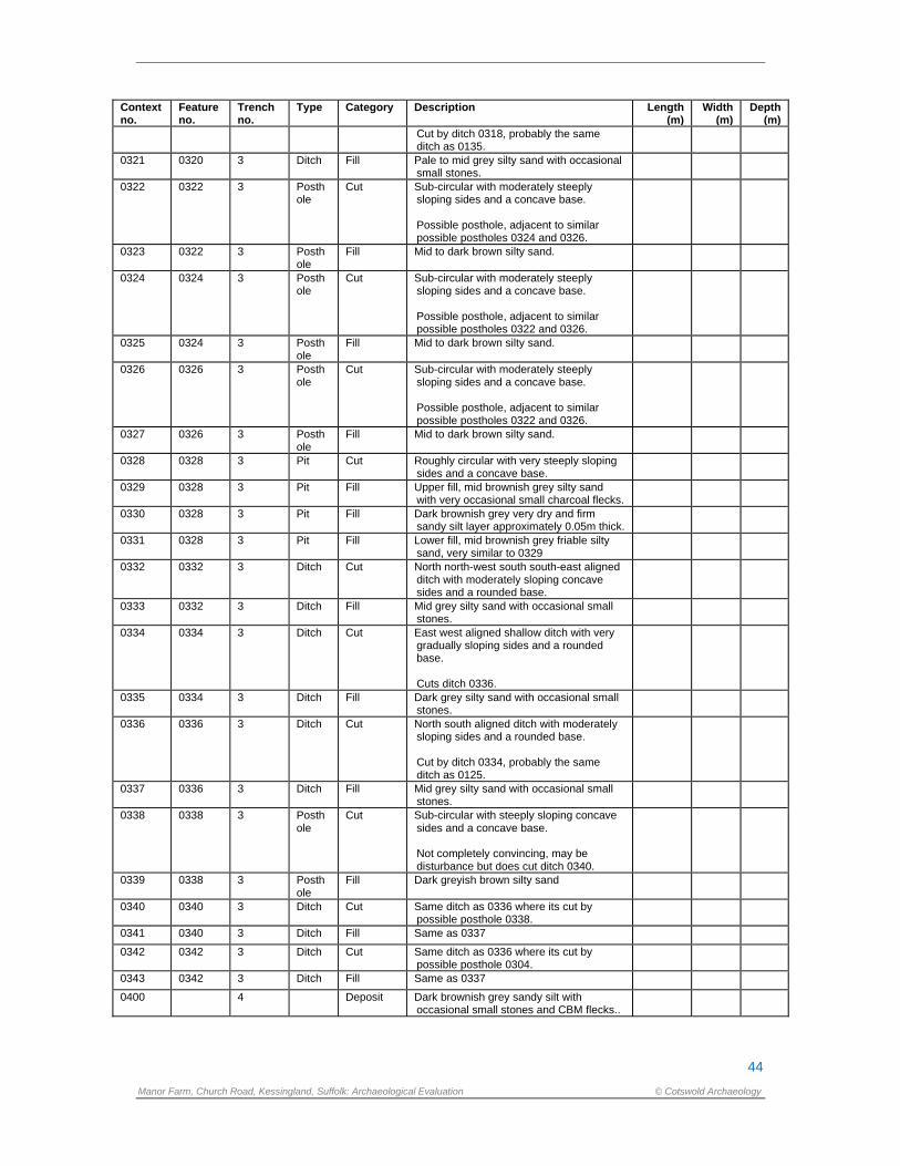
44
Manor Farm, Church Road, Kessingland, Suffolk: Archaeological Evaluation © Cotswold Archaeology
Context no.
Feature no.
Trench no.
Type Category Description Length (m)
Width (m)
Depth (m)
Cut by ditch 0318, probably the same ditch as 0135.
0321 0320 3 Ditch Fill Pale to mid grey silty sand with occasional small stones.
0322 0322 3 Posthole
Cut Sub-circular with moderately steeply sloping sides and a concave base. Possible posthole, adjacent to similar possible postholes 0324 and 0326.
0323 0322 3 Posthole
Fill Mid to dark brown silty sand.
0324 0324 3 Posthole
Cut Sub-circular with moderately steeply sloping sides and a concave base. Possible posthole, adjacent to similar possible postholes 0322 and 0326.
0325 0324 3 Posthole
Fill Mid to dark brown silty sand.
0326 0326 3 Posthole
Cut Sub-circular with moderately steeply sloping sides and a concave base. Possible posthole, adjacent to similar possible postholes 0322 and 0326.
0327 0326 3 Posthole
Fill Mid to dark brown silty sand.
0328 0328 3 Pit Cut Roughly circular with very steeply sloping sides and a concave base.
0329 0328 3 Pit Fill Upper fill, mid brownish grey silty sand with very occasional small charcoal flecks.
0330 0328 3 Pit Fill Dark brownish grey very dry and firm sandy silt layer approximately 0.05m thick.
0331 0328 3 Pit Fill Lower fill, mid brownish grey friable silty sand, very similar to 0329
0332 0332 3 Ditch Cut North north-west south south-east aligned ditch with moderately sloping concave sides and a rounded base.
0333 0332 3 Ditch Fill Mid grey silty sand with occasional small stones.
0334 0334 3 Ditch Cut East west aligned shallow ditch with very gradually sloping sides and a rounded base. Cuts ditch 0336.
0335 0334 3 Ditch Fill Dark grey silty sand with occasional small stones.
0336 0336 3 Ditch Cut North south aligned ditch with moderately sloping sides and a rounded base. Cut by ditch 0334, probably the same ditch as 0125.
0337 0336 3 Ditch Fill Mid grey silty sand with occasional small stones.
0338 0338 3 Posthole
Cut Sub-circular with steeply sloping concave sides and a concave base. Not completely convincing, may be disturbance but does cut ditch 0340.
0339 0338 3 Posthole
Fill Dark greyish brown silty sand
0340 0340 3 Ditch Cut Same ditch as 0336 where its cut by possible posthole 0338.
0341 0340 3 Ditch Fill Same as 0337
0342 0342 3 Ditch Cut Same ditch as 0336 where its cut by possible posthole 0304.
0343 0342 3 Ditch Fill Same as 0337
0400 4 Deposit Dark brownish grey sandy silt with occasional small stones and CBM flecks..
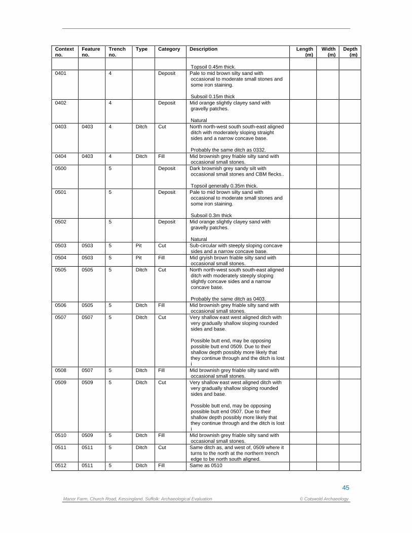
45
Manor Farm, Church Road, Kessingland, Suffolk: Archaeological Evaluation © Cotswold Archaeology
Context no.
Feature no.
Trench no.
Type Category Description Length (m)
Width (m)
Depth (m)
Topsoil 0.45m thick.
0401 4 Deposit Pale to mid brown silty sand with occasional to moderate small stones and some iron staining. Subsoil 0.15m thick
0402 4 Deposit Mid orange slightly clayey sand with gravelly patches. Natural
0403 0403 4 Ditch Cut North north-west south south-east aligned ditch with moderately sloping straight sides and a narrow concave base. Probably the same ditch as 0332.
0404 0403 4 Ditch Fill Mid brownish grey friable silty sand with occasional small stones.
0500 5 Deposit Dark brownish grey sandy silt with occasional small stones and CBM flecks.. Topsoil generally 0.35m thick.
0501 5 Deposit Pale to mid brown silty sand with occasional to moderate small stones and some iron staining. Subsoil 0.3m thick
0502 5 Deposit Mid orange slightly clayey sand with gravelly patches. Natural
0503 0503 5 Pit Cut Sub-circular with steeply sloping concave sides and a narrow concave base.
0504 0503 5 Pit Fill Mid gryish brown friable silty sand with occasional small stones.
0505 0505 5 Ditch Cut North north-west south south-east aligned ditch with moderately steeply sloping slightly concave sides and a narrow concave base. Probably the same ditch as 0403.
0506 0505 5 Ditch Fill Mid brownish grey friable silty sand with occasional small stones.
0507 0507 5 Ditch Cut Very shallow east west aligned ditch with very gradually shallow sloping rounded sides and base. Possible butt end, may be opposing possible butt end 0509. Due to their shallow depth possibly more likely that they continue through and the ditch is lost i
0508 0507 5 Ditch Fill Mid brownish grey friable silty sand with occasional small stones.
0509 0509 5 Ditch Cut Very shallow east west aligned ditch with very gradually shallow sloping rounded sides and base. Possible butt end, may be opposing possible butt end 0507. Due to their shallow depth possibly more likely that they continue through and the ditch is lost i
0510 0509 5 Ditch Fill Mid brownish grey friable silty sand with occasional small stones.
0511 0511 5 Ditch Cut Same ditch as, and west of, 0509 where it turns to the north at the northern trench edge to be north south aligned.
0512 0511 5 Ditch Fill Same as 0510
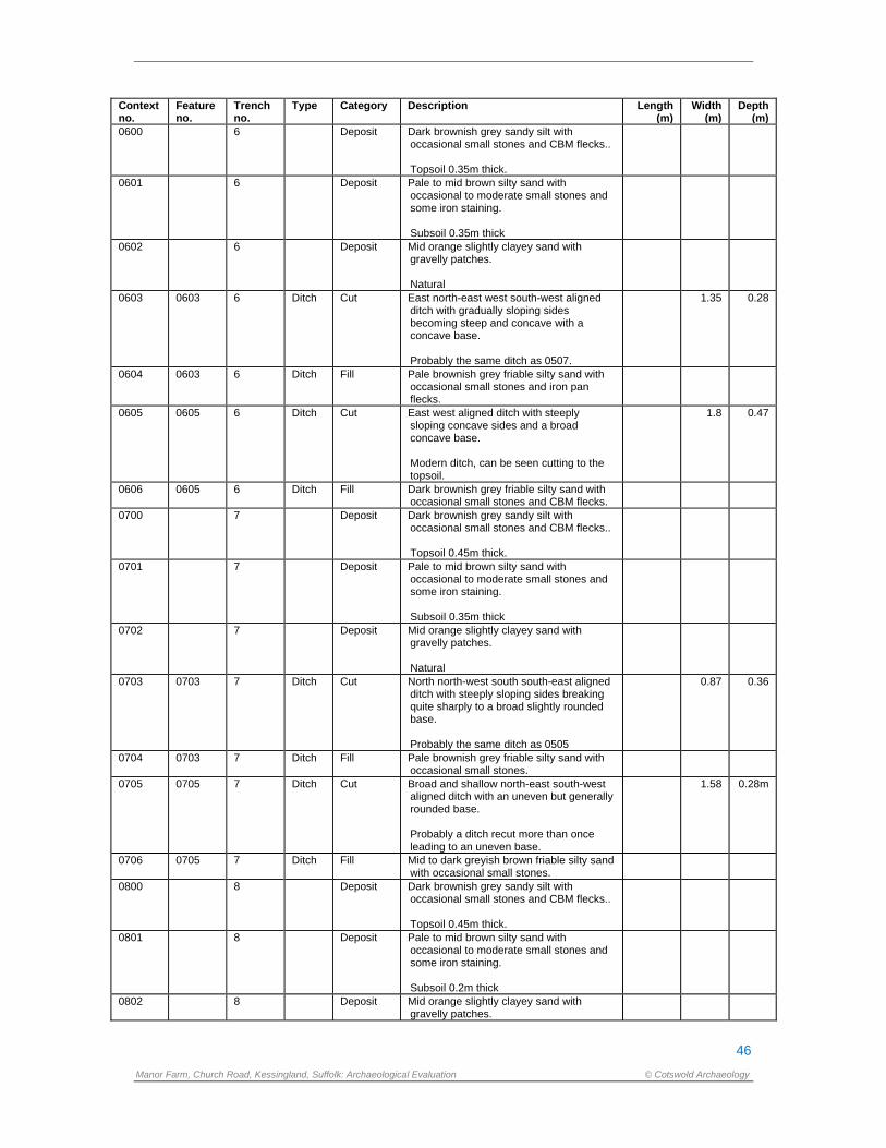
46
Manor Farm, Church Road, Kessingland, Suffolk: Archaeological Evaluation © Cotswold Archaeology
Context no.
Feature no.
Trench no.
Type Category Description Length (m)
Width (m)
Depth (m)
0600 6 Deposit Dark brownish grey sandy silt with occasional small stones and CBM flecks.. Topsoil 0.35m thick.
0601 6 Deposit Pale to mid brown silty sand with occasional to moderate small stones and some iron staining. Subsoil 0.35m thick
0602 6 Deposit Mid orange slightly clayey sand with gravelly patches. Natural
0603 0603 6 Ditch Cut East north-east west south-west aligned ditch with gradually sloping sides becoming steep and concave with a concave base. Probably the same ditch as 0507.
1.35 0.28
0604 0603 6 Ditch Fill Pale brownish grey friable silty sand with occasional small stones and iron pan flecks.
0605 0605 6 Ditch Cut East west aligned ditch with steeply sloping concave sides and a broad concave base. Modern ditch, can be seen cutting to the topsoil.
1.8 0.47
0606 0605 6 Ditch Fill Dark brownish grey friable silty sand with occasional small stones and CBM flecks.
0700 7 Deposit Dark brownish grey sandy silt with occasional small stones and CBM flecks.. Topsoil 0.45m thick.
0701 7 Deposit Pale to mid brown silty sand with occasional to moderate small stones and some iron staining. Subsoil 0.35m thick
0702 7 Deposit Mid orange slightly clayey sand with gravelly patches. Natural
0703 0703 7 Ditch Cut North north-west south south-east aligned ditch with steeply sloping sides breaking quite sharply to a broad slightly rounded base. Probably the same ditch as 0505
0.87 0.36
0704 0703 7 Ditch Fill Pale brownish grey friable silty sand with occasional small stones.
0705 0705 7 Ditch Cut Broad and shallow north-east south-west aligned ditch with an uneven but generally rounded base. Probably a ditch recut more than once leading to an uneven base.
1.58 0.28m
0706 0705 7 Ditch Fill Mid to dark greyish brown friable silty sand with occasional small stones.
0800 8 Deposit Dark brownish grey sandy silt with occasional small stones and CBM flecks.. Topsoil 0.45m thick.
0801 8 Deposit Pale to mid brown silty sand with occasional to moderate small stones and some iron staining. Subsoil 0.2m thick
0802 8 Deposit Mid orange slightly clayey sand with gravelly patches.

47
Manor Farm, Church Road, Kessingland, Suffolk: Archaeological Evaluation © Cotswold Archaeology
Context no.
Feature no.
Trench no.
Type Category Description Length (m)
Width (m)
Depth (m)
Natural
0803 0803 8 Bioturbation
Cut Cresent shaped tree throw, tested and recorded in plan but section not drawn.
0804 0803 8 Bioturbation
Fill Mid brown homogenous silty sand.
Table 4. Context descriptions.

48
Manor Farm, Church Road, Kessingland, Suffolk: Archaeological Evaluation © Cotswold Archaeology
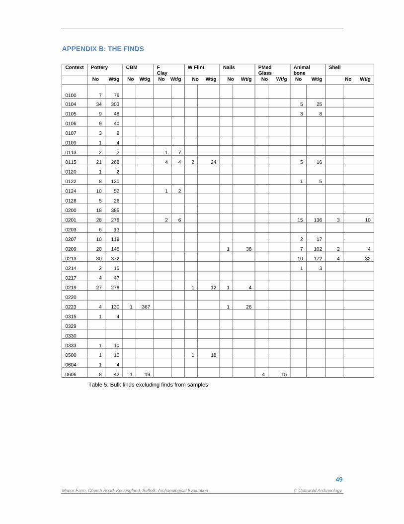
49
Manor Farm, Church Road, Kessingland, Suffolk: Archaeological Evaluation © Cotswold Archaeology
APPENDIX B: THE FINDS
Context Pottery CBM F Clay
W Flint Nails PMed Glass
Animal bone
Shell
No Wt/g No Wt/g No Wt/g No Wt/g No Wt/g No Wt/g No Wt/g No Wt/g
0100 7 76
0104 34 303 5 25
0105 9 48 3 8
0106 9 40
0107 3 9
0109 1 4
0113 2 2 1 7
0115 21 268 4 4 2 24 5 16
0120 1 2
0122 8 130 1 5
0124 10 52 1 2
0128 5 26
0200 18 385
0201 28 278 2 6 15 136 3 10
0203 6 13
0207 10 119 2 17
0209 20 145 1 38 7 102 2 4
0213 30 372 10 172 4 32
0214 2 15 1 3
0217 4 47
0219 27 278 1 12 1 4
0220
0223 4 130 1 367 1 26
0315 1 4
0329
0330
0333 1 10
0500 1 10 1 18
0604 1 4
0606 8 42 1 19 4 15
Table 5: Bulk finds excluding finds from samples
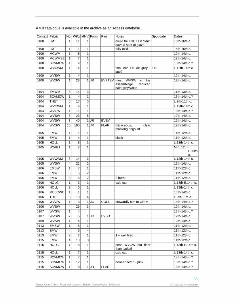
50
Manor Farm, Church Road, Kessingland, Suffolk: Archaeological Evaluation © Cotswold Archaeology
A full catalogue is available in the archive as an Access database. Context Fabric No Wt/g MNV Form Rim Notes Spot date Dates
0100 LMT 1 11 1 could be THET I it didn't have a spot of glaze
15th-16th c.
0100 LMT 1 1 1 fully oxid 15th-16th c.
0100 MCWM 1 8 1 12th-14th c.
0100 MCWMSE 1 7 1 12th-14th c.
0100 SCVMCW 1 4 1 13th-14th c.?
0100 WVCWM 1 14 1 fsm, occ Fe, dk grey - late?
14? L.12th-14th c.
0100 WVSW 1 4 1 12th-14th c.
0100 WVSW 1 28 1 JR EVFTEV most WVSW in this assemblage reduced pale grey/white
12th-14th c.
0104 EMWM 3 14 3 11th-13th c.
0104 SCVMCW 1 4 1 13th-14th c.?
0104 THET 5 17 5 L.9th-11th c.
0104 WVCWM 1 4 1 L.12th-14th c.
0104 WVGW 1 11 1 13th-14th c.?
0104 WVSW 5 23 5 12th-14th c.
0104 WVSW 3 40 1 JR EVEV 12th-14th c.
0104 WVSW 15 190 1 JR FLAR micaceous, clear throwing rings int
12th-14th c.
0105 EMW 1 1 1 11th-12th c.
0105 EMW 1 4 1 black 11th-12th c.
0105 HOLL 1 5 1 L.13th-14th c.
0105 SCAR1 1 2 1 M./L.12th-E.13th c.
0105 WVCWM 3 14 3 L.12th-14th c.
0105 WVSW 4 21 2 12th-14th c.
0106 EMSW 1 7 1 11th-12th c.
0106 EMW 6 5 2 11th-12th c.
0106 EMW 3 5 2 2 burnt 11th-12th c.
0106 HOLG 1 3 1 oxid ext L.13th-E.14th c.
0106 HOLL 2 5 1 L.13th-14th c.
0106 MESCWC 1 1 1 13th-14th c.
0106 THET 6 18 4 L.9th-11th c.
0106 WVGW 1 3 1 JG COLL outwardly sim to GRIM 13th-14th c.?
0106 WVSW 4 26 3 12th-14th c.
0107 WVGW 1 4 13th-14th c.?
0107 WVSW 2 5 1 JR EVBD 12th-14th c.
0109 WVSW 1 4 1 12th-14th c.
0113 EMSW 1 5 1 11th-12th c.
0113 EMW 4 5 4 11th-12th c.
0113 EMW 2 2 1 1 v well fired 11th-12th c.
0115 EMW 4 10 3 11th-12th c.
0115 HOLG 1 18 1 poss WVGW but finer than typical
L.13th-E.14th c.
0115 HOLL 1 7 1 oxid ext L.13th-14th c.
0115 SCVMCW 1 7 1 13th-14th c.?
0115 SCVMCW 1 12 1 heat-affected - pink 13th-14th c.?
0115 SCVMCW 1 8 1 JR FLAR 13th-14th c.?
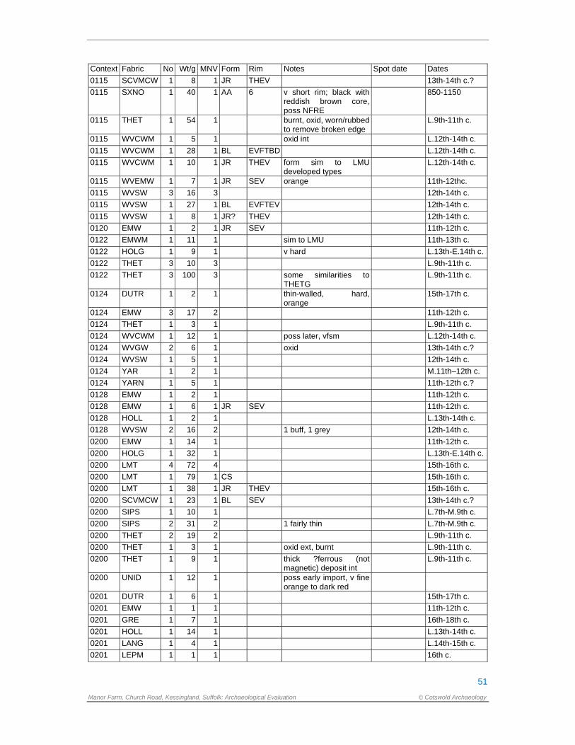
51
Manor Farm, Church Road, Kessingland, Suffolk: Archaeological Evaluation © Cotswold Archaeology
Context Fabric No Wt/g MNV Form Rim Notes Spot date Dates
0115 SCVMCW 1 8 1 JR THEV 13th-14th c.?
0115 SXNO 1 40 1 AA 6 v short rim; black with reddish brown core, poss NFRE
850-1150
0115 THET 1 54 1 burnt, oxid, worn/rubbed to remove broken edge
L.9th-11th c.
0115 WVCWM 1 5 1 oxid int L.12th-14th c.
0115 WVCWM 1 28 1 BL EVFTBD L.12th-14th c.
0115 WVCWM 1 10 1 JR THEV form sim to LMU developed types
L.12th-14th c.
0115 WVEMW 1 7 1 JR SEV orange 11th-12thc.
0115 WVSW 3 16 3 12th-14th c.
0115 WVSW 1 27 1 BL EVFTEV 12th-14th c.
0115 WVSW 1 8 1 JR? THEV 12th-14th c.
0120 EMW 1 2 1 JR SEV 11th-12th c.
0122 EMWM 1 11 1 sim to LMU 11th-13th c.
0122 HOLG 1 9 1 v hard L.13th-E.14th c.
0122 THET 3 10 3 L.9th-11th c.
0122 THET 3 100 3 some similarities to THETG
L.9th-11th c.
0124 DUTR 1 2 1 thin-walled, hard, orange
15th-17th c.
0124 EMW 3 17 2 11th-12th c.
0124 THET 1 3 1 L.9th-11th c.
0124 WVCWM 1 12 1 poss later, vfsm L.12th-14th c.
0124 WVGW 2 6 1 oxid 13th-14th c.?
0124 WVSW 1 5 1 12th-14th c.
0124 YAR 1 2 1 M.11th–12th c.
0124 YARN 1 5 1 11th-12th c.?
0128 EMW 1 2 1 11th-12th c.
0128 EMW 1 6 1 JR SEV 11th-12th c.
0128 HOLL 1 2 1 L.13th-14th c.
0128 WVSW 2 16 2 1 buff, 1 grey 12th-14th c.
0200 EMW 1 14 1 11th-12th c.
0200 HOLG 1 32 1 L.13th-E.14th c.
0200 LMT 4 72 4 15th-16th c.
0200 LMT 1 79 1 CS 15th-16th c.
0200 LMT 1 38 1 JR THEV 15th-16th c.
0200 SCVMCW 1 23 1 BL SEV 13th-14th c.?
0200 SIPS 1 10 1 L.7th-M.9th c.
0200 SIPS 2 31 2 1 fairly thin L.7th-M.9th c.
0200 THET 2 19 2 L.9th-11th c.
0200 THET 1 3 1 oxid ext, burnt L.9th-11th c.
0200 THET 1 9 1 thick ?ferrous (not magnetic) deposit int
L.9th-11th c.
0200 UNID 1 12 1 poss early import, v fine orange to dark red
0201 DUTR 1 6 1 15th-17th c.
0201 EMW 1 1 1 11th-12th c.
0201 GRE 1 7 1 16th-18th c.
0201 HOLL 1 14 1 L.13th-14th c.
0201 LANG 1 4 1 L.14th-15th c.
0201 LEPM 1 1 1 16th c.
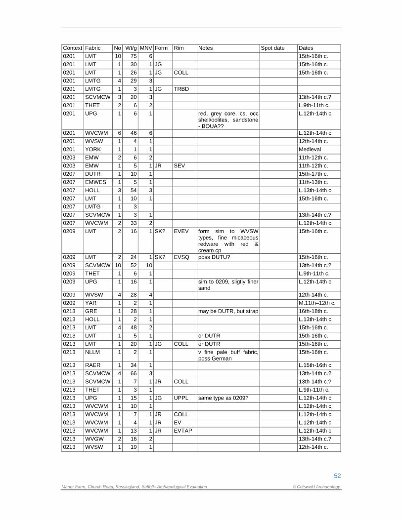
52
Manor Farm, Church Road, Kessingland, Suffolk: Archaeological Evaluation © Cotswold Archaeology
Context Fabric No Wt/g MNV Form Rim Notes Spot date Dates
0201 LMT 10 75 6 15th-16th c.
0201 LMT 1 30 1 JG 15th-16th c.
0201 LMT 1 26 1 JG COLL 15th-16th c.
0201 LMTG 4 29 3
0201 LMTG 1 3 1 JG TRBD
0201 SCVMCW 3 20 3 13th-14th c.?
0201 THET 2 6 2 L.9th-11th c.
0201 UPG 1 6 1 red, grey core, cs, occ shell/oolites, sandstone - BOUA??
L.12th-14th c.
0201 WVCWM 6 46 6 L.12th-14th c.
0201 WVSW 1 4 1 12th-14th c.
0201 YORK 1 1 1 Medieval
0203 EMW 2 6 2 11th-12th c.
0203 EMW 1 5 1 JR SEV 11th-12th c.
0207 DUTR 1 10 1 15th-17th c.
0207 EMWES 1 5 1 11th-13th c.
0207 HOLL 3 54 3 L.13th-14th c.
0207 LMT 1 10 1 15th-16th c.
0207 LMTG 1 3
0207 SCVMCW 1 3 1 13th-14th c.?
0207 WVCWM 2 33 2 L.12th-14th c.
0209 LMT 2 16 1 SK? EVEV form sim to WVSW types, fine micaceous redware with red & cream cp
15th-16th c.
0209 LMT 2 24 1 SK? EVSQ poss DUTU? 15th-16th c.
0209 SCVMCW 10 52 10 13th-14th c.?
0209 THET 1 6 1 L.9th-11th c.
0209 UPG 1 16 1 sim to 0209, sligtly finer sand
L.12th-14th c.
0209 WVSW 4 28 4 12th-14th c.
0209 YAR 1 2 1 M.11th–12th c.
0213 GRE 1 28 1 may be DUTR, but strap 16th-18th c.
0213 HOLL 1 2 1 L.13th-14th c.
0213 LMT 4 48 2 15th-16th c.
0213 LMT 1 5 1 or DUTR 15th-16th c.
0213 LMT 1 20 1 JG COLL or DUTR 15th-16th c.
0213 NLLM 1 2 1 v fine pale buff fabric, poss German
15th-16th c.
0213 RAER 1 34 1 L.15th-16th c.
0213 SCVMCW 4 66 3 13th-14th c.?
0213 SCVMCW 1 7 1 JR COLL 13th-14th c.?
0213 THET 1 3 1 L.9th-11th c.
0213 UPG 1 15 1 JG UPPL same type as 0209? L.12th-14th c.
0213 WVCWM 1 10 1 L.12th-14th c.
0213 WVCWM 1 7 1 JR COLL L.12th-14th c.
0213 WVCWM 1 4 1 JR EV L.12th-14th c.
0213 WVCWM 1 13 1 JR EVTAP L.12th-14th c.
0213 WVGW 2 16 2 13th-14th c.?
0213 WVSW 1 19 1 12th-14th c.
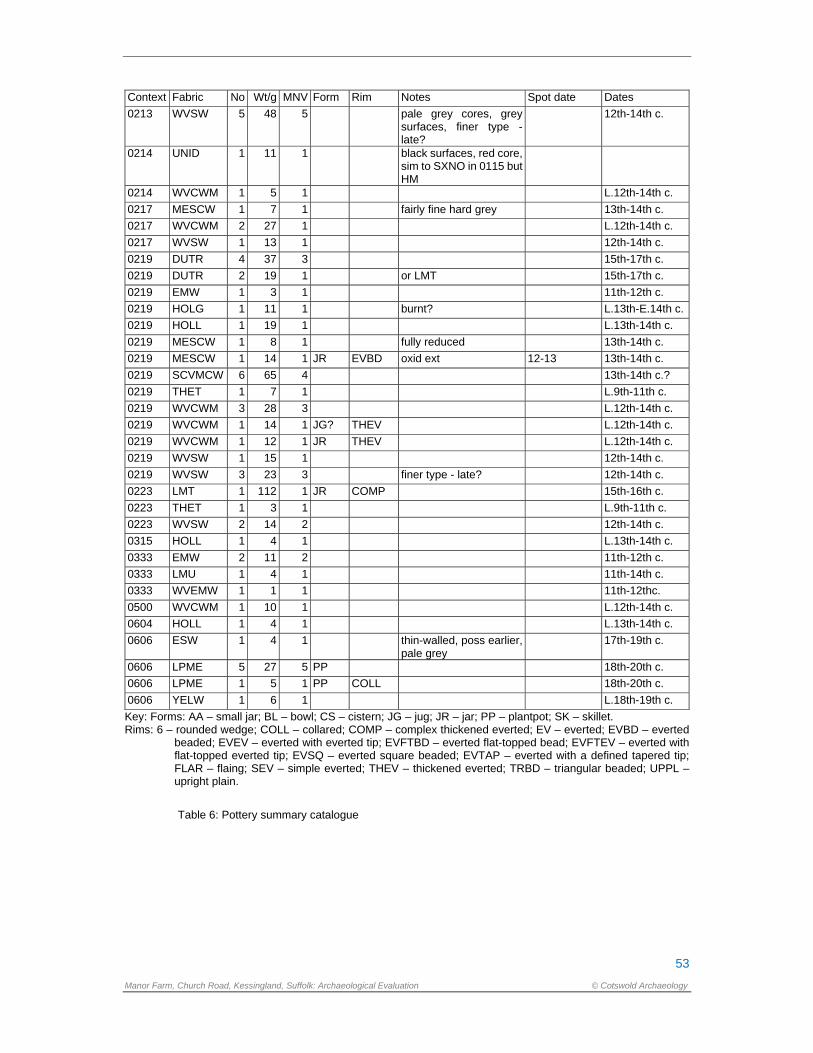
53
Manor Farm, Church Road, Kessingland, Suffolk: Archaeological Evaluation © Cotswold Archaeology
Context Fabric No Wt/g MNV Form Rim Notes Spot date Dates
0213 WVSW 5 48 5 pale grey cores, grey surfaces, finer type - late?
12th-14th c.
0214 UNID 1 11 1 black surfaces, red core, sim to SXNO in 0115 but HM
0214 WVCWM 1 5 1 L.12th-14th c.
0217 MESCW 1 7 1 fairly fine hard grey 13th-14th c.
0217 WVCWM 2 27 1 L.12th-14th c.
0217 WVSW 1 13 1 12th-14th c.
0219 DUTR 4 37 3 15th-17th c.
0219 DUTR 2 19 1 or LMT 15th-17th c.
0219 EMW 1 3 1 11th-12th c.
0219 HOLG 1 11 1 burnt? L.13th-E.14th c.
0219 HOLL 1 19 1 L.13th-14th c.
0219 MESCW 1 8 1 fully reduced 13th-14th c.
0219 MESCW 1 14 1 JR EVBD oxid ext 12-13 13th-14th c.
0219 SCVMCW 6 65 4 13th-14th c.?
0219 THET 1 7 1 L.9th-11th c.
0219 WVCWM 3 28 3 L.12th-14th c.
0219 WVCWM 1 14 1 JG? THEV L.12th-14th c.
0219 WVCWM 1 12 1 JR THEV L.12th-14th c.
0219 WVSW 1 15 1 12th-14th c.
0219 WVSW 3 23 3 finer type - late? 12th-14th c.
0223 LMT 1 112 1 JR COMP 15th-16th c.
0223 THET 1 3 1 L.9th-11th c.
0223 WVSW 2 14 2 12th-14th c.
0315 HOLL 1 4 1 L.13th-14th c.
0333 EMW 2 11 2 11th-12th c.
0333 LMU 1 4 1 11th-14th c.
0333 WVEMW 1 1 1 11th-12thc.
0500 WVCWM 1 10 1 L.12th-14th c.
0604 HOLL 1 4 1 L.13th-14th c.
0606 ESW 1 4 1 thin-walled, poss earlier, pale grey
17th-19th c.
0606 LPME 5 27 5 PP 18th-20th c.
0606 LPME 1 5 1 PP COLL 18th-20th c.
0606 YELW 1 6 1 L.18th-19th c.
Key: Forms: AA – small jar; BL – bowl; CS – cistern; JG – jug; JR – jar; PP – plantpot; SK – skillet. Rims: 6 – rounded wedge; COLL – collared; COMP – complex thickened everted; EV – everted; EVBD – everted
beaded; EVEV – everted with everted tip; EVFTBD – everted flat-topped bead; EVFTEV – everted with flat-topped everted tip; EVSQ – everted square beaded; EVTAP – everted with a defined tapered tip; FLAR – flaing; SEV – simple everted; THEV – thickened everted; TRBD – triangular beaded; UPPL – upright plain.
Table 6: Pottery summary catalogue
54
Manor Farm, Church Road, Kessingland, Suffolk: Archaeological Evaluation © Cotswold Archaeology
Tr. Feature Context Type MSax LSax EMed Med LMed PMed Mod Un Spotdate 1 - 0100 Layer 6 2 15-16
0103 0104 Pit 5 3 26 14?
0103 0105 Pit 2 9 L.13-14
0103 0106 Pit 7 9 9 14
0103 0107 Pit 3 13-14
0108 0109 Pit 1 12-14
0112 0113 Gully 1 6 11-12
0114 0115 Pit 2 5 14 13-14
0119 0120 Gully 1 11-12
0121 0122 Pit 6 1 1 12+
0123 0124 Pit 1 5 5 13?
0127 0128 Gully 2 3 13?
2 - 0200 Topsoil 3 4 1 2 6 1 15-16
- 0201 Layer 2 1 13 20 1 16
- 0207 Layer 1 6 3 15
- 0209 Layer 1 1 15 4 M.14-15
- 0213 Layer 1 19 8 1 16
- 0223 Layer 1 2 1 15-16
0202 0203 Gully 3 11-12
0215 0214 Pit 1 1 13-14?
0216 0217 Pit 4 13-14
0216 0219 Pit 1 1 19 6 15?
3 0314 0315 Posthole 1 L.13-14
0332 0333 Ditch 3 1 11-12
5 0500 Layer 1 13-14
6 0603 0604 Ditch 1 L.13-14
0605 0606 Ditch 8 19-20
Table 7: Distribution of pottery by context and period group
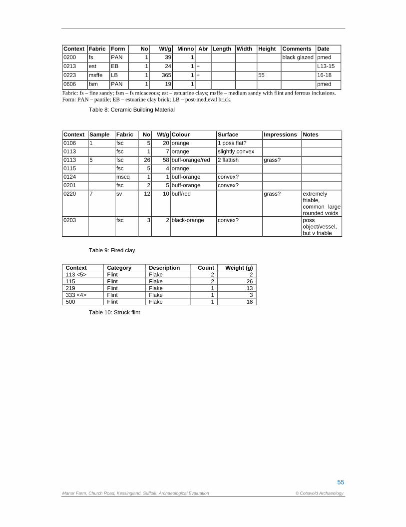
55
Manor Farm, Church Road, Kessingland, Suffolk: Archaeological Evaluation © Cotswold Archaeology
Context Fabric Form No Wt/g Minno Abr Length Width Height Comments Date
0200 fs PAN 1 39 1 black glazed pmed
0213 est EB 1 24 1 + L13-15
0223 msffe LB 1 365 1 + 55 16-18
0606 fsm PAN 1 19 1 pmed
Fabric: fs – fine sandy; fsm – fs micaceous; est – estuarine clays; msffe – medium sandy with flint and ferrous inclusions. Form: PAN – pantile; EB – estuarine clay brick; LB – post-medieval brick.
Table 8: Ceramic Building Material
Context Sample Fabric No Wt/g Colour Surface Impressions Notes
0106 1 fsc 5 20 orange 1 poss flat?
0113 fsc 1 7 orange slightly convex
0113 5 fsc 26 58 buff-orange/red 2 flattish grass?
0115 fsc 5 4 orange
0124 mscq 1 1 buff-orange convex?
0201 fsc 2 5 buff-orange convex?
0220 7 sv 12 10 buff/red grass? extremely friable, common large rounded voids
0203 fsc 3 2 black-orange convex? poss object/vessel, but v friable
Table 9: Fired clay
Context Category Description Count Weight (g) 113 <5> Flint Flake 2 2 115 Flint Flake 2 26 219 Flint Flake 1 13 333 <4> Flint Flake 1 3 500 Flint Flake 1 18
Table 10: Struck flint
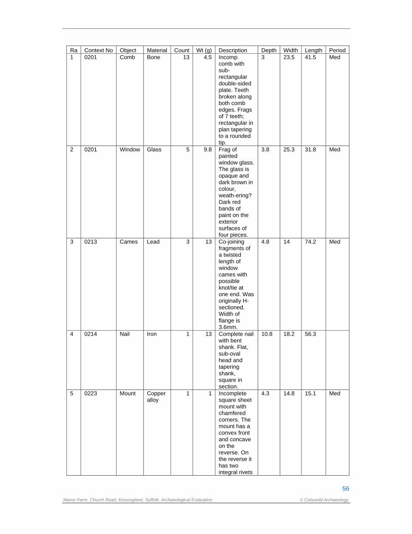
56
Manor Farm, Church Road, Kessingland, Suffolk: Archaeological Evaluation © Cotswold Archaeology
Ra Context No Object Material Count Wt (g) Description Depth Width Length Period 1 0201 Comb Bone 13 4.5 Incomp.
comb with sub-rectangular double-sided plate. Teeth broken along both comb edges. Frags of 7 teeth; rectangular in plan tapering to a rounded tip.
3 23.5 41.5 Med
2 0201 Window Glass 5 9.8 Frag of painted window glass. The glass is opaque and dark brown in colour, weath-ering? Dark red bands of paint on the exterior surfaces of four pieces.
3.8 25.3 31.8 Med
3 0213 Cames Lead 3 13 Co-joining fragments of a twisted length of window cames with possible knot/tie at one end. Was originally H-sectioned. Width of flange is 3.6mm.
4.8 14 74.2 Med
4 0214 Nail Iron 1 13 Complete nail with bent shank. Flat, sub-oval head and tapering shank, square in section.
10.8 18.2 56.3
5 0223 Mount Copper alloy
1 1 Incomplete square sheet mount with chamfered corners. The mount has a convex front and concave on the reverse. On the reverse it has two integral rivets
4.3 14.8 15.1 Med
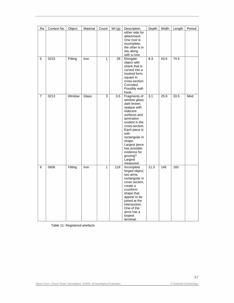
57
Manor Farm, Church Road, Kessingland, Suffolk: Archaeological Evaluation © Cotswold Archaeology
Ra Context No Object Material Count Wt (g) Description Depth Width Length Period either side for attachment. One rivet is incomplete; the other is in situ along with a rove.
6 0223 Fitting Iron 1 28 Elongate object with shank that is curved into a hooked form; square in cross-section. Corroded. Possibly wall-hook.
8.3 43.6 74.5
7 0213 Window Glass 3 3.5 Fragments of window glass; dark brown, opaque with iridecent surfaces and lamination evident in the cross-section. Each piece is sub-rectangular in shape. Largest piece has possible evidence for grozing? Largest measured.
3.1 25.9 33.5 Med
8 0606 Fitting Iron 1 119 Incomplete forged object; two arms, rectangular in cross section, create a cruciform shape that appear to be joined at the intersection. One of the arms has a looped terminal.
11.3 145 183
Table 11: Registered artefacts

58
Manor Farm, Church Road, Kessingland, Suffolk: Archaeological Evaluation © Cotswold Archaeology
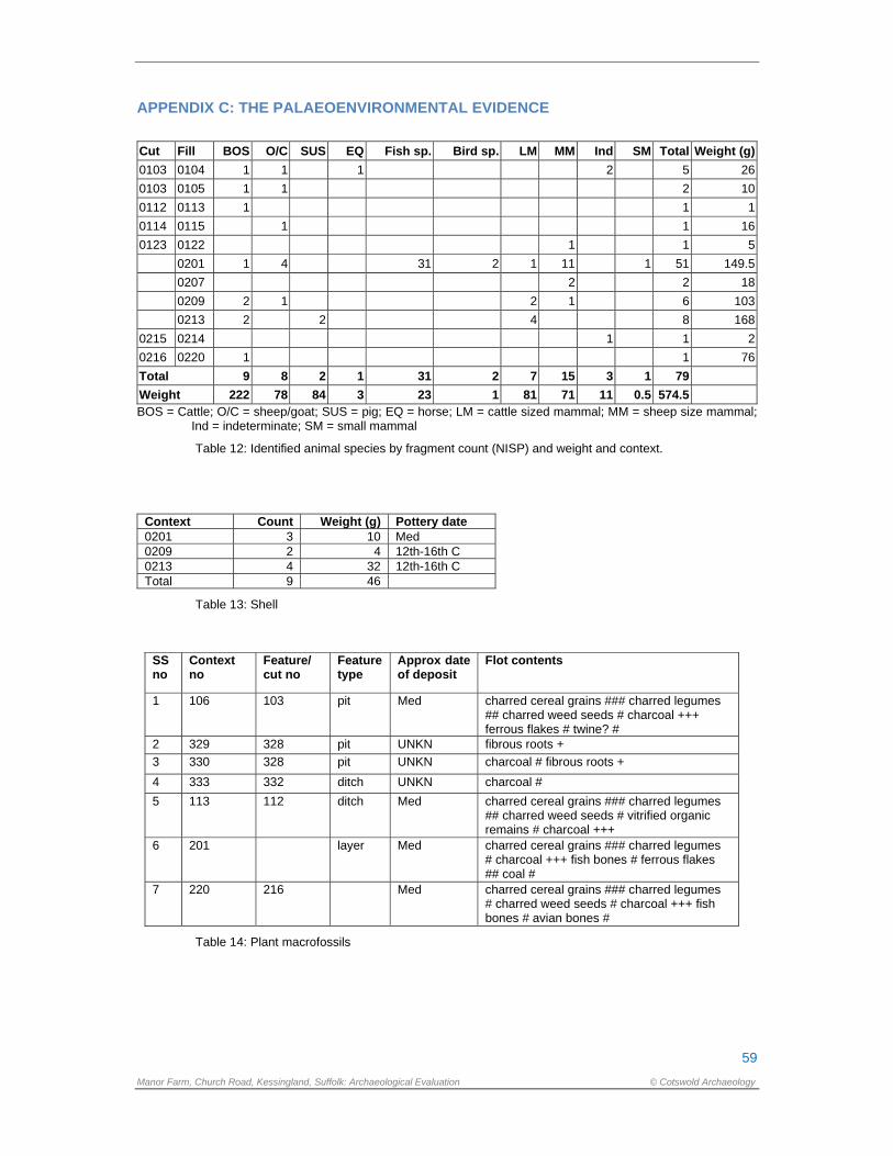
59
Manor Farm, Church Road, Kessingland, Suffolk: Archaeological Evaluation © Cotswold Archaeology
APPENDIX C: THE PALAEOENVIRONMENTAL EVIDENCE
Cut Fill BOS O/C SUS EQ Fish sp. Bird sp. LM MM Ind SM Total Weight (g)
0103 0104 1 1 1 2 5 26
0103 0105 1 1 2 10
0112 0113 1 1 1
0114 0115 1 1 16
0123 0122 1 1 5
0201 1 4 31 2 1 11 1 51 149.5
0207 2 2 18
0209 2 1 2 1 6 103
0213 2 2 4 8 168
0215 0214 1 1 2
0216 0220 1 1 76
Total 9 8 2 1 31 2 7 15 3 1 79
Weight 222 78 84 3 23 1 81 71 11 0.5 574.5 BOS = Cattle; O/C = sheep/goat; SUS = pig; EQ = horse; LM = cattle sized mammal; MM = sheep size mammal;
Ind = indeterminate; SM = small mammal
Table 12: Identified animal species by fragment count (NISP) and weight and context.
Context Count Weight (g) Pottery date 0201 3 10 Med 0209 2 4 12th-16th C 0213 4 32 12th-16th C Total 9 46
Table 13: Shell
SS no
Context no
Feature/ cut no
Feature type
Approx date of deposit
Flot contents
1 106 103 pit Med charred cereal grains ### charred legumes ## charred weed seeds # charcoal +++ ferrous flakes # twine? #
2 329 328 pit UNKN fibrous roots +
3 330 328 pit UNKN charcoal # fibrous roots +
4 333 332 ditch UNKN charcoal #
5 113 112 ditch Med charred cereal grains ### charred legumes ## charred weed seeds # vitrified organic remains # charcoal +++
6 201 layer Med charred cereal grains ### charred legumes # charcoal +++ fish bones # ferrous flakes ## coal #
7 220 216 Med charred cereal grains ### charred legumes # charred weed seeds # charcoal +++ fish bones # avian bones #
Table 14: Plant macrofossils

60
Manor Farm, Church Road, Kessingland, Suffolk: Archaeological Evaluation © Cotswold Archaeology
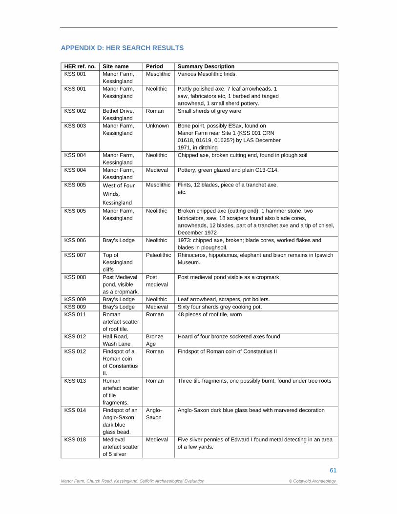
61
Manor Farm, Church Road, Kessingland, Suffolk: Archaeological Evaluation © Cotswold Archaeology
APPENDIX D: HER SEARCH RESULTS
HER ref. no. Site name Period Summary Description KSS 001 Manor Farm,
Kessingland Mesolithic Various Mesolithic finds.
KSS 001 Manor Farm, Kessingland
Neolithic Partly polished axe, 7 leaf arrowheads, 1 saw, fabricators etc, 1 barbed and tanged arrowhead, 1 small sherd pottery.
KSS 002 Bethel Drive, Kessingland
Roman Small sherds of grey ware.
KSS 003 Manor Farm, Kessingland
Unknown Bone point, possibly ESax, found on Manor Farm near Site 1 (KSS 001 CRN 01618, 01619, 01625?) by LAS December 1971, in ditching
KSS 004 Manor Farm, Kessingland
Neolithic Chipped axe, broken cutting end, found in plough soil
KSS 004 Manor Farm, Kessingland
Medieval Pottery, green glazed and plain C13-C14.
KSS 005 West of Four
Winds,
Kessingland
Mesolithic Flints, 12 blades, piece of a tranchet axe, etc.
KSS 005 Manor Farm, Kessingland
Neolithic Broken chipped axe (cutting end), 1 hammer stone, two fabricators, saw, 18 scrapers found also blade cores, arrowheads, 12 blades, part of a tranchet axe and a tip of chisel, December 1972
KSS 006 Bray’s Lodge Neolithic 1973: chipped axe, broken; blade cores, worked flakes and blades in ploughsoil.
KSS 007 Top of Kessingland cliffs
Paleolithic Rhinoceros, hippotamus, elephant and bison remains in Ipswich Museum.
KSS 008 Post Medieval pond, visible as a cropmark.
Post medieval
Post medieval pond visible as a cropmark
KSS 009 Bray’s Lodge Neolithic Leaf arrowhead, scrapers, pot boilers. KSS 009 Bray’s Lodge Medieval Sixty four sherds grey cooking pot. KSS 011 Roman
artefact scatter of roof tile.
Roman 48 pieces of roof tile, worn
KSS 012 Hall Road, Wash Lane
Bronze Age
Hoard of four bronze socketed axes found
KSS 012 Findspot of a Roman coin of Constantius II.
Roman Findspot of Roman coin of Constantius II
KSS 013 Roman artefact scatter of tile fragments.
Roman Three tile fragments, one possibly burnt, found under tree roots
KSS 014 Findspot of an Anglo-Saxon dark blue glass bead.
Anglo-Saxon
Anglo-Saxon dark blue glass bead with marvered decoration
KSS 018 Medieval artefact scatter of 5 silver
Medieval Five silver pennies of Edward I found metal detecting in an area of a few yards.
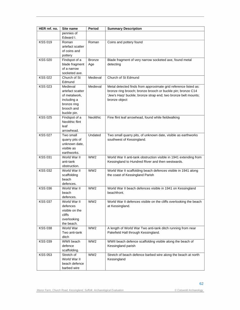
62
Manor Farm, Church Road, Kessingland, Suffolk: Archaeological Evaluation © Cotswold Archaeology
HER ref. no. Site name Period Summary Description pennies of Edward I.
KSS 019 Roman artefact scatter of coins and pottery
Roman Coins and pottery found
KSS 020 Findspot of a blade fragment of a narrow socketed axe.
Bronze Age
Blade fragment of very narrow socketed axe, found metal detecting
KSS 022 Church of St Edmund
Medieval Church of St Edmund
KSS 023 Medieval artefact scatter of metalwork, including a bronze ring brooch and buckle pin.
Medieval Metal detected finds from approximate grid reference listed as: bronze ring brooch; bronze brooch or buckle pin; bronze C14 'Jew's Harp' buckle; bronze strap end; two bronze belt mounts; bronze object
KSS 025 Findspot of a Neolithic flint leaf arrowhead.
Neolithic Fine flint leaf arrowhead, found while fieldwalking
KSS 027 Two small quarry pits of unknown date, visible as earthworks.
Undated Two small quarry pits, of unknown date, visible as earthworks southwest of Kessingland.
KSS 031 World War II anti-tank obstruction.
WW2 World War II anti-tank obstruction visible in 1941 extending from Kessingland to Hundred River and then westwards.
KSS 032 World War II scaffolding beach defences.
WW2 World War II scaffolding beach defences visible in 1941 along the coast of Kessingland Parish
KSS 036 World War II beach defences.
WW2 World War II beach defences visible in 1941 on Kessingland beachfront.
KSS 037 World War II defences visible on the cliffs overlooking the beach.
WW2 World War II defences visible on the cliffs overlooking the beach at Kessingland.
KSS 038 World War Two anti-tank ditch
WW2 A length of World War Two anti-tank ditch running from near Pakefield Hall through Kessingland.
KSS 039 WWII beach defence scaffolding.
WW2 WWII beach defence scaffolding visible along the beach of Kessingland parish
KSS 053 Stretch of World War II beach defence barbed wire
WW2 Stretch of beach defence barbed wire along the beach at north Kessingland
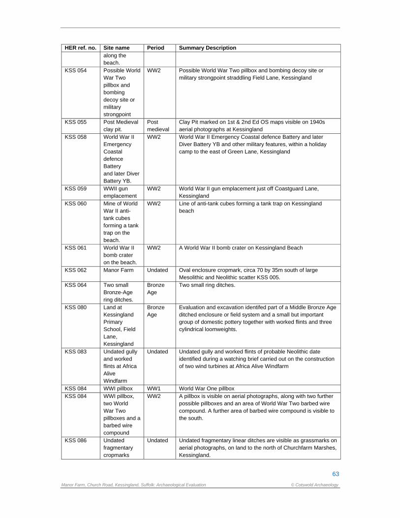
63
Manor Farm, Church Road, Kessingland, Suffolk: Archaeological Evaluation © Cotswold Archaeology
HER ref. no. Site name Period Summary Description along the beach.
KSS 054 Possible World War Two pillbox and bombing decoy site or military strongpoint
WW2 Possible World War Two pillbox and bombing decoy site or military strongpoint straddling Field Lane, Kessingland
KSS 055 Post Medieval clay pit.
Post medieval
Clay Pit marked on 1st & 2nd Ed OS maps visible on 1940s aerial photographs at Kessingland
KSS 058 World War II Emergency Coastal defence Battery and later Diver Battery YB.
WW2 World War II Emergency Coastal defence Battery and later Diver Battery YB and other military features, within a holiday camp to the east of Green Lane, Kessingland
KSS 059 WWII gun emplacement
WW2 World War II gun emplacement just off Coastguard Lane, Kessingland
KSS 060 Mine of World War II anti-tank cubes forming a tank trap on the beach.
WW2 Line of anti-tank cubes forming a tank trap on Kessingland beach
KSS 061 World War II bomb crater on the beach.
WW2 A World War II bomb crater on Kessingland Beach
KSS 062 Manor Farm Undated Oval enclosure cropmark, circa 70 by 35m south of large Mesolithic and Neolithic scatter KSS 005.
KSS 064 Two small Bronze-Age ring ditches.
Bronze Age
Two small ring ditches.
KSS 080 Land at Kessingland Primary School, Field Lane, Kessingland
Bronze Age
Evaluation and excavation identifed part of a Middle Bronze Age ditched enclosure or field system and a small but important group of domestic pottery together with worked flints and three cylindrical loomweights.
KSS 083 Undated gully and worked flints at Africa Alive Windfarm
Undated Undated gully and worked flints of probable Neolithic date identified during a watching brief carried out on the construction of two wind turbines at Africa Alive Windfarm
KSS 084 WWI pillbox WW1 World War One pillbox KSS 084 WWI pillbox,
two World War Two pillboxes and a barbed wire compound
WW2 A pillbox is visible on aerial photographs, along with two further possible pillboxes and an area of World War Two barbed wire compound. A further area of barbed wire compound is visible to the south.
KSS 086 Undated fragmentary cropmarks
Undated Undated fragmentary linear ditches are visible as grassmarks on aerial photographs, on land to the north of Churchfarm Marshes, Kessingland.
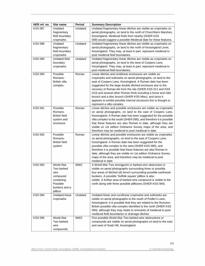
64
Manor Farm, Church Road, Kessingland, Suffolk: Archaeological Evaluation © Cotswold Archaeology
HER ref. no. Site name Period Summary Description KSS 087 Undated
fragmentary field boundary cropmarks
Undated Undated fragmentary linear ditches are visible as cropmarks on aerial photographs, on land to the north of Churchfarm Marshes, Kessingland. Medieval finds from nearby (SHER KSS 009) would suggest a possible Medieval date for these features.
KSS 088 Undated fragmentary field boundary cropmarks
Undated Undated fragmentary linear ditches are visible as cropmarks on aerial photographs, on land to the north of Kessingland Level, Kessingland. They may, at least in part, represent medieval to post medieval field boundaries.
KSS 089 Undated field boundary cropmarks
Undated Undated fragmentary linear ditches are visible as cropmarks on aerial photographs, on land to the west of Coopers Lane, Kessingland. They may, at least in part, represent medieval to post medieval field boundaries.
KSS 090 Possible Romano- British villa complex
Roman Linear ditches and rectilinear enclosures are visible as cropmarks and soilmarks on aerial photographs, on land to the east of Coopers Lane, Kessingland. A Roman date has been suggested for the large double ditched enclosure due to the recovery of Roman tile from the site (SHER KSS 011 and KSS 013) and several other Roman finds including a horse and rider brooch and a disc brooch (SHER KSS Misc), and since it appears to exhibit possible internal structures this is thought to represent a villa complex.
KSS 091 Possible Romano- British field system and enclosure
Roman Linear ditches and possible enclosures are visible as cropmarks on aerial photographs, on land to the east of Coopers Lane, Kessingland. A Roman date has been suggested for the possible villa complex to the south (SHER 090), and therefore it is possible that these features are also Roman in date, although they are visible on 1st edition Ordnance Survey maps of the area, and therefore may be medieval to post medieval in date.
KSS 092 Possible Romano- British field system
Roman Linear ditches and possible enclosures are visible as cropmarks on aerial photographs, on land to the east of Coopers Lane, Kessingland. A Roman date has been suggested for the possible villa complex to the west (SHER KSS 090), and therefore it is possible that these features are also Roman in date, although they are visible on 1st edition Ordnance Survey maps of the area, and therefore may be medieval to post medieval in date.
KSS 093 World War Two barbed wire compound containing Possible bunkers and a pillbox
WW2 A World War Two strongpoint or barbed wire obstruction is visible on aerial photographs surrounding three or possibly four areas of ditched slit trench surrounding possible earthwork bunkers. A possible 'Suffolk square' pillbox is also visible. A further area of barbed wire compound is visible to the north along with three possible pillboxes (SHER KSS 084).
KSS 094 Undated linear cropmarks
Undated Undated linear and curvilinear cropmarks and soilmarks are visible on aerial photographs to the south of Pedler’s Lane, Kessingland. It is possible that they are related to the Romano-British possible villa complex identified to the north (SHER KSS 090), although they may relate to remnants of medieval to post medieval field boundaries or drainage ditches.
KSS 095 World War Two barbed wire compounds
WW2 Five possible World War Two barbed wire obstructions or compounds are visible on aerial photographs on land to the east and west of Snab Hill, Kessingland.
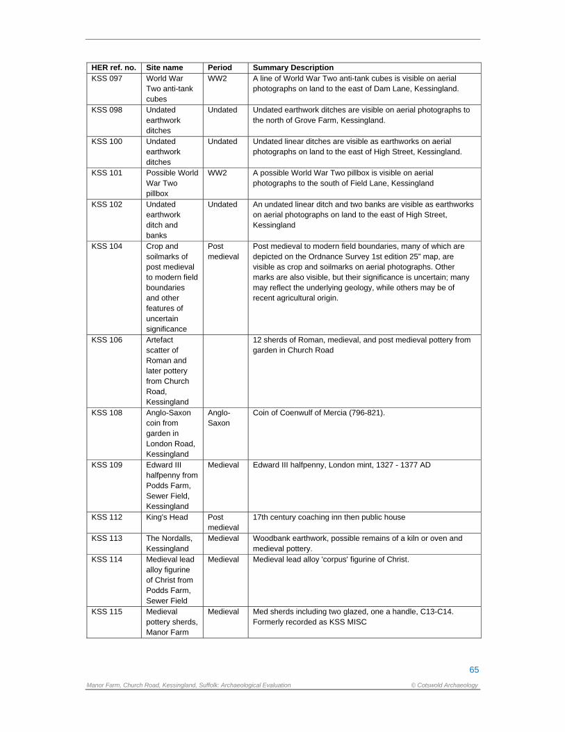
65
Manor Farm, Church Road, Kessingland, Suffolk: Archaeological Evaluation © Cotswold Archaeology
HER ref. no. Site name Period Summary Description KSS 097 World War
Two anti-tank cubes
WW2 A line of World War Two anti-tank cubes is visible on aerial photographs on land to the east of Dam Lane, Kessingland.
KSS 098 Undated earthwork ditches
Undated Undated earthwork ditches are visible on aerial photographs to the north of Grove Farm, Kessingland.
KSS 100 Undated earthwork ditches
Undated Undated linear ditches are visible as earthworks on aerial photographs on land to the east of High Street, Kessingland.
KSS 101 Possible World War Two pillbox
WW2 A possible World War Two pillbox is visible on aerial photographs to the south of Field Lane, Kessingland
KSS 102 Undated earthwork ditch and banks
Undated An undated linear ditch and two banks are visible as earthworks on aerial photographs on land to the east of High Street, Kessingland
KSS 104 Crop and soilmarks of post medieval to modern field boundaries and other features of uncertain significance
Post medieval
Post medieval to modern field boundaries, many of which are depicted on the Ordnance Survey 1st edition 25” map, are visible as crop and soilmarks on aerial photographs. Other marks are also visible, but their significance is uncertain; many may reflect the underlying geology, while others may be of recent agricultural origin.
KSS 106 Artefact scatter of Roman and later pottery from Church Road, Kessingland
12 sherds of Roman, medieval, and post medieval pottery from garden in Church Road
KSS 108 Anglo-Saxon coin from garden in London Road, Kessingland
Anglo-Saxon
Coin of Coenwulf of Mercia (796-821).
KSS 109 Edward III halfpenny from Podds Farm, Sewer Field, Kessingland
Medieval Edward III halfpenny, London mint, 1327 - 1377 AD
KSS 112 King's Head Post medieval
17th century coaching inn then public house
KSS 113 The Nordalls, Kessingland
Medieval Woodbank earthwork, possible remains of a kiln or oven and medieval pottery.
KSS 114 Medieval lead alloy figurine of Christ from Podds Farm, Sewer Field
Medieval Medieval lead alloy 'corpus' figurine of Christ.
KSS 115 Medieval pottery sherds, Manor Farm
Medieval Med sherds including two glazed, one a handle, C13-C14. Formerly recorded as KSS MISC
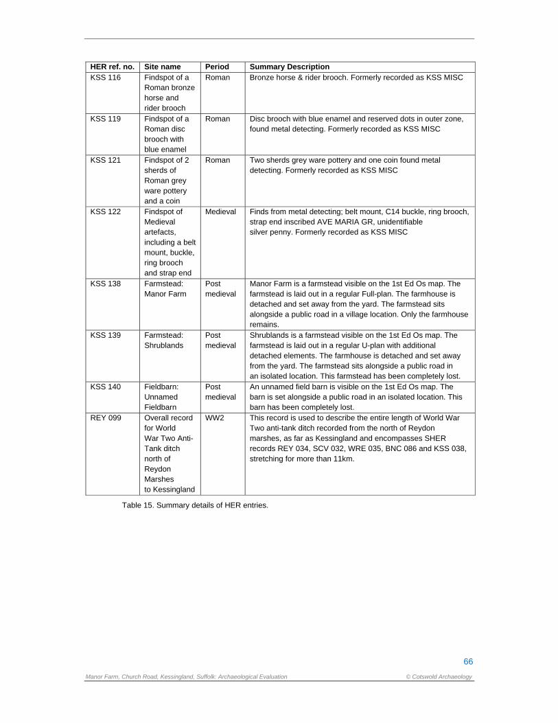
66
Manor Farm, Church Road, Kessingland, Suffolk: Archaeological Evaluation © Cotswold Archaeology
HER ref. no. Site name Period Summary Description KSS 116 Findspot of a
Roman bronze horse and rider brooch
Roman Bronze horse & rider brooch. Formerly recorded as KSS MISC
KSS 119 Findspot of a Roman disc brooch with blue enamel
Roman Disc brooch with blue enamel and reserved dots in outer zone, found metal detecting. Formerly recorded as KSS MISC
KSS 121 Findspot of 2 sherds of Roman grey ware pottery and a coin
Roman Two sherds grey ware pottery and one coin found metal detecting. Formerly recorded as KSS MISC
KSS 122 Findspot of Medieval artefacts, including a belt mount, buckle, ring brooch and strap end
Medieval Finds from metal detecting; belt mount, C14 buckle, ring brooch, strap end inscribed AVE MARIA GR, unidentifiable silver penny. Formerly recorded as KSS MISC
KSS 138 Farmstead: Manor Farm
Post medieval
Manor Farm is a farmstead visible on the 1st Ed Os map. The farmstead is laid out in a regular Full-plan. The farmhouse is detached and set away from the yard. The farmstead sits alongside a public road in a village location. Only the farmhouse remains.
KSS 139 Farmstead: Shrublands
Post medieval
Shrublands is a farmstead visible on the 1st Ed Os map. The farmstead is laid out in a regular U-plan with additional detached elements. The farmhouse is detached and set away from the yard. The farmstead sits alongside a public road in an isolated location. This farmstead has been completely lost.
KSS 140 Fieldbarn: Unnamed Fieldbarn
Post medieval
An unnamed field barn is visible on the 1st Ed Os map. The barn is set alongside a public road in an isolated location. This barn has been completely lost.
REY 099 Overall record for World War Two Anti-Tank ditch north of Reydon Marshes to Kessingland
WW2 This record is used to describe the entire length of World War Two anti-tank ditch recorded from the north of Reydon marshes, as far as Kessingland and encompasses SHER records REY 034, SCV 032, WRE 035, BNC 086 and KSS 038, stretching for more than 11km.
Table 15. Summary details of HER entries.
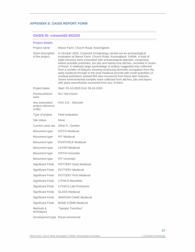
67
Manor Farm, Church Road, Kessingland, Suffolk: Archaeological Evaluation © Cotswold Archaeology
APPENDIX E: OASIS REPORT FORM
OASIS ID: cotswold2-402220
Project details
Project name Manor Farm, Church Road, Kessingland
Short description of the project
In October 2020, Cotswold Archaeology carried out an archaeological evaluation at Manor Farm, Church Road, Kessingland, Suffolk. A total of eight trenches were excavated with archaeological deposits, comprising twelve possible postholes, ten pits and twenty-one ditches, recorded in seven of those. A relatively large assemblage of pottery suggested was collected from a number of features showing continuing domestic occupation from the early medieval through to the post medieval periods with small quantities of residual prehistoric worked flint also recovered from these later features. Seven environmental samples were collected from ditches, pits and layers with plant macrofossils recovered from four of them.
Project dates Start: 05-10-2020 End: 09-10-2020
Previous/future work
No / Not known
Any associated project reference codes
KSS 141 - Sitecode
Type of project Field evaluation
Site status None
Current Land use Other 5 - Garden
Monument type DITCH Medieval
Monument type PIT Medieval
Monument type POSTHOLE Medieval
Monument type LAYER Medieval
Monument type DITCH Uncertain
Monument type PIT Uncertain
Significant Finds POTTERY Early Medieval
Significant Finds POTTERY Medieval
Significant Finds POTTERY Post Medieval
Significant Finds LITHICS Mesolithic
Significant Finds LITHICS Late Prehistoric
Significant Finds GLASS Medieval
Significant Finds WINDOW CAME Medieval
Significant Finds BONE COMB Medieval
Methods & techniques
''Sample Trenches''
Development type Rural commercial
68
Manor Farm, Church Road, Kessingland, Suffolk: Archaeological Evaluation © Cotswold Archaeology
Development type Care Home
Prompt Planning condition
Position in the planning process
After full determination (eg. As a condition)
Project location
Country England
Site location SUFFOLK WAVENEY KESSINGLAND Manor Farm
Postcode NR33 7SJ
Study area 0.85 Hectares
Site coordinates TM 526 862 52.414747862 1.714971293481 52 24 53 N 001 42 53 E Point
Height OD / Depth Min: 18m Max: 18m
Project creators
Name of Organisation
Cotswold Archaeology
Project brief originator
Suffolk County Council Archaeological Services
Project design originator
Cotswold Archaeology (Suffolk)
Project director/manager
Stuart Boulter
Project supervisor Simon Picard
Type of sponsor/funding body
Landowner
Name of sponsor/funding body
KRG Healthcare Ltd
Project archives
Physical Archive recipient
Suffolk County Council Archaeological Services
Physical Archive ID
KSS 141
Physical Contents ''Animal Bones'',''Ceramics'',''Environmental'',''Glass'',''Metal'',''Worked bone'',''Worked stone/lithics''
Digital Archive recipient
Suffolk County Council Archaeological Services
Digital Archive ID KSS 141
Digital Contents ''Environmental'',''Stratigraphic'',''Survey''
Digital Media available
''Database'',''GIS'',''Images raster / digital photography'',''Spreadsheets'',''Survey'',''Text''
Paper Archive recipient
Suffolk County Council Archaeological Services
69
Manor Farm, Church Road, Kessingland, Suffolk: Archaeological Evaluation © Cotswold Archaeology
Paper Archive ID KSS 141
Paper Contents ''Environmental'',''Stratigraphic'',''Survey''
Paper Media available
''Context sheet'',''Correspondence'',''Drawing'',''Map'',''Plan'',''Report'',''Section'',''Survey '',''Unpublished Text''
Project bibliography 1
Publication type
Grey literature (unpublished document/manuscript)
Title Manor Farm, Church Road, Kessingland, Suffolk, Evaluation Report
Author(s)/Editor(s) Picard, S.
Other bibliographic details
SU0173_1
Date 2020
Issuer or publisher
Cotswold Archaeology
Place of issue or publication
Needham Market
Description A4 comb bound in colour
Entered by Simon Picard ([email protected])
Entered on 12 November 2020
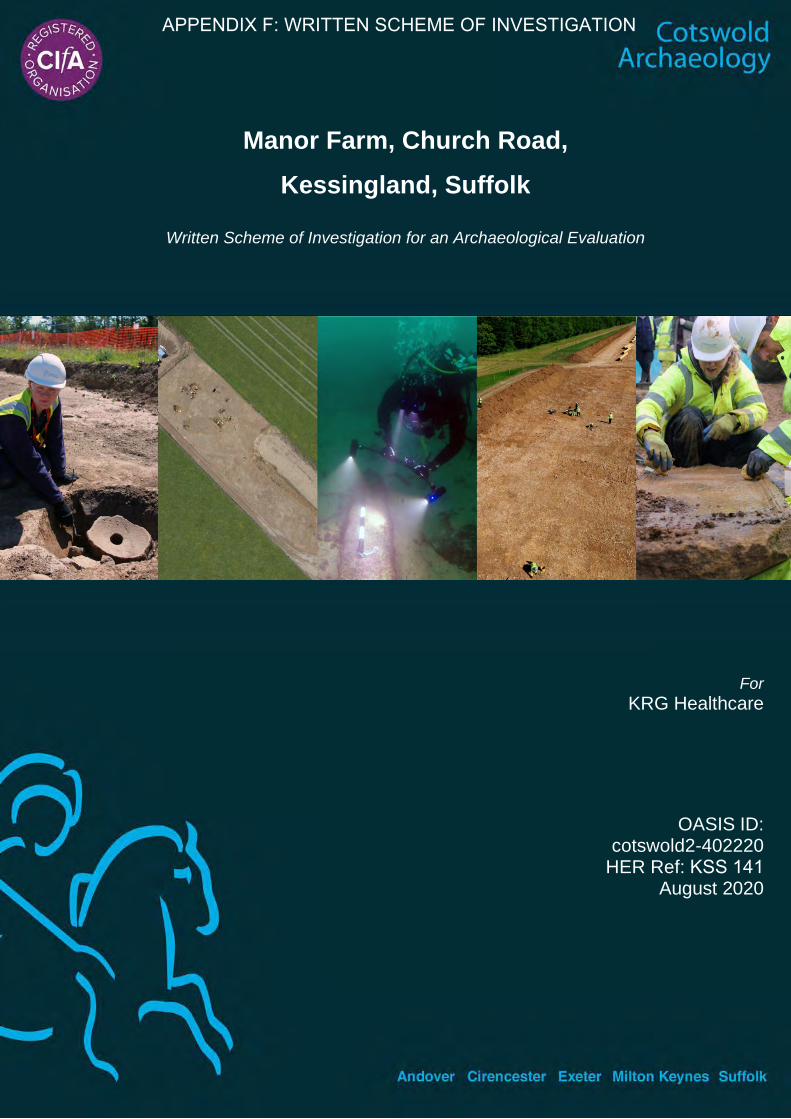
Manor Farm, Church Road,
Kessingland, Suffolk
Written Scheme of Investigation for an Archaeological Evaluation
For KRG Healthcare
OASIS ID: cotswold2-402220
HER Ref: KSS 141 August 2020
APPENDIX F: WRITTEN SCHEME OF INVESTIGATION

Manor Farm, Church Road, Kessingland, Suffolk
Written Scheme of Investigation for an Archaeological Evaluation
CA Project: SU0173 OASIS ID: cotswold2-402220
HER reference: KSS 141
DOCUMENT CONTROL GRID REVISION DATE AUTHOR CHECKED BY STATUS REASONS FOR
REVISION APPROVED
BY A 26/08/2020 S. BOULTER S. BOULTER DRAFT CURATORIAL
SCRUTINY
This report is confidential to the client. Cotswold Archaeology accepts no responsibility or liability to any third party to whom this report, or any part of it, is made known. Any such party relies upon this report entirely at their own risk. No part of this report may be reproduced by any means without permission.
© Cotswold Archaeology

© Cotswold Archaeology Manor Farm, Kessingland, Suffolk: Written Scheme of Investigation for an Archaeological Evaluation
CONTENTS
Summary Project Details .................................................................................... 1
1. INTRODUCTION ................................................................................................ 2
2. ARCHAEOLOGICAL BACKGROUND ................................................................ 3
3. AIMS AND OBJECTIVES ................................................................................... 3
4. METHODOLOGY ............................................................................................... 4
5. STAFF AND TIMETABLE ................................................................................... 9
6. POST-EXCAVATION, ARCHIVING AND REPORTING ..................................... 10
7. HEALTH, SAFETY AND ENVIRONMENT .......................................................... 13
8. INSURANCES .................................................................................................... 13
9. MONITORING .................................................................................................... 14
10. QUALITY ASSURANCE ..................................................................................... 15
11. PUBLIC ENGAGEMENT, PARTICIPATION AND BENEFIT ............................... 15
12. STAFF TRAINING AND CPD ............................................................................. 15
13. REFERENCES ................................................................................................... 16
APPENDIX A: COTSWOLD ARCHAEOLOGY SPECIALISTS ........................................ 17
APPENDIX B: ARCHAEOLOGICAL STANDARDS AND GUIDELINES .......................... 19
Figure 1 Site location
Figure 2 Location of proposed evaluation trenches

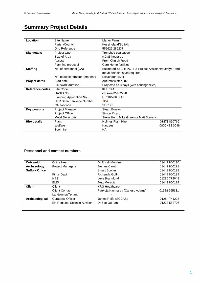
© Cotswold Archaeology
1
Manor Farm, Kessingland, Suffolk: Written Scheme of Investigation for an Archaeological Evaluation
Summary Project Details
Location Site Name Manor Farm Parish/County Kessingland/Suffolk Grid Reference 552622 286237
Site details Project type Trenched evaluation Size of Area c.0.85 hectaresAccess From Church RoadPlanning proposal Care Home facilities
Staffing No. of personnel (CA) Estimated as 1 x PO + 2 Project Assistant/surveyor and metal detectorist as required
No. of subcontractor personnel Excavator driver Project dates Start date Autumn/winter 2020
Fieldwork duration Projected as 3 days (with contingencies) Reference codes Site Code
OASIS No. Planning Application No. HER Search Invoice Number CA Jobcode
KSS 141 cotswold2-402220 DC/16/2868/FUL TBA SU0173
Key persons Project Manager Project Officer Metal Detectorist
Stuart Boulter Simon PicardSteve Hunt, Mike Green or Matt Stevens
Hire details Plant Holmes Plant Hire 01473 890766 Welfare Karzees 0800 432 0048 Tool-hire NA
Personnel and contact numbers
Cotswold Office Head Dr Rhodri Gardner 01449 900120 Archaeology; Suffolk Office
Project Managers Joanna Caruth Stuart Boulter
01449 900121 01449 900122
Finds Dept Richenda Goffin 01449 900129 H&S Luke Brannlund 01285 772648 EMS Jezz Meredith 01449 900124
Client Client KRG Healthcare - Client Contact Patrycja Kacmarek (Carless Adams) 01628 665131 Landowner/Tenant - -
Archaeological Curatorial Officer James Rolfe (SCCAS) 01284 741225 EH Regional Science Advisor Dr Zoe Outram 01223 582707
© Cotswold Archaeology
2
Manor Farm, Kessingland, Suffolk: Written Scheme of Investigation for an Archaeological Evaluation
1. INTRODUCTION
1.1 This document sets out details of a Written Scheme of Investigation (WSI) prepared
by Cotswold Archaeology (CA) covering an archaeological trenched evaluation of the
site of a proposed care home development on land south of Church Road,
Kessingland, Suffolk (NGR: 552622 286237) (Fig. 1).
1.2 Planning Application DC/16/2868/FUL attracted a planning condition requiring a
programme of archaeological work. The scope of the required works is detailed in a
Brief prepared by Suffolk County Council Archaeological Service (SCCAS), the
archaeological advisors to the Local Planning Authority (LPA), archaeologist James
Rolfe in a document dated 27th July 2020. This Written Scheme of Investigation (WSI)
covers the trenched evaluation only. Any further stages of archaeological work that
might be required as a consequence of the evaluation’s results would be subject to
new documentation.
1.3 This WSI has been guided in its composition by Standard and guidance:
Archaeological field evaluation (CIfA 2014; updated June 2020), the SCC
Requirements for Trenched Archaeological Evaluation (SCCAS 2019), the
Management of Research Projects in the Historic Environment (MORPHE): Project
Planning Note 3 (English Heritage 2008), the Management of Research Projects in
the Historic Environment (MORPHE): Project Manager’s Guide (EH 2006) and any
other relevant standards or guidance contained within Appendix B.
The site
1.4 The c.0.85 hectare site lies at approximately 18m AOD on a shallow south facing
slope overlooking the flood plain of the Hundred River which flows south-eastwards
c.1km to the south. The site is bounded by open fields to the south and west, housing
to the east and Church Road to the north.
1.5 Geologically, the site lies close to the junction between two distinctly different
superficial deposits, both of which potentially could be encountered. To the north,
Lowestoft Formation - Diamicton formed up to two million years ago in the Quaternary
Period in a local environment previously dominated by ice age conditions. These
sedimentary deposits are glacigenic in origin, detrital, created by the action of ice and
meltwater. They can form a wide range of deposits and geomorphologies associated
© Cotswold Archaeology
3
Manor Farm, Kessingland, Suffolk: Written Scheme of Investigation for an Archaeological Evaluation
with glacial and inter-glacial periods during the Quaternary. To the south, the Aldeby
Sand and Gravel Member - Sand And Gravel could be encountered. These deposits
also formed up to two million years ago in a local environment previously dominated
by ice age conditions. These sedimentary deposits are glacigenic in origin, detrital,
created by the action of ice and meltwater, they can form a wide range of deposits
and geomorphologies associated with glacial and inter-glacial periods during the
Quaternary Period. The underlying bedrock comprises Lewes Nodular Chalk
Formation, Seaford Chalk Formation, Newhaven Chalk Formation And Culver Chalk
Formation (undifferentiated) – Chalk, a sedimentary rock formed approximately
seventy-two to ninety-four million years ago in the Cretaceous Period in a local
environment previously dominated by warm chalk seas; they are shallow-marine in
origin, biogenic and detrital, generally comprising carbonate material (coccoliths),
forming distinctive beds (BGS 2020).
2. ARCHAEOLOGICAL BACKGROUND
2.1 The evaluation Brief states that the proposed development site lies in an area of high
archaeological potential recorded on the County Historic Environment Record (HER).
NB: A full HER search of an area encompassing a c.1km radius of the site will
be undertaken as part of the evaluation works and included in the subsequent
report.
2.2 The Brief also summarises the most significant HER records noted in the vicinity of
the proposed development site; specifically the medieval church of St. Edmund (KSS
022) c.150m to the east and cropmarks of linear features and enclosures of Roman
and unknown date (KSS 091 and 089). As a result, there is high potential for the
discovery of below-ground heritage assets of archaeological importance within this
area, and ground works associated with the development have the potential to
damage or destroy any archaeological remains which exist.
3. AIMS AND OBJECTIVES
3.1 The objectives of the evaluation are to provide information about the archaeological
resource within the site, including its presence/absence, character, extent, date,
integrity, state of preservation and quality. In accordance with Standard and guidance:
Archaeological field evaluation (CIfA 2014, updated 2020), the evaluation has been
© Cotswold Archaeology
4
Manor Farm, Kessingland, Suffolk: Written Scheme of Investigation for an Archaeological Evaluation
designed to be minimally intrusive and minimally destructive to archaeological
remains. The information gathered will enable SCCAS to identify and assess the
particular significance of any heritage asset, consider the impact of the proposed
development upon it, and to avoid or minimise conflict between the heritage asset’s
conservation and any aspect of the development proposal, in line with the National
Planning Policy Framework (DCLG, revised 2019).
3.2 The SCCAS Brief (4.2) states that the trial-trenching is required to:
• Identify the date, approximate form and purpose of any archaeological deposit,
together with its likely extent, localised depth and quality of preservation.
• Evaluate the likely impact of past land uses, and the possible presence of
masking colluvial/alluvial deposits.
• Establish the potential for the survival of environmental evidence.
• Provide sufficient information to construct an archaeological conservation
strategy, dealing with preservation, the recording of archaeological deposits,
working practices, timetables and orders of cost.
3.3 Any archaeological remains that are identified will be put into their local and regional
context with reference to the East Anglian Regional Research Agenda (Medleycott
2011).
3.4 During the course of the project, any changes proposed by the CA Project Manager
(Stuart Boulter) to the following specifications and methodologies will be
communicated directly to SCCAS for their approval.
4. METHODOLOGY
Excavation and recording 4.1 The Brief (4.3) requires that 5% by area of the 0.85 hectares site is covered by
trenching which is 424m2, equating to a c.235m length of 1.8m wide trenching (8 x
30m long by 1.8m wide trenches) which will be positioned primarily within the footprint
of the proposed buildings and other areas that will be disturbed during the
development (Fig. 2). The trenches will be set out on OS National Grid (NGR) co-
ordinates using Leica GPS, and scanned for live services by trained Cotswold
Archaeology staff using CAT and Genny equipment in accordance with the Cotswold
Archaeology Safe System of Work for avoiding underground services. The locations
© Cotswold Archaeology
5
Manor Farm, Kessingland, Suffolk: Written Scheme of Investigation for an Archaeological Evaluation
of some trenches may need to be adjusted on site to account for currently unidentified
services and other constraints, but only with the approval of the archaeological advisor
to the LPA (SCCAS). The final ‘as dug’ trench plan will be recorded with GPS.
4.2 The trenches will be opened using a mechanical excavator equipped with a toothless
ditching bucket with topsoil and subsoil stored separately adjacent to each trench. All
machining will be conducted under archaeological supervision and will cease when
the first significant archaeological horizon or natural substrate is revealed (whichever
is encountered first) or at a depth where Health and Safety considerations make
further excavation without trench support problematic. Should the depth of the
archaeological deposits be such that unsupported excavation cannot continue, there
will be discussions with SCCAS regarding the need to proceed; if deeper excavation
is deemed necessary then, in the first instance, stepping/battering of the trench edges
will be initiated. However, in extreme circumstances, other methods such as formal
shoring may be employed and will represent an additional expense to the client.
Where deep excavations need to be left open overnight, security fencing will be
erected.
4.3 Following machining, all archaeological features revealed will be planned and
recorded in accordance with CA Technical Manual 1: Fieldwork Recording Manual.
Each context will be recorded on a pro-forma context sheet by written and measured
description; principal deposits will be recorded by drawn plans (scale 1:20 or 1:50, or
electronically using Leica GPS or Total Station [TST] as appropriate) and drawn
sections (scale 1:10 or 1:20 as appropriate). Where detailed feature planning is
undertaken using GPS/TST this will be carried out in accordance with CA Technical
Manual 4: Survey Manual. Photographs (high resolution digital images; unprocessed
Raw files of at least 10 megapixels with a APS-C sensor or larger) will be taken as
appropriate. All finds and samples will be bagged separately and related to the context
record. All artefacts will be recovered and retained for processing and analysis in
accordance with CA Technical Manual 3: Treatment of Finds Immediately after
Excavation.
4.4 Unless agreed with SCCAS, all archaeological deposits and features will be sampled
by hand excavation in order to satisfy the project aims and also comply with the
SCCAS Requirements for Archaeological Evaluation (2019). Where complex or
unexpected deposits are encountered or deposits that are suitable for mechanical
excavation, these will be discussed with SCCAS to agree an excavation strategy.
© Cotswold Archaeology
6
Manor Farm, Kessingland, Suffolk: Written Scheme of Investigation for an Archaeological Evaluation
4.5 Sample excavation of archaeological deposits will, wherever possible, be limited and
minimally intrusive, sufficient to achieve the aims and objectives identified above.
Wherever possible, excavation will not compromise the integrity of the archaeological
record and will be undertaken in such a way as to allow for the subsequent protection
of remains, either for conservation or to allow more detailed investigations to be
conducted under better conditions at a later date. However, the general assumption
is that a minimum of 1m wide slots will be manually excavated across the width of
linear features, while for discrete features, such as pits, 50% of their fills should be
sampled, although in some instances 100% may be requested by SCCAS. Stratified
deposits will be cleaned manually and then sampled by sondage unless it is agreed
with SCCAS that at the evaluation stage of the project the deposit should remain
intact. Where complex stratigraphy is encountered, provision will be made to record
long trench-sections. It is assumed that unless agreed with SCCAS that all features
will be sampled.
4.6 Metal detector searches (non-discriminating against iron), undertaken by an
experienced metal-detectorist (CA staff Steve Hunt, Michael Green or Matt Stevens),
will take place throughout the project to include prior to the trenches being dug, during
the machine excavation and the subsequent hand-excavation phase as well as
scanning the upcast spoil. Metal finds recovered which are not from hand-excavated
features will have their location recorded by GPS.
4.7 All pre-modern finds (with the exception of unstratified animal bone) will be kept and
no discard policy will be considered until all the finds have been processed and
assessed.
4.8 All finds will be brought back to the CA Suffolk premises for processing, preliminary
assessment, conservation and packing. Most finds analysis work will be done in
house, but in some circumstances, it may be necessary to send some categories of
finds to external specialists (see below).
4.9 Should circumstances on site require additional security measures, for example
fencing, then the client will be informed and the additional measures put in place.
© Cotswold Archaeology
7
Manor Farm, Kessingland, Suffolk: Written Scheme of Investigation for an Archaeological Evaluation
Human remains
4.10 In the case of the discovery of human remains (skeletal or cremated), at all times they
should be treated with due decency and respect. For each situation, the following
actions are to be undertaken:
• In line with the recommendations Guidance for best practice for the treatment of
Human remains excavated from Christian Burial Grounds in England (APABE
2017) human burials should not be disturbed without good reason. However,
investigation of human remains should be undertaken to an extent sufficient for
adequate evaluation. Therefore, a suspected burial feature (inhumation or
cremated bone deposit) will be investigated to confirm the presence and
condition of human bone. Once confirmed as human, the buried remains will not
be disturbed further and will instead be left in situ - unless further disturbance is
absolutely unavoidable and required by SCCAS.
• Where further disturbance is unavoidable, or full exhumation of the remains is
deemed necessary by SCCAS, this will be conducted following the provisions of
the Coroners Unit in the Ministry of Justice. All excavation and post-excavation
processes will be in accordance with the standards set out in CIfA Technical
Paper No 7 Guidelines to the Standards for recording Human Remains (CIfA
2004).
Environmental remains
4.11 Due care will be taken to identify deposits which may have environmental potential,
and where appropriate, a programme of environmental sampling will be initiated. This
will follow the Historic England environmental sampling guidelines outlined in
Environmental Archaeology, A guide to the Theory and Practice of Methods, from
Sampling and Recovery to Post-excavation (English Heritage 2011), Additional
Requirements for Palaeoenvironmental Assessment (SCCAS 2017) and CA
Technical Manual 2: The Taking and Processing of Environmental and Other Samples
from Archaeological Sites. The sampling strategy will be adapted for the specific
circumstances of this site, in close consultation with the CA Environmental Officer
and, if necessary, the Heritage England Science Advisor (currently Zoe Outram), but
will follow the general selection parameters set out in the following paragraphs.
© Cotswold Archaeology
8
Manor Farm, Kessingland, Suffolk: Written Scheme of Investigation for an Archaeological Evaluation
4.12 Secure and phased deposits, especially those related to settlement activity and/or
structures will be considered for sampling for the recovery of charred plant remains,
charcoal and mineralised remains. Any cremation-related deposits will be sampled
appropriately (100%) for the recovery of cremated human bone and charred remains.
If any evidence of in situ metal working is found, suitable samples for the recovery of
slag and hammer scale will be taken. Sample sizes will be a minimum of 40 litres, or
100% of the context where deemed more suitable.
4.13 Where sealed waterlogged deposits are encountered, samples for the recovery of
waterlogged remains, insects, molluscs and pollen, as well as any charred remains,
will be considered. The taking of sequences of samples for the recovery of molluscs
and/or waterlogged remains will be considered through any suitable deposits such as
deep enclosure ditches, barrow ditches, palaeo-channels, or buried soils. Monolith
samples may also be taken from this kind of deposit, as appropriate, to allow soil and
sediment description/interpretation as well as sub-sampling for pollen and other
micro/macrofossils such as diatoms, foraminifera and ostracods.
4.14 The need for any more specialist samples, such as OSL, archaeomagnetic dating and
dendrochronology will be evaluated and will be taken in consultation with the relevant
specialist.
4.15 The processing of samples will be done in conjunction with the relevant specialist
following the Environmental Archaeology, A guide to the Theory and Practice of
Methods, from Sampling and Recovery to Post-excavation (English Heritage 2011).
Flotation or wet sieve samples will be processed to 0.25mm. Other more specialist
samples such as those for pollen will be prepared by the relevant specialist. Further
details of the general sampling policy and the methods of taking and processing
specific sample types are contained within CA Technical Manual 2: The Taking and
Processing of Environmental and Other Samples from Archaeological Sites.
4.16 Upon completion of the evaluation the backfilling will not be undertaken without the
consent of SCCAS. Once this is acquired, trenches will be backfilled by mechanical
excavator. Spoil will be pushed back into trenches in the correct sequence and tracked
over by the attending machine in order to ensure the ground surfaces are flat safe and
level. More formal reinstatement is not offered by CA.

© Cotswold Archaeology
9
Manor Farm, Kessingland, Suffolk: Written Scheme of Investigation for an Archaeological Evaluation
5. STAFF AND TIMETABLE
5.1 The project will be managed by CA Project Manager Stuart Boulter MCIfA.
5.2 The staffing structure will be organised thus: the Project Manager will direct the overall
conduct of the evaluation as required during the period of fieldwork. Day to day
responsibility however will rest with the CA Project Leader (TBA) who will be on-site
throughout the project.
5.3 It is projected that the CA team in the field will consist of a maximum of two staff: a
Project Officer (acting as Project Leader) and an Archaeologist (surveyor/metal-
detectorist) as required.
5.4 It is envisaged that the project will require up to three days of fieldwork although,
depending on what is uncovered, a fourth day may be required to complete
investigations and backfill the trenches. In addition, SCCAS may require further
deposit testing as a result of the site monitoring visit. Analysis of the results and
subsequent reporting will take up to a further four- six weeks depending on the
complexity of the results.
5.5 Specialists who will be invited to advise and report on specific aspects of the project
as necessary are:
Ceramics Ed McSloy, Steve Benfield (CA)
Metalwork Ed McSloy, Ruth Beveridge (CA)
Flint Jacky Sommerville, Michael Green (CA)
Animal Bone Andy Clarke BA (Hons) MA (CA), Matty
Holmes BSc MSc ACIfA (freelance),
Julie Curl (freelance)
Human Bone Sharon Clough (CA)
Environmental Remains Sarah Wyles, Anna West (CA)
Conservation Pieta Greeves (freelance)
Geoarchaeology Dr Keith Wilkinson (ARCA)
Building Recording Peter Davenport MCIfA FSA (freelance)
© Cotswold Archaeology
10
Manor Farm, Kessingland, Suffolk: Written Scheme of Investigation for an Archaeological Evaluation
5.6 Depending upon the nature of the deposits and artefacts encountered it may be
necessary to consult other specialists not listed here. A full list of specialists currently
used by Cotswold Archaeology is contained within Appendix A.
6. POST-EXCAVATION, ARCHIVING AND REPORTING
6.1 Following the completion of fieldwork, all artefacts and environmental samples will be
processed, assessed, conserved and packaged in accordance with CA Technical
Manuals and SCCAS guidelines. A recommendation will be made regarding material
deemed suitable for disposal/dispersal in line with the relevant recipient Museums’
collection policy, in this case almost certainly the county store.
6.2 An illustrated report will be compiled on the results of the fieldwork and assessment
of the artefacts, palaeoenvironmental samples etc. The report will include:
(i) an abstract containing the essential elements of the results preceding the main
body of the report;
(ii) a summary of the project’s background;
(iii) description and illustration of the site location;
(iv) a methodology of the works undertaken;
(v) integration of, or cross-reference to, appropriate cartographic and
documentary evidence and the results of other research undertaken, where
relevant to the interpretation of the evaluation results;
(vi) a description of the project’s results;
(vii) an interpretation of the results in the appropriate context;
(viii) a summary of the contents of the project archive and its location (including
summary catalogues of finds and samples);
(ix) a site location plan at an appropriate scale on an Ordnance Survey, or
equivalent, base-map;
(x) a plan showing the location of the trenches and exposed archaeological
features and deposits in relation to the site boundaries;
(xi) plans of each trench, or part of trench, in which archaeological features are
recognised. These will be at an appropriate scale to allow the nature of the
features exposed to be shown and understood. Plans will show the orientation
of trenches in relation to north. Section drawing locations will be shown on
these plans. Archaeologically sterile areas will not be illustrated unless this
© Cotswold Archaeology
11
Manor Farm, Kessingland, Suffolk: Written Scheme of Investigation for an Archaeological Evaluation
can provide information on the development of the site stratigraphy or show
palaeoenvironmental deposits that have influenced the site stratigraphy;
(xii) appropriate section drawings of trenches and features will be included, with
OD heights and at scales appropriate to the stratigraphic detail being
represented. These will show the orientation of the drawing in relation to
north/south/east/west. Archaeologically sterile trenches will not be illustrated
unless they provide significant information on the development of the site
stratigraphy or show palaeoenvironmental deposits that have influenced the
site stratigraphy;
(xiii) photographs showing significant features and deposits that are referred to in
the text. All photographs will contain appropriate scales, the size of which will
be noted in the illustration’s caption;
(xiv) a consideration of evidence within its wider local/regional context;
(xv) a summary table and descriptive text showing the features, classes and
numbers of artefacts recovered and soil profiles with interpretation;
(xvi) specialist assessment or analysis reports where undertaken;
(xvii) an evaluation of the methodology employed and the results obtained (i.e. a
confidence rating).
6.3 Specialist artefact and palaeoenvironmental assessment will take into account the
wider local/regional context of the archaeology and will include:
(i) specialist aims and objectives
(ii) processing methodologies (where relevant)
(iii) any known biases in recovery, or problems of contamination/residuality
(iv) quantity of material; types of material present; distribution of material
(v) for environmental material, a statement on abundance, diversity and preservation
(vi) summary and discussion of the results to include significance in a local and
regional context
6.4 Copies of the draft report will be distributed to the Client or their Representative and
to the LPA’s Archaeological Advisor (SCCAS) thereafter for verification and approval.
Subsequently, copies of the approved report will be issued to the Client, LPA’s
Archaeological Advisor (SCCAS) and the local Historic Environment Record (HER).
Reports will be issued in digital format (PDF/PDFA as appropriate) and a hard copy
will be supplied to the HER along with shapefiles containing location data for the areas
investigated, if required.
© Cotswold Archaeology
12
Manor Farm, Kessingland, Suffolk: Written Scheme of Investigation for an Archaeological Evaluation
6.5 Should no further work be required, an ordered, indexed, and internally consistent site
archive (both physical and digital) will be prepared and deposited in accordance with
Archaeological Archives: A Guide to Best Practice in Creation, Compilation, Transfer
and Curation (Archaeological Archives Forum 2007) and the Archaeological Archives
in Suffolk guidelines (SCCAS 2019). The client is aware of the costs of archiving and
provision will be made to cover these costs in our agreement with them. The archive
will be deposited with the County Archaeology Store unless another suitable
repository is agreed with SCCAS.
6.6 If the client does not agree to transfer ownership to SCCAS they will be required to
nominate another suitable repository approved by SCCAS or provide funding for
additional recording and analysis of the finds archive (such as, but not limited to,
additional photography or illustration of objects). In the rare event that artefacts of
significant monetary value are discovered, separate ownership arrangements may be
negotiated, provided they are not subject to Treasure Act legislation.
6.7 Should items considered to be Treasure as detailed in the Treasure Act 1996 and the
Code of Practice referred to therein, be identified the following guidelines will be
followed.
• The client (and landowner if different) and curator will be informed as soon as
any such objects are discovered/identified and the find will be reported to the
Coroner within fourteen days of discovery or identification. SCCAS, the British
Museum and the local Portable Antiquities Scheme (PAS) Finds Liaison
Officer will subsequently be informed of the find.
• Treasure objects will immediately be moved to secure storage at CA and
appropriate security measures will be taken on site if required.
• Upon discovery of potential treasure, the landowner will be asked if they wish
to waive or claim their right to a treasure reward which, in this instance, would
normally be 100% of the market value. If the landowner wishes to claim, an
inquest will be held and, once officially declared as Treasure and valued, the
item will, if not acquired by a museum, be returned to CA and the project
© Cotswold Archaeology
13
Manor Farm, Kessingland, Suffolk: Written Scheme of Investigation for an Archaeological Evaluation
archive. Employees of CA, or volunteers etc. present on site, will not be eligible
for any share of a treasure reward.
Academic dissemination
6.8 As the limited scope of this work is likely to restrict its publication value, it is anticipated
that only a short publication note will be produced, suitable for inclusion within the
PSIAH. The archaeological advisory and planning role of the SCCAS Historic
Environment Team will be acknowledged in any report or publication generated by
this project. Subject to any contractual constraints, a summary of information from
the project will also be entered onto the OASIS online database of archaeological
projects in Britain, including the upload of a digital (PDF) copy of the final report, which
will appear on the Archaeology Data Service (ADS) website once the OASIS record
has been verified.
Public dissemination
6.9 In addition to the ADS website, a digital (PDF) copy of the final report will also be
made available for public viewing via Cotswold Archaeology’s Archaeological Reports
Online web page, generally within twelve months of completion of the project
(http://reports.cotswoldarchaeology.co.uk/).
Archive deposition
6.10 CA will make arrangements with SCCAS for the deposition of the site archive and,
subject to agreement with the legal landowner(s), the artefact collection.
7. HEALTH, SAFETY AND ENVIRONMENT
7.1 CA will conduct all works in accordance with the Health and Safety at Work Act 1974
and all subsequent Health and Safety legislation, CA Health and Safety and
Environmental policies and the CA Safety, Health and Environmental Management
System (SHE). A site-specific Construction Phase Plan (form SHE 017) will be
formulated prior to commencement of fieldwork.
8. INSURANCES
8.1 CA holds Public Liability Insurance to a limit of £10,000,000 and Professional
Indemnity Insurance to a limit of £10,000,000.
© Cotswold Archaeology
14
Manor Farm, Kessingland, Suffolk: Written Scheme of Investigation for an Archaeological Evaluation
9. MONITORING
9.1 Notification of the start of site works will be made to the archaeological advisor to the
LPA (SCCAS) at least ten working days before commencement of the trenching in
order that there will be opportunities to visit the site and check on the quality and
progress of the work. Where a site visit is possible it will be booked with SCCAS prior
to the works commencing on site.
9.2 However, while the present Covid-19 pandemic is in progress, SCCAS had ceased to
undertake site visits and have issued guidelines regarding remote monitoring. While
this is currently subject to revision, their remote monitoring requirements are as
follows:
• All features present, including presumed natural and geological features
are to be investigated as per the WSI
• GPS plans showing what is present, with context numbers included and which features have had environmental samples taken
• Running phase plans • Written text stating what finds were found (if any) in each context, with
provisional date
• Photographs of features (Please note all photographs should be taken at appropriate times of day and not in bad lighting conditions and once trenches, sections, features have been cleaned)
• Overall site shots from an elevated point or pole cam if possible
• Provision for SCCAS to review the remote monitoring documents and for any queries to be addressed.
9.4 Post-excavation and archiving progress will also be subject to review by SCCAS. For
their part, CA will keep SCCAS informed regarding the progress of the project through
both the fieldwork and post-excavation phases.
© Cotswold Archaeology
15
Manor Farm, Kessingland, Suffolk: Written Scheme of Investigation for an Archaeological Evaluation
10. QUALITY ASSURANCE
10.1 CA is a Registered Organisation (RO) with the Chartered Institute for Archaeologists
(RO Ref. No. 8). As a RO, CA endorses the Code of Conduct (CIfA 2014) and the
Code of Approved Practice for the Regulation of Contractual Arrangements in Field
Archaeology (CIfA 2014). All CA Project Managers and Project Officers hold either full
Member or Associate status within the CIfA.
10.2 CA operates an internal quality assurance system in the following manner. Projects
are overseen by a Project Manager who is responsible for the quality of the project.
The Project Manager reports to the Chief Executive who bears ultimate responsibility
for the conduct of all CA operations. Matters of policy and corporate strategy are
determined by the Board of Directors, and in cases of dispute recourse may be made
to the Chairman of the Board.
11. PUBLIC ENGAGEMENT, PARTICIPATION AND BENEFIT
11.1 This project will not afford opportunities for public engagement or participation during
the course of the fieldwork. However, the results will be made publicly available on
the ADS and CA websites, as set out in Section 6 above.
12. STAFF TRAINING AND CPD
12.1 CA has a fully documented mandatory Performance Management system for all staff
which reviews personal performance, identifies areas for improvement, sets targets
and ensures the provision of appropriate training within CA’s adopted training policy.
In addition, CA has developed an award-winning Career Development Programme for
its staff, which ensures a consistent and high quality approach to the development of
appropriate skills.
12.2 As part of the company’s requirement for Continuing Professional Development, all
members of staff are also required to maintain a Personal Development Plan and an
associated log which is reviewed within the Performance Management system. All
staff are subject to probationary periods on appointment, with monthly review; for site-
based staff additional monthly Employee Performance Evaluations measure and
record skills and identify training needs.
© Cotswold Archaeology
16
Manor Farm, Kessingland, Suffolk: Written Scheme of Investigation for an Archaeological Evaluation
13. REFERENCES
APABE (Advisory Panel on the Archaeology of Burials in England) 2017 Guidance
for best practice for the treatment of Human remains excavated from Christian Burial
Grounds in England, 2nd Edition.
BGS (British Geological Survey) 2020 Geology of Britain Viewer
http://mapapps.bgs.ac.uk/geologyofbritain/home.html (accessed 13th July 2020)
DCLG (Department of Communities and Local Government) 2019 National Planning
Policy Framework

© Cotswold Archaeology
17
Manor Farm, Kessingland, Suffolk: Written Scheme of Investigation for an Archaeological Evaluation
APPENDIX A: COTSWOLD ARCHAEOLOGY SPECIALISTS
Ceramics Neolithic/Bronze Age Ed McSloy BA MCIFA (CA) Steve Benfield (CA) Emily Edwards (freelance) Dr Elaine Morris BA PhD FSA MCIFA (University of Southampton) Iron Age/Roman Ed McSloy BA MCIFA (CA) Kayt Marter Brown BA MSc MCIFA (freelance) Steve Benfield (CA) (Samian) Gwladys Montell MA PhD (freelance) (Amphorae stamps) Dr David Williams PhD FSA (freelance) Anglo-Saxon Paul Blinkhorn BTech (freelance) Sue Anderson (freelance) Dr Jane Timby BA PhD FSA MCIFA (freelance) Medieval/post-medieval Ed McSloy BA MCIFA (CA) Richenda Goffin (CA) Kayt Marter Brown BA MSc MCIFA (freelance) Stephanie Ratkai BA (freelance) Paul Blinkhorn BTech (freelance) John Allan BA MPhil FSA (freelance) South West Henrietta Quinnell BA FSA MCIFA (University of Exeter) East of England Steve Benfield (CA) Richenda Goffin (CA) Clay tobacco pipe Reg Jackson MLitt MCIFA (freelance) Marek Lewcun (freelance) Ceramic Building Material Ed McSloy MCIFA (CA) Dr Peter Warry PhD (freelance) Other Finds Small Finds Ed McSloy BA MCIFA (CA) Ruth Beveredge (CA) Metal Artefacts Katie Marsden BSc (CA) Ruth Beveridge (CA) Dr Jörn Schuster MA DPhil FSA MCIFA (freelance) Dr Hilary Cool BA PhD FSA (freelance) Lithics Ed McSloy BA MCIFA (CA) Mike Green (CA) Jacky Sommerville BSc MA PCIFA (CA) (Palaeolithic) Dr Francis Wenban-Smith BA MA PhD (University of Southampton) Worked Stone Dr Ruth Shaffrey BA PhD MCIFA (freelance) Dr Kevin Hayward FSA BSc MSc PhD PCIFA (freelance) Inscriptions Dr Roger Tomlin MA DPhil, FSA (Oxford) Glass Ed McSloy MCIFA (CA) Dr Hilary Cool BA PhD FSA (freelance) Dr David Dungworth BA PhD (freelance; English Heritage) Coins Ed McSloy BA MCIFA (CA) Dr Peter Guest BA PhD FSA (Cardiff University) Dr Richard Reece BSc PhD FSA (freelance) Leather Quita Mould MA FSA (freelance)
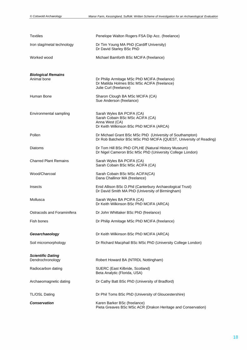
© Cotswold Archaeology
18
Manor Farm, Kessingland, Suffolk: Written Scheme of Investigation for an Archaeological Evaluation
Textiles Penelope Walton Rogers FSA Dip Acc. (freelance) Iron slag/metal technology Dr Tim Young MA PhD (Cardiff University) Dr David Starley BSc PhD Worked wood Michael Bamforth BSc MCIFA (freelance) Biological Remains Animal bone Dr Philip Armitage MSc PhD MCIFA (freelance) Dr Matilda Holmes BSc MSc ACIFA (freelance) Julie Curl (freelance) Human Bone Sharon Clough BA MSc MCIFA (CA) Sue Anderson (freelance) Environmental sampling Sarah Wyles BA PCIFA (CA) Sarah Cobain BSc MSc ACIFA (CA) Anna West (CA)
Dr Keith Wilkinson BSc PhD MCIFA (ARCA) Pollen Dr Michael Grant BSc MSc PhD (University of Southampton) Dr Rob Batchelor BSc MSc PhD MCIFA (QUEST, University of Reading) Diatoms Dr Tom Hill BSc PhD CPLHE (Natural History Museum) Dr Nigel Cameron BSc MSc PhD (University College London) Charred Plant Remains Sarah Wyles BA PCIFA (CA) Sarah Cobain BSc MSc ACIFA (CA) Wood/Charcoal Sarah Cobain BSc MSc ACIFA(CA) Dana Challinor MA (freelance) Insects Enid Allison BSc D.Phil (Canterbury Archaeological Trust) Dr David Smith MA PhD (University of Birmingham) Mollusca Sarah Wyles BA PCIFA (CA)
Dr Keith Wilkinson BSc PhD MCIFA (ARCA)
Ostracods and Foraminifera Dr John Whittaker BSc PhD (freelance) Fish bones Dr Philip Armitage MSc PhD MCIFA (freelance) Geoarchaeology Dr Keith Wilkinson BSc PhD MCIFA (ARCA) Soil micromorphology Dr Richard Macphail BSc MSc PhD (University College London) Scientific Dating Dendrochronology Robert Howard BA (NTRDL Nottingham) Radiocarbon dating SUERC (East Kilbride, Scotland) Beta Analytic (Florida, USA) Archaeomagnetic dating Dr Cathy Batt BSc PhD (University of Bradford) TL/OSL Dating Dr Phil Toms BSc PhD (University of Gloucestershire) Conservation Karen Barker BSc (freelance) Pieta Greaves BSc MSc ACR (Drakon Heritage and Conservation)
© Cotswold Archaeology
19
Manor Farm, Kessingland, Suffolk: Written Scheme of Investigation for an Archaeological Evaluation
APPENDIX B: ARCHAEOLOGICAL STANDARDS AND GUIDELINES
AAF 2007 Archaeological Archives. A guide to best practice in creation, compilation, transfer and curation. Archaeological Archives Forum
AAI&S 1988 The Illustration of Lithic Artefacts: A guide to drawing stone tools for specialist reports. Association of Archaeological Illustrators and Surveyors Paper 9
AAI&S 1994 The Illustration of Wooden Artefacts: An Introduction and Guide to the Depiction of Wooden Objects. Association of Archaeological Illustrators and Surveyors Paper 11
AAI&S 1997. Aspects of Illustration: Prehistoric pottery. Association of Archaeological Illustrators and Surveyors Paper 13
AAI&S nd Introduction to Drawing Archaeological Pottery. Association of Archaeological Illustrators and Surveyors, Graphic Archaeology Occasional Papers 1
ACBMG 2004 Draft Minimum Standards for the Recovery, Analysis and Publication of Ceramic Building Material. (third edition) Archaeological Ceramic Building Materials Group
AEA 1995 Environmental Archaeology and Archaeological Evaluations. Recommendations concerning the environmental archaeology component of archaeological evaluations in England. Working Papers of the Association for Environmental Archaeology No. 2
BABAO and IFA, 2004 Guidelines to the Standards for Recording Human Remains. British Association for Biological Anthropology and Osteoarchaeology and Institute of Field Archaeologists. Institute of Field Archaeologists Technical Paper 7 (Reading)
Barber, B., Carver, J., Hinton, P. and Nixon, T. 2008 Archaeology and development. A good practice guide to managing risk and maximising benefit. Construction Industry Research and Information Association Report C672
Bayley, J. (ed) 1998 Science in Archaeology. An agenda for the future. English Heritage (London) Bewley, R., Donoghue, D., Gaffney, V., Van Leusen, M., Wise, M., 1998 Archiving Aerial Photography and Remote
Sensing Data: A guide to good practice. Archaeology Data Service Blake, H. and P. Davey (eds) 1983 Guidelines for the processing and publication of Medieval pottery from
excavations, report by a working party of the Medieval Pottery Research Group and the Department of the Environment. Directorate of Ancient Monuments and Historic Buildings Occasional Paper 5, 23-34, DoE, London
Brickley, M. and McKinley, J.I., 2004 Guidelines to the Standards for Recording Human Remains. IFA Paper No 7,Institute of Field Archaeologists (Reading)
Brickstock, R.J. 2004 The Production, Analysis and Standardisation of Romano-British Coin Reports. English Heritage (Swindon)
Brown, A. and Perrin, K. 2000 A Model for the Description of Archaeological Archives. English Heritage Centre for Archaeology/ Institute of Field Archaeologists (Reading)
Brown, D.H. 2007 Archaeological Archives: A guide to best practice in creation, compilation, transfer and curation. IFA Archaeological Archives Forum (Reading)
Brown, N & Glazebrook, J., 2000, Research and Archaeology: a framework for the Eastern Counties 2. Research agenda and strategy, East Anglian Archaeology Occasional Paper 8
Buikstra, J.E. and Ubelaker D.H. (eds) 1994 Standards for Data Collection from Human Skeletal Remains. (Fayetteville, Arkansas)
CIfA, 2014, Code of Approved Practice for the Regulation of Contractual Arrangements in Field Archaeology. Chartered Institute for Archaeologists (Reading) CIfA, 2014 (updated 2017), Standard and Guidance for Archaeological Desk-based Assessment. Chartered
Institute for Archaeologists (Reading) CIfA, 2014 (updated 2020), Standard and Guidance for Archaeological Watching Brief. Chartered Institute for
Archaeologists (Reading) CIfA, 2014, Standard and Guidance for Archaeological Excavation. Chartered Institute for Archaeologists
(Reading) CIfA, 2014 (updated 2019), Standard and Guidance for Archaeological Investigation and Recording of Standing
Buildings or Structures. Chartered Institute for Archaeologists (Reading) CIfA, 2014, Standard and Guidance for the Collection, Documentation, Conservation and Research of
Archaeological Materials. Chartered Institute for Archaeologists (Reading) CIfA, 2014 (updated 2020), Standard and Guidance for the Creation, Compilation, Transfer and Deposition of Archaeological Archives. Chartered Institute for Archaeologists (Reading) CIfA, 2014 (updated 2020), Standard and Guidance for Archaeological Field Evaluation. Chartered Institute for
Archaeologists (Reading) Clark, J., Darlington, J. and Fairclough, G. 2004 Using Historic Landscape Characterisation. English Heritage
(London) Coles, J.M., 1990 Waterlogged Wood: guidelines on the recording, sampling, conservation and curation of
structural wood. English Heritage (London) Cowton, J., 1997 Spectrum. The UK Museums Documentation Standard. Second edition. Museums
Documentation Association Cox, M., 2002 Crypt Archaeology: an approach. Institute of Field Archaeologists Technical Paper 3 (Reading)
© Cotswold Archaeology
20
Manor Farm, Kessingland, Suffolk: Written Scheme of Investigation for an Archaeological Evaluation
Darvill, T. and Atkins, M., 1991 Regulating Archaeological Works by Contract. IFA Technical Paper No 8, Institute of Field Archaeologists (Reading)
Davey P.J. 1981 Guidelines for the processing and publication of clay pipes from excavations. Medieval and Later Pottery in Wales, IV, 65-87
Eiteljorg, H., Fernie, K., Huggett, J. and Robinson, D. 2002 CAD: A guide to good practice. Archaeology Data Service (York)
EA 2005 Guidance on Assessing the Risk Posed by Land Contamination and its Remediation on Archaeological Resource Management. English Heritage/ Environment Agency Science Report P5-077/SR (Bristol)
EH 1995 A Strategy for the Care and Investigation of Finds. English Heritage Ancient Monuments Laboratory (London)
EH 1998 Identifying and Protecting Palaeolithic Remains. Archaeological guidance for planning authorities and developers. English Heritage (London) EH 1999 Guidelines for the Conservation of Textiles. English Heritage (London) EH 2000, Managing Lithic Scatters. Archaeological guidance for planning authorities and developers. English
Heritage (London) EH 2002 With Alidade and Tape: graphical and plane table survey of archaeological earthworks. English Heritage
(Swindon) EH 2003a Where on Earth Are We? The Global Positioning System (GPS) in archaeological field survey. English
Heritage (London) EH 2003b Twentieth-Century Military Sites. Current approaches to their recording and conservation English
Heritage (Swindon) EH 2004a Dendrochronology. Guidelines on producing and interpreting dendrochronological dates. English
Heritage (Swindon) EH 2004b Human Bones from Archaeological Sites: Guidelines for producing assessment documents and
analytical report. English Heritage Centre for Archaeology Guidelines EH 2006a Guidelines on the X-radiography of Archaeological Metalwork. English Heritage (Swindon) EH 2006b Archaeomagnetic Dating. English Heritage (Swindon) EH 2006c Science for Historic Industries: Guidelines for the investigation of 17th- to 19th-century industries. English Heritage (Swindon) EH 2007a Understanding the Archaeology of Landscapes. A guide to good recording practice. English Heritage
(Swindon) EH 2007b Geoarchaeology. Using earth sciences to understand the archaeological record. (London) EH 2008a Luminescence Dating. Guidelines on using luminescence dating in archaeology. English Heritage
(Swindon) EH 2008b Geophysical Survey in Archaeological Field Evaluation. English Heritage Research and Professional
Services Guidelines No 1 (second edition). English Heritage (Swindon) EH 2008c Research and Conservation Framework for the British Palaeolithic. English Heritage/Prehistoric Society
(Swindon) EH 2008d Investigative Conservation. Guidelines on how the detailed examination of artefacts from archaeological
sites can shed light on their manufacture and use. English Heritage (Swindon) EH 2010 Waterlogged Wood: Guidelines on the recording, sampling, conservation and curation of archaeological
wood. English Heritage (London) EH 2011 Environmental Archaeology: A guide to the theory and practice of methods, from sampling and recovery
to post-excavation. English Heritage Centre for Archaeology Guidelines (London) EH 2012, Guidelines for the Care of Waterlogged Organic Artefacts: guidelines on their recovery, analysis and
conservation. EH 2014 Our Portable Past: a statement of English Heritage policy and good practice for portable
antiquities/surface collected material in the context of field archaeology and survey programmes (including the use of metal detectors). English Heritage (Swindon)
EH and Church of England, 2005, Guidance for Best Practice for Treatment of Human Remains Excavated from Christian Burial Grounds in England. English Heritage (London)
Ferguson, L. and Murray, D., 1997, Archaeological Documentary Archives. IFA Paper 1, Institute of Field Archaeologists (Reading)
Gaffney, C. and Gater, J., with Ovenden, S., 2002, The Use of Geophysical Techniques in Archaeological Evaluations. IFA Technical Paper 9, Institute of Field Archaeologists (Reading)
Glazebrook, J, 1997, Research and Archaeology: a Framework for the Eastern Counties 1. Resource Assessment, East Anglian Archaeology Occasional Paper 3
Gillings, M. and Wise, A., 1999, GIS: A guide to good practice. Archaeology Data Service (York) Gurney, D.A., 1985, Phosphate Analysis of Soils: A Guide for the Field Archaeologist. IFA Technical Paper 3,
Institute of Field Archaeologists (Reading) HE 2015a Archaeometallurgy: Guidelines for Best Practice. Historic England (Swindon) HE 2015b (revised 2008), Metric Survey Specifications for Cultural Heritage. Historic England (Swindon) HE 2015c Management of Research Projects in the Historic Environment. The MoRPHE Project Managers' Guide. Historic England (Swindon) Handley, M., 1999, Microfilming Archaeological Archives. IFA Technical Paper 2, Institute of Field Archaeologists (Reading)
© Cotswold Archaeology
21
Manor Farm, Kessingland, Suffolk: Written Scheme of Investigation for an Archaeological Evaluation
Mays, S., 1991, Recommendations for Processing Human Bone from Archaeological Sites. Ancient Monuments Lab Report 124/91 (London)
Mays, S., Brickley, M. and Dodwell, N., 2002, Human Bones from Archaeological Sites. Guidelines for Producing Assessment Documents and Analytical Reports. Centre for Archaeology Guidelines, English Heritage (Portsmouth)
Medleycott, M., 2011, Research and Archaeology Revisited: a revised framework for the East of England, East Anglian Archaeology Occasional Paper 24
McKinley, J.I. and Roberts, C., 1993, Excavation and Post-excavation Treatment of Cremated and Inhumed Human Remains. Institute of Field Archaeologists Technical Paper No. 13 (Reading)
MGC, 1992, Standards in the Museum Care of Archaeological Collections. Museums and Galleries Commission Murphy, P.L. and Wiltshire, P.E.J. 1994, A Guide to Sampling Archaeological Deposits for Environmental Analysis.
English Heritage (London) MPRG 2000, A Guide to the Classification of Medieval Ceramics. Medieval Pottery Research Group Occasional
Papers No. 1. MPRG 2001, Minimum Standards for the Processing, Recording, Analysis and Publication of Post-Roman
Ceramics. Medieval Pottery Research Group Owen, J., 1995, Towards an Accessible Archaeological Archive. The Transfer of archaeological archives to
museums: guidelines for use in England, Northern Ireland, Scotland and Wales. Society of Museum Archaeologists
PCRG 1997, The Study of Later Prehistoric Pottery: General polices and guidelines for analysis and publication. Prehistoric Ceramics Research Group Occasional Paper 12
Philo, C. and Swann, A., 1992, Preparation of Artwork for Publication. Institute of Field Archaeologists Technical Paper No. 10 (Reading)
RCHME 1999, Recording Archaeological Field Monuments: A descriptive specification. RCHME (Swindon) RCHME 2007, MIDAS: A manual and data standard for monuments inventories. RCHME (Swindon) Schofield, A J, (ed) 1998, Interpreting Artefact Scatters. Oxbow Monograph 4 (Oxford) Richards, J. and Robinson, D. (eds), 2001, Digital Archives From Excavation and Fieldwork: A guide to good
practice. Archaeology Data Service Robinson, W., 1998, First Aid for Underwater Finds. Archetype Books (London) RFG and FRG, 1993, Guidelines for the Preparation of Site and Assessments for all Finds other than Fired Clay
Vessels. Roman Finds Group And Finds Research Group Schmidt, A., 2001, Geophysical Data in Archaeology: A guide to good practice. Archaeology Data Service SGRP, 1994, Guidelines for the Archiving of Roman Pottery. Study Group for Roman Pottery SMA, 1993, Guidelines on the Selection, Retention and Dispersal of Archaeological Collections. Society of Museum
Archaeologists Suffolk County Council, 2017, Archaeological Archives in Suffolk: Guidelines for Preparation and Deposition, SCC
Archaeology Service (Bury St Edmunds) UKIC, 1983, Packaging and Storage of Freshly Excavated Artefacts from Archaeological Sites. (United Kingdom
Institute for Conservation, Conservation Guidelines No 2) UKIC, 1984, Environmental Standards for Permanent Storage of Excavated material from Archaeological Sites.
(United Kingdom Institute for Conservation, Conservation Guidelines No 3) UKIC, 1990, Guidance for Conservation Practice. United Kingdom Institute for Conservation UKIC, 1990, Guidelines for the Preparation of Excavation Archives for Long-term Storage. United Kingdom Institute
for Conservation Archaeology Section UKIC, 2001, Excavated Artefacts and Conservation. (United Kingdom Institute for Conservation, Conservation Guidelines No 1, revised) Watkinson, D.E., and Neal, V., 1998, First Aid for Finds. (3rd edition) RESCUE/United Kingdom Institute for
Conservation, Archaeology Section and Museum of London Willis, S., 1997, (ed) Research Frameworks for the Study of Roman Pottery. Study Group for Roman Pottery World Archaeology Congress 1989, The Vermillion Accord – Human Remains. Motion Approved at the First Inter-
Congress on the Disposal of the Dead (Vermillion) Young C., 1980, Guidelines for the Processing and Publication of Roman Pottery. Department of the Environment

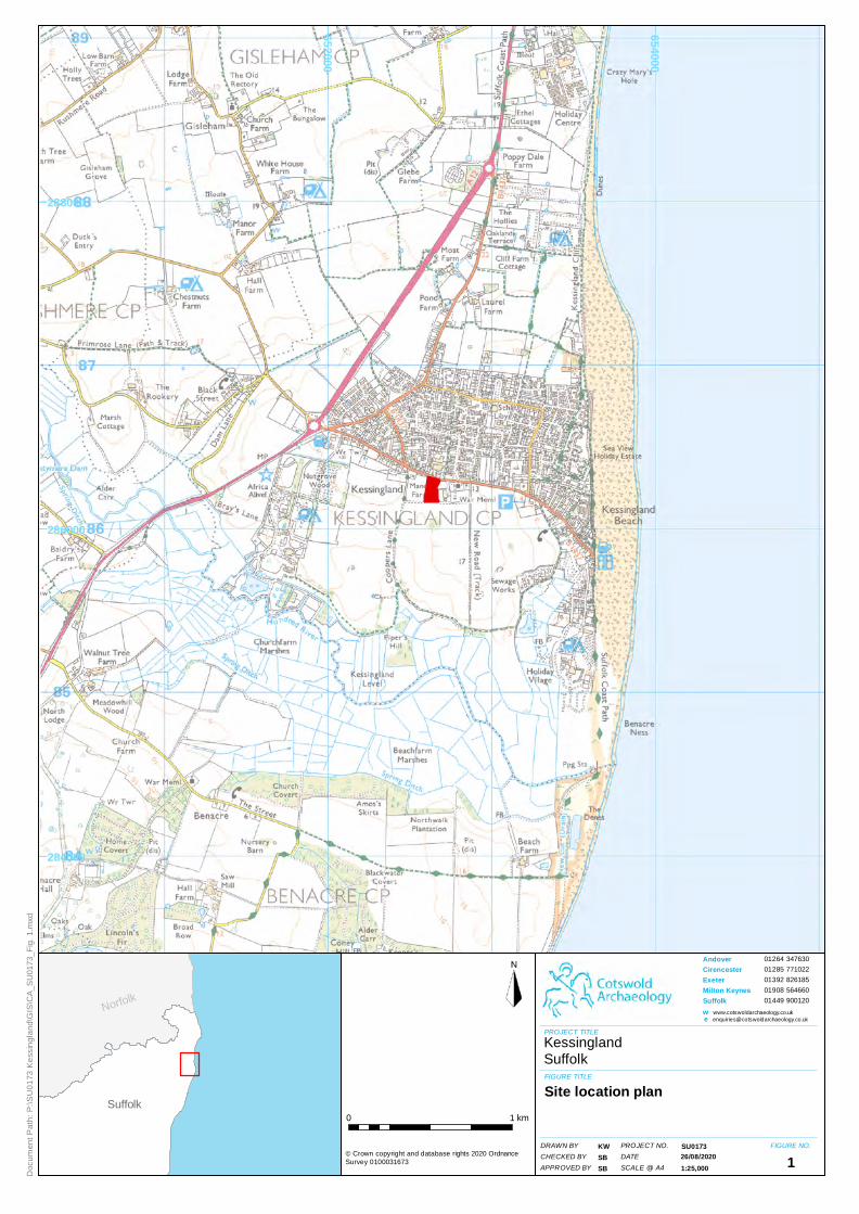
652000
654000
284000
286000
288000
Suffolk
Norfolk
01264 347630
01285 771022
01392 826185
01908 564660
01449 900120
PROJECT TITLE
11:25,000
KessinglandSuffolk
PROJECT NO.DATESCALE @ A4
FIGURE NO.
Andover CirencesterExeterMilton KeynesSuffolkwe
© Crown copyright and database rights 2020 OrdnanceSurvey 0100031673
KWSBSB
SU0173
0 1 km
FIGURE TITLE
DRAWN BYCHECKED BYAPPROVED BY
Site location plan
Doc
um
ent
Pa
th:
P:\
SU
01
73 K
ess
ing
land
\GIS
\CA
_SU
0173
_Fig
. 1.
mxd
26/08/2020

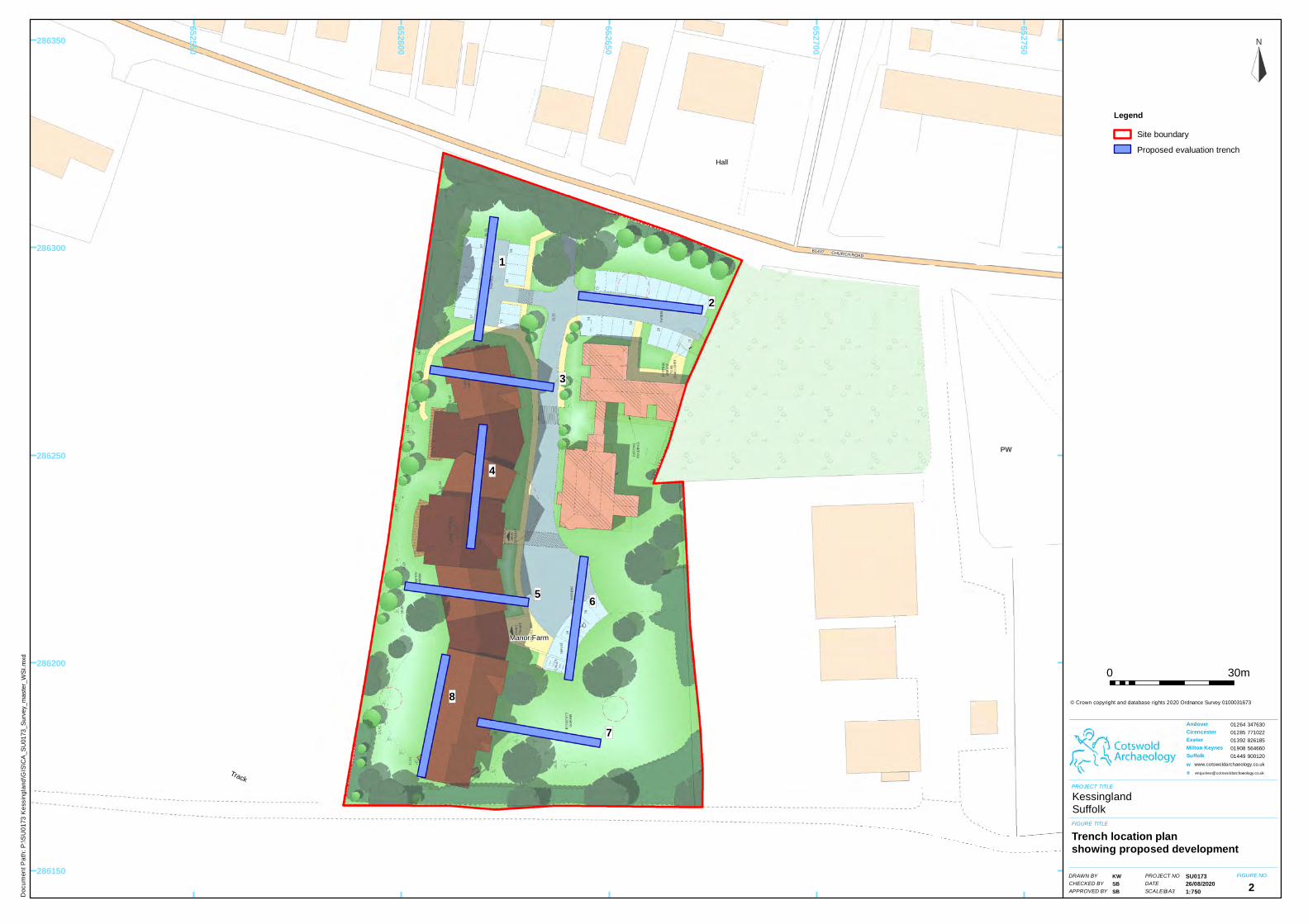
1
2
3
4
5
6
7
8
CHURCH ROADB1437
Manor Farm
Hall
PW
Track
652550
652600
652650
652700
652750
286150
286200
286250
286300
286350
PROJECT TITLE
FIGURE TITLE
DRAWN BYCHECKED BY
FIGURE NO.PROJECT NO
0 30m
1:750APPROVED BYDATESCALE@A3
LegendSite boundary
Proposed evaluation trench
2
www.cotswoldarchaeology.co.uk
we
26/08/2020
Doc
um
ent
Pa
th:
P:\
SU
01
73 K
ess
ing
land
\GIS
\CA
_SU
0173
_Sur
vey_
mas
ter_
WS
I.m
xd
Andover CirencesterExeterMilton KeynesSuffolk
01264 347630
01285 771022
01392 826185
01908 564660
01449 900120
© Crown copyright and database rights 2020 Ordnance Survey 0100031673
KessinglandSuffolk
Trench location planshowing proposed development
SU0173KWSBSB


22
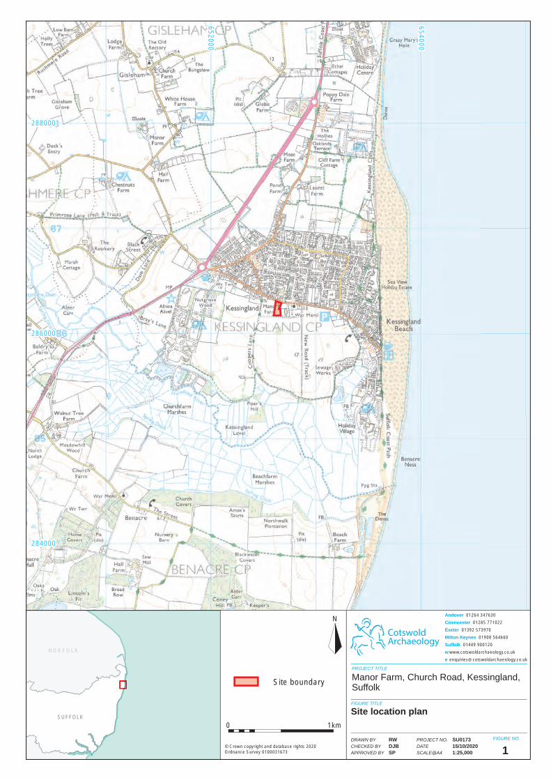
SUFFOLK
NORFOLK
CotswoldArchaeology
N
PROJECT TITLE
FIGURE TITLE
FIGURE NO.
0 1km
1
Manor Farm, Church Road, Kessingland, Suffolk
Site location plan
PROJECT NO.
DATE
SCALE@A4
DRAWN BY
CHECKED BY
APPROVED BY
SU017315/10/20201:25,000
RWDJBSP
© Crown copyright and database rights 2020Ordnance Survey 0100031673
Andover 01264 347630
Cirencester 01285 771022
Exeter 01392 573970
Milton Keynes 01908 564660
Suffolk 01449 900120
w www.cotswoldarchaeology.co.uk
286000286000
284000284000
288000288000
652000652000
654000654000
Site boundary
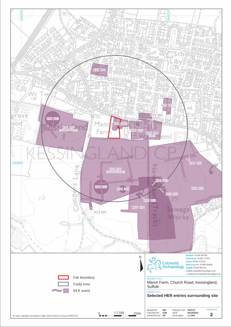
653000653000
652000652000
286000286000
KSS 100KSS 100
KSS 113KSS 113
KSS 084(area)
KSS 084(area)
KSS 084(points)
KSS 084(points)
KSS 022KSS 022KSS 089
(area and linears)KSS 089
(area and linears)
KSS 091(area and linears)
KSS 091(area and linears)
KSS 092KSS 092
KSS 092KSS 092
KSS 090KSS 090
KSS 008KSS 008KSS 025KSS 025
KSS 0138KSS 0138
KSS 023KSS 023
KSS 092KSS 092
KSS 093KSS 093
KSS 093KSS 093
KSS 091KSS 091
CotswoldArchaeology
N
PROJECT TITLE
FIGURE TITLE
FIGURE NO.
2
Manor Farm, Church Road, Kessingland, Suffolk
Selected HER entries surrounding site
PROJECT NO.
DATE
SCALE@A4
DRAWN BY
CHECKED BY
APPROVED BY
SU017330/10/20201:7,500
RWDJBSP© Crown copyright and database rights 2020 Ordnance Survey 0100031673
Andover 01264 347630
Cirencester 01285 771022
Exeter 01392 573970
Milton Keynes 01908 564660
Suffolk 01449 900120
w www.cotswoldarchaeology.co.uk
Site boundary
Study area
HER event
0 250m1:7,500
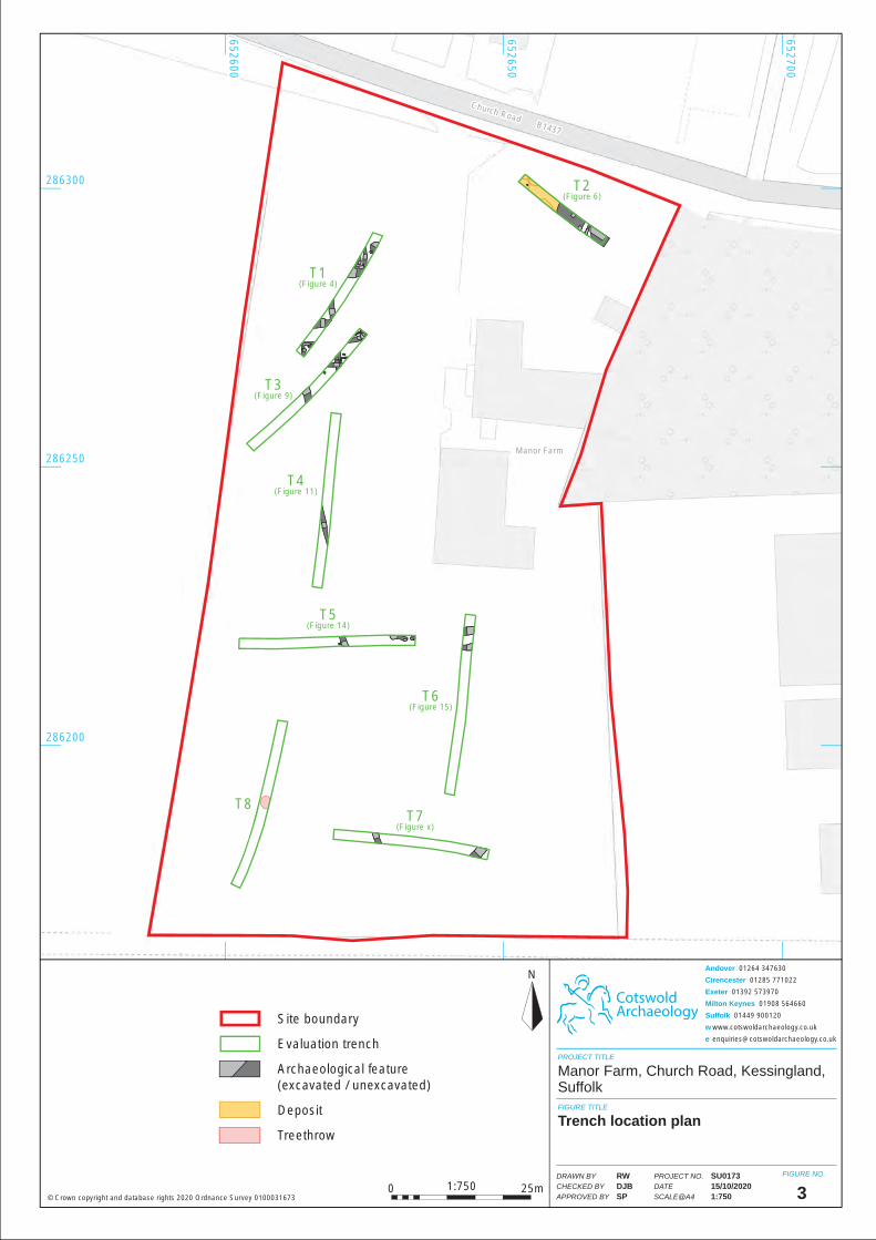
Manor FarmManor Farm
Church Road B1437
Church Road B1437
T2(Figure 6)
T2(Figure 6)
T1(Figure 4)
T1(Figure 4)
T3(Figure 9)
T3(Figure 9)
T4(Figure 11)
T4(Figure 11)
T5(Figure 14)
T5(Figure 14)
T6(Figure 15)
T6(Figure 15)
T8T8T7
(Figure x)T7
(Figure x)
286300286300
286250286250
286200286200
652600652600
652650652650
652700652700
CotswoldArchaeology
N
PROJECT TITLE
FIGURE TITLE
FIGURE NO.
3
Manor Farm, Church Road, Kessingland, Suffolk
Trench location plan
PROJECT NO.
DATE
SCALE@A4
DRAWN BY
CHECKED BY
APPROVED BY
SU017315/10/20201:750
RWDJBSP© Crown copyright and database rights 2020 Ordnance Survey 0100031673
Andover 01264 347630
Cirencester 01285 771022
Exeter 01392 573970
Milton Keynes 01908 564660
Suffolk 01449 900120
w www.cotswoldarchaeology.co.uk
Site boundary
Evaluation trench
Archaeological feature(excavated / unexcavated)
Deposit
Treethrow
0 25m1:750
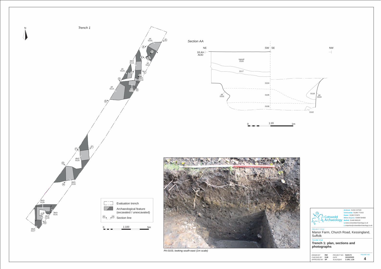
CotswoldArchaeology
PROJECT TITLE
FIGURE TITLE
FIGURE NO.PROJECT NO.
DATE
SCALE@A3
DRAWN BY
CHECKED BY
APPROVED BY
Andover 01264 347630
Cirencester 01285 771022
Exeter 01392 573970
Milton Keynes 01908 564660
Suffolk 01449 900120
w www.cotswoldarchaeology.co.uk
4
Manor Farm, Church Road, Kessingland, Suffolk
Trench 1: plan, sections and photographs
SU017315/10/20201:100, 1:20
RWDJBSP
1:200 1m
Pit 0103, looking south-east (1m scale)
pit0103
pit0103
pit0103
pit0103
18.4mAOD
NE NWSW SE
Section AA
topsoil0100
topsoil0100
01170117
01040104
01050105
01060106
01180118
01020102
A
A
Trench 1N
Evaluation trench
Archaeological feature(excavated / unexcavated)
Section lineA A
ditch0135ditch0135
ditch0129ditch0129
ditch0127ditch0127
ditch0131ditch0131
ditch0133ditch0133
B
B
CE
E
C
D
D
pit0103
pit0103
pit0110
pit0110
ditch0112ditch0112
pit0123
pit0123
pit0114
pit0114
ditch0125ditch0125
pit0121
pit0121
ditch0119ditch0119
1:1000 5m
F
H
H
F
G
G
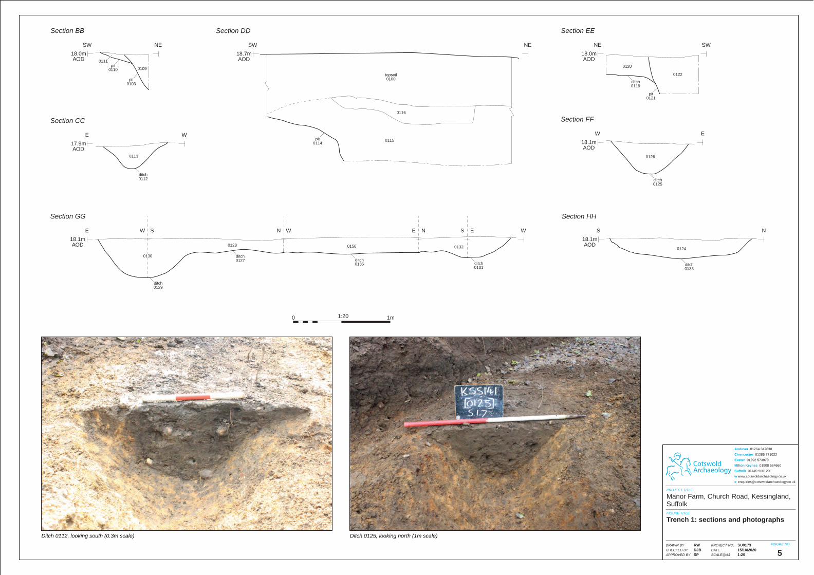
CotswoldArchaeology
PROJECT TITLE
FIGURE TITLE
FIGURE NO.
5
Manor Farm, Church Road, Kessingland, Suffolk
Trench 1: sections and photographs
PROJECT NO.
DATE
SCALE@A3
DRAWN BY
CHECKED BY
APPROVED BY
SU017315/10/20201:20
RWDJBSP
Andover 01264 347630
Cirencester 01285 771022
Exeter 01392 573970
Milton Keynes 01908 564660
Suffolk 01449 900120
w www.cotswoldarchaeology.co.uk
1:200 1m
Ditch 0125, looking north (1m scale)Ditch 0112, looking south (0.3m scale)
pit0103
pit0103
pit0110
pit0110
01110111
ditch0112ditch0112
17.9mAOD
E W
Section CC
18.0mAOD
SW NE
Section BB
01130113
01090109
pit0114
pit0114
18.7mAOD
SW NE
Section DD
topsoil0100
topsoil0100
01160116
01150115
ditch0125ditch0125
18.1mAOD
W E
Section FF
01260126
ditch0119ditch0119
01200120
01220122
pit0121
pit0121
18.0mAOD
NE SW
Section EE
ditch0133ditch0133
ditch0129ditch0129
ditch0135ditch0135
ditch0127ditch0127
ditch0131ditch0131
18.1mAOD
E WW S
Section GG
N W E N S E
18.1mAOD
S N
Section HH
0124012401280128
01300130
01560156 01320132
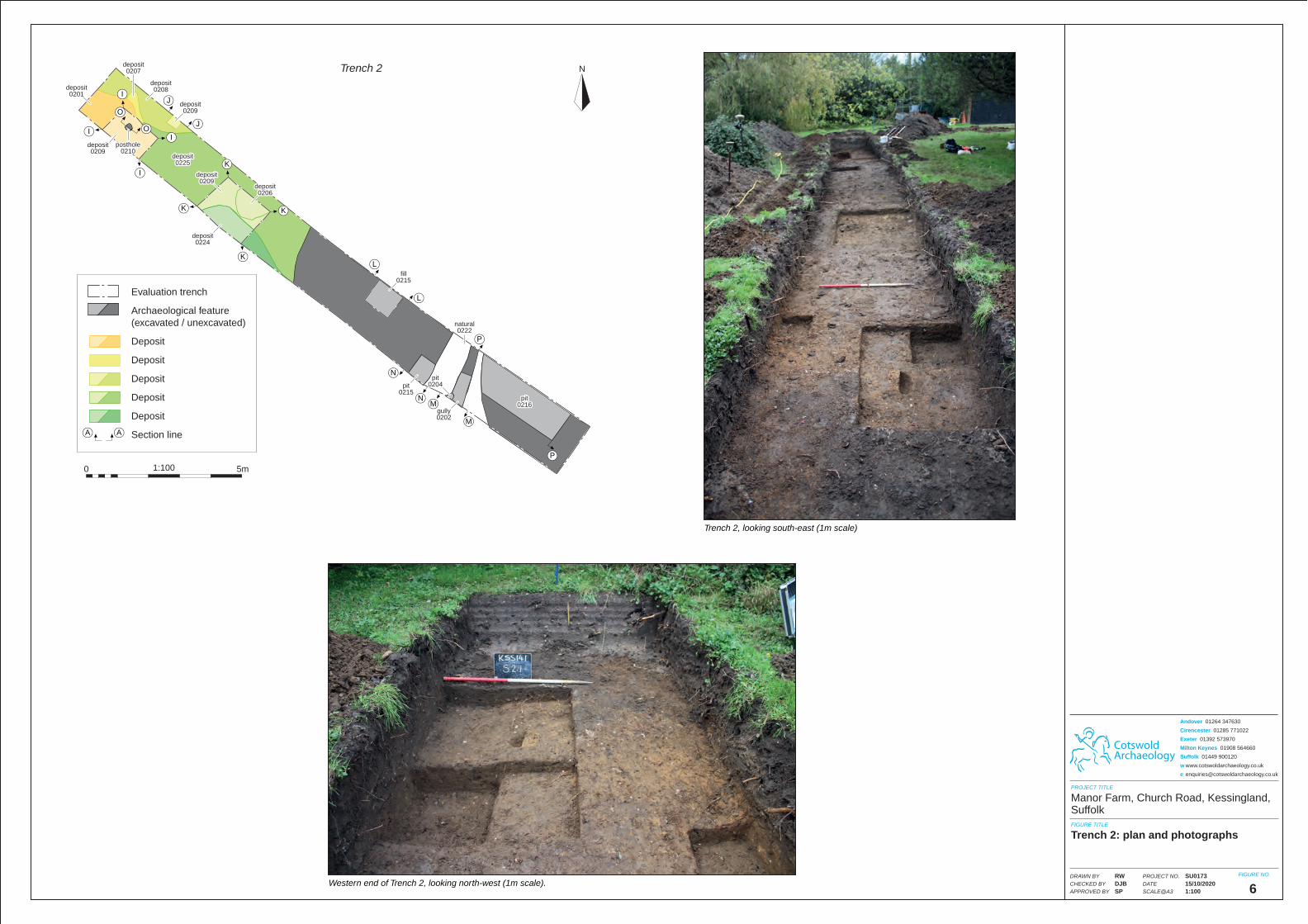
CotswoldArchaeology
PROJECT TITLE
FIGURE TITLE
FIGURE NO.PROJECT NO.
DATE
SCALE@A3
DRAWN BY
CHECKED BY
APPROVED BY
Andover 01264 347630
Cirencester 01285 771022
Exeter 01392 573970
Milton Keynes 01908 564660
Suffolk 01449 900120
w www.cotswoldarchaeology.co.uk
6
Manor Farm, Church Road, Kessingland, Suffolk
Trench 2: plan and photographs
SU017315/10/20201:100
RWDJBSP
Trench 2, looking south-east (1m scale)
Western end of Trench 2, looking north-west (1m scale).
J
J
Trench 2 N
Evaluation trench
Archaeological feature(excavated / unexcavated)
Deposit
Deposit
Deposit
Deposit
Deposit
Section lineA A
1:1000 5m
I
I
IO
O
I
K
KL
L
M
N
N
M
P
P
K
K
deposit0201
deposit0201
deposit0209
deposit0209
posthole0210
posthole0210
deposit0208
deposit0208
deposit0209
deposit0209
deposit0224
deposit0224
gully0202gully0202
natural0222
natural0222
pit0204
pit0204
deposit0209
deposit0209
deposit0206
deposit0206
pit0215
pit0215
fill0215
fill0215
pit0216
pit0216
deposit0207
deposit0207
deposit0225
deposit0225
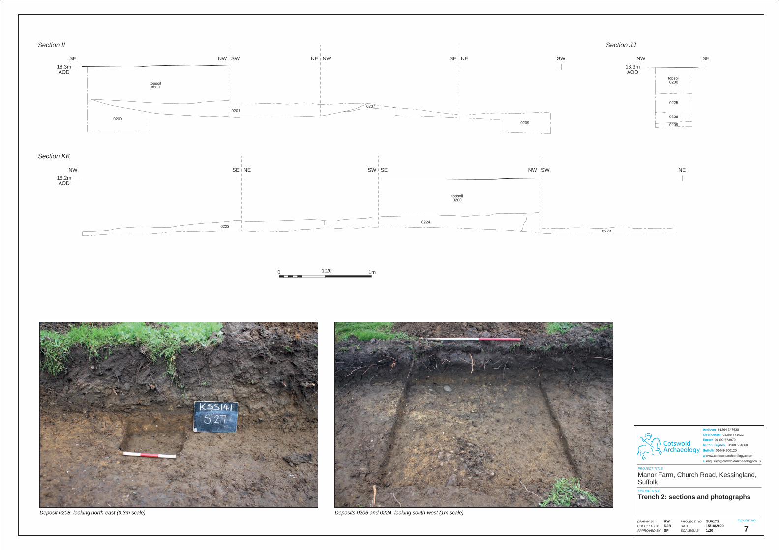
Deposit 0208, looking north-east (0.3m scale) Deposits 0206 and 0224, looking south-west (1m scale)
02070207
02090209
18.3mAOD
SE SWNW SW
Section II
NE NW SE NE
topsoil0200
topsoil0200
02010201
02090209
0223022302230223
02240224
topsoil0200
topsoil0200
18.2mAOD
NW NESE NE
Section KK
SW SE NW SW
02090209
topsoil0200
topsoil0200
02250225
02080208
18.3mAOD
NW SE
Section JJ
CotswoldArchaeology
PROJECT TITLE
FIGURE TITLE
FIGURE NO.PROJECT NO.
DATE
SCALE@A3
DRAWN BY
CHECKED BY
APPROVED BY
Andover 01264 347630
Cirencester 01285 771022
Exeter 01392 573970
Milton Keynes 01908 564660
Suffolk 01449 900120
w www.cotswoldarchaeology.co.uk
7
Manor Farm, Church Road, Kessingland, Suffolk
Trench 2: sections and photographs
SU017315/10/20201:20
RWDJBSP
1:200 1m
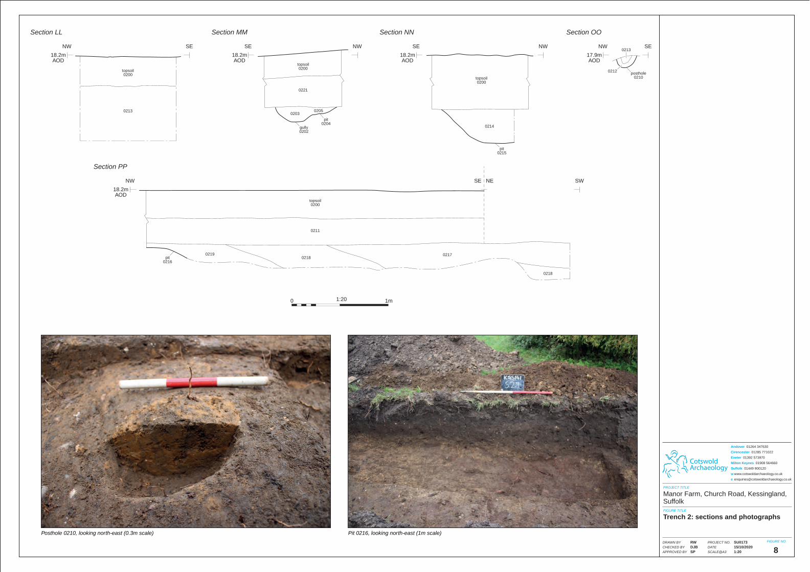
CotswoldArchaeology
PROJECT TITLE
FIGURE TITLE
FIGURE NO.
8
Manor Farm, Church Road, Kessingland, Suffolk
Trench 2: sections and photographs
PROJECT NO.
DATE
SCALE@A3
DRAWN BY
CHECKED BY
APPROVED BY
SU017315/10/20201:20
RWDJBSP
Andover 01264 347630
Cirencester 01285 771022
Exeter 01392 573970
Milton Keynes 01908 564660
Suffolk 01449 900120
w www.cotswoldarchaeology.co.uk
1:200 1m
Pit 0216, looking north-east (1m scale)Posthole 0210, looking north-east (0.3m scale)
posthole0210
posthole0210
02120212
0213021317.9mAOD
NW SE
Section OO
topsoil0200
topsoil0200
02130213
18.2mAOD
NW SE
Section LL
pit0204
pit0204
gully0202gully0202
topsoil0200
topsoil0200
02210221
0203020302050205
18.2mAOD
SE NW
Section MM
pit0215
pit0215
02140214
topsoil0200
topsoil0200
18.2mAOD
SE NW
Section NN
topsoil0200
topsoil0200
02110211
0219021902180218
02170217
02180218
pit0216
pit0216
18.2mAOD
NW SWSE NE
Section PP
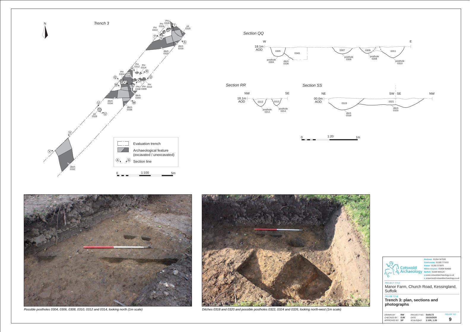
CotswoldArchaeology
PROJECT TITLE
FIGURE TITLE
FIGURE NO.PROJECT NO.
DATE
SCALE@A3
DRAWN BY
CHECKED BY
APPROVED BY
Andover 01264 347630
Cirencester 01285 771022
Exeter 01392 573970
Milton Keynes 01908 564660
Suffolk 01449 900120
w www.cotswoldarchaeology.co.uk
9
Manor Farm, Church Road, Kessingland, Suffolk
Trench 3: plan, sections and photographs
SU017315/10/20201:100, 1:20
RWDJBSP
1:200 1m
Ditches 0318 and 0320 and possible postholes 0322, 0324 and 0326, looking north-west (1m scale)Possible postholes 0304, 0306, 0308, 0310, 0312 and 0314, looking north (1m scale)
posthole0304
posthole0304 ditch
0336ditch0336
posthole0306
posthole0306
posthole0308
posthole0308
posthole0310
posthole0310
0305030503430343
03070307 03090309 03110311
18.1mAOD
W E
Section QQ
posthole0312
posthole0312
posthole0314
posthole0314
03130313 0315031518.1mAOD
NW SE
Section RR
ditch0318ditch0318
ditch0320ditch0320
00.0mAOD
NE NWSW SE
Section SS
0319031903210321
Trench 3N
Evaluation trench
Archaeological feature(excavated / unexcavated)
Section lineA A
1:1000 5m
Q
SS
T
T
RR
Q
WX
X
W
U
U
V
V
PH0304PH
0304
pit0328
pit0328
ditch0334ditch0334
ditch0336ditch0336
ditch0332ditch0332
PH0312PH
0312
ditch0320ditch0320
PH0322PH
0322
PH0324PH
0324
PH0326PH
0326
ditch0318ditch0318
pit0316
pit0316
PH0314PH
0314
PH0306PH
0306
PH0308PH
0308PH
0338PH
0338
ditch0340ditch0340
PH0310PH
0310
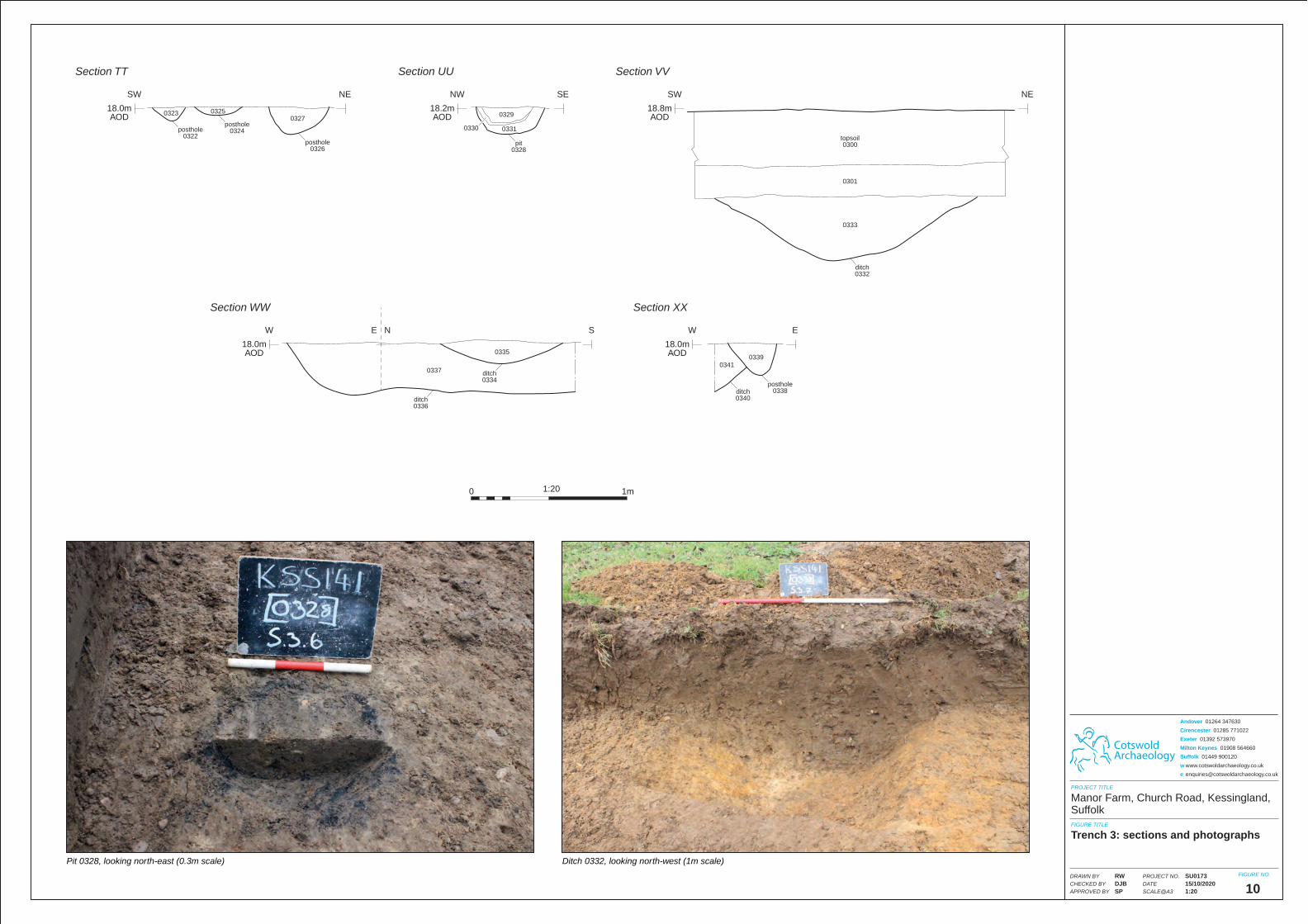
CotswoldArchaeology
PROJECT TITLE
FIGURE TITLE
FIGURE NO.
10
Manor Farm, Church Road, Kessingland, Suffolk
Trench 3: sections and photographs
PROJECT NO.
DATE
SCALE@A3
DRAWN BY
CHECKED BY
APPROVED BY
SU017315/10/20201:20
RWDJBSP
Andover 01264 347630
Cirencester 01285 771022
Exeter 01392 573970
Milton Keynes 01908 564660
Suffolk 01449 900120
w www.cotswoldarchaeology.co.uk
1:200 1m
Ditch 0332, looking north-west (1m scale)Pit 0328, looking north-east (0.3m scale)
pit0328
pit0328
posthole0322
posthole0322
posthole0324
posthole0324
posthole0326
posthole0326
0325032503270327
18.2mAOD
NW SE
Section UU
18.0mAOD
SW NE
Section TT
03300330 03310331
0329032903230323
ditch0332ditch0332
topsoil0300
topsoil0300
03010301
03330333
18.8mAOD
SW NE
Section VV
ditch0334ditch0334
ditch0336ditch0336
posthole0338
posthole0338ditch
0340ditch0340
0341034103390339
03350335
03370337
18.0mAOD
W SE N
Section WW
18.0mAOD
W E
Section XX
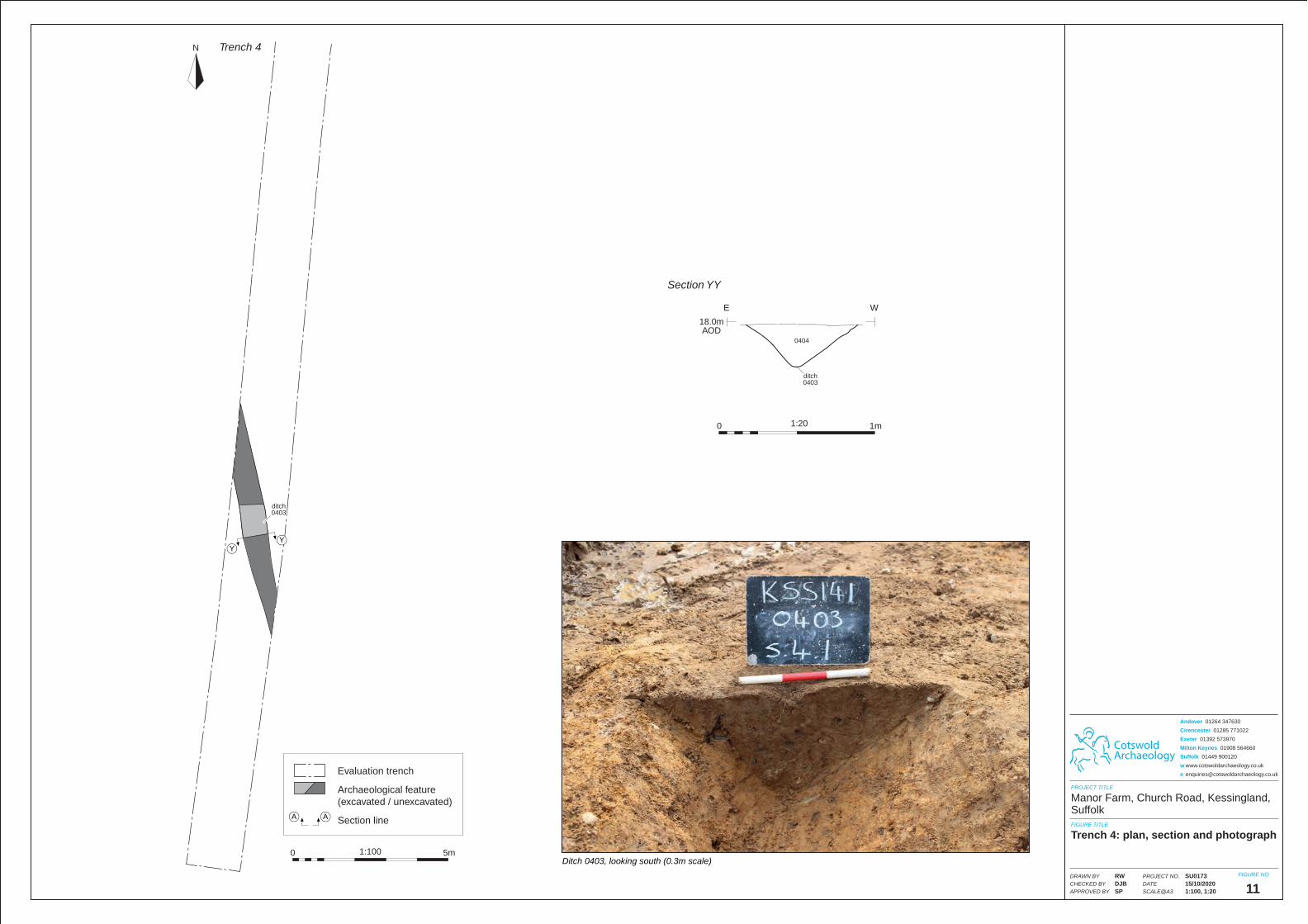
CotswoldArchaeology
PROJECT TITLE
FIGURE TITLE
FIGURE NO.PROJECT NO.
DATE
SCALE@A3
DRAWN BY
CHECKED BY
APPROVED BY
Andover 01264 347630
Cirencester 01285 771022
Exeter 01392 573970
Milton Keynes 01908 564660
Suffolk 01449 900120
w www.cotswoldarchaeology.co.uk
11
Manor Farm, Church Road, Kessingland, Suffolk
Trench 4: plan, section and photograph
SU017315/10/20201:100, 1:20
RWDJBSP
1:200 1m
Ditch 0403, looking south (0.3m scale)
ditch0403ditch0403
18.0mAOD
E W
Section YY
04040404
Trench 4N
Evaluation trench
Archaeological feature(excavated / unexcavated)
Section lineA A
1:1000 5m
YY
ditch0403ditch0403
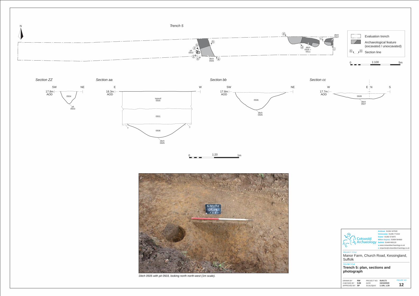
Ditch 0505 with pit 0503, looking north north-west (1m scale).
ditch0505ditch0505
pit0503
pit0503
17.8mAOD
SW NE
Section ZZ
18.3mAOD
E W
Section aa
05040504
05060506
05010501
??
topsoil0500
topsoil0500
??
ditch0505ditch0505
17.8mAOD
SW NE
Section bb
05060506ditch0507ditch0507
05080508
17.7mAOD
W SE N
Section cc
Trench 5N
Evaluation trench
Archaeological feature(excavated / unexcavated)
Section lineA A
1:1000 5m
ditch0505ditch0505
ditch0507ditch0507
ditch0509 =
0511
ditch0509 =
0511pit0503
pit0503
aZ
bb
c
d
dcZ
a
CotswoldArchaeology
PROJECT TITLE
FIGURE TITLE
FIGURE NO.PROJECT NO.
DATE
SCALE@A3
DRAWN BY
CHECKED BY
APPROVED BY
Andover 01264 347630
Cirencester 01285 771022
Exeter 01392 573970
Milton Keynes 01908 564660
Suffolk 01449 900120
w www.cotswoldarchaeology.co.uk
12
Manor Farm, Church Road, Kessingland, Suffolk
Trench 5: plan, sections and photograph
SU017315/10/20201:100, 1:20
RWDJBSP
1:200 1m
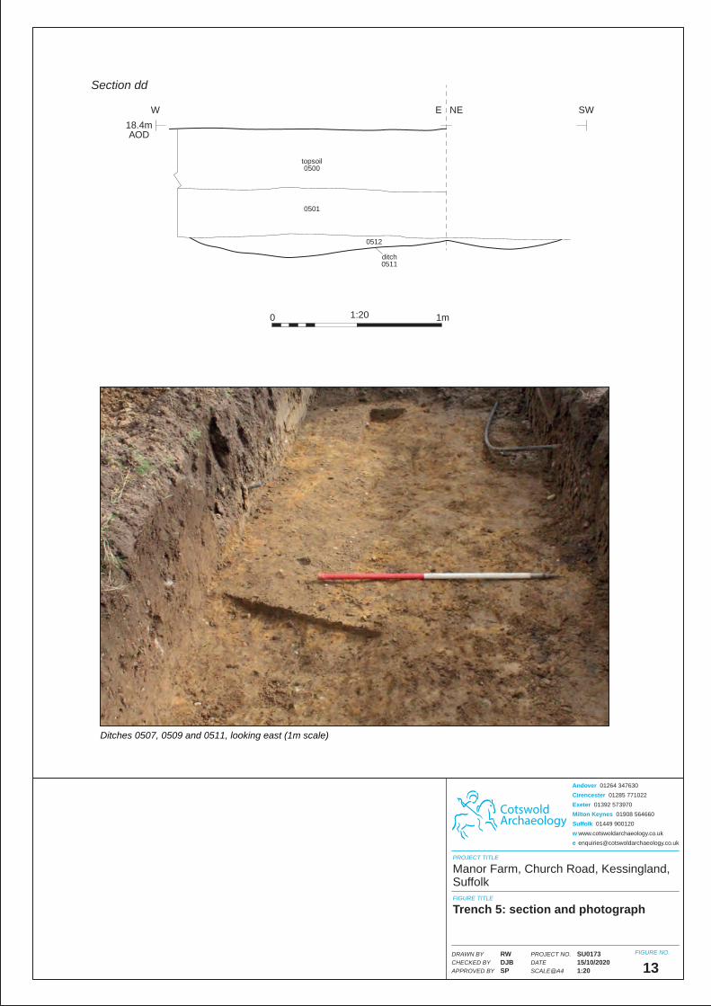
CotswoldArchaeology
PROJECT TITLE
FIGURE TITLE
FIGURE NO.
13
Trench 5: section and photograph
PROJECT NO.
DATE
SCALE@A4
DRAWN BY
CHECKED BY
APPROVED BY
Andover 01264 347630
Cirencester 01285 771022
Exeter 01392 573970
Milton Keynes 01908 564660
Suffolk 01449 900120
w www.cotswoldarchaeology.co.uk
Manor Farm, Church Road, Kessingland, Suffolk
SU017315/10/20201:20
RWDJBSP
1:200 1m
Ditches 0507, 0509 and 0511, looking east (1m scale)
05120512
05010501
topsoil0500
topsoil0500
ditch0511ditch0511
18.4mAOD
W SWE NE
Section dd
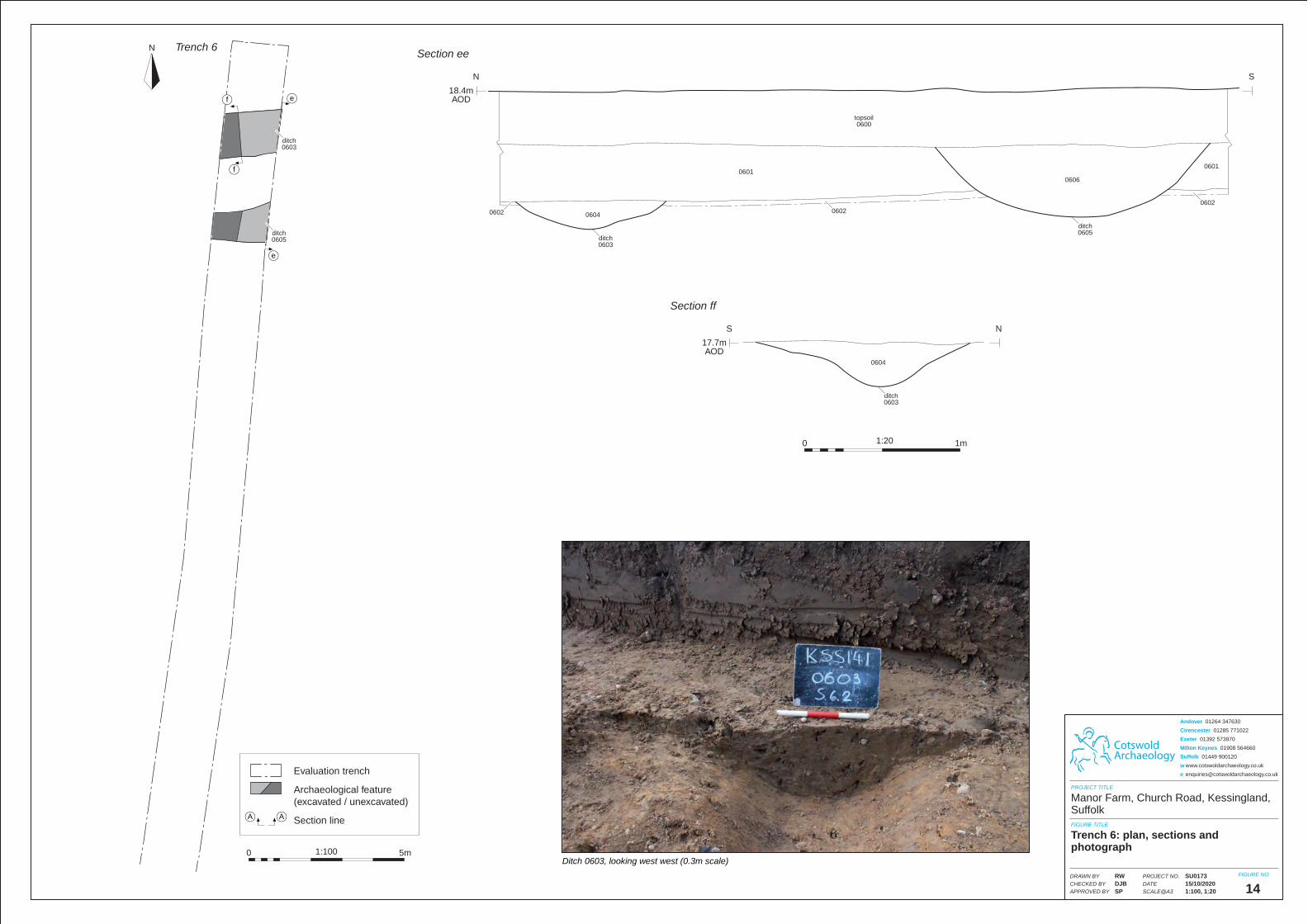
CotswoldArchaeology
PROJECT TITLE
FIGURE TITLE
FIGURE NO.PROJECT NO.
DATE
SCALE@A3
DRAWN BY
CHECKED BY
APPROVED BY
Andover 01264 347630
Cirencester 01285 771022
Exeter 01392 573970
Milton Keynes 01908 564660
Suffolk 01449 900120
w www.cotswoldarchaeology.co.uk
14
Manor Farm, Church Road, Kessingland, Suffolk
Trench 6: plan, sections and photograph
SU017315/10/20201:100, 1:20
RWDJBSP
1:200 1m
Ditch 0603, looking west west (0.3m scale)
ditch0603ditch0603
ditch0605ditch0605
ditch0603ditch0603
17.7mAOD
S N
Section ff
18.4mAOD
N S
Section ee
topsoil0600
topsoil0600
0601060106010601
06040604
06040604
06060606
0602060206020602
06020602
Trench 6N
Evaluation trench
Archaeological feature(excavated / unexcavated)
Section lineA A
1:1000 5m
e
e
ditch0603ditch0603
ditch0605ditch0605
f
f
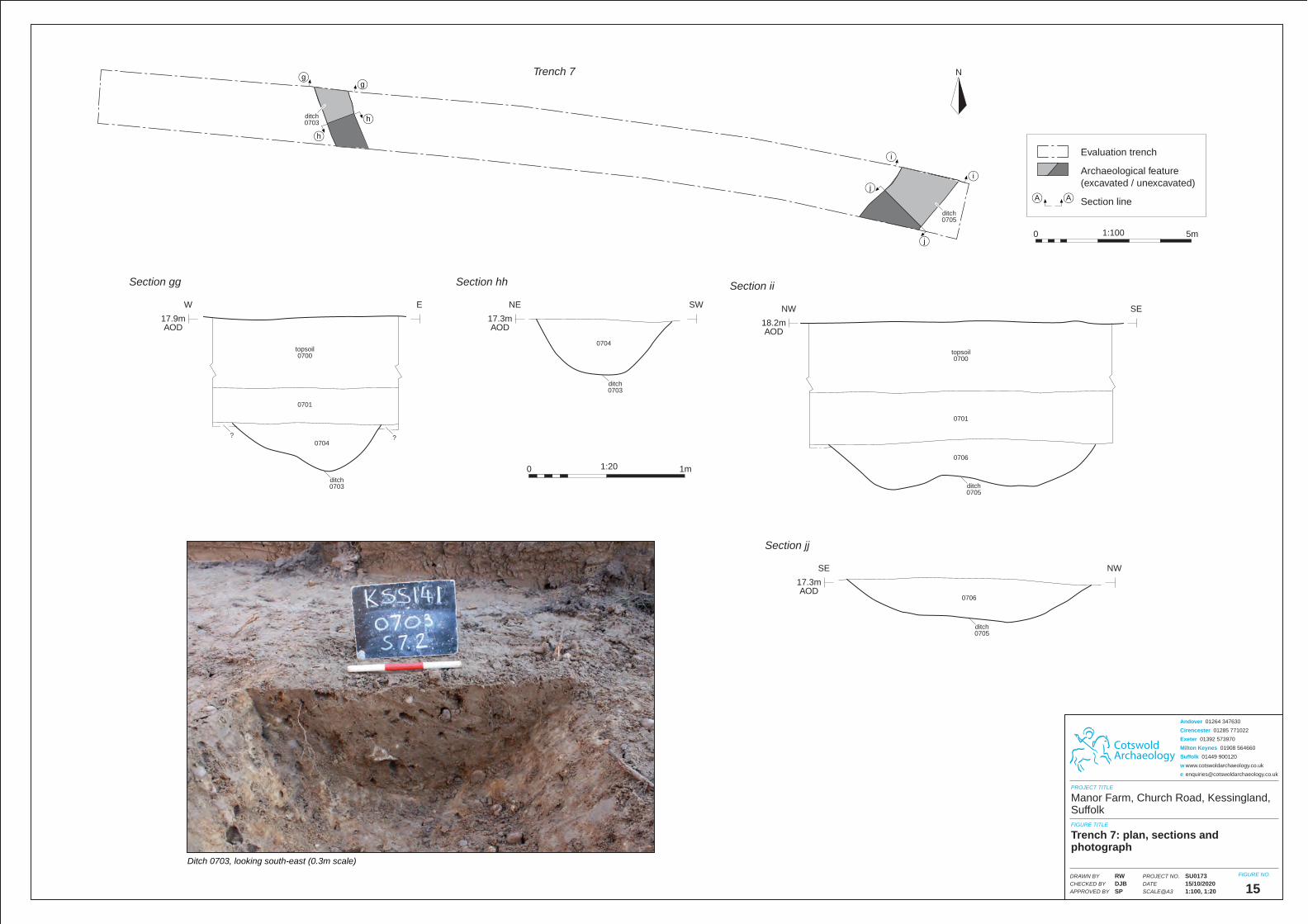
Ditch 0703, looking south-east (0.3m scale)
ditch0703ditch0703
ditch0703ditch0703
17.9mAOD
W E
Section gg
17.3mAOD
NE SW
Section hh
07040704
07040704
07010701
topsoil0700
topsoil0700
????
ditch0705ditch0705
ditch0705ditch0705
18.2mAOD
NW SE
Section ii
17.3mAOD
SE NW
Section jj
07060706
07060706
07010701
topsoil0700
topsoil0700
Trench 7 N
Evaluation trench
Archaeological feature(excavated / unexcavated)
Section lineA A
1:1000 5m
ditch0703ditch0703
ditch0705ditch0705
gg
h
h
i
j
j
i
CotswoldArchaeology
PROJECT TITLE
FIGURE TITLE
FIGURE NO.PROJECT NO.
DATE
SCALE@A3
DRAWN BY
CHECKED BY
APPROVED BY
Andover 01264 347630
Cirencester 01285 771022
Exeter 01392 573970
Milton Keynes 01908 564660
Suffolk 01449 900120
w www.cotswoldarchaeology.co.uk
15
Manor Farm, Church Road, Kessingland, Suffolk
Trench 7: plan, sections and photograph
SU017315/10/20201:100, 1:20
RWDJBSP
1:200 1m
71
Kemble Airfield, Kemble, Gloucestershire, Heritage DBA © Cotswold Archaeology