mangrove wetland ecosystems in ganges-brahmaputra delta in bangladesh
TRANSCRIPT

RESEARCH ARTICLE
Mangrove wetland ecosystems in Ganges-Brahmaputra delta inBangladesh
Shafi Noor ISLAM (*), Albrecht GNAUCK
Department of Ecosystems and Environmental Informatics, Brandenburg University of Technology at Cottbus,
P.O. Box 101344, D-03013 Cottbus, Germany
E Higher Education Press and Springer-Verlag 2008
Abstract The Sundarbans is one of the productive man-
grove wetland ecosystems in the Ganges-Brahmaputra
delta in Bangladesh. The delta is undergoing rapid eco-
logical changes due to human activity. In the present
study, surface water salinity data from 13 rivers of the
Sundarbans were collected in order to investigate the sal-
ine water intrusion in the mangrove wetlands. Results
demonstrate that saline water has penetrated the
upstream area as river water salinity has increased signifi-
cantly in 1976 compared to the year 1968. The soil and
river water salinity data also shows that it has crossed the
water salinity threshold line in most parts of the
Sundarbans wetlands. These observations are due to the
construction of Farakka Barrage in 1975, which reduced
the water discharge of the Ganges River from 3700 m3/s in
1962 to 364 m3/s in 2006. The shortage of freshwater dis-
charge to the deltaic area is trailing active ecosystems
function, especially in the dry season in the south western
region in Bangladesh. The objective of this study is to
understand and analyze the present degraded mangrove
wetland ecosystems and their negative impacts. The find-
ings of this study would contribute to the formulation of
the mangrove wetland ecosystems management plan in
the Ganges delta of Bangladesh.
Keywords freshwater discharge, salinity intrusion, con-
struction of Farakka Barrage
1 Introduction
The Ganges delta is the largest delta and occupies the
lower part of the Bengal Basin of the South Asian
region of Bengal. The delta has come into existence
by the depositional activities of the three mighty rivers
of the region: the Ganges, the Brahmaputra and the
Meghna. The alluvial land has been developed at the
southern portion of the Bengal Basin by the combined
depositional activities of the Ganges, its various dis-
tributaries and other large and small streams of the
region. The Ganges delta is situated just above the
Bay of Bengal with its major portion occupied by
Bangladesh. The delta is about 360 km wide along
the Bay of Bengal. The river courses in the delta are
broad and active, carrying large amounts of water. This
delta is a tract of vast alluvial flat roughly resembling
the Greek letter ‘D’ (Delta) and commences at the off-
take of the Bhagirathi near Gaur of Malda district in
West Bengal, India (Rob, 1998). The delta of the
Ganges covers a total area of 80000 km2 in
Bangladesh and West Bengal of India (Bagchi, 1944;
Coleman, 1974; Seidensticker and Hai, 1983). It com-
prises part of the districts of Kushtia, Jessore, Khulna,
Rajshahi, Pabna and Dhaka of Bangladesh and a
major portion of West Bengal. As the silts are brought
in by normal flow and flooding of the rivers annually,
the Ganges delta is a growing delta. The temperature is
9.3u to 40u; annual precipitation range is 1474 mm to
2265 mm. The dry months have an average rainfall
between 20 mm to 60 mm and the average evapotran-
spiration rate is 15 mm to 90 mm/month. It is com-
posed of a labyrinth of waterways, swamps, lakes and
alluvial deposits occupying the great Bengal delta plane
woven with numerous small and large rivers (Islam,
2006). The Ganges delta is the site of the largest man-
grove forest in the world known as ‘the Sundarbans’.
The Sundarbans is the legendary sanctuary for the
famous Royal Bengal Tiger. It is the world’s largest
delta being the most fertile and vegetated alluvial land.
It is also called the Green delta which is also a nick
name for Bangladesh. The Ganges delta is also called
the Ganges -Brahmaputra River Delta (Islam, 2006).
The landscapes of the deltaic region encompass strong
aesthetic, cultural, biological and geological values (Zube,
1986). At present, landscapes and wetlands are the most
Received September 12, 2007; accepted April 3, 2008
E-mail: [email protected]
Front. Earth Sci. China 2008, 2(4): 439–448DOI 10.1007/s11707-008-0049-2

spectacular global issues for economic growth and bal-
ance ecosystems. On the other hand, water is a fun-
damental issue for human survival and their cultural
development. There is an inter-linkage between cultural
landscape development and water availability. Almost
half of the world’s wetlands have been destroyed in the
past 100 years (Barbier, 1993). The total area of wet-
lands in Bangladesh has been variously estimated as
between 7 and 8 million ha which is almost 50% of
the total land surface. These include rivers, estuaries,
mangrove swamps, marsh (haors), baor (fresh water
oxbow lake) and bils, water storage reservoirs, fish
ponds and some other lands which are seasonally inun-
dated to a depth of 30 cm or more. In Bangladesh, 45%of mangrove wetlands have already been destroyed due
to shrimp farming and anthropogenic influences (Khan
et al., 1994). The area of The Ganges-Brahmaputra-
Meghna (GBM) drainage basin is 1.76 million km2 of
which 62% can be found in India, 18% in China, 7% in
Nepal and 8% in Bangladesh and only 4% in Bhutan
(Elahi et al., 1998). The Sundarbans, situated in the
Ganges delta, consists of an area of around 6017 km2
of which 1400 km2 of its southern part has been
declared as a natural world heritage site by UNESCO
in 1997 (Islam, 2003). The livelihood and ecology of the
Ganges delta of Bangladesh portion depends on the
Ganges fresh water supply (Hasna, 1995).
Approximately 600 000 people are employed seasonally
(UN ESCAP, 1988). The Gorai-Madhumati basin
(Figs. 1 and 2(a)) is directly affected by withdrawal of
water from the Ganges basin. The goal of this research
is the contribution of a comprehensive management
plan for the sustainable conservation and protection
of the Sundarbans mangrove ecosystems in the
Ganges delta.
2 Objectives
The objectives of this paper are to understand the natureof mangrove wetlands ecosystems in the Ganges delta and
how it is being changed to cause threats, and to formulate
a long-term management plan for mangrove wetlands
resources through the supply of Ganges water into
Sundarbans. GIS application would be a proper tool for
making decisions and formulating recommendations for
the protection of Sundarbans ecosystems.
3 Geographical location
Most parts of the Bengal Basin and Ganges delta are
floored with Quaternary sediments eroded from the high-lands on three sides and deposited by the Ganges,
Brahmaputra and theMeghna Rivers and their tributaries
and distributaries. The Ganges River originated in
Gangotri glacier in the southern slopes of the Himalayas
and carries discharge from a catchment of about
865000 km2 in India, to Bangladesh (Fig. 1) (Joseph,
2006). The location of the Ganges-Brahmaputra delta is
at latitude of 24u409 N and 88u E longitude. The longit-udinal extension of the delta is from 88u E to 91u509 Elongitude (Rob, 1998) (Figs. 2(a) and (b)).
The Sundarbans stretches over 10000 km2 and is
located at the southwest extremity of Bangladesh and
the southeast of the state of West Bengal in India. The
Bangladesh part of the Sundarbans is spread over the
districts of Khulna, Bagerhat and Satkhira and the forestcovers about 6017 km2 (Hussain et al., 1994; Hassan et al,
2001). Almost 62% of the land area lies between latitudes
21u319 N and 22u309 N and between Longitudes 89u189 Eand 90u19 E (Katebi, 2001).
Fig. 1 The Ganges delta and the Sundarbans location the GBM River catchment
440 Shafi Noor ISLAM, Albrecht GNAUCK

4 The Ganges delta and the mangrovewetlands
The development of the Ganges-Brahmaputra delta is still
continuing since it began some 125 million years ago
(Ma), after the fragmentation of the Gondwanaland since
the early Cretaceous. TheGanges deltaic plains are largely
drained by innumerable distributaries of the Ganges. It
has such a gentle slope that ranges from 15 m in the north
to nearly one meter in the south; and the interfluves have
such a slight relief, the gradient of the delta surface is
about 0.016 m/km, the rivers criss-cross each other and
have developed a complex river system. The topographic
features are similar to those of the flood plains except that
the relief is more subdivided. The average elevation of the
delta in Khulna, Barisal, the Southern part of Faridpur
and the eastern part of Noakhali district is less than 2 m.
The river courses in the delta are carrying water discharge,
29 692 m3/s in average into the Bay of Bengal. The dis-
charge is 80 684 m3/s during the flood and 6041 m3/s dur-
ing the low water season. The suspended sediment load
during the monsoon flood reaches as high as 13 million
Fig. 2 (a) The limit and the location of the Ganges-Brahmaputra delta
Mangrove wetland ecosystems in Ganges-Brahmaputra delta in Bangladesh 441

tons per day. The Ganges Brahmaputra Delta can be
divided into four major categories: i) Moribund delta, ii)
Mature delta and iii) Active delta and iv) Tidally active
delta (Fig. 2(a)).
i) The moribund delta: The western part of the deltaic
plain, bound on the east by Gorai-Madhumati Rivers,
comprises the areas which extend from the northern
boundary of the Khulna district to Jessore and part of
Kushtia district. The area of moribund delta covers an
area of about 18000 km2. The rivers of the moribund delta
cannot bring down enough water and silt, even in flood
and, being confined within high levees, are not in a posi-
tion to inundate the entire area.
ii) The mature delta: The mature delta covers an area of
about 31500 km2 in Bangladesh and in West Bengal of
India. On average, it includes Murshidabad (West
Bengal, India), Nadia and 24-Parganas of India and
Meherpur, Kushtia, Chuadanga, Jhenaidaha, Magura,
Fig. 2(b) The limit of the Ganges delta and location of wetlands
442 Shafi Noor ISLAM, Albrecht GNAUCK
Jessore, Narial, Khulna, Sathkhira and Bagerhat districts
of Bangladesh.
iii) The active delta: The eastern active delta covers an
area of about 16500 km2. This part of the Ganges-
Brahmaputra delta is about 300 km long in the north-
south direction and about 100 km and 130 km wide in
the upper and middle reaches, respectively. The eastern
active Ganges-Brahmaputra delta includes Rajbari,
Faridpur, Shariatpur, and Madaripur, Gopalgonj,
Lakshmipur, Pirojpur, Barisal, Jhalokati, Patuakhali,
Barguna and Bhola districts of the country.
iv) The tidally active delta: The southwestern part of the
Ganges delta is coastal area and a tidally active delta. It is
dominated by coastal tidal currents. The tidally active delta
actually is the southern part of the Sundarbans region. It
covers an area of about 13500 km2. The Tidally active delta
includes the southern part of Bagerhat, Khulna, Sathkhira
district of Bangladesh and south 24 Pargona district of
West Bengal in India (Islam, 2006).
The surface water flow in the rivers of the
Sundarbans area mainly comes from the Ganges at
the off-take of Gorai-Madhumati and from the lower
Meghna through Swarupkati Kocha River (Figs. 2(a)
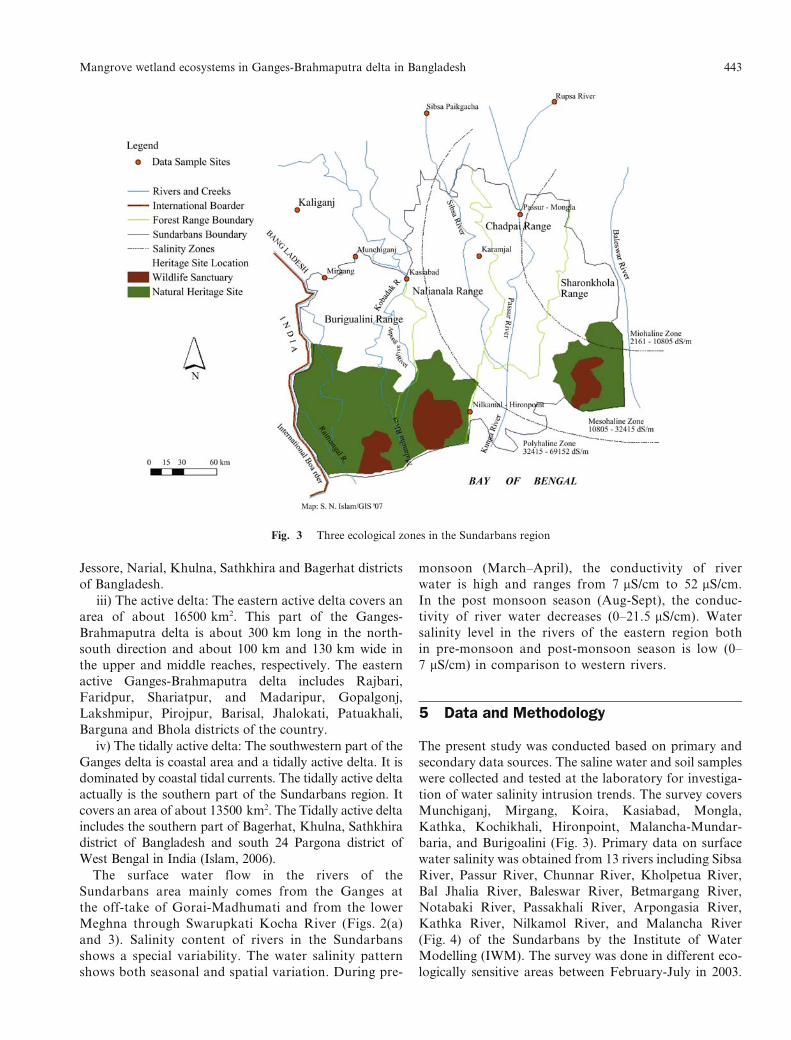
and 3). Salinity content of rivers in the Sundarbans
shows a special variability. The water salinity pattern
shows both seasonal and spatial variation. During pre-
monsoon (March–April), the conductivity of river
water is high and ranges from 7 mS/cm to 52 mS/cm.
In the post monsoon season (Aug-Sept), the conduc-
tivity of river water decreases (0–21.5 mS/cm). Water
salinity level in the rivers of the eastern region both
in pre-monsoon and post-monsoon season is low (0–
7 mS/cm) in comparison to western rivers.
5 Data and Methodology
The present study was conducted based on primary and
secondary data sources. The saline water and soil samples
were collected and tested at the laboratory for investiga-
tion of water salinity intrusion trends. The survey covers
Munchiganj, Mirgang, Koira, Kasiabad, Mongla,
Kathka, Kochikhali, Hironpoint, Malancha-Mundar-
baria, and Burigoalini (Fig. 3). Primary data on surface
water salinity was obtained from 13 rivers including Sibsa
River, Passur River, Chunnar River, Kholpetua River,
Bal Jhalia River, Baleswar River, Betmargang River,
Notabaki River, Passakhali River, Arpongasia River,
Kathka River, Nilkamol River, and Malancha River
(Fig. 4) of the Sundarbans by the Institute of Water
Modelling (IWM). The survey was done in different eco-
logically sensitive areas between February-July in 2003.
Fig. 3 Three ecological zones in the Sundarbans region
Mangrove wetland ecosystems in Ganges-Brahmaputra delta in Bangladesh 443
The data was processed and analyzed through MS Excel,
GISArcView 9.1 for data visualization and MATLAB
software version 7.1 were used for simulation.
6 Results and discussion
To understand the real situation in the Sundarbans
region, 13 important rivers (Fig. 5) located around
the case area have been chosen for modelling of their
water salinity. The time series data of water salinity has
been collected from 13 river basins (Fig. 5) in the
Sundarbans mangrove wetlands area based on the
potentiality of the river basins and ecosystems balance.
All 13 rivers show increasing water salinity. The results
of the investigation of water salinity show that the
salinity rate is much higher in the southern and
south-western rivers; the rivers of the middle area are
moderate level and the rivers of the northern portioncarries low salinity than the rivers of middle area of the
Sundarbans (Figs. 4 and 5).
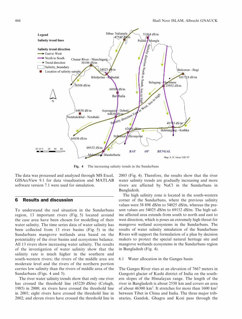
The river water salinity trends show that only one river
has crossed the threshold line (43220 dS/m) (Colugh,
1985) in 2000; six rivers have crossed the threshold line
in 2001; eight rivers have crossed the threshold line in
2002; and eleven rivers have crossed the threshold line in
2003 (Fig. 4). Therefore, the results show that the river
water salinity trends are gradually increasing and more
rivers are affected by NaCl in the Sundarbans in
Bangladesh.
The high salinity zone is located in the south-western
corner of the Sundarbans, where the previous salinity
values were 38 898 dS/m to 54025 dS/m, whereas the pre-
sent values are 54025 dS/m to 69152 dS/m. The high sal-
ine affected area extends from south to north and east to
west direction, which is poses an extremely high threat for
mangrove wetland ecosystems in the Sundarbans. The
results of water salinity simulation of the Sundarbans
Rivers will support the formulation of a plan by decision
makers to protect the special natural heritage site and
mangrove wetlands ecosystems in the Sundarbans region
in Bangladesh (Fig. 4).
6.1 Water allocation in the Ganges basin
The Ganges River rises at an elevation of 7667 meters in
Gangotri glacier of Kashi district of India on the south-
ern slopes of the Himalayan range. The length of the
river in Bangladesh is about 2550 km and covers an area
of about 46300 km2. It stretches for more than 1600 km2
between Tibet in China and India. The three major trib-
utaries, Gandok, Ghagra and Kosi pass through the
Fig. 4 The increasing salinity trends in the Sundarbans
444 Shafi Noor ISLAM, Albrecht GNAUCK

territory of Nepal. The Yamuna joins the Ganges below
Alahabad after receiving the Chambal, Hindon, Sindh,
Betwa and Ken. The Ganges enters Bangladesh about
17 km down the Farakka Dam. The Gorai is the main
tributary of the Ganges which enters the Sundarbans
and supplies upstream fresh water and joins Baleswar
River (Figs. 3 and 5) downstream. The confluence
receives the Meghna a few kilometers downstream
before it merges into the Bay of Bengal (Begum, 1987).
The construction of the Barrage is 2455 m long and is
designed for maximum discharge of 75630 m3/s. In 1972
the Government of Bangladesh took up the Ganges
issue in earnest to the Government of India. The same
year the Indo-Bangladesh Joint River Commission
(JRC) was constituted in 1972. After a collaborative
discussion at the summit in 1974, it was agreed between
Bangladesh and India that Farakka Barrage would not
be in operation before an agreement was reached on
sharing the dry season flow of the Ganges between the
two countries (Miah, 2003).
6.2 Reduced Ganges water and increased salinity
Bangladesh receives low quantity of water discharge after
the construction of the Farakka Barrage on the Ganges
River in India due to water withdrawal at Farakka
Barrage point downstream for irrigation purposes in the
lean season. There was a comparison of salinity intrusion
in 1967–1968 with the situation which occurred during
1976 and 1977 because the unimpaired dry season flows
of these years were comparable. The water salinityapproximations before and after 1975 in the Sundarbans
region are shown in Fig. 6, which shows the water salinity
approximations before and after 1975 in the Sundarbans
region. A comparative survey analysis was done in 2003
based on data of 1968, 1970 and 1976. The result shows
that, the river water salinity has increased significantly in
1976 compared to that in 1968 (Fig. 6).
The amount of the Ganges river water flow inBangladesh is influenced by the effect of the amount of
water drawn at the Farakka Barrage by India. The
Fig. 5 Water salinity isohaline in the Sundarbans region (Base Map: Islam, 2006)
Mangrove wetland ecosystems in Ganges-Brahmaputra delta in Bangladesh 445

Ganges flow was 3700 m3/s in 1962 whereas it was reduced
to 364 m3/s in 2006 (Nishat, 2006) (Fig. 7). As a result, the
high saline sea water has penetrated in the upstream, and
falling water tables occurred. Fig. 7 shows a strong cor-
relation between Ganges water discharge reduction and
salinity intrusion. The reduced water flow line and
increased salinity line has crossed at a certain point in
1975 (optimum point).
At this cross point the Ganges water flow was almost
1500 m3/s. This water level line can be introduced as the
optimal line where both lines crossed at the particular
point and this point can be called as the optimum point
of salinity intrusion. The isohaline salinity map (Fig. 5)
shows the real scenario of salinity intrusion in the
Sundarbans.
To compare the increasing salinity trends of three eco-
logical zones, the present situation is much more harmful
than that of 30 years before. Considering the value of water
salinity, the eastern zone still has a suitable condition for
mangrove ecosystems; the middle area is rapidly turning
from middle saline zone to high saline zone; and the south-
western region which carries the highest rate of water salin-
ity would be more harmful for sensitive mangroves plants
and animals in the Sundarbans (Fig. 4).
6.3 Increased salinity and degraded ecosystems in the
Sundarbans
The reduction of Ganges fresh water in the upstream area is
the main reason for salinity intrusion in the southwestern
Fig. 7 Ganges water flow decreased and salinity increased at Passur-Mongla point
Fig. 6 Water salinity after and before Farakka barrage construction in 1975 in India
446 Shafi Noor ISLAM, Albrecht GNAUCK

part of Bangladesh. Therefore, the increased salinity and
alkalinity has damaged vegetation, agricultural cropping
pattern and changed the cultural landscapes in the
Sundarbans region. The impact on soil starts with the
destruction of surface organic matter and soil fertility for
mangrove plants production. The changes altered basic soilcharacteristics related to aeration, temperature, moisture
and the organisms that live in the soil. The core elements
of the ecosystem such as soil, water, vegetation and wildlife
are strongly affected due to fresh water shortage and human
activity. The results of the study of EGIS (Environmental
Geographical Information Studies) shows that water qual-
ity has degraded during the dry season (February-June) in
the Sundarbans rivers where 60% water is in poor qualitywith EC dS/m being 5532.16 and 40% is in good quality
with EC dS/m being 2766.08 (EGIS, 2000).
6.4 Loss of biodiversity and threats for coastal food
security
The scarcity of the Ganges flow is a challenge for coastal
food security, mangrove wetland ecosystems protection,and further improvement of coastal saline environment.
The research finding has asserted that India’s diversion of
water had resulted in a loss of rice output of 236000 metric
tons in 1976. Deforestation of mangroves due to shrimp
farming, salt farming and agriculture adversely affects mar-
ine fish production and leads to a loss of biodiversity and of
livelihood to over 6 million people who depended on man-
groves (Anon, 1995). A number of species like Javan rhi-noceros (Rhinoceros sondaicus), water buffalo (Bubalus
bubalis), swamp deer (Cervus duvauceli), Guar (Bos gaurus),
hog deer (Axix porcinus) and marsh crocodile (Crocodiles
palustric) became extinct during the last 100 years in the
Sundarbans. Oil spill is another potential threat and could
cause immense damage, especially to aquatic fauna and
seabirds and probably also to the mangrove forest biodi-
versity (Blower, 1985). The yearly natural calamity, globalwarming and its impacts are new challenging threats for
coastal food security and biodiversity (Husain, 1995).
6.5 Top dying diseases
With the commissioning of the Farakka Barrage, the dis-
charge in the downstream was drastically reduced. As a
result, all the elements of ecosystems development on theavailability of water were affected. The siltation in the
Sundarbans has increased and sediment trapping has been
aided by pneumatophores and dense roots of mangroves.
The dominant species of sundari (Heritiera fomes) and
Goran (Cariops decandra) are affected by top-dying dis-
ease. Almost 265 km2 areas of Heritiera type forest are
moderately affected and 210 km2 areas are severely affec-
ted, which is one of the main threats for a sustainablemangrove wetland management and the protection of its
ecosystems.
7 Conclusions
The Sundarbans mangrove wetlands, Chandabill-Baghiar
bill, Bildakatia, Atadanga Baor (Fresh water oxbow lake),
and Marijat Baor (Fig. 2(b)) are situated in the Ganges
delta. The Ganges fresh water plays an important role in
protecting these wetlands and its ecosystems in the delta.
Considering the increasing salinity trends in the region,
the threshold values of water salinity for the Sundarbans
case has been analyzed. In this study, 13 potential river
basins were investigated and it has been asserted that 11
rivers have crossed the water salinity threshold line
(43220 dS/m) in 2003. The previous average water salinity
value was 54025 dS/m, whereas the present highest water
salinity value is 69152 dS/m which is harmful and poses
threats to mangrove wetland ecosystems. The saline affec-
ted areas extend from south to north and east to west
direction and the iso-haline map is gradually changing
because of increasing salinity trends (Figs. 4 and 5). The
Ganges water availability in the basin and water salinity
trends of the downstream show the cyclic increasing beha-
vior in the Sundarbans Rivers. It clearly indicates and
forecasts the message that the upstream freshwater supply
is necessary for the protection of the mangrove wetland
ecosystems in the Sundarbans region. It has been indi-
cated that there is a strong relationship between fresh-
water supply and the quality of water in the Sundarbans
and water quality and ecosystems management are more
closely related. The Ganges water flow line and salinity
increasing line crossed at a certain point (Fig. 7), which is
recognized as optimal point and optimal line. In conclu-
sion, it can be said that if the water level does not cross the
optimal line then there will be no problem for the man-
grove ecosystems. This is why the Ganges freshwater sup-
ply in the Ganges delta in Bangladesh is necessary for the
protection of coastal resources and mangrove wetland
ecosystems. The findings of this study would be a poten-
tial contribution in formulating a comprehensive inter-
disciplinary management plan for the long-term
conservation and protection of mangrove wetland ecosys-
tems in the Sundarbans region in the Ganges Delta in
Bangladesh.
Acknowlegements The authors would like to thank different personsmet at Sundarbans Biodiversity Conservation Project and theDepartment of Environment and Forest, Bangladesh. The financial sup-port for this study was partly provided by APNMega Delta Project. Weacknowledge APN Mega Delta Project and give special thanks to Dr.Zhongyuan Chen of APN Mega Delta Project Leader and Professor ofEast China Normal University, Shanghai, China.
References
Anon (1995). Integrated resource management plan of theSundarbans reserved forest vol 1. Draft final report of FAO/UNDP project BGD/84/056–integrated resource developmentof the Sundarbans resource forest, Khulna, Bangladesh, 385
Mangrove wetland ecosystems in Ganges-Brahmaputra delta in Bangladesh 447
Bagchi K G (1944). The Ganges Delta. Calcutta: Calcutta
University Press, 1–25
Barbier E B (1993). Sustainable use of wetlands valuing tropical
wetland benefits: Economic methodologies and applications.
The Geographical Journal, 159(1): 2–52
Begum K (1987). Tention Over the Farakka Barrage _a Techno
Political Tangle in SouthAsia.Dhaka:University PressLimited, 279
Blower J (1985). Sundarbans forest inventory project, Bangladesh.
Wildlife conservation in the Sundarbans. Project report 151.
Overseas Development Administration, Land Resources
Development Centre, Surbition, UK, 39
Coleman J M (1974). Deltaic Evolution, the Encyclopedia of
Geomorphology. In: Fairbridge R W (ed.,), New York, USA,
252–255
Colugh B F (1985). Factors Regulating Mangrove Ecosystem
Primary Productivity. Proceedings of the UNDP/UNESCO
Regional Project RAS/79/002 Workshop on Mangrove
Ecosystem Dynamics, Papua New Guinea. 79–85
EGIS–Environmental and Geographical Information Studies
(2000). Bangladesh Water Development Board-Environmental
baseline of Gorai River restoration project. (EGIS-I, EGIS-II,
and EGIS-III). Environment and GIS support project for water
sector planning,Ministry ofWater Resources, Government of the
Peoples Republic of Bangladesh, EGIS, Dhaka, 190
Elahi K M, Das S C, Sultana S, et al (1998). Geography of Coastal
Environment: a Study of Selected Issues. In: Bayes A,
Mahammad A, Bangladesh at 25, an analytical discourse on
development. Dhaka: The University Press Limited, 336–368
Hasna J M, (1995). Women for Water Sharing. Dhaka: Academic
Publishers, 1–136
Hassan M, Rahman M S, Haider Z M, et al (2001). Some Facts and
Observations Related to Salinity and the River System of the
Sundarbans Mangrove Forest. Paper presented at 1st national
conference on the Sundarbans at Khulna University. 14-16
February, Khulna. Bangladesh, 1– 4
Husain K Z (1995). The Farakka Catastrophe Reflectiona. In:
Hasna J M, (ed.,) Women for Water Sharing. Dhaka:
Academic Publishers, 71–72
Hussain Z, Acharya G (1994). Mangrove of the Sundarbans, Vol2, Bangladesh. IUCN–Bangkok. Thailand: Dyna Print Ltd, 1–209
Islam S N (2003). Sustainable Eco-tourism as a PracticalManagement Policy. Dhaka: AH Development PublishingHouse, 34–47
Islam S (ed.,) (2006). Banglapedia: Ganges-Padma River System,National Encyclopaedia of Bangladesh, Asiatic Society ofBangladesh. Asiatic civil Military Press, Dhaka. http://www.banglapedia.org/English/Index.htm
Joseph P S (2006). The Environmental Management Do BetterSupply of Fresh Water in Transboundary River: The GangesCould Run Dry. In: Perez J G (ed.,). Proceedings of IIIInternational Symposium on Transboundary WaterManagement–Overcoming Water Management Boundaries.Ciudad Real: Universidad de Castilla-La Mancha, 1–101
Katebi M N A (2001). Sundarbans and Forestry. In: Haider (ed.,).Cyclone’91–An Environmental and Perceptional Study. Dhaka:BACS, Dhaka, 79–100
Khan S M, Haq E, Huq S, et al (1994). Wetlands of Bangladesh.Bangladesh Centre for Advanced Studies (BCAS). Dhaka:Holiday Printers Limited, 2–57
MiahM (2003). Hydro-politics of the Farakka Barrage. http://www.sdnpbd.org/river-basin/bangla
Nishat A (2006). Water at Farakka Barrage in 2006. http://www.ajkerkagoj.com/2006/April 08/Dhaka
Rob M A (1998). Changing morphology of the coastal region ofGanges Delta. Oriental Geographer, 41(2), 1997. Dhaka:Dhaka University, 49–64
Seidensticker J, Hai M A (1983). The Sundarbans WildlifeManagement Plan, Conservation in the Bangladesh CoastalZone. IUCN, Gland, Switzerland, 1–20
UN ESCAP-United Nations/Economic and Social Cooperation forAsia and the Pacific (1988). Coastal environmental managementplan for Bangladesh. UNESCAP, Bangkok, Thailand, 2–25
Zube E H (1986). Landscape values: History, Concepts andApplications. In: Smardon P, and Felleman (eds.,).Foundations for visual project analysis. New York: John Wilay& Sons, USA, 4–19
448 Shafi Noor ISLAM, Albrecht GNAUCK