magnetostratigraphy of quaternary sections in eastern alberta, saskatchewan and manitoba
TRANSCRIPT

Provided for non-commercial research and educational use only. Not for reproduction, distribution or commercial use.
This chapter was originally published in the book Developments in Quaternary Science, Vol.15, published by Elsevier, and the attached copy is provided by Elsevier for the author's benefit and for the benefit of the author's institution, for non-commercial research and educational use including without limitation use in instruction at your institution, sending it to specific colleagues who know you, and providing a copy to your institution’s administrator.
All other uses, reproduction and distribution, including without limitation commercial reprints, selling or licensing copies or access, or posting on open internet sites, your personal or institution’s website or repository, are prohibited. For exceptions, permission may be sought for such use through Elsevier's permissions site at:
http://www.elsevier.com/locate/permissionusematerial
From: René W. Barendregt, Magnetostratigraphy of Quaternary Sections in Eastern Alberta, Saskatchewan and Manitoba. In J. Ehlers, P.L. Gibbard and P.D. Hughes,
editors: Developments in Quaternary Science, Vol. 15, Amsterdam, The Netherlands, 2011, pp. 591-600. ISBN: 978-0-444-53447-7.
© Copyright 2011 Elsevier B.V. Elsevier.

Author's personal copy
Developments in Quaternary Science. Vol. 15, doi: 10.1016/B978-0-444-53447-7.00046-5
ISSN: 1571-0866, # 2011 Elsevier B.V. All rights reserved.
Chapter 46
Magnetostratigraphy of QuaternarySections in Eastern Alberta, Saskatchewanand Manitoba
Rene W. BarendregtDepartment of Geography, The University of Lethbridge, 4401 University Drive, Lethbridge, Alberta, Canada T1K 3M4
46.1. INTRODUCTION
A record of continental glaciations has been developed
from extensive exposures of Quaternary sediments which
outcrop along major river valleys in western Canada.
Although ages of Late Pleistocene glacial continental
events in the study area are relatively well constrained,
the age and extent of earlier glaciations are less well
defined. Palaeomagnetism, tephras, palaeosols and fossils
constrain the timing of some of these glaciations.
While at least 14 glaciations are recognised in the NW
Cordillera of Canada, only about half that number can be
documented in the Interior Plains of Canada (Barendregt
and Duk-Rodkin, 2011). The magnetostratigraphical record
suggests that cold conditions had a very different impact
in western Canada than in northwest Canada (Barendregt
and Irving, 1998; Barendregt and Duk-Rodkin, 2011;
Duk-Rodkin and Barendregt, 2011).
46.2. STUDY SITES
The earliest evidence of Laurentide glaciation on the Cana-
dian Prairies occurs in the Wellsch Valley, Regina and
Saskatoon areas of south central Saskatchewan, and in
the Medicine Hat area of southern Alberta (Fig. 46.1). Of
the five sites discussed here, four are composites of multiple
sections (Medicine Hat, Alberta, Wellsch Valley and Sas-
katoon, Saskatchewan and Gillam, Manitoba), and one is
derived from a single outcrop (Wascana Creek, near
Regina, Saskatchewan). For a number of sites in Saskatch-
ewan where stratigraphic exposures reveal the upper units
only, borehole data are used to describe the lower units.
The composite sections reported here have been developed
from recent work carried out in Saskatchewan, as well as
from previously published and unpublished data. Section
descriptions are based primarily on magnetostratigraphy,
tephrochronology and fossil data and do not provide
detailed facies descriptions (these are published in Chris-
tiansen, 1968, 1992; Stalker, 1969, 1976, 1982; Churcher
and Stalker, 1988). Data presented here highlight extensive
pre-Illinoian (pre-Saalian) deposits which are assigned to
the (late) Matuyama Reversed Chron and the Brunhes
Normal Chron (Fig. 46.2).
46.2.1. Medicine Hat, Alberta
At least three major till sheets, referred to as the Labuma,
Maunsell and Buffalo Lake tills in the early literature, are
present in eastern Alberta, and at the Medicine Hat sites.
These tills have been correlated on the basis of lithostrati-
graphical characteristics, to the Saskatoon Group in Sas-
katchewan (Lower Floral Formation (Fm), Upper Floral
Fm, and Battleford Fm, respectively). The Labuma till
exhibits a distinctive dark colour, derived from Late Creta-
ceous shales which were incorporated into the glacial
deposits laid down by the first continental glacier to reach
the area. It forms the lowermost till at most sections
throughout eastern Alberta, and near the outskirts of Med-
icine Hat, at the Galt Island section (Figs. 46.3 and 46.4) this
till is underlain by normally magnetised preglacial sands,
silts and clays which contain the Galt Island Tephra
(0.43�0.07 Ma; Westgate et al., 1978) as well as late
Irvingtonian fossils. (This age of the Galt Island Tephra
is considered a minimum age. The tephra has a mineralog-
ical assemblage similar to that of the Wellsch Valley
Tephra (0.78�0.04 Ma) and both have a Cascadian
source.) The Labuma till is overlain by interglacial sedi-
ments, which are Sangamon in age, based on dates obtained
from organics and fossil bones and teeth (Stalker, 1976).
These sediments are assumed to be the equivalent of the
591

FIGURE 46.1 Location map of Alberta, Saskatchewan and Manitoba study sites.
Quaternary Glaciations - Extent and Chronology592
Author's personal copy
interglacial Riddell Member of the Floral Fm, in Saskatch-
ewan. The interglacial deposits are overlain by three tills,
separated in places by intertill beds, some of which are con-
sidered to mark interglacial or interstadial conditions. The
tills are clearly Wisconsian in age, and the uppermost till
can be traced westward across southern Alberta to sites
where 36Cl dates on erratics (Jackson et al., 1999) and radio-
carbon dates on organics and bone have confirmed a Late
Wisconsinan age (Stalker, 1969, 1976, 1982; Stalker and
Wyder, 1983; Stalker and Vincent, 1993). Further refine-
ment of the post-Sangamon deposits at Medicine Hat into
early, middle and late Wisconsian ages has been suggested
by previous workers (Stalker, 1976). At Manyberries,
Alberta (60 km south of Medicine Hat), glacio-lacustrine
sediments deposited by receding ice of the last glaciation
contain the 12,000 14C ka BP Glacier Peak Tephra (West-
gate, 1968), further supporting a Late Wisconsinan age for
the surface till in southern Alberta.
All sediments at the Medicine Hat sections (including
Galt Island) are normally magnetised (Barendregt, 1976;
Barendregt and Stalker, 1978; Barendregt et al., 1977,
1988) and are assigned to the Brunhes Normal Chron. This
assignment is supported by tephra and fossil data, as well as
stratigraphical correlations with nearby sites at Wellsch
Valley, Saskatchewan. The preglacial sediments in the
Medicine Hat area are also normally magnetised, and based
on the Galt Island Tephra and late Irvingtonian fossils found
there (Fig. 3), fall within the early to mid Brunhes Chron
(0.78–0.30 Ma; Marine Isotope Stages (MIS) 9–19).
46.2.2. Wellsch Valley Sections, near SwiftCurrent, Saskatchewan
Preglacial, glacial and non-glacial deposits of Late Pliocene
to Late Pleistocene age near Wellsch Valley, Saskatchewan
(Figs. 46.1 and 46.5) have been described from surface
exposures and borecores. Preglacial sediments at Wellsch
Valley are reversely magnetised (Barendregt et al., 1991,
1998a,b) and contain the Wellsch Valley Tephra
(0.78�0.04 Ma) as well as early Irvingtonian fossils
(Stalker, 1969, 1976, 1982; Szabo et al., 1973; Zymela
et al., 1988; Stalker and Vincent, 1993; Stewart and
Seymour, 1996), and therefore the sediments fall within
the late Matuyama (1.0–0.78 Ma). These and underlying
normally magnetised preglacial sediments are assigned to
the Empress Group, which ranges from the late Gauss
Normal Chron to the late Matuyama Reversed Chron
(Figs. 46.2 and 46.5). The overlying glacial tills (five in
total) are all normally magnetised and assigned to the
Brunhes Normal Chron. These tills can be correlated to out-
crop and borehole records near Regina and Saskatoon based
on lithostratigraphical characteristics described in Chris-
tiansen (1968, 1992). Overlying the preglacial sediments
is the upper till of the Dundurn Formation. This till is recog-
nised through large parts of Saskatchewan. At the Wascana
Creek site near Regina (Figs. 46.1 and 46.5), the Dundurn
is overlain by glacio-lacustrine sediments containing
the Wascana Creek Tephra, which is equivalent to
the Lava Creek B Tephra in the American Midwest

FIGURE 46.2 Geomagnetic polarity time scale (Cande and Kent, 1995) for LR04 benthic d18O palaeotemperature profile (Lisiecki and Raymo, 2005).
Black/white intervals represent normal/reversed polarity.Marine isotope stages (MIS) are labelled on LR04 (even numbers represent glacials; odd numbers
interglacials). MIS numbering scheme follows Ruddiman et al. (1986, 1989) and Raymo et al. (1989, 1992) from present to MIS 104, and Shackleton et al.
(1995) in the Gauss Chron. Arrow marks Holocene mean d18O (Raymo, 1992).
Chapter 46 Magnetostratigraphy of Quaternary Sections in Eastern Alberta 593
Author's personal copy

FIGURE 46.3 Late Neogene stratigraphy at Galt Island (Redcliff) section near Medicine Hat, Alberta.
Quaternary Glaciations - Extent and Chronology594
Author's personal copy
(0.639�0.002 Ma; Lanphere et al., 2002). The association
of the ash with sediments of the Dundurn deglaciation
implies that this till was deposited during an MIS 16 glaci-
ation. The Dundurn is overlain by the normally magnetised
Warman Fm (MIS 12 or 14?) (Fullerton et al., 2004) which
in turn is overlain by lower and upper tills of the Floral Fm
(MIS 6 and 4), and by the Battleford Fm (MIS 2) at the
surface.
46.2.3. Wascana Creek Section and Borecorenear Regina, Saskatchewan
The Wascana Creek Tephra site is located 19 km northwest
of Regina, Saskatchewan. Only the upper two-thirds of the
Quaternary sediments outcrop along the west bank of the
Wascana Creek valley. The lower third has been studied
from borecores (Fig. 46.6). Outcrop and borecore records
reveal four tills (Mennon, upper till of the Dundurn, War-
man and Battleford formations) whose characteristics can
be correlated with type sections to the north, near Saska-
toon, Saskatchewan. Of note at this site is the presence of
the Wascana Creek Tephra (0.639�0.002 Ma; Lanphere
et al., 2002) within glacio-lacustrine sediments associated
with the Dundurn Fm and overlain by the Warman till. This
tephra is equivalent to the Lava Creek B Tephra, a Pearlette
ash from the Yellowstone area, and is found in a number of
localities in the American Midwest (Westgate et al., 1977).
It clearly dates the Upper till of the Dundurn Fm to MIS 16

FIGURE 46.4 Late Neogene composite stratigraphy at Medicine Hat, Alberta.
Chapter 46 Magnetostratigraphy of Quaternary Sections in Eastern Alberta 595
Author's personal copy
and points to the antiquity of the underlying tills (lower till
of the Dundurn Fm and till of the Mennon Fm). If the latter
two tills represent separate glaciations, then the Mennon Fm
would be expected to fall in MIS 20 or older and should
be reversely magnetised. In fact, recent measurements
(Barendregt et al., 2007, 2011)made fromborecore sediments
atWascanaCreekandSutherland (seebelow) indicate that the
Mennon Fm indeed falls within the Matuyama Reversed
Chron. The overlying normally magnetized till of the lower
unit of the Dundurn Fm thus most likely falls within
MIS 18. The Mennon is underlain by reversely magnetised
sediments (gravels, clays and sands) of the Empress Forma-
tion, and these sediments are probably of the same age as
thepreglacial sedimentsatWellschValley (latestMatuyama).
Beneath the reversely magnetised sediments of the
Empress Fm, at the base of both theWascanaCreek and Suth-
erland borecores (described below), is an interval of normally
magnetised sediments, also assigned to the Empress Fm
(Fig.46.7).This normal intervalmaybeoneof theEarlyPleis-
tocene normal subchrons within theMatuyama (i.e. Jaramillo
or Olduvai), or may be Gauss age (>2.58 Ma).
46.2.4. Sutherland Borecore, Within CityLimits of Saskatoon, Saskatchewan
Borecores drilled in the Sutherland district of the City of
Saskatoon were collected from the reference sites for the
Sutherland Group (Christiansen, 1968). The Sutherland
Group (Fig. 46.7) includes all sediments between the

FIGURE 46.5 Late Neogene composite stratigraphy from borecores and outcrops at the Wellsch Valley sites, near Swift Current, Saskatchewan.
Quaternary Glaciations - Extent and Chronology596
Author's personal copy
preglacial Empress Group and the Saskatoon Group
(Illinoian and younger deposits). Results (Barendregt
et al., 2007) from the first borecore were mixed, with a num-
ber of tills yielding incoherent magnetisations and therefore
a second core was collected nearby. (incoherent magnetisa-
tion may result from insufficient water content of till
slurries at time of deposition, preventing silt and clay-sized
ferromagnetic minerals from becoming oriented in the
earth’s field.) While some of the units produced incoherent
results in both cores, the Mennon, lower and upper units of
the Dundurn and upper Floral Fms gave good results
(Barendregt et al., 2007, 2011). The Mennon Fm (lower-
most till in Saskatchewan) is reversely magnetised, while
the Dundurn Fm (lower and upper unit tills) and the Floral
Fm (upper till) are normally magnetized (Fig. 46.7). Results
from the Warman and Floral Fm (lower till) were
incoherent. Only the lower part of the Empress Fm was
sampled, and it is normal.
Taken together, the records from Wellsch Valley and
Wascana Creek, and Sutherland confirm a reversely magne-
tised till (late Matuyama) at the base of the Quaternary
sequence, underlain by preglacial sediments which are like-
wise reversed, and based on the age and position of the
Wellsch Valley Tephra, were probably deposited right up
until the first continental (Laurentide) ice sheet arrived in
this region of Saskatchewan.
46.2.5. Lower Nelson/Hayes River Area nearGillam, Manitoba
Thick sequences of both glacial and non-glacial sediments
(Fig. 46.8) are exposed where major rivers in the Hudson
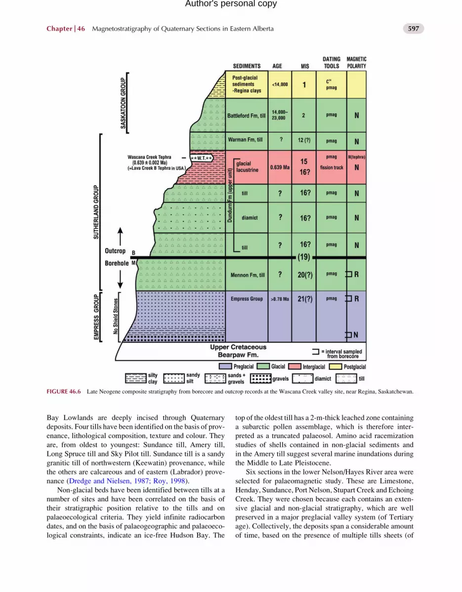
FIGURE 46.6 Late Neogene composite stratigraphy from borecore and outcrop records at the Wascana Creek valley site, near Regina, Saskatchewan.
Chapter 46 Magnetostratigraphy of Quaternary Sections in Eastern Alberta 597
Author's personal copy
Bay Lowlands are deeply incised through Quaternary
deposits. Four tills have been identified on the basis of prov-
enance, lithological composition, texture and colour. They
are, from oldest to youngest: Sundance till, Amery till,
Long Spruce till and Sky Pilot till. Sundance till is a sandy
granitic till of northwestern (Keewatin) provenance, while
the others are calcareous and of eastern (Labrador) prove-
nance (Dredge and Nielsen, 1987; Roy, 1998).
Non-glacial beds have been identified between tills at a
number of sites and have been correlated on the basis of
their stratigraphic position relative to the tills and on
palaeoecological criteria. They yield infinite radiocarbon
dates, and on the basis of palaeogeographic and palaeoeco-
logical constraints, indicate an ice-free Hudson Bay. The
top of the oldest till has a 2-m-thick leached zone containing
a subarctic pollen assemblage, which is therefore inter-
preted as a truncated palaeosol. Amino acid racemization
studies of shells contained in non-glacial sediments and
in the Amery till suggest several marine inundations during
the Middle to Late Pleistocene.
Six sections in the lower Nelson/Hayes River area were
selected for palaeomagnetic study. These are Limestone,
Henday, Sundance, Port Nelson, Stupart Creek and Echoing
Creek. They were chosen because each contains an exten-
sive glacial and non-glacial stratigraphy, which are well
preserved in a major preglacial valley system (of Tertiary
age). Collectively, the deposits span a considerable amount
of time, based on the presence of multiple tills sheets (of

FIGURE 46.7 Magnetostratigraphic correlation of Saskatchewan outcrop and borehole data from the Wellsch Valley, Wascana Creek and
Sutherland sites.
Quaternary Glaciations - Extent and Chronology598
Author's personal copy
differing provenance), the amount of time required to raise
and lower sea level by substantial amounts, the considerable
thicknesses of interglacial sediments, as well as extended
periods of soil development. As no absolute dating tech-
niques could be applied to the older sediments, palaeomag-
netic measurements were made to determine whether
reversely magnetised (Matuyama Chron; 2.6–0.78 Ma) sed-
iments are present in the Hudson Bay Lowlands.
All units exhibit normal magnetisations (Barendregt
et al., 2007, 2011), indicating that the Quaternary record
in the Hudson Bay Lowlands can be assigned to the Brunhes
Chron (<0.78 Ma) and falls within the Middle to Late
Pleistocene age (Fig. 46.2). The magnetostratigraphy of
the Hudson Bay Lowlands indicates that Brunhes Chron
glaciations occurred repeatedly in this region.
46.3. DISCUSSION
The age of North American Interior Plains glaciations is
less well constrained than Cordilleran glaciations, both in
terms of age and extent (Barendregt and Duk-Rodkin,
2011; Duk-Rodkin and Barendregt, 2011). Only in the
American Midwest (Minnesota, Nebraska, Iowa, Kansas
and Missouri) have reversely magnetised continental tills
been previously reported (Roy et al., 2004; Balco et al.,
2005). Based on tephra dates, these reversely magnetised
glacial sediments fall within the early as well as late
Matuyama Reversed Chron (2.60–0.78 Ma). Barendregt
et al. (2011) report the results of palaeomagnetic measure-
ments made on borecore samples collected from south-cen-
tral Saskatchewan. There a single reversely magnetised
till (Mennon Fm) occurs at the base of the glacial sequence,
and can be confidently assigned to the latest Matuyama
(MIS 20), based on underlying and overlying tephras.
At least 4 Middle Pleistocene (MIS 18?, 16?, 12?, 6?)
and 2 Late Pleistocene (MIS 4 and 2) continental tills
overlie the Mennon Fm, and all are normally magnetized.
To the west, in Alberta, only a single (Late Wisconsinan)
glaciation (MIS 2) covered most of the province, while
areas to the east of the �700 m contour line saw two or
more glaciations. In south-central Saskatchewan, evidence
for seven glaciations is reported. The earliest continental

FIGURE 46.8 Late Neogene composite stratigraphy of Hudson Bay Lowland near Gillam, Manitoba.
Chapter 46 Magnetostratigraphy of Quaternary Sections in Eastern Alberta 599
Author's personal copy
glaciation in the southern Canadian Prairies occurred during
the latest Matuyama Reversed Chron (> 0.78 Ma; MIS 20),
based on palaeomagnetism, tephras and fossil data.
46.4. CONCLUSIONS
In 1998, Barendregt and Irving provided a summary of the
magnetostratigraphical data for western Canada and the
northwestern USA. In these summaries, distribution and
extent of ice sheets in western North America are recon-
structed, based on some 70 magnetostratigraphic records,
and show marked differences between the Matuyama
and Brunhes Chrons (see Fig. 46.3 in Barendregt and Duk-
Rodkin, 2011, Chapter 32). During the Matuyama Chron,
ice appears to have been largely absent from large areas of
the southern prairie provinces in Canada and the adjacent
states of Montana and North Dakota, as well as from much
of the Arctic Islands. In the Late Matuyama a modest Kee-
watin ice centre formed, delivering ice as far distant asBanks
Island, (Barendregt and Vincent, 1990; Barendregt et al.,
1998b), North West Territories (NWT) and south-central
Saskatchewan. In contrast, the Labrador/Hudson Bay ice
centre delivered ice as far south as Kansas during both the
Early and Late Matuyama (Roy et al., 2004; Balco et al.,
2005). During the Brunhes Chron, ice caps appear for the
most part to have been far more extensive than in the
Matuyama, and only in the southern Midwestern states did
Brunhes-age ice not reach previous limits. During the last
major glaciation (Late Wisconsinan), ice cover was
continuous from Atlantic to Pacific, with Cordilleran and
Keewatin ice sheets in contact in western Alberta, and along
the easternmargin of theMackenzieMountains in theNWT.
REFERENCES
Balco, G., Stone, J.O.H., Mason, J., 2005. The first glacial maximum in
North America. Science 307, 222.
Barendregt, R.W., 1976. A detailed geomorphological survey of the
Pakowki-Pinhorn Area, Southeastern Alberta. Ph.D. Dissertation,
Department of Geography, Queen’s University, 275 pp.
Barendregt, R.W., Duk-Rodkin, A., 2011. Chronology and extent of late
Cenozoic ice sheets in North America: a magnetostratigraphic assess-
ment. In: Ehlers, J., Gibbard, P.L., Hughes, P.D. (Eds.), Quaternary
Glaciations—Extent and Chronology. Part IV: A Closer Look.
Elsevier, Amsterdam.
Barendregt, R.W., Irving, E., 1998. Changes in the extent of North Amer-
ican ice sheets during the late Cenozoic. Can. J. Earth Sci. 35,
504–509.
Barendregt, R.W., Stalker, A.MacS., 1978. Characteristic magnetization of
someMiddlePleistocenesedimentsfromtheMedicineHatAreaofSouth-
ern Alberta. Geological Survey of Canada Paper, 78-1A, pp. 487–488.
Barendregt, R.W., Vincent, J.-S., 1990. Late Cenozoic paleomagnetic
record of Duck Hawk Bluffs, Banks Island, Canadian Arctic Archipel-
ago. Can. J. Earth Sci. 27, 124–130.
Barendregt,R.W., Foster, J.H., Stalker,A.MacS, 1977. Paleomagnetic rem-
anencecharacteristicsof surface tills found in thePakowki-Pinhornarea
of southern Alberta. Geological Survey of Canada Paper, 77-1B.
Barendregt, R.W., Churcher, C.S., Stalker, A. MacS, 1988. Stratigraphy,
paleomagnetism and vertebrate paleontology of Quaternary preglacial
sediments at the Maser-Frisch Site, southeastern Alberta. Geol. Soc.
Am. Bull. 100, 1824–1832.

Quaternary Glaciations - Extent and Chronology600
Author's personal copy
Barendregt, R.W., Thomas, F.F., Irving, E., Baker, J., Stalker, A. MacS,
Churcher, C.S., 1991. Stratigraphy and paleomagnetism of the Jaw
Face section, Wellsch Valley site, Saskatchewan. Can. J. Earth Sci.
28, 1353–1364.
Barendregt, R.W., Irving, E., Christiansen, E.A., Sauer, E.K.,
Schreiner, B.T., 1998a. Stratigraphy and Paleomagnetism of Late Pli-
ocene and Pleistocene sediments from Wellsch Valley and Swift Cur-
rent Creek areas, southwestern Saskatchewan, Canada. Can. J. Earth
Sci. 35, 1347–1361.
Barendregt, R.W., Vincent, J.-S., Irving, E., Baker, J., 1998b.Magnetostra-
tigraphy of Quaternary and Late Tertiary sediments on Banks Island,
Canadian Arctic Archipelago. Can. J. Earth Sci. 35, 147–161.
Barendregt, R.W., Duk-Rodkin, A., Enkin, R.E., Baker, J.,
Christiansen, E., Naeser, N.D., et al., 2007. New magnetostratigraphic
data from central Saskatchewan, and from the Horton Plateau, Mac-
kenzie District, NWT: evidence for Matuyama Chron glaciations in
the Interior Plains of Canada. In: XVII I NQUA Congress, Cairns,
Australia, 28 July–3 August, 2007.
Barendregt, R.W., Enkin, R.J., Christiansen, E.A., Tessler, D.L., 2011.
Magnetostratigraphy of Late Neogene glacial, interglacial, and preg-
lacial sediments in the Saskatoon and Regina areas, Saskatchewan.
Studia Geophysica and Geodaetica 55 (in press).
Cande, S.C., Kent, D.V., 1995. Revised calibration of the geomagnetic
timescale for the Late Cretaceous and Cenozoic. J. Geophys. Res.
100 (B4), 6093–6095.
Christiansen, E.A., 1968. Pleistocene stratigraphy of the Saskatoon area,
Saskatachewan, Canada. Can. J. Earth Sci. 5, 1167–1173.
Christiansen, E.A., 1992. Pleistocene stratigraphy of the Saskatoon area,
Saskatchewan, Canada: an update. Can. J. Earth Sci. 29, 1767–1778.
Churcher, C.S., Stalker, A. MacS, 1988. Geology and vertebrate
paleontology of the Wellsch Valley site, Saskatchewan. unpub-
lished manuscript.
Dredge, L.A., Nielsen, E., 1987. Glacial and interglacial stratigraphy, Hud-
sonBayLowlands,Manitoba. In: Biggs,D.L. (Ed.), Geological Society
of America Centennial Field Guide. North Central Section 3, 43–46.
Duk-Rodkin, A., Barendregt, R.W., 2011. The glacial history of North-
western Canada. In: Ehlers, J., Gibbard, P.L., Hughes, P.D. (Eds.),
Quaternary Glaciations—Extent and Chronology. Part IV: A Closer
Look. Elsevier, Amsterdam.
Fullerton, D.S., Colton, R.B., Bush, C.A., 2004. Limits of mountain and
continental glaciations east of the continental divide in northern Mon-
tana and northeastern North Dakota, USA. In: Ehlers, J., Gibbard, P.L.
(Eds.), Quaternary Glaciations—Extent and Chronology. Part II:
North America. Elsevier, Amsterdam.
Gradstein, F.M., Ogg, J.G., Smith, A.G., Agterberg, F.P., Bleeker, W.,
Cooper, R.A., 2004. A Geologic Timescale. Geological Survey of
Canada, Miscellaneous Report 86, and 1 map.
Jackson, L.E., Jr., Phillips, F.M., Little, E.C., 1999. Cosmogenic 36Cl dat-
ing of the maximum limit of the Laurentide Ice Sheet in southwestern
Alberta. Can. J. Earth Sci. 36, 1347–1356.
Lanphere, M.A., Champion, D.E., Christiansen, R.L., Izett, G.A.,
Obradovich, J.D., 2002. Revised age for tuffs of the Yellowstone Pla-
teau volcanic field—assignment of the Huckleberry Ridge Tuff to a
new geomagnetic polarity event. Geol. Soc. Am. Bull. 114, 559–568.
Lisiecki, L.E., Raymo, M., 2005. A Pliocene–Pleistocene stack of 57 glob-
ally distributed benthic d18O records. Paleoceanography 20, PA1003.
doi:10.1029/2004PA001071.
Raymo, M.E., 1992. Global climate change: a three million year perspec-
tive. In: Kukla, G.K., Went, E. (Eds.), Start of a Glacial, Nato ASI
Series, Series I, Global Environmental Change 3, 207–223.
Raymo, M.E., Ruddiman, W.F., Backman, J., Clement, B.M.,
Martinson, D.G., 1989. Late Pliocene variation in Northern Hemi-
sphere ice sheets and North Atlantic DeepWater circulation. Paleocea-
nography 4, 413–446.
Roy, Martin, 1998. Pleistocene stratigraphy of the Lower Nelson River
Area: implications for the evolution of the Hudson Bay Lowland of
Manitoba, Canada. Unpublished M.Sc. Thesis, Universite de Quebec
a Montreal, 220 pp.
Roy, M., Clark, P.U., Barendregt, R.W., Glasmann, J.R., Enkin, R.J.,
Baker, J., 2004. Glacial Stratigraphy and Paleomagnetism of late
Cenozoic deposits of the north-central United States. Geol. Assoc.
Am. Bull. 116, 30–41.
Ruddiman, W.F., Raymo, M.E., McIntyre, A., 1986. Matuyama 41,000-
year cycles; North Atlantic Ocean and northern hemisphere ice sheets.
Earth Planet. Sci. Lett. 80, 117–129.
Ruddiman, W.F., Raymo, M.E., Martinson, D.G., Clement, B.M.,
Backman, J., 1989. Pleistocene evolution of Northern Hemisphere
climate. Paleoceanography 4, 353–412.
Shackleton, N.J., Hall, M.A., Pate, D., 1995. Pliocene stable isotope stra-
tigraphy of site 846. Proc. Ocean Drill. Prog. Sci. Results 138,
337–353.
Stalker, A.MacS, 1969. Alberta report II: sections nearMedicine Hat. Geo-
logical Survey of Canada, Paper, 69-26, 28 pp.
Stalker, A. MacS, 1976. Quaternary stratigraphy of the Southwestern Prai-
ries. In: Mahaney, W.C. (Ed.), Quaternary Stratigraphy of North
America. Hutchinson and Ross Inc., Stroudsberg, Pennsylvania, Dow-
den, pp. 381–407.
Stalker, A., 1982. Ice age deposits and animals from the southwestern part
of Great Plains of Canada. Geological Survey of Canada, Miscella-
neous Report, 31, (wall chart).
Stalker, A. MacS, Vincent, J.-S., 1993. Quaternary; subchapter 4K in
Sedimentary Cover of the Craton in Canada. In: Stott, D.F.,
Aitken, J.D. (Eds.), Geological Survey of Canada, Geology of
Canada, No. 5. pp. 466–482 (also Geological Society of America,
The Geology of North America, v. D-1).
Stalker, A. MacS, Wyder, J.E., 1983. Borehole and outcrop stratigraphy
compared with illustrations from the Medicine Hat area of Alberta.
Geol. Surv. Can. Bull. 296, 28 pp. and maps.
Stewart, K.M., Seymour, K.L. (Eds.), 1996. Palaeoecology and Palaeoen-
vironments of Late Cenozoic Mammals: Tributes to the Career of
C.S. (Rufus) Churcher. University of Toronto Press, Toronto, Canada
521 pp.
Szabo, B.J., Stalker, A. MacS, Churcher, C.S., 1973. Uranium-series ages
of some Quaternary deposits near Medicine Hat, Alberta, Canada.
Can. J. Earth Sci. 10, 1464–1469.
Westgate, J.A., 1968. Surficial geology: foremost-Cypress Hills area,
Alberta. Alberta Research Councill Bulletin 22, 120.
Westgate, J.A., Christensen, E.A., Boellstorff, J.D., 1977. Wascana Creek
Ash (Middle Pleistocene) in southern Saskatchewan: characterization,
source, fission track age, paleomagnetism and stratigraphic signifi-
cance. Can. J. Earth Sci. 14, 357–374.
Westgate, J.A., Briggs, N.D., Stalker, A. MacS, Churcher, C.S., 1978. Fis-
sion-track age of glass from tephra beds associated with Quaternary
vertebrate assemblages in the southern Canadian Plains. Geol. Soc.
Am. Abstr. 10, 514–515.
Zymela, S., Schwarcz, H.P., Grun, R., Stalker, A. MacS, Churcher, C.S.,
1988. ESR dating of Pleistocene fossil teeth from Alberta and Sas-
katchewan. Can. J. Earth Sci. 25, 235–245.