low energy and sufficiently accurate ... - vinayak naik
TRANSCRIPT
Low Energy and Sufficiently Accurate Localization for non-Smartphones
Kuldeep Yadav*, Vinayak Naik*, Amarjeet Singh*, Pushpendra Singh*, and Umesh Chandra+
*Indraprastha Institute of Information Technology, Delhi, India
+Nokia Research Centre, Bangalore, India
Abstract—Location-aware mobile applications are steadily gaining pop-
ularity across the world. However, lack of Global PositioningSystem (GPS) and absence of Wi-Fi infrastructure preventusers with non-Smartphones (majority of population in devel-oping countries) from using location-aware applications as theirphones do not have access to their current location. ExistingGSM based approaches such as Cell ID-based works onnon-Smartphones but they require access to a comprehensivedatabase of Cell IDs. Such a database either does not exist oris very limited in developing countries.
In this paper, we propose a novel GSM-based approachof using Cell Broadcast Service (CBS) messages for gettingcurrent location on the phone. Proposed approach does notdepend on a comprehensive database and can run on pro-grammable low end phones. We demonstrate the effectivenessof our approach on data collected in New Delhi, India acrosstwo different operators and propose two space-time historybased algorithms to improve upon the localization accuracy ofour baseline CBS approach. The proposed algorithms provideup to 35% improvement in accuracy over the baseline method.Further, we compare accuracy of our CBS-based approach withthat of Cell ID-based approach and also, present a multimodalapproach that uses combination of both CBS and Cell ID(wherever available) to improve the localization accuracy.
I. INTRODUCTION
Location has been an integral part of user contextin delivering context-aware services such as navigation,activity recognition, local business search, and friend finderservices. Interestingly, all context aware services do notrequire same level of accuracy for current location. Forinstance, navigation applications require high level ofaccuracy (~10 m) whereas if one has to share location withonline social networks, even location accuracy of hundredsof meter will suffice. Many technologies/approaches areavailable to measure user’s current location on mobilephone of which the primary approaches are as follows:
1) GPS: Highly accurate (~10-100 meter) satellite basedapproach and most common for high-end phones.However, it consumes high energy, requires specialhardware, and only works outdoors [13].
2) WiFi based Positioning: A perceptual map ofwireless APs identifier with respective signalstrengths and approximate location is created bywardriving and stored in a database [18]. The mobilephone queries this database to estimate the current
location. Though, it can work indoors but it consumeshigh energy and requires special hardware besidesneeding a WiFi infrastructure, which does not existin majority of developing countries.
3) GSM based Positioning: There are two kinds ofGSM positioning approaches i.e Base station assistedand Base station independent. Base station assistedapproaches require installation of sophisticatedinfrastructure on base station and hence requireassistance from the operator [13]. Base stationindependent GSM positioning approach is based onCell ID where, like WiFi based positioning system, aperceptual map of GSM Cell towers is created usingwar-driving and this is queried to estimate the currentlocation of the phone [17].This method does not require any extra hardwareand easily works on phones having GSM connection(~85% of phones) [19]. This approach have loweraccuracy than GPS and WiFi (~100-1500 meters). Thelocalization accuracy primarily depends on coverageof Cell ID database, Cell ID density in an area, andvisibility of Cell IDs on phone.
Mobile phones having GPS and Wi-Fi chips are ex-pensive, so a large number of non-Smartphones1 do nothave these capabilities. It is predicted that for the next fiveyears, over 50% of the phones will not have GPS [19]. In2011, ratio of non-Smartphones to smartphone sales was2:1 and majority of these phones had capability of internetconnectivity also 2. Apart from cost, mobile phones arehighly energy constrained and continuous use of GPS andWiFi drains the battery quickly. For the class of applicationsthat do not require fine grained location accuracy, Cell IDbased GSM localization is better suited due it its wideavailability and low power consumption. In fact, for low-end phones (without GPS/Wi-Fi capability) this is bestsuited [19]. However, GSM based localization needs toovercome following limitations:
1) According to GSM standards, a phone can receivesignals from seven different Cell towers [17]. How-ever, most of the phones can access (using APIs)
1Also, known as low-end phones or feature phones2http://mobithinking.com/mobile-marketing-tools/latest-mobile-stats
1 3 5 7 9 11 13 15 17 19 21 23 25 27 29 31 33
RSSI Difference(dbm)
0
1000
2000
3000
4000D
ista
nce (
mete
r)
Min-Max Distance
Average Distance
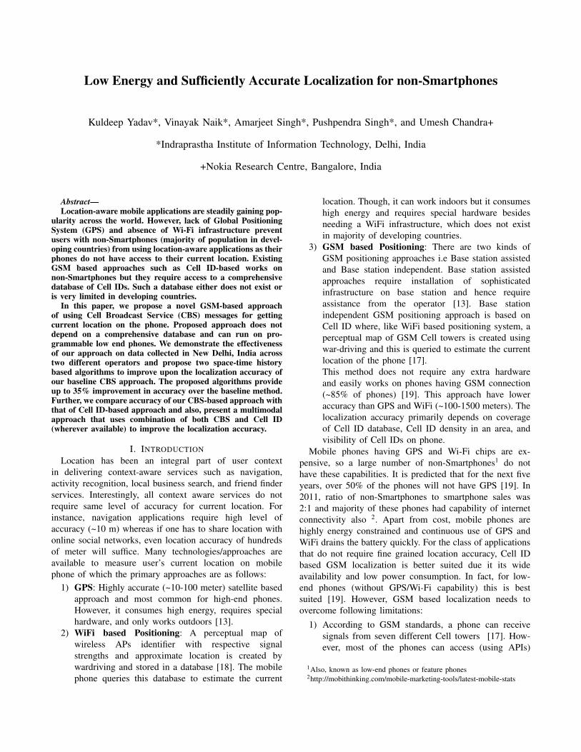
(a) In whole dataset, Min-Max bars representing minimum andmaximum distance between two position into same cell ID. Forinstance, for a difference of 14 dBm in RSSI, distance betweenthose points can range from 0 to 4000 meter.
0 5 10 15 20 25
RSSI Difference (dbm)
0
500
1000
1500
2000
2500
Dis
tance (
mete
r)
(b) Only for single cell ID, X-Y scatter plot for showing variancein RSSI difference vs distance between two positions into sameCell ID. For instance, two points with RSSI difference 21 dBmcan have a distance of 0 to 500 meter.
Figure 1: RSSI analysis on self collected dataset
only one Cell tower to which the phone is currentlyconnected [14]. Access to only a single Cell ID offerscoarse grained accuracy.
2) For Cell ID based localization, perceptual map (CellID database) has to be created by wardriving. Wardriv-ing is not scalable because it is practically impossibleto cover each and every street of a country to create adatabase of Cell Ids. Although, there are few crowd-sourcing based open source Cell ID database, e.g.OpenCellID, they only have few entries and oftenbecomes obsolete due to lack of participation.
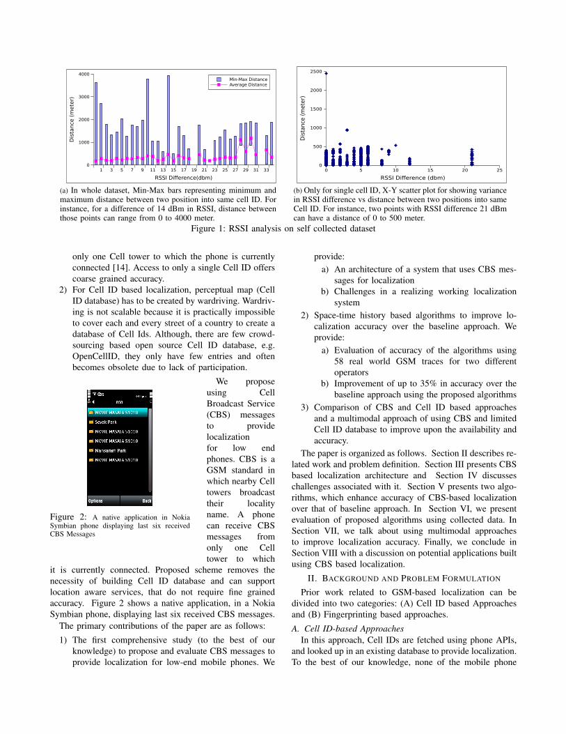
Figure 2: A native application in NokiaSymbian phone displaying last six receivedCBS Messages
We proposeusing CellBroadcast Service(CBS) messagesto providelocalizationfor low endphones. CBS is aGSM standard inwhich nearby Celltowers broadcasttheir localityname. A phonecan receive CBSmessages fromonly one Celltower to which
it is currently connected. Proposed scheme removes thenecessity of building Cell ID database and can supportlocation aware services, that do not require fine grainedaccuracy. Figure 2 shows a native application, in a NokiaSymbian phone, displaying last six received CBS messages.
The primary contributions of the paper are as follows:
1) The first comprehensive study (to the best of ourknowledge) to propose and evaluate CBS messages toprovide localization for low-end mobile phones. We
provide:a) An architecture of a system that uses CBS mes-
sages for localizationb) Challenges in a realizing working localization
system2) Space-time history based algorithms to improve lo-
calization accuracy over the baseline approach. Weprovide:
a) Evaluation of accuracy of the algorithms using58 real world GSM traces for two differentoperators
b) Improvement of up to 35% in accuracy over thebaseline approach using the proposed algorithms
3) Comparison of CBS and Cell ID based approachesand a multimodal approach of using CBS and limitedCell ID database to improve upon the availability andaccuracy.
The paper is organized as follows. Section II describes re-lated work and problem definition. Section III presents CBSbased localization architecture and Section IV discusseschallenges associated with it. Section V presents two algo-rithms, which enhance accuracy of CBS-based localizationover that of baseline approach. In Section VI, we presentevaluation of proposed algorithms using collected data. InSection VII, we talk about using multimodal approachesto improve localization accuracy. Finally, we conclude inSection VIII with a discussion on potential applications builtusing CBS based localization.
II. BACKGROUND AND PROBLEM FORMULATION
Prior work related to GSM-based localization can bedivided into two categories: (A) Cell ID based Approachesand (B) Fingerprinting based approaches.
A. Cell ID-based ApproachesIn this approach, Cell IDs are fetched using phone APIs,
and looked up in an existing database to provide localization.To the best of our knowledge, none of the mobile phone
operators reveal exact location of the Cell towers. Hence,using crowd sourcing/war driving data, cell tower location isapproximated, which could be several hundred meter awayfrom its actual location. If there are multiple visible CellIDs, the approaches compute some function, e.g. centroid,of all the geo-coordinates (latitude and longitude) obtainedfrom the database.
As discussed above, there are limitations on how muchvisibility phone APIs provide to third party developers foraccessing Cell IDs. Many of prior works assume that phoneAPIs provide access to multiple Cell IDs, as far as seven, at atime [17].Our experience supported by other prior work [4],[16] shows that for several phones including Nokia S40, S60phones, Samsung Android phones only provide access toonly one Cell ID to which the phone is currently connected.This significantly reduces accuracy of the localization ascompared that obtained had there been access to seven CellIDs. Google Mobile Maps’(GMM) My Location3 app workson a single Cell ID-based approach, where it provides amedian localization error of 656.37 meter for a rural areaand 503.89 meter for an urban area [3]. The localizationerror depends on density of cell towers. Since in urban areas,density of cell towers is high, so this method provides goodlocation accuracy.
As identified in Section I, it is hard to get a compre-hensive database of cell IDs. There are some proprietarydatabases, such as one used by GMM, which are not publiclyshared. There exist open source initiatives, e.g. OpenCellID4
and Cell Spotting5, that build their database using crowd-sourcing. To check the coverage of open source cell IDdatabases, we selected two widely used operators in NewDelhi. We call them X and Y for anonymity. On our selfcollected dataset of Cell IDs for operators X, we observedthat out of 252 cell IDs, OpenCellID contained only 65. Foroperator Y, the number was only 21 out of 164 as shownin Table I. We cannot find out comprehensiveness of theGMM as it is not publicly available. However, given lowpenetration of Android phones in rural India, we postulatethat the database will be underpopulated.
Crowd-sourcing for building cell ID database seems to bein-effective due to (A) lack of incentives as people need toincur airtime charges for contributing to the databases and(B) lack of GPS-enabled phones in developing countries.
Operator No of cell IDs Found on OpenCellID %X 252 65 31%Y 164 21 13%
Table I: Success rate of Open Cell ID (most extensive opensource database of cell IDs) on our dataset collected in NewDelhi region
3http://www.google.com/mobile/maps/4www.opencellid.org5www.cellspotting.com
B. Fingerprinting-based Approaches
In this approach, RSSI (Received Signal Strength Indi-cation) is also collected along with Cell IDs during war-driving. Typically, a fingerprint constitutes Cell IDs, theirassociated RSSI, and GPS locations that are represented ina vector form. For this approach, database size is largerand more effort is needed during war-driving. During thetracking phase, Cell ID(s) and associated RSSI are com-pared with stored vector space of fingerprints using KNN(K Nearest Neighbor) to user’s location. Here, KNN useseuclidean distance in RSSI space as a metric to find closeststored fingerprint [17]. This approach gives better accuracythan the cell ID-based approaches since granularity of storedinformation is more. However, it requires more storage andcomputational capabilities.
Continuous war-driving effort is required in this approachbecause signal strength keeps on fluctuating due to changesin physical environment. It works good when there is avisibility of seven cell towers and their respective RSSIs.Recent results demonstrates that RSSI measure from singlecell tower is not a good measure to calculate movement [4].
We conducted our own study to find out whether RSSIis a good metric for localization. An RSSI difference is theabsolute change in the RSSI, for a given Cell ID, when usermoves from one location to another. In our database, we had24064 unique RSSI difference values from 410 unique cellIDs. We plot maximum, minimum, and average distancesfor each RSSI difference. As seen in Figure 1a, the averagedifference is almost constant for RSSI difference rangingfrom 1 to 9 dBm. We zoom in on one cell ID and plot thedata (Refer Figure 1b). We observed the similar behavior forRSSI difference ranging from 1 to 6 dBm. This concludesthat RSSI is not a good measure for GSM-based localizationas one observes similar RSSI values between two points withlarge physical distance between them.
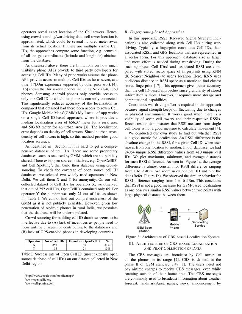
Figure 3: Architecture of CBS based Localization System
III. ARCHITECTURE OF CBS-BASED LOCALIZATIONAND PILOT COLLECTION OF DATA
The CBS messages are broadcast by Cell towers toall the phones in its range [2]. CBS is defined in thephase II of GSM standard 3.49 [1]. The users need notpay airtime charges to receive CBS messages, even whileroaming outside of their home area. The CBS messagesare commonly used to broadcast information about weatherforecast, landmarks/area names, news, announcement by
governments, etc. All this information can be broadcastedsimultaneously on different channels. A cell tower typicallybroadcasts the locality/landmark name, where it is located.Channel 50 is reserved for broadcasting location/area names.Most of the phones come with built-in APIs to capture CBSmessages.
A. Architecture of CBS-based Localization Scheme
In this subsection, we describe architecture of our pro-posed solution to use landmark names in the CBS messagesto find users’ locations. Figure 3 shows architecture of ourworking CBS-based approach. The data flows as depictedby numbered arrows in the Figure 3 correspond to thefollowing:
1. GSM base station broadcasts CBS messages, eachcontaining a CBS string mentioning location name or ad-vertisement. The messages are received by our applicationrunning on the phone.
2. If the message content is a location, then the phonechecks for geo-coordinates of the landmark in its local cache.If it is not available, the application makes a request to acloud-based geo-coding service.
3. In reply to the geo-coding request, the geo-codingservice returns geo-coordinates of that location to the phone.The application adds it to local cache of the phone. Cloudbased geo-coding service is likely to get request from manyphones, using which it builds a cache of all location nameswith their geo-coordinates. Phones can download this globalcache proactively to avoid frequent requests to the cloud.
Above described approach is the most basic way ofestimating a user’s location using CBS messages and calledas baseline approach. Baseline approach is identical to CellID approach described in Section II-A.
B. Pilot Collection of Data
To characterize the accuracy of CBS-based localizationapproach, we collected CBS messages for operators X and Yin urban setting of New Delhi, India. Five volunteers ran ourdata collection application for three months. We collectedthis data to measure accuracy of the baseline approach anddesign algorithms to improve upon the baseline accuracy.
Our data collection application is written in J2ME. We ranthe application on Nokia S60 and Nokia S40 phones. Thoughwe have collected data using Nokia phones, we have foundthat nearly all Java-enabled phones provide APIs to receiveCBS messages. For example, phones from Samsung, SonyEricsson, Black Berry, etc work fine but their APIs to getother location information like Cell ID differs since eachmanufacturer gives proprietary APIs to access information.Our application ran on all of these platforms with minormodifications.
The application collects CBS messages on channel 50,records the location message, time stamp of reception, CellID, MCC (Mobile Country code), MNC (Mobile NetworkCode), and GPS coordinates (if GPS is available on the
phone). Volunteers were given choices to start and stopapplication at any point of time. After collecting each trace,participants tagged their activity as walking or travelingand upload it using one of following methods. – (a) usingphone’s data connection or (b) transferring it to PC first andthen uploading it using PC’s Internet connection.
Nearly half of our traces did not have GPS coordinates dueto volunteers being indoor. For consistency purpose, we haveonly considered the traces, which had GPS values nearlyall the time. We list out some of the statistics about thedataset in Table II. We analyze the collected data in thenext section and list out challenges in using CBS messagefor localization.
State X Y Combined(X+Y) Avg Duration (Minutes)Travelling 27 12 10 46Walking 12 7 7 65
Table II: Number of travelling and walking traces in CBSdataset across two different operators X and Y
IV. CHALLENGES IN CBS BASED LOCALIZATION
Data from our pilot study brought forth non-trivial chal-lenges that require addressing before even the baselineapproach can be used effectively. We addressed some ofthese challenges in our prior work [9], [10] but this paperpresents comprehensive analysis with a bigger dataset.A. Filtering of Advertisement Messages
CBS messages contain advertisements in addition to loca-tion names. It is essential to filter out these advertisements.We found that number of advertisements differ amongoperators X and Y, as shown in Table III.
Operator Total CBS Messages Advertisements(%)X 3106 48%Y 1173 60.53%
Table III: Percentage of Advertisement CBS Messages inour Dataset collected for operator X and Y
It was observed that advertisements contain some com-mon patterns such as special characters (’*’,’#’,’%’,’@’) orcontinuous digits like (’55050’). Using these two discrimi-nators, we designed a regular expression to filter at runtimeall the advertisements at the phone itself [10]. We got100% accuracy in filtering advertisements when the regularexpression was applied off-line to 4279 CBS messages inour dataset.
B. Geocoding of Location Names
As per our architecture, CBS location messages need tobe geo-coded using a geo-coding service i.e. Google Maps.Among all the on-line maps services, we found Google Mapsto be most effective in geo-coding our location names, andwe have used it for all our experiments. We obtained 143unique CBS location names in our dataset, among which30% of location names could not be geo-coded by Google
Maps at first. We call them false negatives. Primary reasonsfor occurrence of false negatives are the following:
1) Location names may exist differently (in the geo-coding service), e.g. there could be a spelling differ-ence, use of short hand abbreviations, or with a com-pletely different name. For example, ’Matiyala’ and’Matyala’, ’Uttam Nagar’ and ’Uttam Ngr’, ’DwarkaSec-3’ and ’Sec-3 Dwarka’.
2) There is no publicly available extensive GIS database.We have employed following approaches on the location
names, that could not be geo-coded directly by GoogleMaps:
1) Sanitizing Location Names : To resolve the ambiguitypresent in location names, we do a pre-processingof landmark names before sending them to thegeo-coding service. Pre-processing algorithm applyfollowing steps to sanitize the CBS location names:
a) Replace special ’-’ character by a space, so’Dwarka Sec-02’, ’Dwarka Sec-2’ and ’Sec-2-Dwarka’ are converted to ’Dwarka Sec 02’,’Dwarka Sec 2’ and ’Sec 2 Dwarka’ respectively.
b) Numerical characters in the location name areseparated out from surrounding text characterse.g. converting ’Dwarka Sec2’ to ’Dwarka Sec2’.
c) After removing special characters from locationname, search for popular abbreviations inlocation names like ’NGR’, ’SEC’, ’VHR’ etc.,and replace then with its full form like ’NGR’for ’Nagar’ followed by a space. We havemanually populated this mapping table from thelocation names.
After pre-processing by the above algorithm, GoogleMaps service was able to geo-code nearly 50% ofthe false negatives. Other 50% (15% of total) of thenames were not present on the map service or existedwith a different name. For instance, the location’Dwarka Mor’ exists on Google Maps and can begeo-coded, but same location with a different name’Kakrola Mor’ does not exist on Google Maps.
2) Use of on-line map based business search services:For the location names that are completely missingfrom digital maps or exist with a different name, wetook help of the data present in on-line map-basedbusiness search services like Google local search.These business name are often collected throughcrowd-sourcing, so many of the location names (notfound on Google maps otherwise) were present inbusiness names. After retrieving business names, weapplied K-means to approximate geo-coordinates fora location. However, currently we could not verify alocation’s geo-coordinates automatically and we leaveit to future work.
We believe that a common algorithm that can work forall the names is hard to achieve due to non-standardnomenclature for CBS messages and poor GIS database(specially in developing countries). However, it is still a one-time task to geo-code the names which are not automaticallygeo-coded by any service and requires much less effortthan the wardriving task used by Cell ID-based approaches.
C. Inaccuracy of Geo-coding Services
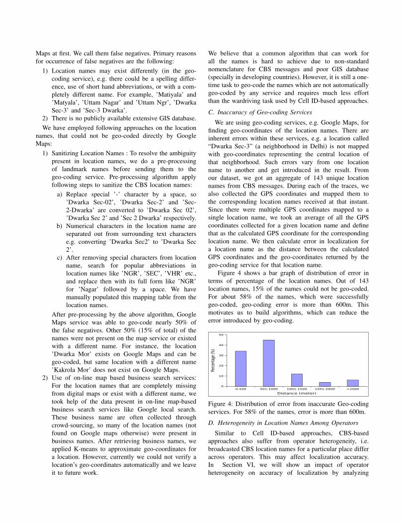
We are using geo-coding services, e.g. Google Maps, forfinding geo-coordinates of the location names. There areinherent errors within these services, e.g. a location called“Dwarka Sec-3” (a neighborhood in Delhi) is not mappedwith geo-coordinates representing the central location ofthat neighborhood. Such errors vary from one locationname to another and get introduced in the result. Fromour dataset, we got an aggregate of 143 unique locationnames from CBS messages. During each of the traces, wealso collected the GPS coordinates and mapped them tothe corresponding location names received at that instant.Since there were multiple GPS coordinates mapped to asingle location name, we took an average of all the GPScoordinates collected for a given location name and definethat as the calculated GPS coordinate for the correspondinglocation name. We then calculate error in localization fora location name as the distance between the calculatedGPS coordinates and the geo-coordinates returned by thegeo-coding service for that location name.
Figure 4 shows a bar graph of distribution of error interms of percentage of the location names. Out of 143location names, 15% of the names could not be geo-coded.For about 58% of the names, which were successfullygeo-coded, geo-coding error is more than 600m. Thismotivates us to build algorithms, which can reduce theerror introduced by geo-coding.
0-500 501-1000 1001-1500 1501-2000 >2000
Distance (meter)
0
10
20
30
40
50
Perc
enta
ge (%
)
Figure 4: Distribution of error from inaccurate Geo-codingservices. For 58% of the names, error is more than 600m.
D. Heterogeneity in Location Names Among Operators
Similar to Cell ID-based approaches, CBS-basedapproaches also suffer from operator heterogeneity, i.e.broadcasted CBS location names for a particular place differacross operators. This may affect localization accuracy.In Section VI, we will show an impact of operatorheterogeneity on accuracy of localization by analyzing
results from experiments with different operators. Thechallenge then is to tolerate this heterogeneity.
V. ALGORITHMS TO IMPROVE LOCALIZATIONACCURACY
Baseline CBS based localization takes the most recentlyreceived CBS message’s geo-coordinates to approximatethe location of the user. Baseline approach does not alwaysgive good results due to two inherent errors: one is causedby geo-coding service (described in Section IV-C) andother due to the fact that CBS location names may be faraway from user’s actual location. A key insight towardsreducing the impact of these errors is that we are not takinginto account history of the locations visited by the mobileuser in the recent past.
To account for location history, we form a vectorof location names received in the past. When the useris stationary, the phone often receives multiple distinctlocation names as it can associate with different cell towersthat are in geographic proximity at different time instances.These location names sometimes may include locationsthat, in reality are far away from user’s current location.However, the frequency of such location names is farsmaller than frequency of location names that are in closeproximity to the current location. We hypothesize that thisfrequency difference is a factor of distance between CellTower and the user. Therefore, a weighted average basedapproach where the weight given to each location name isdependent on the frequency of received messages with thecorresponding location name (within fixed time window)will intuitively work well for improving the localizationaccuracy. We call this approach FrequencyWeighted .
For a slow moving user, since the conditions are similarto a static user, the FrequencyWeighted approach shouldideally provide better localization accuracy. However, a fastmoving user will probably be in the range of a cell tower fora short duration and hence will receive a small number of(often only a single) CBS messages with the correspondinglocation. However, it may happen that the currently receivedlocation name corresponds to a location in real world that isahead on the path of the user while the previously receivedlocation name was behind on the path of the user (a typicalcase when the location name is received immediately oncrossing the cell boundary). Therefore, weighted averageof the geo-coordinates of received location names withhigher weight given to those that are received most recentlyand exponentially reducing the weights of location namesreceived in the past will intuitively improve the localizationaccuracy. We call this approach TimeWeighted .
A. FrequencyWeighted AlgorithmThe FrequencyWeighted algorithm considers all CBS lo-
cation messages received in a fixed time window durationδ.As discussed above, this algorithm will intuitively im-prove localization accuracy in the case of static or slow
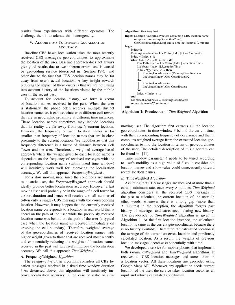
Algorithm: TimeWeighted
Input: Location Vector(LocVector) containing CBS location name,reception time stamp(ReceptionTime),GeoCoordinates[Lat,Lon] and a time out interval λ minutes
beginIndex=0;RunningCoordinates= LocVector[Index].Geo-Coordinates;Index = Index + 1;while Index < LocVector.Size do
TimeDifference = LocVector[Index].ReceptionTime -LocVector[Index-1].ReceptionTime;if TimeDifference < λ then
RunningCoordinates = (RunningCoordinates +LocVector[Index].Geo-Coordinates)/2;
elseRunningCoordinates=LocVector[Index].Geo-Coordinates;
endIndex = Index + 1;
endEstimatedCoordinates = RunningCoordinates;return EstimatedCoordinates;
endAlgorithm 1: Pseudocode of TimeWeighted Algorithm
moving user. The algorithm first extracts all the locationgeo-coordinates, in time window δ behind the current time,with their corresponding frequency of occurrence and then itcomputes weighted average from the extracted location geo-coordinates to find the location in terms of geo-coordinatesof the user. The detailed description of this algorithm canbe found in [11].
Time window parameter δ needs to be tuned accordingto user’s mobility as a high value of δ could consider oldlocation names and a low value could unnecessarily discardrecent location names.
B. TimeWeighted AlgorithmAssuming that CBS messages are received at more than a
certain minimum rate, once every λ minutes, TimeWeightedalgorithm considers all the received CBS messages inthe past to calculate the current location of the user. Inother words, whenever there is a long gap (more thanλ minutes) in the reception, the algorithm forgets pasthistory of messages and starts accumulating new history.The pseudocode of TimeWeighted algorithm is given inAlgorithm 1. At the first location instance, the calculatedlocation is same as the current geo-coordinates because thereis no history available. Thereafter, the calculated location isthe average of the current observed location and previouslycalculated location. As a result, the weights of previouslocation messages decrease exponentially with time.
We developed a service for mobile phones that implementboth FrequencyWeighted and TimeWeighted algorithms. Itreceives all CBS location messages and stores them ina location vector. All these locations are geocoded usingGoogle Maps API. Whenever any application needs currentlocation of the user, the service takes location vector as aninput and returns calculated coordinates.
It is important to note that our approach (aimed for low-end phones) cannot assume any means, e.g. accelerometeror GPS, to measure the speed of the user and accordinglyadapt the averaging policy for improved localization. Wetherefore compare the two approaches - FrequencyWeightedand TimeWeighted with the baseline approach empiricallyfor cases with slow and fast user speed.
VI. EVALUATION OF THE ALGORITHMS’ ACCURACY
We now describe the empirical evaluation of the two al-gorithms, FrequencyWeighted and TimeWeighted , explainedin the previous section, using our self collected real-worlddataset. We used point-based localization approach as abaseline for comparison which is identical to the one usedby cell ID based localization approach, including serviceproviders like Google as described in Section II-A. We uselocalization error as our evaluation metric. It is the distancebetween actual location (GPS Coordinates) and predictedlocation (CBS based approach). For simplicity purpose, wediscuss only one operator’s result (referred to as operatorY) in detail. However, at the end of Section VI-A andSection VI-B, we also briefly present results for operatorX.
As hypothesized earlier, the accuracy of the algorithmscould depend on the speed of travel. Hence, we collectedtraces for two different motions of walking and traveling. Wedefine walking as movement at an average speed of approx3.5Km/h and traveling as movement at average speed ofapprox 30Km/h.
A. Traveling TracesLet us first analyze the effect of varying input parameters
on the performance of two algorithms. For TimeWeightedalgorithm, λ is a time-out parameter, which is necessary toforget old history. Empirically, we found optimum λ to be2 minutes since it gave the least median localization errorfor all the traveling traces. We, therefore, have used λ as2 minutes for evaluating the performance of TimeWeightedalgorithm. For FrequencyWeighted algorithm, parameter δis used to fix the time window within which it considersthe received CBS messages to perform weighted average.Empirically, we found optimum δ to be 2 minutes fortraveling traces since it gave the least median localizationerror for all of traveling traces. We, therefore, have usedδ=2 for evaluating the performance of FrequencyWeightedalgorithm.
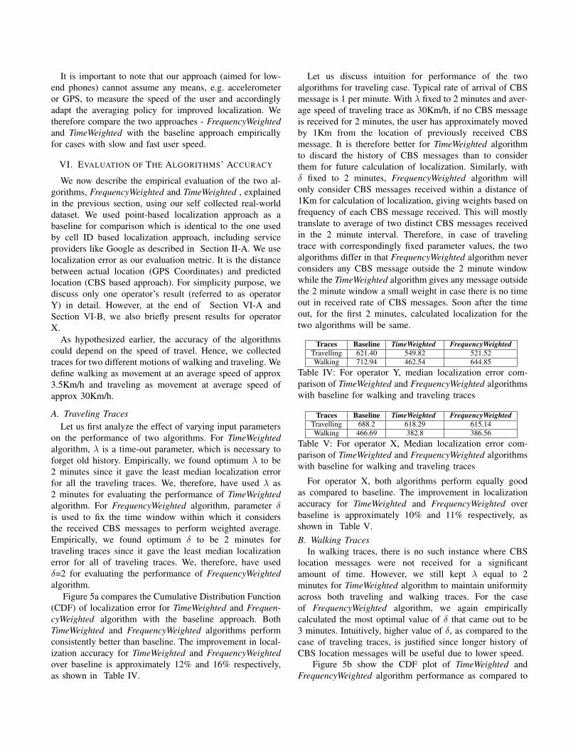
Figure 5a compares the Cumulative Distribution Function(CDF) of localization error for TimeWeighted and Frequen-cyWeighted algorithm with the baseline approach. BothTimeWeighted and FrequencyWeighted algorithms performconsistently better than baseline. The improvement in local-ization accuracy for TimeWeighted and FrequencyWeightedover baseline is approximately 12% and 16% respectively,as shown in Table IV.
Let us discuss intuition for performance of the twoalgorithms for traveling case. Typical rate of arrival of CBSmessage is 1 per minute. With λ fixed to 2 minutes and aver-age speed of traveling trace as 30Km/h, if no CBS messageis received for 2 minutes, the user has approximately movedby 1Km from the location of previously received CBSmessage. It is therefore better for TimeWeighted algorithmto discard the history of CBS messages than to considerthem for future calculation of localization. Similarly, withδ fixed to 2 minutes, FrequencyWeighted algorithm willonly consider CBS messages received within a distance of1Km for calculation of localization, giving weights based onfrequency of each CBS message received. This will mostlytranslate to average of two distinct CBS messages receivedin the 2 minute interval. Therefore, in case of travelingtrace with correspondingly fixed parameter values, the twoalgorithms differ in that FrequencyWeighted algorithm neverconsiders any CBS message outside the 2 minute windowwhile the TimeWeighted algorithm gives any message outsidethe 2 minute window a small weight in case there is no timeout in received rate of CBS messages. Soon after the timeout, for the first 2 minutes, calculated localization for thetwo algorithms will be same.
Traces Baseline TimeWeighted FrequencyWeightedTravelling 621.40 549.82 521.52Walking 712.94 462.54 644.85
Table IV: For operator Y, median localization error com-parison of TimeWeighted and FrequencyWeighted algorithmswith baseline for walking and traveling traces
Traces Baseline TimeWeighted FrequencyWeightedTravelling 688.2 618.29 615.14Walking 466.69 382.8 386.56
Table V: For operator X, Median localization error com-parison of TimeWeighted and FrequencyWeighted algorithmswith baseline for walking and traveling traces
For operator X, both algorithms perform equally goodas compared to baseline. The improvement in localizationaccuracy for TimeWeighted and FrequencyWeighted overbaseline is approximately 10% and 11% respectively, asshown in Table V.B. Walking Traces
In walking traces, there is no such instance where CBSlocation messages were not received for a significantamount of time. However, we still kept λ equal to 2minutes for TimeWeighted algorithm to maintain uniformityacross both traveling and walking traces. For the caseof FrequencyWeighted algorithm, we again empiricallycalculated the most optimal value of δ that came out to be3 minutes. Intuitively, higher value of δ, as compared to thecase of traveling traces, is justified since longer history ofCBS location messages will be useful due to lower speed.
Figure 5b show the CDF plot of TimeWeighted andFrequencyWeighted algorithm performance as compared to
(a) Comparison for traveling traces (b) Comparison for walking tracesFigure 5: CDF plots for TimeWeighted and FrequencyWeighted algorithms w.r.t to Baseline for operator Y
baseline for walking traces. As shown in Table IV, overallTimeWeighted and FrequencyWeighted give an accuracyimprovement of approximately 35% and 10% respectivelyover the baseline approach.
Intuitively, we had hypothesized FrequencyWeightedalgorithm to provide higher localization accuracy thanTimeWeighted algorithm for walking traces (as alsodiscussed in Section V). However, empirical study showedotherwise. Close observation of the collected data revealedthat the walking traces contained a lot of location names,that were farther located, 1200-1500m, from cellphone’sactual location. This noise, particularly, gets added by thegeo-coding service and presence of distant location names,which are among the challenges mentioned in Section IV.Effect of this noise can also be seen in terms of higherpoint-based localization error for walking traces (712.94m)as compared to traveling traces (621.4m).
Although FrequencyWeighted algorithm is hypothesizedto have better accuracy for walking traces but, if the messagecontaining distant location name is repeated within the δtime interval, it will have significant effect on the locationcomputed by FrequencyWeighted algorithm (with fixed δ).On the other hand, for TimeWeighted algorithm, when sucha CBS message with distant landmark name is received mostrecently, the calculated location is inaccurate. However,as the time progresses the weight of the CBS messagewith distant location is reduced, correspondingly resultinginaccuracy is reduced in calculated location as well.
We also conclude that our initial assumption that fast andslow motion patterns would demand different approaches forimproved localization was empirically found incorrect onour collected data. As shown here, TimeWeighted algorithmthat was hypothesized to handle fast motion suffices forslow motion as well since it tolerates the noise added bythe geocoding service for real data. However, we believethat the localization accuracy may vary across differentenvironments. Therefore, an approach that can adapt based
on accurate location input known intermittently from anoracle (in physical world through the GPS coordinates fromintermittently turned on GPS or from a GPS enabled phonein close proximity) will reduce error in localization accuracysignificantly. For operator X, baseline accuracy was gooddue to good quality of landmarks. Improvement in local-ization accuracy for TimeWeighted and FrequencyWeightedover baseline is approximately 18% and 17% respectively,as shown in Table V.C. Impact of Operator Heterogeneity on Accuracy
We observed that different operators provide differentCBS location names as well as with different time inter-val (broadcast cycle). We analyze the impact of operatorheterogeneity on localization accuracy by collecting walkingand traveling traces with two different phones, each having aoperator X and Y. For a fair comparison across two differentoperators, we selected traces which were collected togetherfor Operator X and Y on the same geographic path describedin Table II.
Table VI shows the median localization error for the threedifferent approaches across both the operators. Althoughthe individual errors are different for each operator, weobserve that TimeWeighted algorithm consistently performsbetter for both the operators. This empirically confirms withour finding that TimeWeighted algorithm is able to toleratedifferent broadcast cycles of the operators.
Algorithm Walking TravelingX Y X Y
Baseline 670.71 641.08 530.87 712.94TimeWeighted 577.11 581.38 318.5 462.54
FrequencyWeighted 562.41 529.82 343.07 644.85Table VI: Median localization error comparison of differentalgorithms
VII. MULTIMODAL APPROACHES WITH CBS-BASEDLOCALIZATION
CBS-based approach is a wardriving-free localizationtechnique, that provides an alternative to Cell ID approach.
In this section, we compare accuracy of CBS-based localiza-tion with Cell ID based approach. Cell ID database availabil-ity is variable in different areas because it depends on variousother factors such as network (GPRS/EDGE/HSDPA),operator etc. As shown in Table I, open source Cell IDdatabase such as OpenCellID have very limited coverageacross both the operators, we used Google Cell ID database6
that has a good coverage (˜90% in our dataset) of operatorX’s Cell IDs for 2G network but very limited for operatorY. Therefore, it makes sense to combine CBS and Cell IDbased approaches to improve the overall localization.
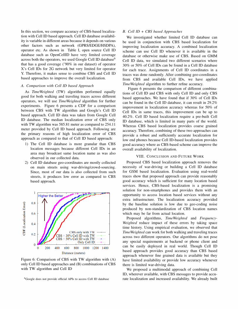
A. Comparison with Cell ID based Approach
As TimeWeighted (TW) algorithm performed equallygood for both walking and traveling traces across differentoperators, we will use TimeWeighted algorithm for furtherexperiments. Figure 6 presents a CDF for a comparisonbetween CBS with TW algorithm and Google’s Cell IDbased approach. Cell ID data was taken from Google CellID database. The median localization error of CBS onlywith TW algorithm was 585.81 meter as compared to 254.11meter provided by Cell ID based approach. Following arethe primary reasons of high localization error of CBSapproach as compared to that of Cell ID based approach:
1) The Cell ID database is more granular than CBSlocation messages because different Cell IDs in anarea may broadcast same location name as was alsoobserved in our collected data.
2) Cell ID database geo-coordinates are mostly collectedon main streets using war-driving/crowd-sourcing.Since, most of our data is also collected from suchstreets, it produces low error as compared to CBSbased approach.
Figure 6: Comparison of CBS with TW algorithm with (A)only Cell ID based approaches and (B) combinations of CBSwith TW algorithm and Cell ID
6Google does not provide official APIs to access Cell ID database
B. Cell ID + CBS based Approaches
We investigated whether limited Cell ID database canbe used in conjunction with CBS based localization forimproving localization accuracy. A combined localizationscheme can use Cell ID whenever it is available in thedatabase or otherwise make use of CBS. Based on GMMCell ID data, we simulated two different scenarios where30% or 50% of Cell IDs can be found in a Cell ID databasefor each trace. Assignments of Cell ID coordinates in atraces was done randomly. After combining geo-coordinatesfrom CBS and available Cell IDs, we have appliedTimeWeighted algorithm to further refine accuracy.
Figure 6 presents the comparison of different combina-tions of Cell ID and CBS with only Cell ID and only CBSbased approaches. We have found that if 30% of Cell IDscan be found in the Cell ID database, it can result in 29.2%improvement in localization accuracy whereas for 50% ofCell IDs in same traces, this improvement can be up to40.2%. Cell ID based localization require a pre-built CellID database, which is limited in many parts of the world.Whereas CBS based localization provides coarse grainedaccuracy. Therefore, combining of these two approaches canprovide a robust and sufficiently accurate localization forlow end phones because Cell ID-based localization providesgood accuracy where as CBS-based scheme can improve theoverall availability of localization.
VIII. CONCLUSION AND FUTURE WORK
Proposed CBS based localization approach removes thenecessity of war-driving or building a Cell ID databasefor GSM based localization. Evaluation using real-worldtraces show that proposed approach can provide reasonablygood accuracy which is sufficient for many location basedservices. Hence, CBS-based localization is a promisingsolution for non-smartphones and provides them with anopportunity to access location based services without anyextra infrastructure. The localization accuracy providedby the baseline solution is low due to geo-coding noiseproduced by non-standardization of CBS location nameswhich may be far from actual location.
Proposed algorithms, TimeWeighted and Frequency-Weighted reduce impact of these errors by taking spacetime history. Using empirical evaluation, we observed thatTimeWeighted can work for both walking and traveling tracesacross two different operators. Our algorithms do not poseany special requirements at backend or phone client andcan be easily deployed in real world. Though Cell IDbased approach provides good accuracy than CBS basedapproach whenever fine grained data is available but theyhave limited availability or provide low accuracy wheneverthere is limited war-driving data.
We proposed a multimodal approach of combining CellID, wherever available, with CBS messages to provide accu-rate localization and increased availability. We already built
some real world applications using CBS based localizationand will provide APIs so that application developers can useit in their applications.
Some of the real world applications, that can be built usingCBS based localization for low cost phones includes:
1) Activity Classification: CBS message reception ratecan be used to do binary activity classification (walk-ing/static and travelling). We observed that numberof CBS messages (location names + advertisements)received per minute is higher than two in walkingwhereas it is lower than two in traveling traces.
2) Location Sharing and Local Search: Most of thepeople in developing countries, like India, do notuse digital maps for navigation and searching localbusinesses [12]. We built a local search application,which estimates current location using CBS locationnames and fetches relevant entries from local businessdatabase in vicinity of current location with a choiseof GPRS/SMS based communication. CBS locationnames can also be used to share location with user’sfriends and across her social networks.
3) Trajectory Matching: Many location aware servicesrequire access to a trajectory (route travelled), whichis built using periodic location samples. Such servicesinclude fleet management, mobile object/asset trackingapplications [19], etc. We have found that combinationof CBS and Cell ID information further combined withstreet map data can result in low cost but accuratetrajectory matching.
In future, we plan to combine CBS based localizationapproach with GPS to reduce energy consumption by peri-odically sampling GPS. Also, we are building a model fromthe collected data to theoretically investigate the optimalityof TimeWeighted approach.
IX. ACKNOWLEDGEMENTS
This work is partially funded by a research grant fromNokia Research Centre and a PhD Fellowship by MicrosoftResearch, India. We would like to thank anonymous review-ers for detailed reviews and helping improving the quality ofthe paper. Finally, we would like to thank all the volunteerswho helped us in collecting data.
REFERENCES
[1] http://cell-broadcast.blogspot.com/2005/11/history-and-importance-of-cell.html
[2] http://www.gsmhelpdesk.nl/en/helpdesk/helpdesk.php?id=57
[3] Mohamed Ibrahim and Moustafa Youssef,A Hidden MarkovModel for Localization Using Low-End GSM Cell Phones,http://arxiv.org/abs/1010.3411.
[4] Jeongyeup Paek, Joongheon Kim, Ramesh Govindan, Energy-Efficient Rate-Adaptive GPS-based Positioning for Smart-phones, MobiSys’10.
[5] GPS and Mobile Handsets. http://www.berginsight.com/ReportPDF/ProductSheet/bi-gps4-ps.pdf.
[6] Constandache, I., Choudhury, R. R., and Rhee, I. 2010.Towards mobile phone localization without war-driving, IEEEInfocomm’2010.
[7] Robert P. Biuk-Aghai, GSM-Based Provider-Independent Po-sitioning Method, Location Asia 2007, Hong Kong, China,13-14 September 2007.
[8] Jain, S., Ghosh, R.K., Shyamsundar, R.K., Engineering loca-tion based pathfinding on Indian road networks over low endmobile phones, Communication Systems and Networks 2010,pp.1-9, Jan 5-9, 2010.
[9] Kuldeep Yadav, Vinayak Naik, Amarjeet Singh, Pushpen-dra Singh, Ponnurangam Kumaraguru, and Umesh Chandra,Challenges and novelties while using mobile phones as ICTdevices for Indian masses: short paper, NSDR’10.
[10] Kuldeep Yadav, Vinayak Naik, Pushpendra Singh, AmarjeetSingh, Alternative localization approach for mobile phoneswithout GPS. In Middleware ’10 Posters and Demos Track.
[11] Kuldeep Yadav, Vinayak Naik, Amarjeet Singh, and Pushpen-dra Singh, Low Energy and Sufficiently Accurate Localizationfor Non-Smartphones, IIIT-D Technical Report (IIITD-TR-2011-009), Nov 2011.
[12] Arun Kumar, Dipanjan Chakraborty, Himanshu Chauhan,Sheetal Agarwal, Nitendra Rajput, FOLKSOMAPS: TowardsCommunity Driven Intelligent Maps for Developing Regions,ICTD 2009.
[13] Yilin Zhao, Mobile phone location determination and itsimpact on intelligent transportation systems,” , IEEE Trans-actions on Intelligent Transportation Systems , vol.1, no.1,pp.55-64, Mar 2000.
[14] Paek, J., Kim, J., and Govindan, R. 2010. Energy-efficientrate-adaptive GPS-based positioning for smartphones. Mo-bisys’10.
[15] Telecom Regulatory Authority of India :http://www.trai.gov.in/WriteReadData/trai/upload/PressReleases/756/pr7sep.pdf
[16] Petteri Nurmi et al, A Grid-Based Algorithm for On-DeviceGSM Positioning, UbiComp 2010.
[17] Mike Y. Chen, Timothy Sohn, Dmitri Chmelev, Dirk Haehnel,Jeffrey Hightower, Jeff Hughes, Anthony LaMarca, Fred Pot-ter, Ian Smith, and Alex Varshavsky, Practical Metropolitan-Scale Positioning for GSM Phones, UbiComp 2006.
[18] Yu-Chung Cheng, Yatin Chawathe, Anthony LaMarca, andJohn Krumm, Accuracy characterization for metropolitan-scale Wi-Fi localization. In Proceedings of MobiSys’05.
[19] Arvind Thiagarajan and Lenin S. Ravindranath and HariBalakrishnan and Samuel Madden and Lewis Girod, Accu-rate, Low-Energy Trajectory Mapping for Mobile Devices,NSDI’11.