linking lowlands among the mountains: the urartian ‘road stations’
TRANSCRIPT
1
Prof. Sergi Makalatia
Gori
Historical-Ethnographical Museum
Studies in
Caucasian Archaeolog y
III
Tbilisi
2017
2
EDITORIAL BOARD:
Dr. Giorgi Mindiashvili
(Editor in Chief)
Georgian National Museum,
Otar Lordkipanidze Centre of
Archaeological Research
Dr. Walter Kuntner
University of Innsbruck
Institut für Alte Geschichte und
Altorientalistik
Dr. Arsen Bobokhyan
Institute of Archaeology and Ethnography
Armenian Academy of Sciences
Yerevan State University,
Dr. Kourosh Roustaei
Iranian Center for Archaeological Research
Dr. Dimitri Narimanishvili
Kldekari Historical-Architechtural
Muzeum-Reserve
Dr. Sandra Heinsch
University of Innsbruck
Institut für Alte Geschichte und
Altorientalistik
Dr. Guram Kvirkvelia
Georgian National Museum,
Otar Lordkipanidze Centre of
Archaeological Research
MA. Thorsten Rabsilber
Deutsches Bergbau Museum,
Ruhr-Universitat Bochum
MA. Giorgi Karelidze
Tbilisi State University
MA. Zviad Sherazadishvili
(Responsible Editor)
Prof. Sergi Makalatia
Gori Historical-Ethngraphical Museum,
Tbilisi State University
Georgian National Museum,
Otar Lordkipanidze Centre of
Archaeological Research
misamarTi. gori, kirion II-is q. 12. Address. 12, Kirion II, Gori.
© prof. sergi makalaTias saxelobis goris istoriul-eTnografiuli muzeumi, 2017 © Prof. Sergi Makalatia Gori Historical-Ethnographical Museum, 2017
ISSN 2233-3517
UDC (უაკ) 902(479)(051.2)
S-90
3
Contents
MEHMET IŞIKLI
AYHAN YARDIMCIEL
Kura-Araxes Pottery from Kars Museum: A Corpus Study ……………………...………… 4
ALEKSANDRE ORJONIKIDZE
Few Aspects of Bedeni Culture Formation ……………………………………………….. 25
ALEKSANDRE ORJONIKIDZE
Eneolthic Signs on Orchosani (Samtskhe) Ceramic ………………………………….…… 37 RENE KUNZE
Living and Working in Late Bronze/Early Iron Age Georgia:
The Settlements of Udabno in Kakheti (Eastern Georgia) and a Contribution to
Metallurgy Based on a Field Survey in the Upper Alazani River Basin ………………….. 54
ROBERTO DAN (ISMEO)
Linking Lowlands Among the Mountains:
The Urartian “Road Stations” ……………………………………………………………... 84
NZHDEH YERANYAN
New Data on Anthropomorphic Stelae from the South-East Caucasus:
Preliminary Reflections ………………………………………………………………….. 113
84
Linking Lowlands among the Mountains:
The Urartian “Road Stations”
ROBERTO DAN (ISMEO)1
ABSTRACT
The main goal of this article is to evaluate the suggestion of Wolfram Kleiss through a detailed
analysis of some isolated Urartian buildings that he interpreted as components of the road
control system. Hitherto only the fortresses of which the main characteristics are known have
been taken into consideration; little is known of the many small fortresses present on the main
communication routes. In particular, Wolfram Kleiss drew attention to certain small-fortified
structures that he considered some kind of ancestors of Islamic caravanserai, which served to
control the roads of the kingdom. These fortified buildings generally share also similar
topographical positions, except for the fortresses that they owned more functions, which were
built on higher hills. These differences in location suggest us that their function, though similar,
might however have been slightly different. With regard to their general shape, these fortresses
can be divided into four main groups. We need to consider the possibility that this sort of road
control system was developed in these regions by the Urartians under the influence of Neo-
Assyrian examples. The existence of similar fortresses, probably built with the same function and
with similar characteristics in different parts of the Urartian kingdom, are a further indication
that Urartu was a centralized state with a complex organization certainly derived in large part
from the adaptation of Neo-Assyrian models, which most probably constituted also the
inspiration for the system of stations of the Achaemenid “Royal Road”.
“There is for this road the following
(information): There are everywhere
royal staging-posts and very fine
inns; the whole road (passes) through
inhabited country and is safe.”
Herodotus, Histories V 52.12
With regard to the success and longevity of a state or an empire a decisive role is
played by the systematic control and management of the road system. The political
system of the kingdom of Urartu was modelled on the adaptation to the complex
geography of the territory. The expansion policy foresaw the gradual annexation of
neighbouring geographic units possessing similar characteristics, both in territorial and
climate terms. Like all aspects of life in the kingdom of Urartu, road management too was
Roberto Dan - Linking Lowlands Among the Mountains: the Urartian ‘Road Stations’, pp. 84-112
deeply influenced by the climate. In fact much of the production system and road network
was seasonal in character because of the long, hard winters that caused the almost
complete cessation of all farming activity and the complete isolation of the cantonal
blocks [Zimansky, 1985].
The conduction of any agricultural activity or transhumance, or indeed the mere
transmission of information between the various regions was impossible for six or seven
months a year, depending on the harshness of winter. The presence of safe and organized
communication routes was therefore necessary for the transport of goods from the
periphery to the administrative core of the kingdom, the plain of Van, as well as to re-
establish political contacts with more distant areas after the long winters and thus ensure
the maintenance of the kingdom and allow progressive territorial expansion.
The main goal of this article is to evaluate the suggestion of Kleiss through a detailed
analysis of some isolated Urartian buildings that he interpreted as components of the road
control system. Hitherto only the fortresses of which the main characteristics are known
have been taken into consideration; little is known of the many small fortresses present
on the main communication routes.
This article is devoted to these little fortresses. Sometimes they are considered by
Kīānī and Kleiss, as in the case of Tepe Dosoq, to be something like prototypes of the
medieval caravanserais3, which were constructed on the level beside roads and were
widespread throughout the Orient starting from the 10th
century CE4. Their main function
was to provide accommodation for travellers, such as official delegations, pilgrims,
messengers and merchants. The general shape of these isolated buildings was square or
rectangular, and they were sometimes fortified with towers and buttresses, with one main
entrance only. The interiors were often set around a central courtyard. As some scholars
have stressed, the development of these peculiar structures can be traced back to
antiquity. In particular, Wolfram Kleiss drew attention to Urartu, and specifically to
certain small-fortified structures that he considered some kind of ancestors of Islamic
caravanserai, which served to control the roads of the kingdom [Kleiss, 1981: 203-205;
Kleiss, 1988b: 187]. We need to consider the association of the Urartian structures with
the Middle Age caravanserais only as a functional comparison. The Urartian structures,
taken into account in this text, need to be considered only as road stations.
Later, Veli Sevin investigated in detail the possible presence of an Urartian road
system controlled by chains of fortresses in Eastern Anatolia [Sevin, 1988b: 547-551;
Sevin, 1989b: 47-56 Sevin, 1991: 97-112]; this was subsequently taken up by other
scholars (Dan, 2012: 56-58). Sevin suggested the possible presence of paved roads and
bridges made during Urartian times [Sevin, 1991: 97-98, figs. 07.1.1, 07.1.2], a
hypothesis that we will discuss in another paper.
Roberto Dan - Linking Lowlands Among the Mountains: the Urartian ‘Road Stations’, pp. 84-112
Oktay Belli has also stressed on several occasions the possible existence of an
Urartian road network in Eastern Anatolia [Belli, 2000b: 409-414; Belli, 2001b: 370-374;
Belli, 2008b: 342-353].
AN ANALYSIS OF THE ROAD STATIONS
The majority of buildings constructed by the Urartians had purely military purposes;
they were built for defence of their extensive territory and were located on the borders of
the kingdom, along all the main roads, in defence of the water reserves and around the
populated areas. The construction of road stations involved the annexation and control of
a territory in a stable manner. Their function was to control the roads and facilitate
connections between these areas and the core of the kingdom.
In the following pages a number of such structures are discussed, with a view to
understanding if they are compatible in shape, size and position with the road stations
referred to above. They will be examined in the broader context of the main roads
through the valleys of Urartu. Overall, we can consider as belonging to this category of
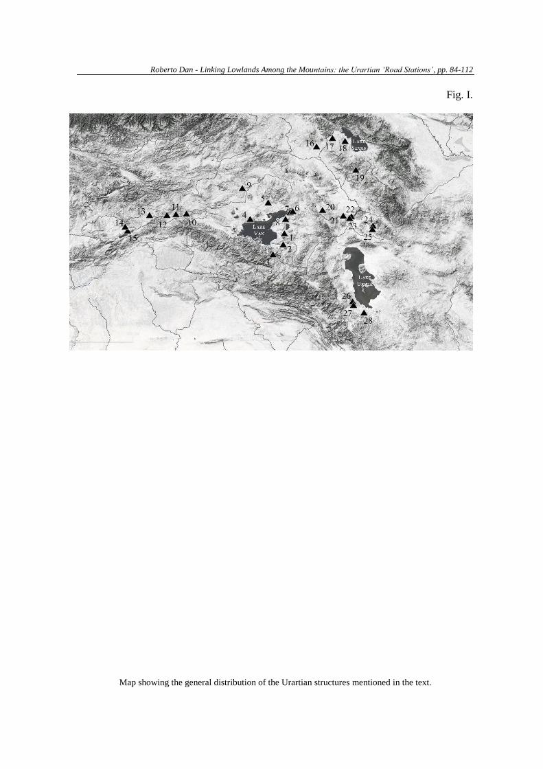
structures a series of small fortifications that have been identified in all parts of the
kingdom (fig. 1). The possible existence of specific Urartian structures which might have
served as road stations is a question which can be approached only from an
archaeological point of view, because to date Urartian texts do not give any kind of
information or contain specific terms that can be connected with such kind of building5.
As said, many small fortresses are known that could have had the function of road
stations. Unfortunately, none of them is sufficiently well documented to permit an
exhaustive investigation of the question. There are, however, twenty-eight archaeological
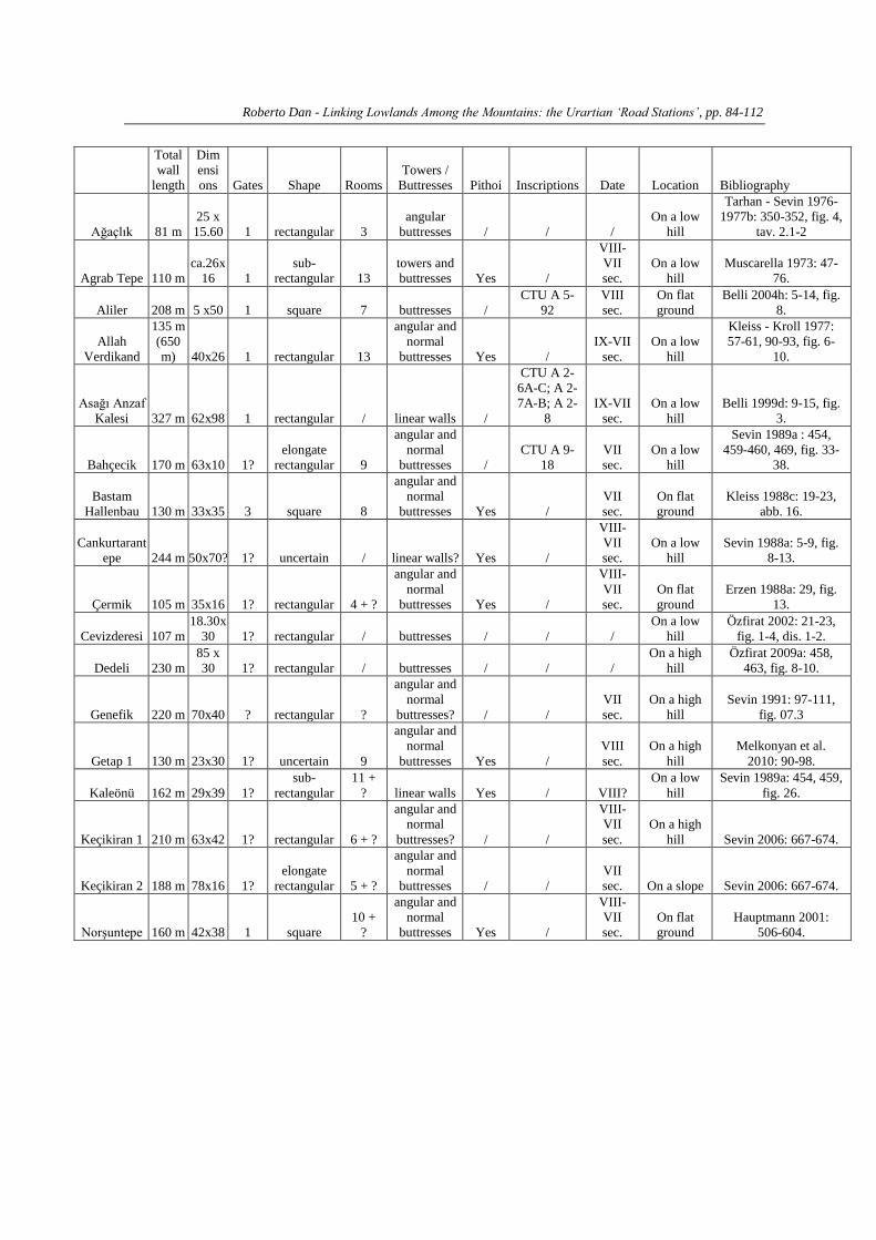
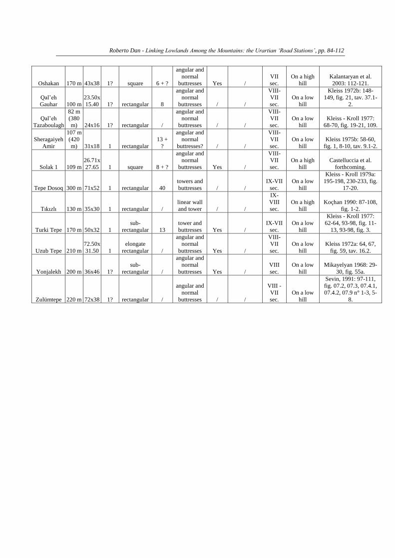
sites containing buildings whose shape and size share common characteristics expected of
a shelter, as we will see below. These sites are: Ağaçlık, Aliler, Aşağı Anzaf Kalesi,
Bahçecik, Cankurtarantepe, Çermik, Cevizderesi, Dedeli, Genefik, Kaleönü, Keçikiran 1,
Keçikiran 2, Norşuntepe (lower structure), Tıkızlı and Zulümtepe in Eastern Anatolia;
Agrab Tepe, Allah Verdikand (the higher fortress), Bastam (Hallenbau), Qal’eh Gauhar,
Qal’eh Tazaboulagh (inner fortress), Sheragaiyeh Amir (inner fortress), Tepe Dosoq,
Turki Tepe and Uzub Tepe in Iranian Azerbaijan; Getap 1, Oshakan (upper fortress),
Solak 1 and Yonjalekh in Armenia (Fig. 1)6. Unfortunately, many other sites are
inconclusive for this question due to the lack of relevant information; others possess
features not compatible with the structures that we consider as possible stations7.
These fortified buildings generally share also similar topographical positions, except
for the fortresses that they owned more functions, which were built on higher hills.
Sixteen of them were constructed on low roadside hills, or on the top or sides of such
hills. Four fortresses were built on a level with the road, while six were built on high
hills. These differences in location suggest us that their function, though similar, might
Roberto Dan - Linking Lowlands Among the Mountains: the Urartian ‘Road Stations’, pp. 84-112
however have been slightly different.
With regard to their general shape, these fortresses can be divided into four main
groups, as will be seen in what follows.
SQUARE FORTRESSES
Five fortresses are almost square in shape: Aliler, Oshakan, Hallenbau (Bastam)8,
Norşuntepe and Solak 1 (Fig. 2); they all share similar features. Their dimensions range
from 54 x 50 metres (Aliler) to 26 x 27 metres (Solak 1). None has been completed
excavated, but partial archaeological investigations were conducted in Oshakan and
Hallenbau, where the topographical situation is different as discussed below, while in
Solak 1 the research is ongoing (Castelluccia et al. forthcoming). Despite the lack of data,
we can affirm that these fortresses show a complex organization of the interior space,
with a number of rooms between 6 and 10 (although the number cannot be definitively
determined in the absence of more detailed investigations). In Hallenbau and Norşuntepe
rooms were identified with rows of pithoi for the storage of foodstuffs, and in Solak 1 and
Oshakan fragmentary remains of pithoi were found, but it is not possible at present to
locate the storage areas inside the fortresses. The Hallenbau structure is the only one that
definitely had stables (west building), but it is very likely that stables were also present in
the others. All the fortresses, apart perhaps Aliler, had curtain walls reinforced with
regularly spaced buttresses and angular buttresses. In Norşuntepe and Solak 1 there was
only a main gate; in Oshakan and Aliler, too, we can hypothesize that there was originally
only one gate, but these have not yet been identified. In the Hallenbau, the original
building had a single entrance and the adjoining western structure containing the stable
had two more gates. Three of these structures were built on flat ground (Norşuntepe,
Aliler and Hallenbau), while two (Oshakan and Solak 1) were built on the top of high
hills, a circumstance that suggests that the latter two fulfilled the dual function of road-
station and road control centre, and probably housed also small garrisons.
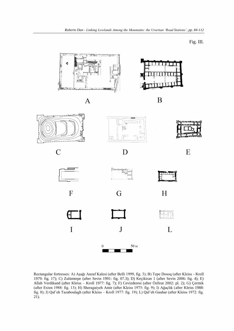
RECTANGULAR FORTRESSES
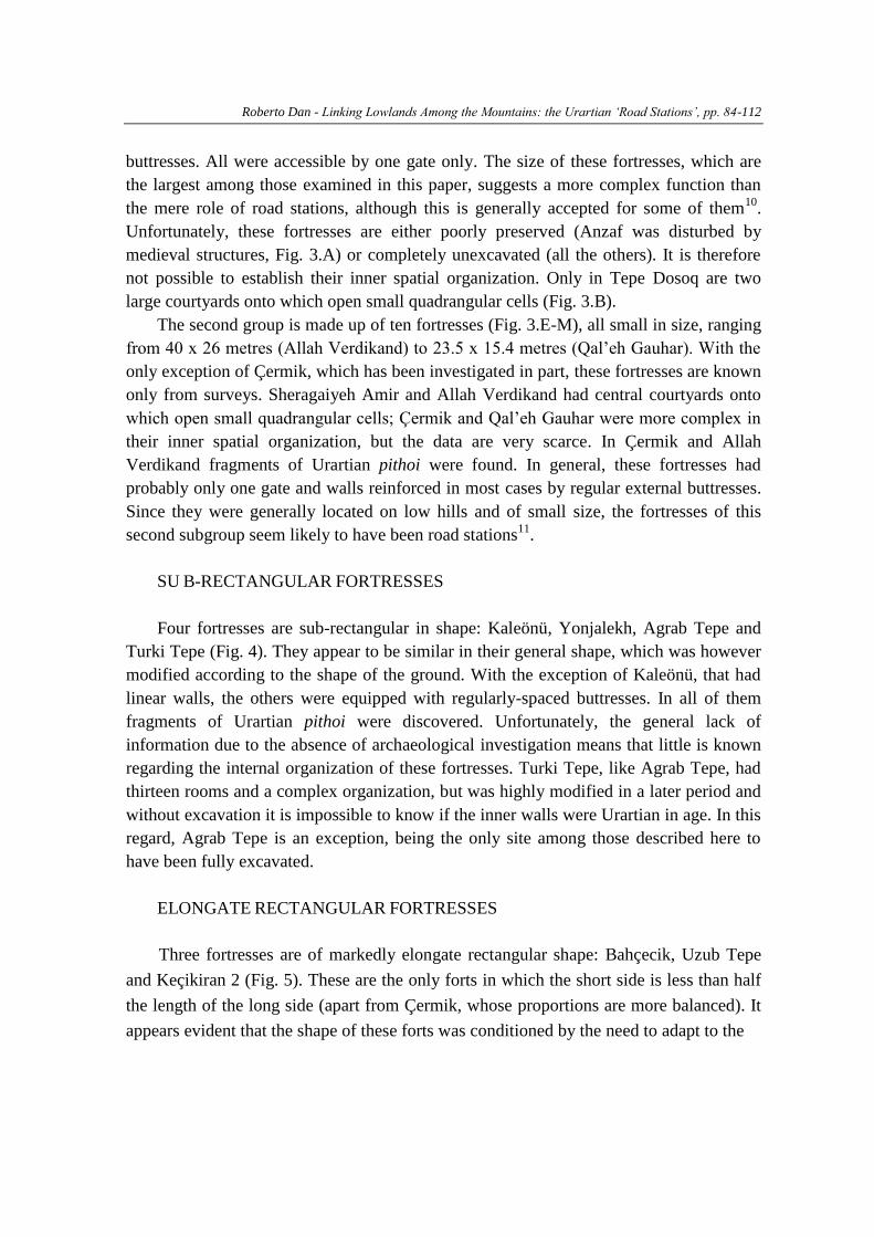
Fourteen fortresses possess a rectangular shape. These are Ağaçlık, Cevizderesi,
Qal’eh Gauhar, Genefik, Qal’eh Tazaboulagh, Sheragaiyeh Amir, Tepe Dosoq,
Zulümtepe, Allah Verdikand, Aşağı Anzaf Kalesi, Keçikiran 1, Dedeli, Tıkızlı and
Çermik (Fig. 3)9. We can divide these fortresses into two subgroups on the basis of their
dimensions. The first comprises the five larger fortresses of Aşağı Anzaf Kalesi, Tepe
Dosoq, Zulümtepe, Keçikiran 1 (Fig. 3.A-D), Dedeli and Genefik, with dimensions
ranging from 68 x 92 m (Anzaf) to 63 x 42 m (Keçikiran 1). These fortresses have linear
walls without reinforcements (Anzaf and Keçikiran 1) or regularly-spaced towers and
Roberto Dan - Linking Lowlands Among the Mountains: the Urartian ‘Road Stations’, pp. 84-112
buttresses. All were accessible by one gate only. The size of these fortresses, which are
the largest among those examined in this paper, suggests a more complex function than
the mere role of road stations, although this is generally accepted for some of them10
.
Unfortunately, these fortresses are either poorly preserved (Anzaf was disturbed by
medieval structures, Fig. 3.A) or completely unexcavated (all the others). It is therefore
not possible to establish their inner spatial organization. Only in Tepe Dosoq are two
large courtyards onto which open small quadrangular cells (Fig. 3.B).
The second group is made up of ten fortresses (Fig. 3.E-M), all small in size, ranging
from 40 x 26 metres (Allah Verdikand) to 23.5 x 15.4 metres (Qal’eh Gauhar). With the
only exception of Çermik, which has been investigated in part, these fortresses are known
only from surveys. Sheragaiyeh Amir and Allah Verdikand had central courtyards onto
which open small quadrangular cells; Çermik and Qal’eh Gauhar were more complex in
their inner spatial organization, but the data are very scarce. In Çermik and Allah
Verdikand fragments of Urartian pithoi were found. In general, these fortresses had
probably only one gate and walls reinforced in most cases by regular external buttresses.
Since they were generally located on low hills and of small size, the fortresses of this
second subgroup seem likely to have been road stations11
.
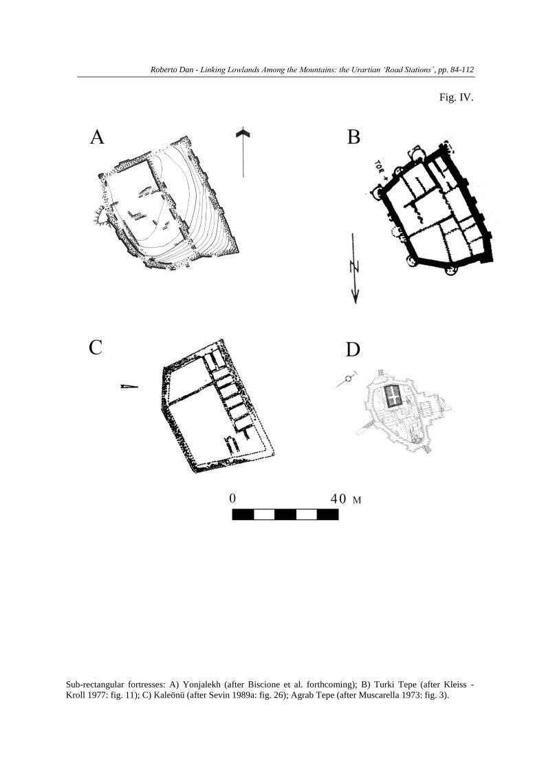
SU B-RECTANGULAR FORTRESSES
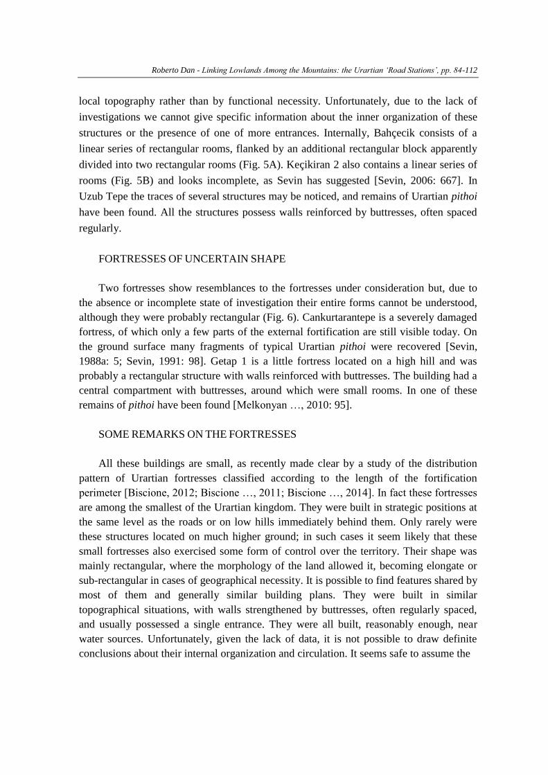
Four fortresses are sub-rectangular in shape: Kaleönü, Yonjalekh, Agrab Tepe and
Turki Tepe (Fig. 4). They appear to be similar in their general shape, which was however
modified according to the shape of the ground. With the exception of Kaleönü, that had
linear walls, the others were equipped with regularly-spaced buttresses. In all of them
fragments of Urartian pithoi were discovered. Unfortunately, the general lack of
information due to the absence of archaeological investigation means that little is known
regarding the internal organization of these fortresses. Turki Tepe, like Agrab Tepe, had
thirteen rooms and a complex organization, but was highly modified in a later period and
without excavation it is impossible to know if the inner walls were Urartian in age. In this
regard, Agrab Tepe is an exception, being the only site among those described here to
have been fully excavated.
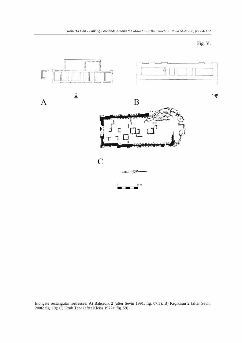
ELONGATE RECTANGULAR FORTRESSES
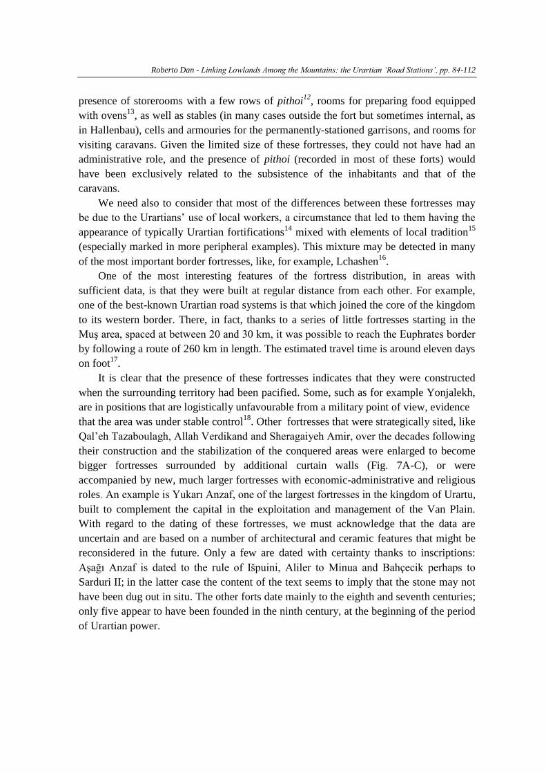
Three fortresses are of markedly elongate rectangular shape: Bahçecik, Uzub Tepe
and Keçikiran 2 (Fig. 5). These are the only forts in which the short side is less than half
the length of the long side (apart from Çermik, whose proportions are more balanced). It
appears evident that the shape of these forts was conditioned by the need to adapt to the
Roberto Dan - Linking Lowlands Among the Mountains: the Urartian ‘Road Stations’, pp. 84-112
local topography rather than by functional necessity. Unfortunately, due to the lack of
investigations we cannot give specific information about the inner organization of these
structures or the presence of one of more entrances. Internally, Bahçecik consists of a
linear series of rectangular rooms, flanked by an additional rectangular block apparently
divided into two rectangular rooms (Fig. 5A). Keçikiran 2 also contains a linear series of
rooms (Fig. 5B) and looks incomplete, as Sevin has suggested [Sevin, 2006: 667]. In
Uzub Tepe the traces of several structures may be noticed, and remains of Urartian pithoi
have been found. All the structures possess walls reinforced by buttresses, often spaced
regularly.
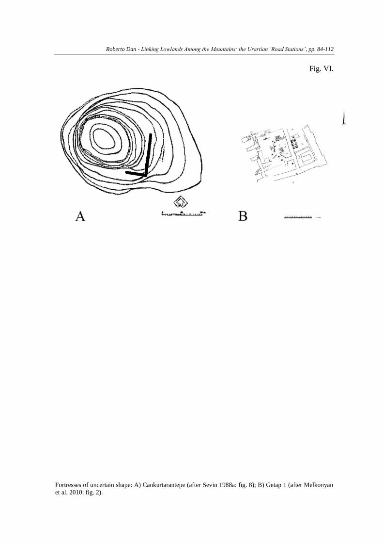
FORTRESSES OF UNCERTAIN SHAPE
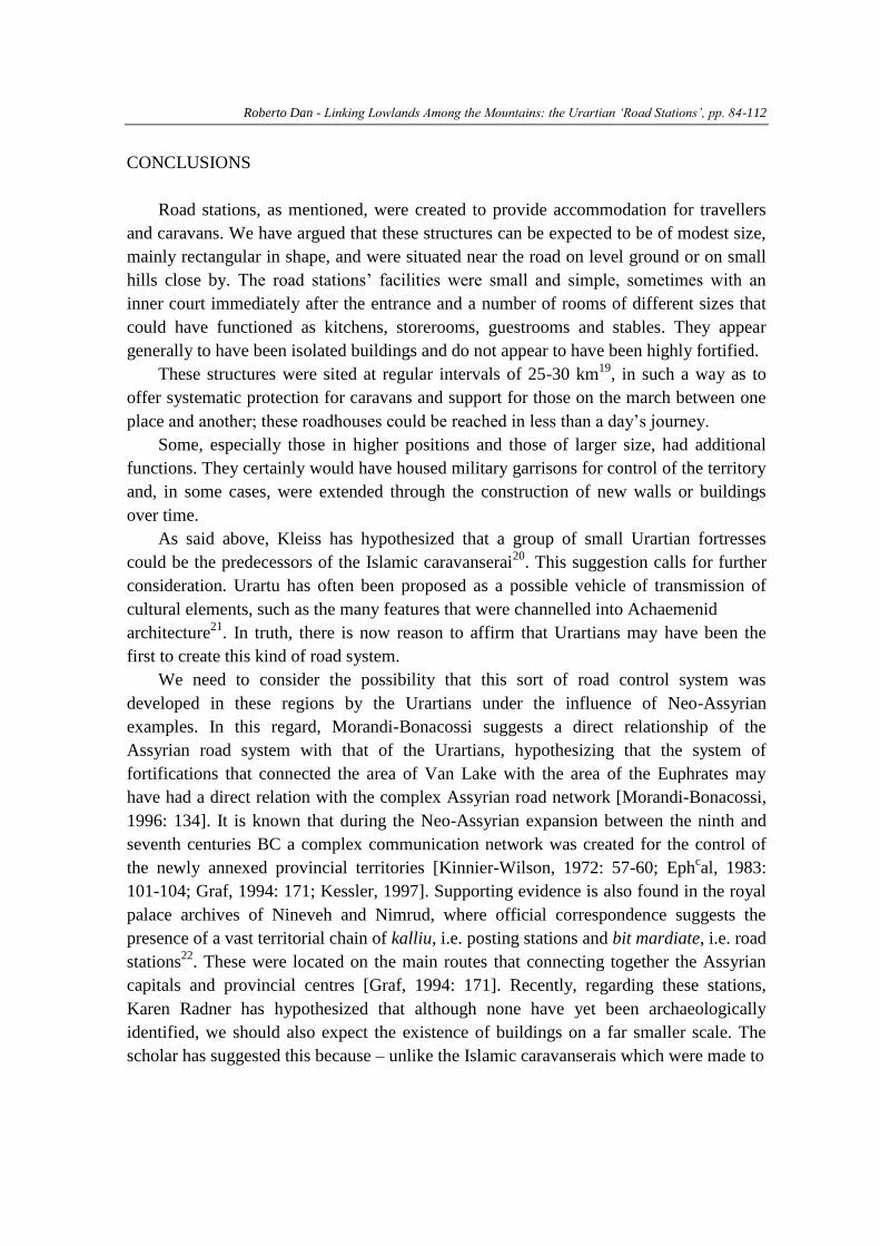
Two fortresses show resemblances to the fortresses under consideration but, due to
the absence or incomplete state of investigation their entire forms cannot be understood,
although they were probably rectangular (Fig. 6). Cankurtarantepe is a severely damaged
fortress, of which only a few parts of the external fortification are still visible today. On
the ground surface many fragments of typical Urartian pithoi were recovered [Sevin,
1988a: 5; Sevin, 1991: 98]. Getap 1 is a little fortress located on a high hill and was
probably a rectangular structure with walls reinforced with buttresses. The building had a
central compartment with buttresses, around which were small rooms. In one of these
remains of pithoi have been found [Melkonyan …, 2010: 95].
SOME REMARKS ON THE FORTRESSES
All these buildings are small, as recently made clear by a study of the distribution
pattern of Urartian fortresses classified according to the length of the fortification
perimeter [Biscione, 2012; Biscione …, 2011; Biscione …, 2014]. In fact these fortresses
are among the smallest of the Urartian kingdom. They were built in strategic positions at
the same level as the roads or on low hills immediately behind them. Only rarely were
these structures located on much higher ground; in such cases it seem likely that these
small fortresses also exercised some form of control over the territory. Their shape was
mainly rectangular, where the morphology of the land allowed it, becoming elongate or
sub-rectangular in cases of geographical necessity. It is possible to find features shared by
most of them and generally similar building plans. They were built in similar
topographical situations, with walls strengthened by buttresses, often regularly spaced,
and usually possessed a single entrance. They were all built, reasonably enough, near
water sources. Unfortunately, given the lack of data, it is not possible to draw definite
conclusions about their internal organization and circulation. It seems safe to assume the
Roberto Dan - Linking Lowlands Among the Mountains: the Urartian ‘Road Stations’, pp. 84-112
presence of storerooms with a few rows of pithoi12
, rooms for preparing food equipped
with ovens13
, as well as stables (in many cases outside the fort but sometimes internal, as
in Hallenbau), cells and armouries for the permanently-stationed garrisons, and rooms for
visiting caravans. Given the limited size of these fortresses, they could not have had an
administrative role, and the presence of pithoi (recorded in most of these forts) would
have been exclusively related to the subsistence of the inhabitants and that of the
caravans.
We need also to consider that most of the differences between these fortresses may
be due to the Urartians’ use of local workers, a circumstance that led to them having the
appearance of typically Urartian fortifications14
mixed with elements of local tradition15
(especially marked in more peripheral examples). This mixture may be detected in many
of the most important border fortresses, like, for example, Lchashen16
.
One of the most interesting features of the fortress distribution, in areas with
sufficient data, is that they were built at regular distance from each other. For example,
one of the best-known Urartian road systems is that which joined the core of the kingdom
to its western border. There, in fact, thanks to a series of little fortresses starting in the
Muş area, spaced at between 20 and 30 km, it was possible to reach the Euphrates border
by following a route of 260 km in length. The estimated travel time is around eleven days
on foot17
.
It is clear that the presence of these fortresses indicates that they were constructed
when the surrounding territory had been pacified. Some, such as for example Yonjalekh,
are in positions that are logistically unfavourable from a military point of view, evidence
that the area was under stable control18
. Other fortresses that were strategically sited, like
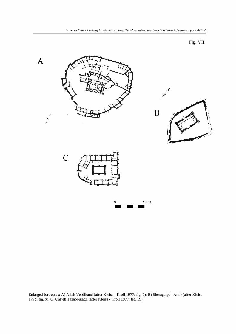
Qal’eh Tazaboulagh, Allah Verdikand and Sheragaiyeh Amir, over the decades following
their construction and the stabilization of the conquered areas were enlarged to become
bigger fortresses surrounded by additional curtain walls (Fig. 7A-C), or were
accompanied by new, much larger fortresses with economic-administrative and religious
roles. An example is Yukarı Anzaf, one of the largest fortresses in the kingdom of Urartu,
built to complement the capital in the exploitation and management of the Van Plain.
With regard to the dating of these fortresses, we must acknowledge that the data are
uncertain and are based on a number of architectural and ceramic features that might be
reconsidered in the future. Only a few are dated with certainty thanks to inscriptions:
Aşağı Anzaf is dated to the rule of Išpuini, Aliler to Minua and Bahçecik perhaps to
Sarduri II; in the latter case the content of the text seems to imply that the stone may not
have been dug out in situ. The other forts date mainly to the eighth and seventh centuries;
only five appear to have been founded in the ninth century, at the beginning of the period
of Urartian power.
Roberto Dan - Linking Lowlands Among the Mountains: the Urartian ‘Road Stations’, pp. 84-112
CONCLUSIONS
Road stations, as mentioned, were created to provide accommodation for travellers
and caravans. We have argued that these structures can be expected to be of modest size,
mainly rectangular in shape, and were situated near the road on level ground or on small
hills close by. The road stations’ facilities were small and simple, sometimes with an
inner court immediately after the entrance and a number of rooms of different sizes that
could have functioned as kitchens, storerooms, guestrooms and stables. They appear
generally to have been isolated buildings and do not appear to have been highly fortified.
These structures were sited at regular intervals of 25-30 km19
, in such a way as to
offer systematic protection for caravans and support for those on the march between one
place and another; these roadhouses could be reached in less than a day’s journey.
Some, especially those in higher positions and those of larger size, had additional
functions. They certainly would have housed military garrisons for control of the territory
and, in some cases, were extended through the construction of new walls or buildings
over time.
As said above, Kleiss has hypothesized that a group of small Urartian fortresses
could be the predecessors of the Islamic caravanserai20
. This suggestion calls for further
consideration. Urartu has often been proposed as a possible vehicle of transmission of
cultural elements, such as the many features that were channelled into Achaemenid
architecture21
. In truth, there is now reason to affirm that Urartians may have been the
first to create this kind of road system.
We need to consider the possibility that this sort of road control system was
developed in these regions by the Urartians under the influence of Neo-Assyrian
examples. In this regard, Morandi-Bonacossi suggests a direct relationship of the
Assyrian road system with that of the Urartians, hypothesizing that the system of
fortifications that connected the area of Van Lake with the area of the Euphrates may
have had a direct relation with the complex Assyrian road network [Morandi-Bonacossi,
1996: 134]. It is known that during the Neo-Assyrian expansion between the ninth and
seventh centuries BC a complex communication network was created for the control of
the newly annexed provincial territories [Kinnier-Wilson, 1972: 57-60; Ephcal, 1983:
101-104; Graf, 1994: 171; Kessler, 1997]. Supporting evidence is also found in the royal
palace archives of Nineveh and Nimrud, where official correspondence suggests the
presence of a vast territorial chain of kalliu, i.e. posting stations and bit mardiate, i.e. road
stations22
. These were located on the main routes that connecting together the Assyrian
capitals and provincial centres [Graf, 1994: 171]. Recently, regarding these stations,
Karen Radner has hypothesized that although none have yet been archaeologically
identified, we should also expect the existence of buildings on a far smaller scale. The
scholar has suggested this because – unlike the Islamic caravanserais which were made to
Roberto Dan - Linking Lowlands Among the Mountains: the Urartian ‘Road Stations’, pp. 84-112
connect remote areas and provide short-term shelter and protection for travellers and their
animals – the Assyrian road stations served only the state and were not open to
commercial travellers [Radner, 2014: 73]. On the basis of their size and general
characteristics Urartian road stations most likely offering assistance to any type of
travellers.
Anyhow, the existence of similar fortresses, probably built with the same function
and with similar characteristics in different part of the Urartian kingdom, are a further
indication that Urartu was a centralized state with a complex organization certainly
derived in large part from the adaptation of Neo-Assyrian models, which most probably
constituted also the inspiration for the system of stations of the Achaemenid “Royal
Road” [Graf, 1994: 172; Briant, 2002: 928].
Roberto Dan - Linking Lowlands Among the Mountains: the Urartian ‘Road Stations’, pp. 84-112
Total
wall
length
Dim
ensi
ons Gates Shape Rooms
Towers /
Buttresses Pithoi Inscriptions Date Location Bibliography
Ağaçlık 81 m
25 x
15.60 1 rectangular 3
angular
buttresses / / /
On a low
hill
Tarhan - Sevin 1976-
1977b: 350-352, fig. 4,
tav. 2.1-2
Agrab Tepe 110 m
ca.26x
16 1
sub-
rectangular 13
towers and
buttresses Yes /
VIII-
VII
sec.
On a low
hill
Muscarella 1973: 47-
76.
Aliler 208 m 5 x50 1 square 7 buttresses /
CTU A 5-
92
VIII
sec.
On flat
ground
Belli 2004h: 5-14, fig.
8.
Allah
Verdikand
135 m
(650
m) 40x26 1 rectangular 13
angular and
normal
buttresses Yes /
IX-VII
sec.
On a low
hill
Kleiss - Kroll 1977:
57-61, 90-93, fig. 6-
10.
Asağı Anzaf
Kalesi 327 m 62x98 1 rectangular / linear walls /
CTU A 2-
6A-C; A 2-
7A-B; A 2-
8
IX-VII
sec.
On a low
hill
Belli 1999d: 9-15, fig.
3.
Bahçecik 170 m 63x10 1?
elongate
rectangular 9
angular and
normal
buttresses /
CTU A 9-
18
VII
sec.
On a low
hill
Sevin 1989a : 454,
459-460, 469, fig. 33-
38.
Bastam
Hallenbau 130 m 33x35 3 square 8
angular and
normal
buttresses Yes /
VII
sec.
On flat
ground
Kleiss 1988c: 19-23,
abb. 16.
Cankurtarant
epe 244 m 50x70? 1? uncertain / linear walls? Yes /
VIII-
VII
sec.
On a low
hill
Sevin 1988a: 5-9, fig.
8-13.
Çermik 105 m 35x16 1? rectangular 4 + ?
angular and
normal
buttresses Yes /
VIII-
VII
sec.
On flat
ground
Erzen 1988a: 29, fig.
13.
Cevizderesi 107 m
18.30x
30 1? rectangular / buttresses / / /
On a low
hill
Özfirat 2002: 21-23,
fig. 1-4, dis. 1-2.
Dedeli 230 m
85 x
30 1? rectangular / buttresses / / /
On a high
hill
Özfirat 2009a: 458,
463, fig. 8-10.
Genefik 220 m 70x40 ? rectangular ?
angular and
normal
buttresses? / /
VII
sec.
On a high
hill
Sevin 1991: 97-111,
fig. 07.3
Getap 1 130 m 23x30 1? uncertain 9
angular and
normal
buttresses Yes /
VIII
sec.
On a high
hill
Melkonyan et al.
2010: 90-98.
Kaleönü 162 m 29x39 1?
sub-
rectangular
11 +
? linear walls Yes / VIII?
On a low
hill
Sevin 1989a: 454, 459,
fig. 26.
Keçikiran 1 210 m 63x42 1? rectangular 6 + ?
angular and
normal
buttresses? / /
VIII-
VII
sec.
On a high
hill Sevin 2006: 667-674.
Keçikiran 2 188 m 78x16 1?
elongate
rectangular 5 + ?
angular and
normal
buttresses / /
VII
sec. On a slope Sevin 2006: 667-674.
Norşuntepe 160 m 42x38 1 square
10 +
?
angular and
normal
buttresses Yes /
VIII-
VII
sec.
On flat
ground
Hauptmann 2001:
506-604.
Roberto Dan - Linking Lowlands Among the Mountains: the Urartian ‘Road Stations’, pp. 84-112
Oshakan 170 m 43x38 1? square 6 + ?
angular and
normal
buttresses Yes /
VII
sec.
On a high
hill
Kalantaryan et al.
2003: 112-121.
Qal’eh
Gauhar 100 m
23.50x
15.40 1? rectangular 8
angular and
normal
buttresses / /
VIII-
VII
sec.
On a low
hill
Kleiss 1972b: 148-
149, fig. 21, tav. 37.1-
2.
Qal’eh
Tazaboulagh
82 m
(380
m) 24x16 1? rectangular /
angular and
normal
buttresses / /
VIII-
VII
sec.
On a low
hill
Kleiss - Kroll 1977:
68-70, fig. 19-21, 109.
Sheragaiyeh
Amir
107 m
(420
m) 31x18 1 rectangular
13 +
?
angular and
normal
buttresses? / /
VIII-
VII
sec.
On a low
hill
Kleiss 1975b: 58-60,
fig. 1, 8-10, tav. 9.1-2.
Solak 1 109 m
26.71x
27.65 1 square 8 + ?
angular and
normal
buttresses Yes /
VIII-
VII
sec.
On a high
hill
Castelluccia et al.
forthcoming.
Tepe Dosoq 300 m 71x52 1 rectangular 40
towers and
buttresses / /
IX-VII
sec.
On a low
hill
Kleiss - Kroll 1979a:
195-198, 230-233, fig.
17-20.
Tıkızlı 130 m 35x30 1 rectangular /
linear wall
and tower / /
IX-
VIII
sec.
On a high
hill
Koçhan 1990: 87-108,
fig. 1-2.
Turki Tepe 170 m 50x32 1
sub-
rectangular 13
tower and
buttresses Yes /
IX-VII
sec.
On a low
hill
Kleiss - Kroll 1977:
62-64, 93-98, fig. 11-
13, 93-98, fig. 3.
Uzub Tepe 210 m
72.50x
31.50 1
elongate
rectangular /
angular and
normal
buttresses Yes /
VIII-
VII
sec.
On a low
hill
Kleiss 1972a: 64, 67,
fig. 59, tav. 16.2.
Yonjalekh 200 m 36x46 1?
sub-
rectangular /
angular and
normal
buttresses Yes /
VIII
sec.
On a low
hill
Mikayelyan 1968: 29-
30, fig. 55a.
Zulümtepe 220 m 72x38 1? rectangular /
angular and
normal
buttresses / /
VIII -
VII
sec.
On a low
hill
Sevin, 1991: 97-111,
fig. 07.2, 07.3, 07.4.1,
07.4.2, 07.9 n° 1-3, 5-
8.
Roberto Dan - Linking Lowlands Among the Mountains: the Urartian ‘Road Stations’, pp. 84-112
NOTES:
1. The author would like to thank Prof. Adriano V. Rossi, Dr. Miqayel Badalyan, Dr.
Tiffany Early-Spadoni and Giorgia Neri for their suggestions and interesting
conversations about the topic of this article.
2. Translation from Greek taken from French 1998: 27.
3. The Persian term kārvān-sarā is a compound word combining kārvān (caravan)
with sarā (palace, building with enclosed courts) (Kīānī – Kleiss 1990: 798).
4. Generally, Kleiss interprets Tepe Dosoq or other small forts as “Station” or
“Wegkastell”. However, always in a military context (Kleiss - Kroll 1979: 195, 198).
We need to consider that the scholar did not intend the caravanserais in the medieval
meaning and that, as architect, his view is more architectural than archaeological.
5. Inscriptions have been found at only three of these sites. None of them are helpful for
understanding the role of these fortresses. The inscriptions of Išpuini discovered in
Aşağı Anzaf CTU are a single foundation inscription of the fortress (CTU A 2-6A-C)
and further texts referring to the construction of generic buildings (CTU A 2-7A-B;
A 2-8). In Aliler a fragmentary column base was discovered on which only the name
of Minua is still legible (CTU A 5-92). The inscription discovered in Bahçecik that
refers to the construction by Sarduri II of a fortress bearing his name, Sarduriḫinili
(CTU A 9-18), clearly came from another site, since the Bahçecik fortress is too
small to be a centre with the administrative and economic characteristics and the susi
temple mentioned in the text.
6. For the general characteristics of these fortresses, please refer to the table at the end
of the article.
7. E.g. the older fortress of Bastam (Kleiss 1988c: 30-31), that is too big to be
considered merely a post station, or Girik Tepe, which shows features more typical
of a little palace than a post station, like the gates and niches with multiple frames
(Balkan 1964: 239-243, fig 2-4). The case of the so-called ‘Nord Gebäude’ of
Bastam is interesting. This building measures 44 x 26 metres and is considered a
residential building with walls reinforced by buttresses, nine interior rooms, two
courtyards and one entrance (Kleiss 1977: 42-43, abb. 31-32; Kleiss 1979b: 26).
Unfortunately, because the building was only partially investigated we cannot be
certain of its function, or its final form. It apparently resembles the structures
discussed in this article.
8. This building is composed of two adjacent structures. The original, eastern part of
Hallenbau was subsequently expanded. The original Hallenbau building measures 23
x 18.2 m, with stepped stone-built foundations and standing walls made of mud brick
which stood on an insulating layer of white lime that overlay a levelling layer of
smaller stones. In this structure pithoi were found (Kroll 1979: 112; Kleiss 1988b:
19-23).
Roberto Dan - Linking Lowlands Among the Mountains: the Urartian ‘Road Stations’, pp. 84-112
9. For Tıkızlı no plans in scale are available, for Genefik only a sketch plan exists
(Köroğlu 1996: 20, fig. 2), while for Dedeli the only known plan is very small
(Özfirat 2009: fig. 10).
10. Tepe Dosoq is considered to be an Urartian station (Kleiss - Kroll 1979: 195),
probably a kind of predecessor of the Islamic caravanserai (Kleiss - Kroll 1979: 198);
it controls the pass between Urmia and Oshnaviyeh (Belgiorno et al. 1984: 172).
Zulümtepe has been described as a way station that would have housed a garrison to
control the caravan route to the west (Sevin 1987: 285).
11. In any case, we cannot exclude that these cells can be younger structures re-using old
fortifications. Unfortunately, most of our information comes from surface surveys
and we cannot exclude post-Urartian occupations.
12. The presence of few pithoi, given also the small dimensions of these structures,
testify the need to store a small amounts of food to satisfy the needs of relatively few
individuals, i.e. who garrisoned permanently the structure and occasional users of the
road stations. It seems evident that these structures depended entirely on other bigger
fortresses and were more likely to the lowest level of hierarchical systems of
fortresses (Biscione 2012; Biscione - Dan 2011; Biscione – Dan 2014).
13. In Çermik, an oven was discovered (Mellink 1972: 176), as also in Getap 1
(Melkonyan et al. 2010: 92).
14. E.g. with walls meeting at right angles, regularly spaced buttresses, stone sockets and
mud-brick upper portions.
15. The use of roughly worked blocks, standing wall made entirely of stone masonry and
structural asymmetries. On this, see Biscione - Parmegiani 2006: 297.
16. The Lchashen fortress shows some points of interest. It is a stronghold of early Iron
Age, but with obvious Urartian construction features, especially around the main
gate, which was rebuilt. The architecture of these modifications is not however
“classical” Urartian; it is therefore possible that these interventions are to be
attributed to a local governor who wanted to imitate contemporary Urartian
structures using local workers. What is certain is that the fortress was in use during
the middle Iron Age, perhaps providing a form of indirect control, with a garrison
stationed there to guarantee the possibility of an intermediate stop between the
recently discovered fortress Solak 1 and that of Berdi Glukh on the shore of Lake
Sevan.
17. On this, see Dan 2012: 56-58 with previous bibliography.
18. The fortress, built in the ancient territory of Uelihuḫi, is located in an area dominated
by a series of hills in a non-strategic position. It has therefore been suggested that the
fort was probably built in the years after 730 BC, i.e. after the campaign of Rusa I
that marked the final pacification of the region (Biscione 2005; Biscione -
Parmegiani 2003: 316).
Roberto Dan - Linking Lowlands Among the Mountains: the Urartian ‘Road Stations’, pp. 84-112
19. This distance between the fortresses is in agreement with Mario Liverani’ s
assumptions used for the reconstruction of the military campaigns of Ashurnasirpal
II, i.e. the possibility of travelling 13.5 km per day on mountain roads, 15 km on hills
and 30 km in lowlands (Liverani 1992: 145).
20. Kemalettin Köroğlu has recently suggested that the Norşuntepe building was a sort
of palace, like the sites of Yoncatepe and Girik Tepe (Köroğlu 2009: 387-389).
However, I see no specific reasons in support of this hypothesis, since the
chronology of the Yoncatepe building has not been established with certainty, while
Girik Tepe, which might for example have been a governor’s residence, has
completely different characteristics from Norşuntepe.
21. On this topic, see Dan 2014.
22. Morandi-Bonacossi expressed doubts about possibility of making a clear functional
differentiation between the two terms on the basis of known data, in particular the
letter ABL 414 (Morandi-Bonacossi 1996: 133).
mTaTa Sorisi dablobTa kavSirebi:
urartuli “gzis sadgurebi”
roberto dan
reziume
ìüïüòòì èTïâïîò èòçïíòï, æåüïäóîò ïíïäòçòì èåSâåëþòT
Såïôïìëì âëäôîïí êäïòìòì èëìïçîåþï îïèæåíòèå òçëäòîåþóäò
óîïîüóäò íïãåþëþòì Såìïõåþ, îëèäåþìïú òãò ãçòì ìïêëíüîëäë
ìòìüåèòì êëèðëíåíüåþïæ èòòCíåâæï. ïáïèæå, ïíïäòçòì ìïãïíì
èõëäëæ òì úòõåìòèïãîååþò ùïîèëïæãåíænen, îëèåäTï èTïâïîò
èïõïìòïTåþäåþòú úíëþòäòï. Tóèúï, ïîú òìå þåâîòï òíôëîèïúòï òè
ðïüïîï úòõåìòèïãîååþòì Såìïõåþ, îëèäåþòú èTïâïî ìïêëèóíòêïúòë
ãçåþçå èæåþïîåëþåí. âëäôîïè êäïòìò ñóîïæRåþïì ãïíìïêóTîåþòT
ïèïõâòäåþæï ãïîêâåóä ìïôëîüòôòêïúòë íïãåþëþåþçå, îëèäåþòú
ìïèåôë ãçåþòì ìïêëíüîëäëæ ãïèëòñåíåþëæï æï romlebsac òì
òìäïèóîò áïîâïìäòì ùòíïèëîþåæåþïæ èòòCíåâæï. îëãëîú ùåìò, ïè
ãïèïãîåþóä íïãåþëþåþì, ìïåîTë üëðëãîïôòóäò ðëçòúòåþò ekavaT,
Tó ïî CïâTâäòT òè úòõåìòèïãîååþì, îëèäåþìïú ìõâï ôóíáúòåþòú
hqondaT æï óôîë SåèïRäåþóä ðëçòúòåþçå Såíæåþëæíåí. èïT
mdebareobebs Sëîòì ãïíìõâïâåþï ãâïôòáîåþòíåþì, îëè
ìïôëîüòôòêïúòë íïãåþëþåþòì ôóíáúòï SåìïZäëï ëæíïâ
ãïíìõâïâåþóäòú êò ñëôòäòñë. èïTò ZòîòTïæò ôëîèòì
ãïTâïäòìùòíåþòT, åì úòõåìòèïãîååþò SåìïZäåþåäòï æïâñëT ëTõ
èTïâïî öãóôïæ. óíæï ãïâòTâïäòìùiíëT òì SåìïZäåþäëþï, îëè ãçòì
ïèæïãâïîò ìïêëíüîëäë ìòìüåèï óîïîüóåäåþèï axal-ïìóîóäò
èïãïäòTåþòì ãïâäåíòì Såæåãïæ ãïíïâòTïîåì. òì ôïáüò, îëè
óîïîüóäò ìïèåôëì ìõâïæïìõâï îåãòëíSò èìãïâìò úòõåìòèïãîååþò
ïîìåþëþì, èòóTòTåþì, îëè óîïîüó ùïîèëïæãåíæï úåíüîïäòçåþóä
ìïõåäèùòôëì îTóäò ëîãïíòçïúòòT, îëèäòì æòæò íïùòäòú axal-
ïìóîóäò èëæåäåþòì ïæïðüïúòòì Såæåãïæ òáíï èòRåþóäò. ïèïâå
èëæåäåþòì ãïâäåíòT óíæï ãïCåíòäòñë ïáåèåíòæóîò “ìïèåôë
ãçåþòì” ìïæãóîTï ìòìüåèïú.
Roberto Dan - Linking Lowlands Among the Mountains: the Urartian ‘Road Stations’, pp. 84-112
BIBLIOGRAPHY:
ABRAMYAN L., BADALYAN R., VARDANYAN L., KALANTARYAN A.A.,
KHARATYAN G. (EDS.)
2003 Pervoprestol’nyj Svyatoj Echmiadzin.
Holy Echmiadzin.
In: Arkheologiya, Etnologiya, i Fol’kloristika Kavkaza, Yerevan. pp. ???
Archaeology, Ethnology and Folklore of Caucasus.
BALKAN K.
1964 Patnos’ta Keşfedilen Urartu Tapınağı ve Urartı Sarayı.
In: Atatürk Konferansları 1, pp. 235-243.
BELGIORNO M. R., BISCIONE R., PECORELLA P. E.
1984 Catalogo degli insediamenti.
In: Pecorella, P. E., Salvini, M., (eds.) Tra lo Zagros e l’Urmia, pp. 141-178.
BELLI O.
1999 The Anzaf Fortresses and the Gods of Urartu, Arkeoloji ve Sanat Yayınları,
İstanbul.
BELLI O.
2000a Türkiye Arkeolojisi ve İstanbul Üniversitesi (1932-1999), İstanbul.
BELLI O.
2000b Doğu Anadolu’da Urartu Yol Şebekesinin Araştırılması.
In: Belli, O. (ed.), Türkiye Arkeolojisi ve İstanbul Üniversitesi (1932-1999), pp.
409-414.
BELLI O.
2001a Istanbul University’s Contributions to Archaeology in Turkey (1932-2000),
Istanbul.
BELLI O.
2001b Survey of the Urartian Road Network in East Anatolia.
In: Belli, O. (ed.), Istanbul University’s Contributions to Archaeology in Turkey
(1932-2000), pp. 370-374.
BELLI O.
2004 An Early Iron Age and Urartian Fortress in the Van Region: Aliler,
In: Studi Micenei ed Egeo-Anatolici 46/1, pp. 5-14.
BELLI O.
2008a Tarih Boyunca Van, İstanbul.
BELLI O.
2008b Van Bölgesi’nin en Eski ve Düzenli Kara Yolları,
In: Belli, O. (ed.), Tarih Boyunca Van, İstanbul, pp. 342-353.
Roberto Dan - Linking Lowlands Among the Mountains: the Urartian ‘Road Stations’, pp. 84-112
BISCIONE R.
2005 La missione archeologica italo-armena nel bacino del Lago Sevan: 1994 - 2003,
In: Macchiarella, G., (ed.), Alpaghian. pp. ???
BISCIONE R.
2012 Urartian Fortification in Iran: An Attempt at a Hierarchical Classification.
In: Kroll, S., Gruber, C., Hellwag, U., Roaf, M., Zimansky, P. (eds.), Biainili-
Urartu, pp. 77-88.
BISCIONE R., DAN R.
2011 Dimensional and geographical distribution of the Urartian fortifications in the
Republic of Armenia.
In: Armenian Journal of Near Eastern Studies/Aramazd VI/2, pp. 104-120.
BISCIONE R., DAN R.
2014 Ranking and Distribution of the Urartian Fortifications in Turkey.
In: Özfırat, A. (ed.), Veli Sevin’e Armağan, pp. 121-136.
BISCIONE R., HMAYAKYAN S., PARMEGIANI N.
Forthcoming, The North-Eastern Frontier. Urartians and non-Urartians in the Sevan
Lake Basin. II, The Western Shores, Documenta Asiana, Rome.
BISCIONE R., PARMEGIANI N.
2003 Armenian-Italian Archaeological Expedition Field Season 2003. 1 - The
Archaeological Survey.
In: Studi Micenei ed Egeo-Anatolici 45/2, pp. 315-318.
BISCIONE R., PARMEGIANI N.
2006 Spedizione archeologica armeno-italiana nel bacino del lago Sevan, campagna
2006.
In: Studi Micenei ed Egeo-Anatolici XLVIII, pp. 295-302.
BRIANT P.
2002 From Cyrus to Alexander. A History of the Persian Empire, Winona Lake, Indiana.
ÇILINGIROĞLU A., FRENCH D.H.
1991 Anatolian Iron Ages. The Proceedings of the Second Anatolian Iron Ages
Colloquium held at İzmir, 4-8 May 1987, British Institute of Archaeology at
Ankara 13, Oxford.
CTU = Salvini 2008.
DAN R.
2012 From Tushpa to Militia. Further considerations on the Westward expansion of the
Kingdom of Urartu.
In: Armenian Journal of Near Eastern Studies/Aramazd VII/2, pp. 54-83.
DAN R.
2014 From Armenian Highland to Iran. A Study on the Relations between the Kingdom
of Urartu and the Achaemenid Empire, Serie Orientale Roma N. S. 4, Roma.
Roberto Dan - Linking Lowlands Among the Mountains: the Urartian ‘Road Stations’, pp. 84-112
DAN R., PETROSYAN A.
forthcoming The Kotayk Survey Project: Preliminary report on 2015 Fieldwork
Activities. In: Annali dell’Università degli Studi di Napoli e l’Orientale.
EPHCAL I.
1983 On Warfare and Military Control in the Ancient Near Eastern Empires: A Research
Outline.
In: Tadmor, H., Weinfeld, M., (eds.), History, Historiography, and Interpretation,
pp. 88-106.
ERKANAL-ÖKTÜ A., ÖZGEN E.
2006 Hayat Erkanal’a Armağan, Kültürlerin Yansıması, İstanbul.
ERZEN, A.
1988 Çavuştepe I, Urartian Architectural Monuments of the 7th
and 6th
Centuries B.C.
and a Necropolis of the Middle Age, Türk Tarih Kurumu, Ankara.
FRENCH D.
1998 Pre-and Early Roman Roads of Asia Minor,
In: Iran, vol. 36, pp. 15-43.
GRAF D.F.
1994 The Persian Royal Road System,
In: Sancisi-Weerdenburg, H., Kurht, A., Cool Root, M. (eds.). Achaemenid History
VIII. Continuity and Change. Proceedings of the last Achaemenid History
Workshop, April 6-8, 1990, Ann Arbor, Michigan, pp. 167-189.
HAUPTMANN H.
1974 Norşun-Tepe Kazısı, 1971
Die Grabungen auf dem Norşuntepe, 1971.
In: ODTU/METU, Keban Projesi 1971, Çalişmaları - Keban Project 1971
Activities (Keban Project Publications I, 4), Ankara, pp. 71-102.
HAUPTMANN H.
2001 Norşuntepe,
In: Reallexikon der Assyriologie und Vorderasiatischen Archäologie 9, pp. 596-
604.
HEJEBRI-NOBARI A.
1997 L’Architecture Militaire Urartéenne, Thèse de Doctorat, Paris.
KALANTARYAN, A.A., MELKONYAN, U.A., ZHAMKOCHYAN, A.S.,
BABAYAN, F.S., PILIPOSYAN, A.S., KANETSYAN, A.G.
2003 Rezul’taty Raskopok 2002 g. v Oshakane. (In Russian).
Results of Excavations in Oshakan 2002.
In: Abramyan, L., Badalyan, R., Vardanyan, L., Kalantaryan, A.A., Kharatyan, G.
(eds.). Arkheologiya, Etnologiya, i Fol’kloristika Kavkaza, pp. 112-121.
Archaeology, Ethnology and Folklore of Caucasus.
Roberto Dan - Linking Lowlands Among the Mountains: the Urartian ‘Road Stations’, pp. 84-112
KIANI M.Y., KLEISS W.
1990 Caravansary.
In: Encyclopaedia Iranica vol. IV.7, pp. 798-802.
KESSLER K.
1997 “Royal roads” and other questions of the Neo-Assyrian communication system.
In: Parpola, S., Whiting, R.M. (eds), Assyria 1995, pp. 129-136.
KINNIER-WILSON J.V.
1972 The Nimrud Wine Lists, London.
KLEISS W.
1970 Ausgrabungen in der Urartäische Festung Bastam (Rusahinili) 1969.
In: Archäologische Mitteilungen aus Iran, band 3, pp. 7-65.
KLEISS W.
1972a Ausgrabungen in der Urartäische Festung Bastam (Rusahinili) 1970.
In: Archäologische Mitteilungen aus Iran, band 5, pp. 7-68.
KLEISS W.
1972b Bericht über Erkundungsfarhen in Iran im Jahre 1971.
In: Archäologische Mitteilungen aus Iran, band 5, pp. 135-242.
KLEISS W.
1975 Planaufnahmen urartäischer Burgen und urartäische Neufunde in Iranisch-
Azerbaidjan im Jahre 1974,
In: Archäologische Mitteilungen aus Iran, band 8, pp. 51-70.
KLEISS W.
1977 Bastam/Rusa-i-URU.TUR. Beschreibung der urartäischen und mittelalterlichen
Ruinen, Deutsches Archäologisches Institute Abteilung Teheran, Führer zu
archäologischen Plätzen in Iran Band 1, Berlin.
KLEISS W.
1979a Bastam I. Ausgrabungen in den Urartäischen Anlagen 1972-1975, Teheraner
Forschungen Band IV, Berlin.
KLEISS W.
1979b Architektur,
In: Kleiss, W. (ed.), Bastam I, pp. 11-98.
KLEISS W.
1981 Zum Stand der Karavanserail-Forschung in Iran 1979.
In: Archäologische Mitteilungen aus Iran, band 14, pp. 203-205.
KLEISS W.
1988a Bastam II. Ausgrabungen in den Urartäischen Anlagen 1977-1978, Teheraner
Forschungen Band V, Berlin.
Roberto Dan - Linking Lowlands Among the Mountains: the Urartian ‘Road Stations’, pp. 84-112
KLEISS W.
1988b Aspekte der Urartäische Architektur
In: Iranica Antiqua, 23, pp. 181-215.
KLEISS W.
1988c Die Architectur,
In: Kleiss, W. (ed.), Bastam II, pp. 13-74.
KLEISS W., KROLL S.
1977 A. Urartäische Plätze in Iran (Kleiss), B. Die Oberflächenfunde des Urartu-Surveys
1976 (Kroll).
In: Archäologische Mitteilungen aus Iran, band 10, pp. 53-118.
KLEISS W., KROLL S.
1979 Vermessene urartäische Plätze in Iran (West-Azerbaidjan) und Neufunde (Stand der
Forschung 1978), A. Architektur, B. Die Oberflächenfunde.
In: Archäologische Mitteilungen aus Iran, band 12, pp. 183-243.
KOÇHAN N.
1990 Malazgirt-Tıkızlı Kalesi.
In: Ege Üniversitesi, Arkeoloji-Sanat Tarihi Dergisi 5, pp. 87-108.
KÖROĞLU K.
1996 Urartu Krallığı Döneminde Elaziğ (Alzi) ve Çevresi, İstanbul. (In Turkish).
KÖROĞLU K.
2009 Urartu dönemi bey konakları. (In Turkish).
In: Sağlamtimur, H., et al. (eds.), Altan Çilingiroğlu’na Armağan, pp. 383-394.
KROLL S.
1979 Grabungsbericht.
In: Kleiss, W., (ed.), Bastam I, pp. 99-113.
KROLL S., GRUBER C., HELLWAG U., ROAF M., ZIMANSKY P.
2012 Biainili-Urartu. The Proceedings of the Symposium Held in Munich 12-14 October
2007, Acta Iranica 51, Leuven.
LIVERANI M.
1992 Studies on the Annals of Asshurnasirpal II. 2: Topographical Analysis, Quaderni di
Geografia Storica, Roma.
MACCHIARELLA, G.
2005 Alpaghian. Raccolta di scritti in onore di Adriano Alpago Novello in occasione del
suo 70mo
compleanno.
MELKONYAN H., KARAPETYAN I., YENGHIBARYAN N.
2010 The Excavations of the Newly Found Urartian Fortress in Getap.
In: Armenian Journal of Near Eastern Studies/Aramazd, vol. 5/2, pp. 90-98.
Roberto Dan - Linking Lowlands Among the Mountains: the Urartian ‘Road Stations’, pp. 84-112
MELLINK M.J.
1972 Archaeology in Asia Minor.
In: American Journal of Archaeology, 76, pp. 165-188.
MIKAYELYAN G. H.
1968 Sevani Avazani Kiklopyan Amrotsnerë (Tsiklopicheskie Kreposti Sevanskogo
Besseyna), Yerevan. (In Armenian, transliteration)
1973 Excavations at Agrab Tepe, Iran.
In: The Metropolitan Museum Journal, 8, pp. 47-76.
MORANDI-BONACOSSI D.
1996 Tra il fiume e la steppa. Insediamento e uso del territorio nella bassa valle del fiume
Ḫābūr in epoca neo-assira, History of the Ancient Near East/Monographs – I,
Padova.
ÖZFIRAT A.
2009 Van Gölü Havzası Yüzey Araştırması: Patnos ovası Demir Çag yerleşimleri. (In
Turkish)
In: Sağlamtimur, H., et al. (eds.), Altan Çilingiroğlu’na Armağan, pp. 455-477.
ÖZFIRAT A.
2014 Veli Sevin’e Armağan. Arkeolojiyle Geçen Bir Yaşam İçin Yazılar - SCRIPTA –
Essays in Honour of Veli Sevin a Life Immersed in Archaeology, İstanbul. (In
Turkish)
PARPOLA, S., WHITING, R.M.
1997 Assyria 1995, Helsinki.
PECORELLA P.E., SALVINI M.
1984 Tra lo Zagros e l’Urmia. Ricerche storiche ed archeologiche nell’Azerbaigian
Iraniano, Incunabula Graeca 78, Roma.
RADNER K.
2014a State Correspondence in the Ancient World. From New Kingdom Egypt to Roman
Empire, NewYork.
2014b An Imperial Communication Network. The State Correspondence of the Neo-
Assyrian Empire.
In: Radner, K. (ed.), State Correspondence in the Ancient World, pp. 64-93.
SAĞLAMTIMUR H., ABAY E., DERIN Z., ERDEM A.Ü., BATMAZ A.,
DEDEOĞLU F.,
ERDALKIRAN M., BAŞTÜRK M.B., KONAKÇI E.
2009 Altan Çilingiroğlu’na Armağan. Yukarı Denizin Kıyısında Urartu Krallığı’na
Adanmış Bir Hayat, Arkeoloji ve Sanat Yayınları, İstanbul. (In Turkish)
SAGONA A.
2004 A View from the Highlands. Archaeological Studies in Honor of Charles Burney,
Ancient Near Eastern Studies 12, Leuven.
Roberto Dan - Linking Lowlands Among the Mountains: the Urartian ‘Road Stations’, pp. 84-112
SALVINI M.
2008 Corpus dei Testi Urartei. Iscrizioni su pietra e roccia, Vol. I-III, Documenta Asiana
VIII, Roma.
SANCISI-WEERDENBURG H., KURHT A., COOL ROOT M., SALVINI M.
1994 Achaemenid History VIII. Continuity and Change. Proceedings of the last
Achaemenid History Workshop, April 6-8, 1990, Ann Arbor, Michigan.
SEVIN V.
1987 Malatya-Elazığ-Bingöl Yüzey Araştırması 1985. (In Turkish)
In: Araştirma Sonuçları Toplantısı 4, 1986, pp. 279-300.
SEVIN V.
1988a Elazığ-Bingöl Yüzey Araştırması, 1986. (In Turkish)
In: Araştirma Sonuçları Toplantısı 5/2, pp. 1-45.
SEVIN V.
1988b The Oldest Highway: between the regions of Van and Elazığ in Eastern Anatolia.
In: Antiquity, 62, pp. 547-551.
SEVIN V.
1989a Elazığ-Bingöl Yüzey Araştırması, 1987. (In Turkish)
In: Araştirma Sonuçları Toplantısı, 6, pp. 451-500.
SEVIN V.
1989b Urartular’a Ait Dünyanın En Eski Karayolu. (In Turkish)
In: Anadolu Araştırmaları, 11, pp. 47-56.
SEVIN V.
1991 The Southwestward Expansion of Urartu: New Observations.
In: Çilingiroğlu, A., French, D.H., (eds.), Anatolian Iron Ages, pp. 97-112.
SEVIN V.
2004 Pastoral Tribes and Early Settlements of the Van Region, Eastern Anatolia.
In: Sagona, A., (ed.), A View from the Highlands, pp. 179-203.
SEVIN V.
2006 Keçıkiran: Van bölgesi’nde yarım kalmış bir Urartu projesi. (In Turkish)
In: Erkanal-Öktü, A., Özgen, E. (eds.), Hayat Erkanal’a Armağan, pp. 667-674.
TADMOR H., WEINFELD M.
1983 History, Historiography, and Interpretation. Studies in Biblical and Cuneiform
Languages, Jerusalem.
TARHAN M.T., SEVIN V.
1976-1977 Van Bölgesinde Urartu Araştırmaları (II). Konut Mimarlığı. (In Turkish)
In: Anadolu Araştırmaları, 4-5, pp. 347-361.
ZIMANSKY P.E.
1985 Ecology and Empire: The Structure of the Urartian State, Chicago.
Roberto Dan - Linking Lowlands Among the Mountains: the Urartian ‘Road Stations’, pp. 84-112
Fig. I.
Map showing the general distribution of the Urartian structures mentioned in the text.
Roberto Dan - Linking Lowlands Among the Mountains: the Urartian ‘Road Stations’, pp. 84-112
Fig. II.
Square fortresses: A) Aliler (after Belli 2004: fig. 8); B) Oshakan (after Kalantaryan et al. 2003: 117); C)
Norşuntepe (after Hauptmann 1974: 83); D) Hallenbau (after Kleiss 1988c: abb. 16); E) Solak 1 (after
Castelluccia et al. forthcoming).
Roberto Dan - Linking Lowlands Among the Mountains: the Urartian ‘Road Stations’, pp. 84-112
Fig. III.
Rectangular fortresses: A) Aşağı Anzaf Kalesi (after Belli 1999, fig. 3); B) Tepe Dosoq (after Kleiss - Kroll
1979: fig. 17); C) Zulümtepe (after Sevin 1991: fig. 07.3); D) Keçikiran 1 (after Sevin 2006: fig. 4); E)
Allah Verdikand (after Kleiss – Kroll 1977: fig. 7); F) Cevizderesi (after Özfirat 2002: pl. 2); G) Çermik
(after Erzen 1988: fig. 13); H) Sheragaiyeh Amir (after Kleiss 1975: fig. 9); I) Ağaçlık (after Kleiss 1988:
fig. 8); J) Qal’eh Tazaboulagh (after Kleiss – Kroll 1977: fig. 19); L) Qal’eh Gauhar (after Kleiss 1972: fig.
21).
Roberto Dan - Linking Lowlands Among the Mountains: the Urartian ‘Road Stations’, pp. 84-112
Fig. IV.
Sub-rectangular fortresses: A) Yonjalekh (after Biscione et al. forthcoming); B) Turki Tepe (after Kleiss -
Kroll 1977: fig. 11); C) Kaleönü (after Sevin 1989a: fig. 26); Agrab Tepe (after Muscarella 1973: fig. 3).
Roberto Dan - Linking Lowlands Among the Mountains: the Urartian ‘Road Stations’, pp. 84-112
Fig. V.
Elongate rectangular fortresses: A) Bahçecik 2 (after Sevin 1991: fig. 07.5); B) Keçikiran 2 (after Sevin
2006: fig. 19); C) Uzub Tepe (after Kleiss 1972a: fig. 59).
Roberto Dan - Linking Lowlands Among the Mountains: the Urartian ‘Road Stations’, pp. 84-112
Fig. VI.
Fortresses of uncertain shape: A) Cankurtarantepe (after Sevin 1988a: fig. 8); B) Getap 1 (after Melkonyan
et al. 2010: fig. 2).
Roberto Dan - Linking Lowlands Among the Mountains: the Urartian ‘Road Stations’, pp. 84-112
Fig. VII.
Enlarged fortresses: A) Allah Verdikand (after Kleiss - Kroll 1977: fig. 7); B) Sheragaiyeh Amir (after Kleiss
1975: fig. 9); C) Qal’eh Tazaboulagh (after Kleiss - Kroll 1977: fig. 19).
Guide for Authors:
The Journal accepts researches, field reports, critiques, reviews, discussions about
metallurgy, funeral rituals, architecture, weapon and armory, experimental, landscape,
social archaeology, trade relations and etc. of the Caucasus and its neighboring countries.
The papers should concern from Paleolithic to Medieval period.
The authors are obliged to respect the style of citation in the journal.
Submitted papers will be sent to the experts for peer review.
In accordance with international standards of ethics, the names of experts are
confidential.
The paper will be published only if it receives a positive assessment of experts.
The author is authorized to request to see the reviews.
The Editorial Board is authorized, if it is considered necessary, to return paper to the
subsequent processing without revising by reviewers.
The Editorial Board is authorized, if it considered necessary, to cancel the paper
publishing without revising by reviewers.
After the consideration of Editorial Board's remarks, the article will be given to
reviewers.
The author is obliged to revise the article according to the request of the Editorial
Board or experts, otherwise the paper will not be published or will not be sent to the
experts.
Sending the paper to the author to revise doesn't mean that the article is accepted to
be published.
The already revised paper will be again discused by Edditorial Board.
The Editorial Board reserves the right to remove already published article from the
electronic version of the journal if it turns out that by the publication of this material
copyrights and/or other generally accepted norms of scientific ethics have been violated.
The Editorial Board will notify about this fact the author and the organization where this
work has been performed.
If the author will not revise remarks made by the Editorial Board and the reviewers in
proposed period, the Editorial Board is authorized not to publish the article.
Position of the author of the article may not necessarily reflect the views of the
Editorial Board.
Authors and reviewers have a moral and ethical responsibility for the scientific
quality and content of publications.
The Editorial Board of the journal Studies in Caucasian Archaeology thanks the
authors for cooperation.
Article Requirements:
1. Article should be given in electronic version.
2. Article should have:
a) Cover, on which will be written: Name and surname of the author (it should be written
on the right upper corner, font 10, line spacing 1)
b) Working place, position/post, university, academic degree/education level (for Ph. D.
candidates) (it should be written on the right upper corner, font 10, line spacing 1)
c) Author contact coordinates (e-mail, it should be written on the right upper corner, font
10, line spacing 1)
3. Article size: Microsoft Word Document A4 format paper 50 (maximum) pages (text,
summary, bibliography, description of the figures and plates, figures, plates)
4. Article on Microsoft Word Document A4 format paper should be signed:
a) Title in the center (print bold, font 12)
b) Text print Times New Roman, font size 11, line spacing 1. 2 cm. borders on each side
c) Summary, Print Times New Roman, font size 10, line spacing 1. Microsoft Word
Document A4 format 1 paper, which will be translated in Georgian.
d) Bibliography, print Times New Roman, font size 11, line spacing 1.
5. References in the text:
a) In square brackets should be given surname of the author, comma, publishing year,
colon and page number: e.g. Picchelauri Konstantin „Waffen der Bronzezeit aus Ost-
Georgien“. Berlin, 1995. p. 121, pl. 70/2 will be as [Picchelauri, 1995: 121, pl. 70/2].
b) If the book has two or more authors, in square brackets should be written the name of
the first author, than et. al., publishing year, colon and page number. e.g. Nikolaishvili
V., Sikharulidze A., Inanishvili G., Iremashvli Sh. „A Fighting Parade Bronze Axe
from Natakhtari“. In Archaeology, Ethnology and Folkloristic of Caucasus. Tbilisi 2010
should be [Nikolaishvili et al. 2010: 230].
c) If the author has two or more books and papers in the same year, after surname of the
author should be written A, B and etc. e.g. [Picchelauri A, 1995: 121, pl. 70/2].
d) Notes: After the sentence, if it is necessary to write some additional ideas, which
usually are placed in the footnotes, the author has to make numbered list of notes after the
main text.
6. Figures in the text:
Figure frame: 210 mm x 297 mm.
Images should be provided at 600 DPI resolutions.
a) For the Figures: the number of the figure should be given in the rounded brackets (Fig.
XV).
If it has several numbered images, the sub number should be given also. e.g. (Fig. XV/2)
b) The description of the figures should be given separately.
7. List of the bibliography at the end of the article:
a) List of used literature should be sorted in alphabetical order.
b) For books/monographs: authors' surname and initials date of publication, title of the
book/monograph, place of publication.
e.g. Reference to a book or monograph:
PICCHELAURI K.
1995 Waffen der Bronzezeit aus Ost-Georgien. Berlin.
d) For Journal articles: authors' surname and initials, date of publication, title of article,
full title of the journal (italic), volume number (italic), issue (italic), page numbers
(italic).
e) Examples:
e.g. Reference to a journal article:
SANDARS N. K.
1961 The First Aegean Swords and Their Ancestry.
American Journal of Archaeology, Vol. 65, No. 1, pp. 17-29.
f) For English, German, French or Italian literature the titles will be left in original
language. For Georgian, Armenian, Azerbaijani, Turkish and Russian or other languages
the titles will be transliterated and translated in English.
e.g. GOGADZE E.
1972 Periodization and Genesis of Trialeti Kurgan Culture. Tbilisi. (In Georgian).
Trialetis korghanuli kulturis periodizatsia da genezisi.
e.g. KUFTIN B. A.
1941 Archaeological Excavations in Trialeti. (In Russian).
Arkheologicheskie raskopki v Trialeti.
8. Please, send electronic versions of papers to