leaders in building certification services
TRANSCRIPT
www.gmacert.com.au BUILDING APPROVALS & INSPECTIONS BUILDING CERTIFICATION FIRE SAFETY AUDITS Page 1 of 15
PLANNING STATEMENT For: Peter Gonsalves & Sofia Goncalves Development: Multiple Dwelling At: Lot 28, 21 Macrossan Street, Port Douglas (Lot 28 on SP150459) Prepared by: GMA Certification Group File Ref: 20212929 Revision: A
Leaders in
Building Certification Services
www.gmacert.com.au
www.gmacert.com.au BUILDING APPROVALS & INSPECTIONS BUILDING CERTIFICATION FIRE SAFETY AUDITS
Table of Contents Introduction ............................................................................................................................... 3
Development Summary ............................................................................................................ 4
Site and Locality ....................................................................................................................... 6
Proposal ................................................................................................................................... 7
Statutory Planning Considerations ............................................................................................ 8
5.1 Planning Act 2016 ...................................................................................................................... 8
5.1.1 Categorisation of Development ............................................................................................................. 8
5.1.2 Assessment Manager ............................................................................................................................. 8
5.1.3 Level of Assessment ............................................................................................................................... 8
5.1.4 Statutory Considerations for Assessable Development ......................................................................... 8
5.1.5 State Planning Policy .............................................................................................................................. 9
5.1.6 Regional Plan .......................................................................................................................................... 9
5.1.7 Referral Agencies ................................................................................................................................... 9
5.1.8 State Development Assessment Provisions ........................................................................................... 9
Local Planning Considerations ............................................................................................... 10
6.1 Douglas Shire Council Planning Scheme ................................................................................. 10
6.1.1 Statement of Compliance ...................................................................................................... 11
Summary and Conclusion ....................................................................................................... 12
Appendix 1. ....................................................................................................................................... 13
Appendix 2. ....................................................................................................................................... 14
PLANNING STATEMENT : Lot 28, 21 Macrossan Street, Port Douglas (Multiple Dwelling)
www.gmacert.com.au BUILDING APPROVALS & INSPECTIONS BUILDING CERTIFICATION FIRE SAFETY AUDITS Page 3 of 15
Introduction
This report has been prepared on behalf of Peter Gonsalves and Sofia Goncalves in
support of a Development Application to Douglas Shire Council for a Development
Permit for Material Change of Use for the purpose of a Multiple Dwelling unit on land
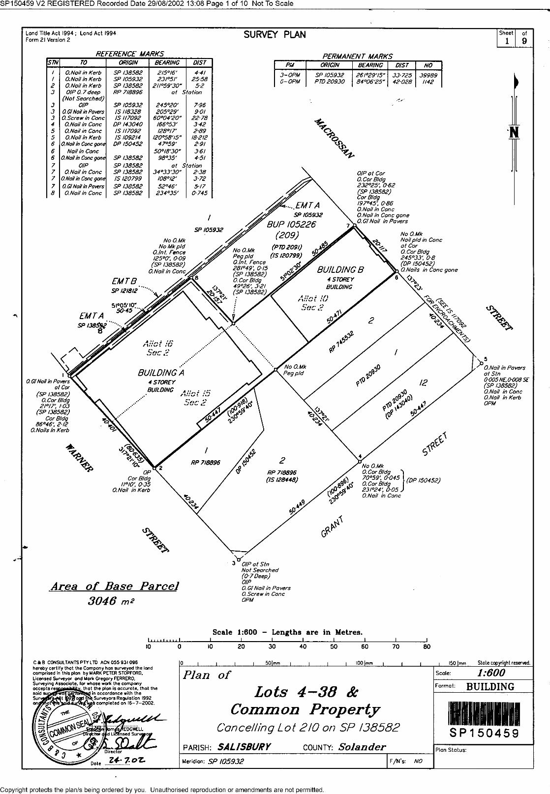
located at lot 28, 21 Macrossan Street, Port Douglas and described as Lot 28 on
SP150459.
The application relates to one self-contained Multiple Dwelling (Tourist) apartment that
forms part of the Mantra Heritage complex located at 21 Macrossan Street, Port
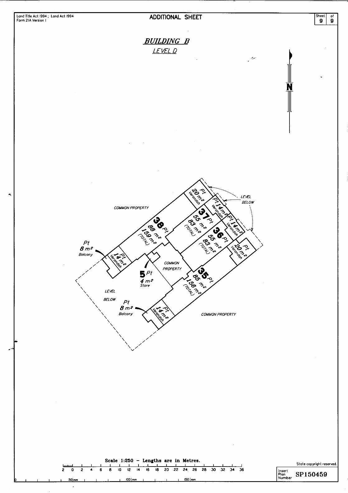
Douglas. The specific apartment is Lot 28, which contains a total floor area of 89m2.
The subject premises includes a single car parking space, located within the overall
development, and which forms part of the title.
The overall site comprises residential apartments, which were approved under the
1996 Douglas Shire Planning Scheme for Multiple Dwelling (Tourist) units, retail units
and communal recreation areas. The tourist use approval prevents the use of the
premises for lawful permanent accommodation.
It is proposed to undertake a Material Change of Use of premises from self-contained
Multiple Dwelling (Tourist) Unit to Multiple Dwelling Unit to provide for permanent
and/or tourist accommodation.
The application is identified as being Code Assessable and consideration can only be
given to the Assessment Benchmarks contained within the Planning Scheme. The
proposed development is considered to be consistent with the Assessment
Benchmarks and is considered to be a suitable use of the premises.
The application is submitted for approval, subject to reasonable and relevant
conditions.
PLANNING STATEMENT : Lot 28, 21 Macrossan Street, Port Douglas (Multiple Dwelling)
www.gmacert.com.au BUILDING APPROVALS & INSPECTIONS BUILDING CERTIFICATION FIRE SAFETY AUDITS Page 4 of 15
Development Summary
Address: Lot 28, 21 Macrossan Street, Port Douglas
Real Property Description: Lot 28 on SP150459
Easements & Encumbrances: nil
Site Area: 89m2
Registered Owner: Peter Christopher Gonsalves and Sofia
Ferreira Quaresma Goncalves
Proposal: Multiple Dwelling unit
Approval Sought: Development Permit
Level of Assessment: Code Assessment
State Interests – State Planning Policy • Safety and Resilience to Hazards
o Flood Hazard area – Level 1-
Queensland floodplain;
o Erosion Prone Area;
o Medium Storm Tide Inundation
Area, in part; and,
o High Storm Tide Inundation
Area, in part.
State Interests – SARA Mapping: • Coastal Protection
o Erosion Prone Area;
o Medium Storm Tide Inundation
Area; and,
o High Storm Tide Inundation
Area;
• Native Vegetation Clearing –
Category X on the regulated
vegetation management map.
Referral Agencies: Nil
State Development Assessment
Provisions:
Not applicable
Regional Plan Designation: Urban Footprint
Zone: Centre Zone
Local Plan Designation: Port Douglas – Craiglie, Precinct 1 – 1a
Town Centre
PLANNING STATEMENT : Lot 28, 21 Macrossan Street, Port Douglas (Multiple Dwelling)
www.gmacert.com.au BUILDING APPROVALS & INSPECTIONS BUILDING CERTIFICATION FIRE SAFETY AUDITS Page 5 of 15
Overlays: • Acid Sulfate Soils Overlay
o Acid Sulfate Soils 5-20m AHD, in
part;
o Acid Sulfate Soils <5m AHD, in
part;
• Coastal Environment Overlay –
Erosion Prone Area;
• Flood and Storm Tide Hazard
Overlay, in part
o Medium Storm Tide Hazard,
in part;
o High Storm Tide Hazard, in
part;
o 100 Year ARI – Mossman
and Port Douglas Flood
Studies.
PLANNING STATEMENT : Lot 28, 21 Macrossan Street, Port Douglas (Multiple Dwelling)
www.gmacert.com.au BUILDING APPROVALS & INSPECTIONS BUILDING CERTIFICATION FIRE SAFETY AUDITS Page 6 of 15
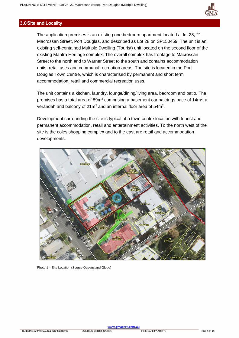
Site and Locality
The application premises is an existing one bedroom apartment located at lot 28, 21
Macrossan Street, Port Douglas, and described as Lot 28 on SP150459. The unit is an
existing self-contained Multiple Dwelling (Tourist) unit located on the second floor of the
existing Mantra Heritage complex. The overall complex has frontage to Macrossan
Street to the north and to Warner Street to the south and contains accommodation
units, retail uses and communal recreation areas. The site is located in the Port
Douglas Town Centre, which is characterised by permanent and short term
accommodation, retail and commercial recreation uses.
The unit contains a kitchen, laundry, lounge/dining/living area, bedroom and patio. The
premises has a total area of 89m2 comprising a basement car pakrings pace of 14m2, a
verandah and balcony of 21m2 and an internal floor area of 54m2.
Development surrounding the site is typical of a town centre location with tourist and
permanent accommodation, retail and entertainment activities. To the north west of the
site is the coles shopping complex and to the east are retail and accommodation
developments.
Photo 1 – Site Location (Source Queensland Globe)
PLANNING STATEMENT : Lot 28, 21 Macrossan Street, Port Douglas (Multiple Dwelling)
www.gmacert.com.au BUILDING APPROVALS & INSPECTIONS BUILDING CERTIFICATION FIRE SAFETY AUDITS Page 7 of 15
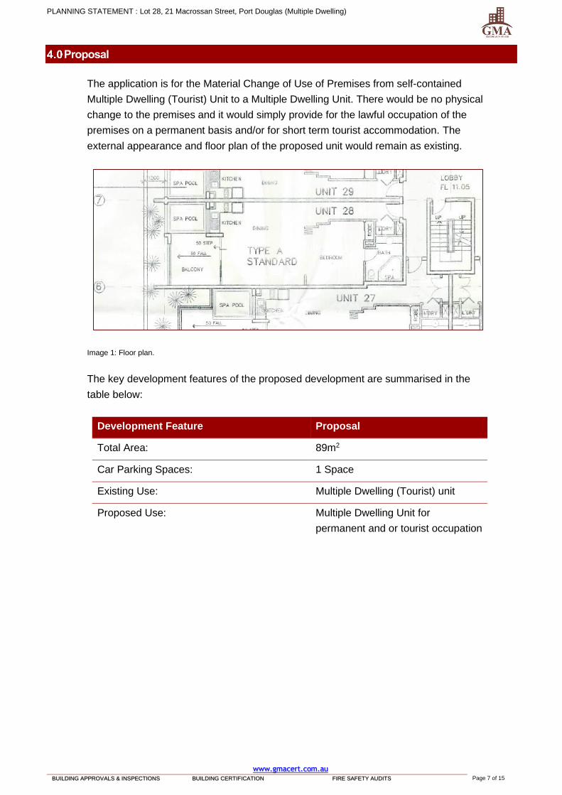
Proposal
The application is for the Material Change of Use of Premises from self-contained
Multiple Dwelling (Tourist) Unit to a Multiple Dwelling Unit. There would be no physical
change to the premises and it would simply provide for the lawful occupation of the
premises on a permanent basis and/or for short term tourist accommodation. The
external appearance and floor plan of the proposed unit would remain as existing.
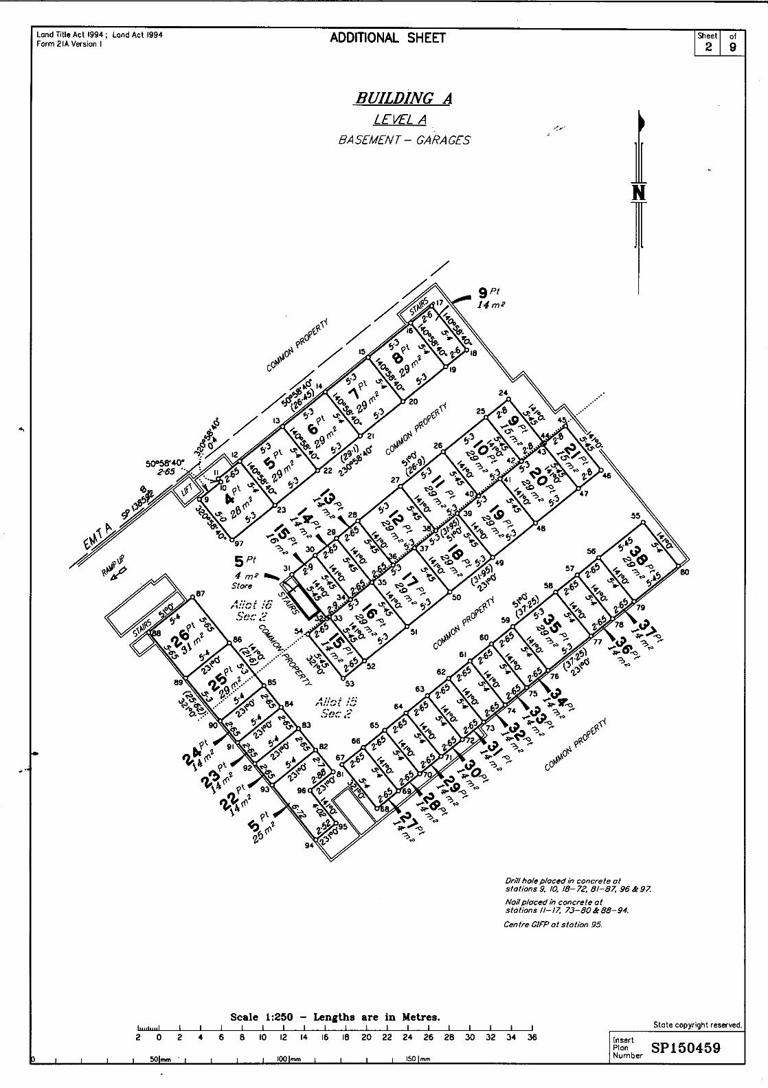
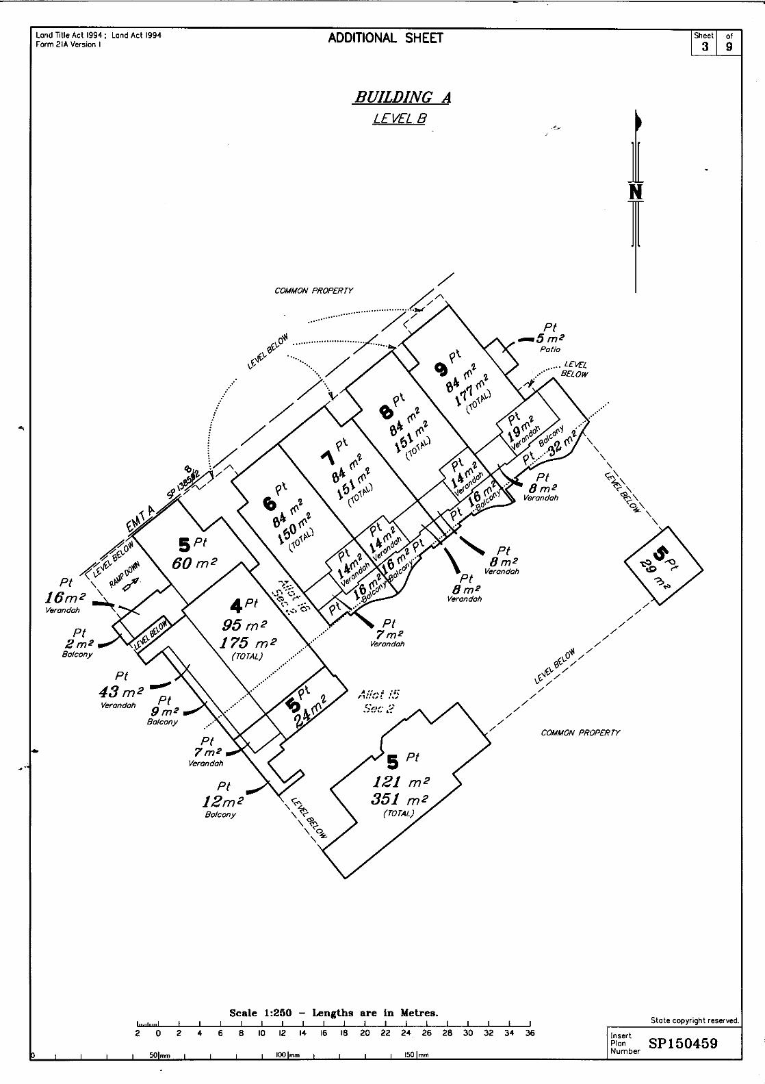
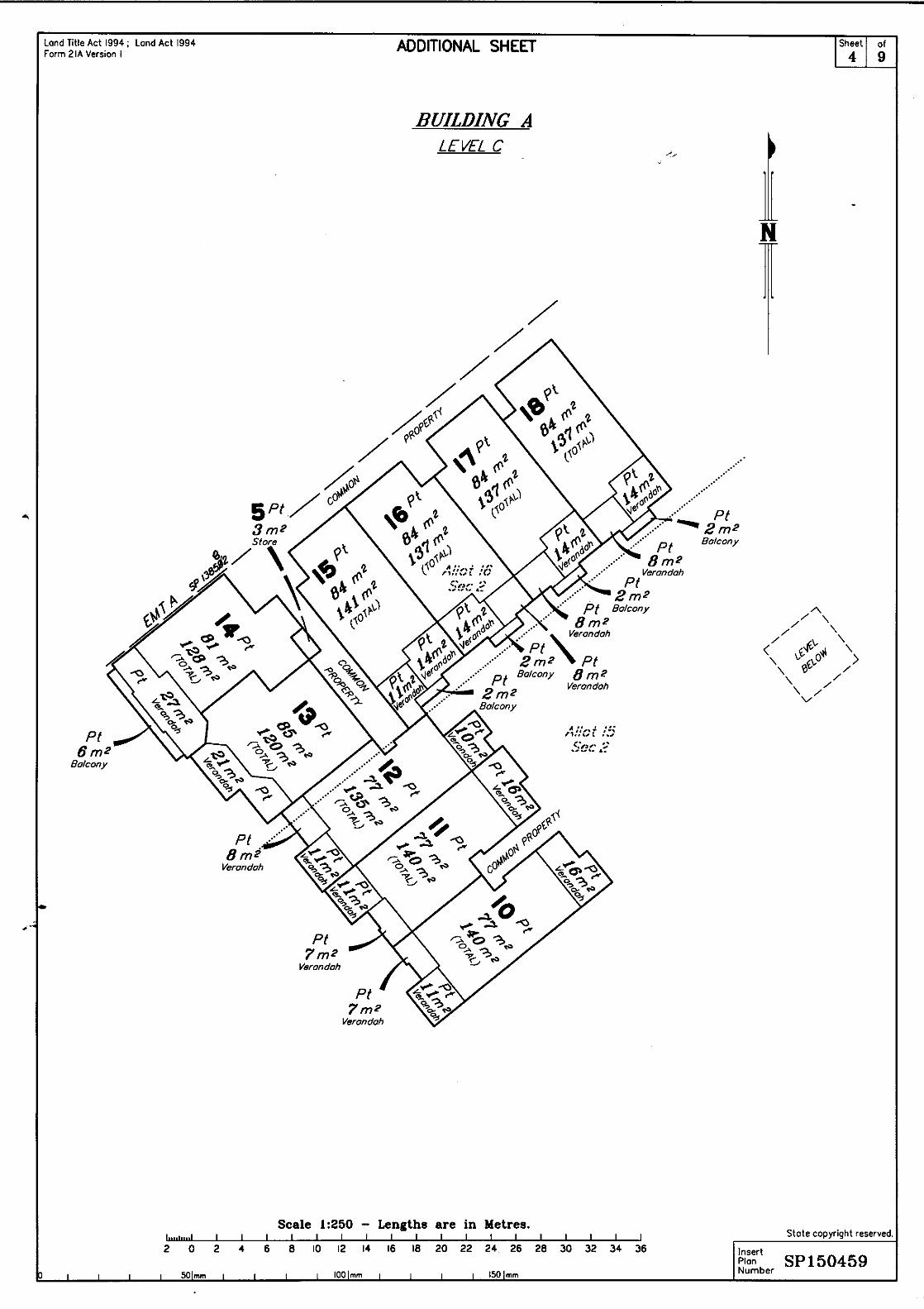
Image 1: Floor plan.
The key development features of the proposed development are summarised in the
table below:
Development Feature Proposal
Total Area: 89m2
Car Parking Spaces: 1 Space
Existing Use: Multiple Dwelling (Tourist) unit
Proposed Use: Multiple Dwelling Unit for
permanent and or tourist occupation
PLANNING STATEMENT : Lot 28, 21 Macrossan Street, Port Douglas (Multiple Dwelling)
www.gmacert.com.au BUILDING APPROVALS & INSPECTIONS BUILDING CERTIFICATION FIRE SAFETY AUDITS Page 8 of 15
Statutory Planning Considerations
This section provides a summary of the legislative framework affecting the application
pursuant to the Planning Act 2016.
5.1 Planning Act 2016
5.1.1 Categorisation of Development
The proposed development is not identified as prohibited development having regard to
the relevant instruments that can prohibit development under the Planning Act 2016,
including
• Schedule 10 of the Planning Regulations 2017
• Relevant Categorising Instruments.
The development is made assessable under the Douglas Shire Council Planning
Scheme, which is a categorising instrument for the purpose of s43 of the Planning Act
2016.
5.1.2 Assessment Manager
Pursuant to Schedule 8 of the Planning Regulations 2017, the Assessment Manager
for the application is the Douglas Regional Council.
5.1.3 Level of Assessment
The application involves the development of a Multiple Dwelling Unit. The table below
identifies the level of assessment and the categorising section of the Douglas shire
Council Planning Scheme.
Development Categorising Section Level of Assessment
Multiple Dwelling
Unit
Table 4.6.a Centre Zone Code Assessable
5.1.4 Statutory Considerations for Assessable Development
As the application is subject to Code Assessment, in deciding the application pursuant
to s60 of the Planning Act 2016, the Council, as Assessment Manager, can only have
regard to the matters established in the relevant planning benchmarks.
This assessment is further discussed in Section 6.0 of this report and a detailed
assessment of the proposed development against the assessment benchmarks is
provided at Appendix 2.

PLANNING STATEMENT : Lot 28, 21 Macrossan Street, Port Douglas (Multiple Dwelling)
www.gmacert.com.au BUILDING APPROVALS & INSPECTIONS BUILDING CERTIFICATION FIRE SAFETY AUDITS Page 9 of 15
5.1.5 State Planning Policy
It is understood that the Minister has identified that the State Planning Policy has been
appropriately integrated into the Douglas Shire Council Planning Scheme and
consequently no further assessment is required in this instance.
5.1.6 Regional Plan
The application site is identified in the Urban Footprint designation of the Far North
Queensland Regional Plan. Consistent with the State Planning Policies, it is
understood that the Planning Scheme has been determined to appropriately advance
the Regional Plan and, on that basis, no further assessment is required in this instance.
5.1.7 Referral Agencies
There are no referral agencies identified in respect of this application.
5.1.8 State Development Assessment Provisions
As there are no referral agencies for the application, no State Development
Assessment Provisions Apply to the assessment.
PLANNING STATEMENT : Lot 28, 21 Macrossan Street, Port Douglas (Multiple Dwelling)
www.gmacert.com.au BUILDING APPROVALS & INSPECTIONS BUILDING CERTIFICATION FIRE SAFETY AUDITS Page 10 of 15
Local Planning Considerations
6.1 Douglas Shire Council Planning Scheme
Within the Douglas Shire Council Planning Scheme (2018, v.1.0), the site is identified
within the Centre Zone and Precinct 1a Town Centre of the Port Douglas/Craiglie Local
Plan, and is affected by the following overlays:
• Acid Sulfate Soils Overlay;
• Coastal Environment Overlay; and,
• Flood and Strom Tide Hazard Overlay.
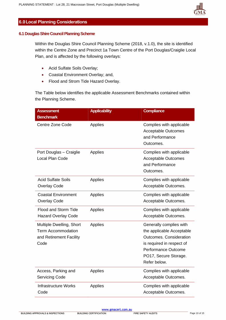
The Table below identifies the applicable Assessment Benchmarks contained within
the Planning Scheme.
Assessment
Benchmark
Applicability Compliance
Centre Zone Code Applies Complies with applicable
Acceptable Outcomes
and Performance
Outcomes.
Port Douglas – Craiglie
Local Plan Code
Applies Complies with applicable
Acceptable Outcomes
and Performance
Outcomes.
Acid Sulfate Soils
Overlay Code
Applies Complies with applicable
Acceptable Outcomes.
Coastal Environment
Overlay Code
Applies Complies with applicable
Acceptable Outcomes.
Flood and Storm Tide
Hazard Overlay Code
Applies Complies with applicable
Acceptable Outcomes.
Multiple Dwelling, Short
Term Accommodation
and Retirement Facility
Code
Applies Generally complies with
the applicable Acceptable
Outcomes. Consideration
is required in respect of
Performance Outcome
PO17, Secure Storage.
Refer below.
Access, Parking and
Servicing Code
Applies Complies with applicable
Acceptable Outcomes.
Infrastructure Works
Code
Applies Complies with applicable
Acceptable Outcomes.
PLANNING STATEMENT : Lot 28, 21 Macrossan Street, Port Douglas (Multiple Dwelling)
www.gmacert.com.au BUILDING APPROVALS & INSPECTIONS BUILDING CERTIFICATION FIRE SAFETY AUDITS Page 11 of 15
Landscaping Code Not applicable No applicable
Assessment Benchmarks.
Vegetation Management
Code
Not applicable No applicable
Assessment Benchmarks.
6.1.1 Statement of Compliance
6.1.1.1 Multiple Dwelling, Short Term Accommodation and Retirement Village Code
Performance Outcome PO17 states of the Multiple Dwelling, Short Term
Accommodation and Retirement Village Code states:
PO17
Development provides a secure storage area for each dwelling.
The associated Acceptable Outcome States:
AO17
A secure storage area for each dwelling:
(a) is located to enable access by a motor vehicle or be near to vehicle parking;
(b) has a minimum space of 3.5m2 per dwelling;
(c) has a minimum height of 2 metres;
(d) is weather proof;
(e) is lockable;
(f) has immunity to the 1% AEP inundation event.
The proposal is for the material change of use of an existing self-contained Multiple
Dwelling (Tourist) unit to a Multiple Dwelling Unit to provide for permanent occupation.
The Dwelling Unit would have access to the storage facilities provided as part of the
original development and would not require additional storage. It is considered that the
proposed development complies with the requirements of the Performance Outcome.

PLANNING STATEMENT : Lot 28, 21 Macrossan Street, Port Douglas (Multiple Dwelling)
www.gmacert.com.au BUILDING APPROVALS & INSPECTIONS BUILDING CERTIFICATION FIRE SAFETY AUDITS Page 12 of 15
Summary and Conclusion
This report has been prepared on behalf of Peter Gonsalves and Sofia Goncalves in
support of a Development Application to Douglas Shire Council for a Development
Permit for Material Change of Use for the purpose of a Multiple Dwelling unit on land
located at Lot 28, 21 Macrossan Street, Port Douglas and described as Lot 28 on
SP150459.
The application relates to one self-contained Multiple Dwelling (Tourist) apartment that
forms part of the Mantra Heritage complex located at 21 Macrossan Street, Port
Douglas. The specific apartment is Lot 28, which contains a total floor area of 89m2.
The subject premises includes a single car parking space, located within the overall
development, and which forms part of the title.
It is proposed to undertake a Material Change of Use of premises from self-contained
Multiple Dwelling (Tourist) Unit to Multiple Dwelling Unit to provide for permanent
and/or tourist accommodation. No physical changes are proposed as part of the
change of use.
The proposed development is considered to be consistent with the Assessment
Benchmarks and is considered to be a suitable use of the premises. The application is
submitted for approval, subject to reasonable and relevant conditions.

PLANNING STATEMENT : Lot 28, 21 Macrossan Street, Port Douglas (Multiple Dwelling)
www.gmacert.com.au BUILDING APPROVALS & INSPECTIONS BUILDING CERTIFICATION FIRE SAFETY AUDITS Page 13 of 15
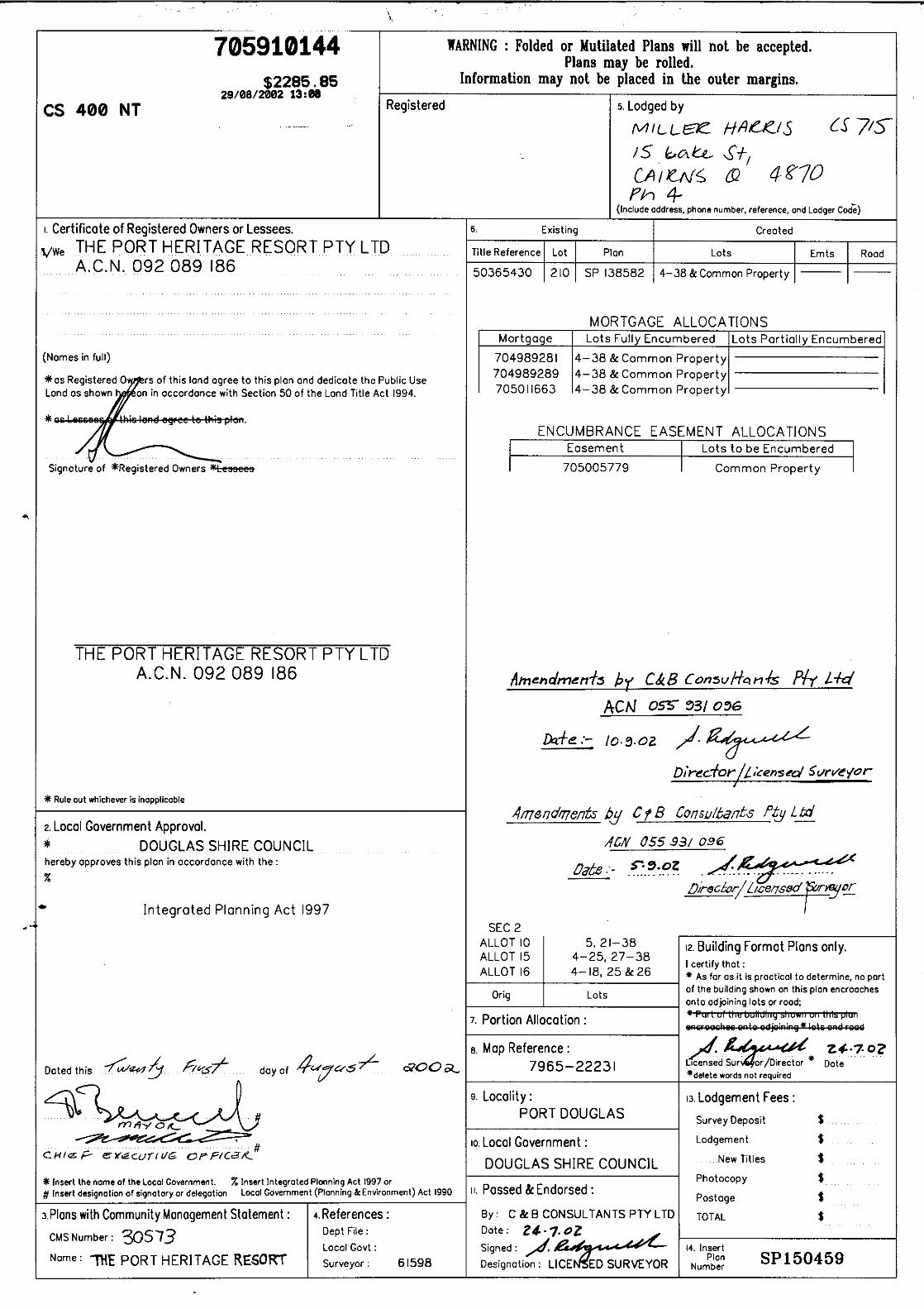
Appendix 1.
CERTIFICATE OF TITLE
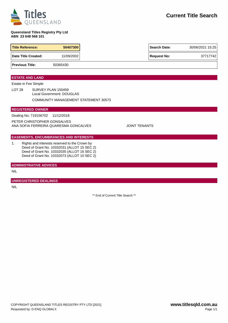
Current Title Search
Queensland Titles Registry Pty LtdABN 23 648 568 101
Title Reference: 50407300 Search Date: 30/06/2021 15:25
Date Title Created: 11/09/2002 Request No: 37717742
Previous Title: 50365430
Estate in Fee Simple
LOT 28 SURVEY PLAN 150459Local Government: DOUGLAS
COMMUNITY MANAGEMENT STATEMENT 30573
ESTATE AND LAND
Dealing No: 719156702 11/12/2018
PETER CHRISTOPHER GONSALVESANA SOFIA FERREIRA QUARESMA GONCALVES JOINT TENANTS
REGISTERED OWNER
1. Rights and interests reserved to the Crown byDeed of Grant No. 10332031 (ALLOT 15 SEC 2)Deed of Grant No. 10332035 (ALLOT 16 SEC 2)Deed of Grant No. 10332073 (ALLOT 10 SEC 2)
EASEMENTS, ENCUMBRANCES AND INTERESTS
NIL
ADMINISTRATIVE ADVICES
NIL
UNREGISTERED DEALINGS
** End of Current Title Search **
COPYRIGHT QUEENSLAND TITLES REGISTRY PTY LTD [2021]Requested by: D-ENQ GLOBALX
www.titlesqld.com.auPage 1/1

PLANNING STATEMENT : Lot 28, 21 Macrossan Street, Port Douglas (Multiple Dwelling)
www.gmacert.com.au BUILDING APPROVALS & INSPECTIONS BUILDING CERTIFICATION FIRE SAFETY AUDITS Page 14 of 15
Appendix 2.
PLANNING BENCHMARK ASSESSMENT
20212929 - Lot 28, 21 Macrossan Street, Port Douglas
6.2.1 – Centre Zone Code Douglas Shire Planning Scheme 2018 Version 1.0
6.2.1 Centre zone code
6.2.1.1 Application
(1) This code applies to assessing development in the Centre zone.
(2) When using this code, reference should be made to Part 5.
6.2.1.2 Purpose
(1) The purpose of the Centre zone code is to provide for a mix of land uses and activities.
(a) These uses include, but are not limited to, business, retail, professional, administrative, community, entertainment, cultural and residential
activities.
(b) Centres are found at a variety of scales based on their location and surrounding activities.
(2) The local government purpose of the code is to:
(a) implement the policy direction set in the Strategic Framework, in particular:
(i) Theme 1 : Settlement pattern, Element 3.4.3 Activity Centres.
(ii) Theme 4 : Strong communities and identity, Element 3.7.4 Sense of place, community and identity, Element 3.7.6 Arts and
Culture
(iii) Theme 5 : Economy, Element 3.8.2 – Economic growth and diversification, Element 3.8.3 Tourism.
20212929 - Lot 28, 21 Macrossan Street, Port Douglas
6.2.1 – Centre Zone Code Douglas Shire Planning Scheme 2018 Version 1.0
(b) provide for a mix of uses and level of economic and social activity to serve community needs.
(3) The purpose of the code will be achieved through the following overall outcomes:
(a) Development creates a range of retail, commercial, community and residential uses.
(b) Development is consistent with any location specific provisions contained within a Local Plan.
(c) Development provides activation and surveillance at ground level where adjoining roads or other public spaces.
(d) Development is integrated and coordinated both within the site and in relation to surrounding land uses and activities.
(e) Development provides a built form that establishes a cohesive streetscape and continuous pedestrian connections and shelters.
(f) Development is sensitively designed and managed to mitigate impacts on surrounding sensitive land uses.
(g) Development has access to infrastructure and services.
6.2.1.3 Criteria for assessment
Table 6.2.1.3.a - Centre zone – assessable development
Performance outcomes Acceptable outcomes Compliance
For self-assessable and assessable development
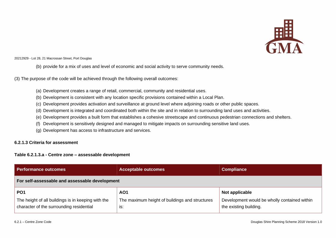
PO1
The height of all buildings is in keeping with the
character of the surrounding residential
AO1
The maximum height of buildings and structures
is:
Not applicable
Development would be wholly contained within
the existing building.
20212929 - Lot 28, 21 Macrossan Street, Port Douglas
6.2.1 – Centre Zone Code Douglas Shire Planning Scheme 2018 Version 1.0
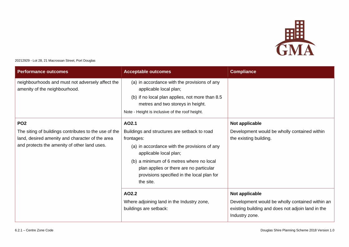
Performance outcomes Acceptable outcomes Compliance
neighbourhoods and must not adversely affect the
amenity of the neighbourhood.
(a) in accordance with the provisions of any
applicable local plan;
(b) if no local plan applies, not more than 8.5
metres and two storeys in height.
Note - Height is inclusive of the roof height.
PO2
The siting of buildings contributes to the use of the
land, desired amenity and character of the area
and protects the amenity of other land uses.
AO2.1
Buildings and structures are setback to road
frontages:
(a) in accordance with the provisions of any
applicable local plan;
(b) a minimum of 6 metres where no local
plan applies or there are no particular
provisions specified in the local plan for
the site.
Not applicable
Development would be wholly contained within
the existing building.
AO2.2
Where adjoining land in the Industry zone,
buildings are setback:
Not applicable
Development would be wholly contained within an
existing building and does not adjoin land in the
Industry zone.
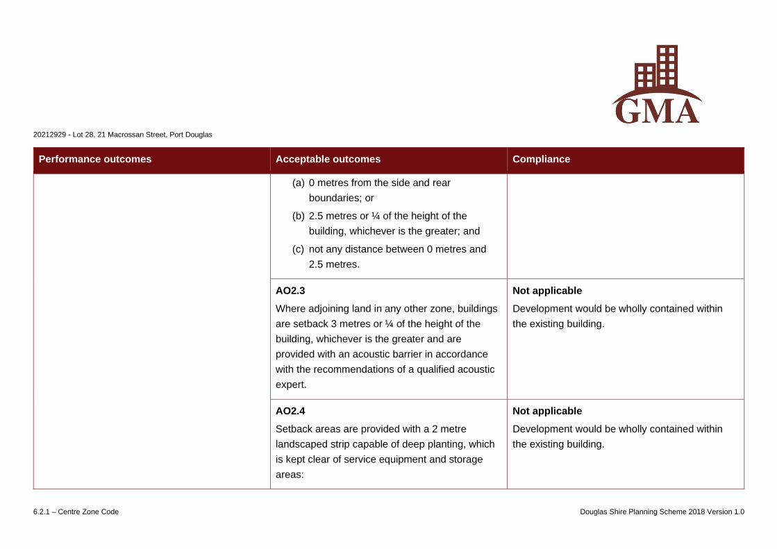
20212929 - Lot 28, 21 Macrossan Street, Port Douglas
6.2.1 – Centre Zone Code Douglas Shire Planning Scheme 2018 Version 1.0
Performance outcomes Acceptable outcomes Compliance
(a) 0 metres from the side and rear
boundaries; or
(b) 2.5 metres or ¼ of the height of the
building, whichever is the greater; and
(c) not any distance between 0 metres and
2.5 metres.
AO2.3
Where adjoining land in any other zone, buildings
are setback 3 metres or ¼ of the height of the
building, whichever is the greater and are
provided with an acoustic barrier in accordance
with the recommendations of a qualified acoustic
expert.
Not applicable
Development would be wholly contained within
the existing building.
AO2.4
Setback areas are provided with a 2 metre
landscaped strip capable of deep planting, which
is kept clear of service equipment and storage
areas:
Not applicable
Development would be wholly contained within
the existing building.
20212929 - Lot 28, 21 Macrossan Street, Port Douglas
6.2.1 – Centre Zone Code Douglas Shire Planning Scheme 2018 Version 1.0
Performance outcomes Acceptable outcomes Compliance
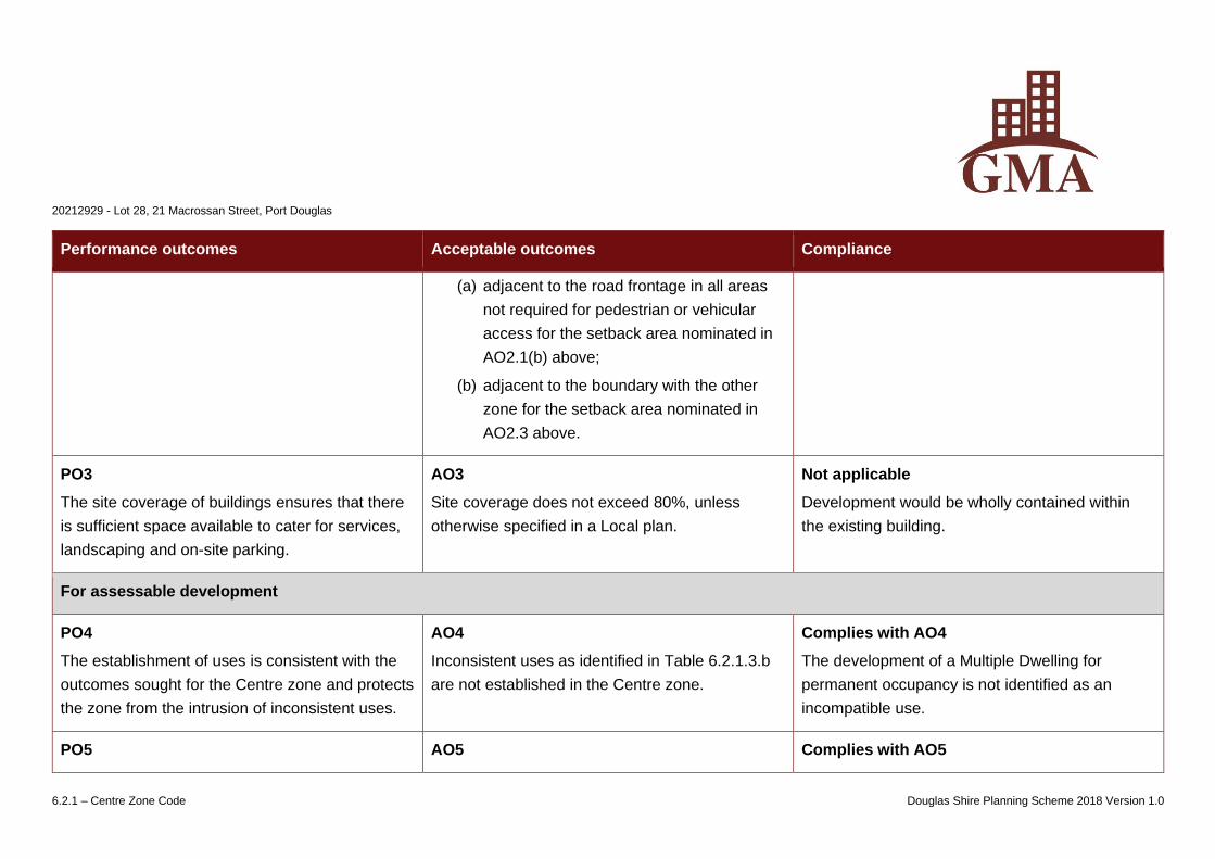
(a) adjacent to the road frontage in all areas
not required for pedestrian or vehicular
access for the setback area nominated in
AO2.1(b) above;
(b) adjacent to the boundary with the other
zone for the setback area nominated in
AO2.3 above.
PO3
The site coverage of buildings ensures that there
is sufficient space available to cater for services,
landscaping and on-site parking.
AO3
Site coverage does not exceed 80%, unless
otherwise specified in a Local plan.
Not applicable
Development would be wholly contained within
the existing building.
For assessable development
PO4
The establishment of uses is consistent with the
outcomes sought for the Centre zone and protects
the zone from the intrusion of inconsistent uses.
AO4
Inconsistent uses as identified in Table 6.2.1.3.b
are not established in the Centre zone.
Complies with AO4
The development of a Multiple Dwelling for
permanent occupancy is not identified as an
incompatible use.
PO5 AO5 Complies with AO5
20212929 - Lot 28, 21 Macrossan Street, Port Douglas
6.2.1 – Centre Zone Code Douglas Shire Planning Scheme 2018 Version 1.0
Performance outcomes Acceptable outcomes Compliance
Development provides a range of convenient
goods and services for the daily needs of discrete
residential communities.
Development complies with the requirements
specified in a local plan.
Refer to the assessment against the Local Plan
Code.
PO6
Development does not lower the standard of
amenity in terms of air, noise, odour, electrical
interference and vibrations at any land use
associated with the:
(a) the Accommodation activity group, located
outside the Centre zone;
(b) the Sensitive land use activity group,
located outside the Centre zone.
AO6
No acceptable outcomes are prescribed.
Complies with PO6
The change of use from a self-contained tourist
unit to a Multiple Dwelling unit capable of
permanent occupation would not have any greater
impact on the amenity of the area.
PO7
Reconfiguration of land results in:
(a) a practical layout for centre land use
activities, generally consisting of regular
rectangular-shaped lots.
(b) lots no less than 600m2 in area
AO7
No acceptable outcomes are prescribed.
Not applicable
No reconfiguration is proposed.
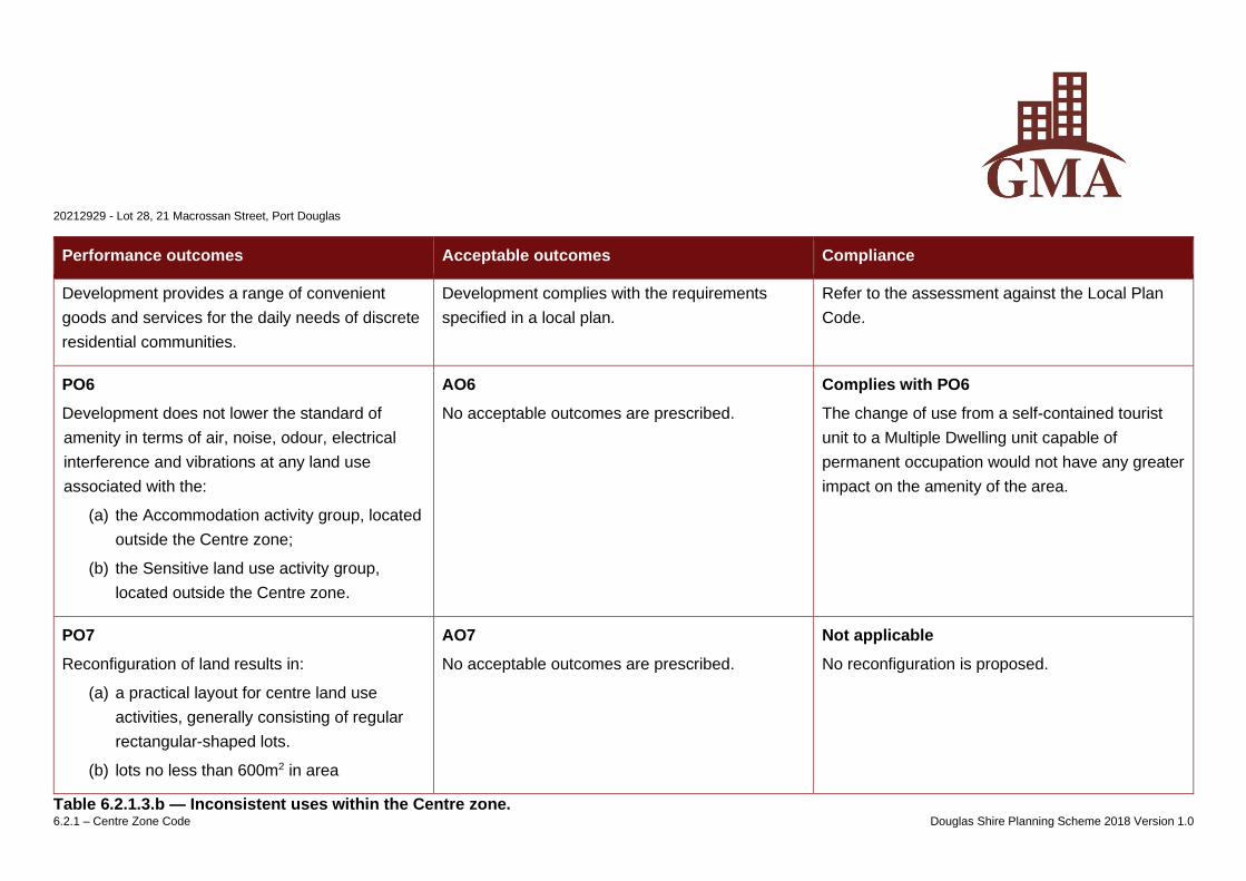
Table 6.2.1.3.b — Inconsistent uses within the Centre zone.
20212929 - Lot 28, 21 Macrossan Street, Port Douglas
6.2.1 – Centre Zone Code Douglas Shire Planning Scheme 2018 Version 1.0
Inconsistent uses
• Air services
• Animal husbandry
• Animal keeping
• Aquaculture
• Brothel
• Cemetery
• Crematorium
• Cropping
• Detention facility
• Environment facility
• Extractive industry
• High impact industry
• Intensive animal industry
• Intensive horticulture
• Major electrical infrastructure
• Major sport and entertainment facility
• Marine industry, except where located
within subprecinct 1b Waterfront North in
the Port Douglas / Craiglie Local Plan.
• Medium impact industry
• Motor sport facility
• Outstation
• Permanent plantation
• Relocatable home park
• Renewable energy facility, being a wind
farm
• Resort complex
• Retirement facility
• Roadside stall
• Rural industry
• Rural workers accommodation
• Special industry
• Tourist park
• Transport depot
• Utility installation
• Winery
Note – This table does not imply that all other uses not listed in the table are automatically consistent uses within the zone. Assessable development must still demonstrate
consistency through the assessment process.
20212929 – Lot 28, 21 Macrossan Street, Port Douglas
7.2.4 Port Douglas – Craiglie Local Plan Code Douglas Shire Planning Scheme 2018 Version 1.0
7.2.4 Port Douglas/Craiglie local plan code
7.2.4.1 Application
(1) This code applies to assessing development within the Port Douglas/Craiglie local plan area as identified on the Port Douglas/Craiglie local plan maps
contained in Schedule 2.
(2) When using this code, reference should be made to Part 5.
7.2.4.2 Context and setting
Editor’s note - This section is extrinsic material under section 15 of the Statutory Instruments Act 1992 and is intended to assist in the interpretation of the Port
Douglas/Craiglie local plan code.
The Port Douglas/Craiglie local plan encompasses the traditional Port Douglas town centre and surrounding tourist and residential areas, including Four Mile
Beach and Craiglie.
Port Douglas was officially named in 1877. It was initially settled as the port of entry and supply for the Hodgkinson goldfield on the Hann Tableland which was
proclaimed in 1876. It was the dominant port in Far North Queensland until a decision was made to establish Cairns as the terminus for a new railway in 1884.
This ended the town’s dominance, and it gradually became a small centre for local residents and fishing activities. During the 1970s and 1980s, a renewed
interest in Far North Queensland as a holiday destination led to a boom in large scale tourism and residential development with Port Douglas re-emerging as
a premium destination.
The Captain Cook Highway runs north-south to the west of Port Douglas through Craiglie (Four Mile). Craiglie caters for the permanent resident population
associated with Port Douglas, as well as providing for service industries to support business in the town. The majority of urban development is confined to
the eastern side of the highway. The main entrance to Port Douglas at the intersection of Port Douglas Road is accentuated by mature oil palms lining both
20212929 – Lot 28, 21 Macrossan Street, Port Douglas
7.2.4 Port Douglas – Craiglie Local Plan Code Douglas Shire Planning Scheme 2018 Version 1.0
sides of the street for almost the entire length of the corridor into the heart of Port Douglas.
Flagstaff Hill is a prominent headland on the northern side of the Port Douglas town centre providing a green tropical backdrop to the town. Island Point Road
runs to the top of Flagstaff Hill and provides access to the iconic lookout overlooking the sweep of Four Mile Beach.
Macrossan Street is the main shopping area in Port Douglas running in a general east-west direction at the base of Flagstaff Hill connecting Four Mile Beach
to Dickson Inlet. Tourist and commercial development is concentrated towards the western side of Macrossan Street, with marine orientated activity focussed
around the inlet. The western side of the inlet provides unspoiled views across mangroves to the distinctive formations and features of the coastal range.
The street pattern in the town centre is based on the original grid pattern survey of 1878. While the town has lost many of its original buildings to cyclones and
redevelopment, a number of important built features remain including the Central Hotel, the Court House Hotel, a number of relocated buildings such as St
Mary’s Church, the former Clink Theatre and the Court House Museum and scattered memorials such as the Carstens memorial in Macrossan Street and the
Port Douglas War memorial in Wharf Street. The Sugar Wharf on Dickson Inlet was the original terminus of the tramline to Mossman. The tramline now
terminates adjacent to the Port Douglas marina and operates as the Balley Hooley passenger service on four kilometres of track between the Port Douglas
Marina and St Crispins Station.
A particular characteristic of the local plan area is its high quality, lush landscaping complementing the tropical resort town atmosphere. This theme will be
carried throughout the local plan area with gateways, nodes and corridor planting emphasising the role of the town as a tropical tourist destination.
7.2.4.3 Purpose
(1) The purpose of the Port Douglas/Craiglie local plan code is to facilitate development outcomes consistent with community values, the local tropical built-
form and protection of the natural environment within the Port Douglas/Craiglie local plan area, while providing a platform for investment and prosperity.
(a) In addition, the purpose of the code is supported by the Port Douglas Waterfront Master Plan which provides a clear strategic direction for the
incremental transformation of the Port Douglas Waterfront, including the following objectives:
(b) To set out a vision for revitalisation of the waterfront;
20212929 – Lot 28, 21 Macrossan Street, Port Douglas
7.2.4 Port Douglas – Craiglie Local Plan Code Douglas Shire Planning Scheme 2018 Version 1.0
(c) To protect and enhance the environmental attributes; and
(2) To provide a flexible framework, expressed through several key strategies that will assist the Council and community in managing change.
(3) The purpose of the code will be achieved through the following overall outcomes:
(a) Port Douglas will continue to develop as the premium destination for international and domestic tourists in the Far North Queensland Region, while
also acting for permanent residents attracted to the associated lifestyle.
(b) Major tourist, retail, dining and entertainment facilities will consolidate in the Town Centre and the Waterfront North sub-precincts, with improved
pedestrian connections between the town centre and the waterfront.
(c) Craiglie will develop as an integrated residential community with some low scale tourism development opportunities in appropriate locations.
Craiglie will also function as small scale commercial and light industry node, providing employment opportunities for the Shire’s permanent
resident population.
(d) All forms of development will complement the tropical image of the town through distinctive tropical vernacular, urban design and landscaping.
(e) Character will be enhanced through the identification of gateway sites, landmarks, main approach routes and pedestrian thoroughfares and view
corridors;
(f) The Flagstaff Hill, Dickson Inlet, Four Mile Beach and other areas of scenic and environmental significance will be protected from development.
Vegetation cover will dominate over built form.
(g) Vegetation, iconic to the character of Port Douglas, including the avenues of Oil Palms, is retained and where appropriate supplemented.
(h) Development will be indistinguishable from view from Four Mile Beach. In addition, any development on Flagstaff Hill will be indistinguishable
when viewed from vantage points in Port Douglas.
(i) Residential areas are designed as pleasant, functional and distinctive, in visually well-defined areas.
(4) The purpose of the code will be further achieved through the following overall outcomes:
(a) Precinct 1 – Port Douglas precinct
(i) Sub-precinct 1a – Town Centre sub-precinct
(ii) Sub-precinct 1b – Waterfront North sub-precinct
20212929 – Lot 28, 21 Macrossan Street, Port Douglas
7.2.4 Port Douglas – Craiglie Local Plan Code Douglas Shire Planning Scheme 2018 Version 1.0
(iii) Sub-precinct 1a – Waterfront South sub-precinct
(iv) Sub-precinct 1d – Limited Development sub-precinct
(v) Sub-precinct 1e – Community and recreation sub-precinct
(vi) Sub-precinct 1f – Flagstaff Hill sub-precinct
(b) Precinct 2 – Integrated Resort precinct
(c) Precinct 3 – Craiglie Commercial and Light Industry precinct
(d) Precinct 4 – Old Port Road / Mitre Street precinct
(e) Precinct 5 – Very Low Density Residential/ Low Scale Recreation/Low Scale Educational/Low Scale Entertainment Uses precinct
Precinct 1 – Port Douglas precinct
(5) In addition to the overall outcomes, the outcomes sought for the precinct are to ensure that:
(a) development will contribute to the incremental transformation of the township, preserving and enhancing maritime activities and environmental
areas, delivering tropical open spaces and a high quality public realm, and allowing for tourism opportunities and investment.
(b) development contributes to the enhancement of the Port Douglas precinct through the following development outcomes:
(i) access and connectivity throughout the township is enhanced through a series of improvements to circulation and mobility, including:.
(A) access to, and connectivity along, the waterfront and foreshore areas is maintained and, where appropriate, enhanced;
(B) reducing reliance on the waterfront as a car parking resource.
(ii) the use of land in the Port Douglas precinct improves the cohesive layout of the township through:
(A) the establishment of distinct sub-precincts that reinforce the character and built form of the Port Douglas local plan area including:
• Port Douglas centre sub-precinct 1a – Town Centre sub-precinct;
• Port Douglas centre sub-precinct 1b – Waterfront North sub-precinct;
20212929 – Lot 28, 21 Macrossan Street, Port Douglas
7.2.4 Port Douglas – Craiglie Local Plan Code Douglas Shire Planning Scheme 2018 Version 1.0
• Port Douglas centre sub-precinct 1a – Waterfront South sub-precinct;
• Port Douglas centre sub-precinct 1d – Limited development sub-precinct;
• Port Douglas centre sub-precinct 1e – Community and recreation precinct;
• Port Douglas centre sub-precinct 1f – Flagstaff Hill sub-precinct;
(B) facilitating marina facilities and supporting marine industry uses as a key part of the local economy;
(C) reducing conflict between industry, community and commercial activities in the waterfront, without diminishing the marine industry
capacity in the Port Douglas precinct;
(i) environment and sustainability is integrated into the township through:
(A) preservation and enhancement of the qualities and characteristics of environmental areas of the township;
(B) water sensitive urban design is considered as a means of water quality improvement and management of overland flow to ensure hard
infrastructure solutions in Warner Street can be mitigated;
(C) design of buildings and access way improvements prioritises walking and cycling modes of transport.
(ii) the tropical character of the Port Douglas precinct is enhanced by ensuring development:
(A) maintains and enhances the built form, local character, streetscapes and natural elements of the township;
(B) is compatible with the desired character and amenity of local places and neighbourhoods;
(C) does not exceed the height of buildings designations which contribute to the desired form of the township which contains three storey
development heights in sub-precinct 1a – Town Centre sub-precinct and part of sub-precinct 1b – Waterfront North sub-precinct;
(D) implements high quality landscaped environments around buildings and on streets;
(E) protects the recognisable character and locally significance sites throughout the precinct.
(iii) public spaces and the streetscape are enhanced through:
(A) an increase in the quantity and quality of public land and places throughout the precinct;
20212929 – Lot 28, 21 Macrossan Street, Port Douglas
7.2.4 Port Douglas – Craiglie Local Plan Code Douglas Shire Planning Scheme 2018 Version 1.0
(B) consolidating community recreation and sporting uses to create a precinct of community focussed activity between Mudlo Street and
Wharf Street;
(C) improved connections between the town centre and the waterfront marina, including an investigation of a plaza on the waterfront;
(D) improved streetscapes with high quality landscaping, surface treatments and shaded pedestrian environments;
(E) the creation of a sense of place through aesthetic streetscapes and built-form character;
(F) managing vegetation to ensure succession of planting and the ongoing presence of significant trees.
(iv) advertising signage is small scale, low-key and complements the tropical character of the town.
Sub-precinct 1a – Town Centre sub-precinct
(6) In addition to other overall development outcomes, development in the Town Centre sub-precinct facilitates the following development outcomes:
(a) tourist, retail, dining and entertainment activities are facilitated at an appropriate pedestrian scale;
(b) drive-through developments, bulky goods showrooms, outdoor sales, saleyards and other big-box retailing or entertainment facilities are not
established;
(c) development contributes to a high quality public realm;
(d) parking (and associated infrastructure) does not undermine the relationship between buildings and street or pedestrian circulation patterns;
(e) consolidation of community and cultural land use activities along Mowbray Street between Wharf Street and Mudlo Street;
(f) active street frontages are established along Macrossan and Wharf Streets and other nearby streets as shown on the Port Douglas Centre Active
Frontages and Pedestrian and Cycle Network Plan;
(g) Live entertainment activities are concentrated within the Live Entertainment Precinct and are subject to the recommendations of a suitably
qualified acoustic engineer.
20212929 – Lot 28, 21 Macrossan Street, Port Douglas
7.2.4 Port Douglas – Craiglie Local Plan Code Douglas Shire Planning Scheme 2018 Version 1.0
Sub- precinct 1b - Waterfront North sub-precinct
(7) In addition to other overall development outcomes, development in the Waterfront North sub-precinct facilitates the following development outcomes:
(a) the precinct evolves as a revitalised open space and waterside development precinct;
(b) development within the precinct is designed to be sympathetic to the environmentally sensitive Dickson Inlet and mitigates any adverse impacts;
(c) the establishment of mixed-use development is facilitated to promote activity and vitality;
(d) public pedestrian access is maximised along the extent of the edge of the waterfront, consisting of a boardwalk or similar structure available for
24-hour use;
(e) development contributes to a high quality public realm;
(f) built form provides an attractive point of arrival from both land and sea;
(g) pedestrian connectivity is safe, efficient and provides for the needs of all users of the Port Douglas waterfront;
(h) parking (and associated infrastructure) does not undermine the relationship between buildings and street or pedestrian circulation patterns;
(i) the importance of existing marine-based industries to the area is recognised, not diminished and protected from incompatible uses. Relocation of
marine based industries to an alternative precinct does not occur until such time that agreement has been reached among all relevant
stakeholders such that development does not diminish the viability of marine based industrial uses that directly serve the Port Douglas tourist and
fishing operators and private boat owners;
(j) marine infrastructure is established to service the tourism, fishing and private boating community;
(k) Live entertainment activities are concentrated within the Live Entertainment Precinct and are subject to the recommendations of a suitably
qualified acoustic engineer;
(l) the functionality of the Balley Hooley tourist rail is retained.
Sub-precinct 1a – Waterfront South sub-precinct
(8) In addition to all other overall development outcomes, development in the Waterfront South sub-precinct facilitates the following development outcomes:
20212929 – Lot 28, 21 Macrossan Street, Port Douglas
7.2.4 Port Douglas – Craiglie Local Plan Code Douglas Shire Planning Scheme 2018 Version 1.0
(a) any use of land in the precinct does not affect the environmental, habitat, conservation or scenic values of Dickson Inlet and surrounding land;
(b) marine-based industries are established on appropriate land having regard to site suitability, accessibility, surrounding land uses, and location of
utilities and services;
(c) marine-based industry achieves appropriate environmental standards;
(d) industrial buildings have a high standard of layout and building design;
(e) landscaping provides an attractive streetscape and screens utility, storage and car parking from the street and other public areas;
(f) the precinct is protected from encroachment of incompatible land use activities.
Sub- precinct 1d – Limited Development sub-precinct
(9) In addition to all other overall development outcomes, development in the Limited Development sub-precinct facilitates the following development
outcomes:
(a) any use of land in the precinct does not affect the environmental, habitat, conservation or scenic values of Dickson Inlet and surrounding land;
(b) the open nature and character of the precinct is retained maintaining view lines across the inlet;
(c) community and recreation land use activities are established that promote public access to the foreshore.
Sub-precinct 1e – Community and recreation sub-precinct
(10) In addition to all other overall development outcomes, development in the Community and recreation sub-precinct facilitates the following development
outcomes:
(a) development for community uses, including sport and recreation is facilitated.
(b) sport and recreation activities predominantly involve outdoor activities;
(c) areas of natural vegetation are protected from further development;
(d) shade trees are increased, in appropriate locations, surrounding the sports fields.

20212929 – Lot 28, 21 Macrossan Street, Port Douglas
7.2.4 Port Douglas – Craiglie Local Plan Code Douglas Shire Planning Scheme 2018 Version 1.0
Sub-precinct 1f – Flagstaff Hill sub-precinct
(11) In addition to all other overall development outcomes, development in the Flagstaff Hill sub-precinct facilitates the following development outcomes:
(a) development is not established where it results in detriment to the vegetated and scenic qualities of Flagstaff Hill;
(b) development minimises excavation and filling;
(c) buildings and other works are unobtrusive when viewed from vantage points in Port Douglas and are designed and constructed of colours and
materials which complement the hill’s vegetated state;
(d) views from public viewing points within the precinct are protected.
Precinct 2 – Integrated Resort precinct
(12) In addition to the overall outcomes, development in the Integrated Resort precinct facilitates development in accordance with the Integrated
Development Resort Act, 1987.
Editor’s note – The development of land within this precinct is subject to the Integrated Development Resort Act 1987 (IDRA). Where a conflict exists between this planning
scheme and the IDRA, the IDRA prevails.
Precinct 3 – Craiglie Commercial and Light Industry precinct
(13) In addition to the overall outcomes, development in the Craiglie Commercial and Light Industry precinct facilitates the following overall outcomes:
20212929 – Lot 28, 21 Macrossan Street, Port Douglas
7.2.4 Port Douglas – Craiglie Local Plan Code Douglas Shire Planning Scheme 2018 Version 1.0
(a) development supports the tourism and marine industries in Port Douglas, along with the small-scale commercial and light industry land uses that
support the local economy that would otherwise be better suited to a location outside the Port Douglas Centre Precinct unless they pose a safety
issue;
(b) development adjacent to the Captain Cook Highway presents an attractive appearance to the highway. The rain-trees, melaleucas and eucalypt
trees along the Captain Cook Highway are retained where possible, taking into account the Department of Transport and main Road’s
requirements;
(c) retailing activities are generally restricted to those which are ancillary and necessarily associated with the primary service and light industry nature
of the area;
(d) adjacent residential areas are protected from industry nuisances;
(e) lots fronting Downing Street, between Dickson Street and Beor Street, are provided with an appropriate standard of road access and
infrastructure, prior to development occurring.
Precinct 4 – Old Port Road / Mitre Street precinct
(14) In addition to the overall outcomes, development in the Old Port Road / Mitre Street precinct facilitates the following overall outcomes:
(a) the precinct is intended to be used for outdoor recreational land use activity, primarily as a golf course;
(b) areas of significant vegetation are protected from development and retained;
(c) other forms of development will only be considered if substantial areas of open space are retained adjacent to existing residential areas to
maintain the existing residential amenity of open views across open space.
Precinct 5 – Very Low Density Residential/Low Scale Recreation/Low Scale Educational/Low Scale Entertainment Uses precinct
(15) In addition to the overall outcomes, development in the Very Low Residential Density/Low Scale Recreation/Low Scale Educational/Low Scale
Entertainment Uses precinct facilitates the following overall outcomes:
20212929 – Lot 28, 21 Macrossan Street, Port Douglas
7.2.4 Port Douglas – Craiglie Local Plan Code Douglas Shire Planning Scheme 2018 Version 1.0
(a) residential accommodation does not exceed a maximum of 8.5 metres in building height;
(b) minimum lot sizes exceed 2 hectares;
(c) very low scale and intensity recreation/ very low scale and intensity educational/ and very low scale entertainment uses may be appropriate in
areas of the precinct subject to erosion and other flooding constraints.
Note - Undeveloped lots in this precinct are located on very low-lying land. Council may consider a consolidation of existing land titles via lot reconfiguration to lot sizes less
than 2 hectares, where the reconfigured lots are consolidated onto the highest terrain, to avoid a pattern of development consisting of dwelling houses located on isolated
islands of raised building pads.
7.2.4.4 Criteria for assessment
Table 7.2.4.4.a — Port Douglas / Craiglie local plan - assessable development
Performance outcomes Acceptable outcomes Compliance
For self-assessable and assessable development
Development in the Port Douglas / Craiglie local plan area generally
PO1
Pedestrians, cyclists, motorists and public
transport users can easily move into and through
the precinct along planned connectivity routes,
identified on the Port Douglas / Craiglie local plan
AO1
A pedestrian and cycle movement network is
integrated and delivered through development.
Not applicable
The proposed development does not trigger a
requirement for a pedestrian or cycle network.
20212929 – Lot 28, 21 Macrossan Street, Port Douglas
7.2.4 Port Douglas – Craiglie Local Plan Code Douglas Shire Planning Scheme 2018 Version 1.0
Performance outcomes Acceptable outcomes Compliance
maps contained in Schedule 2.
PO2
Development retains and enhances key landscape
elements including character trees and areas of
significant vegetation contributing to the character
and quality of the local plan area and significant
views and vistas and other landmarks important to
the context of Port Douglas / Craiglie (as identified
on the Port Douglas/ Craiglie Townscape Plan
map contained in Schedule 2).
AO2.1
Development provides for the retention and
enhancement of existing mature trees and
character vegetation that contribute to the lush
tropical character of the town, including:
(a) the tree covered backdrop of Flagstaff Hill;
(b) natural vegetation along watercourses, in
particular the Mowbray River, Beor Creek and
Dickson Inlet;
(c) the tidal vegetation along the foreshore;
(d) beachfront vegetation along Four Mile Beach,
including the fringe of Coconut Palms;
(e) the oil palm avenues along the major roads;
(f) the lush landscaping within major roundabouts
at key nodes;
(g) Macrossan Street and Warner Street;
(h) Port Douglas waterfront.
Complies with AO2.1
No vegetation would be removed to facilitate the
development.
20212929 – Lot 28, 21 Macrossan Street, Port Douglas
7.2.4 Port Douglas – Craiglie Local Plan Code Douglas Shire Planning Scheme 2018 Version 1.0
Performance outcomes Acceptable outcomes Compliance
AO2.2
Development protects and does not intrude into
important views and vistas as identified on the Port
Douglas Townscape Plan map contained in
Schedule 2, in particular:
(a) Flagstaff Hill;
(b) Four Mile Beach;
(c) Across to the ranges over Dickson Inlet;
(d) Mowbray Valley.
Not applicable
The development would be wholly contained within
an existing building.
AO2.3
Important landmarks, memorials and monuments
are retained.
Complies with AO2.3
The development would be wholly contained within
an existing building.
PO3
Development contributes to the protection,
reinforcement and where necessary enhancement
of gateways and key intersections identified on the
Port Douglas / Craiglie local plan maps contained
in Schedule 2.
AO3
Development adjacent to the gateways and nodes
as identified on the Port Douglas / Craiglie local
plan maps contained in Schedule 2 incorporates
architectural features and landscaping treatments
and design elements that enhance the sense of
Not applicable
The development would be wholly contained within
an existing building.
20212929 – Lot 28, 21 Macrossan Street, Port Douglas
7.2.4 Port Douglas – Craiglie Local Plan Code Douglas Shire Planning Scheme 2018 Version 1.0
Performance outcomes Acceptable outcomes Compliance
arrival and way finding within the town.
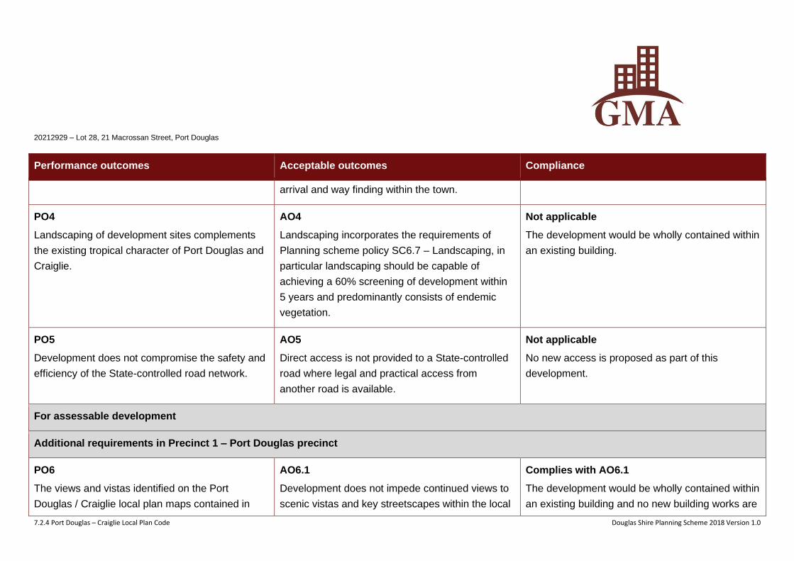
PO4
Landscaping of development sites complements
the existing tropical character of Port Douglas and
Craiglie.
AO4
Landscaping incorporates the requirements of
Planning scheme policy SC6.7 – Landscaping, in
particular landscaping should be capable of
achieving a 60% screening of development within
5 years and predominantly consists of endemic
vegetation.
Not applicable
The development would be wholly contained within
an existing building.
PO5
Development does not compromise the safety and
efficiency of the State-controlled road network.
AO5
Direct access is not provided to a State-controlled
road where legal and practical access from
another road is available.
Not applicable
No new access is proposed as part of this
development.
For assessable development
Additional requirements in Precinct 1 – Port Douglas precinct
PO6
The views and vistas identified on the Port
Douglas / Craiglie local plan maps contained in
AO6.1
Development does not impede continued views to
scenic vistas and key streetscapes within the local
Complies with AO6.1
The development would be wholly contained within
an existing building and no new building works are
20212929 – Lot 28, 21 Macrossan Street, Port Douglas
7.2.4 Port Douglas – Craiglie Local Plan Code Douglas Shire Planning Scheme 2018 Version 1.0
Performance outcomes Acceptable outcomes Compliance
Schedule 2 are maintained. plan area. proposed.
AO6.2
Unless otherwise specified within this Local Plan,
buildings are set back not less than 6 metres from
the primary street frontage.
Not applicable
The development would be wholly contained within
an existing building and no new building works are
proposed.
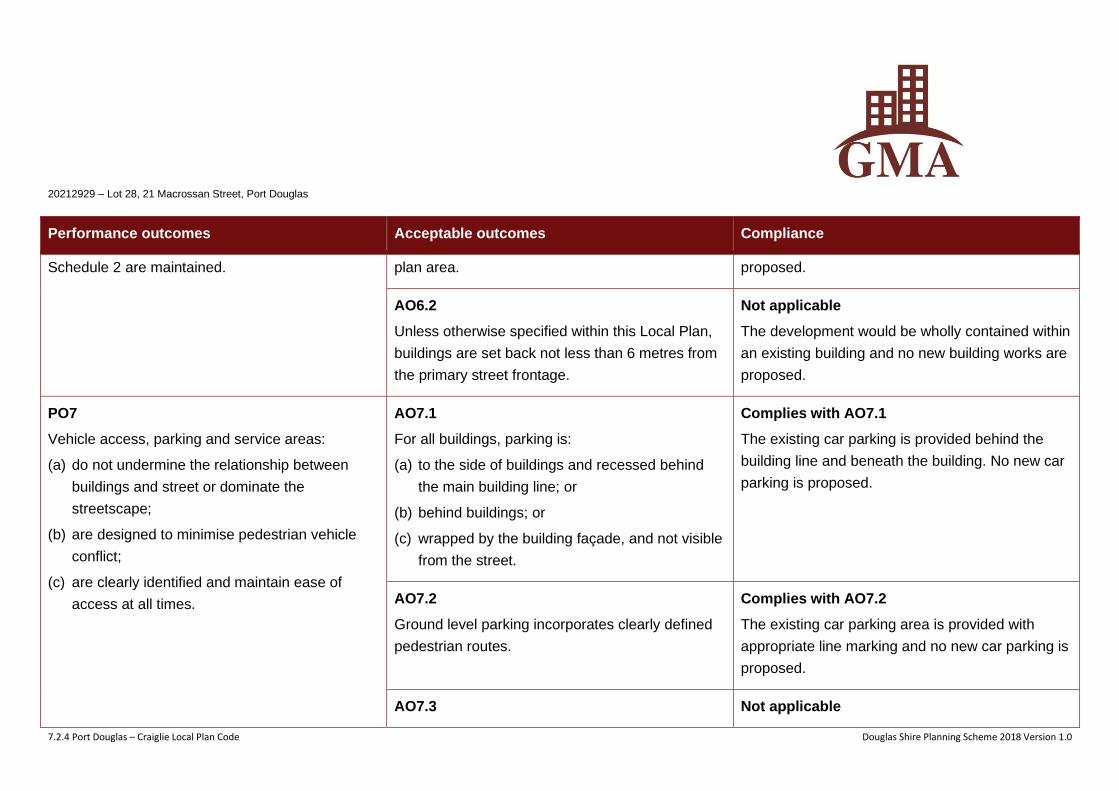
PO7
Vehicle access, parking and service areas:
(a) do not undermine the relationship between
buildings and street or dominate the
streetscape;
(b) are designed to minimise pedestrian vehicle
conflict;
(c) are clearly identified and maintain ease of
access at all times.
AO7.1
For all buildings, parking is:
(a) to the side of buildings and recessed behind
the main building line; or
(b) behind buildings; or
(c) wrapped by the building façade, and not visible
from the street.
Complies with AO7.1
The existing car parking is provided behind the
building line and beneath the building. No new car
parking is proposed.
AO7.2
Ground level parking incorporates clearly defined
pedestrian routes.
Complies with AO7.2
The existing car parking area is provided with
appropriate line marking and no new car parking is
proposed.
AO7.3 Not applicable
20212929 – Lot 28, 21 Macrossan Street, Port Douglas
7.2.4 Port Douglas – Craiglie Local Plan Code Douglas Shire Planning Scheme 2018 Version 1.0
Performance outcomes Acceptable outcomes Compliance
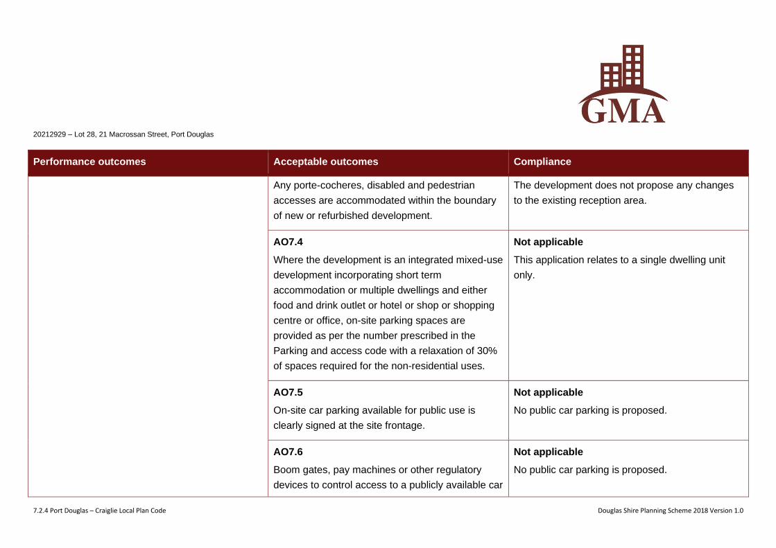
Any porte-cocheres, disabled and pedestrian
accesses are accommodated within the boundary
of new or refurbished development.
The development does not propose any changes
to the existing reception area.
AO7.4
Where the development is an integrated mixed-use
development incorporating short term
accommodation or multiple dwellings and either
food and drink outlet or hotel or shop or shopping
centre or office, on-site parking spaces are
provided as per the number prescribed in the
Parking and access code with a relaxation of 30%
of spaces required for the non-residential uses.
Not applicable
This application relates to a single dwelling unit
only.
AO7.5
On-site car parking available for public use is
clearly signed at the site frontage.
Not applicable
No public car parking is proposed.
AO7.6
Boom gates, pay machines or other regulatory
devices to control access to a publicly available car
Not applicable
No public car parking is proposed.
20212929 – Lot 28, 21 Macrossan Street, Port Douglas
7.2.4 Port Douglas – Craiglie Local Plan Code Douglas Shire Planning Scheme 2018 Version 1.0
Performance outcomes Acceptable outcomes Compliance
parking area are not constructed or installed.
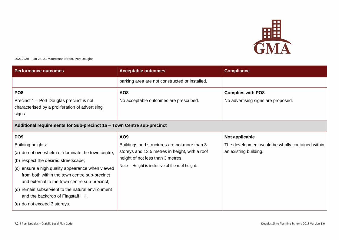
PO8
Precinct 1 – Port Douglas precinct is not
characterised by a proliferation of advertising
signs.
AO8
No acceptable outcomes are prescribed.
Complies with PO8
No advertising signs are proposed.
Additional requirements for Sub-precinct 1a – Town Centre sub-precinct
PO9
Building heights:
(a) do not overwhelm or dominate the town centre;
(b) respect the desired streetscape;
(c) ensure a high quality appearance when viewed
from both within the town centre sub-precinct
and external to the town centre sub-precinct;
(d) remain subservient to the natural environment
and the backdrop of Flagstaff Hill.
(e) do not exceed 3 storeys.
AO9
Buildings and structures are not more than 3
storeys and 13.5 metres in height, with a roof
height of not less than 3 metres.
Note – Height is inclusive of the roof height.
Not applicable
The development would be wholly contained within
an existing building.
20212929 – Lot 28, 21 Macrossan Street, Port Douglas
7.2.4 Port Douglas – Craiglie Local Plan Code Douglas Shire Planning Scheme 2018 Version 1.0
Performance outcomes Acceptable outcomes Compliance
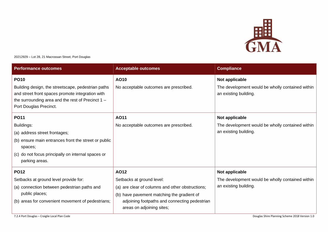
PO10
Building design, the streetscape, pedestrian paths
and street front spaces promote integration with
the surrounding area and the rest of Precinct 1 –
Port Douglas Precinct.
AO10
No acceptable outcomes are prescribed.
Not applicable
The development would be wholly contained within
an existing building.
PO11
Buildings:
(a) address street frontages;
(b) ensure main entrances front the street or public
spaces;
(c) do not focus principally on internal spaces or
parking areas.
AO11
No acceptable outcomes are prescribed.
Not applicable
The development would be wholly contained within
an existing building.
PO12
Setbacks at ground level provide for:
(a) connection between pedestrian paths and
public places;
(b) areas for convenient movement of pedestrians;
AO12
Setbacks at ground level:
(a) are clear of columns and other obstructions;
(b) have pavement matching the gradient of
adjoining footpaths and connecting pedestrian
areas on adjoining sites;
Not applicable
The development would be wholly contained within
an existing building.
20212929 – Lot 28, 21 Macrossan Street, Port Douglas
7.2.4 Port Douglas – Craiglie Local Plan Code Douglas Shire Planning Scheme 2018 Version 1.0
Performance outcomes Acceptable outcomes Compliance
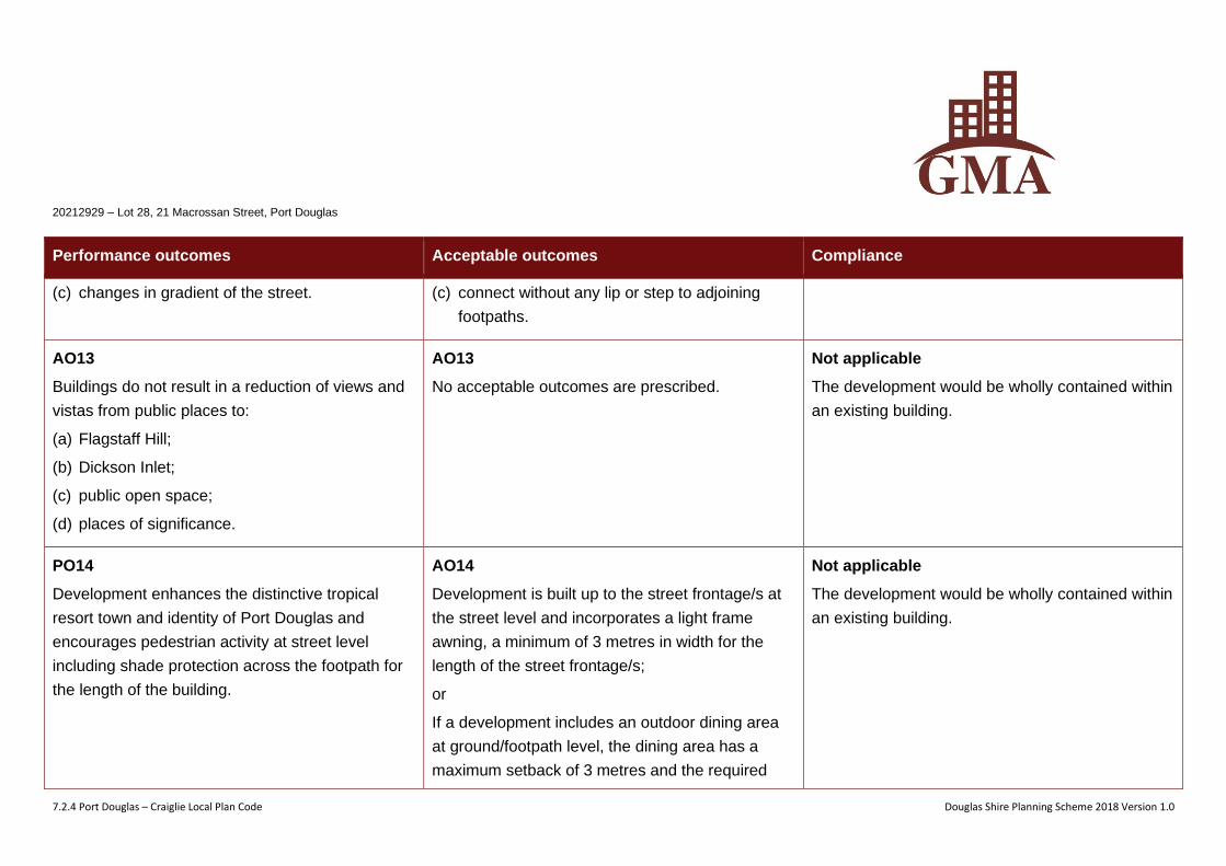
(c) changes in gradient of the street. (c) connect without any lip or step to adjoining
footpaths.
AO13
Buildings do not result in a reduction of views and
vistas from public places to:
(a) Flagstaff Hill;
(b) Dickson Inlet;
(c) public open space;
(d) places of significance.
AO13
No acceptable outcomes are prescribed.
Not applicable
The development would be wholly contained within
an existing building.
PO14
Development enhances the distinctive tropical
resort town and identity of Port Douglas and
encourages pedestrian activity at street level
including shade protection across the footpath for
the length of the building.
AO14
Development is built up to the street frontage/s at
the street level and incorporates a light frame
awning, a minimum of 3 metres in width for the
length of the street frontage/s;
or
If a development includes an outdoor dining area
at ground/footpath level, the dining area has a
maximum setback of 3 metres and the required
Not applicable
The development would be wholly contained within
an existing building.
20212929 – Lot 28, 21 Macrossan Street, Port Douglas
7.2.4 Port Douglas – Craiglie Local Plan Code Douglas Shire Planning Scheme 2018 Version 1.0
Performance outcomes Acceptable outcomes Compliance
awning is still maintained along the length of the
street frontage/s.
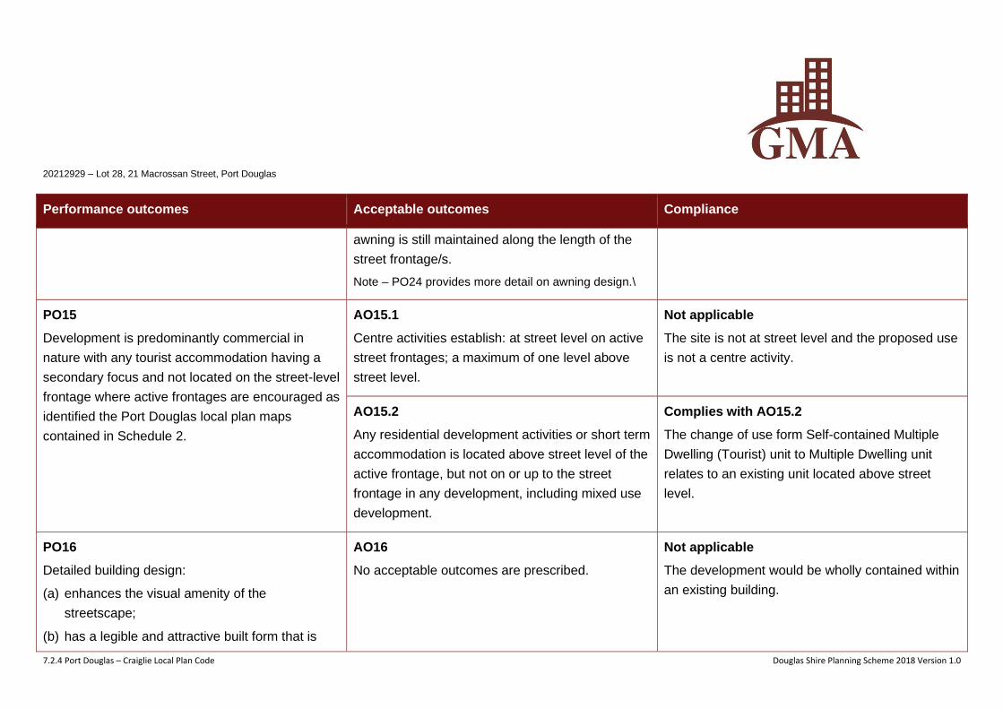
Note – PO24 provides more detail on awning design.\
PO15
Development is predominantly commercial in
nature with any tourist accommodation having a
secondary focus and not located on the street-level
frontage where active frontages are encouraged as
identified the Port Douglas local plan maps
contained in Schedule 2.
AO15.1
Centre activities establish: at street level on active
street frontages; a maximum of one level above
street level.
Not applicable
The site is not at street level and the proposed use
is not a centre activity.
AO15.2
Any residential development activities or short term
accommodation is located above street level of the
active frontage, but not on or up to the street
frontage in any development, including mixed use
development.
Complies with AO15.2
The change of use form Self-contained Multiple
Dwelling (Tourist) unit to Multiple Dwelling unit
relates to an existing unit located above street
level.
PO16
Detailed building design:
(a) enhances the visual amenity of the
streetscape;
(b) has a legible and attractive built form that is
AO16
No acceptable outcomes are prescribed.
Not applicable
The development would be wholly contained within
an existing building.
20212929 – Lot 28, 21 Macrossan Street, Port Douglas
7.2.4 Port Douglas – Craiglie Local Plan Code Douglas Shire Planning Scheme 2018 Version 1.0
Performance outcomes Acceptable outcomes Compliance
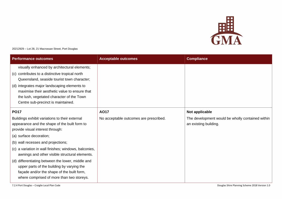
visually enhanced by architectural elements;
(c) contributes to a distinctive tropical north
Queensland, seaside tourist town character;
(d) integrates major landscaping elements to
maximise their aesthetic value to ensure that
the lush, vegetated character of the Town
Centre sub-precinct is maintained.
PO17
Buildings exhibit variations to their external
appearance and the shape of the built form to
provide visual interest through:
(a) surface decoration;
(b) wall recesses and projections;
(c) a variation in wall finishes; windows, balconies,
awnings and other visible structural elements.
(d) differentiating between the lower, middle and
upper parts of the building by varying the
façade and/or the shape of the built form,
where comprised of more than two storeys.
AO17
No acceptable outcomes are prescribed.
Not applicable
The development would be wholly contained within
an existing building.
20212929 – Lot 28, 21 Macrossan Street, Port Douglas
7.2.4 Port Douglas – Craiglie Local Plan Code Douglas Shire Planning Scheme 2018 Version 1.0
Performance outcomes Acceptable outcomes Compliance
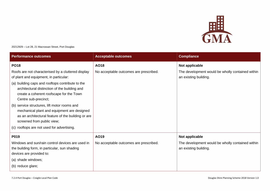
PO18
Roofs are not characterised by a cluttered display
of plant and equipment, in particular:
(a) building caps and rooftops contribute to the
architectural distinction of the building and
create a coherent roofscape for the Town
Centre sub-precinct;
(b) service structures, lift motor rooms and
mechanical plant and equipment are designed
as an architectural feature of the building or are
screened from public view;
(c) rooftops are not used for advertising.
AO18
No acceptable outcomes are prescribed.
Not applicable
The development would be wholly contained within
an existing building.
P019
Windows and sun/rain control devices are used in
the building form, in particular, sun shading
devices are provided to:
(a) shade windows;
(b) reduce glare;
AO19
No acceptable outcomes are prescribed.
Not applicable
The development would be wholly contained within
an existing building.
20212929 – Lot 28, 21 Macrossan Street, Port Douglas
7.2.4 Port Douglas – Craiglie Local Plan Code Douglas Shire Planning Scheme 2018 Version 1.0
Performance outcomes Acceptable outcomes Compliance
(c) assist in maintaining comfortable indoor
temperatures;
(d) minimising heat loads;
(e) enrich the North Queensland tropical character
of the Town Centre sub-precinct;
(f) provide architectural interest to building
façades.
PO20
Buildings are finished with high quality materials,
selected for:
(a) their ability to contribute the character of Town
Centre sub-precinct;
(b) easy maintenance, durability and an ability not
to readily stain, discolour or deteriorate.
AO20
No acceptable outcomes are prescribed.
Not applicable
The development would be wholly contained within
an existing building.
PO21
Buildings do not incorporate any type of glass or
other materials that are likely to reflect the sun’s
rays in a manner that may create a nuisance,
AO21
No acceptable outcomes are prescribed.
Not applicable
The development would be wholly contained within
an existing building.
20212929 – Lot 28, 21 Macrossan Street, Port Douglas
7.2.4 Port Douglas – Craiglie Local Plan Code Douglas Shire Planning Scheme 2018 Version 1.0
Performance outcomes Acceptable outcomes Compliance
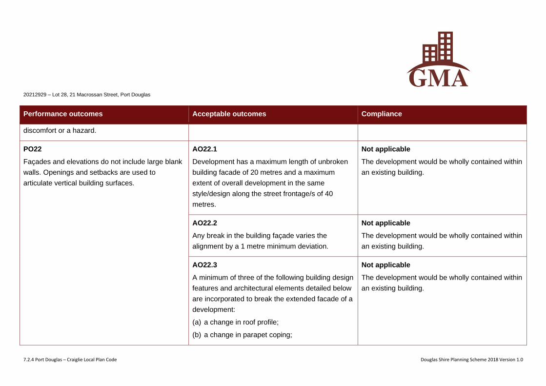
discomfort or a hazard.
PO22
Façades and elevations do not include large blank
walls. Openings and setbacks are used to
articulate vertical building surfaces.
AO22.1
Development has a maximum length of unbroken
building facade of 20 metres and a maximum
extent of overall development in the same
style/design along the street frontage/s of 40
metres.
Not applicable
The development would be wholly contained within
an existing building.
AO22.2
Any break in the building façade varies the
alignment by a 1 metre minimum deviation.
Not applicable
The development would be wholly contained within
an existing building.
AO22.3
A minimum of three of the following building design
features and architectural elements detailed below
are incorporated to break the extended facade of a
development:
(a) a change in roof profile;
(b) a change in parapet coping;
Not applicable
The development would be wholly contained within
an existing building.
20212929 – Lot 28, 21 Macrossan Street, Port Douglas
7.2.4 Port Douglas – Craiglie Local Plan Code Douglas Shire Planning Scheme 2018 Version 1.0
Performance outcomes Acceptable outcomes Compliance
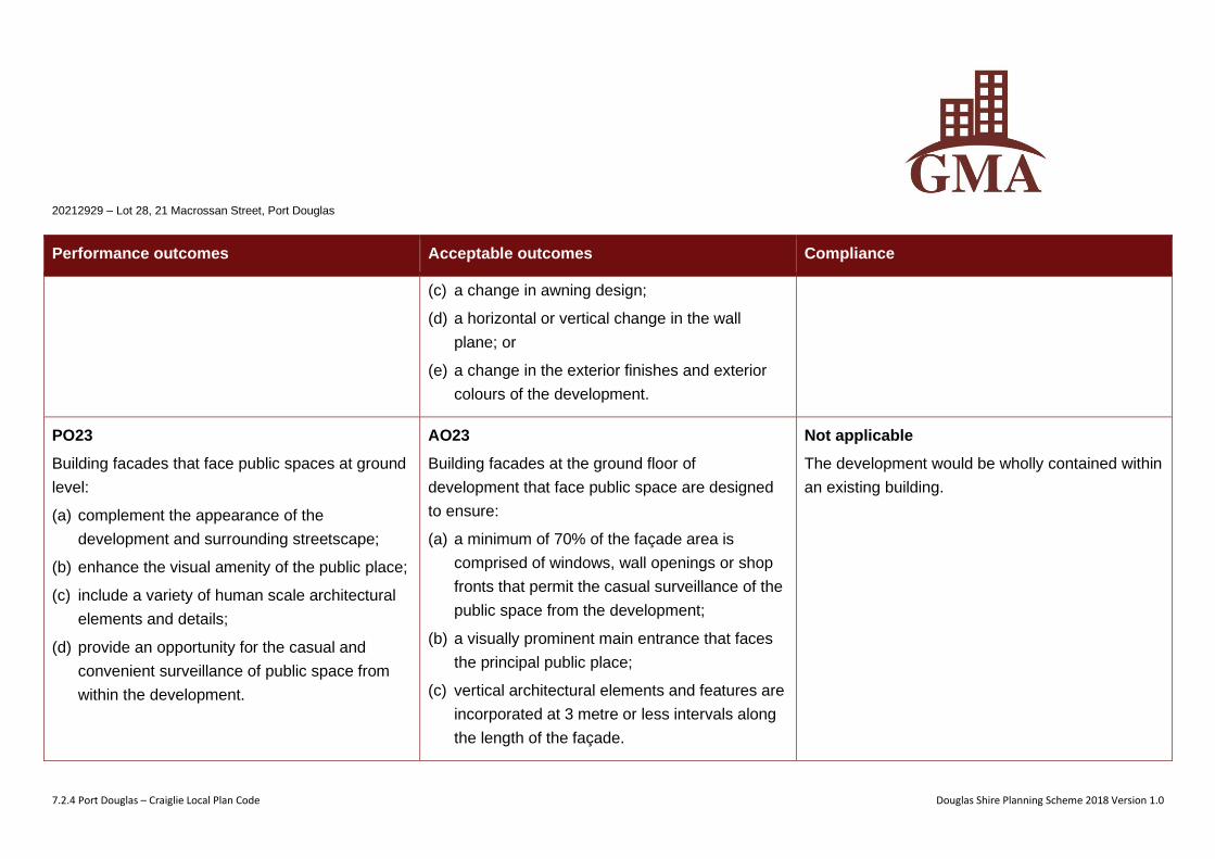
(c) a change in awning design;
(d) a horizontal or vertical change in the wall
plane; or
(e) a change in the exterior finishes and exterior
colours of the development.
PO23
Building facades that face public spaces at ground
level:
(a) complement the appearance of the
development and surrounding streetscape;
(b) enhance the visual amenity of the public place;
(c) include a variety of human scale architectural
elements and details;
(d) provide an opportunity for the casual and
convenient surveillance of public space from
within the development.
AO23
Building facades at the ground floor of
development that face public space are designed
to ensure:
(a) a minimum of 70% of the façade area is
comprised of windows, wall openings or shop
fronts that permit the casual surveillance of the
public space from the development;
(b) a visually prominent main entrance that faces
the principal public place;
(c) vertical architectural elements and features are
incorporated at 3 metre or less intervals along
the length of the façade.
Not applicable
The development would be wholly contained within
an existing building.
20212929 – Lot 28, 21 Macrossan Street, Port Douglas
7.2.4 Port Douglas – Craiglie Local Plan Code Douglas Shire Planning Scheme 2018 Version 1.0
Performance outcomes Acceptable outcomes Compliance
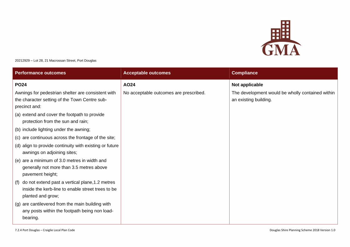
PO24
Awnings for pedestrian shelter are consistent with
the character setting of the Town Centre sub-
precinct and:
(a) extend and cover the footpath to provide
protection from the sun and rain;
(b) include lighting under the awning;
(c) are continuous across the frontage of the site;
(d) align to provide continuity with existing or future
awnings on adjoining sites;
(e) are a minimum of 3.0 metres in width and
generally not more than 3.5 metres above
pavement height;
(f) do not extend past a vertical plane,1.2 metres
inside the kerb-line to enable street trees to be
planted and grow;
(g) are cantilevered from the main building with
any posts within the footpath being non load-
bearing.
AO24
No acceptable outcomes are prescribed.
Not applicable
The development would be wholly contained within
an existing building.
20212929 – Lot 28, 21 Macrossan Street, Port Douglas
7.2.4 Port Douglas – Craiglie Local Plan Code Douglas Shire Planning Scheme 2018 Version 1.0
Performance outcomes Acceptable outcomes Compliance
PO25
Development integrates with the streetscape and
landscaping improvements for Port Douglas.
AO25
Development fronting Davidson Street, Macrossan
Street, Wharf Street, Mowbray Street and Warner
Street is designed to integrate with the on-street
landscaping and design improvements as outlined
within the Port Douglas landscape master plan
contained within Planning scheme policy SC6.7 –
Landscaping.
Note - Planning scheme policy SC6.7 -
Landscaping provides guidance on meeting the
Performance Outcome.
Not applicable
The development would be wholly contained within
an existing building.
Additional requirements for Sub-precinct 1b – Waterfront North sub-precinct
PO26
The establishment of uses is consistent with the
outcomes sought for sub-precinct 1b – Waterfront
North.
AO26
Uses identified as inconsistent uses in Table
7.2.4.4.b – inconsistent uses in sub-precinct 1b –
Waterfront North sub-precinct are not established
in sub-precinct 1b - Waterfront North.
Not applicable
The site is located within Sub-precinct 1a – Town
Centre.
20212929 – Lot 28, 21 Macrossan Street, Port Douglas
7.2.4 Port Douglas – Craiglie Local Plan Code Douglas Shire Planning Scheme 2018 Version 1.0
Performance outcomes Acceptable outcomes Compliance
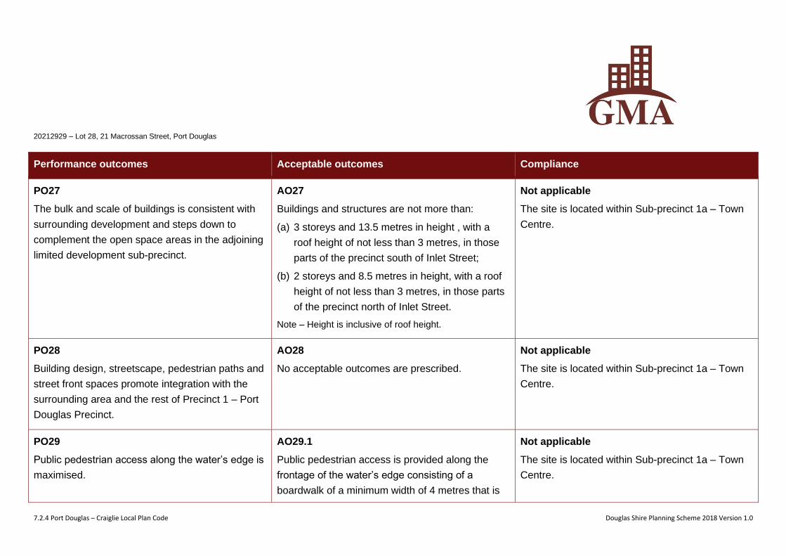
PO27
The bulk and scale of buildings is consistent with
surrounding development and steps down to
complement the open space areas in the adjoining
limited development sub-precinct.
AO27
Buildings and structures are not more than:
(a) 3 storeys and 13.5 metres in height , with a
roof height of not less than 3 metres, in those
parts of the precinct south of Inlet Street;
(b) 2 storeys and 8.5 metres in height, with a roof
height of not less than 3 metres, in those parts
of the precinct north of Inlet Street.
Note – Height is inclusive of roof height.
Not applicable
The site is located within Sub-precinct 1a – Town
Centre.
PO28
Building design, streetscape, pedestrian paths and
street front spaces promote integration with the
surrounding area and the rest of Precinct 1 – Port
Douglas Precinct.
AO28
No acceptable outcomes are prescribed.
Not applicable
The site is located within Sub-precinct 1a – Town
Centre.
PO29
Public pedestrian access along the water’s edge is
maximised.
AO29.1
Public pedestrian access is provided along the
frontage of the water’s edge consisting of a
boardwalk of a minimum width of 4 metres that is
Not applicable
The site is located within Sub-precinct 1a – Town
Centre.
20212929 – Lot 28, 21 Macrossan Street, Port Douglas
7.2.4 Port Douglas – Craiglie Local Plan Code Douglas Shire Planning Scheme 2018 Version 1.0
Performance outcomes Acceptable outcomes Compliance
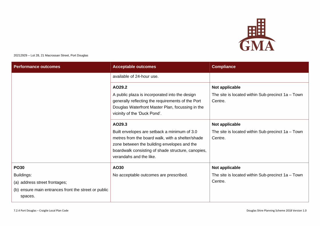
available of 24-hour use.
AO29.2
A public plaza is incorporated into the design
generally reflecting the requirements of the Port
Douglas Waterfront Master Plan, focussing in the
vicinity of the ‘Duck Pond’.
Not applicable
The site is located within Sub-precinct 1a – Town
Centre.
AO29.3
Built envelopes are setback a minimum of 3.0
metres from the board walk, with a shelter/shade
zone between the building envelopes and the
boardwalk consisting of shade structure, canopies,
verandahs and the like.
Not applicable
The site is located within Sub-precinct 1a – Town
Centre.
PO30
Buildings:
(a) address street frontages;
(b) ensure main entrances front the street or public
spaces.
AO30
No acceptable outcomes are prescribed.
Not applicable
The site is located within Sub-precinct 1a – Town
Centre.
20212929 – Lot 28, 21 Macrossan Street, Port Douglas
7.2.4 Port Douglas – Craiglie Local Plan Code Douglas Shire Planning Scheme 2018 Version 1.0
Performance outcomes Acceptable outcomes Compliance
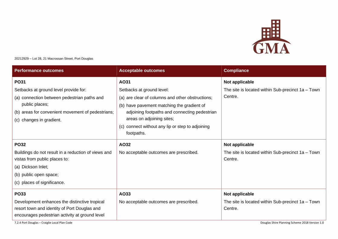
PO31
Setbacks at ground level provide for:
(a) connection between pedestrian paths and
public places;
(b) areas for convenient movement of pedestrians;
(c) changes in gradient.
AO31
Setbacks at ground level:
(a) are clear of columns and other obstructions;
(b) have pavement matching the gradient of
adjoining footpaths and connecting pedestrian
areas on adjoining sites;
(c) connect without any lip or step to adjoining
footpaths.
Not applicable
The site is located within Sub-precinct 1a – Town
Centre.
PO32
Buildings do not result in a reduction of views and
vistas from public places to:
(a) Dickson Inlet;
(b) public open space;
(c) places of significance.
AO32
No acceptable outcomes are prescribed.
Not applicable
The site is located within Sub-precinct 1a – Town
Centre.
PO33
Development enhances the distinctive tropical
resort town and identity of Port Douglas and
encourages pedestrian activity at ground level
AO33
No acceptable outcomes are prescribed.
Not applicable
The site is located within Sub-precinct 1a – Town
Centre.
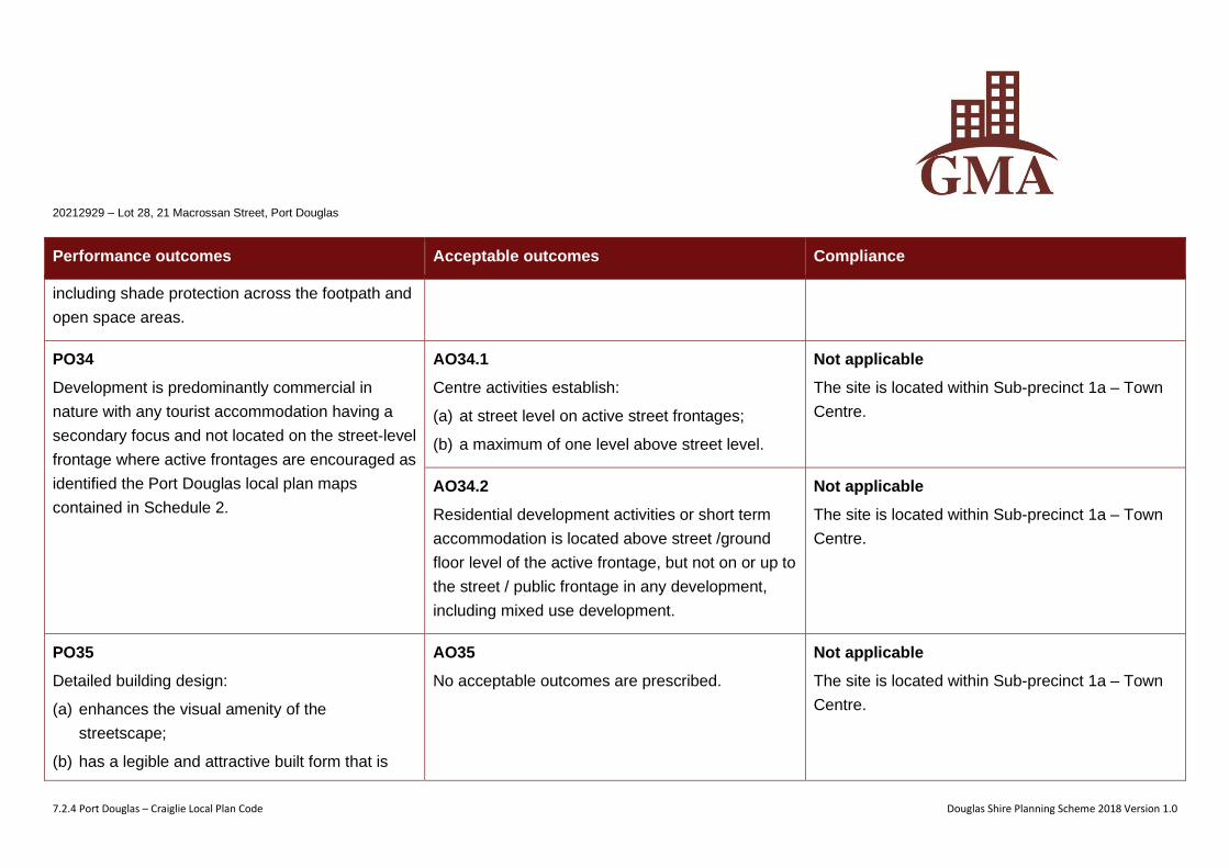
20212929 – Lot 28, 21 Macrossan Street, Port Douglas
7.2.4 Port Douglas – Craiglie Local Plan Code Douglas Shire Planning Scheme 2018 Version 1.0
Performance outcomes Acceptable outcomes Compliance
including shade protection across the footpath and
open space areas.
PO34
Development is predominantly commercial in
nature with any tourist accommodation having a
secondary focus and not located on the street-level
frontage where active frontages are encouraged as
identified the Port Douglas local plan maps
contained in Schedule 2.
AO34.1
Centre activities establish:
(a) at street level on active street frontages;
(b) a maximum of one level above street level.
Not applicable
The site is located within Sub-precinct 1a – Town
Centre.
AO34.2
Residential development activities or short term
accommodation is located above street /ground
floor level of the active frontage, but not on or up to
the street / public frontage in any development,
including mixed use development.
Not applicable
The site is located within Sub-precinct 1a – Town
Centre.
PO35
Detailed building design:
(a) enhances the visual amenity of the
streetscape;
(b) has a legible and attractive built form that is
AO35
No acceptable outcomes are prescribed.
Not applicable
The site is located within Sub-precinct 1a – Town
Centre.
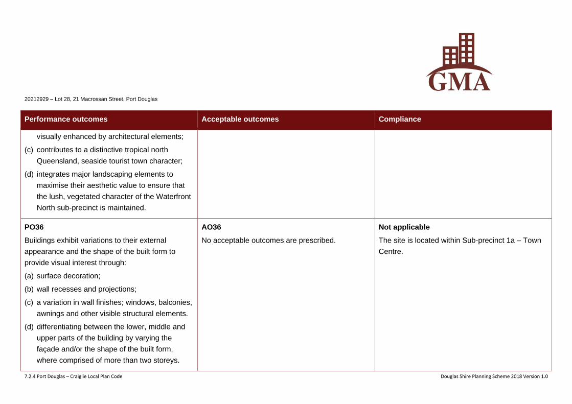
20212929 – Lot 28, 21 Macrossan Street, Port Douglas
7.2.4 Port Douglas – Craiglie Local Plan Code Douglas Shire Planning Scheme 2018 Version 1.0
Performance outcomes Acceptable outcomes Compliance
visually enhanced by architectural elements;
(c) contributes to a distinctive tropical north
Queensland, seaside tourist town character;
(d) integrates major landscaping elements to
maximise their aesthetic value to ensure that
the lush, vegetated character of the Waterfront
North sub-precinct is maintained.
PO36
Buildings exhibit variations to their external
appearance and the shape of the built form to
provide visual interest through:
(a) surface decoration;
(b) wall recesses and projections;
(c) a variation in wall finishes; windows, balconies,
awnings and other visible structural elements.
(d) differentiating between the lower, middle and
upper parts of the building by varying the
façade and/or the shape of the built form,
where comprised of more than two storeys.
AO36
No acceptable outcomes are prescribed.
Not applicable
The site is located within Sub-precinct 1a – Town
Centre.
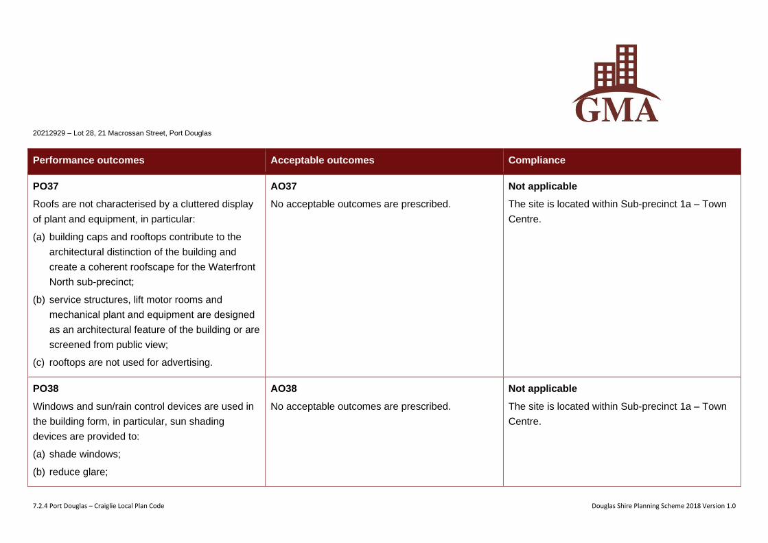
20212929 – Lot 28, 21 Macrossan Street, Port Douglas
7.2.4 Port Douglas – Craiglie Local Plan Code Douglas Shire Planning Scheme 2018 Version 1.0
Performance outcomes Acceptable outcomes Compliance
PO37
Roofs are not characterised by a cluttered display
of plant and equipment, in particular:
(a) building caps and rooftops contribute to the
architectural distinction of the building and
create a coherent roofscape for the Waterfront
North sub-precinct;
(b) service structures, lift motor rooms and
mechanical plant and equipment are designed
as an architectural feature of the building or are
screened from public view;
(c) rooftops are not used for advertising.
AO37
No acceptable outcomes are prescribed.
Not applicable
The site is located within Sub-precinct 1a – Town
Centre.
PO38
Windows and sun/rain control devices are used in
the building form, in particular, sun shading
devices are provided to:
(a) shade windows;
(b) reduce glare;
AO38
No acceptable outcomes are prescribed.
Not applicable
The site is located within Sub-precinct 1a – Town
Centre.
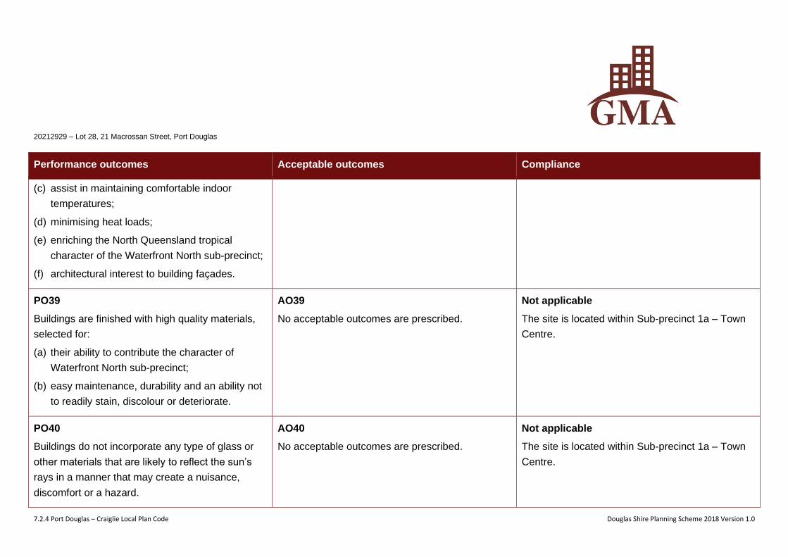
20212929 – Lot 28, 21 Macrossan Street, Port Douglas
7.2.4 Port Douglas – Craiglie Local Plan Code Douglas Shire Planning Scheme 2018 Version 1.0
Performance outcomes Acceptable outcomes Compliance
(c) assist in maintaining comfortable indoor
temperatures;
(d) minimising heat loads;
(e) enriching the North Queensland tropical
character of the Waterfront North sub-precinct;
(f) architectural interest to building façades.
PO39
Buildings are finished with high quality materials,
selected for:
(a) their ability to contribute the character of
Waterfront North sub-precinct;
(b) easy maintenance, durability and an ability not
to readily stain, discolour or deteriorate.
AO39
No acceptable outcomes are prescribed.
Not applicable
The site is located within Sub-precinct 1a – Town
Centre.
PO40
Buildings do not incorporate any type of glass or
other materials that are likely to reflect the sun’s
rays in a manner that may create a nuisance,
discomfort or a hazard.
AO40
No acceptable outcomes are prescribed.
Not applicable
The site is located within Sub-precinct 1a – Town
Centre.
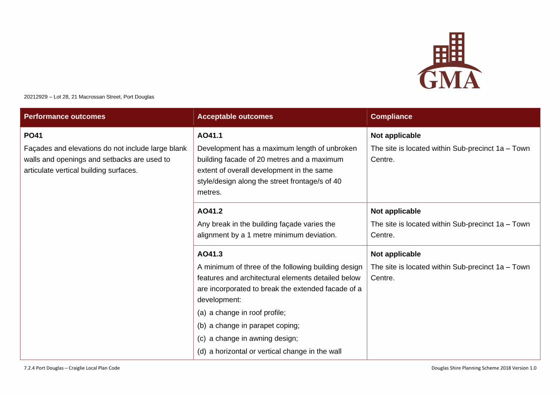
20212929 – Lot 28, 21 Macrossan Street, Port Douglas
7.2.4 Port Douglas – Craiglie Local Plan Code Douglas Shire Planning Scheme 2018 Version 1.0
Performance outcomes Acceptable outcomes Compliance
PO41
Façades and elevations do not include large blank
walls and openings and setbacks are used to
articulate vertical building surfaces.
AO41.1
Development has a maximum length of unbroken
building facade of 20 metres and a maximum
extent of overall development in the same
style/design along the street frontage/s of 40
metres.
Not applicable
The site is located within Sub-precinct 1a – Town
Centre.
AO41.2
Any break in the building façade varies the
alignment by a 1 metre minimum deviation.
Not applicable
The site is located within Sub-precinct 1a – Town
Centre.
AO41.3
A minimum of three of the following building design
features and architectural elements detailed below
are incorporated to break the extended facade of a
development:
(a) a change in roof profile;
(b) a change in parapet coping;
(c) a change in awning design;
(d) a horizontal or vertical change in the wall
Not applicable
The site is located within Sub-precinct 1a – Town
Centre.
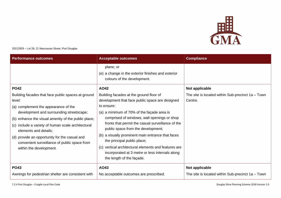
20212929 – Lot 28, 21 Macrossan Street, Port Douglas
7.2.4 Port Douglas – Craiglie Local Plan Code Douglas Shire Planning Scheme 2018 Version 1.0
Performance outcomes Acceptable outcomes Compliance
plane; or
(e) a change in the exterior finishes and exterior
colours of the development.
PO42
Building facades that face public spaces at ground
level:
(a) complement the appearance of the
development and surrounding streetscape;
(b) enhance the visual amenity of the public place;
(c) include a variety of human scale architectural
elements and details;
(d) provide an opportunity for the casual and
convenient surveillance of public space from
within the development.
AO42
Building facades at the ground floor of
development that face public space are designed
to ensure:
(a) a minimum of 70% of the façade area is
comprised of windows, wall openings or shop
fronts that permit the casual surveillance of the
public space from the development;
(b) a visually prominent main entrance that faces
the principal public place;
(c) vertical architectural elements and features are
incorporated at 3 metre or less intervals along
the length of the façade.
Not applicable
The site is located within Sub-precinct 1a – Town
Centre.
PO43
Awnings for pedestrian shelter are consistent with
AO43
No acceptable outcomes are prescribed.
Not applicable
The site is located within Sub-precinct 1a – Town
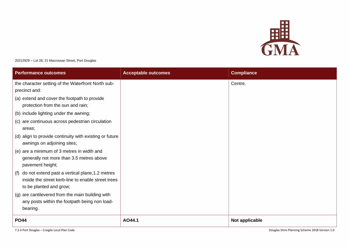
20212929 – Lot 28, 21 Macrossan Street, Port Douglas
7.2.4 Port Douglas – Craiglie Local Plan Code Douglas Shire Planning Scheme 2018 Version 1.0
Performance outcomes Acceptable outcomes Compliance
the character setting of the Waterfront North sub-
precinct and:
(a) extend and cover the footpath to provide
protection from the sun and rain;
(b) include lighting under the awning;
(c) are continuous across pedestrian circulation
areas;
(d) align to provide continuity with existing or future
awnings on adjoining sites;
(e) are a minimum of 3 metres in width and
generally not more than 3.5 metres above
pavement height;
(f) do not extend past a vertical plane,1.2 metres
inside the street kerb-line to enable street trees
to be planted and grow;
(g) are cantilevered from the main building with
any posts within the footpath being non load-
bearing.
Centre.
PO44 AO44.1 Not applicable
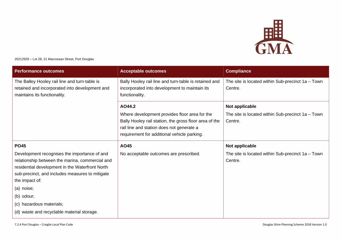
20212929 – Lot 28, 21 Macrossan Street, Port Douglas
7.2.4 Port Douglas – Craiglie Local Plan Code Douglas Shire Planning Scheme 2018 Version 1.0
Performance outcomes Acceptable outcomes Compliance
The Balley Hooley rail line and turn-table is
retained and incorporated into development and
maintains its functionality.
Bally Hooley rail line and turn-table is retained and
incorporated into development to maintain its
functionality.
The site is located within Sub-precinct 1a – Town
Centre.
AO44.2
Where development provides floor area for the
Bally Hooley rail station, the gross floor area of the
rail line and station does not generate a
requirement for additional vehicle parking.
Not applicable
The site is located within Sub-precinct 1a – Town
Centre.
PO45
Development recognises the importance of and
relationship between the marina, commercial and
residential development in the Waterfront North
sub-precinct, and includes measures to mitigate
the impact of:
(a) noise;
(b) odour;
(c) hazardous materials;
(d) waste and recyclable material storage.
AO45
No acceptable outcomes are prescribed.
Not applicable
The site is located within Sub-precinct 1a – Town
Centre.
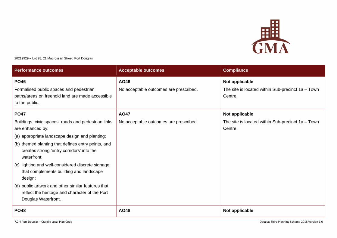
20212929 – Lot 28, 21 Macrossan Street, Port Douglas
7.2.4 Port Douglas – Craiglie Local Plan Code Douglas Shire Planning Scheme 2018 Version 1.0
Performance outcomes Acceptable outcomes Compliance
PO46
Formalised public spaces and pedestrian
paths/areas on freehold land are made accessible
to the public.
AO46
No acceptable outcomes are prescribed.
Not applicable
The site is located within Sub-precinct 1a – Town
Centre.
PO47
Buildings, civic spaces, roads and pedestrian links
are enhanced by:
(a) appropriate landscape design and planting;
(b) themed planting that defines entry points, and
creates strong ‘entry corridors’ into the
waterfront;
(c) lighting and well-considered discrete signage
that complements building and landscape
design;
(d) public artwork and other similar features that
reflect the heritage and character of the Port
Douglas Waterfront.
AO47
No acceptable outcomes are prescribed.
Not applicable
The site is located within Sub-precinct 1a – Town
Centre.
PO48 AO48 Not applicable
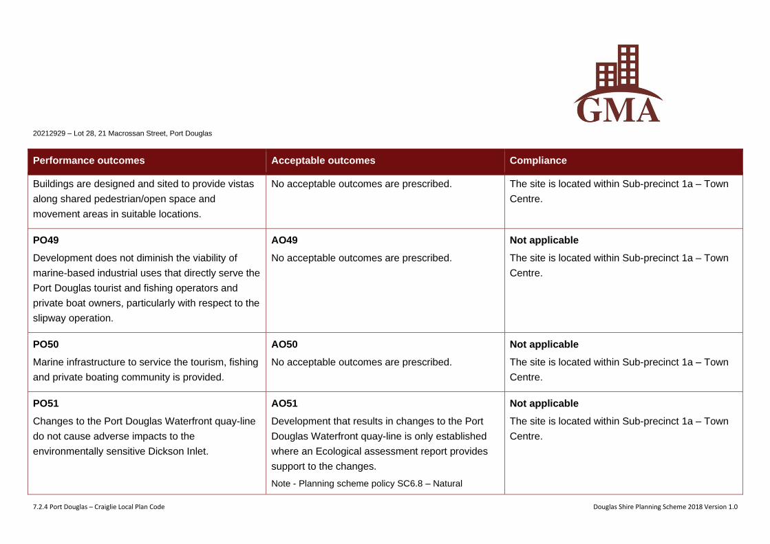
20212929 – Lot 28, 21 Macrossan Street, Port Douglas
7.2.4 Port Douglas – Craiglie Local Plan Code Douglas Shire Planning Scheme 2018 Version 1.0
Performance outcomes Acceptable outcomes Compliance
Buildings are designed and sited to provide vistas
along shared pedestrian/open space and
movement areas in suitable locations.
No acceptable outcomes are prescribed. The site is located within Sub-precinct 1a – Town
Centre.
PO49
Development does not diminish the viability of
marine-based industrial uses that directly serve the
Port Douglas tourist and fishing operators and
private boat owners, particularly with respect to the
slipway operation.
AO49
No acceptable outcomes are prescribed.
Not applicable
The site is located within Sub-precinct 1a – Town
Centre.
PO50
Marine infrastructure to service the tourism, fishing
and private boating community is provided.
AO50
No acceptable outcomes are prescribed.
Not applicable
The site is located within Sub-precinct 1a – Town
Centre.
PO51
Changes to the Port Douglas Waterfront quay-line
do not cause adverse impacts to the
environmentally sensitive Dickson Inlet.
AO51
Development that results in changes to the Port
Douglas Waterfront quay-line is only established
where an Ecological assessment report provides
support to the changes.
Note - Planning scheme policy SC6.8 – Natural
Not applicable
The site is located within Sub-precinct 1a – Town
Centre.
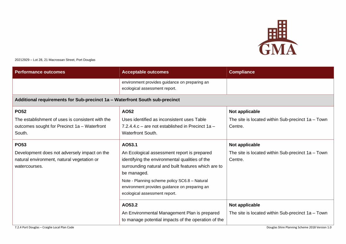
20212929 – Lot 28, 21 Macrossan Street, Port Douglas
7.2.4 Port Douglas – Craiglie Local Plan Code Douglas Shire Planning Scheme 2018 Version 1.0
Performance outcomes Acceptable outcomes Compliance
environment provides guidance on preparing an
ecological assessment report.
Additional requirements for Sub-precinct 1a – Waterfront South sub-precinct
PO52
The establishment of uses is consistent with the
outcomes sought for Precinct 1a – Waterfront
South.
AO52
Uses identified as inconsistent uses Table
7.2.4.4.c – are not established in Precinct 1a –
Waterfront South.
Not applicable
The site is located within Sub-precinct 1a – Town
Centre.
PO53
Development does not adversely impact on the
natural environment, natural vegetation or
watercourses.
AO53.1
An Ecological assessment report is prepared
identifying the environmental qualities of the
surrounding natural and built features which are to
be managed.
Note - Planning scheme policy SC6.8 – Natural
environment provides guidance on preparing an
ecological assessment report.
Not applicable
The site is located within Sub-precinct 1a – Town
Centre.
AO53.2
An Environmental Management Plan is prepared
to manage potential impacts of the operation of the
Not applicable
The site is located within Sub-precinct 1a – Town
20212929 – Lot 28, 21 Macrossan Street, Port Douglas
7.2.4 Port Douglas – Craiglie Local Plan Code Douglas Shire Planning Scheme 2018 Version 1.0
Performance outcomes Acceptable outcomes Compliance
development on surrounding natural areas.
Note - Planning scheme policy SC6.4 – Environmental
management plans contains information to demonstrate
compliance and guidance on preparing an
Environmental Management Plan.
Centre.
PO54
Development of land at the end of Port Street
adjacent to Dickson Inlet incorporates a slipway, or
an alternative functioning facility, with capacity to
service the Port Douglas marine and tourism
industry.
AO54
A master plan for the development is provided and
implemented to demonstrate the integration of the
slipway, or an alternative functioning facility, with
other supporting service industry activities that
service the marine and tourism industry of Port
Douglas.
Not applicable
The site is located within Sub-precinct 1a – Town
Centre.
PO55
Buildings and structures are of a height and are set
back from side boundaries and other sensitive
areas to ensure the scenic amenity and
environmental qualities of the adjacent area are
not adversely affected.
AO55.1
Development has a height of not more than 10
metres.
Not applicable
The site is located within Sub-precinct 1a – Town
Centre.
AO55.2
Development is setback from all property
boundaries not less than 3 metres.
Not applicable
The site is located within Sub-precinct 1a – Town
Centre.
20212929 – Lot 28, 21 Macrossan Street, Port Douglas
7.2.4 Port Douglas – Craiglie Local Plan Code Douglas Shire Planning Scheme 2018 Version 1.0
Performance outcomes Acceptable outcomes Compliance
PO56
The site coverage of all buildings and structures
ensures development:
(a) is sited in an existing cleared area or in an area
approved for clearing;
(b) has sufficient area for the provision of services;
(c) development does not have an adverse effect
on the environmental, habitat, conservation or
landscape values of the on-site and
surrounding sensitive areas.
AO56
No acceptable outcomes are prescribed.
Not applicable
The site is located within Sub-precinct 1a – Town
Centre.
PO57
Premises include adequate provision for service
vehicles, to cater for generated demand. Loading
areas for service vehicles are designed to:
(a) be accommodated on-site;
(b) maximise safety and efficiency of loading;
(c) protect the visual and acoustic amenity of
sensitive land use activities;
AO57.1
Sufficient manoeuvring area is provided on-site to
allow a Medium Rigid Vehicle to enter and leave
the site in a forward gear.
Not applicable
The site is located within Sub-precinct 1a – Town
Centre.
AO57.2
Development is designed to ensure all service
vehicles are contained within the site when being
Not applicable
The site is located within Sub-precinct 1a – Town
Centre.
20212929 – Lot 28, 21 Macrossan Street, Port Douglas
7.2.4 Port Douglas – Craiglie Local Plan Code Douglas Shire Planning Scheme 2018 Version 1.0
Performance outcomes Acceptable outcomes Compliance
(d) minimise adverse impacts on natural
characteristics of adjacent areas.
loaded/unloaded.
AO57.3
Driveways, parking and manoeuvring areas are
constructed and maintained to:
(a) minimise erosion from storm water runoff;
(b) retain all existing vegetation.
Not applicable
The site is located within Sub-precinct 1a – Town
Centre.
PO58
Development ensures adverse impacts from
service vehicles on the road network, external to
the site, are minimised.
AO58
No acceptable outcomes are prescribed.
Not applicable
The site is located within Sub-precinct 1a – Town
Centre.
PO59
Entry to the site is landscaped to enhance the
amenity of the area and provide a pleasant
working environment.
AO59
Areas used for loading and unloading, storage,
utilities and car parking are screened from public
view:
(a) by a combination of landscaping and screen
fencing;
(b) dense planting along any road frontage is a
Not applicable
The site is located within Sub-precinct 1a – Town
Centre.
20212929 – Lot 28, 21 Macrossan Street, Port Douglas
7.2.4 Port Douglas – Craiglie Local Plan Code Douglas Shire Planning Scheme 2018 Version 1.0
Performance outcomes Acceptable outcomes Compliance
minimum width of 3 metres.
PO60
Landscaping is informal in character and
complementary to the existing natural
environment, provides screening and enhances
the visual appearance of the development.
AO60
For any development landscaping is in accordance
with the Plant species schedule in Planning
scheme policy SC6.7– Landscaping.
Not applicable
The site is located within Sub-precinct 1a – Town
Centre.
Additional requirements for Sub-precinct 1d – Limited Development sub-precinct
PO61
The height of buildings and structures contributes
to the desired form and outcomes for the sub-
precinct and are limited to a single storey.
AO61
Buildings and structures are not more than one
storey and 4 metres in height.
Note - Height is inclusive of the roof height.
Not applicable
The site is located within Sub-precinct 1a – Town
Centre.
Additional requirements for Sub-precinct 1e – Community and recreation sub-precinct
PO62
The precinct is developed for organised sporting
activities and other community uses.
AO62
No acceptable outcomes are prescribed.
Not applicable
The site is located within Sub-precinct 1a – Town
Centre.
Additional requirements for Sub-precinct 1f – Flagstaff Hill sub-precinct
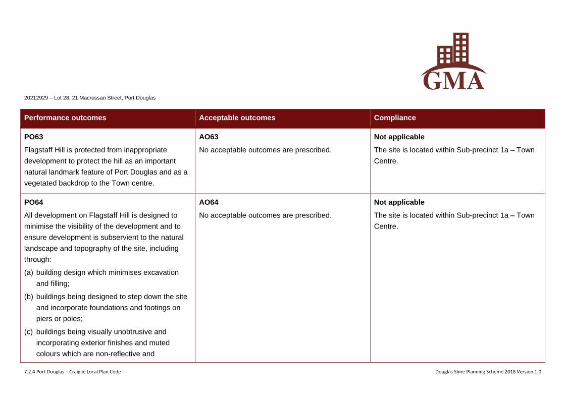
20212929 – Lot 28, 21 Macrossan Street, Port Douglas
7.2.4 Port Douglas – Craiglie Local Plan Code Douglas Shire Planning Scheme 2018 Version 1.0
Performance outcomes Acceptable outcomes Compliance
PO63
Flagstaff Hill is protected from inappropriate
development to protect the hill as an important
natural landmark feature of Port Douglas and as a
vegetated backdrop to the Town centre.
AO63
No acceptable outcomes are prescribed.
Not applicable
The site is located within Sub-precinct 1a – Town
Centre.
PO64
All development on Flagstaff Hill is designed to
minimise the visibility of the development and to
ensure development is subservient to the natural
landscape and topography of the site, including
through:
(a) building design which minimises excavation
and filling;
(b) buildings being designed to step down the site
and incorporate foundations and footings on
piers or poles;
(c) buildings being visually unobtrusive and
incorporating exterior finishes and muted
colours which are non-reflective and
AO64
No acceptable outcomes are prescribed.
Not applicable
The site is located within Sub-precinct 1a – Town
Centre.
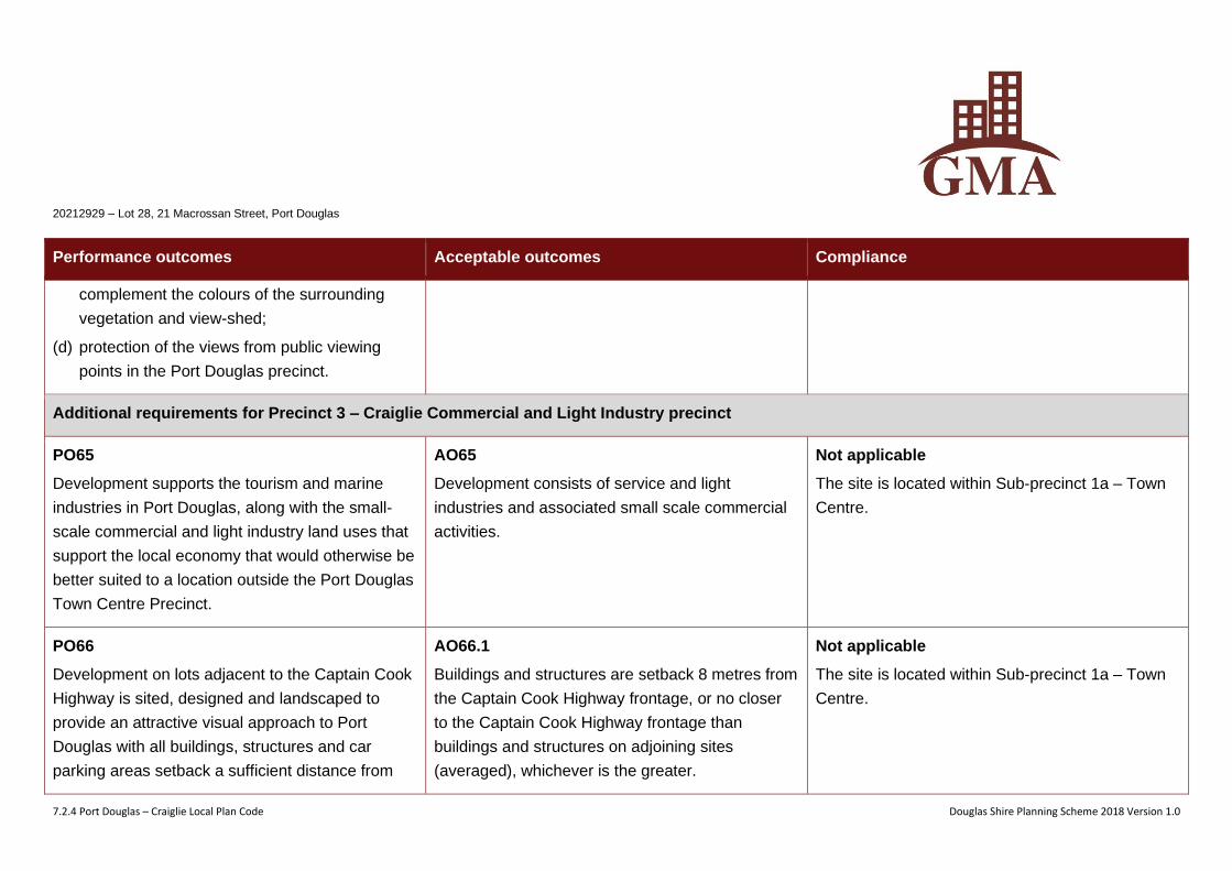
20212929 – Lot 28, 21 Macrossan Street, Port Douglas
7.2.4 Port Douglas – Craiglie Local Plan Code Douglas Shire Planning Scheme 2018 Version 1.0
Performance outcomes Acceptable outcomes Compliance
complement the colours of the surrounding
vegetation and view-shed;
(d) protection of the views from public viewing
points in the Port Douglas precinct.
Additional requirements for Precinct 3 – Craiglie Commercial and Light Industry precinct
PO65
Development supports the tourism and marine
industries in Port Douglas, along with the small-
scale commercial and light industry land uses that
support the local economy that would otherwise be
better suited to a location outside the Port Douglas
Town Centre Precinct.
AO65
Development consists of service and light
industries and associated small scale commercial
activities.
Not applicable
The site is located within Sub-precinct 1a – Town
Centre.
PO66
Development on lots adjacent to the Captain Cook
Highway is sited, designed and landscaped to
provide an attractive visual approach to Port
Douglas with all buildings, structures and car
parking areas setback a sufficient distance from
AO66.1
Buildings and structures are setback 8 metres from
the Captain Cook Highway frontage, or no closer
to the Captain Cook Highway frontage than
buildings and structures on adjoining sites
(averaged), whichever is the greater.
Not applicable
The site is located within Sub-precinct 1a – Town
Centre.
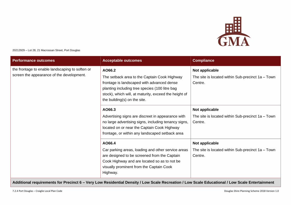
20212929 – Lot 28, 21 Macrossan Street, Port Douglas
7.2.4 Port Douglas – Craiglie Local Plan Code Douglas Shire Planning Scheme 2018 Version 1.0
Performance outcomes Acceptable outcomes Compliance
the frontage to enable landscaping to soften or
screen the appearance of the development.
AO66.2
The setback area to the Captain Cook Highway
frontage is landscaped with advanced dense
planting including tree species (100 litre bag
stock), which will, at maturity, exceed the height of
the building(s) on the site.
Not applicable
The site is located within Sub-precinct 1a – Town
Centre.
AO66.3
Advertising signs are discreet in appearance with
no large advertising signs, including tenancy signs,
located on or near the Captain Cook Highway
frontage, or within any landscaped setback area
Not applicable
The site is located within Sub-precinct 1a – Town
Centre.
AO66.4
Car parking areas, loading and other service areas
are designed to be screened from the Captain
Cook Highway and are located so as to not be
visually prominent from the Captain Cook
Highway.
Not applicable
The site is located within Sub-precinct 1a – Town
Centre.
Additional requirements for Precinct 6 – Very Low Residential Density / Low Scale Recreation / Low Scale Educational / Low Scale Entertainment
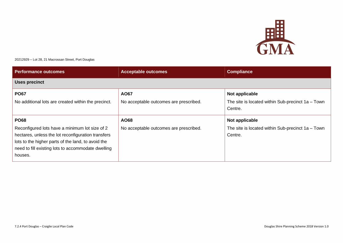
20212929 – Lot 28, 21 Macrossan Street, Port Douglas
7.2.4 Port Douglas – Craiglie Local Plan Code Douglas Shire Planning Scheme 2018 Version 1.0
Performance outcomes Acceptable outcomes Compliance
Uses precinct
PO67
No additional lots are created within the precinct.
AO67
No acceptable outcomes are prescribed.
Not applicable
The site is located within Sub-precinct 1a – Town
Centre.
PO68
Reconfigured lots have a minimum lot size of 2
hectares, unless the lot reconfiguration transfers
lots to the higher parts of the land, to avoid the
need to fill existing lots to accommodate dwelling
houses.
AO68
No acceptable outcomes are prescribed.
Not applicable
The site is located within Sub-precinct 1a – Town
Centre.
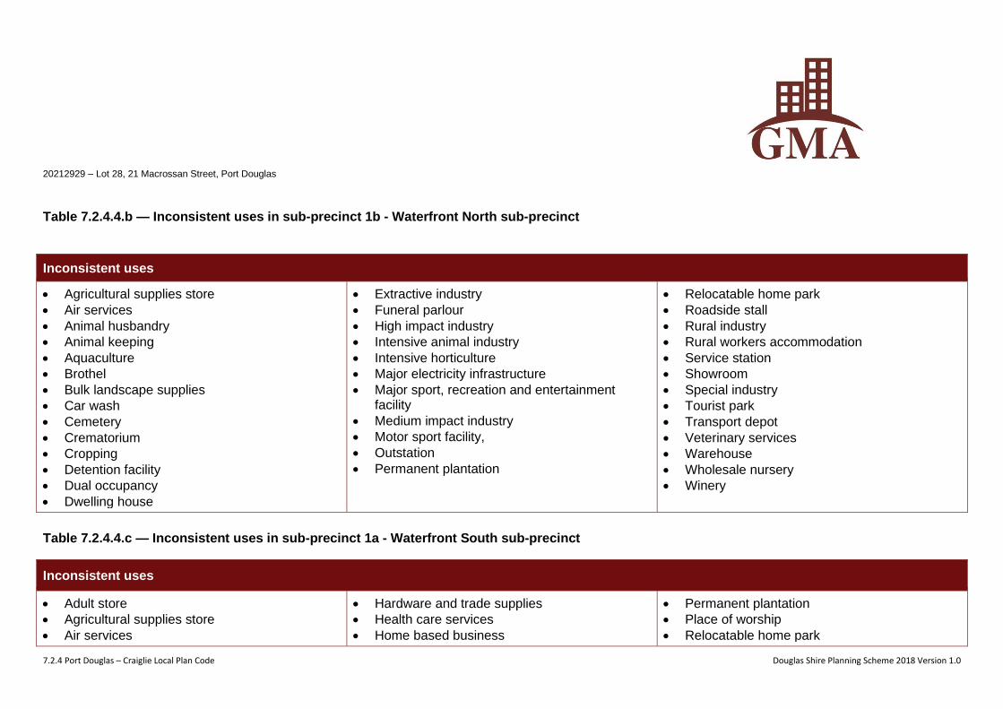
20212929 – Lot 28, 21 Macrossan Street, Port Douglas
7.2.4 Port Douglas – Craiglie Local Plan Code Douglas Shire Planning Scheme 2018 Version 1.0
Table 7.2.4.4.b — Inconsistent uses in sub-precinct 1b - Waterfront North sub-precinct
Inconsistent uses
• Agricultural supplies store
• Air services
• Animal husbandry
• Animal keeping
• Aquaculture
• Brothel
• Bulk landscape supplies
• Car wash
• Cemetery
• Crematorium
• Cropping
• Detention facility
• Dual occupancy
• Dwelling house
• Extractive industry
• Funeral parlour
• High impact industry
• Intensive animal industry
• Intensive horticulture
• Major electricity infrastructure
• Major sport, recreation and entertainment facility
• Medium impact industry
• Motor sport facility,
• Outstation
• Permanent plantation
• Relocatable home park
• Roadside stall
• Rural industry
• Rural workers accommodation
• Service station
• Showroom
• Special industry
• Tourist park
• Transport depot
• Veterinary services
• Warehouse
• Wholesale nursery
• Winery
Table 7.2.4.4.c — Inconsistent uses in sub-precinct 1a - Waterfront South sub-precinct
Inconsistent uses
• Adult store
• Agricultural supplies store
• Air services
• Hardware and trade supplies
• Health care services
• Home based business
• Permanent plantation
• Place of worship
• Relocatable home park
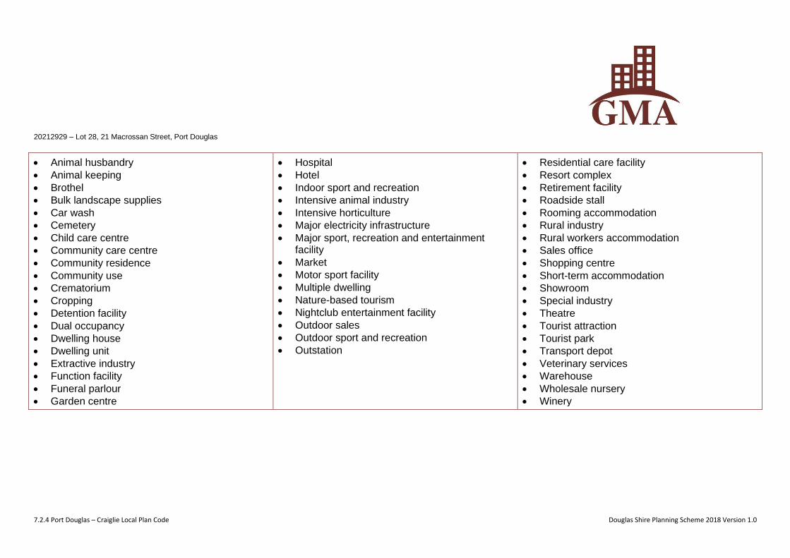
20212929 – Lot 28, 21 Macrossan Street, Port Douglas
7.2.4 Port Douglas – Craiglie Local Plan Code Douglas Shire Planning Scheme 2018 Version 1.0
• Animal husbandry
• Animal keeping
• Brothel
• Bulk landscape supplies
• Car wash
• Cemetery
• Child care centre
• Community care centre
• Community residence
• Community use
• Crematorium
• Cropping
• Detention facility
• Dual occupancy
• Dwelling house
• Dwelling unit
• Extractive industry
• Function facility
• Funeral parlour
• Garden centre
• Hospital
• Hotel
• Indoor sport and recreation
• Intensive animal industry
• Intensive horticulture
• Major electricity infrastructure
• Major sport, recreation and entertainment facility
• Market
• Motor sport facility
• Multiple dwelling
• Nature-based tourism
• Nightclub entertainment facility
• Outdoor sales
• Outdoor sport and recreation
• Outstation
• Residential care facility
• Resort complex
• Retirement facility
• Roadside stall
• Rooming accommodation
• Rural industry
• Rural workers accommodation
• Sales office
• Shopping centre
• Short-term accommodation
• Showroom
• Special industry
• Theatre
• Tourist attraction
• Tourist park
• Transport depot
• Veterinary services
• Warehouse
• Wholesale nursery
• Winery
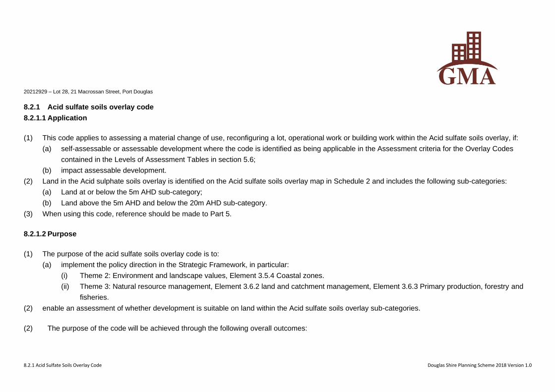
20212929 – Lot 28, 21 Macrossan Street, Port Douglas
8.2.1 Acid Sulfate Soils Overlay Code Douglas Shire Planning Scheme 2018 Version 1.0
8.2.1 Acid sulfate soils overlay code
8.2.1.1 Application
(1) This code applies to assessing a material change of use, reconfiguring a lot, operational work or building work within the Acid sulfate soils overlay, if:
(a) self-assessable or assessable development where the code is identified as being applicable in the Assessment criteria for the Overlay Codes
contained in the Levels of Assessment Tables in section 5.6;
(b) impact assessable development.
(2) Land in the Acid sulphate soils overlay is identified on the Acid sulfate soils overlay map in Schedule 2 and includes the following sub-categories:
(a) Land at or below the 5m AHD sub-category;
(b) Land above the 5m AHD and below the 20m AHD sub-category.
(3) When using this code, reference should be made to Part 5.
8.2.1.2 Purpose
(1) The purpose of the acid sulfate soils overlay code is to:
(a) implement the policy direction in the Strategic Framework, in particular:
(i) Theme 2: Environment and landscape values, Element 3.5.4 Coastal zones.
(ii) Theme 3: Natural resource management, Element 3.6.2 land and catchment management, Element 3.6.3 Primary production, forestry and
fisheries.
(2) enable an assessment of whether development is suitable on land within the Acid sulfate soils overlay sub-categories.
(2) The purpose of the code will be achieved through the following overall outcomes:
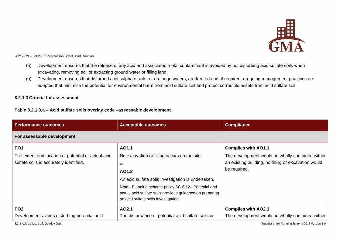
20212929 – Lot 28, 21 Macrossan Street, Port Douglas
8.2.1 Acid Sulfate Soils Overlay Code Douglas Shire Planning Scheme 2018 Version 1.0
(a) Development ensures that the release of any acid and associated metal contaminant is avoided by not disturbing acid sulfate soils when
excavating, removing soil or extracting ground water or filling land;
(b) Development ensures that disturbed acid sulphate soils, or drainage waters, are treated and, if required, on-going management practices are
adopted that minimise the potential for environmental harm from acid sulfate soil and protect corrodible assets from acid sulfate soil.
8.2.1.3 Criteria for assessment
Table 8.2.1.3.a – Acid sulfate soils overlay code –assessable development
Performance outcomes Acceptable outcomes Compliance
For assessable development
PO1
The extent and location of potential or actual acid
sulfate soils is accurately identified.
AO1.1
No excavation or filling occurs on the site.
or
AO1.2
An acid sulfate soils investigation is undertaken.
Note - Planning scheme policy SC 6.12– Potential and
actual acid sulfate soils provides guidance on preparing
an acid sulfate soils investigation.
Complies with AO1.1
The development would be wholly contained within
an existing building, no filling or excavation would
be required.
PO2
Development avoids disturbing potential acid
AO2.1
The disturbance of potential acid sulfate soils or
Complies with AO2.1
The development would be wholly contained within
20212929 – Lot 28, 21 Macrossan Street, Port Douglas
8.2.1 Acid Sulfate Soils Overlay Code Douglas Shire Planning Scheme 2018 Version 1.0
Performance outcomes Acceptable outcomes Compliance
sulfate soils or actual acid sulfate soils, or is
managed to avoid or minimise the release of acid
and metal contaminants.
actual acid sulfate soils is avoided by:
(a) not excavating, or otherwise removing, soil or
sediment identified as containing potential or
actual acid sulfate soils;
(b) not permanently or temporarily extracting
groundwater that results in the aeration of
previously saturated acid sulfate soils;
(c) not undertaking filling that results in:
(d) actual acid sulfate soils being moved below the
water table;
(e) previously saturated acid sulfate soils being
aerated.
or
AO2.2
The disturbance of potential acid sulfate soils or
actual acid sulfate soils is undertaken in
accordance with an acid sulfate soils management
plan and avoids the release of metal contaminants
by:
(a) neutralising existing acidity and preventing the
generation of acid and metal contaminants;
an existing building, no filling or excavation would
be required.
20212929 – Lot 28, 21 Macrossan Street, Port Douglas
8.2.1 Acid Sulfate Soils Overlay Code Douglas Shire Planning Scheme 2018 Version 1.0
Performance outcomes Acceptable outcomes Compliance
(b) preventing the release of surface or
groundwater flows containing acid and metal
contaminants into the environment;
(c) preventing the in situ oxidisation of potential
acid sulfate soils and actual acid sulfate soils
through ground water level management;
(d) appropriately treating acid sulfate soils before
disposal occurs on or off site;
(e) documenting strategies and reporting
requirements in an acid sulfate soils
environmental management plan.
Note - Planning scheme policy SC 6.12 – Acid sulfate
soils provides guidance on preparing an acid sulfate
soils management plan.
PO3
No environmental harm is caused as a result of
exposure to potential acid sulfate soils or actual
acid sulfate soils.
AO3
No acceptable outcomes are prescribed.
Complies with AO3
The development would be wholly contained within
an existing building, no filling or excavation would
be required.

20212929 – Lot 28, 21 Macrossan Street, Port Douglas
8.2.3 Coastal Environment Overlay Code Douglas Shire Planning Scheme 2018 Version 1.0
8.2.3 Coastal environment overlay code
8.2.3.1 Application
(1) This code applies to assessing a material change of use, reconfiguring a lot, operational work or building work within the Coastal environment overlay,
if:
(a) self assessable or assessable development where the code is identified as being applicable in the Assessment criteria for the Overlay Codes
contained in the Levels of Assessment Tables in section 5.6;
(b) impact assessable development.
(2) Land in the Coastal hazard overlay is identified on the Coastal environment overlay map in Schedule 2 and includes the following sub-categories:
(a) Coastal management district sub-category;
(b) Erosion prone area sub-category.
(3) When using this code, reference should be made to Part 5
8.2.3.2 Purpose
(1) The purpose of the Coastal environment overlay code is to:
(a) implement the policy direction in the Strategic Framework, in particular:
(i) Theme 1 Settlement pattern: Element 3.4.7 Mitigation of hazards;
(ii) Theme 2 Environment and landscape values: Element 3.5.4 Coastal zones;
20212929 – Lot 28, 21 Macrossan Street, Port Douglas
8.2.3 Coastal Environment Overlay Code Douglas Shire Planning Scheme 2018 Version 1.0
(iii) Theme 3 Natural resource management: Element 3.6.2 Land and catchment management.
(b) enable an assessment of whether development is suitable on land within the Coastal processes sub-categories.
(2) The purpose of the code will be achieved through the following overall outcomes:
(a) facilitate the protection of both coastal processes and coastal resources;
(b) facilitating coastal dependent development on the foreshore over other development;
(c) public access to the foreshore protects public safety;
(d) maintain the erosion prone area as a development free buffer zone (other than for coastal dependent, temporary or relocatable development);
(e) require redevelopment of existing permanent buildings or structures in an erosion prone area to avoid coastal erosion risks, manage coastal
erosion risks through a strategy of planned retreat or mitigate coastal erosion risks;
(f) require development to maintain or enhance natural processes and the protective function of landforms and vegetation that can mitigate risks
associated with coastal erosion;
(g) locate and design community infrastructure to maintain the required level of functionality during and immediately after a coastal hazard event.
8.2.3.3 Criteria for assessment
Table 8.2.3.3.a – Coastal environment overlay code – self-assessable and assessable development.
Performance outcomes Acceptable outcomes Compliance
For self-assessable and assessable development
20212929 – Lot 28, 21 Macrossan Street, Port Douglas
8.2.3 Coastal Environment Overlay Code Douglas Shire Planning Scheme 2018 Version 1.0
Performance outcomes Acceptable outcomes Compliance
PO1
No works other than coastal protection works
extend seaward of the coastal building line
AO1
Development (including all buildings and other
permanent structures such as swimming pools
and retaining walls) does not extend seaward of a
coastal building line.
Note – Coastal building lines are declared under the
Coastal Protection and Management Act 1995 and are
administered by the State Department of Environment
and Heritage Protection.
Not applicable
The development would be wholly contained
within an existing building.
AO1.2
Coastal protection works are only undertaken as a
last resort where coastal erosion presents an
immediate threat to public safety or existing
buildings or structures and the property cannot be
relocated or abandoned.
Not applicable
No coastal protection works are proposed.
AO1.3
Coastal protection works are as far landward as
practicable on the lot containing the property to
the maximum extent reasonable.
Not applicable
No coastal protection works are proposed.
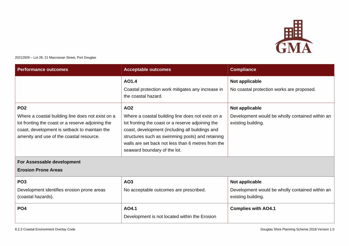
20212929 – Lot 28, 21 Macrossan Street, Port Douglas
8.2.3 Coastal Environment Overlay Code Douglas Shire Planning Scheme 2018 Version 1.0
Performance outcomes Acceptable outcomes Compliance
AO1.4
Coastal protection work mitigates any increase in
the coastal hazard.
Not applicable
No coastal protection works are proposed.
PO2
Where a coastal building line does not exist on a
lot fronting the coast or a reserve adjoining the
coast, development is setback to maintain the
amenity and use of the coastal resource.
AO2
Where a coastal building line does not exist on a
lot fronting the coast or a reserve adjoining the
coast, development (including all buildings and
structures such as swimming pools) and retaining
walls are set back not less than 6 metres from the
seaward boundary of the lot.
Not applicable
Development would be wholly contained within an
existing building.
For Assessable development
Erosion Prone Areas
PO3
Development identifies erosion prone areas
(coastal hazards).
AO3
No acceptable outcomes are prescribed.
Not applicable
Development would be wholly contained within an
existing building.
PO4 AO4.1
Development is not located within the Erosion
Complies with AO4.1
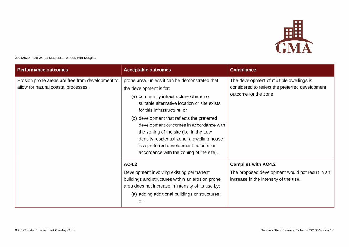
20212929 – Lot 28, 21 Macrossan Street, Port Douglas
8.2.3 Coastal Environment Overlay Code Douglas Shire Planning Scheme 2018 Version 1.0
Performance outcomes Acceptable outcomes Compliance
Erosion prone areas are free from development to
allow for natural coastal processes.
prone area, unless it can be demonstrated that
the development is for:
(a) community infrastructure where no
suitable alternative location or site exists
for this infrastructure; or
(b) development that reflects the preferred
development outcomes in accordance with
the zoning of the site (i.e. in the Low
density residential zone, a dwelling house
is a preferred development outcome in
accordance with the zoning of the site).
The development of multiple dwellings is
considered to reflect the preferred development
outcome for the zone.
AO4.2
Development involving existing permanent
buildings and structures within an erosion prone
area does not increase in intensity of its use by:
(a) adding additional buildings or structures;
or
Complies with AO4.2
The proposed development would not result in an
increase in the intensity of the use.
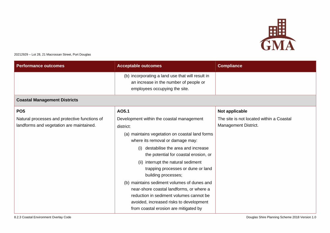
20212929 – Lot 28, 21 Macrossan Street, Port Douglas
8.2.3 Coastal Environment Overlay Code Douglas Shire Planning Scheme 2018 Version 1.0
Performance outcomes Acceptable outcomes Compliance
(b) incorporating a land use that will result in
an increase in the number of people or
employees occupying the site.
Coastal Management Districts
PO5
Natural processes and protective functions of
landforms and vegetation are maintained.
AO5.1
Development within the coastal management
district:
(a) maintains vegetation on coastal land forms
where its removal or damage may:
(i) destabilise the area and increase
the potential for coastal erosion, or
(ii) interrupt the natural sediment
trapping processes or dune or land
building processes;
(b) maintains sediment volumes of dunes and
near-shore coastal landforms, or where a
reduction in sediment volumes cannot be
avoided, increased risks to development
from coastal erosion are mitigated by
Not applicable
The site is not located within a Coastal
Management District.
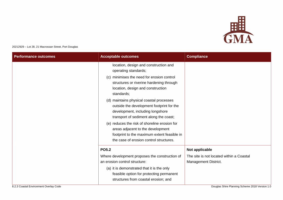
20212929 – Lot 28, 21 Macrossan Street, Port Douglas
8.2.3 Coastal Environment Overlay Code Douglas Shire Planning Scheme 2018 Version 1.0
Performance outcomes Acceptable outcomes Compliance
location, design and construction and
operating standards;
(c) minimises the need for erosion control
structures or riverine hardening through
location, design and construction
standards;
(d) maintains physical coastal processes
outside the development footprint for the
development, including longshore
transport of sediment along the coast;
(e) reduces the risk of shoreline erosion for
areas adjacent to the development
footprint to the maximum extent feasible in
the case of erosion control structures.
PO5.2
Where development proposes the construction of
an erosion control structure:
(a) it is demonstrated that it is the only
feasible option for protecting permanent
structures from coastal erosion; and
Not applicable
The site is not located within a Coastal
Management District.
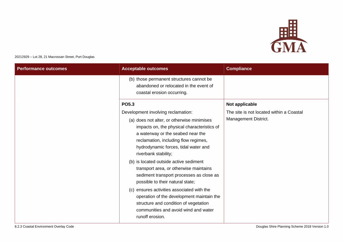
20212929 – Lot 28, 21 Macrossan Street, Port Douglas
8.2.3 Coastal Environment Overlay Code Douglas Shire Planning Scheme 2018 Version 1.0
Performance outcomes Acceptable outcomes Compliance
(b) those permanent structures cannot be
abandoned or relocated in the event of
coastal erosion occurring.
PO5.3
Development involving reclamation:
(a) does not alter, or otherwise minimises
impacts on, the physical characteristics of
a waterway or the seabed near the
reclamation, including flow regimes,
hydrodynamic forces, tidal water and
riverbank stability;
(b) is located outside active sediment
transport area, or otherwise maintains
sediment transport processes as close as
possible to their natural state;
(c) ensures activities associated with the
operation of the development maintain the
structure and condition of vegetation
communities and avoid wind and water
runoff erosion.
Not applicable
The site is not located within a Coastal
Management District.
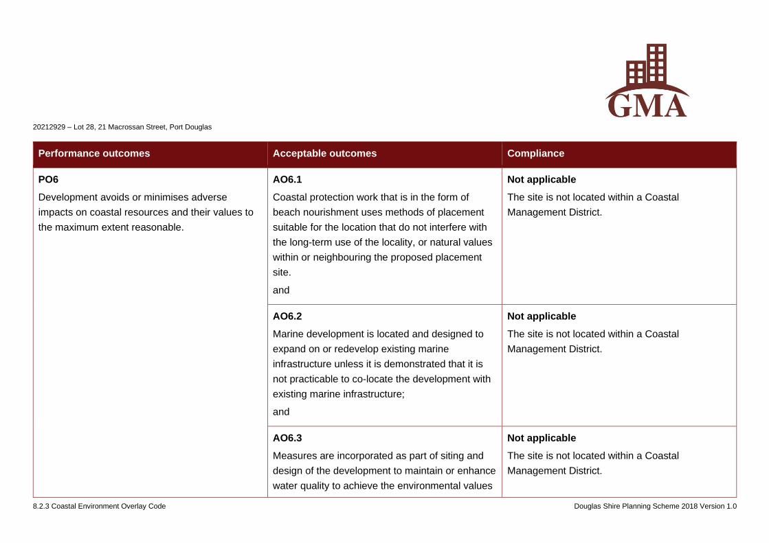
20212929 – Lot 28, 21 Macrossan Street, Port Douglas
8.2.3 Coastal Environment Overlay Code Douglas Shire Planning Scheme 2018 Version 1.0
Performance outcomes Acceptable outcomes Compliance
PO6
Development avoids or minimises adverse
impacts on coastal resources and their values to
the maximum extent reasonable.
AO6.1
Coastal protection work that is in the form of
beach nourishment uses methods of placement
suitable for the location that do not interfere with
the long-term use of the locality, or natural values
within or neighbouring the proposed placement
site.
and
Not applicable
The site is not located within a Coastal
Management District.
AO6.2
Marine development is located and designed to
expand on or redevelop existing marine
infrastructure unless it is demonstrated that it is
not practicable to co-locate the development with
existing marine infrastructure;
and
Not applicable
The site is not located within a Coastal
Management District.
AO6.3
Measures are incorporated as part of siting and
design of the development to maintain or enhance
water quality to achieve the environmental values
Not applicable
The site is not located within a Coastal
Management District.
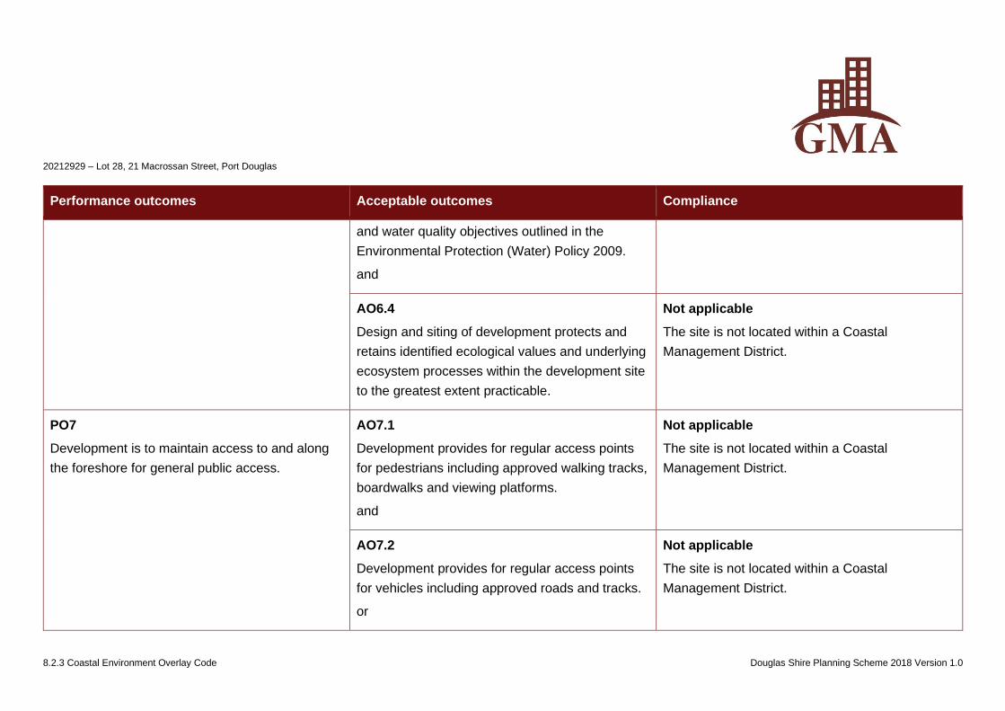
20212929 – Lot 28, 21 Macrossan Street, Port Douglas
8.2.3 Coastal Environment Overlay Code Douglas Shire Planning Scheme 2018 Version 1.0
Performance outcomes Acceptable outcomes Compliance
and water quality objectives outlined in the
Environmental Protection (Water) Policy 2009.
and
AO6.4
Design and siting of development protects and
retains identified ecological values and underlying
ecosystem processes within the development site
to the greatest extent practicable.
Not applicable
The site is not located within a Coastal
Management District.
PO7
Development is to maintain access to and along
the foreshore for general public access.
AO7.1
Development provides for regular access points
for pedestrians including approved walking tracks,
boardwalks and viewing platforms.
and
Not applicable
The site is not located within a Coastal
Management District.
AO7.2
Development provides for regular access points
for vehicles including approved roads and tracks.
or
Not applicable
The site is not located within a Coastal
Management District.
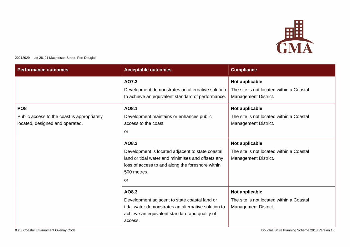
20212929 – Lot 28, 21 Macrossan Street, Port Douglas
8.2.3 Coastal Environment Overlay Code Douglas Shire Planning Scheme 2018 Version 1.0
Performance outcomes Acceptable outcomes Compliance
AO7.3
Development demonstrates an alternative solution
to achieve an equivalent standard of performance.
Not applicable
The site is not located within a Coastal
Management District.
PO8
Public access to the coast is appropriately
located, designed and operated.
AO8.1
Development maintains or enhances public
access to the coast.
or
Not applicable
The site is not located within a Coastal
Management District.
AO8.2
Development is located adjacent to state coastal
land or tidal water and minimises and offsets any
loss of access to and along the foreshore within
500 metres.
or
Not applicable
The site is not located within a Coastal
Management District.
AO8.3
Development adjacent to state coastal land or
tidal water demonstrates an alternative solution to
achieve an equivalent standard and quality of
access.
Not applicable
The site is not located within a Coastal
Management District.
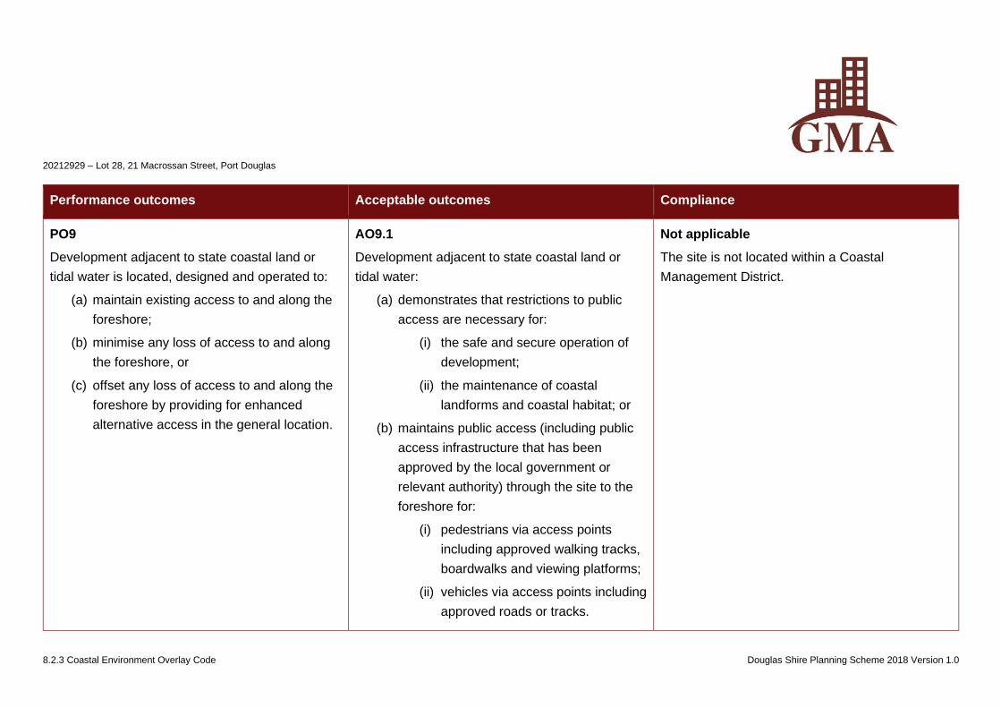
20212929 – Lot 28, 21 Macrossan Street, Port Douglas
8.2.3 Coastal Environment Overlay Code Douglas Shire Planning Scheme 2018 Version 1.0
Performance outcomes Acceptable outcomes Compliance
PO9
Development adjacent to state coastal land or
tidal water is located, designed and operated to:
(a) maintain existing access to and along the
foreshore;
(b) minimise any loss of access to and along
the foreshore, or
(c) offset any loss of access to and along the
foreshore by providing for enhanced
alternative access in the general location.
AO9.1
Development adjacent to state coastal land or
tidal water:
(a) demonstrates that restrictions to public
access are necessary for:
(i) the safe and secure operation of
development;
(ii) the maintenance of coastal
landforms and coastal habitat; or
(b) maintains public access (including public
access infrastructure that has been
approved by the local government or
relevant authority) through the site to the
foreshore for:
(i) pedestrians via access points
including approved walking tracks,
boardwalks and viewing platforms;
(ii) vehicles via access points including
approved roads or tracks.
Not applicable
The site is not located within a Coastal
Management District.
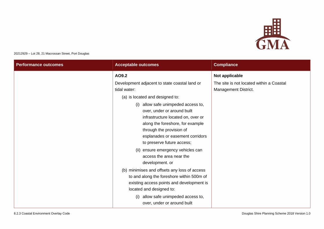
20212929 – Lot 28, 21 Macrossan Street, Port Douglas
8.2.3 Coastal Environment Overlay Code Douglas Shire Planning Scheme 2018 Version 1.0
Performance outcomes Acceptable outcomes Compliance
AO9.2
Development adjacent to state coastal land or
tidal water:
(a) is located and designed to:
(i) allow safe unimpeded access to,
over, under or around built
infrastructure located on, over or
along the foreshore, for example
through the provision of
esplanades or easement corridors
to preserve future access;
(ii) ensure emergency vehicles can
access the area near the
development. or
(b) minimises and offsets any loss of access
to and along the foreshore within 500m of
existing access points and development is
located and designed to:
(i) allow safe unimpeded access to,
over, under or around built
Not applicable
The site is not located within a Coastal
Management District.
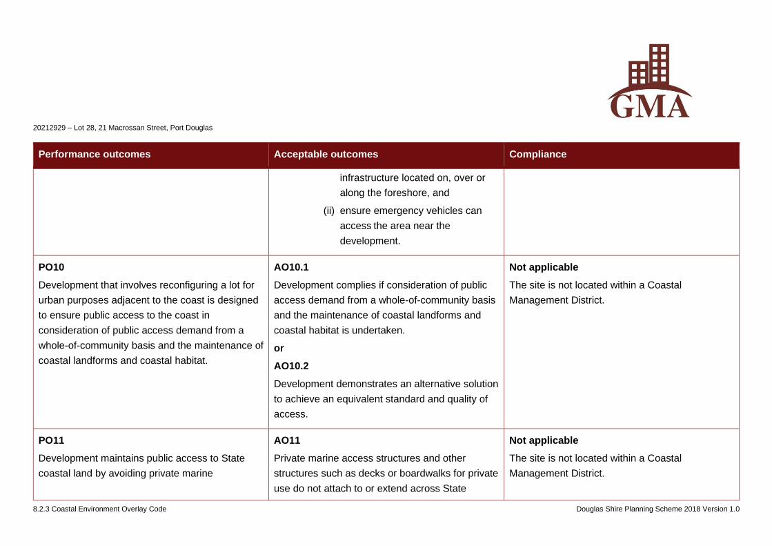
20212929 – Lot 28, 21 Macrossan Street, Port Douglas
8.2.3 Coastal Environment Overlay Code Douglas Shire Planning Scheme 2018 Version 1.0
Performance outcomes Acceptable outcomes Compliance
infrastructure located on, over or
along the foreshore, and
(ii) ensure emergency vehicles can
access the area near the
development.
PO10
Development that involves reconfiguring a lot for
urban purposes adjacent to the coast is designed
to ensure public access to the coast in
consideration of public access demand from a
whole-of-community basis and the maintenance of
coastal landforms and coastal habitat.
AO10.1
Development complies if consideration of public
access demand from a whole-of-community basis
and the maintenance of coastal landforms and
coastal habitat is undertaken.
or
AO10.2
Development demonstrates an alternative solution
to achieve an equivalent standard and quality of
access.
Not applicable
The site is not located within a Coastal
Management District.
PO11
Development maintains public access to State
coastal land by avoiding private marine
AO11
Private marine access structures and other
structures such as decks or boardwalks for private
use do not attach to or extend across State
Not applicable
The site is not located within a Coastal
Management District.
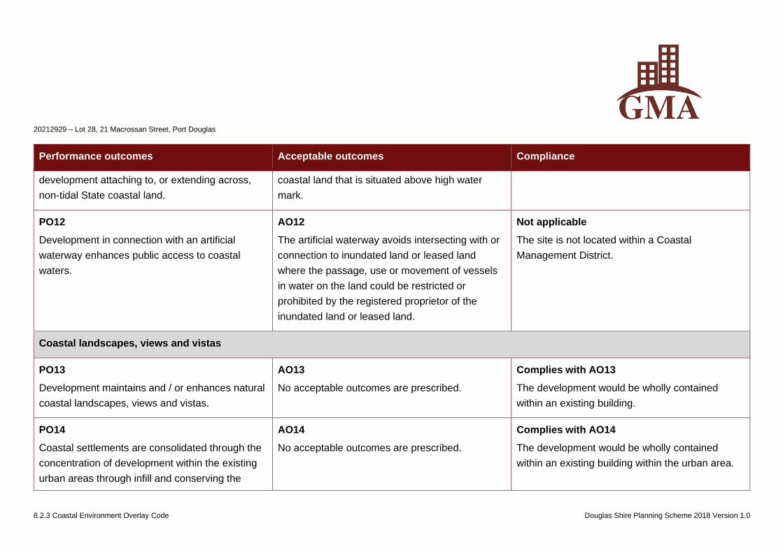
20212929 – Lot 28, 21 Macrossan Street, Port Douglas
8.2.3 Coastal Environment Overlay Code Douglas Shire Planning Scheme 2018 Version 1.0
Performance outcomes Acceptable outcomes Compliance
development attaching to, or extending across,
non-tidal State coastal land.
coastal land that is situated above high water
mark.
PO12
Development in connection with an artificial
waterway enhances public access to coastal
waters.
AO12
The artificial waterway avoids intersecting with or
connection to inundated land or leased land
where the passage, use or movement of vessels
in water on the land could be restricted or
prohibited by the registered proprietor of the
inundated land or leased land.
Not applicable
The site is not located within a Coastal
Management District.
Coastal landscapes, views and vistas
PO13
Development maintains and / or enhances natural
coastal landscapes, views and vistas.
AO13
No acceptable outcomes are prescribed.
Complies with AO13
The development would be wholly contained
within an existing building.
PO14
Coastal settlements are consolidated through the
concentration of development within the existing
urban areas through infill and conserving the
AO14
No acceptable outcomes are prescribed.
Complies with AO14
The development would be wholly contained
within an existing building within the urban area.
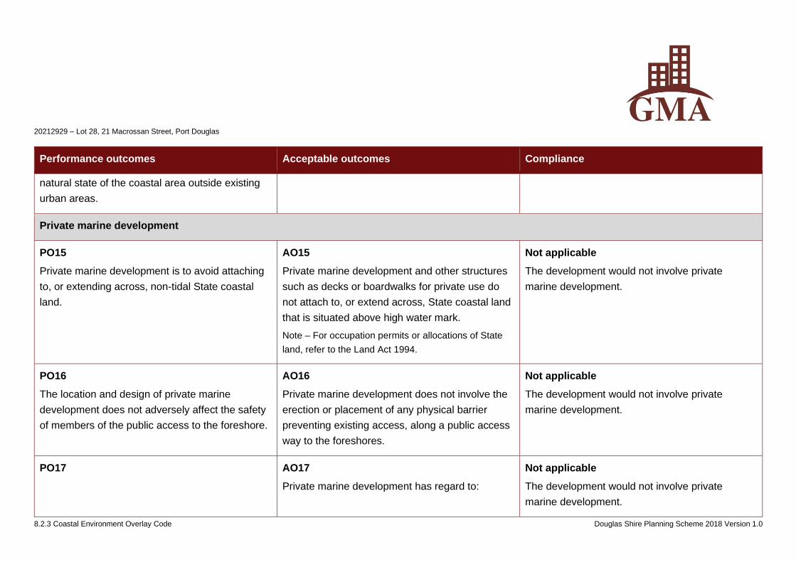
20212929 – Lot 28, 21 Macrossan Street, Port Douglas
8.2.3 Coastal Environment Overlay Code Douglas Shire Planning Scheme 2018 Version 1.0
Performance outcomes Acceptable outcomes Compliance
natural state of the coastal area outside existing
urban areas.
Private marine development
PO15
Private marine development is to avoid attaching
to, or extending across, non-tidal State coastal
land.
AO15
Private marine development and other structures
such as decks or boardwalks for private use do
not attach to, or extend across, State coastal land
that is situated above high water mark.
Note – For occupation permits or allocations of State
land, refer to the Land Act 1994.
Not applicable
The development would not involve private
marine development.
PO16
The location and design of private marine
development does not adversely affect the safety
of members of the public access to the foreshore.
AO16
Private marine development does not involve the
erection or placement of any physical barrier
preventing existing access, along a public access
way to the foreshores.
Not applicable
The development would not involve private
marine development.
PO17 AO17
Private marine development has regard to:
Not applicable
The development would not involve private
marine development.
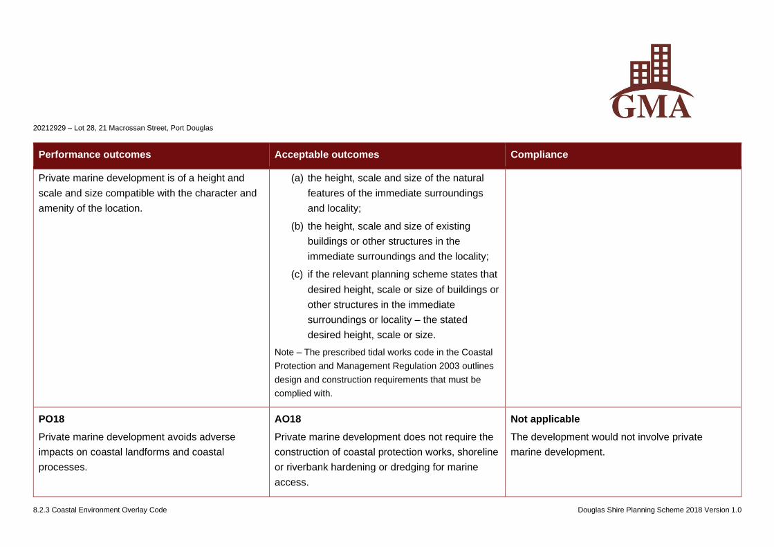
20212929 – Lot 28, 21 Macrossan Street, Port Douglas
8.2.3 Coastal Environment Overlay Code Douglas Shire Planning Scheme 2018 Version 1.0
Performance outcomes Acceptable outcomes Compliance
Private marine development is of a height and
scale and size compatible with the character and
amenity of the location.
(a) the height, scale and size of the natural
features of the immediate surroundings
and locality;
(b) the height, scale and size of existing
buildings or other structures in the
immediate surroundings and the locality;
(c) if the relevant planning scheme states that
desired height, scale or size of buildings or
other structures in the immediate
surroundings or locality – the stated
desired height, scale or size.
Note – The prescribed tidal works code in the Coastal
Protection and Management Regulation 2003 outlines
design and construction requirements that must be
complied with.
PO18
Private marine development avoids adverse
impacts on coastal landforms and coastal
processes.
AO18
Private marine development does not require the
construction of coastal protection works, shoreline
or riverbank hardening or dredging for marine
access.
Not applicable
The development would not involve private
marine development.
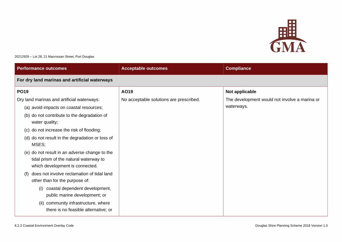
20212929 – Lot 28, 21 Macrossan Street, Port Douglas
8.2.3 Coastal Environment Overlay Code Douglas Shire Planning Scheme 2018 Version 1.0
Performance outcomes Acceptable outcomes Compliance
For dry land marinas and artificial waterways
PO19
Dry land marinas and artificial waterways:
(a) avoid impacts on coastal resources;
(b) do not contribute to the degradation of
water quality;
(c) do not increase the risk of flooding;
(d) do not result in the degradation or loss of
MSES;
(e) do not result in an adverse change to the
tidal prism of the natural waterway to
which development is connected.
(f) does not involve reclamation of tidal land
other than for the purpose of:
(i) coastal dependent development,
public marine development; or
(ii) community infrastructure, where
there is no feasible alternative; or
AO19
No acceptable solutions are prescribed.
Not applicable
The development would not involve a marina or
waterways.

20212929 – Lot 28, 21 Macrossan Street, Port Douglas
8.2.3 Coastal Environment Overlay Code Douglas Shire Planning Scheme 2018 Version 1.0
Performance outcomes Acceptable outcomes Compliance
(iii) strategic ports, boat harbours or
strategic airports and aviation
facilities in accordance with a
statutory land use plan; or
(iv) coastal protection works or works
necessary to protect coastal
resources and processes.
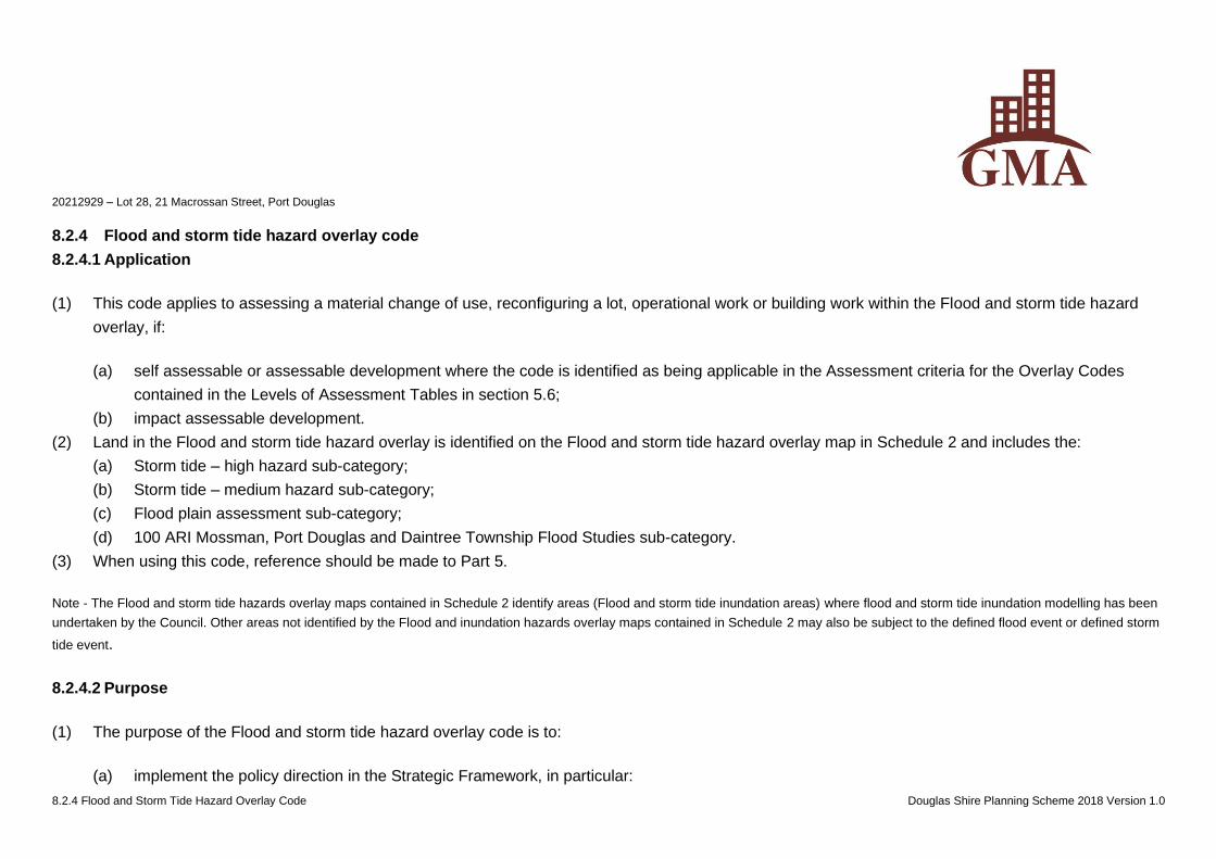
20212929 – Lot 28, 21 Macrossan Street, Port Douglas
8.2.4 Flood and Storm Tide Hazard Overlay Code Douglas Shire Planning Scheme 2018 Version 1.0
8.2.4 Flood and storm tide hazard overlay code
8.2.4.1 Application
(1) This code applies to assessing a material change of use, reconfiguring a lot, operational work or building work within the Flood and storm tide hazard
overlay, if:
(a) self assessable or assessable development where the code is identified as being applicable in the Assessment criteria for the Overlay Codes
contained in the Levels of Assessment Tables in section 5.6;
(b) impact assessable development.
(2) Land in the Flood and storm tide hazard overlay is identified on the Flood and storm tide hazard overlay map in Schedule 2 and includes the:
(a) Storm tide – high hazard sub-category;
(b) Storm tide – medium hazard sub-category;
(c) Flood plain assessment sub-category;
(d) 100 ARI Mossman, Port Douglas and Daintree Township Flood Studies sub-category.
(3) When using this code, reference should be made to Part 5.
Note - The Flood and storm tide hazards overlay maps contained in Schedule 2 identify areas (Flood and storm tide inundation areas) where flood and storm tide inundation modelling has been
undertaken by the Council. Other areas not identified by the Flood and inundation hazards overlay maps contained in Schedule 2 may also be subject to the defined flood event or defined storm
tide event.
8.2.4.2 Purpose
(1) The purpose of the Flood and storm tide hazard overlay code is to:
(a) implement the policy direction in the Strategic Framework, in particular:
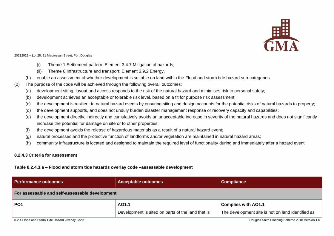
20212929 – Lot 28, 21 Macrossan Street, Port Douglas
8.2.4 Flood and Storm Tide Hazard Overlay Code Douglas Shire Planning Scheme 2018 Version 1.0
(i) Theme 1 Settlement pattern: Element 3.4.7 Mitigation of hazards;
(ii) Theme 6 Infrastructure and transport: Element 3.9.2 Energy.
(b) enable an assessment of whether development is suitable on land within the Flood and storm tide hazard sub-categories.
(2) The purpose of the code will be achieved through the following overall outcomes:
(a) development siting, layout and access responds to the risk of the natural hazard and minimises risk to personal safety;
(b) development achieves an acceptable or tolerable risk level, based on a fit for purpose risk assessment;
(c) the development is resilient to natural hazard events by ensuring siting and design accounts for the potential risks of natural hazards to property;
(d) the development supports, and does not unduly burden disaster management response or recovery capacity and capabilities;
(e) the development directly, indirectly and cumulatively avoids an unacceptable increase in severity of the natural hazards and does not significantly
increase the potential for damage on site or to other properties;
(f) the development avoids the release of hazardous materials as a result of a natural hazard event;
(g) natural processes and the protective function of landforms and/or vegetation are maintained in natural hazard areas;
(h) community infrastructure is located and designed to maintain the required level of functionality during and immediately after a hazard event.
8.2.4.3 Criteria for assessment
Table 8.2.4.3.a – Flood and storm tide hazards overlay code –assessable development
Performance outcomes Acceptable outcomes Compliance
For assessable and self-assessable development
PO1 AO1.1
Development is sited on parts of the land that is
Complies with AO1.1
The development site is not on land identified as
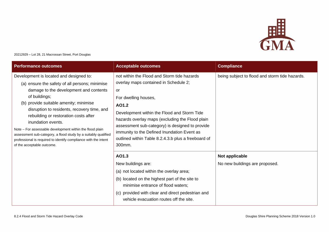
20212929 – Lot 28, 21 Macrossan Street, Port Douglas
8.2.4 Flood and Storm Tide Hazard Overlay Code Douglas Shire Planning Scheme 2018 Version 1.0
Performance outcomes Acceptable outcomes Compliance
Development is located and designed to:
(a) ensure the safety of all persons; minimise
damage to the development and contents
of buildings;
(b) provide suitable amenity; minimise
disruption to residents, recovery time, and
rebuilding or restoration costs after
inundation events.
Note – For assessable development within the flood plain
assessment sub-category, a flood study by a suitably qualified
professional is required to identify compliance with the intent
of the acceptable outcome.
not within the Flood and Storm tide hazards
overlay maps contained in Schedule 2;
or
For dwelling houses,
AO1.2
Development within the Flood and Storm Tide
hazards overlay maps (excluding the Flood plain
assessment sub-category) is designed to provide
immunity to the Defined Inundation Event as
outlined within Table 8.2.4.3.b plus a freeboard of
300mm.
being subject to flood and storm tide hazards.
AO1.3
New buildings are:
(a) not located within the overlay area;
(b) located on the highest part of the site to
minimise entrance of flood waters;
(c) provided with clear and direct pedestrian and
vehicle evacuation routes off the site.
Not applicable
No new buildings are proposed.
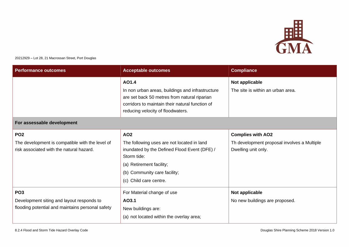
20212929 – Lot 28, 21 Macrossan Street, Port Douglas
8.2.4 Flood and Storm Tide Hazard Overlay Code Douglas Shire Planning Scheme 2018 Version 1.0
Performance outcomes Acceptable outcomes Compliance
AO1.4
In non urban areas, buildings and infrastructure
are set back 50 metres from natural riparian
corridors to maintain their natural function of
reducing velocity of floodwaters.
Not applicable
The site is within an urban area.
For assessable development
PO2
The development is compatible with the level of
risk associated with the natural hazard.
AO2
The following uses are not located in land
inundated by the Defined Flood Event (DFE) /
Storm tide:
(a) Retirement facility;
(b) Community care facility;
(c) Child care centre.
Complies with AO2
Th development proposal involves a Multiple
Dwelling unit only.
PO3
Development siting and layout responds to
flooding potential and maintains personal safety
For Material change of use
AO3.1
New buildings are:
(a) not located within the overlay area;
Not applicable
No new buildings are proposed.
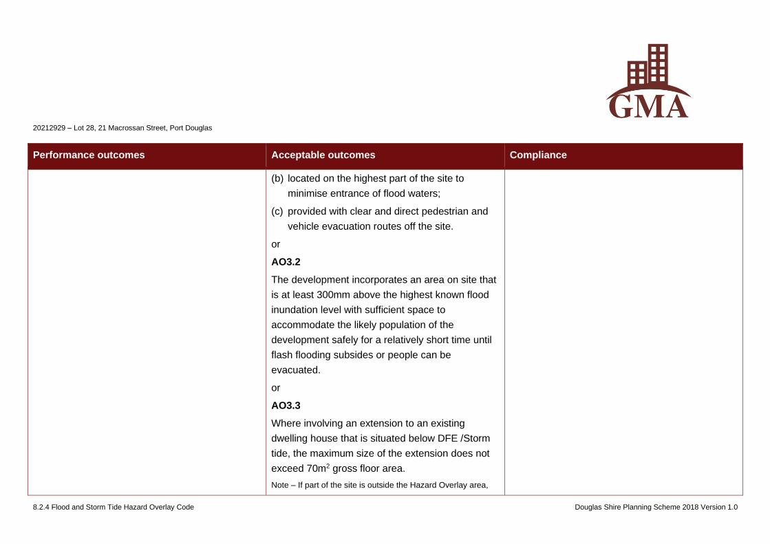
20212929 – Lot 28, 21 Macrossan Street, Port Douglas
8.2.4 Flood and Storm Tide Hazard Overlay Code Douglas Shire Planning Scheme 2018 Version 1.0
Performance outcomes Acceptable outcomes Compliance
(b) located on the highest part of the site to
minimise entrance of flood waters;
(c) provided with clear and direct pedestrian and
vehicle evacuation routes off the site.
or
AO3.2
The development incorporates an area on site that
is at least 300mm above the highest known flood
inundation level with sufficient space to
accommodate the likely population of the
development safely for a relatively short time until
flash flooding subsides or people can be
evacuated.
or
AO3.3
Where involving an extension to an existing
dwelling house that is situated below DFE /Storm
tide, the maximum size of the extension does not
exceed 70m2 gross floor area.
Note – If part of the site is outside the Hazard Overlay area,
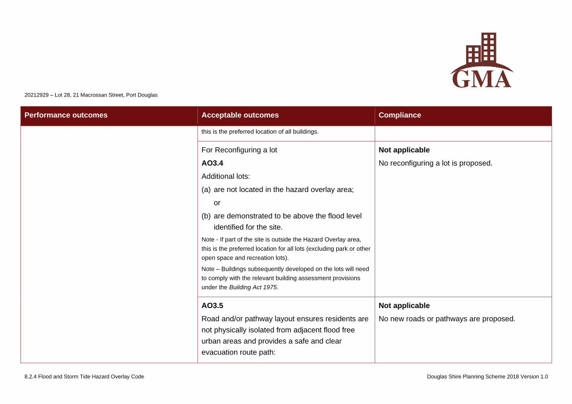
20212929 – Lot 28, 21 Macrossan Street, Port Douglas
8.2.4 Flood and Storm Tide Hazard Overlay Code Douglas Shire Planning Scheme 2018 Version 1.0
Performance outcomes Acceptable outcomes Compliance
this is the preferred location of all buildings.
For Reconfiguring a lot
AO3.4
Additional lots:
(a) are not located in the hazard overlay area;
or
(b) are demonstrated to be above the flood level
identified for the site.
Note - If part of the site is outside the Hazard Overlay area,
this is the preferred location for all lots (excluding park or other
open space and recreation lots).
Note – Buildings subsequently developed on the lots will need
to comply with the relevant building assessment provisions
under the Building Act 1975.
Not applicable
No reconfiguring a lot is proposed.
AO3.5
Road and/or pathway layout ensures residents are
not physically isolated from adjacent flood free
urban areas and provides a safe and clear
evacuation route path:
Not applicable
No new roads or pathways are proposed.
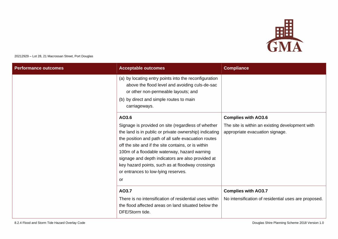
20212929 – Lot 28, 21 Macrossan Street, Port Douglas
8.2.4 Flood and Storm Tide Hazard Overlay Code Douglas Shire Planning Scheme 2018 Version 1.0
Performance outcomes Acceptable outcomes Compliance
(a) by locating entry points into the reconfiguration
above the flood level and avoiding culs-de-sac
or other non-permeable layouts; and
(b) by direct and simple routes to main
carriageways.
AO3.6
Signage is provided on site (regardless of whether
the land is in public or private ownership) indicating
the position and path of all safe evacuation routes
off the site and if the site contains, or is within
100m of a floodable waterway, hazard warning
signage and depth indicators are also provided at
key hazard points, such as at floodway crossings
or entrances to low-lying reserves.
or
Complies with AO3.6
The site is within an existing development with
appropriate evacuation signage.
AO3.7
There is no intensification of residential uses within
the flood affected areas on land situated below the
DFE/Storm tide.
Complies with AO3.7
No intensification of residential uses are proposed.
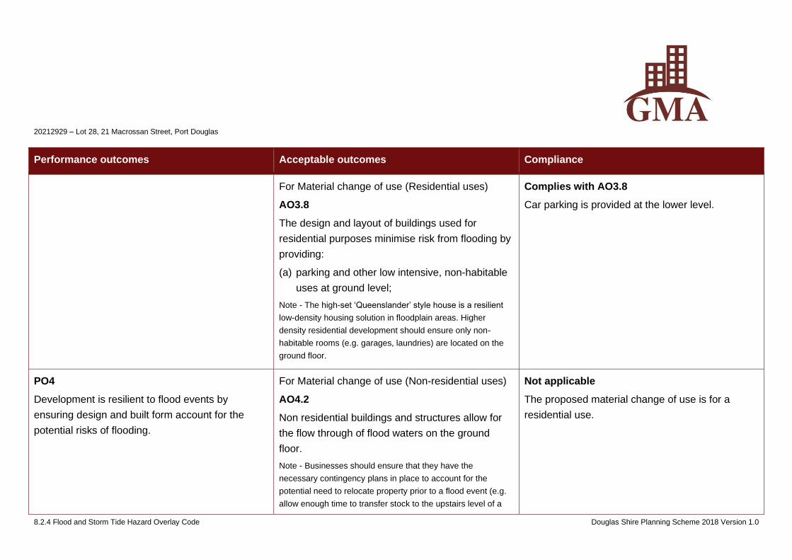
20212929 – Lot 28, 21 Macrossan Street, Port Douglas
8.2.4 Flood and Storm Tide Hazard Overlay Code Douglas Shire Planning Scheme 2018 Version 1.0
Performance outcomes Acceptable outcomes Compliance
For Material change of use (Residential uses)
AO3.8
The design and layout of buildings used for
residential purposes minimise risk from flooding by
providing:
(a) parking and other low intensive, non-habitable
uses at ground level;
Note - The high-set ‘Queenslander’ style house is a resilient
low-density housing solution in floodplain areas. Higher
density residential development should ensure only non-
habitable rooms (e.g. garages, laundries) are located on the
ground floor.
Complies with AO3.8
Car parking is provided at the lower level.
PO4
Development is resilient to flood events by
ensuring design and built form account for the
potential risks of flooding.
For Material change of use (Non-residential uses)
AO4.2
Non residential buildings and structures allow for
the flow through of flood waters on the ground
floor.
Note - Businesses should ensure that they have the
necessary contingency plans in place to account for the
potential need to relocate property prior to a flood event (e.g.
allow enough time to transfer stock to the upstairs level of a
Not applicable
The proposed material change of use is for a
residential use.
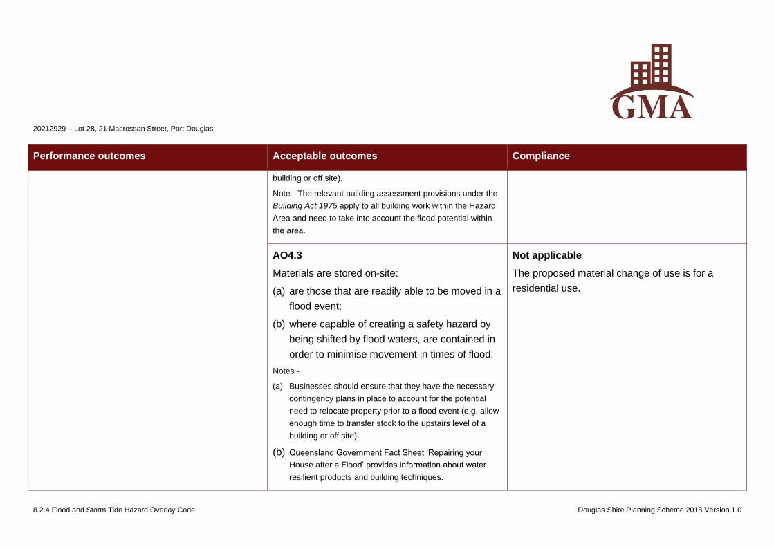
20212929 – Lot 28, 21 Macrossan Street, Port Douglas
8.2.4 Flood and Storm Tide Hazard Overlay Code Douglas Shire Planning Scheme 2018 Version 1.0
Performance outcomes Acceptable outcomes Compliance
building or off site).
Note - The relevant building assessment provisions under the
Building Act 1975 apply to all building work within the Hazard
Area and need to take into account the flood potential within
the area.
AO4.3
Materials are stored on-site:
(a) are those that are readily able to be moved in a
flood event;
(b) where capable of creating a safety hazard by
being shifted by flood waters, are contained in
order to minimise movement in times of flood.
Notes -
(a) Businesses should ensure that they have the necessary
contingency plans in place to account for the potential
need to relocate property prior to a flood event (e.g. allow
enough time to transfer stock to the upstairs level of a
building or off site).
(b) Queensland Government Fact Sheet ‘Repairing your
House after a Flood’ provides information about water
resilient products and building techniques.
Not applicable
The proposed material change of use is for a
residential use.
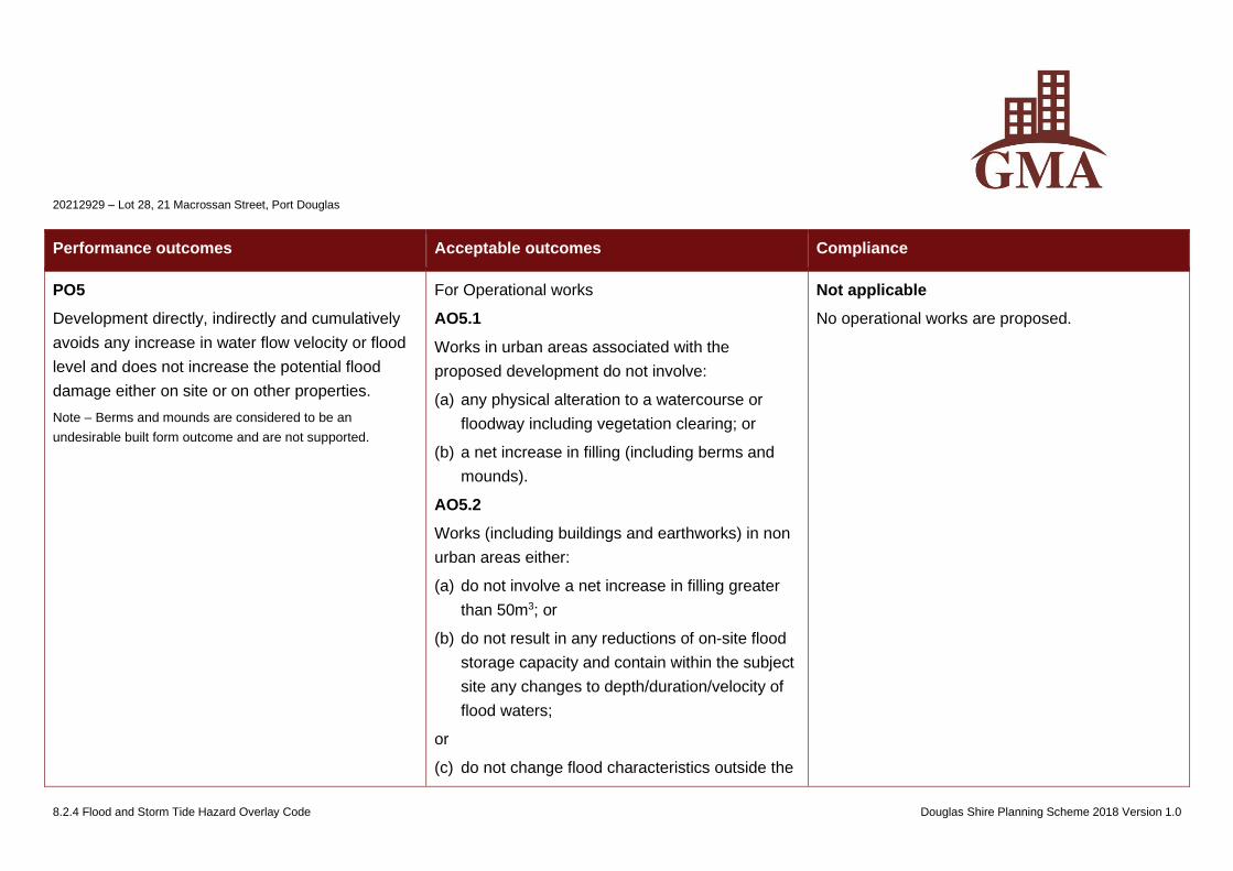
20212929 – Lot 28, 21 Macrossan Street, Port Douglas
8.2.4 Flood and Storm Tide Hazard Overlay Code Douglas Shire Planning Scheme 2018 Version 1.0
Performance outcomes Acceptable outcomes Compliance
PO5
Development directly, indirectly and cumulatively
avoids any increase in water flow velocity or flood
level and does not increase the potential flood
damage either on site or on other properties.
Note – Berms and mounds are considered to be an
undesirable built form outcome and are not supported.
For Operational works
AO5.1
Works in urban areas associated with the
proposed development do not involve:
(a) any physical alteration to a watercourse or
floodway including vegetation clearing; or
(b) a net increase in filling (including berms and
mounds).
AO5.2
Works (including buildings and earthworks) in non
urban areas either:
(a) do not involve a net increase in filling greater
than 50m3; or
(b) do not result in any reductions of on-site flood
storage capacity and contain within the subject
site any changes to depth/duration/velocity of
flood waters;
or
(c) do not change flood characteristics outside the
Not applicable
No operational works are proposed.
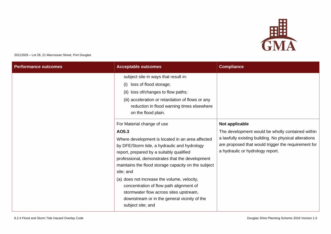
20212929 – Lot 28, 21 Macrossan Street, Port Douglas
8.2.4 Flood and Storm Tide Hazard Overlay Code Douglas Shire Planning Scheme 2018 Version 1.0
Performance outcomes Acceptable outcomes Compliance
subject site in ways that result in:
(i) loss of flood storage;
(ii) loss of/changes to flow paths;
(iii) acceleration or retardation of flows or any
reduction in flood warning times elsewhere
on the flood plain.
For Material change of use
AO5.3
Where development is located in an area affected
by DFE/Storm tide, a hydraulic and hydrology
report, prepared by a suitably qualified
professional, demonstrates that the development
maintains the flood storage capacity on the subject
site; and
(a) does not increase the volume, velocity,
concentration of flow path alignment of
stormwater flow across sites upstream,
downstream or in the general vicinity of the
subject site; and
Not applicable
The development would be wholly contained within
a lawfully existing building. No physical alterations
are proposed that would trigger the requirement for
a hydraulic or hydrology report.
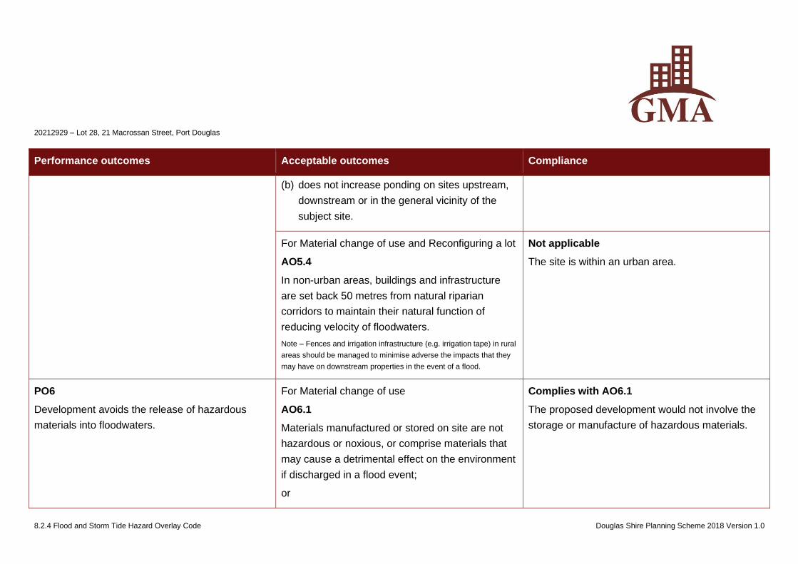
20212929 – Lot 28, 21 Macrossan Street, Port Douglas
8.2.4 Flood and Storm Tide Hazard Overlay Code Douglas Shire Planning Scheme 2018 Version 1.0
Performance outcomes Acceptable outcomes Compliance
(b) does not increase ponding on sites upstream,
downstream or in the general vicinity of the
subject site.
For Material change of use and Reconfiguring a lot
AO5.4
In non-urban areas, buildings and infrastructure
are set back 50 metres from natural riparian
corridors to maintain their natural function of
reducing velocity of floodwaters.
Note – Fences and irrigation infrastructure (e.g. irrigation tape) in rural
areas should be managed to minimise adverse the impacts that they
may have on downstream properties in the event of a flood.
Not applicable
The site is within an urban area.
PO6
Development avoids the release of hazardous
materials into floodwaters.
For Material change of use
AO6.1
Materials manufactured or stored on site are not
hazardous or noxious, or comprise materials that
may cause a detrimental effect on the environment
if discharged in a flood event;
or
Complies with AO6.1
The proposed development would not involve the
storage or manufacture of hazardous materials.
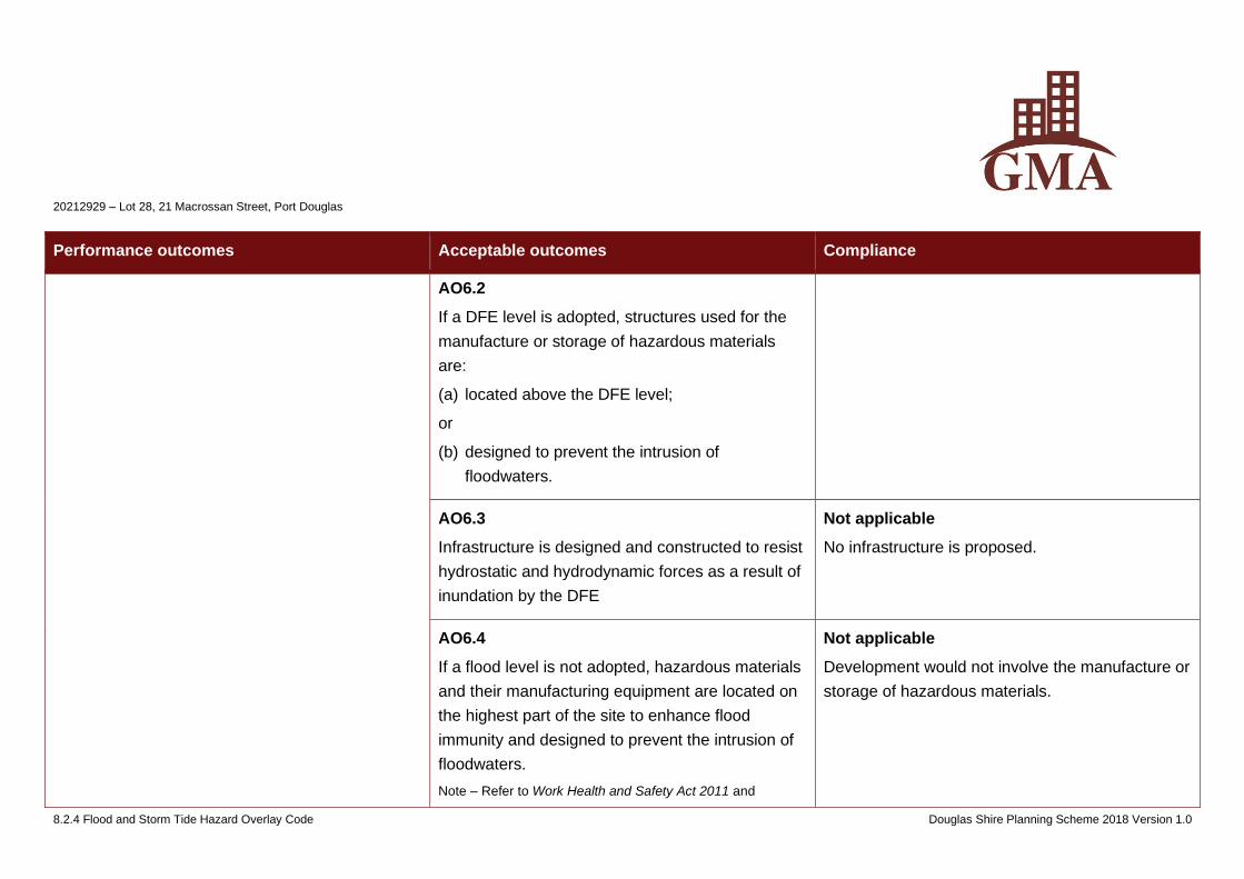
20212929 – Lot 28, 21 Macrossan Street, Port Douglas
8.2.4 Flood and Storm Tide Hazard Overlay Code Douglas Shire Planning Scheme 2018 Version 1.0
Performance outcomes Acceptable outcomes Compliance
AO6.2
If a DFE level is adopted, structures used for the
manufacture or storage of hazardous materials
are:
(a) located above the DFE level;
or
(b) designed to prevent the intrusion of
floodwaters.
AO6.3
Infrastructure is designed and constructed to resist
hydrostatic and hydrodynamic forces as a result of
inundation by the DFE
Not applicable
No infrastructure is proposed.
AO6.4
If a flood level is not adopted, hazardous materials
and their manufacturing equipment are located on
the highest part of the site to enhance flood
immunity and designed to prevent the intrusion of
floodwaters.
Note – Refer to Work Health and Safety Act 2011 and
Not applicable
Development would not involve the manufacture or
storage of hazardous materials.
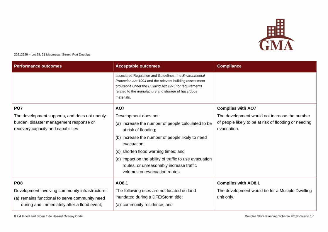
20212929 – Lot 28, 21 Macrossan Street, Port Douglas
8.2.4 Flood and Storm Tide Hazard Overlay Code Douglas Shire Planning Scheme 2018 Version 1.0
Performance outcomes Acceptable outcomes Compliance
associated Regulation and Guidelines, the Environmental
Protection Act 1994 and the relevant building assessment
provisions under the Building Act 1975 for requirements
related to the manufacture and storage of hazardous
materials.
PO7
The development supports, and does not unduly
burden, disaster management response or
recovery capacity and capabilities.
AO7
Development does not:
(a) increase the number of people calculated to be
at risk of flooding;
(b) increase the number of people likely to need
evacuation;
(c) shorten flood warning times; and
(d) impact on the ability of traffic to use evacuation
routes, or unreasonably increase traffic
volumes on evacuation routes.
Complies with AO7
The development would not increase the number
of people likely to be at risk of flooding or needing
evacuation.
PO8
Development involving community infrastructure:
(a) remains functional to serve community need
during and immediately after a flood event;
AO8.1
The following uses are not located on land
inundated during a DFE/Storm tide:
(a) community residence; and
Complies with AO8.1
The development would be for a Multiple Dwelling
unit only.
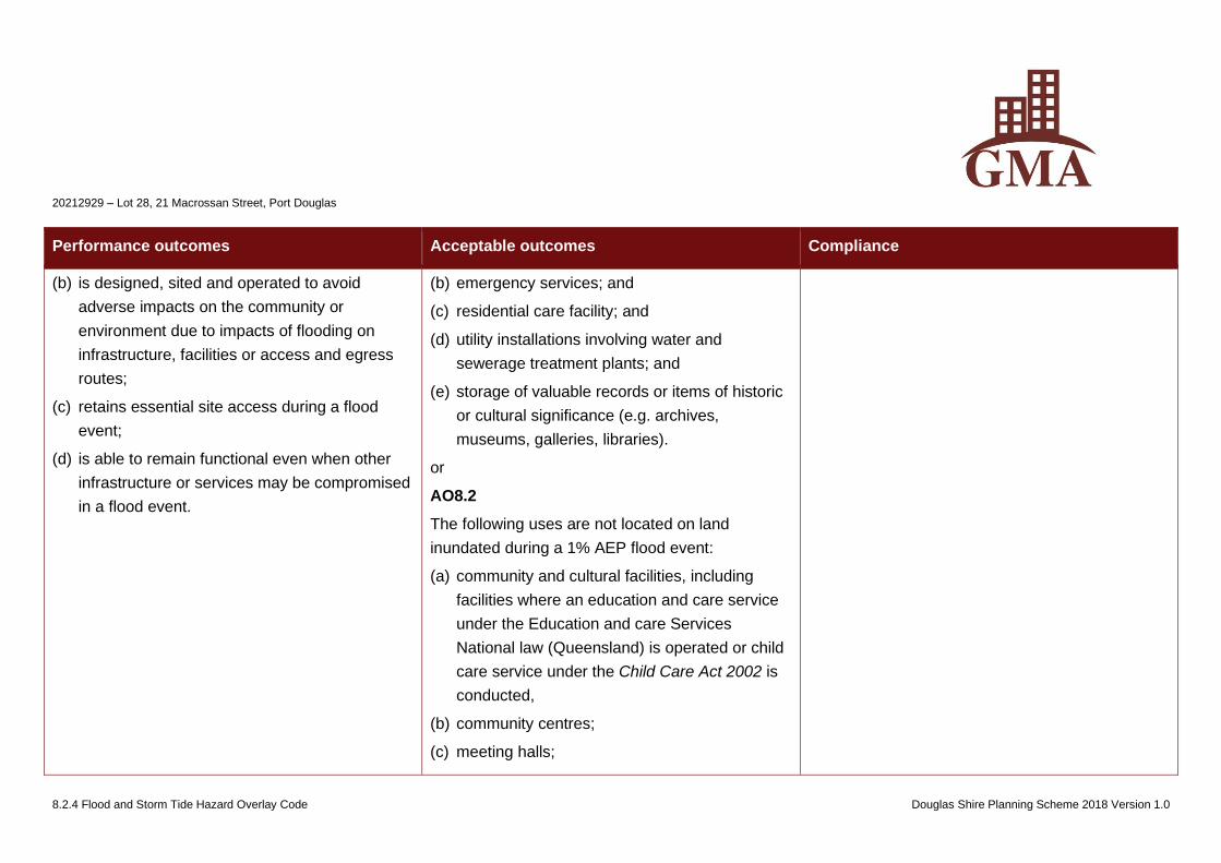
20212929 – Lot 28, 21 Macrossan Street, Port Douglas
8.2.4 Flood and Storm Tide Hazard Overlay Code Douglas Shire Planning Scheme 2018 Version 1.0
Performance outcomes Acceptable outcomes Compliance
(b) is designed, sited and operated to avoid
adverse impacts on the community or
environment due to impacts of flooding on
infrastructure, facilities or access and egress
routes;
(c) retains essential site access during a flood
event;
(d) is able to remain functional even when other
infrastructure or services may be compromised
in a flood event.
(b) emergency services; and
(c) residential care facility; and
(d) utility installations involving water and
sewerage treatment plants; and
(e) storage of valuable records or items of historic
or cultural significance (e.g. archives,
museums, galleries, libraries).
or
AO8.2
The following uses are not located on land
inundated during a 1% AEP flood event:
(a) community and cultural facilities, including
facilities where an education and care service
under the Education and care Services
National law (Queensland) is operated or child
care service under the Child Care Act 2002 is
conducted,
(b) community centres;
(c) meeting halls;
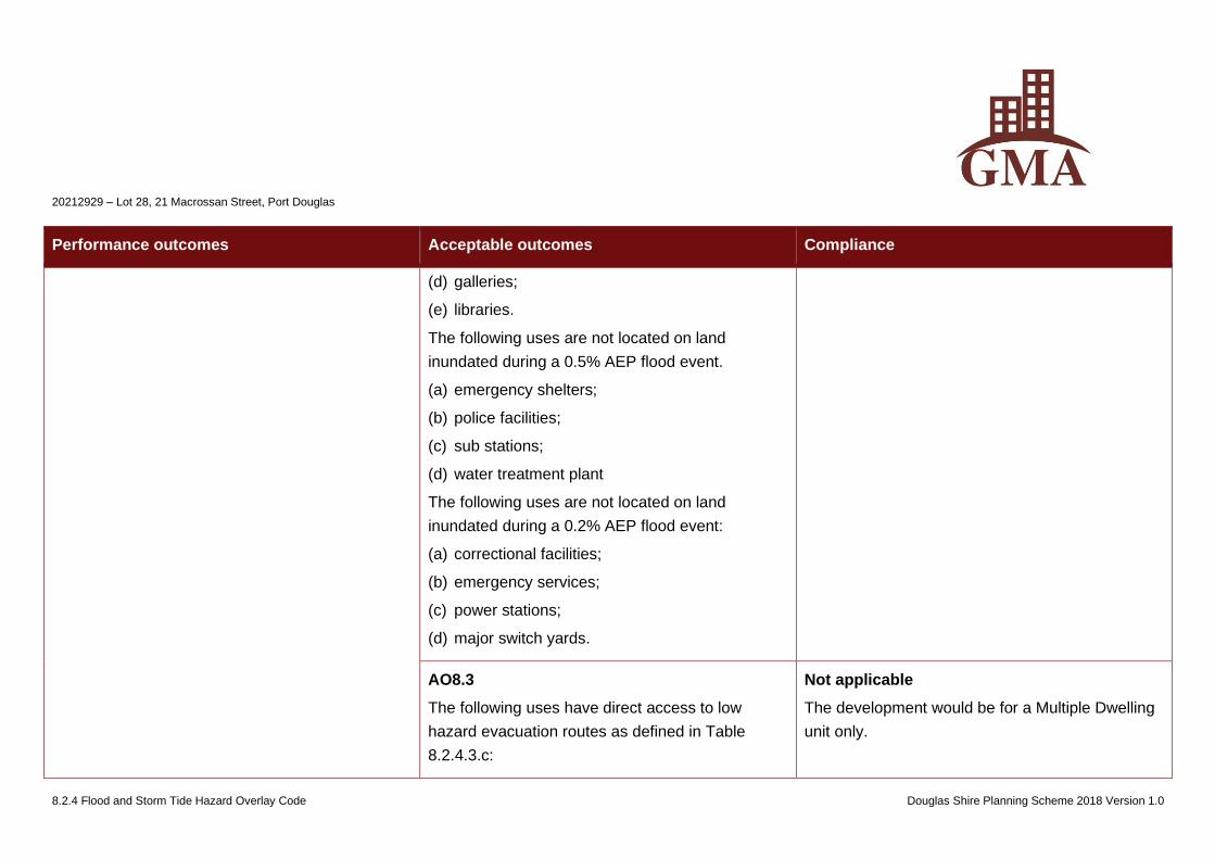
20212929 – Lot 28, 21 Macrossan Street, Port Douglas
8.2.4 Flood and Storm Tide Hazard Overlay Code Douglas Shire Planning Scheme 2018 Version 1.0
Performance outcomes Acceptable outcomes Compliance
(d) galleries;
(e) libraries.
The following uses are not located on land
inundated during a 0.5% AEP flood event.
(a) emergency shelters;
(b) police facilities;
(c) sub stations;
(d) water treatment plant
The following uses are not located on land
inundated during a 0.2% AEP flood event:
(a) correctional facilities;
(b) emergency services;
(c) power stations;
(d) major switch yards.
AO8.3
The following uses have direct access to low
hazard evacuation routes as defined in Table
8.2.4.3.c:
Not applicable
The development would be for a Multiple Dwelling
unit only.
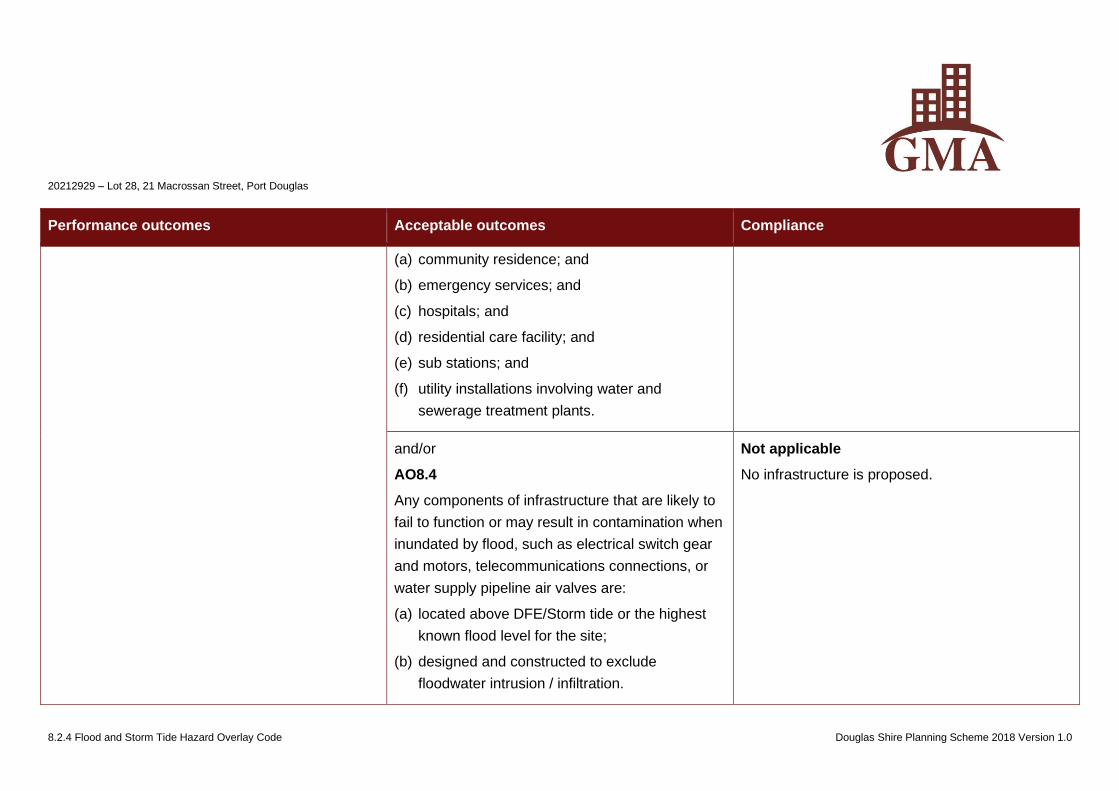
20212929 – Lot 28, 21 Macrossan Street, Port Douglas
8.2.4 Flood and Storm Tide Hazard Overlay Code Douglas Shire Planning Scheme 2018 Version 1.0
Performance outcomes Acceptable outcomes Compliance
(a) community residence; and
(b) emergency services; and
(c) hospitals; and
(d) residential care facility; and
(e) sub stations; and
(f) utility installations involving water and
sewerage treatment plants.
and/or
AO8.4
Any components of infrastructure that are likely to
fail to function or may result in contamination when
inundated by flood, such as electrical switch gear
and motors, telecommunications connections, or
water supply pipeline air valves are:
(a) located above DFE/Storm tide or the highest
known flood level for the site;
(b) designed and constructed to exclude
floodwater intrusion / infiltration.
Not applicable
No infrastructure is proposed.
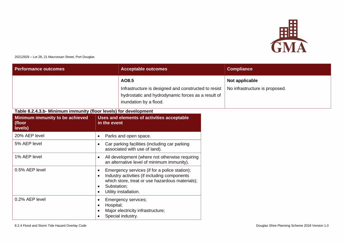
20212929 – Lot 28, 21 Macrossan Street, Port Douglas
8.2.4 Flood and Storm Tide Hazard Overlay Code Douglas Shire Planning Scheme 2018 Version 1.0
Performance outcomes Acceptable outcomes Compliance
AO8.5
Infrastructure is designed and constructed to resist
hydrostatic and hydrodynamic forces as a result of
inundation by a flood.
Not applicable
No infrastructure is proposed.
Table 8.2.4.3.b- Minimum immunity (floor levels) for development
Minimum immunity to be achieved (floor levels)
Uses and elements of activities acceptable in the event
20% AEP level • Parks and open space.
5% AEP level • Car parking facilities (including car parking associated with use of land).
1% AEP level • All development (where not otherwise requiring an alternative level of minimum immunity).
0.5% AEP level • Emergency services (if for a police station);
• Industry activities (if including components which store, treat or use hazardous materials);
• Substation;
• Utility installation.
0.2% AEP level • Emergency services;
• Hospital;
• Major electricity infrastructure;
• Special industry.
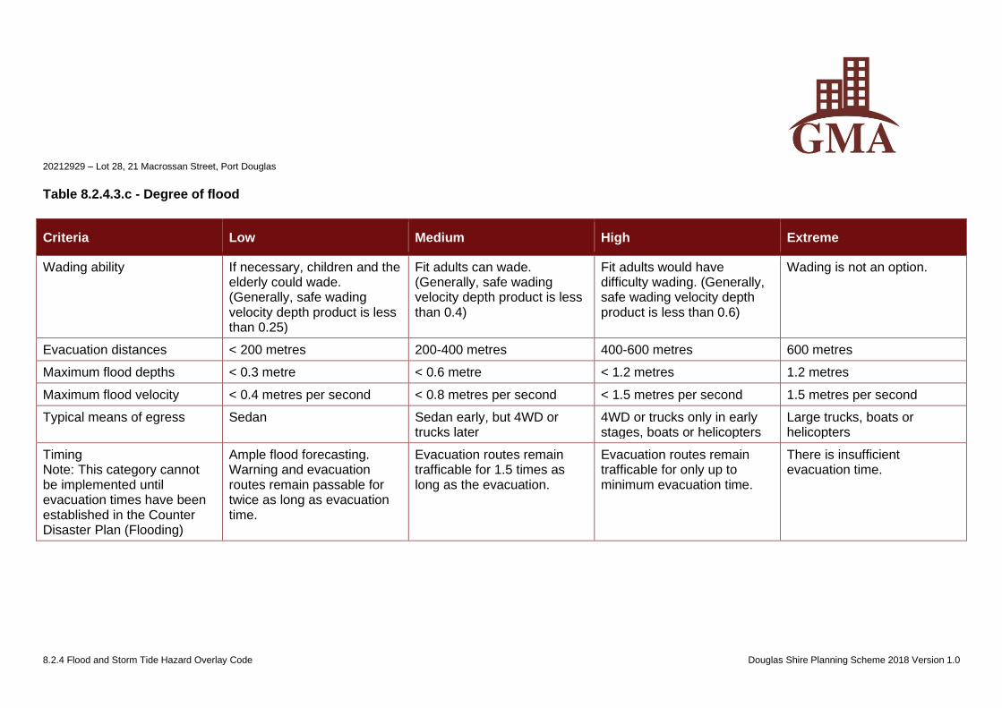
20212929 – Lot 28, 21 Macrossan Street, Port Douglas
8.2.4 Flood and Storm Tide Hazard Overlay Code Douglas Shire Planning Scheme 2018 Version 1.0
Table 8.2.4.3.c - Degree of flood
Criteria Low Medium High Extreme
Wading ability If necessary, children and the elderly could wade. (Generally, safe wading velocity depth product is less than 0.25)
Fit adults can wade. (Generally, safe wading velocity depth product is less than 0.4)
Fit adults would have difficulty wading. (Generally, safe wading velocity depth product is less than 0.6)
Wading is not an option.
Evacuation distances < 200 metres 200-400 metres 400-600 metres 600 metres
Maximum flood depths < 0.3 metre < 0.6 metre < 1.2 metres 1.2 metres
Maximum flood velocity < 0.4 metres per second < 0.8 metres per second < 1.5 metres per second 1.5 metres per second
Typical means of egress Sedan Sedan early, but 4WD or trucks later
4WD or trucks only in early stages, boats or helicopters
Large trucks, boats or helicopters
Timing Note: This category cannot be implemented until evacuation times have been established in the Counter Disaster Plan (Flooding)
Ample flood forecasting. Warning and evacuation routes remain passable for twice as long as evacuation time.
Evacuation routes remain trafficable for 1.5 times as long as the evacuation.
Evacuation routes remain trafficable for only up to minimum evacuation time.
There is insufficient evacuation time.
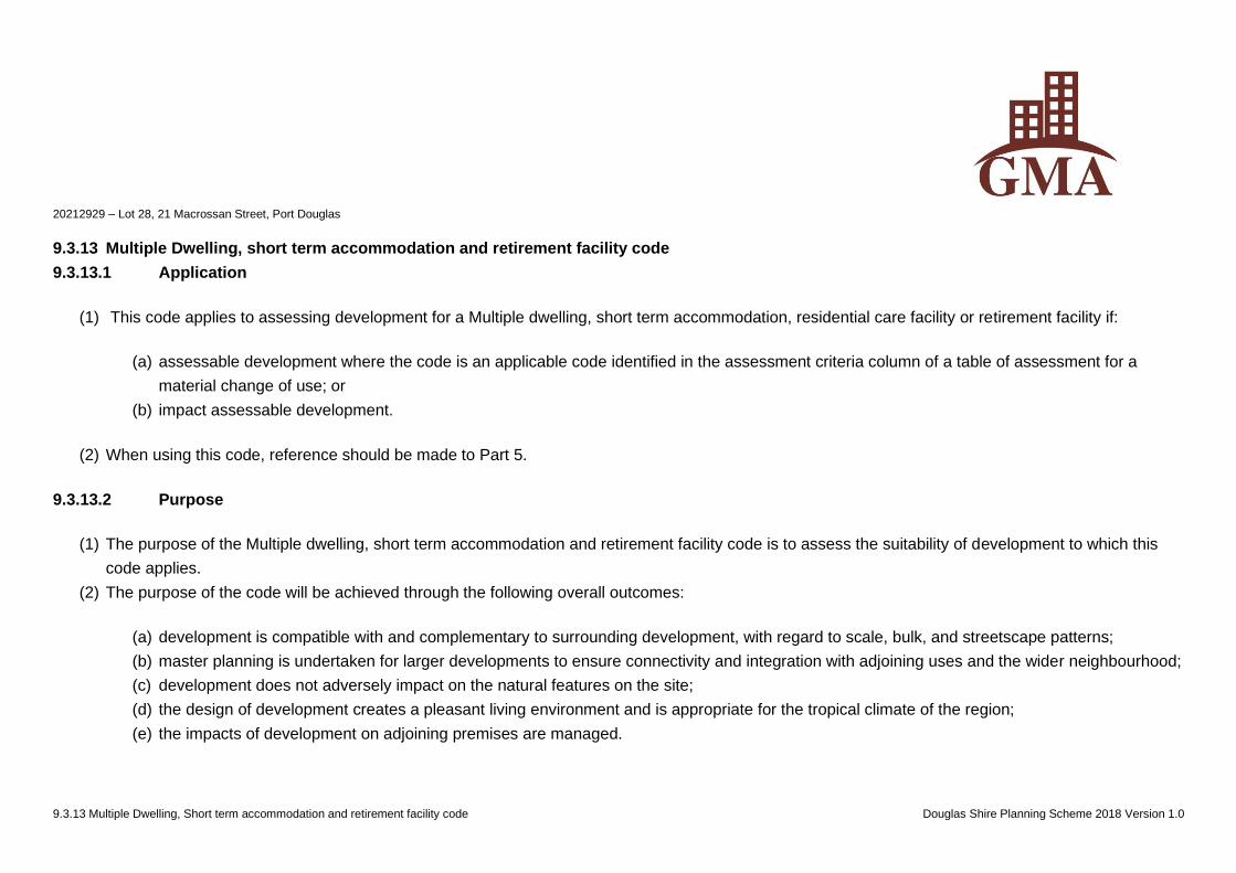
20212929 – Lot 28, 21 Macrossan Street, Port Douglas
9.3.13 Multiple Dwelling, Short term accommodation and retirement facility code Douglas Shire Planning Scheme 2018 Version 1.0
9.3.13 Multiple Dwelling, short term accommodation and retirement facility code
9.3.13.1 Application
(1) This code applies to assessing development for a Multiple dwelling, short term accommodation, residential care facility or retirement facility if:
(a) assessable development where the code is an applicable code identified in the assessment criteria column of a table of assessment for a
material change of use; or
(b) impact assessable development.
(2) When using this code, reference should be made to Part 5.
9.3.13.2 Purpose
(1) The purpose of the Multiple dwelling, short term accommodation and retirement facility code is to assess the suitability of development to which this
code applies.
(2) The purpose of the code will be achieved through the following overall outcomes:
(a) development is compatible with and complementary to surrounding development, with regard to scale, bulk, and streetscape patterns;
(b) master planning is undertaken for larger developments to ensure connectivity and integration with adjoining uses and the wider neighbourhood;
(c) development does not adversely impact on the natural features on the site;
(d) the design of development creates a pleasant living environment and is appropriate for the tropical climate of the region;
(e) the impacts of development on adjoining premises are managed.
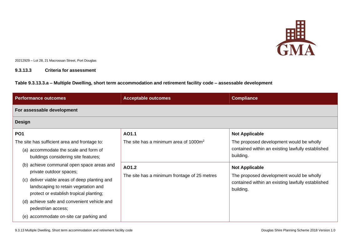
20212929 – Lot 28, 21 Macrossan Street, Port Douglas
9.3.13 Multiple Dwelling, Short term accommodation and retirement facility code Douglas Shire Planning Scheme 2018 Version 1.0
9.3.13.3 Criteria for assessment
Table 9.3.13.3.a – Multiple Dwelling, short term accommodation and retirement facility code – assessable development
Performance outcomes Acceptable outcomes Compliance
For assessable development
Design
PO1
The site has sufficient area and frontage to:
(a) accommodate the scale and form of
buildings considering site features;
(b) achieve communal open space areas and
private outdoor spaces;
(c) deliver viable areas of deep planting and
landscaping to retain vegetation and
protect or establish tropical planting;
(d) achieve safe and convenient vehicle and
pedestrian access;
(e) accommodate on-site car parking and
AO1.1
The site has a minimum area of 1000m2
Not Applicable
The proposed development would be wholly
contained within an existing lawfully established
building.
AO1.2
The site has a minimum frontage of 25 metres
Not Applicable
The proposed development would be wholly
contained within an existing lawfully established
building.
20212929 – Lot 28, 21 Macrossan Street, Port Douglas
9.3.13 Multiple Dwelling, Short term accommodation and retirement facility code Douglas Shire Planning Scheme 2018 Version 1.0
Performance outcomes Acceptable outcomes Compliance
manoeuvring for residents, visitors and
service providers
PO2
Development for large-scale multiple dwellings,
short term accommodation and retirement villages
contributes to the neighbourhood structure and
integrates with the existing neighbourhood
through:
(a) the establishment and extension of public
streets and pathways;
(b) the provision of parks and other public
spaces as appropriate to the scale of the
development;
(c) inclusion of a mix of dwelling types and
tenures and forms;
(d) buildings that address the street;
(e) building height and setback transitions to
adjoining development of a lower density or
scale
AO2
Development on a site 5,000m2 or greater is in
accordance with a structure plan.
Note – Guidance on preparing a structure plan is provided within
Planning scheme policy SC6.14 – Structure planning.
Not Applicable
The proposed development would be wholly
contained within an existing lawfully established
building.
20212929 – Lot 28, 21 Macrossan Street, Port Douglas
9.3.13 Multiple Dwelling, Short term accommodation and retirement facility code Douglas Shire Planning Scheme 2018 Version 1.0
Performance outcomes Acceptable outcomes Compliance
PO3
Development ensures that the proportion of
buildings to open space is:
(a) in keeping with the intended form and
character of the local area and immediate
streetscape;
(b) contributes to the modulation of built form;
(c) supports residential amenity including
access to breezes, natural light and
sunlight;
(d) supports outdoor tropical living;
(e) provides areas for deep tropical planting
and / or for the retention of mature
vegetation.
AO3.1
The site cover is not more than 40%
Not Applicable
The proposed development would be wholly
contained within an existing lawfully established
building.
AO3.2
The development has a gross floor area of not
more than:
Zone Maximum GFA
Low-medium density
residential
0.8 x site area
Medium density
residential
1.2 x site area
Tourist
accommodation
1.2 x site area
All other zones No acceptable
outcome specified.
Not Applicable
The proposed development would be wholly
contained within an existing lawfully established
building.
PO4 AO4.1 Not Applicable
20212929 – Lot 28, 21 Macrossan Street, Port Douglas
9.3.13 Multiple Dwelling, Short term accommodation and retirement facility code Douglas Shire Planning Scheme 2018 Version 1.0
Performance outcomes Acceptable outcomes Compliance
Development is sited so that the setback from
boundaries:
(a) provides for natural light, sunlight and
breezes;
(b) minimises the impact of the development
on the amenity and privacy of neighbouring
residents;
(c) provides for adequate landscaping.
Buildings and structures are set back not less than
6 metres from a road frontage.
The proposed development would be wholly
contained within an existing lawfully established
building.
AO4.2
Buildings and structures are setback not less than
4 metres to the rear boundary
Not Applicable
The proposed development would be wholly
contained within an existing lawfully established
building.
AO4.3
The side boundary setback for buildings and
structures is:
(a) for buildings up to 2 storeys not less than
2.5 metres for the entire building;
(b) for buildings up to 3 storeys not less than
3.5 metres for the entire building.
Not Applicable
The proposed development would be wholly
contained within an existing lawfully established
building.
PO5
Building depth and form must be articulated to
(a) ensure that the bulk of the development is
in keeping with the form and character
AO5.1
(a) The maximum length of a wall in any
direction is 30 metres with substantial
articulation provided every 15 metres.
Not Applicable
The proposed development would be wholly
contained within an existing lawfully established
building.
20212929 – Lot 28, 21 Macrossan Street, Port Douglas
9.3.13 Multiple Dwelling, Short term accommodation and retirement facility code Douglas Shire Planning Scheme 2018 Version 1.0
Performance outcomes Acceptable outcomes Compliance
intent of the area;
(b) provide adequate amenity for residents in
terms of natural light and ventilation.
Note – Planning scheme policy SC6.1 – Building design and
architectural elements provides guidance on reducing building bulk.
(b) The minimum distance between buildings
on a site is not less than 6 metres;
AO5.2
The length of any continuous eave line does not
exceed 18 metres.
Not Applicable
The proposed development would be wholly
contained within an existing lawfully established
building.
PO6
Development reduces the appearance of building
bulk, ensures a human-scale, demonstrates
variations in horizontal and vertical profile and
supports streetscape character.
AO6.1
Development incorporates a number of the
following design elements:
(a) balconies;
(b) verandahs;
(c) terraces;
(d) recesses
Not Applicable
The proposed development would be wholly
contained within an existing lawfully established
building used for residential purposes.
AO6.2
Development reduces building bulk by:
(a) variation in building colours, materials and
textures;
Not Applicable
The proposed development would be wholly
contained within an existing lawfully established
building used for residential purposes.
20212929 – Lot 28, 21 Macrossan Street, Port Douglas
9.3.13 Multiple Dwelling, Short term accommodation and retirement facility code Douglas Shire Planning Scheme 2018 Version 1.0
Performance outcomes Acceptable outcomes Compliance
(b) the use of curves, recesses, projections or
variations in plan and elevation;
(c) recession and projection of rooflines and
the inclusion of interesting roof forms, such
as cascading roof levels, gables, skillions
or variations in pitch;
(d) use of sun-shading devices and other
façade features;
(e) use of elements at a finer scale than the
main structural framing of the building.
PO7
Development provides a building that must define
the street to facilitate casual surveillance and
enhance the amenity of the street through:
(a) orientation to the street;
(b) front boundary setback;
(c) balconies and windows to provide
overlooking and casual surveillance;
(d) building entrances.
AO7.1
Development provides a building that is not set
back further than 2m beyond the minimum
required street front setback.
Not Applicable
The proposed development would be wholly
contained within an existing lawfully established
building.
AO7.2
Development provides balconies and windows
from the primary living area that face and overlook
the street or public space.
Complies with AO7.2
The Multiple Dwelling unit would have access to an
existing balcony that overlooks public space.
20212929 – Lot 28, 21 Macrossan Street, Port Douglas
9.3.13 Multiple Dwelling, Short term accommodation and retirement facility code Douglas Shire Planning Scheme 2018 Version 1.0
Performance outcomes Acceptable outcomes Compliance
PO8
Buildings exhibit tropical design elements to
support Douglas Shire’s tropical climate, character
and lifestyle.
AO8.1
Development has floor to ceiling heights of 2.7
metres;
Not Applicable
The proposed development would be wholly
contained within an existing lawfully established
building.
AO8.2
Buildings include weather protection and sun
shading to all windows to all external doors and
windows of habitable rooms.
Not Applicable
The proposed development would be wholly
contained within an existing lawfully established
building.
AO8.3
Development incorporates deep recesses, eaves
and sun-shading devices.
Not Applicable
The proposed development would be wholly
contained within an existing lawfully established
building.
AO8.4
Western orientated facades are shaded using
building and landscape elements, such as
adjustable screens, awnings or pergolas or dense
Not Applicable
The proposed development would be wholly
contained within an existing lawfully established
building.
20212929 – Lot 28, 21 Macrossan Street, Port Douglas
9.3.13 Multiple Dwelling, Short term accommodation and retirement facility code Douglas Shire Planning Scheme 2018 Version 1.0
Performance outcomes Acceptable outcomes Compliance
tropical planting.
AO8.5
Individual dwelling units are not located on both
sides of an enclosed central corridor (i.e. not
double banked).
Not Applicable
The proposed development would be wholly
contained within an existing lawfully established
building.
PO9
Development minimises direct overlooking
between buildings through appropriate building
layout, location and the design of windows and
balconies or screening devices.
Note—Siting and building separation is used to minimise privacy
screening requirements.
AO9.1
Development where the dwelling is located within 2
metres at ground level or 9 metres above ground
level of a habitable room window or private open
space of an existing dwelling house, ensures
habitable rooms and any private outdoor spaces
have:
(a) an offset from the habitable room or private
open space of the existing dwelling to limit
direct outlook; or
(b) sill heights a minimum of 1.5m above floor
level; or
(c) fixed obscure glazing in any part of the
Not Applicable
The proposed development would be wholly
contained within an existing lawfully established
building.
20212929 – Lot 28, 21 Macrossan Street, Port Douglas
9.3.13 Multiple Dwelling, Short term accommodation and retirement facility code Douglas Shire Planning Scheme 2018 Version 1.0
Performance outcomes Acceptable outcomes Compliance
window below 1.5m above floor level; or
(d) fixed external screens; or
(e) in the case of screening for a ground floor
level unit, fencing to a minimum 1.8m
above the ground storey floor level.
AO9.2
Development where a direct view is available from
balconies, terraces, decks or roof decks into
windows of habitable rooms, balconies, terraces or
decks in an adjacent existing dwelling house, is
screened from floor level to a height above 1.5m
above floor level.
Not Applicable
The proposed development would be wholly
contained within an existing lawfully established
building.
AO9.3
Development provides screening devices that are
solid translucent screens, perforated or slatted
panels or fixed louvres that have a maximum of
25% openings, with a maximum opening
dimension of 50mm, and that are permanent and
Not Applicable
The proposed development would be wholly
contained within an existing lawfully established
building used for residential purposes.
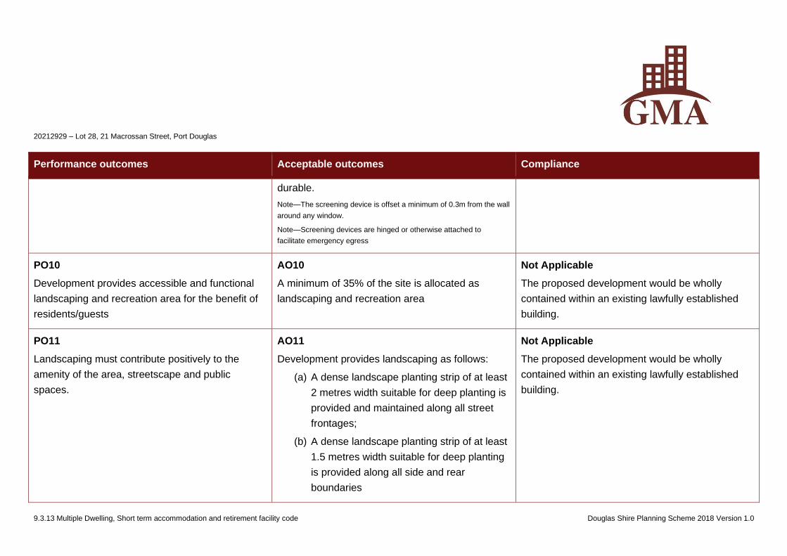
20212929 – Lot 28, 21 Macrossan Street, Port Douglas
9.3.13 Multiple Dwelling, Short term accommodation and retirement facility code Douglas Shire Planning Scheme 2018 Version 1.0
Performance outcomes Acceptable outcomes Compliance
durable.
Note—The screening device is offset a minimum of 0.3m from the wall
around any window.
Note—Screening devices are hinged or otherwise attached to
facilitate emergency egress
PO10
Development provides accessible and functional
landscaping and recreation area for the benefit of
residents/guests
AO10
A minimum of 35% of the site is allocated as
landscaping and recreation area
Not Applicable
The proposed development would be wholly
contained within an existing lawfully established
building.
PO11
Landscaping must contribute positively to the
amenity of the area, streetscape and public
spaces.
AO11
Development provides landscaping as follows:
(a) A dense landscape planting strip of at least
2 metres width suitable for deep planting is
provided and maintained along all street
frontages;
(b) A dense landscape planting strip of at least
1.5 metres width suitable for deep planting
is provided along all side and rear
boundaries
Not Applicable
The proposed development would be wholly
contained within an existing lawfully established
building.
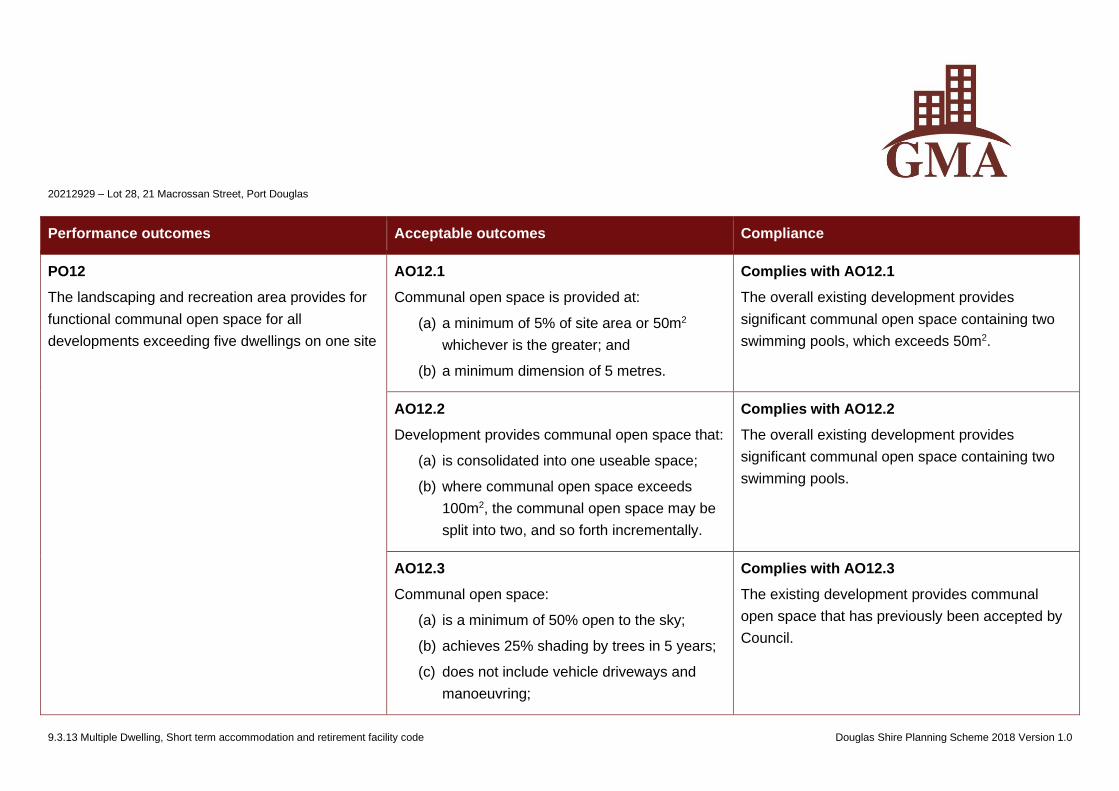
20212929 – Lot 28, 21 Macrossan Street, Port Douglas
9.3.13 Multiple Dwelling, Short term accommodation and retirement facility code Douglas Shire Planning Scheme 2018 Version 1.0
Performance outcomes Acceptable outcomes Compliance
PO12
The landscaping and recreation area provides for
functional communal open space for all
developments exceeding five dwellings on one site
AO12.1
Communal open space is provided at:
(a) a minimum of 5% of site area or 50m2
whichever is the greater; and
(b) a minimum dimension of 5 metres.
Complies with AO12.1
The overall existing development provides
significant communal open space containing two
swimming pools, which exceeds 50m2.
AO12.2
Development provides communal open space that:
(a) is consolidated into one useable space;
(b) where communal open space exceeds
100m2, the communal open space may be
split into two, and so forth incrementally.
Complies with AO12.2
The overall existing development provides
significant communal open space containing two
swimming pools.
AO12.3
Communal open space:
(a) is a minimum of 50% open to the sky;
(b) achieves 25% shading by trees in 5 years;
(c) does not include vehicle driveways and
manoeuvring;
Complies with AO12.3
The existing development provides communal
open space that has previously been accepted by
Council.
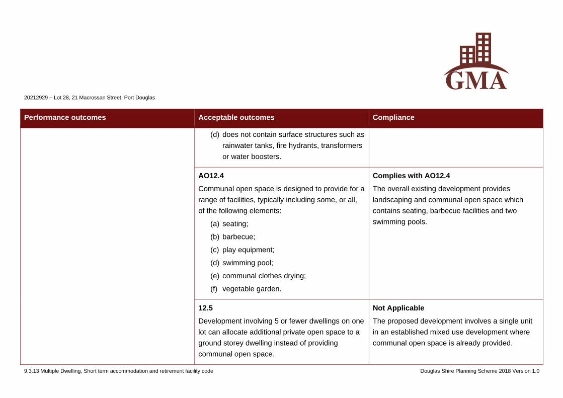
20212929 – Lot 28, 21 Macrossan Street, Port Douglas
9.3.13 Multiple Dwelling, Short term accommodation and retirement facility code Douglas Shire Planning Scheme 2018 Version 1.0
Performance outcomes Acceptable outcomes Compliance
(d) does not contain surface structures such as
rainwater tanks, fire hydrants, transformers
or water boosters.
AO12.4
Communal open space is designed to provide for a
range of facilities, typically including some, or all,
of the following elements:
(a) seating;
(b) barbecue;
(c) play equipment;
(d) swimming pool;
(e) communal clothes drying;
(f) vegetable garden.
Complies with AO12.4
The overall existing development provides
landscaping and communal open space which
contains seating, barbecue facilities and two
swimming pools.
12.5
Development involving 5 or fewer dwellings on one
lot can allocate additional private open space to a
ground storey dwelling instead of providing
communal open space.
Not Applicable
The proposed development involves a single unit
in an established mixed use development where
communal open space is already provided.
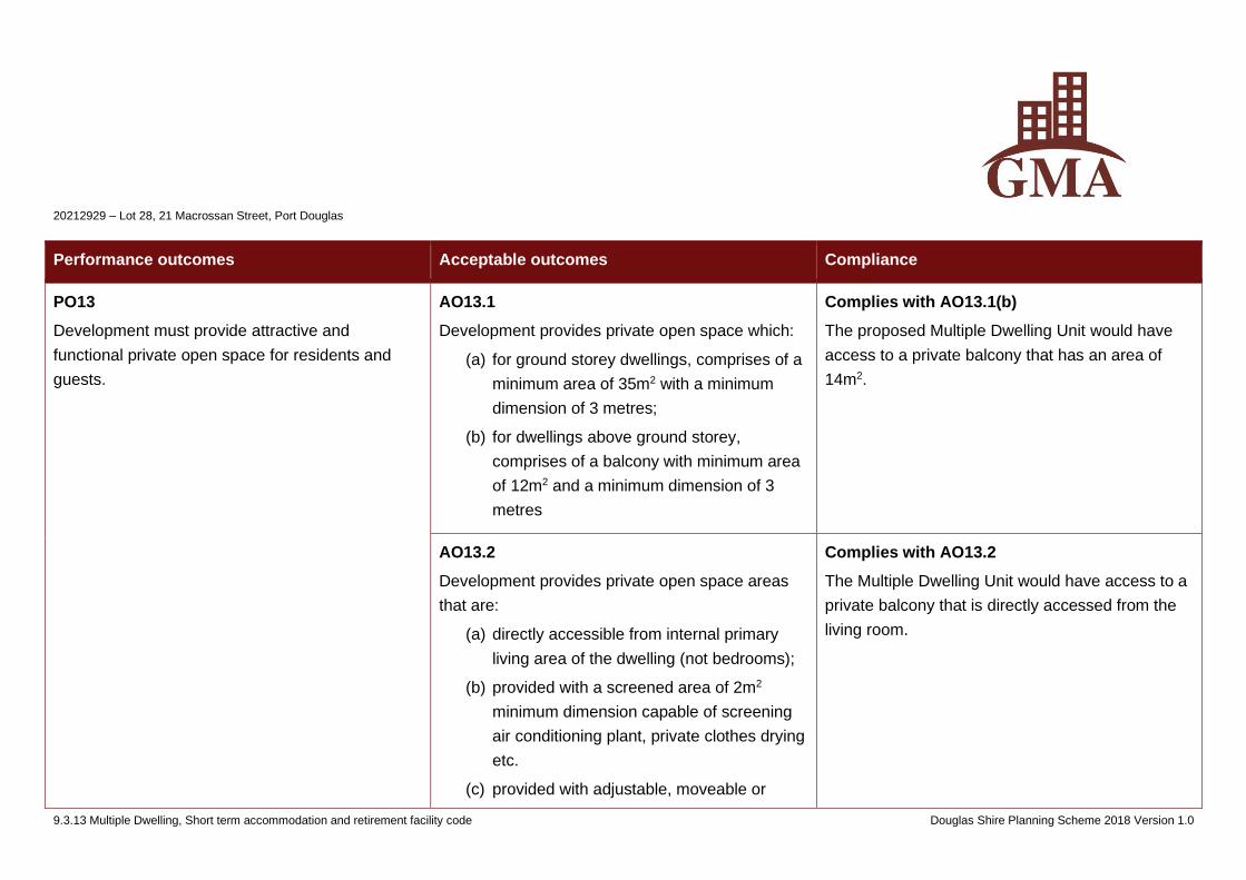
20212929 – Lot 28, 21 Macrossan Street, Port Douglas
9.3.13 Multiple Dwelling, Short term accommodation and retirement facility code Douglas Shire Planning Scheme 2018 Version 1.0
Performance outcomes Acceptable outcomes Compliance
PO13
Development must provide attractive and
functional private open space for residents and
guests.
AO13.1
Development provides private open space which:
(a) for ground storey dwellings, comprises of a
minimum area of 35m2 with a minimum
dimension of 3 metres;
(b) for dwellings above ground storey,
comprises of a balcony with minimum area
of 12m2 and a minimum dimension of 3
metres
Complies with AO13.1(b)
The proposed Multiple Dwelling Unit would have
access to a private balcony that has an area of
14m2.
AO13.2
Development provides private open space areas
that are:
(a) directly accessible from internal primary
living area of the dwelling (not bedrooms);
(b) provided with a screened area of 2m2
minimum dimension capable of screening
air conditioning plant, private clothes drying
etc.
(c) provided with adjustable, moveable or
Complies with AO13.2
The Multiple Dwelling Unit would have access to a
private balcony that is directly accessed from the
living room.
20212929 – Lot 28, 21 Macrossan Street, Port Douglas
9.3.13 Multiple Dwelling, Short term accommodation and retirement facility code Douglas Shire Planning Scheme 2018 Version 1.0
Performance outcomes Acceptable outcomes Compliance
operable privacy screening where
appropriate
AO13.3
Development provides balconies that are located
to the front or rear of the building except where
adequate building separation can be achieved to
maintain privacy.
Complies with AO13.3
The proposed Multiple Dwelling Unit would have
access to a lawfully existing private balcony.
AO13.4
Where secondary balconies are provided to a side
of a building for additional amenity or services,
such as clothes drying or to articulate facades, the
setback may be reduced to the minimum setback,
but these areas are not included in the calculation
of private open space requirements.
Not Applicable
A secondary balcony is not provided.
AO13.5
Private open space:
(a) does not include vehicle driveways and
manoeuvring;
Complies with AO13.5
The private balcony does not include driveways or
surface structures.
20212929 – Lot 28, 21 Macrossan Street, Port Douglas
9.3.13 Multiple Dwelling, Short term accommodation and retirement facility code Douglas Shire Planning Scheme 2018 Version 1.0
Performance outcomes Acceptable outcomes Compliance
(b) does not contain surface structures such as
rainwater tanks, fire hydrants, transformers
or water boosters
PO14
Development provides front fencing and retaining
walls that must:
(a) facilitate casual surveillance of the street
and public space;
(b) enable use of private open space;
(c) assist in highlighting entrances to the
property;
(d) provide a positive interface to the
streetscape.
AO14.1
Development ensures that, where fencing is
provided, the height of any new fence located on
any common boundary to a street or public space
is a maximum of:
(a) 1.2m, where fence construction is solid or
less than 50% transparent;
(b) 1.5m, where fence construction is at least
50% transparent;
(c) 1.8m and solid only where the site is on an
arterial road or higher order road.
Not Applicable
No new fencing is proposed.
AO14.2
Development incorporating solid front fences or
walls that front the street or other public spaces
and are longer than 10m, indentations, material
Not Applicable
No new fencing is proposed..
20212929 – Lot 28, 21 Macrossan Street, Port Douglas
9.3.13 Multiple Dwelling, Short term accommodation and retirement facility code Douglas Shire Planning Scheme 2018 Version 1.0
Performance outcomes Acceptable outcomes Compliance
variation or landscaping is provided to add visual
interest and soften the visual impact.
AO14.3
Development for a retaining wall is:
(a) stepped to minimise impact on the
streetscape and pedestrian environment;
(b) a maximum of 0.6m in height if directly
abutting the edge of the adjoining road
reserve verge
Not Applicable
No retaining walls are proposed.
PO15
Development minimises light nuisances.
AO15
Outdoor lighting is in accordance with AS 4282-
1997 Control of the obtrusive effects of outdoor
lighting.
Not Applicable
No outdoor lighting is proposed.
PO16
Waste and recyclable material storage areas are:
(a) convenient and accessible to residents and
waste and recyclable material collection
AO16
Waste and recyclable material storage areas:
(a) are located on site;
(b) are sited and designed to be unobtrusive
Complies with AO16
The proposed Multiple Dwelling Unit would have
access to the existing waste and recyclable
storage areas provided as part of the overall
development.
20212929 – Lot 28, 21 Macrossan Street, Port Douglas
9.3.13 Multiple Dwelling, Short term accommodation and retirement facility code Douglas Shire Planning Scheme 2018 Version 1.0
Performance outcomes Acceptable outcomes Compliance
services;
(b) located and designed to mitigate adverse
impacts:
(i) within the site;
(ii) on adjoining properties;
(iii) to the street.
and screened from view from the street
frontage:
(c) are imperviously sealed roofed and
bunded, and contain a hose down area
draining to Council’s sewer network;
(d) are of a sufficient size to accommodate
bulk (skip) bins;
(e) have appropriate access and sufficient on
site manoeuvrability area for waste and
recyclable material collection services
Note - The Environmental performance code contains requirements
for waste and recyclable material storage
PO17
Development provides a secure storage area for
each dwelling.
AO17
A secure storage area for each dwelling:
(a) is located to enable access by a motor
vehicle or be near to vehicle parking;
(b) has a minimum space of 3.5m2 per
dwelling;
(c) has a minimum height of 2 metres;
Complies with PO17
The proposal is for the material change of use of
an existing self-contained Multiple Dwelling
(Tourist) unit to a Multiple Dwelling Unit to provide
for permanent occupation. The Dwelling Unit would
have access to the storage facilities provided as
part of the original development and would not
require additional storage.
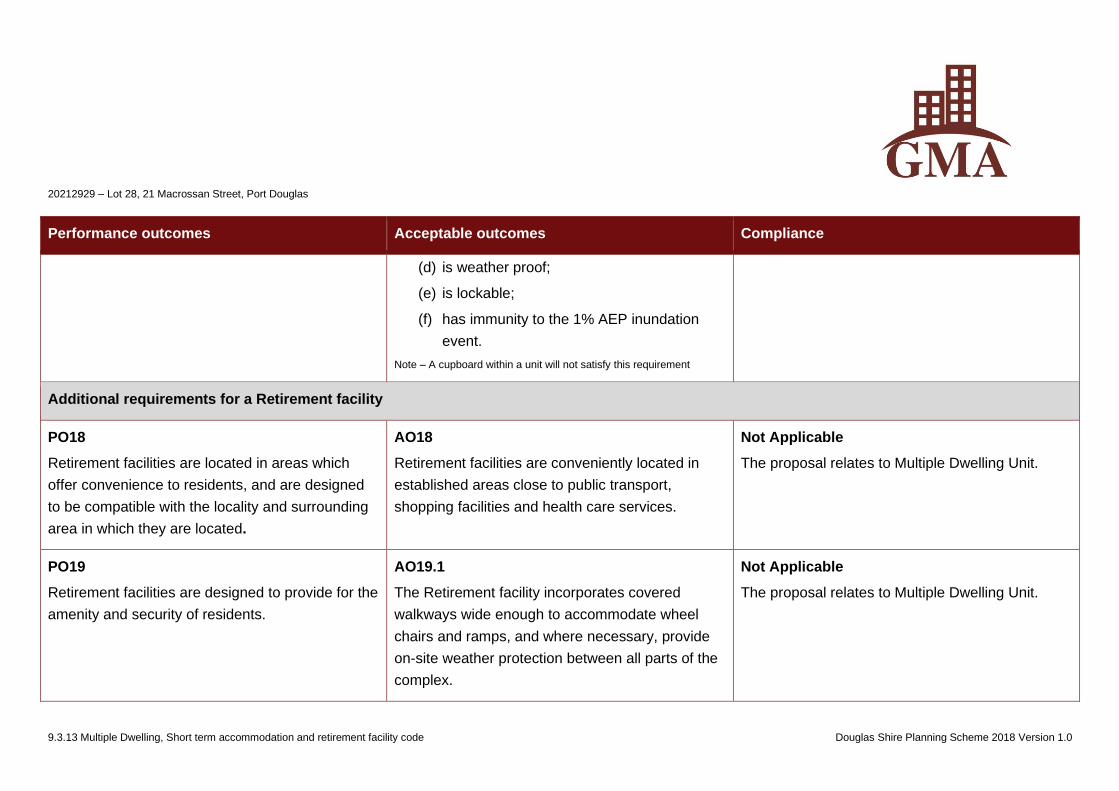
20212929 – Lot 28, 21 Macrossan Street, Port Douglas
9.3.13 Multiple Dwelling, Short term accommodation and retirement facility code Douglas Shire Planning Scheme 2018 Version 1.0
Performance outcomes Acceptable outcomes Compliance
(d) is weather proof;
(e) is lockable;
(f) has immunity to the 1% AEP inundation
event.
Note – A cupboard within a unit will not satisfy this requirement
Additional requirements for a Retirement facility
PO18
Retirement facilities are located in areas which
offer convenience to residents, and are designed
to be compatible with the locality and surrounding
area in which they are located.
AO18
Retirement facilities are conveniently located in
established areas close to public transport,
shopping facilities and health care services.
Not Applicable
The proposal relates to Multiple Dwelling Unit.
PO19
Retirement facilities are designed to provide for the
amenity and security of residents.
AO19.1
The Retirement facility incorporates covered
walkways wide enough to accommodate wheel
chairs and ramps, and where necessary, provide
on-site weather protection between all parts of the
complex.
Not Applicable
The proposal relates to Multiple Dwelling Unit.
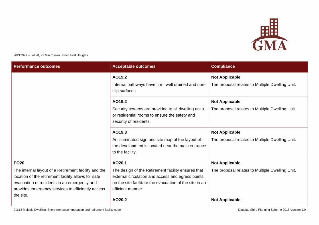
20212929 – Lot 28, 21 Macrossan Street, Port Douglas
9.3.13 Multiple Dwelling, Short term accommodation and retirement facility code Douglas Shire Planning Scheme 2018 Version 1.0
Performance outcomes Acceptable outcomes Compliance
AO19.2
Internal pathways have firm, well drained and non-
slip surfaces.
Not Applicable
The proposal relates to Multiple Dwelling Unit.
AO19.2
Security screens are provided to all dwelling units
or residential rooms to ensure the safety and
security of residents.
Not Applicable
The proposal relates to Multiple Dwelling Unit.
AO19.3
An illuminated sign and site map of the layout of
the development is located near the main entrance
to the facility.
Not Applicable
The proposal relates to Multiple Dwelling Unit.
PO20
The internal layout of a Retirement facility and the
location of the retirement facility allows for safe
evacuation of residents in an emergency and
provides emergency services to efficiently access
the site.
AO20.1
The design of the Retirement facility ensures that
external circulation and access and egress points
on the site facilitate the evacuation of the site in an
efficient manner.
Not Applicable
The proposal relates to Multiple Dwelling Unit.
AO20.2 Not Applicable
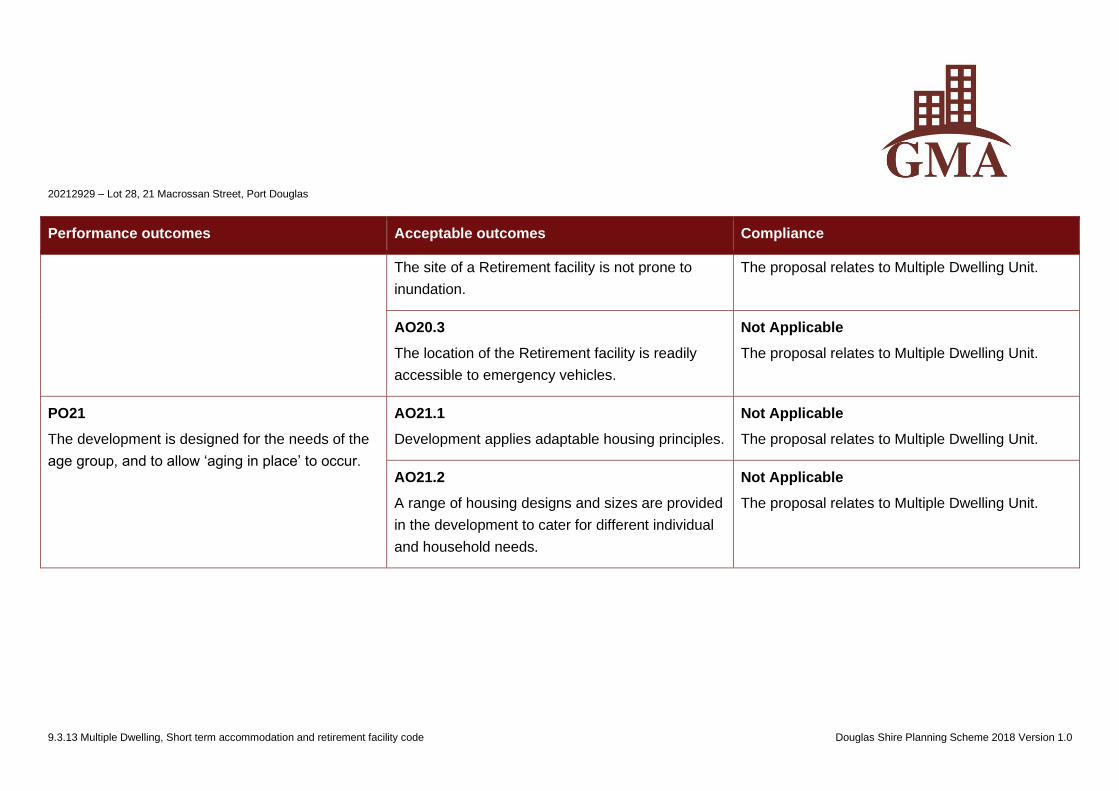
20212929 – Lot 28, 21 Macrossan Street, Port Douglas
9.3.13 Multiple Dwelling, Short term accommodation and retirement facility code Douglas Shire Planning Scheme 2018 Version 1.0
Performance outcomes Acceptable outcomes Compliance
The site of a Retirement facility is not prone to
inundation.
The proposal relates to Multiple Dwelling Unit.
AO20.3
The location of the Retirement facility is readily
accessible to emergency vehicles.
Not Applicable
The proposal relates to Multiple Dwelling Unit.
PO21
The development is designed for the needs of the
age group, and to allow ‘aging in place’ to occur.
AO21.1
Development applies adaptable housing principles.
Not Applicable
The proposal relates to Multiple Dwelling Unit.
AO21.2
A range of housing designs and sizes are provided
in the development to cater for different individual
and household needs.
Not Applicable
The proposal relates to Multiple Dwelling Unit.
20212929 – Lot 28, 21 Macrossan Street, Port Douglas
9.4.1 Access, parking and servicing code Douglas Shire Planning Scheme 2018 Version 1.0
9.4.1 Access, parking and servicing code
9.4.1.1 Application
(1) This code applies to assessing:
(a) operational work which requires a compliance assessment as a condition of a development permit; or
(b) a material change of use or reconfiguring a lot if:
(i) self-assessable or assessable development where this code is identified in the assessment criteria column of the table of assessment;
(ii) impact assessable development, to the extent relevant.
(2) When using this code, reference should be made to Part 5.
9.4.1.2 Purpose
(1) The purpose of the Access, parking and servicing code is to assess the suitability of access, parking and associated servicing aspects of a
development.
(2) The purpose of the code will be achieved through the following overall outcomes:
(a) sufficient vehicle parking is provided on-site to cater for all types of vehicular traffic accessing and parking on-site, including staff, guests, patrons,
residents and short term delivery vehicles;
(b) sufficient bicycle parking and end of trip facilities are provided on-site to cater for customer and service staff;
(c) on-site parking is provided so as to be accessible and convenient, particularly for any short term uses;
(d) development provides walking and cycle routes through the site which link the development to the external walking and cycling network;
(e) the provision of on-site parking, loading / unloading facilities and the provision of access to the site do not impact on the efficient function of street
network or on the area in which the development is located;
(f) new vehicular access points are safely located and are not in conflict with the preferred ultimate streetscape character and local character and do
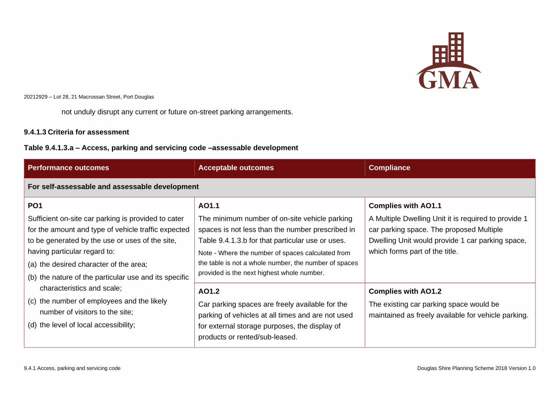
20212929 – Lot 28, 21 Macrossan Street, Port Douglas
9.4.1 Access, parking and servicing code Douglas Shire Planning Scheme 2018 Version 1.0
not unduly disrupt any current or future on-street parking arrangements.
9.4.1.3 Criteria for assessment
Table 9.4.1.3.a – Access, parking and servicing code –assessable development
Performance outcomes Acceptable outcomes Compliance
For self-assessable and assessable development
PO1
Sufficient on-site car parking is provided to cater
for the amount and type of vehicle traffic expected
to be generated by the use or uses of the site,
having particular regard to:
(a) the desired character of the area;
(b) the nature of the particular use and its specific
characteristics and scale;
(c) the number of employees and the likely
number of visitors to the site;
(d) the level of local accessibility;
AO1.1
The minimum number of on-site vehicle parking
spaces is not less than the number prescribed in
Table 9.4.1.3.b for that particular use or uses.
Note - Where the number of spaces calculated from
the table is not a whole number, the number of spaces
provided is the next highest whole number.
Complies with AO1.1
A Multiple Dwelling Unit it is required to provide 1
car parking space. The proposed Multiple
Dwelling Unit would provide 1 car parking space,
which forms part of the title.
AO1.2
Car parking spaces are freely available for the
parking of vehicles at all times and are not used
for external storage purposes, the display of
products or rented/sub-leased.
Complies with AO1.2
The existing car parking space would be
maintained as freely available for vehicle parking.
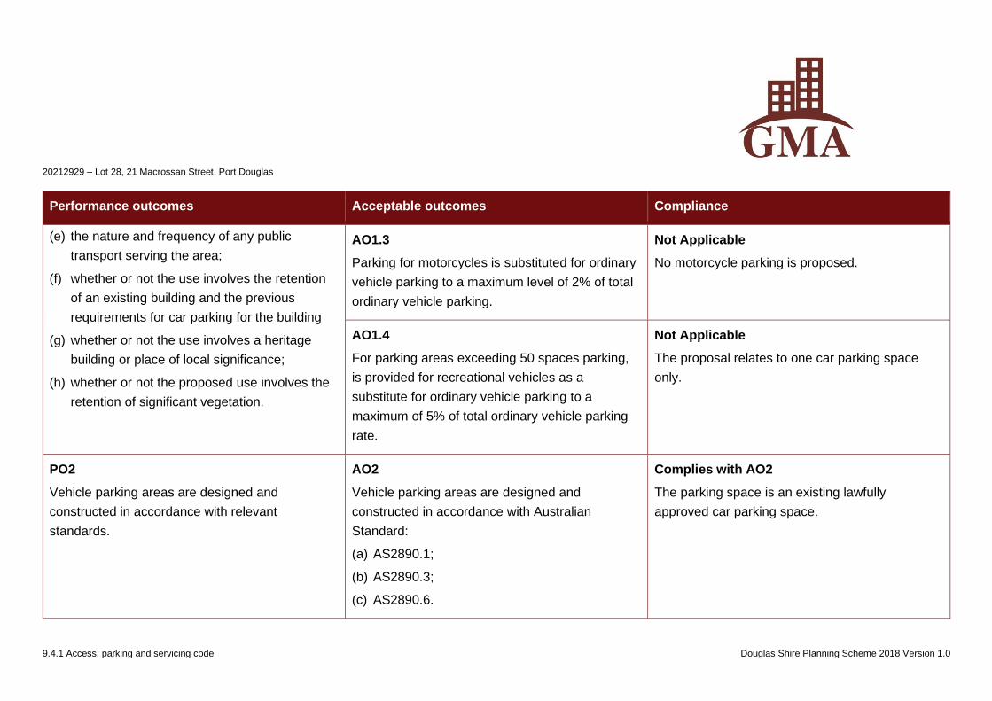
20212929 – Lot 28, 21 Macrossan Street, Port Douglas
9.4.1 Access, parking and servicing code Douglas Shire Planning Scheme 2018 Version 1.0
Performance outcomes Acceptable outcomes Compliance
(e) the nature and frequency of any public
transport serving the area;
(f) whether or not the use involves the retention
of an existing building and the previous
requirements for car parking for the building
(g) whether or not the use involves a heritage
building or place of local significance;
(h) whether or not the proposed use involves the
retention of significant vegetation.
AO1.3
Parking for motorcycles is substituted for ordinary
vehicle parking to a maximum level of 2% of total
ordinary vehicle parking.
Not Applicable
No motorcycle parking is proposed.
AO1.4
For parking areas exceeding 50 spaces parking,
is provided for recreational vehicles as a
substitute for ordinary vehicle parking to a
maximum of 5% of total ordinary vehicle parking
rate.
Not Applicable
The proposal relates to one car parking space
only.
PO2
Vehicle parking areas are designed and
constructed in accordance with relevant
standards.
AO2
Vehicle parking areas are designed and
constructed in accordance with Australian
Standard:
(a) AS2890.1;
(b) AS2890.3;
(c) AS2890.6.
Complies with AO2
The parking space is an existing lawfully
approved car parking space.
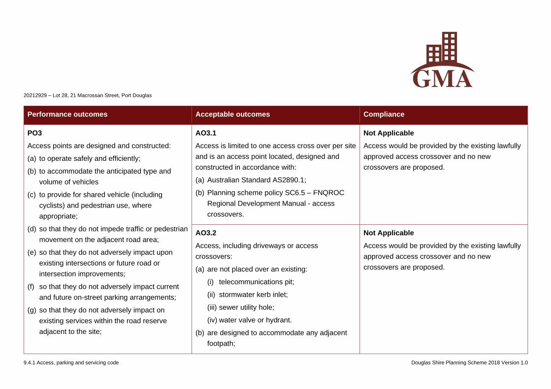
20212929 – Lot 28, 21 Macrossan Street, Port Douglas
9.4.1 Access, parking and servicing code Douglas Shire Planning Scheme 2018 Version 1.0
Performance outcomes Acceptable outcomes Compliance
PO3
Access points are designed and constructed:
(a) to operate safely and efficiently;
(b) to accommodate the anticipated type and
volume of vehicles
(c) to provide for shared vehicle (including
cyclists) and pedestrian use, where
appropriate;
(d) so that they do not impede traffic or pedestrian
movement on the adjacent road area;
(e) so that they do not adversely impact upon
existing intersections or future road or
intersection improvements;
(f) so that they do not adversely impact current
and future on-street parking arrangements;
(g) so that they do not adversely impact on
existing services within the road reserve
adjacent to the site;
AO3.1
Access is limited to one access cross over per site
and is an access point located, designed and
constructed in accordance with:
(a) Australian Standard AS2890.1;
(b) Planning scheme policy SC6.5 – FNQROC
Regional Development Manual - access
crossovers.
Not Applicable
Access would be provided by the existing lawfully
approved access crossover and no new
crossovers are proposed.
AO3.2
Access, including driveways or access
crossovers:
(a) are not placed over an existing:
(i) telecommunications pit;
(ii) stormwater kerb inlet;
(iii) sewer utility hole;
(iv) water valve or hydrant.
(b) are designed to accommodate any adjacent
footpath;
Not Applicable
Access would be provided by the existing lawfully
approved access crossover and no new
crossovers are proposed.
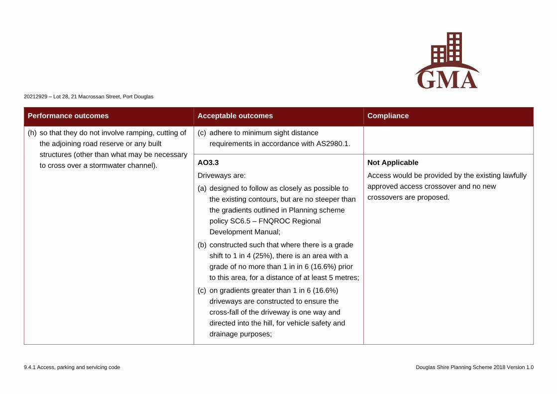
20212929 – Lot 28, 21 Macrossan Street, Port Douglas
9.4.1 Access, parking and servicing code Douglas Shire Planning Scheme 2018 Version 1.0
Performance outcomes Acceptable outcomes Compliance
(h) so that they do not involve ramping, cutting of
the adjoining road reserve or any built
structures (other than what may be necessary
to cross over a stormwater channel).
(c) adhere to minimum sight distance
requirements in accordance with AS2980.1.
AO3.3
Driveways are:
(a) designed to follow as closely as possible to
the existing contours, but are no steeper than
the gradients outlined in Planning scheme
policy SC6.5 – FNQROC Regional
Development Manual;
(b) constructed such that where there is a grade
shift to 1 in 4 (25%), there is an area with a
grade of no more than 1 in in 6 (16.6%) prior
to this area, for a distance of at least 5 metres;
(c) on gradients greater than 1 in 6 (16.6%)
driveways are constructed to ensure the
cross-fall of the driveway is one way and
directed into the hill, for vehicle safety and
drainage purposes;
Not Applicable
Access would be provided by the existing lawfully
approved access crossover and no new
crossovers are proposed.
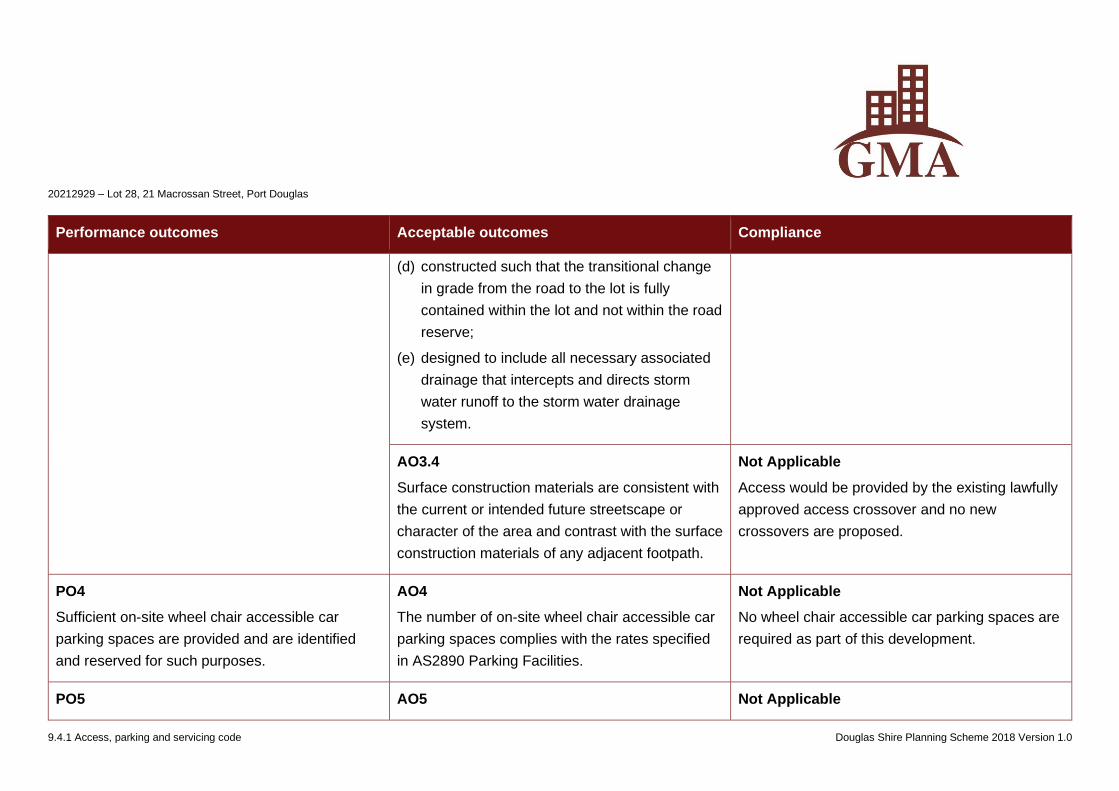
20212929 – Lot 28, 21 Macrossan Street, Port Douglas
9.4.1 Access, parking and servicing code Douglas Shire Planning Scheme 2018 Version 1.0
Performance outcomes Acceptable outcomes Compliance
(d) constructed such that the transitional change
in grade from the road to the lot is fully
contained within the lot and not within the road
reserve;
(e) designed to include all necessary associated
drainage that intercepts and directs storm
water runoff to the storm water drainage
system.
AO3.4
Surface construction materials are consistent with
the current or intended future streetscape or
character of the area and contrast with the surface
construction materials of any adjacent footpath.
Not Applicable
Access would be provided by the existing lawfully
approved access crossover and no new
crossovers are proposed.
PO4
Sufficient on-site wheel chair accessible car
parking spaces are provided and are identified
and reserved for such purposes.
AO4
The number of on-site wheel chair accessible car
parking spaces complies with the rates specified
in AS2890 Parking Facilities.
Not Applicable
No wheel chair accessible car parking spaces are
required as part of this development.
PO5 AO5 Not Applicable
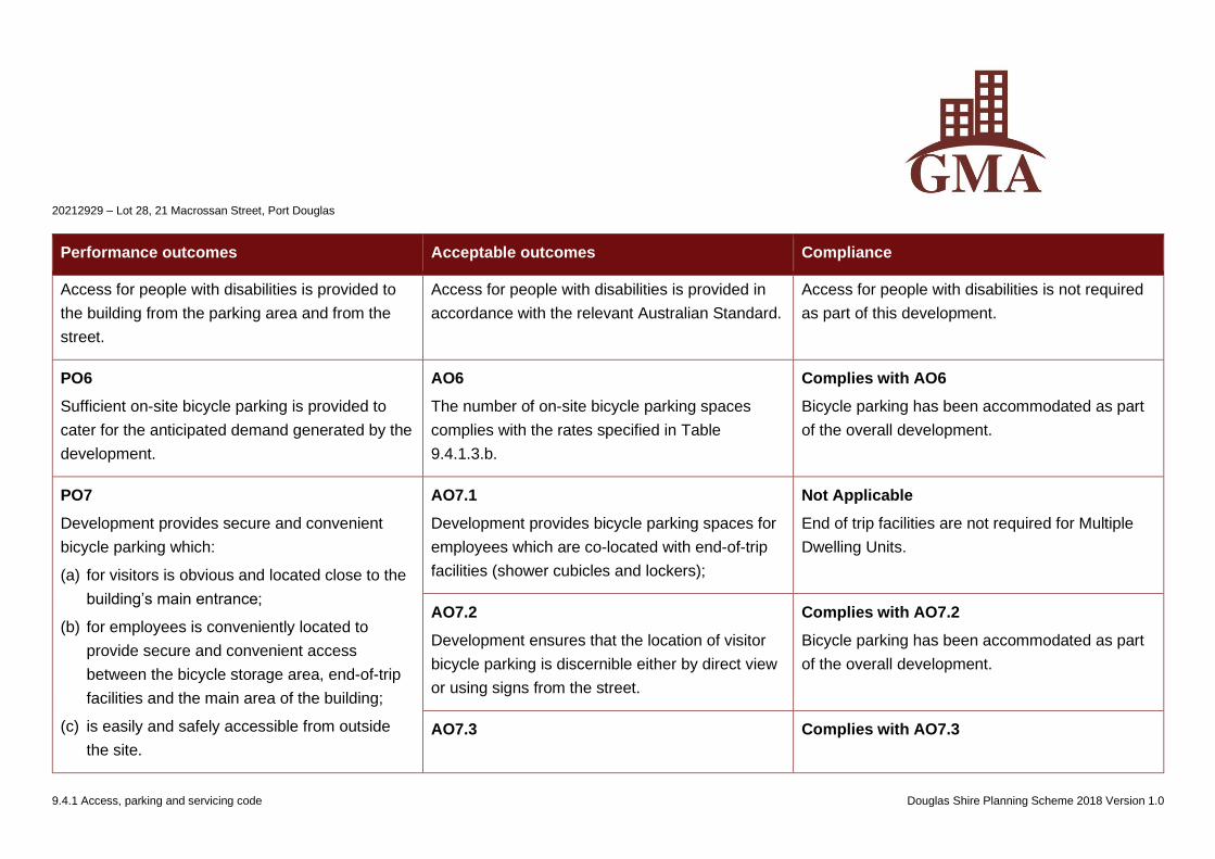
20212929 – Lot 28, 21 Macrossan Street, Port Douglas
9.4.1 Access, parking and servicing code Douglas Shire Planning Scheme 2018 Version 1.0
Performance outcomes Acceptable outcomes Compliance
Access for people with disabilities is provided to
the building from the parking area and from the
street.
Access for people with disabilities is provided in
accordance with the relevant Australian Standard.
Access for people with disabilities is not required
as part of this development.
PO6
Sufficient on-site bicycle parking is provided to
cater for the anticipated demand generated by the
development.
AO6
The number of on-site bicycle parking spaces
complies with the rates specified in Table
9.4.1.3.b.
Complies with AO6
Bicycle parking has been accommodated as part
of the overall development.
PO7
Development provides secure and convenient
bicycle parking which:
(a) for visitors is obvious and located close to the
building’s main entrance;
(b) for employees is conveniently located to
provide secure and convenient access
between the bicycle storage area, end-of-trip
facilities and the main area of the building;
(c) is easily and safely accessible from outside
the site.
AO7.1
Development provides bicycle parking spaces for
employees which are co-located with end-of-trip
facilities (shower cubicles and lockers);
Not Applicable
End of trip facilities are not required for Multiple
Dwelling Units.
AO7.2
Development ensures that the location of visitor
bicycle parking is discernible either by direct view
or using signs from the street.
Complies with AO7.2
Bicycle parking has been accommodated as part
of the overall development.
AO7.3 Complies with AO7.3
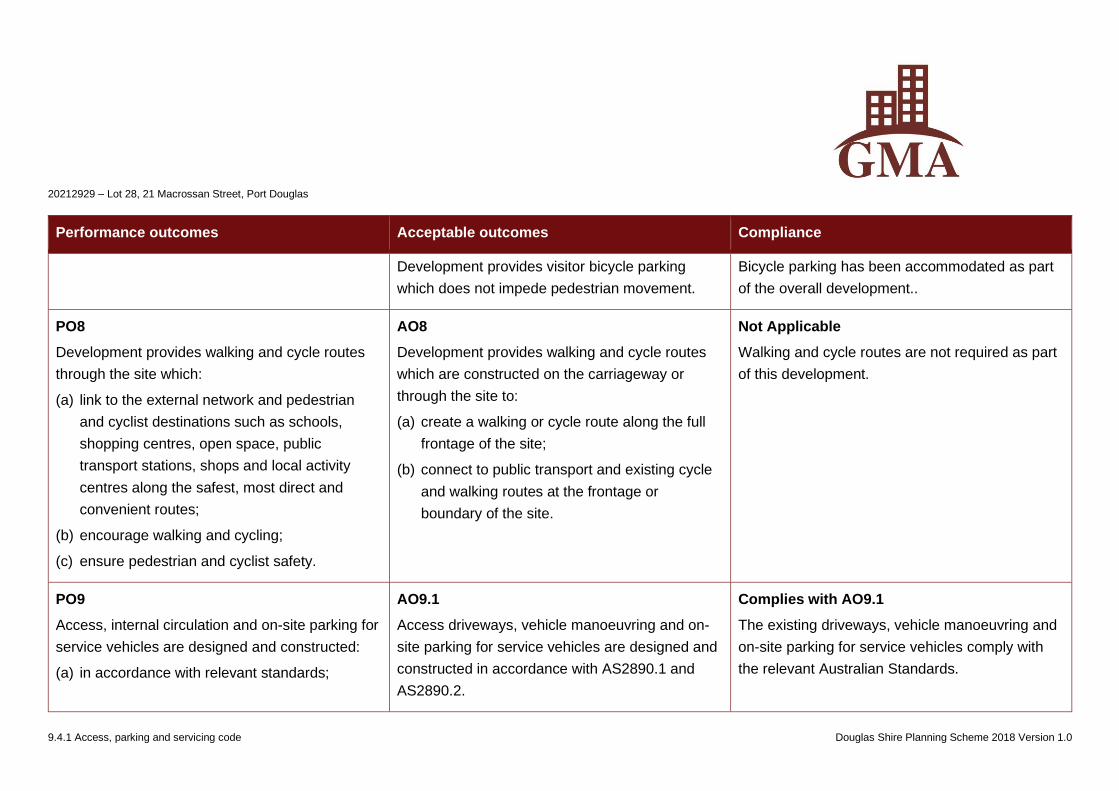
20212929 – Lot 28, 21 Macrossan Street, Port Douglas
9.4.1 Access, parking and servicing code Douglas Shire Planning Scheme 2018 Version 1.0
Performance outcomes Acceptable outcomes Compliance
Development provides visitor bicycle parking
which does not impede pedestrian movement.
Bicycle parking has been accommodated as part
of the overall development..
PO8
Development provides walking and cycle routes
through the site which:
(a) link to the external network and pedestrian
and cyclist destinations such as schools,
shopping centres, open space, public
transport stations, shops and local activity
centres along the safest, most direct and
convenient routes;
(b) encourage walking and cycling;
(c) ensure pedestrian and cyclist safety.
AO8
Development provides walking and cycle routes
which are constructed on the carriageway or
through the site to:
(a) create a walking or cycle route along the full
frontage of the site;
(b) connect to public transport and existing cycle
and walking routes at the frontage or
boundary of the site.
Not Applicable
Walking and cycle routes are not required as part
of this development.
PO9
Access, internal circulation and on-site parking for
service vehicles are designed and constructed:
(a) in accordance with relevant standards;
AO9.1
Access driveways, vehicle manoeuvring and on-
site parking for service vehicles are designed and
constructed in accordance with AS2890.1 and
AS2890.2.
Complies with AO9.1
The existing driveways, vehicle manoeuvring and
on-site parking for service vehicles comply with
the relevant Australian Standards.
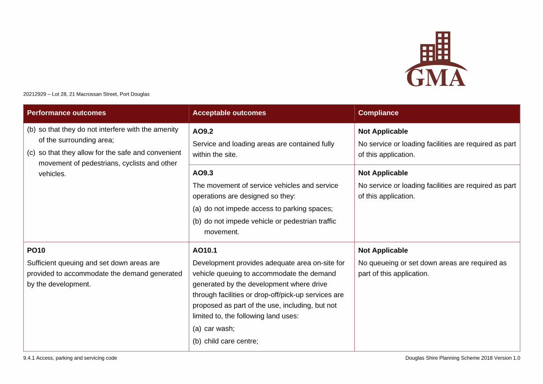
20212929 – Lot 28, 21 Macrossan Street, Port Douglas
9.4.1 Access, parking and servicing code Douglas Shire Planning Scheme 2018 Version 1.0
Performance outcomes Acceptable outcomes Compliance
(b) so that they do not interfere with the amenity
of the surrounding area;
(c) so that they allow for the safe and convenient
movement of pedestrians, cyclists and other
vehicles.
AO9.2
Service and loading areas are contained fully
within the site.
Not Applicable
No service or loading facilities are required as part
of this application.
AO9.3
The movement of service vehicles and service
operations are designed so they:
(a) do not impede access to parking spaces;
(b) do not impede vehicle or pedestrian traffic
movement.
Not Applicable
No service or loading facilities are required as part
of this application.
PO10
Sufficient queuing and set down areas are
provided to accommodate the demand generated
by the development.
AO10.1
Development provides adequate area on-site for
vehicle queuing to accommodate the demand
generated by the development where drive
through facilities or drop-off/pick-up services are
proposed as part of the use, including, but not
limited to, the following land uses:
(a) car wash;
(b) child care centre;
Not Applicable
No queueing or set down areas are required as
part of this application.
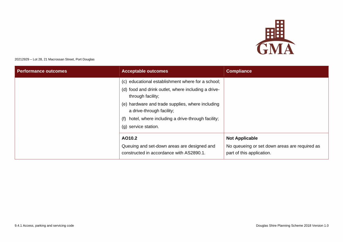
20212929 – Lot 28, 21 Macrossan Street, Port Douglas
9.4.1 Access, parking and servicing code Douglas Shire Planning Scheme 2018 Version 1.0
Performance outcomes Acceptable outcomes Compliance
(c) educational establishment where for a school;
(d) food and drink outlet, where including a drive-
through facility;
(e) hardware and trade supplies, where including
a drive-through facility;
(f) hotel, where including a drive-through facility;
(g) service station.
AO10.2
Queuing and set-down areas are designed and
constructed in accordance with AS2890.1.
Not Applicable
No queueing or set down areas are required as
part of this application.
20212929 – Lot 28, 21 Macrossan Street, Port Douglas
9.4.5 Infrastructure Works Code Douglas Shire Planning Scheme 2018 Version 1.0
9.4.5 Infrastructure works code
9.4.5.1 Application
(1) This code applies to assessing:
(a) operational work which requires an assessment as a condition of a development permit or is assessable development if this code is identified in
the assessment criteria column of a table of assessment;
(b) a material change of use or reconfiguring a lot if:
(i) assessable development where this code is identified in the assessment criteria column of the table of assessment;
(ii) impact assessable development, to the extent relevant.
Note – The Filling and excavation code applies to operational work for filling and excavation.
(2) When using this code, reference should be made to Part 5.
9.4.5.2 Purpose
(1) The purpose of the Infrastructure works code is to ensure that development is safely and efficiently serviced by, and connected to, infrastructure.
(2) The purpose of the code will be achieved through the following overall outcomes:
(a) the standards of water supply, waste water treatment and disposal, stormwater drainage, local electricity supply, telecommunications, footpaths
and road construction meet the needs of development and are safe and efficient;
(b) development maintains high environmental standards;
(c) development is located, designed, constructed and managed to avoid or minimise impacts arising from altered stormwater quality or flow,
wastewater discharge, and the creation of non-tidal artificial waterways;
(d) the integrity of existing infrastructure is maintained;
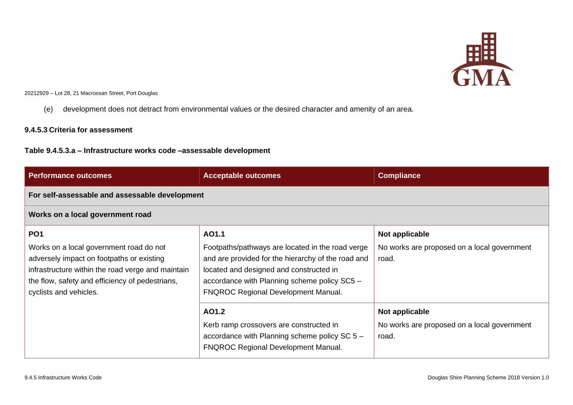
20212929 – Lot 28, 21 Macrossan Street, Port Douglas
9.4.5 Infrastructure Works Code Douglas Shire Planning Scheme 2018 Version 1.0
(e) development does not detract from environmental values or the desired character and amenity of an area.
9.4.5.3 Criteria for assessment
Table 9.4.5.3.a – Infrastructure works code –assessable development
Performance outcomes Acceptable outcomes Compliance
For self-assessable and assessable development
Works on a local government road
PO1
Works on a local government road do not
adversely impact on footpaths or existing
infrastructure within the road verge and maintain
the flow, safety and efficiency of pedestrians,
cyclists and vehicles.
AO1.1
Footpaths/pathways are located in the road verge
and are provided for the hierarchy of the road and
located and designed and constructed in
accordance with Planning scheme policy SC5 –
FNQROC Regional Development Manual.
Not applicable
No works are proposed on a local government
road.
AO1.2
Kerb ramp crossovers are constructed in
accordance with Planning scheme policy SC 5 –
FNQROC Regional Development Manual.
Not applicable
No works are proposed on a local government
road.
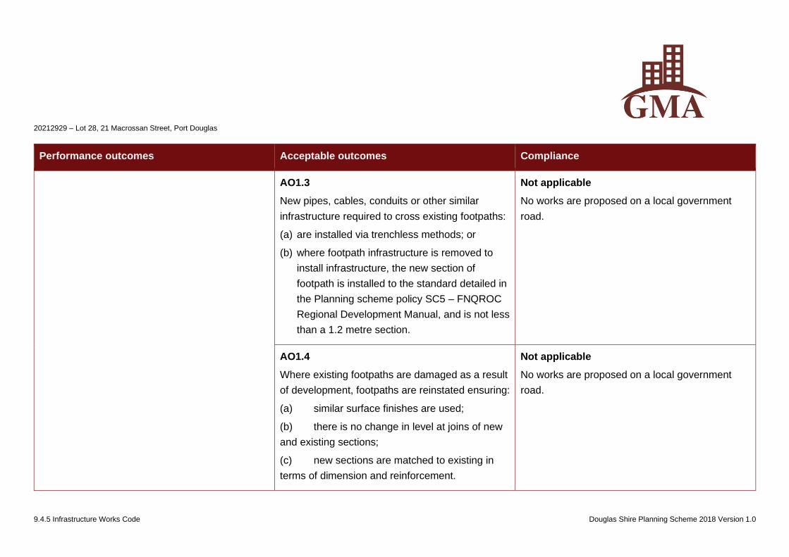
20212929 – Lot 28, 21 Macrossan Street, Port Douglas
9.4.5 Infrastructure Works Code Douglas Shire Planning Scheme 2018 Version 1.0
Performance outcomes Acceptable outcomes Compliance
AO1.3
New pipes, cables, conduits or other similar
infrastructure required to cross existing footpaths:
(a) are installed via trenchless methods; or
(b) where footpath infrastructure is removed to
install infrastructure, the new section of
footpath is installed to the standard detailed in
the Planning scheme policy SC5 – FNQROC
Regional Development Manual, and is not less
than a 1.2 metre section.
Not applicable
No works are proposed on a local government
road.
AO1.4
Where existing footpaths are damaged as a result
of development, footpaths are reinstated ensuring:
(a) similar surface finishes are used;
(b) there is no change in level at joins of new
and existing sections;
(c) new sections are matched to existing in
terms of dimension and reinforcement.
Not applicable
No works are proposed on a local government
road.
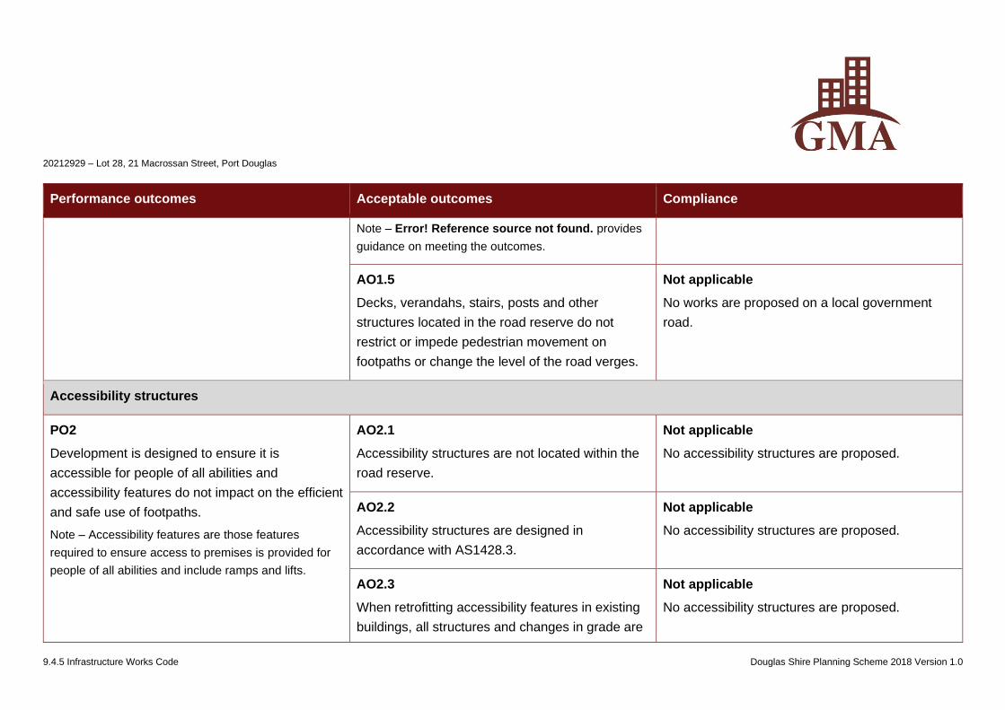
20212929 – Lot 28, 21 Macrossan Street, Port Douglas
9.4.5 Infrastructure Works Code Douglas Shire Planning Scheme 2018 Version 1.0
Performance outcomes Acceptable outcomes Compliance
Note – Error! Reference source not found. provides
guidance on meeting the outcomes.
AO1.5
Decks, verandahs, stairs, posts and other
structures located in the road reserve do not
restrict or impede pedestrian movement on
footpaths or change the level of the road verges.
Not applicable
No works are proposed on a local government
road.
Accessibility structures
PO2
Development is designed to ensure it is
accessible for people of all abilities and
accessibility features do not impact on the efficient
and safe use of footpaths.
Note – Accessibility features are those features
required to ensure access to premises is provided for
people of all abilities and include ramps and lifts.
AO2.1
Accessibility structures are not located within the
road reserve.
Not applicable
No accessibility structures are proposed.
AO2.2
Accessibility structures are designed in
accordance with AS1428.3.
Not applicable
No accessibility structures are proposed.
AO2.3
When retrofitting accessibility features in existing
buildings, all structures and changes in grade are
Not applicable
No accessibility structures are proposed.
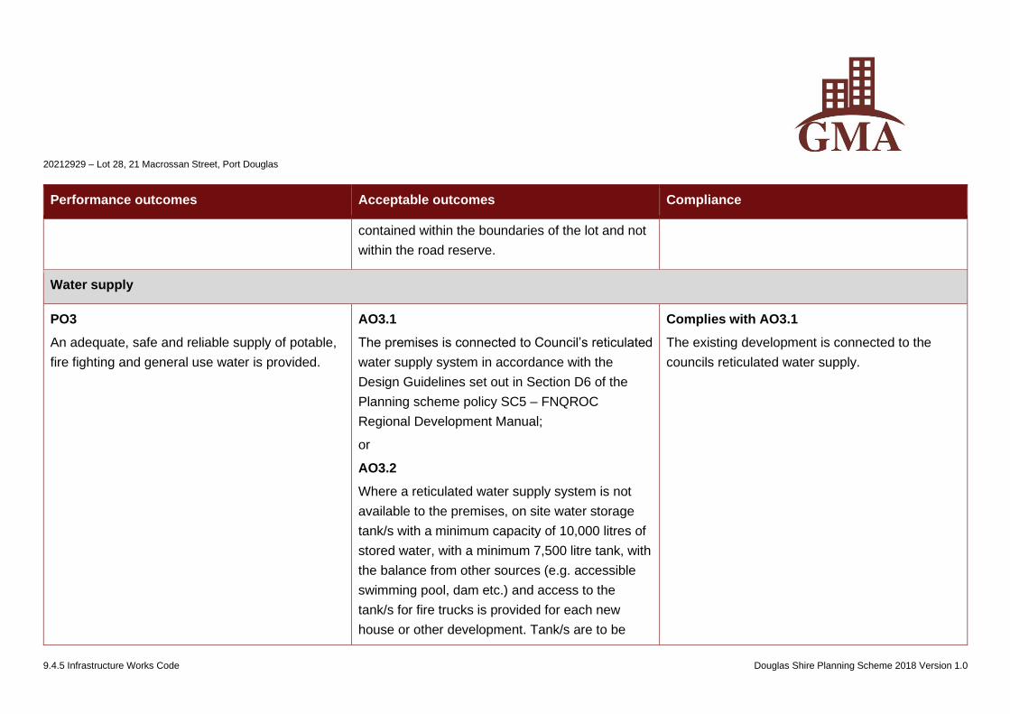
20212929 – Lot 28, 21 Macrossan Street, Port Douglas
9.4.5 Infrastructure Works Code Douglas Shire Planning Scheme 2018 Version 1.0
Performance outcomes Acceptable outcomes Compliance
contained within the boundaries of the lot and not
within the road reserve.
Water supply
PO3
An adequate, safe and reliable supply of potable,
fire fighting and general use water is provided.
AO3.1
The premises is connected to Council’s reticulated
water supply system in accordance with the
Design Guidelines set out in Section D6 of the
Planning scheme policy SC5 – FNQROC
Regional Development Manual;
or
AO3.2
Where a reticulated water supply system is not
available to the premises, on site water storage
tank/s with a minimum capacity of 10,000 litres of
stored water, with a minimum 7,500 litre tank, with
the balance from other sources (e.g. accessible
swimming pool, dam etc.) and access to the
tank/s for fire trucks is provided for each new
house or other development. Tank/s are to be
Complies with AO3.1
The existing development is connected to the
councils reticulated water supply.

20212929 – Lot 28, 21 Macrossan Street, Port Douglas
9.4.5 Infrastructure Works Code Douglas Shire Planning Scheme 2018 Version 1.0
Performance outcomes Acceptable outcomes Compliance
fitted with a 50mm ball valve with a camlock fitting
and installed and connected prior to occupation of
the house and sited to be visually unobtrusive.
Treatment and disposal of effluent
PO4
Provision is made for the treatment and disposal
of effluent to ensure that there are no adverse
impacts on water quality and no adverse
ecological impacts as a result of the system or as
a result of increasing the cumulative effect of
systems in the locality.
AO4.1
The site is connected to Council’s sewerage
system and the extension of or connection to the
sewerage system is designed and constructed in
accordance with the Design Guidelines set out in
Section D7 of the Planning scheme policy SC5 –
FNQROC Regional Development Manual;
or
AO4.2
Where not in a sewerage scheme area, the
proposed disposal system meets the
requirements of Section 33 of the Environmental
Protection Policy (Water) 1997 and the proposed
on site effluent disposal system is designed in
Complies with AO4.1
The site is connected to the Council’s sewerage
system.
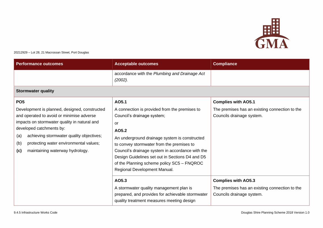
20212929 – Lot 28, 21 Macrossan Street, Port Douglas
9.4.5 Infrastructure Works Code Douglas Shire Planning Scheme 2018 Version 1.0
Performance outcomes Acceptable outcomes Compliance
accordance with the Plumbing and Drainage Act
(2002).
Stormwater quality
PO5
Development is planned, designed, constructed
and operated to avoid or minimise adverse
impacts on stormwater quality in natural and
developed catchments by:
(a) achieving stormwater quality objectives;
(b) protecting water environmental values;
(c) maintaining waterway hydrology.
AO5.1
A connection is provided from the premises to
Council’s drainage system;
or
AO5.2
An underground drainage system is constructed
to convey stormwater from the premises to
Council’s drainage system in accordance with the
Design Guidelines set out in Sections D4 and D5
of the Planning scheme policy SC5 – FNQROC
Regional Development Manual.
Complies with AO5.1
The premises has an existing connection to the
Councils drainage system.
AO5.3
A stormwater quality management plan is
prepared, and provides for achievable stormwater
quality treatment measures meeting design
Complies with AO5.3
The premises has an existing connection to the
Councils drainage system.
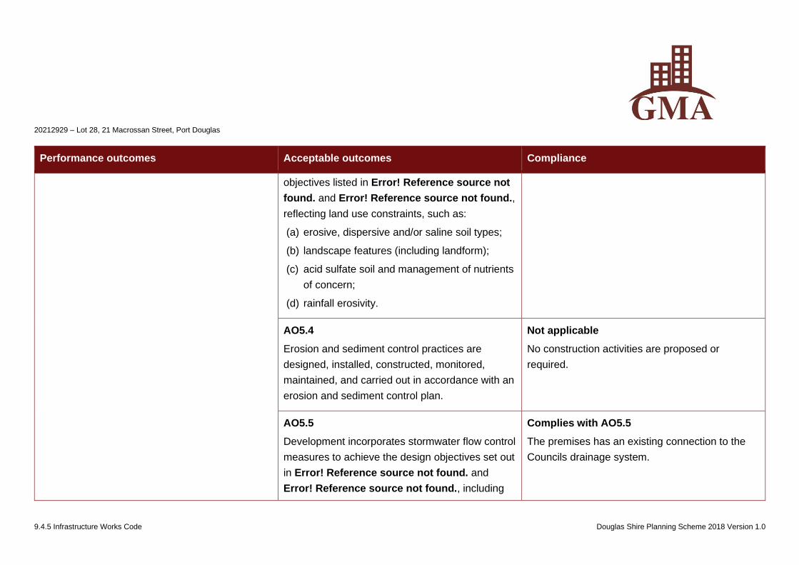
20212929 – Lot 28, 21 Macrossan Street, Port Douglas
9.4.5 Infrastructure Works Code Douglas Shire Planning Scheme 2018 Version 1.0
Performance outcomes Acceptable outcomes Compliance
objectives listed in Error! Reference source not
found. and Error! Reference source not found.,
reflecting land use constraints, such as:
(a) erosive, dispersive and/or saline soil types;
(b) landscape features (including landform);
(c) acid sulfate soil and management of nutrients
of concern;
(d) rainfall erosivity.
AO5.4
Erosion and sediment control practices are
designed, installed, constructed, monitored,
maintained, and carried out in accordance with an
erosion and sediment control plan.
Not applicable
No construction activities are proposed or
required.
AO5.5
Development incorporates stormwater flow control
measures to achieve the design objectives set out
in Error! Reference source not found. and
Error! Reference source not found., including
Complies with AO5.5
The premises has an existing connection to the
Councils drainage system.
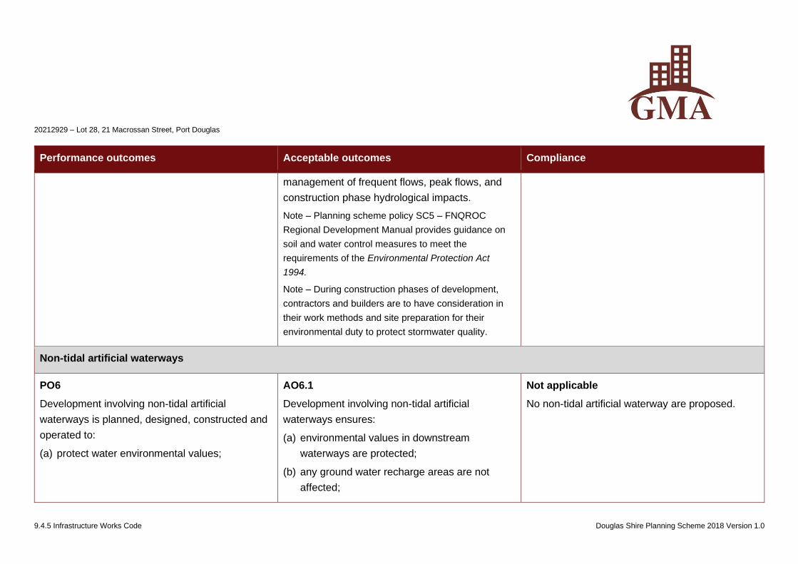
20212929 – Lot 28, 21 Macrossan Street, Port Douglas
9.4.5 Infrastructure Works Code Douglas Shire Planning Scheme 2018 Version 1.0
Performance outcomes Acceptable outcomes Compliance
management of frequent flows, peak flows, and
construction phase hydrological impacts.
Note – Planning scheme policy SC5 – FNQROC
Regional Development Manual provides guidance on
soil and water control measures to meet the
requirements of the Environmental Protection Act
1994.
Note – During construction phases of development,
contractors and builders are to have consideration in
their work methods and site preparation for their
environmental duty to protect stormwater quality.
Non-tidal artificial waterways
PO6
Development involving non-tidal artificial
waterways is planned, designed, constructed and
operated to:
(a) protect water environmental values;
AO6.1
Development involving non-tidal artificial
waterways ensures:
(a) environmental values in downstream
waterways are protected;
(b) any ground water recharge areas are not
affected;
Not applicable
No non-tidal artificial waterway are proposed.
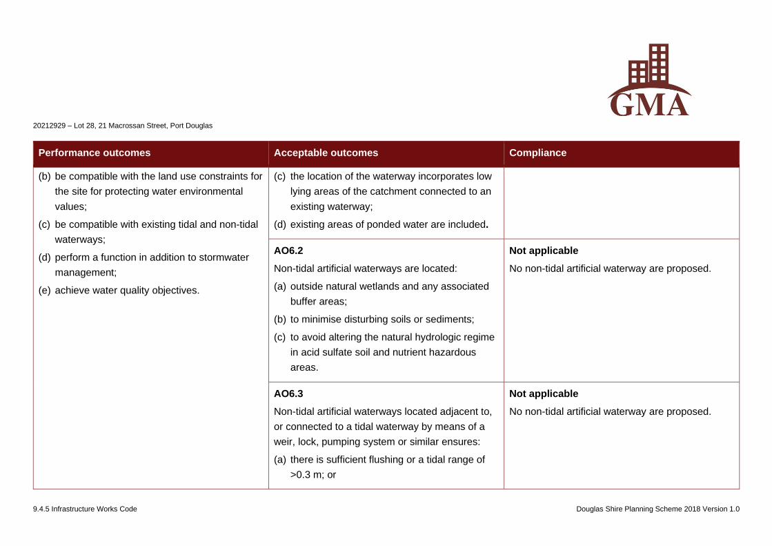
20212929 – Lot 28, 21 Macrossan Street, Port Douglas
9.4.5 Infrastructure Works Code Douglas Shire Planning Scheme 2018 Version 1.0
Performance outcomes Acceptable outcomes Compliance
(b) be compatible with the land use constraints for
the site for protecting water environmental
values;
(c) be compatible with existing tidal and non-tidal
waterways;
(d) perform a function in addition to stormwater
management;
(e) achieve water quality objectives.
(c) the location of the waterway incorporates low
lying areas of the catchment connected to an
existing waterway;
(d) existing areas of ponded water are included.
AO6.2
Non-tidal artificial waterways are located:
(a) outside natural wetlands and any associated
buffer areas;
(b) to minimise disturbing soils or sediments;
(c) to avoid altering the natural hydrologic regime
in acid sulfate soil and nutrient hazardous
areas.
Not applicable
No non-tidal artificial waterway are proposed.
AO6.3
Non-tidal artificial waterways located adjacent to,
or connected to a tidal waterway by means of a
weir, lock, pumping system or similar ensures:
(a) there is sufficient flushing or a tidal range of
>0.3 m; or
Not applicable
No non-tidal artificial waterway are proposed.
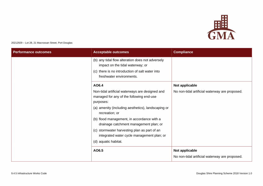
20212929 – Lot 28, 21 Macrossan Street, Port Douglas
9.4.5 Infrastructure Works Code Douglas Shire Planning Scheme 2018 Version 1.0
Performance outcomes Acceptable outcomes Compliance
(b) any tidal flow alteration does not adversely
impact on the tidal waterway; or
(c) there is no introduction of salt water into
freshwater environments.
AO6.4
Non-tidal artificial waterways are designed and
managed for any of the following end-use
purposes:
(a) amenity (including aesthetics), landscaping or
recreation; or
(b) flood management, in accordance with a
drainage catchment management plan; or
(c) stormwater harvesting plan as part of an
integrated water cycle management plan; or
(d) aquatic habitat.
Not applicable
No non-tidal artificial waterway are proposed.
AO6.5 Not applicable
No non-tidal artificial waterway are proposed.
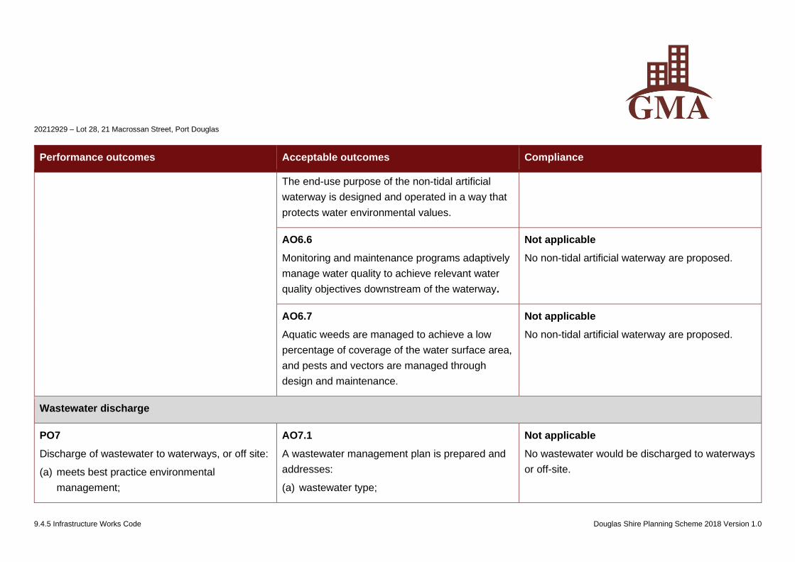
20212929 – Lot 28, 21 Macrossan Street, Port Douglas
9.4.5 Infrastructure Works Code Douglas Shire Planning Scheme 2018 Version 1.0
Performance outcomes Acceptable outcomes Compliance
The end-use purpose of the non-tidal artificial
waterway is designed and operated in a way that
protects water environmental values.
AO6.6
Monitoring and maintenance programs adaptively
manage water quality to achieve relevant water
quality objectives downstream of the waterway.
Not applicable
No non-tidal artificial waterway are proposed.
AO6.7
Aquatic weeds are managed to achieve a low
percentage of coverage of the water surface area,
and pests and vectors are managed through
design and maintenance.
Not applicable
No non-tidal artificial waterway are proposed.
Wastewater discharge
PO7
Discharge of wastewater to waterways, or off site:
(a) meets best practice environmental
management;
AO7.1
A wastewater management plan is prepared and
addresses:
(a) wastewater type;
Not applicable
No wastewater would be discharged to waterways
or off-site.
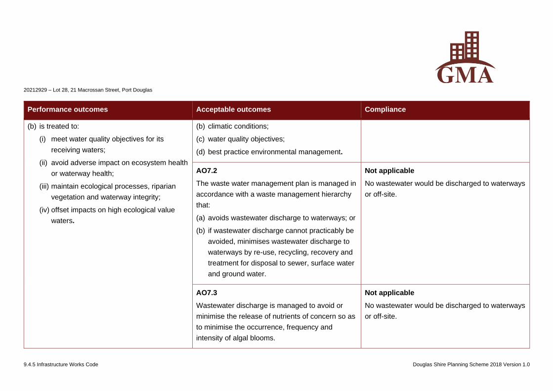
20212929 – Lot 28, 21 Macrossan Street, Port Douglas
9.4.5 Infrastructure Works Code Douglas Shire Planning Scheme 2018 Version 1.0
Performance outcomes Acceptable outcomes Compliance
(b) is treated to:
(i) meet water quality objectives for its
receiving waters;
(ii) avoid adverse impact on ecosystem health
or waterway health;
(iii) maintain ecological processes, riparian
vegetation and waterway integrity;
(iv) offset impacts on high ecological value
waters.
(b) climatic conditions;
(c) water quality objectives;
(d) best practice environmental management.
AO7.2
The waste water management plan is managed in
accordance with a waste management hierarchy
that:
(a) avoids wastewater discharge to waterways; or
(b) if wastewater discharge cannot practicably be
avoided, minimises wastewater discharge to
waterways by re-use, recycling, recovery and
treatment for disposal to sewer, surface water
and ground water.
Not applicable
No wastewater would be discharged to waterways
or off-site.
AO7.3
Wastewater discharge is managed to avoid or
minimise the release of nutrients of concern so as
to minimise the occurrence, frequency and
intensity of algal blooms.
Not applicable
No wastewater would be discharged to waterways
or off-site.
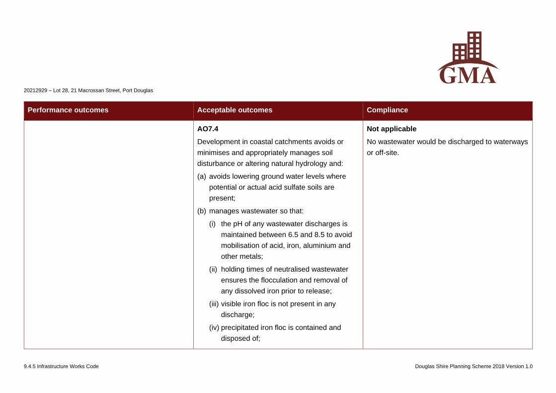
20212929 – Lot 28, 21 Macrossan Street, Port Douglas
9.4.5 Infrastructure Works Code Douglas Shire Planning Scheme 2018 Version 1.0
Performance outcomes Acceptable outcomes Compliance
AO7.4
Development in coastal catchments avoids or
minimises and appropriately manages soil
disturbance or altering natural hydrology and:
(a) avoids lowering ground water levels where
potential or actual acid sulfate soils are
present;
(b) manages wastewater so that:
(i) the pH of any wastewater discharges is
maintained between 6.5 and 8.5 to avoid
mobilisation of acid, iron, aluminium and
other metals;
(ii) holding times of neutralised wastewater
ensures the flocculation and removal of
any dissolved iron prior to release;
(iii) visible iron floc is not present in any
discharge;
(iv) precipitated iron floc is contained and
disposed of;
Not applicable
No wastewater would be discharged to waterways
or off-site.
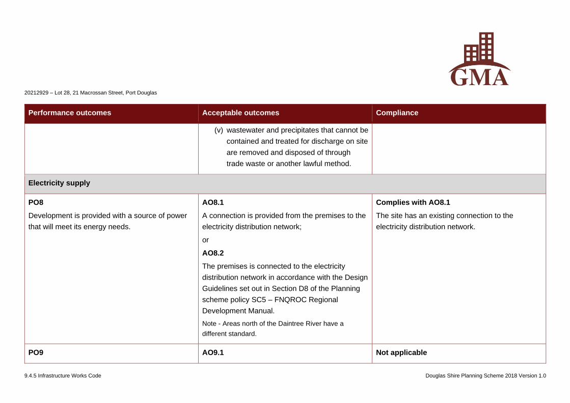
20212929 – Lot 28, 21 Macrossan Street, Port Douglas
9.4.5 Infrastructure Works Code Douglas Shire Planning Scheme 2018 Version 1.0
Performance outcomes Acceptable outcomes Compliance
(v) wastewater and precipitates that cannot be
contained and treated for discharge on site
are removed and disposed of through
trade waste or another lawful method.
Electricity supply
PO8
Development is provided with a source of power
that will meet its energy needs.
AO8.1
A connection is provided from the premises to the
electricity distribution network;
or
AO8.2
The premises is connected to the electricity
distribution network in accordance with the Design
Guidelines set out in Section D8 of the Planning
scheme policy SC5 – FNQROC Regional
Development Manual.
Note - Areas north of the Daintree River have a
different standard.
Complies with AO8.1
The site has an existing connection to the
electricity distribution network.
PO9 AO9.1 Not applicable
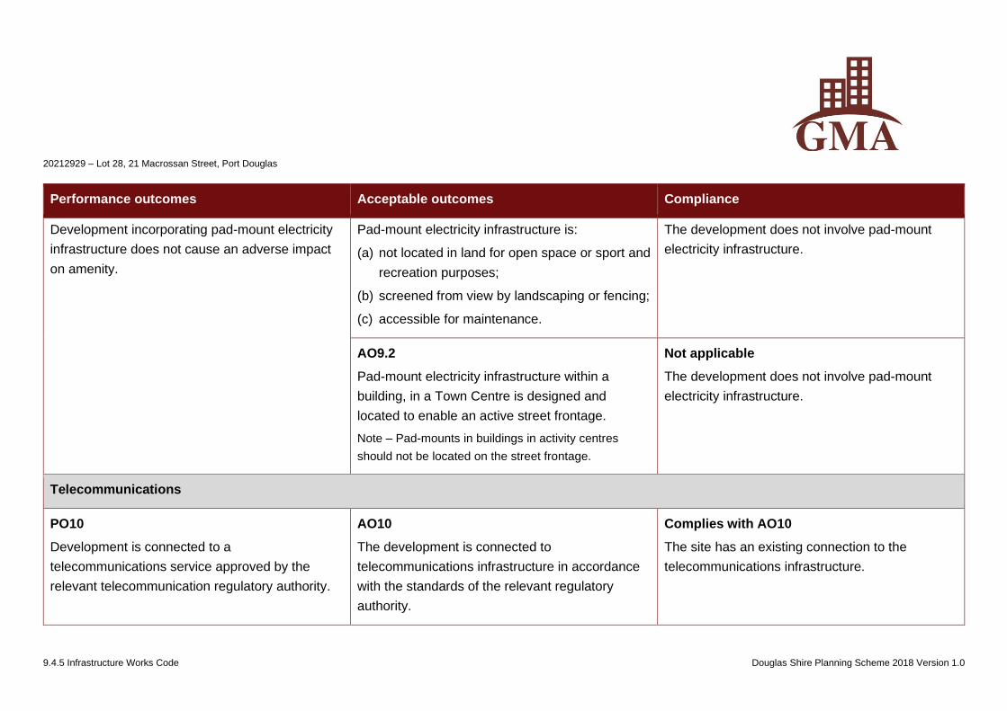
20212929 – Lot 28, 21 Macrossan Street, Port Douglas
9.4.5 Infrastructure Works Code Douglas Shire Planning Scheme 2018 Version 1.0
Performance outcomes Acceptable outcomes Compliance
Development incorporating pad-mount electricity
infrastructure does not cause an adverse impact
on amenity.
Pad-mount electricity infrastructure is:
(a) not located in land for open space or sport and
recreation purposes;
(b) screened from view by landscaping or fencing;
(c) accessible for maintenance.
The development does not involve pad-mount
electricity infrastructure.
AO9.2
Pad-mount electricity infrastructure within a
building, in a Town Centre is designed and
located to enable an active street frontage.
Note – Pad-mounts in buildings in activity centres
should not be located on the street frontage.
Not applicable
The development does not involve pad-mount
electricity infrastructure.
Telecommunications
PO10
Development is connected to a
telecommunications service approved by the
relevant telecommunication regulatory authority.
AO10
The development is connected to
telecommunications infrastructure in accordance
with the standards of the relevant regulatory
authority.
Complies with AO10
The site has an existing connection to the
telecommunications infrastructure.
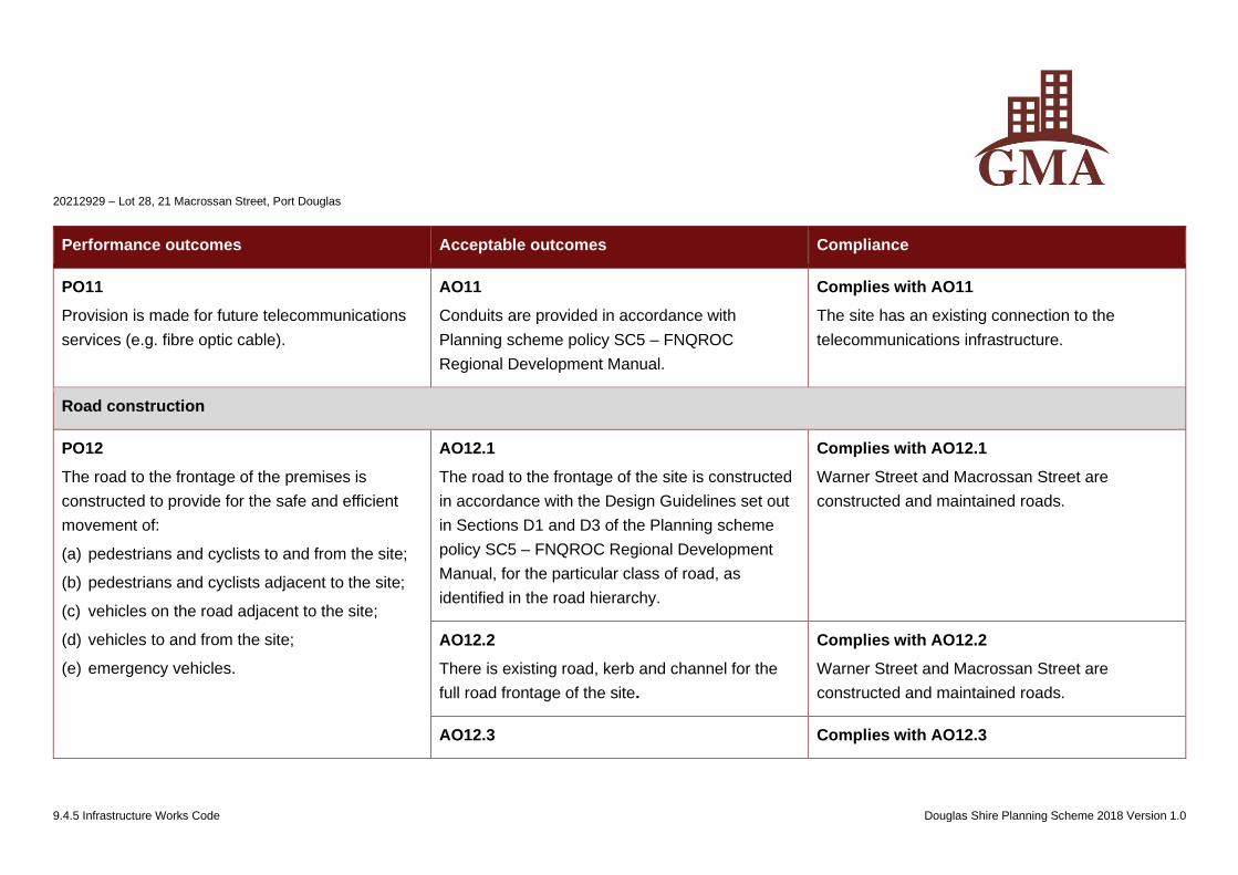
20212929 – Lot 28, 21 Macrossan Street, Port Douglas
9.4.5 Infrastructure Works Code Douglas Shire Planning Scheme 2018 Version 1.0
Performance outcomes Acceptable outcomes Compliance
PO11
Provision is made for future telecommunications
services (e.g. fibre optic cable).
AO11
Conduits are provided in accordance with
Planning scheme policy SC5 – FNQROC
Regional Development Manual.
Complies with AO11
The site has an existing connection to the
telecommunications infrastructure.
Road construction
PO12
The road to the frontage of the premises is
constructed to provide for the safe and efficient
movement of:
(a) pedestrians and cyclists to and from the site;
(b) pedestrians and cyclists adjacent to the site;
(c) vehicles on the road adjacent to the site;
(d) vehicles to and from the site;
(e) emergency vehicles.
AO12.1
The road to the frontage of the site is constructed
in accordance with the Design Guidelines set out
in Sections D1 and D3 of the Planning scheme
policy SC5 – FNQROC Regional Development
Manual, for the particular class of road, as
identified in the road hierarchy.
Complies with AO12.1
Warner Street and Macrossan Street are
constructed and maintained roads.
AO12.2
There is existing road, kerb and channel for the
full road frontage of the site.
Complies with AO12.2
Warner Street and Macrossan Street are
constructed and maintained roads.
AO12.3 Complies with AO12.3
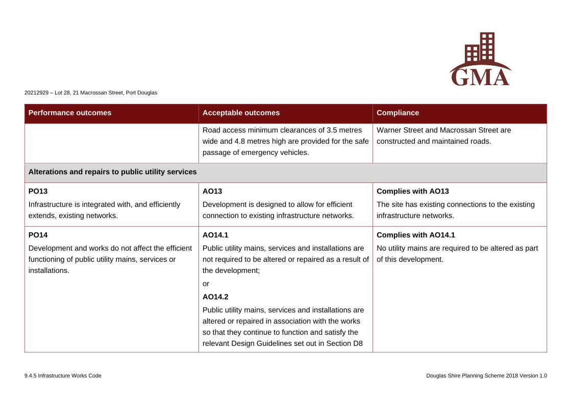
20212929 – Lot 28, 21 Macrossan Street, Port Douglas
9.4.5 Infrastructure Works Code Douglas Shire Planning Scheme 2018 Version 1.0
Performance outcomes Acceptable outcomes Compliance
Road access minimum clearances of 3.5 metres
wide and 4.8 metres high are provided for the safe
passage of emergency vehicles.
Warner Street and Macrossan Street are
constructed and maintained roads.
Alterations and repairs to public utility services
PO13
Infrastructure is integrated with, and efficiently
extends, existing networks.
AO13
Development is designed to allow for efficient
connection to existing infrastructure networks.
Complies with AO13
The site has existing connections to the existing
infrastructure networks.
PO14
Development and works do not affect the efficient
functioning of public utility mains, services or
installations.
AO14.1
Public utility mains, services and installations are
not required to be altered or repaired as a result of
the development;
or
AO14.2
Public utility mains, services and installations are
altered or repaired in association with the works
so that they continue to function and satisfy the
relevant Design Guidelines set out in Section D8
Complies with AO14.1
No utility mains are required to be altered as part
of this development.
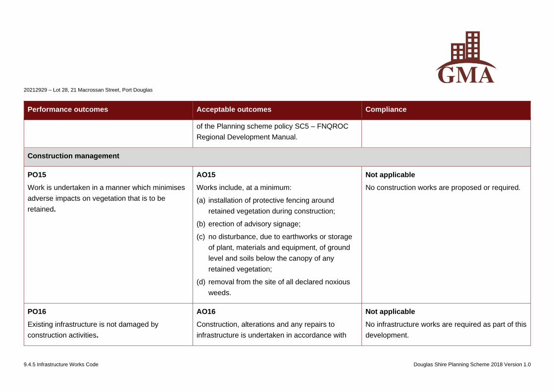
20212929 – Lot 28, 21 Macrossan Street, Port Douglas
9.4.5 Infrastructure Works Code Douglas Shire Planning Scheme 2018 Version 1.0
Performance outcomes Acceptable outcomes Compliance
of the Planning scheme policy SC5 – FNQROC
Regional Development Manual.
Construction management
PO15
Work is undertaken in a manner which minimises
adverse impacts on vegetation that is to be
retained.
AO15
Works include, at a minimum:
(a) installation of protective fencing around
retained vegetation during construction;
(b) erection of advisory signage;
(c) no disturbance, due to earthworks or storage
of plant, materials and equipment, of ground
level and soils below the canopy of any
retained vegetation;
(d) removal from the site of all declared noxious
weeds.
Not applicable
No construction works are proposed or required.
PO16
Existing infrastructure is not damaged by
construction activities.
AO16
Construction, alterations and any repairs to
infrastructure is undertaken in accordance with
Not applicable
No infrastructure works are required as part of this
development.
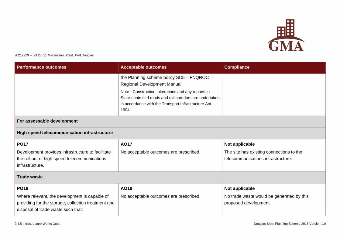
20212929 – Lot 28, 21 Macrossan Street, Port Douglas
9.4.5 Infrastructure Works Code Douglas Shire Planning Scheme 2018 Version 1.0
Performance outcomes Acceptable outcomes Compliance
the Planning scheme policy SC5 – FNQROC
Regional Development Manual.
Note - Construction, alterations and any repairs to
State-controlled roads and rail corridors are undertaken
in accordance with the Transport Infrastructure Act
1994.
For assessable development
High speed telecommunication infrastructure
PO17
Development provides infrastructure to facilitate
the roll out of high speed telecommunications
infrastructure.
AO17
No acceptable outcomes are prescribed.
Not applicable
The site has existing connections to the
telecommunications infrastructure.
Trade waste
PO18
Where relevant, the development is capable of
providing for the storage, collection treatment and
disposal of trade waste such that:
AO18
No acceptable outcomes are prescribed.
Not applicable
No trade waste would be generated by this
proposed development.
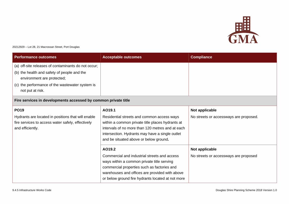
20212929 – Lot 28, 21 Macrossan Street, Port Douglas
9.4.5 Infrastructure Works Code Douglas Shire Planning Scheme 2018 Version 1.0
Performance outcomes Acceptable outcomes Compliance
(a) off-site releases of contaminants do not occur;
(b) the health and safety of people and the
environment are protected;
(c) the performance of the wastewater system is
not put at risk.
Fire services in developments accessed by common private title
PO19
Hydrants are located in positions that will enable
fire services to access water safely, effectively
and efficiently.
AO19.1
Residential streets and common access ways
within a common private title places hydrants at
intervals of no more than 120 metres and at each
intersection. Hydrants may have a single outlet
and be situated above or below ground.
Not applicable
No streets or accessways are proposed.
AO19.2
Commercial and industrial streets and access
ways within a common private title serving
commercial properties such as factories and
warehouses and offices are provided with above
or below ground fire hydrants located at not more
Not applicable
No streets or accessways are proposed
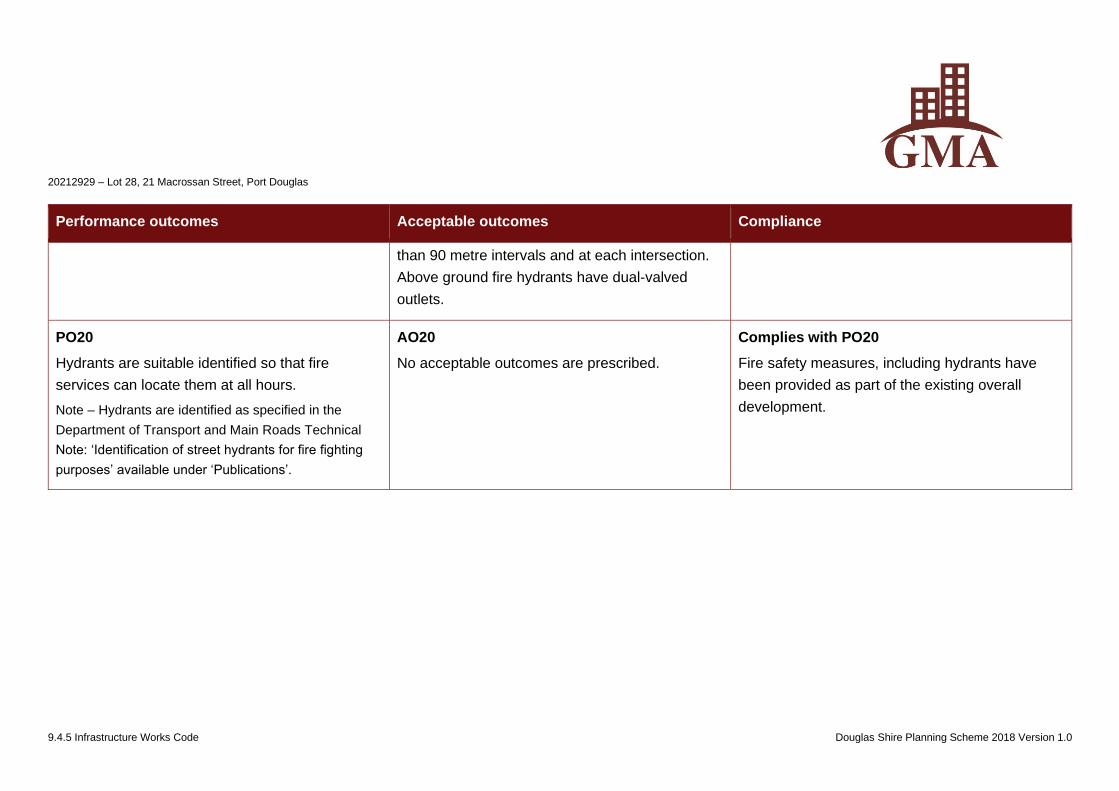
20212929 – Lot 28, 21 Macrossan Street, Port Douglas
9.4.5 Infrastructure Works Code Douglas Shire Planning Scheme 2018 Version 1.0
Performance outcomes Acceptable outcomes Compliance
than 90 metre intervals and at each intersection.
Above ground fire hydrants have dual-valved
outlets.
PO20
Hydrants are suitable identified so that fire
services can locate them at all hours.
Note – Hydrants are identified as specified in the
Department of Transport and Main Roads Technical
Note: ‘Identification of street hydrants for fire fighting
purposes’ available under ‘Publications’.
AO20
No acceptable outcomes are prescribed.
Complies with PO20
Fire safety measures, including hydrants have
been provided as part of the existing overall
development.

www.gmacert.com.au BUILDING APPROVALS & INSPECTIONS BUILDING CERTIFICATION FIRE SAFETY AUDITS Page 15 of 15
www.gmacert.com.au
Leaders in
Building Certification Services
GOLD COAST
Suite 26, 39-47 Lawrence Drive
NERANG Qld 4211
PO Box 2760, NERANG Qld 4211
PORT DOUGLAS
Craiglie Business Park, Owen Street
CRAILIE Qld 4877
PO Box 831 PORT DOUGLAS Qld 4877
CABOOLTURE
Unit 3/5 Hasking Street,
CABOOLTURE Qld 4510
PO Box 2760 NERANG Q 4211
T. 07 5578 1622 F. 07 5596 1294 T. 07 4098 5150 F. 07 4098 5180 T. 07 5432 3222 F. 07 5432 3322
TOWNSVILLE
Shop 1/1 Ingham Rd,
WEST END. QLD. 4812
PO Box 2760
NERANG Qld 4211
CHILDERS
4 Randall St
CHILDERS Qld 4660
PO Box 2760
NERANG Qld 4211
CAIRNS
310 Gatton Street,
MUNUNDA. Qld 4870
PO Box 2760
NERANG Qld 4211
T. 07 4771 6532 F. 07 4771 2165 T. 07 4126 3069 F. 07 4126 3950 T. 07 40410111 F. 07 40410188
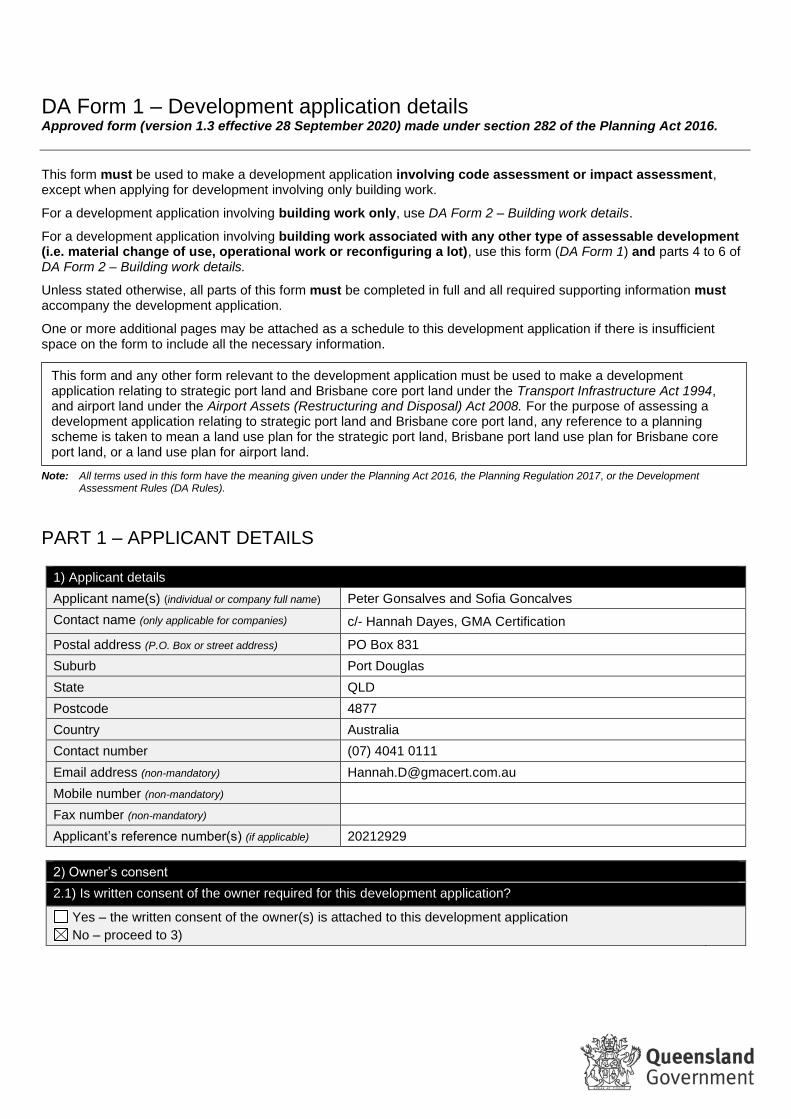
DA Form 1 – Development application details Approved form (version 1.3 effective 28 September 2020) made under section 282 of the Planning Act 2016.
This form must be used to make a development application involving code assessment or impact assessment, except when applying for development involving only building work.
For a development application involving building work only, use DA Form 2 – Building work details.
For a development application involving building work associated with any other type of assessable development (i.e. material change of use, operational work or reconfiguring a lot), use this form (DA Form 1) and parts 4 to 6 of DA Form 2 – Building work details.
Unless stated otherwise, all parts of this form must be completed in full and all required supporting information must accompany the development application.
One or more additional pages may be attached as a schedule to this development application if there is insufficient space on the form to include all the necessary information.
Note: All terms used in this form have the meaning given under the Planning Act 2016, the Planning Regulation 2017, or the Development Assessment Rules (DA Rules).
PART 1 – APPLICANT DETAILS
1) Applicant details
Applicant name(s) (individual or company full name) Peter Gonsalves and Sofia Goncalves
Contact name (only applicable for companies) c/- Hannah Dayes, GMA Certification
Postal address (P.O. Box or street address) PO Box 831
Suburb Port Douglas
State QLD
Postcode 4877
Country Australia
Contact number (07) 4041 0111
Email address (non-mandatory) [email protected]
Mobile number (non-mandatory)
Fax number (non-mandatory)
Applicant’s reference number(s) (if applicable) 20212929
2) Owner’s consent
2.1) Is written consent of the owner required for this development application?
Yes – the written consent of the owner(s) is attached to this development application
No – proceed to 3)
This form and any other form relevant to the development application must be used to make a development application relating to strategic port land and Brisbane core port land under the Transport Infrastructure Act 1994, and airport land under the Airport Assets (Restructuring and Disposal) Act 2008. For the purpose of assessing a development application relating to strategic port land and Brisbane core port land, any reference to a planning scheme is taken to mean a land use plan for the strategic port land, Brisbane port land use plan for Brisbane core port land, or a land use plan for airport land.
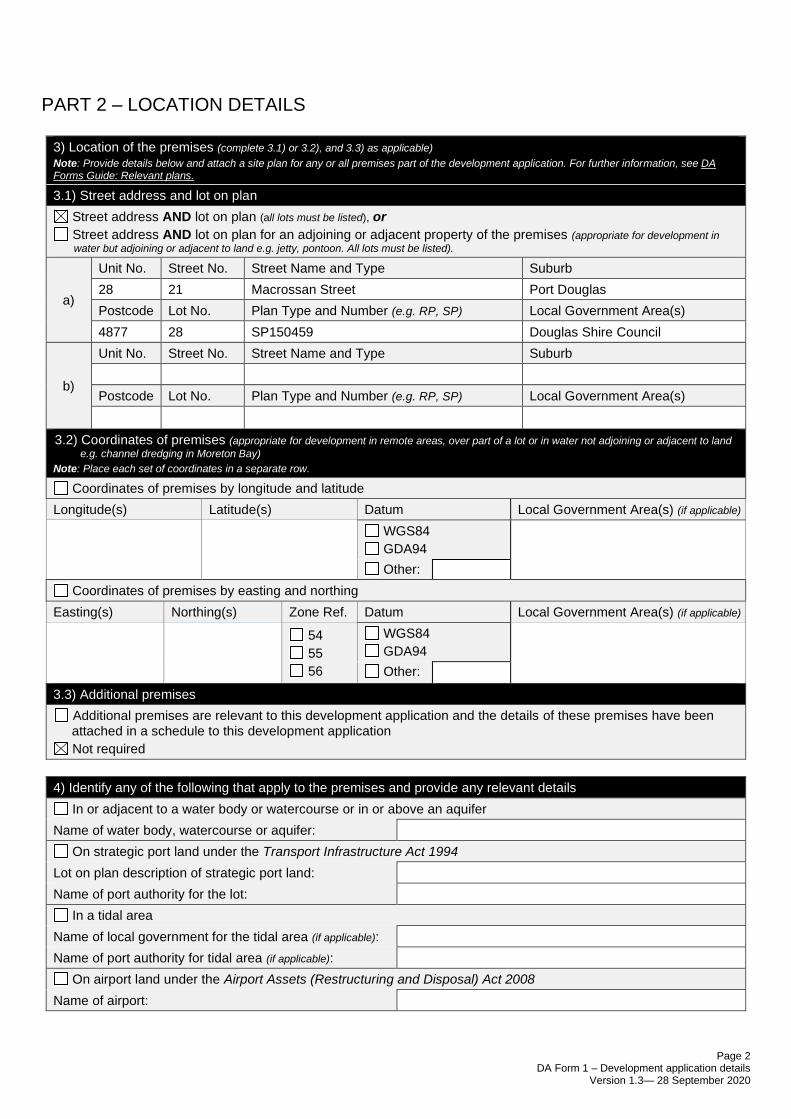
Page 2 DA Form 1 – Development application details
Version 1.3— 28 September 2020
PART 2 – LOCATION DETAILS
3) Location of the premises (complete 3.1) or 3.2), and 3.3) as applicable)
Note: Provide details below and attach a site plan for any or all premises part of the development application. For further information, see DA Forms Guide: Relevant plans.
3.1) Street address and lot on plan
Street address AND lot on plan (all lots must be listed), or
Street address AND lot on plan for an adjoining or adjacent property of the premises (appropriate for development in
water but adjoining or adjacent to land e.g. jetty, pontoon. All lots must be listed).
a)
Unit No. Street No. Street Name and Type Suburb
28 21 Macrossan Street Port Douglas
Postcode Lot No. Plan Type and Number (e.g. RP, SP) Local Government Area(s)
4877 28 SP150459 Douglas Shire Council
b)
Unit No. Street No. Street Name and Type Suburb
Postcode Lot No. Plan Type and Number (e.g. RP, SP) Local Government Area(s)
3.2) Coordinates of premises (appropriate for development in remote areas, over part of a lot or in water not adjoining or adjacent to land
e.g. channel dredging in Moreton Bay)
Note: Place each set of coordinates in a separate row.
Coordinates of premises by longitude and latitude
Longitude(s) Latitude(s) Datum Local Government Area(s) (if applicable)
WGS84
GDA94
Other:
Coordinates of premises by easting and northing
Easting(s) Northing(s) Zone Ref. Datum Local Government Area(s) (if applicable)
54
55
56
WGS84
GDA94
Other:
3.3) Additional premises
Additional premises are relevant to this development application and the details of these premises have been attached in a schedule to this development application
Not required
4) Identify any of the following that apply to the premises and provide any relevant details
In or adjacent to a water body or watercourse or in or above an aquifer
Name of water body, watercourse or aquifer:
On strategic port land under the Transport Infrastructure Act 1994
Lot on plan description of strategic port land:
Name of port authority for the lot:
In a tidal area
Name of local government for the tidal area (if applicable):
Name of port authority for tidal area (if applicable):
On airport land under the Airport Assets (Restructuring and Disposal) Act 2008
Name of airport:
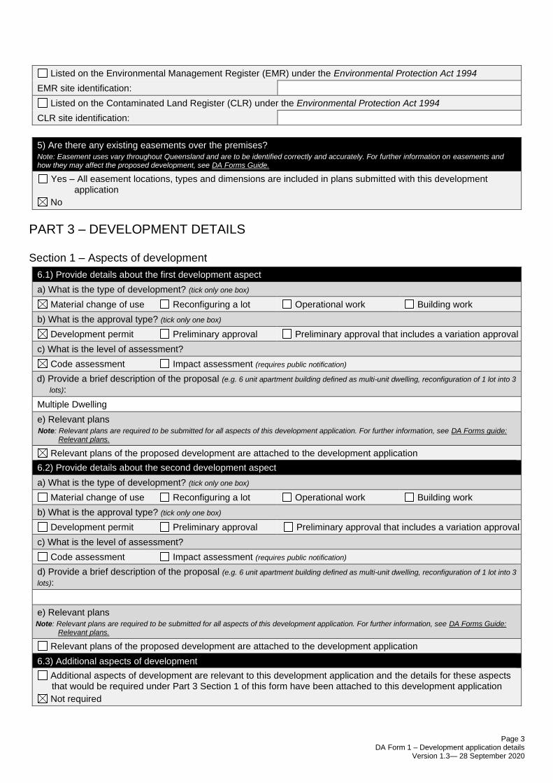
Page 3 DA Form 1 – Development application details
Version 1.3— 28 September 2020
Listed on the Environmental Management Register (EMR) under the Environmental Protection Act 1994
EMR site identification:
Listed on the Contaminated Land Register (CLR) under the Environmental Protection Act 1994
CLR site identification:
5) Are there any existing easements over the premises? Note: Easement uses vary throughout Queensland and are to be identified correctly and accurately. For further information on easements and how they may affect the proposed development, see DA Forms Guide.
Yes – All easement locations, types and dimensions are included in plans submitted with this development application
No
PART 3 – DEVELOPMENT DETAILS
Section 1 – Aspects of development
6.1) Provide details about the first development aspect
a) What is the type of development? (tick only one box)
Material change of use Reconfiguring a lot Operational work Building work
b) What is the approval type? (tick only one box)
Development permit Preliminary approval Preliminary approval that includes a variation approval
c) What is the level of assessment?
Code assessment Impact assessment (requires public notification)
d) Provide a brief description of the proposal (e.g. 6 unit apartment building defined as multi-unit dwelling, reconfiguration of 1 lot into 3
lots):
Multiple Dwelling
e) Relevant plans Note: Relevant plans are required to be submitted for all aspects of this development application. For further information, see DA Forms guide:
Relevant plans.
Relevant plans of the proposed development are attached to the development application
6.2) Provide details about the second development aspect
a) What is the type of development? (tick only one box)
Material change of use Reconfiguring a lot Operational work Building work
b) What is the approval type? (tick only one box)
Development permit Preliminary approval Preliminary approval that includes a variation approval
c) What is the level of assessment?
Code assessment Impact assessment (requires public notification)
d) Provide a brief description of the proposal (e.g. 6 unit apartment building defined as multi-unit dwelling, reconfiguration of 1 lot into 3
lots):
e) Relevant plans Note: Relevant plans are required to be submitted for all aspects of this development application. For further information, see DA Forms Guide:
Relevant plans.
Relevant plans of the proposed development are attached to the development application
6.3) Additional aspects of development
Additional aspects of development are relevant to this development application and the details for these aspects that would be required under Part 3 Section 1 of this form have been attached to this development application
Not required
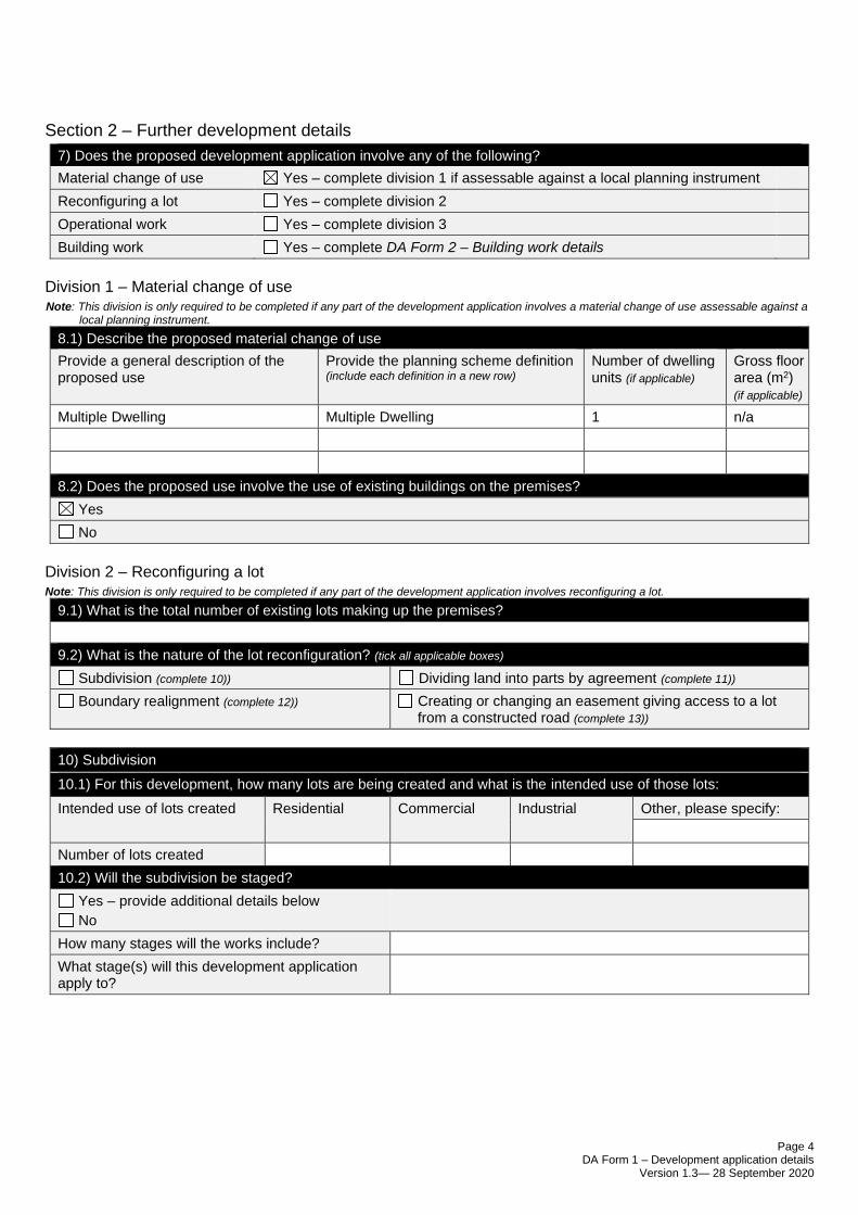
Page 4 DA Form 1 – Development application details
Version 1.3— 28 September 2020
Section 2 – Further development details
7) Does the proposed development application involve any of the following?
Material change of use Yes – complete division 1 if assessable against a local planning instrument
Reconfiguring a lot Yes – complete division 2
Operational work Yes – complete division 3
Building work Yes – complete DA Form 2 – Building work details
Division 1 – Material change of use Note: This division is only required to be completed if any part of the development application involves a material change of use assessable against a
local planning instrument.
8.1) Describe the proposed material change of use
Provide a general description of the proposed use
Provide the planning scheme definition (include each definition in a new row)
Number of dwelling units (if applicable)
Gross floor area (m2) (if applicable)
Multiple Dwelling Multiple Dwelling 1 n/a
8.2) Does the proposed use involve the use of existing buildings on the premises?
Yes
No
Division 2 – Reconfiguring a lot Note: This division is only required to be completed if any part of the development application involves reconfiguring a lot.
9.1) What is the total number of existing lots making up the premises?
9.2) What is the nature of the lot reconfiguration? (tick all applicable boxes)
Subdivision (complete 10)) Dividing land into parts by agreement (complete 11))
Boundary realignment (complete 12)) Creating or changing an easement giving access to a lot from a constructed road (complete 13))
10) Subdivision
10.1) For this development, how many lots are being created and what is the intended use of those lots:
Intended use of lots created Residential Commercial Industrial Other, please specify:
Number of lots created
10.2) Will the subdivision be staged?
Yes – provide additional details below
No
How many stages will the works include?
What stage(s) will this development application apply to?
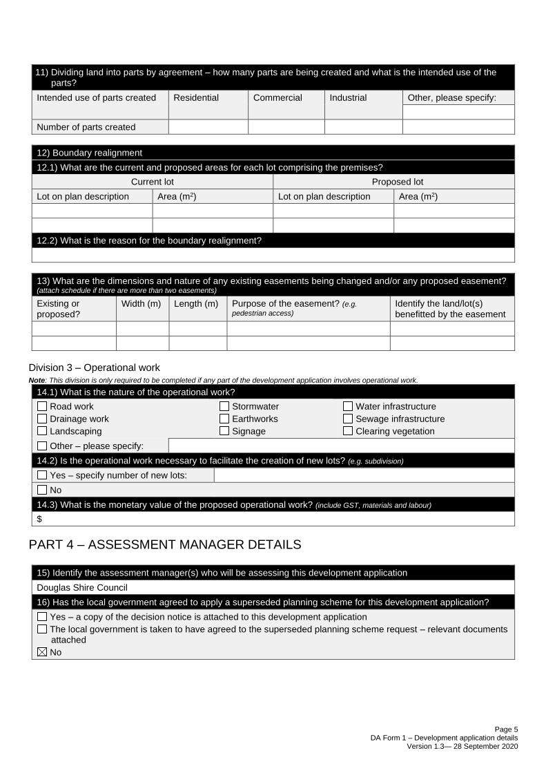
Page 5 DA Form 1 – Development application details
Version 1.3— 28 September 2020
11) Dividing land into parts by agreement – how many parts are being created and what is the intended use of the parts?
Intended use of parts created Residential Commercial Industrial Other, please specify:
Number of parts created
12) Boundary realignment
12.1) What are the current and proposed areas for each lot comprising the premises?
Current lot Proposed lot
Lot on plan description Area (m2) Lot on plan description Area (m2)
12.2) What is the reason for the boundary realignment?
13) What are the dimensions and nature of any existing easements being changed and/or any proposed easement? (attach schedule if there are more than two easements)
Existing or proposed?
Width (m) Length (m) Purpose of the easement? (e.g.
pedestrian access) Identify the land/lot(s) benefitted by the easement
Division 3 – Operational work
Note: This division is only required to be completed if any part of the development application involves operational work.
14.1) What is the nature of the operational work?
Road work
Drainage work
Landscaping
Stormwater
Earthworks
Signage
Water infrastructure
Sewage infrastructure
Clearing vegetation
Other – please specify:
14.2) Is the operational work necessary to facilitate the creation of new lots? (e.g. subdivision)
Yes – specify number of new lots:
No
14.3) What is the monetary value of the proposed operational work? (include GST, materials and labour)
$
PART 4 – ASSESSMENT MANAGER DETAILS
15) Identify the assessment manager(s) who will be assessing this development application
Douglas Shire Council
16) Has the local government agreed to apply a superseded planning scheme for this development application?
Yes – a copy of the decision notice is attached to this development application
The local government is taken to have agreed to the superseded planning scheme request – relevant documents attached
No
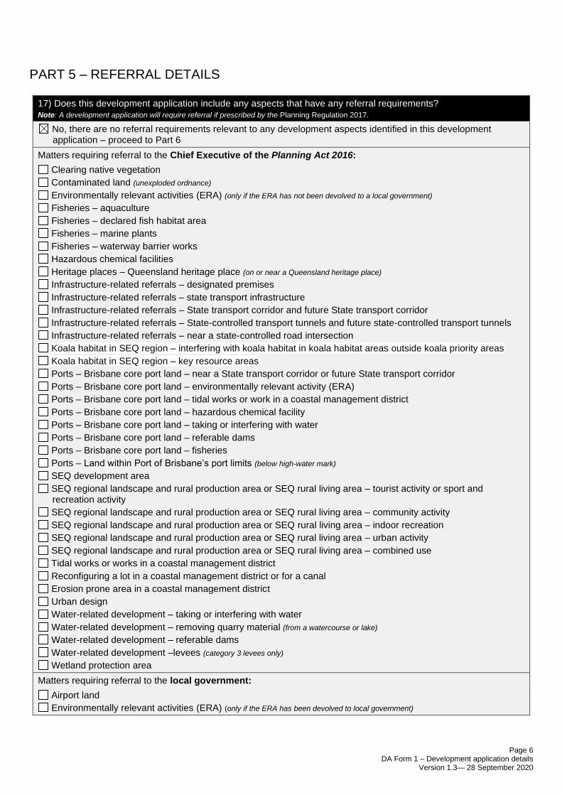
Page 6 DA Form 1 – Development application details
Version 1.3— 28 September 2020
PART 5 – REFERRAL DETAILS
17) Does this development application include any aspects that have any referral requirements? Note: A development application will require referral if prescribed by the Planning Regulation 2017.
No, there are no referral requirements relevant to any development aspects identified in this development application – proceed to Part 6
Matters requiring referral to the Chief Executive of the Planning Act 2016:
Clearing native vegetation
Contaminated land (unexploded ordnance)
Environmentally relevant activities (ERA) (only if the ERA has not been devolved to a local government)
Fisheries – aquaculture
Fisheries – declared fish habitat area
Fisheries – marine plants
Fisheries – waterway barrier works
Hazardous chemical facilities
Heritage places – Queensland heritage place (on or near a Queensland heritage place)
Infrastructure-related referrals – designated premises
Infrastructure-related referrals – state transport infrastructure
Infrastructure-related referrals – State transport corridor and future State transport corridor
Infrastructure-related referrals – State-controlled transport tunnels and future state-controlled transport tunnels
Infrastructure-related referrals – near a state-controlled road intersection
Koala habitat in SEQ region – interfering with koala habitat in koala habitat areas outside koala priority areas
Koala habitat in SEQ region – key resource areas
Ports – Brisbane core port land – near a State transport corridor or future State transport corridor
Ports – Brisbane core port land – environmentally relevant activity (ERA)
Ports – Brisbane core port land – tidal works or work in a coastal management district
Ports – Brisbane core port land – hazardous chemical facility
Ports – Brisbane core port land – taking or interfering with water
Ports – Brisbane core port land – referable dams
Ports – Brisbane core port land – fisheries
Ports – Land within Port of Brisbane’s port limits (below high-water mark)
SEQ development area
SEQ regional landscape and rural production area or SEQ rural living area – tourist activity or sport and recreation activity
SEQ regional landscape and rural production area or SEQ rural living area – community activity
SEQ regional landscape and rural production area or SEQ rural living area – indoor recreation
SEQ regional landscape and rural production area or SEQ rural living area – urban activity
SEQ regional landscape and rural production area or SEQ rural living area – combined use
Tidal works or works in a coastal management district
Reconfiguring a lot in a coastal management district or for a canal
Erosion prone area in a coastal management district
Urban design
Water-related development – taking or interfering with water
Water-related development – removing quarry material (from a watercourse or lake)
Water-related development – referable dams
Water-related development –levees (category 3 levees only)
Wetland protection area
Matters requiring referral to the local government:
Airport land
Environmentally relevant activities (ERA) (only if the ERA has been devolved to local government)
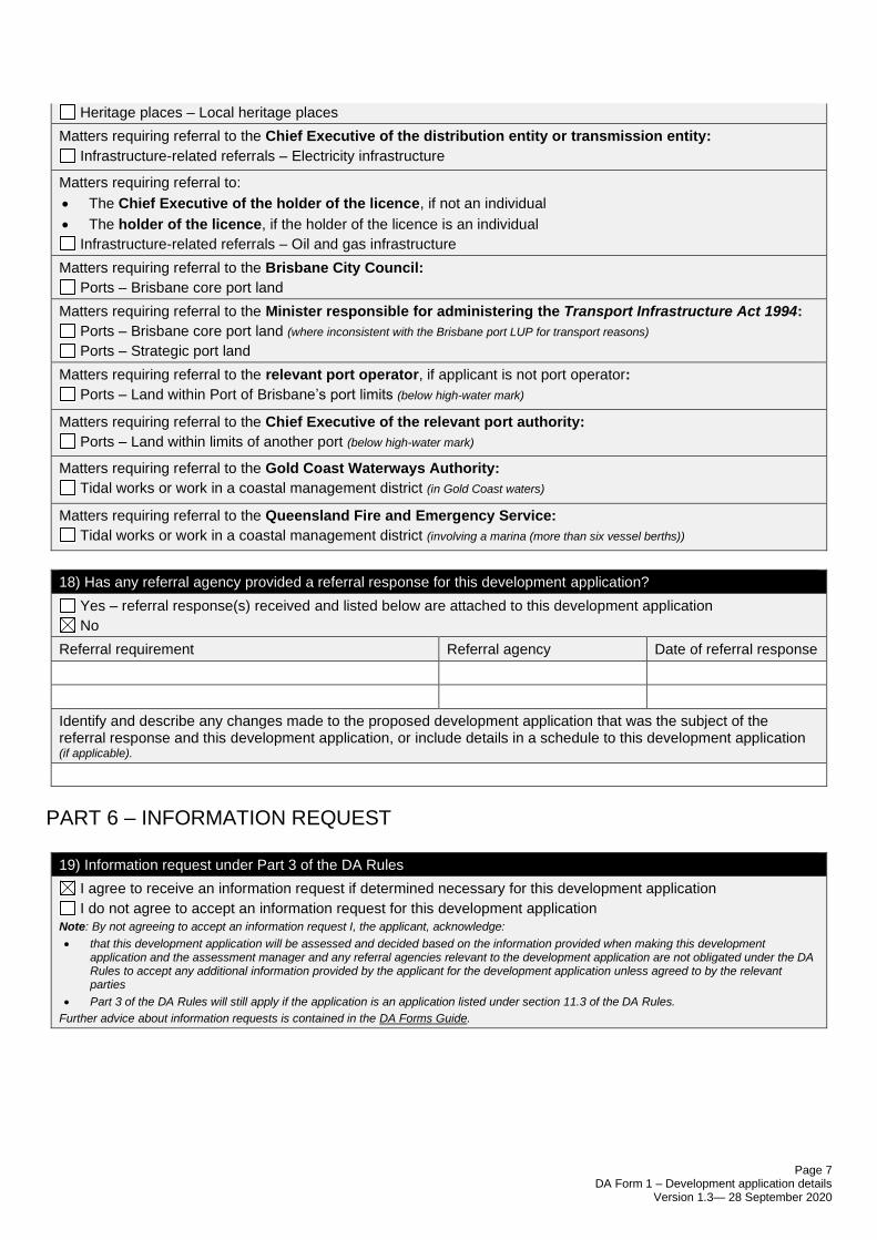
Page 7 DA Form 1 – Development application details
Version 1.3— 28 September 2020
Heritage places – Local heritage places
Matters requiring referral to the Chief Executive of the distribution entity or transmission entity:
Infrastructure-related referrals – Electricity infrastructure
Matters requiring referral to:
• The Chief Executive of the holder of the licence, if not an individual
• The holder of the licence, if the holder of the licence is an individual
Infrastructure-related referrals – Oil and gas infrastructure
Matters requiring referral to the Brisbane City Council:
Ports – Brisbane core port land
Matters requiring referral to the Minister responsible for administering the Transport Infrastructure Act 1994:
Ports – Brisbane core port land (where inconsistent with the Brisbane port LUP for transport reasons)
Ports – Strategic port land
Matters requiring referral to the relevant port operator, if applicant is not port operator:
Ports – Land within Port of Brisbane’s port limits (below high-water mark)
Matters requiring referral to the Chief Executive of the relevant port authority:
Ports – Land within limits of another port (below high-water mark)
Matters requiring referral to the Gold Coast Waterways Authority:
Tidal works or work in a coastal management district (in Gold Coast waters)
Matters requiring referral to the Queensland Fire and Emergency Service:
Tidal works or work in a coastal management district (involving a marina (more than six vessel berths))
18) Has any referral agency provided a referral response for this development application?
Yes – referral response(s) received and listed below are attached to this development application
No
Referral requirement Referral agency Date of referral response
Identify and describe any changes made to the proposed development application that was the subject of the referral response and this development application, or include details in a schedule to this development application (if applicable).
PART 6 – INFORMATION REQUEST
19) Information request under Part 3 of the DA Rules
I agree to receive an information request if determined necessary for this development application
I do not agree to accept an information request for this development application Note: By not agreeing to accept an information request I, the applicant, acknowledge:
• that this development application will be assessed and decided based on the information provided when making this development application and the assessment manager and any referral agencies relevant to the development application are not obligated under the DA Rules to accept any additional information provided by the applicant for the development application unless agreed to by the relevant parties
• Part 3 of the DA Rules will still apply if the application is an application listed under section 11.3 of the DA Rules.
Further advice about information requests is contained in the DA Forms Guide.
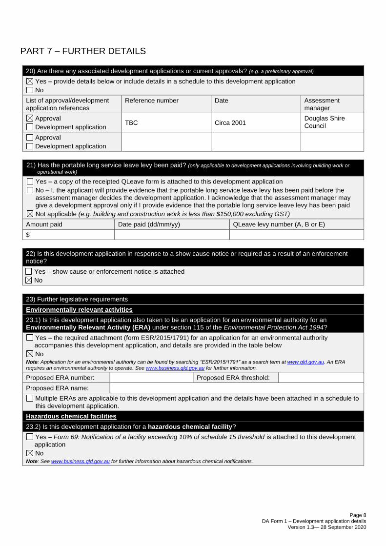
Page 8 DA Form 1 – Development application details
Version 1.3— 28 September 2020
PART 7 – FURTHER DETAILS
20) Are there any associated development applications or current approvals? (e.g. a preliminary approval)
Yes – provide details below or include details in a schedule to this development application
No
List of approval/development application references
Reference number Date Assessment manager
Approval
Development application TBC Circa 2001
Douglas Shire Council
Approval
Development application
21) Has the portable long service leave levy been paid? (only applicable to development applications involving building work or
operational work)
Yes – a copy of the receipted QLeave form is attached to this development application
No – I, the applicant will provide evidence that the portable long service leave levy has been paid before the assessment manager decides the development application. I acknowledge that the assessment manager may give a development approval only if I provide evidence that the portable long service leave levy has been paid
Not applicable (e.g. building and construction work is less than $150,000 excluding GST)
Amount paid Date paid (dd/mm/yy) QLeave levy number (A, B or E)
$
22) Is this development application in response to a show cause notice or required as a result of an enforcement notice?
Yes – show cause or enforcement notice is attached
No
23) Further legislative requirements
Environmentally relevant activities
23.1) Is this development application also taken to be an application for an environmental authority for an Environmentally Relevant Activity (ERA) under section 115 of the Environmental Protection Act 1994?
Yes – the required attachment (form ESR/2015/1791) for an application for an environmental authority accompanies this development application, and details are provided in the table below
No Note: Application for an environmental authority can be found by searching “ESR/2015/1791” as a search term at www.qld.gov.au. An ERA requires an environmental authority to operate. See www.business.qld.gov.au for further information.
Proposed ERA number: Proposed ERA threshold:
Proposed ERA name:
Multiple ERAs are applicable to this development application and the details have been attached in a schedule to this development application.
Hazardous chemical facilities
23.2) Is this development application for a hazardous chemical facility?
Yes – Form 69: Notification of a facility exceeding 10% of schedule 15 threshold is attached to this development application
No
Note: See www.business.qld.gov.au for further information about hazardous chemical notifications.
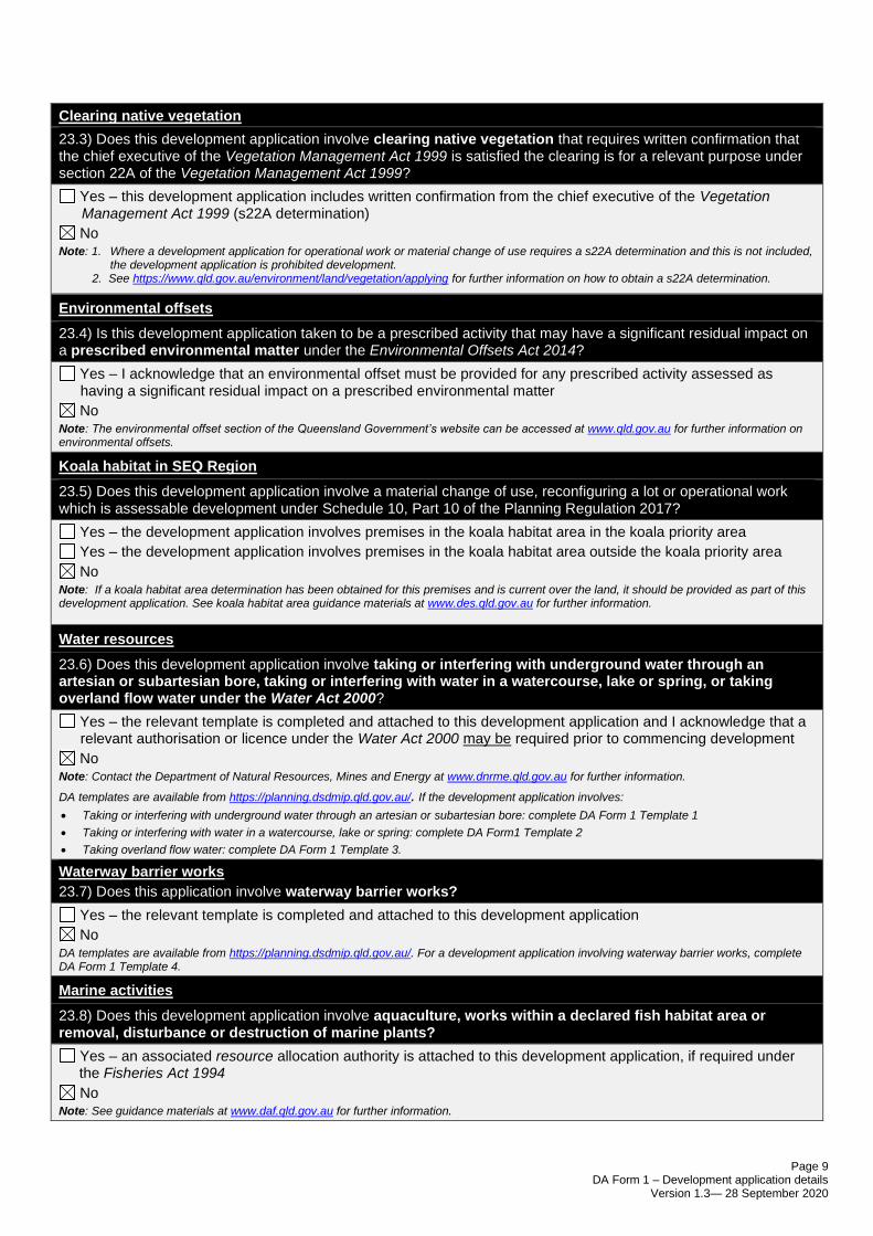
Page 9 DA Form 1 – Development application details
Version 1.3— 28 September 2020
Clearing native vegetation
23.3) Does this development application involve clearing native vegetation that requires written confirmation that the chief executive of the Vegetation Management Act 1999 is satisfied the clearing is for a relevant purpose under section 22A of the Vegetation Management Act 1999?
Yes – this development application includes written confirmation from the chief executive of the Vegetation Management Act 1999 (s22A determination)
No Note: 1. Where a development application for operational work or material change of use requires a s22A determination and this is not included,
the development application is prohibited development. 2. See https://www.qld.gov.au/environment/land/vegetation/applying for further information on how to obtain a s22A determination.
Environmental offsets
23.4) Is this development application taken to be a prescribed activity that may have a significant residual impact on a prescribed environmental matter under the Environmental Offsets Act 2014?
Yes – I acknowledge that an environmental offset must be provided for any prescribed activity assessed as having a significant residual impact on a prescribed environmental matter
No Note: The environmental offset section of the Queensland Government’s website can be accessed at www.qld.gov.au for further information on environmental offsets.
Koala habitat in SEQ Region
23.5) Does this development application involve a material change of use, reconfiguring a lot or operational work which is assessable development under Schedule 10, Part 10 of the Planning Regulation 2017?
Yes – the development application involves premises in the koala habitat area in the koala priority area
Yes – the development application involves premises in the koala habitat area outside the koala priority area
No Note: If a koala habitat area determination has been obtained for this premises and is current over the land, it should be provided as part of this development application. See koala habitat area guidance materials at www.des.qld.gov.au for further information.
Water resources
23.6) Does this development application involve taking or interfering with underground water through an artesian or subartesian bore, taking or interfering with water in a watercourse, lake or spring, or taking overland flow water under the Water Act 2000?
Yes – the relevant template is completed and attached to this development application and I acknowledge that a relevant authorisation or licence under the Water Act 2000 may be required prior to commencing development
No Note: Contact the Department of Natural Resources, Mines and Energy at www.dnrme.qld.gov.au for further information.
DA templates are available from https://planning.dsdmip.qld.gov.au/. If the development application involves:
• Taking or interfering with underground water through an artesian or subartesian bore: complete DA Form 1 Template 1
• Taking or interfering with water in a watercourse, lake or spring: complete DA Form1 Template 2
• Taking overland flow water: complete DA Form 1 Template 3.
Waterway barrier works
23.7) Does this application involve waterway barrier works?
Yes – the relevant template is completed and attached to this development application
No
DA templates are available from https://planning.dsdmip.qld.gov.au/. For a development application involving waterway barrier works, complete DA Form 1 Template 4.
Marine activities
23.8) Does this development application involve aquaculture, works within a declared fish habitat area or removal, disturbance or destruction of marine plants?
Yes – an associated resource allocation authority is attached to this development application, if required under the Fisheries Act 1994
No Note: See guidance materials at www.daf.qld.gov.au for further information.
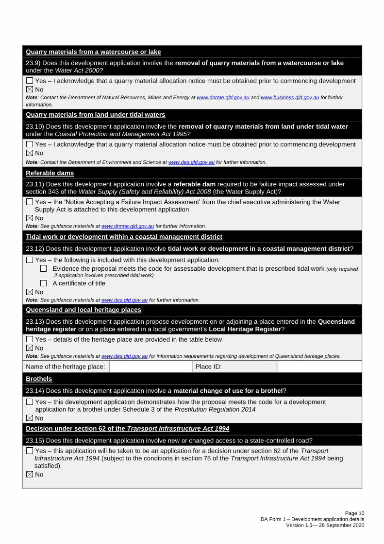
Page 10 DA Form 1 – Development application details
Version 1.3— 28 September 2020
Quarry materials from a watercourse or lake
23.9) Does this development application involve the removal of quarry materials from a watercourse or lake under the Water Act 2000?
Yes – I acknowledge that a quarry material allocation notice must be obtained prior to commencing development
No Note: Contact the Department of Natural Resources, Mines and Energy at www.dnrme.qld.gov.au and www.business.qld.gov.au for further
information.
Quarry materials from land under tidal waters
23.10) Does this development application involve the removal of quarry materials from land under tidal water under the Coastal Protection and Management Act 1995?
Yes – I acknowledge that a quarry material allocation notice must be obtained prior to commencing development
No
Note: Contact the Department of Environment and Science at www.des.qld.gov.au for further information.
Referable dams
23.11) Does this development application involve a referable dam required to be failure impact assessed under section 343 of the Water Supply (Safety and Reliability) Act 2008 (the Water Supply Act)?
Yes – the ‘Notice Accepting a Failure Impact Assessment’ from the chief executive administering the Water Supply Act is attached to this development application
No Note: See guidance materials at www.dnrme.qld.gov.au for further information.
Tidal work or development within a coastal management district
23.12) Does this development application involve tidal work or development in a coastal management district?
Yes – the following is included with this development application:
Evidence the proposal meets the code for assessable development that is prescribed tidal work (only required
if application involves prescribed tidal work)
A certificate of title
No Note: See guidance materials at www.des.qld.gov.au for further information.
Queensland and local heritage places
23.13) Does this development application propose development on or adjoining a place entered in the Queensland heritage register or on a place entered in a local government’s Local Heritage Register?
Yes – details of the heritage place are provided in the table below
No
Note: See guidance materials at www.des.qld.gov.au for information requirements regarding development of Queensland heritage places.
Name of the heritage place: Place ID:
Brothels
23.14) Does this development application involve a material change of use for a brothel?
Yes – this development application demonstrates how the proposal meets the code for a development application for a brothel under Schedule 3 of the Prostitution Regulation 2014
No
Decision under section 62 of the Transport Infrastructure Act 1994
23.15) Does this development application involve new or changed access to a state-controlled road?
Yes – this application will be taken to be an application for a decision under section 62 of the Transport Infrastructure Act 1994 (subject to the conditions in section 75 of the Transport Infrastructure Act 1994 being satisfied)
No
Page 11 DA Form 1 – Development application details
Version 1.3— 28 September 2020
Walkable neighbourhoods assessment benchmarks under Schedule 12A of the Planning Regulation
23.16) Does this development application involve reconfiguring a lot into 2 or more lots in certain residential zones (except rural residential zones), where at least one road is created or extended?
Yes – Schedule 12A is applicable to the development application and the assessment benchmarks contained in schedule 12A have been considered
No Note: See guidance materials at www.planning.dsdmip.qld.gov.au for further information.
PART 8 – CHECKLIST AND APPLICANT DECLARATION
24) Development application checklist
I have identified the assessment manager in question 15 and all relevant referral requirement(s) in question 17
Note: See the Planning Regulation 2017 for referral requirements
Yes
If building work is associated with the proposed development, Parts 4 to 6 of DA Form 2 – Building work details have been completed and attached to this development application
Yes
Not applicable
Supporting information addressing any applicable assessment benchmarks is with the development application Note: This is a mandatory requirement and includes any relevant templates under question 23, a planning report and any technical reports required by the relevant categorising instruments (e.g. local government planning schemes, State Planning Policy, State Development Assessment Provisions). For further information, see DA Forms Guide: Planning Report Template.
Yes
Relevant plans of the development are attached to this development application Note: Relevant plans are required to be submitted for all aspects of this development application. For further information, see DA Forms Guide: Relevant plans.
Yes
The portable long service leave levy for QLeave has been paid, or will be paid before a development permit is issued (see 21)
Yes
Not applicable
25) Applicant declaration
By making this development application, I declare that all information in this development application is true and correct
Where an email address is provided in Part 1 of this form, I consent to receive future electronic communications from the assessment manager and any referral agency for the development application where written information is required or permitted pursuant to sections 11 and 12 of the Electronic Transactions Act 2001
Note: It is unlawful to intentionally provide false or misleading information.
Privacy – Personal information collected in this form will be used by the assessment manager and/or chosen assessment manager, any relevant referral agency and/or building certifier (including any professional advisers which may be engaged by those entities) while processing, assessing and deciding the development application. All information relating to this development application may be available for inspection and purchase, and/or published on the assessment manager’s and/or referral agency’s website.
Personal information will not be disclosed for a purpose unrelated to the Planning Act 2016, Planning Regulation 2017 and the DA Rules except where:
• such disclosure is in accordance with the provisions about public access to documents contained in the Planning Act 2016 and the Planning Regulation 2017, and the access rules made under the Planning Act 2016 and Planning Regulation 2017; or
• required by other legislation (including the Right to Information Act 2009); or
• otherwise required by law.
This information may be stored in relevant databases. The information collected will be retained as required by the Public Records Act 2002.
Page 12 DA Form 1 – Development application details
Version 1.3— 28 September 2020
PART 9 – FOR COMPLETION OF THE ASSESSMENT MANAGER – FOR OFFICE USE ONLY
Date received: Reference number(s):
Notification of engagement of alternative assessment manager
Prescribed assessment manager
Name of chosen assessment manager
Date chosen assessment manager engaged
Contact number of chosen assessment manager
Relevant licence number(s) of chosen assessment manager
QLeave notification and payment
Note: For completion by assessment manager if applicable
Description of the work
QLeave project number
Amount paid ($) Date paid (dd/mm/yy)
Date receipted form sighted by assessment manager
Name of officer who sighted the form