late pleistocene-holocene environments in valle carbajal, tierra del fuego, argentina
TRANSCRIPT

This article was originally published in a journal published byElsevier, and the attached copy is provided by Elsevier for the
author’s benefit and for the benefit of the author’s institution, fornon-commercial research and educational use including without
limitation use in instruction at your institution, sending it to specificcolleagues that you know, and providing a copy to your institution’s
administrator.
All other uses, reproduction and distribution, including withoutlimitation commercial reprints, selling or licensing copies or access,
or posting on open internet sites, your personal or institution’swebsite or repository, are prohibited. For exceptions, permission
may be sought for such use through Elsevier’s permissions site at:
http://www.elsevier.com/locate/permissionusematerial
Autho
r's
pers
onal
co
py
Late Pleistocene–Holocene environments in Valle Carbajal,Tierra del Fuego, Argentina
Ana Marıa Borromei a,*, Andrea Coronato b,c, Mirta Quattrocchio a, Jorge Rabassa b,c,Silvia Grill a, Claudio Roig b,c
a CONICET, Departamento de Geologıa, Universidad Nacional del Sur, San Juan 670, 8000 Bahıa Blanca, Argentinab Laboratorio de Geologıa del Cuaternario, CADIC-CONICET, C.C. 92, 9410 Ushuaia, Tierra del Fuego, Argentina
c Universidad Nacional de la Patagonia-San Juan Bosco, Darwin y Canga, 9410 Ushuaia, Tierra del Fuego, Argentina
Received 1 May 2003; accepted 1 June 2004
Abstract
The authors discuss Late Pleistocene–Holocene depositional environments in one of the Fuegian Andes valleys on the basis of pal-ynological, geomorphological, and sedimentological analyses from two sites located near the Beagle Channel. The results obtained atthese localities reinforce and refine the Late Pleistocene–Holocene climatic pattern previously recorded there. A colder period, associatedwith the Younger Dryas stadial event, is suggested by low Nothofagus pollen frequency, and communities of grass, low scrub, and shrubheath expanded into the low/middle slopes (10,310 14C yr BP). By ca. 9500 14C yr BP, warmer and drier conditions occurred, as evi-denced by the development of open-grown vegetation in the valley floors (pollen zone O-3), followed by the expansion of open Nothof-
agus woodland (pollen zone O-2) in the middle Holocene. The milder climate subsequently changed, as indicated by the spreading of theclosed forest and mire (pollen zone O-1), to more humid and cooler conditions during the last ca. 5000 yr BP.� 2007 Elsevier Ltd. All rights reserved.
Keywords: Palynology; Geomorphology; Sedimentology; Paleoenvironment; Paleoclimate; Late Pleistocene–Holocene; Valle Carbajal; Tierra del Fuego
Resumen
En base al analisis palinologico, sedimentologico y geomorfologico de dos sitios ubicados en las cercanıas del Canal Beagle, se discuteel ambiente depositacional durante el Pleistoceno Tardıo – Holoceno en uno de los valles de montana de los Andes Fueguinos. Losresultados obtenidos para este valle de montana refuerzan y refinan el patron climatico del Pleistoceno Tardıo – Holoceno registradopreviamente a lo largo del Canal Beagle. Digno de atencion es la evidencia de un perıodo frıo asociado con el evento estadial YoungerDryas, sugerido por un mınimo en el porcentaje de polen de Nothofagus mientras que las comunidades de gramıneas, matorrales y arbus-tos bajos se extendıan por las pendientes bajas y medias (Unidad 2, 10,310 14C a AP). Alrededor de los 9500 a AP, la tendencia haciacondiciones mas secas y templadas indicadas por el desarrollo de una vegetacion abierta en el piso de los valles (Zona Polınica O-3), fueseguida por la expansion del bosque abierto de Nothofagus (Zona Polınica O-2) durante el Holoceno medio. El clima moderado cambiomas tarde, como lo indica la expansion del bosque cerrado y los pantanos (Zona Polınica O-1) bajo condiciones mas humedas y mas frıasdurante los ultimos 5000 a AP, aproximadamente.� 2007 Elsevier Ltd. All rights reserved.
Palabras claves: Palinologıa; Geomorfologıa; Sedimentologıa; Paleoambiente; Paleoclima; Pleistoceno Tardıo–Holoceno; Valle Carbajal; Tierra delFuego
0895-9811/$ - see front matter � 2007 Elsevier Ltd. All rights reserved.
doi:10.1016/j.jsames.2007.02.008
* Corresponding author.E-mail address: [email protected] (A.M. Borromei).
www.elsevier.com/locate/jsames
Journal of South American Earth Sciences 23 (2007) 321–335
Autho
r's
pers
onal
co
py
1. Introduction
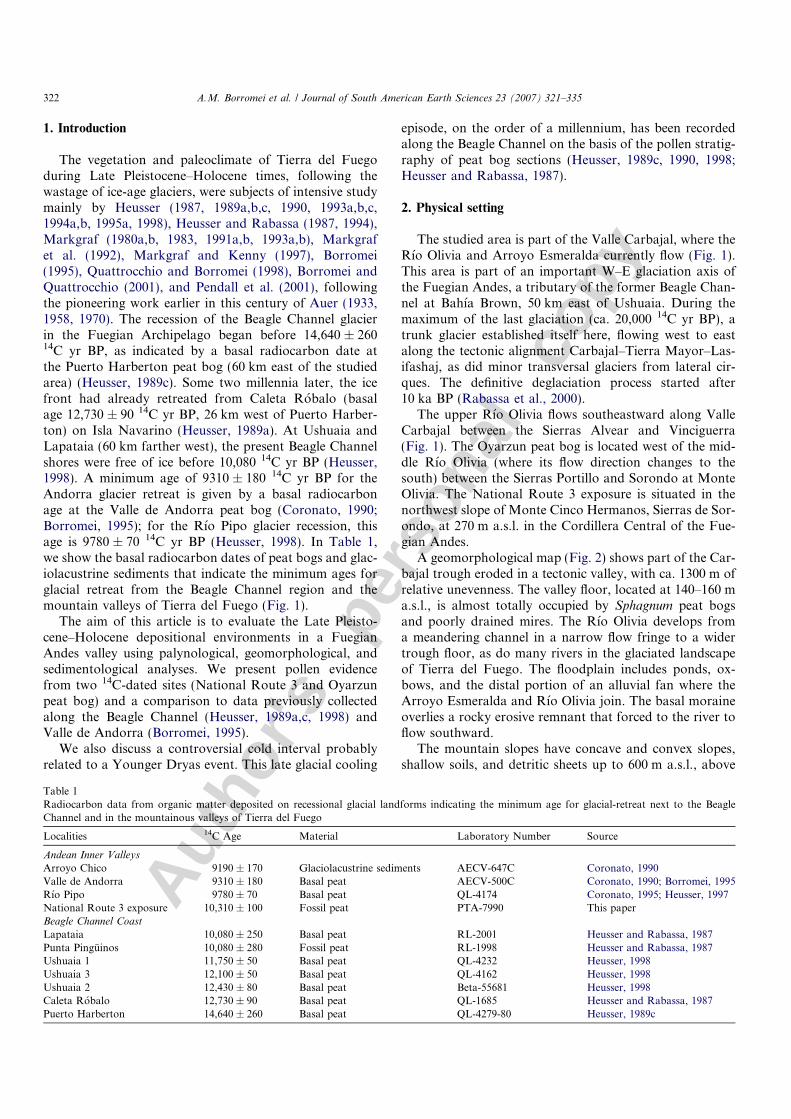
The vegetation and paleoclimate of Tierra del Fuegoduring Late Pleistocene–Holocene times, following thewastage of ice-age glaciers, were subjects of intensive studymainly by Heusser (1987, 1989a,b,c, 1990, 1993a,b,c,1994a,b, 1995a, 1998), Heusser and Rabassa (1987, 1994),Markgraf (1980a,b, 1983, 1991a,b, 1993a,b), Markgrafet al. (1992), Markgraf and Kenny (1997), Borromei(1995), Quattrocchio and Borromei (1998), Borromei andQuattrocchio (2001), and Pendall et al. (2001), followingthe pioneering work earlier in this century of Auer (1933,1958, 1970). The recession of the Beagle Channel glacierin the Fuegian Archipelago began before 14,640 ± 26014C yr BP, as indicated by a basal radiocarbon date atthe Puerto Harberton peat bog (60 km east of the studiedarea) (Heusser, 1989c). Some two millennia later, the icefront had already retreated from Caleta Robalo (basalage 12,730 ± 90 14C yr BP, 26 km west of Puerto Harber-ton) on Isla Navarino (Heusser, 1989a). At Ushuaia andLapataia (60 km farther west), the present Beagle Channelshores were free of ice before 10,080 14C yr BP (Heusser,1998). A minimum age of 9310 ± 180 14C yr BP for theAndorra glacier retreat is given by a basal radiocarbonage at the Valle de Andorra peat bog (Coronato, 1990;Borromei, 1995); for the Rıo Pipo glacier recession, thisage is 9780 ± 70 14C yr BP (Heusser, 1998). In Table 1,we show the basal radiocarbon dates of peat bogs and glac-iolacustrine sediments that indicate the minimum ages forglacial retreat from the Beagle Channel region and themountain valleys of Tierra del Fuego (Fig. 1).
The aim of this article is to evaluate the Late Pleisto-cene–Holocene depositional environments in a FuegianAndes valley using palynological, geomorphological, andsedimentological analyses. We present pollen evidencefrom two 14C-dated sites (National Route 3 and Oyarzunpeat bog) and a comparison to data previously collectedalong the Beagle Channel (Heusser, 1989a,c, 1998) andValle de Andorra (Borromei, 1995).
We also discuss a controversial cold interval probablyrelated to a Younger Dryas event. This late glacial cooling
episode, on the order of a millennium, has been recordedalong the Beagle Channel on the basis of the pollen stratig-raphy of peat bog sections (Heusser, 1989c, 1990, 1998;Heusser and Rabassa, 1987).
2. Physical setting
The studied area is part of the Valle Carbajal, where theRıo Olivia and Arroyo Esmeralda currently flow (Fig. 1).This area is part of an important W–E glaciation axis ofthe Fuegian Andes, a tributary of the former Beagle Chan-nel at Bahıa Brown, 50 km east of Ushuaia. During themaximum of the last glaciation (ca. 20,000 14C yr BP), atrunk glacier established itself here, flowing west to eastalong the tectonic alignment Carbajal–Tierra Mayor–Las-ifashaj, as did minor transversal glaciers from lateral cir-ques. The definitive deglaciation process started after10 ka BP (Rabassa et al., 2000).
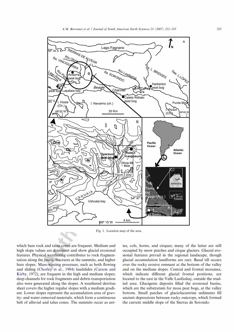
The upper Rıo Olivia flows southeastward along ValleCarbajal between the Sierras Alvear and Vinciguerra(Fig. 1). The Oyarzun peat bog is located west of the mid-dle Rıo Olivia (where its flow direction changes to thesouth) between the Sierras Portillo and Sorondo at MonteOlivia. The National Route 3 exposure is situated in thenorthwest slope of Monte Cinco Hermanos, Sierras de Sor-ondo, at 270 m a.s.l. in the Cordillera Central of the Fue-gian Andes.
A geomorphological map (Fig. 2) shows part of the Car-bajal trough eroded in a tectonic valley, with ca. 1300 m ofrelative unevenness. The valley floor, located at 140–160 ma.s.l., is almost totally occupied by Sphagnum peat bogsand poorly drained mires. The Rıo Olivia develops froma meandering channel in a narrow flow fringe to a widertrough floor, as do many rivers in the glaciated landscapeof Tierra del Fuego. The floodplain includes ponds, ox-bows, and the distal portion of an alluvial fan where theArroyo Esmeralda and Rıo Olivia join. The basal moraineoverlies a rocky erosive remnant that forced to the river toflow southward.
The mountain slopes have concave and convex slopes,shallow soils, and detritic sheets up to 600 m a.s.l., above
Table 1Radiocarbon data from organic matter deposited on recessional glacial landforms indicating the minimum age for glacial-retreat next to the BeagleChannel and in the mountainous valleys of Tierra del Fuego
Localities 14C Age Material Laboratory Number Source
Andean Inner Valleys
Arroyo Chico 9190 ± 170 Glaciolacustrine sediments AECV-647C Coronato, 1990Valle de Andorra 9310 ± 180 Basal peat AECV-500C Coronato, 1990; Borromei, 1995Rıo Pipo 9780 ± 70 Basal peat QL-4174 Coronato, 1995; Heusser, 1997National Route 3 exposure 10,310 ± 100 Fossil peat PTA-7990 This paperBeagle Channel Coast
Lapataia 10,080 ± 250 Basal peat RL-2001 Heusser and Rabassa, 1987Punta Pinguinos 10,080 ± 280 Fossil peat RL-1998 Heusser and Rabassa, 1987Ushuaia 1 11,750 ± 50 Basal peat QL-4232 Heusser, 1998Ushuaia 3 12,100 ± 50 Basal peat QL-4162 Heusser, 1998Ushuaia 2 12,430 ± 80 Basal peat Beta-55681 Heusser, 1998Caleta Robalo 12,730 ± 90 Basal peat QL-1685 Heusser and Rabassa, 1987Puerto Harberton 14,640 ± 260 Basal peat QL-4279-80 Heusser, 1989c
322 A.M. Borromei et al. / Journal of South American Earth Sciences 23 (2007) 321–335
Autho
r's
pers
onal
co
py
which bare rock and talus cones are frequent. Medium andhigh slope values are dominant and show glacial erosionalfeatures. Physical weathering contributes to rock fragmen-tation along the joints, fractures at the summits, and higherbare slopes. Mass-wasting processes, such as both flowingand sliding (Chorley et al., 1984) landslides (Carson andKirby, 1972), are frequent in the high and medium slopes;deep channels for rock fragments and debris transportationalso were generated along the slopes. A weathered detritussheet covers the higher regular slopes with a medium gradi-ent. Lower slopes represent the accumulation area of grav-ity- and water-removed materials, which form a continuousbelt of alluvial and talus cones. The summits occur as are-
tes, cols, horns, and cirques; many of the latter are stilloccupied by snow patches and cirque glaciers. Glacial ero-sional features prevail in the regional landscape, thoughglacial accumulation landforms are rare. Basal till occursover the rocky erosive remnant at the bottom of the valleyand on the medium slopes. Central and frontal moraines,which indicate different glacial frontal positions, arelocated to the east in the Valle Lasifashaj, outside the stud-ied area. Glacigenic deposits filled the erosional basins,which are the substratum for moss peat bogs, at the valleybottom. Small patches of glaciolacustrine sediments fillancient depressions between rocky outcrops, which formedthe current middle slope of the Sierras de Sorondo.
Fig. 1. Location map of the area.
A.M. Borromei et al. / Journal of South American Earth Sciences 23 (2007) 321–335 323
Autho
r's
pers
onal
co
py
The two sampled sections have different geomorpholog-ical locations: the Oyarzun peat bog (54�44 0S, 68�12 0W;140 m a.s.l.) occurs at the bottom of the trough, and theNational Route 3 exposure (54�43 0S, 68�9 0W; 270 ma.s.l.) is a roadside outcrop in the middle slope of theMonte Cinco Hermanos (Fig. 2).
The present climate is determined by a belt of prevailinghumid and cold southern westerlies, which cause orograph-ically influenced precipitations at the Beagle Channel coast.The daily temperature in summer (January) at Ushuaiaaverages 9.2 �C and in winter (July) 1.6 �C; the meanannual precipitation is 574 mm (Prohaska, 1976). The areais located within a deciduous beech forest (Pisano, 1977;Moore, 1983) that contains three species of southern beech:Nothofagus pumilio (lenga), Nothofagus betuloides (guindo),and Nothofagus antarctica (nire). These species grow fromthe sea shore to an average altitudinal limit of 550–600 ma.s.l. and predominate where precipitation reaches 400–800 mm/year.
3. Materials and methods
The fossil content of pollen samples from the Oyarzunpeat core and a fossil peat exposure on a road cut were ana-lyzed by standard techniques (Heusser and Stock, 1984).Exotic Lycopodium spores were added to provide the pollenconcentration per gram of dry weight of sediment (Stock-marr, 1971). Frequencies (%) of tree, shrub, and herb taxaare based on counts of at least 200 grains; those of pollen ofaquatics, spores of cryptogams, and spores of algae arefrom total counts. Identifications were made using modernreference material from the Laboratory of Palynology ofthe Universidad Nacional del Sur and published descrip-tions and keys (Heusser, 1971; Markgraf and D’Antoni,1978; Morbelli, 1980). The evergreen species N. betuloidesand the deciduous species N. pumilio and N. antarctica
are treated collectively as the ‘‘Nothofagus dombeyi type’’
because it is impossible to differentiate them at a more spe-cific level. Another special case pertains to Empetrum
rubrum and Gaultheria/Pernettya (Ericaceae), which aremorphologically similar. The latter may be included withEmpetrum when its sculpture is not distinct.
The fossil pollen spectra were compared with regionalpollen spectra from surface soil samples (Heusser, 1989a)and present-day vegetation from Tierra del Fuego (Pisano,1977).
The palynofacial analysis was performed on residuesafter acid treatment (HCl and HF) of those samplesfrom the road cut exposure. No oxidation or acetolisiswere performed to avoid alterations in the fluorescenceof the hydrogen-rich particles. The total palynologicalorganic matter was systematically examined under nor-mal transmitted light. The relative fluorescence intensityof the total palynological organic matter was assessedby incident blue light. The phytoclasts and amorphousgroups were examined visually at five points of a slidewith 20· magnification, and their relative frequencieswere estimated independent of the palynomorph groups(Batten, 1987).
The palynological material was studied with an Olym-pus BH2 microscope 100786, and microphotography wastaken with an automatic Olympus camera with Kodak filmof 100 ASA. The radiocarbon dates were obtained on peatsamples at the Quaternary Dating Research Unit, Divisionof Water, Environment and Forestry Technology CSIR,Pretoria, South Africa, using traditional radiocarbon anal-ysis techniques.
We illustrate the pollen/spores frequency (%) diagram atthe Oyarzun peat core in Fig. 3. In Fig. 4, we present thepollen/spores frequency (%) diagram with pollen concen-tration (grains g�1) for the National Route 3 section.
The geomorphological analysis was based on field work;air photo interpretation at a scale of 1:20.000; false-color,Landsat images; and topographic sheets at a scale of1:50.000, drawn by the GIS Department of Tierra delFuego, Argentina. The geomorphological map was pre-pared using ArcView 3.1 software.
4. Pollen and spore records: age and stratigraphy
4.1. Oyarzun peat bog
The Oyarzun bog, surrounded by a deciduous southernbeech forest, occupies 11,074 ha; the section depth is 5.8 m,which we sampled at 10-cm intervals. The ombrogenous(raised) bog surface is formed mainly by Sphagnum magel-
lanicum and covered by Empetrum rubrum, with minoramounts of Cyperaceae, Juncaginaceae, and Juncaceae.The section consists of predominantly Sphagnum peat,unhumified in the upper 2.0 m and humified below, whichoverlies fine detritus peat at 3.0 m that continues to a depthof 5.7 m and is underlain by clay gyttja to 5.8 m. Twoundated tephra layers of unknown provenance are inter-bedded at 3.0–3.1 and 3.4–3.6 m. They could be derived
Fig. 2. Geomorphological map.
324 A.M. Borromei et al. / Journal of South American Earth Sciences 23 (2007) 321–335
Autho
r's
pers
onal
co
py
from Monte Burney, a volcanic vent 220 km to the north-west, or an unidentified eruptive area to the south (54�57 0S,70�15 0W) (Heusser, 1989a).
According to a radiocarbon date of 7640 ± 80 14C yr BP(Pta 7607) for detritus peat at a depth of 3.8 m, as well as togeological and geomorphological criteria and its
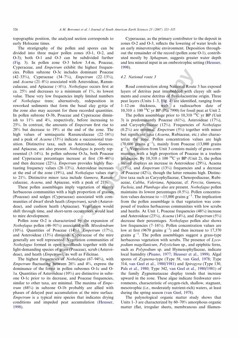
Fig. 4. Fossil pollen and spore frequency (%) and pollen concentration (grains g-1) diagram at National Route 3 exposure.
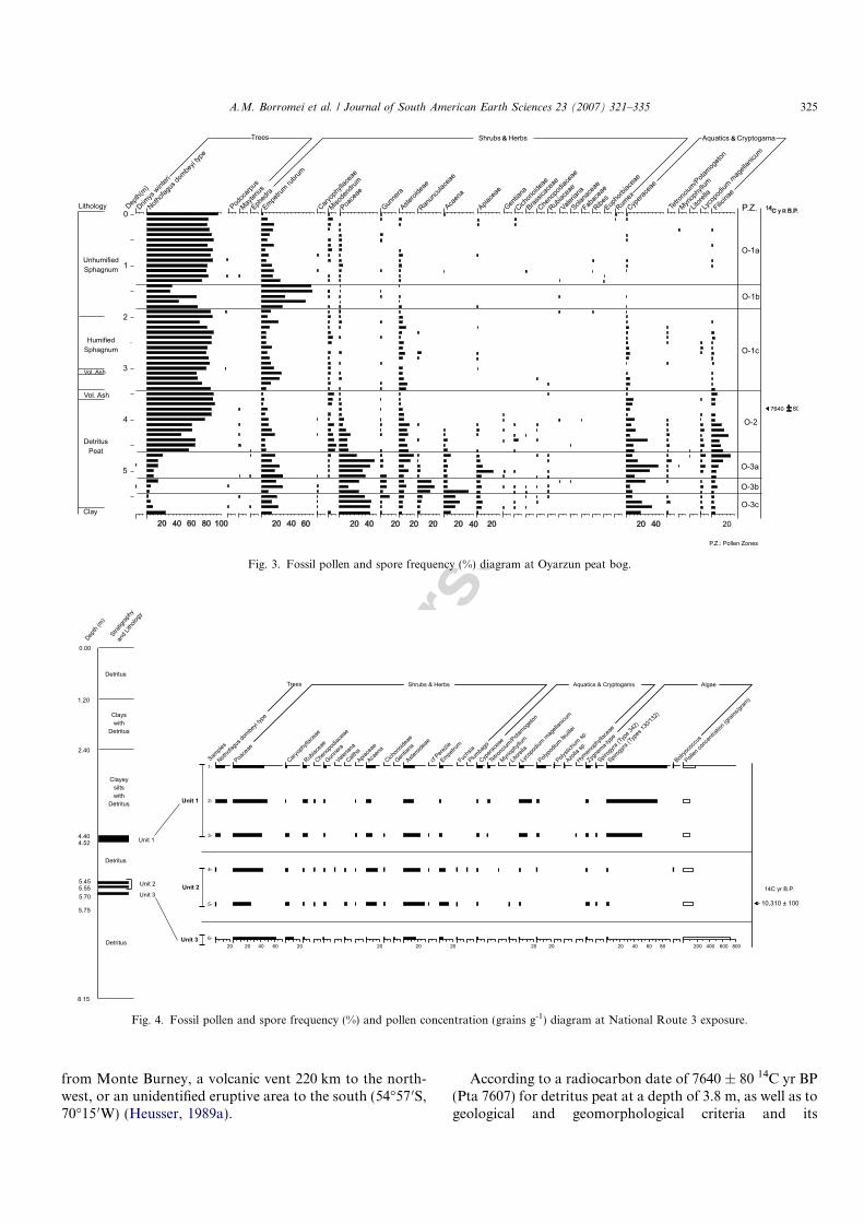
Fig. 3. Fossil pollen and spore frequency (%) diagram at Oyarzun peat bog.
A.M. Borromei et al. / Journal of South American Earth Sciences 23 (2007) 321–335 325
Autho
r's
pers
onal
co
py
topographic position, the analyzed section corresponds toearly Holocene times.
The stratigraphy of the pollen and spores can bedivided into three major pollen zones (O-1, O-2, andO-3); both O-1 and O-3 can be subdivided further(Fig. 3). In pollen zone O-3 below 3.4 m, Poaceae,Cyperaceae, and Empetrum exhibit the highest frequen-cies. Pollen subzone O-3c includes dominant Poaceae(42–33%), Cyperaceae (34–7%), Empetrum (22–13%),and Acaena (21–8%) associated with Asteroideae, Ranun-culaceae, and Apiaceae (<6%). Nothofagus occurs first atca. 25% and decreases to a minimum of 1%, its lowestvalue. These very low frequencies imply limited numbersof Nothofagus trees; alternatively, redeposition inreworked sediments that form the basal clay gyttja ofthe zone also may account for these recorded quantities.In pollen subzone O-3b, Poaceae and Cyperaceae dimin-ish to 11% and 4%, respectively, before increasing to25%. In contrast, the amounts of Empetrum first rise to28% but decrease to 19% at the end of the zone. Thehigh values of semiaquatic Ranunculaceae (22–16%)and a peak of Acaena (33%) indicate a successional tran-sition. Distinctive taxa, such as Asteroideae, Gunnera,and Apiaceae, are also present. Nothofagus is poorly rep-resented (3–14%). In pollen subzone O-3a, both Poaceaeand Cyperaceae percentages increase at first (30–46%)and then decrease (22%). Empetrum provides highly fluc-tuating frequency values (28–13%). Asteroideae increasesat the end of the zone (19%), and Nothofagus values riseto 21%. Distinctive minor taxa include Gunnera, Ranun-culaceae, Acaena, and Apiaceae, with a peak of 21%.
These pollen assemblages imply vegetation of mainlyherbaceous communities with a high proportion of grasses(Poaceae) and sedges (Cyperaceae) associated with com-munities of dwarf shrub heath (Empetrum), scrub (Asteroi-deae), and cushion heath (Apiaceae). Vegetation wouldshift through time, and short-term occurrences would leadto mire development.
Pollen zone O-2 is characterized by the expansion ofNothofagus pollen (46–91%) associated with Misodendrum
(10%). Quantities of Poaceae (14%), Empetrum (17%),and Asteroideae (13%) diminish. Cyperaceae of the miregenerally are well represented. Vegetation communities ofNothofagus formed in open woodlands together with thelight-demanding species of grass (Poaceae), scrub (Asteroi-deae), and heath (Empetrum), as well as Filicinae.
The highest frequencies of Nothofagus (67–94%), withEmpetrum fluctuating between 26% and 4%, express thedominance of the forest in pollen subzones O-1c and O-1a. Quantities of Asteroideae (10%) are distinctive in subz-one O-1c prior to its decrease, and Poaceae frequencies,similar to other taxa, are minimal. The maxima of Empe-
trum (68%) in subzone O-1b probably are allied withphases of delayed peat accumulation at the mire surface.Empetrum is a typical mire species that indicates dryingconditions and impeded peat accumulation (Heusser,1998).
Cyperaceae, as the primary contributor to the deposit inzones O-2 and O-3, reflects the lowering of water levels inan early minerotrophic environment. Deposition through-out the remainder of the record (pollen zone O-1), contrib-uted mostly by Sphagnum, suggests greater water depthand less mineral input in an ombrotrophic setting (Heusser,1998).
4.2. National route 3
Road construction along National Route 3 has exposedlayers of detritus peat interbedded with clayey silt sedi-ments and coarse detritus of fluviolacustrine origin. Threepeat layers (Units 1–3, Fig. 4) are identified, ranging from1–12 cm thickness, with a radiocarbon date of10,310 ± 100 14C yr BP (Pta 7990) for fossil peat at Unit 2.
The pollen assemblage prior to 10,310 14C yr BP (Unit3) is predominantly Poaceae (61%), Asteroideae (17%),and Caryophyllaceae (12%). Frequencies of Nothofagus
(0.2%) are minimal. Empetrum (5%) together with minorbut significant taxa (Acaena, Rubiaceae, etc.) also charac-terize the zone. Pollen concentration values are high(70,600 grains g�1), mainly from Poaceae (13,000 grainsg�1). Vegetation from Unit 3 consists mainly of grass com-munities with a high proportion of Poaceae in a treelesslandscape. By 10,310 ± 100 14C yr BP (Unit 2), the pollenrecord displays an increase in Asteroideae (29%), Acaena(15%), and Empetrum (13%) frequencies and a decreaseof Poaceae (42%), though the latter remains high. Distinc-tive taxa such as Caryophyllaceae, Chenopodiaceae, Rubi-aceae, Caltha, Valeriana, Apiaceae, cf. Perezia, Gunnera,Fuchsia, and Plumbago also are present. Nothofagus pollenmaintains its lowest percentages (0.5%). Pollen concentra-tion values decrease to �15,000 grains g�1. The implicationfrom the pollen assemblage is that vegetation was com-posed of treeless herbaceous communities with low scrubsand heaths. At Unit 1, Poaceae frequencies (48%) increaseand Asteroideae (23%), Acaena (14%), and Empetrum (5%)decrease their percentages. Nothofagus pollen also showslow frequencies (7–16%). Pollen concentration values arelow at first (9670 grains g�1) and then increase to 17,370grains g�1. The pollen assemblages suggest a grass-typeherbaceous vegetation with scrubs. The presence of Lyco-
podium magellanicum, Polystichum sp., and epiphitic ferns,such as Polypodium sp. and Hymenophyllaceae, indicatelocal humidity (Pisano, 1977; Heusser et al., 1999). Algalspores of Zygnema-type (Type 58, van Geel, 1978; Type314, van Geel et al., 1980/1981) and Spirogyra (Type 130,Pals et al., 1980; Type 342, van Geel et al., 1980/1981) ofthe family Zygnemataceae display trends that increaseupward in the zone. These algae indicate freshwater envi-ronments, characteristic of oxygen-rich, shallow, stagnant,mesotrophic (i.e., moderately nutrient-rich) waters, at leastduring the spring season (van Geel, 1978).
The palynological organic matter study shows thatUnits 1–3 are characterized by 60–70% amorphous organicmatter (flat, irregular sheets, membranous and filamen-
326 A.M. Borromei et al. / Journal of South American Earth Sciences 23 (2007) 321–335
Autho
r's
pers
onal
co
py
tous), pale to amber fluorescent in blue light and related todegraded land plants, as well as 30–40% degraded translu-ced phytoclasts, pale yellow to amber fluorescent in bluelight. The transluced phytoclasts are dominant over theopaque ones (<5%). Hyphae fungal forms are abundant.The palynological organic matter shows intense corrosionand degradation. The dominance of amorphous organicmatter of terrestrial origin over phytoclasts and the abun-dance of fungi and hyphae fungal forms suggest decanta-tion over traction processes in alternating reduction/oxidation conditions. The paleoenvironment inferred forthese three units is continental lacustrine, in which the les-ser proportion of tissues and cuticles in Units 3 and 2 sug-gests a higher degradation or more scarce arboreal vegetalcover than in Unit 1.
5. Discussion
5.1. Vegetation reconstruction
The studied pollen records depict the development of thevegetation and plant invasion of the Fuegian valleys thatfollowed the deglaciation processes during the regionalBeagle Channel glacier recession. The section collectedfrom National Route 3 comprises levels of peat (Units 1–3) interbedded with fluviolacustrine sediments, each ofwhich are separated by discontinuities, which suggestsdepositional hiatuses. The plant communities, prior to10,310 14C yr BP (Unit 3), were predominantly treeless,herb-dominated grasslands. This vegetational assemblagemay be related to communities that grow in flat-lying areasof slow-moving, impeded drainage, where the soil humidityis higher than the atmospheric humidity (Roig, 2000). Insuch areas, the herbaceous vegetal cover is abundant, coin-cident with the higher Poaceae concentration valuesrecorded in the sample. Unfavorable conditions for treegrowth and locally developed humid settings are indicatedat this time. At 10,310 ± 100 14C yr BP (Unit 2), the vege-tation was characteristic of treeless communities of grass,low scrub, and shrub heath, which reflect the drier condi-tions that restrict arboreal growth. The presence of alocally shallow, stagnant, open freshwater environment,at least during the spring season, is suggested by theslightly increase of Zygnemataceae algae (mainly Zygnem-
a-type spores). These zygospores have been recorded insediments belonging to the last part of the Younger Dryasevent in The Netherlands (van Geel et al., 1980/1981).
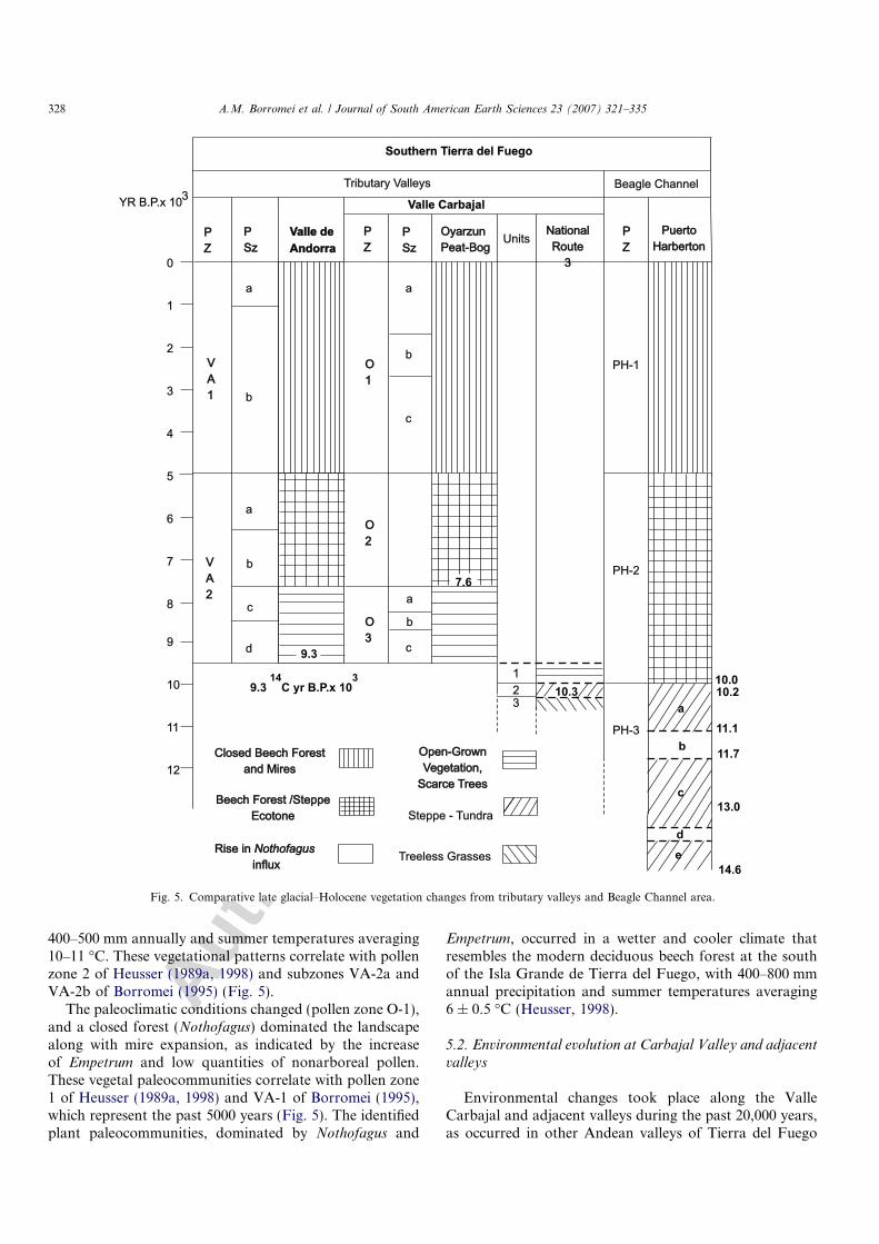
The pollen assemblage of Unit 2 is here chronostrati-graphically correlated with Heusser’s pollen zone 3a at Cal-eta Robalo (11,850–10,510 14C yr BP) and the PuertoHarberton peat sections (11,160–10,200 14C yr BP) in theBeagle Channel (Fig. 5). Most likely, it represents theYounger Dryas stadial event, with an estimated summertemperature that is <3 �C lower than the present tempera-ture at Ushuaia and annual precipitation as much as200 mm less than the present (Heusser and Rabassa,1987; Heusser, 1989c, 1990, 1998). Table 2 shows the paleo-
environments that prevailed during the late glacial coolingepisode along the Beagle Channel and the surroundinginner valleys (Fig. 1). However, Markgraf et al. (2002) pro-pose, on the basis of high charcoal levels, that late glacialenvironmental variability is related to increased fire fre-quency. If so, the decrease in rain forest taxa and increasein woodland or steppe elements would be a response by thevegetation to increased fire frequency.
In Unit 1, the vegetation of open-grown communities—mainly grass with scrubs and a slight increase in the pro-portion of trees—suggests that milder conditions prevailedduring this interval. Nothofagus pollen values imply extra-local forest sources (Heusser, 1989a). The record of fernspores indicates local humid environments. In this unit,the presence of a shallow, stagnant, mesotrophic–eutrophicopen freshwater environment, as inferred from the Zygne-mataceae algae record (mainly Spirogyra spores), is con-spicuous. The zygospores formation may be associatedwith seasonal warming and possible dessiccation of thehabitat (Head, 1992). The zygospores germinate in the sub-sequent year during early spring; thus, their presence indi-cates that freshwater habitats prevailed at least inspringtime (van Geel, 1978). Similar spores of Spirogyra
sp. have been illustrated in early Holocene sediments ofThe Netherlands (van Geel et al., 1980/1981).
The palynological organic matter shows the presence ofa continental lacustrine environment throughout theseunits, in which decantation processes are important foralternating reduction/oxidation conditions.
An early Holocene age is suggested for the origin of theOyarzun peat bog on the basis of a comparison with theValle de Andorra pollen record, dated at 9310 14C yr BPat its base (Borromei, 1995), as well as by several basal peatlayers located in the surrounding valleys (Coronato, 1995).Pollen zones O-3 and O-2 extended from ca. 9500 and 500014C yr BP, and pollen zone O-1 represents the last 5000years.
In the lowermost part of the section (pollen subzones O-3a, O-3b, and O-3c), the vegetation pattern reflects grass-dominated communities associated with dwarf shrub heath(Empetrum), scrub (Asteroideae), cushion heath (Apia-ceae), and low frequencies of Nothofagus. The vegetalpaleocommunities are analogous to the modern steppe ofnorthern Isla Grande de Tierra del Fuego (Heusser,1989a) and thereby reflect drier conditions with annual pre-cipitation estimated at 200–350 mm. Due to the low Not-hofagus frequencies, most of this record must originatefrom extra-local forest locations. Also, increased firesmay have impeded the spreading of trees in the steppe inconjunction with the climatic conditions (Heusser, 1993a,1998). The pollen subzones identified here correlate withpollen subzones VA-2c and VA-2d of Borromei (1995) inthe nearby Valle de Andorra (Fig. 5).
Pollen zone O-2 is characterized by open beechwoodland communities with grasses, composites, heaths,and ferns. The forest-steppe ecotone supplies a modernanalog to this interval to suggest available moisture of
A.M. Borromei et al. / Journal of South American Earth Sciences 23 (2007) 321–335 327
Autho
r's
pers
onal
co
py
400–500 mm annually and summer temperatures averaging10–11 �C. These vegetational patterns correlate with pollenzone 2 of Heusser (1989a, 1998) and subzones VA-2a andVA-2b of Borromei (1995) (Fig. 5).
The paleoclimatic conditions changed (pollen zone O-1),and a closed forest (Nothofagus) dominated the landscapealong with mire expansion, as indicated by the increaseof Empetrum and low quantities of nonarboreal pollen.These vegetal paleocommunities correlate with pollen zone1 of Heusser (1989a, 1998) and VA-1 of Borromei (1995),which represent the past 5000 years (Fig. 5). The identifiedplant paleocommunities, dominated by Nothofagus and
Empetrum, occurred in a wetter and cooler climate thatresembles the modern deciduous beech forest at the southof the Isla Grande de Tierra del Fuego, with 400–800 mmannual precipitation and summer temperatures averaging6 ± 0.5 �C (Heusser, 1998).
5.2. Environmental evolution at Carbajal Valley and adjacent
valleys
Environmental changes took place along the ValleCarbajal and adjacent valleys during the past 20,000 years,as occurred in other Andean valleys of Tierra del Fuego
Tributary Valleys
0
1
2
3
4
5
6
7
8
9
10
11
12Closed Beech Forest
and MiresClosed Beech Forest
and Mires
Steppe - Tundra
Treeless Grasses
Beech Forest /SteppeEcotone
Beech Forest /SteppeEcotone
Open-GrownVegetation,
Scarce Trees
Open-GrownVegetation,
Scarce Trees
3YR B.P.x 10
PuertoHarberton
PuertoHarberton
NationalRoute
3
NationalRoute
3
UnitsOyarzunPeat-BogOyarzunPeat-Bog
PZPZ
PZPZ
a a
b
b
b
b
a
a
123
c
c
cd
VA1
VA1
VA2
VA2
O1O1
O2O2
O3O3
PZPZ
PH-1
PH-2
PH-3
PSzPSz
PSzPSz
Valle CarbajalBeagle Channel
Southern Tierra del Fuego
Valle deAndorraValle deAndorra
9.3
10.3
7.6
9.3 C yr B.P.x 1014 3
14.6
13.0
11.7
11.1
10.210.0
a
b
c
deRise in
influxNothofagusRise ininfluxNothofagus
Fig. 5. Comparative late glacial–Holocene vegetation changes from tributary valleys and Beagle Channel area.
328 A.M. Borromei et al. / Journal of South American Earth Sciences 23 (2007) 321–335
Autho
r's
pers
onal
co
py
(Coronato, 1995). Geomorphological features and plantinvasion, according to previously published regional mod-els (Coronato, 1995; Rabassa et al., 1990, 1996, 2000;Heusser, 1989a,b, 1998), enable us to propose the followingnatural history of the studied area.
During the last glacial maximum (LGM), Valle Carbajaland adjacent valleys were occupied by a valley glacier thatflowed eastward from the Andean (Cordillera Darwin)mountain ice cap for a distance of 78 km and joined theformer Beagle Channel glacier at Bahıa Brown, 50 km east(Fig. 1). This valley glacier received several lateral minorglaciers from the cirques located in the Sierras Alvear(northern) and Vinciguerra (southern). These small glacierscrafted the bottom of the present hanging valleys at 400 ma.s.l. Due to the erosional features at the higher slopes, amean ice thickness of 800–600 m can be estimated for theancient Carbajal glacier. During the LGM, the tectonicdepression was covered by ice; only horns and peaks above1200 m a.s.l. showed. At the studied area, a small tongue ofice flooded to the south from the Carbajal glacier accumu-lation area toward the Beagle Channel and carved themodern Valle Olivia and Oyarzun peat bog depression.Although no age data are available in the area for late gla-cial times, geomorphological criteria in the surroundingValle Lasifashaj imply that the definitive glacier recessionwas interrupted several times after the LGM. The10,310 ± 130 14C yr BP absolute age obtained for the stud-ied location suggests that the valley slopes (240 m a.s.l.)were free of ice and covered with widespread vegetation.At this time, treeless vegetation such as grass, low scrub,and shrub heath expanded (Fig. 4, Unit 2). This daterefines by 230 years the definitive age of ice disappearancein the tributary glaciers of the region, previously proposedaround 10,080 14C yr BP for the Beagle Channel at Ush-uaia (Heusser and Rabassa, 1987). By this time, the studiedarea had unstable slopes, affected by ice decompression,which generated frequent mass-wasting movements andchanged the rocky slopes into convex and detritical ones.Multiple river channels must have flooded along the bot-tom of the valleys, started to fill the erosional basins withmeltwater, and generated narrow floodplains.
During early Holocene times, the landscape at the bot-tom of the valley was full of lakes, surrounded by centraland frontal moraines (the latter are located out of the studyarea) or mountain slopes and the basal moraine (Fig. 2).Those lakes were progressively transformed into peat bogsby the colonization of aquatic plants and mosses. Accord-ing to the radiocarbon date for the Oyarzun peat bog,lacustrine sediments were deposited at the bottom of thepostglacial lakes around 9.6 ka BP, if we consider that, inthe surrounding valleys, the top of glaciolacustrine sedi-mentation was estimated as 9.1–9.3 and 9.7 ka BP (Table1). The initial vegetation of grass-dominated communitiesassociated with dwarf shrub heath, scrub, and cushionheath settled the ice-free slopes and unflooded lands atthe valley floor (Fig. 3, pollen zone O-3).
By the middle Holocene, the closed forest had started toexpand continuously (Fig. 3, pollen zone O-1) to occupy theslopes progressively and replace the former open beechwoodland and grass vegetation (Fig. 3, pollen zone O-2),but landslide processes continued. On the Sierra de Vinci-guerra slopes, earth landslides or snow avalanches carryingforest material to the Oyarzun and other bogs at the bottomof the valley occurred during the late Holocene, between3770 ± 60 14C yr BP (B-71799) and 260 ± 60 14C yr BP(B-71801) (Roig et al., 1996). These data indicate that slopeinstability is a continuous process that still occurs.
At the valley floor, fluvial erosion and accumulationprocesses were restricted to a narrow flood fringe betweenpeat bogs; meanders and point bars may have been gener-ated because of the low gradient of the valley floor. Alter-nating sections of meandering and high-energy channelsare a common pattern in fluvial environments of the innermountainous valleys of Tierra del Fuego because of itsLate Pleistocene glacier heritage (Coronato, 1995; Corona-to and Roig, 1999).
The last Holocene millennia represents the full invasionof the southern beech forest in the landscape to 600–700 ma.s.l. and the expansion of the mires to their currentappearance.
Neoglacial cooling should be significant in the cirques ofthe hanging lateral valleys and result in short glacial
Table 2Paleoenvironments during late glacial cooling along the Beagle Channel and the surrounding inner valleys (Fig. 1)
Localities ma.s.l.
14C Age PollenZone
Pollen assemblage Vegetal Paleocommunites Source
Ushuaia 2 80 10,130 ± 80 U2-3a Empetrum-Gramineae–Cyperaceae Shrub heaths, grasses, andsedges
Heusser, 1998
Puerto Harberton 50 10,200 ± 60 PH-3a Gramineae-Empetrum- Tubuliflorae Grasses and shrub heaths Heusser, 1989aNational Route 3
exposure240 10,310 ± 100 Unit 2 Poaceae–Asteroideae-Acaena-
Empetrum
Grasses, low scrubs, andshrubs
this paper
Caleta Robalo 10 10,510 ± 80 3a Gramineae-Empetrum Grasses and heaths Heusser andRabassa, 1987
Ushuaia 1 280 10,570 ± 60 U1-3a Gramineae-Empetrum-Cyperaceae Grasses, sedges, and lowshrub heaths
Heusser, 1998
Ushuaia 3 7 10,790 ± 50 U3-3a Gramineae-Empetrum-Acaena-Tubuliflorae–Cyperaceae
Grasses, sedges, and lowshrub heaths
Heusser, 1998
The weak tundra and cold steppe environments followed an open Nothofagus forest settlement.
A.M. Borromei et al. / Journal of South American Earth Sciences 23 (2007) 321–335 329
Autho
r's
pers
onal
co
py
advances, because it occurred along the whole PatagonianAndean range (Mercer, 1983; Clapperton and Sudgen,1988; Clapperton, 1993). Unfortunately, no absolute datesare available for this cool period in the surrounding area. Acomparison with Cordillera Darwin (Kuylenstierna et al.,1996; Strelin et al., 2002) seems inadequate because itsannual precipitation is twice that of Ushuaia (Tuhkanen,1992); thus, different glaciological behavior must beexpected. Nevertheless, some inferences may be made fromdiverse paleoclimatic studies carried out at Ushuaia Bay inthe Beagle Channel (Fig. 1). According to results obtainedfrom pollen (Heusser, 1989a,c, 1998), dendrochronology(Villalba, 1989, 1994), and marine water isotopic analysis(Obelic et al., 1998) and compared with the Vostok ice core(Jozuel et al., 1987), climatic reversal episodes must haveoccurred in the region during 4.4–3.4, 2.8–2.0, 1.8–1.4,and 0.5 ka BP Nevertheless, detailed, radiometricallydated, geomorphological, and paleoclimatic studies mustbe done in the Fuegian Andes upper hanging valleys andcirques to confirm these hypotheses.
6. Overview and conclusions
The palynological, sedimentological, and geomorpho-logical analyses at Valle Carbajal confirm and refine theLate Pleistocene–Holocene paleoecology and chronostra-tigraphy in valleys of the Fuegian Andes. The Late Pleisto-cene–Holocene climatic pattern can be recorded regionallynot only along the Beagle Channel and at sites as far asPunta Moat (Heusser, 1989a, 1990, 1995b) but also in theinterior valleys, as shown by Borromei (1995) (Fig. 1).
In Fig. 5, we compare the Late Pleistocene–Holocenetributary valley vegetation changes with the Beagle Chan-nel peat bog sections. We derive this synthesis from thethree interior valley pollen records and the Puerto Harber-ton pollen record (Heusser, 1989c), which represents astandard reference for the Beagle Channel area becauseof its time extension and detailed studies. There is positiveevidence of a cold climatic episode, probably associatedwith the Younger Dryas event, in the minimum of Nothof-
agus pollen frequency among communities of grass, lowscrub, and shrub heath at the National Route 3 section(Unit 2). According to Heusser (1998), it can be assumedthat conditions at that time, though fluctuating, weremostly colder than those of today due to the local presenceof the Beagle Channel glacier and valley glaciers in themountain ranges around Ushuaia. A cooler episode,between 11,400 and 10,200 14C yr BP, also is confirmedby high-resolution AMS radiocarbon chronologies frommid-latitude paleoclimate records (41�S) of South America(Hajdas et al., 2003). The treeless vegetation environmentprior to 10.3 ka BP indicates that the inner valley glaciershad already receded by this time. The Younger Dryas cool-ing would have affected the higher glacier cirques located inthe hanging valleys. This assumption, in contrast to Heus-ser’s (1998) inference that ice in interior valleys north ofUshuaia apparently wasted slowly, favors the hypothesis
that a rapid deglaciation process took place along the Fue-gian Andes and the Beagle Channel. A date older than14.6 ka BP (Puerto Harberton basal peat bog age) mustbe obtained to support an earlier beginning for deglacia-tion and, consequently, a more progressive general icerecession.
Early Holocene vegetation of open-grown communitiesspread into the interior valley floors (Unit 1, pollen zoneO-3 and subzones VA-2c and VA-2d, Fig. 5), which werefully occupied by ponds and braided rivers, whereas a for-est-steppe ecotone was dominant along the Beagle Channel(pollen zone PH-2). By about ca. 7600 14C yr BP, the land-scape displayed a forest-steppe vegetational pattern at theregional level (pollen subzones VA-2b and VA-2a, pollenzones O-2 and PH-2, Fig. 5). During the past 5000 years,a closed forest vegetation and spread of mires developed(pollen zones O-1, VA-1, and PH-1, Fig. 5), and severalglacial ponds disappeared from the landscape due to vege-tation colonization.
Opinions about the factors that caused the YoungerDryas cooling differ. It may be attributed to regimes of coldsurface temperatures, production rates of deep-water for-mation, natural carbon dioxide variations in high-latitudeoceans, or extension of the late glacial sea ice surroundingAntarctica (Heusser and Rabassa, 1987). The lesser precip-itation and higher temperatures of early Holocene timescould have been affected by frequent excursions and dis-placement of the polar air by subtropical maritime air,due to the weakened polar maritime atmospheric circula-tion. However, wet, cool late Holocene conditions arebelieved to have occurred when the polar maritime air massbecame dominant (Heusser, 1998).
Acknowledgments
The authors are grateful to G. Oyarzun for his hospital-ity and permanent authorization to develop Quaternary re-search in his rural property. Topographic maps and aerialphotographs were supplied by the GIS Department, Tierradel Fuego Province Government. The study has been sup-ported by CONICET (Consejo Nacional de Investigaci-ones Cientıficas y Tecnicas) grants to Mirta Quattrocchioand Jorge Rabassa (PIP-CONICET 4305/96) and SECYT(Universidad Nacional del Sur) grants to MirtaQuattrocchio.
Appendix
Algal, fungal, undetermined, and zoological types fromthe National Route 3 section are illustrated. Microfossilsare numbered according to an informal type denominationused by van Geel (1978), Pals et al. (1980), and van Geelet al. (1980/1981, 1982/1983). A brief description is pro-vided for new microfossil types only (Types 1–7). Key ref-erences are given for previously described types. Theecology of microfossil types is discussed on the basis oftheir occurrence in peat/sediment sequences of Tierra del
330 A.M. Borromei et al. / Journal of South American Earth Sciences 23 (2007) 321–335
Autho
r's
pers
onal
co
py
Fuego, especially at the National Route 3 section, BahıaLapataia (Borromei and Quattrocchio, 2001) and RıoVarela (Grill et al., 2002) (Fig. 1).
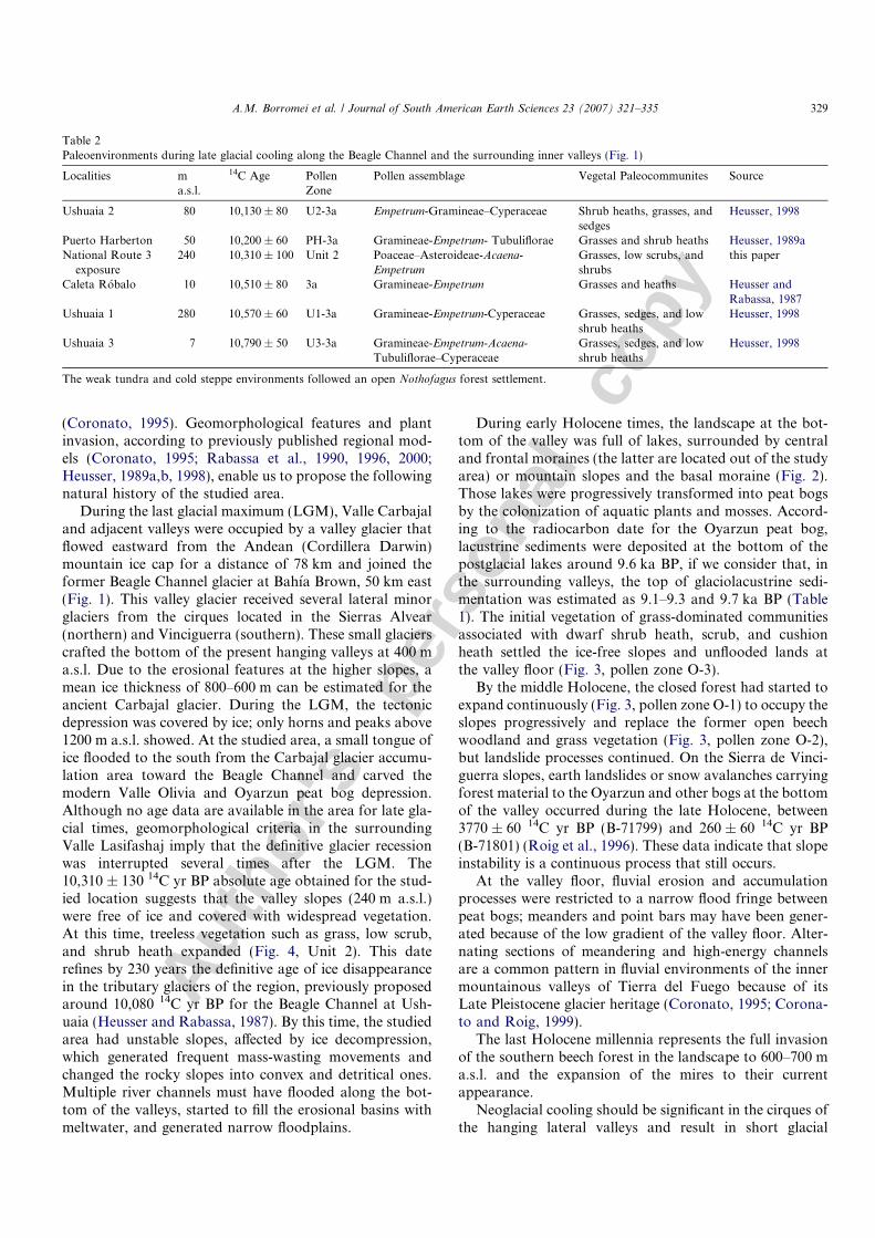
Zygnema-type spores (Plate 1, 1–2)Group of zygospores of the Zygnemataceae found
mainly in upper Unit 1 and Unit 2. Similar types aredescribed by van Geel (1978, Type 58) and van Geelet al. (1980/1981, Type 314).
Spirogyra spores (Type 342) (Plate 1, 3–4)
Group of pitted zygospores of the Zygnemataceaerecorded at Units 1 and 2. A similar type is described byvan Geel et al. (1980/1981, Type 342).
Spirogyra spores (Type 130) (Plate 1, 5)Group of psilate zygospores of the Zygnemataceae
highly abundant at Unit 1. The spores were compared withmaterial from sediments of the Okefenokee Swamp, Geor-gia, USA. A similar type is described by Pals et al. (1980,Type 130).
Plate 1. For each specimen, the sample number, slide number, England finder coordinates, and magnification are given (in that order): (1) Zygnema-type,Sample 1, 1810, O31, 400·. (2) Zygnema-type, Sample 3, 1812, T22/4, 400·. (3, 4) Spirogyra (Type 342), Sample 1, 1810, M57, 1000·. (5) Spirogyra (Type130), Sample 1, 1810, L25/4, 1000·. (6) Type 128, Sample 2, 1811, V48, 1000·. Scale bar is 10 lm.
A.M. Borromei et al. / Journal of South American Earth Sciences 23 (2007) 321–335 331
Autho
r's
pers
onal
co
py
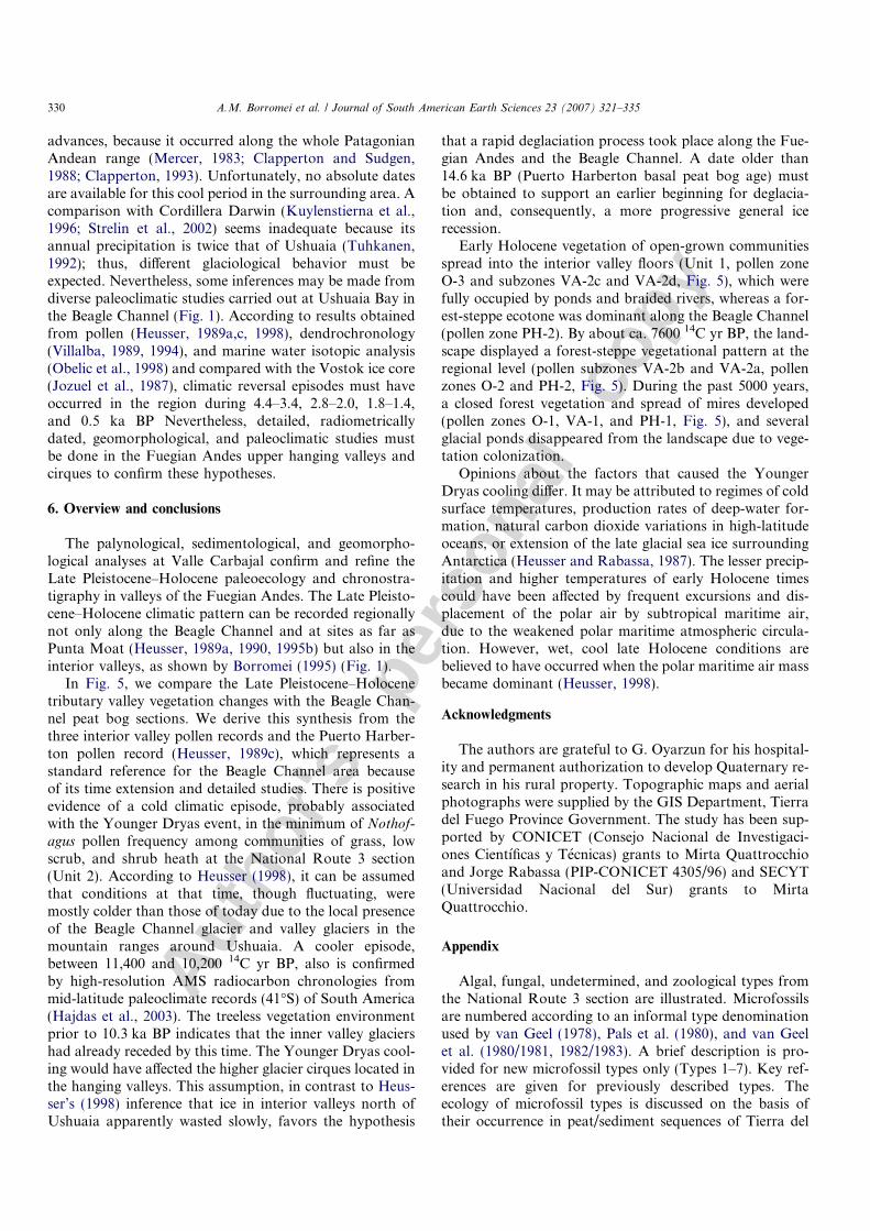
Type 128 (Plate 1, 6)Globose microfossil 30.4–38.4 lm in diameter, with an
S-shaped furrow and 1 lm spines over the surface. For adescription, see Pals et al. (1980) and van Geel et al.(1982/1983). The presence of this type indicates shalloweutrophic freshwater. It was found in low quantities inUnits 1 and 2. Similar types have been recorded fromHolocene sediments at the Rıo Varela site, Beagle Channel(Grill et al., 2002).
Type 41 (Plate 2, 1–2)Algal microfossil, ellipsoidal body (36 · 44 lm), with an
S-shaped furrow and characteristic protuberances (diame-ter at base = 1.6 lm; diameter at apex = 0.8 lm;length = 2.4–1.6 lm), distally open. Two-layered hyalinewall (inner wall = 1.2 lm thick; outer wall = 0.4 lm thick).One specimen found in Unit 2. Description by van Geel(1978).
Type 181 (Plate 1, 6)
Plate 2. For each specimen, the sample number, slide number, England finder coordinates, and magnification are given (in that order): (1, 2) Type 41,Sample 5, 1814, D46/2, 1000·. (3) Type 1, Sample 4, 1813, R54/3, 1000·. (4) Type 2, Sample 5, 1814, X27/2, 1000·. (5) Type 3, Sample 3, 1812, W49/2,400·. (6) Type 181, Sample 1, 1810, Q40/4, 1000·. Scale bar is 10 lm.
332 A.M. Borromei et al. / Journal of South American Earth Sciences 23 (2007) 321–335
Autho
r's
pers
onal
co
py
Globose microfossil, ca. 20 lm in diameter, with hairs2.4 lm long. It was registered in high numbers in Unit 1.Description by van Geel et al. (1982/1983). Type 181 hasbeen recorded from Holocene fluvial sediments of a mean-dering stream at Rıo Varela, Beagle Channel (Grill et al.,2002).
Type 1 (Plate 2, 3)Algal(?) spore, subspheroidal to ellipsoidal body
(44 · 32 lm), and verrucate ornamentation, with verrucaevariable in size and outline (1.6–2.4 lm diameter, clavae
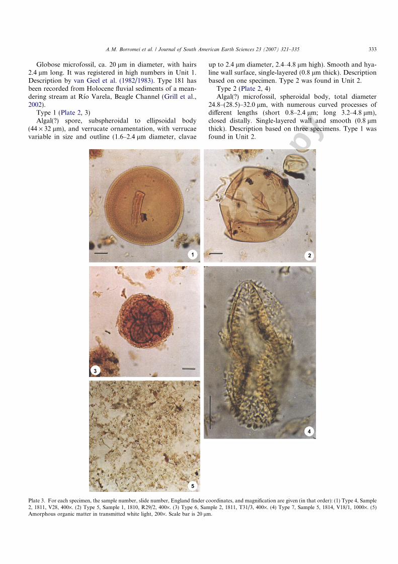
up to 2.4 lm diameter, 2.4–4.8 lm high). Smooth and hya-line wall surface, single-layered (0.8 lm thick). Descriptionbased on one specimen. Type 2 was found in Unit 2.
Type 2 (Plate 2, 4)Algal(?) microfossil, spheroidal body, total diameter
24.8–(28.5)–32.0 lm, with numerous curved processes ofdifferent lengths (short 0.8–2.4 lm; long 3.2–4.8 lm),closed distally. Single-layered wall and smooth (0.8 lmthick). Description based on three specimens. Type 1 wasfound in Unit 2.
Plate 3. For each specimen, the sample number, slide number, England finder coordinates, and magnification are given (in that order): (1) Type 4, Sample2, 1811, V28, 400·. (2) Type 5, Sample 1, 1810, R29/2, 400·. (3) Type 6, Sample 2, 1811, T31/3, 400·. (4) Type 7, Sample 5, 1814, V18/1, 1000·. (5)Amorphous organic matter in transmitted white light, 200·. Scale bar is 20 lm.
A.M. Borromei et al. / Journal of South American Earth Sciences 23 (2007) 321–335 333
Autho
r's
pers
onal
co
py
Type 3 (Plate 2, 5)Microfossil, subspheroidal, total diameter 88.0 lm.
Microreticulate surface, muri of 0.8 lm wide, and lumina(± polygonal) varying 1.6–2.0 lm in maximum diameter.Hyaline to amber wall (1.0 lm thick). Description basedon one specimen from Unit 1 that probably represents a fos-sil of aquatic (algal?) origin. Type 3 has been recorded frommiddle Holocene marine sediments (local Unit C) at BahıaLapataia, Beagle Channel, which suggests reworking anddeposition of freshwater microfossils from the underlyingpeat level (local Unit B) into the basin at the initial stageof the transgression (Borromei and Quattrocchio, 2001).
Type 4 (Plate 3, 1)Fungal spore(?), one-celled, outline circular, inapertur-
ate, yellow to brown color. Spore wall compact, approxi-mately 5.6 lm thick, distinctly two-layered, outer layerconspicuously thicker (4.0–5.6 lm) than inner one(0.8 lm). Surface microreticulate. Spore diameter 112.0–122.0 lm. Abundant at Unit 1.
Type 5 (Plate 3, 2)Fungal spore (?), one-celled, outline ovate (112.0 lm ·
120.0 lm), brown color. Spore wall 0.8 lm in thickness,usually with several fractures. Surface psilate. Abundantin Unit 1.
Type 6 (Plate 3, 3)Fungal spore (?), multicellular, pale to dark brown
color, inaperturate, consisting of many cells that form anunevenly spherical group. Central group of psilate cellsmore or less isodiametric, surrounded by a reticulateperipheral layer. Spore diameter 86.0 lm. Abundant inUnit 1.
Type 7 (Plate 3, 4)Cocoon(?). Microfossil folded, maximum diameter
88.0 lm. Hyaline and scabrate wall, single-layered(0.8 lm thick). Ornamented with spines (diameter atbase = 2.4 lm; height = 4.0 lm) and baculae (diameter atbase = 1.6 lm; height = 4.0 lm). One specimen found inUnit 2. Type 4 has been recorded from Holocene fluvialsediments of a meandering stream at Rıo Varela site, Bea-gle Channel (Grill et al., 2002).
References
Auer, V., 1933. Verschiebungen der Wald- und Steppengebiete Feuerlandsin postglazialer Zeit. Acta Geographica 5, 1–313.
Auer, V., 1958. The Pleistocene of Fuego-Patagonia. Part II: the history offlora and vegetation. Annales Academiae Scie. Fennicae. Series A III.Geolo-Geogr. 50, 1–239.
Auer, V., 1970. The Pleistocene of Fuego-Patagonia. Part V: Quaternaryproblems of southern South America. Annales Academiae Scie.Fennicae. Series A III. Geolog-Geogr. 100, 1–194.
Batten, D.J., 1987. Application of palynofacies analysis to interpretationof palaeoenvironments and source potential for hydrocarbons.Unpublished course notes, 34pp.
Borromei, A.M., 1995. Analisis polınico de una turbera holocenica en elValle de Andorra, Tierra del Fuego, Argentina. Revista Chilena deHistoria Natural 68, 311–319.
Borromei, A.M., Quattrocchio, M., 2001. Palynological study of Holocenemarine sediments from Bahıa Lapataia, Beagle Channel, Tierra del
Fuego, Argentina. Revista Espanola de Micropaleontologıa 33 (1), 61–70.
Carson, M., Kirby, M., 1972. Hillslope Form and Processes. CambridgeUniversity Press, Cambridge.
Chorley, R., Schumm, S., Sudgen, D., 1984. Geomorphology. Methuen &Co, London.
Clapperton, C., 1993. Quaternary Geology and Geomorphology of SouthAmerica. Elsevier, 779 pp.
Clapperton, C., Sudgen, D., 1988. Holocene glacier fluctuations inSouth America and Antarctica. Quaternary Science Reviews 7,185–198.
Coronato, A., 1990. Definicion y alcance de la Ultima GlaciacionPleistocena-Glaciacion Moat- en el Valle de Andorra, Tierra delFuego, Argentina. XI Congreso Geologico Argentino, Actas I, 286–289. San Juan.
Coronato, A., 1995. The last Pleistocene glaciation in tributary valleys ofthe Beagle Channel, southernmost South America. Quaternary ofSouth America and Antarctic Peninsula 9, 173–182.
Coronato, A., Roig, C., 1999. Peligro geomorfologico en ambientes degenesis reciente. Valles de Tierra Mayor y Rıo Olivia. I CongresoArgentino de Geomorfologıa y Cuaternario, Santa Rosa, La Pampa.
Grill, S., Borromei, A.M., Quattrocchio, M., Coronato, A., Bujalesky,G., Rabassa, J., 2002. Palynological and sedimentological analysisof Recent sediments from Rıo Varela, Beagle Channel, Tierra delFuego, Argentina. Revista Espanola de Micropaleontologıa. 34 (2),145–161.
Hajdas, I., Bonani, G., Moreno, P., Ariztegui, D., 2003. Preciseradiocarbon dating of late glacial cooling in mid-latitude SouthAmerica. Quaternary Research 59, 70–78.
Head, M.J., 1992. Zygospores of the Zygnemataceae (Division Chloro-phyta) and other freshwater algal spores from the uppermost PlioceneSt. Erth Beds of Cornwall, southwestern England. Micropaleontology38 (3), 237–260.
Heusser, C.J., 1971. Pollen and Spores of Chile. Modern Types of thePteridophyta, Gymnospermae and Angiospermae. University of Ari-zona Press, Tucson.
Heusser, C.J., 1987. Late Quaternary pollen records from SubantarcticChile-Argentina. IGCP-201, ‘‘Cuaternario de America del Sur,’’Volumen de Resumenes y Excursiones, CADIC, Contribucion Cientı-fica 4, Ushuaia.
Heusser, C.J., 1989a. Late Quaternary vegetation and climate of southernTierra del Fuego. Quaternary Research 31, 396–406.
Heusser, C.J., 1989b. Polar perspective of late Quaternary climates in thesouthern Hemisphere. Quaternary Research 32, 60–71.
Heusser, C.J., 1989c. Climate and chronology of Antarctica and adjacentSouth America over the past 30,000 yr. Palaeogeography, Palaeocli-matology, Palaeoecology 76, 31–37.
Heusser, C.J., 1990. Late-glacial and Holocene vegetation and climate ofSubantarctic South America. Review of Palaeobotany and Palynology65, 9–15.
Heusser, C.J., 1993a. Clima, fuego e interaccion del bosque y estepa enTierra del Fuego durante el Cuaternario. Taller Internacional ‘‘ElCuaternario de Chile.’’ 5ta. Reunion Anual del Proyecto PICG-281.Noticias, Ano 2 (1), Buenos Aires.
Heusser, C.J., 1993b. Late Quaternary forest–steppe contact zone, IslaGrande de Tierra del Fuego, Subantarctic South America. QuaternaryScience Reviews 12, 169–177.
Heusser, C.J., 1993c. Late-glacial of southern South America. QuaternaryScience Reviews 12, 345–350.
Heusser, C.J., 1994a. Paleoindians and fire during the late Quaternary insouthern South America. Revista Chilena de Historia Natural 67,435–443.
Heusser, C.J., 1994b. Quaternary of paleoecology of Fuego-Patagonia.Review Inst. Geol., Sao Paulo 15 (1/2), 7–26.
Heusser, C.J., 1995a. Palaeoecology of a Donatia-Astelia cushion bog,Magellanic Moorland-Subantarctic Evergreen Forest transition,southern Tierra del Fuego, Argentina. Review of Palaeobotany andPalynology 89, 429–440.
334 A.M. Borromei et al. / Journal of South American Earth Sciences 23 (2007) 321–335
Autho
r's
pers
onal
co
py
Heusser, C.J., 1995b. Three Late Quaternary pollen diagrams fromsouthern Patagonia and their palaeoecological implications. Palaeog-eography, Palaeoclimatology, Palaeoecology 118, 1–24.
Heusser, C.J., 1997. Deglacial setting of the southern Andes following theLast Glacial Maximum: A short review. Anales del Instituto de laParagonia, Serie Ciencias Naturales 25, 89–103.
Heusser, C.J., 1998. Deglacial paleoclimate of the American sector of thesouthern Ocean: Late Glacial-Holocene records from the latitude ofCanal Beagle (55(S), Argentine Tierra del Fuego. Palaeogeography,Palaeoclimatology, Palaeoecology 141, 277–301.
Heusser, C.J., Heusser, L.E., Lowell, T.V., 1999. Paleoecology of thesouthern Chilean Lake District-Isla Grande de Chiloe during middle-late Llanquihue glaciation and deglaciation. Geografiska Annaler 81A(2), 231–284.
Heusser, C.J., Rabassa, J.O., 1987. Cold climatic episode of YoungerDryas Age in Tierra del Fuego. Nature 328 (6131), 609–611.
Heusser, C.J., Rabassa, J.O., 1994. Late Holocene forest–steppe inter-action at Cabo San Pablo, Isla Grande de Tierra del Fuego,Argentina. Quaternary of South America and Antarctic Peninsula 9,179–188.
Heusser, L.E., Stock, C., 1984. Preparation techniques for concentratingpollen from marine sediments and other sediments with low pollendensity. Palynology 8, 225–227.
Jozuel, J., Lorius, C., Petit, J., Genthon, C., Barkov, N., Kotlyakov, V.,Petrov, V., 1987. Vostok ice core: a continuous isotope temperaturerecord over the last climatic cycle (160,000 years). Nature 329,403–408.
Kuylenstierna, J., Rosqvist, G., Holmlund, P., 1996. Late-Holoceneglacier variations in the Cordillera Darwin, Tierra del Fuego, Chile.The Holocene 6 (3), 353–358.
Markgraf, V., 1980a. New data on the late and post glacial vegetationalhistory of La Mision, Tierra del Fuego, Argentina. IV InternationalPalynological Conference 3, 68–74. Lucknow, India.
Markgraf, V., 1980b. Paleoclimatic changes during the last 15,000years in Subantarctic and arid environments in Argentina (SouthAmerica). V International Conference of Palynology. Cambridge,England. 33pp.
Markgraf, V., 1983. Late and postglacial vegetational and paleoclimaticchanges in subantarctic, temperate and arid environments in Argen-tina. Palynology 7, 43–70.
Markgraf, V., 1991a. Late Pleistocene environmental and climaticevolution in southern South America. Bamberger GeographischeSchriften Bd. 11, 271–281.
Markgraf, V., 1991b. Younger Dryas in southern South America? Boreas20, 63–69.
Markgraf, V., 1993a. Paleoenvironments and paleoclimates in Tierra delFuego and southernmost Patagonia, South America. Palaeogeogra-phy, Palaeoclimatology, Palaeoecology 102, 53–68.
Markgraf, V., 1993b. Younger Dryas in southernmost South America – anupdate. Quaternary Science Reviews 12, 351–355.
Markgraf, V., D’Antoni, H., 1978. Pollen Flora of Argentina. Universityof Arizona Press, Tucson.
Markgraf, V., Kenny, R., 1997. Character of rapid vegetation and climatechange during the late-glacial in southernmost South America. NATOASI Series: Past and Future Environmental Changes I (47), 81–90.
Markgraf, V., Dodson, J.R., Kershaw, A.P., McGlone, M.S., Nicholls,N., 1992. Evolution of late Pleistocene and Holocene climates in thecircum-South Pacific land areas. Climate Dynamics 6, 193–211.
Markgraf, V., Webb, R.S., Anderson, K.H., Anderson, L., 2002. Modernpollen/climate calibration for southern South America. Palaeogeogra-phy, Palaeoclimatology, Palaeoecology 181, 375–397.
Mercer, J., 1983. Cenozoic glaciation in the southern hemisphere. AnnualReview of Earth and Planetary Sciences 11, 99–132.
Moore, D.M., 1983. Flora of Tierra del Fuego. Nelson, Oswestry.Morbelli, M., 1980. Morfologıa de las esporas de Pteridophyta presentes
en la region Fuego-patagonica, Republica Argentina. Opera Lilloana,28. Tucuman.
Obelic, B., Alvarez, A., Argullos, J., Piana, E.L., 1998. Determination ofwater palaeotemperature in the Beagle Channel (Argentina) during thelast 6000 years through stable isotope composition of Mytilus edulisshells. Quaternary of South America & Antarctic Peninsula 11, 47–71.
Pals, J.P., van Geel, B., Delfos, A., 1980. Paleoecological studies in theKlokkeweel bog near Hoogkarspel (Prov. of Noord-Holland). Reviewof Palaeobotany and Palynology 30, 371–418.
Pendall, E., Markgraf, V., White, J.W., Dreier, M., 2001. Multiproxyrecord of Late Pleistocene–Holocene climate and vegetation changesfrom a peat bog in Patagonia. Quaternary Research 55, 168–178.
Pisano, V.E., 1977. Fitogeografıa de Fuego-Patagonia chilena. I Comun-idades vegetales entre las latitudes 52 y 56�S. Anales del Instituto de laPatagonia Punta Arenas, Chile 8, 121–250.
Prohaska, F., 1976. The climate of Argentina, Paraguay and Uruguay. In:Schwerdfeger, W. (Ed.), Climates of Central and South America,World Survey of Climatology 12. Elsevier, Amsterdam, pp. 3–112.
Quattrocchio, M., Borromei, A.M., 1998. Paleovegetational and paleocli-matic changes during the late Quaternary in southwestern BuenosAires Province and southern Tierra del Fuego (Argentina). Palynology22, 67–82.
Rabassa, J., Coronato, A., Roig, C., Serrat, D., Martınez, O., 1996.Geologıa glacial de Bahıa Sloggett, Tierra del Fuego, Argentina. XIIICongreso Geologico Argentino, Actas IV, 329pp. Buenos Aires.
Rabassa, J., Coronato, A., Bujalesky, G., Salemme, M., Roig, C.,Meglioli, A., Heusser, C., Gordillo, S., Roig, F., Borromei, A.,Quattrocchio, M., 2000. Quaternary of Tierra del Fuego, southern-most South America: An updated review. Quaternary International,217–240.
Rabassa, J., Serrat, D., Marti, C., Coronato, A., 1990. El Tardiglacial enel Canal Beagle, Tierra del Fuego, Argentina y Chile. XI CongresoGeololgico Argentino, Actas 1, 290–293.
Roig, F.A., 2000. Comunidades vegetales productoras de turba en Tierradel Fuego. En: A. Coronato y C. Roig (Eds.) Conservacion deecosistemas a nivel mundial con enfasis en las turberas de Tierra delFuego. Disertaciones y Conclusiones 33–54. Ushuaia.
Roig, F.A., Roig, C.E., Rabassa, J., Boninsegna, J., 1996. Fuegian bogs asa source of paleoclimate data from subfossil woods. The Holocene 6,469–476.
Stockmarr, J., 1971. Tablets with spores used in absolute pollen analysis.Pollen et Spores 13, 615–621.
Strelin, J., Malagnino, E., Sone, T., Casassa, G., Iturraspe, R., Mori, J.,Torielli, C., 2002. Cronologıa Neoglacial del extremo sur de Sudame-rica, Arco de Scotia y Penınsula Antartica. XV Congreso GeologicoArgentino, Actas 2, 106-111. Santa Cruz.
Tuhkanen, S., 1992. The climate of Tierra del Fuego from a vegetationgeographical point of view and its ecoclimatic counterparts elsewhere.Acta Botanica Fennica 145, 1–64.
van Geel, B., 1978. A palaeoecological study of Holocene peat bogsections in Germany and The Netherlands, based on the analysis ofpollen, spores and macro- and microscopic remains of fungi, algae,cormophytes and animals. Review of Palaeobotany and Palynology25, 1–120.
van Geel, B., Bohncke, S.J.P., Dee, H., 1980/1981. A palaeoecologicalstudy of an upper Late Glacial and Holocene sequence from ‘‘DeBorchert,’’ The Netherlands. Review of Palaeobotany and Palynology31, 367–448.
van Geel, B., Hallewas, D.P., Pals, J.P., 1982/1983. A late Holocenedeposit under the Westfriese Zeedijk near Enkhuizen (Prov. of Noord-Holland, The Netherlands): palaeoecological and archaeologicalaspects. Review of Palaeobotany and Palynology 38, 269–335.
Villalba, R., 1989. Latitude of the surface high-pressure belt over westernSouth America during the last 500 years as inferred from tree-ringanalysis. Quaternary of South America and Antarctic Peninsula 7,273–303.
Villalba, R., 1994. Tree-rings and glacial evidence from the MedievalWarm Epoch and the Little Ice Age in southern South America.Climatic Change 30, 1–15.
A.M. Borromei et al. / Journal of South American Earth Sciences 23 (2007) 321–335 335