landscape, violence and social bodies: ritualized architecture in a solomon islands society
TRANSCRIPT
LANDSCAPE,VIOLENCE AND SOCIAL BODIES:RITUALIZED ARCHITECTURE IN A SOLOMON
ISLANDS SOCIETY
T T, P S & R W
University of Otago, University of Auckland, University of Otago
This article considers the interplay between the bodily experience of landscape and the for-mation of sociality.We investigate the social experiences of landscape in nineteenth-centuryRoviana Lagoon in the Solomon Islands, dealing specifically with the ritualized architectureof a fortification on Nusa Roviana Island. Drawing on oral tradition and archaeological andhistorical data, we argue that the architectural remains reflect a powerful mode of shapingsocial experience and notions of personhood in the manipulation of ideology.The Rovianalandscape creates a world in which genealogical lines are sedimented to place, and practicesof ritual violence and head-hunting are made to appear necessary and natural. Paying attention to both oral and material history allows a greater understanding of the ways inwhich such social structures are reproduced, and adds to the construction of a rich histori-cal anthropology.
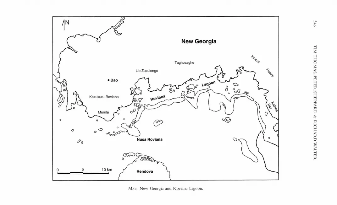
In this article we present a historical account of a Melanesian cultural land-scape that draws on archaeological and ethnographic data. Historicism is onthe rise in anthropology, especially so in work that deals with Melanesia (e.g.Carrier 1992), but the potential for archaeology to contribute to this has notyet been realized, or even greatly explored. We argue that the archaeology ofthe recent past in Melanesia can add to the construction of a rich historicalanthropology that transcends traditional disciplinary boundaries. Our data arefrom an ongoing field project instigated in 1996 in the Solomon Islandsinvolving archaeologists, ethnographers, and palaeo-environmental specialists –the New Georgia Archaeological Survey (NGAS) (Sheppard & Walter 1998;Sheppard,Walter & Nagaoka 2000). In this article we concentrate on the smallbarrier reef island of Nusa Roviana situated on the south coast of NewGeorgia (Map). The crest of the ridge line that forms the backbone of thisisland is dominated by a large fortified complex. This place is our primaryfocus here; we use it as an access point from which to depart in investi-gating the recursive interplay between landscape, personhood, and group identity on Nusa Roviana in the nineteenth century.
Theoretically our approach draws on recent studies that investigate thesocial role of landscape and architecture as cultural artefacts (e.g. Bender 1993;1998; Hirsch & O’Hanlon 1995; Parker-Pearson & Richards 1994; Tilley1994). In these works, landscape is an analytical concept that describes the
© Royal Anthropological Institute 2001.J. Roy. anthrop. Inst. (N.S.) 7, 545-572
546T
IM T
HO
MA
S,PET
ER
SHE
PPAR
D &
RIC
HA
RD
WA
LTE
R
M. New Georgia and Roviana Lagoon.

culturally structured, human experience of the world. Landscapes are producedrecursively during a dynamic interplay between social action and topography.Cultural experiences of landscape are thus considered to be heterogeneous,imbued with different concepts, values, and perceptions. Such a conceptionallows an analysis of landscape in historical, political, and phenomenologicalterms (Bender 1998).
As an artefact of history, landscape is a palimpsest of past human action inthe world: it is ‘cultural sediment’ (Sheppard, Walter & Nagaoka 2000; n.d.).As such, landscape is never value-free, and can function as a political resourcemanipulated and drawn on in the formation of ideology. Conflict over accessto and the meaning of places is frequently ongoing. Such contestations maybe politically coercive or indifferent, but often take subtle advantage of the socializing role of bodily experience (Parker-Pearson & Richards 1994).Constraint, what may be seen and not seen, the sacred, the profane, and soon can be reinforced physically through the elaborate manipulation of space.An ideology made material through landscape may serve to naturalize it insuch a manner that it may be impossible to imagine a world that is different.
The differential experience of landscape is thus an important mode ofsocialization. Movement, memory, and daily routine within a landscape maywork to create particular senses of personhood, as well as ideas about appro-priate action in different contexts. This is captured in Bourdieu’s (1977)‘habitus’ and Heidegger’s (1972) ‘dwelling’. Both stress an embodied experi-ence of the world in which there is no Cartesian split between mind andbody, culture and nature.The phenomenology of Merleau-Ponty (1962) makesa similar point: we come to know the world through our bodies, not as spectators, but from an involved point of view in which the body is linkedinescapably with the phenomenal world. The habitual embodied experienceof landscape throughout life is consequently a primary part of the formationof subjectivity and notions of how one fits into society (Tilley 1996).
However, it is unwise to adopt the precepts of the phenomenologicalproject uncritically.The ethnographies of Strathern (1988) and Wagner (1991),for example, outline radical differences between Western and Melanesiannotions of personhood. This suggests that the phenomenology of Heideggerand others, with its focus on uncovering the common ontological basis of allbeing, may have little to tell us about modes of being in other cultures (Gell1995). Different experiences of landscape and habitus, different dwellings, mayamount to different modes of humanness and different types of person. Thisis not only true in terms of the establishment of categories of person withinsociety (women, men, commoners, chiefs etc.), but also in global terms,between different communities. Whilst many works dealing with issues of relational personhood investigate how such notions are expressed and howthey differ from others (Busby 1997), here we explore how personhood isreproduced in society.We are interested in outlining the means by which thehabitual experience of a particular setting is manipulated in the creation ofnotions of personhood, and how power over people is expressed through land-scape in the service of ideology.
This is an anthropological problem amenable to investigation throughethnography, history, and archaeology, but rather than relying solely on anyone of these, we advocate their integration. Ballard (1994) has noted that
TIM THOMAS, PETER SHEPPARD & RICHARD WALTER 547

archaeologists working in Melanesia have tended to neglect the wealth ofethnographic material available to them. He argues that a full exploitation ofthe ‘landscape’ approach rests on the ability of archaeologists to engage withethnographic literature and, more importantly, actively to produce ethno-graphies that address archaeological concerns (1994: 130). Equally, anthro-pologists might produce and engage with archaeologies addressing the‘ethnographic past’. This approach would seek to avoid giving one data formprimacy as somehow less problematic or more truthful (Funari, Jones & Hall1999).The approach of NGAS members has been to practise an ‘ethnographicarchaeology’ paying attention to both spoken and material remains of the past.We engaged in archaeology and ethnography simultaneously and sustained acritical awareness of the limitations of each.
Data were collected over a period of seven field seasons from 1996 (seeSheppard,Walter & Nagaoka 2000), during which time we resided in variouscommunities throughout Roviana Lagoon. As we practised the standard tech-niques of archaeological survey, mapping, and excavation, children, young men,chiefs, and other leaders of the community accompanied us on site, workingwith us, telling stories. More formally, we recorded oral traditions during interviews with elders and guardians of traditional knowledge in the local Austronesian language, Roviana, and in Solomon Islands Pijin (see Aswani2000).We maintained a constant dialogue between the material record of thepast and local traditional knowledge, but most satisfying was when theyblended during fieldwork. White (1991), on Santa Isabel in the Solomons,recounts a walk through the bush upon his arrival, guided by two seniorvillage men who spin a constant narrative about important features within thelandscape as they proceed. This narrative gradually builds up an account oftraditional life and foundations of identity centred on important places, ances-tral migrations, intermarrying clans, and propitiatory and sacrificial rites. Land-scape elements act as aids to memory, commemorating life before Christianity.Similar narratives occurred daily during our own fieldwork and represent ameans of coming to terms with the past through encounter. As such they arethe foundation of our ‘ethnographic archaeology’, the integration of oralhistory and archaeological method. Here we find it appropriate, as White hasdone, to adopt a narrative-based account of the Nusa Roviana hillfort. Theform of this narrative reflects the fact that cumulative encounters with land-scape elements and their related histories help forge social identities, and givemeaning to landscape experience. Rather than focusing solely on a ‘top-down’account in which everything has already been encountered and interpreted,we embed the narrative in the physical experience of the Roviana landscapeand gradually draw out to a wider consideration of society. Let us now turnour attention back to the context of our study.
The view from above: sites and traditions
Roviana Lagoon lies off the southwest coast of New Georgia, stretching some40 kilometres from Kalena bay in the east to Munda in the west (Map). It isa shallow coastal lagoon about 3 kilometres wide laced with coral reefs andoutcrops, separated from the sea by a string of barrier reef islands. A mosaic
548 TIM THOMAS, PETER SHEPPARD & RICHARD WALTER

of rain forest, gardens, coconut plantations, and settlements covers the main-land and offshore islands. Amongst the barrier islands, Nusa Roviana standsout (Fig. 1). It occupies a position perpendicular to the general trend of thechain and it crosses the barrier reef so that the island sits half in, half out ofthe lagoon. It is about 4 kilometres in length and, rising to a height of nearly80 metres, is the highest of the barrier islands. The portion inside the lagoonconsists of a narrow coastal strip surrounding a long central ridge. Extendingbeyond the reef edge towards the open sea is a wide plain, swampy and unoc-cupied. Today, a single village curves around the northwest coastal flat andcoconut plantations line the adjacent southwestern shore. Swidden gardensoccupy a low tab of land east of the village, and extend up the north-facingslopes of the central ridge.
Nusa Roviana is infamous in early historic literature for its role in the retributive violence and head-hunting cults of the nineteenth century (seeBennett 1987; Somerville 1897; Woodford 1890). Often focusing on theviolent exploits and authority of individual chiefs, these accounts depict acyclical process of raiding driven by the quest for mana and wealth, spirallingout of control under the influence of Western trade in axes and guns. Deeperunderstandings come from early anthropological observations such as the pioneering fieldwork of Hocart in 1908 (see Hocart 1922; 1925; 1931) and,particularly, local oral traditions. The latter consist of tribal histories detailingorigins and migrations, genealogies, important myths, and the particulars ofritual, warfare, and exchange.These accounts begin thirteen to fifteen genera-tions ago and are generally consistent amongst the various groups residing inthe lagoon. We follow Vansina (1985) in arguing that they provide a viablesource for the reconstruction of pre-colonial history (see Aswani 2000 for an
TIM THOMAS, PETER SHEPPARD & RICHARD WALTER 549
F 1. Aerial photo of Nusa Roviana, 1/5000.

extended discussion in terms of the NGAS data). Here, we use oral traditionsto inform our interpretation of landscape elements and examine how tribalhistories qualified landscape experience in the nineteenth century. Thearchaeological data correlate well with the oral traditions, but generally we donot rely too heavily on genealogical methods of dating.As Weissner and Tumu(1998) note, past the fifth generation one can no longer assume a consistenttime period per generation. Archaeology provides more accuracy and wherepossible we rely on that for dates.
On Nusa Roviana, archaeological remains are found within three territo-rial units corresponding to the major social divisions of the Nusa Rovianapolity: Kalikoqu (lagoon side), Vuragare (ocean side), and Kokorapa (middle)(Fig. 2). Above these, extending along the ridgeline under forest cover, lies the fortification (Fig. 3). Named in oral traditions as a place of refuge duringattack, the fort was also the ceremonial and symbolic centrepiece of Rovianalife. We refer to the structure as a ‘fortification’ or ‘hillfort’, because this iswhat it is known as colloquially and in the literature – but as will be seen,it is actually a lot more than that.
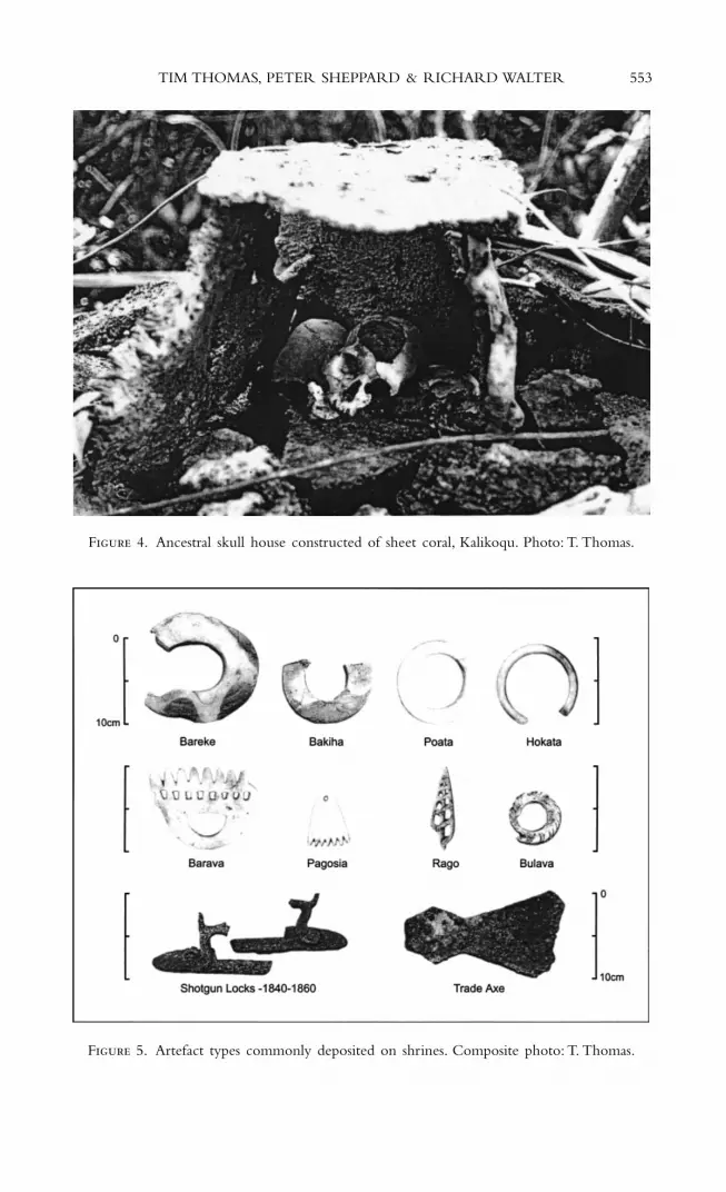
The hillfort runs for more than 600 metres along the highest, most narrowportion of the ridge.The most obvious fort-like features are walls constructedof coral cobbles, formed into a series of defensive barriers bisecting the ridgetop. These walls divide the fortification into four primary sections, each ofwhich is named and associated with specific oral traditions. Each section con-tains a suite of different archaeological features; there are piles of coral cobbles,flat platforms a few centimetres above the ground surface, and stone-faced ter-races cut into the adjacent slopes.These features are the remains of both ritualand domestic architecture. The residential features commonly have deepmidden deposits and tend to lack artefacts other than the occasional shell adze. Shrines are the most significant features of the complex in terms of oraltraditions, which detail their uses and associations. Consisting of piles of coralrubble, they are usually amorphous sub-rectangular structures. On someshrines scattered sheets of lace coral and fragments of human bone are all thatremain of small ‘houses’ that once contained the skulls of important ancestors(Fig. 4). Numerous artefacts are scattered throughout the cobbles of theshrines, including shell rings and European trade items such as iron axes andfirearms (Fig. 5). Associated stone ovens are often found nearby and providea good means of dating structures.
A series of excavations has established a basic time range for the con-struction and use of the hillfort (Sheppard, Walter & Nagaoka 2000). A shrine (site 118) excavated outside the first wall produced a calibrated age in the thirteenth-fourteenth centuries AD (WK-6155, Table 1) and probably pre-dates construction of the fortification. The form of this shrine is typo-logically early, relative to those within the fortification proper (Nagaoka 1999). Shell from an excavation in an entrance-way through the second wall(feature 1058) has been dated (WK-6757) to between the sixteenth and seventeenth centuries. A similar date (WK-6156) was provided by the exca-vation of an oven nearby. So the sequence of construction and use of the hill-fort probably begins sometime in the late sixteenth century and continuesuntil after European contact in the nineteenth century. Here, we focus on the latter part of this period, when we can be sure all of the structures were
550 TIM THOMAS, PETER SHEPPARD & RICHARD WALTER

TIM
TH
OM
AS,PE
TE
R SH
EPPA
RD
& R
ICH
AR
D W
ALT
ER
551F 2. The archaeological landscape of Nusa Roviana.

552T
IM T
HO
MA
S,PET
ER
SHE
PPAR
D &
RIC
HA
RD
WA
LTE
R
F 3. Plan of Nusa Roviana hillfort, showing named locations and sites referred to in the text.
TIM THOMAS, PETER SHEPPARD & RICHARD WALTER 553
F 4. Ancestral skull house constructed of sheet coral, Kalikoqu. Photo: T. Thomas.
F 5. Artefact types commonly deposited on shrines. Composite photo: T. Thomas.

present and visible as part of the complex, and hence available parts of thelandscape.
We turn now to a more embodied description of the fortification, takinginto account the physical experience of the structure and the oral traditionsto which people moving through its four sections would have had access latein the nineteenth century.
The view from the ground
Viewed from the lagoon, Nusa Roviana is dwarfed by mainland New Georgiaand the towering bulk of Rendova out to sea.The deforested northern gardensprovide a striking contrast to the rainforest cover typical of coastal NewGeorgia. A sharp line distinguishes the areas of habitation and land use fromthe forested unpopulated reaches of the island (Fig. 6). Except for regrowth
554 TIM THOMAS, PETER SHEPPARD & RICHARD WALTER
T 1. Radiocarbon dates
Lab number Site Feature Sample 14C Age BP Calibrated 1 sigma range
WK-6155 118 Shrine Shell1 1060 ± 45 1290–1365, 1375–1380 ADWK-6757 1058 Hillfort wall Shell1 720 ± 50 1523–1653 ADWK-6156 1082 Hillfort oputu Charcoal 300 ± 45 1517–1650 AD
1 Shell dates calibrated with a delta r set to 0.Source: Sheppard, Walter & Nagaoka 2000: 32.
F 6. Nusa Roviana from the inner lagoon, looking southwest. Rendova dominates theview out to sea. Photo: R. Walter.
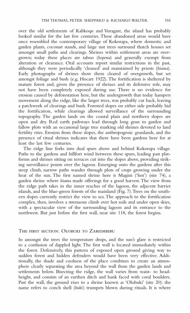
over the old settlements of Kalikoqu and Vuragare, the island has probablylooked similar for the last few centuries. These abandoned areas would haveonce resembled the contemporary village of Kokorapa, where domestic andgarden plants, coconut stands, and large nut trees surround thatch houses setamongst small paths and clearings. Shrines within settlement areas are over-grown; today these places are taboo (hopena) and generally exempt from alteration or clearance. Oral accounts report similar restrictions in the past,although they were periodically ‘cleaned’ and maintained by priests (hiama).Early photographs of shrines show them cleared of overgrowth, but setamongst foliage and bush (e.g. Hocart 1922). The fortification is sheltered bymature forest and, given the presence of shrines and its defensive role, maynot have been completely exposed during use. There is no evidence forerosion caused by deforestation here, but the undergrowth that today hampersmovement along the ridge, like the larger trees, was probably cut back, leavinga patchwork of clearings and bush. Forested slopes on either side probably hidthe fortification, while clearings allowed surveillance of the surroundingtopography. The garden lands on the coastal plain and northern slopes areopen and dry. Red earth pathways lead through long grass to garden andfallow plots with an occasional large tree marking old shrines devoted to landfertility rites. Erosion from these slopes, the anthropogenic grasslands, and thepresence of ritual shrines indicates that there have been gardens here for atleast the last few centuries.
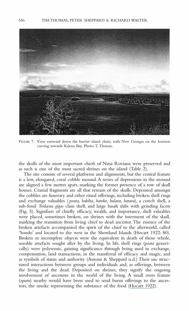
The ridge line forks into dual spurs above and behind Kokorapa village.Paths to the gardens and hillfort wind between these spurs, leading past plat-forms and shrines sitting on terraces cut into the slopes above, providing strik-ing surveillance points over the lagoon. Emerging onto the gardens after thissteep climb, narrow paths wander through plots of crops growing under theheat of the sun. The first named shrine here is Manini (‘hot’) (site 74), agarden shrine where hiama made offerings for a good harvest.The view fromthe ridge path takes in the inner reaches of the lagoon, the adjacent barrierislands, and the blue-green forests of the mainland (Fig. 7).Trees on the south-ern slopes currently restrict the view to sea.The approach to the fortificationcomplex, then, involves a strenuous climb over hot soils and under open skies,with a spectacular view of the surrounding lagoon and its entrance to thenorthwest. But just before the first wall, near site 118, the forest begins.
T : O Z
In amongst the trees the temperature drops, and the sun’s glare is restrictedto a confusion of dappled light. The first wall is located immediately withinthe forest. Defensively, this pattern of exposed open ground giving way tosudden forest and hidden defenders would have been very effective. Addi-tionally, the shade and coolness of the place combines to create an atmos-phere clearly separating the area beyond the wall from the garden lands andsettlements below. Bisecting the ridge, the wall varies from waist- to head-height, and consists of an earthen ditch and bank faced with coral boulders.Past the wall, the ground rises to a shrine known as ‘Olobuki’ (site 20): thename refers to conch shell (buki ) trumpets blown during rituals. It is where
TIM THOMAS, PETER SHEPPARD & RICHARD WALTER 555
the skulls of the most important chiefs of Nusa Roviana were preserved andas such is one of the most sacred shrines on the island (Table 2).
The site consists of several platforms and alignments, but the central featureis a low, elongated, coral cobble mound. A series of depressions in the moundare aligned a few metres apart, marking the former presence of a row of skullhouses. Cranial fragments are all that remain of the skulls. Deposited amongstthe cobbles are funerary and other ritual offerings, including broken shell ringsand exchange valuables ( poata, bakiha, bareke, bulava, barava), a conch shell, asub-fossil Tridacna gigas clam shell, and large basalt slabs with grinding facets(Fig. 5). Signifiers of chiefly efficacy, wealth, and importance, shell valuableswere placed, sometimes broken, on shrines with the interment of the skull,marking the transition from living chief to dead ancestor. The essence of thebroken artefacts accompanied the spirit of the chief to the afterworld, called‘Sondo’ and located to the west in the Shortland Islands (Hocart 1922: 80).Broken or incomplete objects were the equivalent in death of those whole,useable artefacts sought after by the living. In life, shell rings (poata generi-cally) were polysemic, gaining significance through being used in exchange,compensation, land transactions, in the transferral of efficacy and magic, andas symbols of status and authority (Aswani & Sheppard n.d.) Their use struc-tured interactions between groups and individuals and, as offerings, betweenthe living and the dead. Deposited on shrines, they signify the ongoinginvolvement of ancestors in the world of the living. A small oven feature(oputu) nearby would have been used to send burnt offerings to the ances-tors, the smoke representing the substance of the food (Hocart 1922).
556 TIM THOMAS, PETER SHEPPARD & RICHARD WALTER
F 7. View eastward down the barrier island chain, with New Georgia on the horizoncurving towards Kalena Bay. Photo: T. Thomas.
TIM THOMAS, PETER SHEPPARD & RICHARD WALTER 557
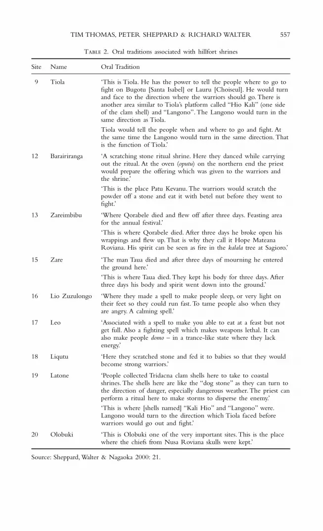
T 2. Oral traditions associated with hillfort shrines
Site Name Oral Tradition
9 Tiola ‘This is Tiola. He has the power to tell the people where to go to fight on Bugotu [Santa Isabel] or Lauru [Choiseul]. He would turn and face to the direction where the warriors should go. There is another area similar to Tiola’s platform called “Hio Kali” (one side of the clam shell) and “Langono”. The Langono would turn in the same direction as Tiola.
Tiola would tell the people when and where to go and fight. At the same time the Langono would turn in the same direction. That is the function of Tiola.’
12 Barairiranga ‘A scratching stone ritual shrine. Here they danced while carrying out the ritual. At the oven (oputu) on the northern end the priest would prepare the offering which was given to the warriors and the shrine.’
‘This is the place Patu Kevanu. The warriors would scratch the powder off a stone and eat it with betel nut before they went to fight.’
13 Zareimbibu ‘Where Qorabele died and flew off after three days. Feasting area for the annual festival.’
‘This is where Qorabele died. After three days he broke open hiswrappings and flew up. That is why they call it Hope MateanaRoviana. His spirit can be seen as fire in the kalala tree at Sagioro.’
15 Zare ‘The man Taua died and after three days of mourning he entered the ground here.’
‘This is where Taua died. They kept his body for three days. After three days his body and spirit went down into the ground.’
16 Lio Zuzulongo ‘Where they made a spell to make people sleep, or very light on their feet so they could run fast. To tame people also when they are angry. A calming spell.’
17 Leo ‘Associated with a spell to make you able to eat at a feast but not get full. Also a fighting spell which makes weapons lethal. It can also make people domo – in a trance-like state where they lack energy.’
18 Liqutu ‘Here they scratched stone and fed it to babies so that they wouldbecome strong warriors.’
19 Latone ‘People collected Tridacna clam shells here to take to coastal shrines. The shells here are like the “dog stone” as they can turn to the direction of danger, especially dangerous weather. The priest can perform a ritual here to make storms to disperse the enemy.’
‘This is where [shells named] “Kali Hio” and “Langono” were.Langono would turn to the direction which Tiola faced before warriors would go out and fight.’
20 Olobuki ‘This is Olobuki one of the very important sites. This is the place where the chiefs from Nusa Roviana skulls were kept.’
Source: Sheppard, Walter & Nagaoka 2000: 21.

Below and to the east of the skull shrine, there is a flat area containing a few platforms and alignments of coral cobbles. These order space and probably provided places for ritual activity and ceremonies integral to theacquisition and maintenance of chiefly power. In Roviana society, those who sought chiefly status needed to demonstrate ancestral support for their political ambitions. Ceremonies were held at specific focal shrines, such asOlobuki, in order to obtain the ‘blessings’ of ancestors and deities. Such bless-ings were later made evident by success or efficacy in endeavours such aswarfare and raiding, bonito fishing, harvests, and so on. Participation in ceremonies at shrines was dependent upon a person’s position within society,making these spaces charged with relations of power. Shrines as sacred placeswere ‘hot’ or dangerous, their structure unable to be touched or approachedby anyone other than hiama, and access was controlled by hereditary chiefs.Given that this is clearly a ritually and politically charged zone, it is some-what surprising that a series of domestic terraces is located nearby. Anyonedwelling here would have seen the shrine every day.These structures perhapshoused attendant priests, those involved in periodic ceremonies, or defendersof the wall.
The next named shrine is Latone (site 19), traditionally a shrine associatedwith giant clam shells, which were said to turn towards dangerous weather.Priests also made spells here to conjure storms to disperse the enemy. BeyondLatone is Liqutu (site 18), a shrine said to be a place where priests ‘ “scratchedstone” and fed it to babies so that they would become strong warriors’ (Table2). Liqutu contains five upright basalt stones sourced geologically from themainland, sheets of lace coral, and some fragments of human cranial material,the latter indicating that this too was once an ancestral skull shrine. Shell ringsand barava are strewn amongst the cobbles, and there is a deposit of pigmandibles on the south side of the shrine. Shrines known as ‘Leo’ (site 17)and ‘Lio Zuzulongo’ (site 16) are located a further 50 metres along the ridgeand these too are associated in oral tradition with war magic and ritual (Table2). Sheets of coral and fragments of human skull indicate that they were alsoancestral skull shrines. Small platforms and terraces occur nearby. The ma-terial culture present reinforces the oral traditions associating these places withthe rituals of war. A laterally ground section of Terebra shell (rago) found onsite 17 is an artefact closely associated with head-hunting practices.These weretied to charms known as serebule and vovoso, along with shell rings, pagosia andbarava. Such charms were stored at shrines before being taken in war canoeson head-hunting forays (Hocart 1922;Waite 1979).The final shrines encoun-tered in the first section of the hillfort are Zare (site 15) and Zareimbibu (site13). Although very similar in form to previous shrines, they differ in meaningand association. Connected with divine ancestral figures called mateana, Zareand Zareimbibu are powerful origin points for the chiefly lineages of NusaRoviana. The experience of this area involves the binding of people to placethrough an origin narrative that connects extant leaders to a mythical past ofdivine ancestors.This narrative is the key to understanding the importance ofthe hillfort in nineteenth-century Roviana society.
The narrative begins in the mountainous interior of New Georgia, wherepeople are said to have lived before radiating out to the coastal margins andbarrier islands of the lagoon.Towards the central and eastern end of the lagoon
558 TIM THOMAS, PETER SHEPPARD & RICHARD WALTER

lived the tribes of Taghosaghe, Lio Zuzulongo, Hoava, Hoeze, and Kalena Bay,and towards the western end lived the Kazukuru and Roviana tribes. Inter-marriage between members of Kazukuru, Roviana, and Taghosaghe led to theformation of the Kazukuru-Roviana polity and the eventual replacement ofthe Kazukuru language with Roviana (Aswani 1997; 2000). This polity con-trolled lands around a place named ‘Bao’, inland from Munda (map) (see Hall1964). Here, a series of shrines descends a ridge line, probably documentingthe land-ownership rights of successive generations of Kazukuru-Rovianapeople. Located by the NGAS in 1999, these shrines differ considerably fromthe shrines found on Nusa Roviana. They are massive constructions; basalt-faced platforms surrounded by large uprights, with ‘table’ stones (large flat slabsraised on top of smaller boulders) usually set out in front (Fig. 8). Eighteenshrines were located, aligned east to west along a ridge looking out to north-ern New Georgia.There are no associated artefacts or living floors near theseshrines, no terraces or any other form of habitation structure. Additionally,there are no defensive structures in evidence.
Oral traditions tell of two ancestors, Luturu-Bangara and his son Ididu-Bangara, who lived at Bao until the latter began a migration to the coast inthe mid-sixteenth to early seventeenth centuries (Aswani 2000: 47). Ididu-Bangara and his followers resettled on Nusa Roviana where they encounteredtwo groups of people, the Koloi, who visited the eastern lagoon-side stretchof land, and the Vuragare, who occupied the seaward coast. Traditions speakfrom this point of a process of alliance formation, integration, and replace-ment, in which the Kazukuru-Roviana polity extended control over NusaRoviana and eventually much of south New Georgia.These stories also refer,for the first time, to the ritual and symbolic trappings of Roviana politicalpower. They tell of the use of shell valuables as items of exchange and ritualoffering, and of warfare and head-hunting (2000: 48), characteristics that wereto continue into the twentieth century.
Two generations after Ididu-Bangara’s migration to the coast, nine of hisdescendants were transformed into a class of spirit beings called mateana.Traditionally capable of flight and transmutation, mateana were dangerousfigures: when seen at sea they portended raids from overseas or plentifulbonito, they caused disease with their spears, and people did not go outsidewhen they were abroad for fear of death (Hocart 1922: 268-9). The nineancestors transformed into mateana lived in an area once known as the ‘SevenHills of Zare Botu’ on the ridge line of Nusa Roviana, and two – Qorabeleand Taua – are associated with specific shrines there. Qorabele died at Zare-imbibu (site 13) and after three days he flew into the sky from that place.Taua died at Zare (site 15) and after three days his body and spirit descendedinto the ground there (Table 2).Their siblings are said to have done the same,with three ascending into the skies like Qorabele and four following Taua intothe earth.
The transformations and deaths of these ancestors mark a point of sever-ance. From here onwards, chiefly lineages were traced to mateana associatedwith violence and supernatural power. In their descent into the centre of theisland and ascension into the skies, the nine mateana were bound to NusaRoviana and at the same time remained to haunt the lagoon. Roviana chiefs,through affiliation with the mateana shrines of the hillfort, embodied these
TIM THOMAS, PETER SHEPPARD & RICHARD WALTER 559
560T
IM T
HO
MA
S,PET
ER
SHE
PPAR
D &
RIC
HA
RD
WA
LTE
R
F 8. Plan of Bao shrine 14.

qualities in their rule over the lagoon, and Nusa Roviana became the centralseat of power.
Knowledge of this oral tradition would inform the experience of peoplemoving between Olobuki and Zareimbibu. This section of the fort works asa sedimented genealogical narrative, a ‘topogeny’ (Fox 1997) binding peopleto place. Contemporary chiefly lineages embedded themselves in this narra-tive by placing the skulls of their recent dead in the Olobuki shrine. A directphysical connection with the legitimacy of the past was thus established, reaf-firming the genealogical basis of self and group identity in the process. BeyondOlobuki the next shrines contain references to the inland origins of theRoviana peoples. The shrine Lio Zuzulongo is named after an ancestral tribefrom southeast New Georgia, and Zareimbibu is the name of an ancestralvillage in the Taghosaghe region. The presence of volcanic stones taken fromNew Georgia and placed upright in these shrines, echoing those at Bao, alsoindicates the linkage with the mainland. At the end of this area, above theother shrines, is the central place, the origin point of the mateana lineageswhere the locus of authority was transferred from Bao to Nusa Roviana.
When summarized in this way the first section of the fort can be seen asan analogue of Bao. Both places have a series of shrines descending a ridge,legitimizing genealogical emplacement.The ancestor of the Kazukuru peopleof Bao,Vakorige, emerged from the earth at a mountain top (Hall 1964: 133).This autochthonous origin is mimicked in the story of the mateana ancestorsof Roviana. So the hillfort shrines work as a way of binding migrating peopleto a new place: they negotiate the integration of ancestral mainland tribeswith those encountered on Nusa Roviana by physically incorporating theminto a single line and complex.
But the Nusa Roviana shrines differ in important ways from those at Baoin form, content, and significance. They are associated with practices of warand conflict, contain artefacts used in exchange and offering, and are defended.Structures other than shrines are also present – living floors and activity areas.A different ideological formation is reflected in these characteristics: the prac-tices of head-hunting and efficacious endeavour in war, wealth accumulationand exchange, have become integral to the wielding of power.
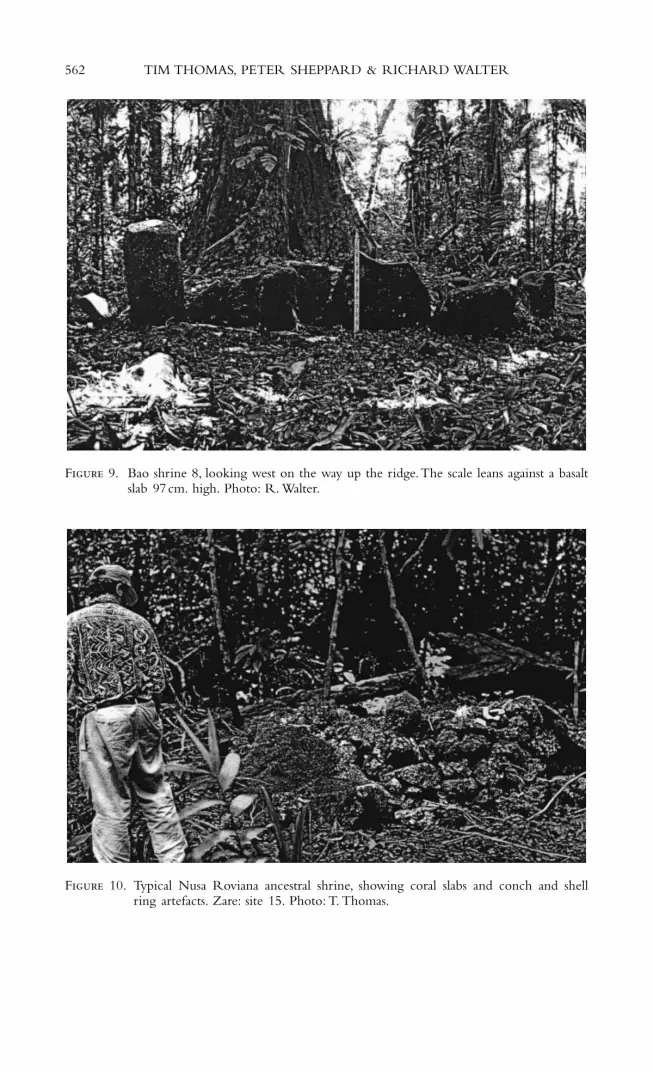
Comparison between the two locales is informative. Several of the Baoshrines are monumental, and all are geometric and formally structured (Figs.8, 9).The effect of these shrines is one of captivation and awe focused on thesize and weight of the stones, and the overall scale of construction. They area quite obvious demonstration of power and the ability to alter, manipulate,and shape the world. As focal places for descent groups, they bind people toa specific place through an ordered expression of collective will. Amongst theuncontainable forest of the interior they create a constructed space for a groupwith their ancestors and descendants. On Nusa Roviana, however, the shrinesare relatively formless and not easily grasped, in contrast with the structure ofthe living areas, terraces, and walls. They appear as piles of coral rocks gath-ered into an almost makeshift mound, spilling out and blending into the surrounding ground surface, strewn with broken and unfinished artefacts (Fig. 10).The key to understanding these shrines is in the recognition of theirrole in communication with ancestors. If the world of the living is reflectedin the order of rectangular living platforms, in whole shell rings, and the
TIM THOMAS, PETER SHEPPARD & RICHARD WALTER 561
562 TIM THOMAS, PETER SHEPPARD & RICHARD WALTER
F 9. Bao shrine 8, looking west on the way up the ridge.The scale leans against a basaltslab 97cm. high. Photo: R. Walter.
F 10. Typical Nusa Roviana ancestral shrine, showing coral slabs and conch and shellring artefacts. Zare: site 15. Photo: T. Thomas.

useable objects of everyday life, then the world of ancestral spirits is diffuseand formless: it is shadow, essence, smoke of burnt food, detritus, and amor-phous constructions. The shrines work as physical manifestations of the ever-present spirit world, existing in a zone between the living and dead. Asmediation points they make sensible the broken, diffuse qualities of the ances-tral spirits while retaining difference from the ordered world of the living.The form of the shrines thus marks the ideological juncture that occurredwith the advent of the mateana cults. On Nusa Roviana, authority was notdemonstrated so much in an ordered control over place (though it probablyinvolved this in practice) as in an ability to commune effectively with power-giving ancestors. Ancestral power became crucial to the definition of chieflypersonhood. This communing with ancestors was also effected in a spatialcompression, and perhaps even a blurring between the worlds of the ances-tors and the living – as the next section of the hillfort shows more clearly.
T : B
A high wall is located almost immediately to the east of Zareimbibu (Fig. 11).Too tall to be seen over, it stretches between the increasingly steep slopes ofthe ridge line. This wall is more massive than the first, but a narrow breakoccurs half-way along, allowing passage beyond while restricting visibility.Thisleads to a series of shrines merged into a long mound following the ridgetop for about 20 metres. Movement is directed away and down the ridge by this shrine complex, to two sets of terraces cut into the slope on eitherside. There are almost thirty terraces in all, stone faced and well constructed,some cut back into the rock with careful walkways passing between them.Abundant food waste is distributed over the surface of these platforms – shell,fishbone, and mammal bone is deposited in a thick cultural layer (Sheppard,Walter & Nagaoka 2000). Evidently used as living areas, these probably heldresidential structures.
Oral traditions name this section ‘Barairiranga’ (‘wall for shouting’), anddescribe its use as a last place of refuge for women and children when theisland was under attack (Sheppard & Walter 1998: 19).The shrine complex isnamed ‘Patu Kevanu’, a warriors’ ‘scratching stone’ shrine (Table 2). Artefactsresembling those encountered previously, and human skull material, arepresent, with sheet coral distributed nearby. Located to the east of the shrinesare a few platforms backing up against the next wall. The largest of these isperhaps a dance area, as oral tradition refers to dances performed while the‘scratching stone’ ceremony took place.
Barairiranga appears the most ordered area of the hillfort. If the first sectionwas a place associated with ancestors, then the order here marks this place asprimarily for the living. This clarifies a pattern encountered throughout theprevious section of the fort, whereby a central ancestral shrine is framed bya large wall to the west, an assembly area to the east, and residential terraceson either side. There is little spatial separation between the components – asacred area surrounded by dwellings in close juxtaposition. This closeness ofliving spaces to what is ostensibly a dangerously sacred place needs explana-tion. Perhaps as a place of last refuge, the importance of protecting the lineage
TIM THOMAS, PETER SHEPPARD & RICHARD WALTER 563

and its most cherished and sacred signs of group identity from attack over-ruled any ritual danger. On the other hand, this pattern of intimacy does not differ appreciably from the rest of the Nusa Roviana settlement land-scape (Fig. 2). In Kokorapa, Kalikoqu, and Vuragare, shrines, house platforms,working floors, and midden define a contiguous living-surface (Sheppard,Walter & Nagaoka 2000: 28). Again there are spatial distinctions but these
564 TIM THOMAS, PETER SHEPPARD & RICHARD WALTER
F 11. Wall at Barairiranga. Photo: T. Thomas.

are condensed. Maps of the Vuragare and Kalikoqu settlements indicate apattern of domestic platforms along the hill slopes, followed by shrines clus-tered immediately below on the beach ridge, and a series of wharves alongthe coastline (Nagaoka 1999). On the ground, however, there is no clear spatialdelineation separating houses from shrines; they blur and merge in clusters.This may be attributable to the function of different shrines. Nagaoka (1999:164-7) has shown how agricultural and domestic shrines are found inland,whereas shrines associated with war, bonito fishing, and ancestors are placedseaward, reflecting conceptually female versus male activities. So, there are categorical divisions in spatial organization, but firm distinctions betweensecular and religious activity seem to have little relevance. Interaction with thespirit world was bound into the practices of everyday life for the communityas a whole.
The essential point is that the presence of shrines within the routine move-ments of everyday life, created a sense of sociality dominated by an awarenessof ritual, communion with the ancestral realm, and the associated restrictionsand dangers. Because shrines were not set off from living areas or daily activ-ities, each day was defined by patterns of movement along paths able or unableto be travelled, and through boundaries able or unable to be crossed, depend-ing on one’s place in society. As an example, a shrine named ‘Hariatana’ sitswithin Kokorapa village, amongst old midden and near house floors. Infor-mants today speak of how, in the past, this shrine restricted the movement ofwomen in its vicinity; if they wished to pass this place they were obliged touse canoes and paddle out and around via the lagoon.
This pattern is in striking contrast with mainland and nearby settlements.Mainland settlements are highly dispersed, with shrines found on ridges farfrom habitation zones and agricultural land (Sheppard, Walter & Nagaoka2000: 36). In the barrier island settlements of Honiavasa and Kekehe, the settlement pattern is more clustered, with domestic and religious structuresspread out on the fringe of agricultural land, but many of the structures arespaced 50 metres or more apart (2000: 27). At some level, especially in themainland settlements, people would have been able to go days without evercoming near a shrine, without considering a path taken, without restrictionon movement. Ceremonies, dances, and offerings at shrines were out of sightof daily activity and so perhaps not considered by the majority of the com-munity for the majority of the time.The nucleated character of Nusa Rovianais clearly unusual amongst settlements in the surrounding area.
Turning back to the Barairiranga section, the placement of terraces andshrines draws attention to an inversion of the scheme noted by Nagaoka(1999). Here, domestic features are associated with ancestral shrines used inwarrior magic, located far from the coast. The fortification clearly does notreplicate in miniature the wider settlement pattern and organization of space.Rather, it is a special component of the landscape. Dedicated specifically tothe most important origin-ancestors of the Nusa Roviana lineages, the hill-fort shrines are sited on the highest, most defended part of the island.Their centrality speaks of their importance, they are the primary reason forthe presence of walls and platforms. The hillfort occupies a landscape zoneabove the settlements of daily life, engendering an experience similar butsubtly different.
TIM THOMAS, PETER SHEPPARD & RICHARD WALTER 565
T : B R
The end of Barairiranga is defined by a substantial wall that makes the mostof the natural steepness of the ridge at this point. Its northeast limit sits atopa high bluff that descends sharply to the forest floor below. Beyond this is thethird section, named ‘Botu’. The southwest side of the ridge here is formedinto a very steep series of terraces similar to those of Barairiranga. Again,midden is deposited on the terraces and there is a small shrine-like feature(site 10) on the centre of the ridge. However, the architecture here is basi-cally a causewayed approach leading up to the final section, narrowing move-ment towards the crest of the ridge. The next wall delineates the beginningof an area known as ‘Roviana’. But this wall differs from those preceding itin that it is not a straight line bisecting the ridge. Rather, it is a curved rampextending from a low point on the edge of the cliff to the north.The top ofthis wall is the highest point on the ridge line and also marks its end. Theramp directs movement towards an exposed and high promontory overlook-ing the surrounding forest. At the summit is the final shrine, Tiola. Beyondthe shrine is a very steep slope to a ditch, 7 metres wide and 5 metres deep,cut into the rock. Climbing through this ditch brings one to a small platform.Below this, several head-high terraces descend the hill ending in a final wall.From here, the forest drops away steeply to the eastern flat land.
The Tiola shrine is by far the least accessible place on the ridge line. Theterraces and ditches to the east are boundaries to access from behind, and thesuccessive walls of the hillfort restrict access from the west. Other approachesare impractical due to the cliffs on either side. The architecture frames theapproach in such a way as to hide the shrine until one is almost upon it.Theramped wall locates the shrine high above, but out of sight. Every architec-tural feature in this area of the ridge surrounds the shrine; the terraces, ditches,and walls frame, defend, and serve it. So why all this effort?
Tiola is a central figure in Roviana mythology, perhaps the most impor-tant spirit figure in warfare narratives. The name comes from ‘tio’ meaning‘man’ (specifically, a man of Nusa Roviana) and ‘la’ meaning ‘go!’ Togetherthey translate as a rallying cry: ‘man go to fight!’ (Aswani 2000: 50). Tiolaappeared as a dog and was considered an oracle. Able to detect attackingenemies, he would select the next place a raid should be directed towards. Alimestone statue of a dog on the Tiola shrine is said to have given warningand turned to the direction of approaching threat.
The Tiola origin story relates that he came out of a cave shaped like avagina on the island of Nduke, and later travelled to Simbo where he duginto the centre of a mountain before being blown out of the hole throughthe air to Nusa Roviana. Whilst living at Zare he taught the people of theisland how to build tomoko war canoes and paele canoe houses (both shapedafter his own form), in order that he might marry a chief ’s daughter. Aftermarriage, Tiola stayed on Nusa Roviana, and later died there and turned tostone (as reported by Oka, in Sheppard & Walter 1998: 25-8). As in the otherorigin stories, the ancestor-god is integrated into a new place, in this casethrough marriage and by turning into the very substance of the island.
Unlike Ididu-Bangara, Qorabele, and Taua however, Tiola is an ancestor ofideas and values more than kinship. The innovations of tomoko and paele
566 TIM THOMAS, PETER SHEPPARD & RICHARD WALTER

emphasize the importance of canoes in Roviana society. As the sole means fortravel over long distances, tomoko were primary symbols of efficacy in head-hunting expeditions, and were highly decorated and ritualized. Tomoko con-ferred power to act effectively in the world, which, if managed successfully,translated into power over others. Authority, the ability to rule, and the con-fidence of one’s followers were founded in successful head-hunting raids:success indicated the will and support of the ancestors, it proved in a sensethat people were living ‘correctly’. Paele were a land-based reflection of thisefficacy. Canoe houses were both a locus for activities of warriors and chiefsand also the place where the symbols of efficacious head-hunting (the trophyskulls themselves) were stored and displayed (Woodford 1890). Tomoko andpaele are clearly fundamental to a particular sense of identity in Roviana,reflecting a lineage group’s efficacy, grounded in violence, and enacted in travelbetween disparate places.
The position of the Tiola shrine, then, emphasizes the values and associa-tions that Tiola held for society. The highest, most defended, least accessibleplace is reserved for the shrine that commemorates the most fundamentalmechanisms and tenets by which people living on Nusa Roviana gained theirauthority, their ability to act in the world, and by association their sense ofgroup identity.
Today, the setting of the shrine is still spectacular, high above the sur-rounding lagoon and ocean, sitting amongst the tree canopy. The view, if thetrees were cleared, would be incredible: looking out over much of the sur-rounding landscape, it is no wonder that the stone dog could detect approach-ing enemies (Fig. 12).The shrine itself, however, is under-whelming.The headis all that remains of the small statue of a dog. It is set amongst a collectionof shell rings, other shell artefacts, a conch, three large basalt grinding-stones,a giant clam shell, and some human jawbone and cranial material (Fig. 13).There is no large pile of coral cobbles, just these artefacts placed next to theedge of the wall. Nevertheless, the power of this place mainly derives fromits aspect and carefully constructed architecture, framing and positioning theshrine so that its importance cannot be mistaken.
Discussion
The multi-layered experience of the hillfort created a specific sense of social-ity within the groups living on Nusa Roviana. In gathering together a col-lection of important recollections, of the lives and trajectories of differentpeople and things, the hillfort was a powerful place for creating and com-municating self-identity. For Roviana people, the architectural structures, andassociations and memories harboured in them, told of how one was boundinto society through ancestry and kinship, practice and engagement. Belong-ing was established by the origin shrines and associated chiefly skull shrines.They define a foundation, and descend through lines of kinship to the present,their structures forming a cohesive physical presence, a proof of lineage andownership.
The values and practices associated with those shrines further bound peopleinto society: bonds of reciprocation and dependency were established in the
TIM THOMAS, PETER SHEPPARD & RICHARD WALTER 567

568 TIM THOMAS, PETER SHEPPARD & RICHARD WALTER
F 12. View from the terraces below Tiola, looking westward. Photo: T. Thomas.
F 13. Tiola shrine: site 9. Photo: T. Thomas.
lived experience of the architecture. Funeral rites, propitiatory ceremonies, thecasting of spells, preparations for war and raiding, dances and feasts all tookplace within a structured context helping create a specific habitus. Experienceof these ceremonial practices – participation in some, restriction from others– created a sense of place within society, how one was linked into its struc-tures, or conversely, how some were excluded.
The habitus of the hillfort was formed around and imbued with the practices of ritualized warfare and head-hunting. The structure is frameddefensively, as a fortified place of war. The ancestral shrines were to be experienced in this context. Associated with violent endeavour, they were not used for childbirth rituals, plentiful harvests, or marriage rites. Instead,they conferred the power of the ancestors in head-hunting raids, invinci-bility for warriors, and misfortune for enemies. The very fact that the sacred origin points were cast in these terms argues for the central impor-tance of ritualized warfare in life on Nusa Roviana. The ideology at workhere is that of male warrior-chiefs and their immediate followers. Thegenealogical narratives and symbols of power were, in a sense, captured bythem and put to their service. Leaders made the argument that through head-hunting raids, through their abilities as warriors and their capacity for bodilyviolence, they derived their authority to rule, made evident in ancestrallyblessed success.
The physically compressed structures of the hillfort materialized this ideol-ogy and helped make it possible. The intimacy of the fort, and indeed thewider landscape, speaks of one group experience, one way of living. Daily lifecould not be continued in ignorance of the physical presence of shrines andassociated rituals. It is a landscape without spaces where other ways, other pos-sibilities, might be imagined. Groups were in effect bound together throughstrong experiences of physical belonging – one social body, bound by similarancestry, practices, dangers, and solutions.
Part of this identity construction was the definition of groups who did not belong, groups who were enemies and, in terms of head-hunting, prey.Aswani (2000) has argued that through head-hunting, the identity of cate-gories of people was established and reinforced.The captured heads of victimsdisplayed in paele stood as objectified others, ultimately reduced to physicalproof of efficacious action. In severing heads and capturing slaves, Rovianawarrior-chiefs affirmed the ritual superiority of their own ancestors, con-firming the well-being of the community in the process, while denying theseand their possibility in their victims (2000: 55-7). In the act of head-takingand the subsequent display, use, and disposal of those heads, ‘outsiders’ wereobjectified, their personhood denied in removal from their own socialnetwork. The skulls of ‘appropriated outsiders’ were possessed objects sym-bolizing the efficacy of warrior-chiefs, and were treated as heirlooms muchlike shell rings and other valuables sought after and collected. Others wereaccordingly transformed into belongings as particles of what Gell (1998) hascalled the ‘distributed personhood’ of the leader. They became part of theagency of the person who controlled their remains, and by extension theagency of the group as a whole.
This process is consistent with the Melanesian notion of ‘fractal person-hood’ (Wagner 1991). Personhood is defined relationally: one does not exist
TIM THOMAS, PETER SHEPPARD & RICHARD WALTER 569
as a person simply by virtue of being born, but becomes a person throughan involved sociality and the manifestation in one’s body of the genealogy inwhich one is embedded (see also Strathern 1988). In terms of Roviana head-hunting, those who lacked social bonds, whether lineage ties or exchange rela-tions, were accordingly open to ‘objectification’.
The Nusa Roviana hillfort can be understood from this perspective to bea primary means of reproducing and legitimizing a specific notion ofgenealogically based personhood.The ancestral skull shrines amongst its wallsstand as the representation of a cohesive genealogical belonging and its fractalcore.These exist in direct opposition to the coastal paele canoe houses bearingthe skulls of victims – outsiders incorporated into the agency of the group asa demonstration of its efficacy, and defining an otherness that was ultimatelyinconsequential.The landscape of the fort embodies an experience of belong-ing and personhood in opposition to a world of vessels and objects to beappropriated. The hillfort is the defended core of what it means to be aRoviana person.
Conclusion
The tribal histories harboured in the Nusa Roviana landscape exist betweenspoken and material worlds.A constant dialogue takes place between the mate-rial remains of the past and interpreted memory. Roviana people are attachedto the places they inhabit by the memories and stories woven through theforest, earth, sea, and stones, and the evidence that world gives them throughits material record of ancestral life. Continuities between current genera-tions and past inhabitants are constantly reaffirmed. Today these continuitiesconvey land use rights for descent groups, and revenue from fisheries andlogging ventures. But as in the past, tribal histories gathered in landscaperemain the well-spring of identity and personhood. It is only in the settingthat harbours their past that the people of Roviana truly become Rovianapeople. The most effective anthropological method for capturing this processclearly calls for an equal awareness of oral and material histories. A politicalhistory of modes of being within particular settings can be effectively writtenin the dialogue between ethnography and archaeology. Such an approach isalways going to be limited by the particularities of available data. But inMelanesian settings such as Roviana, where there exists a formidable archae-ological record of the recent past equal to the ethnographic record, true dis-ciplinary crossings are attainable and will allow wide-ranging explorations of‘landscape’ anthropology.
NOTE
We would like to acknowledge the Royal Society of New Zealand Marsden Fund, the Uni-versity of Otago, and the University of Auckland for supporting our research programme.Thanks also to the people of Roviana Lagoon, and particularly Kenneth Roga and the Ministry of Culture Western Province, Roviana Area Council, and the Solomon Islands NationalMuseum. Finally, we wish to thank Helen Leach and several anonymous reviewers for manyhelpful comments.
570 TIM THOMAS, PETER SHEPPARD & RICHARD WALTER

REFERENCES
Aswani, S. 1997. Customary sea tenure and artisanal fishing in the Roviana and VonavonaLagoons, Solomon Islands: the evolutionary ecology of marine resource utilization. Ph.D.dissertation, University of Hawaii.
——— 2000. Changing identities: the ethnohistory of Roviana predatory head-hunting. Journalof the Polynesian Society 109, 39-70.
——— & P. Sheppard n.d. Gifts, commodities and inalienable possessions: exchangeable andnon-exchangeable objects in pre-colonial Roviana, Solomon Islands. MS.
Ballard, C. 1994. The centre cannot hold: trade networks and sacred geography in the PapuaNew Guinea Highlands. Archaeology in Oceania 29, 130-48.
Bender, B. (ed.) 1993. Landscape: politics and perspectives. Oxford: Berg.——— 1998. Stonehenge: making space. Oxford: Berg.Bennett, J. 1987. Wealth of the Solomons: a history of a Pacific archipelago, 1800-1978. Honolulu:
University of Hawaii Press.Bourdieu, P. 1977. Outline of a theory of practice. Cambridge: University Press.Busby, C. 1997. Permeable and partible persons: a comparative analysis of gender and body in
South India and Melanesia. Journal of the Royal Anthropological Institute (N.S.) 3, 261-78.Carrier, J. (ed.) 1992. History and tradition in Melanesian anthropology. Berkeley: University of
California Press.Fox, J. 1997. Place and landscape in comparative Austronesian perspective. In The poetic power
of place: comparative perspectives on Austronesian ideas of locality (ed.) J. Fox, 1-21. Canberra:Australian National University.
Funari, P.P.A., S. Jones & M. Hall 1999. Introduction: archaeology in history. In Historical archae-ology: back from the edge (eds) P.P.A. Funari, M. Hall & S. Jones, 1-20. London: Routledge.
Gell, A. 1995. The language of the forest: landscape and phonological iconism in Umeda. InThe anthropology of landscape: perspectives on place and space (eds) E. Hirsch & M. O’Hanlon,232-54. Oxford: Clarendon Press.
——— 1998. Art and agency: an anthropological theory. Oxford: Clarendon.Hall, A.M. 1964. Customs and culture from Kazukuru: folklore obtained after the discovery of
the shrine at Bao. Oceania 35, 129-35.Heidegger, M. 1972. Building dwelling thinking. In Martin Heidegger: basic writings (ed. D. Krell),
319-39. London: Routledge.Hirsch, P. & M. O’Hanlon (eds) 1995. The anthropology of landscape: perspectives on place and space.
Oxford: Clarendon Press.Hocart, A.M. 1922. The cult of the dead in Eddystone of the Solomons. Journal of the Royal
Anthropological Institute of Great Britain and Ireland 52, 71-117, 259-305.——— 1925. Medicine and witchcraft in Eddystone of the Solomon Islands. Journal of the Royal
Anthropological Institute of Great Britain and Ireland 55, 229-70.——— 1931. Warfare in Eddystone of the Solomon Islands. Journal of the Royal Anthropological
Institute of Great Britain and Ireland 61, 301-24.Merleau-Ponty, M. 1962. Phenomenology of perception. London: Routledge.Nagaoka,T. 1999. Hope Pukerane: a study of religious sites in Roviana, New Georgia, Solomon
Islands. MA thesis, University of Auckland.Parker-Pearson, M. & C. Richards (eds) 1994. Architecture and order: approaches to social space.
London: Routledge.Sheppard, P. & R. Walter 1998. New Georgia Archaeological Survey (NGAS) Roviana Lagoon year
2: annual report 1997. Auckland: Department of Anthropology, University of Auckland.———, ——— & T. Nagaoka 2000. The archaeology of head-hunting in Roviana Lagoon,
New Georgia. Journal of the Polynesian Society 109, 4-38.———, ——— & ——— n.d. Cultural sediment: the nature of a cultural landscape in Roviana
Lagoon. MS.Somerville, B.T. 1897. Ethnographical notes in New Georgia, Solomon Islands. Journal of the
Royal Anthropological Institute 26, 357-413.Strathern, M. 1988. The gender of the gift. Berkeley: University of California Press.Tilley, C. 1994. A phenomenology of landscape: places, paths and monuments. Oxford: Berg.——— 1996.The powers of rocks: topography and monument construction on Bodmin Moor.
World Archaeology 8, 161-76.
TIM THOMAS, PETER SHEPPARD & RICHARD WALTER 571

Vansina, J. 1985. Oral tradition as history. Madison: University of Wisconsin Press.Wagner, R. 1991. The fractal person. In Big men, and great men: personifications of power in
Melanesia (eds) M. Strathern & M. Godelier, 159-73. Cambridge: University Press.Waite, D.B. 1979.Art and ethnographica from the Solomon Islands in the Museum of Mankind.
In Captain Cook and the South Pacific (ed.) T.C. Mitchell, 199-239. London: British Museum.Weissner, P. & A.Tumu 1998. Historical vines: Enga networks of exchange, ritual and warfare in Papua
New Guinea. Washington, DC: Smithsonian Institution Press.White, G. 1991. Identity through history: living stories in a Solomon Islands society. Cambridge:
University Press.Woodford, C.M. 1890. A naturalist among the headhunters. London: George Philip & Son.
Le paysage, la violence et les corps sociaux: l’architectureritualisée dans une société des îles Salomon
Résumé
Cet article considère les interactions entre l’expérience physique du paysage et la formationde la socialité. Nous examinons les expériences sociales du paysage dans le lagon de Rovianadans les îles Salomon au dix-neuvième siècle, en portant un intérêt spécifique à l’architec-ture ritualisée d’une fortification sur l’île Nusa de Roviana. Sur la base de la tradition oraleet de données archéologiques et historiques, nous soutenons que les vestiges architecturauxreflètent une modalité puissante de manipulation de l’idéologie, capable de donner forme àl’expérience sociale et aux notions de personne. Le paysage de Roviana crée un monde danslequel les lignées généalogiques sont sédimentées sur place et où les pratiques de violencerituelle et de chasse de têtes sont présentées comme nécessaires et naturelles. Porter l’atten-tion à la fois sur l’histoire orale et sur l’histoire matérielle permet une compréhension plusétendue des modes de reproduction de telles structures, et contribue à la construction d’uneanthropologie historique plus riche.
Tim Thomas, Dept of Anthropology, University of Otago, PO Box 56, Dunedin, New [email protected]
Peter Sheppard, Dept of Anthropology, University of Auckland, Private Bag 92019, Auckland, NewZealand [email protected]
Richard Walter, Dept of Anthropology, University of Otago, PO Box 56, Dunedin, New [email protected]
572 TIM THOMAS, PETER SHEPPARD & RICHARD WALTER