krobicki & golonka, 2008 (geoturystyka - clay; pkb, black shales)
TRANSCRIPT
�
Abstract: The main aim of this paper is presentation both general history of the Pieniny Klippen Belt and two famous sites in this region: Dunajec River Gorge and Homole Gorge. According to such general introduction the authors explain also paleogeographical position of the Pieniny Klippen Belt Basin within Mesozoic Tethyan Ocean, and especially stratigraphical position and paleoenvironmental conditions of Middle Jurassic black shales and their significance in geodynamic reconstruction of this basin. Both the Dunajec River Gorge, one of the most popular geotouristic object within Pieniny Mts, and Homole Gorge, one of the best place to geological study of the Pieniny Klippen Belt, are most attractive natural phenomena of this geological region.Key words: southern Poland, Carpathians, Pieniny Mts, Pieniny Klippen Belt, black shales, Mesozoic history
Treść: Głównym celem niniejszej pracy jest próba prezentacji zarówno generalnej historii pienińskiego pasa skałkowego jak i dwóch słynnych miejsc tego regionu: przełomu Dunajca i wąwozu Homole. W nawiązaniu do takiego generalnego wprowadzenia autorzy przedstawiają również paleogeograficzną pozycję basenu pienińskiego pasa skałkowego w obrębie mezozoicznego oceanu Tetydy, a szczególnie stratygraficzną pozycję i paleośrodowiskowe warunki powstawania środkowojurajskich czarnych łupków oraz ich znaczenie w geodynamicznych rekonstrukcjach tego basenu. Zarówno spływ Dunajcem, jeden z najbardziej popularnych obiektów geoturystycznych w Pieninach, jak i wąwóz Homole, jedno z najlepszych miejsc do studiowania geologii pienińskiej, są najbardziej atrakcyjnymi obiektami przyrodniczymi w tym regionie geologicznym.Słowa kluczowe: południowa Polska, Karpaty, Pieniny, pieniński pas skałkowy, czarne łupki, mezozoik
Geological history of the Pieniny Klippen Belt and Middle Jurassic black shales as one of the oldest deposits of this region – stratigraphical position and palaeoenvironmental significance
Geologiczna historia pienińskiego pasa skałkowego a środkowojurajskie czarne łupki jako jedne z najstarszych utworów regionu – stratygraficzna pozycja
i paleośrodowiskowe znaczenie
Michał Krobicki & Jan GolonkaAGH University of Science and Technology, Faculty of Geology, Geophysics and Environmental Protection,
Al. Mickiewicza 30, 30-059 Kraków e-mail: [email protected], [email protected]
Warszawa
Kraków
Warszawa
Kraków
Warszawa
Kraków
Warszawa
Kraków
Zakopane
Chabówka
Czarny DunajecNiedzica
Szczawnica
Nowy Targ
IntroductionThe Outer Carpathians and Pieniny Klippen Belt realm
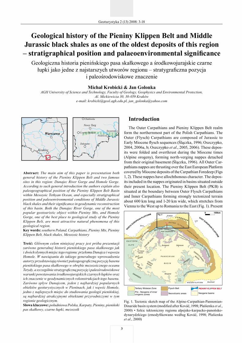
form the northernmost part of the Polish Carpathians. The Outer (Flysch) Carpathians are composed of Jurassic to Early Miocene flysch sequences (Ślączka, 1996; Oszczypko, 2004, 2006a, b; Oszczypko et al., 2005, 2006). These depos-its were folded and overthrust during the Miocene times (Alpine orogeny), forming north-verging nappes detached from their original basement (Ślączka, 1996). All Outer Car-pathians nappes are thrusting over the East European Platform covered by Miocene deposits of the Carpathian Foredeep (Figs 1, 2). These nappes have allochthonous character. The depos-its included in the nappes originated in basins situated outside their present location. The Pieniny Klippen Belt (PKB) is situated at the boundary between Outer Flysch Carpathians and Inner Carpathians forming strongly tectonized terrain about 600 km long and 1-20 km wide, which stretches from Vienna to the West up to Romania to the East (Fig. 1). Present
Fig. 1. Tectonic sketch map of the Alpine-Carpathian-Pannonian-Dinaride basin system (modified after Kováč, 1998; Plašienka et al., 2000) • Szkic tektoniczny regionu alpejsko-karpacko-panońsko-dynarydzkiego (zmodyfikowano według Kováč, 1998; Plašienka et al., 2000)
Geoturystyka 2 (13) 2008: 3-18
�
Geological history of the Pieniny Klippen Belt
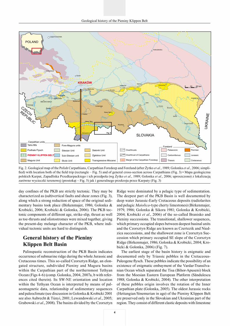
Fig. 2. Geological map of the Polish Carpathians, Carpathian Foredeep and Foreland (after Żytko et al., 1989; Golonka et al., 2006; simpli-fied) with location both of the field trip (rectangle – Fig. 5) and of general cross-section across Carpathians (Fig. 3) • Mapa geologiczna polskich Karpat, Zapadliska Przedkarpackiego i ich przedpola (wg Żytko et al., 1989; Golonka et al., 2006; uproszczono) z lokalizacją zarówno wycieczki terenowej (prostokąt – Fig. 5) jak i generalnego przekroju przez Karpaty (Fig. 3)
day confines of the PKB are strictly tectonic. They may be characterized as (sub)vertical faults and shear zones (Fig. 3), along which a strong reduction of space of the original sedi-mentary basins took place (Birkenmajer, 1986; Golonka & Krobicki, 2006; Krobicki & Golonka, 2006). The PKB tec-tonic components of different age, strike-slip, thrust as well as toe-thrusts and olistostromes were mixed together, giving the present-day melange character of the PKB, where indi-vidual tectonic units are hard to distinguish.
General history of the Pieniny Klippen Belt BasinPalinspastic reconstruction of the PKB Basin indicates
occurrence of submarine ridge during the whole Jurassic and Cretaceous times. This so-called Czorsztyn Ridge, an elon-gated structure, subdivided Pieniny and Magura basins within the Carpathian part of the northernmost Tethyan Ocean (Figs 4-6) (comp. Golonka, 2004, 2007a, b with refer-ences cited therein). Its SW-NE orientation and location within the Tethyan Ocean is interpreted by means of pal-aeomagnetic data, relationship of sedimentary sequences and paleoclimate (see discussion in Golonka & Krobicki 2001 see also Aubrecht & Túnyi, 2001; Lewandowski et al., 2005; Grabowski et al., 2008). The basins divided by the Czorsztyn
Ridge were dominated by a pelagic type of sedimentation. The deepest part of the PKB Basin is well documented by deep water Jurassic-Early Cretaceous deposits (radiolarites and pelagic Maiolica-type cherty limestones) (Birkenmajer, 1979, 1986; Golonka & Sikora 1981; Golonka & Krobicki, 2004; Krobicki et al., 2006) of the so-called Branisko and Pieniny successions. The transitional, shallower sequences, which primary occupied slopes between deepest basinal units and the Czorsztyn Ridge are known as Czertezik and Nied-zica successions, and the shallowest zone is Czorsztyn Suc-cession which primary occupied SE slope of the Czorsztyn Ridge (Birkenmajer, 1986; Golonka & Krobicki, 2004; Kro-bicki & Golonka, 2006) (Fig. 7).
The earliest stage of the basin history is enigmatic and documented only by Triassic pebbles in the Cretaceous-Paleogene flysch. These pebbles indicate the possibility of an existence of enigmatic embayment of the Vardar-Transilva-nian Ocean which separated the Tisa (Bihor-Apuseni) block from the Moesian Eastern European Platform (Săndulescu 1988; Golonka & Krobicki, 2004). The other interpretation of these pebbles origin involves the rotation of the Inner Carpathian plate (Golonka, 2005). The oldest Jurassic rocks (Hettangian/Sinemurian in age) of the Pieniny Klippen Belt are preserved only in the Slovakian and Ukrainian part of the region. They consist of different clastic deposits with limestone
�
Geological history of the Pieniny Klippen Belt
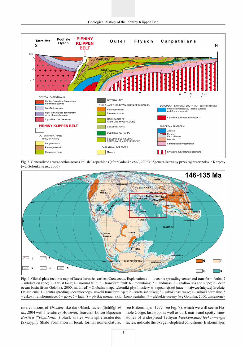
Fig. 3. Generalized cross-section across Polish Carpathians (after Golonka et al., 2006) • Zgeneralizowany przekrój przez polskie Karpaty (wg Golonka et al., 2006)
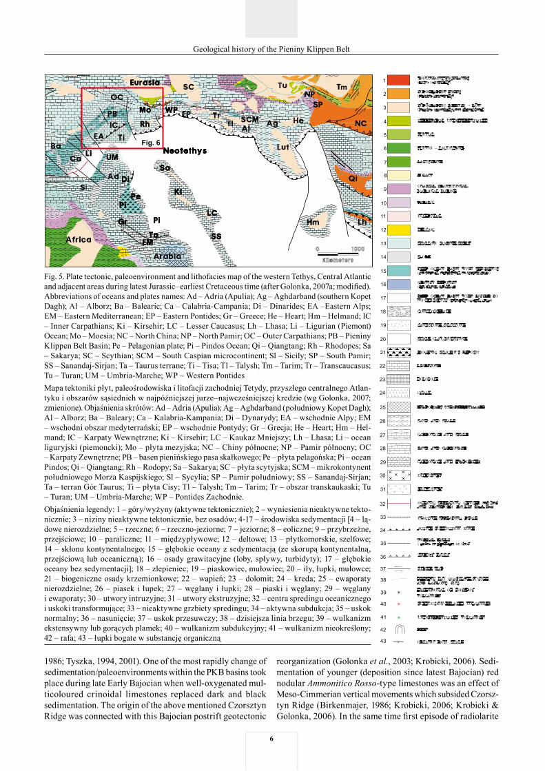
Fig. 4. Global plate tectonic map of latest Jurassic–earliest Cretaceous. Explanations: 1 – oceanic spreading center and transform faults; 2 – subduction zone; 3 – thrust fault; 4 – normal fault; 5 – transform fault; 6 – mountains; 7 – landmass; 8 – shallow sea and slope; 9 – deep ocean basin (from Golonka, 2000; modified) • Globalna mapa tektoniki płyt litosfery w napóźniejszej jurze – najwcześniejszej kredzie. Objaśnienia: 1 – centra spredingu oceanicznego i uskoki transformujące; 2 – strefa subdukcji; 3 – uskoki nasuwcze; 4 – uskoki normalne; 5 – uskoki transformujące; 6 – góry; 7 – lądy; 8 – płytkie morza i skłon kontynentalny; 9 – głębokie oceany (wg Golonka, 2000; zmienione)
intercalations of Gresten-like dark/black facies (Schlögl et al., 2004 with literature). However, Toarcian-Lower Bajocian Bositra (“Posidonia”) black shales with spherosiderites (Skrzypny Shale Formation in local, formal nomenclature,
see Birkenmajer, 1977; see Fig. 7), which we will see in Ho-mole Gorge, last stop, as well as dark marls and spotty lime-stones of widespread Tethyan Fleckenkalk/Fleckenmergel facies, indicate the oxygen-depleted conditions (Birkenmajer,
�
Geological history of the Pieniny Klippen Belt
Fig. 5. Plate tectonic, paleoenvironment and lithofacies map of the western Tethys, Central Atlantic and adjacent areas during latest Jurassic–earliest Cretaceous time (after Golonka, 2007a; modified). Abbreviations of oceans and plates names: Ad – Adria (Apulia); Ag – Aghdarband (southern Kopet Dagh); Al – Alborz; Ba – Balearic; Ca – Calabria-Campania; Di – Dinarides; EA –Eastern Alps; EM – Eastern Mediterranean; EP – Eastern Pontides; Gr – Greece; He – Heart; Hm – Helmand; IC – Inner Carpathians; Ki – Kirsehir; LC – Lesser Caucasus; Lh – Lhasa; Li – Ligurian (Piemont) Ocean; Mo – Moesia; NC – North China; NP – North Pamir; OC – Outer Carpathians; PB – Pieniny Klippen Belt Basin; Pe – Pelagonian plate; Pi – Pindos Ocean; Qi – Qiangtang; Rh – Rhodopes; Sa – Sakarya; SC – Scythian; SCM – South Caspian microcontinent; Sl – Sicily; SP – South Pamir; SS – Sanandaj-Sirjan; Ta – Taurus terrane; Ti – Tisa; Tl – Talysh; Tm – Tarim; Tr – Transcaucasus; Tu – Turan; UM – Umbria-Marche; WP – Western PontidesMapa tektoniki płyt, paleośrodowiska i litofacji zachodniej Tetydy, przyszłego centralnego Atlan-tyku i obszarów sąsiednich w najpóźniejszej jurze–najwcześniejszej kredzie (wg Golonka, 2007; zmienione). Objaśnienia skrótów: Ad – Adria (Apulia); Ag – Aghdarband (południowy Kopet Dagh); Al – Alborz; Ba – Baleary; Ca – Kalabria-Kampania; Di – Dynarydy; EA – wschodnie Alpy; EM – wschodni obszar medyterrański; EP – wschodnie Pontydy; Gr – Grecja; He – Heart; Hm – Hel-mand; IC – Karpaty Wewnętrzne; Ki – Kirsehir; LC – Kaukaz Mniejszy; Lh – Lhasa; Li – ocean liguryjski (piemoncki); Mo – płyta mezyjska; NC – Chiny północne; NP – Pamir północny; OC – Karpaty Zewnętrzne; PB – basen pienińskiego pasa skałkowego; Pe – płyta pelagońska; Pi – ocean Pindos; Qi – Qiangtang; Rh – Rodopy; Sa – Sakarya; SC – płyta scytyjska; SCM – mikrokontynent południowego Morza Kaspijskiego; Sl – Sycylia; SP – Pamir południowy; SS – Sanandaj-Sirjan; Ta – terran Gór Taurus; Ti – płyta Cisy; Tl – Talysh; Tm – Tarim; Tr – obszar transkaukaski; Tu – Turan; UM – Umbria-Marche; WP – Pontides Zachodnie. Objaśnienia legendy: 1 – góry/wyżyny (aktywne tektonicznie); 2 – wyniesienia nieaktywne tekto-nicznie; 3 – niziny nieaktywne tektonicznie, bez osadów; 4-17 – środowiska sedymentacji [4 – lą-dowe nierozdzielne; 5 – rzeczne; 6 – rzeczno-jeziorne; 7 – jeziorne; 8 – eoliczne; 9 – przybrzeżne, przejściowe; 10 – paraliczne; 11 – międzypływowe; 12 – deltowe; 13 – płytkomorskie, szelfowe; 14 – skłonu kontynentalnego; 15 – głębokie oceany z sedymentacją (ze skorupą kontynentalną, przejściową lub oceaniczną); 16 – osady grawitacyjne (loby, spływy, turbidyty); 17 – głębokie oceany bez sedymentacji]; 18 – zlepieniec; 19 – piaskowiec, mułowiec; 20 – iły, łupki, mułowce; 21 – biogeniczne osady krzemionkowe; 22 – wapień; 23 – dolomit; 24 – kreda; 25 – ewaporaty nierozdzielne; 26 – piasek i łupek; 27 – węglany i łupki; 28 – piaski i węglany; 29 – węglany i ewaporaty; 30 – utwory intruzyjne; 31 – utwory ekstruzyjne; 32 – centra spredingu oceanicznego i uskoki transformujące; 33 – nieaktywne grzbiety spredingu; 34 – aktywna subdukcja; 35 – uskok normalny; 36 – nasunięcie; 37 – uskok przesuwczy; 38 – dzisiejsza linia brzegu; 39 – wulkanizm ekstensywny lub gorących plamek; 40 – wulkanizm subdukcyjny; 41 – wulkanizm nieokreślony; 42 – rafa; 43 – łupki bogate w substancję organiczną
1986; Tyszka, 1994, 2001). One of the most rapidly change of sedimentation/paleoenvironments within the PKB basins took place during late Early Bajocian when well-oxygenated mul-ticoloured crinoidal limestones replaced dark and black sedimentation. The origin of the above mentioned Czorsztyn Ridge was connected with this Bajocian postrift geotectonic
reorganization (Golonka et al., 2003; Krobicki, 2006). Sedi-mentation of younger (deposition since latest Bajocian) red nodular Ammonitico Rosso-type limestones was an effect of Meso-Cimmerian vertical movements which subsided Czorsz-tyn Ridge (Birkenmajer, 1986; Krobicki, 2006; Krobicki & Golonka, 2006). In the same time first episode of radiolarite
�
Geological history of the Pieniny Klippen Belt
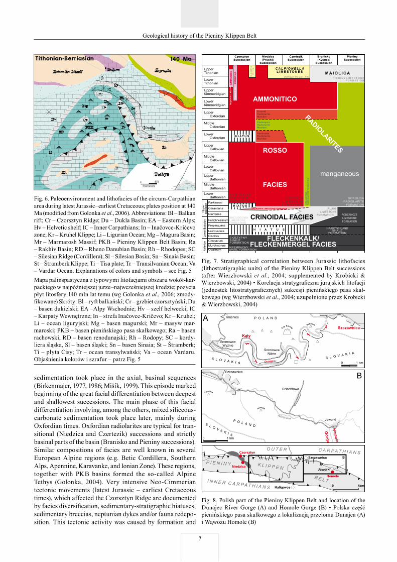
Fig. 6. Paleoenvironment and lithofacies of the circum-Carpathian area during latest Jurassic–earliest Cretaceous; plates position at 140 Ma (modified from Golonka et al., 2006). Abbreviations: Bl – Balkan rift; Cr – Czorsztyn Ridge; Du – Dukla Basin; EA – Eastern Alps; Hv – Helvetic shelf; IC – Inner Carpathians; In – Inačovce-Kričevo zone; Kr – Kruhel Klippe; Li – Ligurian Ocean; Mg – Magura Basin; Mr – Marmarosh Massif; PKB – Pieniny Klippen Belt Basin; Ra – Rakhiv Basin; RD – Rheno Danubian Basin; Rh – Rhodopes; SC – Silesian Ridge (Cordillera); Sl – Silesian Basin; Sn – Sinaia Basin; St – Štramberk Klippe; Ti – Tisa plate; Tr – Transilvanian Ocean; Va – Vardar Ocean. Explanations of colors and symbols – see Fig. 5 Mapa palinspastyczna z typowymi litofacjami obszaru wokół-kar-packiego w najpóźniejszej jurze–najwcześniejszej kredzie; pozycja płyt litosfery 140 mln lat temu (wg Golonka et al., 2006; zmody-fikowane) Skróty: Bl – ryft bałkański; Cr – grzbiet czorsztyński; Du – basen dukielski; EA –Alpy Wschodnie; Hv – szelf helwecki; IC – Karpaty Wewnętrzne; In – strefa Inačovce-Kričevo; Kr – Kruhel; Li – ocean liguryjski; Mg – basen magurski; Mr – masyw mar-maroski; PKB – basen pienińskiego pasa skałkowego; Ra – basen rachowski, RD – basen renodunajski; Rh – Rodopy; SC – kordy-liera śląska, Sl – basen śląski; Sn – basen Sinaia; St – Štramberk; Ti – płyta Cisy; Tr – ocean transylwański; Va – ocean Vardaru. Objaśnienia kolorów i szrafur – patrz Fig. 5
Fig. 7. Stratigraphical correlation between Jurassic lithofacies (lithostratigraphic units) of the Pieniny Klippen Belt successions (after Wierzbowski et al., 2004; supplemented by Krobicki & Wierzbowski, 2004) • Korelacja stratygraficzna jurajskich litofacji (jednostek litostratygraficznych) sukcesji pienińskiego pasa skał-kowego (wg Wierzbowski et al., 2004; uzupełnione przez Krobicki & Wierzbowski, 2004)
Fig. 8. Polish part of the Pieniny Klippen Belt and location of the Dunajec River Gorge (A) and Homole Gorge (B) • Polska część pienińskiego pasa skałkowego z lokalizacją przełomu Dunajca (A) i Wąwozu Homole (B)
sedimentation took place in the axial, basinal sequences (Birkenmajer, 1977, 1986; Mišík, 1999). This episode marked beginning of the great facial differentiation between deepest and shallowest successions. The main phase of this facial differentiation involving, among the others, mixed siliceous-carbonate sedimentation took place later, mainly during Oxfordian times. Oxfordian radiolarites are typical for tran-sitional (Niedzica and Czertezik) successions and strictly basinal parts of the basin (Branisko and Pieniny successions). Similar compositions of facies are well known in several European Alpine regions (e.g. Betic Cordillera, Southern Alps, Apennine, Karavanke, and Ionian Zone). These regions, together with PKB basins formed the so-called Alpine Tethys (Golonka, 2004). Very intensive Neo-Cimmerian tectonic movements (latest Jurassic – earliest Cretaceous times), which affected the Czorsztyn Ridge are documented by facies diversification, sedimentary-stratigraphic hiatuses, sedimentary breccias, neptunian dykes and/or fauna redepo-sition. This tectonic activity was caused by formation and
�
Geological history of the Pieniny Klippen Belt
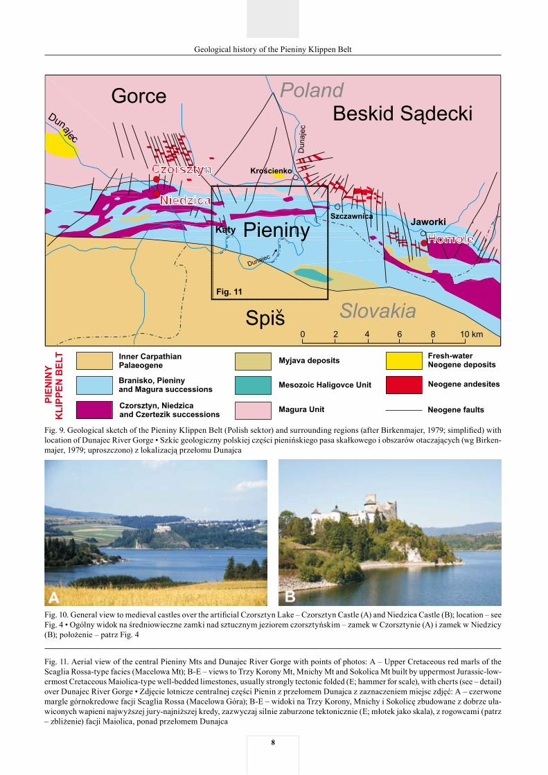
Fig. 9. Geological sketch of the Pieniny Klippen Belt (Polish sektor) and surrounding regions (after Birkenmajer, 1979; simplified) with location of Dunajec River Gorge • Szkic geologiczny polskiej części pienińskiego pasa skałkowego i obszarów otaczających (wg Birken-majer, 1979; uproszczono) z lokalizacją przełomu Dunajca
Fig. 10. General view to medieval castles over the artificial Czorsztyn Lake – Czorsztyn Castle (A) and Niedzica Castle (B); location – see Fig. 4 • Ogólny widok na średniowieczne zamki nad sztucznym jeziorem czorsztyńskim – zamek w Czorsztynie (A) i zamek w Niedzicy (B); położenie – patrz Fig. 4
Fig. 11. Aerial view of the central Pieniny Mts and Dunajec River Gorge with points of photos: A – Upper Cretaceous red marls of the Scaglia Rossa-type facies (Macelowa Mt); B-E – views to Trzy Korony Mt, Mnichy Mt and Sokolica Mt built by uppermost Jurassic-low-ermost Cretaceous Maiolica-type well-bedded limestones, usually strongly tectonic folded (E; hammer for scale), with cherts (see – detail) over Dunajec River Gorge • Zdjęcie lotnicze centralnej części Pienin z przełomem Dunajca z zaznaczeniem miejsc zdjęć: A – czerwone margle górnokredowe facji Scaglia Rossa (Macelowa Góra); B-E – widoki na Trzy Korony, Mnichy i Sokolicę zbudowane z dobrze uła-wiconych wapieni najwyższej jury-najniższej kredy, zazwyczaj silnie zaburzone tektonicznie (E; młotek jako skala), z rogowcami (patrz – zbliżenie) facji Maiolica, ponad przełomem Dunajca
�
Geological history of the Pieniny Klippen Belt
10
Geological history of the Pieniny Klippen Belt
11
Geological history of the Pieniny Klippen Belt
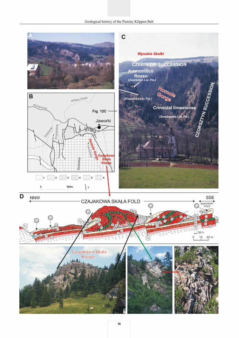
Fig. 12. General panoramic view (A) and geological sketch (B) of vicinity of Jaworki village with more detail view of entrance to Homole Gorge (C) and Czajakowa Skała Klippe and Bukowiny Fold (D) (geology after Birkenmajer, 1970; modified by Jurewicz, 1994). Expla-nations: B: tectonic sketch of the Homole block, northern part (after Birkenmajer, 1970, 1983); 1 – andesite intrusion (Middle Miocene: Sarmatian); 2 – autochthonous Magura-type Palaeogene; 3 – Grajcarek Unit (Magura Succession); 4 – Czorsztyn Unit (Czorsztyn Succes-sion); 5 – Skalski Stream depression (Niedzica Nappe – Niedzica Succession); 6 – Homole block (Czorsztyn Unit with overthrust Niedzica and Branisko nappes); 7 – strike-slip faults; D: Czorsztyn Succession: 1 – Smolegowa Limestone Fm. (white crinoidal limestones); 2 – Krupianka Limestone Fm. (red crinoidal limestones); 3 – Czorsztyn Limestone Fm. (red nodular Ammonitico Rosso-type limestones); 4 – Dursztyn Limestone Fm. (pink and white Callpionella limestones); 5 – Pomiedznik Formation (marly limestones); 6– Jaworki Formation (variegated marls); Niedzica Succession: 7 – Krempachy Marl and Skrzypny Shale formations (Fleckenmergel-type grey and black spotty marls/shales sometime with spherosiderite concretions – latter formation); 8 – Smolegowa Limestone Fm. (green-red crinoidal limestones); 9 – Niedzica Limestone Fm. (red nodular Ammonitico Rosso-type limestones); 10 – Czajakowa Radiolarite Fm. (red and green radiolarites); 11 – Czorsztyn Limestone Fm. (red nodular Ammonitico Rosso-type limestones); 12 – Dursztyn Limestone Formation (red and white Callpionella limestones); 13 – Pieniny Limestone Fm. (white and grey cherty Maiolica-type limestones); 14 – Kapuśnica Fm. (greenish spotty limestones). P – Location of phosphate deposits on the uppermost surface of the Sobótka Limestone Member of the Dursztyn Limestone Fm. (formal units after Birkenmajer, 1977) • Ogólna panorama (A) i szkic geologiczny (B) okolic wsi Jaworki z bardziej szczegółowym widokiem na wejście do wąwozu Homole (C) oraz na Czajakową Skałę i fałd z Bukowin (D) (geo-logia wg Birkenmajer, 1970; zmodyfikowane przez Jurewicz, 1994). Objaśnienia: B – szkic tektoniczny bloku Homoli, część północna (wg Birkenmajer, 1970, 1983); 1 – intruzje andezytowe (środkowy miocen: sarmat); 2 – paleogen autochtoniczny typu magurskiego; 3 – jednostka Grajcarka (sukcesja magurska); 4 – jednostka czorsztyńska (sukcesja czorsztyńska); 5 – depresja Skalskiego potoku (płasz-czowina niedzicka – sukcesja niedzicka); 6 – blok Homoli (jednostka czorsztyńska z nasunięciem płaszczowiny niedzickiej i braniskiej); 7 – uskoki przesuwcze; D – sukcesja czorsztyńska: 1 – formacja wapienia ze Smolegowej (białe wapienie krynoidowe); 2 – formacja wapienia z Krupniaki (czerwone wapienie krynoidowe); 3 – formacja wapienia czorsztyńskiego (czerwone wapienie bulaste typu Am-monitico Rosso); 4 – formacja wapieni dursztyńskich (różowe i białe wapienie kalpionellowe); 5 – formacja z Pomiedzkina (wapienie margliste); 6 – formacja z Jaworek (margle pstre); sukcesja niedzicka: 7 – formacje margli z Krempachów i łupków ze Skrzypnego (szare i czarne plamiste margle/łupki typu Fleckenmergel niekiedy z konkrecjami sferosyderytów – druga z formacji); 8 – formacja wapienia ze Smolegowej (zielono-czerwone wapienie krynoidowe); 9 – formacja wapienia niedzickiego (czerwone wapienie bulaste typu Ammonitico Rosso); 10 – formacja radiolarytów z Czajakowej (czerwone i zielone radiolaryty); 11 – formacja wapienia czorsztyńskiego (czerwone wapienie bulaste typu Ammonitico Rosso); 12 – formacja wapieni dursztyńskich (różowe i białe wapienie kalpionellowe); 13 – formacja wapienia pienińskiego (białe i szare wapienie rogowcowe typu Maiolica); 14 – formacja z Kapuśnicy (zielonkawe wapienie plamiste). P – lokalizacja utworów sfosfatyzowanych na powierzchni ogniwa wapieni z Sobótki formacji wapieni dursztyńskich (jednostki formalne wg Birkenmajer, 1977)
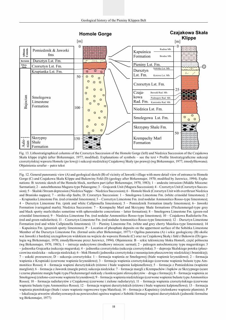
Fig. 13. Lithostratigraphical columns of the Czorsztyn Succession of the Homole Gorge (left) and Niedzica Succession of the Czajakowa Skała klippe (right) (after Birkenmajer, 1977; modified). Explanations of symbols – see the text • Profile litostratygraficzne sukcesji czorsztyńskiej wąwozu Homole (po lewej) i sukcesji niedzickiej Czajakowej Skały (po prawej) (wg Birkenmajer, 1977; zmodyfikowane). Objaśnienia szrafur – patrz tekst
12
Geological history of the Pieniny Klippen Belt
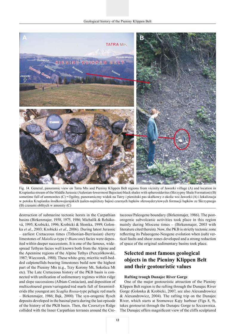
Fig. 14. General, panoramic view on Tatra Mts and Pieniny Klippen Belt regions from vicinity of Jaworki village (A) and location in Krupianka stream of the Middle Jurassic (Aalenian-lowermost Bajocian) black shales with spherosiderites (Skrzypny Shale Formation) (B) sometime full of ammonites (C) • Ogólny, panoramiczny widok na Tatry i pieniński pas skałkowy z okolic wsi Jaworki (A) i lokalizacja w potoku Krupianka środkowojurajskich (aalen-najniższy bajos) czarnych łupków sferosyderytowych formacji łupków ze Skrzypnego (B) czasami obfitych w amonity (C)
destruction of submarine tectonic horsts in the Carpathian basins (Birkenmajer, 1958, 1975, 1986; Michalík & Reháko-vá, 1995; Krobicki, 1996; Krobicki & Słomka, 1999; Golon-ka et al., 2003; Krobicki et al., 2006). During latest Jurassic – earliest Cretaceous times (Tithonian-Berriasian) cherty limestones of Maiolica-type (=Biancone) facies were depos-ited within deeper successions. It is one of the famous, wide-spread Tethyan facies well known both from the Alpine and the Apennine regions of the Alpine Tethys (Pszczółkowski, 1987; Wieczorek, 1988). These white-gray, micritic well-bed-ded calpionellids-bearing limestones build now the highest part of the Pieniny Mts (e.g., Trzy Korony Mt, Sokolica Mt etc). The Late Cretaceous history of the PKB basin is con-nected with unification of sedimentary regimes within ridge and slope successions (Albian-Coniacian), and deposition of multicoloured green/variegated/red marls full of foraminif-erids (the youngest are Scaglia Rossa-type pelagic red marls – Birkenmajer, 1986; Bąk, 2000). The syn-orogenic flysch deposits developed in the basinal parts during the last episode of the history of the PKB basin. Then, the Czorsztyn Ridge collided with the Inner Carpathian terranes around the Cre-
taceous/Paleogene boundary (Birkenmajer, 1986). The post-orogenic subvolcanic activities took place in this region mainly during Miocene times – (Birkenmajer, 2003 with literature cited therein). Now, the PKB is strictly tectonic zone reflecting its Palaeogene-Neogene evolution when (sub) ver-tical faults and shear zones developed and a strong reduction of space of the original sedimentary basins took place.
Selected most famous geological objects in the Pieniny Klippen Belt and their geotouristic values
Rafting trough Dunajec River GorgeOne of the major geotouristic attraction of the Pieniny
Klippen Belt region is the rafting through the Dunajec River Gorge (Golonka & Krobicki, 2007, see also Alexandrowicz & Alexandrowicz, 2004). The rafting trip on the Dunajec River, which starts at Sromowce Kąty harbour (Figs 8, 9), takes geotourist through the Dunajec Gorge to Szczawnica. The Dunajec offers magnificent view of the cliffs sculptured
1�
Geological history of the Pieniny Klippen Belt
in the Pieniny Mountains by the tectonic activity and river’s erosion. It offers also the close view of the outcrops of Jurassic and Cretaceous rocks of the Pieniny Succession and complex tectonics of the PKB.
The Kąty’s harbor has good connection with main touris-tic points in the Pieniny Mts and is easily accessible both from Zakopane (from south) and from Kraków (from north). Kąty are located very close to famous medieval castles (Czorsztyn Castle – Fig. 10A and Niedzica Castle – Fig. 10B), which oc-cupied good accessible and visible places just above artificial Czorsztyn Lake (Figs 8, 9).
The Macelowa Mt (Fig. 11) is the first viewpoint along our boat trip. The Oxfordian radiolarites and latest Jurassic-Early Cretaceous gray cherty limestones of the Maiolica facies (Pieniny Limestone Formation) of the Pieniny Succes-sion, occupy topmost and middle part of this mountain in completely overturned position. Therefore, the youngest part of this succession occurs in lowest (topographically) position and is represented by the Late Cretaceous Globotruncana-bearing marls of the Scaglia Rossa-type deposits (Fig. 11A) (Birkenmajer, 1979; Bąk, 2000). In close view we can see red marls and marly limestones with greyish intercalations of calcareous sandstones and siltstones of turbiditic origin con-nected with distal parts of submarine fans, typical flysch and flyschoidal sedimentation (comp. Mutti & Ricci Lucchi, 1975; Słomka, 1986; Stow, 1986; Mutti & Normark, 1987; Ghibau-do, 1992; Reading & Richards, 1994; Lowe, 1997; Shanmu-gam, 2000). The red Globotruncana marls of the Scaglia Rossa-type facies (in local nomenclature – Macelowa Marl Member of the Jaworki Formation; Birkenmajer, 1977), which we can see now, is the youngest part of this unit. The Jaworki Formation is composed (stratigraphically) by green-variegat-ed-red globotruncanid marls with perfect studied biostratig-raphy (Bąk, 2000). Such type of facies is wide known both from Alpine and Apennine geology. The primary seaways between several parts of the Tethyan Ocean, especially the above mentioned Alpine Tethys (Golonka, 2004), which ex-isted during the Late Cretaceous times are very well docu-mented by these facies occurrences. Later, Dunajec River crosses through several vertical strike-slip faults, which separate the Pieniny Klippen Belt from the Central Carpathi-ans Palaeogene Flysch region (precisely – Oligocene in age). At Sromowce Niżne village (Figs 8, 11) the Dunajec River enters again Pieniny Klippen Belt.
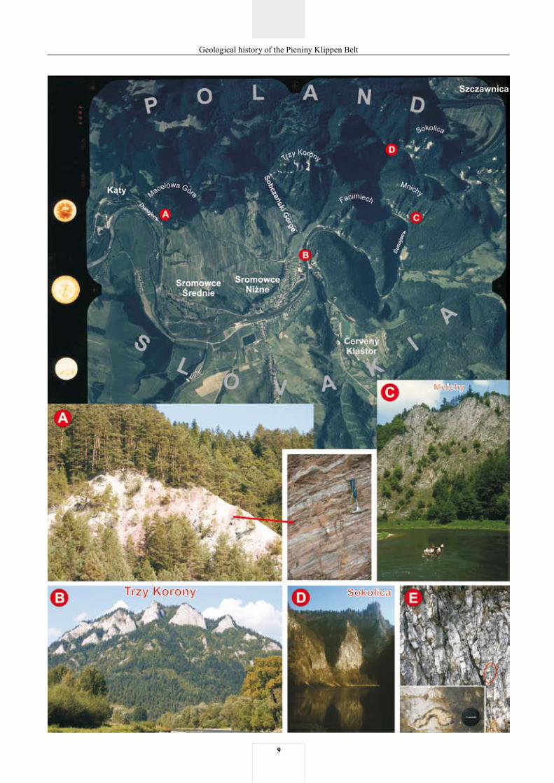
The most famous and beautiful peak of the Pieniny Mts – Trzy Korony Mt (Three Crowns) (982 m a.s.l.) (Fig. 11B) is good visible at the beginning of the Dunajec River Gorge (Birkenmajer et al., 2001). In local, folk nomenclature, the Trzy Korony peak is known as (from left to right): Kaśka (Kate), Zośka (Sophie) and Kudłata Maryśka (Hairy Mary). The very steep walls of this peak are formed by strongly folded thin-bedded, grey, cherty limestones of the Maiolica (=Biancone) facies of the Pieniny Limestone Formation (Kim-meridgian-Albian) of the Pieniny Succession.
The origin of the Dunajec River Gorge is connected with young, mainly Neogene history, related to the neotectonic movements. This river have had the mature stage in the latest Miocene–Pliocene time, and manifested by meandering shape. Then, during episode of the uplifting of the Pieniny Mts, such
shape of the river have been conserved, when more competent Late Cretaceous marls and marly limestones, softer than Jurassic/Early Cetaceous cherty limestones, which occurred between several tectonic slices, have been easily eroded by the Dunajec River water, during the fault-related uplift. Origin of strongly faulted, usually thin-bedded Maiolica-type cherty limestones is connected with this tectonic activity of Alpine orogeny (Fig. 11E). Some of the faults were still active during the Quaternary and were connected with rare earthquakes (Baumgart-Kotarba, 1996, 2001; Zuchiewicz et al., 2002 and references therein). Recently vertical movements reached up to + 0.5 mm per year, according to very detail geodetic meas-urements (Vanko, 1988; Vass, 1998). Detail description of origin and age of the Dunajec River Gorge, with the review of structural and geomorphological features of the Pieniny Mts and formation of magnificent cliffs of the Gorge, was published by Birkenmajer (2006) (see also – Zuchiewicz, 1982).
The next interesting point on the right bank of the Dunajec River is the medieval Czerwony Klasztor (Red Monastery) constructed in 1330, where one of the Camelot’s pharmacist (Brother Cyprian – Franciszek Ignacy Jeszke) collected a huge quantity of plants (282 species), both from the Pieniny and Tatra mountains.
The Pieniny Limestone Formation builds steep cliffs along the Dunajec River Gorge, described in more detail by Golon-ka & Krobicki (2007). One of the most spectacular views along rafting trip is Mnichy (Seven Monks) (Fig. 11C) and Sokol-ica Mt (Falcon’s Mt) (Fig. 11D). The name of this mountain is derived from numerous falcons, which used to nest here.
The Sokolica is frequently visited by hikers because of magnificent view of the Tatra Mts and the ancient, 500 years-old pine forest (Tłuczek, 2004). Close to the Szczawnica town, the Dunajec River Gorge ended, just after the last cliff built by thin-bedded cherty limestones. This town is popular spa, famous for its mineral springs, which have been known since the medieval time, but first written remarks came from XVI century.
After rafting on Dunajec River we will go eastward to Jaworki village. The Grajcarek stream valley runs parallel with the Pieniny Klippen Belt, where Jurassic and Lower Cretaceous rocks of the so-called tectonic Grajcarek Unit are exposed (with full development of the Magura (Hulina) Suc-cession. This succession was deposited within the northwest-ern part of the Carpathian Tethys, separated palaeogeo-graphically by the Czorsztyn Ridge from the other basinal succession (Birkenmajer, 1986; Golonka, 2004; Golonka & Krobicki, 2004). On the northern side this unit is in tectonic contact with the flysch rocks of the Krynica Unit of the Magura Nappe. Several Miocene andesite intrusions cut both tectonic units (Malinów abandoned quarry, Jarmuta and Krupianka hills).
Homole Gorge near Jaworki villageThe famous deep Homole Gorge is cutting through the
rocks of the so-called Homole tectonic block south of the Jaworki village (Figs 8, 9, 12-14). The origin this block is speculative and a subject of scientific debate. There is a va-riety of opinions, from the autochthonous position within the Czorsztyn ridge (e.g. Birkenmajer, 1986) through the nappe
1�
Geological history of the Pieniny Klippen Belt
thrust over the other tectonic units (e.g. Książkiewicz, 1977; Golonka & Rączkowski, 1984; Jurewicz, 1997, 2005) to the olistoliths (Cieszkowski & Golonka, 2005, 2006; Cieszkowski et al., 2008). In the Homole Gorge up to near 100 m thick section of white crinoidal limestones of the Smolegowa Lime-stone Formation of the Czorsztyn Succession is exposed (Birkenmajer, 1963, 1977). These limestones are overlain by red crinoidal limestones (of the Krupianka Limestone Forma-tion) and Ammonitico Rosso-type nodular limestones of the Czorsztyn Limestone Formation, which reach maximum 20 m in thickness. Both Smolegowa and Krupianka formations are Bajocian (Middle Jurassic) in age whereas condensed nodular limestones of the Ammonitico Rosso facies (Czorsz-tyn Limestone Formation) represent Middle Jurassic to Early Cretaceous. The decrease of sedimentation rate in pelagic sedimentation regime happened during late Middle-Late Jurassic times. This phenomenon is recorded by the deepen-ing-upward sequence of deposits. The famous Pieniny Klip-pen Belt tectonic fold and thrust structures can be observed in the Czajakowa Skała Klippe in the upper part of the Homole Gorge (Birkenmajer, 1970, 1979) (Fig. 12D). The Niedzica Nappe is there thrust here over the thick Czorsztyn Unit. Several beds representing the red nodular limestones of the Ammonitico Rosso-type of the Niedzica Limestone Formation and Czorsztyn Limestone Formation as well as intercalated radiolarites of the Czajakowa Radiolarite Formation are strongly tectonically disturbed, forming the overturned fold (Birkenmajer, 1970; Jurewicz, 1994) (Fig. 12D). The type
locality of the Czajakowa Radiolarite Formation occurs within this klippe (Fig. 13). The Czajakowa Skała Klippe also shows a complete sequence of the Jurassic deposits of the Niedzica Succession (Birkenmajer, 1977; Wierzbowski et al., 1999). The oldest black and grey marly shales with spherosi-derite concretions of the Skrzypny Shale Formation (Birken-majer, 1977; Tyszka, 1994) are exposed here. These deposits are overlain by yellowish-greyish-red and dark cherry-green-ish crinoidal limestones. The contact between black shales and crinoidal limestones is sharp and irregular. The ammonite fauna was found in the lowermost part of the crinoidal lime-stones of the Smolegowa Limestone Formation. These very precise biostratigraphical data suggest a hiatus between black shales and crinoidal limestones, spanning the Laeviuscula and a part of Propinquans ammonite zones of the Lower Bajocian (Middle Jurassic) (Krobicki & Wierzbowski, 2004; Krobicki, 2006). The small outcrops of these black shales occur below Czajakowa Skała Klippe within local landslide. The best outcrops of these rocks within the Pieniny Klippen Belt in Poland occur in the Krupianka stream, which run the Homole Gorge, westward. Their thickness reach 4-5 metres. The shales contain a lot of spherosiderites and sometimes perfectly preserved ammonites (Fig. 14). The ammonite fauna indicates latest of Aalenian and/or earliest of Bajocian (Middle Jurassic) age of black shales, representing oxygen-depleted facies of the Fleckenmergel-type.
This research have been financially supported by AGH grant (11.11.140.447)
Streszczenie
Geologiczna historia pienińskiego pasa skałkowego a środkowojurajskie czarne łupki jako jedne z najstarszych utworów
regionu – stratygraficzna pozycja i paleośrodowiskowe znaczenie
Michał Krobicki & Jan Golonka
Karpaty Zewnętrzne (fliszowe) i pieniński pas skałkowy tworzą najbardziej północną część polskich Karpat. Te pierw-sze są zbudowane przez fliszowe utwory jurajsko-wczesno-mioceńskie (Ślączka, 1996; Oszczypko, 2004, 2006a, b; Oszczypko et al., 2005, 2006). Utwory te były oderwane od swojego podłoża i fałdowane oraz nasuwane od południa w miocenie (orogeneza alpejska) formując płaszczowiny (Ślączka, 1996). Wszystkie płaszczowiny Karpat Zewnętrz-nych są nasunięte na platformę wschodnioeuropejską przy-krytą utworami miocenu zapadliska przedkarpackiego (Fig. 1, 2). Płaszczowiny są elementem allochtonicznym, a utwory je budujące powstawały w karpackich basenach sedymenta-cyjnych, daleko na południe od ich dzisiejszego miejsca wy-stępowania. Pieniński pas skałkowy (pps) natomiast, znajdu-je się na granicy Zewnętrznych Karpat Fliszowych i Karpat Wewnętrznych, stanowiąc bardzo silnie stektonizowaną stre-fę, która dzisiaj ma około 600 km długości i 1-20 km szero-kości, biegnąc od okolic Wiednia na zachodzie aż do Rumunii
na wschodzie. (Fig. 1). Zarówno północna jak i południowa granica pps są dzisiaj granicami tektonicznymi, mając prawie pionowy przebieg (Fig. 3), wzdłuż których następowało tek-toniczne skracanie oryginalnego basenu sedymentacyjnego (Birkenmajer, 1986; Golonka & Krobicki, 2006; Krobicki & Golonka, 2006). W swoim regionalnym charakterze pps jest generalnie strefą melanżu tektonicznego, gdzie poszczególne jednostki tektoniczne są trudne do rozróżnienia.
Palinspastyczna rekonstrukcja basenu pps wskazuje na występowanie podmorskiego grzbietu podczas jego jurajsko-kredowej historii. Jest to tzw. grzbiet czorsztyński, który stanowił wydłużoną strefę, rozdzielającą pierwotnie basen magurski (Karpat Zewnętrznych) od basenu pienińskiego w obrębie najbardziej północnej części oceanu Tetydy (Fig. 4-6) (por. Golonka, 2007a, b z literaturą tam cytowaną). Geograficzna orientacja tego grzbietu, z SW na NE, jest in-terpretowana na podstawie badań paleomagnetycznych, analizy facjalnej osadów mezozoicznych jak i warunków paleoklimatycznych (patrz dyskusja – Golonka & Krobicki, 2001; oraz Aubrecht & Túnyi, 2001; Lewandowski et al., 2005; Grabowski et al., 2008). Baseny sedymentacyjne rozdzielone przez grzbiet czorsztyński były zdominowane przez pelagicz-ny typ sedymentacji. Najgłębsze części basenu pps są dobrze udokumentowane przez jurajsko-wczesnokredowe utwory głębokowodne (radiolaryty i wapienie rogowcowe typu Ma-iolica) (Birkenmajer, 1979, 1986; Golonka & Sikora, 1981; Golonka & Krobicki, 2004; Krobicki et a., 2006) tzw. sukce-sji braniskiej i pienińskiej. Nieco płytsze, przejściowe
1�
Geological history of the Pieniny Klippen Belt
sukcesje (czertezicka i niedzicka) okupowały miejsce od-powiadające skłonowi kontynentalnemu pomiędzy głębszy-mi partiami basenu a częścią najpłytszą, reprezentowaną przez sukcesję czorsztyńską, która zajmowała pierwotnie SE skłon grzbietu czorsztyńskiego (Birkenmajer, 1986; Kro-bicki & Golonka, 2006).
Najwcześniejsze stadium historii basenu pienińskiego jest enigmatyczne i udokumentowane jedynie egzotykami z fli-szowych utworów kredy i paleogenu. Egzotyki te sugerują istnienie hipotetycznej „zatoki” oceanu Vardar-Transylwania, który oddzielał blok Cisy (rejon Bihor-Apuseni) od platform mezyjskiej i wschodnioeuropejskiej (Săndulescu, 1988; Go-lonka & Krobicki, 2004). Najstarsze utwory jury pps (hetang-synemur) znane są tylko na Słowacji i Ukrainie i reprezento-wane są przez zróżnicowane, szaro-czarne utwory klastycz-ne facji gresteńskiej z nielicznymi wkładkami czarnych wapieni (Schlögl et al., 2004 z literaturą). Natomiast młodsze (toark-dolny bajos) są wapienie i margle plamiste facji Fle-ckenkalk/Fleckenmergel i czarne łupki sferosyderytowe z małżami Bositra („Posidonia”) (w lokalnej terminologii – formacja łupków ze Skrzypnego; Birkenmajer, 1977), powsta-łe w okresowo niedotlenionych środowiskach sedymentacji oceanu Tetydy (Birkenmajer, 1986; Tyszka, 1994. 2001). We wczesnym bajosie (jura środkowa) grzbiet czorsztyński ukształtował się jako wyraźny grzbiet śródoceaniczny, z czym związana była równocześnie bardzo gwałtowna zmiana se-dymentacji/paleośrodowiska, kiedy dobrze dotlenione, róż-nokolorowe (białe, żółtawe, różowe, szare, czerwone) wapie-nie krynoidowe zastąpiły szare i czarne niedotlenione utwory wczesnej jury i początków jury środkowej (Krobicki & Wierzbowski, 2004). Te wapienie krynoidowe osadzały się w najpłytszych i przejściowych sukcesjach osadowych (czor-sztyńska, niedzicka i czertezicka). Bajoskie wynurzenie grzbietu czorsztyńskiego pomiędzy basenem pienińskim a magurskim było związane z postryftową fazą ewolucji basenu pienińskiego i najprawdopodobniej odpowiada pierw-szym epizodom ruchów fazy mezokimeryjskiej orogenezy alpejskiej (Golonka et al., 2003; Krobicki, 2006). Nieco póź-niej (od najpóźniejszego bajosu) osadziły się czerwone, pe-lagiczne wapienie bulaste facji Ammonitico Rosso. W tym samym czasie w najgłębszych partiach basenu pps tworzyły się po raz pierwszy radiolaryty (Birkenmajer, 1986; Mišík, 1999). Późnojurajska (oksford-kimeryd) historia basenu pie-nińskiego ukazuje jego najsilniejsze zróżnicowanie facjalne z sedymentacją mieszanych utworów krzemionkowo-wapien-nych. Te pierwsze osadzały się w relatywnie płytszych śro-dowiskach sedymentacji (np. sukcesja czorsztyńska), a radio-laryty powstawały w sukcesjach przejściowych i basenowych (Birkenmajer, 1977, 1986; Mišík, 1999). Na przełomie jury i kredy efekt działania neokimeryjskich ruchów tektonicz-nych, doprowadził do silnego zróżnicowania facjalnego. Formowaniem się i destrukcja podmorskich zrębów tekto-nicznych jest utożsamiana z dużą aktywnością tektoniczną w basenach karpackich w tym czasie (Birkenmajer, 1958, 1975, 1986; Michalík & Reháková, 1995; Krobicki, 1996; Aubrecht et al., 1997; Krobicki & Słomka, 1999; Plašienka, 2002; Golonka et al., 2003; Krobicki et al., 2006). Równocześ-nie w głębszych partiach basenu pienińskiego (głównie suk-cesja braniska i pienińska) trwała sedymentacja mikrytowych
wapieni rogowcowych facji Maiolica (=Biancone). Jest to jedna z najszerzej rozprzestrzenionych litofacji w całej Tety-dzie (Pszczółkowski, 1987; Wieczorek, 1988). W polskiej części Pienin te białe, cienkouławicone wapienie budują najwyższe szczyty tych gór (np. Trzy Korony, Sokolica etc.). Pelagiczne margle otwornicowe, początkowo zdominowane przez hedbergelle, dokumentują z kolei albski (najmłodsze piętro wczesnej kredy) etap sedymentacji w basenie (Birken-majer, 1986). Natomiast późnokredowe utwory pelagiczne, zdominowane są przez czerwone margle globotrunkanowe (najpopularniejszy rodzaj otwornic w tym czasie) facji Scaglia Rossa (Birkenmajer, 1986; Bąk, 2000).
Jedną z największych atrakcji geoturystycznych pieniń-skiego pasa skałkowego jest spływ Dunajcem, opisana ostatnio szczegółowo przez Golonkę & Krobickiego (2007) (patrz również Alexandrowicz & Alexandrowicz, 2004) i z tego powodu tutaj tylko lakonicznie wzmiankowana. Początek spływu ma miejsce na przystani Kąty (Fig. 8, 9) we wsi Sromowce i kończy się w Szczawnicy (ok. 2-2.5 godziny). Dogodne połączenia komunikacyjne tego miejsca umożli-wiają łatwe dotarcie tutaj zarówno od północy (Kraków) jak i od południa (Zakopane). Wycieczka ta oferuje nadzwyczaj-ne widoki stromych ścian centralnych Pienin, uformowanych tak zarówno dzięki procesom tektonicznym jak i erozji rzecz-nej. Przy okazji można odwiedzić niedalekie, średniowiecz-ne zamki w Czorsztynie (Fig. 10A) bądź w Niedzicy (Fig. 10B). Na trasie spływu pierwszym interesującym obiektem geologicznym (geoturystycznym) jest Macelowa Góra (Fig. 11), która w odwróconej pozycji tektonicznej ukazuje ciągły profil utworów najwyższej jury-dolnej kredy sukcesji pieniń-skiej (od górnojurajsko-dolnokredowych wapieni rogowco-wych facji Maiolica na górze aż po górnokredowe margle globotrunkanowe facji Scaglia Rossa na dole). W obrębie tych margli można zaobserwować cienkie (kilka cm) wkładki turbidytowych piaskowców i mułowców, których geneza ściśle nawiązuje do głębokomorskiej sedymentacji typu fli-szowego (por. Mutti & Ricci Lucchi, 1975; Słomka, 1986; Stow, 1986; Mutti & Normark, 1987; Ghibaudo, 1992; Reading & Richards, 1994; Lowe, 1997; Shanmugam, 2000). Kolej-nymi spektakularnym obiektami na trasie spływu są Trzy Korony (982 m n.p.m.) (Fig. 11B) i Sokolica (Fig. 11D), naj-wyższe szczyty centralnych Pienin, prawie w całości zbudo-wane z cienkoławicowych, silnie tektonicznie zdeformowa-nych wapieni rogowcowych facji Maiolica, również należą-cych do sukcesji pienińskiej. Natomiast, tektoniczno-erozyj-na historia Przełomu Dunajca była obiektem zainteresowania już XIX-to wiecznych geologów, lecz nie do końca w szcze-gółach rozpoznany jest fenomen jego powstania mimo upły-wu tylu lat od tamtych czasów (zob. Zuchiewicz, 1982; Bir-kenmajer, 2006). Przełom ten tworzy wiele łusek tektonicz-nych ponasuwanych na siebie a zbudowanych głównie z twardych, odpornych na erozję wapieni rogowcowych, a przekładających się wielokrotnie (łuski tektoniczne) z mniej odpornymi na wietrzenie i erozję marglami i łupkami, głów-nie górnej kredy. Bezsprzeczny jest związek budowy geolo-gicznej tego obszaru, a zwłaszcza jego plan strukturalno-tek-toniczny, z genezą Przełomu Dunajca, co w świetle najnow-szych danych neotektonicznych zyskuje nowe argumenty (Zuchiewicz et al., 2002). W historii badań tego frapującego
1�
Geological history of the Pieniny Klippen Belt
zagadnienia proponowano co najmniej cztery rozwiązania. Najstarszy z nich preferował genezę epigenetyczną, uznając, że Dunajec wcinał się w miękkie utwory przykrywające zwartą pokrywą wapienne skałki podłoża. Drugi pogląd skupiał się na antecedentnej genezie Przełomu Dunajca, sugerując powolne podnoszenie się górotworu pienińskiego i stopniowe wcinanie się meandrującego pierwotnie pra-Du-najca w podłoże. Pomysł trzeci wskazuje na tektoniczne uwarunkowania powstania przełomu (płynie on obecnie po utworach budujących maksymalną depresję strukturalną) i dlatego został nazwany przełomem strukturalnym. Ostat-nia z propozycji rozważa możliwość kaptażu systemu rzecz-nego Białki-Białego Dunajca przez tzw. „Dunajec sądecki”, co miało wywołać efekt erozji wstecznej, a przez to Przełom Pieniński można by uznać za przełom regresyjny. Bez wzglę-du na to, która z propozycji jest prawdziwa, przebieg procesu formowania się przełomu miał miejsce pomiędzy późnym miocenem a plejstocenem jak ostatnio to zreasumował Bir-kenmajer (2006) w nawiązaniu do najnowszych obserwacji tego fenomenu.
Po spływie Dunajcem udajemy się w kierunku wsi Jawor-ki, na wschód za Szczawnicę, aby zwiedzić słynny Wąwóz Homole (Fig. 8, 9, 12-14). Jest to praktycznie jedyne miejsce w pienińskim pasie skałkowym Polski gdzie wapienna płyta, pochylona nieznacznie pod stosunkowo niewielkim kątem ku północy, jest relatywnie słabo zaburzona tektonicznie. Dlatego w terminologii geologicznej tego obszaru zwykło się używać określenia „tektoniczny blok (płyta) Homoli” (Bir-kenmajer, 1970, 1979), dla skrótowego zobrazowania jego charakteru strukturalnego. Prawie ze wszystkich stron jest on obcięty licznymi uskokami tektonicznymi, a i w swojej wewnętrznej budowie charakteryzuje się przebiegiem licz-nych dyslokacji tektonicznych. Są one głównie efektem działania odprężających sił w obrębie tej płyty, która z jednej strony jest erozyjnie podcinana przez okoliczne potoki, a z drugiej strony izolowane w ten sposób bloki wapieni ulegają grawitacyjnemu zapadaniu się w plastyczne podłoże zbudowane z miękkich łupków środkowojurajskich. Główna część wąwozu zbudowana jest ze środkowojurajskich (bajos) białych wapieni krynoidowych tzw. formacji wapienia ze Smolegowej, których miąższość dochodzi tutaj do 100 metrów (Fig. 13). Wapienie te są przykryte niewielkiej miąższości czerwonymi wapieniami krynoidowymi (formacja wapienia z Krupianki) oraz czerwonymi wapieniami bulastymi facji Ammonitico Rosso (formacja wapienia czorsztyńskiego). Wszystkie wymienione utwory należą do sukcesji czorsztyń-skiej (Birkenmajer, 1970, 1977). Na nie nasunięte są, w po-staci spektakularnego fałdu Czajakowej Skały obalonego ku północy, utwory sukcesji niedzickiej, które w postaci lokalnej płaszczowiny leżą na poziomej płycie wapiennej bloku Ho-moli. Sekwencja utworów płaszczowiny niedzickiej jest zbliżona do profilu sukcesji czorsztyńskiej (Fig. 13) z wyjąt-kiem środkowej jej części z jednej strony [gdzie występują
górnojurajskie (oksford) utwory krzemionkowe – radiolaryty, nieobecne w profilu sukcesji czorsztyńskiej] a z drugiej stro-ny wyraźną dysproporcją w miąższości środkowojurajskich wapieni krynoidowych. Profil tej sukcesji rozpoczynają ciemne utwory jury środkowej, występując w grupie Czaja-kowej Skały, gdzie tworzą spąg nasunięcia płaszczowiny niedzickiej na jednostkę czorsztyńską. Zwłaszcza czarne łupki sferosyderytowe były podatne na takie tektoniczne przemieszczenia, a dzisiaj powodują tworzenie się osuwisk strukturalnych, czego najlepszym przykładem jest polana pod Czajakową Skałą, gdzie łupki te znajdują się w najniższej części jednego z najlepiej widocznych osuwisk. W sukcesji tej wapienie krynoidowe są niewielkiej miąższości a przy-kryte czerwonymi wapieniami bulastymi. Te drugie dostar-czyły bogatej fauny amonitów, na podstawie których precy-zyjnie ustalono ich wiek na bajos-oksford (jura środkowa-jura górna). Wapienie te najlepiej odsłaniają się w głównej skałce Czajakowej Skały (Birkenmajer, 1970, 1979; Wierzbowski et al., 1999). Radiolaryty stanowią najbardziej charakterystycz-ny wyróżnik litologiczny dla sukcesji niedzickiej, świetnie widoczny w samym jądrze obalonego fałdu (Birkenmajer, 1970, 1979; Jurewicz, 1994; Golonka & Krobicki, 2001). Formacja ta składa się z trzech ogniw (Birkenmajer, 1977) (w następstwie stratygraficznym): czerwone radiolaryty, zielone radiolaryty i ponownie czerwone radiolaryty forma-cji radiolarytów z Czajakowej, które tutaj mają swój stratotyp (Fig. 12, 13). Są to cienkouławicone (od kilku do 20 cm miąż-szości – por. Fig. 12D) utwory rogowców i wapieni krzemion-kowych przeławicanych cienkimi łupkami o grubościach nieprzekraczających 2 cm. Leżące ponad radiolarytami czer-wone wapienie bulaste i cienkouławicone mikrytowe wapie-nie kalpionellowe są wieku górnojurajsko-dolnokredowego, a ponad nimi niewielkiej miąższości jasnopopielate wapienie mikrytowe z rogowcami, które wieńczą profil utworów dolnej kredy. Wiekowo wapienie te odpowiadają wapieniom rogow-cowym formacji wapienia pienińskiego znanym z centralnej części Pienin (patrz wyżej – spektakularne strome szczyty Trzech Koron, Sokolicy, Mnichów) (Fig. 11).
Natomiast najstarsze utwory sukcesji czorsztyńskiej od-słaniające się w południowej części bloku Homoli jak i w korycie sąsiadującego od zachodu potoku Krupianka (Fig. 14), reprezentowane są przez szare lub szarobrunatne margle i wapienie margliste plamiste oraz czarne łupki ze sferosy-derytami (odpowiednio formacja margli z Krempachów i formacja łupków ze Skrzypnego) (aalen-najniższy bajos) (ekwiwalenty facjalne czarnych łupków obserwowanych w osuwisku pod Czajakową Skałą). W odniesieniu do geolo-gii alpejskiej można zaklasyfikować te utwory do szeroko rozprzestrzenionej w całym łańcuchu alpejskim facji Fle-ckenkalk/Fleckenmergel (= plamiste wapienie/margle). Pa-leośrodowiskowo utwory te reprezentują niedotlenione (re-dukcyjne) warunki środowiska sedymentacji we wczesnym etapie rozwoju basenu pienińskiego.
Literatura (References)Alexandrowicz, Z. & Alexandrowicz, S.W., 2004. Geoparks – the most
valuable landscape parks in southern Poland. Polish Geological Insti-tute, Special Paper, 13: 49-56.
Aubrecht, R. & Túnyi, I., 2001. Original orientation of neptunian dykes in the Pieniny Klippen Belt (Western Carpathians): the first results. Con-tributions to Geophysics and Geodesy, 31: 557-578.
1�
Geological history of the Pieniny Klippen Belt
Baumgart-Kotarba, M., 1996. On origin and age of the Orava Basin, West Carpathians. Studia Geomorphologica Carpatho-Balcanica, 30: 101-116.
Baumgart-Kotarba, M., 2001. Continuous tectonic evolution of the Orava basin from Late Badenian to the present-day. Geologica Carpathica, 52: 103-110.
Bąk, K., 2000. Biostratigraphy of deep-water agglutinated Foraminifera in Scaglia Rossa-type deposits of the Pieniny Klippen Belt, Carpathians, Poland. In: Hart, M.B., Kaminski, M.A. & Smart, C.W. (Eds.): Pro-ceedings of the Fifth International Workshop on Agglutinated Forami-nifera. Grzybowski Foundation Special Publication, 7: 15-41, Kraków.
Birkenmajer, K., 1958. Submarine erosional breaks and Late Jurassic sy-norogenic movements in the Pieniny Klippen Belt geosyncline. Bulletin de Academie Polonaise de Science, Sér., sci. chim., géol. & géogr., 8: 551-558.
Birkenmajer, K., 1963. Stratigraphy and paleogeography of the Czorsztyn Series (Pieniny Klippen Belt, Carpathians) in Poland. Studia Geologica Polonica, 45: 7–158. Studia Geologica Polonica, 45: 7-158. (In Polish, English summary)
Birkenmajer, K., 1970. Pre-Eocene fold structures in the Pieniny Klippen Belt (Carpathians) of Poland. Studia Geologica Polonica, 31: 1-77. (In Polish, English summary)
Birkenmajer, K., 1975. Tectonic control of sedimentation at the Jurassica-Cretaceous boundary in the Pieniny Klippen Belt, Carpathians. Collo-que sur la limite Jurass.-Crét., Lyon-Neuchâtel (1973). Mémoire BRGM: 294-299.
Birkenmajer, K., 1977. Jurassic and Cretaceous lithostratigraphic units of the Pieniny Klippen Belt, Carpathians, Poland. Studia Geologica Polo-nica, 45: 1-158.
Birkenmajer, K., 1979. Przewodnik geologiczny po pienińskim pasie skał-kowym. Wydawnictwa Geologiczne, 1-237, Warszawa. (In Polish only)
Birkenmajer K., 1983. Strike-slip faults in the northern boundary zone of the Pieniny Klippen Belt, Carpathians. Studia Geologica Polonica, ��: 89-112. (In Polish, English summary)
Birkenmajer, K., 1986. Stages of structural evolution of the Pieniny Klippen Belt, Carpathians. Studia Geologica Polonica, 88: 7-32.
Birkenmajer, 2003. Post-collisional Late Middle Miocene (Sarmatian) Pieniny Volcanic Arc, Western Carpathians. Bulletin of the Polish Academy of Sciences, Earth Sciences, 51, 1: 79-89.
Birkenmajer, K., 2006. Dunajec River Gorge, Pieniny Mts, West Carpat-hians. Pieniny – przyroda i człowiek, 9: 9-22. (In Polish, English sum-mary)
Birkenmajer, K., Bąk, M. & Bąk, K., 2001. Stop C5.3 – Sromowce Niżne – Trzy Korony Mt. In: Birkenmajer, K. & Krobicki, M. (Eds.); 12th meeting of the Association of European Geological Societies; 10-15 September 2001, Kraków: Carpathian palaeogeography and geodyna-mics: a ultidisciplinary approach; field trip guide. Polish Geological Institute, Kraków: 146-150.
Cieszkowski, M. & Golonka, J., 2005. Olistolites and olistostromes as geotouristic objects – examples from Northern Carpathians, Poland. In: Doktor, M. & Waśkowska-Oliwa, A. (Eds.) Geotourism – new dimen-sions in XXI century tourism and chances for future development. 2nd International Conference Geotour 2005, 22-24 September, Kraków: 21-23.
Cieszkowski, M. & Golonka, J., 2006. Olistostrom as indicators of the geodynamic process (Northern Carpathians). Geolines, 20: 27-28.
Cieszkowski, M., Golonka, J., Krobicki, M., Ślączka A., Oszczypko, N. & Waśkowska-Oliwa, A., 2008. The Northern Carpathians plate tectonic evolutionary stages and origin of olistolites. In: Németh, Z. & Plašien-ka, D. (eds.) SlovTec 08, 6th Meeting of the Central European Tectonic Studies Group (CETeG) & 13th Meeting of the Czech Tectonic Studies Group (ČTS), 23-26 April 2008, Upohlav, Pieniny Klippen Belt, Slova-kia. Proceedings and Excursion Guide: 21-22
Ghibaudo, G., 1992. Subaqueous sediment gravity flow deposits: practical criteria for their field description and classification. Sedimentology, 39: 423-454.
Golonka, J., 2000. Cambrian-Neogene Plate Tectonic Maps. Wydawnictwa Uniwersytetu Jagiellońskiego, Kraków, 125 pp.
Golonka, J., 2004. Plate tectonic evolution of the southern margin of Eura-sia in the Mesozoic and Cenozoic. Tectonophysics, 381: 235-273.
Golonka, J., 2005. Mesozoic plate tectonics of the Inner Carpathians – ro-tational approach. Geolines, 19: 42-43.
Golonka, J., 2007a. Late Triassic and Early Jurassic palaeogeography of the world. Palaeogeography, Palaeoclimatology, Palaeoecology, 244, 1-4: 297-307.
Golonka, J., 2007b. Phanerozoic paleoenvironment and paleolithofacies maps. Mesozoic. Kwartalnik AGH, Geologia, 33, 2: 211-264.
Golonka, J. & Krobicki, M., 2001. Upwelling regime in the Carpathian Tethys: a Jurassic-Cretaceous palaeogeographic and palaeoclimatic perspective. Geological Quarterly, 45: 15-32.
Golonka, J. & Krobicki, M., 2004. Jurassic paleogeography of the Pieniny and Outer Carpathian basins. Rivista Italiana di Paleontologica Strati-grafica, 110: 5-14.
Golonka, J. & Krobicki, M., 2006. Field trip A – From Tethyan to Platform Facies. Outer Carpathians. In: Wierzbowski, A., Aubrecht., R., Golon-ka, J., Gutowski, J., Krobicki, M., Matyja, B.A, Pieńkowski, G. & Uchman, A. (eds.). Jurassic of Poland and adjacent Slovakian Carpat-hians. Field trip guidebook. 7th International Congress on the Jurassic System, 6-18 September 2006, Kraków, Poland. pp. 11-15.
Golonka, J. & Krobicki, M., 2007. Dunajec River rafting as one of the most important geotouristic object of the future trans-bordering PIENINY Geopark. Geoturystyka, 3 (10): 29-44.
Golonka, J. & Rączkowski, W., 1984. Arkusz Piwniczna; Detailed Geolo-gical Map of Poland; Geological Institute – Publishing House Wydaw-nictwa Geologiczne. 85 p. Warszawa.
Golonka, J. & Sikora, W., 1981. Microfacies of the Jurassic and Lower Cretaceous sedimentarily thinned deposits of the Pieniny Klippen Belt in Poland. Biuletyn Instytutu Geologicznego, 31: 7-37. (In Polish, English summary)
Golonka, J., Krobicki, M., Oszczypko, N., Ślączka, A. & Słomka, T., 2003. Geodynamic evolution and paleogeography of the Polish Carpathians and adjacent areas during Neo-Cimmerian and preceding events (latest Triassic-earliest Cretaceous). In: McCann, T. & Saintot, A. (Eds) Tracing Tectonic Deformation Using the Sedimentary Record. Geological So-ciety, Special Publication, London, 208: 138-158.
Golonka, J., Gahagan, L., Krobicki, M., Marko, F., Oszczypko, N. & Ślącz-ka, A., 2006. Plate-tectonic evolution and paleogeography of the Circum-Carpathian region. In: Golonka, J. & Picha, F.J. (eds), The Carpathians and their foreland: Geology and hydrocarbon resources. American As-sociation of Petroleum Geologists, Memoire, 84: 11-46.
Grabowski, J., Krobicki, M. & Sobień, K., 2008. New palaeomagnetic results from the Polish part of the Pieniny Klippen Belt, Carpathians – eviden-ce for the palaeogeographic position of the Czorsztyn Ridge in the Mesozoic. Geological Quarterly, 52 (1): 31-44.
Jurewicz, E., 1994. Structural analysis of the Pieniny Klippen Belt at Ja-worki, Carpathians, Poland. Studia Geologica Polonica, 7-87. (In Polish, English summary)
Jurewicz, E., 1997. The contact between the Pieniny Klippen Belt and Magura Unit (the Małe Pieniny Mts.). Geological Quarterly, 41, 3: 315-326.
Jurewicz, E., 2005. Geodynamic evolution of the Tatra Mts. and the Pieni-ny Klippen Belt (Western Carpathians): problems and comments. Acta Geologica Polonica, 3: 295-338.
Kováč, M., Nagymarosy, A., Oszczypko, N., Ślączka, A., Csontos, L., Marunteanu, M., Matenco, L. & Márton. M., 1998. Palinspastic recon-struction of the Carpathian-Pannonian region during the Miocene, In: Rakús, M. (Ed.), Geodynamic development of the Western Carpathians. Geological Survey of Slovac Republic, Bratislava: 189–217.
Krobicki, M., 1996. Neo-Cimmerian uplift of intraoceanic Czorsztyn pe-lagic swell (Pieniny Klippen Belt, Polish Carpathians) indicated by the change of brachiopod assemblages. In: Riccardi A.C. (Ed.): Advances in Jurassic Research. GeoResearch Forum, 1-2: 255-264, Zurich.
Krobicki, M., 2006. Field trip A – From Tethyan to Platform Facies. Outer Carpathians. Stop A5 – Falsztyn – Czorsztyn Succession (Aalenian-Bajocian). In: Wierzbowski, A., Aubrecht., R., Golonka, J., Gutowski, J., Krobicki, M., Matyja, B.A, Pieńkowski, G. & Uchman, A. (eds.). Jurassic of Poland and adjacent Slovakian Carpathians. Field trip guidebook. 7th International Congress on the Jurassic System, 6-18 September 2006, Kraków, Poland. pp. 39-41.
Krobicki, M. & Golonka, J., 2006. Pieniny Klippen Belt. In: Wierzbowski, A., Aubrecht, R., Golonka, J., Gutowski, J., Krobicki, M., Maryja, B.A, Pień-kowski, G. & Uchman, A. (Eds.). Jurassic of Poland and adjacent Slovakian Carpathians. Field trip guidebook. 7th International Congress on the Ju-rassic System, 6-18 September 2006, Kraków, Poland. pp. 15-22.
Krobicki, M., Poprawa, P. & Golonka, J., 2006. Early Jurassic – Late Cre-
1�
Geological history of the Pieniny Klippen Belt
taceous evolution of the Pieniny Klippen Basin indicated by tectonic subsidence analysis. In: Oszczypko, N., Uchman, A. & Malata, E. (eds), Palaeotectonic evolution of the Outer Carpathian and Pieniny Klippen Belt Basins. Instytut Nauk Geologicznych UJ: 165-178. Kraków. (In Polish only)
Krobicki, M. & Słomka, T., 1999. Berriasian submarine mass movements as results of tectonic activity in the Carpathians basins. Geologica Carpathica, 50, 42-44.
Krobicki, M. & Wierzbowski, A., 2004. Stratigraphic position of the Bajo-cian crinoidal limestones and their palaeogeographic significance in evolution of the Pieniny Klippen Basin. Tomy Jurajskie, 2: 69-82. (In Polish, English summary)
Książkiewicz, M., 1977. The Tectonics of the Carpathians. In: Geology of Poland, Volume 4. Tectonics (ed. Pożaryski, W.), 476-699.Wydawnictwa Geologiczne, Warszawa.
Lewandowski, M., Krobicki, M., Matyja., B.A. & Wierzbowski, A., 2005. Palaeogeographic evolution of the Pieniny Klippen Basin using strati-graphic and palaeomagnetic data from the Veliky Kamenets section (Carpathians, Ukraine). Palaeogeography, Palaeoclimatology, Palaeo-ecology, 216: 53-72.
Lowe, D.R., 1997. Reinterpretation of depositional processes in a classic flysch sequence (Pennsylvanian Jackfork Group), Ouachita Mountains, Arkansas and Oklahoma: discussion: American Association of Petrole-um Geology Bulletin, 81, 3: 460-465.
Mišík, M., 1999. Contribution to the lithology and paleogeography of ra-diolarites in the Western Carpathians. Mineralia Slovaca, 31: 491-506.
Michalík, J. & Reháková, D., 1995. Sedimentary records of Early Cretace-ous tectonic activity in the Alpine-Carpathian region. Slovak Geologi-cal Magazine, 2: 159-164.
Mutti, E. & Normark, W.R., 1987. Comparing examples of modern and ancient turbidite systems: problems and concepts. In: Legget, J. K. & Zuffa, G.G. (Eds), Marine Clastic Sedimentology, concepts and case studies: Graham & Trotman, London, 1-38.
Mutti, E. & Ricci Lucchi, F., 1975. Turbidite facies and facies associations. In: Mutti, E. et al., (Eds): Examples of turbidite facies associations from selected formations of the Northern Apennines. Field Trip A11, IX Int. Sedimentol. Congr., Nice, 21-36.
Oszczypko, N., 2004. The structural position and tectonosedimentary evolution of the Polish Outer Carpathians. Przegląd Geologiczny, 52, 8/2: 780-791.
Oszczypko, N., 2006a. Late Jurassic-Miocene evolution of the Outer Car-pathian fold-and-thrust belt and its foredeep basin (Western Carpathians, Poland). Geological Quarterly, 50, 1: 169-194.
Oszczypko, N., 2006b. Position of the Polish Outer Carpathians in the Alpine arc and their stages of development. In: Oszczypko, N., Uchman, A. & Malata, E. (eds), Palaeotectonic evolution of the Outer Carpathian and Pieniny Klippen Belt Basins (Rozwój paleotektoniczny basenów Karpat Zewnętrznych i pienińskiego pasa skałkowego). Instytut Nauk Geologicznych UJ: 9-18. Kraków. (In Polish, English summary)
Oszczypko, N. & Oszczypko-Clowes, M., 2006. Evolution of the Magura Basin. In: Oszczypko, N., Uchman, A. & Malata, E. (eds), Palaeotecto-nic evolution of the Outer Carpathian and Pieniny Klippen Belt Basins (Rozwój paleotektoniczny basenów Karpat Zewnętrznych i pienińskie-go pasa skałkowego). Instytut Nauk Geologicznych UJ: 133-164. Kraków. (In Polish, English summary)
Oszczypko, N., Oszczypko-Clowes, M., Golonka, J. & Marko, F., 2005. Oligocene-Lower Miocene sequences of the Pieniny Klippen Belt and adjacent Magura Nappe between Jarabina and the Poprad River (East Slovakia and South Poland): their tectonic position and palaeogeographic implications. Geological Quarterly, 49 (4): 379-402.
Plašienka, D., 2002. Early stages of tectonic evolution of the Pieniny Klip-pen Belt. GeoLines, 14: 75-78.
Plašienka, D., Grecula, P., Putiš, M., Kováč, M. & Hovorka, D. 2000. Evo-lution and structure of the Western Carpathians: an overview. In: Gre-cula, P., Hovorka, D. & Putiš, M. (eds.), Geological evolution of the Western Carpathians, Geocomplex. Bratislava, pp. 1-24.
Pszczółkowski, 1987. Paleogeography and paleotectonic evolution of Cuba and adjoining areas during the Jurassic-Early Cretaceous. Annales
Societatis Geologorum Poloniae, 57: 27-142.Reading, H.G. & Richards. M., 1994. Turbidite systems in deep-water basin
margins classified by grain size and feeder system. American Associa-tion of Petroleum Geology Bulletin, 78, 5: 792-822.
Săndulescu, M., 1988. Cenozoic Tectonic History of the Carpathians, In: Royden L. & Horváth F. (Eds.): The Pannonian Basin: A study in basin evolution. American Association of Petroleum Geology, Memoire, 45: 17-25, Tulsa.
Schlögl, J., Rakús, M., Krobicki, M., Matyja, B.A., Wierzbowski, A., Au-brecht, R., Sitár, V. & Józsa, Š., 2004. Beňatina Klippe – lithostrati-graphy, biostratigraphy, palaeontology of the Jurassic and Lower Cre-taceous deposits (Pieniny Klippen Belt, Western Carpathians, Slovakia). Slovak Geological Magazine, 10, 4: 241-262.
Shanmugam, G., 2000. 50 years of turbidite paradigm (1950s-1990s): deep-water processes and facies models – a critical perspective. Marine Pe-troleum Geology, 17: 285-342.
Słomka, T., 1986. Statistical approach to study of flysch sedimentation – Kimmeridgian-Hauterivian Cieszyn Beds, Polish Outer Carpathians. Annales Societatis Geologorum Poloniae, 56: 227-336. (In Polish, En-glish summary)
Stow, D.A.V., 1986. Deep clastic seas. In: Reading, H.G., (Ed.), Sedimenta-ry environments and facies, Blackwell Scientific, Oxford, 399-444.
Ślączka, A., 1996. Oil and gas in the northern Carpathians. In: Wessely, G. & Liebl, W., (Eds.): Oil and gas in Alpidic thrustbelts and basins of Central and Eastern Europe, Eur. Ass. Geosci. Engin., Sp. Publ., 5: 187-195. Geological Society, London.
Tłuczek, D., 2004. Pozycja geologiczna paleogeńskich wapieni organoge-nicznych oraz zlepieńców i piaskowców organodetrytycznych rejonu Lipnika (Pieniny na południe od Szczawnicy-kartowanie detaliczne, mikrofacje, aspekt geoturystyczny). Unpublished Mr. Thesis. Archiwum ING UJ., 129 pp. (In Polish only)
Tyszka, J., 1994. Response of Middle Jurassic benthic foraminiferal morpho-groups to disoxic/oxic conditions in the Pieniny Klippen Basin, Polish Carpathians. Palaeogeography, Palaeoclimatology, Palaeoecology, 110: 55-81.
Tyszka, J., 2001. Microfossil assemblages as bathymetric indicators of the Toarcian/Aalenian „Fleckenmergel”-facies in the Carpathian Pieniny Klippen Belt. Geologica Carpathica, 52: 147-158.
Vanko, J., 1988. Mapa recentných vertikálnych pohybov Západných Karpát na Slovensku ore epochu 1952-1977. Geodetický a kartografický obzor, Bratislava, 34/76: 216-222. (In Slovak only)
Vass, D., 1998. Neogene geodynamic development of the Carpathian arc and associated basins. In: Rakús, M., (Ed.) Geodynamic development of the Western Carpathians. Geological Survey of Slovac Republic, Bratislava, Dionýz Štúr Publishers: 155-158.
Wieczorek, J., 1988. Maiolica – A unique facies of the Western Tethys. Annales Societatis Geologorum Poloniae, 58: 255-276.
Wierzbowski, A., Jaworska, M. & Krobicki, M., 1999. Jurassic (Upper Bajocian-lowest Oxfordian) ammonitico rosso facies in the Pieniny Klippen Belt, Carpathians, Poland: its fauna, age, microfacies and sed-imentary environment. Studia Geologica Polonica, 115: 7-74.
Wierzbowski, A., Aubrecht, R., Krobicki, M., Matyja, B.A. & Schlögl, J., 2004. Stratigraphy and palaeogeographic position of the Jurassic Czer-tezik Succession, Pieniny Klippen Belt (Western Carpathians) of Poland and Eastern Slovakia. Annales Societatis Geologorum Poloniae, 74: 237-256.
Zuchiewicz, W., 1982. Geneza przełomu Dunajca przez Pieniny. Wszech-świat, 83 (10-11): 169-173. (In Polish only)
Zuchiewicz, W., Tokarski, A.K., Jarosiński, M. & Márton, E., 2002. Late Miocene to present day structural development of the Polish segment of the Outer Carpathians. EGU Stephen Mueller Special Publication Series, 3: 185-202.
Żytko, K., Zając, R., Gucik, S., Ryłko, W., Oszczypko, N., Garlicka, I., Nemčok, J., Eliáš, M., Menčik, E. & Stránik, Z., 1989. Map of the tec-tonic elements of the Western Outer Carpathians and their foreland. In: Poprawa, D. & Nemčok, J. (eds.), Geological Atlas of the Western Outer Carpathians and their Foreland. Państwowy Instytut Geologiczny, Warszawa/GUDŠ Bratislava/Uug Praha.