investigating regional patterning in archaeological remains by pairing extensive survey with a lidar...
TRANSCRIPT
Journal of Archaeological Science: Reports xxx (2014) xxx–xxx
JASREP-00016; No of Pages 11
Contents lists available at ScienceDirect
Journal of Archaeological Science: Reports
j ourna l homepage: ht tp : / /ees.e lsev ie r .com/ jas rep
Investigating regional patterning in archaeological remains by pairing extensive surveywith a lidar dataset: The case of the Manu'a Group, American Samoa
Seth Quintus a,⁎, Jeffrey T. Clark b, Stephanie S. Day c, Donald P. Schwert c
a University of Auckland, Department of Anthropology, Private Bag, 92019 Auckland, New Zealandb North Dakota State University, Department of Sociology and Anthropology, United Statesc North Dakota State University, Department of Geosciences, United States
⁎ Corresponding author. Tel.: +64 9 373 7599.E-mail address: [email protected] (S. Quintu
http://dx.doi.org/10.1016/j.jasrep.2014.11.0102352-409X/© 2014 Published by Elsevier Ltd.
Please cite this article as: Quintus, S., et al., Idataset: The case of the Manu..., Journal of A
a b s t r a c t
a r t i c l e i n f oArticle history:Received 19 October 2014Received in revised form 25 November 2014Accepted 28 November 2014Available online xxxx
Keywords:LidarRemote sensingSettlement patternsSocial hierarchyPolynesia
A long standing research approach in island Oceania is the examination of community and regional level pattern-ing of archaeological remains. However, these efforts are impeded by heavy vegetation and rugged terrain,whichlimit the implementation and productivity of traditional archaeological methods. Aerial lidar data provide anopportunity to survey large archaeological landscapes effectively and efficiently in these environments. In thispaper, we present the results of a lidar-based survey and analysis of community-level spatial patterning for atsites in the Manu'a Group of American Samoa. Using lidar data in conjunction with pedestrian survey results,we first established the suitability of lidar for identifying archaeological features, and then applied the techniqueto a previously unexamined landscape. We were able to record archaeological remains and analyse the data todiscern spatial patterning in their distribution. The patterning of these remains is broadly comparable, thoughnot identical, to that of three other settlement zones on Olosega and the adjacent island of Ofu, which previouslywere intensively surveyed. The differences in the characteristics and distribution of structural featureswithin andbetween these four settlement zones may reflect differences in social status and ranking.
© 2014 Published by Elsevier Ltd.
1. Introduction
Landscape and settlement pattern studies have diversified andmatured in Polynesia since the pioneering investigations of Roger C.Green in the 1960s (see Green, 2002). Settlement pattern studies havebeen supplemented more recently by advances in geospatial technolo-gies (e.g., Field, 2003, 2005; Field et al., 2010; Kurashima and Kirch,2011; Ladefoged et al., 2009, 2013; McCoy et al., 2011a,2011b;Morrison, 2012). Of particular importance has been the application ofaerial lidar (LightDetection and Ranging) for understanding landscapes,especially in forested areas (e.g., Opitz and Cowley, 2013). Lidar datasetsare just beginning to be used on some islands of the eastern Pacific forrevealing the distribution of archaeological remains (Ladefoged et al.,2011;McCoy et al., 2011a), but such studies are still uncommon becausedatasets are available for so few islands. As lidar becomes increasinglyavailable, however, the analyses of resultant datasets will presentopportunities for more-efficient examinations of large-scale settlementpatterns.
s).
nvestigating regional patternirchaeological Science: Report
Settlement pattern studies have made important contributions toarchaeological research in the Samoan Archipelago (e.g., Clark andHerdrich, 1993; Green and Davidson, 1969, 1974; Hunt and Kirch,1988; Jennings and Holmer, 1980; Jennings et al., 1976; Pearl, 2004;Quintus and Clark, 2012). These studies, conducted within local envi-ronmental constraints, have resulted in a growing understanding ofthe nature and distribution of archaeological features across small sec-tions of the landscape. Nevertheless, because of the dense vegetationand often rugged topography, the vast majority of the Samoan islandsare still unexamined. Consequently, there remains a need for enhancedunderstanding of large regional settlement patterns and the relation-ships among settlement zones through time.
Using a lidar dataset that has recently become publicly available forthe Territory of American Samoa, we assess the benefits and limitationsof that dataset for the study of archaeological landscapes on the islandsof Olosega and Ofu, in the Manu'a Group, which are the eastern-mostislands of the Samoan Archipelago. By comparing the locations and con-figurations of upland archaeological features identified through groundsurveywith apparent features observed in the lidar dataset, we are ableto establish a set of techniques to digitally identify and record features inan area not previously investigated on Olosega. Analyses of data from all
ng in archaeological remains by pairing extensive survey with a lidars (2014), http://dx.doi.org/10.1016/j.jasrep.2014.11.010
2 S. Quintus et al. / Journal of Archaeological Science: Reports xxx (2014) xxx–xxx
of the upland settlement zones described for Ofu and Olosega demon-strate that the lidar dataset can contribute significantly to our under-standing of community and regional spatial patterning of archaeologicalfeatures on these islands.
2. Background
2.1. The islands
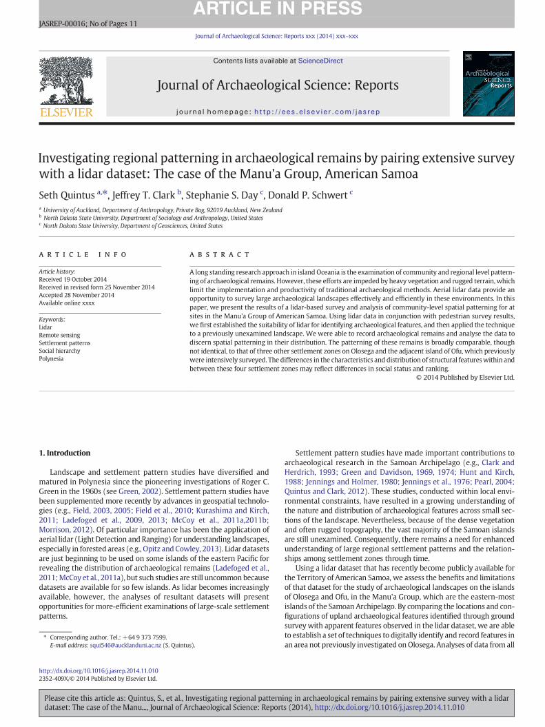
The Samoan Archipelago, located in West Polynesia, comprises nineinhabited islands: Savai'i, Apolima, Manono, 'Upolu, Tutuila, Aunu'u,Ofu, Olosega, and Ta'u. The first four islands are part of the IndependentNation of Samoa, with Savai'i and 'Upolu being the largest of the group.The latter five islands are part of the U.S. Territory of American Samoa.Ofu, Olosega, and Ta'u form the Manu'a group, which is somewhat dif-ferent, environmentally and culturally, from the rest of the archipelago(Mead, 1969; Meleiseā, 1995). Of these islands, Ta'u is the largest(36 km2), Ofu next (7 km2), and Olosega (5 km2) the smallest. Theislands of Manu'a are located proximal to one another: Ofu and Olosegaseparated by a≈100m-wide channel, with Ta'u≈ 10 km to the south-east. Of particular interest to this study are the interior upland zones ofOfu and Olosega (Fig. 1).
The uplands of Ofu range in elevation from ≈45 to 495 masl. Sloperanges from ≈10 to 45°, increasing with elevation. Streams are fewand flow intermittently during times of heavy rain, which are frequent.On the north side of the island the elevation drops from the high ridge-line into a large area of relatively gently sloping ground that is theremnant of a volcanic caldera. The north side of the caldera is a cliffthat marks the north coast of the island. Vegetation throughout thecaldera and its defining slopes is a mix of native and introduced species.At lower elevations, vegetation is largely economic or secondary forests(Liu and Fischer, 2007) with equally modified understories. Rain andcloud forests grow at the higher elevations. The upland zone of Olosegaranges in elevation from≈60 to 640 masl, and slope ranges from ≈10to 40°. Streams are intermittent, and several dissected channels aresituated near the centre of the island. Like Ofu, the vegetation is dense,in both canopy and understory, and is classified as modified/economic,
Fig. 1. Ofu and Olosega highlighting the locat
Please cite this article as: Quintus, S., et al., Investigating regional patternidataset: The case of the Manu..., Journal of Archaeological Science: Report
secondary, or cloud/rain forest, with these zones in a linear progressionfrom lower to higher elevations.
2.2. Settlement in the uplands
Three primary anthropogenic feature types are the focus of thisstudy: terraces, ditches, and star mounds. Terraces are defined hereinas artificiallyflattened earthen structureswith three or less freestandingsides. These features served a variety of functions but most representresidential activities. The presence of water-worn coral and/or basaltgravel scattered over a terrace surface is taken to reflect a house/residential activity floor; the frequent presence of stone artefacts andoccasional cooking features reinforces the assessment of a residentialfunction. Larger residential terraces likely served as foundations formultiple structures that constituted individual households. Terracesthat we have preliminarily designated as non-residential lack water-worn coral/basalt, artefacts, and ovens/fireplaces. These are typicallysmaller than residential terraces and are situated on the steeper slopesperipheral to the residential area. We tentatively propose that thenon-residential terraces were related to agricultural production, eitheras planting terraces or as work/rest stations. Another terrace type isthe ditched terrace (Quintus, 2011:84–85). These features are more-or-less oval-shaped terraces bounded entirely or nearly so by a shallowditch. Typically, these terraces have coral paving but the corals are large,flat slabs rather thanwater-worn rubble. On the basis of these and othercharacteristics, Quintus (2011) has argued that ditched terraces wereceremonial/religious structures.
Ditches are defined as artificial channels that are longer than theyare wide. The feature class is diverse, but many of these features areinterpreted as drainage features given their size and spatial distribution(Quintus, 2012, 2014; Quintus and Clark, 2012). Ditches in Samoa serv-ing functions other than fortification or sunken path are rare outside theManu'a Group, but possible drainage ditches were briefly described forinland Falefa Valley of 'Upolu by Davidson (1974a:239) and Ishizuki(1974:49).
Star mounds are a feature type unique to the Samoan Archipelago.These structures are platforms constructed of stacked rocks or earthenfill with rock facing, having one to 11 projections on the perimeters
ion of named archaeological complexes.
ng in archaeological remains by pairing extensive survey with a lidars (2014), http://dx.doi.org/10.1016/j.jasrep.2014.11.010
3S. Quintus et al. / Journal of Archaeological Science: Reports xxx (2014) xxx–xxx
(see Herdrich, 1991). Although their function has been debated, theyare often equated with pigeon catching mounds. Pigeon catching wasa chiefly sport that functioned more as an avenue for status rivalrythan subsistence activity (Herdrich, 1991; Herdrich and Clark, 1993;Krämer, 1902–3, II:388). Because of this, starmounds are often associat-ed with the development of a social hierarchy, ranking, and labour con-trol (Herdrich and Clark, 1993; Quintus and Clark, 2012). Theconstruction of the features themselves would likely have requiredgroup cooperation and coordination. Many of the features are over ametre in height, exhibit stone facing, and can have surface areas ofover 1000 m2.
Prior pedestrian surveys of upland areas of Ofu and Olosega thoughtto be likely locations for human occupation revealed settlement zonesmarked by high densities of terraces, with other features, particularlystar mounds, scattered beyond those zones. These settlements cannotproperly be called villages because contemporary Samoan communitiesthat appear to be a single village may in fact be composed of two ormore conceptually and politically distinct villages. One might use theterm site in reference to a settlement zone, but the features aredispersed over fairly large areas that show variability in the density offeatures present. There are also different strategies as to how archaeol-ogists working in Samoa have applied the concept of site, ranging froman entire settlement zone be regarded as a single site (e.g., Clark andHerdrich, 1993; Kirch andHunt 1993; Quintus and Clark, 2012) to singlehouseholds (house platform/floor and associated features such as ovensand pits) within large settlement zones given designated distinct sites(e.g., Best 1992; Jennings and Holmer, 1980). For analytical purposes
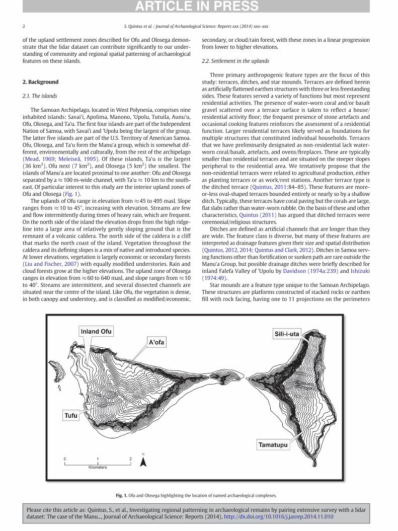
Fig. 2. Spatial patterns in the Tamatupu settlement zone showing the association between theridgeline. (Data from Quintus, 2011.)
Please cite this article as: Quintus, S., et al., Investigating regional patternidataset: The case of the Manu..., Journal of Archaeological Science: Report
we will use the term settlement zone in this paper, but for recordingand identification purposes we have assigned a single site number toeach of the settlement zones.
On Ofu, upland settlement zones with high feature density areaswere documented in three locations (Clark et al., 2012; Quintus, 2011,2014). Well known to local residents, but not reported in earlier siteinventories, is the settlement zone of A'ofa (site AS-13-39) (Fig. 1), thefeatures of which are distributed throughout the old caldera basin onthe north side of the island. A second settlement zone was found intheuplands at Tufu (AS-13-42), overlooking thewest coast of the island,just to the south of the modern village of Ofu. A third zone has beenpreliminarily identified on the slopes above modern Ofu Village, onthe northwest side of the island. We tentatively refer to this settlementzone as Inland Ofu, but only limited reconnaissance has taken placein that area, so it will not be discussed further here. Residential terracesare the most common feature at A'ofa and Tufu, with likely non-residential terraces also present on the higher slopes. Ditchesinterpreted as drainage features are found at both settlement zones,typically surrounding parcels of sloping land that may have served ascultivation plots. Two varieties of these features have been identified,those with a single branch defining a single parcel and those withmultiple branches defining a network of parcels. Ditched terraces arerare, perhaps absent, on Ofu, and star mounds are uncommon on thesurrounding ridgetops.
The largest zone of settlement is on Olosega and is referred to in oralhistory as Tamatupu (AS-12-2). While only a subset of the land consti-tuting the probable settlement zone of Tamatupu (≈60 of ≈120 ha)
location of the ditch and vegetation zones and the density of star mounds on the inland
ng in archaeological remains by pairing extensive survey with a lidars (2014), http://dx.doi.org/10.1016/j.jasrep.2014.11.010
Table 1Details of lidar data acquisition (Raber, 2012).
Scanrate
Field ofview
Laserpulse rate
Maximum pointspacing
Average pointdensity
Root meansquare error
37 Hz 36.0° 70,000 Hz 0.838 m 1.43 pts/m2 0.074 (7 cm)
4 S. Quintus et al. / Journal of Archaeological Science: Reports xxx (2014) xxx–xxx
has been examined on the ground, it is themost intensively surveyed ofall the Manu'a upland sites (Quintus, 2011, 2012; Quintus and Clark,2012). The Tamatupu features are distributed over the southern halfof the uplands east of the major north-south ridgeline of the island.The entire settlement zone is divided by a single, long ditch that runsperpendicular to the slope, or roughly parallel to the coast. The size ofterraces, which functioned as both residential and non-residentialfeatures, decrease with increase in elevation. The largest residentialterrace is the most centrally located feature in the surveyed area andis likely the central feature of the entire settlement zone. The ditch sep-arates economic forest (downslope) from secondary forest (upslope), apattern suggestive of arboriculture in the residential portion of thesettlement zone and shifting cultivation upslope (Fig. 2). Star moundsare distributed on the ridgeline overlooking the rest of the settlementzone in the highest density known for the archipelago (Quintus andClark, 2012). Ditched terraces are dispersed across the landscape down-slope of the long ditch and tend to increase in size with distance fromthe centre (Quintus and Clark, 2012).
A comparable settlement zone is located on the northern third of theinterior uplands of Olosega covering an area of≈20 ha and is the focusof this paper. The study area is inland of the high ridgeline that backs themodern coastal village of Sili and is known in oral history as the ancientinland village where inhabitants of modern (coastal) Sili Village used tolive. The site wasfirst reported by Kikuchi (1963:44) as Siliiuta and sub-sequently listed by Clark (1980) (site AS-12-1), but neither investigatorvisited the site. Amore proper designation for the site, and one followedhere, is Sili-i-uta, or Sili inland. Nearly 20 years later, a cursory investiga-tion by Suafo'a and Clark identified some terraces in the uplands abovecoastal Sili (or Sili-i-tai), although theywere able only to reach themar-gins of what was thought to be the old Sili-i-uta settlement (Suafo‘a,
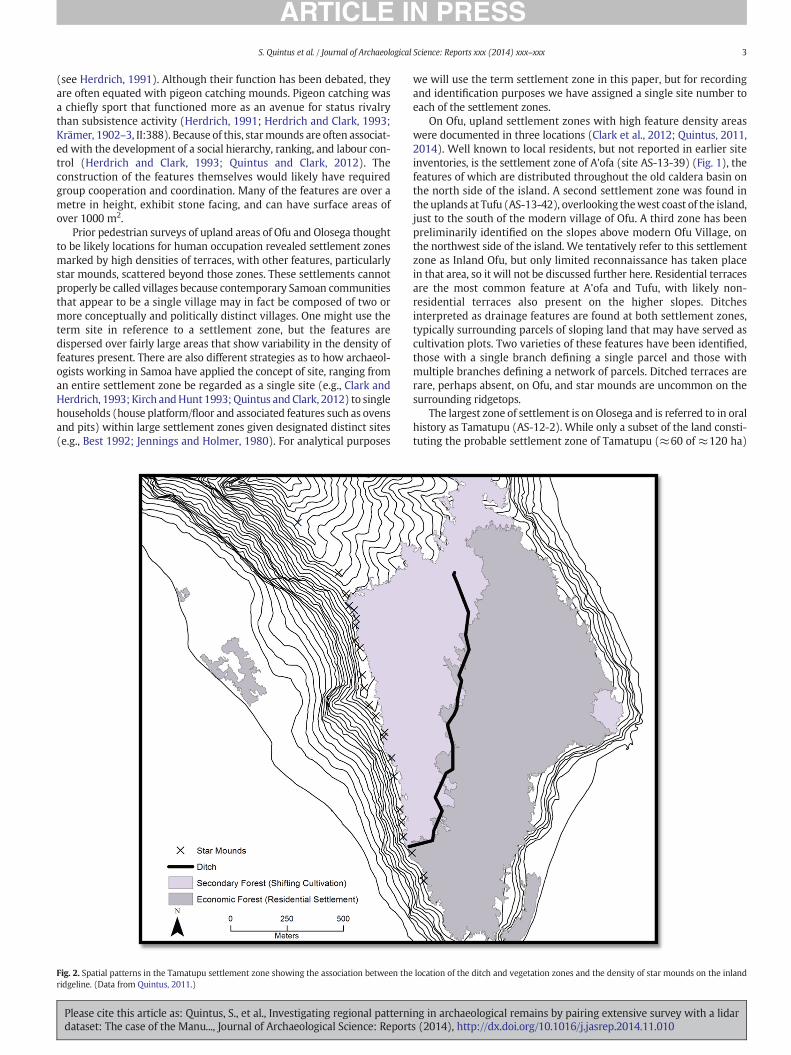
Fig. 3. The association between field observed
Please cite this article as: Quintus, S., et al., Investigating regional patternidataset: The case of the Manu..., Journal of Archaeological Science: Report
1999). Still, while the existence of an inland settlement was confirmedfrom oral history and limited reconnaissance survey, the true natureof the terrain, the settlement features, and their distribution remainedunknown.
3. Lidar digital survey: methods
3.1. Dataset
In the summer of 2012, aerial lidar data collection was undertakenby the NOAA Coastal Services Center in partnership with the AmericanSamoa Government (ASG) Department of Commerce, the U.S. NationalPark Service, and other ASG agencies (for details, see Raber, 2012).The lidar dataset was collected using an Optech lidar system attachedto a twin-engine Beechcraft King Air 90 flying at a height of 1219 m,with an overlap of 50% and a line spacing of 395 m. Point clouds weregenerated and manipulated in Optech and GeoCue software beforebeing imported into TerraScan and TerraModeler. From these, bareearthmodelswere generatedwith the resultant bare earth digital eleva-tion model (DEM) having a horizontal resolution of 1 m. The bare earthDEM was imported into ArcGIS 10.1 where derivative products weregenerated. Technical details regarding Lidar data acquisition arepresented in Table 1.
The lidar dataset was made available to the authors as we enteredthe field in the summer of 2013. With those data in hand, we wereable to engage in a preliminary round of ground truthing to test thereliability of the lidar imagery for identifying the range of features inthe upland settlements of Ofu. The locations of features found duringthe ground survey of Tufu and A'ofa were recorded using TrimbleGeoXT series GPS rover units, which have submetre accuracy. The GPScoordinates were imported into ArcGIS 10.1 for analysis. Ground-basedcoordinate data were then compared with a slope map derived fromthe lidar dataset. This comparison illustrated the association betweenfield-observed terraces and areas of 0–10° slope in Tufu (Fig. 3). Theprimary limitation was the inability to distinguish residential fromnon-residential terraces. Star mounds were identified on the ridgetopsand ditches were recognizable, as well.
terraces and areas of 0–10° slope in Tufu.
ng in archaeological remains by pairing extensive survey with a lidars (2014), http://dx.doi.org/10.1016/j.jasrep.2014.11.010
5S. Quintus et al. / Journal of Archaeological Science: Reports xxx (2014) xxx–xxx
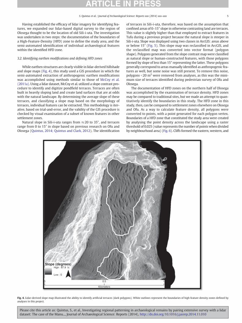
Having established the efficacy of lidar imagery for identifying fea-tures, we expanded our lidar-based digital survey to the region ofOlosega thought to be the location of old Sili-i-uta. The investigationwas undertaken in two steps: the documentation of the boundaries ofa High-Feature-Density (HFD) zone to define the study area, and thesemi-automated identification of individual archaeological featureswithin the identified HFD zone.
3.2. Identifying earthen modifications and defining HFD zones
While earthen structures are clearly visible in lidar-derived hillshadeand slope maps (Fig. 4), this study used a GIS procedure in which thesemi-automated extraction of anthropogenic earthen modificationswas accomplished using methods similar to those of McCoy et al.(2011a). Using a lidar dataset, McCoy et al. utilized a slope contrast pro-cedure to identify and digitize pondfield terraces. Terraces are oftenbuilt in heavily sloping land and create land surfaces that are at oddswith the natural landscape. By determining the average slope of theseterraces, and classifying a slope map based on the morphology ofterraces, individual features can be extracted. This methodology is iter-ative, based on trial-and-error, and the validity of the GIS procedure ischecked by visual examination of a subset of known features in othersettlement zones.
Natural slope in Sili-i-uta ranges from ≈20 to 35°, and terracesrange from 0 to 15° in slope based on previous research on Ofu andOlosega (Quintus, 2014; Quintus and Clark, 2012). The identification
Fig. 4. Lidar-derived slope map illustrated the ability to identify artificial terraces (dark polyganalyses in this project.
Please cite this article as: Quintus, S., et al., Investigating regional patternidataset: The case of the Manu..., Journal of Archaeological Science: Report
of terraces in Sili-i-uta, therefore, was based on the assumption thatconfined areas of 0–15° slope in otherwise contrasting land are terraces.This value is slightly higher than that employed to extract features inTufu during a previous project because the natural slope is steeper inSili-i-uta. Slope was displayed using two classes in ArcGIS: areas aboveor below 15° (Fig. 5). This slope map was reclassified in ArcGIS, andthe reclassified map was converted into vector format (polygonshape). Polygons generated from the slope contrast mapwere classifiedas natural slope or human-constructed features, with those polygonsformed by slope of less than 15° representing the latter. These polygonsgenerally correspond to areasmanually identified as anthropogenic fea-tures as well, but some noise was still present. To remove this noise,polygons b20 m2 were removed from analyses, as this was the mini-mum size of terraces identified during pedestrian survey of Ofu andOlosega.
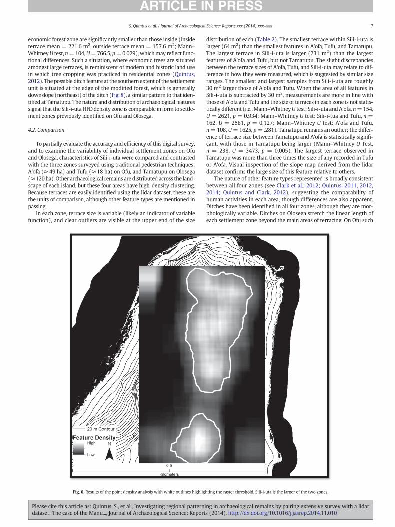
The documentation of HFD zones on the northern half of Olosegawas accomplished by the examination of terrace density. HFD zonesmay be compared to traditional sites, but we made an attempt to quan-titatively identify the boundaries in this study. The HFD zone in thisstudy, then, can be compared to settlement zones elsewhere on Olosegaand Ofu. As a way to calculate feature density, all polygons wereconverted to points, with a point generated for each polygon vertex.Boundaries of a HFD zone that constituted the study area were createdby analysing the point density across the landscape using a rasterthreshold of 0.025 (value represents the number of pointswhendividedby neighbourhood area) (Fig. 6). Cliffs formed the eastern, western, and
ons). White outlines represent the boundaries of high feature density zones defined by
ng in archaeological remains by pairing extensive survey with a lidars (2014), http://dx.doi.org/10.1016/j.jasrep.2014.11.010

6 S. Quintus et al. / Journal of Archaeological Science: Reports xxx (2014) xxx–xxx
northern extent of the unit of analysis and the southern boundary ofanalysis was formed by the southern boundary of the generated HFDzone. While two high density zones were identified during this proce-dure, only the larger of the two is considered here.
Individual features were extracted using the 0–15° polygon file.These polygons were manipulated to create a better representation ofeach feature through a visual examination of a slopemap and a principalcomponent hillshade integrating four hillshades with altitudes of 45°and azimuths of the four cardinal directions. However, any manipula-tion was minimal. Additionally, five polygons were drawn aroundareas of contrasted slope to mark possible terraces, which were notidentified by the slope contrast methods employed, likely a result ofmore severe slope in the areas surrounding these potential features.All polygons N20 m2 were classified as terraces, labelled with a prefixL, and numbered sequentially. Terrace area was calculated in squaremetres using ArcGIS Calculate Geometry tool. A single ditch featurewas identified by visual inspection, and added as a line feature.
4. Lidar digital survey: results
4.1. Sili-i-uta
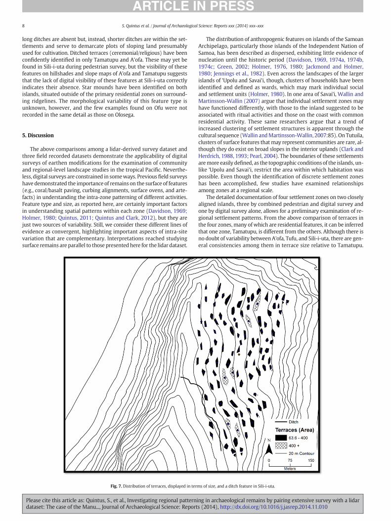
Through the examination of the lidar dataset, we were able toidentify and record 104 terraces in the Sili-i-uta study area (Fig. 7).
Fig. 5. Classified slope map showing the distribution of terraces w
Please cite this article as: Quintus, S., et al., Investigating regional patternidataset: The case of the Manu..., Journal of Archaeological Science: Report
The surface areas of these features range from 67 to 731 m2, with amean of 214 m2 (s.d. = 102 m2). When plotted sequentially, the distri-bution among terrace sizes is almost continuous, with few naturalbreaks in the dataset. Two outliers are apparent at the right tail of thedistribution: the largest features in the zone at 537 m2 (L-92) and731 m2 (L-97). One possible ditch feature was also identified with alength of ≈350 m, running from Alei Ridge to the eastern cliff edge atthe southern extent of the HFD zone. The full extent of this feature isnot known, although it appears similar to the large ditch feature atTamatupu zone (southern half of the island). The ditch appears to beabsent within a natural drainage but is present on either side, suggestingthat it may drain into the drainage.
When the dataset is analysed as a whole, terraces are distributedin a dispersed pattern (nearest neighbour ratio = 1.38; z-score =7.47; p b 0.01). Terraces with a surface area b400 m2 (n = 6) clusterinto three groups of two, and the central grouping includes the largestterrace in the HFD zone (L-97). There is a broad correlation betweenthe location of terracing and the distribution of modified/economicforests (e.g., Artocarpus altilis, Cocos nucifera, Inocarpus fagifer, Aleuritesmoluccanus), mapped previously from high resolution satellite imagery(Liu and Fischer 2007). In total, 86% of the vegetation within the HFDzone is classified as modified forest (approximately 127,000 m2 of147,000m2), and 88% (92 of 104) of the terraces are dispersed amongstthis economic forest zone. Additionally, those terraces outside of the
ith defined high feature density boundaries (black outline).
ng in archaeological remains by pairing extensive survey with a lidars (2014), http://dx.doi.org/10.1016/j.jasrep.2014.11.010
7S. Quintus et al. / Journal of Archaeological Science: Reports xxx (2014) xxx–xxx
economic forest zone are significantly smaller than those inside (insideterrace mean = 221.6 m2, outside terrace mean = 157.6 m2; Mann–WhitneyU test,n=104,U=766.5, p=0.029), whichmay reflect func-tional differences. Such a situation, where economic trees are situatedamongst large terraces, is reminiscent of modern and historic land usein which tree cropping was practiced in residential zones (Quintus,2012). Thepossible ditch feature at the southern extent of the settlementunit is situated at the edge of the modified forest, which is generallydownslope (northeast) of the ditch (Fig. 8), a similar pattern to that iden-tified at Tamatupu. The nature and distribution of archaeological featuressignal that the Sili-i-utaHFDdensity zone is comparable in form to settle-ment zones previously identified on Ofu and Olosega.
4.2. Comparison
To partially evaluate the accuracy and efficiency of this digital survey,and to examine the variability of individual settlement zones on Ofuand Olosega, characteristics of Sili-i-uta were compared and contrastedwith the three zones surveyed using traditional pedestrian techniques:A'ofa (≈49 ha) and Tufu (≈18 ha) on Ofu, and Tamatupu on Olosega(≈120ha). Other archaeological remains are distributed across the land-scape of each island, but these four areas have high-density clustering.Because terraces are easily identified using the lidar dataset, these arethe units of comparison, although other feature types are mentioned inpassing.
In each zone, terrace size is variable (likely an indicator of variablefunction), and clear outliers are visible at the upper end of the size
Fig. 6. Results of the point density analysis with white outlines highlig
Please cite this article as: Quintus, S., et al., Investigating regional patternidataset: The case of the Manu..., Journal of Archaeological Science: Report
distribution of each (Table 2). The smallest terrace within Sili-i-uta islarger (64 m2) than the smallest features in A'ofa, Tufu, and Tamatupu.The largest terrace in Sili-i-uta is larger (731 m2) than the largestfeatures of A'ofa and Tufu, but not Tamatupu. The slight discrepanciesbetween the terrace sizes of A'ofa, Tufu, and Sili-i-uta may relate to dif-ference in how they were measured, which is suggested by similar sizeranges. The smallest and largest samples from Sili-i-uta are roughly30 m2 larger those of A'ofa and Tufu. When the area of all features inSili-i-uta is subtracted by 30 m2, measurements are more in line withthose of A'ofa and Tufu and the size of terraces in each zone is not statis-tically different (i.e.,Mann–WhitneyU test: Sili-i-uta andA'ofa, n=154,U = 2621, p = 0.934; Mann–Whitney U test: Sili-i-tua and Tufu, n =162, U = 2581, p = 0.127; Mann–Whitney U test: A'ofa and Tufu,n=108, U=1625, p= .281). Tamatupu remains an outlier; the differ-ence of terrace size between Tamatupu and A'ofa is statistically signifi-cant, with those in Tamatupu being larger (Mann–Whitney U Test,n = 238, U = 3473, p = 0.005). The largest terrace observed inTamatupu was more than three times the size of any recorded in Tufuor A'ofa. Visual inspection of the slope map derived from the lidardataset confirms the large size of this feature relative to others.
The nature of other feature types represented is broadly consistentbetween all four zones (see Clark et al., 2012; Quintus, 2011, 2012,2014; Quintus and Clark, 2012), suggesting the comparability ofhuman activities in each area, though differences are also apparent.Ditches have been identified in all four zones, although they are mor-phologically variable. Ditches on Olosega stretch the linear length ofeach settlement zone beyond the main areas of terracing. On Ofu such
hting the raster threshold. Sili-i-uta is the larger of the two zones.
ng in archaeological remains by pairing extensive survey with a lidars (2014), http://dx.doi.org/10.1016/j.jasrep.2014.11.010
8 S. Quintus et al. / Journal of Archaeological Science: Reports xxx (2014) xxx–xxx
long ditches are absent but, instead, shorter ditches are within the set-tlements and serve to demarcate plots of sloping land presumablyused for cultivation. Ditched terraces (ceremonial/religious) have beenconfidently identified in only Tamatupu and A'ofa. These may yet befound in Sili-i-uta during pedestrian survey, but the visibility of thesefeatures on hillshades and slope maps of A'ofa and Tamatupu suggeststhat the lack of digital visibility of these features at Sili-i-uta correctlyindicates their absence. Star mounds have been identified on bothislands, situated outside of the primary residential zones on surround-ing ridgelines. The morphological variability of this feature type isunknown, however, and the few examples found on Ofu were notrecorded in the same detail as those on Olosega.
5. Discussion
The above comparisons among a lidar-derived survey dataset andthree field recorded datasets demonstrate the applicability of digitalsurveys of earthen modifications for the examination of communityand regional-level landscape studies in the tropical Pacific. Neverthe-less, digital surveys are constrained in someways. Previousfield surveyshave demonstrated the importance of remains on the surface of features(e.g., coral/basalt paving, curbing alignments, surface ovens, and arte-facts) in understanding the intra-zone patterning of different activities.Feature type and size, as reported here, are certainly important factorsin understanding spatial patterns within each zone (Davidson, 1969;Holmer, 1980; Quintus, 2011; Quintus and Clark, 2012), but they arejust two sources of variability. Still, we consider these different lines ofevidence as convergent, highlighting important aspects of intra-sitevariation that are complementary. Interpretations reached studyingsurface remains are parallel to those presented here for the lidar dataset.
Fig. 7. Distribution of terraces, displayed in ter
Please cite this article as: Quintus, S., et al., Investigating regional patternidataset: The case of the Manu..., Journal of Archaeological Science: Report
The distribution of anthropogenic features on islands of the SamoanArchipelago, particularly those islands of the Independent Nation ofSamoa, has been described as dispersed, exhibiting little evidence ofnucleation until the historic period (Davidson, 1969, 1974a, 1974b,1974c; Green, 2002; Holmer, 1976, 1980; Jackmond and Holmer,1980; Jennings et al., 1982). Even across the landscapes of the largerislands of 'Upolu and Savai'i, though, clusters of households have beenidentified and defined as wards, which may mark individual socialand settlement units (Holmer, 1980). In one area of Savai'i, Wallin andMartinsson-Wallin (2007) argue that individual settlement zones mayhave functioned differently, with those to the inland suggested to beassociated with ritual activities and those on the coast with commonresidential activity. These same researchers argue that a trend ofincreased clustering of settlement structures is apparent through thecultural sequence (Wallin andMartinsson-Wallin, 2007:85). On Tutuila,clusters of surface features thatmay represent communities are rare, al-though they do exist on broad slopes in the interior uplands (Clark andHerdrich, 1988, 1993; Pearl, 2004). The boundaries of these settlementsaremore easily defined, as the topographic conditions of the islands, un-like 'Upolu and Savai'i, restrict the area within which habitation waspossible. Even though the identification of discrete settlement zoneshas been accomplished, few studies have examined relationshipsamong zones at a regional scale.
The detailed documentation of four settlement zones on two closelyaligned islands, three by combined pedestrian and digital survey andone by digital survey alone, allows for a preliminary examination of re-gional settlement patterns. From the above comparison of terraces inthe four zones, many of which are residential features, it can be inferredthat one zone, Tamatupu, is different from the others. Although there isno doubt of variability between A'ofa, Tufu, and Sili-i-uta, there are gen-eral consistencies among them in terrace size relative to Tamatupu.
ms of size, and a ditch feature in Sili-i-uta.
ng in archaeological remains by pairing extensive survey with a lidars (2014), http://dx.doi.org/10.1016/j.jasrep.2014.11.010
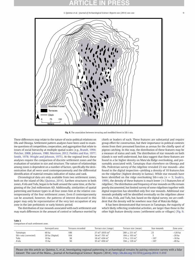
Fig. 8. The association between terracing and modified forest in Sili-i-uta.
9S. Quintus et al. / Journal of Archaeological Science: Reports xxx (2014) xxx–xxx
These differences may relate to the nature of socio-political relations onOfu and Olosega. Settlement pattern analyses have been used to exam-inequestions of competition, cooperation, and aggregation that relate toissues of social hierarchy at multiple spatial scales (e.g., Brandt, 1994;Fletcher, 2008; Johnson, 1980; Morrison, 2012; Peebles and Kus, 1977;Smith, 1978; Wright and Johnson, 1975). At the regional level, theseanalyses require the comparison of discrete settlement zones and theevaluation of variation in size and structure. The nature of relationshipsamong zones is dependent on a number of factors, specifically the dem-onstration that all were used contemporaneously and the differentialidentification of material remains indicative of status and rank.
Chronological data are only available from two settlement zones,both on the island of Ofu (Quintus, 2014). Earthen structures in bothzones, A'ofa and Tufu, began to be built around the same time, at the be-ginning of the 2nd millennium AD. Additionally, similarities of spatialpatterning and feature types in all four zones hint at the relative con-temporaneity of the four settlement zones. Even if contemporaneitycan be assumed, however, the patterns of interest discussed in thispaper may only be representative of the very last occupation of anyzone in the late prehistoric or early historic period.
The distribution of starmounds associatedwith each settlement unitmay mark differences in the amount of control or influence exerted by
Table 2Comparison of each settlement zone.
Surveyed area Terraces recorded Terrace
Tamatupu 60 ha 188 27 m2–
Sili-i-uta (corrected) 20 ha (Digital) 104 34 m2–
Tufu 10 ha 58 18 m2–
A'ofa 15 ha 50 35 m2–
Please cite this article as: Quintus, S., et al., Investigating regional patternidataset: The case of the Manu..., Journal of Archaeological Science: Report
chiefs or leaders of each. These features are substantial and requiregroup effort for construction, but their importance in political contextsstems from their presumed function as arenas for the chiefly sport ofpigeon catching. In this way, the distribution of these features may bea measure of status and rank. The distribution of star mounds on bothislands is not well understood, but data suggest that these features arefound in a far higher density on Mata'ala Ridge overlooking, and pre-sumably associated with, Tamatupu than elsewhere on Olosega andOfu. Pedestrian survey of the ridgeline revealed 23 star mounds—alsofound in the digital inspection—yielding a density of 10 features/kmon the ridgeline (highest density in Samoa). While star mounds havebeen identified on the ridge overlooking Sili-i-uta (n = 5; Suafo'a,1999), the density of these features is much lower (≈3 features/km ofridgeline). The distribution and frequency of starmounds onOfu remainpoorly documented, but limited survey of some ridgelines togetherwithdigital inspection has identified only five star mounds. Additional starmounds probably will be identified eventually on the ridgelines aboveSili-i-uta, A'ofa, and Tufu, but, based on the digital survey, we are confi-dent that the density will be nowhere near that of Mata'ala Ridge.
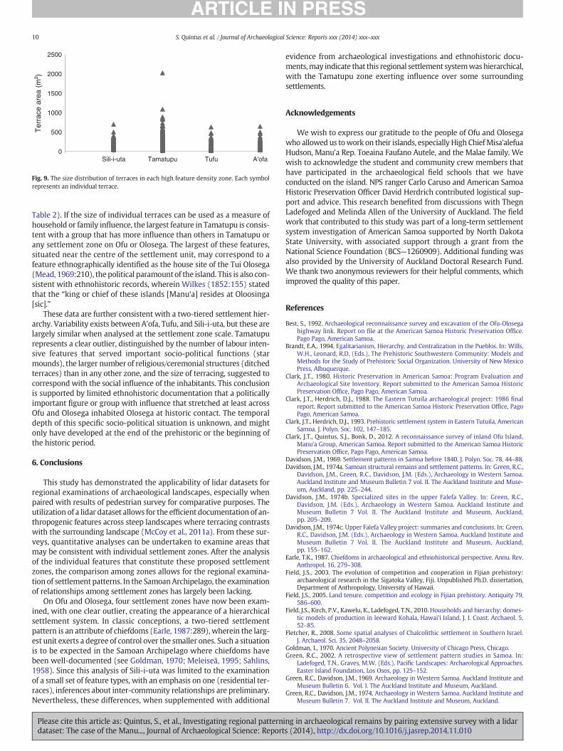
It has been demonstrated that terraces in Tamatupu, themajority ofwhich likely reflecting residential activities, are larger than those in theother high feature density zones (settlement units or villages) (Fig. 9;
size (range) Terrace size (mean) Star mounds Zone area
2035 m2 289 ± 231 m2 23 ~120 ha701 m2 184 ± 103 m2 5 ~20 ha636 m2 174 ± 133 m2 b10? ~18 ha650 m2 194 ± 129 m2 b10? ~49 ha
ng in archaeological remains by pairing extensive survey with a lidars (2014), http://dx.doi.org/10.1016/j.jasrep.2014.11.010
0
500
1000
1500
2000
2500
Ter
race
are
a (m
² )
Sili-i-uta Tamatupu Tufu A'ofa
Fig. 9. The size distribution of terraces in each high feature density zone. Each symbolrepresents an individual terrace.
10 S. Quintus et al. / Journal of Archaeological Science: Reports xxx (2014) xxx–xxx
Table 2). If the size of individual terraces can be used as a measure ofhousehold or family influence, the largest feature in Tamatupu is consis-tent with a group that has more influence than others in Tamatupu orany settlement zone on Ofu or Olosega. The largest of these features,situated near the centre of the settlement unit, may correspond to afeature ethnographically identified as the house site of the Tui Olosega(Mead, 1969:210), thepolitical paramount of the island. This is also con-sistent with ethnohistoric records, wherein Wilkes (1852:155) statedthat the “king or chief of these islands [Manu‘a] resides at Oloosinga[sic].”
These data are further consistent with a two-tiered settlement hier-archy. Variability exists between A'ofa, Tufu, and Sili-i-uta, but these arelargely similar when analysed at the settlement zone scale. Tamatupurepresents a clear outlier, distinguished by the number of labour inten-sive features that served important socio-political functions (starmounds), the larger number of religious/ceremonial structures (ditchedterraces) than in any other zone, and the size of terracing, suggested tocorrespond with the social influence of the inhabitants. This conclusionis supported by limited ethnohistoric documentation that a politicallyimportant figure or group with influence that stretched at least acrossOfu and Olosega inhabited Olosega at historic contact. The temporaldepth of this specific socio-political situation is unknown, and mightonly have developed at the end of the prehistoric or the beginning ofthe historic period.
6. Conclusions
This study has demonstrated the applicability of lidar datasets forregional examinations of archaeological landscapes, especially whenpaired with results of pedestrian survey for comparative purposes. Theutilization of a lidar dataset allows for the efficient documentation of an-thropogenic features across steep landscapes where terracing contrastswith the surrounding landscape (McCoy et al., 2011a). From these sur-veys, quantitative analyses can be undertaken to examine areas thatmay be consistent with individual settlement zones. After the analysisof the individual features that constitute these proposed settlementzones, the comparison among zones allows for the regional examina-tion of settlement patterns. In the SamoanArchipelago, the examinationof relationships among settlement zones has largely been lacking.
On Ofu and Olosega, four settlement zones have now been exam-ined, with one clear outlier, creating the appearance of a hierarchicalsettlement system. In classic conceptions, a two-tiered settlementpattern is an attribute of chiefdoms (Earle, 1987:289), wherein the larg-est unit exerts a degree of control over the smaller ones. Such a situationis to be expected in the Samoan Archipelago where chiefdoms havebeen well-documented (see Goldman, 1970; Meleiseā, 1995; Sahlins,1958). Since this analysis of Sili-i-uta was limited to the examinationof a small set of feature types, with an emphasis on one (residential ter-races), inferences about inter-community relationships are preliminary.Nevertheless, these differences, when supplemented with additional
Please cite this article as: Quintus, S., et al., Investigating regional patternidataset: The case of the Manu..., Journal of Archaeological Science: Report
evidence from archaeological investigations and ethnohistoric docu-ments,may indicate that this regional settlement systemwashierarchical,with the Tamatupu zone exerting influence over some surroundingsettlements.
Acknowledgements
We wish to express our gratitude to the people of Ofu and Olosegawho allowed us towork on their islands, especially High ChiefMisa'alefuaHudson, Manu'a Rep. Toeaina Faufano Autele, and the Malae family. Wewish to acknowledge the student and community crew members thathave participated in the archaeological field schools that we haveconducted on the island. NPS ranger Carlo Caruso and American SamoaHistoric Preservation Officer David Herdrich contributed logistical sup-port and advice. This research benefited from discussions with ThegnLadefoged and Melinda Allen of the University of Auckland. The fieldwork that contributed to this study was part of a long-term settlementsystem investigation of American Samoa supported by North DakotaState University, with associated support through a grant from theNational Science Foundation (BCS—1260909). Additional funding wasalso provided by the University of Auckland Doctoral Research Fund.We thank two anonymous reviewers for their helpful comments, whichimproved the quality of this paper.
References
Best, S., 1992. Archaeological reconnaissance survey and excavation of the Ofu-Olosegahighway link. Report on file at the American Samoa Historic Preservation Office.Pago Pago, American Samoa.
Brandt, E.A., 1994. Egalitarianism, Hierarchy, and Centralization in the Pueblos. In: Wills,W.H., Leonard, R.D. (Eds.), The Prehistoric Southwestern Community: Models andMethods for the Study of Prehistoric Social Organization. University of New MexicoPress, Albuquerque.
Clark, J.T., 1980. Historic Preservation in American Samoa: Program Evaluation andArchaeological Site Inventory. Report submitted to the American Samoa HistoricPreservation Office, Pago Pago, American Samoa.
Clark, J.T., Herdrich, D.J., 1988. The Eastern Tutuila archaeological project: 1986 finalreport. Report submitted to the American Samoa Historic Preservation Office, PagoPago, American Samoa.
Clark, J.T., Herdrich, D.J., 1993. Prehistoric settlement system in Eastern Tutuila, AmericanSamoa. J. Polyn. Soc. 102, 147–185.
Clark, J.T., Quintus, S.J., Bonk, D., 2012. A reconnaissance survey of inland Ofu Island,Manu'a Group, American Samoa. Report submitted to the American Samoa HistoricPreservation Office, Pago Pago, American Samoa.
Davidson, J.M., 1969. Settlement patterns in Samoa before 1840. J. Polyn. Soc. 78, 44–88.Davidson, J.M., 1974a. Samoan structural remains and settlement patterns. In: Green, R.C.,
Davidson, J.M., Green, R.C., Davidson, J.M. (Eds.), Archaeology in Western Samoa.Auckland Institute and Museum Bulletin 7 vol. II. The Auckland Institute and Muse-um, Auckland, pp. 225–244.
Davidson, J.M., 1974b. Specialized sites in the upper Falefa Valley. In: Green, R.C.,Davidson, J.M. (Eds.), Archaeology in Western Samoa. Auckland Institute andMuseum Bulletin 7 Vol. II. The Auckland Institute and Museum, Auckland,pp. 205–209.
Davidson, J.M., 1974c. Upper Falefa Valley project: summaries and conclusions. In: Green,R.C., Davidson, J.M. (Eds.), Archaeology in Western Samoa. Auckland Institute andMuseum Bulletin 7 Vol. II. The Auckland Institute and Museum, Auckland,pp. 155–162.
Earle, T.K., 1987. Chiefdoms in archaeological and ethnohistorical perspective. Annu. Rev.Anthropol. 16, 279–308.
Field, J.S., 2003. The evolution of competition and cooperation in Fijian prehistory:archaeological research in the Sigatoka Valley, Fiji. Unpublished Ph.D. dissertation,Department of Anthropology, University of Hawaii.
Field, J.S., 2005. Land tenure, competition and ecology in Fijian prehistory. Antiquity 79,586–600.
Field, J.S., Kirch, P.V., Kawelu, K., Ladefoged, T.N., 2010. Households and hierarchy: domes-tic models of production in leeward Kohala, Hawai'i Island. J. I. Coast. Archaeol. 5,52–85.
Fletcher, R., 2008. Some spatial analyses of Chalcolithic settlement in Southern Israel.J. Archaeol. Sci. 35, 2048–2058.
Goldman, I., 1970. Ancient Polynesian Society. University of Chicago Press, Chicago.Green, R.C., 2002. A retrospective view of settlement pattern studies in Samoa. In:
Ladefoged, T.N., Graves, M.W. (Eds.), Pacific Landscapes: Archaeological Approaches.Easter Island Foundation, Los Osos, pp. 125–152.
Green, R.C., Davidson, J.M., 1969. Archaeology in Western Samoa. Auckland Institute andMuseum Bulletin 6. Vol. I. The Auckland Institute and Museum, Auckland.
Green, R.C., Davidson, J.M., 1974. Archaeology in Western Samoa. Auckland Institute andMuseum Bulletin 7. Vol. II. The Auckland Institute and Museum, Auckland.
ng in archaeological remains by pairing extensive survey with a lidars (2014), http://dx.doi.org/10.1016/j.jasrep.2014.11.010

11S. Quintus et al. / Journal of Archaeological Science: Reports xxx (2014) xxx–xxx
Herdrich, D.J., 1991. Towards an understanding of Samoan star mounds. J. Polyn. Soc. 100,381–435.
Herdrich, D.J., Clark, J.T., 1993. Samoan Tia 'Ave and social structure: methodological andtheoretical considerations. In: Graves, M.W., Green, R.C. (Eds.), The Evolution andOrganization of Prehistoric Society in Polynesia. New Zealand ArchaeologicalAssociation Monograph Series, Auckland, pp. 52–63.
Holmer, R.N., 1976. Mt. Olo settlement pattern interpretation. In: Jennings, J.D., Holmer,R.N., Janetski, J., Smith, H.L. (Eds.), Excavations on ‘Upolu, Western Samoa. PacificAnthropological Records No. 25, Honolulu, pp. 41–56.
Holmer, R.N., 1980. Mt. Olo settlement pattern interpretation. In: Jennings, J.D., Holmer,R.N. (Eds.), Archaeological Excavations in Western Samoa. Pacific AnthropologicalRecords No. 32, Honolulu, pp. 93–103.
Hunt, T.L., Kirch, P.V., 1988. An archaeological survey of the Manu'a Islands, AmericanSamoa. J. Polyn. Soc. 97, 153–183.
Ishizuki, K., 1974. Excavation of site SU-Fo-1 at Folasa-a-Lalo. In: Green, R.C., Davidson,J.M. (Eds.), Archaeology in Western Samoa. Auckland Institute and Museum Bulletin6, Auckland Vol. II, pp. 36–57.
Jackmond, G., Holmer, R.N., 1980. Sapapali'i settlement. In: Jennings, J.D., Holmer, R.N.(Eds.), Archaeological Investigations in Western Samoa. Pacific AnthropologicalRecords No. 32, Honolulu, pp. 147–152.
Jennings, J.D., Holmer, R.N., 1980. Archaeological Excavations in Western Samoa. PacificAnthropological Records No. 32, Honolulu.
Jennings, J.D., Holmer, R.N., Janetski, J., Smith, H.L., 1976. Excavations on 'Upolu, WesternSamoa. Pacific Anthropological Records No. 25, Honolulu.
Jennings, J.D., Holmer, R.N., Jackmond, G., 1982. Samoan village patterns: four examples.J. Polyn. Soc. 91, 81–102.
Johnson, G.A., 1980. Rank-size convexity and system integration: a view from archaeolo-gy. Econ. Geogr. 56, 234–247.
Kikuchi, W.K., 1963. Archaeological Surface Ruins in American Samoa. Unpublished MAthesis, Department of Anthropology, University of Hawaii.
Kirch, P.V., Hunt, T.L., 1993. The To'aga Site: Three Millennia of Polynesian Occupation inthe Manu'a Islands, American Samoa. Berkeley: Contributions of the University ofCalifornia Archaeological Research Facility No. 51. University of California Press.
Krämer, A., 1902–3. Die Samoa-Inseln. 2 Vol. E. Nagele, Stuttgart (1978 translation by T.E.Verhaaren, Palo Alto).
Kurashima, N., Kirch, P.V., 2011. Geospatial modeling of pre-contact Hawaiian productionsystems on Moloka'i Island, Hawaiian Islands. J. Archaeol. Sci. 38, 3662–3674.
Ladefoged, T.N., Kirch, P.V., Gon, S.M., Chadwick, O.A., Hartshorn, A.S., Vitousek, P.M.,2009. Opportunities and constraints for intensive agriculture in the Hawaiian archi-pelago prior to European contact. J. Archaeol. Sci. 36, 2374–2383.
Ladefoged, T.N., McCoy, M.D., Asner, G.P., Kirch, P.V., Puleston, C.O., Chadwick, O.A.,Vitousek, P.M., 2011. Agricultural potential and actualized development in Hawai'i:an airborne LIDAR survey of the leeward Kohala field system (Hawai'i Island).J. Archaeol. Sci. 38, 3605–3619.
Ladefoged, T.N., Flaws, A., Stevenson, C.M., 2013. The distribution of rock gardens on RapaNui (Easter Island) as determined from satellite imagery. J. Archaeol. Sci. 40,1203–1212.
Please cite this article as: Quintus, S., et al., Investigating regional patternidataset: The case of the Manu..., Journal of Archaeological Science: Report
Liu, Z., Fischer, L., 2007. American Samoa Vegetation Mapping using High Spatial Resolu-tion Imagery. Draft report submitted to the United States Forest Service.
McCoy, M.D., Asner, G.P., Graves, M.W., 2011a. Airborne lidar survey of irrigated agricul-tural landscapes: an application of the slope contrast method. J. Archaeol. Sci. 38,2141–2154.
McCoy, M.D., Ladefoged, T.N., Graves, M.W., Stephens, J.W., 2011b. Strategies forconstructing religious authority in ancient Hawai'i. Antiquity 85, 927–941.
Mead, M., 1969. Social Organization of Manu'a. B.P. Bishop Museum Bulletin No. 76,Honolulu.
Meleiseā, M., 1995. “To whom the men crowded”: chieftainship and hierarchy in ancientSamoa. In: Huntsman, J. (Ed.), Tonga and Samoa: Images of Gender and Polity.Macmillian Brown Centre for Pacific Studies, Christchurch, pp. 19–36.
Morrison, A.E., 2012. An archaeological analysis of Rapa Nui settlement structure: a multi-scalar approach. Unpublished PhD dissertation, Department of Anthropology.University of Hawai'i.
Opitz, R.S., Cowley, D.C., 2013. Interpreting Archaeological Topography. Airborne LaserScanning, 3D Data and Ground Observation. Oxbow Books, Oxford.
Pearl, F.B., 2004. The chronology of mountain settlement on Tutuila, American Samoa.J. Polyn. Soc. 113, 331–348.
Peebles, C.S., Kus, S.M., 1977. Some archaeological correlates of ranked societies. Am.Antiq. 42, 421–448.
Quintus, S.J., 2011. Land use and the human-environment interaction on Olosega Island,Manu'a, American Samoa. Unpublished M.S. Thesis, Department of Sociology andAnthropology, North Dakota State University.
Quintus, S.J., 2012. Terrestrial food production and land use in prehistoric Samoa: an ex-ample from Olosega Island, Manu'a, American Samoa. Archaeol. Ocean. 47, 133–140.
Quintus, S., 2014. Dynamics of agricultural development in prehistoric Samoa: the case ofOfu Island. Unpublished Ph.D. Thesis, Department of Anthropology, University ofAuckland. forthcoming.
Quintus, S.J., Clark, J.T., 2012. Between chaos and control: spatial perception of domestic,political, and ritual organization in prehistoric Samoa. J. Polyn. Soc. 121, 275–302.
Raber, S., 2012. Post-flight aerial acquisition and calibration report. Unpublished reportcompleted by Photo Science, Inc. Colorado Springs, Colorado.
Sahlins, M., 1958. Social Stratification in Polynesia. American Ethnological Society, Seattle.Smith, B.D., 1978. Mississippian Settlement Pattern. Academic Press, New York.Suafo‘a, E., 1999. Reconnaissance survey of Olosega and Sili village lands: natural and
cultural resources. Unpublished report of the National Park Service of AmericanSamoa, Pago Pago.
Wallin, P., Martinsson-Wallin, H., 2007. Settlement patterns—social and ritual space inprehistoric Samoa. Archaeol. Ocean. 42, 83–89 (Supplement).
Wilkes, C., 1852. Narrative of the United States Exploring Expedition during the Years1838, 1839, 1840, 1841, 1842. Ingram, Cooke, and Co., 227, Strand, London.
Wright, H.T., Johnson, G.A., 1975. Population, exchange, and early state formation inSouthwestern Iran. Am. Anthropol. 77, 267–289.
ng in archaeological remains by pairing extensive survey with a lidars (2014), http://dx.doi.org/10.1016/j.jasrep.2014.11.010