interannual changes in seasonal ground freezing and near-surface heat flow beneath bottom-fast ice...
TRANSCRIPT

PERMAFROST AND PERIGLACIAL PROCESSESPermafrost and Periglac. Process. 21: 256–270 (2010)Published online 8 July 2010 in Wiley Online Library(wileyonlinelibrary.com) DOI: 10.1002/ppp.682
Interannual Changes in Seasonal Ground Freezing and Near-surface Heat FlowBeneath Bottom-fast Ice in the Near-shore Zone, Mackenzie Delta, NWT, Canada
Christopher W. Stevens ,1* Brian J. Moorman 2 and Steve M. Solomon 3
1 Department of Geoscience, University of Calgary, Calgary, Alberta, Canada2 Department of Geography, University of Calgary, Calgary, Alberta, Canada3 Geological Survey of Canada (Atlantic), Natural Resources Canada, Dartmouth, Nova Scotia, Canada
* CoGeosAlbe
Contment
Copy
ABSTRACT
Interannual changes in seasonal ground freezing and near-surface heat flow beneath zones of bottom-fast ice (BFI) wereexamined over the winters of 2005–06 and 2006–07 within the near-shore zone of the Mackenzie Delta, Canada. Wintervariability in ground thermal conditions was determined at three monitoring sites. Ground-penetrating radar surveyswere conducted in late winter to determine spatial variability in landfast ice conditions and the extent of ice-bondedsediments. Shallow water sites (<0.5m-water depth) were characterised by early onset of BFI, freezeback of the activelayer andmeanwinter sediment bed temperatures ranging between�38C and�108C. In contrast, deepwater sites (>1mof water) experienced prolonged periods of floating ice, which limited the duration of ice contact with the sediment bedand the depth of seasonal frost, and resulted in warmer winter ground temperatures (between �0.58C and �2.68C).Under similar water depths, interannual changes in ice growth altered the timing of BFI and winter heat loss from theground. When comparing conditions over the twowinters, 2005–06 was characterised by a decrease in ice thickness thatlimited the extent of BFI and seasonal cooling of the ground. These changes in ice conditions had a greater effect on thethermal conditions at sites where water depths were close to the maximum ice thickness. The short ice contact times atthese sites are important to the thermal state of permafrost, as only minimal heat exchange contributing to permafrostcooling occurs prior to freezeback of the active layer. Copyright # 2010 John Wiley & Sons, Ltd.
KEY WORDS: seasonal ground freezing; permafrost; bottom-fast ice; Mackenzie Delta
INTRODUCTION
Arctic water bodies represent the greatest thermal disturb-ance to local ground temperatures (Lachenbruch et al.,1962) and cause significant spatial variability in theoccurrence and condition of permafrost (e.g. Smith,1976). However, few studies have examined ground thermalregimes beneath shallow near-shore water (<2m deep)where the ice column completely freezes to the sedimentbed. Under such conditions, the ice forms a thermallyconductive link that permits heat transfer between theatmosphere and the underlying sediments. This results inheat loss from the ground and contributes to sustainingpermafrost or causing its aggradation below water (Dyke,
rrespondence to: Christopher W. Stevens, Department ofcience, University of Calgary, 2500 University Dr NW, Calgary,rta, Canada T2N 1N4. E-mail: [email protected]
ract/grant sponsors: Program for Energy Research and Develop-; Northern Energy Development Program; NSERC.
right # 2010 John Wiley & Sons, Ltd.
1991, 2000; Kurfurst and Dallimore, 1991; Allard et al.,1998; Burn, 2002, 2005; Solomon et al., 2008).In the near-shore zone of the Mackenzie Delta (Figure 1A)
regions of shallow water extend�15km seaward of the deltafront (Solomon, 2003), with bottom-fast ice (BFI) formingover tens of square kilometres by late winter. As a result,permafrost and seasonal ground freezing occur over extensiveareas (e.g. Solomon et al., 2008; Stevens et al., 2008), yetlittle is known about the effects that changing environmentalconditions (e.g. sea-level rise, water temperature, on-ice snowaccumulation and sediment input) might have on the groundthermal regime. This is in spite of plans to engineer coastalinfrastructure (pipelines) in support of oil and gas develop-ment in the delta (Mackenzie Gas Project, 2008) andincreased interest in understanding the impacts of climatechange on Arctic coastal systems (Rachold et al., 2005).Solomon et al. (2008) recently presented the first
continuous ground temperature record from the near-shorezone of the Mackenzie Delta, which spanned 2 years. Thisstudy indicated that thermal conditions beneath varying
Received 3 July 2009Revised 22 February 2010
Accepted 22 February 2010

Figure 1 (A) Location map of the Mackenzie Delta, NWT, Canada and (B) study area within the near-shore zone. Ground temperature monitoring sites arelabelled as BH01, BH02 and BH04. This figure is available in colour online at wileyonlinelibrary.com/journal/ppp
Interannual Variability in Ice Conditions 257
water depths were affected by differences in the duration ofBFI so that ground temperatures varied between years. In thesame region, Stevens et al. (2008) showed that permafrostoccurring beneath a water depth>1m was in disequilibrium
Copyright # 2010 John Wiley & Sons, Ltd.
with the current surface conditions when ice contact with thesediment bed was short-lived, and suprapermafrost talikswere present. However, the impact of the ice contact time onshallow ground temperatures has yet to be fully addressed.
Permafrost and Periglac. Process., 21: 256–270 (2010)
258 C. W. Stevens et al.
In this study, we hypothesise that interannual variability inice conditions is important in determining the duration of icecontact beneath a given water depth, which consequentlyalters winter heat loss and seasonal ground freezing. Groundtemperature records originally presented by Solomon et al.(2008, Figure 1) are re-analysed in combination with newlyacquired geophysical data from the near-shore zone of theMackenzie Delta over the winters of 2005–06 and 2006–07.The primary objectives are (i) to characterise spatial andtemporal variability in bottom-fast and floating iceconditions, (ii) to determine the influence interannualchanges in ice conditions have on seasonal ground freezingand winter heat loss from the ground , and (iii) to discuss theimplications these changes may have on permafrost beneathzones of shallow water.
STUDY AREA
The Mackenzie Delta, located in western Canada, is thelargest Arctic delta in North America (Figure 1) and the focusof hydrocarbon exploration and development. The moderndelta plain lies within a zone of continuous permafrost(Nguyen et al., 2009), which greatly influences geomorphicprocesses in the region (Mackay, 1963). Permafrost beneathmost of the delta plain is less than 100m thick (Allen et al.,1989; Taylor et al., 1996) and may be absent beneath waterbodies that restrict cooling of the ground (Smith, 1976; Burn,2002, 2005). Seaward of the delta plain, the near-shore zoneconsists of a low-gradient shelf composed of fine-grainedsediments, with water depths <2m extending �15km off-shore (Solomon, 2003). Although much of the modernHolocene delta is undergoing a transgression with shorefaceretreat (Solomon, 2005), previous research has shown thatsedimentation contributing to the accretion of distributarymouth bars is taking place at some near-shore locations(Jenner and Hill, 1998; Hill et al., 2001).This study takes place at a recently deposited distributary
bar, which extends seaward from the mouth of Middle Channel(Figure 1B). The mouth bar is below water level with theexception of an intertidal region that is periodically exposed.During periods of open water (June to September), thesubaqueous portion of the bar is submerged by freshwater thatis discharged from the delta. The onset of ice cover typicallyoccurs in mid-October, at which point, relatively stable landfastice forms. Seasonal ice growth can be up to 2m in the near-shore zone, depending on the influence of other variables, suchas early season on-ice snow (Duguay et al., 2006).BFI in this region typically remains attached to the sediment
bed until ice break-up in late May. The timing of ice break-upis primarily controlled by peak discharge from the MackenzieRiver (Dean et al., 1994; Hill et al., 2001;Walker et al., 2008).Ice break-up in the near-shore zone is commonly characterisedby over-ice flooding at the mouth of distributary channels, assediment-laden river water fills topographic lows within zonesof BFI. The BFI in some areas remains flooded until the holdbetween the base of the ice and the sediment bed is released,causing a sudden buoyancy of the ice column. Regions
Copyright # 2010 John Wiley & Sons, Ltd.
unaffected by over-ice flooding and mechanical break-upoften experience in-situ melting of the ice column.
METHODS
Ground-penetrating radar (GPR) was used to determine iceconditions and the depth of seasonal frost. Surveys wereorientated along the regional bathymetric gradient, in orderto capture variations in the thermophysical conditions thatoccur with changing water depth. Radar surveys in this studywere conducted with Noggin Plus 250-MHz and 500-MHzsystems. Radar traces were then linked to differential globalpositioning system readings to provide effective spatialcorrelation of the interpreted subsurface interfaces. TheGPR data were processed with a Dewow filter to removelow-signal energy and an automatic gain control to enhanceweaker reflections.The depth of seasonal frost was detected above ice-
bonded permafrost, where freezeback of the active layerdoes not occur annually and at locations where permafrostdoes not exist. The ability to detect the depth of seasonalfrost with GPR relates to the change in bulk electricproperties which occurs at the interface between frozen andunfrozen sediments (Moorman et al., 2003). The dielectricconstant of frozen sediment typically ranges from �4–8(Arcone and Delaney, 1984), in contrast to unfrozensaturated sediment which may range from 20–30 (Pattersonand Smith, 1981; Davis and Annan, 1989). Previous GPRsurveys conducted over river and lake ice have alsorecognised thermally related interfaces where ice hasbecome bottom-fast (Delaney et al., 1990; Arcone et al.,1992, 1998, 2006). GPR reflections resolved beneath BFI inthe location of the present study have been shown to relate tochanges in ground temperature from above to below 08C(Stevens et al., 2008). Bottom-fast and floating iceconditions were also distinguished with GPR by thepresence or absence of ice-bottom multiples using thetechniques outlined by Stevens et al. (2009).Drilling with a CRREL coring barrel or an auger attached to
an air rotary drill was used to validate the GPR interpretationsbeneath the various ice conditions. Depth to the base ofseasonal frost and to the top of the ice-bonded permafrost wasdetermined by the drill operator as a change in drill resistanceassociated with frozen and unfrozen sediments. At some drilllocations, the frost line was not detected and frozen sedimentwas continuous with permafrost. Under such conditions,thermally related GPR reflections were not resolved.Verification of ice conditions (bottom-fast and floating ice)was conducted using an ice auger, with average measurementsof ice thickness determined over regions of floating ice. For thepurposes of this study, ice thickness at locations of BFI areconsidered to be representative of the relative water depth.However, it is recognised that factors influencing BFIthickness (e.g. flood ice accumulation) will influence estimatesof local water depth.Ground temperature monitoring sites used for this study
were established in the winter of 2004–05 beneath three
Permafrost and Periglac. Process., 21: 256–270 (2010)
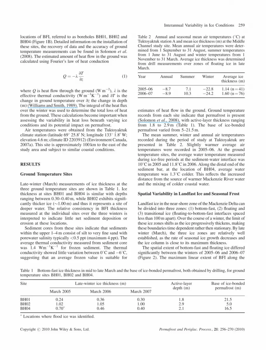
Table 2 Annual and seasonal mean air temperatures (8C) atTuktoyaktuk station A and mean ice thickness (m) at the MiddleChannel study site. Mean annual air temperatures were deter-mined from 1 September to 31 August, summer temperaturesfrom 1 June to 31 August and winter temperatures from 1November to 31 March. Average ice thickness was determinedfrom drill measurements over zones of floating ice in lateMarch.
Year Annual Summer Winter Average icethickness (m)
2005–06 �8.7 7.1 �22.8 1.14 (n¼ 41)2006–07 �8.9 10.3 �24.2 1.60 (n¼ 76)
Interannual Variability in Ice Conditions 259
locations of BFI, referred to as boreholes BH01, BH02 andBH04 (Figure 1B). Detailed information on the installation ofthese sites, the recovery of data and the accuracy of groundtemperature measurements can be found in Solomon et al.(2008). The estimated amount of heat flow in the ground wascalculated using Fourier’s law of heat conduction
Q ¼ �l@T
@z(1)
where Q is heat flow through the ground (Wm�2), l is theeffective thermal conductivity (Wm�1K�1) and @T is thechange in ground temperature over @z the change in depth(m) (Williams and Smith, 1989). The integral of the heat fluxover the winter was used to determine the total loss of heatfrom the ground. These calculations become important whenassessing the variability in heat loss beneath varying iceconditions and its potential impact on permafrost.
Air temperatures were obtained from the Tuktoyaktukclimate station (latitude 698 25.80 N; longitude 1338 1.80 W;elevation 4.6m; climate ID 2203912) (Environment Canada,2007a). This site is approximately 100 km to the east of thestudy area and subject to similar coastal conditions.
RESULTS
Ground Temperature Sites
Late-winter (March) measurements of ice thickness at thethree ground temperature sites are shown in Table 1. Icethickness at sites BH01 and BH04 is similar with depthsranging between 0.30–0.40m, while BH02 exhibits signifi-cantly thicker ice (�1.00m) and thus it represents a site ofdeeper water. The relative consistency in BFI thicknessmeasured at the individual sites over the three winters isinterpreted to indicate little net sediment deposition orerosion at these locations.
Sediment cores from these sites indicate that sedimentswithin the upper 1–4m consist of silt to very fine sand withporewater salinity typically<0.5 ppt (maximum 4 ppt). Theaverage thermal conductivity measured from sediment corewas 1.4 Wm�1K�1 for frozen sediment. The thermalconductivity showed little variation between 08C and �68C,suggesting that an average frozen value is suitable for
Table 1 Bottom-fast ice thickness in mid to late March and the basetemperature sites BH01, BH02 and BH04.
Site Late-winter ice thickness (m)
March 2005 March 2006 Mar
BH01 0.24 0.36BH02 1.02 1.05BH04 0.70� 0.46
� Locations where flood ice was identified.
Copyright # 2010 John Wiley & Sons, Ltd.
estimates of heat flow in the ground. Ground temperaturerecords from each site indicate that permafrost is present(Solomon et al., 2008), with active-layer thickness rangingfrom 1.8 to 2.9m (Table 1). The base of ice-bondedpermafrost varied from 5–21.5m.
The mean summer, winter and annual air temperaturesrecorded during the period of study at Tuktoyaktuk arepresented in Table 2. Slightly warmer average airtemperatures were recorded in 2005–06. At the groundtemperature sites, the average water temperature measuredduring ice-free periods at the sediment-water interface was108C in 2005 and 11.88C in 2006. Along the distal end of thesediment bar, at the location of BH04, average watertemperature was 1.38C colder. This reflects the increaseddistance from the source of warmer Mackenzie River waterand the mixing of colder coastal water.
Spatial Variability in Landfast Ice and Seasonal Frost
Landfast ice in the near-shore zone of theMackenzie Delta canbe divided into three zones: (1) bottom-fast, (2) floating and(3) transitional ice (floating-to-bottom-fast interfaces spacedless than 100m apart). Over the course of a winter, the limit ofthese ice zones shifts as the ice progressively thickens, makingthese boundaries time dependent rather then stationary. By latewinter (March), the three ice zones are relatively wellestablished, as the rate of seasonal ice growth decreases andthe ice column is close to its maximum thickness.
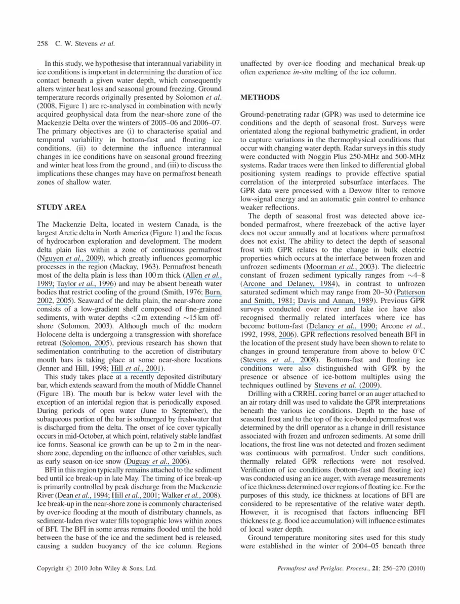
The spatial extent of bottom-fast and floating ice differedsignificantly between the winters of 2005–06 and 2006–07(Figure 2). The maximum linear extent of BFI along the
of ice-bonded permafrost, both obtained by drilling, for ground
Active-layerdepth (m)
Base of ice-bondedpermafrost (m)
ch 2007
0.30 1.8 21.51.00 2.9 5.00.40 2.1 16.5
Permafrost and Periglac. Process., 21: 256–270 (2010)
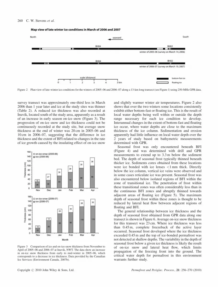
Figure 2 Plan view of late-winter ice conditions for the winters of 2005–06 and 2006–07 along a 13-km long transect (see Figure 1) using 250-MHzGPR data.
260 C. W. Stevens et al.
survey transect was approximately one-third less in March2006 than 1 year later and ice at the study sites was thinner(Table 2). A reduced ice thickness was also recorded atInuvik, located south of the study area, apparently as a resultof an increase in early season on-ice snow (Figure 3). Theprogression of on-ice snow and ice thickness could not becontinuously recorded at the study site, but average snowthickness at the end of winter was 20 cm in 2005–06 and10 cm in 2006–07, suggesting that the difference in icethickness and the extent of BFI related to changes in the rateof ice growth caused by the insulating effect of on-ice snow
Figure 3 Comparison of ice and on-ice snow thickness from November toApril of 2005–06 and 2006–07 at Inuvik, NWT. The data show an increasein on-ice snow thickness from early to mid-winter in 2005–06, whichcorresponds to a decrease in ice thickness. Data provided by the CanadianIce Services (Environment Canada, 2007b).
Copyright # 2010 John Wiley & Sons, Ltd.
and slightly warmer winter air temperatures. Figure 2 alsoshows that over the two winters some locations consistentlyexhibit either bottom-fast or floating ice. This is the result oflocal water depths being well within or outside the depthrange necessary for each ice condition to develop.Interannual changes in the extent of bottom-fast and floatingice occur, where water depths are close to the maximumthickness of the ice column. Sedimentation and erosionapparently had little influence on local water depth over the2 years of study based on bathymetric measurementsdetermined with GPR.Seasonal frost was only encountered beneath BFI
(Figure 4) and was determined with drill and GPRmeasurements to extend up to 3.3m below the sedimentbed. The depth of seasonal frost typically thinned beneaththicker ice. Sediments cores obtained from these locationswere ice bonded with ice lenses <1mm thick. Directlybelow the ice column, vertical ice veins were observed andin some cases reticulate ice was present. Seasonal frost wasalso encountered below isolated regions of BFI within thezone of transitional ice. The penetration of frost withinthese transitional zones was often considerably less than inthe continuous BFI zones and abruptly thinned towardsadjacent areas of floating ice (Figure 5). The maximumdepth of seasonal frost within these zones is thought to bereduced by lateral heat flow between adjacent regions offloating and BFI.The general relationship between ice thickness and the
depth of seasonal frost obtained from GPR data along onetransect is shown in Figure 6. Average on-ice snow thicknessfor this transect was 23 cm. Where ice thickness was lessthan 0.45m, complete freezeback of the active layeroccurred. Seasonal frost developed where the ice thicknessexceeded 0.45m and the top of ice-bonded permafrost wasnot detected at shallow depths. The variability in the depth ofseasonal frost below a given ice thickness is likely the resultof on-ice snow and lateral heat flow, which limitspropagation of the freezing front into the ground. Thecritical water depth for permafrost in this environmentwarrants further study.
Permafrost and Periglac. Process., 21: 256–270 (2010)
Figure 4 (A) 250-MHz GPR profile surveyed across a zone on bottom-fast ice. (B) Interpreted GPR profile delineating the base of ice and depth of seasonalfrost.
Interannual Variability in Ice Conditions 261
Ground Temperatures and Heat Flow beneath BFI
At the sediment bed, ground temperatures are above 08Cduring periods of open water and at or below 08C duringperiods of ice cover (Figure 7). Prior to ice contact, duringthe period of floating ice, ground temperatures at thesediment bed are around 08C and in thermal equilibriumwith the water column. As the ice extends down to thesediment bed, the temperatures become consistentlynegative and ice bonding of the underlying sediments takesplace. During the period of BFI, variations in groundtemperatures at the sediment bed correlate with the generalpattern of air temperatures through the winter.
The onset of BFI and the duration of ice contact arespatially variable (Table 3). Ground temperatures at sitesBH01 and BH04 indicate a similar timing for ice contact inmid-November. In comparison, site BH02 experienced theonset of BFI in late February in 2006 and in early January in2007. The difference in the timing of ice contact with thesediment bed can be partly explained by the greater amount
Copyright # 2010 John Wiley & Sons, Ltd.
of ice growth necessary to achieve BFI conditions atlocations of deeper water, such as at BH02. Additionalfactors affecting the thermal rate of ice growth (e.g. on-icesnow pack) and minor fluctuations in the water level (e.g.tide and river discharge) are also likely to be influential inthe timing of BFI.
Sediment bed temperatures show a gradual warmingbetween mid-March and early May as air temperaturessteadily rise while the ice column remains bottom-fast(Figure 8). Surface conditions dramatically change withflooding of the ice surface and melting of on-ice snow inMay, leading to an abrupt increase in sediment bedtemperatures to �08C. A majority of the flooding is inresponse to increased spring meltwater being dischargedfrom the Mackenzie and Peel Rivers (Carmack andMacdonald, 2008). The over-ice flooding results in thermaldegradation of the BFI, which eventually leads todetachment of the ice column from the sediment bed.While visual observations of ice liftoff were not made at allsites, liftoff was inferred to have occurred when sediment
Permafrost and Periglac. Process., 21: 256–270 (2010)

Figure 5 (A) 250-MHz GPR profile surveyed across a zone of transitional ice. (B) Interpreted GPR profile delineating the base of ice, depth of seasonal frostand sediment-water interface (dashed line). Note seasonal frost is only present beneath locations of bottom-fast ice.
Figure 6 Depth of seasonal frost plotted against ice thickness. Radar depth measurements were calculated with an average velocity of 0.16mns�1 for ice and0.15mns�1 for frozen sediment using 500-MHz GPR data collected in March 2008.
Copyright # 2010 John Wiley & Sons, Ltd. Permafrost and Periglac. Process., 21: 256–270 (2010)
262 C. W. Stevens et al.
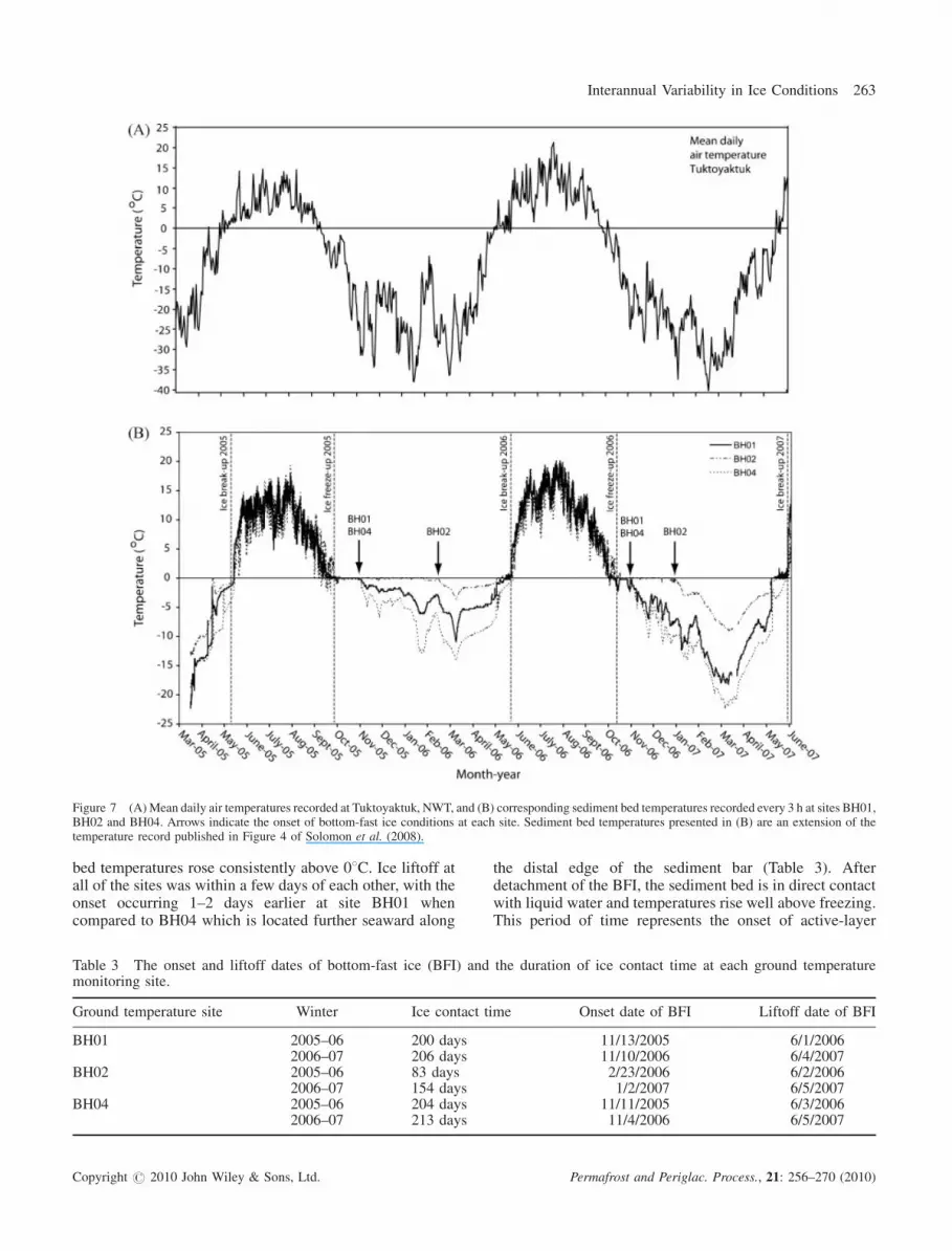
Figure 7 (A)Mean daily air temperatures recorded at Tuktoyaktuk, NWT, and (B) corresponding sediment bed temperatures recorded every 3 h at sites BH01,BH02 and BH04. Arrows indicate the onset of bottom-fast ice conditions at each site. Sediment bed temperatures presented in (B) are an extension of thetemperature record published in Figure 4 of Solomon et al. (2008).
Interannual Variability in Ice Conditions 263
bed temperatures rose consistently above 08C. Ice liftoff atall of the sites was within a few days of each other, with theonset occurring 1–2 days earlier at site BH01 whencompared to BH04 which is located further seaward along
Table 3 The onset and liftoff dates of bottom-fast ice (BFI) andmonitoring site.
Ground temperature site Winter Ice contact ti
BH01 2005–06 200 days2006–07 206 days
BH02 2005–06 83 days2006–07 154 days
BH04 2005–06 204 days2006–07 213 days
Copyright # 2010 John Wiley & Sons, Ltd.
the distal edge of the sediment bar (Table 3). Afterdetachment of the BFI, the sediment bed is in direct contactwith liquid water and temperatures rise well above freezing.This period of time represents the onset of active-layer
the duration of ice contact time at each ground temperature
me Onset date of BFI Liftoff date of BFI
11/13/2005 6/1/200611/10/2006 6/4/20072/23/2006 6/2/20061/2/2007 6/5/2007
11/11/2005 6/3/200611/4/2006 6/5/2007
Permafrost and Periglac. Process., 21: 256–270 (2010)
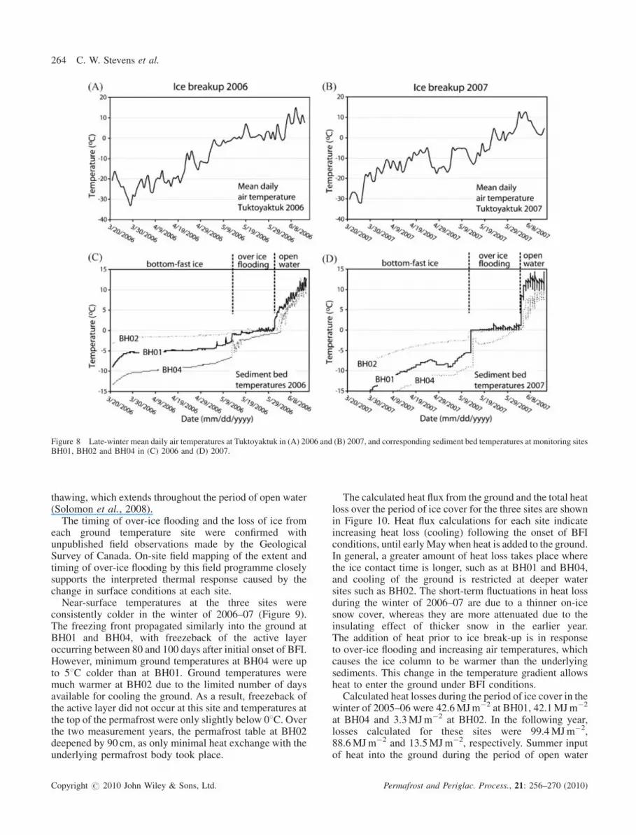
Figure 8 Late-winter mean daily air temperatures at Tuktoyaktuk in (A) 2006 and (B) 2007, and corresponding sediment bed temperatures at monitoring sitesBH01, BH02 and BH04 in (C) 2006 and (D) 2007.
264 C. W. Stevens et al.
thawing, which extends throughout the period of open water(Solomon et al., 2008).The timing of over-ice flooding and the loss of ice from
each ground temperature site were confirmed withunpublished field observations made by the GeologicalSurvey of Canada. On-site field mapping of the extent andtiming of over-ice flooding by this field programme closelysupports the interpreted thermal response caused by thechange in surface conditions at each site.Near-surface temperatures at the three sites were
consistently colder in the winter of 2006–07 (Figure 9).The freezing front propagated similarly into the ground atBH01 and BH04, with freezeback of the active layeroccurring between 80 and 100 days after initial onset of BFI.However, minimum ground temperatures at BH04 were upto 58C colder than at BH01. Ground temperatures weremuch warmer at BH02 due to the limited number of daysavailable for cooling the ground. As a result, freezeback ofthe active layer did not occur at this site and temperatures atthe top of the permafrost were only slightly below 08C. Overthe two measurement years, the permafrost table at BH02deepened by 90 cm, as only minimal heat exchange with theunderlying permafrost body took place.
Copyright # 2010 John Wiley & Sons, Ltd.
The calculated heat flux from the ground and the total heatloss over the period of ice cover for the three sites are shownin Figure 10. Heat flux calculations for each site indicateincreasing heat loss (cooling) following the onset of BFIconditions, until earlyMay when heat is added to the ground.In general, a greater amount of heat loss takes place wherethe ice contact time is longer, such as at BH01 and BH04,and cooling of the ground is restricted at deeper watersites such as BH02. The short-term fluctuations in heat lossduring the winter of 2006–07 are due to a thinner on-icesnow cover, whereas they are more attenuated due to theinsulating effect of thicker snow in the earlier year.The addition of heat prior to ice break-up is in responseto over-ice flooding and increasing air temperatures, whichcauses the ice column to be warmer than the underlyingsediments. This change in the temperature gradient allowsheat to enter the ground under BFI conditions.Calculated heat losses during the period of ice cover in the
winter of 2005–06 were 42.6MJm�2 at BH01, 42.1MJm�2
at BH04 and 3.3MJm�2 at BH02. In the following year,losses calculated for these sites were 99.4MJm�2,88.6MJm�2 and 13.5MJm�2, respectively. Summer inputof heat into the ground during the period of open water
Permafrost and Periglac. Process., 21: 256–270 (2010)
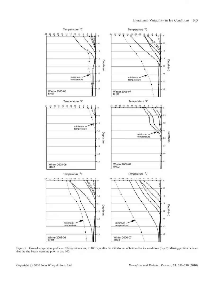
Figure 9 Ground temperature profiles at 20-day intervals up to 100 days after the initial onset of bottom-fast ice conditions (day 0). Missing profiles indicatethat the site began warming prior to day 100.
Copyright # 2010 John Wiley & Sons, Ltd. Permafrost and Periglac. Process., 21: 256–270 (2010)
Interannual Variability in Ice Conditions 265
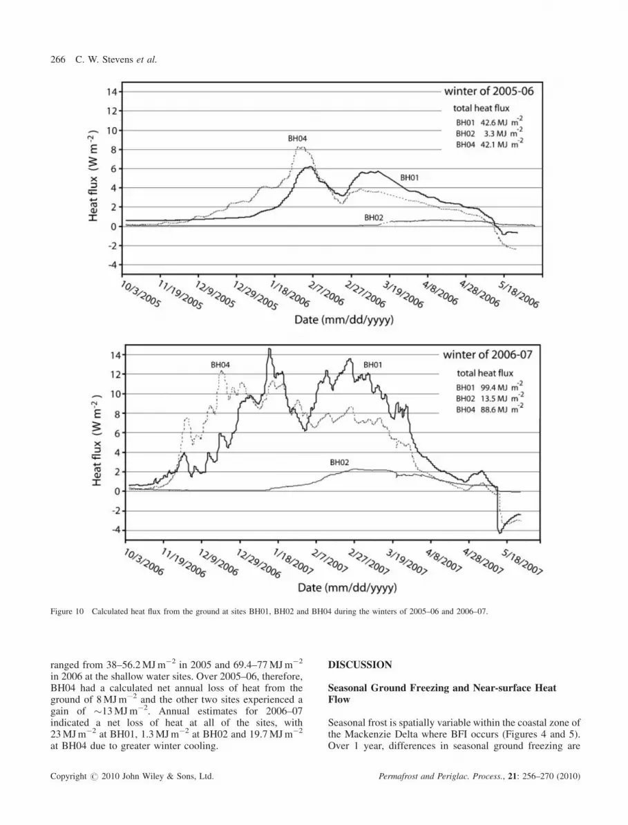
Figure 10 Calculated heat flux from the ground at sites BH01, BH02 and BH04 during the winters of 2005–06 and 2006–07.
266 C. W. Stevens et al.
ranged from 38–56.2MJm�2 in 2005 and 69.4–77MJm�2
in 2006 at the shallow water sites. Over 2005–06, therefore,BH04 had a calculated net annual loss of heat from theground of 8MJm�2 and the other two sites experienced again of �13MJm�2. Annual estimates for 2006–07indicated a net loss of heat at all of the sites, with23MJm�2 at BH01, 1.3MJm�2 at BH02 and 19.7MJm�2
at BH04 due to greater winter cooling.
Copyright # 2010 John Wiley & Sons, Ltd.
DISCUSSION
Seasonal Ground Freezing and Near-surface HeatFlow
Seasonal frost is spatially variable within the coastal zone ofthe Mackenzie Delta where BFI occurs (Figures 4 and 5).Over 1 year, differences in seasonal ground freezing are
Permafrost and Periglac. Process., 21: 256–270 (2010)

Figure 11 Schematic illustration showing the development of seasonalfrost beneath zones of bottom-fast ice. (A) Shallow water of <0.5m deepwhere onset of bottom-fast ice occurs in early winter and is followed bydevelopment of seasonal frost and active-layer freezeback. (B) Deep watersite >1m where bottom-fast ice occurs only in late winter. As a result,penetration of seasonal frost into the ground is limited and a supraperma-frost talik is present. Note that some deep water sites may not exhibitunderlying permafrost.
Interannual Variability in Ice Conditions 267
mainly due to local changes in water depth, with the onsetand duration of BFI being important factors. This is evidentby comparing differences in winter heat loss from the groundat sites BH01 and BH04 (<0.5-m water depths) to site BH02(1-m water depth) (Figures 9 and 10). Locations of shallowwater (BH01 and BH04) exhibit a greater ice contact timewith the sediment bed, which results in greater cooling of theground throughout winter and the presence of permafrost.Deeper water sites, such as BH02, exhibit both late onset ofBFI and a shorter ice contact time. Consequently, there isboth a decrease in the penetration of seasonal frost andreduced heat loss beneath deeper water sites, resulting inwarmer ground temperatures. Cooling of the ground is alsoless effective in late winter and early spring, due toprogressively increasing air temperatures and the thermaland albedo effects of over-ice flooding at some sites (Deanet al., 1994).
Short-term interannual variability in ice conditions alsoimpacts the spatial extent of ground freezing, as demonstratedby changes in the distribution of BFI between the two winters(Figure 2). During years with decreased rates of ice growth(e.g. the winter of 2005–06), the ice contact time is decreasedand thus the penetration depth and rate of ground freezing areless. In some instances, the complete absence of seasonal frostmay occur at locations previously subject to BFI duringwinters that exhibit slow rates of ice growth. Interannualvariability in winter heat loss from the ground, therefore, canbe attributed to several key factors which include: (i) thetiming and duration of BFI conditions, (ii) the on-ice snowpack properties (e.g. thickness and rate of accumulation) and(iii) the average winter air temperature (Figure 10).
The timing and duration of BFI conditions at similar waterdepths are mainly related to on-ice snow properties, whichrestrict heat loss from the ice-water interface during theperiod of ice growth. This is supported by previous studieswhich have shown that ice growth is highly sensitive toinsulation from snow (e.g. Holtsmark, 1955; Jacobs et al.,1975; Maykut, 1978). Brown and Cote (1992) found that inthe high Arctic snow cover accounted for 30–60 per cent ofthe variance in maximum late-winter ice thickness withinthe zone of landfast ice and air temperature explained lessthan 4 per cent of the variability. Based on data presented inTable 3, deeper water sites located in water depths that areclose to the ‘typical’ thickness of late-winter ice are moresensitive to interannual variability in ice conditions thanshallow water sites.
On-ice snow cover also plays a significant role in reducingheat transfer through the ice column once ice is bottom-fast,similar to its insulating effects on land (e.g. Mackay, 1974;Outcalt et al., 1975; Smith, 1975; Goodrich, 1982; Zhanget al., 1996). The insulating effects of thicker on-ice snow in2005–06 are responsible for both the attenuated signal ofheat loss from the ground and the major differences in heatloss between sites with similar ice contact times (e.g BH01and BH04) (Figure 10). Other controls on through-ice heattransfer include over-ice flooding, which temporally limitsheat loss from the ground and ice column as shown inFigure 8. Over-ice flooding occurring throughout winter also
Copyright # 2010 John Wiley & Sons, Ltd. Permafrost and Periglac. Process., 21: 256–270 (2010)
268 C. W. Stevens et al.
reduces on-ice snow thickness and insulation of the ground,by melting the snow and refreezing it as superimposed whiteice that has a higher thermal conductivity.
Implications for Permafrost Stability
The development of seasonal frost within shallow waterenvironments is important to permafrost stability becauseonly minimal heat loss from permafrost can take placeprior to complete freezeback of the active layer (Figure 9).Large amounts of energy need to be extracted to advancethe freezing front and the conduction of heat through thesaturated sediments is limited. Given that summer watertemperatures measured at the ground temperature sites wererelatively similar over the study period, it is inferred thatvariations in heat exchange during the period of open waterwere not responsible for the major differences in winterground temperatures.Freezeback of the active layer within shallow water
environments takes longer than in similar terrestrialpermafrost environments. This is attributed to the greateractive layers developed at shallow water sites, and theamount of time necessary for the ice column to thicken andbecome bottom-fast. Osterkamp and Romanovsky (1997),for example, found that at West Dock on the Alaskan coastalplain, the average active-layer thickness was 0.36m,freezeback began in mid-September and was completedafter 42 days in late October. At the shallow water sites inthis study, active-layer thickness was �2m and the durationof freezeback at BH01 and BH04 ranged from 80–100 dayswhile complete freezeback did not occur at BH02.Permafrost at BH02 appears to be in disequilibrium withsurface conditions and the permafrost table is falling. Inorder to sustain permafrost at this site under equilibriumconditions, an increase in the ice contact time under minimalsnow thickness is necessary. This may be achieved bydecreasing water depth.A conceptual model depicting the differences between
shallow water (<0.5m) and deep water (>1m) sites isshown in Figure 11. Water depths that are <0.5m typicallyexhibit early onset of BFI and prolonged duration of icecontact, resulting in freezeback of the active layer andpermafrost cooling. Beneath water depths >1m limitedduration of ice contact throughout winter and completefreezeback of the active layer does not take place. Underthe deeper water scenario, heat gained from the previoussummer cannot be effectively removed. As a result,degrading permafrost conditions exist and deepening ofthe permafrost table occurs.
CONCLUSIONS
Near-surface thermal conditions beneath bottom-fast andfloating ice are significantly different in theMackenzie Deltadue to the presence and timing of ice or water at the sedimentbed. From the examination of ice conditions and ground
Copyright # 2010 John Wiley & Sons, Ltd.
temperatures over the winters of 2005–06 and 2006–07, thefollowing conclusions can be reached.
1. I
nterannual differences in ice growth over the winters of2005–06 and 2006–07 had a profound effect on the extentof BFI and the duration that ice was in contact with thesediment bed. This resulted in changes in the total winterloss of heat from the ground and in the spatial distributionand depth of seasonal frost.2. C
older ground temperatures (between �38C and�10.38C) and complete freezeback of the active layeroccurred where early onset of BFI led to longer periods ofice contact during winter. These conditions developedbeneath water depths of<0.5m. At these sites permafrostwas in equilibrium with the surface conditions.3. W
ater depths >1m were characterised by prolongedperiods of ice growth that limited the ice contact timeand resulted in warm winter ground temperatures rangingbetween�0.58C and �2.68C. At locations where perma-frost was present, annual freezeback of the active layerdid not always occur and permafrost at these locationswas degrading.4. T
he onset of seasonal thaw beneath locations with BFI isinitiated by detachment of the ice column and water at thesediment bed. Prior to removal of the ice column, over-ice flooding allows for the input of heat into the groundand warming of the sediment bed temperatures to 08C.5. A
t a larger scale, near-shore ice and snow conditionsreflect major changes in seasonal ground freezing and thethermal condition of permafrost beneath varying waterdepths. As a result, thermal modelling and monitoring ofnear-shore permafrost conditions over wide areas couldbe based on the integration of water bathymetry, icegrowth and on-ice snow thickness.ACKNOWLEDGEMENTS
This work was supported by the Program for EnergyResearch and Development, the Northern Energy Develop-ment Program and the NSERC. Logistical support fromShell Canada, Chevron Canada, Devon Energy, MGMEnergy Corporations, the Aurora Research Institute andthe Polar Continental Shelf Project is greatly appreciated.We also thank Dustin Whalen, J. C. Lavergne and Jen Bodefor assisting with data collection in the field. Antoni Lew-kowicz and two anonymous reviewers provided helpfulcomments that improved this manuscript.
REFERENCES
Allard M, Michaud Y, Ruz M-H, Hequette A. 1998. Ice foot,freeze-thaw of sediments, and platform erosion in a subarcticmicrotidal environment, Manitounuk Strait, northern Que-bec, Canada. Canadian Journal of Earth Sciences 35: 965–979.
Allen DM, Michel FA, Judge AS. 1989. The permafrost regimein the Mackenzie Delta, Beaufort Sea region, N.W.T. and its
Permafrost and Periglac. Process., 21: 256–270 (2010)
Interannual Variability in Ice Conditions 269
significance to the reconstruction of the paleoclimatic history.Journal of Quaternary Science 3: 3–13.
Arcone SA, Delaney AJ. 1984. Field dielectric measurements offrozen silt using VHF pulses. Cold Regions Science andTechnology 9: 29–37.
Arcone SA, Chacho EF Jr, Delaney AJ. 1992. Short-pulse radardetection of ground water in the Sagavanirktok River floodplain in early spring. Water Resources Research 28: 2925–2936.
Arcone SA, Chacho EF, Delaney AJ. 1998. Seasonal structureof taliks beneath arctic streams determined with ground-penetrating radar. In Proceedings of the Seventh Inter-national Conference on Permafrost. Canadian National Com-mittee for the International Permafrost Association:Yellowknife, Canada; 23–27 June 1998. 19–24.
Arcone SA, Finnegan DC, Lanbo L. 2006. Target interactionwith stratigraphy beneath shallow, frozen lakes: Quarter-wave resonances within GPR profiles. Geophysics 71:k119–k131. DOI: 10.1190/1.2358404.
Brown RD, Cote P. 1992. Interannual variability of landfast icethickness in the Canadian high Arctic, 1950-89. Arctic 45:273–284.
Burn CR. 2002. Tundra lakes and permafrost, Richards Island,western Arctic coast, Canada. Canadian Journal of EarthSciences 39: 1281–1298. DOI: 10.1139/E02-035.
Burn CR. 2005. Lake-bottom thermal regimes, western arcticcoast, Canada. Permafrost and Periglacial Processes 16:355–367. DOI: 10.1002/ppp.542.
Carmack E, Macdonald R. 2008. Water and ice-relatedphenomena in the coastal region of the Beaufort Sea: Someparallels between native experience and western science.Arctic 61: 265–280.
Davis JL, Annan AP. 1989. Ground-penetrating radar for high-resolution mapping of soil and rock stratigraphy. Geophysi-cal Prospecting 37: 531–551.
Dean KG, Stringer WJ, Ahlnas K, Searcy C, Weingartner T.1994. The influence of river discharge on the thawing of seasice, Mackenzie River Delta: albedo and temperatureanalyses. Polar Research 13: 83–94. DOI: 10.1111/j.1751-8369.1994.tb00439.x.
Delaney AJ, Arcone SA, Chacho EF. 1990. Winter short-pulseradar studies on the Tanana River, Alaska. Arctic 43: 244–250.
Duguay CR, Prowse TD, Bonsal BR, Brown RD, Lacroix MP,Menard P. 2006. Recent trends in Canadian lake ice cover.Hydrological Processes 20: 781–801. DOI: 10.1002/hyp.6131.
Dyke LD. 1991. Temperature changes and thaw of permafrostadjacent to Richards Island, Mackenzie Delta, N.W.T. Cana-dian Journal of Earth Sciences 28: 1834–1842.
Dyke LD. 2000. Shoreline permafrost along the MackenzieRiver. In The Physical Environment of the Mackenzie Valley,Northwest Territories: A Base Line for the Assessment ofEnvironmental Change, Dyke LD, Brooks GR (eds). Geo-logical Survey of Canada, Bulletin 547: 143–151.
Environment Canada. 2007a. Historical Canadian climate data-base. www.climate.weatheroffice.ec.gc.ca/ [November 2007].
Environment Canada. 2007b. Canadian Ice Services ice thick-ness database. www.ice-glaces.ec.gc.ca/WsvPageDsp.cfm?I-D=11872&Lang=eng [December ]. 2008.
Goodrich LE. 1982. The influence of snow cover on the groundthermal regime. Canadian Geotechnical Journal 19: 421–432.
Copyright # 2010 John Wiley & Sons, Ltd.
Hill PR, Lewis P, Desmarais S, Kauppaymuthoo V, Rais H.2001. The Mackenzie Delta: sedimentary processes andfacies of a high-latitude, fine-grained delta. Sedimentology48: 1047–1078.
Holtsmark BE. 1955. Insulating effect of a snow cover on thegrowth of young sea ice. Arctic 8: 60–65.
Jacobs JD, Barry RG,Weaver RL. 1975. Fast ice characteristics,with special reference to the eastern Canadian Arctic. PolarRecord 17: 521–536.
Jenner KA, Hill PR. 1998. Recent, arctic deltaic sedimentation,Olivier Islands, Mackenzie Delta, Northwest Territories,Canada. Sedimentology 45: 987–1004.
Kurfurst PJ, Dallimore SR. 1991. Engineering geology ofnearshore areas off Richards Island, N.W.T., a comparisonof stable and actively eroding coastlines. Canadian Geotech-nical Journal 28: 179–188.
Lachenbruch AH, Brewer MC, Greene GW,Marshall BV. 1962.Temperatures in permafrost. In Temperature: Its Measure-ment and Control in Science and Industry. Vol. 3, part 1,Herzfeld CM (ed.). Reinhold: New York, NY; 791–803.
Mackay JR. 1963. The Mackenzie Delta area, N.W.T. Geo-graphical Branch Memoir 8, Department of Mines andTechnical Surveys, Ottawa, Canada: 202 pp.
Mackay JR. 1974. Ice-wedge cracks, Garry Island, NorthwestTerritories. Canadian Journal of Earth Sciences 11: 1366–1383.
Mackenzie Gas Project. 2008. Application submission. http://www.mackenziegasproject.com/theProject/regulatoryProcess/applicationSubmission/, [6 December 2009].
Maykut GA. 1978. Energy exchange over young sea ice in thecentral Arctic. Journal of Geophysical Research 83(C7):3646–3657.
Moorman BJ, Robinson SD, Burgess MM. 2003. Imagingperiglacial conditions with ground-penetrating radar. Perma-frost and Periglacial Processes 14: 319–329. DOI: 10.1002/ppp.463.
Nguyen TN, Burn CR, King DJ, Smith SL. 2009. Estimating theextent of near-surface permafrost using remote sensing,Mackenzie Delta, Northwest Territories. Permafrost andPeriglacial Processes 20: 141–153. DOI: 10.1002/ppp.637.
Osterkamp TE, Romanovsky VE. 1997. Freezing of the activelayer on the coastal plain of the Alaskan Arctic. Permafrostand Periglacial Processes 8: 23–44.
Outcalt SL, Goodwin C, Weller G, Brown J. 1975. Computersimulation of the snowmelt and soil thermal regime atBarrow, Alaska. Water Resources Research 11: 709–715.
Patterson DE, Smith MW. 1981. The measurements of unfrozenwater content by time domain reflectometry: results fromlaboratory tests. Canadian Geotechnical Journal 18: 131–144.
Rachold V, Are FE, Atkinson DE, Cherkashov G, Solomon SM.2005. Arctic coastal dynamics (ACD): an introduction. Geo-Marine Letters 25: 63–68.
Smith MW. 1975. Microclimatic influences on ground tem-peratures and permafrost distribution, Mackenzie Delta,Northwest Territories. Canadian Journal of Earth Sciences12: 1421–1438.
Smith MW. 1976. Permafrost in the Mackenzie Delta. Geo-logical Survey of Canada, Paper 75-28, 31 pp.
Solomon SM. 2003. The mineral potential of the proposedMackenzie Delta marine protected areas. Geological Surveyof Canada, Open File Report 1820, 50 pp.
Permafrost and Periglac. Process., 21: 256–270 (2010)
270 C. W. Stevens et al.
Solomon SM. 2005. Spatial and temporal variability of shore-line change in the Beaufort-Mackenzie region, NorthwestTerritories, Canada. Geo-Marine Letters 25: 127–137. DOI:10.1007/s00367-004-0194-x.
Solomon SM, Taylor AE, Stevens CW. 2008. Nearshore groundtemperatures, seasonal ice bonding and permafrost formationwithin the bottom-fast ice zone, Mackenzie Delta, NWT. InNinth International Conference on Permafrost Proceed. Uni-versity of Alaska Fairbanks: Alaska, USA; 1675–1680.
Stevens CW, Moorman BJ, Solomon SM. 2008. Detection offrozen and unfrozen interfaces in the near-shore zone of theMackenzie Delta, Canada. In Ninth International Conferenceon Permafrost Proceedings. University of Alaska Fairbanks:Alaska, USA; 1711–1716.
Stevens CW, Moorman BJ, Solomon SM, Hugenholtz C. 2009.Mapping subsurface conditions within the near-shore zone ofan Arctic delta using ground penetrating radar. Cold Regions
Copyright # 2010 John Wiley & Sons, Ltd.
Science and Technology 56: 30–38. DOI: 10.1016/j.coldre-gions.2008.09.005.
Taylor AE, Dallimore SR, Outcalt SI. 1996. Late Quaternaryhistory of the Mackenzie-Beaufort region, arctic Canada,frommodelling of permafrost temperatures: 1. The onshore –offshore transition. Canadian Journal of Earth Sciences 33:52–71.
Walker TR, Grant J, Jarvis P. 2008. Approaching freshetbeneath landfast ice in Kugmallit Bay on the Canadian ArcticShelf: evidence from sensor and ground truth data. Arctic 61:76–86.
Williams PJ, SmithMW. 1989. The Frozen Earth Fundamentalsof Geocryology. Cambridge University Press: Campbridge.
Zhang T, Osterkamp TE, Stamnes K. 1996. Influence of thedepth hoar layer of the seasonal snow cover on the groundthermal regime. Water Resources Research 32: 2075–2086.
Permafrost and Periglac. Process., 21: 256–270 (2010)