information and communication technology for disaster risk
TRANSCRIPT
i
Information and Communication Technology for Disaster Risk Management in Japan How Digital Solutions are Leveraged to Increase Resilience through Improving Early Warnings and Disaster Information Sharing

©2019 The World Bank
International Bank for Reconstruction and Development
The World Bank Group
1818 H Street NW, Washington, DC 20433 USA
October 2019
RIGHTS AND PERMISSIONS
The material in this work is subject to copyright. Because The World Bank encourages dissemination of its knowledge, this work may be reproduced, in whole or in part, for noncommercial purposes as long as full attribution to this work is given.
Any queries on rights and licenses, including subsidiary rights, should be addressed to World Bank Publications, The World Bank Group, 1818 H Street NW, Washington, DC 20433, USA; e-mail: [email protected].
CITATION
Please cite the report as follows: World Bank. 2019. “Information and Communication Technology for Disaster Risk Management in Japan: How Digital Solutions are Leveraged to Increase Resilience through Improving Early Warnings and Disaster Information Sharing” World Bank, Washington, D.C.
COVER IMAGE
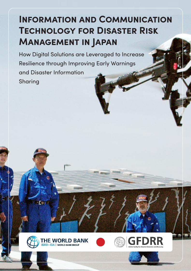
Disaster information collection drill using drones conducted by Kashihara City Government, Nara Prefecture (May 2015). Source: Kyodo News Images.
Information and Communication Technology for Disaster Risk Management in Japan How Digital Solutions are Leveraged to Increase Resilience through Improving Early Warningsand Disaster Information Sharing

Table of Contents
Acknowledgement 1Abbreviations 2Executive Summary 4
1. Introduction 71.1 Why Japan? 91.2 ICT for DRM 101.3 Scope of This Report 12 2. Disasters and ICT Development in Japan: Historical Review 152.1 Natural Disasters in Japan 162.1.1 Disaster Types and Impacts 162.1.2 Major Policies and Institutional Framework for DRM in Japan 20
2.2 ICT Development in Japan 222.2.1 Definitions of ICT 222.2.2 High Level Technology Development in Japan 232.2.3 Major Policies and Institutional Framework for ICT Development in Japan 23
2.3 Historical Evolution and Utilization of ICT to Strengthen Disaster Resilience in Japan 26 3. Early Warning Systems 313.1 Early Warning Systems in Japan: Key Lessons 333.1.1 Systems Discussed 333.1.2 Key Lessons from the EWSs 34
3.2 Earthquake Early Warning Systems in Japan 363.2.1 Earthquake Early Warning System: Overview 363.2.2 Earthquake Early Warning System: Lessons and Recommendations 373.2.3 Earthquake Early Warning System: ICT Systems and Context 383.2.4 Earthquake Early Warning System: Enabling Environment 40
3.3 J-ALERT: Nationwide Instantaneous Warning and Alert System 423.3.1 J-ALERT: System Overview 423.3.2 J-ALERT: Lessons and Recommendations 433.3.3 J-ALERT: ICT Systems and Context 443.3.4 Enabling Environment 46
3.4 Emergency Alert Mail: Cell Broadcast Early Warning System 483.4.1 Emergency Alert Mail: System Overview 483.4.2 Emergency Alert Mail: Lessons and Recommendations 493.4.3 Emergency Alert Mail: ICT Systems and Infrastructures 503.4.4 Emergency Alert Mail: Enabling Environment 53
4. Multi-Hazard Disaster Information management Systems (DIMS) in Japan 554.1 DIMS Overview 584.1.1 Systems Discussed 584.1.2 Key Lessons 59
4.2 L-ALERT: Common Public Information System for Safety and Security 604.2.1 L-ALERT: System Overview 604.2.2 L-ALERT: Lessons and Recommendations 614.2.3 L-ALERT: ICT Systems and Context 624.2.4 Enabling Environment 65
4.3 GIS-Based DIMS 664.3.1 GIS-Based DIMS: System Overview 664.3.2 GIS-Based DIMS: Lessons and Recommendations 684.3.3 GIS-Based DIMS: ICT Systems and Context 694.3.4 Enabling Environment 72
4.4 Tokushima DIMS: Disaster Information Management System 744.4.1 Tokushima DIMS: System Overview 744.4.2 Tokushima DIMS: Lessons and Recommendations 764.4.3 Tokushima DIMS: ICT Systems and Context 784.4.4 Tokushima DIMS: Enabling Environment 81
4.5 K-DIS: DIMS for Utilities 824.5.1 K-DIS: System Overview 824.5.2 K-DIS: Lessons and Recommendations 834.5.3 K-DIS: ICT Systems and Context 844.5.4 K-DIS: Enabling Environment 85
4.6 Hyogo Asset Management System: DIMS for Infrastructure 864.6.1 Hyogo Asset Management System: System Overview 864.6.2 Hyogo Asset Management System: Lessons and Recommendations 874.6.3 Hyogo Asset Management System: ICT Systems and Context 884.6.4 Hyogo Asset Management System: Enabling Environment 91
5. Key Takeaways and Next Steps on ICT for DRM 93
Appendix of Additional Technical Details 99Appendix A: High Level Technology Development in Japan: Historical Review 100A.1 History of Earthquakes and ICT Development in Japan: 100A.2. Comparison of JMA Intensity Scale 102
Appendix B: Earthquake Early Warning System 108B.1 Examples of Application During Disaster Events 108B.2 Earthquake Early Warning System: ICT Systems and Context 108 Systems and Infrastructures 108 Institutional Framework 113B.3. Earthquake Early Warning System: Enabling Environment 114 Limitations of Earthquake Early Warning System 114
Appendix C: J-ALERT: Nationwide Instantaneous Warning/Alert System 116C.1 Examples of Application During Disaster Events 116C.2 J-ALERT: ICT Systems and Context 118 Systems and Infrastructures 118 Warning Types 120C.3 J-ALERT: Enabling Environment 121 System Costs 121
Appendix D: Emergency Alert Mail (Cell Broadcast Early Warning System) 122D.1 Examples of Application During Disaster Events 122D.2 Emergency Alert Mail: ICT Systems and Context 123 Systems and Infrastructures 123 Warning Types 125
Appendix E: L-ALERT 126E.1 Examples of Application During Disaster Events 126E.2 L-ALERT: ICT Systems and Context 126 Systems and Infrastructures 126 Dissemination 128 Institutional Framework 129
Appendix F: GIS-based Disaster Management Information System 130F.1 Examples of Application During Disaster Events 130F.2 GIS-Based DIMS: ICT Systems and Context 131 Systems and Infrastructures 131 Institutional Framework 135
Appendix G: Tokushima Prefecture: Disaster Information Management System 136G.1 Examples of Application During Disaster Events 136G.2 GIS-Based DIMS: ICT Systems and Context 137 Systems and Infrastructures 137 Deployment 141 Institutional Framework 142
Appendix H: K-DIS: DIMS for Utilities 144H.1 Examples of Application During Disaster Events 144H.2 K-DIS: ICT Systems and Context 144 Systems and Infrastructures 144 Institutional Framework 147
Appendix I: Hyogo Asset Management System for Resilience: DIMS for Infrastructure 150I.1 Hyogo Asset Management System: ICT Systems and Context 150 Systems and Infrastructures 150 Institutional Framework 154
References 156
1
DisclaimerThis work is a product of the staff of The World Bank with external contributions. The findings, interpretations, and conclusions expressed in this work do not necessarily reflect the views of The World Bank, its Board of Executive Directors, or the governments they represent.
The World Bank does not guarantee the accuracy of the data included in this work. The boundaries, colors, denominations, and other information shown on any map in this work do not imply any judgment on the part of The World Bank concerning the legal status of any territory or the endorsement or acceptance of such boundaries.
The report reflects information available up to March 31, 2019.
AcknowledgementThis report was prepared by a World Bank team comprised of Shoko Takemoto, Naho Shibuya, Siou Chew Kuek, Alexander Ryota Keeley, and Lizzie Yarina. Primary and secondary data gathering was conducted by the Mitsubishi Research Institute (MRI). The report benefited from additional research and contributions by Robin Lewis and Yasuko Kusakari.
Special gratitude is extended to the Japanese professionals and experts on early warning and disaster information management systems at national and local governments, utility companies, and universities that kindly provided primary data, information, analysis, and their invaluable perspectives and time. These include: Ministry of Internal Affairs and Communications (MIC); Fire and Disaster Management Agency (FDMA) of MIC; Ministry of Land, Infrastructure, Transport and Tourism (MLIT); Japan Meteorological Agency (JMA); Hyogo Prefectural Government, Department of Land and Infrastructure; Tokushima Prefectural Government, Crisis Management Department; Foundation for Multi-Media Communications (FMMC); The Japan Bosai Platform (JBP); Micro Media Disaster Information Network (MMDIN); Fujitsu Limited; Hitachi, Ltd.; The Kansai Electric Power Company, Incorporated; Mitsubishi Electric Corporation; NEC Corporation; Nippon Telegraph and Telephone Corporation (NTT); NTT DATA Corporation; Crisis Mappers Japan; and Aoyama Gakuin University.
The report benefited from the guidance and contributions from the following Japanese experts: Professor Haruo Hayashi, National Research Institute for Earth Science and Disaster Resilience (NIED); Professor Isao Nakamura, Faculty of Sociology, University of Toyo; Ms. Kaori Kowada, Reconstruction Agency and GensaiInfo (NPO); Professor Norio Maki, Disaster Prevention Research Institute (DPRI), Kyoto University; Professor Taichi Furuhashi, Spatial Information, School of Global Studies and Collaboration, Aoyama Gakuin University.
The team also acknowledges the valuable contributions from the World Bank peer reviewers, including: Ko Takeuchi, Koji Nishida, Keiko Saito, Makoto Suwa, Masatake Yamamichi, Naohisa Koide, and Satoshi Ogita. The team is also grateful for the support from Mika Iwasaki, Luis Tineo, Guillermo Siercke, Satoshi Imura, Thimali Thanuja Pathirana Batuwita Pathiranage, Reiko Udagawa, and Haruko Nakamatsu.
Editorial services were provided by Pasquale Franzese. Lizzie Yarina designed the report.
This report was prepared with support from the Japan-World Bank Program for Mainstreaming Disaster Risk Management in Developing Countries.
2 DIGITAL SOLUTIONS FOR RESILIENCE
Abbreviations
3GPP 3rd Generation Partnership Project
AI Artificial Intelligence
AMS Asset Management System
API Application Programming Interface
ASP Application Service Provider
BCP Business Continuity Plan
BC-SMS Broadcast SMS
bps Bits per second
CAO Cabinet Office
CAS Cabinet Secretariat
CBS Cell Broadcast Service
CD-R Compact Disc-Recordable
CMAS Commercial Mobile Alert System
CMID Crisis Management Information Databank
CSOs Civil Society Organizations
CTC Hyogo Construction Technology Center for Regional Development
DA Digital Access
DID Densely Inhabited District
DMAT Disaster Medical Assistance Team
DIMS Disaster Information Management System
DRM Disaster Risk Management
EDXL Emergency Data Exchange Language
EEWS Earthquake Early Warning System
EMIS Emergency Medical Information System
EOC Emergency Operations Center
EPOS Earthquake Phenomena Observation System
ETWS Earthquake and Tsunami Warning System
EWS Early Warning System
FAX Facsimile
FDMA Fire and Disaster Management Agency
FMMC Foundation for MultiMedia Communications
GFDRR Global Facility for Disaster Reduction and Recovery
GIS Geographical Information System
GPL GNU General Public License
GPS Global Positioning System
GSI Geospatial Information Authority of Japan
HDD Hard Disk Drive
HTML Hyper Text Markup Language
ICT Information and Communication Technology
ID Identification
IDC Internet Data Center
IP Internet Protocol
IP-VPN Internet Protocol Virtual Private Network
J-ALERT Nationwide Instantaneous Warning/Alert System
JBP Japan Bosai* (bosai: holistic approach to reduce disaster impact)Platform
J-LIS Japan Agency for Local Authority Information Systems
JAMSTEC Japan Agency for Marine-Earth Science and Technology
JMA Japan Meteorological Agency
JMBSC Japan Meteorological Business Support Center
3
JPY Japanese Yen
JR Japan Railway Company
JSDF Japan Self-defense Force
JWA Japan Weather Association
Kansai Kansai Electric Power Company
L-ALERT Local Alert: Common public information for safety and security
LAN Local Area Network
LASCOM Local Authorities Satellite Communications Organization
LGWAN Local Government Wide Area Network
MHLW Ministry of Health, Labour and Welfare
MIC Ministry of Internal Affairs and Communications
MJ Ministry of Justice
MLIT Ministry of Land, Infrastructure, Transport and Tourism
MMDIN Micro Media Disaster Information Network
MOE Ministry of the Environment
MOFA Ministry of Foreign Affairs
MVNO Mobile Virtual Network Operator
NHK Nippon Hoso Kyokai (Japan Broadcasting Corporation)
NIED National Research Institute for Earth Science and Disaster Resilience
NTT Nippon Telegraph and Telephone Corporation
O&M Operation and Maintenance
OSM OpenStreetMap
PC Personal Computer
PCXML Public Commons XML
PLUM Propagation of Local Undamped Motion
PR Public Relations
PWS Public Warning System
R&D Research and Development
RFU Radio Frequency Unit
RSS Rich Site Summary
SAR Synthetic Aperture Radar
SIP4D Sharing Information Platform for Disaster management
SMS Short Message Service
SNS Social Networking Service
SOAP Simple Object Access Protocol
SOP Standard Operating Procedure
TS Technical Specification
TTL Task Team Leader
TV Television
UI User Interface
UN United Nations
UNISDR United Nations International Strategy for Disaster Reduction
UPS Uninterruptible Power Supply
URL Uniform Resource Locator
USB Universal Serial Bus
USD US Dollar
USGS United States Geological Survey
VPN Virtual Private Network
WAN Wide Area Network
WS-Security
Web Services Security
XML Extensible Markup Language
4 DIGITAL SOLUTIONS FOR RESILIENCE
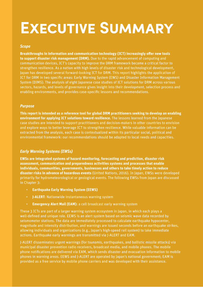
Executive Summary ScopeBreakthroughs in information and communication technology (ICT) increasingly offer new tools to support disaster risk management (DRM). Due to the rapid advancement of computing and communication devices, ICT’s capacity to improve the DRM framework became a critical factor to strengthen resilience. As a nation with high levels of disaster risk and technological development, Japan has developed several forward-looking ICT for DRM. This report highlights the application of ICT for DRM in two specific areas: Early Warning System (EWS) and Disaster Information Management System (DIMS). The analysis of eight Japanese case studies of ICT solutions for DRM across various sectors, hazards, and levels of governance gives insight into their development, selection process and enabling environments, and provides case-specific lessons and recommendations.
PurposeThis report is intended as a reference tool for global DRM practitioners seeking to develop an enabling environment for applying ICT solutions toward resilience. The lessons learned from the Japanese case studies are intended to support practitioners and decision-makers in other countries to envision and explore ways to better leverage ICT to strengthen resilience. While valuable information can be extracted from the analysis, each case is contextualized within its particular social, political and environmental framework: our recommendations should be adapted to local needs and capacities.
Early Warning Systems (EWSs)EWSs are integrated systems of hazard monitoring, forecasting and prediction, disaster risk assessment, communication and preparedness activities systems and processes that enable individuals, communities, governments, businesses and others to take timely action to reduce disaster risks in advance of hazardous events (United Nations, 2016). In Japan, EWSs were developed primarily for hydrometeorological or geological events. The following EWSs from Japan are discussed in Chapter 3:
• Earthquake Early Warning System (EEWS)
• J-ALERT: Nationwide instantaneous warning system
• Emergency Alert Mail (EAM): a cell broadcast early warning system
These 3 ICTs are part of a larger warning system ecosystem in Japan, in which each plays a well-defined and unique role. EEWS is an alert system based on seismic wave data recorded by seismometer stations. The data are immediately processed to calculate earthquake hypocenter, magnitude and intensity distribution, and warnings are issued seconds before an earthquake strikes, allowing individuals and organizations (e.g., Japan’s high-speed rail system) to take immediate actions. Earthquake early warnings are transmitted via J-ALERT and EAM.
J-ALERT disseminates urgent warnings (for tsunamis, earthquakes, and ballistic missile attacks) via municipal disaster prevention radio receivers, broadcast media, and mobile phones. The mobile phone notifications are delivered via EAM, which sends disaster and evacuation information to mobile phones in warning areas. EEWS and J-ALERT are operated by Japan’s national government; EAM is provided as a free service by mobile phone carriers and was developed with their assistance.
5
Several lessons and recommendations have been developed from these cases:
• Warning systems should be selected in accordance with the local ICT context;
• Warning dissemination should be redundant and diverse;
• Interoperability among relevant systems allows EWSs to build upon and work with existing systems;
• Periodic education and training to officials and residents is important to respond quickly and effectively to early warnings.
• Multi-functional for disaster and non-disaster times: EWSs that can be utilized in normal times will be more effective during a disaster.
Disaster Information Management Systems (DIMSs)DIMSs are mechanisms for effectively processing, organizing, storing and disseminating information required for disaster response and recovery, particularly in the immediate aftermath of a natural disaster. In Japan there are various types of DIMSs which are differentiated by target hazards, key functions, actors involved, technologies utilized, and key information communicated. The following DIMS cases from Japan are discussed in Chapter 4:
• L-ALERT Common Public Information for Safety and Security
• GIS-based DIMS
• Tokushima Prefecture DIMS
• K-DIS: DIMS for Utilities
• Hyogo Asset Management System for Resilience: DIMS for Infrastructure
These DIMS cases reveal several lessons, the most important of which can be summarized as:
• To ensure effective operations when a disaster strikes the legislation should clearly define the roles and procedures of relevant organizations, for example by implementing a Standard Operating Procedure (SOP) at multiple levels of government to clarify key roles and responsibilities.
• Pre-disaster outreach and engagement with the system in order to familiarize with it increase the use and effectiveness of DIMS during a disaster.
• DIMSs are more effective and affordable when they are based upon existing communication infrastructure and user contexts.

Image: Students hiding under their desks after receiving Earthquake Early Warning (disaster drill), conducted at Hanawaho Kichi Gakuen, Kawagoe City, Saitama Prefecture (Oct. 2012). Source: Kyodo News Images.

[1] Introduction
8 DIGITAL SOLUTIONS FOR RESILIENCE
1.0 Introduction
Information and Communication Technology (ICT) provides new tools for challenges that many countries face in achieving sustainable and equitable development. ICT systems play a critical role in enhancing disaster and climate resilience: augmenting the capacities of people, communities, organizations, and nations to gather risk and damage information; enabling quick and meaningful analysis and communication; and offering innovative and effective technological tools, platforms, and systems to make disaster risk management and response more efficient. Across the globe, ICTs are now essential within all phases of Disaster Risk Management (DRM1)– i) Prevention and mitigation; ii) Preparedness; iii) Response; and iv) Rehabilitation, recovery and reconstruction.
However, in a world of fast-paced digital innovations, the nexus of ICT and DRM is dynamic. While continuous development increases the possibilities to apply ICT to resilience, ICT users often face the paradox of choice; understanding the implications of one set of ICT solutions from an array of software and hardware options is often a complex task for DRM practitioners and decision-makers at national and local levels. Furthermore, limited information, technical capacity, and awareness can make it difficult to navigate the complex and fast-changing technologies necessary to create an enabling environment for effective and sustained use of ICT systems within DRM operations. These factors can represent significant barriers to fully access and utilize ICT systems, and benefiting from their potential to reduce and manage disaster-related risks more effectively.
Recognizing the significant opportunities and challenges of utilizing ICT to strengthen resilience to natural disasters, this report draws upon practical examples of ICT solutions to DRM in Japan to help answering the following three questions:
1. Which ICT systems have a track record in reducing disaster risks, damages, and losses?
2. What are the key enabling environments that allow ICT to be used effectively and sustainably before, during, and after disasters?
3. How can the best available ICT be identified and applied to address disaster risks in the context of developing countries?
This report is intended as a reference tool for global DRM practitioners and decision-makers seeking to develop or improve ICT strategies to strengthen resilience and to design, roll out, operate and maintain ICT systems for DRM. It presents a historical review of ICT development in Japan, and case studies of ICT solutions to DRM in Japan across various sectors, hazards, and levels of governance. Concluding remarks and several recommendations are also provided. Note that the cases from Japan are to be understood within their particular social, political and environmental contexts: any ICT for DRM strategy should be developed accounting for local needs and capacities.
1 “Disaster risk management most regularly refers to both disaster risk reduction (prevention, preparedness and mitigation) and humanitarian and development action (emergency response, relief and reconstruction).” (Schipper & Pelling, 2006). The term DRM is sometimes used interchangeably with Disaster Risk Reduction (DRR). However, DRR is the policy objective of disaster risk management, and its goals and objectives are defined in DRR strategies and plans. On the other hand, DRM is the application of DRR policies and strategies to prevent new disaster risk, reduce existing disaster risk and manage residual risk, contributing to the strengthening of resilience and reduction of disaster losses (UNISDR, 2017).

9
1.1 Why Japan?Japan is one of the most technologically advanced countries in the world 2, and one of the most exposed to natural disasters, including earthquakes, tsunamis, volcanic eruptions, typhoons, rainstorms, flooding, landslides3, and snowstorms (Government of Japan, 2006). Faced with diverse and significant disaster risks, Japan has accumulated significant experience in recovering from diverse disaster impacts. Large-scale earthquakes, though less frequent than floods, have strongly impacted Japanese society. For example, in 1995 the Great Hanshin-Awaji Earthquake (magnitude4 7.3) caused six thousand deaths, and property damages of USD 100 billion (World Bank, 2011). In 2011, the magnitude 9.05 Great East Japan Earthquake (GEJE), one of the largest earthquakes ever recorded in the world, and the giant tsunami it triggered, devastated the northeastern coastal regions on the main island of Japan. The destruction included more than 17,500 fatalities and estimated economic damage of USD 210 billion (World Bank, 2012). The history of disasters in Japan is further discussed in Chapter 2.
After each disaster Japan has channeled significant efforts to recover from extensive damages, prepare for and mitigate future risks by “building back better”, learning from response and risk reduction challenges to improve the design of ICT systems – often doing so through modernizing outdated and underperforming systems or adopting new technologies. Notably, such “post-disaster technology innovation” (Toya, 2014) has increased economic productivity in the long-run; a phenomenon which has been studied by various researchers (e.g., Akao and Sakamoto, 2013; Skidmore and Toya, 2002) indicating the opportunity for policymakers and stakeholders to rebuild infrastructures in more efficient and resilient ways.
2 Japan is ranked 10th out of 176 nations for ICT Development Index (ITU-D, 2017), and Networked Readiness Index (Dutta et. al., 2015).3 Japan is ranked 37th out of 191 countries for Hazard and Exposure Risk Index (INFORM, 2017)4 Measured in local magnitude (Mj). The two magnitude scales used by the Japan Meteorological Agency (JMA) to express the intensity of earthquakes are JMA magnitude (Mj) and moment magnitude (Mw). Mj is calculated from the maximum amplitude of seismic waves as observed by strong-motion seismometers recording strong motion with a period of up to around five seconds. As Mj information can be provided within around three minutes of an earthquake, it is suitable for the prompt issuance of warnings. See https://www.data.jma.go.jp/svd/eqev/data/en/tsunami/LessonsLearned_Improvements_brochure.pdf for more information. 5 Measured in moment magnitude (Mw)
10 DIGITAL SOLUTIONS FOR RESILIENCE
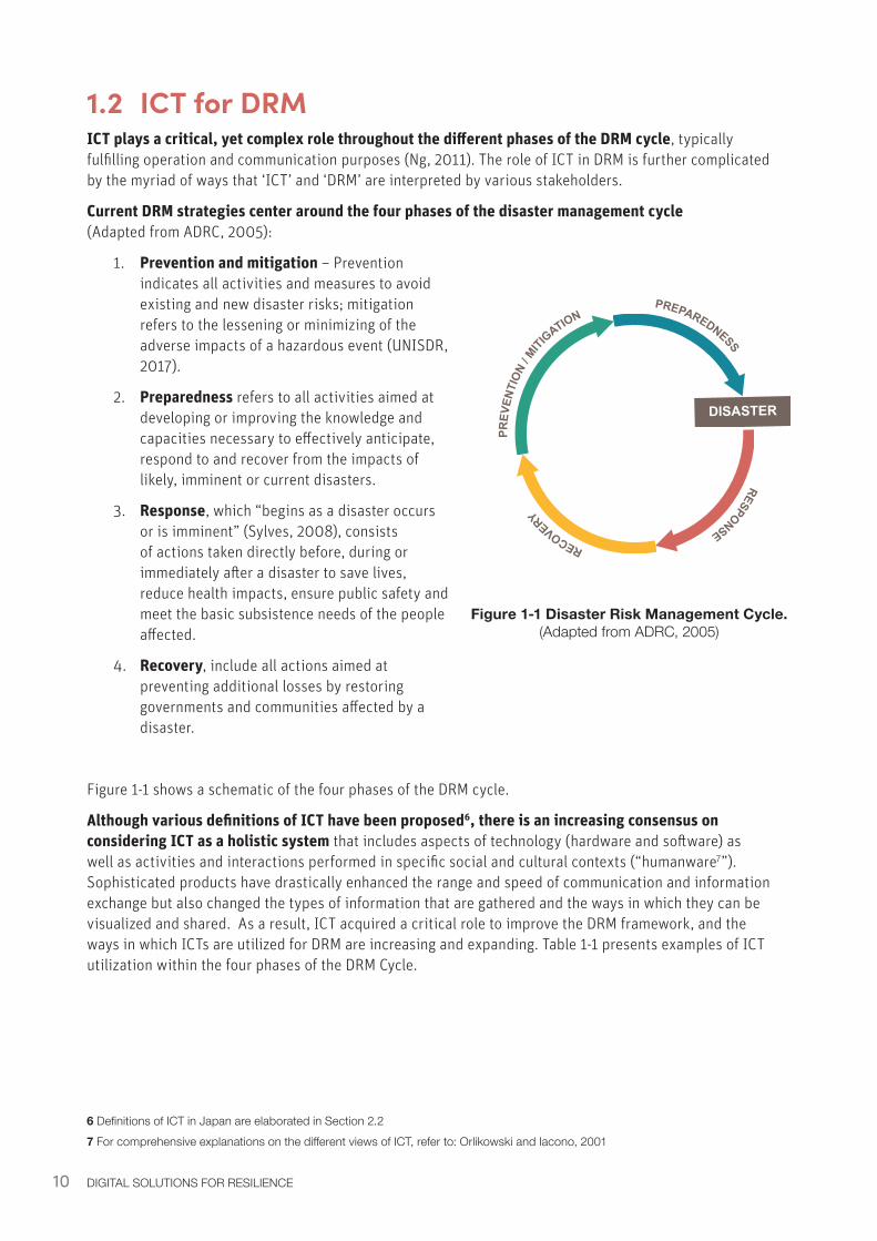
1.2 ICT for DRMICT plays a critical, yet complex role throughout the different phases of the DRM cycle, typically fulfilling operation and communication purposes (Ng, 2011). The role of ICT in DRM is further complicated by the myriad of ways that ‘ICT’ and ‘DRM’ are interpreted by various stakeholders.
Current DRM strategies center around the four phases of the disaster management cycle (Adapted from ADRC, 2005):
1. Prevention and mitigation – Prevention indicates all activities and measures to avoid existing and new disaster risks; mitigation refers to the lessening or minimizing of the adverse impacts of a hazardous event (UNISDR, 2017).
2. Preparedness refers to all activities aimed at developing or improving the knowledge and capacities necessary to effectively anticipate, respond to and recover from the impacts of likely, imminent or current disasters.
3. Response, which “begins as a disaster occurs or is imminent” (Sylves, 2008), consists of actions taken directly before, during or immediately after a disaster to save lives, reduce health impacts, ensure public safety and meet the basic subsistence needs of the people affected.
4. Recovery, include all actions aimed at preventing additional losses by restoring governments and communities affected by a disaster.
Figure 1-1 shows a schematic of the four phases of the DRM cycle.
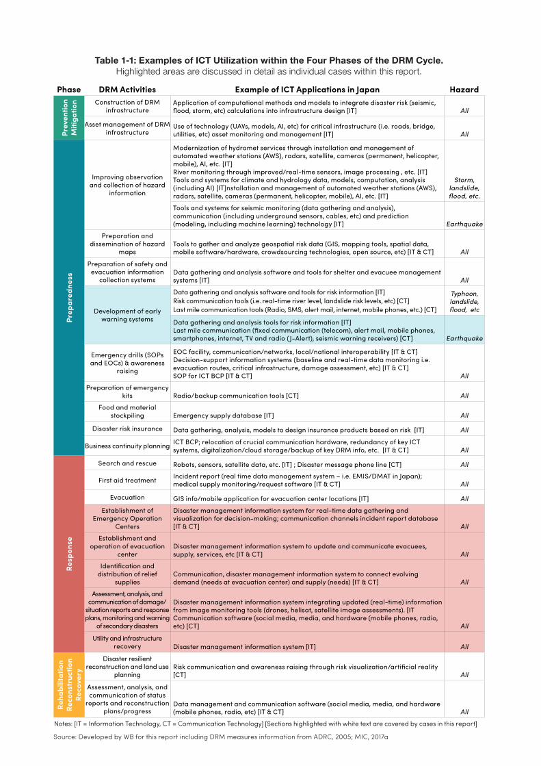
Although various definitions of ICT have been proposed6, there is an increasing consensus on considering ICT as a holistic system that includes aspects of technology (hardware and software) as well as activities and interactions performed in specific social and cultural contexts (“humanware7”). Sophisticated products have drastically enhanced the range and speed of communication and information exchange but also changed the types of information that are gathered and the ways in which they can be visualized and shared. As a result, ICT acquired a critical role to improve the DRM framework, and the ways in which ICTs are utilized for DRM are increasing and expanding. Table 1-1 presents examples of ICT utilization within the four phases of the DRM Cycle.
6 Definitions of ICT in Japan are elaborated in Section 2.27 For comprehensive explanations on the different views of ICT, refer to: Orlikowski and Iacono, 2001
PREPAREDNESS
PREV
ENTI
ON / M
ITIGATION
RECOVERY
RESPONSE
DISASTER
Figure 1-1 Disaster Risk Management Cycle. (Adapted from ADRC, 2005)
11
Phase DRM Activities Example of ICT Applications in Japan Hazard
Prev
entio
n M
itiga
tion Construction of DRM
infrastructureApplication of computational methods and models to integrate disaster risk (seismic, flood, storm, etc) calculations into infrastructure design [IT] All
Asset management of DRM infrastructure
Use of technology (UAVs, models, AI, etc) for critical infrastructure (i.e. roads, bridge, utilities, etc) asset monitoring and management [IT] All
Prep
ared
ness
Improving observation and collection of hazard
information
Modernization of hydromet services through installation and management of automated weather stations (AWS), radars, satellite, cameras (permanent, helicopter, mobile), AI, etc. [IT] River monitoring through improved/real-time sensors, image processing , etc. [IT] Tools and systems for climate and hydrology data, models, computation, analysis (including AI) [IT]nstallation and management of automated weather stations (AWS), radars, satellite, cameras (permanent, helicopter, mobile), AI, etc. [IT]
Storm, landslide, flood, etc.
Tools and systems for seismic monitoring (data gathering and analysis), communication (including underground sensors, cables, etc) and prediction (modeling, including machine learning) technology [IT] Earthquake
Preparation and dissemination of hazard
maps Tools to gather and analyze geospatial risk data (GIS, mapping tools, spatial data, mobile software/hardware, crowdsourcing technologies, open source, etc) [IT & CT] All
Preparation of safety and evacuation information
collection systemsData gathering and analysis software and tools for shelter and evacuee management systems [IT] All
Development of early warning systems
Data gathering and analysis software and tools for risk information [IT] Risk communication tools (i.e. real-time river level, landslide risk levels, etc) [CT] Last mile communication tools (Radio, SMS, alert mail, internet, mobile phones, etc.) [CT]
Typhoon, landslide, flood, etc
Data gathering and analysis tools for risk information [IT] Last mile communication (fixed communication (telecom), alert mail, mobile phones, smartphones, internet, TV and radio (J-Alert), seismic warning receivers) [CT] Earthquake
Emergency drills (SOPs and EOCs) & awareness
raising
EOC facility, communication/networks, local/national interoperability [IT & CT] Decision-support information systems (baseline and real-time data monitoring i.e. evacuation routes, critical infrastructure, damage assessment, etc) [IT & CT] SOP for ICT BCP [IT & CT] All
Preparation of emergency kits Radio/backup communication tools [CT] All
Food and material stockpiling Emergency supply database [IT] All
Disaster risk insurance Data gathering, analysis, models to design insurance products based on risk [IT] All
Business continuity planning ICT BCP; relocation of crucial communication hardware, redundancy of key ICT systems, digitalization/cloud storage/backup of key DRM info, etc. [IT & CT] All
Resp
onse
Search and rescue Robots, sensors, satellite data, etc. [IT] ; Disaster message phone line [CT] All
First aid treatment Incident report (real time data management system – i.e. EMIS/DMAT in Japan); medical supply monitoring/request software [IT & CT] All
Evacuation GIS info/mobile application for evacuation center locations [IT] All
Establishment of Emergency Operation
Centers
Disaster management information system for real-time data gathering and visualization for decision-making; communication channels incident report database [IT & CT] All
Establishment and operation of evacuation
centerDisaster management information system to update and communicate evacuees, supply, services, etc [IT & CT] All
Identification and distribution of relief
suppliesCommunication, disaster management information system to connect evolving demand (needs at evacuation center) and supply (needs) [IT & CT] All
Assessment, analysis, and communication of damage/
situation reports and response plans, monitoring and warning
of secondary disasters
Disaster management information system integrating updated (real-time) information from image monitoring tools (drones, helisat, satellite image assessments). [IT Communication software (social media, media, and hardware (mobile phones, radio, etc) [CT] All
Utility and infrastructure recovery Disaster management information system [IT] All
Reha
bilit
atio
n
Reco
nstr
uctio
n
Reco
very
Disaster resilient reconstruction and land use
planningRisk communication and awareness raising through risk visualization/artificial reality [CT] All
Assessment, analysis, and communication of status
reports and reconstruction plans/progress
Data management and communication software (social media, media, and hardware (mobile phones, radio, etc) [IT & CT] All
Notes: [IT = Information Technology, CT = Communication Technology] [Sections highlighted with white text are covered by cases in this report]
Table 1-1: Examples of ICT Utilization within the Four Phases of the DRM Cycle. Highlighted areas are discussed in detail as individual cases within this report.
Source: Developed by WB for this report including DRM measures information from ADRC, 2005; MIC, 2017a
12 DIGITAL SOLUTIONS FOR RESILIENCE
1.3 Scope of This Report
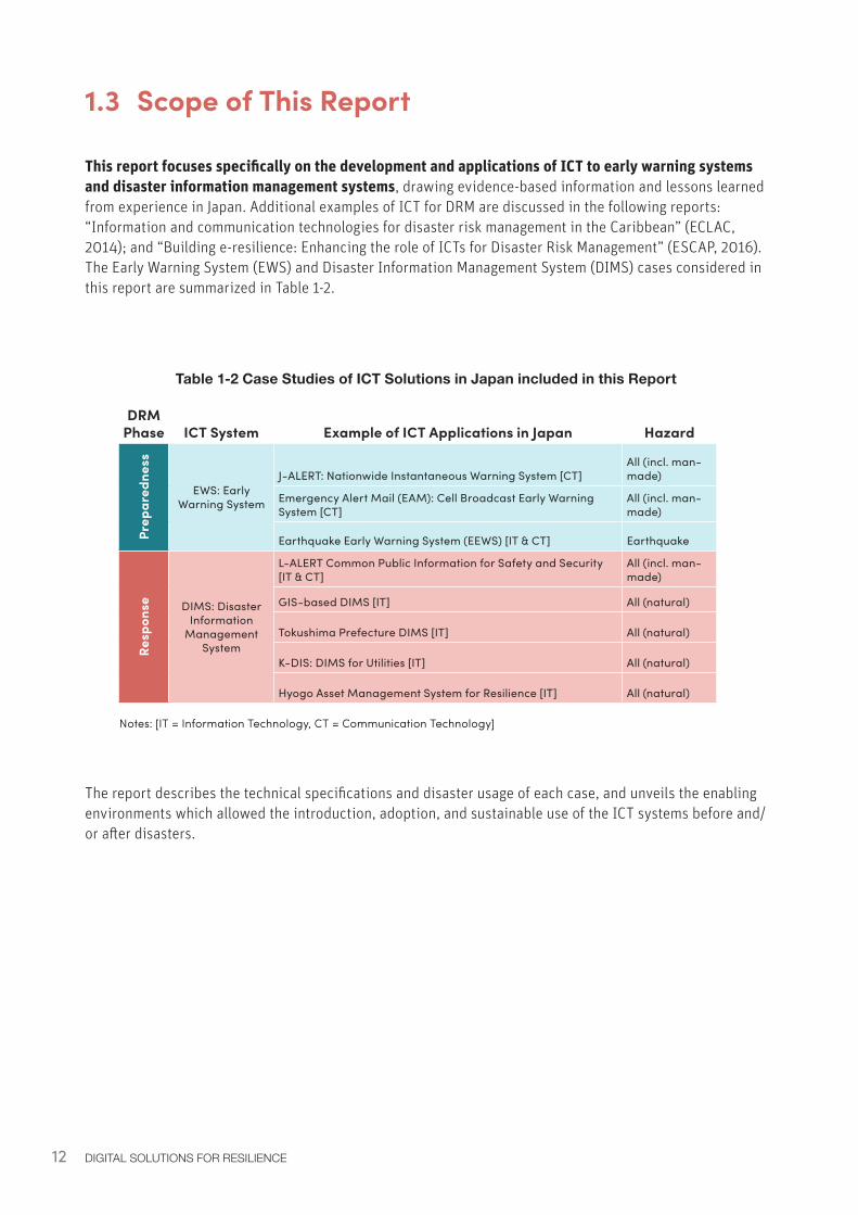
This report focuses specifically on the development and applications of ICT to early warning systems and disaster information management systems, drawing evidence-based information and lessons learned from experience in Japan. Additional examples of ICT for DRM are discussed in the following reports: “Information and communication technologies for disaster risk management in the Caribbean” (ECLAC, 2014); and “Building e-resilience: Enhancing the role of ICTs for Disaster Risk Management” (ESCAP, 2016). The Early Warning System (EWS) and Disaster Information Management System (DIMS) cases considered in this report are summarized in Table 1-2.
Table 1-2 Case Studies of ICT Solutions in Japan included in this Report
The report describes the technical specifications and disaster usage of each case, and unveils the enabling environments which allowed the introduction, adoption, and sustainable use of the ICT systems before and/or after disasters.
DRM Phase ICT System Example of ICT Applications in Japan Hazard
Prep
ared
ness
EWS: Early Warning System
J-ALERT: Nationwide Instantaneous Warning System [CT]All (incl. man-made)
Emergency Alert Mail (EAM): Cell Broadcast Early Warning System [CT]
All (incl. man-made)
Earthquake Early Warning System (EEWS) [IT & CT] Earthquake
Resp
onse DIMS: Disaster
Information Management
System
L-ALERT Common Public Information for Safety and Security [IT & CT]
All (incl. man-made)
GIS-based DIMS [IT] All (natural)
Tokushima Prefecture DIMS [IT] All (natural)
K-DIS: DIMS for Utilities [IT] All (natural)
Hyogo Asset Management System for Resilience [IT] All (natural)
Notes: [IT = Information Technology, CT = Communication Technology]
13INTRODUCTION
DRM Phase ICT System Example of ICT Applications in Japan Hazard
Prep
ared
ness
EWS: Early Warning System
J-ALERT: Nationwide Instantaneous Warning System [CT]All (incl. man-made)
Emergency Alert Mail (EAM): Cell Broadcast Early Warning System [CT]
All (incl. man-made)
Earthquake Early Warning System (EEWS) [IT & CT] Earthquake
Resp
onse DIMS: Disaster
Information Management
System
L-ALERT Common Public Information for Safety and Security [IT & CT]
All (incl. man-made)
GIS-based DIMS [IT] All (natural)
Tokushima Prefecture DIMS [IT] All (natural)
K-DIS: DIMS for Utilities [IT] All (natural)
Hyogo Asset Management System for Resilience [IT] All (natural)
Notes: [IT = Information Technology, CT = Communication Technology]
The report is organized into five chapters.
Chapter 1 introduces the motivation and objectives of this study; the unique context of Japan and its relevance to exploring possible advancements of ICT for DRM globally; the framework of the nexus of ICT and DRM; and the specific areas investigated in this report.
Chapter 2 illustrates the historical context of EWSs and DIMSs in Japan, highlighting the incremental development of ICT systems. Significant advancements have often been triggered by large-scale disasters, attempting to respond to challenges and incorporate lessons into future preparedness and response programs.
Chapters 3 and 4 include specific examples of ICT applications within EWSs and DIMSs in Japan, respectively. For each case study the key enabling factors are identified, and recommendations are extracted to support practitioners and decision-makers in other countries designing or implementing a fit-for-purpose ICT for EWSs or DIMSs.
Chapter 5 summarizes the key findings and takeaways, identifies areas that require further analysis and proposes next steps.
14
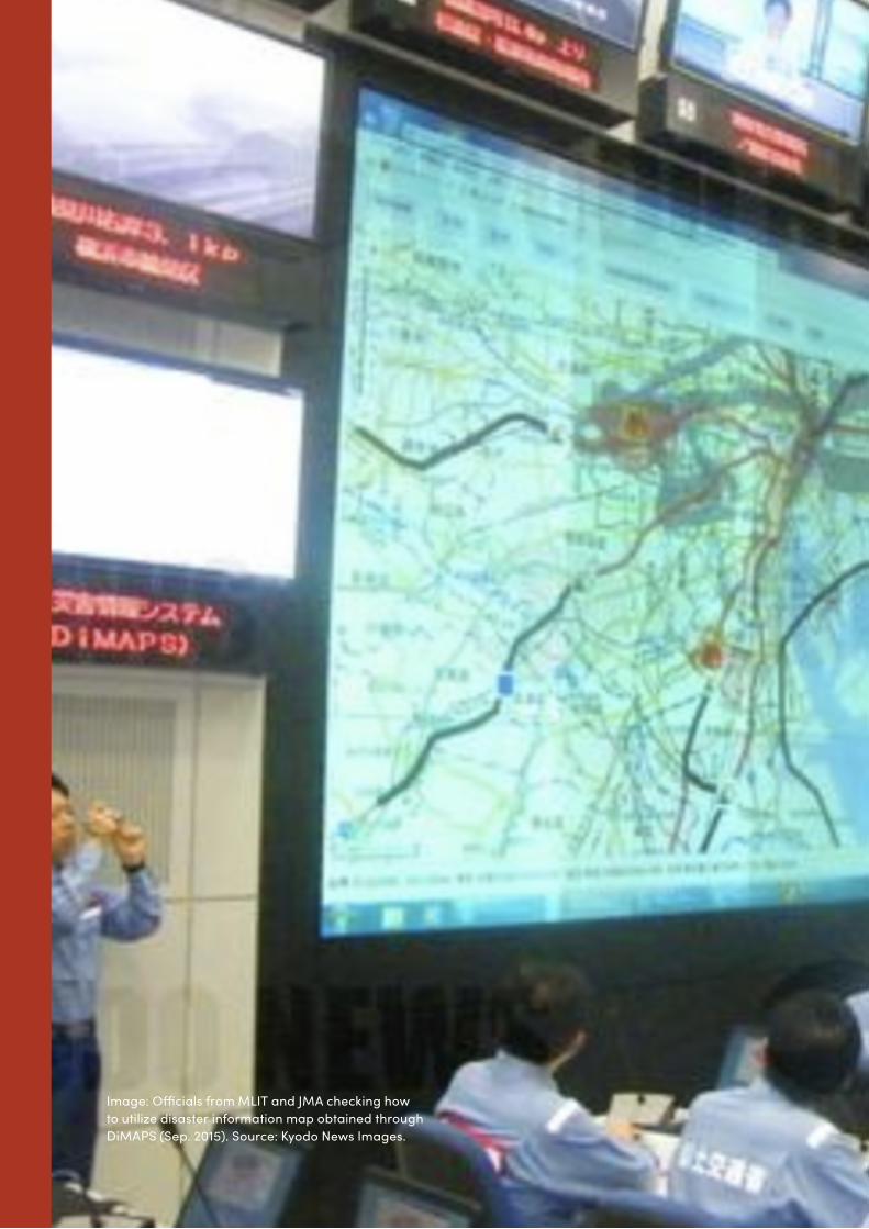
Image: Officials from MLIT and JMA checking how to utilize disaster information map obtained through DiMAPS (Sep. 2015). Source: Kyodo News Images.
[2] Disasters and ICT Development in Japan: Historical Review
16 DIGITAL SOLUTIONS FOR RESILIENCE
2.0 Disasters and ICT Development in Japan: Historical ReviewJapan is an archipelago of more than 6,000 islands highly exposed to seismic, meteorological, and hydrological hazards. Its history is closely interwoven with its experiences of confronting natural disasters and the incremental efforts made to build back better from each catastrophic event. Simultaneously, Japan’s rapid and sustained socioeconomic development after the Second World War has been driven by significant advances in science and technology. At present, technology serves as a critical backbone of Japanese economic competitiveness. In light of this context, Japan’s history of DRM and technological innovation is fundamentally interrelated.
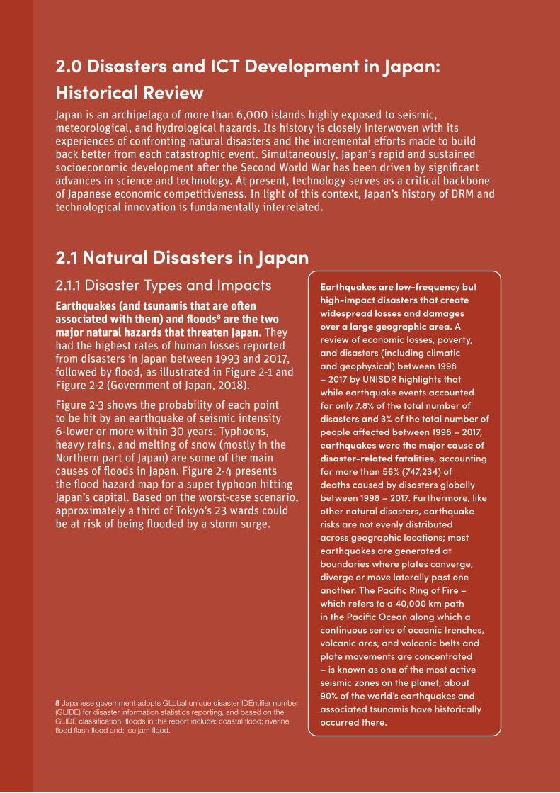
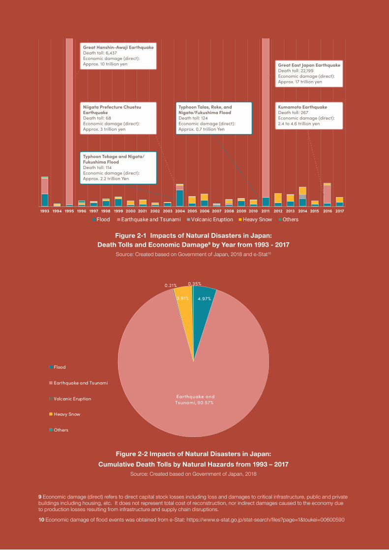
2.1 Natural Disasters in Japan2.1.1 Disaster Types and ImpactsEarthquakes (and tsunamis that are often associated with them) and floods8 are the two major natural hazards that threaten Japan. They had the highest rates of human losses reported from disasters in Japan between 1993 and 2017, followed by flood, as illustrated in Figure 2-1 and Figure 2-2 (Government of Japan, 2018).
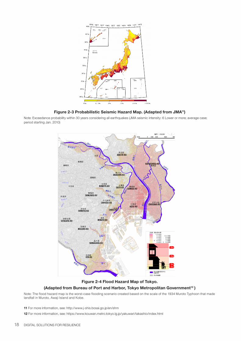
Figure 2-3 shows the probability of each point to be hit by an earthquake of seismic intensity 6-lower or more within 30 years. Typhoons, heavy rains, and melting of snow (mostly in the Northern part of Japan) are some of the main causes of floods in Japan. Figure 2-4 presents the flood hazard map for a super typhoon hitting Japan’s capital. Based on the worst-case scenario, approximately a third of Tokyo’s 23 wards could be at risk of being flooded by a storm surge.
8 Japanese government adopts GLobal unique disaster IDEntifier number (GLIDE) for disaster information statistics reporting, and based on the GLIDE classification, floods in this report include: coastal flood; riverine flood flash flood and; ice jam flood.
Earthquakes are low-frequency but high-impact disasters that create widespread losses and damages over a large geographic area. A review of economic losses, poverty, and disasters (including climatic and geophysical) between 1998 – 2017 by UNISDR highlights that while earthquake events accounted for only 7.8% of the total number of disasters and 3% of the total number of people affected between 1998 – 2017, earthquakes were the major cause of disaster-related fatalities, accounting for more than 56% (747,234) of deaths caused by disasters globally between 1998 – 2017. Furthermore, like other natural disasters, earthquake risks are not evenly distributed across geographic locations; most earthquakes are generated at boundaries where plates converge, diverge or move laterally past one another. The Pacific Ring of Fire – which refers to a 40,000 km path in the Pacific Ocean along which a continuous series of oceanic trenches, volcanic arcs, and volcanic belts and plate movements are concentrated – is known as one of the most active seismic zones on the planet; about 90% of the world’s earthquakes and associated tsunamis have historically occurred there.
17
Figure 2-1 Impacts of Natural Disasters in Japan: Death Tolls and Economic Damage9 by Year from 1993 - 2017
Source: Created based on Government of Japan, 2018 and e-Stat10
Figure 2-2 Impacts of Natural Disasters in Japan:
Cumulative Death Tolls by Natural Hazards from 1993 – 2017Source: Created based on Government of Japan, 2018
9 Economic damage (direct) refers to direct capital stock losses including loss and damages to critical infrastructure, public and private buildings including housing, etc. It does not represent total cost of reconstruction, nor indirect damages caused to the economy due to production losses resulting from infrastructure and supply chain disruptions.
10 Economic damage of flood events was obtained from e-Stat: https://www.e-stat.go.jp/stat-search/files?page=1&toukei=00600590
1993 1994 1995 1996 1997 1998 1999 2000 2001 2002 2003 2004 2005 2006 2007 2008 2009 2010 2011 2012 2013 2014 2015 2016 2017
Flood Earthquake and Tsunami Volcanic Eruption Heavy Snow Others
Great Hanshin-Awaji EarthquakeDeath toll: 6,437Economic damage (direct): Approx. 10 trillion yen
Niigata Prefecture Chuetsu EarthquakeDeath toll: 68Economic damage (direct): Approx. 3 trillion yen
Typhoon Tokage and Nigata/ Fukushima Flood Death toll: 114Economic damage (direct): Approx. 2.2 trillion Yen
Typhoon Talas, Roke, and Nigata/Fukushima Flood Death toll: 124Economic damage (direct): Approx. 0.7 trillion Yen
Great East Japan EarthquakeDeath toll: 22,199Economic damage (direct): Approx. 17 trillion yen
Kumamoto Earthquake Death toll: 267Economic damage (direct): 2.4 to 4.6 trillion yen
4.97%
Earthquake and Tsunami, 90.57%
0.21%
3.91%
0.35%
Flood
Earthquake and Tsunami
Volcanic Eruption
Heavy Snow
Others
18 DIGITAL SOLUTIONS FOR RESILIENCE
Figure 2-3 Probabilistic Seismic Hazard Map. (Adapted from JMA11)Note: Exceedance probability within 30 years considering all earthquakes (JMA seismic intensity: 6 Lower or more; average case; period starting Jan. 2010)
Figure 2-4 Flood Hazard Map of Tokyo. (Adapted from Bureau of Port and Harbor, Tokyo Metropolitan Government12 )
Note: The flood hazard map is the worst-case flooding scenario created based on the scale of the 1934 Muroto Typhoon that made landfall in Muroto, Awaji Island and Kobe.
11 For more information, see: http://www.j-shis.bosai.go.jp/en/shm12 For more information, see: https://www.kouwan.metro.tokyo.lg.jp/yakuwari/takashio/index.html
19DISASTERS AND ICT DEVELOPMENT IN JAPAN: HISTORICAL REVIEW
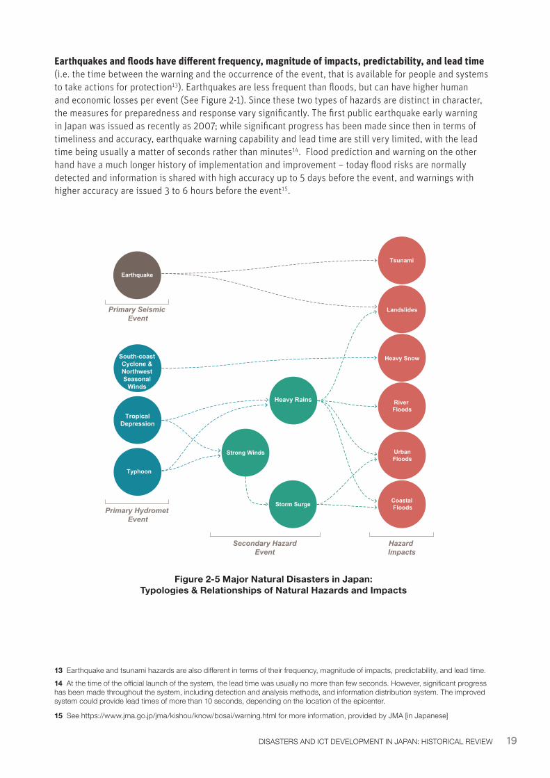
Earthquakes and floods have different frequency, magnitude of impacts, predictability, and lead time (i.e. the time between the warning and the occurrence of the event, that is available for people and systems to take actions for protection13). Earthquakes are less frequent than floods, but can have higher human and economic losses per event (See Figure 2-1). Since these two types of hazards are distinct in character, the measures for preparedness and response vary significantly. The first public earthquake early warning in Japan was issued as recently as 2007; while significant progress has been made since then in terms of timeliness and accuracy, earthquake warning capability and lead time are still very limited, with the lead time being usually a matter of seconds rather than minutes14. Flood prediction and warning on the other hand have a much longer history of implementation and improvement – today flood risks are normally detected and information is shared with high accuracy up to 5 days before the event, and warnings with higher accuracy are issued 3 to 6 hours before the event15.
Figure 2-5 Major Natural Disasters in Japan: Typologies & Relationships of Natural Hazards and Impacts
13 Earthquake and tsunami hazards are also different in terms of their frequency, magnitude of impacts, predictability, and lead time. 14 At the time of the official launch of the system, the lead time was usually no more than few seconds. However, significant progress has been made throughout the system, including detection and analysis methods, and information distribution system. The improved system could provide lead times of more than 10 seconds, depending on the location of the epicenter.
15 See https://www.jma.go.jp/jma/kishou/know/bosai/warning.html for more information, provided by JMA [in Japanese]
TropicalDepression
Earthquake
Primary Seismic Event
Primary Hydromet Event
Secondary HazardEvent
Hazard Impacts
Typhoon
Strong Winds
Heavy Rains
Storm Surge
Landslides
Heavy Snow
Tsunami
River Floods
Coastal Floods
UrbanFloods
South-coast Cyclone & Northwest Seasonal
Winds
20 DIGITAL SOLUTIONS FOR RESILIENCE
Current and future directions for DRM in Japan are driven by the following disaster-related trends:
• Heavy rain events (more than 80 mm rainfall per hour) are increasing and intensifying and the trend is expected to continue due to climate change16, suggesting that the magnitude and frequency of flood events are expected to increase.
• Earthquakes risks are imminent and urgent: there is a high probability that high density economic and political centers in the Kanto and Kansai Regions will be affected by a large-scale earthquake in the near future17: in particular, the Government of Japan estimates the probability of an earthquake of magnitude 7 or more hitting the Tokyo metropolitan area at 70% in the next three decades18. Furthermore, Japan is also preparing for a 70% chance of a magnitude 8 to 9 quake, followed by tsunami, striking along the Nankai Trough (which extends southwest from the Pacific coast of central Japan) within the next 30 years19. A disaster of this magnitude has the potential to cause significant human and economic damage in the Kansai Region, with an estimated 1.4 quadrillion JPY in reconstruction costs over 20 years.
2.1.2 Major Policies and Institutional Framework for DRM in JapanJapan has incrementally developed various DRM policies and institutional frameworks over time, with adjustments made after each major disaster. The primary legal and institutional framework for DRM in Japan is the Disaster Countermeasures Basic Act (DCBA). The DCBA was adopted in 1961 following the Ise-wan Typhoon, which caused devastating damage and the loss of more than 5,000 people in 1959.
The DCBA defines20:
• Responsibilities of the citizens and the national, prefectural, municipal, and designated public authorities.
• Institutional set up and organizational structure of national and subnational government required for disaster risk management before and after disasters (such as establishment of the Central Disaster Management Council and Disaster Management Headquarters, etc.).
• Types of DRM plans at the national level, designated public authority and prefectural/municipal levels.
• Efforts to promote preparedness and mitigation measures.
• Financing mechanism of disaster countermeasures, directing the responsible national and local government entities to bear the cost of implementing designated countermeasures (responsible implementation body burden principle) except for extreme events designated by the Prime Minister of Japan, whereby additional national financing will be allocated by law.
• Emergency response mechanisms, which establish that in times of an extraordinary disaster with serious and far-reaching repercussions for the national economy and public welfare, the Prime Minister may declare a state of emergency involving the whole or part of the affected area by issuing a Cabinet Notice of Disaster Emergency Situation.
16 For more information about the recent trends of flood events, see the Cabinet Office website at: http://www.bousai.go.jp/kyoiku/hokenkyousai/suigai.html [in Japanese]17 According to the Earthquake and Disaster-Reduction Research Division of Ministry of Education, Culture, Sports, Science and Technology (MEXT)18 For more information on the long-term evaluations of probability of occurrence of earthquakes, see http://cais.gsi.go.jp/UJNR/6th/orally/O01_UJNR_Dobashi.pdf19 According to the Earthquake and Disaster-Reduction Research Division of Ministry of Education, Culture, Sports, Science and Technology (MEXT)20 See http://www.bousai.go.jp/taisaku/kihonhou/pdf/kihonhou_gaiyou.pdf [in Japanese]
21DISASTERS AND ICT DEVELOPMENT IN JAPAN: HISTORICAL REVIEW
The DCBA clearly states that administrators of public organizations and of any relevant facility must endeavor to gather and transmit information related to disasters, as provided for by laws and regulations or under a disaster management plan. It also recommends the creation of a platform for disaster information sharing and enhancement of ICT to make use of multiple means of transmission.
Furthermore, the DCBA outlines Japan’s Basic Principles for DRM, which are21:
1. In view of the natural characteristics of the country, always assume the imminent occurrence of a disaster, and in the event of a disaster take measures to minimize the damage and to recover promptly considering the constant changes in the population, the industry, and other socio-economic conditions.
2. Ensure appropriate role sharing and mutual cooperation between the national and local governments and other public institutions, and promote voluntary and diverse disaster prevention activities by residents, organizations and community groups, etc.
3. Prepare for disasters through a combination of appropriate measures and ensure continuous improvement based on scientific knowledge and lessons learned from past disaster experiences.
4. Appropriately distribute human resources, supplies and other necessary resources to prioritize protection of lives and physical wellbeing of people, by grasping the situation of the disaster as accurately as possible, even in difficult situations.
5. Take measures to protect disaster victims in consideration of their age, gender, disability, and other relevant factors, without impeding proactive measures implemented by disaster victims.
6. In the event of a disaster, promptly restore facilities and provide support to the victims for disaster recovery.
The above policies and principles guide the development of the DRM approaches in Japan. However, DRM policies and institutional frameworks are compelled to continuously strengthen and advance by the frequency and severity of past natural disasters, as well as significant future risks.
21 See http://www.bousai.go.jp/kaigirep/kentokai/bousai_specialist/03/pdf/sankou4.pdf [in Japanese]
22 DIGITAL SOLUTIONS FOR RESILIENCE
2.2 ICT Development in Japan2.2.1 Definitions of ICT
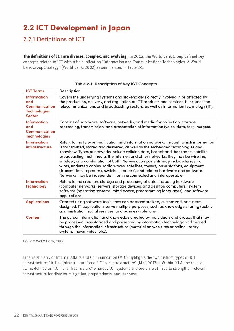
The definitions of ICT are diverse, complex, and evolving. In 2002, the World Bank Group defined key concepts related to ICT within its publication “Information and Communications Technologies: A World Bank Group Strategy” (World Bank, 2002) as summarized in Table 2-1.
Table 2-1: Description of Key ICT ConceptsICT Terms DescriptionInformation and Communication Technologies Sector
Covers the underlying systems and stakeholders directly involved in or affected by the production, delivery, and regulation of ICT products and services. It includes the telecommunications and broadcasting sectors, as well as information technology (IT).
Information and Communication Technologies
Consists of hardware, software, networks, and media for collection, storage, processing, transmission, and presentation of information (voice, data, text, images).
Information infrastructure
Refers to the telecommunication and information networks through which information is transmitted, stored and delivered, as well as the embedded technologies and knowhow. Types of networks include cellular, data, broadband, backbone, satellite, broadcasting, multimedia, the Internet, and other networks; they may be wireline, wireless, or a combination of both. Network components may include terrestrial wires, undersea cables, radio waves, satellites, towers, base stations, equipment (transmitters, repeaters, switches, routers), and related hardware and software. Networks may be independent, or interconnected and interoperable.
Information technology
Refers to the creation, storage and processing of data, including hardware (computer networks, servers, storage devices, and desktop computers), system software (operating systems, middleware, programming languages), and software applications.
Applications Created using software tools; they can be standardized, customized, or custom-designed. IT applications serve multiple purposes, such as knowledge sharing (public administration, social services, and business solutions.
Content The actual information and knowledge created by individuals and groups that may be processed, transformed and presented by information technology and carried through the information infrastructure (material on web sites or online library systems, news, video, etc.).
Source: World Bank, 2002.
Japan’s Ministry of Internal Affairs and Communication (MIC) highlights the two distinct types of ICT infrastructure: “ICT as Infrastructure” and “ICT for Infrastructure” (MIC, 2017b). Within DRM, the role of ICT is defined as “ICT for Infrastructure” whereby ICT systems and tools are utilized to strengthen relevant infrastructure for disaster mitigation, preparedness, and response.
23DISASTERS AND ICT DEVELOPMENT IN JAPAN: HISTORICAL REVIEW
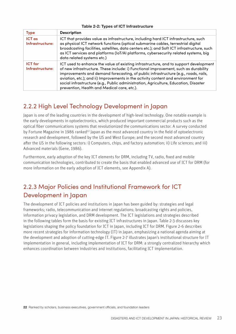
Table 2-2: Types of ICT InfrastructureType DescriptionICT as Infrastructure:
ICT that provides value as infrastructure, including hard ICT infrastructure, such as physical ICT network functions (optical submarine cables, terrestrial digital broadcasting facilities, satellites, data centers etc.); and Soft ICT infrastructure, such as ICT services and platforms (IoT/AI platforms, cybersecurity related systems, big data related systems etc.)
ICT for Infrastructure:
ICT used to enhance the value of existing infrastructure, and to support development of new infrastructure. These include: i) Functional improvement, such as durability improvements and demand forecasting, of public infrastructure (e.g., roads, rails, aviation, etc.); and ii) Improvements in the activity content and environment for social infrastructure (e.g., Public administration, Agriculture, Education, Disaster prevention, Health and Medical care, etc.).
2.2.2 High Level Technology Development in JapanJapan is one of the leading countries in the development of high-level technology. One notable example is the early developments in optoelectronics, which produced important commercial products such as the optical fiber communications systems that revolutionized the communications sector. A survey conducted by Fortune Magazine in 1986 ranked22 Japan as the most advanced country in the field of optoelectronic research and development, followed by the US and West Europe; and the second most advanced country after the US in the following sectors: i) Computers, chips, and factory automation; ii) Life sciences; and iii) Advanced materials (Gene, 1986).
Furthermore, early adoption of the key ICT elements for DRM, including TV, radio, fixed and mobile communication technologies, contributed to create the basis that enabled advanced use of ICT for DRM (for more information on the early adoption of ICT elements, see Appendix A).
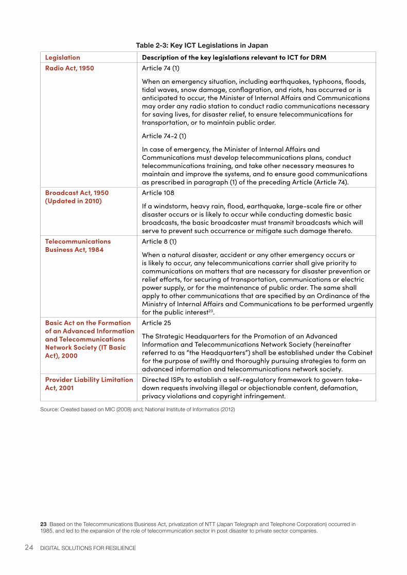
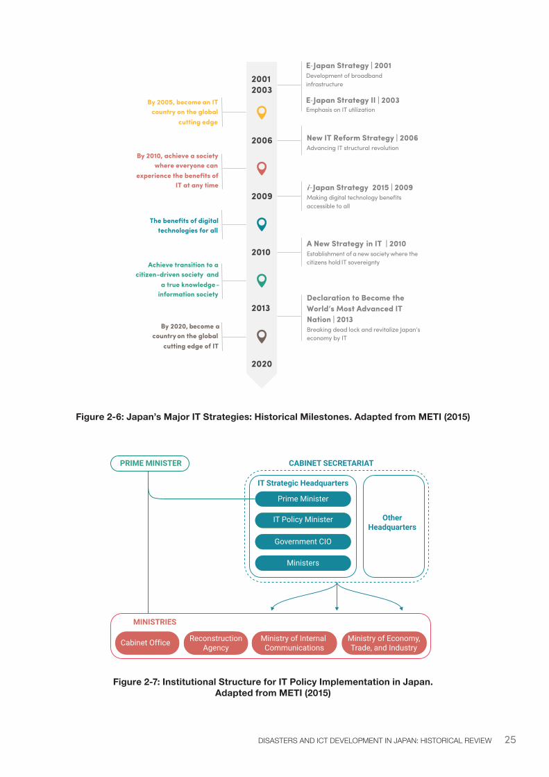
2.2.3 Major Policies and Institutional Framework for ICT Development in JapanThe development of ICT policies and institutions in Japan has been guided by: strategies and legal frameworks; radio, telecommunication and internet regulations; broadcasting rights and policies, information privacy legislation, and DRM development. The ICT legislations and strategies described in the following tables form the basis for existing ICT infrastructures in Japan. Table 2-3 discusses key legislations shaping the policy foundation for ICT in Japan, including ICT for DRM. Figure 2-6 describes more recent strategies for information technology (IT) in Japan, emphasizing a national agenda aiming at the development and adoption of cutting-edge IT. Figure 2-7 illustrates Japan’s institutional structure for IT implementation in general, including implementation of ICT for DRM: a strongly centralized hierarchy which enhances coordination between industries and institutions, facilitating ICT implementation.
22 Ranked by scholars, business executives, government officials, and foundation leaders
24 DIGITAL SOLUTIONS FOR RESILIENCE
Table 2-3: Key ICT Legislations in JapanLegislation Description of the key legislations relevant to ICT for DRMRadio Act, 1950 Article 74 (1)
When an emergency situation, including earthquakes, typhoons, floods, tidal waves, snow damage, conflagration, and riots, has occurred or is anticipated to occur, the Minister of Internal Affairs and Communications may order any radio station to conduct radio communications necessary for saving lives, for disaster relief, to ensure telecommunications for transportation, or to maintain public order.
Article 74-2 (1)
In case of emergency, the Minister of Internal Affairs and Communications must develop telecommunications plans, conduct telecommunications training, and take other necessary measures to maintain and improve the systems, and to ensure good communications as prescribed in paragraph (1) of the preceding Article (Article 74).
Broadcast Act, 1950 (Updated in 2010)
Article 108
If a windstorm, heavy rain, flood, earthquake, large-scale fire or other disaster occurs or is likely to occur while conducting domestic basic broadcasts, the basic broadcaster must transmit broadcasts which will serve to prevent such occurrence or mitigate such damage thereto.
Telecommunications Business Act, 1984
Article 8 (1)
When a natural disaster, accident or any other emergency occurs or is likely to occur, any telecommunications carrier shall give priority to communications on matters that are necessary for disaster prevention or relief efforts, for securing of transportation, communications or electric power supply, or for the maintenance of public order. The same shall apply to other communications that are specified by an Ordinance of the Ministry of Internal Affairs and Communications to be performed urgently for the public interest23.
Basic Act on the Formation of an Advanced Information and Telecommunications Network Society (IT Basic Act), 2000
Article 25
The Strategic Headquarters for the Promotion of an Advanced Information and Telecommunications Network Society (hereinafter referred to as “the Headquarters”) shall be established under the Cabinet for the purpose of swiftly and thoroughly pursuing strategies to form an advanced information and telecommunications network society.
Provider Liability Limitation Act, 2001
Directed ISPs to establish a self-regulatory framework to govern take-down requests involving illegal or objectionable content, defamation, privacy violations and copyright infringement.
Source: Created based on MIC (2008) and; National Institute of Informatics (2012)
23 Based on the Telecommunications Business Act, privatization of NTT (Japan Telegraph and Telephone Corporation) occurred in 1985, and led to the expansion of the role of telecommunication sector in post disaster to private sector companies.
25DISASTERS AND ICT DEVELOPMENT IN JAPAN: HISTORICAL REVIEW
Figure 2-6: Japan’s Major IT Strategies: Historical Milestones. Adapted from METI (2015)
Figure 2-7: Institutional Structure for IT Policy Implementation in Japan. Adapted from METI (2015)
20012003
2006
2009
2010
2013
2020
By 2005, become an IT country on the global
cutting edge
By 2010, achieve a society where everyone can
experience the benefits of IT at any time
The benefits of digital technologies for all
Achieve transition to a citizen-driven society and
a true knowledge -information society
By 2020, become acountry on the global
cutting edge of IT
E-Japan Strategy | 2001Development of broadband infrastructure
E-Japan Strategy II | 2003Emphasis on IT utilization
New IT Reform Strategy | 2006Advancing IT structural revolution
i -Japan Strategy 2015 | 2009Making digital technology benefits accessible to all
A New Strategy in IT | 2010Establishment of a new society where the citizens hold IT sovereignty
Declaration to Become the World’s Most Advanced IT Nation | 2013Breaking dead lock and revitalize Japan’s economy by IT
CABINET SECRETARIAT
IT Strategic Headquarters
OtherHeadquarters
Prime Minister
PRIME MINISTER
MINISTRIES
IT Policy Minister
Government CIO
Ministers
Cabinet Office ReconstructionAgency
Ministry of Internal Communications
Ministry of Economy,Trade, and Industry
26 DIGITAL SOLUTIONS FOR RESILIENCE
2.3 Historical Evolution and Utilization of ICT to Strengthen Disaster Resilience in Japan In line with the context of DRM and ICT in Japan described above, and drawing upon existing international discourse, within this report ICT for DRM is defined as:
“The utilization of digital technologies for information and communication – consisting of hardware, software, networks, and media for collection, storage, processing, transmission, and presentation of information (voice, data, text, images, maps, etc.) – to enhance the resilience of existing infrastructure and systems in face of disaster risks and impacts.”
In the context of Japan, ICT’s role within DRM has evolved and expanded significantly over time, particularly in the areas of pre-disaster early warning and post-disaster information management systems.
The integration and utilization of ICT to enhance DRM capacity in Japan is the result of a dedicated and sustained effort. The development of ICT for disaster resilience has been a continuous process evolving over several decades, reflecting lessons learned from the various successes and challenges experienced in DRM and response. Placed at the heart of DRM policies and actions at all levels of governance, the evolution of ICT solutions for DRM in Japan has been shaped by various national and global drivers.
Table 2-4 illustrates how diverse drivers have influenced the development of EWSs and DIMSs. In Japan, the advancement of ICT for DRM has been driven by three key factors:
1. Large scale disasters have led to in-depth analyses of the impacts and the identification of measures to avoid, reduce, and manage future risks. These activities have catalyzed various investments to develop and utilize new technologies and solutions, including ICT for EWS and DIMS.
2. Policy and legal frameworks are usually updated and enhanced after major disasters, reflecting the lessons learned and the identification of areas of improvement. They outline the national direction for research, development, and utilization of new information and communication technologies needed to improve disaster preparedness, prevention, mitigation, and response. By establishing legislation, subsidies, or incentives, these policies often catalyze private and public initiatives to implement ICT solutions with financial and technical support often induced by the government.
3. Existing and planned national and global ICT infrastructure investments and knowledge, as well as international standards for ICT and DRM, have significantly extended the range of ICT options available for DRM. The underlying ICT infrastructure and policy context, as well as global and local consumer trends, has also influenced how public and private sectors invest in EWS and DIMS solutions.
Chapters 3 and 4 will detail how and why an earthquake EWS and a multi-hazard DIMS have been developed in Japan and will identify key success factors. Additional resources for hydromet and volcanic EWSs, which are outside of the scope of this report, are referenced in Table 2-4.
27DISASTERS AND ICT DEVELOPMENT IN JAPAN: HISTORICAL REVIEW
Table 2-4: Overview of Key Driving Factors of EWS and DIMS in Japan
Key Driving Factors
EWS for Hydrometeorological Events
EWS for Earthquakes and Tsunamis
EWS for Volcanic Eruptions24
Multi-hazard DIMS
Disaster triggering major development
1959 Typhoon Vera (Isewan Typhoon)
1995 Great Hanshin Awaji Earthquake
2000 Mount Usu and Sakurajima Eruptions
1995 Great Hanshin Awaji Earthquake
Disaster triggering system review and improvement
Any major disaster events
Any major disaster events (i.e. 2011 Great East Japan Earthquake and Tsunami; 2016 Kumamoto Earthquake)
Any major disaster events
Any major disaster events (i.e. 2011 Great East Japan Earthquake and Tsunami; 2016 Kumamoto Earthquake)
Policy and Legal Frameworks
River Law (1964, 1997 update) and Meteorological Service Act (1952, 2007 update)
Meteorological Service Act Update (2007)
Meteorological Service Act Update (2007). Act on Special Measures for Active Volcanoes (1973, 2015 update)
Disaster Countermeasures Basic Act (1961). Expert Panel on Disaster Information Sharing (2002) within the Central Disaster Management Council. Basic Act on the Advancement of Utilizing Geospatial Information (2007)
24 Volcanic eruption observation was initiated in 1974 at Mount Usu. Development of the modern system was driven largely by the large-scale eruption that occurred in 2000. For more information, see: http://data.nistep.go.jp/dspace/bitstream/11035/2010/1/NISTEP-STT094-20.pdf
28 DIGITAL SOLUTIONS FOR RESILIENCE
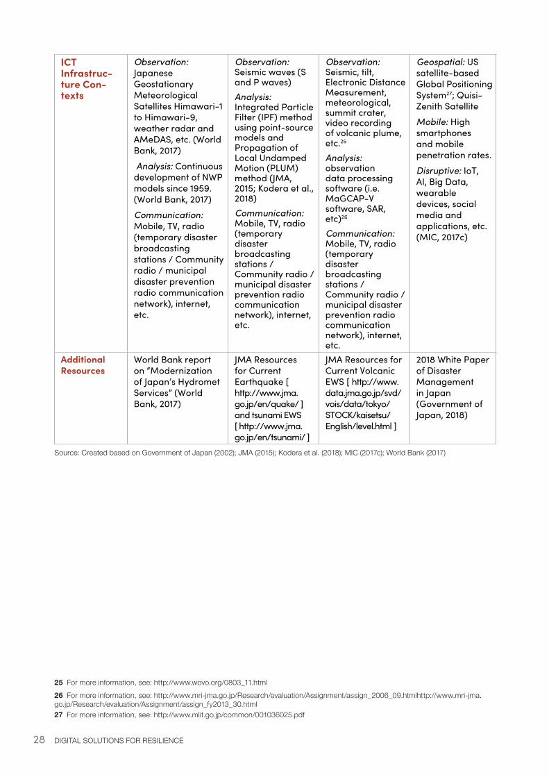
ICT Infrastruc-ture Con-texts
Observation: Japanese Geostationary Meteorological Satellites Himawari-1 to Himawari-9, weather radar and AMeDAS, etc. (World Bank, 2017)
Analysis: Continuous development of NWP models since 1959. (World Bank, 2017)
Communication: Mobile, TV, radio (temporary disaster broadcasting stations / Community radio / municipal disaster prevention radio communication network), internet, etc.
Observation: Seismic waves (S and P waves)Analysis: Integrated Particle Filter (IPF) method using point-source models and Propagation of Local Undamped Motion (PLUM) method (JMA, 2015; Kodera et al., 2018)Communication: Mobile, TV, radio (temporary disaster broadcasting stations / Community radio / municipal disaster prevention radio communication network), internet, etc.
Observation: Seismic, tilt, Electronic Distance Measurement, meteorological, summit crater, video recording of volcanic plume, etc.25
Analysis: observation data processing software (i.e. MaGCAP-V software, SAR, etc)26
Communication: Mobile, TV, radio (temporary disaster broadcasting stations / Community radio / municipal disaster prevention radio communication network), internet, etc.
Geospatial: US satellite-based Global Positioning System27; Quisi-Zenith Satellite
Mobile: High smartphones and mobile penetration rates.
Disruptive: IoT, AI, Big Data, wearable devices, social media and applications, etc. (MIC, 2017c)
Additional Resources
World Bank report on “Modernization of Japan’s Hydromet Services” (World Bank, 2017)
JMA Resources for Current Earthquake [ http://www.jma.go.jp/en/quake/ ] and tsunami EWS [ http://www.jma.go.jp/en/tsunami/ ]
JMA Resources for Current Volcanic EWS [ http://www.data.jma.go.jp/svd/vois/data/tokyo/STOCK/kaisetsu/English/level.html ]
2018 White Paper of Disaster Management in Japan (Government of Japan, 2018)
Source: Created based on Government of Japan (2002); JMA (2015); Kodera et al. (2018); MIC (2017c); World Bank (2017)
25 For more information, see: http://www.wovo.org/0803_11.html 26 For more information, see: http://www.mri-jma.go.jp/Research/evaluation/Assignment/assign_2006_09.htmlhttp://www.mri-jma.go.jp/Research/evaluation/Assignment/assign_fy2013_30.html 27 For more information, see: http://www.mlit.go.jp/common/001036025.pdf

29
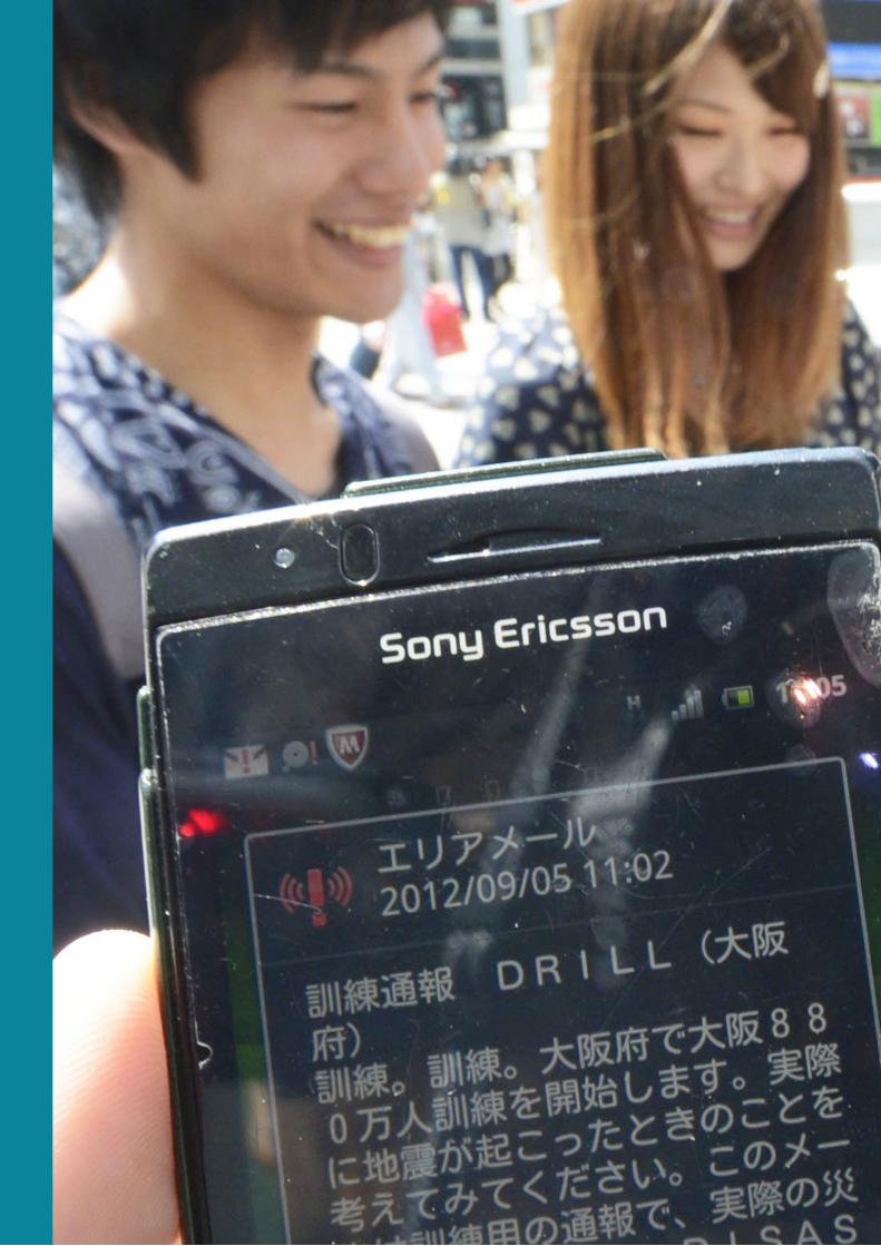
Image: People in Osaka checking Emergency Alert Mail for Nankai Trough earthquake (training alert) (Sep. 2012). Source: Kyodo News Images.
31
[3] Early Warning Systems
32 DIGITAL SOLUTIONS FOR RESILIENCE
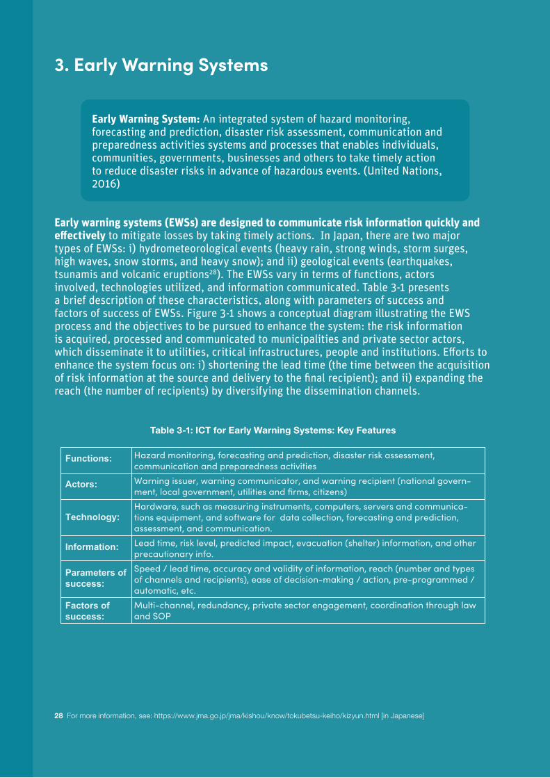
3. Early Warning Systems
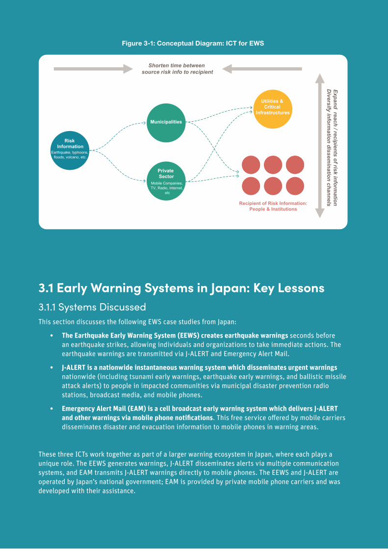
Early warning systems (EWSs) are designed to communicate risk information quickly and effectively to mitigate losses by taking timely actions. In Japan, there are two major types of EWSs: i) hydrometeorological events (heavy rain, strong winds, storm surges, high waves, snow storms, and heavy snow); and ii) geological events (earthquakes, tsunamis and volcanic eruptions28). The EWSs vary in terms of functions, actors involved, technologies utilized, and information communicated. Table 3-1 presents a brief description of these characteristics, along with parameters of success and factors of success of EWSs. Figure 3-1 shows a conceptual diagram illustrating the EWS process and the objectives to be pursued to enhance the system: the risk information is acquired, processed and communicated to municipalities and private sector actors, which disseminate it to utilities, critical infrastructures, people and institutions. Efforts to enhance the system focus on: i) shortening the lead time (the time between the acquisition of risk information at the source and delivery to the final recipient); and ii) expanding the reach (the number of recipients) by diversifying the dissemination channels.
Table 3-1: ICT for Early Warning Systems: Key Features
28 For more information, see: https://www.jma.go.jp/jma/kishou/know/tokubetsu-keiho/kizyun.html [in Japanese]
Early Warning System: An integrated system of hazard monitoring, forecasting and prediction, disaster risk assessment, communication and preparedness activities systems and processes that enables individuals, communities, governments, businesses and others to take timely action to reduce disaster risks in advance of hazardous events. (United Nations, 2016)
Hazard monitoring, forecasting and prediction, disaster risk assessment, communication and preparedness activitiesWarning issuer, warning communicator, and warning recipient (national govern-ment, local government, utilities and firms, citizens)Hardware, such as measuring instruments, computers, servers and communica-tions equipment, and software for data collection, forecasting and prediction, assessment, and communication.Lead time, risk level, predicted impact, evacuation (shelter) information, and other precautionary info.Speed / lead time, accuracy and validity of information, reach (number and types of channels and recipients), ease of decision-making / action, pre-programmed / automatic, etc.Multi-channel, redundancy, private sector engagement, coordination through law and SOP
Functions:
Actors:
Technology:
Information:
Parameters of success:
Factors of success:
33
Figure 3-1: Conceptual Diagram: ICT for EWS
3.1 Early Warning Systems in Japan: Key Lessons3.1.1 Systems DiscussedThis section discusses the following EWS case studies from Japan:
• The Earthquake Early Warning System (EEWS) creates earthquake warnings seconds before an earthquake strikes, allowing individuals and organizations to take immediate actions. The earthquake warnings are transmitted via J-ALERT and Emergency Alert Mail.
• J-ALERT is a nationwide instantaneous warning system which disseminates urgent warnings nationwide (including tsunami early warnings, earthquake early warnings, and ballistic missile attack alerts) to people in impacted communities via municipal disaster prevention radio stations, broadcast media, and mobile phones.
• Emergency Alert Mail (EAM) is a cell broadcast early warning system which delivers J-ALERT and other warnings via mobile phone notifications. This free service offered by mobile carriers disseminates disaster and evacuation information to mobile phones in warning areas.
These three ICTs work together as part of a larger warning ecosystem in Japan, where each plays a unique role. The EEWS generates warnings, J-ALERT disseminates alerts via multiple communication systems, and EAM transmits J-ALERT warnings directly to mobile phones. The EEWS and J-ALERT are operated by Japan’s national government; EAM is provided by private mobile phone carriers and was developed with their assistance.
EWS
DIMS
Municipalities
Private Sector
Risk Information
Earthquake, typhoons, floods, volcano, etc.
Utilities & Critical
Infrastructures
Utilities & Critical
Infrastructures
Recipient of Risk Information:People & Institutions
Recipient of Risk Information:People & Institutions
Shorten time between source risk info to recipient
Expand reach / recipients of risk information
Diversify inform
ation dissemination channels
Expand reach and ease of access by recipients of disaster inform
ation
Expand sources, types and quality of disaster im
pact and response information
Mobile Companies, TV, Radio, Internet,
etc
Sources of Disaster Impact & Response Information
Institutions
Hub for Disaster
Information[Municipal
Government]
Private Sector
Mobile Companies, TV, Radio, Internet,
etc
34 DIGITAL SOLUTIONS FOR RESILIENCE
3.1.2 Key Lessons from the EWSsSuitability - Hardware and software for EWSs should be selected taking into account the existing and planned ICT specific to the country and its institutions. Japan’s initial EWS was radio-based because at the time of its development in 1985 (Ito, 2007), radio was the most reliable, far reaching, and low-cost technology available for broadcasting warnings. Today, Japan is adapting its EWSs to integrate new ICT (e.g., mobile phones). If an EWS were to be designed from scratch today, it would look very different given the advances in national and global ICT.
Redundancy - Redundant and diverse warning dissemination ensures reach, reliability and resilience: Japanese EWSs use multiple means of transmission. Earthquake early warnings can be transmitted via mobile operators, broadcasters, and J-ALERT. In turn, J-ALERT warnings are primarily disseminated through Disaster Administrative Radios Systems in municipalities, but the system is also linked to EAM via mobile operators, as well as television and radio networks via broadcasting companies. Likewise, use of redundant ICT infrastructures, such as multiple communication lines between public organizations and the Japan Meteorological Agency (JMA) with EAM, and communication from FDMA to municipalities duplicated by satellite and terrestrial lines with J-ALERT, ensures backup in case the primary systems fail during a disaster.
Standardization - Standardizing alert warning sounds can reduce confusion and improve the reaction times of the recipients. In the case of J-ALERT, alert warning sounds from various media including TV, Disaster Prevention Radios, community FM, and mobile phones, are standardized for each type of disaster. The most effective auditory warnings can be defined by the local cultural context; otherwise, it is advisable to adopt existing standards to promote global standardization.
Interoperability - Interoperability among systems allows EWSs to build upon and work with existing systems, expand and adapt to new requirements, and securely disseminate warnings via multiple systems. Interoperability is ensured by well-defined protocols which should be made public. For example, the standard specifications for J-ALERT receivers in municipalities and trigger controllers of Disaster Administrative Radios Systems were developed by a national agency (Fire and Disaster Management Agency), which benefited from the collaboration of major developers.
Preparedness - Periodic education and training help officials and residents to respond quickly and effectively to early warnings. The preparedness goals are: i) clearly understand the warning messages and know in advance the actions to be taken (in the case of an earthquake, the recipient has only a few seconds to act). In Japan, very high levels of awareness and understanding of the system were achieved as a result of extensive public awareness campaigns. For example, a Disaster Prevention Day was established in 1960 to commemorate the 1923 Great Kanto earthquake and since then most of the prefectural and municipal governments, schools, and private companies have been conducting disaster drills every year on that day. The Japanese government has made large efforts to promote development of Business Continuity Plans29 (BCPs) in the ICT sector of local governments to enhance preparedness and enable actions in response to alerts. A BCP specifies the methodologies and procedures required for managing risks, emergencies, and recovery of an organization during a crisis and ensuring the return to normal business operations (Doughty, 2000). Examples of BCP for ICT at prefectural and municipal governments include establishment of emergency response teams upon reception of an EWS alert. As of 2018, 93.6 % of the prefectural governments and 27.5% of the municipal governments have ICT-BCP (MIC, 2019).
29 BCP have been mainly developed since 2008, when development guidelines in the ICT sector of local governments were developed by MIC.

35
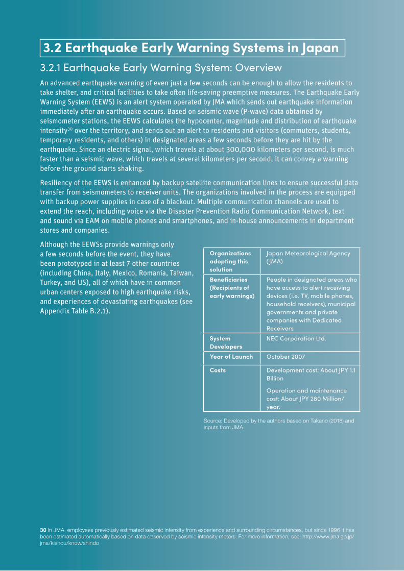
36 DIGITAL SOLUTIONS FOR RESILIENCE
Source: Developed by the authors based on Takano (2018) and inputs from JMA
3.2.1 Earthquake Early Warning System: OverviewAn advanced earthquake warning of even just a few seconds can be enough to allow the residents to take shelter, and critical facilities to take often life-saving preemptive measures. The Earthquake Early Warning System (EEWS) is an alert system operated by JMA which sends out earthquake information immediately after an earthquake occurs. Based on seismic wave (P-wave) data obtained by seismometer stations, the EEWS calculates the hypocenter, magnitude and distribution of earthquake intensity30 over the territory, and sends out an alert to residents and visitors (commuters, students, temporary residents, and others) in designated areas a few seconds before they are hit by the earthquake. Since an electric signal, which travels at about 300,000 kilometers per second, is much faster than a seismic wave, which travels at several kilometers per second, it can convey a warning before the ground starts shaking.
Resiliency of the EEWS is enhanced by backup satellite communication lines to ensure successful data transfer from seismometers to receiver units. The organizations involved in the process are equipped with backup power supplies in case of a blackout. Multiple communication channels are used to extend the reach, including voice via the Disaster Prevention Radio Communication Network, text and sound via EAM on mobile phones and smartphones, and in-house announcements in department stores and companies.
Although the EEWSs provide warnings only a few seconds before the event, they have been prototyped in at least 7 other countries (including China, Italy, Mexico, Romania, Taiwan, Turkey, and US), all of which have in common urban centers exposed to high earthquake risks, and experiences of devastating earthquakes (see Appendix Table B.2.1).
30 In JMA, employees previously estimated seismic intensity from experience and surrounding circumstances, but since 1996 it has been estimated automatically based on data observed by seismic intensity meters. For more information, see: http://www.jma.go.jp/jma/kishou/know/shindo
3.2 Earthquake Early Warning Systems in Japan
Organizations adopting this solution
Japan Meteorological Agency (JMA)
Beneficiaries (Recipients of early warnings)
People in designated areas who have access to alert receiving devices (i.e. TV, mobile phones, household receivers), municipal governments and private companies with Dedicated Receivers
System Developers
NEC Corporation Ltd.
Year of Launch October 2007
Costs Development cost: About JPY 1.1 Billion
Operation and maintenance cost: About JPY 280 Million/year.
37
3.2.2 Earthquake Early Warning System: Lessons and RecommendationsThe system resilience is enhanced by:
• Reliability - Internet Protocol Virtual Private Network (IP-VPN) and stable power supply to seismometers and communication units are indispensable to achieve continuous real-time data transfer for the EEWS.
• Redundancy - Satellite communication lines are employed as backups to ensure data transfer from seismometers to the receiver unit at JMA in the case of a blackout, and the organizations involved are equipped with backup power supplies.
• Complementarity - All warning systems have limitations: complementary systems should be implemented to fill potential gaps.
• Risk management - The EEWS is effective mainly in areas far from the hypocenter; seismic risk management strategies should be implemented, such as:
• Appropriate building standards and land-use management;
• Awareness raising, evacuation procedures and safe suspension of hazardous work and operations;
• Mitigation strategies for infrastructure and plants unable to shut down rapidly.
• Clarity – Clear warning messages are critical in crowded areas to ensure safe evacuation procedures, in areas close to the hypocenter to minimize the reaction time, and in areas where multiple earthquakes occur concurrently31, where the system may become inaccurate. To mitigate these issues, JMA launched intense outreach activities to raise awareness of the EEWS and its capability.
• Accuracy – To ensure continuous technological and operational improvements JMA has operated the “Committee for improving the technology and operation of EEWS” since 2009. The committee promotes technological developments to upgrade existing methods and develop fundamentally different ones32.
• Interagency communication – Effective operation of the EEWS requires cooperation between organizations that carry out seismic observations (JMA and the National Research Institute for Earth Science and Disaster Resilience (NIED) in the case of Japan) and those that transmit information (telecommunications companies etc.).
31 For example, on January 5, 2018, seismic intensity was overestimated because two consecutive earthquakes were detected as one earthquake and therefore, an erroneous earthquake early warning was released.32 For example, in the past, seismic intensity at each location was estimated after estimating the position and magnitude of the hypocenter based on data from a few observation points. In 2011, strong shakes off the Pacific coast of Great East Japan Earthquake could not be accurately predicted far from the hypocenter by the conventional method. However, with the new method (PLUM: Propagation of Local Undamped Motion), seismic intensities at given points can be estimated without estimating the hypocenter. JMA improved the accuracy of predictions by hybridizing these two methods and then updated the Earthquake Early Warning System. Operation by this hybrid method began in March 2018, and the first warning using this method was announced at the time of Shimane prefecture earthquake on April 9, 2018.
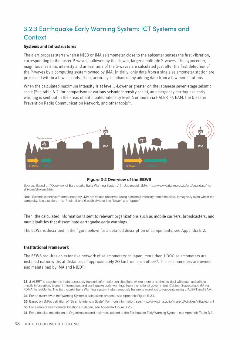
38 DIGITAL SOLUTIONS FOR RESILIENCE
3.2.3 Earthquake Early Warning System: ICT Systems and ContextSystems and Infrastructures
The alert process starts when a NIED or JMA seismometer close to the epicenter senses the first vibration, corresponding to the faster P-waves, followed by the slower, larger amplitude S-waves. The hypocenter, magnitude, seismic intensity and arrival time of the S-waves are calculated just after the first detection of the P-waves by a computing system owned by JMA. Initially, only data from a single seismometer station are processed within a few seconds. Then, accuracy is enhanced by adding data from a few more stations.
When the calculated maximum intensity is at level 5-Lower or greater on the Japanese seven-stage seismic scale (See table A.2. for comparison of various seismic intensity scale), an emergency earthquake early warning is sent out in the areas of anticipated intensity level 4 or more via J-ALERT33, EAM, the Disaster Prevention Radio Communication Network, and other tools34.
Figure 3‑2 Overview of the EEWSSource: Based on “Overview of Earthquake Early Warning System,” [in Japanese], JMA: http://www.data.jma.go.jp/svd/eew/data/nc/shikumi/shikumi.html
Note: Seismic intensities35 announced by JMA are values observed using a seismic intensity meter installed. It may vary even within the same city. It is a scale of 1 to 7, with 5 and 6 each divided into “lower” and “upper.”
Then, the calculated information is sent to relevant organizations such as mobile carriers, broadcasters, and municipalities that disseminate earthquake early warnings.
The EEWS is described in the figure below; for a detailed description of components, see Appendix B.2.
Institutional Framework
The EEWS requires an extensive network of seismometers: in Japan, more than 1,000 seismometers are installed nationwide, at distances of approximately 20 km from each other36. The seismometers are owned and maintained by JMA and NIED37.
33 J-ALERT is a system to instantaneously transmit information on situations where there is no time to deal with such as ballistic missile information, tsunami information, and earthquake early warnings from the national government (Cabinet Secretariat/JMA via FDMA) to residents. The Earthquake Early Warning System instantaneously transmits warnings to residents using J-ALERT and EAM.
34 For an overview of the Warning System’s calculation process, see Appendix Figure B.2.1.35 Based on JMA’s definition of “Seismic Intensity Scale”. For more information, see: http://www.jma.go.jp/jma/en/Activities/inttable.html36 For a map of seismometer locations in Japan, see Appendix Figure B.2.2.37 For a detailed description of Organizations and their roles related to the Earthquake Early Warning System, see Appendix Table B.3.
Seismometer
S-Wave P-Wave
JMA
S-Wave P-Wave
JMA
The seismometer estimates the position and the scale of the epicenter instantaneously, and predicts the seismic intensity and the arrival time of the S-wave
Earthquake early warning is announced before the S-wave (strong tremors) arrive.
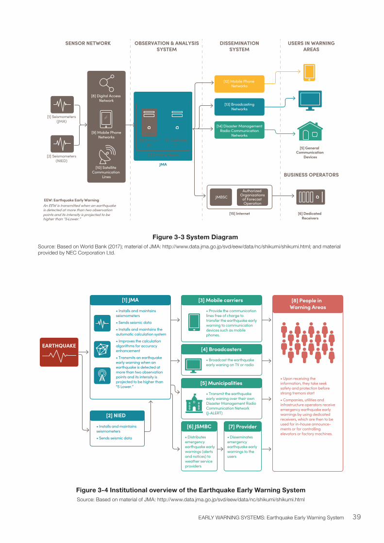
39EARLY WARNING SYSTEMS: Earthquake Early Warning System
[3] ReceiverUnit
[4] AnalyzingUnit
[6] Dedicated Receivers
[5] General Communication
Devices
[1] Seismometers(JMA)
[8] Digital Access Network
[9] Mobile PhoneNetworks
[10] Satellite Communication
Lines
[2] Seismometers(NIED)
SENSOR NETWORK OBSERVATION & ANALYSISSYSTEM
JMA
DISSEMINATIONSYSTEM
USERS IN WARNINGAREAS
BUSINESS OPERATORS
An EEW is transmitted when an earthquakeis detected at more than two observation points and its intensity is projected to be higher than “5-Lower.”
EEW: Earthquake Early Warning
[7] EPOS Software
[12] Mobile Phone Networks
[13] BroadcastingNetworks
[14] Disaster ManagementRadio Communication
Networks
JMBSCAuthorized
Organizationsof Forecast Operation
[15] Internet
Figure 3-3 System DiagramSource: Based on World Bank (2017); material of JMA: http://www.data.jma.go.jp/svd/eew/data/nc/shikumi/shikumi.html; and material provided by NEC Corporation Ltd.
Figure 3-4 Institutional overview of the Earthquake Early Warning SystemSource: Based on material of JMA: http://www.data.jma.go.jp/svd/eew/data/nc/shikumi/shikumi.html
EARTHQUAKE
[8] People in Warning Areas
[3] Mobile carriers[1] JMA
• Installs and maintains seismometers
• Sends seismic data
• Installs and maintains the automatic calculation system
• Improves the calculation algorithms for accuracy enhancement
• Transmits an earthquake early warning when an earthquake is detected at more than two observation points and its intensity is projected to be higher than “5 Lower.”
• Upon receiving the information, they take seek safety and protection before strong tremors start
• Companies, utilities and infrastructure operators receive emergency earthquake early warnings by using dedicated receivers, which are then to be used for in-house announce-ments or for controlling elevators or factory machines.
• Provide the communication lines free of charge to transfer the earthquake early warning to communication devices such as mobile phones.
[4] Broadcasters
• Broadcast the earthquake early waning on TV or radio
[5] Municipalities
• Transmit the earthquake early waning over their own Disaster Management Radio Communication Network (J-ALERT)
[6] JSMBC [7] Provider
• Distributes emergency earthquake early warnings (alerts and notices) to weather service providers
• Disseminates emergency earthquake early warnings to the users
[2] NIED
• Installs and maintains seismometers
• Sends seismic data
40 DIGITAL SOLUTIONS FOR RESILIENCE
3.2.4 Earthquake Early Warning System: Enabling EnvironmentPolicy and Legislation
According to the Meteorological Service Act, JMA is mandated to issue forecasts and warnings of earthquake ground motions38. JMA transmits the warning to relevant organizations which distribute it in the designated disaster areas (although areas close to the epicenter may not receive advanced warnings39). The Meteorological Service Act forbids anyone except JMA from issuing earthquake warnings, in part to prevent issuance of improper warnings. Before starting to operate the EEWS, JMA took steps to ensure warnings did not create confusion or chaos: in 2003 it arranged an organizational structure for setting up a project team in charge of developing the EEWS; in 2004 it started feasibility studies on information transfer; and in 2007 it finally started providing earthquake early warnings for regular use.
While JMA has been promoting use and enhancing transfer of early warnings through pilot operations, feasibility studies, and preliminary live operations, it also started familiarization and outreach activities, which continued after launching system operations for regular use40. The awareness campaign was successful in promoting the earthquake early warning system and emphasizing the difference between EEW and earthquake information41.
Since earthquakes tend to occur less frequently than other natural hazards such as floods, cyclones, heatwaves or droughts, it is difficult to allocate resources to invest in the development of an EEWS, unless a catastrophic event has just occurred. Furthermore, although earthquake early warnings are considered an effective component of earthquake hazard preparedness, research points to various limitations in terms of reliability and challenges improving accuracy by reducing false/missed alarms.
Given these barriers, in order to manage risks of earthquake disasters, priorities are often placed on implementing preventative measures such as strengthening building codes to ensure seismic resilience, as well as awareness, education, and drills to improve the capacity for protection and preparedness.
Several countries have developed and operationalized prototypes of validated EEWS including China, Italy, Japan, Mexico, Romania, Taiwan, Turkey, and the United States of America (U.S.A.) - all countries that have urban centers exposed to high earthquake risks, and with experiences of severe earthquakes (see Appendix B.2 for details). Each system is unique depending on the local seismic faults and the specific ground motion data available.
38 See Table B.2.4 in Appendix B on the relationship between an earthquake early warning and JMA forecasts/warnings39 See Appendix B.3 for more on the limitations of the Warning System40 In order to examine the “know-how” in using the EEWS and the measures for disseminating and improving awareness of the system, JMA set up a “Committee for the launch of operation of the Earthquake Early Warning System” in 2005, and a final report was compiled in 2007. JMA has also held the “Committee for improving the technology and operation of the Earthquake Early Warning System” since 2009, and further development of conventional as well as new methods are underway.41 For details see Appendix Figure B.3.1. Awareness of Earthquake Early Warning Systems.

41EARLY WARNING SYSTEMS: Earthquake Early Warning System
System Costs
The capital costs of the EEWS was about JPY 11 billion. Operation and maintenance costs are about JPY 2.8 billion a year42 (excluding personnel costs). Besides communication devices such as mobile phones, TV and radios, a variety of specially designed EEWS receivers are available at a cost ranging from 10,000 yen to hundreds of thousands of yen. Lower cost receivers generally use the warning information transmitted by broadcasters, and higher cost receivers use internet and/or dedicated ISDN lines.
42 The O&M costs are borne by JMA and NIED.
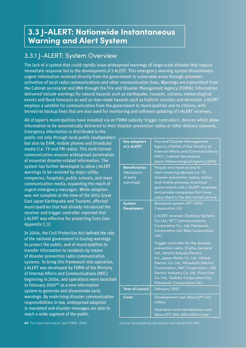
42 DIGITAL SOLUTIONS FOR RESILIENCE
3.3.1 J-ALERT: System OverviewThe lack of a system that could rapidly issue widespread warnings of large-scale disaster that require immediate response led to the development of J-ALERT. This emergency warning system disseminates urgent information received directly from the government in vulnerable areas through automatic activation of local radio communications and other communication lines. Warnings are transmitted from the Cabinet secretariat and JMA through the Fire and Disaster Management Agency (FDMA). Information delivered include warnings for natural hazards such as earthquake, tsunami, volcano, meteorological events and flood forecasts as well as man-made hazards such as ballistic missiles and terrorism. J-ALERT employs a satellite for communication from the government to municipalities and to citizens, with terrestrial backup lines that are also used for monitoring and software updating of J-ALERT receivers.
All of Japan’s municipalities have installed via an FDMA subsidy ‘trigger controllers’, devices which allow information to be automatically delivered to their disaster prevention radios or other delivery channels. Emergency information is distributed to the public not only through local public loudspeakers but also by EAM, mobile phones and broadcast media (i.e. TV and FM radio). This multi-format communication ensures widespread penetration of essential disaster-related information. The system has further developed to allow J-ALERT warnings to be received by major utility companies, hospitals, public schools, and mass communication media, expanding the reach of urgent emergency messages. While adoption was not complete at the time of the 2011 Great East Japan Earthquake and Tsunami, affected municipalities that had already introduced the receiver and trigger controller reported that J-ALERT was effective for protecting lives (see Appendix C.1)
In 2004, the Civil Protection Act defined the role of the national government in issuing warnings to protect the public, and of municipalities to transfer information to residents by means of disaster prevention radio communication systems. To bring this framework into operation, J-ALERT was developed by FDMA of the Ministry of Internal Affairs and Communications (MIC) beginning in 2004, and operations were launched in February 200743 as a new information system to generate and disseminate early warnings. By enshrining disaster communication responsibilities in law, widespread adoption is mandated and disaster messages are able to reach a wide segment of the public.
43 For more information, see FDMA, 2009
Key adopters of J-ALERT
Fire and Disaster Management Agency (FDMA) of the Ministry of Internal Affairs and Communications (MIC), Cabinet Secretariat, Japan Meteorological Agency (JMA)
Beneficiaries (Recipients of early warnings)
People who have access to alert receiving devices (i.e. TV, disaster prevention radios, radios, and mobile phones), municipal governments with J-ALERT receivers, and private companies that have subscribed to the alert email service
System Developers
Backbone system: NTT DATA Corporation Ltd
J-ALERT receiver: (Century Systems Co. Ltd., NTT Communications Corporation Co., Ltd, Panasonic Corporation Ltd, Rikei Corporation Ltd.)
Trigger controller for the disaster prevention radio: (Fujitsu General Ltd., Hitachi Kokusai Electric Inc., Japan Radio Co. Ltd., Meisei Electric Co. Ltd., Mitsubishi Electric Corporation., NEC Corporation., Oki Electric Industry Co. Ltd., Plum Five Co. Ltd., Toshiba Corporation Ltd., Panasonic Corporation Ltd.)
Year of Launch February 2007
Costs Development cost: About JPY 472 million
Operation and maintenance cost: About JPY 300-400 million/year
Source: Developed by the authors with inputs from MIC
3.3 J-ALERT: Nationwide Instantaneous Warning and Alert System
43
3.3.2 J-ALERT: Lessons and Recommendations• Rapidity and penetration - Effective emergency alert systems must be rapid and
widespread. J-ALERT’s potency lies in its ability to reach rapidly most of Japan’s population. This is achieved using direct satellite communication to municipalities with terrestrial backups, and by dissemination to individuals via multiple methods. Outside of Japan, existing technology and penetration should be considered in order to select systems for emergency alerts which are already widely available and cost-effective. The wide reach of J-ALERT is also facilitated by legislation which defines the responsibilities of national and local governments in relationship to disaster communications. To enhance rapidity and penetration a combination of ICT systems and government policies is advisable.
• Informative warnings - The actions to be taken should be communicated along with the alert, and awareness-raising activities such as training in normal times should be introduced. Because J-ALERT is simply an alert, it does not include information on how to respond to hazards. In some cases, people alerted via J-ALERT in recent years did not know exactly what actions to take (e.g., evacuate to safe area based on hazard map), in spite of Japan’s broad use of drills and preparedness programs in schools, workplaces, and civil society; populations in other contexts are likely to be less prepared.
• Maintenance - Alert systems require periodic inspections to maintain reliability. In a nationwide simultaneous simulation drill conducted by FDMA in 2018, 15 local governments found that J-ALERT did not operate due to incorrect setting of J-ALERT receivers or trigger controllers, failures of wireless devices and/or incorrect setting of mail transmission devices. An instantaneous alert system deployed in another context would similarly require a maintenance budget to conduct drills and checks to ensure the system is fully operational when a disaster does strike.
• Tailoring the system - Both capital and O&M costs for alert systems could be reduced by reducing extents and complexity. The relatively high up-front capital costs associated with J-ALERT include the cost of designing and developing the original technical standards from scratch, and overhead costs from frequent modifications; in other countries, systems similar to J-ALERT can be developed at less cost by using existing technologies. Moreover, while in Japan the government is mandated to deliver early warnings to all citizens, in developing countries new alert systems may begin with the development of programs targeted at mobile phone users or other priority groups. While full penetration is ideal, a smaller initial scope may be useful as the system is being developed and tested. The cooperation of telecom companies or broadcasting companies which allow dissemination via their networks provides another option for reducing the cost for national governments and municipalities while retaining reasonable effectiveness.
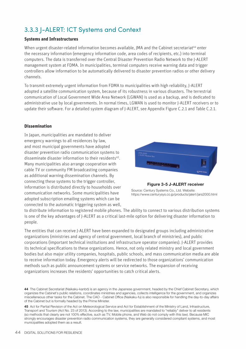
44 DIGITAL SOLUTIONS FOR RESILIENCE
3.3.3 J-ALERT: ICT Systems and ContextSystems and Infrastructures
When urgent disaster-related information becomes available, JMA and the Cabinet secretariat44 enter the necessary information (emergency information code, area codes of recipients, etc.) into terminal computers. The data is transferred over the Central Disaster Prevention Radio Network to the J-ALERT management system at FDMA. In municipalities, terminal computers receive warning data and trigger controllers allow information to be automatically delivered to disaster prevention radios or other delivery channels.
To transmit extremely urgent information from FDMA to municipalities with high reliability, J-ALERT adopted a satellite communication system, because of its robustness in various disasters. The terrestrial communication of Local Government Wide Area Network (LGWAN) is used as a backup, and is dedicated to administrative use by local governments. In normal times, LGWAN is used to monitor J-ALERT receivers or to update their software. For a detailed system diagram of J-ALERT, see Appendix Figure C.2.1 and Table C.2.1.
Dissemination
In Japan, municipalities are mandated to deliver emergency warnings to all residences by law, and most municipal governments have adopted disaster prevention radio communication systems to disseminate disaster information to their residents45. Many municipalities also arrange cooperation with cable TV or community FM broadcasting companies as additional warning dissemination channels. By connecting these systems to the trigger controller, information is distributed directly to households over communication networks. Some municipalities have adopted subscription emailing systems which can be connected to the automatic triggering system as well, to distribute information to registered mobile phones. The ability to connect to various distribution systems is one of the key advantages of J-ALERT as a critical last-mile option for delivering disaster information to people.
The entities that can receive J-ALERT have been expanded to designated groups including administrative organizations (ministries and agency of central government, local branch of ministries), and public corporations (important technical institutions and infrastructure operator companies). J-ALERT provides its technical specifications to these organizations. Hence, not only related ministry and local government bodies but also major utility companies, hospitals, public schools, and mass communication media are able to receive information today. Emergency alerts will be redirected to those organizations’ communication methods such as public announcement systems or service networks. The expansion of receiving organizations increases the residents’ opportunities to catch critical alerts.
44 The Cabinet Secretariat (Naikaku-kanbō) is an agency in the Japanese government, headed by the Chief Cabinet Secretary, which organizes the Cabinet’s public relations, coordinates ministries and agencies, collects intelligence for the government, and organizes miscellaneous other tasks for the Cabinet. The CAO - Cabinet Office (Naikaku-fu) is also responsible for handling the day-to-day affairs of the Cabinet but is formally headed by the Prime Minister.45 Act for Partial Revision of the Act on Meteorological Service and Act for Establishment of the Ministry of Land, Infrastructure, Transport and Tourism (Act No. 23 of 2013). According to the law, municipalities are mandated to “reliably” deliver to all residents (so methods that clearly are not 100% effective, such as TV, Mobile phone, and Web do not comply with this law). Because MIC strongly encourages disaster prevention radio communication systems, they are generally considered compliant systems, and most municipalities adopted them as a result.
Figure 3-5 J-ALERT receiverSource: Century Systems Co., Ltd. Website: https://www.centurysys.co.jp/products/jalert/jars2000.html
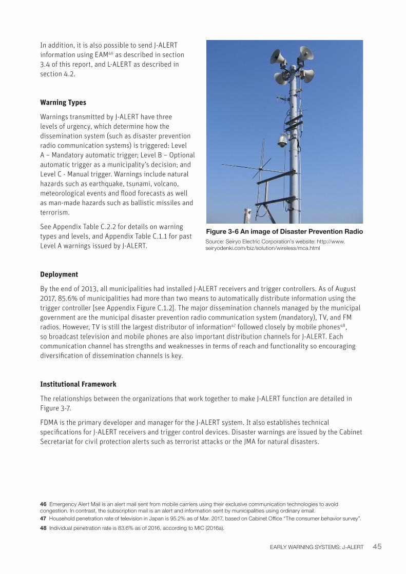
45EARLY WARNING SYSTEMS: J-ALERT
In addition, it is also possible to send J-ALERT information using EAM46 as described in section 3.4 of this report, and L-ALERT as described in section 4.2.
Warning Types
Warnings transmitted by J-ALERT have three levels of urgency, which determine how the dissemination system (such as disaster prevention radio communication systems) is triggered: Level A – Mandatory automatic trigger; Level B – Optional automatic trigger as a municipality’s decision; and Level C - Manual trigger. Warnings include natural hazards such as earthquake, tsunami, volcano, meteorological events and flood forecasts as well as man-made hazards such as ballistic missiles and terrorism.
See Appendix Table C.2.2 for details on warning types and levels, and Appendix Table C.1.1 for past Level A warnings issued by J-ALERT.
Deployment
By the end of 2013, all municipalities had installed J-ALERT receivers and trigger controllers. As of August 2017, 85.6% of municipalities had more than two means to automatically distribute information using the trigger controller [see Appendix Figure C.1.2]. The major dissemination channels managed by the municipal government are the municipal disaster prevention radio communication system (mandatory), TV, and FM radios. However, TV is still the largest distributor of information47 followed closely by mobile phones48, so broadcast television and mobile phones are also important distribution channels for J-ALERT. Each communication channel has strengths and weaknesses in terms of reach and functionality so encouraging diversification of dissemination channels is key.
Institutional Framework
The relationships between the organizations that work together to make J-ALERT function are detailed in Figure 3-7.
FDMA is the primary developer and manager for the J-ALERT system. It also establishes technical specifications for J-ALERT receivers and trigger control devices. Disaster warnings are issued by the Cabinet Secretariat for civil protection alerts such as terrorist attacks or the JMA for natural disasters.
46 Emergency Alert Mail is an alert mail sent from mobile carriers using their exclusive communication technologies to avoid congestion. In contrast, the subscription mail is an alert and information sent by municipalities using ordinary email.47 Household penetration rate of television in Japan is 95.2% as of Mar. 2017, based on Cabinet Office “The consumer behavior survey”.48 Individual penetration rate is 83.6% as of 2016, according to MIC (2016a).
Figure 3-6 An image of Disaster Prevention RadioSource: Seiryo Electric Corporation’s website: http://www.seiryodenki.com/biz/solution/wireless/mca.html
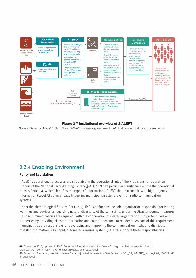
46 DIGITAL SOLUTIONS FOR RESILIENCE
Information on armed attacks
etc.
Natural Disaster Event
[2] Cabinet Secretariat
Issues civil protection warnings such as armed attacks
[1] FDMA
• Develops, manages and maintains the J-ALERT backbone system (for sending and receiving data)
• Compiles the general specifications of the J-ALERT receiver
• Monitors the status of J-ALERT receivers and updates its software
[4] Municipalites
• Install, manage, and maintain the disaster prevention radio
•Install the trigger controller for the disaster prevention radio
•Distribute disaster information by using communication media other than the disaster management radio communication system
[6] Private Companies
•Through the trigger controller owned by municipalities, warnings are transferred to private companies, such as cable TV, community TV, or subscription email service providers
[7] Residents
•Take prompt actions to ensure safety upon receiving warnings from J-ALERT on the disaster prevention radio, TV, radio, or mobile messages
[3] JMA
Issues natural disaster warnings
[5] Mobile Phone Carriers
• Distribute the early warning emails, when receiving civil protection warnings from FDMA or natural disaster warnings from JMA, such as Tsunami or Earthquake early warnings
Satellite
LGWANInternet
Civil protection
warning
Tsunami warning, Earthquake Early Warning, etc.
Emergency Alert Mail
3.3.4 Enabling EnvironmentPolicy and Legislation
J-ALERT’s operational processes are stipulated in the operational rules “The Provisions for Operation Process of the National Early Warning System (J-ALERT49).” Of particular significance within the operational rules is Article 4, which identifies the types of information J-ALERT should transmit, with high-urgency information (Level A) automatically triggering municipal disaster prevention radio communication systems50.
Under the Meteorological Service Act (1952), JMA is defined as the sole organization responsible for issuing warnings and advisories regarding natural disasters. At the same time, under the Disaster Countermeasures Basic Act, municipalities are required (with the cooperation of related organizations) to protect lives and properties by providing disaster information and countermeasures to residents. As part of this requirement, municipalities are responsible for developing and improving the communication method to distribute disaster information. As a rapid, automated warning system, J-ALERT supports these responsibilities.
49 Created in 2010, updated in 2016. For more information, see: https://www.fdma.go.jp/mission/protection/item/protection001_05_J-ALERT_gyomu_kitei_280322.pdf [In Japanese]50 For more information, see: https://www.fdma.go.jp/mission/protection/item/protection001_05_J-ALERT_gyomu_kitei_280322.pdf [In Japanese]
Figure 3-7 Institutional overview of J-ALERTSource: Based on MIC (2016b) Note: LGWAN = General government WAN that connects all local governments.
47EARLY WARNING SYSTEMS: J-ALERT
The following are the major acts related to J-ALERT:
• Act for Establishment of the Ministry of Land, Infrastructure, Transport and Tourism (MLIT): defines the position and role of MLIT, JMA and other agencies under MLIT.
• Meteorological Service Act: defines rules of meteorological services especially including the roles and responsibilities of JMA and its partners, as well as the collaboration mechanism.
• Disaster Countermeasures Basic Act: defines the institutional framework for disaster prevention and management, including the organization, functioning, powers, and responsibilities of central and local disaster prevention councils.
• Civil Protection Act: defines the responsibilities of national and local governments and measures, such as evacuation, relief, and response to armed attacks in order to protect lives and property.
Japan has a strong central government. This helps the policy making process, and the above legislation ensures ongoing funding and support for the system, and widespread dissemination.
System Costs
The total cost to develop and enhance J-ALERT was approximately 1.37 billion JPY51 from 2005-2009. Additional smaller costs were associated with municipal subsidies for implementation. Over the long-term, however, the main investment is associated with the operation and maintenance of the FDMA-owned system, about JPY 300-400 million annually. See the Appendix C.3 for additional information.
Substantial financial and human resources have been allocated to develop and operate J-ALERT because disaster early warning is a critical mission and responsibility as outlined in the legislations listed above. Countries and institutions seeking to design and implement a nationwide instantaneous warning and alert system modeled on J-ALERT should expect a lower cost given the significant technological advances made in recent years. Furthermore, the J-ALERT development cost include designing and developing the original technical standard from scratch, and overhead costs from frequent modifications and changes, which are not to be incurred by a new developer.
51 Based on the inputs from MIC: Initial development cost (472 million JPY), and system enhancement cost (900 million JPY) to enable remote operations for monitoring the receivers’ statuses and updating the software.
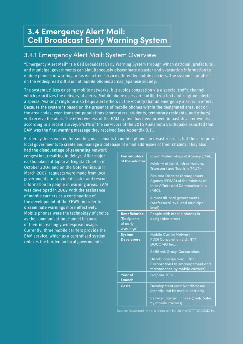
48 DIGITAL SOLUTIONS FOR RESILIENCE
3.4.1 Emergency Alert Mail: System Overview“Emergency Alert Mail” is a Cell Broadcast Early Warning System through which national, prefectural, and municipal governments can simultaneously disseminate disaster and evacuation information to mobile phones in warning areas via a free service offered by mobile carriers. The system capitalizes on the widespread diffusion of mobile phones across Japanese society.
The system utilizes existing mobile networks, but avoids congestion via a special traffic channel which prioritizes the delivery of alerts. Mobile phone users are notified via text and ringtone alerts; a special ‘wailing’ ringtone also helps alert others in the vicinity that an emergency alert is in effect. Because the system is based on the presence of mobile phones within the designated area, not on the area codes, even transient populations (commuters, students, temporary residents, and others) will receive the alert. The effectiveness of the EAM system has been proved in past disaster events: according to a recent survey, 85.1% of the survivors of the 2016 Kumamoto Earthquake reported that EAM was the first warning message they received [see Appendix D.1].
Earlier systems existed for sending mass emails to mobile phones in disaster areas, but these required local governments to create and manage a database of email addresses of their citizens. They also had the disadvantage of generating network congestion, resulting in delays. After major earthquakes hit Japan at Niigata Chuetsu in October 2004 and on the Noto Peninsula in March 2007, requests were made from local governments to provide disaster and rescue information to people in warning areas. EAM was developed in 2007 with the assistance of mobile carriers as a continuation of the development of the EEWS, in order to disseminate warnings more effectively. Mobile phones were the technology of choice as the communication channel because of their increasingly widespread usage. Currently, three mobile carriers provide the EAM service, which as a centralized system reduces the burden on local governments.
3.4 Emergency Alert Mail: Cell Broadcast Early Warning System
Key adopters of the solution
Japan Meteorological Agency (JMA),
Ministry of Land, Infrastructure, Transport and Tourism (MLIT),
Fire and Disaster Management Agency (FDMA) of the Ministry of Inter Affairs and Communications (MIC),
Almost all local governments (prefectural level and municipal level)
Beneficiaries (Recipients of early warnings)
People with mobile phones in designated areas
System Developers
Mobile Carrier Network: KDDI Corporation Ltd., NTT DOCOMO Inc.,
SoftBank Group Corporation.
Distribution System: NEC Corporation Ltd. (management and maintenance by mobile carriers)
Year of Launch
October 2007
Costs Development cost: Not disclosed (contributed by mobile carriers)
Service charge: Free (contributed by mobile carriers)
Source: Developed by the authors with inputs from NTT DOCOMO Inc.
49
3.4.2 Emergency Alert Mail: Lessons and Recommendations• Redundancy - Redundant systems ensure that alert messages are not disrupted. EAM uses
redundant systems to communicate from public organizations such as JMA to mobile carriers (Dedicated line, IP-VPN, and Wide-area Ethernet), and from mobile carriers to individuals via station substitution in affected areas, to ensure that alerts are distributed even if some lines of infrastructure and communication are disrupted.
• Diversification - Although mobile phone rate penetration is high, diversification is key to a wide reach for emergency alerts. Because disaster information is distributed by push notifications to mobile phones the EAM has high penetration. However, mobile phone ownership among elderly residents is low in Japan and in many other countries. To address this issue, in Japan emergency alerts are distributed through multiple communication channels, including TV, radio, or municipal disaster prevention radio communication networks. Other countries exploring new emergency alert systems should consider the penetration of different messaging systems amongst different subsets of the population, and diversify accordingly.
• Language - Alert messages should be multilingual. This is important for many multilingual states among developing countries. It is also a critical need for Japan, which hosts a growing number of foreign residents and tourists. In Japan, EAM started to provide alert messages in five languages with Android models in 2015. Since the operating system enables multilingual services, the issues associated with multilingual correspondence should be handled primarily at the upstream level (for example, Google) rather than among mobile phone carriers. For instance, the iPhone automatically translates the texts to the device’s pre-set language.
• Partnership - Public-Private Partnerships with communication providers can keep down costs, but incentives and secondary alert mechanisms may be required. The operating costs of EAM are borne by cell phone carriers and are relatively low. Carriers have some incentive to participate in terms of public image and the fact that customers may factor the availability of the service when choosing their mobile carrier. However, while in Japan the perceived responsibility of private companies to participate in disaster preparedness-related programs is high, elsewhere additional incentives or legislation may be required. Currently, only the three major mobile carriers participate in EAM, whereas low-cost carriers (a growing segment) do not. In these cases many users install applications that can receive J-ALERT such as Yahoo! Disaster Prevention Bulletin. In other countries, if alerts are not guaranteed by all mobile carriers, outreach mechanisms may be required to gain high levels of participations in opt-in alert applications.
• Customization - The scale of alert delivery areas matters: currently EAM is delivered to an entire municipality. The system could be made more effective by tailoring the alert distribution areas depending on the characteristics of a disaster, based on requests by municipal governments. The areas covered by an alert are becoming larger due to continuing municipal mergers. In cooperation with municipalities, FDMA started a feasibility study in 2016 to distribute alert messages to areas smaller than a municipality. Elsewhere, a combination of local capacity, system capacity, and hazard types can help inform the decision of what scale to use for alert delivery.
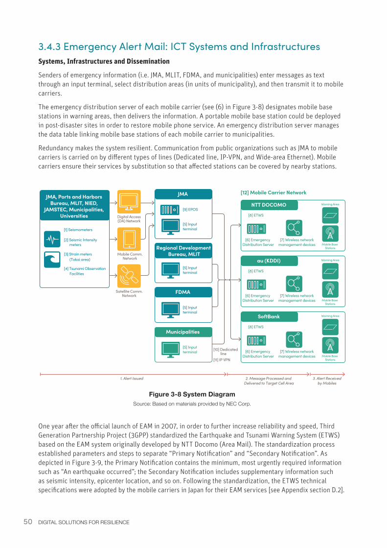
50 DIGITAL SOLUTIONS FOR RESILIENCE
3.4.3 Emergency Alert Mail: ICT Systems and InfrastructuresSystems, Infrastructures and Dissemination
Senders of emergency information (i.e. JMA, MLIT, FDMA, and municipalities) enter messages as text through an input terminal, select distribution areas (in units of municipality), and then transmit it to mobile carriers.
The emergency distribution server of each mobile carrier (see (6) in Figure 3-8) designates mobile base stations in warning areas, then delivers the information. A portable mobile base station could be deployed in post-disaster sites in order to restore mobile phone service. An emergency distribution server manages the data table linking mobile base stations of each mobile carrier to municipalities.
Redundancy makes the system resilient. Communication from public organizations such as JMA to mobile carriers is carried on by different types of lines (Dedicated line, IP-VPN, and Wide-area Ethernet). Mobile carriers ensure their services by substitution so that affected stations can be covered by nearby stations.
Figure 3-8 System DiagramSource: Based on materials provided by NEC Corp.
JMAJMA, Ports and Harbors Bureau, MLIT, NIED,
JAMSTEC, Municipalities, Universities
[1] Seismometers
[9] EPOS
[5] Input terminal
[2] Seismic Intensity
[3] Strain meters(Tokai area)
[4] Tsunami ObservationFacilities
FDMA
[5] Input terminal
Municipalities
NTT DOCOMO
[5] Input terminal
Regional Development Bureau, MLIT
[5] Input terminal
Digital Access (DA) Network
Mobile Comm. Network
Satellite Comm. Network
meters
[12] Mobile Carrier Network
[6] Emergency Distribution Server
[7] Wireless networkmanagement devices Mobile Base
Stations
Warning Area
[8] ETWS
au (KDDI)
[6] Emergency Distribution Server
[7] Wireless networkmanagement devices Mobile Base
Stations
Warning Area
[8] ETWS
SoftBank
[6] Emergency Distribution Server
[7] Wireless networkmanagement devices Mobile Base
Stations
Warning Area
[8] ETWS
[10] Dedicated line[11] IP VPN
1. Alert Issued 2. Message Processed and Delivered to Target Cell Area
3. Alert Receivedby Mobiles
One year after the official launch of EAM in 2007, in order to further increase reliability and speed, Third Generation Partnership Project (3GPP) standardized the Earthquake and Tsunami Warning System (ETWS) based on the EAM system originally developed by NTT Docomo (Area Mail). The standardization process established parameters and steps to separate “Primary Notification” and “Secondary Notification”. As depicted in Figure 3-9, the Primary Notification contains the minimum, most urgently required information such as “An earthquake occurred”; the Secondary Notification includes supplementary information such as seismic intensity, epicenter location, and so on. Following the standardization, the ETWS technical specifications were adopted by the mobile carriers in Japan for their EAM services [see Appendix section D.2].
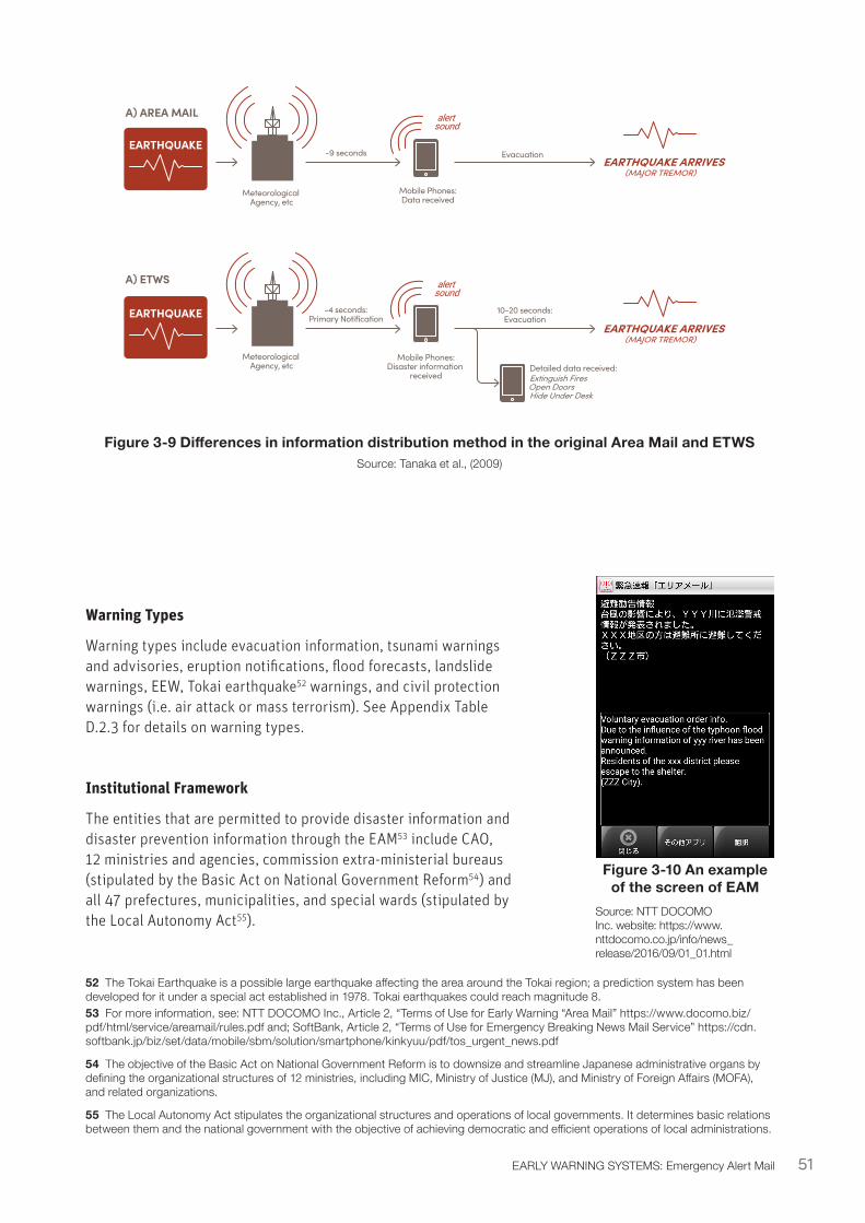
51EARLY WARNING SYSTEMS: Emergency Alert Mail
Figure 3-9 Differences in information distribution method in the original Area Mail and ETWSSource: Tanaka et al., (2009)
Warning Types
Warning types include evacuation information, tsunami warnings and advisories, eruption notifications, flood forecasts, landslide warnings, EEW, Tokai earthquake52 warnings, and civil protection warnings (i.e. air attack or mass terrorism). See Appendix Table D.2.3 for details on warning types.
Institutional Framework
The entities that are permitted to provide disaster information and disaster prevention information through the EAM53 include CAO, 12 ministries and agencies, commission extra-ministerial bureaus (stipulated by the Basic Act on National Government Reform54) and all 47 prefectures, municipalities, and special wards (stipulated by the Local Autonomy Act55).
52 The Tokai Earthquake is a possible large earthquake affecting the area around the Tokai region; a prediction system has been developed for it under a special act established in 1978. Tokai earthquakes could reach magnitude 8.53 For more information, see: NTT DOCOMO Inc., Article 2, “Terms of Use for Early Warning “Area Mail” https://www.docomo.biz/pdf/html/service/areamail/rules.pdf and; SoftBank, Article 2, “Terms of Use for Emergency Breaking News Mail Service” https://cdn.softbank.jp/biz/set/data/mobile/sbm/solution/smartphone/kinkyuu/pdf/tos_urgent_news.pdf
54 The objective of the Basic Act on National Government Reform is to downsize and streamline Japanese administrative organs by defining the organizational structures of 12 ministries, including MIC, Ministry of Justice (MJ), and Ministry of Foreign Affairs (MOFA), and related organizations.
55 The Local Autonomy Act stipulates the organizational structures and operations of local governments. It determines basic relations between them and the national government with the objective of achieving democratic and efficient operations of local administrations.
A) AREA MAIL
EARTHQUAKE ARRIVES(MAJOR TREMOR)
Mobile Phones:Data received
alertsound
A) ETWS
EARTHQUAKE ARRIVES(MAJOR TREMOR)
Meteorological Agency, etc
Meteorological Agency, etc
Mobile Phones:Disaster information
received
alertsound
Detailed data received: Extinguish Fires
Open Doors Hide Under Desk
EARTHQUAKE
EARTHQUAKE
-9 seconds
-4 seconds:Primary Notification
10-20 seconds:Evacuation
Evacuation
Figure 3-10 An example of the screen of EAM
Source: NTT DOCOMO Inc. website: https://www.nttdocomo.co.jp/info/news_release/2016/09/01_01.html

52 DIGITAL SOLUTIONS FOR RESILIENCE
Figure 3-11 Institutional overview of EAMSource: Based on mobile carriers’ website: https://www.nttdocomo.co.jp/biz/service/areamail/?dh=svam and material provided by NEC Corporation Ltd.
[3] Mobile carriers
Provide the communication lines free of charge to transfer the Emergency Alert Email to communication devices such as mobile phones.
Company A
Company B
Company C
[1] JMA
Automatically issues alerts or advisories on natural disasters, earthquakes and tsunamis. Delivers special warnings related to weather and volcanic eruptions.
[2] MLIT
Issues flood forecasts of designated rivers and landslide disaster warning information
[3] Municipalities
Deliver necessary information for evacuation.
[4] FDMA
Sends information for civil protection.
[8] People in Warning Areas
• Upon receiving information, they take actions to ensure safety and protection.
• Emails can be delivered to municipal or prefectural areas.
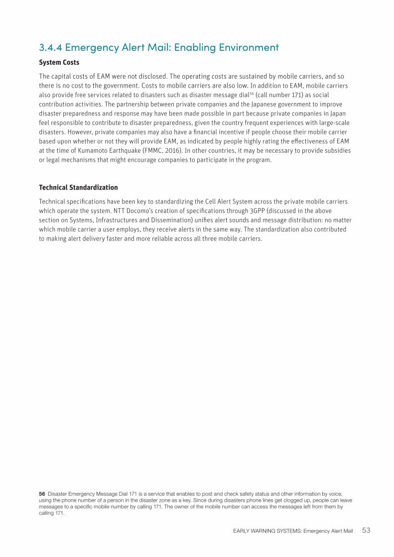
53EARLY WARNING SYSTEMS: Emergency Alert Mail
3.4.4 Emergency Alert Mail: Enabling Environment System Costs
The capital costs of EAM were not disclosed. The operating costs are sustained by mobile carriers, and so there is no cost to the government. Costs to mobile carriers are also low. In addition to EAM, mobile carriers also provide free services related to disasters such as disaster message dial56 (call number 171) as social contribution activities. The partnership between private companies and the Japanese government to improve disaster preparedness and response may have been made possible in part because private companies in Japan feel responsible to contribute to disaster preparedness, given the country frequent experiences with large-scale disasters. However, private companies may also have a financial incentive if people choose their mobile carrier based upon whether or not they will provide EAM, as indicated by people highly rating the effectiveness of EAM at the time of Kumamoto Earthquake (FMMC, 2016). In other countries, it may be necessary to provide subsidies or legal mechanisms that might encourage companies to participate in the program.
Technical Standardization
Technical specifications have been key to standardizing the Cell Alert System across the private mobile carriers which operate the system. NTT Docomo’s creation of specifications through 3GPP (discussed in the above section on Systems, Infrastructures and Dissemination) unifies alert sounds and message distribution: no matter which mobile carrier a user employs, they receive alerts in the same way. The standardization also contributed to making alert delivery faster and more reliable across all three mobile carriers.
56 Disaster Emergency Message Dial 171 is a service that enables to post and check safety status and other information by voice, using the phone number of a person in the disaster zone as a key. Since during disasters phone lines get clogged up, people can leave messages to a specific mobile number by calling 171. The owner of the mobile number can access the messages left from them by calling 171.

54 DIGITAL SOLUTIONS FOR RESILIENCE
55
Image: Disaster information for quick recovery after major power outage - drill (Jul. 2016). Source: Sankei Visual.
Multi-Hazard Disaster Information management Systems (DIMS) in Japan
[4]
4. Multi-Hazard Disaster Information Management Systems (DIMS) in Japan
Information Management is defined as the collection, processing, organization, storage and dissemination of information for a specific purpose (UNISDR, 2013). Effective information management for disasters is vital for disaster preparedness, response and relief. While information management through an EWS is utilized to save lives and assets, effective management of disaster information for quick relief, recovery, and/or continuity is also crucial, particularly in the immediate aftermath of a disaster event.
Disaster Information Management Systems (DIMSs) allow information related to a specific disaster to be readily accessed by relevant stakeholders: after a disaster, delivering the right information to the right recipients allows response and recovery teams to begin their work quickly and effectively. DIMSs are typically developed and setup before a disaster strikes. Related or synonymous concepts include Emergency Management Information System (EMIS57), Disaster Management Information System (DMIS58), Integrated Disaster Information System (DiMAPS59), and National Emergency Management Information System (NEMIS60).
Various types of DIMSs exist in Japan, differentiated by target hazards, key functions, actors involved, technologies utilized, and key information communicated. Table 4-1 summarizes these features of DIMSs, including parameters of success and factors of success. Figure 4-1 shows a schematic of the DIMS process, where the information flows from the sources of disaster impact and the response information institutions to a hub for disaster information, and from there disseminated to utilities and critical infrastructures, private sector stakeholders, people and institutions. Enhancement of DIMSs should aim at: i) increasing the sources monitored; ii) the types and quality of disaster impacts and response information; and iii) expand the reach and ease of access of the recipients of disaster information.
57 EMIS is an information sharing system developed by the Ministry of Health, Labour and Welfare based on the lessons from 1995 Great Hanshin-Awaji Earthquake. It provides disaster medical care information, such as medical service availabilities, to be shared not only within the damaged areas but among all prefectures, in order to support medical care and rescue activities in damaged areas.
58 See http://www.mlit.go.jp/river/bousai/olympic/en/helpful01/index.html59 See http://www.mlit.go.jp/river/bousai/olympic/en/helpful01/index.html60 See https://www.fema.gov/nemis-system
Disaster Information Management System (DIMS): a mechanism for effectively processing, organizing, storing and disseminating information required for disaster response and recovery, particularly in the immediate aftermath of a natural disaster event
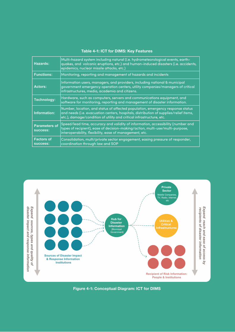
57
Table 4-1: ICT for DIMS: Key Features
Figure 4-1: Conceptual Diagram: ICT for DIMS
EWS
DIMS
Municipalities
Private Sector
Risk Information
Earthquake, typhoons, floods, volcano, etc.
Utilities & Critical
Infrastructures
Utilities & Critical
Infrastructures
Recipient of Risk Information:People & Institutions
Recipient of Risk Information:People & Institutions
Shorten time between source risk info to recipient
Expand reach / recipients of risk information
Diversify inform
ation dissemination channels
Expand reach and ease of access by recipients of disaster inform
ation
Expand sources, types and quality of disaster im
pact and response information
Mobile Companies, TV, Radio, Internet,
etc
Sources of Disaster Impact & Response Information
Institutions
Hub for Disaster
Information[Municipal
Government]
Private Sector
Mobile Companies, TV, Radio, Internet,
etc
Multi-hazard system including natural (i.e. hydrometeorological events, earth-quakes, and volcanic eruptions, etc.) and human-induced disasters (i.e. accidents, epidemics, nuclear missile attacks, etc.)
Monitoring, reporting and management of hazards and incidents
Information users, managers, and providers, including national & municipal government emergency operation centers, utility companies/managers of critical infrastructures, media, academia and citizens.
Hardware, such as computers, servers and communications equipment, and software for monitoring, reporting and management of disaster information.
Number, location, and status of a�ected population, emergency response status and needs (i.e. evacuation centers, hospitals, distribution of supplies/relief items, etc.), damage/condition of utility and critical infrastructure, etc.
Speed/lead time, accuracy and validity of information, accessibility (number and types of recipient), ease of decision-making/action, multi-use/multi-purpose, interoperability, flexibility, ease of management, etc.
Consolidation, multi/private sector engagement, easing pressure of responder, coordination through law and SOP
Hazards:
Functions:
Actors:
Technology:
Parameters of success:
Factors of success:
Information:
58 DIGITAL SOLUTIONS FOR RESILIENCE
4.1 DIMS Overview 4.1.1 Systems DiscussedThis section discusses the following Disaster Information Management System (DIMS) case studies from Japan:
• L-ALERT Common Public Information for Safety and Security is a centralized repository for gathering and distributing disaster-related information developed by the MIC; the information it handles includes warnings from J-ALERT.
• GIS-based DIMSs. Three technologies for obtaining imagery of disaster areas are discussed:
• Helicopter Satellite Communication System, which transfers disaster images from helicopters to disaster management centers via satellite;
• Disaster Damage Map, an interface for displaying before-and-after images of disaster-impacted areas;
• Crisis Mapping, which publishes post-disaster drone imagery online.
• Tokushima Prefecture: Disaster Information Management System is a platform for disaster information sharing covering the entire prefecture, used by 499 organizations.
• K-DIS: DIMS for Utilities. Kansai prefecture’s K-DIS focuses on sharing the post-disaster status of utilities, including the status of damage of facilities such as substations and transmission lines, as well as power outages and recovery status of the Kansai Electric Power Co. Inc.
• Hyogo Asset Management System for Resilience of the Hyogo Prefecture explores the role of DIMS for infrastructure by assessing damages and response status in a ledger system. It also serves as an asset management system for infrastructure facilities during non-disaster periods.
L-Alert and the GIS-based DIMS are national-scale systems, whereas the last three case studies are developed and operated by prefectures; while each has a unique emphasis, they all work to streamline sharing disaster-related information.
59
4.1.2 Key Lessons• Legislative framework - Laws which clearly define the roles of relevant organizations ensure
that operations of DIMS are effective when a disaster strikes. To develop DIMSs, it is necessary to clarify who does what and when in the event of a disaster, with respect to collecting, disseminating, and utilizing information through DIMS. In the case of Japan, the disaster management plan has been developed by all administrative bodies, including national agencies, prefectures, and municipalities, based on the Disaster Countermeasures Basic Act. The chain of command at the time of a disaster, the flow for processing information on damage and disaster response, and the responsibilities of each organization are clearly defined.
In most developing countries, a disaster management plan has already been prepared at the national level, however, not all have prepared one at a local level. Therefore, it is necessary to develop the Standard Operating Procedure (SOP) not only at the national level but also at the level of local governments, as well as utilities (lifeline operators and transportation infrastructure operators), and to clarify the roles taken by each organization. This will allow response, recovery, and associated communications to operate effectively based on DIMS during a crisis.
• Outreach - Pre-disaster outreach and system engagement can promote use of DIMSs during a disaster. To fully utilize any DIMS, users should be motivated to regularly use and update the system in normal times. For example, in Tokushima Prefecture’s system, government employees benefit by linking other disaster management systems within the prefectural government. The latest information on damage is registered in the system, saving time spent for administrative work by disaster management officials responding to mass media.
DIMSs cannot be used effectively in an emergency unless participants are accustomed to using it in normal times. For example, Hyogo Prefecture’s Asset Management System (AMS) is used for maintaining facilities in the prefecture and preparing updated plans in normal times. At the time of a disaster it is possible to share images of disaster areas with the same system. When designing new DIMSs, potentials for non-disaster use and promoting its use should be integrated into the system.
• Contextualization - Information access for DIMSs should be based upon existing communication infrastructures and user contexts.
In Tokushima Prefecture’s DMIS, Hyogo Prefecture’s Asset Management System and GIS-based DIMS, users are able to register and view disaster information anytime and anywhere via internet networks and mobile communication networks. In addition, information security is taken into consideration by setting access restrictions with login management.
On the other hand, K-DIS uses a dedicated line inside the company and is connected to all departments of Kansai Electric Power Company and information is shared with all employees. In developing countries, access methods and information management should be based on the existing communication infrastructure development status and the circumstances of DIMS users. Systems should be implemented in accordance with the actual situation of developing countries.
60 DIGITAL SOLUTIONS FOR RESILIENCE
4.2.1 L-ALERT: System OverviewL-ALERT is a common public information system for safety and security, which serves as a one-stop platform for dissemination of disaster early warnings, evacuation information, and post-disaster information from different sources, such as municipalities and utility companies. L-ALERT disseminates the information sent from senders across Japan to distributors of information regardless of their locations, so that the same information is accessible to residents through various media, including TV, radio, mobile phones, and web portal sites61. Since the system itself does not store information, it does not require storage and backup solutions, keeping maintenance and management costs low. Although L-ALERT includes some EWS functions, it is classified as a DIMS considering its paramount function as a shared platform of disaster information. Here we focus on the way L-ALERT creates a system of consolidation, aggregation, and dissemination of information from multiple sources and makes this information accessible to affected residents and local businesses/organizations.
L-ALERT gathers and distributes disaster information in a centralized fashion, relieving local governments from individually providing disaster information to each media outlet, consuming time and resources, and enabling to browse disaster information issued in nearby local governments. Through L-ALERT media outlets can receive information from each region in a unified format, streamlining information transmission. Residents in disaster areas can receive the same information through a variety of mediums, allowing them to receive important messages whether they are at home, work, or on the move.
L-ALERT was developed by the MIC in order to quickly and accurately convey post-disaster information, and it has been adopted by all municipalities in Japan62.
The system is operated by the Foundation for MultiMedia Communications (“FMMC” hereafter), a public organization which participated in the working group and feasibility studies.
61 For more information and an overview of L-ALERT, see: http://www.soumu.go.jp/soutsu/kanto/saigai/osirase/lalert.html (in Japanese)62 For a description of the history of L-ALERT’s development, see Appendix E.2.
4.2 L-ALERT: Common Public Information System for Safety and Security
Key adopters of the solution
Ministry of Internal Affairs and Communications of Japan (MIC)
Beneficiaries (Users of the database)
National and prefectural governments, municipal governments, utility companies, and distributors of information (i.e. broadcast companies, mobile phone carriers, web portal site operators, and newspaper publishers)
System Developers
Development: NEC Corp.
Operation: Foundation for MultiMedia Communications (FMMC)
Year of Launch
2011
Costs Development cost: About JPY 63.6 million
Source: Developed by the authors with inputs from MIC
61
4.2.2 L-ALERT: Lessons and Recommendations• Centralization - A centralized platform to gather and communicate disaster information reduces
the burden on local governments.
• Outreach - Advance planning and everyday usage can ensure that DIMS are effective post-disaster. Lessons from the 2016 Kumamoto earthquake emphasized the need for adequate preparedness when planning to share disaster-related information (FMMC, 2016). For example, not all the public relations (PR) divisions of municipalities, which are usually responsible for updating information on their websites, transmitted the information obtained from L-ALERT to residents. Transmitting L-ALERT announcements in normal times would help PR divisions become familiar with the system. Similarly, pre-disaster outreach activities help major media to increase their usage of L-ALERT.
Inputting data into L-ALERT can be difficult for municipalities during a crisis. Establishing an organizational support framework for municipalities in advance, such as in cooperation with the MIC, can help them to cope with the human resource shortages they are likely to face post disaster as they deal with various disaster-related missions such as search and rescue, and recovering infrastructure.
• Capacity building - Drills and other forms of capacity building are required in order to ensure that a DIMS can be operated effectively during a crisis. L-ALERT requires data providers (including municipal government and operators of critical infrastructure) to decide and take responsibility for the information to be disseminated. Furthermore, data input requirements are also many and complex. Therefore, capacity building and simulation drills, such as those conducted in Japan, would also be critical in developing countries for this system to be applicable.
• Multilingual services - Alert messages should be received in the appropriate language for residents of and visitors to the country. Japan is currently working to improve multilingual services for increasing numbers of foreign visitors. Elsewhere, the language needs of both resident populations and visitors (tourists, businesspeople, foreign workers) should be considered.
• Visual impact - Combining text and visual information improves comprehension. In Japan, there is currently an effort to incorporate visualization of landslide disaster information on the map for related areas: as the number of related areas increase, it becomes more difficult to understand text information. Some information can be more quickly and clearly understood visually, and visual information, if well-designed, can also help overcome some language and comprehension barriers.
• Redundancy - The L-ALERT system operates with a redundant architecture consisting of national data center and backup data center ensuring uninterrupted operations. Information sent to each center is synchronized automatically.
62 DIGITAL SOLUTIONS FOR RESILIENCE
4.2.3 L-ALERT: ICT Systems and ContextSystems and Infrastructures
L-ALERT mainly consists of three components:
1. “Commons Node System,” to receive, convert, and transfer information. It is the core of L-ALERT, comes in two versions: one is the national node operated as Local Government Wide Area Network (LGWAN) Application Service Provider (ASP) for Japan as a whole, and the other is the local node operated as an independent ASP. Each node is equipped with a commons node system with the same functionality. Because nodes are connected to each other to form the commons network, the Commons Node System was developed to provide a high level of redundancy and availability as a large-scale distributed system, ensuring completion of information delivery even if there are problems with communication paths by resending data at system recovery regardless of the timing or location of a failure.
2. “Editor” and “Viewer”, which are two tools available for users to connect easily to L-ALERT without developing a cooperative system.
3. “Master data management system”, which is a web system for controlling configurations for receiving and sending data63.
Senders of information have two options to connect to the node system. They either develop a cooperative application system to be interfaced with L-ALERT, or install the commons editor on their PCs.
L-ALERT system operates with a redundant architecture consisting of national data center and backup data center. Information sent to each center is synchronized automatically64.
In addition to Figure 4-2, a more detailed table of L-ALERT components can be found in Appendix E, Table E.2.1.
Dissemination
L-ALERT is often used as a post-disaster tool for local governments to quickly and widely disseminate relevant information such as rainfall, water levels, tide heights, shelters, or evacuation65. However, L-ALERT also works as an EWS that disseminates alerts and evacuation information (for example, L-ALERT handles warnings from J-ALERT too66).
The contents of L-ALERT are being continuously improved and enhanced, especially after each disaster experiences. For example, in addition to basic features for transmitting evacuation advisories, directives, shelter, and disaster information, L-ALERT has an “announcement feature” to provide daily life information such as on administrative procedures, assistance and support regarding welfare, education, and childcare for victims of disasters. This announcement feature was used in the aftermath of the 2016 Kumamoto earthquake to deliver evacuation advisories, directives, and other information. Municipal officers could input this information directly into L-ALERT instead of multiple organizations separately (see Appendix E.1 for details).
In order to disseminate disaster information based on L-ALERT more effectively, new services are also being generated through the cooperative efforts of the public sector and private companies. Some examples
63 For more information, see: http://www.fmmc.or.jp/commons/merit/index.html64 Since 2014, the backup data center has been used according to the following backup policies:65 See Appendix Table E.2.2 for more details66 Recent examples (disclosed from FMMC on “Measures for utilization of L-ALERT”) of when and how L-ALERT was activated include: in the summer of 2016, L-ALERTS was used to issue 147 evacuation warnings for typhoon No. 8, 785 for typhoon No. 9 and 491 for typhoon No. 10.
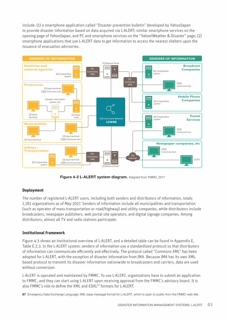
63DISASTER INFORMATION MANAGEMENT SYSTEMS: L-ALERT
Deployment
The number of registered L-ALERT users, including both senders and distributors of information, totals 1,181 organizations as of May 2017. Senders of information include all municipalities and transportation (such as operator of mass-transportation or road/highway) and utility companies, while distributors include broadcasters, newspaper publishers, web portal site operators, and digital signage companies. Among distributors, almost all TV and radio stations participate.
Institutional Framework
Figure 4-3 shows an institutional overview of L-ALERT, and a detailed table can be found in Appendix E, Table E.2.3. In the L-ALERT system, senders of information use a standardized protocol so that distributors of information can communicate efficiently and effectively. The protocol called “Commons XML” has been adopted for L-ALERT, with the exception of disaster information from JMA. Because JMA has its own XML-based protocol to transmit its disaster information nationwide to broadcasters and carriers, data are used without conversion.
L-ALERT is operated and maintained by FMMC. To use L-ALERT, organizations have to submit an application to FMMC, and they can start using L-ALERT upon receiving approval from the FMMC’s advisory board. It is also FMMC’s role to define the XML and EDXL67 formats for L-ALERT.
67 Emergency Data Exchange Language: XML base message format for L-ALERT, which is open to public from the FMMC web site.
Figure 4-2 L-ALERT system diagram. Adapted from FMMC, 2017
[1] National Node
[10] Commons NetworkLGWAN
SENDERS OF INFORMATION
Municipalities
Prefectures
Ministries and national agencies
Utilities /Transportation
[6] Cooperativesystem
[3] Input terminal
[2] Users’ node
[3] Input terminal[7][8] Commons tool
[3] Input terminal[7][8] Commons tool
Disaster information system, etc.
[3] Input terminal
[3] Input terminal[7][8] Commons tool [6] Cooperative
system
SENDERS OF INFORMATION
BroadcastCompanies
Mobile PhoneCompanies
Newspaper companies, etc
PostalServices
[6] Cooperativesystem
[6] Cooperativesystem
[6] Cooperativesystem
[7][9] Commons tool
[7][9] Commons tool
[7][9] Commons tool
[4] PC
[11] Commons
VPN
[11] Commons
VPN
[11] Commons
VPN
[12]Internet
[1] National Node
include: (1) a smartphone application called “Disaster prevention bulletin” developed by Yahoo!Japan to provide disaster information based on data acquired via L-ALERT; similar smartphone services on the opening page of Yahoo!Japan, and PC and smartphone services on the “Yahoo!Weather & Disaster” page; (2) smartphone applications that use L-ALERT data to get information to access the nearest shelters upon the issuance of evacuation advisories.
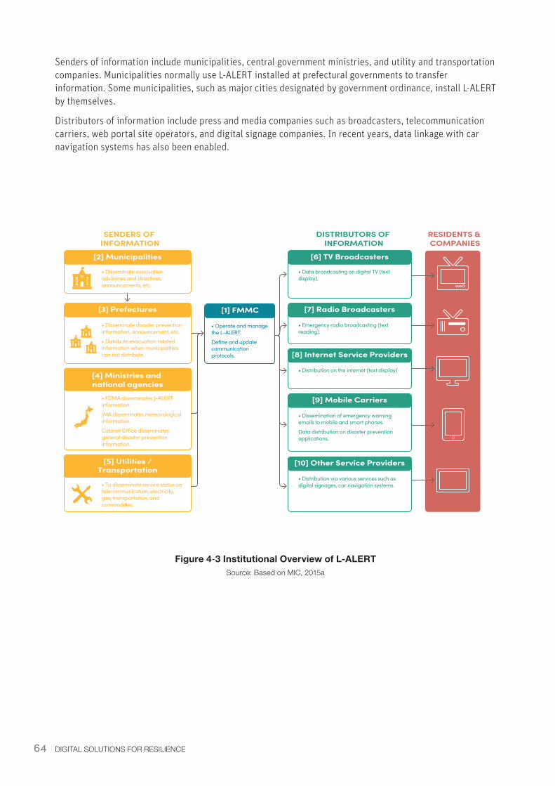
64 DIGITAL SOLUTIONS FOR RESILIENCE
Senders of information include municipalities, central government ministries, and utility and transportation companies. Municipalities normally use L-ALERT installed at prefectural governments to transfer information. Some municipalities, such as major cities designated by government ordinance, install L-ALERT by themselves.
Distributors of information include press and media companies such as broadcasters, telecommunication carriers, web portal site operators, and digital signage companies. In recent years, data linkage with car navigation systems has also been enabled.
Figure 4‑3 Institutional Overview of L-ALERTSource: Based on MIC, 2015a
SENDERS OF INFORMATION
[2] Municipalities
[3] Prefectures
[4] Ministries and national agencies
[5] Utilities /Transportation
• Disseminate evacuation advisories and directives, announcements, etc.
• Disseminate disaster prevention information, announcement, etc.
• Distribute evacuation related information when municipalities can not distribute.
• FDMA disseminates J-ALERT information.
JMA disseminates meteorological information.
Cabinet O�ce disseminates general disaster prevention information.
• To disseminate service status on telecommunication, electricity, gas, transportation, and commodities.
DISTRIBUTORS OF INFORMATION
RESIDENTS & COMPANIES
[6] TV Broadcasters
[7] Radio Broadcasters
• Data broadcasting on digital TV (text display).
• Emergency radio broadcasting (text reading).
[1] FMMC
• Operate and manage the L-ALERT.
Define and update communication protocols. [8] Internet Service Providers
• Distribution on the internet (text display)
[10] Other Service Providers
• Distribution via various services such as digital signages, car navigation systems.
[9] Mobile Carriers
• Dissemination of emergency warning emails to mobile and smart phones.
Data distribution on disaster prevention applications.
65DISASTER INFORMATION MANAGEMENT SYSTEMS: L-ALERT
4.2.4 Enabling EnvironmentPolicy and Legislation
L-ALERT was initially developed under the name “Public Information Commons” as a result of an MIC working group and feasibility studies beginning in 2008, and its use was expanded by a series of legislation. Under the trial project funded by MIC, L-ALERT was developed as a light and simple system consisting of a single gateway server connected to the network. The Basic Act on Sediment Disaster Control Measures was amended following the 2014 Hiroshima landslides to require prefectural governments to specify warning zones in regard to landslides and to publish the results of geotechnical investigation. The act also requires governors to supply landslide disaster warnings to mayors of municipalities, who in turn keep residents informed. Based on this amendment, the guidelines on landslide disaster control measures were modified in January 2015, providing methods to announce or distribute disaster-related information. This modification stipulates the expansion of L-ALERT as a tool for disseminating landslide disaster information to various mass media (MIC, 2015b).
L-ALERT is not subject to telecommunication laws because it only relays information already submitted by each sender organizations (which are regulated by telecommunication laws). This condition simplified its development and enabled increased utilization. For example, L-ALERT receives, among the others, J-ALERT information through the J-ALERT receiver, but the legislation and operational rules regulating the dissemination of information obtained using J-ALERT68 are not relevant to L-ALERT.
System Costs
Capital cost for L-ALERT is about JPY 63.6 million69. Operation and maintenance costs have not been disclosed. All capital costs were borne by MIC, while the O&M costs are borne by FMMC. Therefore users, including municipalities, do not pay a user fee.
68 For example, “The Provisions for Operation Process of the National Early Warning System (J-ALERT)”69 Based on inputs from MIC.
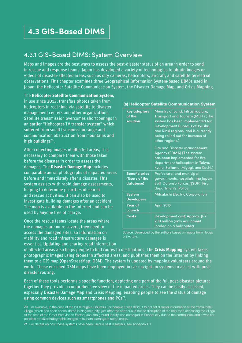
66 DIGITAL SOLUTIONS FOR RESILIENCE
4.3.1 GIS-Based DIMS: System OverviewMaps and images are the best ways to assess the post-disaster status of an area in order to send in rescue and response teams. Japan has developed a variety of technologies to obtain images or videos of disaster-affected areas, such as city cameras, helicopters, aircraft, and satellite terrestrial observations. This chapter examines three Geographical Information System-based DIMSs used in Japan: the Helicopter Satellite Communication System, the Disaster Damage Map, and Crisis Mapping.
The Helicopter Satellite Communication System, in use since 2013, transfers photos taken from helicopters in real-time via satellite to disaster management centers and other organizations. Satellite transmission overcomes shortcomings in an earlier “Helicopter-TV transfer system” which suffered from small transmission range and communication obstruction from mountains and high buildings70.
After collecting images of affected areas, it is necessary to compare them with those taken before the disaster in order to assess the damages. The Disaster Damage Map includes comparable aerial photographs of impacted areas before and immediately after a disaster. This system assists with rapid damage assessments, helping to determine priorities of search and rescue activities. It can also be used to investigate building damages after an accident. The map is available on the Internet and can be used by anyone free of charge.
Once the rescue teams locate the areas where the damages are more severe, they need to access the damaged sites, so information on viability and road infrastructure damages is essential. Updating and sharing road information of affected areas also helps people to find routes to destinations. The Crisis Mapping system takes photographic images using drones in affected areas, and publishes them on the Internet by linking them to a GIS map (OpenStreetMap: OSM). The system is updated by mapping volunteers around the world. These enriched OSM maps have been employed in car navigation systems to assist with post-disaster routing.
Each of these tools performs a specific function, depicting one part of the full post-disaster picture: together they provide a comprehensive view of the impacted areas. They can be easily accessed, especially Disaster Damage Map and Crisis Mapping, enabling people to see the status of damage using common devices such as smartphones and PCs71.
70 For example, in the case of the 2004 Niigata-Chuetsu Earthquake it was difficult to collect disaster information at the Yamakoshi-village (which has been consolidated in Nagaoka-city) just after the earthquake due to disruption of the only road accessing the village. At the time of the Great East Japan Earthquake, the ground facility was damaged in Sendai-city due to the earthquake, and it was not possible to take photographic images of tsunami damage in some areas.71 For details on how these systems have been used in past disasters, see Appendix F.1.
4.3 GIS-Based DIMS
(a) Helicopter Satellite Communication SystemKey adopters of the solution
Ministry of Land, Infrastructure, Transport and Tourism (MLIT) (The system has been implemented for Development Bureaus of Kyushu and Kinki regions, and is currently being rolled out for bureaus of other regions.)
Fire and Disaster Management Agency (FDMA) (The system has been implemented for fire department helicopters in Tokyo, Kyoto, Saitama, Miyagi, and Kochi.)
Beneficiaries (Users of the database)
Prefectural and municipal governments, hospitals, the Japan Self-Defense Forces (JSDF), Fire departments, Police
System Developers
Mitsubishi Electric Corporation
Year of Launch
April 2013
Costs Development cost: Approx. JPY 200 million (only equipment loaded on a helicopter)
Source: Developed by the authors based on inputs from Hyogo prefecture.
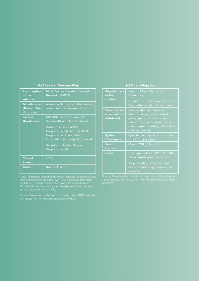
67
(b) Disaster Damage Map Key adopters of the solution
Micro Media Disaster Information Network (MMDIN)
Beneficiaries (Users of the database)
Anyone with access to the Internet, search and rescue operators
System Developers
MMDIN and Environmental Systems Research Institute, Inc.
Data providers: PASCO Corporation Ltd., NTT GEOSPACE Corporation., Geospatial Information Authority of Japan, etc.
Secretariat: Global Survey Corporation Ltd.
Year of Launch
2013
Costs Not disclosed*
Note: * Expenses related to the system such as development and maintenance costs are not known. This is because total costs contributed by related companies have not been calculated. Administration is financed by membership fees from corporate groups supporting this activity.
Source: Developed by the authors based on the MMDIN website, and inputs from Dr. Hayashi (president of NIED)
(c) Crisis MappingKey adopters of the solution
Yamato City in Kanagawa Prefecture,
Chofu City and Komae City in the Tokyo Metropolitan Government
Beneficiaries (Users of the database)
People who need disaster information (e.g., the central government, prefectural and municipal governments, disaster management centers, residents in affected areas)
System Developers
Specified non-profit corporation Crisis Mappers Japan
Year of Launch
March 2011 (in Japan)
Costs Development cost: JPY 100 – 300 million (drone purchase cost)
Map updating: Free (as maps are updated using open source services)
Source: Developed by the authors based on the Crisis Mappers Japan website, and inputs from Prof. Furuhashi (Aoyama Gakuin University)
68 DIGITAL SOLUTIONS FOR RESILIENCE
4.3.2 GIS-Based DIMS: Lessons and Recommendations• Outreach - Crowdsourced or volunteer-operated platforms require promotion campaigns to
be effective at broad geographic scales. The Disaster Damage Map has not been widely used nationwide in Japan and to reach its full potential requires promotion activities highlighting the system’s role in assessing damage, searching for missing persons, and building damage investigations. In addition to emphasizing the functions of systems, outreach campaigns should also identify potential users and target the campaigns towards these users.
• Preparedness - Some data collection or agreements may be necessary pre-disaster for GIS-based DIMS to be effective post-disaster. When creating a Disaster Damage Map, housing footprints on the map before a disaster occurs should be available. Pre-disaster housing footprints is required because if a house is carried away (e.g., by a landslide, or a flood), officials of the JSDF, fire departments, and police dispatched to the site for search and rescue have information on the existence and original location of the house by comparing housing footprints before and after the disaster. For this system, drone routes are also pre-approved prior to disasters.
OpenStreetMap is an open source system, and anyone can use it free of charge. However, map information is not adequate everywhere, and it is not usually feasible to create a base map after a disaster. Therefore, it is important to start creating maps in normal times.
Disaster Damage Map and Crisis Mapping can be accessed from anywhere in the world as long as an internet connection is available. However, in order to ensure smooth cooperation among stakeholders in the event of a disaster, it is essential to prepare in advance a cooperation agreement and/or an SOP.
Other mapping systems might require preemptively drawing or identifying other types of resources, creating effective labeling systems, or identifying systems of communication or other sorts of permissions.
• Appropriate technology - Different mapping and visual image collection systems have different strength and weaknesses-it is important to understand and identify these parameters to select the right technology for each purpose.
With the Heli-Sat system, images could be blurred by shadows cast by the helicopter (the blocking effect). Since the Heli-Sat system transmits imagery information through geostationary satellites, the blocking effect is less likely to occur at low latitudes or equatorial areas, whereas it may occur at mid latitude locations such as Japan. The use of drones may create legal or permissions challenges. Satellite and aerial photographs avoid these challenges, but their collection process is slower. These technologies have different shortcomings and benefits in various aspects, including start-up time, areas that could be covered, impact of weather, night time operation etc. The ways the images will be used will help determine which technologies will be most effective, and how different technologies can complement one another.
Disaster management is also evolving along with technology: in the future, crowd-sourced mapping may work in concert with AI systems for collecting disaster information, that are currently under development around the world. Also, disaster mapping is evolving to use three-dimensional information rather than two-dimensional data, such as AW3D72, which is the world’s first and most precise 3D map covering all Earth with 5-meter resolution, developed jointly by NTT DATA and Remote Sensing Technology Center of Japan.
• Standard base maps - Creating cross-platform systems increases effectiveness. Heli-Sat, Disaster Damage Map and Crisis Mapping each provide an effective approach, but the systems lack interoperability because they use different base maps. Integrating the base maps would allow for data to be more easily shared and compared between the platforms. In Japan, integration of maps via Sharing Information Platform for Disaster Management (SIP4D73) is being studied. In countries where similar systems are being newly designed and/or implemented, there is an opportunity to create a standard base map to ease information sharing across platforms.
72 For more information on AW3D, see: https://www.aw3d.jp/en/about/73 System for sharing disaster information with collaboration among central agencies
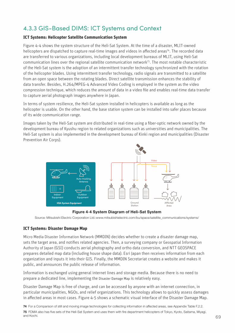
69
4.3.3 GIS-Based DIMS: ICT Systems and ContextICT Systems: Helicopter Satellite Communication System
Figure 4-4 shows the system structure of the Heli-Sat System. At the time of a disaster, MLIT-owned helicopters are dispatched to capture real-time images and videos in affected areas74. The recorded data are transferred to various organizations, including local development bureaus of MLIT, using Heli-Sat communication lines over the regional satellite communication network75. The most notable characteristic of the Heli-Sat system is the adoption of an intermittent transfer technology synchronized with the rotation of the helicopter blades. Using intermittent transfer technology, radio signals are transmitted to a satellite from an open space between the rotating blades. Direct satellite transmission enhances the stability of data transfer. Besides, H.264/MPEG-4 Advanced Video Coding is employed in the system as the video compression technique, which reduces the amount of data in a video file and enables real-time data transfer to capture aerial photograph images anywhere in Japan.
In terms of system resilience, the Heli-Sat system installed in helicopters is available as long as the helicopter is usable. On the other hand, the base station system can be installed into safer places because of its wide communication range.
Images taken by the Heli-Sat system are distributed in real-time using a fiber-optic network owned by the development bureau of Kyushu region to related organizations such as universities and municipalities. The Heli-Sat system is also implemented in the development bureau of Kinki region and municipalities (Disaster Prevention Air Corps).
Figure 4‑4 System Diagram of Heli-Sat SystemSource: Mitsubishi Electric Corporation Ltd.:www.mitsubishielectric.com/bu/space/satellite_communications/systems/
ICT Systems: Disaster Damage Map
Micro Media Disaster Information Network (MMDIN) decides whether to create a disaster damage map, sets the target area, and notifies related agencies. Then, a surveying company or Geospatial Information Authority of Japan (GSI) conducts aerial photography and ortho data conversion, and NTT GEOSPACE prepares detailed map data (including house shape data). Esri Japan then receives information from each organization and inputs it into their GIS. Finally, the MMDIN Secretariat creates a website and makes it public, and announces the public release of information.
Information is exchanged using general internet lines and storage media. Because there is no need to prepare a dedicated line, implementing the Disaster Damage Map is relatively easy.
Disaster Damage Map is free of charge, and can be accessed by anyone with an internet connection, in particular municipalities, NGOs, and relief organizations. This technology allows to quickly assess damages in affected areas in most cases. Figure 4-5 shows a schematic visual interface of the Disaster Damage Map.
74 For a Comparison of still and moving image technologies for collecting information in affected areas, see Appendix Table F.2.2.75 FDMA also has five sets of the Heli-Sat System and uses them with fire department helicopters of Tokyo, Kyoto, Saitama, Miyagi, and Kochi.
Auto-trackingAntenna
Indoor Equipment
Outdoor Equipment
GroundStation
Video
Voice
A�ictedArea
HSA System Equipment
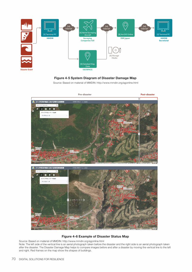
70 DIGITAL SOLUTIONS FOR RESILIENCE
Figure 4‑5 System Diagram of Disaster Damage Map Source: Based on material of MMDIN: http://www.mmdin.org/agonline.html
[3] Terminal PC
Disaster Event
MMDIN MMDINSecretariat
Surveying Companies/GSI
ESRI Japan
GEOSPACE
[14]Internet
[4] Aerial SurveyingAircraft
[9] Detailed Map Data
[14]Internet
[8] ArcGIS Online [3] Terminal PC
[14]Internet
[5] Storage Media
Pre-disaster Post-disaster
Figure 4-6 Example of Disaster Status Map Source: Based on material of MMDIN: http://www.mmdin.org/agonline.html Note: The left side of the vertical line is an aerial photograph taken before the disaster and the right side is an aerial photograph taken after the disaster. The Disaster Damage Map helps to compare images before and after a disaster by moving the vertical line to the left and right. Red frames on the map show the shapes of buildings.
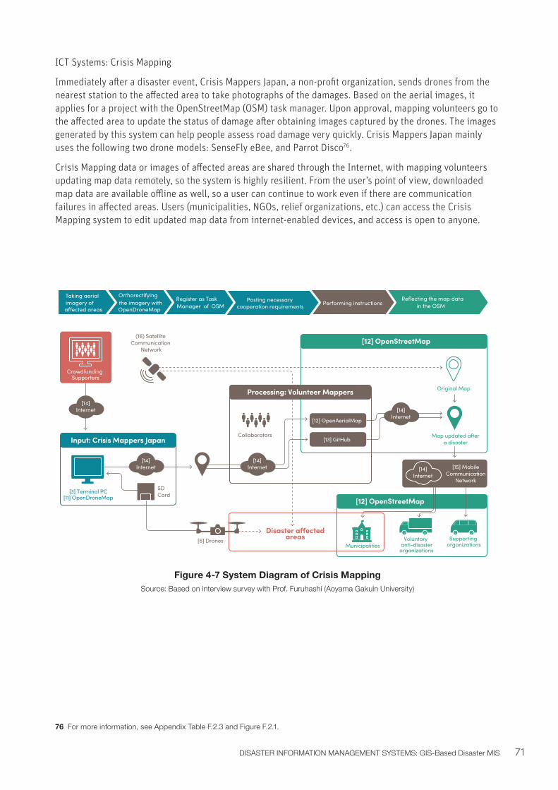
71DISASTER INFORMATION MANAGEMENT SYSTEMS: GIS-Based Disaster MIS
ICT Systems: Crisis Mapping
Immediately after a disaster event, Crisis Mappers Japan, a non-profit organization, sends drones from the nearest station to the affected area to take photographs of the damages. Based on the aerial images, it applies for a project with the OpenStreetMap (OSM) task manager. Upon approval, mapping volunteers go to the affected area to update the status of damage after obtaining images captured by the drones. The images generated by this system can help people assess road damage very quickly. Crisis Mappers Japan mainly uses the following two drone models: SenseFly eBee, and Parrot Disco76.
Crisis Mapping data or images of affected areas are shared through the Internet, with mapping volunteers updating map data remotely, so the system is highly resilient. From the user’s point of view, downloaded map data are available offline as well, so a user can continue to work even if there are communication failures in affected areas. Users (municipalities, NGOs, relief organizations, etc.) can access the Crisis Mapping system to edit updated map data from internet-enabled devices, and access is open to anyone.
Figure 4-7 System Diagram of Crisis MappingSource: Based on interview survey with Prof. Furuhashi (Aoyama Gakuin University)
76 For more information, see Appendix Table F.2.3 and Figure F.2.1.
Reflecting the map data in the OSM Performing instructionsPosting necessary
cooperation requirementsRegister as Task Manager of OSM
Orthorectifying the imagery with OpenDroneMap
Taking aerial imagery of a�ected areas
Crowdfunding Supporters
[3] Terminal PC[11] OpenDroneMap
[14]Internet
[14]Internet
[14]Internet
[14]Internet
Collaborators
[6] Drones
Original Map
Map updated aftera disaster
[12] OpenAerialMap
[13] GitHub
[15] MobileCommunication
Network
(16) Satellite Communication
Network
Input: Crisis Mappers Japan
Processing: Volunteer Mappers
SDCard
[12] OpenStreetMap
Disaster a�ectedareas
[12] OpenStreetMap
Municipalities
[14]Internet
Supporting organizations
Voluntary anti-disaster
organizations
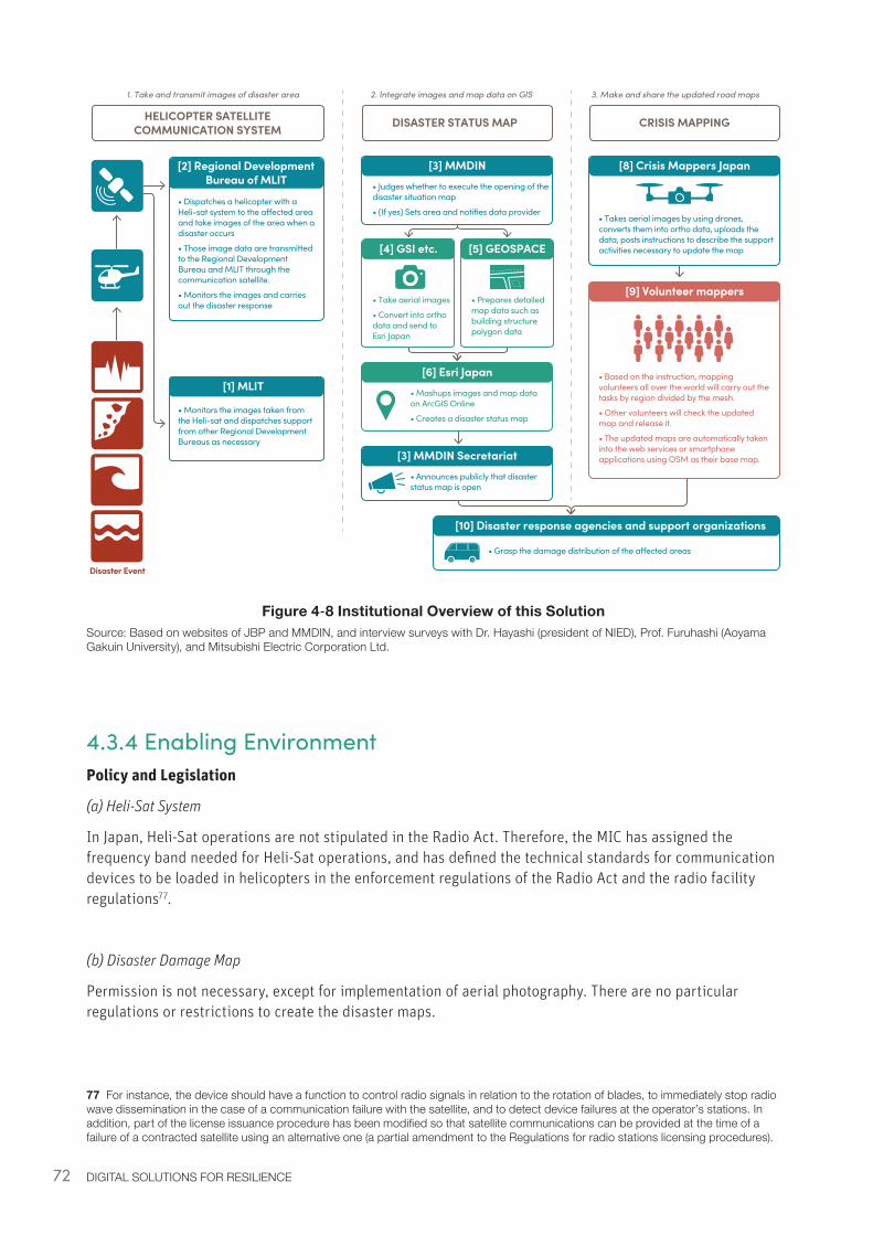
72 DIGITAL SOLUTIONS FOR RESILIENCE
Figure 4‑8 Institutional Overview of this SolutionSource: Based on websites of JBP and MMDIN, and interview surveys with Dr. Hayashi (president of NIED), Prof. Furuhashi (Aoyama Gakuin University), and Mitsubishi Electric Corporation Ltd.
4.3.4 Enabling EnvironmentPolicy and Legislation
(a) Heli-Sat System
In Japan, Heli-Sat operations are not stipulated in the Radio Act. Therefore, the MIC has assigned the frequency band needed for Heli-Sat operations, and has defined the technical standards for communication devices to be loaded in helicopters in the enforcement regulations of the Radio Act and the radio facility regulations77.
(b) Disaster Damage Map
Permission is not necessary, except for implementation of aerial photography. There are no particular regulations or restrictions to create the disaster maps.
77 For instance, the device should have a function to control radio signals in relation to the rotation of blades, to immediately stop radio wave dissemination in the case of a communication failure with the satellite, and to detect device failures at the operator’s stations. In addition, part of the license issuance procedure has been modified so that satellite communications can be provided at the time of a failure of a contracted satellite using an alternative one (a partial amendment to the Regulations for radio stations licensing procedures).
Disaster Event
HELICOPTER SATELLITECOMMUNICATION SYSTEM DISASTER STATUS MAP CRISIS MAPPING
[2] Regional Development Bureau of MLIT
• Dispatches a helicopter with a Heli-sat system to the a�ected area and take images of the area when a disaster occurs
• Those image data are transmitted to the Regional Development Bureau and MLIT through the communication satellite.
• Monitors the images and carries out the disaster response
[1] MLIT
• Monitors the images taken from the Heli-sat and dispatches support from other Regional Development Bureaus as necessary
1. Take and transmit images of disaster area 2. Integrate images and map data on GIS 3. Make and share the updated road maps
[3] MMDIN• Judges whether to execute the opening of the disaster situation map
• (If yes) Sets area and notifies data provider
[8] Crisis Mappers Japan
• Takes aerial images by using drones, converts them into ortho data, uploads the data, posts instructions to describe the support activities necessary to update the map
[3] MMDIN Secretariat• Announces publicly that disaster status map is open
[6] Esri Japan• Mashups images and map data on ArcGIS Online
• Creates a disaster status map
[4] GSI etc.
• Take aerial images
• Convert into ortho data and send to Esri Japan
[5] GEOSPACE
• Prepares detailed map data such as building structure polygon data
[10] Disaster response agencies and support organizations
• Grasp the damage distribution of the a�ected areas
[9] Volunteer mappers
• Based on the instruction, mapping volunteers all over the world will carry out the tasks by region divided by the mesh.
• Other volunteers will check the updated map and release it.
• The updated maps are automatically taken into the web services or smartphone applications using OSM as their base map.

73DISASTER INFORMATION MANAGEMENT SYSTEMS: GIS-Based Disaster MIS
(c) Crisis Mapping
Since amendment of Civil Aeronautics Act in December 2015, there have been restrictions as a general rule on flying drones in Densely Inhabited Districts (DID) in Japan. During a disaster, municipalities are allowed to fly drones as a special measure, but not private organizations. Therefore, it is important for municipalities and private organizations to finalize a disaster agreement beforehand in order to have private organizations fly drones on behalf of municipalities. Crisis Mappers Japan sets flight routes with the approval of municipalities in normal times, so that it can start aerial shooting within an hour after a disaster strikes through automatic operation on a preliminarily defined flight route.
The municipalities that have entered into an agreement with Crisis Mappers include Yamato City, Kanagawa Prefecture, and Chofu City and Komae City, Tokyo78.
System Costs
(a) Heli-Sat System
Capital Costs: As a ballpark estimate, the development cost is about JPY 200 million per aircraft79. A total of 14 aircraft are currently in operation. The national government owns seven of these aircraft, distributed across different prefectures: the MIC owns five (located in Tokyo, Kyoto, Saitama, Miyagi, and Kochi prefectures) and the MLIT owns 2 (in Fukuoka and Osaka80).
O&M Costs: Not disclosed
(b) Disaster Damage Map
Capital Costs: Expenses related to the system such as introduction cost and maintenance cost are not known. This is because the total expenses contributed by related companies have not been calculated. Administration is financed with membership fees from corporate groups that agree with this activity81. Since the map is created by volunteers now, the cost is lower compared to owning the systems outright. In that case, the license fee for ArcGIS online (approx. JPY 0.1 million per year) and operation staff costs would be required.
O&M Costs: Essentially free of charge because it is based on contributions from cooperating companies.
(c) Crisis Mapping
Capital Costs: Approximately JPY 100 – 300 million, for purchasing drones82, GPS loggers, and drone control applications.
O&M Costs: Essentially free of charge because it is based on open source services.
78 For more information, see Appendix Table F.2.4.79 Based on inputs from Hyogo prefecture80 For more information, see: https://www.projectdesign.jp/201510/new-disaster-prevention-measures/002465.php81 The above corporate groups include data providers: PASCO, NTT Spatial Information Corporation, Global Survey Corporation Ltd., and other navigation companies.82 Crisis Mappers Japan currently owns a fleet of about 30 drones.

74 DIGITAL SOLUTIONS FOR RESILIENCE
4.4.1 Tokushima DIMS: System OverviewAfter a disaster, logistical issues, including sharing information across organizations to coordinate response activities, pose a challenge. Tokushima Prefecture’s Disaster Information Management System (“Tokushima DIMS” hereafter) is a platform for disaster information sharing covering the entire prefecture. The Tokushima DIMS is used by about 500 organizations (as of September 2017), including the prefectural government and all municipalities, all hospitals, electricity companies, Japan Self-Defense Forces (JSDF), fire departments, and police departments. The Tokushima DIMS centrally manages damage information, disaster assistance activities, and services necessary to carry out the rescue and recovery operations efficiently, and to share the disaster response information quickly and accurately to the public.
The Tokushima DIMS was created incrementally. It began as a system for sharing information needed to confirm personal safety, disaster response, and relief activities. Then, it was integrated with existing external systems, starting from EMIS. It finally expanded into its current version as more and more individual organizations joined the system.
The Tokushima DIMS was designed with an easy-to-use interface; anyone in the organizations which have adopted the system can view or input information in the Tokushima DIMS through PCs, smartphones, or tablets. This data is collected in a unified format and can be easily accessed, reducing the burden on municipalities of collecting and sharing large amounts of dynamic information necessary for effective disaster response operations.
In Japan, municipal governments are responsible for on-site disaster responses based on the “Disaster Countermeasures Basic Act83.” In the case of large disasters which incapacitate municipal governments, responsibility shifts to the prefecture: if the prefecture is also overwhelmed then national agencies coordinate the response. NGOs, NPOs, and private companies increasingly also play an important role in Japanese disaster response.
Previously, disaster responses conducted by Tokushima prefecture focused on reporting to the central government (FDMA) damage information and the progress of responses by municipalities via telephone, FAX, and email, which created a heavy burden for municipalities. The efficacy of the response was also hampered by the presence of two distinct ICT systems84 which were not communicating efficiently with each other.
Development of the Tokushima DIMS was started by integrating the EMIS system already operated by the medical department with the disaster information system owned by the Disaster Prevention Department, so that life-saving activities could be appropriately carried out85.
The Tokushima DIMS was developed to streamline information transfer and sharing among concerned organizations, and to standardize disaster response work. It has three main features: 1) Disaster information entry; 2) Assessment roll-up: to illustrate risk levels and response levels visually on a GIS map; and 3) Missions management: disaster response task management system (see Appendix G, Table G.2.1). It has been successfully used in disaster response in the prefecture, including during the 2014 floods (see Appendix G.1).
83 Typically, the status of damage in affected areas is reported by municipal governments to the local (prefectural) government, which reports it to the National Government (the Fire and Disaster Management Agency (FDMA)). See Appendix Figure G.2.1 for a visualization of disaster information collection and aggregation in Japan.
84 Developed independently by the Disaster Prevention Department and the Medical Department.85 For a timeline of the development of DIMS in Tokushima Prefecture, see Appendix G, Table G.2.3.
4.4 Tokushima DIMS: Disaster Information Management System
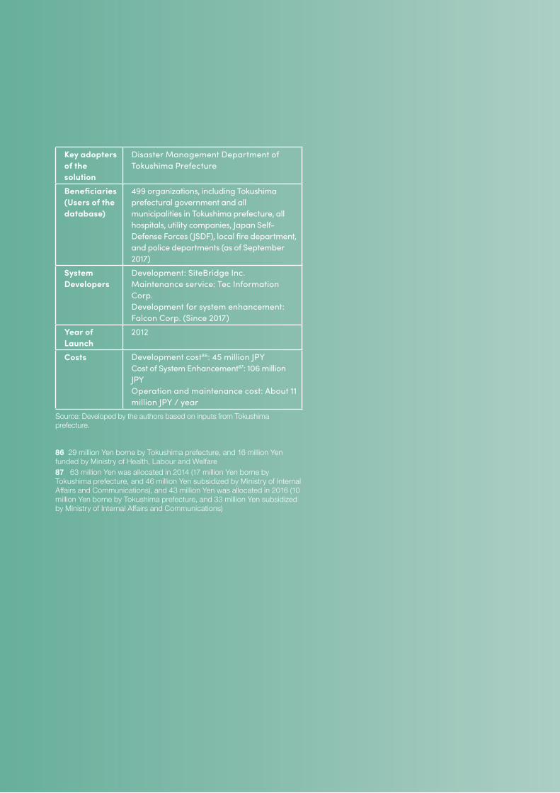
75
Key adopters of the solution
Disaster Management Department of Tokushima Prefecture
Beneficiaries (Users of the database)
499 organizations, including Tokushima prefectural government and all municipalities in Tokushima prefecture, all hospitals, utility companies, Japan Self-Defense Forces (JSDF), local fire department, and police departments (as of September 2017)
System Developers
Development: SiteBridge Inc. Maintenance service: Tec Information Corp. Development for system enhancement: Falcon Corp. (Since 2017)
Year of Launch
2012
Costs Development cost86: 45 million JPY Cost of System Enhancement87: 106 million JPY Operation and maintenance cost: About 11 million JPY / year
Source: Developed by the authors based on inputs from Tokushima prefecture.
86 29 million Yen borne by Tokushima prefecture, and 16 million Yen funded by Ministry of Health, Labour and Welfare 87 63 million Yen was allocated in 2014 (17 million Yen borne by Tokushima prefecture, and 46 million Yen subsidized by Ministry of Internal Affairs and Communications), and 43 million Yen was allocated in 2016 (10 million Yen borne by Tokushima prefecture, and 33 million Yen subsidized by Ministry of Internal Affairs and Communications)
76 DIGITAL SOLUTIONS FOR RESILIENCE
4.4.2 Tokushima DIMS: Lessons and Recommendations• Awareness - Awareness and education initiatives encourage people to contribute information
to DIMSs. If the stakeholders are not fully aware of the direct benefit of DIMSs, in the event of a disaster they are unlikely to input data given other urgent priorities. In fact, lack of awareness in the past has been a key barrier to the effective operation of DIMSs to function effectively in post-disaster situations.
EMIS was officially launched in 1996 based on lessons from the 1995 Great Hanshin-Awaji Earthquake, but staff members at hospitals were busy responding to injured people and the system was not effectively utilized for a long time. In 2005, the Disaster Medical Assistance Team (DMAT)88 started to use EMIS as a management system during operations on site, and to implement annual trainings for DMAT staff around Japan, which has led to effective use of the system and helped information centralization including sharing and reporting information. For the Tokushima DIMS, the problem of information input has been overcome by creating annual trainings at both the prefecture and municipality levels. Communicating the system’s benefit to the prefecture has also helped improve participation among stakeholders. Linking the system with EMIS has also increased participation by preventing the need to input information twice.
In general, it is important to clarify and raise awareness on the merits of using DIMSs (i.e. more effective use of disaster information and time-saving potential during disaster times) and inform relevant parties accordingly.
• Centralization - Centralized DIMSs can reduce clerical work, but should communicate with existing systems. Clerical work for mass communication was reduced by the Tokushima DIMS. Before the system was introduced, the Disaster Prevention Department was required to regularly summarize the status of damage from each department within the agency and related organizations in order to respond to the mass media. Since the introduction of the system, the Disaster Prevention Department needs only to summarize the latest information, because information from each organization is updated in real-time. Thus, the burden of organizing information at each department for corresponding with mass media decreased, while the disaster management department no longer has to contact each department to compile data. Similarly, linking EMIS to the Tokushima DIMS eliminated duplicate inputs, as information in the system was automatically reflected in EMIS. When designing consolidated systems elsewhere, the ways disaster information is already managed should be considered, to ensure they can integrate with existing programs.
• On-demand relief - Decentralized requests systems can contribute to the quick and targeted fulfillment of post disaster needs, with possibilities of partnering with the private sector. The Tokushima DIMS is capable of collaborating with an Amazon wish list, which allows evacuees to receive support with what they want, and relieves municipal officials from the burden of procuring materials for evacuees. Representatives of evacuation centers compile the type and number of supplies needed and enter information on the desired list from the website. Then, the supporter buys the goods through Amazon, and the goods are sent to the evacuation center. This means staff of the prefecture can assess a situation by linking the Amazon wish list information with the prefecture DIMS. Other systems should consider the advantages of linking post-disaster needs and logistics to reduce the burden on heavy centralized systems.
88 Disaster Medical Assistance Team (DMAT) consists of doctors, nurses, and coordinators (medical staff other than doctors and nurses and administrative staff). They are specially trained and have mobility for acting in the acute phase (generally within 48 hours after a disaster occurs) on the scene, such as a large-scale disaster and accidents where multiple people are seriously injured.
77
• Cross-level support - DIMSs should be designed to permit support across government levels to assist local governments when they are overcome by the demands of a disaster. For example, when Mashiki Town was heavily damaged by the Kumamoto earthquake and did not have enough capacity to input real-time damage and needs data, staff of Kumamoto Prefecture (who had a duty to report to the Emergency Operation Center (EOC) at the national government) entered the data and substituted for the town staff. In Shizuoka Prefecture, the system has been pre-established to substitute for municipalities If they are incapacitated by a disaster. The prefecture was divided into four areas, each with assigned prefectural officials prepared to support one another in the case of a disaster.
A large-scale disaster can easily overwhelm the resources of a municipality or other local government; establishing systems like these at the regional or national scale to support local governments can help cope with expanded needs during emergency times. Similarly, resource or staff-sharing agreements between municipalities themselves can also be important, allowing people responsible for operating specific DIMS in one municipality to aid with that system in another municipality when a disaster occurs.
• Existing infrastructure - DIMSs which use preexisting ICT infrastructures can reduce development costs and implementation time. With Tokushima’s DIMS, municipalities and utility companies can send information using standard mobile devices and an internet connection. Receivers of information similarly require only widely-used devices (such as mobile phones, radios, PC, and landline telephones) and an internet connection. Thus, the Tokushima DIMS works with the existing internet connections or the mobile communication lines without requiring any dedicated line services or special terminals. When developing DIMS, using pre-existing ICT infrastructures rather than creating special new infrastructures can make these systems more easily applicable, even in developing countries.
• Pre-disaster planning - DIMSs require pre-disaster planning, training, and relationship-building through the development of a Standard Operating Procedure (SOP) and/or Business Continuity Plan (BCP). Since the system is designed to effectively perform response and recovery efforts and resource management after a disaster occurs, it is necessary to clarify the work to be carried out in advance. Therefore, the system development requires a Standard Operating Procedure (SOP) integrated within the municipal government and/or institutions disaster response manual and/or business continuity plan (BCP). It is also important that the disaster response governance mechanisms and cooperation procedures are discussed, agreed, and endorsed in advance between relevant sectoral government agencies at the municipal and national level, private sector, and local communities, regarding their specific roles and responsibilities.
• Redundancy - Redundancy increases the resilience of the system by ensuring uninterrupted use of DIMSs during a disaster. Because it is inevitable that terminal equipment may fail, the Tokushima DIMS can be accessed from any device via authorization with a user ID and password. While the Tokushima DIMS normally uses internet for information transmission, it is also possible to connect via the disaster prevention radio communication system owned by municipalities. The web service is implemented on servers located on the premises and via a cloud service (located in eastern Kanto) with a failover option. It is also being considered using multiple cloud services at various locations to ensure server functionality.
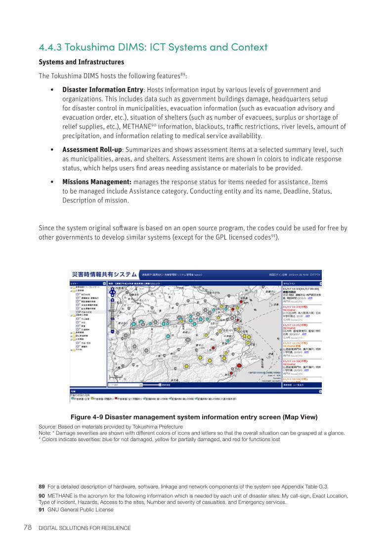
78 DIGITAL SOLUTIONS FOR RESILIENCE
4.4.3 Tokushima DIMS: ICT Systems and ContextSystems and Infrastructures
The Tokushima DIMS hosts the following features89:
• Disaster Information Entry: Hosts information input by various levels of government and organizations. This includes data such as government buildings damage, headquarters setup for disaster control in municipalities, evacuation information (such as evacuation advisory and evacuation order, etc.), situation of shelters (such as number of evacuees, surplus or shortage of relief supplies, etc.), METHANE90 information, blackouts, traffic restrictions, river levels, amount of precipitation, and information relating to medical service availability.
• Assessment Roll-up: Summarizes and shows assessment items at a selected summary level, such as municipalities, areas, and shelters. Assessment items are shown in colors to indicate response status, which helps users find areas needing assistance or materials to be provided.
• Missions Management: manages the response status for items needed for assistance. Items to be managed include Assistance category, Conducting entity and its name, Deadline, Status, Description of mission.
Since the system original software is based on an open source program, the codes could be used for free by other governments to develop similar systems (except for the GPL licensed codes91).
Figure 4-9 Disaster management system information entry screen (Map View)Source: Based on materials provided by Tokushima Prefecture Note: * Damage severities are shown with different colors of icons and letters so that the overall situation can be grasped at a glance. * Colors indicate severities: blue for not damaged, yellow for partially damaged, and red for functions lost
89 For a detailed description of hardware, software, linkage and network components of the system see Appendix Table G.3.90 METHANE is the acronym for the following information which is needed by each unit of disaster sites: My call-sign, Exact Location, Type of incident, Hazards, Access to the sites, Number and severity of casualties, and Emergency services.91 GNU General Public License
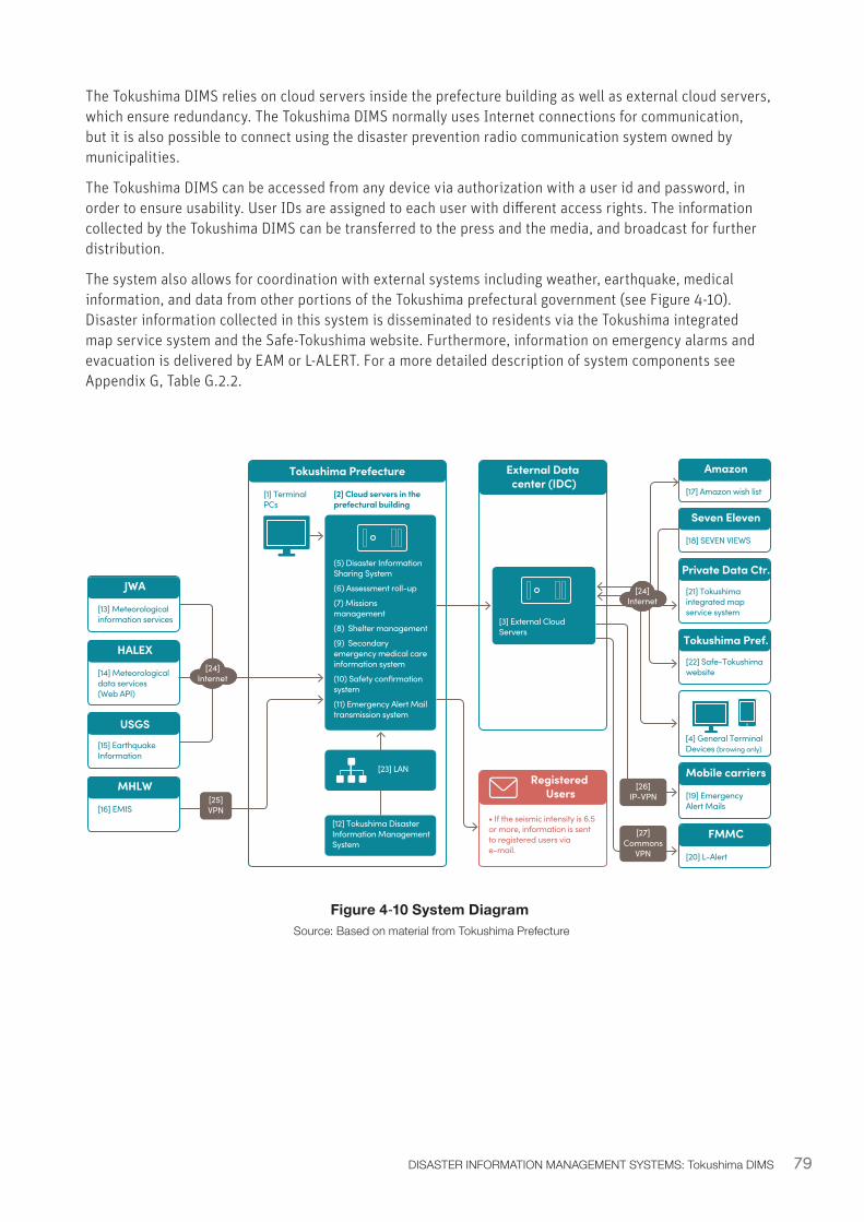
79DISASTER INFORMATION MANAGEMENT SYSTEMS: Tokushima DIMS
• If the seismic intensity is 6.5 or more, information is sent to registered users via e-mail.
Tokushima Prefecture External Data center (IDC)
Registered Users
[2] Cloud servers in the prefectural building
[1] Terminal PCs
[23] LAN
[12] Tokushima Disaster Information Management System
(5) Disaster Information Sharing System
(6) Assessment roll-up
(7) Missions management
(8) Shelter management
(9) Secondary emergency medical care information system
(10) Safety confirmation system
(11) Emergency Alert Mail transmission system
JWA
[13] Meteorological information services
HALEX
[14] Meteorological data services (Web API)
USGS[15] Earthquake Information
MHLW
[16] EMIS
[24]Internet
[25]VPN
[26]IP-VPN
[27]Commons
VPN
[3] External Cloud Servers
[24]Internet
Seven Eleven
[18] SEVEN VIEWS
Amazon
[17] Amazon wish list
FMMC
[20] L-Alert
Mobile carriers
[19] Emergency Alert Mails
Tokushima Pref.
[22] Safe-Tokushima website
[4] General Terminal Devices (browing only)
Private Data Ctr.
[21] Tokushima integrated map service system
Figure 4‑10 System Diagram Source: Based on material from Tokushima Prefecture
The Tokushima DIMS relies on cloud servers inside the prefecture building as well as external cloud servers, which ensure redundancy. The Tokushima DIMS normally uses Internet connections for communication, but it is also possible to connect using the disaster prevention radio communication system owned by municipalities.
The Tokushima DIMS can be accessed from any device via authorization with a user id and password, in order to ensure usability. User IDs are assigned to each user with different access rights. The information collected by the Tokushima DIMS can be transferred to the press and the media, and broadcast for further distribution.
The system also allows for coordination with external systems including weather, earthquake, medical information, and data from other portions of the Tokushima prefectural government (see Figure 4-10). Disaster information collected in this system is disseminated to residents via the Tokushima integrated map service system and the Safe-Tokushima website. Furthermore, information on emergency alarms and evacuation is delivered by EAM or L-ALERT. For a more detailed description of system components see Appendix G, Table G.2.2.
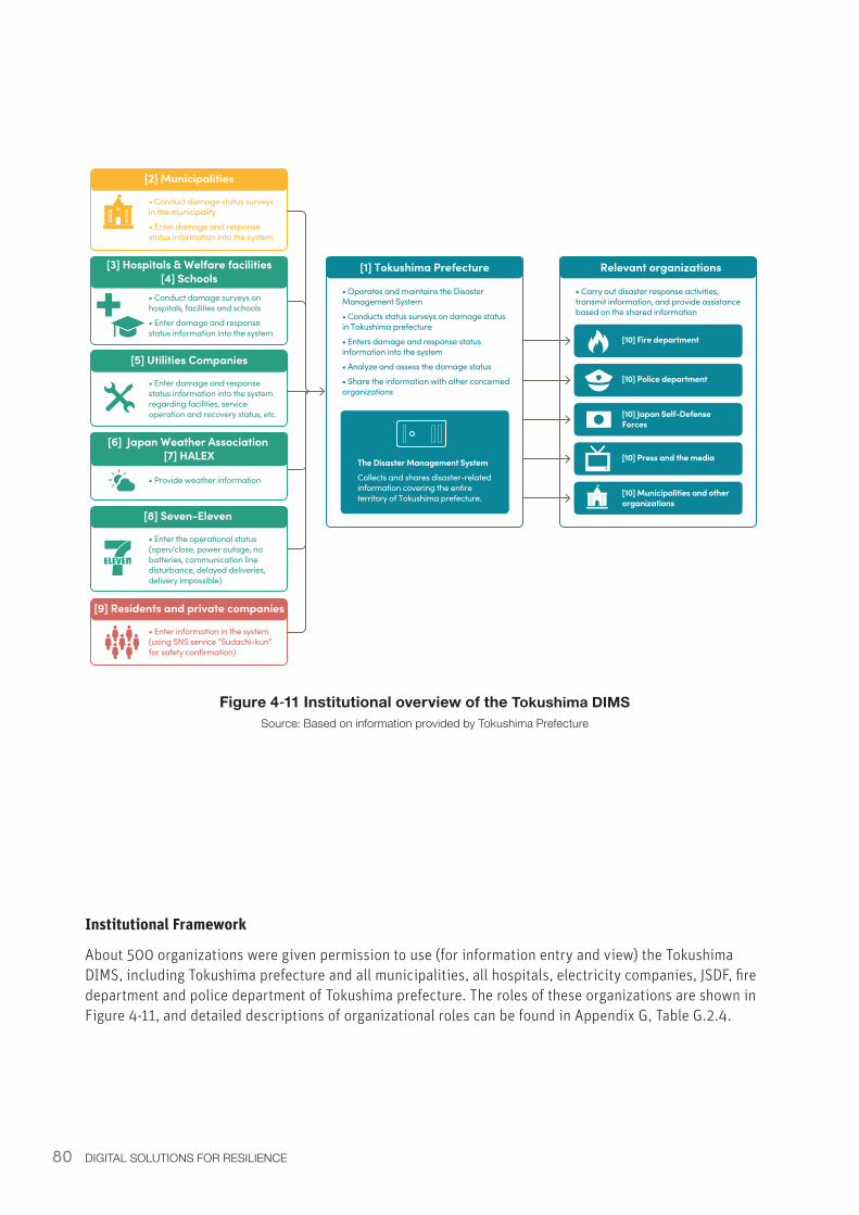
80 DIGITAL SOLUTIONS FOR RESILIENCE
Institutional Framework
About 500 organizations were given permission to use (for information entry and view) the Tokushima DIMS, including Tokushima prefecture and all municipalities, all hospitals, electricity companies, JSDF, fire department and police department of Tokushima prefecture. The roles of these organizations are shown in Figure 4-11, and detailed descriptions of organizational roles can be found in Appendix G, Table G.2.4.
[2] Municipalities
• Conduct damage status surveys in the municipality
• Enter damage and response status information into the system
• Operates and maintains the Disaster Management System
• Conducts status surveys on damage status in Tokushima prefecture
• Enters damage and response status information into the system
• Analyze and assess the damage status
• Share the information with other concerned organizations
[5] Utilities Companies
• Enter damage and response status information into the system regarding facilities, service operation and recovery status, etc.
[3] Hospitals & Welfare facilities[4] Schools
• Conduct damage surveys on hospitals, facilities and schools
• Enter damage and response status information into the system
[8] Seven-Eleven
• Enter the operational status (open/close, power outage, no batteries, communication line disturbance, delayed deliveries, delivery impossible)
[6] Japan Weather Association [7] HALEX
• Provide weather information
[9] Residents and private companies
• Enter information in the system (using SNS service “Sudachi-kun” for safety confirmation)
[1] Tokushima Prefecture
The Disaster Management SystemCollects and shares disaster-related information covering the entire territory of Tokushima prefecture.
• Carry out disaster response activities, transmit information, and provide assistance based on the shared information
Relevant organizations
[10] Fire department
[10] Police department
[10] Japan Self-Defense Forces
[10] Press and the media
[10] Municipalities and other organizations
Figure 4‑11 Institutional overview of the Tokushima DIMSSource: Based on information provided by Tokushima Prefecture
81DISASTER INFORMATION MANAGEMENT SYSTEMS: Tokushima DIMS
4.4.4 Tokushima DIMS: Enabling EnvironmentPolicy and Legislation
The Tokushima DIMS has benefitted from prefectural and national programs which have supported its development. Since 2004, Tokushima has been working towards improving public and private communication infrastructure in the prefecture, and under the ‘e-Tokushima Promotion Plan.’ The 2014-2018 “ICT Tokushima Creation Strategies” which fall under this plan include considerations for disaster events such as a projected Nankai Trough megathrust earthquake. The Tokushima DIMS is one of these strategies, aiming to enhance information sharing across the prefecture by increasing the number of organizations within the network (Tokushima Prefectural Government, 2014).
In addition to support at the prefectural level, the Tokushima DIMS received support from the national government as a feasibility study project for enhancing the disaster information sharing infrastructure in the Geospatial city development project, which is an initiative led by the MIC. Through this study project, new applications were developed including a safety confirmation system called “Sudachi-kun”, which is a platform to collect damage information from citizens; floods; medicine demand forecast for prolonged shelter life based on “medicine delivery result” analyses; and relief goods procurement system using an Amazon wish list. Furthermore, the Tokushima DIMS was connected to the Tokushima “Integrated map service system” and to “L-ALERT” in order to help disaster information be effectively provided to residents in affected areas92.
System Costs
The functionality of the Tokushima DIMS continues to be upgraded: from 2012-2015, JPY 151 million had been spent on development, of which JPY 95 million was subsidized by the national government. The Tokushima DIMS can be accessed using ordinary devices such as smartphones, tablets, and PCs through a regular internet connection (no dedicated line is required). The estimated Operation and Maintenance Costs for 2017 was JPY 11 million93.
92 For more information, see: http://www.soumu.go.jp/menu_seisaku/ictseisaku/ictriyou/geo-spatial_ict/g-city/project/p04.html93 Based on inputs provided by Tokushima prefecture.
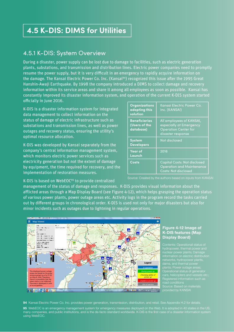
82 DIGITAL SOLUTIONS FOR RESILIENCE
4.5.1 K-DIS: System OverviewDuring a disaster, power supply can be lost due to damage to facilities, such as electric generation plants, substations, and transmission and distribution lines. Electric power companies need to promptly resume the power supply, but it is very difficult in an emergency to rapidly acquire information on the damage. The Kansai Electric Power Co. Inc. (Kansai94) recognized this issue after the 1995 Great Hanshin-Awaji Earthquake. By 1998 the company introduced a DIMS to collect damage and recovery information within its service areas and share it among all employees as soon as possible. Kansai has constantly improved its disaster information system, and operation of the current K-DIS system started officially in June 2016.
K-DIS is a disaster information system for integrated data management to collect information on the status of damage of electric infrastructure such as substations and transmission lines, as well as power outages and recovery status, ensuring the utility’s optimal resource allocation.
K-DIS was developed by Kansai separately from the company’s central information management system, which monitors electric power services such as electricity generation but not the extent of damage by equipment, the time required for recovery, and the implementation of restoration measures.
K-DIS is based on WebEOC95 to provide centralized management of the status of damage and responses. K-DIS provides visual information about the afflicted areas through a Map Display Board (see Figure 4-12), which helps grasping the operation status of various power plants, power outage areas etc. Activity logs in the program record the tasks carried out by different groups in chronological order. K-DIS is used not only for major disasters but also for minor incidents such as outages due to lightning in regular operations.
94 Kansai Electric Power Co. Inc. provides power generation, transmission, distribution, and retail. See Appendix H.2 for details.95 WebEOC is an emergency management system for emergency measures deployed on the Web. It is adopted in 40 states in the US, many companies, and public institutions, and is the de-facto standard worldwide. K-DIS is the first case of a disaster information system using WebEOC.
4.5 K-DIS: DIMS for Utilities
Organizations adopting this solution
Kansai Electric Power Co. Inc. (KANSAI)
Beneficiaries (Users of the database)
All employees of KANSAI, especially at Emergency Operation Center for disaster response
System Developers
Not disclosed
Year of Launch
2016
Costs Capital Costs: Not disclosed Operation and Maintenance Costs: Not disclosed
Source: Created by the authors based on inputs from KANSAI
Legend
Map Contents
In operation
During power up
Checking ability of power up
Unable to power up
Out of service
Map Viewer
· Operational status of hydropower, thermal power and nuclear power plants· Damage information on electric distribution networks, hydropower plants, dam and thermal power plants· Power outage areas· Operational status of generator cars, helicopters and vessels etc.· Registered information such as road conditions
The displayed power outage areas are based on the press announcement as of at 17:30 on May 6, 2016. Therefore, there is a possibility that the latest status is not reflected. The area is displayed in units of municipalities.
Figure 4-12 Image of K-DIS features (Map Display Board)
Contents: Operational status of hydropower, thermal power and nuclear power plants; Damage information on electric distribution networks, hydropower plants, dams, and thermal power plants; Power outage areas; Operational status of generator cars, helicopters and vessels etc.; Registered information such as road conditions Source: Based on materials provided by KANSAI
83
4.5.2 K-DIS: Lessons and Recommendations• Central management - Creating a system of centrally managed and company-wide open
disaster information can serve as a real-time decision-support system for utility companies, allowing them to make quick and informed disaster mitigation and management actions in a fast-changing environment. K-DIS provides great information visibility to decision makers by centrally managing all disaster information (damage, restoration, and response status) collected by various departments within the utility company, and by summarizing important information in the Company-wide Activities Log. In past incidents, the Company-wide Activities Log functioned as an excellent tool for monitoring the response status of important operations, and the Map Display Board has also been effective in providing visual information about afflicted areas. Having this information at their fingertips in real-time allows decision makers to move-quickly in rapidly-evolving disaster situations.
• Data security - DIMSs for power companies should prioritize data security due to the sensitive nature of infrastructure information. K-DIS is tailored to the needs of the Kansai power company which operates in the Kansai Region. Since the utility handles confidential information, to protect this data K-DIS uses in-house telecommunication networks rather than external systems. K-DIS follows procedures outlined in Kansai’s “Disaster Management Plan,” which is based on Japan’s 1962 Disaster Countermeasures Basic Act. Sharing information about sensitive infrastructure can be risky, and in other countries the local context should determine the optimal system by weighing the extent of information sharing with confidentiality concerns.
• Cooperation - Managing disaster information for public utilities requires interdepartmental and interagency cooperation. To provide disaster status information to Kansai, K-DIS receives also information from other groups including police and fire departments, customers, and municipalities. Kansai also shares information with the Japan Self-Defense forces, national government ministries, and other power sources via its Emergency Operation Center (EOC). K-DIS is a good example of the importance of coordinating disaster information across different agencies and levels of governance, particularly for public utilities which are critically interconnected with other government agencies.
• Standard Operating Procedure - Roles and responsibilities in a system like K-DIS should be defined by a Standard Operating Procedure (SOP) integrated within the institution’s disaster response manual and/or Business Continuity Plan (BCP). The SOP should include at least the following procedures: during a disaster, who sends what kind of information to whom; how to process; how to output; and who (which department) gets what kind of information. K-DIS and its SOP were developed in alignment with Kansai’s “Disaster Management Plan,” which defines the procedures to be followed during an emergency, and was developed following Article 39 of the Disaster Countermeasures Basic Act96.
• Activity Log - DIMSs can be used not only to record and share information about a disaster status, but also about response activities. A key component of K-DIS is the company-wide activities log, as well as activity logs for individual divisions within K-DIS. The activity log records critical response-related activities from different groups in a chronological format. This structure allows a quick assessment of current progress and identification of areas that might need additional support. The critical response-related activities recorded in a chronological order could also be used by decision makers to find areas of improvement for future disaster response activities.
96 For more information, see: http://law.e-gov.go.jp/htmldata/S36/S36HO223.html
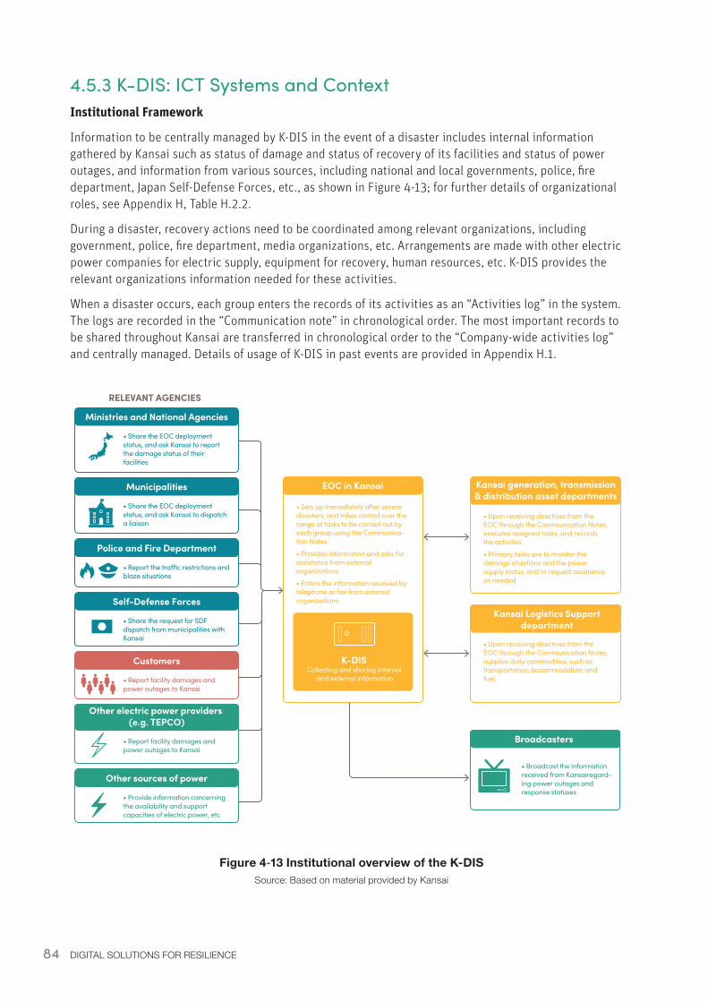
84 DIGITAL SOLUTIONS FOR RESILIENCE
4.5.3 K-DIS: ICT Systems and ContextInstitutional Framework
Information to be centrally managed by K-DIS in the event of a disaster includes internal information gathered by Kansai such as status of damage and status of recovery of its facilities and status of power outages, and information from various sources, including national and local governments, police, fire department, Japan Self-Defense Forces, etc., as shown in Figure 4-13; for further details of organizational roles, see Appendix H, Table H.2.2.
During a disaster, recovery actions need to be coordinated among relevant organizations, including government, police, fire department, media organizations, etc. Arrangements are made with other electric power companies for electric supply, equipment for recovery, human resources, etc. K-DIS provides the relevant organizations information needed for these activities.
When a disaster occurs, each group enters the records of its activities as an “Activities log” in the system. The logs are recorded in the “Communication note” in chronological order. The most important records to be shared throughout Kansai are transferred in chronological order to the “Company-wide activities log” and centrally managed. Details of usage of K-DIS in past events are provided in Appendix H.1.
Figure 4‑13 Institutional overview of the K-DISSource: Based on material provided by Kansai
Other electric power providers (e.g. TEPCO)
• Report facility damages and power outages to Kansai
Customers
• Report facility damages and power outages to Kansai
Ministries and National Agencies
• Share the EOC deployment status, and ask Kansai to report the damage status of their facilities
Municipalities
• Share the EOC deployment status, and ask Kansai to dispatch a liaison
Police and Fire Department
• Report the tra�c restrictions and blaze situations
Self-Defense Forces
• Share the request for SDF dispatch from municipalities with Kansai
Other sources of power
• Provide information concerning the availability and support capacities of electric power, etc
RELEVANT AGENCIES
• Sets up immediately after severe disasters, and takes control over the range of tasks to be carried out by each group using the Communica-tion Notes
• Provides information and asks for assistance from external organizations
• Enters the information received by telephone or fax from external organizations
EOC in Kansai
• Upon receiving directives from the EOC through the Communication Notes, executes assigned tasks, and records the activities
• Primary tasks are to monitor the damage situations and the power supply status, and to request assistance as needed
Kansai generation, transmission & distribution asset departments
• Upon receiving directives from the EOC through the Communication Notes, supplies daily commodities, such as transportation, accommodation, and fuel.
Kansai Logistics Support department
K-DISCollecting and sharing internal
and external information
Broadcasters
• Broadcast the information received from Kansairegard-ing power outages and response statuses
85DISASTER INFORMATION MANAGEMENT SYSTEMS: K-DIS
Systems and Infrastructures
The components of K-DIS are connected to each other by dedicated in-house communication lines97, and operation of K-DIS is enabled through the same PCs used by employees in normal times. In addition to K-DIS, Kansai owns a weather alert system, A-BIS to manage failures of transmission and distribution lines, and AccESS to manage power outage information. Information stored in these systems is also available from K-DIS, which is entered in to K-DIS at Kansai’s Emergency Operations Center (EOC). The resilience of the system is ensured by duplicating servers and communication lines. For a detailed description of the K-DIS components, see Appendix H, Table H.2.1.
In terms of software, K-DIS includes the following key components:
• Facility Damage Situation Board: summarizes the status of damage of each facility based on damage information entered on the board (entry screen) by each group. This information is interfaced with the Map Display (See Appendix H, Figure H.2.2).
• Map Display: shows the status of damage on the map based on information summarized on the Damage Situation Board. Information includes, among the others: Operating status of power stations (e.g. thermal, hydro, and nuclear); Status of damage to dams and power stations; Blackout areas; Operating status of electric generator vehicles, helicopters, ships, etc.; Traffic status.
• Communication Notes: used for various communication, such as announcements, requests, etc., and task management. EOC issues a communication note on the information or requests to be shared, and based on the note, each group records the tasks they carried out. EOC uses these notes to understand the response status. Important records are copied to the Company-wide Activities Log, shown in the “Company-wide Timeline” screen in chronological order (See Appendix H, Figure H.2.3).
• Company-wide Activities Logs: summarizes critical issues from communication notes, and from group activity logs, and displays summary information in chronological order (Company-wide Time Line) (See Appendix H Figure H.2.4).
4.5.4 K-DIS: Enabling EnvironmentPolicy and Legislation
Kansai has defined processes to be followed at the time of a disaster in its “Disaster Management Plan,” following Article 39 of the Disaster Countermeasures Basic Act98, which mandates designated public institutions to create disaster management plans99 (Kansai, 2018). In addition to the disaster management processes, the disaster management plan developed by Kansai incorporates the “Promotion of special provision for Nankai Trough Earthquake”, which includes disaster management plans specifically designed for the future Nankai Trough earthquakes, and the “Enhancement program for disaster prevention against large-scale earthquakes”, which prescribes the measures and plans required to strengthen disaster management for large-scale earthquakes in general.
The disaster management plan specifies criteria to set up the EOC and its roles, and communication channels for directives and information both inside and outside Kansai. K-DIS was developed in alignment with this plan.
System Costs
Neither capital costs nor O&M costs have been disclosed.
97 Kansai generation, transmission and distribution asset departments98 The Disaster Countermeasures Basic Act was promulgated in 1961 and enforced in 1962. For more information, see: http://law.e-gov.go.jp/htmldata/S36/S36HO223.html99 For more information, see: http://www.KEPCO.co.jp/corporate/notice/20140922_1.html
86 DIGITAL SOLUTIONS FOR RESILIENCE
4.6.1 Hyogo Asset Management System: System OverviewThe Asset Management System was developed to manage ledgers of infrastructure facilities (called “the facilities ledger”) and facility inspection results in an integrated fashion. In normal times, it is used as an asset management system for infrastructure facilities (roads, bridges, rivers, harbors, sewerage, etc.) in Hyogo prefecture, and can be used for superimposing hazard maps and facility maps. This system also functions as a DIMS100, in conjunction with the asset ledger system, in order to collect and assess damage and response status. As a disaster management system, it has functionalities to identify bridges to be prioritized for restoration, especially those located on roads designated as emergency goods transportation routes, to calculate alternative routes based on the status of damage and to make plans for restoring roadways based on the status of damage.
The Asset Management System has wide accessibility, including the Internet via the prefectural network (WAN), or solely via the Internet for auxiliary organizations, and using the mobile network from construction and inspection sites.
The development of the system responds to the challenges of maintaining and managing social infrastructure with limited budgets and human resources, while facing a severe fiscal situation, deterioration of infrastructure facilities built during rapid economic growth, and staff shortages. One of the most critical issues in Hyogo prefecture, which experienced the Hanshin-Awaji Earthquake in 1995, is to ensure the safety of infrastructure. However, it had been difficult for the prefecture to carry out an overall review of asset status and asset maintenance costs, due to segmented management by types of facility, such as bridges, harbors, and sewerage. To address these issues, Hyogo prefecture developed the Asset Management System, an integrated system which can control various infrastructure data, allowing the prefecture to carry out infrastructure management more efficiently101.
100 Although there has not been a disaster event for which the Asset Management system was used, it is expected to be effective because the same system can be used for both normal and disaster operations.101 For more information, see: http://pr.fujitsu.com/jp/news/2013/01/29.html
4.6 Hyogo Asset Management System: DIMS for Infrastructure
Organizations adopting this solution
Public Works and Development Department, Hyogo prefectural government
Beneficiaries (Users of the database)
Department of Land Development and relevant departments of Hyogo prefecture, and Hyogo Construction Technology Center for Regional Development
System Developers
Development: Fujitsu Limited Operation and maintenance: Fujitsu Social Infrastructure Management System Group (2012-2016), Fujitsu Lease (since 2017)
Year of Launch
2013
Costs Not disclosed. Source: Developed by the authors based on inputs from Hyogo prefecture.
87
4.6.2 Hyogo Asset Management System: Lessons and Recommendations• Ordinary use – ICT systems can be designed with both ordinary and DRM functions. During
non-disaster times, the Asset Management System serves as a ledger of municipal infrastructure facilities, allowing for integrated management of social infrastructures across Hyogo prefecture communities. This functionality makes facility management efficient and safe across the prefecture102. The system’s cloud service (created through private data centers) is designed with a high level of disaster resilience, so it can also be used for disaster response. This combination of both disaster and non-disaster uses also means that users are more familiar with the system when a disaster does happen. Other ICT for DRM systems might consider how to be leveraged during non-disaster times. Existing ICT systems which might take on DRM functions require stable power supply and disaster-resistant infrastructures.
• Training – Training and guidelines are required to effectively use the system, especially during a disaster. The basis of the Asset Management System is facility ledger management. Therefore, it is necessary to develop a mechanism and capacity (i.e. through personnel training) to properly manage the facility ledger. Developing guidelines has helped the effective use of this system to become more widespread. In other countries, it is important to consider not only the ICT strategy for DIMS, but also how users will be educated and motivated to participate.
• Low bandwidth – The use of mobile networks and terminals allows users to update DIMSs from the field; however, some functions may be too data-intensive for mobile users. The Asset Management System does not require a large bandwidth, and all its features are available over the mobile network. Therefore, the system can be used from construction and inspection sites using mobile terminals, such as smartphones or tablet PCs to browse or update ledger information and to enter additional information with attachments of photographic images etc.
102 http://pr.fujitsu.com/jp/news/2013/01/29.html
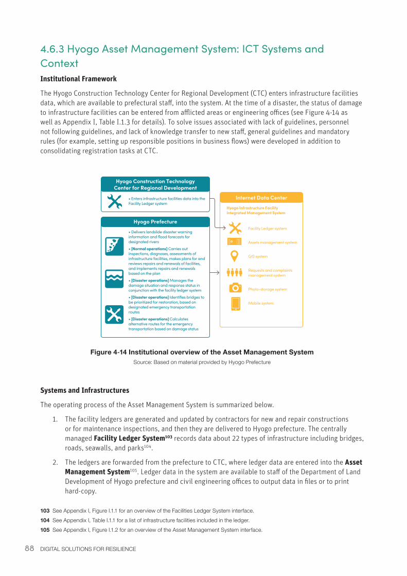
88 DIGITAL SOLUTIONS FOR RESILIENCE
4.6.3 Hyogo Asset Management System: ICT Systems and ContextInstitutional Framework
The Hyogo Construction Technology Center for Regional Development (CTC) enters infrastructure facilities data, which are available to prefectural staff, into the system. At the time of a disaster, the status of damage to infrastructure facilities can be entered from afflicted areas or engineering offices (see Figure 4-14 as well as Appendix I, Table I.1.3 for details). To solve issues associated with lack of guidelines, personnel not following guidelines, and lack of knowledge transfer to new staff, general guidelines and mandatory rules (for example, setting up responsible positions in business flows) were developed in addition to consolidating registration tasks at CTC.
Figure 4‑14 Institutional overview of the Asset Management SystemSource: Based on material provided by Hyogo Prefecture
Systems and Infrastructures
The operating process of the Asset Management System is summarized below.
1. The facility ledgers are generated and updated by contractors for new and repair constructions or for maintenance inspections, and then they are delivered to Hyogo prefecture. The centrally managed Facility Ledger System103 records data about 22 types of infrastructure including bridges, roads, seawalls, and parks104.
2. The ledgers are forwarded from the prefecture to CTC, where ledger data are entered into the Asset Management System105. Ledger data in the system are available to staff of the Department of Land Development of Hyogo prefecture and civil engineering offices to output data in files or to print hard-copy.
103 See Appendix I, Figure I.1.1 for an overview of the Facilities Ledger System interface.104 See Appendix I, Table I.1.1 for a list of infrastructure facilities included in the ledger.105 See Appendix I, Figure I.1.2 for an overview of the Asset Management System interface.
Hyogo Construction TechnologyCenter for Regional Development
• Enters infrastructure facilities data into the Facility Ledger system
Hyogo Prefecture
• Delivers landslide disaster warning information and flood forecasts for designated rivers
• [Normal operations] Carries out inspections, diagnoses, assessments of infrastructure facilities, makes plans for and reviews repairs and renewals of facilities, and implements repairs and renewals based on the plan
• [Disaster operations] Manages the damage situation and response status in conjunction with the facility ledger system
• [Disaster operations] Identifies bridges to be prioritized for restoration, based on designated emergency transportation routes
• [Disaster operations] Calculates alternative routes for the emergency transportation based on damage status
Internet Data Center
Hyogo Infrastructure Facility Integrated Management System
Facility Ledger system
Assets management system
GIS system
Requests and complaintsmanagement system
Photo-storage system
Mobile system
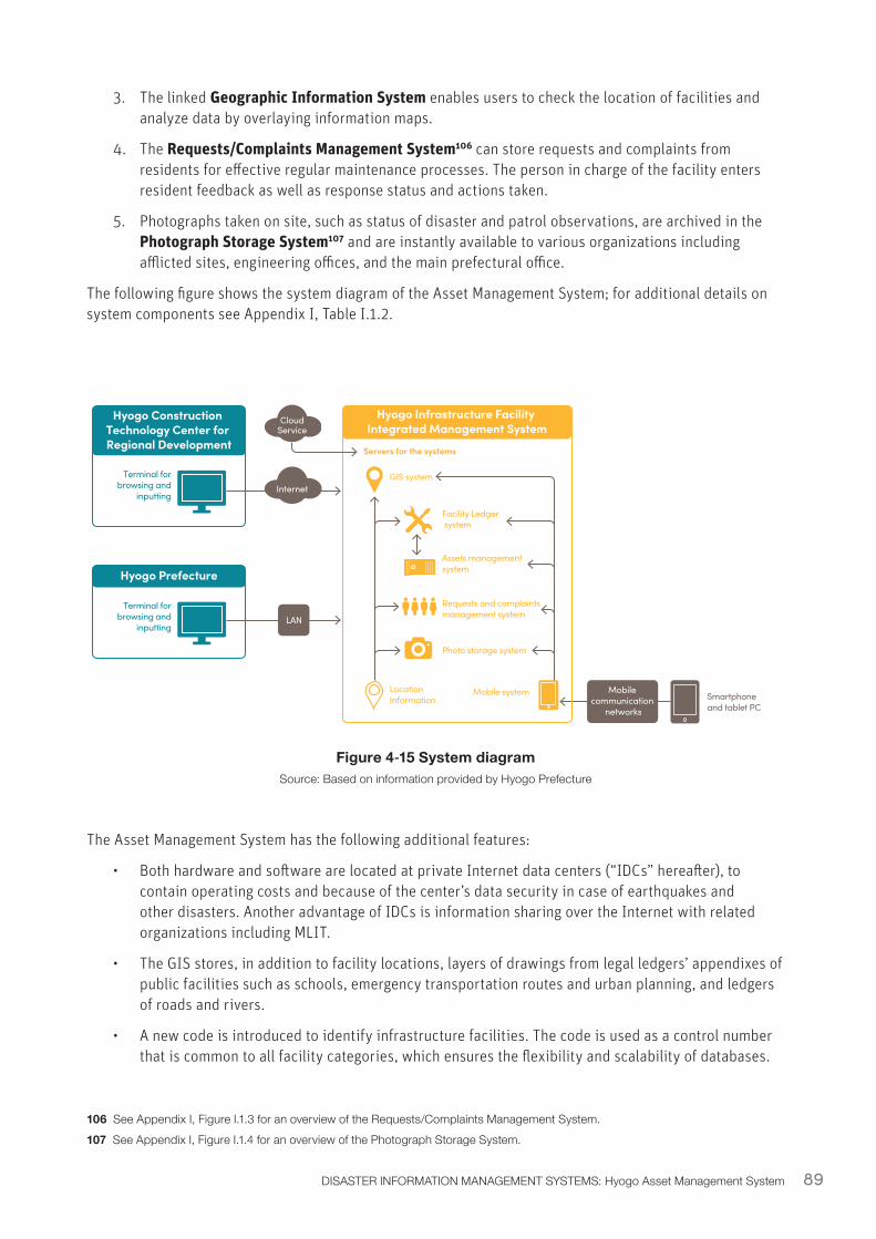
89DISASTER INFORMATION MANAGEMENT SYSTEMS: Hyogo Asset Management System
3. The linked Geographic Information System enables users to check the location of facilities and analyze data by overlaying information maps.
4. The Requests/Complaints Management System106 can store requests and complaints from residents for effective regular maintenance processes. The person in charge of the facility enters resident feedback as well as response status and actions taken.
5. Photographs taken on site, such as status of disaster and patrol observations, are archived in the Photograph Storage System107 and are instantly available to various organizations including afflicted sites, engineering offices, and the main prefectural office.
The following figure shows the system diagram of the Asset Management System; for additional details on system components see Appendix I, Table I.1.2.
Figure 4‑15 System diagramSource: Based on information provided by Hyogo Prefecture
The Asset Management System has the following additional features:
• Both hardware and software are located at private Internet data centers (“IDCs” hereafter), to contain operating costs and because of the center’s data security in case of earthquakes and other disasters. Another advantage of IDCs is information sharing over the Internet with related organizations including MLIT.
• The GIS stores, in addition to facility locations, layers of drawings from legal ledgers’ appendixes of public facilities such as schools, emergency transportation routes and urban planning, and ledgers of roads and rivers.
• A new code is introduced to identify infrastructure facilities. The code is used as a control number that is common to all facility categories, which ensures the flexibility and scalability of databases.
106 See Appendix I, Figure I.1.3 for an overview of the Requests/Complaints Management System.107 See Appendix I, Figure I.1.4 for an overview of the Photograph Storage System.
Hyogo Construction Technology Center for Regional Development
Hyogo Infrastructure Facility Integrated Management System
Terminal for browsing and
inputting
Hyogo Prefecture
Terminal for browsing and
inputtingLAN
Internet
CloudService
Servers for the systems
GIS system
LocationInformation
Facility Ledger system
Assets management system
Requests and complaintsmanagement system
Photo storage system
Mobile system Mobile communication
networksSmartphone and tablet PC

90 DIGITAL SOLUTIONS FOR RESILIENCE
There are multiple ways to access the Asset Management System, including the Internet via the prefectural network (WAN), or through the Internet for auxiliary organizations, or using the mobile network from construction and inspection sites. This broad accessibility was achieved by installing all hardware and software in IDCs.
91DISASTER INFORMATION MANAGEMENT SYSTEMS: Hyogo Asset Management System
4.6.4 Hyogo Asset Management System: Enabling EnvironmentPolicy and Legislation
The Asset Management System was developed by Hyogo prefecture to collect infrastructure data and analyses and evaluation results to elaborate the prefecture’s 10-year infrastructure maintenance plan for extending infrastructure life by reducing maintenance costs and optimizing the budget for social infrastructure. Hyogo prefecture has been working on the plan since 2011, along with developing and enhancing the Asset Management System. The system was developed by local governments in part because they already had a facility ledger, and municipal government staff are mandated to manage and update them in Japan.

92 DIGITAL SOLUTIONS FOR RESILIENCE
93
Image: Disaster information management drill in preparation for major power outage (Jun. 2019). Source: Kyodo News Images.
Key Takeaways and Next Steps on ICT for DRM
[5]
Key Takeaways and Next Steps on ICT for DRM
In this report, several ICT solutions for DRM in Japan are surveyed and analyzed through EWSs and DIMSs case studies. Conclusions and lessons that may be of relevance to policy makers in other countries are discussed below.
Ensure effective data management – ICT for DRM must be supported by accepted rules, procedures, and relationships that encourage, facilitate, and guide the production, sharing, analysis and use of data in response to disasters.
Access to reliable, detailed, and timely information at all levels of society is crucial immediately before, during, and after a disaster. An effective emergency response can be provided only if disaster information data are readily collected, processed, analyzed, and shared. Effective data management enhances scalability and interoperability of EWSs and DIMSs.
As observed in most of the ICT solutions covered in this report, cloud computing helps ensuring effective data management. It offers resiliency and redundancy with its off-premise nature, and changes the finance structure from CAPEX-based to OPEX-based, increasing the financial flexibility of public institutions.
Design for today and the future – ICT for DRM should be designed taking into consideration the existing ICT context and planned or projected future conditions.
The specific ICT utilized in Japan for EWS and DMIS may not necessarily be appropriate for other countries, especially because the systems strongly depend on robust telecommunications infrastructure. For example, in the case of EWS, it is desirable to maximize the transmission routes using systems familiar to residents, which may be different depending on the country. In every country, the solutions must be based on the existing communication infrastructure, as well as future development plans. In particular, in developing countries ICT for DRM should also consider the current and projected economic conditions to select economically feasible systems which can also be maintained over time.
For example, EAM (section 3.4) was developed due to the wide diffusion of mobile phones in Japan, projected to increase in the future. Since the mobile penetration rate in developing countries is also relatively high, and it is likely to continue to increase, systems similar to EAM may be effective. However, it is important to note that the participation of mobile carriers in Japan is facilitated by their roles as public institutions based on the Disaster Countermeasures Basic Act.
On the other hand, installing equipment equivalent to Disaster Administrative Radios Systems in developing countries may not be realistic because of the high cost. It would be more effective to take advantage of existing widespread equipment, such as speakers already installed at religious facilities such as mosques or churches, where people get together on a regularly basis and can be effective to disseminate information. In many areas the places of worship are also designated as (or serve informally as) evacuation facilities. However, the possibility of implementation depends on the specific social contexts and inclusivity of these institutions.
Solutions based on broadcasting networks should not be considered in a developing country if radios and televisions are relatively uncommon, unless their penetration is projected to increase. Widely diffused radios and televisions can be very effective dissemination tools.
95
Agree on the details in advance – Roles and responsibilities, priority actions, and terms of cooperation need to be defined in advance of a disaster by developing SOP, pre-arranged agreements, and business continuity plans.
ICT solutions including EWS and DIMS cannot be developed unless the following procedures are clearly defined: who inputs what kind of information to whom; how information is processed; and how information is output. Without an SOP, it is unclear who is responsible for installing and operating the ICT solution, and it will not be effective during a disaster. SOPs were fundamental to the development of many of the systems described in this report: for ICTs like K-DIS (section 4.5), an SOP clearly identifies roles and responsibilities. Legislation also helps to define roles within ICT for DRM systems, including which parts of government are responsible for specific warning and response activities. For example, the responsibilities of different government agencies associated with J-ALERT (section 3.3) are shaped by several acts including the Meteorological Service Act and the Disaster Countermeasures Basic Act. J-ALERT’s operational processes are more specifically outlined in “The Provisions for Operation Process of the National Early Warning System (J-ALERT108).”
Use the system during normal times – ICT for DRM systems that can be utilized in normal times will be more effective during a disaster.
It is difficult to make effective use of a system during a disaster unless it has been used in normal times. Everyday utilization allows both official users and citizens to become familiar with the system’s operation; for example, the system can be used to respond to the small-scale disasters which occur every year, for everyday information management, and by providing periodic training.For example, L-ALERT (section 4.2) can be used to transmit information on administrative procedures, welfare and education, and special events for tourists during normal times, which improves operation of and user familiarity with the system. Similarly, Hyogo Prefecture’s Asset Management System (AMS) (section 4.6) is used for maintaining facilities in the prefecture and preparing updated plans in normal times. At the time of a disaster it is possible to share images of disaster areas with the same system. For GIS-based disaster MIS (section 4.3), maps created during normal times provide a foundation for analyzing disaster status. When designing new DIMSs, potentials for non-disaster use and incentivization of use should be integrated into the system.
Practices makes perfect – Awareness and training ensure that stakeholders are familiar with specific ICT for DRM before a disaster strikes, and can leverage them quickly and effectively during an emergency.
An effective EWS or DIMS requires not only well-designed digital and physical infrastructure. It also requires that the users understand how it works and are able to play their roles even when a disaster disrupts the status quo. Possible users must first be aware that the system exists, which can be achieved through outreach or awareness programs. If more specialized information is required to engage with the system, training ensures that the users have the proper knowledge and skills.
For example, public education and drills to prepare for earthquake, including an annual disaster prevention day, ensure that recipients of early warnings—both the general public and officials—know how to respond immediately (i.e., shelter in place or send out a notification). In the case of the Tokushima DIMS, training and outreach highlighting the system’s benefit to the prefecture has increased participation.
108 Created in 2010, updated in 2016 https://www.fdma.go.jp/mission/protection/item/protection001_05_J-ALERT_gyomu_kitei_280322.pdf
ConclusionICT for DRM is a rapidly evolving field and Japan, as a country at the cutting edge of many technologies and vast experience with frequent disasters, provides a good testing ground for its development. While the cases studied here are specific to the context of Japan, the high-level lessons extracted will be useful for other countries looking to develop or improve these types of systems. Key considerations include: planning considering both existing and future ICTs; establishing Standard Operating Procedures; considering both daily and disaster utilization; and integrating education and awareness-building into system development.
As global technology continues to advance, new frontiers will emerge for DRM technologies. Rapid urbanization, technological development, and climate change are also changing the nature and scope of DRM. Developing ICT for DRM which are well-adapted to local contexts and adaptable to a changing world will be essential to improve disaster preparedness and resilience for citizens around the world.
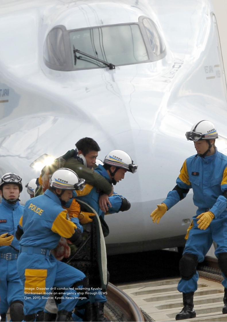
97
Image: Disaster drill conducted assuming Kyushu Shinkansen made an emergency stop through EEWS (Jan. 2011). Source: Kyodo News Images.

99
AppendixAPPENDIX OF ADDITIONAL TECHNICAL DETAILS
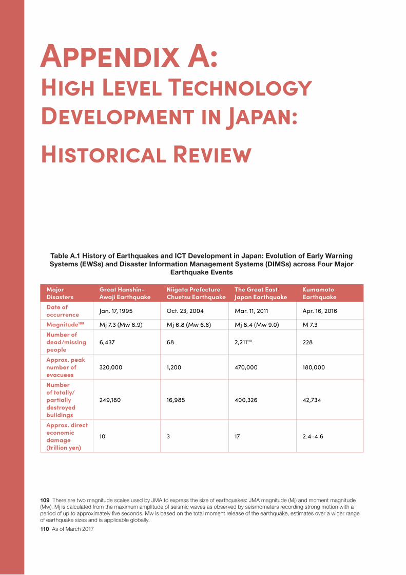
100 DIGITAL SOLUTIONS FOR RESILIENCE
Appendix A: High Level Technology Development in Japan: Historical Review
Major Disasters
Great Hanshin-Awaji Earthquake
Niigata Prefecture Chuetsu Earthquake
The Great East Japan Earthquake
Kumamoto Earthquake
Date of occurrence Jan. 17, 1995 Oct. 23, 2004 Mar. 11, 2011 Apr. 16, 2016
Magnitude109 Mj 7.3 (Mw 6.9) Mj 6.8 (Mw 6.6) Mj 8.4 (Mw 9.0) M 7.3Number of dead/missing people
6,437 68 2,211110 228
Approx. peak number of evacuees
320,000 1,200 470,000 180,000
Number of totally/partially destroyed buildings
249,180 16,985 400,326 42,734
Approx. direct economic damage (trillion yen)
10 3 17 2.4-4.6
109 There are two magnitude scales used by JMA to express the size of earthquakes: JMA magnitude (Mj) and moment magnitude (Mw). Mj is calculated from the maximum amplitude of seismic waves as observed by seismometers recording strong motion with a period of up to approximately five seconds. Mw is based on the total moment release of the earthquake, estimates over a wider range of earthquake sizes and is applicable globally.110 As of March 2017
Table A.1 History of Earthquakes and ICT Development in Japan: Evolution of Early Warning Systems (EWSs) and Disaster Information Management Systems (DIMSs) across Four Major
Earthquake Events
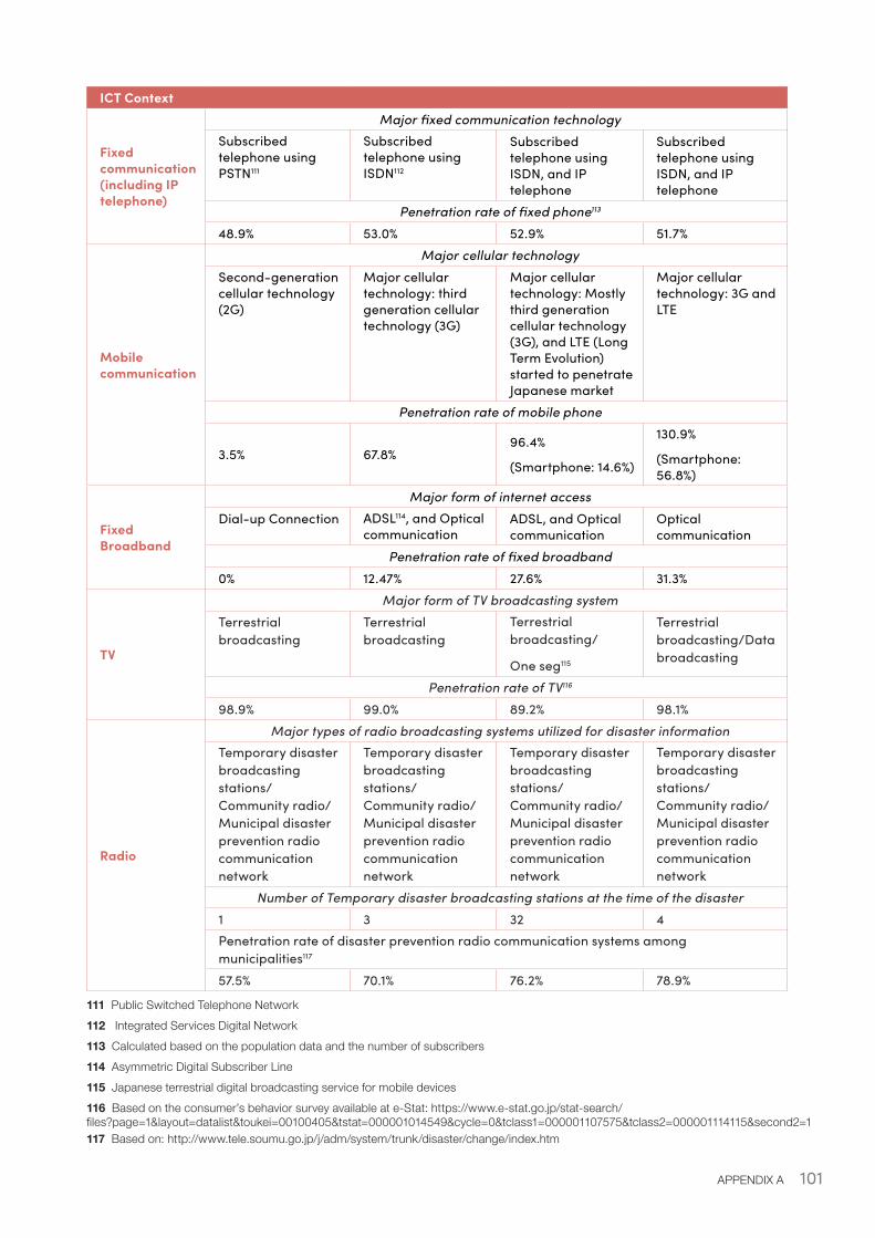
101APPENDIX A
ICT Context
Fixed communication (including IP telephone)
Major fixed communication technologySubscribed telephone using PSTN111
Subscribed telephone using ISDN112
Subscribed telephone using ISDN, and IP telephone
Subscribed telephone using ISDN, and IP telephone
Penetration rate of fixed phone113
48.9% 53.0% 52.9% 51.7%
Mobile communication
Major cellular technologySecond-generation cellular technology (2G)
Major cellular technology: third generation cellular technology (3G)
Major cellular technology: Mostly third generation cellular technology (3G), and LTE (Long Term Evolution) started to penetrate Japanese market
Major cellular technology: 3G and LTE
Penetration rate of mobile phone
3.5% 67.8%96.4%
(Smartphone: 14.6%)
130.9%
(Smartphone: 56.8%)
Fixed Broadband
Major form of internet accessDial-up Connection ADSL114, and Optical
communicationADSL, and Optical communication
Optical communication
Penetration rate of fixed broadband0% 12.47% 27.6% 31.3%
TV
Major form of TV broadcasting systemTerrestrial broadcasting
Terrestrial broadcasting
Terrestrial broadcasting/
One seg115
Terrestrial broadcasting/Data broadcasting
Penetration rate of TV116
98.9% 99.0% 89.2% 98.1%
Radio
Major types of radio broadcasting systems utilized for disaster informationTemporary disaster broadcasting stations/ Community radio/ Municipal disaster prevention radio communication network
Temporary disaster broadcasting stations/ Community radio/ Municipal disaster prevention radio communication network
Temporary disaster broadcasting stations/ Community radio/ Municipal disaster prevention radio communication network
Temporary disaster broadcasting stations/ Community radio/ Municipal disaster prevention radio communication network
Number of Temporary disaster broadcasting stations at the time of the disaster1 3 32 4Penetration rate of disaster prevention radio communication systems among municipalities117
57.5% 70.1% 76.2% 78.9%
111 Public Switched Telephone Network112 Integrated Services Digital Network113 Calculated based on the population data and the number of subscribers114 Asymmetric Digital Subscriber Line115 Japanese terrestrial digital broadcasting service for mobile devices116 Based on the consumer’s behavior survey available at e-Stat: https://www.e-stat.go.jp/stat-search/files?page=1&layout=datalist&toukei=00100405&tstat=000001014549&cycle=0&tclass1=000001107575&tclass2=000001114115&second2=1117 Based on: http://www.tele.soumu.go.jp/j/adm/system/trunk/disaster/change/index.htm
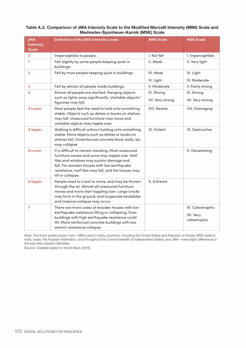
102 DIGITAL SOLUTIONS FOR RESILIENCE
Table A.2. Comparison of JMA Intensity Scale to the Modified Mercalli Intensity (MMI) Scale and Medvedev-Sponheuer-Karnik (MSK) Scale
JMA Intensity Scale
Definition of the JMA Intensity Levels MMI Scale MSK Scale
0 Imperceptible to people. I. Not felt I. Imperceptible1 Felt slightly by some people keeping quiet in
buildings.II. Weak II. Very light
2 Felt by most people keeping quiet in buildings. III. Weak
IV. Light
III. Light
IV. Moderate3 Felt by almost all people inside buildings. V. Moderate V. Fairly strong4 Almost all people are startled. Hanging objects
such as lights sway significantly. Unstable objects/figurines may fall.
VI. Strong
VII. Very strong
VI. Strong
VII. Very strong
5 Lower Most people feel the need to hold onto something stable. Objects such as dishes or books on shelves may fall. Unsecured furniture may move and unstable objects may topple over.
VIII. Severe VIII. Damaging
5 Upper Walking is difficult without holding onto something stable. More objects such as dishes or books on shelves fall. Unreinforced concrete block walls, etc. may collapse.
IX. Violent IX. Destructive
6 Lower It is difficult to remain standing. Most unsecured furniture moves and some may topple over. Wall tiles and windows may sustain damage and fall. For wooden houses with low earthquake resistance, roof tiles may fall, and the houses may tilt or collapse.
X. Devastating
6 Upper People need to crawl to move, and may be thrown through the air. Almost all unsecured furniture moves and more start toppling over. Large cracks may form in the ground, and largescale landslides and massive collapse may occur.
X. Extreme
7 There are more cases of wooden houses with low earthquake resistance tilting or collapsing. Even buildings with high earthquake resistance could tilt. More reinforced concrete buildings with low seismic resistance collapse.
XI. Catastrophic
XII. Very catastrophic
Note: The three scales shown here—MMI (used in many countries, including the United States and Republic of Korea), MSK (used in India, Israel, the Russian Federation, and throughout the Commonwealth of Independent States), and JMA—have slight differences in the way they classify intensities. Source: Created based on World Bank (2016)
103APPENDIX A
EWS and DIMS Challenges, Achievements, Advancements, and legislation developed in response to the disaster
1. Great Hanshin-Awaji Earthquake
EWS Challenges
• Very limited seismic warning system caused significant loss and damages (e.g., to roads and rails).
• In 1992, Tohoku Shinkansen installed a preliminary seismic detection and EWS called “Urgent Earthquake Detection and Alarm System” or UrEDAS (Watanabe et al., 2009), designed to automatically stop or slow down high-speed rails. However, UrEDAS was not installed in the area where the 1995 EQ occurred. During the 1995 EQ, although there were no passenger fatalities, damages were significant including 16 lines derailed and 32 fallen bridges.
Post-Disaster Advancements
• The severe damages led to a complete renewal of Japan’s seismic risk management approach.
• Japan’s seismic observational and research infrastructure was entirely revamped and development of earthquake early warning system was initiated.
• UrEDAS was improved (as Compact UrEDAS) and installed in other high-speed and local rail lines.
DIMS Challenges
• The Municipal Disaster Management Radio Communication System (MDMRCS) was established at national, prefectural, and municipal levels to gather and deliver disaster information during emergencies. These systems consist of VHF/UHF radio communication link, microwave communication link and satellite communication link, and are comprised of fixed systems, simultaneous communication systems, and mobile systems.
• However, at the time of the EQ, only 20% of local governments in Hyogo Prefecture, and only 53.6% of local governments nationally had installed the system. Therefore, significant delays and barriers were faced to collect and disseminate disaster information such as on damage and relief status (Satoru Ishigaki, 2011).
• Information for vulnerable groups including the elderly and people with disabilities were insufficient, causing them disproportionate casualties.
Legislation
1995:
• Act on Special Measures for Earthquake Disaster Countermeasures• Act on Promotion of the Earthquake-proof Retrofit of Buildings• Amendment of Disaster Countermeasures Basic Act• Amendment of Act on Special Measures for Large-scale Earthquakes
1996:
• Act on Special Measures for Preservation of Rights and Profits of the Victims of Specified Disasters
104 DIGITAL SOLUTIONS FOR RESILIENCE
1997:
• Act on Promotion of Disaster Resilience Improvement in Densely Inhabited Areas
1998:
• Act on Support for Livelihood Recovery of Disaster Victims
2. Niigata Prefecture Chuetsu Earthquake
EWS Challenges
• Due to disruption of the MDMRSC system, seismic observation information was lost for a certain period. Furthermore, repeated aftershocks caused data congestion.
• Compact UrEDAS system was activated and the emergency breaks slowed down the Shinkansen/ high-speed rails (by cutting power transmissions). At the time of the earthquake, four Shinkansen were passing through the EQ-affected area. Three out of four trains were able to safely slow down and stop. One train, which was moving at 200 km/hr with 154 passengers slowed down but derailed118. Since the line was passing through an area close to the epicenter, the time between detection and emergency break was less than one second (Hitotsubashi University Railway Study Group, 2011).
Post-Disaster Advancements
• Based on this experience, improvements were made to shorten the time from EQ detection to activation of emergency breaks119.
DIMS Challenges
• NTT lines and MDMRCS were disconnected in certain areas causing information isolation.• Blackout caused disruption to communication through MDMRSC.• Mobile communication was disrupted due to increased communication volume. • GIS system certainly played an important role, which enabled the sharing of geographic information
in real time to support disaster response activities
Post-Disaster Advancements
• In order to secure alternative communication channels during disasters, satellite phones were established for municipal governments.
• Partnerships with private communication companies to send disaster information (i.e. through mass emails) were further explored120.
Legislation
2005:
• Amendment of Act on Promotion of the Earthquake-proof Retrofit of Buildings2006:
• Amendment of Act on the Regulation of Residential Land Development
118 For more information, see: http://port80japan.net/bosai/bosai_1_1_3.htm119 For more information, see: http://www.jreast.co.jp/safe/jishin.html120 For more information, see: http://www.soumu.go.jp/main_sosiki/joho_tsusin/policyreports/chousa/jyuyou-t/pdf/080118_1_si4-6.pdf
105APPENDIX A
3. The Great East Japan Earthquake
EWS Achievements
• The EEWS of JMA (launched in Oct. 2007 for common use and 2004 for advanced use) issued warnings 18 times, delivered via J-ALERT (launched in Feb. 2007) and EAM (launched in Dec. 2007), effectively delivering the alert through multiple channels. The municipalities who had installed receivers of the J-ALERT (46%) reported the effectiveness of the early warnings
• UrEDAS activated emergency brakes to slow down 27 Shinkansen high-speed rails that were in operation during the earthquake. All lines came to a safe stop. Although five trains were destroyed after the tsunami that followed shortly after, there were no casualties as passengers were safely evacuated121.
Legislation
2011:
• Act on Promotion of Tsunami Countermeasures• Act on Development of Areas Resilient to Tsunami Disasters
2012:
• Amendment of Disaster Countermeasures Basic Act• Act for Establishment of the Nuclear Regulation Authority
2013:
• Amendment of Disaster Countermeasures Basic Act• Act on Reconstruction from Large-Scale Disasters• Amendment of the Act on Promotion of the Earthquake-proof Retrofit of Buildings• Amendment of the Flood Control Act and River Act• Act on Special Measures for Land and Building Leases in Areas Affected by Large-scale Disaster• Basic Act for National Resilience Contributing to Preventing and Mitigating Disasters for Developing
Resilience in the Lives of the Citizenry
4. Kumamoto Earthquake
EWS Achievements
• The earthquake early warnings were issued 19 times, exhibiting remarkable performance. Receivers of the J-ALERT were installed in most municipalities (above 99%), and this contributed to delivering the alert effectively.
• However, in four cases, the system issued inaccurate warnings. In order to address over-prediction and under-prediction, JMA plans to implement the integrated particle filter (IPF) and propagation of local undamped motion (PLUM) methods122.
Challenges
• Given that the epicenter of the EQ was close to urban centers, the EQ EWS was unable to prevent derailment, although it did activate the emergency breaks.
121 For more information, see: http://www.jreast.co.jp/safe/jishin.html122 For comprehensive analysis of the performance of the earthquake early warning system during the Kumamoto Earthquake, see Kodera et al. (2016)
106 DIGITAL SOLUTIONS FOR RESILIENCE
DIMS Challenges
• Impacts to ICT as well as critical infrastructure such as energy due to EQ and tsunami caused significant disruptions to ICT systems after the disasters. 385 NTT buildings became non-functional, 6,300 km of cables along the coastlines were damaged/destroyed, and approximately 1.9 million access lines (to connect users to communication network) were cut. More than 29,000 mobile phones and PHS hubs stopped functioning (MIC, 2016c).
• Furthermore, due to increased communication demand of 50-60 times more than normal, the mobile communication lines were congested and had very poor connection.
• On the other hand, data/internet-based communication via smartphones was possible. Furthermore, satellite phones were found to be reliable communication tools in the event of disasters.
• Disaster information was collected and shared among relevant organizations mostly using emergency municipal radio communication systems, phone, fax, and wireless transceiver. The information was delivered to affected areas using radio broadcasting systems, public trucks with speakers, e-mails, TV, community radio, and social media platforms (Inomo et al., 2012).
• Nevertheless, citizens were dissatisfied with the dissemination of disaster information by the public sector. Local governments also recognized the need to improve provision of quick, accurate, and continuous disaster information (MIC, 2014).
Post-Disaster Advancements
• New legislation ensuring that citizens can obtain accurate disaster information through utilization of Geospatial information systems and ICT. Initiated development of Public Information Commons (later called L-Alert System) and Public Wireless LAN, etc. to secure multiple channels to access disaster information. Started discussions on pre-arranged agreements to utilize public and private information communication infrastructure as well as ensuring information access and dissemination to people with disabilities (MIC, 2014).
Legislation
2016:
• Amendment of Act on Special Measures concerning Preservation of Rights and Interests of Victims of Specified Disaster

107APPENDIX A
108 DIGITAL SOLUTIONS FOR RESILIENCE
Appendix B: Earthquake Early Warning SystemB.1 Examples of Application During Disaster Events
• At the time of the 2011 Great East Japan Earthquake, Early Warning Systems enabled people to take actions moments before the earthquake struck. However, the P- and S-waves in areas close to the hypocenter struck almost immediately after one another, and so some people failed to find adequate shelter.
• During the 2016 Kumamoto Earthquake, information was delivered via mobile phones, smartphones, TV, and other means. This timely dissemination of critical information proved effective in helping people. For example, approximately 80% of residents were able to obtain information related to the earthquake, and approximately 40% were able to take some form of preventative action to reduce injuries and damage (JMA, 2017).
B.2 Earthquake Early Warning System: ICT Systems and ContextSystems and Infrastructures
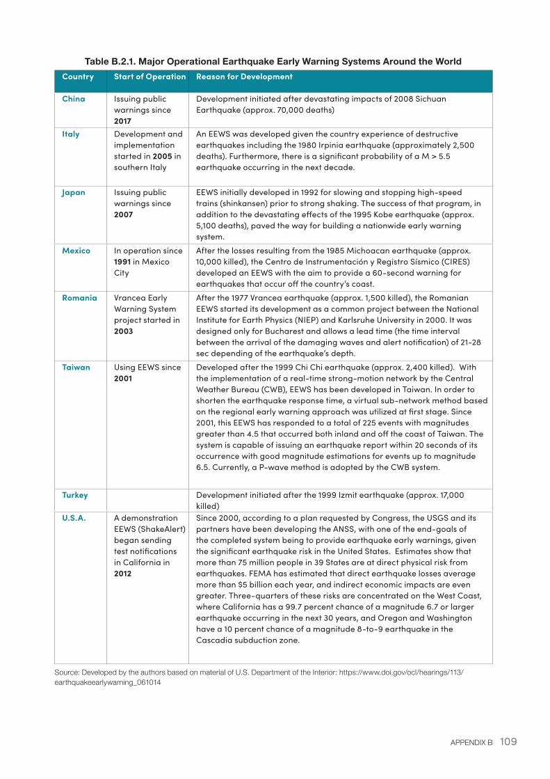
109APPENDIX B
Table B.2.1. Major Operational Earthquake Early Warning Systems Around the WorldCountry Start of Operation Reason for Development
China Issuing public warnings since 2017
Development initiated after devastating impacts of 2008 Sichuan Earthquake (approx. 70,000 deaths)
Italy Development and implementation started in 2005 in southern Italy
An EEWS was developed given the country experience of destructive earthquakes including the 1980 Irpinia earthquake (approximately 2,500 deaths). Furthermore, there is a significant probability of a M > 5.5 earthquake occurring in the next decade.
Japan Issuing public warnings since 2007
EEWS initially developed in 1992 for slowing and stopping high-speed trains (shinkansen) prior to strong shaking. The success of that program, in addition to the devastating effects of the 1995 Kobe earthquake (approx. 5,100 deaths), paved the way for building a nationwide early warning system.
Mexico In operation since 1991 in Mexico City
After the losses resulting from the 1985 Michoacan earthquake (approx. 10,000 killed), the Centro de Instrumentación y Registro Sísmico (CIRES) developed an EEWS with the aim to provide a 60-second warning for earthquakes that occur off the country’s coast.
Romania Vrancea Early Warning System project started in 2003
After the 1977 Vrancea earthquake (approx. 1,500 killed), the Romanian EEWS started its development as a common project between the National Institute for Earth Physics (NIEP) and Karlsruhe University in 2000. It was designed only for Bucharest and allows a lead time (the time interval between the arrival of the damaging waves and alert notification) of 21-28 sec depending of the earthquake’s depth.
Taiwan Using EEWS since 2001
Developed after the 1999 Chi Chi earthquake (approx. 2,400 killed). With the implementation of a real-time strong-motion network by the Central Weather Bureau (CWB), EEWS has been developed in Taiwan. In order to shorten the earthquake response time, a virtual sub-network method based on the regional early warning approach was utilized at first stage. Since 2001, this EEWS has responded to a total of 225 events with magnitudes greater than 4.5 that occurred both inland and off the coast of Taiwan. The system is capable of issuing an earthquake report within 20 seconds of its occurrence with good magnitude estimations for events up to magnitude 6.5. Currently, a P-wave method is adopted by the CWB system.
Turkey Development initiated after the 1999 Izmit earthquake (approx. 17,000 killed)
U.S.A. A demonstration EEWS (ShakeAlert) began sending test notifications in California in 2012
Since 2000, according to a plan requested by Congress, the USGS and its partners have been developing the ANSS, with one of the end-goals of the completed system being to provide earthquake early warnings, given the significant earthquake risk in the United States. Estimates show that more than 75 million people in 39 States are at direct physical risk from earthquakes. FEMA has estimated that direct earthquake losses average more than $5 billion each year, and indirect economic impacts are even greater. Three-quarters of these risks are concentrated on the West Coast, where California has a 99.7 percent chance of a magnitude 6.7 or larger earthquake occurring in the next 30 years, and Oregon and Washington have a 10 percent chance of a magnitude 8-to-9 earthquake in the Cascadia subduction zone.
Source: Developed by the authors based on material of U.S. Department of the Interior: https://www.doi.gov/ocl/hearings/113/earthquakeearlywarning_061014
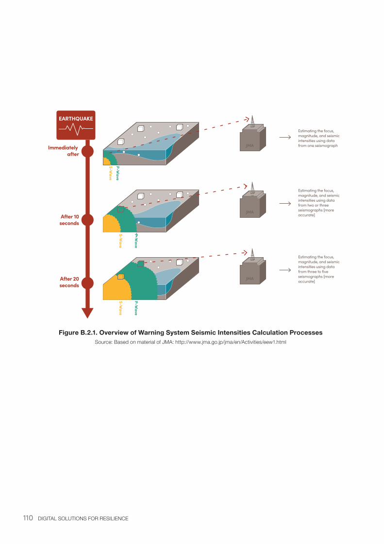
110 DIGITAL SOLUTIONS FOR RESILIENCE
Figure B.2.1. Overview of Warning System Seismic Intensities Calculation ProcessesSource: Based on material of JMA: http://www.jma.go.jp/jma/en/Activities/eew1.html
EARTHQUAKE
Immediately after
After 10seconds
After 20seconds
S-Wave
P-Wave
S-Wave
P-Wave
S-Wave
P-Wave
JMA
JMA
JMA
Estimating the focus, magnitude, and seismic intensities using data from one seismograph
Estimating the focus, magnitude, and seismic intensities using data from two or three seismographs [more accurate]
Estimating the focus, magnitude, and seismic intensities using data from three to five seismographs [more accurate]
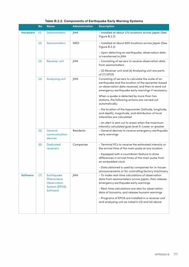
111APPENDIX B
Table B.2.2. Components of Earthquake Early Warning Systems No. Name Administration Description
Hardware (1) Seismometers JMA - Installed at about 270 locations across Japan (See Figure B.2.2)
(2) Seismometers NIED - Installed at about 800 locations across Japan (See Figure B.2.2)
- Upon detecting an earthquake, observation data is transferred to JMA
(3) Receiver unit JMA - Consisting of servers to receive observation data from seismometers
- (3) Receiver unit and (4) Analyzing unit are parts of (7) EPOS
(4) Analyzing unit JMA Consisting of servers to calculate the scale of an earthquake and the location of the epicenter based on observation data received, and then to send out emergency earthquake early warnings if necessary.
When a quake is detected by more than two stations, the following actions are carried out automatically:
- the location of the hypocenter (latitude, longitude, and depth), magnitude, and distribution of local intensities are calculated
- an alert is sent out to areas when the maximum intensity calculated goes level 5-Lower or greater
(5) General communication devices
Residents - General devices to receive emergency earthquake early warnings
(6) Dedicated receivers
Companies - Terminal PCs to receive the estimated intensity or the arrival time of the main pulse at any location
- Equipped with a countdown feature to show differences in arrival times of the main pulse from an embedded clock
- Data obtained is used by companies for in-house announcements or for controlling factory machinery
Software (7) Earthquake Phenomena Observation System (EPOS) Software
JMA - To make real-time calculations of observation data from seismometers across Japan, then release emergency earthquake early warnings
- Real-time calculations are also for observation data of tsunamis, and release tsunami warnings
- Programs of EPOS are installed in a receiver unit and analyzing unit as noted in (3) and (4) above
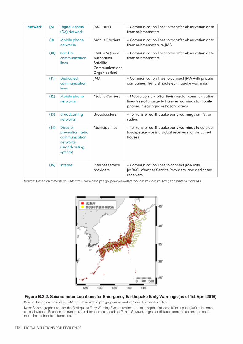
112 DIGITAL SOLUTIONS FOR RESILIENCE
Network (8) Digital Access (DA) Network
JMA, NIED - Communication lines to transfer observation data from seismometers
(9) Mobile phone networks
Mobile Carriers - Communication lines to transfer observation data from seismometers to JMA
(10) Satellite communication lines
LASCOM (Local Authorities Satellite Communications Organization)
- Communication lines to transfer observation data from seismometers
(11) Dedicated communication lines
JMA - Communication lines to connect JMA with private companies that distribute earthquake warnings
(12) Mobile phone networks
Mobile Carriers - Mobile carriers offer their regular communication lines free of charge to transfer warnings to mobile phones in earthquake hazard areas
(13) Broadcasting networks
Broadcasters - To transfer earthquake early warnings on TVs or radios
(14) Disaster prevention radio communication networks (Broadcasting system)
Municipalities - To transfer earthquake early warnings to outside loudspeakers or individual receivers for detached houses
(15) Internet Internet service providers
- Communication lines to connect JMA with JMBSC, Weather Service Providers, and dedicated receivers.
Source: Based on material of JMA: http://www.data.jma.go.jp/svd/eew/data/nc/shikumi/shikumi.html; and material from NEC
Figure B.2.2. Seismometer Locations for Emergency Earthquake Early Warnings (as of 1st April 2016)Source: Based on material of JMA: http://www.data.jma.go.jp/svd/eew/data/nc/shikumi/shikumi.htmlNote: Seismographs used for the Earthquake Early Warning System are installed at a depth of at least 100m (up to 1,000 m in some cases) in Japan. Because the system uses differences in speeds of P- and S-waves, a greater distance from the epicenter means more time to transfer information.
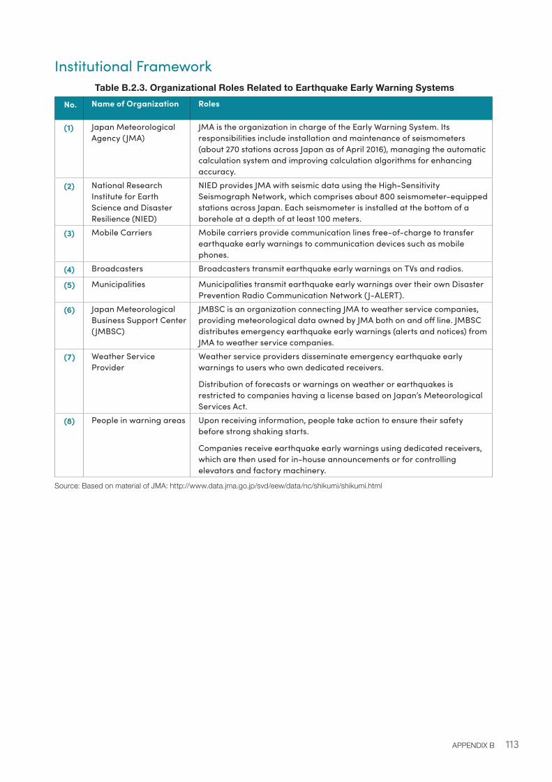
113APPENDIX B
Institutional FrameworkTable B.2.3. Organizational Roles Related to Earthquake Early Warning Systems
No. Name of Organization Roles
(1) Japan Meteorological Agency (JMA)
JMA is the organization in charge of the Early Warning System. Its responsibilities include installation and maintenance of seismometers (about 270 stations across Japan as of April 2016), managing the automatic calculation system and improving calculation algorithms for enhancing accuracy.
(2) National Research Institute for Earth Science and Disaster Resilience (NIED)
NIED provides JMA with seismic data using the High-Sensitivity Seismograph Network, which comprises about 800 seismometer-equipped stations across Japan. Each seismometer is installed at the bottom of a borehole at a depth of at least 100 meters.
(3) Mobile Carriers Mobile carriers provide communication lines free-of-charge to transfer earthquake early warnings to communication devices such as mobile phones.
(4) Broadcasters Broadcasters transmit earthquake early warnings on TVs and radios.
(5) Municipalities Municipalities transmit earthquake early warnings over their own Disaster Prevention Radio Communication Network (J-ALERT).
(6) Japan Meteorological Business Support Center (JMBSC)
JMBSC is an organization connecting JMA to weather service companies, providing meteorological data owned by JMA both on and off line. JMBSC distributes emergency earthquake early warnings (alerts and notices) from JMA to weather service companies.
(7) Weather Service Provider
Weather service providers disseminate emergency earthquake early warnings to users who own dedicated receivers.
Distribution of forecasts or warnings on weather or earthquakes is restricted to companies having a license based on Japan’s Meteorological Services Act.
(8) People in warning areas Upon receiving information, people take action to ensure their safety before strong shaking starts.
Companies receive earthquake early warnings using dedicated receivers, which are then used for in-house announcements or for controlling elevators and factory machinery.
Source: Based on material of JMA: http://www.data.jma.go.jp/svd/eew/data/nc/shikumi/shikumi.html
114 DIGITAL SOLUTIONS FOR RESILIENCE
Table B.2.4. Relationship Between Earthquake Early Warnings and JMA Forecasts/Warnings
JMA Category Service name used by licensed organizations
Contents
Emergency warning/ Warning of earthquake ground motion
Emergency earthquake early warning (Warning)” or “Earthquake early warning”
An alert for a risk of disastrous damage in areas where the anticipated maximum intensity exceeds level 5-lower on the Japanese seismic scale based on the analysis of data from more than 2 observation points.
Forecast of earthquake ground motion
“Emergency earthquake early warning (Forecast)”
A notice for a risk of disastrous damage in areas where the estimated magnitude is 3.5 or more, or the predicted maximum intensity is 3 or more.
Source: Based on material of JMA: http://www.data.jma.go.jp/svd/eew/data/nc/shikumi/shousai.html#2
B.3. Earthquake Early Warning System: Enabling EnvironmentLimitations of Earthquake Early Warning SystemIssues and limitations of the Warning System are listed below:
• Originally developed for alleviating the impacts of damage caused by subduction zone earthquakes, which can provide effective warnings for areas far from the hypocenter. Because the Early Warning System predicts the S-waves arrival time based on the observations of P-waves, there is not enough time to transfer information to areas very close to the hypocenter. Especially in the case of epicenter-type earthquakes, it may not be possible to deliver a warning before the ground starts shaking. In addition, if multiple earthquakes occur in close proximity and within a short time interval, the calculation results would become prone to error.
• The time interval is ten seconds to a few tens of seconds at most from the time a warning is received until the time designated areas are hit by strong quakes.
• The calculation errors range ±1 in terms of earthquake intensity.
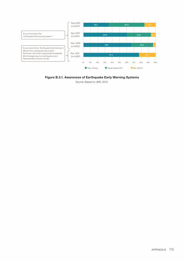
115APPENDIX B
Figure B.3.1. Awareness of Earthquake Early Warning SystemsSource: Based on JMA, 2012.
77.3
66.1
60.6
35.5
30.5
32.8
48.9
22.7
3.4
6.6
15.6
0% 10% 20% 30% 40% 50% 60% 70% 80% 90% 100%
Nov. 2012(n=5,490)
Mar. 2009(n=3,503)
Sep. 2007(n=2,001)
May 2007(n=2,037)
Yes, I know Have heard of it No, I don't
Do you know about the“Earthquake Early Warning System” ?
Do you know that an “Earthquake Early Warning” is di�erent from earthquake information?The former information is generated immediately After the beginning of an earthquake, and is Delivered before tremors are felt.
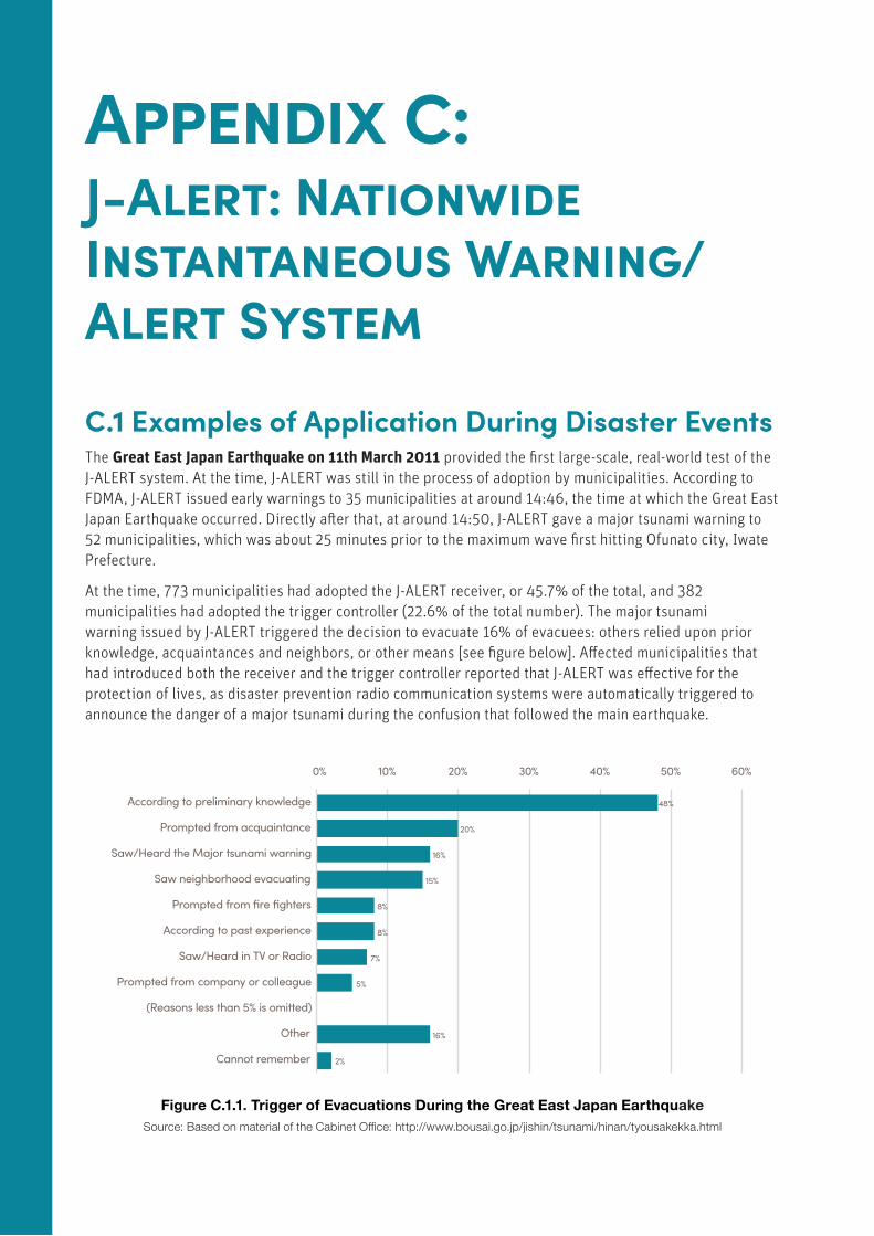
116 DIGITAL SOLUTIONS FOR RESILIENCE
Appendix C: J-Alert: Nationwide Instantaneous Warning/Alert System
C.1 Examples of Application During Disaster EventsThe Great East Japan Earthquake on 11th March 2011 provided the first large-scale, real-world test of the J-ALERT system. At the time, J-ALERT was still in the process of adoption by municipalities. According to FDMA, J-ALERT issued early warnings to 35 municipalities at around 14:46, the time at which the Great East Japan Earthquake occurred. Directly after that, at around 14:50, J-ALERT gave a major tsunami warning to 52 municipalities, which was about 25 minutes prior to the maximum wave first hitting Ofunato city, Iwate Prefecture.
At the time, 773 municipalities had adopted the J-ALERT receiver, or 45.7% of the total, and 382 municipalities had adopted the trigger controller (22.6% of the total number). The major tsunami warning issued by J-ALERT triggered the decision to evacuate 16% of evacuees: others relied upon prior knowledge, acquaintances and neighbors, or other means [see figure below]. Affected municipalities that had introduced both the receiver and the trigger controller reported that J-ALERT was effective for the protection of lives, as disaster prevention radio communication systems were automatically triggered to announce the danger of a major tsunami during the confusion that followed the main earthquake.
Figure C.1.1. Trigger of Evacuations During the Great East Japan EarthquakeSource: Based on material of the Cabinet Office: http://www.bousai.go.jp/jishin/tsunami/hinan/tyousakekka.html
48%
20%
16%
15%
8%
8%
7%
5%
16%
2%
0% 10% 20% 30% 40% 50% 60%
According to preliminary knowledge
Prompted from acquaintance
Saw/Heard the Major tsunami warning
Saw neighborhood evacuating
Prompted from fire fighters
According to past experience
Saw/Heard in TV or Radio
Prompted from company or colleague
(Reasons less than 5% is omitted)
Other
Cannot remember
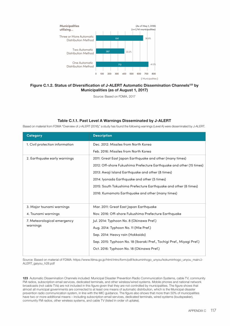
117APPENDIX C
Figure C.1.2. Status of Diversification of J-ALERT Automatic Dissemination Channels123 by Municipalities (as of August 1, 2017)
Source: Based on FDMA, 2017
Table C.1.1. Past Level A Warnings Disseminated by J-ALERTBased on material from FDMA “Overview of J-ALERT (2016),” a study has found the following warnings (Level A) were disseminated by J-ALERT.
Category Description
1. Civil protection information Dec. 2012: Missiles from North Korea
Feb. 2016: Missiles from North Korea
2. Earthquake early warnings 2011: Great East Japan Earthquake and other (many times)
2012: Off-shore Fukushima Prefecture Earthquake and other (15 times)
2013: Awaji Island Earthquake and other (8 times)
2014: Iyonada Earthquake and other (5 times)
2015: South Tokushima Prefecture Earthquake and other (6 times)
2016: Kumamoto Earthquake and other (many times)
3. Major tsunami warnings
4. Tsunami warnings
Mar. 2011: Great East Japan Earthquake
Nov. 2016: Off-shore Fukushima Prefecture Earthquake
7. Meteorological emergency warnings
Jul. 2014: Typhoon No. 8 (Okinawa Pref.)
Aug. 2014: Typhoon No. 11 (Mie Pref.)
Sep. 2014: Heavy rain (Hokkaido)
Sep. 2015: Typhoon No. 18 (Ibaraki Pref., Tochigi Pref., Miyagi Pref.)
Oct. 2016: Typhoon No. 18 (Okinawa Pref.)
Source: Based on material of FDMA: https://www.fdma.go.jp/html/intro/form/pdf/kokuminhogo_unyou/kokuminhogo_unyou_main/J-ALERT_gaiyou_h28.pdf
123 Automatic Dissemination Channels included: Municipal Disaster Prevention Radio Communication Systems, cable TV, community FM radios, subscription email services, dedicated terminals, and other wireless/wired systems. Mobile phones and national network broadcasts (not cable TVs) are not included in this figure given that they are not controlled by municipalities. The figure shows that almost all municipal governments are connected to at least one means of automatic distribution, which is the Municipal disaster prevention radio communication system, in line with the MIC guidance. The figure also shows that more than 50% of municipalities have two or more additional means – including subscription email services, dedicated terminals, wired systems (loudspeaker), community FM radios, other wireless systems, and cable TV (listed in order of uptake).
713
387
641
41.0%
22.2%
36.8%
0 100 200 300 400 500 600 700 800
One Automatic Distribution Method
Two Automatic Distribution Method
Three or More AutomaticDistribution Method
(Municipalities)
(As of May 1, 2016)(n=1,741 municipalities)
713
387
641
0 100 200 300 400 500 600 700 800
One Automatic Distribution Method
Two Automatic Distribution Method
Three or More AutomaticDistribution Method
( )
(As of May 1, 2016)(n=1,741 municipalities)
713
387
641
41.0%
22.2%
36.8%
0 100 200 300 400 500 600 700 800
( Municipalities )
(As of May 1, 2016)(n=1,741 municipalities)
Municipalities utilizing…
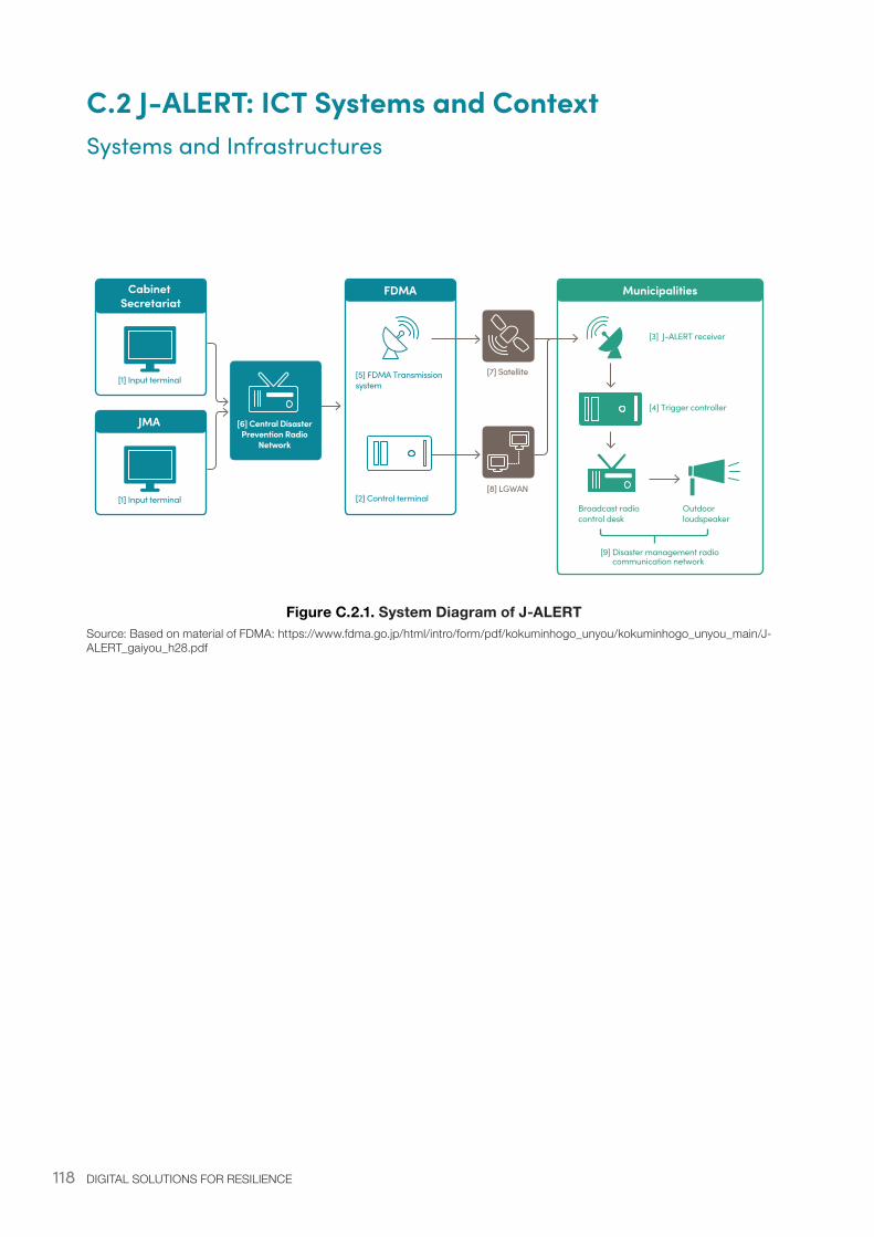
118 DIGITAL SOLUTIONS FOR RESILIENCE
C.2 J-ALERT: ICT Systems and ContextSystems and Infrastructures
Figure C.2.1. System Diagram of J-ALERTSource: Based on material of FDMA: https://www.fdma.go.jp/html/intro/form/pdf/kokuminhogo_unyou/kokuminhogo_unyou_main/J-ALERT_gaiyou_h28.pdf
Cabinet Secretariat
[1] Input terminal
JMA
FDMA Municipalities
[5] FDMA Transmission system
[2] Control terminal[1] Input terminal
[6] Central Disaster Prevention Radio
Network
[7] Satellite
[8] LGWAN
[3] J-ALERT receiver
Broadcast radio control desk
[4] Trigger controller
Outdoor loudspeaker
[9] Disaster management radio communication network
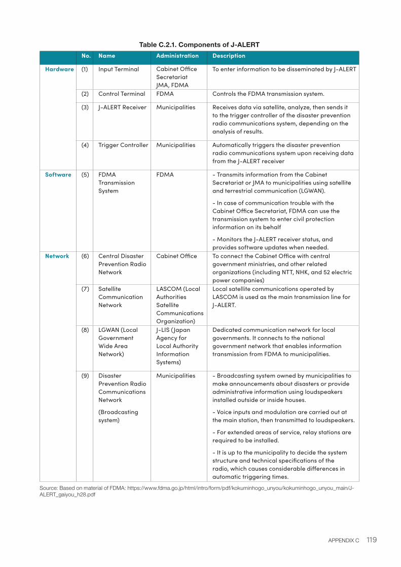
119APPENDIX C
Table C.2.1. Components of J-ALERT No. Name Administration Description
Hardware (1) Input Terminal Cabinet Office Secretariat JMA, FDMA
To enter information to be disseminated by J-ALERT
(2) Control Terminal FDMA Controls the FDMA transmission system.
(3) J-ALERT Receiver Municipalities Receives data via satellite, analyze, then sends it to the trigger controller of the disaster prevention radio communications system, depending on the analysis of results.
(4) Trigger Controller Municipalities Automatically triggers the disaster prevention radio communications system upon receiving data from the J-ALERT receiver
Software (5) FDMA Transmission System
FDMA - Transmits information from the Cabinet Secretariat or JMA to municipalities using satellite and terrestrial communication (LGWAN).
- In case of communication trouble with the Cabinet Office Secretariat, FDMA can use the transmission system to enter civil protection information on its behalf
- Monitors the J-ALERT receiver status, and provides software updates when needed.
Network (6) Central Disaster Prevention Radio Network
Cabinet Office To connect the Cabinet Office with central government ministries, and other related organizations (including NTT, NHK, and 52 electric power companies)
(7) Satellite Communication Network
LASCOM (Local Authorities Satellite Communications Organization)
Local satellite communications operated by LASCOM is used as the main transmission line for J-ALERT.
(8) LGWAN (Local Government Wide Area Network)
J-LIS (Japan Agency for Local Authority Information Systems)
Dedicated communication network for local governments. It connects to the national government network that enables information transmission from FDMA to municipalities.
(9) Disaster Prevention Radio Communications Network
(Broadcasting system)
Municipalities - Broadcasting system owned by municipalities to make announcements about disasters or provide administrative information using loudspeakers installed outside or inside houses.
- Voice inputs and modulation are carried out at the main station, then transmitted to loudspeakers.
- For extended areas of service, relay stations are required to be installed.
- It is up to the municipality to decide the system structure and technical specifications of the radio, which causes considerable differences in automatic triggering times.
Source: Based on material of FDMA: https://www.fdma.go.jp/html/intro/form/pdf/kokuminhogo_unyou/kokuminhogo_unyou_main/J-ALERT_gaiyou_h28.pdf
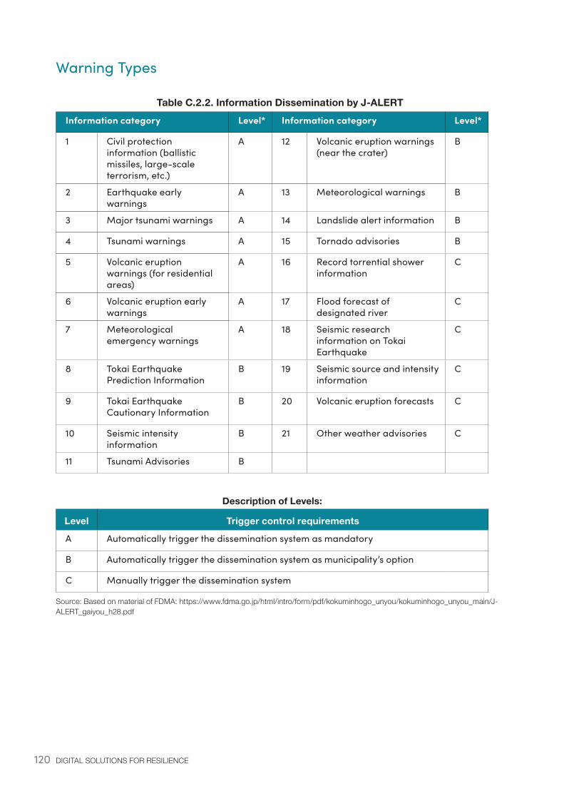
120 DIGITAL SOLUTIONS FOR RESILIENCE
Warning Types
Table C.2.2. Information Dissemination by J-ALERTInformation category Level* Information category Level*
1 Civil protection information (ballistic missiles, large-scale terrorism, etc.)
A 12 Volcanic eruption warnings (near the crater)
B
2 Earthquake early warnings
A 13 Meteorological warnings B
3 Major tsunami warnings A 14 Landslide alert information B
4 Tsunami warnings A 15 Tornado advisories B
5 Volcanic eruption warnings (for residential areas)
A 16 Record torrential shower information
C
6 Volcanic eruption early warnings
A 17 Flood forecast of designated river
C
7 Meteorological emergency warnings
A 18 Seismic research information on Tokai Earthquake
C
8 Tokai Earthquake Prediction Information
B 19 Seismic source and intensity information
C
9 Tokai Earthquake Cautionary Information
B 20 Volcanic eruption forecasts C
10 Seismic intensity information
B 21 Other weather advisories C
11 Tsunami Advisories B
Description of Levels:
Level Trigger control requirements
A Automatically trigger the dissemination system as mandatory
B Automatically trigger the dissemination system as municipality’s option
C Manually trigger the dissemination system
Source: Based on material of FDMA: https://www.fdma.go.jp/html/intro/form/pdf/kokuminhogo_unyou/kokuminhogo_unyou_main/J-ALERT_gaiyou_h28.pdf
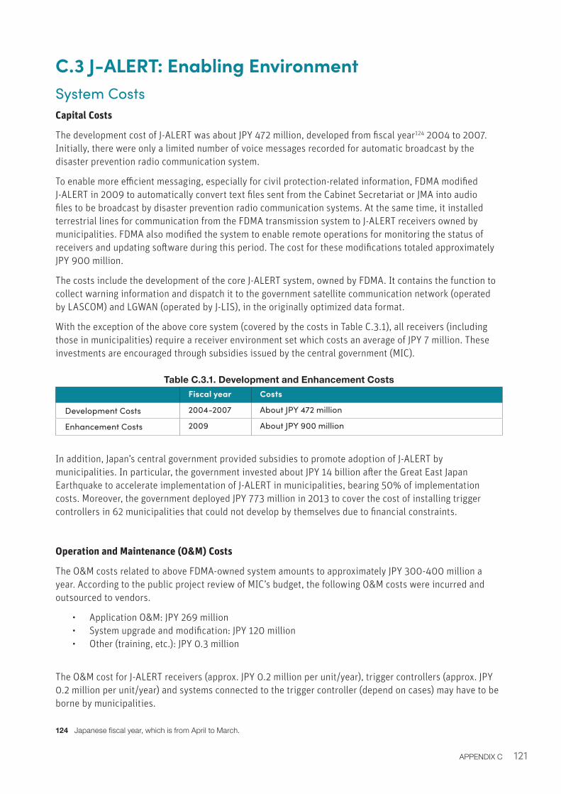
121APPENDIX C
C.3 J-ALERT: Enabling EnvironmentSystem CostsCapital Costs
The development cost of J-ALERT was about JPY 472 million, developed from fiscal year124 2004 to 2007. Initially, there were only a limited number of voice messages recorded for automatic broadcast by the disaster prevention radio communication system.
To enable more efficient messaging, especially for civil protection-related information, FDMA modified J-ALERT in 2009 to automatically convert text files sent from the Cabinet Secretariat or JMA into audio files to be broadcast by disaster prevention radio communication systems. At the same time, it installed terrestrial lines for communication from the FDMA transmission system to J-ALERT receivers owned by municipalities. FDMA also modified the system to enable remote operations for monitoring the status of receivers and updating software during this period. The cost for these modifications totaled approximately JPY 900 million.
The costs include the development of the core J-ALERT system, owned by FDMA. It contains the function to collect warning information and dispatch it to the government satellite communication network (operated by LASCOM) and LGWAN (operated by J-LIS), in the originally optimized data format.
With the exception of the above core system (covered by the costs in Table C.3.1), all receivers (including those in municipalities) require a receiver environment set which costs an average of JPY 7 million. These investments are encouraged through subsidies issued by the central government (MIC).
Table C.3.1. Development and Enhancement Costs Fiscal year Costs
Development Costs 2004-2007 About JPY 472 million
Enhancement Costs 2009 About JPY 900 million
In addition, Japan’s central government provided subsidies to promote adoption of J-ALERT by municipalities. In particular, the government invested about JPY 14 billion after the Great East Japan Earthquake to accelerate implementation of J-ALERT in municipalities, bearing 50% of implementation costs. Moreover, the government deployed JPY 773 million in 2013 to cover the cost of installing trigger controllers in 62 municipalities that could not develop by themselves due to financial constraints.
Operation and Maintenance (O&M) Costs
The O&M costs related to above FDMA-owned system amounts to approximately JPY 300-400 million a year. According to the public project review of MIC’s budget, the following O&M costs were incurred and outsourced to vendors.
• Application O&M: JPY 269 million• System upgrade and modification: JPY 120 million• Other (training, etc.): JPY 0.3 million
The O&M cost for J-ALERT receivers (approx. JPY 0.2 million per unit/year), trigger controllers (approx. JPY 0.2 million per unit/year) and systems connected to the trigger controller (depend on cases) may have to be borne by municipalities.
124 Japanese fiscal year, which is from April to March.
122 DIGITAL SOLUTIONS FOR RESILIENCE
Appendix D: Emergency Alert Mail (Cell Broadcast Early Warning System)D.1 Examples of Application During Disaster EventsResults from a post disaster survey conducted to analyze the effectiveness of the Alert service after the 2016 Kumamoto Earthquake highlighted that EAM was effective in delivering the earthquake early warning message to a large portion of the affected population, while further challenges remained to translate the warnings into protective measures and actions. The results showed that: 85.1% of residents first received information regarding earthquake early warnings via EAM; 52.1% reported that “the warning message from the Alert service helped them prepare for the tremors to come”; and 17.1% claimed that “it helped them take action to protect themselves.” (JMA, 2017).
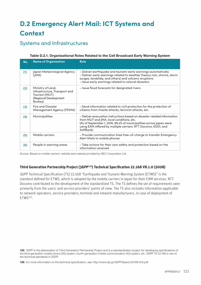
123APPENDIX D
D.2 Emergency Alert Mail: ICT Systems and ContextSystems and Infrastructures
Table D.2.1. Organizational Roles Related to the Cell Broadcast Early Warning System
No. Name of Organization Role
(1) Japan Meteorological Agency (JMA)
- Deliver earthquake and tsunami early warnings automatically- Deliver early warnings related to weather (heavy rain, storms, storm surges, landslide, and others) and volcanic eruptions- Issue early warnings related to natural disasters
(2) Ministry of Land, Infrastructure, Transport and Tourism (MLIT)(Regional Development Bureau)
- Issue flood forecasts for designated rivers
(3) Fire and Disaster Management Agency (FDMA)
- Send information related to civil protection for the protection of citizens from missile attacks, terrorist attacks, etc.
(4) Municipalities - Deliver evacuation instructions based on disaster-related information from MLIT and JMA, local conditions, etc.(As of September 1, 2016, 99.4% of municipalities across Japan were using EAM offered by multiple carriers: NTT Docomo, KDDI, and SoftBank)
(5) Mobile carriers - Provide communication lines free-of-charge to transfer Emergency Alert Mails to mobile phones
(6) People in warning areas - Take actions for their own safety and protection based on the information received
Source: Based on mobile carriers’ website and material provided by NEC Corporation Ltd.
Third Generation Partnership Project (3GPP125) Technical Specification 22.168 V8.1.0 (2008)
3GPP Technical Specification (TS) 22.168 “Earthquake and Tsunami Warning System (ETWS)” is the standard defined for ETWS, which is adopted by the mobile carriers in Japan for their EAM services. NTT Docomo contributed to the development of the standardized TS. The TS defines the set of requirements seen primarily from the users’ and service providers’ points of view. The TS also includes information applicable to network operators, service providers, terminal and network manufacturers, in case of deployment of ETWS126.
125 3GPP is the abbreviation of Third Generation Partnership Project and is a standardization project for developing specifications of the third-generation mobile phone (3G) system, fourth-generation mobile communication (4G) system, etc. 3GPP TS 22.168 is one of the technical standards in 3GPP.
126 For more information on the technical specification, see: http://www.qtc.jp/3GPP/Specs/22168-810.pdf
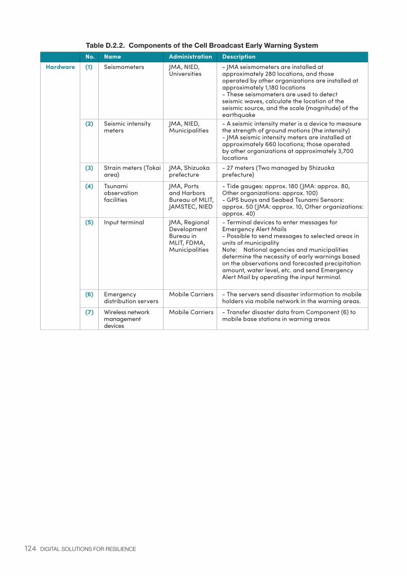
124 DIGITAL SOLUTIONS FOR RESILIENCE
Table D.2.2. Components of the Cell Broadcast Early Warning System No. Name Administration DescriptionHardware (1) Seismometers JMA, NIED,
Universities- JMA seismometers are installed at approximately 280 locations, and those operated by other organizations are installed at approximately 1,180 locations- These seismometers are used to detect seismic waves, calculate the location of the seismic source, and the scale (magnitude) of the earthquake
(2) Seismic intensity meters
JMA, NIED, Municipalities
- A seismic intensity meter is a device to measure the strength of ground motions (the intensity)- JMA seismic intensity meters are installed at approximately 660 locations; those operated by other organizations at approximately 3,700 locations
(3) Strain meters (Tokai area)
JMA, Shizuoka prefecture
- 27 meters (Two managed by Shizuoka prefecture)
(4) Tsunami observation facilities
JMA, Ports and Harbors Bureau of MLIT, JAMSTEC, NIED
- Tide gauges: approx. 180 (JMA: approx. 80, Other organizations: approx. 100)- GPS buoys and Seabed Tsunami Sensors: approx. 50 (JMA: approx. 10, Other organizations: approx. 40)
(5) Input terminal JMA, Regional Development Bureau in MLIT, FDMA, Municipalities
- Terminal devices to enter messages for Emergency Alert Mails- Possible to send messages to selected areas in units of municipalityNote: National agencies and municipalities determine the necessity of early warnings based on the observations and forecasted precipitation amount, water level, etc. and send Emergency Alert Mail by operating the input terminal.
(6) Emergency distribution servers
Mobile Carriers - The servers send disaster information to mobile holders via mobile network in the warning areas.
(7) Wireless network management devices
Mobile Carriers - Transfer disaster data from Component (6) to mobile base stations in warning areas
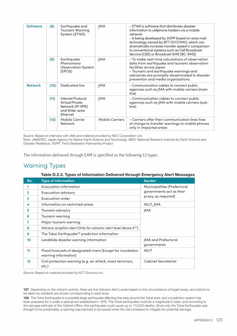
125APPENDIX D
Software (8) Earthquake and Tsunami Warning System (ETWS)
JMA - ETWS is software that distributes disaster information to cellphone holders via a mobile network- Is being developed by 3GPP based on area mail technology owned by NTT DOCOMO, which can dramatically increase transfer speed in comparison to conventional systems such as Cell Broadcast Service (CBS) or Broadcast SMS (BC-SMS)
(9) Earthquake Phenomena Observation System (EPOS)
JMA - To make real-time calculations of observation data from earthquake and tsunami observation facilities across Japan- Tsunami and earthquake warnings and advisories are promptly disseminated to disaster prevention and media organizations.
Network (10) Dedicated line JMA - Communication cables to connect public agencies such as JMA with mobile carriers (main line)
(11) Internet Protocol Virtual Private Network (IP-VPN) and Wide-area Ethernet
JMA - Communication cables to connect public agencies such as JMA with mobile carriers (sub-line)
(12) Mobile Carrier Network
Mobile Carriers - Carriers offer their communication lines free of charge to transfer warnings to mobile phones only in impacted areas
Source: Based on interview with JMA and material provided by NEC Corporation Ltd. Note: JAMSTEC: Japan Agency for Marine-Earth Science and Technology, NIED: National Research Institute for Earth Science and Disaster Resilience, 3GPP: Third Generation Partnership Project
The information delivered through EAM is specified as the following 12 types.
Warning TypesTable D.2.3. Types of Information Delivered through Emergency Alert Messages
No. Type of information Sender1 Evacuation information Municipalities (Prefectural
governments act as their proxy, as required)
2 Evacuation advisory3 Evacuation order4 Information on restricted areas MLIT, JMA5 Tsunami advisory JMA
6 Tsunami warning7 Major tsunami warning8 Volcanic eruption alert (Only for volcanic alert level above 4127)9 The Tokai Earthquake128 prediction information 10 Landslide disaster warning information JMA and Prefectural
governments11 Flood forecasts of designated rivers (Except for inundation
warning information)MLIT
12 Civil protection warning (e.g. air attack, mass terrorism, etc.)
Cabinet Secretariat
Source: Based on material provided by NTT Docomo Inc.
127 Depending on the volcanic activity, there are five Volcanic Alert Levels based on the circumstance of target areas, and actions to be taken by residents are shown corresponding to each level. 128 The Tokai Earthquake is a possible large earthquake affecting the area around the Tokai area, and a prediction system has been prepared for it under a special act established in 1978. The Tokai earthquake could be a magnitude 8 class, and according to the damage estimate of the Cabinet Office, this earthquake could cause up to 110,000 deaths. Since only the Tokai Earthquake was thought to be predictable, a warning was planned to be issued when the risk increased to mitigate the potential damage.
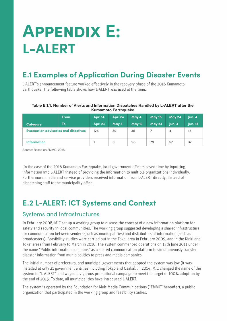
126 DIGITAL SOLUTIONS FOR RESILIENCE
Appendix E: L-ALERT E.1 Examples of Application During Disaster EventsL-ALERT’s announcement feature worked effectively in the recovery phase of the 2016 Kumamoto Earthquake. The following table shows how L-ALERT was used at the time.
Table E.1.1. Number of Alerts and Information Dispatches Handled by L-ALERT after the Kumamoto Earthquake
Category
From
To
Apr. 14
Apr. 23
Apr. 24
May 3
May 4
May 13
May 15
May 23
May 24
Jun. 3
Jun. 4
Jun. 13
Evacuation advisories and directives 126 39 35 7 4 12
Information 1 0 98 79 57 37
Source: Based on FMMC, 2016.
In the case of the 2016 Kumamoto Earthquake, local government officers saved time by inputting information into L-ALERT instead of providing the information to multiple organizations individually. Furthermore, media and service providers received information from L-ALERT directly, instead of dispatching staff to the municipality office.
E.2 L-ALERT: ICT Systems and ContextSystems and Infrastructures In February 2008, MIC set up a working group to discuss the concept of a new information platform for safety and security in local communities. The working group suggested developing a shared infrastructure for communication between senders (such as municipalities) and distributors of information (such as broadcasters). Feasibility studies were carried out in the Tokai area in February 2009, and in the Kinki and Tokai areas from February to March in 2010. The system commenced operations on 13th June 2011 under the name “Public information commons” as a shared communication platform to simultaneously transfer disaster information from municipalities to press and media companies.
The initial number of prefectural and municipal governments that adopted the system was low (it was installed at only 21 government entities including Tokyo and Osaka). In 2014, MIC changed the name of the system to “L-ALERT” and waged a vigorous promotional campaign to meet the target of 100% adoption by the end of 2015. To date, all municipalities have introduced L-ALERT.
The system is operated by the Foundation for MultiMedia Communications (“FMMC” hereafter), a public organization that participated in the working group and feasibility studies.
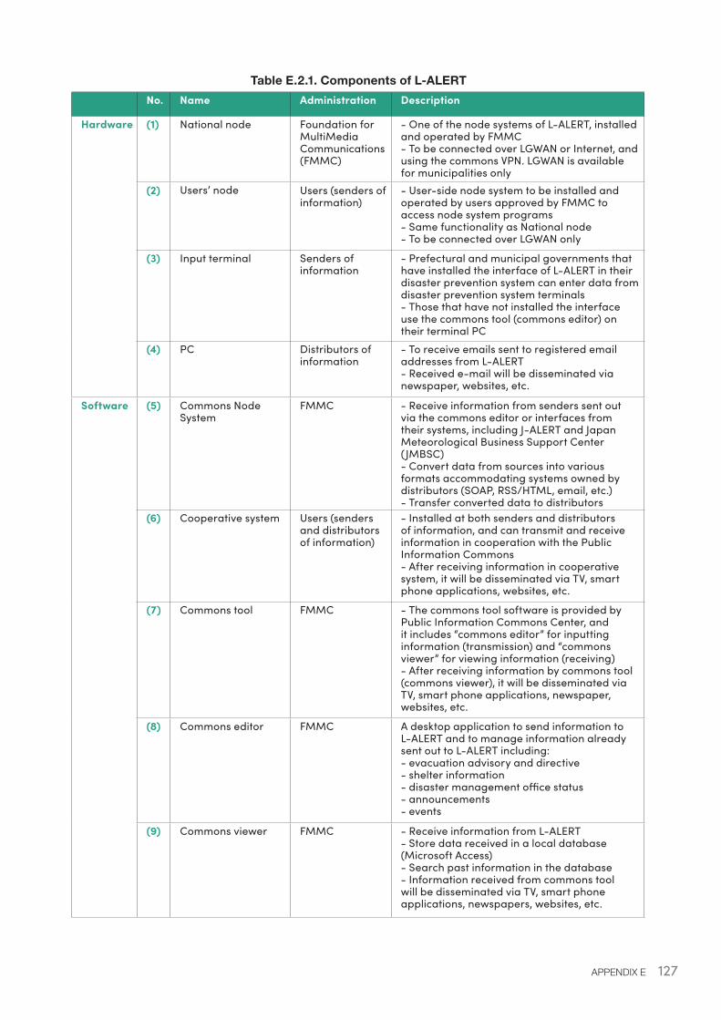
127APPENDIX E
Table E.2.1. Components of L-ALERT No. Name Administration Description
Hardware (1) National node Foundation for MultiMedia Communications (FMMC)
- One of the node systems of L-ALERT, installed and operated by FMMC- To be connected over LGWAN or Internet, and using the commons VPN. LGWAN is available for municipalities only
(2) Users’ node Users (senders of information)
- User-side node system to be installed and operated by users approved by FMMC to access node system programs- Same functionality as National node- To be connected over LGWAN only
(3) Input terminal Senders of information
- Prefectural and municipal governments that have installed the interface of L-ALERT in their disaster prevention system can enter data from disaster prevention system terminals- Those that have not installed the interface use the commons tool (commons editor) on their terminal PC
(4) PC Distributors of information
- To receive emails sent to registered email addresses from L-ALERT- Received e-mail will be disseminated via newspaper, websites, etc.
Software (5) Commons Node System
FMMC - Receive information from senders sent out via the commons editor or interfaces from their systems, including J-ALERT and Japan Meteorological Business Support Center (JMBSC)- Convert data from sources into various formats accommodating systems owned by distributors (SOAP, RSS/HTML, email, etc.)- Transfer converted data to distributors
(6) Cooperative system Users (senders and distributors of information)
- Installed at both senders and distributors of information, and can transmit and receive information in cooperation with the Public Information Commons- After receiving information in cooperative system, it will be disseminated via TV, smart phone applications, websites, etc.
(7) Commons tool FMMC
- The commons tool software is provided by Public Information Commons Center, and it includes “commons editor” for inputting information (transmission) and “commons viewer” for viewing information (receiving)- After receiving information by commons tool (commons viewer), it will be disseminated via TV, smart phone applications, newspaper, websites, etc.
(8) Commons editor FMMC A desktop application to send information to L-ALERT and to manage information already sent out to L-ALERT including:- evacuation advisory and directive- shelter information- disaster management office status- announcements- events
(9) Commons viewer FMMC - Receive information from L-ALERT- Store data received in a local database (Microsoft Access)- Search past information in the database- Information received from commons tool will be disseminated via TV, smart phone applications, newspapers, websites, etc.
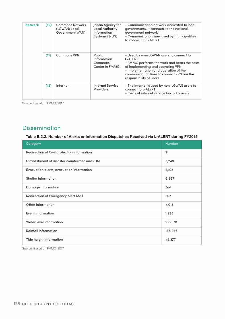
128 DIGITAL SOLUTIONS FOR RESILIENCE
Network (10) Commons Network (LGWAN; Local Government WAN)
Japan Agency for Local Authority Information Systems (J-LIS)
- Communication network dedicated to local governments. It connects to the national government network- Communication lines used by municipalities to connect to L-ALERT
(11) Commons VPN Public Information Commons Center in FMMC
- Used by non-LGWAN users to connect to L-ALERT- FMMC performs the work and bears the costs of implementing and operating VPN- Implementation and operation of the communication lines to connect VPN are the responsibility of users
(12) Internet Internet Service Providers
- The Internet is used by non-LGWAN users to connect to L-ALERT- Costs of internet service borne by users
Source: Based on FMMC, 2017
DisseminationTable E.2.2. Number of Alerts or Information Dispatches Received via L-ALERT during FY2015
Category Number
Redirection of Civil protection information 2
Establishment of disaster countermeasures HQ 3,248
Evacuation alerts, evacuation information 2,102
Shelter information 6,967
Damage information 744
Redirection of Emergency Alert Mail 202
Other information 4,013
Event information 1,290
Water level information 158,370
Rainfall information 158,366
Tide height information 49,377
Source: Based on FMMC, 2017
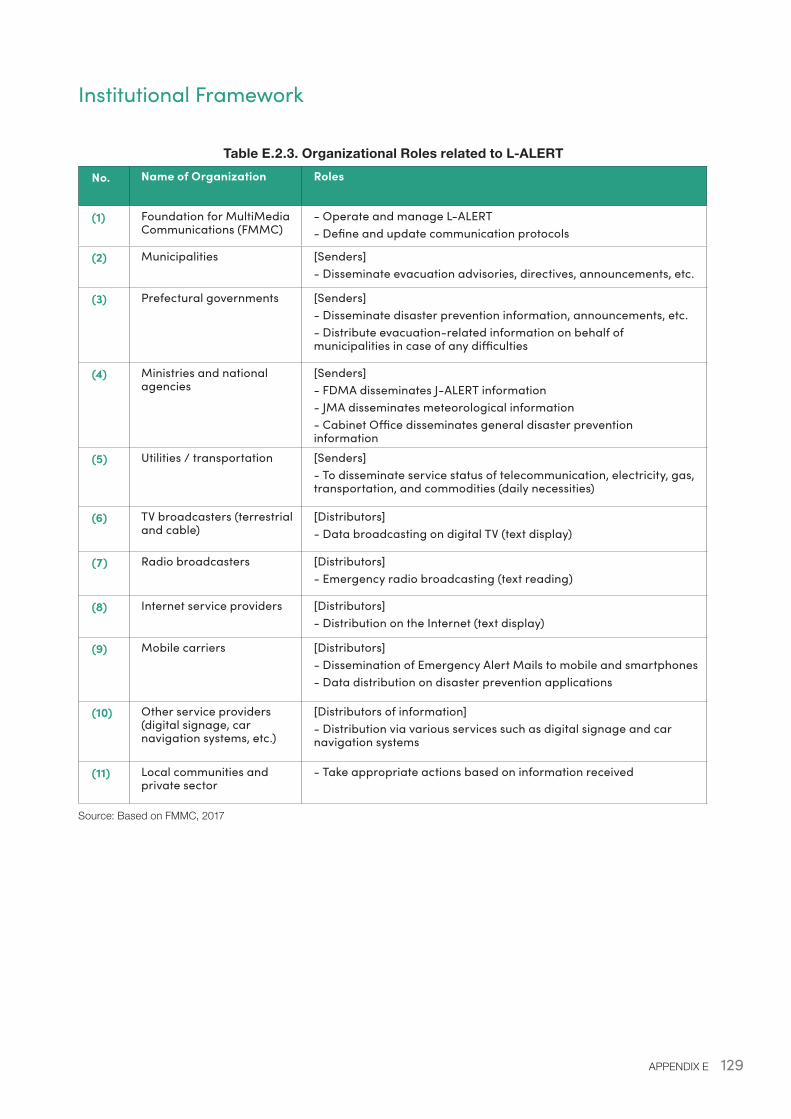
129APPENDIX E
Institutional Framework
Table E.2.3. Organizational Roles related to L-ALERT
No. Name of Organization Roles
(1) Foundation for MultiMedia Communications (FMMC)
- Operate and manage L-ALERT- Define and update communication protocols
(2) Municipalities [Senders]- Disseminate evacuation advisories, directives, announcements, etc.
(3) Prefectural governments [Senders]- Disseminate disaster prevention information, announcements, etc.- Distribute evacuation-related information on behalf of municipalities in case of any difficulties
(4) Ministries and national agencies
[Senders]- FDMA disseminates J-ALERT information- JMA disseminates meteorological information- Cabinet Office disseminates general disaster prevention information
(5) Utilities / transportation [Senders]- To disseminate service status of telecommunication, electricity, gas, transportation, and commodities (daily necessities)
(6) TV broadcasters (terrestrial and cable)
[Distributors]- Data broadcasting on digital TV (text display)
(7) Radio broadcasters [Distributors]- Emergency radio broadcasting (text reading)
(8) Internet service providers [Distributors]- Distribution on the Internet (text display)
(9) Mobile carriers [Distributors]- Dissemination of Emergency Alert Mails to mobile and smartphones- Data distribution on disaster prevention applications
(10) Other service providers (digital signage, car navigation systems, etc.)
[Distributors of information]- Distribution via various services such as digital signage and car navigation systems
(11) Local communities and private sector
- Take appropriate actions based on information received
Source: Based on FMMC, 2017
130 DIGITAL SOLUTIONS FOR RESILIENCE
Appendix F: GIS-based Disaster Management Information System F.1 Examples of Application During Disaster EventsIn the wake of several major disasters, Helicopter Satellite Communication Systems have been deployed to collect important information of the impacted areas.
The Disaster Damage Map has been used to provide visual information such as aerial photographs of the Hiroshima landslide disaster (2014), which was the first case of its use, as well as the volcanic eruption of Kuchinoerabu-jima (2015), the Kanto/Tohoku heavy rains (2015) and the Kumamoto earthquake (2016). At the time of the Kumamoto earthquake, just three days after the earthquake on 17th April, images before and after the disaster were developed. The Disaster Damage Map helped not only to compare images pre and post-disaster, but also to grasp the extent and scope of building damage, as red frames on the map outline the shapes of buildings.
To date, no municipality that has signed the disaster agreement has been hit by a disaster in which crisis mapping has been used. One nonprofit organization created crisis maps by using drones in the aftermath of the Kumamoto Earthquake.
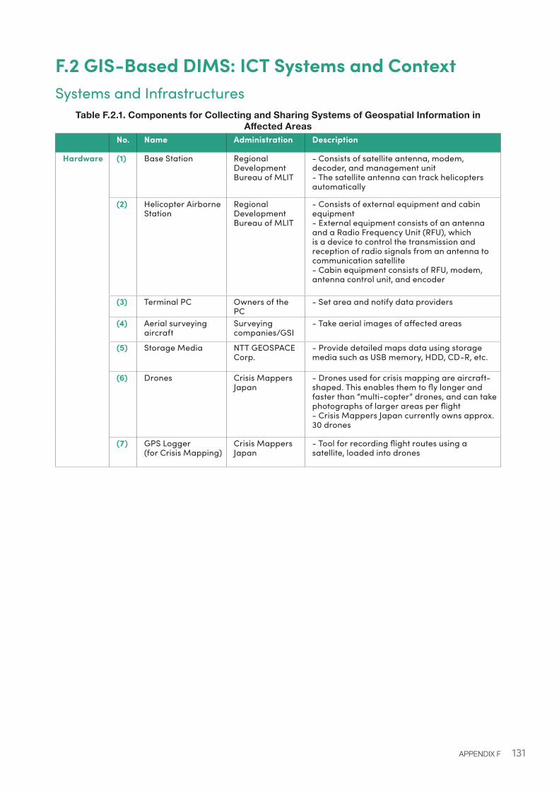
131APPENDIX F
F.2 GIS-Based DIMS: ICT Systems and ContextSystems and Infrastructures
Table F.2.1. Components for Collecting and Sharing Systems of Geospatial Information in Affected Areas
No. Name Administration Description
Hardware (1) Base Station Regional Development Bureau of MLIT
- Consists of satellite antenna, modem, decoder, and management unit- The satellite antenna can track helicopters automatically
(2) Helicopter Airborne Station
Regional Development Bureau of MLIT
- Consists of external equipment and cabin equipment- External equipment consists of an antenna and a Radio Frequency Unit (RFU), which is a device to control the transmission and reception of radio signals from an antenna to communication satellite- Cabin equipment consists of RFU, modem, antenna control unit, and encoder
(3) Terminal PC Owners of the PC
- Set area and notify data providers
(4) Aerial surveying aircraft
Surveying companies/GSI
- Take aerial images of affected areas
(5) Storage Media NTT GEOSPACE Corp.
- Provide detailed maps data using storage media such as USB memory, HDD, CD-R, etc.
(6) Drones Crisis Mappers Japan
- Drones used for crisis mapping are aircraft-shaped. This enables them to fly longer and faster than “multi-copter” drones, and can take photographs of larger areas per flight- Crisis Mappers Japan currently owns approx. 30 drones
(7) GPS Logger(for Crisis Mapping)
Crisis Mappers Japan
- Tool for recording flight routes using a satellite, loaded into drones
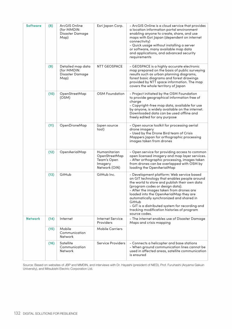
132 DIGITAL SOLUTIONS FOR RESILIENCE
Software (8) ArcGIS Online(for MMDIN: Disaster Damage Map)
Esri Japan Corp. - ArcGIS Online is a cloud service that provides a location information portal environment enabling anyone to create, share, and use maps with Esri Japan (dependent on internet connectivity)- Quick usage without installing a server or software, many available map data and applications, and advanced security requirements
(9) Detailed map data(for MMDIN: Disaster Damage Map)
NTT GEOSPACE - GEOSPACE is a highly accurate electronic map prepared on the basis of public surveying results such as urban planning diagrams, forest basic diagrams and forest drawings provided by NTT space information. The map covers the whole territory of Japan
(10) OpenStreetMap (OSM)
OSM Foundation - Project initiated by the OSM Foundation to provide geographical information free of charge- Copyright-free map data, available for use by anyone, is widely available on the internet. Downloaded data can be used offline and freely edited for any purpose
(11) OpenDroneMap (open source tool)
- Open source toolkit for processing aerial drone imagery- Used by the Drone Bird team of Crisis Mappers Japan for orthographic processing images taken from drones
(12) OpenAerialMap Humanitarian OpenStreetMap Team’s Open Imagery Network (OIN)
- Open service for providing access to common open licensed imagery and map layer services. - After orthographic processing, images taken from drones can be overlapped with OSM by loading the OpenAerialMap
(13) GitHub GitHub Inc. - Development platform: Web service based on GIT technology that enables people around the world to store and publish their own data (program codes or design data).- After the images taken from drones are loaded into the OpenAerialMap they are automatically synchronized and shared in GitHub- GIT is a distributed system for recording and tracking modification histories of program source codes.
Network (14) Internet Internet Service Providers
- The internet enables use of Disaster Damage Maps and crisis mapping
(15) Mobile Communication Network
Mobile Carriers
(16) Satellite Communication Network
Service Providers - Connects a helicopter and base stations- When ground communication lines cannot be used in affected areas, satellite communication is ensured
Source: Based on websites of JBP and MMDIN, and interviews with Dr. Hayashi (president of NIED), Prof. Furuhashi (Aoyama Gakuin University), and Mitsubishi Electric Corporation Ltd.
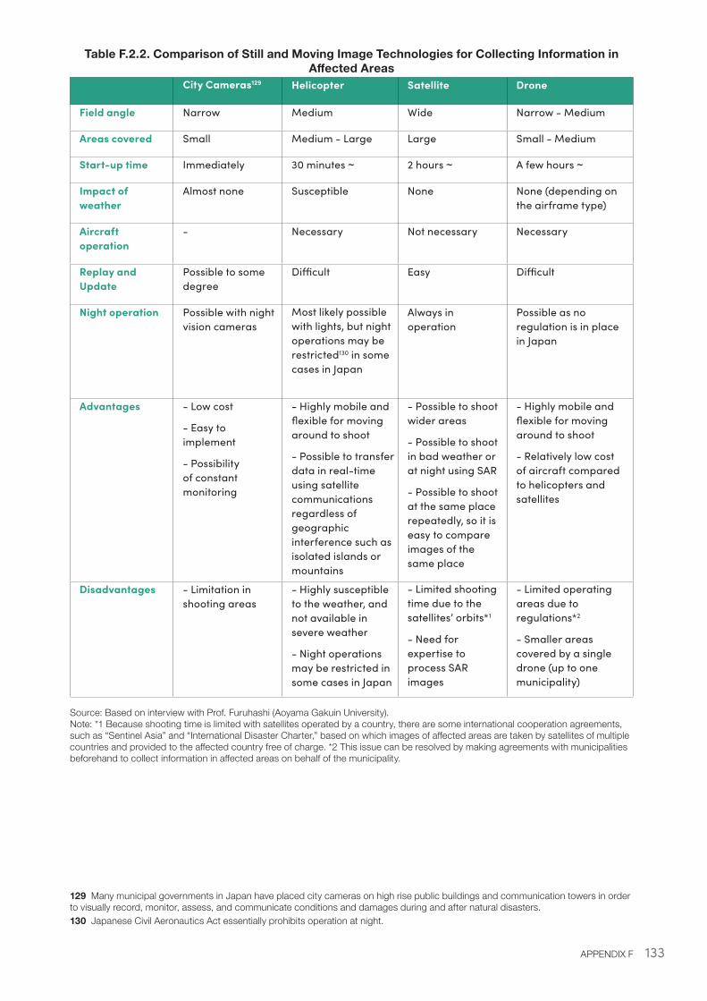
133APPENDIX F
Table F.2.2. Comparison of Still and Moving Image Technologies for Collecting Information in Affected Areas
City Cameras129 Helicopter Satellite Drone
Field angle Narrow Medium Wide Narrow - Medium
Areas covered Small Medium - Large Large Small - Medium
Start-up time Immediately 30 minutes ~ 2 hours ~ A few hours ~
Impact of weather
Almost none Susceptible None None (depending on the airframe type)
Aircraft operation
- Necessary Not necessary Necessary
Replay and Update
Possible to some degree
Difficult Easy Difficult
Night operation Possible with night vision cameras
Most likely possible with lights, but night operations may be restricted130 in some cases in Japan
Always in operation
Possible as no regulation is in place in Japan
Advantages - Low cost
- Easy to implement
- Possibility of constant monitoring
- Highly mobile and flexible for moving around to shoot
- Possible to transfer data in real-time using satellite communications regardless of geographic interference such as isolated islands or mountains
- Possible to shoot wider areas
- Possible to shoot in bad weather or at night using SAR
- Possible to shoot at the same place repeatedly, so it is easy to compare images of the same place
- Highly mobile and flexible for moving around to shoot
- Relatively low cost of aircraft compared to helicopters and satellites
Disadvantages - Limitation in shooting areas
- Highly susceptible to the weather, and not available in severe weather
- Night operations may be restricted in some cases in Japan
- Limited shooting time due to the satellites’ orbits*1
- Need for expertise to process SAR images
- Limited operating areas due to regulations*2
- Smaller areas covered by a single drone (up to one municipality)
Source: Based on interview with Prof. Furuhashi (Aoyama Gakuin University). Note: *1 Because shooting time is limited with satellites operated by a country, there are some international cooperation agreements, such as “Sentinel Asia” and “International Disaster Charter,” based on which images of affected areas are taken by satellites of multiple countries and provided to the affected country free of charge. *2 This issue can be resolved by making agreements with municipalities beforehand to collect information in affected areas on behalf of the municipality.
129 Many municipal governments in Japan have placed city cameras on high rise public buildings and communication towers in order to visually record, monitor, assess, and communicate conditions and damages during and after natural disasters.130 Japanese Civil Aeronautics Act essentially prohibits operation at night.
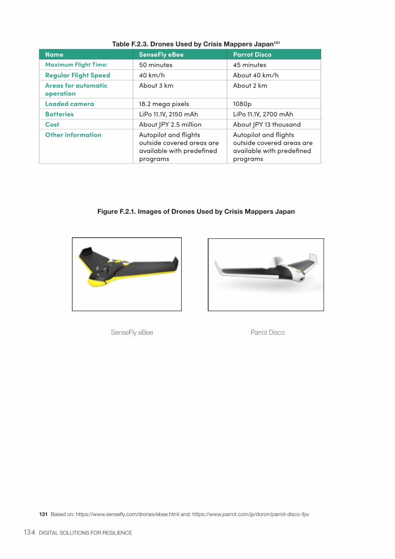
134 DIGITAL SOLUTIONS FOR RESILIENCE
Table F.2.3. Drones Used by Crisis Mappers Japan131
Name SenseFly eBee Parrot DiscoMaximum Flight Time: 50 minutes 45 minutesRegular Flight Speed 40 km/h About 40 km/hAreas for automatic operation
About 3 km About 2 km
Loaded camera 18.2 mega pixels 1080pBatteries LiPo 11.1V, 2150 mAh LiPo 11.1V, 2700 mAhCost About JPY 2.5 million About JPY 13 thousand Other information Autopilot and flights
outside covered areas are available with predefined programs
Autopilot and flights outside covered areas are available with predefined programs
Figure F.2.1. Images of Drones Used by Crisis Mappers Japan
SenseFly eBee Parrot Disco
131 Based on: https://www.sensefly.com/drones/ebee.html and; https://www.parrot.com/jp/doron/parrot-disco-fpv
135APPENDIX F
Institutional Framework Table F.2.4. Municipalities with Agreements with Crisis Mappers Japan
Municipality, Date of agreement
Name of agreement
Description
Yamato City, Kanagawa Prefecture.20th September 2016
Agreement on investigations and support in Yamato City at the time of a disaster
To use drones to assess damage, such as the collapse of roads and other structures.
Chofu City and Komae City, Tokyo.31th March 2017
Agreement on assistance using drones at the time of a disaster
In the event of a large-scale disaster in Chofu City or Komae City, for which urgent assistance is needed, Crisis Mappers conducts the following activities based on the government’s requests:- Damage assessments using drones- Provision of photographic images taken by drones- Generation of Disaster Damage Maps based on image data obtained- Provision of Disaster Damage Maps, and release of map data on the Internet
Source: Based on the websites of Yamato City (Kanagawa Prefecture), and Chofu City and Komae City (Tokyo).
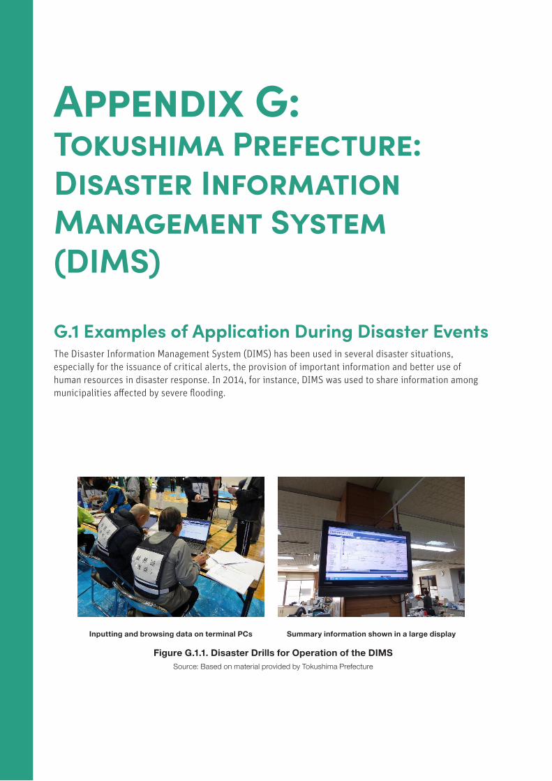
136 DIGITAL SOLUTIONS FOR RESILIENCE
Appendix G: Tokushima Prefecture: Disaster Information Management System (DIMS)
G.1 Examples of Application During Disaster EventsThe Disaster Information Management System (DIMS) has been used in several disaster situations, especially for the issuance of critical alerts, the provision of important information and better use of human resources in disaster response. In 2014, for instance, DIMS was used to share information among municipalities affected by severe flooding.
Inputting and browsing data on terminal PCs Summary information shown in a large display
Figure G.1.1. Disaster Drills for Operation of the DIMSSource: Based on material provided by Tokushima Prefecture
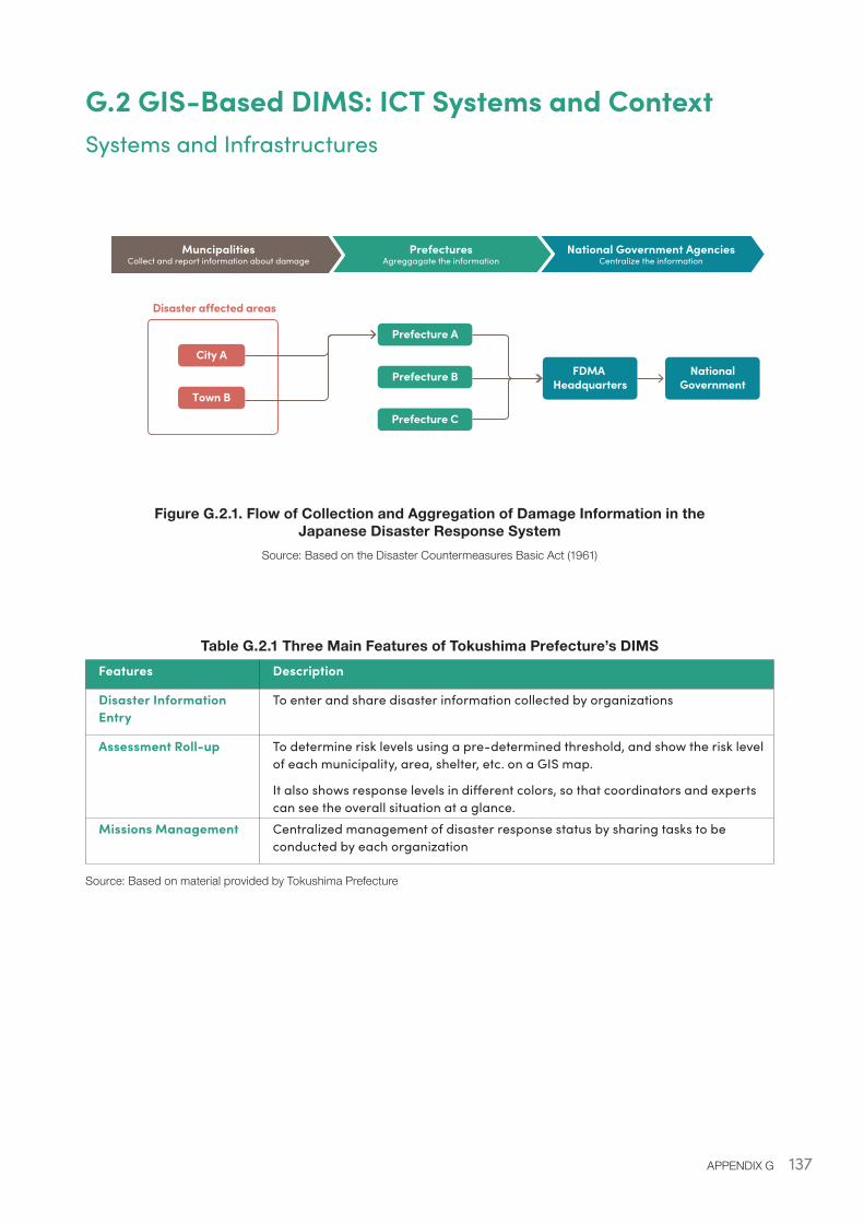
137APPENDIX G
G.2 GIS-Based DIMS: ICT Systems and ContextSystems and Infrastructures
Figure G.2.1. Flow of Collection and Aggregation of Damage Information in the Japanese Disaster Response System
Source: Based on the Disaster Countermeasures Basic Act (1961)
Table G.2.1 Three Main Features of Tokushima Prefecture’s DIMS Features Description
Disaster Information Entry
To enter and share disaster information collected by organizations
Assessment Roll-up To determine risk levels using a pre-determined threshold, and show the risk level of each municipality, area, shelter, etc. on a GIS map.
It also shows response levels in different colors, so that coordinators and experts can see the overall situation at a glance.
Missions Management Centralized management of disaster response status by sharing tasks to be conducted by each organization
Source: Based on material provided by Tokushima Prefecture
MuncipalitiesCollect and report information about damage
PrefecturesAgreggagate the information
National Government AgenciesCentralize the informationOSM
Disaster a�ected areas
City A
Prefecture A
Prefecture B FDMA Headquarters
NationalGovernment
Prefecture C
Town B
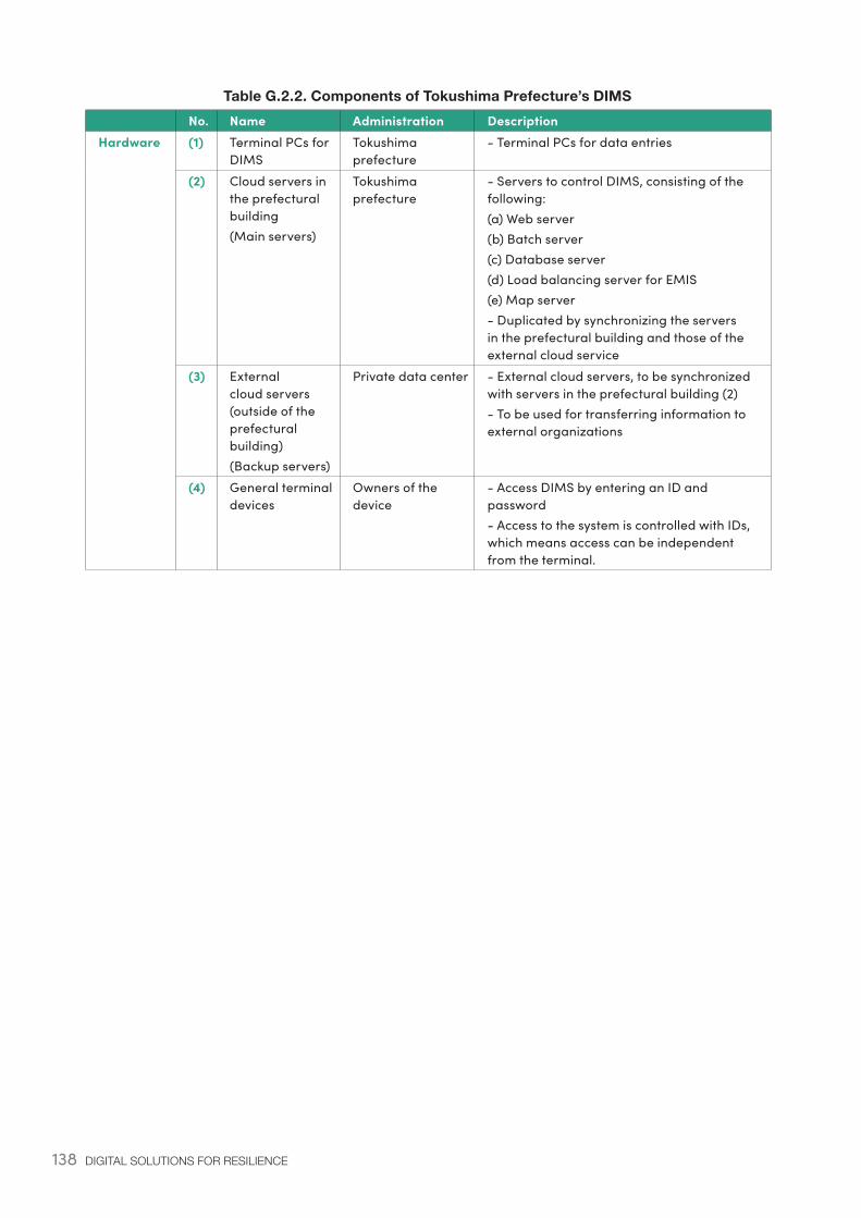
138 DIGITAL SOLUTIONS FOR RESILIENCE
Table G.2.2. Components of Tokushima Prefecture’s DIMS No. Name Administration DescriptionHardware (1) Terminal PCs for
DIMSTokushima prefecture
- Terminal PCs for data entries
(2) Cloud servers in the prefectural building(Main servers)
Tokushima prefecture
- Servers to control DIMS, consisting of the following:(a) Web server(b) Batch server(c) Database server(d) Load balancing server for EMIS(e) Map server- Duplicated by synchronizing the servers in the prefectural building and those of the external cloud service
(3) External cloud servers (outside of the prefectural building)(Backup servers)
Private data center - External cloud servers, to be synchronized with servers in the prefectural building (2)- To be used for transferring information to external organizations
(4) General terminal devices
Owners of the device
- Access DIMS by entering an ID and password- Access to the system is controlled with IDs, which means access can be independent from the terminal.
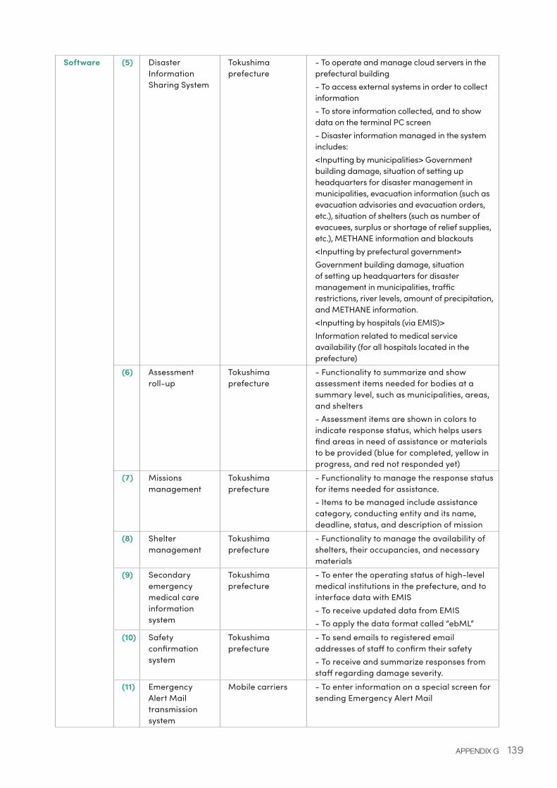
139APPENDIX G
Software (5) Disaster Information Sharing System
Tokushima prefecture
- To operate and manage cloud servers in the prefectural building- To access external systems in order to collect information- To store information collected, and to show data on the terminal PC screen- Disaster information managed in the system includes:<Inputting by municipalities> Government building damage, situation of setting up headquarters for disaster management in municipalities, evacuation information (such as evacuation advisories and evacuation orders, etc.), situation of shelters (such as number of evacuees, surplus or shortage of relief supplies, etc.), METHANE information and blackouts<Inputting by prefectural government>Government building damage, situation of setting up headquarters for disaster management in municipalities, traffic restrictions, river levels, amount of precipitation, and METHANE information.<Inputting by hospitals (via EMIS)>Information related to medical service availability (for all hospitals located in the prefecture)
(6) Assessment roll-up
Tokushima prefecture
- Functionality to summarize and show assessment items needed for bodies at a summary level, such as municipalities, areas, and shelters- Assessment items are shown in colors to indicate response status, which helps users find areas in need of assistance or materials to be provided (blue for completed, yellow in progress, and red not responded yet)
(7) Missions management
Tokushima prefecture
- Functionality to manage the response status for items needed for assistance.- Items to be managed include assistance category, conducting entity and its name, deadline, status, and description of mission
(8) Shelter management
Tokushima prefecture
- Functionality to manage the availability of shelters, their occupancies, and necessary materials
(9) Secondary emergency medical care information system
Tokushima prefecture
- To enter the operating status of high-level medical institutions in the prefecture, and to interface data with EMIS- To receive updated data from EMIS- To apply the data format called “ebML”
(10) Safety confirmation system
Tokushima prefecture
- To send emails to registered email addresses of staff to confirm their safety- To receive and summarize responses from staff regarding damage severity.
(11) Emergency Alert Mail transmission system
Mobile carriers - To enter information on a special screen for sending Emergency Alert Mail
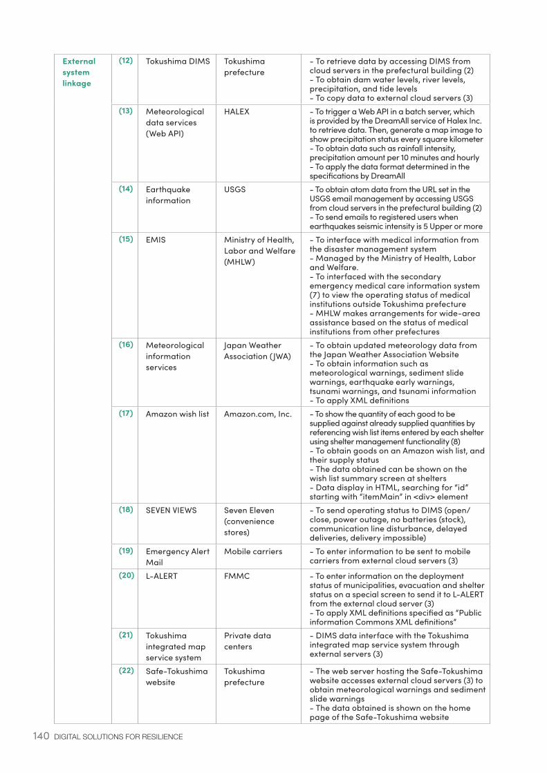
140 DIGITAL SOLUTIONS FOR RESILIENCE
External system linkage
(12) Tokushima DIMS Tokushima prefecture
- To retrieve data by accessing DIMS from cloud servers in the prefectural building (2)- To obtain dam water levels, river levels, precipitation, and tide levels- To copy data to external cloud servers (3)
(13) Meteorological data services (Web API)
HALEX - To trigger a Web API in a batch server, which is provided by the DreamAll service of Halex Inc. to retrieve data. Then, generate a map image to show precipitation status every square kilometer- To obtain data such as rainfall intensity, precipitation amount per 10 minutes and hourly- To apply the data format determined in the specifications by DreamAll
(14) Earthquake information
USGS - To obtain atom data from the URL set in the USGS email management by accessing USGS from cloud servers in the prefectural building (2)- To send emails to registered users when earthquakes seismic intensity is 5 Upper or more
(15) EMIS Ministry of Health, Labor and Welfare (MHLW)
- To interface with medical information from the disaster management system- Managed by the Ministry of Health, Labor and Welfare.- To interfaced with the secondary emergency medical care information system (7) to view the operating status of medical institutions outside Tokushima prefecture- MHLW makes arrangements for wide-area assistance based on the status of medical institutions from other prefectures
(16) Meteorological information services
Japan Weather Association (JWA)
- To obtain updated meteorology data from the Japan Weather Association Website- To obtain information such as meteorological warnings, sediment slide warnings, earthquake early warnings, tsunami warnings, and tsunami information- To apply XML definitions
(17) Amazon wish list Amazon.com, Inc. - To show the quantity of each good to be supplied against already supplied quantities by referencing wish list items entered by each shelter using shelter management functionality (8)- To obtain goods on an Amazon wish list, and their supply status- The data obtained can be shown on the wish list summary screen at shelters- Data display in HTML, searching for “id” starting with “itemMain” in <div> element
(18) SEVEN VIEWS Seven Eleven (convenience stores)
- To send operating status to DIMS (open/close, power outage, no batteries (stock), communication line disturbance, delayed deliveries, delivery impossible)
(19) Emergency Alert Mail
Mobile carriers - To enter information to be sent to mobile carriers from external cloud servers (3)
(20) L-ALERT FMMC - To enter information on the deployment status of municipalities, evacuation and shelter status on a special screen to send it to L-ALERT from the external cloud server (3)- To apply XML definitions specified as “Public information Commons XML definitions”
(21) Tokushima integrated map service system
Private data centers
- DIMS data interface with the Tokushima integrated map service system through external servers (3)
(22) Safe-Tokushima website
Tokushima prefecture
- The web server hosting the Safe-Tokushima website accesses external cloud servers (3) to obtain meteorological warnings and sediment slide warnings- The data obtained is shown on the home page of the Safe-Tokushima website
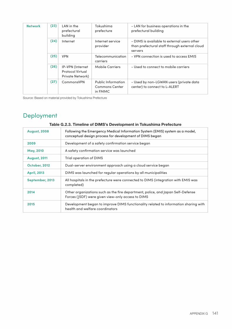
141APPENDIX G
Network (23) LAN in the prefectural building
Tokushima prefecture
- LAN for business operations in the prefectural building
(24) Internet Internet service provider
- DIMS is available to external users other than prefectural staff through external cloud servers
(25) VPN Telecommunication carriers
- VPN connection is used to access EMIS
(26) IP-VPN (Internet Protocol Virtual Private Network)
Mobile Carriers - Used to connect to mobile carriers
(27) CommonsVPN Public Information Commons Center in FMMC
- Used by non-LGWAN users (private data center) to connect to L-ALERT
Source: Based on material provided by Tokushima Prefecture
DeploymentTable G.2.3. Timeline of DIMS’s Development in Tokushima Prefecture
August, 2008 Following the Emergency Medical Information System (EMIS) system as a model, conceptual design process for development of DIMS began
2009 Development of a safety confirmation service began
May, 2010 A safety confirmation service was launched
August, 2011 Trial operation of DIMS
October, 2012 Dual-server environment approach using a cloud service began
April, 2013 DIMS was launched for regular operations by all municipalities
September, 2013 All hospitals in the prefecture were connected to DIMS (integration with EMIS was completed)
2014 Other organizations such as the fire department, police, and Japan Self-Defense Forces (JSDF) were given view-only access to DIMS
2015 Development began to improve DIMS functionality related to information sharing with health and welfare coordinators
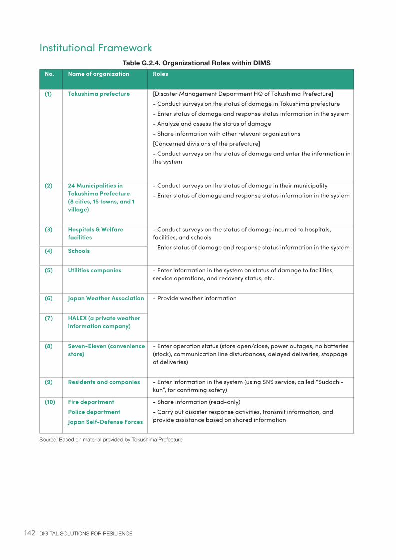
142 DIGITAL SOLUTIONS FOR RESILIENCE
Institutional FrameworkTable G.2.4. Organizational Roles within DIMS
No. Name of organization Roles
(1) Tokushima prefecture [Disaster Management Department HQ of Tokushima Prefecture]- Conduct surveys on the status of damage in Tokushima prefecture- Enter status of damage and response status information in the system- Analyze and assess the status of damage- Share information with other relevant organizations[Concerned divisions of the prefecture]- Conduct surveys on the status of damage and enter the information in the system
(2) 24 Municipalities in Tokushima Prefecture (8 cities, 15 towns, and 1 village)
- Conduct surveys on the status of damage in their municipality- Enter status of damage and response status information in the system
(3) Hospitals & Welfare facilities
- Conduct surveys on the status of damage incurred to hospitals, facilities, and schools- Enter status of damage and response status information in the system(4) Schools
(5) Utilities companies - Enter information in the system on status of damage to facilities, service operations, and recovery status, etc.
(6) Japan Weather Association - Provide weather information
(7) HALEX (a private weather information company)
(8) Seven-Eleven (convenience store)
- Enter operation status (store open/close, power outages, no batteries (stock), communication line disturbances, delayed deliveries, stoppage of deliveries)
(9) Residents and companies - Enter information in the system (using SNS service, called “Sudachi-kun”, for confirming safety)
(10) Fire departmentPolice departmentJapan Self-Defense Forces
- Share information (read-only)- Carry out disaster response activities, transmit information, and provide assistance based on shared information
Source: Based on material provided by Tokushima Prefecture

143APPENDIX G
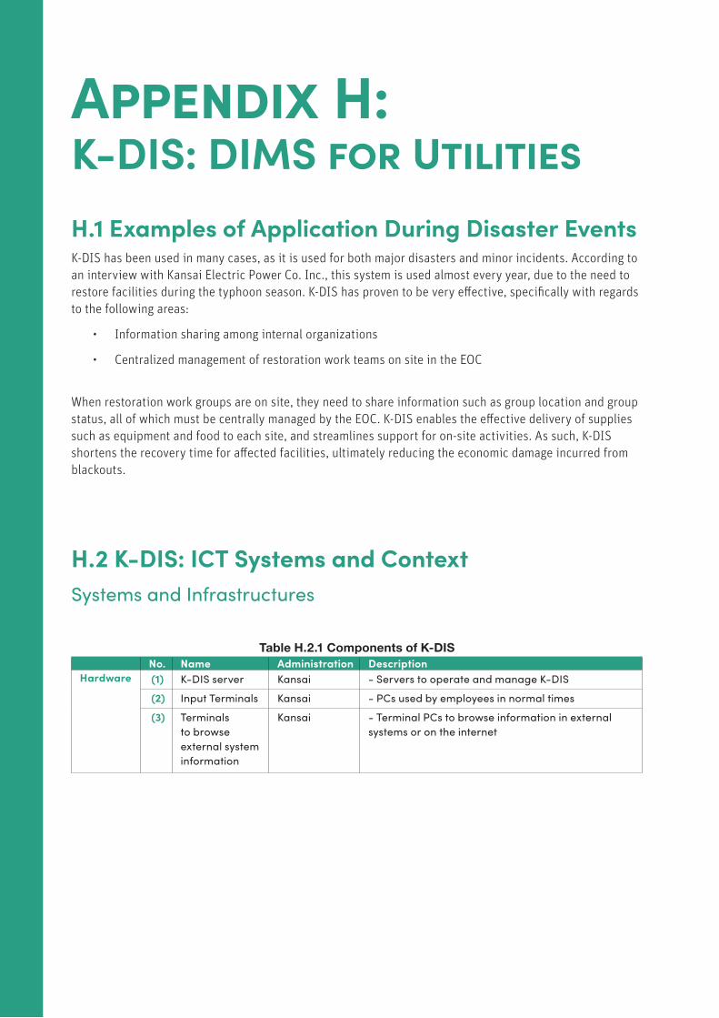
144 DIGITAL SOLUTIONS FOR RESILIENCE
Appendix H: K-DIS: DIMS for UtilitiesH.1 Examples of Application During Disaster EventsK-DIS has been used in many cases, as it is used for both major disasters and minor incidents. According to an interview with Kansai Electric Power Co. Inc., this system is used almost every year, due to the need to restore facilities during the typhoon season. K-DIS has proven to be very effective, specifically with regards to the following areas:
• Information sharing among internal organizations
• Centralized management of restoration work teams on site in the EOC
When restoration work groups are on site, they need to share information such as group location and group status, all of which must be centrally managed by the EOC. K-DIS enables the effective delivery of supplies such as equipment and food to each site, and streamlines support for on-site activities. As such, K-DIS shortens the recovery time for affected facilities, ultimately reducing the economic damage incurred from blackouts.
H.2 K-DIS: ICT Systems and ContextSystems and Infrastructures
Table H.2.1 Components of K-DIS No. Name Administration DescriptionHardware (1) K-DIS server Kansai - Servers to operate and manage K-DIS
(2) Input Terminals Kansai - PCs used by employees in normal times
(3) Terminals to browse external system information
Kansai - Terminal PCs to browse information in external systems or on the internet
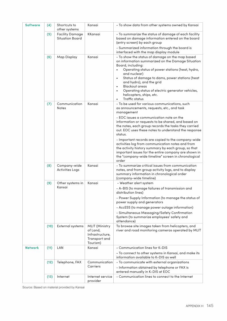
145APPENDIX H
Software (4) Shortcuts to other systems
Kansai - To show data from other systems owned by Kansai
(5) Facility Damage Situation Board
KKansai - To summarize the status of damage of each facility based on damage information entered on the board (entry screen) by each group- Summarized information through the board is interfaced with the map display module
(6) Map Display Kansai - To show the status of damage on the map based on information summarized on the Damage Situation Board, including:• Operating status of power stations (heat, hydro,
and nuclear)• Status of damage to dams, power stations (heat
and hydro), and the grid• Blackout areas• Operating status of electric generator vehicles,
helicopters, ships, etc.• Traffic status
(7) Communication Notes
Kansai - To be used for various communications, such as announcements, requests, etc., and task management- EOC issues a communication note on the information or requests to be shared, and based on the notes, each group records the tasks they carried out. EOC uses these notes to understand the response status.- Important records are copied to the company-wide activities log from communication notes and from the activity history summary by each group, so that important issues for the entire company are shown in the “company-wide timeline” screen in chronological order
(8) Company-wide Activities Logs
Kansai - To summarize critical issues from communication notes, and from group activity logs, and to display summary information in chronological order (company-wide timeline)
(9) Other systems in Kansai
Kansai - Weather alert system- A-BIS (to manage failures of transmission and distribution lines)- Power Supply Information (to manage the status of power supply and generators- AccESS (to manage power outage information)- Simultaneous Messaging/Safety Confirmation System (to summarize employees’ safety and attendance)
(10) External systems MLIT (Ministry of Land, Infrastructure, Transport and Tourism)
To browse site images taken from helicopters, and river and road monitoring cameras operated by MLIT
Network (11) LAN Kansai - Communication lines for K-DIS- To connect to other systems in Kansai, and make its information available to K-DIS as well
(12) Telephone, FAX Communication Carriers
- To communicate with external organizations- Information obtained by telephone or FAX is entered manually in K-DIS at EOC
(13) Internet Internet service provider
- Communication lines to connect to the Internet
Source: Based on material provided by Kansai
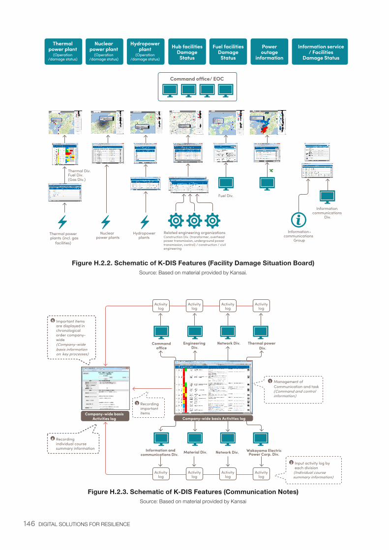
146 DIGITAL SOLUTIONS FOR RESILIENCE
Figure H.2.2. Schematic of K-DIS Features (Facility Damage Situation Board)Source: Based on material provided by Kansai.
Figure H.2.3. Schematic of K-DIS Features (Communication Notes)Source: Based on material provided by Kansai
Nuclear power plants
Thermal power plants (incl. gas
facilities)
Related engineering organizationsConstruction Div. (transformer, overhead power transmission, underground power transmission, control) / construction / civil engineering
Information-communications
Group
Thermal Div.Fuel Div.(Gas Div.)
Informationcommunications
Div.
Fuel Div.
PAZ
/UPZ
PAZ
/UPZ
PAZ
/UPZ
PAZ
/UPZ
PAZ
/UPZ
Hydropower plants
PAZ
/UPZ
PAZ
/UPZ
G
G 2015/11/23 15:00
Command o�ce/ EOC
Thermal power plant
(Operation/damage status)
Nuclear power plant
(Operation/damage status)
Hydropower plant
(Operation/damage status)
Hub facilitiesDamage
Status
Fuel facilitiesDamage
Status
Power outage
information
Information service / Facilities
Damage Status
-
Command o�ce
Engineering Div.
Network Div. Thermal power Div.
Information and communications Div. Material Div. Network Div. Wakayama Electric
Power Corp. Div.
Recordingimportantitems
Important items are displayed in chronologicalorder company-wide (Company-wide basis informationon key processes)
Recording individual course summary information
Input activity log by each division
(Individual coursesummary information)
Activitylog
Activitylog
Activitylog
Activitylog
Activitylog
Activitylog
Activitylog
Activitylog
1 Management of Communication and task(Command and controlinformation)
Company-wide basis Activities log Company-wide basis
Activities log
2
3
4
5
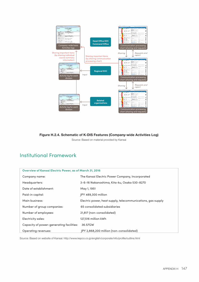
147APPENDIX H
Figure H.2.4. Schematic of K-DIS Features (Company-wide Activities Log)Source: Based on material provided by Kansai
Institutional Framework
Overview of Kansai Electric Power, as of March 31, 2016
Company name: The Kansai Electric Power Company, Incorporated
Headquarters: 3-6-16 Nakanoshima, Kita-ku, Osaka 530-8270
Date of establishment: May 1, 1951
Paid-in capital: JPY 489,300 million
Main business: Electric power, heat supply, telecommunications, gas supply
Number of group companies: 65 consolidated subsidiaries
Number of employees: 21,817 (non-consolidated)
Electricity sales: 127,516 million kWh
Capacity of power-generating facilities: 36.57GW
Operating revenues: JPY 2,868,200 million (non-consolidated)
Source: Based on website of Kansai: http://www.kepco.co.jp/english/corporate/info/profile/outline.html
-
Input
Sharing Requests and report
Head O�ce EOCCommand O�ce
Input
Related organizations
Regional EOC
Communication processing chart (sharing and requests)
Communication processing chart (sharing and requests)
Communication processing chart (sharing and requests)
Sharing Requests and report
Company-wide basis Activities logs
Activity log for each division
Activity log for each division
Sharing important items(by sharing communication processing chart)
Sharing important items(by sharing individual
course summary information)
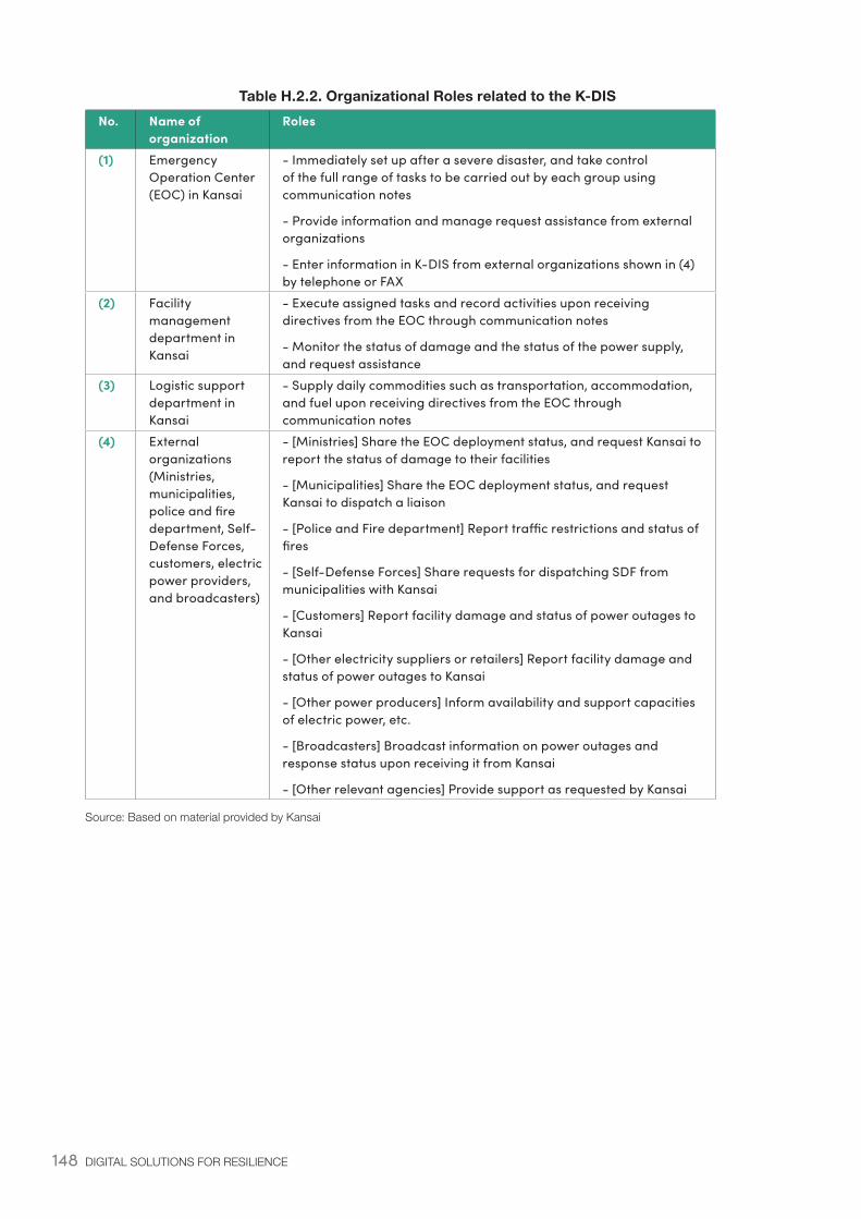
148 DIGITAL SOLUTIONS FOR RESILIENCE
Table H.2.2. Organizational Roles related to the K-DISNo. Name of
organizationRoles
(1) Emergency Operation Center (EOC) in Kansai
- Immediately set up after a severe disaster, and take control of the full range of tasks to be carried out by each group using communication notes
- Provide information and manage request assistance from external organizations
- Enter information in K-DIS from external organizations shown in (4) by telephone or FAX
(2) Facility management department in Kansai
- Execute assigned tasks and record activities upon receiving directives from the EOC through communication notes
- Monitor the status of damage and the status of the power supply, and request assistance
(3) Logistic support department in Kansai
- Supply daily commodities such as transportation, accommodation, and fuel upon receiving directives from the EOC through communication notes
(4) External organizations (Ministries, municipalities, police and fire department, Self-Defense Forces, customers, electric power providers, and broadcasters)
- [Ministries] Share the EOC deployment status, and request Kansai to report the status of damage to their facilities
- [Municipalities] Share the EOC deployment status, and request Kansai to dispatch a liaison
- [Police and Fire department] Report traffic restrictions and status of fires
- [Self-Defense Forces] Share requests for dispatching SDF from municipalities with Kansai
- [Customers] Report facility damage and status of power outages to Kansai
- [Other electricity suppliers or retailers] Report facility damage and status of power outages to Kansai
- [Other power producers] Inform availability and support capacities of electric power, etc.
- [Broadcasters] Broadcast information on power outages and response status upon receiving it from Kansai
- [Other relevant agencies] Provide support as requested by Kansai
Source: Based on material provided by Kansai

149APPENDIX H
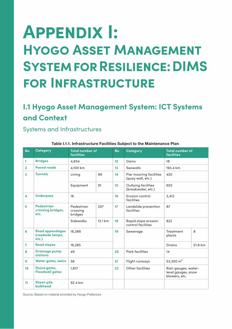
150 DIGITAL SOLUTIONS FOR RESILIENCE
Appendix I: Hyogo Asset Management System for Resilience: DIMS for InfrastructureI.1 Hyogo Asset Management System: ICT Systems and ContextSystems and Infrastructures
Table I.1.1. Infrastructure Facilities Subject to the Maintenance Plan
No Category Total number of facilities
No Category Total number of facilities
1 Bridges 4,654 12 Dams 18
2 Paved roads 4,100 km 13 Seawalls 193.4 km
3 Tunnels Lining 99 14 Pier mooring facilities(quay wall, etc.)
420
Equipment 91 15 Outlying facilities(breakwater, etc.)
602
4 Underpass 16 16 Erosion control facilities
2,412
5 Pedestrian crossing bridges, etc.
Pedestrian crossing bridges
207 17 Landslide prevention facilities
87
Sidewalks 12.1 km 18 Rapid slope erosion control facilities
822
6 Road appendages (roadside lamps, etc.)
18,386 19 Sewerage Treatment plants
8
7 Road slopes 16,285 Drains 51.8 km
8 Drainage pump stations
49 20 Park facilities 14
9 Water gates, weirs 56 21 Flight runways 53,300 m²
10 Sluice gates, Floodwall gates
1,817 22 Other facilities Rain gauges, water-level gauges, snow blowers, etc.
11 Sheet-pile bulkhead
92.4 km
Source: Based on material provided by Hyogo Prefecture
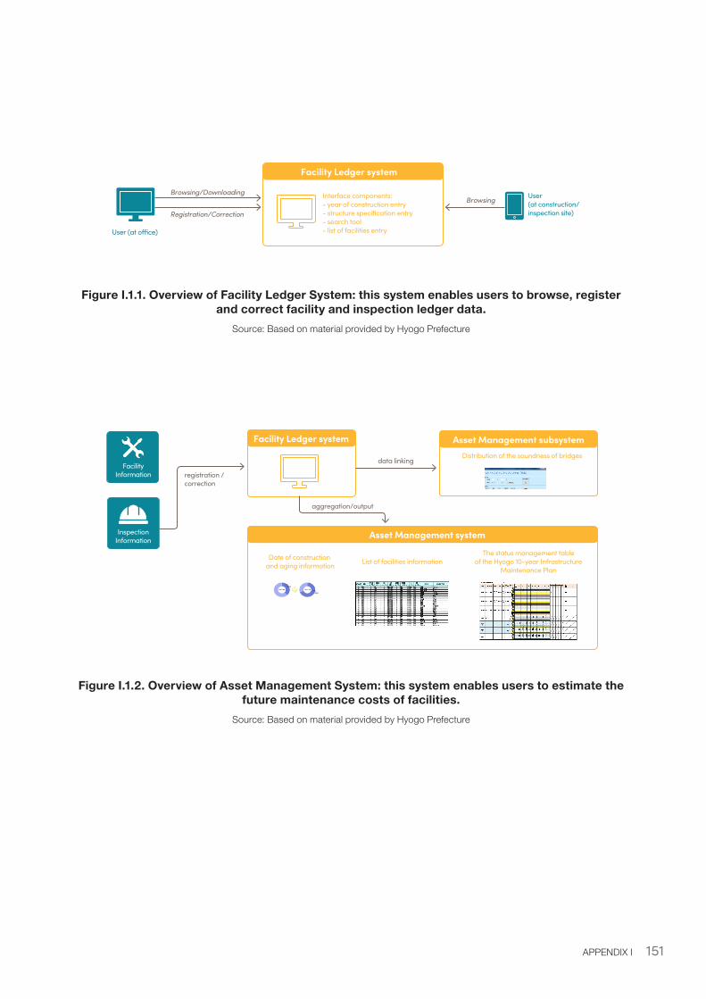
151APPENDIX I
Figure I.1.1. Overview of Facility Ledger System: this system enables users to browse, register and correct facility and inspection ledger data.
Source: Based on material provided by Hyogo Prefecture
Figure I.1.2. Overview of Asset Management System: this system enables users to estimate the future maintenance costs of facilities.
Source: Based on material provided by Hyogo Prefecture
Facility Ledger system
Interface components:- year of construction entry- structure specification entry- search tool- list of facilities entryUser (at o�ce)
User (at construction/inspection site)
Browsing/Downloading
Registration/Correction
Browsing
Inspection Information
Facility Ledger system
Asset Management system
FacilityInformation registration /
correction
Date of construction and aging information List of facilities information
The status management tableof the Hyogo 10-year Infrastructure
Maintenance Plan
aggregation/output
Asset Management subsystemDistribution of the soundness of bridges
data linking
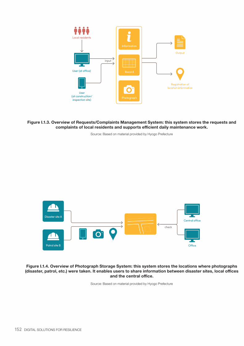
152 DIGITAL SOLUTIONS FOR RESILIENCE
Figure I.1.3. Overview of Requests/Complaints Management System: this system stores the requests and complaints of local residents and supports efficient daily maintenance work.
Source: Based on material provided by Hyogo Prefecture
Figure I.1.4. Overview of Photograph Storage System: this system stores the locations where photographs (disaster, patrol, etc.) were taken. It enables users to share information between disaster sites, local offices
and the central office.
Source: Based on material provided by Hyogo Prefecture
User (at o�ce)
Local residents
User (at construction/inspection site)
Photograph
Record
Output
Registration of location information
Information
input
Disaster site A
Patrol site B
Central o�ce
O�ce
check
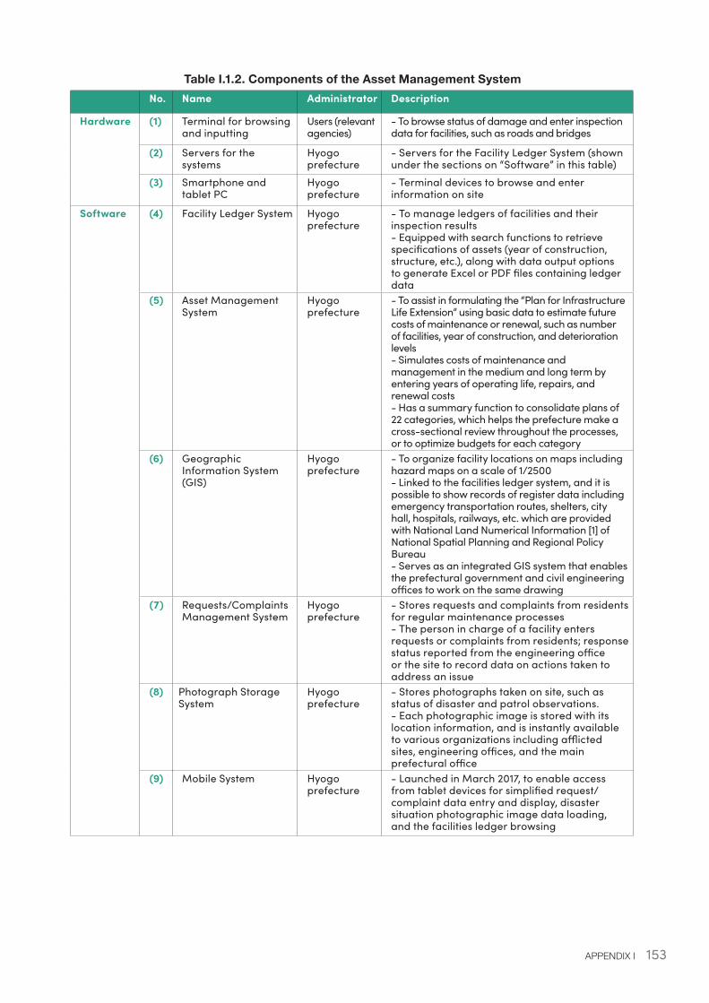
153APPENDIX I
Table I.1.2. Components of the Asset Management System No. Name Administrator Description
Hardware (1) Terminal for browsing and inputting
Users (relevant agencies)
- To browse status of damage and enter inspection data for facilities, such as roads and bridges
(2) Servers for the systems
Hyogo prefecture
- Servers for the Facility Ledger System (shown under the sections on “Software” in this table)
(3) Smartphone and tablet PC
Hyogo prefecture
- Terminal devices to browse and enter information on site
Software (4) Facility Ledger System Hyogo prefecture
- To manage ledgers of facilities and their inspection results - Equipped with search functions to retrieve specifications of assets (year of construction, structure, etc.), along with data output options to generate Excel or PDF files containing ledger data
(5) Asset Management System
Hyogo prefecture
- To assist in formulating the “Plan for Infrastructure Life Extension” using basic data to estimate future costs of maintenance or renewal, such as number of facilities, year of construction, and deterioration levels- Simulates costs of maintenance and management in the medium and long term by entering years of operating life, repairs, and renewal costs- Has a summary function to consolidate plans of 22 categories, which helps the prefecture make a cross-sectional review throughout the processes, or to optimize budgets for each category
(6) Geographic Information System (GIS)
Hyogo prefecture
- To organize facility locations on maps including hazard maps on a scale of 1/2500- Linked to the facilities ledger system, and it is possible to show records of register data including emergency transportation routes, shelters, city hall, hospitals, railways, etc. which are provided with National Land Numerical Information [1] of National Spatial Planning and Regional Policy Bureau- Serves as an integrated GIS system that enables the prefectural government and civil engineering offices to work on the same drawing
(7) Requests/Complaints Management System
Hyogo prefecture
- Stores requests and complaints from residents for regular maintenance processes- The person in charge of a facility enters requests or complaints from residents; response status reported from the engineering office or the site to record data on actions taken to address an issue
(8) Photograph Storage System
Hyogo prefecture
- Stores photographs taken on site, such as status of disaster and patrol observations.- Each photographic image is stored with its location information, and is instantly available to various organizations including afflicted sites, engineering offices, and the main prefectural office
(9) Mobile System Hyogo prefecture
- Launched in March 2017, to enable access from tablet devices for simplified request/complaint data entry and display, disaster situation photographic image data loading, and the facilities ledger browsing
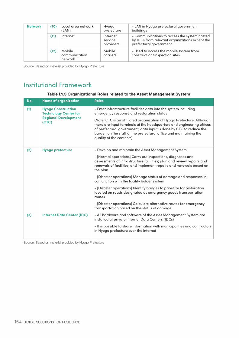
154 DIGITAL SOLUTIONS FOR RESILIENCE
Network (10) Local area network (LAN)
Hyogo prefecture
- LAN in Hyogo prefectural government buildings
(11) Internet Internet service providers
- Communications to access the system hosted by IDCs from relevant organizations except the prefectural government
(12) Mobile communication network
Mobile carriers
- Used to access the mobile system from construction/inspection sites
Source: Based on material provided by Hyogo Prefecture
Institutional FrameworkTable I.1.3 Organizational Roles related to the Asset Management System
No. Name of organization Roles
(1) Hyogo Construction Technology Center for Regional Development (CTC)
- Enter infrastructure facilities data into the system including emergency response and restoration status
(Note: CTC is an affiliated organization of Hyogo Prefecture. Although there are input terminals at the headquarters and engineering offices of prefectural government, data input is done by CTC to reduce the burden on the staff of the prefectural office and maintaining the quality of the contents)
(2) Hyogo prefecture - Develop and maintain the Asset Management System
- [Normal operations] Carry out inspections, diagnoses and assessments of infrastructure facilities; plan and review repairs and renewals of facilities; and implement repairs and renewals based on the plan
- [Disaster operations] Manage status of damage and responses in conjunction with the facility ledger system
- [Disaster operations] Identify bridges to prioritize for restoration located on roads designated as emergency goods transportation routes
- [Disaster operations] Calculate alternative routes for emergency transportation based on the status of damage
(3) Internet Data Center (IDC) - All hardware and software of the Asset Management System are installed at private Internet Data Centers (IDCs)
- It is possible to share information with municipalities and contractors in Hyogo prefecture over the internet
Source: Based on material provided by Hyogo Prefecture

155APPENDIX I
156 DIGITAL SOLUTIONS FOR RESILIENCE
ReferencesExecutive Summary
United Nations. 2016. “Report of the Open-ended Intergovernmental Expert Working Group on Indicators and Terminology Relating to Disaster Risk Reduction”. New York: United Nations. https://www.preventionweb.net/files/50683_oiewgreportenglish.pdf
Chapter 1
Akao, K., and Sakamoto, H. 2013. “A Theory of Disasters and Long-run Growth”. Discussion Paper. Tokyo: RIETI.
ADRC (Asian Disaster Reduction Center). 2005. “Total Disaster Risk Management - Good Practices, Building e-resilience: Enhancing the role of ICTs for Disaster Risk Management (DRM)”. Bangkok: UNESCAP. https://www.unescap.org/sites/default/files/Enhancing%20the%20role%20of%20ICTs%20for%20DRM.pdf
Dutta, S. T. Geiger, B. Lavin. 2015. “The Global Information Technology Report 2015, ICTs for Inclusive Growth”. World Economic Forum. http://www3.weforum.org/docs/WEF_GITR2015.pdf
ECLAC (Economic Commission for Latin America and the Caribbean). 2014. “Information and communication technologies for disaster risk management in the Caribbean”. Chile: UNECLAC https://repositorio.cepal.org/bitstream/handle/11362/36735/1/S20131130_en.pdf
ESCAP (Economic and Social Commission for Asia and the Pacific). 2016. “Building e-resilience, Enhancing the role of ICTs for Disaster Risk Management (DRM)”. Bangkok: UNESCAP. http://www. unescap.org/resources/building-e-resilience-enhancing-role-icts-disaster-risk-management-drm
Government of Japan. 2006. “Japan’s Natural Disaster Early Warning Systems and International Cooperative Efforts”. Tokyo: Early Warning Sub-Committee of the Inter-Ministerial Committee on International Cooperation for Disaster Reduction, Government of Japan. http://www.bousai.go.jp/kokusai/kyoryoku/pdf/soukikeikai.pdf
Government of Japan. 2018. White paper on Disaster Management. [in Japanese.] Tokyo: Cabinet Office. http://www.bousai.go.jp/kaigirep/hakusho/h30.html
INFORM (Index for Risk Management). 2017. Index for Risk Management: 2017 Results. Report. Inter-Agency Standing Committee Task Team for Preparedness and Resilience and the European Commission.http://www.inform-index.org
ITU-D (International Telecommunication Union). 2017. Measuring the information society report 2017. Report. Geneva: ITU-D https://www.itu.int/en/ITU-D/Statistics/Pages/publications/mis2017.aspx
Takano, K. 2018. “Looking Back on the Decade of the Earthquake Early Warning (Alarm) and Thinking about Future Tasks and Directions of Improvement”. Informatics Research, 94, 1-13. Tokyo: University of Tokyo.
MIC (Ministry of Internal Affairs and Communications). 2017a. “Achieving Quality Infrastructure through the ICT of Japan”. [in Japanese.] Tokyo: MIC. http://www.soumu.go.jp/english/gisb/pdf/100445.pdf
Ng, Vanessa Mei-Yee. 2011. “Evolving technologies for disaster planning in US Cities”. PhD thesis, Massachusetts Institute of Technology. http://dspace.mit.edu/handle/1721.1/67280
Orlikowski W, and Iacono CS. 2001. “Desperately seeking the “IT” in IT research: a call to theorizing the IT artifact”. Inform Sys Res, 12, 121–134.
157
Schipper, L., and Pelling, M. 2006. “Disaster risk, climate change and international development: scope for, and challenges to, integration: Disaster Risk, Climate Change and International Development”. Disasters, 30(1), 19–38. https://doi.org/10.1111/j.1467-9523.2006.00304.x
Skidmore, M., and Toya, H. 2002. “Do natural disasters promote long–run growth?”. Economic inquiry, 40(4), 664-687.
Sylves, R. T. 2008. “Disaster Policy and Politics: Emergency Management and Homeland Security”. Washington DC: CQ Press.
Toya, H. 2014. “The Long-Term Macroeconomic Impact of Natural Disasters”. Nippon.com (blog), November 7. https://www.nippon.com/en/in-depth/a03501/
UNISDR (United Nations International Strategy for Disaster Risk Reduction). 2017. In Terminology on Disaster Reduction. 28
World Bank. 2011. “World Bank East Asia and Pacific Economic Update 2011, Volume 1 : Securing the Present, Shaping the Future”. Washington, DC: World Bank. https://openknowledge.worldbank.org/handle/10986/14713
World Bank. 2012. “The Great East Japan Earthquake--Learning from Megadisasters: Knowledge Notes, Executive Summary”. Washington, DC: World Bank. https://openknowledge.worldbank.org/handle/10986/17107
Chapter 2
Gene, B. 1986. “The High Tech Race: Who’s Ahead?”. Fortune, 10, 26-44
Government of Japan. 2002. Lessons Learned from Great Hanshin Awaji Earthquake. [in Japanese.] Tokyo: Cabinet Office. http://www.bousai.go.jp/kaigirep/chousakai/kyoyu/1/pdf/01-03shiryo02-04.pdf
Inomo, H., Shiraki, W., Imai, Y., Isouchi, C., Takemoto, M., Yokoi, T. 2012. “A consideration about the information gathering and transfer in a large-scale wide area disaster such as the Eastertn Japan Great Earthquake”. [in Japanese.] Journal of JSCE, 68(2), 88-95.
JMA (Japan Meteorological Agency). 2015. “Technological Improvements in Earthquake Early Warning System”. [in Japanese.] Power Point presentation, JMA, March 10. http://www.data.jma.go.jp/svd/eqev/data/study-panel/eew-hyoka/06/shiryou2.pdf
JMA (Japan Meteorological Agency). 2017. Survey on the utilization status of the Earthquake Early Warning System after the occurrence of Kumamoto Earthquake. [in Japanese.] Power Point presentation, JMA, March 22. http://www.data.jma.go.jp/svd/eqev/data/study-panel/eew-hyoka/09/shiryou4_1.pdf
Kodera, Y., Saitou, J., Hayashimoto, N., Adachi, S., Morimoto, M., Nishimae, Y., Hoshiba, M. 2016. “Earthquake early warning for the 2016 Kumamoto earthquake: performance evaluation of the current system and the next-generation methods of the Japan Meteorological Agency”. Earth, Planets and Space, 68(1), 202.
Kodera, Y., Yamada, Y., Hirano, K., Tamaribuchi, K., Adachi, S., Hayashimoto, N., Hoshiba, M. 2018. “The Propagation of Local Undamped Motion (PLUM) Method: A Simple and Robust Seismic Wavefield Estimation Approach for Earthquake Early WarningThe Propagation of Local Undamped Motion (PLUM) Method”. Bulletin of the Seismological Society of America, 108(2), 983-1003.
METI (Ministry of Economy, Trade and Industry). 2015. IT Policy in Japan. Power Point presentation, Tokyo: METI. http://www.cicc.or.jp/japanese/kouenkai/pdf_ppt/pastfile/h27/151013-1jp.pdf
MIC (Ministry of Internal Affairs and Communications). 2008. “Japan’s ICT Strategy”. [in Japanese.] Tokyo: MIC. www.soumu.go.jp/main_sosiki/joho_tsusin/policyreports/chousa/vigor/pdf/080212_2_si4.pdf
REFERENCES
158 DIGITAL SOLUTIONS FOR RESILIENCE
MIC (Ministry of Internal Affairs and Communications). 2017b. 2017 White paper on information and communications in Japan. [in Japanese.] Tokyo: MIC. http://www.soumu.go.jp/johotsusintokei/whitepaper/eng/WP2017/2017-index.html
MIC (Ministry of Internal Affairs and Communications). 2017c. Playbook for Investment in “Quality ICT Infrastructure”. Tokyo: MIC. http://www.soumu.go.jp/english/gisb/pdf/115748_2.pdf
MIC (Ministry of Internal Affairs and Communications). 2017d. “Basic Plan for the Advancement of Utilizing Geospatial Information”. [in Japanese.] Tokyo: MIC. http://www.soumu.go.jp/main_content/000574484.pdf
National Institute of Informatics. 2012. “Challenges in ICT and the Legal System”. [in Japanese.] National Institute of Informatics News, 55, 9 - 10. https://www.nii.ac.jp/userdata/results/pr_data/NII_Today/55/all.pdf
United Nations. 2016. “Report of the Open-ended Intergovernmental Expert Working Group on Indicators and Terminology Relating to Disaster Risk Reduction”. New York: United Nations. https://www.preventionweb.net/files/50683_oiewgreportenglish.pdf
UNISDR (United Nations International Strategy for Disaster Risk Reduction). 2013. “Information and Knowledge Management for Disaster Risk Reduction (IKM4DRR) Framework and Scorecard”. Geneva: UNISDR.https://www.unisdr.org/files/35238_ikm4drrframeworkscorecard.pdf
World Bank. 2002. “Information and Communication Technologies: A WORLD BANK GROUP STRATEGY”. Washington, DC: World Bank. http://siteresources.worldbank.org/EXTINFORMATIONANDCOMMUNICATIONANDTECHNOLOGIES/Resources/SSPwithAnnexes.pdf
World Bank. 2017. “Modernization of Japan’s Hydromet Services: A Report on Lessons Learned for Disaster Risk Management”. Washington, DC: World Bank. http://pubdocs.worldbank.org/en/355891472179524146/DRMHubTokyo-Japan-Hydromet-Summary.pdf
Chapter 3
Doughty, K. 2000. “Business continuity planning: protecting your organization’s life”. Auerbach Publications.
FDMA (Fire and Disaster Management Agency). 2009. “Increase of J-ALERT information receiving organizations”. [in Japanese.] Tokyo: FDMA. http://www.fdma.go.jp/ugoki/h2103/2103_1-32-2-10.pdf
FMMC (Foundation for MultiMedia Communications). 2016. “Usage and Challenges of L-ALERT during Kumamoto Earthquake”. [in Japanese] Tokyo: FMMC. https://www.fmmc.or.jp/Portals/0/images/commons/publish/commons_advisory183.pdf
Ito, Y. 2007. “Emergency Warning Broadcasting System”. The Journal of the Institute of Image Information and Television Engineers, 61(6), 761-763
Tanaka, I., Aoyagi, K., Umesh, A., Hapsari, W. A. 2009. “Advanced warning message distribution platform for the next-generation mobile communication network”. NTT DoCoMo Technical Journal, 11(3), 20-26.
MIC (Ministry of Internal Affairs and Communications). 2016a. “Communications Usage Trend Survey”. [in Japanese.] Tokyo: MIC. http://www.soumu.go.jp/johotsusintokei/statistics/statistics05b1.html
MIC (Ministry of Internal Affairs and Communications). 2016b. “2016 White paper on information and communications in Japan”. [in Japanese.] Tokyo: MIC. http://www.soumu.go.jp/johotsusintokei/whitepaper/ja/h28/pdf/28honpen.pdf
MIC (Ministry of Internal Affairs and Communications). 2019. “Local government information management summary”. [in Japanese.] Tokyo: MIC. http://www.soumu.go.jp/main_content/000610588.pdf
159
Chapter 4
Kansai (Kansai Electric Power Company). 2018. “Disaster Management Plan”. [in Japanese] Osaka: Kansai https://www.kepco.co.jp/corporate/notice/notice_pdf/20180822_1_01.pdf
Tokushima Prefectural Government. 2014. “ICT Tokushima Creation Strategies”. [in Japanese] Tokushima: Tokushima Prefectural Government https://www.pref.tokushima.lg.jp/file/attachment/143423.pdf
FMMC (Foundation for MultiMedia Communications). 2017. “L-ALERT Technology Seminar”. [in Japanese] Tokyo: FMMC. https://www.fmmc.or.jp/Portals/0/images/commons/publish/commons_document20180725_1.pdf
MIC (Ministry of Internal Affairs and Communications). 2015a. “Deployment Status of L-ALERT”. [in Japanese.] Tokyo: MIC. http://www.kantei.go.jp/jp/singi/it2/senmon_bunka/bousai/dai8/siryou3.pdf
MIC (Ministry of Internal Affairs and Communications). 2015b. “For Further Deployment of L-ALERT”. [in Japanese.] Tokyo: MIC. http://www.soumu.go.jp/main_content/000352090.pdf
Appendices
FDMA (Fire and Disaster Management Agency). 2017. “ 2017 White Paper on Fire Service”. Tokyo: FDMA.http://www.kaigai-shobo.jp/pdf/White_Paper29_eng.pdf
Hitotsubashi University Railway Study Group. 2011. “Disasters and Railway”. [in Japanese] Tokyo: Hitotsubashi University. https://www.ikkyo-tekken.org/studies/2011/2011_all.pdf
JMA (Japan Meteorological Agency). 2012. “Survey on current status and actual utilization of Earthquake Early Warning System”. [in Japanese.] Tokyo: JMA. https://www.jma.go.jp/jma/press/1212/14b/24manzokudo_data.pdf
MIC (Ministry of Internal Affairs and Communications). 2014. “Challenges and Future Perspectives of Communication Measures During Disasters” [in Japanese] Tokyo: MIC. http://www.soumu.go.jp/main_content/000324270.pdf
MIC (Ministry of Internal Affairs and Communications). 2016c. “Report of Study Group on Emergency Communication Means at the time of Large Scale Disaster”. [in Japanese] Tokyo: MIC. http://www.soumu.go.jp/main_content/000427271.pdf
Satoru Ishigaki. 2011. “Evolution of Disaster Management Radio Systems”. JRC Review, 60, 40-46.
Watanabe, A. Honma, Y. Oba, K. Okutomi, T. 2009. “The development of the early earthquake detection and alarm system for bullet-train (Shinkansen)”. MITSUBISHI SPACE SOFTWARE technology Information, 19, 12-16.
World Bank. 2016. “Preparedness Map for Community Resilience: Earthquakes – Experience of Japan”. Washington, DC: World Bank. http://pubdocs.worldbank.org/en/180521481856986238/121516-drmhubtokyo-Preparedness-Map-for-Community-Resilience-Earthquakes.pdf
REFERENCES
160 DIGITAL SOLUTIONS FOR RESILIENCE
World Bank DRM Hub, Tokyo
The World Bank Tokyo Disaster Risk Management (DRM) Hub supports developing countries to mainstream DRM in national development planning and investment programs. As part of the Global Facility for Disaster Reduction and Recovery, the DRM Hub provides technical assistance grants and connects Japanese and global DRM expertise and solutions with World Bank teams and government officials. The DRM Hub was established in 2014 through the Japan-World Bank Program for Mainstreaming DRM in Developing Countries – a partnership between Japan’s Ministry of Finance and the World Bank.
GFDRR
The Global Facility for Disaster Reduction and Recovery (GFDRR) is a global partnership that helps developing countries better understand and reduce their vulnerabilities to natural hazards and adapt to climate change. Working with over 400 local, national, regional, and international partners, GFDRR provides grant financing, technical assistance, training, and knowledge sharing activities to mainstream disaster and climate risk management in policies and strategies. Managed by the World Bank, GFDRR is supported by 36 countries and 10 international organizations.
Contact
World Bank Disaster Risk Management Hub, TokyoPhone: +81-3-3597-1320Email: [email protected]: http://worldbank.org/drmhubtokyo
This publication is printed on recycled paper