influence of the spatial resolution of seawifs, landsat-7, spot, and international space station...
TRANSCRIPT
Influence of the spatial resolution of SeaWiFS,Landsat-7, SPOT, and International SpaceStation data on estimates of landscape
parameters of Pacific Ocean atollsSerge Andréfouët, Julie A. Robinson, Chuanmin Hu, Gene C. Feldman, Bernard Salvat,
Claude Payri, and Frank E. Muller-Karger
Abstract. Perimeter, surface area, total hydrodynamic aperture, and degree of hydrodynamic aperture are key landscapeparameters used to quantify differences in the biological functioning of Tuamotu Archipelago atolls (French Polynesia). In aprevious study, these landscape parameters were computed using Satellite pour l’observation de la terre (SPOT) high-resolution visible (HRV) data at 20 m spatial resolution. Since 1999, Tuamotu atolls have been systematically imaged by anarray of satellite sensors with a wide range of spatial resolution (from 1 km to 5 m) including the sea-viewing wide field-of-view sensor (SeaWiFS), Landsat enhanced thematic mapper plus (ETM+), and digital photographs taken by astronauts fromthe International Space Station (ISS). Our goal was to assess the influence of the spatial resolution of SeaWiFS (1 km),ETM+ (30 m), HRV (20 m), and ISS digital photographs (5 m) on the estimation of landscape parameters of Pacific Oceanatolls. Total hydrodynamic aperture and degree of hydrodynamic aperture are the parameters most sensitive to variation inresolution. For the same atoll, the differences between degree of aperture computed from SPOT and Landsat can reach 28%.Conversely, perimeters and atoll surface area estimates are in agreement within 7% using data with resolution from 5 to30 m. One kilometre resolution SeaWiFS data offer the possibility to rank atolls based on surface area correctly, but only foratolls larger than 70 km2.
Résumé. Le perimètre, la surface totale, l’ouverture hydrodynamique totale et le degré d’ouverture hydrodynamique sontdes paramètres paysagers cruciaux pour comprendre les différences de fonctionnement biologiques des atolls de l’archipeldes Tuamotu (Polynésie francaise). Dans une etude précédente, ces paramètres paysagers ont été quantifiés à partir dedonnées SPOT haute resolution visible (HRV) à 20 m de résolution. Cependant, depuis 1999, les atolls des Tuamotu ontégalement été la cible systématique de plusieurs capteurs couvrant un large éventail de résolution spatiale (de 1 km à 5 m),dont le sea-viewing wide field-of-view sensor (SeaWiFS), le Landsat enhanced thematic mapper plus (ETM+), ainsi que desphotographies numériques acquises par les astronautes depuis la Station Spatiale Internationale (SSI). Notre objectif était dequantifier l’influence de la résolution spatiale de SeaWiFS (1 km), ETM+ (30 m), HRV (20 m) et SSI (5 m) sur la mesuredes paramètres paysagers dans les milieux d’atolls du Pacifique. Ouverture hydrodynamique totale et degré d’ouverturehydrodynamique sont les paramètres les plus sensibles aux changements de résolution. Les différences peuvent atteindre28 % d’écarts selon que l’on utilise SPOT ou Landsat. En revanche, périmètres et surfaces coincident à 7 % près, dans desfourchettes de résolution de 5 à 30 m. Les données SeaWiFS à résolution kilométrique s’avère potentiellement utile pourordonner les atolls suivant leurs surfaces, mais une estimation précise reste difficile, surtout pour les atolls de tailleinférieure à 70 km2.
218
IntroductionMost coral reef studies involving remote sensing data have
focused on bottom mapping (Green et al., 1996). The nature ofthe bottom is key information required by coral reef scientistsand resource managers, as it is used to assess the surface areacovered by various communities, spatial patterns (Andréfouëtet al., 2000), productivity (Andréfouët and Payri, 2001), andchanges in benthic coral reef communities over time (Done,1999; Andréfouët et al., 2001a). However, information otherthan the composition and areal extent of benthic communities isalso required to understand the functioning of a coral reefsystem. The dynamics of coral reef systems depends onstructural features, especially at the boundaries, as this will
210 © 2003 CASI
Can. J. Remote Sensing, Vol. 29, No. 2, pp. 210–218, 2003
Received 14 March 2002. Accepted 5 September 2002.
S. Andréfouët,1 C. Hu, and F.E. Muller-Karger. Institute forMarine Remote Sensing, University of South Florida,St. Petersburg, FL 33701, U.S.A.
J.A. Robinson. Earth Sciences and Image Analysis Laboratory,NASA Johnson Space Center, Houston, TX 77058-3691, U.S.A.
G.C. Feldman. SeaWiFS Project, Goddard Space Flight Center,Greenbelt, MD 20771-0003, U.S.A.
B. Salvat. École Pratique Haute Études, Perpignan, France.
C. Payri. Laboratoire Terre-Océan, Université de la PolynésieFrançaise, Tahiti, French Polynesia.
1Corresponding author (e-mail: [email protected]).

affect the way the land (including rivers), atmosphere, andocean exchange energy and matter with the reefs.
Landscape ecology is the science that studies the exchangeof matter and energy between connected ecosystems (Formanand Godron, 1986). The spatial structure of ecosystems andtheir boundaries can be characterized in terms of landscapeparameters such as surface area, surface of contact, shape,degree of patchiness, aperture, continuity, connectivity,porosity, or fractal dimension (Forman and Godron, 1986;Riitters et al., 1995; Hargis et al., 1998; Hanski, 1999). Spatialcharacteristics of land ecosystems can be assessed through insitu assessment and adequate spatial modeling (Legendre andFortin, 1989), but large-scale assessments and (or) remotelocations require the use of remotely sensed data for optimalcoverage (Quattrochi and Pelletier, 1990; Poulter, 1996). Thereis substantial consensus that estimates of landscape parametersare sensitive to methods of investigation (Cullinan and Thomas,1992; Fortin, 1999; Fortin et al., 2000). When using remotelysensed data, spatial resolution is a critical factor (Woodcockand Strahler, 1987; Benson and MacKenzie, 1995; Atkinsonand Curran, 1997); the sensitivity to resolution will depend onthe type of ecosystem considered. Landscape ecologistspresently have access to several satellite platforms with spatialresolutions ranging from 4 m (Ikonos) to 1 km (e.g., sea-viewing wide field-of-view sensor, SeaWiFS). Therefore, thereis a need to clarify the limits of each sensor for landscapecharacterization. Obviously, this is ecosystem dependent. Inthis paper we address the case of atoll environments.
Concepts and methods of landscape ecology (Wagner andEdwards, 2001; Vos et al., 2001) can readily be applied to reefenvironments. The potential is enormous because habitats andpopulation dynamics are highly structured by physicalgradients such as turbidity, hydrodynamics, and light. However,application of landscape ecology to coral reefs is rare (Aronsonand Precht, 1995; West and van Woesik, 2001). Inferencesabout ecological phenomena from preliminary landscapecharacterization efforts (with or without remote sensing) areuncommon, mainly because few sites have been characterizedin a way that is consistent enough to enable comparisonsbetween sites.
The atolls of the Tuamotu Archipelago, French Polynesia(Figure 1), are among the few locations where landscapeparameters have been estimated, making it possible to conductlarge-scale comparative studies. Atolls are one of the majortypes of coral reef formations (Guilcher, 1988). They can bedescribed as a complex made up of three ecological systems:the oceanic outer slope, the rim, and the lagoon. Interactionbetween these systems depends on the water flows betweenocean and lagoon through the rim. The efficiency of thesehydrodynamic exchanges depends primarily on three landscapeparameters defined in the next paragraph: total hydrodynamicaperture of the rim, degree of hydrodynamic aperture of therim, and the surface areas of the atoll (or the lagoon)(Andréfouët et al., 2001b). For brevity, we will no longer usethe term “hydrodynamic” when referring to aperture or degreeof aperture.
The total aperture of an atoll has been defined as the sum ofthe width of the sections along the atoll rim that connect theinternal “wet” areas of the atoll with the open ocean (Figure 1).This includes widths of reef flat spillways, passes, andsubmerged rims along the perimeter of the atoll. The degree ofaperture is the ratio of total aperture to perimeter of the atoll(Dufour and Harmelin-Vivien, 1997). On Tuamotu atolllagoons, degree of aperture and surface areas quantified withSatellite pour l’observation de la terre (SPOT) images(Andréfouët et al., 2001b) have been identified by statisticalmultivariate analysis as key factors that explain the differencesin benthic and fish community structures (Galzin et al., 1994;Adjeroud et al., 2000), nutrient regimes (Dufour et al., 2001),particulate organic matter (Charpy et al., 1997), phytoplanktonbiomass (Andréfouët et al., 2001c), and dissolved organicmatter concentrations (Pagès and Andréfouët, 2001). Otherparameters have less influence (e.g., densities of coralpinnacles) and therefore have not been considered here.
One of the questions raised by the earlier Tuamotu atollstudies was whether the spatial resolution of SPOT data wasadequate to compute atoll aperture. At that time, a set of aerialcolor photographs of Tikehau atoll showed that the degree ofaperture computed from SPOT and aerial photographs did notdiffer by more than 8% (Andréfouët et al., 2001b). However, itwas difficult to answer the question regarding space-basedobservations because prior to the late 1990s there was nosystematic coverage of Pacific atolls by space sensors withdifferent spatial resolution.
In the late 1990s, three satellite missions ensured systematiccoverage of reefs worldwide, namely the SeaWiFS, Landsat-7enhanced thematic mapper plus (ETM+), and InternationalSpace Station (ISS) missions. These data provided 1 km, 30 m,and 5 m resolution, respectively, of many of the Tuamotu atolls.This new data set offers the opportunity to investigate theinfluence of spatial resolution on key landscape parameters ofTuamotu atolls and provides insight into the strengths andweaknesses of each sensor for atoll studies.
Material and methodsAtoll structure and landscape parameters
The general atoll structure in the Tuamotu Archipelago isdetailed in Andréfouët et al. (2001b) and summarized inFigure 1. Here we are interested in comparing the perimeter(in km), surface areas (total, rim, and lagoon; in km2), totalaperture (in km), and degree of aperture (unitless) of the rim.The total aperture of an atoll is the sum of widths of reef flatspillways, passes, and submerged rims along the perimeter ofthe atoll (Figure 1). The degree of aperture is the ratio of thetotal aperture to the perimeter of the atoll.
In the Tuamotu Archipelago, tide amplitude is minimal(~0.5 m) and does not change the shape, perimeter, or effectivesurface area of atolls, since they are characterized by steepouter slopes. This may not be true in other reefs, such as in theGreat Barrier Reef in Australia. However, in Tuamotu high
© 2003 CASI 211
Canadian Journal of Remote Sensing / Journal canadien de télédétection

212 © 2003 CASI
Vol. 29, No. 2, April/avril 2003
Figure 1. Study area and example of location of apertures along the rim of Marutea Sud atoll. Blue and green pixels areshallow water along the rim. Red and white pixels represent emergent cays made of vegetation, coral rubble, and sand.At the interface between rim and ocean, the breaking waves are visible in bright white. The flow of water is directedtowards the lagoon (black arrow) through the channels. For a given section of rim the total aperture is the sum of thewidth of the channels, i.e., total aperture corresponds to the sum of the black segments. The degree of aperture is thenormalization of the total aperture by the length of the rim section (or perimeter of the atoll if the entire atoll isconsidered).

swells can modify the proportion of submerged rim estimatedby space-based imaging. Most of the images used in this studywere acquired during moderate swell conditions, as shown bybreaking waves patterns visible along the rims (Figure 1).
Image data set
Limitations in knowledge of extent and location of coralreefs worldwide have prompted since 1999 the systematiccoverage of coral reef using various orbital platforms.
SeaWiFS was launched in 1997 for global-scale monitoringof chlorophyll in the oceans. From 21 June to 26 September1999 it was programmed for systematic acquisition of localarea coverage (LAC) data (1.1 km spatial resolution) between35°N and 35°S (Robinson et al., 2000). The goal was toestablish a baseline data set for global-scale reef mapping. TheTuamotu Archipelago was included in this process. One good(minimal cloud cover) image of the Tuamotu Archipelagoacquired on 29 June 1999 was used in this study. The imageincluded numerous atolls of different sizes and shapes, but only16 cloud-free atolls close to the SeaWiFS nadir were selected tolimit resampling–distortion effects. The atolls were, in order ofincreasing size, Akiaki, Pinaki, Nukutavake, Vahitahi,Vairaatea, Fangatau, Paraoa, Ahunui, Fakahina, Takume,Nengonengo, Aratika, Taenga, Kauehi, Raraka, and Raroia.Georectification was achieved using the SeaWiFS processingpackage distributed by the National Aeronautics and SpaceAdministration (NASA; SeaDAS V3.2). The image wasprocessed as per Hu et al. (2000) to remove atmospheric effectsover shallow lagoons (<40 m depth). Shallow lagoon waterswere easily separated from oceanic waters using the 440 and555 nm bands. Rims include very shallow water (<2 m) andland and were more efficiently segmented using the near-
infrared bands (765 and 865 nm), since these bands providedsharper edges than other bands.
SPOT high resolution visible (HRV; 20 m spatial resolution)images and processing for 51 of the 77 atolls of the TuamotuArchipelago were described in Andréfouët et al. (2001b).Landsat-7 ETM+ (30 m spatial resolution) data have beensystematically acquired over the Tuamotu Archipelago sincemid-1999 according to a long-term acquisition plan (LTAP)(Arvidson et al., 2001). Landsat-7 images covering 38 atollswere available for this study. They were processed in a waysimilar to the methods used for the SPOT HRV images, using acombination of statistical classification to extract the limit ofwater bodies and photointerpretation to locate the differentspillways, passes, and submerged rim sections along the atollperiphery (Andréfouët et al., 2001b). For comparison purposes,we focus here on the 12 atolls covered by both SPOT andLandsat-7 data. They are Pinaki, Tepoto Sud, Vairaatea,Haraiki, Hiti, Tuanake, Mataiva, Takapoto, Takaroa, MaruteaSud, Amanu, and Tikehau.
The highest resolution images used for this study were 6 m orbetter resolution digital photographs taken by astronauts fromthe ISS (Robinson et al., 2002). The ISS has an average altitudeof 407 km. The combination of high-quality windows and high-magnification camera lenses on the ISS provided higher spatialresolution data than had previously been acquired byastronauts. To our knowledge, this is the first remote sensingapplication of ISS photographs, but Space Shuttle and SpaceShuttle – Mir photographs have been useful for many Earthobservation studies (Webb et al., 2000, and references within)thanks to an increase in quality, digital availability, andtechnical documentation of the data (Robinson et al., 2002).Hundreds of images of atolls throughout the Pacific Ocean
Canadian Journal of Remote Sensing / Journal canadien de télédétection
© 2003 CASI 213
Total surface area (km2) Lagoon surface area (km2) Rim surface area (km2)
Atoll SeaWiFSLandsat-7 –SPOT SeaWiFS
Landsat-7 –SPOT SeaWiFS
Landsat-7 –SPOT
Akiaki 0 1.78 0 0 0 1.78Pinaki 9 3.55 0 0.75 9 2.75Nukutavake 11 6.16 0 0 11 6.16Vahitahi 19 19.33 0 8.13 19 11.20Vairaatea 23 21.10 1 13.42 22 7.68Fangatau 20 22.19 5 9.96 15 12.23Paraoa 18 23.51 5 13.31 13 10.20Ahunui 22 27.43 7 19.14 15 8.29Fakahina 24 34.99 5 19.63 19 15.36Takume 53 69.40 13 42.40 40 27.00Nengonengo 68 87.60 38 67.80 30 19.80Aratika 149 179.20 93 151.80 56 27.40Taenga 151 199.20 99 169.40 52 29.80Kauehi 244 343.40 172 315.10 72 28.30Raraka 290 397.80 224 361.80 66 36.00Raroia 330 413.00 233 358.00 97 55.00Apataki 565 680.70 456 516.20 109 164.50SE* 12.78 28.39 19.23
*Standard error estimate.
Table 1. Comparison between landscape parameters estimated with Landsat-7 – SPOT (reference) and SeaWiFS.
were photographed by the ISS Expedition 2 (ISS002). Fourcloud-free photographs of complete Tuamotu atolls, alsocovered by Landsat and (or) SPOT data, were included in thisstudy (ISS002-ESC-5401, ISS002-ESC-6371, ISS002-ESC-6372, and ISS002-ESC-6373 for Pinaki, Napuka, Fangatau,and Fakahina atolls, respectively). All ISS images wereacquired with a 400 mm lens with a 2× extender mounted on adigital camera (Kodak DCS460D), set at maximum aperture(F5.6) and 1/500 shutter speed. The tilt angles were 19, 34, 26,and 29° for ISS002-ESC-5401, ISS002-ESC-6371, ISS002-
ESC-6372, and ISS002-ESC-6373, respectively, providingdata with little horizontal distortion when compared to satelliteimagery. ISS002-ESC-5401 was acquired 20 April 2001, andthe three other images were acquired on 21 May 2001. Thereare a number of technical issues related to remote sensing usinghand-held photographs (Robinson et al., 2002), in particular thelack of geometric correction, lack of calibrated data, andlimited spectral resolution. Here, the digital images weregeorectified using SPOT level 2A or Landsat L1G images.
214 © 2003 CASI
Vol. 29, No. 2, April/avril 2003
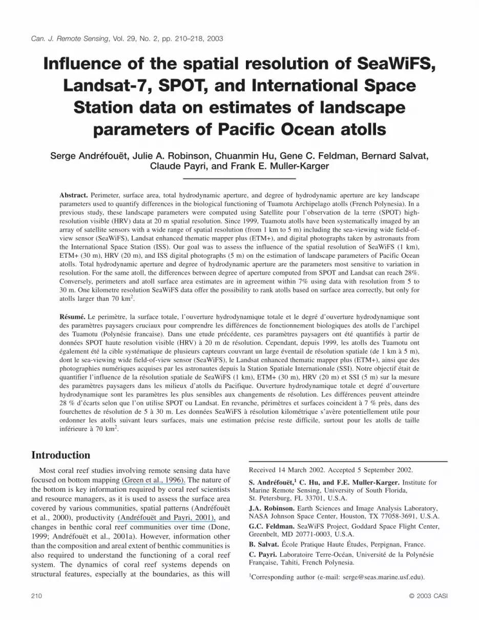
Figure 2. Relationships between (a) total surface area (km2),(b) rim surface area (km2), and (c) lagoon surface area (km2)computed with SeaWiFS and SPOT data. SE, standard error.
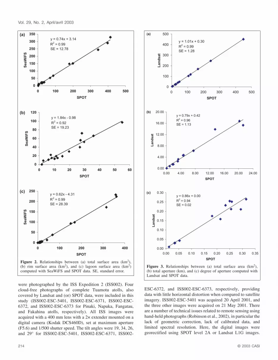
Figure 3. Relationships between (a) total surface area (km2),(b) total aperture (km), and (c) degree of aperture computed withLandsat and SPOT data.

Since the ISS data were almost vertical photographs withminimum distortion, they were resampled to obtain the sameaspect ratio of a bounding rectangle calculated on SPOT orLandsat data. Triangulation based on ground-control pointsvisible on both ISS and Landsat–SPOT data provided theground resolution of the ISS images. The corrected spatialresolution was 5.0, 5.3, 5.6, and 5.6 m for ISS002-ESC-5401,ISS002-ESC-6371, ISS002-ESC-6372, and ISS002-ESC-6373,respectively. Since we were interested in simple structuralfeatures (i.e., isolating water from land to estimate surfacelagoon and degree of aperture), fine spectral resolution was notstrictly necessary. The contrast provided by the ISSphotographs was sufficient to recognize boundaries betweenwater bodies and land.
Unfortunately, there are no ground-truth data to validate theestimated landscape parameters. No amount of fieldwork couldpossibly provide systematic validation of total aperture orsurface areas for such a large number and diversity of sites.Since the 1980s, SPOT has provided geographic reference datafor mapping purposes in the Tuamotu Archipelago (Fourgassié,1990; SHOM-SPT, 1990), even for higher resolution data likeaerial photographs (Champomier, 1990). Therefore, ourstrategy hereafter when making comparisons is to consider thehighest resolution data as the reference.
Results and discussionsFor the 16 atolls covered by SeaWiFS, we compared lagoon
surface area, rim surface area, and total surface area with thevalues obtained using SPOT (Table 1; Figure 2). Lagoon andtotal surface areas seem to have been underestimated bySeaWiFS LAC data, whereas rim surface areas were typicallyoverestimated. The cause is the typical width of a rim, whichrarely exceeds that of a SeaWiFS pixel (�1 km). Adjacencyeffects likely contribute to the overestimation of surface areaestimates near bright land targets. Results were worse (e.g.,(lagoon area)SeaWiFS = 0.31 × (lagoon area)SPOT – 0.34, r2 =0.89) when considering only small atolls (1.76 < total area <70.00 km2). Overall, however, the SeaWiFS versus SPOTlandscape parameter estimates fit a linear relationship. Thismeans that the statistical relationships between lagoon or totalsurface areas and ecological–biological data described inGalzin et al. (1994), Adjeroud et al. (2000), or Dufour et al.(2001) should remain significant, even at this resolution, ifspanning a large range of atoll sizes.
Comparison of total surface area, total aperture, and degreeof aperture for 12 atolls covered by both SPOT HRV andLandsat ETM+ is provided in Table 2 and Figure 3. Theagreement for total surface areas is very high. The maximumdiscrepancy reached 4.2% of the reference SPOT value for
© 2003 CASI 215
Canadian Journal of Remote Sensing / Journal canadien de télédétection
Perimeter (km) Surface area (km2) Total aperture (km)Degree of aperture(unitless)
Atoll Landsat-7 SPOT Landsat-7 SPOT Landsat-7 SPOT Landsat-7 SPOT
Tikehau 79.17 79.17 451.70 448.85 16.76 20.25 0.21 0.26Amanu 72.67 72.45 246.20 244.00 15.30 21.26 0.21 0.29Marutea Sud 54.33 54.08 168.70 163.80 13.85 13.52 0.25 0.25Takaroa 59.18 59.24 117.65 117.35 2.52 3.15 0.04 0.05Takapoto 47.92 47.81 103.50 104.10 1.43 1.70 0.03 0.04Mataiva 26.82 26.71 47.60 47.35 0.79 0.91 0.03 0.03Tuanake 23.64 23.80 38.90 38.10 6.26 7.50 0.26 0.32Hiti 18.70 18.37 26.20 25.50 4.70 4.75 0.25 0.26Haraiki 19.87 19.80 25.40 25.45 4.62 4.63 0.23 0.23Vairaatea 18.55 18.05 21.95 21.10 3.24 3.27 0.17 0.18Tepoto Sud 9.10 9.00 6.40 6.15 1.44 1.93 0.16 0.21Pinaki 6.99 6.65 3.70 3.55 0.06 0.08 0.01 0.01SE* 0.19 1.28 1.13 0.02
*Standard error estimate.
Table 2. Comparison between landscape parameters estimated with SPOT (reference) and Landsat-7.
Perimeter (km) Surface area (km2) Total aperture (km)Degree of aperture(unitless)
AtollLandsat-7 –SPOT ISS
Landsat-7 –SPOT ISS
Landsat-7 –SPOT ISS
Landsat-7 –SPOT ISS
Napuka 27.44 27.800 38.32 38.42 3.93 3.89 0.14 0.14Fangatau 20.07 20.410 22.19 23.58 0.84 0.69 0.04 0.03Fakahina 22.40 22.916 34.99 37.34 0.78 0.68 0.03 0.03Pinaki 6.65 6.800 3.55 3.70 0.08 0.06 0.01 0.01SE* 0.11 1.20 0.07 0.00
*Standard error estimate.
Table 3. Comparison between landscape parameters estimated with Landsat-7 – SPOT and ISS (reference).
Pinaki atoll. There was less correspondence between SPOTHRV and Landsat ETM+ for total aperture and degree ofaperture. Landsat underestimated the total aperture, with amaximum discrepancy of 28% for Amanu atoll. To computethe degree of aperture, the perimeter estimate is required, andthe agreement was good between both sensors
((perimeter)Landsat = 0.99 × (perimeter)SPOT +0.23, r2 = 0.99).The underestimate in degree of aperture by Landsat wasprincipally due to four atolls (Tikehau, Amanu, Tuanake, andTepoto Sud). These presented the highest proportions of rimcharacterized by a succession of numerous narrow spillways. Inthe typology of atoll rims described by Andréfouët et al.(2001b), these rims correspond to the types rim 2, rim 5, andrim 6. For Amanu, Tikehau, Tepoto Sud, and Tuanake, thesetype of rims represent 71, 53, 49, and 38%, respectively, of theentire rim (Andréfouët et al., 2001b).
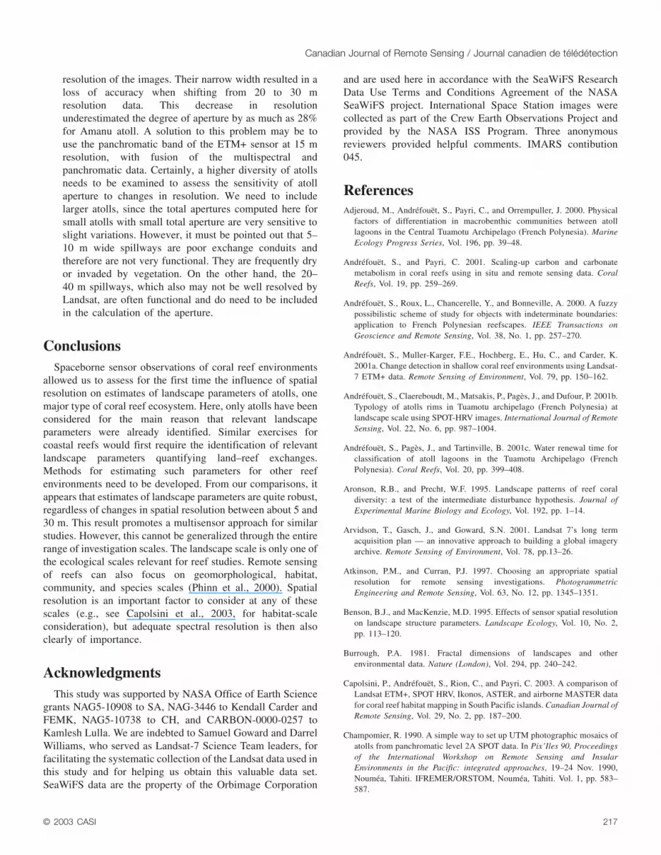
Comparisons of perimeter, total surface area, and degree ofaperture between ISS and SPOT or Landsat are provided inTable 3 and Figure 4. The range of size and degree of aperturecovered by this set of atolls was narrow. The perimeters andtotal surface areas slightly increased at ISS resolution, with amaximum difference of 2.3% in perimeter for Pinaki atoll and6.6% in total surface area for Fakahina atoll. Total aperturedecreased by as much as 25% for Pinaki atoll. The very smalltotal aperture of these atolls, making them sensitive even to tinyvariations in sea state or image resampling, explains highdiscrepancies. Conversely, the degree of aperture appearedconstant between ISS and satellite data.
From these comparisons, we make the followingconclusions:
(1) Estimation of total areas of atolls is consistent usingLandsat, SPOT, and ISS data. The worst discrepancybetween these data was less than 7%. A reader familiarwith fractal theory (Burrough, 1981; Turcotte, 1992) mayfind surprising that perimeters remain extremelyconsistent despite the change in resolution. This goodagreement is due to the fact that the contours of atolls aresmooth. Thus, the change in resolution from 30 to 5 mdid not change the results significantly.
(2) SeaWiFS LAC data (or any kilometre-resolution data)can hardly be recommended for precise measurements ofatoll surface areas. It is worth noting that the currentestimates of global coral reef extent come from digitizedmaps with at best 1 km resolution (Spalding et al., 2001).Our results clearly suggest that this resolution is notadequate for precise or even accurate inventory purposes.SeaWiFS or similar 1 km resolution data are not adequateto quantify coral reef landscape parameters, especiallyfor atolls with surface areas <70 km2. In the case of theTuamotu Archipelago, this represents as many as 45 ofthe 77 atolls of the archipelago. However, SeaWiFS is ofvalue for ranking and classifying broadly definedecological systems (atoll, lagoon). In our case, one singleimage covered a large variety of systems, presenting acost-effective technique of investigation.
(3) The estimate of degree of aperture of an atoll is sensitiveto spatial resolution. Here, we noticed that a change inresolution from 20 to 30 m had an influence for rimswith numerous narrow apertures. Typically, the spillwaywidth along these rims is 15–40 m, or close to the
216 © 2003 CASI
Vol. 29, No. 2, April/avril 2003
Figure 4. Relationships between (a) perimeter (km), (b) totalsurface area (km2), and (c) total aperture (km) computed with ISSand SPOT–Landsat data.
resolution of the images. Their narrow width resulted in aloss of accuracy when shifting from 20 to 30 mresolution data. This decrease in resolutionunderestimated the degree of aperture by as much as 28%for Amanu atoll. A solution to this problem may be touse the panchromatic band of the ETM+ sensor at 15 mresolution, with fusion of the multispectral andpanchromatic data. Certainly, a higher diversity of atollsneeds to be examined to assess the sensitivity of atollaperture to changes in resolution. We need to includelarger atolls, since the total apertures computed here forsmall atolls with small total aperture are very sensitive toslight variations. However, it must be pointed out that 5–10 m wide spillways are poor exchange conduits andtherefore are not very functional. They are frequently dryor invaded by vegetation. On the other hand, the 20–40 m spillways, which also may not be well resolved byLandsat, are often functional and do need to be includedin the calculation of the aperture.
ConclusionsSpaceborne sensor observations of coral reef environments
allowed us to assess for the first time the influence of spatialresolution on estimates of landscape parameters of atolls, onemajor type of coral reef ecosystem. Here, only atolls have beenconsidered for the main reason that relevant landscapeparameters were already identified. Similar exercises forcoastal reefs would first require the identification of relevantlandscape parameters quantifying land–reef exchanges.Methods for estimating such parameters for other reefenvironments need to be developed. From our comparisons, itappears that estimates of landscape parameters are quite robust,regardless of changes in spatial resolution between about 5 and30 m. This result promotes a multisensor approach for similarstudies. However, this cannot be generalized through the entirerange of investigation scales. The landscape scale is only one ofthe ecological scales relevant for reef studies. Remote sensingof reefs can also focus on geomorphological, habitat,community, and species scales (Phinn et al., 2000). Spatialresolution is an important factor to consider at any of thesescales (e.g., see Capolsini et al., 2003, for habitat-scaleconsideration), but adequate spectral resolution is then alsoclearly of importance.
AcknowledgmentsThis study was supported by NASA Office of Earth Science
grants NAG5-10908 to SA, NAG-3446 to Kendall Carder andFEMK, NAG5-10738 to CH, and CARBON-0000-0257 toKamlesh Lulla. We are indebted to Samuel Goward and DarrelWilliams, who served as Landsat-7 Science Team leaders, forfacilitating the systematic collection of the Landsat data used inthis study and for helping us obtain this valuable data set.SeaWiFS data are the property of the Orbimage Corporation
and are used here in accordance with the SeaWiFS ResearchData Use Terms and Conditions Agreement of the NASASeaWiFS project. International Space Station images werecollected as part of the Crew Earth Observations Project andprovided by the NASA ISS Program. Three anonymousreviewers provided helpful comments. IMARS contibution045.
ReferencesAdjeroud, M., Andréfouët, S., Payri, C., and Orrempuller, J. 2000. Physical
factors of differentiation in macrobenthic communities between atolllagoons in the Central Tuamotu Archipelago (French Polynesia). MarineEcology Progress Series, Vol. 196, pp. 39–48.
Andréfouët, S., and Payri, C. 2001. Scaling-up carbon and carbonatemetabolism in coral reefs using in situ and remote sensing data. CoralReefs, Vol. 19, pp. 259–269.
Andréfouët, S., Roux, L., Chancerelle, Y., and Bonneville, A. 2000. A fuzzypossibilistic scheme of study for objects with indeterminate boundaries:application to French Polynesian reefscapes. IEEE Transactions onGeoscience and Remote Sensing, Vol. 38, No. 1, pp. 257–270.
Andréfouët, S., Muller-Karger, F.E., Hochberg, E., Hu, C., and Carder, K.2001a. Change detection in shallow coral reef environments using Landsat-7 ETM+ data. Remote Sensing of Environment, Vol. 79, pp. 150–162.
Andréfouët, S., Claereboudt, M., Matsakis, P., Pagès, J., and Dufour, P. 2001b.Typology of atolls rims in Tuamotu archipelago (French Polynesia) atlandscape scale using SPOT-HRV images. International Journal of RemoteSensing, Vol. 22, No. 6, pp. 987–1004.
Andréfouët, S., Pagès, J., and Tartinville, B. 2001c. Water renewal time forclassification of atoll lagoons in the Tuamotu Archipelago (FrenchPolynesia). Coral Reefs, Vol. 20, pp. 399–408.
Aronson, R.B., and Precht, W.F. 1995. Landscape patterns of reef coraldiversity: a test of the intermediate disturbance hypothesis. Journal ofExperimental Marine Biology and Ecology, Vol. 192, pp. 1–14.
Arvidson, T., Gasch, J., and Goward, S.N. 2001. Landsat 7’s long termacquisition plan — an innovative approach to building a global imageryarchive. Remote Sensing of Environment, Vol. 78, pp.13–26.
Atkinson, P.M., and Curran, P.J. 1997. Choosing an appropriate spatialresolution for remote sensing investigations. PhotogrammetricEngineering and Remote Sensing, Vol. 63, No. 12, pp. 1345–1351.
Benson, B.J., and MacKenzie, M.D. 1995. Effects of sensor spatial resolutionon landscape structure parameters. Landscape Ecology, Vol. 10, No. 2,pp. 113–120.
Burrough, P.A. 1981. Fractal dimensions of landscapes and otherenvironmental data. Nature (London), Vol. 294, pp. 240–242.
Capolsini, P., Andréfouët, S., Rion, C., and Payri, C. 2003. A comparison ofLandsat ETM+, SPOT HRV, Ikonos, ASTER, and airborne MASTER datafor coral reef habitat mapping in South Pacific islands. Canadian Journal ofRemote Sensing, Vol. 29, No. 2, pp. 187–200.
Champomier, R. 1990. A simple way to set up UTM photographic mosaics ofatolls from panchromatic level 2A SPOT data. In Pix’Iles 90, Proceedingsof the International Workshop on Remote Sensing and InsularEnvironments in the Pacific: integrated approaches, 19–24 Nov. 1990,Nouméa, Tahiti. IFREMER/ORSTOM, Nouméa, Tahiti. Vol. 1, pp. 583–587.
© 2003 CASI 217
Canadian Journal of Remote Sensing / Journal canadien de télédétection

Charpy, L., Dufour, P., and Garcia, N. 1997. Particulate organic matter insixteen Tuamotu atoll lagoons (French Polynesia). Marine EcologyProgress Series, Vol. 151, pp. 55–65.
Cullinan, V.I., and Thomas, J.M. 1992. A comparison of quantitative methodsfor examining landscape pattern and scale. Landscape Ecology, Vol. 7,No. 3, pp. 211–227.
Done, T.J. 1999. Coral community adaptability to environmental change at thescales of regions, reefs and reef zones. American Zoologist, Vol. 39, pp. 66–79.
Dufour, P., and Harmelin-Vivien, M. 1997. A research program for a typologyof atoll lagoons: strategy and first results. In Proceedings of the 8thInternational Coral Reef Symposium, 24–29 June 1996, Panama. Edited byH.A. Lessios and I.G. Macintyre. Smithsonian Tropical Reef Institute,Balboa, Panama. Vol. 1, pp. 843–848.
Dufour, P., Andréfouët, S., Charpy, L., and Garcia, N. 2001. Atollsmorphometry control nutrient regime in their lagoons. Limnology andOceanography, Vol. 46, No. 2, pp. 456–461.
Forman, R.T.T., and Godron, M. 1986. Landscape ecology. John Wiley &Sons, New York. 619 pp.
Fortin, M.J. 1999. Effects of quadrat size and data measurement on thedetection of boundaries. Journal of Vegetation Science, Vol. 10, pp. 43–50.
Fortin, M.J., Olson, R.J., Ferson, S., Iverson, L., Hunsaker, C., Edwards, G.,Levine, D., Butera, K., and Klemas, V. 2000. Issues related to the detectionof boundaries. Landscape Ecology, Vol. 15, pp. 453–466.
Fourgassié, A. 1990. The marine image-map, a way to map Polynesian atolls.In Pix’Iles 90: Proceedings of the International Workshop on RemoteSensing and Insular Environments in the Pacific: integrated approaches,19–24 Nov. 1990, Nouméa, Tahiti. IFREMER/ORSTOM, Nouméa, Tahiti.Vol. 1, pp. 329–341.
Galzin, R., Planes, S., Dufour, V., and Salvat, B. 1994. Variation in diversity ofcoral reef fish between French Polynesian atolls. Coral Reefs, Vol. 13,pp. 175–180.
Green, E.P., Mumby, P.J., Edwards, A.J., and Clark, C.D. 1996. A review ofremote sensing for the assessment and management of tropical coastalresources. Coastal Management, Vol. 24, No. 1, pp. 1–40.
Guilcher, A. 1988. Coral reef geomorphology. Coastal morphology andresearch series. John Wiley & Sons, New York. 228 pp.
Hanski, I. 1999. Habitat connectivity, habitat continuity, and metapopulationsin dynamic landscapes. Oikos, Vol. 87, pp. 209–219.
Hargis, C.D., Bissonette, J.A., and David, J.L. 1998. The behavior oflandscape metrics commonly used in the study of habitat fragmentation.Landscape Ecology, Vol. 13, pp. 167–186.
Hu, C., Carder, K., and Muller-Karger, F. 2000. Atmospheric correction ofSeaWiFS imagery over turbid coastal waters: a practical method. RemoteSensing of Environment, Vol. 74, pp. 195–206.
Legendre, P., and Fortin, M.J. 1989. Spatial pattern and ecological analysis.Vegetatio, Vol. 80, No. 2, pp. 107–138.
Pagès, J., and Andréfouët, S. 2001. A reconnaissance approach for hydrologyof atoll lagoons. Coral Reefs, Vol. 20, pp. 409–414.
Phinn, S.R., Neil, D.T., and Joyce, K.E. 2000. Coral reefs: a multi-scaleapproach to monitoring their composition and dynamics. In IGARSS 2000,Proceedings of the International Geoscience and Remote Sensing
Symposium, 24–28 July 2000, Honolulu, Hawaii. TH04.1540. CD-ROM.IEEE, New York.
Poulter, M.A. 1996. On the integration of Earth observation data: defininglandscape boundaries to a GIS. In Geographic objects with indeterminateboundaries. Edited by P.A. Burrough and A.U. Frank. GISDATA. Taylor &Francis, London. pp. 287–298.
Quattrochi, D.A., and Pelletier, R.E. 1990. Remote sensing for analysis oflandscapes: an introduction. In Quantitative methods in landscape ecology:the analysis and interpretation of landscape heterogeneity. Edited by M.G.Turner and R.H. Gardner. Ecological Studies, Springer-Verlag, New York.pp. 51–76.
Riitters, K.H., O’Neill, R.V., Hunsaker, C.T., Wickham, J.D., Yannkee, D.H.,Timmins, S.P., Jones, K.B., and Jackson, B.L. 1995. A factor analysis oflandscape pattern and structure metrics. Landscape Ecology, Vol. 10, No. 1,pp. 23–39.
Robinson, J.A., Feldman, G.C., Kuring, N., Franz, B., Green, E., Noordeloos,M., and Stumpf, R.P. 2000. Data fusion in coral reef mapping: working atmultiple scales with SeaWiFS and astronaut photography. In Proceedingsof the 6th International Conference on Remote Sensing for Marine andCoastal Environments, 1–3 May 2000, Charleston, S.C. EnvironmentalResearch Institute of Michigan (ERIM), Ann Arbor, Mich. Vol. 2, pp. 473–483.
Robinson, J.A., Evans, C.A., and Krikalev, S.K. 2002. Six-meters spatialresolution for remote sensing of Earth from the International Space Station.EOS, Vol. 83, pp. 185–188.
Robinson, J.A., Amsbury, D.L., Liddle, D.A., and Evans, C.A. 2002.Astronaut-acquired photographs as digital data for remote sensing: spatialresolution. International Journal of Remote Sensing, Vol. 23, No. 20,pp. 4403–4438.
SHOM-SPT. 1990. Les dossiers de spatio-préparation des campagneshydrographiques aux Tuamotu-Gambier. In Pix’Iles 90: Proceedings of theInternational Workshop on Remote Sensing and Insular Environments inthe Pacific: Integrated Approaches, 19–24 Nov. 1990, Nouméa, Tahiti.IFREMER/ORSTOM, Nouméa, Tahiti. Vol. 1, pp. 593–595.
Spalding, M.D., Ravilious, C., and Green, E.P. 2001. World atlas of coralreefs. University of California Press, Berkeley, Calif. 424 pp.
Turcotte, D.L. 1992. Fractal and chaos in geology and geophysics. CambridgeUniversity Press, Cambridge, Mass. 221 pp.
Vos, C.C., Verboom, J., Opdam, P.F.M., and TerBraak, C.J.F. 2001. Towardsecologically scaled landscapes indices. The American Naturalist, Vol. 157,pp. 24–41.
Wagner, H.H., and Edwards, P.J. 2001. Quantifying habitat specificity toassess the contribution of a patch to species richness at a landscape scale.Landscape Ecology, Vol. 16, No. 2, pp. 121–131.
Webb, E.L., Evangelista, M.A., and Robinson, J.A. 2000. Digital land-useclassification using Space Shuttle acquired orbital photographs: aquantitative comparison with Landsat TM imagery of a coastalenvironment, Chantaburi, Thailand. Photogrammetric Engineering andRemote Sensing, Vol. 66, No. 12, pp. 1439–1449.
West, K., and van Woesik, R. 2001. Spatial and temporal variance of riverdischarge on Okinawa (Japan): inferring the temporal impact on adjacentcoral reefs. Marine Pollution Bulletin, Vol. 42, No. 10, pp. 864–872.
Woodcock, C.E., and Strahler, A.H. 1987. The factor of scale in remotesensing. Remote Sensing of Environment, Vol. 21, pp. 311–332.
218 © 2003 CASI
Vol. 29, No. 2, April/avril 2003