improving recovery from mature oil fields producing from carbonate reservoirs: upper jurassic...
TRANSCRIPT
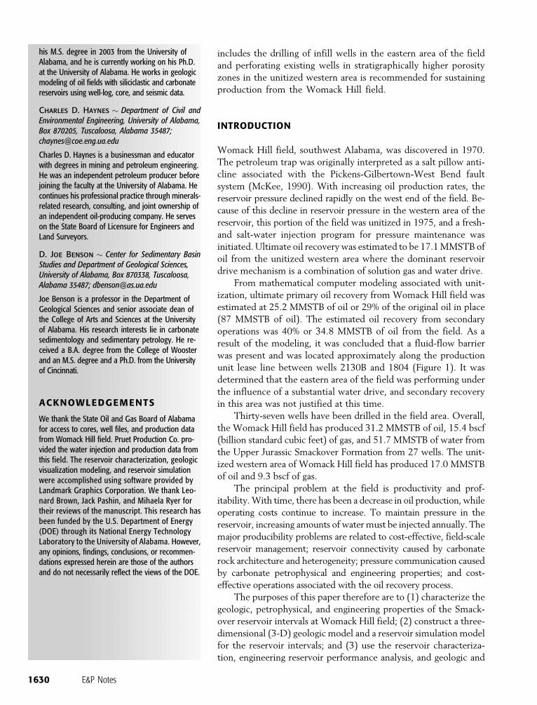
AUTHORS
Ernest A. Mancini � Center for SedimentaryBasin Studies and Department of GeologicalSciences, University of Alabama, Box 870338,Tuscaloosa, Alabama 35487;[email protected]
Ernest A. Mancini is regional director of the Eastern GulfRegion of the Petroleum Technology Transfer Council,director of the Center for Sedimentary Basin Studies,and professor in petroleum geology in the Departmentof Geological Sciences at the University of Alabama. Hisresearch focus is on reservoir characterization andmodeling, petroleum systems, and the applicationof stratigraphic analysis to petroleum exploration.
Thomas A. Blasingame � Department of Petro-leum Engineering, Texas A&M University, CollegeStation, Texas 77843; [email protected]
Tom Blasingame is an associate professor in theDepartment of Petroleum Engineering at Texas A&MUniversity. He holds B.S. and M.S. degrees and a Ph.D.from Texas A&M University in petroleum engineer-ing. He is a distinguished member of the Societyof Petroleum Engineers and a member of the So-ciety for Exploration Geophysicists and AAPG.
Rosalind Archer � Department of EngineeringScience, University of Auckland, Private Bag 92019,Auckland, 1020, New Zealand;[email protected]
Rosalind Archer holds a Ph.D. in petroleum engineer-ing from Stanford University. Her research interestsare in reservoir characterization, well testing, andreservoir simulation. She is currently a lecturer in theDepartment of Engineering Science at the Universityof Auckland, Auckland, New Zealand. She is also anadjunct assistant professor in the Department ofPetroleum Engineering at Texas A&M University.
Brian J. Panetta � Center for Sedimentary BasinStudies and Department of Geological Sciences,University of Alabama, Box 870338, Tuscaloosa,Alabama 35487; [email protected]
Brian Panetta is a research associate in the Departmentof Geological Sciences at the University of Alabama.He received a B.S. degree from the University of SouthCarolina, an M.S. degree from the University of Ken-tucky, and an M.S. degree and a Ph.D. from the Uni-versity of Alabama. His research interests are inreservoir characterization and geologic modeling.
Juan Carlos Llinas � Center for SedimentaryBasin Studies and Department of GeologicalSciences, University of Alabama, Box 870338,Tuscaloosa, Alabama 35487; [email protected]
Juan Carlos Llinas obtained his B.A degree fromthe National University of Colombia in 1995 and
Improving recovery frommature oil fields producingfrom carbonate reservoirs:Upper Jurassic SmackoverFormation, Womack Hill field(eastern Gulf Coast, U.S.A.)Ernest A. Mancini, Thomas A. Blasingame,Rosalind Archer, Brian J. Panetta, Juan Carlos Llinas,Charles D. Haynes, and D. Joe Benson
ABSTRACT
Reservoir characterization, modeling, and simulation were under-
taken to improve production from Womack Hill field (eastern Gulf
Coast, United States). This field produces oil from Upper Jurassic
Smackover carbonate shoal reservoirs. These reservoirs occur in
vertically stacked, heterogeneous depositional and porosity cycles.
The cycles consist of lime mudstone and wackestone at the base and
ooid grainstone at the top. Porosity has been enhanced through dis-
solution and dolomitization. Porosity is chiefly interparticle, solution-
enlarged interparticle, grain moldic, intercrystalline dolomite, and
vuggy pores. Dolostone pore systems and flow units have the high-
est reservoir potential. Petroleum-trapping mechanisms include a
fault trap (footwall uplift with closure to the south against a major
west-southeast–trending normal fault) in the western area, a foot-
wall uplift trap associated with a possible southwest-northeast–
trending normal fault in the south-central area, and a salt-cored anti-
cline with four-way dip closure in the eastern area. Potential barriers
to flow are present as a result of petrophysical differences among
and within the cycles, as well as the presence of normal faulting.
Reservoir performance analysis and simulation indicate that the
unitized western area has less than 1 MMSTB of oil remaining to
be recovered, and that the eastern area has 2–3 MMSTB of oil to
be recovered. A field-scale reservoir management strategy that
E&P NOTES
AAPG Bulletin, v. 88, no. 12 (December 2004), pp. 1629–1651 1629
Copyright #2004. The American Association of Petroleum Geologists. All rights reserved.
Manuscript received March 17, 2004; provisional acceptance May 26, 2004; revised manuscript receivedJune 10, 2004; final acceptance June 21, 2004.
includes the drilling of infill wells in the eastern area of the field
and perforating existing wells in stratigraphically higher porosity
zones in the unitized western area is recommended for sustaining
production from the Womack Hill field.
INTRODUCTION
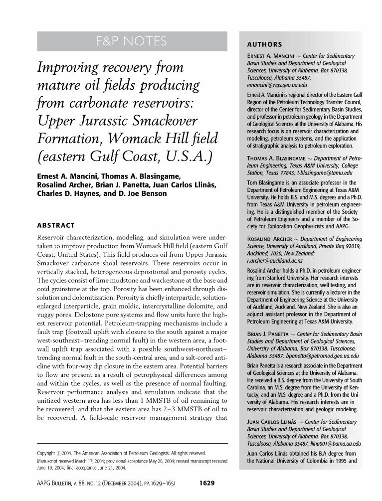
Womack Hill field, southwest Alabama, was discovered in 1970.
The petroleum trap was originally interpreted as a salt pillow anti-
cline associated with the Pickens-Gilbertown-West Bend fault
system (McKee, 1990). With increasing oil production rates, the
reservoir pressure declined rapidly on the west end of the field. Be-
cause of this decline in reservoir pressure in the western area of the
reservoir, this portion of the field was unitized in 1975, and a fresh-
and salt-water injection program for pressure maintenance was
initiated. Ultimate oil recovery was estimated to be 17.1 MMSTB of
oil from the unitized western area where the dominant reservoir
drive mechanism is a combination of solution gas and water drive.
From mathematical computer modeling associated with unit-
ization, ultimate primary oil recovery from Womack Hill field was
estimated at 25.2 MMSTB of oil or 29% of the original oil in place
(87 MMSTB of oil). The estimated oil recovery from secondary
operations was 40% or 34.8 MMSTB of oil from the field. As a
result of the modeling, it was concluded that a fluid-flow barrier
was present and was located approximately along the production
unit lease line between wells 2130B and 1804 (Figure 1). It was
determined that the eastern area of the field was performing under
the influence of a substantial water drive, and secondary recovery
in this area was not justified at this time.
Thirty-seven wells have been drilled in the field area. Overall,
the Womack Hill field has produced 31.2 MMSTB of oil, 15.4 bscf
(billion standard cubic feet) of gas, and 51.7 MMSTB of water from
the Upper Jurassic Smackover Formation from 27 wells. The unit-
ized western area of Womack Hill field has produced 17.0 MMSTB
of oil and 9.3 bscf of gas.
The principal problem at the field is productivity and prof-
itability. With time, there has been a decrease in oil production, while
operating costs continue to increase. To maintain pressure in the
reservoir, increasing amounts of water must be injected annually. The
major producibility problems are related to cost-effective, field-scale
reservoir management; reservoir connectivity caused by carbonate
rock architecture and heterogeneity; pressure communication caused
by carbonate petrophysical and engineering properties; and cost-
effective operations associated with the oil recovery process.
The purposes of this paper therefore are to (1) characterize the
geologic, petrophysical, and engineering properties of the Smack-
over reservoir intervals at Womack Hill field; (2) construct a three-
dimensional (3-D) geologic model and a reservoir simulation model
for the reservoir intervals; and (3) use the reservoir characteriza-
tion, engineering reservoir performance analysis, and geologic and
his M.S. degree in 2003 from the University ofAlabama, and he is currently working on his Ph.D.at the University of Alabama. He works in geologicmodeling of oil fields with siliciclastic and carbonatereservoirs using well-log, core, and seismic data.
Charles D. Haynes � Department of Civil andEnvironmental Engineering, University of Alabama,Box 870205, Tuscaloosa, Alabama 35487;[email protected]
Charles D. Haynes is a businessman and educatorwith degrees in mining and petroleum engineering.He was an independent petroleum producer beforejoining the faculty at the University of Alabama. Hecontinues his professional practice through minerals-related research, consulting, and joint ownership ofan independent oil-producing company. He serveson the State Board of Licensure for Engineers andLand Surveyors.
D. Joe Benson � Center for Sedimentary BasinStudies and Department of Geological Sciences,University of Alabama, Box 870338, Tuscaloosa,Alabama 35487; [email protected]
Joe Benson is a professor in the Department ofGeological Sciences and senior associate dean ofthe College of Arts and Sciences at the Universityof Alabama. His research interests lie in carbonatesedimentology and sedimentary petrology. He re-ceived a B.A. degree from the College of Woosterand an M.S. degree and a Ph.D. from the Universityof Cincinnati.
ACKNOWLEDGEMENTS
We thank the State Oil and Gas Board of Alabamafor access to cores, well files, and production datafrom Womack Hill field. Pruet Production Co. pro-vided the water injection and production data fromthis field. The reservoir characterization, geologicvisualization modeling, and reservoir simulationwere accomplished using software provided byLandmark Graphics Corporation. We thank Leo-nard Brown, Jack Pashin, and Mihaela Ryer fortheir reviews of the manuscript. This research hasbeen funded by the U.S. Department of Energy(DOE) through its National Energy TechnologyLaboratory to the University of Alabama. However,any opinions, findings, conclusions, or recommen-dations expressed herein are those of the authorsand do not necessarily reflect the views of the DOE.
1630 E&P Notes
Figu
re1
.Pro
duct
ion
byw
elli
nW
omac
kH
illfie
ldan
dlo
catio
nof
cros
sse
ctio
nA
A0 .N
ote
the
mos
tpro
duct
ive
wel
lsar
ein
the
sout
h-ce
ntra
lpar
toft
hefie
ld.S
eeth
eA
ppen
dix
for
wel
lpe
rmit
info
rmat
ion.
Mancini et al. 1631
reservoir simulation modeling to assess the current
field-scale reservoir management practices to provide
a foundation for improving production from this field.
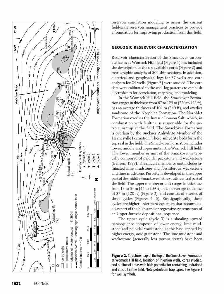
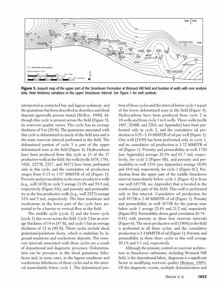
GEOLOGIC RESERVOIR CHARACTERIZATION
Reservoir characterization of the Smackover carbon-
ate facies at Womack Hill field (Figure 1) has included
the description of the six available cores (Figure 2) and
petrographic analysis of 304 thin sections. In addition,
electrical and geophysical logs for 37 wells and core
analyses for 24 wells (Figure 3) were studied. The core
data were calibrated to the well-log patterns to establish
electrofacies for correlation, mapping, and modeling.
In the Womack Hill field, the Smackover Forma-
tion ranges in thickness from 67 to 129 m (220 to 422 ft),
has an average thickness of 104 m (340 ft), and overlies
sandstone of the Norphlet Formation. The Norphlet
Formation overlies the Jurassic Louann Salt, which, in
combination with faulting, is responsible for the pe-
troleum trap at the field. The Smackover Formation
is overlain by the Buckner Anhydrite Member of the
Haynesville Formation. These anhydrite beds form the
top seal in the field. The Smackover Formation includes
lower,middle,andupperunits intheWomackHill field.
The lower member or unit of the Smackover is typi-
cally composed of peloidal packstone and wackestone
(Benson, 1988). The middle member or unit includes la-
minated lime mudstone and fossiliferous wackestone
and lime mudstone. Porosity is developed in the upper
partofthemiddleSmackoverinthesouth-centralpartof
the field. The upper member or unit ranges in thickness
from 13 to 64 m (44 to 209 ft), has an average thickness
of 37 m (120 ft) (Figure 3), and consists of a series of
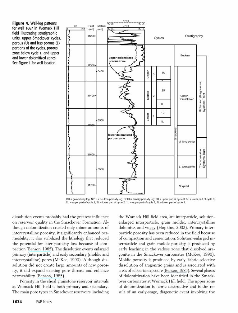
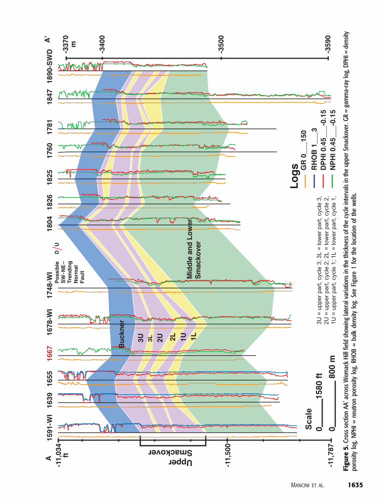
three cycles (Figures 4, 5). Stratigraphically, these
cycles are higher order parasequences that accumulat-
ed as part of the highstand or regressive systems tract of
an Upper Jurassic depositional sequence.
The upper cycle (cycle 3) is a shoaling-upward
parasequence composed of lower energy, lime mud-
stone and peloidal wackestone at the base capped by
higher energy, ooid grainstone. The lime mudstone and
wackestone (generally less porous strata) have been
Figure 2. Structure map of the top of the Smackover Formationat Womack Hill field, location of injection wells, cores studied,and outline of areas with high potential for containing undrainedand attic oil in the field. Note petroleum trap types. See Figure 1for well symbols.
1632 E&P Notes
interpreted as restricted bay and lagoon sediment, and
the grainstone has been described as shoreface and shoal
deposits (generally porous strata) (McKee, 1990). Al-
though this cycle is present across the field (Figure 5),
its reservoir quality varies. The cycle has an average
thickness of 9 m (30 ft). The grainstone associated with
this cycle is dolomitized in much of the field area and is
the main reservoir interval perforated in the field. The
dolomitized portion of cycle 3 is part of the upper
dolomitized zone in the field (Figure 4). Hydrocarbons
have been produced from this cycle in 21 of the 27
productive wells in the field. Six wells (wells 1678, 1781,
1826, 2257B, 2327, and 3657) have been perforated
only in this cycle, and the cumulative oil production
ranges from 0.13 to 1.97 MMSTB of oil (Figure 1).
Porosity and permeability in the more productive wells
(e.g., well 1678) in cycle 3 average 21.0% and 59.3 md,
respectively (Figure 6A), and porosity and permeabil-
ity in the less productive wells (e.g., well 2327) average
12% and 3 md, respectively. The lime mudstone and
wackestone in the lower part of the cycle have po-
tential to be a barrier to vertical flow in the field.
The middle cycle (cycle 2) and the lower cycle
(cycle 1) also occur across the field. Cycle 2 has an aver-
age thickness of 14 m (47 ft), and cycle 1 has an average
thickness of 12 m (40 ft). These cycles include shoal
grainstone/packstone facies, which is underlain by la-
goonal mudstone and wackestone deposits. The reser-
voir intervals associated with these cycles are a result
of depositional and diagenetic processes. Dolomitiza-
tion can be pervasive in the shoal grainstone litho-
facies and, in some cases, in the lagoon mudstone and
wackestone lithofacies of these cycles and in the inter-
val immediately below cycle 1. The dolomitized por-
tion of these cycles and the interval below cycle 1 is part
of the lower dolomitized zone in the field (Figure 4).
Hydrocarbons have been produced from cycle 2 in
18 wells and from cycle 1 in 6 wells. Three wells (wells
1847, 2248B, and 2263; see Appendix) have been per-
forated only in cycle 2, and the cumulative oil pro-
duction is 0.35–3.18 MMSTB of oil per well (Figure 1).
One well (2109) has been perforated only in cycle 1,
and its cumulative oil production is 1.72 MMSTB of
oil (Figure 1). Porosity and permeability in well 1720
(see Appendix) average 20.3% and 61.7 md, respec-
tively, for cycle 2 (Figure 6B), and porosity and per-
meability in well 1591 (see Appendix) average 18.0%
and 18.8 md, respectively, for cycle 1 (Figure 6C). Pro-
duction from the upper part of the middle Smackover
interval immediately below cycle 1 (Figure 4) is from
one well (4575B, see Appendix) that is located in the
south-central part of the field. This well is perforated
only in this interval. Cumulative oil production for
well 4575B is 2.48 MMSTB of oil (Figure 1). Porosity
and permeability in well 4575B for the porous zone
below cycle 1 average 23.4% and 21.2 md, respectively
(Figure 6D). Permeability shows good correlation (0.74–
0.81) with porosity in these four reservoir intervals
(Figure 6). The most productive well (1804) in the field
is perforated in all three cycles, and the cumulative
production is 3.4 MMSTB of oil (Figure 1). Porosity and
permeability in these three cycles in this well average
20.1% and 5.1 md, respectively.
Although the primary control on reservoir architec-
ture in Smackover carbonates, including Womack Hill
field, is the depositional fabric, diagenesis is a significant
factor in modifying reservoir quality (Benson, 1985).
Of the diagenetic events, multiple dolomitization and
Figure 3. Isopach map of the upper part of the Smackover Formation at Womack Hill field and location of wells with core analysisdata. Note thickness variations in the upper Smackover interval. See Figure 1 for well symbols.
Mancini et al. 1633
dissolution events probably had the greatest influence
on reservoir quality in the Smackover Formation. Al-
though dolomitization created only minor amounts of
intercrystalline porosity, it significantly enhanced per-
meability; it also stabilized the lithology that reduced
the potential for later porosity loss because of com-
paction (Benson, 1985). The dissolution events enlarged
primary (interparticle) and early secondary (moldic and
intercrystalline) pores (McKee, 1990). Although dis-
solution did not create large amounts of new poros-
ity, it did expand existing pore throats and enhance
permeability (Benson, 1985).
Porosity in the shoal grainstone reservoir intervals
at Womack Hill field is both primary and secondary.
The main pore types in Smackover reservoirs, including
the Womack Hill field area, are interparticle, solution-
enlarged interparticle, grain moldic, intercrystalline
dolomite, and vuggy (Hopkins, 2002). Primary inter-
particle porosity has been reduced in the field because
of compaction and cementation. Solution-enlarged in-
terparticle and grain moldic porosity is produced by
early leaching in the vadose zone that dissolved ara-
gonite in the Smackover carbonates (McKee, 1990).
Moldic porosity is produced by early, fabric-selective
dissolution of aragonitic grains and is associated with
areas of subaerial exposure (Benson, 1985). Several phases
of dolomitization have been identified in the Smack-
over carbonates at Womack Hill field. The upper zone
of dolomitization is fabric destructive and is the re-
sult of an early-stage, diagenetic event involving the
Figure 4. Well-log patternsfor well 1667 in Womack Hillfield illustrating stratigraphicunits, upper Smackover cycles,porous (U) and less porous (L)portions of the cycles, porouszone below cycle 1, and upperand lower dolomitized zones.See Figure 1 for well location.
1634 E&P Notes
Figu
re5
.Cro
ssse
ctio
nA
A0 ac
ross
Wom
ack
Hill
field
show
ing
late
ralv
aria
tions
inth
eth
ickn
ess
ofth
ecy
cle
inte
rval
sin
the
uppe
rSm
acko
ver.
GR
=ga
mm
a-ra
ylo
g,D
PHI=
dens
itypo
rosi
tylo
g,N
PHI
=ne
utro
npo
rosi
tylo
g,RH
OB
=bu
lkde
nsity
log.
See
Figu
re1
for
the
loca
tion
ofth
ew
ells
.
Mancini et al. 1635
downward movement of evaporitically concentrated
brine (Tedesco, 2002). The lower zone of dolomitiza-
tion contains large amounts of intercrystalline porosity
and permeability and is the result, in part, of fabric-
destructive, mixing-zone processes (Tedesco, 2002).
Vuggy porosity, as defined by Choquette and Pray
(1970), is present in the field area as the product of late,
nonfabric-selective dissolution of calcite or dolomite
and is produced by solution enlargement of earlier
formed interparticle or intercrystalline pores (Benson,
1985; Benson and Mancini, 1999). Smackover reser-
voirs characterized by vuggy porosity have high poros-
ity (up to 29%) and permeability (up to 4106 md) val-
ues (Benson and Mancini, 1984; Mancini et al., 2000).
Pore systems are the fundamental building blocks
of reservoir architecture. Pore origin, geometry, and
spatial distribution determine the amount and kind
of reservoir heterogeneity. Pore systems affect not
only hydrocarbon storage and flow but also reservoir
producibility and flow-unit quality and comparative
rank in a field. Hydrocarbon recovery efficiency and
total recovery volume are determined by the 3-D
shape and size of the pores and pore throats (Kopaska-
Merkel and Hall, 1993; Ahr and Hammel, 1999). There-
fore, the pore systems (pore topology and geometry
and pore-throat size distribution) of the Womack Hill
field reservoir intervals are extremely important. Pore-
throat size distribution is one of the important factors
Figure 6. Porosity vs. permeability plots for reservoir zones (cycles) in wells in the Womack Hill field: (A) cycle 3, well 1678; (B)cycle 2, well 1720; (C) cycle 1, well 1591; and (D) below cycle 1, well 4575B. See Figure 1 for the location and productivity of wells.
1636 E&P Notes
determining permeability because the smallest pore
throats are the bottlenecks that determine the rate
at which fluid can pass through a rock. Permeability
has been shown to be directly related to the inherent
pore system and degree of heterogeneity in Smack-
over reservoirs (Carlson et al., 1998; Mancini et al.,
2000). Generally, the more homogeneous (little vari-
ability in architecture and pore systems) the reservoir,
the greater the hydrocarbon recovery from that res-
ervoir. However, heterogeneity at one scale is not nec-
essarily paralleled by heterogeneity at other scales. For
example, the shoal grainstone reservoir intervals at
Womack Hill field can be dominated by an interpar-
ticle and solution-enlarged, moldic and intercrystal-
line, or intercrystalline and vuggy pore system and
have low mesoscopic-scale heterogeneity but low to
high microscopic-scale heterogeneity, depending on the
pore system. Such heterogeneity is a function of both
depositional and diagenetic processes. The grainstone
deposits accumulated in shoal environments, which
tend to have uniformity of paleoenvironmental condi-
tions in a given shoal, but these carbonates can be later
subjected to dissolution and dolomitization, such as at
Womack Hill field, to produce dolograinstone and
coarse (large) crystalline dolostone. The moldic and
intercrystalline pore system produced is characterized
by pores of variable size that are poorly connected by
narrow pore throats. Pore size is dependent on the
size of the carbonate grain that was leached. The
intercrystalline and vuggy pore system is charac-
terized by more large-sized pores that are inter-
connected by larger and more uniform pore throats.
The size of the pores is dependent on the dolomite
crystal size. Interparticle porosity of Lucia (1999),
which includes intergrain and intercrystal pore types
in grainstone, dolograinstone, and large crystalline
dolostone, provides for high connectivity in carbon-
ate reservoirs and high permeability (Lucia, 1999;
Jennings and Lucia, 2001). In the Womack Hill field,
leached and dolomitized grainstone flow units domi-
nated by moldic and intercrystalline porosity have
lower reservoir potential than the grainstone flow
units dominated by depositional interparticle and
solution-enlarged porosity because the leached (mol-
dic) grainstone pore system is characterized by a higher
percentage of small-sized pores poorly connected by nar-
row pore throats. Dolostone flow units dominated by
intercrystalline and vuggy porosity have the highest res-
ervoir potential because of a pore system characterized
by a higher percentage of large-sized pores intercon-
nected by larger and more uniform pore throats.
ENGINEERING DATA AND ANALYSIS
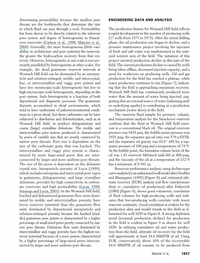
The production history for Womack Hill field reflects
a rapid development in the number of producing wells
(17 wells from 1971 to 1973). After the initial drilling
phase, the oil production rate began to decline, and a
pressure maintenance project involving the injection
of fresh and salt water was implemented in the unit-
ized western area of the field. The initiation of this
project arrested production decline in this part of the
field. The current production decline is caused by wells
being taken offline, decreased injection capacity, and a
need for workovers on producing wells. Oil and gas
production for the field has reached a plateau, while
water production continues to rise (Figure 7), indicat-
ing that the field is approaching maximum recovery.
Womack Hill field has continuously produced more
water than the amount of water being injected, sug-
gesting that an external source of water (adjoining and/
or underlying aquifer) is contributing as a production
mechanism (water drive) in the field.
The reservoir fluid sample for pressure, volume,
and temperature analysis for the Smackover reservoir
confirms that the fluid in Womack Hill field reser-
voir is a conventional black oil. The original reservoir
pressure was 5433 psia, the bubble-point pressure was
1925 psig, the separator gas-oil ratio was 579 scf/STB,
and the separator oil gravity was 42.6j API for a sep-
arator pressure of 100 psig and a temperature of 74jF.
At the bubble point, the formation volume factor of the
oil was 1.41 reservoir bbl/stock tank bbl at 400 psig,
and the viscosity of the oil at a temperature of 212jF
has a minimum of 0.342 cp.
Reservoir performance analysis, using decline-type
curve analysis for an unfractured well model after Doublet
and Blasingame (1995) (Figure 8) and estimated ulti-
mate recovery (EUR) analysis (oil-flow rate/pressure
drop vs. cumulative oil production) after Fetkovich
(1980) (Figure 9), shows good volumetric correlation
of fluid volumes for high-producing wells and indi-
cates that low-producing wells correlate with lower
reservoir continuity. Good correlation is evident for the
production data and model trends in the field as il-
lustrated for well 1639 in Figure 8. A strong depletion
trend (terminal production decline) for production
in the field is evident in Figure 9 as shown for well
1639. In utilizing cumulative oil and water produc-
tion from the field, ultimate oil recovery for the field
will approximate at least 34.6 MMSTB of oil. Using
EUR, conservatively about 10% of the recoverable
34.6 MMSTB of oil remains to be produced from
Mancini et al. 1637
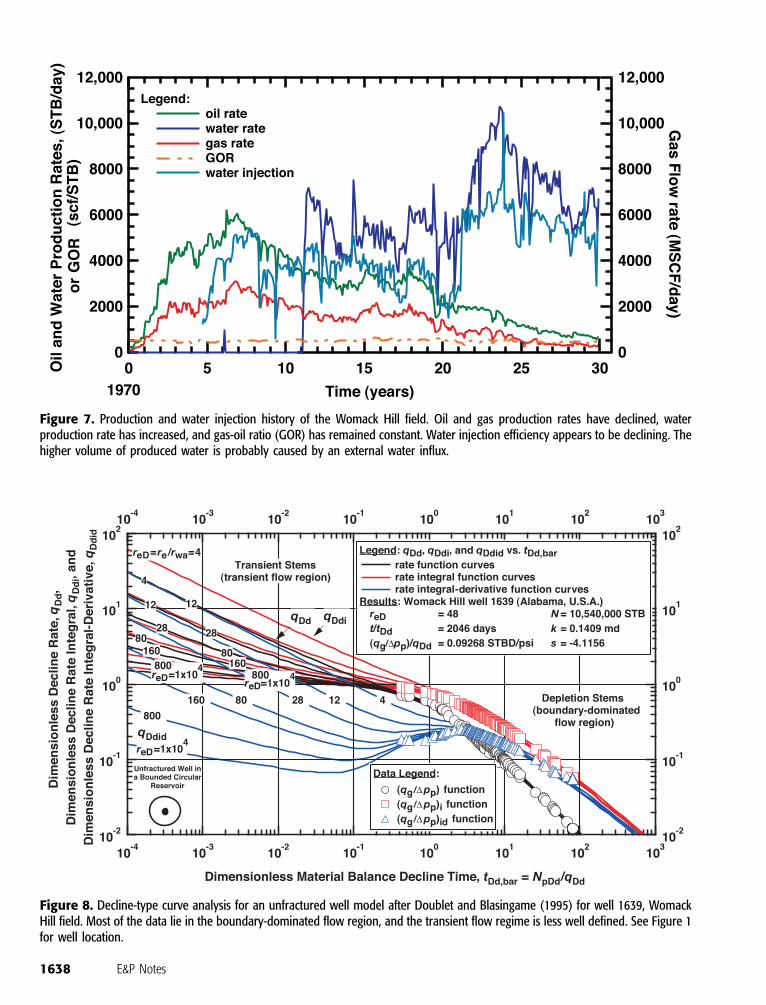
Figure 7. Production and water injection history of the Womack Hill field. Oil and gas production rates have declined, waterproduction rate has increased, and gas-oil ratio (GOR) has remained constant. Water injection efficiency appears to be declining. Thehigher volume of produced water is probably caused by an external water influx.
Figure 8. Decline-type curve analysis for an unfractured well model after Doublet and Blasingame (1995) for well 1639, WomackHill field. Most of the data lie in the boundary-dominated flow region, and the transient flow regime is less well defined. See Figure 1for well location.
1638 E&P Notes
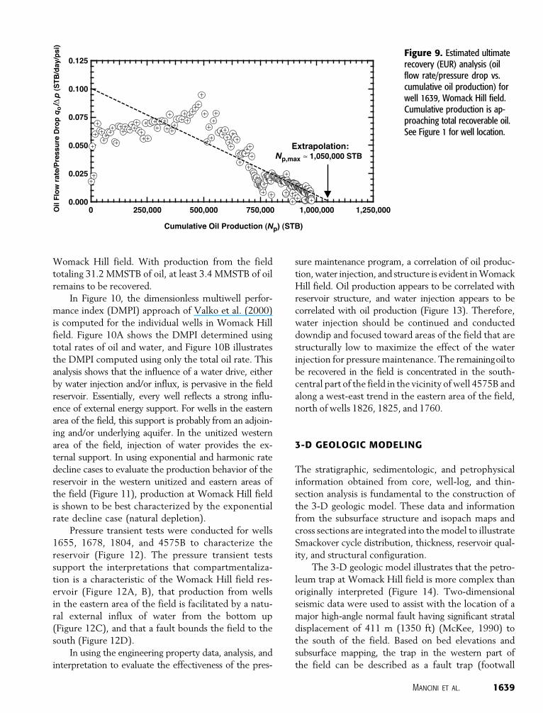
Womack Hill field. With production from the field
totaling 31.2 MMSTB of oil, at least 3.4 MMSTB of oil
remains to be recovered.
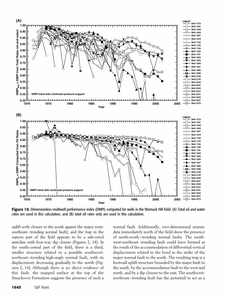
In Figure 10, the dimensionless multiwell perfor-
mance index (DMPI) approach of Valko et al. (2000)
is computed for the individual wells in Womack Hill
field. Figure 10A shows the DMPI determined using
total rates of oil and water, and Figure 10B illustrates
the DMPI computed using only the total oil rate. This
analysis shows that the influence of a water drive, either
by water injection and/or influx, is pervasive in the field
reservoir. Essentially, every well reflects a strong influ-
ence of external energy support. For wells in the eastern
area of the field, this support is probably from an adjoin-
ing and/or underlying aquifer. In the unitized western
area of the field, injection of water provides the ex-
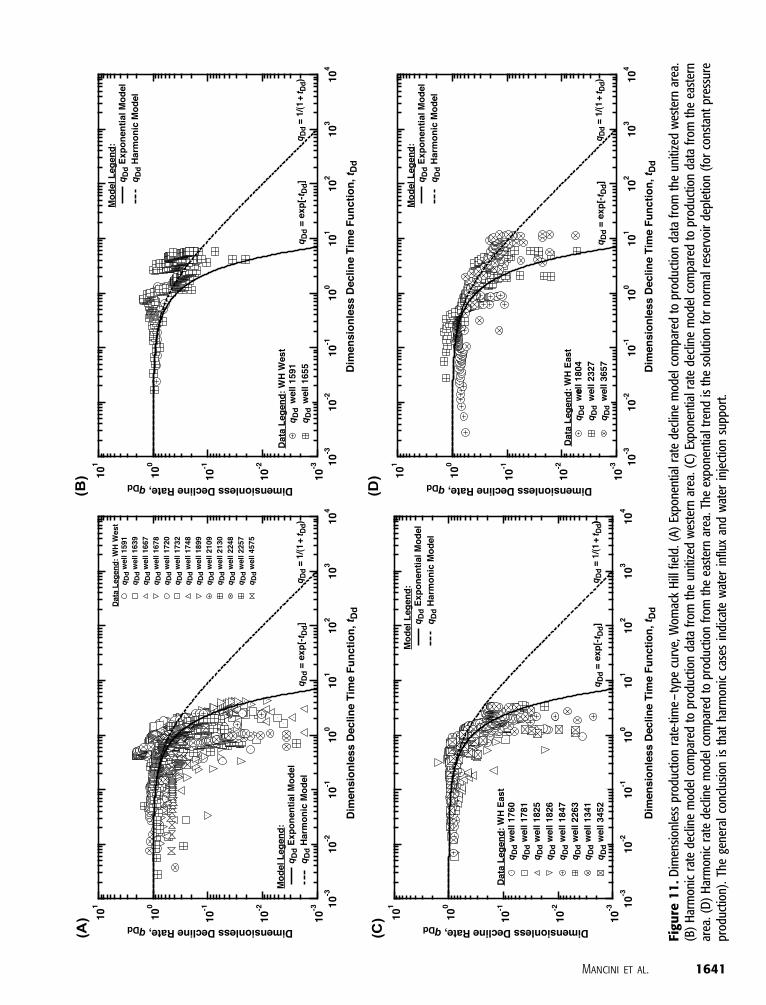
ternal support. In using exponential and harmonic rate
decline cases to evaluate the production behavior of the
reservoir in the western unitized and eastern areas of
the field (Figure 11), production at Womack Hill field
is shown to be best characterized by the exponential
rate decline case (natural depletion).
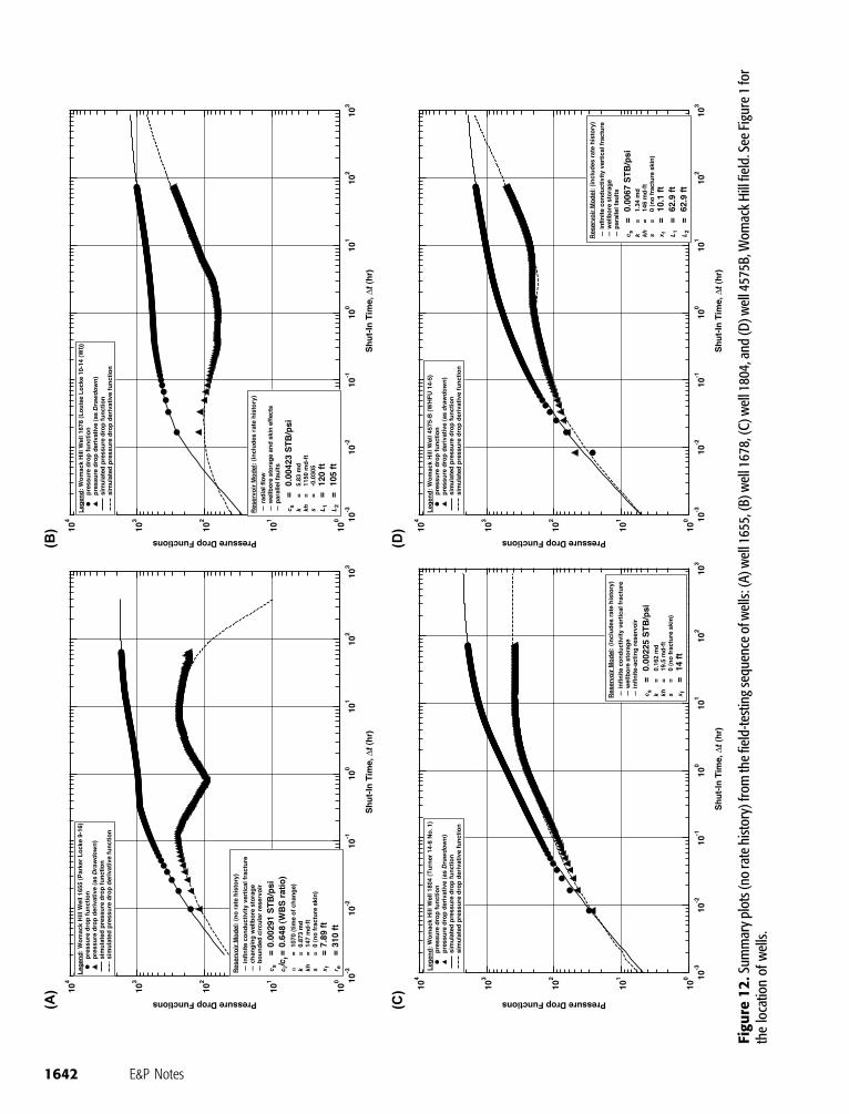
Pressure transient tests were conducted for wells
1655, 1678, 1804, and 4575B to characterize the
reservoir (Figure 12). The pressure transient tests
support the interpretations that compartmentaliza-
tion is a characteristic of the Womack Hill field res-
ervoir (Figure 12A, B), that production from wells
in the eastern area of the field is facilitated by a natu-
ral external influx of water from the bottom up
(Figure 12C), and that a fault bounds the field to the
south (Figure 12D).
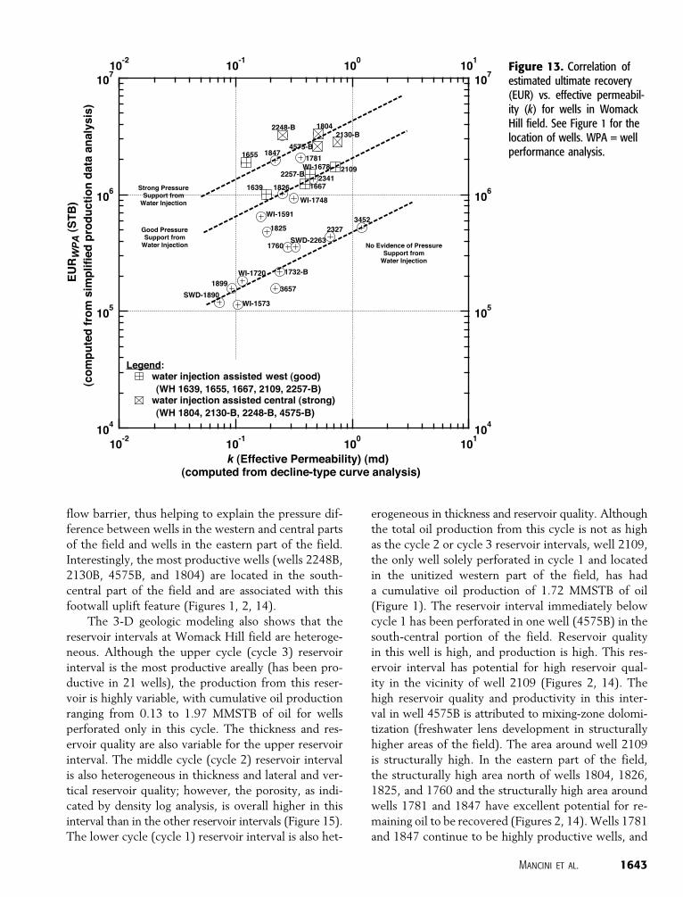
In using the engineering property data, analysis, and
interpretation to evaluate the effectiveness of the pres-
sure maintenance program, a correlation of oil produc-
tion, water injection, and structure is evident in Womack
Hill field. Oil production appears to be correlated with
reservoir structure, and water injection appears to be
correlated with oil production (Figure 13). Therefore,
water injection should be continued and conducted
downdip and focused toward areas of the field that are
structurally low to maximize the effect of the water
injection for pressure maintenance. The remainingoilto
be recovered in the field is concentrated in the south-
central part of the field in the vicinity of well 4575B and
along a west-east trend in the eastern area of the field,
north of wells 1826, 1825, and 1760.
3-D GEOLOGIC MODELING
The stratigraphic, sedimentologic, and petrophysical
information obtained from core, well-log, and thin-
section analysis is fundamental to the construction of
the 3-D geologic model. These data and information
from the subsurface structure and isopach maps and
cross sections are integrated into the model to illustrate
Smackover cycle distribution, thickness, reservoir qual-
ity, and structural configuration.
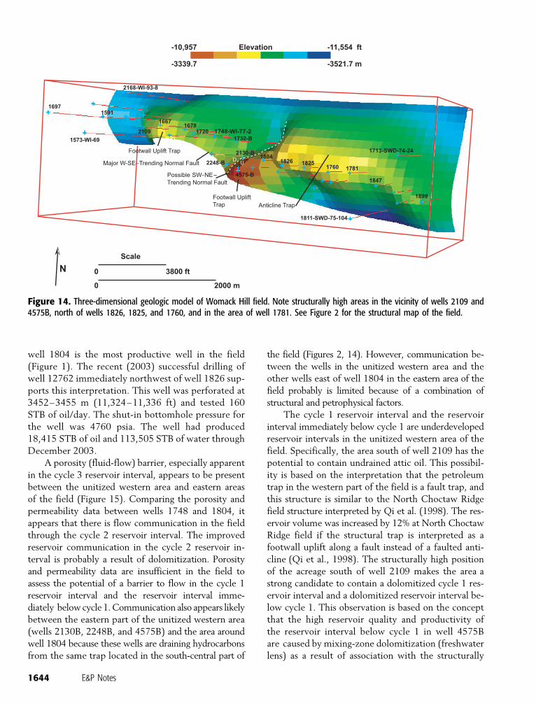
The 3-D geologic model illustrates that the petro-
leum trap at Womack Hill field is more complex than
originally interpreted (Figure 14). Two-dimensional
seismic data were used to assist with the location of a
major high-angle normal fault having significant stratal
displacement of 411 m (1350 ft) (McKee, 1990) to
the south of the field. Based on bed elevations and
subsurface mapping, the trap in the western part of
the field can be described as a fault trap (footwall
Figure 9. Estimated ultimaterecovery (EUR) analysis (oilflow rate/pressure drop vs.cumulative oil production) forwell 1639, Womack Hill field.Cumulative production is ap-proaching total recoverable oil.See Figure 1 for well location.
Mancini et al. 1639
uplift with closure to the south against the major west-
southeast–trending normal fault), and the trap in the
eastern part of the field appears to be a salt-cored
anticline with four-way dip closure (Figures 2, 14). In
the south-central part of the field, there is a third,
smaller structure related to a possible southwest-
northeast–trending high-angle normal fault, with its
displacement decreasing gradually to the north (Fig-
ures 2, 14). Although there is no direct evidence of
this fault, the mapped surface at the top of the
Smackover Formation suggests the presence of such a
normal fault. Additionally, two-dimensional seismic
data immediately north of the field show the presence
of north-south–trending normal faults. The south-
west-northeast–trending fault could have formed as
the result of the accommodation of differential vertical
displacement related to the bend in the strike of the
major normal fault to the south. The resulting trap is a
footwall uplift structure bounded by the major fault to
the south, by the accommodation fault to the west and
north, and by a dip closure to the east. The southwest-
northeast–trending fault has the potential to act as a
Figure 10. Dimensionless multiwell performance index (DMPI) computed for wells in the Womack Hill field: (A) Total oil and waterrates are used in this calculation, and (B) total oil rates only are used in this calculation.
1640 E&P Notes
Figu
re1
1.D
imen
sion
less
prod
uctio
nra
te-t
ime
–ty
pecu
rve,
Wom
ack
Hill
field
.(A
)Ex
pone
ntia
lrat
ede
clin
em
odel
com
pare
dto
prod
uctio
nda
tafr
omth
eun
itize
dw
este
rnar
ea.
(B)
Har
mon
icra
tede
clin
em
odel
com
pare
dto
prod
uctio
nda
tafr
omth
eun
itize
dw
este
rnar
ea.(
C)
Expo
nent
ialr
ate
decl
ine
mod
elco
mpa
red
topr
oduc
tion
data
from
the
east
ern
area
.(D
)H
arm
onic
rate
decl
ine
mod
elco
mpa
red
topr
oduc
tion
from
the
east
ern
area
.The
expo
nent
ialt
rend
isth
eso
lutio
nfo
rno
rmal
rese
rvoi
rde
plet
ion
(for
cons
tant
pres
sure
prod
uctio
n).
The
gene
ral
conc
lusi
onis
that
harm
onic
case
sin
dica
tew
ater
influ
xan
dw
ater
inje
ctio
nsu
ppor
t.
Mancini et al. 1641
Figu
re1
2.S
umm
ary
plot
s(n
ora
tehi
stor
y)fr
omth
efie
ld-t
estin
gse
quen
ceof
wel
ls:(
A)w
ell1
655,
(B)w
ell1
678,
(C)w
ell1
804,
and
(D)w
ell4
575B
,Wom
ack
Hill
field
.See
Figu
re1
for
the
loca
tion
ofw
ells
.
1642 E&P Notes
flow barrier, thus helping to explain the pressure dif-
ference between wells in the western and central parts
of the field and wells in the eastern part of the field.
Interestingly, the most productive wells (wells 2248B,
2130B, 4575B, and 1804) are located in the south-
central part of the field and are associated with this
footwall uplift feature (Figures 1, 2, 14).
The 3-D geologic modeling also shows that the
reservoir intervals at Womack Hill field are heteroge-
neous. Although the upper cycle (cycle 3) reservoir
interval is the most productive areally (has been pro-
ductive in 21 wells), the production from this reser-
voir is highly variable, with cumulative oil production
ranging from 0.13 to 1.97 MMSTB of oil for wells
perforated only in this cycle. The thickness and res-
ervoir quality are also variable for the upper reservoir
interval. The middle cycle (cycle 2) reservoir interval
is also heterogeneous in thickness and lateral and ver-
tical reservoir quality; however, the porosity, as indi-
cated by density log analysis, is overall higher in this
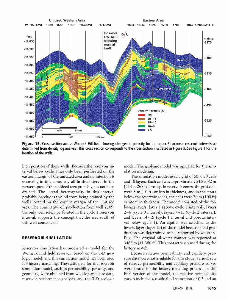
interval than in the other reservoir intervals (Figure 15).
The lower cycle (cycle 1) reservoir interval is also het-
erogeneous in thickness and reservoir quality. Although
the total oil production from this cycle is not as high
as the cycle 2 or cycle 3 reservoir intervals, well 2109,
the only well solely perforated in cycle 1 and located
in the unitized western part of the field, has had
a cumulative oil production of 1.72 MMSTB of oil
(Figure 1). The reservoir interval immediately below
cycle 1 has been perforated in one well (4575B) in the
south-central portion of the field. Reservoir quality
in this well is high, and production is high. This res-
ervoir interval has potential for high reservoir qual-
ity in the vicinity of well 2109 (Figures 2, 14). The
high reservoir quality and productivity in this inter-
val in well 4575B is attributed to mixing-zone dolomi-
tization (freshwater lens development in structurally
higher areas of the field). The area around well 2109
is structurally high. In the eastern part of the field,
the structurally high area north of wells 1804, 1826,
1825, and 1760 and the structurally high area around
wells 1781 and 1847 have excellent potential for re-
maining oil to be recovered (Figures 2, 14). Wells 1781
and 1847 continue to be highly productive wells, and
Figure 13. Correlation ofestimated ultimate recovery(EUR) vs. effective permeabil-ity (k) for wells in WomackHill field. See Figure 1 for thelocation of wells. WPA = wellperformance analysis.
Mancini et al. 1643
well 1804 is the most productive well in the field
(Figure 1). The recent (2003) successful drilling of
well 12762 immediately northwest of well 1826 sup-
ports this interpretation. This well was perforated at
3452–3455 m (11,324–11,336 ft) and tested 160
STB of oil/day. The shut-in bottomhole pressure for
the well was 4760 psia. The well had produced
18,415 STB of oil and 113,505 STB of water through
December 2003.
A porosity (fluid-flow) barrier, especially apparent
in the cycle 3 reservoir interval, appears to be present
between the unitized western area and eastern areas
of the field (Figure 15). Comparing the porosity and
permeability data between wells 1748 and 1804, it
appears that there is flow communication in the field
through the cycle 2 reservoir interval. The improved
reservoir communication in the cycle 2 reservoir in-
terval is probably a result of dolomitization. Porosity
and permeability data are insufficient in the field to
assess the potential of a barrier to flow in the cycle 1
reservoir interval and the reservoir interval imme-
diately below cycle 1. Communication also appears likely
between the eastern part of the unitized western area
(wells 2130B, 2248B, and 4575B) and the area around
well 1804 because these wells are draining hydrocarbons
from the same trap located in the south-central part of
the field (Figures 2, 14). However, communication be-
tween the wells in the unitized western area and the
other wells east of well 1804 in the eastern area of the
field probably is limited because of a combination of
structural and petrophysical factors.
The cycle 1 reservoir interval and the reservoir
interval immediately below cycle 1 are underdeveloped
reservoir intervals in the unitized western area of the
field. Specifically, the area south of well 2109 has the
potential to contain undrained attic oil. This possibil-
ity is based on the interpretation that the petroleum
trap in the western part of the field is a fault trap, and
this structure is similar to the North Choctaw Ridge
field structure interpreted by Qi et al. (1998). The res-
ervoir volume was increased by 12% at North Choctaw
Ridge field if the structural trap is interpreted as a
footwall uplift along a fault instead of a faulted anti-
cline (Qi et al., 1998). The structurally high position
of the acreage south of well 2109 makes the area a
strong candidate to contain a dolomitized cycle 1 res-
ervoir interval and a dolomitized reservoir interval be-
low cycle 1. This observation is based on the concept
that the high reservoir quality and productivity of
the reservoir interval below cycle 1 in well 4575B
are caused by mixing-zone dolomitization (freshwater
lens) as a result of association with the structurally
Figure 14. Three-dimensional geologic model of Womack Hill field. Note structurally high areas in the vicinity of wells 2109 and4575B, north of wells 1826, 1825, and 1760, and in the area of well 1781. See Figure 2 for the structural map of the field.
1644 E&P Notes
high position of these wells. Because the reservoir in-
terval below cycle 1 has only been perforated on the
eastern margin of the unitized area and no injection is
occurring in this zone, any oil in this interval in the
western part of the unitized area probably has not been
drained. The lateral heterogeneity in this interval
probably precludes this oil from being drained by the
wells located on the eastern margin of the unitized
area. The cumulative oil production from well 2109,
the only well solely perforated in the cycle 1 reservoir
interval, supports the concept that the area south of
this well contains oil.
RESERVOIR SIMULATION
Reservoir simulation has produced a model for the
Womack Hill field reservoir based on the 3-D geo-
logic model, and this simulation model has been used
for history matching. The static data for the reservoir
simulation model, such as permeability, porosity, and
geometry, were obtained from well-log and core data,
reservoir performance analysis, and the 3-D geologic
model. The geologic model was upscaled for the sim-
ulation modeling.
The simulation model used a grid of 60 � 30 cells
and 19 layers. Each cell was approximately 216 � 82 m
(414 � 268 ft) areally. In reservoir zones, the grid cells
were 3 m (10 ft) or less in thickness, and in the strata
below the reservoir zones, the cells were 30 m (100 ft)
or more in thickness. The model consisted of the fol-
lowing layers: layer 1 (above cycle 3 interval), layers
2–6 (cycle 3 interval), layers 7–13 (cycle 2 interval),
and layers 14–19 (cycle 1 interval and porous inter-
val below cycle 1). An aquifer was attached to the
lowest layer (layer 19) of the model because field pro-
duction was determined to be supported by water in-
flux. The original oil-water contact was reported at
3463 m (11,360 ft). This contact was varied during the
history match.
Because relative permeability and capillary pres-
sure data were not available for this study, various sets
of relative permeability and capillary pressure curves
were tested in the history-matching process. In the
final version of the model, the relative permeability
curves included a residual oil saturation of 0.3 and an
Figure 15. Cross section across Womack Hill field showing changes in porosity for the upper Smackover reservoir intervals asdetermined from density log analysis. This cross section corresponds to the cross section illustrated in Figure 5. See Figure 1 for thelocation of the wells.
Mancini et al. 1645
endpoint water relative permeability of 1.0. The cap-
illary pressure curves used represent strong imbibition
water. To match the water influx, a value of 1.0 was
used for the ratio of vertical to horizontal permeabil-
ity. With the capillary pressure and oil-water contact
defined for a particular simulation, the modeling was
commenced for an initial fluid distribution.
Monthly oil and gas production volumes used for
the study were available from the beginning of pro-
duction in the field in 1970. Monthly volumes of water
production and of water injection data were acquired
for each well since 1982. The lack of water production
data from 1970 to 1982 was an issue in the history-
matching process because it was difficult to determine
when breakthrough occurred in many of the wells in
the field. Well completion and perforation depths and
dates were also obtained. A significant change in field
operations occurred in 1990–1991 when jet pumps
were installed in the production wells. The increase in
field watercut that occurred at the time may be a result
of this operational change. Acid treatments were per-
formed periodically in the wells.
During the history-matching process, the wells
were operated by withdrawing the same amount of oil
as was historically produced. Because pressure data
were limited, the success of the history match was
judged by the ability to match the reported water pro-
duction data from the simulation modeling. Analysis
of the production data shows that the reservoir has
remained above the bubble point; therefore, detailed
history matching information could not be obtained
from the gas production data.
Initially, global model parameters, such as the
water-oil contact depth, ratio of vertical to horizontal
permeability, degree of connectivity between the unit-
ized western and eastern areas of the field, and the
aquifer strength and location, were adjusted to achieve
the best possible match. Based on the results of the
production data analysis and well test analysis, compart-
mentalization was introduced using transmissibility
barriers around well 1804. This well has been the most
productive well in the field and probably is produc-
ing from its own reservoir compartment. In this stage
of the history-matching study, the impact of changes
in global parameters was evaluated to gain insight into
the key factors controlling flow in the reservoir. Twenty-
four simulation runs were made, systematically varying
the oil-water contact depth, the aquifer location (under
the entire reservoir or under the eastern area only), the
aquifer strength (weak, strong), and the strength of
a possible flow barrier between the unitized western
and eastern areas of the field. The oil-water contact
depth has the strongest influence on cumulative wa-
ter production. Indications are that the presence of a
flow barrier between the unitized western and east-
ern areas of the field has little impact on cumulative
water production.
The final phase of the history-matching effort in-
volved making some local changes to the geologic mod-
el in the neighborhood of key wells (commonly those
with high water and/or oil production). Typically, these
changes involved reducing porosity in a window around
the well to accelerate the process of water invasion
into the well. In some cases, porosity was increased
to reduce amounts of water production. These local
changes were based on the results from the produc-
tion data analysis, which assigned in-place volumes to
individual wells.
The field watercut as determined from the mod-
eling is shown in Figure 16. The final part of the solid line
on this figure presents the expected watercut in the
field if production is maintained from the existing
wells and if two additional infill wells are drilled. The
performance of the individual wells was matched with
varying degrees of success. Several wells had excellent
watercut history matches until 1990. At this point, jet
pumps were installed, and the watercut in certain wells
showed a marked increase. This effect was very difficult
to capture in the reservoir simulation model. Altering
the relative permeability curve assigned to the con-
nection between the well and its grid block in the res-
ervoir at the time jet pumps were introduced was the
most successful history-matching strategy to account
for the installation of the jet pumps.
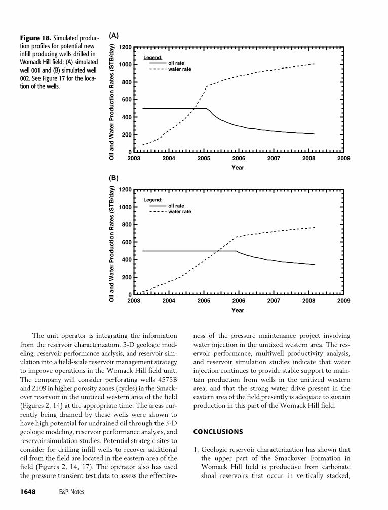
Figure 17 shows the oil saturation in the top of the
upper cycle or cycle 3 in the Womack Hill field at the
end of the history match (February 2003). The oil satu-
ration is progressively less in layers below the cycle 3
interval. In the unitized western area of the field, there
is some remaining mobile oil in the vicinity of wells
4575B and 2109.
High remaining oil saturations are in the eastern
area of the field, north of wells 1804, 1825, and around
well 1781 (Figure 17). These areas are structurally high
and are predicted by the geologic model to have
reservoir-quality porosity and permeability. To target
this remaining oil, the production performance of two
infill wells (001 and 002) was simulated. The resulting
production profiles are shown in Figure 18. In the
simulation model, the wells were perforated above
11,300 ft (3440 m) and produced at a rate of 500 STB
of oil/day. Over 5 yr, the cumulative production of
1646 E&P Notes
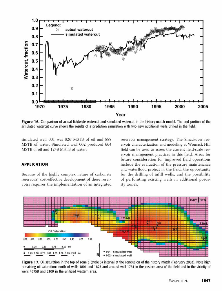
simulated well 001 was 826 MSTB of oil and 888
MSTB of water. Simulated well 002 produced 664
MSTB of oil and 1248 MSTB of water.
APPLICATION
Because of the highly complex nature of carbonate
reservoirs, cost-effective development of these reser-
voirs requires the implementation of an integrated
reservoir management strategy. The Smackover res-
ervoir characterization and modeling at Womack Hill
field can be used to assess the current field-scale res-
ervoir management practices in this field. Areas for
future consideration for improved field operations
include the evaluation of the pressure maintenance
and waterflood project in the field, the opportunity
for the drilling of infill wells, and the possibility
of perforating existing wells in additional poros-
ity zones.
Figure 16. Comparison of actual fieldwide watercut and simulated watercut in the history-match model. The end portion of thesimulated watercut curve shows the results of a prediction simulation with two new additional wells drilled in the field.
Figure 17. Oil saturation in the top of zone 3 (cycle 3) interval at the conclusion of the history match (February 2003). Note highremaining oil saturations north of wells 1804 and 1825 and around well 1781 in the eastern area of the field and in the vicinity ofwells 4575B and 2109 in the unitized western area.
Mancini et al. 1647
The unit operator is integrating the information
from the reservoir characterization, 3-D geologic mod-
eling, reservoir performance analysis, and reservoir sim-
ulation into a field-scale reservoir management strategy
to improve operations in the Womack Hill field unit.
The company will consider perforating wells 4575B
and 2109 in higher porosity zones (cycles) in the Smack-
over reservoir in the unitized western area of the field
(Figures 2, 14) at the appropriate time. The areas cur-
rently being drained by these wells were shown to
have high potential for undrained oil through the 3-D
geologic modeling, reservoir performance analysis, and
reservoir simulation studies. Potential strategic sites to
consider for drilling infill wells to recover additional
oil from the field are located in the eastern area of the
field (Figures 2, 14, 17). The operator also has used
the pressure transient test data to assess the effective-
ness of the pressure maintenance project involving
water injection in the unitized western area. The res-
ervoir performance, multiwell productivity analysis,
and reservoir simulation studies indicate that water
injection continues to provide stable support to main-
tain production from wells in the unitized western
area, and that the strong water drive present in the
eastern area of the field presently is adequate to sustain
production in this part of the Womack Hill field.
CONCLUSIONS
1. Geologic reservoir characterization has shown that
the upper part of the Smackover Formation in
Womack Hill field is productive from carbonate
shoal reservoirs that occur in vertically stacked,
Figure 18. Simulated produc-tion profiles for potential newinfill producing wells drilled inWomack Hill field: (A) simulatedwell 001 and (B) simulated well002. See Figure 17 for the loca-tion of the wells.
1648 E&P Notes
heterogeneous depositional and porosity cycles. The
cycles typically consist of lime mudstone and wacke-
stone at the base and ooid grainstone at the top. The
lime mudstone and wackestone lithofacies has been
interpreted as restricted bay and lagoon sediment,
and the grainstone lithofacies has been described as
beach shoreface and shoal deposits. The grainstone
associated with the upper cycle (cycle 3) is dolomi-
tized (upper dolomitized zone) in much of the field
area. Dolomitization (lower dolomitized zone) can
be pervasive in the middle cycle (cycle 2) and the
lower cycle (cycle 1) and the interval immediately
below cycle 1. These cycles occur across the field,
but they are laterally heterogeneous in depositional
texture and diagenetic fabric. Porosity consists chiefly
of depositional interparticle, solution-enlarged in-
terparticle, grain moldic, intercrystalline dolomite
and vuggy pores. Dolostone pore systems and flow
units dominated by intercrystalline and vuggy pores
have the highest reservoir potential. Dolostone flow
units have a higher percentage of large-sized pores
with larger pore throats, and dolomitized and leached
grainstone flow units have a lower percentage of large-
sized pores with narrow pore throats.
2. Engineering characterization and analysis have
shown that the reservoir fluid in Womack Hill field
is conventional black oil. Pressure transient test data
support the interpretations that the Womack Hill
field reservoir is compartmentalized, and that a fault
bounds the field reservoir to the south. Reservoir
performance analysis indicates good volumetric cor-
relation for high-producing wells, and that low-
producing wells correlate with lower reservoir
continuity. Multiwell productivity analysis shows
that the influence of water drive by water injection
and/or water influx from the aquifer is pervasive
in the field reservoir. Production behavior analysis
indicates that the production in the field is best
characterized by the exponential decline case. Res-
ervoir performance studies have shown that 10%
of the recoverable 34.6 MMSTB of oil remains to
be produced from the field. The undrained oil is
concentrated in structural highs associated with
footwall uplifts in the unitized western area and
along an elongated west-east anticline in the eastern
part of the field. Water injection in the field should
be continued and conducted downdip and focused
toward areas of the field that are structurally low.
3. A 3-D geologic model has been constructed for the
Womack Hill field structure and reservoir. The 3-D
geologic modeling shows that the petroleum trap
is more complex than originally interpreted. The
petroleum-trapping mechanisms include a fault trap
(footwall uplift with closure to the south against
a major west-southeast–trending, high-angle nor-
mal fault) in the western area, a footwall uplift trap
associated with a possible southwest-northeast–
trending, high-angle normal fault in the south-central
area, and a salt-cored anticline with four-way dip
closure in the eastern area. The pressure difference
between wells in the unitized western area of the
field and wells in the eastern area of the field may be
attributed to a flow barrier caused by the presence
of a possible southwest-northeast–trending fault and
a change in porosity and/or permeability in Smack-
over facies. The geologic modeling shows that the
Smackover reservoirs are heterogeneous. The petro-
physical component of the barrier to flow is present
potentially in the vicinity of the unit line between
the unitized western and the eastern areas of the
field. Reservoir characterization and geologic model-
ing have shown that four areas in the Womack Hill
field have potential for the recovery of undrained oil.
4. Reservoir simulation has produced a model for the
Womack Hill field reservoir based on the 3-D
geologic model and reservoir performance analysis.
Analysis of the production data shows that the
reservoir has remained above the bubble point. The
simulation model has been used successfully for
history matching. The depth of the oil-water con-
tact has the strongest influence on cumulative water
production. The history match of the performance
of the field is satisfactory, and the reservoir sim-
ulation model indicates that oil remains to be re-
covered in the eastern area of the field. The unitized
western area of the field appears to have some oil
remaining to be recovered.
5. The operator for the Womack Hill field unit is
integrating the information and results from this
study into a field-scale reservoir management strat-
egy to improve operations at the Womack Hill field.
The company will consider perforating wells in
higher porosity zones in the Smackover reservoir to
recover attic oil in the unitized western area at the
appropriate time. The operator is using the pres-
sure transient test data to assess the effectiveness of
the pressure maintenance project involving water
injection in the unitized western area. The company
is evaluating the cost-effectiveness and risks asso-
ciated with instituting an infill drilling program to
recover undrained oil in the eastern area of the
Womack Hill field.
Mancini et al. 1649
REFERENCES CITED
Ahr, W. M., and B. Hammel, 1999, Identification and mapping flowunits in carbonate reservoirs: An example from Spraberry(Permian) field, Garza County, Texas, U.S.A.: Energy Ex-ploration and Exploitation, v. 17, p. 311–334.
Benson, D. J., 1985, Diagenetic controls on reservoir developmentand quality, Smackover Formation of southwest Alabama:Gulf Coast Association of Geological Societies Transactions,v. 35, p. 317–326.
Benson, D. J., 1988, Depositional history of the SmackoverFormation in southwest Alabama: Gulf Coast Association ofGeological Societies Transactions, v. 38, p. 197–205.
Benson, D. J., and E. A. Mancini, 1984, Porosity development andreservoir characteristics of the Smackover Formation insouthwest Alabama, in Jurassic of the Gulf Rim: ProceedingsGulf Coast Section SEPM Foundation 3rd Research, p. 1–17.
Benson, D. J., and E. A. Mancini, 1999, Diagenetic influence onreservoir development and quality in the Smackover updipbasement ridge play, southwest Alabama: Gulf Coast Associ-ation of Geological Society Transactions, v. 99, p. 95–101.
Carlson, E. C., D. J. Benson, R. H. Groshong, and E. A. Mancini,1998, Improved oil recovery from heterogeneous carbonatereservoirs associated with paleotopographic basement struc-tures: Appleton field, Alabama: Society of Petroleum Engi-neers/Department of Energy 11th Symposium on ImprovedOil Recovery, p. 99–105.
Choquette, P. W., and L. C. Pray, 1970, Geologic nomenclatureand classification of porosity in sedimentary carbonates: AAPGBulletin, v. 54, p. 207–250.
Doublet, L. E., and T. A. Blasingame, 1995, Decline curve analysisusing type curves: Water influx/waterflood cases: Presented atthe 1995 Annual Society of Petroleum Engineers TechnicalConference and Exhibition, Dallas, Texas, October 22–25,SPE Paper 30774, 32 p.
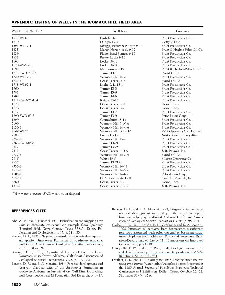
APPENDIX: LISTING OF WELLS IN THE WOMACK HILL FIELD AREA
Well Permit Number* Well Name Company
1573-WI-69 Carlisle 16-4 Pruet Production Co.1579 Dungan 17-5 Getty Oil Co.1591-WI-77-1 Scruggs, Parker & Norton 9-14 Pruet Production Co.1635 Martin-Norton et al. 9-12 Pruet & Hughes-Pelto Oil Co.1639 Fluker-Bend-Scruggs 9-15 Pruet Production Co.1655 Parker-Locke 9-16 Pruet Production Co.1667 Locke 10-13 Pruet Production Co.1678-WI-93-8 Locke 10-14 Pruet Production Co.1697 McPhearson 8-15 Pruet & Hughes-Pelto Oil Co.1713-SWD-74-24 Turner 13-1 Placid Oil Co.1720-WI-77-2 Womack Hill 15-2 Pruet Production Co.1732-B Gross Turner 15-4 Placid Oil Co.1748-WI-92-1 Locke S. L. 15-1 Pruet Production Co.1760 Turner 13-5 Pruet Production Co.1781 Turner 13-6 Pruet Production Co.1804 Turner 14-6 Pruet Production Co.1811-SWD-75-104 Knight 13-15 Pruet Production Co.1825 Gross Turner 14-8 Exxon Corp.1826 Gross Turner 14-7 Exxon Corp.1847 Turner 13-7 Pruet Production Co.1890-SWD-83-3 Turner 13-9 Petro-Lewis Corp.1899 Counselman 18-12 Pruet Production Co.2109 Womack Hill 9-16-A Pruet Production Co.2130-B Womack Hill 14-4-A Pruet Production Co.2168-WI-72 Womack Hill WI 9-10 FMP Operating Co., Ltd. Ptn.2183 Louise Locke 1 North American Royalties2257-B Womack Hill 15-4 Pruet Production Co.2263-SWD-85-5 Turner 13-21 Pruet Production Co.2327 Turner 13-25 Pruet Production Co.2341 Gross Turner 14-8A J. R. Pounds, Inc.2737-B Womack Hill 15-2-A Placid Oil Co.2916 White 19-5 Midroc Operating Co.3657 Turner 13-21A Pruet Production Co.4335-B Womack Hill 14-12 Pruet Production Co.4575-B Womack Hill 14-5 2 Pruet Production Co.4805-B Womack Hill 14-6 2 Petro-Lewis Corp.4852-B C. A. Cox Estate 15-8 Santa Fe Minerals, Inc.4860 Gross-Turner 14-10 Exxon Corp.12762 Gross Turner 14-7 2 J. R. Pounds, Inc.
*WI = water injection; SWD = salt water disposal.
1650 E&P Notes
Fetkovich, M. J., 1980, Decline curve analysis using type curves:Journal of Petroleum Technology, v. 32, no. 6, p. 1065–1077.
Hopkins, T. L., 2002, Integrated petrographic and petrophysicalstudy of the Smackover Formation, Womack Hill field, Clarkeand Choctaw counties, Alabama: M.S. thesis, Texas A&MUniversity, College Station, Texas, 156 p.
Jennings, J. W., and F. J. Lucia, 2001, Predicting permeability fromwell logs in carbonates with a link to geology for interwellpermeability mapping: Society of Petroleum Engineers Paper71336, p. 1–16.
Kopaska-Merkel, D. C., and D. R. Hall, 1993, Reservoir character-ization of the Smackover Formation in southwest Alabama:Geological Survey of Alabama Bulletin, v. 153, 111 p.
Lucia, F. J., 1999, Carbonate reservoir characterization: New York,Springer, 226 p.
Mancini, E. A., D. J. Benson, B. S. Hart, R. S. Balch, W. C. Parcell,and B. J. Panetta, 2000, Appleton field case study (eastern Gulfcoastal plain): Field development model for Upper Jurassic
microbial reef reservoirs associated with paleotopographicbasement structures: AAPG Bulletin, v. 84, p. 1699–1717.
McKee, D. A., 1990, Structural controls on lithofacies and pe-troleum geology of the Smackover Formation: Eastern Missis-sippi Interior Salt basin, Alabama: M.S. thesis, University ofAlabama, Tuscaloosa, Alabama, 254 p.
Qi, J., J. C. Pashin, and R. H. Groshong, Jr., 1998, Structure andevolution of North Choctaw Ridge field, Alabama, a saltrelated footwall uplift along the peripheral fault system, GulfCoast basin: Gulf Coast Association of Geological SocietiesTransactions, v. 48, p. 349–359.
Tedesco, W. A., 2002, Dolomitization and reservoir developmentof the Upper Jurassic Smackover Formation, Womack Hillfield, eastern Gulf coastal plain: Ph.D. dissertation, Universityof Mississippi, University, Mississippi, 251 p.
Valko, P. P., L. E. Doublet, and T. A. Blasingame, 2000, De-velopment and application of the multiwell productivity index(MPI): Society of Petroleum Engineers Journal, v. 5, p. 1.
Mancini et al. 1651