horrocks beach coastal management strategy
TRANSCRIPT
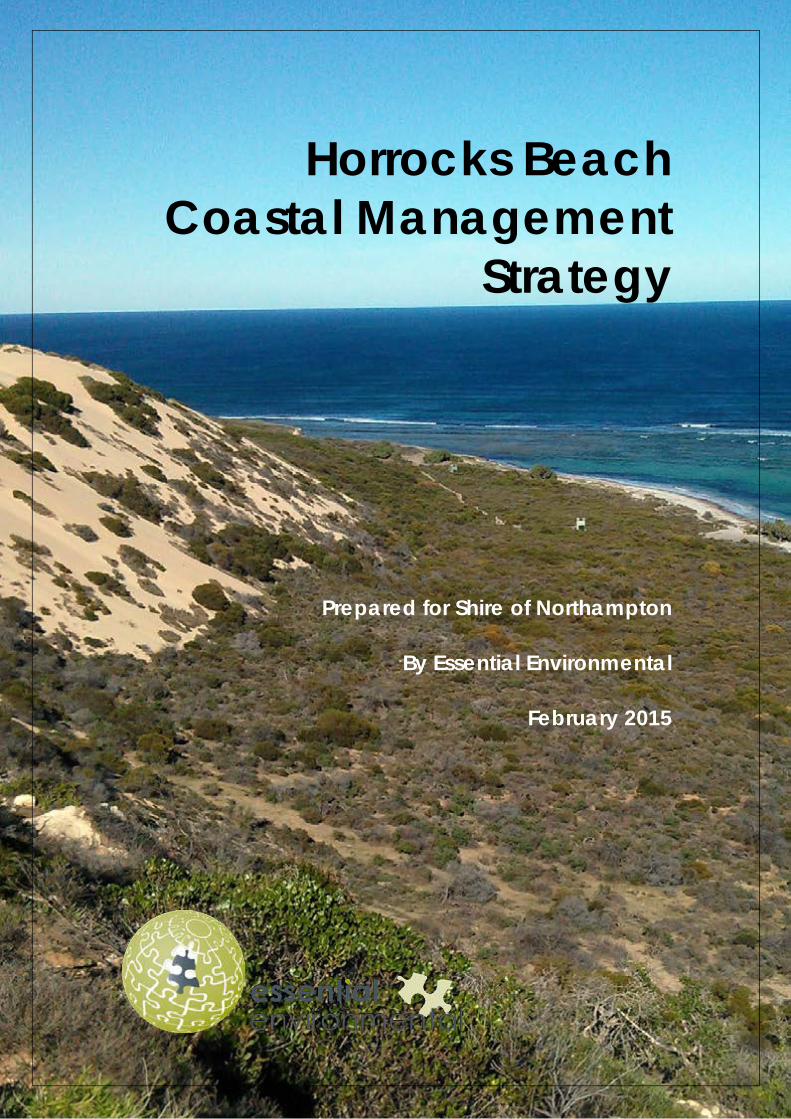
Horrocks Beach Coastal Management
Strategy
Prepared for Shire of Northampton
By Essential Environmental
February 2015
Horrocks Beach Coastal Management Strategy
February 2015
Disclaimer and Limitation
This document is published in accordance with and subject to an agreement between Essential Environmental and the Client, Shire of Northampton, for who it has been prepared for their exclusive use. It has been prepared using the standard of skill and care ordinarily exercised by environmental professionals in the preparation of such Documents.
This report is a qualitative assessment only, based on the scope of services defined by the Client, budgetary and time constraints imposed by the Client, the information supplied by the Client (and its agents), and the method consistent with the preceding. Essential Environmental has not attempted to verify the accuracy or completeness of the information supplied.
Any person or organisation that relies upon or uses the document for purposes or reasons other than those agreed by Essential Environmental and the Client without first obtaining the prior written consent of Essential Environmental, does so entirely at their own risk and Essential Environmental, denies all liability in tort, contract or otherwise for any loss, damage or injury of any kind whatsoever (whether in negligence or otherwise) that may be suffered as a consequence of relying on this Document for any purpose other than that agreed with the Client.
Copying of this report or parts of this report is not permitted without the authorisation of the Client or Essential Environmental.
Acknowledgement
This report has been substantially prepared using information in the Horrocks Beach Foreshore Restoration Plan (2012) prepared for Shire of Northampton and the Horrocks Progress Association by Coastal Focus.
Thanks to Hayley Williams and the Horrocks community for all their assistance, information and inspiration!
Horrocks Beach Coastal Management Strategy
- i - February 2015
CONTENTS
Acknowledgement .............................................................................................................................. ii 1 Introduction ........................................................................................................................................... 1
1.1 Study Area ................................................................................................................................. 1 1.2 Management Objectives........................................................................................................ 1 1.3 Preparation of the Strategy .................................................................................................... 4 1.4 Implementation of this strategy ............................................................................................. 5
2 Horrocks foreshore - Characteristics ................................................................................................. 6
2.1 Existing facilities and infrastructure ........................................................................................ 6 2.1.1 Little Bay.......................................................................................................................... 6
2.2 Climate ..................................................................................................................................... 13 2.3 Landscape and coastal geomorphology ......................................................................... 14 2.4 Coastal processes .................................................................................................................. 17 2.5 Environmental Values ............................................................................................................ 18
2.5.1 Flora and Fauna .......................................................................................................... 18 2.6 Heritage Values ...................................................................................................................... 19
2.6.1 Aboriginal Heritage .................................................................................................... 19 2.7 Recreational values ............................................................................................................... 21
2.7.1 Fishing ............................................................................................................................ 21 2.7.2 Boating.......................................................................................................................... 21 2.7.3 Swimming and snorkeling .......................................................................................... 21 2.7.4 Surfing............................................................................................................................ 22 2.7.5 Walking ......................................................................................................................... 22 2.7.6 Sports and Leisure ....................................................................................................... 23 2.7.7 Camping ...................................................................................................................... 23 2.7.8 Off road driving ........................................................................................................... 23
3 Coastal RIsk Assessment .................................................................................................................... 25
3.1 Context and Objectives ........................................................................................................ 25 3.2 Risk Identification .................................................................................................................... 25 3.3 Risk Analysis .............................................................................................................................. 27 3.4 Risk Evaluation and Controls ................................................................................................. 29 3.5 Risk adaption planning, monitoring and review ............................................................... 33
4 Coastal Management Strategy ....................................................................................................... 34
4.1 Issues ......................................................................................................................................... 34 4.1.1 Coastal processes ....................................................................................................... 34 4.1.2 Stormwater Management ........................................................................................ 35 4.1.3 Uncontrolled access .................................................................................................. 36 4.1.4 Access to recreational facilities ............................................................................... 36
4.2 Recommendations ................................................................................................................. 38 4.2.1 Little Bay........................................................................................................................ 38 4.2.2 Horrocks Beach Townsite ........................................................................................... 39 4.2.3 Bowes River Area ........................................................................................................ 43
5 Implementation .................................................................................................................................. 44 6 Monitoring and Review ..................................................................................................................... 45 7 References ........................................................................................................................................... 55
Horrocks Beach Coastal Management Strategy
- ii - February 2015
Appendix 1: Planning and Policy Context .............................................................................................. 56 Appendix 2: Horrocks Beach Coastal Management StrategySummary of submissions ................ 59
Figures
Figure 1: Site Location and Study Area ..................................................................................................... 2 Figure 2: Local Planning Scheme No 10 – Northampton District .......................................................... 3 Figure 3: Coastal characteristics – Little Bay area ................................................................................... 7 Figure 4: Coastal characteristics – Horrocks townsite ............................................................................. 8 Figure 5: Coastal characteristics – Bowes river mouth ........................................................................... 9 Figure 6: Climate statistics for Geraldton Town weather station no. 8050 ........................................ 13 Figure 7: Landform (Source: Eliot et al, 2012) ......................................................................................... 15 Figure 8: Department of Transport (2010) recommended allowance for sea level rise in coastal
planning for WA ......................................................................................................................... 18 Figure 9: Aboriginal Heritage ..................................................................................................................... 20 Figure 10: Little Bay Sector: Little Bay Campsite..................................................................................... 46 Figure 11: Little Bay Sector: Access North ............................................................................................... 47 Figure 12: Little Bay Sector: Access South ............................................................................................... 48 Figure 13: Little Bay Sector: Frog Pond ..................................................................................................... 49 Figure 14: Horrocks Beach: Walk Trail ....................................................................................................... 50 Figure 15: Horrocks Beach: Lookout ......................................................................................................... 51 Figure 16: Horrocks Beach ......................................................................................................................... 52 Figure 17: Horrocks Beach: Osprey Lookout ........................................................................................... 53 Figure 18: Bowes River Sector .................................................................................................................... 54
Plates
Plate 1: Beach access points through dunes in the Little Bay sector .................................................. 6 Plate 2: Toilet and campsite at Little Bay ................................................................................................ 10 Plate 3: Car parking facilities at Horrocks Beach .................................................................................. 10 Plate 4: Whiting Pool and boat launch point ......................................................................................... 11 Plate 5: Horrocks Beach pedestrian access from North Court ........................................................... 11 Plate 6: Horrocks Beach Shelters............................................................................................................... 12 Plate 7: Bowes River Fishing area and informal surfers car park ......................................................... 12 Plate 8: Vacant lot on Horan Way permits access to Bowes via track through dunes and private
land ................................................................................................................................................. 13 Plate 9: Bowes River mouth and deflation basin at Bowes ................................................................. 14 Plate 10: Horrocks Beach ........................................................................................................................... 16 Plate 11: Little Bay and active, mobile sand sheets at Little Bay ........................................................ 16 Plate 12: Frog Pond and Osprey nest platform at Horrocks Beach ................................................... 19 Plate 13: Swimming at the Jetty and Whiting Pool at Horrocks Beach ............................................. 22 Plate 14: Beach access ramp and stepped beach access at Horrocks Beach ............................. 22 Plate 15: Community sporting facilities at Horrocks Beach ................................................................. 23 Plate 16: Camping facilities at Horrocks Beach ..................................................................................... 23 Plate 17: Off road vehcle use in the study area .................................................................................... 24 Plate 18: Erosion from coastal processes at Horrocks Beach .............................................................. 34 Plate 19: Community led revegetation of the Horrocks Beach dune system .................................. 35 Plate 20: Scouring and erosion stormwater ............................................................................................ 35 Plate 21: Indiscriminate off road vehicle tracks through dunes at Bowes River .............................. 36 Plate 22: Beach access tracks in the Little Bay area ............................................................................ 37 Plate 23: Beach access at Horrocks Beach............................................................................................ 37

Horrocks Beach Coastal Management Strategy
- iii - February 2015
Plate 24: Boat launch access and facilities at Horrocks Beach ......................................................... 38 Plate 25: Geotextile shoreline protection at Horrocks Beach ............................................................. 40 Plate 26: Coastal Morts in the southern townsite car park .................................................................. 42 Plate 27: Proposed view of Horrocks Beach townsite Boardwalk connecting the lookout and
proposed community centre ..................................................................................................... 42 Plate 28: Example wooden boardwalk design for Bowes ................................................................... 43
Tables
Table 1: Reserves comprising the Horrocks foreshore ............................................................................. 1 Table 2: Qualitative measures of Likelihood ........................................................................................... 27 Table 3: Qualitative Measures of Consequence ................................................................................... 28 Table 4: Qualitative risk evaluation table ................................................................................................ 29 Table 5: Risk assessment for Horrocks Beach Study Area ..................................................................... 30 Table 6: Assessments of Likelihood and Consequence ........................................................................ 31 Table 7: Recommended actions for implementation .......................................................................... 44
Horrocks Beach Coastal Management Strategy
- iv - February 2015
land& water solutions
if not now…
when?
Horrocks Beach Coastal Management Strategy
- 1 - February 2015
1 INTRODUCTION
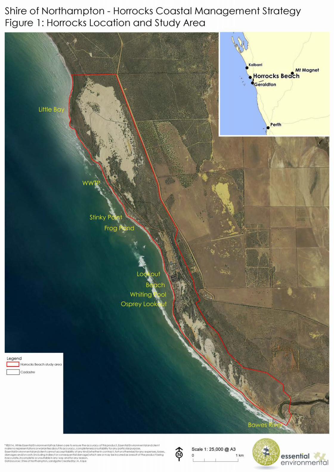
The Horrocks Beach coastal management strategy has been prepared to provide guidancefor the management of coastal and human use impacts along Horrocks Beach from the BowesRiver mouth to Little Bay in the Shire of Northampton (Figure 1).
This document has been prepared to enable input on its recommendations by the communityduring a period of public comment. It will be revised in response to comments received andpresented to Council for endorsement.
This Strategy makes recommendations based on site visits, community input andrecommendations from existing plans and strategies to assist in the future management of thearea.
1.1 Study Area
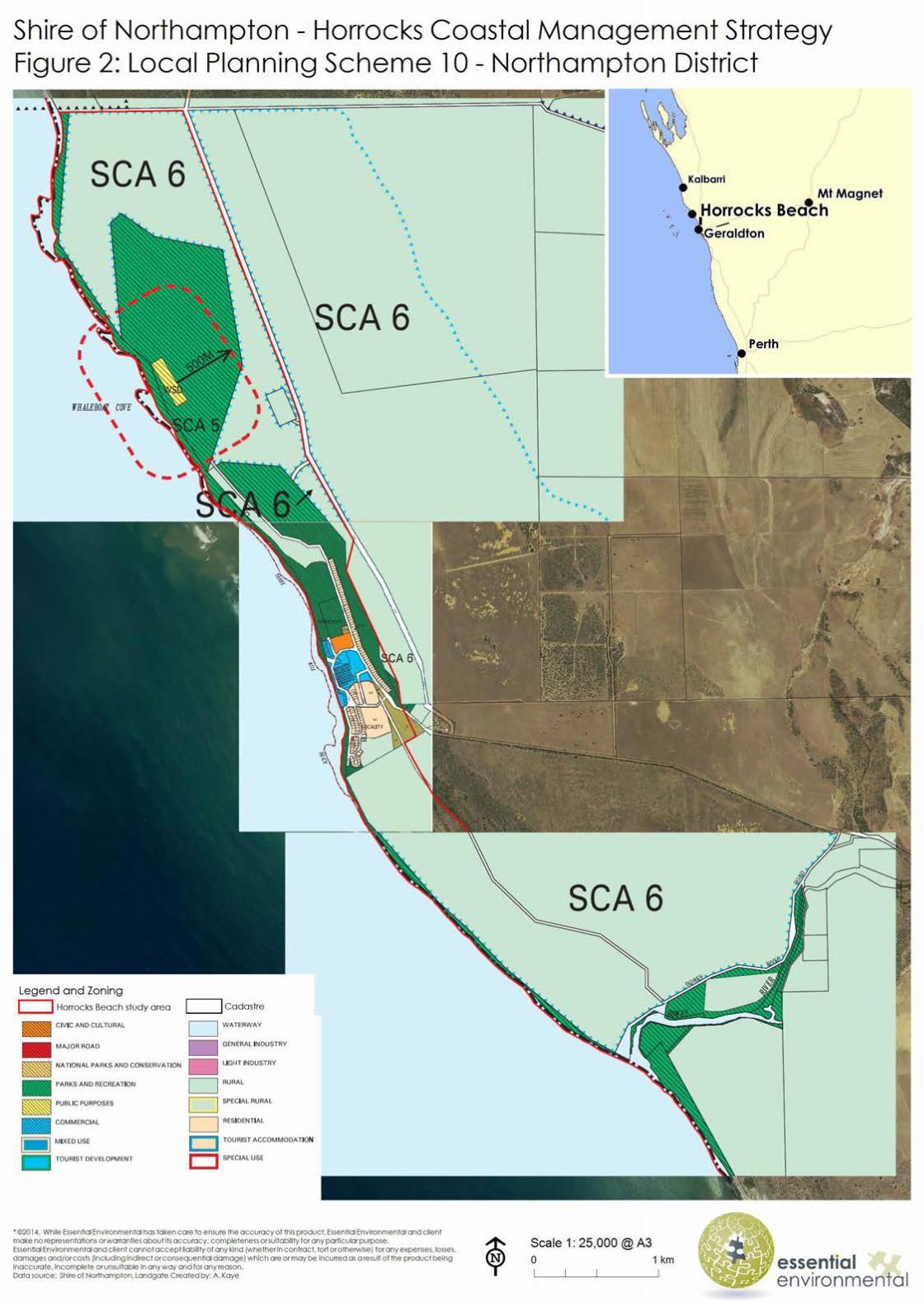
The study area for the Horrocks Coastal Management Strategy extends along 9.5km ofcoastline and is a maximum of 1 km wide (Figure 1). The area that is the subject of this Strategyis reserved for a number of uses including dune preservation, parks and recreation, and watersupply, sewerage and drainage in the Shire of Northampton Local Planning Scheme No 10(Figure 2).
Most of the coastal environment is held as Crown reserve or unallocated crown land. Thecoastal reserve abutting the town is narrow; all of the undeveloped residential and towncentre zoned land is in the ownership of local government and management of the foreshorereserve rests with the Shire of Northampton (Table 1).
Table 1: Reserves comprising the Horrocks foreshore
ReserveNo
Purpose Management Responsibility Northampton LPS 10 Zoning
R 21450 Recreation Shire of Northampton Parks and Recreation
Various Unallocated Crown Land Department of Lands Public Purposes
R 49842 Recreation Shire of Northampton Parks and Recreation
R 29151 Recreation Shire of Northampton Parks and Recreation
1.2 Management Objectives
Objectives for this strategy relate to environmental protection, protection of assets andfacilitating ongoing human uses of the coast.The objectives of this strategyare to:
Protect, maintain and enhance the environmental and cultural values of the coastalenvironment. To ensure significant cultural, environmental and landscape values arerecognised and enhanced into the future. This includes maintaining the coastal dunesand the social, environmental and economic services which they currently provide.
Horrocks Beach Coastal Management Strategy
- 1 - February 2015
1 INTRODUCTION
The Horrocks Beach coastal management strategy has been prepared to provide guidancefor the management of coastal and human use impacts along Horrocks Beach from the BowesRiver mouth to Little Bay in the Shire of Northampton (Figure 1).
This document has been prepared to enable input on its recommendations by the communityduring a period of public comment. It will be revised in response to comments received andpresented to Council for endorsement.
This Strategy makes recommendations based on site visits, community input andrecommendations from existing plans and strategies to assist in the future management of thearea.
1.1 Study Area
The study area for the Horrocks Coastal Management Strategy extends along 9.5km ofcoastline and is a maximum of 1 km wide (Figure 1). The area that is the subject of this Strategyis reserved for a number of uses including dune preservation, parks and recreation, and watersupply, sewerage and drainage in the Shire of Northampton Local Planning Scheme No 10(Figure 2).
Most of the coastal environment is held as Crown reserve or unallocated crown land. Thecoastal reserve abutting the town is narrow; all of the undeveloped residential and towncentre zoned land is in the ownership of local government and management of the foreshorereserve rests with the Shire of Northampton (Table 1).
Table 1: Reserves comprising the Horrocks foreshore
ReserveNo
Purpose Management Responsibility Northampton LPS 10 Zoning
R 21450 Recreation Shire of Northampton Parks and Recreation
Various Unallocated Crown Land Department of Lands Public Purposes
R 49842 Recreation Shire of Northampton Parks and Recreation
R 29151 Recreation Shire of Northampton Parks and Recreation
1.2 Management Objectives
Objectives for this strategy relate to environmental protection, protection of assets andfacilitating ongoing human uses of the coast.The objectives of this strategyare to:
Protect, maintain and enhance the environmental and cultural values of the coastalenvironment. To ensure significant cultural, environmental and landscape values arerecognised and enhanced into the future. This includes maintaining the coastal dunesand the social, environmental and economic services which they currently provide.

Horrocks Beach Coastal Management Strategy
- 4 - February 2015
• Protect and maintain the character and attraction of Horrocks as a tourist destination. To provide quality tourist amenities and facilities that are reflective of the historic and social character of the area and encourage walkable and family-oriented experiences.
• Protect and maintain access for both recreational use and the local fishing industry. To facilitate ongoing, sustainable public access and recreational use of the area for current and future generations and ensure facilities are suitable for local fishing industry and community needs.
• Manage public safety and protect infrastructure. To ensure public safety and the protection of infrastructure from damage by coastal forces.
1.3 Preparation of the Strategy
This Strategy has been prepared on the basis of a review of a number of existing relevant strategies including:
• Horrocks Beach Foreshore Restoration Plan (Coastal Focus, 2012) • Shire of Northampton Coastal Strategy (Landvision and Shire of Northampton, 2006) • Horrocks Beach Coastal Plan (Department of Planning and Urban Development, 1993) • State Planning Policy 2.6: State Coastal Planning Policy (2013) • Draft Shire of Northampton Local Planning Strategy (Shire of Northampton, 2009) • The Coast of the Shires of Coorow to Northampton, Mid West, Western Australia:
Geology, Geomorphology and Vulnerability (Prepared by Damara WA Pty Ltd and Geological Survey of Western Australia for the Department of Planning and Department of Transport).
A summary of these documents is provided in Appendix 1.
A series of community forums were held throughout May, June and July 2014. The forums aimed to identify community values, issues and objectives associated with the use of the coast which were then used as a basis for preparation of options for future management. The options were workshopped and refined into the concept that is presented in this draft strategy for public comment. The forums were attended by a number of community members representing a range of stakeholders on the basis of open invitations issued via the Shire website and local newspaper.
In addition, a number of interviews were undertaken with members of the Horrocks Beach and Nanda communities to assist in the identification of values and discern support for the recommendations proposed.
The desk top review and community input was supported by a number of site visits to ground truth the findings and recommendations.
The strategy was publically advertised from Friday 7th November 2014, for a period of 42 days, closing on Friday 19th December at 4.30pm. Two submissions were received. The submissions provided support for the Strategy, particularly improving pedestrian accessibility and walkability including access to the jetty and improving pathways and boardwalks. The Strategy has been modified to incorporate the recommended changes. Further information is provided in Appendix 2.
Horrocks Beach Coastal Management Strategy
- 5 - February 2015
1.4 Implementation of this strategy
Specific recommendations for implementation are contained in section 4. It is recognised that further detailed work will be required, including detailed design and costing of infrastructure, to facilitate implementation in some instances.
No commitments have been made as yet regarding the implementation of this coastal management strategy. Its delivery will depend on the availability of resources and priorities identified by the Shire.
It is anticipated that implementation of the adopted coastal management strategy will require the formulation of partnerships and the identification of a variety of sources of funding. The lead agency for implementing this Strategy will be the Shire of Northampton.
Horrocks Beach Coastal Management Strategy
- 6 - February 2015
2 HORROCKS FORESHORE - CHARACTERISTICS
Located approximately 20 kilometres west of Northampton, Horrocks was established as a coastal holiday settlement and the town is supported by the tourism and fishing industry. It is situated between an ocean lagoon on one side and a vegetated limestone escarpment on the other, with high, vegetated dunes to the immediate north and south of the town.
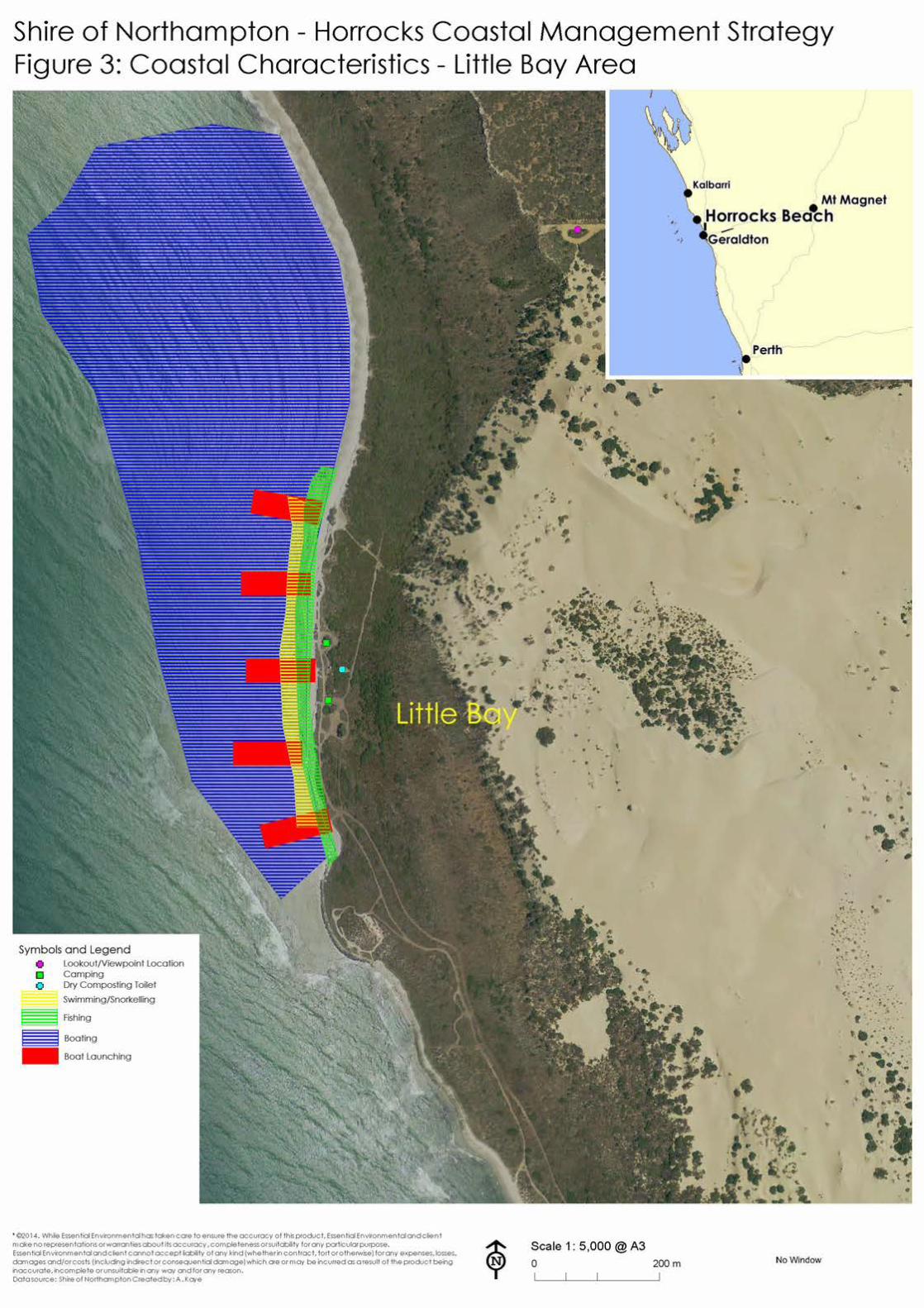
The study area comprises three rather distinct sectors: Little Bay to the north (Figure 3), the Horrocks townsite (Figure 4) and the Bowes river mouth to the south (Figure 5). Due to the different characteristics of use associated with each sector, they have been addressed separately by this strategy.
2.1 Existing facilities and infrastructure
2.1.1 Little Bay
Little Bay is serviced by a 4-wheel drive sand track that continues from the end of a gravel road that services the townsite wastewater treatment works. There are numerous beach access points through the dunes between Stinky Point and Little Bay (Plate 1) that permit vehicle and pedestrian access to the beach. These are used for recreational purposes including accessing of crayfish pots on the reef.
Plate 1: Beach access points through dunes in the Little Bay sector
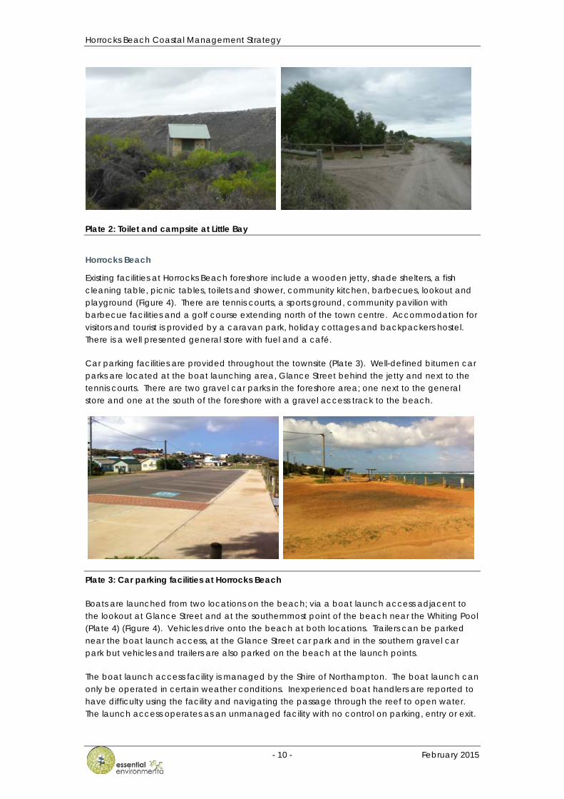
The Shire has provided basic camping facilities at a designated site at Little Bay (Plate 2). The campsites are fenced to define their locations and are mostly under the shelter of Tamarisk trees. Two dry composting toilets with stepped access are located west of the campsites and service the camp grounds. The toilets can be accessed by a vehicle track for maintenance. This track is gated to prevent unauthorised vehicle access.
The site is the preferred location for boat launching due to the sheltered nature of the lagoon. Boat trailers are driven onto and parked on the beach. There is an informal turning area at the entrance to the Little Bay campsite that is well used. There is a crayfish weighing hut to service the local fishing industry at the site. The site has no formal parking facilities and vehicles access the beach through the frontal dune to park or pull off the access track.


Horrocks Beach Coastal Management Strategy
- 10 - February 2015
Plate 2: Toilet and campsite at Little Bay
Horrocks Beach
Existing facilities at Horrocks Beach foreshore include a wooden jetty, shade shelters, a fish cleaning table, picnic tables, toilets and shower, community kitchen, barbecues, lookout and playground (Figure 4). There are tennis courts, a sports ground, community pavilion with barbecue facilities and a golf course extending north of the town centre. Accommodation for visitors and tourist is provided by a caravan park, holiday cottages and backpackers hostel. There is a well presented general store with fuel and a café.
Car parking facilities are provided throughout the townsite (Plate 3). Well-defined bitumen car parks are located at the boat launching area, Glance Street behind the jetty and next to the tennis courts. There are two gravel car parks in the foreshore area; one next to the general store and one at the south of the foreshore with a gravel access track to the beach.
Plate 3: Car parking facilities at Horrocks Beach
Boats are launched from two locations on the beach; via a boat launch access adjacent to the lookout at Glance Street and at the southernmost point of the beach near the Whiting Pool (Plate 4) (Figure 4). Vehicles drive onto the beach at both locations. Trailers can be parked near the boat launch access, at the Glance Street car park and in the southern gravel car park but vehicles and trailers are also parked on the beach at the launch points.
The boat launch access facility is managed by the Shire of Northampton. The boat launch can only be operated in certain weather conditions. Inexperienced boat handlers are reported to have difficulty using the facility and navigating the passage through the reef to open water. The launch access operates as an unmanaged facility with no control on parking, entry or exit.

Horrocks Beach Coastal Management Strategy
- 11 - February 2015
Plate 4: Whiting Pool and boat launch point
The beach in front of the boat launch access and beach access ramp from the southern car park are subject to action from coastal processes and scouring from stormwater runoff which adds to the difficulty experienced by boat handlers visiting Horrocks who are unfamiliar with the location. The location is considered exposed and hazardous by the Department of Transport and does not meet AS 3962-2001 Guidelines for the Design of Marinas.
There is pedestrian access to the beach at several points in the foreshore (Plate 5). There is a ramp at the jetty that was installed to improve access to the beach, particularly for the elderly and prams. At the time of the visits the cyclical action of accretion/erosion of sand due to coastal processes had resulted in the launch access terminating via a large step onto the beach. There are two beach access points via stairs; one south of the jetty from the gravel car park and another from Glance Street opposite Killy Street. At the southern end of the beach Glance Street is several meters above the height of the beach and access is via gravel tracks, steps and a wooden stairway.
Plate 5: Horrocks Beach pedestrian access from North Court
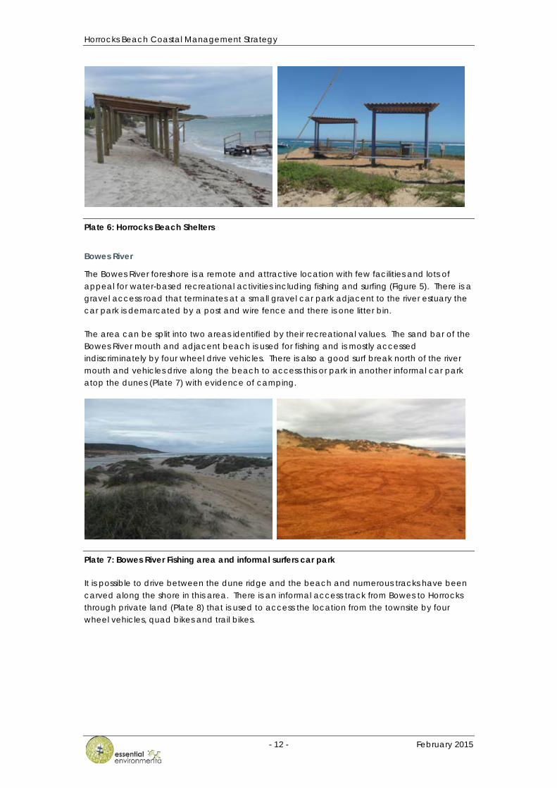
There are several shelters throughout the foreshore reserve (Plate 6) with the majority located at the foot of the jetty on the beach. They are heavily utilised and people spread onto the dunes to the rear of the shelters in times of high beach use.
Horrocks Beach Coastal Management Strategy
- 12 - February 2015
Plate 6: Horrocks Beach Shelters
Bowes River
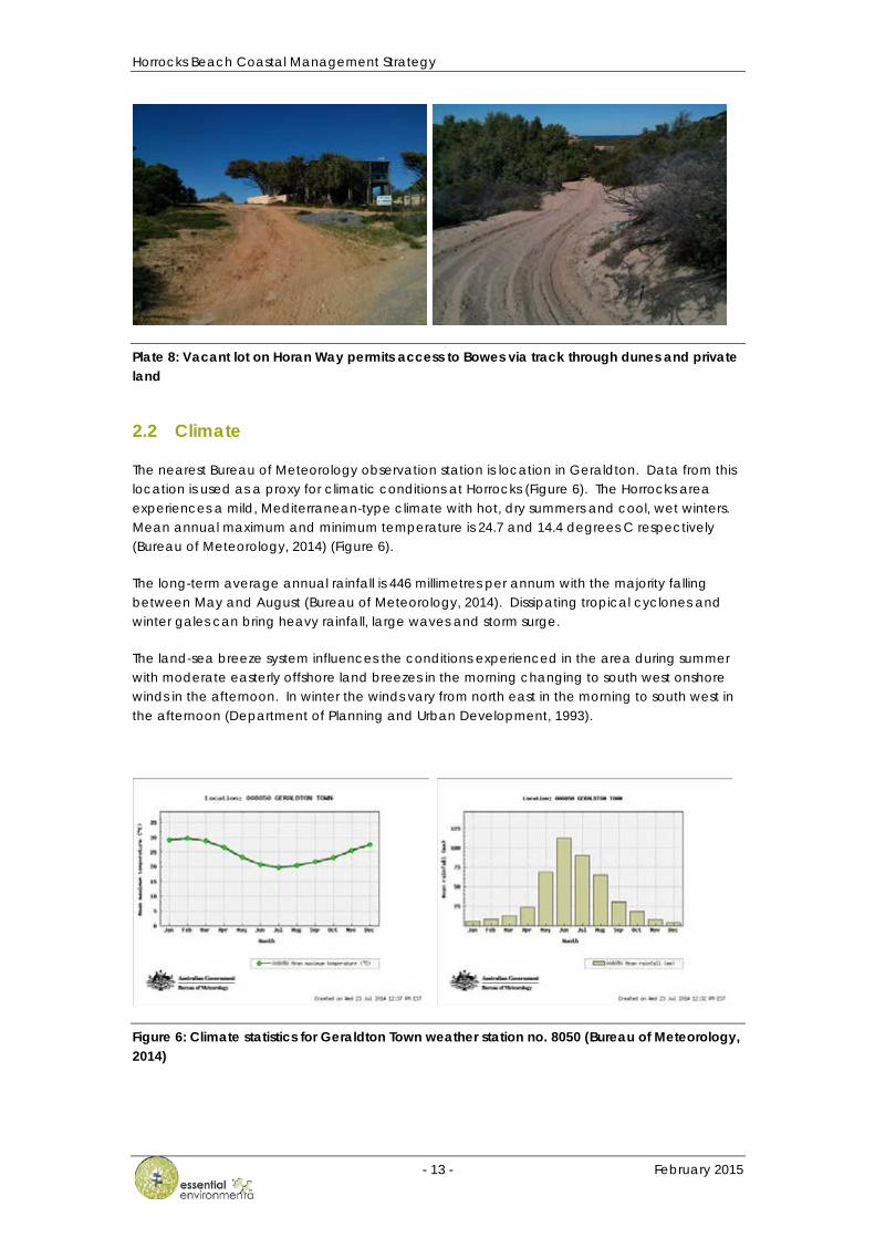
The Bowes River foreshore is a remote and attractive location with few facilities and lots of appeal for water-based recreational activities including fishing and surfing (Figure 5). There is a gravel access road that terminates at a small gravel car park adjacent to the river estuary the car park is demarcated by a post and wire fence and there is one litter bin.
The area can be split into two areas identified by their recreational values. The sand bar of the Bowes River mouth and adjacent beach is used for fishing and is mostly accessed indiscriminately by four wheel drive vehicles. There is also a good surf break north of the river mouth and vehicles drive along the beach to access this or park in another informal car park atop the dunes (Plate 7) with evidence of camping.
Plate 7: Bowes River Fishing area and informal surfers car park
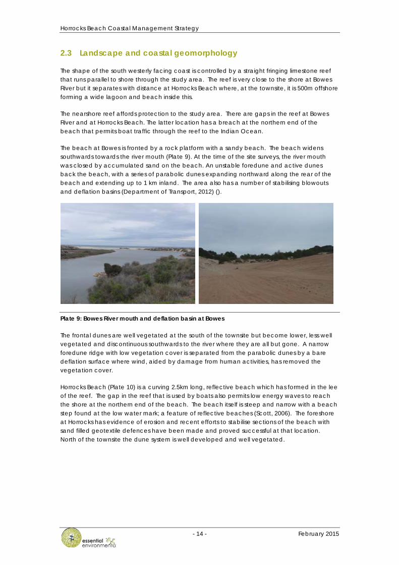
It is possible to drive between the dune ridge and the beach and numerous tracks have been carved along the shore in this area. There is an informal access track from Bowes to Horrocks through private land (Plate 8) that is used to access the location from the townsite by four wheel vehicles, quad bikes and trail bikes.
Horrocks Beach Coastal Management Strategy
- 13 - February 2015
Plate 8: Vacant lot on Horan Way permits access to Bowes via track through dunes and private land
2.2 Climate
The nearest Bureau of Meteorology observation station is location in Geraldton. Data from this location is used as a proxy for climatic conditions at Horrocks (Figure 6). The Horrocks area experiences a mild, Mediterranean-type climate with hot, dry summers and cool, wet winters. Mean annual maximum and minimum temperature is 24.7 and 14.4 degrees C respectively (Bureau of Meteorology, 2014) (Figure 6).
The long-term average annual rainfall is 446 millimetres per annum with the majority falling between May and August (Bureau of Meteorology, 2014). Dissipating tropical cyclones and winter gales can bring heavy rainfall, large waves and storm surge.
The land-sea breeze system influences the conditions experienced in the area during summer with moderate easterly offshore land breezes in the morning changing to south west onshore winds in the afternoon. In winter the winds vary from north east in the morning to south west in the afternoon (Department of Planning and Urban Development, 1993).
Figure 6: Climate statistics for Geraldton Town weather station no. 8050 (Bureau of Meteorology, 2014)
Horrocks Beach Coastal Management Strategy
- 14 - February 2015
2.3 Landscape and coastal geomorphology
The shape of the south westerly facing coast is controlled by a straight fringing limestone reef that runs parallel to shore through the study area. The reef is very close to the shore at Bowes River but it separates with distance at Horrocks Beach where, at the townsite, it is 500m offshore forming a wide lagoon and beach inside this.
The nearshore reef affords protection to the study area. There are gaps in the reef at Bowes River and at Horrocks Beach. The latter location has a breach at the northern end of the beach that permits boat traffic through the reef to the Indian Ocean.
The beach at Bowes is fronted by a rock platform with a sandy beach. The beach widens southwards towards the river mouth (Plate 9). At the time of the site surveys, the river mouth was closed by accumulated sand on the beach. An unstable foredune and active dunes back the beach, with a series of parabolic dunes expanding northward along the rear of the beach and extending up to 1 km inland. The area also has a number of stabilising blowouts and deflation basins (Department of Transport, 2012) ().
Plate 9: Bowes River mouth and deflation basin at Bowes
The frontal dunes are well vegetated at the south of the townsite but become lower, less well vegetated and discontinuous southwards to the river where they are all but gone. A narrow foredune ridge with low vegetation cover is separated from the parabolic dunes by a bare deflation surface where wind, aided by damage from human activities, has removed the vegetation cover.
Horrocks Beach (Plate 10) is a curving 2.5km long, reflective beach which has formed in the lee of the reef. The gap in the reef that is used by boats also permits low energy waves to reach the shore at the northern end of the beach. The beach itself is steep and narrow with a beach step found at the low water mark; a feature of reflective beaches (Scott, 2006). The foreshore at Horrocks has evidence of erosion and recent efforts to stabilise sections of the beach with sand filled geotextile defences have been made and proved successful at that location. North of the townsite the dune system is well developed and well vegetated.
Horrocks Beach Coastal Management Strategy
- 15 - February 2015
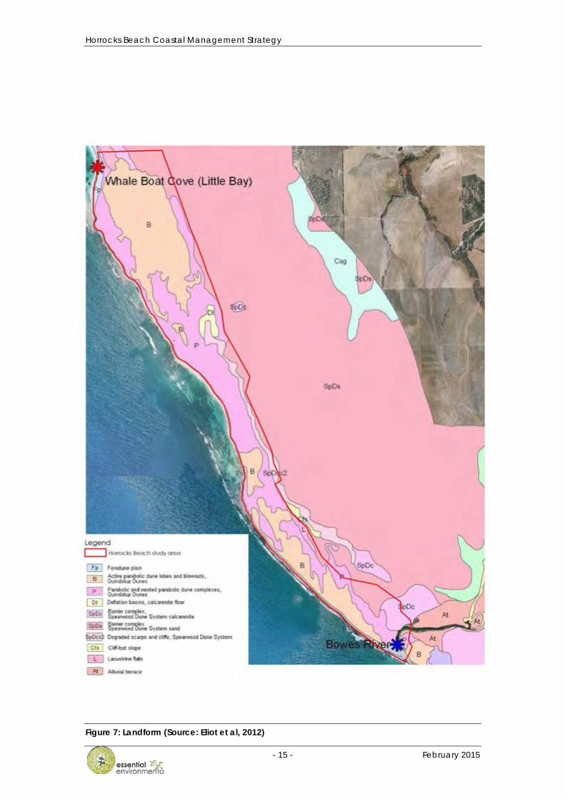
Figure 7: Landform (Source: Eliot et al, 2012)

Horrocks Beach Coastal Management Strategy
- 16 - February 2015
Plate 10: Horrocks Beach
North of the townsite the gap between shore and reef narrows to become a discontinuous shore attached reef. The beach also narrows and disappears just south of Little Bay. The sector is well protected by the offshore reef and rock platforms; waves break heavily on the reef and platform with low wave to calm conditions at the shore.
At Little Bay the reef is 300m offshore providing a sheltered cove for anchorage and boat launching. The beach at Little Bay extends northwards in the lee of the nearshore reef as a low energy reflective beach. The beach consists of a low tide terrace back by step sand dune at the south and a high limestone escarpment that continues northwards.
The foreshore plain behind the beach at Little Bay is well vegetated, low lying and sheltered by parabolic and nested dunes. These dunes have migrated northwards from Horrocks as an active sand sheet behind Stinky Point and drop steeply into Little Bay (Plate 11).
Plate 11: Little Bay and active, mobile sand sheets at Little Bay
The beach, dunes and sandsheet in the study area are dominated by unconsolidated calcareous sands of the Quindalup unit. Further inland lie red and brown tamala sand (Department of Transport, 2012).
Horrocks Beach Coastal Management Strategy
- 17 - February 2015
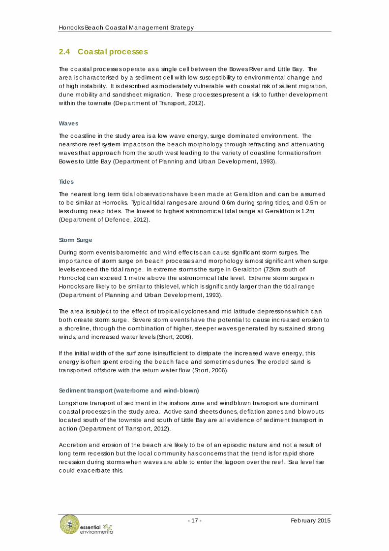
2.4 Coastal processes
The coastal processes operate as a single cell between the Bowes River and Little Bay. The area is characterised by a sediment cell with low susceptibility to environmental change and of high instability. It is described as moderately vulnerable with coastal risk of salient migration, dune mobility and sandsheet migration. These processes present a risk to further development within the townsite (Department of Transport, 2012).
Waves
The coastline in the study area is a low wave energy, surge dominated environment. The nearshore reef system impacts on the beach morphology through refracting and attenuating waves that approach from the south west leading to the variety of coastline formations from Bowes to Little Bay (Department of Planning and Urban Development, 1993).
Tides
The nearest long term tidal observations have been made at Geraldton and can be assumed to be similar at Horrocks. Typical tidal ranges are around 0.6m during spring tides, and 0.5m or less during neap tides. The lowest to highest astronomical tidal range at Geraldton is 1.2m (Department of Defence, 2012).
Storm Surge
During storm events barometric and wind effects can cause significant storm surges. The importance of storm surge on beach processes and morphology is most significant when surge levels exceed the tidal range. In extreme storms the surge in Geraldton (72km south of Horrocks) can exceed 1 metre above the astronomical tide level. Extreme storm surges in Horrocks are likely to be similar to this level, which is significantly larger than the tidal range (Department of Planning and Urban Development, 1993).
The area is subject to the effect of tropical cyclones and mid latitude depressions which can both create storm surge. Severe storm events have the potential to cause increased erosion to a shoreline, through the combination of higher, steeper waves generated by sustained strong winds, and increased water levels (Short, 2006).
If the initial width of the surf zone is insufficient to dissipate the increased wave energy, this energy is often spent eroding the beach face and sometimes dunes. The eroded sand is transported offshore with the return water flow (Short, 2006).
Sediment transport (waterborne and wind-blown)
Longshore transport of sediment in the inshore zone and windblown transport are dominant coastal processes in the study area. Active sand sheets dunes, deflation zones and blowouts located south of the townsite and south of Little Bay are all evidence of sediment transport in action (Department of Transport, 2012).
Accretion and erosion of the beach are likely to be of an episodic nature and not a result of long term recession but the local community has concerns that the trend is for rapid shore recession during storms when waves are able to enter the lagoon over the reef. Sea level rise could exacerbate this.

Horrocks Beach Coastal Management Strategy
- 18 - February 2015
Sea Level Change
The Intergovernmental Panel on Climate Change (IPCC) has presented various scenarios of possible climate change and the resultant sea level rise in the coming century (IPCC 2001, 2007). There is still some uncertainty as to which of these scenarios will occur.
A worst case scenario is considered by State Planning Policy 2.6 and Department of Transport (2010) in Figure 8 (Note: Red line SRES scenario A1F1 95th percentile, blue line continuation of scenario to 2110). This requires that coastal development allow for a 0.9 m sea level rise over a 100 year planning horizon and has been adopted for coastal planning throughout Western Australia.
Figure 8: Department of Transport (2010) recommended allowance for sea level rise in coastal planning for WA
Future sea level rise will increase the frequency, and potentially severity, of existing storm inundation events and these impacts will need to be considered in this risk assessment and coastal management strategy.
2.5 Environmental Values
2.5.1 Flora and Fauna
Horrocks is located within the Geraldton Sandplains IBRA bioregion. The Geraldton Sandplains bioregion comprises mainly proteaceous scrub-heaths, rich in endemics, on the sandy earths of an extensive, undulating sandplain (Department of Conservation and Land Management, 2002).
The waters of the Horrocks coast are known for their rich diversity in marine life. This also provides a significant recreational and small professional fishing resource. Reef platforms dominate the coastline. They provide a barrier to the high wave energy and are important feeding and breeding grounds for fish species.
A wetland has been identified within the coastal dunes south of Stinky Point, north of the golf course (Figure 3). Named the “Frog Pond” by the community as a result of the large number of frogs that reside in it, the freshwater pond is considered to have significant biodiversity values and is valued by the local community. The Frog Pond historically supplied the drinking water supply to the townsite.

Horrocks Beach Coastal Management Strategy
- 19 - February 2015
Plate 12: Frog Pond and Osprey nest platform at Horrocks Beach
A search of the EPBC Protected Matters Search Tool identified a range of migratory birds and other fauna that may be present in the foreshore area although existing searches did not identify occurrences of protected flora and fauna in the foreshore reserve. There are three Osprey nest platforms in the study area including one at Little Bay and one at the southern end of Horrocks beach (Plate 12). These are currently inhabited by Osprey pairs with young.
A search of the Department of Parks and Wildlife NatureMap search tool listed three species of Spider Orchid as 'rare or likely to become extinct' and six species of birds including Fork tailed Swift (Apus pacificus) and White-bellied Sea-Eagle (Haliaeetus leucogaster) as 'protected under international agreement.
2.6 Heritage Values
Horrocks has historic significance as the holiday and summer recreation location for residents of Northampton and surrounding areas since early settlement days. A short history of Horrocks Beach is provided in the Horrocks Beach Coastal Plan (Department of Planning and Urban Development, 1993).
In the 1880’s Horrocks was known as Three Mile Bay. It was a holiday destination for pastoral families in the area. As early as the 1930's there were a substantial number of tents and semi-permanent shacks on the beach. These were continually improved and replaced with more permanent but still humble dwellings along the foreshore in the 1940’s and 1950’s. The foreshore cottages were demolished in the late 1970’s in response to higher standards of living and pressure from government agencies to create a more modern Horrocks townsite with many cottage owners taking up leaseholds elsewhere in the town. Since then, development has continued throughout the townsite on freehold areas.
The only listed structure on the Heritage Council of WA database is the old wooden jetty that has been replaced
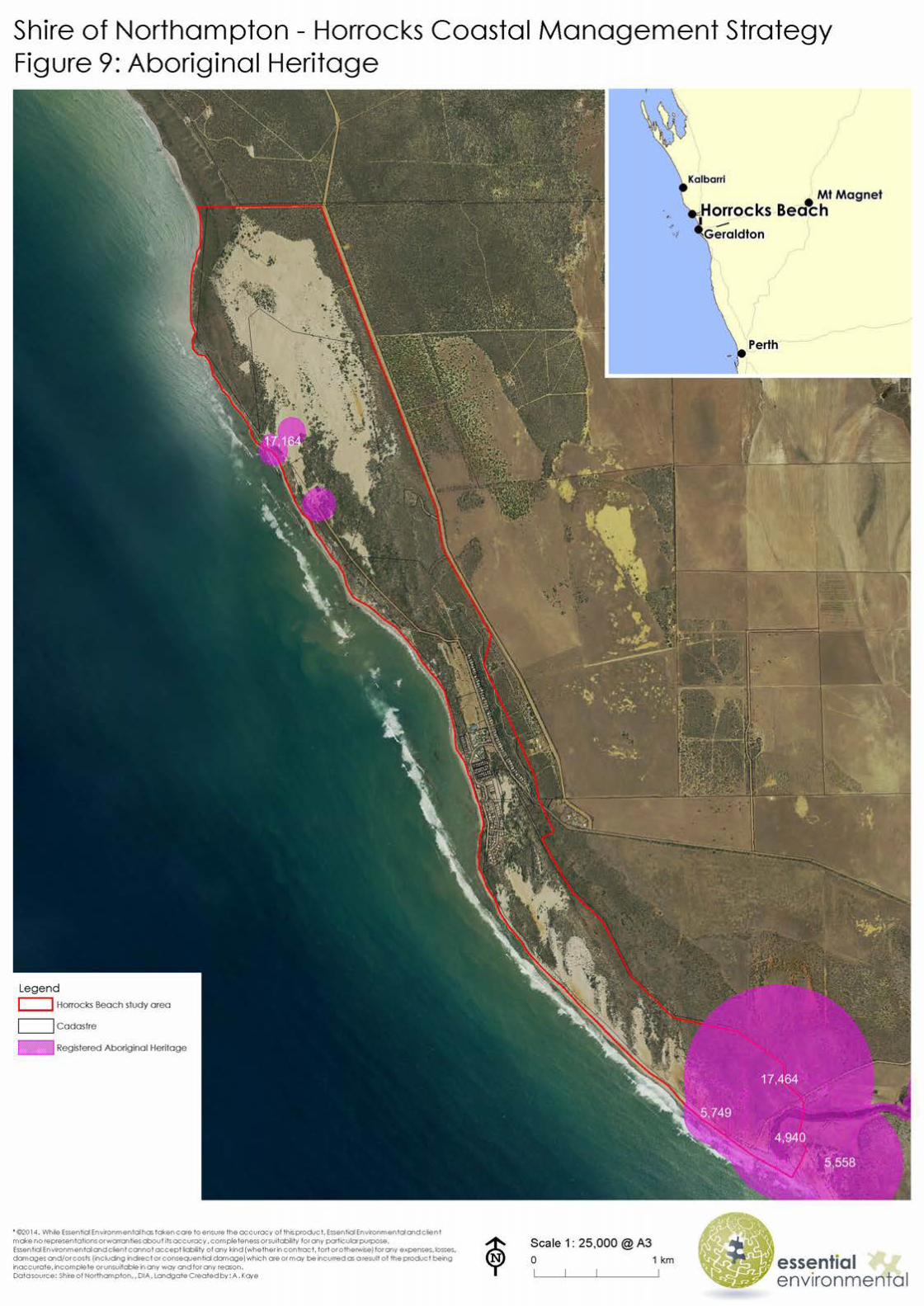
2.6.1 Aboriginal Heritage
Native title in the area has not been formally recognised. The study area contains a number of important cultural sites, a number of which are registered with the Department of Aboriginal Affairs (Figure 9). There is significant Nanda heritage at the Willi Gulli caves complex on the Bowes River, inland from the river mouth. The caves feature rock art created by the Nanda people to describe and communicate their traditions, ideas and values.
Horrocks Beach Coastal Management Strategy
- 21 - February 2015
2.7 Recreational values
The Horrocks community and its visitors highly value their outdoor recreational activities. Activities undertaken in the study area include:
• fishing; • boating; • swimming and snorkeling; • surfing; • walking; • sports and leisure; • camping; and • off road driving.
2.7.1 Fishing
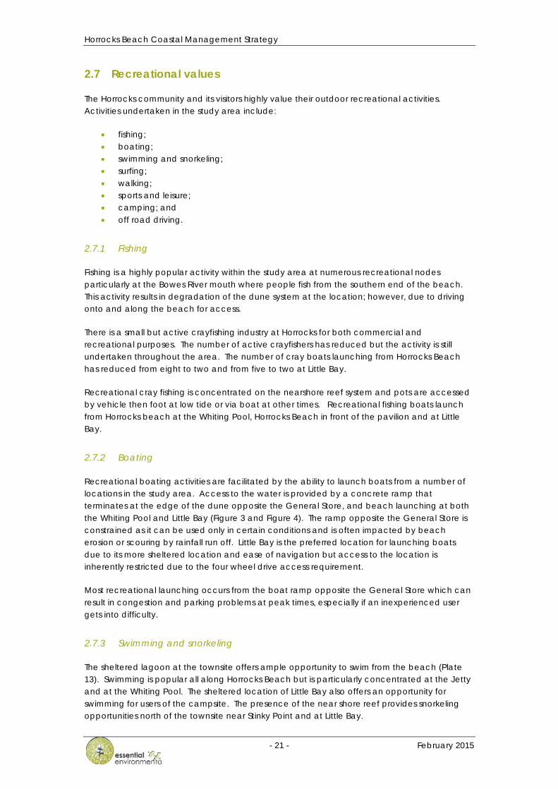
Fishing is a highly popular activity within the study area at numerous recreational nodes particularly at the Bowes River mouth where people fish from the southern end of the beach. This activity results in degradation of the dune system at the location; however, due to driving onto and along the beach for access.
There is a small but active crayfishing industry at Horrocks for both commercial and recreational purposes. The number of active crayfishers has reduced but the activity is still undertaken throughout the area. The number of cray boats launching from Horrocks Beach has reduced from eight to two and from five to two at Little Bay.
Recreational cray fishing is concentrated on the nearshore reef system and pots are accessed by vehicle then foot at low tide or via boat at other times. Recreational fishing boats launch from Horrocks beach at the Whiting Pool, Horrocks Beach in front of the pavilion and at Little Bay.
2.7.2 Boating
Recreational boating activities are facilitated by the ability to launch boats from a number of locations in the study area. Access to the water is provided by a concrete ramp that terminates at the edge of the dune opposite the General Store, and beach launching at both the Whiting Pool and Little Bay (Figure 3 and Figure 4). The ramp opposite the General Store is constrained as it can be used only in certain conditions and is often impacted by beach erosion or scouring by rainfall run off. Little Bay is the preferred location for launching boats due to its more sheltered location and ease of navigation but access to the location is inherently restricted due to the four wheel drive access requirement.
Most recreational launching occurs from the boat ramp opposite the General Store which can result in congestion and parking problems at peak times, especially if an inexperienced user gets into difficulty.
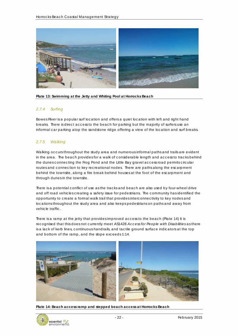
2.7.3 Swimming and snorkeling
The sheltered lagoon at the townsite offers ample opportunity to swim from the beach (Plate 13). Swimming is popular all along Horrocks Beach but is particularly concentrated at the Jetty and at the Whiting Pool. The sheltered location of Little Bay also offers an opportunity for swimming for users of the campsite. The presence of the near shore reef provides snorkeling opportunities north of the townsite near Stinky Point and at Little Bay.
Horrocks Beach Coastal Management Strategy
- 22 - February 2015
Plate 13: Swimming at the Jetty and Whiting Pool at Horrocks Beach
2.7.4 Surfing
Bowes River is a popular surf location and offers a quiet location with left and right hand breaks. There is direct access to the beach for parking but the majority of surfers use an informal car parking atop the sandstone ridge offering a view of the location and surf breaks.
2.7.5 Walking
Walking occurs throughout the study area and numerous informal paths and trails are evident in the area. The beach provides for a walk of considerable length and access to tracks behind the dunes connecting the Frog Pond and the Little Bay gravel access road permits circular routes and connection to key recreational nodes. There are paths along the escarpment behind the townsite, along a fire break behind houses at the foot of the escarpment and through dunes in the townsite.
There is a potential conflict of use as the tracks and beach are also used by four-wheel drive and off road vehicles creating a safety issue for pedestrians. The community has identified the opportunity to create a formal walk trail that provides interconnectivity to key nodes and locations throughout the study area and also keeps pedestrians on paths and away from vehicle traffic.
There is a ramp at the jetty that provides improved access to the beach (Plate 14) It is recognised that this does not currently meet AS1428 Access for People with Disabilities as there is a lack of kerb lines, continuous handrails, and tactile ground surface indicators at the top and bottom of the ramp, and the slope exceeds 1:14.
Plate 14: Beach access ramp and stepped beach access at Horrocks Beach

Horrocks Beach Coastal Management Strategy
- 23 - February 2015
2.7.6 Sports and Leisure
The townsite has sporting facilities in the study area including a golf course, tennis courts, bowling green, playground and a sports ground (Plate 15). These facilities are key assets to the community and for tourists who visit the town.
Plate 15: Community sporting facilities at Horrocks Beach
2.7.7 Camping
A caravan park exists in the townsite near the foreshore that provides shady sites for numerous cabins, caravans, tents and vehicles (Plate 16). The Shire operates additional camping facilities at Little Bay where there is space for a number of tents under the shade of Tamarisk trees and dry composting toilet facilities. The potential to provide additional eco camping facilities at Little Bay has been identified in the draft Horrocks Beach Local Planning Strategy (2012).
Plate 16: Camping facilities at Horrocks Beach
2.7.8 Off road driving
Four and two wheel off road driving is a significant activity within the study area (Plate 17). Vehicles can access the beach directly at a number of locations including Bowes, the townsite, Little Bay and at numerous points from the access track between the Frog Pond and Little Bay.
There is a persistent level of activity as drivers are engaged in recreational sport as well as the use of off-road vehicles to access sites for fishing, camping and surfing. This has resulted in a

Horrocks Beach Coastal Management Strategy
- 24 - February 2015
number of issues relating to safety, loss of amenity, trespassing on private land and environmental degradation throughout the study area. The community highlighted a particular concern regarding trail and quad bikes accessing Horrocks from Bowes River via private land. Riders are reported to originate from Coronation Bay in Chapman Valley or Drummonds Cove near Geraldton and use this informal route to refuel at the General Store before making the return journey. Access via pedestrian paths in the townsite has also been reported which represents a safety issue.
Plate 17: Off road vehcle use in the study area

Horrocks Beach Coastal Management Strategy
- 25 - February 2015
3 COASTAL RISK ASSESSMENT
State Planning Policy 2.6 recommends coastal hazard risk management and adaptation planning to ensure that risk assessment and management planning are incorporated into the decisions that are made in protecting, conserving and enhancing the cultural, environmental and recreational values of the coast.
A risk management approach is particularly relevant given the uncertainty surrounding the local effects of climate change and lack of data for erosion rates, historical shoreline change and sediment transport. A risk assessment framework can help to define overall levels of risk, as outcomes may be assessed and compared even when there is little available data. This process involves the identification, analysis and evaluation of risks leading to recommendations for adaptation and management.
A coastal risk assessment of the study area has been undertaken using the framework established within AS/NZS ISO 31000 (Standards Australia, 2009). The risk assessment has been used to inform Strategy by identifying the short and long term actions required to reduce risk to a tolerable / acceptable levels.
3.1 Context and Objectives
The first step in understanding risks to be managed is to establish the context for by defining the objectives of the assessment. Objectives for this risk assessment relate to environmental protection, protection of assets and facilitating ongoing human uses of the coast. Section 1 outlined the objectives for the coastal management strategy which can be summarised as follows:
• Protect, maintain and enhance the environmental and cultural values of the coastal environment;
• Protect and maintain the character and attraction of Horrocks as a tourist destination; • Protect and maintain access for both recreational use and the local fishing industry;
and • Manage public safety and protect infrastructure.
Each of these objectives is affected by risks which may require planning controls and/or active management actions.
3.2 Risk Identification
Coastal processes and environmental factors identified in section 2 and changes to management of the coastal area present risks to the objectives identified. Specific risks associated with each of the objectives have been identified as follows.
Objective 1: Protect, maintain and enhance the environmental and cultural values of the coastal environment.
1. Loss of dunes, dune vegetation and ecosystems due to coastal recession. There is a risk of beaches, dunes and areas such as the Frog Pond being inundated and/or lost to coastal recession. This may result in impacts on vulnerable ecosystems.
2. Degradation of the coastal environment from human activities and weed proliferation. Human activities can degrade sensitive dune areas and associated vegetation

Horrocks Beach Coastal Management Strategy
- 26 - February 2015
causing proliferation of weeds, reduction in visual amenity and damage dunal ecosystems.
3. Degradation and/or loss of ecosystems and species due to coastal processes and climate variability. There is a risk degradation of the coastal dune environment due to the significant uncertainty in local ecosystem responses to climate change.
Objective 2: Protect and maintain access for both recreational use and the local fishing industry.
4. Beach degradation due to inadequate space for coastline recession. It is predicted that coastal forces could result in recession of the coastline during the 100 year planning timeframe. This will impact on the access required to continue commercial fishing operations and the ease of continuing recreational activities.
5. Degradation of nearby coastline caused by protection of existing facilities. Impacts from protection works have potential to cause an impact on adjacent local ecosystem or facilities through altering coastal processes.
6. Recreational facilities and access points could be inundated or damaged by erosion during storm surge events or by rainfall runoff. Potential inundation from storm surge or flooding during extreme rainfall events could impact amenity, damage infrastructure and result in injury to public.
7. Boat launch access closure due to coastline recession and/or damage by erosion from storm surge events and/or stormwater. Damage to the boat launch area from wave action, storm surge or stormwater could result in the facility being unusable and requiring closure.
Objective 3: Protect and maintain the character and attraction of Horrocks as a tourist destination.
8. Beach, dunes and facilities inundated or subject to erosion damage during storm events. There is a risk to recreational and environmental amenity due to flooding or impacts on recreational areas.
9. Perceived loss of family friendly environment as a result of conflicts between off road vehicle use and pedestrians in the foreshore. There is a risk of injury due to vehicle use in areas of the foreshore where pedestrians are also present.
10. Provision of pedestrian beach access and pathways not viable within the foreshore reserve as a result of coastal erosion. It is predicted that coastal forces could result in recession of the coastline during the 100 year planning timeframe. Adapting to natural recession may not be possible if there is not enough space in the foreshore reserve area.
Objective 4: Manage public safety and protect infrastructure.
11. Property could be inundated or damaged by erosion during storm surge event and by rainfall runoff. Potential inundation from storm surge or flooding during extreme rainfall events could result in damage to property or the need for additional adaptation measures.
12. Human activities undermining stability of dunes such that they are no longer able to provide protection to inland areas. There is a risk that uncontrolled or poorly designed access through the foredune could result in blowouts that undermine the existing coastal dunes and reduce the protection and amenity that is currently provided by them.
Horrocks Beach Coastal Management Strategy
- 27 - February 2015
13. Injury to users of recreational facilities due to structural failure as a result of damage from erosion during storm surge/rainfall runoff and/or coastal erosion. There is a risk that damage to recreational facilities in the foreshore area may result in injury to one/more people.
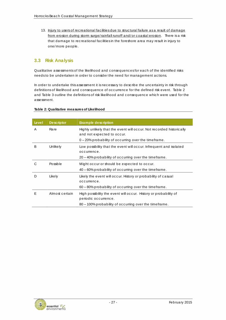
3.3 Risk Analysis
Qualitative assessments of the likelihood and consequences for each of the identified risks needs to be undertaken in order to consider the need for management actions.
In order to undertake this assessment it is necessary to describe the uncertainty in risk through definitions of likelihood and consequence of occurrence for the defined risk event. Table 2 and Table 3 outline the definitions of risk likelihood and consequence which were used for the assessment.
Table 2: Qualitative measures of Likelihood
Level Descriptor Example description
A Rare Highly unlikely that the event will occur. Not recorded historically and not expected to occur. 0 – 20% probability of occurring over the timeframe.
B Unlikely Low possibility that the event will occur. Infrequent and isolated occurrence. 20 – 40% probability of occurring over the timeframe.
C Possible Might occur or should be expected to occur. 40 – 60% probability of occurring over the timeframe.
D Likely Likely the event will occur. History or probability of casual occurrence. 60 – 80% probability of occurring over the timeframe.
E Almost certain High possibility the event will occur. History or probability of periodic occurrence. 80 – 100% probability of occurring over the timeframe.
Horrocks Beach Coastal Management Strategy
- 28 - February 2015
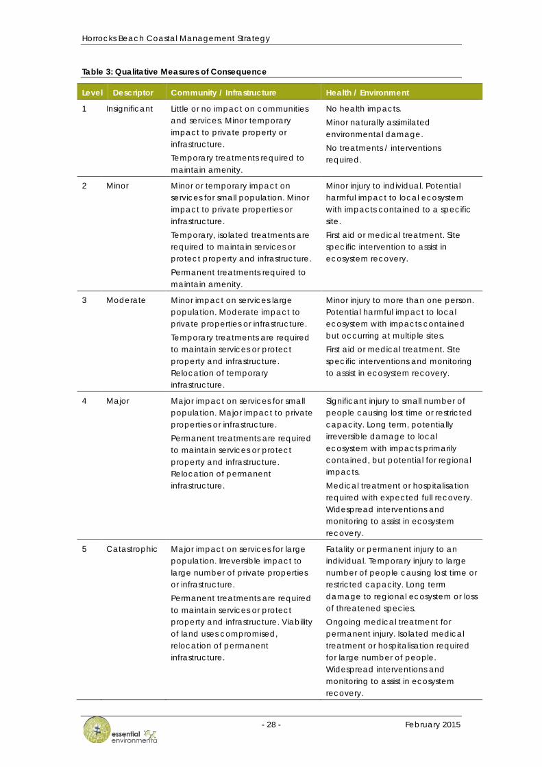
Table 3: Qualitative Measures of Consequence
Level Descriptor Community / Infrastructure Health / Environment
1 Insignificant Little or no impact on communities and services. Minor temporary impact to private property or infrastructure. Temporary treatments required to maintain amenity.
No health impacts. Minor naturally assimilated environmental damage. No treatments / interventions required.
2 Minor Minor or temporary impact on services for small population. Minor impact to private properties or infrastructure. Temporary, isolated treatments are required to maintain services or protect property and infrastructure. Permanent treatments required to maintain amenity.
Minor injury to individual. Potential harmful impact to local ecosystem with impacts contained to a specific site. First aid or medical treatment. Site specific intervention to assist in ecosystem recovery.
3 Moderate Minor impact on services large population. Moderate impact to private properties or infrastructure. Temporary treatments are required to maintain services or protect property and infrastructure. Relocation of temporary infrastructure.
Minor injury to more than one person. Potential harmful impact to local ecosystem with impacts contained but occurring at multiple sites. First aid or medical treatment. Site specific interventions and monitoring to assist in ecosystem recovery.
4 Major Major impact on services for small population. Major impact to private properties or infrastructure. Permanent treatments are required to maintain services or protect property and infrastructure. Relocation of permanent infrastructure.
Significant injury to small number of people causing lost time or restricted capacity. Long term, potentially irreversible damage to local ecosystem with impacts primarily contained, but potential for regional impacts. Medical treatment or hospitalisation required with expected full recovery. Widespread interventions and monitoring to assist in ecosystem recovery.
5 Catastrophic Major impact on services for large population. Irreversible impact to large number of private properties or infrastructure. Permanent treatments are required to maintain services or protect property and infrastructure. Viability of land uses compromised, relocation of permanent infrastructure.
Fatality or permanent injury to an individual. Temporary injury to large number of people causing lost time or restricted capacity. Long term damage to regional ecosystem or loss of threatened species. Ongoing medical treatment for permanent injury. Isolated medical treatment or hospitalisation required for large number of people. Widespread interventions and monitoring to assist in ecosystem recovery.
Horrocks Beach Coastal Management Strategy
- 29 - February 2015
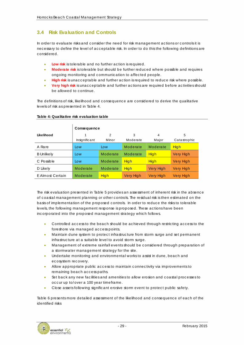
3.4 Risk Evaluation and Controls
In order to evaluate risks and consider the need for risk management actions or controls it is necessary to define the level of acceptable risk. In order to do this the following definitions are considered.
• Low risk is tolerable and no further action is required. • Moderate risk is tolerable but should be further reduced where possible and requires
ongoing monitoring and communication to affected people. • High risk is unacceptable and further action is required to reduce risk where possible. • Very high risk is unacceptable and further actions are required before activities should
be allowed to continue.
The definitions of risk, likelihood and consequence are considered to derive the qualitative levels of risk as presented in Table 4.
Table 4: Qualitative risk evaluation table
Consequence
Likelihood 1 Insignificant
2 Minor
3 Moderate
4 Major
5 Catastrophic
A Rare Low Low Moderate Moderate High
B Unlikely Low Moderate Moderate High Very High
C Possible Low Moderate High High Very High
D Likely Moderate Moderate High Very High Very High
E Almost Certain Moderate High Very High Very High Very High
The risk evaluation presented in Table 5 provides an assessment of inherent risk in the absence of coastal management planning or other controls. The residual risk is then estimated on the basis of implementation of the proposed controls. In order to reduce the risks to tolerable levels, the following management response is proposed. These actions have been incorporated into the proposed management strategy which follows.
• Controlled access to the beach should be achieved through restricting access to the foreshore via managed access points.
• Maintain dune system to protect infrastructure from storm surge and set permanent infrastructure at a suitable level to avoid storm surge.
• Management of extreme rainfall events should be considered through preparation of a stormwater management strategy for the site.
• Undertake monitoring and environmental works to assist in dune, beach and ecosystem recovery.
• Allow appropriate public access to maintain connectivity via improvements to remaining beach access paths.
• Set back any new facilities and amenities to allow erosion and coastal processes to occur up to/over a 100 year timeframe.
• Close assets following significant erosive storm event to protect public safety.
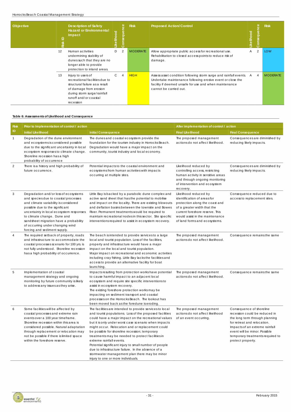
Table 6 presents more detailed assessment of the likelihood and consequence of each of the identified risks
Horrocks Beach Coastal Management Strategy
- 30 - February 2015
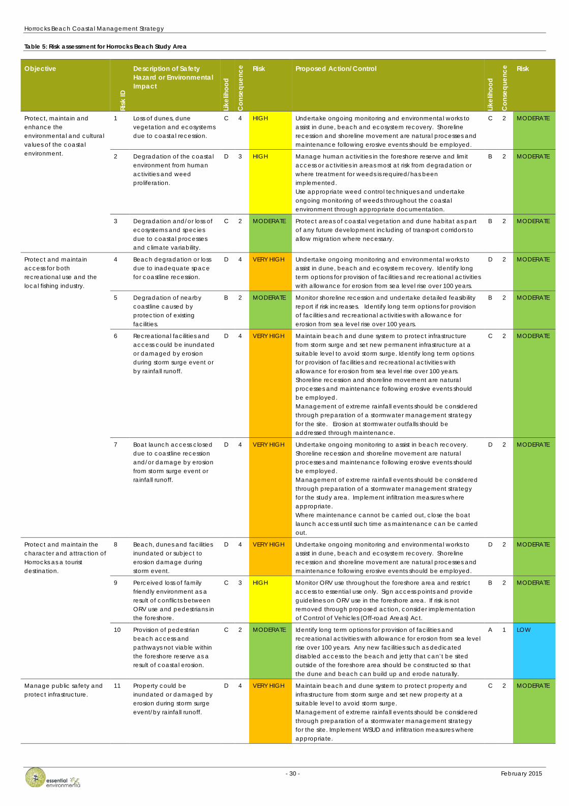
Table 5: Risk assessment for Horrocks Beach Study Area
Objective
Risk
ID
Description of Safety Hazard or Environmental Impact
Likel
ihoo
d
Con
sequ
ence
Risk Proposed Action/Control
Likel
ihoo
d
Con
sequ
ence
Risk
Protect, maintain and enhance the environmental and cultural values of the coastal environment.
1 Loss of dunes, dune vegetation and ecosystems due to coastal recession.
C 4 HIGH Undertake ongoing monitoring and environmental works to assist in dune, beach and ecosystem recovery. Shoreline recession and shoreline movement are natural processes and maintenance following erosive events should be employed.
C 2 MODERATE
2 Degradation of the coastal environment from human activities and weed proliferation.
D 3 HIGH Manage human activities in the foreshore reserve and limit access or activities in areas most at risk from degradation or where treatment for weeds is required/has been implemented. Use appropriate weed control techniques and undertake ongoing monitoring of weeds throughout the coastal environment through appropriate documentation.
B 2 MODERATE
3 Degradation and/or loss of ecosystems and species due to coastal processes and climate variability.
C 2 MODERATE Protect areas of coastal vegetation and dune habitat as part of any future development including of transport corridors to allow migration where necessary.
B 2 MODERATE
Protect and maintain access for both recreational use and the local fishing industry.
4 Beach degradation or loss due to inadequate space for coastline recession.
D 4 VERY HIGH Undertake ongoing monitoring and environmental works to assist in dune, beach and ecosystem recovery. Identify long term options for provision of facilities and recreational activities with allowance for erosion from sea level rise over 100 years.
D 2 MODERATE
5 Degradation of nearby coastline caused by protection of existing facilities.
B 2 MODERATE Monitor shoreline recession and undertake detailed feasibility report if risk increases. Identify long term options for provision of facilities and recreational activities with allowance for erosion from sea level rise over 100 years.
B 2 MODERATE
6 Recreational facilities and access could be inundated or damaged by erosion during storm surge event or by rainfall runoff.
D 4 VERY HIGH Maintain beach and dune system to protect infrastructure from storm surge and set new permanent infrastructure at a suitable level to avoid storm surge. Identify long term options for provision of facilities and recreational activities with allowance for erosion from sea level rise over 100 years. Shoreline recession and shoreline movement are natural processes and maintenance following erosive events should be employed. Management of extreme rainfall events should be considered through preparation of a stormwater management strategy for the site. Erosion at stormwater outfalls should be addressed through maintenance.
C 2 MODERATE
7 Boat launch access closed due to coastline recession and/or damage by erosion from storm surge event or rainfall runoff.
D 4 VERY HIGH Undertake ongoing monitoring to assist in beach recovery. Shoreline recession and shoreline movement are natural processes and maintenance following erosive events should be employed. Management of extreme rainfall events should be considered through preparation of a stormwater management strategy for the study area. Implement infiltration measures where appropriate. Where maintenance cannot be carried out, close the boat launch access until such time as maintenance can be carried out.
D 2 MODERATE
Protect and maintain the character and attraction of Horrocks as a tourist destination.
8 Beach, dunes and facilities inundated or subject to erosion damage during storm event.
D 4 VERY HIGH Undertake ongoing monitoring and environmental works to assist in dune, beach and ecosystem recovery. Shoreline recession and shoreline movement are natural processes and maintenance following erosive events should be employed.
D 2 MODERATE
9 Perceived loss of family friendly environment as a result of conflicts between ORV use and pedestrians in the foreshore.
C 3 HIGH Monitor ORV use throughout the foreshore area and restrict access to essential use only. Sign access points and provide guidelines on ORV use in the foreshore area. If risk is not removed through proposed action, consider implementation of Control of Vehicles (Off-road Areas) Act.
B 2 MODERATE
10 Provision of pedestrian beach access and pathways not viable within the foreshore reserve as a result of coastal erosion.
C 2 MODERATE Identify long term options for provision of facilities and recreational activities with allowance for erosion from sea level rise over 100 years. Any new facilities such as dedicated disabled access to the beach and jetty that can’t be sited outside of the foreshore area should be constructed so that the dune and beach can build up and erode naturally.
A 1 LOW
Manage public safety and protect infrastructure.
11 Property could be inundated or damaged by erosion during storm surge event/by rainfall runoff.
D 4 VERY HIGH Maintain beach and dune system to protect property and infrastructure from storm surge and set new property at a suitable level to avoid storm surge. Management of extreme rainfall events should be considered through preparation of a stormwater management strategy for the site. Implement WSUD and infiltration measures where appropriate.
C 2 MODERATE
Horrocks Beach Coastal Management Strategy
- 31 - February 2015
Objective
Risk
ID
Description of Safety Hazard or Environmental Impact
Likel
ihoo
d
Con
sequ
ence
Risk Proposed Action/Control
Likel
ihoo
d
Con
sequ
ence
Risk
12 Human activities undermining stability of dunes such that they are no longer able to provide protection to inland areas.
D 2 MODERATE Allow appropriate public access for recreational use. Rehabilitation to closed access points to reduce risk of damage.
A 2 LOW
13 Injury to users of recreational facilities due to structural failure as a result of damage from erosion during storm surge/rainfall runoff and/or coastal recession
C 4 HIGH Assess asset condition following storm surge and rainfall events. Undertake maintenance following erosive event or close the facility if deemed unsafe for use and when maintenance cannot be carried out.
A 4 MODERATE
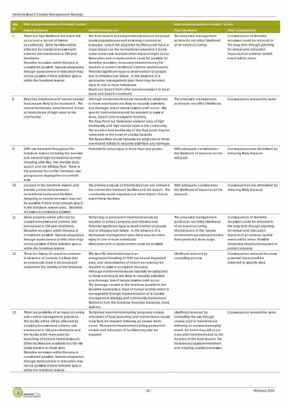
Table 6: Assessments of Likelihood and Consequence
Risk ID
Prior to Implementation of control / action After implementation of control / action
Initial Likelihood Initial Consequence Final Likelihood Final Consequence
1 Degradation of the dune environment and ecosystems is considered possible due to the significant uncertainty in local ecosystem responses to climate change. Shoreline recession has a high probability of occurrence
The dunes and coastal ecosystem provide the foundation for the tourism industry in Horrocks Beach. Degradation would have a major impact on the community, tourist industry and local economy.
The proposed management actions do not affect likelihood.
Consequences are diminished by reducing likely impacts.
2 There is a history and high probability of future occurrence.
Potential impacts to the coastal environment and ecosystems from human activities with impacts occurring at multiple sites.
Likelihood reduced by controlling access, restricting human activity in sensitive areas and through ongoing monitoring of intervention and ecosystem recovery.
Consequences are diminished by reducing likely impacts.
3 Degradation and/or loss of ecosystems and species due to coastal processes and climate variability is considered possible due to the significant uncertainty in local ecosystem responses to climate change. Dune and sandsheet migration have a probability of occurring under changing wind forcing and sediment supply.
Little Bay is backed by a parabolic dune complex and active sand sheet that has the potential to mobilise and impact on the locality. There are existing blowouts and deflation basins between the townsite and Bowes River. Permanent treatments would be required to maintain recreational nodes in this sector. Site specific interventions required to assist in ecosystem recovery.
Likelihood reduced by identification of areas for protection along the coast and of a greater width that the current foreshore reserve. This would assist in the maintenance of land forms and ecosystems.
Consequence reduced due to access to replacement sites.
4 The required setback of property, roads and infrastructure to accommodate the coastal processes scenario for 100 yrs. is not fully understood. Shoreline recession has a high probability of occurrence.
The beach is intended to provide services to a large local and tourist population. Loss of the facilities, property and infrastructure would have a major impact on the local and tourist population. Major impact on recreational and economic activities including cray fishing. Little Bay lacks the facilities and access to provide an alternative facility for boat launching.
The proposed management actions do not affect likelihood.
Consequence remains the same
5 Implementation of coastal management strategy and ongoing monitoring by future community is likely to address any issues as they arise.
Impacts resulting from protection works have potential to cause harmful impact to an adjacent local ecosystem and require site specific interventions to assist in ecosystem recovery. The existing foreshore protection works may be impacting on sediment transport and coastal processes on the Horrocks Beach. The lookout has been moved back as the foredune is eroding.
The proposed management actions do not affect likelihood.
Consequence remains the same
6 Some facilities will be affected by coastal processes and extreme rain events over a 100 year timeframe. Shoreline recession within this area is considered possible. Natural adaptation through replacement or relocation may not be possible if there is limited space within the foreshore reserve.
The facilities are intended to provide services to local and tourist populations. Loss of the proposed facilities could have a major impact on the recreational values but it is only under worst case scenario when impacts might occur. Relocation and or replacement could be possible for shoreline recession; temporary treatments may be needed to protect facilities in extreme rainfall events. Potential significant injury to small number of people due to infrastructure failure. In the absence of a stormwater management plan there may be minor injury to one or more individuals.
The proposed management actions do not affect likelihood of an event occurring.
Consequence of shoreline recession could be reduced in the long term through planning for retreat and relocation. Impacts of an extreme rainfall event will be minor. Possible temporary treatments required to protect property.
Horrocks Beach Coastal Management Strategy
- 32 - February 2015
Risk ID
Prior to Implementation of control / action After implementation of control / action
Initial Likelihood Initial Consequence Final Likelihood Final Consequence
7 There is a high likelihood the event will occur and a record of historic occurrences. Some facilities will be affected by coastal processes and extreme rain events over a 100 year timeframe. Shoreline recession within this area is considered possible. Natural adaptation through replacement or relocation may not be possible if there is limited space within the foreshore reserve.
The boat launch access provides services to local and tourist populations as well as serving commercial purposes. Loss of the proposed facilities could have a major impact on the recreational values but it is only under worst case scenario when impacts might occur. Relocation and or replacement could be possible for shoreline recession; temporary treatments may be needed to protect facilities in extreme rainfall events. Potential significant injury to small number of people due to infrastructure failure. In the absence of a stormwater management plan there may be minor injury to one or more individuals. Boats can launch from other locations subject to local wave and beach conditions.
The proposed management actions do not affect likelihood of an event occurring.
Consequence of shoreline recession could be reduced in the long term through planning for retreat and relocation. Impacts of an extreme rainfall event will be minor.
8 Beaches, foredunes and natural coastal features are likely to be inundated. The natural landscape, beaches and dunes at Horrocks are of high value to the community.
Although environments would naturally be subjected to these events and are likely to naturally assimilate any damage, loss of natural assets could occur. Site specific interventions would be required to assist in dune, beach and ecosystem recovery. The Frog Pond is a freshwater wetland area of high biodiversity and high natural value in the community. The location and biodiversity of the Frog pond may be vulnerable to the onset of coastal hazards. The Bowes River would naturally be subjected to these events and is likely to naturally assimilate any damage.
The proposed management actions do not affect likelihood.
Consequence remains the same
9 ORV use is present throughout the foreshore reserve including the townsite and areas of high recreational activity including Little Bay, the townsite boat launch and the Whiting Pool. There is the potential for conflict between user groups as no segregation or controls exist.
Potential for minor injury to more than one person. With adequate consideration the likelihood of impacts can be reduced.
Consequences are diminished by reducing likely impacts.
10 Located in the foreshore reserve and provide connections between recreational nodes and facilities. Adapting to natural recession may not be possible if there is not enough space in the foreshore reserve area. Shoreline recession is considered possible.
The primary purpose of this infrastructure is to enhance the connection between facilities and the beach. The community would experience a minor impact due to loss of these facilities.
With adequate consideration the likelihood of impacts can be reduced.
Consequences are diminished by reducing likely impacts.
11 Some property will be affected by coastal processes and extreme rain events over a 100 year timeframe. Shoreline recession within this area is considered possible. Natural adaptation through replacement or relocation may not be possible if there is limited space within the foreshore reserve.
Temporary or permanent treatments would be required to protect property and infrastructure. Potential significant injury to small number of people due to infrastructure failure. In the absence of a stormwater management plan there may be minor injury to one or more individuals. Relocation and or replacement could be possible.
The proposed management actions do not affect likelihood of an event occurring. Maintenance of the natural environment provides protection from predicted storm surge.
Consequence of shoreline recession could be reduced in the long term through planning for retreat and relocation. Impacts of an extreme rainfall event will be minor. Possible temporary treatments required to protect property.
12 There is a history of casual occurrence. In absence of controls, it is likely that access would result in blowouts and undermine the viability of the foredune.
Site specific interventions such as revegetation/brushing of ORV tracks and degraded area; and rationalisation of beach access may be required to assist in ecosystem recovery. Although environments would naturally be subjected to these events and are likely to naturally assimilate any damage, loss of natural assets could occur. The damage caused to the foredune parallel to the shoreline is primarily a result of human activity which is manageable through implementation of a coastal management strategy and community involvement. Sediment from the foredune forms the parabolic dune systems.
Likelihood reduced by controlling access.
Consequence reduced because potential impacts will be restricted to specific sites.
13 There is a possibility of an injury occurring with current management practices. The facility will be will be affected by coastal processes and extreme rain events over a 100 year timeframe and the facility is the main point for launching of boats in Horrocks Beach. Other facilities are available but the risk is also present at these sites. Shoreline recession within this area is considered possible. Natural adaptation through replacement or relocation may not be possible if there is limited space within the foreshore reserve.
Temporary treatments including temporary closure, relocation of boat launching and maintenance would most likely be required following an erosive storm event. Permanent treatments including permanent closure and relocation of facilities may also be required.
Likelihood reduced by controlling the use through closure and/or maintenance following an erosive/damaging event. An event may still occur even after treatments due to the location of the boat launch, the hazardous coastal environment and ongoing coastal processes.
Consequence remains the same

Horrocks Beach Coastal Management Strategy
- 33 - February 2015
3.5 Risk adaption planning, monitoring and review
The definitions of likelihood and consequence and the proposed evaluation of risk described in Table 2 and Table 3 provide a subjective assessment of the level of risk which might be considered tolerable in the current social and administrative context.
Further, the identification of key risks (Section 3.2), assessment of likelihood and consequence (Table 6) and evaluation of risks presented considers the current understanding and information about local coastal processes and likely impacts. This is particularly relevant given the rate at which new knowledge regarding climate change and potential impacts on coastal forces has been developed over the past few years, and the potential impacts that this will have on community expectations.
These observations highlight the need for ongoing monitoring and review to continuously refine the assessment of risks, consider new information and observations, and to reflect changing needs and aspirations of society. It is therefore necessary that the risk assessment and outcomes reflected in this coastal management strategy are reviewed every 5 years.
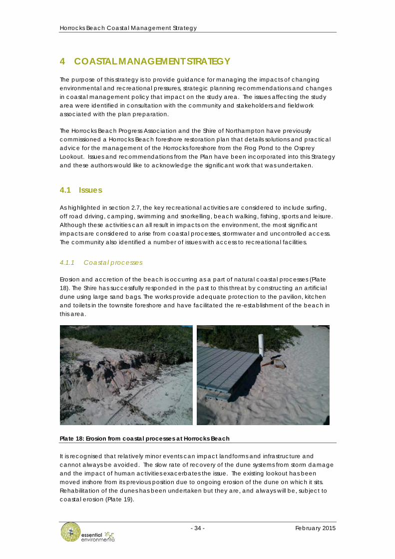
Horrocks Beach Coastal Management Strategy
- 34 - February 2015
4 COASTAL MANAGEMENT STRATEGY
The purpose of this strategy is to provide guidance for managing the impacts of changing environmental and recreational pressures, strategic planning recommendations and changes in coastal management policy that impact on the study area. The issues affecting the study area were identified in consultation with the community and stakeholders and fieldwork associated with the plan preparation.
The Horrocks Beach Progress Association and the Shire of Northampton have previously commissioned a Horrocks Beach foreshore restoration plan that details solutions and practical advice for the management of the Horrocks foreshore from the Frog Pond to the Osprey Lookout. Issues and recommendations from the Plan have been incorporated into this Strategy and these authors would like to acknowledge the significant work that was undertaken.
4.1 Issues
As highlighted in section 2.7, the key recreational activities are considered to include surfing, off road driving, camping, swimming and snorkelling, beach walking, fishing, sports and leisure. Although these activities can all result in impacts on the environment, the most significant impacts are considered to arise from coastal processes, stormwater and uncontrolled access. The community also identified a number of issues with access to recreational facilities.
4.1.1 Coastal processes
Erosion and accretion of the beach is occurring as a part of natural coastal processes (Plate 18). The Shire has successfully responded in the past to this threat by constructing an artificial dune using large sand bags. The works provide adequate protection to the pavilion, kitchen and toilets in the townsite foreshore and have facilitated the re-establishment of the beach in this area.
Plate 18: Erosion from coastal processes at Horrocks Beach
It is recognised that relatively minor events can impact landforms and infrastructure and cannot always be avoided. The slow rate of recovery of the dune systems from storm damage and the impact of human activities exacerbates the issue. The existing lookout has been moved inshore from its previous position due to ongoing erosion of the dune on which it sits. Rehabilitation of the dunes has been undertaken but they are, and always will be, subject to coastal erosion (Plate 19).
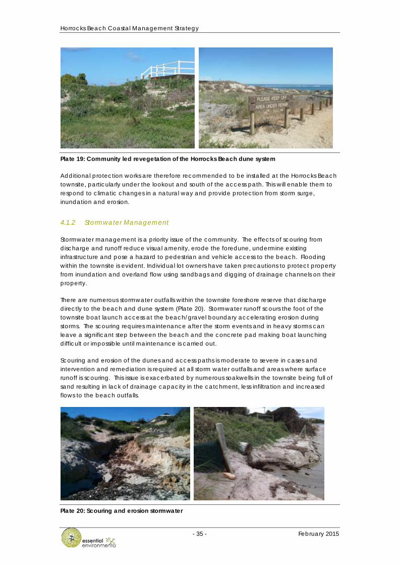
Horrocks Beach Coastal Management Strategy
- 35 - February 2015
Plate 19: Community led revegetation of the Horrocks Beach dune system
Additional protection works are therefore recommended to be installed at the Horrocks Beach townsite, particularly under the lookout and south of the access path. This will enable them to respond to climatic changes in a natural way and provide protection from storm surge, inundation and erosion.
4.1.2 Stormwater Management
Stormwater management is a priority issue of the community. The effects of scouring from discharge and runoff reduce visual amenity, erode the foredune, undermine existing infrastructure and pose a hazard to pedestrian and vehicle access to the beach. Flooding within the townsite is evident. Individual lot owners have taken precautions to protect property from inundation and overland flow using sandbags and digging of drainage channels on their property.
There are numerous stormwater outfalls within the townsite foreshore reserve that discharge directly to the beach and dune system (Plate 20). Stormwater runoff scours the foot of the townsite boat launch access at the beach/gravel boundary accelerating erosion during storms. The scouring requires maintenance after the storm events and in heavy storms can leave a significant step between the beach and the concrete pad making boat launching difficult or impossible until maintenance is carried out.
Scouring and erosion of the dunes and access paths is moderate to severe in cases and intervention and remediation is required at all storm water outfalls and areas where surface runoff is scouring. This issue is exacerbated by numerous soakwells in the townsite being full of sand resulting in lack of drainage capacity in the catchment, less infiltration and increased flows to the beach outfalls.
Plate 20: Scouring and erosion stormwater

Horrocks Beach Coastal Management Strategy
- 36 - February 2015
4.1.3 Uncontrolled access
Indiscriminate use of off road vehicles can damage the coastal environment. Problems associated with the use of off road vehicles are being experienced in a number of locations throughout the study area and it is necessary to control access by vehicles to limit environmental damage and loss of amenity.
The limited control and resultant network of tracks in the Bowes area are testament to the high level of usage and attraction of the sector for recreational activities. Tracks are numerous, and the loss of dune height, dune vegetation and of visual amenity is evident (Plate 21). The Horrocks Beach General store dispenses fuel and is used as a refuelling point for off road vehicles that travel to Horrocks along the foreshore from places to the south of Bowes before making the return journey. These vehicles access the townsite via private land at Bowes, a track from a vacant lot on Horan Way and via the southern pedestrian path at the corner of Stoke and Glance Street. This results in significant impacts on the residents from noise and on dune vegetation and stability.
Plate 21: Indiscriminate off road vehicle tracks through dunes at Bowes River
Vehicular access to the beach throughout the study area is valued highly by the community and is required by older people to launch their boats from the safer and more accessible environment near the Whiting Pool. Although the Whiting Pool is a popular place for people to swim, the current level of use of this area by people and vehicles is not considered by the community to pose a significant conflict at this time. It is recognised; however, that the risk of conflicts at the Whiting Pool could be reduced through the provision of dedicated trailer parking north of this location, in the southern car park.
4.1.4 Access to recreational facilities
The access to Little Bay and the key recreational nodes north of the Horrocks townsite is via gravel and then an unmade track through dunes close to the shore (Plate 22). There are a number of access points to the beach from the main track used by vehicles at Little Bay and throughout the sector that have contributed to degradation of the dunes. These tracks are used to access the beach and near shore reef for recreational activities, cray fishing, boat launching and in case of emergencies.
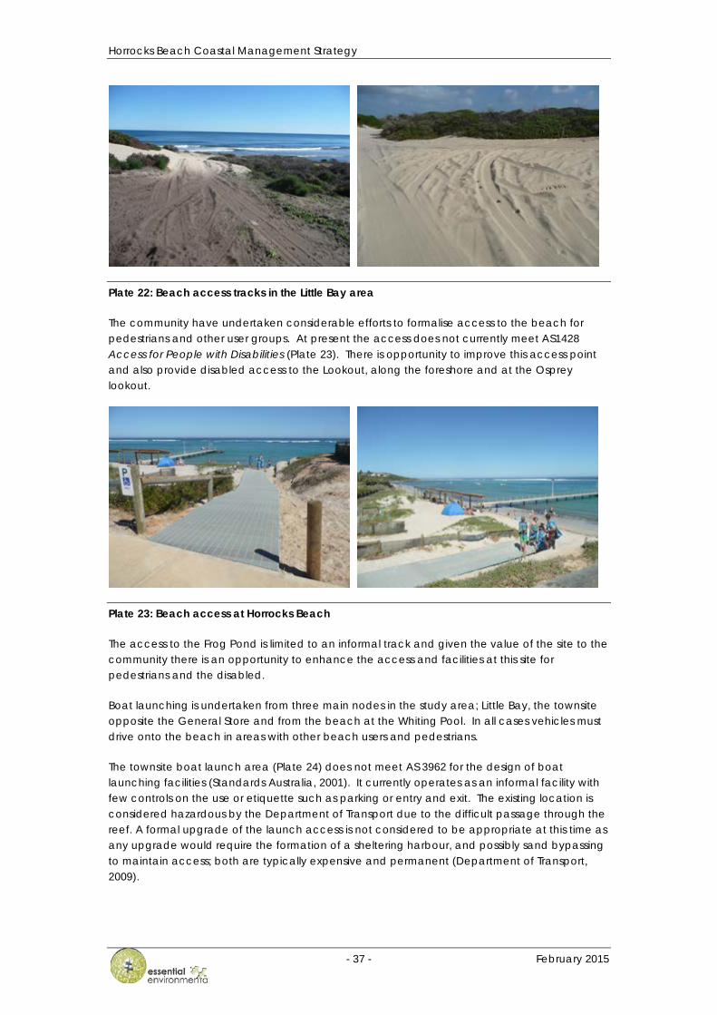
Horrocks Beach Coastal Management Strategy
- 37 - February 2015
Plate 22: Beach access tracks in the Little Bay area
The community have undertaken considerable efforts to formalise access to the beach for pedestrians and other user groups. At present the access does not currently meet AS1428 Access for People with Disabilities (Plate 23). There is opportunity to improve this access point and also provide disabled access to the Lookout, along the foreshore and at the Osprey lookout.
Plate 23: Beach access at Horrocks Beach
The access to the Frog Pond is limited to an informal track and given the value of the site to the community there is an opportunity to enhance the access and facilities at this site for pedestrians and the disabled.
Boat launching is undertaken from three main nodes in the study area; Little Bay, the townsite opposite the General Store and from the beach at the Whiting Pool. In all cases vehicles must drive onto the beach in areas with other beach users and pedestrians.
The townsite boat launch area (Plate 24) does not meet AS 3962 for the design of boat launching facilities (Standards Australia, 2001). It currently operates as an informal facility with few controls on the use or etiquette such as parking or entry and exit. The existing location is considered hazardous by the Department of Transport due to the difficult passage through the reef. A formal upgrade of the launch access is not considered to be appropriate at this time as any upgrade would require the formation of a sheltering harbour, and possibly sand bypassing to maintain access; both are typically expensive and permanent (Department of Transport, 2009).
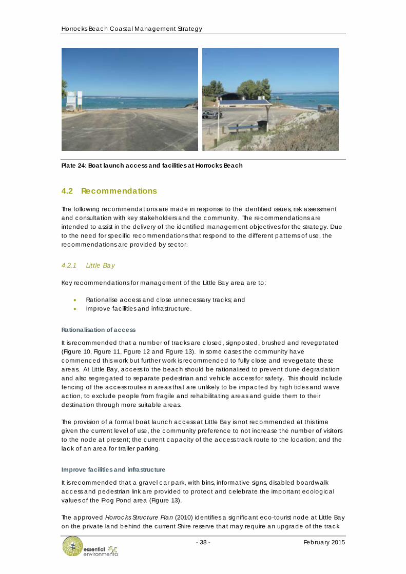
Horrocks Beach Coastal Management Strategy
- 38 - February 2015
Plate 24: Boat launch access and facilities at Horrocks Beach
4.2 Recommendations
The following recommendations are made in response to the identified issues, risk assessment and consultation with key stakeholders and the community. The recommendations are intended to assist in the delivery of the identified management objectives for the strategy. Due to the need for specific recommendations that respond to the different patterns of use, the recommendations are provided by sector.
4.2.1 Little Bay
Key recommendations for management of the Little Bay area are to:
• Rationalise access and close unnecessary tracks; and • Improve facilities and infrastructure.
Rationalisation of access
It is recommended that a number of tracks are closed, signposted, brushed and revegetated (Figure 10, Figure 11, Figure 12 and Figure 13). In some cases the community have commenced this work but further work is recommended to fully close and revegetate these areas. At Little Bay, access to the beach should be rationalised to prevent dune degradation and also segregated to separate pedestrian and vehicle access for safety. This should include fencing of the access routes in areas that are unlikely to be impacted by high tides and wave action, to exclude people from fragile and rehabilitating areas and guide them to their destination through more suitable areas.
The provision of a formal boat launch access at Little Bay is not recommended at this time given the current level of use, the community preference to not increase the number of visitors to the node at present; the current capacity of the access track route to the location; and the lack of an area for trailer parking.
Improve facilities and infrastructure
It is recommended that a gravel car park, with bins, informative signs, disabled boardwalk access and pedestrian link are provided to protect and celebrate the important ecological values of the Frog Pond area (Figure 13).
The approved Horrocks Structure Plan (2010) identifies a significant eco-tourist node at Little Bay on the private land behind the current Shire reserve that may require an upgrade of the track
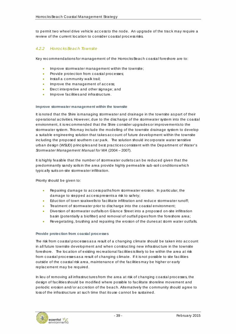
Horrocks Beach Coastal Management Strategy
- 39 - February 2015
to permit two wheel drive vehicle access to the node. An upgrade of the track may require a review of the current location to consider coastal process risks.
4.2.2 Horrocks Beach Townsite
Key recommendations for management of the Horrocks Beach coastal foreshore are to:
• Improve stormwater management within the townsite; • Provide protection from coastal processes; • Install a community walk trail; • Improve the management of access; • Erect interpretive and other signage; and • Improve facilities and infrastructure.
Improve stormwater management within the townsite
It is noted that the Shire is managing stormwater and drainage in the townsite as part of their operational activities. However, due to the discharge of the stormwater system into the coastal environment, it is recommended that the Shire consider upgrades or improvements to the stormwater system. This may include the modelling of the townsite drainage system to develop a suitable engineering solution that takes account of future development within the townsite including the proposed southern car park. The solution should incorporate water sensitive urban design (WSUD) principles and best practices consistent with the Department of Water’s Stormwater Management Manual for WA (2004 – 2007).
It is highly feasible that the number of stormwater outlets can be reduced given that the predominantly sandy soils in the area provide highly permeable sub-soil conditions which typically suits on-site stormwater infiltration.
Priority should be given to:
• Repairing damage to access paths from stormwater erosion. In particular, the damage to stepped access presents a risk to safety;
• Eduction of town soakwells to facilitate infiltration and reduce stormwater runoff; • Treatment of stormwater prior to discharge into the coastal environment; • Diversion of stormwater outfalls on Glance Street into a proposed on-site infiltration
basin (potentially a biofilter) and removal of outfall pipes from the foreshore area; • Revegetating, brushing and repairing the erosion of the dunes at storm water outfalls.
Provide protection from coastal processes
The risk from coastal processes as a result of a changing climate should be taken into account in all future townsite development and when constructing new infrastructure in the townsite foreshore. The location of existing recreational facilities is likely to be within the area at risk from coastal processes as a result of changing climate. If it is not possible to site facilities outside of the coastal risk area, maintenance of the facilities may be higher or early replacement may be required.
In lieu of removing all infrastructures from the area at risk of changing coastal processes, the design of facilities should be modified where possible to facilitate shoreline movement and periodic erosion and/or accretion of the beach. Alternatively the community should agree to loss of the infrastructure at such time that its use cannot be sustained.

Horrocks Beach Coastal Management Strategy
- 40 - February 2015
There is existing shoreline protection in the form of geotextile sandbags (Plate 25) in front of the community kitchen, toilets and showers and the town lookout has already been relocated due to erosion of the dune as a result of coastal processes. Erosion at the lookout location may be enhanced as a result of coastal processes that are altered by the existing shoreline protection.
To protect the dune systems from further erosion, priority should be given to protecting the dune system through revegetation and managing vehicles access on the beach. An investigation into coastal processes and the potential impact of any proposed modifications to the dune systems would be required prior to consideration of any additional engineering solution or shoreline protection to address ongoing erosion and recession.
Plate 25: Geotextile shoreline protection at Horrocks Beach
Install a community walk trail
The establishment of a community walk trail through the townsite to connect places of interest and key recreational areas is strongly recommended (Figure 14). Waypoints along the proposed route should be provided as well as interpretive signage at key recreation nodes such as the lookout, Frog Pond and Osprey Point which advise on cultural, indigenous and natural heritage values. The route should take account of the proposed Mitchell Street extension and Cliff Road development in the Horrocks Structure Plan (2010). It is recommended that the trail design incorporate a dual use pathway and permit disabled use in the townsite and be set back from roads where possible.
Improve the management of access
It is proposed that vehicle access to Horrocks Beach at both the Boat launch access and southern car park is maintained. However it is recommended that the access near the lookout is clearly identified as the priority access point, due to potential conflicts of use between vehicles and beach goers at the Horrocks townsite and Whiting Pool.
It is important that access to the jetty, lookout, Frog Pond and townsite boardwalks meets the requirements of the suite of AS1428 standards to provide access for people with disabilities. This disabled access should connect to the proposed walk trail and allow direct access to disabled car parking facilities.
There is a need to install chicane barriers on the pedestrian path at the southern corner of Stokes and Glance Street to prevent trail bike access (Figure 17).
Horrocks Beach Coastal Management Strategy
- 41 - February 2015
Signage
A consistent signage strategy should be used for all interpretive, directional and informative signage. The purpose should be education and communication including the following:
• Dune rehabilitation area • Keep off the dunes • Keep to the track • Track closed – No ORV access to Horrocks • Beach access
Interpretive signage is recommended at the Frog Pond, the Lookout and the Osprey Lookout to provide information on the cultural, recreational and natural heritage of the area. Where revegetation and protection of dunes has been undertaken, signage in appropriate locations helps inform visitors and the local community of the work, the reasons why rehabilitation has been undertaken, and to encourage them to protect the area and use the facilities provided with care.
It is important to provide signage at the townsite boat launch access to warn of the hazards of launching at the location, notify of where to park boat trailers and educate users on the sensitivity of the beach and dunes in the area.
A large illustrative sign should also be erected at the Whiting Pool (southern car par access point) (Figure 16) which depicts the location of boat launch facilities near the Lookout; highlights the risks to beach users from vehicle assess; educates users on the damage vehicles can cause on the foreshore; and highlights that the area is only to be used when other boat launch facilities are unavailable.
Improve facilities and infrastructure
This strategy has identified the need to improve some of the facilities and infrastructure that exists within the townsite foreshore. This includes:
• Development of the community walk trail as outlined above and in Figure 14; • Installation of a dry composting toilet, shelters and exercise equipment in the southern
townsite car park as well as removal of weeds (Figure 16, Plate 26); • Advocating with the Department of Transport to release appropriate marine
bathymetric information (charts) and provide navigation markers to facilitate safe passage for boats through the Horrocks Beach Lagoon;
• Construction of a Town boardwalk link to the proposed community centre (Figure 15 and Plate 27), although it is noted that the primary access to the community centre will be via a dual use path along North Court; and
• Construction of a lookout at Osprey Point with refurbished beach access stairs and a gravel pathway for pram access (Figure 17).
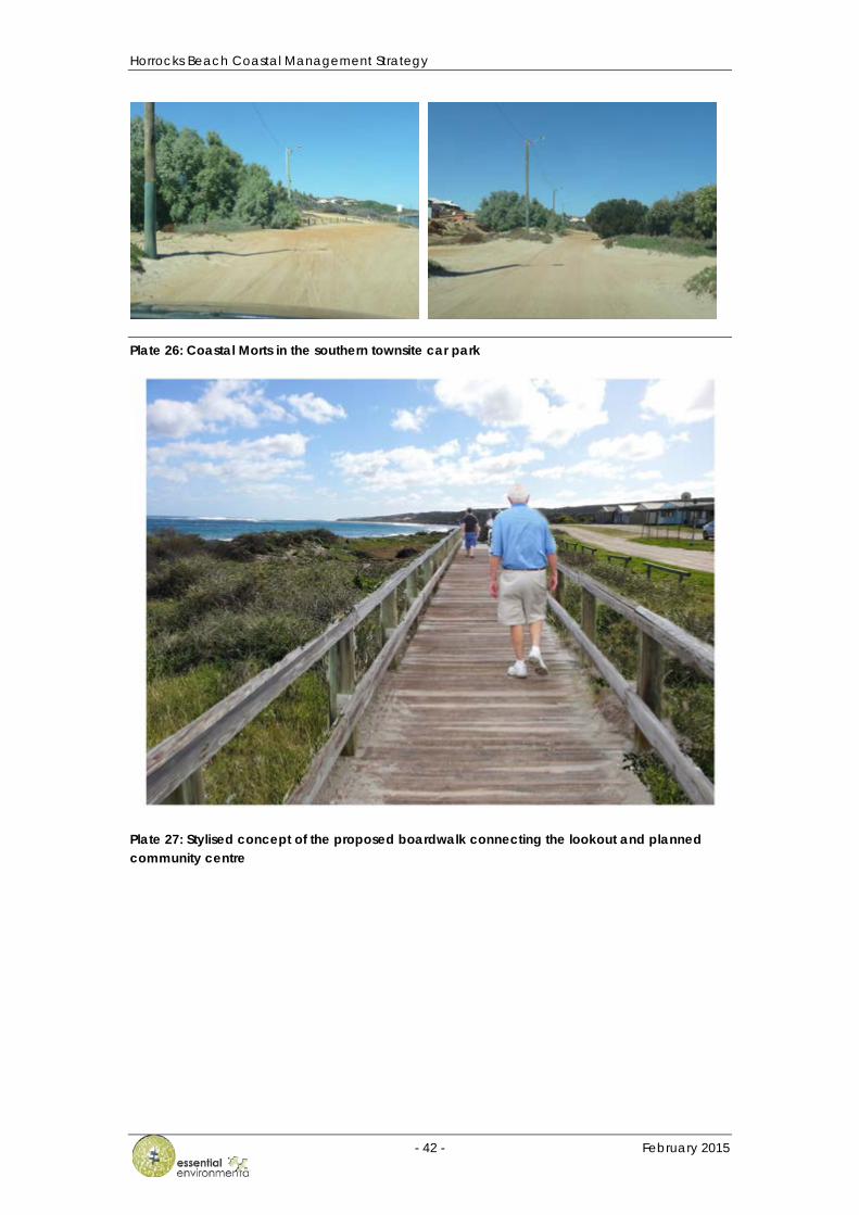
Horrocks Beach Coastal Management Strategy
- 42 - February 2015
Plate 26: Coastal Morts in the southern townsite car park
Plate 27: Stylised concept of the proposed boardwalk connecting the lookout and planned community centre
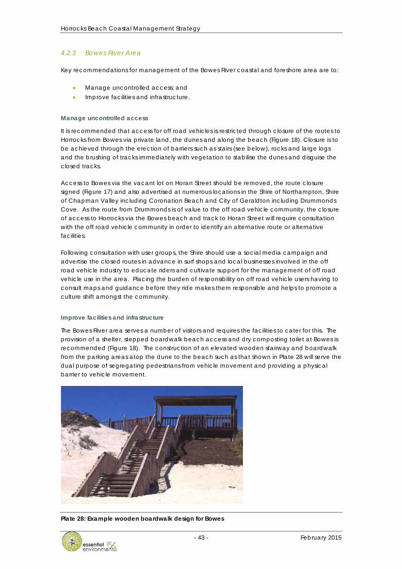
Horrocks Beach Coastal Management Strategy
- 43 - February 2015
4.2.3 Bowes River Area
Key recommendations for management of the Bowes River coastal and foreshore area are to:
• Manage uncontrolled access; and • Improve facilities and infrastructure.
Manage uncontrolled access
It is recommended that access for off road vehicles is restricted through closure of the routes to Horrocks from Bowes via private land, the dunes and along the beach (Figure 18). Closure is to be achieved through the erection of barriers such as stairs (see below), rocks and large logs and the brushing of tracks immediately with vegetation to stabilise the dunes and disguise the closed tracks.
Access to Bowes via the vacant lot on Horan Street should be removed, the route closure signed (Figure 17) and also advertised at numerous locations in the Shire of Northampton, Shire of Chapman Valley including Coronation Beach and City of Geraldton including Drummonds Cove. As the route from Drummonds is of value to the off road vehicle community, the closure of access to Horrocks via the Bowes beach and track to Horan Street will require consultation with the off road vehicle community in order to identify an alternative route or alternative facilities.
Following consultation with user groups, the Shire should use a social media campaign and advertise the closed routes in advance in surf shops and local businesses involved in the off road vehicle industry to educate riders and cultivate support for the management of off road vehicle use in the area. Placing the burden of responsibility on off road vehicle users having to consult maps and guidance before they ride makes them responsible and helps to promote a culture shift amongst the community.
Improve facilities and infrastructure
The Bowes River area serves a number of visitors and requires the facilities to cater for this. The provision of a shelter, stepped boardwalk beach access and dry composting toilet at Bowes is recommended (Figure 18). The construction of an elevated wooden stairway and boardwalk from the parking areas atop the dune to the beach such as that shown in Plate 28 will serve the dual purpose of segregating pedestrians from vehicle movement and providing a physical barrier to vehicle movement.
Plate 28: Example wooden boardwalk design for Bowes
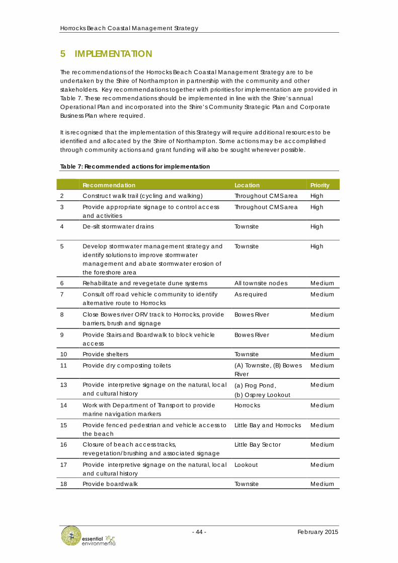
Horrocks Beach Coastal Management Strategy
- 44 - February 2015
5 IMPLEMENTATION
The recommendations of the Horrocks Beach Coastal Management Strategy are to be undertaken by the Shire of Northampton in partnership with the community and other stakeholders. Key recommendations together with priorities for implementation are provided in Table 7. These recommendations should be implemented in line with the Shire’s annual Operational Plan and incorporated into the Shire’s Community Strategic Plan and Corporate Business Plan where required.
It is recognised that the implementation of this Strategy will require additional resources to be identified and allocated by the Shire of Northampton. Some actions may be accomplished through community actions and grant funding will also be sought wherever possible.
Table 7: Recommended actions for implementation
Recommendation Location Priority 2 Construct walk trail (cycling and walking) Throughout CMS area High
3 Provide appropriate signage to control access and activities
Throughout CMS area High
4 De-silt stormwater drains Townsite High
5 Develop stormwater management strategy and identify solutions to improve stormwater management and abate stormwater erosion of the foreshore area
Townsite High
6 Rehabilitate and revegetate dune systems All townsite nodes Medium
7 Consult off road vehicle community to identify alternative route to Horrocks
As required Medium
8 Close Bowes river ORV track to Horrocks, provide barriers, brush and signage
Bowes River Medium
9 Provide Stairs and Boardwalk to block vehicle access
Bowes River Medium
10 Provide shelters Townsite Medium
11 Provide dry composting toilets (A) Townsite, (B) Bowes River
Medium
13 Provide interpretive signage on the natural, local and cultural history
(a) Frog Pond, (b) Osprey Lookout
Medium
14 Work with Department of Transport to provide marine navigation markers
Horrocks Medium
15 Provide fenced pedestrian and vehicle access to the beach
Little Bay and Horrocks Medium
16 Closure of beach access tracks, revegetation/brushing and associated signage
Little Bay Sector Medium
17 Provide interpretive signage on the natural, local and cultural history
Lookout Medium
18 Provide boardwalk Townsite Medium
Horrocks Beach Coastal Management Strategy
- 45 - February 2015
Recommendation Location Priority 19 Install a chicane to prevent 2WD access at
southern pedestrian footpath (Note: implemented in conjunction with Bowes River track closures)
Townsite Medium
20 Remove weeds and revegetate Townsite southern car park area
Medium
21 Provide disabled access Townsite Lookout, Jetty Medium
22 Provide gravel car parking Frog Pond Low
23 Provide boardwalk with disabled access Frog Pond Low
24 Provide fish cleaning table Little Bay campsite Low
25 Provide Lookout, stepped access and gravel path (Note: implementation dependant on stormwater management strategy implementation)
Osprey Lookout Low
26 Provide exercise equipment in the southern grassed area
Townsite Low
27 Provide signage to warn of marine hazards Townsite boat launch access
Low
28 Removal of Tamarisks and Wattle Osprey Lookout Low
29 Provide stepped access to the lookout from the boat launch access
Lookout Low
30 Provide signage at the southern car park beach access ramp to identify the primary boat launch area near the Lookout and warn beach users in the area
Southern car park
6 MONITORING AND REVIEW
It is recommended that the implementation of this coastal management strategy is audited annually and outstanding actions incorporated into the Shire’s Community Strategic Plan and Corporate Business Plan.
The effectiveness of the Coastal Management Strategy should be reviewed in 5 years and updated as required.
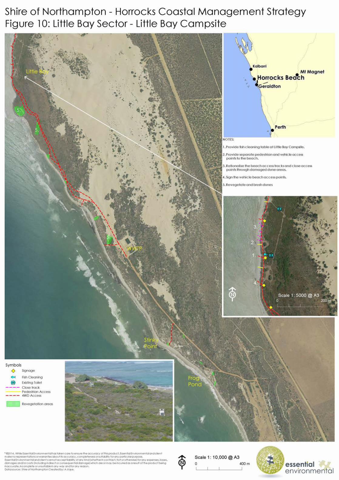
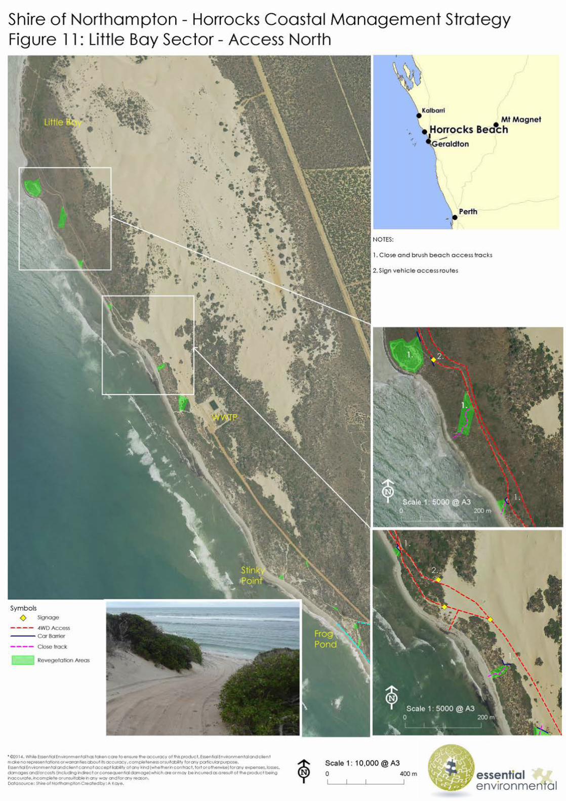
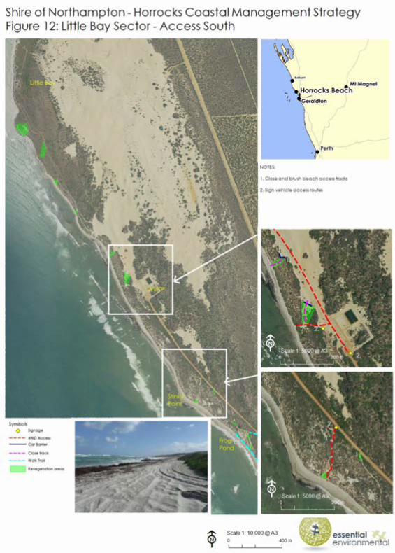
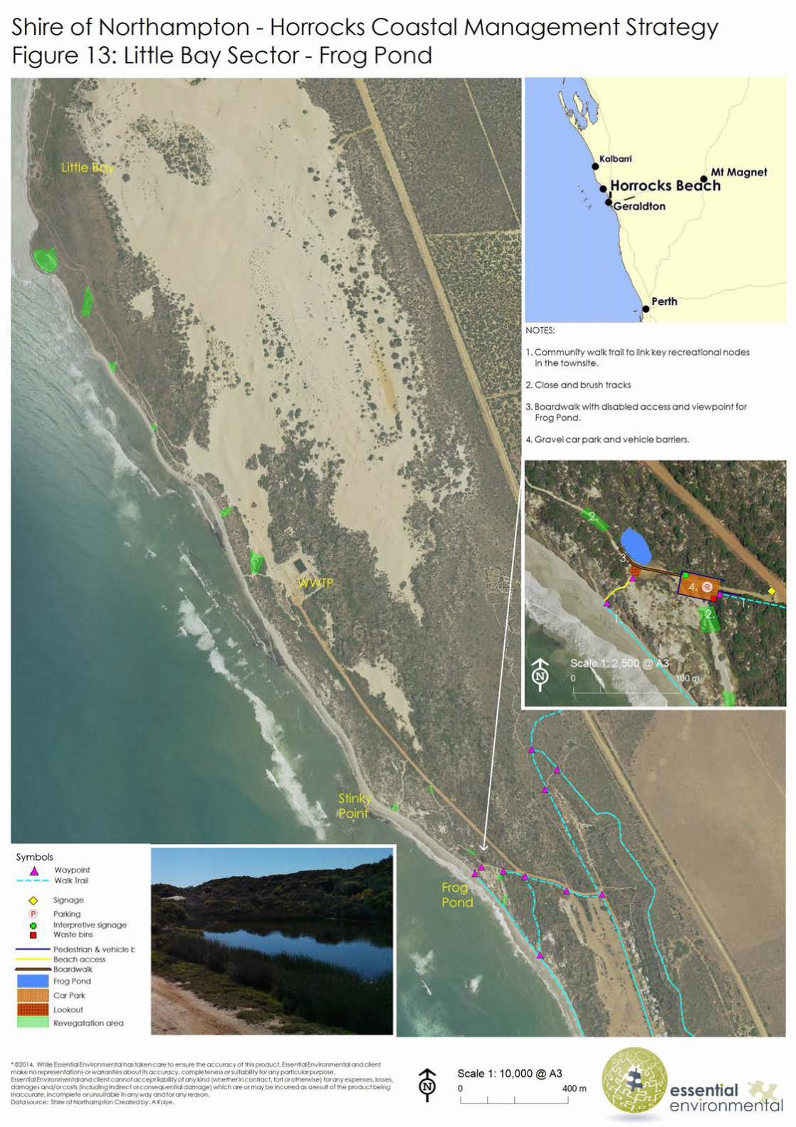
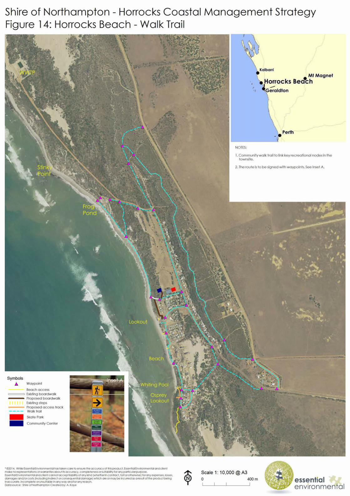
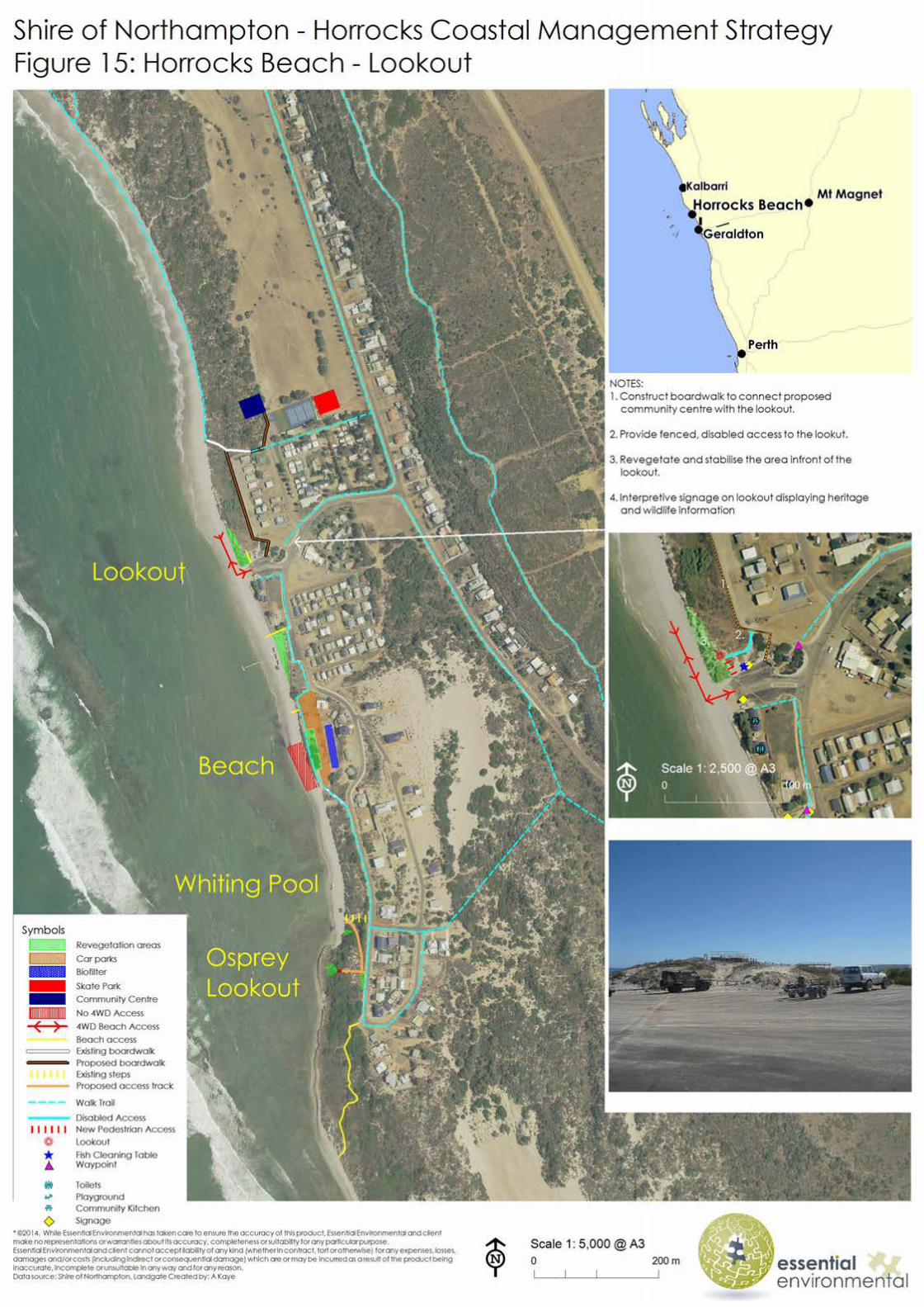
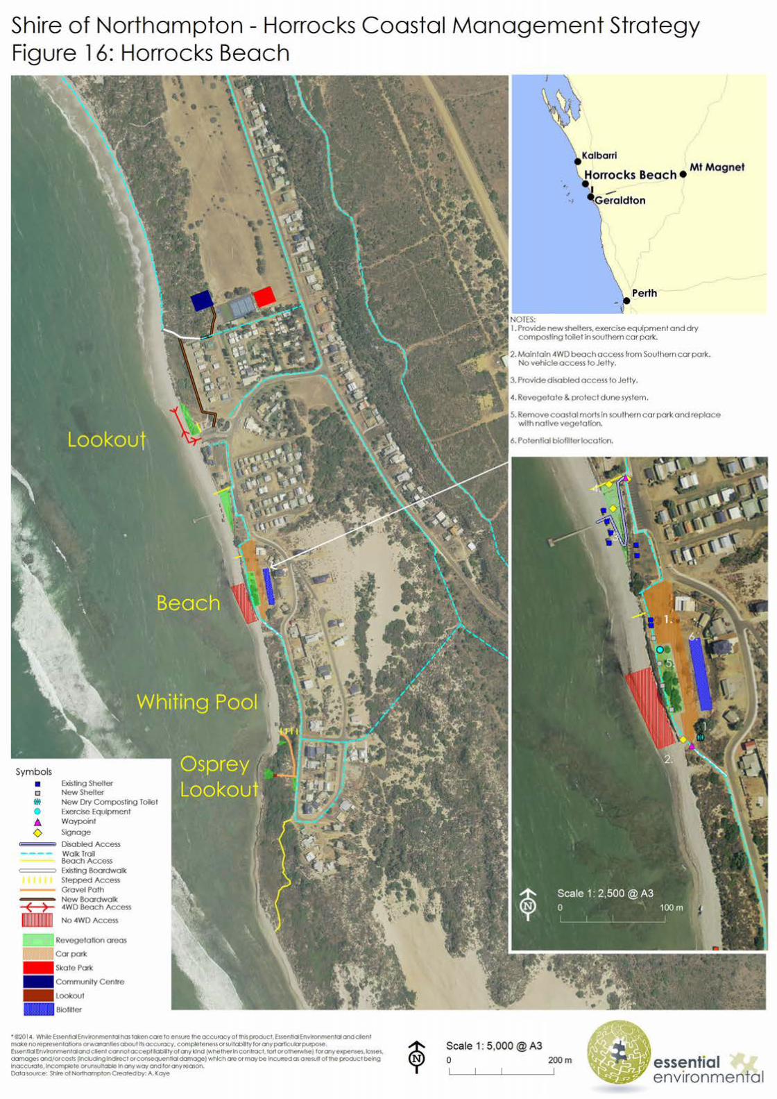
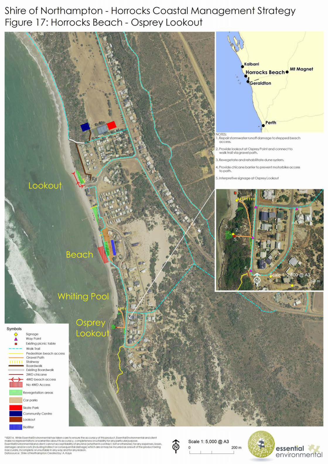

Horrocks Beach Coastal Management Strategy
- 55 - February 2015
7 REFERENCES
Australian Government Bureau of Meteorology, 2014. Climate Statistics for Australian locations. http://www.bom.gov.au/climate/data/index.shtml
Bureau of Meteorology 2014, Climate data online. Available from: <http://www.bom.gov.au/climate/data/?ref=ftr [7th July 2014].
Coastal Focus; 2012, Horrocks Beach Foreshore Restoration Plan: A Community Project. Prepared for the Horrocks Progress Association and the Shire of Northampton, By: Coastal Focus.
Department of Conservation and Land Management; 2002, Bioregional Summary of the 2002 Biodiversity Audit for Western Australia.
Department of Defence; 2012, Australian National Tide Tables 2013.
Department of Planning and Urban Development; 1993, Horrocks Beach Coastal Plan.
Department of Planning and Department of Transport, 2012, The Coast of the Shires of Coorow to Northampton, Mid West, Western Australia: Geology, Geomorphology and Vulnerability, Eliot I, Gozzard JR, Eliot M, Stul T and McCormack G (eds). Prepared by Damara WA Pty Ltd and Geological Survey of Western Australia for the Department of Planning and Department of Transport.
Department of Transport, 2010; Sea Level Change in Western Australia: Application to Coastal Planning, Bicknell, C., Department of Transport - Coastal Infrastructure, Coastal Engineering Group
IPCC (Intergovernmental Panel on Climate Change), 2007, 'Climate change 2007: the physical science basis', Contribution of Working Group I to the Fourth Assessment Report of the Intergovernmental Panel on Climate Change, S Solomon, D Qin, M Manning, Z Chen, M Marquis, KB Averyt, M Tignor & HL Miller (eds), Cambridge University Press, Cambridge, United Kingdom &d New York, USA.
IPCC, 2001: Climate Change 2001: The Scientific Basis. Contribution of Working Group I to the Third Assessment Report of the Intergovernmental Panel on Climate Change [Houghton, J.T., Y. Ding, D.J. Griggs, M. Noguer, P.J. van der Linden, X. Dai, K. Maskell, and C.A. Johnson (eds.)]. Cambridge University Press, Cambridge, United Kingdom and New York, NY, USA, 881pp.
Shire of Northampton, 2012, Local Planning Scheme (District Plan) Map No.s 13 &14
Short, Andrew D.; 2006, Beaches of the Western Australian Coast: Eucla to Roebuck Bay.
Western Australia Planning Commission (WAPC), 2013. State Planning Policy 2.6: State Coastal Planning Policy. www.planning.wa.gov.au
Western Australia Planning Commission (WAPC), 2013b. State Planning Policy 2.6 Guidelines. www.planning.wa.gov.au

Horrocks Beach Coastal Management Strategy
- 56 - February 2015
APPENDIX 1: PLANNING AND POLICY CONTEXT
Key planning and policy context for Horrocks is provided by the following documents. Key strategies, outcomes, issues and recommendations are summarised where possible.
Horrocks Beach Foreshore – Restoration Plan (Coastal focus, 2012)
Developed through consultation with the community, surveying the area and drawing upon existing local and regional costal management plans and strategies, the restoration plan provides solutions and advice for the future management of the Horrocks foreshore based on an understanding of coastal processes, ecosystem services and community aspirations.
Horrocks Beach Coastal Plan (Department of Planning and Urban Development, 1993)
A coastal management plan that details issue and sector based management strategies for Horrocks beach. The aim of the plan is to provide a management framework to guide development and recreational use of the coastal area at Horrocks for a ten year period. The plan provides a comprehensive basis for continued planning and management of the issues identified and was adopted by the local Council as a strategic guide.
Batavia Coast Strategy (Batavia Coast Coastal Planning Group, Land Vision; 2001)
The Batavia Coast Strategy provides a framework for coastal management and land use at a regional and local level. It is intended to compliment other regional initiatives and guide local decision-making and actions undertaken within local planning and management frameworks.
The primary objective of the Batavia Coast Strategy is:
“to ensure that all reasonable demands along the coast for housing, tourism, recreation, commercial, industrial and other activities are provided for, while sustaining or enhancing existing coastal resources and environmental quality at an acceptable community cost.”
Horrocks is identified as a Local Centre providing localised services to surrounding areas together with opportunities for low key tourism and recreation / holiday facilities.
Shire of Northampton Coastal Strategy (Landvision & Shire of Northampton, 2006)
The Strategy has been prepared to guide decision making in relation to the management, protection and planning of foreshore and coastal areas. The strategy presents issues and opportunities; planning and management recommendations for locations in the shire.
The Strategy identifies a number of low-key tourism opportunities in the form of caravan and camping sites in strategic locations such as Little Bay and also recognises that development and tourism are placing pressures on the area including demands for greater access by boat and off-road vehicles due to recreational fishing.
Draft Horrocks Beach Local Planning Strategy (Larry Smith Planning, 2012)
The strategy seeks to establish an overall pattern of development that respects the key physical, environmental and social issues together with the reasonable expectations of the community and facilitates economic provision of services and infrastructure.

Horrocks Beach Coastal Management Strategy
- 57 - February 2015
Shire of Northampton – Consultation for Planning Proposals (Shire of Northampton, 2009)
Sets out the method by which proposals can be classified according to their likely impact; defines the different levels of consultation that will be undertaken and advice that will be provided in respect of a range of land use and development proposals including providing the community with adequate and appropriate opportunities to be kept informed and comment on and respond to issues and proposals.
Shire of Northampton Local Planning Strategy (Shire of Northampton, 2009)
The Shire of Northampton has prepared a Local Planning Strategy (2009) to outline Council’s vision and provide strategic planning direction for the next 15-20 years. The Local Planning Strategy identifies key issues including the growth of tourism based on the economic assets of the coastal environment, heritage and natural resources and; recognises the need to provide comprehensive management and planning for the coastline of the Shire including the protection of natural resources including vegetation and soil.
Horrocks is identified as a major growth townsite in the strategy and the townsite aim is “To facilitate the emergence of this coastal settlement into a unique place for residents, centred on tourism, the fishing industry, recreational pursuits and a beach lifestyle.” The strategies for the townsite include:
• Manage and protect natural resources; • Recognise the environmental and visual importance of the coastal foredune areas; • Maintain the attraction and importance of Horrocks as a tourist destination.
State Planning Policy 2.6: State Coastal Planning Policy (2013)
The purpose of the Policy is to provide guidance for decision-making within the coastal zone including managing development and land use change; establishment of foreshore reserves; and to protect, conserve and enhance coastal values. This policy recognises and responds to regional diversity in coastal types; requires that coastal hazard risk management and adaptation is appropriately planned for; and encourages innovative approaches to managing coastal hazard risk, and provides public ownership of coastal foreshore reserves.
The policy provides high order guidance for decision making on coastal planning matters and applies state wide. The objectives of this policy are to:
• Ensure that the location of coastal facilities takes into account coastal processes, landform stability, coastal hazards, climate change and biophysical criteria;
• Ensure the identification of appropriate areas for the sustainable use of the coast for housing, tourism, recreation, ocean access, maritime industry, commercial and other activities;
• Provide for public coastal foreshore reserves and access to them on the coast; and • Protect, conserve and enhance coastal zone values, particularly in areas of
landscape, biodiversity and ecosystem integrity, indigenous and cultural significance. Policy measures include clauses relating to:
• Coastal hazard risk management and adaptation planning; • Coastal protection works; • Protection of public interests; • Identification of coastal foreshore reserves; • Preparation of coastal strategies and management plans, and the precautionary
principle.

Horrocks Beach Coastal Management Strategy
- 58 - February 2015
In regards to management of coastal hazards, SPP 2.6 requires that development proposals are considered in the context of coastal hazard risk management and adaption planning undertaken by the responsible authority or proponent of the development. SPP 2.6, Clause 5.5(i) notes the following.
“Adequate coastal hazard risk management and adaptation planning should be undertaken by the responsible management authority and/or proponent where existing or proposed development or landholders are in an area at risk of being affected by coastal hazards over the planning timeframe.”
This coastal management strategy aims to address key aspects of the policy as they relate to the study area.

Horrocks Beach Coastal Management Strategy
- 59 - February 2015
APPENDIX 2: HORROCKS BEACH COASTAL MANAGEMENT STRATEGYSUMMARY OF SUBMISSIONS
The Horrocks Beach Coastal Management Strategy has been prepared to provide guidance for the management of the coastal foreshore reserves in Horrocks from the Bowes River mouth to Little Bay in the Shire of Northampton. The strategy was developed by the Shire of Northampton with assistance from the local community and makes recommendations regarding the future management of impacts in order to maintain or enhance the identified values for the long term.
The Shire of Northampton endorsed the draft Horrocks Coastal Management Strategy for public comment. The strategies were advertised from Friday 7th November to Friday 19th December 2014. Two submissions were received on the draft Horrocks Beach Coastal Management Strategy.
The comments on the Horrocks Coastal Management Strategy were in relation to:
• Raising the importance of providing full access to jetty and other facilities for all the community;
• Considering the establishment of a bird lookout at the river mouth rather than the ‘frog pond’;
• Support for the boardwalk and pathway plans around the community to make Horrocks pedestrian friendly;
• Support for the long term management of the southern end car parking areas and beach access areas; and
• The risk of hard surface run-off from car parks and roads and the need for a higher priority to address surface drainage in the town.
Appropriate changes were made to the draft strategy in response to the above comments.
Client: Shire of Northampton
Report Version Prepared by Reviewed by Submitted to Client
Copies Date
Draft report V1 SSh/AK SSh Electronic 30 July 2014
Draft Report V2 AK SSh Electronic 18 August 14
Final V3 SSh HBr Electronic 25 Feb 2015
Endorsed V4 SSh HBr Electronic 9 April 2015
Essential Environmental land & water solutions 622 Newcastle St Leederville 6007 p: 08 9328 4663 │f: 08 6316 1431 e: [email protected] www.essentialenvironmental.com.au