hopkins comprehensive plan - chapter 8: transportation
TRANSCRIPT

p a g e 8-1
Hopkins comprehensive plan
Chapter 8 - transportation
Chapter 8 - Transportation
Transportation Issues
The transportation network of Hopkins, like the land development pattern, is established and has few opportunities for major restructur-ing. The planned Southwest Transitway light-rail (LRT) line planned in 2015 represents one significant change. This LRT line will run within the Hennepin County Regional Rail Authority (HCRRA) regional trail right-of-way through the center of the community. Three LRT stations are planned in Hopkins; one at the east end near the Blake Road/2nd Street NE intersection; one near downtown just south of Excelsior Blvd at 8th Avenue; and the third on the west end near Shady Oak Road between the 16th and 17th Avenue alignments and one block south of Excelsior Boulevard. See attached Hopkins Station Area Plan Final Report, October 2007. Reference 11th Avenue South - Southwest Transitway Crossing Study, August 2007.
IssuesIdentify transportation issues and required mitigation actions •related to LRT stations and the associated redevelopment. This would be done through additional station area planning efforts and the development of the Draft Environmental Impact Statement. What will be the impact of the proposed reconstruction of Shady •Oak Road?What unexpected impact on local streets, if any, will be caused by •the new Cargill corporate campus? Several roadways, such as Highway 169, Excelsior Boulevard, and •Highway 7, divide the community. What can be done to reduce the divisive effect of those roadways?What should be the City’s role and response in reducing conges-•tion on the metropolitan highway system?

p a g e 8-2
Hopkins comprehensive plan
Chapter 8 - transportation
_____________Transportation Plan The planned system of major roads in Hopkins is illustrated on the Transportation Systems Plan along with the light rail transit route and station site being identi-fied by the Hennepin County Regional Railroad Authority (see Figure 8.1). No major changes to the road system are planned for Hopkins with the exception of the reconstruction and upgrading of Shady Oak Road by Hennepin County.
Transportation Systems Plan Traffic count forecasts and number of existing and proposed lanes of principal arterials and A-Minor Reliever roadways are shown below.
The forecasted traffic volumes are taken from the December 2008 update to the Hennepin County 2000 Transportation Systems Plan (see Figure 8.2). These forecasts take into account future Hennepin County road improvement projects, including a projected 2013-2014 improvement to CSAH 61 from Excelsior Boulevard (CSAH 3) to MN TH 7 that will expand this roadway from 2-lane to 4-lane. The forecast volumes also consider construction of the Southwest Transitway and a region-wide assumption that transit trips will double by year 2030. This contributes to the projected volume reduction on CSAH 3. Being a fully developed community, it is reasonable to use the Hennepin County TSP model traffic forecasts.
There are several roadways within Hopkins that currently experience capacity or safety problems. The US Highway 169 and CSAH 61 both experience capac-ity problems including severe congestion during the PM peak hour. The CSAH 61 problems should be relieved with the proposed expansion from 2 to 4 lanes and realignment of the MN TH 7 intersection to be done with the 2013 - 2014
Road Class # of Lanes Traffic Counts/Forecast
Existing Proposed Current 2030
MN TH 7 Principal Arterial 4 4 30,500 32,000
US 169 Principal Arterial 4 4 92,000 98,700
CSAH 3 A-Minor Reliever 4 4 25,400 22,900
CSAH 61 A-Minor Reliever 2 4 11,300 13,700
CSAH 73 A-Minor Reliever 2/4 2/4 11,200 12,000
CSAH 5 A-Minor Reliever 2 2 10,200 11,200
Table 8.1 - Improvements

p a g e 8-3
Hopkins comprehensive plan
Chapter 8 - transportation
Figure 8.1 - Transportation System Plan

p a g e 8-4
Hopkins comprehensive plan
Chapter 8 - transportation
Figure 8.2 - Traffic Volumes
Hennepin County reconstruction project. Hopkins is participating along with other corridor stakeholders in a US Highway 169 Corridor Study that is looking at ways to construct moderately priced improvements to help relieve conges-tion. However, current MnDOT budget constraints reduce the likelihood of constructing near-term projects of the scope necessary to improve capacity and relieve congestion.
The CSAH 20/MN TH 7 intersection is at LOS E or F for several movements during the PM peak hour. Additionally, the crash rate for the intersection is twice the average crash rate for similar intersections. MnDOT is planning a 2009 improvement project to modify intersection geometrics and revise the signal system to reduce collisions. This project will improve the pedestrian travel way across TH 7 by eliminating the free right turn lane and frontage road

p a g e 8-5
Hopkins comprehensive plan
Chapter 8 - transportation
connection to CSAH 20. However, the safety improvement will also negatively affect intersection capacity for NB to EB right turns - vehicle queues extending south of the intersection on CSAH 20 to and beyond Cambridge Street will persist.
Roadway System Policies The City will continue to design and maintain its roads and review site •plans according to the functional classification system of roads illus-trated by the Transportation Systems Plan in order that they serve the needs of the community and enhance regional efforts to reduce traffic congestion.The City will monitor whether excessive non-local traffic uses residential •streets and, if so, explore means to minimize it.When Hennepin County widens Shady Oak Road, the City will work •with the County and the adjacent landowners to ensure that there remain adequate landscaped setbacks along its edge.The City will ensure there is adequate multi-modal connectivity at future •LRT stations.The City will consider alternative methods of funding road improve-•ments, as State legislation allows, to maintain its roadways and also to improve its financial readiness to support necessary Hennepin County road improvement projects.
Travel Demand Management Policies Travel demand management (TDM) aims to increase the number and propor-tion of people who share rides and who travel outside of rush hours. These techniques are expected of communities in the metropolitan area served by congested portions of the metropolitan highway system and of cities that have regional business concentrations, both of which include Hopkins. It has been proven to be far more cost-effective to promote TDM and transit than to try to build more highway lanes.
Hopkins will continue to review the site plans of major new business de-•velopments to ensure that they contain provisions for preferential parking for ride-sharing vehicles and consider zoning code changes incorporating TDM incentives and goals for large business redevelopments.Hopkins has a mixture of low-and high-density housing and industrial •and office businesses which may help reduce travel on the metropolitan highway system by allowing people to live near their place of work. The
p a g e 8-6
Hopkins comprehensive plan
Chapter 8 - transportation
Land Use Plan continues that pattern.Hopkins will support the Minnesota Department of Transportation •(MN/DOT) and the Metropolitan Council efforts regarding ongo-ing educational programs to encourage ride-sharing, staggered work hours, and off-peak travel. Such campaigns can be most effectively mounted at the metropolitan level.
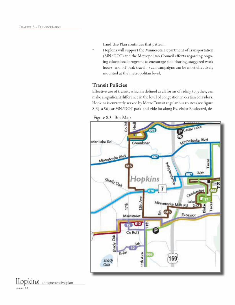
Transit Policies Effective use of transit, which is defined as all forms of riding together, can make a significant difference in the level of congestion in certain corridors. Hopkins is currently served by Metro Transit regular bus routes (see figure 8.3), a 56-car MN/DOT park-and-ride lot along Excelsior Boulevard, de-
Figure 8.3 - Bus Map

p a g e 8-7
Hopkins comprehensive plan
Chapter 8 - transportation
mand responsive service for the elderly and disabled through Metro Mobility and Hopkins Hop-A-Ride, and the Minnesota Rideshare carpooling program. The Hennepin County Regional Railroad Authority (HCRRA) and Metropolitan Council are planning to build a Southwest Transitway new transit route through Hopkins with three stations within the community. This new transit corridor is currently in the draft Environmental Impact Statement development process with either enhanced bus or light rail as transit options. Hennepin County in conjunction with the partner cities along this new transitway are working to get this project recognized as a needed and justified near-term transit improvement and listed as a “Tier I” initiative in the Metropolitan Council’s Transportation Policy Plan (TPP).
Hopkins is committed to fostering an environment supportive of transit and ridesharing because it recognizes the benefits that good access can have on economic development and general quality of life in this community, not to mention the fuel savings and reduced air emissions.
Regular Route Transit The City, through its representatives, will continue to actively participate •in the planning and design of the proposed 2015 Southwest Transitway. As of January 2009, the project is in the project planning phase of the project development process outlined by FTA for major transit initiatives. The DEIS scoping summary report is scheduled to be considered for approval by the HCRRA Board on January 27, 2009. The DEIS scope includes four light rail alignment options, an enhanced bus alternative and a no-build option. It is anticipated that the locally preferred alternative will be selected by May 2009. The DEIS is scheduled to be completed by January 2010. The City supports the proposed locations for light rail transit stations •in Hopkins. Should a light rail transit option be chosen, the City will continue to work with the HCRRA on station planning and design. The station locations are shown on the Transportation System Plan on page 8.3. Hopkins will plan LRT stations and transit-oriented developments to •ensure an excellent pedestrian environment within 1/2 mile of the stations. The City will publicize the accessibility of the LRT stations in the com-•munity to promote the use of this new travel mode and also to make the general public more aware of the convenient access to the central city.

p a g e 8-8
Hopkins comprehensive plan
Chapter 8 - transportation
The City will attempt to maximize the connectivity between the pro-•posed downtown LRT station and the central business district, including pedestrian, bicycle and shuttle bus access.The City will strive to ensure that parking demands at LRT stations do •not negatively impact surrounding residential or business areas.
Metro Transit Bus Service The City has worked with the Metro Transit to create new or improved •bus waiting stations along its routes through Hopkins, especially along Excelsior Boulevard and in the Downtown. The City will review major new developments for the inclusion of bus •shelters and pullouts if such sites are along MTC bus routes.The City will ensure that there is good public transit service and LRT-•feeder bus connectivity at each LRT station. Hopkins is within the Metropolitan Transit Taxing District, Market Area •II. Service options for Market Area II include regular-route locals, all-day expresses, small vehicle circulators, special needs paratransit (ADA, seniors), and ridesharing.
Demand-Responsive Service The City will continue to do what it can to facilitate Metro Mobility and Hop-kins Hop-A-Ride.
Bicyclist and Pedestrian Policies Note: Bicycle and pedestrian trail information is also found in the Parks, Open Space and Trails section of this plan.
The City will attempt to retain The Depot facility as a regional trailhead •facility or develop new trailhead facilities near the confluence of the regional trails, as required with the implementation of the Southwest Transitway LRT. The City will continue to build pedestrian ways along its collector and •certain minor arterial streets to improve accessibility and pedestrian travel safety between residential areas, downtown, parks and the regional trails. Hopkins will strive to create excellent pedestrian environments in and •around its future LRT stations and TOD areas. Hopkins will endeavor, in the near-term, to secure funding for and im-•prove the adequacy and safety of pedestrian accommodations along the

p a g e 8-9
Hopkins comprehensive plan
Chapter 8 - transportation
Blake Road corridor from Excelsior Boulevard to Highway 7. The City will continue to ensure the safest possible conditions at regional •trail street crossing locations.The City will support the Three Rivers Park District in its plan to con-•struct the Nine Mile Creek Regional Trail that would run from the MN River Bluffs LRT Regional Trail at 11th Avenue, south along 11th Avenue through Valley Park and southeasterly into Edina and Richfield.The City will improve pedestrian and bicycle accessibility between the •regional trails and the Hopkins central business district.
AviationThere are no existing or planned aviation facilities within Hopkins; however, the City recognizes that it has a responsibility to include airspace protection in its Update. The protection is for potential hazards to air navigation including electronic interference. Hopkins does not plan and its ordinances do not permit structures of 200 feet or more. Hopkins will notify MnDOT and the FAA us-ing the FAA Form 7460-1 “Notice of Proposed Construction or Alteration” if it receives any development proposals for structures of 200 feet or taller.
2030 Met Council Traffic Analysis Zones (TAZs)
Population Households Employment
TAZ 2010 2020 2030 2010 2020 2030 2010 2020 2030527 239 242 242 103 105 105 300 300 300565 691 691 691 300 300 300 120 120 120566 1,147 1,147 1,147 499 499 499 554 554 554567 4,395 4,420 4,436 2,271 2,286 2,296 3,755 3,814 3,888568 1,402 1,399 1,395 521 521 521 159 160 161569 2,994 3,653 3,958 1,532 1,802 1,982 3,358 4,438 5,788570 - - - - - - 3,751 3,776 3,791571 4,310 4,310 4,293 2,118 2,118 2,118 1,312 1,312 1,312572 1,368 1,368 1,368 592 592 602 62 77 77573 637 664 664 265 288 288 59 59 59574 717 706 706 299 289 289 80 90 100575 - - - - - - - - -610 - - - - - - 90 100 150613 - - - - - - - - -Total 17,900 18,600 18,900 8,500 8,800 9,000 13,600 14,800 16,300
Table 8.2 - Met Council TAZ Data

p a g e 8-10
Hopkins comprehensive plan
Chapter 8 - transportation
H O P K I N S
E D I N A
M I N N E T O N K A
S T . L O U I S P A R K565
527
524571
576
567
612
569
577
570
572
613
573
574
568
591
566
595
610
594
575
578
597
528
614
611
580
590593
0.1 0 0.1 0.20.05Miles
Community DevelopmentOctober 23, 2007
* Some users describe TAZ's as TrafficAnalysis Zones or some other closelyrelated words. In principle, they referto similar transportation planning areas.
Open WaterStreamCommunity Boundary
Local Roads
SOURCE: The geography for the TAZ'sare based on the Twin Cities RegionalTravel Demand Forecast Model. LocalRoads are from The Lawrence Group'sStreet Centerline data. CommunityBoundary, Stream, and Open Waterare from DataFinder.org TAZ Boundary
TAZ Identification Number1148
Transportation Analysis Zones (TAZ)*Hopkins
Figure 8.4 - Hopkins Transportation Analysis Zones (TAZ)