transportation - westminster, md
TRANSCRIPT
Transportation 2009
Chapter 12: Transportation Page 231
2009 COMPREHENSIVE PLAN
2009
Transportation
C I T Y O F W E S T M I N S T E R
Transportation 2009
Chapter 12: Transportation Page 232
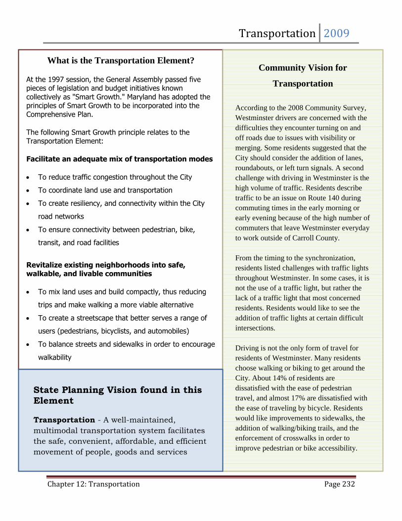
What is the Transportation Element?
At the 1997 session, the General Assembly passed five pieces of legislation and budget initiatives known collectively as "Smart Growth." Maryland has adopted the principles of Smart Growth to be incorporated into the Comprehensive Plan.
The following Smart Growth principle relates to the Transportation Element:
Facilitate an adequate mix of transportation modes
To reduce traffic congestion throughout the City
To coordinate land use and transportation
To create resiliency, and connectivity within the City
road networks
To ensure connectivity between pedestrian, bike,
transit, and road facilities
Revitalize existing neighborhoods into safe, walkable, and livable communities
To mix land uses and build compactly, thus reducing
trips and make walking a more viable alternative
To create a streetscape that better serves a range of
users (pedestrians, bicyclists, and automobiles)
To balance streets and sidewalks in order to encourage
walkability
Community Vision for
Transportation
According to the 2008 Community Survey,
Westminster drivers are concerned with the
difficulties they encounter turning on and
off roads due to issues with visibility or
merging. Some residents suggested that the
City should consider the addition of lanes,
roundabouts, or left turn signals. A second
challenge with driving in Westminster is the
high volume of traffic. Residents describe
traffic to be an issue on Route 140 during
commuting times in the early morning or
early evening because of the high number of
commuters that leave Westminster everyday
to work outside of Carroll County.
From the timing to the synchronization,
residents listed challenges with traffic lights
throughout Westminster. In some cases, it is
not the use of a traffic light, but rather the
lack of a traffic light that most concerned
residents. Residents would like to see the
addition of traffic lights at certain difficult
intersections.
Driving is not the only form of travel for
residents of Westminster. Many residents
choose walking or biking to get around the
City. About 14% of residents are
dissatisfied with the ease of pedestrian
travel, and almost 17% are dissatisfied with
the ease of traveling by bicycle. Residents
would like improvements to sidewalks, the
addition of walking/biking trails, and the
enforcement of crosswalks in order to
improve pedestrian or bike accessibility.
State Planning Vision found in this Element
Transportation - A well-maintained,
multimodal transportation system facilitates
the safe, convenient, affordable, and efficient
movement of people, goods and services
within and between population and business
centers.
Transportation 2009
Chapter 12: Transportation Page 233
Part 1: Transportation Infrastructure
Transportation is increasingly the most complex issue
faced by State and local governments. The movement of
people, goods and services is crucial to the economic and
social vitality of any community. The transportation
network in and around Westminster provides access for
people and products to small local markets, as well as
large metropolitan areas. The Westminster
transportation system affords its residents the
opportunity to work in the larger employment centers,
while residing in a community that has an established
high quality of life. As Westminster and Carroll County
continue to grow, the pressures on the transportation
network will continue to increase, and these increasing
pressures will need to be addressed by the State, County
and local governments.
Section 1: Summary of the Existing Transportation Network
The Westminster area features a variety of modes of transportation. These include the road network,
which encompasses State highway facilities, collector roads, and the local street system; pedestrian and
bicycle facilities; railroads; the Carroll County Regional Airport; and transit and ridesharing
opportunities. All of these facilities are described in detail below. In addition, information is provided
regarding the traffic volumes and capacity of area roadways, as well as the level of service and
functional classification.
Section 2: Functional Classification
Functional classification is the assignment of streets and roadways into classes or systems, according to
the type of service they are intended to provide based on its daily traffic volumes as well as its purpose,
characteristics and location (Map 9.1). Individual streets do not function independently. Rather, travel
involves movement through a network of roadway systems. The functional classification defines the
role that any particular street should fulfill in order to facilitate logical and efficient travel patterns.
Basically, local roadway classifications represent an emphasis on access to property, arterials represent
a high level of mobility, and collectors represent a compromise between property access and mobility.
(Source: Carroll County Functional Classification Criteria and Assignment, October 1995 (Revised in
accordance with current SHA classification system, June 2004).
Chapter 12 Part 1: Transportation Infrastructure
Part 2: Traffic Volumes & Capacity
Part 3: Pedestrian & Bicycle Accessibility
Part 4: Transit Alternatives
Part 5: Commuting Patterns
Part 6: Corridor Studies
Part 7: Proposed Major Streets
Part 8: Transportation Planning
Goals and Objectives
Transportation 2009
Chapter 12: Transportation Page 234
Roadway segments are designated as rural or urban based on context and roadway characteristics. The
roadway segments of the Westminster area are then further classified into one of the following
categories:
Principal Arterial
Links large population or employment centers; can range from expressways to two-lane roadways; inter-
county or interstate oriented and indicative of long travel lengths; high in traffic volume and speeds;
access should be limited to intersections with public streets and controlled by establishing distances
between points of access, provision of service or parallel roads, connections between adjacent
developments, prevention of private/individual driveway connections, as well as the reduction in the
number of existing access points.
Minor Arterial
Provide a lower level of mobility while placing more of an emphasis on land access than the other
arterial classifications; typically provide a link to the collector roadway system and connect small
population centers to the overall arterial system; access should be controlled by establishing distances
between points of access, connections between adjacent developments; and prevention of
private/individual driveway connections.
Collector
Provide for both land access and movement within residential, commercial, industrial or agricultural
areas; links from the land uses to the arterials; provide service to areas not on an arterial route and to
other important traffic generators; access should be controlled by establishing distances between points
of access, connections between adjacent developments; and prevention of private/individual driveway
connections.
Local System
Provide for direct access to individual land uses; discourage through traffic and are typically low in traffic
volumes and speed.
Section 3: State Highway Facilities
The City of Westminster and the surrounding area are served by seven Maryland State Highways: MD
140 (Baltimore Boulevard and a segment of MD 97), MD 97 North (Littlestown Pike), MD 97 South
(Washington Road), MD 27 (Westminster/Manchester Road, Railroad Avenue/Liberty Street and Ridge
Road), MD 32 (Sykesville Road), MD 31 (New Windsor Road), Route 832 (Old Taneytown Road), Route
852 North (Old Manchester Road), and Route 852 south (Old New Windsor Road). Each of these
facilities is briefly described below, beginning with the principal arterials and working down to the state
highways, which are classified as local roads (Map 12.2).
Transportation 2009
Chapter 12: Transportation Page 235
Maryland MD 140
Maryland MD 140 is classified as a principal arterial under the State Highway Administration (SHA)
system of functional classification. Eastbound MD 140 provides access from Westminster to Interstate
795, which joins the Baltimore Beltway (I-695); to the west, MD 140 intersects with U.S. Route 15 in
Emmitsburg. This route serves commercial and commuter traffic between Carroll County, Pennsylvania,
and the Baltimore area via I-795 and I-695. East of the Westminster corporate limits, MD 140 is a four
lane, divided highway, with twelve-foot wide travel lanes and ten to twelve foot shoulders. The posted
speed limit is 55 miles per hour to the east of the City.
Within the Westminster area, the speed limit decreases to 45 miles per hour, while the roadway width
increases to provide for right and left turn lanes at intersections. West of MD 31, the width of MD 140
decreases to between forty-four and forty-eight feet, providing two twelve foot travel lanes with ten to
twelve foot paved shoulders. The speed limit increases to 55 miles per hour in this area. Signalized
intersections include Market Street, Malcolm Drive/MD 97, Gorsuch Road, Ralph Street, Center Street,
Englar Road, Sullivan Road, MD 31 (partial), and WMC Drive. Interchanges with on- and off-ramps exist
where MD Routes 27 and 97 North travel under MD 140.
Maryland MD 97 North
Maryland MD 97 North also classified by SHA as a principal arterial from MD 140 to Old Meadow Branch
Road, connects MD 140 to Pennsylvania MD 97, serving Littlestown and Gettysburg and providing a
connection to U.S. Route 15. The width of MD 97 North is forty feet, which offers two twelve foot travel
lanes with ten foot left turn and acceleration/deceleration lanes at major intersections. There are no
shoulders along most of the road, except in the section just north of the MD 140 interchange, where
eight foot wide shoulders are available along the west side of the road.
Signalized intersections include Commerce Center Drive and Airport Drive/Magna Way. The City’s most
significant industrial parks, as well as the Carroll County Airport, are located on MD 97 North.
Considerable commuter and commercial traffic use this route to reach both local and regional
employment and market centers. Recently, SHA is constructed a new bridge at the intersection with MD
97(N) and MD 140. This replacement bridge did not add capacity. However, it functions more efficiently
as the ramps were slightly realigned for smoother transition of merging traffic.
Maryland MD 97 South
Maryland MD 97 South, between MD 140 and MD 32, is classified as a principal arterial. This road
continues south through Carroll County and into Howard and Montgomery Counties, intersecting with
the Washington, D.C. beltway (I-495) and continuing into Washington, D.C. In Westminster, at its
intersection with MD 140, the width of MD 97 South is approximately fifty feet. Northbound traffic is
provided with two left turn lanes, a shared left and through lane, and one twelve foot, free flow right
turn lane separated by an island. A four foot raised median separates north and south bound traffic,
Transportation 2009
Chapter 12: Transportation Page 236
and curb and gutter is provided on both the east and west sides of the highway. The southbound
direction has two twelve foot lanes with a free-flow right turn lane from eastbound MD 140. Between
MD 140 and Main Street, MD 97 South has three twelve foot lanes in each direction separated by a four
foot wide concrete median. To the south of Main Street, MD 97 is forty-four feet wide, providing two
twelve foot travel lanes with ten foot paved shoulders.
Maryland MD 27
Maryland MD 27 classified as a principal arterial by SHA (Bond Street to Hahn Road), runs diagonally
across the County, from Manchester to Mount Airy, where there is an interchange at I-70. This route
then continues through Howard and Montgomery Counties to terminate at I-270. Maryland MD 27,
both north and south of the Westminster corporate limits, is an undivided highway with two twelve foot
travel lanes and stabilized shoulders that vary from zero to ten feet along the length of the road.
In the City of Westminster and to the south of Green Street, MD 27 has two twelve foot travel lanes with
parking permitted on the east side of the road. Between Green Street and South Alley, parking is
permitted on the west side of the street, and from South Alley to Main Street; parking is restricted to
provide turn lanes at the Main Street intersection. Signalized intersections include Green Street, Main
Street, and Mall Ring Road. An interchange exists where MD 27 crosses under MD 140. Recently, the
State Highway Administration reconstructed the bridge at MD 27 and MD 140. This project added
additional lane capacity to MD 140. The MD 27 Corridor has also been identified by the City of
Westminster as the primary “Gateway” into downtown Westminster. Plans have been developed to
provide mixed-use development opportunities along MD 27 near downtown.
Maryland MD 32
Maryland MD 32 is classified by SHA as a minor arterial. This road offers a connection from Westminster
to the Sykesville/Eldersburg area, and continues into Howard and Anne Arundel Counties, terminating at
I-97. MD 32 provides access to U.S. 29, M.D. 100, I-70, U.S. 1, U.S. 50, U.S. 301, and I-97. Within the
Westminster corporate limits, MD 32 is also known as Main Street (Washington Road south of the
intersection with Manchester Avenue). Various segments of Main Street have been reconstructed by
the State Highway Administration (SHA) and then turned over to the City.
To date, the SHA has reconstructed and deeded to the City the section of MD 32 from the southern
corporate limits on Washington Road through the downtown area as far as McDaniel College. The City
now owns and maintains Main Street from MD 140 to Colonial Avenue. Main Street has two twelve foot
travel lanes with parking permitted on both sides in most areas. Signalized intersections include
Manchester Avenue, Center Street, Longwell Avenue, MD 27, John/Bond Street, Pennsylvania Avenue,
and MD 31. Left turn lanes are provided at MD 27 and Manchester Avenue/Washington Road. South of
Westminster, MD 32 has a thirty-two foot width, except where turn lanes are provided, resulting in two
twelve foot travel lanes with a four foot shoulder area on each side.
Transportation 2009
Chapter 12: Transportation Page 237
Maryland MD 31
Maryland MD 31 is classified by SHA as a principal arterial, connects Westminster to New Windsor and
continues west to terminate at Route 26 near Libertytown in Frederick County. In the Westminster area,
MD 31 is a two lane, undivided roadway. The forty-four foot width provides two twelve foot travel lanes
with ten foot stabilized shoulders.
Maryland Route 832
Maryland Route 832 (Old Taneytown Road) runs just south of and parallel to MD 140, providing an
alternate route between Westminster and Taneytown. The thirty-two foot width provides two eleven-
foot travel lanes with approximately five-foot shoulders. It will be necessary to make upgrades to this
road with the eventual development of the Roop’s Mill property.
Maryland Route 852 North
Maryland Route 852 North, also known as Old Manchester Road, offers a connection between
Cranberry Road and MD 27. Maryland 852 continues north, parallel to MD 27, to a point north of
Maryland Route 482. This route has two twelve foot travel lanes with approximately ten-foot shoulders.
Maryland Route 852 South
Maryland Route 852 South, also known as Old New Windsor Road, provides a connection between the
Main Street/Uniontown Road intersection and the Wakefield Valley area. This road, which parallels
Maryland MD 31, provides an alternate route to residents in the western portion of the City who have
destinations in the downtown.
Section 4: Local System
Collector roads are those roads that facilitate traffic flow between arterial highways, and local roads,
such as subdivision streets. Collector roads are classified as major or minor in rural areas and are
characterized by moderate speeds. The State Highway Administration makes no distinction between
major and minor collectors in urban areas. Roads bearing some or all of the characteristics of a collector
in the Westminster area include the Main Street portion of Maryland MD 32, Uniontown Road, Sullivan
Road, Gorsuch Road, parts of Green Street, John/Bond Streets and Englar Road, Center Street, Market
Street, Kate Wagner Road, part of Hook Road, and Old Westminster Pike. The portion of Center Street
north of MD 140, and all of Market Street are four-lane roadways divided by a concrete median. Once
complete, the reconstructed Meadow Branch Road will be a significant collector road between MD
97(N) and MD 140. This critical road will serve as a primary through movement for the MD 97 Industrial
Corridor as well as the residential development occurring in the area.
Other roads designed and/or functioning similar to collectors in the Westminster area are Carroll Street,
Monroe Street, Hahn Road, Sunshine Way, Meadow Branch Road, Old Bachman Valley Road, Lemon
Transportation 2009
Chapter 12: Transportation Page 238
Road, Lucabaugh Mill Road, Royer Road, Stoner Avenue, 140 Village Road, Leidy Road, Gist Road, Poole
Road, and the eastern part of Hook Road. In general, these roads link residential areas with large
commercial areas and provide travel routes to the other municipalities within the County. With the
exception of Englar Road, which becomes a four-lane, divided highway for a short section to the north of
MD 140, the collectors are two-lane, undivided roadways. Within the City limits, on-street parking is
sometimes permitted along collector roads.
The remaining streets in the City of Westminster are classified as local roads. This type of road provides
direct access to individual parcels of land and is characterized by low speed limits, low traffic volumes,
and the discouragement of through traffic. Most local roads have two lanes, are undivided, and
frequently allow on-street parking; however, some local roads in Westminster, particularly those in the
downtown area, provide only one-way traffic flow.
Pennsylvania Avenue
Pennsylvania Avenue is City owned and maintained. The road connects West Main Street to MD 97
North at its juncture with MD 140. Pennsylvania Avenue has two twelve foot wide travel lanes with
parking permitted on both sides of the street. The City received a Community Legacy Grant from the
State of Maryland in 2008 and in 2009, to implement the Pennsylvania Avenue Streetscape Project. This
project began construction in October 2009 to install traffic calming devices and to revitalize two
intersections in order to create a pedestrian friendly environment through this primarily residential
neighborhood.
Transportation 2009
Chapter 12: Transportation Page 239
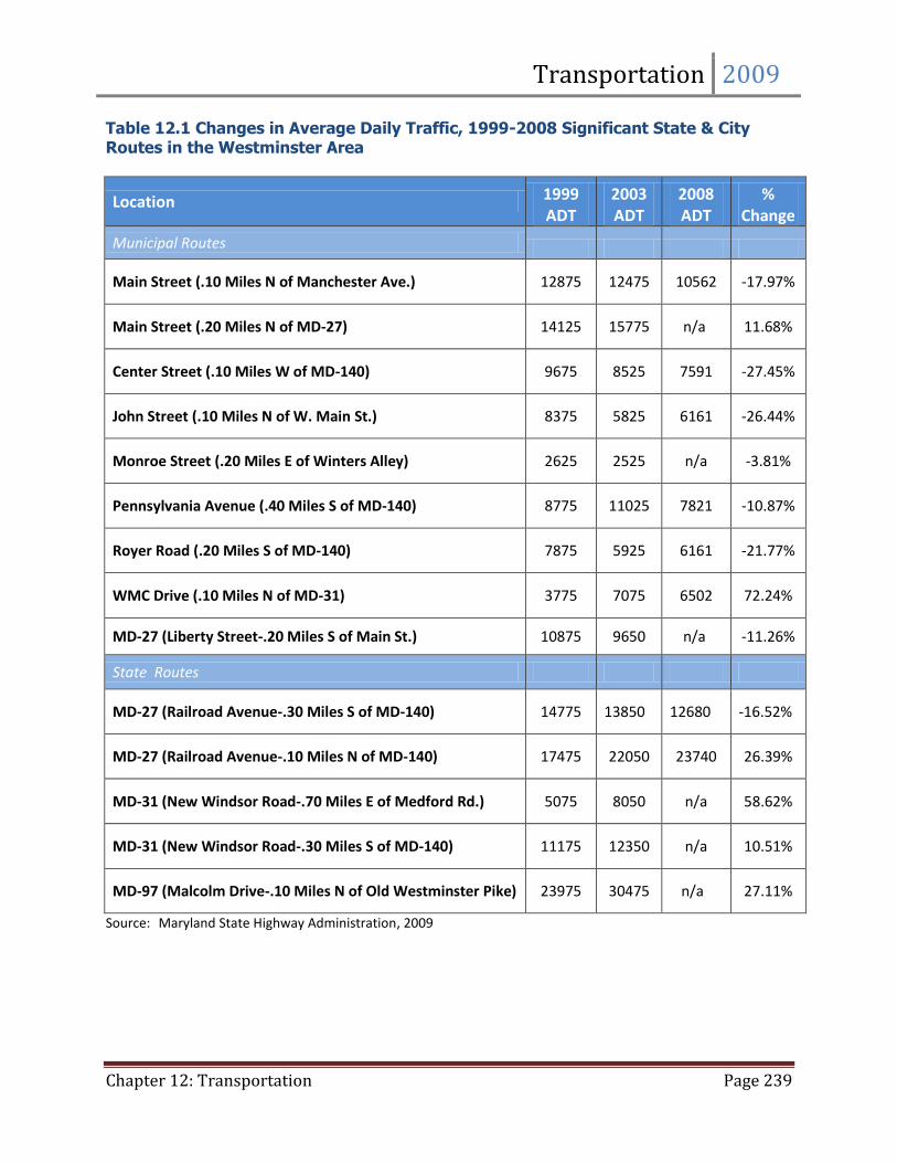
Table 12.1 Changes in Average Daily Traffic, 1999-2008 Significant State & City Routes in the Westminster Area
Location 1999 ADT
2003 ADT
2008 ADT
% Change
Municipal Routes
Main Street (.10 Miles N of Manchester Ave.) 12875 12475 10562 -17.97%
Main Street (.20 Miles N of MD-27) 14125 15775 n/a 11.68%
Center Street (.10 Miles W of MD-140) 9675 8525 7591 -27.45%
John Street (.10 Miles N of W. Main St.) 8375 5825 6161 -26.44%
Monroe Street (.20 Miles E of Winters Alley) 2625 2525 n/a -3.81%
Pennsylvania Avenue (.40 Miles S of MD-140) 8775 11025 7821 -10.87%
Royer Road (.20 Miles S of MD-140) 7875 5925 6161 -21.77%
WMC Drive (.10 Miles N of MD-31) 3775 7075 6502 72.24%
MD-27 (Liberty Street-.20 Miles S of Main St.) 10875 9650 n/a -11.26%
State Routes
MD-27 (Railroad Avenue-.30 Miles S of MD-140) 14775 13850 12680 -16.52%
MD-27 (Railroad Avenue-.10 Miles N of MD-140) 17475 22050 23740 26.39%
MD-31 (New Windsor Road-.70 Miles E of Medford Rd.) 5075 8050 n/a 58.62%
MD-31 (New Windsor Road-.30 Miles S of MD-140) 11175 12350 n/a 10.51%
MD-97 (Malcolm Drive-.10 Miles N of Old Westminster Pike) 23975 30475 n/a 27.11%
Source: Maryland State Highway Administration, 2009
Transportation 2009
Chapter 12: Transportation Page 240
Part 2: Traffic Volumes & Capacity
Average daily traffic (ADT) figures are presented in Tables 12.1. Table 12.1 includes counts for
significant State and City routes from 1999 and 2008. Table 12.1 also shows the percent change in ADT
over those years.
Two distinct trends emerge from the average daily traffic data. Traffic levels in the older sections of
Westminster generally remained constant or dropped from 1999 to 2008. A notable exception is
Pennsylvania Avenue, which experienced a 25% increase in traffic in 2003 but dropped 29 % again in
2008. The overall lack of a substantial increase in traffic volumes of these older City roadways suggests
that this portion of the road network will require few large-scale capacity improvements in the near
future. Significant infill development, particularly in the downtown area, would likely increase the ADT
figures for downtown and may warrant capacity improvements.
Traffic levels on roads serving the more recently developed portions of Westminster increased at
varying rates. MD 31, MD 27, and MD 97 all show increases over the four-year span. In addition, traffic
volumes on MD 140, the City’s primary arterial, increased at rates between 10% and 17% depending on
the location. These increases underscore the need to plan for greater capacity on existing roadways as
well as the construction of new roadways in the developing portions of Westminster.
Section 1: Capacity Analysis
The average daily traffic figures presented in Table 12.1 define trends in traffic patterns, but provide
little information about the impacts on the operation of the highway network. Capacity analysis is a
procedure that can estimate the number of vehicles per hour that can use a particular road section or
pass through an intersection before congestion is experienced and/or safety problems result.
The capacity analysis procedure takes into consideration the number of lanes, lane width, topography,
and, if applicable, the amount of green-signal time allocated to each approach vector. This procedure
was used to measure the current operation of intersections on Maryland MD 140, as the route carries
the largest volume of traffic in and through Westminster. Road segments may also be studied; however,
conditions at intersections usually deteriorate prior to road segments.
Capacity analysis is then used to determine the level of service (LOS) of a roadway. Level of service
defines and describes the level of congestion experienced by motorists. LOS is a qualitative measure
expressed as a grade letter. The designations range from ‘A’ to ‘F,’ with ‘A’ representing the least
restricted flow and ‘F’ representing failure of the intersection. Once identified, intersections operating
at low levels of service may be targeted for improvements or new roadways may be planned to relieve
congestion in the area. Brief descriptions of the typical conditions associated with each level appear
below.
Transportation 2009
Chapter 12: Transportation Page 241
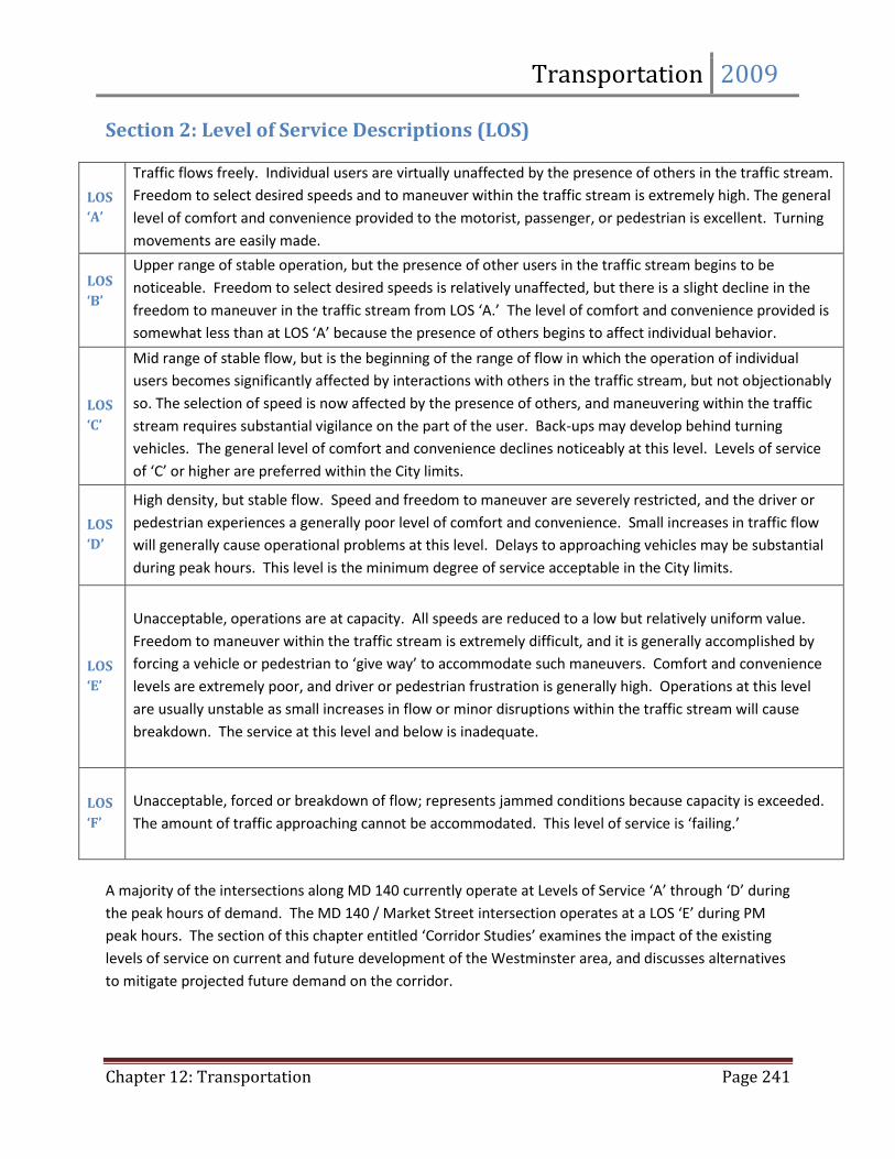
Section 2: Level of Service Descriptions (LOS)
LOS
‘A’
Traffic flows freely. Individual users are virtually unaffected by the presence of others in the traffic stream.
Freedom to select desired speeds and to maneuver within the traffic stream is extremely high. The general
level of comfort and convenience provided to the motorist, passenger, or pedestrian is excellent. Turning
movements are easily made.
LOS
‘B’
Upper range of stable operation, but the presence of other users in the traffic stream begins to be
noticeable. Freedom to select desired speeds is relatively unaffected, but there is a slight decline in the
freedom to maneuver in the traffic stream from LOS ‘A.’ The level of comfort and convenience provided is
somewhat less than at LOS ‘A’ because the presence of others begins to affect individual behavior.
LOS
‘C’
Mid range of stable flow, but is the beginning of the range of flow in which the operation of individual
users becomes significantly affected by interactions with others in the traffic stream, but not objectionably
so. The selection of speed is now affected by the presence of others, and maneuvering within the traffic
stream requires substantial vigilance on the part of the user. Back-ups may develop behind turning
vehicles. The general level of comfort and convenience declines noticeably at this level. Levels of service
of ‘C’ or higher are preferred within the City limits.
LOS
‘D’
High density, but stable flow. Speed and freedom to maneuver are severely restricted, and the driver or
pedestrian experiences a generally poor level of comfort and convenience. Small increases in traffic flow
will generally cause operational problems at this level. Delays to approaching vehicles may be substantial
during peak hours. This level is the minimum degree of service acceptable in the City limits.
LOS
‘E’
Unacceptable, operations are at capacity. All speeds are reduced to a low but relatively uniform value.
Freedom to maneuver within the traffic stream is extremely difficult, and it is generally accomplished by
forcing a vehicle or pedestrian to ‘give way’ to accommodate such maneuvers. Comfort and convenience
levels are extremely poor, and driver or pedestrian frustration is generally high. Operations at this level
are usually unstable as small increases in flow or minor disruptions within the traffic stream will cause
breakdown. The service at this level and below is inadequate.
LOS
‘F’
Unacceptable, forced or breakdown of flow; represents jammed conditions because capacity is exceeded.
The amount of traffic approaching cannot be accommodated. This level of service is ‘failing.’
A majority of the intersections along MD 140 currently operate at Levels of Service ‘A’ through ‘D’ during
the peak hours of demand. The MD 140 / Market Street intersection operates at a LOS ‘E’ during PM
peak hours. The section of this chapter entitled ‘Corridor Studies’ examines the impact of the existing
levels of service on current and future development of the Westminster area, and discusses alternatives
to mitigate projected future demand on the corridor.
Transportation 2009
Chapter 12: Transportation Page 242
Part 3: Pedestrian & Bicycle Accessibility Westminster has set a goal to develop a Westminster Pedestrian Master Plan and Bicycle Accessibility
Strategy that would outline the future of the City’s bicycle, sidewalk and pathways system by 2012. The
development of safe, attractive, efficient and accessible bicycle facilities and sidewalks will reduce
vehicular use, increase pedestrian use and help to improve air quality as well as the overall health of
Westminster residents and visitors. The development of these types of facilities would also aid in the
connectivity of the overall transportation network for pedestrians. Sidewalks are critical transportation
routes for communities as they allow pedestrians to travel from one place to another, stimulate
business districts by encouraging leisure shopping, and keep communities safe by providing more
activity on the street.
Section 1: Sidewalks
An extensive pedestrian system in Westminster gives residents and employees the opportunity to walk
to businesses, civic functions, and cultural events instead of driving. Most City streets are lined with
sidewalks, and the City’s recreational parks often include pedestrian walkways as well (Map 12.3).
Even with the extensive sidewalk system within the City, there are several intersections that are difficult
for pedestrians to navigate. The intersection of East Main Street and Washington Road is an example of
these intersections that are characterized by fairly fast moving traffic, wider than usual crossings due to
a skewed approach of the intersecting streets, a lack of pedestrian signals, and insufficient or
nonexistent crosswalks. The City is working with the County and the State to improve the priority
intersections. The City received a Community Legacy Grant from the State of Maryland in 2008 to
improve the intersection of Union Street and Pennsylvania Avenue. In 2009, the City received another
Community Legacy Grant from the State, to improve the intersection of West Main Street and
Pennsylvania Avenue. These two projects will be completed by early 2010 and should improve the safety
and accessibility for pedestrians in Downtown Westminster.
Another problem with the pedestrian system is a lack of sidewalks or other pedestrian facilities on the
outside edge of the City limits, as well as connections to major activity centers such as the Town Mall of
Westminster, the County’s regional mall. Sidewalk links are needed along many Carroll County roads
that become City streets once they enter the corporate limits, such as Bond Street and the South Center
Street and Gist Road area. Sidewalks are also needed along some of the Maryland State Highway
Administration facilities, such as Liberty Street/Railroad Avenue (Maryland MD 27).
The Maryland State Highway Administration offers matching funds for installation of sidewalks along
existing state highways where there is significant pedestrian use. A project in the Westminster area
identified for possible sidewalk funding is along MD 27 from the termination of the existing sidewalk at
the Westminster City limits north to connect to the Hahn Road and Cranberry Mall. Since this project is
located outside of the City in the unincorporated area of the County, the decision to construct the
Transportation 2009
Chapter 12: Transportation Page 243
sidewalk and provide matching funds belongs to Carroll County. Within the City limits, newly
constructed roads are required by regulation to contain sidewalks.
Along with the high number of vehicles, pedestrians are also present along Maryland MD 140. The
provision of sidewalks along this highway needs to be assessed. Speeds along MD 140 are not
conducive to creating a pedestrian environment, and sidewalks offer the impression of a safe haven for
pedestrians, which may not be the case along this highway. However, this factor must be weighed
against the need for pedestrian access. Regardless of whether sidewalks are installed, current
pedestrian use clearly indicates the need for pedestrian crossings at the major intersections, particularly
at Englar Road and Center Street. The future provision of sidewalks along the highway is under study in
connection with the MD 140 Improvements Study. The overall project is being designed and
implemented to increase the capacity and efficiency of the existing road because the Westminster By-
pass was eliminated from the State of Maryland Consolidated Transportation Plan in 1999. The City will
continue to seek engineering assistance from SHA to determine the need for additional traffic control
devices for pedestrians at these locations.
Section 2: Bicycle Travel
The ease and safety of bicycling varies throughout the City of Westminster. In general, the streets with
low traffic volumes are typically narrow with little or no shoulder area, creating a greater potential for
bicycle and vehicular conflicts. The roads that do have wide shoulders are characterized by heavy
volumes of high-speed traffic that increase the danger to bicyclists. In addition, there are no designated
bicycle lanes along any of the roads in the Westminster area. The Westminster Pedestrian Master Plan
and Bicycle Accessibility Strategy (Pedestrian Plan) will include recommendations for adding bicycle
lanes in the Westminster area. Westminster will include the following Maryland State Highway
Administration definitions for bicycle and pedestrian improvements in the Pedestrian Plan:
Bicycle Facilities: General term denoting improvements and provisions made by public agencies
to accommodate or encourage bicycling, including parking and storage facilities and bikeways.
Bikeway: Bicycle Lanes, shared lanes, paved shoulders, wide curb lanes, and shared use paths.
These facilities may or may not be marked for preferential or exclusive use for bikers.
Bike Lane: A portion of a roadway which has been designated by pavement markings for the
preferential or exclusive use of bikers. Bike lanes may be supplemented with signage.
Bike Route: A system of bikeways designated with “way finding” signage, pavement markings,
maps or other means.
The Carroll County Office of Tourism has published a set of maps depicting recreational bicycle tours in
the County, two of which pass through Westminster. The first bicycle route makes a 27-mile loop to the
Transportation 2009
Chapter 12: Transportation Page 244
north of the City and travels along Pennsylvania Avenue and West Main Street to end at Westminster
Elementary School. The second, 15-mile tour begins and ends at Westminster High School and involves
biking on East Main Street and South Center Street past the Carroll County Farm Museum.
The State Highway Administration has designated a regional bike loop connecting Westminster,
Taneytown, and Frederick. Within the City, the route follows MD 27 north, turns west on Main Street,
continues along WMC Drive, and exits the City Limits on MD 140 west towards Taneytown. Signs
directing cyclists along the route were installed at intersections during the summer of 2004.
Section 3: Greenways & Trails
Maryland’s Greenways Program Greenways are natural corridors set aside to connect larger areas of open space and to provide for the
conservation of natural resources, protection of habitat, movement of plants and animals, and to offer
opportunities for linear recreation, alternative transportation, and nature study.
“The Carroll County Greenways, Bicycle, and Pedestrian Facilities Technical Report,” was prepared by
Carroll County in 1994. The report outlines a recommendation for creating a countywide trail system.
The trails system, if implemented, would facilitate better access to existing and future recreation
facilities while concurrently decreasing the impact on the local roadway network. The study identified
potential greenways locations, recommended greenways corridor design criteria, established a
greenways classification system, and proposed a method of determining priority projects to help focus
the County’s efforts in implementing the plan.
Union Mills to Westminster Greenway The Union Mills to Westminster Greenway is a potential greenways corridor that could be designated
along stream valleys between the proposed reservoir site at Union Mills and the city of Westminster.
This greenway could provide connections to Hashawha Environmental Center, the Carroll County Sports
Complex, and local parks in Westminster.
Trails
The Wakefield Valley Community Trail, the first trail in Westminster, begins at Old New Windsor Road
and travels northeast to Uniontown Road, roughly paralleling Maryland MD 31. The approximately
three mile trail provides Wakefield Valley residents with pedestrian and bicycle access to the Avondale
Run Community Center in the Ridgeview Chase Apartment complex, the Fenby Farm Quarry and Lime
Kiln Park, a bird and wildlife observation area, a basketball court, the Uniontown Road Athletic Field,
and a commercial area planned at the intersection of Maryland MD 31 and Tahoma Farm Road.
The Wakefield Valley Community Trail is being built in three phases. The City is currently working on
building Phase II that begins at Long Valley Road and travel northeast to Windsor Drive, as shown on the
Transportation 2009
Chapter 12: Transportation Page 245
Comprehensive Land Use Plan map. Phase I will connect Long Valley Road to Congressional Drive,
traversing the open space land between Sawgrass Court and South Burning Tree Drive in the Avondale
Run Community. Phase III was constructed when the property at the corner of Uniontown Road and
Maryland MD 31 was developed. Phase III is the link between Windsor Drive and the Uniontown Road
Athletic Field.
When completed, the trail will be dedicated as the Terrence Burk Memorial Trail, in memory of a local
businessman and community leader who was fatally injured while jogging on Maryland MD 97. In the
transportation element of the Westminster and Environs Comprehensive Plan, Carroll County has
designated certain areas for the construction of greenway trails. In that regard, this trail system will tie
together existing pedestrian areas and provide an opportunity for greater pedestrian access in and
around Westminster.
Section 4: Maryland Scenic Byways Program The Maryland State Highway Administration (SHA) established the Maryland Byways Program to
enhance the quality of life for Maryland’s citizens, engender pride, and improve visitor appeal of the
state’s most scenic, cultural and historic roads. Byways help residents express their values of place,
contribute to the state’s economy through tourism development, and provide unique experiences for
all. SHA seeks to identify, designate, promote, and encourage stewardship of the State’s byways and
their surrounding resources while providing safe routes for travel. SHA has designated 19 byways that
encompass 1,595 miles. In order to obtain the State designation, the byway must be "scenic" with added
weight given to byways with historical, cultural, natural, and/or recreational qualities that promote
Maryland's unique heritage. Westminster is part of the State designated Old Main Streets Byway.
Old Main Streets Byway
Westminster is part of the Old Main Streets Byway. The Old Main Streets Byway is described as a quiet
drive along white picket fences, tree-lined streets and historic homes with rocking chairs on the front
porch; sights associated with small-towns that visitors can step back in time to enjoy when driving along
this charming byway. The tour is separated into an Upper and Lower loop and can include leisurely
drives past wide open fields, window-shopping for antiques, dining with “locals” at the eatery on the
corner, and then drifting off to sleep on a four-post bed inside a quaint country inn.
Part 4: Transit Alternatives Section 1: Maryland Midland Railroad
Based in Union Bridge, the Maryland Midland Railway provides freight rail service to central Carroll
County. This line heads northwest to Thurmont and into Hagerstown where it connects with CSX
Railroad in Pennsylvania. From Keymar in Carroll County, the track runs northeast through Taneytown,
Transportation 2009
Chapter 12: Transportation Page 246
southwest into Walkersville in Frederick County, and east through New Windsor and Westminster. The
rail then heads southeast through Finksburg, and continues through Baltimore County into Baltimore
City, rejoining CSX near South Baltimore’s harbor and ports. Westminster hosts one of two intermodal
transfer stations operated by the rail line. According to Maryland Midland Railway, the company
currently services for commercial clients in Westminster.
Section 2: Carroll County Regional Airport
Begun originally as the Westminster Airport with two turf landing strips, the Carroll County Regional
Airport is located on the north side of the City of Westminster, off of Maryland MD 97. The initial owner
and operator was the Shriver Packing Company. By 1969, there were about 22 based aircraft and
approximately 7,500 annual operations according to the FAA. The County acquired the airport in 1976.
Three parcels of land were purchased in 1977 for future use. A 2,930 foot by 40 foot paved runway was
constructed in the fall of 1977. The following year the main hangar, which presently contains the
administrative offices, and the first T-hangar were constructed with local funds. Runway lighting was
installed in 1978. A parallel taxiway was paved and the runway was extended 300 feet in the fall of
1979. Both were widened in the early 1980s.
Now known as the Carroll County Regional Airport, the facility is designated as a General Utility-State II
Airport, which means it serves aircraft with approach speeds of less than 121 knots and wingspans of
less than 79 feet, essentially the size of small planes and corporate jets. The airport has been upgraded
through the construction of a 5,100 foot runway. The old runway was extended and functions as a
parallel taxiway. The terminal area consists of a maintenance hangar, operations center, classroom
area, and seven 10,000 square foot corporate hangars with adjoining office space. The facility has an
instrument approach with a final approach fix. Jet “A” fuel is currently available, as well as 100 Octane
LL. There are currently 128 aircraft based at the airport, including thirteen multi-engine planes and
three jets.
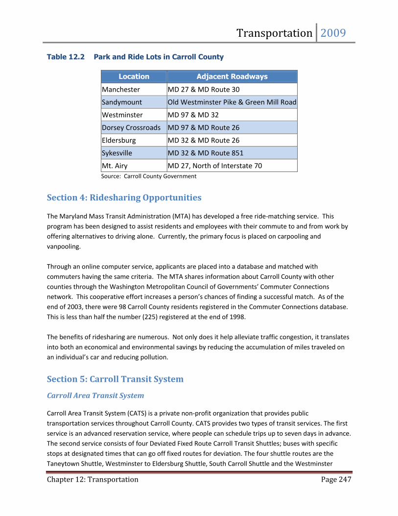
Section 3: Park and Ride Lots
Park and ride lots are intended for commuters who transfer from their own vehicles to alternative
means of transportation, such as carpools or vanpools. There are seven park and ride lots located in
Carroll County, with one in the Westminster area located at the intersection of MD Routes 97 and 32.
This lot offers parking for 101 automobiles with approximately 15% of the spaces occupied on average.
Handicapped parking is provided along with lighting and a telephone. All of Carroll County’s park and
ride facilities are state owned, with the exception of the Sandymount lot, which is owned by the County.
Table 12.2 lists the locations of the Park and Ride lots serving Carroll County.
Transportation 2009
Chapter 12: Transportation Page 247
Table 12.2 Park and Ride Lots in Carroll County
Location Adjacent Roadways
Manchester MD 27 & MD Route 30
Sandymount Old Westminster Pike & Green Mill Road
Westminster MD 97 & MD 32
Dorsey Crossroads MD 97 & MD Route 26
Eldersburg MD 32 & MD Route 26
Sykesville MD 32 & MD Route 851
Mt. Airy MD 27, North of Interstate 70
Source: Carroll County Government
Section 4: Ridesharing Opportunities
The Maryland Mass Transit Administration (MTA) has developed a free ride-matching service. This
program has been designed to assist residents and employees with their commute to and from work by
offering alternatives to driving alone. Currently, the primary focus is placed on carpooling and
vanpooling.
Through an online computer service, applicants are placed into a database and matched with
commuters having the same criteria. The MTA shares information about Carroll County with other
counties through the Washington Metropolitan Council of Governments’ Commuter Connections
network. This cooperative effort increases a person’s chances of finding a successful match. As of the
end of 2003, there were 98 Carroll County residents registered in the Commuter Connections database.
This is less than half the number (225) registered at the end of 1998.
The benefits of ridesharing are numerous. Not only does it help alleviate traffic congestion, it translates
into both an economical and environmental savings by reducing the accumulation of miles traveled on
an individual’s car and reducing pollution.
Section 5: Carroll Transit System
Carroll Area Transit System Carroll Area Transit System (CATS) is a private non-profit organization that provides public
transportation services throughout Carroll County. CATS provides two types of transit services. The first
service is an advanced reservation service, where people can schedule trips up to seven days in advance.
The second service consists of four Deviated Fixed Route Carroll Transit Shuttles; buses with specific
stops at designated times that can go off fixed routes for deviation. The four shuttle routes are the
Taneytown Shuttle, Westminster to Eldersburg Shuttle, South Carroll Shuttle and the Westminster
Transportation 2009
Chapter 12: Transportation Page 248
Shuttle (Map 12.4). CATS currently has a fleet of 30 vehicles that serve a growing user population.
Eighteen of these vehicles (60%) are lift equipped providing 37 wheelchair positions. The service
currently transports an average of 12,453 one-way trips per month.
Carroll County Transportation Advisory Group
The Transportation Advisory Group is a 15-member group designed to provide input, ideas and
consultation to the management of Carroll Area Transit System. The Group focuses on finding ways to
improve existing services, to enhance and expand services and to coordinate with other community
agencies providing transportation or with transportation needs.
Carroll Area Transit System Strategic Plan
In the fall of 2007, the Carroll Area Transit System (CATS) hosted a Carroll County Transportation Summit
to gather ideas and input from local businesses, community organizations and service providers for the
creation of a strategic plan. In January 2008, CATS presented the County Commissioners with a Strategic
Plan to make operational and marketing changes to improve service, increase ridership and meet more
of the needs that were identified at the Transportation Summit.
Over the next three years, CATS will implement the CATS Strategic Plan to connect the shuttle routes
and add an additional shuttle route. CATS is also focused on the goal to expand their service by adding
extended hours and adding Saturdays to their schedule. This change in service will help local residents
who need to use the shuttle in the evenings for errands or have work hours that don’t coincide with the
current schedule. Overall, the CATS has set a benchmark for their service to increase ridership by 20% by
2011. The success of Carroll Area Transit System and the future of transportation for the County will rely
on the continued cooperative effort and open communication between the County and CATS.
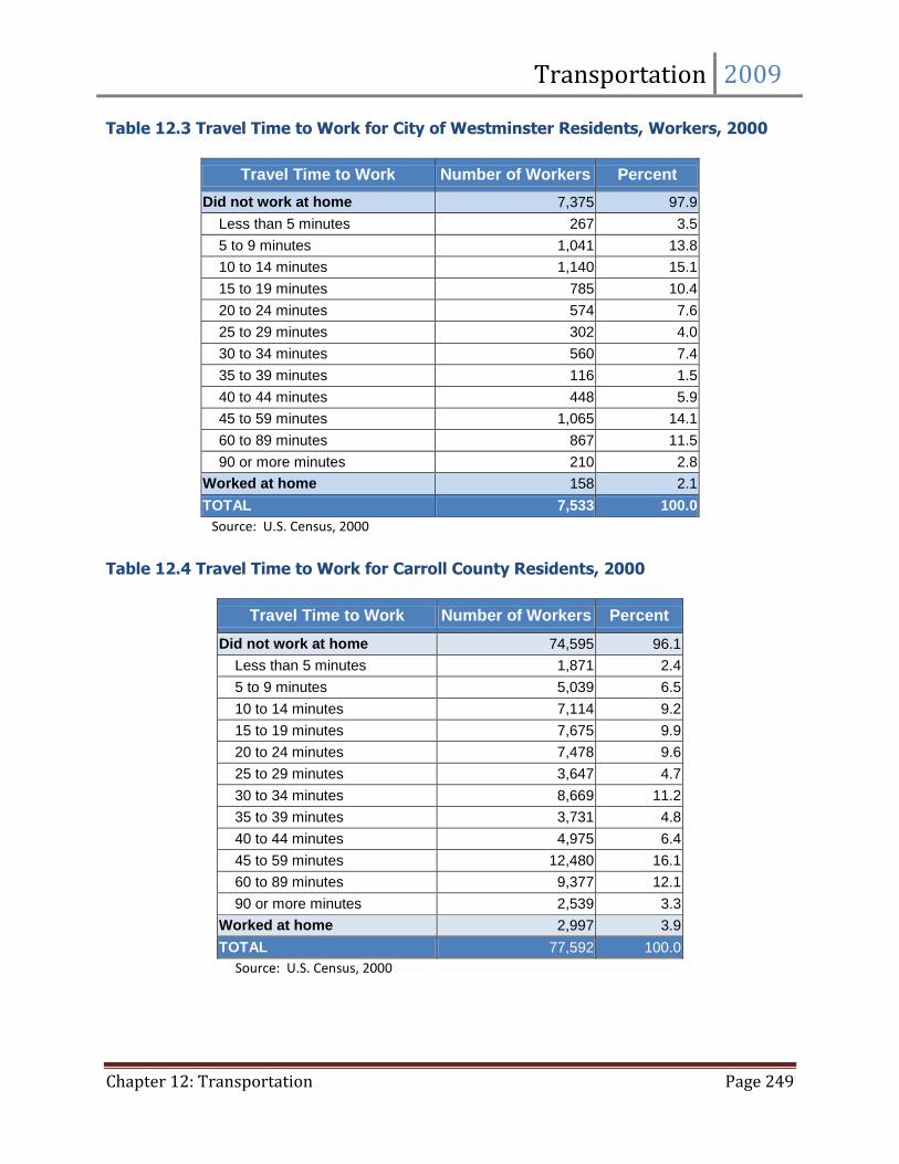
Part 5: Commuting Patterns
According to the 2000 U.S. Census, over 30% of the residents in Westminster spent less than 15 minutes
traveling to work, while 28% of City residents spent 45 minutes or more in travel time to work (Table
12.3). This latter percentage represents an 8% increase from 1990, and is reflective of a regional trend
of lengthening commutes. Travel time to work for residents in the County as a whole shows a similar
pattern, with 31.5% of the County labor force commuting for 45 minutes or more each day (Table 12.4).
The number of people working at home rose from 1.4% to 2.1% from 1990 to 2000, and is expected to
continue to gradually increase due to technological advances in telecommunications.
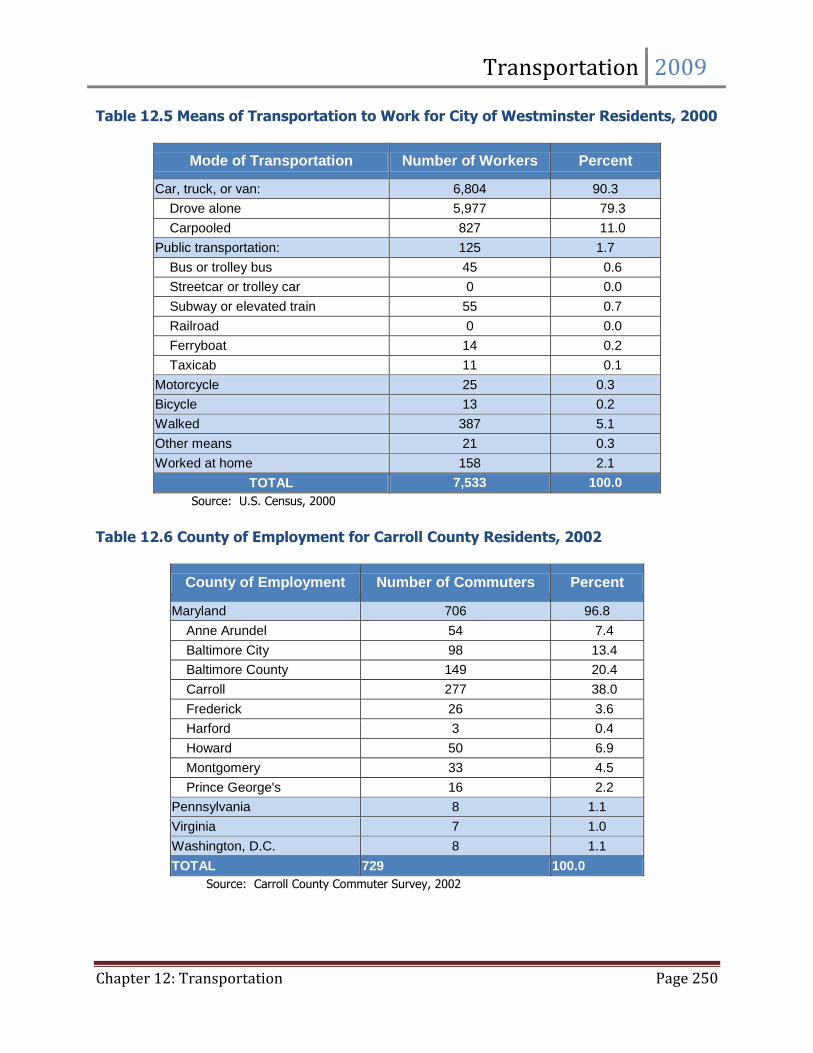
The majority of persons commuting to work in 2000 traveled in cars, trucks, or vans (Table 12.5). Nearly
80% of the City’s labor force drove alone to work, while 11% carpooled. These figures represent a shift
of 4% from carpools to driving alone from 1990 to 2000. The next highest category for transportation
mode to work was ‘walked’ with 5.1% of the labor force, down from 6.8% in 1990. Only 1.7% of the
2000 labor force in Westminster used some sort of public transportation to travel to work.
Transportation 2009
Chapter 12: Transportation Page 249
Table 12.3 Travel Time to Work for City of Westminster Residents, Workers, 2000
Travel Time to Work Number of Workers Percent
Did not work at home 7,375 97.9
Less than 5 minutes 267 3.5
5 to 9 minutes 1,041 13.8
10 to 14 minutes 1,140 15.1
15 to 19 minutes 785 10.4
20 to 24 minutes 574 7.6
25 to 29 minutes 302 4.0
30 to 34 minutes 560 7.4
35 to 39 minutes 116 1.5
40 to 44 minutes 448 5.9
45 to 59 minutes 1,065 14.1
60 to 89 minutes 867 11.5
90 or more minutes 210 2.8
Worked at home 158 2.1
TOTAL 7,533 100.0
Source: U.S. Census, 2000
Table 12.4 Travel Time to Work for Carroll County Residents, 2000
Travel Time to Work Number of Workers Percent
Did not work at home 74,595 96.1
Less than 5 minutes 1,871 2.4
5 to 9 minutes 5,039 6.5
10 to 14 minutes 7,114 9.2
15 to 19 minutes 7,675 9.9
20 to 24 minutes 7,478 9.6
25 to 29 minutes 3,647 4.7
30 to 34 minutes 8,669 11.2
35 to 39 minutes 3,731 4.8
40 to 44 minutes 4,975 6.4
45 to 59 minutes 12,480 16.1
60 to 89 minutes 9,377 12.1
90 or more minutes 2,539 3.3
Worked at home 2,997 3.9
TOTAL 77,592 100.0
Source: U.S. Census, 2000
Transportation 2009
Chapter 12: Transportation Page 250
Table 12.5 Means of Transportation to Work for City of Westminster Residents, 2000
Mode of Transportation Number of Workers Percent
Car, truck, or van: 6,804 90.3
Drove alone 5,977 79.3
Carpooled 827 11.0
Public transportation: 125 1.7
Bus or trolley bus 45 0.6
Streetcar or trolley car 0 0.0
Subway or elevated train 55 0.7
Railroad 0 0.0
Ferryboat 14 0.2
Taxicab 11 0.1
Motorcycle 25 0.3
Bicycle 13 0.2
Walked 387 5.1
Other means 21 0.3
Worked at home 158 2.1
TOTAL 7,533 100.0
Source: U.S. Census, 2000
Table 12.6 County of Employment for Carroll County Residents, 2002
County of Employment Number of Commuters Percent
Maryland 706 96.8
Anne Arundel 54 7.4
Baltimore City 98 13.4
Baltimore County 149 20.4
Carroll 277 38.0
Frederick 26 3.6
Harford 3 0.4
Howard 50 6.9
Montgomery 33 4.5
Prince George's 16 2.2
Pennsylvania 8 1.1
Virginia 7 1.0
Washington, D.C. 8 1.1
TOTAL 729 100.0
Source: Carroll County Commuter Survey, 2002
Transportation 2009
Chapter 12: Transportation Page 251
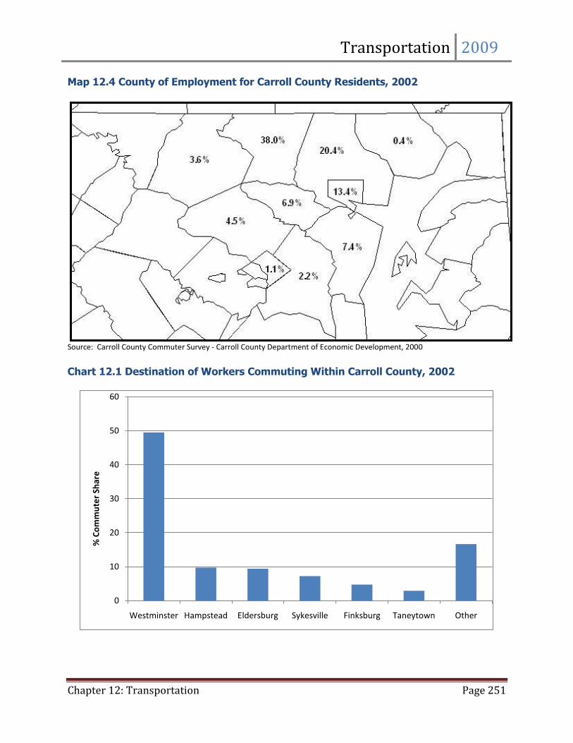
Map 12.4 County of Employment for Carroll County Residents, 2002
Source: Carroll County Commuter Survey - Carroll County Department of Economic Development, 2000
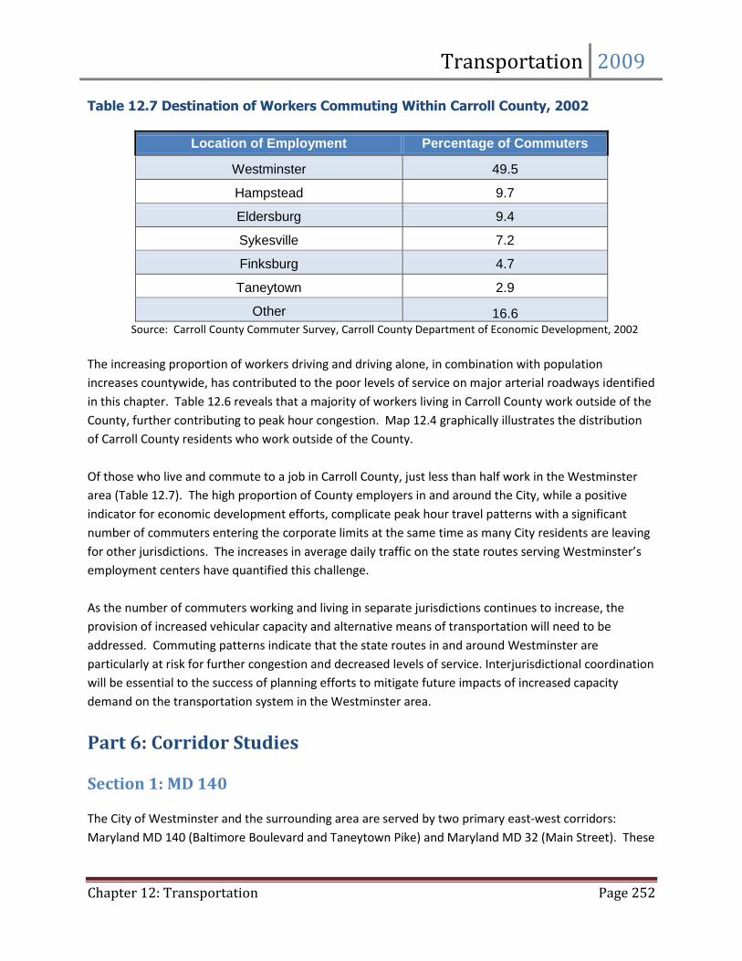
Chart 12.1 Destination of Workers Commuting Within Carroll County, 2002
0
10
20
30
40
50
60
Westminster Hampstead Eldersburg Sykesville Finksburg Taneytown Other
% C
om
mu
ter
Shar
e
Transportation 2009
Chapter 12: Transportation Page 252
Table 12.7 Destination of Workers Commuting Within Carroll County, 2002
Location of Employment Percentage of Commuters
Westminster 49.5
Hampstead 9.7
Eldersburg 9.4
Sykesville 7.2
Finksburg 4.7
Taneytown 2.9
Other 16.6 Source: Carroll County Commuter Survey, Carroll County Department of Economic Development, 2002
The increasing proportion of workers driving and driving alone, in combination with population
increases countywide, has contributed to the poor levels of service on major arterial roadways identified
in this chapter. Table 12.6 reveals that a majority of workers living in Carroll County work outside of the
County, further contributing to peak hour congestion. Map 12.4 graphically illustrates the distribution
of Carroll County residents who work outside of the County.
Of those who live and commute to a job in Carroll County, just less than half work in the Westminster
area (Table 12.7). The high proportion of County employers in and around the City, while a positive
indicator for economic development efforts, complicate peak hour travel patterns with a significant
number of commuters entering the corporate limits at the same time as many City residents are leaving
for other jurisdictions. The increases in average daily traffic on the state routes serving Westminster’s
employment centers have quantified this challenge.
As the number of commuters working and living in separate jurisdictions continues to increase, the
provision of increased vehicular capacity and alternative means of transportation will need to be
addressed. Commuting patterns indicate that the state routes in and around Westminster are
particularly at risk for further congestion and decreased levels of service. Interjurisdictional coordination
will be essential to the success of planning efforts to mitigate future impacts of increased capacity
demand on the transportation system in the Westminster area.
Part 6: Corridor Studies Section 1: MD 140
The City of Westminster and the surrounding area are served by two primary east-west corridors:
Maryland MD 140 (Baltimore Boulevard and Taneytown Pike) and Maryland MD 32 (Main Street). These
Transportation 2009
Chapter 12: Transportation Page 253
two corridors were studied in depth because of their significance with respect to commercial activity, as
well as the flow of goods, materials, and people into, out of, and through the Westminster area.
The Westminster portion of MD 140 functions in many ways as the core business area for much of
Carroll County. Included in the MD 140 corridor are numerous shopping, dining, and entertainment
opportunities. The highest concentration of goods and services available to Carroll County residents is
also located along this highway.
In addition to its commercial character, the MD 140 corridor provides access to the Baltimore regional
markets via connections to I-795 and I-695. Goods and materials shipped from Pennsylvania and
Baltimore, as well as commuters traveling to places of employment, uses this important transportation
link.
Another issue in the Maryland MD 140 corridor is access control. The State Highway Administration
manages access control for MD 140. Access management has been partially addressed within the
Westminster corporate limits, in part by the construction of Market Street for use as a parallel collector
road to commercial properties. The Westminster and Environs Transportation Element further
enhances this effort, as it will provide alternative local roads to be used as alternatives to State roads.
In the future, the City of Westminster will have to manage land development along the MD 140 corridor
to develop a well planned local roadway network with frontage or road service roads to alleviate MD
140 traffic pressure. The City also will work to develop a strategy to consolidate or limit driveway access
points onto MD 140. Currently, the priority project for the MD 140 corridor is to accomplish the goals of
the MD 140 Improvement Study in order to improve the traffic operation and safety, as well as increase
accessibility for bicyclists and pedestrians.
MD 140 Improvement Study
The Maryland Department of Transportation and the State Highway Administration have proposed a
four-phase approach to increasing capacity along MD 140. During the 1998 Comprehensive Plan, the
State of Maryland was prepared to construct the Westminster By-pass which would alleviate much of
the pressure on MD Routes140 and 97. However, in 1999, the State of Maryland removed the proposed
Westminster By-pass from the Consolidated Transportation Plan because its construction was not in
compliance with the principles of Smart Growth.
As a result of that action, the State of Maryland initiated project planning for MD 140 from Market
Street to Sullivan Road to provide extensive capacity improvements to it. In October 2004, SHA
conducted a Location/Design Public Hearing at the Henry C. Evans Armory where five alternatives,
including the No-Build Alternative, were presented. The build alternatives focused on three critical
intersections: Englar Road, Center Street, and Malcolm Drive, and ranged from minor upgrades to the
construction of interchanges. Following the hearing, the project team evaluated all comments received
from the public, regulatory agencies, and local officials and performed additional work to determine
Transportation 2009
Chapter 12: Transportation Page 254
whether a combination of alternatives would work best along the corridor. As a result, Combination
Option 4 with Gorsuch Road Option B was chosen as the selected alternative.
Combination Option 4
Combination Option 4 would provide major intersection improvements at Center Street and Englar Road
through what is known as a Continuous-Flow Intersection (CFI). A CFI separates left-turning vehicles
from the main intersection, which significantly increases the number of vehicles the intersection can
handle. At Malcolm Drive, a Single-Point Urban Interchange (SPUI) would be constructed. The SPUI is
compact and efficient; a single traffic signal above the overpass would allow vehicles approaching the
intersection from opposite directions to turn left at the same time. Between Malcolm Drive and Center
Street, one-way service roads with interchange ramps would provide access to properties along both
sides of MD 140. Other intersections along the study area corridor would receive minor improvements.
Gorsuch Road Option B
Gorsuch Road Option B would provide right-in/right-out access onto Old Gorsuch Road from
northbound MD 140, avoiding several businesses identified as community landmarks by the City of
Westminster.
Additional Features
Throughout the project limits, MD 140 would have 16-foot-wide outside lanes to accommodate on-road
bicyclists. Pedestrians would benefit from five-foot-wide sidewalks and improved crossings. A new
pedestrian bridge at Gorsuch Road would provide safe access to businesses and services on both sides
of MD 140.
Final Approvals
In May 2009, SHA announced that federal and state approvals were in place for a package of
improvements along MD 140 from Market Street to Sullivan Road in Westminster. The Maryland State
Highway Administration (SHA) has completed a project planning study that examined ways to improve
future traffic flow, relieve congestion, and upgrade pedestrian travel along the 2.5-mile study area
corridor. Location and design approvals make the project eligible for detailed engineering activities
when funding becomes available.
Section 2: Main Street
The Main Street corridor provides a totally different character. Whereas Maryland MD 140 is oriented
for individual motorized vehicles, the historic Main Street of downtown Westminster is less automobile
oriented and more focused toward pedestrians. Many of the historic buildings contain shops, offices,
and services. The tree-lined street and wide sidewalks encourage pedestrian movement.
Transportation 2009
Chapter 12: Transportation Page 255
Parking in the Main Street area is of particular concern to both merchants and potential customers. On-
street parking is available in many locations, and public parking lots are located at major intersections
and to the rear of the commercial buildings along the first block of East Main Street. The City has
established consistent rates at all of its parking meters. In addition, there is no charge to park at a meter
on weekends, holidays, and after 5:00 p.m. on weekdays. To further address parking concerns, the City
constructed two parking garages which were opened in September 2003. The Longwell Avenue
Municipal Parking Garage, located at the intersection of Longwell Avenue and Distillery Drive, is a 296
space parking garage which is open to monthly permit holders, as well as hourly users. The Westminster
Square Municipal Parking Garage, located on Green Street near its intersection with MD 27, is a 160
space parking garage that is also open to monthly permit holders, as well as hourly users.
Main Street experiences serious congestion problems during the afternoon period. Vehicles stopped at
the traffic signals along Main Street back-up past the side street intersections and limit access to Main
Street. This results in congestion characteristic of and approaching gridlock. A significant number of
trucks were noted turning left from northbound MD 27 to westbound Main Street. The entire block
along MD 27 between Main Street and Green Street was frequently filled with vehicles, causing traffic to
back up on Green Street, as well as Liberty Street as far as George Street. Traffic queued from the Main
Street/MD 27 signal also backs up through the Longwell Avenue intersection, restricting opportunities
for traffic to enter Main Street from Longwell Avenue when Longwell has the green signal phase.
Section 3: MD 27
There is not a significant section of MD 27 within the corporate limits of Westminster. However, it does
provide a primary access to Downtown Westminster from Maryland MD 140, as well as serving as the
primary access to the Washington D.C. Metropolitan Area.
During the summer of 2002, the City partnered with the State of Maryland to develop the MD 27
Corridor Study. The primary objective of that plan was to redevelop the MD Route 27 Corridor into the
primary “Gateway” to downtown Westminster.
Section 4: MD 97 (N)
The Maryland MD 97 (N) corridor immediately to the north of Maryland MD 140 is the site of prime
industrial land in Westminster. The Carroll County Regional Airport is located in this area, as well as six
industrial parks which have experienced moderate levels of development over the past several years.
Maryland MD 97 (N) also serves as a primary commuter route, connecting residents of northern Carroll
County and southern Pennsylvania with employment destinations in Westminster and points to the
south and east. During morning and evening rush hours, the volume of pass-through commuter traffic
chokes the roadway, making it difficult for employees and clients of the industrial parks to safely make
turning movements. This situation results in long queuing of vehicles at the signalized intersections. A
Transportation 2009
Chapter 12: Transportation Page 256
study completed in 1994 by Whitney, Bailey, Cox & Magnani (WBCM) for the Carroll County Industrial
Development Authority indicated that traffic along Maryland MD 97 (N) is expected to increase
dramatically by the year 2020. These increases will be the result of both additional through traffic and
the generation of a greater number of trips from the industrial parks as they continue to develop,
indicating a need for multiple lane additions along MD 97 (N).
As a result of the increasing needs along MD 97, City staff, in cooperation with SHA and Carroll County,
will require three developers to be responsible for immediate mainline widening on MD 97(N). As
future developments approach the City for development opportunity, they will also be required to make
additional improvements to MD 97. The City will also make arrangements to consolidate the number of
access points onto MD 97. To date, the planned closing of the Kriders Church Road will be complete
once Meadow Branch Road is reconstructed. While impossible to eliminate all single source access
points to MD 97(N), it is a priority to eventually eliminate as many as possible. Because the Westminster
By-pass was eliminated from the Consolidated Transportation Plan in 1999, mainline widening
improvements to MD 97(N) are now even more critical as areas beyond Westminster continue to
develop at a pace that further exacerbates the problems on the existing roadway. The City will be in
discussion with SHA to move this project along in a timely manner to meet the current needs of MD
97(N) to improve the safety and increase the capacity of this vital road for not only the residents but the
economy of Westminster.
Part 7: Proposed Major Streets The planned major streets for the City of Westminster are included on the Comprehensive Land Use
Plan Map. The alignments of these proposed streets were evaluated with assistance from County
Planning staff. Major street alignments that are located beyond, but in the vicinity of the City’s
corporate limits, are shown on the map for informational purposes. The proposed major streets, as well
as streets deleted from the 1985 Comprehensive Plan for Westminster and Environs, are described
below:
Crossbridge Drive will be extended to Tahoma Farm Road. Continuation of Crossbridge Drive was
incorporated into the City’s Major Street Plan with adoption of the 1985 Comprehensive Plan for
Westminster and Environs. The Crossbridge Drive Bridge over Copp’s Branch has been completed, and
construction of the final segment will be accomplished in connection with the development of the
adjacent commercial site.
Wyndtryst Drive is proposed to be extended to Maryland MD 140. This planned street between MD
97 and Meadow Branch Road was included in the adoption of the 1985 Comprehensive Plan for
Westminster and Environs. The current proposed alignment reflects a modification to the 1985
alignment, so that the primary through movement is from MD 97 to MD 140 at the WMC Drive
intersection, rather than the direct Wyndtryst-Thornbury-Meadow Branch Road connection shown on
Transportation 2009
Chapter 12: Transportation Page 257
the 1985 plan. This change from the 1985 alignment reduces the number of stream crossings and
environmental impacts.
Meadow Branch Road will serve as a major collector street for the connection between MD 97(N) and
MD 140. Once reconstructed, the alignment will be shifted and vehicular traffic will move more
efficiently as the radius of the turn towards MD 97 will be more gradual. This primary road will have
very few direct connections to it from the Meadow Branch Industrial Park. The Bolton Hill development
will have only a single access point which is the main entrance to the development. There will be no
individual residential access points to Meadow Branch Road.
Business Parkway North is proposed to be extended to Old Meadow Branch Road. As the Air
Business Center has developed, it has become apparent that an alternate means of access is necessary.
Extension of Business Parkway North to Old Meadow Branch road will not affect any existing site
development. This route will become a secondary means of ingress and egress for the industrial park to
MD 97 at Old Meadow Branch Road. The installation of a traffic signal is ultimately anticipated at this
intersection.
Tuc Road Realigned the MD 27 Corridor Study recommended that Tuc Road be realigned near East
Middle School to provide a safer environment for the school to eliminate traffic traveling directly in
front of the school. If approved, the potential development of City owned land in and around the area
could provide the necessary funding to complete this project. Tuc Road could be realigned so the road
would no longer separate the parking lot from the school building.
Part 8: Transportation Planning
The 2009 Comprehensive Plan has adopted the Smart Growth Principle of creating a balanced, multi-
modal transportation system that plans for increased transportation choice. In Westminster, land use
and transportation planning must be integrated to accommodate automobiles and to provide increased
transportation choices, such as mass transit, bicycles, and walking. The Westminster transportation
system in the future must be reliable, efficient, and user-friendly, allowing full access by all segments of
the population to housing, employment, education, and human and community services.
Section 1: Complete Streets
Background
In June of 2005, at its 73rd Annual Meeting, the U. S. Conference of Mayors, led by Seattle Mayor Greg
Nickels and Des Moines Mayor Frank Crownie, adopted a resolution that urged Congress and the current
Administration to require local and regional transportation departments and metropolitan planning
organizations to adopt Complete Streets policies.
Transportation 2009
Chapter 12: Transportation Page 258
Complete Streets are designed and operated to enable safe access for all users. The National Complete
Streets Coalition seeks to fundamentally transform the look, feel, and function of the roads and streets
in a community, by changing the way most roads are planned, designed, and constructed. Complete
Streets policies direct transportation planners and engineers to consistently design with all users in
mind. The 2009 Comprehensive Plan encourages Complete Streets in order to create a seamless
network of on-street bicycling and walking facilities, trails, and transit connecting homes, jobs, schools,
shops, families, and friends. The City of Westminster will integrate the elements of the Complete Streets
policies in future transportation projects and the Complete Streets concepts in the development of the
Westminster Pedestrian and Bicycle Master Plan.
Elements of an Ideal Complete Streets Policy:
1. Includes a vision for how and why the community wants to complete its streets
2. Specifies that ‘all users’ includes pedestrians, bicyclists, and transit passengers of all ages and abilities, as well as trucks, buses, and automobiles
3. Encourages street connectivity and aims to create a comprehensive, integrated,
connected network for all modes of transportation
4. Is adoptable by all agencies, to cover all roads
5. Applies to both new and retrofit projects, including design, planning, maintenance, and operations, for the entire right of way
6. Makes any exceptions specific and sets a clear procedure that requires high-level
approval of any exceptions to the policy
7. Directs the use of the latest and best design standards, while recognizing the need for flexibility in balancing user needs
8. Directs that Complete Streets solutions will complement the context of the community
9. Establishes performance standards with measurable outcomes
10. Includes specific next steps for implementation of the policy
Section 2: Maryland 20-Year Bicycle & Pedestrian Access Master Plan
The Maryland Bicycle and Pedestrian Advisory Committee (MBPAC) advises State government agencies
on issues directly related to bicycling and pedestrian activity including funding, public awareness, safety,
and education.
On October 1, 2002, the Maryland Department of Transportation completed its 20-Year Statewide
Bicycle and Pedestrian Access Master Plan with input from MBPAC. The Plan includes five goals ensuring
Transportation 2009
Chapter 12: Transportation Page 259
the creation of a transportation system designed to encourage walking and bicycling, as well as provide
a seamless, balanced, and barrier-free network for all. The City of Westminster will work with MBPAC to
implement the goals and action items in the plan that support Westminster’s efforts to become a more
pedestrian- and bicycle-friendly community.
Maryland 20-Year Statewide Bicycle and Pedestrian Access Master Plan Goals
State Goal 1: Integrate and expand the State’s bicycle and pedestrian facilities, creating a
connected network of on-road, off-road, and transit-related accommodations that will
encourage and facilitate increased levels of bicycling and walking and improve access for
individuals with disabilities
State Goal 2: Preserve, protect, and maintain the State’s existing bicycle and pedestrian
facilities and rights-of-way including bike lanes, roadway shoulders, sidewalks, crosswalks, trails,
and side paths
State Goal 3: Provide safe and convenient bicycle and pedestrian accommodations for every
type of trip, and for all levels of ability
State Goal 4: Develop education and promotional programs that will increase bicycling and
walking and foster a pro-bicycle and pro-pedestrian awareness in individuals, private sector
organizations, and all levels of government
State Goal 5: Work with local communities to increase their understanding of how land use,
transportation, and other policies and planning processes need to be modified to achieve
increased levels of bicycling and walking, especially in Priority Funding Areas
Section 3: Pedestrian-Oriented Design Pedestrian Oriented Design is a method where land use activities are designed and arranged in a way
that emphasizes travel by foot, rather than by car. Elements include compact, mixed-use development
patterns with facilities and design that enhance the environment for pedestrians in terms of safety,
walking distances, comfort, and the visual appeal of the surroundings. Pedestrian-friendly environments
can be created by locating buildings close to the sidewalk, by lining the street with trees, and by
buffering the sidewalk with planting strips or parked cars, small shops, street-level lighting and signs,
and public art or displays.
Section 4: Transit-Oriented Development
The Center for Transit-Oriented Development is the only national nonprofit effort dedicated to providing
best practices, research, and tools to support market-based, transit-oriented development. Transit-
oriented development is about creating attractive, walkable, and sustainable communities that allow
Transportation 2009
Chapter 12: Transportation Page 260
residents to have housing and transportation choices, in order to live convenient, affordable, pleasant
lives.
Transit-oriented development is often defined as higher-density, mixed-use development within walking
distance – or a half mile – of transit stations. The Center for Transit-Oriented Development uses a
performance-based definition that projects should:
Increase “location efficiency” so people can walk and bike
Boost transit ridership and minimize traffic
Provide a rich mix of housing, shopping, and transportation choices
Create a sense of place
Carroll Area Transit System (CATS) serves the City of Westminster’s public transportation needs. In the
future, CATS will continue to expand its operations and service capacity. The City will be working with
CATS to support its efforts to improve the transit system of Westminster. The 2009 Comprehensive Plan
also focuses on the other aspects of transit-oriented development that require high-density and mixed-
use developments that encourage walking and the use of bicycles. The City of Westminster promotes
transit-oriented development to generate a new wave of development that could improve housing
affordability and choice as well as revitalize Downtown Westminster and neighborhoods.
Section 5: Context Sensitive Solutions The Maryland State Highway Administration (SHA) has been a national leader in implementing Context
Sensitive Solutions (CSS) for transportation development. Context Sensitive Solutions result from a
collaborative, interdisciplinary approach to developing and implementing transportation projects,
involving all stakeholders to ensure that transportation projects are in harmony with communities and
preserve and enhance environmental, scenic, aesthetic, and historic resources while enhancing safety
and mobility. While the CSS approach applies to all of SHA’s projects, Maryland’s Byways, designated for
their acknowledged scenic, cultural and historic qualities, merit additional care in decision-making to
preserve and enhance their special qualities.
Elements that Affect the Character of a Byway
Safety
Alignment and Geometry
Roadside Barriers
Grading and Drainage
Traffic Control Devices
Utilities
Landscape
Bridges and Small Structures
Signs
Lighting
Access
Roadside Enhancements
Bicycles
Maintenance
Management of Publicly Owned Land
Transportation 2009
Chapter 12: Transportation Page 261
Transportation Element
The 2009 Comprehensive Plan promotes an appropriate network of arterial, collector, and local streets
to safely and efficiently serve the anticipated travel demand generated by the existing and proposed
land uses. Proposed transportation improvements should relieve growing traffic congestion while
improving pedestrian and bicycle accessibility. An efficient transportation system is essential to the
sound social, as well as economic, development of the City. The Transportation Element seeks to
improve the City’s transportation system to ensure the safe and efficient movement of people and
goods, and provide a variety of mode choices, while enhancing neighborhood livability and resident
quality of life.
Goals and Objectives
Goal T1: Coordinate the provision and improvement of the Westminster area transportation infrastructure for compact and directed growth, as defined in the Municipal Growth Element
Objective 1: Develop an efficient road system that supports safe and efficient traffic circulation
a. Maintain a data collection system, including traffic counts and accidents to support
studies, operational changes, and designs
b. Establish a high accident location identification and analysis system to ensure efforts are
concentrated at the most critical locations
c. Develop priorities for improvements to the transportation system based on safety
considerations and existing deficiencies, as well as physical, economic, and policy constraints
Objective 2: Review and monitor the transportation system to provide adequate service to existing and future land uses
a. Prepare an annual travel forecast to identify needed transportation improvements
b. Study changes in personal travel behavior and feasibility of mode choices
c. Monitor growth in population and employment as needed to ensure that planned transportation improvements will address the potential impacts of growth
d. Ensure that transportation improvements or strategies are constructed or financed
concurrently with development
Transportation 2009
Chapter 12: Transportation Page 262
Objective 3: Provide an integrated street network of different classes of streets designed to facilitate different types of traffic flows and access needs
a. Ensure that transportation system improvements are compatible with adjacent land
uses and will minimize potential conflicts
b. Consider the multiple purposes of streets to accommodate transit and commercial
vehicles
c. Review and revise design standards for all classifications of Westminster streets
Objective 4: Partner with Carroll County to implement appropriate transportation demand management strategies
a. Coordinate with Carroll Area Transit System to sustain and improve the local bus transit
system to serve both transit-dependent and discretionary riders
b. Encourage activities that aim at changing travel behaviors by getting people to utilize
more efficient means of transportation alternatives
c. Promote carpooling, flexible work times, telecommuting, and similar outcomes to
increase peak-hour efficiency of the existing transportation infrastructure and services
Objective 5: Develop a “Transportation Strategy and Design Guidelines” for new developments
and improvements to existing transportation systems in Westminster
a. Require new transportation systems to consider the principles of Pedestrian-Oriented
Design and Transit-Oriented Development
b. Study Complete Streets policies in other cities of comparable size to Westminster
c. Create a Westminster Complete Streets policy
d. Refer to the goals of the Maryland’s Bicycle and Pedestrian Access Master Plan during
the development review process of new developments and future streetscape projects
e. Integrate the Transportation Strategy and Design Guidelines into the Westminster
Design Guidelines and Manual according to the Community Character & Design Element
Transportation 2009
Chapter 12: Transportation Page 263
Goal T2: Provide a continuous and seamless pedestrian and bicycle system, and enhance the pedestrian environment to create a more walkable community
Objective 1: Develop a Pedestrian Master Plan that identifies and ranks, in order of priority, sidewalk and pedestrian needs
a. Create a sidewalk and pedestrian trail network linking neighborhoods, Downtown, and key community destinations
b. Prioritize sidewalk improvements on arterials and local roads
c. Complete the arterial sidewalk system according to a priority system
d. Require development to provide additional sidewalks along local streets to complete
missing links, increase pedestrian safety, and provide linkages to key destinations Objective 2: Promote an appropriate mix of land uses and densities, the quality and design of the built environment, pedestrian scale streetscapes, and pedestrian comfort
a. Create pedestrian-oriented environments between buildings in auto-oriented
commercial areas
b. Require sidewalks or pedestrian areas to provide connections between buildings within
developments
c. Encourage pedestrian amenities such as trees, planters, street furniture, and awnings
Objective 3: Build a connected bicycle route that is viable, convenient, and safe and will encourage both utilitarian and recreational riding
a. Develop a plan that designates an interconnected bicycle route system throughout the
City that forms a transportation network linking major activity center
b. Incorporate a Bicycle Accessibility Strategy into the Pedestrian Master Plan
c. Expand the City’s system of off-road bicycling trail facilities
Goal T3: Encourage parking strategies that minimize redundant access and maximize public space
Objective 1: Require only the amount of parking necessary to avoid problems, maintain viable businesses, and meet the needs of Downtown Westminster
a. Develop an inventory and usage survey of all parking facilities, both private and public
b. Use the inventory and survey to identify surface lots with the potential for future
development
Transportation 2009
Chapter 12: Transportation Page 264
c. Seek to provide an appropriate balance in on-street parking by providing resident
parking and overflow commercial and employee parking in residential areas
d. Consider strategies for addressing residential area on-street parking that allow flexibility
for neighborhood-specific situations
Objective 2: Increase flexibility with minimum parking requirements to reflect typical daily demand and allow innovative parking provisions
a. Require no more parking than reasonably necessary to optimize land use density and
minimize the amount of impervious surface
b. Promote locating parking to the side or behind buildings or new developments to
provide pedestrian accessibility of building entrances and walkways to the street
c. Encourage commercial uses on contiguous parcels to have connecting or shared parking
areas
Goal T4: Provide a safe and convenient access system that respects community needs and values
Objective 1: Ensure adequate and safe access to property
a. Encourage the preparation of comprehensive access plans, and consolidation of access
points in commercial and residential areas
b. Require new development to minimize and consolidate access points along all principal
and minor arterials
c. Design and construction standards should result in consistent street types, adequate
lane widths, maintenance standards, and compatible subdivision patterns
Objective 2: Promote the continuity of the street pattern and design when considering subdivision, street vacation, or street extension proposals.
a. Encourage the connection of streets when considering subdivision or street
improvement proposals
b. Limit the use of cul-de-sacs, dead-end streets, loops, and other designs that form
barriers in the community
c. Recognize that increasing connections can reduce traffic congestion and increase
neighborhood unity
Transportation 2009
Chapter 12: Transportation Page 265
d. Consider street design consistency when reviewing street extensions such as right-of-
way width, curb style, landscape width, and sidewalk material and width
Objective 3: Develop through-routes and access to main roads while protecting local neighborhood circulation
a. Seek to minimize impacts of through traffic within residential neighborhoods by employing neighborhood traffic management strategies
b. Consider neighborhood traffic management strategies such as traffic control signs,
speed limit education, enforcement, narrow streets, curves, or traffic circles
Objective 4: Mitigate traffic congestion when and where necessary to maintain traffic flow and minimize travel delays with a balanced approach
a. Consider alternatives that do not include adding lanes when evaluating future capacity
solutions
b. Use transportation system management strategies on arterial roads to improve traffic
flow, maximize capacity, and increase overall system efficiency and safety
c. Design new local streets to provide for traffic movement while ensuring a safe and attractive pedestrian and bicycle-friendly neighborhood environments
Goal T5: Evaluate and mitigate the impacts of development on the Westminster area transportation system
Objective 1: Work with Carroll County to ensure that new development outside of the City does not negatively affect Westminster transportation systems
a. Coordinate with Carroll County to implement the Transportation Chapter of the 2007
Westminster Environs Community Comprehensive Plan
b. Continue to work with the Carroll County Traffic Team to stay informed on
transportation issues and projects
Objective 2: Promote responsible funding of needed transportation system improvements with public and private sector participation
a. Prioritize circulation system improvements needed to address safety, maintenance, congestion relief, multi-modal projects, transit, and growth
b. Ensure adequate maintenance of existing facilities throughout the City
c. Allocate resources in the City’s transportation capital investment program in
conjunction with the community’s priorities
Transportation 2009
Chapter 12: Transportation Page 266
d. Require new development to contribute its fair share towards transportation improvements and services required due to the development
e. Enforce a shared responsibility of mitigating development impacts between the public
and private sector
Objective 3: Encourage the use of telecommunications to reduce commuter traffic.
a. Work with the Baltimore Metropolitan Council and the Carroll County Department of
Economic Development to establish a telecommuting center in Westminster
b. Clarify language in the Zoning Ordinance to address the home offices of telecommuters
Goal T6: Develop a transportation system that recognizes regional traffic needs, while allowing the Westminster area to meet economic development goals
Objective 1: Cooperate with local, regional, state, and federal agencies in the development and operation of the Westminster area transportation system
a. Support and complement the transportation functions of the Carroll Area Transit System to meet Westminster transportation needs.
b. Coordinate planning, construction, and operation of transportation facilities and
programs with Carroll County and the State Highway Administration
c. Make transportation decisions consistent with Transportation Chapter of the 2007
Westminster Environs Community Comprehensive Plan
d. Support the Baltimore Regional Transportation Board to implement the Baltimore
Region Long-Range Transportation Plan “Transportation Outlook 2035” Objective 2: Establish and maintain a level of service consistent with local and regional circulation needs
a. Coordinate with Carroll Area Transit in establishing appropriate levels of service for the community
b. Support additional transit levels of service for the Downtown Westminster based upon
existing and future population and employment densities
c. Integrate management and operations strategies that improve the performance and reliability of existing transportation infrastructure to relieve congestion and reduce delay
Transportation 2009
Chapter 12: Transportation Page 267
Objective 3: Attract and retain business enterprises to Westminster by managing traffic growth
a. Design the system to allow for safe, efficient access to commercial and mixed-use areas
b. Encourage public/private partnerships for financing transportation projects that foster economic growth in Westminster
c. Promote multi-modal improvements such as local transit improvements or carpool
programs
Objective 4: Cooperate with Maryland State Highway Administration (SHA) to make the
necessary improvements to State roads in the Westminster area
a. Support SHA to complete the MD 140 Improvement Project according to enhance traffic circulation on MD 140 from Market Street to Sullivan Road
b. Coordinate with SHA to study and implement the MD 97 (N) Improvement Project to increase safety and traffic capacity for regional traffic on MD 97 (N)
Goal T7: Maintain the availability of safe air travel services in Westminster
Objective 1: Support the continued operation of the Carroll County Regional Airport to provide private air transportation services to the region and community
a. Recognize the Carroll County Regional Airport as a business that is economically and historically significant to the community
b. Ensure planning and zoning regulations address the needs and issues of the Carroll
County Regional Airport Objective 2: Plan for appropriate uses and activities in the vicinity to minimize impacts to and from the Carroll County Regional Airport
a. Comply with State laws requiring plans and regulations that discourage incompatible uses adjacent to the Carroll County Regional Airport
b. Ensure plans and regulations address height hazards, safety, and noise issues that can
affect the long-term viability of the Carroll County Regional Airport
c. Allow compatible uses, buildings, or land or water activities in the vicinity that do not present safety problems to Airport operations, or that would not be sensitive to noise from the Airport operations