holocene environmental changes in the gebel umm hammad, eastern desert, egypt
TRANSCRIPT
Ž .Geomorphology 26 1999 297–312
Holocene environmental changes in the Gebel Umm Hammad,Eastern Desert, Egypt
Jan Moeyersons a,), Pierre M. Vermeersch b, Hans Beeckman a, Philip Van Peer b
a Royal Museum of Central Africa, B-3080 TerÕuren, Belgiumb Laboratorium Õoor Prehistorie, K.U. LeuÕen, Redingenstraat, 16, B-3000 LeuÕen, Belgium
Received 17 October 1997; revised 7 May 1998; accepted 27 May 1998
Abstract
Gebel Umm Hammad in the Red Sea Mountains east of Quseir, Egypt, today enjoys small but irregular amounts ofwinter rain, enabling the widening of joint controlled openings in the Thebes Limestone. Cavities are especially affected byflaking, while rock fragmentation is more active on the outside. The sedimentological and botanical study of fan deposits atthe outlet of a karstic shaft in the Tree Shelter showed the local Holocene environmental evolution. Three periods of
Ž . Ž .different degree of aridity can be considered: i Before 8120"45 BP UtC-5389 , bedload aggradation points to rare butoccasionally heavy rains, lasting for several hours, attaining intensities of more than 76 mmrh and covering some 20 km2.
Ž . Ž .Wadi flash floods occasionally attained bankfull stage. ii Since 8120"45 BP UtC-5389 , such heavy rains have notoccurred in the Egyptian Red Sea Mountains. Instead, a more moderate but maybe wetter precipitation regime wasestablished. The karstic shafts were active, and there was water and life in the desert. Two humid pulses can be distinguished
Ž .within this period. The first occurs at "8000 BP, the second between 6630"45 GrN-22560 and 6770"60 BPŽ . Ž .GrN-22562 . iii After the last wet culmination, there was a gradual shift to drier conditions. Shortly after "5000 BP,modern climatic conditions are believed to have been attained. Today, the occasional rain storms are less heavy than before"8000 BP. Bankfull stage river floods do not occur. Instead, secondary channels are eroded in the wadi beds. The generalarid character during the whole period and the inherent local and temporal variations in precipitation patterns might explainapparent aberrations between the palaeoenvironmental evolution of the Tree Shelter site and other remote study areas inEgypt and Sudan. q 1999 Elsevier Science B.V. All rights reserved.
Keywords: dry karst; desert; Egypt; flaking; Holocene; palaeoenvironment; spheroidal weathering
1. Introduction
The Gebel Umm Hammad is a 200-m high hog-back on the western shoulder of the synclinal Nakheilvalley. The valley and Gebel, together somewhatmore than 5 km wide, run parallel to the Egyptian
) Corresponding author. Fax: q32-2-767-02-42
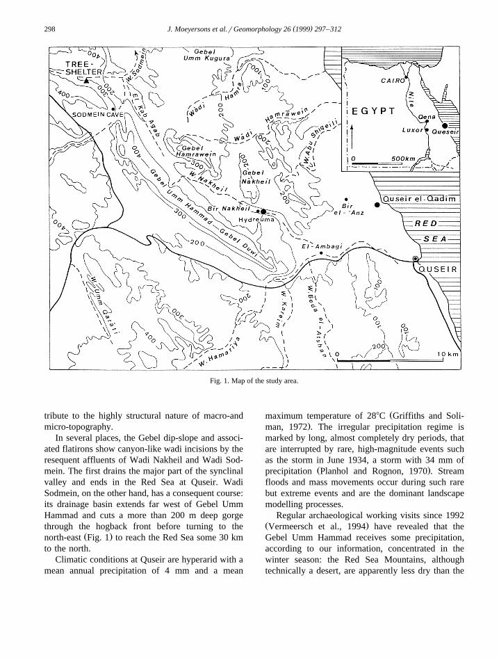
Red Sea coast for a distance of about 30 km, 25 kmŽ .inland from Quseir Fig. 1 . The hogback consists of
Thebes Limestone, the last marine deposit beforeRed Sea proto-rifting began in Oligocene timesŽ .Purser et al., 1990 . The Thebes Limestone forma-tion contains several beds, 0.5 to 2 m thick, withintercalated ‘conglomerates’ of rounded chert nod-ules. Differential weathering andror erosion con-
0169-555Xr99r$ - see front matter q 1999 Elsevier Science B.V. All rights reserved.Ž .PII: S0169-555X 98 00067-1
( )J. Moeyersons et al.rGeomorphology 26 1999 297–312298
Fig. 1. Map of the study area.
tribute to the highly structural nature of macro-andmicro-topography.
In several places, the Gebel dip-slope and associ-ated flatirons show canyon-like wadi incisions by theresequent affluents of Wadi Nakheil and Wadi Sod-mein. The first drains the major part of the synclinalvalley and ends in the Red Sea at Quseir. WadiSodmein, on the other hand, has a consequent course:its drainage basin extends far west of Gebel UmmHammad and cuts a more than 200 m deep gorgethrough the hogback front before turning to the
Ž .north-east Fig. 1 to reach the Red Sea some 30 kmto the north.
Climatic conditions at Quseir are hyperarid with amean annual precipitation of 4 mm and a mean
Žmaximum temperature of 288C Griffiths and Soli-.man, 1972 . The irregular precipitation regime is
marked by long, almost completely dry periods, thatare interrupted by rare, high-magnitude events suchas the storm in June 1934, a storm with 34 mm of
Ž .precipitation Planhol and Rognon, 1970 . Streamfloods and mass movements occur during such rarebut extreme events and are the dominant landscapemodelling processes.
Regular archaeological working visits since 1992Ž .Vermeersch et al., 1994 have revealed that theGebel Umm Hammad receives some precipitation,according to our information, concentrated in thewinter season: the Red Sea Mountains, althoughtechnically a desert, are apparently less dry than the
( )J. Moeyersons et al.rGeomorphology 26 1999 297–312 299
Red Sea coast at Quseir. In 1994–1995 and 1996–1997 in particular, winter rains were rather importantand resulted in the deepening of erosional gullies inthe wadi beds. Also several rock shelters in theThebes Limestone appeared to produce some quanti-ties of water and sediment during the winter rainsand our first opinion that all the karstic phenomena
Žin the Thebes Limestone are inactive today Moeyer-.sons et al., 1996 had to be revised.
2. Karst forms and processes in the Gebel UmmHammad
Karst landforms, inherited from wetter geologicalperiods in the past, have been described in EgyptŽ .Said and Issawi, 1964 , especially along the Red
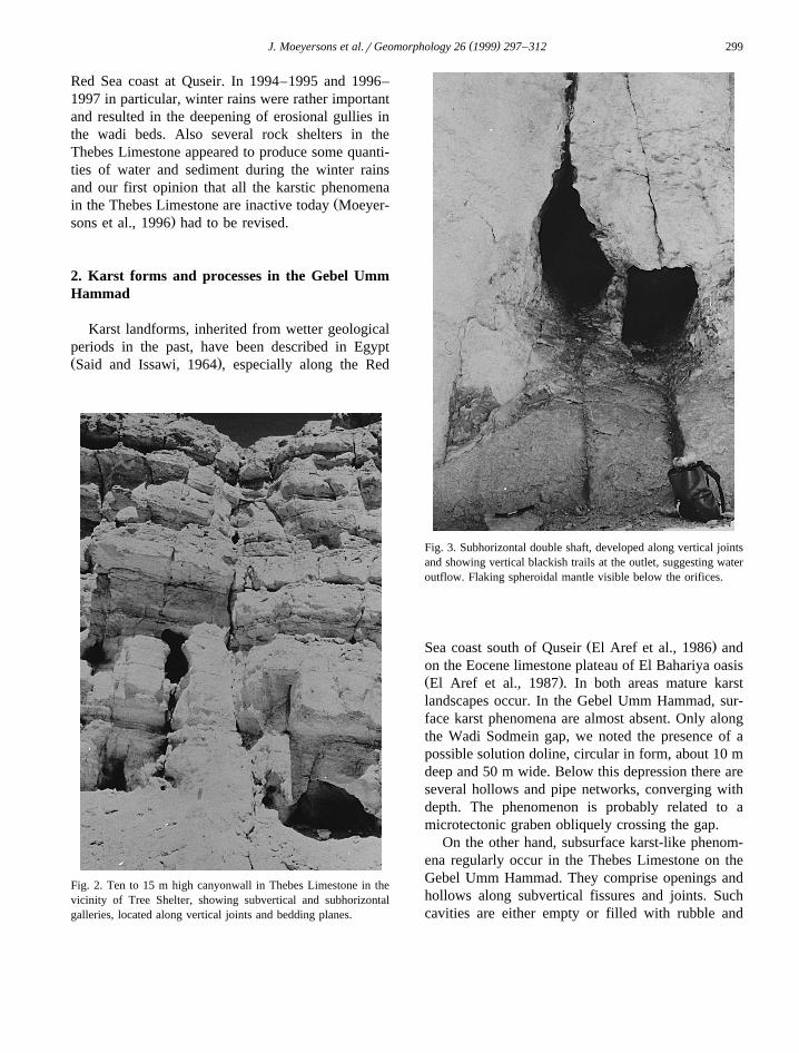
Fig. 2. Ten to 15 m high canyonwall in Thebes Limestone in thevicinity of Tree Shelter, showing subvertical and subhorizontalgalleries, located along vertical joints and bedding planes.
Fig. 3. Subhorizontal double shaft, developed along vertical jointsand showing vertical blackish trails at the outlet, suggesting wateroutflow. Flaking spheroidal mantle visible below the orifices.
Ž .Sea coast south of Quseir El Aref et al., 1986 andon the Eocene limestone plateau of El Bahariya oasisŽ .El Aref et al., 1987 . In both areas mature karstlandscapes occur. In the Gebel Umm Hammad, sur-face karst phenomena are almost absent. Only alongthe Wadi Sodmein gap, we noted the presence of apossible solution doline, circular in form, about 10 mdeep and 50 m wide. Below this depression there areseveral hollows and pipe networks, converging withdepth. The phenomenon is probably related to amicrotectonic graben obliquely crossing the gap.
On the other hand, subsurface karst-like phenom-ena regularly occur in the Thebes Limestone on theGebel Umm Hammad. They comprise openings andhollows along subvertical fissures and joints. Suchcavities are either empty or filled with rubble and
( )J. Moeyersons et al.rGeomorphology 26 1999 297–312300
dust. On other occasions, subvertical shafts, some-times a meter in diameter, are developed more or
Ž .less in the joint plane Fig. 2 . Many widenings areŽprobably joint-controlled corrosion kolks Dreybrodt
.and Franke, 1994 in origin. Also horizontal tunnel-like phenomena occur in the Gebel Umm Hammad,like those in the base of the cliff in Fig. 2. Theirdiameter varies between some decimeters and sev-eral meters and even more. In some cases, blackvertical trails suggest past or present outflow ofwater and dripstone-like pillars between roof and
Ž .bottom sometimes appear Fig. 3 . Some of thesegalleries come from deep in the Gebel and have awidened outlet. Similar forms have been reported
Ž .from the Atlas by Smith 1978 . An example fromŽthe Gebel Umm Hammad is Sodmein Cave Moeyer-
.sons et al., 1996 . Travertine-like secondary depositsof CaCO have been found deeper in the gallery,3
broken dripstones occur in the lower part of theshelter deposits and caliches are developed in someparts of the shelter infillings. We reported several ofsuch caves in the area. Common to all existingkarstic cavities in the study area is their control oflocation and form by vertical joints and fissures. The
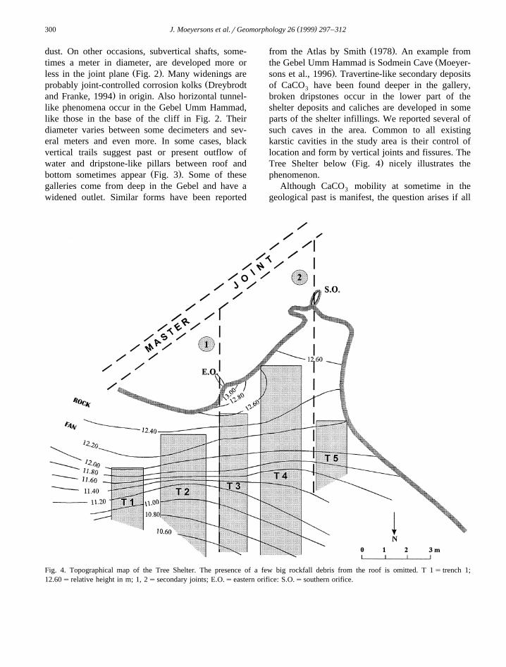
Ž .Tree Shelter below Fig. 4 nicely illustrates thephenomenon.
Although CaCO mobility at sometime in the3
geological past is manifest, the question arises if all
Fig. 4. Topographical map of the Tree Shelter. The presence of a few big rockfall debris from the roof is omitted. T 1s trench 1;12.60s relative height in m; 1, 2ssecondary joints; E.O.seastern orifice: S.O.ssouthern orifice.
( )J. Moeyersons et al.rGeomorphology 26 1999 297–312 301
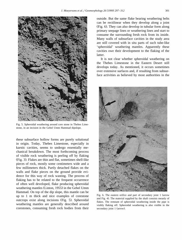
Fig. 5. Spheroidal weathering around core stone in Thebes Lime-stone, in an incision in the Gebel Umm Hammad dipslope.
these subsurface hollow forms are purely solutionalin origin. Today, Thebes Limestone, especially inkarstic cavities, seems to undergo essentially me-chanical breakdown. The most forthcoming processof visible rock weathering is peeling off by flakingŽ .Fig. 3 . Flakes are thin and flat, sometimes shell-likepieces of rock, mostly some centimeters wide and afew millimeters thick. Partly detached flakes on thewalls and flake pieces on the ground provide evi-dence for this way of rock wasting. The process offlaking has to be related to the frequent occurrenceof often well developed, flake producing spheroidal
Ž .weathering mantles Linton, 1955 in the Gebel UmmHammad. On top of the dip slope, this mantle can beup to 1 m thick and nice examples of corestone
Ž .outcrops exist along incisions Fig. 5 . Spheroidalweathering mantles are generally described aroundcorestones, consuming fresh rock bodies from their
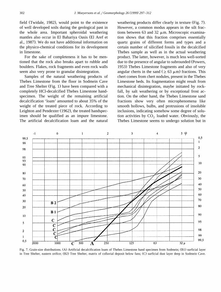
outside. But the same flake bearing weathering beltscan be rectilinear when they develop along a jointŽ .Fig. 6 . They can also develop in tubular form alongprimary seepage lines or weathering lines and start toconsume the surrounding fresh rock from its inside.Many walls of subsurface cavities in the study areaare still covered with in situ parts of such tube-like‘spheroidal’ weathering mantles. Apparently thesecavities owe their development to the flaking of thelatter.
It is not clear whether spheroidal weathering onthe Thebes Limestone in the Eastern Desert stilldevelops today. As mentioned, it occurs sometimesover extensive surfaces and, if resulting from subsur-face activities as believed by most authorities in the
ŽFig. 6. The eastern orifice and part of secondary joint 1 arrow.and Fig. 4 . The material supplied by the shaft consists meanly of
flakes. The remnant of spheroidal weathering inside the pipe isvisibly flaking off. Spheroidal weathering is also visible in the
Ž .secondary joint 1 arrow .
( )J. Moeyersons et al.rGeomorphology 26 1999 297–312302
Ž .field Twidale, 1982 , would point to the existenceof well developed soils during the geological past inthe whole area. Important spheroidal weathering
Žmantles also occur in El Bahariya Oasis El Aref et.al., 1987 . We do not have additional information on
the physico-chemical conditions for its developmentin limestone.
For the sake of completeness it has to be men-tioned that the rock also breaks apart to rubble andboulders. Flakes, rock fragments and even rock wallsseem also very prone to granular disintegration.
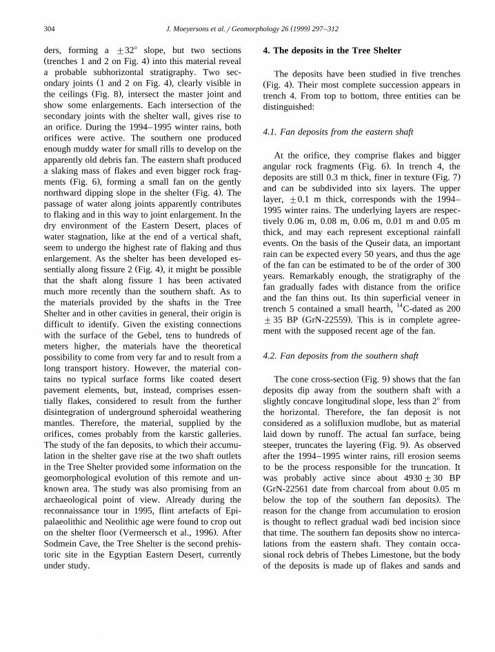
Samples of the natural weathering products ofThebes Limestone from the floor in Sodmein Cave
Ž .and Tree Shelter Fig. 1 have been compared with acompletely HCl-decalcified Thebes Limestone hand-specimen. The weight of the remaining artificialdecalcification ‘loam’ amounted to about 35% of theweight of the treated piece of rock. According to
Ž .Leighton and Pendexter 1962 , the treated handspec-imen should be qualified as an impure limestone.The artificial decalcification loam and the natural
Ž .weathering products differ clearly in texture Fig. 7 .However, a common modus appears in the silt frac-tions between 63 and 32 mm. Microscopic examina-tion shows that this fraction comprises essentiallyquartz grains of different forms and types and acertain number of silicified fossils in the decalcifiedThebes sample as well as in the actual weatheringproduct. The latter, however, is much less well-sorted
Ždue to the presence of angular to subrounded Powers,.1953 Thebes Limestone fragments and also of very
Ž .angular cherts in the sand G63 mm fractions. Thischert comes from chert nodules, present in the ThebesLimestone beds. Its fragmentation might result frommechanical disintegration, maybe initiated by rock-fall, by salt weathering or by exceptional frost ac-tion. On the other hand, the Thebes Limestone sandfractions show very often microphenomena likesmooth hollows, bulbs, and protrusions of insolubleinclusions, indicating somehow some degree of solu-tion activities by CO loaded water. Obviously, the2
Thebes Limestone seems to undergo solution but in
Ž . Ž .Fig. 7. Grain-size distributions. A Artificial decalcification loam of Thebes Limestone hand specimen from Sodmein; B1 surficial layerŽ . Ž .in Tree Shelter, eastern orifice; B2 Tree Shelter, matrix of colluvial deposit below fans; C surficial dust layer deep in Sodmein Cave.
( )J. Moeyersons et al.rGeomorphology 26 1999 297–312 303
the same time it falls apart in smaller pieces. Thelatter process does not necessarily result from classi-cal mechanical rock weathering, but indirectly fromsolution. It has been observed under the binocularmicroscope that Thebes Limestone pieces, treatedwith HCl, react in two ways: the treated rock pro-duces the above described decalcification silt, butpart of the HCl disappears into small fissures andcrevasses and soon sand and gravel sized ThebesLimestone fragments become detached from the rockspecimen as a result of solution along the pre-exist-ing joints. Therefore, joint and crack controlled solu-tion might explain the bimodal grain-size distributionof the mineral weathering products in the upperlayers in Sodmein Cave and Tree Shelter, and mightexplain the easy detachment of flakes from speroidalweathering mantles. It might be the process responsi-ble for the karstic activities in the modern dry cli-mate. Joint controlled solution in the absence ofspeleothems has also been attributed by Dreybrodt
Ž .and Franke 1994 to climatic or environmental con-ditions without much vegetation. They argue that thelow levels of CO needed for the process are highly2
exceeded on soil covered surfaces bearing vegeta-tion. The Gebel Umm Hammad hogback is largely
devoid of any cover but receives still some winterrains and is, therefore, the ideal environment forjoint controlled solution.
3. The Tree Shelter joint controlled karstic system
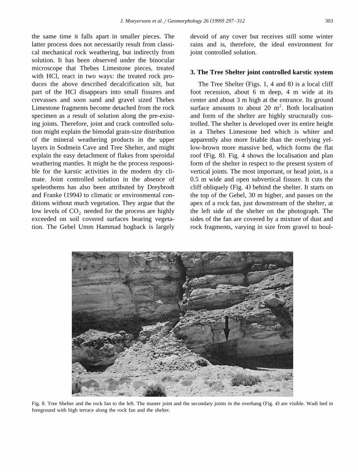
Ž .The Tree Shelter Figs. 1, 4 and 8 is a local clifffoot recession, about 6 m deep, 4 m wide at itscenter and about 3 m high at the entrance. Its groundsurface amounts to about 20 m2. Both localisationand form of the shelter are highly structurally con-trolled. The shelter is developed over its entire heightin a Thebes Limestone bed which is whiter andapparently also more friable than the overlying yel-low-brown more massive bed, which forms the flat
Ž .roof Fig. 8 . Fig. 4 shows the localisation and planform of the shelter in respect to the present system ofvertical joints. The most important, or head joint, is a0.5 m wide and open subvertical fissure. It cuts the
Ž .cliff obliquely Fig. 4 behind the shelter. It starts onthe top of the Gebel, 30 m higher, and passes on theapex of a rock fan, just downstream of the shelter, atthe left side of the shelter on the photograph. Thesides of the fan are covered by a mixture of dust androck fragments, varying in size from gravel to boul-
Ž .Fig. 8. Tree Shelter and the rock fan to the left. The master joint and the secondary joints in the overhang Fig. 4 are visible. Wadi bed inforeground with high terrace along the rock fan and the shelter.
( )J. Moeyersons et al.rGeomorphology 26 1999 297–312304
ders, forming a "328 slope, but two sectionsŽ .trenches 1 and 2 on Fig. 4 into this material reveala probable subhorizontal stratigraphy. Two sec-
Ž .ondary joints 1 and 2 on Fig. 4 , clearly visible inŽ .the ceilings Fig. 8 , intersect the master joint and
show some enlargements. Each intersection of thesecondary joints with the shelter wall, gives rise toan orifice. During the 1994–1995 winter rains, bothorifices were active. The southern one producedenough muddy water for small rills to develop on theapparently old debris fan. The eastern shaft produceda slaking mass of flakes and even bigger rock frag-
Ž .ments Fig. 6 , forming a small fan on the gentlyŽ .northward dipping slope in the shelter Fig. 4 . The
passage of water along joints apparently contributesto flaking and in this way to joint enlargement. In thedry environment of the Eastern Desert, places ofwater stagnation, like at the end of a vertical shaft,seem to undergo the highest rate of flaking and thusenlargement. As the shelter has been developed es-
Ž .sentially along fissure 2 Fig. 4 , it might be possiblethat the shaft along fissure 1 has been activatedmuch more recently than the southern shaft. As tothe materials provided by the shafts in the TreeShelter and in other cavities in general, their origin isdifficult to identify. Given the existing connectionswith the surface of the Gebel, tens to hundreds ofmeters higher, the materials have the theoreticalpossibility to come from very far and to result from along transport history. However, the material con-tains no typical surface forms like coated desertpavement elements, but, instead, comprises essen-tially flakes, considered to result from the furtherdisintegration of underground spheroidal weatheringmantles. Therefore, the material, supplied by theorifices, comes probably from the karstic galleries.The study of the fan deposits, to which their accumu-lation in the shelter gave rise at the two shaft outletsin the Tree Shelter provided some information on thegeomorphological evolution of this remote and un-known area. The study was also promising from anarchaeological point of view. Already during thereconnaissance tour in 1995, flint artefacts of Epi-palaeolithic and Neolithic age were found to crop out
Ž .on the shelter floor Vermeersch et al., 1996 . AfterSodmein Cave, the Tree Shelter is the second prehis-toric site in the Egyptian Eastern Desert, currentlyunder study.
4. The deposits in the Tree Shelter
The deposits have been studied in five trenchesŽ .Fig. 4 . Their most complete succession appears intrench 4. From top to bottom, three entities can bedistinguished:
4.1. Fan deposits from the eastern shaft
At the orifice, they comprise flakes and biggerŽ .angular rock fragments Fig. 6 . In trench 4, the
Ž .deposits are still 0.3 m thick, finer in texture Fig. 7and can be subdivided into six layers. The upperlayer, "0.1 m thick, corresponds with the 1994–1995 winter rains. The underlying layers are respec-tively 0.06 m, 0.08 m, 0.06 m, 0.01 m and 0.05 mthick, and may each represent exceptional rainfallevents. On the basis of the Quseir data, an importantrain can be expected every 50 years, and thus the ageof the fan can be estimated to be of the order of 300years. Remarkably enough, the stratigraphy of thefan gradually fades with distance from the orificeand the fan thins out. Its thin superficial veneer intrench 5 contained a small hearth, 14C-dated as 200
Ž ."35 BP GrN-22559 . This is in complete agree-ment with the supposed recent age of the fan.
4.2. Fan deposits from the southern shaft
Ž .The cone cross-section Fig. 9 shows that the fandeposits dip away from the southern shaft with aslightly concave longitudinal slope, less than 28 fromthe horizontal. Therefore, the fan deposit is notconsidered as a solifluxion mudlobe, but as materiallaid down by runoff. The actual fan surface, being
Ž .steeper, truncates the layering Fig. 9 . As observedafter the 1994–1995 winter rains, rill erosion seemsto be the process responsible for the truncation. Itwas probably active since about 4930"30 BPŽGrN-22561 date from charcoal from about 0.05 m
.below the top of the southern fan deposits . Thereason for the change from accumulation to erosionis thought to reflect gradual wadi bed incision sincethat time. The southern fan deposits show no interca-lations from the eastern shaft. They contain occa-sional rock debris of Thebes Limestone, but the bodyof the deposits is made up of flakes and sands and
()
J.Moeyersons
etal.r
Geom
orphology26
1999297
–312
305
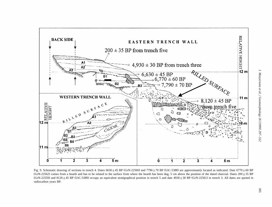
Ž . Ž .Fig. 9. Schematic drawing of sections in trench 4. Dates 6630"45 BP GrN-22560 and 7790"70 BP UtC-5388 are approximately located as indicated. Date 6770"60 BPŽ .GrN-22562 comes from a hearth and has to be related to the surface from where the hearth has been dug, 5 cm above the position of the dated charcoal. Dates 200"35 BPŽ . Ž . Ž .GrN-22559 and 8120"45 BP UtC-5389 occupy an equivalent stratigraphical position in trench 5 and date 4930"30 BP GrN-22561 in trench 3. All dates are quoted inradiocarbon years BP.
( )J. Moeyersons et al.rGeomorphology 26 1999 297–312306
silts, resulting from the granular disintegration of thelatter. The deposits can further be subdivided intotwo members:
- the upper A-member, with layers A1 to A3. TheŽ .date of 4930"30 BP GrN-22561 comes from
charcoal from a Neolithic hearth in the upper partof A1.- the under-lying B-member, with layers B1 to B6.Both members are separated by a somewhat
coarser stone-line layer, not thicker than 0.01 m,containing somewhat bigger sized flakes and smallrock fragments. A comparable layer, B3, separatesB2 from B4. The question arises whether these twocoarser layers are to be considered as lag-depositsupon erosive truncation. Two arguments can be for-warded to answer this question in a negative way.First of all, the actual erosion surface contains sev-eral rills, some of them more than 0.03 m deep. The‘stone-lines’ on the other hand, appear in the trenchwalls as incisionless smooth and flat surfaces. Sec-ondly, the submodern rilled erosion surface laterally
Ž .truncates the much flatter lying fan deposits Fig. 9 ,while the ‘stone-lines’ are exactly parallel with over-lying and underlying deposits. Therefore, we con-sider these coarser ‘floors’ simply as a depositionfrom a runoff sheet with higher competence thanabove or below, necessarily as a result of biggerdischarge.
The soil samples from both members show thesame textural and microscopic characteristics as theeastern shaft deposits. Joint controlled solution in adry environment seems still to be the case. But theycontrast with overlying and underlying deposits inorganic content: while the latter are quasi sterile, theA1 to A3 layers, and to a lesser degree the B1 to B4
Žlayers, contain in their sand and silt fractions 2000–.2032 mm numerous pieces of charcoal, indeter-
minable plant and insect fragments and various typesof other organic debris. On the whole, the A-mem-
Žbers are slightly darker in colour 7.5YR 6r4 against.8r4 than the other deposits. In some places, nests of
Hymenoptera are present and coproliths of faunalŽ .origin Dorcas gazelle and others ? are not uncom-
mon. This, in combination with more competentrunoff at the transition from A3 to B1 and at B3,suggests the presence of more faunal and floristiclife and water in the southern fan deposits, especiallyin the A-member. Caliche development in the A- and
B-members is a supplementary indication that waterevaporation took place in the fan during an unidenti-fied period in the past.
4.3. The lower blocky deposits with fluÕial intercala-tions
Below the B6 layer, the material contains largeŽ .0.01–0.1 m angular and subangular Thebes Lime-stone blocks and rock fragments. The matrix grain
Ž .size distribution in C1 Fig. 9 is given on Fig. 7.These blocky deposits contain intercalations of
Ž .clearly fluvial material D in Fig. 9 , Thebes Lime-stone pebbles of variable dimensions, supplied by thewadi in front of the shelter. The highest intercalationcorresponds in local elevation with the top of the
Ž .‘high terrace’, visible on Fig. 8 Fig. 9 . The collu-vial rock debris C1 and C2 below the fan depositshave been deposited during a period of extreme wadifloods, giving rise to the aggradation of coarse andheavy bed load, the silts and fine sands being ex-ported.
5. The deposits from the side of the rock fan,outside the shelter
Trenches 1 and 2 are situated outside, but veryclose to the shelter, in what was first believed to be amere scree slope in rock debris on the flank of the
Ž .rock fan Figs. 4 and 8 . The exposures in thetrenches show essentially subangular Thebes rockfragments of variable size, sometimes clast sup-ported, but in other places supported in the matrix offine sand and silt. It appears that the stratigraphy inthis material is essentially subhorizontal and cut bythe ‘scree’ slope. The stratigraphy is comparable andperfectly correlated with the one inside the shelter.The blocky material on the flank of the rock fancontains in its upper 0.5 m a darker matrix of humicsands and silts. This layer has been related with theA-member of the fan deposits. Deeper, the matrixbecomes more greyish and corresponds with theB-member. Although subdivisions like those in theshelter could not be seen, the artefacts from the B3layer in the shelter did also occur in trenches 1 and 2at about the same relative height of "11.5 m, which
( )J. Moeyersons et al.rGeomorphology 26 1999 297–312 307
confirms the stratigraphic continuity. The sectionsoutside the shelter are important for two reasons:first, they show that the process of flaking was and isactive, especially in the karstic shaft system of theTree Shelter and in the cavity of the shelter itself,while contemporaneous processes outside lead andled more to boulder, block and debris formation,maybe the result of rock fall; secondly, the goodcorrelation between fan stratigraphy in the shelterand debris stratigraphy, outside, suggest that the
environmental changes, as recorded in the fan de-posits inside a shelter or cave, reflect eventually in avery detailed way what happens outside.
6. The timing of events
Six uncalibrated 14C dates on charcoal piecesŽ .quoted here in radiocarbon years BP provide a
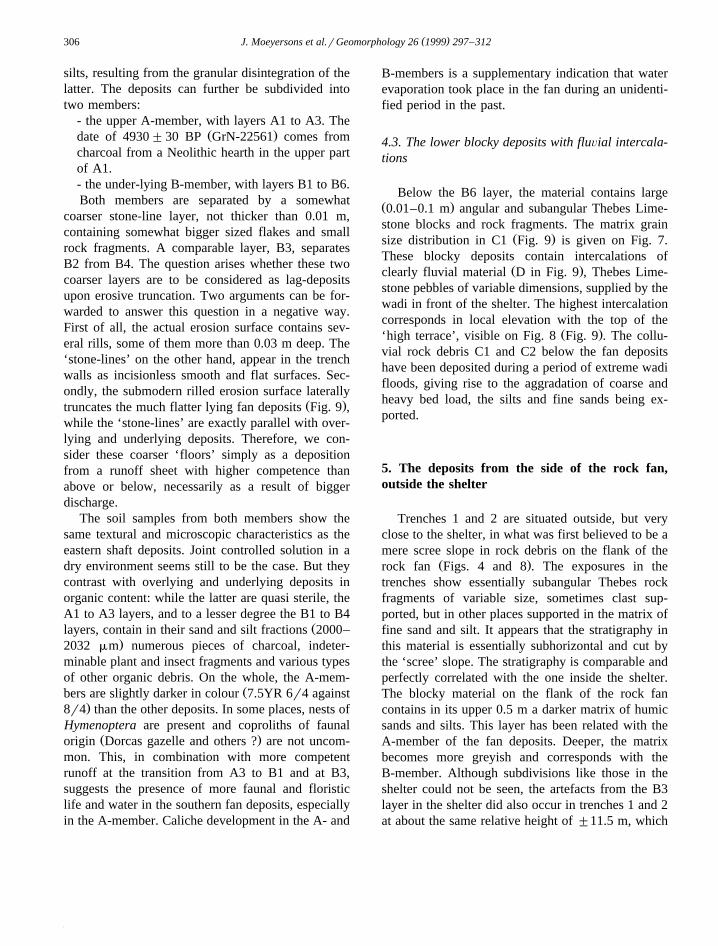
Table 1Ž .Fan growth dynamics, evolution of wadi bed and adjacent slopes and rainfall patterns since more than 8000 BP at Tree Shelter site Egypt
( )J. Moeyersons et al.rGeomorphology 26 1999 297–312308
chronological framework for the southern fan de-Ž .posits Fig. 9 . The charcoal fragments date the
stratigraphical level at which they are found. Anexception is date GrN-22562: the charcoal comesfrom 5 cm below the rim of a hearth, and corre-sponds in age with the surface from where the hearthhas been dug. The Holocene age of the stratigraphic
Ž .succession is evident Fig. 9 , but the geomorpholog-ical dynamics show remarkable variations. Cautiousand conservative estimations of fan deposition rate,deduced from difference in altitude between the datedstratigraphic levels, are given in Table 1. The varia-tions in deposition rate largely exceed the possibleerror by the use of radiometric ages. Shortly after
Ž .4930"30 BP GrN-22561 , the activities of thesouthern orifice switch suddenly from accumulationto erosion, the latter apparently still active today. Atthe end of this erosive period, probably only somehundreds of years ago, the eastern shaft starts its ownfan building. The southern fan deposits show twowell pronounced peaks in deposition rate. The most
Ž .recent one sits between 6630"45 GrN-22560 andŽ .6770"60 BP GrN-22562 and comprises layers A3
to part of B1. It includes the stone-line-like transitionbetween A- and B-member, discussed earlier. An
Ž .older peak, between 7790"60 BP UtC-5388 andŽ .8120"45 BP UtC-5389 , concerns layers B2 to B6
and further the rocky C1 facies on top of the upper-most wadi deposits. The southern fan formation startswith a peak in deposition, the B3 stone-line about inthe center. Peaks in fan deposition rate in this dryenvironment probably point to periods of morerunoff. The intercalation of a stone-line in the middleof such a period, corroborates the hypothesis fromabove that the stone-lines within the fan deposits aredepositional in nature and correspond to higher runoffcompetence. In the mean time, the small artefacts,found in and around such a stone-line would haveundergone little or no post-depositional reworking.
7. The palaeoenvironmental context of the TreeShelter
Several points, explained further in more detail,indicate an arid environment during the whole period
Ž .of fan deposition since 8120"45 BP UtC-5389 :
the more or less catastrophic nature of precipitationregime during the whole period; the remarkable un-derground preservation of organic materials, indicat-ing the essentially dry character of the environmentthrough time; the spectrum of tree species, definedon the base of charcoal remains. Nevertheless, cleardifferences as to the degree of aridity appear: from
Ž .before 8120"45 BP UtC-5389 till 4930"30 BPŽ .GrN-22561 , subhorizontal accumulation of rockdebris, gravels and sands took place in the wadi
Ž .valley. Before 8120"45 BP UtC-5389 , these de-Ž .posits interfinger with coarse wadi bedload Fig. 9 .
It concerns a period of bankfull and even overbarkwadi stages, with a flood peak discharge estimated atc 40 m3rs. The supposed wadi discharge peak of 40m3rs can easily be calculated to correspond with aninput of a storm rainfall intensity of 72 mmrh overthe 20 km2 basin, again neglecting losses by evapo-transpiration and infiltration. Such an intensity is notexceptional. Combined, however, with the secondcondition, namely that this intensity should cover theentire 20 km2 basin during a time necessary toinstall steady state flow conditions in the wholebasin, implies that it concerns in fact an extremelyheavy rainstorm. Obviously, the high water stages,indicated by the stratigraphy, can only representindividual flash floods and not a seasonal or perma-nent situation. Concerning the periods between thefloods, no evidence exists for a permanent wet andgreen environment.
The period of aggadational wadi floods came toan end with the establishment of the high wadi
Ž .terrace just before 8120"45 BP UtC-5389 . Subse-quently, the subhorizontal accumulation of rock de-bris continued in the wadi side, but without anymoretraces of fluvial inundations. Instead, very shortly
Ž .after 8120"45 BP UtC-5389 , we find the first fandeposits in the shelter. Maybe the shelter was scouredout by the wadi during the last high wadi stand, aprocess which might have liberated the already exis-
Ž .tant southern orifice Fig. 4 . Until about 4930"30Ž .BP GrN-22561 , flakes, sand and loam have been
supplied at regular times by the latter and accumu-lated in the shelter as a small fan deposit, showing agradual lateral transition into the subhorizontal coarserock debris outside. Above the B5 layer, the fancontains organic material from plants, insects andanimals. The concentration of organic debris be-
( )J. Moeyersons et al.rGeomorphology 26 1999 297–312 309
comes even higher in the A member. The wholeperiod of southern fan development, but especiallythe period of the A member development, knewmore precipitation than today because such rich or-ganic, content is absent even in the base of theeastern fan deposits. On the other hand, rain storms
Ž .of the size from before 8120"45 BP UtC-5389did not occur anymore. It is supposed that the periodof southern fan deposition represents conditionswhere joint controlled solution and especially flakingis active in the karstic pipes. Within these shafts,there was also transport to their outlet. Without anydoubt, there was enough precipitation to realise atleast partial water percolation from the gebel backs-lope through shafts and galleries with resurgence atthe wadi side. However, precipitation was not evenlyspread over the whole period. The two accumulationrate maxima in the souther fan deposits and the highcompetence runoff stone-lines within these maximaare interpreted as the expression of two more humidpulses within this long period. The oldest pulse is arather short one and falls between 8120"45 BPŽ . Ž .UtC-5389 and 7790"70 BP UtC-5388 , probablyvery close to 8000 BP. The younger pulse takeslonger and is centered around the transition between
ŽA- and B-member between 6630"45 BP GrN-. Ž .22560 and 6770"70 BP GrN-22562 . Charcoal
appeared in and around the deposits of both pulses.During the later pulse, it is generally found in hearths.The following wood species have been identified:
Ž .Capparis decidua Forsk. Edgew., SalÕadora per-Ž .sica L., Acacia nilotica L. Willd. ex Del., Boscia
Ž .salicifolia Oliver., Acacia tortilis Forsk. Hayne.,Maerua crassifolia Forsk., Acacia albida L.,Tamarix sp. At the deposit of the wet pulse at"8000 BP, there are dispersed and fragmented char-coal pieces identified as Tamarix sp., A. albida L.,
Ž .A. tortilis Forsk. Hayne., Celtis sp., Balanites ae-Ž .gyptiaca Del., A. nilotica L. Willd. ex Del. It
should be stressed that these botanic spectra aretypical for dry conditions like steppe and dry savan-nah environments.
After the younger pulse and the subsequent rela-tively wet period, important changes occurred: thesouthern fan deposits in the shelter stopped growingand runoff, still fed occasionally by the pipe, startedto erode and to laterally truncate the fan deposits. Itsrock debris counterpart, outside, also underwent lat-
eral erosion in the direction of the center of the wadibed. The erosion process, inside the shelter as wellas outside apparently continues today and points to agradual reincision of the wadi bed, aggraded before
Ž .8120"45 BP UtC-5389 . This reincision is thoughtto continue today at the occasion of exceptionalrains. After the 1994–1995 winter rains it becameclear that the modern rainstorms do not lead tocomplete wadi bed inundation but only to the scour-ing out of small secondary channels in the wide wadibeds. This situation seems thus to have prevailedover about the last 5000 years. Table 1 summarisesthe geomorphological and climatic events since sometime before 8000 BP.
8. Local and regional comparison
Comparing the palaoenvironmental evolution be-tween sites on the base of their stratigraphy is oftendifficult. One can never be sure that the stratigraphicrecord covers a complete time span. Stratigraphichiatuses are not always detectable. Furthermore, lo-cal conditions might govern the stratigraphic expres-sion of environmental characteristics. Finally, thelocal nature of precipitation regimes in arid environ-ments might obscure existing similarities or differ-ences between the palaeoclimatic evolution on dif-ferent sites. Therefore, the palaeoenvironmental evo-lution, worked out above, might miss some pulsa-tions, well expressed in other sites. In the same waythe Tree Shelter might indicate pulsations not ob-served elsewhere.
The Holocene environmental evolution, estab-Ž .lished at the Tree Shelter Table 1 , has been com-
pared with the results from Sodmein Cave, only 4km to the southeast. Here, the Holocene layers B to
Ž . 14D Moeyersons et al., 1996 are C dated betweenŽ . Ž6320"100 BP Lv-2082 and 7090"80 BP Lv-
.2086 . They fall within the wet period, centeredaround the A–B-member transition in the Tree Shel-ter. The B to D layers in Sodmein contain charcoalfragments of Cadaba farinosa Forsk., A. tortilisŽ .Forsk. Hayne., SalÕadorica persica L., Tamarix
Ž .sp., Boscia senegalensis Pers. Lam. ex Poir., Zizi-phus sp. Still more trees are present, but could not beidentified. Indications for the most humid environ-ment are given by the presence of Olea sp. in the C
( )J. Moeyersons et al.rGeomorphology 26 1999 297–312310
layer, approximately dated between 6360"90 BPŽ . Ž .Lv-2085 and 6940"100 BP Lv-2083 , and thusoverlapping the youngest wet peak in the Tree Shel-ter. No accumulations of the peak at 8000 BP havebeen found in Sodmein Cave. This period is pre-sented by a stratigraphic hiatus and disconformity,due to erosion. The dry period since the last wetpulse is represented in Sodmein by a superficial dustlayer, occasionally reworked by wind and rain.
The Holocene climatic and environmental evolu-tion at the Tree Shelter has also been compared withthe results by other workers in the wider region. Themodern aridity in the Red Sea Mountains appears tohave commenced maybe as much as 1000 to 2000years earlier at the Tree Shelter than in Sudan, 500 to
Ž1000 km to the south Alaily, 1993; Hoelzman,.1993 . On the other hand, studies on Pteropoda
Ž .from the Red Sea Almogi-Labin et al., 1991 showthat before 8500 BP, i.e., during the period of highwadi floods, the mixed seawater layer and the salin-ity showed rapid variations, possibly associated withunstable conditions in the upper part of the watercolumn. The period of extreme floods in the GebelUmm Hammad might also correspond with the veryfirst local rains after the ‘Wild Nile’ period, which
Žwas still dry in Egypt Butzer and Hansen, 1968;Adamson et al., 1980; Butzer, 1980; Vermeersch,1983; Paulissen, 1986; Paulissen and Vermeersch,
. 141989 . C dates from predynastic hearths and fossilroot systems, combined with faunal and botanicalevidence show that the Nile valley at Qena became
Ž .wetter since "9740 BP Vermeersch et al., 1992 .According to the same authors, humid conditionsprevailed until "6000 BP but it took until "4810BP before the Nile valley environment was againfully adapted to hyperarid conditions. The latest datefrom Tree Shelter before modern aridity is 4930"30
Ž .BP GrN-22561 .In the Eastern Sahara, west of the Nile, the two
last humid pulsations in Nabta Playa and Bir Ki-Ž .seiba, Playa II and III, Wendorf and Schild, 1984
correspond closely in age with the ones from theTree Shelter. However, these two sites are some 400km further to the south. Correlations with the closer
Ž .Kharga Oasis Wendorf and Schild, 1980 are lessclear.
On the other hand, clear parallels appear betweenŽ .Tree Shelter and Dakhla Oasis. Here, Brookes 1993
mentions a pluvial interval from about 9000 to 4500BP. At Tree Shelter, the modern arid phase wasdated to start shortly after 5000 BP.
Ž .According to Neumann 1989 , a very dry envi-ronment prevailed in the Eastern Sahara north of258N since 6000 BP and became apparent in GilfKebir and Soudan around 5000 BP. In the North, theless dry period before 6000 BP saw a depauperatebotanical spectrum.
Ž .More to the south, Kropelin 1989 attributes¨wadi deposits in Gilf Kebir to an arid environment,prevailing during the whole of the Holocene era. Heassumes that between 9500 and 6000 BP the areaexperienced about four heavy rainstorm events acentury. More moderate aridity occurred between6000 and 5000 BP, and supposed renewed ariditysince 4800 BP is not documented any more by thedeposits.
Ž .In the central Sahara, Pachur and Braun 1980find a fluvial link between the Tibesti and theMediterranean, radiometrically dated around 8000BP, the moment of the first humid pulse at TreeShelter. According to the same authors the periodafter 5000 BP shows a trend to decreasing precipita-tion. Another fossil fluvial link is the one betweenWadi Howar and the Nile in Sudan. This wadi was
Žactive from about 9500 to 4500 years ago Pachur.and Kropelin, 1987 .¨
Ž .Finally, the compilation by Banks 1984 showsthat results from the Tree Shelter differ markedlywith the Holocene climatic evolution from moreremote areas like the Tibesti and Hoggar massifs orlike Lake Tchad.
This short overview evidences certain parallelismsbetween the evolution at different sites in the EasternSahara, the Red Sea Mountains and the Red Seabasin. All authors, mentioned, agree on the existenceof a humid or less arid period in the first half of theHolocene. However, some pulsations or marked tran-sitions in the climatic history at some sites are out ofphase with the same characteristic points in theevolution at other sites. Part of this problem might bedue to the restricted possibilities of finding 14Cdatable quantities of charcoal at the desired strati-graphical levels. Another partial explanation mightbe the arid character of the whole region during theperiod considered, even as far south as Gilf KebirŽ .Kropelin, 1989 . The irregular precipitation in such¨
( )J. Moeyersons et al.rGeomorphology 26 1999 297–312 311
conditions might explain the apparent aberration be-tween the ‘climatic’ evolution from different sites.
Acknowledgements
This research project is funded by the ‘Fondsvoor Wetenschappelijk Onderzoek-Vlaanderen’ andthe ‘Onderzoeksfonds K.U. Leuven’.
References
Adamson, D.A., Gasse, F., Street, F.A., Williams, M.A., 1980.Late Quaternary history of the Nile. Nature 288, 50–55.
Alaily, F., 1993. Soil development and climatic changes duringthe Quaternary in the north eastern part of the Red Sea HillsŽ . Ž .sudan . In: Thorweihe, U., Schandelmeier, H. Eds. , Geosci-entific Research in Northeast Africa. Balkema, Rotterdam, pp.581–584.
Almogi-Labin, A., Hemleben, C., Meischner, D., Erlenkeuser, H.,1991. Paleoenvironmental events during the last 13,000 yearsin the central Red Sea as recorded by Pteropoda. Paleoceanog-raphy 6, 83–96.
Banks, K.M., 1984. Climates, cultures and cattle: the Holocenearchaeology of the Eastern Sahara. Southern Methodist Uni-versity, Dallas, 259 pp.
Brookes, I.A., 1993. Geomorphology and Quaternary geology ofthe Dakhla Oasis region, Egypt. Quaternary Science Reviews12, 529–552.
Butzer, K.W., 1980. Pleistocene history of the Nile valley inEgypt and Lower Nubia. In: Williams, M.A.D., Faure, H.Ž .Eds. , The Sahara and the Nile. Balkema, Rotterdam, pp.253–280.
Butzer, K.W., Hansen, C.L., 1968. Desert and river in Nubia. TheUniv. Wisconsin Press, Madison, 562 pp.
Dreybrodt, W.D., Franke, H.W., 1994. Joint controlled solutionŽ .pockets Laugungskolke in ceilings of limestone caves: a
model of genesis, growth rates and diameters. Z. Geomorph.N.F. 38, 239–245.
El Aref, M.M., Awaldalah, F., Ahmed, S., 1986. Karst landformdevelopment and related sediments in the Miocene rocks ofthe Red Sea coastal zone, Egypt. Geologische Rundschau 75,781–790.
El Aref, M.M., Abou Khadrah, A.M., Lofty, Z.H., 1987. Karsttopography and karstification processes in the Eocene lime-stone plateau of El Bahariya Oasis, Western Desert, Egypt. Z.Geomorph. N.F. 31, 45–64.
Ž .Griffiths, J.F., Soliman, K.H., 1972. The Northern Desert Sahara .Ž .In: Griffiths, J.F. Ed. , World Survey of Climatology 10:
Climates of Africa. Elsevier, Amsterdam, pp. 75–132.
Hoelzman, P., 1993. Palaeoecology of Holocene lacustrine sedi-ments in Western Nubia, SE Sahara. In: Thorweihe, U.,
Ž .Schandelmeier, H. Eds. , Geoscientific Research in NortheastAfrica. Balkema, Rotterdam, pp. 569–574.
Kropelin, S., 1989. Untersuchungen zum Sedimentationsmilieu¨Ž .von Playas im Gilf Kebir. In: Kuper, R. Ed. , Forschungen
zur Umweltgeschichte der Ostsahara. Heinrich-Barth-Institut,Koln, pp. 183–306.¨
Leighton, M.W., Pendexter, C., 1962. Carbonate rock types. Am.Assoc. Petrol. Geol. Mem. 1, 33–61.
Linton, D.L., 1955. The problem of tors. Geogr. J. 121, 187–470.Moeyersons, J., Vermeersch, P.M., Van Peer, P., Van Neer, W.,
Beeckman, H., De Coninck, E., 1996. Sodmein Cave site, RedSea Mountains, Egypt: development, stratigraphy and
Ž .palaeoenvironment. In: Pwiti, G., Soper, S. Eds. , Aspects ofAfrican Archaeology: papers from the 10th Congress of thePanAfrican Association for Prehistory and Related Studies.University of Zimbabwe Publications, Harare, pp. 53–62.
Neumann, K., 1989. Vegetationsgeschichte der Ostsahara imHolozan: Holzkohlen aus prahistorischen Fundstellen. In: Ku-¨ ¨
Ž .per, R. Ed. , Forschungen zur Umweltgeschichte der Ostsa-hara. Heinrich-Barth-Institut, Koln, pp. 13–182.¨
Pachur, H.-J., Braun, G., 1980. The palaeoclimate of the centralSahara, Libya and the Libyan desert. In: Van Zinderen Bakker
Ž .Sr., E.M., Coetzee, J.A. Eds. , Palaeoecology of Africa 12.Balkema, Rotterdam, pp. 350–363.
Pachur, H.-J., Kropelin, S., 1987. Wadi Howar: palaeoclimatic¨evidence from an extinct river system in the southeasternSahara. Science 237, 298–300.
Paulissen, E., 1986. Characteristics of The ‘Wild’ Nile Stage inŽ .Upper Egypt. In: Faure, H., Faure, L., Diop, E.S. Eds. ,
INQUA-ASEQUA International Symposium: Changementsglobaux en Afrique durant le Quaternaire. Passe-Present-Futur.´ ´Dakar, 21–28 Avril 1986. ORSTOM, Paris, pp. 367–369.
Paulissen, E., Vermeersch, P.M., 1989. Le comportement desgrands fleuves allogenes: l’exemple du Nil saharien au Quater-`naire superieur. Bull. Soc. Geol. France V, 73–83.´
Planhol, X., Rognon, P., 1970. Les zones arides et tropicales. A.Collin, Paris, 487 pp.
Powers, M.C., 1953. A new roundness scale for sedimentaryparticles. J. Sediment. Petrol. 23, 117–119.
Purser, B.H., Philobbos, E.R., Soliman, M., 1990. Sedimentationand rifting in the NW parts of the Red Sea: a review. Bull.
Ž .Soc. Geol. France VI 3 , 371–384.Said, R., Issawi, B., 1964. Geology of northern plateau, Bahariya
Ž .Oasis, Egypt. Geol. Surv. Egypt Cairo 29, 41p.Smith, B.J., 1978. The origin and geomorphic implications of cliff
foot recesses and tafoni on limestone hamadas in the north-west Sahara. Z. Geomorph. N.F. 22, 21–43.
Twidale, C.R., 1982. Granite Landforms. Elsevier, Amsterdam,372 pp.
Vermeersch, P.M., 1983. New research in the Makhadma Area.Nyame Akuma 22, 5–6.
Vermeersch, P.M., Paulissen, E., Huyge, D., Neumann, K., VanNeer, W., Van Peer, P., 1992. Predynastic hearths in Upper
Ž .Egypt. In: Friedman, R., Adams, B. Eds. , The Followers ofHorus. Oxbow Monograph 20, Oxford, pp. 163–172.

( )J. Moeyersons et al.rGeomorphology 26 1999 297–312312
Vermeersch, P.M., Van Peer, P., Moeyersons, J., Van Neer, W.,Ž .1994. Sodmein Cave site, Red Sea Mountains Egypt . Sahara
6, 31–40.Vermeersch, P.M., Van Peer, P., Moeyersons, J., Van Neer, W.,
1996. Neolithic occupation of the Sodmein area, Red SeaŽ .mountains, Egypt. In: Pwiti, G., Soper, S., Eds. , Aspects of
African Archaeology: Papers from the 10th Congress of the
PanAfrican Association for Prehistory and Related Studies.University of Zimbabwe Publications, Harare, pp. 411–419.
Wendorf, F., Schild, R., 1980. The Prehistory of the EasternSahara. Academic Press, New York, 414 pp.
Wendorf, F., Schild, R., 1984. Cattle-keepers of the EasternŽ .Sahara: The Neolithic of Bir Kiseiba. In: Close, A.E. Ed. ,
Southern Methodist University, Dallas, 458 pp.