hiking land value docx for stamford,nov 2013
TRANSCRIPT
Title:
Hiking Land Value & the Deteriorating Environmental
Situation of Dhaka City.
Abstract
Dhaka, the capital of Bangladesh, accommodating a huge
population (14.6 million), heavy traffic, excess urban
structures, is also the center of all the socio-economic
and cultural activities. In a medium size urban area of 125square miles (325 sq.km.) the density of population is 115,000
people /sq.mile (45,000 sq.km.) in Dhaka city. (RISE Society, 2013).
Additionally, a large number of people from all corners of
the country influx everyday into the city to reside and to
commute for various purposes. Needless to say, in such a
dynamic and densely inhabited city, an integrated
infrastructural management plan has to be established to
ensure the proper and maximum utilization of the land,
while keeping the city environment healthy and safe for
its inhabitants. The present study is an attempt to find
out the degree of demand for land in the city, causing
excessive pressure upon the land market, and causing an
escalating rise in land value -rational or not. The
deterioration done to the city environment for over and
1
improper land use is also shown in the study, as this
sector is also important for a healthy city planning.
Introduction:
Dhaka city, termed as a “Garden City” by James Taylor
(1840), was a small town with numerous khals and marshy
lands, surrounded by rivers named-Buriganga, Balu, Turag
and Tongi in four sides. There were enough open landscapes
in early 1900(1184 acres; Geddes,1917) and even in the mid
1900s (1338 acres; Minoprio & Spencely,1959).But the huge number
of people migrating towards Dhaka after the Liberation war
for various reasons turned Dhaka into a overcrowded
megacity. However, the city has been expanded upto 590
sq.miles by the Dhaka Metropolitan Development Plan
(1993), the amount of open spaces reduced to an
insignificant amount. Consequently, constantly increasing
pressure upon the city land for residential, commercial,
and other many types of land use purposes, led the urban
market into an unstable condition. Greedy land grabbers,
developers, and other related organizations are
accelerating the value of land in response to the high
demand for land. On the other hand, people also find
investing money in land market safer and profit maximizing
within a short period of time. But, this malpractice is
destructing the environment of the city as almost all the2
open spaces, vegetation and water bodies has been occupied
to provide more land. The present study attempts to find
out the trend of accelerating land value through the time
span of about 40 years (from 1974-2012).The effect of
high land value upon the city environment will be
discussed as a resultant of unplanned and over use of the
land.
Methodology:
i) Objective: The main objective of the study is to find
out the influence on the city environment as a consequence
of accelerating land value through the time span of almost
40 years.
To achieve the main objective three secondary objectives has to be reached. These are:
a) to depict a chronological portray of land value in the study area,b) to depict the gradual environmental deterioration of the study area, and c) to suggest the ways to mitigate the destruction with a view to refurbishment of healthy environment of the study area.
ii) Sample Area: The sample area of the present study is the Dhaka city area between the river Buriganga in the south, Tongi khal in the north, river Turag in the west and the river Balu in the east.
3
iii) Data Sources: The data had been collected from the main two sources like--
a) Primary Sources, such as- field survey, questionnaire survey.
b) Secondary Sources, such as books, journals, reports, satellite imageries, unpublished thesis, etc.
iii) Data Presentation: The data derived from different
sources has been processed, checked, and cross-checked to
prove authenticity. Tabular forms and maps have been used
to present the derived data.
Chronology of Land Value in Dhaka City:
Land Value Characteristic in Dhaka City: 1974
The land value surface map of Dhaka City in 1974 confirms
the pattern of the Classic Value-Distance Relationship
(Map 1). There is a general decline in land value from
city center towards the periphery with a number of ups and
downs along the profile. The main characteristic of land
value in Dhaka in 1974 was like below:
(i) it had two peak value zones, one peak area centered
around the Gulistan intersection of the Bangabandhu
Avenue, and the other one occupied the Islampur road and
4
extended up to Chauk Bazar area. The zones showed the
values of over tk. 35 per sq.ft. (Tk.4 9.50 /m)
(ii) the two peak value zones were joined by an elongated
stretch of land on both sides of the Nawabpur road, where
the average value ranged from tk. 25-30/sq. ft (9.50
taka/sq. m.)
(iii) The iso-value belts tended to be distributed
concentrically and dense belts were wider in the new area
of Dhaka city.
(iv) These value belts were in somewhat concentric
arrangements and were found with a decline in value, away
from the center.
(v) The concentric trends of iso-value belts were
distributed by many factors of which 'topography' was the
most important.
(vi) From the center to the east, south and west,
availability of build able land was limited and invariably
the iso-value belts were thin and constricted.
(vii) In the north and north-west of the center, three
wide tracts of high-quality lands are found. Consequently,
the iso-value belts were wider and evenly distributed
here.
5
(viii) Low land values encountered in all directions
within a short distance from the city center excepting the
northern sector. Low lands with value of 0.50
taka/sq.ft.,was encountered in east, south, and western
sectors within two miles from the city center.
(ix) The ratio between the central and peripheral values
in the three directions towards east, south, and west was
1:20, where in the northern sector the ratio was 1:18.
This represents that the growth of the city was more
towards north than the other three sides. This mostly
happened for the presence of high buildable land towards
north and low submerged land on the other three
directions.
(x) Besides the planned area of the C.B.D, there were
other two planned commercial areas- the New Market area
and the commercial areas on the Mymensingh road near
Karwan Bazar. These areas showed high land value like 25
take per sq.ft. (9.50 taka /sq.m.).
(xi) The residential areas like Dhanmondi, Mohammadpur,
Mirpur and Gulshan had uniformity from the view point of
topography, plot size, and residential amenities including
water sewage, electricity, roads & communication, shopping
centers etc. facilities. Accordingly, the land value was
6
mostly uniform here ranging from tk. 4.00 -10.00 per sq.
ft.
Land Value Characteristics in Dhaka City: 1998
The land value surface map of Dhaka city in 1998 showed that,
the Classic Value-Distance Relationship became almost
inapplicable after 1980s.By 1998, the land value characteristic
turned into a complex, and integrated one, where the
physiographic and socio-economic conditions exerted strong
influence. At the verge of the 20th century, while people
became more concerned about his socio-economic life, political
situation, international relationships and many other
strategies, the previously considered prime factors, like-
distance from the city centre, land use pattern, physiographic
situation, etc. were no more the key factors for determining
the land value. It really became challenging to figure out a
pattern or zone for land value in Dhaka City at that period.
Consequently, some commercial & residential land use areas,
showing generalized range of land value has been shown in the
map (Map 2). The land value characteristics here did not follow
any of the classic land-value concepts entirely, though there
were some similarities. The main characteristic were like
below:
(i) There were two-peak value zones like-the Gulshan-
Banani commercial areas (Tk. 35-45 lakh/ katha), and the
Motijheel Commercial area (30-35 lakh / katha),
7
(ii) There were two other main commercial areas in Karwan
Bazar & Banani along with the C.B.D. in Motijheel and
Dilkusha. These commercial areas showed the second highest
land value. The value of Gulshan residential plots were
the same (tk.35-45 lakh/ katha) as those of commercial
plots in 1998. The unlawful use of the residential plots
for commercial purpose turned the residential plots into a
unit of mixed land use. The land value of the high-class
residential areas ranged from tk.25-30 lakh/katha in
Dhanmondi, Gulshan, Banani, and Baridhara, adjacent to the
Ambassador’s zone.
(iv)The curvilinear graph of value has been depicted by
some ups and downs towards northeast and west sides in the
high-class areas.
(v) The high, middle, and low-middle class areas like—
Uttara, Uttar Khan, Dakshin Khan, Joarsharara, Badda,
Maghbazar, Malibagh, Eskaton, Sidheshwari, Shantinagar,
Segun Bagicha, Kamalapur, Mohammadpur, Rayerbazar,
Hazaribagh, Azimpur, Lalbagh, Chawlk Bazar, Green Road,
Kalabagan, Kathal Bagan, etc. residential areas,
illustrated gradual decline of land value away from the
C.B.D. (tk.25 to tk.5 lakh / katha).The land value in the
eastern and western fringe areas were the lowest (tk.3-5
lakh/katha), in Green Road, Azimpur, Lalbagh etc. areas 8
land values were of medium range (tk.10-15 lakh/katha) and
in Shantinagar, Eskaton, Segunbagicha the value was the
highest (tk.10-20 lakh/katah).
(vi) The fringe areas were occupied by the lower middle
and lower income group population,like Uttar Khan,Dakshin
Khan, Dumni, Gandaria, Postagola, etc. in the eastern
side, and Char Kamrangi, Rayerbazr low land, Shamoly Ring
road, Adabor, etc. in the western side of Dhaka city. The
land value in these areas ranged from tk.1-5 lakh/katha.
(vii) The deviation between the central and peripheral
land value became more uniformed while RAJUK developed a
master plan in 1997 to expand the city, and establish the
urban structural facilities like-road & transport, gas,
water, electricity, etc. evenly in all directions for a
span of time from 1995-2015. (DMDP,1993).
(ix)The land value in the fringe areas increased gradually
in the last one and half decades (1980-1998) as the
government, semi-government, and private developers
established housing plots,apartments, roads, and other
urban infra-structural facilities there. The value of
these built-up areas varied from tk. 3-6 lakh/katha in
1998, while it was about tk. 40-60 thousand/katha only
around 5-10 years back.
9
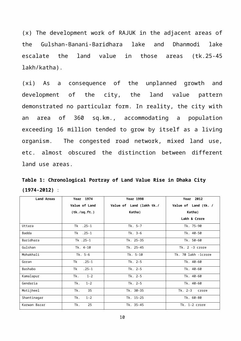
(x) The development work of RAJUK in the adjacent areas of
the Gulshan-Banani-Baridhara lake and Dhanmodi lake
escalate the land value in those areas (tk.25-45
lakh/katha).
(xi) As a consequence of the unplanned growth and
development of the city, the land value pattern
demonstrated no particular form. In reality, the city with
an area of 360 sq.km., accommodating a population
exceeding 16 million tended to grow by itself as a living
organism. The congested road network, mixed land use,
etc. almost obscured the distinction between different
land use areas.
Table 1: Chronological Portray of Land Value Rise in Dhaka City
(1974-2012) : Land Areas Year 1974
Value of Land
(tk./sq.ft.)
Year 1998
Value of Land (lakh tk./
Katha)
Year 2012
Value of Land (tk. /
Katha)
Lakh & Crore
Uttara Tk .25-1 Tk. 5-7 Tk. 75-90
Badda Tk .25-1 Tk. 3-6 Tk. 40-50
Baridhara Tk .25-1 Tk. 25-35 Tk. 50-60
Gulshan Tk. 4-10 Tk. 25-45 Tk. 2 -3 crore
Mohakhali Tk. 5-6 Tk. 5-10 Tk. 70 lakh -1crore
Goran Tk .25-1 Tk. 2-5 Tk. 40-60
Bashabo Tk .25-1 Tk. 2-5 Tk. 40-60
Kamalapur Tk. 1-2 Tk. 2-5 Tk. 40-60
Gendaria Tk. 1-2 Tk. 2-5 Tk. 40-60
Motijheel Tk. 35 Tk. 30-35 Tk. 2-3 crore
Shantinagar Tk. 1-2 Tk. 15-25 Tk. 60-80
Karwan Bazar Tk. 25 Tk. 35-45 Tk. 1-2 crore
10
Shamoly Tk. 1-2 Tk. 5-7 Tk. 50-70
DOHS Tk .25-1 Tk.25-30 Tk. 70 lakh -1 crore
Banani Tk .25-1 Tk. 35-45 Tk. 2-3 crore
Mirpur Tk. 4-10 Tk. 5-8 Tk. 50-70
Kallayanpur Tk .25-1 Tk. 5-8 Tk. 40-60
Mohammadpur Tk. 4-10 Tk. 3-5 Tk. 60-80
Lalmatia Tk. 1-2 Tk. 3-5 Tk. 60-80
Dhanmondi Tk. 4-10 Tk. 25-30 Tk. 1-2 crore
Azimpur Tk. 25-30 Tk. 10-15 Tk. 70 lakh -1crore
Uttar Khan &
Dakshin Khan
Tk .25-1 Tk. 3-6 Tk. 25-40
Source: Khan, 1974, Ahmad, 1998, & Present Study, 2013 **1.The Land Value of the year 1998 & 2012 has been collected from main three sources,
like- landowners, developers, and secondary sources ,such as newspaper, internet,&
articles.
*2.The Land value shown in the study of some areas like- Gulshan, Baridhara, Banani,
Dhanmondi, Lalmatia, Azimpur, Mirpur, Mohammadpur,etc. is the average of the residential
and commercial land plots.
*3.The mixed land use pattern of nearly all the areas of Dhaka city, and the current
practice of selling apartments in terms of tk/sq.feet made it complicated to identify the
actual value of the land.
C) Land Value Characteristics in Dhaka City: 2012
i) The difference between the central and peripheral land value in
the recent years were very little as numerous developers, both
public and private, along with RAJUK, developed urban structures
like- housing plots,apartments, roads & transport, gas, water,
electricity, etc. uncompromisingly in all directions to accommodate
the constantly growing residential inhabitants, which emerged as
huge profit business as well. This motivated the manifold raise in
land value. Actually, the land value demanded for a piece of land
has become one’s personal desires. The value fixed by the government
is not followed in any area of the city. However, Map 3 shows a
pattern of land value in the recent years.
11
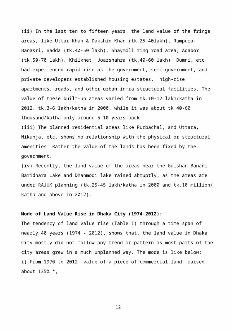
(ii) In the last ten to fifteen years, the land value of the fringe
areas, like-Uttar Khan & Dakshin Khan (tk.25-40lakh), Rampura-
Banasri, Badda (tk.40-50 lakh), Shaymoli ring road area, Adabor
(tk.50-70 lakh), Khilkhet, Joarshahra (tk.40-60 lakh), Dumni, etc.
had experienced rapid rise as the government, semi-government, and
private developers established housing estates, high-rise
apartments, roads, and other urban infra-structural facilities. The
value of these built-up areas varied from tk.10-12 lakh/katha in
2012, tk.3-6 lakh/katha in 2000, while it was about tk.40-60
thousand/katha only around 5-10 years back.
(iii) The planned residential areas like Purbachal, and Uttara,
Nikunja, etc. shows no relationship with the physical or structural
amenities. Rather the value of the lands has been fixed by the
government.
(iv) Recently, the land value of the areas near the Gulshan-Banani-
Baridhara Lake and Dhanmodi lake raised abruptly, as the areas are
under RAJUK planning (tk.25-45 lakh/katha in 2000 and tk.10 million/
katha and above in 2012).
Mode of Land Value Rise in Dhaka City (1974-2012):
The tendency of land value rise (Table 1) through a time span of
nearly 40 years (1974 - 2012), shows that, the land value in Dhaka
City mostly did not follow any trend or pattern as most parts of the
city areas grew in a much unplanned way. The mode is like below:
i) From 1970 to 2012, value of a piece of commercial land raised
about 135% *,
12
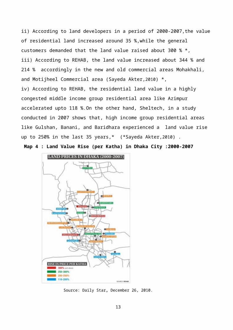
ii) According to land developers in a period of 2000-2007,the value
of residential land increased around 35 %,while the general
customers demanded that the land value raised about 300 % *,
iii) According to REHAB, the land value increased about 344 % and
214 % accordingly in the new and old commercial areas Mohakhali,
and Motijheel Commercial area (Sayeda Akter,2010) *,
iv) According to REHAB, the residential land value in a highly
congested middle income group residential area like Azimpur
accelerated upto 118 %.On the other hand, Sheltech, in a study
conducted in 2007 shows that, high income group residential areas
like Gulshan, Banani, and Baridhara experienced a land value rise
up to 250% in the last 35 years,* (*Sayeda Akter,2010) .
Map 4 : Land Value Rise (per Katha) in Dhaka City :2000-2007
Source: Daily Star, December 26, 2010.
13
However, the city, with an area of 360 sq. km. and population of
around 14.6 million, tends to grow by itself as a living being,
coping to accommodate a large number of people migrating from all
parts of the country, mainly for socio-economic, commercial and
educational purposes. As a consequence, it experiences heavily
congested roads & highways, high rise structures, heavy traffic,
extreme level of environmental pollution, and very indistinctly
demarcated and mixed type of land use, etc.
Influence of Land Value on City Environment:
From the early 80s, the already densely inhabited Dhaka city
experienced high economic growth accompanied by rapid urbanization.
Consequently, the huge influx of population accelerated the need for
supply of food, shelter, transport, education, residential land
plots, and the basic environmental healthiness for the city
dwellers. The high demand of land for various reasons increased the
value of land manifolds making the land owners and the developers
greedy to get a high profit from the land sector. Almost all the
unused and underused lands like, agricultural, open lands, vacant
lands, play ground & fields, low lying marshy lands, khals, river
banks, etc. are being encroached by the land traders to sell or
develop land by the earth filling process. The whole procedure of
acquiring, grabbing, selling or even developing land is mostly being
done illegally. Accordingly, deterioration in every aspect of city
environment like-air, water, soil, and biodiversity has become a
common scenario. The main sectors of the city environment, where
deterioration occurred are stated below:
1. Loss of Agricultural Land:
14
Due to the excessive pressure upon land, agricultural land has been
turned into residential plots in an accelerating rate. A study shows
that, during the period from 1991-2008, net loss of agricultural
land was 14.59%, while vegetation had a net loss of 16.92% area in
Dhaka city. (Source: Islam & Ahmed, 2011).
2. Loss of Water bodies & Wet Lands:
After occupying the high lands of Dhaka city’s central part, the low
lying water bodies and marshy lands on both side of the city was
occupied by all category of land developers. A study shows that,
there has been a loss of 23.57% of wet/lowlands and a gain of
24.85% with a net gain of 1.28% (1991-2008). The same study shows
that, there was no gain in the area of water bodies during the
periods 1991-2008, but the area lost 10.27% in that period. (Islam
& Ahmed, 2011). Only 13 khals of the previous 35 khals of Dhaka city
exists now as the others were land filled for providing plots.
3. Groundwater Overexploitation:
In Dhaka city, about 82% of the city's water supply is abstracted
from groundwater through 577 deep tube wells, while four relatively
small surface water treatment plants provide the remaining 18%. The
over exploitation of groundwater caused the water level drop by two
to three meters every year. The city’s water table has sunk by 50
meters in the past four decades and the closest underground water is
now over 60 meters below ground level. An estimation shows that, by
2015, an acute shortage of water supply would occur if groundwater
abstraction is not reduced. However, in 2012, ECNEC
(Executive Committee of National Economic Council,Bangladesh)
decided to develop a new well field with 46 wells providing 150,000
cubic meters of water per day by DWASA (OOSKAnews, 19 October 2012).
15
4. Loss of Open / Green spaces:
The first Master Plan of Dhaka (1958) suggested that, there should
be at least 480 hectors of open space in Dhaka city for a better
city environment. However, the open space of the city decreased to
318 hectors in 1978 (Minoprio,Spencley & Macfarlane,1959),21% of the
total area of Dhaka city was of open landscape type (Rahman,1998)
and recently it is feared that the city contains less than 60
hectors of open space (Dhaka City State of Environment,2005).The
rapidly diminishing green areas, such as the parks and playgrounds
are encroached upon illegally both by the land developers as well as
the poor rootless people. Likewise, the open spaces once found
around the government quarters in Azimpur, Sobhanbag and Mirpur has
been occupied by new buildings erected to make room for more
government officials.
Vegetation:
Vegetation is natural store of carbon and source of oxygen. Presence
of vegetation in significant amount in urban area is helps to reduce
sound and air pollution since leaves of trees make a huge surface
area for settling down of dust particles and absorption of noise.
Vegetation abundance influences environmental conditions and energy
fluxes by selective reflection and absorption of solar radiation, by
modulation of evapotranspiration and by sequestration of pollutants.
Ecosystem services such as fresh air generation, maintenance of
local hydrogeology for perpetuation of fresh water supply and
balancing the temperature for the dwellers depend on the amount and
quality of green spaces (Mahfujur Rahman, 2009) .The loss of green
and /or open spaces of Dhaka city has a dreadful impact upon the
city environment as the above mentioned natural procedures of
16
maintaining a healthy ecosystem has been disrupted by over
exploitation of these lands.
5. Increase in Air Pollution / Temperature rise:
Over use of land in Dhaka city not only enhances the chance of both
indoor and outdoor air pollution and rise in temperature as well.
The increasing rate of urbanization results into high rise
apartments- poorly ventilated, congested and suffocating, roads over
flown by traffic-exhausting toxic fumes, fully concrete grounds–
accelerating the air temperature, 1,000 brick kilns, dust from roads
and construction sites , and toxic fumes from industrial sites are
major sources of air pollution
which is turned the city into a heat island.,
According to the Department of Environment (DoE), the density of
airborne particulate matter (PM) reaches 463 micrograms per cubic
meter (mcm) in the city during December-March period –which is
measured as the highest level in the world. An estimated 15,000
premature deaths, as well as several million cases of pulmonary,
respiratory and neurological illness are attributed to poor air
quality in Dhaka, according to the Air Quality Management Project
(AQMP), funded by the government and the World Bank. The phasing out
of petrol-driven two-stroke auto-rickshaws in 2003 and their
replacement with four-stroke versions, which use a much cleaner
burning fuel (compressed natural gas), significantly decreased the
volume of air contaminants. But, according to DoE sources, a sharp
increase in the number of vehicles and construction sites after the
2000s led to a declination of Dhaka city’s air quality (Shohagh &
Tapas,2009).
17
Measures have to be taken to stop further contamination of the
natural environment and find the processes of mitigation of the
damages already done to the city. Otherwise, excessive effluence
emitted from the traffic, industries, sewerage, household garbage,
heat generated from the brick-roads, vehicles, electronics, like-air
conditioners, excessive extraction of ground water, etc. will bring
destruction in the total ecosystem of the city. For that reason,
existing city environment condition has to be restored and
refurbished and the sustainability of the city’s future environment
has to be confirmed.
Fig.1: Three Basic Components of City Environment
Source: Present Study, 2013
While planning for the city in future, the planners must be concern
about avoiding further damage in the three spheres of the city
environment, such as-land, water, and air.
Ways to Mitigate the Deterioration:
1. Conserve the existing agricultural land in the fringe areas of
the city,
2. Prevent further exploitation of water bodies & wet lands,
3. Regulate groundwater overexploitation,
4. Mitigate the loss and exploitation of open / green spaces, and
5. Control the increase in air pollution and temperature rise.
Conclusion:
18
Tremendous pressure of continually growing population, escalating
economic activities, and comparatively greater investment in land
and housing considering it a secure sector, resulted into towering
demand for land for housing, industrial, commercial activities, road
construction, etc. The continuous high demand of land and poor
governance of the law enforcing agencies and planners helped to
create a new business sector of land and housing. In this sector,
both legally and illegally all types of land, water bodies, rivers
and khals is being grabbed and sold at excessive value. To ensure
the existence of the city an integrated management planning has to
be taken and implied.
Reference:
Dhaka Metropolitan Development Plan:1995-2015,DMDP Project, RAJUK,Dhaka,1993.
Dhaka City State of Environment:2005, Department of Environment, Ministry of Environment & Forest,Bangladesh,2003. Geddes, Patrick (1917), Report on Dacca City Planning: 1917 (translated by Abdul Mohaimen),Dhaka City Museum,Dhaka,1990.
Khan,A.M.M.Amanatullah (1975),Land Value Pattern in Dhaka City, The Oriental Geographer,Vol. ix & xx, No.1&2, The Bangladesh Geographical Society, Department of Geography, University of Dhaka, Dhaka.
Mahfujur Rahman,Preserving Green Spaces in Dhaka city, The Daily Star, Saturday,3rd October,2009.http://archive.thedailystar.net/newDesign/archive.php?date=2009-10-03
Md. Shahidul Islam & Raquib Ahmed (2011), Land use change predictionin Dhaka city using GIS aided Markov Chain Modeling, Journal of Life Earth Science, Vol.6: 81-89, ISSN 1990-4827
19
Institute of Environmental Science, University of Rajshahi, Rajshahi.
http://banglajol.info.index.php/JLES © 2011, JLES, RU
Minoprio, Spencley & Macfarlane (1959), Master Plan for Dacca:1959, Dacca Improvement Trust (D.I.T.), Dhaka.
OOSKAnews, 19 October 2012, Water_management_in_Dhaka, report on Bangladesh's Executive Committee of National Economic Council (ECNEC),16 October, 2012.http://en.wikipedia.org/wiki/Water_management_in_Dhaka
RISE Society, A look into Dhaka, Bangladesh: The most densely populated city in the world, Initiative for Social Equity Society, RISE Society, March 9, 2013.http://risebd.com/2013/03/09/a-look-into-dhaka-bangladesh-the-most-densely-populated-city-in-the-world/
Saima Ahmad (2007), Geomorphological Control Over Land Value & Land Utilization in Dhaka City: A Study in Applied Geomorphology, unpublished M.Phil Thesis, Dept. of Geography & Environment, University of Dhaka, Dhaka.
1. Sayeda Akter, (2010), Where to Live: Behind soaring land prices, The Daily Star, 14th November,2013.http://archive.thedailystar.net/newDesign/news-details.php?nid=167371
Shohagh,Md. & Tapas,(2009), Air pollution in Dhaka,Department of Geography & Environmental Studies, University of Chittagong, The Daily Star, Thursday,7th November,2013.http://bangladeshenvironment.com/index.php/polution-s/air-polution/286-air-pollution-in-dhaka
Taylor, James (1840), Topography of Dacca, (Translated by Md.Asaduzzaman titled Kompani Amala Dhaka), Bangla Academy, 1993.
Ziaur Rahman (1998), A Study of Open Spaces in Dhaka City, unpublished B.Sc. Thesis,
20
Department of Environmental Studies, North South University, Dhaka.
___________________________
AuthorSaima AhmadAssistant Professor, Geography & Environment,School of Social Sciences Humanities & Languages,Bangladesh Open University, Gazipur 1705.
21