growth - asian online journal publishing group
TRANSCRIPT
Growth Vol. 1, No. 1, 10-17, 2014
http://asianonlinejournals.com/index.php/Growth
* Corresponding Author
10
Geographical Determinants of the Structural and
Functional Growth of Damaturu Town in Yobe State,
Nigeria
Ahmed AbubakarJajere1*
--- Ibrahim Jaro Musa2 --- Muhammad Isma’il
3
1Department of Geography, Umar Sulaiman College of Education, Gashua
2,3Department of Geography, Ahmadu Bello University, Zaria
Abstract
This work is licensed under a Creative Commons Attribution 3.0 License
Asian Online Journal Publishing Group
Contents 1. Introduction ............................................................................................................................................................................... 11
2. The Area of Study ..................................................................................................................................................................... 11
3. Methodology .............................................................................................................................................................................. 12
4. Results and Discussion .............................................................................................................................................................. 13
5. Conclusion .................................................................................................................................................................................. 17
References ...................................................................................................................................................................................... 17
Damaturu town became the capital of Yobe State when the state was created in 1991. Since then, the
town has been experiencing rapid changes in the landuse/landcover types due to urban expansion,
economic development, and social transformation in the town. This study examined the geographical
determinants of the growth of Damaturu town from 1986 to 2009. The satellite imageries of
Damaturu were obtained processed and analysed using Remote Sensing and Geographic Information
System techniques to determine the growth rate of the town within the period of study. This was
complemented with the information acquired from the field survey to achieve the objectives of the
study. Findings revealed that within this period (1991-1999), Damaturu built-up area increased about
four times while the urban area increased more than four times. This significant growth was
influenced by the location of the administrative offices and housing estates at the periphery of the
town, categorisation of the land into administrative, residential, commercial, and industrial areas; as
well as the transportation network and substantial population growth within the period. The most
influential change within the second period (1999-2005) was increased agriculture and significant
urban expansion. Within the current period (2005-2009), the urban area expanded by about 22Km2.
This remarkable expansion of urban area is responsible for the significant reduction of more than
two-third of Damaturu wetland and significant reduction of shrub land. The geographical
determinants of change within the period is the location of the State University, the construction of
over 1000 housing units at Gujba and Gashua roads, as well as the relocation of other government
ministries and agencies far away from the centre of Damaturu town. Besides, the structural growth of
the town within this period engulfed four nearby villages. This study demonstrated the role of
Remote Sensing and GIS techniques in understanding the dynamics of urban growth. Therefore, GIS
should be employed for continuous monitoring and management of landuse change in the town to
control development.
Keywords: Geography, Structural change, Functional change, Remote sensing, GIS Model.
Growth, 2014, 1(1): 10-17
11
1. Introduction Urban growth results from complex dynamic interactions between the spatial, socioeconomic and physical
systems (Cheng and Masser, 2003) which lead to structural and functional changes in towns and cities. Urbanization
brings about landuse change (Rimal, 2011) and triggers socioeconomic transformation which sets in natural
ecosystem imbalance manifesting in environmental pollution and climate change. Change in land use patterns has
implication on local environmental conditions as well as human, economic and social welfare as it affects
environmental sustainability. The determinants of landuse change vary from one geographical location to the other.
Therefore, an understanding of the peculiar determinants of landuse change in an area is necessary to guide informed
urban and regional planning to attain sustainable development. One of the challenges faced in urban development
especially among developing countries is urban sprawl which is an unplanned inconsistent expansion of urban area
into the surrounding countryside or periphery. The magnitude and consequences of urban sprawl differ from one
country to the other because it depends on availability and productivity of land resources as well as the level of
development in an area (Alabi, 2009). Urban sprawl affects the structural growth and economic system of an area as
it affects administrative planning, planning for utilities and infrastructure, provision and distribution of services,
accessibility and travelling distance within the city. The current trend of urbanization in developing countries requires considerable attention not only as a basis for
transformation of societies in the developing countries but also for sustainable development. (Lwasa) (n.d) observed
that several factors such as demographic change and economic transformation policies influence the urban growth of
Kampala. These have led to the proliferation of informal sector which is different from developed countries and
significant in employment generation within the city.
Moreover, Igbokwe (2006) utilized satellite image data (NigeriaSat-1) to examine the growth of major urban
centres in parts of Southeastern Nigeria. The study also included spatial characterisation of essential growth features
of these cities by comparing the generated maps with existing topographic maps of the areas. It was found that the
urban areas in southeastern Nigeria have been growing at a very fast rate. Results showed that between 1965 and
2004, the cities (Awka, Onitsha and Nnewi) experienced different annual rates of growth. The study also observed
that the expansions have completely overstretched the urban infrastructures within the cities.
Abiodun et al. (2011) observed that Lagos is growing at an unprecedented rate that requires constant monitoring. He
reported that many parts of Lagos especially the suburbs have witnessed great urban sprawl in recent times spreading
fast into the neighbouring states. Therefore, they recommended the need to critically study and understand the pattern
of growth and possible checks in to avoid possible negative results.
Similarly, Adedokun (2011) analysed the spatial pattern of activities in Ilorin city of northcentral Nigeria. He
classified the economic activities within the city into educational, artisan/technician, commercial, and civil
service/administration, financial and other services. Of these activities, those connected with education was found to
be dominant while financial activities occupied the lowest position.His findings showed that the activities were fixed
in space and that there is no significant linkage between the activities. The study also found that spatial structure of
activity in Ilorin is different from what obtains in Western cities where there is strict zonation in the usage of space.
Yobe State was created in 1991 with Damaturu as the capital city. Twenty three years after the creation of Yobe
State, Damaturu town has experienced profound growth in economic activities coupled with development of
infrastructure to meet the need of the growing population. The population growth is as a result of migration of the
staff of federal agencies and ministries, traders and other people to the new capital from Old Borno. Consequently,
this leads to expansion of Damaturu town to engulf nearby villages resulting to changes in landuse and rural
economy especially along the highways and in the immediate vicinity of the town. This dispersed development
outside the traditional settlement of Damaturu along highways and rural countryside is devoid of basic amenities due
to the fact that the development is unplanned. Daura et al. (2006) studied the problems of Damaturu urban
development focusing on the growth of residential neighbourhoods. Besides, Mamudo (2009) reviewed Damaturu
developmental plan of 1992 with a focus on conformity analysis. However, dynamics of Damaturu urban growth
needs to be properly understood for proper urban and regional planning to attain sustainable economic growth and
development of the city.The focus of this study is to examine the geographical factors responsible for the structural
and functional changes within the Damaturu town for effective planning, land management, and sustainable urban
development.
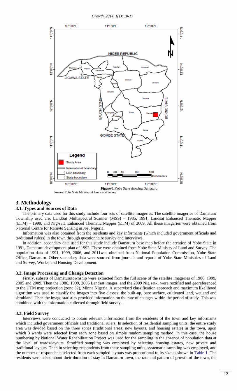
2. The Area of Study Damaturu is located between latitude 11
0 39’ 30’’ – 11
0 47’ 00’’ N and longitude 11
0 54’ 00’’ – 12
0 02’ 00’’E as
shown in Figure 1. The town has been the district headquarters of the then Borno province. It was later made the
headquarters of Damaturu Local Government in 1976, and in 1991 it became the capital of Yobe State in
northeastern Nigeria. The town covers a land area of 206,241Km2. Damaturu was founded in 1813 and it is multi-
ethnic with the Fulani and Kanuri as the dominant ethnic groups. Others are the Hausas, Karai-Karai, Bade and other
minority tribes of the state. With the creation of Yobe state in 1991, a growing number of Igbo and Yoruba from
southern Nigeria migrated there. Tivs and other southern tribes are also found as traders and public servants in
Damaturu town.
According to the 1991 census of the National Population Commission, the population of Damaturu was 30,970.
The population increased to 39,233 in the year 2000. It was estimated at 48,014persons according to 2006 census,
and the population of Damaturu increased to 69,952 in 2010. The landuse and landcover of Damaturu consist of
settlements, agricultural activities such as farming and animal rearing, and public structures such as schools, offices,
road and markets etc. Being the administrative centre of the state, it is inhabited majorly by civil servants and traders.
Growth, 2014, 1(1): 10-17
12
Figure-1.Yobe State showing Damaturu
Source: Yobe State Ministry of Lands and Survey
3. Methodology 3.1. Types and Sources of Data
The primary data used for this study include four sets of satellite imageries. The satellite imageries of Damaturu
Township used are: LandSat Multispectral Scanner (MSS) – 1985, 1991, Landsat Enhanced Thematic Mapper
(ETM) – 1999, and Nig-sat1 Enhanced Thematic Mapper (ETM) of 2009. All these imageries were obtained from
National Centre for Remote Sensing in Jos, Nigeria.
Information was also obtained from the residents and key informants (which included government officials and
traditional rulers) in the town through questionnaire survey and interviews.
In addition, secondary data used for this study include Damaturu base map before the creation of Yobe State in
1991, Damaturu development plan of 1992. These were obtained from Yobe State Ministry of Land and Survey. The
population data of 1991, 1999, 2006, and 2011was obtained from National Population Commission, Yobe State
Office, Damaturu. Other secondary data were sourced from journals and reports of Yobe State Ministries of Land
and Survey, Works, and Housing Development.
3.2. Image Processing and Change Detection Firstly, subsets of Damaturutownship were extracted from the full scene of the satellite imageries of 1986, 1999,
2005 and 2009. Then the 1986, 1999, 2005 Landsat images, and the 2009 Nig sat-1 were rectified and georeferenced
to the UTM map projection (zone 32), Minna Nigeria. A supervised classification approach and maximum likelihood
algorithm was used to classify the images into five classes: the built-up, bare surface, cultivated land, wetland and
shrubland. Then the image statistics provided information on the rate of changes within the period of study. This was
combined with the information collected through field survey.
3.3. Field Survey Interviews were conducted to obtain relevant information from the residents of the town and key informants
which included government officials and traditional rulers. In selection of residential sampling units, the entire study
area was divided based on the three zones (traditional areas, new layouts, and housing estate) in the town, upon
which 3 wards were selected from each zone based on simple random sampling method. In this case, the house
numbering by National Water Rehabilitation Project was used for the sampling in the absence of population data at
the level of wards/layouts. Stratified sampling was employed by selecting housing estates, new private and
traditional layouts. Then in selecting respondents from these sampling units, systematic sampling was employed, and
the number of respondents selected from each sampled layouts was proportional to its size as shown in Table 1. The
residents were asked about their duration of stay in Damaturu town, the rate and pattern of growth of the town, the
Growth, 2014, 1(1): 10-17
13
structural and functional changes within the town, the problems of urban planning policies of Damaturu town, as
well the solutions to the problems.
Table-1. Sampling frame for Damaturu residents
S/No Strata Sampled wards No of houses Sample size Total sample size per zone
1 Traditional
Areas
Ajiyari Ward
Abasha Ward
Nayi-nawa Ward
305
209
409
29
24
36
89
2 New Layouts SabonPegi Ward
Kiri-Kasama Ward
Nasarawa Ward
361
Nil
Nil
32
32
32
96
3 Housing
Estates
Nyanya
Waziri Ibrahim
Ben-kalio
440
250
130
44
27
13
84
The key informants included a total of 20 respondents from various departments of Ministry of Land and Survey.
The departments included town planning, survey and land administration. In addition to this, traditional rulers in the
area were also interviewed. The selection of these respondents was through purposive sampling technique. The key
informants were asked about the evolution of Damaturu town, the nature of Damaturu urban growth before and after
1991, the factors responsible for the growth of Damaturu, and the urban development problems in Damaturu town.
They were also asked to proffer solutions to these problems.
4. Results and Discussion Damaturu urban growth passed through different stages starting before the creation of Yobe State in 1991, the
emergence of the town as capital city up to the present stage of development. This is presented in the following
sections:
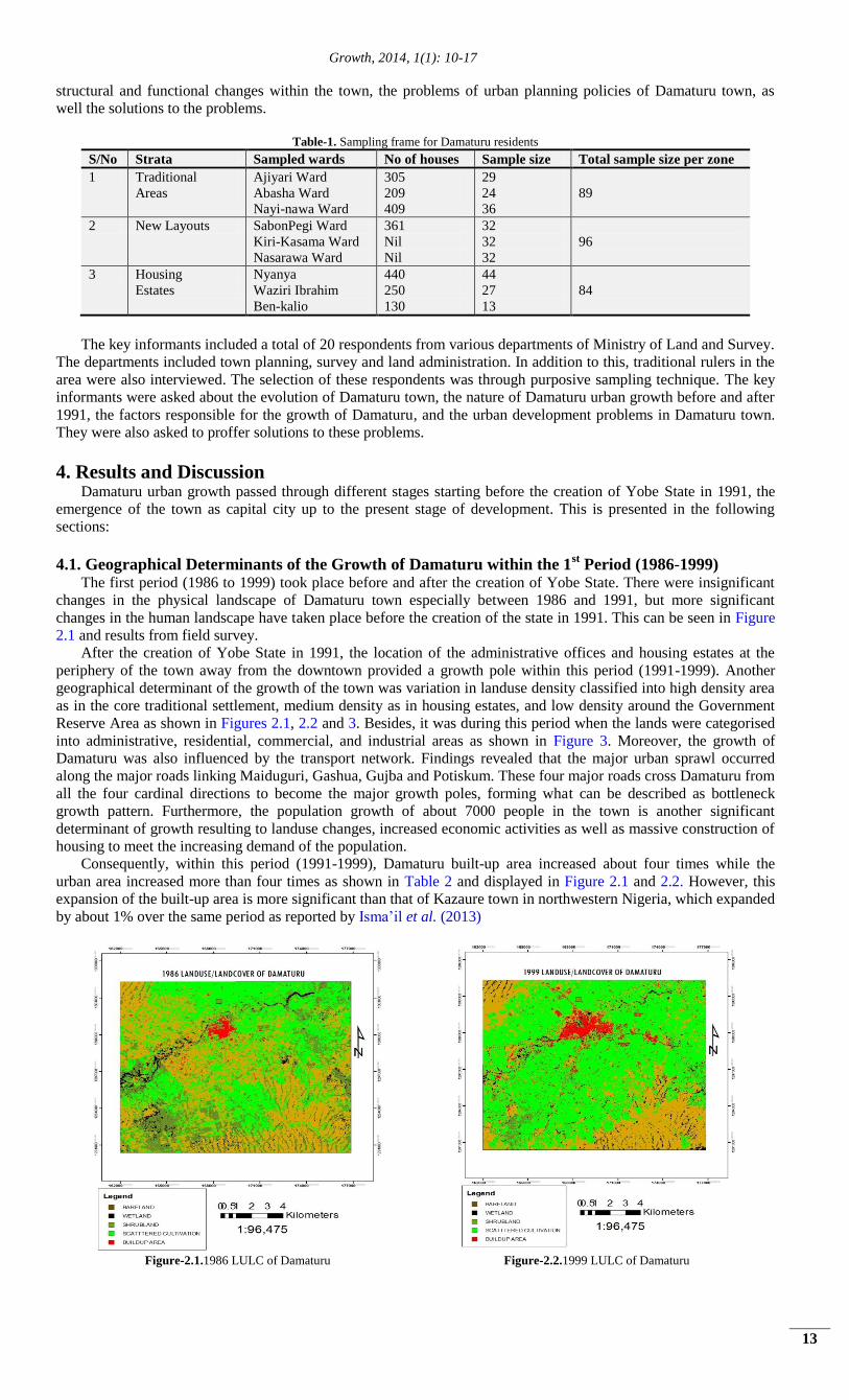
4.1. Geographical Determinants of the Growth of Damaturu within the 1st Period (1986-1999)
The first period (1986 to 1999) took place before and after the creation of Yobe State. There were insignificant
changes in the physical landscape of Damaturu town especially between 1986 and 1991, but more significant
changes in the human landscape have taken place before the creation of the state in 1991. This can be seen in Figure
2.1 and results from field survey.
After the creation of Yobe State in 1991, the location of the administrative offices and housing estates at the
periphery of the town away from the downtown provided a growth pole within this period (1991-1999). Another
geographical determinant of the growth of the town was variation in landuse density classified into high density area
as in the core traditional settlement, medium density as in housing estates, and low density around the Government
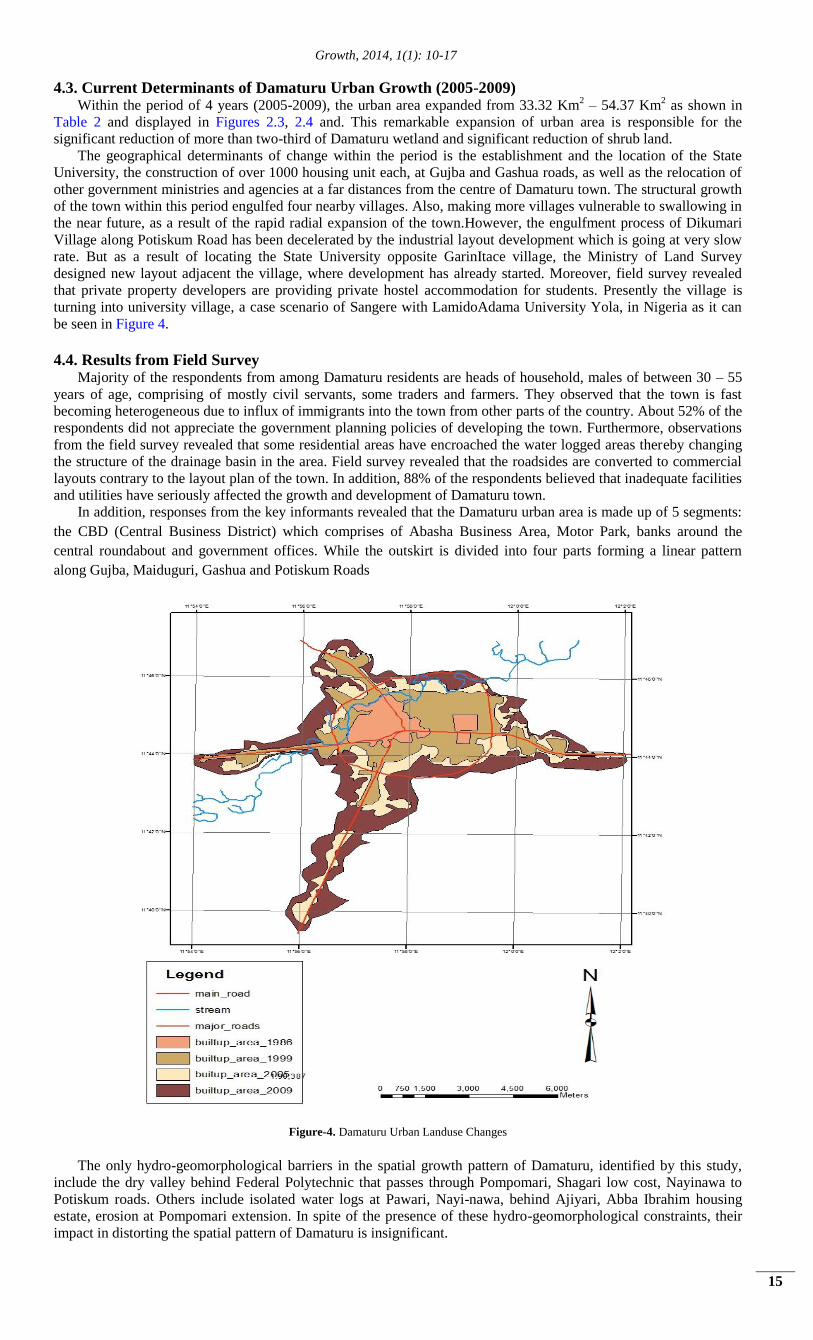
Reserve Area as shown in Figures 2.1, 2.2 and 3. Besides, it was during this period when the lands were categorised
into administrative, residential, commercial, and industrial areas as shown in Figure 3. Moreover, the growth of
Damaturu was also influenced by the transport network. Findings revealed that the major urban sprawl occurred
along the major roads linking Maiduguri, Gashua, Gujba and Potiskum. These four major roads cross Damaturu from
all the four cardinal directions to become the major growth poles, forming what can be described as bottleneck
growth pattern. Furthermore, the population growth of about 7000 people in the town is another significant
determinant of growth resulting to landuse changes, increased economic activities as well as massive construction of
housing to meet the increasing demand of the population.
Consequently, within this period (1991-1999), Damaturu built-up area increased about four times while the
urban area increased more than four times as shown in Table 2 and displayed in Figure 2.1 and 2.2. However, this
expansion of the built-up area is more significant than that of Kazaure town in northwestern Nigeria, which expanded
by about 1% over the same period as reported by Isma’il et al. (2013)
Figure-2.1.1986 LULC of Damaturu Figure-2.2.1999 LULC of Damaturu
Growth, 2014, 1(1): 10-17
14
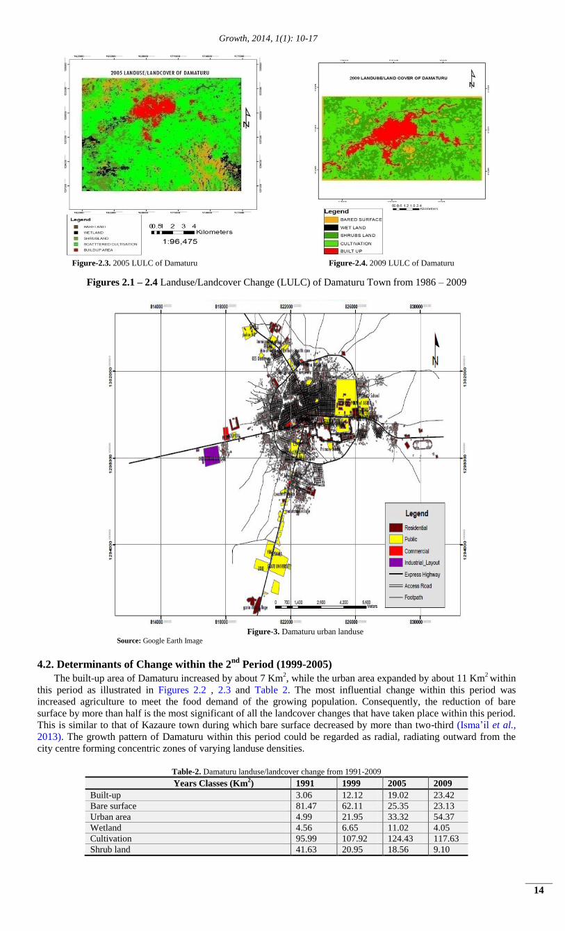
Figure-2.3. 2005 LULC of Damaturu Figure-2.4. 2009 LULC of Damaturu
Figures 2.1 – 2.4 Landuse/Landcover Change (LULC) of Damaturu Town from 1986 – 2009
Figure-3. Damaturu urban landuse
Source: Google Earth Image
4.2. Determinants of Change within the 2nd
Period (1999-2005)
The built-up area of Damaturu increased by about 7 Km2, while the urban area expanded by about 11 Km
2 within
this period as illustrated in Figures 2.2 , 2.3 and Table 2. The most influential change within this period was
increased agriculture to meet the food demand of the growing population. Consequently, the reduction of bare
surface by more than half is the most significant of all the landcover changes that have taken place within this period.
This is similar to that of Kazaure town during which bare surface decreased by more than two-third (Isma’il et al.,
2013). The growth pattern of Damaturu within this period could be regarded as radial, radiating outward from the
city centre forming concentric zones of varying landuse densities.
Table-2. Damaturu landuse/landcover change from 1991-2009
Years Classes (Km2) 1991 1999 2005 2009
Built-up 3.06 12.12 19.02 23.42
Bare surface 81.47 62.11 25.35 23.13
Urban area 4.99 21.95 33.32 54.37
Wetland 4.56 6.65 11.02 4.05
Cultivation 95.99 107.92 124.43 117.63
Shrub land 41.63 20.95 18.56 9.10
Growth, 2014, 1(1): 10-17
15
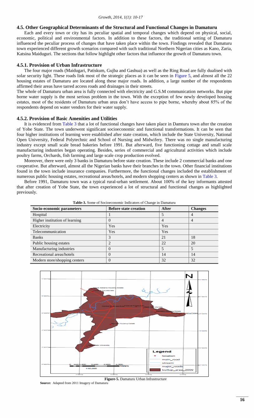
4.3. Current Determinants of Damaturu Urban Growth (2005-2009) Within the period of 4 years (2005-2009), the urban area expanded from 33.32 Km
2 – 54.37 Km
2 as shown in
Table 2 and displayed in Figures 2.3, 2.4 and. This remarkable expansion of urban area is responsible for the
significant reduction of more than two-third of Damaturu wetland and significant reduction of shrub land.
The geographical determinants of change within the period is the establishment and the location of the State
University, the construction of over 1000 housing unit each, at Gujba and Gashua roads, as well as the relocation of
other government ministries and agencies at a far distances from the centre of Damaturu town. The structural growth
of the town within this period engulfed four nearby villages. Also, making more villages vulnerable to swallowing in
the near future, as a result of the rapid radial expansion of the town.However, the engulfment process of Dikumari
Village along Potiskum Road has been decelerated by the industrial layout development which is going at very slow
rate. But as a result of locating the State University opposite GarinItace village, the Ministry of Land Survey
designed new layout adjacent the village, where development has already started. Moreover, field survey revealed
that private property developers are providing private hostel accommodation for students. Presently the village is
turning into university village, a case scenario of Sangere with LamidoAdama University Yola, in Nigeria as it can
be seen in Figure 4.
4.4. Results from Field Survey Majority of the respondents from among Damaturu residents are heads of household, males of between 30 – 55
years of age, comprising of mostly civil servants, some traders and farmers. They observed that the town is fast
becoming heterogeneous due to influx of immigrants into the town from other parts of the country. About 52% of the
respondents did not appreciate the government planning policies of developing the town. Furthermore, observations
from the field survey revealed that some residential areas have encroached the water logged areas thereby changing
the structure of the drainage basin in the area. Field survey revealed that the roadsides are converted to commercial
layouts contrary to the layout plan of the town. In addition, 88% of the respondents believed that inadequate facilities
and utilities have seriously affected the growth and development of Damaturu town. In addition, responses from the key informants revealed that the Damaturu urban area is made up of 5 segments:
the CBD (Central Business District) which comprises of Abasha Business Area, Motor Park, banks around the
central roundabout and government offices. While the outskirt is divided into four parts forming a linear pattern
along Gujba, Maiduguri, Gashua and Potiskum Roads
Figure-4. Damaturu Urban Landuse Changes
The only hydro-geomorphological barriers in the spatial growth pattern of Damaturu, identified by this study,
include the dry valley behind Federal Polytechnic that passes through Pompomari, Shagari low cost, Nayinawa to
Potiskum roads. Others include isolated water logs at Pawari, Nayi-nawa, behind Ajiyari, Abba Ibrahim housing
estate, erosion at Pompomari extension. In spite of the presence of these hydro-geomorphological constraints, their
impact in distorting the spatial pattern of Damaturu is insignificant.
Growth, 2014, 1(1): 10-17
16
4.5. Other Geographical Determinants of the Structural and Functional Changes in Damaturu Each and every town or city has its peculiar spatial and temporal changes which depend on physical, social,
economic, political and environmental factors. In addition to these factors, the traditional setting of Damaturu
influenced the peculiar process of changes that have taken place within the town. Findings revealed that Damaturu
town experienced different growth scenarios compared with such traditional Northern Nigerian cities as Kano, Zaria,
Katsina Maiduguri. The sections that follow highlight other factors that influence the growth of Damaturu town.
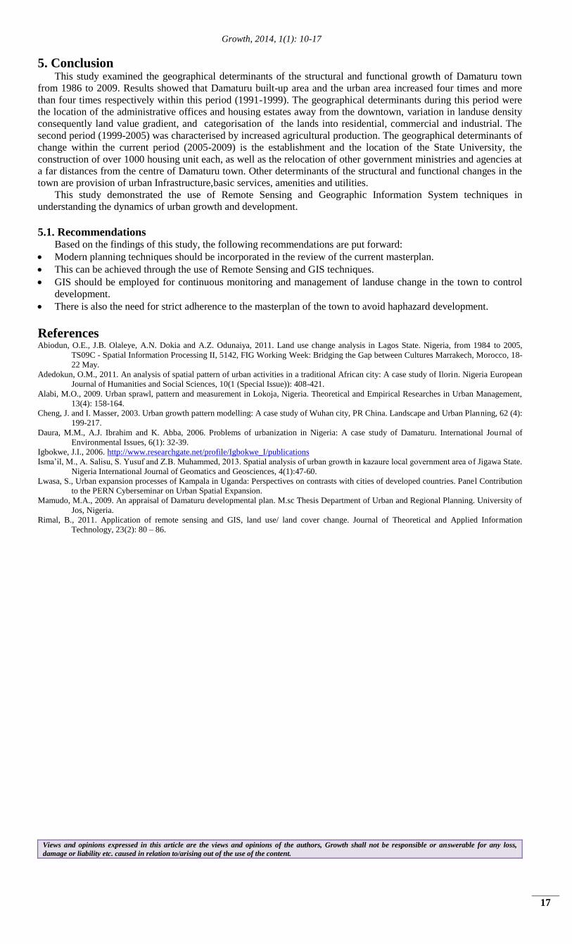
4.5.1. Provision of Urban Infrastructure The four major roads (Maidugari, Patiskum, Gujba and Gashua) as well as the Ring Road are fully dualised with
solar security light. These roads link most of the strategic places as it can be seen in Figure 5, and almost all the 22
housing estates of Damaturu are located along these major roads. In addition, a large number of the respondents
affirmed their areas have tarred access roads and drainages in their streets.
The whole of Damaturu urban area is fully connected with electricity and G.S.M communication networks. But pipe
borne water supply is the most serious problem in the town. With the exception of few newly developed housing
estates, most of the residents of Damaturu urban area don’t have access to pipe borne, whereby about 85% of the
respondents depend on water vendors for their water supply.
4.5.2. Provision of Basic Amenities and Utilities
It is evidenced from Table 3 that a lot of functional changes have taken place in Damturu town after the creation
of Yobe State. The town underwent significant socioeconomic and functional transformations. It can be seen that
four higher institutions of learning were established after state creation, which include the State University, National
Open University, Federal Polytechnic and School of Nursing and Midwifery. There was no single manufacturing
industry except small scale bread bakeries before 1991. But afterward, five functioning cottage and small scale
manufacturing industries began operating. Besides, series of commercial and agricultural activities which include
poultry farms, Orchards, fish farming and large scale crop production evolved.
Moreover, there were only 3 banks in Damaturu before state creation. These include 2 commercial banks and one
cooperative. But afterward, almost all the Nigerian banks have their branches in the town. Other financial institutions
found in the town include insurance companies. Furthermore, the functional changes included the establishment of
numerous public housing estates, recreational areas/hotels, and modern shopping centers as shown in Table 3.
Before 1991, Damaturu town was a typical rural-urban settlement. About 100% of the key informants attested
that after creation of Yobe State, the town experienced a lot of structural and functional changes as highlighted
previously.
Table-3. Some of Socioeconomic Indicators of Change in Damaturu
Socio-economic parameters Before state creation After Changes
Hospital 1 5 4
Higher institution of learning 0 4 4
Electricity Yes Yes
Telecommunication Yes Yes
Banks 3 21 18
Public housing estates 2 22 20
Manufacturing industries 0 5 5
Recreational areas/hotels 0 14 14
Modern store/shopping centers 0 32 32
Figure-5. Damaturu Urban Infrastructure
Source: Adapted from 2011 Imagery of Damaturu
Growth, 2014, 1(1): 10-17
17
5. Conclusion This study examined the geographical determinants of the structural and functional growth of Damaturu town
from 1986 to 2009. Results showed that Damaturu built-up area and the urban area increased four times and more
than four times respectively within this period (1991-1999). The geographical determinants during this period were
the location of the administrative offices and housing estates away from the downtown, variation in landuse density
consequently land value gradient, and categorisation of the lands into residential, commercial and industrial. The
second period (1999-2005) was characterised by increased agricultural production. The geographical determinants of
change within the current period (2005-2009) is the establishment and the location of the State University, the
construction of over 1000 housing unit each, as well as the relocation of other government ministries and agencies at
a far distances from the centre of Damaturu town. Other determinants of the structural and functional changes in the
town are provision of urban Infrastructure,basic services, amenities and utilities.
This study demonstrated the use of Remote Sensing and Geographic Information System techniques in
understanding the dynamics of urban growth and development.
5.1. Recommendations Based on the findings of this study, the following recommendations are put forward:
Modern planning techniques should be incorporated in the review of the current masterplan.
This can be achieved through the use of Remote Sensing and GIS techniques.
GIS should be employed for continuous monitoring and management of landuse change in the town to control
development.
There is also the need for strict adherence to the masterplan of the town to avoid haphazard development.
References Abiodun, O.E., J.B. Olaleye, A.N. Dokia and A.Z. Odunaiya, 2011. Land use change analysis in Lagos State. Nigeria, from 1984 to 2005,
TS09C - Spatial Information Processing II, 5142, FIG Working Week: Bridging the Gap between Cultures Marrakech, Morocco, 18-
22 May.
Adedokun, O.M., 2011. An analysis of spatial pattern of urban activities in a traditional African city: A case study of Ilorin. Nigeria European
Journal of Humanities and Social Sciences, 10(1 (Special Issue)): 408-421.
Alabi, M.O., 2009. Urban sprawl, pattern and measurement in Lokoja, Nigeria. Theoretical and Empirical Researches in Urban Management,
13(4): 158-164.
Cheng, J. and I. Masser, 2003. Urban growth pattern modelling: A case study of Wuhan city, PR China. Landscape and Urban Planning, 62 (4):
199-217.
Daura, M.M., A.J. Ibrahim and K. Abba, 2006. Problems of urbanization in Nigeria: A case study of Damaturu. International Journal of
Environmental Issues, 6(1): 32-39.
Igbokwe, J.I., 2006. http://www.researchgate.net/profile/Igbokwe_I/publications
Isma’il, M., A. Salisu, S. Yusuf and Z.B. Muhammed, 2013. Spatial analysis of urban growth in kazaure local government area of Jigawa State.
Nigeria International Journal of Geomatics and Geosciences, 4(1):47-60.
Lwasa, S., Urban expansion processes of Kampala in Uganda: Perspectives on contrasts with cities of developed countries. Panel Contribution
to the PERN Cyberseminar on Urban Spatial Expansion.
Mamudo, M.A., 2009. An appraisal of Damaturu developmental plan. M.sc Thesis Department of Urban and Regional Planning. University of
Jos, Nigeria.
Rimal, B., 2011. Application of remote sensing and GIS, land use/ land cover change. Journal of Theoretical and Applied Information
Technology, 23(2): 80 – 86.
Views and opinions expressed in this article are the views and opinions of the authors, Growth shall not be responsible or answerable for any loss,
damage or liability etc. caused in relation to/arising out of the use of the content.