geomorphology, site distribution, and paleolithic settlement dynamics of the ma'aloula region,...
TRANSCRIPT
Geomorphology, Site Distribution,
and Paleolithic Settlement Dynamics
of the Ma’aloula Region, Damascus
Province, Syria
Andrey E. Dodonov,1,* Andrew W. Kandel,2
Aleksandra N. Simakova,1 Mohammed al-Masri,3 and Nicholas J. Conard2
1Geological Institute, Russian Academy of Sciences, Pyzhevsky 7, 119017
Moscow, Russia2Department of Early Prehistory and Quaternary Ecology, University of
Tübingen, Schloss Hohentübingen, 72070 Tübingen, Germany3Directorate General of Antiquities and Museums, Department of Damascus
Province, Damascus, Syria
This survey of the geology, geomorphology, and Paleolithic archaeology of a 300 km2 area inDamascus Province, Syria, focused around the villages of Ma’aloula and Jaba’deen. The studyresulted in the definition of seven geomorphological zones that trend northeast–southwest, par-allel to the prevailing geological features of the region. The zones span a broad range of ele-vations, from a dry lake bed in the Jeiroud Basin (ca. 800 m) to the peaks of the Anti-LebanonMountains (ca. 2350 m). The research focused on assessing the geological and paleoenviron-mental history of the region as a backdrop for 500,000 years of Paleolithic settlement. Amongthe 618 archaeological sites documented thus far, all major archaeological periods from theLower Paleolithic through the Epipaleolithic are represented. Most abundant are occurrencesof the Levalloisian Middle Paleolithic, with 255 new sites documented. Nine Neolithic siteswere also included in the survey. The distribution of sites varies during the Paleolithic andreflects the availability of resources, especially of flint and water, as well as the spatial patternsof erosion and deposition on the ancient land surfaces. © 2007 Wiley Periodicals, Inc.
INTRODUCTION
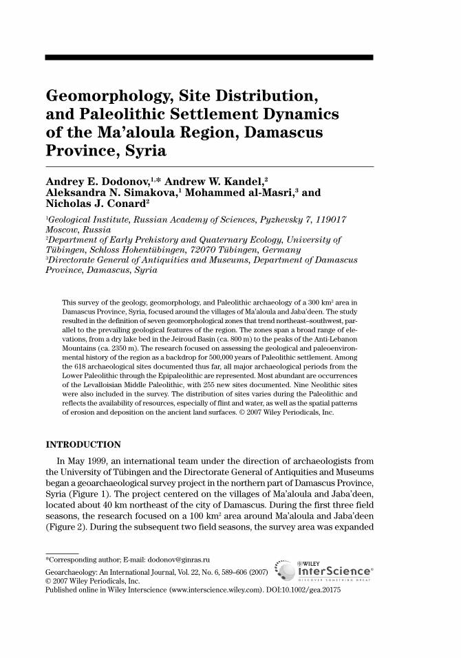
In May 1999, an international team under the direction of archaeologists fromthe University of Tübingen and the Directorate General of Antiquities and Museumsbegan a geoarchaeological survey project in the northern part of Damascus Province,Syria (Figure 1). The project centered on the villages of Ma’aloula and Jaba’deen,located about 40 km northeast of the city of Damascus. During the first three fieldseasons, the research focused on a 100 km2 area around Ma’aloula and Jaba’deen(Figure 2). During the subsequent two field seasons, the survey area was expanded
Geoarchaeology: An International Journal, Vol. 22, No. 6, 589–606 (2007)© 2007 Wiley Periodicals, Inc.Published online in Wiley Interscience (www.interscience.wiley.com). DOI:10.1002/gea.20175
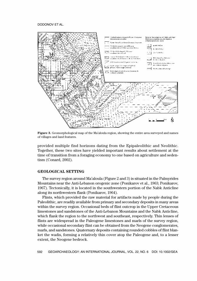
*Corresponding author; E-mail: [email protected]
GEA226_615_20175.qxd 6/14/07 1:37 PM Page 589
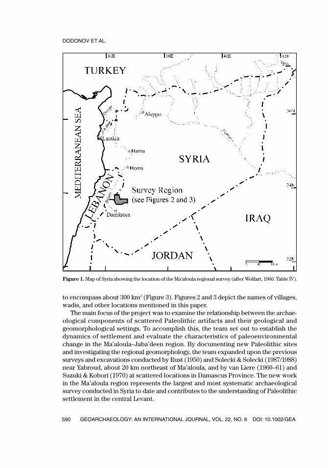
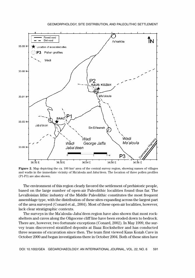
to encompass about 300 km2 (Figure 3). Figures 2 and 3 depict the names of villages,wadis, and other locations mentioned in this paper.
The main focus of the project was to examine the relationship between the archae-ological components of scattered Paleolithic artifacts and their geological andgeomorphological settings. To accomplish this, the team set out to establish thedynamics of settlement and evaluate the characteristics of paleoenvironmentalchange in the Ma’aloula–Jaba’deen region. By documenting new Paleolithic sitesand investigating the regional geomorphology, the team expanded upon the previoussurveys and excavations conducted by Rust (1950) and Solecki & Solecki (1987/1988)near Yabroud, about 20 km northeast of Ma’aloula, and by van Liere (1960–61) andSuzuki & Kobori (1970) at scattered locations in Damascus Province. The new workin the Ma’aloula region represents the largest and most systematic archaeologicalsurvey conducted in Syria to date and contributes to the understanding of Paleolithicsettlement in the central Levant.
DODONOV ET AL.
GEOARCHAEOLOGY: AN INTERNATIONAL JOURNAL, VOL. 22, NO. 6 DOI: 10.1002/GEA590
Figure 1. Map of Syria showing the location of the Ma’aloula regional survey (after Wolfart, 1966: Table IV).
GEA226_615_20175.qxd 6/14/07 1:37 PM Page 590
The environment of this region clearly favored the settlement of prehistoric people,based on the large number of open-air Paleolithic localities found thus far. TheLevalloisian lithic industry of the Middle Paleolithic constitutes the most frequentassemblage type, with the distribution of these sites expanding across the largest partof the area surveyed (Conard et al., 2004). Most of these open-air localities, however,lack clear stratigraphic contexts.
The surveys in the Ma’aloula–Jaba’deen region have also shown that most rock-shelters and caves along the Oligocene cliff line have been eroded down to bedrock.There are, however, two fortunate exceptions (Conard, 2002). In May 1999, the sur-vey team discovered stratified deposits at Baaz Rockshelter and has conductedthree seasons of excavation since then. The team first viewed Kaus Kozah Cave inOctober 2000 and began investigations there in October 2004. Both of these sites have
DOI: 10.1002/GEA GEOARCHAEOLOGY: AN INTERNATIONAL JOURNAL, VOL. 22, NO. 6
GEOMORPHOLOGY, SITE DISTRIBUTION, AND PALEOLITHIC SETTLEMENT
591
Figure 2. Map depicting the ca. 100 km2 area of the central survey region, showing names of villagesand wadis in the immediate vicinity of Ma’aloula and Jaba’deen. The location of three pollen profiles (P1-P3) are also shown.
GEA226_615_20175.qxd 6/14/07 1:37 PM Page 591
provided multiple find horizons dating from the Epipaleolithic and Neolithic.Together, these two sites have yielded important results about settlement at thetime of transition from a foraging economy to one based on agriculture and seden-tism (Conard, 2002).
GEOLOGICAL SETTING
The survey region around Ma’aloula (Figure 2 and 3) is situated in the PalmyridesMountains near the Anti-Lebanon orogenic zone (Ponikarov et al., 1963; Ponikarov,1967). Tectonically, it is located in the southwestern portion of the Nabk Anticlinealong its northwestern flank (Ponikarov, 1964).
Flints, which provided the raw material for artifacts made by people during thePaleolithic, are readily available from primary and secondary deposits in many areaswithin the survey region. Occasional beds of flint outcrop in the Upper Cretaceouslimestones and sandstones of the Anti-Lebanon Mountains and the Nabk Anticline,which flank the region to the northwest and southeast, respectively. Thin lenses offlints are widespread in the Paleogene limestones and marls of the survey region,while occasional secondary flint can be obtained from the Neogene conglomerates,marls, and sandstones. Quaternary deposits containing rounded cobbles of flint blan-ket the wadis, forming a relatively thin cover atop the Paleogene and, to a lesserextent, the Neogene bedrock.
DODONOV ET AL.
GEOARCHAEOLOGY: AN INTERNATIONAL JOURNAL, VOL. 22, NO. 6 DOI: 10.1002/GEA592
Figure 3. Geomorphological map of the Ma’aloula region, showing the entire area surveyed and namesof villages and land features.
GEA226_615_20175.qxd 6/14/07 1:37 PM Page 592
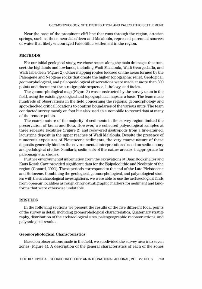
Near the base of the prominent cliff line that runs through the region, artesiansprings, such as those near Jaba’deen and Ma’aloula, represent perennial sourcesof water that likely encouraged Paleolithic settlement in the region.
METHODS
For our initial geological study, we chose routes along the main drainages that tran-sect the highlands and lowlands, including Wadi Ma’aloula, Wadi George Jaffa, andWadi Jaba’deen (Figure 2). Other mapping routes focused on the areas formed by thePaleogene and Neogene rocks that create the higher topographic relief. Geological,geomorphological, and paleopedological observations were made at more than 300points and document the stratigraphic sequence, lithology, and facies.
The geomorphological map (Figure 3) was constructed by the survey team in thefield, using the existing geological and topographical maps as a basis. The team madehundreds of observations in the field concerning the regional geomorphology andspot-checked critical locations to confirm boundaries of the various units. The teamconducted survey mostly on foot but also used an automobile to record data at manyof the remote points.
The coarse nature of the majority of sediments in the survey region limited thepreservation of fauna and flora. However, we collected palynological samples atthree separate localities (Figure 2) and recovered gastropods from a fine-grained,lacustrine deposit in the upper reaches of Wadi Ma’aloula. Despite the presence ofnumerous exposures of Pleistocene sediments, the very coarse nature of thesedeposits generally hinders the environmental interpretations based on sedimentaryand pedological studies. Similarly, sediments of this nature are also inappropriate forpaleomagnetic studies.
Further environmental information from the excavations at Baaz Rockshelter andKaus Kozah Cave provided significant data for the Epipaleolithic and Neolithic of theregion (Conard, 2002). These periods correspond to the end of the Late Pleistoceneand Holocene. Combining the geological, geomorphological, and palynological stud-ies with the archaeological investigations, we were able to use the archaeological findsfrom open-air localities as rough chronostratigraphic markers for sediment and land-forms that were otherwise undatable.
RESULTS
In the following sections we present the results of the five different focal pointsof the survey in detail, including geomorphological characteristics, Quaternary stratig-raphy, distribution of the archaeological sites, paleogeographic reconstructions, andpalynological results.
Geomorphological Characteristics
Based on observations made in the field, we subdivided the survey area into sevenzones (Figure 4). A description of the general characteristics of each of the zones
DOI: 10.1002/GEA GEOARCHAEOLOGY: AN INTERNATIONAL JOURNAL, VOL. 22, NO. 6
GEOMORPHOLOGY, SITE DISTRIBUTION, AND PALEOLITHIC SETTLEMENT
593
GEA226_615_20175.qxd 6/14/07 1:37 PM Page 593
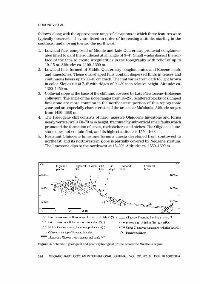
follows, along with the approximate range of elevations at which these features weretypically observed. They are listed in order of increasing altitude, starting in thesoutheast and moving toward the northwest.
1. Lowland fans composed of Middle and Late Quaternary proluvial conglomer-ates tilted toward the southeast at an angle of 3–4º. Small wadis dissect the sur-face of the fans to create irregularities in the topography with relief of up to10–15 m. Altitude: ca. 1100–1300 m.
2. Lowland hills formed of Middle Quaternary conglomerates and Eocene marlsand limestones. These oval-shaped hills contain dispersed flints in lenses andcontinuous layers up to 30–40 cm thick. The flint varies from dark to light brownin color. Slopes tilt at 7–8ºwith ridges of 20–30 m in relative height. Altitude: ca.1300–1450 m.
3. Colluvial slope at the base of the cliff line, covered by Late Pleistocene–Holocenecolluvium. The angle of the slope ranges from 15–25º. Scattered blocks of slumpedlimestone are more common in the northeastern portion of this topographiczone and are especially characteristic of the area near Ma’aloula. Altitude rangesfrom 1450–1550 m.
4. The Paleogene cliff consists of hard, massive Oligocene limestone and formsnearly vertical walls 50–70 m in height, fractured by subvertical small faults whichpromoted the formation of caves, rockshelters, and niches. The Oligocene lime-stone does not contain flint, and its highest altitude is 1550–1600 m.
5. Resistant Oligocene limestone forms a cuesta developed from southwest tonortheast, and its northwestern slope is partially covered by Neogene stratum.The limestone dips to the northwest at 15–20º. Altitude: ca. 1550–1600 m.
DODONOV ET AL.
GEOARCHAEOLOGY: AN INTERNATIONAL JOURNAL, VOL. 22, NO. 6 DOI: 10.1002/GEA594
Figure 4. Schematic geological and geomorphological profile across the Ma’aloula region.
GEA226_615_20175.qxd 6/14/07 1:37 PM Page 594
6. Highland hills formed by Pliocene conglomerates are observed as a belt northwest of the Oligocene cuesta. Erosion has created a highly dissected topog-raphy in the bedrock and is represented by incised Pliocene conglomerates,siltstones, and marls. The depth of erosion reaches as much as 70–80 m. Theinclination of the eroded slope does not exceed 15–17º. Altitude is in the rangeof 1600–1700 m.
7. Highland plateau formed on Pliocene conglomerates with a 3–4 m layer of cal-crete at the top tilting slightly downward toward the northwest. The inclinationof the surface is around 3–5º to the northwest in accordance with the general dipof the Pliocene conglomerates. The calcrete serves as a hardpan that hinderserosion. The highland plateau is cut by several prominent, deep wadis. Altitudeis from 1600–1650 m.
Quaternary Stratigraphy
The Quaternary subdivisions used here are those of the international stratigraphicscale: the Neogene-Quaternary boundary is 1.8 Ma, the Lower Pleistocene ranges from1.8–0.8 Ma, the Middle Pleistocene from 0.8–0.13 Ma, the Upper Pleistocene from 0.13–0.01 Ma, and the Holocene spans the last 0.01 Ma. Ponikarov et al. (1969) cor-related the lower boundary of the Quaternary in Syria with the base of the Calabrianstage or its continental equivalents. According to Gibard et al. (2004), the Calabrian stagerepresents the period from 1.8 to 1.0 Ma. In the Ma’aloula survey region, MiddlePleistocene, Upper Pleistocene, and Holocene deposits can be recognized on the basisof geomorphological and archaeological data, with additional evidence provided by thepalynological analysis.
The Middle Pleistocene is represented by proluvium (Fairbridge, 1968; Garyet al., 1972) that is widespread to the southeast of the Ma’aloula–Jaba’deen cliff line.The proluvium is a poorly bedded and poorly sorted conglomerate with clasts ofpebbles, gravels, and boulders in a carbonate, coarse sandy matrix. It contains bothangular and rounded pieces of local materials (limestone, marl, and flint) and occa-sionally thin lenses of sandy silt with pebbles and gravel. The proluvial conglomer-ate formed during phases of highly seasonal, intense precipitation, and consequentsurface erosion along wadi systems. This poorly sorted, aggradating debris wasdeposited over large areas during the Quaternary.
The thickness of the proluvial conglomerates ranges from a few meters up to atleast 20–25 m, increasing in the southeastern part of the area studied. The age of theconglomerates cannot be younger than Middle Quaternary because many open-airMiddle Paleolithic sites are located on their surface. The conglomerates are presenton the slopes of wadi valleys and are often eroded by the wadis. For example, WadiMa’aloula has cut 35–40 m into the conglomerates and the underlying Paleogenerocks. Smaller wadis do not create such deep erosional systems.
At the top of the proluvial conglomerates a 0.5–1 m thick horizon of calcretecreates a resistant crust that hinders agricultural activities. Intense evaporationof soil moisture near the surface during dry seasons resulted in the precipitation ofcarbonate from saturated groundwater, leading to the formation of calcrete on the
DOI: 10.1002/GEA GEOARCHAEOLOGY: AN INTERNATIONAL JOURNAL, VOL. 22, NO. 6
GEOMORPHOLOGY, SITE DISTRIBUTION, AND PALEOLITHIC SETTLEMENT
595
GEA226_615_20175.qxd 6/14/07 1:37 PM Page 595
surface. In modern trenches that penetrate through the calcrete crust, the underlyingcarbonate material appears loose, and the conglomerates are not strongly cemented.
The Upper Pleistocene and Holocene geological accumulations include col-luvium, proluvium, and lacustrine deposits. The colluvium covers the base of thesteep slope below the resistant cliffs of Oligocene limestone (Krasheninnikov et al.,1996). The colluvium consists of unsorted, poorly cemented debris with angularpieces of marl and limestone. Very large blocks of limestone (�100 m3) rest precar-iously on the slope of the colluvium. The colluvial thickness varies from less than 1 mat the top of the slope and increases to 5–6 m or more at its base. The age of the col-luvium can be assigned to the Upper Pleistocene and Holocene based on theEpipaleolithic and Neolithic finds on the colluvial surface near Baaz Rockshelterand other sites. Moreover, scattered finds of Upper Paleolithic artifacts on the colluvialsurface can be considered as an argument for an Upper Pleistocene age for some ofthe colluvial sediments.
Young proluvial deposits, 4–5 m thick, form the lower terraces along Wadi Jaba’deen,Wadi Ma’aloula, and Wadi George Jaffa. The young proluvium fills the bottom of smallwadis, but does not form terraces. Lithologically, this deposit is similar to the prolu-vium of the Middle Pleistocene, but it is less cemented and more silty.
A 2–3 m thick exposure of lacustrine sediment in the upper reaches of WadiMa’aloula above the Oligocene cliff consists of clayey carbonate silt and contains mol-lusks (Figure 2: P2). In situ stone artifacts attributed to the Upper Paleolithic sug-gest an Upper Pleistocene age for these lake sediments. A calcrete horizon of 0.8–1.0m thickness overlies the silt. An analysis of the mollusks indicates the presence ofthree families of terrestrial gastropods. Two forms each of the genera Pupillidae andSuccinidae were identified, as was one form of the genera Helicidae (pers. comm.A. L. Tchepalyga). Many of the gastropods are juveniles. The identified genera typi-cally inhabit rocky, grass-covered slopes and are characteristic of an open landscapein a semiarid climate. The presence of these gastropods provides evidence that slopewashing occurred along the valley of Wadi Ma’aloula, depositing the shells into asmall, shallow lake that followed the contours of the wadi in the area just above thecliff line.
Distribution of the Archaeological Sites
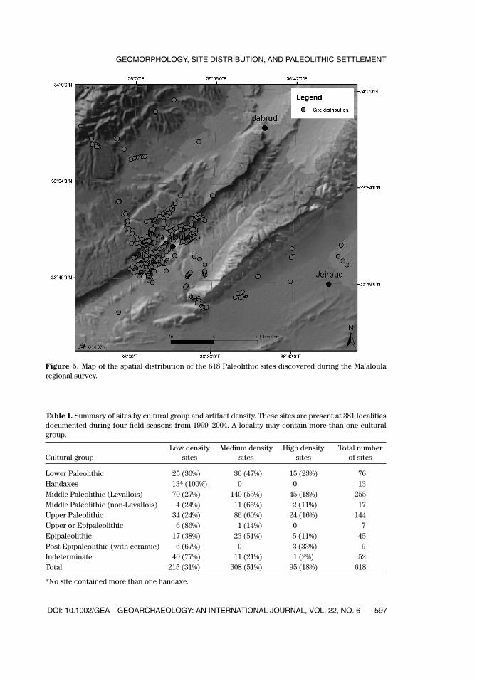
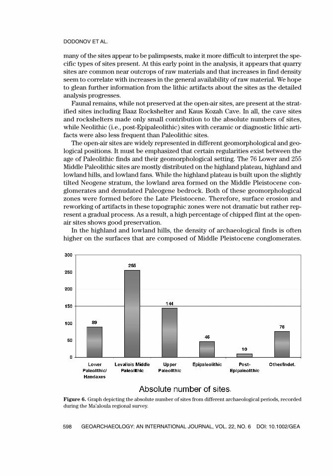
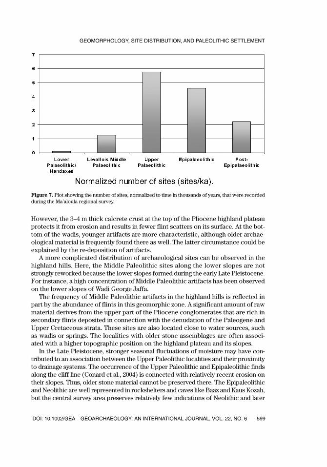
The survey resulted in the discovery of 618 new archaeological sites, the vast major-ity of which were Paleolithic open-air occurrences (Figure 5). The sites were charac-terized according to the density of lithic artifacts within a radius of 5 m (Table I). A lowdensity rating indicated less than 1 find/10 m2, while a medium density site had from1–5 finds/10 m2 and a high density scatter contained more than 5 finds/10 m2. Althoughthe absolute number of sites of all find densities shows the predominance of LevalloisianMiddle Paleolithic sites, the number of sites normalized over time shows the domi-nance of Upper Paleolithic and Epipaleolithic occupations (Figures 6 and 7).
The sites were frequently observed as continuous scatters on the land surface,where a site was defined as continuous if it extended beyond a radius of 100 m. Thespatial continuity of many of the sites over large areas, combined with the fact that
DODONOV ET AL.
GEOARCHAEOLOGY: AN INTERNATIONAL JOURNAL, VOL. 22, NO. 6 DOI: 10.1002/GEA596
GEA226_615_20175.qxd 6/14/07 1:37 PM Page 596
DOI: 10.1002/GEA GEOARCHAEOLOGY: AN INTERNATIONAL JOURNAL, VOL. 22, NO. 6
GEOMORPHOLOGY, SITE DISTRIBUTION, AND PALEOLITHIC SETTLEMENT
597
Figure 5. Map of the spatial distribution of the 618 Paleolithic sites discovered during the Ma’aloularegional survey.
Table I. Summary of sites by cultural group and artifact density. These sites are present at 381 localitiesdocumented during four field seasons from 1999–2004. A locality may contain more than one culturalgroup.
Low density Medium density High density Total number Cultural group sites sites sites of sites
Lower Paleolithic 25 (30%) 36 (47%) 15 (23%) 76Handaxes 13* (100%) 0 0 13Middle Paleolithic (Levallois) 70 (27%) 140 (55%) 45 (18%) 255Middle Paleolithic (non-Levallois) 4 (24%) 11 (65%) 2 (11%) 17Upper Paleolithic 34 (24%) 86 (60%) 24 (16%) 144Upper or Epipaleolithic 6 (86%) 1 (14%) 0 7Epipaleolithic 17 (38%) 23 (51%) 5 (11%) 45Post-Epipaleolithic (with ceramic) 6 (67%) 0 3 (33%) 9Indeterminate 40 (77%) 11 (21%) 1 (2%) 52Total 215 (31%) 308 (51%) 95 (18%) 618
*No site contained more than one handaxe.
GEA226_615_20175.qxd 6/14/07 1:37 PM Page 597
DODONOV ET AL.
GEOARCHAEOLOGY: AN INTERNATIONAL JOURNAL, VOL. 22, NO. 6 DOI: 10.1002/GEA598
Figure 6. Graph depicting the absolute number of sites from different archaeological periods, recordedduring the Ma’aloula regional survey.
many of the sites appear to be palimpsests, make it more difficult to interpret the spe-cific types of sites present. At this early point in the analysis, it appears that quarrysites are common near outcrops of raw materials and that increases in find densityseem to correlate with increases in the general availability of raw material. We hopeto glean further information from the lithic artifacts about the sites as the detailedanalysis progresses.
Faunal remains, while not preserved at the open-air sites, are present at the strat-ified sites including Baaz Rockshelter and Kaus Kozah Cave. In all, the cave sitesand rockshelters made only small contribution to the absolute numbers of sites,while Neolithic (i.e., post-Epipaleolithic) sites with ceramic or diagnostic lithic arti-facts were also less frequent than Paleolithic sites.
The open-air sites are widely represented in different geomorphological and geo-logical positions. It must be emphasized that certain regularities exist between theage of Paleolithic finds and their geomorphological setting. The 76 Lower and 255Middle Paleolithic sites are mostly distributed on the highland plateau, highland andlowland hills, and lowland fans. While the highland plateau is built upon the slightlytilted Neogene stratum, the lowland area formed on the Middle Pleistocene con-glomerates and denudated Paleogene bedrock. Both of these geomorphologicalzones were formed before the Late Pleistocene. Therefore, surface erosion andreworking of artifacts in these topographic zones were not dramatic but rather rep-resent a gradual process. As a result, a high percentage of chipped flint at the open-air sites shows good preservation.
In the highland and lowland hills, the density of archaeological finds is oftenhigher on the surfaces that are composed of Middle Pleistocene conglomerates.
GEA226_615_20175.qxd 6/14/07 1:37 PM Page 598
However, the 3–4 m thick calcrete crust at the top of the Pliocene highland plateauprotects it from erosion and results in fewer flint scatters on its surface. At the bot-tom of the wadis, younger artifacts are more characteristic, although older archae-ological material is frequently found there as well. The latter circumstance could beexplained by the re-deposition of artifacts.
A more complicated distribution of archaeological sites can be observed in thehighland hills. Here, the Middle Paleolithic sites along the lower slopes are notstrongly reworked because the lower slopes formed during the early Late Pleistocene.For instance, a high concentration of Middle Paleolithic artifacts has been observedon the lower slopes of Wadi George Jaffa.
The frequency of Middle Paleolithic artifacts in the highland hills is reflected inpart by the abundance of flints in this geomorphic zone. A significant amount of rawmaterial derives from the upper part of the Pliocene conglomerates that are rich insecondary flints deposited in connection with the denudation of the Paleogene andUpper Cretaceous strata. These sites are also located close to water sources, suchas wadis or springs. The localities with older stone assemblages are often associ-ated with a higher topographic position on the highland plateau and its slopes.
In the Late Pleistocene, stronger seasonal fluctuations of moisture may have con-tributed to an association between the Upper Paleolithic localities and their proximityto drainage systems. The occurrence of the Upper Paleolithic and Epipaleolithic findsalong the cliff line (Conard et al., 2004) is connected with relatively recent erosion ontheir slopes. Thus, older stone material cannot be preserved there. The Epipaleolithicand Neolithic are well represented in rockshelters and caves like Baaz and Kaus Kozah,but the central survey area preserves relatively few indications of Neolithic and later
DOI: 10.1002/GEA GEOARCHAEOLOGY: AN INTERNATIONAL JOURNAL, VOL. 22, NO. 6
GEOMORPHOLOGY, SITE DISTRIBUTION, AND PALEOLITHIC SETTLEMENT
599
Figure 7. Plot showing the number of sites, normalized to time in thousands of years, that were recordedduring the Ma’aloula regional survey.
GEA226_615_20175.qxd 6/14/07 1:37 PM Page 599

archaeological settlement. The Jeiroud Basin, however, documents clear indicationsof Neolithic settlement including open-air scatters and at least one tell.
Paleogeographic Reconstructions
The paleogeographic reconstructions in Figures 8 and 9 illustrate how the geologichistory of the region influenced the development of the landscape and the avail-ability of flint. Profiles I and II (Figure 8), depict the primary sources of UpperCretaceous and Paleogene flint layers and their inferred distribution during thePliocene. These diagrams help to explain the presence of flint raw material in cer-tain areas but its lack in other areas. Clearly, the distribution of flint artifacts co-varies with the availability of flint raw material. For example, one area of theAnti-Lebanon Mountains (Sector A) is devoid of the units that contain UpperCretaceous and Eocene flints, whereas Sector B, located to the northeast, shows an
DODONOV ET AL.
GEOARCHAEOLOGY: AN INTERNATIONAL JOURNAL, VOL. 22, NO. 6 DOI: 10.1002/GEA600
Figure 8. Schematic geological profiles I and II depicting the primary sources of flint from UpperCretaceous (K 2) and Paleogene (P) layers and its inferred distribution during the Pliocene epoch (N2) inthe al-Majar depression. The map inset corresponds to the same area shown in Figure 3. In the Anti-Lebanon Mountains, Sector A is in an area where the units that contain Upper Cretaceous and Eoceneflints are not well represented, whereas Sector B shows an area where flint layers and concretions occurfrequently. In Sector C in the Palmyrides, flints derived from Eocene and Upper Cretaceous (Campanian,Maestrichtian) rocks are well represented.
GEA226_615_20175.qxd 6/14/07 1:37 PM Page 600
DOI: 10.1002/GEA GEOARCHAEOLOGY: AN INTERNATIONAL JOURNAL, VOL. 22, NO. 6
GEOMORPHOLOGY, SITE DISTRIBUTION, AND PALEOLITHIC SETTLEMENT
601
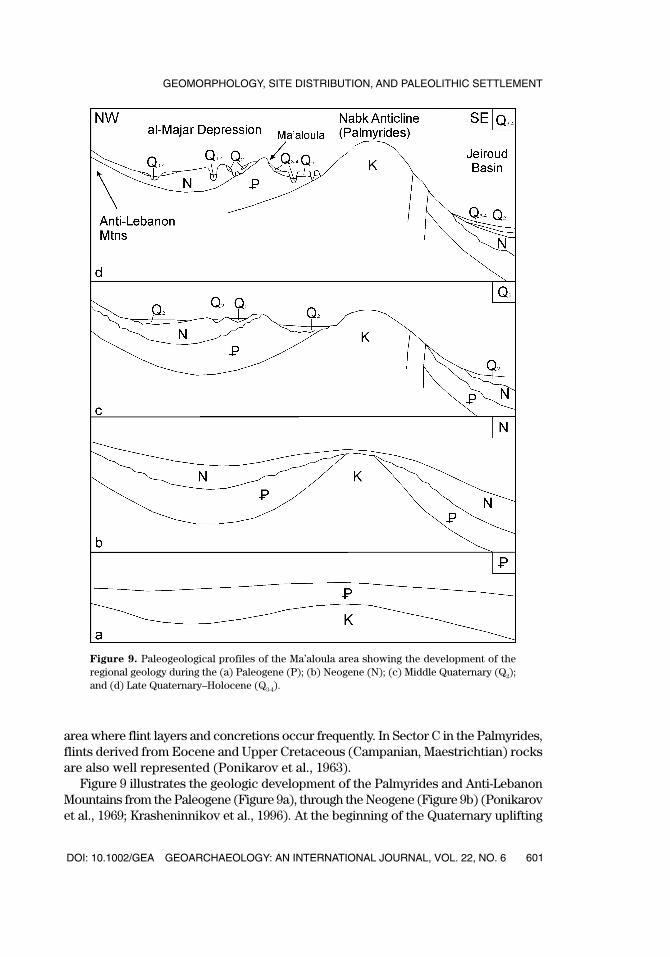
Figure 9. Paleogeological profiles of the Ma’aloula area showing the development of theregional geology during the (a) Paleogene (P); (b) Neogene (N); (c) Middle Quaternary (Q2);and (d) Late Quaternary–Holocene (Q3-4).
area where flint layers and concretions occur frequently. In Sector C in the Palmyrides,flints derived from Eocene and Upper Cretaceous (Campanian, Maestrichtian) rocksare also well represented (Ponikarov et al., 1963).
Figure 9 illustrates the geologic development of the Palmyrides and Anti-LebanonMountains from the Paleogene (Figure 9a), through the Neogene (Figure 9b) (Ponikarovet al., 1969; Krasheninnikov et al., 1996). At the beginning of the Quaternary uplifting
GEA226_615_20175.qxd 6/14/07 1:37 PM Page 601
occurred, and, as a result, the Neogene molasse was dislocated and eroded. The MiddleQuaternary is characterized by the formation of proluvial deposits (Figure 9c). Drainagesystems were more active than at present, resulting in the accumulation of verycoarse conglomerates. At that time, the wide passes in the Oligocene cliff line wereformed in Wadi Ma’aloula, Wadi Jaba’deen, and Wadi George Jaffa, among others.During the Late Pleistocene and Holocene, cutting of relief increased (Figure 9d). Thisresulted in the formation of the dissected highland hills and the cutting down of wadis,especially Wadi Ma’aloula, with its narrow canyons that incise the Paleogene cliff.A small lake that collected seasonal water existed in the upper reaches of WadiMa’aloula until a protective limestone dam was undercut.
Palynological Results
The survey area is situated in a transitional zone between the Syrian Desert andthe Mediterranean vegetation zone. In subfossil pollen spectra determined in theDamascus region, the prevalence of herbs (up to 90%) with a predominance ofChenopodiaceae indicates a semidesert-steppe landscape (Devyatkin & Dodonov,2000). Despite the presence of many exposures of sediment in the survey region,only three stratigraphic sections have been successfully tested for pollen.
The first profile (P1) is a brown paleosol in the upper part of the proluvial fan onthe right flank of Wadi George Jaffa (Figure 2). Here, a brown paleosol separatestwo generations of proluvial deposits. The B-horizon of the paleosol, 1.0 m in thick-ness, consists of loam with small amounts of gravel. The soil exhibits characteristiciron and manganese staining and contains very soft carbonate concretions. In theupper part of the soil the identification of a few pollen grains of Chenopodiaceae andHerbetum mixtum document the presence of a steppic landscape at the time ofdeposition.
The second profile (P2) is located in a small wadi above the canyon in Ma’aloula(Figure 2). Lacustrine silts with shell inclusions fill the valley with a visible thicknessof 2–3 m. At a depth of 1.25 m, pollen of Asteraceae and Cichoriaceae predominatein the silt, with a significant quantity of grains of Caryophyllaceae, Brassicaceae,Chenopodiaceae, and rarely of Pterocarya, Carpinus, and Oleaceae. The pollen spec-trum at 1.0 m in depth is characterized by an increase in the presence of trees. Herbsand small shrubs predominate in this steppe phytocenosis. Pollen grains of Pinus,
Alnus, Tilia, and Rhus are recorded, and Brassicaceae, Cyperaceae, Poaceae, andThalictrum predominate in the herb group. This pollen spectrum attests to a relativeincrease in moisture within a landscape that was predominantly steppic. At a depthof 0.75 m, tree pollen was not recognized, while Cichoriaceae, Brassicaceae, andChenopodiaceae predominate. The latter changes can be associated with aridization.If we exclude the possibility of re-deposition of pollen grains, the presence of Tilia
and Pterocarya can be interpreted as evidence of sedimentation in a small lake duringat least the early Late Pleistocene. According to Leroi-Gourhan (1980), this pollensignal has not been recognized in Syria after 35 ka.
The third profile (P3) consists of a 6 m-thick outcrop of conglomerates near theDamascus Highway (Figure 2). These conglomerates form a widespread, proluvial
DODONOV ET AL.
GEOARCHAEOLOGY: AN INTERNATIONAL JOURNAL, VOL. 22, NO. 6 DOI: 10.1002/GEA602
GEA226_615_20175.qxd 6/14/07 1:37 PM Page 602
DOI: 10.1002/GEA GEOARCHAEOLOGY: AN INTERNATIONAL JOURNAL, VOL. 22, NO. 6
GEOMORPHOLOGY, SITE DISTRIBUTION, AND PALEOLITHIC SETTLEMENT
603
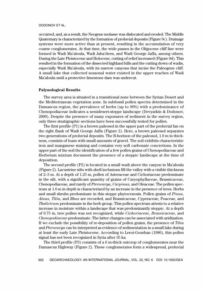
Fig
ure 1
0.
Pol
len
prof
ile f
rom
the
6.0
m s
ecti
on, P
2, (
#98
of y
ear
2000
), w
here
Mid
dle
Ple
isto
cene
con
glom
erat
es o
utcr
op a
long
the
edg
e of
a p
rolu
vial
ter
-ra
ce. T
he lo
cati
on o
f th
is s
ecti
on is
dep
icte
d in
Fig
ure
2.
GEA226_615_20175.qxd 6/14/07 1:37 PM Page 603
DODONOV ET AL.
GEOARCHAEOLOGY: AN INTERNATIONAL JOURNAL, VOL. 22, NO. 6 DOI: 10.1002/GEA604
terrace. Three out of ten samples (depth 5.8, 5.2, and 2.0 m) included sufficient quan-tities of pollen to calculate the percentage content (Figure 10). In general, the pollenof herbs and small shrubs prevails (75–80%) pointing to the development of an opensteppe landscape. At 5.8 m depth, pollen grains of Brassicaceae (20%), Thalictrum
(26%), and Herbetum mixtum (41%) predominate. At a depth of 5.2 m, the analysisidentified Leguminosae (68%), Cichoriaceae (4%), Chenopodiaceae (5%), Herbetum
mixtum (15%), as well as rare grains of Pinus, Olea, and Jasminum. In the spore-pollen spectrum from 2.0 m depth, we recorded pollen grains of Asteraceae (14%),Brassicaceae (48%), Chenopodiaceae (4%), and Thalictrum (6%). The content oftree pollen became more diverse with the presence of Pinus, Carpinus, Morus,Juglandaceae, Cornaceae, and Ericales, indicating a moister paleoclimate, althoughthe steppe remained as the dominant landscape. Considering the pollen spectra fromconglomerates in comparison with the palynological data of the Late Pleistocene(van Zeist & Bottema, 1982; Leroi-Gourhan, 1980), we propose that the conglomer-ates formed during the late Middle to Late Pleistocene.
CONCLUSIONS
By the early Middle Pleistocene, people settled in the Ma’aloula area. An analysisof the distribution of the Paleolithic and Neolithic sites shows that human activityvaried not only with the prevailing environmental conditions, but also with the tech-nological and economic systems employed. In the Ma’aloula region, the abundanceand easy accessibility of local raw material, as well as the rich seasonal outflow ofwater and permanent springs, provided good conditions for Paleolithic settlement.
During the Pleistocene, the relief of the region formed during two phases asso-ciated with the Middle and Late Pleistocene. The Middle Pleistocene was charac-terized by relatively intense seasonal moisture, as indicated by the deposition ofproluvium. As a result, conglomeratic fans formed to the southeast of the Oligocenecliff line. In the Late Pleistocene, general aridization increased. Regional uplifting anderosional processes resulted in further dissection of the highland area and in thecutting down of wadis.
The environmental data obtained from three pollen profiles indicate an expan-sion of alternating steppe and desert-steppe vegetation in the Ma’aloula area from thelate Middle Pleistocene through the Holocene. The herb pollen supports that an aridclimate dominated the greater part of the Late Pleistocene. The spread of forest tookplace only during relatively brief intervals in response to increased precipitation.However, establishing the specific timing of these climatic fluctuations will requiremore reliable dating.
The distribution of archaeological sites indicates similar patterns of settlementduring the Lower and Middle Paleolithic. However, the amount of diagnostic LowerPaleolithic material is significantly lower than that of the nearly ubiquitous, LevalloisianMiddle Paleolithic (Conard et al., 2004). Acheulean handaxes are present at 13 local-ities, but in each case only one handaxe was recovered (Conard, 2003). The UpperPaleolithic is also well represented in most of the survey zones, but more work isneeded to distinguish this group from earlier and later laminar assemblage types.
GEA226_615_20175.qxd 6/14/07 1:37 PM Page 604
DOI: 10.1002/GEA GEOARCHAEOLOGY: AN INTERNATIONAL JOURNAL, VOL. 22, NO. 6
GEOMORPHOLOGY, SITE DISTRIBUTION, AND PALEOLITHIC SETTLEMENT
605
The Epipaleolithic is well established in rockshelters and caves, as documentedat Baaz Rockshelter and Kaus Kozah Cave. The survey results also demonstrate thatEpipaleolithic sites existed in a variety of geographic settings. Even at the highestreaches of our survey, at 2350 m on a peak of the Anti-Lebanon Mountains,Epipaleolithic finds were recovered. In contrast to the older periods, Epipaleolithicoccurrences seem to depend less upon the presence of flint raw material and watersources and instead focus upon good vantage points or sheltered locations.
Neolithic and later archaeological periods are poorly represented in the centralsurvey area, although Neolithic finds were documented at Baaz Rockshelter andKaus Kozah Cave. The Neolithic is accompanied by a shift from the Ma’aloula regioninto the lowland areas of the Jeiroud Basin, where, as in the more southerly DamascusBasin, Neolithic artifact scatters and tells indicate a different system of settlementthat reflects new economic and social systems.
Without the support of the Director General of Antiquities and Museums of Syria, Dr. Tamman Fakoush,and our many colleagues in the Department of Antiquities, this project would not be possible. Special thanksare due to Prof. Sultan Muhesen of the University of Damascus and Prof. Jean-Marie LeTensorer of theUniversity of Basel for their scientific advice. Finally we are grateful to Umm Pelagia and the sisters ofthe Convent of St. Takla for providing us with lodging in Ma’aloula.
REFERENCES
Conard, N.J. (2002). An overview of the recent excavations at Baaz Rockshelter, Damascus Province,Syria. In R. Aslan, S. Blum, G. Kastl, F. Schweizer, & D. Thumm (Eds.), Mauer Schau—Festschrift fürManfred Korfmann., Bd. 2 (pp. 623–640). Remshalden-Grunbach: Verlag Bernhard Albert Greiner.
Conard, N.J. (2003). Handaxes on the landscape and the reconstruction of Paleolithic settlement patterns.In J.M. Burdukiewicz, L. Fiedler, W.-D. Heinrich, A. Justus, & E. Brühl (Eds.), Erkenntnisjäger–Kulturund Umwelt des frühen Menschen. Festschrift für Dietrich Mania, Bd. 1. (pp. 123–144). Halle (Saale):Landesamt für Archäologie Sachsen-Anhalt/Landesmuseum für Vorgeschichte.
Conard, N.J., Kandel, A.W., Dodonov, A.E., & al-Misri, M. (2004). Middle Paleolithic settlement in theMa’aloula region of the Damascus Province, Syria. In N.J. Conard (Ed.), Settlement Dynamics ofthe Middle Paleolithic and Middle Stone Age, Vol. II. (pp. 65–87). Tübingen: Kerns Verlag.
Devyatkin, E.V., & Dodonov, A.E. (2000). Stratigraphy of the Neogene and Quaternary deposits. In Y.G.Leonov (Ed.), Outline of Geology of Syria, 129–176. Moscow: Nauka.
Fairbridge, R.W. (Ed.) (1968). The Encyclopedia of Geomorphology. New York: Reinhold. Gary, M., McAfee Jr., R., & Wolf, C.L. (Eds.) (1972). Glossary of geology. Washington: American Geological
Institute.Gibard, P.L., Boreham, S., Cohen, K. M., & Moscariello, A. (Eds.), (2004). Global chronostratigraphic
correlation table for the last 2.7 million years. Cambridge: University of Cambridge. Krasheninnikov, V.A., Golovin, D.I., Mouravyov, V.I., Helou, R., Nseir, H. & Shweki, A. (1996). Paleogene of
Syria: Stratigraphy, lithology, geochronology. Geologisches Jahrbuch. Reihe B, Heft 86. Hannover:Schweizerbart.
Leroi-Gourhan, A. (1980). Les analyses polliniques au Moyen-Orient. Paléorient, 6, 79–91. van Liere, W.J. (1960–1961). Observation on the Quaternary of Syria. Berichten Rijksdienst voor
Oudheidkunde en Bodemonderzoek 10/11, 7-69. Ponikarov, V.P. (1964). Tectonic map of Syria: Scale 1:1,000,000: Ministry of Industry. Syrian Arabic Republic.Ponikarov, V.P., Shatsky, V., Kazmin, V.G., Mikailov, I., Aistov, L., Kulakov, V., Shatskaya, M., & Shirokov,
V. (1963). Geological map of Syria (1:200,000), sheets I-36-XII, I-37-VII. V.O. Moscow: Technoexport. Ponikarov, V. P. (Ed.) (1967). The geological map of Syria (1:200,000), explanatory notes. V.O. Moscow:
Technoexport
GEA226_615_20175.qxd 6/14/07 1:37 PM Page 605
DODONOV ET AL.
GEOARCHAEOLOGY: AN INTERNATIONAL JOURNAL, VOL. 22, NO. 6 DOI: 10.1002/GEA606
Ponikarov, V.P., Kazmin, V.G., Kozlov, V.V., Krasheninnikov, V.A., Kikhailov, I.A., Razvalyaev, A.V., Sulidi-Kondratoev, E.D., Uflyand, A.K., & Faradzhev, V.A. (1969). Geologiya i poleznye iskopaemye zarubezh-nyh stran. Syria. (Geology and mineral resources of foreign countries. Syria). Nedra: Leningrad.
Rust, A. (1950). Die Höhlenfunde von Jabrud (Syrien). Neumünster: Karl Wachholtz Verlag. Solecki, R.S., & Solecki, R.L. (1987/1988). Archaeological researches at Yabroud, Syria and vicinity, Summer
1987. Le Annales Archéologiques Arabes Syriennes: Revue d’Archéologie et d’Histoire, 37/38, 9–49. Suzuki, H., & Koburi, I. (Eds.) 1970. Report of the reconnaissance survey on Palaeolithic sites in Lebanon
and Syria. Bull. 1. Tokyo: University Museum. Wolfart, R. (1966). Zur Geologie und Hydrogeologie von Syrien (unter besonderer Berücksichtigung
der süd- und nordwestlichen Landesteile). Beihefte zum Geologischen Jahrbuch, Heft 68. Stuttgart:Schweizerbart.
van Zeist, W., & Bottema, S. (1982). Reflections on a Holocene subdivision of the Near East. In J. Mangerud(Ed.), Chronostratigraphic subdivision of the Holocene, Striae, 16, 36–39.
Received December 15, 2004Accepted for publication April 15, 2006
GEA226_615_20175.qxd 6/14/07 1:37 PM Page 606