geomorphic setting and stratigraphy of cotiga mound, mingo county, west virginia
TRANSCRIPT

Geomorphic Setting and Stratigraphyof Cotiga Mound, Mingo County,West Virginia
D. L. Cremeens and D. B. LandersGAI Consultants, Inc., 570 Beatty Road, Monroeville,Pennsylvania 15146-1300
S. R. FrankenbergAnthropology Department, University of Tennessee, Knoxville,Tennessee 37966-0720
Cotiga Mound, a 2100-year-old Woodland burial mound, was constructed on a mid-Holocene terrace along the Tug Fork of the Big Sandy River. The terrace is the onlystable, level landscape in the area. The intact nature of the terrace soil horizons indi-cated that little if any of the mound materials were taken from the terrace surface inthe immediate vicinity of the mound. The mound was constructed of silty material andcontained basket-loading macrofabric and a rock ring of sandstone fragments. Seis-mic fan refraction indirectly indicated the center of the rock ring, while ground-pene-trating radar (GPR) did not detect the rock ring. A stratigraphic cross section, basedon particle-size analysis, indicates that the mound consisted of 10 lithologic layers. Theuppermost layer resulted from faunal disturbance. The remaining nine layers repre-sented construction episodes; the upper four extending across large expanses of themound in caplike fashion, and the lower five representing more specific inner-moundlocalized construction. Particle-size analysis quantitatively substantiates field observa-tions of mound stratigraphy and highlights subtle changes in materials used for con-struction. This approach provides a basis for quantitative comparisons with othermounds and earthworks by delineating stratigraphic details associated with episodesof construction and the ceremonial implications of the episodes. 1997 John Wiley &Sons, Inc.
INTRODUCTION
Ceremonial mounds and earthworks constitute the most conspicuous recordof prehistoric culture on the landscape of eastern North America (Woodwardand McDonald, 1986). Geoarchaeological studies have been applied to the un-derstanding of formation processes affecting a variety of archaeological sites,but few detailed and comprehensive studies have been applied to moundsites. One reason for this is that most large, burial mounds and other earth-works have been completely excavated within a matter of weeks, or incom-pletely sampled through coring, etc. Geomorphic analysis is essential for ac-curate interpretations of the age, appearance, and stability of the natural
Geoarchaeology: An International Journal, Vol. 12, No. 5, 459–477 (1997) 1997 by John Wiley & Sons, Inc. CCC 0883-6353/97/050459-19
CREMEENS, LANDERS, AND FRANKENBERG
landform on which the mound was constructed, of potential borrow areas formound construction materials, the stratigraphic structure of the mound, andpostconstruction modification of the mound. Geomorphology influences theoriginal site selection, is influential during the period of site use, and is re-sponsible for site preservation or modification.
Due to the general lack of data on the physical structure of mound sites forthe upper tributaries of the Ohio River in West Virginia, the excavation ofCotiga Mound provided the opportunity to evaluate geomorphological proper-ties that may have played a role in prehistoric sociocultural systems involvedin ‘‘mound building.’’ Cotiga Mound yielded radiocarbon ages of 2100 B.P. formound construction on a terrace dated 4300 B.P. (Cremeens, 1995). CotigaMound may well be the last Woodland burial mound completely excavated inthe eastern United States for quite some time. The data and interpretationsin this article are intended to serve as a guide for future excavations and forreevaluations of past excavations.
Most of the previous work in the Ohio Valley was based on qualitativefield observations of color and texture in order to make inferences as to thestratigraphy and function or use of the mounds. Dragoo (1963) reported thatthe structure of Cresap Mound was similar to that of the classic AdenaMound originally reported by Mills (1902) and analyzed by Greenman (1932).Cross sections through these mounds indicated that they were built in asym-metrical increments and contained central primary mounds that served asfoundations for subsequent mound construction (Dragoo, 1963; Woodwardand McDonald, 1986). Grave Creek Mound was sampled via split-spoon sam-pling that penetrated through the mound fill and into the underlying terracesoil (Hemmings, 1977, 1978a, 1984). Textures indicated that mound fill mate-rial came from locally available floodplain and terrace sediments.
A few quantitative studies of mound stratigraphy and pedogenesis ofmound materials have been conducted in the Ohio Valley (Hemmings, 1978b;Cremeens, 1995), the midwest (Parsons et al., 1962; Bettis, 1988; Kolb et al.,1990), and in the south (Ammons et al., 1992; Saunders and Allen, 1994).In these studies, workers generally used particle-size analysis and chemicalanalysis to evaluate mound stratigraphy, identify borrow areas, and to studyand date soil horizon formation on mounds.
The objectives of the investigations at the Cotiga Mound site were (1) toevaluate the geomorphic setting of the mound and (2) to evaluate mound stra-tigraphy and develop a stratigraphic cross section to represent the stratigra-phy. The geomorphic setting evaluation included studies of the fluvial geo-morphology of the site and how it influenced occupation, an estimation of theage of the terrace upon which the mound was built, and identification of po-tential borrow areas of moundfill materials. The evaluation of mound stratig-raphy consisted of determining the mound’s lithostratigraphy based onparticle-size data, defining the mound/terrace interface, and estimatingmound building episodes.
460 VOL. 12, NO. 5
GEOMORPHIC SETTING OF COTIGA MOUND, WEST VIRGINIA
SITE LOCATION AND SETTING
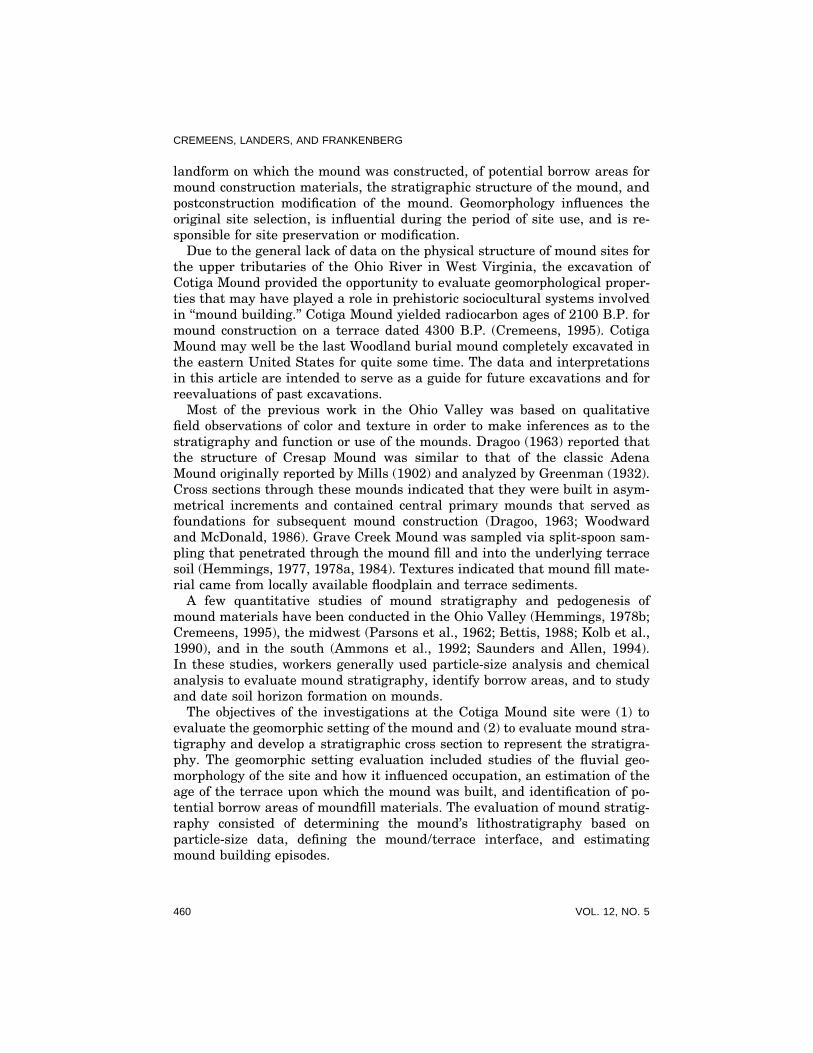
The Cotiga Mound site (46MO1) is on the southeast bank of the Tug Forkof the Big Sandy River, at the western border of Mingo County, West Virginia(Figure 1). This area of West Virginia is within the southern portion of theunglaciated Appalachian Plateau, a highly dissected plateau of Mississippianto Permian age clastic rocks with dendritic valley systems (Thornbury, 1965).The Tug Fork basin is approximately 4040 sq km consisting of narrow rivervalleys bordered by steeply rising mountains ascending as much as 400 mabove the river (Hirsch et al., 1982).
The Cotiga Mound site is just upstream (south–southwest) of the conflu-ence of the Tug Fork with Miller Creek (Figure 1). The valley floor, 300 mwide at the confluence, narrows to approximately 200 m upstream of the site.The upland topography consists of very steep valley walls, with large areasof rock bluffs, and ledges (Kelly, 1990). Local relief ranges from 110 m to amaximum of .300 m. The area in the immediate vicinity of the mound hadconsiderable disturbance from modern construction including several build-ings constructed within a few meters of the mound, a sidewalk and retainingwall adjacent to the mound, and a highway, earth road, driveway, and rail-road built within 20–75 m of the mound.
Cotiga Mound was completely excavated as part of a mitigation effort. Priorto excavation the mound’s perimeter covered an area approximately 24 mby 22 m, and the maximum depth of the mound’s deposits reached 3.8 m.Approximately 1050 cu m of material were excavated.
METHODS
Field Methods
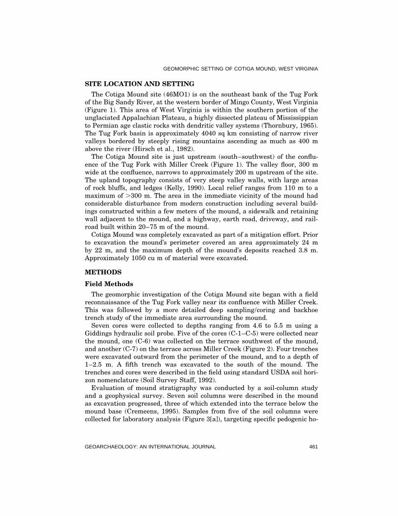
The geomorphic investigation of the Cotiga Mound site began with a fieldreconnaissance of the Tug Fork valley near its confluence with Miller Creek.This was followed by a more detailed deep sampling/coring and backhoetrench study of the immediate area surrounding the mound.
Seven cores were collected to depths ranging from 4.6 to 5.5 m using aGiddings hydraulic soil probe. Five of the cores (C-1–C-5) were collected nearthe mound, one (C-6) was collected on the terrace southwest of the mound,and another (C-7) on the terrace across Miller Creek (Figure 2). Four trencheswere excavated outward from the perimeter of the mound, and to a depth of1–2.5 m. A fifth trench was excavated to the south of the mound. Thetrenches and cores were described in the field using standard USDA soil hori-zon nomenclature (Soil Survey Staff, 1992).
Evaluation of mound stratigraphy was conducted by a soil-column studyand a geophysical survey. Seven soil columns were described in the moundas excavation progressed, three of which extended into the terrace below themound base (Cremeens, 1995). Samples from five of the soil columns werecollected for laboratory analysis (Figure 3[a]), targeting specific pedogenic ho-
GEOARCHAEOLOGY: AN INTERNATIONAL JOURNAL 461
CREMEENS, LANDERS, AND FRANKENBERG
Fig
ure
1.R
egio
nal
loca
tion
,geo
mor
phol
ogy
and
topo
grap
hy
ofC
otig
aM
oun
dse
ttin
g.E
leva
tion
sin
met
ers
mod
i-fi
edfr
omth
eU
.S.G
.S.
7.5-
min
topo
seri
es,
Nau
gatu
ck,
Wes
tV
irgi
nia
–Ken
tuck
yqu
ad.
462 VOL. 12, NO. 5

GEOMORPHIC SETTING OF COTIGA MOUND, WEST VIRGINIA
Figure 2. Study area and sampling locations for the geomorphology analysis of the CotigaMound site.
GEOARCHAEOLOGY: AN INTERNATIONAL JOURNAL 463

CREMEENS, LANDERS, AND FRANKENBERG
Figure 3. (a) Topography of Cotiga Mound with sample locations; (b) generalized stratigraphyof Cotiga Mound. Modified from Cremeens (1995).
464 VOL. 12, NO. 5

GEOMORPHIC SETTING OF COTIGA MOUND, WEST VIRGINIA
rizons, anthrogenic features, or at 10–20 cm intervals in thick uniform zones.A geophysical survey was performed to evaluate the stratigraphy and locatelaterally restricted anomalous materials associated with mound constructionand function. Seismic fan shooting was used to provide images of horizontalsections through the mound. Ground penetrating radar (GPR), utilizing a 500MHz antenna, was used to provide cross-sectional images of the mound.
Laboratory Methods
Samples for particle-size analysis (PSA) were passed through a 2-mm (#10)sieve. Coarse fragments (2–64 mm) were soaked overnight in a 10% solutionof sodium hexametaphosphate to disperse finer material, rinsed, air-dried,and weighed. Particle-size analysis of the ,2 mm fraction was conducted bythe sieve and pipet method (Gee and Bauder, 1986; Thurman et al., 1992).Samples were pretreated with 10% hydrogen peroxide to destroy organic mat-ter and dispersed with a 10% solution of sodium hexametaphosphate priorto analysis.
RESULTS
Geomorphology
The Tug Fork is a meandering stream, cut deeply into local bedrock, withnarrow point-bar type deposits on the inside bend of meanders. One terraceis evident in the vicinity of the confluence of Miller Creek and the Tug Fork(Figure 1). A narrow immediate flood plain exists upstream and downstreamon both sides of the Tug Fork and Miller Creek. Soil profiles in the floodplain indicate recent alluvium with primary stratification, a lack of pedogenicdevelopment similar to the Yeager (Typic Udifluvent) soils (Kelly, 1990), andplastic objects in 2-m-deep portions of the profiles. These data suggest thatthe age of the floodplain is less than 50 years.
The terrace on which the Cotiga Mound was constructed is about 10 mhigher than the floodplain. It has a dark gray to black silt loam fill at thesurface from 14 to 40 cm thick (Table I). The native soil profile (the combinedA and B horizons or solum) is from 107 to 159 cm thick, and thickens to thesouth, away from the immediate mound area, and on the west edge of themound. The A horizon varies from 15 to 49 cm thick. The Bt horizon has thecharacteristic increase in clay content and distinct clay films on ped surfacesto classify it as an argillic horizon, similar to the Shelbiana (Typic Palehu-mults) soil (Kelly, 1990). Redox depletions (gray mottles) only appear in thelowest portions of the Bt horizon indicating that the terrace is moderatelywell drained. Relatively unaltered alluvial sediments, the C horizon, becomeincreasingly coarse and stratified with depth with occasional silt loam, orsilty clay loam lenses. No weathering or pedogenic characteristics were foundbetween the base of the modern soil and a depth of 5 m. The fining-upwardtextural sequence observed in all cores and backhoe trenches is indicative of
GEOARCHAEOLOGY: AN INTERNATIONAL JOURNAL 465
CREMEENS, LANDERS, AND FRANKENBERG
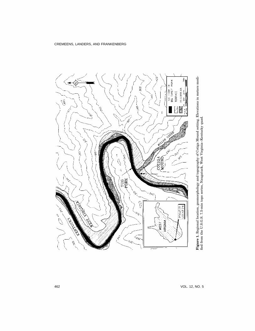
Table I. Typical profile characteristics of the terrace soil (Core C3).
Horizonb Depthc Munsell Colora Texture Structuref Boundaryg CutanClassese MorphologyMatrix Mottlesd
A1-fill 0–15 10YR2/1, sil m ai10YR3/3
A2 15–49 10YR4/3 sil 2msbk gBt1 49–56 7.5YR4/4 sicl 1fp-2msbk cs md10YR4/3aBt2 56–72 7.5YR4/4 sicl 1fpr-2msbk cs cd10YR4/3aBt3 72–87 7.5YR4/4 l 2msbk cs cd10YR4/3aBt4 87–122 7.5YR4/4 f 2.5Y5/2 1 1msbk g fd10YR4/3a
f 2.5Y6/2f 7.5YR5/6
BC 122–180 7.5YR4/4 f 2.5Y5/2 fsl 1csbk d ff10YR4/3aC1 180–240 7.5YR4/4 f 2.5YR5/6 sl m-1csbk csC2 240–277 10YR4/4 f 2.5Y5/2 scl 1msbk cs
f 7.5YR5/6C3 277–315 7.5YR4/4 f 2.5Y5/2 fsl m csC4 315–365 10YR4/4 ls-s sg gC5 365–414 10YR4/4 fsl-fs m csC6 414–452 2.5Y4/4 c 7.5YR5/6 sil m cs
c 10YR6/2C7 452–500 10YR4/4 s sg
a Moist color.b Soil Survey Staff (1992).c Depth below surface in centimeters.d Mottle abundance: f-few (2% of surface), c-common (2–20% of surface).e Texture classes: sl-silt loam, sicl-silty loam, l-loam, fsl-fine sandy loam, sl-sandy loam, scl-sandyclay loam, ls-loamy sand, s-sand, fs-fine sand.f Structure: grade 1-weak, 2-moderate, 3-strong; size f-fine, m-medium, c-coarse; type sbk-suban-gular blocky, pr-prismatic, m-structureless massive, sg-single grain.g Boundary: distinction a-abrupt, c-clear, g-gradual, d-diffuse; topography s-smooth, i-irregular.h Cutan morphology: abundance f-few, c-common, m-many; distinctness f-faint, d-distinct; typea-argillan.
lateral accretion sedimentation, such as point bar deposits, often associatedwith meandering stream systems (Blatt et al., 1980). The age of the terrace,based on the development of the argillic Bt horizon, was tentatively estimatedat 5000–8000 years (Cremeens, 1995).
The confluence of the Tug Fork and Miller Creek valleys contains a singlestable terrace with a single soil profile. No stable geomorphic surfaces appearto exist at elevations lower than the terrace, and no older, higher terraceswere observed in the immediate valley. The single terrace appears to be theonly level ground in the immediate area, and, prior to modern highway andrailroad construction, was a fairly broad, moderately well-drained level sur-face with ready access to river resources.
466 VOL. 12, NO. 5

GEOMORPHIC SETTING OF COTIGA MOUND, WEST VIRGINIA
General Mound Stratigraphy
The general stratigraphy of the mound, as observed in the field, consistedof a relatively uniform silt loam fill with a soil profile in the upper meter,basket-loading macrofabric, numerous archaeological features including thelog tomb Central Feature, a large ring of sandstone rock fragments (Feature8 Rock Ring) surrounding the Central Feature, and a Prepared Surface (Fig-ure 3[b]). The basket-loading macrofabric consisted of long, sinuous layersapproximately 5–40 cm thick and 50–100 cm long. Colors varied from darkyellowish brown and dark brown to yellowish brown. There were also slightvariations in texture, with sand and coarse fragment contents varying by upto 5%. The basket loading macrofabric in the upper 1 m of Cotiga Mound wasobliterated by soil formation (Cremeens, 1995).
The Feature 8 Rock Ring occurred at a depth of 1–2.5 m below the moundsurface (Figure 3[b]) and consisted of 1644 sandstone fragments arranged ina ring that enclosed the central features of the mound. The ring had an outerdiameter of 14.5–16 m, and an inner diameter of 7–8 m. The Prepared Sur-face, as identified in the field, was a relatively thin layer of yellowish brownsilt loam immediately overlying the submound Ab horizon. The central fea-ture was constructed on the Prepared Surface. In plan view the PreparedSurface was an oval about 15 m by 20 m in the center of the mound, primarilywithin the outline defined by the Feature 8 Rock Ring. No features or otherconstruction episodes penetrated through the Prepared Surface.
Detailed Mound Stratigraphy
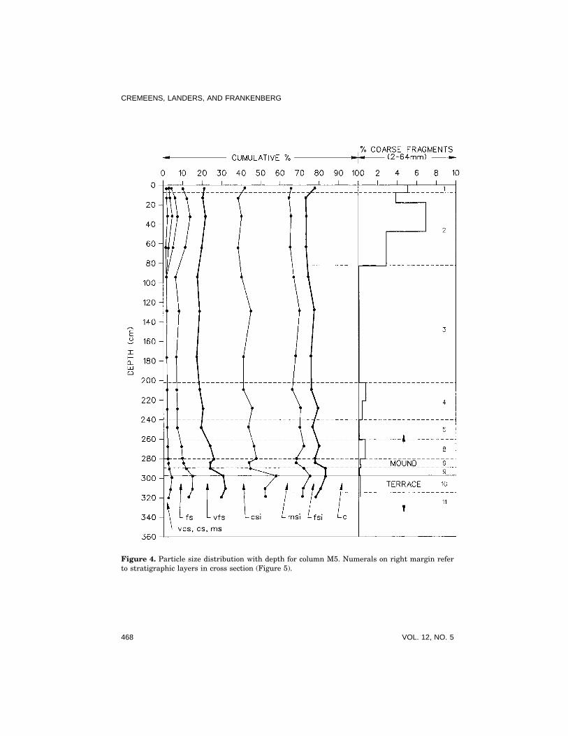
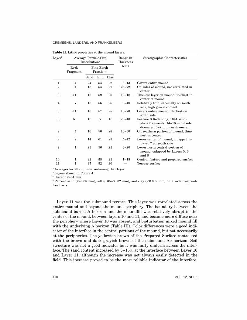
Particle-size analysis was used to delineate variations in the mound fill inorder to develop a detailed stratigraphic cross section of the mound (Figure4). The distribution of the fine earth fraction (,2 mm) with depth had a modeof coarse and medium silt (0.05–0.002 mm). Medium, coarse, and very coarsesands occurred in trace amounts in most of the mound and the upper horizonsof the terrace soil. Between 2% and 12% coarse fragments (2–64 mm) oc-curred in the upper portions of the mound. Layers were delineated based onchanges in sand and coarse fragment content so that the sequence could becorrelated from column to column.
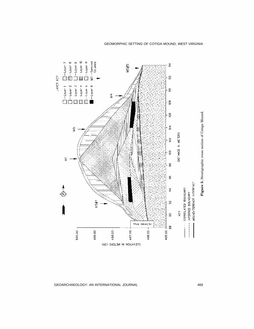
The cross section was constructed as a north–south cut through the moundto illustrate the sequence of layers (Figure 5). The concept of a Layer as astratigraphic unit is used in the sense of Stein (1990). Not every zone orhorizon delineated in the field, such as individual basket load, is shown onthe cross section because they could not be correlated. Major material unitsof the mound are shown as they might relate to the mound construction se-quence and potential borrow areas. Eleven layers were identified within andimmediately below the mound (Table II). Nine of these layers representmound construction episodes, one represents postconstruction surface distur-bance, and one represents the submound terrace sediments.
GEOARCHAEOLOGY: AN INTERNATIONAL JOURNAL 467
CREMEENS, LANDERS, AND FRANKENBERG
Figure 4. Particle size distribution with depth for column M5. Numerals on right margin referto stratigraphic layers in cross section (Figure 5).
468 VOL. 12, NO. 5
GEOMORPHIC SETTING OF COTIGA MOUND, WEST VIRGINIA
Fig
ure
5.S
trat
igra
phic
cros
sse
ctio
nof
Cot
iga
Mou
nd.
GEOARCHAEOLOGY: AN INTERNATIONAL JOURNAL 469
CREMEENS, LANDERS, AND FRANKENBERG
Table II. Lithic properties of the mound layers.
Layerb Average Particle-Size Range in Stratigraphic CharacteristicsDistributiona Thickness
(cm)Rock Fine EarthFragment Fractiond
Sand Silt Clay
1 4 24 54 22 6–13 Covers entire mound2 4 18 54 27 25–72 On sides of mound, not correlated in
center3 ,1 16 59 26 119–181 Thickest layer on mound, thickest in
center of mound4 7 18 56 26 9–40 Relatively thin, especially on south
side, high gravel content5 ,1 18 57 25 10–70 Covers entire mound, thickest on
south side6 tr tr tr tr 20–40 Feature 8 Rock Ring, 1644 sand-
stone fragments, 14–16 m outsidediameter, 6–7 m inner diameter
7 4 16 56 28 10–50 On southern portion of mound, thin-nest in center
8 2 14 61 25 5–42 Lower center of mound, onlapped byLayer 7 on south side
9 1 23 56 21 3–20 Lower north central portion ofmound, onlapped by Layers 5, 6,and 8
10 1 22 58 21 1–18 Central feature and prepared surface11 1 27 52 20 — Terrace surface
a Averages for all columns containing that layer.b Layers shown in Figure 4.c Percent 2–64 mm.d Percent sand (2–0.05 mm), silt (0.05–0.002 mm), and clay (,0.002 mm) on a rock fragment-free basis.
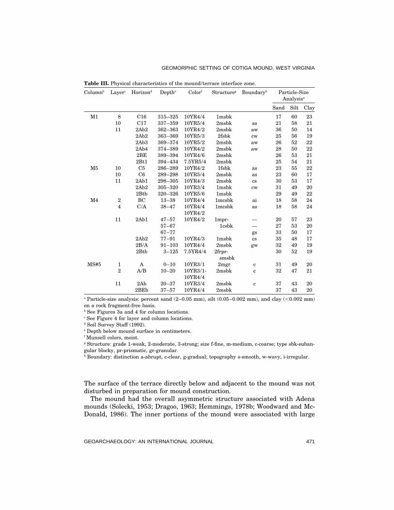
Layer 11 was the submound terrace. This layer was correlated across theentire mound and beyond the mound periphery. The boundary between thesubmound buried A horizon and the moundfill was relatively abrupt in thecenter of the mound, between layers 10 and 11, and became more diffuse nearthe periphery where Layer 10 was absent, and bioturbation mixed mound fillwith the underlying A horizon (Table III). Color differences were a good indi-cator of the interface in the central portions of the mound, but not necessarilyat the peripheries. The yellowish brown of the Prepared Surface contrastedwith the brown and dark grayish brown of the submound Ab horizon. Soilstructure was not a good indicator as it was fairly uniform across the inter-face. The sand content increased by 5–15% at the interface between Layer 10and Layer 11, although the increase was not always easily detected in thefield. This increase proved to be the most reliable indicator of the interface.
470 VOL. 12, NO. 5
GEOMORPHIC SETTING OF COTIGA MOUND, WEST VIRGINIA
Table III. Physical characteristics of the mound/terrace interface zone.
Columnb Layerc Horizond Depthe Colorf Structureg Boundaryh Particle-SizeAnalysisa
Sand Silt Clay
M1 8 C16 315–325 10YR4/4 1msbk 17 60 2310 C17 337–359 10YR5/4 2msbk as 21 58 2111 2Ab2 362–363 10YR4/2 2msbk aw 36 50 14
2Ab2 363–369 10YR5/3 2fsbk cw 25 56 192Ab3 369–374 10YR5/2 2msbk aw 26 52 222Ab4 374–389 10YR4/2 2msbk aw 28 50 222BE 389–394 10YR4/6 2msbk 26 53 212Bt1 394–434 7.5YR5/4 2msbk 25 54 21
M5 10 C5 286–289 10YR4/2 1fsbk as 23 55 2210 C6 289–298 10YR5/4 2msbk as 23 60 1711 2Ab1 298–305 10YR4/3 2msbk cs 30 53 17
2Ab2 305–320 10YR3/4 1msbk cw 31 49 202Btb 320–326 10YR5/6 1msbk 29 49 22
M4 2 BC 13–38 10YR4/4 1mcsbk ai 18 58 244 C/A 38–47 10YR4/4 1mcsbk as 18 58 24
10YR4/211 2Ab1 47–57 10YR4/2 1mpr- — 20 57 23
57–67 1csbk — 27 53 2067–77 gs 33 50 17
2Ab2 77–91 10YR4/3 1msbk cs 35 48 172B/A 91–103 10YR4/4 2msbk gw 32 49 192Btb 3–125 7.5YR4/4 2frpr- 30 52 19
smsbkMS#5 1 A 0–10 10YR3/1 2mgr c 31 49 20
2 A/B 10–20 10YR3/1- 2msbk c 32 47 2110YR4/4
11 2Ab 20–37 10YR3/4 2msbk c 37 43 202BEb 37–57 10YR4/4 2msbk 37 43 20
a Particle-size analysis: percent sand (2–0.05 mm), silt (0.05–0.002 mm), and clay (,0.002 mm)on a rock fragment-free basis.b See Figures 3a and 4 for column locations.c See Figure 4 for layer and column locations.d Soil Survey Staff (1992).e Depth below mound surface in centimeters.f Munsell colors, moist.g Structure: grade 1-weak, 2-moderate, 3-strong; size f-fine, m-medium, c-coarse; type sbk-suban-gular blocky, pr-prismatic, gr-granular.h Boundary: distinction a-abrupt, c-clear, g-gradual; topography s-smooth, w-wavy, i-irregular.
The surface of the terrace directly below and adjacent to the mound was notdisturbed in preparation for mound construction.
The mound had the overall asymmetric structure associated with Adenamounds (Solecki, 1953; Dragoo, 1963; Hemmings, 1978b; Woodward and Mc-Donald, 1986). The inner portions of the mound were associated with large
GEOARCHAEOLOGY: AN INTERNATIONAL JOURNAL 471
CREMEENS, LANDERS, AND FRANKENBERG
cultural features and activity areas, whereas the outer portions of the moundcontained few indications of activities other than mound construction. Layers10, 9, and 8 were associated with the inner central construction of the mound,the earliest mounding episodes. Layer 10 represented a culturally constructedsurface and feature fill, the Prepared Surface and Central Feature, which didnot occur outside of the prepared surface perimeter. Layers 8 and 9 indicatedcapping or closure of the central portion of the Prepared Surface, essentiallyforming a primary mound (Webb and Haag, 1941, 1942; Webb and Elliot,1942).
The Feature 8 Rock Ring, Layer 6, occurred stratigraphically above theprepared surface and its cap (Layer 8), thus postdating it. The rocks werepacked tightly with little or no sediment between fragments. The rock ringwas constructed on a bermlike structure correlated to Layer 7. Layer 7 ap-peared to extend in ramplike fashion to the south from the crest of the earlierstructure defined by Layer 8 (Charles et al., 1988). This was then coveredwith the first cap, Layer 5. Caps are defined as layers that extend across alarge portion of the mound, overlapping several of the inner-mound layers.Basket-loading macrofabric was contained in the capping layers above therock ring, Layers 2–5. Layer 5 covered nearly the entire mound, and wasinterpreted as asymmetric lateral extensions or additions onto the earlymound. On the north side, portions of this cap were thin possibly due to ero-sion. Layers 4 and 3 also covered the entire mound as caps. Layer 4 was oneof the few layers correlated across the entire mound, suggesting that it wasan intermediate generalized cap. Layer 3, the thickest layer covering themound, except on the north edge, where it was thin, probably resulted fromlocalized filling, or building up, of the mound crest. Layer 3 was capped byLayer 2 except at the mound crest where Layer 2 was not correlated and mayhave been eroded. Layer 2 was considered a general cap since it coverednearly the entire mound. Sediments eroded from layers 2 and 3 may haveformed the bulk of materials at the periphery of the mound. Layer 1 was apatchwork of slightly differing thin layers at the very surface of the mound,apparently the result of erosion, sedimentation, and postconstruction distur-bance such as the redistribution of spoil from intrusions by later people or an-imals.
Geophysical Survey
The seismic fan survey indicated that refracted seismic velocities of thelower levels (2 and 4 m below mound crest) were statistically different fromthe upper level (1 m depth). Midlevel (2 m) velocities were skewed towardslower values, while the lower level (4 m) velocities were skewed toward highvalues. A very high velocity anomaly was located near the center of themound, offset to the south, and appeared to correlate with the center of theFeature 8 Rock Ring (Figure 3[a]). In other words, the seismic survey de-
472 VOL. 12, NO. 5
GEOMORPHIC SETTING OF COTIGA MOUND, WEST VIRGINIA
tected the ‘‘donut hole’’ of the rock ring. Seismic waves evidently traveledfaster around the rock ring than across the soil material in the center, butwere interpreted as traveling through the center.
Ground penetrating radar (GPR) displayed little evidence of stratigraphiclayering in the mound. Instead, there were numerous point targets classifiedas weak or strong. Strong ‘‘ringing’’ targets, usually associated with largemetallic objects, rock, or concrete, only had lateral continuity near disturbedareas. Other noticeably strong point targets were 2.5–2.6 m deep and south-east to southwest of center and could not be correlated with any objects uponexcavation. Weak targets were numerous and unevenly distributed through-out the mound. The sandstone rock ring buried in an otherwise silty moundprovided an excellent target for GPR, but was not detected during the GPRsurvey.
Borrow Areas
Most of the Cotiga Mound fill materials were silt loam (Figure 6). In con-trast, soil textures beneath the mound, and on the terrace were mostly loamsand sandy loams. Only the Ap horizon of Core C7 and the surface layersimmediately beneath the mound had textures similar to those of the moundfill. An intact A horizon was found beneath the mound and an overthickenedA horizon surrounded the mound. Little, if any, of the mound fill was collectedfrom the mound base area or the immediate area of the surroundingterrace.
A shallow trough-shaped depression was located about 30 m south of themound and adjacent to an earth road (Figure 2). In places the depression hadapproximately 50–75 cm of modern fill materials overlying a natural A or Bhorizon. Samples from Backhoe Trench 1 (BHT 1), in the depression, weresilt loam and silty clay loam, similar to the mound (Figure 6). Coarse frag-ment content of samples from BHT 1 were also similar to those from themound fill. Colluvial soils with variable amounts of coarse fragments, at thebase of the valley walls, may have also been a source for some of the moundmaterials.
DISCUSSION AND CONCLUSIONS
Construction of mounds on upper terraces, above significant flood risk,is characteristic of most Adena mounds in the upper Ohio Valley (Hem-mings, 1978b). Clay (1986) even indicates that the majority of Adenamounds in northern Kentucky are constructed on physically isolatedridgetops away from riverine environments. With the exception of largeriver valleys, large expanses of level land are relatively scarce in theAppalachian Plateau. Flood plains and low terraces provide the only rela-tively large areas of level land with a source of sediments suitable forconstruction of mounds (Woodward and McDonald, 1986). Willow Island
GEOARCHAEOLOGY: AN INTERNATIONAL JOURNAL 473

CREMEENS, LANDERS, AND FRANKENBERG
Figure 6. Particle-size range for the mound sediments, terrace sediments, and samples from apossible borrow area.
Mound was constructed on an upper terrace of the Ohio River mappedwith the Wheeling (Ultic Hapludalfs) soil (Hemmings, 1978b). Not onlywas this terrace removed from flood risk, the Wheeling soil had propertiesfavorable for earth construction. The terrace on which Cotiga Mound wasbuilt constituted the only stable, level surface in the area. Therefore, thechoice of mound location was constrained by the physical limits of thegeomorphic environment. The terrace exhibited a single soil profile with a
474 VOL. 12, NO. 5

GEOMORPHIC SETTING OF COTIGA MOUND, WEST VIRGINIA
submound A horizon radiocarbon date of 4300 B.P., and an argillic Bthorizon indicating that the mound was constructed on a mid-Holoceneterrace that was 2000–3000 years old at the time.
A potential borrow pit for Cotiga Mound fill was located in a depressionarea south of the mound. Nearby building and road construction made thisinterpretation uncertain. The depression may have been the remnant of anold channel from either stream, or possible the remnant of borrow pits associ-ated with construction of the buildings, the railroad, and/or the highway. Theterrace surface in the immediate area of the mound was not used for borrowor disturbed for mound construction. Alternative borrow areas, based on soilcharacteristics, could include the surface of the terrace where the buildingswere constructed, the other side of Miller Creek (Core C7), the mouth ofMiller Creek, and the banks of the creek and the Tug Fork River (Figure 2).The deeper, sandier materials in the terrace were not used in mound con-struction, even though they might have been readily accessible in the terracebanks. This could indicate a preference for silty materials during mound con-struction. Several mounds in northern Kentucky were constructed of immedi-ately available materials based on similarities in estimated textures and ob-servations of nearby depressions (Webb and Haag, 1941, 1942; Webb andElliott, 1942).
Accretionary burial mounds are vertically organized cemeteries built dur-ing decades or centuries (Clay, 1986). Dragoo (1963) identified an inner pri-mary mound in Cresap Mound by a humus-laden zone within the interior,indicating a possible hiatus in construction episodes. In Cotiga Mound nopostdepositional soil development (i.e., humus layers) or weathering wasfound between the mound layers, indicating that mound construction wasrelatively continuous at least within a pedogenic time span. This does notindicate that construction episodes or methods were uniform during moundconstruction.
Different methods of construction can be inferred from the distribution offabric properties in the mound fill. Basket-loading macrofabric is a primarysedimentary structure of mound fills resulting from the mode of deposition,and formed at the time of deposition. In Cotiga Mound, the macrofabric wasonly found in the cap layers above the central feature primary mound androck ring, indicating that the lower, inner mound layers were not constructedby simple basket loading. Variation between basket loads probably resultsfrom variations in soil horizons at the borrow site (Bettis, 1988).
Adena mound construction and the attendant mortuary ceremonialism arecharacterized by extreme variability whose events or activities can be deciph-ered by detailed stratigraphic analysis (Clay, 1986; Seeman, 1986). Particle-size analysis (PSA) is an important tool for characterizing and differentiatinglayers, and for differentiating between the mound fill materials and sub-mound soil horizons at the mound/terrace interface. Delineation of themound/terrace interface is important because the shape of submound ‘‘struc-
GEOARCHAEOLOGY: AN INTERNATIONAL JOURNAL 475
CREMEENS, LANDERS, AND FRANKENBERG
tures’’ echoes the plan of the subsequent earthworks (Clay, 1986). In time theaccretionary mounds are expanded beyond the floor area of the submoundstructures. PSA can be used to detect subtle differences in materials used indifferent phases of construction and in sources, subtle differences often notdetectable during field observations. The result is a quantitatively detailedmodel of stratigraphy that provides a more refined context for evaluating con-struction of earthworks, and delineation of the interface between the earth-works and the natural surface on which they are constructed. That latter isespecially critical for burial mounds because of the ceremonialism associatedwith the early use of the mound area.
The authors thank the West Virginia Department of Highways, the citizens of West Virginia,and GAI Consultants, Inc. for support. G. Henning, S. Sherwood, and the Soil CharacterizationLaboratory at Pennsylvania State University assisted with the field and laboratory analyses.Vance Holliday and an anonymous reviewer provided several helpful comments.
REFERENCES
Ammons, J.T., Newton, J.E., Foss, D.L., and Lynn, W.R. (1992). Soil Genesis of Two IndianMounds in West Tennessee. Soil Surv. Horiz. 33, 39–45.
Bettis, E.A., III (1988). Pedogenesis in Late Prehistoric Indian Mounds, Upper Mississippi Val-ley. Physical Geography 9, 263–279.
Blatt, H., Middleton, G., and Murray, R. (1980). Origin of Sedimentary Rocks. Englewood Cliffs,New Jersey: Prentice-Hall.
Charles, D.K., Leigh, S.R., and Buikstra, J.E. (1988). The Archaic and Woodland Cemeteries atthe Elizabeth Site in the Lower Illinois Valley. Kampsville Archeological Center, ResearchSeries 7. Kampsville, Illinois: Center for American Archeology.
Clay, R.B. (1986). Adena ritual spaces. In K.B. Farnsworth and T.E. Emerson, Eds., EarlyWoodland Archeology, pp. 581–595. Kampsville, Illinois: Center for American ArcheologyPress.
Cremeens, D.L. (1995). Pedogenesis of Cotiga Mound, A 2100-Year-Old Woodland Mound inSouthwest West Virginia. Soil Science Society of America Journal 59, 1377–1388.
Dragoo, D.W. (1963). Mounds for the Dead. Anthropological Series 37. Annals of the CarnegieMuseum. Pittsburgh, Pennsylvania: Carnegie Museum.
Gee, G.W., and Bauder, J.W. (1986). Particle-Size Analysis. In A. Klute, Ed., Methods of SoilAnalysis, Part 1—Physical and Mineralogical Methods, pp. 383–412. Madison, Wisconsin: SoilScience Society of America.
Greenman, E.F. (1932). Excavation of the Coon Mound and an Analysis of the Adena culture.Ohio Archaeological and Historical Society Publications XLI, 367–523.
Hemmings, E.T. (1977). The Core Drilling Project at Grave Creek Mound: Preliminary Resultsand Radiocarbon Date. West Virginia Archaeologist 26, 59–68.
Hemmings, E.T. (1978a). A New Look at an Old Mound. Mountain State Geologist 1978 (Dec.),26–29.
Hemmings, E.T. (1978b). Exploration of an Early Adena Mound at Willow Island, West Virginia.Report of Archaeological Investigations RAI-7. Morgantown: West Virginia Geological andEconomic Survey.
Hemmings, E.T. (1984). Investigations at Grave Creek Mound 1975–76: A Sequence for Moundand Moat Construction. West Virginia Archaeologist 36, 3–49.
476 VOL. 12, NO. 5
GEOMORPHIC SETTING OF COTIGA MOUND, WEST VIRGINIA
Hirsch, R.M., Scott, A.G., and Wyant, T. (1982). Investigations of Trends in Flooding in the TugFork Basin of Kentucky, Virginia, and West Virginia. Supply Paper 2203. Washington, D.C.:U.S. Geological Survey Water.
Kelly, J.A. (1990). Soil Survey of Pike County, Kentucky. Washington, D.C.: USDA Soil Conserva-tion Service.
Kolb, M.F., Lasca, N.P., and Goldstein, L.G. (1990). A Soil-Geomorphic Analysis of the MiddenDeposits at the Aztalan Site, Wisconsin. In N. Lasca and J. Donahue, Eds., ArchaeologicalGeology of North America, pp. 199–218. Centennial Special Volume 4. Boulder, Colorado:Geological Society of America.
Mills, W.C. (1902). Excavation of the Adena Mound. Ohio Archaeological and Historical QuarterlyX, 452–479.
Parsons, R.B., Scholtes, W.H., and F.F. Riechen (1962). Soils of Indian Mounds in NortheasternIowa as Benchmarks for Studies of Soil Genesis. Soil Science Society of America Proceedings26, 491–496.
Saunders, J.W., and Allen, T. (1994). Hedgepeth Mounds, an Archaic Mound Complex in North-Central Louisiana. American Antiquity 59, 471–489.
Seeman, M. (1986). Adena ‘‘Houses’’ and Their Implications for Early Woodland Settlement Mod-els in the Ohio Valley. In K.B. Farnsworth and T.E. Emerson, Eds., Early Woodland Archeol-ogy, pp. 564–580. Kampsville, Illinois: Center for American Archeology Press.
Soil Survey Staff (1992). Keys to Soil Taxonomy, 5th. SMSS Technical Monograph 19. Blacksburg:Virginia Polytechnic Institute and State University.
Solecki, R.S. (1953). Exploration of an Adena Mound at Natrium, West Virginia. Bureau of Eth-nology Bulletin 131, 313–395.
Stein, J.K. (1990). Archaeological Stratigraphy. In N.P. Lasca and J. Donahue, Eds., Archaeologi-cal Geology of North America, Geological pp. 513–523. Centennial Special Volume 4. Boulder,Colorado: Geological Society of America.
Thornbury, W.D. (1965). Regional Geomorphology of the United States. New York: John Wileyand Sons.
Thurman, N.C., Ciolkosz, E.J., and Dobos, R.R. (1992). Soil Characterization Laboratory MethodsManual. Agronomy Series No. 117. University Park: Pennsylvania State University.
Webb, W.S., and Elliot, J.B. (1942). The Robbins Mounds, Sites Be3 and Be14, Boone County,Kentucky. Reports in Anthropology and Archaeology 5(5). Lexington: Department of Anthro-pology, University of Kentucky.
Webb, W.S., and Haag, W.G. (1941). The Morgan Stone Mound, Site 15, Bath County, Kentucky.Reports in Anthropology and Archaeology 5(3). Lexington: Department of Anthropology, Uni-versity of Kentucky.
Webb, W.S., and Haag, W.G. (1942). The C. and O. Mounds at Paintsville: Sites Jo2 and Jo9,Johnson County, Kentucky. University of Kentucky Reports in Anthropology and Archaeology5(4). Lexington: Department of Anthropology, University of Kentucky.
Woodward, S.L., and McDonald, J.N. (1986). Indian Mounds of the Middle Ohio Valley: A Guideto Adena and Hopewell Sites. Blacksburg: McDonald and Woodward.
Received September 9, 1996Accepted for publication February 12, 1997
GEOARCHAEOLOGY: AN INTERNATIONAL JOURNAL 477
