general report - dspace@gipe
TRANSCRIPT
SURVEY OF INDIA \
GENERAL REPORT
I
From 1st October 1934 'l'o 30th Sept.ember 1935
,PUBLISHED BY ORDER OF
BRIGADIER H. J. COUCHMAN, D.s.o., M.O •
. ,~· -· SU~VEYOR G~N~RAL OF INDIA, ~ .:·- _:-•. -~ -· .
- ._t,
"_. --. '
17 , /~ ,---... ·,. Printed at th~ Photo:~Litho, Offlce,
(, p_~,.' .· _ _ ~-----~---~urvey of India,
I~. J7::4..;{(;~fALCUTTA. . .. . - . -:·· . ' - . :~ 1935.
· .. ·· · -~~.---~--'· ."':.~~ {pyright reserued • . . x.,r .,. ... .., _ .. ,..~ .J. --·~--~ --+-- .~ .. "'-~
~~:-.2-SJ Annas or Tw~ Shillings and Six Pence.
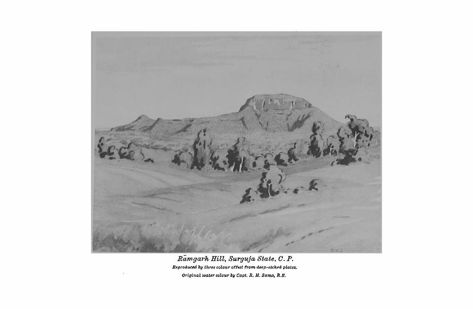
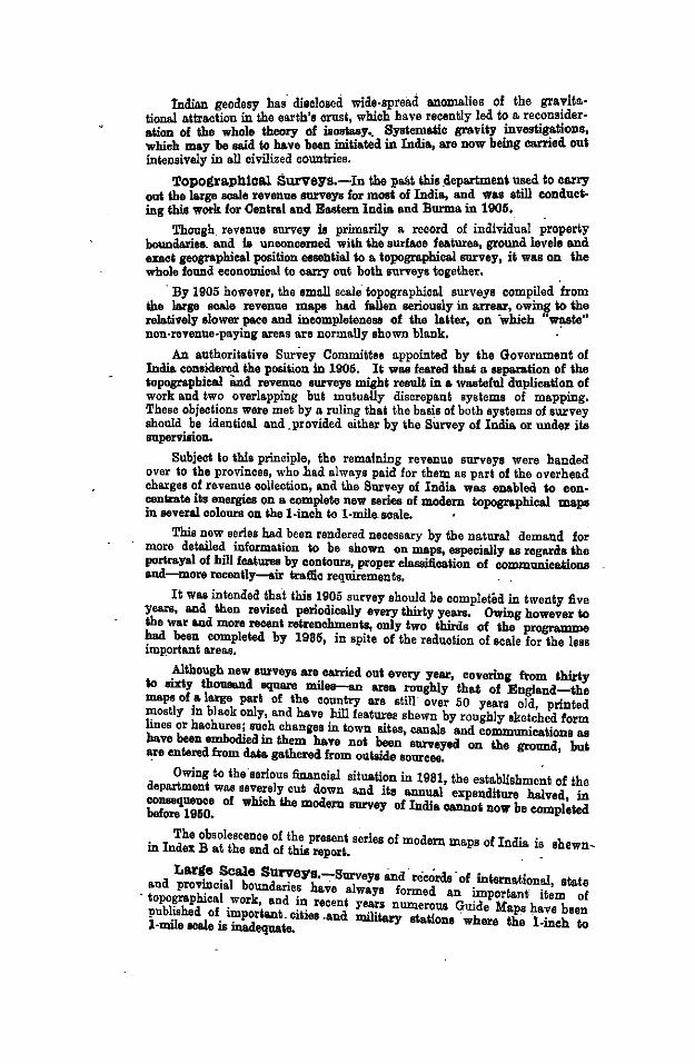
Ramga1·h Hill, Surguja Btate, C. P. R~prod.u(ed by thrte colour offset from detp·elchtd. platt!.
Orioinat wattr colour by Capt. R. H. Sam,, R.E.
SURVEY OF INDIA
GENERAL REPORT
1935
From 1st October 1934 To 30th September 1935
PUBLISHED BY ORDER OF
BRIGADIER H. J. COUCHMAN, D.S.O., M.C.
SURVEYOR GENERAL OF INDIA.
_ Printed at the Photo.-Litho. Offl<:e,
Survey of India,
OALOUTTA,
1935.
Copyright reserued.
NOTICES
I. Work done by the . Survey of India.
II. How. to obtain maps and other publications.
III. List of Agents for the sale of maps.
t. WORK DONE BY THE SURVEY OF INDiA
APPLICATION FOR SURVEYS OF ANY KIND, whether for private or Goveromeot purposes should be made to the followiog officers : The Direot.or, Frontier Oircl;, •Survey of India., Simla. (!el, 11 Sur~~ontitr~'li
Geodetio Branch • , Debra. Dun. (!l'sl. 8urtrig ). " n · Ea.atern Oirole •' ;; ,, Shillong. (Pel. 11 Surea1t", n 0 a. No.6 (Booth fudia.) II " Ba.ngalore. (Pe~. "Burfield. (SiAl"). n • Party•
,. No, 10 (Burma) n Part,.,• "
FonBsT AND CANTONMENT SunrBYB, LEVELLING, TRu.NoULA· TJON AND 'l.'IDB-TAnl.BS. Advice in regard to these, and on scientific qnestions, is obtainable from the Di•·ector, Geodetic BJ"anch, Survey of India, Dthra Dun, who undertakes a good deol of levelling and similar work for mnoicipalities and engineering projects, on payment. ( T el'll,.aiM "Su1'1rig ").
MAPS AND ILLUSTRATIONS can be printed by the DireciOJ•, Map Publication, Survey of India, IS Wood Street,_ Calcotts, for Govern· ment Departments only, and special maps can also sometimes be prepared, on payment. ·
TaB MATHEMATICAL lNsTauuxNT 0FFICB, Survey of India, 15 Wood Street, Calcutt&, is •· well equipped Government Factory which supplies, manufactures and repairs all kinds of Surveying Drawing, Optical, Meteorological and Medical instrnments. It also manttfactures special instruments for experimental purposes and receives back surplus instruments on valuation, f1·om nll Government Departments, whether Imperial or Provincial.
The Price List, Rule~ and Regulations and Forms lor Indent», Repairs aod Deposits are supplied gratis on application. ( 7'el'l/l'aiM "Surimt"). . . . : . . ·
GxNBRAL BNQUIRIBB should be addressed tc the Assistsot Surveyor General, IS Wood Street, Calcutta. (Te/'1/rams "Survq•"), _as the Surveyor General of India .is on tcur dqriiig most of the year.
- . • PrtnJiflce& mul.Sialu .in each Sw11e9 Circle.
l. PBON7!IBB Oirde 2. Kuhmir .and Jammu N. W. F. Prorince Balttobittiul Pooj&b PaojabBtaleo BikB.ner State Bincl
6. No.lO (B!VN .. ) P•rty. Barma.
GBODBTIO Brand. 3, No. 6 (South United Provinces India) Part.p. Centrallnotia Madru Gwalior Madru State• Ajmer.Merwira H vderibid Delhi .M yaore and Coorg E. Rii{lutii.n& Sta.tee Bomba.r (Southern W. RiJputina States Dirinon). Baroda Bombay (Northern
Division). States of Western
India.
4. BA.STBBN Olrcle Central Provinces
(including Berir), Bihir a.nd Orisaa Bengal Aemm and Sikkim, Ea.etern Statoo,
II;. HOW 1'0 OBTAIN MAPS
AND OTHER PUllLICA-:riONf:3
· · StrRVBY oil' lliDIA MAPB are obtainable from. tloe Map Office, IS WooC'! Street, Calcutta (Tel. "Sw·maps"). :Aiiro to some extent from the Agents detailed below and from the Direetors of' Survey Circles. A ·MAP·CAT.u.oauB, which itself forms a useful atlas of India and ~urrounding .eountries, can be obtained for Re. 1/- (postji'ee):
FonBBT Alln .CAIITON>!BIIT Mus ao·e ·obtainable front. the Map Office, Survey of India, Debra Diin. (Tel. "Sw·Mg"). . ·. !
GBOLOO IOAL MAPs are prepared by . and can be obtained from the Director, Geologicnl Survey, Calcutta. ·
SunvBY. Puoi.toATioNs OTBBn THAN MAPS, as outlined belo~. are obtainable tlorough the Director, Geodetic Branch, Survey of India, Debra. D~n, who_ will s11pply a _IIlli Oata/ogue gr·atis on application, The Catalog11e is also included in the Annnal Geodetio ReJ>oit. . -
(a) 7Hgonometr·ical data; Triangulation pamphlets, each covering ' · . ··_one square degree, giving descriptions, positions, and height&
of triangulated points and other data, with chart. · Leve!linjt pamphlets, each covering 4" x 4°, giving desoriptiona anll heights of Bencil marks, with chart. ·
(b) 1'idal Predictions, published llnnnally in ~dvance as Ti~ Tables of. tht Indian Ocean. These tables contain predio-
_..,.. · :tiona lor 41 ·Indian and Burmese ports, "!ld for 28 other · ports in rario\l!j parts of the world. ·
(c) ·_Gtodetic wot·ks. of Riferenc.,_The G. T.S. selies of twenty-one large quarto volumes describing in detail the geodetic operatlons of the Great Tligonometrical Snr:vey from 1800. Detailed a~connts are !l'iven cif the llase-line measuremente, of the reduction of the Geodetic Triang11lation treated in five portions, of the early Pendulum observations, of T-elegraphic
.· Longitude and. Astronomical Latitude operations, Of Tidal observations, and of Levelling of high precision. .'
(d) Hi~to~ical, and .Gentral Report•, including the "Memoirs on lndiao. Surveys" by Sir Clements Markham and C.E.D •
.. Biac)<: also Annual Reports, Narrative Reports, Record V olnmes, and the annunl· Geodetic Repnrts. ·
(•) Miscellantous. Papers on Geodesy, Exploration, etc. including a "Sketcl1 of the Geography and Geology ·of the Himiilaya Mountains and Tibet" (in 4 parts) revised in 19SS.
- , ;
lll. LIST OF AGENTS FOR THE SA I.E OF MAPS
OoT or INnu.
Enf1ltmd. ). Secy. totloe High Commissionerfor India. (Genl. Deptt.),India Honse, Aldwych, London, W, C. 2.
2. Sifton Praed & Co. Ltd., The Map Honse, 67 St. James's Street, London, S. W. 1.
Amnica. s. C. S. Hammond & Co., SO Clonrclo St •• Hudson Ter-minal, New York, nnd 75 StAte St., Boston, Mass.
G11·many. 4. Dietrich Reimer, Berlin, S. W. 48. OAina. 5. The French Book Stores, Grand Hotel de Pekin,
Peiping. INDIA.
Aflra. ). English Book Depot, Tiij Road. 2. IndiAn Army Bonk Depot, DAyiil Biigh.
.Ajmtr. s . Rajputana Book Honse. . -.Allalotibdd. 4. North India Christian Tract and Book Society. .A mba/a, 5 . Ram Cbnnder & Sons.
6. English Book Depot, Ambiila Cantonment. Ba"ff4lore. 7. Raja Gopal Photo. Zinco. and Printing Works,
Fort Bangalore. Bar,'l/y. 8. London Book Depot. Baroda. 9. B. Parikh & Co., Miodvi Road. Bombay. · 10. Thocker & Co.
11. D. B. TarAporevAla Sons & Co. 12. King & Co., 213-216 Badri Mahal, Hornby Road.
Ca/culla. IS. W. Newman & Co., 8 Old Conrt Honse Street. . 14. AntomobileAssociAtion of Bengal, 40 Chowringhee • 15. City Mop Agency, Govt. Book Depot, 8 Hastings St. 16. Oxford Book & Stationery Co., 17, Park St. 17. Tloocker Spink & Co., S Esplanode Ea•t. 18. The Good Companions, Chowringhee.
Oawnpot•. 19. Ad vani Brothers. DarJ••li•fl· 20. Oxford Book & Stationery Co. Dt/Ai. 21. Oxford Book & StAtionery Co., 1\ oshmtr Gats,
22. Ramesh Book Depot and Stationery Mort. 28. J. M. ,Jaina & Brothers, Mori Gats. 24. Bhawani & Sons, Connanght Ploce, New Delhi, 25. Oxford Book & Stationery Co., Connanght Place,
New Delhi. Dum-Dum. 26. Indian Air Snrvey & Transport Ltd. Ferozepore. 27. English Book Depot, W azir Ali Buildings. lmJor~. 28. The Manager, Dak Bungalow, Indore.
29. The Proprietor, Central India High Class Athletic Depot.
Jhnflli. so. English Book Depot. KariicAi. 81. Aero Stores, N spier Road. Ka~auli. 82. Ram Chander & Sons. Ka1Aml•·· 88. Cockbnrns Agency, Srinagar.
84. D. G. Smith & Co., Srinagar. Ltd ore, 85. Pnnjab Religions Book Society, Aniirkali.
86. l!tandard Book Depot. · 37. Oxford Book & Stationery Co.
Lvclcnow. 88. Luckoow Pllhlishing Honse, The Mall Mado·a1, 89. Higginbotham• Ltd. '
( Otmtinued OvtJrlea-f)

III. LIST OF AGENTS FOR THE
SALE OF MAPS-(Ooncld.)
INDu.-(Ooncld.) Jf••rut. 40. Oxford Book & Stationery Co •. • JlutT... 41. J. Ray & Sons, The Mall. ,Jiwsoot·ie. 42. 1'he Mnssoorie Book Society. Mtn~fa>pur. 43. Bnnoan & Co. Nagpur. 44. Superintendent, Govt. Printing, Book Depot. Ootacamund. 45. Higginbothems Ltd. Patna Oity. 46. K. P. Saxena & Co., Diwan Mohalla. P••hdwa•·· 47. Faqir Chand Marwab, Peshawar Cantonment.
Prxma.
Quetla.
Rangoon. Rawalpindi. Simla,
, 48. J. Ray & Sons, Arbab Road. 49. Sham La! & Sons. 50. London Book Co. (India), 51. The International Book Service, Deccan Gymkhana
Colony. 52, Standard Book Stall, Club Corner. (Temporarily
closed). 58. The Curat01·, Government Book Depot, Burma. 54. J. Rlly & Sons, 48 K & L, Edwardes Road. 51>. Oxford Book & Stationery Co.
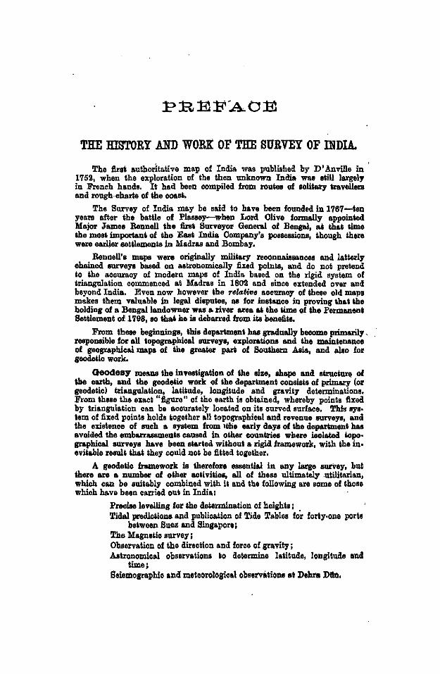
THE HISTORY AND WORK OF THE SURVEY OF INDIA.
The first authoritative map of India was published by D' Anville in 1752, when the exploration of the then unknown India was still largely in French hands. It hod been compiled from routeo of solitary tr&vell8I8 and rough.oharle of the ooast.
The Survey of India may be said to have been founded in 1767-ten years after the battle of Plossey-when Lord Olive formally appoin4ed 'Major James Bonnell the first Surveyor General of Bengal, at that time the most important of the East India Company's posBeBBklns, though there were earlier aetllemenls in 'Madras and Bombay.
Bonnell's maps were originelly military reconnaissances and latterly chained surveys based on astronomically lixed points, and do not pretend lo the accuracy of modern maps of India based on ths rigid system of triangulation commenced at Madras in 1802 and since extended over and beyond India. Even now however the relative accuroey of these old maps makes them valuable in legal disputes, as for instance in proving that the holding of a Bengal landowner was a river area at the time of the Permanent Setllement of 1798, eo thai he is debarred from ite beneftla.
From these beginninga, this department has gradnelly become primarily .. reeponeible for all topogrophicel surveys, explorations and the meinlenence of gaographioal maps of the greater pari of Soulhern Asia, and aleo fo• seodelio work.
Geodesy means the invesligatlon of the size, shops and structure of the earth, and the gcodelio work of tho department consists of primary (o• gaodeticl triangulation, lalilude, longitude and gravity determinations. From these the exact "figure" of the earth is obtained, whereby points fixed by triangulation can be accurately looa.ted on its curved surface, This sys. lem of fixed points holds together all topographical and revenue surveys, and the existence of ouch a eyslem from tthe early days of the department has avoided the embarrasemenls cauaed in other countries where isolated lopo· graphical surveys have been starled without a •igid framework, with the in· evilable result thai they could not be fitted together.
A geodelic framework Is therefore essential in any laqe sn>vey, bul there are a number of other aoliviliea, all of these ultimately .utilitarian, which can he suitably combined with !t and the followins are some of tboss which have bssn carried out in India:
PfOOlae levellins fo• the determination of heights; Tidal p&'Odiclione and publication of Tide Tables for fofiy·one poria
belween Suez and Singapore; The Maguetio suney; Observation of the direction and force of gravity ; Astronomical obssrvations to determine latitude, longltuao and
time; Seismosraphic and moloorological observiotiollll at Dshfa Dlln,
tnclian geodesy has disclosed wide-spread anomalies of the graylta· tiona.! attraction in the earth's crust, which have re~ently l~d t~ a. rec_ons~der· alion of the whole theory of isoslasy.. Systemalic grav1ly !"ves~lions, which may be said to have been illiliated in India, are now bemg carr1ed oui intensively in all civilized countries.
Topogra.pb1ca.l Surveys.-In the pa!lt this .department used to carry oni lhe large aca.le revenue surveys for mod of India, end woo still conduct· ing this work for Oenttsl and Esslem India and Burma in 1906,
Though. revenue survey is primarily a record of individual property boundaries. and i& unconcerned wUh lhe surface features, ground levels and exaci geographical position esseblial to a topographical snrvey, it was on lhc whole found economical to carry out both surveys together.
·By 1905 however, the smo.ll scalelopogrsphieal surveys compiled from 1he large seale revenue mapa had fallen seriously in arrear, owing io ibe relo.tively slower p&ee and incompleteness of the latter, on ·which "w~te" non-rovenue-pn.ying areas are normally shown blank.
An authorita.tive SurVey Committee appointed by the Government of India considered lhe posilion in 1905. II was feared lhsl a soparalion oflhe topographical and revenue surveys might resnlt in a wasteful duplicalion of work and two overl&pping but mutually discrepant systems of ma.pping. These objections were met by a ruling tha.t the basis of both systems of survey should be identical and .provided either by lhe Survey of India or under ils supervision.
Subject to this principle, the remaining revenue surveys were handed over to the provinces, who .had always paid for them as part of the overhead cha.rges of revenue collection, &nd the Survey of India was enabled to concentrate its energies on a complete new series of modern topographical maps in several colours on the l-inch to 1-mile. scale.
This new series had been rendered necessary by the natural demand for more deto.iled information io be shown on maps, espeeia.lly as regards the portrays) of hill fealurco by contours, proper clsssi1icalion of commnnicauons and-more recently-air tra.flic requirements.
II was intended that this 1905 survey should be completed in twenty live years, and lhen revised periodically every thirty years. Owing however to ~e war a.nd more recent; retrenchment;s, only two thirds of Ule programme had been completed by 1985, in spite of the reduction of scale for the less imP.ortant a.rea.s.
Although new surveys are carried out every year, covering from &hir&y 1o sixty thonoand square miles-an area roughly that of England-lhe maps of a large par• of the country are still· over 50 years old printed ~ostly in bla.ok only, and have hill features shewn by roughly aket~hed form lines or hachures; such changes in town Bit.es, canals and communications as have been embodied in them have not boon surveyed on lhe ground bul are entered from data gathered from outside sources. . '
Owing to the serious financia.l situation in 1981, the establishment of the depa.rtment was sev~e]y cut down and its annual expenditure halved, in conoequence of which the modem survey of India CODDot now be completed before 1960.
• The obsolescence of the present aeries of modern maps of India. is shewn .... m Index B at the end of thio report. . _
La.rt!e ~ca.le Suryeys.-,.Snrveys ed. reoords . of inlemational, state . a.nd provl;Dcta.l bounda.ne~ ha.ve always formed an important· item of topo~aphica.l .work, and ~~ recent years numerous Guide Mapa have been pub~IShod of_ ~porlant. Cllleo .and military stalions whore the l-inch to l·mile aca.le ,. in&dequale.
Miscellaneous.-Wbu6 expending on topog•aphical and geodetic work oil funds allotted by imperial uvenuea, tbe department is prepared to undertake or aid local surveys, on payment by those concerned,· such as
Forest and cantonment surveys; Riverain, irrigation, railway and city BUrVeya; Surveys of tea. ga.rdens and mining areas, , with such ConkoJ
levelling as is necessary for these operations. Administrative assistance is also given, and execuUve officers lent, in
aid of the revenue surveys of various provinces and staes. !l'he Printing Offices at Calcutta and Deh•a Diin are olways at the dis·
posa.l of other Government departments, for such work as the printing of special maps, illustrations for reports and eJl diagra.ma for pa.ten~s.
!l'he Mathematical Inetrnment Office of lhie department &Ssiols all Government depa.rtments, as well as non-officials, by maintaining up-1o-date instrumental &nd optical equipment and by manufacturing and repairing instrnmonts which would otherwise have to he replaced f•o1:9- abroad.
M11itary Requirements a.nd Air Survey.-The Department is also responsible for all survey operations required by the· anny, and is in a position io · meet tbe rapidly increasing complexity of modern military requirements, especially in air survey.
In view of its high military importance, air survey work ior civil purposes is· receiving all possible assistance, and continuous research is being carried on in the latest methods of mapping from photographs taken from the growid and in the ail:.
Ths flying and photography for air mapping done by this ·department are at present carried out by the Royal Air Force or the Indian Air Survey Company, a commercia.] firm with headquarters at Dum Dum.
Admlnistra.tton is in the bands of the Surveyor General under lhe Education, Health and Lands Department of the Government of India.
The Headquarters Office ia at Calcutta under the Assistant Surveyor General, and there are four Directors, one for the Map Publica.tion and other technical o!licee al Calcutta, and three for three of the live Survey of India Circles into which the country is divided; tilie other two Circle are&S (covet· ing Burma and South India) are odminislered personally by the Surveyor Gene:n.I.
Of the tiliree Circle Directors, one also adminiote•s the Geodetic Branch at Debra Dtln in addition to hie topographical survey Circle.
Nomenclature.-Ahhough the terms "Iran" a.nd "Irltnie.n" a.re now to be.used in all correspondence il).·. supersession of 11 Persia." and 11Persian" respectively, the latter are uoed throughout Ibis report in order to conform with the maps published by the Survey of India, on which the old names are to be retained.
CONT~NTS.
PBBF.A.OB-The """""' tm4 work of U.. s_, of IndiG.
PART L GENERAL. I. INTRODUCTION and SUMM~Y-
II. ABSTRACT OF SURVEYS in oaoh ProviDce and State
PART 2. GEODETIC WORK. IlL ABSTRACT OF GEODETIC OPERATIONS
PART 3, TOPOGRAPHICAL WORK. IV. ,ABSTRACT OF TOPOGRAPHICAL W!)RK ( wiijJ. Tables A, 11
. and C). •.• ••• ••• ... V, SURVEY REPORTS, FRONTIER ·CIRCLE
Summary-• A' Survey Company 'E' Survey Company · No. 18 (Air Survey) Party
VI. SURVEY REPORTS, GEODETIC liRANCii-Ne~. 1 Party ... No. 20 (Cantonments) Detachment
VII, SURVEY REPORTS, EASTERN CIRCLE Summary- -No.4 Party ' No.6 Party No. 12 Party
Vill. SURVEY REPORTS, INDEPENDENT PARTIES-
- •·.•
PAGB,
1
' 11
31
31· 34 36
38 39 42
42 46 47
No. 6 (South India) Part:r .... ; 60 No. 10 (Burma) Party ·:.. 61
IX. SURVEY REPORTS, MISCELLANEOUS- ... . 63
PART 4. MAP PUBLICATION AND OFFICE WORK. X. INTRODUCTION AND PERSONNEL . ... ... 64
XI. PUBLICATIONS AND ISSUES (with Tables I, II,lii, IV and V) 66 XII. DRAWING OFFICES (with Tables VI, VII and Vffi) ... 64
XIII. PRINTING AND MISCELLANEOUS .. ;;_ 69 XIV. MATHEMATICAL INSTRUMENT OFF~CE 72
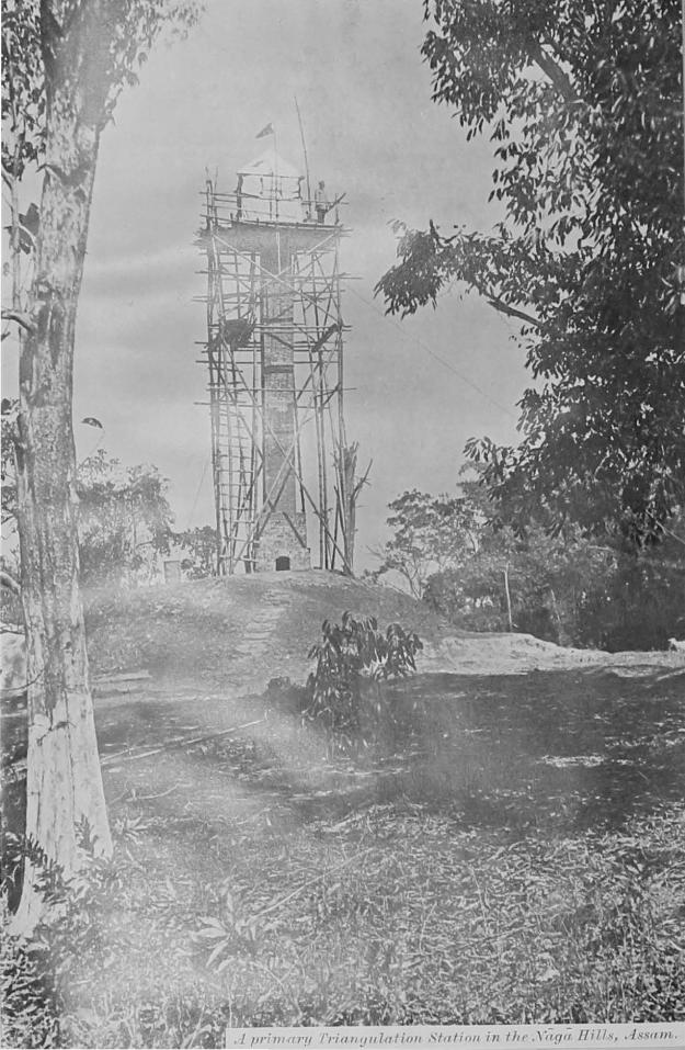
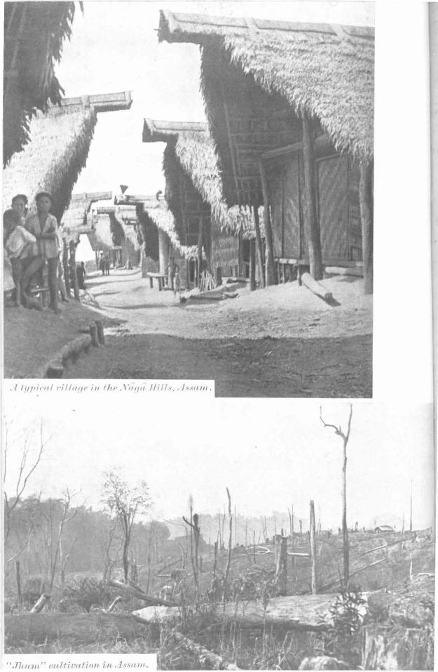
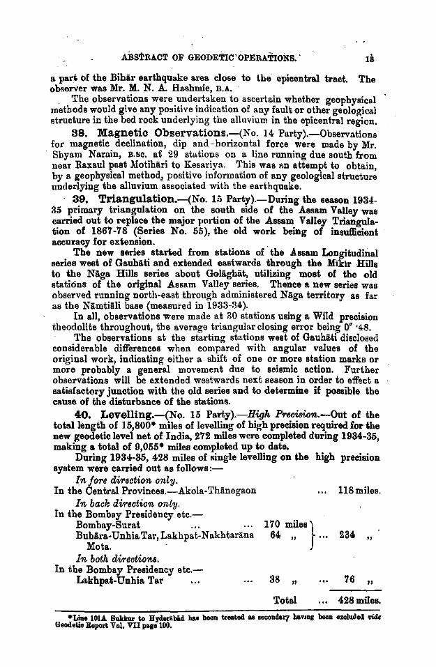
ILLUSTRATIONS, Runjlarh Hill, Surria State, C. P,- :·: ... ... Frontispiece. A pnmary Triangulation Station in t'he Nilga Hills Assam ... Page 12 A typical -.i!lage in the Nop Hills, Assam ... ... J 13 44 Jhum n Cultiva.tion in .Assam .... ... . .. Party headquarters at RiiDgimlti, Chittagong Hill Traota .. . 48 On the march in Burma · .. , . . . ... •.. 49 Portion of a l-inch shset, 1936 ... , ... ... 66 Pinning up an original for photography, Photo.-Litho.
Oilice, Calcutta ... · ... ... ... 70 INDEX MAPS.-A. Modem topographical surveys and compilation 4t end.
B. Modern topographical surveys and revision By 10-years periods from 1906 ... ...
C. Maps publiohed OD acales of 1-inch and i-inch to one mile •.. .... • ••
D. Mapa published on acalea of l-inch to one mlle . E. India and Adjacent Countries Series, 1/M scale
F. Carte Internationale dn Mondo, l(M. scale .. . G. Bovthern Asia Series, 1,12M scale ... .. .
.. .. •• .. .. ..
GLOSSARY.
Scales &D rele=d to as follows:-(<) by their represenlalivelmetion, s.g. "1/26,000",
(10) for """•• w1Kch ,.,.. .,..IUplu of l/l,OOO,IJOD-"1/M. oeale", · "1/611£ aeale" &c., which mean ·"1/1,000,000 aeale", "1/6,000,000 aeale" &c.,
(m) for· ""''•• omalkr tlullll4 mile~ to.,.. inch-" 50-mile acale", "S·mile scale" &c., which mean "scale of 50 miles to one inch" "scale of 8 miles to one inch" &c.,
(w) for ••ales of and larger than 4 mil•• to one inch-"t-inoh sca.le", 11 f-inch scale", "4-inch aoo.le 11
, "16-inch seal~" &o., which mean "scale of f inch to one mile" &o., &c.
Serial numbering ot survey ot India. maps.
Sheets 65,· 78 &o. are sheets on the 1/M scale; Sheets 65 K, 78 F &c. are t-inch sheets; Sheets 65 K/N.W., 78 F/S.E., &o. are t-inoh sheets; Sheela 65 K/1, 78 F/16 &o. are l-inch sheets,
The Bf81em of nnmhering is fully expla.ined in ihe Indezee al ihe end of lhil reporl.
AbbreV1atlons.-u. S., S. denoles Upper Subordinale Serviee. L. S. S. denolee Lower Subordinate Serviee. U.S. Officer denoles Upper Subordinate Officer. L. S. Officer denotes Lower Suborciil:.ale Ollleer. P. L. 0. denolee Pholo.-Liiho. OJ!Iee (Calculi&). P. Z. Scclion denolee Pholo.·Zinco Seclion (Debm
Dunt. D. 0. denotes Drawing Office. F. 0. U. 0. denotes "For Official Use Only".
SURVEY OF INDIA
GENERAL REPORT
1935
From 1st October 1934
To 30th September 1935
INTRODUCTION AND SUMMARY.
1. Annual Reports are now published in two separate volumes namely:-
The Geodeflic Report. The GeneraL Report.
These reports cover the survey year, which ends on 30th September, except that Part 4 (Map Publication and Office Work) of the latter is for the financial year, which ends on 31st March.
The Geodetic Report contains full details of all scientific work. The General Report includes an abstract of the Geodetic Report (in
Part 2), and full details of the survey operations of the ordinary field units (Pa1·t 3) as well as drawing, map publication and instrument manufacture (Part 4). Abstracts II and IV (vide Table of Contents) summarize the detailed reports of Part 3 and enable the reader to select. those which are of special interest to him.
The progress of "modern" (i.e. since 1905) topographical surveys made by this Department, and compilations made from our own or other material, is illustrated in Index A at the end of this report, while Index B indicates the obsolescence of modern surveys. The remaining indexes show all the standard maps which have been published up to date on the various scales. It will be seen from lnder» 0 that the areas within the Indian Empire which are blank on lnder» A are actually almost entirely covered by topographical maps. These maps are however from old material based on the old longitude of 1815, which was over 2 miles out, and are drawn in the old style; they are consequently excluded from Index A.
2. GeneraL-Brigadier H. J. Couchman, D.s.o., H.c., held the post of Surveyor General throughout the year. Colonel S. W. S. Hamilton, D.s.o., officiated from 7th June, while Brigadier Couchman was on leave.
The post of Assistant Surveyor General was filled hy Major H. R. C. Meade, I.A., up to the date of his death on 3rd December 1984 and there~fter by Lt.-Colonel E. 0. Wheeler, H.C., R.E., except for a short period immediately after Major Meade's death during which it was filled br Lt.-Colonel F. J. M. King, !I.E.
2 INTRODUCTION AND SUMMARY.
· Th total cost ~f the Department f~r the year ending 31st ~arch ~935, as compared :with that of preVlous years, was as follows:-
1932-33 I 118.
Grosa actual cost ... 86,10,206(a.)
Deduc* recoveries ... 14,08,175
Neil aotoa.l charges 22,02,031
1983-34 I &.
34,25,857(b)
12,55,341
21,70,016
1934-35 I REMABKS.
Bs.
33,50,66lt
10,45,885t
22,54,776t
(a) Inc 1 u d i n g Rs, 1,21,aao for Eng-lish Charges (High Commissioner) on Stores, and loss 01' gain by exchange.
(b) Including Rs. 1,08,290 for do. do.
tTheae figurea are not tiDal.
' Squa.re miles. Squa.re miles. I Squii.re miles. Tot<al area· of survey of
all kinds completed 1-----i-~-----T~-----1 · during lhe year. . 43,688* 42,216'' 51,673• *Vide page 16.
4. Organisation .. No. 23 (Irril(stion Surveys) Party was disbaildedirom 1st Aprill935 when its work was placed in abeyance.
The Photo. Zinco Section which was shown in the General Report for 1931-32 as transferred to the Computing and Tidal Party, is now directly under the orders of the Director, Geodetic Branch. .
An Assistant Head Engraver was recruited froin England and assumed charge of his duties from 20th October.
A revised scale of pay has been sanctioned, with effect from the 1st October 1934, for the existing members of the Upper Supervising Staff of the Workshop Establishment of the Mathematical Instrument Office.
5. Notable events of the Survey year. Some interesting relics of Colonel Sir George Evere~t, c.B., F.R.s.,
have very kindly been donated by his family, anq have been lodged in the offices of the Survey of India at Debra Diin, where Sir George spent the last ten years of his service.
Quetta Earthqualce.--A severe earthquake occurred at Quetta at about 3 A.ll. on the 31st
May, resulting in the death of 4 lower subordinates of 'E' Company. Considering the severity of the earthquak~ and the heavy losses
•';!stained by the civil population in the city, the personnel of 'E' Com-pan;v were fodunate in escaping with so few casualties. . .
INTRODUCTION AND SUMMARY. 8
The office building was severely· shaken and the walls cracked in many places. Plant and machinery were not seriously damaged, and were able to be used to print many urgent maps required by the various local authorities.
Levelling near Hardi?>ge Bridge for the Eastern Bengal.Railway.At the request of the Eastern Bengal Ra.ilway a detachment of
No. 15 Party ca~·ried out some 3, 700 linear miles of levelling in the vicinity of the Hardinge Bridge. 256 bench marks, 1,508 pakka points, and 15,569 spot heights were fixed (para. 115).
The .results for the area west of the railway line from Calcutta to Darjeeling were supplied to the Railway at the end of February and for the area to the east of that line, about the middle of June.
Traverse by H1.1,nter Short Base in the O.·eat Indian Desert.Framework for detail surveys of 8,450 square miles in sheets 40 I
and M, consisting largely of a desert of wind-blown sand, was pro'l'ided · by means of traverse, utilizing the Hunter Short Base for the measurement of distances.
Four main East-West lines, each about 120 miles long, approximately parallel and about 15 miles apart, were run between G: T. meridional triangulation series on either flank (para. '11 ).
Boondary &Lrvey.-At the request of the Agent to the Governor-General, Eastern
States, a part of the boundary between the Srinagar and Riimpur Tappas of Surguja State was d~marcated, on payment. This boundary had been in dispute since 1869. (para. 93).
EzplOTation.-An account by Captain F. Kingdon Ward of his exploration in south
east Tibet has appeared in the Journal of the Royal Geographical Society for November, 1934. .
Surveyor Muhammad Akram was deputed during April to accompany the Visser Himalayan Expedition, 1935, to the Karakoram. Khan Sahib Afraz Gul Khan, a retired Class II Officer, also joined the expedition to assist in its sur'l'ey work. . Sur'l'eyor Muhammad Ayub Khan was again deputed for a period of about 2 years from 1st July to accompany Sir Aurel Stein in his Persian expedition.
The results of the reconnaissance suneys carried out in 1933-34 by Surveyor Muhammad Ayuh Khan, who accompanied Sir Aural Stein in connec~ion with his explorations in south-west Persia, have been incorporated in 1/M Sheet No. 17 (SHIRAZ ).
Eurcises and. Manoeuvres.-Major '].'. M. M. Penney, R.E., Officer Commanding, 'E' Company
took part in the Western Command Exercise, 1934, in the capacity of Deputy Director of Surveys.
·An air survey exercise was carri~d out near Nowsbera by No. 18 Party during February, which was attended by certain R. A. officers of the Northern Command, by the Commandant School of Artillery in India and by Lt.-Colonel 0. Slater, 11.0., R.E., Officer Commanding, 'A' Com· pany.
INTRODUCTION AND SUMMARY.
Extracts from the report on this ~xercise, ~y Ca~tain D. R. Crone, R.E., Officer in Charge, No. 18 Party, will be published m due course .
.AW. 81111"PJey.- . At the request of the Calcutta Corporation the survey of 14 square
miles was undertaken in connection with the Kulti Outfall scheme ( pa.ra. 80 ).
At the request of the Commissioner and the Municipal Boa~d, Nagpur the survey of about 30 square miles in and about Nagpur C1ty and Ci-ril Station has been undertaken using a combination oi air. a!ld • · ground survey methods ( psra. 93 ). ·
Deputatwn, of Office-rs.-. · During the year, lst· Class Surveyor Muhammad Khan and
Muhammad Ayub Khan were deputed respecti~ely to acc~n;pany ~he Vieser Expedition, 1935, to the Ka.rakoram and Sir Aurel Stem s Pers1an Expedition, 1935.
Lectv:res.-The students of the Senior Division of the Staff College attended a
lecture and demonstration in the office of 'E' Company at Quetta on the 29th October. ·
.Adwentwres an,d CasuaUies.-The Surveyor General deeply regrets to record the following
deaths:-Mr. L. F. Everest, M.A., L.L.D., (Cautab.), Barrister-at-Law, the
eldest son and last lineal descendant of the late Colonel Sir George Everest, C.B., F.R.S., who died in London on the 1st April in his 82nd year.
·Major H. R. C. Meade, I.A., Assistant Surveyor General, who was killed in an aeroplane accident at Birati, near Dum Dum, on 3rd December.
Mr. N. N. Banarji, M.A., B.L., Registrar, who died in Calcutta on the 8th June after a brief illness.
Mr. 0. C. Ollenbach, late Deputy Superintende!lt (Class I) who died at Mussoorie on the 6th July. ' ·
. Mr. H. P. D. Morto!l, late Superinte!ldent, who died at Southampton on the 7th November.
Mr. R. P. Ray, R.A., late Extra Assistant Superintendent, who died at Debra DG.n on the 12th July.
Captain J. O'C. Fitzpatrick, late Extra .Assistant Superintendent who died at Gloucester on the 2nd November. '
Rai Sahib Narendra Nath Mukherji, late Head Assistant Surveyor General's Office, wh?. died at Calcutta on the 22nd February. ' .
Mr. Abdul MaJid, late Sub-Assistant Superintendent who died at Debra Diin on the 27th October. · 1
Mr. Abdul Ghafur, late .Sub-Assistant Superintendent, who died at Bangalore on the 12th August.
. Mr. Kadir Baksh, late Head Assistant, Geodetic Branch Office who died at Debra DG.n on the 18th November. '
18 Lower Subordinates and 11 inferior servants died during the year under report. . _ .
• . lNTRODUCTION AND SUMMARY .
.Distinguished visitors.-His Excellency Sir Harry Haig, K.c.s.r., c.r.E., r.c.s., Governor of
the United Provinces, visited the Geodetic Branch Office at Debra Diln on the 11th April.
The Hon'ble Sir Kunwar Jagdish Prasad, Kt., c.s.r., c.r.E., o.B.E., Hon'ble Member, Education Health and Lands visited the Survey of India Offices in Calcutta on the 13th February.
The 5th term Gentlemen Cadets of the Indian Military. Academy visited the Geodetic Branch Offices on the 31st May.
:6. Appreciations and Awards. Their :Majesties' Silver Jubilee medals were awarded to 59 officers
and subordinates of the Department. His Excellency the Viceroy and Governor-General has been pleased
to confer the title of Rai Sahib, as a personal distinction, upon Mr. Raj Bahadur Mathur, B.A., Extra Assistant Superintendent, Survey of India.
The following is an extract from the Report by the G. 0. C. in C. Western Command on training carried out in the Western Command during the individual training period J 934 :-
'E' Survey Company.
" 'E' Survey Company eo-operated during the year both with Staffs and R. A. and did valuable work. I much appreciate the way in which this unit assists training in every way possible, and the response they give invariably to all requests for their assistance."
The Superintendent, Government Fruit Research Station, Chaubattia, Ranikhet, has written to the Director, Geodetic Branch expressing his appreciation of the satisfactory manner in which the survey of the Government Gardens was done by No. 20 Detachment.
Mathematical Inst'I"Ument Office.-Among other special manufactures were the following :-All improved and more robust type of clinometer has been evolved
by the Mathematical Instrument Office and is under test. Fixed instead of folding vanes are utilized, and improvements have been made in the levelling arrangements.
One Pilot gauge was made up and supplied to the Principal, ·Bengal Engineering College, Sibpur. ·
One new Hunter Short Base apparatus complete was made and sup· plied to the Director Geodetic Branch.
Five 36-inch duralumin tree calipers, with cases, were ma~e and sup· plied to various Forest Officers.
In an Essay Review of the work of the Calcutta School of Tropical Medicine the following paragraph appears:-
"In this connection one must pay special tribute to the work of the Mathematical Instrument Office of the Survey of India. This Department ever since the School started has been of invaluable assistance in repairing instruments, devising new apparatus, and tackling laboratory problems. The Superintendent may almost be included as an honorary member of the staff of the School".
m!ritom:icTi:ON AND SifirM:ARY.
7. Personnel.-Casualties, retirements, promotions and other chanaes were as follows:-e .
Class I Officers.-Messrs. V. W. Morton, E. A. Meyer and P. Simpson, . granted leave preparat~ry to retirement.
Dr. J. de Graaff Hunter, c.I.E., M.A., sc.D., F.R.s., F.mst.P. and Lt.Colonel A. H. Gwyn, I.A., retired.
Majors L. H. Jackson, I.A., and E. A. Glennie, D.s.o., R.E., promoted to be Lt."Colonels.
Captains G. F. Heaney, B.E., and G. H. Osmaston, M.c., R.E:, promoted to be Majors.
Lieutenant R. H. Sams, n.sc., R.E., promoted to be Captain. Major H. R. C. }[eade, I.A., killed in an aeroplane accident. General Central Services Class 1.-Mr. S. Woodhouse, Superinten
dent, Mathematical Instrument Office, granted leave preparatory to retirement.
Class II Officers.-Rai Sahib A. K. Mitra, retired. MiscellaneO'l£8 a1>pointments,-Ge11eral Central Services Class 11.Mr. R. C. Malcolm, appointed to officiate as Superintendent, Mathe-
maticaLinstrumant Ofllce. . Mr. J. B. Chorlton, invalided. Mr. F. E. Selfe, appointed Assistant Head Engraver. Mr. N. N. Banarji, M.A., B.L., Registrar, died. Mr. G. M. Dhara,. appointed to officiate as Registrar. Upper 8u.bOTdinate Offict!'l's.-Messrs. L. D. Joshi, Jagannath,
Muhammad Siddik and L. M. Ganguli retirad.
II. ABSTRACT OF SURVEYS IN EACH PROVINCE AND STATE.
7
8. The .prime duties of the Survey of India are geodetic, topographical and geogt·aphical, but the department is also developing cooperation with local survey agencies, with a view to mutual economy, and is now doing a considet·able amount of miscellaneous outside work on payment, besides advising and assisting Provincial Governments with local and settlement surveys as required.
The following abstract shows the nature and locale of the field operations actually carrie~ out by the department ~uring the past year, grouped under the followmg sub-heads:
Air Surveys. Boundary Surveys. Codastral Surveys. Cantonment and Cily Surveys. Correction Surveys. Exploration. Foreat Surveys. Framework.
Geodetic. Levelling. Miscellaneous. Ra.ilway Surveys. Rivera.in Surveys. Speci&l Surveys. ~opographical Surveys. ~raining.
If a province or state is not mentioned, no work bas been done there during the year under report. · ·
9. Ajmer-Merwara. Framework. Traversing and levelling for Cantonment surveys of
Nasirabad (p. 41). Geodetic. Latitude at 4 stations (p. 12).
Longitude at 4 stations (p. 12). 10. Assam.
Geodetic. Primary triangulation on the south side of the Assam valley from Gauhii.ti to the Naga Hills (p. 13).
Topographical surveys in Lusbai Bills district (p. 47), and in Manipur State (p. 47). 11. Baluchistan.
F1·a'Ynework. Triangulation in Sibi district and Kalat State (p. 35). Traversing in Zhob district (p. 35).
Geodetic. Latitude at 3:! stations (p. 12). . Longitude at 32 stations (p. 12).
Topographical surveys in Sibi a~d Zhob districts and Kalat State (p. 35 ). 12. Baroda.
Fra'flltUHYrk. Ol'iginal and revision triangulation in the district of Kadi (p. ::19).
Geodetic. Gravity at 2 stations (p. 12). 13. Bengal.
Air survey. Kulti Outfall area, Calcutta (p. 42). Oumtcmment surr;eys. Re· survey of Barracl<pore Cantonment and
Ishapore Ordnance Factory Lands (p. 40). Framework. Triangulation and traverse in Chittagong district and Chitta
~ong Hill Tracts (p. 47).

8 AJlSTRAOT OF SURVEYS IN EAOH PROVINOE AND STATE.
LevelUng. Precise levelling from Dinajpur to Purnea. Revision of pr~cise levelling from Chittagong to Akyab (p. 14). Secondarl;' and ~ert1ary levelling in Pabna an~ adjoi~ing districts in connection w1th the protection of the Hardmge Bndge ( p. 53). . •
Topographical swrveys in Chittagong Hill Tracts (p. 47) and Ill Chittagong district (p. 52).
14. Bera.r. Levelling. High precision levelling from Akola to Thiinegaon, of the
new geodetic level net (p. 13).
15. Bihar and Orissa.. Correction surveys in 'Puri district (p. 50). Framework. Triangulation and traverse in Angul, Bhiigalpur, Dat·bhanga,
Monghyr, Muzaffarpur, Patna, Purnea, Sambalpur, and Santa) l'arganas districts (pp. 44, 46).
Geodetic. Latitude at 25 stations (p. 12). Longitude at 16 stations (p. 12). Gravimetric observations (Gravity gradient) at 61 stations (p. 12). Magnetic observations at 29 stations (p. 13).
LevelTA.ng. Precise levelling from Bagaha to Ghiizipnr, (being a portion of the line Bagaha to Sironj) and from Diniijpur to Purnea, in connection with disturbances caused by the earthquake of 15th January 1934 (p. 14).
Topographical surveys in Darbhanga, Gaya, Monghyr, Muzalfarpur, Patna, Sambalpur and Saran dietricts (pp. 43, 4.5 ). 16. Bombay.
Geodetic. Gravity at 3 stations (p. 12). Levelling High precision levelling from Bombay to Snrat part of the
new geodetic level net (p. 13). '
17. Burma. Framework. Tl'iangulation and traverse in Akyab district and the
Arakan Hill Tracts (p. 47). Triangulation and traverse in· Kyaukse, Mandalay Meiktila
Sagaing and Yamethin di•tl'icts and the Northern and Souther~ Shan States. Supplementary triangulation in Akyab district (p. 52). . .
Levelling . . Revision of precise levelling from Cbittagong to Akyab (p. 14). Topograplt~cal surveys in Akyab, Minbu and Pakokku districts and the
Arakan Hill Tracts (p. 52) and in Chin Hills district (pp. 47, 52). 18. Central India..
Framework. Revision triangulation in the Malwa A"ency and in Indore and Jaora States (p. 39). "
Geodetic. ~titude at ~1 stations (p. 12). . Topograplo.cal 81J.rveys m Indore, K.hilchipnr, and Rajgarh States (p. 38).
19. Central Provinces. Air 8'UTVey. Travers~ and postpointing in Nii.gpur (p. 46). Framework. Traversmg and level!in.. for Canton me t f
JuJ;lbulp~re . (p. 40); triangulatio~ and traverse i: Bi~::;:; a:d Ra1pnr d1str1cts (p. 46).
ABSTRACT OF SURVEYS IN EACH PROVINCE AND STATE. 9
Geodetic. Latitude at 14 stations (p. 12). Levelling. High precision levelling from Akola to Thinegaon, portion of
the line Dhillin to Nagpur, o! the new geodetic level net (p. 13). TopogrophicaJ B1111"Veys in Bilaspur and Baipur districts (p. 46).
20. Eastern States. 00'1"1"6ction su1rt•eys in Nayagnrh State (p. 50). Framew<Yrk. Triangulation and traverse in Baudh, Gingpur, Kii.lihandi,
Patna, Rnigarh, Rairakhol, Sakti, Sii.rangarh and Sonepur States (p. 46). Triangulation in Bastar and Kii.lilhandi States (p. 50).
Miscellaneous. Demarcation of the boundary between SrJnagar and Rampur tapp9.s of Surguja State (p. 47).
Topographical suTVeys in Raigarh, Sakti and Siirangarh States (p. 46).
21. Gwalior. Framework. Revision triangulation in Gwalior State (p. 39). Geodetic. Latitude at 5 stations (p. 12).
Longitude at 5 stations (p. 12). Topograpkicalsurveys in Gwalior State (p. 38).
22. Hyderabad. Geodetic. Latitude at 8 stations (p. 12).
23. Madras. Framework. Triangulation hi Vizaga.patam district (p. 50) and in
Ganjam district (pp. 46, 50). · . Topographical SUT'Ileys in Ganjii.m and Vizagapatam districts (p. 50).
24. N. W. F. Province. Air surveys in Tiriih and Mohmand Tribal territory, North Waziristii.n
Agency, Khyber Agency and in Pesl;liiwar and Kohii.t districts (p. 36).
25. Punjab. · Oorrection SUT'Ileys in Amritsar, Hoshiii.rpur, Jullundur and Ludhiii.na
districts (p. 32). Framework. Triangulation and traversing in Dera Ghiizi Khiin district
(p. 32). Settlement traverse in Kiingra district (p. 33).
Topographical suT'IJeys in Amritsar, Ferozepore, Jullundur, Kangra, Montgomery, Multan and Muzaft'argarh districts (p. 31).
26. Puniab States. Oorrection surveys in Kapilrthala State (p. 32}.
_ Framew<Yrk. Triangulation and traversing in Bahii.walpur State (p. 32). · Topographieal 8UT'Ileys in Bahii.walpur, Chamba, Faridkot, Kalsia and
Mandi States (p. 31).
27. Rajputana. Framework. Triltngulation in Bikaner State (p. 32).
Original and revision triangulation in Bikaner, Dungarpur, Jaisalmer, Jhii.lawii.r, Jodhpur, Udaipur, Palanpur, Partabgarh and Tonk States. (p. 39).
Geodetic. Latitude at 22 stations (p. 12). Longitude at 21 stations (p. 12). Qravity at 12 stations (p. 12).
10 ABSTRACT OF SURVEYS IN EACH PROVINCE 4ND STATE.
Topographical sWr-veys i~ Bikaner State. (p .. 31), and in Jhii.lawar, Jodhpur, Kotah, Uda1pnr, Palanpur, S1roh1 and Tonk States (p. 38).
28. Sind. · . Fra;mework. Triangulation in Upper Sind Frontier distnct (p. 35).
Original and revision triangulation in. Thar Parka.r district (p. 39). Traverse by Hunter Short Base in Sukkur district (p. 39).
Geodetic. Latitude at 7 stations (p. 12). Longitude at 7 stations (p. 12). Gravity at 1 station (p. 12).
Topogru.phicaliiWI"Veys in Upper Sind Frontier district (p. 35). 29. States of Western India.
Framework. Original and revision triangulation in the Sabar Kantha (formerly Banis Kantha) Agency (p. 39). ·
GeodeUo. Gravity at 15 stations (p. 12). ' . L61Jelling. High precision levelling from Lakhpat (Cutch) to Buhiira
part of the new geodetic level net (p. 13). 30. United Provinces.
Cantonment BWI"Veys. Re-survey of Bareilly, Debra Diln and Naini Tiil . Cantonments and Sahamnpur Remount DepOt (p. 40). Framework. Traversing for survey of Chaubattia Government Orchard
(p. 40). . . Geodetic. Latitude at 24 stations (p. 12).
Longitude at 22 stations (p. 12). I.eveUing. Precise levelling from Bagaha to Ghiizipur, (being a portion
of line Bagaha to Sironj) in connection with disturbances caused by the earthquake of 15th January 1934 (p. 14).
8pecial8'11.'1'11Bys. Original survey of the Chaubattia Government Orchard on the 32-inch scale (p. 40). ·
Topographical BU'1'11eys in Ballia district (p. 43). ·
PART ~.-GEODETIC WORK.
III.-ABSTRACT OF GEODETIC OPERATIONS.
_fLt.-Colonel C. M. Thompson, I.A., to 20-1()..34. DIRECTOR :-lcoloncl C. G. Lewis, o.s.E,, !rom 21-10·34.
31. General.-Beeidee geodetic work, the Director, Geodetic Branch, administers at Debra Dun No. !J Drawing Office, the FO'r'est Map Office, a Printing Section and a Photo.-Zinco. Section, whose work is reported in Part 4 of this report, and also the following survey operations, which are reported in other parts of the General Report:-:-
Le'!Jelling carried out in aid of special engineering projects, (para. 115).
Topographical SWMJey carried out by No.1 Party (paras. 69-72). Oantonm.ent Su'f'Veys (paras. 73-77). The Trl!'ining School was closed during the year under report. 32. Geodetic.-Purely geodetic operations include miscellaneous
computations and research, preparation and publication of records,. observatory work (astronomical, magnetic, seismological and meteorological), the measurement of geodetic bases, principal triangulation, geodetic levelling, precise latitudes, longitudes, azimuths, gravity determinations in all parts of India, and prediction of tides at 41 eastern porte
·between Suez and Singapore. These operations are fully described in the annual Geodetic Report
of the Survey of India. . The following is a brief abstract of the geodetic operations described in the Geodetic Report of 1935, which contains complete index maps and detailed results.
33. Observatory Seotion.-Bi-weekly time observations werie continued with the shutter and motor transits and a record of the longitude of Debra Dlin maintained by the reception of wireless time signals from Bordeaux and Rugby.
Shortt Clock No. 34 was in use throughout. The usual magnetic, seismographic and meteorological observations
were undertaken and various instrument& adjusted, cleaned and repaired.
34. Computing Seotion.-The Computing Section bas been largely employed on computations conn.ected with field observations for latitude and longitu<le (see para. 36 below). The adjustment of minor triangulation in 1/M 29 and 30 has been completed and that of Persian sheets is in hand.
Hypsometric heights from observations by Mr. G. Sheriff in the Himalayan regions of Assam and Bhutan have been computed.
The computations of Poona base extension and .Padag base extension triangulations were completed.
Geodetic Report 1934 and Handbook of Topography Chapters II and VII, have been edited and printed at Debra Dun.
Two Indian triangulation pamphlets and addenda to 3 others have been compiled and printed. One secondary levelling pamphlet has been reproduced by gestetner.
ll! ABSTRACT OF GEODETIC OPF;RATIONS.
35 Tida.l Section.-The tide-tables of the Indian Ocean for 1935 for 69 "ports were prepared and published in October.l934, and advance predictions for H ports for 1936 were despatc~ed m October 1934 to the hydrographic departments of the U. K., Umted States and Japan for inclusion in their tide-tables. . .
Automatic registrations were continued at Aden, Karachi, Bombay, Colombo Trincomalee (up to 15th January 1934), Dublat (up to 31st March 1934), K.idderpore and Rang?on. I~ addition, observn_tions of bi"'h and low water on tide-poles during daylight only were continued at Bl7a.vnagar, Chiindbali (up to 31st March 1935), Chittugong and Akyab. The tidal observatories at Rangoon (May 1934) and Bombay (May & July 1984) were inspected by the port authorities.
36. Latitude and Longitude.-(No. 14 Party).-Observations for latitude and longitude were made along 3 different series, running east and west and connecting the work done in previous years and extending from the Burma-Siam to the Perso-Baluchistan frontier. The first series consisting of 39 stations, at 2 of which Geodetic values only were determined, was observed by Capt. Bomford, R.E. and extended from the Perso-Baluchistan frontier to Reti iii Sind. · The second series of 57 stations, observed by Rai Sahib R. B. Mathur, B.A., was continued from near Riinchi in Bihar and Orissa to Ajmer where it joh1ed the meridional series along longitude 75° observed in 1930·31; the third series of llstations, also by Rai Sal!ib Mathur, was observed along latitude 28° starting east of Ratangarh from a station of the 75° meridional series and extending westwards to join up near Uperthal H. S. in Jaisalmer State with the work done by Lt.-CoL E. A. Glennie, D.s.o., R.E. in 1930-31. The personal equations of the observers were determined by comparative observations at Debra Diin before and after the field work and in the second· and third series, by an additional cheek at the Fyziibiid Longitude station. These observations extend the section of the geoid westwards from Ranchi to the extreme west of India. .
Observations for latitude were made at 34 stations in a north-south alignment along the great meridional arc from near Hyderiibiid (Deccan) to Dholpur Sta.te, thus connecting the geoidal section of last year and . that of 1980-31. The system of work and the instruments used were the· s"me as in the previous year.
The observers were Mr. B. L. Gulatee, M.A. and Computer J. B . .Mathur for 26 and 8 stations respectively.
Latitude was also determined at 11 stations by Computer· J. B. Mathur along the western flank of the Hurilaono- meridional series which lies near the disturbed area of the Bihii.r earthq:ake.
1
3~. Gravity Obserya.tions.-(No. 14 Party).-Observations to d~termme th_e force _of g.ravity were ma~e at 8 stations in Rii.jputii.ua and AJ_mer-Merwara, 3 I~ Bikaner Stata, 3 m Bombay Presidency, 1 in Sind, 2 m Baroda State, 3 In Cutch State, 2 in Gujriit States Agency and 10 in States of Wes~ern I~dia. The observer was Mr. M. N. A. Hashmie, B.A.
_Observations With an Oe~g Gradiometer to determine the gravity gradient _were m~de at 61 statiOns. The work consisted of a single traverse hne runniD~ ~o~th from the Nepal boundary about 4 miles east of Raxaul past MotihiirJ to Chiipra on the ?anges, thus passing through
ABSTRACT OF GEODETIC' OPERATIONS •. til
a part of the Bihar earthquake area close to the epicentral tract. The observer was Mr. lll. N. A. Hashmie, B.A. ·
. The observations were undertaken to ascertain whether geophysical methods would give any positive indication of any fault or other geological structut·e in the bed rock underlying the alluvium in the epicentral region.
38. Magnetic Observations.-(No. 14 Party).-Observations for magnetic declination, dip and -horizontal force were made by Mr. Shyam Narain, n.sc. a£ 29 stations on a line running due south from near Raxaul past Motihiiri to Kesariya. This was nn attempt to obtain, by a geophysical method, positive information of any geological structure underlying the alluvium associated with the earthquake.
· 39, Triangulation.-(No. 15 Party).-During the season 1934-35 primary triangulation on the south side of the Assam Valley was carried out to replace the major portion of the Assam Valley Triangulation of 1867-78 (Series No. 55), the old work being of insufficient accuracy for extension. .
The new series started from stations of the Assam Longitudinal series west of Gauhiti and extended eastwards through the lllikir Hills to the Niga Hills series about Golaghat, utilizing most of the old stations of the original Assam Valley series. Thence a new series was observed running north-east through administered Naga territory as far as the Namtiiili base (measured in 1933-34).
In all, observations were made 11t 30 stations using a Wild precision theodolite throughout, the average triangular closing error being 0" ·48.
'l'he observations at the starting stations west of Gauhati disclosed considerable differences when compared with angular values of the original work, indicating either a shift of one or more station marks or more probably a general movement due to seismic action. Further observations will be extended westwards next season in order to effect a satisfactory junction with the old series and to determine if possible the cause of the disturbance of the stations.
40. Levelling.-(No. 15 Party).-Higk Precisio1t.-Out of the total length of 15,800* miles of levelling of high precision required for the new geodetic level net of India, 272 miles were completed during 1984-35, making a total of 9,055* miles completed up to date.
During 1984-35, 428 miles of single levelling on the high precision system were carried out as follows:-
ln fore direction only. In the Central Provinces.-Akola-Thanegaon
In back direction only. In the Bombay Presidency etc.
Bombay-Surat Buhira·Unhia Tar, Lakhpat-N akhtarana
Mota. In both directions.
In the Bombay Presidency etc.Lakhpat-Unhia Tar
170 miles} 64 Jl •••
88 " Total
118miles.
234 "
76 " 428 miles.
•:uue lOlA Sulrkar to Byderibid baa boon treo.tod oa oec:ondaq havaar beoJl Ol<Oluded 1Jide Geodello Boport Vol. VII pose 100.
14 ABSTRACT OF GEODETIC OPERATIONS.
Precise Levelling . ....:_ The line of precise levelling Chittagong-Magwe executed in 1932-33 for the Indo-Burma connection, revealed that Mean Water Level &t Akyab was 4•13 feet below Mean Water Level at Chittsgoug and that Amherst was 0·84 feet above Mean Water Level at Akyab. The latter discrepancy of 0·84 feet, being reasonable, was adjusted . between Minbu and .Akyab. .An error of 3 feet or so was however suspected between Chittsgong and .Akyab and this portion was therefore rolevelled by single levelling; as expectec;l, an error of 2·4 feet was found about 60 miles north of A.k:yab.
Precise levelling from Diniijpur to Purnea 92 miles and from Bagaha to Ghiizipur 163. miles (the latter to be eventually extended to Sironj) were executed to determine ho.w the bench marks at Bagaha and Purnea . had been affected by the earthquake of 15th January 1934. Neither Diniijpnr on the alluvium of Bengal, nor Sironj on the stable plateau of Central India are likely to have been affected by the earthquake.
Reports of secondary and tertiary levelling will be found under part IX of this report (p. 53).
15
PART a.-TOPOGRAPHICAL WORK.
IV.-ABSTRACT OF TOPOGRAPHICAL WORK.
41. The following tables indicate the progress achieved to date in the topographical survey programme assigned to the Department in 1905 and give details of the work done in the year under report.
Table A shows the area of survey completed on various scales since 1905, as well ns the approximate balance which remains to complete the contoured topographical survey of India. The figures which were entered in the report for 1930-31 were found on re-examination to be inaccurate, and to be incapable of calculation by 5 year periods for separate scales; consolidated _figures from 1905 to 1930 Me therefore given. ·
Table B shows the area revised during the ·year under report. Table 0 shows in detail the survey operations carried out during
the year under report, together witb their cost ·rates. While every attempt is made to calculate the cost rates accurately, it is extremely difficult to allocate "overhead charges" fairly to the various classes of . work, and rates of pay etc., will vary with the locality; the cost rates shown in the table must therefore be considered to· be approximate. _For this reason, a column showing "out-turn" is included in the table, which those familiar with survey organization will find very useful in esti· mating costs in subsequent years.
The cost, shown for mapping and computations are those incurred in the party etc., offices only, except where otherwise stated; pu blieation charges, if required, may be ascertained from the Director, Map Publi· cation, at Calcutta.
42. Progress. In the second page of the preface to this report will be found a brief outline of the scope of the topographical suryeys of the department. The hopes expressed in 1905-that modern maps on the l-inch scale would be available for the entire Indid.n Empire within 25 years-are still far from realization in 1935, just over half .the total area of India having ·been completed on that scale. In 1913, when it wa~ realized that for various reasons it would be impossible to complete the l-inch surveys in the time allotted, a scheme for the reduci- . tion of the scale of survey in the less populous areas was sanctioned by the Secretary of State. ·
In spite of the reductions in scale however, only two thirds of the country is as yet covered by modern maps. The tendency to revert to the l-inch scale in special circumstances, such as in areas of more than ordi· nary military, geological or engineering importance, the necessity which frequently arises to resurvey on the l-inch scale areas already surveyed on smaller scales, as they grow in importance, the necessity for the com· paratively frequent revision of existing surveys in the more populous areas and lastly but by no means least important, the recent urgent necessity for economy; all these factors have conspired to delay still further the completion of the programme even as amended in 1918.
Original surveys since 1981, the year of retrenchment, have been carried out at the rate of about 39,000 sq. miles per annnm; on this basis, some 16 ;years arQ .still required to complete the progr&Jllme.
18 · ABSTRACT OF TOPOGRAPHICAL WORK.
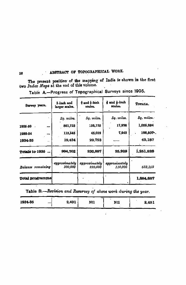
The present position· of the· mapping of India is shown in the first two Index .Afaps at the end of this volume. . ·
Table A.-Progress of Topographical Surveys since 1906.
·Survey years, l-inch and t and t-ilieh f and i-ineh TOTALS.
larger scales. scales. seales. 0
.. Sq. mile1. Sg. ·miles, Sq. miles. Sq. mile•.·
1906-80 ... 861,728 156,123 17,996 1,085,884 . 1980-84 ... 118,646 45,019 7,948 166,507•
1934-85 l
19,434 29,753 ...... 49,187
To.t&lsto·l935 ... . 994,7021 230,8971 25,9291 i,251,528
appro:rimat•ly appro:rimateey appro:rimately Balanoe remaining aoo,ooo I· 220,000 110,000 688,159
TOtal prot(ramllle . 1,894.687 0
-Table B.-Rwision and Re8'1J1Miey of above WfYI'k dwring the year .
1984-85 ... 1 2,4911 NU NU 2,491
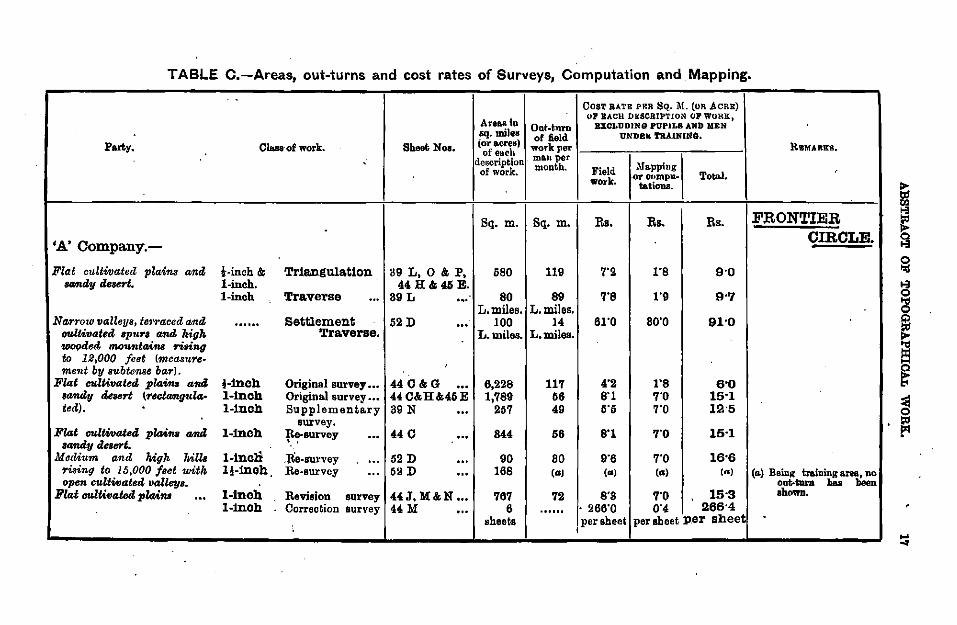
TABLE C.-Areas, out-turns and cost rates of Surveys, Computation and Mapping.
CosT BATE PRR SQ. i\1. (oR AcRE)
Area.aiu Ul!' BACH Dii:SCRIPTION OF WORK,
Ont-t.nrn B10LUDING PUPILB AND MEN sq. miles of Aeld UND.Bk 'I'RAINJNG.
Party. Class-of work. Sheet; Nos. (or acres) wotk Jlet' RWMARKS. of euch . description · ma.uper-1\Ja.pping
of work. month. Field work. or onmpu. Total.
tat ions.
Sq. m. Sq. m. Rs. Rs. Rs. Fl:tONTIER
'A' Company.-CffiCLE.
Flat cultivated plaim Mtd t-inch & Tr1a.nguia.t1on 89 L, 0 & P, 580 119 7"2 rs 9•0 IOJIUly deo<Tt. l-inch. 44H&45E.
l-inch Traverse ... 39L ... 80 89 7'8 1"9 9•7 L.miles. L.miles.
Narrow valleys, te'1'1'aced a;nd ...... Settlement 52 D ... 100 14 61"0 80'0 91•0 tmltivated Bp'ln'B and high Traverse. L. miles. L.miles. wooded. mo'UfttMn.f 'rising to 12,000 feet (m.ecuure-
' ment by subtcme bar). Flat culUvated plaim and l-Inch Original survey ••• 440&G ... 6,228 117 4"2 r8 6'0
randy dea<Tt (t'ec!Mtg"la- l-Inch Original survey ••• 440&H&45E 1,789 56 8"1 7"0 15•1 ted). l-Inch Supplementary 39 N ... 257 49 5'5 7"0 12•5
survey. Flat e1<ltWatetZ plaim and l-Inch Re-survey ... 44 0 ... 844 56 8'1 7"0 15·1
sandy .Zestl1"t. . . Modium and high hills 1-tncli .lie-survey ... 52 D ... 90 80 9"6 7'0 16•6
riaing to 16,000 feet will• 1!-lnoh. Re-survey ... 52 D ... 168 (") (a) (a) (R) (a.) Beinl( training lll'ea, no open cultivated valleys. out.tura baa been
Flat e1<ltivated plains l-inch Revision survey 44J, M&N ... 767 72 8'8 7"0 15·3 showa. ... l-Inch Correction survey 44M ... 6 ...... . 266'0 0"4 266'4
sheets per sheet per sheet per sheet I
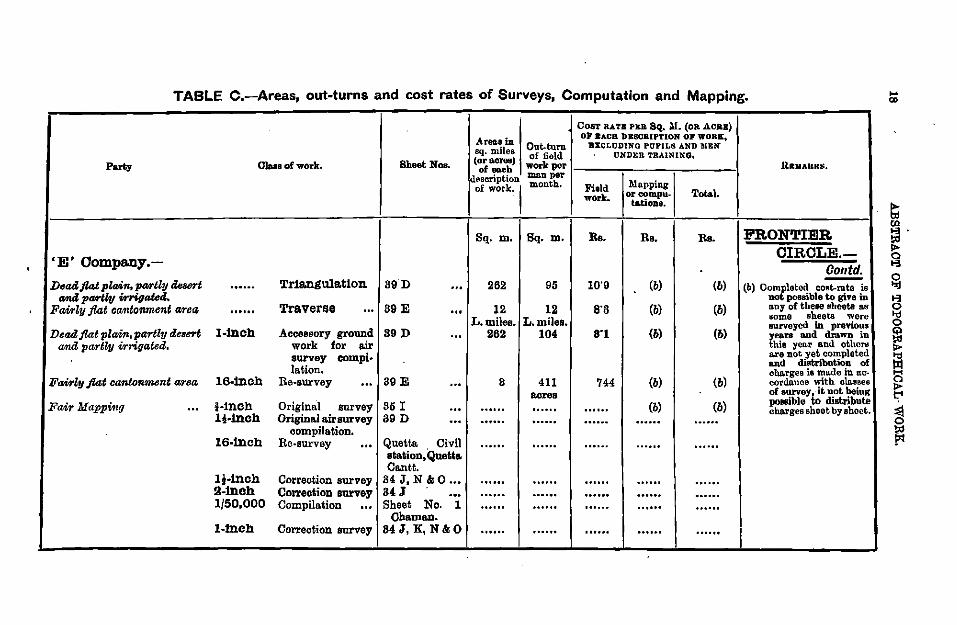
TABLE C.-Areas, out-turns and cost rates of Surveys, Computation and Mapping.
CosT RATB PER SQ. M. (o& AC&B)
Areca in OJ .ACR bBSCRIPTlON OJ' WORE,
sq. miles Out-turn BX(lf,UDINO PUPILS AND MEN of field UNDER TRAINING,
Party Oloaa of work. Sheet Nos. (or acl'911) workpor UltMARKS. of each description ........ of work.,
montb. Field Mo.pping work. or compu- Total.
ta.tiona.
Sq. m. Sq. m. Rs. Rs. Rs. FRONTIER
'E' Company.- CIRCLE.-Contd.
D•adflat pltdn, pMUy deaert TrJ&.ngula.tlon 89D 262 95 10'9 (b) (b) -...... ... (b) Completed CORt-rate is ....& pMUy Wriga!etl.. not possible to give in
Fain!y flat C<Mitonmcnt wrca ...... Traverqe ... 89 E . .. 12 12 a· a (b) (b) nny of theee sheeta 8.8 some sheets were L.miles. L.miles. BUrveyed in previous
Dead flat pltdn, partly tl.esert l-Inch Accessory ground S9D ... 262 104 8'1 (b) (b) yeaTS and dmWD in and partly irrigated. work for a.ir thia yoor a.nd others
survey compi· are not yet completed and distribution of
la.tion. cba:rges is made in ac-Fainly flat can!enment area 16-lnch Re-survey ... 39 E ... 8 411 744 (b) (b) cordo.nce with cla.aaee
acres of survey t.!t not being
Fair Mappi·ug ... f-Inch OriginO:l survey 35 I (b) (b) pouible distribute ... ...... ...... . ..... cha.rges sheet by sheet . lHnch Origino.l a.irsurvey 89 D ... oouoo ...... ...... .. .... . .....
compilation. 16-lnch Re-survey ... Quetta Civil ...... ...... ...... ······ ......
st&tion, Quetta. Cantt.
1!-lnch Correction survey 84 J, N &0 ... ...... ...... ...... . ..... . ..... 9-lnch Correction survey B4J ... ...... ······ ...... ...... . ..... 1/50,000 Compilation ... Sheet No. I ...... ...... ······ . ..... . .....
Chaman. l-Inch Correction survey 84J, K, N&O ...... ...... ...... . ..... . ..... I
... "'
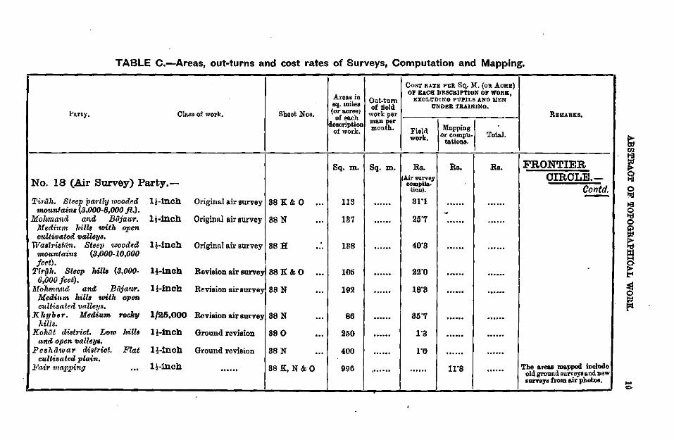
TABLE C.-Areas, out-turns and cost rates of Surveys, Computation and Mapping.
CosT RATE PER SQ. M, (oR Amn:)
Areas in 01' EACH DESCRIPTION OF WORK~
Out-tum EXOL'C'DING PUPILS AND MEN aq.milaa of field UNDER i'BAINJNO.
1-'J\rty. Cla.ss of work. Sheet Nos, (or&erea) work per RB:IIIARKS, of each description ma.n per
month. Field Ua.pping of work. or compu. Tot»!. work. tationa.
Sq. m. Sq. m. Rs. Rs. Rs. FRONTIER
No. 18 (Air Survey) Party.-lAir survey CIRCLE.-
oompiJa. Contd. tioll), -Ti1·ti..h. Steep ptlA'tly wooded 1!-lnch Original air survey 88 K& 0 ... 113 ······ 31'1 ...... ......
1nonntains (3,000-8,000 ft.). -Molvmanrl "''"' Bcijaur. 1;-lnch Original air survey 88 N ... 187 ...... 25'7 ...... ······ Medium /tills •oitk open cultivated 11alky11,
wa . .ririsf-tin. Steep ·wooded 1!-lnch Original a.ir survey 88H ... 188 ······ 40'8 ······ ...... mountain8 (3,000-10,000 j-.t).
Tlr{i1l. Steep 6,000jc.t).
Mils (3,000- 1!-lnch Revision air survey 88K&O ... 105 ...... 22'0 ....... . ..... MohmCl!lu'l anrl Bt1iaur. 1!-lnch Revision air survey 88N ... 192 ...... 18'8 ······ . .....
Medi1tm. ll.iU1 toith opon cultivated valleys.
KltttbtJr. Medium rocky 1/25,000 Reviaion a.ir survey as N ... 86 oooou 85'7 ...... ...... hills.
Kolrtit cU.strict. La.o Mil• 1!-lnch Ground revision 88 0 ... 250 ...... 1'8 ······ ...... and open va-ll~ys.
Pcshcl'l.uar district. Flat 1!-lnch Ground revision 88 N ... 400 ...... 1'0 ...... ...... cultivated plain.
The areas mapped include Fair mapping ... 1!-lnch ...... 88K,N&O 996 . ...... ...... 11'8 . ..... old ground surveys and uew 81U'Yeya from air photos.
Po.rty,
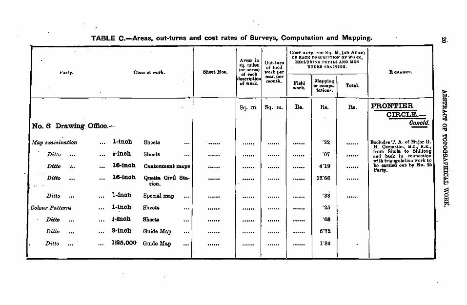
No.6 Drawing
Map exainination
Ditto ... Ditto .~. . .. Ditto ...
I i' '
Ditto ... Oolour Patterm
Ditto ... Ditto ... Ditto ...
TABLE C.-Areas, out-turns and cost rates of Surveys, Computation and Mapping.
An~n~ in I Uut-tu.n
\ CosT RATF: Pv.n ~Q. M. (oR ACRE) 01' BACH DKSCRIPTION OF WURK1
E.J.CLUDlNO PUPIJ.S AND IIBN llq. nnl-ea f fi ld UNDER 'fRAlNlNQ',
Cln.ss of work. ~heet Nos. (or. aot'OIIJ ;Ot'k eper RRTIIARK~. ol euob jdeaerit)Mon ma.n per
~lo.pping of work. month. Field work. orcompu- Total.
tation>~,
Sq. m. Sq. m. Rs. Rs. Rs. FRONTIER CIRCLE.-
Office.- Conoid. -... 1-tnoh Sheets ... ...... ...... ······ "22 ...... E:.:olndPB '1'. A. of Mu.jor G.
... 1·1noh Sheets . .. . ..... . ..... ...... ...... "07 . ..... H. Oamn.at.on, M.c., R.IC., from Simla to Shillong nnd back in couneotion
. .. 16-tnoh Cantonment maps noooo ...... .. .... ...... 4"19 . ...... with tria.~lntion work to be eani out by No. 15 Party •
. .. 16-tnch Quetl& Civil Sta- ...... ...... ...... . ..... 12'66 .. .... tion.
. .. l-inch . Speci•l m•p ... . ..... . ..... ' . ..... . ..... "38 . .....
... l-1noh Sheets ... .. .... . ..... .. .... ...... ' "25
. .. Hnch Sheets ... . ..... ······ . ..... . ..... ·os
... s-tnoh Guide Map ... . ..... ······ ...... . ..... 6"72
. .. 1/26,000 Guido M•p ... . ..... ...... .. .... . ..... 1"83 -
.. Q•
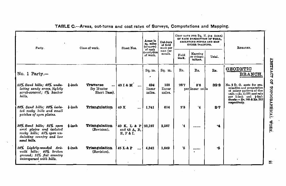
TABLE c.-Areas, out-turns and cost rates of Surveys, Computations and Mapping . . COST RATE Pfo:R SQ.. M. (OB ACRE)
Areas in 01!' RACK DIIRCIUPTION OF WORK,
Out-tun EXCLUOING PUPn,s AND UKN sq. milee ot field UNDER TttAlNlNQ,
Party. Cla.ss of work. Sheet Nos. (oro.cre1:1) work per REMARKS. of ench description ma.n uer
of work. mouth. Field Ma.pping
work. or cmnpu- '!'ota.L ta.tiona.
Sq.m. Sq. m. Rs. Rs. Rs. GEODETIC No. 1 Party.- BRANCH . . 55% San-l hills; 40"/. uml.u- !-inch Traverse ... 40I&M . .. 494 103 28'7 8'6 32•3 No. S D. 0. costs fnr exn.-
lating Bamdy areaa, lighthj (by Hunter linear linear per linear mi le mintttion a.nd prepa.nttion
scrub·CCYIJered; 6o/o kamkcw Short B•se). miles. miles. ot' colour patterns of thU< unit :-.lts. 2,fi39/-cost mte
hills. per l-inch and l-inch sheet&:- Rs.l66 k Rs. 212 re.speetively.
80"/. Sand hills; 110"/. isola. l-inch Tr1anguiatto~ 40K ... 1,741 614 2'3 '4 2•7 ted TocX:y hills a·nd small patches of open plains.
80"/. Sand lti!ls; 115% open l-inch Tr1anguiatlon 40K,L&P 23,187 2,567 '4 ...... '4 arid plains and isolated (Revision), and 45 A, B, rocky hill8 ,· 45o/o open 1m- E,F&I. dula.Ung coun!ry amd lo-w aand Mlla. -
50"/. Liglttly-toooiled A~ii- t-ineh Tr1angu1atlon 45L&P ... 4,842 1,649 '5 ...... •5 valli hills; 40"/. broken (Revision). . ground; 1 CfYo flat country intersper•ed. with hilla.
- ... -·
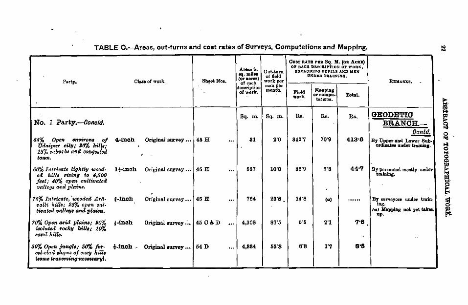
TABLE C.-Area~, out-turns and cost rates of Surveys, Computations and Mapping.
CosT RATE PER SQ. M. (oa AcaM)
Area.s i11 Ol' RACll DESCRIPTION OF WORK,
sq. miles Out..t.urn EXCLUDING PUPILS AND M&N of &eld O'NDE& TRA.lNlNQ,
P1nt.y, Cla.sa of work. Sb~et Noa. (or aortWJ) work por REHAR£8, . of eo.ch -
description muu per of work. mouth. Field Dlo.pping
work. or compu- Total. ta.tiona.
Sq. m. Sq. m. Rs. Rs. Rs. GEODETIC No. 1 Party.-Concld. . BRANCH.-
£E!!!!!:. 66% Open .,.ViTo"' of 4-inch Original survey ••• 46H ... 81 2"0 842"7 70"9 413•8 By Upper and Lower Sub-
Udaipn,r city; 20% ltills; ordinates under trainins. 16% Bllb1<rb• 11nd co71ge,(od,
' totUJI..
600/o Intricate lightly wood- H-inch Origina.l sw:vey .. , 46 H ... 657 10"0 86"9 7"8 44•'7 By personnel mostly under oil /•ill• rising to 4,6(J() tminiDg. /cot; flo% open ct<llwatod valleys and plains. .
?5% Intricate, 'tvoodccZ .A.rii- f-inch Origin&! sw:vey •• , 45 H ... 764 28"8. 14"8 (co) ...... B~ surveyors under tra.tn-'Valli hill•~· 26% opon cu,l- ' lDg.
tivat~d vall"lf• amd pla4m. (GJ Mapping not yet taken up.
70% Opsn tJJTi,d plaim; He% iBolate<l 'rocky kill1; Io%
•-inch Origino.l survey ••• 45 C&D ... 4,308 87"6 5.5 2"1 '7"8
sa-nd hill8.
50% Open junglo; 5o% for- !-inch - Original survey ••• 54D . .. 4,884 55"8 6"8 1"1 8•6 est-clad slopes of ea"1J hills <•om.e travening necel8ary).
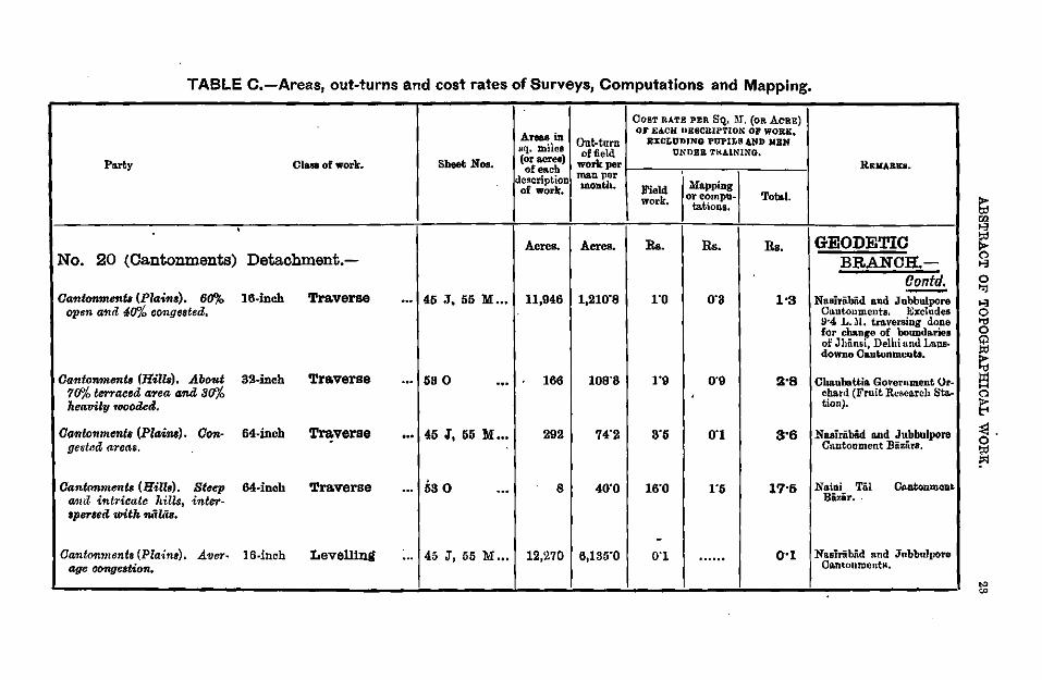
TABLE C.-Areas, out-turns and cost rates of Surveys, Computations and Mapping.
COST RATE PER SQ.. 1\f. (OR ACRE)
Areas in OJ' EACH UESCRIPTION OJ WORK,
sq. miles Out-turn BXCLUDJNG PUPILS .&ND -.aN of field UN DEB TlU.lNING,
Party Clau of work. Sheet Nos. (oraeree) work per REMARK&. of each description ma.n per
of work. month. Field Mapping work, orcompu- Tob>l.
ta.tions •
• Acres. Aeres. Ra. Rs. Ra. GEODETIC
No. 20 (Cantonments) Detachment.- BRANCH.-Oontd. -Cantonment. (Piaitll). 60% 16-inch Traverse ... 45 J, 55 :M ... 11,946 1,210'8 ro 0'8 1•3 Ntu~iribiid a.nd Jubbulpore
open and 411'/o congested. Ctmtonmenta. ~;xcludes 9·4 L . .ll. tra.ver.siug done for change of bouuda.riea of Jhii.nsi, Delhi und Lana· downo Ca.ntunments.
oa.,tonmentB (Hills). About 32-inch Traverse ... 58 0 . .. 166 108"8 1'9 0'9 !1;·8 Cbaubattia. Government Or-711'/o terraced anea and 811'/o ' eba.rd (Fruit Resea.rch Sto.-heavihJ 1oootled. tion).
Oa,.tonmente (Plains). Con· 64-incb Traverse ... 45 J, 55 :M ... 292 74'2 8'5 0'1 3'6 Nasiriibii.d a.nd Jnbbulpore gesteit areas. Cttntonment Biizii.ra.
Ganl<mtn61rtB (Hills). Steep 64-inch Traverse ... 5s o . .. 8 40'0 16'0 1'6 17•5 Naini Tiil Cn.ntonment and intricate hills, inter- Bi?iir •.
aper&eit with 'IUibis.
-Cantonments (Plains). .A VeT• 16-inch Levelllng ... 45 J, 55 :M ... 12,270 6,135'0 0'1 ······ 0·1 Nasiriibiid nnd Jnbbolpore
age aongeation. CantoumentM.
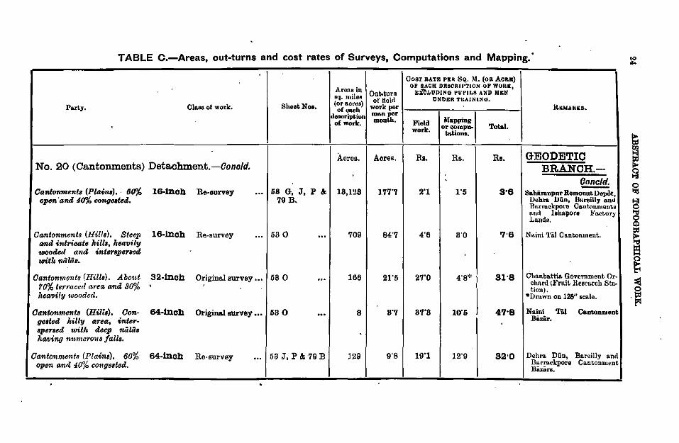
TABLE C.-Areas, out-turns and cost rates of Surveys, Computations and Mapping.·
CosT RATe PKK SQ .• ~1. (OR AORRI)
Arens in OF !tACH DRSCRIPTION oP WOIU: 1
Oa.t..turn E~LDDING PUPILS AND MKN sq. mile .. of ttold ONDER TIUINlNO,
PMty. Cla.aa of work. Sheet Nos. (or a.cres) work per }h.NAKiiS. of oo.ob descriptiun m•"n per
of work. mouth. Field )[apping
work. orcompu- Total. ta.tions.
Acres. Acres. Rs. Rs. Rs. GEODETIC No. 20 (Cantonments) Deta.chment.-Cono/d. BRANCH.-
Cafllomnenl8 (Plt>im). · 60% 16-lnoh '!!!!!!!!.!!.:
Re-survey ... 58 G, J, P& 18,1~8 177"1 2'1 1"5 s·e Sahiiraupur RemonntDepOt, open ·and 4fl% C01tgo.ted. 79 B. Uellra lJU.n, Usroilly aud
B1~rmckpo1'0 C11-ntonment.s and lslu~pore l!'actury La.ud1:1.
Cantonments (Hills). Steep 16-lnoh Re-survey ... 53 0 ... 709 84'7 4'6 8'0 '7'6 Nk\ini 'l'il Cantonment . and i11tricate llills, l1eavily woodetl auil interapenred with 1ulliis.
Oantonment8 (Hills). About 32-lnch Original survey ••. 58 0 ... 166 21'5 27'0 4'8'' I 31•8 Cha.ubattia. Government Or-
10% terraced area. a.nci ao% . I ctuml!ll,rnit. Uesca.rch Stu..
I tion).
]!eQNi/y 1voodccl. •Drawn on128" sca.le.
Canto?Jmenbl (Hills). Con· 64-lnch Original survey ... 58 0 ... 8 8'7 87'8 10'6 4'7•8 Naini Til Cantonment gested hilly area, inter- Bizi.r.
aptJraecl with deep miliia . luwing numerous falla.
Catnlonnumts (Plcvi·na). 60% 64-inch Re-survey ... 58 J, P & 79 B 129 9'8 19'1 12'9 Sl!•O Debra DUn, Bareilly and open and 40% congested. Harrackpore Ca.ntonna·nt
Biiziin.
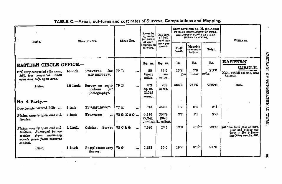
TABLE C.-Areas, out-turns and cost rates of Surveys, Computations and' Mapping.
CosT RA.Tit PRR Sq. M. (OR ACRE)
Area.a in Out-turn OJI' EACH D£tiCKIP'l'lUN or WOR)[1
sq. miles EXCLUDING PUPILS AND liEN of field 'UNDER TRA.INlNQ,
Party. Cla.sa of work. Sheet Nos, (or acrea) work per of eiK'h description DUUI ~er
mont, Mapping of work, Fie I~ work. Ol'Ct>mpU• Total.
t&tiOJls.
EASTERN OIROLE OFFIOE.- Sq. m. Sq- m. Rs. Rs. Rs.
s(f>fo fJery congested city area., 16-inch Traverse tor 79 B 58 53'0 15'2 7'8 23-0 ... 10% less congested urbam air surveys. linen.r linear per linear mile.
ti/NG crnut 70% open area,. miles. miles.
Ditto. 16-lnch Survey on recti· 79 B ... 8'2 768 564-3 221'6 '185•8 fica.tions (air sq. m. acres. photography). (2,048
acres).
No 4 Party.-Low Jungle covored hills ... l-inch Triangulation 72 K ... 676 439'8 1'7 0'4 2·1
PlaMt., mosU1J open and cul· l·inch Traverse ... 72G,K&O ... 6,810 252'4 2'7 1'1 3'8
U11ded. (2,241 (84'8 L.milesi. L.miles).
Plaim, mostl1J open and oul· l-inch Original Survey 72 C & G ... 2,680 28'5 12'8 s·t<"l 20•9 tivt.ted. Surveyed by 'I'S•
notion from auziliqrv points fi:<ed from traver,. control.
Ditto. l-inch Supplementary 72 G ... 2,422 85'0 13'2 s·tC" 21'3 Survey.
RRHARKB.
-
EASTERN OIRCLE.
Kulti ontt'u.ll scheme, near (.;u.lcuttn.
Ditto •
'
(r&) 'l'he tot11l cost of mn.p· ping and culonr pat· Wrus 111 No . .6 Dm.w-ing Ollioe was .Ka. ~.
... ..
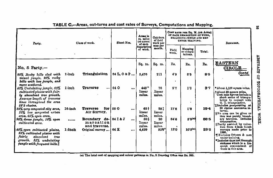
TABLE C.-Areas, out-turns and cost rates of Surveys, Computations and Mapping,
Party.
No, 5 Pa.rty.-
80% Rocky hill• olad with twized jungle, JJO% rocky lalla with leu jungle, anci mors scatttJred.
40% Uruiulating jungle, 60% cultivated plainsUJith fairly <&bundant treo growth. Average lenuth of traverse Unes throug !tout the area 62' 6 cltains,
.95% very eongeBted city arecs, 10% less congested urban area, 65% open area.
90% dense jungle, 10% open cultivated. area.
4o% open cultivate4 plaina, !it;% eullivated plain• wit/• /wirly abundant treo growl". 85% U111J:ulating fungi" with frequent l•illB.Il
l-inch
l-inch
16-inob
...... 1-fnoh
Cla.11 of work, Sheet Noa,
Tr1aniulatton 64 L, o & P ...
Traverse ... 64 0
Traverse tor 55 0 Air Survey,
Boundary de- 64 I & J maroatton and traverse.
Original survey ••• 64 K
...
AteUin sq. miles (or acres) of each
deecript.!ol of work.
Sq. Ill.
5,476
448* linea.r miles.
62t linea.r miles.
58§ linear miles. 4,429
Out-turn of field
CosT BATB PEB. SQ. ll. (oB ACRE} OJ' E.A.CK DESCRIPTION OP WORK,
EXCLUDlNG PDPlLII AND l:[J:N UNDER TBAlNING,
work per l----,~--~-----l man per 1 month. Field Mapping
work, 0~~:.~·
Sq. m.
211
76 ,linear miles.·
23t linear miles.
20 linear miles.
82•*
Rs. Rs.
4.9 8'6
1'0
17'6 1'8
84'6
12'0
Total.
Rs.
8•5
8'7
19•4
88•5
(a) The toto.l cost of ma.ppmg and colour po.tteros m No. 6 Dra.wmg Oftioe was B.a. 305.
lt&w.uu,s,
EASTERN CIRCLE.
0.2!!.!!!:,
• About.l 1100 sqWI.re miles • t About 39 square rnilea.
Cost rate fiJUres iuclude & shol't serteB of triangu. Iation to connect wit.h G. '1', triangulation.
%Includes poatpolnting at 20 chains maximum iaterva.l.
§No area. can be given as this wru~ purely boundary traverse. Includes dema.rca.tion.
II Partly a.eeisted by reduction from 4-inch forest surveys JD.a.de prior to 1905.
'I(' Excludes Officers & men under trainiT1g,
•Includes da.ysloat through eickneN whieb is a. fre. queut concomitant of work in this a.rea..
.. "'
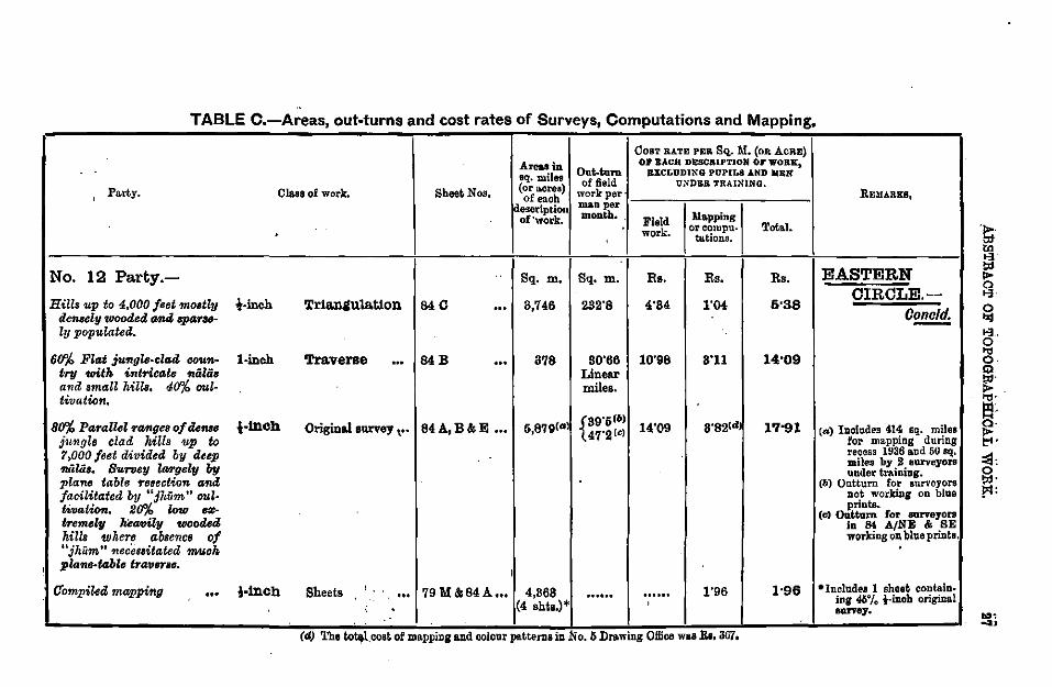
TABLE C.-Areas, out-turns and cost rates of Surveys, Computations and Mapping,
CosT RATE PER SQ.. M. (oR AcRE) Areas in Out. tum
OJ' EACH DESCRIPTION OF WORK,
sq.milet EXCLUDING PUPILS AND liEN of field U:-IDER TRAINING,
Party. Class of work. SheeoNoa. (or acres) work per· ' of each
description mAn per
of'work. month. . Field Mapping . work . oreorupu- Total.
' tu.tions.
No. 12 Party.- Sq. m. Sq. m. Rs. Rs. Rs.
Hills up to 4,000 feet nwstly !·inch 'rrJ.a.ngula.tlon 840 ... 3,746 I
232"8 4'84 1"04 5"38 densel-y toooded G1UI spalYI6-ly populated.
6~ Flat jungl•-clacl ccotn- l-inch 'l'ra.verae ... 84B ... 878 80'66 10"98 8'11 14"09 try with intricate flii·lii8 Linear and small hills. 40% oul- miles. tivation,
8~ Parallel TDAiges of dems l-tnch Original survey, .. 84A,B&E ... 6,879(Gl {39"6(b) 14'09 8"82(" 1'1•91 jungl• clad hill• 1IP to
47"2(<)
1,000 feet divided by deep 'niiliil. Burooy lan-gely by pla-ne table f'esection tmd . facilitated b'lj "Jhiim" md-tivation. 2~ low ..,.. fnoemely heavily wooded hills where absence of "jhUm" 'llecessitated fTIIUoh
; pl-ane-table tra'f1eTBe. I
Cfompiled mapping !•tnCh Sheets ' 79 M&84A ... 4,868 1"96 1•96 ... ... ...... . ..... i . (4 shts.)* '
. (d) The to~l.cost of ma.ppmg and colour pa.tterDBlD No. 5 Dra.mng OJiioo waa B.l. 367,
REMARKS,
EASTERN CIRCLE.-
Cone/d. -
(a) Includes 414 sq. miles for mapping during recess 1936 and 50 sq. miles by 2 surveyors under training.
(b) Oo.tturn for surveyors Dot workiDg on blue priots.
(c) Ootturn for surveyors in 84 A/NE & BE working oD bllle prints.
•Include• 1 sheet contain-ing 46% i-iDoh origi.Dal 8111'Y8J • .., ....
TABLE C.-Areas, out-turns and cost rates of Surveys, Computations and Mapping.
Co::tT RATB PkR s~. M. (OR ACiu:) Areo.s in Oot-tum
Oll' E..I.CR DJ:SCRIPTION or WoRK,
aq. milf'll li:XCL'O'DINO PVPlLS AND II&N
(or acres) of 6ehl UNII&B TllAUClNQ,
ParbJ. Olaoa of Wort. . Sheet Not. nf tll'ob wot"kper description nan.n per
of work. month. Field Mo.pping work:, or compu- 'l'otal.
ta.tions.
No. 6 (South India) Party.- Sq. m. Sq. m. Ro. Ro. Rs.
' Hilly country with peakB up l·inch Tr1a.ngula.t1on· 651&11! 6,784 aoo·o 2"47 o·as .2•83 ... to 4,000 / .. t 47U/, .Uop 11allq•; often TuJanly wooded. Bptiii"B•lu ... ,.... bit•~ by hill tribes, conci •"71 unhealtiVJJ.
Hilly ....,.z,.y with peako up 1-ino~ Correolion survey 74A ... 64 90"0 6"07 8'78' 13•80 to 8,000 fool anti llm411 cultivated arBal in valley1,
Re1ertJeci ForeBIB about Sl)% 1-inoll Supplementary 74A ... 892 28"7 16'91 8"73* 24•64 flat ,.z jvmgle """ 6~ survey. hilly.
' 4o% eu!tivate~ plai11B with l-inch Origina.laurvey ••• 74A&B ... 4,488 19"8 28'61 8"78" 82•34
iaolauci MliB up to 1,600 /eel. 60% hilly counlry witll peakB riBing to 4,000 feet; 1071!6 denBo jung!s and some cultivated area.s, mo1t!y tempOT4'7/; little tl'a-'VtJTri'R(I f'UIMI84'Ffl•
RsuAaKs..
INDE· PENDENT
PARTIES • '
•Includes coet of oolour potteme.
: '
... CD
TABLE C.-Areas, out-turns and cost rates of Surveys, Computations and Mapping,
CosT RA'l'B PElt. SQ. M. (oa AcRE) Areaa in OJ EACH DI!:SCKIPTh.IN OP WOR&,
11q. mile" Out-tnm BZCLUDING PUPILS AND 11BN· of field t1ND&R 'rRAINING.
PartJ. OW.. of work. Shoot; Nos. (~or acres) work per REMARKS, of each description man per , month. Ma.ppin~ of work. Field Total. .
work. or compu-ta.tiona.
Sq. m. Sq. m. Rs. Rs. Rs. INDE-No. 6 (South India) Party.-fJoncld.
PENDENT !·Inch Compiled mapping 65 & 74 ... 10 shls. ...... ...... 2'02* 2•02 PARTIES.-
. Contd • "
}·InCh Compiled mapping 65 ... 1 shl. ...... ...... 0'50* 0•6 •Includes coat; of colour patterns.
No. 10 (Burma) Party. Mtdnly wooded hiUo from 1-inoh Tr1all!lulat1on 93 B,O&D ...
4,(!00 to 6,000 fed Trig h. 6,116 850 8'70 2'05 5•'15
and fo>l cult>vatod land in the VIZI!ey of the IrriZ• waddy Biver,
L""' intri<>IZte -oded Ttillt l-inch Tr1anltulat1on 84R ... 200 462 2'68 ...... 2•68 and open cu!Uvated plaint. (Supplement- fit is not possible to give
a.ry), the area. in squa.re miles Flat ou!Uvated country l·inch Traverse 9BB, O&D ... ll9t 88 22'19 6'74 27'93 M the tra.verae work wu ... ... ea.rried ont to .suppie •
linea.r linear ment points in th& area. miles. miles. tria.n~
TABLE 0.-Areas out-turns and Cost rates of Surveys, Computations and Mapping.
CosT BATE PER Sq. )[. (OR ACRE) ,
AreiUJ in On.t.turn OF EACH DESCRIPTION or WORK,
sq. milea EXCLUDING PUPILS AND llEN
(or acres) of Jiold UNDER TlUIN"ING, Pa.ty, Cln.sa of work. Sheet Nos. of eu.ch work per REMARKS.
deseription nll\D per
of work. month. Field )lapping
work. Ol" COlllpU• Total. hi. tiona.
Sq. m. Sq. m. Rs, Rs. Rs. INDE-
No. 10 (Burma.) Pa.rty.-Conold. PENDENT
PARTIES.
Steep Wills rising to ov ... Hnch Origin&! survey ... 84F,G&R ... 8,241 102'0 9'65 2'79 11!•44 Conoid. 10,000 feot p«rtly ope" and partly wooded. Oom. munic"tiom poor.
Loto demely wo~de<l ridges l-inch Original survey ... 84D&R ... 1,985 28'2 23'69 8'64 3!!•33 with ft.at cultivated lane! bett(ltJBn.
Fair drawing ••• ... l-inch Compiled mapping 96 J' & M ... 816 ouuo . ..... 4'09 4•09
Ditto ... ... t-1nch ditto 84I&94C ... 8,820 ...... . ..... 1'80 1•80
Ditto ... ... t-1nch ditto 88 L &N, 92J 12,861 ······ . ..... 0'56 0•56 Total Cost of Olfice Copy corrections & mi~llaue.
Preparation of ...... 16 shts, ······ . ..... 187'87 137•87 ous work B.s. 16,652,
Colour Patterns. per sheet .per sheet,
-
V.-SURVEY REPORTS, FRONTIER CIRCLE.
DIBECTORS :-{ColonelS. W. Sack\"ille Hamilton, D.~:o., to 6-~-35. ~ J.t.-Colonel C. i\1. Thompson, I.A.1 f1om 7-6-3o,
81
43. Summary.-The units administered by the Frontier Circle were 'A' and 'E' Companies, Ko. 18 Pal"ty, Ko. 6 Drawing Office and No. 23 Party up to its disbandment on 1st April.
44. Training.-Two Class I Officers on probation received training in air survey.
Eleven soldier surveyors were under training in 'A' Company during the field season, of whom two reverted to their regiments.
45. SpeciaL-The Officer Commanding, 'E' Survey Company, took part in the Western Command Exercise held around Quetta between 22nd and 24th October 1934. During the year the Staff College senior students visited his office for brief lectures, and demonstrations of map making and reproduction.
'E' Survey Company was severely affected by the disastrous Quetta Earthquake which occurred on 31st May. Four members of the Company lost their lives in the city and the office building was rendered unsafe for further occupation.
46. Areas Surveyed.-580 sq. miles of triangulation.
80 linear miles of traversing. 12 linear miles of cantonment boundary traverse.
100 linear miles of settlement traverse. 6,228 sq. miles of !-inch original survey. 1, 790 sq. miles of l-inch original survey.
262 sq. miles of l-inch original survey (triangulated and photographed from the air).
168 sq. miles of 1!-inch resurvey. 3 sq. miles of 16-inch resurvey.
434 sq. miles of l-inch resurvey. 257 sq. miles of l-inch supplementary survey. 767 sq. miles of 1-inth revision survey. l-inch correction surveys of 6 sheets.
By No. 18 (Air Swrvey) Party.-388 sq. miles compiled (original survey). 383 sq. miles compiled (revision survey).
'A' Survey Company.
gtr. W. H. Strong, lf.B.P:., to 1-1-35. Ojlieer Commtuuling.- t .. Colonel 0. Slo.ter, M.C., R.E.,.from 2-1-85 to 8-8-35.
ieut. C. A. Biddle, k.E., from 4-8..35.
47. GeneraL-The party continued surveys in Ferozepore, Jullundur, Kangra, Montgomery, Multiin and Muzafiilrgarh districts and in Bahnwalpur, Chamba, Faridkot, Kalsia, and Mandi States of the Punjab and in Bikaner State of Rajputana.
82 SURVEY REPORTS, FRONTIER CmCLE.
In addition correction surveys were carried out in Amritsar, Hoshiilrpur, Jull.;.,dur and Ludhiina districts and in Kapiirthala. State of the Punjab. .
Trian.,ulation and traverse for t•ext season's survey were carrted out in Dera Gt1iizi Khan district and Bahiwalpur State of the Punjab. A small area in the neivhbourhood of Bik . .ner City was also triangulated to provide a frame;ork for a special survey of that city. This survey was completed during the year under report.
Towards the end of the field season a traverse camp was formed for fixing points for a settlement survey shortly to be undertaken in the Kanvra district of the Punjab.
"Field headquarters opened at Ferozepore Cantonment on 16th October and closed on 15th April.
48. Personnel.-The average strength of the Company during the year was one Class I, 3 Clas• II, 6 U. S. Officers, 2!! surveyors, 1 traverser, 1 draftsman, 6 computers, 3 clerks and 1:1 soldier surveyors.
Messrs. 0. D. Jackson (Class II) and ~fuzatfar Husain (U. S. S.) joined 'A' Company from No. 23 Party and No. ·18 p,,rty respectively in October and Mr. E. R. Wilson, B.A. (Class II) in December.
Mr. Mohd. Najamuddin, B.A. (Class II) was trilnsferred to 'E' Company in December and 3Iessrs. W. H. Strong, M B. E. (Class II) and Muztdfar Husain (U.S. S.)to No.6 Drawing Office in January and June respectively.
49. Areas Snrveyed.-580 sq. miles of triangul~tion.
80 linear miles of traversing. 100 linear miles of settlement traverse.
6,228 sq. miles of !-inch original survey. 1,789 sq. miles of l-inch original sul'Vey.
168 sq. miles of 1!-inch resurvey. 434 sq. miles of l·inch resurvey. 257 sq. miles of l-inch supplementary survey. 767 sq. miles of l-inch revision survey.
6 sheets of l-inch correction surveys. 50. Fiel~ work was organised as follows:-· Oamp (1) under Rai Sahib Chuni Lui Kapur with Mr. I. K.
Ponnappa and 10 surveyors completed 1,037 square miles of !·inch ori.,inal survey, 1, 725 square miles of l-inch ori"inal survey 344 square ~ilea ?f l-inch re-survey and 2.57 square miles ~fl-inch supplementary survey m sheets 39 N and 44 C-and G. ·
Oamp (9) under Mr. 0. D. Jackson with Mr. Mlll!afl'ar Husain and 10 surveyors completed 5,191 square miles of !-inch orivinal survey in sheeta 44 C and G. "
· Oam~ (9) under. ~r. ~ardar Khan, assisted by Mr. Mohd. Akbar was orgam.sed for trammg In the Kangra valley and in yarts of Chamba and Mandl ~tates. One. surveyor and 6 second year soldier surveyors completed 2o8 square miles or 1- and 1!-inch resurvey in sheet ......,.. ~ 52. D. Five_ fi_rst year soldier surveyors and one computer received InstructiOn and d1d mdependen t work in the same area.
. Oam.p (4) .under Mr. Mohd. NB:jamuddin, li.A. succeeded by Mr. E. R. Wilson, B.A. w1th 3 surveyors completed 767 square miles of revision
SURVEY REPORTS, FRONTIER CIRCLE. 88
survey in sheets 44 J, M and N, together with 6 sheets of correction surveys in sheet 44 M. The basis of the revision survey was 4-inch survey done by No. 23 Party during season 1931-32 for the Punjab Irrigation Department. A drawing section of 6 surveyors and 1 draftsman alAo formed part of the camp and completed 4 sheets of mapping left over from recess. ·
Triangulatim.-Mr. Bashirullah Khan completed 580 square miles of triangulation in nil. Of this, 80 square miles in sheets 44 H and 45 E, was for a special survey of Bikaner city; and the remainder, in sheet 39 P, for surveys to be carried out next field season.
Traversing.-The north west corner of sheet 39 L, which falls in next season's survey area, required supplementary triangulation. Owing to excessive tree growth it was found cheaper to traverse the area and Mr. Bashirullah Khan completed 80 linear miles of traverse in this area.
Special surveys.---An area of 64 square miles of l-inch original survey round Bikaner city in sheets 44 H and 45 E was completed by 2 surveyors supervised by Mr. Muzaffar Husain. This survey is for a special map with contours at 10 feet intervals required on payment by Bikaner·State.
At the request of the Punjab Government a traverse camp of 8 traversers and 8 computers was formed towards the end of the field season to undertake the traverse for settlement purposes of 30 small villages in the Kangra district. This work was supervised by Rai Sahib Chuni La! Kapur and 100 linear miles of traverse, together with its com· putations and plotting, was completed during the month of August.
Description of GountTy.-In the neighbourhood of the Sutlej the country is thickly populated and intensively cultivated. In addition to_ numerous wells there is now a rectangular net work of field distributaries fed by canals controlled at their head works by the various barrages across the Sutlej itself. The alignments of the old inundation canals are marked by high banks which wind apparently haphazard across the country or have been realigned to form modern canals, South of this the country is desert in pt·ocess of reclamation. Large areas of sand duues, mostly eipa.rsely covered with shrubs but a few sterile and shifting, are interspe1'8ed with areas of pat now canalised and cultivated. The banks of the old taubas are fast disappearing as the water supply now depends chiefly on deep tanks supplied from canals. In out of the way places the old and bitter wells are still in use, but near the canals the wells are gradually becoming sweeter. There are no signs of the actual bed of the old Hakra or Ghaggar river; but the area through which it flowed is marked now by a broad canalised and cultivated rift between sand hills, which in the south rise to two hundred feet above the plain. The whole area except for some of the larger dune areas has been reetangulated and this formed the basis of the survey.
51. Recess Duties.-Including arrears the Company bad a total • of 27 sheets to be mapped during the_ recess. Of these _23 sheets were
completed by four drawing sections. The remainder wtll be completed during the coming field season.
Computations. Owin.,. to the formation of the traverse camp men· tioned above the computation section during most of the recess was
84 SURVEYeREPORTS, FRONTIER:CIRCLE.
reduced to Mr. Saiyid lrshad Ahmad, B.A., and 1 computer. All the computation work for the coming field season was completed by the end of recess.
'E' Survey Company. ·ojf£cer CMnmandtng.-Major T. M. M. Penney, R.J:.
52. GeneraL-Due to the accumulation of arrears of mapping the Company did not take the field as a whole during the year under report but was concentrated in Quetta on fair drawing, both during the field season and during recess.
Some survey work was done however both as departmental and extra departmental jobs.
In Iiaieon with the R. A. F. and as training in air survey fo~ both the R. A. F. and this unit, one l-inch sheet was photographed, tnangul-, ated, and bad its detail checked on the ground. Correction_s to the Quetta Cantonment map were verified on the ground and the fall' sheets brought up to date. An extra departmental spot level survey was carried out in the neighbourhood of Pishin. The Fort Sandeman Cantonment was re-surveyed on behalf of No. 20 (Cantonments) Detachment. One or two other small surveys were carried out as paid for works, ·while numerous small jobs, such as fixing bearing pickets for the Royal Artillery and range taking for range finder testing ranges, were undertaken · for the Army.
The Officer Commanding took part in the capacity of Deputy Director of Surveys in the Western Command Exercise, while a selected number of surveyors and computers carried out a small triangulation exercise with signallers kindly lent by the 2nd Indian Divisional Signals. · One surveyor went on deputation with Dr. Visser's 1935 Himalayan expedition.
53. Quetta Earthquake.-The Company was severely affected by the disastrous earthquake which occurred in the early hours of 31st May. The office building being situated in the 50% zone was very severely shaken and will require complete reconstruction on earthquake-proof lines. Practically the whole of the personnel were living in the 100% zone in the city, and suffered very great loss both in relatives and personal property. Fortunately, only four men of the Company lost their lives while one was severely injured.
The survivors_ of all families were evacuated from Quetta, and the whole Company lived and worked in tents throu"hout the remainder of the recess season. "
The emergent demands of the Civil and Military authorities for surveys and maps, arising out of the earthquake, caused extra departmental wor~ to be grea1l:y ~cre.a~ed. A special rectangulation survey was earned out to assist m 8lting the temporary Quetta City, special maps and plans for the Earthquake Claims Commissioner were drawn an<! reproduced and special skeleton plans of the Cantonment for the Quetta Cantonment Reconstruction Committee were prepared. Demands for large scale maps of Quetta Cantonment, and Civil area and of the sur~ounding country inclU<l~ng all adjacent villages, wer: heavy during the first few days after the diSaster. These were met immediately, though
SURVEY REPORTS, FRONTIER CIRCLE. 86
the press room was severely shakea and not really safe for work, in vi~w of recurring shocks. To refute current rumours that the earthquake had altered the position and heights of the surrounding hills, and to enable an up-to-date report on triangulation stations and bench marks to be submitted, a special re-triangulation of the adjoining hills was carried out, and the levels of bench marks in the city area were cheeked.
54. Personnel.-The average strength during the year was 2 Class I officers, 2 Class II, 3 Uppet• Subordinate officers and 19 Lower Subordinates (excluding 3 clerks, 2 computers and 15 reproduction section .personnel).
One clerk, one computer, one surveyor and one member of the Reproduction Section were killed in the earthquake.
_Lieut. J. S. 0. Jelly proceeded on leave for 3 months from 2nd January. Mr. H. M. Critehell proceeded on 4 months leave from 12th November prior to transfer to No. 6 Drawing Office.
Mr. Chowdhury Mohd. Aslam proceeded on three months sick leave from 7th June due to injuries received in the earthquake.
55. Areas surveyed.-262 square miles round Jacobiibild were triangulated, and photographed from the air, and visited on the ground for classification of detail, and the air survey map compiled. 3 square miles on the 16-inch scale were resurveyed in Fort Sandeman Cantonment and 12 linear miles of cantonment boundary traversed.
An area of one square mile was rectangnlated and surveyed on the 32 inch scale neat· the Murree Brewery on the outskirts of Quetta, to assist in laying out the temporary Quetta City area.
56. Field Work~-Apart from the work mentioned above no field work was done. The ground work for the air survey of the Jacobiibiid area in 39 D/7 was carried out by Mr. Khushal Khan (U.S. S.) and 2 surveyors during January and February, while the Fort Sandeman work was done by Mr. Chiragh Shah (U. S. S.) and 2 surveyors during April, May and June.
Natwre of cowntry ll'Urveyed.-Dead fiat plain, partly desert and partly irrigated round Jacobiibiid, and ordinary fairly fiat cantonment area at Fort Sandeman.
57. Offi.ce Work.-The normal drawing work was divided into two sections. No. (1) Section under Mr. Najamuddin consisted on an average of 9 draftsmen. No. (fJ) Section was under Mr. Critchell assisted by Mr. Vidya Dhar Chopra who took over the section on Mr. H. M. Critchell's proceeding on leave until Mr. Chowdhnry Muhammad Aslam joined on 15th April. The section consisted on an average of 9 draftsmen. 17 Fair sheets of arrears mapping were completed between the two sections throughout the year.
A large number of special maps and plans were drawn to meet requirements due to the earthquake, especially large scale plans of the various city wards for use in connections with salvage operations in Quetta City. -
Lieut. J. S. 0. Jelly generally supervised the computing section, the air survey work and the reproduction section, and was available for experimental work and mi~cellaneous jobs requirod by the Army
86 SURVEY REPORTS, FRONTIER CIRCLE.
and for military training. His services were also lent to ~he. military authorities during the week following the eart.hquake to as~1st 1n supervising the many engineering jobs urgently reqmred at that t1me.
58. Reproduction Section.-This section under Litho-draftsman Shahabuddin was employed on miscellaneous work throughout the year, the largest single job being the printing of 98 sets of deh maps for the Irrigation Department.
The section was very fully employed from the day of the earthquake onwards in printing the various special maps and plans referred to above. When the earthquake occurred revised 16-inch maps of the Quetta Cantonment and Civil Station, as well as the new 1/25,000 Guide map, were under publication in Debra Diin and Calcutta; no published copies Ol! these scales were available. To meet the immediate demand for large scale maps, the Reproduction Section were .able to use preliminary plates which h,W. been made in Quetta before the material for lhe 16-inch and 1/25,000 maps had been sent for publication; they were thereby able to meet all demands made by the Civil and Military authorities.
59. Military Training • ....,.Senior surveyors were given a short course in triangulation and traverse, rapid 1/25,000 scale plane·tabling and advanced triangulation with signallers.
No. 18 (Air Survey) Party.
0"'· . h {Captain D. R. Crone, R.E., to 13-8·85. 'JJ"'n •n c arge.- . Ltent. R. C. N. Jenney, B.. E., from 14-3-85.
60. General.-Recess and field headquarters remained at Murree and Risiilput• respectively, the latter openinoo on 20th October and closing (ln 6th May. n
81. PersonneL-The average strength of the party was 2 Class I, 2 . Class II, 3 U. S. officers and 17 Lower Subordinates (excluding clerks and reproduction personnel). · ·
Mr. E. R. Wils<~n, B.A.., joined the Party on let Oct<~ her for training was transferred to 'A' Company on 7th December, and transferred back to No. 18 Party on 20th May.
Mr. N. D. Joshi, B.A., joined the Party for trainin"' on 28th November. "'
62. Areas Surveyed.-388 square miles compiled (original survey). 383 square miles compiled (revision survey) .
. 63, Field work.-No. 1 Wing Station, R. A. F., Kohat, supplied o~hque P?otog~aphs with the F/8 camera of 129 linear flying miles in tnbal terntorr tn she~t 38 K & H for height determination.
. No. 2 W1ng Stat1on, R. A: F. Risalpur supplied oblique photographs wtth t~e ~/8 camera of 112 hnear flying miles in sheet 38 N for height determmation .
. Experiment~! wo~k with the 20-inch lens and infra-red filter was ?ontinued, b~t difficulties were encountered owing to vibration resulting 10 a blurred tmage. · •
SURVEY REPORTS, FRONTIER CIRCLE. 87
A modified mounting for the F /8 camera for use with the Rose 6-inch E. M .. I. lens was designed by No. 2 Wing Station, R. A. F. Risiilpur.
64. Compilation.-The compilation of a special map for Northern Command was completed in January. For the method of reproduction see page 70 para. 131. .
The remaining compilation carried out was for the greater part the completion for contours of the previous year's outline compilations, by the method of survey from oblique photographs.
205 square miles were compiled for detail only from air photos taken in previous years.
Fair mapping.-583 square miles compiled from air photos in previous years have beeu fair mapped during the year under report.
65. · Photographic Equipment and Instruments.-A Wild air camera with its accessories was purchased by the Department.
One model of the Zeiss folding mirror stereoscope with tracing stereometer attachment was received during the year. This instrument proved most useful for the examination of photographs by the officer in charge and section officer.
66. Training.-Lieuts. C. A. Biddle, R.E., and D. E. 0. Thackwell, R.E., were trained in methods of air survey during recess.
67. Nowshera Air Survey Exercise.-This exercise was carried out in Jnnuary-February 1935. The primary object was the rapid production of 1/50,000 standard maps and a 1/25,000 .. battle map. Incidental objects were to test the Indian oblique method of fixing spot heights under active service conditions and to ascertain the value to the R A. of copies, on the 1/25,000 scale, of the air survey compilation during the making of the 1/50,000 standard map. Extracts from this report will be published in due course. · -
68. Reproduction Seotion.-For details of the work of the reproduction section see page 70.
88
VI.-SURVEY REPORTS, GEODETIC BRANCH.
No.1 Party.
Officer ill cltatyt~.-Co.ptain H. W. Wright, R,E.
69. General.-The party carried out operations in the Punjab States Riijputiina and Central India Agencies, Gwalior, the Bombay Presidency, the States of Western India and in Baroda in sheets 40 I, K, L, M P 45 A, B, C, D, E, F, H, I, L, P and 54 D.
At 'the end of Au.rost a small Camp took the field for high mountain surveys in sheets 53 I, J, M and N. The area, which is to be surveyed on f-inch scale for !-ineh maps, comprised the uppermost part of the Bhiigirathi basin north of the Bandarpunch, Gangotri, Kediirniith and Badrini!.th massifs as far as the Tibetan Border.
This work will be described in the General Report'for 1936-37. Both Jodhpur and Tonk States contributed at the full rates for surveys
carried out for them. The officer in charge continued. personal negotiations for contribu
tions to surveys with the administrations of Indian States and his proposals have already been accepted by one state and have received promises in others.
The field headquarters of the party by permission of H. H. the Mabiiriina of Mewiir continued to be at Udaipur (Udaipur or Mewir State) throughout the season from 15th October 1934 to 14th April 1935; on the conclusion of field work, all equipment was moved to Jodhpur, the future headquarters. ·
Perscmml.-The field strength of the party was 1 Class I, 5 Class II, 2 Class II probationers, 6 Upper Subordinate Officers and 39 Lower Subordinates. ·
70. Areas surveyed.-4-inch original survey 31 square miles.
1}-inch original survey 557 , , f-inch original survey 764 , , l-inch original survey 8,642 , ,
71. Field work was organised as follows:-Cam~ (1).-Mr. A. A. Graham(Ciass II) with 12 surveyors_complet
ed the ongmal survey of 4,308 square miles on the !-inch scale in the states of Jodhpur, Piilanpur and Sirohi in sheets 45 C and D.
The area is ~ypical of the arid flat c?untry which largely comprises Jodhpu~ State, mterspersed however wtth isolated groups of bold rocky mounbuns, and tending to desert conditions on the west.
Camp (e).-Mr. J. B. Lal (Class II) assisted by Mr. B. B. Kuttappa <U:· :S· 8.), and .12 surveyors completed 4,334 square miles of }-inch ortgmal surveys ID the states of Indore, Khilchipur Rajgnrh Jhilawir Kotah, Tonk and Gwalior in .sheet 54 D; the counti:y is undul~ting inter~ sected by steeply-bD.nked btg rivers aiiQ includes extensive 11reD.s of jungle·clad hills. · · ·
SURVEY REPORTS, GEODETIC BRANCH, ali
Camp (3).-Mr. J. C. Ross (Class II), with 2 Class II probationers, i U. S. S. officer and 10 surveyors completed 764 square miles of i-inch and 317 square miles of 1!-inch original surveys in the states of Jodhpur, Udaipur and Sirohi in sheet 45 H.
The camp consisted mostly of personnel under training; the area is in the wildest tracts of the little known Arivalli mountains.
Camp (#).-Mr. M. W. Kalappa (U.S. S.), with 3 U. S. S. officers and one lower subordinate under training completed 31 square miles of 4-inch original surveys for the preparation of the Udaipur Guide Map, and 240 square miles on the I !-inch scale in the neighbourhood of Udaipur in sheet 45 H.
Trian.gu.la.tion.-Mr. T. M. C. Alexander (Class II), completed 1,741 square miles of original triangulation in sheet 40 K and 9,063 square miles of revision of old triangulation in sheets ·to K, L and P in Kadi (Baroda) and Thar Pii.rkar (Sind) and in the states of Jodhpur and Palanpur and the Sabar Kantha Agency.
1st Class Surveyor Najmul Husain and Inter Class Surveyor R. K. Saxena completed 14,124 square miles of triangulation revision in sheets 45 A, B, E, F and I in the states of Blkaner, Jaisalmer and Jodhpur.
These framework officers carried out their work in a semi-desert country of which the predominant feature was sand formations and in which water was scarce.
Inter Class Surveyor R. K. Saxena also completed 4,342 square miles of revision of old triangulation in sheets 45 I, and P in the states of Dungarpur, Gwalior, Indore, Jhalawar, Udaipur, Partiibgarh and Tonk and in the l\Iiilwa Agency.
T'l'a'tlerse by Hunter Short Base.-Mr. M. M. Mudaliar (Class II), accompanied by 2 computers, provided framework for detail surveys of 8,453 square miles in the heart of the Great Indian Desert in sheets 40 I and l\f in Sukkur District (Sind) and in the states of Bahawalpur, Jaisalmer and Jodhpur.
The area consisted largely of a desert of windblown sand, which although covered with low coarse vegetation, provided very few identifiable points, thus making triangulation both difficult and uneconomical.
Framework was therefore provided by traversing east and west lines between two flanking Great Trigonometrical series.
Four main traverse lines, each about 120 miles long, approximately parallel and about 15 miles apart, were run by subtense measurements of a 4, 5 or 6 chain Hunter Short Base set up 2, 3 or 4 miles respectively from each (Wild) theodolite Station.
Computations of each day's observations were carried out nightly. Conditions in this desert area were particularly arduous and special
arrangements had to be made for food, water and fuel. Of the 19 camels employed, 8 <lied of exhaustion due to lack of adequate fodder and water.
72. Recess duties.-Fair mapping was completed by 3 main sections under Messrs. T. l\f, C. Alexander, Juga.! Behari La! and P. C. Sen Gupta, the latter assisting in the fair mapping supervised by Messrs. J. C. Ross and M. W. Kalappa.
Framework computations were dealt with by a section under Mr. I. D. Suri (U.S.S.).
40 SURVEY REPORTS, GEODETIC BRANCH.
No. 20 (Cantonments) Detachment. . . {Mr. O.N, Pusbong, to9-4-35,
O.Jiu:~r an cllargD.- " A. A. Gruham, from 104-36.
73. General.-The detachment surveyed ·cantonments and their bazlirs on the 16-inch and 64-incb scales respectively, in accordance with the programme approved by the Engineer-in-Chief and the Army Department. ·
A special survey on the 32-inch seale, at Chaubattia, was completed for the Deputy Director, Government Gardens; and a theodolite survey of 10·14 miles of the re-aligned boundary of Nepal adjoining Bahraich District was carried out for the Government of the United Provinces.
The field season commenced on the lOth October 1934 and closed on the 15th April 1935, field headquarters remaining at Debra Diin.
Per8onnel.-1'he field strength was 2 U. S. officers and 32 Lower Subordinates, including 4 draftsmen and 8 computers employed at field headquarters; one traverser was temporarily transferred to No. 5 Party at the beginning of March for about 2 months.
74. Areas surveyed.-16-inch re-su•·vey.
Bareilly Cantonment Barrackpore , Debra Diin , Isbapore Ordnance Factory Lands Naini Tii.l Cantonment Sabii.ranpur Remount DepOt
Total The above areas include overlaps.
32-inch o'l'iginal swvey. Chaubattia Government Orchard
6~-inclr. o'l'iginal BWM!ey. Naini Tal Cantonment Biiziir
6~-inch re·survey. Bareilly Cantonment Biiziirs Barrackpore , , Debra Dun ,
"
4, 944 · 5 acres. .... 1,262·5 "
3,696·1 " 575·6 " 709·3 "
2,644·0 "
... 13,882·0 "
166·3 acres.
8·0 acres.
65·4 acres. 59·8 " 4·0 "
Total 129·2 ., 75. Field work was arranged as follows:-Camp ( 1), un?er Mr. J. A. Cabral with 4 surveyors and 2 traversers,
comple~ed the detail ~urvey of Barrackpore and Ishapore, and the advance traversmg and Jevelhng of Jubbulpore.
Oamp (2), under Mr. Bak~shi Harnam Singh with 9 surveyors and 2 travers~rs, com~leted the deta1l survey of Bareilly, Naini Tal, Saharanpur a!ld Chaubatt1a Government Orchard, and the advance traversing and levelhng of Nasiriibiid.
• Oamp (3), under the officer in charge assisted by Surveyor A Francis w1.th 4 surveyors, completed the detail survey of Debra Diin. :
SURVEY REPORTS, GEODETIC BRANOli. 4i
'rhe survey of topographical featur~s in the open and hilly areas of Cantonments was carried out in much greater detail than in the previous surveys; this was facilitated by theodolite traverses having been run along all main niilis.
76. Traversing and Levelling.-9·8 linear miles of traversing was completed for the survey of Chan
battia Government Orchard. 244·5 linear miles of traversing and 55·6 linear miles of levelling
were completed for next season's survey·of Jubbulpore and Nasirii.bii.d. 9·4 linear miles were traversed in connection with changes of
cantonment boundaries in Delhi, Jhii.nsi and Lansdowne. At the request of the Officer Commanding the station, 28 points
were fixed at Debra Diin for the training of range takers. 77. Recess duties.-Fair mapping was divided into two sec
tions under Messrs. J. A. Cabral and Bakhshi Harnam Singh. A section of 4 draftsmen, under the supervision of the officer
in charge was employed throughout the field season to deal with arrears of mapping.
35 sheets on the 16-inch scale of Allahabiid, Barrackpore, Fyziibid, Bareilly and Shiihjahiinpur Cantonments, Sahiranpnr Remount Dep6t, Isba pore Ordnance Factory Lands, and 5 sheets on the 64-inch scale of Bareilly, Debra Diin and Naini Tii.l bii.ziirs were completed and sent for publication.
The computations of the traversing and levelling carried out in the field season were also completed during recess.
VII.-SURVEY REFORTS, EASTERN CIR9LE.
, {Major L. H. Jacl<son, I.A., to 11·11·34. DIRECTOR.- Colonel J.D. Campbell, n.s.o., from-12-11-34.
78. Summary. The units administered hy the Eastern Circle were Nos. 4, 5 and 12·Parties, and No.5 Drawing Office. 1 ·
The Director, Eastern Circle, also acted as technical adviser to the Government of Assam, and on the request of the C. P. Government, inspected the survey work in that province.
79. Areas surveyed.-5,879 sq. miles of l-inch original survey. 7,109 sq. miles of l-inch original survey. 2,422 sq. miles of l-inch supplementary survey.
80. Air Survey.-The. control for the air survey of Nagpur City and its environs is described in No. 5 Party's report (p. 46).
The air survey was also carried out of a strip of country east of Calcutta in connection with the outfall scheme. The method adopted wa~ first to photograph a strip 20 miles long by 1 mile wide and provide a contact mosaic for post-pointing of control and subsequently, rectified prints for field work on 16-ineh seale. With the aid of these prints, the Outfall Engineer was able to lay out his line on the ground, and detail survey mainly consisting of inking up detail on photos, was thus confined to astrip 600 feet wide on either side. The field work was completed by Mr. Mathur (U. S. S.) and 1 surveyor and the tracing and roproduetion of the finished map were completed during recess.
81. Training.-In addition to two Cl~ss I Officers under trabung, 5 probationers of Class II Service joined tbe Circle during the field season for training.
No pupils were recruited during the year under report. 82. Special.-The Director, Eastern Circle, inspected No.6 (S.I.)
Independent Party in the field.
No.4 Farty.
Offi<er in cluwge.-{lllr, D. K. RenJUck, li.B.B., to 17-3-35. Mr. J. MeCn.keD, M.B.B., from 18·8-86.
83. General.-The party continued surveys on the l-inch scale in Bihiir and Orissa and the United Provinces in sheets 72 C and G .
. The field headquarters opened at Patna on 16th November 1934 and closed on 15th Aprill935 on completion of field work.
84. Fersonnel.-The field strength of the party was 1 Class I 8 Cla.ss II (3 under training) and 4 Upper Subordinate officers, si surveyors, 4 computers, 3 clerks a.nd 1 store-keeper.
Mr. D. K. Rennick, M.B.E.; (Cla.ss I) proceeded on 8 months leave out of India from 18th March.
Mr. J. McCraken, M.B.E.1 (Class II) joined the party in the field on 18th March.
Mr. J. L. Sahgal (Class II) proceeded on leave from 3rd ·April to 7th M•y ..
SURVEY REPORTS, EASTERN CIRCLE. 48
Mr. U. D. Mamgain, B.Bc., (U. S. S.) was temporarily transferred to No. 5 Party from 26th March and rejoined on 18th June.
Mr. S. B. P. Mathur, B.Se., {U. S. S.) waR temporarily _transferred for duty on the Calcutta outfall scheme from 1st February to 31st May, and Messrs. N. L. Gupta, C.E., M. Alaoddin, B.SC. and L. J. Bagnall, B.Se, (Class II Probationers) joined the Party-in November for trsining.
85. Area surveyed.-2,680 square mileA of l-inch original sul'Vey. 2,422 square miles of l-inch supplementary survey. 675 square miles of triangulation for subsequent l-inch detail survey. ·
2,106 linear miles of theodolite traverse for subsequent l-inch detail survey.
135 linear -miles of theodolite traverse was carried out in December 1934 and January 1935 for detail survey in the same season.
The triangulation was connected to minor topographical triangulation and the traverse adjusted to G. T. triangulation.
, 86. Field Work.-The detail survey and the advance triangnla-tion and traverse carried out were distributed and organised as follows:-
Camp (1).-Mr. J. L. Sahgal, (Class II) with 8 surveyors completed the l-inch supplementary survey of 1,077 square miles in sheet 72 G, in the Gaya and Patna. districts of Bihar and Orissa. This survey was carried out on blue prints of the compiled preliminary sheets. The detail was found a.ccurate and was of great assistance to surveyors in the field. _ .
Oamp (~).-Mr. F. M. Hu.wley, (Clu.ss II), with Mr. L. J. Bagnall, B.sc., (Ciu.ss II) under training and 10 8urveyors completed the l-inch original survey of 1,340 square miles in sheets 72 C and 72 G in Balli& district of the United Provinces and in the M uzaffarpur and Saran dietricts of Bihiir and Orissa. This survey was carried out on blue prints of the compiled preliminary sheets. Except for o, few main features and village names the detail on the blue prints was found inaccurate and of very little assistance to surveyors in the field.
Oamp (8).-· Mt·. M. M. Ganapathy, B.A., (Class II) with Mr. J. R. Chibbar (U. S. S.) as assistant, Mr. N. L. Gupta, c.E., (Class II) under training and 10 surveyors completed 268 square miles of l-inch original survey and 1,077 square miles of l-inch supplementary survey in sheet 72 G in the Da.rbhanga, Gaya, Monghyr and Patna districts of Bihar and Orissa. The supplementary survey wu.s carried out on blue prints of the compiled preliminary sheets; the detail, except for changes in the north bank of the Ganges River was found accurate and was of great assistance to surveyors in the field. The original survey was also carried out on blue prints of the compiled preliminary sheets bot owing to considerable changes in the topography the detail on the blue prints was of little or no assistance to surveyors in the field.
Mr. N. L. Gupta, O.E., (Class II) contracted lymphangitis in January and proceeded on leave; he was however able to return and continue his training before the end of the season.
Towards the end of January, Mr. M. M. Ganapathy, B.A., (Class II) 1Dad11 over charge of Oamp (3) to Mr. J. R. Chi.bbar (U. S. S.) and.
SURVEY BEPOBTS, EASTERN CffiCLE.
took over charge of Camp (5) (Triangulation and Traverse) for the remainder of the season. ·
Camp (4).-Mr. Abdul Ahad, s.sc., (Class II) with Mr. Md. Alauddin, u.se., (Class II) under training and 9 surveyors completed. 268 aq~re miles of l-inch supplementary survey aud 1,072 square mtles of l-Inch original survey in sheet 72 G in the Darbhauga, Muzaffarpur and. Patna districts of llihiir and Orissa. The supplementary survey was carried out on blue prints of the compiled preliminary s~eets. There ha_ve been considerable changes north of the Ganges River, an~ the de~ail on the blue printa was in consequence found to be of very httle assiStance to the surveyors In the field. The detail south of the Ganges River was found accurate. The original survey was carried out on blue prints of the compiled preliminary sheets. Except for village names and a few main features there have been considerable changes, and, the detail on the blue prints was found to be of very little assistance to surveyors in the field.
Towards the end of February, six surveyors were transferred to this camp from Camp8 (1), (11) and (3) to help complete the l-inch original surveys in 62 G/9, 10 and 13 where conditions were more difficult owing to the area being heavily congested with village sites densely surrounded by trees and fruit gardens.
Camp (5).-Mr. U. D. Mamgain, B.sc., (U. S. S.) with Messrs. S. B. P. Mathur, s.sc., (U. S. S.) and A. P. Datta, s.sc., (U. S. 8.) 1$ traversers and ·4 computers completed 2,241 linear miles of theodolite traverse covering an area of ·6,310 square miles in 72 G and 72 K & 0 in the Bhiigalpur, Darbhanga, Monghyr, Muzafl'arpur, Patna, Purnea-and Santiil Parganas districts of Bihar and Orissa; Mr. U. D. Mamgain, B.sc., (U. S. S.) also completed triangulation for l-inch surveys covering an area of 675 square miles in sheet 72 K in Monghyr district.
Mr. M. M. Ganapathy, B.A., (Class II) took over charge of Camp (5) on 8th February from Mr. U. D. Mamgain, B.sc., (U. S. S.), who was then employed on theodolite traverse for the remainder of the season.
87. Description of Country.-The area lies in the Gangetic plain with two main tributaries, the Gogra and Gandak Rivers meeting the Ganges near · Cbiipra and Hiijlpur respectively. Large areas are liable to floods during the rains and remain inundated till about the end of January. The general nature of the country is flat open plain, d_ensely populated. In the area of triangulation however, the hills nee from 150 to 1,600 feet and are fairly well wooded, with sparse population. .
Road and railway communications are good with several metalled roads and numerous roads and cart tracks motorable in the dry season.
The country surveyed falls within the earthquake area of January 1934. Except for a few ruined houses still unrepaired there · is no evidence of the damage done.
88. 1!rliscellaneous.-Healtk.-The health of the party was generally ~ery satisfacto7. At the beginning of the season most of the !Den were Inoculated against cholera. In February, plague was prevalent ID the area north of the Ganges River. Advantage however was take11
SURVEY REPORTS, EASTERN CIRCLE, 46
of the Public Health Depots in the Districts to have the men inoculated against plague, and there were no casualties.
Weather.-Weather conditions were favourable throughout the field season except during March and April when they were somewhat trying owing to high winds accompanied by sand and dust.
Khamal.-At the close of the field season the field headquarters of the Party was removed from Patna to Bhiigalpur in the area for survey in 1985-36. ..
89. Recess duties.-The' fair mapping was divided into four sections in ·charge of Messrs. J. L. Sahgal, F. Ill. Hawley, Ill. Ill. Ganapathy, B.a., and Abdul A had, B.sc., (Class II).
The computing section was in charge of lllr. U. D. Mamgain, B.sc., (U.S. S.).
All surveys were fair-mapped and all computations completed by the end of recess.
No.5 Party. O.Jlcer in charge.- (Qap~u I. H. R. Wileo~, R.B., to 31-tO.:W.
Capta.1n J. B. P. A.ngwm, R.R., from 1·11·34.
90. General.-Topographical survey on the scale of 1 inch to 1 mile was continued in the Raipur and Biliispur districts of the Central Provinces, the Sambalpur district of Bibiir and Orissa and in the Eastern· States Agency. Tbe whole of sheet 64 K was surveyed.
Triangulation for topographical survey was carried out in 64 L, 0 & P and traverse in 64 0. A length of some 58 miles of boundary
· between the Srinagar and Rii.mpur tappas of Surguja State was demarcated and traversed. Traverse and postpointing of contact prints for the Air Survey of Niigpur City was carried out.
Field headquartera was at Raipur, at which the field season opened on 25th October 1934 and closed on 3rd lllay 1935. ·
91. Personnel.-The field strength consisted of the officer in charge, 2 R. E. subalterns on probation, 5 class II officers, 2 class II officers on probation, 5 Upper Subordinate officers, 22 surveyors, 2 traversers, 1 computer, 3 clerks and 1 storekeeper.
92. Areas surveyed.-4,429 square miles of l-inch original survey. 5,476 square miles of triangulation for l-inch survey.
443 linear miles of traverse covering about 1,100 square miles for l-inch survey.
58 linear miles of traverse for boundary demarcation. 62 linear miles of traverse covering about 32 square miles
for 16-inch air survey. 93. Field work.-The 16 sheets of 64 K were divided up
between 8 Camps as follows:-Camp (1).-Mr. R. N. Hastir (Class II), with 1 U.S. officer and 7
surveyors carried out tlie original survey of 1,385 square miles in sheet 64 K, falling in Raipur, Biliispur and Sambalpur districts and Siirangarh State.
The country varies between medium jungle clad hills and partly cultiva.te<l, partly jungled plains. The southern portiop of the al'8a. is
46 SURVEY REPORTS, EASTERN CIRCLE.
traversed by the Great Eastern Road and also contains some convenient dry-weather motor roads. . . . .
Camp headquarters was first at Sara1piih and later at Bila1garh and Seoriniiriiyan. . .
- Work in this camp was delayed owing to fever and d1d not firush until May lOth.
Oamp (B).-Mr. C. T. Hurley (Class II) with Mr. G. H. Khan (Class II) two Class II prob&tioners and 6 surveyors carried out the original ;urvey of 1,387 square mile? ~n sheet 64 K, falling .in Raipur a_nd Sambalpur districts. Mr. H. H. PhJihps (Class II probatiOner) camed out 24 miles of supplementary traverse in 64 K/4.
At the end of February one man was withdrawn for the Niigpur Air Survey traverse and near the end of the season one man was sent to assist Oamp ( 1 ). ·
The country is partly densely wooded with medium hills and partly open, gently undulating plains.
The Great Eastern Road, several minor motorable roads and the Raipur- Vizianagram branch of the Bengal-Niigpur Railway run through the area.
Camp headquarters was at Mahiisamund throughout the season. Oamp (9).-Mr. M. A. Khan (Class II) assisted by Mr. K. C. Gosain
(Class II) and 10 surveyors, including 4 under training, earried out the original survey of 1,657 square miles in sheet 64 K falling in Raipur and Biliispur districts and Raigarh and Sakti States. The area iR- mainly gently undulating plains about half open and half covered with patches of jungle and thickly wooded cultivation. The Main Bengai-Nii.gpur Ra.ilway line &nd some minor motorable roads run through the west of the area. In the east communic11tions are poor.
Camp headquarters was first at Baloda. Bazar a.nd later at Chii.mpa on the Bengai-Nii.gpur Railway in sheet 64 J/12. _
Tria11g1£lati<nt.-Lt. D. E. 0. Thackwell, R.E., and Messrs. I. H. Naquvi and G. S. Sidhu (U .. S. S.) triangulated 5,476 square miles in sheets 64 L, 0 & P, in the Angul a.nd Sambalpur districts of Bihii.r and Oriss&, the Bilii.spur, and Raipur districts of the Central Provinces and the
_ Ganjiim district of Madras, and in Baudh, Gangpur, Kaliihandi, Patna Rairiikhol, Raigarh, Sakti, Siirangarh and Sonepur States, for detail survey jn subsequent seasons. Lt. C. A. Biddle, R.E., and Messrs. N. C. Nang and A. R. Khan (U. S. S.) assisted in the reconnaissance for this triangulation but were unable to complete their work owing to malaria. The country is mainly medium wooded hills, with indifferent communications. The triangulation in 64 0 completes a connecting link between the Bilii.spur and Sambalpur geodetic meridional series.
Traverse.-443 linear miles, covering about 1,100 square miles were traversed in sheet 64 0 in Bilii.spur and Sambalpur districts and in Patna, Siirangarh and Sonepur States. The country is mainly gently undulating and open, with patches of jungle. ,
Nagpwr Air Swrvey.-Traverser Am&r Singh with Traver&er Nand Kishore Sharma, temporarily transferred from the Geodetic Branch, traversed 62. linear mi!e~ cove~ing about 82 square miles in and about Niigpur C1ty and CIVIl Stat1on, and connected this traverse
SURVEY REPORTS, EASTERN CIRCLE. 47
by triangulation with Geodetic framework. 250 natural objecta were fixed by this traverse and "postpointed" on contact prints of air photos supplied by the Indian Air Survey and Transport Ltd. 50 "independent lines" were also measured and their ends postpointed.
Swr{J'Uja State.-At the request of the Agent to the GovernorGeneral, Eastern S~ates, Lieut. R. H. Same, B.Sc., R.E. was deputed to demarcate part of the boundary between Srinagar and Rampur tappas of Surgnja State, . which bad been in dispute since 1869. Lieut. Sams demarcated this boundary to the satisfaction of both parties to the dispute, and commenced the theodolite traverse. On his departure at the end of December to take over charge of No. 12 Party the traverse was taken over by Lieut. C. A. Biddle, B.E., who completed it.
94. Miscellaneous.-There was a good deal of sickness in the party ; as a result general closing of the field was delayed until May 3rd and part of Camp (1) did not finish work until May lOth. Weather was good until the latter part of the season when the heat was mitigated only by severe storms which did considerable damage to tents.
95. Recess duties.-There were five fair mapping sections in charge respectively of Messrs. C. T. Hurley, M. A. Khan, K.IC. Gosain, G. H. Khan and R. N. Hastir (all Class II) and the 16 sheets surveyed were completed. Mr. G. H. Khan assisted by Mr. G. S. Sidhu, (U.S. S.)' also had charge of the computations. The computations of the Niigpur traverse were completed and sent to the Air Survey Company by the end of May and the remaining computations were completed by the end of recess. ·
No. 12 Party.
0""· . I {Lt.-Colouel E. 0. Wheeler, M.c., a.x.t to 30-12-34. "' ... ern~ c targe.- . . L1out. (Captn.m) R. H. Sa.ms, B.sc., R,E, 1 from 31-12·84.
96. General~The survey operations of the party for this season were carried on the ~-inch scale in the Lushai Hills district and Manipur State of Assam, the Chin Hills district of Burma and Chittagong Hill Tracts of Bengal, in sheets 84 A, B and E.
Triangulation and traverse for future survey were carried out in the Chittagong district and Chittagong Hill Tructs of Bengal and in the Arakan Hill Tracts and Akyab district of Burma, in sheets 84 B and 0.
The field headquarters of the party opened at Riingii.mati on the 6th November 1934 and closed on 16th April 1935.
Personnel.-The strength of the party was 1 Class I, 3 Class II, 5 Upper Subordinate officers and 3~ Lower Subordinates including 31 surveyors.
97. Areas surveyed.-5,879 square miles of !-inch original survey in sheets 84 A, B
and E. 3, 7 46 square miles of triangulation for ~-inch survey in sheet
84 c. 378 square miles of traversing in sheet 84 B.
SURVEY REPOR~S, EASTERN OlROL'Iil.
The triangulation was conne.cted to ~e Bur~a Coast G. T. Series, and the traverse with previous triangulation earned out by the party.
98. Field work was organised as follows.- . Camp (1) under Mr. F. J. Grice (Class II), with Mr. G. C. Aggarwa.Ia
(U. s. S.) up to end of January, and 10 surv~yors completed 2,184 square miles of ori!>inal survey on the !-inch scale 1n sheet 84 E.
Camp (e) under Mr. J. C. Berry (Class II) with Mr. 0. P. Anand (U.S. S.) and 11 surveyors completed 1,664 square miles of original survey on the !-inch scale in sheets 84 A and B.
Camp (3) under Mr. K. L. Dhawan (Class II), with Mr. G. C. Aggarwala (U. S. S.) from end of January, and 10 surveyors completed 1,636 square miles on the !-inch scale in 84 AfNE and SE up to the end of January. The camp was ·then transferred to 84 AfSW where an area of 414 square miles of original survey on the f-inch scale was completed. Blue prints of the outline only, from old style Assam l-inch sheets surveyed in 1899-1901, were utilised in sheets 84 A{NE and SE, and were of considerable help in the survey of these sheets.
Triangulation.-Messrs. Hari Singh and S. K. Guha (both U. S. S.) and surveyor S. N. Sharma completed the triangulation for !-ineh survey of 3, 7 46 square miles in sheet 84 C.
Traverse.-In the flat and wooded area of sheet 84 B, the previous triangulation was supplemented by traversing, with the object also of testing the possibility of using the existing .revenue surveys of this area for revision survey on the l-inch scale next season.
Traversing of 169 linear miles was carried out for the control of detail survey on the l-inch scale of 378 square miles in sheets 84 Bf2, 3 and 4. ·
99. Description of Country.-The area surveyed in Camps (1) and (B) and that surveyed in Camp (3) up to the end of January fell mainly in the Lushai Hills of Assam, a small portion in the east being in the Chin Hills of Burma.
The area consists mostly of steep hills and deep valleys. The general formation of the ridges, which are a distinct feature due to their regularity, runs mainly north and south.
'£he whole area is covered with dense junale and communications are therefore limited. The main communication, ~ule tracks and footpaths, follow the crests of the ridges, thereby connecting the villages, which the Lushais almost always locate on a hill top. This custom, formerly a defensive measure against tribal raids, is still maintained, as water is alway~ o~taina~le fro~ springs near the crests of the ridges and the malarJB ndden Jungles 1n the lower valleys are avoided. . .
_Cultivati?n is c~ried out mainly by the system of jkUmti:ng, which cons1sts of d1sforestmg patches of hill side for planting crops. This ~ac~ adde~ ~eatly to the ~peed of survey in Camps (1) and (3), where 'ku~ ~n!tivation was extenBlve. The area of Camp (B) in the Lungleh ~nbdiVISIOn, and the se~ond area taken up by Camp (3), contained fewer Jkums due to there bemg few villages, and the features were not so bold and more ?'tricate. :rhe difficulty of obtaining fixings by· reseetion and the necessity for conSiderable plane-table traversing in heavy jungle made progress in this area l)lUCh slower,
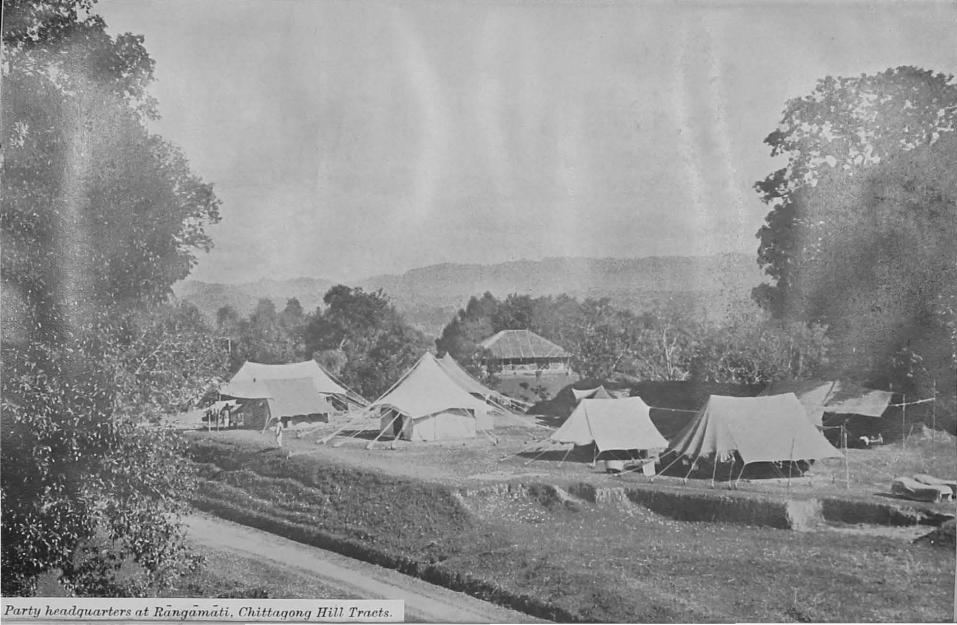
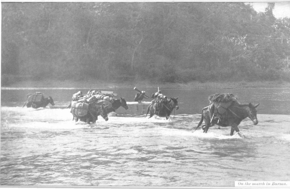
011 I lu· 11111/'t·!t 111 lftu·mu.
SURVEY REPORTS, l<:ASTERN CIRCLE, 49
100. Miscellaneous.-Hudth.-On the whole there was little sickness in the party, due to
th4! healthy climate of the Lushai Hills during the winter months, and the freedom from disease aud malaria among the Lushais.
Mr. N. C. Roy (U. S. 8.) fell sick with enteric and a computer employed in traversing contracted pneumonia, both at the commencement of the field season, and were invalided from the area. One khalasi died of pneumonia. There were no other casualties or sickness of a serious nature.
. WeatheT.-Throughout the season the weather remained very fair. The haze due to jhum burning hampered the triangulation towards the latter part of the season. Occasional sharp storms occurred towards the end of the season but due to an early return to recess the worst of these were avoided.
Fauna.-Game of any sort is now comparatively rare in the Lushai Hills, due to the inhabitants themselves being keen on shikar, and lately having acquired considerable quantities of sporting arms. Pheasant, jungle fowl and imperial pigeon were seen.
Sambhur, barking deer, wild bear, bison, panther, tiger and elephant still exist however and are more numerous towards tl).e south and sparsely populated areas of the district.
101. Recess Duties.-The party was organised in three drawing sections under Messrs. F. J. Grice, J. C. Berry and K. ~- Dhawan (all · Class II).
The five sheets on the !-inch seale surveyed during the field season as well as four sheets on the t-inch seale compiled from their component l-inch sheets surveyed in seasons 1932-33 and 1933-34 were fairmapped.
The computations for the triangulation and traverse carried out during the field season were completed by the end of recess.
VIII.-SURVEY REPORTS, INDEPENDENT PARTiES.
102. Nos. 6 (South India) and 10 (Burma) Independent Parties were administered directly by the Surveyor General. l'heir mapping and survey areas were approximately . the same. as t~ose of the former Southern and Burma Circles respectively, abobshed m 1932.
No. 6 (South India) Party. . ~Major W. J, Norman, :u.c., R.E., to 3-s-.35.
O.Jicer m charge.- u B T w tt ~- 4 o •• .w.r. a yn.: ) v.o., uvm • ..,.......
103. General.-The party continued the l-inch survey of the Ganjam and Vizagapatam Districts of Madras. A small area of correction survey was carried out in Nayagarh State of the Eastern States Agency and Puri District of Bihar and Orissa. The area surveyed by this party now joins up on the East Coast with that surveyed by the Eastern Circle.
1'riangulation in advance for subsequent survey on the l-inch scale was carried 9ut in the Ganjam and Vizagapatam Districts of Madras and in Bastar and Kiilahandi States of the Eastern Stat-es Agency.
Field head-quarters opened at Gopiilpur on 20th November 1934 and closed on llth May 1935.
In addition to the field work, a permanent drawing section was employed on compiled mapping and colour patterns in Bangalore.
The party was inspected in recess by the Surveyor General and in the field by the Director, Eastern Circle.
104. Personnel-The strength of the party was 1 Class I; 5 Class II, 8 Upper Subordinate officers and 63 Lower Subordin11tes.
Mr. Drake (Class II) proceeded on leave in April.
105. Areas surveyed.-4,483 square miles of l-inch original survey.
392 square miles of l-inch supplementary survey. 54 square miles of l-inch correction survey.
6, 734 square miles of triangulation for subsequent 1-inch survey.
·106. Field work was organized as follows:-Camp (1).-Mr. Nangia (CJ~s II) with 7 to 8 surveyors completed
1,119 square miles in sheets 74 Af1, 5, 9 & 13. Camp (B).-Mr. Wyatt, V.D., (Class II) with 12 surveyors eompleted
1,120 square miles in sheets 74 A/2, 6, 10 & 14. Owing to the late return from leave of Mr. Wyatt, this camp was djyided at the start of the field season between Mr. Thomas (Class II) and Mr. Mnthanna (U. S. S.).
Camp (3).-Mr. Drake, D.C.M., (Class II) with 8 to 12 surveyors completed 1,107 square miles in sheets 74 Af3, 7, 11 & 15. When Mr. Dmke went on leave in April, M1·. Thomas took charge of this camp. ,
Camp (4}.-Mr. Nair (Class II) with 7 to 8 surveyors surveyed 901 square miles in sheets 74 Af4, 8, 12 & 16. ·
SURVEY REPORTS, INDEPENDENT PARTIES. 81
Oamp (6).---:Mr. Azim, I.D.B.III., (U. 8. 8.) with 5 to 8 surveyors completed 682 square miles in sheets 7 4 B/1, 5 & 9. - -- Trianrrulation. -Messrs. Murti Rao, l\lu~tafa, Shamanna, Fernandez, Faruquie (U. S. S.) and Surveyor Narasinga Rao triangulated 6,784 square miles in sheets 65 I & M.
107. The health of the party was again bad and during the latter half of the field season nearly all its members suffered from recurring attacks of malaria fever. It is possible to avoid infection by living in a mosquito-net room in a bungalow between sunset and sunrise, but this being impracticable for the members of a survey party it is nearly impossible to prevent the spread of the fever. The use of Atebrin and Plas'11Wq'Uine has helped surveyors to recover quickly from attacks and has possibly reduced somewhat the incidence of the disease.
108. Recess duties.-The nineteen l-inch sheets of the current programme were mapped during the recess by five sections under Messr&. Wyatt, Nangia, Nair, Thomas and Azim.
The permanent drawing section under Mr. Natesan (Class II) was employed at Bangalore throughout the year on t-inch and !-inch compiled mapping and colour patterns, of which there are now no arrears. An effort is being made to complete both the l-inch and !·inch compiled mapping within one year of the completion of the l-inch original mapping, which has been successful in the case of 65 0. This constitutes a saving of 3 or 4 years over the time normally taken, and it is hoped that the improvement may be maintained.
No. 10 (Burma) Party.
0'"'' • h {Mr. J._McCrakeD, H.B.E., to 31-10-344 '.V"'er '"" c arge.- Lt .• Col. F. B. Scott, I.A., from 1·11-34.
109. General.-The party continued surveys on the l-inch and l-inch scales in Upper Burma, Assam and Bengal. The field headquarters opened at Pakokku on 19th November and closed on 4th April._
110. Personnel.-The field strength was one Class I, 3 Class II and 5 U. 8. officers and 40 Lower Subordinates.
In addition a Drawing Section consisting of 10 draftsmen and 1 computer, in charge of one Class II officer, remained in Maymyo to carry on the compiled mapping of the party.
Mr. C. 8. Mcinnes, (Class II) was posted to the Party on return from leave from the 25th October.
Mr. J. McCraken, M.B.E., (Class II) was transferred to No.5 Drawing Office, Shillong on the 23rd December.
111. Areas surveyed.-6,116 square miles of triangulation for l-inch detail survey;·
200 square miles of supplementary triangulation for l-inch detail survey;
1 ~ 9 linear miles of traversing ; 8,241 square miles of l-inch original survey; 1,985 square miles of l-inch original survey;
62 SURVEY REPORTS, INDEPENDENT PARTIES.
'·112. Field work was organised as follows:-GOITJ1,p (1).-Mr. F. W. Smith (Class II) wi~h 9. surveyors completed
the_ l-inch original survey of 3,308 square miles m sheets 84 FfSW & SE and 84 GjNW, in the Chin Hills district and the Araksn Hill Tracts of Burma and the Lushai Hills district of Assam. l'he country surveyed consists of steep hills rising to 8,000 feet above sea-level, partly open and partly wooded. Communications are poor.
Camp (9).-Mr. C. P. E. Davenport (Class II), with 8 surveyors completed the !-inch original survey of 3,323 square miles in sheets 84 GfNE, SW & SE in the Akyab, Chin Hills .and Pakokku districts and the Arakan Hill Tracts of Burma. The country surveyed eonsists of steep hills rising to over 10,000 feet above sea-level, partly open and partly wooded. Communications are poor.
Camp (9).-Mr. D. N. Saba (Class II), with 11 surveyors completed the l-inch original survey of 1,429 square miles in sheets 84 D/1, 5, 6, 9, 10, 13 and 14 in the Akyab district of Burma and the Chittagong district of Bengal. The country surveyed consists of low densely wooded ridges with fiat cultivated land between them. Communications are good.
0(//lflp (4).-Mr. A. K. Sen Gupta (U. S. S.) with 9 surveyors com· . pleted the l-inch original survey of 556 square miles in sheets 84 H/1 and 2 and !-inch origina.l survey of 1,609 square miles in sheets 84 HfNW & NE, in the Akyab, Chin Hills nnd Minbu districts and the Arakan Hill Tracts of Burma. The country surveyed on the l-inch scale consists of low intricate wooded hills and open cultivated plains. Com· municationa are good. The l-inch area consists of densely wooded hills rising to nearly 6,000 feet above sea-level. Communications are poor.
Triwngulaticm.-Messrs. Khan Muhammad, H. K. Kar, A. K. Talapatra, and surveyor Iqbal Muhammad completed the triangulation of 6,116 square miles in sheets 93 B/4, 93 0 and 93 DfNW & NE, in the Kyaukse, Mandalay, Meiktila, Sagaing and Yamethin districts and the Northern and Southam Shan States.
Mr. Sen Gupta completed the supplementary triangulation of 200 square miles in the Akyab district.
113. Recess duties.-Fair mapping was divided into two sec· tions under Mr. F. W. Smith assisted by Mr. D. N. Saba and Mr. C. P. E. Davenport assisted by Mr. A. K. Sen Gupta, and the computing section was in charge of Mr. Davenport aAsisted by Mr. Khan Muhammad. All surveys w~re fair ?lapped on the appropriate sca.les during the year. The Drawmg Section, under Mr. C. S. Mcinnes, carried out compiled mapping throughout the year,
Ot
IX.-MISCELLANEOUS SURVEY REPORTS.
No. 15 Party <Triangulation and Levelling). . . {Captam G. Bomlord, B.E., up to SS.lll.M.
Officer tn e~~uge.- . Ma,or G. H. Oama.aton, M.c., B.z., from 29·10.34.
114. Other work done by this party ia described in paras. 39 and 40. 115. Levelling f0'1' the protection of the Hardi'nge Bridge.-364
miles of secondary, 311 miles of double tertiary, and 3,056 miles of single tertiary levelling were carried out by this party for the Eastel'JI Bengal Railway in Pabna and adjoining districts. ·
The work was paid for by the Railway Department.
PART 4.:....MAP PUBLICATION AND OFFICE WORK.
From 1st Aprll1934 to 31st March 1935.
X.-INTRODUCTION AND PERSONNEL.
116. Index maps C to G, at the end of this Report, form the most important adjunct to Part ~. as they show the progress of publication to date for all standard serios of modern. maps,_ excluding transfrimtier work.
· "'i17.- Letter press.-.Apart from Sections X (Introduction) and XIV (the annual report of the Mathematical Instrument Office), Parl.f. is divided into three main Sections:-
Section XI shows all publications and map issues for the year. Section XII shows all the fair drawing, whether completed for
publication or still in hand, carried out by the various drawing offices and field parties.
Section XIII describes the work of the printing and miscellaneous offices, excluding thst of the Computing and Tidal Party, whose work is of a geodetic character and is published in full in the annual Geodetic Report.
118. Personnel.-
Calcutta.. Director, Map Pnbllcat1on.
Lt.-Col. F. J. M. King, R.E.
Chief Drajtsman-Mr. AmiU" Krisbm> lllitm, a.s., to 11-6-3hod from 1!4-10.34 to a.l!-35. ,, , F. H. Gru.nt, from 12-6-34 to 28-10-34 and from 4-2-35.
Yo. 1 Drawtnu Ofllce. Photo.-Litho. 01/f.ce. o.c. Mr. L .. Williams, li,JS.x., to 3-2-35. O.C. Major G. W. Gemmell, I. A,, to 10-10-M.
"" , Captain G. F. Heaney, R.E., from 11-10-34, n 11 Ama.r Krishna. Mitra., R.s., from ... v35. II tt F. B. Grant, to 11-6-34and ll47.1agers 4" Asaistant Maftd'gera.
from 24-10-34. to 3-2-36. llr. S. Colquhoun, .Mana.ger, Litho.
" " "
, P. C. Mitra., B,A., from ].]0-84. , J. C. St. c. Pollett, v.o. u A. F. Murphy.
11 , Dhirendra Na.th Banarji, L.c.E.
11 , Bhupendra. Nath Saba, K.SC.
11 , Abdul Rashid Qura.ishi, B.A., to31·10-M. U.S. , Koda.ndera Ga.napa.tby :Ma.ndanna..
•• u Girij& Sonker BILJChi. 11 , At1ll Chandra. Ma.ulick. , , Sureab Chandra. Chatterjee, B.So.,
from 1-6-34.. II II Ninnal Chandra. Sen, B,com.
Engraving Ofll.ce.
,, L. H. ltlordue, Offg, Manager, Photo. to 26-IO.M.
, F. R. Vandyke,
, K. L. Dev,
,, L. H. ltlordue, ,
, L. J ."Vallie, Off g. ,
, K. L. Dev, ..
n Photo. from 91/ .]0--34. Litho.
to26-IO.M. .. ., Litho.
from27·10-84, Photo. ..
to 26-10-M. , Photo •
from 27·10-M. Map Recot·d ana Isme Ofll.ce
o.c. Mr. E. A. )!eyer, to4.2-36aDdfrom6-3-35. , " F. H. Grant, from 5-2·35 to 4-.8.35.
.1Cat1....,...tical Inst>'Ument Ofll.ce, Mr. S. W oodhoue, Superintendent in charge. ,. R. C. ltlalcolm, P.R,u.s., i'.R,Het. soo!l
" 1- "1·1" •• , ____ A .. tt. ~updt, .-.... eo v-....., ,1 A. ~p, Asatt, Supdt. .
llr. A. R. J. Dalziel, Head Engraver. ,, F. E. Selfe, Asstt. u
PERSONNEL. 55
Dehra Dun. Director. Geodetic Branch.
Ool. C. G. Lewis, O.B.E., to 21-6-34 , . • and from 21-10-34.
Lt.-OoL 0. M. Thompson, I.A..._ from 22-6-34 tO 2v-10-34.
Yo. 2 Dratvit~g Office. O.C. Mr. V. W. Morton. II , lloquimuddiu Ansari, B.A.
, , N. S. Baribara lyer. U.S. ,~ A. A. S. )(a.tlub Abmad,
from 7 -6·34 to 15-9-34. , , Abdul Ghani Qureshi. ,. ,. N. M. Bopa.iah. from !3-2-34 to
. 31-12-34.
Forest Map Office. O.D. Mr. F. C. Pilcher. U.S. ,. B. B. Sbome, fromll-4-34.
Computing &l T!tla~ Pa••t11. O.C. Ca.pta.in G. Bomford, R.B.,
.. . , to 12-10-Mand from 14-12-34.
" Lt:o.-001. E. A. Glennie, D.s.o., R.E., from 13-10.34 to 13-12-34.
P/wto.-Zinco. &ctiun.. Mr. S. C. Amtoon.
LelUrpreu Printing Sec<i<n<, Mr. B. H. Williams,
Simla. Director, Frontier Circle.
ColonelS. W. Sa.ekvllle Hamilton, D.S.O.
Yo. 6 D1•awing Office, O.C. Lt.-CoL C. M.. Thompson, I.A.,
to 26-4.-M and from 25-10-34.
, Lieut. R. H. Sama, n.sc., R.x., from 27.4-34- to 3-IO.M.
, OoL S. W. Sackville Ha.milton, D.s.o., · from 4-10-34 to 24-10-M.
SUBVItY SECTION,
II Mr. Duni Chand Puri.
" , W. H. Strong, M.B.Bi.-,
. from 8-1-35 to 10-2·35. , ,t Ch~huri Mobd, Aelam, B.A.
u , B. N. Murthy, B.sc.~ from 24-9-34. V.S. ,, H. Na.raai.mha. MUlti Rao, B.A.,
to 21-1().34.
" , Ghulam Ha.aa.n.
" ., La.lbir Singh, c.n., to 24-9-34.
..\RMY SECTlOK.
Ca.pta.in 'l'. A. Wbitma;sh.
Shillong. Director, Eastern Circle.
Colonel J.D. Campbell, D.S.O., · to 5-5-34 and from 12-11·34.
Lt.-Col. 0. 1!4. Thompeon, I.A.., from 6-5-34 to 14-6·3t.
Major L. H. Jackson, I.A., from 15-6-34 to ll-11-34.
~~o.;; Dratviuy QjJfce. O.C. Mr. P. Simpson, to 1-1-35 and a.gaiu
from 14-3.36.
" , J. McCra.ken, v.a.e:.,
from 2·1·30 to 13·3·30. II , P. C. MitTa, B.A., to 30-9-34. , ., B. T. Wyatt, v.D., to 15-7-34.
" , A. R. Q.uraishi, B.A., fr9m 1-11-34. U.S. , P. C. Sen Gupta, a.se., to 13-12.34.
, , Jann.m Raj Chibba.r, to 23-9-34. , , Muhammad Muzaffar Shah.
Bangalore. No.6 (South India) Party.
O.C. lia.jor W. J. Norman: lr.c .. a.Jt, - .
II Mr. A. J. A. Dl"a.ke, D.C.M.
" " B. 'l'. Wyatt •. v .D,, fr_om 17·1~.
" .. E. N. Na.tesa.n, B.A.
" " !II. D. Nangia, B,A, .. .. M.. R. N&ir, B.A •
" .. P. A. 'l'homas, from 20-S.U. u.s.
" H. Na.rn.aintbn. Murti Raof B,A.22,. _ rotn. ·. 10-M.
" .. Mohaba.t La.l Kohli, from 2-12-34-.
" " Muhamm.o.d Abdul Azim, I.D.S.M, .. .. K. B. ~lutha.nn&.
" .. Mohammad Mustafa •
" " .A.. Shamauna..
" .. C. H. Fernandez.
" " Mohd. Amir Faraquie, B.A ...
Maymyo. No. 10 (Burma) Party.
0.0. Lt.-Col. F. D. Scott, J.A., from 1-11-34.
" Major L. H. Jo.ckson, I.A., to 2-6·34. u Mr. J. MeCraken, K.B.E.,
from 3-6-34 to 31-10·34. II 1 , J. 1\IcCra.ken, Y.B.B., to 22·12-34. ,, , F. W. Smith.
" " "
" C. 8. ·r.rolnnes, from 25-10·34. , C. P. E. Da.veuport. , D. N. -Sa.hn..
U.S. , Klw.n Muh&mmnd, C,H,
,, A. K. Sea Gupta., .. .. " "
:1• H.K.Kar. , A. K. Tala.patra., , U. On Ba.
•• XI.-PUBLiOATtONS AND iSSUES.
119. Publications.-The publications of the Department for the year are shown in the following three tables, of which Table I shows map publications at the various preRses, Table II shows the progress made in publication of modern topographical maps, and Table III shows the more important letterpress publications.
Table I( a)-Maps published at Calcutta, during the year 1934-35. Revised
New editions, Number of Value. Class of maps. Seale. publiea· newedi- copies Bs. tiona. Sionsand prinled.
re!!rinl8.
GENERAL MAPS. Dep,.,.tmental.
Maps of India ... ... Various 1 4 8,788 10,009
GEOGRAPHICAL MAPS.
Soulhern Asia Series ... 1:2 million 3 . .. 1,820 .8,640 India and Adjacent Countries
Serieo ... ... 1:1 million 2 14 8,890 18,064 Carls Inlernationale du Mondo 1:1 million ... 3 970 1,940
TOPOGRAPHICAL MAPS.
Quarler·lnch, Modern -· 1"= 4miles 19 85 29,605 45,905
" tPrely.i ... Ditto . .. 8 1,065 1,660
" (I'rovl.) ... Ditto ... 8 2,066 2,184
Half-inch, Modern ... 1''=2miles 46 27 41,519 84,696 One·incb. Modern ... 1"=1 mile 119 91 127,988 1,98,126 .. (!'rely.) . .. Ditto 8 6 8,974 6,246
" ~J.>rovl.) ... Ditto ... 4 1,868 2,116
Old alyle maps ... ... Various . .. 9 1,622 2,518
SPECIAL MAPS.
Mancauvre and Radius mape .•. Various 1 5 4,952 ·11,476 Provincial ma.ps ... ... Ditto . .. 4 2,185 5,278 City &-. Town Guide maps ... Ditto 2 8 5,098 16,872 Index ma.ps ... . ... Ditto 1 88 52,744 5,789 Miaeellaneoua maps ... Ditt<> . 27 IG 29,054 6,217
Total I 224j 3191 323,653j4.16,103 ... I
I Eo;wa·clopartm ... tal. Maps ... I Variou& 120 18 95,688 22,27G I'lano and diagram& ... Ditto 61 2 87,600 2,652 moorations 145 2 60,240 8,756 Miscellaneous ... I 26 17 78,785 4,878
Total ... j 3521 39 1 2'72.208 1 38,061
Grand 'l'otaJ. ... I 6'76j 368j 696,861 14,54,164
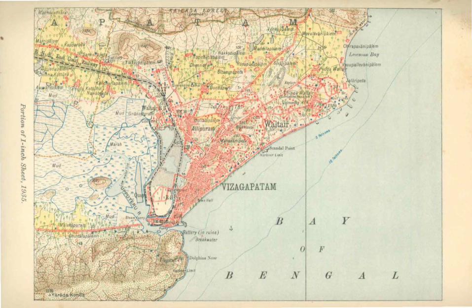
•
' ...,
JJ
JJ
.,.. ~ ....
A
() p
N
t' ,.. ••'
,~
G
y
A L
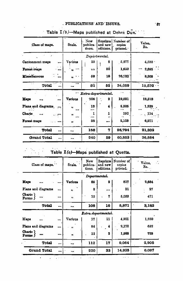
. PUBLIOA'l'IO:SS· AND' ISSUES. . 57
Table I (b)-Maps published at Dehra Dun: ·
. ~ew Reprints !\umber of Yaluc. Clasa of maps. Sco.le. pubiica- and new . copies Rs . tions. editions. ·printed.·
.- Depitrtmental . -Cantonment ma.ps ... vr·iOus '
23 I
6 5,677 4,5UO · I -.
Fo""'in&pa ... " ... . ..... 80 1,650 ... 2,698. .. -
M'isOeili.neous .. - 69 1& 26,782". 8,809 ... .. ..
... .. ". ' ·-Total ... 1 521 34,0691 15,53'2 ...
'· · E~tra-depa1'tmenttil.
Mapa V¢ous "106· 2 19,031 18,618
Plane. ~nd diagramo __ -~·!. .. 18 • 6,886 1,82_9 ..
Cb~s .. ,!1•• " 1 1 250 , U4 ___ ·-" Forest mapa "
88 2,128 6,871
Total ···I I 1581 71 26,7941 21,33l:l
Grand Total ... I I 2401 591 60,8531 36,864
Table !{c)-Maps published at Quetta.
. . New l!,eprinta Number of VBlue • Class of maps,··· Scale. publica.- a.nd new copies Rs. tions. editions. printed.
D•partmenfal.
Mapa ... . ... Various 86 9 817 2,684 . .
Plans ond diagroms -... "
8 ... 21 27
Charts} Forms ... ...
" 16 7 6,088 471
Total ... I ... I 1081 161 5,871 3,18l:l
Eztra.depart ...... tat
Maps ... ... Various 17 11 4,901 1,550
Plans and diagrams ... "
84 4 2,170 632 - .
Ohar&s} Forms ... ...
" 11 2 1,998 728
.
Total ... 1 1121 171 9,0641 2,905
Grand Total ... 1 · sal 14,9351 6,087
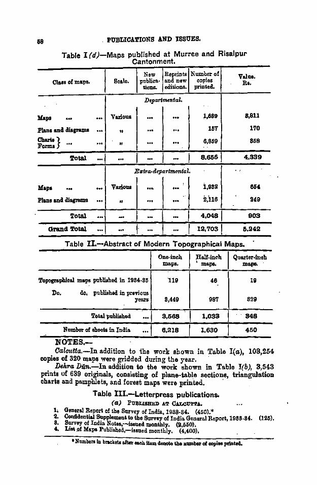
18
Mapa
. PUBLICATIONS AND ISSUES,
Table I (d)-Maps published at Murree and Risalpur Cantonment.
New Reprints Number of Value. Class of mapa. Scale. publica· and new copies Rs.
tioDS. edisions. printecl.
Depart,.ntcd.
••• ... Various ... ... 1,689 8,811
Plana ana mcrams ... " ... ... 157 170
?.:!} ... " ... ... 6,959 858 ... . .
Total ... I ... I ... I ... I 8,666 4,339
E.,tra-departm.,.tal. . '
Mapa ... ... Various ... ... i,982 864
Plano ana diagrams ... " ... ... il,il6 249 .
Total ... ... I ... ... I 4,0481 903
Gra.ud Total ... ... I· ... .. . I 1!!,7031 6.114!!
_Table !I.-Abstract of Modern Topographical Maps.
One-inch lllalf-ineh I Quarter-inch maps.. • maps. maps.
Topographical mapa pn'bliabed in 1984-85 119 46 19
Do. do, published in previous years 8,449 987 829
Total pnbliahed ... I 3,668 I 1,033 .. 848
Nnmbar of sheets in India ... , 8,!!18 I 1,830 460
NOTES.-Calcutta.-In addition to the work shown in Table I( a), 103,254
copies of 320 maps were gridded during the year. · Dehra Dun.-In addition to the work shown in Table I(b), 3,543
prints of 639 originals, consisting of plane-table sectio~e, triangulation charts and pamphlets, and forest maps were printed.
Table III.-Letterpress publications. (a) PUBLISBED AT CALCUTTA.
l; General Report of the Survey of Inclia, 1988-84. (450).* 2. Conlldential SuppleiiiOUt lo the Survey of India General Report, 1988-84. (125). 8. Survey of India Nolea,-isaued monthly. (2,660). 4, Lial of Mapa Published,-iaaned monthly. (4,400),
•Namben in btaclcets after ea.oh item deaolo t.ho n11Dlber of copies printecl.
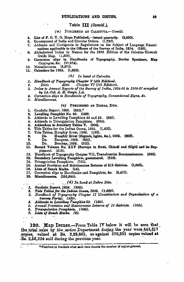
PUBLICATIONS ·AND ISSUES,
Table Ill (Conoid.). (a) PUBLISHED AT CALCOTTA.-Coftcld.
5. List of F. 0. U. 0. Maps Published,.:_issued quarterly. (2,000). 6. Government of India. and Circular Orders. (1,750).
69
7. Addenda. and Corrigenda. to Regulations on the Subject of Language Examinations applicable to the Officers of the Survey of India, 1914. (250).
8. Alphabetical Index to Names for the 1933 Edition of the Calcutta-Howrah Guide Map. (1,500).
9. Correction slips to Handbooks of Topography, Border Specimen, Map Catalogue, &c. (21,674).
10. Miscellaneous. (8,272). 11. Calendars for 1935. (1,650).
(b) In hamd at Calcutta. 1. Handbook of Topography Chapter V (4th E.UUO..). 1!. Ditto ditto Chapter VI (1th ErUUon). a. Indez to A01nual Report. of thtJ Survey of India, 190J·05 to 1926·21 compiled
by Lt.·Col. A. H. Gwyn,l.A. 4. Correction eUps to Handbooks of TopograpT2y, Convsntional Signo, tic. 5. Mi:rcellaneoue.
(c) PUBLISHED AT DEBRA DUN.
1, Geodetic Report, 1988. (850).* 2, LevelliDg Pamphlet No. 40. (100). 8, Addenda to Levelling Pamphlets 45 and 53. (865). 4. Addenda to Triangulation Pamphlets. (960). 6. Addendum to Awdliary Tablee V. (200), 6, Tide Tables for the Indian Ocean, 1985. (1,400). 7. Tide Tables, Hooghly River, 1935, {150). 8. Do. Hooghly River {Signals, lights, &o.), 1986. {800). 9, Do. Rangoon, 1986. (850).
10, Do. Bombay, 1986. {900). 11. Record Volume No. XXV (Surveya in Swiit, OhikAI and Gilgil) a.nd ita Sup·
plement. (810). 12. Handbook of Topography Chapler ·VII, Tr&nsfrontier Rec<>nn&issanco. {880). 18. Secondary Levelling Pampbl~to, gestelnered. {210). 14. Triangulation Pamphlets. (700), 15, Ann IIlLI Proviaion and Maintenance Re~urns of 812 dislricla. {7 ,800), 16. Liats of Bench Marks. (14).
· 17. Correction slips to Handbooks and Pamphlets, &c. (6,475). 18. l\fieoellaneoue. {255,863),
, __ ...(d) ln .. kani. Qt.D•hra. .Diin, l. G•olletio Beport, 1984. (850). fl. Ti.dt! Tablea for tluJ Indian OC8411,l936, (l,!lOO). 8. Ha,ntlbook of Topography Chapter II (Conotitution a011i Organiaation of a
surv"" Ptllrly). 1 aaoJ. 4. Addenda 14 L011elUng Pamphkt 93. (1flO). 6. Annual Pro!Ji:rion and Maintenance R•turns of 12 tUatriotl. (800), 6. Triangulation Pamplu.tl. ( aoo). 7, Lilt. of B0111Jl. Marko. (S).
120. Map Issues.-From Table IV below it will be seen that JhJI .. tP.tAL~~lll& by .the.eptire Department dutipg the year wer4_H5.,1U 7 ~pies, . -valued ~t .~a.. 2,29,865, as against 570,331 copies ~ue.d at -Rs. 2,36,324 sold during the previous year.
•Numbers in brackets a.ftet •ch item denote the number of copio1 printed.·
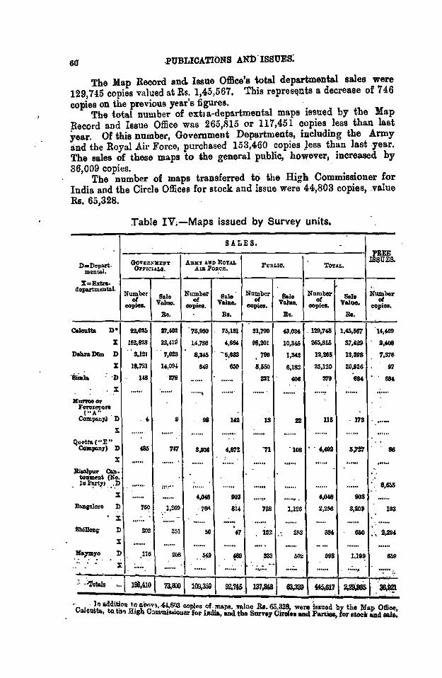
.PUBLICATIONS AN:IriSSUES:
The Map Record and. Issue Office's total departmental sales were 129,7 45 copies valued at Rs. 1,45,567, This repres~nts a decrease of '746 copies on the previous year's figures.
The total number of ext• a-departmental maps issued by the Map Record nnd Issue Office was 265,1!15 or 117,451 copies less thnn !nat year. Of this number, Government Departments, including the Army and the Royal Air Force, purchased 153,460 copies Jess than last .year. The sales of these maps to the general public, however, increased by 36,009 copies.
The number of maps transferred to the High Commissioner for India and the Circle Offices for stock and issue were 44,803 copies, .value Rs. 65,328.
D•Deplll't· mental.
%=Exf;n.. departmental.
Table IV.-Maps issued by Survey units.
SALES.
GOVERIOCEllT ABKY AND RoTAL OFi'ICULI, AlB .i'onc:R,
Number of
copies. Sa.le
Value.
Bo.
Number of
oopiet. •·te Value.
Bt.
l'tTBLIQ,
Number of
eopiea. -Value.
a •.
TOT.u..
Num..,. of
copies. &le
Value,
llo.
PBEE ISSUES.
Number of
cOpies.
Calelltta n• 22,(125 21.a ?s,m ?S,tal 31,'190 .a,o:K . 129,748 1,45,567 u,469
X 159,8'1..8 22,·U9
Deb.raD&n D S..l21 7,023
X lS,t-21 14,094
·Simla ·n us m . x
)( ......... Ferozenftte
I"A?iCompallJ') · D
X
Qoetta("E" Compmy) D
X
BiCllpuT Qm. toDment (No. J~F~J., .. D
X
BnDgnlore D
X
D
X
D
X
•• •
7<7
::·.···
760 1,269
$1
116
14,786 f,stU
8,34S . - ~,083
... 650
..... ,
1<2
98,201
799
s.aso 231
.... ,~ 728
t7 ' 152
.. , ...
10,346 265,811
1,342 12,M~
4,1M 25,120
... 3'19
22 115
., .... 4,492
.... ., . 1,126
~,,
4,018
2,2tl6
. 173
. ......
..... 1,316
97 .... ·~····
·.······ '·""'
86
e.~
193
- ln addition t.o abov;~ .~81'.13 en 1 of 1 D- - • CIIJoutta, tQ tbOJ Hish C:nnmi~uer~:; ln·t~PB:,·""tbenes .ftl;ll,. 65.C328irol, ' w_e~ pisau~d . by the Map Office,
..._, an"' urvey •• - arc.te~, for stock and sale.
Re. 4,so,ooo
4,00,000
3,50,000
3,00,000
2,50,000
2,00,000
1,50,000
1,00,000
50,000
. PUBLICATION AND ISSUES.
PROGRESS OF MAP SALES·
1928-35.
1928-29 1929-30 1930-31 1931-32 1932-33 1933-34 1934-35.
Extra Departmental. · •
Departmental. 0
61
--
The above dia.gra~.u •~presents the aggregate sales o£ the whole Department.
121. Map Record and Issue 011lce.-The volume of work in the Map Record and Issue Office has remained constant .. Against 15,423 letters received in 1932 and 15,414, in 1933, 15,434 were received in 1934.
Excluding the value of maps held by the Circle Offices, the approximate value of the Map Record and Issue Office stock: on 81·8-35, including those stocked in the Branch Office, Calcutta, was Rs. 34,93,601,
. 112 l'tmLIOATIONS AND ISSUES •
· The physical verification of stock carried out at frequent intervals throughout the year by the Officer in Charge is now recorded in a " Stock Verification Register". This register was opened in January 1934 and l'llveals discrepancies averaging only to a decimal point. _
All receipts were. brought to account at Catalogue prices. No revaluation "t.ook place ·of stocks already in hand.
21,921 superseded copies of 194 different maps were removed from stock, of which 1,973 copies were sold at a nominal value to the Bengal and the Bihiir and Orissa Drawing Offices for departmental use; the remaining copies were scrapped.
As in past years, the Army still continues to top the list of plll'C~Bers. From a classification of issues, it is found that the percentages of dep~tmental sales roughly work out as below:-
.. -·- ARMY .,.. ••• ... 68l% PUBLIC 24!% Ol'HEB GOVl'. DEPl'S. ,, ,, 17%
PtmLIOATIONS AND IS$UES. 88
Table V. Stock of lla.ps. This table gives the stock of. mapa as ii ~tood on Slet March 1985. - .
CALCUTTA. DEHRA DO'N. SHILLONG. SIMLA. FEROZEPORE AND I QUETTA, MAYMYO. BAN GALORE. MORREE. ! TOTAL. '
M.R.I.O. BIWfCB AGBROY, I CJuaofmapa. N111111oai of Ptese~~l NIUIIber of l'relant N'lllllller of PNMDt Number of Preaeut Ne.~of l'reseol Number of Preeeul Numbor of Pmenl Number of l'ro81>DI , Number of Presenl NIUIIber of r,!eaorU copies Face Value copies FacoV&luo copies FaceVah1e copies Face Vnlu ,COp188 Face Value oopiea Face Value co pie a Face Value Cllpiee Face Value
oopiea Face Value copies Value in slock. Ra, in atook. Be. in elcek. Ra. in alook. Ra. iD aloek. Ra. in alock. Be. in slack. Ra. in olock. Be. .. in alack. Bs. in elcek. Ra. i
• I ;
! l
1/2M SoiDberll Aala Series ... 10,897 19,265 19 86 160 820 ... ... u 108 89 88 ' I u 114 ... ... 88 87 10,784 19,998
1/M Inclia and Adj•-• Cannlries ... 86,021 68,081 211 848 1,694 2,652 128 192 847 589 144 218 817 476 818 474 464 oli70 80,682 68,895
1/M Clade ll!femelinnale cia Monde 8,841 6,948 10 20 121 242 60 100 42 i - 84 12 86 I 18 88 47 141 8,841 '1,801
• ... . ..
I
Two-inch IJUI!lll ... ... 10,8011 81,768 ... .. . 7,8M 16,0&4 361 628 ... ... ... .. . I ... ... ... . .. . .. .. . 18,968 48,480
' One-inch maps ... ... 1,298,841 19,64,880 4,228 8,180 51,240 76,718 25,062 87,148 8,998 6,010 8,825 5,787 ! 2,988 8,450 22,690 88,816 4,911 7,542 1,417,218 21,110,478
ReJI·inch mapa ... ... 400,8115 7,97,654 1,002 1,1168 ls,B54 24,874 6,084 11,96'1 807 1,219 989 1,972 I 880 1,780 8,857 7,628 1,401 2,918 427,609 8,51,856
-Quo.rlor•inch maps ... • ... 267,697 8,93,146 666 8611 '1,609 11,105 3,028 4,006 1,188 1,728 871 1,266 1,486 ll,228 2,848 8,801 516 720 285,847 4,18,861
' General mapa of India ... 1A,048 88,194 78 • 154 407 512 67 205 88 156 18 56 28 80 8 86 120 284 18,882 84,808
- I
Provincial andDialriet mapa of Inclia 6,154 19,708 28 89 804 761 685 1,045 39 188 11 82 ; 6 9 88 818 7,285 22,090 .... ... !
1,62,100 Oanlonmen'and Towll maps (Special 68,216 1,82,825 60 119 11,902 23,968 411 855 287 1,718 825 1,250 88 128 118 841 487 ... 87,274
and Gaide). - I . I ~. ! ... 8,882 18,888
ManiiMlvre and Badia maps ... 6,989 12,519 10 2'1 128 281 ... ... 14 81 110 198 ... 181 812 ... ... • !
lrt:iJceUilDeDU& maps ... . .. 78,582 84,188 '19 160 8,491 7,296 172 128 504 844 17 56 62 1M ... .. . 81 80 86,888 42,815 ; :
TOTALS ... 2,188,824 84,93,601 8,861 9,951 100,114 1,64,267 85,988 68,764 7,098 12,569 6,881 10,896 : 5,818 8,881 28,614 45,817 8,012 18,698 2,888,680 88,15,446
64 ...
XII.-WORX OF DRAWING OFFICES.
122. Tables VI to VIII give an abstract of new maps, reprints and new editio~s completed for publication, as well as those in hand during the year, for the whole department.
123. No. 1 Drawing O:fflce, Ca.lcutta.-The revised edition of the 32-mile map of India and Adjacent Countries, with details and lettering in bold characters, is making progress. A revised edition of the 50-mile Road Map of India, in an improved form, has been taken in hand.
The new style Province Maps of the Punjab and of the U. P. ~nd Delhi on 1/M scale have been published. ' - En(J'I'aving Office:-New and up to date plant and methods for carrying out erasures and corrections on copper plates have bee.n introduced in the Engraving Office during the year under report.
After cleaning, the plate is silvered with a solution of nitrate of silver. Erasures to be made are then cut out to the depth of the engraving and painted round with bitumen or varnish after which the edges and the back of the plate are coated with wa.x.
The plate after being c~eaned with dilute nitric acid is suspended in a vat or copper sdlphate at a distance of about 5 to 6 inches from a pure copper anode and a direct electric current is passed from the anode to the plate.
The energy is supplied by a motor generator which delivers up to 100 amperes at a voltage up to .6.
After about 14 hours running the erasures will have become filled with copper; the plate is then handed to an engraver, who scrapes off the surplus deposit and the plate is then ready for engraving the corrections.
124. No. 2 Drawing O:fflce, Dehra. Dun.-With the object or providing more work for the Photo.-Zinco. Office in Debra Diin and of relieving the pressure in No. 1 Drawing Office and the Photo.-Litbo. Office in Calcutta, all work in connection with the re-issue of Persia sheets falling in 1/M sheets Nos. 9 and 10 has been transferred to the Geodetic Branch. A new section called the Re-issue Section was created to deal with these sheets.
The S-mile map of Nepal mentioned in the report for 1933-34 is still under publication. ·
Origin&! survey records prior to 1905 beyond the limit of regular survey were received from the Directors Frontier Circle and Eastern Circle and utilized for completion of the · 1/M record of exploration surveys.
125. Forest Map Office, Dehra Dlin.-This office, which is maintained by contribution from all Provincial Governments except Assam and Bihar and Orissa, continues to meet all demands from these Governments for forest maps. Its main work is the fair drawing of workinl!' nlans and new editions for various forest officers and the
WORK OF DRAWING OFFICES.
upkeep of their office copies. In addition 15 sheets compnstng 4-inch enlargements and !-inch working plans were prepared for the Jawhiir and Kashmir States.
126. -Map Record and Business Section, Dehra Diin.Thia section continues to be responsible for the storage, despatch and sales of publications and forms, and the collection of bills for all aupplies o.nd extra-departmental work carried out by the Geodetic Branch. It stores all ori1,.Jnals of departmental maps published in the Geodetic Branch and of cantonment and forest maps with their publiahed prints, and carries a stock of Survey of India maps for issue within the department and for sale to the public. · .
127. No. 6 Drawing Office, Simla. Swrvey Section.-
(!) The examination of party sheets has been particularly heavy this year owing to parties continuing drawing in the winter to complete arrears of mapping.
(B) The following work was done in addition to that reported in Tables VI to VIII:-
lnde:ces.-A ·large number of miscellaneous indexes were prepared.
General.--(a) Frontier Circle records received from parties were arranged and indexed.
(b) New registers of triangulation and tra· verse data are under preparation to facilitate cross references between angle books, charts and volumes.
(c) On urgent requisition, 52 one-inch sheets (51 old style and 1 new style) with the corners of the main rectanules marked
M
thereon from the rectangulation data by No. 24 Party in seasons 1926-30 were supplied to the Executive Engineer, Development & Researeh Division, Jrri.,.ation Branch, Kariichi, Sind. "
(d) The fair originals of sheets 43 C/5 43 D and Simla Panorama map wet•e co~ected an~ aubmitted to the Director, Map Publi-cation. .
(e) The fair originals of Quetta Civil Station corrected by 0. C. 'E' Company were examined and submitted to D. G. B.
(f~ Some ~wing a?d typing of additional mfo~mat10n relatmg to their work was. earned out on maps supplied to certain Government. departments for conference purposes, etc.
WORK OF DRAWING OFFICES .
.Army Secticm.-(1) During the past year, the Army Section was employed in
the compilation, drawing and reproduction of maps, plans and diagrams for the Army and the various Government departments.
(£) As was to be expected, the installation of the new machiu printing pres~es has resulted in 11; vast increase in output. Full advantage of the maohine printing has been taken by all departments of the Government of India, and the draftsmen have been hard pressed to keep pace with the increased demands.
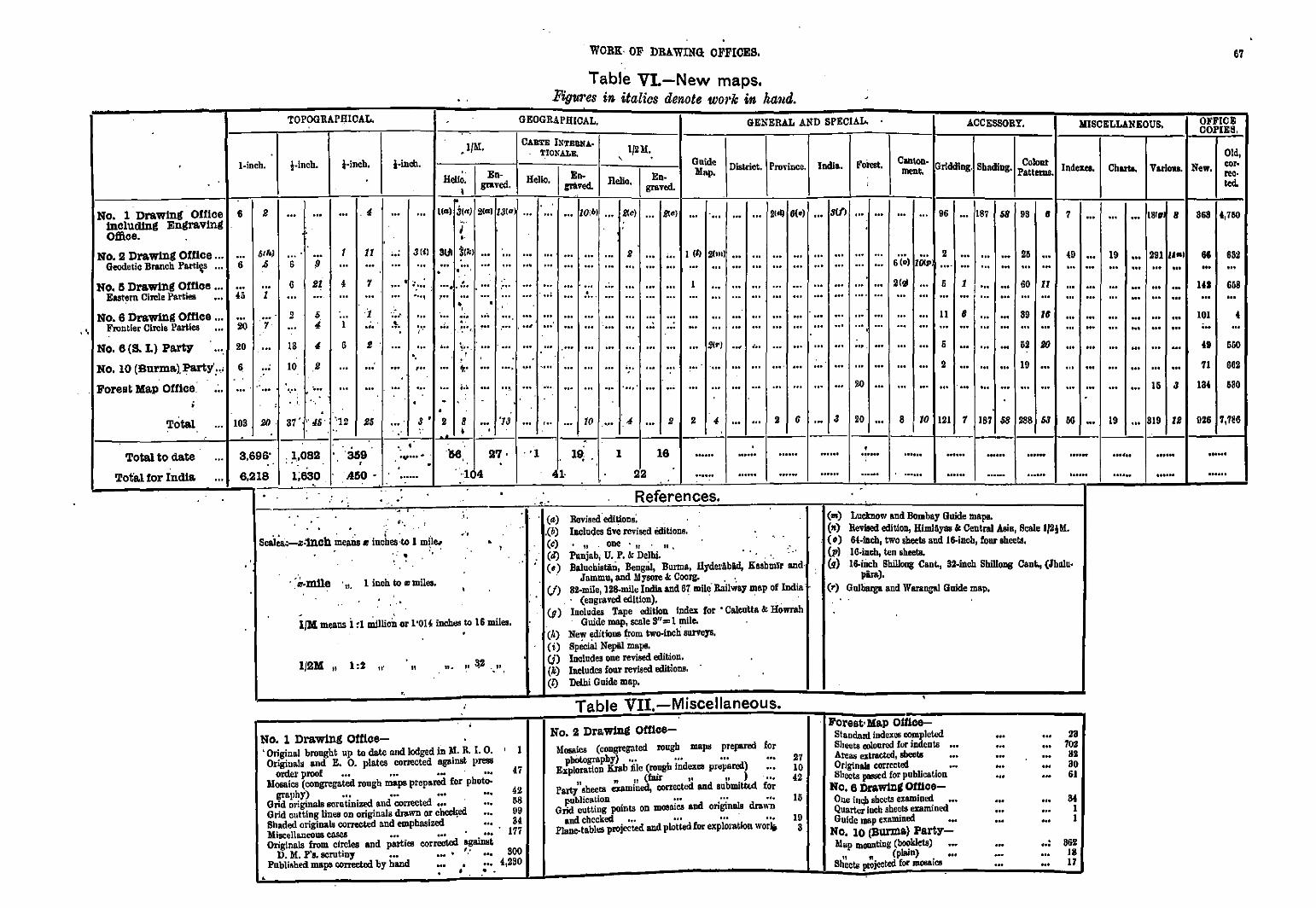
•,
WORK· OF DRAWING OFFICES.
Table VL-New maps. Figures in italics denote work in ha11d.
67
TOPOGRAPI)]CAL. GEOGRAPHICAL, GENERAL AND SPECIAL. ACCESSORY. MISCELLANEOUS. OFFICE COPIES.
No. 1 Drawing Oftlce tnclud!ng Engraving Office.
l-inch.
6
i-incb. ~-inCh.
.4
.J/M. i-incll.
.. I En Hello. grav~ ' .
CAUTE INTBIIIIA· TIONALE.
Hello. I r!:~
, 1f2M ••
Hello. I Engraved.
Guide Map. District. Prol"iuce. India. Forest.
... \(G) J(n) 2{G) 13!•) ... ... ZOib) N ) a ) ... ... ... ... ..• ... ... ... ... 21"1 6(e) ... SIJI ... ... ~ .. I •·
Clll1on· Gr!ddlng Shading Colonr menl. · • Pattems. lndexeo.
... 96 ... 187 68 99 8 7
No. 2 Drawing Office ... ... Sth) Geodetic Branch Part.!~ ... 6 .0 6
G
!J
Sl
I 1l 3 (t) 3UI ~~~) ... ... ... ... . ... ... ... 2 ... ... I (ll 2(111) ... ... ... ... ... ... ... ... 2 ... ... ... 25 ... ••• ... ... ••• ... ... ••• ••• ... 6 (o) 10C:P .... ... ... ... .,, ...
{0 ...
No. 5 Drawlnll Office ... Eastern Cirele Parties •••
No. 6 Drawinll Office ... FroDtier Circle Parties •••
No. 6 (S. L) Pa.rty
No. 10 (Burma.),Pa.rty':.;
Forest Map Office:
l
2 iio ·:; ... 20
6
.. ... . ...
IS
10
·.··
4 7
1
6
.... .
... :·· ,··· ... ... ... ... ... ... ... ... ... . .. • ... . .... ... .. .. ,
····-~··· ...
·. ... , .. . ...
• ...•. ... ... .··· ... ... ... ... ... ... ... .. . ~ ... - ... - ..• - ~- - - ... .. . • •
• ... .... ... ... ... ... ... ... ... ... ... . .. . . - -·.- .... - ... - ... - ...... -- p• - ... - ... - ... - ... - -
on 'r,• ooo •••o ,_., ~on ooo ou no ••• ooo ooo
- •• - 000 - no - 000 - 'ooo 000 -
•
... ... ... ... ... ... ... ... ... 2(QI ... 5 1 ... ... GO ll ... ... ... ... ... ... ... .... ... ... ... ... ... ... ... ... ...
... - ... ... - ... ... ... - ... II B ... ... 99 ZB
............ - ...... ··.-- ...... - ... - ... -... 2(t') .... ~.. ... ••• ... ••• ••!>. • ••
... ... - ... ... ... - - ... -... ... ••• ... ••• ••• ••• 20 ...
6
2
... ... ... 62 Rf)
... ... ... 19 ...
... ... ... ... ... ... . ..
Tota.l ... lOS 2(). 37' l'4$• '•']2 26 3 • 2 8 I
... '13 ... ... ... 10 ... 4 2 2 4 2 6 ... 3 20 ... s I 10 121 1 187 68 288 s3 66 ...
Tota.l to date
Tot'a.l for India
3,696' : _1,08!1 359 ·- . . ., ..... '56
6,218 1;630 .450 • . ·1 4
'· <·. . Scai~-.,:mch ~ep.;;. t: incbes to 1 mi'ie. ' .
.. ·, . .
· ~ ,D.mne 11, 1 inch to z milea.
l/M means i :1 ai.ulirn;_ or 1'014 iDchos to 16 miles.
1/IIM, 1:2 ,.. "
11. II ~2 . II
..
No. 1 Drawing Office-' Original brought up to dote and lodged in ~· R. I. 0. ' 1 Originals and E. 0. plates corrected &,"81IIllt press
47
•
order proof ... ... ... ... Mosaics (congregated rough maps preparod for photo-
graphy) ... ... ... ••• Grid originals scrutinized a.nd corrected ... ... Grid cutting lines on originals drawn or chec];;ed •••
42 58 09 84 Shaded originals corrected and emphasized .. .
'M.isc:clla.neoua co.sea ••• ' ... 177 Originals from circles and parties corrected agailllit
D. M. P's. scrutiny ... ... • '-' ... 800 Published maps comctod by band ... , ... 4,290
• • •
. '1
. .... (a) ,(b) (c)
; (4) (•)
l~ 1 16 ...... 22
References . Revised.edit~on~: IacluQes five revised m.itions •
11 one " n, l'!lnjab, U. P. It Delhi. BalucbistaD, BengBl, Burma, HyderAbild, Kashmir and·
Jammu, and Mysore It Coorg. . . (/) 82-mile, 128-mi1e lrulla and 6'1 mile Railway map of India
. · (engraved edition). · · · .. . . (q) lnoludes Tape edition index for • Calcutt<~ It Howrah
Guide map, scaleS"=== l mile. (I•) New editions from wo-tnch surveys. (i) SpOctal Nepil mops. U) Includes one revised edition. (k) Ineludcs four revJsed editions. (f) Delhi Guide map •
Table VII.-Miscellaneous.
No. 2 Dra.winll Office-Mosaics (congi'Of!llled rough mope prepared for
pbotogt·aphy) ... ... ... ... 27 Exploration Krab file (rough indW<08 preparod) ... 10
n , n(fair '' 11 .l ... 42 PBl'IJ shectll examined, correct<.-d and subiD!tl<.d for
publication ... •·· ... 15 Grid cutting points on mosaic& and originals drawn
and checked ... ... ... ... 10 Plane-tabl08 projected and plotted for cxplo1'&11on worlj 3
• . ..... . ..... ......
("') Luctnow and Bombay Guide maps. (n) Revised edition, HlmiAyas It Central Asia, Scale IflliM •
. ( •) 64-illch, two sheets and 16-incb, four ehecto. (p) 16-incb, ten sbeeta. (q) 16-iiu:h Shillong Cant., 32-incb ShilloDg Cant., (Jblllu·
pira). (•) Gulharga and Warangal Guide map,
Forest• Map OUlce Standanl indexes completed Sheets oolourod for indents ... Areas extraett.'d, sbects ... Originals corrected ... Sheets P""""d for publication
No. el)rawlnll omce-Oue i~ &beets examined ••• Quarter iacb sheets examinl-d Guide map enmincd •••
No. 10 (Burma) Party-Map lllOIIDting (booklets) ...
11 " (plain) . ... Sheets projected for mooa1ca
...
... .. . ... .. .
23 702
HZ ao 61
84 1 I
..: 862 18 17
Chorla. V&rioluo. New.
Old, cor· .... ted.
... 181. 8
19 ••• 291 ,..., ... ... ... ... ... ... ... ... ... ..• ... .. . ... ... ... ... ... ... ... ... . .. ... 1s a
19 ... 819 lB
.. ..... .. .... ......
868 4,760
66 ... 141
101 •••
682
668 ...
550
662
580
DZ6 7,786
. .....
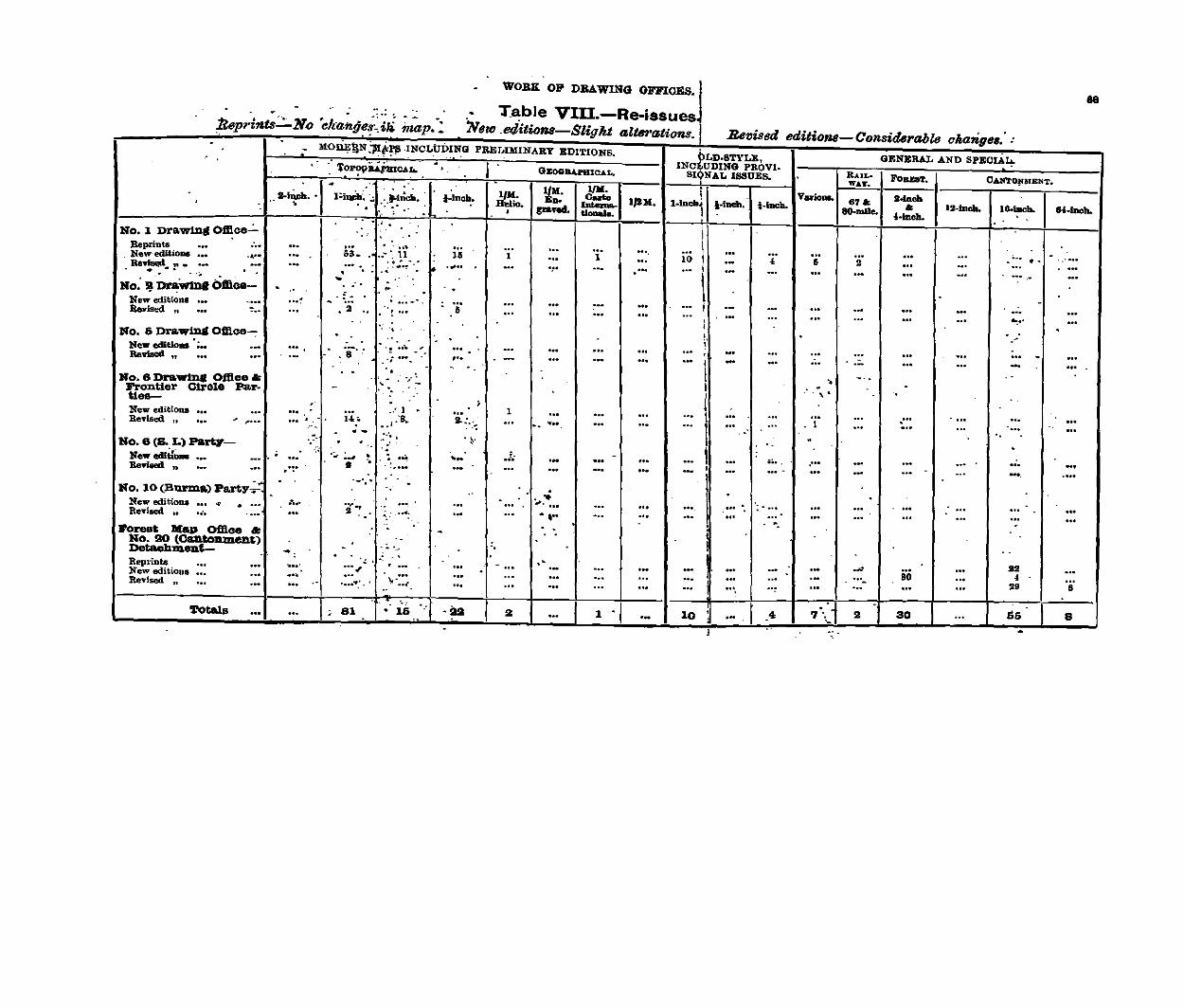
:fleprints:::_ No . . -
'ekangei ~ ui -map.~
WORK OP DRAWING OF.FICES.JI
Table VIU.-Re-issues 'New.edltions-Sligkt aZttwations.j .Be'IJised
MOJiE!jN .'J!r~!'!! -INCLUDING PRET.,JMINABY EDITIONS. (JLD.STYLE, 'i?P<?PiUiioc.<ro.
. I GBOGBAI'BIOAL,
INC~UDING PROVI-' SIQNAL ISSUES. -1/M. c ....
editiotut-Considtlrable changes. :
GENERAL AND SPECIAl;.
RAIL• FOaEaT. OAN'rOJilfENT. w.a:r.
Val'ioaa. ·--11 I. 111-iucb. I 11-1.;.;. .. ,·.,,,;..(_, ~~~~- 2-lftcb -t-lftcb •. !-Inc~. ~- D• 1jUl. 1-IDCh. t-iDch. 67A<
" 12--IDch. .. .......... 80-mlle.
' -- ~ .. -~ .· ~- .- : pavod. ........ • '-Inch. -- . ·' I No. 1 Drawing Ofll:ce.:. ... . -
I Be prints ... ..• ... ... ··· . ... ... ... ·-· -... ... r:a .. . -New editions ... -. tl u 1 ... 1 ... 10 . .. ' 6 • ... ... ... ·- ...... .... .
I Re'ri~ "- ·- ·- ..... ..... ...... ... . _ .. --- ... ... ... .. . ... ·- ... ... .. . .-... . . ' . I" .
I . .. ... - • . -~ DraWma Omoe- . . No. . .. . • .
l -.
···:" - . ... - ... ... ... ... ... ! ... . .. ... ... ... ... ... New editiODI ... ····• - ... -. : ·;; Rerised -·· ... • ..
' ... ... ... ... ... ... ... ... ... .. . ... ... ~--
" ... i . -· 6 DrawiDII omce----, -. I
No. . .. . New edit1oal . . .... . ... . .. ... ... ... ... ... ... ... ... ... ... ... -·- ·- ... . ..... . ' - . .
' -· Re- ... . 8 •.. -· ... ... ... ·- I - ... ... ... ... ... " ... ... .,· ... .
' .. .
I -- . . . '
No. 6 Dr&Winll Ollice ol: . . I . ' -J'rontter Otrole P-ar- - . -
i ' . -ties- . . ;
New editions ... I . ... 1 ... ... ... . .. ::: _: ... ... . - ... ... ... ... ...
I U,;.
• ,I :a:. B-:.:~ ... ... ... . .. ... ... ... ... ... Revised .. ... . ,. ... ... . ... .. .·-- ; - j . -- - . :··· . . ~-· . No. 6 (S. L) Partv- . . -- .. -. .. ~.- ;;,. - ... ... ... Newediihm. • -;.. ..• • ...... ·- ·- ... ... ... . .. .... ... ... ... ... -.
' - ... --· . .. Reftoed • ... ... - ... -· ... ... ... ... ... ·-.. ... . .. . No. 10 (Burma.) Part:v;:
. ·-· .. - -· . . . .... . -. .. ~- ... . .. ... ... ... . . .... ... ::: ... .. . . .. New edi tiona ..... ... _ ... ... • • ... ·; .. ~ .. . .. ... ... ... ... .. . ... . .. . .. Re.,.iaed ... ... ... ... . ... .. .... . ... . . . · . . . . ' l'orea& -- omce ., -No. !W (08ntODmen" . -'
. ! :Detachmen&- _ - - -. ·---
' . -· •' - ..., ..• ,. . Rep1·ints ' . ... ... - .. . ·- ... ·- ·- ... ... ... so • ... ... ..... . .. , . ... ... ... New editions ... ... ... ~ ...
\, -::; ... ... ... . .. ... ... ... . .. . •• ... ... . .. Revised " ... ... ... -· ....• _.. ... ... ... ... . .. . .. I "'\ ·-
I , ··c
·illl . I ' t 4 '1 ·• 2 30 I ... 66 Totals 81 . 16 a ... 1 ... 10 -- - ·-... ... . ..
- ·- . - ! --
88
., ..... b.
. .... . .. ...
. .. . .. .
. .. .. .
-· ... ... . ... . .. . ..
... 8
6
. ' XIII.-PRINTING AND MISCELLANE.OUS.
128. The Photo.-Litho. Office, Calcutta.-During the year there has been a noticeable decrease in the amount of W'lrk both departmental and extra-departmental passing through the ollie~: Efforts are now being made to attract more work from other Government departments. Owing to the reduction in the size of the Survey" Department. in recent years, this office is in a position to undertake more extra-depart· mental work than formerly.
An average of three out of four rotary offset and seven 0ut of nine flat-bed printing machines were in continuous working, and the twenty hand presses were fully. occupied. In the Type Printing ~action the six letter-press machines were almost continuously in use.
Experiments have been carried out with.a view to reducing the time taken to prepare drawing blue prints from plane table sections, for survey parties, and have met with a great measure of success. Hitherto the normal method involved the preparation of a "mosaic" using black prints pulled on a hand-press, from lithographic zinc plates of individual planetable sections. The method was lengthy and costlyj~and the quality of blue print was not good. The only alternative was the method of direct lithographic combination of the work on two or more zinc plates which however could be used only in a small percentage of cases, and even then had serious defects.
The new methods involve the use of "Correctostat'~ ·and "Ozalid" papers, products which have recently come on to the market. These papers are used for taking contact prints from the negatives of individual planetable sections, and are then put down in mosaic form on a projection of the sheet on zinc or glass. The time taken to ·produce a ·drawing blue print has now been redu~ed from an average of over four weeks to one week, an,d there has been a marked improvement in both the quaJity and accuracy of the blue prints. All mosaicing is now done in the Photo.· Litho. Office instead of being sent out to a Q.rawiug office as hitherto. This has resulted in a saving of time and clerical work, and has relieved drawing .offices of work which often was difficult to deal with expeditiously without interference with norma.! routine.
OOST AND OUT-TURN OF PROTO.-LITRO. OFFICE.
I Value of MAPS PlUNTEn.
Zinc Ezpendi- out-turn Negutives plates Depart- I Extm-
lmpreasiona ture. I at office prepa.red. pulled.
I prepore<i. depart-ro.tes. menta.l. mental,
Rs. Rs.
9,80,123 3,32,808 4,381 • 6,089 '733 1,541 3,183,9'78
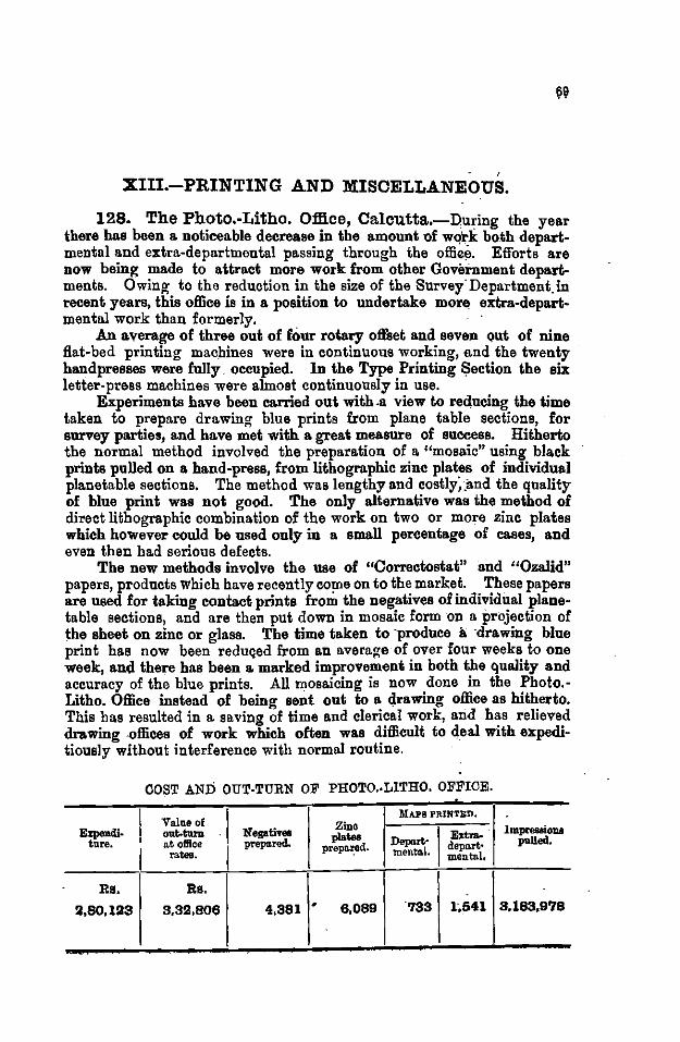
' XIII.-PRINTING AND MISCELLANEOUS.
128. The Photo.-Litho. Office, Calcutta.-During the year there has been a noticeable decrease in the amount of wq'rk both departmental and extra-departmental passing through the offie~. Efforts are now being made to attract more work from other Government departments. Owing to the reduction in the size of the Survey" Department. in recent years, this office is in a position to undertake more extra-depart-mental work than formerly. ·
An average of three out of four rotary offset and seven qut of nine flat-bed printing machines were in continuous working, and the twenty hand presses were fully. occupied. In the Type Printing $ection the six letter-press machines were almost continuously in use.
Experiments have been carried out with .a view to reducing the time taken to prepare drawing blue prints from plane table sections, for survey parties, and have met with a great measure of success. Hitherto the normal method involved the preparation of a "mosaic" using black prints pulled on a hand -press, from lithographic zinc plates of individual planetable sections. The method was lengthy and costlyi.and the quality of blue print was not good. The only alternative was the method of direct lithographic combination of the work on two or more zinc plates which however could be used only in a small percentage of cases, and even then had serious defects.
The new methods involve the use of "Correctostat" and "Ozalid" papers, products which have recently come on to the market. These papers are used for taking contact prints from the negatives of individual planetable sections, and are then put down in mosaic form on a projection of the sheet on zinc or glass. The time taken to ·produce a ·drawing blue print has now been reduqed from an average of over four weeks to one week, all(] there has been a marked improvement in both the quality and accuracy of the blue prints. All mosaicing is now done in the Photo.Litho. Office instead of being sent out to a drawing office as hitherto. This bas resulted in a saving of time and clerical work, and has relieved drawing .offices of work which often was difficult to deal with expeditiously without interference with normal routine.
COST AND OUT-TURN OF PHOTO.·LITHO. OFFICE . . I Value of
1\lAPB PRINTS:D, Zinc Impressions Ezpendl· out..turn Negatives plates I~ ture. I a.t office prep&rod. prepa.~ed. Depart-- depart• pulled.
rates. mental. mental,
Rs. Rs.
2,80,1!33 3,3!3,806 4,381 • 6,089 733 1,541 3,183,9'18
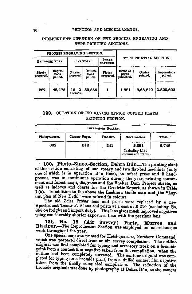
70 PRINTING AND MISCELLANEOUS.
INDEPENDENT OUT·TURN OF THE PROCESS ENGRAVING AND TYPE PRINTING SECTIONS.
PROCESS ENGRAVING SECTION. TYPE PRINTING SECTION.
PROTO• HALI'·TONB WORE, LINI WOB.s:. GRAVURBS.
Impres· Blocks !~pres- Plates Items or Copies I Impressioos Blocks pages pnpned. lions prepared. IIODS prepared. printed. I _pulled. polled. pulled. published.
287 48,475 15+2 39.865 l I 1,821 9,63,840 1,800,603 Stereos.
129, OUT-TURN OF ENGRAVING OFFICE COPPER PLATE PRINTING SECTION.
IIIPRESSIONS PVLLRD.
Photogftvuree. Chromo Paper. Transfer. loliscell- I Total, ·
602 512 241 5,391 6,748 Including 1,160
commission fot·ms.
. 130. Photo.-Zinco.•Section, Debra Dun.-The pnntingplant of this section consisting of one rotary and two flat-bed machines (only one of which is in operation at· a time), an offset press and 3 handpresses, was in continuous operation during the year, printing cantonment and forest maps, diagrams and the Bhakra Dam Project sheets, as well as indexes and charts for the Geodetic Report, as shown in Table I.(b). In addition to the above the Lucknow Guide map and the "Lay-out plan of New Delhi" were printed in colours. · •
The old Zeiss Protar lens and prism were replaced by a new · Apochromat Tessar F. 9 lens and prism at a cost of£ 210 (excluding Rs. 858 on freight and import duty). This lens gives much improved negatives using considerably shorter exposures than with the previous lens.
131. No. 18 (Air Survey) Party, Murree and Risalpur.-The Reproduction Section was employed on miscellaneous work throughout the year.
One special map was printed for Head-quarters, Northern Command, whieh was perpared direct from an air survey compilation. The outline or~ginal was first completed for typing and aceessory .work on a bromide pnn~ from a contact film negative taken from the compilation, when the outline had been completely surveyed. The contour orio-inal was completed for typing on a bromide print, from a dulfed contact jilm negative taken from the finally completed compilation. The reduction of the brQmide originals was done br photographr at Dehra Dun, as the camera
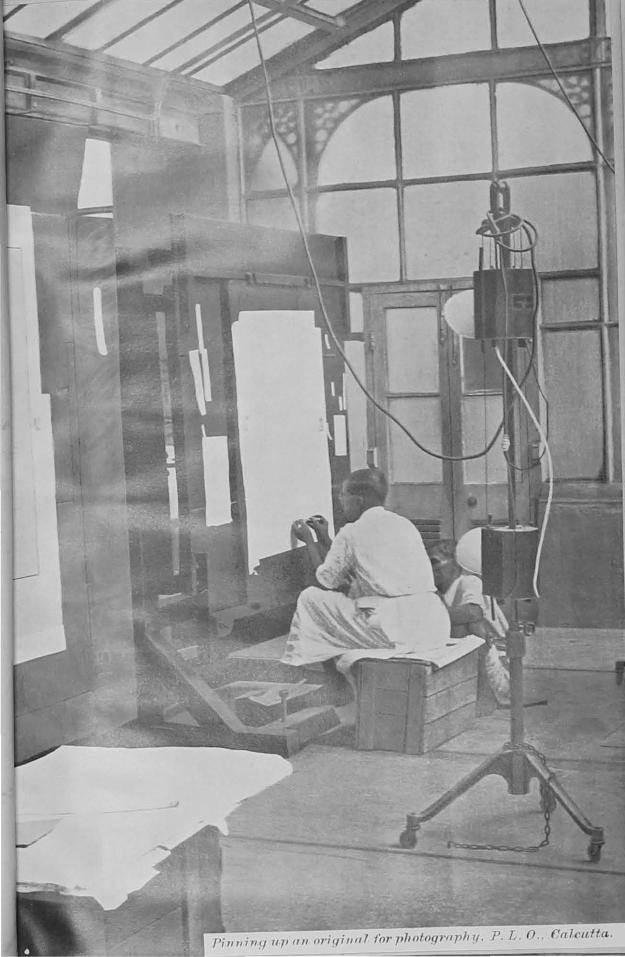
l'i 7111; 11 y 11 fl fill ori (/iII fl' f'nr plwtog7'fl ph 1{. p L n ('(( 7 ('(t/frL.
i'iUNTING-4~D MISCELLANEOUS.
in No. 18 Party was not large ·enough. The final map in two colours is very satisfactory, and the elimination of fair drawing greatly reduced the time and cost, besides ensuring more faithful reproduction of the survey.
This method of reproducing maps in two colours direct from the survey has been further developed to eliminate the dufling which is carried out at present, by means of a black bank-post paper print of the outline, registered carefully with the combined film negative. The new method is more satisfactory than the two-colour process reported in the 1934 report, and has been standardized for hasty map production in the Party. One special map was produced by this method for Headquarters, Peshawar District.
The Party has been re-equipped with a process camera, to take film or plate negatives up to 23 X 21 inches, to matc)l the Fnrnival portable band presses in use in the Party.
132. 'E' Company, Q.uetta.-The Reproduction Seetion was employed throughout the year mostly on extra-departmental work.
A paper cutting machine, and a double royal hand press were received and set up dnring the year. .
lmprovemen ts were made in the Photo Section, the lighting being improved and a long focus lens being installed which 'is capable of dealing with full size blue prints.
There are now in the Company one offset rotary printing machine, one duplicating press, 4 hand presses and 2 portable presses.
Reproduction of originale received:-
In one colour In two colours In three ,
In four "
Vandyke and helio plates prepared Prinls pulled
TOTAL
208 19 22
3
262
884 14,846
XIV.-MATHEMATICAL INSTRUMENT OFFlOE.
133. During the year under review the total value of repairs carried out and the sale of instruments, have shown an increase on the previous year.·
Owing to the decision of the military authorities to discontinue employing the M. I. 0. for repair work, considerable retrenchment of staff was unfortunately necessary. This involved the discharge of 62 men. The savings thus effected in the cost of establishment amount to Rs. 22,572 per annum. An additional saving is expected owing to the Superintendent proceeding on leave for 28 months from 4th April 1935, preparatory to retirement.
Repairs and manufactures during the year covered the usual wide range associated with theM. I. 0. The principal items are as follows:-
Repairs for Public Departments:-Theodolites. Drawing instruments. Levels. Pantographs. Sextants. Sight rules. Quintante. Parallel rules. Clinometers. Levelling staves. Abney levels. Ghat tracers. Plane-tables. Hypsometers. Drawing boards. . Rain gauges. T·Squares. Survey umbrellas. Plane-table stands. Sphygmomanometers. Theodolite and level stands. Microscopes.
Repairs to .Army Optical and other instruments included:-60 Rangefinders. 530 Binoculars. 50 Dial sights. 160 Monoculars. 54 Telescopes. 11!0 Liquid compasses. 36 Directors. 80 Watches.
Manufactures for Public Departments included the following:-Steel Band chains. Ferro-printing frames. Subtense bars. Zinc washing tubs. Measuring rods. Canvas covers. Levelling staves. Set squares. Survey umbrellas. Drawing instruments .. Sight rules. Protractors. Water bottles. Leather tape cases. Surveying flags. Plotting scales. Canvas holdalls. Aluminium gauge plates. Drawing boards. Head stereoscopes. Plane-tables. Wind vanes. T-Squares. Copy, Imperial Yard. Mule trunks. Sounding quintants. Ink rollers.
MATREMATIOAL INSTRUMENT OFFICE, 78
1JI anufactwres for Director of Contracts, Simla. A large number of spare parts and smaller apparatus for the Army
were made up and supplied, on tender, to the Director of Contracts Simla. In connection with this work numerous experiments wer~ carried out with a view to perfecting the radium painting of luminous components. ·
In the Optical Department considerable progress was made in the renovation of prisms and lenses. During the year under review, the following were re-worked, polished and figured:-
2,300 Prism surfaces. 350 Plano-convex lenses and object glasses.
1,031 Object glasses rebalsamed. In the Optical Department manufactures extended to:-500 Prisms. 250 Rangefinder moderating
glasses. 421 Lenses. 940 Compass glasses. 564 Theodolite and level
diaphragms. 605 Binocular graticules. Instruments adjusted and
aa follows:-71 Head stereoscopes.
260 Thermometers. 70 Microscopes. 30 Barometers. 40 Hygrometers.
tested
162 Reflecting mirrors. 136 Spirit bubbles. 308 Thermometers.
. 148 Pocket Sikes hydrometers. in the Optical Department were
40 Planimeters. 85 Sphygmomanometers. 12 Ophthalmoacopes. 41 Hydrometers. 30 Microscope objectives.
In addition, 370 glass jars ment.
were graduated -for the Excise Depart-
Special manufactures to design were completed as followa :-8 Ampoule fillers (7 for the Director, Bacteriophage Laboratory,
Bankipore and 1 for the School of Tropical Medicine, · Calcutta).
4 Polarity indicator magnets for the Superintendent, Gun and Shell Factory, Cossipore.
1 Pilot gauge for the Principal, Bengal Engineering College, Shibpur.
1 Hunter short base apparatus for the D. G. B., Debra Dun. 5 Duralumin tree calipers for the Divl, Forest Officer, Dhii.rwii.r,
the Silviculturist, Assam, and the Provincial Silviculturist, Ootacamund.
Six new pattern survey clinometers were made up and issued to Directors and 0. C's. Nos. 6 and 10 Parties for test and report after the field season with a view to further improvement in design.
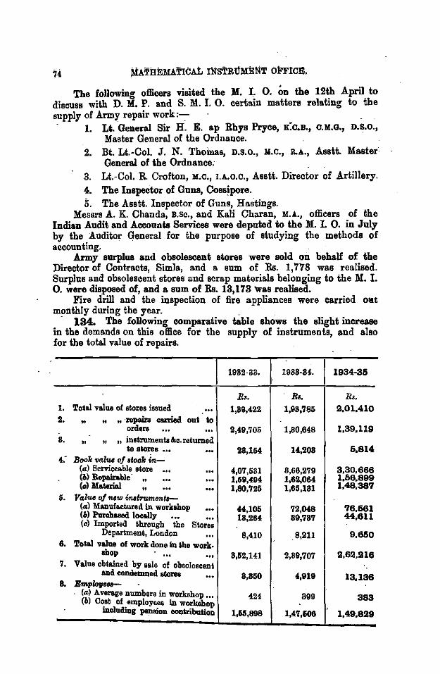
74
The followina officers visited the M. I. 0. on the 12th April to discuss with D. M. P. and S. M. I. 0. certain matters relating to the supply of Army repair work:-:-
1. U. General Sir H. E. ap Rhys Pryce, K:c.s., c.M.G., D.S.o., Master General of the Ordnance.
2. Bt. Lt.-Col. J. N. Thomas, D.s.o., :u.c., R.A., Asstt. Master General of the Ordnance:
3. Lt.-Col. R. Crofton, M.c., I.A.o.c., Asstt. Director of Artillery. 4. The Inspector of Guns, Cossipore. 5. The Asstt. Inspector of Guns, Hastings.
Messrs A. K. Chanda, B.sc., and Kali Charan, M.A., officers of the Indian Audit and Accounts Services were deputed to the M. I. 0. in July by the Auditor General for the purpose of studying the methods of accounting.
Army surplus and obsolescent stores were sold on behalf of the Director of Contracts, Simla, and a sum of Rs. 1,778 was realised. Surplus and obsolescent stores and scrap materials belonging to the M. I. 0. were disposed of, and a sum of Rs. 13, 173 was realised.
Fire drill and the inspection of fire appliances were carried owt monthly during the year.
· 134. The following comparative table shows the slight increase in the demands on this office for the supply of instruments, and also for the total value of repairs.
1982·33. I 1988-84. 1934-36
B •. Bo. Rs. 1. Toi&l value of stores issued 1,89,422 1,98,785 rA,Ol,410 2. .. , , ·repairs carried oui lo
orders 2,49,705 1,80,648 1,39,119 8. " " n instruments &c. returned
tio stores ... 28,154 14,208 6,814 4.- Book vtdu• of Block i..-
(a) Serviceable store ... 4,07,581 8,66,279 3,30,666 (bl Repairable
" 1,59,494 1,62,064 1,66,899 (c) Material , 1,80,726 1,65,181 1,48,387
6. Vt>l<£1 of new inat.....,.ent.-(a) Manuf&ctured in workshop 44,106 72,048 76,661 (6) Purchll8ed locally ••• • .. 18,264 89,787 44,611 (c) Imported through the Stores
Department, London 8,410 8,211 9,660 6. Tolal valno of work dono in lhe work.
shop 8,52,141 2,89,707 2,62,218 7. Value obtained by sale of obsolescent
and condemned sloroa 8,860 4,919 13,138 8. Bmpiov•-
(~>) Average numbers in workshop ... 424 899 383 (b) C~at of. employ~a in workshop mcludiog pen1110n contribution 1,15,698 1,47,606 1,49,829
INDEX MAPS
A. Modern Topo. survey& and _cO]Ilpil&lion
B. Sea.sons of survey and revision
0. Mapa published on 1 inclr and ~ inch scales
·D. " " ., ~inch ~e ... . '
.... - ' . ...
. ' E. The India sud Adjacent Cciuutries·Se>·ies, .1/M. scale
--~.
F. Carte Inlemsiionale du Moude,l/Msca.l&
G. Tbe Southern Asia Series, l/2·M scale
-·--.
.... . -!It E'f!d. . •
II II
.... " " ... . ~:..·.s·
. . .. " "
" " .... ... "

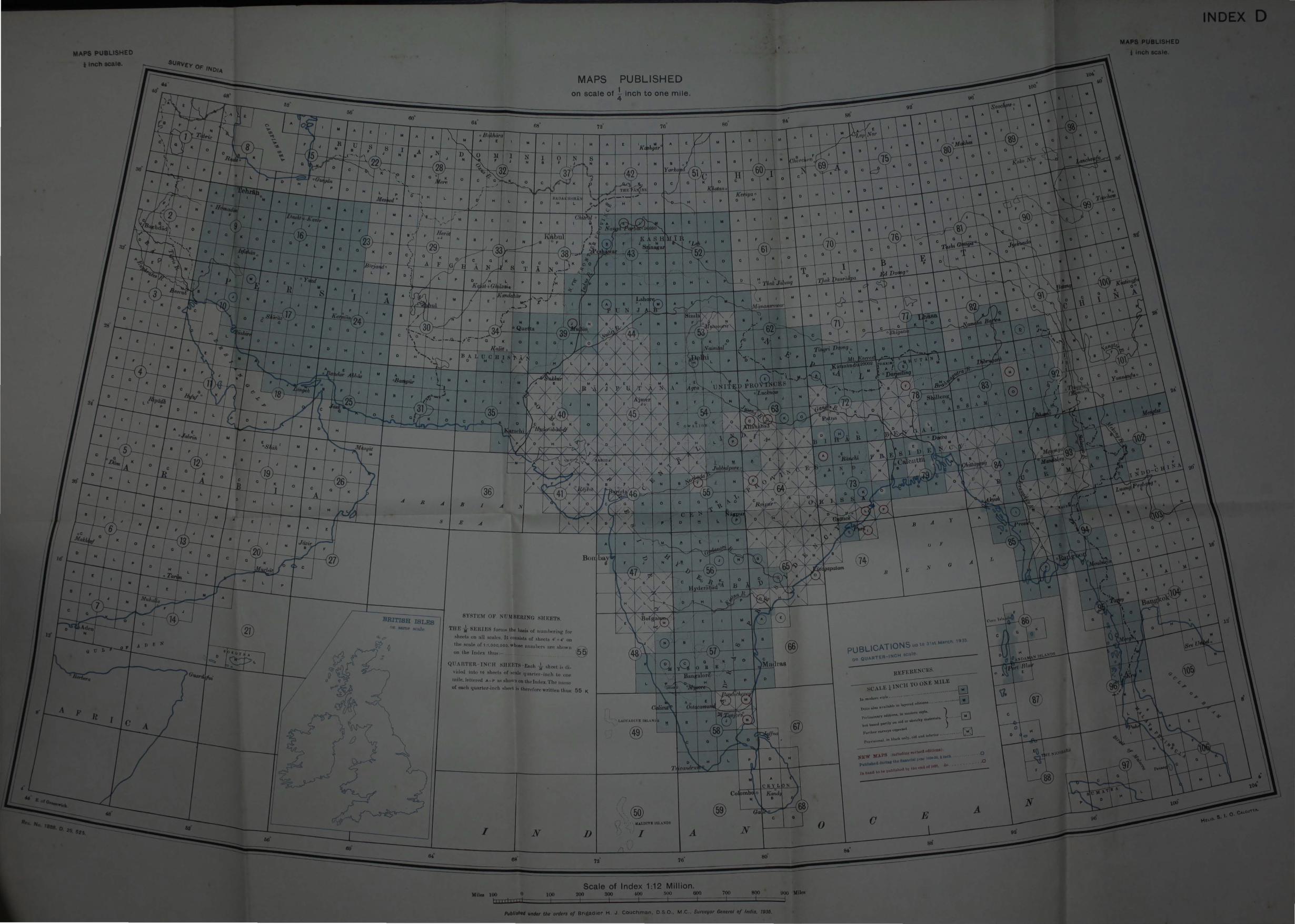
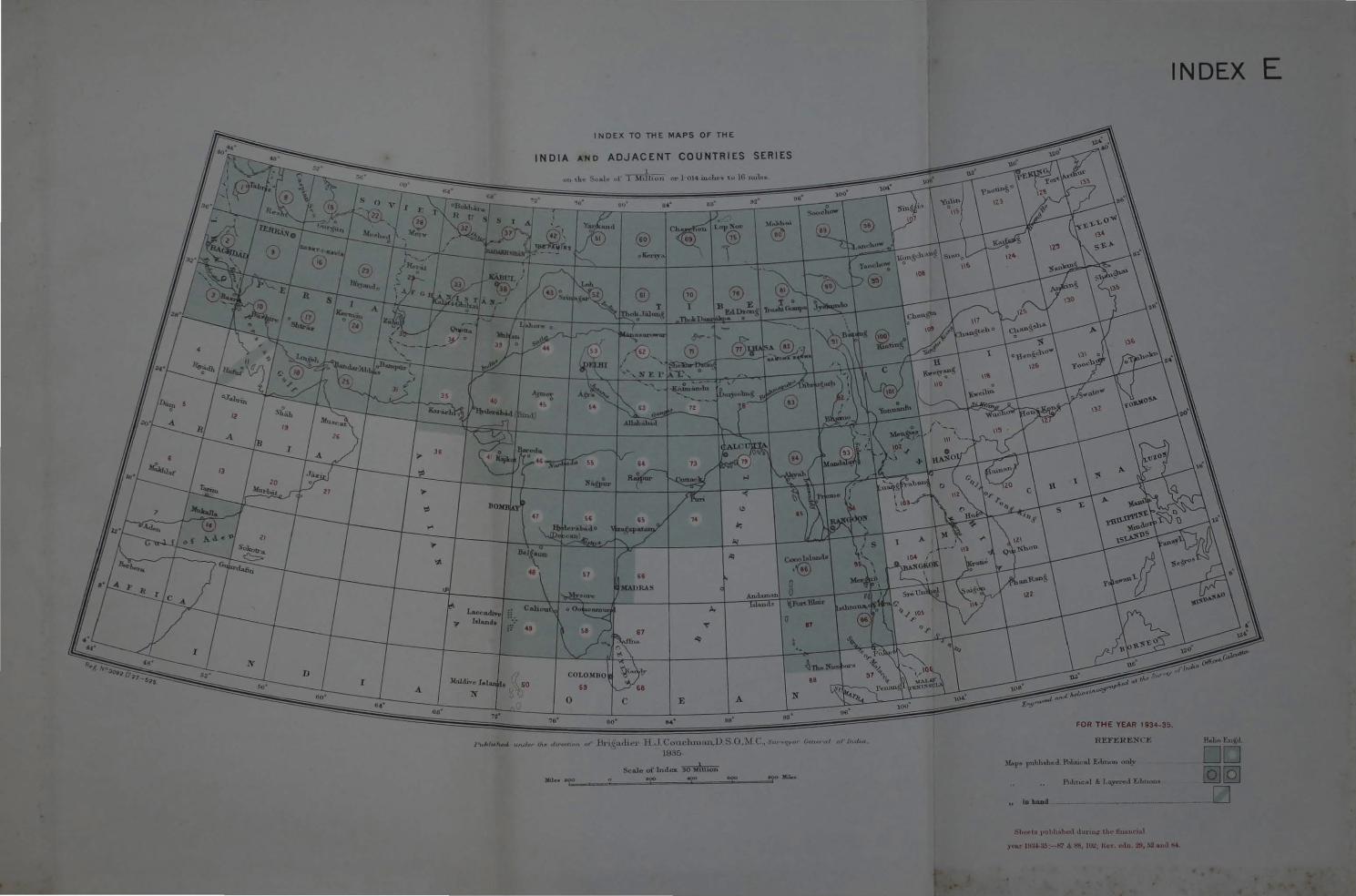
Laccadiv, Lol...,d1 :: .,
INDEX TO THE MAPS OF THE
INDIA AND ADJACENT COUNTRIES SERIES
or 1- 01-l mclu~• tu lG uu1··•
•..
• louul< \I.Portlllmr
0
lk•~adu·•· lLJ Couchman,D ~.O.~ll"., sw •<Y"' 1935.
Scalo of Index. 30 ~hthon
INDEX E
in hAnd
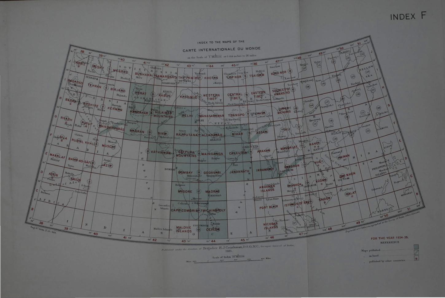
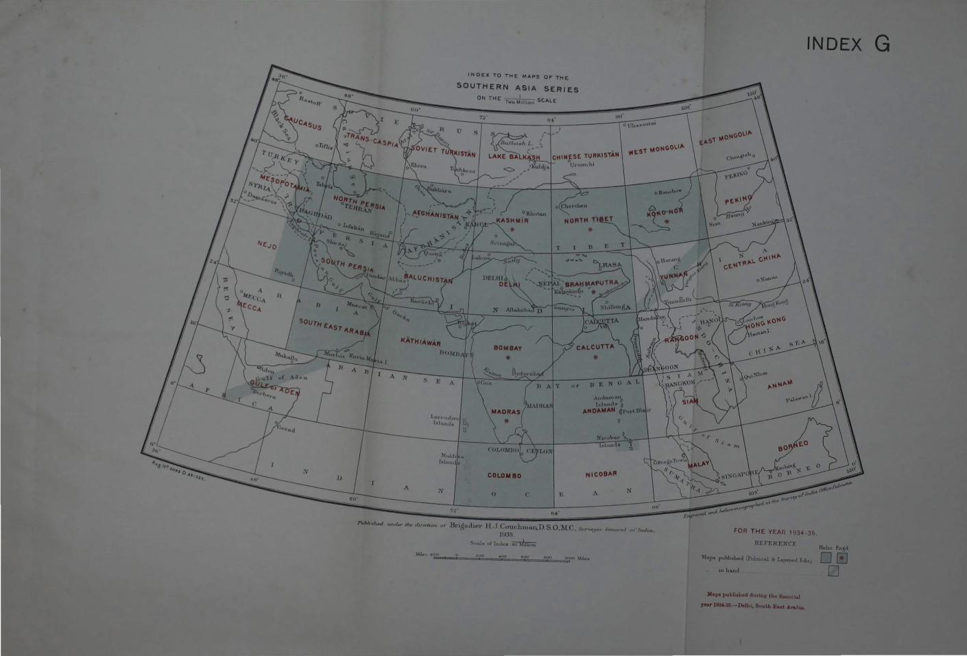
N
A
INDEX TO THE MAPS OF THE
SOUTHERN ASIA SERIES
ON THE -T-_o-~oli,"oo SCALE
ut•
Lut·t•Juhv1
MADRAS (~1.\llH.\."
A.Juh•n,hn0
l lllruaJM 1 AN DAMAN 4l'o•·• Bit ,.
lxluruJ,. o;.:.
)1 .. Jrf, 'It
r .. Ju•nJ;~
N
7~'
*
COLOMBO NIC08AR
() ( > A
Ht·i,~t,dit>r H .. T Couclnnan.D S.O.l.L<'. s .. n.,_,.., 1!1:35
"it·,Je of' JnJ.,.x ~
0
N
INDEX
FOR THE YEAR 1'134-35.
l!EFE!H;NCE
uaha.nd
Jlap1 puhlilhf'd durin.r tho tlwuu:ua)
Hoho Eot~
DEJ 0
G