floods and flood-mindedness in early colonial australia, environmental history, 2016 21 (2): 315-342
TRANSCRIPT

Grace Karskens
Floods andFlood-mindedness in Early
Colonial Australia
ABSTRACTTo date, environmental histories of rivers, floods, and
settlers in early colonial Australia (1788–1820) have meshedwith colonial historiography rather than challenging it.Missing from these studies are problem-oriented questionsabout the behaviors of rivers and people alike. What werethe specific histories and impacts of floods and freshes?How did settlers survive, conceptualize, and understandfloods? Why did they stay on the riverbanks, even defyinggovernors’ orders to move to higher ground, when theywell knew the river’s destructive power? These are ques-tions we might ask of all humans who live on floodplains.This article argues and demonstrates that a deep ethno-graphic and environmental approach can do more thangraft new environmental research onto existing historicalnarratives. It can unlock the radical potential of environ-mental history to reveal past peoples more fully, morehumanly, in a whole new light—in short, to change the waywe think about them and their environments.
VC The Author 2016. Published by Oxford University Press on behalf of the AmericanSociety for Environmental History and the Forest History Society. All rights reserved.For permissions, please e-mail: [email protected]
Grace Karskens, “Floods and Flood-mindedness in Early Colonial Australia,”Environmental History 21 (2016): 315–342
doi: 10.1093/envhis/emv186
at University of N
ew South W
ales on July 25, 2016http://envhis.oxfordjournals.org/
Dow
nloaded from

INTRODUCTIONIn March 1817, people on board the colonial brig Elizabeth Henriettasailing off the coast of New South Wales saw a strange sight. Six milesout from land a stack of wheat carrying several dead pigs rocked on theopen ocean. In August 1819, Captain Thompson of the brig Active wasthree hundred miles from Sydney when he noted fragments of wheatstacks, floating timber, and “other vestiges.” The captain knew that asevere flood had occurred on the mainland some weeks before.1
The bobbing flotsam represented disaster for hundreds ofHawkesbury-Nepean River settlers. Wheat and pigs were the equiva-lent of income as well as food for these small-scale farmers, and thesmashed timber was the remains of their simple homes and barns.Afterward, locals spoke of being “helpless spectators only of ourstacks, Barns, Houses and stock swimming down the current,” as theywatched everything they owned being lifted up and whirled away.2
In big floods, the river carried these chaotic cargoes at great speed.Huge masses of corn, trees, timber and lathe, wheat stacks and barleymows carrying pigs, dogs, and chickens careened through the river’sstone labyrinth, to be washed up at Mullet Island (now DangarIsland) or Pittwater, or spewed out into the ocean from Broken Bay.3
Drought, fire, and soils loom large in narratives about Australia’snational development, experience, and consciousness, yet the conti-nent’s rivers have been the locus of both Aboriginal and settler popu-lations, economies, and transport over thousands of years. Theirflows and floods have major impacts on river people, their communi-ties, and livelihoods.4 This was particularly true in the early colonialperiod (1788–1820), which Australian historians tend to regard as akind of primitive prehistory, of little importance to later develop-ment. Yet modern Australian society, economies, and cultures werefounded in this period, and colonists had already encountered keyenvironmental and climate conditions that characterized thecontinent.5
This article explores the flood history of early colonial Australia, fo-cusing on one of the earliest centers of white settlement, theHawkesbury-Nepean River fifty kilometers west of Sydney. There, onthe fertile river flats at present-day Pitt Town Bottoms, ex-convictsand soldiers began farming by early 1794. Their community was a dis-tant offshoot of the main settlements at Sydney and Parramatta.Exiled convicts and a small military force under the command ofGovernor Arthur Phillip founded the British colony in 1788 on theeast coast of Australia in New South Wales. It was a remarkable socialexperiment, planned, not as a jail, but as an agricultural colony.Convicts who served out their sentences were to be granted thirty-acre parcels of land, become farmers, and build a new society. Two as-sumptions underpinned the plan: first, that the new land was fertile,
Environmental History 21 (April 2016)316
at University of N
ew South W
ales on July 25, 2016http://envhis.oxfordjournals.org/
Dow
nloaded from

open, and suitable for farming; and second, that New South Waleswas terra nullius, owned by no one, thereby making the British right-ful claimants. The first proved to be true only in some areas; the sec-ond was mistaken. Aboriginal people had occupied the Australiancontinent for at least fifty thousand years.6
The historiography of the Hawkesbury-Nepean floods in the earlycolonial period is bound up with that of the ex-convict farmers andshaped by the politics and narratives of legitimate occupancy.Chroniclers generally portrayed these early farmers as failures,doomed by drought, debt, ineptitude, and drunkenness. Floods weremerely another obstacle they faced.7 This narrative of failure is a cul-tural and political construct. The independent and oppositionalstance of the ex-convict Hawkesbury community, their determina-tion to live as they pleased, and their vigorous pursuit of the pleasuresof popular culture invariably resulted in negative reports from au-thorities. Their untidy farms, hoe farming, bark houses, and povertyearned derisory descriptions of backwardness and failure from newlyarrived middle-class settlers keen to establish their own preeminenceas “legitimate” settlers.8 However, the earlier small farmers in factmade the colony self-sufficient in grain from 1795. Until settlementexpanded to the south in the 1810s, and even after, the Hawkesbury-Nepean was the breadbasket of the colony.9
Environmental historians have examined the Hawkesbury-Nepeanfloods largely in terms of environmental degradation. The clearing ofthe riverbank forests for farms in the 1790s allegedly resulted in im-mediate, severe erosion, as well as in channel siltation and blockage.Although little research exists on the actual impacts of early farming,or on the rate and extent of clearing, the Hawkesbury settlers wereportrayed not only as hopeless farmers, but also as Australia’s originalenvironmental sinners. Early environmental vandalism is usually nar-ratively paired with settler ignorance of the strange Antipodean envi-ronment.10 “In the early years of European colonisation,” declared agroup of climate scientists in 2006, “flood hazards loomed large be-cause of lack of knowledge of infrequent floods and the consequentoccupation of unsuitable low-lying land.”11 Simple ignorance ledfoolish settlers to occupy the floodplains.
In 2010 Joelle Gergis, Don Garden, and Claire Fenby moved beyondthemes of environmental damage to reconstruct the wider climate his-tory of the early colony in New South Wales. They suggested that his-torians generally “ignore or misconstrue the influence of climate onpast societies.” Examining the impacts of floods and droughts on thecolony between 1788 and 1809, they presented climate research along-side historical accounts of early settlement. Their reconstruction of1790s El Nino-Southern Oscillation (ENSO) cycles in particular repre-sents a breakthrough in our understanding of Australia’s colonial cli-mate history. Yet their account of human experiences and responses is
Floods and Flood-mindedness in Early Colonial Australia 317
at University of N
ew South W
ales on July 25, 2016http://envhis.oxfordjournals.org/
Dow
nloaded from

strangely familiar. As in numerous earlier colonial settler histories, thetropes of settler arrogance, ignorance, and hubris in the face of thealien and capricious Australian environment appear once more, andthe settlers’ stubborn “failure to learn” is a constant leitmotif. On theHawkesbury-Nepean River itself, the image they present of the stereo-typical “wretched” ex-convict farmers differs little from the descrip-tions written about them in the 1790s.12
I have discussed these works in some detail because their methodo-logical problems are common to multidisciplinary approaches moregenerally. First, while acknowledging that settlers did learn about thenew land, Gergis et al. tend to project modern scientific understand-ings and managerial approaches backward onto early eighteenth- andnineteenth-century people. Inevitably, settlers appear to be ignorantand unresponsive. Second, they do not subject the historical materialto the same critical scrutiny as the scientific sources, and thus repro-duce long-held historical stereotypes and tropes rather than interro-gating them. Third, they simplify the human-environmental story offloods to a series of major flood events, whereas the impacts of floodsvaried enormously according to speed, height, place, and season. Togauge past lived experience accurately, we need not only an under-standing of climate science, but also detailed biographies of floodsand how they were experienced.
To date, the environmental and flood history of the Hawkesbury-Nepean River has meshed with colonial historiography rather thanchallenging it. Missing from these studies is curiosity: problem-oriented questions about the behaviors of river and people alike.What were the specific histories of floods and freshes? Wheredid they come from, how often, what did they do, and where?Meanwhile, the question about the settlers is the same one thatbaffled successive governors, and one we might ask of all humanswho live on floodplains: why did these people stay on their farmswhen they knew the river’s destructive power could tear away anddestroy all they owned? Still more puzzling, why did they insist onoccupying their flood-prone farms even when authorities directedand then compelled them to move to higher ground nearby?
To explore such questions, we need to understand the social, cul-tural, and political context of the colony and its outcast colonists andto track particular human experiences of floods over time. This in turnallows us to plumb cultural stances and mentalites, to ask: How didthese people conceptualize floods and incorporate them into theirlives on the river? How did the floods shape their cosmology, theirsense of their own place in the world, and in this valley, where theymade new lives? Here, I argue and demonstrate that a deep ethno-graphic and environmental approach can do more than graft newenvironmental research onto existing historical narratives. It can un-lock the radical potential of environmental history to reveal past
Environmental History 21 (April 2016)318
at University of N
ew South W
ales on July 25, 2016http://envhis.oxfordjournals.org/
Dow
nloaded from

peoples more fully, more humanly, in a whole new light—in short, tochange the way we think about them and their environments.
LEARNING FROM THE HAWKESBURY-NEPEANThe British began searching for arable land and rivers almost as
soon as they arrived in New South Wales. Identifying land suitablefor farming was essential not because the colony was starving (itwasn’t), but in order to implement the agrarian plan. The British werea maritime people—water was their familiar and preferred mode oftravel, and rivers were seen as conduits into the unknown interior.But the Hawkesbury-Nepean, while broad and bewitchingly beautiful,offered no such route. Instead of leading them westward, it flowedsouth to north along the base of the rugged Blue Mountains plateaubefore turning east to the coast.
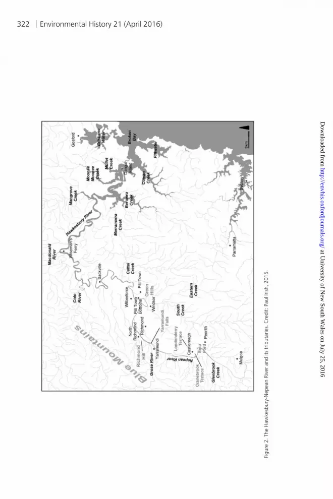
The Hawkesbury-Nepean is an unusual river. It flows out of moun-tains in the south and back into mountains in the north. Tumblingdown from the plateau of the Southern Highlands on the east coastof Australia, the river flows at the foot of the Blue Mountains west ofSydney, meandering north through the river flats and terraces ofMulgoa, Penrith, Castlereagh, Richmond, Windsor, and Pitt Town.At Sackville, it narrows as it enters a twisted sandstone labyrinththrough the Hawkesbury-Hunter ranges, turning abruptly east atWiseman’s Ferry to debouche into the ocean at Broken Bay. Seasonalrains send floodwaters rushing down from Southern Highlands andBlue Mountains via the Nepean and its seven tributaries as well as theGrose and Colo Rivers, a catchment of some seventy thousand squarekilometers (figures 1 and 2). When the waters reach the bottleneck atSackville, they back up and drown the valley floor like one vast bath.The receding waters leave behind layers of sediments, but what kindis a lottery: rich, black, silty mud from the Paleozoic rocks of the Coxand Wollondilly, sterile sand from the Warragamba, Nepean, andGrose Gorges, or a mixture of both, a fine sandy loam.13
The British could not have known that Australian rivers have “vastlydifferent hydrologies, ecologies and soil compositions” from those ofBritain. The flow rates of Australian rivers, including the Hawkesbury-Nepean, are twice as variable as rivers in the rest of the world. In geo-morphological terms, they are “nonequilibrium” rivers, stable for onlyrelatively short periods of time.14 Instead of “fixing” farms and build-ings in predictable landscapes with reliable climates according to theideal colonial model, settlers moved into zones of flux.15
Contrary to the historiographical stereotype, the British colonistswere environmentally observant, and they learned fast. A party of of-ficers, soldiers, and convicts rowing up the Hawkesbury for the firsttime in the winter of 1789 were awed by the eerie evidence of a recent
Floods and Flood-mindedness in Early Colonial Australia 319
at University of N
ew South W
ales on July 25, 2016http://envhis.oxfordjournals.org/
Dow
nloaded from

flood all around them. At Yarramundi Falls, where the Nepean andHawkesbury meet and the Grose flows down from its mountaingorge, floodwaters had flattened the dense stand of Casuarinas liketoothpicks, their drowned foliage pointing out the path of the deluge.Captain (later Governor) John Hunter wrote with some disquiet, “Forhere we had evident marks of the vast torrents which must pourdown from the mountains, after heavy rains. The low grounds, atsuch times, are entirely covered, and the trees with which they areovergrown are laid down (with their tops pointing down the river) asmuch as I ever saw a field of corn after a storm.”16
When the white explorers looked up into the massive blue gumsand forest red gums of the dense river-flat forest, the monstrousheight of this last flood became terrifyingly clear: “where any of thesetrees have been strong enough to resist in any degree the strength ofthe torrent (for they are all less or more bent downwards), we saw inthe clifts of the branches of such trees vast quantities of large logswhich had been hurried down by the force of the waters, and lodgedthirty to forty feet above the common level of the river. And at thatheight there were great quantities of grass, reeds, and other suchweeds as are washed from the banks of the river, hanging to thebranches.”17 The evidence before their eyes was so compelling, sofresh, that another flood seemed imminent.
Crossing the river to explore the country west of Richmond Hill(present-day North Richmond) in 1791, a nervous Lieutenant WatkinTench turned back because of “the terror of a river at our back, whosesudden rising is almost beyond computation,” a flood that mightstrand them in the wilderness.18 Some years later, Governor PhillipGidley King consulted Aboriginal people of the Hawkesbury-Nepeanand discovered that high floods occurred there around 1780 andagain in March 1788, dates that recent research indicates coincidedwith La Nina events.19 The colony’s elite also grasped the river’sflood-prone topography. John Hunter, returning as governor, wroteto Sir Joseph Banks in 1796:
the Cause of the extraordinary Swellings of this River isclearly occasion’d by its Serpentine Shape and theNarrowness of its Bed . . . the Stream downriver must be verymuch retarded in its progress to the Sea by the Short andSudden bending of its various reaches, so that the torrents ofwater which after a heavy fall of rain must run down thesides of the Neighbouring Mountains, raises the Waterwithin the Banks of the River . . . so high as to overflow thebanks & cover much of the Cultivated ground.20
Governor Phillip, who implemented the first stages of the plannedagricultural colony in New South Wales, avoided granting land for
Environmental History 21 (April 2016)320
at University of N
ew South W
ales on July 25, 2016http://envhis.oxfordjournals.org/
Dow
nloaded from

Figure
1.The
Haw
kesb
ury
-Nepean
Riv
er
regio
nand
catc
hm
ents
.C
redit:PaulI
rish
,2015.
Floods and Flood-mindedness in Early Colonial Australia 321
at University of N
ew South W
ales on July 25, 2016http://envhis.oxfordjournals.org/
Dow
nloaded from
Figure
2.The
Haw
kesb
ury
-Nepean
Riv
er
and
its
trib
uta
ries.
Cre
dit:PaulI
rish
,2015.
Environmental History 21 (April 2016)322
at University of N
ew South W
ales on July 25, 2016http://envhis.oxfordjournals.org/
Dow
nloaded from

farms at the Hawkesbury because of flood danger and because hecould not control a settlement so far from Sydney. But ex-convict andsoldier settlers, apparently independently, began taking the riverlands of the Boorooberongal Aboriginal people in late 1793 or early1794. The first group established small farms at the Green Hills (nowPitt Town Bottoms). Even if these settlers were unaware of floods tostart with, they could not have remained so for long. A scarcely re-corded “high flood” swept through in March 1794 and two more fol-lowed in 1795, one reaching 7.6 meters.21 Then in March 1799 camea flood that rose to a monstrous 15.6 meters. Thus, even before theturn of the century, Hawkesbury-Nepean settlers experienced highfloods. Most chose to stay, nevertheless.
For over two decades, between 1799 and 1820, a series of floodsand freshes swept through the valleys in what seemed like an unend-ing yet unpredictable cascade of destruction. After 1820 came respite:roughly three decades of drier conditions and droughts, with fewer,smaller floods. Thirty-odd years, half a lifetime, might well havedimmed the memory of those gigantic floods of the early colonialyears. Perhaps people believed the mayhem had been left behindwith the convict and pioneering era. But in the 1860s the waters re-turned with a vengeance. The greatest and most terrible flood on theHawkesbury-Nepean in historical times occurred in 1867, when the
Figure 3. Casuarinas flattened by floodwaters at Emu Ford, Nepean River, May 2013. Credit: GraceKarskens.
Floods and Flood-mindedness in Early Colonial Australia 323
at University of N
ew South W
ales on July 25, 2016http://envhis.oxfordjournals.org/
Dow
nloaded from

river at Windsor rose 19.26 meters above its normal summer level,and at Penrith to 27.47 meters above sea level.22 A number of newspa-per artists at the time depicted the terror of people clinging to bark-roofed houses above surging torrents, images that echoed theexperiences of earlier settlers in the century’s first floods (figure 4).Floods plagued and pestered the valleys until the mid-1890s, whenthe dry years returned with the legendary Federation drought.23
As historian Sue Rosen writes, flood knowledge, memory, and sto-ries became “an established part of folk wisdom” in the Hawkesbury-Nepean communities. Floods were recurring nightmares, events thatcreated flood terror and ordeals, flood mythos and stories, retold orallyand in print over the succeeding decades. River people used floods asthe great temporal markers of their lives: events happened before orafter floods. Floods were the subject of “study and speculation” andabiding local interest.24 Local newspapers and histories were full offlood stories, passed down the generations, about flood heights andhuman heroism, triumph and tragedy, and the sight of familiar land-scapes now sodden, ruined, and disordered, of cattle swept up intotrees whose bones dangled there for years after. Floods became a wayof life, and of thinking, and persisted among the valley’s farming peo-ple at least until the late 1990s.25
The growing store of local knowledge of the changing river cross-fertilized with continuous scientific recording and study of the floods.
Figure 4. “Recent Floods in New South Wales: View of Penrith from the Great Western Road,” 1867.Credit: Mitchell Library, State Library of New South Wales.
Environmental History 21 (April 2016)324
at University of N
ew South W
ales on July 25, 2016http://envhis.oxfordjournals.org/
Dow
nloaded from

Flood records began at the Green Hills (Windsor) in 1799, with heightsrecorded in official reports and the Sydney Gazette by local astronomerJohn Tebbutt between 1855 and 1903, and in local newspapers as well.A weather station recording rainfall was established at Goulburn in1858, followed in the 1860s and 1870s by increasing numbers of stationson the Hawkesbury-Nepean and its tributaries.26 So the Hawkesbury-Nepean offers the longest flood history record in Australia. Flood histo-ries are invariably built around these records, and they attracted earlyand ongoing scientific interest as well. Eventually this record contrib-uted to the discovery of decades-long cyclical climate regimes and thegiant interacting oceanic climate systems that drive them.27
Australia’s climate generally is in the grip of ENSO, which drives al-ternating periods of roughly seven to ten years of dry El Nino andwetter La Nina events. But ENSO does not explain the longer climatepatterns of the New South Wales coastal rivers—fifteen to forty yearsof wet weather and frequent big (ten meters and higher) floods, fol-lowed by decades of drier weather, fewer floods, then fierce drought.Sydney University geographer Lesley D. Hall first observed this phe-nomenon in 1927. Using the Hawkesbury flood records, Hall noticedthat while sudden rain events and high floods on the Hawkesbury-Nepean were not evenly spread on an annual seasonal basis, theywere not entirely random either. They occurred in clusters of wetterand drier seasons, extending over periods of up to four decades.28
Scientists continued to work at the Hawkesbury-Nepean flood fig-ures, combining them with historic changes in the river channel andthe geology of its terraces in search of the elusive flood patterns. In1987 fluvial geomorphologist Robin Warner, working on the stretchof the Nepean near Penrith, identified and named these cycles asflood-dominated and drought-dominated regimes, each extendingover roughly three to four decades. Warner argued that the shape andsize of the river channel was not fixed, but varied with these regimes,deeper and narrower in the drier periods, wider and shallower in theflood times.29 In the late 1990s, scientists discovered long-range pat-terns in the changing surface temperatures of the Pacific Ocean,warming and cooling at intervals of twenty to thirty years. Theynamed this phenomenon the Pacific Decadal Oscillation (PDO).30
Soon the correlation between the PDO and the long-term droughtand flood regimes on the east coast of Australia was made, though ex-actly how and why this happens is still mysterious. What is striking isthat the longer PDO cycles interact with the shorter ENSO, for whenthe long drought regimes coincide with El Nino events, temperaturessoar and the drought is most severe. When the PDO cycle matches LaNina, the heavens open and the floods are massive. The reverse is alsotrue: the PDO can act as both “throttle and brake” on ENSO, modify-ing the severity of flood and drought seasons when they cycle inopposite directions.31
Floods and Flood-mindedness in Early Colonial Australia 325
at University of N
ew South W
ales on July 25, 2016http://envhis.oxfordjournals.org/
Dow
nloaded from

The Hawkesbury-Nepean flood records thus played an essential rolein the discovery of the great interdecadal cycles that rule the climateof Australia’s east coast. Today these are linked to modern predictivemodels for assessing and reducing flood risk, as well as to numerousmanagement plans and public education programs aimed at raisingawareness and minimizing flood destruction and deaths. But the ex-convict settlers who cleared and planted their patches on the banksof the Hawkesbury-Nepean over two hundred years ago moved un-knowingly into the arms of these giant interacting oceanic climatesystems.
LIVED EXPERIENCE OF THE FLOODSIronically the records so critical to flood and river research tend to
mask the lived experience of floods. Lined up neatly by date withheights, they suggest single, finite events. Actual floods, chancy andunpredictable, could stretch over days and their impacts could stretchover years. The records might suggest that floods were more or lessthe same. But if we examine them as discrete events, and pay atten-tion to specificities, it emerges that each flood was distinctive accord-ing to natural and human factors.
When the colony’s first newspaper, the Sydney Gazette, appeared in1803, settlers were already reading the signs and omens of oncomingfloods. The high floods of the late 1790s and 1801 swept away cropsand houses and drowned people.32 The onset of storms, wild winds,and heavy, continuous rainfall, especially in February and March,aroused “nervous apprehension of mischief.” If the rains eased, thefears too subsided. The discoloration of the river waters with sedi-ments was another portent of flood. Settlers watched the water colorand levels intently, noting every rise and fall. Successive rises excitedworry, then alarm, then panic, while falls led to gradual reassuranceand relief—an exhausting emotional roller-coaster.33
The anniversary of a big flood made people jittery and terrified.False rumors of imminent deluge flew round the country, reportedand then contradicted in the Gazette. Ten months after the August1809 flood, one Pitt Town farmer advertised urgently for someone toship his corn to market, “induced by the dread of a possible floodwhich may sweep the whole away, to the great loss not of himselfand family alone, but of the Colony at large.”34 The psychological im-pacts of flood fear were especially severe at these times, for the “con-sternation it excited was everywhere visible” with “families alreadyparalysed.”35 People watched the waters constantly and yet never re-ally knew whether they would be flooded or not. Levels could riseand fall again, day after day, but then the river could suddenly swellto sweep away all before it. Like people watching bushfires, they were
Environmental History 21 (April 2016)326
at University of N
ew South W
ales on July 25, 2016http://envhis.oxfordjournals.org/
Dow
nloaded from

always uncertain about whether to flee to higher ground or stay onthe farms to try to save what they could. Sometimes there were nowarnings at all. There was no local rain before the flood of May 1809,when the water suddenly began to rise at the rate of 1.2 meters anhour. Experienced settlers thought the cause was the “bursting of acloud upon the mountains . . . overflowing the gulph” beyond theirhorizons.36
Between 1795 and 1821, the Hawkesbury-Nepean rose in freshesand floods at least thirty-seven times (Table 1, Online SupplementaryMaterial). February and March came to be seen as particularly high-risk months, but floods could occur at almost any time of the year.Many were heavy freshes, generally dismissed as of only limited con-sequences. The effects of these five- to nine-meter rises on the lowestlying lands around South Creek and Windsor were of considerableconsequence to farmers there, of course; year after year they lost theirragged patches of maize and wheat. But in terms of land space, theimpacts were minimal, and the benefits of fertile silts the waters leftbehind were seen as compensation for the destruction of crops, inter-rupted river traffic, and boggy roads. Larger floods of nine to twelvemeters did much more damage, cutting roads completely, washingout many more farms, and inundating farms along creeks and billa-bongs, where the waters backed up and overflowed.37
Nine times in twenty years the floodwaters reached over twelve me-ters and up to 14.6 meters. These were the dreaded “overflows of themain river,” which deluged the riverbanks and carried away animals,people, buildings, and crops. In these floods, the river reclaimed itsancient broader channels, inundating the floodplains, “branchingout . . . into innumerable channels,” and drowning river and creekjunctions.38 Figure 5, a detailed watercolor panorama of the 1816flood, which rose to 13.9 meters, shows the area around Windsor andSouth Creek as a vast, disorienting lake, studded with the tops oftrees, the vanes of windmills, and the roofs of the highest houses. Thescale of destruction and the transformation of the country wereshocking. “No person would believe unless they saw the Hawkesburythat the flood had made such a great devastation,” wrote theReverend Samuel Marden of the March 1806 flood.39
People also developed immediate responses to floods. With enoughwarning, they knocked down their sties, drove their pigs to higherground, and tried to secure what they could of their corn and wheat.Those on the lowlands usually fled for the higher ground. The leftpanel of Figure 5 shows livestock crowded onto one of the highpoints above the confluence of the Hawkesbury and South Creek.Elsewhere, families and workers would gather together in houses orbarns they considered safe, only to be forced by the inky waters ontothe roofs. Men, women, and children clung to the thatch in rains andhowling winds, crying out for help, and shooting off dangerously
Floods and Flood-mindedness in Early Colonial Australia 327
at University of N
ew South W
ales on July 25, 2016http://envhis.oxfordjournals.org/
Dow
nloaded from

overcharged muskets to signal for help. Some spent the night in trees,clutching their children. Others, like their farm animals, climbedonto the next highest structures, the wheat stacks and barley mows,and ended up riding the currents down the river, hoping to be res-cued before they crashed or slipped off, or their vessel broke up. In1817 two men survived the deluge by swirling down the river in awashtub and a pig trough, respectively.40
In every big flood, rescue boats, organized by local magistrates andmanned by settlers, worked day and night without rest, plucking peo-ple from roofs, trees, and wheat stacks, risking frequent collisionswith submerged trees and structures. There were never enough boatsto rescue everyone quickly, let alone stranded animals, although ef-forts were made to save pigs in the 1816 flood (figure 5 shows pigs be-ing landed from rescue boats, as well as timber animal hutches). Therescues performed by men were always reported as heroic and selfless,as indeed they were.41 The efforts of women—like the namelesswoman who stood for hours in floodwaters up to her neck holding uptwo children or the woman with newborn twins found whirlingdownriver clinging to a fast disintegrating heap of straw—were re-ported as the experiences of helpless victims, rather than feats ofheroism.42
What people often remembered as worst of all were the sounds offloods. Margaret Catchpole, who rented a small farm near Richmond,wrote of the August 1809 flood when she heard “maney poor CratuerCrying out for marcey Crying out for Botes given of gunes [giving offguns] in Destrees it was shocken to hear.”43 People on the highgrounds in 1806 listened helplessly to this terrible cacophony of dis-tress, “sorrowful spectators of the calamity they could not relieve.”44
People stranded on their roofs all night in the flood of March 1817heard the “howlings of the angry storm” and the “crashing of im-mense timber,” the great eucalypts of the river-flat forests, thirty tofifty meters in height, brought down by the wild torrents. Catchpoleherself “thought once must all been lost” in the flood of March 1806.
Figure 5. A detailed watercolor panorama of the floods on the Hawkesbury River and South Creekaround Windsor in June 1816. Credit: Mitchell Library, State Library of New South Wales.
Environmental History 21 (April 2016)328
at University of N
ew South W
ales on July 25, 2016http://envhis.oxfordjournals.org/
Dow
nloaded from

“Being in the water up to my middle as you well know I have a goodspirit I was trying to save what I could,” but then she and her mistressMrs. Dight were forced to climb into the loft with the children, onlyto find the house collapsing around them: “the first chimney [fell]and all the walls went down and middle wall went then I expectedthe next chimney to go and all the walls and then to be crushed todead for the water was about five feet deep in the house at the time.”To their relief, “great providence turned up a Boat to save us from awatery grave.”45
The big floods did not end neatly; they had very long tails.Catchpole, a fit and active woman, was still “very ill” a month afterher ordeal. Just over a year after the 1809 floods, Andrew Thompsonsuccumbed to a disease he caught during rescue work. How manyothers, particularly the frail or elderly, suffered illnesses and died lateris unknown. In the immediate aftermath, there were days waiting forwater to recede, to recover and bury the drowned, to begin rebuildinghouses and huts in a chaotic landscape. The air stank with “nauseousvapours arising from the putrefaction of carcasses, the stench of rot-ting maize and the mud and filth that has covered the fields.”46
People rowed about trying to recover submerged goods and spentweeks frantically drying salvaged maize and replanting crops. Wheatstacks that were partly wetted had to be opened and dried quickly, be-fore wisps and columns of smoke signaled that spontaneous combus-tion had set in.47 It was weeks or months before farmers knewwhether the seeds in their submerged fields were dead or wouldsprout. Weeks, months, and even years were spent searching for andreclaiming stock. A year or more might pass before the shopkeepersdemanded to be paid for the goods they had sold on credit to dis-tressed farmers.48
In the first decade of the nineteenth century, the government un-stintingly supported flood victims with food, clothing, and other sup-plies. Before the Macquarie period (1810–22), farmers were notexpected to repay this government assistance because they were con-sidered essential to the colony’s survival, the growers of its food.
Figure 5. (Continued)
Floods and Flood-mindedness in Early Colonial Australia 329
at University of N
ew South W
ales on July 25, 2016http://envhis.oxfordjournals.org/
Dow
nloaded from

There was, however, considerable remonstration from authoritiesconcerning their moral obligation to sell their next harvest of wheatand corn to the government rather than to private buyers.49 Looterswho ransacked abandoned farms were regarded as the lowest of thelow, and regulations smartly introduced to punish them; the slaugh-ter of wandering stock was also forbidden.50 The heroic tradition ofthe rescue boats became an institution, and from 1806 those settlerswho escaped the worst were urged to help their unfortunate neigh-bors get back on their feet. Assistance was also coerced during theworst floods—local constables had authority to “confine the menwithin their districts til they had given all the assistance possible.” By1816 the community was so “habituated to misfortunes of this kind. . . those who suffer naturally look forward to their fellow settlers forrelief in these horrible cases of emergency.” Thus floods built theHawkesbury-Nepean community’s bonds of mutual support, later re-sulting in formal relief appeals and, in 1819, the establishment of theWindsor Benevolent Society.51
Nevertheless, each big flood was distinctive, and their impacts indifferent places on the rivers varied enormously with the length ofwarning, time of year and stage of the farming cycle, the speed of cur-rents, and the state of the banks. It is this chancy nature, the multi-plicity of possibilities, probabilities, and risks, which offers insightsinto the way people experienced floods and how they incorporatedsuch terrifying events into their lives on the river.
FLOOD STRATEGIES AND SETTLER RESISTANCEIn November 1810, just as the harvest was coming on, a large and
elaborate party, including a carriage, a boat on a wagon, dragoonsand gentlemen on horseback, servants, baggage, and tents, wound itsway slowly along the track toward the Nepean farms from Mulgoa inthe south. The carriage rolled through the “long extensive chain ofFarms along the Nepean,” past the huts, pigsties, wheat fields, andswamps. Governor and Mrs. Macquarie had arrived in the colonyeleven months earlier, and now they were surveying the most distantdistricts of their domain.52
The governor, like the settlers, had floods on his mind. Two greatfloods, in May and August 1809, had drowned the valley just beforehis arrival. The August inundation overtopped even the “memorableflood of 1806” by about two meters.53 Nevertheless, in late 1810 thecrops on the Nepean and Hawkesbury flourished and the Macquariesrevelled in the beauty of the river landscape, the tranquil lagoons,and the mysterious Blue Mountains beyond. But the Hawkesbury-Nepean farms were another matter. The new governor was appalledby the settlers’ poverty, most obvious in their “very mean and paltry”
Environmental History 21 (April 2016)330
at University of N
ew South W
ales on July 25, 2016http://envhis.oxfordjournals.org/
Dow
nloaded from

bark and slab houses, their ragged, ugly clothing, and their messyfarms. The reasons were clear to him: these were ravages wrought byfloods.
Macquarie spent the next six days galloping up and down theHawkesbury-Nepean valley choosing sites for five flood-proof towns.On December 6, at a banquet at Government Cottage at Green Hills,came the grand announcement: the new towns, Castlereagh,Richmond, Windsor, Wilberforce, and Pitt Town were christened,and bumpers were drunk to the success of each, no doubt accompa-nied by great huzzahs.54 The five river towns became one ofMacquarie’s many pet projects. As historian Ian Jack points out, theyappear to have been “Macquarie’s own initiative,” since he was notgiven specific instructions to lay out such towns.55 As ambitious peo-ple of modest background and newly acquired wealth, both Lachlanand Elizabeth Macquarie were enthusiastic devotees of the enlighten-ment values espoused by the Scottish elite. Modern enlightenedthinking included the injunction that landowners treat their tenantswith “hospitality and justice,” particularly with regard to decenthousing. Before his appointment to New South Wales, Macquarie ac-quired an estate on the island of Mull and was already planning andbuilding new housing for his tenants there.56 In New South Wales, hedeveloped and implemented similar improving projects with greatenergy. Having supervised the survey and design of his newHawkesbury-Nepean towns, Macquarie directed the settlers to moveinto their allotted town blocks. It was a unique land tenure arrange-ment: the town blocks were to be considered as part of the farms;they could not be sold separately and they were calibrated accordingto the size of the farms.57
Yet four of the five towns were not immediately successful. The ex-ception, Windsor, was already a town (Green Hills) some fifteen yearsold. Those that succeeded eventually—Richmond, Wilberforce, andPitt Town—grew slowly in the decades after Macquarie left the col-ony.58 At Castlereagh few farmers bothered to formalize their rightsto the lots and the town was practically stillborn. The only part incontinual use was the burial ground.59
The governor was flummoxed by the settlers’ refusal. Between 1811and 1817, he issued a stream of long-winded and increasingly impa-tient orders instructing the river settlers to move into his towns. Hereasoned, cajoled, and persuaded. He made regulations they mustsurely obey, for governors had extensive powers in New South Wales.He warned them not to forget the terror of the floods in the lull be-tween 1809 and 1816. He insisted that government flood assistancenow had to be repaid and threatened that those “persevering in notremoving” would not be granted aid at all. Thus the devastation vis-ited by floods would be, not a natural disaster, but their own fault.These orders were published repeatedly in the Gazette and read out
Floods and Flood-mindedness in Early Colonial Australia 331
at University of N
ew South W
ales on July 25, 2016http://envhis.oxfordjournals.org/
Dow
nloaded from

from church pulpits on Sundays. Magistrates, parsons, and gentlemenwere enjoined to personally persuade the farmers to move.60 All to noavail. The settlers refused to budge, stubbornly remaining on theirfarms by the river.
Macquarie was not the first governor to try to shift theHawkesbury-Nepean settlers. Hunter ordered settlers to move offsoggy lowland farms along South Creek in 1796, though there is littleevidence that they did so.61 King also attempted to draw at least somefarmers away from the flood-prone valleys of the Hawkesbury-Nepean and onto the less fertile shale-soil forest lands of theCumberland Plain. Although he himself established the planned sol-dier settlement on the Nepean (later Castlereagh) in 1803–4, after thedisastrous flood of March 1806 he wished “this unfortunate event . . .will more than ever convince the settlers in that quarter of the unsta-ble tenure by which they hold their property and the fruits of their la-bour, which I hope will have the effect of making them set a greatervalue on the forrest lands, which, although not so fertile as theHawkesbury land, are secure against the many misfortunes of floods.”King, too, encountered resistance. Already by 1806 “no accident willprevail on the present holders of farms on the Hawkesbury to relin-quish their situations.” The governor knew why: the settlers’ “consol-ing comfort,” their hope and expectation, was the belief that “onegood crop will repay two bad ones.”62 The river’s legacy of rich siltswould repay the destruction and losses, the bad years and good wouldeven out in the end.
Macquarie returned to the Castlereagh district in 1815 to see whatimprovements had been made. He was sorely disappointed, for littlehad changed. Riding along the same line of farms he had visited in1810, “I was truly concerned to observe that the Settlers have not madethe smallest improvement on their farms since I first visited inNovember 1810 near Five years ago! – No Fences or Enclosures orGardens made, and no new Houses built or old ones repaired, and theSettlers themselves living in the same Poverty and Sloth as they didthen. This is a melancholy and mortifying reflection.”63 Two years later,the governor had all but given up. Faced with the settlers’ staunch re-fusal to move, he concluded they were afflicted by an “InfatuatedObstinacy,” bewitched by their land. “I have used every means in mypower to induce and persuade these Infatuated Hawkesbury andNepean Settlers to quite the Banks of these Rivers . . . ,” he wrote in adespatch in 1817, “but they are deaf to all my Remonstrations, and Ifear they will never be prevailed on to remove from their miserableCottages on the Banks of those Rivers.” But, more reflectively, he musedon the Hawkesbury-Nepean’s spell: “the lands on the banks of theHawkesbury are so very productive and Cultivated with such very littleTrouble that it is not at all Surprising that the Old Settlers who have so
Environmental History 21 (April 2016)332
at University of N
ew South W
ales on July 25, 2016http://envhis.oxfordjournals.org/
Dow
nloaded from

long lived on these Farms should be so partial to, and so unwilling toleave them.”64
“INFATUATED OBSTINACY”From Macquarie’s perspective, and also perhaps from our own risk-
averse one, there is something slightly mad in the way the settlersstuck to the river flats, knowing as they did the capricious and terriblepowers of the waters. Despite his disappointment and frustration,Macquarie understood something of the ethos of the Hawkesbury-Nepean settlers and their particular history. His reference to the rich-ness of the river soils, “Cultivated with such very little Trouble,” ech-oed popular local mythos about the soils reaching back to the firstsettlements, when stories about crops growing luxuriantly with littleeffort had caused a sensation. Hundreds of people flocked out to theriver to grab patches of land, and the Hawkesbury was soon dubbedthe “Nile of the colony.” It was likely seen by convicts and ex-convicts as a materialization of mythical Cockaigne, the dreamlandof Europe’s poor and hungry, the fabled place where food was plenti-ful and people were free of hard work.65 Australia’s first native-bornwhite poets—Charles Tompson, Charles Harpur, and William CharlesWentworth—were deeply inspired by the river and wrote paeans inpraise of its beauty and fertility.
Floods, however destructive, did not deter settlers from the area.After the early high floods, a few recent grantees “offered their grantsagain to the Crown,” or advertised their farms for sale, but more soontook their places.66 For the floodwaters left behind the prized “richmud . . . so that every piece of land that the water reaches is as pro-ductive as the richest muck-heap, the corn . . . being often twentyfeet high.” In a country where other soils were quickly exhausted,and where many small famers lacked manure-producing animals, theriver silts were consolation for the floods’ destruction, essential to thenatural cycle of renewal, the “renovation of the soil.”67
Yet the fertility of the soils and flood silts do not in themselves ex-plain the determinedness of the settlers to live on their riverbankfarms in defiance of Macquarie’s orders. There may have been prag-matic reasons, specific to each area. Let us look at the town that failedas a case study. Castlereagh’s poet Charles Tompson explained thatthe town was sited in an area that was high but dry, with no reliablewater supply at hand.68 He was right—the ghost town was pegged outon the ancient Londonderry Terrace, a particularly dry area withdeeply leached soils. Meanwhile, an abundance of lagoons, creeks,and swamps glinted on the flats below. But there were other practicalreasons as well. Living away from the farms meant that settlers couldnot defend their property against the very real threat of bushrangers
Floods and Flood-mindedness in Early Colonial Australia 333
at University of N
ew South W
ales on July 25, 2016http://envhis.oxfordjournals.org/
Dow
nloaded from

and Aboriginal attack, nor guard their largely unfenced crops fromwandering stock. Too far from the lush cornfields, the tracks, andriver crossings, too far from established bush homes.69
Macquarie’s orders on building standards for new houses in thetowns may have been another deterrent. They were to be “made ofBrick or Weatherboarded, to have Brick Chimneys and Shingled roofsand no dwelling house is to be less than nine feet high” and they hadto have at least two rooms, each with a glazed window. Local consta-bles were even given plans for these cottages to “ensure confor-mity.”70 Evidently river settlers had neither the money nor theinclination to build such houses and few appeared. They preferredthe light, easily built huts of slabs and bark, a building tradition usingeasily procurable materials that had developed locally and lasted wellinto the 1860s. Like Aboriginal structures, these semipermanentearth-fast buildings were well adapted to floods, as they were readilyrebuilt. When the better-off Hawkesbury-Nepean settlers began tobuild more substantial houses, they had two stories, so that people,and probably animals, could take refuge upstairs from floodwaters.71
The most ironic aspect of the settlers’ refusal to comply withMacquarie’s orders was that the governors had such wide-rangingpowers in New South Wales. This had been political commentators’great criticism of the colony from the start: the governors were ty-rants who infringed the rights and liberties of Englishmen.72 Whythen was Macquarie evidently so powerless to impose his regulations?Why did he not simply enforce their removal or levy punitive fines?
Macquarie’s edicts were undermined by the system of local gover-nance, the distance of the outlying settlements from the seat of gov-ernment, the intimately interwoven nature of the local community,as well as local traditions of independence and resistance.Theoretically, local magistrates, like the Reverend Henry Fulton, ap-pointed to Castlereagh Parish in 1814, were the governor’s servants,his executive arm imposing and enacting regulations and the law,and also his means of surveillance in these outlying areas. But Fultonhad a long history of loyalty to the people. In 1808 he sided stead-fastly with Governor Bligh and the Hawkesbury-Nepean farmersagainst the officers of the NSW Corp in the rebellion of that year.73 AtCastlereagh, Fulton may well have read Macquarie’s orders week afterweek from the pulpit of the simple church on the ridge, but there isno evidence that he actually obeyed Macquarie’s request to encour-age settlers to move.
Founded by working people, the Hawkesbury-Nepean communityhad always been marked by a measure of resistance to authority.Because towns were intentionally sites of surveillance and control,moving into them also involved the loss of certain personal liberties.On their own farms, settlers could do as they pleased. The politics offood production were also important. The valley had long been the
Environmental History 21 (April 2016)334
at University of N
ew South W
ales on July 25, 2016http://envhis.oxfordjournals.org/
Dow
nloaded from

breadbasket to the colony, essential for its grain foods, and the farm-ers well knew it—they referred to their wheat crops as “the townwheat” because it was their cash crop, sold in Sydney and Parramatta,where folks refused to eat maize. As the authorities discovered afterthe 1806 flood, it was unwise to antagonize or threaten them becausethey could easily respond by refusing to send their wheat to the gov-ernment store, or to town at all.
Beliefs about property and ownership were deeply significant inearly New South Wales, and Macquarie was well aware of the im-portance of small-scale land ownership. He was canny enough toavoid any hint of the removals and resumptions that GovernorWilliam Bligh had attempted in 1807–8.74 On the Hawkesbury-Nepean, Macquarie insisted that farm and town allotments wouldremain indivisible; thus there was no real threat to the settlers’right to their land. But most of the Castlereagh farmers weregrantees, not freeholders, and they knew it. The rest had boughtfrom grantees. Under the terms of the grants, settlers were obligedto occupy, clear, and farm the land. In theory, a governor couldtake away what he had given, and occasionally governors did in-deed revoke grants that grantees failed to occupy. The importanceof being physically on one’s land did not affect the better-off,more prominent farmers, who often owned multiple properties,but it probably held powerful sway over the lesser settlers on theirsingle small farms.75 Many of the Castlereagh people, for example,had come from the rural areas of England, Ireland, and Scotlandwhere their chances of owning land were negligible, and wherememories of displacement through the Enclosure Acts were stillstrong. For Irish people in particular, land ownership was held inthe highest regard.76
For the ex-convict farmers there were probably also emotional andcultural factors at play: perhaps this is what Macquarie was expressingin those words “so partial to and so unwilling to leave them.” Thesewere uprooted people, banished to the ends of the earth. Yet theyhad made new lives and homes and often families on the river, itselfpowerfully emblematic of renewal, fruitfulness, and plenty, of theirdeliverance into a bounteous colonial environment. At-homenessand a passionate attachment to the valley was articulated still moreclearly among the next generation, who identified strongly with theirriver birthplaces, families, and communities, and called themselvesAustralians.77
It was also possible for the river people to calculate flood risks tosome extent. Here the specificities of topography are important. Thesodden denizens of South Creek and other lowland areas, for example,were swamped by every large fresh. But other, higher places on the riv-erbanks offered more security. At Castlereagh on the Nepean, for ex-ample, the farms were located on the Cranebrook Terrace, which rises
Floods and Flood-mindedness in Early Colonial Australia 335
at University of N
ew South W
ales on July 25, 2016http://envhis.oxfordjournals.org/
Dow
nloaded from

to twenty-six meters above sea level (ASL) at its highest point(figure 6). A flood of twenty-one meters ASL is enough to inundate theswales, creeks, and the swampy backcountry of this area, but the farm-ers located on the highest points were probably only hit by the muchmore severe, but less frequent, monster floods. Water backing up viathe mouth of Cranebrook Creek, flowing into the Nepean on the eastside, made their neighbors on the back and middle farms on lowerground far more vulnerable. There the water stood stagnant and tooklonger to drain away; yet this also gave the rich silt time to settle.78
Freshes and minor floods were frequent occurrences, and Februaryand March were ominous months, but the actual timing of floodevents was nevertheless unpredictable. “To calculate with unerringprecision on the seasons of this country,” the Gazette observed in1821, “appears next to impossibility—each month and almost everyyear being so conspicuously at variance.”79 No one could knowwhether two or even three big floods would happen in one year, orwhether there would be a respite of six years, as occurred between1809 and 1816. Once a major flood subsided, people often believed—falsely—that they had had their big flood, and another would surelynot follow.80
Figure 6. Map showing the extent of the March 1806 floods on the Hawkesbury, South Creek, and theupper and lower Nepean River. Castlereagh is located to the right (north) of the pronounced bend onthe Nepean at the center of the map. Credit: Enclosure No. 2, Governor King to Earl Camden, April 7,1806, Historical Records of New South Wales, vol. 6.
Environmental History 21 (April 2016)336
at University of N
ew South W
ales on July 25, 2016http://envhis.oxfordjournals.org/
Dow
nloaded from

Each flood was different, with different warning times. Days ofheavy rains and freshes allowed farmers to drive their stock andcarry their wheat to higher ground and stack their bark ceilingswith corn. But floods resulting from distant, unseen rainfall couldrise without warning, silent and terrifying. The time of the floodin the annual farming cycle was critical. One reason the 1806flood became legendary was that it happened after the harvest andwashed away the wheat and corn still on the ground, causing se-vere shortages, later remembered as a famine. By contrast theflood of June 1816, although less than a meter lower, caused littleloss to crops and helped the newly sown wheat flourish.81 Thefloods reached different heights in different places and ran at dif-ferent speeds: fast floods tended to cause more damage thanslower ones even if they were not as high. Whether or not one’sriverbank and crops were washed away was by no means certain:some lost land, some gained it. Whether floodwaters left the cov-eted coat of rich silt, guaranteeing a bountiful harvest, or buriedthe crops and pastures in acres of destructive, sterile sand also de-pended entirely on chance.
The risk of death by drowning was truly terrifying. Most early settlerscould not swim, and even if they could, the speed of the flood currentsand crashing debris were lethal. There were many lamenting reports ofdeaths as well as awful ordeals and hairbreadth escapes. Overall, though,the known immediate death tolls were relatively low: twenty-one, possi-bly twenty-three, people lost their lives in floods in the twenty-year pe-riod between 1799 and 1819 (Table 1, Online Supplemental Material).Later deaths from exposure and disease were not counted.
In Macquarie’s mind, the response to floods was obvious: settlersshould behave rationally and move to his townships on higherground. To stubbornly stay put was nothing more than sheer stupid-ity. But this was not the way the small settlers saw it. For them thefloods were powerful and malevolent entities. They were understoodin terms of wildness, they were willful, unbridled, impetuous, theysurged far beyond puny human ideas of order and control. The risksof death and ruination were integral to a kind of contract they heldwith the river.82 Yet the very fact that the impacts of floods wereunpredictable, especially for those on the higher terraces likeCastlereagh, also left room for reasonable hopes that this time, crops,stock, houses, and people would be spared.
So much of the way the ordinary settlers saw their world turned uponfate, risk, and opportunity rather than notions of control, forethought,and prudence. Settlers and governors alike expressed beliefs inProvidence, that is, the rather amorphous idea of God, or some higherforce of nature, which both caused the floods and destruction butmight equally intervene to avert disaster, calm the storms, and evensend “botes” in the nick of time. Governor Hunter himself hoped the
Floods and Flood-mindedness in Early Colonial Australia 337
at University of N
ew South W
ales on July 25, 2016http://envhis.oxfordjournals.org/
Dow
nloaded from
floods of 1799–1800 were acts of Providence, random and unusual,and not a normal phenomenon to which “we may be so frequentlyliable to as we have of late.”83 But Providence was nested in a largerworldview, one of chance and opportunity, of risk and reckoning,of maximizing the odds, of skillful gambling. This way of thinkingunderpinned many aspects of everyday life, from farming—plantingdifferent wheat varieties in the same field to offset the vicissitudes ofweather, blights, and pests—to the great pleasures and risks of popularculture.84
But the reverse side was a wellspring of fatalism and resignation tothings beyond human control. The floods stood alongside life’s otherawesome and inescapable factors: the vast ocean which might drownthem, yet upon which they sailed; disease, madness, violence, treach-ery, accident, death—any of these might strike at any time. Good for-tune and bad were conditional on luck, fate, or acts of Providence.85
The shining river commanded admiration but also respect and wari-ness. In flood it brought plenty in rich alluvium to replenish theearth; and it brought devastation.
Grace Karskens is Associate Professor in history at the University ofNew South Wales, Sydney, Australia. Her book The Colony won the 2010Prime Minister’s Award for Non-fiction and the US Urban HistoryAssociation’s 2010 award for best book (non-North American).
NotesI am grateful to Richard Waterhouse, Ian Tyrrell, Tom Griffiths, Lisa Brady, and twoanonymous referees for reading this article and providing valuable feedback.
1 Sydney Gazette (SG), March 15, 1817; August 14, 1819.2 William Aspinall, cited in Jan Barkley-Jack, Hawkesbury Settlement Revealed: A
New Look at Australia’s Third Mainland Settlement 1793–1802 (Dural, NSW:Rosenberg, 2009), 258.
3 SG, March 15, 1817. The river’s double name is the result of early British explo-rations. The eastern and southern sections were discovered independently andthe two names persisted. The Nepean joins the Hawkesbury at the cobble rapidsof Yarramundi.
4 Emily O’Gorman, Flood Country: An Environmental History of the Murray-DarlingBasin (Melbourne: CSIRO Press, 2012), x.
5 Grace Karskens, “The Settler Evolution: Space, Place and Memory in EarlyColonial Australia,” Journal of the Association for the Study of Australian Literature13 (2013): 1–21; Joelle Gergis, Don Garden, and Clare Fenby, “The Influence ofClimate on the First European Settlement of Australia: A Comparison ofWeather Journals, Documentary Data, and Palaeoclimate Records 1788–1793,”Environmental History 15 (2010): 502–3.
6 Grace Karskens, The Colony: A History of Early Sydney (Sydney: Allen & Unwin,2009), chaps. 2 and 3.
Environmental History 21 (April 2016)338
at University of N
ew South W
ales on July 25, 2016http://envhis.oxfordjournals.org/
Dow
nloaded from

7 See D. N. Jeans, An Historical Geography of New South Wales to 1901 (Sydney:Reed Education, 1972), 88–89; Jan Kociumbas, Oxford History of Australia:Volume 2: 1770–1860 Possessions (Melbourne: Oxford University Press, 1992),45–49.
8 Karskens, The Colony, 123–28.9 Ted Henzell, Australian Agriculture: Its History and Challenges (Melbourne: CSIRO
Press, 2007), 10.10 Sue Rosen, Losing Ground: An Environmental History of the Hawkesbury-Nepean
Catchment (Sydney: Hale & Iremonger, 1995), 12–21, 30–32; Geoffrey Bolton,Spoils and Spoilers: A History of Australians Shaping their Environments (Sydney:Allen & Unwin, 1992), 37–38. For more sympathetic local accounts, see D. G.Bowd, Macquarie Country: A History of the Hawkesbury (Sydney: Library ofAustralian History, 1994), chap. 4; Barkley-Jack, Hawkesbury Settlement;Michelle Nichols, Disastrous Decade: Flood and Fire in Windsor 1864–1874(Berowra Heights NSW: Deerubbin Press, 2001).
11 Barrie Pittock, Debbie Abbs, Ramasamy Suppiah, and Roger Jones, “ClimaticBackground to Past and Future Floods in Australia,” Advances in EcologicalResearch 39 (2006): 13–39; quote 14. See also Eric Rolls, “More a New PlanetThan a New Continent,” in Eric Rolls, From Forest to Sea: Australia’s ChangingEnvironment (St. Lucia, Queensland: University of Queensland Press, 1993),161–76.
12 See Gergis et al, “The Influence of Climate;” Claire Fenby, Don Garden, andJoelle Gergis, “The Usual Weather in New South Wales Is Uncommonly Brightand Clear . . . Equal to the Finest Summer Day in England: Flood and Droughtin New South Wales, 1788–1815,” in Climate and Colonisation: Histories fromAustralia and New Zealand, ed. James Beattie, Emily O’Gorman, and MatthewHenry (New York: Palgrave Macmillan, 2014), 43–60.
13 Lesley D. Hall, “The Physiographic and Climatic Factors Controllingthe Flooding of the Hawkesbury River at Windsor,” Proceedings of theLinnaean Society of New South Wales 52 (1927): 149; Rosen, Losing Ground,viii, ix.
14 B. L. Finlayson and T. A. McMahon, “Australia v the World: A ComparativeAnalysis of Streamflow Characteristics;” and Gerald Nanson and WayneErskine, “Episodic Changes of Channels and Floodplains on Coastal Rivers inNew South Wales,” in Fluvial Geomorphology of Australia, ed. Robin F. Warner(Sydney: Academic Press, 1988),17–40, 215–18.
15 Governor John Hunter to Duke of Portland, May 1, 1799, Historical Recordsof New South Wales (HRNSW) 3, 668; see also Helen Proudfoot, “Fixingthe Settlement upon a Savage Shore: Planning and Building,” in A DifficultInfant: Sydney Before Macquarie, ed. Graeme Aplin (Sydney: UNSW Press, 1988),54–71.
16 John Hunter, An Historical Journal of Events at Sydney and at Sea 1787–1792, ed.John Bach (1793; repr., Sydney: Angus and Robertson, 1968), 105–6.
17 Ibid.18 Watkin Tench, A Complete Account of the Settlement at Port Jackson, published as
Sydney’s First Four Years, ed. L. F. Fitzhardinge (1793; repr., Sydney: Library ofAustralian History, 1979), 235.
19 King to Earl Camden, April 7, 1806, HRNSW 6, 61; Gergis et al., “The Influenceof Climate,” 486 ff.
20 Hunter to Banks, August 20, 1796, Banks Papers, A1787, Mitchell Library (ML).See also Hunter to Portland, May 1, 1799, Historical Records of Australia (HRA) 2,354–55, and note 188, 738.
Floods and Flood-mindedness in Early Colonial Australia 339
at University of N
ew South W
ales on July 25, 2016http://envhis.oxfordjournals.org/
Dow
nloaded from

21 Lieutenant-Governor William Paterson to Right Hon. Henry Dundas,September 16, 1795, HRNSW 2, 320; King to Camden, April 7, 1806, HRNSW 6,61. Space does not permit a discussion here of the Aboriginal and cross-culturalexperiences of floods. See Grace Karskens, People of the River (Sydney: Allen &Unwin, forthcoming).
22 M. G. Bracewell and G. E. McDermott, “Report on the 1867 Flood,” report forthe Metropolitan Water Sewerage and Drainage Board, 1985, no pagination,sect. 4.
23 J. P. Josephson, “History of the Floods in the Hawkesbury River,” Journal of theRoyal Society of New South Wales 19 (1885): 97–111; Pittock et al., “ClimaticBackground,” 20. These regimes refer to southeastern Australia.
24 Rosen, Losing Ground, 26; see, for example, J. T. “Toby” Ryan, Reminiscences ofAustralia (1894; repr., Sydney: Nepean Family History Society, 1982); FlorenceEarle Hooper, “My Childhood Recollections,” unpublished reminiscences,Balmain, 1964 ML MMS1553/1–2; “Cooramill” (Samuel Boughton),Reminiscences of Richmond from the Forties Down, ed. Cathy McHardy (1903–4;repr., Penrith, NSW: Cathy McHardy, 2010).
25 See, for example, Jackie Flowers, interview with Sue Anderson, November 7,1997, Castlereagh, tape recording, Penrith Local History Collection.
26 Josephson, “History of the Floods,” 106; Hall, “The Physiographic and ClimaticFactors,” 146.
27 Modern fluvial geomorphologists regard the Windsor flood records as impre-cise for research beyond a general guide to flood behavior; see Martens andAssociates, Geomorphology of the Hawkesbury-Nepean River System (WindsorNSW: Hawkesbury-Nepean Catchment Management Trust, 1998) 22 ff., 161.
28 Hall, “Physiographic and Climatic Factors.”29 See S. J. Riley, “Aspects of the Flood Record at Windsor,” Proceedings of the 16th
Institute of Australian Geographers Conference Newcastle (1980): 325–40; R. F.Warner, “Channel Changes in the Sandstone and Shale Reaches of the NepeanRiver, New South Wales,” in R. W. Young and G. C. Nanson, Aspects ofAustralian Sandstone Landscapes (Wollongong: Australia and New ZealandGeomorphology Group, Special Publications no. 1, 1983), 106–19; Robin F.Warner, “The Impacts of Alternating Flood- and Drought-dominated Regimeson Channel Morphology at Penrith, New South Wales, Australia,” Proceedingsof the Vancouver Symposium, International Association of Hydrological SciencesPublication 168 (1987): 327–38. Although initially challenged, Warner’s con-clusions are today generally accepted.
30 S. Power, T. Casey, C. Folland, A. Colman, and V. Mehta, “Inter-decadalModulation of the Impact of ENSO on Australia,” Climate Dynamics 15 (1999):319–24; Stewart W. Franks, “Identification of a Change in Climate State UsingRegional Flood Data,” Hydrology and Earth System Sciences 6 (2002): 11–16; S. W.Franks, “Multi-Decadal Climate Variability, New South Wales, Australia,”Water Science and Technology 49 (2004): 133–40.
31 Franks, “Identification of a Change”; Franks, “Multi-Decadal ClimateVariability,” 133–40; Julia Miller, “Rain on Our Parade: La Nina and the Impactof Climate Change on “Sunny” Sydney,” paper presented at the From theGround Up conference, Sydney, 2012, 4.
32 SG, March 23, 1806, May 28, 1809, March 30, 1811.33 SG, May 29, 1803; February 10, March 3, 1805; March 17, April 6, 1806; June
28, 1807; July 14, 1810; March 30, 1811.34 SG, July 14, 1810; June 2, 1810.35 SG, June 2, 1810; June 28, 1807.
Environmental History 21 (April 2016)340
at University of N
ew South W
ales on July 25, 2016http://envhis.oxfordjournals.org/
Dow
nloaded from

36 SG, June 4, 1809.37 SG, April 28, October 22, 1805; March 30, 1811; June 29, 1816; March 7, 1818.38 SG, June 8, 1816; June 4, August 6, 1809; see Bracewell and McDermott,
“Report on the 1867 Flood.”39 See Barkley-Jack’s notes on this panorama, Hawkesbury Settlement, 118, 223,
258, 259; Marsden to King, March 28, 1806, HRNSW, 6, 53.40 Catchpole to W. Howes, October 8, 1806, transcript, A3059, ML; SG, March 30,
April 4, 1806; August 6, 1809; June 8, 1816; March 15, 1817; March 29, 1817,February 28, 1818.
41 SG, March 30, 1806; June 4, 1809; March 29, 1817; Barkley-Jack, HawkesburySettlement, 227, 258.
42 SG, April 4, 1806; March 29, 1817.43 Catchpole to Mrs. Cobbold, October 8, 1809.44 SG, March 30, 1806.45 SG, March 15, 1817; Catchpole to W. Howes, October 8, 1806.46 SG, March 15, 1817.47 SG, April 6, 1806; June 8, 1816; Marsden to King, March 28, 1806, HRNSW, 6,
53.48 SG, April 6, April 17, 1806; August 18, 1809; January 7, February 9, 1810;
February 2–9, 1811; February 10, 1821.49 Hunter to Portland, May 1, 1799, HRNSW, 2, 688; Government and General
Order, August 1806, HRNSW, 6, 176; SG, February 8, 1807; August 13, 1809,January 14, 1810, December 6, 1817.
50 SG, April 13, 1806.51 SG, March 30, June 1, 1806; Marsden to King, March 28, 1806, HRNSW, 6, 53;
SG, June 8, 1816; June 14, 21, 28, July 5, 12, August 16, 30, September 27,December 6, 1817; January 16, 30, June 30, 1819, July 8, 18, 1820.
52 Governor Lachlan Macquarie, Journal, entry for November 30, 1810, ML A774.53 SG, June 4, August 6, 13, 1809.54 Macquarie, Journal, entries for December 2–6.55 Ian Jack, Macquarie’s Towns (Sydney: Heritage Council of New South Wales and
Land and Property Management Authority, 2010), 7–9.56 T. C. Smout, “The Improvers and the Scottish Environment: Soils, Bogs and
Woods,” in Eighteenth Century Scotland: New Perspectives, ed. T. M. Devine and J.R. Young (East Lothian: Tuckwell Press, 1999), 210; John Dwyer, VirtuousDiscourse: Sensibility and Community in Late Eighteenth Century Scotland(Edinburgh: John Donald, 1987), 43, 120; M. H. Ellis, Lachlan Macquarie:His Life, Adventures and Times (Sydney: Angus and Robertson, 1970), 123–24,143.
57 Macquarie, Journal, entry for January 10, 1811; Jack, Macquarie’s Towns, 9, 31.58 Bobbie Hardy, Early Hawkesbury Settlers (Kenthurst NSW: Kangaroo Press, 1985),
37; Jack, Macquarie’s Towns, 4.59 Jack, Macquarie Towns, 80–90; Robert Murray and Kate White, Dharug &
Dungaree: The History of Penrith and St Marys to 1860 (Melbourne: HargreenPublishing and the Council of the City of Penrith, 1988), 129–41.
60 Government and General Orders, December 9, 1815, Colonial Secretary’sCorrespondence, Reel 6038, SZ759, ML, 160–61; SG, March 30, 1811, December9, 1815, July 13, 1816, March 8, 1817.
61 Hunter to Banks, August 20, 1796, Banks Papers, ML, A1787, 14.62 King to Camden, April 7, 1806, HRNSW, 6, 62.63 Macquarie to Bathurst, April 4, 1817, Governor’s Despatches, ML MMS 1191, 2,
no. 18, 246–48; see also SG, December 9, 1815.
Floods and Flood-mindedness in Early Colonial Australia 341
at University of N
ew South W
ales on July 25, 2016http://envhis.oxfordjournals.org/
Dow
nloaded from

64 Macquarie to Bathurst, ibid.65 Karskens, The Colony, 120–22; Alan Atkinson, The Europeans in Australia
(Melbourne: Oxford University Press, 1997), 170–71.66 Paterson to Dundas, September 16, 1795, HRNSW 2, 320; SG, January 15, 1819.67 Surgeon Joseph Arnold, letter to his brother, March 18, 1810, ML A1849-2; SG,
March 30, 1806, March 29, 1817.68 Charles Tompson, “Retrospect; Or, A Review of My Scholastic Days” in Notes:
From the Lyre of a Native Minstrel, 1826, digital text online at Australian DigitalCollection, University of Sydney Library, http://purl.library.usyd.edu.au/setis/id/v00007.
69 Karskens, The Colony, 129.70 Cited in Bowd, Macquarie Country, 43; Jack, Macquarie’s Towns, 31.71 Grace Karskens, “Naked Possession: Building and the Politics of Legitimate
Occupation in Early New South Wales, Australia,” in Investing in the EarlyModern Built Environment: Europeans, Asians, Settlers and Indigenous Societies, ed.Carole Shammas (Leiden: Brill, 2012), 333–41.
72 See Richard Waterhouse, “Liberty and Representative Government in Australia1788–1901,” in Exclusionary Empire: English Liberty Overseas 1600–1900, ed. JackP. Greene (New York: Cambridge University Press, 2010), 220–47; Karskens, TheColony, 190, 217, 251–54.
73 K. J. Kable, “Fulton, Henry (1761–1840),” Australian Dictionary of Biography, 1(Melbourne: Melbourne University Press, 1966).
74 SG, February 8, 1807, August 6, 1809; Marsden and Arndell to King, April 5 and6, 1806, King Papers, A1980/2 (Safe 1/139), ML, 195, 205–6; Grace Karskens,The Rocks: Life in Early Sydney (Melbourne: Melbourne University Press, 1997),28–29; Grace Karskens and Richard Waterhouse, “Property, Liberty, Tyrannyand the ‘Rum Rebellion,’” Journal of Australian Colonial History 12 (2010), 1–22.
75 Governor Phillip’s Instructions, April 25, 1787, HRA 1, 14–15.76 Karskens, The Colony, 133; Patrick O’Farrell, The Irish in Australia (Sydney:
UNSW Press, 1993) 32–35; Gergis et al., “The Influence of Climate,” 499.77 See Petition of the Hawkesbury settlers, June 23, 1801, HRNSW 4, 412–13;
Ryan, Reminiscences of Australia; John Molony, The Native Born: The First WhiteAustralians (Melbourne: Melbourne University Press, 2000), 98–99, 112–15,182–83.
78 Glen Atkinson, “Soil-Stratigraphic Relationships of the Clarendon andCranebrook Formations, Nepean River N.S.W.: A Multivariate Analysis”(Master’s thesis, University of New South Wales, 1983, 19–20); Peter Mitchell,“Geomorphology and Soils in Relation to Archaeological Investigations on theCranebrook Terrace, Penrith Lakes, NSW” (2010, report for ComberConsultants and the Penrith Lakes Development Consortium), 11–12; Marsdenand Arndell to King, April 5–6, 1806, 205–6.
79 SG, September 22, 1821.80 O’Gorman, Flood Country, 20.81 SG, August 13, 1809, February 26, 1814, June 8, 1816, February 27, 1819.82 Barkley and Nichols, Hawkesbury 1794–1994, 70.83 Hunter to Portland, March 30, 1800, HRNSW 4, 66. See also Petition of
Hawkesbury settlers, June 23, 1801, HRNSW 4, 412–13.84 Grace Karskens, People of the River; Richard Waterhouse, The Vision Splendid: A
Social and Cultural History of Rural Australia (Fremantle: Curtin University Booksand Fremantle Arts Centre Press, 2005), 66–74.
85 Karskens, The Rocks, 12, 47–48; see also Atkinson, Europeans, 197–98.
Environmental History 21 (April 2016)342
at University of N
ew South W
ales on July 25, 2016http://envhis.oxfordjournals.org/
Dow
nloaded from