field techniques manual: gis, gps and remote sensing
TRANSCRIPT
Field Techniques Manual: GIS, GPS and Remote Sensing
• Section D: Planning & Practicalities
Chapter 14: GISci Software

14 GISci Software Geographical Information Sciences (GISci) encompass several disciplines, from surveying to database manipulation. Each discipline uses its own systems and software. Usually the software that links all these together is the Geographical Information System (GIS). There are several different GIS software products on the market and there are a number of different pieces of software that can be used for GISci data collection and data analysis.
In the space available here, only a small number of products can be discussed. Preference has been given in these discussions to software used in the RGS-IBG Expedition Advisory Centre’s Mapping Unit teaching exercises. This is not to suggest that these tools are the best on the market or designed to exclude any other suppliers, but the authors have found that they work well for expedition tasks. Internet addresses of major GISci software suppliers are provided in the Appendix. Bear in mind too that GIS magazines, such as Geo-Informatics (www.geoinformatics.com) often have useful reviews of the latest software.
The software discussed in this chapter cover the core needs of an expedition. There is an immense range of specialist, often more costly, software available for use in GISci, which might be needed for particular expedition needs. Generally, however, it has been found that the majority of typical expedition GIS needs can be met with a relatively small set of software combined with ingenuity.
The core subjects covered are GPS data, data manipulation, remote sensing analysis and GIS functions. Many GIS and image processing packages tend to be very expensive, so there is a section on low cost alternatives. If you are based in, or have links with, a university check whether a low-cost student license or university-usage arrangement exists. These include the UK CHEST agreement for educational usage of software (www.chest.ac.uk). For example, ESRI’s ArcGIS retails for many thousands of pounds but via CHEST it is available for about £110 in universities that have agreements. If your association with the educational institution is sufficient the software may even be provided free of charge.
14.1 General principles in software selection In general, the more features a software product has the more it will cost. Also the more specialised and technical a product is the more it will cost. Logically, a simple product with a single basic function would be cheap (examples include GPS Utility); whereas a product with a full suite of functions such as ArcGIS would tend to be expensive. However the expedition may require software with highly specialised and intricate functions, which may be very expensive (examples include various photogrammetry packages).
The basic relationships of cost and features are shown in Figure 14-1. Any software that plots below the central line generally represents good value for money. Software that plots above the line does not appear to be good value.
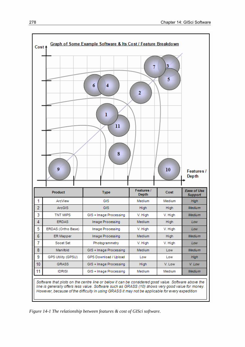
278 Chapter 14: GISci Software
Figure 14-1 The relationship between features & cost of GISci software.
Field Techniques: GIS, GPS and Remote Sensing 279
This relationship is only the most basic expression of the value of software to an expedition. Software that is very inaccessible to an expedition or requires considerable time and effort to learn may not be suitable. As many team members as possible should be capable of manipulating the software. It is not acceptable to run an expedition with a single user proficient in the use of the software. Therefore, software selection should take into account the usability of the program. As an example an area where this principal has been used and refined is in industry.
In industry, software is selected on two basic foundations; initial cost and total cost of ownership. Initial cost represents the cost to purchase software. Total cost of ownership (TCO) reflects the cost to train staff and implement and run the software over a long period of time. TCO is often much more costly than the upfront payment for the program. TCO includes possible lost productivity due to software downtime and the man-hours involved in setting up the system. An expedition should be run with a similar thought process. The significant difference between industry and expedition software requirements is the time available. Though it may be a clichéd statement, in industry ‘time is money’. The time taken to set up software and the delay in getting a return on the investment is a major cause for concern. Because staff time is expensive and delays can cause problems in a business environment, it is generally more practical for a business to invest more heavily in the initial cost than suffer increased overall TCO. In an expedition where money is usually very tight but timeframes are longer, personnel time is unlikely to be as great a contributor to cost of the project as it is in industry, where staff on training courses still have to be paid a salary. An expedition can spend longer deciphering software in advance and spend time that would be un-economical in a standard business model, however, the expedition should be careful when employing this methodology.
Industry selects software that is accessible and quick to deploy and reap benefits from. This explains the continued proliferation of Windows software in a market that would seem to favour a LINUX deployment. In an expedition environment it is possible to stray from the standard model to a degree. However, the expedition should not lose sight of its primary goal which should never be software led. The expedition will have many goals and objectives and learning software should not be one of them. For that reason very difficult to learn software should not be selected purely based on cost.
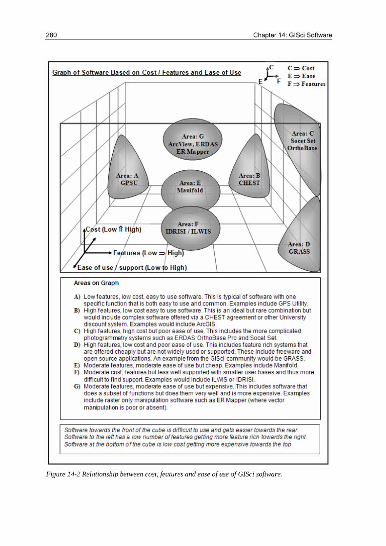
Figure 14-2 shows this relationship in a basic 3-axis cube. In this diagram software such as GRASS, which plots very favourably in Figure 14-1, no longer looks as attractive. Software in Figure 14-2 that plots towards the front of the cube is inaccessible. Software that plots towards the right of the cube has many features and a complexity to its functions. Software that plots towards the top of the cube is expensive. Many expeditions spend an inordinate amount of time attempting to obtain software either for free or for as little as possible. This approach often fails to work and the expedition is left without the means to fulfil its goals. Though expeditions have time to learn and obtain software; the business model should never be forgotten. Often it is worth investing some money in software to alleviate the problems of complexity or unsupportable systems.
280 Chapter 14: GISci Software
Figure 14-2 Relationship between cost, features and ease of use of GISci software.
Field Techniques: GIS, GPS and Remote Sensing 281
Before discussing GIS software, this chapter will describe software for collecting GISci data and formatting it for inclusion in GIS.
14.2 Software for GPS data retrieval When the GPS field data have been collected, it is a good precaution to make back-up copies. Back-up by hand is usually unfeasible, so a digital connection to the GPS or surveying equipment is the standard method. To download GPS co-ordinates into any computer for use in a GIS requires a cable to connect the two together. This usually consists of a 9 pin serial cable (RS232) on the PC side and a special connection on the GPS. It is wise to ensure that the expedition laptop, if there is one, has a serial port because many newer laptops no longer have these ports as standard. The following websites offer information on connecting to various GPS models.
• Wolfe’s GPS cables: www.gpscables.com • GPS-PC connectors: pfranc.com • Joe Mehaffey’s GPS information page: www.gpsinformation.net
If a laptop computer is available in the field then GPS data can be accessed directly. A very cheap way to do this is to use software bundled with Microsoft Windows, such as HyperTerminal. Though this is probably the cheapest way for an expedition to collect data, it is inefficient and requires a constant connection to a PC. It may, however, be a good solution if the expedition is spending a long time travelling and the PC can be powered from the vehicle adapter. A description of how to use HyperTerminal for GPS connections is included in the appendix.
There are several products on the market to connect to a GPS and download stored data. These range from freeware utilities, easy to code software solutions, inexpensive software and software plug-ins for major software. For expedition use, this chapter will concentrate on inexpensive software designed to upload and download GPS waypoints and trackpoints. Two of the most popular download programmes are OziExplorer and GPS Utility. Both of these are for the PC but a popular Mac alternative is GPSy. GPSy has a large user base and is popular. A standard user license of GPSy retails for US $50 but student licenses can be obtained for US $30. More information can be found at www.gpsy.com. GPS Utility is used in many of the examples in this manual and is the software used in the RGS-IBG training weekends. The most recent version released on 20 December 2004 is Version 4.15. This is a 1.57Mb download from www.gpsu.co.uk. This version is a 32-bit application for Win 9x, NT and XP. There is also a 16-bit version called GPS Utility-Lite (GPSU-LT) for use on Windows 3.1.
OziExplorer is a more in-depth package with several modules for use on laptops, PDAs and for generating 3D terrains. The basic package costs $85.00 US (+VAT). OziExplorer is a 4.7 Mb download from www.oziexplorer.com. The OziExplorer3D add-on to the OziExplorer software costs US$30.00 (+VAT) while the handheld version, OziExplorerCE retails for US $30. OziExplorerCE is an add-on to the major product. To get the full use of OziExplorerCE you must have a full purchased copy of OziExplorerCE and a full purchased copy of PC OziExplorer. OziExplorerCE runs on PocketPC and Windows CE PDA's but relies on map calibrations from the PC version.
282 Chapter 14: GISci Software
Though OziExplorer is a more advanced software package than GPS Utility, it is often better to select packages that perform single operations well, rather than those that attempt to span several functions. All of OziExplorer’s functions can be replicated better in the expedition’s main GIS. If, however, a main GIS is not being used then a product like OziExplorer is an excellent choice. Selecting GPS integration software depends on the larger picture of all the expedition’s software. If a fully featured GIS is used then select cheap and simple GPS software. If a full GIS is not available select a GPS tool with added functionality.
14.3 Software for terrain visualisation Many GIS packages come with advanced 3D terrain visualisation modules. Some suppliers will charge extra for this and the cost might put it beyond many expeditions. In these cases there are an increasing number of free or cheap packages that can work in partnership with the GIS to produce 3D views.
3DEM is a freeware programme for visualising 3 dimensional datasets such as NASA’s SRTM data. The most recent version of the software, 18.9, can be downloaded from www.visualizationsoftware.com. The software can even take in the raw unpatched SRTM and fill the holes. The download size is 5.8 Mb. GPS data can be used on the maps and fly-throughs can be created. 3DEM uses the OpenGL libraries for high speed 3D rendering and will render 24 bit colour three-dimensional projections. These can be displayed either in perspective views, red-blue projections requiring red-blue 3D glasses, or colour 3D projections requiring Liquid Crystal Shutter (LCS) electronic shutter glasses for viewing. Another 3D visualisation package is Manifold 3D View Studio. Manifold is a full-blown GIS software package reviewed in Section 14.5. Though modern versions (5+) have 3D capabilities, earlier versions lacked this capability. To rectify this a separate module was developed and released as a standalone product. The capabilities of 3D View are beyond those of 3DEM but the software carries a US$75 price tag. The one advantage of 3D View over 3DEM beyond the advanced textures and animations is that 3D View can plot none surface data. This means it can be used as a 3D graphing tool for any dataset.
14.4 Remote sensing / image processing software There are many software packages that can handle image processing. Anything from a basic image editor, such as the free Microsoft PhotoEditor, can enhance brightness, contrast and gamma but dedicated remote sensing software is the only real solution for scientific analysis. If cost is a real consideration and no access is available to high-end packages, then any professional graphics-processing package that allows histogram manipulation is an acceptable, though not perfect, option. Examples of this may include Corel Photo-Paint or PaintShop Pro.
There are two or three problems with this form of image processing. The first is that the image formats supported by these packages are different to the standard GIS and remote sensing standards. Though TIF files are supported in most professional applications, GIS sometimes require more complex data types, often including meta-data. There are also more efficient data storage solutions that are not supported, such as ERMapper’s .ECW and .ERS formats and MrSid compression routines. Many GIS packages will only work
Field Techniques: GIS, GPS and Remote Sensing 283
with .BIL and other binary formats not supported in graphics processing suites. The second problem is that some of these graphics packages are not designed to deal with very large images. A programme such as ERMapper or ERDAS Imagine could open a 1 Gb image almost instantly, a task that would render a PC running a ‘Paint’ application unresponsive for a significant period of time. This is because remote sensing packages are designed to deal with large data sets by building ‘pyramids’. Pyramids are views of an image at various scales and help a programme switch views very efficiently. They also segment large image files into subsets which are indexed, allowing rapid transit to the pertinent section of files, an approach that cheap or free graphics software does not use.
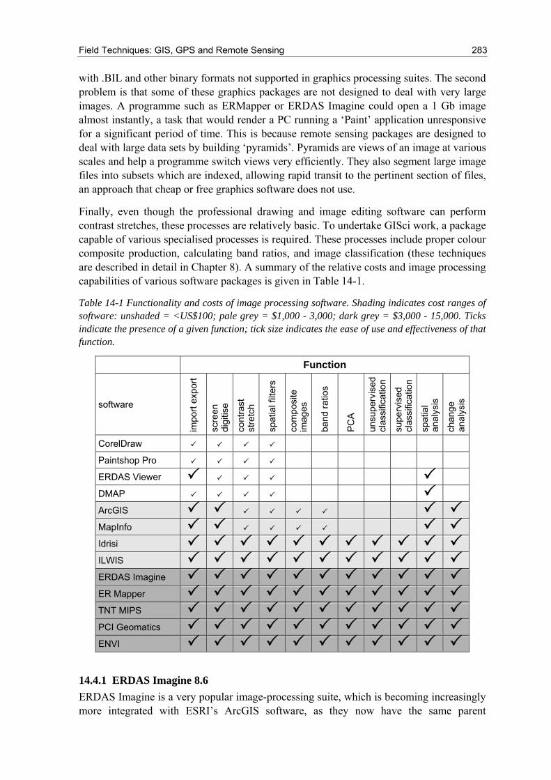
Finally, even though the professional drawing and image editing software can perform contrast stretches, these processes are relatively basic. To undertake GISci work, a package capable of various specialised processes is required. These processes include proper colour composite production, calculating band ratios, and image classification (these techniques are described in detail in Chapter 8). A summary of the relative costs and image processing capabilities of various software packages is given in Table 14-1.
Table 14-1 Functionality and costs of image processing software. Shading indicates cost ranges of software: unshaded = <US$100; pale grey = $1,000 - 3,000; dark grey = $3,000 - 15,000. Ticks indicate the presence of a given function; tick size indicates the ease of use and effectiveness of that function.
Function
software
impo
rt ex
port
scre
en
digi
tise
cont
rast
st
retc
h
spat
ial f
ilter
s
com
posi
te
imag
es
band
ratio
s
PC
A
unsu
perv
ised
cl
assi
ficat
ion
supe
rvis
ed
clas
sific
atio
n
spat
ial
anal
ysis
chan
ge
anal
ysis
CorelDraw
Paintshop Pro
ERDAS Viewer
DMAP
ArcGIS
MapInfo
Idrisi
ILWIS
ERDAS Imagine
ER Mapper
TNT MIPS
PCI Geomatics
ENVI
14.4.1 ERDAS Imagine 8.6 ERDAS Imagine is a very popular image-processing suite, which is becoming increasingly more integrated with ESRI’s ArcGIS software, as they now have the same parent
284 Chapter 14: GISci Software
company, Leica Geosystems. ERDAS Imagine is a major competitor to ERMapper but offers more functionality through a series of additional programmes and plugins. Imagine has plugins for DEM generation whereas ERMapper can simply display 3D images. The package required for 3D viewing is VGIS. Imagine is expensive, but is available at much lower cost to universities through the CHEST agreement. There are many different licenses for ERDAS Imagine, from a basic package called Essentials, up to the more complete Professional version. A further very expensive plugin for Imagine, called OrthoBase Pro, enables full photogrammetric functionality, including DEM generation from aerial photography and suitable remotely sensed datasets.
14.4.2 ER Mapper 6.4 This is a popular piece of software for image processing, produced by Earth Resource Mapping. It became popular in the mid 1990s due to its revolutionary storage system. Unlike other image processing packages of the time, ERMapper stored ‘algorithms’, which were very small text files that told the programme how to process the original image. By doing this, it meant that the system did not have to store a second re-processed image and stored only the original and a series of small text files to re-create large images. By contrast, competitors’ software would need to store the original image as well as a number of copies all at the same size. This made saving very slow and back when hard drive space was at a premium it meant that very few images could be created. When considering the smaller size of hard drives on expedition PCs (see Chapter 13) this method may be an advantage. The main disadvantage to this approach is that a complex process may have to be run every time an image is called up, making image display slow, especially on low specification processor PC’s. ER Mapper also has a proprietary, very powerful wavelet compression algorithm that can compress images very rapidly with an acceptable level of detail loss, assuming manual interpretation is the only use to which the image is put. This format is known as ECW. Older versions of ArcView support .ECW as does Manifold. ERMapper also has a sophisticated webserver for displaying very large images across the Internet. The software is very user-friendly and CHEST licences exist through universities.
14.5 GIS software When selecting GIS software, the most important consideration for an expedition will be the cost of the package. With professional GIS solutions costing up to £5,000 and image processing suites at around the same price, an expedition may find affording these solutions very difficult. There are a number of ways of mitigating these costs, such as academic licenses and the UK CHEST agreement. However, it is important to understand some of the costs that may normally be overlooked in expedition planning. The cost of purchasing software is only one cost. There are time and money costs in learning the software and time costs in uploading data. Due to the high cost of time in the field it is better to have a reliable and easy to use solution so that unnecessary time is not spent working with the system instead of doing fieldwork. It is better to use a system you are familiar with or can easily get support for, than to try and use a cheap but unsuitable tool. The payback in terms of field time will be well worth the investment. Having said this, expeditions generally have a long time to plan the work before leaving for the field. The weeks before the field trip could be spent getting familiar with the software. Either way, it
Field Techniques: GIS, GPS and Remote Sensing 285
is imperative that once in the field, the team can work with the software as efficiently as possible.
14.5.1 ArcView 3.x and ArcGIS 8.x/9.x This very popular GIS software is provided by ESRI and is as close to an industry standard as it is possible to get in a very competitive market. ESRI used to be compatible with ERMapper and supported both .ERS and .ECW files, but this is becoming less valid as ESRI moves more to support *IMG files and MrSid compression. That said, ERMapper can export other more standard file formats, which can be loaded by all GIS packages, meaning that matching GIS and image processing software is still not critical.
ESRI’s software is now known as the ArcGIS suite. Until recently ESRI’s software came in two distinct packages, ArcView and ArcInfo. ArcView was a desktop package with limited raster and analytical capabilities. ArcInfo was the more powerful of the two but was predominantly command-line based. In 2001, these two packages were replaced by a single product called ArcGIS8, which has three levels of functionality: ArcView, ArcEditor and ArcInfo. The user interface is the same across all these levels, the difference being the functionality increases from ArcView to ArcInfo, as does the cost. The software interface for all levels consists of three components: ArcCatalog, ArcToolbox and ArcMap. ArcCatalog is designed for managing geo-datasets and various metadata types either locally or from networked databases. It works in a similar manner to Windows Explorer but is significantly more sophisticated. ArcToolbox is an analytical interface designed for various geoprocessing applications. ArcMap is the interface for displaying the spatial data. ArcMap allows spatial queries and the application of various analytical techniques to both raster and vector datasets, although an add-in may need to be purchased to fully manipulate raster data. ArcGIS can also deal in a basic way with imagery, allowing histogram manipulation and application of some basic stretches.
ArcView 3.3 is still supported and is a good start for expeditions requiring a good GIS solution, as it is sold at a significantly lower price. Older versions of ArcView are available for free download (see www.esri.com). ArcView 3.x is the GIS solution seen in many of the screenshots of this manual and is the package taught at the EAC workshops hosted by the authors. ESRI run a web-based GIS training system: the ‘virtual-campus’. Access to introductory tutorials is free, but a charge is made for more advanced tutorials. Many of these can be accessed free for CHEST users.
The disadvantage of ESRI software for expeditions is the expense. A complete ArcGIS installation would cost many thousands of pounds depending on the level of functionality (ArcView, ArcEditor, ArcInfo) and a basic copy costs £1,500. Fortunately, if the expedition is associated with a University then a complete ArcGIS ArcInfo install can be obtained for around £130 through the CHEST agreement (depending on the package opted for by the University). The Chest version can be installed on a single PC but requires a license code file from ESRI and may need a hardware dongle on the back of the PC. This severely restricts the expedition’s ability to re-install onto a second PC if there is a problem in the field. ArcView 3.x is still sold and supported and can usually still be obtained, though most Universities have switched to ArcGIS 8.x or 9. The advantage of ArcView 3.x is its single interface and development environment, and many free add-ins being available from ESRI’s website (written in Avenue, a proprietary development language).
286 Chapter 14: GISci Software
ArcGIS add-ins are also available as free downloads from ESRI; numbers are limited, mainly because the development environment for ArcGIS is Visual Basic and many users still have to get to grips with such a fundamental change, however, this is changing quickly. ArcGIS cannot be installed on Windows 95 or 98 and can take up to 2 Gb (although a typical installation including sample datasets is ~500 Mb), which is a major consideration if an older PC is used as the expedition computer. ArcView 3.x requires significantly less space, with a complete install (not including sample data) requiring 100 Mb, and runs on older versions of Windows. The system requirements are also substantially less for ArcView 3.x, which was designed in the late 1990s (when a high specification PC was a Pentium II 300MHz).
If you are considering purchasing ArcGIS, but would like to see what it is capable of before spending the capital, ESRI produce a tutorial book, Getting to Know ArcGIS. This includes a fully functional demonstration copy of the software, licensed for six months, and costs about £55 - an excellent way to gain access to commercial software for a real evaluation of its usefulness.
14.5.2 GRASS (Geographic Resources Analysis Support System) GRASS is described as the world’s leading free GIS solution. It is an open source code download and compile only solution. The system was developed in 1982 by the US Army Construction Engineering Research Laboratories (USA-CERL). It was designed as a land planning and management tool. Subsequently it has emerged as a competent and reliable GIS package. A network of worldwide developers continually updates the software as part of an open source development arrangement. The current release at the time of writing is GRASS 5 (5.0.2 released 10 April 2003). Version 5 has increased the Windows PC compatibility, but a number of features have yet to be ported from LINUX and UNIX. The software is only available for NT and similar versions of Windows (NT, Win2000 and XP) but not all modules of the software are guaranteed to work under a Windows environment. The software is free to download and is provided under the GNU General Public License (GPL). GRASS is very popular in the academic world, but also has many uses in both commercial and government arenas. The relative complexity of setting up a GRASS system has limited its further spread.
GRASS is a raster/vector GIS with image processing facilities. It can manage and store many types of spatial data. GRASS combines both an intuitive Windows interface as well as the more powerful command line interface. This flexibility makes it a very popular solution, even though some commercial GIS solutions have moved away from this approach. The main programme has over 350 programmes and tools to render maps and images and has a continuous influx of new features developed by the open source community. The software can be downloaded from www.grass.itc.it and is available for a variety of operating systems in one of two formats, Binary and Source Code. Binaries are zipped compiled programmes that are easier to begin using for the novice, but lack the expandability and flexibility of pure source code. Source code on the other hand requires compiling, but is required to develop GRASS extensions or to run GRASS on less standard platforms. Precompiled binaries exist for GNU/Linux, Mac OSX and Windows NT. The windows download is a 40Mb zipped download. The Windows PC version is still in development and 9x and ME are not supported. GRASS is a powerful package, but very
Field Techniques: GIS, GPS and Remote Sensing 287
difficult for new users to get started in. There are many downloadable manuals for using the system and for getting it started, but the software is not widely used.
14.5.3 IDRISI IDRISI is a popular GISci package sold by Clark Labs: it has a very long pedigree and is used in many universities. IDRISI is not an anagram; it is named after a pioneering 12th Century Muslim map-maker, Abu Abd Allah Muhammed al-Idrisi. The latest version is the 14th edition of the software package, which was originally released in 1987, part of a joint initiative between Clark University, USA, and the United Nations Institute for Training and Research (UNITAR). The software became popular due to its low pricing and well-rounded functionality: it has the most extensive set of GIS and Image Processing tools in a single, low-cost package. The latest release, named Kilimanjaro, has over 200 modules and offers a large set of tools. Clark Labs also publish CartaLinx. CarataLinx is a 32-bit spatial database tool that can capture data from input devices, as well as from existing GIS and databases. This makes IDRISI very compatible with existing GISs that the expedition may have access to, such as ArcView, ArcInfo and MapInfo.
IDRISI is popular because of the complete solution offered by a single package reducing the need for an expensive dedicated image-processing suite. IDRISI was among the first to offer this multi-featured approach, but is no longer unique, with both GRASS and Manifold offering similar solutions. Another major advantage of IDRISI is in the set of easy to use tutorials that come with the package, as well as an extensive collection of case-study based tutorials that can be purchased separately. Modern versions of IDRISI are competitively priced in the GISci market, but probably too expensive for most expeditions. The pricing has increased in recent times, as the company has attempted to manoeuvre into the commercial world as well as the academic. Clark Laboratories offer special prices for students and non-profit organisations (Table 14-2); further details can be found at their website (www.clarklabs.org). In the UK IDRISI is available via the CHEST agreement, so more competitive prices may be available through a local university.
Table 14-2 IDRISI pricing system.
license cost notes
General $995 Standard install
Student $250 For full time students
Student Starter $95 One year time limited release
14.5.4 ILWIS (Integrated Land Water Information System) ILWIS began as a government-funded research project at the Dutch international centre for applied remote sensing, ITC, in 1984. The original DOS-based GIS software was superseded by a Windows version in 1996. In 1998 PCI Geomatics (a large photogrammetry company) became a partner with ITC. ILWIS 3.2 is the latest version, released in 2004. This release marked a change from the more commercialised direction the company had been pursing in recent years to an academic one. Previously there were two different licenses but these were merged in 2004 into a single license costing just €100.
288 Chapter 14: GISci Software
The company boasts that over 5000 licences have been sold, but this is a very small market share compared to either ArcGIS or IDRISI. The ILWIS website at www.itc.nl offers some good tutorials, though finding further support for the product maybe difficult, due to its limited user base. The academic licenses can be obtained through ITC via their website or through PCI for corporate licences.
The advantage of ILWIS is that it supports both image processing and GIS applications. ILWIS 3.11 onwards is particularly useful, as it allows the software to pull in both Level 1a and 1b ASTER data. This will be of particular interest to expeditions who may be struggling to import ASTER *.hdf files into other applications. The ability to combine both remote sensing and GIS analysis for a very low price (€100 via ITC) makes ILWIS a very attractive GIS solution. ILWIS is considered a cheap and easy to use GIS solution for expeditionary fieldwork.
14.5.5 Manifold This is a professional GIS package that is trying to change the way GIS is sold and distributed. By developing code from the ground up with no legacy software Manifold.Net, the company behind the GIS, believes it can offer a more efficient and substantially cheaper GIS solution than any competitor. The software is developed purely for Microsoft Windows with no Unix, Linux or MacOS support. Though this is a disadvantage to some users, it means the company can focus on developing a package cost effectively for the majority of users.
Manifold is a well-rounded package with a very good selection of projections and image converters. The system also features very powerful image processing facilities beyond those normally found in a GIS package. Manifold retails at US$245 but there is no student agreement to reduce this cost. It is, however, the cheapest commercially oriented GIS available. A large source of Manifold.Net’s income comes from its support lines. Whereas ESRI offer 1 year’s free support with a copy of ArcGIS, Manifold’s support can be expensive. Any contact with Manifold.Net requiring an answer will be charged for and even asking for confirmation of a bug in the Manifold system costs around US$50. This is before any attempt is made by the company to address the problem. Ordering the software outside the US is done via the website www.manifold.net.
Manifold uses ECW compression as its standard imaging format over competitors such as MrSid. The latest version is 5.50 and Service Pack 1 for 5.50 was released in June 2003. One advantage of Manifold is its support for COM and Active X allowing standard languages such as C++ and Visual Basic to be used to develop it. This is a significant advantage over proprietary languages such as MapBasic, AML and Avenue. Though Manifold is not a client/server solution like some of its competitors, it can support accessing files located on remote servers. Manifold is becoming a popular GIS package and its functionality is continually growing.
14.5.6 MapInfo This is a well-developed professional package, designed for offering business solutions to corporate clients. It features all the standard GIS tools but its primary focus is towards business not fieldwork. The main product offered by the company is MapInfo 7.8 but various other GIS tools are available to help analyse location-based data. The website is
Field Techniques: GIS, GPS and Remote Sensing 289
very professional and the company has continued to develop its presence and GIS software since inception in 1986. Quoting a price for the product is difficult because of the number of tailored solutions the company offers. There is, however, a version available via the CHEST agreement.
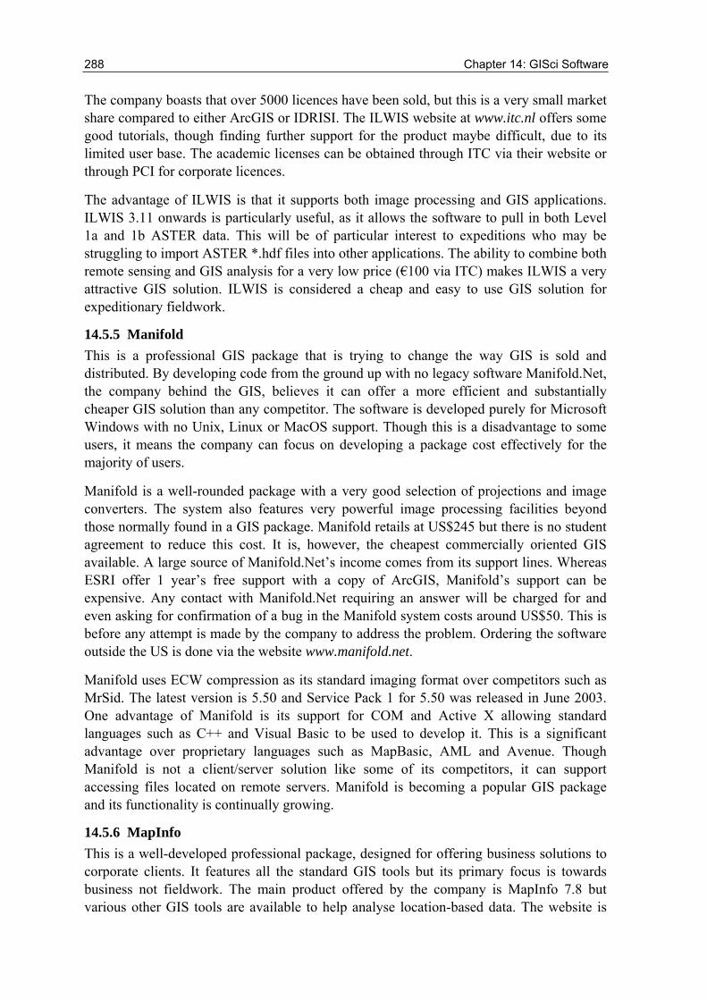
14.6 Very low cost software Cost is most commonly the deciding factor in selecting software but ease of use and the level of assistance available should also be considered. Being forced to use a difficult system with no help available because of economic decisions should be avoided. If the expedition cannot acquire any software for economic viability reasons, there are some very cheap alternatives that offer some of the benefits of a full-blown GIS. There is a cut-down version of ER Mapper called ER Viewer, which allows users to open .ERS and .ECW images and do very basic analysis. A better solution is ERDAS View Finder, which allows the import of many image formats and, notably, the re-projection of image data. Figure 14-3 shows just how effective ERDAS View Finder can be when examining Landsat data.
Figure 14-3 Use of ERDAS Viewfinder to examine Landsat TM imagery of the Western Sahara, SW Mauritania. Top left, the full Landsat scene (c. 180 km x 170 km), geocorrected to the local UTM map projection. The selected TM band combinations highlight sand dunes (North) and evaporite deposits (South), as well as NNW-SSE trending rock formations. Right: detail of the window in the previous image, showing a granitic intrusion and its associated annular drainage system. Bottom left: detail of the window on the granitic terrain, showing vegetation along the valley floors. (Imagery provided by the Office Mauritanien de Recherches Geologiques and the Japanese International Cooperation Agency).
290 Chapter 14: GISci Software
Other inexpensive software is the freeware MultiSpec downloadable from Purdue University at http://dynamo.ecn.purdue.edu/~biehl/MultiSpec or available on the CD accompanying this manual. A tutorial for using MultiSpec for Landsat combined with 3-DEM for SRTM is also included on the CD.
A recent development in applied GIS software is the introduction of rich content Internet based data servers. These servers offer both global raster and vector data. The principal versions include Google Earth (http://earth.google.com), MSN Virtual Earth (http://virtualearth.msn.com) and NASA World Winds (http://worldwind.arc.nasa.gov). These are both exciting and interesting developments in the GISci world and have come about since mid 2005. They are, however, currently extremely limited and the reader should read through the caveats listed below with care.
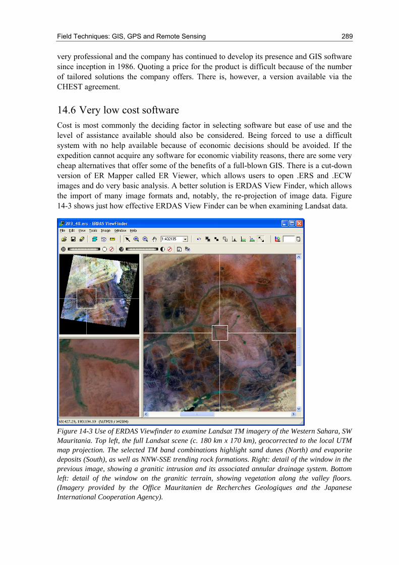
The first significant advantage of these data sources is that they are free. Google Earth is perhaps the most sophisticated and is based around a product called KeyHole acquired by Google in late 2004. Google Earth featured heavily in the press due to impressive images of urban areas such as the one shown in Figure 14-4. As can be seen the high resolution 2D data raster layer has a 3D vector layer of buildings. These views are currently limited to 38 major US cities and are of limited use to expeditions, but they show the potential power of an ever developing system.
Figure 14-4 3D View of New York Manhattan Island
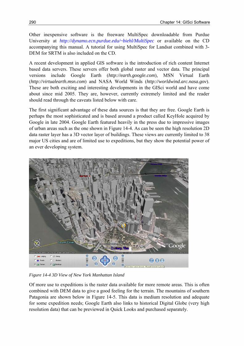
Of more use to expeditions is the raster data available for more remote areas. This is often combined with DEM data to give a good feeling for the terrain. The mountains of southern Patagonia are shown below in Figure 14-5. This data is medium resolution and adequate for some expedition needs; Google Earth also links to historical Digital Globe (very high resolution data) that can be previewed in Quick Looks and purchased separately.
Field Techniques: GIS, GPS and Remote Sensing 291
Figure 14-5 Glaciers in the South American Andes from Google Earth shown in 3D.
Additional benefits of Google Earth include locating urban regions near to the expedition’s chosen study areas. By selecting the airport layer the party can very quickly locate the easiest way into and out of the area. GPS points can be uploaded into Google Earth but to take full advantage of this system requires a nominal annual subscription of US$20.
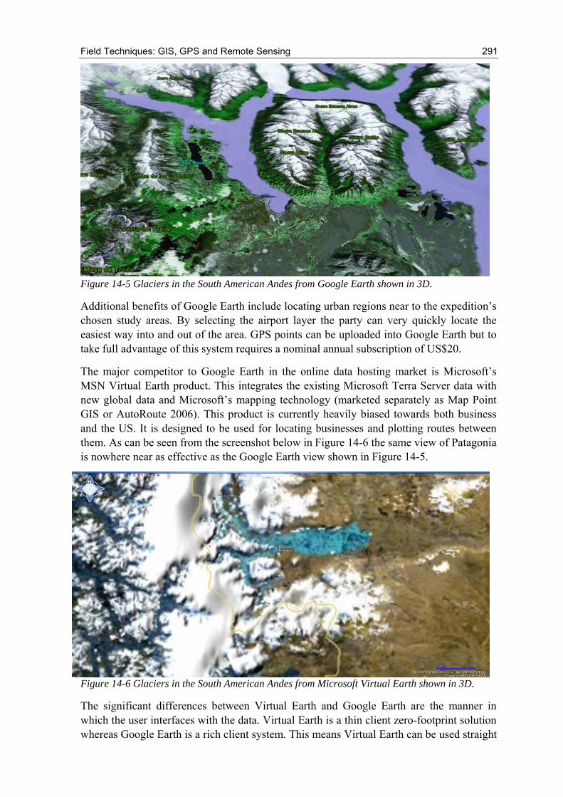
The major competitor to Google Earth in the online data hosting market is Microsoft’s MSN Virtual Earth product. This integrates the existing Microsoft Terra Server data with new global data and Microsoft’s mapping technology (marketed separately as Map Point GIS or AutoRoute 2006). This product is currently heavily biased towards both business and the US. It is designed to be used for locating businesses and plotting routes between them. As can be seen from the screenshot below in Figure 14-6 the same view of Patagonia is nowhere near as effective as the Google Earth view shown in Figure 14-5.
Figure 14-6 Glaciers in the South American Andes from Microsoft Virtual Earth shown in 3D.
The significant differences between Virtual Earth and Google Earth are the manner in which the user interfaces with the data. Virtual Earth is a thin client zero-footprint solution whereas Google Earth is a rich client system. This means Virtual Earth can be used straight
292 Chapter 14: GISci Software
through a web browser such as Internet Explorer while Google Earth requires a moderate download (10.5 Mb) and installation even before the data can be accessed. The actual data needs to be streamed across the Internet and requires a broadband link and a powerful PC with a 3D accelerated graphics card. There are a number of other issues with the software and more importantly the data served by these applications. There is no information in Google Earth about the age of the data. The Google Earth homepage says the data should be no more than three years old but this is not guaranteed. There is also no information on the seasonal aspects of the data. This means that an expedition could plan around water supplies that turn out to be ephemeral and not present during the actual fieldwork. The expedition would be far better served by traditional data suppliers who can offer superior information on the temporal nature of the data. Also, the data is only presented in true colour with no scope for multispectral analysis. Used carefully on a powerful PC with a broadband connection Google Earth makes a useful first stage planning tool. If in the future the data provided is of a higher resolution, across more of the world and more meta-data is supplied then it could be useful enough to replace some of the more traditional GISci software.
NASA World Winds is slightly different to either Google Earth or Virtual Earth. It too is a rich client solution and requires a 53 Mb download for the browser. Like Google Earth the system requirements are high and for the SRTM 3D views a modern 3D accelerated graphics card is essential. The current version 1.3.3.1 (25 October 2005) has the advantage over Google Earth in that it has data for every month of the year so seasonal changes can be assessed. It also has the ability to upload daily temperature and environmental information into its database. The data is a base of MODIS data with Landsat 7 ETM+. Areas of the US are available with 0.25 m resolutions with other high resolution data available where licensing restrictions allow.
14.7 Summary A field project can succeed or fail to achieve its aims depending on choices made very early in the planning process and a critical area for success may well be software used for data collection and analysis in the field. Many projects fail to devote sufficient attention to this subject and suffer accordingly. A little time spent making informed decisions, underpinned by testing and careful review of the options available, can mean the difference between achieving more than your aims and failing to meet any of them. Software is no exception to this. If you are not sure of the issues involved with a specific piece of software that seems ideal for your project, then asking the Expedition Advisory Centre for advice.
Field Techniques: GIS, GPS and Remote Sensing 293
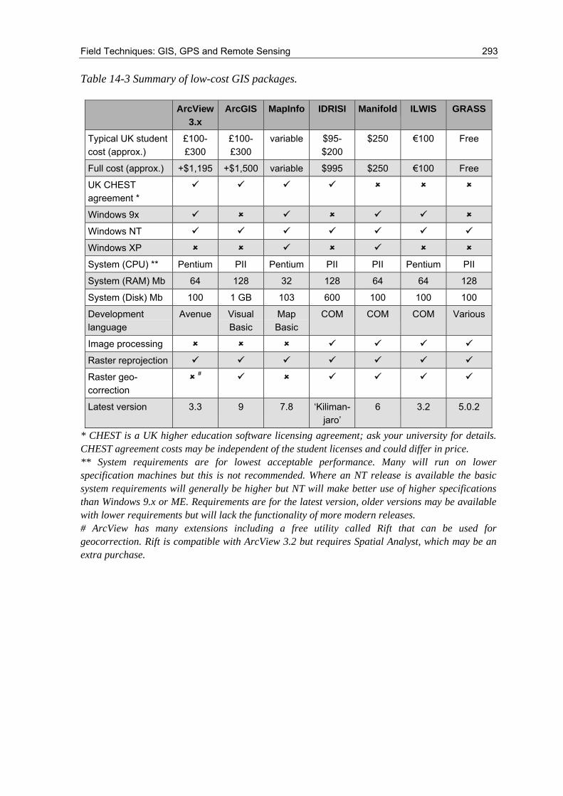
Table 14-3 Summary of low-cost GIS packages.
* CHEST is a UK higher education software licensing agreement; ask your university for details. CHEST agreement costs may be independent of the student licenses and could differ in price. ** System requirements are for lowest acceptable performance. Many will run on lower specification machines but this is not recommended. Where an NT release is available the basic system requirements will generally be higher but NT will make better use of higher specifications than Windows 9.x or ME. Requirements are for the latest version, older versions may be available with lower requirements but will lack the functionality of more modern releases. # ArcView has many extensions including a free utility called Rift that can be used for geocorrection. Rift is compatible with ArcView 3.2 but requires Spatial Analyst, which may be an extra purchase.
ArcView 3.x
ArcGIS MapInfo IDRISI Manifold ILWIS GRASS
Typical UK student cost (approx.)
£100-£300
£100-£300
variable $95-$200
$250 €100 Free
Full cost (approx.) +$1,195 +$1,500 variable $995 $250 €100 Free
UK CHEST agreement *
Windows 9x
Windows NT
Windows XP
System (CPU) ** Pentium PII Pentium PII PII Pentium PII
System (RAM) Mb 64 128 32 128 64 64 128
System (Disk) Mb 100 1 GB 103 600 100 100 100
Development language
Avenue Visual Basic
Map Basic
COM COM COM Various
Image processing
Raster reprojection
Raster geo-correction
#
Latest version 3.3 9 7.8 ‘Kiliman-jaro’
6 3.2 5.0.2

294 Chapter 14: GISci Software