field reconnaissance geologic mapping of the columbia hills, mars, based on mars exploration rover...
TRANSCRIPT

Field reconnaissance geologic mapping of the Columbia Hills,Mars, based on Mars Exploration Rover Spiritand MRO HiRISE observations
L. S. Crumpler,1 R. E. Arvidson,2 S. W. Squyres,3 T. McCoy,4 A. Yingst,5 S. Ruff,6
W. Farrand,7 Y. McSween,8 M. Powell,9 D. W. Ming,10 R. V. Morris,10 J. F. Bell III,3
J. Grant,4 R. Greeley,6 D. DesMarais,11 M. Schmidt,12 N. A. Cabrol,11 A. Haldemann,13
Kevin W. Lewis,14 A. E. Wang,2 C. Schröder,15,16 D. Blaney,9 B. Cohen,17 A. Yen,9
J. Farmer,6 R. Gellert,18 E. A. Guinness,2 K. E. Herkenhoff,19 J. R. Johnson,20
G. Klingelhöfer,20 A. McEwen,21 J. W. Rice Jr.,22 M. Rice,3 P. deSouza,23 and J. Hurowitz9
Received 30 September 2010; revised 24 January 2011; accepted 11 March 2011; published 6 July 2011.
[1] Chemical, mineralogic, and lithologic ground truth was acquired for the first timeon Mars in terrain units mapped using orbital Mars Reconnaissance Orbiter’s HighResolution Imaging Science Experiment (MRO HiRISE) image data. Examination ofseveral dozen outcrops shows that Mars is geologically complex at meter length scales, therecord of its geologic history is well exposed, stratigraphic units may be identified andcorrelated across significant areas on the ground, and outcrops and geologic relationshipsbetween materials may be analyzed with techniques commonly employed in terrestrialfield geology. Despite their burial during the course of Martian geologic time bywidespread epiclastic materials, mobile fines, and fall deposits, the selective exhumation ofdeep and well‐preserved geologic units has exposed undisturbed outcrops, stratigraphicsections, and structural information much as they are preserved and exposed on Earth.A rich geologic record awaits skilled future field investigators on Mars. The correlationof ground observations and orbital images enables construction of a correspondinggeologic reconnaissance map. Most of the outcrops visited are interpreted to bepyroclastic, impactite, and epiclastic deposits overlying an unexposed substrate, probablyrelated to a modified Gusev crater central peak. Fluids have altered chemistry andmineralogy of these protoliths in degrees that vary substantially within the same map unit.Examination of the rocks exposed above and below the major unconformity between theplains lavas and the Columbia Hills directly confirms the general conclusion from remotesensing in previous studies over past years that the early history of Mars was a time ofmore intense deposition and modification of the surface. Although the availability of fluidsand the chemical and mineral activity declined from this early period, significant latervolcanism and fluid convection enabled additional, if localized, chemical activity.
Citation: Crumpler, L. S., et al. (2011), Field reconnaissance geologic mapping of the Columbia Hills, Mars, based on MarsExploration Rover Spirit and MRO HiRISE observations, J. Geophys. Res., 116, E00F24, doi:10.1029/2010JE003749.
1New Mexico Museum of Natural History and Science, Albuquerque,New Mexico, USA.
2Department of Earth and Planetary Sciences, Washington University,St. Louis, Missouri, USA.
3Department of Astronomy, Cornell University, Ithaca, NewYork, USA.4National Museum of Natural History, Smithsonian, Washington, D. C.,
USA.5Planetary Science Institute, Tucson, Arizona, USA.6School of Earth and Space Exploration, Arizona State University,
Tempe, Arizona, USA.7Space Science Institute, Boulder, Colorado, USA.8Department of Earth and Planetary Sciences, University of Tennessee,
Knoxville, Tennessee, USA.9Jet Propulsion Laboratory, Pasadena, California, USA.
10Johnson Space Center, Houston, Texas, USA.11NASA Ames Research Center, Moffett Field, California, USA.12Department of Earth Sciences, Brock University, St. Catharines,
Ontario, Canada.13ESA/ESTEC, Noordwijk, Netherlands.14Division of Geological and Planetary Sciences, California Institute of
Technology, Pasadena, California, USA.15Center for Applied Geoscience, Universität of Bayreuth and Eberhard
Karls Universität, Tübingen, Germany.16Now at Johnson Space Center, Houston, Texas, USA.17NASA Marshall Spaceflight Center, Huntsville, Alabama, USA.18Department of Physics, University of Guelph, Guelph, Ontario, Canada.19U.S. Geological Survey, Flagstaff, Arizona, USA.20Institut für Anorganische und Analytische Chemie, Johannes
Gutenberg‐Universität, Mainz, Germany.21Lunar and Planetary Lab, University of Arizona, Tucson, Arizona, USA.22NASA Goddard Space Flight Center, Greenbelt, Maryland, USA.23Tasmanian ICT Centre, CSIRO, Hobart, Tasmania, Australia.
Copyright 2011 by the American Geophysical Union.0148‐0227/11/2010JE003749
JOURNAL OF GEOPHYSICAL RESEARCH, VOL. 116, E00F24, doi:10.1029/2010JE003749, 2011
E00F24 1 of 55
1. Introduction
[2] The traverse through the Columbia Hills by the MarsExploration Rover (MER) Spirit began on the 156th sol afterlanding [Arvidson et al., 2006, 2008; Squyres et al., 2006](Figure 1a). The crossing of the contact between the lavaplains and the older Columbia Hills represents an historicfirst crossing and documentation of a major stratigraphicunconformity on Mars. This unconformity records conditionsextant at two significantly different points in Martian geo-logic time. Using the Athena Instruments [Arvidson et al.,2003; Bell et al., 2003; Christensen et al., 2003; Gorevanet al., 2003; Herkenhoff et al., 2003; Klingelhöfer et al.,2003; Rieder et al., 2003; Squyres et al., 2003] to replicatethe basic capabilities of a field geologist, a field assessment ofthe mineralogy, chemistry, and microscopic character ofoutcrops and samples was made at representative sitesthroughout the traverse, and the locations of these observa-tions were mapped onto Mars Reconnaissance Orbiter’s HighResolution Imaging Science Experiment (MRO HiRISE)[McEwen et al., 2007, 2010] orbital image data. Using theHiRISE data as a base along with concurrent photogeologicmapping of units and their contacts, the resulting summary ofthe geology provides geologic context for some of the moreimportant in situ results of the MER mission. This simplecoordination between orbital and surface data also enablessome inferences about the distribution of differing lithologiesin the Columbia Hills beyond the immediate areas actuallysampled by the traverse. The traverse by Spirit through aphotogeologic map also represents the first time that photo-geologic units have been examined in the field on Mars.[3] The mineralogy and chemistry of outcrops in the
Columbia Hills are moderately complex, geologically chal-lenging to interpret, and certainly not easily interpreted using asimple, monotonic geologic setting. Several perspectives on thecategorization of the disparate outcrops and samples analyzedduring the mission have been discussed based on collectiveproperties as determined with the Athena instrument suite[Squyres et al., 2006], the elemental chemistry and iron min-eralogy [Ming et al., 2008;Morris et al., 2008], and the visibleand near‐infrared [Farrand et al., 2008] and thermal infrared[Ruff et al., 2006] spectral character of the rocks and outcrops.The limited information on the geologic context and correlationof outcrops from one site to another within the Columbia Hillshas restricted initial efforts to interpret the significance of someof these categorizations. The chemistry of any protoliths is notknown, and neither the degree of alteration, nor the timing ofalteration events can be easily related to the observed lithologiesandmineralogies. The field geologicmap provides a context forthe lateral correlation of outcrops. And by providing a narrativeof the basic field geologic observations, some of the complexrelations and many of the otherwise unconnected observationsof local setting,morphology, and structure at individual sites arealso presented in a broader geologic context from which theymay be better appreciated, if not entirely understood.
2. Background: Geologic Setting, Spirit’sTraverse, and Rover Location
[4] Details of the geologic setting are succinctly reviewedby McCoy et al. [2008]. The following abbreviated outlineis provided for context. Gusev crater is a 160 km diameter
impact crater of likely Noachian age located near theboundary between the southern highlands and the northernlowlands and is distinguished principally by its location atthe terminus of an important large valley, Ma’adim Vallis[Cabrol et al., 2003; Golombek et al., 2003]. The ColumbiaHills lie near the center of Gusev crater and consist of aroughly north‐south oriented series of rounded peaksforming a continuous range approximately 6.6 km in north‐south extent and range in width from 0.4 km on the north to3.6 km on the south. The range relief gradually diminishes,and the east‐west extent narrows to the north where itappears to merge visually with the plains. On the south end,steep range fronts form a clear contact with the surround-ing plains lavas. Maximum relief of the Columbia Hillsrelative to the landing site is 110 m and 90 m above the localplains [Squyres et al., 2006; Li et al., 2008], and slopesrange up to approximately 25° [Li et al., 2005, 2006, 2008].Steeper flanks generally occur midway up the hills, summitshave rounded characters, and the basal slopes are low rampsof debris.[5] Overlapping relations from regional photogeologic
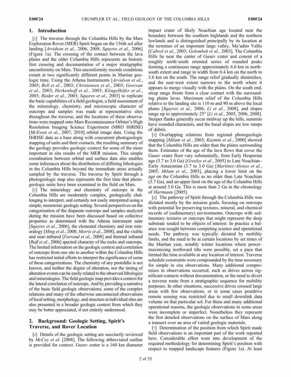
mapping [Milam et al., 2003; Kuzmin et al., 2000] showedthat the Columbia Hills are older than the plains surroundingthem. Estimates of the age of the lava flows that cover theGusev crater floor vary substantially, from Early Hesperianage (3.7 to 3.0 Ga) [Greeley et al., 2005] to Late Noachian–Early Amazonian (3.7 to 3.0 Ga) [Martínez‐Alonso et al.,2005; Milam et al., 2003], placing a lower limit on theage on the Columbia Hills as no older than Late Noachian(3.7 Ga), and an upper limit on the age of the Columbia Hillsat around 3.0 Ga. This is more than 2 Ga in the chronologyof Hartmann [2005].[6] The pathway of Spirit through the Columbia Hills was
dictated mostly by the mission goals, focusing on outcropswith potential for preserving textures, mineral, and chemicalrecords of (sedimentary) environments. Outcrops with sed-imentary textures or outcrops that might represent the deepsubstrate tended to be objects of interest. In practice a bal-ance was sought between competing science and operationalneeds. The pathway was typically dictated by mobilitylimits, and the need to be at certain locations by set times ofthe Martian year, notably winter locations where power‐maximizing northward tilts were possible, set a pace thatlimited the time available at any location of interest. Traverseschedule constraints were compounded by the time necessaryfor simple in situ observations. Many additional compro-mises in observations occurred, such as drives across sig-nificant contacts without documentation, or the need to diverta traverse route from a stratigraphic sequence for mobilitypurposes. In other situations, successive drives crossed largeareas with few observations, or in some cases postdriveremote sensing was restricted due to small downlink datavolume on that particular sol. For these and many additionaloperational reasons, the geologic observations in some areaswere incomplete or imperfect. Nonetheless they representthe first detailed observations on the surface of Mars alonga transect over an area of varied geologic materials.[7] Determination of the position from which Spirit made
field observations is an important part of the work reportedhere. Considerable effort went into development of therequired methodology for determining Spirit’s position withrespect to mapped landscape features (Figure 1a). At least
CRUMPLER ET AL.: FIELD GEOLOGY OF THE COLUMBIA HILLS E00F24E00F24
2 of 55

Figure 1
CRUMPLER ET AL.: FIELD GEOLOGY OF THE COLUMBIA HILLS E00F24E00F24
3 of 55

three methods have been used to locate Spirit with respectto the Mars surface coordinate system and with respectto the orbital image data products including position esti-mates determined by dead reckoning with respect to a startingpoint [Arvidson et al., 2004]; estimates from two‐wayDoppler radio positioning, cartographic triangulations, visualodometry, and bundle‐adjustment technologies [Li et al.,2005]; and (used in this study) azimuthal centering of therover position with respect to characteristics identified in asingle orbital image and corresponding local panoramas.[8] In this study we are interested in relating geological
observations from the rover perspective to regional geologiccharacteristics in HiRISE images rather than rover positionwith respect to a particular map datum or coordinate system.Triangulation in rover perspective with respect to HiRISEimage features was facilitated by development of a process[Powell et al., 2010] (Maestro Map View) that mergedoverhead projections of Navigation Camera (Navcam) pa-noramas [Powell et al., 2010] with the HiRISE image baseusing standard data products and flight operations software.Navcam mosaics were acquired in stereo and digital terrainmodel routinely generated for surroundings out to the limitof useful stereopsis (about 20 m on average) and provideddetailed information about ranges to surrounding triangula-tion targets. Maestro Map View facilitated the process ofaligning image mosaics draped onto the local terrain model.When combined with HiRISE image data and the ability tomove the Navcam plan viewmosaics around with respect to aHiRISE image base and match features, the rover positionwas accurately established with respect to geologic char-acteristics mapped previously. The flight operations softwareScience Activity Planner (SAP) integrated this informationfor use in daily science activities on both rovers [Norriset al., 2005].
3. Observation Naming Conventionsand Geologic Mapping Methods
[9] Names of features and naming conventions through-out the mission are informal, but followed a well‐definedsystem that identified larger geographic features, outcrops,and in situ observations according to predefined themes (forexample, sailing ships, sailing ship parts). The themes wereoften restricted to individual outcrops or series of outcrops ina larger geographical division such as “the west side,” “thesummit,” or “the south flank.” The observations made byeach of the Athena Instruments, Pancam, Min‐iTES, APXS,Mossbauer, Rock Abrasion Tool (RAT), and MicroscopicImager (MI), were each identified with an informal targetname keyed to a location, or sample, on a larger feature,usually the outcrop (feature name). For example, the targetPlano was on the outcrop feature Clovis in the geographic
area West Spur. In most cases, observations on a given targethave similar names for each instrument, although the in situinstruments (APXS, Mossbauer, MI, and RAT) and theremote sensing instruments (Pancam and Min‐iTES) fre-quently examined different features and targets. Even withthis rigorous naming convention for each observation, thevariety and abundance of names and locations can be con-fusing. To clarify the usage of names, some of the largerlocation names are shown in Figure 1, the important outcropsand sample name localities are labeled in Figure 3, andfinally, Table 1 compiles the target, feature, and outcropnames and their respective locations (Table 2 of Arvidsonet al. [2008] is also an important resource in this regard).[10] Geologic mapping followed terrestrial field geologic
mapping methods [e.g., Evans, 2007;Compton, 1985; Barnes,1981] and made use of both orbital and surface observations.Fieldwork (Spirit’s traverse and in situ observations) waspreceded by examination of high‐resolution orbital imagedata, and a preliminary photogeologic map of the area wasprepared from the preview. The mapping initially used MarsGlobal Surveyor (MGS)–Mars Orbiter Camera (MOC) ima-ges and was subsequently updated and refined with MRO‐HiRISE data. Additional refinements in the map resulted as insitu observations accumulated. The field reconnaissancegeologic map here combines a photogeological map and theresults of in situ examination of outcrops along a limitedtransect, including the determination of lithology, petrology,and stratigraphic relationships. The Navigation cameras, forwhich there is the most continuous record, have <1 mrad/pixelresolution [Maki et al., 2003] which enables identificationof details smaller than 1 cm within 10 m.Within 100 to 150 mof the rover, Navcam data exceeds the resolution of MRO/HiRISE (Figure 1b). Beyond 150 m, where the surroundingswere not obscured by local horizons, to a distance of 1 km theresolution is less thanMRO/HiRISE. But the Navcam images,in combination with limited Pancam data, provides additionalground‐based perspectives useful for identifying details ofthe stratigraphy and geologic structure. The final geologicmap (Figures 2 and 3) represents the merged results fromobservations based on orbital data, and proximal remotesensing and in situ observations from the rover.[11] The photogeological mapping part of the analysis
followed methods used to prepare planetary geologic mapsfrom orbital remote sensing data [e.g., Tanaka et al., 2009;Greeley and Batson, 1990; Wilhelms, 1990]. Units wereidentified and contacts located using left and right stereopticpairs examined at full resolution (not anaglyphs). The stereois based on HiRISE images acquired at differing emissionangles (PSP_001513_1655, “left” and PSP_001777_1650,“right”) [McEwen et al., 2010]. Mapping in the stereo pairs,as in terrestrial field geologic mapping, enables correlationof surface relief characteristics at large scales with surface
Figure 1. (a) Traverse locations on HiRISE image base (PSP_001777_1650) showing the position of Spirit for sols 156through the present as determined through methods of rover location discussed in the text. Regional names used throughoutthe text are also shown. Outlined areas A–F are shown in detail in Figure 3. (b) Map showing the approximate area andresolution of field observations assuming 1 mrad resolution and local ridgeline horizons. The most detailed observations atcentimeter scale occurred along a corridor within 20 m of the rover at the sites of Navcam panoramas. Observations outsidethe light shaded area were not made from the rover and are assigned geologic units based on characteristics in HiRISEimage data as correlated with known units along the traverse.
CRUMPLER ET AL.: FIELD GEOLOGY OF THE COLUMBIA HILLS E00F24E00F24
4 of 55

Tab
le1.
Sum
maryof
Nom
enclature(Sam
ple,
Class,andOutcrop
Nam
es)andSam
pleCharacteristicsa
Location
Map
Unit
Label
Sam
pleTyp
eOutcrop
/Field
Site
Feature
bUnitStrike
andDip
cUnit
Thickness
Targeton
Feature/Outcrop
dPetrographicClass
eMap
UnitNam
e
Sum
mit
(dmf)
Soil
summitridg
eline
Cliffhanger
Lands
End
,HangTwo
Basaltic
sand
driftedmob
ilefines
Husband
Hill
northw
est
slop
eSoil
Soil
Pasadena
PasoRob
les,Marengo
Sulfate
rich
fines
Husband
Hill
northw
est
slop
eSoil
Soil
PasoRob
les2
Ben’s
Clod,
Big
Clod,
BittyClod,
PasoDark,
PasoLight
Sulfate
rich
fines
Cum
berlandRidge
fFloat
rock
Backstay
Scupp
ers,Scurvy
Adirond
ackclass
float(basalt)
Sou
th(Inn
er)Basin
Float
rock
DeadSea
Arad
Masada
Irvine
class
WestflankHusband
Hill
Float
rock
Independ
ence
Missile
ValleybetweenWestSpu
randNW
Husband
Hill
dmf
Soil
Thank
sgivingFlats
Yam
sTofurkey
mob
ilefines
driftedmob
ilefines
Sou
th(Inn
er)Basin
Soil
DeadSea
Arad
Sam
ra,Hula
Sulfate
rich
fines
driftedmob
ilefines
WestSpu
rpl
Float
rock
Loo
fah
Jerry
Adirond
ackclass
Plainslava
Sum
mitRegion,
Husband
Hill
chrock
(sum
mit)
Tenzing
18Sat
N15
E(M
);SEat
N60
E(A
)>2m
Everest,Mon
tagsdem
Pangb
oche,Pho
rtse,
Phakd
ing,
Naboche
Watchtower
class
Colum
biaHillsSum
mit
outcrops
rock
outcrop
Hillary
Nam
cheBazaar,Khu
mjung
EastflankHusband
Hill
chrock
outcrop
Kansas
Tenzing
18Sat
N15
E(M
);SEat
N60
E(A
)>2m
Kestrel
Watchtower
class
Colum
biaHillsSum
mit
outcrops
Cum
berlandRidge,
northw
estHusband
Hill
lcr
rock
outcrop
Alligator
N45
E∼2
3m
Jambalaya
Peace
class
northw
estCum
berland
Ridge
outcrops
rock
outcrop
Jibsheet
Keel
Reef
Watchtower
class
rock
outcrop
Jibsheet
Keel
Davis
rock
outcrop
LarrysLoo
kout
Watchtower
Joker,Firetow
er,Sentin
el,
Bulwark,
Citadel
rock
outcrop
LarrysOutcrop
Pequo
dAhab,
Mob
y,Mob
yDick,
Dou
bloo
nLarrysOutcrop
Paros
Paros
rock
outcrop
Methu
selah
Keyston
erock
outcrop
Peace
Justice_2,
Equ
ality
Peace
class
Sou
thHusband
Hill
edsoil
ElDorado
Gallant
Knigh
tEdg
arShado
wBasaltic
Sand
ElDoradoripp
lefield
Sou
thof
summit
Husband
Hill
ffloatrock
summitregion
Irvine
Shrew
sbury2
Irvine
class
float
Sum
mit
soil
summit
Lam
bert
Cou
zyWhy
mper
mob
ilefines?
Crestof
HaskinRidge
hrock
outcrop
LarrysBench
Thrasher,Bluestem
Zizia
MuscogeeYeehaw
Wishstone
class
HaskinRidge
Upp
erslop
esof
Inner
basin
librock
outcrop
Com
ancheSpu
r>15
S>10
mHorseback
Watchtower
class
lower
InnerBasin
CRUMPLER ET AL.: FIELD GEOLOGY OF THE COLUMBIA HILLS E00F24E00F24
5 of 55

Tab
le1.
(con
tinued)
Location
Map
Unit
Label
Sam
pleTyp
eOutcrop
/Field
Site
Feature
bUnitStrike
andDip
cUnit
Thickness
Targeton
Feature/Outcrop
dPetrographicClass
eMap
UnitNam
e
rock
outcrop
Com
ancheSpu
rPalom
ino
Sou
thflankHaskinRidge
uib
rock
outcrop
Algon
quin
15Sat
N53
E(M
)20
mIroq
uois
Algon
quin
class
upperInnerBasin
rock
outcrop
Sem
inole
OsceolanAbiaka
Husband
Hill
northw
estslop
edcr
Float
rock
northw
estHusband
Hill
slop
eWishstone
LaBrea,
Chisel
Wishstone
class
bright
unconformable
depo
sitsof
Cum
berland
Ridge
LaBrea
Chisel
Champagn
eWishing
Well
Dream
ing
Piper
Piping
Westflankof
Husband
Hill
wh
rock
outcrop
Independ
ence
Independ
ence
Jefferson,
Livingston,
Penn2
,Frank
lin,Liberty
Bell2
Independ
ence
class
western
Husband
Hill
rock
Voltaire
Descartes
Discourse,Enlightenment,
Paris,Versailles,Napolean,
Fraternite
rock
Haussmann
Rue
Legendre,
Rue
Laplace,
Sop
hieGermain
rock
Assem
blee
Gruyere
rock
Bou
rgeoisie
Chic,
Gentil
Matrice
WestSpu
rlws
rock
outcrop
Hanks
Hollow
∼0–15N
atbN
85W
(M)
∼8m
Pot‐of‐Gold,
Breadbo
x,FortKno
x,Stringof
Pearls
Peace
class?
lower
WestSpu
rou
tcrops
uws
rock
WestSpu
rCrest
andup
perslop
esWoo
lyPatch
∼0≥2
mCratchit,TinyTim
,Scroo
geClovisclass
upperWestSpu
rou
tcrops
rock
Tetl
Clump,
Squ
eeze,Edg
erock
Palinqu
e–
rock
Uchben
Koo
likrock
Lutefisk
FlatFish,
Pickled,Twins,
Fisheyes,Ratfish
rock
outcrop
TurkeyLeg
rock
Woo
lyPatch
Woo
lyPatch
Sabre,Mastodo
nrock
Woo
lyPatch
Woo
lyPatch
Plano
,Cochiti,
Jemez
a Parentheses
indicate
that
theassociated
mappedlitho
logy
isidentifiedbu
tthesampleistoosm
allto
representin
theregion
almap.
bSom
eou
tcrops
arelargeenou
ghthat
multip
lelocatio
nsor
features
wereinvestigated,each
with
multip
letargets.The
featureisno
tgivenforsomelocatio
nsbecauseotherou
tcrops
aresm
allandthefeatureand
target
arethesamein
situ
analysislocatio
n.c Strikeanddipfrom
M,McC
oyet
al.[200
8],andA,Arvidsonet
al.[200
8].
dNam
esused
fortargetsplannedwith
Athenainstruments.
e Petrographicclassisdefinedon
hand
scaleandmicroscop
icim
agerdetected
characterof
therock
texture,grainsize,and
laminationandislargelyindepend
ento
fchem
istryas
used
inthissenseof
correlation.Note
that
thepetrog
raph
icclassisused
inclusivelybasedon
outcroplitho
logy
.Individu
alou
tcrops
may
bevery
differentin
chem
ical
andmineral
parameters.
CRUMPLER ET AL.: FIELD GEOLOGY OF THE COLUMBIA HILLS E00F24E00F24
6 of 55

textural differences, tone, and small‐scale physical featuresmany of which are not apparent in monoscopic images or inanaglyph stereo. Mapping in the orbital data also served toidentify areas where the detection of differing lithologiesand stratigraphy based on photo mapping was ambiguous,and where more focused attention on the ground could assistin resolving questions of stratigraphy, structure, and unitcorrelation. In practice geologic context was only one ofmany science objectives of the mission, few such sites werevisited due to other scientific and operational requests, andthe observations necessary for accurate reconnaissancemapping were done at few of the traverse stops.
4. Descriptions and Comparison of Unitsin Photogeologic and Field Maps
[12] Here we describe the regional photogeologic mapunits (Figures 2 and 3), and where possible by identification
of contact relations, overlapping relations, and possiblestratigraphic correlations. We start each discussion with abrief synopsis of the combined interpretation, followed by adescription of the observations and analysis of HiRISE data,then discuss the relevant Mars Exploration Rover observa-tions (Table 2), proximal remote sensing and in situ investiga-tions of representative outcrops, and conclude with an overallanalysis and interpretation of the unit. (Auxiliary materialFigure S1 illustrates an example of the HiRISE image fromeach unit.)1 Details of observations beyond that included inTable 2, such as observation geometry and sampling char-acteristics, are available in the online MER Field Analyst’sNotebook (http://an.rsl.wustl.edu/mer/).[13] Using Figure 2b (correlation chart) as a guide, the
discussion order proceeds from left to right and top to bottom,
1Auxiliary materials are available in the HTML. doi:10.1029/2010JE003479.
Figure 2. (a) Geologic map of the Columbia Hills prepared from photogeologic mapping on HiRISEimage base merged with in situ observations. Contacts in this map were located using stereo image pairsPSP_001513_1655 and PSP_001777_1650. (Note that units Bm, R, and B are not discussed in this workand refer to units exposed near the southern end of the traverse near the feature Home Plate.) (b) Corre-lation of units as determined from final analysis. This represents a combination of stratigraphy from thephotogeologic mapping as well as the in situ inferences regarding stratigraphy from Spirit’s traverse.
CRUMPLER ET AL.: FIELD GEOLOGY OF THE COLUMBIA HILLS E00F24E00F24
7 of 55

with departures in a few places to accommodate the localorder in which the units were encountered. This order ofdiscussion differs from the mapping convention of older toyounger, but we believe that in this case it follows a missiontime‐progressive narrative that works better in understandingthe analyses, correlations, and conclusions.[14] Figures 2 and 3 show the traverse and geologic
mapping through the last sol near the feature dubbed HomePlate. We discuss the geology of the traverse only thoughapproximately sol 720 because the information accumulatedsubsequently from detailed studies near the feature HomePlate is much greater than elsewhere and requires a separ-ate discussion.
4.1. El Dorado Drifted Mobile Fines (Unit ed)
[15] Several dark areas around the Columbia Hills appearsimilar to dark ripple fields on crater floors elsewhere onMars (Figures 2 and 3f). In situ studies by Spirit show that atleast this example consists of sand‐sized basaltic grains andthe dark character reflects scouring of dust by active tur-bulence at these locations, but insufficient wind to removethe sands from the local relief trap.4.1.1. Orbital Observations[16] El Dorado is the largest (200 m × 150 m) area of dark
ripple bed forms and is situated on the southeast facing lowerslope of Husband Hill. Individual ripples have wavelengths
on the order of 1 to 3 m. This area is unusually dark and issimilar to many much larger areas of dark ripple bed formselsewhere on Mars [Sullivan et al., 2008] often on largeimpact crater floors. It appears to onlap adjoining larger,light‐toned transverse ridges (unit rmf) and the slope debrisfrom Husband Hill.4.1.2. Field Observations[17] The contact with the surrounding landscape is sharply
defined such that Spirit was able to examine the materialwhile parked on the adjacent unit. In situ observations of theeastern edge of El Dorado during sols 706–710 show thatthese consist of ripples similar in morphology and size tothose seen within craters on the plains [Squyres et al., 2004].Individual ripples have wavelengths on the order of 1 to 3 mand relief of about 30 cm [Sullivan et al., 2008]. Remoterover‐based observations during the third winter [Sullivanet al., 2008] detected periodic changes in light streaksacross the surface in El Dorado implying that the surface tonevaries according to transient scouring and dust depositionpossibly arising from small‐scale turbulence in local winds.Trenching of small ripple bed forms in the plains previously(for example, the ripple Serpent on the rim of Bonnevillecrater [Squyres et al., 2004]) showed that the interiors ofripples consists of dark sand‐sized basaltic grains, the rippleexteriors being coated with bright dust. Sullivan et al.’s[2008, paragraph 20] analysis of the MI data on wheel
Figure 2. (continued)
CRUMPLER ET AL.: FIELD GEOLOGY OF THE COLUMBIA HILLS E00F24E00F24
8 of 55

Figure 3. Detailed views of the individual sub areas identified in Figure 1. All rover locationsshown here were determined with respect to local HiRISE image base using the MER data tool Maestro.Figures 3a–3d (top) and Figures 3e and 3f (left) show the image base with contacts. Figures 3a–3d(bottom) and Figures 3e and 3f (right) show the geologic units and unit labels on the image base map.(a) West Spur to northwest Husband Hill. (b) Northwest Husband Hill–Larrys Lookout. (c) WesternHusband Hill–Voltaire outcrop. (d) Summit Region–Hillary outcrop. (e) Haskin Ridge–Larrys Bench–Seminole–Algonquin–Comanche outcrops. (f) El Dorado to Arad–Mitcheltree Ridge. HiRISE image base(PSP_001777_1650).
CRUMPLER ET AL.: FIELD GEOLOGY OF THE COLUMBIA HILLS E00F24E00F24
9 of 55

scuffs indicates that El Dorado materials are similarly“dominated by poorly sorted sand with maximum grain sizeof around 300 mm, but with most sand around 100 mm andsomewhat smaller…. Materials right at the surface are 200–
300 mm sand with minor amounts of air fall dust.” Pancam,Mössbauer, APXS, and Min‐iTES results at El Dorado[Sullivan et al., 2008; Morris et al., 2008; Ming et al., 2008;Arvidson et al., 2008] are consistent with El Dorado sand
Figure 3. (continued)
CRUMPLER ET AL.: FIELD GEOLOGY OF THE COLUMBIA HILLS E00F24E00F24
10 of 55

Figure 3. (continued)
CRUMPLER ET AL.: FIELD GEOLOGY OF THE COLUMBIA HILLS E00F24E00F24
11 of 55

Figure 3. (continued)
CRUMPLER ET AL.: FIELD GEOLOGY OF THE COLUMBIA HILLS E00F24E00F24
12 of 55

grains consisting of mostly mafic (olivine and pyroxene rich)materials mixed with small amounts of dust.4.1.3. Analysis and Interpretation[18] On the basis of the similarity of El Dorado with the
dark ripple patterns within craters on the plains in orbitalremote sensing, El Dorado is a collection trap on the lee sideof Husband Hill for sand grains sourced in the surroundingplains [Greeley et al., 2006]. The grains arrive throughepisodic saltation in a dominantly west‐northwest‐east‐southeast orientation across the top of Husband Hill. Sandsthat are mobile in specific conditions of slope, surfaceroughness, and wind velocity become trapped in lee basalslopes. Persistent and repeating changes in azimuth of windassociated with the natural turbulence of winds flowingaround the Columbia Hills result in distinct cross‐rippleorientations as well as scouring of dust that normally settleson the surface and results in most bed forms (such as unitrmf) being lighter in tone. Although the El Dorado bed formfield blends with surrounding mobile fines deposits, theactive mafic component appears to be responsible for thesharply defined brightness boundary. What is not clear fromremote sensing alone is why it is dark as opposed to thelighter tone common to ripples elsewhere around theColumbia Hills. Sullivan et al. [2008, paragraph 1] con-
cluded that El Dorado represents an unusual setting where“active mafic sand ripples and larger inactive coarse‐grainedripples interact.”
4.2. Rippled Mobile Fines (Unit rmf)
[19] Elongated or transverse ridges in the vicinity of theColumbia Hills are similar in morphology to the ripplessampled during the traverse, but larger in size such as thosecommon across the surface of Mars (Figures 2 and 3f). Theyare accordingly interpreted as aeolian bed forms. The detailsof the constituent grains in these larger bed forms were notexamined by Spirit, but they bear some similarity to the ElDorado bed forms.4.2.1. Orbital Observations[20] Localized fields of longitudinal ripple bed forms
several meters long, and one to two meters wide occurthroughout the plains and within the Columbia Hills, par-ticularly on the west side of the Columbia Hills south ofWest Spur, and within the Inner Basin (between HusbandHill and McCool Hill). These characteristically occur asmultiple parallel, straight to slightly sinuous ridges, manywith a superimposed second set of smaller ridges that are atapproximately right angles to the orientation of the mainridge. Locally, these grade laterally into smooth drifted
Figure 3. (continued)
CRUMPLER ET AL.: FIELD GEOLOGY OF THE COLUMBIA HILLS E00F24E00F24
13 of 55

mobile fines (dmf) but in places appear to rest directly onrelatively exposed substrate lithologies.4.2.2. Field Observations[21] Only a few proximal observations of ripple bed form
fields were done during the traverse simply because largeripples and transverse ridges represented mobility hazards tobe avoided. The larger examples were on the order of ameter or slightly more high, and up to 50 m long, often withsmaller or secondary set of ripples on their slopes oriented atright angles to the primary ridge form. Drives along thestrike of several ridges and down the regional slope occurredafter leaving the margins of El Dorado on sol 711. Drivesthrough this transverse ridge field continued until sol 716where a notably large transverse ridge temporarily obstructedprogress near the Dead Sea site and the rock feature Arad andsoil feature Samra (sol 716–718).[22] Transverse ridges within this unit were not examined
directly with the Athena instruments, so we cannot say forcertain whether significant differences occur in the particlesin bed forms of different relief and distribution. MI datashow that the sand‐sized particles in Cliffhanger, a smallerripple bed form examined near the summit of Husband Hill(sols 605–611), appear more angular than those out on theplains, supporting a local derivation. The mineralogical andchemical results of analysis at Cliffhanger [Sullivan et al.,
2008] were also consistent with local derivation from theflanks of Husband Hill, consisting of Wishstone class ma-terials (see section 4.16) mixed with average Gusev soils ofthe Laguna (i.e., typical Gusev plains) class [Ming et al.,2008]. And on the basis of the Wishstone class compo-nent, the source could be as nearby as Cumberland Ridgeto the northwest.4.2.3. Analysis and Interpretation[23] Ripple and ridge fields consist of coarse‐grained
sand‐sized materials transported mostly through saltation ingenerally recurring patterns of winds. We interpret theseprimarily based on previous studies of similar features. Insitu examination of several smaller ripples throughout thetraverse show that the locations and orientations tend to beinfluenced by characteristics of the particles supplied, con-sistent wind orientations, and local topography [Greeleyet al., 2008]. No changes were noted on any of the trans-verse ridges from rover perspective, so most ripples appearto have relatively stable exteriors and are interpreted to beactive only during exceptional conditions.
4.3. Drifted Mobile Fines (Unit dmf)
[24] In orbital images there are many featureless areas inthe Columbia Hills, mostly in low areas and along the basalwest facing slopes (Figures 2, 3a, and 3e). Many examplesof restricted rover mobility, as well as in situ measurements,
Figure 3. (continued)
CRUMPLER ET AL.: FIELD GEOLOGY OF THE COLUMBIA HILLS E00F24E00F24
14 of 55

Tab
le2(Sam
ple).
PhotogeologicMap
Units,R
epresentativeObservatio
nsWith
theAthenaInstrumentson
OutcropsandRocks
With
inEachUnit,andSum
maryInterpretatio
nsof
Lith
ology,
Mineralogy,andChemistrya
[The
fullTable2isavailablein
theHTMLversionof
thisarticle]
Pho
togeolog
icMap
Traverse‐Based
Observatio
ns
Location
Rem
oteSensing
Map
UnitNam
eMap
Unit
Label
MERA
Sol
Traversed
RepresentativeRocks/Outcrop
s
Pancam
Mini‐TESTargets
Sam
pleMosaics/Images
Multispectral
ElDoradodrifted
mob
ilefines
ed70
6–71
0ElDoradoripp
lefield
ElDorado,
Sol70
8A_P
2267
;Sol11
78A_P
2359
_L25
7;Sol69
9A_P
2589
;Sol71
1A_P
2536
Sol
711_
P25
35;Sol71
1_P25
36Sol
707–70
8P36
81ti_
vscan_
el_d
orado,
Sol
708–70
9P36
80ti_
raster_el_do
rado
,Sol
711
P33
53ElDoradoScuff
Rippled
mob
ilefines
rmf
nottraversed(proximal
observations,sol71
6–71
8);
relatedob
ssol60
5–61
1?
(related
observation?
=Cliff_Hangerdrift)
(see
Navcam
2N19
0016
113
EFFAM
CW
P07
35L0M1);
Sol13
74A_P
2421
_L25
7
e.g.,Sol
589_
P25
59
Drifted
mob
ilefines
dmf
314–31
6;70
5,71
6–72
7;78
2–80
1,10
95–110
1Thank
sgivingFlats–sol
313–
320driftdepo
sits;
DeadSea;Tyron
e
2P15
4430
448EFF93
00P25
59L2C1;
779A
_P23
89_d
rivedirection_
L7;
“Tyron
e”,Sol78
8A_P
2396
_L25
7;“T
hank
sgivingPan”
(foregroun
d);
Sol32
4A_P
2261
;Sol72
1A_
P25
38;Sol10
98A_P
2548
Sol
721P33
57,Arad1
;Sol
721
P33
58.Arad2
;Sol
722P33
59,
Arad_
tracks1;
Sol
722P33
60,
Arad_
tracks2;
Sol
724P33
66,
Lot;Sol
724P33
67,LotsW
ife
Plainslava
pl(01–15
5)Adirond
ack,
Hum
phrey,
Mazatz,
(Loo
fah‐sol19
1)2P14
0138
483EFF67
00P23
71R1C1
(Sol
35_P
2578
;Sol
55_P
2583
,Sol
60_P
2597
)Sol
014P31
09,Adirond
ack;
Sol
041P31
48.Sarah;
Sol
047P31
54,Beacon;
Sol
060P31
78,Hum
phrey;
Sol
100P32
29,Rou
te66
Troug
hlava
tlno
ttraversed
NA
NA
Upp
ercaprockof
WestSpu
ruw
s(192–2
09)21
0–26
2,30
5–31
3(W
ooly
Patch);Clovis;Ebenezer;
Tetl,Palinqu
e;Uchben;
Lutefisk
Cahok
iaPan;Sol21
0A_P
2398
_L25
7;TurkeyLeg,Sol31
3A_P
2431
_L35
7;Sol27
8A_P
2415
;Sol53
1A_
P24
43;Sol21
7A_P
2277
;Sol22
6A_
P25
69;Sol30
4A_P
2553
;Sol32
2A_
P22
98;Sol52
6A_P
2439
;
A22
7FrioP25
71,P25
72(W
ooly
Patch,sol20
0P25
56)
P33
00_sol19
4_viera_cairns,
P33
18_sol21
6_bram
sen,
P33
22_sol21
9_toltecs,
P33
24_sol22
0_plate,
P33
30_sol22
5_pico,
P33
31_sol22
6_clov
is_b
rushed,
P33
33_sol22
7_ebenezer,
P33
82_sol29
0_palenq
ue_
1630
,P33
98_sol30
8_cocomam
aSlopesof
WestSpu
rlws
156–18
1,19
2–20
9,26
3–30
4
Pot‐of‐Gold/Hanks
Hollow;
[Hanks
Hollow
litho
logies
coveredwith
Clovis‐type
float]
Archipelago
,Sol16
5A_P
2377
_L25
7;Sol15
8A_P
2595
;Sol15
8A_
P25
94;2P
1409
3672
7
Pot
ofGoldsol159
_P25
97,
sol17
6_P25
43Sol
159P32
57Rog
er_D
ean,
Sol
160P32
62Pancake,
Sol
165P32
82Breadbo
x,Sol
167P32
88Pot
ofGold,
Sol
169P32
91Pud
gie
Upp
erCum
berland
Ridge
materials
ucr
515–52
3Non
e(W
ishstone,Champagn
e);
seeun
itdcrdescription
Sol45
9A_P
2412
;Sol51
9A_S
unset_
Ridge_L
256;
Sol51
9A_P
2291
(a33
2Wishb
onep2
563;
a337
Wishstone
RATed
p256
9;a343
LaB
reap2
574;
a362
Champagn
eRATed
p253
0)
Sol
335_
P38
11_Wishb
one,
Sol
341_
P38
20_LaBrea,
Sol
341_
P38
19_Golden_
ring
s,Sol
344_
P38
30_Pipers_
piping
a Dashindicatesthat
theun
itmay
also
bepresentwith
inthesamplefielddu
ring
thesesolsalthou
ghanotherun
itismappedas
occurringin
theselocatio
ns.
bReferencesareF,F
arrand
etal.[2008
];M,M
cSweenetal.[2006
a,2006
b];M
o,Morrisetal.[20
08];Mi,Mingetal.[20
08];R,R
uffetal.[200
6];S
,Squyres
etal.[2006
];Y,Y
enetal.[20
08];W,W
angetal.[20
08].
c Resultsfrom
Pancam,Navcam,andMI.
dResultsfrom
Min‐iTES,APXS,Mossbauer.
CRUMPLER ET AL.: FIELD GEOLOGY OF THE COLUMBIA HILLS E00F24E00F24
15 of 55

show that there are very fine materials. Proximity to ripplesand other Aeolian characteristics suggests that these areareas were the fine component becomes trapped duringAeolian transport of mobile fines.4.3.1. Orbital Observations[25] These are bland‐appearing surfaces that occur in
topographic lows (based on stereoscopic images), and unlikedark ripple fields that occur on southeast facing slopes, thisunit commonly occurs at the west facing base of hillsthroughout the Columbia Hills. It may also be present adjacentto areas of prominent ripple bed forms (unit rmf). The contactwith surroundings ranges from an abrupt to gradational in anarea of otherwise distinguishable surface textures and smallroughness to adjacent areas where relief characteristics maybe visible, but tonal variations and high‐frequency surfaceirregularities appear subdued. In some locations a pattern ofparallel streaks may also be present.4.3.2. Field Observations[26] These deposits correspond with sites of sulfate‐rich
soils commonly traversed in local topographic lows [Wanget al., 2008; Yen et al., 2008] including iron sulfates ofPaso Robles (sol 398–403, 424–430) and Dead Sea (soil targetSamra) (sols 716–725) where large variations in chemistryof the soils occurs over centimeter scales. Other examplesare silica‐enriched [Squyres et al., 2008; Wang et al., 2008]particularly around the margins of Home Plate. These areasare mostly detectable in HiRISE images, but are too small tobe mapped consistently in the regional mapping. Some of thelarger mapped deposits are located on the basal northwestslopes of hills.[27] Some of these deposits have a one to two centimeter
thick uppermost layer of somewhat more cohesive fines[Arvidson et al., 2010b] with distinct vertical chemicalstratification profiles interpreted to result from downwardpercolation of fluids through minerals of varying solubilitiesand corresponding variability in downward transport. Thecohesive character of these constitutes a significant mobilityhazard. In some cases, such as at Troy [Arvidson et al.,2010a], small clasts have been deposited on the surface ofthese cohesive soils resulting in a surface that appears like athinly mantle rocky surface but is actually a crusted, cohe-sionless sand, and a mobility hazard.4.3.3. Analysis and Interpretation[28] We identify these as mobile fines because they occur
frequently in association with (1) more obvious ripple bedforms and (2) areas where local relief lows are likely toprovide a trap for fines. Assuming they are mobile materials,it is likely that they have been trapped in topographic lowsand banked against the windward side of steeper slopeswhere they commonly occur. In this respect the driftedmobile fines deposits (unit dmf) are the results of sortingprocesses that are different from dark ripples (unit ed), andoccur mostly on the windward rather than lee sides of large‐scale relief features. Part of the reason for the location on thewindward lower slopes of relief feature may relate to theparticle sizes. Whereas dark lee slope ripples are sand sizematerials that are likely to have been transported by salta-tion, windward mobile fines could consist of a size fractionthat is below the threshold necessary for upslope transportthrough saltation. The transitional contact with surroundingmaterial units is consistent with the obscuring effects ofa relatively thin mantle smoothing rougher elements and
washing out tonal variations of the surface, and thicklymantling local topographic lows, but accumulating insuffi-ciently to bury typical surface relief.[29] Sufficient in situ and remote sensing observations
have been made on a number of these deposits [Wang et al.,2008; Squyres et al., 2008; Arvidson et al., 2010b] to showthat many of the deposits have hydration characteristics.Furthermore the small‐scale variations in chemistry appearconsistent with volumetrically limited, but locally concen-trated, availability of altering fluids. This might include gas‐solid interactions or liquid‐solid interactions associated withfumaroles or low water to rock ratios [Wang et al., 2006].A viable hypothesis for the later is an episodic climaticchange in the presence of water (ice?) resulting in soil‐stratified alteration character that is time‐intensive [Arvidsonet al., 2010a]. This hypothesis implies that these soils arechemically metastable in the current environment, and mayhave had considerable residence time in their current form.
4.4. Plains Lava (Unit pl)
[30] The contact between the plains and the ColumbiaHills is of interest because it represents a major unconfor-mity, a significant gap in recorded geologic time, and sig-nificant differences in the environments of emplacement forrocks above and below the unconformity (Figures 2 and 3a).Also, there has been no previous experience with how suchcontacts between lava flows and preexisting terrains arepreserved. Unlike terrestrial contacts, these contacts havebeen exposed at the surface for potentially several billionyears. Before Spirit’s traverse across this contact it wasunknown whether major contacts were detectable at meterscales due to the potential diffusion of otherwise distinctivelithologies across contacts through the effects of long‐termweathering. Spirit’s observations show that such contactsare actually well preserved and are sharp boundary contactsmuch like many terrestrial contacts between lava flows andpreexisting terrains.4.4.1. Orbital Observations[31] The rolling plains surface in central Gusev crater is
Late Hesperian in age [Cabrol et al., 1998; Kuzmin et al.,2000; Greeley et al., 2005], and is a known basaltic lavaunit [e.g., Golombek et al., 2006]. Embayment relationsalong the contact indicate that the plains unit postdates theColumbia Hills. The contact with the Columbia Hills con-sists of alternating faint light and dark bands or discontin-uous ridges a few meters wide parallel to the contact withthe hills resulting in a light and dark aureole in plan view.Despite the young relative age from overlapping relations,the plains record more impact craters.4.4.2. Field Observations[32] Characteristics of the plains lava surface [Golombek
et al., 2006], mineralogy, and chemistry [Gellert et al.,2004; McSween et al., 2006a, 2008; Morris et al., 2004]have been discussed previously. On sol 154 Spirit entered thelight and dark aureole along the contact, but few observationswere made while crossing it. On sol 155 Spirit was located atthe contact with the Columbia Hills (Figure 4a) where thecontact between the basaltic lava plains and the ColumbiaHills was surprisingly abrupt and easily identifiable in whichsurface clasts adjacent to the rover to the east were morefragmental and lighter in tone, whereas the rubble to the westwas blocky and dark. On the basis of this single observation,
CRUMPLER ET AL.: FIELD GEOLOGY OF THE COLUMBIA HILLS E00F24E00F24
16 of 55
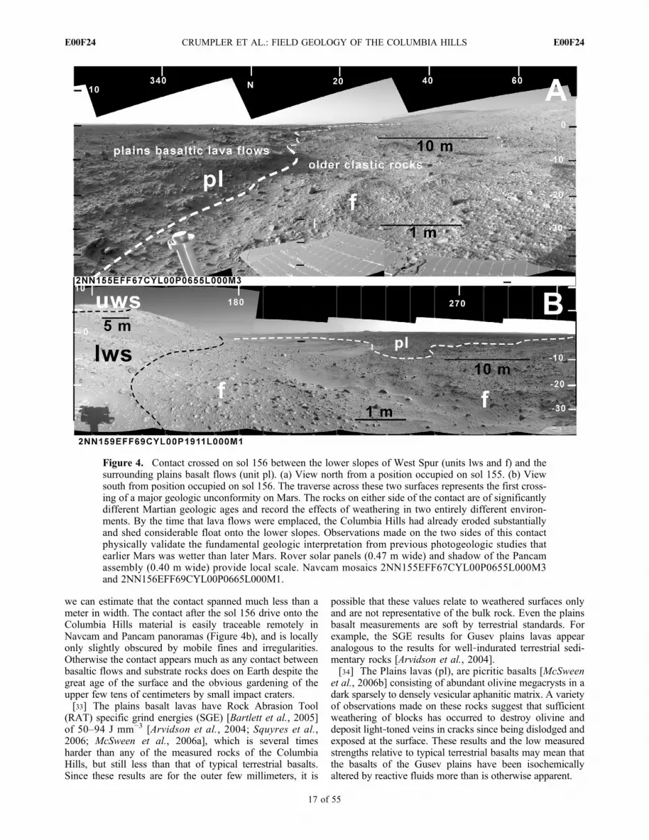
we can estimate that the contact spanned much less than ameter in width. The contact after the sol 156 drive onto theColumbia Hills material is easily traceable remotely inNavcam and Pancam panoramas (Figure 4b), and is locallyonly slightly obscured by mobile fines and irregularities.Otherwise the contact appears much as any contact betweenbasaltic flows and substrate rocks does on Earth despite thegreat age of the surface and the obvious gardening of theupper few tens of centimeters by small impact craters.[33] The plains basalt lavas have Rock Abrasion Tool
(RAT) specific grind energies (SGE) [Bartlett et al., 2005]of 50–94 J mm−3 [Arvidson et al., 2004; Squyres et al.,2006; McSween et al., 2006a], which is several timesharder than any of the measured rocks of the ColumbiaHills, but still less than that of typical terrestrial basalts.Since these results are for the outer few millimeters, it is
possible that these values relate to weathered surfaces onlyand are not representative of the bulk rock. Even the plainsbasalt measurements are soft by terrestrial standards. Forexample, the SGE results for Gusev plains lavas appearanalogous to the results for well‐indurated terrestrial sedi-mentary rocks [Arvidson et al., 2004].[34] The Plains lavas (pl), are picritic basalts [McSween
et al., 2006b] consisting of abundant olivine megacrysts in adark sparsely to densely vesicular aphanitic matrix. A varietyof observations made on these rocks suggest that sufficientweathering of blocks has occurred to destroy olivine anddeposit light‐toned veins in cracks since being dislodged andexposed at the surface. These results and the low measuredstrengths relative to typical terrestrial basalts may mean thatthe basalts of the Gusev plains have been isochemicallyaltered by reactive fluids more than is otherwise apparent.
Figure 4. Contact crossed on sol 156 between the lower slopes of West Spur (units lws and f) and thesurrounding plains basalt flows (unit pl). (a) View north from a position occupied on sol 155. (b) Viewsouth from position occupied on sol 156. The traverse across these two surfaces represents the first cross-ing of a major geologic unconformity on Mars. The rocks on either side of the contact are of significantlydifferent Martian geologic ages and record the effects of weathering in two entirely different environ-ments. By the time that lava flows were emplaced, the Columbia Hills had already eroded substantiallyand shed considerable float onto the lower slopes. Observations made on the two sides of this contactphysically validate the fundamental geologic interpretation from previous photogeologic studies thatearlier Mars was wetter than later Mars. Rover solar panels (0.47 m wide) and shadow of the Pancamassembly (0.40 m wide) provide local scale. Navcam mosaics 2NN155EFF67CYL00P0655L000M3and 2NN156EFF69CYL00P0665L000M1.
CRUMPLER ET AL.: FIELD GEOLOGY OF THE COLUMBIA HILLS E00F24E00F24
17 of 55

[35] Examples of Adirondack class rocks were detected assmall isolated clasts on Husband Hill in a few localitieswhere they were likely ballistically emplaced as ejecta fromsmall impacts in the surrounding plains [Ruff et al., 2006;Grant et al., 2006]. One miscellaneous clast, Loofah, wasencountered in the float at the base of West Spur a fewmeters from the plains‐hills contact on sol 191 [Herkenhoffet al., 2006]. This sample proved distinctive, as it is one ofthe few samples of vesicular basalt observed with theMicroscopic Imager. The mean vesicle size [Crumpler andthe Athena Science Team, 2005] of Loofah is approxi-mately 1 mm with a linear semilog size distribution that is, ifinterpreted as a proxy for volume distribution, indicative ofa population inherited from nucleation distributions andinitial bubble growth [Shea et al., 2010]. With the exceptionof a few joined vesicle walls, there is minimal evidence forcoalescence. Irregular vesicles are evidence that the lavaenclosing them had attained a strength of a few tens ofN m−2 in order for the irregular shapes to be maintainedbefore solidification [e.g., Rust et al., 2003]. This suggeststhat the observed vesicles represent the vesicularity at thesolidification interface of the lava with slight growth, pos-sibly from exsolution during crystallization at the time thebasalt was emplaced. The pervasive sulfate coatings onmany of the plains rocks are what we would characterize assulfate varnishes [Haskin et al., 2005;McSween et al., 2006a]because they are layers on the order of tens to 100 micronsthick unconformably coating rock surfaces.4.4.3. Analysis and Interpretation[36] The halo visible in orbital images plainsward of the
contact with the Columbia Hills is not identifiable from therover perspective, so its origin remains unclear. Possibleorigins include: (1) successive onlap of lava sheet flows ason Earth where successive lava sheets encroach and thendeflate along a contact with adjoining relief or valley walls;(2) the margins of lava flows may also be areas where theflows thin against topographic relief, solidification was rel-atively rapid, and distinctive surface textures were developed;(3) interaction of the lavas with a volatile‐rich substrate couldcause some disruption of lava flows along margins wherethe hydrostatic balance favors release of gases; and (4) thebands could reflect back wasting of a former steeper buttressformed by the hills and collapse of the lavas during ablationof the underlying Columbia Hills materials.[37] The surfaces of basalt blocks record other evidence
for long‐term climatic effects. Several observations implythat fluids have altered the surfaces of basalt and in suffi-cient amounts since the early disruption of the surface bysmall impact craters to weather the surface of loose basaltblocks. Varnish‐like coatings are common and may be alliedin origin with the same intermittent fluid events that alteredmany loose soils such as the sulfate‐rich and crusty soilsassociated with drifted mobile fines unit (dmf). Becausesulfate coatings were measured on ventifact surfaces such asMazatzal, a plains lava block on the rim of Bonneville crater[Haskin et al., 2005], the coatings must have accumulatedsince the wind abrasion of the block. Similar surface coat-ings consisting dominantly of sulfates [Ming et al., 2008]are common among the undisturbed surfaces of rocks withinthe Columbia Hills as well. Several possible mechanism forthese coatings were discussed by Haskin et al. [2005],including alteration of the surface of the basalt and possible
mechanism analogous to desert vanish on Earth in whichrocks exposed to dust and moisture are effectively paintedwith alteration products from the surrounding environment[Perry and Adams, 1978] at scales of a few thousand years.Given the evidence for the intermittent availability of fluidsseen elsewhere during Spirit’s traverse, the desert varnishmodel is an important alternative to consider. In the case ofMartian sulfate varnishes, only thin films of moisture ormelting ice acting on several microns of dust and separatedby thousands to millions of years need occur to fix sulfateson the surfaces of rocks. Since Hesperian time (∼2 Ga)wetting events need only occur every 100,000 years or lessto replicate the rates estimated for some terrestrial varnishaccumulations during the Quaternary [Fleisher et al., 1999;Liu and Broecker, 2000]. This number of wetting cycles(∼104) is similar to the number of climatic cycles associatedwith Martian changes in obliquity [Arvidson et al., 2004]assuming cycles of a few tens of thousands of years and anHesperian age of the surface or slightly younger for thecurrently exposed surfaces of individual rocks.[38] Despite the Hesperian age and disturbance of the
surface by small impact craters, the lavas forming the plainsaround the Columbia Hills are still one of the youngest large‐scale geologic events in the region. The greater apparentalteration of older rocks in the older hills is primary evidencefor significantly more fluids during their formation. Docu-mentation of the different character of rocks on either side ofthis stratigraphic unconformity validates with in situ studiesthe general interpretation from several decades of research[e.g., Carr, 1996] that substantial changes in the Martianclimate have occurred over geologic time.
4.5. Trough Lava (Unit tl)
[39] This is a low surface west of Mitcheltree Ridge andHome Plate, somewhat smoother than plains lavas and lyingbetween the plains lavas (pl) and interior of the ColumbiaHills (Figure 2a). Both the high retention of impact cratersand a local lobate shaped margin appear more similar to theplains than the rounded shapes of relief within the ColumbiaHills. Because it lies in a relatively low‐lying area, it appearsheavily mantled, most likely by mobile fines, and there arefew blocks or small‐scale relief characteristics in comparisonwith the plains lavas (unit pl). The topographic trace of thecontact between the plains lava and the Columbia Hillscrosses this material, so it appears to be an underlying surfacethat predates the latest plains lavas sheets. This material wasnot traversed and there are no relevant observations from theground. Observations from the summit of Husband Hill andwhile traversing the west side of Home Plate reveal onlyextensive mobile fines and ripple bed forms in the low areabetween the plains basalts (pl) and the Inner Basin.
4.6. Upper Caprock of West Spur (Unit uws)
[40] The upper surface of the West Spur is relatively flatin appearance, yet the flanks are mostly straight slopes(Figures 2 and 3a). This differs from the margins of theColumbia Hills elsewhere where the flanks uniformly slopedown into contact with the surrounding plains. So from orbitalobservations it was unclear whether the West Spur was rep-resentative of the Columbia Hills, or something overprinted onthe main massif. The abrupt margin of the caprock on WestSpur implies that it is now a remnant of a formerly more
CRUMPLER ET AL.: FIELD GEOLOGY OF THE COLUMBIA HILLS E00F24E00F24
18 of 55

widespread surface in which a resistant material had beenbackwasted on a less resistant substrate long prior to theemplacement of the plains basaltic lavas. The high Cl contentis comparable to proposed salient chemical characteristics ofa large‐scale geologic unit in the eastern equatorial regionof Mars.4.6.1. Orbital Observations[41] The upper surface of West Spur consists of light‐
toned slabs and more indurated materials that are apparent instereo image data as a nearly level caprock on low ridges andhills on the west flank of the Columbia Hills. The margins arerelatively abrupt in relief and the caprock material appears tobe fragmented and covers the surrounding lower slopes.Small impact craters and residual depressions appear morecommon than surrounding slopes implying that it represents alocal residual surface surrounded by areas of erosion. Fromthe stereo analysis of the apparent disposition of outcrops onthe top of the saddle where the eastern end ofWest Spur abutsHusband Hill, this material appears to overlie the flanks ofHusband Hill.4.6.2. Field Observations[42] Representative observations on outcrops and rocks of
the upper unit of West Spur were made between sol ∼210and sol 312, notably at the outcrop Clovis, but also at therocks Frio, Ebenezer, Palenque, Uchben, Tetl, and Lutefisk,all along the north upper slope of West Spur. These outcropsand rocks are laminated at scales from a few millimeters tocentimeters. On the basis of Navcam ranging data the cap-rock is estimated to be in excess of 2 m thick. In Micro-scopic Images and in situ chemical and mineralogicalanalyses, Clovis and Uchben are poorly sorted fine‐grainedclastic rocks of basaltic composition [Squyres et al., 2006;Herkenhoff et al., 2008; Wang et al., 2006]. Some isolatedlarger grains appear matrix supported implying explosivelyenergetic deposition with little sorting. Although this unitoccurs as a caprock, clasts and large blocks (Wooly Patch)are pervasive on the slopes of West Spur. Individual rocks(for example, Tetl) have subplanar fabrics or partings butotherwise appear to be part of the same unit. During RATgrinding the tailings from the grinds were voluminous, oftensettling into the grind cavity indicative of the poor cohesionof the rock mass. Together with the reported RAT grindenergy of 4 to 9 J mm−3 [Squyres et al., 2006], the overallimpression is that this is a poorly consolidated rock of littleequivalent compressive strength.[43] An outcrop imaged but not sampled while departing
from West Spur on its east end (Pancam sequence P2431_L357, Turkey Leg, sol 312) (Figure S2) consolidates somestratigraphic inferences made elsewhere along West Spur.The sequence of laminations repeats on one outcrop thefine lamination sequence of the stratigraphic group Tetl,Palenque, and a finely laminated remote sensing targetAnasazi. The outcrop also appears to dip conformably withlocal slope toward the east. The overall impression is thatthe caprock of West Spur and Clovis class material are thesame, constitute a dip slope at this site, and form a conform-able drape on an existing relief or have become rotated tofollow the relief of an underlyingmore easily eroded substrate.[44] Pancam multispectral data for the Clovis‐type cap-
rock of West Spur (uws) [Farrand et al., 2008] showed thatthese rocks had the highest 535 nm band depth of any of therocks observed by Spirit, an indicator typical of substantial
oxidation. That these are altered rocks is consistent withother results. In Miniature Thermal Emission Spectrometer(Min‐iTES) deconvolutions [Ruff et al., 2006] of multipleClovis class rocks on West Spur (unit uws), a substantialcomponent of the rock is an amorphous phase akin to glass(noncrystalline) in addition to a fraction consisting of likelyplagioclase and pyroxene. Mössbauer results indicate abun-dant nanophase iron oxides, goethite, and hematite, and high(0.72) Fe3+/FeT [Morris et al., 2008]. The rocks Clovis,Ebenezer, Palenque, Uchben, Tetl, and Lutefisk are funda-mentally basaltic in chemistry, bearing abundant normativepyroxene, but are enriched in Cl (1.4 wt %) and Br [Gellertet al., 2006; Ming et al., 2006, 2008], a characteristicsometimes seen in volcanic air fall deposits [Delmelle andStix, 2000]. A fine ash, which may consist of quenchedsilica melt comminuted to dust size fractions and subse-quently altered, would be consistent with the glassy or dustycharacter of these rocks from Mini‐TES results [Ruff et al.,2006] particularly if the particles were also subsequentlyweathered. If the upper caprock of West Spur (uws) is avolcanic ash, then the nanophase iron oxides may also rep-resent the results of substantial alteration of the glassycomponent. We cannot rule out one additional hypothesis forthis deposit, namely that the alteration predated the deposi-tion, as might occur with fall out from a distal impact in apreviously altered terrain.[45] Another planar slab, Wooly Patch [Wang et al.,
2006], is oriented in conformable repose with the slopesimmediately adjacent to the crest of West Spur and appearsto have been dropped down the northwest side of West Spurthrough the gradual retreat of the substrate. Chemical andmineralogical results at Wooly Patch were comparable to theresults of subsequent analysis at Clovis [Squyres et al.,2006] although it may be distinguished from other Clovisclass rocks by phyllosilicates [Wang et al., 2006]. Regard-less of minor differences in chemical character, the outcrophabit and hand specimen petrography of Wooly patch andClovis are similar. They are probably fragments of outcropsof the same caprock lithology. Additional analyses of therocks Ebenezer, Tetl, Palenque, Uchben, and Lutefisk bearmore similarities to this Wooly Patch and Clovis caprocklithology than to the Hanks Hollow rocks, so they too aredisplaced caprock fragments despite being down the localslope from the crest of West Spur.4.6.3. Analysis and Interpretation[46] The scarp‐like margins in orbital data combined with
the disparity in crater occurrences between the surface and itsmargins imply that this material was formerly more extensiveand has been reduced in area by erosion of its margins.Because it forms a distinct rock layer capping ridges, itprobably rests on a more easily eroded substrate the gradualback wasting of which has cantilevered off chunks of theoverlying resistant unit leaving sharp outcrop margins.[47] From rover‐based remote observations, throughout
most of the West Spur this unit forms a more competentlayer at least several tens of centimeters thick and occupyingthe crests of ridges. There has been substantial back wastingof the underlying less resistant materials that form the lowerslopes of West Spur, but the clasts of fragmented caprockmaterial are persistent and now cover the back wasted slopes.Based in physical, petrographic, chemical, and mineralogicalassessment of representative examples, this unit appears to be
CRUMPLER ET AL.: FIELD GEOLOGY OF THE COLUMBIA HILLS E00F24E00F24
19 of 55

a distal pyroclastic ash or impactite, either altered post-deposition or composed of altered material redistributed asimpactite. It appears to be draped on preexisting reliefbecause the apparent dip of bedding surfaces in some of thelarger outcrops is roughly conformable to some local slopes.[48] The chlorine enrichment of Clovis is notable given
that Keller et al. [2007] found the equatorial area immedi-ately north of Gusev crater to be enriched in chlorine in anarea identified [Newsom et al., 2007] as restricted to theMedusae Fossae Formation, a broad equatorial region ofthick layered mantling deposits [Mandt et al., 2008; Kerberand Head, 2010]. The average value of 1.4 wt% as deter-mined from APXS measurements in Clovis class rocks[Ming et al., 2006] falls within the 1 wt% Cl enrichmentcontour of Keller et al. [2007]. The proximity of Gusevcrater to the region over which Medusae Fossae Formationoccurs and the chlorine anomaly make the Clovis classmaterials a viable candidate as a distal outlier of theMedusae Fossae Formation.
4.7. Lower Slopes of West Spur (Unit lws)
[49] The slopes of West Spur were poorly exposed in bothorbital and in situ observations, being mostly armored withclasts of the overlying caprock in both data sets (Figures 2and 3a). The only in situ observations were near the baseof the slopes and it is inferred from those observations thatthe slopes developed in materials that are relatively friableand poorly indurated. Even so, some fracture networks mayhave carried fluid in volumes great enough to result in somenetworks of case hardened joint blocks.4.7.1. Orbital Observations[50] The slopes around the upper caprock unit of West
Spur are distinguished mainly by downslope streaks andchutes, and speckled appearance in orbital images. The latterappears to be rocky debris grading from a meter to dimen-sions below the resolution of HiRISE image data. It is clearthat the caprock unit is resting on an easily eroded substrate,but there are no obvious exposures of that substrate material.4.7.2. Field Observations[51] Observations on the lower West Spur unit were made
between sol 156 and ∼sol 191. Representative rocks includePot‐of‐Gold and Breadbox in the outcrop area broadlyknown as Hanks Hollow, a shallow depression, approxi-mately 4 m across, floored with fines and rimmed withoutcrops and float (Figure 5). It is located approximately 10m from the plains contact at the foot of slopes leading up toa northward projecting thumb of the main east‐west orientedmass of West Spur proper. Outcrops positioned in a narrowzone around the rim of the depression appear to be expo-sures on the former margins of a shallow impact crater nowdeflated and truncated by wind erosion. The rocks aroundHanks Hollow are suborthogonal shaped blocks with smooth,fin‐like coatings or with cases enclosing a more granular orcloddy interior. The interiors consist of wind‐fluted roundedclasts [Squyres et al., 2006]. Faint subparallel bands visible inoverhead views of slopes adjacent to the Hanks Hollow sitecould be the trace of horizontal layers or lamination in nearbyslopes, a characteristic that is repeated in other exposuresthroughout the Columbia Hills. The known thickness is atleast equal to the vertical relief between Hanks Hollow andthe base of the West Spur caprock, or about 8 m.[52] Pot‐of‐Gold, the first rock investigated within the
Columbia Hills [Squyres et al., 2006], is a loosely consoli-dated clastic rock, bearing uniformly oriented stalk‐liketextures, probably originating from wind abrasion acting onresistant aggregates, lapilli, or small concretion‐like areasset within a more uniform and less cohesive rock mass. Thepoor consolidation of these outcrops is illustrated by the rockBreadbox (Figure 5b) where a network of vein‐like planarstructures form open box works consisting of orthogonalnetworks of vertical fins enclosing poorly consolidated gran-ular materials. Breadbox and Cibola (Figure 5b) are strikingexamples of case hardening, a characteristic of weathered rockmasses in which the more resistant shells on exposed rocksencase more eroded interiors. It is one of the strongest mor-phological pieces of evidence encountered that fluids wereonce pervasive in the Columbia Hills [Farmer, 2005].[53] Other rocks nearby with unusual textures are perched
on the east rim of Hanks Hollow. Frichasee and Frack on thewest rim (Figure 6a) have unusual agglomerated textures,are unlike any other local rocks, and may be exotic. The
Figure 5. (a) Overhead image composite (in “MaestroMap”) of Hanks Hollow positions from Navcam mosaicstaken from sols 156 through 161. Exposures here are typicalof the outcrop exposures that frequently exist on the floorsand rims of small impact craters amid otherwise substantialfloat. (b) (top) Characteristic textures of rocks exposed inthe slopes of West Spur (unit lws). (middle) Pot‐of‐Goldand Bread Box, and (bottom) Cibola all occur along theexposed rim of a small depression (Hanks Hollow), possiblya small impact crater. Induration along joints followed byablation results in many examples of fins and angular rockswith casings. All of these rocks appear to be clastic materialsthat are relatively poorly indurated compared with rocks far-ther upslope (unit uws) and capping West Spur.
CRUMPLER ET AL.: FIELD GEOLOGY OF THE COLUMBIA HILLS E00F24E00F24
20 of 55

Figure 5. (continued)
CRUMPLER ET AL.: FIELD GEOLOGY OF THE COLUMBIA HILLS E00F24E00F24
21 of 55

Figure
6.View
from
LarrysLookout
across
thelower
Cum
berlandRidge
unit(lcr).Anunusualknob
andtrough
relief
throughout
thisregion
correlates
with
dippinglayersof
alapilli
tuff.T
hetraceshow
nas
adashed
linein
thelocallandscape
aretheledge‐form
inglayers
a,b,
andgidentifiedin
Figure7c.Individual
knobs(b)appear
tobe
residual
remnantsof
layeredmem
berbresulting
from
localablatio
nandback
wastin
gof
mem
berbon
a.The
ability
toidentifythislevelof
outcropdetailillustrates
thefuture
potentialfor
detailedfieldstratig
raphicstudieson
Mars.MappedusingNavcam
mosaics
2NN409E
FFA8C
YL00P0706L000M
1and2N
N409E
FFA8C
YL00P0706R000M
1as
stereo
pairs.
CRUMPLER ET AL.: FIELD GEOLOGY OF THE COLUMBIA HILLS E00F24E00F24
22 of 55

nearby rock Yessong, also known as the Cobra (NASA imagePIA06286), is an example, among many in the ColumbiaHills, of the extremely delicate way in which ablation by windhas sculpted unusual shapes, in this case leaving behind a thindelicate stalk supporting a knob of rock.[54] Chemically, the rocks of Hanks Hollow contained
higher Ca, S, and Ni but significantly less Cl and Br than theoverlying caprock unit of West Spur [Ming et al., 2006].The high hematite content of Pot‐of‐Gold [Morris et al.,2006, 2008] is comparable only to a few other samples inthe Columbia Hills, such as the valley floor rocks farthersouth (lower Home Plate unit (B) near Low Ridge (Halley,Grahamland) and samples at the outcrops Jibsheet andLarrys Outcrop within the lower Cumberland Ridge unit(lcr) on Husband Hill. All of these rocks are notable for theirhigh hematite content, consistent with other evidence foralteration. Due to the limitations of time and the relativelysmall scale of the rocks around the rim of Hanks Hollow,no comparative analyses of the shells versus interiors ofthese rocks were possible.4.7.3. Analysis and Interpretation[55] Although this unit is not widely exposed in outcrop,
the fact that the overlying caprock unit of West Spur appearsfrom HiRISE images to have been back wasted along steepmargins implies that the lower slopes of West Spur consistof a less indurated and more easily eroded rock. Thisinterpretation is consistent with rover based observationsbecause few exposures of the slope former were encoun-tered. The lower West Spur materials (lws) appear to dis-integrated during erosion and fragmented into material finesrather than rocks. Clasts of the caprock of West Spur (uws)generally a few centimeters in size occurring as slope debrisalmost completely obscure the underlying slopes, a char-acteristic of many caprock settings in arid landscapes onEarth where there is a large difference between the com-petence of the caprock and substrate [e.g., Easterbrook,1999]. Even though the large block Wooly Patch (betweensols 192–199) occurs in the middle of this unit, it was foundto be Clovis class in both mineralogical and physical char-acteristics and we suggest that it is instead a block displaceddownslope from the overlying caprock unit (uws). Whateverthe protolith of this slope forming unit, the few in situobservations imply that it has been substantially altered byfluids and that some of the fluid were transported along anetwork of joints ultimately responsible for the box‐likecharacter of rocks such as Breadbox.
4.8. Upper Cumberland Ridge Materials (Unit ucr)
[56] From orbital images this surface appears to be therelatively bright ejecta surrounding a relatively fresh crateroccupying the crest of the Cumberland Ridge, the west rimof a broad north‐south valley on the north flank of HusbandHill (Tennessee Valley) (Figures 2 and 3b). We suspect thatthis unit is the origin of the blocky materials encountered onthe northwest flank of Husband Hill during initial ascent. Ifso, it appears relatively unaltered compared with most rocksand may be derived from deeper unweathered materialsexcavated by this small impact along the crest of CumberlandRidge.4.8.1. Orbital Observations[57] This surface consists of light toned streaks and large
associated blocks occurring mostly along the crest of
Cumberland Ridge, a northwest‐southeast oriented rim onnorthwest Husband Hill. It is largely restricted in area as amottled surface surrounding a relatively fresh impact crateralong the crest of Cumberland Ridge. There is an overalltrough and ridge aspect somewhat similar to that seen in theunderlying unit (Northwest Cumberland Ridge outcrops,lcr). On the basis of bright streamlines in the lower nearbyslopes it appears that some of this light and blocky materialhas moved directly downslope from the upper CumberlandRidge unit (ucr), and likely contribute to unit dcr fartherdownslope.4.8.2. Field Observations[58] Where this unit was crossed on the northwest side of
Husband Hill between sols 514 and 519 it appears as a fieldof detached light‐toned subangular blocks and small clastscontributing to a rocky general float. In situ analyses of thematerials common to this unit were done on the represen-tative float rocks, Wishstone and Champagne, both analyzedfarther downslope in the bright unconfomable deposits ofCumberland Ridge (unit dcr). On the basis of chemical,spectral, and mineralogical data, Wishstone class [Squyreset al., 2006] rocks are unusual and appear relatively unal-tered. Yet some alteration may be present in order to explainunusual elemental abundances, an example being the highphosphorus (see section 4.16). The morphology and spectralcharacter of much of the rocky debris on the northwest flankof Husband Hill shed from the Cumberland Ridge crest aresimilar to the isolated rocks Wishstone and Champagne.This is supported by Mini‐TES spectra of rocks of similartexture that have the plagioclase‐rich spectral featurescomparable to that of Wishstone [Ruff et al., 2006]. Wishstoneand Champagne are assumed here to be representative of thisunit and are described in more detail in association with thegeologic unit where they were encountered (section 4.16,bright unconformable deposits of Cumberland Ridge, unitdcr). Where it occurs on Cumberland Ridge, it appears to be asurficial, thin mantle of rocky material with no substantialthickness.4.8.3. Analysis and Interpretation[59] The position of this bright unit downslope from a
relatively fresh impact crater was the basis for the hypoth-esis that this is relatively young, blocky debris from thelocal ejecta of a ridge crest impact crater. Traverse acrossthis surface did not disprove this hypothesis, and theobservation of abundant angular blocks appears consistentwith this hypothesis. Unexpected, however, was the fact thatthe blocks appear to be a rock type not seen elsewhere, andone of the least altered rocks encountered (Wishstone classrocks, see section 4.16). The latter is consistent with thesebeing excavated from deeper than most of the rocksencountered and potentially stratigraphically older as well.[60] Wishstone class float is common on the west side of
Husband Hill, so an excavating impact could be responsiblefor its widespread distribution and it deep, relatively unal-tered origin. The occurrence of this rock class as rind‐coatedpolygonal blocks is suggestive of deep massive rock unitsbearing abundant joints along which alteration has occurredin restricted volumes adjoining fractures. Projection of out-crop traces of the nearby lower Cumberland Ridge unit (lcr)toward the upper slopes of Tennessee Valley shows that thetarget material is likely to be stratigraphically lower than eventhe Northwest Cumberland Ridge outcrops (unit lcr, see
CRUMPLER ET AL.: FIELD GEOLOGY OF THE COLUMBIA HILLS E00F24E00F24
23 of 55

below). This finding is further consistent with the presenceof clasts of Wishstone class materials in the Voltaire outcrop(unit wh) [Arvidson et al., 2008; Ming et al., 2008] deter-mined to be stratigraphically the lowest demonstrable out-crop in the Columbia Hills. In order for Wishstone classclasts to be present in this unit, the source outcrops forWishstone class rocks must be considerably lower. Giventhe source of these rocks is the substrate near the center ofthe antiformal arrangement of stratigraphy [McCoy et al.,2008] in Husband Hill, it is possible that it has been rela-tively isolated from any infiltrating fluids over Martiangeologic time compared with rocks down gradient.
4.9. Northwest Cumberland Ridge Outcrops (Unit lcr)
[61] Prior to traverse through the area covered by this unitthere was little evidence to indicate that the prominent relieffeatures in this area, such as the knob on the west rim ofTennessee Valley, informally named Larrys Lookout,were anything other than large slumps or blocks of materialfrom the main massif of Husband Hill (Figures 2 and 3b).However, these were some of the first clearly layered ma-terials encountered by Spirit. Observations during the tra-verse of multiple layered outcrops dipping downslope in thisarea were unanticipated. Dips greater than the hillslopeimply that down section is upslope. All of these rocksappear to be altered lapilli tuffs, but might also include airfall impactites.4.9.1. Orbital Observations[62] This is one of the few areas within the Columbia Hills
that has a surface relief at meter scales consistent withexposed bedrock instead of mantling by fines and looseslope debris. It is limited to a small area on the upper westrim of a broad depression on the north flank of Husband Hillinformally named the Tennessee Valley. The relief on thisunit consists of a poorly integrated series of troughs, ridgesand outcrop knobs. The outcrops are surrounded by mobilefines materials (dmf) and are onlapped on the southwest byunconformable bright slope materials (ucr and dcr).4.9.2. Field Observations[63] Several of the important outcrops visited on Husband
Hill occur within this photogeologic unit traversed from sols381 to 513, including Peace, Alligator, Larrys Lookout,Methuselah, Jibsheet, and Larrys Outcrop (Table 1). Theseoutcrops comprise a range of rock classes as identified bySquyres et al. [2006] but occur within a distinctive surfacetextural unit as mapped in HiRISE image data so they arelumped together here. One important rock examined atLarrys Lookout, Watchtower, defines an important class ofmaterial seen at other outcrops.[64] From the rover perspective all of these outcrop
exposures lie eastward of a topographic divide between thefloat‐covered outer slopes of Husband Hill and the bedrock‐cut surface that forms a general slope leading into theTennessee Valley where there is an abrupt change in outcropstyle from a surface of scattered Wishstone type rocks in amatrix of mobile fines on the west to multiple isolatedpedestals of disaggregated rock of darker tone on the east.These form roughly concordant topped ridges of a moreindurated material standing as divides between a sinuouspattern of troughs filled with fines (Figure 6).[65] The outcrop Alligator (Figure S3) examined on sols
381–385 is a light‐toned tabular outcrop segmented with
suborthogonal fractures or joints. The dip (32°NW) of slabsalong the facing edge is greater than other exposures in theNorthwest Cumberland Ridge unit (lcr), but occurs in anarea where the surface abruptly increases slope, so under-mining followed by tilting and detachment of the exposurefrom the substrate is likely as suggested by McCoy et al.[2008]. Petrographically, the MI target Jambalaya is a poorlysorted, fined‐grained and cohesive clastic rock bearing sub-rounded dark lithic fragments.[66] Downslope from the Alligator outcrop, the outcrop
Peace consists of sand‐sized grains based on MI mosaics ofa RAT abraded surface, a marked contrast to the lapilli‐likegrains of Jibsheet and Larrys Outcrop. Peace and the near‐by outcrop Alligator are fine‐grained clastic rocks consistingof sand‐sized grains loosely consolidated and have a poroustexture in MI data [Herkenhoff et al., 2006]. RAT specificgrind energy [Squyres et al., 2006] also indicates that it is apoorly consolidated rock. Peace was found to contain higherMg and S [Gellert et al., 2006] in accord with Mössbauerresults indicating mostly olivine, pyroxene, and magnetite.Fe3+/FeT (0.35) [Morris et al., 2008] approaches that ofsome plains basalt analyses and is comparable to Wishstoneclass rocks (section 4.16). These results are interpreted tomean that Peace is less altered than most rocks in theColumbia Hills. The higher S in Peace is interpreted as aresult of cementation of a relatively unaltered basaltic sand bysulfates [Squyres et al., 2006], and in this respect, Peace bearssome similarity to sulfate‐rich soils, although not nearly asFe‐enriched. The unusual sulfate‐rich soils of Paso Robles[Yen et al., 2008], lies within the area of this unit (sol 399–404, 424–430) although there is nothing in particular tosuggest that the two are related since sulfate rich soils occur ina variety of differing terrains and geologic units along thetraverse and appear to be mostly associated with local reliefcharacteristics [Wang et al., 2008]. No bedding planes arepresent in the faces of outcrop exposures, but a subplanarmegascopic lamination pervades the outcrops at decimeter(hand specimen) scale yielding strikes and dips of N45°Eand 20° (Figure S4).[67] On the basis of the measure dip and the distance from
the bottom of Larrys outcrop to the top of the Alligatoroutcrop, the estimated thickness is approximately 23 m.Similar subtle lamination occurs in terrestrial lapilli tuffs,and are attributed to rapid deposition of pyroclasts in whichvertical (time variable) clast sorting is minor. These arecharacteristics of violent deposition as might occur fromeither a volcanic eruption or impact ejecta [Squyres et al.,2006]. Similar MI textures occur in the summit outcropHillary and the Comanche Spur outcrop targets Horsebackand Palomino.[68] Clast litter in this unit attained the highest sphericity
of any site along the traverse [Yingst et al., 2008]. Whiletransport and emplacement could be a factor, we note sim-ply that the outcrops in this unit tend to consist of moregravel size (>2 mm) particles than other outcrops in theColumbia Hills, and the outcrops tend to disaggregate intomore or less equant fragments. The target Davis in theoutcrop Jibsheet consists of uniformly packed grains orclasts a few millimeters in size comparable in texture totypical lapilli tuffs. This coarse, subrounded granularity atmillimeter scales is also apparent in outcrops from mega-scopic views (Figure S5).
CRUMPLER ET AL.: FIELD GEOLOGY OF THE COLUMBIA HILLS E00F24E00F24
24 of 55

[69] Mineralogical and chemical analyses include someof the more hematite‐rich, highest 535 nm band depthas determined by Pancam, and highest Fe3+/FeT ratios asdetermined by Mössbauer encountered. However, Fe3+/FeTratios vary substantial from outcrop to outcrop implyingsignificant variations in alteration are present. Chemicaldiscriminants used to infer different rock classes [Squyreset al., 2006] separate several of the outcrops into distinctrocks that we have lumped in this unit. Wishstone andWatchtower are similar in elemental details [Ming et al.,2008]. But Watchtower has abundant hematite and nano-phase iron oxides, as well as elevated Fe3+/FeT (0.74) [Morriset al., 2008] and high 535 nm band depth [Farrand et al.,2008], consistent with Watchtower class rocks being aweatheredWishstone‐type protolith. Significantly, low rock‐water ratios are applicable to avoid leaching of solublecomponents, a model supporting slow infiltration of smallamounts of sulfate enriched water and downward collectionin fractures.[70] Min‐iTES results demonstrate that Watchtower class
rocks contain less than half the plagioclase of Wishstoneclass rocks, but more glass phases and sulfates. Pancam mul-tispectral data [Farrand et al., 2008], shows that Watchtowerhas one of the most pronounced 904 nm band depth features,a trait shared with the Seminole outcrop on the other side ofHusband Hill.4.9.3. Analysis and Interpretation[71] The trough‐and‐ridge surface texture of this unit (lcr)
may result from trough‐like chutes developed in associationwith debris slides in the adjoining surficial debris unit (dcr)just to the west. Alternatively, the ridges may be exposuresof dipping bedding planes. We can construct structuralcontours [e.g., Ragan, 2009] that enable prediction of thetrace of clastic ledge‐forming outcrops in the surroundinglandscape (Figure 7). When compared with the observedtrace of ridges, the results support the latter hypothesis.Using a strike (N45°E) and dip (20°) of the outcrops atLarrys Lookout determined by McCoy et al. [2008] fromanalysis of rover acquired stereo image pairs representativeof the known outcrop exposures at Jib Sheet, Larrys Out-crop, and the Methuselah outcrop, together with the regionaltopography from Navcam panorama‐based digital elevationmodels, several of the sinuous ridges and chutes in thelocal terrain follow the predicted trace of these outcrops(Figure 7). The sinuous ridges and ledges in this part ofHusband Hill are predicted to be the trace of these outcropsexposed in the slopes through erosion and ablation of themargins of the Tennessee Valley. The whole area of this unittherefore represents one of the more significant areas ofsubstrate exposure on a hillside that is otherwise buried withthick debris. It offers some insight into the overall structureof the layered units visited along the traverse through thehills in general.[72] If the Alligator outcrop is in conformable contact
with the other layers in this unit, then based on the analysisof structural contours, it is stratigraphically slightly higherthan the Methuselah–Larrys Lookout outcrops upslope. If itis in unconformable contact with the layers upslope, then itcould be draped on an erosional unconformity cut intothe Methuselah–Jib Sheet–Larrys Lookout sequence. Fromthese assessments and the structural analysis (Figure 7) aproposed stratigraphic sequence for the rocks examines
within this unit (bottom to top) would be Wishstone, thetarget Pequod on the feature Paros (at Larrys Outcrop),Watchtower (Larrys Lookout), the outcrop Jibsheet, theoutcrop Methuselah (a few meters west of Jibsheet), Peace,and Alligator.[73] On the basis of in situ analyses, we would interpret
this unit as a layered sequence of clastic materials of basalticcomposition, mostly air fall (ash or impactite), drapedconformably over slopes of an unknown Columbia Hillsprecursor hill form and substrate. The poor lamination orbedding form of the outcrops are interpreted to be char-acteristics derived from rapid and emplacement of volumi-nous and variably comminuted materials. A strong candidatefor the substrate is the Wishstone class source material thatis abundant in the float but is otherwise unexposed. Thealteration line of descent from Wishstone to Watchtowerclass rocks would be consistent with a stack of massive airfall pyroclastic or impactite materials altered differentlyaccording to the differing exposure to fluids, the variablealteration in turn dependent on differences in rock compe-tence and fracture spacing, compaction, and intergranularporosity with depth.
4.10. Columbia Hills Summit Outcrops (Unit ch)
[74] Aside from scattered blocks the summit region ofHusband Hill appears smooth at 10 cm scales and relativelystructureless (Figures 2 and 3d). Sufficient rock mass at ornear the summit must be present in order to supply theabundance of blocky debris immediately downslope fromthe summit and in order to support relatively steep scarpsalong the Tennessee Valley side of the summit. Large blocksof laminated lapilli tuff at the summit bear similarity to theoutcrops on the northwest side of Husband Hill (unit lcr).These may be correlated units as they also appear to occupystratigraphically similar positions besides being miner-alogically and chemically similar.4.10.1. Orbital Observations[75] Exposures at or near the summit of Husband Hill
consist of rolling relief at meter scales, scattered blocks tensof centimeters to one‐half meter in size, abundant smoothdebris mantles, and numerous circular depressions fromlikely degraded small impact craters. The rugged and crateredsurface bears some resemblance to the surface of West Spurand Haskin Ridge, although there is a greater abundance ofloose debris between exposures compared with those twoareas. The contact between outcrops and the surroundingfloat and debris grades downslope into loose debris andfloat. The principal difference between the two is the abun-dance of blocks and the change from relief at meter scaleto a binary roughness consisting of blocks and smooth‐interblock‐type surfaces. Although outcrops of the substrateare not apparent, it consists of a lithology that is induratedwell enough to support steep scarps like that forming thesouth boundary of the Tennessee Valley just north of thesummit. It also appears competent enough to yield on frag-mentation an excess of large blocks that litter the slopes ofHusband Hill around the summit region.4.10.2. Field Observations[76] This map unit was traversed from sols 581 to 588 and
603 to 654. Only a few large rock exposures are presentalong the traverse, one of which was the summit outcropHillary, examined on sol 625 to 632 and the other the outcrop
CRUMPLER ET AL.: FIELD GEOLOGY OF THE COLUMBIA HILLS E00F24E00F24
25 of 55

Figure 7. Simple structural analysis of layers dipping northwest at Larrys Lookout. (a) Spirit positionsfrom sol 392 through sol 513 in the vicinity of Larrys Lookout. (b) A ∼10 cm contour map of the areashown in Figure 7a derived from Navcam stereo DEM data (S. Thompson, personal communication,2006). Strike and dip determinations for the local outcrop are from McCoy et al. [2008]. (c) Predictedoutcrop trace in the local landscape for outcrops exposed at “a, b, g” as shown in Figure 7b and based onthe strike and dip shown. (d) Expanded overhead view of the area showing that the sinuous ridge formsare of the scale and sinuosity predicted for outcrop ledges dipping to the northwest. the interpretation isthat the ridges in this slope are outcrop exposures in which the ridges represent slightly more induratedlayers now exposed by general erosion of the northwest slope of Husband Hill. This interpretation isconsistent with the cross‐slope view of outcrops shown in Figure 6.
CRUMPLER ET AL.: FIELD GEOLOGY OF THE COLUMBIA HILLS E00F24E00F24
26 of 55

Figure
8
CRUMPLER ET AL.: FIELD GEOLOGY OF THE COLUMBIA HILLS E00F24E00F24
27 of 55

Kansas (sol 642–648). The angular faces of most rocks in thesummit area are relatively massive and apparently finegrained as there is little to distinguish them in panoramas.Where apparent planar fabrics occur, they dip southeast[McCoy et al., 2008]. However, many of the summit rocksare also characterized by linear patterns and flutes that arecommon on ventifacts.[77] The rock Hillary is a rotated and slumped fragment
(Figure 8) forming a west facing ledge a few meters west ofthe absolute summit. The slab has been undercut, presum-ably by the prevailing north northwesterly winds that streamacross the summit, and has subsequently rotated westwardonto the undercut local slope. Hillary illustrates a situation(common in many HiRISE images of resistant laminatedoutcrops elsewhere on Mars) in which large slabs or blocksbecome detached from bedrock exposures through initialundercutting, and are then followed by collapse and rotationinto slope tiles. In situ observations of the rock between sols625 and 632 on the accessible, west facing ventifact surfaceare on a bedding plane, as were most of the rock surfacesexamined by Spirit. Tenzing, a rock at the topographicsummit, was examined via remote sensing between sols 619and 623 and appears to be the same rock type. The onlyadditional outcrop successfully examined within theColumbia Hills Summit unit (ch) was the outcrop Kansaslocated within a shallow depression on the east flank ofHusband Hill. Kansas is a flat surface with no megascopiclayered structure, so it too is likely a bedding plane if it islayered at all.[78] In situ observations of the rock Hillary (sols 625–
632) included MI data bearing similarity to MI textures inthe lower Cumberland Ridge unit (lcr), notably the MImosaic (Keystone) on the Methuselah outcrop (Figure 9).Since the MI results were acquired on a RAT brushed sur-face, linear textures could also result from wind abrasion.However, the slab‐like character of the outcrop, and itsorientation before rotation are consistent with the lineartextures arising from etched relief of aligned grains in alayered clastic rock.[79] In addition to bearing many of the same subtle planar
traces and tabular breakage characteristics as seen in thelower Cumberland Ridge unit (lcr), the summit outcropsshare mineralogical and chemical similarities with Watch-tower class rocks from lower Cumberland Ridge unit (lcr).Both the outcrops Hillary and Kansas are similar toWatchtower class (lower Cumberland Ridge (lcr) in Möss-bauer and APXS results [Morris et al., 2008; Ming et al.,2008]. Abundant hematite, elevated Fe3+/FeT (∼0.6), andsubstantial nanophase iron oxides are all characteristics ofthese two outcrops and the outcrops in the Methuselah–Larrys Lookout (Watchtower) area. Likewise Pancam mul-
tispectral observations on the Cumberland Ridge and theSummit (ch) rocks have intermediate 904 nm band depthcharacteristics, values similar to those in the outcrop Jibsheet(unit lcr). Outcrop and hand specimen scale morphology islargely in agreement with this chemical and spectral simi-larity between the summit rocks and rocks of Larrys Lookout[Arvidson et al., 2008].4.10.3. Analysis and Interpretation[80] Lying along the summit of Husband Hill and
unprotected by a thick blanket of float, as are other parts ofthe hills, the otherwise bland appearance of the summit areacould be a result of it being extensively rubblized andablated as a results of the long‐term effects of small impactcraters. Some blocks are as large as several tens of cen-timeters in size suggesting that outcrops are near the surfaceeven if they are not clearly exposed, and that the surfaceresults mostly from rubblized outcrop.[81] The summit outcrops of Husband Hill and the ma-
terials that are exposed in the northwest flank at the outcropsMethuselah and Larrys Lookout are correlatable rock unitsbased on similar stratigraphic position in the overallColumbia Hills stratigraphic stack and similar mineralogicaland chemical constituents. The protolith appears to be ash orimpactite draped conformably over slopes of a ColumbiaHills substrate. The substrate consists in part of the westernHusband Hill unit (unit wh) and that in turn overlies thesource substrate for Wishstone class materials. We suspectthat the Summit unit (ch) together with the alternating large‐scale outcrop laminations of the northwest Husband Hillunit (lcr) and other crudely bedded outcrops of approxi-mately similar stratigraphic position on Husband Hill arepart of a sequence of explosively emplaced units that weredraped over an initial hill relief feature.
4.11. Western Husband Hill (Unit wh)
[82] This exposure on the upper western flanks of Hus-band Hill is a good example of a material that is not obviousuntil seen in outcrop and noted for its unusual properties ofpetrography and stratigraphic position (Figures 2 and 3c).But once identified in outcrop, it can be correlated relativelyeasily with distinctive orbital image characteristics. Thisshows the value of both orbital and surface data in definingimportant geologic units, since neither data set alone assuresidentification of a material or its lateral extent. The overallconclusion is that the western Husband Hill (wh) unit is acoarse impactite that postdates early Wishstone class mate-rials of the Columbia Hills, but predates the other unitsexamined on the west side of Husband Hill.4.11.1. Orbital Observations[83] The upper west slopes of Husband Hill are charac-
terized by a broad depression or shallow valley together
Figure 8. (a) The relative positions of Spirit as determined inMaestroMap from convergence of targets in multiple overheadNavcam mosaics. (b) (left) The summit outcrop and rock feature Hillary as viewed from a position on the summit in Pancammosaic sol 624 sequence 2532 and (right) schematic depiction. (c) Navcam mosaic 2NN619AECYLRFP0750L000M1 fromthe summit. (d) Navcam mosaic 2NN625ILFAECYLUWP0645L000M1 and (e) Pancam sol 618 predrive mosaic sequencep2379) where in situ observations were made of the rock Hillary between sols 625 and 636. In Figure 8b the view is directedwest from on top of the summit outcrop. The rock Hillary has cantilevered eastward and downward from this outcrop. Theschematic version of the slab illustrates the slab rotation. (e) (left) The view looking east at the rotated top of the Hillary outcropslab. (right) The geometry illustrated schematically.
CRUMPLER ET AL.: FIELD GEOLOGY OF THE COLUMBIA HILLS E00F24E00F24
28 of 55

Figure 9. Comparison of Microscopic Imager (MI) mosaics on the Columbia Hills summit outcrop unit(ch) exposed at the outcrops (a) Hillary, (b) Methuselah (b member of lower Cumberland Ridge unit, lcr,see Figures 6 and 7), and (c) Kansas. A laminated granularity of 1 to 2 mm particles is common to manyof the Columbia Hills ledge‐forming outcrops. Paired images show the MI mosaic and position of MI onthe outcrop where the mosaic was acquired.
CRUMPLER ET AL.: FIELD GEOLOGY OF THE COLUMBIA HILLS E00F24E00F24
29 of 55

with a varied but generally rougher surface texture than iscommon elsewhere. There are fewer blocks and mottledtextures than the surrounding units, and particularly fewerbright toned blocks. Inspection of stereo pairs shows thatthere is a prominent step in relief at the contact between thisterrain and smoother appearing downslope areas.[84] The surface texture transitions upslope to a smooth
surface bearing blocks and intervening fines common nearthe summit Columbia Hills summit (unit ch). That unit appearsto overlie the western Husband Hill (wh) unit and thereforeis a window in an overlying Columbia Hills unit (ch) and athick float layer. It is consistent with the lower stratigraphicposition inferred for the western Husband Hill (wh) unit.4.11.2. Field Observations[85] The western Husband Hill unit was traversed between
sols 527 to 575 after leaving the Methuselah–Larrys Lookoutarea and during the climb and approach to the summit. Thewest side of Husband Hill is covered with large blocks,possibly rubblized outcrop from upslope, and there are fewoutcrops. Elevated rocky platforms and intervening troughsthat continue frommidflank to the crest of Cumberland Ridgedominate the terrain. The troughs are relatively free of largeblocks and expose relatively homogeneous, nonjointed, andgranular‐appearing light toned to dark bedrock surfaces,typified by the irregular shaped outcrop Independence.Although not defined in a specific observation, similargranular light toned surfaces are noted in L2‐R7 filter drivedirection Pancam panoramas along the traverse towardthe summit. So this material may be more widespread thanaccounted for in in situ observations. We cannot determinethe relative stratigraphic positions of the Independence andVoltaire outcrops and here place themwithin the same unit. Asecond type of substrate exposure is the bench‐shaped andmore jointed outcrop Voltaire. Tracking of relative strati-graphic positions of units suggests that the Voltaire outcrop islow in the stratigraphic sequence [Arvidson et al., 2008].Whereas most of the outcrops on the west flank of HusbandHill dip more or less conformably with the surroundingslopes, estimates of the strike and dip for Voltaire [Arvidsonet al., 2008; McCoy et al., 2008] range from approximatelynorthwesterly to southeasterly into the hillslope.[86] These are coarse clastic rocks with characteristics
of breccias or conglomerates. The campaign at Voltaire, anorthogonally jointed outcrop consisting of several separatetarget areas (Descartes, Bourgeoisie, and Haussmann), isdescribed by Arvidson et al. [2008], and the results arecompelling evidence for mixtures of multiple lithologies.The centimeter‐scale clasts within Bourgeoisie consistingof Wishstone class materials appear to be set in a finematrix of nanophase iron oxides and high ferric‐ferrousratio materials [Morris et al., 2008]. A probable origin ofnanophase iron oxides common in many Columbia Hillsrocks is the alteration of a mafic‐rich glass [Arvidson et al.,2008]. Elemental abundances [Ming et al., 2008] are, how-ever, distinct between the outcrops Independence and Vol-taire. Independence is anomalously low in Fe, and Voltaireis high in Cr.[87] Clasts littering the soils within this unit are among the
largest on the Columbia Hills [Yingst et al., 2008] with amean size up to 15 mm. Either the outcrops are morecompetent here or the large angular clasts in the observed
exposures are weathering out and account for the relativelylow sphericity [Yingst et al., 2008] of clasts in this unit. Onthe basis of Min‐iTES observations, there is an unusual mixof rock classes represented in individual float rocks imme-diately upslope [see Arvidson et al., 2008, Figure 8]. There-fore, a breccia bearing fragments from multiple lithologieswould be consistent with that observation.[88] In terms of visible and near infrared spectra from
Pancam, the rocks at the Voltaire outcrop show some het-erogeneity, but are typified by the rock Descartes and arespectrally similar to the Methuselah spectral class of rocks[Farrand et al., 2008]. Descartes, however, has a shorter‐wavelength reflectance maximum at 673 nm, shallower blueto red slopes, and a band minimum at 934 (instead of 900)nm. So there are detectable differences in the spectra ofDescarte and Methuselah.4.11.3. Analysis and Interpretation[89] The rough texture at short scales and absence of mixed
blocks and fines typical of most of the slopes of Husband Hillare characteristics suggestive of the exposure of bedrockmaterial rather than loose debris. Overlapping relations withsurrounding units imply that it lies beneath the general debrismantle and is either stratigraphically correlated to the north-west Cumberland Ridge outcrops (unit lcr), or stratigraphicallylower. The sharp transition from a surface of trough and ridgerelief upslope to one of bland block aggregations downslopeis consistent with an unconformable surface stripped of float,or exhumed along an unconformity. This would account forthe step up in relief on the downslope side of the contactbetween surrounding mantles and this surface.[90] The low‐angle attitude of this outcrop and distinctive
elemental abundances of the sampled areas distinguishes itfrom the other outcrops in the Columbia Hills. Given thebreccia‐like texture of the rock, a mixed impact melt andbreccia origin is likely, the variations in elemental abun-dances may reflect the heterogeneity of the target materials.In addition, the melts have incorporated some of the rockclasses from the preexisting areas of Husband Hill.[91] The matrix of nanophase oxides, interpreted as orig-
inally glassy, and breccia‐like textures bearing clasts ofanother distinctive regional rock (Wishstone class rocks)[Arvidson et al., 2008] are evidence that this is an earlyimpactite. The fact that clasts of the lower stratigraphicmaterials (Wishstone class rocks) of the Columbia Hillshave been incorporated into it is also significant constrainton the stratigraphic position of this unit. Unless this outcropis rotated from its original position, these orientations areindicative of emplacement prior to development of thecurrent shape of Husband Hill. A working hypothesis forthis orientation would be early emplacement of the Voltaireoutcrop rocks, possibly as part of the original ColumbiaHills massif formation, followed by erosion, development ofan unconformity, and subsequent deposition of the Summitand lower Cumberland Ridge (lcr) materials as a drape ofsuccessive air fall layers.
4.12. Haskin Ridge (Unit h)
[92] The upper surface of Haskin Ridge forms a spur thatjuts eastward on the east side of Husband Hill much like theWest Spur does on the west side of Husband Hill (Figures 2and 3e). But there are more apparent impact craters here
CRUMPLER ET AL.: FIELD GEOLOGY OF THE COLUMBIA HILLS E00F24E00F24
30 of 55

than anywhere else along the traverse, and from rover per-spective the rocks are more massive, and laminated structureis absent. The terrain relief is also more rugged and blockyat meter scales than elsewhere in the Columbia Hills, givingthe overall impression of fewer mobile fines and exposuresof more strongly consolidated bedrock that has been rub-blized in situ. These characteristics, in combination with thestratigraphically higher materials on the flanks of HaskinRidge suggest that the rocks here are stratigraphically low.Possibly relevant is the granular petrographic characteris-tic that appears similar to Wishstone class rocks (upperCumberland Ridge Materials, unit ucr), the stratigraphicallylowest material identified. Rover based observations placethe Haskin Ridge unit stratigraphically low and suggest it isexposed because an overburden of less competent materialsmay have been stripped off.4.12.1. Orbital Observations[93] The ridge extending eastward from Husband Hill is a
distinct surface of rugged relief of blocky surface textureand a somewhat greater population of small impact cratersthan elsewhere along the traverse. This is a relatively oldsurface texturally more comparable to the summit outcrops(ch) and the caprock of West Spur (uws) than other areaswithin the Columbia Hills. The contact to the south withunderlying units on the south flank of Haskin ridge is rel-atively abrupt, there are several debris chutes, and the unitterminates abruptly at a bench of the upper Inner Basin unit(uib). Also similar to the West Spur, this unit appears to capa ridge crest and based on orbital images alone could bestratigraphically high like the caprock of West Spur. HiRISEstereo relief data show the presence of prominent benchesand steps in the southern hillside suggestive of thick rela-tively flat‐lying layers making up the south side of HusbandHill.4.12.2. Field Observations[94] Haskin Ridge was traversed between sols 655 and
679 and representative outcrops were examined at LarrysBench (sol 659–663) near the crest of the ridge and Semi-nole (sol 671–677) on the south flank of the ridge. Therelative stratigraphic position of Haskin Ridge outcrops withrespect to the west side of Husband Hill is uncertain becausethe contact with the rocks of Husband Hill is covered bythick float. Spirit drove 90 m down this float‐covered con-tact on sol 655 after leaving the Columbia Hills unit (ch) andthe outcrop Kansas.[95] Many small impact craters are visible from the rover
perspective in agreement with their abundance in orbitalimages (see Figures 2, 3e, and 17). As a result, there are few,if any, undisturbed outcrop exposures, so information onorientation of the Haskin Ridge rocks is restricted. Most ofHaskin Ridge consists of outcrops that are blocky or angularat meter length scales. Rubble consists of subangular blocks10 to 30 cm, and local bench‐like ledges of suborthogonallyjointed rock up to 1 m in size.[96] The interpretation from orbital images that the ridge
is a flat‐lying stack of depositional units is not supported byin situ observations. In eastward directed panoramas fromthe west end of Haskin Ridge, the upper surface presents theimpression of a surface or cap that dips gently southward.Measurements at outcrops farther southward [McCoy et al.,2008] in the next lower geologic unit (uib) certainly indicatesouthward dips at low angles there. The steps in the relief
of the southeast side of Husband Hill roughly match thebenches associated with mapped units like the Haskin Ridgeunit (H) and the Inner Basin units. The transition from thesummit to Haskin Ridge is just the uppermost of these.Additional steps occur at the transition from Haskin Ridgeto the Inner Basin. Each of these steps continues somewhatsubdued westward beneath the thick mantle of float on thesouth side of Husband Hill.[97] Large exposures of rock are present and planar fab-
rics and laminations seen in other outcrops of the ColumbiaHills are generally absent. Joints have no strong orientationand are mostly massive rock masses fractured possibly fromimpact rather than from far‐field stress. The outcrop surfacesconsist of roughly planar faces derived from irregular tosuborthogonal jointing and bearing a megascopic polygonalroughness at a scale of a few millimeters. The outcropsurface at Larrys Bench was RAT brushed but remainedlargely obscured with dust because the irregularities asso-ciated with the millimeter‐scale roughness act as a trap formobile fines and obscure most of the petrographic character.In MI images a few small areas within the brushed area ofthe target Thrasher on Larrys Bench (Figure 10) consists ofcoarse, granular patterns of lineation, comparable in textureto the target Jambalaya at the Alligator outcrop (unit lcr) onthe northwest flank of Husband Hill. An overall knob andpit morphology at the scale of the grains is consistent witheither a poorly cemented clastic rock or alteration of anigneous rock matrix supporting angular microxenoliths andmegacrysts. The composition is basaltic with slightly higherP and Ti, and moderate to low Fe3+/FeT somewhat compa-rable to Wishstone class rocks [Squyres et al., 2006; Minget al., 2008; Clark et al., 2007] but with a dominant olivinephase [Morris et al., 2008; McSween et al., 2008]. Themorphology of the outcrop Seminole is similar to the outcropAlligator from the northwest side of Husband Hill and con-sists of a light‐toned and granulated appearing planar outcropsurface broken by an array of obliquely intersecting jointsat intervals of several centimeters.[98] In situ observations at the outcrop Seminole (Figure 11)
were done on a brushed surface, as were all in situ studiesafter about sol 419 following failure of the RAT abrasiontool, so details of the petrography are difficult to comparewith previous samples. But elemental and mineral abun-dances appear similar to Larrys Bench, namely, enriched inFe and Mg, depleted in Al, and dominated by olivine, nano-phase oxides, and pyroxene [Ming et al., 2008]. Alligator, aPeace class outcrop on the other side of Husband Hill[Squyres et al., 2006;Ming et al., 2006] is texturally similar tosome Haskin Ridge rocks, and it contains slightly moreolivine and pyroxene. The surface is distinct from theAlgonquin and Comanche outcrops farther downslope. MIimages for this outcrop reveal a surface texture that is similarto the texture in MI images of Larrys Bench, bearing apolygonal relief on scales of 2 to 4 mm and trace lineations ofpossible grain alignment (bedding?) across the rock face, anda few dark clasts 1 to 3 mm in size resting in a granular,poorly sorted matrix. In Pancam multispectral data, theHaskin Ridge outcrops, Larrys Bench and Seminole havedeep 904 nm band depths, a characteristic shared withMethuselah outcrop rocks (unit lcr), Cumberland Ridge,and Columbia Hills Summit rocks (unit ch). The 673 nmreflectance maximum appears to be a characteristic of the
CRUMPLER ET AL.: FIELD GEOLOGY OF THE COLUMBIA HILLS E00F24E00F24
31 of 55

Figure 10. (a) Sample of the Haskin Ridge unit in the MI target Thrasher on the outcrop Larrys Bench.The rough microscale polygonal character of the outcrop surface impeded RAT brushing. MI mosaicsshow small areas of 1 mm roughness elements that may be granularity. (b and c) The outcrop is partof a rocky terrain bearing minimal drifted fines.
CRUMPLER ET AL.: FIELD GEOLOGY OF THE COLUMBIA HILLS E00F24E00F24
32 of 55

Figure 11. (a) MI on the outcrop Seminole consists of a (poorly sorted) millimeter‐scale granularity sim-ilar to that in the target Thrasher on Larrys Bench. The dynamic range of the lower half of this mosaic wasshadowed and has been stretched to enhance details. (b and c) Locations and terrain.
CRUMPLER ET AL.: FIELD GEOLOGY OF THE COLUMBIA HILLS E00F24E00F24
33 of 55

Haskin Ridge rocks, especially the Seminole outcrop (H)and it distinguishes it from outcrops southward in the Innerbasin such as Comanche. This shift to a shorter reflectancemaximum is consistent with the olivine‐rich character ofthese rocks. Farrand et al. [2008] interpret this distinction inPancam as resulting from the higher fraction of pyroxene inComanche relative to Seminole, an interpretation that mustnow be reconsidered considering the carbonate‐rich nature ofthe material [Morris et al., 2010] and corresponding apparentabsence of pyroxene. The outcrop morphologies and rocktextures are decidedly different between Comanche andSeminole and might in part reflect the striking mineralogicaldifferences.4.12.3. Analysis and Interpretation[99] It is unclear whether the Haskin Ridge outcrops are a
continuation of the same sequence of materials that caps thesummit of Husband Hill (ch), whether it is another unit thatlaps onto the summit outcrop unit, or whether it is a localexposure of an even deeper unit forming the core of theColumbia Hills. The relatively greater number of impactcraters either means that Haskin Ridge outcrops are an oldersurface, a preserved and exhumed surface, or a relativelyresistant material retaining impact craters against long‐termablation that removes them in softer units. The surface ofHaskin Ridge appears to be an area of extensive in siturubblization based on the widespread occurrence of rockymaterials and limited fines and mixed float as comparedwith many other areas along the traverse. The fragmentedsubstrate outcrops consist of a poorly laminated, mostlygranular clastic rock.[100] There are some petrographic, mineralogic, and ele-
mental similarities between the rocks of the Haskin Ridgearea and rocks on the northwest side of Husband Hill (suchas Wishstone). On the basis of the similarity to otherrocks on the west side and its high position in the localrelief, it is tentatively correlated with the lithologies presentin the upper Cumberland Ridge unit (ucr). Like the sourceof the upper Cumberland Ridge unit lithology, which wasinterpreted as likely to be remobilized via impact fromsome of the lower stratigraphic sections, we consider theHaskin Ridge unit (H) to be potentially correlated strati-graphically and lithologically with the source of Wishstoneclass materials.
4.13. Upper Inner Basin (Unit uib)
[101] From orbital data this material is fairly distinctivebecause of the prevalence of small knobs across its surface,but there is nothing in the orbital perspective to indicate thatthis is not a flat‐lying material and part of the Haskin Ridgeoutcrops in general (Figures 2 and 3e). However, significantplanar structure is present in rover based observations andthe attitude supports an interpretation that the stratigraphicsequence on this south flank of Haskin Ridge is actuallythe inverse of that predicted from orbital observations. Thepetrography of the rock appears to be more coarse grainedthan the outcrops from upslope, so it is a different lithologythan the exposures of the Haskin Ridge unit (H) along thecrest of Haskin Ridge. But it is also lithologically differentfrom the more lapilli‐tuff type character of outcrops down-slope at the outcrop Comanche (and apparent up section; seebelow). For this reason we accord it a distinct unit desig-nation. As is the case with western Husband Hill (wh) unit,
once characterized in outcrop, MRO‐HiRISE images wereused to help define the lateral extent.4.13.1. Orbital Observations[102] This unit is restricted to the upper slopes of the inner
basin and is populated by widespread knobs and ridges inthe upper elevations of the basin south of Haskin Ridge. Theknobs and ridges are from 2 m to 10 m in width and sep-arated by 30 to 40 m from adjacent knobs and ridges. Thecontact coincides with a prominent bench separating HaskinRidge from the interior of the basin to the south. The benchon which it occurs is a distinctly flat‐lying based on HiRISEstereoscopic views, so the inference is that this unit is a flat‐lying resistant layer exposed by backwasting of the flanks ofHaskin Ridge, and that the layer underlies the Haskin Ridgeunit (H) and overlies the unit within the basin to the south(lower Inner Basin unit, lib).4.13.2. Field Observations[103] The only outcrop examined (Algonquin, sol 685–689)
consists of scattered exposures finely fractured alongobliquely intersecting joints, and somewhat laminated inappearance (Figures 12a and 12d). The laminations dip15° south [McCoy et al., 2008] somewhat more steeply thanthe regional slope down to the outcrop Comanche and intothe Inner Basin. Down dip projection of this unit implies thatit lies stratigraphically below the outcrops of Comanche andthe inner basin (unit lib), unless abrupt changes in dip orfaulting occur, neither of which are evident. On the basis ofthis attitude, the unit thickness is in excess of 23 m.[104] Microscopic Imager mosaics from sol 688 (Figure 12)
of the RAT brushed surface Iroquois on the outcrop Algon-quin are distinctly coarse grained and consist of 0.5 mmangular grains and apparent grain sockets. Some grains aslarge as a few millimeters, possibly olivine megacrysts[McSween et al., 2008], appear darker and more angular.4.13.3. Analysis and Interpretation[105] Because the contact with Haskin Ridge is a step in
relief, it was interpreted from the mapping in HiRISE data asa flat‐lying (layer) contact, in this case overlain by theHaskin Ridge unit (H) and underlain by the lower InnerBasin unit (lib). Arguments for descending into the InnerBasin south of Haskin Ridge during planning for long‐termtraverse options were based on the possibility that this unitand the unit upslope and downslope were all part of a stackof layered materials, roughly horizontal. Descent wouldultimately enable sampling lower and lower stratigraphicunits. However, the rover‐based observation of the strikeand dip of the unit imply instead that this unit probablyoverlies the Haskin Ridge unit (H) and is overlain by thelower Inner Basin unit (lib). This is an example where wehave tested a stratigraphic interpretation based on the bestavailable orbital image data and have rejected that inter-pretation by observations from the surface. The lessonlearned is that information about the attitude of a materialunit may occur at a small scale within small outcrops, andbelow that detectable from remote images alone. Large‐scalerelief characteristics may be correspondingly misleadingregarding the attitude and incorrect stratigraphic interpreta-tions can result.[106] The origin of the characteristic knobby texture of
this unit is not clear. Some debris slide sheets on Earth arehummocky at scales of tens of meters, although other thanbeing adjacent to prominent ridges or slopes, there is
CRUMPLER ET AL.: FIELD GEOLOGY OF THE COLUMBIA HILLS E00F24E00F24
34 of 55

Figure 12. The outcrop “Algonquin,” (a) Laminations in the outcrops at Algonquin dip southward at anangle (15°) that is steeper than the local slopes. This means that outcrops to the north (upslope) are strati-graphically below the Algonquin outcrop and that outcrops to the south (downslope), including the out-crop Comanche and Comanche Spur (in the distance at top), are stratigraphically higher. (b) (left) An MImosaic on the target Iroquois on the outcrop Algonquin and (right) the location on the outcrop where themosaic was acquired. (c) The MI enlargement shows a coarsely sorted but immature sandstone texturebearing some lithic fragments. High porosity is implied since there are apparent openings between grains.Petrologically this rock is distinct from the underlying units. (d) a Pancam image view down at the top ofthe Algonquin outcrop showing the planar south dipping textures. The brushed circle shown in the MIimages is clearly visible on the planar surface.
CRUMPLER ET AL.: FIELD GEOLOGY OF THE COLUMBIA HILLS E00F24E00F24
35 of 55

nothing that particularly supports a debris slide origin forthis unit. Alternately, since it is mostly adjacent to the rel-atively competent ridge forming material of Haskin Ridge, itis possible that the knobs are residual fragments of theHaskin Ridge outcrop material armoring a more easily, andnow widely ablated underlying unit.[107] An unusual drop in sphericity of surface clasts is
reported by Yingst et al. [2008] during the circuit around theknob Miami (sol 690–692) just after leaving the Algonquinoutcrop. We speculate that the transition in float derivedfrom the relatively chunky and rubblized competent rocks ofHaskin Ridge to the coarse‐grained, somewhat more lami-nated clastic outcrops of Algonquin could be responsible.Alternatively, the greater sphericity of clasts and the bench‐like character of the relief that forms the surface on whichthe outcrop Algonquin is located may result from an unusualweathering environment prior to the backwasting that openedthe inner valley. These are igneous rocks of unknownemplacement, possibly altered. Mechanisms for generatinglaminated granular rocks of fundamentally ultramafic lineageare limited. Either this is an unusual type of cumulate or theyare pulverized mantle materials explosively emplaced on thesurface (deeply derived impactite). An open network of vugsor pits is similar in form to a moldic porosity. In this case, itcould arise from cementation of a coarse clastic rock orpervasive alteration of a finer intergranular matrix in primaryigneous rock.[108] The coarse poorly sorted aspect of these rocks is
similar to the rocks Wishstone and Champagne on thenorthwest side of Husband Hill. However, chemically andmineralogically, Wishstone and Champagne bear littlesimilarity to this unit where it was sampled (Iroquois) at theoutcrop Algonquin. Wishstone is elevated in plagioclase andphosphates, whereas Algonquin and the Haskin Ridge rocksin general are notably olivine rich. The Haskin Ridge rocksare chemically characterized as ultramafic [McSween et al.,2008; Mittlefehldt et al., 2006] which raises the questionof whether they are clastic, derived from ultramafic parentmaterials, or a primary ultramafic rock possibly isochemicallyweathered. Visible and near infrared spectral character of theAlgonquin rocks are very similar to the outcrop Seminolefrom the Haskin Ridge unit (h).
4.14. Lower Inner Basin (Unit lib)
[109] The upper slopes of the basin south of Husband Hilland adjoining Haskin Ridge on the south are examples ofthe importance of surface observation in establishing theoverlapping relations for units observable in orbital data(Figures 2, 3f, and 3f). It is distinctive in both orbital andsurface images due to the light‐toned characteristic of out-crops. From rover perspective there is a distinctively south-ward dipping laminated structure to this unit. Up dipprojection at the contact with the Haskin Ridge unit impliesit overlies the Haskin Ridge outcrops. Prior to the traverse,it was mapped from orbital interpretations as flat lying, andtherefore basal to the Haskin Ridge outcrops. It is similarpetrographically to the lapilli tuffs on the flanks of HusbandHill and both are of similar estimated stratigraphic position.This material includes the unusually carbonate‐rich outcropComanche; therefore, the stratigraphic position determinedfrom this study implies that the environment and the pro-cesses responsible for the carbonates postdate the deposition
of some of the stratigraphically higher materials of theColumbia Hills.4.14.1. Orbital Observations[110] This is a distinctive unit in HiRISE images because
of the relatively light‐toned and subpolygonal patterns ofoutcrop. It occurs over a series of benches down which thesurface descends from Haskin Ridge into the Inner Basinsouth of Husband Hill. The exposures appear to be relativelyflat lying and without obvious relief knobs or scarps. Onthe basis of mapping the materials around the periphery ofthe Inner Basin, this material appears to occupy the lowestsurfaces. By inference it was assumed to be among the loweststratigraphic materials exposed.4.14.2. Field Observations[111] Only one outcrop, Comanche was examined within
this unit (sols 697 to 703). TheComanche outcrop (Figures 13aand 13b) is a bedrock knob 8 m wide and about 4 m high,the base resting on a broad bedrock bench that slopes towardthe Inner Basin. The surface of the outcrop has a granulartexture consistent with a massive material and fin‐like tracesof what appear to be slightly more resistant bedding planesslanting across the outcrop face. On the basis of the moder-ately uniform grain size and massive bedding planes, wewould characterize this petrographically as a lapilli tuff,although some grains might be described as more angularthan typical of lapilli.[112] In at least two places, a dominant orientation set
and minor set of these planar traces intercept obliquely. Theminor set may be a joint plane subparallel to bedding. Thefacing side of Comanche in approach images is character-ized by several throughgoing fractures or joints oriented atroughly right angles to these bedding traces suggestingexpansion joints in an otherwise coherent rock of sufficientcompetence to fracture along roughly planar extensionjoints. One or two shorter fractures are oriented obliquely,and in local vertical orientation, to this first set. Terrestriallysimilar patterns occur only in fine‐grained massive sand-stones or fine‐grained igneous rocks. If it is an igneous rock,then the bedding planes are cumulate structures that arecoincidentally roughly parallel to local slopes.[113] The Comanche outcrop could be an outlier of the
upper inner basin unit (uib) and correlative with the upperparts of the Algonquin outcrop upslope which lies wellwithin the upper Inner Basin unit (uib). Structural contoursprojected linearly southward from Algonquin intercept thebase of Comanche outcrop assuming a relief (∼10 m) andprofile as determined from adjusted rover telemetry [Li et al.,2008] and separation between the two outcrops of about 90m.The general dip of what appears to be bedding planes in theComanche outcrop is comparable to that in the outcropAlgonquin. However, if it is part of the upper Inner Basinunit (uib) it bears little chemical or mineralogical similarityto Algonquin or even Seminole, with the exception that allof these are fundamentally ultramafic [McSween et al., 2008;Ming et al., 2008; Morris et al., 2008]. On the basis of theabove analysis of the attitude of laminations dipping south-ward, the Comanche outcrop (unit lib) stratigraphicallyoverlies the unit exposed in the Algonquin outcrop (uib). Onthe basis of a dip of at least 15° south, unit lib is a minimum of10 m thick, the upper surface being a current erosion surface.[114] Observations from the one visited location did not
resolve whether Comanche is representative of the larger
CRUMPLER ET AL.: FIELD GEOLOGY OF THE COLUMBIA HILLS E00F24E00F24
36 of 55

Figure 13. (a) Navcam and Pancam approach mosaics of the outcrop Comanche and (b) from the loca-tion near the outcrop Comanche Spur: (top) Navcam and (bottom) Pancam. Comanche and ComancheSpur are a residual knobs resting on a generally south dipping (left) layered sequence. Two sets of line-ation are present. Solid lines indicate the general trend of parallel bedding planes. Cross lamination isminor, if present. Dashed lines denote throughgoing fractures. The vertical fractures are fin‐like andmay be the results of fluid alteration along vertical fractures in the rock mass. (c) Pancam mosaic ofComanche Spur, a smaller outlier 3 m north of the Comanche outcrop where in situ observations weremade. (d) Proximal Pancam image with locations of MI shown. Note that the outcrop has an overallstair‐step pattern likely from the oblique section through a series of dipping laminations. (e) MI mosaicof the target Palomino on Comanche Spur. In the MI data there is an overall granularity consisting of1 mm size rounded particles similar to lapilli seen elsewhere in layered materials on Husband Hill andthe basin to its south.
CRUMPLER ET AL.: FIELD GEOLOGY OF THE COLUMBIA HILLS E00F24E00F24
37 of 55

expanse of the lower Inner Basin unit as mapped in HiRISEor whether it is a sole residual of an upper darker member ofthis unit. Beyond Comanche several meters to the west arelow ledge‐like exposures with similar apparent southwarddipping planes suggesting that the southward dipping planarfeatures of Comanche are consistent at least with it being aresidual knob on a more extensive unit of the same beddingsequence. These dips are roughly conformable to the localslope leading into the Inner Basin. Although it is interpretedfrom the regional view provided by HiRISE to be a strati-graphically lower unit in the overall stratigraphic sequencetraversed on Husband Hill, we cannot discount the possi-bility that it is actually a much later material that conform-ably fills the depression south of Husband Hill. Contactrelations with the nearby upper Inner basin unit (Algonquinarea) appear consistent with Comanche underlying thatoutcrop, but contacts can featheredge in misleading ways insome cases.
[115] In situ observations were done on a smaller knob,Comanche Spur (Figures 13c, 13d, and 13e), occupying ashort ridge to the north of the main outcrop Comanche.Microscopic Imager results (Figure 13e) on the brushedsurface of an adjoining outcrop, Comanche Spur, showindividual grains less than 1 mm and traces of planar grainalignment. There are few obvious clasts or inclusions, butotherwise the appearance in hand specimen scale is similar tothe lapilli tuff‐like exposures at the outcrop Methuselah(target Keystone), the outcrop Jibsheet (target Davis), and theoutcrop Larrys Outcrop (target Pequod).[116] These outcrops are ultramafic compositions, a char-
acteristic of Haskin Ridge outcrops (Larrys Bench andSeminole) in general [McSween et al., 2008; Mittlefehldtet al., 2006]. Although the chemistry is similar among theHaskin Ridge outcrops, theMössbauer andMin‐iTES spectraof the Comanche outcrops are decidedly different from theother outcrops [McSween et al., 2008; Morris et al., 2008]because they indicate the presence of major mineralogical
Figure 13. (continued)
CRUMPLER ET AL.: FIELD GEOLOGY OF THE COLUMBIA HILLS E00F24E00F24
38 of 55

component in addition to olivine. Subsequent reanalysis ofthe APXS, Mössbauer, andMin‐iTES data for the Comancheoutcrops and additional laboratory studies show that thiscomponent is Mg‐Fe carbonate [Morris et al., 2010].[117] In terms of Pancam spectra, Comanche, is similar to
the Seminole spectral class [Farrand et al., 2008] but has ashallower 900 nm band depth, a higher 535 nm band depth,and a relative reflectance maximum at 754 instead of 673 nm.The higher 535 nm band depth is consistent with a greatercontent of oxidizedmaterials and the change in position of therelative reflectance maximum, originally thought to be con-sistent with more pyroxene in Comanche than in Seminole, isnow suspected to reflect the presence of carbonate.4.14.3. Analysis and Interpretation[118] Map relations determined from orbital data sug-
gested that this is the lowest stratigraphic unit encountered.But in situ observations support the alternative view, thatthis unit is among the stratigraphically higher materials andfills a preexisting basin. The question remains why theoutcrop Comanche occurs as a knob if the surroundingmaterials have been eroded so deeply. It is possible that thenoneroded material of this layer was locally induratedthrough one or more processes. For example, it could be asubsurface zone of fluid movement at the site of a formermineral‐enriched spring, with corresponding greater cemen-tation of the parent material and subsequent resistance toerosion. Or it could be compacted and shocked material frombeneath the floor of impact crater exposed as a remnant byerosion.[119] These are mafic to ultramafic igneous rocks with
character of lapilli tuffs. We cannot say whether the car-bonates characteristic of the Comanche outcrop prevailsover a broader area or whether it is restricted to just a localoccurrence because there were no additional in situ observa-tions of this unit. If it is restricted in occurrence, then theComanche outcrop may be a local mineralized zone in aformer subsurface fluid pathway, or a shallow exposure offormer spring. Vertical fracture zones that cut across the faceof the outcrop and the unusually wide fins associated withsome of them could easily represent former pathways forfluids bearing dissolved carbonate that have cemented lapilliof an existing fall deposit in the vicinity of greatest fluidflow. If so, then this outcrop may well be the subsurfaceexpression of a spring deposit. Martian spring deposits havebeen predicted to occur and have been sought in remotesensing data [Crumpler, 2003a, 2003b] because of theirpotential as sites of prebiotic chemistry and habitability. Ifthese outcrops are lapilli tuffs, then they have been altered andinfusedwith significant carbonates subsequent to desposition.
4.15. Float (Unit f)
[120] Because of the great age, general fragmentation ofoutcrops, and extensive occurrence of mobile fines, floatconsisting of loose clasts in a matrix of fines is possibly themost common surface unit [Yingst et al., 2008] (Figures 2and 3). In many places it is thin enough that the characterof underlying materials asserts characteristics that aremappable. Float is by definition widespread and locally ofvariable thickness and it has correspondingly irregular, dis-continuous, and commonly feather‐edged contacts. Roverobservations show that in many places it has the character of adistinct epiclastic unit subject to erosion and deflation along
underlying unconformities much like any bedrock unit. Thisis significant because much of the float appears to haveaccumulated rapidly, may simply be a relic of environmentsof rapid erosion early in the history of the Columbia Hills.Instead of being a late surficial material unrelated to deepgeologic time as it is on Earth, it may actually record char-acteristics from an environmentally more dynamic earliertime of Martian geologic history.4.15.1. Orbital Observations[121] This is the most widespread map unit and appears to
consist of accumulated debris of both blocks and finesforming thick mantles, ramps, and fans on the mid to lowerflanks of steep hills and ridges throughout the ColumbiaHills. Whereas the upper slopes are generally topographi-cally rough, the downslope areas of hills and massifs bearvery little roughness or relief other than individual blocks. Inplaces a mantle of mobile aeolian materials overlies this yetmay be thin to absent along the crests of most of the ridgesand hills.4.15.2. Field Observations[122] Float is more pervasive than it appears from the
mapping based on the HiRISE image. Although widespreadit may locally be relatively thin, and where it is thick it maynot mask the large‐scale texture of a geologic unit. Severalareas mapped as bedrock in the remotes sensing data are intraverse‐based observations actually veiled with a layer ofloose debris. The pervasive character of float was used togood advantage in analysis of clast survey images [Yingst et al.,2008], systematically acquired single frame Pancam imagesdirected at high incidence at the ground near the rover.Changes in the morphology, size, and abundance of clastsoccurring as float in local soils appear to represent changes inbedrock units and were used as additional information on thecharacter of the geologic units being traversed.[123] In the Columbia Hills float appears to occur as a
debris‐mantling layer of moderately uniform thickness. Weconsider float to be a distinct epiclastic deposit throughoutmuch of the Columbia Hill. Examples of the layer‐likecharacter in surface panoramas and observation whileascending West Spur around sol 192 and 193 (Figure 14a)where light‐toned float of cobble‐sized and finer materialform a layer or mantle that covers and armors the slopes todepths of at least 10 to 20 cm. This layer has locally ablatedexhuming an underlying unconformity developed on theslopes of West Spur. From the rover perspective this perva-sive float has the appearance of fragmented clasts derivedfrom more resistant material upslope. It is undeterminedwhether the float developed from downslope movement orballistic and air fall accumulation. Some of the ablation mayresult from small impact craters, as many of the float‐freearea appear to be local depressions.[124] Another example occurs near the outcrop Voltaire
on the west side of Husband Hill, where loose debris andfines typical of float elsewhere form a distinct mantle on thesubstrate that has been subject to local thinning andremoval. Immediately downslope from the Voltaire outcrop,a small ledge delineates the contact between a layer oftypical float type debris and the underlying bedrock of theVoltaire outcrop. In stereo HiRISE images the flat ironcharacteristic of the float mantle results in float‐bedrockcontact forming a relatively flat, natural grade throughundulations in the hillside along which Spirit ascended
CRUMPLER ET AL.: FIELD GEOLOGY OF THE COLUMBIA HILLS E00F24E00F24
39 of 55
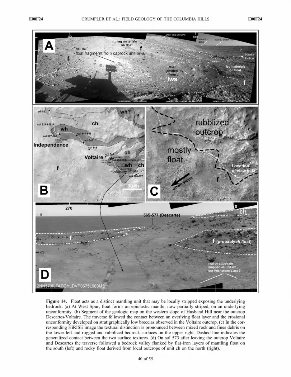
Figure 14. Float acts as a distinct mantling unit that may be locally stripped exposing the underlyingbedrock. (a) At West Spur, float forms an epiclastic mantle, now partially striped, on an underlyingunconformity. (b) Segment of the geologic map on the western slope of Husband Hill near the outcropDescartes/Voltaire. The traverse followed the contact between an overlying float layer and the erosionalunconformity developed on stratigraphically low breccias observed in the Voltaire outcrop. (c) In the cor-responding HiRISE image the textural distinction is pronounced between mixed rock and fines debris onthe lower left and rugged and rubblized bedrock surfaces on the upper right. Dashed line indicates thegeneralized contact between the two surface textures. (d) On sol 573 after leaving the outcrop Voltaireand Descartes the traverse followed a bedrock valley flanked by flat‐iron layers of mantling float onthe south (left) and rocky float derived from local outcrops of unit ch on the north (right).
CRUMPLER ET AL.: FIELD GEOLOGY OF THE COLUMBIA HILLS E00F24E00F24
40 of 55

beginning on sol 523. The contact is apparent from HiRISEperspective (Figures 14b and 14c) according to the distinctionin surface texture between the blocky float and the ruggedrelief of the outcrop upslope. The abundance of float down-slope and the rugged rubblized outcrop upslope can be seenin Navcam panoramas throughout the traverse along thiscontact. In a Navcam panorama on sol 573 looking back atthis contact (Figure 14d), it appears as step or ramp of looserocks typical of float, while the floor of the trough justupslope appears to be outcrop. The float is acting like aclastic layer in this case and is draped on an unconformity.Removal of the float layer has created a flat iron type layeror skin; the contact with the underlying unconformity fol-lows local variations in relief.4.15.3. Analysis and Interpretation[125] From orbital images this material is interpreted as
surficial debris and soils covering bedrock. General down-slope transport and overlapping accumulations of rubblizedand disaggregated bedrock appear to contribute to this sur-ficial debris and soil, and forms unconsolidated mantles onhillsides. The widespread occurrence probably representslong‐term erosion by both low‐energy (aeolian deflation)and energetic (impact cratering) processes over significantintervals of geologic time.[126] Rover‐based observations show that float occurs
nearly everywhere in the Columbia Hills [Yingst et al.,2008]. It encompasses many parent lithologies and manytime scales of emplacement, and has accumulated fromindividual clasts for the most part but locally it may be partof slides, debris flows, and downslope creep all leading tothick accumulations locally on the mid to lower flanks ofhills. Simple tracking of changes in clast morphology andlithology in local float throughout the Columbia Hills[Yingst et al., 2008] shows that it is probably representativeof the underlying bedrock through rubblization of the sub-strate, downslope transport, and overlapping accumulationof debris fragmented by long‐term (aeolian deflation) andenergetic (impact cratering) erosion.[127] In the long term, small impacts could act as
mechanical erosion agents, gradually move float off of upperslopes of hills, and accumulate it on the lower slopes. Severalobservations show that there are substantial float mantles,that it behaves as an epiclastic layer, and that it is subjectto erosion, stripping, and subsequent reexposure of theunderlying outcrop much as with any other clastic layer. Inseveral locations float forms a distinct layer on an under-lying disconformity and has been partially stripped off. Inthis respect it behaves now in many places as a distinctancient epiclastic layer.[128] If the characteristics of float here in the Columbia
Hills are representative of float elsewhere on Mars, thenoutcrops of bedrock are most likely to occur near crests ofrelief features simply because float, as well as mobile fines,are thinner to absent on the upper slopes. Float accumula-tions or layers may be important stratigraphic markers thatare common on Mars, are restricted to one or a few timestratigraphic positions, and have developed on significantgeologic unconformities. The role of float on Mars as ageologic record of changing environments is unlike its roleon Earth where it is of importance principally as a surficialmaterial of very recent age.
4.16. Bright Unconformable Debris of CumberlandRidge (Unit dcr)
[129] This surface is prominent in both orbital images androver‐based images, but for different reasons (Figures 2, 3a,and 3b). In orbital data it is clear that this is a bright streakedmaterial, that it includes many blocks, and that the streakstrend downslope and over significant breaks in slope. Takentogether these imply a likely zone of high downslopemobilityof clasts derived from some rocky source upslope. From roverperspective this a steep sloping area occupied by many large(20–30 cm) clasts resting on and within mobile fines. Itappears to be an area of competition between aeolian finesmoving upslope with prevailing westerlies, and blocksmoving downslope derived mostly from unit ucr. The claststhemselves may be representative of the lowest observedmaterials.4.16.1. Orbital Observations[130] Bright‐toned, streak‐like patterns and linear boulder
trains occur on the northwest side of Cumberland Ridge, thewest rim of Tennessee Valley, a deep cleft on the northslope of Husband Hill. The streaked appearance consists oftrails of aligned boulders and cobbles, many brighter in tonethan the surroundings. The continuity of the streaks acrosssignificant changes in relief is apparent in stereo image dataand illustrates its association with steep slopes in general.4.16.2. Field Observations[131] The surface consists of abundant angular to sub-
angular blocks resting on, and within, thick mantles of fineswhere this unit was crossed during the initial ascent ofHusband Hill between sols 317 and 380 (Figure 15). Thefines resulted in significant impairment of mobility. A buried3 to 4 cm clast churned up by the wheels during drives wastemporarily wedged in the right rear wheel. Buried clastsoccurred in at least two or three other sites where thick, nearlycohesionless, soils were present, mostly in areas character-ized as mobile fines (dmf) adjoining slopes where downslopemovement of rocky debris also occurred (Dead Sea adjacentto Lorre Ridge south of Husband Hill and Troy, a site on thewest base of the Inner Basin feature Home Plate).[132] The rocks (Wishstone, sol 332–337, and Cham-
pagne, sol 353–358) are two well‐studied examples of theseblocks examined in situ. Their relatively low alteration andrelatively higher RAT SGE (15 to 24 J mm‐3) compared toother classes of rocks such as the Clovis class [Squyreset al., 2008] is consistent with a competent rock mass thathas been broken into multiple subangular fragments insteadof simply disintegrating as would a materials with poorcohesion. On the basis of the high RAT SGE, the overallblockiness of these materials is therefore not surprising. Nooutcrops of comparable mineralogy were encountered far-ther upslope, but the presence of a moderately fresh impactcrater near the crest, and small clasts of this rock class inoutcrops (Voltaire) of what are interpreted to be impactbreccias and melts, suggests a possible source as deeplyexcavated substrate material.[133] In an MI mosaic of the RATed surface, Wishstone is
characterized as a poorly sorted clastic rock. Angular darkgrains 1 mm in diameter are set in a matrix of smaller lightergrains and a subresolution matrix. Texturally the character issimilar to that of some terrestrial volcanic tuffs [Squyres et al.,2006], including ash flows, but we cannot exclude the pos-
CRUMPLER ET AL.: FIELD GEOLOGY OF THE COLUMBIA HILLS E00F24E00F24
41 of 55

Figure 15
CRUMPLER ET AL.: FIELD GEOLOGY OF THE COLUMBIA HILLS E00F24E00F24
42 of 55
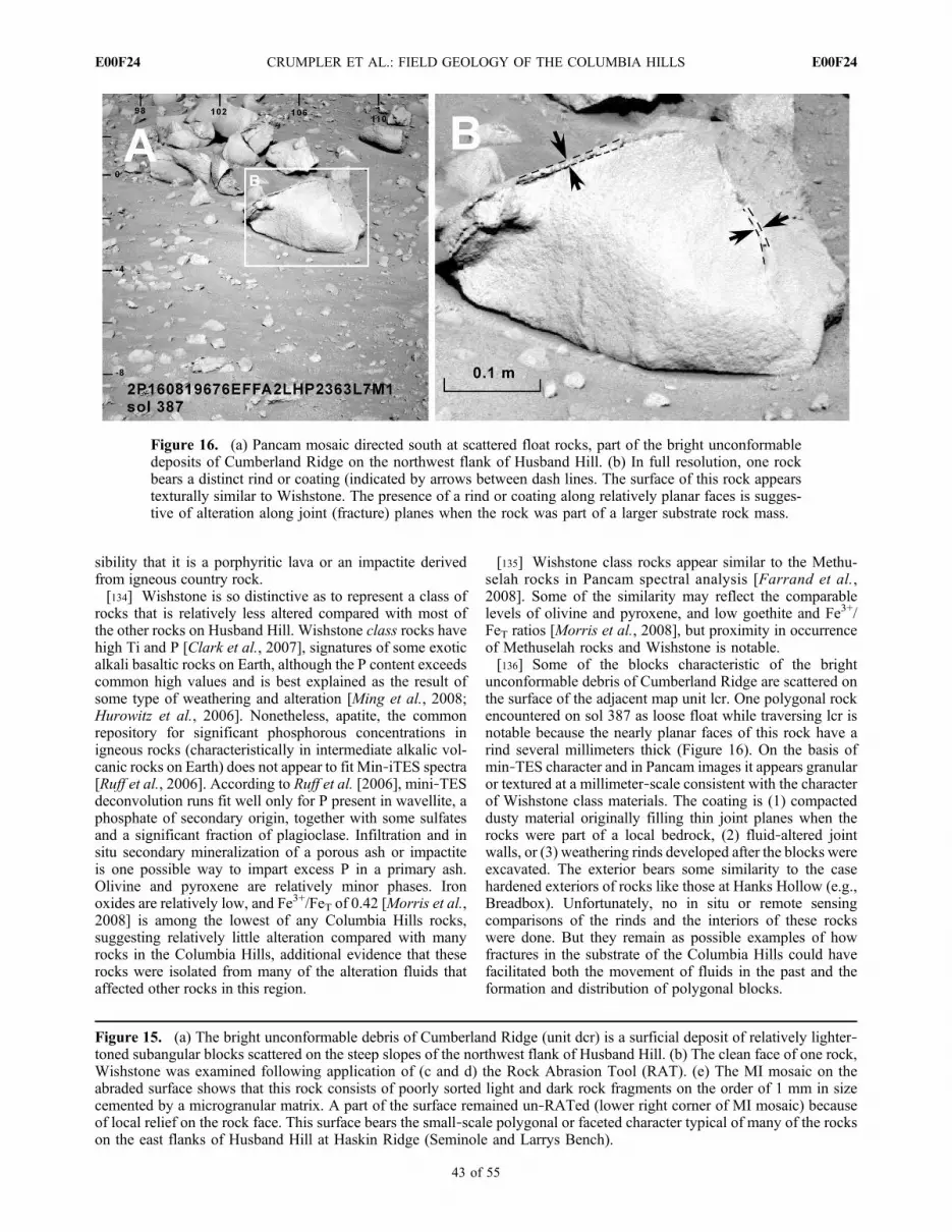
sibility that it is a porphyritic lava or an impactite derivedfrom igneous country rock.[134] Wishstone is so distinctive as to represent a class of
rocks that is relatively less altered compared with most ofthe other rocks on Husband Hill. Wishstone class rocks havehigh Ti and P [Clark et al., 2007], signatures of some exoticalkali basaltic rocks on Earth, although the P content exceedscommon high values and is best explained as the result ofsome type of weathering and alteration [Ming et al., 2008;Hurowitz et al., 2006]. Nonetheless, apatite, the commonrepository for significant phosphorous concentrations inigneous rocks (characteristically in intermediate alkalic vol-canic rocks on Earth) does not appear to fit Min‐iTES spectra[Ruff et al., 2006]. According to Ruff et al. [2006], mini‐TESdeconvolution runs fit well only for P present in wavellite, aphosphate of secondary origin, together with some sulfatesand a significant fraction of plagioclase. Infiltration and insitu secondary mineralization of a porous ash or impactiteis one possible way to impart excess P in a primary ash.Olivine and pyroxene are relatively minor phases. Ironoxides are relatively low, and Fe3+/FeT of 0.42 [Morris et al.,2008] is among the lowest of any Columbia Hills rocks,suggesting relatively little alteration compared with manyrocks in the Columbia Hills, additional evidence that theserocks were isolated from many of the alteration fluids thataffected other rocks in this region.
[135] Wishstone class rocks appear similar to the Methu-selah rocks in Pancam spectral analysis [Farrand et al.,2008]. Some of the similarity may reflect the comparablelevels of olivine and pyroxene, and low goethite and Fe3+/FeT ratios [Morris et al., 2008], but proximity in occurrenceof Methuselah rocks and Wishstone is notable.[136] Some of the blocks characteristic of the bright
unconformable debris of Cumberland Ridge are scattered onthe surface of the adjacent map unit lcr. One polygonal rockencountered on sol 387 as loose float while traversing lcr isnotable because the nearly planar faces of this rock have arind several millimeters thick (Figure 16). On the basis ofmin‐TES character and in Pancam images it appears granularor textured at a millimeter‐scale consistent with the characterof Wishstone class materials. The coating is (1) compacteddusty material originally filling thin joint planes when therocks were part of a local bedrock, (2) fluid‐altered jointwalls, or (3) weathering rinds developed after the blocks wereexcavated. The exterior bears some similarity to the casehardened exteriors of rocks like those at Hanks Hollow (e.g.,Breadbox). Unfortunately, no in situ or remote sensingcomparisons of the rinds and the interiors of these rockswere done. But they remain as possible examples of howfractures in the substrate of the Columbia Hills could havefacilitated both the movement of fluids in the past and theformation and distribution of polygonal blocks.
Figure 15. (a) The bright unconformable debris of Cumberland Ridge (unit dcr) is a surficial deposit of relatively lighter‐toned subangular blocks scattered on the steep slopes of the northwest flank of Husband Hill. (b) The clean face of one rock,Wishstone was examined following application of (c and d) the Rock Abrasion Tool (RAT). (e) The MI mosaic on theabraded surface shows that this rock consists of poorly sorted light and dark rock fragments on the order of 1 mm in sizecemented by a microgranular matrix. A part of the surface remained un‐RATed (lower right corner of MI mosaic) becauseof local relief on the rock face. This surface bears the small‐scale polygonal or faceted character typical of many of the rockson the east flanks of Husband Hill at Haskin Ridge (Seminole and Larrys Bench).
Figure 16. (a) Pancam mosaic directed south at scattered float rocks, part of the bright unconformabledeposits of Cumberland Ridge on the northwest flank of Husband Hill. (b) In full resolution, one rockbears a distinct rind or coating (indicated by arrows between dash lines. The surface of this rock appearstexturally similar to Wishstone. The presence of a rind or coating along relatively planar faces is sugges-tive of alteration along joint (fracture) planes when the rock was part of a larger substrate rock mass.
CRUMPLER ET AL.: FIELD GEOLOGY OF THE COLUMBIA HILLS E00F24E00F24
43 of 55

4.16.3. Analysis and Interpretation[137] In the HiRISE images vectors for some of the streaks
place the up hill source in the ejecta of a relatively deep15 m diameter impact crater situated on the crest of Cum-berland Ridge. From the rover perspective, the abundance ofrocky debris and moderate angularity of the blocks is evi-dence for relatively short transport from the source, and therim and ejecta of a small impact crater farther upslope wouldexplain their abundance. The rock Wishstone, which bearsseveral unusual characteristics that distinguishes it fromother rocks examined in the Columbia Hills [Squyres et al.,2006], is a representative of these rocks. On the basis ofthe fact that Wishstone class materials occur as fragmentswithin one of the lowest stratigraphic units encountered(Voltaire outcrop, see discussion of unit wh), it is likely thatWishstone along with many of the other blocks in the brightunconformable debris of Cumberland Ridge unit (ucr) arecurrently, as exposed, are disaggregated and out of positionin the stratigraphic sequence. If these are derived from theejecta of a crater farther upslope, then they could easily beamong the lowest materials encountered and are represen-tative of lower stratigraphic materials not exposed elsewherealong the traverse. The rind‐like coatings along angularboundaries of at least one of these rocks, along withchemical evidence for relatively minor alteration in thesurrounding rocks, would be consistent with a source inmoderately competent and jointed bedrock of low perme-ability and high hydraulic conductivity in which fluidsmoved primarily along planar joints and fractures. Subse-quent excavation of the blocks by impacts scattered frag-ments on the upper slopes of Husband Hill where they wereincluded in the loose unconformable surficial deposits. Tosummarize, these deposits are likely to be a mixture of debrisslide fines and excess deeply derived blocks from an impactcrater ejecta field migrating downslope and mobile finesmigrating up the west‐northwest slope of Husband Hill.
4.17. Unconformable Debris of Allegheny Ridge(Unit da)
[138] This is an anomalously sinuous ridge that extendsacross the surface of the basin south of Haskin Ridge(Figures 2 and 3f). In HiRISE images the ridge has theappearance of developing from confinement of a materialalong a sinuous trace, which suggests and inverted channelthe material of which could be anything from mudflows orimpact debris to lava flows or streambeds perched throughsubsequent erosion of the surrounding landscape. Proximal,although not in situ, observations indicate that the outcropmaterial along the crest contains clasts of blocks and cobblesize, so we suggest that this is a debris channel that has beentopographically inverted.4.17.1. Orbital Observations[139] A narrow and elongate ridge in the floor of the
valley south of Husband Hill, Allegheny Ridge, stands outas unusual because its narrow planform curves southwardacross another larger ridge. Where it terminates it is a broaderlobate platform with steep margins descending directly ontothe inner basin valley floor. It also appears to overlie thecontact between two map units implying that it representssomething unconformable that was emplaced after theexposure of the contact between the two underlying units
and was therefore emplaced late in the morphologic devel-opment of the Columbia Hills.4.17.2. Field Observations[140] This material was not traversed, but on sol 716,
Spirit passed within 100 m of its steep western margin.Pancam images acquired near the closest approach betweensol 723 and sol 724 (Figure 17) show resistant outcrops 1–2mthick resting on a light‐toned unit that appears similar fromthe distal perspective to outcrops of the lower Inner Basinunit (lib). There is no evidence for large clasts within theoutcrops, yet the crest and slopes of the ridge are coveredwith large equant blocks. So we cannot say with certaintythat the Allegheny Ridge material is fine grained, or whetherit is a gravel and cobble deposit.4.17.3. Analysis and Interpretation[141] The sinuous form and the exposure of distinct out-
crops of moderately resistant material in the upper slopes ofthe ridge implies that the ridge form is the results of topo-graphic inversion through erosion of up to several meters ofmaterial from the surroundings. A likely upstream source fora well‐developed channel is not obvious, and the overallbroadening near its western terminus appears similar to thepatterns seen in other slide and debris deposits identifiedwithin the Columbia Hills. If it is a former valley, then it isjust as likely that it was filled by debris derived from localmore competent rock type materials and persisted as aresistant caprock following deflation within the inner basin.
4.18. Unconformable Boulder Debris of West Spur(Unit bws)
[142] This is one of the more distinct surface units in bothorbital and rover images (Figures 2 and 3a). Unfortunately,it was not visited, and it appears to be limited in lateraloccurrence. The relatively high concentration of equantblocks compared to the flat‐lying and laminated rocks thatmake up the rest of the West Spur, and the abruptness withwhich it strikes across the West Spur imply a significantlocalized angular unconformity. On the basis of rover prox-imal perspectives it appears to be a blocky deposit, possiblydebris flow materials from farther up Husband Hill thathave collected in a structural valley transecting West Spur(graben?) and subsequently exposed by back wasting ofthe margins of West Spur.4.18.1. Orbital Observations[143] This, like the western Husband Hill (wh) unit, is
another example of a unit that is too limited in occurrence tohave been mapped in pretraverse orbital image base pho-togeologic mapping exercises. Only after detecting thismaterial during surface traverse was it subsequently possibleto identify its surface characteristics well enough to map itsextent in a HiRISE image. In plan view this is an elongatedarea of unusually abundant blocks but limited apparentbedrock outcrop occurring as a low ridge diagonally trans-ecting the roughly east‐west strike of West Spur. The eastand west contacts of this unit with West Spur are abrupt andlinear suggesting either a preexisting linear valley or gra-ben‐bounding normal fault crosscutting West Spur.4.18.2. Field Observations[144] This is a distinctive terrain from the rover perspec-
tive and it was imaged from several locations (Figures 18a,18b, and 18c) while Spirit was located on the upper slopesof West Spur (sol 313 to ∼sol 324). It appears as a cluster
CRUMPLER ET AL.: FIELD GEOLOGY OF THE COLUMBIA HILLS E00F24E00F24
44 of 55

Figure
17.
Pancam
mosaicof
AlleghenyRidge.T
hisisan
obliq
ue,n
earlyend‐on
view
oftheridge.The
uppermeter
con-
sistsof
concentrated
blocks
andsm
allclasts.Outcropsjustbelow
theseareof
anundeterm
ined
lithology.The
uppermeter
may
berepresentative
ofwhatevermaterialfilledtheoriginal
sinuousdepression
that
isnow
inverted
toform
Alleghany
Ridge.
CRUMPLER ET AL.: FIELD GEOLOGY OF THE COLUMBIA HILLS E00F24E00F24
45 of 55

Figure
18.
Uncon
form
able
boulderdebris
ofWestSpu
r(bws).(a)View
from
roverlocation
onsol31
3look
ingback
towardtheWestS
purfrom
which
theroverhasjustdescendedon
theprevious
fewsols.T
heunconformableboulderdebris
ofWestSpuroccurs
asadistinct
clusterof
boulders
alongashortsegm
entof
WestSpur.Polygon
show
sarea
acquired
inpredrive
Pancam
ofsol317.
(b)Pancam
imageacquired
onsol317(locationshow
nin
Figure18a)
during
closestapproach
totheunconformabledepositsof
WestSpur.The
overalltextureandsize
ofblocks
aresimilarto
thosein
thebright
uncon-
form
able
debrisof
Cum
berlandRidge
(unitdcr).Itisinterpretedthatthisaresidual
accumulationin
aform
ertrough
filled
with
debrissourcedin
materialsfrom
fartherupslopeandcomparableto
unitdcrmaterials(W
ishstone
class?).(c)Vieweast
from
WestSpuracross
anom
alousblockandboulderconcentration.
The
caprockof
WestSpur(unituw
s),exposed
asout-
cropson
thefareastside
ofthedeposit,appearsto
plunge
beneaththedeposit.(d)Observatio
nshere
during
thedecent
ofWestSpu
rshow
that
thecaprockof
WestSpu
r(uws)
plun
geseastwardunderneath
theunconformable
depo
sits
ofWest
Spur.
CRUMPLER ET AL.: FIELD GEOLOGY OF THE COLUMBIA HILLS E00F24E00F24
46 of 55

of 10 cm and larger subrounded, light‐toned blocks andboulders in an area where most of the rocks are tabular orlaminated (unit uws). It occupies a roughly northeast trendinglinear trough into which the normally horizontal laminationsforming the caprock ofWest Spur (unit uws) appear to plungeor dip (sol 312, Figure 18d). In observations around sol 313near the east end of West Spur (Sol313A_P2431_L357) thecaprock outcrop (uws) locally has an apparent easterly tilttoward the contact with this unit.4.18.3. Analysis and Interpretation[145] The morphology and texture as seen from rover
perspective contrasts strongly with surroundings and is oneof the clearer examples of a geologic unit mappable fromthe ground. Because all of the rocks are large, moderatelyround, and morphologically distinct from the slab like rocksofWest Spur, it is unlikely that the material is associated withthe surrounding ridge. Instead it appears to be a collection ofdisaggregated blocks of a distinctly different lithology thanlocal rocks and outcrops of West Spur.[146] In HiRISE stereo data the crest of the crosscutting
ridge clearly lies below the elevation of the surroundingWest Spur caprock (uws) in support of the hypothesis that itis a blocky deposit that has filled a tough‐shaped disconti-nuity cutting diagonally across the West Spur ridge form. Ifso, the fact that the west Spur caprock appears to dip towardthe unit on the east and west sides might imply that thetrough was either present prior to the deposition of WestSpur caprock or the graben developed subsequently withblind boundary faults resulting in surface drag fold ratherthan scarps. Distinct linear terminations of bedding planeson the far wall of the trough (Figure 18b) are suggestive ofeither a fault line scarp or the strike line of dipping beddingplane. On the basis of the linear boundaries and the cross-cutting character of this unit in HiRISE stereo data, either(1) it is slope debris and debris slide materials collected in aformer valley, possibly a graben that cuts across the WestSpur, and is now topographically inverted by differentialerosion of a less resistant substrate or (2) it is a fault sliveruplifting a block of Columbia Hills bedrock or droppingformerly overlying units within a narrow graben.[147] In the absence of compositional or spectral data
on these rocks, we cannot say how they differ from theobserved West Spur mineralogies. But on the basis of therestricted occurrence the most likely interpretation is that itis debris collected in a former valley cutting across WestSpur. The equidimensional form of many of the blocks andthe relatively light tone are similar to blocks (like Wish-stone) in the light unconformable deposits on the northwestside of Husband Hill (dcr) or the Cumberland Ridge (ucr?).[148] Our interpretation based on limited proximal remote
sensing is that these deposits are the results of early land-slide or debris flow of materials from the upper slopes ofa formerly steeper Husband Hill. A sequence that couldaccount for the observed exposure is the development of agraben in the lower West Spur unit (lws), followed by airfall draping of the material that became the West Spurcaprock (uws), and then unconformable emplacement of theboulder deposit. Alternatively, normal faults could havedropped a segment of the West Spur along a crosscuttinggraben, cantilevering segments of the West Spur caprockinto the margins of the graben, followed by deposition of theunconformable boulder deposit.
4.19. Unconformable Debris and Chute Materials(Unit d)
[149] The lower slopes of the Columbia Hills in HiRISEimages are characterized by debris aprons, deep valleys andravines, and streaks similar to that generally interpreted onMars as evidence for significant downslope migration ofloose materials and disintegrated bedrock (Figures 2 and3e). From the rover perspective, some areas on the slopes ofthe Columbia Hills, particularly the south face of HusbandHill and Haskin Ridge, and the north face of McCool Hill,appear more organized as chutes with adjoining fan‐likearrangements of deposits at their lower termini. We interpretthese as debris slides and chutes but cannot say whether theyform as single slide events or are the results of long‐termaccumulation. Exposures of the terminus of the McCool Hilldebris slide show that at least some of these are emplaced asdistinct thin layers implying that they are emplaced as thin,spreading flows possibly over many events.4.19.1. Orbital Observations[150] Hillside chutes, lobe‐shaped areas at the foot of
slopes, and linear boulder trains and streaks are present in afew locations, mostly on the steeper slopes of the ColumbiaHills. Significant examples near Spirit’s traverse occur onthe north and south flanks of Husband Hill and the southflank of Haskin ridge. In HiRISE image data, the surfaces ofdebris flows appear to consist of loose debris of mixed finesand some rocks. The uphill termination of the more lobe‐shaped examples are frequently defined by scallop‐shapedalcoves or small scarps while the margins of larger exampleslike that on the north flank of Husband Hill are bounded bylateral ridges or levee‐like arrangements in midslope. Theterminus of the two larger lobe‐shaped examples is hum-mocky, yet the interiors are relatively smooth. The linearboulder trains and streaks differ in that the plan shape ismore irregular. The two type examples are on the northwestflank of Husband Hill and appear to be sourced at prominentscarps in flat‐lying benches.4.19.2. Field Observations[151] None of the areas mapped as this material were
traversed and only the occurrences on the eastern end ofWest Spur and the south face of Husband Hill wereobserved with proximal remote sensing during the traverse.The example on the eastern end of West Spur is imaged inthe south‐southeast quarter of the Thanksgiving Pan (NASAPIA 07734) (Figure 19a) but is unrevealing other than thatthe slope is excessively rocky and undulating with localswells several meters across and up to 50 cm deep. Aprominent debris chute on the south side of Husband Hillwas imaged in super resolution Pancam data on sol 1513(Figure 19b). Only the upper end of this was acquired, but itdoes reveal that the interior of the chute is hummocky, morefinely textured than the surrounding much rockier flanks ofHusband Hill, and the contact between the surroundings andthe chute are defined by an abrupt ridge or scarp.4.19.3. Analysis and Interpretation[152] From orbital images alone these areas are interpreted
as debris chutes and fans that have developed followingfluid downslope movement of unconsolidated and unstablematerials, including blocks and fines together. Alternately,instead of coherent mass movement as a loose debris flow,these could be long‐term accumulation of materials along
CRUMPLER ET AL.: FIELD GEOLOGY OF THE COLUMBIA HILLS E00F24E00F24
47 of 55

chute‐like corridors. The lobe‐shaped examples appear to bewell‐confined flows of aggregated debris mass in whichterminal run out included large, possibly matrix‐supportedblocks.[153] Comparison of landscape characteristics from the
rover perspective and the location and plan view lobateshape of these surfaces in HiRISE images are consistentwith the more coherent flow of material en mass to as debrisflows. The smooth, rolling surface of some of these as seenin superresolution Pancam images (Figure 19b) is similar tothe fine‐dominated and character of debris slides on Earth.The location on relatively steep slopes, particularly whereoutcrops are few and the surface is bland and apparentlyloaded with fines supports this interpretation. We suspectthat these are examples of a form of mass movement that hasbeen common during the landscape evolution throughoutthe Columbia Hills [Rice et al., 2010]. Other areas identified
as this unit may be areas of confined downslope accumu-lation rather than cohesive flows.
5. Impact Craters
[154] Distinct differences in the density of impact craterswithin the Columbia Hills are notable in a map based onidentification of all impact crater rims and circular residualimpact depressions using stereo HiRISE images (Figures 20aand 20b). Three distinct groups of surface units were groupedfor counting and include the plains unit (Ba), Float materials(F), and capping or outcrop units. The capping or outcropunits include several widely separated Columbia Hills out-crops and rock types: West Spur (uws), Haskin Ridge (H),Cumberland Ridge (ucr), Columbia Hills summit (ch), andupper Home Plate (R).[155] The results show that where the float (unit F) is
common, which is mostly on slopes, there is a dearth of small
Figure 19. (a) Rover perspective on NW Husband Hill looking upslope at thick, rocky debris mantlethat drapes over the steeper slopes on the northwest flank of Husband Hill. (b) Pancam “super resolution”view of feature/frame AuthorC.Clarke (Sol 1513A_P2588), a debris chute or slide on the south side ofHusband Hill, as seen from the third winter location on the north edge of Home Plate. Inset shows per-spective from HiRISE.
CRUMPLER ET AL.: FIELD GEOLOGY OF THE COLUMBIA HILLS E00F24E00F24
48 of 55

Figure
20.
(a)Map
ofallidentifiableim
pactcratersin
HiRISEim
ages
covering
thearea
show
nin
Figures
1and2a.S
ome
variations
incrater
density
arenotablethroughout
theColum
biaHills.Areas
ofobviouslylower
impactcrater
concentration
arenotcorrelated
with
stratig
raphically
higher
(younger)materialsbutinsteadarecorrelated
with
areaswhere
significant
erosionhasoccurred,or
where
slopedebrisisabundant.(b)Size‐frequencydistributio
nof
smallim
pact
cratersin
threeof
thebroadsurfacetypes,plains
lavas(unitpl),floatcoveredslopes
(unitf),andunits
representin
goutcrops
andcapping
ridges
(units
uws,lcr,ch,h,
R).Areas
coveredby
mobile
materials
(unitsrm
fanddm
f)werenotcounted.
Impact
crater
abundances
intheplains
determ
ined
from
countson
theHiRISEim
agebase
(dottedlin
e)iscomparableto
thefindings
from
rover‐basedcounts(solid
line)
alongSpirit’straverse
with
intheplains.A
tthisscalethesynopticoverhead
view
afforded
byHiRISEismoreuseful
forcrater
inventoriesbecauseitassesses
greaterareasthan
ground
‐based
crater
identification.
CRUMPLER ET AL.: FIELD GEOLOGY OF THE COLUMBIA HILLS E00F24E00F24
49 of 55

impact craters, whereas later plains lavas tend to have slightlymore impact craters. As a check, in Figure 20b we directlycompare the results for counts on the plains unit in HiRISEimage data with impact craters distributions identified fromthe rover perspective [Golombek et al., 2006] and find thatcrater counts based on HiRISE data are capable of detectingsmall impact craters nearly as well as ground‐based countsfrom rovers and certainly over larger areas.[156] Compared with the small impact craters that were
easily identified from the rover perspective within the plains[Golombek et al., 2006], impact craters are not as obviousalong the traverse within the Columbia Hills. Only a few smallimpact craters are easily identifiable from rover perspective(sols 200, 310, 317, 520, 639, 655, 1886) whereas numerousdepressions, troughs, and hillside scalloped depressions weretraversed. The latter are likely remnants of small impactcraters although there is nothing distinctive other than theabsence of other reasonable alternative methods to createhollows and arcuate scarps to confirm this origin. At least twolocalities of outcrop exposure on the traverse over HusbandHill (Independence and Kansas) (see Figure 2) appear to lie inbroad depressions that are sharply separated from the thickmantles of surrounding float. These coincide with (roughlycircular) depressions and are identifiable in HiRISE imagedata as probable small impact craters. There is some sug-gestion that among small impact crater populations, low‐velocity impacts, presumably secondary craters, are morecommon [Golombek et al., 2006; Grant et al., 2006]. Thedepressions with little float are intriguing inasmuch as theysupport some basic concepts about the dispersal of impactenergy in targets of variable strength. For example, low‐ tomoderate‐velocity impacts into layered targets [Melosh,1989], where a low‐strength material overlies a hard sub-strate (a reasonable description for float‐covered bedrock),the impact energy can be diverted in lateral expulsion of upperlayers and relatively little excavation. These observationsmay support the general conclusion that low‐velocity impactson slopes with thick float may be capable of removing sig-nificant covers of loose debris and result in exposure of thebedrock substrate. In the long term, the process exposesbedrock to erosion and breakdown while mostly movingexisting loose material downslope.[157] The variation in the local impact crater distribution
at this scale bears little relation to the stratigraphy deter-mined from geologic mapping. For example, overall abun-dances of impact crater are greater in the plains than withinthe Columbia Hills [Haldemann et al., 2004], in apparentcontradiction to the fact that onlapping relations, visible inorbital images [Kuzmin et al., 2000] as well as from Spirit’straverse [Crumpler et al., 2005], show that the ColumbiaHills are much older than the surrounding plains. The lowercrater abundances for the stratigraphically older ColumbiaHills most likely reflect differences in crater retention ratherthan age, a difference that is almost certainly a result of themore resistant plains lavas relative to the less competentclastic lithologies that dominate the shallow surface andoutcrops of the Columbia Hills. The greater strength ofplains rocks relative to rocks of the Columbia Hills wasconfirmed directly by recorded Rock Abrasion Tool (RAT)Specific Grind Energies (SGE) [Gorevan et al., 2003;Bartlettet al., 2005]. The SGE recorded the energy consumed toexcavate a RAT hole of a given volume and represents a
reliable quantitative proxy for laboratory rock compressivestrength measurements. The average SGE of plains rocks(50–60 J mm−3) is several times higher than typical rocks ofthe Columbia Hills (2 to 24 J mm−3) [Bartlett et al., 2005;Arvidson et al., 2006; Squyres et al., 2006]. Rocks of theplains are likely to erode at rates proportionately slower thanthe rocks within the hills therefore yielding a net highercrater retention rate within the plains.
6. Stratigraphy and Geologic History of theColumbia Hills Interpreted From Field Results
[158] At least 60 m of vertical stratigraphic section hasbeen examined as outcrop within the Columbia Hills. Wherebenches, ridges, and ledges were traversed on the flanks ofHusband Hill, the dip of local outcrop layers, or structuralsurfaces, generally exceeded the topographic slopes. Fromthis general arrangement of bedding planes, the ColumbiaHills are interpreted to have an eroded antiformal structure,that is, older materials are generally exposed at higher ele-vations, although this is modified at the highest elevationsby local caps of higher, more resistance stratigraphic units.Exposure of older rocks at higher elevations was accom-plished through general effects of ablation wearing away thesummits and depositing debris on the lower flanks. Duringthe traverse, the contact between the exposed bedrock out-crops and the debris‐laden lower slopes appeared to bedistinct and the debris itself had begun to be ablated as alater epiclastic unit. The ability to measure the dimensionsof the observed sections from the rover enabled sections tobe roughly correlated for the first time at meter scales on thesurface of Mars. The summary sketch of stratigraphic results(Figures 21a and 21b) plotted on the general profile of theColumbia Hills along with the measured sections and litho‐stratigraphic relations permits the development of somegeneral hypotheses for the regional geologic history of theColumbia Hills.[159] Sections on the northwest flank of Husband Hill (the
Methuselah–Larrys Lookout region) and on the south flankof Haskin Ridge bear some similarities in their petrographyand overlapping position with other units. In both sectionsan early poorly sorted material (Larrys Bench and Seminole)with abundant nanophase oxides, interpreted as severelyaltered matrix glass groundmass and microshards (Voltaireand Wishstone source), is overlain by somewhat coarser, butpoorly laminated lapilli tuffs (Larrys Lookout and Algon-quin–Comanche Spur). The latter bear evidence for explo-sive emplacement, abundant altered glassy groundmasses,and incorporation of Wishstone clasts (Voltaire). We inter-pret this sequence as the result of at least one significantimpact into a Wishstone class material substrate that gen-erated impact melts, along with other impacts into basalticmaterial, and followed by later volcanic air fall deposits.Pervasive and thick lapilli tuffs resting on these rocks arepossible volcanic deposits from local Plinian to sub‐Plinianeruptions, either vents within the floor of Gusev crater, ormore distal volcanoes typified by those in the surroundinghighlands. Lapilli of the observed dimension, on the order of1 to 2 mm, can be transported from several hundred kilo-meters [Wilson and Head, 2007].[160] The outcrop Clovis (the caprock of West Spur, unit
uws) in general is interpreted as a fundamentally basaltic
CRUMPLER ET AL.: FIELD GEOLOGY OF THE COLUMBIA HILLS E00F24E00F24
50 of 55

volcanic ash (size fraction) fall deposit from a distal source.The unusual enrichment in Cl (1.4 wt %) bears some sim-ilarity to the high Cl concentrations determined from MarsOdyssey Gamma Ray Spectrometer results for the equatorialregion immediately to the north [Keller et al., 2007]. Thisbroad region corresponds with the mapped extent of the
Medusae Fossae mantling deposit, a material that uncon-formably buries significant preexisting relief and is gener-ally compared with deposits of ashfall derivation [Mandtet al., 2008]. The proximity of Gusev crater to the regionover which Medusae Fossae Formation occurs, together withthe chlorine anomaly, makes the Clovis class material (unit
Figure 21
CRUMPLER ET AL.: FIELD GEOLOGY OF THE COLUMBIA HILLS E00F24E00F24
51 of 55

uws) a viable candidate as a distal outlier of the MedusaeFossae Formation. If this were so then we could speculatethat the entire Columbia Hills stratigraphic sequence pre-dates the end of the Ma’adim Vallis incursion into Gusevcrater, because the channels at the terminus of Ma’adim cutMedusae Fossae materials. The presence of a surroundinglake or throughgoing channels after the protolith rocks ofColumbia Hills had been emplaced would be consistent withthe greater availability of fluids in the environment that ulti-mately played a role in chemically altering the rocks. Theextreme backwasting of the lower slopes of the ColumbiaHills, such as that seen at West Spur and significant devel-opment of slope debris and thick epiclastic deposits wouldalso be consistent with enhancedmechanical erosion affordedby significant water and corresponding physical erosion.[161] From Spirit’s traverse we now know from direct
observation that significant geologic time transpired beforethe emplacement of the plains basaltic lavas in Gusev crater.The Columbia Hills side of the lava contact is an angularunconformity. Yet this unconformable surface is coveredwith float derived from some of the higher stratigraphicunits (Clovis and Hanks Hollow, units uws and lws) and thesequence of clastic rocks in West Spur are truncated by backwasting beneath the resistant cap of Clovis class rock.Erosion sufficient to generate this scale of unconformity wasaccomplished by some extremely energetic erosion processor by a less energetic process operating over a long period.Either intense activity or long intervals of activity areimplied, which is geologically significant in either case, andthe regional volcanism occurred long afterward. This fol-lows a pattern of former fluvial valleys reoccupied by laterlava flows that appears common to much of Mars [e.g.,Crumpler et al., 2007].[162] All rocks measured, even the distal ash deposits like
Clovis, and with the exception of Wishstone, are extensivelyaltered by fluids. So, a fluid‐rich environment and potentialfor erosive environments continued long after the originalimpacts and pyroclastic eruption events responsible forthem. Wishstone appears to represent a substrate, possiblyan early core massif of the Columbia Hill that was notsubjected to the abundance of fluids that affected later rocks,although the presence of rind‐coated angular blocks (sol 387)and possible secondary P implies that at least a limitedamount of fluids were present.[163] The following geologic history of the Columbia
Hills is based on the observations outlined above and cur-
rent understanding of their implications. The Columbia Hillswere initiated as a floor relief feature in Gusev crater, likelya central peak. At some point structural deformation occurred.Both a series of wrinkle ridges and numerous impact cratersacross the floor may have helped shape the hills. Tectonicdeformation may have continued through later times bothas wrinkle ridges and late floor isostatic adjustments.Thermal events may also have affected the basement rocksthroughout this period.[164] During this earlier and more dynamic period, deep
erosion and modification of the central peaks between inter-vals of modification, and regional impact crater fall depositswere probably occurring and contributed to a series ofdeposits and unconformities further obliterating any originalcentral peak rocks or their associated landscape. Fluvialevents (Ma’adimVallis) were active on the Gusev crater floorat some point during these events or immediately followingthem, but there is no evidence to indicate whether or not theColumbia Hills were directly affected mechanically. There isevidence that moderately high water‐to‐rock ratios werepresent during the time that most of the clastic rocks of theColumbia Hills were being deposited as fall deposits,including both impactites and pyroclastic deposits. Thesewere all subsequently altered significantly by fluids movingthrough the rocks.[165] Proximal volcanic vents, possibly local, deposited
volcanic air fall materials throughout the hills. Small tec-tonic movements possibly associated with continued wrin-kle ridge type deformations may have occurred during thisphase as well. Local volcanic vents may have been thesource of the widespread pyroclastic deposits or they mayhave been simply a part of the regional rise in volcanism thatalso contributed to the stack of volcanic fall deposits drapedover the hills. Substantial time elapsed after, and likelybetween, these eruptions for early erosion of the ColumbiaHills, including backwasting of ridges and peaks draped byregional fall deposits. The early, more altered, and softercore rocks acted as slope formers and later pyroclasticsequences were caprocks. Accumulated hillslope debrisaided by local small impact cratering events initiated manydebris slides and slumps. Wind redistributed some of the ashand eroded volcanic rocks throughout the time of activevolcanism, filling local hollows with secondary, mobilesands of composition similar to the local primary volcanicrocks. Finally the floor of Gusev crater was flooded bylava flows that encroached on the eroded margins of the
Figure 21. (a) Summary schematic section of Husband Hill and adjoining ridges on an elevation plot along the traverseroute. The profile represents elevations of the traverse from sol 156 to sol 720 based on the rover tracking reported by Li et al.[2008]. Sols of significant back tracking (sols 423–434; 454–513; 582–605; 619–635; 668–664; 667–678) have beenremoved, and the profile laterally collapsed into a serial ascent and descent traverse from left to right from theWest Spur on theleft, across Husband Hill in the center, and into the Inner Basin near Lorre and Mitcheltree Ridges on the right. On the basis ofrecorded structure at laminated outcrops, and the apparent down‐stratigraphic sequence of exposures with upslope traverse, theColumbia Hills are interpreted to consist of multiple draped deposits, now mostly stripped from the crest so that strati-graphically higher materials tend to occur topographically lower on the hills. An unconformity on the core massif materials andon the Wishstone parent material, shown only graphically, predate and form the substrate over which most of the otheroutcrops visited during the traverse are draped. (b) Measured stratigraphic sections at four locations along the traverse throughthe Columbia Hills. The total apparent section is about 60 m. Early impactites and microbreccias are followed in succession bythick lapilli tuffs, fine ashfall deposits, and late basaltic lava flows. A significant erosion unconformity postdates the high‐Clash ofWest Spur (Clovis outcrop, unit uws) unconformity. Note that breaks in the lateral correlation of these four sites result inconsiderable uncertainty regarding their relative vertical positions in the regional stratigraphy.
CRUMPLER ET AL.: FIELD GEOLOGY OF THE COLUMBIA HILLS E00F24E00F24
52 of 55

Columbia Hills. Continued, but significantly reduced, impactcratering modified the hills and the lava plains. Even thoughthe period of intense geological activity and surface modi-fication had ended by this point in the sequence, repetitivecycles of moist climatic events over the course of the next(few) billion years that followed, together with the acidiccharacter of fluids and their sequestering in the substratebetween moisture events, were sufficient to further erode andalter rocks at depth and leach fines exposed at the surface.Sulfate seeps and springs may have continued until the rel-atively recent past.
7. Conclusions
[166] Spirit conducted a geologic reconnaissance traverseon Mars and field checked a photogeologic map preparedfrom orbital remote sensing data. From the results of thetraverse mapping, we conclude that stratigraphic complexityoccurs at submeter scales on Mars, field geologic mappingis possible at meter (outcrop) scales, and elements ofregional geologic history may be preserved and subse-quently interpreted by terrestrial type field methods. Thetools of field geology were an important part of the missiondesign criteria and these results confirm that the use ofstandard field geologic methods and field tools is appro-priate to understanding the geologic history of Mars. Thisfirst walk through and geological characterization of acomplex geologic setting on Mars also demonstrates thatMars is as geologically complex as Earth. But whereas themost complex preservation on Earth records the last halfbillion years of geologic activity, on Mars the activity wasearlier and equally well preserved as young events on Earth,though no less complex. The main impediment to accurateunit mapping on the surface in rugged terrains on Mars willbe float. Slumped blocks and residual fragments of hardcaprocks on a softer undermined substrate can almost entirelycover retreating slopes leaving very little of any softer sub-strate exposed for sampling. In terrains where float is abun-dant, a successful in situ sampling strategy might includefocusing on small impact craters. Because small impacts maybe dominated by low‐velocity secondary impacts [Golombeket al., 2006], and the kinetics is insufficient to substantiallydamage the substrate, loose (float) overburden resting onharder bedrock appears to be swept laterally by the impact.[167] The geology along the entire traverse through the
Columbia Hills consists of scattered outcrops, mostly of tuffsand breccias, thick accumulations of float, and mobile fines.Spirit’s in situ studies were unable to examine the deepsubstrate materials of the Columbia Hills but it is likely thatthe precursor hills were part of an original central peak massifconsisting of breccias and uplifted deeper crustal materials.Following development of one or more unconformities andintervening fall deposits, the precursor hills were draped withvarious later air fall deposits to form the outcrops that wereexamined. Many of the variations in microscopic texture,abundances of small lithic fragments (clasts) and evidence forpredepositional and postdepositional nonisochemical alter-ation are consistent with local and regional fallout and ejectafrom impacts of differing sizes and depth of excavation intarget materials of diverse initial alteration state. In somecases, these may have been altered subsequently by secularand episodic events in which fluids circulated through the
rock masses. Differing proximity and differing alterationand petrologic state of nearby target materials are possibleorigins of variations in observed protolith chemistries forthese deposits. Other materials are volcanic fall depositsfrom distal and proximal ash and lapilli sources. The Clovisclass materials that cap West Spur and the Medusae FossaeFormation of equatorial Mars may be part of the sameregional volcanic fall deposit.[168] The documentation of the great differences in alter-
ation and weathering of rocks on either side of the geologicunconformity between the plains and Columbia Hills representsthe first direct validation of the general inference fromremote sensing that the Martian climate has become dryerand less energetic with time. The general stratigraphic trendin the Columbia Hills records a geologic history that pro-gresses from time of higher water‐rock ratios, through aperiod of predominant influences of impact ejecta and fall-out, then to predominantly volcanic, and subsequently alonger period of small secular changes in fluid abundanceand pervasive aeolian erosion. A sequence of environments,the decline in vigorous geologic activity punctuated bycycles of fluid interaction, periods of volcanism, and someintervening periods of erosion are all documented in theColumbia Hills through direct observation of exposed out-crops. This geologic history, determined with basic fieldgeologic techniques, in the Columbia Hills is similar tocurrent hypotheses of global Martian geologic history, andmay be applicable to interpreting global processes andsecular changes that have affected many as yet unvisitedareas of Mars.
[169] Acknowledgments. This work was supported by the MarsExploration Rover mission project through contracts with the Jet Propul-sion Laboratory, California Institute of Technology, sponsored by NASA.The Mars Reconnaissance Orbiter High Resolution Imaging Science Exper-iment (HiRISE) is supported by the Mars Reconnaissance Orbiter projectthrough the NASA contract to the Jet Propulsion Laboratory, CaliforniaInstitute of Technology.
ReferencesArvidson, R. E., et al. (2003), Physical properties and localization investi-gations associated with the 2003 Mars Exploration rovers, J. Geophys.Res., 108(E12), 8070, doi:10.1029/2002JE002041.
Arvidson, R. E., et al. (2004), Initial localization and physical propertiesexperiments conductedwith theMars Exploration RoverMission to Gusevcrater, Science, 305(5685), 821–824, doi:10.1126/science.1099922.
Arvidson, R. E., et al. (2006), Overview of the Spirit Mars ExplorationRover Mission to Gusev crater: Landing site to Backstay Rock inthe Columbia Hills, J. Geophys. Res., 111, E02S01, doi:10.1029/2005JE002499.
Arvidson, R. E., et al. (2008), Spirit Mars Rover Mission to the ColumbiaHills, Gusev crater: Mission overview and selected results from the Cum-berland Ridge to Home Plate, J. Geophys. Res., 113, E12S33, doi:10.1029/2008JE003183.
Arvidson, R. E., et al. (2010a), Spirit Mars Rover Mission: Overview andselected results from the northern Home Plate Winter Haven to the sideof Scamander crater, J. Geophys. Res., 115, E00F03, doi:10.1029/2010JE003633.
Arvidson, R. E., et al. (2010b), Recent scientific results from Spirit’s obser-vations of sulfate sands on the side of Scamander crater, Columbia Hills,Mars, Lunar Planet. Sci., 41, Abstract 1247.
Barnes, J. (1981), Basic Geological Mapping, 119 pp., Open Univ. Press,London.
Bartlett, P. W., L. E. Carlson, P. C. Chu, K. R. Davis, S. Gorevan, A. G.Kusack, T. M. Myrick, and J. J. Wilson (2005), Summary of Rock Abra-sion Tool (RAT) results pertinent to the Mars Exploration Rover sciencedata set, Lunar Planet. Sci., 36, Abstract 2292.
CRUMPLER ET AL.: FIELD GEOLOGY OF THE COLUMBIA HILLS E00F24E00F24
53 of 55

Bell, J., et al. (2003), Mars Exploration Rover Athena Panoramic Camera(Pancam) invest igat ion, J. Geophys. Res. , 108 (E12), 8063,doi:10.1029/2003JE002070.
Cabrol, N. A., E. A. Grin, R. Landheim, R. O. Kuzmin, and R. Greeley(1998), Duration of the Ma’adim Vallis/Gusev crater hydrologic system,Icarus, 133, 98–108, doi:10.1006/icar.1998.5914.
Cabrol, N. A., et al. (2003), Exploring Gusev crater with Spirit: Review ofscience objectives and testable hypotheses, J. Geophys. Res., 108(E12),8076, doi:10.1029/2002JE002026.
Carr, M. H. (1996),Water on Mars, 229 pp., Oxford Univ. Press, New York.Christensen, P. R., et al. (2003), The Miniature Thermal Emission Spec-trometer for the Mars Exploration Rovers, J. Geophys. Res., 108(E12),8064, doi:10.1029/2003JE002117.
Clark, B. C., et al. (2007), Evidence for montmorillonite or its composi-tional equivalent in Columbia Hills, Mars, J. Geophys. Res., 112,E06S01, doi:10.1029/2006JE002756.
Compton, R. (1985), Geology in the Field, 398 pp., John Wiley, New York.Crumpler, L. S. (2003a), Spring deposits on Mars: Physical processes fromterrestrial analogs, Lunar Planet. Sci., XXXIV, Abstract 2002.
Crumpler, L. S. (2003b), Physical characteristics, geologic setting, and pos-sible formation processes of spring deposits on Mars based on terrestrialanalogs, in Sixth Mars Conference (CD‐ROM), Abstract 3238, Lunarand Planet. Inst., Houston, Tex.
Crumpler, L. S., and the Athena Science Team (2005), MER field observa-tions and analysis of vesicles in the Gusev plains: Significance as recordsof emplacement environment, Lunar Planet. Sci., XXXVI, Abstract 2122.
Crumpler, L. S., et al. (2005), MER geologic traverse science by the SpiritRover in the Plains of Gusev crater, Mars, Geology, 33, 809–812,doi:10.1130/G21673.1.
Crumpler, L. S., L. P. Keszthelyi, W. L. Jaeger, A. McEwen, and the HiRISEScience Team (2007), High‐resolution imaging of lava flow terrains onMars by MRO HiRISE, Eos Trans. AGU, 88(52), Fall Meet. Suppl.,Abstract P34A‐03.
Delmelle, P., and J. Stix (2000), Volcanic gases, inEncyclopedia of Volcanoes,edited by H. Sigurdsson, et al., pp. 803–815, Academic, San Diego, Calif.
Easterbrook, D. J. (1999), Surface Processes and Landforms, Prentice Hall,Upper Saddle River, N. J.
Evans, T. J. (2007), General standards of geologic maps, in The GeoscienceHandbook, edited by J. D. Walker and H. A. Cohen, pp. 23–26, Am.Geogr. Inst., Alexandria, Va.
Farmer, J. D. (2005), Case‐hardening of rocks on Mars: Evidence forwater‐mediated weathering processes, paper presented at Annual Meet-ing, Geol. Soc. of Am., Salt Lake City, Utah.
Farrand, W. H., et al. (2008), Rock spectral classes observed by the SpiritRover’s Pancam on the Gusev crater plains and in the Columbia Hills,J. Geophys. Res., 113, E12S38, doi:10.1029/2008JE003237.
Fleisher, M., T. Liu, W. S. Broecker, and W. Moore (1999), A clue regard-ing the origin of rock varnish, Geophys. Res. Lett., 26, 103–106,doi:10.1029/1998GL900229.
Gellert, R., et al. (2004), Chemical composition of Martian rocks and soilsat the Spirit Landing Site in Gusev crater: Initial results of the AlphaParticle X‐ray Spectrometer, Science, 305, 829–832, doi:10.1126/science.1099913.
Gellert, R., et al. (2006), Alpha Particle X‐Ray Spectrometer (APXS):Results from Gusev crater and calibration report, J. Geophys. Res., 111,E02S05, doi:10.1029/2005JE002555.
Golombek, M. P., et al. (2003), Selection of the Mars Exploration Roverlanding sites, J. Geophys. Res., 108(E12), 8072, doi:10.1029/2003JE002074.
Golombek, M. P., et al. (2006), Geology of the Gusev cratered plains fromthe Spirit rover transverse, J. Geophys. Res., 111, E02S07, doi:10.1029/2005JE002503.
Gorevan, S. P., et al. (2003), Rock abrasion tool: Mars Exploration Rovermission, J. Geophys. Res., 108(E12), 8068, doi:10.1029/2003JE002061.
Grant, J. A., et al. (2006), Crater gradation in Gusev crater andMeridiani Pla-num, Mars, J. Geophys. Res., 111, E02S08, doi:10.1029/2005JE002465.
Greeley, R., and R. M. Batson (1990), Planetary Mapping, 296 pp., Cam-bridge Univ. Press, New York.
Greeley, R., et al. (2005), Fluid lava flows in Gusev crater, Mars, J. Geophys.Res., 110, E05008, doi:10.1029/2005JE002401.
Greeley, R., et al. (2006), Gusev crater: Wind‐related features and pro-cesses observed by the Mars Exploration Rover, Spirit, J. Geophys.Res., 111, E02S09, doi:10.1029/2005JE002491.
Greeley, R., et al. (2008), Columbia Hills, Mars: Aeolian features seen fromthe ground and orbit, J. Geophys. Res., 113, E06S06, doi:10.1029/2007JE002971.
Haldemann, A. F. C., et al. (2004), Survey of craters by Spirit in Gusev cra-ter and Opportunity in Meridiani Planum, paper presented at Mars CraterConsortium 7th Meeting, Flagstaff, Ariz.
Hartmann,W. K. (2005),Martian cratering 8: Isochron refinement and the chro-nology of Mars, Icarus, 174, 294–320, doi:10.1016/j.icarus.2004.11.023.
Haskin, L. A., et al. (2005), Water alteration of rocks and soils on Mars atthe Spirit rover site in Gusev crater, Nature, 436, 66–69, doi:10.1038/nature03640.
Herkenhoff, K. E., et al. (2003), The Athena Microscopic Imager Investi-gation, J. Geophys. Res., 108(E12), 8065, doi:10.1029/2003JE002076.
Herkenhoff, K. E., et al. (2006), Overview of the Microscopic ImagerInvestigation during Spirit’s first 450 sols in Gusev crater, J. Geophys.Res., 111, E02S04, doi:10.1029/2005JE002574.
Herkenhoff, K. E., et al. (2008), Surface processes recorded by rocks andsoils on Meridiani Planum, Mars: Microscopic Imager observations dur-ing Opportunity’s first three extended missions, J. Geophys. Res., 113,E12S32, doi:10.1029/2008JE003100.
Hurowitz, J. A., et al. (2006), In situ and experimental evidence for acidicweathering of rocks and soils on Mars, J. Geophys. Res., 111, E02S19,doi:10.1029/2005JE002515.
Keller, J. M., et al. (2007), Equatorial and mid‐latitude distribution of chlo-rine measured by Mars Odyssey Gamma Ray Spectrometer, J. Geophys.Res., 112, E03S08, doi:10.1029/2006JE002679.
Kerber, L., and J. W. Head (2010), The age of the Medusae Fossae Forma-tion: Evidence of Hesperian emplacement from crater morphology, stratig-raphy, and ancient lava contacts, Icarus, 206, 669–684, doi:10.1016/j.icarus.2009.10.001.
Klingelhöfer, G., et al. (2003), Athena MIMOS II Mössbauer spectrometerinvestigation, J.Geophys. Res., 108(E12), 8067, doi:10.1029/2003JE002138.
Kuzmin, R. O., R. Greeley, R. Lanheim, N.A. Cabrol, and J. Farmer(2000), Geologic map of the MTM‐15182 and MTM 15187 quadrangles,Gusev crater‐Ma’adim Vallis region, Mars, U. S. Geol. Surv. Misc.Invest. Map, I‐2666.
Li, R., et al. (2005), Initial results of rover localization and topographicmapping for the 2003 Mars Exploration Rover Mission, J. Photogramm.Eng. Remote Sens., 71, 1129–1142.
Li, R., et al. (2006), Spirit rover localization and topographic mapping atthe landing site of Gusev crater, Mars, J. Geophys. Res., 111, E02S06,doi:10.1029/2005JE002483.
Li, R., et al. (2008), Characterization of traverse slippage experienced bySpirit Rover on Husband Hill at Gusev crater, J. Geophys. Res., 113,E12S35, doi:10.1029/2008JE003097.
Liu, T., and W. S. Broecker (2000), How fast does rock varnish grow?,Geology, 28 , 183–186, doi:10.1130/0091-7613(2000)28<183:HFDRVG>2.0.CO;2.
Maki, J. N., et al. (2003), Mars Exploration Rover engineering cameras,J. Geophys. Res., 108(E12), 8071, doi:10.1029/2003JE002077.
Mandt, K. E., S. L. de Silva, J. R. Zimbelman, and D. A. Crown (2008),The origin of theMedusae Fossae Formation, Mars: Insights from a synop-tic approach, J. Geophys. Res., 113, E12011, doi:10.1029/2008JE003076.
Martínez‐Alonso, S., B. M. Jakosky, M. T. Mellon, and N. E. Putzig(2005), A volcanic interpretation of Gusev crater surface materials fromthermophysical, spectral, and morphological evidence, J. Geophys. Res.,110, E01003, doi:10.1029/2004JE002327.
McCoy, T. J., et al. (2008), Structure, stratigraphy, and origin of HusbandHill, Columbia Hills, Gusev crater, Mars, J. Geophys. Res., 113, E06S03,doi:10.1029/2007JE003041.
McEwen, A. S., et al. (2007), Mars Reconnaissance Orbiter’s High Reso-lution Imaging Science Experiment (HiRISE), J. Geophys. Res., 112,E05S02, doi:10.1029/2005JE002605.
McEwen, A. S., et al. (2010), The High Resolution Imaging Science Exper-iment (HiRISE) during MRO’s Primary Science Phase (PSP), Icarus,205, 2–37, doi:10.1016/j.icarus.2009.04.023.
McSween, H. Y., et al. (2006a), Characterization and petrologic interpreta-tion of olivine‐rich basalts at Gusev crater, Mars, J. Geophys. Res., 111,E02S10, doi:10.1029/2005JE002477.
McSween, H. Y., et al. (2006b), Alkaline volcanic rocks from the ColumbiaHills, Gusev crater, Mars, J. Geophys. Res., 111, E09S91, doi:10.1029/2006JE002698.
McSween, H. Y., et al. (2008), Mineralogy of volcanic Rocks in Gusevcrater, Mars: Reconciling Mössbauer, APXS, and Mini‐TES Spectra,J. Geophys. Res., 113, E06S04, doi:10.1029/2007JE002970.
Melosh, H. J. (1989), Impact Cratering: A Geologic Process, 245 pp.,Oxford Univ. Press, New York.
Milam, K. A., et al. (2003), THEMIS characterization of the MER Gusevcrater landing site, J. Geophys. Res., 108(E12), 8078, doi:10.1029/2002JE002023.
Ming, D. W., et al. (2006), Geochemical and mineralogical indicators foraqueous processes in the Columbia Hills of Gusev crater, Mars, J. Geo-phys. Res., 111, E02S12, doi:10.1029/2005JE002560.
Ming, D. W., et al. (2008), Geochemical properties of rocks and soils inGusev crater, Mars: Results of the Alpha Particle X‐ray Spectrometer
CRUMPLER ET AL.: FIELD GEOLOGY OF THE COLUMBIA HILLS E00F24E00F24
54 of 55

from Cumberland Ridge to Home Plate, J. Geophys. Res., 113, E12S39,doi:10.1029/2008JE003195.
Mittlefehldt, D.W., R. Gellert, T. McCoy, H. Y. McSween Jr., R. Li, andthe Athena Science Team (2006), Possible Ni‐rich mafic‐ultramafic mag-matic sequence in the Columbia Hills: Evidence from the Spirit Rover,Lunar Planet Sci., 37, Abstract 1505.
Morris, R. V., et al. (2004), Mineralogy at Gusev crater from the MössbauerSpectrometer on the Spirit Rover, Science, 305, 833–836, doi:10.1126/science.1100020.
Morris, R. V., et al. (2006), Mössbauer mineralogy of rock, soil, and dustat Gusev crater, Mars: Spirit’s journey through weakly altered olivinebasalt on the plains and pervasively altered basalt in the ColumbiaHills, J. Geophys. Res., 111, E02S13, doi:10.1029/2005JE002584.
Morris, R. V., et al. (2008), Iron mineralogy and aqueous alterationfrom Husband Hill through Home Plate at Gusev crater, Mars: Resultsfrom the Mössbauer instrument on the Spirit Mars Exploration Rover,J. Geophys. Res., 113, E12S42, doi:10.1029/2008JE003201.
Morris, R. V., et al. (2010), Identification of carbonate‐rich outcrops onMarsby the Spirit Rover, Science, 329, 421–424, doi:10.1126/science.1189667.
Newsom, H. E., et al. (2007), Geochemistry of Martian soil and bedrock inmantled and less mantled terrains with gamma ray data fromMars Odyssey,J. Geophys. Res., 112, E03S12, doi:10.1029/2006JE002680.
Norris, J. S., M. W. Powell, M. A. Vona, P. G. Backes, and J. V. Wick(2005), Mars Exploration Rover operations with the Science ActivityPlanner, paper presented at 2005 IEEE International Conference onRobotics and Automation, Barcelona, Spain.
Perry, R. S., and J. B. Adams (1978), Desert varnish: Evidence for cyclicdeposition of manganese, Nature, 276(5687), 489–491, doi:10.1038/276489a0.
Powell, M. W., T. M. Crockett, K. Shams, and J. S. Norris (2010), Geo-logic mapping in Mars Rover operations, paper presented at 2010 SpaceOps Conference, Am. Inst. of Aeron. and Astron., Huntsville, Ala., April.
Ragan, D. M. (2009), Structural Geology: An Introduction to GeometricalTechniques, Cambridge Univ. Press, Cambridge, U. K.
Rice, J. W., Jr., et al. (2010), Geomorphology of the Columbia Hills Com-plex: Landslides, Volcanic Vent, and Other Home Plates, Lunar Planet.Sci., 41, Abstract 2566.
Rieder, R., et al. (2003), The new Athena Alpha Particle X‐Ray Spectrometer(APXS) for the Mars Exploration Rovers, J. Geophys. Res., 108(E12),8066, doi:10.1029/2003JE002150.
Ruff, S. W., et al. (2006), The Rocks of Gusev crater as viewed by theMini‐TES instrument, J. Geophys. Res., 111, E12S18, doi:10.1029/2006JE002747.
Rust, A. C., M. Manga, and K. V. Cashman (2003), Determining flow type,shear rate and shear stress in magmas from bubble shapes and orienta-tions, J. Volcanol. Geotherm. Res., 122, 111–132, doi:10.1016/S0377-0273(02)00487-0.
Shea, T. B., et al. (2010), Textural studies of vesicles in volcanic rocks: Anintegrated methodology, J. Volcanol. Geotherm. Res., 190, 271–289,doi:10.1016/j.jvolgeores.2009.12.003.
Squyres, S. W., et al. (2003), Athena Mars rover science investigation,J. Geophys. Res., 108(E12), 8062, doi:10.1029/2003JE002121.
Squyres, S. W., et al. (2004), The Spirit Rover’s Athena Science Inves-tigation at Gusev crater, Mars, Science, 305, 794–799, doi:10.1126/science.3050794.
Squyres, S. W., et al. (2006), Rocks of the Columbia Hills, J. Geophys.Res., 111, E02S11, doi:10.1029/2005JE002562.
Squyres, S. W., et al. (2008), Detection of silica‐rich deposits on Mars,Science, 320, 1063–1067, doi:10.1126/science.1155429.
Sullivan, R. R., et al. (2008),Wind‐driven particle mobility onMars: InsightsfromMERObservations at “El Dorado” and surroundings at Gusev crater,J. Geophys. Res., 113, E06S07, doi:10.1029/2008JE003101.
Tanaka, K. L., et al. (2009), Assessment of planetary geologic mappingtechniques for Mars using terrestrial analogues: The SP Mountain areaof the San Francisco Volcanic Field, Arizona, Planet. Space Sci., 57,510–532, doi:10.1016/j.pss.2008.06.012.
Wang, A., et al. (2006), Evidence of phyllosilicates in Wooly Patch, analtered rock encountered at West Spur, Columbia Hills, by the Spirit roverin Gusev crater, Mars, J. Geophys. Res., 111, E02S16, doi:10.1029/2005JE002516.
Wang, A., et al. (2008), Light‐toned salty soils and coexisting Si‐richspecies discovered by the Mars Exploration Rover Spirit in ColumbiaHills, J. Geophys. Res., 113, E12S40, doi:10.1029/2008JE003126.
Wilhelms, D. E. (1990), Geologic mapping, in Planetary Mapping, editedby R. Greeley and R. M. Batson, pp. 208–260, Cambridge Univ. Press,New York.
Wilson, L., and J. W. Head (2007), Dispersal of tephra in explosive erup-tions on Mars, Lunar Planet Sci. Conf., 38, Abstract 1117.
Yen, A. S., et al. (2008), Hydrothermal processes at Gusev crater: An eval-uation of Paso Robles class soils, J. Geophys. Res., 113, E06S10,doi:10.1029/2007JE002978.
Yingst, R. A., et al. (2008), Morphology and texture of particles along theSpirit Rover traverse from sol 450 to sol 745, J. Geophys. Res., 113,E12S41, doi:10.1029/2008JE003179.
R. E. Arvidson, E. A. Guinness, and A. E. Wang, Department of Earth andPlanetary Sciences, Washington University, 1 Brookings Dr., St. Louis,MO 63130, USA.J. F. Bell III, M. Rice, and S. W. Squyres, Department of Astronomy,
Cornell University, Ithaca, NY 14853, USA.D. Blaney, J. Hurowitz, M. Powell, and A. Yen, Jet Propulsion
Laboratory, Pasadena, CA 91109, USA.N. A. Cabrol and D. DesMarais, NASA Ames Research Center, Moffett
Field, CA 94035, USA.B. Cohen, NASA Marshall Spaceflight Center, Huntsville, AL 35812,
USA.L. S. Crumpler, New Mexico Museum of Natural History and Science,
1801 Mountain Rd. NW, Albuquerque, NM 8710, USA. ([email protected])P. deSouza, Tasmanian ICT Centre, CSIRO, Hobart, Tasmania, Australia.W. Farrand, Space Science Institute, 4750 Walnut St., Ste. 205, Boulder,
CO 80301, USA.R. Gellert, Department of Physics, University of Guelph, Guelph, ONN1G
2W1, Canada.J. Grant and T. McCoy, National Museum of Natural History,
Smithsonian, Washington, DC 2001, USA.R. Greeley, J. Farmer, and S. Ruff, School of Earth and Space
Exploration, Arizona State University, Tempe, AZ 85287‐1404, USA.A. Haldemann, ESA/ESTEC, P.O. Box 299, 2200 AG Noordwijk ZH,
Netherlands.K. E. Herkenhoff and J. R. Johnson, U.S. Geological Survey, Flagstaff,
AZ 86001, USA.G. Klingelhöfer, Institut für Anorganische und Analytische Chemie,
Johannes Gutenberg‐Universität, D‐55099 Mainz, Germany.K. W. Lewis, Division of Geological and Planetary Sciences, California
Institute of Technology, Mail Code 150‐21, Pasadena, CA 91125, USA.A. McEwen, Lunar and Planetary Lab, University of Arizona, 1541 E.
Univ. Blvd., Tucson, AZ 85721, USA.Y. McSween, Department of Earth and Planetary Sciences, University of
Tennessee, 306 Geological Sciences Bldg., RM 306, Knoxville, TN 37996,USA.D. W. Ming and R. V. Morris, Johnson Space Center, Mail Code
KX, 2101 NASA Pkwy., Houston, TX 77058, USA.J. W. Rice Jr., NASA Goddard Space Flight Center, Greenbelt, MD
20771, USA.M. Schmidt, Department of Earth Sciences, Brock University,
St. Catharines, ON L2S 3A1, Canada.C. Schröder, Johnson Space Center, Houston, TX 77058, USA.A. Yingst, Planetary Science Institute, 1700 East Fort Lowell, Ste. 106,
Tucson, AZ 85719, USA.
CRUMPLER ET AL.: FIELD GEOLOGY OF THE COLUMBIA HILLS E00F24E00F24
55 of 55