fdot-permit-handbook.pdf - net
TRANSCRIPT
PERMIT HANDBOOK
2019
2019 Table of Contents
TABLE OF CONTENTS SECTION 1: INTRODUCTION ........................................................................................................................ 1-1
1.1 Purpose of Handbook ..................................................................................................... 1-1
1.2 Organization of the Permit Handbook ......................................................................... 1-2
1.3 Roles and Responsibilities................................................................................................ 1-4
1.4 Maintaining Files for Environmental Permitting ........................................................... 1-5
SECTION 2: ROLE OF THE ENVIRONMENTAL PERMIT COORDINATOR IN KEY PHASES OF THE PROJECT .................................................................................................................................... 2-8
2.1 Participating in the Planning Phase .............................................................................. 2-8
2.1.1 Early Coordination .................................................................................................... 2-8
2.2 Participation in the Project Development and Environment Phase .................... 2-15
2.2.1 Environmental Document Review .........................................................................2-16
2.3 Participation in the Design Phase ............................................................................... 2-19
2.3.1 Scope Development ..............................................................................................2-19
2.3.2 Plans Review ...........................................................................................................2-20
2.3.3 Obtain Permits ........................................................................................................2-20
2.4 Re-evaluations ................................................................................................................ 2-20
2.5 Participation in the Construction Phase .................................................................... 2-21
2.5.1 Alternative Project Delivery ....................................................................................2-21
2.5.2 Permit Modifications and Extensions ......................................................................2-22
2.5.3 Permit Compliance and Project Commitments During Construction ..................2-23
2.5.4 Permit Closeout ......................................................................................................2-23
2.6 Maintenance Phase ...................................................................................................... 2-23
SECTION 3: FEDERAL VS. STATE PROCESSES: SIMILARITIES AND DIFFERENCES .................................. 3-25
3.1 Overview of Federal and State Environmental Permitting Processes .................. 3-25
3.1.1 Federal Permitting Process .....................................................................................3-25
3.1.2 State Permitting Process .........................................................................................3-28
3.2 Wetland Jurisdiction ...................................................................................................... 3-31
3.3 Drainage Jurisdiction ..................................................................................................... 3-31
3.4 Bridge Jurisdiction .......................................................................................................... 3-32
3.5 Threatened and Endangered Species Jurisdiction ................................................. 3-33
3.5.1 United States Fish and Wildlife Service ...................................................................3-33
3.5.2 National Marine Fisheries Services ..........................................................................3-34
3.5.3 Florida Fish and Wildlife Conservation Commission ...............................................3-35
3.6 Cultural Resources Jurisdiction .................................................................................... 3-36
2019 Table of Contents
3.7 Federal and State Permit Thresholds and Criteria ................................................... 3-37
3.7.1 Federal Permitting Thresholds .................................................................................3-37
3.7.2 State Permitting Thresholds .....................................................................................3-38
3.8 United States Army Corps of Engineers Permits (Federal) ...................................... 3-39
3.8.1 No Permit Required by the United States Army Corps of Engineers .....................3-40
3.8.2 Nationwide Permit ..................................................................................................3-40
3.8.3 Regional General Permit ........................................................................................3-42
3.8.4 Programmatic General Permit ...............................................................................3-43
3.8.5 Letter of Permission .................................................................................................3-44
3.8.6 Standard Permit ......................................................................................................3-44
3.8.7 Emergency Permit ..................................................................................................3-44
3.8.8 Section 408 Permit ..................................................................................................3-45
3.9 United States Coast Guard Bridge Permit (Federal)................................................ 3-45
3.10 Federal Commenting Agencies .................................................................................. 3-47 3.10.1 United States Fish and Wildlife Services and National Marine Fisheries
Service ....................................................................................................................3-47
3.10.2 Environmental Protection Agency .........................................................................3-48
3.10.3 State Historic Preservation Officer ..........................................................................3-48
3.10.4 Native American Tribes ..........................................................................................3-49
3.10.5 Advisory Council on Historic Preservation ..............................................................3-50
3.11 State Processes ............................................................................................................... 3-50
3.11.1 No Permit Required (With Specified Thresholds) ....................................................3-51
3.11.2 Exemptions ..............................................................................................................3-52
3.11.3 De Minimis Exemptions ...........................................................................................3-53
3.11.4 General Permits ......................................................................................................3-54
3.11.5 Individual Permits ....................................................................................................3-56
3.11.6 Conceptual Approval Permit .................................................................................3-56
3.11.7 State Commenting Agencies ................................................................................3-57
3.12 Additional Review Elements for State Agencies ...................................................... 3-58
3.12.1 Sovereign Submerged Lands .................................................................................3-58
3.12.2 Forms of Authorization ............................................................................................3-59
3.12.3 Coastal Construction Control Line .........................................................................3-61
3.12.4 Outstanding Florida Waters ....................................................................................3-61
3.12.5 Water Quality (401) Certification ...........................................................................3-62
3.12.6 Water Management District Right of Way Occupancy Permit ............................3-63
3.12.7 National Pollutant Discharge Elimination System Permit .......................................3-63
2019 Table of Contents
SECTION 4: KEY RESOURCE IMPACTS ...................................................................................................... 4-66
4.1 Identification and Quantification of Impacts ........................................................... 4-66
4.1.1 Florida Regulated Species and Habitats ...............................................................4-67
4.1.2 Data Collection ......................................................................................................4-67
4.1.3 Threatened and Endangered Species Impacts ....................................................4-77
4.1.4 Cultural Resource Impacts .....................................................................................4-80
4.2 Avoidance and Minimization ...................................................................................... 4-82
4.3 Determination of Functional Analysis ......................................................................... 4-84
4.3.1 Uniform Mitigation Assessment Method .................................................................4-85
4.3.2 Wetland Assessment Technique for Environmental Review ..................................4-86
4.3.3 Wetland Rapid Assessment Procedure ..................................................................4-86
4.4 Endangered Species Act Section 7 Consultation ................................................... 4-86
4.4.1 Endangered Species Act Informal Consultation ...................................................4-87
4.4.2 Endangered Species Act Formal Consultation .....................................................4-89
4.5 Endangered Species Act Section 10 Permitting ...................................................... 4-93
4.5.1 Incidental Take Permits ...........................................................................................4-94
4.6 Wetland Mitigation ........................................................................................................ 4-95
4.6.1 Florida Department of Transportation Mitigation Mechanisms .............................4-98
4.7 Species Mitigation ........................................................................................................ 4-106
SECTION 5: STATE AND FEDERAL PERMIT ACQUISITION FROM START TO FINISH ............................. 5-110
5.1 Scope Permitting Effort (Step 1) ................................................................................ 5-113
5.2 Review Project Plans in Electronic Review Comments System (Step 2) ............ 5-113
5.3 Data Collection (Step 3) ............................................................................................. 5-114
5.4 Impact Analysis, Internal Coordination, and Interagency Coordination (Step 4) ………. ............................................................................................................................. 5-115
5.5 Agency Consultation as Appropriate (Step 5) ....................................................... 5-115
5.6 Prepare Permit Application (Step 6)......................................................................... 5-117 5.6.1 Application for Individual and Conceptual Environmental Resource
Permit / Authorization to Use State-Owned Submerged Lands ......................... 5-120
5.6.2 United States Army Corps of Engineers Federal Dredge and Fill Permit ............ 5-130
5.6.3 Navigation Permitting Process (Section 10 of the Rivers and Harbors Act) – United States Coast Guard Bridge Permit ........................................................ 5-132
5.6.4 Right of Way Occupancy Permit ........................................................................ 5-139
5.6.5 National Pollutant Discharge Elimination System Permitting .............................. 5-139
5.6.6 Special Use Permits .............................................................................................. 5-140
5.7 Respond to Requests for Additional Information (Step 7) .................................... 5-142
5.8 Agency Approves / Issues Permit (Step 8) .............................................................. 5-143
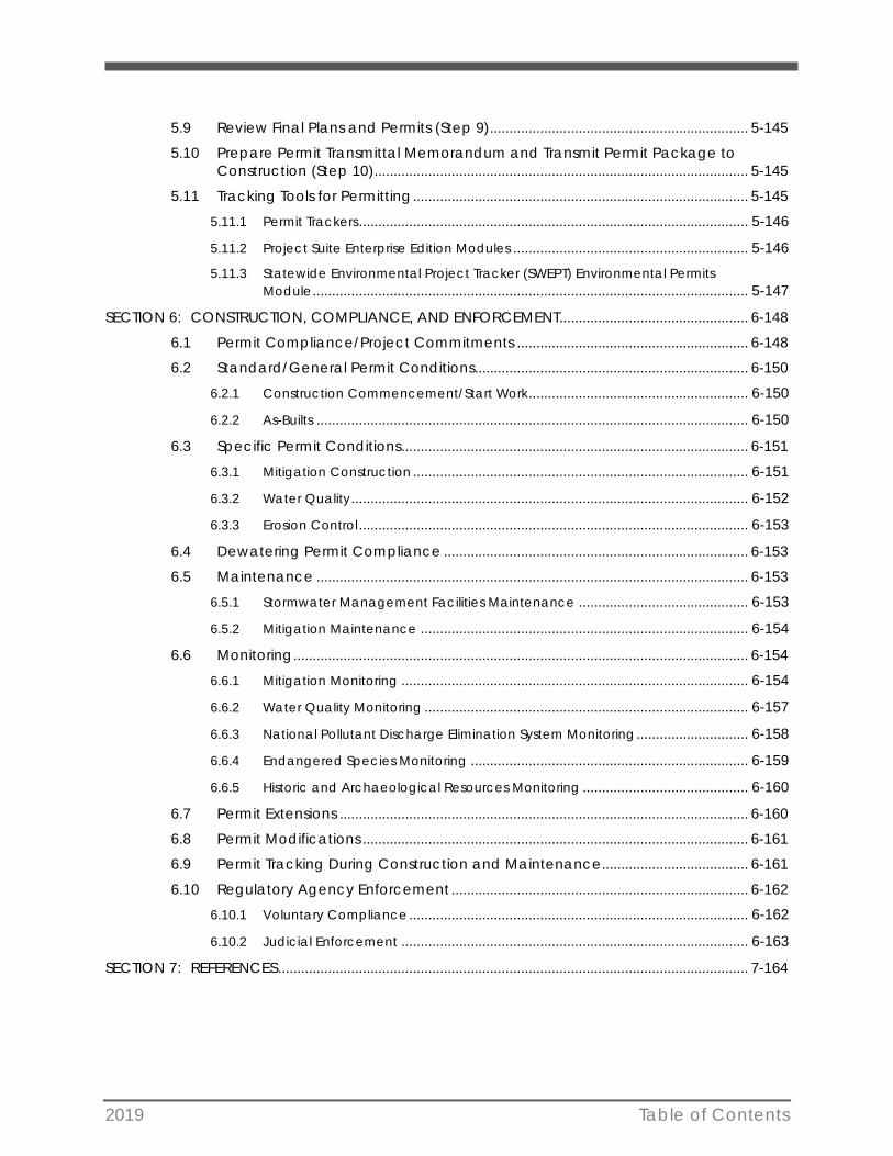
2019 Table of Contents
5.9 Review Final Plans and Permits (Step 9) ................................................................... 5-145
5.10 Prepare Permit Transmittal Memorandum and Transmit Permit Package to Construction (Step 10) ................................................................................................. 5-145
5.11 Tracking Tools for Permitting ....................................................................................... 5-145
5.11.1 Permit Trackers ..................................................................................................... 5-146
5.11.2 Project Suite Enterprise Edition Modules ............................................................. 5-146
5.11.3 Statewide Environmental Project Tracker (SWEPT) Environmental Permits Module ................................................................................................................. 5-147
SECTION 6: CONSTRUCTION, COMPLIANCE, AND ENFORCEMENT ................................................. 6-148
6.1 Permit Compliance/Project Commitments ............................................................ 6-148
6.2 Standard/General Permit Conditions....................................................................... 6-150
6.2.1 Construction Commencement/Start Work ......................................................... 6-150
6.2.2 As-Builts ................................................................................................................ 6-150
6.3 Specific Permit Conditions .......................................................................................... 6-151
6.3.1 Mitigation Construction ....................................................................................... 6-151
6.3.2 Water Quality ....................................................................................................... 6-152
6.3.3 Erosion Control ..................................................................................................... 6-153
6.4 Dewatering Permit Compliance ............................................................................... 6-153
6.5 Maintenance ................................................................................................................ 6-153
6.5.1 Stormwater Management Facilities Maintenance ............................................ 6-153
6.5.2 Mitigation Maintenance ..................................................................................... 6-154
6.6 Monitoring ...................................................................................................................... 6-154
6.6.1 Mitigation Monitoring .......................................................................................... 6-154
6.6.2 Water Quality Monitoring .................................................................................... 6-157
6.6.3 National Pollutant Discharge Elimination System Monitoring ............................. 6-158
6.6.4 Endangered Species Monitoring ........................................................................ 6-159
6.6.5 Historic and Archaeological Resources Monitoring ........................................... 6-160
6.7 Permit Extensions .......................................................................................................... 6-160
6.8 Permit Modifications .................................................................................................... 6-161
6.9 Permit Tracking During Construction and Maintenance...................................... 6-161
6.10 Regulatory Agency Enforcement ............................................................................. 6-162
6.10.1 Voluntary Compliance ........................................................................................ 6-162
6.10.2 Judicial Enforcement .......................................................................................... 6-163
SECTION 7: REFERENCES .......................................................................................................................... 7-164
2019 Table of Contents
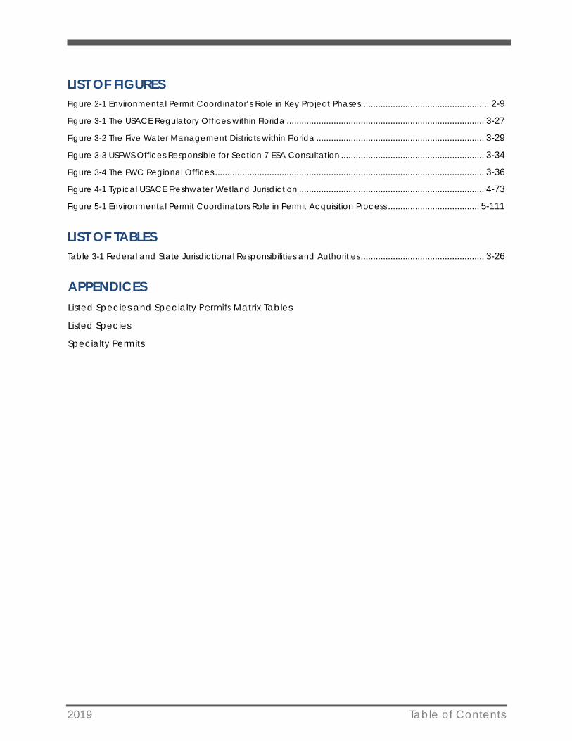
LIST OF FIGURES Figure 2-1 Environmental Permit Coordinator’s Role in Key Project Phases .................................................... 2-9
Figure 3-1 The USACE Regulatory Offices within Florida ................................................................................ 3-27
Figure 3-2 The Five Water Management Districts within Florida .................................................................... 3-29
Figure 3-3 USFWS Offices Responsible for Section 7 ESA Consultation .......................................................... 3-34
Figure 3-4 The FWC Regional Offices ............................................................................................................. 3-36
Figure 4-1 Typical USACE Freshwater Wetland Jurisdiction ........................................................................... 4-73
Figure 5-1 Environmental Permit Coordinators Role in Permit Acquisition Process ..................................... 5-111
LIST OF TABLES Table 3-1 Federal and State Jurisdictional Responsibilities and Authorities .................................................. 3-26
APPENDICES Listed Species and Specialty Permits Matrix Tables
Listed Species
Specialty Permits
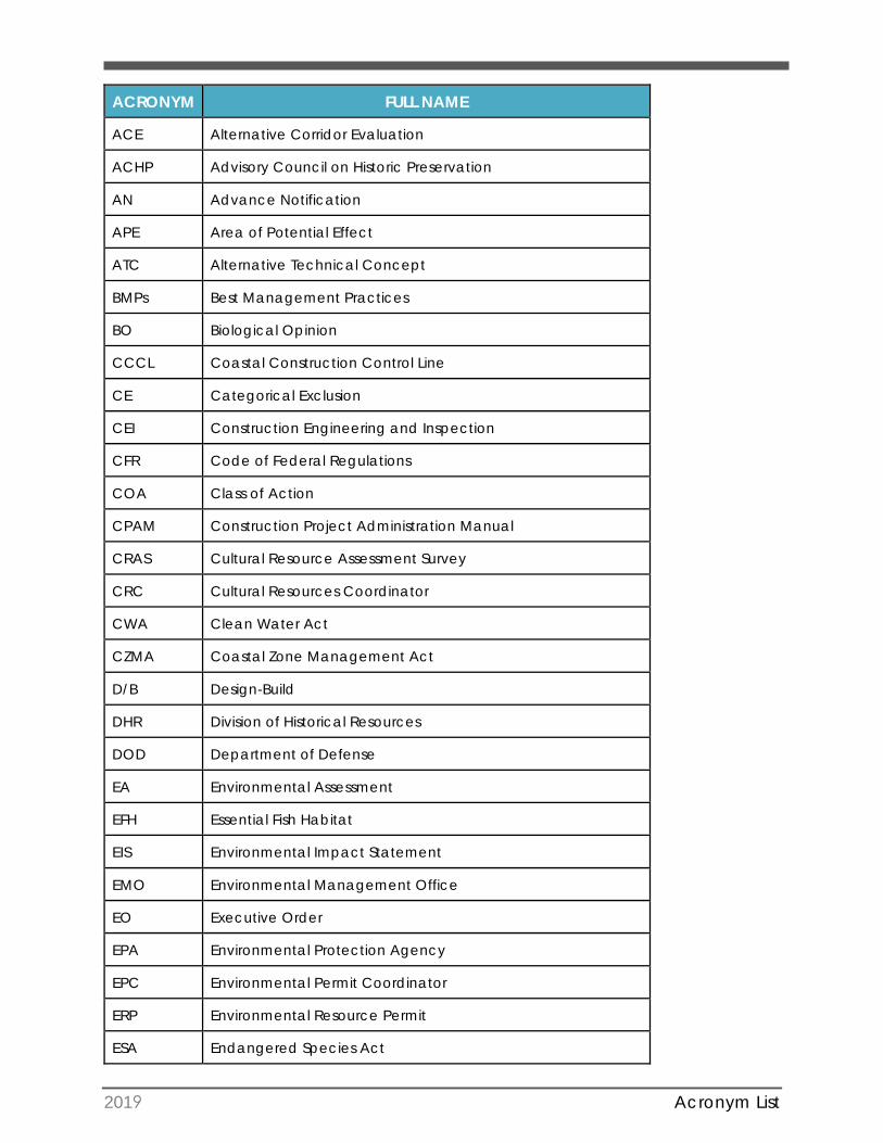
2019 Acronym List
ACRONYM FULL NAME
ACE Alternative Corridor Evaluation
ACHP Advisory Council on Historic Preservation
AN Advance Notification
APE Area of Potential Effect
ATC Alternative Technical Concept
BMPs Best Management Practices
BO Biological Opinion
CCCL Coastal Construction Control Line
CE Categorical Exclusion
CEI Construction Engineering and Inspection
CFR Code of Federal Regulations
COA Class of Action
CPAM Construction Project Administration Manual
CRAS Cultural Resource Assessment Survey
CRC Cultural Resources Coordinator
CWA Clean Water Act
CZMA Coastal Zone Management Act
D/B Design-Build
DHR Division of Historical Resources
DOD Department of Defense
EA Environmental Assessment
EFH Essential Fish Habitat
EIS Environmental Impact Statement
EMO Environmental Management Office
EO Executive Order
EPA Environmental Protection Agency
EPC Environmental Permit Coordinator
ERP Environmental Resource Permit
ESA Endangered Species Act
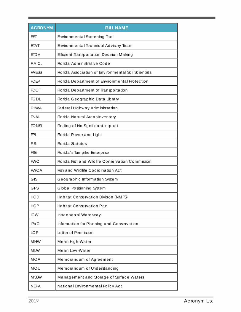
2019 Acronym List
ACRONYM FULL NAME
EST Environmental Screening Tool
ETAT Environmental Technical Advisory Team
ETDM Efficient Transportation Decision Making
F.A.C. Florida Administrative Code
FAESS Florida Association of Environmental Soil Scientists
FDEP Florida Department of Environmental Protection
FDOT Florida Department of Transportation
FGDL Florida Geographic Data Library
FHWA Federal Highway Administration
FNAI Florida Natural Areas Inventory
FONSI Finding of No Significant Impact
FPL Florida Power and Light
F.S. Florida Statutes
FTE Florida’s Turnpike Enterprise
FWC Florida Fish and Wildlife Conservation Commission
FWCA Fish and Wildlife Coordination Act
GIS Geographic Information System
GPS Global Positioning System
HCD Habitat Conservation Division (NMFS)
HCP Habitat Conservation Plan
ICW Intracoastal Waterway
IPaC Information for Planning and Conservation
LOP Letter of Permission
MHW Mean High-Water
MLW Mean Low-Water
MOA Memorandum of Agreement
MOU Memorandum of Understanding
MSSW Management and Storage of Surface Waters
NEPA National Environmental Policy Act
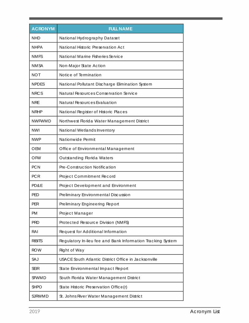
2019 Acronym List
ACRONYM FULL NAME
NHD National Hydrography Dataset
NHPA National Historic Preservation Act
NMFS National Marine Fisheries Service
NMSA Non-Major State Action
NOT Notice of Termination
NPDES National Pollutant Discharge Elimination System
NRCS Natural Resources Conservation Service
NRE Natural Resources Evaluation
NRHP National Register of Historic Places
NWFWMD Northwest Florida Water Management District
NWI National Wetlands Inventory
NWP Nationwide Permit
OEM Office of Environmental Management
OFW Outstanding Florida Waters
PCN Pre-Construction Notification
PCR Project Commitment Record
PD&E Project Development and Environment
PED Preliminary Environmental Discussion
PER Preliminary Engineering Report
PM Project Manager
PRD Protected Resource Division (NMFS)
RAI Request for Additional Information
RIBITS Regulatory In-lieu fee and Bank Information Tracking System
ROW Right of Way
SAJ USACE South Atlantic District Office in Jacksonville
SEIR State Environmental Impact Report
SFWMD South Florida Water Management District
SHPO State Historic Preservation Office(r)
SJRWMD St. Johns River Water Management District
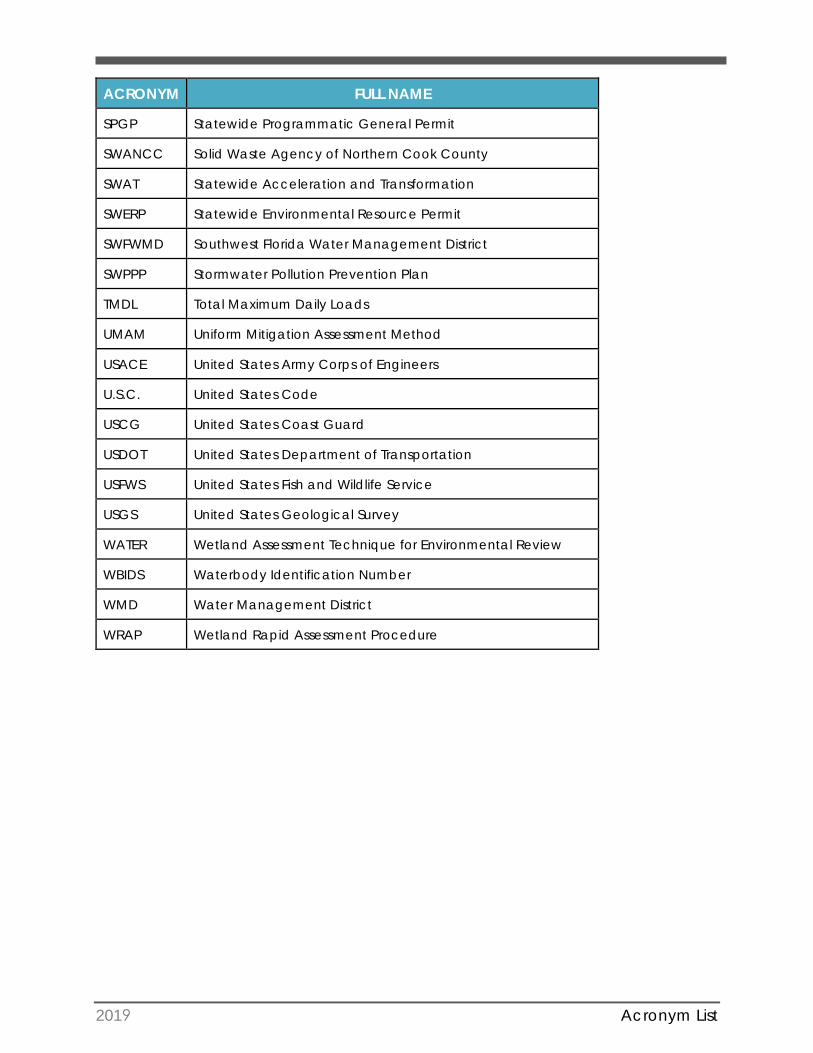
2019 Acronym List
ACRONYM FULL NAME
SPGP Statewide Programmatic General Permit
SWANCC Solid Waste Agency of Northern Cook County
SWAT Statewide Acceleration and Transformation
SWERP Statewide Environmental Resource Permit
SWFWMD Southwest Florida Water Management District
SWPPP Stormwater Pollution Prevention Plan
TMDL Total Maximum Daily Loads
UMAM Uniform Mitigation Assessment Method
USACE United States Army Corps of Engineers
U.S.C. United States Code
USCG United States Coast Guard
USDOT United States Department of Transportation
USFWS United States Fish and Wildlife Service
USGS United States Geological Survey
WATER Wetland Assessment Technique for Environmental Review
WBIDS Waterbody Identification Number
WMD Water Management District
WRAP Wetland Rapid Assessment Procedure
2019 1-1
SECTION 1: INTRODUCTION 1.1 Purpose of Handbook
This Permit Handbook provides a practical “how to” permitting guide and reference for environmental professionals in the Florida Department of Transportation (FDOT) when FDOT is the permit applicant. The intended audience includes FDOT Districts and the Florida Turnpike Enterprise (FTE) staff, their consultants, and numerous FDOT offices (e.g., Environmental Management, Design, and Construction).
The purpose of this handbook is to provide guidance to FDOT staff and their consultants on how environmental permitting is performed for transportation projects. This also includes how and when to coordinate with regulatory agencies and commenting agencies, as well as internal FDOT coordination between the various offices that are involved in obtaining permits for a project. This handbook will help the analyst navigate the permitting process from the early stages of project Planning, through Project Development and Environment (PD&E), Design, and Construction, and even some maintenance activities. It also addresses minor projects that do not require a PD&E Study yet may still require environmental permits.
This handbook works in concert with FDOT’s PD&E Manual chapters, specifically Environmental Permits; Wetlands and Other Surface Waters; and Protected Species and Habitat. The Environmental Permits chapter (Part 1, Chapter 12) complements this handbook as a useful background reference.
The handbook also incorporates other chapters from the PD&E Manual, including the Project Development Process (project phases); Engineering Analysis; Essential Fish Habitat (EFH); Archaeological and Historical Resources; Commitments; and other topics related to environmental permitting.
The following “how to” issues are addressed:
• Determine which environmental permits (federal, state, and local) are required fora project
• Maximize information capture and coordination between project phases (e.g.,PD&E and Design phases)
• Identify interrelationships and optimize the timing and coordination of permit-related activities to streamline overall permitting duration
• Implement “best practices” for overall permitting strategies and specific permits
• Initiate agency coordination prior to permit application submittal
• Identify, access, and properly complete permit application forms (hyperlinks topermit forms and instructions are included where possible)
• Facilitate agency processing of permit applications
2019 1-2
• Track permit conditions, expiration dates, and permit compliance after permitissuance
• Reinitiate agency coordination for permit modifications and/or extensions
The handbook also includes Appendices to address highly-specialized environmental permits and procedures [e.g., Section408 Review and Permission]; specific resources (e.g., gopher tortoises); geographically restricted resources within certain parts of Florida (e.g., Florida Keys National Marine Sanctuary); and local permitting regulations (e.g., Miami-Dade County).
1.2 Organization of the Permit Handbook
This Permit Handbook can be used for various purposes, depending upon the permitting professional’s informational needs, level of experience, and the project phase and/or permit(s) of interest. If the reader’s primary interest is to learn more about a certain type of permit or to understand general procedures, then each handbook section can be read in whole or in part.
If the reader seeks specific information, the handbook provides a detailed index of subjects and keywords.
The handbook contains hyperlinks to FDOT and external resources on the internet. These resources include downloadable or online permit application forms; applicant handbooks and instructions; agency guidance documents; and other resources to facilitate environmental permitting.
Table of Contents
The Table of Contents provides an overview of topics related to FDOT environmental permitting. Subsections are listed in sufficient detail to locate a specific topic, if desired. The Index allows for searching by major keywords, and the electronic format of the handbook also allows for rapid searching through use of the “Find” functions.
Related PD&E Manual chapters, referenced and hyperlinked throughout the handbook, can also provide background information and context.
While the handbook aims to present topics in a logical, linear format, the permitting process is often not linear. Various permitting activities may occur in a prescribed sequence (each step dependent on a previous step); may occur concurrently; or some combination of the two. In this regard, numerous cross-references between sections occur throughout the handbook, as a reminder that one aspect of permitting may (and often does) influence another.
Understanding the interrelationships between federal, state, and local permitting procedures (and commenting agencies) facilitates timely and efficient environmental permitting.
2019 1-3
A brief overview of the Permit Handbook sections is provided below.
• Section 1: Introduction
• Section 2: Role of the Environmental Permit Coordinator in Key Phases of the Project
Where do we find the information to include in permit applications?
This section provides a brief overview of FDOT’s project development and deliveryprocess and describes the interrelated project phases and how they relate toenvironmental permitting.
• Section 3: Federal vs. State Processes: Similarities and Differences
What does the permitting process entail? What types of permits will we apply forand which agencies will grant them?
This section provides an overview of federal and state regulatory agencyenvironmental permitting processes and highlights their similarities and differences.It includes a primer on the USACE dredge & fill (Section 404) permits, United StatesCoast Guard (USCG) Bridge Permits, the State of Florida Environmental ResourcePermit (ERP), stormwater management systems, and other activities related towater resources. This section also addresses other issues such as SovereignSubmerged Lands and Coastal Construction Control Line (CCCL) authorizations.
Additionally, this section describes the role of commenting agencies in thepermitting process, and procedures for effectively coordinating the permitprocessing between the lead agency (permit issuer) and commenting agency (-ies).
• Section 4: Key Resource Impacts
What regulated resources are potentially impacted by FDOT projects?
Section 4 provides guidance on the identification of threatened and endangeredspecies/habitats, cultural resources, and wetland impacts that are common toboth processes. Identification of key resource impacts is a crucial step in thepermitting process, since the information gathered must be documented in thepermit application. This section also discusses agency coordination, EndangeredSpecies Act (ESA) Section 7 consultation, and ESA Section 10 Incidental TakePermits.
Federal and state guidelines for wetland mitigation are also provided in this section,along with a discussion of various mitigation options. The section also includesdiscussions of functional assessment methodologies and funding of mitigationactivities.
2019 1-4
• Section 5: Permit Acquisition from Start to Finish
When and how do we apply for permits? Where do we find the information toinclude in permit applications? How long does the permitting process take?
This section provides a step-by-step process which delineates the permit acquisitionprocess from initial scoping of the permitting effort to transmittal of the permitpackage to construction. The process identifies the information required for permitapplications, how to compile application packages, and how to navigate permitprocessing by the agencies. This section also includes information and proceduresfor obtaining a National Pollutant Discharge Elimination System (NPDES) stormwaterpermit and special use permits. Tracking tools for permitting are also discussed.
• Section 6: Construction, Compliance, and Enforcement
What happens once permits are obtained?
Guidance is provided for post-permit responsibilities and the procedures forcomplying with permit conditions; implementing mitigation and monitoringactivities; seeking permit extensions and/or modifications; and tracking permits.
• Section 7: References
Where can we find out more about environmental permitting?
The major guidance and reference materials cited throughout the PermitHandbook are described, along with online links to these sources (whereavailable). Major references include the USACE Source Book; the Florida StatewideERP (SWERP) application handbooks; and various agency guidance documents.
• Appendices
Where can we find more information about environmental permitting issues specificto our District?
Specific permitting activities that apply to certain local jurisdictions, resource types,regions, and/or activities are covered by individual sections within the Appendices.
1.3 Roles and Responsibilities
This handbook provides guidance regarding the various roles and responsibilities associated with the permitting process. The responsibility for obtaining the necessary environmental permits typically resides with the Environmental Permit Coordinator in each FDOT District and FTE, although it should be viewed as an agency responsibility.
NOTE: The organizational structures for the Environmental, Permitting,Construction, and Operations offices vary between each District, and environmental permitting tasks may be delegated to staff and consultants in various ways throughout the state.
Throughout the permitting process, various FDOT offices (e.g., Design, Construction, Maintenance) have an important role and responsibility to coordinate with the
2019 1-5
Environmental Permit Coordinator and the staff and/or consultants who are preparing the application package. Furthermore, the local, state, and federal levels all require integration of engineering and biological considerations to evaluate and quantify impacts to natural resources, which serve as the basis of determining the type of permit and degree of mitigation necessary.
It is crucial for the Design and Environmental Permits offices to coordinate regularly, since the project’s Design determines the footprint of those impacts requiring environmental permits. Input from the various FDOT offices can improve the technical quality and thoroughness of the permit application during its development and improve coordination for compliance activities after permits are issued.
As described in subsequent sections, environmental permitting often involves a complex series of interrelated tasks performed over time. Although there are numerous tasks that must be completed to acquire an environmental permit, the critical paths and dependencies should synchronize in a way that optimizes the permitting timeline. Since a variety of organizational structures exist within each FDOT District, it is not possible to assign specific permitting roles and responsibilities in a “one size fits all” manner. Still, it remains imperative that all permit-related tasks are identified, assigned, tracked, and completed in a coordinated fashion to secure the necessary permits for each project.
One solution is to create a comprehensive matrix of roles and responsibilities for all permitting tasks, where all tasks are assigned to specific positions or offices. This comprehensive permitting matrix can serve three important functions:
1. It helps to identify, visualize, and coordinate all the interrelated permitting tasks;
2. It assigns responsibility and accountability to specific individuals; and,
3. It preserves organizational flexibility at the District/FTE level.
The same assurances for roles and responsibilities could also be achieved through use of the project schedule, by assigning specific activities and reporting responsibilities (which will be covered in later sections of this handbook) to the appropriate role/person.
1.4 Maintaining Files for Environmental Permitting
An important “take-home message” is that efficient and successful environmental permitting requires the applicant(s) to maintain thorough records for the permitting files. These records are discussed in further detail in later sections and may include, but are not limited to, the following:
• Project background information
• Environmental data
• Engineering plans and drawings
• Calculations; spreadsheets
• Permit application forms
2019 1-6
• Meeting notes
• Memos
• Agency correspondence
• Telephone call logs
The majority of environmental permitting is performed during the Design phase of the project (see Section 5.0). However, many projects generate useful permit-related information during the Planning phase. If a PD&E phase is required, even more useful permit-related information will be produced at this time. The information and data developed during previous project phases should be well documented in the Environmental Document, technical reports and other project records. The usable information extracted from previous project phases can avoid unnecessary duplication of effort and improve the efficiency of the permitting process.
Why are these records important for successful environmental permitting? Broadly speaking, well-maintained documentation can:
• Document project information and decisions made prior to submittal of the permitapplication. These records may include project information from the: EfficientTransportation Decision Making (ETDM) Screening (e.g., potential resource impacts;listed species to be evaluated); PD&E data and National Environmental Policy Act(NEPA) analyses (e.g., listed species consultations; alternatives analyses); and initialcorrespondence and meeting notes with resource agencies.
• Provide the basis for verifying permit application information and for responding toan agency Request for Additional Information (RAI). Regulators will cross-checkinformation as part of the permit application review, and the applicant is expectedto provide additional information to substantiate and/or confirm permittingrationales, data, calculations, and conclusions. If discrepancies exist within theapplication package, the discrepancies can be resolved by reviewing the projectrecords.
• Document interactions with resource agencies, including correspondence,meeting notes, and phone calls. In addition to recording the nature and frequencyof applicant interactions with agencies, these records should document importantdecisions, action items, and estimated timeframes for processing the permitapplication. These communication records enable the applicant to respondpromptly to agency requests, and to document previous decisions.
• Allow the applicant to check the issued permit(s) and any special conditionsagainst the project record. Depending on the number and complexity of permitsrequired for a project, the project documentation allows the applicant to cross-check the issued permit(s) for accuracy, special conditions, and commitmentsrequired of the applicant.
• Develop a complete Administrative Record. Permitting files can become part ofthe Administrative Record for a project when a FDOT project becomes involved in
2019 1-7
potential or actual litigation. Documentation of permitting, mitigation, commitments, and other project elements are important elements in an Administrative Record for a project.
By its nature, environmental permitting is often complex. It involves many interrelated tasks, requires coordination among multiple parties, and often occurs over long timeframes (months or years). Maintaining well-organized permitting records can provide a strong basis for:
• developing well-prepared permit applications;
• monitoring the permitting process;
• tracking action items throughout the permitting process;
• facilitating permit issuance in an efficient and timely manner; and
• transmitting the permit information to the next phase of the project (e.g.,Construction and Maintenance).
This handbook covers a range of details regarding the responsibilities and tasks associated with environmental permitting. It is important to routinely save documentation to the project file that will support a robust project record and help facilitate the permitting process.
2019 2-8
SECTION 2: ROLE OF THE ENVIRONMENTAL PERMIT COORDINATOR IN KEY PHASES OF THE PROJECT
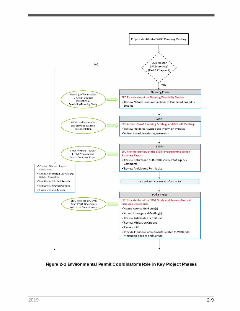
Florida Department of Transportation’s (FDOT’s) process for constructing transportation facilities includes multiple phases of project delivery, from project planning to construction and maintenance. This handbook addresses the phases of project delivery that relate both directly or indirectly to obtaining environmental permits that authorize construction. The purpose of this section is to: identify the role of the Environmental Permit Coordinator in each phase of project delivery, discuss the intent of that action and its relationship to the permitting process, and the specific items that should be documented and used to obtain permits. Figure 2-1 provides a flow chart outlining the Environmental Permit Coordinator’s role in each phase of the project.
For FDOT, permit applications are typically submitted to the regulatory agencies at the development of the 60-percent plans during the Design phase. However, permitting considerations should also be evaluated during the Planning phase/Efficient Transportation Decision Making (ETDM) process, Project Development and Environment (PD&E) Phase, and continue through the Construction Phase.
NOTE: The responsibilities of the Environmental Permit Coordinator vary byDistrict. This section discusses all activities that need to be completed to obtain environmental permits or those needed to advance the permitting process in other phases. Some tasks may be completed by other Departments, such as
Environmental Management Office (EMO). Also, depending on the District organization, the District staff responsible for leading the permitting effort may be the District Environmental Permitting Engineer, Permits Coordinator, or Drainage Engineer. For the purposes of this handbook, this position will be referred to as the Environmental Permit Coordinator.
2.1 Participating in the Planning Phase
2.1.1 Early Coordination
In the Planning phase, FDOT adopts or prepares a Planning Study, Feasibility Study and/or desktop evaluation to identify the need for further study. In the early phase of project development, the Environmental Permit Coordinator will review and provide input on the planning-level document to verify that the natural resource issues, mitigation issues or anticipated permits are properly identified. Guidance from the Environmental Permit Coordinator in this phase will help inform the Preliminary Environmental Discussion (PED) and the ETDM process, discussed below, as well as scope development for the future PD&E Study or Design Phase. The benefit of early coordination is pre-emptively identifying any environmental issues that would elevate the Class of Action (COA) in PD&E or affect the schedule of the PD&E Study or Design Phases.
2019 2-9
Figure 2-1 Environmental Permit Coordinator’s Role in Key Project Phases
2019 2-10
Figure 2-1 Environmental Permit Coordinator’s Role in Key Project Phases
2019 2-11
2.1.1.1 Planning/Feasibility Studies
During the Planning phase, the Planning Office will take the lead on evaluating potential corridors or concepts that will develop into a future PD&E Study or Design project.
The Planning Office provides the Environmental Permit Coordinator with any Feasibility/Planning Studies prepared.
The Environmental Permit Coordinator then reviews the document and provides input regarding the natural resource section. Specifically, the Environmental Permit Coordinator will review information pertaining to wetlands, protected species and habitat, Essential Fish Habitat (EFH), anticipated permits and possible needs for mitigation.
2.1.1.2 Statewide Acceleration Transformation Team
The Statewide Acceleration Transformation (SWAT) process provides a systematic approach to accelerate pre-construction phases of project delivery. Activities of the SWAT process are inter-meshed with FDOT’s annual Work Program Development Cycle to facilitate funding and project type identification, as well as anticipated critical issues and opportunities to conduct advanced work. The SWAT process advocates using multi-disciplinary teams and early engagement with the project manager (PM) and key District staff to efficiently advance projects using SWAT milestone meetings. The SWAT process includes three major milestone meetings that occur between the Planning and PD&E phases.
Although the Environmental Permit Coordinator is not an official member of the District SWAT Team, permitting items are discussed at each milestone meeting. Technical experts, such as the Environmental Permit Coordinator, are invited to
attend these meetings. The Environmental Permit Coordinator will review the preliminary scope of work, advise the Team regarding potential future permitting needs, scheduling issues related to permits, mitigation and agency coordination and, provide input relating to natural resource impacts.
• SWAT Planning Meeting: This meeting is held annually between May and Octoberto evaluate candidate projects for selection into the Five-Year Work Program.Project funding source(s) and potential COA are discussed at this meeting. Thoseprojects requiring a PD&E are identified along with minor projects which qualify asNon-Major State Action (NMSA) and Type 1 Categorical Exclusions (CEs).
• SWAT Strategy Meeting: This meeting is held annually between February and Apriland assesses the new projects in FDOT’s Tentative Work Program; it is also used tore-assess upcoming PD&E projects and check their schedules. At this meeting pre-PD&E activities are identified and scheduled including: The Planning Studies,Alternative Corridor Evaluation (ACE) studies, ETDM Programming Screen, SWATKick-off Meeting and PD&E advertisement. This meeting produces each project’sfirst schedule, early assessment for the potential overlap of PD&E and Design, andinitial identification of risks and constraints such as environmental permittingdurations.
2019 2-12
• SWAT Kick-off Meeting: This meeting is held for each individual projectapproximately one year before the start of the PD&E phase. It sets the frameworkfor developing the Scope of Services, identifies overlap between the PD&E andDesign phase and initiates any pre-PD&E activities that can shorten the duration ofthe PD&E Study, such as season-specific species surveys. By the time of this meeting,the ETDM Programming Screen and planning activities should be completed.Additionally, major risks and constraints, such as permitting activities, should beidentified.
Overall, the SWAT process encourages expedited project delivery by initiating pre-PD&E activities and the consideration of overlapping major phases such as PD&E and Design. For projects that overlap PD&E and Design Phases, it is important that the PD&E and Design teams carefully coordinate information (wetland(s), listed species, essential fish habitat, and archaeological data) along with any Design changes after the environmental document is approved for inclusion in permit applications.
2.1.1.3 Efficient Transportation Decision Making Screening
The ETDM process occurs in the Planning phase of FDOT project delivery for projects qualifying for a PD&E Study. The process is used as a “first look” environmental analysis and early consideration of environmental effects. Within the Districts and Florida’s Turnpike Enterprise (FTE), ETDM coordinators provide support to the EMOs with the ETDM reviews.
To qualify for the ETDM screening process, a project must meet conditions described in the ETDM and PD&E Manuals, which includes activities such as a new roadway, interchange, or bridge as well as additional access or capacity improvements. Please refer to FDOT’s PD&E Manual and the ETDM Manual for details of the ETDM process and a complete list of qualifying project types including the Type 2 CEs, Environmental Assessments (EA), Environmental Impact Statements (EIS) and State Environmental Impact Reports (SEIR). Projects that do not qualify for ETDM screenings include Type 1 CEs, some Type 2 CEs, and NMSAs.
The ETDM phase utilizes the Environmental Screening Tool (EST), which provides Geographic Information System (GIS) data and an opportunity for resource agencies and other stakeholders to provide comments and considerations. The EST incorporates a large digital database [maintained by the Florida Geographic Data Library (FGDL)] that includes information pertaining to natural, physical, cultural, and social resources. The database pulls information from a variety of sources including, but not limited to, FDOT, Florida Fish and Wildlife Conservation Commission (FWC), United States Fish and Wildlife Service (USFWS), the Florida Department of Environmental Protection (FDEP), Water Management Districts (WMD), counties, and cities.
As part of the Advance Notification (AN) Package sent to the agencies during the ETDM screening, FDOT initiates a PED with the environmental regulatory agency stakeholders, who comprise the Environmental Technical Advisory Team (ETAT) members. The PED provides early identification of resource involvement, anticipated permitting requirements, and potential mitigation options. The Environmental Permit Coordinator may
2019 2-13
be asked by the ETDM Coordinator to review information in the PED, as well as compile an initial list of permits that may be required for the project based on the anticipated project impacts.
Preliminary input on the project are solicited from the permitting agencies [i.e. United States Army Corps of Engineers (USACE), United States Coast Guard (USCG), and the WMDs] and their associated commenting agencies [USFWS, National Marine Fisheries Services (NMFS), FWC, State Historic Preservation Officer (SHPO), etc.] as part of the ETAT through the ETDM process. These comments provide early insight into which environmental issues (such as wetland permitting requirements or endangered species mitigation) must be addressed as the project progresses. The ETAT members provide comments and a Degree of Effect for each pertinent environmental resource ranging from ‘No Involvement’, ‘None’, ‘Enhanced’, ‘Minimal’, ‘Moderate’, ‘Substantial’ to ‘Dispute Resolution’. The resulting Final Programming Screening Summary Report provides a summary of existing and potential environmental issues identified by the ETAT members, issue resolution, and permitting considerations. It is important to note that the agency responses are only at a level of detail corresponding to the information provided for the project which tends to be more general. This process provides a basis for the level of environmental analysis and coordination needed during the PD&E Study and informs the Scope of Services. For the Environmental Permit Coordinator, the summary report will identify the level of agency coordination anticipated during PD&E, such as formal or informal Section 7 ESA consultation for listed species (see Section 4) and what issues the Environmental Permit Coordinator can track during the PD&E phase in preparation for the permitting phase.
Please reference the ETDM Manual for additional details relating to degrees of effect, Screening Summary Reports and topics reviewed by the ETAT agencies.
The EMO will provide the ETDM Programming Screen Summary Report to the Environmental Permit Coordinator for review. The Environmental Permit Coordinator should review the Natural, Physical and Cultural Resource ETAT Agency comments, as well as the anticipated permit(s) list.
The benefit of this early review by the Environmental Permit Coordinator will provide insight on the issues that the agencies will focus on during the PD&E Study, as well as identify the level of natural resource involvement, agency coordination and ultimately, the level of environmental permitting.
2019 2-14
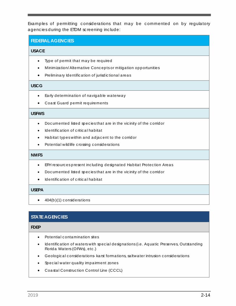
Examples of permitting considerations that may be commented on by regulatory agencies during the ETDM screening include:
FEDERAL AGENCIES
USACE
• Type of permit that may be required
• Minimization/Alternative Concepts or mitigation opportunities
• Preliminary Identification of jurisdictional areas
USCG
• Early determination of navigable waterway
• Coast Guard permit requirements
USFWS
• Documented listed species that are in the vicinity of the corridor
• Identification of critical habitat
• Habitat types within and adjacent to the corridor
• Potential wildlife crossing considerations
NMFS
• EFH resources present including designated Habitat Protection Areas
• Documented listed species that are in the vicinity of the corridor
• Identification of critical habitat
USEPA
• 404(b)(1) considerations
STATE AGENCIES
FDEP
• Potential contamination sites
• Identification of waters with special designations (i.e. Aquatic Preserves, OutstandingFlorida Waters (OFWs), etc.)
• Geological considerations- karst formations, saltwater intrusion considerations
• Special water quality impairment zones
• Coastal Construction Control Line (CCCL)
2019 2-15
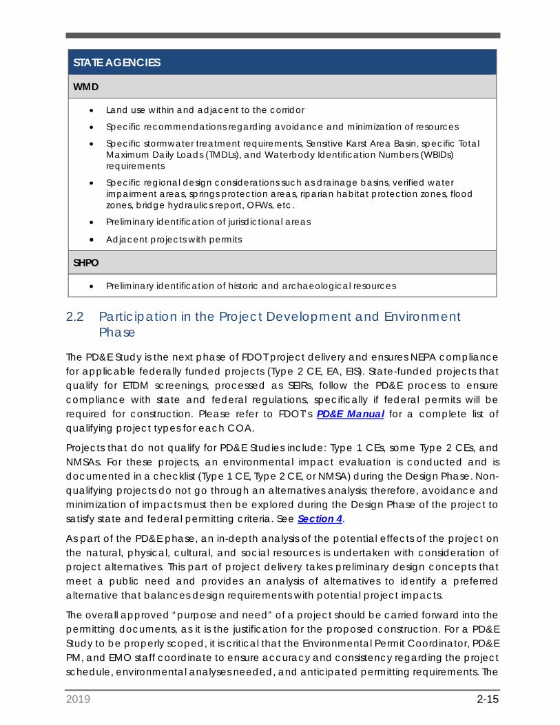
STATE AGENCIES
WMD
• Land use within and adjacent to the corridor
• Specific recommendations regarding avoidance and minimization of resources
• Specific stormwater treatment requirements, Sensitive Karst Area Basin, specific TotalMaximum Daily Loads (TMDLs), and Waterbody Identification Numbers (WBIDs)requirements
• Specific regional design considerations such as drainage basins, verified waterimpairment areas, springs protection areas, riparian habitat protection zones, floodzones, bridge hydraulics report, OFWs, etc.
• Preliminary identification of jurisdictional areas
• Adjacent projects with permits
SHPO
• Preliminary identification of historic and archaeological resources
2.2 Participation in the Project Development and Environment Phase
The PD&E Study is the next phase of FDOT project delivery and ensures NEPA compliance for applicable federally funded projects (Type 2 CE, EA, EIS). State-funded projects that qualify for ETDM screenings, processed as SEIRs, follow the PD&E process to ensure compliance with state and federal regulations, specifically if federal permits will be required for construction. Please refer to FDOT’s PD&E Manual for a complete list of qualifying project types for each COA.
Projects that do not qualify for PD&E Studies include: Type 1 CEs, some Type 2 CEs, and NMSAs. For these projects, an environmental impact evaluation is conducted and is documented in a checklist (Type 1 CE, Type 2 CE, or NMSA) during the Design Phase. Non-qualifying projects do not go through an alternatives analysis; therefore, avoidance and minimization of impacts must then be explored during the Design Phase of the project to satisfy state and federal permitting criteria. See Section 4.
As part of the PD&E phase, an in-depth analysis of the potential effects of the project on the natural, physical, cultural, and social resources is undertaken with consideration of project alternatives. This part of project delivery takes preliminary design concepts that meet a public need and provides an analysis of alternatives to identify a preferred alternative that balances design requirements with potential project impacts.
The overall approved “purpose and need” of a project should be carried forward into the permitting documents, as it is the justification for the proposed construction. For a PD&E Study to be properly scoped, it is critical that the Environmental Permit Coordinator, PD&E PM, and EMO staff coordinate to ensure accuracy and consistency regarding the project schedule, environmental analyses needed, and anticipated permitting requirements. The
2019 2-16
ETAT agency comments received during the ETDM process informs the Scope of Services and staff hour estimates prepared by the PD&E PM with input from the District technical staff.
The Environmental Permit Coordinator will provide input as needed related to design activities that may overlap with or impact the PD&E phase, natural resource evaluation, species consultation, and conceptual mitigation options.
2.2.1 Environmental Document Review
PD&E Study documents that relate directly to permitting include the Natural Resource Evaluation (NRE), the Cultural Resources Assessment Survey (CRAS), and the environmental documents [Type 2 CE, EIS, EA with Finding of No Significant Impact (FONSI), or SEIR]. These reports must be carefully reviewed prior to the Design phase scoping process to use these studies as a springboard of anticipated permitting involvement and to ensure that previous efforts are properly utilized and are not duplicated. These documents will provide a basis for the environmental permit applications. In some cases, these documents will be enough to satisfy state and federal permitting requirements as discussed below.
The EMO provides the Environmental Permit Coordinator with the draft PD&E documents and the list of commitments for review and comment.
2.2.1.1 Alternative Analysis
The PD&E Study is based on the alternative analysis. For Type 2 CEs, EAs, EISs and SEIRs, this analysis will typically include the engineering and environmental evaluation of one or more build alternatives and a ‘no action’ alternative. Both the environmental technical documents and the Preliminary Engineering Report (PER) include an evaluation of the proposed alternatives and the environmental impacts associated with each alternative. The environmental analysis will look at avoidance and minimization techniques to reduce the potential environmental impacts associated with each alternative. In most cases, the alternative analysis is a strong starting point for the avoidance and minimization documentation in the permit application, although additional analysis during Design may be required (see Section 4).
For new roadway or bridge alignments, indirect and cumulative effects analysis during the PD&E Study is a critical component to support the selection of the preferred alternative. For the state and federal permitting processes, these terms have separate and distinct regulatory applications that will be explained in Section 4. However, this aspect of the PD&E Study should be used as the starting point for developing the permit applications.
The analysis of indirect and cumulative effects during PD&E can incorporate additional stakeholder coordination that will be essential for permitting presumptions made during the PD&E Study and become a basis for the permitting process in Design. The
2019 2-17
documentation of the avoidance and minimization, and/or the reduction/elimination of impacts, is essential for mitigation planning and permitting.
2.2.1.2 Natural Resource Evaluation
Building from the issues identified in the ETDM Screening, an analysis of the existing natural resources including wetlands, protected species and habitat, and EFH is conducted for the project based on the alternatives being evaluated and is compiled in an NRE. Wetlands are documented in the Wetland Evaluation section of the NRE in accordance with Part 2, Chapter 9 (Wetlands and Other Surface Waters) of the PD&E Manual. An evaluation of impacts is performed for all potential jurisdictional areas such as freshwater wetlands, mangroves, seagrass and other surface waters (see Section 4). Potential effects to protected species and their habitats are documented in the Protected Species and Habitat section of the NRE in accordance with Part 2, Chapter 16 (Protected Species and Habitat) of the PD&E Manual. Documented effects within this report include the results of species-specific surveys and effects determinations (see Section 4). When EFH is present, the NRE includes an EFH impact analysis in accordance with Part 2, Chapter 17 (Essential Fish Habitat) (see Section 4). Agency concurrence from the USFWS, NMFS, and the FWC is included as part of the final environmental document (EIS, EA, Type 2 CE, SEIR).
The EMO will provide the NRE for the Environmental Permit Coordinator to review, particularly the portions regarding anticipated permit list, mitigation requirements and commitments. The Environmental Permit Coordinator may
provide input on the analysis as well as the mitigation options as the results of the NRE will form a basis for the permit application.
2.2.1.3 Historic and Archaeological Resources
In accordance with Part 2, Chapter 8 (Archaeological and Historic Resources) of the PD&E Manual, the CRAS and associated Case Study are reviewed by the SHPO as part of the PD&E analysis. If the project is state funded, the CRAS/Case Study are reviewed by the Florida Division of Historical Resources (DHR). The CRAS identifies the potential historic and archaeological sites within the PD&E Study to an assigned distance, referred to as an Area of Potential Effect (APE), which varies according to project scope and location and includes proposed stormwater pond sites. The Case Study evaluates the potential effect a project will have on those sites that are listed or are eligible for listing on the National Register of Historic Places (NRHP). Concurrence from the SHPO/DHR is a requirement to obtain state Environmental Resource Permits (ERPs) and federal permits. The SHPO/DHR concurrence letter received during PD&E can potentially be used to satisfy this requirement. Otherwise, the EMO will need to prepare a CRAS Addendum and Case Study, if applicable to obtain an updated concurrence letter from the SHPO/DHR during the re-evaluation process (Part 1, Chapter 13) in design.
Therefore, it is beneficial for the Environmental Permit Coordinator to review and provide input as appropriate for any cultural commitments made in the Environmental Document.
2019 2-18
It is important to note that any work occurring in areas not included as part of the PD&E APE will need to be evaluated during the design process. Coordination between design engineers and the Cultural Resources Coordinator (CRC) should occur between the initial plans review and the permitting phase, to ensure that additional areas are assessed and coordinated with SHPO/DHR prior to permit application submittals.
2.2.1.4 Agency Coordination
A continuation of the agency coordination conducted during the ETDM process occurs with the regulatory and commenting agencies should occur ‘early and often’ as the PD&E Study progresses.
The Environmental Permit Coordinator should attend agency field visits, interagency meetings and other key agency meetings where decisions are made regarding permitting and/or mitigation, as appropriate.
This allows the Environmental Permit Coordinator to remain informed as to the reasoning behind project decisions made during the PD&E phase that may impact project permitting.
2.2.1.5 Project Commitments Related to Permitting
Project commitments are an important aspect of the PD&E phase’s conclusion, as the commitments provide assurances that any identified environmental issues will be appropriately addressed in the future. FDOT tracks these commitments in Project Suite Enterprise Edition and with the Project Commitment Record (PCR, Form 650-000-01). The project commitments made during the PD&E phase are included in the appropriate sections of the Environmental Document and entered into the Project Suite Enterprise Edition. Please see Part 2, Chapter 22 (section 22.2.3.1) and FDOT Project Commitment Record Procedure 650-000-003 for further information.
Examples of commitments that relate to permitting include installation of wildlife crossings, pre-Construction surveys for listed species, or archaeological monitoring. It is important that commitments are communicated from the EMO to the Design PM and the Environmental Permit Coordinator prior to the start of design scope development to ensure that all commitments are thoroughly understood. This will avoid potential permitting delays associated with missing the window of a listed species survey season, for example. Commitments made during PD&E are generally incorporated into the design and permit application (results of species survey), become permit conditions, or are included in contract documents (e.g. special provisions).
Since PD&E commitments are often directly related to the permitting process, it is crucial for the Environmental Permit Coordinator to review, provide feedback, and confirm the anticipated permit list prior to the start of the Design phase.
2019 2-19
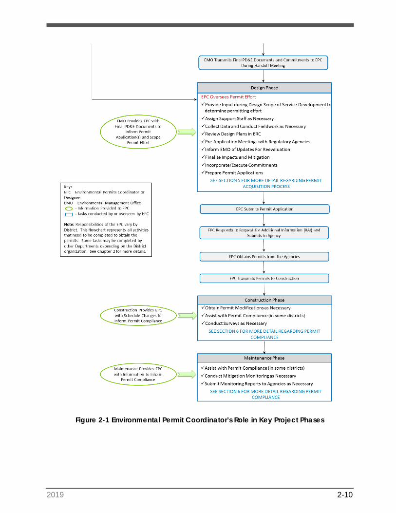
2.3 Participation in the Design Phase
Design of a project comprises the next phase of FDOT project delivery. This phase takes the preliminary PD&E concepts and develops the final engineering aspects of the project for construction. If permits were not issued during PD&E, or the project did not qualify for PD&E Study, permit applications are typically submitted for regulatory agency review at the 60-percent plan development.
Ultimately, it is the Environmental Permit Coordinator’s responsibility to ensure that permits are acquired within the production schedule.
See Section 5 for a step-by-step guide to the permit application process.
The design is typically carried out by a consultant team led by FDOT’s PM and each assigned discipline lead (i.e. Drainage/Permitting, Structures etc.). For some projects, the design is sometimes carried out by FDOT in-house staff or in-house consultants. Regardless of who carries out the design analysis, the same process applies.
At the beginning of the Design phase, it is recommended to have a project “Hand-off Meeting” where the EMO and the PD&E PM formally transmit the PD&E documents and commitments to the Design PM and the Environmental Permit Coordinator.
This ensures a smooth transition of information from one phase to another. The Environmental Permit Coordinator will use the PD&E documents, such as the NRE, CRAS and Environmental Document, to support the permitting effort. As previously mentioned, these documents become the basis of the avoidance and minimization documentation and permit application.
2.3.1 Scope Development
The Environmental Permit Coordinator will provide input during the scope of service development for the Design phase to determine the permitting effort needed.
If the design consultant team will be preparing the permit applications, the Environmental Permit Coordinator will provide input into the staff hour estimate and scope related specifically to the permitting effort. In some cases, the Environmental Permit Coordinator may use in-house staff or consultant support for the permitting effort. In either case, once the level of required permitting effort has been identified, the Environmental Permit Coordinator or the assigned support staff ensure the plans review, coordination, and permit acquisition processes are completed thoroughly and within the production schedule. See Section 5.1 for additional details.
2019 2-20
2.3.2 Plans Review
The Environmental Permit Coordinator or designated staff will review each phase of the design plans to determine the following:
• What are the natural resource impacts – wetlands, protected species, EFH?• What level and/or type of field surveys are required?• What type of agency coordination is needed and when should it occur?• What permits are required?• Are there any contamination impacts that will affect drainage?• Is coordination with other disciplines required – Utilities, Construction, EMO?• Is any mitigation required?• Are there design changes that require permit modifications?
If the project qualified for a PD&E Study, the Environmental Permit Coordinator will review those environmental and engineering documents to determine what studies have already been completed, what impacts have already been identified, as well as what has changed on the project in order to develop a permitting strategy. If the project did not qualify for a PD&E Study, the Environmental Permit Coordinator would then rely on a review of the design plans to identify the impacts and permitting needs. See Section 4 for more details relating to the identification of resources and Section 5 for details of the permit application process.
2.3.3 Obtain Permits
The Environmental Permit Coordinator is responsible for overseeing the permitting effort and ensuring the permits are obtained within the production schedule; however, some tasks may be completed by other District staff or offices, or accomplished with consultant support, depending on the District organization.
• The Environmental Permit Coordinator attends pre-application meetings withregulatory agencies.
• The Environmental Permit Coordinator determines the final project impactsand mitigation options.
• The Environmental Permit Coordinator incorporates and/or executescommitments as appropriate.
• The Environmental Permit Coordinator or designated consultant/FDOT staffprepares, reviews and submits the permit applications and responds to anyRequest(s) for Additional Information to the appropriate regulatory agency.
2.4 Re-evaluations
Once a PD&E Study is approved, it must be re-evaluated in accordance with Part 1, Chapter 13. Re-evaluations ensure that the decisions made during PD&E (or the previous project phase) are still valid.
2019 2-21
Re-evaluations document any major design changes, environmental changes, or changes in federal and state laws that occurred after the PD&E Study. Major design changes include changes in typical section; shifts in roadway alignment; changes in Right of Way (ROW) requirements; changes in drainage requirements; and changes in traffic volumes that may affect traffic noise models.
During the re-evaluation process, design changes that affect wetlands, wildlife and habitat, and archaeological and historic resources are also assessed.
The Environmental Permit Coordinator will provide the EMO with any wetland, benthic or species surveys conducted in the Design Phase for documentation in the re-evaluation. Environmental Permit Coordinator also provides
documentation of any agency consultation, such as Section 7 ESA documents or consultation letters, a list of permits with issuance and expiration dates, mitigation status, as well as commitment status updates related to natural resources.
NOTE: In some Districts, the EMO will conduct the natural resource surveys,species consultation, etc. In this case, the EMO and Environmental Permit Coordinator will coordinate to ensure both the re-evaluation and permit applications are complete and consistent.
Re-evaluations rely heavily on this information; hence it is important that the EMO, permitting staff and the Design PM frequently discuss project changes to ensure these changes are properly evaluated in terms of environmental impacts and are properly documented in the re-evaluations.
2.5 Participation in the Construction Phase
At the completion of the Design Phase, the Environmental Permit Coordinator prepares a Permit Transmittal Memorandum, Form No. 650-040-01 prior to the production date and sends copies of the permits to Construction and other
interested parties (see Section 5, Step 10 and 11).
The permits are included in the contract package prior to the letting.
The Environmental Permit Coordinator will participate in the pre-Construction Meeting held prior to construction activities to advise the contractor and FDOT construction staff on the permitting and environmental issues associated with the
project.
2.5.1 Alternative Project Delivery
The Construction phase of project delivery is primarily accomplished through the Design-Bid-Build and Design-Build (D/B) processes. The Design-Bid-Build (conventional) process is a form of project delivery whereby FDOT either performs the design work in-house or negotiates with an engineering design firm to prepare drawings and specifications under a design services contract, and then separately contracts for construction services by engaging a contractor through competitive bidding. The D/B form of project delivery is a
2019 2-22
system of contracting whereby one entity performs both engineering Design and Construction under one contract.
The difference between Design-Bid-Build vs D/B processes from a permitting perspective is the timing of permit acquisition. Design-Bid-Build projects are awarded with permits which are issued prior to letting. On D/B Projects, conceptual or construction permits may be acquired by FDOT prior to letting but may be modified by the D/B Team based on design changes proposed during the Alternative Technical Concept (ATC) process. Otherwise, the permitting effort is assigned as part of the D/B team scope of services.
To clarify, the D/B Team will prepare the permit packages or modifications as directed by the scope of services; however, the Environmental Permit Coordinator is responsible to review and sign applications before submittal to the regulatory agencies.
Examples of design changes proposed during this process include reducing bridge spans, alternative drainage design, or a change in interchange concepts such as a cloverleaf altered to a diverging diamond interchange.
During this vetting process, FDOT and the Design team must understand which activities the issued permits authorize in relation to stormwater criteria, wetland impacts, and listed species effects, and which design changes would require permit modifications.
Additional impacts to wetlands raise concerns, including whether additional mitigation is available or whether the USACE, FDEP or WMD would authorize additional impacts given that the previous design demonstrated avoidance and minimization of these impacts. Commitments made during the PD&E Study should also be followed closely when considering ATC proposals, especially given the extensive public involvement conducted prior to finalization of the PD&E documents. A change in an interchange concept could require extensive coordination and additional approvals and/or public involvement through the NEPA process.
2.5.2 Permit Modifications and Extensions
The contractor may request changes to the project design during the Construction phase. When these changes require modification to the drainage design or cause increased natural resource impacts, a permit modification will likely be required.
The Environmental Permit Coordinator is responsible for reviewing the proposed design change, determining the need for agency authorization, and coordinating the issuance of the permit modifications.
The Environmental Permit Coordinator will also acquire permit extensions as needed during construction. The Environmental Permit Coordinator See Section 6 for additional details.
2019 2-23
2.5.3 Permit Compliance and Project Commitments During Construction
All permit conditions and project commitments must be tracked during construction to ensure compliance with the environmental permits and the environmental document. As noted in Section 1.2.1.5, FDOT uses Project Suite Enterprise Edition and the PCR to document and track commitments. The PCR also provides a record that can be used to demonstrate commitments have been fulfilled. Permit conditions are also tracked to ensure compliance during construction. The Construction Project Administrator is required to coordinate with the Environmental Permit Coordinator and other designated environmental compliance staff (as assigned per each District’s process) to ensure all work is completed in accordance with the permit conditions as described in the Construction Project Administration Manual (CPAM).
In some Districts, the Environmental Permit Coordinator is responsible for assisting with permit and commitment compliance. This may include overseeing additional species surveys, water quality monitoring, wetland protection or compliance with the erosion and sediment control plan.
The Construction Project Administrator or Construction Engineering and Inspection (CEI) team will provide the Environmental Permit Coordinator with schedule changes and other pertinent information to inform the permit compliance effort. Please refer to Section 6 for further information regarding permit and commitments compliance.
2.5.4 Permit Closeout
Once a project is nearing the end of construction, the Environmental Permit Coordinator, Construction Project Administrator, CEI team, and the contractor superintendent typically coordinate on closing out permit conditions and
project commitments.
These conditions include the Transfer of Operations Actions and the submittal of As-Built plans in accordance with the state permit obligations. This also includes conducting any final inspections with agency personnel that are required to closeout the permits.
It is recommended that the Environmental Permit Coordinator review all conditions in the issued permits for the project, as well as any project commitments, to ensure that nothing is being overlooked. The Construction Project Administrator or CEI is responsible for submitting the permit closeout documentation to the agencies; however, the
Environmental Permit Coordinator must confirm that all permit requirements are complete, and the project documents are retained for the record.
2.6 Maintenance Phase
Many permits require that post-construction maintenance activities be conducted. If this is required, it will be documented in the project-specific conditions within the permit. Examples of activities that may be conditioned for project maintenance are stormwater management facilities (ponds, swales, drainage structures) and monitoring of mitigation sites.
2019 2-24
In some FDOT Districts, the Environmental Permit Coordinator is responsible for assisting with permit compliance during the Maintenance phase.
The Maintenance Office and the Environmental Permit Coordinator are responsible for continuous coordination to ensure both parties have an understanding of what scheduling information and other pertinent details are needed to implement and track the permit conditions applicable to the Maintenance phase. See Section 6 for more guidance regarding permit compliance during the Maintenance phase.
2019 3-25
SECTION 3: FEDERAL VS. STATE PROCESSES: SIMILARITIES AND DIFFERENCES
3.1 Overview of Federal and State Environmental Permitting Processes
This section provides an overview of federal and state environmental permitting programs, as they relate to Florida Department of Transportation (FDOT) projects. Historically, there has been considerable overlap between federal and state permitting requirements; streamlining the process is a win/win situation for both regulatory levels of government and applicants. This chapter provides an overview of the regulatory process at the federal and state levels, outlines differences and similarities, and lists the various permitting options available to the District Environmental Permit Coordinator. A summary of these topics can be found in Table 3-1 on the following page, and further detail for each is provided in the subsequent sections.
3.1.1 Federal Permitting Process
The United States Army Corps of Engineers (USACE) is the federal agency responsible for the protection of the nation’s wetlands through the regulation of all dredging and filling activities within “Waters of the United States”, which includes wetlands and surface waters.
In Florida, the USACE 404 Permitting Program is administered out of the South Atlantic District Office in Jacksonville. A map of USACE Regulatory Offices is useful for determining which counties are served by a specific USACE office (see Figure 3-1). The state is divided into a North Branch, a West Branch, and a South Branch. Offices in the North Branch include Jacksonville, Panama City, Cocoa, and Gainesville. Offices in the West Branch include Tampa and Fort Myers. The offices in the South Branch are located in Palm Beach Gardens and Miami.
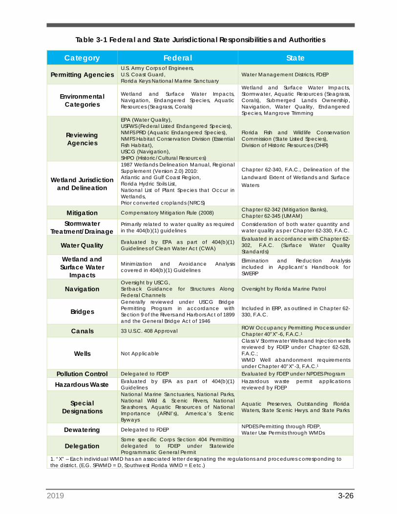
2019 3-26
Table 3-1 Federal and State Jurisdictional Responsibilities and Authorities
Category Federal State
Permitting Agencies U.S. Army Corps of Engineers, U.S. Coast Guard, Florida Keys National Marine Sanctuary
Water Management Districts, FDEP
Environmental Categories
Wetland and Surface Water Impacts, Navigation, Endangered Species, Aquatic Resources (Seagrass, Corals)
Wetland and Surface Water Impacts, Stormwater, Aquatic Resources (Seagrass, Corals), Submerged Lands Ownership, Navigation, Water Quality, Endangered Species, Mangrove Trimming
Reviewing Agencies
EPA (Water Quality), USFWS (Federal Listed Endangered Species), NMFS PRD (Aquatic Endangered Species), NMFS Habitat Conservation Division (Essential Fish Habitat), USCG (Navigation), SHPO (Historic/Cultural Resources)
Florida Fish and Wildlife Conservation Commission (State Listed Species), Division of Historic Resources (DHR)
Wetland Jurisdiction and Delineation
1987 Wetlands Delineation Manual, Regional Supplement (Version 2.0) 2010: Atlantic and Gulf Coast Region, Florida Hydric Soils List, National List of Plant Species that Occur in Wetlands, Prior converted croplands (NRCS)
Chapter 62-340, F.A.C., Delineation of the Landward Extent of Wetlands and Surface Waters
Mitigation Compensatory Mitigation Rule (2008) Chapter 62-342 (Mitigation Banks), Chapter 62-345 (UMAM)
Stormwater Treatment/Drainage
Primarily related to water quality as required in the 404(b)(1) guidelines
Consideration of both water quantity and water quality as per Chapter 62-330, F.A.C.
Water Quality Evaluated by EPA as part of 404(b)(1) Guidelines of Clean Water Act (CWA)
Evaluated in accordance with Chapter 62-302, F.A.C. (Surface Water Quality Standards)
Wetland and Surface Water
Impacts
Minimization and Avoidance Analysis covered in 404(b)(1) Guidelines
Elimination and Reduction Analysis included in Applicant’s Handbook for SWERP
Navigation Oversight by USCG, Setback Guidance for Structures Along Federal Channels
Oversight by Florida Marine Patrol
Bridges Generally reviewed under USCG Bridge Permitting Program in accordance with Section 9 of the Rivers and Harbors Act of 1899 and the General Bridge Act of 1946
Included in ERP, as outlined in Chapter 62-330, F.A.C.
Canals 33 U.S.C. 408 Approval ROW Occupancy Permitting Process under Chapter 40”X”-6, F.A.C.1
Wells Not Applicable
Class V Stormwater Wells and Injection wells reviewed by FDEP under Chapter 62-528, F.A.C.; WMD Well abandonment requirements under Chapter 40”X”-3, F.A.C.1
Pollution Control Delegated to FDEP Evaluated by FDEP under NPDES Program
Hazardous Waste Evaluated by EPA as part of 404(b)(1) Guidelines
Hazardous waste permit applications reviewed by FDEP
Special Designations
National Marine Sanctuaries, National Parks, National Wild & Scenic Rivers, National Seashores, Aquatic Resources of National Importance (ARNI’s), America’s Scenic Byways
Aquatic Preserves, Outstanding Florida Waters, State Scenic Hwys. and State Parks
Dewatering Delegated to FDEP NPDES Permitting through FDEP, Water Use Permits through WMDs
Delegation Some specific Corps Section 404 Permitting delegated to FDEP under Statewide Programmatic General Permit
1. “X” – Each individual WMD has an associated letter designating the regulations and procedures corresponding tothe district. (E.G. SFWMD = D, Southwest Florida WMD = E etc.)
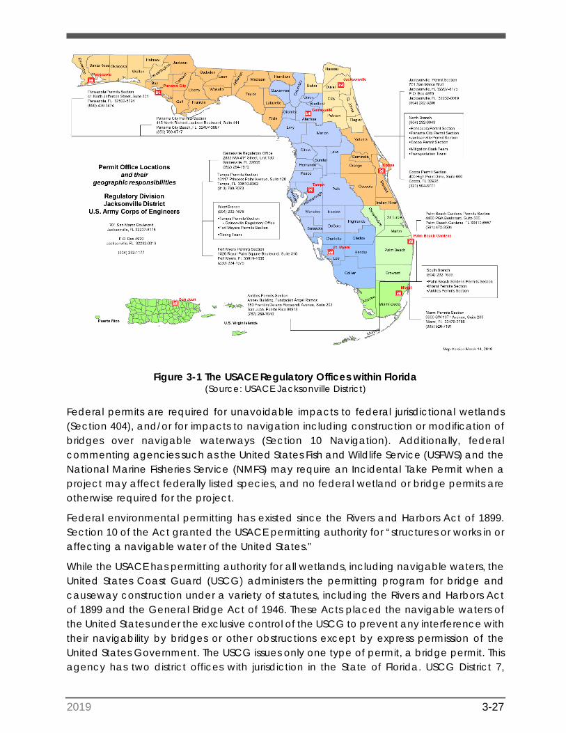
2019 3-27
Figure 3-1 The USACE Regulatory Offices within Florida (Source: USACE Jacksonville District)
Federal permits are required for unavoidable impacts to federal jurisdictional wetlands (Section 404), and/or for impacts to navigation including construction or modification of bridges over navigable waterways (Section 10 Navigation). Additionally, federal commenting agencies such as the United States Fish and Wildlife Service (USFWS) and the National Marine Fisheries Service (NMFS) may require an Incidental Take Permit when a project may affect federally listed species, and no federal wetland or bridge permits are otherwise required for the project.
Federal environmental permitting has existed since the Rivers and Harbors Act of 1899. Section 10 of the Act granted the USACE permitting authority for “structures or works in or affecting a navigable water of the United States.”
While the USACE has permitting authority for all wetlands, including navigable waters, the United States Coast Guard (USCG) administers the permitting program for bridge and causeway construction under a variety of statutes, including the Rivers and Harbors Act of 1899 and the General Bridge Act of 1946. These Acts placed the navigable waters of the United States under the exclusive control of the USCG to prevent any interference with their navigability by bridges or other obstructions except by express permission of the United States Government. The USCG issues only one type of permit, a bridge permit. This agency has two district offices with jurisdiction in the State of Florida. USCG District 7,

2019 3-28
based out of Miami, Florida, is responsible for Coast Guard activities throughout the majority of the state, while USCG District 8, in New Orleans, Louisiana, oversees Coast Guard activities taking place in Florida’s panhandle.
Federal protection of wetlands commenced with the passage of the Clean Water Act of 1969 (CWA). Section 404 of the Act regulates the dredging and filling of wetlands and waters of the United States and is administered by USACE. Therefore, the associated federal wetland permits are alternatively referred to as “dredge and fill permits,” “404 permits,” and/or “Corps permits”.
The federal permitting process for FDOT is addressed through a lead permitting agency (either the USACE or the USCG depending on the type of project, or USFWS if no wetlands or bridge permit is required). Permits are typically required for proposed dredging and/or filling impacts to jurisdictional wetlands and other surface waters or for bridge or causeway construction over navigable waters of the United States. The lead permitting agency is responsible for reviewing the application, sending out copies to federal reviewing agencies, assembling the agency comments, coordinating with FDOT, and issuing the final decision.
Per Section 404 of the CWA, the Environmental Protection Agency (EPA) shares Section 404 enforcement authority with the USACE and is also responsible for reviewing and commenting on individual Section 404 permit applications. This commenting agency also has the authority to prohibit, deny, or restrict the use of any proposed disposal site. However, since the EPA has delegated the Water Quality Certification component of its Section 404 authority to the Florida Department of Environmental Protection (FDEP), in practice this agency only comments on permit applications which have been deemed controversial. Please refer to Section 3.10.2 for more information regarding the EPA’s role as a federal commenting agency.
The Endangered Species Act of 1973 (ESA) requires that federal agencies ensure that their actions (e.g., issuing permits) do not jeopardize the continued existence of listed species or adversely modify critical habitat. Section 4 of the permitting handbook describes the interagency coordination that is required when a federal action agency (USACE or USCG) processes a Section 404 and/or bridge permit application that may affect federally listed species. This interagency coordination between USACE/USCG and USFWS or NMFS is often the most time-consuming aspect of the federal permitting process.
3.1.2 State Permitting Process
The FDEP and each of the five Water Management Districts (WMDs) administer the Statewide Environmental Resource Permitting (SWERP) program. This current regulatory framework was developed in 1993 from three separate permitting programs: Wetlands Resource Permit (wetland regulation), Management and Storage of Surface Waters (MSSW) (stormwater regulation), and Sovereign Submerged Land (submerged lands) program. The SWERP program is currently governed under Part IV of Chapter 373 of the Florida Statutes (F.S.) and Chapter 62-330 of the Florida Administrative Code (F.A.C.).
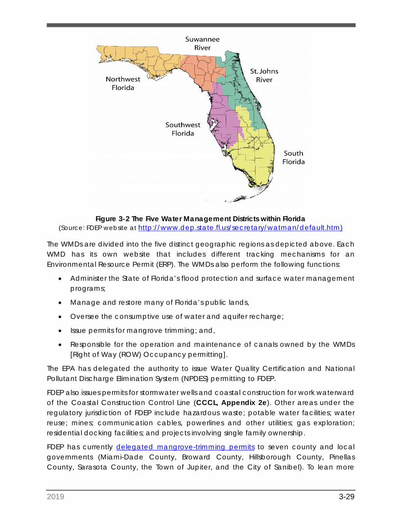
2019 3-29
Figure 3-2 The Five Water Management Districts within Florida (Source: FDEP website at http://www.dep.state.fl.us/secretary/watman/default.htm)
The WMDs are divided into the five distinct geographic regions as depicted above. Each WMD has its own website that includes different tracking mechanisms for an Environmental Resource Permit (ERP). The WMDs also perform the following functions:
• Administer the State of Florida’s flood protection and surface water managementprograms;
• Manage and restore many of Florida’s public lands,
• Oversee the consumptive use of water and aquifer recharge;
• Issue permits for mangrove trimming; and,
• Responsible for the operation and maintenance of canals owned by the WMDs[Right of Way (ROW) Occupancy permitting].
The EPA has delegated the authority to issue Water Quality Certification and National Pollutant Discharge Elimination System (NPDES) permitting to FDEP.
FDEP also issues permits for stormwater wells and coastal construction for work waterward of the Coastal Construction Control Line (CCCL, Appendix 2e). Other areas under the regulatory jurisdiction of FDEP include hazardous waste; potable water facilities; water reuse; mines; communication cables, powerlines and other utilities; gas exploration; residential docking facilities; and projects involving single family ownership.
FDEP has currently delegated mangrove-trimming permits to seven county and local governments (Miami-Dade County, Broward County, Hillsborough County, Pinellas County, Sarasota County, the Town of Jupiter, and the City of Sanibel). To lean more
2019 3-30
about FDEP’s Mangrove permitting rules pursuant to Section 403.9324, F.S., as well as coordination on mangrove trimming, go to FDEP’s web page on mangroves.
Operating Agreement
Jurisdiction for state permitting responsibilities is established in operating agreements between FDEP and each of the WMDs. In accordance with this Operating Agreement, WMDs regulate multiple family housing projects, commercial developments, mitigation banks (except in the Suwanee River Water Management District) and transportation facilities.
Except for instances where a state statute specifically delegates permitting of transportation facilities through FDEP (such as in Northwest Florida Water Management District (NWFWMD), where FDEP still issues permits for FDOT projects on state lands), FDOT projects are permitted through the WMDs. Exceptions would include projects involving contamination coordination and cleanup on FDOT ROW, projects located waterward of the CCCL, and temporary cement plants for FDOT projects. The state regulatory agency will be referred to as “WMD” for the remainder of this document unless there is direct FDEP involvement. Other special permit cases that require permits from FDEP are further explained in this document.
Regulatory Components
In 2012, Section 373.4131, F.S., further refined the regulatory framework to become more streamlined and standardized throughout all FDEP and WMD offices. This streamlined effort, labeled the SWERP, developed an Applicant’s Handbook that outlines the rules, procedures, standards, and criteria that currently apply to ERP permitting. The Applicant’s Handbook is divided into two volumes.
• Volume I provides the background of the ERP program which includes rules andstatutes, forms, thresholds, exemptions, erosion and sediment control methods,operation and maintenance requirements and environmental criteria. This volumeis applicable to both FDEP and all five WMD offices.
• Volume 2 is specific to each WMD. Volume 2 for specific WMDs can be accessedfrom the Water Resource Management Rules webpage and are listed underEnvironmental Resource Permitting Rules. These volumes primarily apply to thedesign criteria and permitting of stormwater management systems.
HELPFUL HINTS: Chapter 10 of Volume I of the Applicant’s Handbookincludes the environmental criteria for permit issuance related to activities located in wetlands and other surface waters.
The SWERP program regulates two principle categories of permitted activities: (1) stormwater management and (2) environmental impacts. The term “environmental,” from the standpoint of ERP review criteria, does not include all items included in FDOT Project Development and Environment (PD&E) Studies, such as air quality, noise, and
2019 3-31
contamination. Typically, the ERP environmental analysis by WMD staff includes the review of a project’s effects to wetlands, surface waters, and wetland dependent species. Effects to archaeological and historic resources and state-listed wildlife are reviewed by other state agencies commenting on the application [e.g. Florida Division of Historical Resources (DHR) and the Florida Fish and Wildlife Conservation Commission (FWC)]. The WMDs have separate staff reviewers for each application component, who work with the applicant to achieve compliance with state rules.
3.2 Wetland Jurisdiction
Federal Jurisdiction
The USACE is responsible for the protection of the nation’s wetlands through the regulation of all dredging and filling activities within waters of the United States, which includes wetlands and other surface waters.
Wetlands are currently defined by the USACE in 33 Code of Federal Regulations (CFR) § 328.3(b) as "those areas that are inundated or saturated by surface or ground water at a frequency and duration sufficient to support and that under normal circumstances do support a prevalence of vegetation typically adapted for life in saturated soils." In other words, wetlands are areas that are covered by water or have appropriate wetland vegetation, hydrologic soils, and other hydrologic indicators (such as the presence of water marks, sediment deposits, or aquatic fauna). Species specific wetland dependent plants are indicators of saturated conditions. See handbook section 4.1.2.3 Hydrophytic Vegetation.
State Jurisdiction
The FDEP is responsible for ensuring statewide consistency in the delineation of wetlands and surface waters in Florida. Wetlands are currently defined in Chapter 62-340, F.A.C. as "those areas that are inundated or saturated by surface or ground water at a frequency and duration sufficient to support a prevalence of vegetation typically adapted for life in saturated soils." For the state’s purposes, wetlands are areas that contain at least two of the following components: appropriate wetland vegetation, hydrologic soils, or other hydrologic indicators.
Chapter 62-340, F.A.C. also includes a list of plants that can be found in wetlands. These plants are also included in Florida Wetland Plants: An Identification Manual that was published by the University of Florida in 1998.
3.3 Drainage Jurisdiction
The ERP stormwater management review criteria are based on the principle that all water runoff from the project site must be managed utilizing “best management practices” (BMPs) prior to discharge from the project site. The purpose of these BMPs, or stormwater management systems, is to provide reasonable assurance that no adverse impacts to state water quality or quantity will occur due to the project. Various stormwater
2019 3-32
management systems and associated criteria are documented within Volume II of the Applicant’s Handbook and the Florida Statutes.
Additional criteria may also be applicable for stormwater management systems based on the geographic location or basin in which the project is located and the classification of the receiving water body, e.g. Outstanding Florida Waters (OFWs). The WMDs typically have an engineer review this component of the ERP permit application that provides guidance through the stormwater permitting process. FDOT also has its own criteria for drainage that are detailed in the FDOT Drainage Manual.
NOTE: An applicant must demonstrate compliance through proper design andperformance of systems to demonstrate treatment of a minimum of 80% pollutant removal.
The permit evaluation criteria associated with stormwater management include documentation that a project does not cause adverse water quality impacts to receiving waters and adjacent uplands and does not cause adverse flooding to onsite and offsite properties. By implementing the design standards in the Applicant’s Handbook, the discharge is presumed to meet state water quality standards that are validated by issuance of an ERP permit.
An ERP permit may be required for stormwater improvements even when there are no wetland and surface water impacts. Close coordination with the drainage and roadway engineers regarding FDOT permitting efforts is an integral part of the permitting process.
Note that a Water Quality Certification (“401 certification”), which is implemented by the WMDs and the FDEP on behalf of the EPA, is required prior to issuance of the USACE dredge-and-fill permit. Therefore, the timing of the state and federal wetland permit processing should be coordinated so the state permit is issued (with Water Quality Certification) prior to the completion of USACE dredge-and-fill permitting.
3.4 Bridge Jurisdiction
Under Section 10 of the Rivers and Harbors Act (1899), the USACE is required to evaluate potential impacts to navigable waters to ensure that the proposed activities do not affect navigation. As defined in 33 CFR § 329, navigable waters are “those waters that are subject to the ebb and flow of the tide and/or are presently used, or have been used in the past, or may be susceptible for use to transport interstate or foreign commerce.” In Florida, these waters generally include the Atlantic Ocean, the Gulf of Mexico, bays, estuaries, rivers, and canals connected to tidal waters. This jurisdiction extends seaward to include all ocean waters within a zone of three nautical miles from the coastline (the "territorial seas"). FDOT projects that require evaluation under this rule include bridges, shoreline stabilization (including seawalls and riprap), and causeways.
2019 3-33
HELPFUL HINTS: Authorization under the Rivers and Harbors Act isprovided as part of the USACE Dredge and Fill Permit. A list of navigable waters in Florida is provided by USACE and is subject to the disclaimers provided by USACE.
The USCG is responsible for issuing permits for bridges and causeways in or over navigable waters of the United States, and for causeway construction in all tidal waters of the United States.
USCG versus USACE Jurisdiction for Projects Involving Bridges
Pile-supported structures (such as bridges) are delegated to the USCG, which serves as the lead federal agency under the terms of Section 9 of the Rivers and Harbors Act of 1899, and the General Bridge Act of 1946.
Under these Acts, the USCG’s mission is to administer the bridge program, under which it approves the location and plans of bridges and causeways and imposes any necessary conditions relating to the construction, maintenance, and operation of these bridges in the interest of public navigation. When the Coast Guard serves as the lead federal agency, it is also required by law to perform interagency consultation(s) with USFWS and/or NMFS for each bridge permitting decision. The rules and regulations governing the USCG bridge permit program are listed in 33 CFR Parts 114 and 115.
For FDOT projects, USACE jurisdiction within navigable waters applies to bridge approaches, bridge abutments, fenders, shoreline stabilization, riprap and aids to navigation, and temporary structures such as coffer dams.
Note that while the USACE jurisdiction covers bridge abutments and other in-water structures, the USCG bridge permit authorizes the actual bridge construction or bridge modifications to ensure adequate horizontal/vertical clearances and bridge lighting for navigation. Both agencies should be consulted for any project involving bridges over waterways, to determine agency jurisdiction.
HELPFUL HINTS: The USACE regulates the bridge approaches, bridgeabutments and other in-water structures. The USCG regulates the remainder of the bridge. Applications to both agencies will be required for activities that include both areas of the bridge.
3.5 Threatened and Endangered Species Jurisdiction
3.5.1 United States Fish and Wildlife Service
The United States Fish and Wildlife Service (USFWS) maintains jurisdiction over federally listed threatened and/or endangered species, and critical habitat, under the ESA of 1973, as amended. This agency serves as a federal wildlife commenting agency and has jurisdiction over the land and freshwater species protected by the ESA and their habitat, such as the Florida panther, wood stork, and nesting or hatching sea turtles. It also
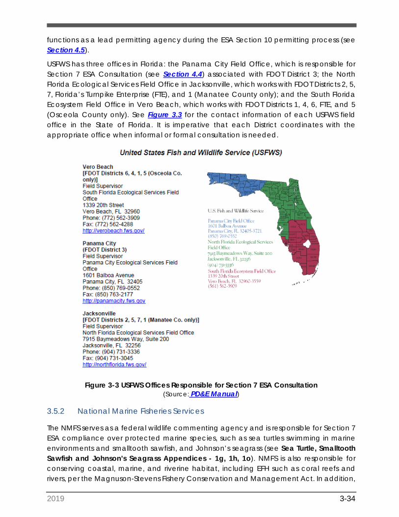
2019 3-34
functions as a lead permitting agency during the ESA Section 10 permitting process (see Section 4.5).
USFWS has three offices in Florida: the Panama City Field Office, which is responsible for Section 7 ESA Consultation (see Section 4.4) associated with FDOT District 3; the North Florida Ecological Services Field Office in Jacksonville, which works with FDOT Districts 2, 5, 7, Florida’s Turnpike Enterprise (FTE), and 1 (Manatee County only); and the South Florida Ecosystem Field Office in Vero Beach, which works with FDOT Districts 1, 4, 6, FTE, and 5 (Osceola County only). See Figure 3.3 for the contact information of each USFWS field office in the State of Florida. It is imperative that each District coordinates with the appropriate office when informal or formal consultation is needed.
Figure 3-3 USFWS Offices Responsible for Section 7 ESA Consultation (Source: PD&E Manual)
3.5.2 National Marine Fisheries Services
The NMFS serves as a federal wildlife commenting agency and is responsible for Section 7 ESA compliance over protected marine species, such as sea turtles swimming in marine environments and smalltooth sawfish, and Johnson’s seagrass (see Sea Turtle, Smalltooth Sawfish and Johnson’s Seagrass Appendices - 1g, 1h, 1o). NMFS is also responsible for conserving coastal, marine, and riverine habitat, including EFH such as coral reefs and rivers, per the Magnuson-Stevens Fishery Conservation and Management Act. In addition,
2019 3-35
this agency may take on the lead permitting agency role during Section 10 permitting under the ESA (see Section 4.5). The NMFS maintains two divisions that may be involved in project coordination:
• The Protected Resources Division (PRD) has the responsibility of protecting marinemammals and threatened or endangered marine life.
• The Habitat Conservation Division (HCD) is responsible for conserving coastal,marine, and riverine habitat.
The agency’s Southeast Regional Office is located in St. Petersburg, Florida. This office’s PRD is responsible for Section 7 ESA consultation statewide, while the HCD is responsible for EFH consultation throughout Florida.
3.5.3 Florida Fish and Wildlife Conservation Commission
The state’s regulatory wildlife agency is the FWC. FWC regulates 57 species listed in Florida’s Endangered and Threatened Species Act (such as the burrowing owl, Appendix 1b), and the gopher tortoise, Appendix 1d), as well as the federally listed or protected species such as the bald eagle (Appendix 1a) and West Indian manatee (Appendix 1e). FWC serves as the state wildlife commenting agency during the state permitting process. The FWC also issues species-specific permits including the relocation of gopher tortoises and burrowing owls. FWC is currently moving forward with a new imperiled species management plan that is the result of a ten-year effort establishing regulatory standards for the future. The management plans focus on restoring habitat and addressing long-term issues for all 57 state listed species. This plan includes developing specific permitting guidelines for these species.
There are five FWC regional offices located in the Northwest, North Central, Northeast, Southwest, and South Regions of Florida. See Figure 3-4 for the contact information and regional boundaries of each FWC regional office. Each district should coordinate with the office in their appropriate region when needed.
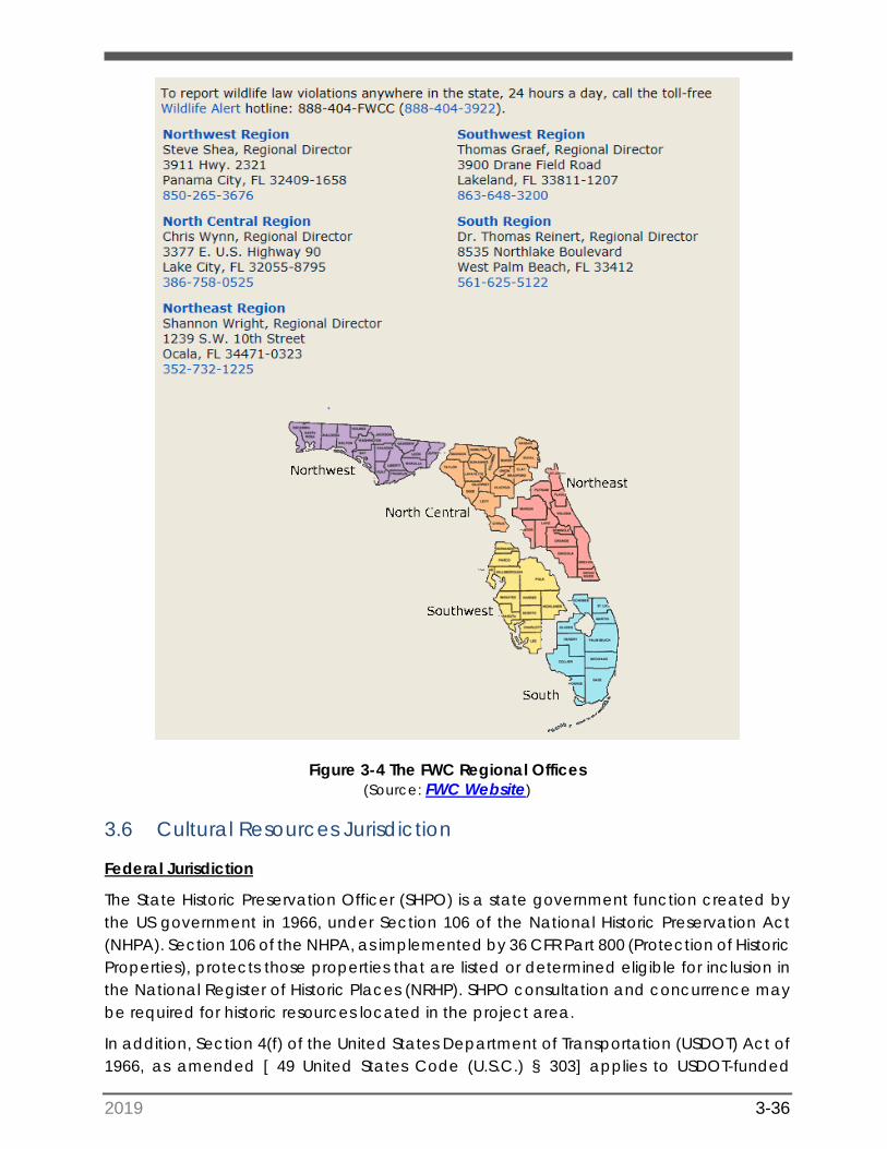
2019 3-36
Figure 3-4 The FWC Regional Offices (Source: FWC Website)
3.6 Cultural Resources Jurisdiction
Federal Jurisdiction
The State Historic Preservation Officer (SHPO) is a state government function created by the US government in 1966, under Section 106 of the National Historic Preservation Act (NHPA). Section 106 of the NHPA, as implemented by 36 CFR Part 800 (Protection of Historic Properties), protects those properties that are listed or determined eligible for inclusion in the National Register of Historic Places (NRHP). SHPO consultation and concurrence may be required for historic resources located in the project area.
In addition, Section 4(f) of the United States Department of Transportation (USDOT) Act of 1966, as amended [ 49 United States Code (U.S.C.) § 303] applies to USDOT-funded
2019 3-37
projects. Section 4(f) protects historic and/or cultural resources of national, state, or local significance and other natural public features from conversion to highway use, unless there is no prudent or feasible alternative. This also includes land from publicly owned parks, recreational areas, wildlife and waterfowl refuges, or public and private historical sites. The 4(f) determinations will have been made during the PD&E phase. See Part 2, Chapter 7 of the PD&E Manual for more details regarding Section 4(f) impacts and how they can affect a project in the National Environmental Policy Act (NEPA) (PD&E) Phase. Section 4(f) generally is documented in a PD&E Study; however, design changes with new or revised impacts to Section 4(f) properties could affect the project schedule.
State Jurisdiction
The Florida Department of State, DHR reviews state funded projects and provides concurrence for projects that will not affect any historical, cultural, or archaeological resources. DHR also complies with Chapter 267, F.S., for consultation and concurrence required for adverse effects to NRHP listed or eligible cultural resources. Projects with a PD&E phase will have initiated contact with the DHR during the Efficient Transportation Decision Making (ETDM) process and the PD&E Study.
3.7 Federal and State Permit Thresholds and Criteria
3.7.1 Federal Permitting Thresholds
In general, dredging and/or filling impacts to wetlands that are considered waters of the United States will require authorization from the USACE. For any proposed bridge or causeway across a navigable waterway of the United States, the project sponsor should identify the USCG as a cooperating agency and apply for a USCG bridge permit. This includes all temporary bridges used for construction access or traffic detours.
A bridge permit is necessary for any of the following:
1. The construction of a new bridge or causeway over navigable waters
2. The modification of an existing bridge or causeway that increases the travelcapacity of the bridge/causeway (i.e., adding a travel lane)
The modification of an existing bridge/causeway that would result in changes to navigation (i.e., changes to the horizontal or vertical clearances, fender systems, etc.).
NOTE: The USCG has the responsibility to determine whether a USCG permit isrequired for the improvement or construction of a bridge over navigable waters, and to approve the bridge location, alignment, and appropriate navigational clearances in all bridge permit applications.
2019 3-38
A permit from the USCG is not required for the following activities:
1. Construction of bridges crossing non-tidal waters NOT presently used as orsusceptible to use as a means of transporting interstate or foreign commerce;
2. Removal of an existing bridge with no replacement.
For projects requiring a PD&E, the need for a federal permit should be identified at this stage once the project scope has been established. This will help determine if the USACE or USCG should serve as a cooperating agency for the project, as well as allowing for early coordination with the permitting agencies. Additionally, once the need for a USACE or USCG permit has been identified, the project team can begin to analyze which avoidance and minimization measures may be feasible for the project.
HELPFUL HINTS: Many types of projects involving bridges do not requireUSCG permits. Examples include maintenance projects involving bridge painting, pile jackets, spall repairs, etc. Minor projects not affecting clearance or navigation will not need USCG permitting, but a “Notice to Mariners” may still be required to aid navigation.
3.7.2 State Permitting Thresholds
The ERP Program regulates dredging and/or filling in wetlands and surface waters, as well as the treatment and storage of stormwater runoff. Chapter 62-330, F.A.C. provides a complete listing of threshold criteria which if exceeded would require an ERP Permit. Chapter 62-330 also includes a complete listing of exemptions included under the ERP Program. If a project meets these exemption criteria, no ERP is required. However, if the permitting thresholds or the criteria listed for exemptions are exceeded, an ERP permit will be required for the proposed project. The stormwater permitting criteria are listed in the following section while the exemption criteria are presented in Sections 3.11.1 – 3.11.3 of this Handbook.
Stormwater Review Criteria
When evaluating what type of permit (if any) a project or activity may require, the first item to evaluate is whether any part of the project will exceed the established ERP permit thresholds. Rule 62-330.020(2), (a) through (j), F.A.C., lists all the thresholds that, if exceeded, will require a permit. According to this regulation, a permit is required (for FDOT projects) prior to the construction, alteration, operation, maintenance, removal, or abandonment of any new project that, by itself or in combination with an activity conducted after October 1, 2013, cumulatively results in any of the following:
• Any project in, on, or over wetlands or other surface waters;
• A total of more than 4,000 square feet of impervious and semi-impervious surfaceareas subject to vehicular traffic;
• A total of more than 9,000 square feet impervious and semi-impervious surfacearea;
• A total project area of more than one acre;
2019 3-39
• Capability of impounding more than 40 acre-feet of water; and
• Any modification or alteration of a project previously permitted under Part IV ofChapter 373, Florida Statutes.
In accordance to Section 3.1.4 (f) of Volume I of the Applicant’s Handbook, activities that do not exceed the above thresholds must also not:
• Cause adverse water quality impacts to receiving waters and adjacent lands;
• Cause adverse flooding to on-site or off-site property;
• Cause adverse impacts to existing surface water storage and conveyancecapabilities;
• Cause or contribute to a violation of the water quality standards; and,
• Cause adverse secondary or cumulative impacts to the water resources.
The above criteria must first consider those activities that qualify as not regulated or exempt (custodial maintenance, grandfathered activities, or exemptions). Activities that presumably do not require a permit or qualify as an exempted activity should be carefully reviewed to ensure that the proposed activities do not require a permit. The following section highlights which activities must be considered prior to moving forward with a permit determination.
3.8 United States Army Corps of Engineers Permits (Federal)
The USACE is responsible for the regulation of dredging activities and the placement of fill in waters of the United States. A definition of waters of the United States was originally provided in the CWA, which has been updated numerous times. The definition of waters of the United States has been quite controversial and there have been a number of Supreme Court rulings providing clarifications to this term, including the Solid Waste Agency of Northern Cook County (SWANCC) and Rapanos cases. The SWANCC ruling provided clarification on the criteria to be used for the identification of isolated wetlands, and the Rapanos decision identified factors to consider for the concept of “significant nexus.” The term “significant nexus” applies to wetlands or tributaries that provide substantial effect on a connecting water body either directly or indirectly. Guidance from both court cases should be factored into a decision on whether a wetland is connected (which requires authorization for any impacts) or isolated (which generally does not require a USACE Section 404 permit authorization). In general, the jurisdictional areas protected by the CWA include the navigable waters described in Section 3.4, as well as wetlands, sloughs, ponds, lakes and canals.
HELPFUL HINTS: Federal guidance for defining waters of the United States,“significant nexus”, and technical issues for determining USACE jurisdiction have changes in the past and are likely to do so in the future. Make sure to stay informed and litigation and decisions that affect waters of the United States jurisdiction and the effects that it may have on your project.
2019 3-40
In practical terms, the first step in the USACE permitting process is to determine what types of permits are required for the proposed activity(-ies). This determination of the type of federal permit required may occur in the ETDM process or in the early portions of the PD&E phase as explained in Section 2.
The lower levels of permitting (i.e. Nationwide Permits (NWPs) and General Permits) usually involve minor impacts to less than 0.5 acres. Since NWP applications are submitted for projects with relatively minor impacts, the general assumption is that less agency coordination will be needed than is typically required for a higher level of permitting. However, as per the NWP general conditions, an environmental impact review should still be conducted to ensure there are no significant impacts to listed species, critical habitat, and cultural or tribal resources. If these resources are present within the project area, coordination may still be required with the appropriate agency. The reduced level of federal coordination tends to result in much shorter review periods. Some NWPs also require a Water Quality Certification (see Section 3.12.5).
Typically, NWPs take 30-60 days for the USACE to process, while Standard Permits can take six months to a year to process (or longer for complex and/or controversial projects).
HELPFUL HINTS: The Source Book on the USACE Jacksonville Districtwebsite provides a detailed guide to the USACE Permitting Process. It can be obtained online at
www.saj.usace.army.mil/Missions/Regulatory/Source-Book/
3.8.1 No Permit Required by the United States Army Corps of Engineers
For projects where FDOT concludes that no USACE permit is necessary, it is advisable that FDOT request a determination by the USACE to document that no permit is required. This is particularly important for specific projects where an interpretation by the USACE is necessary to verify whether a permit is needed. Examples include:
a. A proposed project that is located within potentially navigable waters of the UnitedStates.
b. Bridge permits with no associated fill activities, where the USCG is the lead agency.
HELPFUL HINTS: The local USACE Regulatory Office should be contactedfor assistance in determining whether a federal permit is required. Documentation of coordination and the No Permit Required Decision should be obtained from USACE and placed in the file.
3.8.2 Nationwide Permit
An integral part of the USACE regulatory program involves the issuance of NWPs for specific activities that involve only minor impacts. NWPs are designed to relieve some of the administrative burdens associated with permit processing for both the applicant and the federal government.
2019 3-41
The NWPs are typically re-issued by USACE every five years, and the current permits are in effect from March 19, 2017 – March 18, 2022. There are 52 NWPs currently available. Each NWP defines a series of impact thresholds as specified in the rules, and the USACE maintains a helpful website for NWP information. The USACE Jacksonville District Source Book should be consulted routinely when considering the use of an NWP.
It is recommended to submit an application package to the USACE, and request that the USACE concur with the determination that the project is consistent with the thresholds associated with a given NWP. As noted below, some NWPs require Pre-Construction Notification (PCN), even though the NWP did not require review or approval from USACE.
The following NWPs may be applicable to FDOT Projects: (Be aware that more than one type of NWP may apply to a project and some are used more frequently than others):
a. Aids to Navigation (NWP 1). Examples of projects applicable to this NWP includechannel markers associated with bridges over a Federal Channel;
b. Structures in Artificial Canals (NWP 2). Examples include headwalls for outfallstructures in canals;
c. Maintenance (NWP 3). This NWP applies to many road project activities includingreplacement of bridge pilings; replacement of fender systems; repairs to roadsdamaged by storms; etc.
d. Scientific measuring devices (NWP 5). This NWP is applicable to rain gauges inmitigation areas.
e. Survey activities (NWP 6). This NWP is useful for geotechnical borings in wetlands orsurface waters where sub-surface information is required for designing structuressuch as bridges or for establishing subsurface conditions for roads.
f. Outfall Structures and Associated Intake Structures (NWP 7). This NWP includesstormwater outfall structures that discharge into Waters of the United States.
g. Utility Line Activities (NWP 12). This NWP can include fiber optic cable for operationof road signs. In addition, although not directly applicable to FDOT, this NWP isroutinely used for relocation of utilities within FDOT ROW.
h. Bank stabilization (NWP 13). This NWP is used for stabilizing canal banks or to placeriprap in front of (waterward) of seawalls.
i. Linear Transportation Projects (NWP 14). This is the most commonly used NWP forroad projects.
j. United States Coast Guard Approved Bridges (NWP 15).
k. Minor Discharges for small projects involving the discharge of less than 25 cubicyards of fill into jurisdictional areas (NWP 18).
l. Minor Dredging for small projects involving the dredging of less than 25 cubic yardsof fill from jurisdictional areas (NWP 19).
m. Reshaping Existing Drainage Ditches (NWP 41).
2019 3-42
There are certain NWPs that require a PCN to be submitted in writing prior to project construction due to variability in the degree of potential impacts for a given type of work. The following information is typically required for a PCN to be considered complete:
1. Contact information of the prospective permittee
2. Project location
3. Identification of which NWP(s) the prospective permittee would like to use
4. Project description and purpose, anticipated adverse environmental effects,proposed mitigation measures, and any other permits needed
5. Delineation of wetlands and any other water bodies located in the project area
6. Discussion of mitigation options if wetland impacts are anticipated to be greaterthan 1/10 acre
7. Documentation of which threatened and endangered species and criticalhabitats might be affected
8. Documentation of any NRHP listed or eligible cultural resources that may beaffected
9. Identification of Wild and Scenic Rivers, if applicable
10. Documentation of the written request for section 408 permission from theappropriate USACE office, if applicable
Where applicable, the PCN must be submitted in writing as early as possible prior to commencing the proposed activity, and it requires a 45-day review period. The 45-day period starts on the notification’s date of receipt in the USACE district office. The prospective permittee may not proceed with the proposed activity before expiration of the 45-day period, unless otherwise notified by the USACE.
3.8.3 Regional General Permit
The term "general permit" refers to a USACE authorization that is issued on a regional basis for a category of activities that cause only minimal individual and cumulative impacts. General permits are also a way to reduce the burden of the regulatory program on the public and ensure timely issuance of permits. The only Regional General Permit applicable to FDOT projects is SAJ-92.
This general permit applies to FDOT projects that have gone through the PD&E process where dredge and fill impacts do not result in the loss of greater than 5.0 acres of non-tidal waters of the United States (wetlands and surface waters) for any 1-mile segment of roadway length, up to a maximum impact of 50 acres of waters of the United States per project.
This regional general permit is limited to linear transportation projects that have been reviewed through the ETDM process and/or PD&E Study since 2010 and cannot be used for construction of new alignments. This permit is excluded from use in Monroe County.
2019 3-43
The SAJ-92 permit was issued on April 8, 2015 and remains valid through April 8, 2020. Regional General Permits do not have an official issuance timeframe, so the amount of time required for the permit to be issued varies from six to 12 months. It is advisable for the permit application to be submitted as early as possible to alleviate impacts to FDOT’s project schedule and for the District to coordinate with the appropriate USACE reviewer on projects needing this type of permit.
The standard review requirements for the SAJ-92 permit linked above include 25 special conditions. These conditions should be reviewed and understood to confirm if the SAJ-92 permit is applicable to the project.
3.8.4 Programmatic General Permit
A Programmatic Permit is a type of general permit that is delegated to the State of Florida by the USACE and is designed to avoid duplication between agencies (see Regional General Permits Appendix 2b). Two types of Programmatic General Permits may apply to FDOT projects: the SAJ-111 and the Statewide Programmatic General Permit (SPGP). The SAJ-111 is only issued by St. Johns River Water Management District (SJRWMD) through an agreement with the USACE. This permit does not directly apply to most FDOT projects, since it covers minor wetland and surface water impacts for projects involving the construction or expansion of residential, commercial, or institutional building foundations and building pads (see Section 3.11.4 for more details).
Another Programmatic General Permit that is directly applicable to FDOT projects is the SPGP. The USACE Jacksonville District has an agreement with the State of Florida which authorizes the FDEP or designee to administer SPGP permitting on behalf of the USACE. The current version of the SPGP (“SPGP V”) was issued on July 26, 2016 and expires on July 26, 2021. The purpose of the SPGP is to reduce the duplication of permitting effort between the USACE and FDEP.
Most activities authorized under the SPGP are for minor actions that are currently authorized by existing USACE Nationwide and Regional General Permits. The implementation of the SPGP eliminates the need for separate approval from the USACE for minor work located in Waters of the United States, including navigable waters, when that work is authorized by the FDEP or other delegated agency.
Other agencies that have received this delegated permitting authority from the USACE include the Southwest Florida Water Management District (SWFWMD) and SJRWMD. The types of FDOT road projects eligible for authorization under the SPGP process are limited and include shoreline stabilization and the relocation of utility lines.
HELPFUL HINTS: See a copy of the current SPGP (SPGP V) or learn moreabout Regional General Permits in Appendix 2b.
2019 3-44
3.8.5 Letter of Permission
The purpose of the Letter of Permission (LOP) is to offer an expedited federal permit process for minor projects with impacts to Waters of the United States. The impacts permitted through this process cannot be significant enough to go through the full Standard Permitting Process but may be slightly more significant than the impacts allowed under an NWP or Regional General Permit. The applicable criteria for LOPs can be found in the Source Book on the USACE Jacksonville District Regulatory website. In general, the USACE reviewer is responsible for determining if a project is eligible for a LOP. The LOP process is most commonly used by FDOT for minor bridge repair projects in the Florida Keys that require the use of temporary structures during construction.
As with the Federal Standard Permit process, LOP coordination with federal and state wildlife agencies is required under the Fish and Wildlife Coordination Act (FWCA). The LOP evaluation process is comprised of a 15-day comment period with state and federal agencies, as well as any adjacent property owners. If no comments are received during this 15-day period, the USACE can issue the permit. Due to the LOP’s streamlined process, it is not necessary to publish an individual public notice.
3.8.6 Standard Permit
A Standard Permit, commonly known as an “Individual Permit” is required when a proposed project does not meet the criteria to qualify for a General Permit, NWP or LOP. These permits are required for more complex projects with wetland and surface water impacts that exceed the thresholds of Nationwide or General Permits. Public notice is required for individual projects and will be published once the USACE has determined that the standard permit application is complete. Coordination with federal commenting agencies should also be conducted if resources under commenting agency jurisdiction are anticipated to be impacted by the project. Processing time varies for these types of permits from 120 days to a year from the receipt of a complete application in non-controversial projects. Controversial or larger projects may take longer.
3.8.7 Emergency Permit
The USACE addresses the permitting process for emergency situations in its regulations under 33 CFR § 325.2(e) (4). The USACE regulations define an “emergency” as “a situation which would result in an unacceptable hazard to life, a significant loss of property, or an immediate, unforeseen, and significant economic hardship if corrective action requiring a permit is not undertaken within a time period less than the normal time needed to process the application under standard procedures.”
In emergency situations, USACE Division Engineers, in coordination with the USACE District Engineers, are authorized to approve special processing procedures to expedite permit issuance. The USACE also uses alternative permitting procedures, such as general permits and letters of permission, when appropriate, to expedite processing of permit applications for emergencies.
2019 3-45
Situations requiring emergency permits may include emergencies due to a natural disaster (e.g., flood, hurricane, earthquake, etc.) or a catastrophic (sudden and complete) failure of a facility due to an external cause (e.g., a bridge collapse after being struck by a barge). The NWP for repairs to existing structures (NWP 3) can be used under the emergency permit time-period to repair damages caused by these unforeseen events.
3.8.8 Section 408 Permit
FDOT is required to obtain Section 408 USACE permission when an FDOT project is proposed to alter existing federal flood control projects (i.e., levees, dams, and canals). This process is frequently required for bridge projects over canals in South Florida that are associated with flood control projects in the Everglades. This permit process is handled as part of the ROW Occupancy permit process through the WMDs.
The USACE provides guidance for this process in Engineer Circular 1165-2-216, Policy and Procedural Guidance for Processing Requests to Alter United States Army Corps of Engineers Civil Works Projects Pursuant to 33 U.S.C. 408 (USACE, 2015b). The granting or denial of permission pursuant to Section 408 is made formal through a Section 408 Decision Letter. Information about the Section 408 Permit process is provided in Appendix 2f.
3.9 United States Coast Guard Bridge Permit (Federal)
A permit from the USCG is required for the construction or alteration of bridges or causeways over navigable waters. A USCG permit provides approval of the location and engineering plans for the bridge or causeway in relation to how the project affects to the public right of navigation. USCG bridge permits do not authorize approaches or other dredge and fill activities separate from the bridge itself.
Separate approval from the USCG is required for bridge navigational lighting and signals. The bridge lighting plan is a separate application from the bridge permit application.
The District should contact the local USCG District Bridge Office when a project includes a plan to construct a new bridge or causeway or modify an existing bridge or causeway over a canal, channel, stream, river, lake, bay, or other body of water or waterway. If the District is uncertain whether a waterway is susceptible to improvement for navigation, is tidal, or is considered navigable, the appropriate USCG representative can be contacted to obtain information regarding a navigability determination. The USCG representative determines whether the waterway is navigable and jurisdictional and provides comments in the Environmental Screening Tool (EST) for qualifying projects or correspondence confirming the determination.
Regulatory Components
The USCG issues permits for bridges and causeways in or over navigable waters of the United States, and for causeway construction in all tidal waters of the United States. In accordance with the USCG Bridge Program, the following definitions are applicable:
2019 3-46
• Navigable waters – waters subject to tidal influence, waterways with a history ofsubstantial commercial navigation, waterways that presently have commercialnavigation, waterways susceptible to commercial development, or thosehistorically or currently used for interstate commerce.
• Bridge – Any structure over, on, or in navigable waters of the United States used fortransporting persons, vehicles, commodities, or other physical matter and providingfor the passage or flow of water through or under the structure. The term bridgeincludes all integral bridge elements: approaches and appurtenances, regardlessof the materials used, whether natural or manufactured, or the constructionmethodology. Types of bridges include highway bridges, railroad bridges,pedestrian bridges, aqueducts, aerial tramways and conveyors, overheadpipelines, and similar structures of the same function with their approaches, bridgeprotective systems, foundations, and appurtenances (integral features). Thedefinition of bridges does not include aerial power transmission lines, submergedpipelines, and other similar structures and works unless they are integral features ofa bridge used in its construction, maintenance, operation, or removal; or they areaffixed to the bridge and affect the bridge clearances.
• Causeway – A raised road of solid fill across water or marshland, constructed sothat the water or marshland is on both sides of the road and there are no openingsfor navigation or water transfer. A raised road with any openings is a “bridge” withsolid fill approaches, not a causeway. Congressional approval is required beforethe Coast Guard may approve a causeway.
The USCG permits the location and plans of bridges and causeways and imposes any necessary conditions relating to the construction, maintenance, and operation of these bridges in the interest of public navigation.
Minor Deviations
If a project includes modifications of existing bridges to add bicycle paths, sidewalks, or other features that do not increase capacity, even if it causes widening of the existing bridge, it results in the need for a Minor Deviation. Minor Deviations are not considered permits, though the USCG reviews and approves them.
Permit Exemptions / Advanced Approval Waterways
Waterways that are not navigated other than by logs, log rafts, rowboats, canoes, and small motorboats pursuant to 33 CFR § 115.70 do not require a USCG Bridge Permit.
HELPFUL HINTS: The term “small motorboats” means rowboats, canoes,and other similar craft with outboard motors. It does not include sailing or cabin cruiser craft. Typically, this includes all boats smaller than 21 feet in length.
For these types of waterways, the clearances provided for high-water stages will be considered adequate to meet the reasonable needs of navigation. Bridge permit applications or information requests will be reviewed to see if the use criterion of the
2019 3-47
regulation applies. If it is met, the waterway is considered an “Advance Approval Waterway” and a permit is not required.
Since construction in waters exempt from a USCG permit may still require coordination with the USCG, such as approval of navigation lights and signals and timely notice to local mariners of waterway changes, the USCG should be notified whenever the proposed action may substantially affect local navigation.
3.10 Federal Commenting Agencies
Commenting agencies are an integral part of the permit review process. The lead permitting agency issuing a permit has an obligation to ensure that their authorization (i.e. permit) does not conflict with any other applicable state or federal regulations. Prior to and during the Design phase, FDOT will have completed much of the interagency coordination required for permitting. In some cases (such as with listed species), the information obtained during the previous phases will require updating once the design becomes certain; the necessary agency coordination/consultation can then be completed.
The lead federal permitting agency (either the USACE or USCG) will determine which commenting agencies are required to review and comment on a permit application. The agency will then share the project information with the other applicable agencies to solicit comments regarding the potential project impacts on protected resources under their jurisdiction.
The federal permitting process may include coordination with the following agencies:
• USFWS;
• NMFS;
• EPA;
• SHPO;
• Advisory Council on Historic Preservation (ACHP); and,
• Native American Tribes.
HELPFUL HINTS: Coordinating agencies provide input on projects, but donot approve or deny federal permits. Only the lead federal agency authorizes a final agency action (permit).
3.10.1 United States Fish and Wildlife Services and National Marine Fisheries Service
Regardless of whether the USACE or USCG is serving as lead or cooperating agency for a given federal project, USFWS and/or NMFS (collectively and individually known as “the Service(s)”) must review the permit application as a federal wildlife commenting agency. Both USFWS and NMFS have the potential to serve as commenting agencies for FDOT
2019 3-48
projects, but the need for each agency’s review depends on whether the proposed impacts are anticipated to affect terrestrial and freshwater species (under USFWS jurisdiction) or marine species (under NMFS jurisdiction) and/or their habitats.
After the lead permitting agency determines if USFWS, NMFS, or both agencies will be reviewing the permit application, each commenting agency works with the permit applicant and lead permitting agency through the ESA Section 7 consultation process or EFH consultation process, as appropriate, to determine if any impacts are anticipated to federally listed species and habitats. Depending on the level of impacts, informal consultation may be sufficient, or the formal consultation process may be needed. Refer to Section 4.3 for more details regarding informal and formal Section 7 consultation.
For projects that have already had an ETDM screening and PD&E phase, prior coordination and documentation with the Service(s) will have already occurred as appropriate. As part of the review process during permitting, the federal wildlife resource agency may request additional species-specific surveys, confirmation of habitat boundaries and characterization, and/or data on any observed listed species from prior species surveys. While these agencies are not generally responsible for issuing the required federal permit, issuance of federal permits from USACE and/or USCG is contingent upon approval from the Service(s). Also, in some cases the Service(s) may be responsible for issuing a species-specific permit under Section 10 of the ESA (see Section 4.4 for more details).
3.10.2 Environmental Protection Agency
The EPA reviews USACE permit application packages on all projects requiring a public notice. Projects that are part of a larger study and are included in the ETDM process will likely have coordinated with the EPA during that phase. Typically, the EPA provides comments related to water quality standards per Section 404 of the CWA, 33 U.S.C. § 1344, to ensure that there is not any proposed degradation of any waters of the United States.
Because Water Quality Certification has been delegated to the State of Florida and is issued as a part of the state permitting process, the EPA does not typically comment on projects during permitting unless they are controversial in nature. Water Quality Certification is required prior to the issuance of the federal Section 404 permits.
3.10.3 State Historic Preservation Officer
Most FDOT projects are subject to review by the SHPO for the presence of archaeological, historical, or cultural sites within the project area. Projects involving these resources should have coordinated with SHPO during the PD&E phase. A Cultural Resource Assessment Survey (CRAS) will be prepared during the PD&E Study to document the results of the survey; this will be based on the Area of Potential Effect (APE), which varies according to project scope and location and includes proposed pond sites. Refer to Part 2, Chapter 8, Archaeological and Historical Resources of the PD&E Manual.
2019 3-49
The APE may change, based on design modifications after the PD&E Study is completed, resulting in the need to update the survey. This will be especially important for larger studies, where significant time has elapsed between the conclusion of the Study and project permitting. Because these studies require field work, changes in the project footprint (or easements) should be communicated between FDOT project staff to determine if additional survey work is required. Note that if any design changes affecting new areas are made during the Design or permitting phases, additional coordination and consultation will likely be needed and a permit modification may be required.
HELPFUL HINTS: Anytime there is a change to the project impacts that mayaffect a resource protected by SHPO, FDOT must coordinate with SHPO and obtain concurrence.
Most minor FDOT projects will not produce full CRAS documents to use for SHPO concurrence. A cultural resource firm can perform a desktop cultural resource analysis to document the recorded findings for the project area, which will typically satisfy SHPO for project clearance as per the 2015 Section 106 Programmatic Agreement Among FHWA, the Advisory Council on Historic Preservation, the Florida DHR, SHPO, and FDOT Regarding Implementation of the Federal-Aid Highway Program in Florida. A query can be made to the State Master Site File at the DHR during the early stages of design if no previous CRAS exists for the project area. The Master Site File is the state’s official inventory of historical and cultural resources and can provide an informal list of any previous recorded site information.
SHPO clearance is required for the issuance of both state and federal permits.
3.10.4 Native American Tribes
If a transportation project occurs on or adjacent to Tribal land or is in an area that may be of religious or cultural significance to the tribe(s), the project will need to be reviewed by Tribal representatives. FDOT includes the tribes during the ETDM screening for these types of projects. In Florida, there is a liaison at the USACE (located in the Cocoa Branch Office) to work with the local Native American Tribes on projects which may have an impact to Tribal lands.
The main tribes that have been involved in reviewing FDOT projects are the Miccosukee Tribe of Florida, Muscogee Creek Nation, Poarch Band of Creek Indians, Seminole Nation of Oklahoma, Mississippi Band of Choctaw Indians, and Seminole Tribe of Florida. These tribes provide designated representatives to consult on projects and provide comment and feedback to the lead federal permitting agency. Under the regulations, consideration must be given to areas designated as historically and culturally significant by tribes, even if they are located on private lands.
FDOT projects located near Tribal lands or areas that may be of religious or cultural significance to a tribe should have initiated coordination during the PD&E phase. This ensures that the appropriate coordination and consultation occur before the project
2019 3-50
reaches the Design and Permitting phase. Note that if any design changes affecting new areas are made during the Design or Permitting phases, additional coordination and consultation will likely be needed and a permit modification may be required. Please refer to Part 2, Chapter 8, Archaeological and Historical Resources of the PD&E Manual for more details regarding consultation with Native American tribes.
3.10.5 Advisory Council on Historic Preservation
The ACHP is responsible for general oversight of the Section 106 process. As such, FDOT is required to notify the ACHP via the ACHP e106 Form whenever a finding of adverse effect on historic resources is made or if there is a disagreement regarding a particular effect finding. Once the form has been submitted, the ACHP has 15 days to review the undertaking and determine if consultation is needed. The ACHP will typically choose to enter consultation when there are:
• Substantial impacts to important historic properties,
• Questions regarding policy or interpretation,
• Potential procedural problems, or
• Issues of concern to Native American tribes
Consultation with the ACHP is generally resolved through the development of a Memorandum of Agreement (MOA), which contains avoidance, minimization, or mitigation measures that have been agreed upon by all parties involved. On rare occasions, consultation may result in the determination that the adverse effects will be accepted in the interest of the public even though no such mitigatory measures are feasible.
Although consultation with the ACHP usually occurs during the PD&E phase, FDOT will be required to notify (and possibly consult with) the ACHP in the Design or Permitting phase if a design change is found to have adverse effects on a historic resource. It is crucial for FDOT staff to communicate internally regarding any potential design changes. This will help minimize impacts to the project schedule by ensuring early identification of the need to notify the ACHP of any newly anticipated adverse effects.
3.11 State Processes
The ERP program regulates all activities that are located in, on or over surface waters or wetlands (dredging and filling), as well as any activity involving the alteration of surface water flows (stormwater management). The activities that are regulated under the ERP Program include the construction, alteration, operation, maintenance or repair, removal, and abandonment of dams, impoundments, reservoirs, appurtenant works, and works, which includes dredging and filling in wetlands and other surface waters and alterations of uplands [Rule 62-330.020(2), F.A.C.]. An ERP permit is required for construction activities (and some maintenance activities) to prevent flooding, protect water quality of Florida's
2019 3-51
surface waters, and protect wetlands. Some activities listed above may be exempted by rule as further explained in Section 3.11.2.
Pursuant to Rule 62-330.301, F.A.C., ERP criteria dictate that an applicant must demonstrate that activities will not cause adverse water quality and quantity impacts; not cause flooding of off-site property; not impact existing surface water conveyance; and not adversely affect functions provided to fish and wildlife.
3.11.1 No Permit Required (With Specified Thresholds)
Items that may exceed permit thresholds but do not require a permit fit into the category of routine custodial maintenance, grandfathered activities, or exemptions. For smaller projects in uplands that do not appear to exceed any threshold, a confirmation may be requested from the WMD and documented in the file, although not required by rule or statute.
Routine Custodial Maintenance
Routine maintenance activities do not require a permit, provided they comply with following:
• Meet the conditions of permits or other authorizations;
• Do not violate water quality standards in receiving waters;
• Do not alter, modify, expand, abandon, or remove the existing work in a manneras to require a general or individual permit; and,
• Are routine and custodial with no more than minimal adverse impact on theenvironment.
To be considered routine and custodial maintenance, the activity must occur on a frequent enough basis to ensure that the project continues to function as originally designed. The restoration of a project that has deteriorated to an extent that it no longer functions as originally designed is not exempt from permitting. The exception is when a project has lost its functionality due to a sudden event like a storm.
Specific examples of environmental impacts that are considered to be more than minimal, as cited in the Applicants Handbook (Volume 1, Chapter 3.1.1) include:
• Changing water levels in wetlands or other surface waters in a manner thatadversely impacts fish and wildlife or their habitat;
• Causing a violation of state water quality standards in receiving waters.
Grandfathered Activities
Under this provision, no permit is required for certain activities that were previously authorized to remain in existence, under operation, or constructed under the previous MSSW statutes and rules that existed prior to the current ERP program (prior to October 3, 1995). An exception exists for NWFWMD, where the effective date of the ERP program is October 1, 2007 for stormwater management systems and November 1, 2010 for the dredging and filling of wetlands.
2019 3-52
It is important to note that most of the construction permits from this era have expired, but the operation and maintenance of stormwater management systems remains in effect in perpetuity. Historic permits are available (to some extent) within WMD permitting portals. If an old MSSW permit has been identified within the designated project area, an applicant should explore whether this provision is applicable.
3.11.2 Exemptions
There are 16 specific permit exemptions outlined in Volume I, Section 3.2 of the Applicant’s Handbook, Rule 62-330.051, F.A.C, and Section 373.406, Florida Statutes. Additional WMD-specific exemptions are included in Section 1.3 of Volume II of each WMD Applicant’s Handbook. A review of these exemptions is recommended for all projects, especially atypical FDOT projects like infrastructure, sidewalks, and trails. For a discussion of stormwater permitting criteria which would require an ERP if exceeded, please see Section 3.7.2.
Specific permit exemptions that may apply to FDOT projects include some bridges, driveways, and roadways activities such as:
• The replacement and repair of existing open-trestle footbridges and vehicularbridges;
• The construction, alteration, or maintenance, and operation, of culverteddriveway or roadway crossings and bridges of wholly artificial, non-navigabledrainage conveyance;
• Minor roadway safety construction, alteration, or maintenance, and operation;
• Resurfacing existing paved roads and grading of existing unpaved roads;
• The repair, stabilization, or paving of existing unpaved roads; and,
• The repair or replacement of vehicular bridges that are part of the unpaved road.
Note that additional criteria are also required to meet these exemptions, as listed in Rule 62-330.051 (4), F.A.C.:
• Some maintenance and restoration activities, provided they meet rule criteria;
• The installation of aids to navigation, including bridge fender piles, “No Wake” andsimilar regulatory signs, and buoys associated with such aids;
• Some Pipes or Culverts;
• The construction, alteration, maintenance, removal, or abandonment of somerecreational paths for pedestrians, bicycles, and golf carts;
• Construction, replacement, restoration, enhancement, and repair of seawall,riprap, and other shoreline stabilization;
• Utilities;
• Modification or reconstruction of an existing conveyance system; and,
2019 3-53
• The construction, alteration, maintenance, or removal of wholly-owned, artificialsurface waters.
WMD-Specific Exemptions
Additional WMD-specific exemptions are included in Volume II, Section 1.3 of each WMD Applicant’s Handbook. For SWFWMD, NWFWMD and SJRWMD, these exemptions pertain to agricultural activities and therefore are not germane to FDOT projects. South Florida Water Management District (SFWMD) does not have a district-specific exemption.
Suwanee River WMD is the only WMD that has a specific exemption that could be applicable to FDOT projects. This exemption allows for the connections or additions to existing stormwater systems owned, operated, and maintained by a unit of local (city or county), regional, or state government. This exemption applies if the stormwater connection or addition is authorized by the local unit of government, under a local ordinance by the unit or regional or state government, and under a license issued pursuant to Section 120.60, F.S., if:
1. The authorization or license requires control of post development runoff ratesand/or volumes in a manner consistent with the requirements of Rule 62-330, F.A.C.;
2. Such connections or additions do not require alteration of the existing systems; and
3. Such connections or additions do not cause the existing system to become ahazard to the public health, safety, or general welfare.
3.11.3 De Minimis Exemptions
An additional exemption, which is known as the de minimis exemption (Volume I, Section 3.2.7(c) of the Applicant’s Handbook), is also available to permit applicants and can be used for FDOT projects where there is only minimal or insignificant individual or cumulative adverse impact on the water resources. A de minimis exemption is authorized on a “case by case” basis and can be issued at the discretion of the reviewer.
Requests to qualify for this exemption shall be submitted in writing to the WMD or FDEP, and such activities shall not be commenced without a written determination from the WMD or department confirming that the activity qualifies for the exemption. The written determination should be placed into the project file.
BEST PRACTICES: REGARDING EXEMPTIONS
Required: There are several exemptions that may be used by FDOT, which require authorization before starting construction. These exemptions include the following:
• "De minimis” exemptions.
• Maintenance dredging within previously dredged portions of natural water bodies within drainage ROW or drainage easements, which have been recorded in the public records of the county.
2019 3-54
• Repair, stabilization, or paving of existing county-maintained roads and therepair or replacement of bridges that are part of the roadway.
Recommended: An applicant is not required to submit a request for a determination or notice of exemption to the regulatory agencies for most exemptions (see below). However, the submittal of a “Request for Verification of an Exemption” form is highly recommended for the file to prevent any preconstruction confusion of WMD compliance questions.
Documentation of Determination
It is recommended that a letter (or email) from the WMD be obtained to document concurrence with the determination that the proposed activity qualifies as an exempt activity, grandfathered provision, or that no permit is required.
Types of Permits
Once it is determined that the project exceeds the thresholds to qualify for an exemption or grandfathered provision, the next step is to determine what type of permit will be required. There are three main types of permits available: a general permit, an individual permit, and a conceptual approval permit.
3.11.4 General Permits
A total of 34 general permits are available for applicants, each with specific project scope and criteria. The qualification criteria for each permit are outlined in Rule 62-330.410 through 63-330.635, Florida Administrative Code. General permits share a set of conditions that are applicable to all permits, as well as specific conditions unique to each permit. Approvals from state commenting agencies are not part of the general permit approval process. The following general permits can be applicable to FDOT projects:
• 62-330.407 General Permit for Geotechnical Investigations in Wetlands or otherSurface Waters.
• 62-330.417 General Permit for Construction, Alteration, Operation, andMaintenance of Boat Ramp Facilities.
• 62-330.431 General Permit for Installation of Riprap.
• 62-330.437 General Permit for Installation of Fences.
• 62-330.439 General Permit for Construction or Maintenance of Culverted Drivewayor Roadway Crossings, and Bridges of Artificial Waterways.
• 62-330.443 General Permit to the Florida Department of Transportation, Counties,and Municipalities for Minor Bridge Alteration, Placement, Replacement, Removal,Maintenance, and Operation.
• 62-330.447 General Permit to the Florida Department of Transportation, Counties,and Municipalities for Minor Activities within Existing Rights-of-Way or Easements.
2019 3-55
• 62-330.453 General Permit for Installation, Maintenance, Repair, and Removal ofUtility Lines.
• 62-330.455 General Permit for the Construction of Aerial Pipeline, Cable, andConduit Crossings of Certain Waters.
• 62-330.457 General Permit for Subaqueous Utility Crossings of Artificial Waterways.
• 62-330.459 General Permit for Relocation of Aerial Electric and CommunicationLines Associated with Road Improvement Projects.
• 62-330.475 General Permit for Minor Activities and Single-family Residential Activitiesin Isolated Wetlands.
HELPFUL HINTS: 62-330.443 and 62-330.447 are the most common generalpermits that apply to FDOT projects. 62-330.407 is also frequently used for FDOT projects to authorize the Design team’s geotechnical staff to access wetlands and conduct borings for the project.
10/2 Self-Certification General Permit
This “permit” is essentially a self-certification for upland stormwater systems. To qualify for this authorization, activities must be in uplands having less than 10 acres of total land area and less than two acres of impervious surface. Self-certification of compliance with this permit can be achieved through FDEP’s portal (Florida Department of Environmental Protection Business Portal), regardless of whether the activity is within the jurisdiction of FDEP or a WMD. The self-certification is sent back immediately upon submittal of the request through the FDEP portal.
Qualification for this self-certification for FDOT projects would only be reserved for small infrastructure projects, such as rest areas or small sections of sidewalk or trail projects. It is important to note that the 10 acres apply only to the area of uplands that will be disturbed. No wetland or surface water impacts are authorized under this self-certification process.
Programmatic General Permits Issued on Behalf of the USACE
There are a number of programmatic general permits available to applicants that authorize the WMDs or other regulatory authorities (i.e. NMFS; Counties; Native American Tribes) to issue a permit on behalf of the USACE. Currently, the SPGP V and SAJ-111 described below may be applicable to FDOT projects (see Regional General Permits Appendix 2b). These permits are only available to the WMDs that enter into an agreement with the USACE.
State Programmatic General Permit (SPGP V)
SPGP V authorizes the WMDs that enter into an agreement with USACE to issue a permit on behalf of USACE (see Regional General Permits Appendix 2b). The authorization is limited to the following types of projects: shoreline stabilization; boat ramps; docks; piers and other minor piling-supported structures; maintenance dredging of canals and channels; and minor transient projects (such as derelict vessel removal, certain geotechnical investigations, and living shoreline projects). The project must have relatively
2019 3-56
minor impacts to wetlands or surface waters. Like other general permits, approvals from state commenting agencies are not part of the process, and a notice to the USACE is submitted as part of the application process.
SAJ-111
This SJRWMD-specific Programmatic General Permit is available to applicants for certain types of projects with relatively minor impacts to wetlands or surface waters that are located in Baker, Brevard, Clay, Duval, Flagler, Lake, Marion, Nassau, Orange, Putnam, Seminole, St. Johns and /or Volusia Counties. In addition, the project must be located west of I-95 in Brevard, Flagler, St. Johns, and Volusia counties (see Regional General Permits Appendix 2b).
The authorization is limited to residential, commercial, or institutional projects with up to 3 acres of impacts to low quality or urbanized non-tidal wetlands of the following four types: 1) wetlands in pine plantations with raised beds in production over 20 years;2) herbaceous wetlands in improved pasture; 3) wetlands on parcels bordered by at least75 percent development; and 4) wetlands covered by greater than 80 percent invasiveexotic vegetation. Note that this type of authorization would only apply to FDOT projectsthat have an associated building structure, as it does not authorize road projectsindependent of institutional building pads.
3.11.5 Individual Permits
An individual permit is the “catch all” for those activities that exceed the permitting thresholds and do not qualify for a general permit or permit exemption. An application for a mitigation bank is also processed as an individual permit. Notices/solicitations for comments are part of this permit application process and should be considered when preparing the application documents. Section 5 provides additional descriptions of the permitting process including application forms and documentation.
3.11.6 Conceptual Approval Permit
Conceptual approval permits (conceptual permits) are typically for activities that occur in phases with a long-term construction period. A conceptual permit may be issued to expire 20 years after issuance but does not actually authorize construction. A separate individual permit, issued subsequent to the conceptual permit, will authorize construction activities for each project phase.
It is very uncommon for FDOT to apply for a conceptual permit. However, one possible advantage for using this type of permit could include locking down Uniform Mitigation Assessment Method (UMAM) scores and having preliminary approval of mitigation concepts for longer road corridors for more information on UMAM). Another advantage for using a conceptual permit might include delaying the expenditure of mitigation funds for a project that may not be constructed for many years in the future. A possible disadvantage of conceptual permits is that FDOT must obtain an additional construction
2019 3-57
permit within five years of issuance. If a construction permit is not issued within this period, the conceptual permit will expire within five years.
HELPFUL HINTS: For FDOT project, possible use of a conceptual permitcould include a conceptual approval of a Design-Build (D/B) project that has very preliminary plans. In this scenario, mitigation scores and concepts can be approved, based on the preliminary plan sets.
3.11.7 State Commenting Agencies
Information for FDOT projects with PD&E Studies are forwarded to state agencies for comment early in the process, often during PD&E phase. For smaller projects, ERP permit applications are submitted to applicable state agencies when received by the WMDs or FDEP. Typically, a Natural Resources Evaluation (NRE) is prepared and forwarded to state commenting agencies during the PD&E process. State commenting agencies include the FWC and the DHR.
For state ERPs, neither the FDEP nor the applicable WMD will issue the permit until the review has determined that the project meets all the criteria in Part IV of Chapter 373 and Chapter 253, F.S.; and Chapter 62-330, Chapter 18-20, and Chapter 18-21 of the Florida Administrative Code.
FWC Review
FWC typically reviews a project for agreement with its regulations and policies concerning state-listed species. FWC may provide additional data regarding listed species that may occur in the area. Most large FDOT capacity and new alignment projects have previously coordinated with FWC during the PD&E Study. However, some projects, such as trail or sidewalk projects that do not have a PD&E phase and start in Design phase, may be new to the FWC. For this reason, it is recommended that potential effects to state listed wildlife species be included in the project’s environmental permit application. They may also ask about construction methods or mandate precautionary measures. For example, in projects where there may be manatees, the FWC will require the use of manatee protection provisions (see West Indian Manatee Appendix 1e). Recently, FWC is focusing on coral impacts, which affect bridge repair projects in South Florida.
HELPFUL HINTS: It may be beneficial to include documentation ofcoordination with FWC that occurred during the PD&E Study in the permit application package, to reiterate previous effect determinations.
DHR Review The WMD is required to submit the ERP application to the DHR of the Department of State. The DHR may request that the applicant perform a historic and archaeological survey for projects located in, on, or over wetlands or other surface waters. If this project went through the PD&E process, this Cultural Resource Assessment should already exist.
2019 3-58
However, the CRAS study may need to be updated to reflect any changes in the APE, which varies according to project scope and location.
HELPFUL HINTS: When Design has reached approximately 45%, it isprudent to review any areas that were not part of the PD&E Study to ascertain whether the APE included all areas of the current project footprint. Any areas not included in the previous surveys should be surveyed and coordinated with DHR prior to submitting applications.
For smaller projects, DHR may request that an archaeological survey be conducted. At a minimum, a desktop-level review of the project area by a cultural resources professional will be necessary. Full surveys may be required, depending on the project’s potential impacts and the level of information available for the project area. It is wise to review the potential need for surveys early in the project, as these surveys can take time to plan and carry out.
Please refer to Part 2, Chapter 8, Archaeological and Historical Resources of the PD&E Manual for more details regarding DHR’s review process.
3.12 Additional Review Elements for State Agencies
Additional topics reviewed under the ERP program, which are less frequent in occurrence, include Sovereign Submerged Lands, Coastal Zone Consistency, Aquatic Preserves, Water Quality Certification, WMD ROW Occupancy, and other topics specific to FDEP, such as the NPDES.
The EPA has delegated the authority to issue the Water Quality Certification and NPDES to the State of Florida. Both of these authorizations are related to the protection of water quality in the state.
3.12.1 Sovereign Submerged Lands
Authorization for use of Sovereign Submerged Lands is required for any construction on, over or under submerged land owned by the State of Florida. Sovereign Submerged Lands are typically all lands below the ordinary high-water line of navigable lakes, rivers, and streams, and below the mean high-water (MHW) line of tidally influenced bays, rivers, and oceans. If a determination is made that the activity is located on state-owned submerged lands, a separate submerged lands authorization, or a modification of an existing easement, will likely be required in addition to any required ERP. A Professional Land Surveyor is required to produce an easement sketch and descriptions.
BEST PRACTICES: A predetermination of whether a project is located overSovereign Submerged Land can be sent directly to FDEP’s Division of State Lands, Bureau of Survey and Mapping (3900 Commonwealth Blvd. MS 100, Tallahassee, FL 32399) for a title determination, and is recommended in the early Design process.
2019 3-59
Chapter 18-21, F.A.C., dictates Sovereign Submerged Land regulation in Florida. Authorization to use Sovereign Submerged Land is part of the ERP review process and authorization. Authorization can occur either by the reviewing WMD staff (Consent by Rule or Letter of Consent) or separately by FDEP easement, depending on what thresholds are being exceeded for each proposed activity.
Applicants are not responsible for obtaining a determination for what type of authorization is required for projects over Sovereign Submerged Land. However, it is highly encouraged that a pre-application meeting occurs to determine the form of authorization required, the delegation of authority (FDEP or WMD), and the items that will be required for the authorization, so those items can be discovered several months prior to submittal of the permit applications.
The processing of state-owned submerged lands authorization typically occurs concurrently with the permit application. The reviewer at the WMD will forward a copy of the application to the State Lands Section in Tallahassee for review and determination of the extent of Sovereign Submerged Land involved in the proposed application. For a General Permit, authorization of Sovereign Submerged Land can be approved through the WMD as Consent by Rule or Letter of Consent as part of the permit issuance. In the event that the authorization will require execution of a document, such as a lease or easement, it may be prudent to submit all required items to FDEP directly (or through the WMD) ahead of the permit submittal, to expedite issuance of the individual permit. Unlike the general permit, which can be issued separately from the Sovereign Submerged Land authorization, an individual permit must have Sovereign Submerged Land approval prior to being issued.
3.12.2 Forms of Authorization
The level of review for Sovereign Submerged Land authorization is dependent on the level of proposed activity. Mangrove trimming, or alteration, is not considered an activity that requires a Sovereign Submerged Land authorization. Some authorizations including, “Consent by Rule” and a “Letter of Consent,” can be granted through the WMD review staff as part of the permit review.
In accordance with Rule 18-21.005, F.A.C., FDOT projects that may qualify for this “Consent by Rule” include the construction or replacement of dock or pier structures, provided that the activity is:
• Not located within an Aquatic Preserve, Monroe County
• A manatee “No Entry Zone” or “Motorboat Prohibited Zone” as specified inChapter 68C-22, F.A.C.;
• Comprised of lands under the jurisdiction or management of the Department’sDivision of Recreation and Parks;
• Not subject to any conservation easement or restrictive covenant of recordprohibiting the activity; and,
2019 3-60
• Not revenue-generating.
In accordance with Rule 18-21.005, F.A.C., FDOT activities that may qualifiy for a “Letter of Consent” include the following:
• Construction, or replacement, of bulkheads, seawalls, or other such shorelinestabilization structures that extend no more than three feet waterward of the lineof mean or ordinary high-water;
• Placement, replacement, or repair of riprap, groins, breakwaters, or intake anddischarge structures no more than ten feet waterward of the line of mean orordinary high-water;
• Artificial reefs or fish attractors that are constructed for public use;
• Public docks or piers that are exempt from permit requirements under Section403.813(1), F.S., or that qualify as minimum-size docks or piers or are less than orequal to the 10:1 preempted area to shoreline ratio; boat ramps; channels; orswimming areas, provided that all such structures or activities are owned andoperated by governmental entities, and any revenues collected are used solely foroperation and maintenance of the structure or adjacent public recreationalfacilities; and,
• Emergency or other critical, time-sensitive activities necessary to enhance, protector restore: public health, safety or welfare; utility service; the health of fish, otheraquatic life, or other animals; or recreational, commercial, industrial, agricultural,or other reasonable uses. Unless the activity otherwise qualifies for a letter ofconsent under the provisions of this rule, the activity shall require the applicableform of authorization as specified in this rule within one year.
In accordance with Rule 18-21.005, F.A.C., FDOT projects that do not qualify for a “Consent by Rule” or “Letter of Consent” are required to use an Sovereign Submerged Land lease for the following activities:
• Docks or piers, boat ramps, or other similar activities that do not qualify for aconsent by rule or letter of consent.
In accordance with Rule 18-21.005, F.A.C., FDOT projects that do not qualify for a “Consent by Rule” or “Letter of Consent” are required to use a Sovereign Submerged Land lease for the following activities:
• Utility crossings and rights of way;
• Road and bridge crossings and rights of way, including such structures built prior tothe need to obtain an easement when proposed for modification or repair;
• Groins, breakwaters, and shoreline protection structures, except when constructedas part of a docking facility that requires a lease;
• Public navigation projects other than public channels;
• Intake and discharge structures more than ten feet waterward of the mean orordinary high-water line;
2019 3-61
• Spoil disposal sites;
• Borrow areas that will be used for longer than five years for beach nourishment;
• Management activities, which include permanent preemption by structures orexclusion of the general public, associated with protection of threatened,endangered and special concern species, rookeries, artificial or natural reefs,parks, preserves, historical sites, scientific study activities, or habitat restoration orenhancement areas; and,
• Repair, replacement, or modification of a functional structure or activityconstructed prior to that structure or activity being required to obtain an easementunder this chapter.
In accordance with Rule 18-21.005, F.A.C., FDOT projects that may require an easement for the following activities include:
• Geophysical testing on all private, state-owned, or federal upland areas whichinvolve any incidental crossing of sovereignty submerged lands; and
• Geophysical testing in bays, estuaries, or Florida Territorial Waters seaward of theMHW line and referred to herein as offshore testing.
3.12.3 Coastal Construction Control Line
In 1972, the US Congress passed the Coastal Zone Management Act (CZMA) in an effort to preserve, protect, develop, and where possible, restore and enhance the resources of the nation's coastal zone.
As a direct result of this act, the State of Florida has implemented a CCCL permitting program that is administered through FDEP. The CCCL is defined as the portion of the beach and dune system subject to severe fluctuations based on a 100-year storm event (Chapter 62B-33, F.A.C.), and establishes the landward limit of jurisdiction of the FDEP along sandy beaches of the state which front on the Gulf of Mexico, the Atlantic Ocean, and the Straits of Florida. The CCCL has been established throughout Florida and can be searched through FDEP’s mapping direct portal and zooming in to the area of interest (http://ca.dep.state.fl.us/mapdirect/?focus=beaches).
Pursuant to Chapter 62B-33, F.A.C., a permit is required from FDEP for construction and excavation activities seaward of the CCCL unless the proposed activity meets a specific exemption. If a proposed project also extends onto Sovereign Submerged Land seaward of the MHW line, and involves impacts to wetlands or surface waters, a Joint Coastal Permit is required. See Appendix 2e for a more detailed discussion on CCCL Permitting.
3.12.4 Outstanding Florida Waters
FDEP has designated certain Florida water bodies as OFWs through their Environmental Regulatory Commission, in accordance with Section 403.061(2), Florida Statutes. There are a number of protected OFW waterbodies in Florida, including Aquatic Preserves, waters
2019 3-62
within National Parks and National Forests, State Parks, and Wild and Scenic Rivers. All OFWs in Florida fall under one of the following three types:
• OFW Aquatic Preserves,
• Special OFWs, and
• Other OFWs
Note that while Aquatic Preserves are considered to be OFWs, they may have separate OFW and Aquatic Preserve boundaries. Examples of OFWs in Florida include Apalachicola Bay, Biscayne Bay, Mosquito Lagoon, Rainbow River and the Florida Keys. A complete list of all OFWs in Florida is provided in Rule 62-302.700, Florida Administrative Code.
The relevance of the designation of OFWs to environmental permitting is that water bodies that receive this designation are afforded additional protection measures. An OFW designation provides that water body with an antidegradation standard for certain activities affecting water quality. State water quality rules mandate that discharges to OFWs must not exceed ambient water quality conditions. Furthermore, additional treatment of runoff from impervious surfaces is required prior to discharge into an OFW for the evaluation of the stormwater management plan for the ERP.
In addition to this water quality mandate, projects that propose discharges within an OFW must also be clearly in the public interest. This demonstration of “clearly in the public interest is a more difficult regulatory requirement than is the case for projects that are located in waterbodies that are not designated as OFW. Fortunately for FDOT, road projects are generally considered to provide a public benefit to the citizens of Florida, so the burden of proof is not as tough as for private development projects located in OFW’s.
3.12.5 Water Quality (401) Certification
The CWA established the USACE Section 404 permitting program (33 U.S.C. § 1341) and requires issuance of the water quality certification prior to the USACE Section 404 permit. The FDEP and all five WMDs have authority, delegated by the EPA, to certify compliance with applicable state water quality standards for federal licenses or permits issued by the USACE under Section 404 of the CWA.
There are two ways of obtaining water quality certification. The first method is by issuance of the following types of permits:
• General ERPs;
• Individual or conceptual ERPs; and
• Joint coastal permits
The second method of receiving Water Quality Certification is to qualify for a waiver under the delegation, which is provided by the following stipulations:
• Activities that fall below permitting thresholds;
• Activities that are exempt by rule or statute from the requirement to obtain an ERP
2019 3-63
If an FDOT project under USACE review does not require an ERP or meets one of the exemptions identified Rule 62-330.051, F.A.C., then the USACE can evaluate FDOT’s application with the knowledge that Water Quality Certification is waived.
The Water Quality Certification requirement can also be waived under unusual circumstances when the proposed project results in the “net improvement provisions for water quality” provided by paragraph 373.414(1)(b), Florida Statutes. These projects are typically located in areas of poor water quality (i.e. areas that do not meet current water quality standards). If an ERP is issued for the project, water quality in the area hydrologically connected to the project is improved, thus resulting in a “net improvement” of water quality. The USACE then has the option of issuing a Section 404 Permit based on this “net improvement.”
For FDOT projects, FDOT sends a copy of the issued ERP permit to the USACE as a demonstration of Water Quality Certification so the federal Section 404 permit can be issued.
Finally, unless otherwise stated, the denial of an ERP application also constitutes denial of state Water Quality Certification. The USACE will then typically deny the Section 404 Permit application due to the lack of Water Quality Certification.
3.12.6 Water Management District Right of Way Occupancy Permit
The South Florida WMD is responsible for the maintenance of the canals and levees that make up the Districts flood control system. These canals and levees are designated as “Works of the District.” The purpose of the ROW Permitting Program is to ensure that the use or activity within a canal ROW does not impair the South Florida’s WMD ability to access, operate and maintain the flood control system. The most common type of FDOT activities that require a ROW Occupancy Permit are the construction or improvements of bridge crossings over South Florida WMD canals and the construction or maintenance of outfalls into South Florida WMD Canals. The procedures to follow in the application process for a ROW – Occupancy Permit are described in the ROW Permit Information Manual that is available on the WMD website for those districts that require ROW Occupancy Permits (which is primarily in South Florida). For further details on the ROW Occupancy Permitting process, please see Appendix 2g.
NOTE: Projects that require a SFWMD ROW Occupancy Permit also may requirea 408 Permit from the USACE.
3.12.7 National Pollutant Discharge Elimination System Permit
In Florida, authorization for the permitting process for the NPDES has been delegated from EPA to FDEP.
Once all required environmental permits for a transportation project have been issued and construction is scheduled, FDOT must obtain coverage under an NPDES stormwater
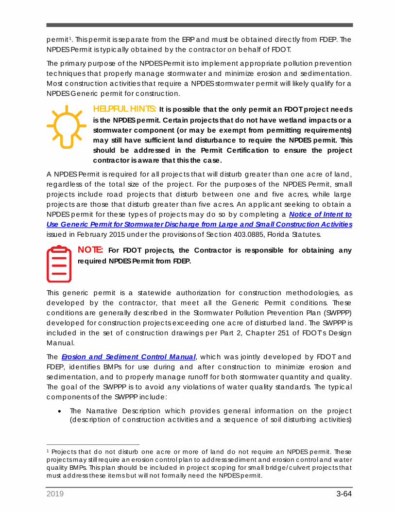
2019 3-64
permit1. This permit is separate from the ERP and must be obtained directly from FDEP. The NPDES Permit is typically obtained by the contractor on behalf of FDOT.
The primary purpose of the NPDES Permit is to implement appropriate pollution prevention techniques that properly manage stormwater and minimize erosion and sedimentation. Most construction activities that require a NPDES stormwater permit will likely qualify for a NPDES Generic permit for construction.
HELPFUL HINTS: It is possible that the only permit an FDOT project needsis the NPDES permit. Certain projects that do not have wetland impacts or a stormwater component (or may be exempt from permitting requirements) may still have sufficient land disturbance to require the NPDES permit. This should be addressed in the Permit Certification to ensure the project contractor is aware that this the case.
A NPDES Permit is required for all projects that will disturb greater than one acre of land, regardless of the total size of the project. For the purposes of the NPDES Permit, small projects include road projects that disturb between one and five acres, while large projects are those that disturb greater than five acres. An applicant seeking to obtain a NPDES permit for these types of projects may do so by completing a Notice of Intent to Use Generic Permit for Stormwater Discharge from Large and Small Construction Activities issued in February 2015 under the provisions of Section 403.0885, Florida Statutes.
NOTE: For FDOT projects, the Contractor is responsible for obtaining anyrequired NPDES Permit from FDEP.
This generic permit is a statewide authorization for construction methodologies, as developed by the contractor, that meet all the Generic Permit conditions. These conditions are generally described in the Stormwater Pollution Prevention Plan (SWPPP) developed for construction projects exceeding one acre of disturbed land. The SWPPP is included in the set of construction drawings per Part 2, Chapter 251 of FDOT’s Design Manual.
The Erosion and Sediment Control Manual, which was jointly developed by FDOT and FDEP, identifies BMPs for use during and after construction to minimize erosion and sedimentation, and to properly manage runoff for both stormwater quantity and quality. The goal of the SWPPP is to avoid any violations of water quality standards. The typical components of the SWPPP include:
• The Narrative Description which provides general information on the project(description of construction activities and a sequence of soil disturbing activities)
1 Projects that do not disturb one acre or more of land do not require an NPDES permit. These projects may still require an erosion control plan to address sediment and erosion control and water quality BMPs. This plan should be included in project scoping for small bridge/culvert projects that must address these items but will not formally need the NPDES permit.
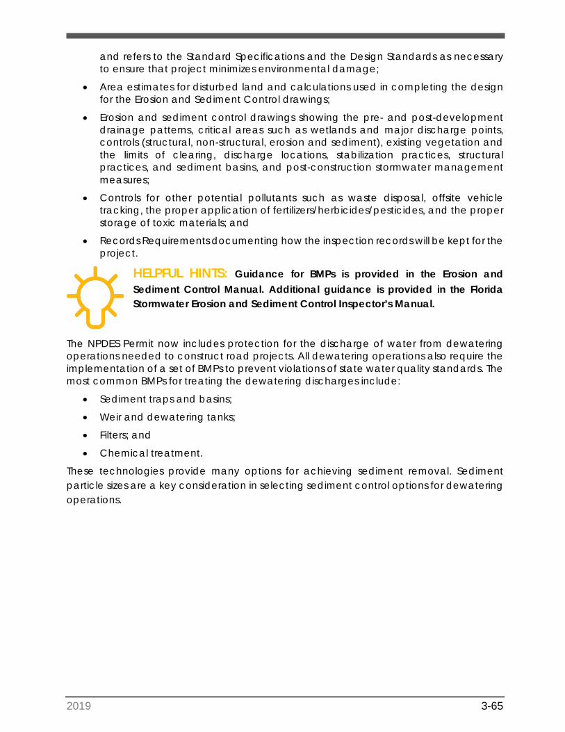
2019 3-65
and refers to the Standard Specifications and the Design Standards as necessary to ensure that project minimizes environmental damage;
• Area estimates for disturbed land and calculations used in completing the designfor the Erosion and Sediment Control drawings;
• Erosion and sediment control drawings showing the pre- and post-developmentdrainage patterns, critical areas such as wetlands and major discharge points,controls (structural, non-structural, erosion and sediment), existing vegetation andthe limits of clearing, discharge locations, stabilization practices, structuralpractices, and sediment basins, and post-construction stormwater managementmeasures;
• Controls for other potential pollutants such as waste disposal, offsite vehicletracking, the proper application of fertilizers/herbicides/pesticides, and the properstorage of toxic materials; and
• Records Requirements documenting how the inspection records will be kept for theproject.
HELPFUL HINTS: Guidance for BMPs is provided in the Erosion andSediment Control Manual. Additional guidance is provided in the Florida Stormwater Erosion and Sediment Control Inspector’s Manual.
The NPDES Permit now includes protection for the discharge of water from dewatering operations needed to construct road projects. All dewatering operations also require the implementation of a set of BMPs to prevent violations of state water quality standards. The most common BMPs for treating the dewatering discharges include:
• Sediment traps and basins;
• Weir and dewatering tanks;
• Filters; and
• Chemical treatment.
These technologies provide many options for achieving sediment removal. Sediment particle sizes are a key consideration in selecting sediment control options for dewatering operations.
2019 4-66
SECTION 4: KEY RESOURCE IMPACTS 4.1 Identification and Quantification of Impacts
The process to identify and quantify impacts consists of a desktop evaluation of available information, including Geographic Information System (GIS) layers; field reviews; wetland delineations and assessments; general listed species surveys, and occasionally species-specific surveys (which can occur as the design progresses); and agency coordination.
For many projects, documentation that was compiled during the Project Development and Environment (PD&E) Phase should be reviewed to ascertain any potential project issues that were previously identified. The results from the technical reports produced during any PD&E Study are carried forward into the permitting phase. Commitments of various types (e.g., protection of threatened and endangered species, or historic resources) are developed during PD&E and detail how Florida Department of Transportation (FDOT) will comply with commitment obligations or special conditions before, during, and after a project’s construction. It is important to review these documents to ensure that these commitments are carried forward during the design and permitting of a project. FDOT’s Project Manager (PM) and Environmental Permit Coordinator will use this information to help draft the scope for the design of the project.
An initial desktop review of data from websites [e.g., Google Earth; ETDM Environmental Screening Tool; Water Management District (WMD) databases and mapping; federal and state regulatory agencies] is conducted to gain a basic understanding of the project area. The primary information of interest relates to the land cover (vegetation community types), wetlands, and surface waters that are found within the project area. It is important to identify where potential jurisdictional wetlands and other surface waters such as lakes, rivers, and tributaries occur, and whether there may be potential impacts from the proposed project. Along with the project location, these resources (land cover, wetlands, and surface waters) assist with assessing potential listed species occurrences.
It is also important to identify if there are any mitigation banks with service areas that overlap the project, or if a WMD can provide mitigation services for the proposed project. Mitigation is finalized later during the permitting process, but the early identification of available mitigation options reduces the risk of impacting the project schedule. Note that at this point in the process, the identification of mitigation options is just to verify which of the previously discussed options from the PD&E phase are still viable for the project. The District Environmental Permit Coordinator, in coordination with PM, will ultimately make the decision of mitigation acquisition later in the process.
All permitted mitigation banks throughout the state are listed through the Florida Department of Environmental Protection (FDEP) Mitigation Banks website, and the WMDs include mitigation bank information on their individual websites as well. The US Army Corps of Engineers (USACE) also has an internet based tracking system that provides up to date information on mitigation banks through its Regulatory In-lieu fee and Bank Information Tracking System (RIBITS) website (See Wetland Mitigation Appendix 2d).
2019 4-67
It is also important for the overall project team to be informed of the initial field review analysis. This will ensure that avoidance and minimization of wetland impacts are considered for design and permitting. Additionally, the field review should identify any potential complications that may result in a delay of schedule. Examples of potential complications include:
• Previously undocumented occurrence of listed species, habitat, or nests;
• Limited windows for species surveys (e.g., caracara and sand skink);
• Aquatic preserve impacts; and,
• Discovery of conservation easements or protective restrictions.
4.1.1 Florida Regulated Species and Habitats
Listed species data would have been gathered during the PD&E phase (if a study occurred) and should be the starting point for the collection of this data. The most up to date list of federally endangered and threatened species can be found on the United States Fish and Wildlife Service (USFWS) Information for Planning and Conservation (IPaC) website. A list of Florida’s Endangered and Threatened Species can be located on the Florida Fish and Wildlife Conservation Commission (FWC) website. These resources are important to review, particularly for projects where the PD&E Study occurred more than a few years in the past. Additional county-specific federal species lists can be found on each of the three USFWS field office websites (Vero Beach, Jacksonville, and Panama City), as shown in PD&E Manual Part 2, Chapter 16. The National Marine Fisheries Service (NMFS) and Florida Natural Areas Inventory (FNAI) both maintain websites that can be used to query species information by geographic region. Additionally, an Essential Fish Habitat Mapper can be accessed on the National Oceanic and Atmospheric Administration (NOAA) Fisheries website. See specific listed Species Appendices 1a-1r.
4.1.2 Data Collection
Desktop Reviews
Wetland data would have been gathered during the PD&E phase (if a study occurred) and should be the starting point for the collection of this data. Online sources can be utilized to collect data on the existing wetlands mapped within a given project area. One source is the National Wetlands Inventory (NWI) Mapper. Utilizing this mapper, it is possible to obtain a baseline understanding of where potential wetlands have been identified, which can provide an understanding of where potential impacts may occur from a proposed project. The NWI layer is updated periodically and should be relied upon only as a preliminary source for project background information. Current aerial photo mapping sites may be compared with NWI mapping, to identify land use changes or construction and development that are not yet reflected on the NWI maps.
The use of soil maps and soil databases to identify mapped hydric soils can also help refine the baseline wetland data during this process. The Soil Survey Geographic Database provides soil data produced and distributed by the Natural Resources Conservation
2019 4-68
Service (NRCS), which can assist in refining the potential extents of mapped wetlands obtained from the online resources.
Historic aerial photos can also help identify the land uses within a project area, prior to development or the construction of a roadway. One of the best sources for historic aerials in Florida can be found at the University of Florida Aerial Photography website. Using the historic aerials during the desktop analysis, changes to the project area can be assessed over time, potential wetland communities can be identified, and land cover changes documented.
Historic aerials can also be utilized to determine whether any wetland or surface-water ditch was historically part of a natural wetland or excavated from upland soils. Aerials can be very helpful in determining whether current features are remnants of historic wetlands or the result of manmade activity. This is especially important during the federal permitting process in relation to drainage features such as roadside ditches, and in determining historical connectivity of wetlands when a system may appear isolated in the present time.
Field Reviews
Field reviews should be conducted to verify onsite project conditions. The data gathered during field reviews will be incorporated into the permit application, and includes the land use or cover types, wetland limits, potential habitat for threatened or endangered species, wildlife utilization, and any other observations relevant to the potential impacts from the project on the environment.
Once the Design phase has kicked off (either in-house or under contract), the first permit-related tasks are typically the ecological field reviews of the project area. During the initial field events, the environmental scientist should note habitat types of all undeveloped areas with regard to potential utilization by listed species. The environmental scientist should also note any observed wildlife and take photographs of all undeveloped habitats, including each wetland. The data will help formulate the environmental permitting support document that will be submitted as part of the permit application.
Early in project design, environmental scientists should delineate the limits of wetlands and other surface waters. The determination of USACE wetland limits is based on the presence of three criteria: vegetation, soils, and hydrology. In general, a wetland must demonstrate that it meets all three criteria to be considered a wetland by USACE. For FDEP and WMD, at least two of the same criteria required by USACE must be present for an area to be considered a wetland. Draft GIS map sets of the project study corridor are generally produced at this time to support the fieldwork. This preliminary map set will evolve into the map set that is eventually used for the permit application submittal. Correspondence with agency staff during the permit application submittal process should be directed through the Environmental Permit Coordinator unless prior permission is granted to coordinate independently. A more in-depth discussion of the federal wetland delineation methodology along with the differences between the state and federal wetland jurisdiction is provided in Section 4.1.2.1.
2019 4-69
4.1.2.1 Jurisdictional Wetland Determination
Informal Jurisdictional Wetland Determination
As per Section 373.421, F.S., FDEP and the WMDs conduct informal wetland determinations that are not tied to a permit and are non-binding. These reviews are not subject to timeframes, and as such, are reviewed subject to the availability of the regulatory reviewers. However, these informal approvals can serve the same purpose as a formal wetland determination if followed by an Environmental Resource Permit (ERP) application submittal within a reasonable period (<12 months).
Prior to, or concurrent with, the informal agency wetland field review, the environmental scientists should delineate the limits of wetlands and other surface waters. Note: sometimes the limits of wetlands and other surface waters are generally referred to as ‘wetland limits’ or ‘jurisdictional limits’. Environmental scientists will conduct the delineation by flagging the wetland limits according to the state and federal delineation methods (referenced below) and labeling each wetland flag placed with a unique number. This delineation will serve as the basis for the wetland impact assessment, which is a very important part of the permitting process. It is prudent that the environmental scientist participates in progress meetings to ascertain whether additional right of way (ROW) areas are added to the project limits, including but not limited to pond sites, which may necessitate additional delineation events.
The federal wetland delineation methods are illustrated in the 1987 Corps of Engineers Wetland Delineation Manual (Technical Report Y-87-1), Regional Supplement to the Corps of Engineers Wetland Delineation Manual: Atlantic and Gulf Coastal Plain Region (Version 2.0) (ERDC/EL TR-10-20), and the state delineation methodology is presented in Chapter 62-340 F.A.C., Delineation of the Landward Extent of Wetlands and Surface Waters.
HELPFUL HINTS: The key differences in the USACE and the State of Floridawetland delineation methods are the following:
• The USACE considers slash pine and gallberry as wetland indicator plantswhile the State considers them neutral (neither upland or wetlandindicators); and
• The USACE requires that vegetation, hydrology, and soils be used asindicators to meet wetland jurisdictional criteria while the State requiresjust two of these indicators (i.e. vegetation and soils or hydrology andsoils).
The state and federal delineation methods are typically similar in assessing the limits of wetlands and surface waters; however, in special circumstances (such as when there is a large divergence between the two lines), it may be prudent to establish two distinct wetland lines. An example would be for areas that have been converted to agricultural uses, such as pasture. More of these areas are classified as jurisdictional to the state based on district criteria found in Chapter 62-340, Florida Administrative Code. Another example could include pine plantation where the USACE can claim additional areas dominated
2019 4-70
by slash pine and gallberry. Impacts to both wetlands and other surface waters are required to be quantified in the permit application.
BEST PRACTICES: The appropriate WMD permitting database should bequeried to see if any onsite wetlands have already been flagged, permitted for impact (mitigated), or are currently under conservation easement constraints.
Some surface water limits require the placement of flags in the field, while others do not. Surface waters with a distinct channel or bank may use the “top of bank” elevation as the other surface waters limit. If the other surface water is not a feature defined as “top of bank,” those areas are most often field delineated with pin flags with unique numbers in the same manner as the wetland delineation. In accordance with Rule 62-340.600, F.A.C., the landward extent of surface waters shall be the more landward of the following:
a) Wetlands as located by Rule 62-340.300, F.A.C., of this chapter;
b) The MHW-water line elevation for tidal water bodies;
c) The ordinary high-water line for non-tidal natural water bodies;
d) The top of the bank for artificial lakes, borrow pits, canals, ditches and other artificialwater bodies with side slopes of one foot vertical to four feet horizontal or steeper,excluding spoil banks when the canals and ditches have resulted from excavationinto the ground; or
e) The seasonal high-water line for artificial lakes, borrow pits, canals, ditches, andother artificial water bodies with side slopes flatter than one foot vertical to fourfeet horizontal along with any artificial water body created by diking orimpoundment above the ground.
Determinations made pursuant to paragraphs (b) and (c) shall be for regulatory purposes, and are not intended to be a delineation of the boundaries of lands for the purposes of title. Any alternate delineation methods for other surface waters should be discussed with the Environmental Permit Coordinator and then the agencies.
Once the wetland and other surface waters limits (and seasonal high-water level elevations2) have been established in the project area, it is prudent to seek concurrence
2 Seasonal high-water level elevations (set with the use of biological indicators), combined with the separate subsurface geotechnical analysis, are critical elements in the drainage design for projects in non-tidal areas. seasonal high-water level elevations are typically established within each wetland system as a series of three points. These elevations are needed to assist the drainage engineer with the assessment of ponds and other drainage features, though they may not be needed for every project. The data are typically required for projects that have drainage features near wetlands, and/or for the drainage engineer to meet surface drainage criteria. Prior to the field event, the environmental scientist should coordinate with the design drainage engineer regarding the setting seasonal high-water level elevations. Environmental scientists are encouraged to review the scope of services for the agreed-upon number of seasonal high-water level elevations that should be established within each wetland.
2019 4-71
from the state and federal regulatory authority that will be reviewing the permit applications. Consultants should contact each District’s Environmental Permit Coordinator to determine the preferred protocol for obtaining agency concurrence. Some Environmental Permit Coordinators may prefer to accompany the environmental scientists on one or more of the field days.
HELPFUL HINTS: The field reviews with regulatory staff provide anexcellent opportunity to assess each wetland function directly with the reviewer.
It is recommended that a map set depicting the limits of flagged wetlands be submitted to the regulatory field staff ahead of the scheduled field events.
Formal Jurisdictional Wetland Determination
Additionally, an applicant may petition the WMD for a formal determination of the landward extent of wetlands and other surface waters (known as a jurisdictional determination or “JD”). This binding determination can be secured for a period of five years and extended if requested (with or without additional field reviews, at WMDs discretion) to verify that the approved wetland determination still meets the state criteria. If the site is less than ten acres, the petitioner is not required to pre-flag the site prior to agency verification. This formal determination may be beneficial to an applicant for site planning purposes and/or to conduct preliminary estimates of potential wetland impacts, mitigation costs or preservation value.
To process this type of determination, an applicant must submit an application (also called a petition) that includes an aerial depicting the preliminary established limits of wetlands and surface waters. This aerial is only required if the site is more than ten acres in size. WMD staff then review and approve (or adjust) the location of the wetland delineation. To finalize this determination, boundary surveys (signed and sealed by a professional land surveyor) that depict the limits of the approved wetlands must be submitted to the WMD. A standard form is available online: Petition for a Formal Determination of the Landward Extent of Wetlands and Other Surface Waters.
The petitioner may request either a “formal” wetland determination, which requires a certified survey of the delineation, or an approximate determination, which depicts the approximate boundaries of the field verified limits of wetlands and surface waters. Note that with an approximate determination, the accuracy of the Global Positioning System (GPS) points at a minimum distance of one point per 1,000 feet is required.
HELPFUL HINTS: FDOT petitioning for a formal wetland determinationwould be uncommon, and likely associated with a large regional mitigation option.
2019 4-72
4.1.2.2 Jurisdictional Wetland Survey Coordination
The limits of the jurisdictional wetlands and surface waters will be included on the construction plans, permitting reports, and dredge and fill sketches, all of which will be required for the permit application. The environmental scientist will have to work closely during Design with the roadway engineer and a Professional Land Surveyor to locate the limits of wetland and surface waters and ensure that these limits are displayed correctly on all parts of the application. Coordination is especially important for the dredge and fill sketches, which will depict the wetland and surface water impacts that will included in the issued permit.
Environmental staff should closely coordinate with the Design team surveying staff to record the locations of all surveyed wetland field data (e.g., wetland lines; USACE data form sampling locations; Mean High-Water (MHW)/Mean Low-Water (MLW) lines; seasonal high-water level). After flagging wetland and surface water limits and setting seasonal high-water level elevations, it is prudent to create a map for the survey crew that displays the locations of the placed flags. It may also be beneficial to provide a Google Earth™ KML or KMZ file that includes the geographic information, to further aid the survey crew in locating the flagged areas. Consistent flagging colors/material and nomenclature, as well as recording each flag location on maps, are recommended for easy coordination with the surveyors.
To avoid additional mobilization when possible, the establishment of wetland limits and surveying of associated data points should coincide with times when the survey crew is already working along the corridor.
BEST PRACTICES: It is important that the field data markers (wetland flags,seasonal high-water level limits) are not established too long before surveyors locate them, as flags can bleach out in the sun, or be mowed over or even consumed by wildlife.
4.1.2.3 Hydrophytic Vegetation
Nearly 5,000 plant species and subspecies in the United States, and over 1,400 in Florida, occur primarily in wetlands. These plants are known as hydrophytic vegetation and are listed in regional publications of the USFWS. Common hydrophytic vegetation include cattails, cordgrass, bald cypress, willow, mangroves, sedges, and rushes. Figure 4-1 presents a graphic for a typical jurisdictional wetland. It is not necessary to know all wetland plant species to identify wetlands. Wetland jurisdictional determinations usually can be accomplished by knowing the most common wetland species, upland species, and transitional species routinely present within the geographic area where the project occurs.
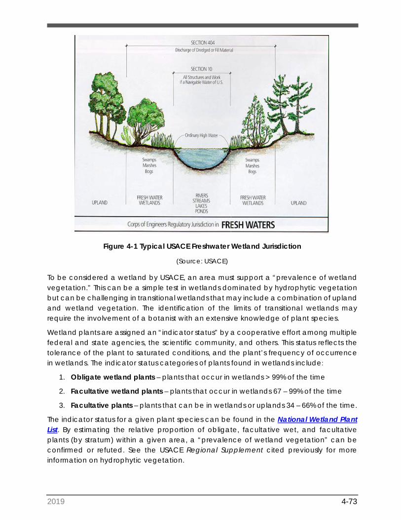
2019 4-73
Figure 4-1 Typical USACE Freshwater Wetland Jurisdiction
(Source: USACE)
To be considered a wetland by USACE, an area must support a “prevalence of wetland vegetation.” This can be a simple test in wetlands dominated by hydrophytic vegetation but can be challenging in transitional wetlands that may include a combination of upland and wetland vegetation. The identification of the limits of transitional wetlands may require the involvement of a botanist with an extensive knowledge of plant species.
Wetland plants are assigned an “indicator status” by a cooperative effort among multiple federal and state agencies, the scientific community, and others. This status reflects the tolerance of the plant to saturated conditions, and the plant’s frequency of occurrence in wetlands. The indicator status categories of plants found in wetlands include:
1. Obligate wetland plants – plants that occur in wetlands > 99% of the time
2. Facultative wetland plants – plants that occur in wetlands 67 – 99% of the time
3. Facultative plants – plants that can be in wetlands or uplands 34 – 66% of the time.
The indicator status for a given plant species can be found in the National Wetland Plant List. By estimating the relative proportion of obligate, facultative wet, and facultative plants (by stratum) within a given area, a “prevalence of wetland vegetation” can be confirmed or refuted. See the USACE Regional Supplement cited previously for more information on hydrophytic vegetation.
2019 4-74
4.1.2.4 Hydric Soils
Hydric soils have characteristics that developed in conditions where soil saturation and biological activity depletes soil oxygen for extended periods during the growing season. The oxygen depletion usually produces changes in soil features (color; color patterns; mineral concentrations or depletions; organic matter content) that can be observed as field indicators of hydric soils. Hydric soil lists for each county can be obtained from the NRCS and compared to soil survey mapping for the project site, which can indicate the potential for hydric soil occurrence.
A detailed discussion of the hydric soil indicators found in Florida can be found in the USACE Regional Supplement cited earlier, and in publications from the Florida Association of Environmental Soil Scientists (FAESS). While some of the more obvious hydric soil indicators and hydric soils can be documented by personnel with only minimal hydric soils training, in-field verification of some hydric soils may require examination by an experienced soil scientist.
HELPFUL HINTS: There are professional soil scientists located throughoutFlorida that can assist in the identification of hydric soils. NRCS maintains a directory of local NRCS service centers, and a list of certified professional soil scientists is available from FAESS.
4.1.2.5 Hydrology/Hydrologic Indicators
Wetland hydrology refers to the presence of water at or above the soil surface for a sufficient period of the year to significantly influence the plant types and soils that occur in the area. Most hydrologic indicators are those that can be observed during field inspection. The following indicators provide some evidence of the periodic presence of flooding or soil saturation:
1. Standing or flowing water is observed on the area during the growing season.
2. Soil is waterlogged (saturated) during the growing season.
3. Watermarks (staining) are present on trees or other standing objects. Such marksindicate that water periodically covers the area to the depth of staining.
4. Drift lines, which are small piles of debris oriented in the direction of watermovement through an area, are present. These often occur along contours andrepresent the approximate extent of flooding in an area.
5. Debris is lodged in trees or piled against other objects by water.
6. Thin layers of sediments are deposited on leaves or other objects. Sometimes thesebecome consolidated with small plant parts to form discernible crust on the soilsurface.
HELPFUL HINTS: Hydrologic indicators are most visible during the rainyseason. It is important to be aware of the amount of rainfall recently received by the project site to determine if site conditions during the site inspection are normal or atypical (i.e. if an unusual rain event had just occurred).
2019 4-75
4.1.2.6 Acres and Type
Once it is determined that an area is in fact a designated wetland it then becomes necessary to identify its type and how much will be impacted. Potential wetlands fall into two major categories; freshwater and coastal. Freshwater wetlands are generally emergent (sawgrass, cattail, cypress). Coastal wetlands generally include mangroves (red, white and black), buttonwoods and other transitional species such as sugarberry and cinnamon fern. Analysis of impact is based on wetland functionality (see Section 4.3).
4.1.2.7 United States Army Corps of Engineers Wetland Data Forms
As part of the application process, it is important to include completed USACE wetland data forms with the application package. The data forms are a requirement prescribed by the USACE 1987 Wetland Delineation Manual and the Regional Supplement. A map (sketch) showing the locations of the sampling points should be provided. The number of data forms (sampling points) will vary with the complexity of the site but should be sufficient to show how the line between the wetland/non-wetland interface was determined.
A data form is completed for each side of the jurisdictional line (upland and wetland) at each sampling location. The data forms provide a summary of wetland vegetation present, the percentage coverage by wetland species, a description of the soil types included on the project area and a listing of hydrologic indicators present at the sampling site(s).
The Preliminary Jurisdictional Determination Form is occasionally used to speed up the Dredge & Fill permitting process for projects with simple or obvious wetland limits. The Preliminary Jurisdictional Wetland Determination Data Form can be downloaded for reference. First a site inspection is conducted to identify the limits of jurisdictional methods within the project corridor, using the methodology broadly described in Section 4.1.2.1. The Preliminary Jurisdictional Determination Form is completed with basic background information and supporting data, submitted to USACE, and is processed with a desktop review and/or field review.
A signature on the Preliminary Jurisdictional Determination Form by FDOT and USACE constitutes an agreement that all wetlands and other water bodies on the site, as depicted on an aerial map or survey, are jurisdictional waters of the United States, and precludes any future challenge to such jurisdiction. Preliminary Jurisdictional Determination Forms are advisory in nature and may not be appealed. Once a Preliminary Jurisdictional Determination Form has been obtained, it is advisable to seek an official approved jurisdictional determination as soon as possible.
4.1.2.8 Mean High-Water/Mean Low Water
MHW and MLW elevations are associated with the normal daily fluctuations in tidal waters along the coast. The MHW can be critical since it can represent the limits of jurisdiction in tidally influenced wetlands or surface waters. The identification of mean high- and mean
2019 4-76
low-water elevations are also important in the design of tidal wetland mitigation plans, when required. The elevations of MHW and MLW can found on the FDEP’s Land Boundary Information System website.
4.1.2.9 Benthic Surveys
Benthic surveys are generally conducted for FDOT bridge projects crossing surface waters (i.e. bays, lagoons, rivers, etc.) and for road projects adjacent to open water areas. The primary difference between a wetland determinations and benthic surveys is that benthic surveys are always conducted in areas that are jurisdictional for both State and Federal environmental permitting agencies. The purpose of the benthic survey is to document the presence and abundance of submerged aquatic resources including seagrasses, submerged vegetation and live/hard bottom communities including oysters, corals and sponges. In addition, a benthic survey would document any listed species such as Johnson’s seagrass (Appendix 1o), and corals. A site-specific survey methodology must include the determination of the location, percent coverage and distribution of submerged ecological resources.
A critical component of benthic surveys is that submerged aquatic vegetation is highly dependent on seasonal cycles. Advanced planning is therefore required to conduct benthic surveys within the seagrass growing season. In Florida, the seagrass growing season generally runs from June 1st through September 30th. The exception to this guidance is that surveys for Johnson’s Seagrass (Halophila johnsonii) can be conducted throughout the year (particularly in the southern part of the state); however, it is more practical to conduct a single seagrass survey within the established growing season to avoid multiple surveys. See Johnson’s Seagrass Appendix 1o. Note that Benthic Surveys and Essential Fish Habitat are typically conducted together (see Essential Fish Habitat section 4.1.3.3).
HELPFUL HINTS: Seagrass surveys must be conducted between June 1and September 30 in accordance with established NMFS guidance.
For the most part, benthic surveys require on-site data collection. Historically, the use of aerial photography has not proven to be a reliable method of accurately assessing the occurrence of submerged resources because of water depth and reflectance of sunlight off the water surface. New technology may prove to be accurate and cost effective, but for now the general guidance is to conduct benthic surveys in the field.
Conducting benthic surveys can be time consuming. Specialized equipment including boats and scuba equipment may be required to conduct the survey. Because surveys may have to be conducted in areas of heavy boat traffic, it is vitally important to develop a safety plan to ensure that all personnel involved in the benthic survey are protected.
Benthic resource survey activities are generally completed using a quadrat sampling methodology covering the entire area to be surveyed. Because of the time involved to
2019 4-77
conduct a survey, it is highly recommended for the survey limits to be extended beyond the proposed project area. The size of this buffer is determined by professional opinion and varies according to the scope of the proposed work. For example, a wider buffer would be needed if barge use is anticipated during project construction. The use of a buffer ensures that all resources requiring a survey are covered and allows an evaluation of indirect impacts beyond the project area. Additionally, if design changes occur in the future, there is a higher likelihood that an increased construction footprint will have already been surveyed along with the original project area.
The use of quadrats is site specific but ensures the ability to fully describe the presence, abundance, and distribution of submerged aquatic resources. Because of the variability of site conditions and the time intensive nature of conducting benthic surveys, it is highly recommended that biologists coordinate with the permitting agencies and the NMFS well in advance of the survey to develop an acceptable methodology prior to conducting the survey.
HELPFUL HINTS: Protocols for the survey of Johnson’s Seagrass requirespecific percentage cover of the area to be surveyed. The survey methodology is dependent on the size of the impact area (small =< 0.25 acres; intermediate = 0.25 to 2.5 acres; large => 2.5 acres). It is important to initially coordinate with the NMFS to develop an acceptable survey methodology prior to conducting the survey.
All benthic surveys must be located through the identification of a fixed reference point and/or with the use of accurate GPS points outlining the survey area. This allows for an accurate identification of the limits of the survey as well as to document the grid system used for the transect lines. Underwater notes are usually taken to document all species observed as well as the percent cover and spatial distribution of all species. During the survey, it is also critical to document the use of the site by aquatic species (especially use by listed species) as well as the listing of all vertebrate and invertebrate species observed during the survey.
In addition to a description of the observations and species data developed from the survey, critical reporting requirements for benthic surveys must include the time of the survey, weather conditions existing during the time of the survey, visibility, tidal conditions, sediment types, and water depths.
4.1.3 Threatened and Endangered Species Impacts
4.1.3.1 Critical Habitat
Designated critical habitat for federally listed species is defined by the following:
1. The specific areas within the geographical area occupied by the species, at thetime it is listed in accordance with the provisions of the Endangered Species Act(ESA), on which are found those physical or biological features (constituentelements) that are:
2019 4-78
a. Essential to the conservation of the species and
b. Which may require special management considerations or protection.
2. The specific areas outside the geographical area occupied by the species at thetime it is listed in accordance with the ESA’s provisions, upon a determination bythe Secretary that such areas are essential for conservation of the species.
A more detailed description of designated critical habitats can be found in 50 Code of Federal Regulations (CFR) § 17 and 226.
Critical habitat should be identified as early as possible in the project development process. For projects that qualify for an Efficient Transportation Decision Making (ETDM) screening, the presence of critical habitat in the proposed project area is usually documented at this time. Those projects that do not qualify for an ETDM screening should still have a protected species and habitat evaluation conducted with sufficient detail to ensure these resources have been considered in adequate detail. Regardless of whether a project has been screened in ETDM or not, a thorough desktop review should be conducted followed by field surveys as appropriate to verify the presence or absence of potential listed species and critical habitats within the project area. See specific Listed Species Appendices 1a-1r.
Not all federally listed species present in a project area have designated critical habitat, but if critical habitat for a species does exist in the area, consultation with the appropriate “Service” (USFWS or NFMS) is necessary. Separate effect determinations must be made for both the species and its critical habitat during the informal consultation process. If it is determined by the lead federal agency that the federal action may affect the listed species or critical habitat, formal consultation will be required. Further discussion of critical habitats and their role in the ESA Section 7 Consultation process can be found in Section 4.4 and the PD&E Manual Part 2, Chapter 16.
Note that while FWC does not designate critical habitats as part of its role, this state agency does recognize federally designated critical habitats of listed species in Florida.
For state-funded projects it is recommended that the federal process be followed in the event that federal funding or permitting is needed at a later time.
4.1.3.2 Listed Species Surveys
Field surveys are needed to determine and record the presence of listed species in the proposed project area. A desktop review of the ETDM Environmental Screening Tool should be conducted prior to field surveys to identify Consultation Areas, Critical Habitat, and occurrence data so that field surveyors can anticipate presence of listed species. If multiple federal and state listed species, and/or their habitats have the potential to occur within the action area, the field surveys should be conducted concurrently as feasible. When conducting a listed species survey, the wildlife biologist should consider the known life histories and behaviors of the listed species with the potential to occur in the area, as well as the habitat quality and current site conditions. As such, the survey methodology should be designed with the appropriate time of day and season in mind. For example,
2019 4-79
Johnson’s seagrass surveys must be conducted during the period of maximum abundance from April 1 – October 31, so seasonal limitations must be considered when planning a survey. Another factor to consider when scheduling surveys is that some survey data, such as nest site locations, may be considered outdated after a short period of time.
Additionally, several species (such as the sand skink, Audubon’s crested caracara, and Florida scrub-jay) have specific survey protocols that have been developed or approved by the Service(s). If one of these species is suspected to occur within the action area of a project, or designated Critical Habitat, or Consultation Areas are known to exist, the approved protocol should be followed and documented as appropriate. Other listed species, such as the Florida bonneted bat, do not yet have Service-developed survey protocols but instead have draft protocols developed. Prior to conducting a survey for a species with a draft protocol, there should be a discussion with the applicable Service to verify that the current draft protocol is the latest one, or if a revised draft or official protocol has been developed.
In many cases, follow-up species-specific surveys will be required by the Service as a result of prior consultation/coordination. These surveys are often documented as project commitments during the PD&E phase and later carried out as part of the permitting process. The Service will communicate what type of data should be collected, when the surveys should be conducted, and if follow-up surveys are necessary. If a more intensive species survey than originally conducted is needed to collect more quantitative species data (such as percent plant cover or wildlife population size), the Service will provide the requirements during the coordination process. Once the survey has been completed, all results and field notes should be provided to the appropriate agency. More information regarding listed species surveys can be found in the PD&E Manual Part 2, Chapter 16. In addition, see specific Listed Species Appendices 1a-1r.
4.1.3.3 Essential Fish Habitat
The NMFS is also responsible for the evaluation of potential impacts to Essential Fish Habitat (EFH) under the Magnuson-Stevens Fishery Conservation and Management Act. This evaluation is conducted by the Habitat Conservation Division (HCD) of the NMFS and is separate from the consultations through the ESA.
EFH is defined as "those waters and substrate necessary to fish for spawning, breeding, feeding or growth to maturity." Under the requirements of the Magnuson-Stevens Fishery Conservation and Management Act, federal agencies, (including the USACE) are required to consult with the NMFS on all actions or proposed actions that may adversely affect EFH. This analysis also requires a description of means to avoid or minimize adverse effects on EFH.
EFH is typically associated with waterways and wetlands that have a direct connection to the coastal waters of Florida. EFH areas will have a tidal influence, though it may not necessarily be apparent. Wetlands adjacent to tidal waterbodies may be connected via a conveyance, or only during periods of high water, and still meet the classification of EFH. There are also examples of freshwater tidal systems (including forested systems) that are
2019 4-80
classified as EFH. NMFS maintains an EFH Mapper that can be reviewed for your project area. EFH and benthic surveys are typically conducted together (see Benthic Survey section 4.1.2.9).
Information on the types of EFH included in a project area, the proposed project impacts to EFH, and the proposed mitigation to offset those impacts must be provided to NMFS for review. As with listed species, initial EFH coordination would have taken place during the PD&E phase. Any further coordination will continue if necessary when the project is being permitted. If design changes have occurred since the PD&E phase, then an EFH survey may be required. Mitigation to offset EFH impacts is generally separate from wetland mitigation, as most wetland mitigation options readily available to FDOT do not have a tidal component and therefore do not provide any benefit to EFH. EFH mitigation is typically required to offset the same type of EFH as being proposed for impact and may require some critical thinking and coordination to provide a suitable option.
NMFS may request additional information following issuance of the Public Notice that must be responded to before the coordination process can be concluded. There is usually coordination between the applicant, USACE, and NMFS staff during this process so that the resolution is satisfactory to all parties. The timeframe for the NMFS to provide any comments is 30 days following the receipt of the Public Notice. If NMFS misses this comment period, the USACE may still consider any late comments, but is not bound to do so. The final result may include EFH recommendations that can be incorporated into the USACE Dredge & Fill Permit. Further information related to EFH can be found in the PD&E Manual Part 2, Chapter 17.
4.1.4 Cultural Resource Impacts
“Cultural resources” is a broad term used to describe all archaeological sites, as well as historic buildings, structures, objects, and districts that are 50 years of age or older. Potential impacts to cultural resources should be identified as early as possible during project development. For projects that were screened during the ETDM phase, initial cultural resource identification will have occurred at this time. As the project’s scope becomes more defined, the Area of Potential Effects (APE) must be determined and documented so the potential impacts can be evaluated. The APE is defined in the PD&E Manual as “the geographic area or areas within which an undertaking may directly or indirectly cause alterations in the character or use of historic properties, if any such properties exist”. This area varies based on the proposed project scope of work, since all possible impacts to cultural resources present in the project area must be considered when delineating the APE.
The Cultural Resource Assessment Survey (CRAS) is the process by which archaeological, historical, architectural, and traditional cultural properties within the project APE are identified, documented, and evaluated. If the State Historic Preservation Officer (SHPO)/Division of Historical Resources (DHR) concurs with the District’s determination that no cultural resource effects are anticipated within the APE, then no further action is needed as long as there are no project changes that could alter the project APE or effects
2019 4-81
determination. In the event that potential impacts are documented in the CRAS, a Consultation Case Study Report must then be prepared to document and evaluate if those effects are adverse. For more information regarding the identification and evaluation of cultural resource impacts, please refer to PD&E Manual Part 2, Chapter 8.
4.1.4.1 Historic Resources
A historic resource is any historic building, structure, object, or district that is at least 50 years of age. Historic resources that are eligible for or included in the National Register of Historic Places3 (NRHP) are referred to as historic properties, and must be identified during project development as part of the Section 106 process (see Section 3.6 and the PD&E Manual Part 2, Chapter 8). Once all historic properties within a project’s APE have been identified, the potential effects to these properties must be assessed and coordinated with SHPO if the project is federally funded or DHR if state funded. This is accomplished through the preparation of a Consultation Case Study Report, which documents all impacts with the potential to alter the characteristics that qualify historic properties for inclusion in or eligibility for the NRHP. The District must submit the Case Study Report to the Office of Environmental Management (OEM) so a finding of Adverse Effect or No Adverse Effect can be made. OEM will then forward the finding and Case Study Report to the appropriate agency for concurrence.
SHPO or DHR must concur on a project prior to issuance of a federal permit or state ERP. Therefore, the Environmental Permit Coordinator should coordinate with the District Cultural Resources Coordinator (CRC)during the PD&E phase to review the results of the CRAS and become aware of any cultural commitments made in the Environmental Document. During the Design phase, the Environmental Permit Coordinator should be mindful of design changes that may affect the previous cultural evaluation results and coordinate with the CRC staff to address those changes prior to permitting the project. The CRC, who oversees the necessary evaluations and consults with SHPO/DHR, should also inform the Environmental Permit Coordinator if further SHPO/DHR coordination is needed during the Design Phase due to newly proposed work within the APE. Once any additional agency coordination has been completed, the Environmental Permit Coordinator should incorporate all necessary cultural resource information into the permit application prior to submittal.
4.1.4.2 Archaeological Resources
The process for identifying archaeological resource impacts is similar to that of cultural resource impact identification. The presence of archaeological resources within the project APE should be identified as early as possible during project development, documented in the CRAS, and concurred with by SHPO or DHR. If any impacts to these resources are anticipated, they should be evaluated in the Consultation Case Study
3 The National Register of Historic Places is a nationwide list of historic resources considered worthy of preservation. This list is authorized by the National Historic Preservation Act of 1966 and administered by the U.S. Department of Interior’s National Park Service.
2019 4-82
Report, so the Environmental Management Office (EMO) can make its effect finding and seek concurrence from the applicable agency. As with cultural resource impacts, the Environmental Permit Coordinator should coordinate as needed with the CRC and Design team throughout project development.
When a federally-funded project has the potential to impact resources that are of cultural importance to Native American tribes, the District should provide the appropriate tribal chief or chair with the Advance Notification (AN) Package (see Section 2.1.1.3). If the tribe(s) expresses interest in the project after receiving the AN Package, the District should provide the CRAS to OEM for subsequent distribution to the tribe(s). OEM will notify Federal Highway Administration (FHWA) if the tribe(s) requests government-to-government consultation. Although tribal consultation will likely have occurred during the PD&E phase, there may be a need for additional surveys and consultation during Design/Permitting if project changes are made that could lead to new tribal resource impacts. Refer to the PD&E Manual Part 2, Chapter 8 and Cultural Resource Management Handbook for more details regarding the tribal consultation process.
4.2 Avoidance and Minimization
Regulatory guidelines for both the state and federal permitting programs require that projects be designed to eliminate or reduce impacts to wetlands to the greatest extent practicable (this can also be referred to as avoidance and minimization). This process may occur over a lengthy period of time for some projects (major roadway expansions) or just during the Design phase for others (minor projects, safety projects). When a project goes through the PD&E process, multiple alternatives are presented and evaluated based upon their proposed impacts to the natural and physical environment. Design standards for side slopes, turning radii, the placement of additional lanes, lane widths, and the availability of parcels for stormwater management facilities are all considerations to establish a preferred alternative.
As a result of this process, elimination and reduction (avoidance and minimization) of impacts to wetlands can be easily demonstrated to the permit agencies. However, since not all FDOT projects have gone through an elimination and reduction evaluation as part of the PD&E process (such as Type 1 Categorical Exclusions (CE), some Type 2 CEs; and Non-Major State Actions (NMSAs)), these projects will likely need to demonstrate that the project has undergone this type of evaluation during the permitting process. The following activities are examples of how avoidance and minimization can be achieved during the Design phase:
• Shift alignment to avoid wetlands
• Reduce typical sections to avoid or minimize wetland impacts
• Design stormwater management system to avoid or minimize wetlands
For those projects that were subject to prior PD&E Studies, prior coordination with regulatory agencies during the National Environmental Policy Act (NEPA) process will have fulfilled much (if not all) of the analysis for elimination and reduction of impacts. There may
2019 4-83
be a need to address any changes that occurred after the completion of the PD&E process (if new pond locations are proposed, for example) to ensure that the project has fully demonstrated elimination and reduction to the greatest extent practicable.
State Rules on Elimination and Reduction
Pursuant to section 10.2.1, Statewide Environmental Resource Permitting (SWERP) Applicant’s Handbook I, FDOT must consider practicable design modifications that would reduce or eliminate adverse impacts to wetlands and other surface waters.
Section 10.2.1 outlines the following factors that should be considered in determining whether the Agency will approve an application:
• the degree of impact to wetland and other surface water functions caused by aproposed activity; whether the impact to these functions can be mitigated; and,
• the practicability of design modifications for the site that could eliminate or reduceimpacts to these functions, including alignment alternatives for a proposed linearsystem.
During the design analysis, the team should look for additional ways to further demonstrate that elimination and reduction strategies were employed (such as designing floodplain or stormwater ponds to avoid impacts to the wetland systems).
Federal Rules on Minimization and Avoidance
In its evaluation of standard permit applications, the USACE is required to analyze alternatives to the proposed project that could achieve the defined purpose and need (as required by NEPA). The USACE must evaluate alternatives that accomplish the overall project purpose and are reasonable and practicable. Note that an alternative is considered practicable if it is viable after cost, existing technology, and logistics have been taken into consideration in the context of overall project purposes. A permit cannot be issued if there is a practicable alternative that has no other significant adverse environmental impacts and is anticipated to have less adverse impacts to aquatic ecosystems than the proposed alternative. Guidance on minimization and avoidance analysis is provided in the 404 (b)(1) Guidelines.
For those projects where a previous PD&E Study did not occur, an alternatives analysis should be conducted. At the beginning of an alternatives analysis, the applicant should clearly state the overall project purpose and need. The overall project purpose must be specific enough to define a permit applicant’s needs, but not so restrictive as to preclude other alternatives. It should also not be too wide-ranging without consideration for the applicant’s real needs, as the geographic boundaries for the project purpose define the scope of the analysis.
For projects that have a prior PD&E phase, FDOT coordinates with the USACE during the study to develop practicable alternatives that consider wetland impacts. For projects without a PD&E phase, the designer and environmental staff should work to avoid and minimize wetland impacts to the extent practicable and coordinate with the USACE prior to submitting the application.
2019 4-84
“Practicable” is defined here as meaning the alternative is available; can achieve the overall project purpose; and is feasible considering cost, existing technology, and/or logistics in light of the overall project purpose. Factors to be considered to determine practicability include:
1. Cost - For example, the costs associated with various infrastructure componentssuch as roadways or utilities, including upgrades to existing infrastructurecomponents or the need to establish new infrastructure components, may affectthe viability of a particular alternative. Cost is analyzed in the context of the overallcost of the project and whether it is unreasonably expensive or exorbitant.
2. Existing technology – The alternatives examined should consider the limitations ofexisting technology yet incorporate the most efficient/least-impacting constructionmethods currently available.
3. Logistics - Examples of alternatives that may not be practicable when consideringlogistics are alternatives that are located too far from the proposed road corridor,or do not align with existing road components, to meet the overall project purpose.
FDOT must list and briefly describe alternatives that could meet the overall project purpose:
1. Alternatives that would involve no discharges of dredged or fill material intowetlands;
2. Alternative offsite locations, including those that might involve less adverse impactto wetlands;
3. Onsite alternatives that would involve less adverse impact to wetlands (theseinclude modifications to the alignments, site layouts, or design options in thephysical layout and operation of the project to reduce the amount of impacts towetlands);
4. Alternatives that would involve greater adverse impacts to wetlands but avoid orminimize other significant adverse environmental consequences, including offsiteand onsite options.
FDOT must consider practicable design modifications, which would reduce or eliminate adverse impacts to wetlands and other surface waters, using the following criteria:
The degree of impact to wetland and other surface water functions caused by a proposed activity; whether the impact to these functions can be mitigated; and,
The practicability of design modifications for the site that could eliminate or reduce impacts to these functions, including alignment alternatives for a proposed linear system.
4.3 Determination of Functional Analysis
Following the minimization and avoidance analysis, a mitigation plan must be developed that is designed to offset all unavoidable wetland impacts. Demonstrating that a mitigation plan wholly offsets proposed impacts to wetlands is accomplished by
2019 4-85
conducting a functional assessment of both the impact and mitigation areas. The Uniform Mitigation Assessment Method (UMAM) is the most commonly used functional analysis used to identify the impact types and mitigation types required for a project. However, other functional assessment methodologies may be used for determining mitigation needs, such as the Wetland Assessment Technique for Environmental Review (WATER) and the Wetland Rapid Assessment Procedure (WRAP). The use of other functional assessment methodologies should be closely coordinated with the Environmental Permit Coordinator and, if applicable, the mitigation bank providing the credits.
4.3.1 Uniform Mitigation Assessment Method
The UMAM was developed by various State of Florida regulatory agencies, with input from local governments and the USACE, Jacksonville District. On February 2, 2004, UMAM went into effect at the state level, and those state and local government agencies responsible for environmental regulation were required to begin utilizing the methodology. Prior to its implementation at the federal level, the USACE conducted a study of the method and recommended UMAM be used for federal wetland regulatory purposes starting August 1, 2005.
The UMAM is the current method approved by the state and federal regulatory authorities for assessing wetland functions and determining the amount of mitigation (functional gain) required to offset wetland functional loss. This method is also used to track mitigation credits from the mitigation banks and the WMDs. The UMAM assessment is composed of two parts:
1. Qualitative Section (Part 1) - Includes an assessment of environmental conditions(including vegetative communities), basin boundaries and likely utilization by listedspecies.
2. Quantitative Section (Part 2) – Involves scoring of those parameters relative to thewetland location and landscape support; hydrology; and vegetative communities.
Prior to conducting field delineations of the wetlands within the project area, it is recommended that portions of UMAM Part 1 assessment forms be filled out, identifying the known background data. A UMAM assessment of the existing condition should be prepared for each wetland, or grouping of similar wetlands, that will be potentially impacted by the project. The data required for Parts 1 and 2 of the UMAM forms can be collected in the field during the wetland delineation.
In addition, USACE wetland data forms should also be filled out during this wetland delineation effort. As with the UMAM forms, part of these forms can be filled out in the office, but the relevant biological data should be collected in the field.
The UMAM Process is described in more detail in Chapter 62-345, Florida Administrative Code. These UMAM procedures were developed to provide a standardized procedure for assessing wetland functions throughout Florida. There are three factors involved in the use of UMAM including:
1. Location and Landscape Support
2019 4-86
2. Water Environment
3. Community Structure
Implementation of UMAM by the USACE included a few minor changes from the state rule. For example, when compared to the state, the USACE has more restrictions in the amount of wetland and upland preservation credit given. The FDEP UMAM Website provides a thorough description of the implementation of the UMAM methodology, as well as associated forms, the UMAM Rule, and training materials.
4.3.2 Wetland Assessment Technique for Environmental Review
WATER was developed to evaluate the restoration potential of the Florida Power and Light Company (FPL) Everglades Mitigation Bank in Miami-Dade County, as well as to identify the number of wetland credits required to offset unavoidable wetland impacts. This assessment technique was first proposed by FPL, and can be accessed on FPL’s website.
4.3.3 Wetland Rapid Assessment Procedure
WRAP is a rating index developed by the South Florida Water Management District (SFWMD) to assist in the regulatory evaluation of wetlands and proposed wetland mitigation sites. WRAP was originally designed to ensure consistency and accuracy when evaluating a site during the regulatory process of resource permitting and post-permit compliance. WRAP input data consist primarily of field observations and professional experience. WRAP variables used in the analysis include the following:
1. Wildlife Utilization
2. Wetland Overstory/Shrub Canopy
3. Wetland Vegetative Ground Cover
4. Adjacent Upland Support/Wetland Buffer
5. Field Indicators of Wetland Hydrology and
6. Water Quality Input and Treatment Systems
The WRAP analysis is still used at some older mitigation banks to identify credits needed to offset unavoidable wetland impacts. For example, WRAP is used to determine credits needed for the Loxahatchee Bank in Palm Beach County. A modified version of WRAP was also developed in 1996 specifically for use by certain mitigation banks to identify credits needed to offset unavoidable wetland impacts. More information regarding the WRAP analysis can be found on South Florida WMD’s website.
4.4 Endangered Species Act Section 7 Consultation
The USACE and/or United States Coast Guard (USCG) is required to evaluate the potential impacts of a proposed action on any federally listed threatened or endangered species or its designated critical habitat. These evaluations often require coordination with the USFWS and/or NMFS (“Services”), pursuant to Section 7 of the Endangered Species Act.
2019 4-87
As prescribed under Section 7(a)(2) of the ESA and its implementing regulations at 50 CFR Part 402, for every activity in which a federal action is involved, the USACE and/or USCG is required to evaluate the effects of each proposed action on any federally listed threatened or endangered species or its designated critical habitat.
The lead agency sends copies of the application to the USFWS and/or the NMFS, depending on the potential listed species that may be found in the project area and the USACE’s initial effect determinations. Agency coordination is an informal process at this stage and involves the sharing of related project information. The Protected Resource Division (PRD) of the NMFS is responsible for the evaluation of potential impacts to endangered species under its purview. It is the responsibility of the lead agency to identify the level of effect to listed species based on information provided by FDOT.
The USFWS and NMFS review projects for concurrence with their regulations. These agencies may ask for additional clarification regarding construction methods or mandate precautionary measures for avoidance of resources (such as manatee protection provisions). In special cases, the USFWS or NMFS may provide additional data regarding listed species that may occur in the area. Most large FDOT capacity and new alignment projects have previously coordinated with the USFWS and/or NMFS during the PD&E Study. However, some minor projects may be new to the USFWS. For these reasons, it is recommended to include a summary in the environmental permitting report regarding the potential effects to listed wildlife that are associated with the project.
4.4.1 Endangered Species Act Informal Consultation
Through the Section 7 consultation program, the USFWS and NMFS work with the USACE and/or USCG to emphasize the identification and informal resolution of potential species conflicts. The Services work with federal agencies on any action that is federally funded, authorized, or carried out that may affect a listed species and designated critical habitats (as with USACE permit processing for federally funded FDOT projects).
The lead permitting agency must evaluate each FDOT project to determine its effects on any federally listed threatened or endangered species or designated critical habitat. The lead agency reviewer will collaboratively make an “effects determination” for any federally listed species with the potential to be impacted by the project. The lead reviewer will then submit these effect determinations to the appropriate Service for concurrence. As part of this process, the USACE and/or USCG sends a coordination letter directly to the USFWS and/or the NMFS, along with a copy of the application package. There is no effective timeframe for the endangered species review by these two agencies for informal consultation, but there are prescribed timelines for the formal consultation process.
HELPFUL HINTS: For those projects involved in prior studies such as a PD&E,data on wildlife involvement will have already been collected and shared with USFWS. In some cases, consultation will have already been concluded. If there are changes brought on by design, this new data should be shared with the applicable agencies during permitting.
2019 4-88
FDOT will usually provide all information required for the lead agency (typically USACE) to make the effect determinations. In many cases, the environmental technical reports submitted with the permit application for the lead permitting agency’s consideration will contain the anticipated effect determinations reached during the PD&E phase. These effect determinations are based in part upon the guidelines issued in the USFWS and NMFS Endangered Species Act Consultation Handbook (March 1998), as explained in Part 2, Chapter 16 of the PD&E Manual. It is likely that the USFWS and NMFS’ PRD and/or HCD will have been involved during the PD&E Study phase so that when permitting is underway, potential impacts can be addressed without heavy time delays.
HELPFUL HINTS: It is incumbent on FDOT to send all required informationto the USACE, to allow the USACE to deem the file complete and to send out the Public Notice as soon as possible. This will allow the initiation of the commenting process for the project.
The effects determination should be the result of a well-prepared ecological assessment of the project corridor, habitat types, and the project’s potential impacts to the listed species and habitat. Several species-specific effect determination “keys” have been produced as interagency efforts between the USACE and USFWS in Florida, to guide applicants and USACE permit reviewers in documenting whether a proposed project may affect a listed species. See the USACE Source Book “Endangered Species” section for examples of these keys.
HELPFUL HINTS: Effect determination keys currently exist for the woodstork, eastern indigo snake, manatee, and Florida panther. See specific Listed Species Appendices 1a-1r.
A separate effect determination must be made for each listed species with potential involvement. It is important to also consider those species designated by the Services as candidate species or proposed species (i.e., species under consideration for future listing). If a proposed or candidate species could be impacted by the project such that construction schedule delays are possible, those potential impacts should be addressed during permitting (refer to Part 2, Chapter 16 of the PD&E Manual for more information). Three effect determinations are possible:
• “No effect” – No habitat for the listed species present, and there will be no impact(“no effect”) to the habitat or species from the project.
• “May affect, not likely to adversely affect” – Habitat or listed species have beenidentified, but the project impacts to the species are expected to be insignificant,discountable, or completely beneficial.
• “May affect, likely to adversely affect” – An adverse impact to listed species mayoccur as a direct or indirect result of the proposed action.
Once the Services receives the pertinent wildlife information from the lead permitting agency, they can request additional information (e.g., species surveys); concur with the
2019 4-89
lead permitting agency’s determination; or choose to not concur with the effect determination(s). Under the ESA regulations and the Services' March 1998, Section 7 Consultation Handbook, for those projects where the lead permitting agency makes a finding of "no effect”, nothing more will be needed regarding consultation with the appropriate Service. For those projects where the lead permitting agency makes a finding of "may affect not likely to adversely affect”, the agency will then request the appropriate Service’s written concurrence with its determination under the procedures governing informal consultation. The written concurrence should be placed in the project file.
If the Service reaches a “may affect, likely to adversely affect” determination, formal consultation will be required in accordance with Section 7 of the ESA. Additional information can be found in the federal permitting agency coordination discussion in Part 2, Chapter 16 of the PD&E Manual.
HELPFUL HINTS: Many listed species have established protocol forconducting the surveys, so coordination with USFWS/NMFS staff should occur to ensure that the proper procedures are followed. Since some species have very limited survey windows, planning of these surveys must be carried out well in advance to avoid costly time delays.
4.4.2 Endangered Species Act Formal Consultation
For those projects where the USACE and/or USCG makes a finding of "may affect, likely to adversely affect" the lead permitting agency will request the appropriate Service to initiate formal consultation. Consultation is generally initiated by FDOT/EMO during the PD&E phase, based on the results of the Protected Species and Habitat section of the Natural Resources Evaluation (NRE). The law allows up to 90 calendar days to conclude the formal consultation process, and an additional 45 days to produce a Biological Opinion (BO) (up to 135 calendar days total). However, additional project impacts, new species listings, or new species survey information may necessitate a BO or a modification to an existing BO during permitting. The lead federal permitting agency often initiates consultation as part of the permitting process. See Part 2, Chapter 16 of the PD&E Manual for a description of Section 7 consultation.
Formal consultation is the process put in place to address proposed impacts to listed species or critical habitat, when the proposed activity may adversely affect one or more federally listed species, or when there is potential for “adverse modification” of critical habitat. For those projects that proceed to formal consultation with the wildlife commenting agency, the request from the lead federal permitting agency to the commenting agency will start an in-depth review process of how the project may affect listed species and/or critical habitat. The reviewer will request detailed analysis of the project’s listed species impacts to provide to the USFWS or NMFS for review. This will include the species-specific survey data and results; maps and graphics; and any proposed mitigation measures. A good description of the formal consultation process is provided in section 27.2.2.1.4 of Part 2, Chapter 16 of the PD&E Manual.
2019 4-90
HELPFUL HINTS: The timeframe for formal consultation is expected toinclude a 90-day review by USFWS from the date of initiation, followed by a 45-day period to prepare a draft BO. If sufficient information is not providedto USFWS in a timely manner to make the review, the timeframe can beextended.
In short, the project design will be evaluated for proposed impacts to the listed species and/or critical habitat, and to determine whether the impacts could result in an authorized taking of the species or habitat. As part of its review, the USFWS addresses threatened and endangered species concerns associated with dredge and fill activities that are being reviewed by the USACE. Although the USFWS comments are directed at potential adverse impacts to endangered species, in certain instances avoidance and minimization of wetland impacts may also be addressed when critical habitat for endangered species are being affected. For the NMFS review of aquatic listed species, FDOT must complete the Section 7 Endangered Species Checklist (note that the link provided is for downloading of the checklist). This checklist provides basic information regarding potential impacts to listed aquatic species including smalltooth sawfish (Appendix 1h), corals and Johnson’s seagrass (Appendix 1o), among others. Once formal consultation has been completed, the results will be issued in a BO from USFWS and/or NMFS. See specific Listed Species Appendices 1a-1r.
HELPFUL HINTS: NMFS reviews can take considerable time. There are noset timeframes for informal consultation. Under formal consultation, it may take months for a legal review of an issued BO. It is essential to coordinate early with NMFS whenever a project may impact resources under NMFS jurisdiction.
4.4.2.1 Endangered Species Act Biological Opinion
In cases where the formal consultation leads to a non-jeopardy opinion, the BO will contain an “Incidental Take Statement” that provides coverage for incidental (unintentional) species takings during project implementation. The issuance of the BO allows the lead permitting agency to issue the permit with no further involvement from the USFWS or NMFS. If FDOT (as the lead agency during PD&E) has already conducted formal consultation with USFWS and/or NMFS, this documentation should be shared with the USACE and/or USCG.
In the very rare instances when formal consultation results in a jeopardy opinion (where the proposed action could jeopardize the continued existence of a species), the BO will include “reasonable and prudent alternatives” and mandatory measures that must be adopted or negotiated with Services to avoid a jeopardy opinion and proceed with federal permit issuance. The same is true for a finding of adverse modification of critical habitat.
2019 4-91
These results (jeopardy opinions) are rare because project impacts should have been previously addressed during the ETDM process and PD&E phase, when agency coordination and avoidance/minimization strategies would guide the project design.
4.4.2.2 Endangered Species Act Programmatic Biological Opinions
Statewide Programmatic Biological Opinion
The NMFS PRD issued the Statewide Programmatic BO in December 2015 in an effort to help expedite ESA consultation between the USACE and NMFS on projects. This programmatic BO represents NMFS’ review of impacts associated with the USACE authorizations for minor in-water activities. See Programmatic Agreements Appendix 2a.
Programmatic consultations under ESA can be used to evaluate the expected effects of groups of related agency actions anticipated to be implemented in the future, where specifics of individual projects such as project location are not definitively known. The Statewide Programmatic BO represents NMFS’ opinion based on their review of impacts associated with the USACE request for programmatic concurrence on minor in-water activities that would be permitted by USACE throughout the state of Florida. For FDOT projects with minor in-water work, this would help expedite consultation between USACE and NMFS.
The opinion analyzed the effects from 11 categories of activities on the following species and their designated critical habitat (denoted by an asterisk [*] if applicable) in accordance with Section 7 of the ESA:
• Sea turtles (loggerhead*, leatherback, Kemp’s ridley, hawksbill, and green);
• Smalltooth sawfish*;
• Johnson’s seagrass*;
• Sturgeons (Gulf*, shortnose, and Atlantic);
• Corals (elkhorn*, staghorn*, boulder star, mountainous star, lobed star, roughcactus, and pillar); and
• North Atlantic right whales*
The primary type of activity pertinent to FDOT is related to the placement of:
1. temporary work platforms and access fill;
2. installation of pile jackets around piles to protect them (e.g., cathodic protectionused for bridge supports); and
3. cofferdams (to dewater an area for construction).
“Temporary” is defined as less than 120 days, and the amount of fill is limited to 0.5 acres of clean fill at any time. This activity is not allowed if there are any corals or Johnson’s seagrass present, or if the project is located within Johnson’s seagrass critical habitat.
To comply with the requirements of the Statewide Programmatic BO, FDOT must ensure that all Project Design Criteria are met. If they are met, the USACE submits the project to
2019 4-92
the NMFS for comments, and NMFS has ten calendar days to review and respond. If no response is received by USACE within ten days, USACE can proceed with permitting the project.
United States Army Corps of Engineers Jacksonville District's Programmatic Biological Opinion
In November 2017, the NMFS approved the United States Army Corps of Engineers Jacksonville District’s Programmatic BO. This programmatic BO is intended to streamline consultation between the USACE and NMFS for ten categories of in-water activities that occur throughout the State of Florida, the Commonwealth of Puerto Rico, and the U.S. Virgin Islands. These activities are regulated according to Section 10 of the Rivers and Harbors Act of 1899 and Section 404 of the Clean Water Act (CWA):
1. Shoreline stabilization
2. Pile-supported structures
3. Maintenance, minor, and muck dredging
4. Water-management outfall structures and associated endwalls
5. Scientific survey devices
6. Boat ramps
7. Aquatic habitat enhancement, establishment, and restoration activities
8. Transmission and utility lines
9. Marine debris removal
10. Temporary platforms, fill, and cofferdams
For FDOT projects with one of the above categories of in-water work, Jacksonville District’s Programmatic BO will help to expedite ESA Section 7 consultation between USACE and NMFS if the project area contains the following species and/or their designated critical habitat (denoted by an asterisk [*] if applicable):
• Sea turtles (loggerhead*, leatherback, Kemp’s ridley, hawksbill, and green);
• Smalltooth sawfish*;
• Sturgeons (Gulf*, shortnose, and Atlantic*);
• Nassau grouper
• Johnson’s seagrass*
• Corals (elkhorn*, staghorn*, boulder star, mountainous star, lobed star, roughcactus, and pillar); and
• Whales (North Atlantic right*, blue, fin, Sei, sperm, and Bryde’s)
As with Statewide Programmatic BO, FDOT must meet all associated Project Design Criteria to comply with Jacksonville District’s Programmatic BO’s requirements. If all Project Design Criteria have been met, the USACE will submit the project to NMFS for review and comment. NMFS will then have 10 calendar days to review and respond to the project. If
2019 4-93
no response or comments are received from NMFS within this timeframe, USACE will then proceed with permit issuance.
4.5 Endangered Species Act Section 10 Permitting
The ESA Section 7 process requires interagency coordination between the federal action agency (e.g., USACE; USCG; FDOT) and the USFWS and/or NMFS whenever project-related impacts to federally listed species may occur. An “action agency” is a federal agency that authorizes, funds, or carries out a discretionary action.
When the USACE authorizes wetland impacts through its permitting program, or when the USCG authorizes a bridge permit, the agencies are required to coordinate with the USFWS and NMFS under Section 7 of the ESA. Similarly, when FDOT projects are federally funded, FDOT is the action agency and must engage in Section 7 coordination with the Services.
If a proposed project has the potential to impact federally listed species, yet proposes no federal wetland impacts or bridges requiring permits and receives no federal funding, no “federal nexus” exists for initiating Section 7 coordination with USFWS and/or NMFS. In these scenarios, Section 10a(1)(B) of the ESA provides for permitting the “incidental take” of federally listed species for non-federal projects that lack a federal nexus, when the “take” is incidental to otherwise lawful activities (such as constructing, widening, or maintaining roadways).
FDOT projects, especially larger projects, usually include federal wetland impacts, federal funding, and/or USCG bridge permits. Therefore, Section 7 interagency coordination typically occurs, and it is relatively rare that FDOT becomes involved with incidental take permitting under Section 10 of the ESA. However, it is essential to note that in the rare instances where incidental take permits are required, they may take much longer to obtain than Section 7 clearances. Section 10 permitting requires that a Habitat Conservation Plan (HCP) be prepared as part of the application for an Incidental Take Permit, and the HCP itself can be time-consuming (depending upon the species involved and project specifics). Additionally, because these projects do not have a federal nexus, a PD&E will not have occurred, and a NEPA document may need to be prepared and approved. Some “low effect” HCPs may be categorically excluded.
Despite the differences between the Section 7 and Section 10 processes, one key similarity holds true for FDOT projects: engage in early, continual, and strategic coordination with USFWS and/or NMFS whenever a project may potentially impact federally listed species. The Section 7 and Section 10 processes often result in the single most time-consuming element within the federal permitting timeline. To minimize the duration of these processes, close coordination with the agencies is essential when permitting is initiated.
2019 4-94
4.5.1 Incidental Take Permits
What is Authorized by an Incidental Take Permit?
HELPFUL HINTS: “The Services do not authorize the applicant’s activitiesthat cause the take. Instead, the Services authorize the incidental take that results from the applicant’s covered activities.” (USFWS, 2016)
Simply stated, an incidental take permit authorizes the incidental (unintentional) taking of listed wildlife and/or fish species that occurs as the result of one or more “covered activities.” The covered activities are nothing more than those specific activities for which the applicant seeks incidental take coverage.
For example, if FDOT sought incidental take coverage for sand skink only for constructing a specified road segment, the Incidental Take Permit would not cover road maintenance activities, future road widening, or incidental take of sand skink on other road segments.
The forms of take that apply to FDOT projects involve “harm” and “harassment.” “Harm” occurs when an activity results in the actual injury or death of listed wildlife and/or fish species. Significant habitat modification or degradation that impairs essential behaviors, and results in injury or death, also constitutes harm. “Harassment” occurs when wildlife become bothered (by an activity) to such an extent that their normal behavior patterns are disrupted (see 50 CFR § 17.3).
When is an Incidental Take Permit Required?
If the project may impact federally listed species and require an Incidental Take Permit, FDOT must coordinate with the Services as early as possible within the project schedule. The coordination will determine the species under review; the potential for incidental take; the type(s) of take involved; whether a “low effect” HCP is sufficient for mitigating potential impacts; and what type of NEPA document may be required to analyze the effects of the proposed HCP and issuance of an Incidental Take Permit. These factors will in turn determine the amount of time and effort required to obtain an Incidental Take Permit.
NEPA Requirements
Even though projects may require an Incidental Take Permit when no federal nexus exists, the issuance of an Incidental Take Permit is a federal action subject to the NEPA process. Incidental take permitting that involves “low effect” HCPs can receive a CE under NEPA. The USFWS defines “low effect” HCPs as “those involving (1) minor effects on federally listed, proposed, or candidate species and their habitats covered under the HCP; and (2) minor effects on other environmental values or resources.” (USFWS, 2016). The determination of whether an HCP is “low effect” occurs during the coordination between the applicant and the Services and represents a key step that strongly influences the Incidental Take Permit permitting timeline. Early, continual, and strategic coordination with the Service(s) is therefore essential.
HCPs that are not considered “low effect” will require the lead agency (i.e. USFWS or NMFS) to prepare an Environmental Assessment (EA), or (in rare cases) an Environmental
2019 4-95
Impact Statement (EIS). The level of analysis required by the lead agency will depend on the following:
• Which species and resources may be affected;
• The nature, extent, and degree of the potential impacts;
• The type of take anticipated (harassment and/or harm); and
• The overall effect of the HCP and Incidental Take Permit issuance on the speciesrecovery.
It is important to note that while FDOT may assist the lead agency by providing supporting information for NEPA document, FDOT is not ultimately responsible for preparation of the document itself.
4.6 Wetland Mitigation
Mitigation is the term used to describe how a permit applicant can offset environmental losses that result from unavoidable project impacts. Federal and state permit issuance requires mitigation for projects with direct and indirect impacts to wetlands and other surface waters, as assessed during the permitting process (described in Section 5). Mitigation for impacts to wetlands is the most common form of mitigation and can include offsetting affects to wildlife such as the wood stork. Many permitted mitigation banks also sell credits to offset affects to habitat utilized by listed species, as discussed later in this section. See Wetland Mitigation Appendix 2d.
Mitigation options are first evaluated as part of the PD&E Study, after avoidance and minimization of impacts has been documented as part of the study. Final mitigation is then proposed for each project during the permitting process.
From a federal perspective, Executive Order (EO) 11990 requires that there be “no net loss of wetland functions” resulting from federal actions, such as the issuance of a USACE Dredge & Fill (“404”) Permit. Mitigating (avoiding, minimizing, and providing compensatory mitigation) the environmental impacts of development actions on wetlands and other aquatic resources is a major component of the federal wetland programs. The CWA Section 404 permit program relies on the use of compensatory mitigation to offset unavoidable functional loss to wetlands and other aquatic resources.
Federal wetland mitigation is addressed in the 404(b)(1) Guidelines and is more fully described in the Wetlands Mitigation Rule: Compensatory Mitigation for Losses of Aquatic Resources (33 CFR Parts 325 and 332), which provides the criteria for applicants to follow. The USACE adopted this mitigation rule in 2008 to provide more consistency and predictability; provide more mitigation options; provide similar standards and criteria for mitigation projects; and to improve ecological success of mitigation projects.
The mitigation rule provides for the planning, implementation and management of compensatory mitigation projects using the following approaches: emphasizing a watershed approach in selecting compensatory mitigation project locations; requiring measurable, enforceable ecological performance standards and regular monitoring for
2019 4-96
all types of compensation; and specifying the components of a complete compensatory mitigation plan, including assurances of long-term protection of compensation sites, financial assurances, and identification of the parties responsible for specific project tasks.
The rule provides a hierarchy for the selection of compensatory mitigation options for development projects (lower numbers are preferable):
1. Mitigation bank credits
2. In-lieu fee program credits
3. Permittee-responsible mitigation under a watershed approach
4. Onsite and/or in-kind permittee-responsible mitigation
5. Offsite and/or out-of-kind permittee-responsible mitigation
An application must provide a mitigation plan that employs this hierarchy to identify the proposed mitigation for the project (see Wetland Mitigation Appendix 2d). If the applicant proposes mitigation options other than mitigation bank credits in a project location that has available mitigation bank options, the applicant must provide a description of why the proposed plan is more ecologically preferable than using a mitigation bank.
An ecologically preferable option would be a mitigation opportunity that more closely offsets the resources affected. The USACE typically requires that mitigation be provided in the same United States Geological Survey (USGS) Hydrologic Unit Code 8-digit basin (Hydrologic Unit Code-8 basin), which is different from the WMD-designated Cumulative Mitigation Basins that are often much smaller in extent. An ecologically preferable mitigation option may be located much closer to the resource impact(s) and/or provide more appropriate type-for-type mitigation.
One example is an impact within (or nearby) a large coastal estuarine system, with a proposed mitigation project that provides a direct benefit to this resource. A mitigation bank may have a federal service area that includes the impact area, but the bank may not directly benefit the coastal system.
Another example would be a mitigation option that considers specific resources such as EFH (see Section 4.1.3.3 and the PD&E Manual Part 2, Chapter 17 for additional guidance on EFH). Per the 2008 USACE rule, all mitigation plans that are not mitigation banks must include the Twelve Components of a Compensatory Mitigation Plan. Mitigation banks are permitted by the USACE and are required to meet these components to have the permit issued.
Correspondingly, the State of Florida requires mitigation as part of the permitting criteria included in Volume I, Chapter 10 of the SWERP Applicants Handbook. Mitigation is also included as parts of Sections 373.4135, 373.4136, and 373.4137, F.S. and Chapter 62-342, Florida Administrative Code. Section 373.4137, F.S., was created in 1996 specifically to meet FDOT’s transportation needs.
Special regulatory consideration (from a state perspective) includes state cumulative effects. FDOT projects are assessed on provision of the required mitigation to offset these
2019 4-97
impacts, as well as for their potential cumulative impacts and impacts to listed species. Wetland mitigation must be provided within the same WMD-defined regulatory drainage basin to provide reasonable assurance that wetland impacts will not cause unacceptable cumulative impacts. A Cumulative Impact Evaluation, in accordance with Section 10.2.8, Volume 1 of the Applicants Handbook, may be required to justify mitigating outside of the project mitigation basin.
Historically, cumulative impact evaluations were a costly effort. However, an abbreviated analysis is now accepted if it considers the extent of privately owned “higher-risk” wetlands located within that WMD defined regulatory drainage basin and compares it to the extent of “low-risk” wetlands in conservation. Please refer to Section 5 for additional guidance on cumulative impacts.
For both regulatory authorities, mitigation for wetland impacts may include the purchase of mitigation bank credits; the transfer of funds to a third party such as the WMD program (permittee-responsible mitigation), that will do or has done mitigation; or undertaking the mitigation either onsite or offsite (permittee-responsible mitigation).
Mitigation typically includes a combination of one or more of creation, enhancement or restoration of wetlands and their functions. The preservation of wetlands, while not generally accepted by itself, can be a component of a larger mitigation plan.
Mitigation banks are generally large tracts of land permitted to generate a specific amount of sellable credits. For this type of mitigation, the permitting is conducted upfront by the mitigation bank as a standalone enterprise and is separate from the permitting of the road project impacts. Additional information can be found in Section 4.6.1.1.
Third-party mitigation includes FDOT’s Mitigation Program (also termed “Senate Bill”) carried out by participating WMDs, and privately-owned mitigation areas established as compensation for one or more specified projects. In these cases, the permitting of the mitigation is generally conducted concurrently with the project permitting. However, it is also possible that the permitting for the mitigation site may have already been obtained for an established WMD mitigation service area. It is crucial for FDOT to coordinate with the appropriate WMD to determine if a permit is required.
The final type of mitigation is onsite or offsite mitigation, as established by the applicant. This type of mitigation is permitted concurrently with the project permitting impacts. Additional information on this type of mitigation is found in Section 4.6.1.3.
During the state and federal permitting processes, compensatory mitigation is proposed only after avoidance and minimization (also known as elimination and reduction) have been adequately demonstrated. The degree to which avoidance and minimization is demonstrated varies for different FDOT projects. For capacity improvement projects, the widening of the roadway to the inside or the outside is evaluated as part of the PD&E and Design team analysis. Often, engineering constraints put in place for public safety ultimately determine the location of expansion. These constraints are utilized to demonstrate avoidance and minimization of wetland impacts for state and federal agencies.
2019 4-98
New roadway footprints exhibit greater variability regarding the alignment and proposed impacts. The location of stormwater ponds along a project corridor can undergo scrutiny based on alignment options.
For both types of FDOT projects, avoidance and minimization criteria are typically met during the alternatives analysis in a PD&E Study and can be demonstrated to the reviewing agencies by providing the study documents/technical reports. The alternatives analysis conducted during the PD&E Study considers multiple criteria from anticipated social, economic, wildlife, and wetland impacts, which may provide the documentation necessary to satisfy state and federal permitting criteria.
HELPFUL HINTS: In accordance with Volume 1 of the ApplicantsHandbook, section 10.2.1.2, an applicant is not required to implement avoidance and minimization when the proposed mitigation provides greater regional ecological value than the impacts. Note that this is for state impacts only and does not apply to federal regulations. From a state perspective, all permitted mitigation banks are considered “regionally significant”, which meets the criteria. Other types of mitigation can also be considered regionally significant for ecological benefits based on size, uniqueness, and geographic location. However, “regional significance” is evaluated at the discretion of the state agency reviewer.
The following sections describe the major components of mitigation, including mitigation mechanisms (types) available to FDOT; mitigation banks; participation in FDOT’s Mitigation Program; and site-specific mitigation. The compensation provided for impacts to listed species is addressed separately in Section 4.7.
4.6.1 Florida Department of Transportation Mitigation Mechanisms
To demonstrate that the project adequately offsets impacts to proposed wetlands and surface waters, the permit applicant must provide a mitigation plan for review and approval. For FDOT projects, this plan typically proposes the purchase of mitigation bank credits or participation in FDOT’s Mitigation program. In special cases where neither option is available, FDOT will undertake the responsibility for designing and implementing a mitigation plan. These special cases are discussed in Section 4.6.1.3.
Note: State and federal wetland mitigation requirements for a given projectmay not be the same. As such, FDOT must consider options that address both regulatory considerations and/or options that result in the least costly alternative.
To evaluate each mitigation alternative, it is sometimes prudent to construct a matrix evaluating all options. This matrix will serve as the decision-making instrument and provides clear documentation of decisions for the project file. Multiple criteria should be considered to determine which mitigation option would completely offset the project impacts and ultimately result in state and federal permit issuance. Please refer to
2019 4-99
Section 5 for additional information regarding the simultaneous evaluation of multiple mitigation options.
The approximate cost for wetland mitigation is estimated in the PD&E phase. Once a project is in design, the Environmental Permit Coordinator would need to review mitigation needs and use cost comparison (required per statute) of banks vs WMD (when WMD mitigation is available) to determine what mitigation option will be used. The approximate cost of mitigation is updated as the design progresses and should be based on functional assessment scores (e.g., UMAM), and the average cost of mitigation options in the region (e.g., mitigation bank credits).
It is important to note that costs are typically the biggest consideration for the type of mitigation ultimately recommended for a project. State and federal wetland mitigation requirements may not be the same; however, a single mitigation option that satisfies both agencies’ requirements typically represent the most cost-effective option.
Additional items to consider include the ecological type(s) of wetland mitigation required. Regulatory agencies typically require that impacts be offset with type for type mitigation. This entails the replacement of freshwater wetlands with freshwater wetland mitigation. Similarly, forested or herbaceous impacts are required to be offset by forested or herbaceous mitigation. Shrub-dominated wetlands can typically be offset by either forested or herbaceous mitigation. Cost and availability should be a consideration in which type of mitigation is proposed for shrub wetland impacts.
For estuarine or marine wetland impacts, it is important to list the type of habitat, as impacts to mangrove or seagrass require that these specific habitat types are provided as mitigation. Less habitat-specific estuarine impacts, such as cordgrass or needle-rush marsh, do not require specific offsets by vegetation type.
FDOT Districts perform mitigation planning through the annual submittal of an inventory of proposed projects (within a three-year window) that includes the type of wetland impacts, regulatory mitigation basins, permitting schedules and whether listed species or special designated impacts such as EFH are part of a project. As discussed in Section 4.1.3.3, EFH is under the purview of NMFS and is habitat for the management of fisheries. Note that impacts to EFH resources cannot always be offset by the WMD or mitigation banks. Coordination with the WMD and NMFS is essential to ascertain whether the type of resource impacts can be adequately offset.
Currently, FDOT’s Mitigation Program only operates in four WMDs: Northwest Florida Water Management District (NWFWMD), St. Johns River Water Management District (SJRWMD), Southwest Florida Water Management District (SWFWMD), and Suwannee River Water Management District. South Florida has not typically participated.
The WMDs use the inventory to develop a mitigation plan by July 1st of each year. Mitigation services by the WMDs are critical for those Districts where mitigation credits are limited or do not exist. For more information regarding FDOT’s mitigation mechanisms, please reference the Environmental Mitigation Payment Processing Handbook on FDOT’s website.
2019 4-100
4.6.1.1 Mitigation Banks
Mitigation banks occur throughout Florida. The FDEP Mitigation Banks webpage provides a complete listing of the locations and service areas of the various state-permitted mitigation banks in Florida, as well as a spreadsheet list of mitigation banks and GIS files for service areas. The WMDs also include mitigation bank information on their individual websites.
A mitigation bank service area is the defined geographic area within which the bank credits may be used to offset impacts. Details regarding each bank can be identified by viewing individual bank websites, or by contacting the bank directly.
The USACE also provides a listing of federally approved mitigation banks at the Regulatory In-Lieu Fee and Bank Information Tracking System (RIBITS) webpage. The USACE site includes detailed information regarding credit availability, type of credits, and mitigation bank service areas. A dropdown menu on the left side of the RIBITS homepage allows the user to filter results by USACE district (e.g., Jacksonville District).
HELPFUL HINTS: When accessing the RIBITS website, users will receive awarning about the website’s security certificate. RIBITS is hosted on a USACE server within the Department of Defense (DOD). Most web browsers are configured to not trust DOD websites by default. You may either ignore the warning and proceed or follow your browser’s instructions for adding the USACE website security certificate.
Mitigation banks typically cover a service area that follows a single USGS Hydrologic Unit Code basin boundary (or sometimes multiple basin boundaries). Generally, mitigation bank credits are accepted by the USACE if the bank occurs within the same watershed or Hydrologic Unit Code as the project impacts.
However, since FDOT projects are linear facilities providing public services, provisions can be made allowing FDOT to utilize credits from mitigation banks located outside of the watershed where the wetland impacts occur when banking options within the same watershed are not available (Rule 62-342.600, F.A.C.).
HELPFUL HINTS: Approval of mitigations options outside the watershed isat the discretion of the USACE and WMD permit reviewers. As such, it is prudent to have upfront and early coordination with both state and federal reviewers prior to moving forward with a mitigation plan that proposes such an activity.
The WMD also accepts mitigation credits from a mitigation bank where project impacts occur within the mitigation bank service area. However, a cumulative impact study may be required for the use of mitigation bank credits where the impacts occur outside the limits of the regulatory mitigation basin.
For FDOT projects that propose to use a mitigation bank within the same federal service area, USACE reviewers will verify that the mitigation bank offsets the impacts. As an
2019 4-101
example, if the project impacts hardwood freshwater-forested wetlands and freshwater marsh, the mitigation bank must provide both types of credits to offset the impacts.
If a mitigation bank credit purchase is proposed, FDOT must provide the WMD and the USACE with a letter of reservation from the bank. Typically, both state and federal permits include conditions for FDOT projects, mandating that the mitigation credits be purchased before the construction or wetland impacts begin.
4.6.1.1.1 Acquisition of Mitigation Bank Credits The first step in a mitigation plan is to analyze the impacts and determine what type of mitigation will be required to offset the impacts associated with the proposed project. This analysis includes listed species and unusual circumstances such as seagrass and EFH impacts. As required in Section 373.4137, F.S., FDOT must consider the use of credits from a permitted mitigation bank. Considerations include the following:
• Availability of suitable and sufficient mitigation bank credits within thetransportation project’s area;
• The ability to satisfy regulatory and resource agencies regulations;
• The availability of suitable and sufficient mitigation purchased or developed underthis section;
• Existing or proposed WMD or FDEP mitigation sites initiated with FDOT mitigationfunds; and
• The ability to satisfy state and federal requirements, including long-termmaintenance and liability.
Additional items that FDOT may also consider include the project schedule, mitigation bank credit availability, and cost:
• Schedule: If one or more mitigation bank(s) is located within the same WMD-designated drainage basin and has both federal and state permits, the purchaseof credits from a mitigation bank is typically the fastest and most clear-cut methodof satisfying the compensatory mitigation requirement.
• Availability: Is a mitigation bank located within the appropriate Regulatory Basin tosatisfy state criteria, or within the watershed to satisfy federal permit criteria?
• Cost: The cost of mitigation bank options may appear to be simple dollar figures.However, the functional assessment method for the federal and state mitigationbank permit must be considered. An example would be a mitigation bank with afunctional assessment other than UMAM that may at first glance appear to bemuch cheaper than other options. However, mitigation bank credits purchasedmust meet the conditions set in the state and/or federal environmental permit.
For FDOT projects, mitigation planning will typically start during the PD&E Study (for larger projects). For this phase, mitigation planning includes a list of mitigation options that would satisfy state and federal permitting criteria.
2019 4-102
If multiple mitigation bank options exist for a FDOT project, the Environmental Permit office issues an Invitation to Bid for mitigation credits. The Invitation to Bid specifies the detailed mitigation requirements, including the mitigation types (freshwater, herbaceous, forested) and the state and federal basins/service areas. Invitation to Bid templates for purchasing mitigation credits can be found within the Environmental Mitigation Payment Processing Handbook.
Vendors with available mitigation credits in the specified basin respond to the Invitation to Bid and provides a cost per mitigation credit. This process provides an opportunity for FDOT to identify the most appropriate and cost-effective mitigation bank option. The Department selects a vendor and enters into a contractual agreement, locking down mitigation prices for the duration of the contract. For more information on the processing of mitigation payment, please refer to Environmental Mitigation Payment Processing Handbook on FDOT’s website.
The purchase of mitigation bank credits is typically the preferred option, if the credit costs are acceptable and the available credits can adequately offset FDOT project impacts. If no mitigation banks are available to satisfy federal and state criteria, the next step is to see if the project impacts are located within a WMD that participates in FDOT’s Mitigation program.
4.6.1.2 Participation in Florida’s Department of Transportation Mitigation Program
In 1996, the Florida Legislature created FDOT’s Mitigation Program (Section 373.4137, F.S.) that allows the WMDs to provide mitigation for FDOT districts transportation projects. The state finds that environmental mitigation for the impact of transportation projects proposed by the Department of Transportation (or a transportation authority established pursuant to chapter 348 or chapter 349) can be more effectively achieved through regional, long-range mitigation planning rather than on a project-by-project basis.
The state intends that mitigation to offset the adverse effects of transportation projects be FDOT-funded and carried out using mitigation banks and any other mitigation options that satisfy state and federal requirements. The mitigation should be provided with efficiency, timeliness in project delivery, and cost-effectiveness. FDOT Districts must also consider the purchase of credits from public and private mitigation banks when determining which activities will be included in the plans.
One mitigation option available for FDOT outlined in Section 373.4137, F.S., directs the WMDs to plan and implement mitigation for FDOT projects in the adopted FDOT work program.
The strength of this program is that the WMDs can group multiple FDOT projects together within a regulatory mitigation basin, to enact large-scale mitigation typically associated with corridor concepts. From a federal permitting perspective, FDOT’s Mitigation program must satisfy the 12 components of a mitigation plan.
According to the 2008 USACE rule, all mitigation plans must include the following Twelve Components of a Compensatory Mitigation Plan:
2019 4-103
1. Objectives - A description of the resource type(s) and amount(s) that will beprovided, the method of compensation (wetland creation, restoration, orpreservation), and how the anticipated functions of the mitigation project willaddress watershed needs.
2. Site selection - A description of the factors considered during the mitigation siteselection process. This should include consideration of watershed needs, onsitealternatives where applicable, and practicability of accomplishing ecologicallyself-sustaining aquatic resource restoration, establishment, enhancement, and/orpreservation at the mitigation project site.
3. Site protection instrument - A description of the legal arrangements and instruments(including site ownership) that will be used to ensure the long-term protection ofthe mitigation project site.
4. Baseline information - A description of the ecological characteristics of theproposed mitigation project site, and in the case of a 404-permit application, adescription of the impact site.
5. Determination of credits - A description of the number of credits to be provided,including a brief explanation of the rationale and calculations for thisdetermination. For permittee-responsible mitigation, this should include anexplanation of how the mitigation project will provide the required compensationfor unavoidable impacts to aquatic resources resulting from the permitted activity.
6. Mitigation work plan - Detailed written specifications and work descriptions for themitigation project, including: the geographic boundaries of the project;construction methods, timing, and sequence; source(s) of water; methods forestablishing the desired plant community; plans to control invasive plant species;proposed grading plan; soil management; and erosion control measures.
7. Maintenance plan - A description and schedule of maintenance requirements toensure the continued viability of the resource once initial construction iscompleted.
8. Performance standards - Ecologically based standards that will be used todetermine if the mitigation project is achieving its objectives.
9. Monitoring requirements - A description of parameters that will be monitored todetermine if the mitigation project is on track to meet performance standards andif adaptive management is needed. A schedule for monitoring and reportingmonitoring results to the USACE District Engineer must be included.
10. Long-term management plan - A description of how the mitigation project will bemanaged after performance standards have been achieved to ensure the long-term sustainability of the resource, including long-term financing mechanisms andwhich party is responsible for long-term management.
11. Adaptive management plan - A management strategy to address unforeseenchanges in site conditions or other components of the mitigation project, including
2019 4-104
the party or parties responsible for implementing adaptive management measures.
12. Financial assurances - A description of which financial assurances will be providedand how they are sufficient to ensure a high level of confidence that the mitigationproject will be successfully completed in accordance with its performancestandards.
The USACE Jacksonville District developed a useful summary presentation on Compensatory Mitigation and the Mitigation Rule. It may also be useful to review the original Federal Register notice for the Compensatory Mitigation for Losses of Aquatic Resources, which contains explanations for the 12 components (beginning on page 19670). The USACE refers to this mitigation type as permittee-responsible mitigation.
HELPFUL HINTS: Mitigation Banks and In-Lieu Fee Programs havedemonstrated that they have met these components to have the permit issued.
FDOT staff not only provide input to the program with regard to offsetting impacts, oversight of the compliance and permitting is ultimately the responsibility of FDOT. As compliance monitoring is carried out by the WMD, FDOT’s role is primarily review and oversite to ensure the success of the mitigation.
Northwest Florida WMD FDOT Mitigation Program
One exception to the general rule that WMD-provided mitigation opportunities must follow the USACE 12-component process during project permitting is the program managed by the NWFWMD. NWFWMD has structured their FDOT mitigation program as a regional “Umbrella Plan” that is federally permitted as an In-Lieu Fee program. This type of program gains federal approval in advance and therefore expedites the permitting process for FDOT projects.
Use of the In-Lieu Fee program is designated for projects located in areas where private mitigation banks do not currently exist. If a mitigation bank is available to offset an impact, then FDOT will purchase mitigation bank credits. There are several areas within the NWFWMD boundary where no mitigation banks exist, which allows this program to fund many regional mitigation projects. NWFWMD maintains a ledger of all mitigation projects on their website.
St. Johns River WMD FDOT Mitigation Program
SJRWMD has an active FDOT Mitigation program which provides mitigation options for FDOT projects in areas that do not currently have mitigation banks. This program also provides options for projects with resource-specific impacts where mitigation banks do not offer those credit types, such as EFH or submerged aquatic vegetation.
FDOT can participate in this program by contacting the WMD program lead and adding projects to the program one-three years before permit applications are submitted.
2019 4-105
Because this program is not permitted as an In-Lieu Fee program, the SJRWMD coordinates with the USACE ahead of the permit submittal to gain initial acceptance of the project concepts and ultimately provide the 12-step components required by the USACE.
WMD ERP permit application reviewers typically document in the permit technical staff report that the project is going through FDOT’s mitigation program, and do not require any additional information from FDOT regarding mitigation. It is not required that the mitigation plan be constructed by the state before the impacts occur.
Southwest Florida WMD FDOT Mitigation Program
The SWFWMD FDOT mitigation program currently has 37 operational mitigation projects. This program operates to offset impacts to FDOT projects in basins that currently do not have a mitigation bank option.
Suwanee River WMD FDOT Mitigation Program
Suwanee River WMD also participates in FDOT’s Mitigation Program. This district has implemented a total 15 projects since 1996. Similar to Southwest Florida WMD, this program operates in basins that do not currently have a mitigation bank option.
If the project is located within a WMD that participates in FDOT’s Mitigation Program, the next step is to coordinate with the appropriate WMD to see if they have an existing project to offset the impacts, or if they can offset the impacts with a new project. If the WMD can offset the impacts, then the project is added to the program. Typically, projects are added to the program when they are within three years of permitting to allow the WMD sufficient time for planning.
4.6.1.3 Site-Specific Mitigation
If FDOT does not have a mitigation bank or a participating WMD with a FDOT Mitigation program to offset impacts, then the mitigation will be designed, permitted, and implemented directly by FDOT. For projects where FDOT is undertaking the mitigation responsibilities, the mitigation plans must be approved by the state and the USACE. This mitigation type is also referred to by the USACE as permittee-responsible mitigation (see Wetland Mitigation Appendix 2d).
Examples of situations where this may occur include projects with impacts to resource types such as seagrass, submerged aquatic vegetation, certain listed species, or EFH.
Planning for these mitigation activities should commence well in advance of the permit application submittals. It is important that FDOT confirms with the permitting agencies from the very beginning that the proposed plan and general concepts are valid, and that all parties agree on the estimated credits that will be generated by the proposed activities.
These discussions should include details regarding construction, monitoring, maintenance, and specifications to ensure that everyone is aware of project specifics and that all mitigation aspects are addressed early on. Examples of discussion items include special soil needs, special grading/planting, and pay items.
2019 4-106
FDOT is responsible for meeting the mitigation conditions in the issued permit which usually include enforceable goals, time frames, and maintenance and monitoring plans. If a mitigation site is created to meet federal requirements, the mitigation must meet the USACE 12-component plan pursuant to 40 CFR Part 230: Compensatory Mitigation for Losses of Aquatic Resources.
If the site is created to fulfill state requirements, the mitigation must meet the conditions of the state permit Volume I, Chapter 10.3 of the SWERP Applicants Handbook. Generally, transportation projects require both federal and state authorizations; therefore, developing a mitigation plan that meets both federal and state requirements is a good best practice.
4.7 Species Mitigation
Federal Species Mitigation
The USFWS and the NMFS regulate federally listed wildlife (endangered and threatened species). USFWS and NMFS are commenting agencies for submitted USACE/USCG permit applications. If species surveys or other analyses determine that the project “may affect, is likely to adversely affect” a federal listed species, compensation for these affects may be required.
Examples of activities that often result in a “may affect, is likely to adversely affect” determination include (but are not limited to) the following:
• Proposed activities within the primary zone (300-meters) of an active Auduboncrested caracara nest (see Audubon Crested Caracara Appendix 1j);
• Activities within the active territory of a scrub-jay family;
• Work within a stream documented to contain listed freshwater mussels (seeFreshwater Mussels Appendix 1r);
• Activities that reduce suitable red-cockaded woodpecker habitat below 200hectares;
• Converting documented sand skink and/or blue-tailed mole skink habitat to otheruses such as a pond or roadway (see Sand Skink Appendix 1n);
• Activities that modify USFWS or NMFS designated critical habitat for the Evergladesnail kite or small-tooth sawfish (see Everglade Snail Kite and Smalltooth SawfishAppendices 1k-1h);
• Activities that exceed the thresholds of the USACE and USFWS programmatic effectkeys for the wood stork, West Indian manatee, eastern indigo snake; and the Floridapanther (see Wood Stork, West Indian Manatee, Eastern Indigo Snake, and FloridaPanther Appendices - 1i, 1e, 1c, and 1m).
As described in Section 4.4, a “may affect, is likely to adversely affect” determination requires formal consultation, and usually results in a BO that includes an Incidental Take
2019 4-107
Statement.” As part of the consultation process, the Services sometimes require mitigation for the proposed impacts to some listed species in Florida.
It is important to note that mitigation is not always required for an initial “may affect” determination. Coordination with USFWS to discuss all available options should occur. In many instances, seasonal activity restrictions, construction protection measures, or other preventative mechanisms may be enacted to ameliorate the impact.
When these construction options are deemed by USFWS or NMFS to not fully offset the proposed effects to listed species, additional options may have to be explored. Mitigation options for listed species may include the purchase of mitigation bank credits, a contribution to an established species conservation fund (e.g., Audubon’s crested caracara), or (on rare occasion) the direct purchase of lands for conservation.
Mitigation banks are often the preferred option for FDOT when credits are available and acceptable to the agencies, as it requires no additional action besides purchase of credits. Some wetland mitigation banks also offer species-specific mitigation. Common examples are credits to offset impact to the Florida panther or the wood stork.
Panther credits must have been permitted as part of an approved mitigation bank permit and are specific to southwest Florida. The wood stork has assigned core foraging areas that are based on a radius from the known rookeries. This radius varies from 13 to 18.6 miles, depending on the geographic location of the project. Typically, USFWS allows wetland mitigation credits to also be used to offset wood stork habitat impacts and will recognize any mitigation bank that is within the core foraging area of a wood stork rookery as appropriate mitigation (see Wood Stork Appendix 1i).
The USFWS currently has approved third-party recipient organizations that accept funding to offset effects to listed species. Currently, there are four USFWS approved species-specific third-party funds that may offset impacts to the species. The species that are covered include the Florida panther, northern Audubon’s crested caracara, Eastern indigo snake, and Okaloosa darter.
As a last resort, FDOT will undertake the conservation of habitat being used by listed species (or habitat appropriate for use) when no other mitigation option is available. These situations are not common and would require negotiations with USFWS or NMFS.
HELPFUL HINTS: For projects that may have listed species impacts and will require a BO, coordination with USACE and USFWS should occur early in the process to ascertain whether the mitigation plan for the wetland impacts could also offset proposed impacts to listed species.
For impacts to habitat under NMFS jurisdiction, the HCD will review the relevant information on the resource types and degree of impacts, and the compensatory mitigation measures proposed. Most habitat impacts will require a type-for-type mitigation, where the proposed mitigation measures involve the same community types as the impacts.
Many of these project-specific plans will involve coordination between Design, Construction, and Environmental staff to ensure that the appropriate mitigation
2019 4-108
information is carried forward to construction. Once NMFS staff agree with the proposed impacts and mitigation, concurrence will be provided to the lead permitting agency and included as conditions in the permit.
Impacts to species protected under the PRD are handled in the same way as USFWS consultation (as described in Section 4.4), with the exception that the applicant (FDOT) must complete the NMFS Section 7 Checklist (link is for a compressed ZIP file). This checklist requires the permit applicant to provide essential information regarding potential impacts to listed aquatic species and/or critical habitats. See Appendices 1o & 1h on Johnson’s Seagrass and Smalltooth Sawfish.
State Species Mitigation
Within the State of Florida, state-listed species fall under the jurisdiction of the FWC. FDOT road projects are evaluated for potential impacts to state-listed species to determine if any additional permitting is required. State permits are currently required for the disturbance of active burrowing owl burrows and gopher tortoise burrows. Burrowing owl nest disturbance permits may require mitigation in the form of erecting bird perches (burrowing owl). A monetary contribution or the conservation of property is not currently required (see Burrowing Owl, Appendix 1b). Gopher tortoise are protected under state law, Chapter 68A - 27.003, F.A.C and require permits to relocate. In addition, gopher tortoise surveying and relocations must be conducted by an FWC certified gopher tortoise agent (see Gopher Tortoise Appendix 1d).
On April 20th, 2017, the Florida Fish and Wildlife Conservation Commission approved revisions to the state’s bald eagle rule (Rule 68A-16.002, F.A.C.) that eliminated the need for applicants to obtain a state permit for activities with the potential to take or disturb bald eagles or their nests. Under the approved revisions, only a federal permit is required (see Bald Eagle Appendix 1a). Note that removing active osprey nests also requires obtaining a permit from the USFWS Migratory Bird Division (see Osprey Appendix 1f).
The State of Florida implemented an Imperiled Species Management Plan in 2016 that is aimed at imperiled species recovery. This plan addresses 42 species not covered by the USFWS. These species either have not met criteria to be federally listed or are awaiting a formal listing decision. Species conservation measures and permitting guidelines are being developed in support of the Imperiled Species Management Plan. If species surveys are conducted and the species is not detected, no FWC review or coordination will be required through permitting. If the species is present, the review of anticipated impacts will be handled during the ERP process.
New guidelines state that wetland mitigation will (in most instances) offset impacts to state-listed, wetland dependent species. However, additional mitigation could also include monetary contribution to FWC for species research. This is true for some species with proposed permit guidelines under the Imperiled Species Management Plan but is not true for all species. As regulations associated with the Imperiled Species Management Plan are still under development, FDOT should coordinate closely with FWC where species
2019 4-109
survey, permitting and mitigation requirements may change within a project’s permitting timeframe.
Regional Conservation Banking
In 1994, FDOT established the Platt Branch Mitigation Park, a 1,710-acre habitat conservation bank that is ecologically suitable to offset impacts to the Florida scrub jay, red-cockaded woodpecker, and may be suitable for other listed species occurring in the south-central Florida region. The project was established with a Memorandum of Understanding (MOU) between FDOT, USFWS and the FWC, covering the South-Central Florida Region (defined as Manatee, Sarasota, Charlotte, Lee, Polk, Hardee, Highlands, Desoto, Glades, Okeechobee, Hendry, Palm Beach, Martin, St. Lucie, and Indian River counties). Further questions on the Platt Branch Mitigation Park, or to receive a copy of the MOU, should be direct to FDOT’s OEM office.
Credits established under this MOU consisted of 935 acre-credits for the gopher tortoise, 327 acre-credits for scrub-jays, and 1,300 acre-credits for the red–cockaded woodpecker. The MOU recognizes that onsite habitat may be used by more than one listed species, but the acre-credits may be applied only once. The site is currently managed by FWC with the intent to conserve and restore natural habitat.
FDOT District 1 and Florida’s Turnpike Enterprise (FTE) have utilized this site to offset impacts to listed species although, District 4 is also included in the bank service area. This project is an example of FDOT devising a regional solution for mitigation needs, rather than relying on project-by-project mitigation.
2019 5-110
SECTION 5: STATE AND FEDERAL PERMIT ACQUISITION FROM START TO FINISH
The following subsections outline a generalized process for obtaining Florida Department of Environmental Protection (FDEP) or Water Management District (WMD) Environmental Resource Permits (ERPs), United States Army Corps of Engineers (USACE), and United States Coast Guard (USCG) permits, beginning with the start of the Design phase through permit issuance. While there may be other permits required (i.e. local agencies), this section focuses on the typical state/federal permitting process for Florida Department of Transportation (FDOT) projects. A brief discussion of the other permit types is also included at the end of this section. It is important to recognize that individual Districts and Florida’s Turnpike Enterprise (FTE) may have different approaches to completing each permitting task. Additional permitting that may be required based on geographic region and project type should also be considered. Please refer to Appendices 2a-2n for more information regarding these and other permit types (County Permitting, Water Control Districts, Florida Keys National Marine Sanctuary).
The state ERP permitting process incorporates the impacts to wetlands and surface waters, as well as the management of stormwater systems. A USACE permit is required for dredge and fill activities including any activity in, on, or over wetlands or other Waters of the United States. The USCG permits activities involving the construction or modification of a bridge or causeway across navigable waters of the United States.
Permitting typically occurs during the Design phase, with the submittal of the application documents when the Phase II design plans are completed. Permitting may occur earlier for projects where the Project Development and Environment (PD&E) Study and Design overlap. For some Design-Build (D/B) projects, FDOT obtains permits prior to Phase II design plan development with the anticipation that the contractor will further the design for construction and modify the permits accordingly.
Regardless of whether the project is being designed in-house or by an outside consultant team, the process of obtaining the permits will be the same as outlined in this section. The disciplines on the design team that obtain the environmental permits are the drainage and environmental staff. Consultant design teams prepare the permitting packages for the review and final approval by FDOT’s Environmental Permits Coordinator.
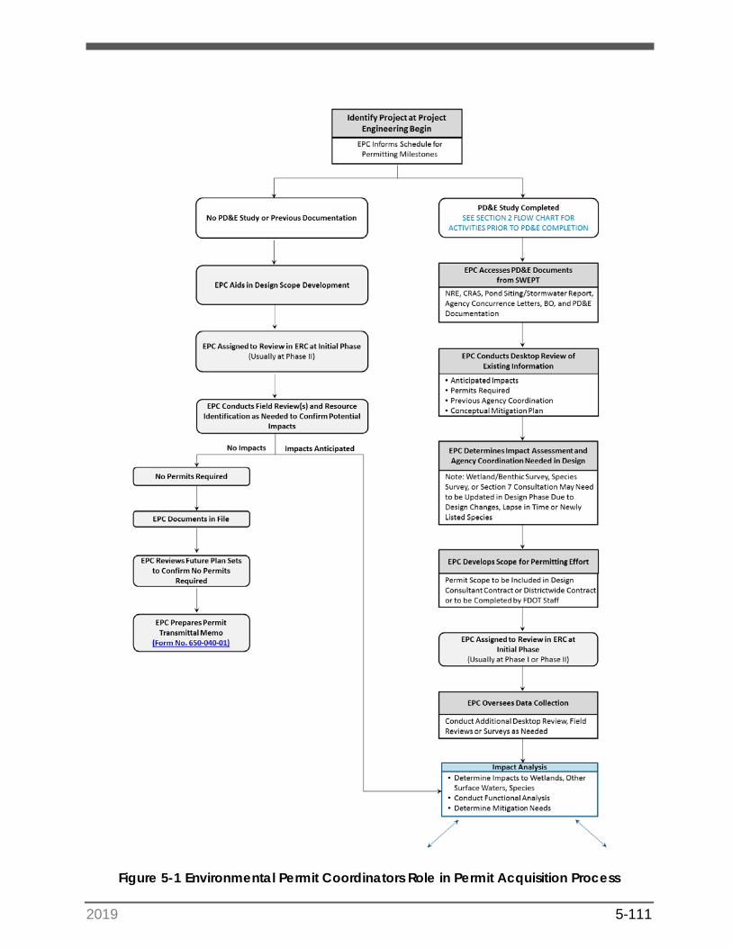
2019 5-111
Figure 5-1 Environmental Permit Coordinators Role in Permit Acquisition Process
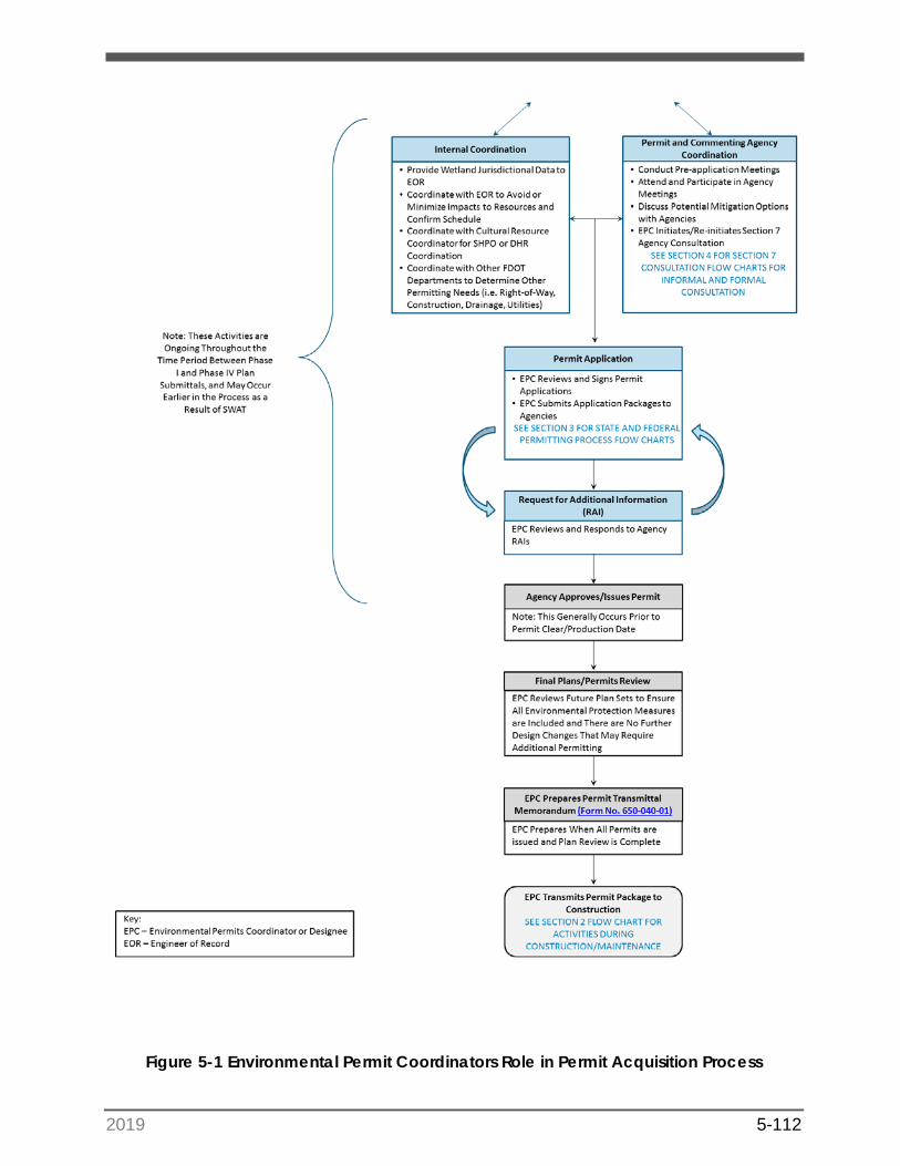
2019 5-112
Figure 5-1 Environmental Permit Coordinators Role in Permit Acquisition Process
2019 5-113
5.1 Scope Permitting Effort (Step 1)
For the typical roadway project, FDOT will assign an in-house Project Manager (PM) to prepare a Scope of Services and select a consultant team to design and permit the project. The selected consultant team is usually comprised of a main “prime” consultant that manages the many disciplines that may include additional firms. The PM for the prime consultant will be the main contact with FDOT’s PM. In this case, the Environmental Permit Coordinator will provide input to the Scope of Service and preliminary staff hour estimate related specifically to the permitting effort. This will include reviewing existing information available from the PD&E Study, if applicable, to use as a basis for identifying the level of permitting and resource analysis required. The Scope will outline the anticipated permits required and an estimate of the level of natural resource identification and analysis, agency coordination and mitigation required. The Scope will be established using the FDOT Design Standard Scope of Services and Design Staff Hour Estimation Forms. The Environmental Permit Coordinator may also be required to review the consultant’s proposed scope and staff hour estimate, as well as attend the consultant negotiation meeting.
Be aware that sometimes FDOT may design and permit a project using in-house staff or in-house consulting support that eliminates the need to advertise the project. In this instance, the Environmental Permit Coordinator will coordinate with FDOT or consultant staff directly to develop a scope and staff hour estimate to perform the permitting effort.
5.2 Review Project Plans in Electronic Review Comments System (Step 2)
Once a project is in the Design phase, each plan submittal (Phase I to Phase IV) is routed through the ERC system for review by each District office/discipline. The Environmental Permit Coordinator will receive an electronic notification from the ERC at the start of all phases to review the plans or designate other FDOT or consultant staff to identify/confirm the permits required based on the scope of work (drainage, in-water work, reconstruction, etc.) and level of natural resource impacts.
The assigned reviewer will be notified by the ERC system via email of when the comments are due and when the designer submits comment responses. Once responses are entered by the designer, the reviewer must accept the response, accept and request additional information, or reject the response. The intent of this system is to resolve issues with the plans, provide information between the reviewer and the design team, and document this coordination effort.
If a consultant team is scoped to design and permit a project, the reviewer’s comments will generally focus on the following main issues:
a) Confirming the appropriate permits are being acquired based on the scope of work;
b) Request the status of the permitting activities;

2019 5-114
c) Confirm the appropriate impact analysis is occurring, including desktop and fieldreviews; and,
d) Confirm the limits of environmentally sensitive areas, habitats, erosion controlmeasures are shown in the plans.
If the project is being permitted by the consultant or FDOT staff that are reviewing the plans, the reviewer’s comments will generally focus on the following main issues:
a) Advise the designer of the status of permitting activities;
b) Request the information (drainage report, permit sketches, etc.) needed toprepare the applications;
c) Identify possible natural resource impacts and possible avoidance/minimizationmeasures; and,
Request the limits of environmentally sensitive areas, habitats, erosion control measures be shown in the plans.
HELPFUL HINTS: Arrangements for a Pre-Application Meeting with theappropriate permitting agency should be made at this stage if not already completed. Please note that the USACE is not likely to participate in a Pre-Application Meeting unless at least a basic permit application has been submitted.
5.3 Data Collection (Step 3)
Section 4 describes in detail the process and tools needed to identify key resources and quantify impacts; however, in general data collection includes both a desktop evaluation of available information and field reviews. Initial data collection is usually initiated with the first phase review submittal (Phase I or Phase II dependent on project schedule). A more detailed analysis will be completed prior to submittal of the permit application.
When beginning the data collection phase, it is important to note if a PD&E Study was completed for the project or if it is a project that was initiated in the Design phase. The documents prepared during the PD&E Study contain usable information that is pertinent to the preparation of the permit applications. If the Environmental Permit Coordinator does not already have copies of the documents, they can be acquired via the following:
• Download the documents directly from the StateWide Environmental ProjectTracker (SWEPT);
• Request copies from the Project Development PM; or,
• Request copies from the Environmental Management Office (EMO).
If the project was initiated in the Design Phase, this is most likely the initial data collection phase. The level of desktop and field reviews are based on the proposed scope of work and potential impacts.
2019 5-115
5.4 Impact Analysis, Internal Coordination, and Interagency Coordination (Step 4)
Impact analysis is based on the footprint of construction over sensitive habitats including jurisdictional wetlands, benthic submerged habitat, Sovereign Submerged Lands, and designated critical habitat. In order to identify these areas within the construction footprint, close coordination with federal and state agencies is necessary including the commenting agencies. These generally include the Florida Fish and Wildlife Commission (FWC) and State Historic Preservation Officer (SHPO) at the state level and United States Fish and Wildlife Service (USFWS), National Marine Fisheries Service (NMFS), and Native American tribes at the federal level. In all cases, avoidance and minimization of the resource impacted must be demonstrated which may mean modification of the project design. Generally, avoidance and minimization occur during the PD&E phase and are refined in Design as a component of the permitting process. The permitting process often begins with an interagency meeting to introduce the project and identify major issues of concern by the agencies prior to submittal of a formal application. See Section 4 for additional details relating to the impact analysis process.
HELPFUL HINTS: It is beneficial to ensure that a thorough avoidance and minimization review is conducted during the PD&E phase. Otherwise, the project schedule may be negatively impacted if significant project modifications are required as part of the permitting process.
During the Design phase, it is important to coordinate with other disciplines within the District including but not limited to Roadway, Drainage, Structures, Construction, Maintenance and Utilities, to ensure all aspects of the scope of work and impacts are addressed in the application. Often, the construction means and methods are not developed during Design. However, the Construction Office can provide guidance as to whether construction will be from the land or require in-water access via barge or floating platform or require dewatering for excavation associated with drainage or utility work. Utility work can be included in a project via a Utility Work by Highway Contractor Agreement, which may need to be incorporated into FDOT’s permit applications. These are just a few examples of the issues that can be resolved with good internal coordination.
HELPFUL HINTS: If dewatering is required, the contractor will be held responsible for acquiring the Dewatering Permit and any associated permit modifications.
5.5 Agency Consultation as Appropriate (Step 5)
A major objective for FDOT is to work with regulatory personnel in the early stages of a project to coordinate a smooth permitting process. Projects would ideally be permitted in PD&E, but this can only occur with detailed plans and drainage which are not generally available until final design. However, this aim may become more achievable given the
2019 5-116
current initiative to combine PD&E and Design scopes of work. Efficient Transportation Decision Making (ETDM) was developed with the aim of bridging the gap between the National Environmental Policy Act (NEPA) and permitting, thus streamlining agency coordination to expedite project delivery. All major agencies have Environmental Technical Advisory Team (ETAT) representatives, whose responsibility is working with FDOT to expedite project review and provide comments on the resources under their jurisdiction. These ETAT representatives participate in review of project impacts in the early stages and some are also responsible for issuing permits. Therefore, developing and maintaining professional relationships with them is highly recommended. Many projects will have concurrence letters from state and federal resource agencies that were obtained as part of the PD&E Study prior to submitting permitting applications and these letters can be critical since commenting agencies have already consulted on the projects. However, if there are design changes resulting in impacts to areas that have not been assessed, or new federal or state-listed species need to be evaluated, then consultation will be re-initiated. Please note that the lead permitting agency is responsible for initiating and conducting any additional resource agency consultation required during the permitting process.
Environmental Protection Agency Coordination
The Environmental Protection Agency (EPA) is provided with an application package for review, as part of the USACE Public Notice Process. If the EPA chooses to provide a response, they have 30 days to respond. Generally, EPA will only comment on controversial projects involving potential water quality degradation.
The EPA may make comments to obtain assurance that water quality standards will be met. The guidelines require that no discharge of dredged or fill material shall be permitted that will cause or contribute to significant degradation of the waters of the United States.
State Historic Preservation Officer (SHPO) Coordination
Nearly all FDOT road project permit applications are sent to the SHPO, within the Division of Historical Resources (DHR) of the Department of State, for review for the presence of historical, cultural, or archaeological sites within the proposed construction zone.
The SHPO is notified as part of the Public Notice Process and has 30 days to respond to the USACE after receipt of the Public Notice. Depending upon the documentation provided in the application package, the SHPO may issue a Request for Additional (RAI) Information where information relevant to historical, cultural, or archaeological issues is deemed incomplete. SHPO may also request that the applicant perform an archeological survey.
If the project went through the PD&E process, a historic and/or archaeological survey may already exist but may need to be updated to reflect any changes to the Area of Potential Effect (APE), which varies according to project scope and location. The results of the analysis would have been documented in the Cultural Resource Assessment Survey (CRAS) prepared during the study and would be referenced in the application package.
Many minor projects may not have undergone a PD&E Study and could require a historic and/or archaeological survey. At a minimum, a desktop review should be completed
2019 5-117
prior to the application submittal, to determine if any previously identified historical, cultural, or archaeological resources occur within the project area. The USACE and state permitting agencies require a documented record of compliance with associated historic preservation laws prior to issuing a permit. The Environmental Permit Coordinator should coordinate with the District Cultural Resource Coordinator to obtain a copy of the cultural resource documentation to include in the permit application.
HELPFUL HINTS: When Design has reached approximately 45%, it isprudent to review any areas that were not part of the PD&E Study, to ascertain whether the APE included these areas. Any areas not included in the previous surveys should be surveyed (in coordination with DHR) prior to submitting permit applications.
Tribal Coordination
For road projects that are in, or adjacent to, Tribal lands, or on areas of tribal interest, consultation must occur with the appropriate Tribal representatives. The Advisory Council on Historic Preservation (ACHP) regulations contain provisions requiring consultation with Indian Tribes. The USACE will consult with a representative designated by the Indian Tribe, in addition to consulting with the SHPO. The ACHP regulations also require consultation with any Indian Tribe that places historic and cultural significance on historic properties, including traditional cultural properties that may be affected by the proposed road project, even if those historic properties are located on private lands. Effective consultation requires informed communication with Native Americans, and consideration of their interests during the decision-making process. Guidance for consultation with Native Americans is found in the US Army Corps of Engineers Tribal Consultation Policy and Related Documents. Section 106 of the National Historic Preservation Act (NHPA) and Part 2, Chapter 8 of the PD&E Manual provides additional information on this topic. The OEM, in coordination with the District’s Cultural Resource Coordinator, will lead any consultation efforts with the Tribes during the PD&E phase for federally-funded projects. Once the permit application has been submitted, the permitting agency will then take the lead for any subsequent tribal consultation required. The Environmental Permit Coordinator should coordinate with the Cultural Resource Coordinator on any Tribal issues that arise during permitting.
HELPFUL HINTS: Most correspondence between FDOT and a NativeAmerican Tribe should come from the OEM Director.
5.6 Prepare Permit Application (Step 6)
Pre-Application Meeting(s)
After the initial environmental data are collected and field reviews have taken place, the environmental staff will likely need to wait until the drainage analysis is complete before
2019 5-118
scheduling a pre-application meeting with the state agency. Pre-application meetings with the USACE are encouraged as appropriate, particularly for projects with large environmental impacts. However, it is likely that some type of coordination was initiated with USACE during the PD&E process.
HELPFUL HINTS: If feasible, it is helpful to hold a pre-application meeting with the appropriate permitting agency during the PD&E process. Although the project design will still be in the conceptual stage, it is beneficial to discuss these early details with the agencies to keep them informed of the project and encourage early feedback.
The pre-application meeting typically occurs one-two months prior to the submittal of the application. The majority of the pre-application meeting allows the drainage engineer to discuss the drainage design and any innovative concepts. This meeting can also serve to reacquaint the environmental reviewer(s) with the project or introduce the project if there is a new reviewer. The discussion may cover permit application items such as wetland impacts, mitigation options, listed species surveys, cultural resources, sovereign submerged lands, and cumulative effects.
More than one pre-application meeting may be held if scheduled early in the Design Phase. The additional meeting(s) may be used to discuss/gain concept approval on a large project prior to completion of Phase II design plans, or to discuss a design change that has the potential to affect permitting. The more complex the project, the more beneficial it is to hold multiple pre-application meetings so that potential permitting issues can be quickly recognized and addressed.
HELPFUL HINTS: Pre-application meetings can be a critical link in expediting permitting time frames and should be used to eliminate outstanding variables before submitting the application.
Basic Application Package
Permit application packages are typically prepared once all internal questions from the Phase II design plan submittal have been resolved between FDOT and the Design team responsible for incorporating comments for the modified Phase II design plan submittal. The application package includes a description of the project, location and aerial map, wetland, other surface water, and listed species information, and drainage analysis (if necessary). For information regarding federal and state permit thresholds and criteria, please see Section 3.7. Refer to Section 5.6.1 for information regarding the state permit application, and Section 5.6.2 for a discussion of the federal permit application.
At this time, permit sketches on the plan sheets can be produced as required for the permit application. Up until this point, wetland impact calculations have typically occurred through Geographic Information System (GIS) analyses. These plan sheets, often referred to as the dredge and fill sketches, will include the following:
2019 5-119
• A map key that includes the names and locations of all wetlands and other surfacewaters along the corridor;
• Plan-view sheets that include all wetland lines and wetland/other surface waterimpacts (with unique identifiers), including individual wetland acreages;
• Call-outs of the total wetland/other surface water acreage and direct impactacreage;
• At least one cross section view per wetland, showing the wetland/other surfacewater impacts and acreage;
• The wetlands should have the universal wetland hash mark symbol(s) on the insideof the wetland designation (see Section 3.7.4.1 of the FDOT CADD MANUAL);
• A table of the volume of material (cubic yards) to be dredged and/or filled in eachwetland or other surface waters;
• Documentation of the Impervious Surface Cover on the General Notes plans sheet;and
• Plan sheets signed and sealed by a professional engineer.
HELPFUL HINTS: The total wetland acreage is important, as isolatedwetlands that are less than 0.5 acres do not require mitigation according to the state ERP process (Section 10.2.2.1 of Volume I of the Applicant’s Handbook). If an individual ERP is needed, the state permit agency will typically request mitigation for any wetland impact, regardless of acreage. For federal permits, the USACE currently requests mitigation for any wetland impact greater than 0.1 acres.
All application documents can be submitted either as hard copies, via email to [email protected], or online through the dedicated USACE Safe Access File Exchange site (see Section 4.1.2) and through each respective WMD/FDEP permitting portal (ePermitting). Note that online permit applications require permitting forms to be completed online. These online forms can be saved at any point during the process and can be converted to a “package” for review prior to submittals. Any associated environmental and drainage documentation/reports can be uploaded into the permitting portal as attachments. The online portals allow the engineer to electronically sign and seal reports, as well as upload signature pages.
HELPFUL HINTS: Benefits to submitting online state applications includethe immediate acceptance of a submittal with an emailed receipt to all parties, and the conservation of resources associated with printing hundreds of pages of information. For the USACE, it is recommended to make a follow-up call within 7 days to the designated reviewer, to confirm the application was received.
2019 5-120
Application Fees are Required for State Permits
Every FDOT District should coordinate an effective application fee payment plan with the permitting agency as appropriate. Each WMD has separate fee schedules that can be accessed through their permitting website. Payment of fees is required for the application to be deemed complete. A state permit application can be submitted without including permit fees. However, payment of permit application fees will be required prior to permit issuance. The design scope of service should provide direction as to whether FDOT or the design firm will make the payment of the permit fee. The USACE review process does not require permit fees if the applicant is a governmental agency; and thus, no application fee is assessed for FDOT projects.
5.6.1 Application for Individual and Conceptual Environmental Resource Permit / Authorization to Use State-Owned Submerged Lands
Effective October 1, 2017, the Department is required to submit separate application packages to the USACE for the Dredge and Fill Permit and to the State for the ERP. For more information, reference the USACE Public notice issued August 25, 2017 (www.saj.usace.army.mil/Missions/Regulatory/Public-Notices/Article/1290332/corps-%20withdrawing-from-the-florida-joint-application-process-effective-october/).
Permit Application Review Criteria/Environmental Permit Documentation
The material provided in the permit application includes the basic information about the proposed project, and the project-specific details that the agencies will review to ensure the project meets the regulatory criteria for a permit. Supporting materials will also be included, such as:
• location maps;
• aerial maps;
• United States Geological Survey (USGS) Quadrangle maps;
• signed and sealed engineering plans (preferably digital);
• dredge and fill sketches; and, an
• environmental report.
The application forms must be signed by someone with the authority to sign on behalf of FDOT’s District (typically the Environmental Permit Coordinator). On any applications submitted to the USACE or the State of Florida, the environmental consultant (if there is one) must be identified for a permit reviewer to be able to discuss the project with them. For off system projects, the project owner may have to sign the project with FDOT as the agent. Note that the permit applicant’s agent is legally able to represent the applicant during the permit application process.
There are a number of differences in each Agency’s application process. Though much of the content required by the USACE and the State is the same, the application forms are
2019 5-121
different. There are also a number of other important differences. An overview for each Agency’s application and process is provided below.
State ERP Permitting
As stated in Sections 3.7.2 and 3.11 of this handbook, the State ERP permitting process incorporates impacts to wetlands and surface waters, as well as the management of stormwater systems. Complete application forms can be found on the FDEP ERP Program website and each individual Water Management District website. The FDEP’s Water Permitting Portal website: http://flwaterpermits.com contains links to all five state WMD permitting sites. These sites contain written guidelines as well as online portals for the state application that will walk the user through each step of the application.
ERP Application Sections for FDOT Projects
For FDOT projects, an application will typically require Sections “A,” “C,” and “E” of the application. Sections “D,” “F,” and “G” may also be required depending upon the project. Section “B” is not needed for FDOT projects as it pertains to permits for single family projects.
5.6.1.1 Section A: General Information
Section “A” is required for all Individual, General, and Conceptual applications, where the applicant provides the basic project information including Section, Township, and Range; applicant and agent contact information; permit history; and type of permit being requested. Part 4 of Section “A” requires the signature of the applicant or applicant’s authorized agent. This portion must be signed by the Department, usually the Environmental Permit Coordinator. If a consultant is applying for the permit on behalf of FDOT, their signature is also required.
5.6.1.2 Section C: Wetlands and Other Surface Waters
Section “C” provides the environmental data required to process the application and is typically filled out by an Environmental Scientist. Section “C,” specifically provides the environmental information as it pertains to activities in, on, or over wetlands and other surface waters. This information can be provided directly in the Section “C” form, or separately as a comprehensive environmental report. For FDOT projects, the size of the project area and scale of effects typically require an environmental report to be included with the application package.
HELPFUL HINTS: When presenting the environmental data in a report, it is helpful to the WMD reviewer to categorize each section with a reference to the Applicant Handbook. In addition, it is recommended that the Section “C” form clearly reference which section of the attached environmental report contains the requested information (i.e. “Please refer to Section 3.0 – Wetland Impacts in the attached Environmental Report”).
The environmental report will be prepared as a narrative to describe the project, the conditions at the project site, proposed impacts, and mitigation. The document should be
2019 5-122
divided into sections to provide the reviewer with all the pertinent details about the project site, including:
• the various land uses and community types;
• an assessment of the wetlands and aquatic habitat;
• listed species and wildlife information (including effects determinations for listedspecies);
• details on proposed impacts to wetlands and other surface waters;
• avoidance and minimization techniques;
• wetland functional assessments; and,
• proposed mitigation measures.
Avoidance and Minimization
Avoidance and minimization are key elements to the permit application and are documented in the environmental report attached to the application. See Section 4.2 for more details relating to avoidance and minimization measures for the state permitting process.
State Rules on Direct Impacts
Part I of Section “C” requests that the applicant document the direct impacts associated with the project. Direct impacts typically refer to the placement of fill or the removal or soil (dredge) within a wetland or surface water. However, all activities in, on, or over wetlands or surface waters must be accounted for and evaluated in relation to the reduction of the functional value of the wetland.
Direct impacts are defined as those impacts where wetland function is being lost, either completely or partially, because of the project. Examples of direct impacts for FDOT projects include the placement of fill for a roadway and the associated side slopes; the creation of stormwater management ponds; drainage features such as outfall structures; or safety components such as guard rails, signs, and lighting. In many cases, the wetland will cease to exist upon completion of the project and will be replaced by roadway or drainage features associated with the project.
ERP Table 1 (Impact Summary Table) is to be filled out to document the proposed direct wetland and surface water impacts calculated along the corridor, as depicted on the dredge and fill sketches. Unavoidable direct impacts require mitigation as described later in this section.
State Rules on Indirect Impacts
Secondary Impacts refer to those wetland areas that are not directly impacted via dredging or filling but will still lose some functional value due to the activity occurring adjacent to them. If the project cannot provide an upland buffer between the limits of construction and adjacent natural wetlands, secondary impacts are assessed.
2019 5-123
As per the Applicant’s Handbook, secondary impacts to the habitat functions of wetlands, associated with adjacent upland activities, will not be considered adverse if buffers, with a minimum width of 15 ft. and an average width of 25 ft., are provided abutting those wetlands that will remain under the permitted design. Secondary Impacts are reviewed under State of Florida rules under a four-part criterion (see Applicant’s Handbook I, Section 10.2.7):
1. Secondary impacts from construction will not cause or contribute to violations ofwater quality standards or adverse impacts to the functions of wetlands or othersurface waters. Examples of secondary impacts to be considered include light andnoise penetration; the increase in trash, and the elimination of an upland buffer.
2. Project will provide reasonable assurance that the proposed activity will not impactthe ecological value of uplands for bald eagles and wetland dependent listedanimal species, including areas needed for foraging or wildlife corridors.
3. The Agency will consider any other associated activities that are very closely linkedand causally related to any proposed dredging or filling that have the potential tocause impacts to significant historical and archaeological resources.
4. An applicant shall provide reasonable assurance that the following future activitieswill not result in water quality violations or adverse impacts to the functions ofwetlands or other surface waters; additional phases or expansion of the proposedactivity; other onsite or offsite activities that are closely linked to the proposedactivity.
HELPFUL HINTS: A list of wetland dependent listed wildlife species isprovided in Table 10.2.7-1, Volume 1, Chapter 10 of the Applicants Handbook.
If the project cannot demonstrate that proper buffers can be implemented (a minimum width of 15' and an average width of 25'), the state reviewer may assess additional impacts. Part 2 of the Uniform Mitigation Assessment Method (UMAM) assessment provides opportunities to assess a diminished function associated with a reduced upland buffer.
If listed or protected species are present or may be present, then additional coordination may be required with wildlife agencies. Any correspondence with the USFWS or FWC during the PD&E phase (or any previous project phases) should be provided.
HELPFUL HINTS: Drainage features and ponds are not typicallyconsidered subject to secondary impacts, if the engineer demonstrates that these features are not causing a tail water effect and drawing down the pre-existing hydroperiod of adjacent wetland systems. This determination is typically left to the discretion of the WMD reviewer. However, providing examples to the WMD reviewer of previous similarly design/permitted projects that were not assessed for secondary impacts can be beneficial in making this determination.
2019 5-124
State Rules on Cumulative Impacts
Cumulative impacts assess the project’s impacts to the basin (watershed) in which the project occurs, in conjunction with past, present, and future activities, to determine if the basin may be impacted beyond a sustainable level. This is generally referred to as “the straw that breaks the camel’s back.”
Each WMD has regulatory drainage basins defined for cumulative impact analysis. These basins are illustrated in 10.2.8 of Volume 1 of the Applicants Handbook. For a project to provide reasonable assurances that wetland impacts will not cause unacceptable cumulative impacts, the wetland mitigation must be provided within the same regulatory drainage basin.
HELPFUL HINTS: GIS data is available for each WMD regulatory drainage basin, and for available mitigation banks. These databases are typically available on the GIS data resources section of each WMD website (see Wetland Mitigation Appendix 2d).
If there are no available mitigation options within the same regulatory drainage basin, the applicant should consult directly with the WMD reviewers to ascertain if they will accept mitigation credits from a mitigation bank in a neighboring basin, or other regional mitigation opportunities. This process should be led by the Environmental Permit Coordinator. A Cumulative Impact Evaluation in accordance with Section 10.2.8, Volume 1 of the Applicants Handbook may be required to justify mitigating for project impacts outside of the project mitigation basin.
Cumulative impacts are considered unacceptable when the proposed activity, considered in conjunction with the past, present, and future activities would then result in:
• A violation of state water quality standards; or
• Significant adverse impacts to functions of wetlands or other surface waters, within the same drainage basin, when considering the basin as a whole.
Historically, cumulative impact evaluations were costly efforts that included in-depth analyses, comparing all wetland impacts that occurred in the past and were likely to occur in the future with the amount of wetlands that were then under conservation easement or public ownership. However, these analyses are now more commonly accepted in an abbreviated form that considers the extent of potential loss of privately owned “higher-risk” wetlands located within that regulatory drainage basin and compares it to the extent of wetlands in conservation that are “low risk.”
HELPFUL HINTS: When a mitigation bank is within the same service area as the impacts, it does not automatically mean that the bank will offset the cumulative impacts. Mitigation bank service areas are typically established based on US Geological Society Hydrologic Unit Code (Hydrologic Unit Code) maps. The mitigation bank must also be located within the same WMD designated regulatory drainage basin as the impacts.
2019 5-125
Uniform Mitigation Assessment Method (UMAM)
Wetlands proposed to be impacted should have a UMAM assessment to calculate the functional loss. This assessment will include two parts, a qualitative and quantitative analysis, and should assume that the area will be directly impacted by a dredge or fill activity.
Part 1 - Qualitative Characterization (62-345.400) must address the following applicable information:
• Special water classifications, such as Outstanding Florida Water (OFW), AquaticPreserve, Class II water approved, restricted, conditionally approved, conditionallyrestricted for shellfish harvesting, or an Area of Critical State Concern;
• Significant nearby features that might affect the values of the functions providedby the assessment area;
• Assessment area size;
• Geographic relationship and hydrologic connection between the assessment areaand any contiguous wetland or other surface waters, or uplands as applicable;
• Classification of assessment area, including description of past alterations thataffect the classification;
• Uniqueness of the assessment area in relation to the surrounding regionallandscape;
• Functions performed by the assessment area;
• Anticipated wildlife utilization, type of use and applicable listing classifications(threatened, endangered, species of special concern);
• Whether any portion of the assessment area has been previously used as mitigationfor a prior issued permit; and
• Any additional information that is needed to accurately characterize theecological values of the assessment area and functions provided.
Part 2 – Assessment and Scoring (62-345.500) determines the degree to which the assessment area provides the functions identified in Part 1 and the amount of function lost or gained by the project. Each impact and mitigation assessment area must be assessed under two conditions:
• Current condition, or in the case of preservation mitigation, without preservation;and,
• “With mitigation” or “with impact”.
Full text regarding the rules of the UMAM can be found on the Florida Administrative Code (F.A.C.) and Florida Administrative Register (FAR) Website.
When the limits of direct and secondary impacts are fully understood, the UMAM impact assessment can be completed and submitted with the permit application. By rule, state
2019 5-126
agency review staff have the final say as to the UMAM scores, though it is important to provide the scores calculated by the applicant in the permit package. USACE also utilizes UMAM for most wetland assessments in Florida.
Once functional losses have been established for each wetland system, it is recommended that a table be created that separates impacts by basin, as well as by habitat type (forested vs herbaceous). The total functional loss as calculated in the UMAM assessment will be the amount of mitigation (by type) that is required to offset the project impacts.
HELPFUL HINTS: UMAM scores should be reviewed and approved by the District Permits Coordinator prior to being submitted to regulatory staff.
Mitigation Plan
Once all practicable measures to avoid and minimize impacts have been incorporated into the design, the mitigation required to provide an equivalent functional gain to offset the losses to wetlands is determined. The process of incorporating all appropriate and practicable measures to avoid, minimize and, finally, compensate for impacts to aquatic resources caused by permitted actions is referred to as sequencing. To demonstrate that the project adequately offsets impacts to proposed wetlands and surface waters, the applicant must provide a mitigation plan which identifies the type and amount of mitigation being proposed.
The mitigation proposed should be similar to those being impacted (e.g., forested wetland impacts should be offset with forested bank credits). The UMAM assessment that quantified the functional loss will be used to identify the impact mitigation types required for the project. Note that other functional assessment methodologies may be used for determining mitigation needs, depending on the mitigation bank providing the credits (if a mitigation bank is used). Additional wetland functional assessment methods prior to UMAM were in use when a number of mitigation banks were permitted. Other examples of wetland functional assessments that may be used include:
1. Wetland Assessment Technique for Environmental Review (WATER);
2. Wetland Rapid Assessment Procedure (WRAP); and,
3. Modified WRAP.
State permit requirements are generally satisfied with the purchase of mitigation bank credits or participation in FDOT’s Mitigation program. If a mitigation bank credit purchase is proposed, FDOT must provide the WMD a letter of reservation from the bank. The credit purchase will then be accounted for in the WMD’s mitigation plan, and FDOT will be responsible for completing the purchasing of the reserved credits. Typically, permits include a specific condition for FDOT projects, requiring that credits be purchased either before the project construction starts or when wetland impacts begin.
2019 5-127
FDOT’s Mitigation program allows the state’s WMDs or DEP to provide mitigation services for FDOT districts on a cost-per-acre basis for projects that were included in a mitigation plan prior to July 1, 2013. FDOT pays the full cost of the mitigation services to the WMD or DEP for projects included in the mitigation plan. Please see Section 373.4137, Florida Statutes (F.S.) for more information regarding mitigation requirements for transportation projects. Not all WMDs participate in the FDOT Mitigation Program so coordinate with your regional WMD.
HELPFUL HINTS: During early design coordination (after the wetlands areflagged), it is important to coordinate with FDOT’s Permits Coordinator on the estimated amount, type, and functional loss so that proper mitigation planning can occur.
Compensation for impacts to listed species may also be required by state and federal commenting agencies. Please refer to Section 4 for additional guidance on species mitigation.
Water Quality
The applicant must demonstrate how water quality will be maintained in wetlands and other surface waters that will be preserved or will remain undisturbed, both onsite and offsite. For FDOT projects, the erosion control that accompanies the roadway plans typically satisfies these criteria. The Erosion Control Plan is an important tool and document that helps provide assurances to the permitting agencies that adjacent wetlands will be protected during construction activities. The Erosion Control Plan is also referred to as a Stormwater Pollution Prevention Plan (SWPPP) if the project requires a National Pollutant Discharge Elimination System (NPDES) permit (see Section 5.6.5).
Valuable input to the Erosion Control Plan includes what type of erosion control measures (i.e. sediment barrier, staked turbidity barrier, floating turbidity barrier) should be utilized, based on the topography and projected hydroperiod and groundwater levels associated with each type of ecological system. Stream and lake swamps, marshes, and cypress-dominated areas indicate long periods of inundation, while wet prairie, hydric flatwood, and some wetland hardwoods may indicate much shorter inundations. Seasonal high-water level elevations and physical evidence such as rack lines and soil deposition areas should also indicate whether adjacent wetland systems are “flashy” (i.e., subject to rapid water-level rises) and may require additional means of protection to reduce water velocity.
HELPFUL HINTS: It is important that an environmental scientist review theErosion Control Plan to ensure that the proposed erosion control options are appropriate based on the type of systems identified along the corridor.
If the proposed project is located within a water body and maintaining water quality standards will be difficult because of topography or water movement, the applicant may request a temporary mixing zone pursuant to 10.2.4.4 of the Volume 1 of the Applicants
2019 5-128
Handbook. Mixing zone approval is at the discretion of the WMD, and largely depends on the presence and proximity of adjacent resources.
Public Interest Criteria
As part of the permit review process, an applicant must demonstrate that a project is not contrary to the public interest, per the Public Interest Test (refer to Applicant’s Handbook 1, Section 10.2.3):
a) Whether the regulated activity will adversely affect the public health, safety, orwelfare or the property of others;
b) Whether the regulated activity will adversely affect the conservation of fish andwildlife, including endangered or threatened species, or their habitats;
c) Whether the regulated activity will adversely affect navigation or the flow of wateror cause harmful erosion or shoaling;
d) Whether the regulated activity will adversely affect the fishing or recreationalvalues or marine productivity in the vicinity of the activity;
e) Whether the regulated activity will be of a temporary or permanent nature;
f) Whether the regulated activity will adversely affect or will enhance significanthistorical and archaeological resources; and
g) Whether the project will be designed to avoid adverse effects to the currentcondition and relative value of functions being performed by areas affected bythe proposed regulated activity.
HELPFUL HINTS: Because of the level of scrutiny associated with the NEPAanalysis approval, a project subject to these evaluations during a PD&E Study, or other study, will not have much difficulty demonstrating that it is in the public interest. The primary component of the NEPA study is the alternatives analysis, which considers the effects of each alternative to both natural (wetlands, listed species) and physical environment (historical and archaeological). This analysis goes beyond what is required for the state Public Interest Test and typically can be provided if requested by the agency.
Outstanding Florida Waters
FDEP has designated certain Florida water bodies as OFWs through their Environmental Regulatory Commission, in accordance with Section 403.061(2), Florida Statutes (F.S.). Water bodies that receive this designation are afforded additional protection measures by mandating that discharges to OFWs must not exceed ambient water quality conditions. In addition to this mandate, projects that propose discharges within an OFW must also be clearly in the Public Interest [373.414(1)(a), F.S.].
2019 5-129
HELPFUL HINTS: There is additional scrutiny regarding the public interest test when a project is located within an OFW to demonstrate that a project is “clearly in the public interest”.
5.6.1.3 Section D: Structures or Works in Surface Waters
Section “D” is required for bridge projects that may cause a disruption or restriction of flow within surface waters.
5.6.1.4 Section E: Stormwater Management System
Section “E” provides the required stormwater management system information and is typically filled out by the drainage engineer who will be responsible for the signing and sealing of the drainage portion of the roadway plan set. Section “E” typically references sections of the drainage reports that will accompany the application.
5.6.1.5 Section F: State-Owned Submerged Lands
Section “F” is used for FDOT projects that propose activities on Sovereign Submerged Lands (refer to Section 3.12.1 for additional information.
5.6.1.6 Section G: Mitigation Banks
Section “G” is used for FDOT projects which require a mitigation bank permit or a mitigation bank conceptual approval in accordance with Chapter 62-342, F.A.C. Information provided in this section includes, but is not limited to, the following:
• Location of the proposed mitigation bank;
• Ecological significance of the proposed mitigation bank to the regional watershed in which it is located;
• Current site conditions;
• Mitigation plan;
• Assessment of improvements in ecological value;
• Evidence of sufficient legal or equitable interest in the property;
• Draft documentation of financial responsibility; and,
• Land use restrictions.
Refer to Section 4.6.1.1 for more detail regarding mitigation banks.
Deadlines
The state permitting process is tied to statutory deadlines for permit issuance, though this deadline can be formally waived by the applicant. The duration of the state permitting process depends on the complexity of the construction and the environmental sensitivity
2019 5-130
of the project area, unless the project qualifies for a general permit, which takes approximately 30 days. Section 373.4141, F.S., provides FDEP or the WMD 30 days to request additional information on an application or in any subsequent submittal within 30 days after receipt of an application for permit or receipt of additional information. An application is considered complete by a regulatory agency when the applicant has provided sufficient information for the regulatory agency to make a final agency action. A permit is issued or denied within 60 days after the application has been deemed complete.
Unlike the state process, the federal permitting process is not tied to a statutory timeframe for permit issuance.
5.6.2 United States Army Corps of Engineers Federal Dredge and Fill Permit
Federal Dredge and Fill Permitting
As stated in Section 3.8 of this handbook, a USACE permit is required for dredge and fill activities including any activity in, on, or over wetlands or other waters of the United States.
The USACE requires use of Engineering Form 4345 (Form ENG 4345) for the application. This form has the basic applicant and project information, similar to Section “A” of the ERP Application.
Form 4345 is submitted to USACE via their file transfer application, the Safe Access File Exchange portal, which is located at https://safe.amrdec.army.mil/safe/. This site is similar to the WMD ePermitting site described above for the ERP submittal. The SharePoint site will allow you to complete project specific information, attach files and print out a draft application to then send via email to the USACE generic email address. The site will send a verification email after the documents are uploaded and submitted to confirm your application submittal. You must verify your email in order to finalize the application process. It is recommended to send an email to the general USACE email address ([email protected]) with a copy of a transmittal letter, Form 4345 (printed out from the Safe Access File Exchange site) and applicable attachments. Alternatively, if the permit application file size does not exceed the USACE or FDOT email threshold, the general USACE email address can be utilized in lieu of the Safe Access File Exchange site.
HELPFUL HINTS: The USACE requires the permit application to includetyped mailing labels for projects with more than ten adjacent property owners.
Avoidance and Minimization
Avoidance and minimization are key elements to the permit application and are document in the environmental report attached to the application. See Section 4.2 for more details relating to avoidance and minimization measures for the federal permitting process.
2019 5-131
Federal Rules on Direct and Indirect Impacts
Refer to Section 5.6.1.2 for a description of direct impact analysis as the state and federal agencies follow a similar process.
Secondary impacts (also referred to as indirect affects) refer to adverse effects on remaining wetlands that are adjacent to the project being constructed. These impacts are not directly associated with road construction but result from the presence of a new road (or from the widening of an existing road), and usually occur in the wetland adjacent to the direct wetland impacts. Impacts for indirect and secondary affects are assessed to distances that range from 25-300 feet, depending on the type of project and the extent of the direct impacts. Agency coordination should also be conducted to determine the appropriate distance. Most roadway projects (with the exception of new corridors) will have secondary impacts calculated at 75-100 feet from the limits of construction. Some examples of secondary impacts include:
1. Increased establishment of nuisance/exotic plant species adjacent to thenew/widened road;
2. Increased wildlife mortality;
3. Effects of noise on animals using remaining wetlands adjacent to the road; and,
4. Effects of new lighting on animals using remaining wetlands adjacent to the road.
Secondary/indirect impacts must be considered in the development of the project’s overall mitigation plan to offset all unavoidable wetland impacts. For more information regarding the federal rules on indirect impacts, please refer to 40 CFR §§1500-1508.
Federal Rules on Cumulative Impacts
The USGS has established Hydrologic Unit Codes for all drainage basins in the United States. Hydrologic Unit Code codes are available from the USGS National Hydrography Dataset (NHD) website. For a project to provide reasonable assurances that wetland impacts will not cause unacceptable cumulative impacts, the mitigation must be provided within the same Hydrologic Unit Code basin.
HELPFUL HINTS: GIS data is available for each Hydrologic Unit Codebasin, and for available mitigation banks.
A cumulative impacts evaluation may be requested if the mitigation proposed does not occur within the impacted Hydrologic Unit Code basin. Similar to the evaluation that may be required in state permitting, this involves an analysis of past, present, and future wetland impacts to the Hydrologic Unit Code basin, to determine if the project has a significant negative effect that will not be replaced by providing mitigation in an alternate basin. Much of the same data collected in a state-level analysis can be used, though the Hydrologic Unit Code basin and the state WMD basin boundaries will not be exactly the same in most cases.
2019 5-132
Uniform Mitigation Assessment Method
Refer to Section 5.6.1.2 for more detail regarding what is expected for the 404 Permit.
Mitigation Plan
Federal permit mitigation requirements are based upon the 2008 Mitigation Rule (Compensatory Mitigation for Losses of Aquatic Resources), which was designed to promote consistency and predictability by having similar standards and criteria for all mitigation projects. The rule is consistent with the requirements of Executive Order (EO) 11990, Protection of Wetlands to have “no net loss of wetland functions”. As discussed in Section 4.6.1.2, the USACE requires all compensatory mitigation plans to include the Twelve Components of a Compensatory Mitigation Plan.
This rule created a compensatory mitigation hierarchy, giving preference first to mitigation provided by mitigation banks, then in-lieu fee credits, then permittee-responsible mitigation based upon a watershed approach, on-site or in-kind permittee-responsible mitigation, and finally off-site or out-of-kind permittee-responsible mitigation (see Wetland Mitigation Appendix 2d). Compensatory mitigation may include creation, enhancement or restoration of wetlands and their functions or, in some cases, may include preservation of wetlands and associated upland buffers.
HELPFUL HINTS: The USACE rarely gives mitigation credit for the preservation of wetlands, unlike the state regulatory programs. Wetlands with upland buffers can be used as part of a mitigation plan, but typically are given much less credit than the state programs.
Compensation for impacts to listed species may also be required by state and federal commenting agencies. Please refer to Section 4 for additional guidance on listed species mitigation.
Water Quality
Refer to Section 5.6.1.2 for more detail regarding what is expected for the 404 Permit.
Public Interest Criteria
Refer to Section 5.6.1.2 for more detail regarding what is expected for the 404 Permit.
Outstanding Florida Waters (OFWs)
Refer to Section 5.6.1.2 for more detail regarding what is expected for the 404 Permit.
5.6.3 Navigation Permitting Process (Section 10 of the Rivers and Harbors Act) – United States Coast Guard Bridge Permit
FDOT projects that are within 100 feet of a USACE maintained Federal Channel [e.g., the Intracoastal Waterway (ICW)] require additional coordination, in accordance with the Setback Guidance for Structures Along Certain Federal Channels. In addition to the normal permitting process described above, the USACE must coordinate with the Construction Operations Section in Jacksonville.
2019 5-133
The Construction Operations Section in Jacksonville is responsible for ensuring that all permit applications within a 100-foot distance of the federally maintained channel are reviewed for any potential conflicts with the maintenance of the channel. The Construction Operations Section in Jacksonville may also send Requests for Additional Information (RAIs) to resolve any issues and ensure a complete application. Once all information is received and the application is acceptable, a Consent-to-Use document is issued.
5.6.3.1 Determine Navigation
The primary criterion for determining USCG jurisdiction is navigation. It may be obvious that the waterway is navigable, and if so, this step is complete after contact has been initiated with the USCG to confirm this determination. Coordination with the USCG through ETDM process, and then the PD&E Study, will determine whether the project crosses a navigable water. For projects in District 3, the New Orleans USCG does not use ETDM to determine navigability. Instead, the District must submit a Bridge Project Questionnaire to USCG for navigability determination. Conclusions regarding navigability are documented in the PD&E Study.
In special cases where navigability is questionable or there is no PD&E Study, a Bridge Project Questionnaire, which supplies data on the navigation of the waterway to the USCG, may be required. The Coast Guard may also request a Navigation Impact Report, which is a tool by which the Coast Guard District Bridge Office determines the current and prospective needs of navigation on a waterway. The USCG uses the data in the Navigation Impact Report to make a preliminary navigation determination, which can be used to determine if a Bridge Permit is required.
The information needed to complete the report includes navigation data on the subject waterway, as well as information on the types of vessels using the waterway, clearances, information on obstructions, and information on properties adjacent to the bridge and waterway in the project location.
HELPFUL HINTS: A major issue for new bridges or bridge replacement ishorizontal and vertical clearance. The clearance of the bridge determines the size of boats that can be used in the waterways.
Ultimately, the decision made by the Coast Guard will determine if the water body is navigable, and if the project will require a bridge permit.
5.6.3.2 Permitting Process
The only permit type issued by the USCG is a bridge permit. A bridge permit is the written approval of the location and plans of the bridge or causeway to be constructed (or modified) across a navigable waterway of the United States.
The Bridge Permit Application Guide (COMDTPUB P16591.3D, July 2016) provides the steps to walk the applicant through the completion of the application package.
2019 5-134
Project Initiation (During FDOT’s Design Phase)
During FDOT’s Design phase, early coordination with the USCG should be initiated when the project has advanced to a point where a preliminary design is available to consider. This would entail the applicant contacting the USCG District Bridge Office to discuss the proposed bridge project to provide a status and discuss any changes to the design that may have occurred since PD&E. The Bridge Project Initiation Request template (from the Bridge Permit Application Guide) can be used to start this process.
HELPFUL HINTS: Schedule a pre-app meeting when the design plansreach 30% completion. There should be sufficient information to discuss the project and determine navigation issues and to also discuss any design changes that have occurred since the PD&E Study (example: changing the clearance on a bridge).
Determining the Lead Federal Action Agency During Permitting
Consistent with NEPA Assignment, FDOT acts as the lead federal action agency for federally-funded highway projects and OEM has final signature authority of the NEPA document. FDOT also serves as the lead action agency if a state-funded project requires a federal permit. The USACE or USCG will then take on the role of lead federal permitting agency based on the project scope and location.
As discussed previously, if a federal or state project involves bridge work over navigable waters of the United States, the USCG will be the lead federal permitting agency. The USACE will take the lead if the project involves dredge and fill in Waters of the United States in accordance with Section 404 of the Clean Water Act (CWA) and Section 10 of the Rivers and Harbors Act of 1899. If the project scope falls under the jurisdiction of both the USACE and USCG, the two agencies will determine which will serve as the lead permitting agency. This decision is often made based on which agency has jurisdiction over the majority of the project scope.
The lead federal permitting agency has the option to adopt the NEPA document from the PD&E phase as their own rather than preparing a separate one. If the project is state funded, the lead federal permitting agency (USCG if a bridge permit is required) can use the State Environmental Impact Report (SEIR) as the basis to prepare the NEPA document required for the bridge permit. Regardless of whether the lead federal permitting agency prepares their own NEPA document or not, FDOT should coordinate with the appropriate agency throughout project development to ensure a smooth permitting process.
Once a decision has been made that the project will require a USCG Bridge Permit, the assembly of the bridge permit application package can begin. A decision also must be made on whether a USACE permit will be required in conjunction with the bridge permit, so that a separate application can be prepared for review by the USACE.
This is a common occurrence, as many bridge projects will also require authorization under the USACE dredge and fill program for either temporary construction methods (cofferdams, temporary fills) which can be granted under a Nationwide 15 Permit for US Coast Guard Approved Bridges; under a Nationwide 18 Permit for Minor Fill (less than 0.5

2019 5-135
acres); or under a separate Standard Permit to address approach fills or causeway fills. The lead federal action agency will conduct the necessary consultation with the appropriate federal agency.
HELPFUL HINTS: In 2016 FDOT accepted the assignment of NEPA responsibilities from Federal Highway Administration (FHWA). FDOT now serves as the lead federal agency for projects where FHWA is the source of federal funding, or which constitute a federal action through FHWA.
Assembling the Application Package
The information required for each application to be submitted to the USCG includes three main sections: the application package, environmental documentation, and plans. These materials should be submitted to the US Coast Guard District Bridge Office that has jurisdiction over the area of the proposed bridge site. In Florida, the USCG Seventh District in Miami covers peninsular Florida and the eastern panhandle, while the western panhandle is within the USCG Eighth District in New Orleans, LA. See Section 5.6.3.3 for contact information.
Environmental Documentation
The application must include the appropriate environmental documentation to demonstrate that the project is in compliance with other applicable federal regulations (i.e. Section 106, Section 7, and/or Section 10). The Bridge Permit Application Guide provides checklists for interagency coordination.
Projects that are part of a larger study, such as a PD&E, should have already addressed all or most of these questions. The application should include all relevant information collected during the study. Additional information (if any) from after the approval of the study should be provided as well. Previous project correspondence and approvals should be provided in the application package.
Should a significant period elapse from the completion of the Environmental Document (NEPA document or SEIR) to the permitting process, updated studies and correspondence should be provided in the application documenting the project is still in compliance with NEPA.
Engineering Plans
The application package must also contain the detailed engineering plans, which will become part of the issued permit (or permit amendment for bridge modifications). The plan sheets (in standard 8 ½ X 11” size) must be included for review and approval, containing the following information:
• Dimensions and distances in US linear feet in decimal form (versus feet and inches).
• The datum used in plan and elevation view (North American Vertical Datum of 1988, National Geodetic Vertical Datum of 1929).
2019 5-136
• Date, signature, and stamp of a professional engineer (if desired, note that it isacceptable for the engineer to add the following statement to the plans,“Conceptual Plans utilized to obtain Coast Guard Bridge Permit”).
• All title blocks should contain the name of the applicant/owner, consultant/agent,name of bridge, name of waterway, mile point of bridge location in statute miles,city, county/parish, and state, date of plans, sheet number and total number ofsheets in plan set.
• A location map/vicinity map showing the graphic scale and north arrow, locationof bridge on waterway, name of waterway, course of waterway, any structuresimmediately adjacent to the proposed bridge, any wildlife or waterfowl refugesand any historical/archaeological sites, and an inset of the state in which theproject is located with an arrow indicating the location of the project.
• A plan view sheet(s) showing the graphic bar scale and north arrow, identifying theadjacent property owners at the four corners of the proposed structure, showingthe existing shorelines, the ebb and flood in tidal waters and direction of flow innon-tidal waters, mean high- and low-water lines in tidal areas or ordinary high-water and ordinary low-water elevations in non-tidal waterways, all portions ofexisting bridge that will remain in place, all portions of existing bridge that will beremoved by using dashed lines, principal dimensions of structure from grade tograde (length, width, etc.), the location of dredging, excavation, fill, or rip-rapincluding the number of cubic yards, the location of any bridge protective systems,piles, cables, etc. existing or to be constructed in the waterway, the limits of thenavigational channel, the axis (centerline) of the channel, the horizontalclearances, normal to the axis (centerline) of the channel between the bridgeprotective system, pilings, or abutments, the water depth at mean low (or ordinarylow if non-tidal) at various locations in the channel, under, upstream, anddownstream of the bridge.
• An elevation view sheet(s) showing the graphic bar scale and north arrow, themean high- and mean low-water elevations in tidal areas (or ordinary high- andlow-water elevations in non-tidal areas), the amount of fill material in cubic yardsbelow MHW, the horizontal clearance normal to the axis (centerline) of the channelbetween the bridge protective fender system, pilings, or abutments as appropriatefor navigation channel, the vertical clearances referenced to the appropriatehigh-water stage either MHW or Ordinary High-Water, the vertical clearances atthe center, as well as the horizontal limits of the navigational channel (the mostrestrictive vertical clearance in the navigation channel), the proposednavigational envelope (opening), proposed and existing contour of the waterwaybottom, the 100-year flood elevation, the location and elevation of the low steelmember of the navigation span, and if the bridge will have a permanent travelersystem installed for inspection/maintenance, the reduction in vertical clearance(traveler height below low steel) and the location of the traveler storage when not

2019 5-137
in use. (If the bridge will have a draw, show the draw in the open and closed positions.).
• A typical section view showing the graphic bar scale, the out-to-out width of the structure (the width of the bridge at its widest point), and the location and dimension of travel lanes, shoulders, sidewalks, fishing/pedestrian platforms, railings, pipelines, etc.
• A sheet showing the details of the bridge pier protection system in plan and elevation views including detail of attachment to pier, countersunk bolts, and relationship to mean high- and low-water lines (on elevation view).
• A sheet showing any temporary structures/falsework, with the minimum horizontal and vertical clearances during construction and any existing bridge to be removed using dashed lines.
NOTE: The Bridge Lighting Plan is to be submitted as a separate application from the bridge permit application. Plan sheets depicting the bridge lighting should not be included in the bridge permit application plan set.
Application Review
Once all permit application materials are submitted, the Coast Guard District Bridge Office reviews the application and determines whether it is complete. They will then notify the applicant in writing (via letter or email) of application deficiencies and when the application is determined to be complete. A project permit date will be included in the letter to the applicant once the application is deemed complete. The application is deemed complete when all final required documents and certifications are received and are sufficient to make a permit decision.
The USCG issues coordination letters to other federal agencies (USFWS, NMFS, USACE) as determined by the nature of the proposed activity and resources potentially affected. Agency responses are considered during the permit processing.
Public Notice
The Coast Guard District Bridge Office will issue a Public Notice (PN) for the project when sufficient information has been received. The application does not need to be complete in order to issue the Public Notice. The Coast Guard District Bridge Office will respond to any navigation-related public comments and send all non-navigation related comments to the lead federal agency (if other than the USCG) and applicant/sponsor to address. After the comments are addressed and all consultations under all applicable environmental laws are completed, the permit decision can be made.
Permit Decision
The state and USACE permits must be issued prior to issuance of the USCG permit. In Florida, this includes having Water Quality Certification (“401 certification”) issued, which is implemented by the State WMDs and the FDEP on behalf of the EPA. If the state agency
2019 5-138
with jurisdiction over the bridge project has not issued the state permit, which includes the Water Quality Certification, the Coast Guard District Bridge Office cannot issue a permit.
HELPFUL HINTS: Obtaining Water Quality Certification can be difficult,especially on bridges along the coasts. It is advisable to discuss these projects with the state regulatory agency very early in the process to avoid lengthy permit reviews on water quality.
The Coast Guard District Bridge Office makes a permit recommendation, and if appropriate, issues the permit. If the project was deemed a “Headquarters Action” during review, the case file is sent to Coast Guard Headquarters in Washington D.C. for a permit decision. It is rare for a project to be elevated in this manner, but this strategy can be used to resolve agency disagreements or address public controversy or other factors that have led to the project becoming high profile. The USCG District Bridge Office makes the ultimate decision to submit a project to Coast Guard Headquarters for final agency action. The timeframe for this decision varies according to the project, and elevation to Coast Guard Headquarters will occur whenever the USCG District Bridge Office deems appropriate.
HELPFUL HINTS: It is best to coordinate early and often with USCG DistrictBridge Office staff to determine the need for a Headquarters Action and schedule the appropriate time for obtaining the bridge permit.
Notice to Mariners
It is necessary to contact the Coast Guard District Bridge Office prior to any bridge construction, so that the Coast Guard can issue a “Notice to Mariners” for the bridge. Information regarding repairs that may affect navigation must be submitted at least 60 days prior to the beginning of construction. Coast Guard District Offices issue “Notice to Mariners” as circumstances prescribe. These notices include information about changes or deficiencies in aids to navigation, deficiencies in bridge navigation lights, notices of work in progress in the waterway and cautionary information.
Written notices, called Local Notices to Mariners, are published weekly or as circumstances require. Broadcast notices are made when immediate dissemination of marine information is necessary for the safety of navigation. Notices to Mariners are broadcast over Coast Guard radio stations. Broadcast notices are later documented by publication in Local Notices to Mariners, when the original information is still valid.
HELPFUL HINTS: The Notice to Mariners is written during the constructionphase by the USCG Operations Group, with the specifics dependent upon the contractor’s means and methods during construction.
2019 5-139
Bridge Navigational Lighting
All bridges across waterways that support nighttime navigation are required to display navigational lights in accordance with 33 CFR Part 118. The approval of navigational lights and other required signals must be obtained prior to any construction from the Coast Guard District Bridge Office. The Coast Guard may exempt bridges over waterways with no significant nighttime navigation from the lighting or other signal requirements. Design plans for navigational lighting should be separate from the design plans for the bridge when submitting a Coast Guard Bridge Permit application.
5.6.3.3 Coast Guard District Bridge Program Office Contacts
For Peninsular Florida, the Seventh Coast Guard District handles bridge permit applications. This office is located at the following address: 909 SE First Avenue (suite 432), Miami, Florida, 33130-3050. Contact phone number is 305-415-6743.
For the Panhandle of Florida (west of the Apalachicola River), The Eighth Coast Guard District handles bridge permit applications. This office is located in the Hale Boggs Federal Building at 501 Magazine Street, New Orleans, Louisiana, 70130-3396. Contact phone number is 504-671-2127.
5.6.4 Right of Way Occupancy Permit
The forms for this permit can be obtained from the Water Management District Website. This type of permit is discussed in Section 3.12.6. Generally, these permits require information relating to canals and waterways owned by either the state or federal government. Information required includes any impact to the hydraulics or access to the waterway that may be impacted. Often FDOT needs to apply to municipal governments as well under some type of water control permit. If the federal government has or had jurisdiction, then a Section 408 permit may also be required. Examples of these permits are located in the following Appendices - ROW Occupancy Permit, Appendix 2g; Water Control Districts, Appendix 2h; Section 408 Review and Permission, Appendix 2f; and, County Permits, Appendices 2j-2n.
5.6.5 National Pollutant Discharge Elimination System Permitting
The NPDES permitting process is handled by the project contractor. However, the Environmental Permit Coordinator or designated reviewer should review the SWPPP during the Design Phase and make comments to ensure it contains the appropriate information relating to erosion and sediment control. As mentioned in Section 3.12.7, the NPDES permitting process consists of submitting a Notice of Intent to Use Generic Permit for Stormwater Discharge from Large and Small Construction Activities [DEP Form 62-621.300(4)(b)] to FDEP prior to construction. This form is also known as a Notice of Intent (NOI) and can be submitted online through the FDEP Business Portal. The primary purpose of this NOI is to certify an agreement with the Generic Permit requirements and to notify FDEP where the official copy of the SWPPP is located. The SWPPP is a living document and will be updated by the contractor with site-specific information during construction. More
2019 5-140
information regarding the NPDES permitting process can be found on FDEP’s NPDES web page.
HELPFUL HINTS: Only wetland and surface water protections need to be shown for NPDES permitting plan sets. Permit conditions can be included to require upland Erosion Control Plans prior to ground-breaking.
5.6.6 Special Use Permits
Components of an Incidental Take Permit Application
A complete application for a Section 10 Incidental Take Permit includes the following: a standard application form (available from the Service); a Habitat Conservation Plan (HCP); an Implementation Agreement (if required); and, if appropriate, a draft NEPA analysis. These application components can be developed through coordination with USFWS/NMFS personnel.
The standard application form can be obtained from the Service(s) and provides basic information about the applicant(s), the project, covered species, and covered activities.
The HCP provides a plan to minimize and mitigate the effects of the Incidental Take Permit authorization. As with NEPA documents, HCPs range from simple to complex, depending upon the resources affected. The development of an HCP should occur in coordination with the Service(s) to ensure that the plan adequately addresses the potential impacts to federally listed species.
An Implementing Agreement is a binding commitment between the permittee and USFWS/NMFS to assure that the permittee will implement the HCP as described. The Agreement includes all applicable permit conditions and obligations of the parties involved. Implementing Agreements are typically included with larger, more complex HCPs, and are not typically utilized for low-effect HCPs.
The NEPA documentation required for the Incidental Take Permit application package, and how the NEPA documentation will be prepared, will be determined as part of the coordination between the applicant and the Service(s).
Incidental Take Permit Process
The following descriptions of the Incidental Take Permit/HCP procedures are based upon the USFWS Midwest Region summary of the HCP development process, adapted for use by FDOT. The exact steps will vary by project and by the USFWS/NMFS offices involved with the incidental take permitting; however, the first step (early coordination with the Services) is the most critical.
The general procedures by phase are provided below:
Pre-application Phase
1. Early coordination occurs between the applicant (FDOT) and the Service(s), including technical advice for project planning, design, and permitting
2019 5-141
implications. Data reviews, site visits, and species surveys may be performed to assist with initial determinations and HCP development.
2. After the initial coordination, the Service(s) determine whether the project qualifiesfor a categorical exclusion (CE) as a “low-effect HCP.” If the project does notqualify, the Service(s) will decide whether an Environmental Assessment (EA) or anEnvironmental Impact Statement (EIS) is required under NEPA.
3. The applicant develops the HCP, in coordination with input from the Service(s).
4. If the project is not a "low-effect" HCP, the applicant must prepare an ImplementingAgreement to accompany the HCP document.
5. The Service(s) will review and comment on the draft HCP, NEPA document, andImplementing Agreements as applicable.
Permit Processing Phase
1. The applicant (FDOT) submits the complete Incidental Take Permit applicationpackage, including the Incidental Take Permit application form, the draft HCP, andan application fee (NOTE: If the project is being delivered through the Design Build(DB) process, the DB Team will generally be responsible for paying any feesassociated with permit modifications).
2. The Service(s) and/or the applicant finalize the draft NEPA document andImplementing Agreement, if applicable.
3. The Service(s) reviews the application for completeness.
4. The USFWS publishes an announcement in the Federal Register for publiccomments on the draft HCP. The public comment period is typically 30 days.
5. Under the Endangered Species Act (ESA), the Service(s) must perform an intra-agency Section 7 consultation on the proposed action (issuance of the IncidentalTake Permit) and prepare a biological opinion (BO).
6. The Service(s) addresses public comments on the draft HCP.
7. The Service(s) and/or the applicant drafts the required NEPA document.
8. The Service(s) issues the Incidental Take Permit to the applicant.
Post-issuance Phase
1. The permittee (FDOT) implements the HCP and Incidental Take Permit terms, andthe Service(s) upholds their responsibilities under the agreements.
2. The permittee submits all the required reports as described in the HCP and/orimplementing Agreement.
3. The Service(s) monitors and evaluates the HCP implementation and Incidental TakePermit compliance.
2019 5-142
5.7 Respond to Requests for Additional Information (Step 7)
RAIs are the format used for agencies to formally document the information that is needed for the agency to consider an application complete. This is an important milestone since there is generally a specific time frame that most agencies have to issue the RAI Information and also for the applicant to respond. Generally, new information should not be requested in subsequent RAIs and agencies may be limited to two RAIs depending on the completeness of the responses. The best policy is to respond within a few weeks even if all the information is not available. It is easy to request additional time which is usually granted. Once all the questions are provided and accepted, the application is deemed complete.
For state permitting, an applicant may receive a RAI from the agency within 30 days of the receipt of permit application submittal. This RAI asks for clarification of submittal documents, as well as a request for additional technical information not included in the application submittal package. Each RAI question typically includes a reference to the specific rule criteria that mandate the specific requirement for permit issuance.
Additional RAIs, in accordance with Statute, should only ask questions to clarify the additional information or ask a question about newly submitted information (Section 373.4141, F.S.). The RAI also includes any specific requests by state commenting agencies (See Section 3.11.7). An application is deemed incomplete if it does not include all requested information associated with the application package. However, if all information requested (either through the original application or the RAI) has been answered, the agency must either issue a permit or deny the permit. FDOT may voluntarily submit a request to waive the 30-day time clock requirement, to allow the Agency additional time to determine if additional information is required, or to allow FDOT to prepare additional information required for the WMD or FDEP to make a decision to issue the permit.
HELPFUL HINTS: Permit reviewers will typically reach out before this time to discuss the project specifics, and any items that are missing from the application. Sometimes, documentation that can avoid a RAI can be provided before the 30 days have elapsed.
For federal permitting, an application should receive a RAI from the USACE within 30 days of the receipt of permit application submittal, if the application is not complete. This RAI will include a request for all technical information required for the issuance of a Public Notice (Standard Permit only). Once all items are received by the USACE, an application is considered complete and the Public Notice can be issued (if required).
Additional RAIs may be received following consultation with other federal agencies, and additional RAIs can be issued until the USACE reviewer possesses all the necessary information to make a permit decision. Once all items are received by the USACE, a permit can be issued.

2019 5-143
5.8 Agency Approves / Issues Permit (Step 8)
Noticing
WMD/Florida Department of Environmental Protection
It is recommended that FDOT publish a one-time notice of the agency decision in a newspaper of general circulation (meeting the requirements of Section 50.031, F.S.) in the county where the activity is proposed if it is determined that the proposed activity is reasonably expected to result in a heightened public concern or likelihood of request for administrative proceedings.
The FDEP or WMD staff will provide a “Notice of Intent to Issue” that explains the time limit for a party to file a petition for an administrative hearing. The general public, if not provided with a Notice of the Intent to Issue an Agency permit, may have the right to petition for an administrative hearing on the activity at any time. To avoid this potentially costly schedule delay, FDOT may elect to publish a one-time notice of the intended decision to issue the permit for projects requiring an individual permit.
BEST PRACTICES: FDOT can publish a one-time notice of the intendeddecision to issue the permit for all projects requiring an individual permit. A standard noticing form can be found on FDEP’s permitting website.
USACE Public Notice
For projects requiring a Standard Permit, the USACE is required to publish a Public Notice. For the USACE, the Public Notice represents a description of the “who, what, when, where and why” of the proposed project. The information required for the Public Notice includes basic applicant information; project location; project purpose [as required by the 404(b)(1) Guidelines]; proposed work; existing conditions; identification of federally listed species that may be present on the site; alternatives/avoidance/minimization analysis; and proposed mitigation to offset the unavoidable wetland impacts.
The Public Notice is a critical milestone to reach, since it represents the initiation of the required commenting review period. The Public Notice package is deemed complete when the reviewer has determined that the project design, wetland impacts, and proposed mitigation have all been agreed upon. The Public Notice is posted for comment for a period that typically consists of 21 days for the public and any other interested party, including other governmental agencies.
HELPFUL HINTS: The cover letter on the submittal of the USACE permit cansummarize the project in the same format as a Public Notice to expedite the USACE reviewers time drafting it. Refer to a recent Public Notice for a FDOT project, as a guide to the format of the cover letter.
2019 5-144
Once the Public Notice is issued, it can be accessed on the USACE (Jacksonville District) Public Notice website. Even though the Public Notice period is generally only 21 days, any comments received by the USACE during permit review can still be added to the permit file and addressed. Should a project have significant changes after the Public Notice has been completed (changes in impacts, changes in mitigation, etc.), a new Public Notice must be issued.
Issuance and Execution of Permits
Once a draft Standard Permit/Intent to Issue is prepared by USACE, a “first time out” letter and initial proffered permit instrument is sent to FDOT for review. At this time, FDOT has the option of reviewing the draft permit and coordinating with the USACE should there be any specific conditions of the draft permit that need to be altered or adjusted. Once agreement is reached, FDOT will sign the draft permit and return it to the USACE for finalizing the permit. Once the USACE receives the draft permit signed by FDOT, the USACE will sign the permit and the permit is then final.
Once a permit application is deemed complete, the WMD/FDEP reviewers will make a decision to either issue or deny the permit. If the decision is to approve the permit, the WMD/FDEP has 60 days from the last RAI response to issue the permit. Individual and General permits are typically issued for a period of five years. Conceptual permits can be issued for a period of up to 20 years. Once the permit/Intent to Issue has been issued, FDOT has the opportunity to provide comments to the WMD/FDEP. If necessary, the WMD/FDEP will then implement a minor modification to fix any minor errors.
Water Quality Certification (“401 certification”), which is implemented through the ERP process by the WMDs and FDEP on behalf of the EPA, is required prior to issuance of the USACE and/or USCG permit.
Permit Conditions
Permits include a set of conditions. Environmental Permit Coordinators should read all permit conditions for every permit issued, and coordinate with appropriate offices (if needed) to address unusual permit conditions well before project letting. The permits have general and special conditions which must be followed by FDOT and the Contractor or the project may be stopped or fined. Generally, FDOT uses Construction Engineering and Inspection (CEI) guidelines to ensure permit compliance. If any conditions of the permit are not acceptable, the issue must be resolved prior to the initiation of any work.
A majority of the permit conditions are procedural mandates for erosion control, archaeological discoveries, and water quality or “hold harmless” statements. However, there are typically at least three conditions that require FDOT action: construction commencement noticing (standard form), documentation that mitigation conditions have been met, and post-construction submittal of As-Builts and transfer to operational phase within 30 days of construction completion. Documentation that mitigation conditions have been met is very important, as it is a requirement that must be met before starting construction (i.e. before the wetland impacts). The operation and Maintenance
2019 5-145
phase of all ERP permits lasts in perpetuity. Please refer to Section 6: Construction, Compliance, and Enforcement for additional information on permit conditions.
HELPFUL HINTS: It is important to include within the permit tracking a listof general and special conditions that FDOT must implement before and after construction.
5.9 Review Final Plans and Permits (Step 9)
Issued permits are based on the signed and sealed plans submitted with the application package. The Environmental Permit Coordinator should continue to review updated plans through the duration of the Design phase to determine if there are any changes that will require a permit modification. The permit will have an issue date and an expiration date. Requests to extend the permit duration need to be submitted at least 30 days prior to the expiration date. It is important to read the conditions of each individual permit as timelines for extension and expiration may differ.
5.10 Prepare Permit Transmittal Memorandum and Transmit Permit Package to Construction (Step 10)
Once the environmental permit(s) are issued, the Environmental Permit Coordinator utilizes a Permit Transmittal Memorandum, Form No. 650-040-01 to transfer the permit(s) to the Construction Office and posts the permit(s) to FDOT’s File Transfer Protocol (FTP) site. Note that in some Districts, the Construction Office posts the permits on the FTP site after receiving the Permit Transmittal Memorandum and permits from the Environmental Permit Coordinator. Posting to the FTP site is part of the official contract package. Potential contractors use the FTP site to obtain copies of the permits when preparing their bids. The Construction Office, CEI team, winning contractor, and Maintenance Office review the environmental permits to ensure permit compliance during the Construction and Maintenance phase of a project.
5.11 Tracking Tools for Permitting
Each District Environmental Permit Coordinator must implement a means to track the conditions associated with each permit issued to FDOT – including but not limited to pre-construction wildlife surveys/permitting, mitigation implementation/purchase, ESA consultation, resource protection during construction, permit expiration dates, monitoring and inspection schedules, and post-construction notification and reporting. Each district will develop methods of tracking to accommodate their permit compliance practices. The following sections provide examples that have been found helpful around the state.
2019 5-146
5.11.1 Permit Trackers
Development of permit trackers help in tracking permit conditions, special provisions, and agency notifications. These tools are helpful when outlining the items to be completed at various milestones before, during and after construction, as well as outline responsible staff and timelines for completion.
The format for permit trackers can vary but include:
• Preparation of manual Excel spreadsheets maintained before, during and post construction;
• Preparation of automated Excel spreadsheets programmed to mine project data directly from FDOT databases such as Work Program, Project Suite, etc.;
• GIS-based permit tracking databases;
• SharePoint Sites developed as a central repository for permit related information including inspection reports and permit documentation; or,
• Automated notifications via email which mine data relating to permit expiration dates, survey schedules, or agency notifications (during construction or post construction) from FDOT databases and notify project staff.
Permit trackers can be used during the pre-construction meeting to alert FDOT’s CEI staff and the Contractor of key environmental issues, as well as during regular construction progress meetings to track items that need to be completed throughout construction.
5.11.2 Project Suite Enterprise Edition Modules
Project Suite Enterprise Edition is a statewide tool developed to track and coordinate production activities throughout the Department. The tool is made up of various modules specific to the offices and programs within each District. A District can modify the modules to align with their own procedures by coordinating with the Project Suite Enterprise Edition Champions in Central Office.
The statewide Permits Module allows the Environmental Permit Coordinator to enter data relating to the permit(s) and mitigation requirements, including but not limited to the following:
• Permit Type
• Authorizing Agency
• Current Status
• Application and Permit Numbers
• Issued and Expiration Dates
• Description of mitigation requirements
• FDOT and Agency contacts involved with the permitting effort
• Permit Notes – to document RAI responses, agency decisions, etc.
2019 5-147
In addition, the permits can be uploaded to the module for reference and ultimately are saved into Enterprise Electronic Data Management System (EEDMS). See the Project Suite Enterprise Edition website for additional details and computer-based trainings on how to use the tool.
If updated regularly, the Permits Module serves as an easily accessible snapshot of the current status of the permitting process for each project. This tool can be useful to the Environmental Permit Coordinator and PMs when preparing for progress meetings with project staff or with upper management to quickly access the permit status.
Additionally, a new Commitment Module has been created in Project Suite Enterprise Edition to document, transmit, and track all commitments established as a result of the PD&E Study and/or agency coordination. Once the Environmental Document has been finalized, it is the PD&E PM’s responsibility to enter all commitments into the Project Suite Enterprise Edition Commitment Module in accordance with Procedure No. 650-000-003, Project Commitment Tracking. These commitments will then be transferred to the Design PM for future tracking.
NOTE: This module is dependent on user input. Therefore, regular updates bythe Environmental Permit Coordinator or designated staff will keep the Permits and Commitment Module information up to date and accurate. It is recommended the District staff set a regular schedule for entering updates.
5.11.3 Statewide Environmental Project Tracker (SWEPT) Environmental Permits Module
The Statewide Environmental Project Tracker (SWEPT) includes an Environmental Permits Module that allows the District Permit Coordinators to track permitting information including applications, RAIs, issued permits and mitigation requirements. It can also create the Permit Transmittal Memorandum. The SWEPT Permitting Module can be accessed at SWEPT. Access to the module can be requested through the District’s Environmental Permits Coordinator.
2019 6-148
SECTION 6: CONSTRUCTION, COMPLIANCE, AND ENFORCEMENT
All the environmental regulatory agencies that issue permits to Florida Department of Transportation (FDOT) also maintain an Enforcement and Compliance section. These sections ensure that regulated activities are implemented in a manner consistent with the issued permits/authorizations (including permit conditions and applicable rules and regulations). Each agency's compliance structure is organized to satisfy the specific requirements of its regulatory program.
The Water Management District (WMD) offices each have a Compliance/Enforcement section for the Environmental Resource Permitting (ERP) Program, as well as for the Water Use Program. The United States Army Corps of Engineers (USACE) maintains a central Compliance/Enforcement Program in Jacksonville, with dedicated compliance and enforcement staff members located in each local regulatory office.
The United States Coast Guard (USCG) District 7 office, located in Miami, is responsible for the entire state of Florida except for the area covered by FDOT District 3. The responsibility for USCG enforcement and permitting in northwest Florida is handled by the USCG District 8 office in New Orleans, Louisiana.
Like the WMDs, the Florida Department of Environmental Protection (FDEP) maintains Compliance/Enforcement staff in each field office for the ERP program, as well as for the water well permitting program. However, FDEP also maintains a centralized compliance/enforcement staff in Tallahassee for more specialized programs, like the State Lands Section, the National Pollutant Discharge Elimination System (NPDES) Program and the Coastal Construction Program.
HELPFUL HINTS: The Department must demonstrate a good faith efforttowards compliance with all permit conditions by proactively communicating with regulatory agencies throughout the transportation construction phase of the project.
If project staff believe that permit compliance or enforcement actions may become an issue, it is best to address these issues promptly and openly. Coordination between the District Construction, Environmental Permits Coordinator and Environmental Offices is important to ensure the Department is fully compliant with federal and state permit requirements.
6.1 Permit Compliance/Project Commitments
The goal of permit compliance is to ensure effective compliance within all areas of environmental concern during the construction and operation phases of a project. The Construction Project Administration Manual (CPAM) outlines the steps needed for construction projects and provides procedures to be implemented so compliance is achieved for all issued permits. Compliance during the operation phase of the permit
2019 6-149
involves conducting appropriate maintenance of the system to ensure it functions as designed.
HELPFUL HINTS: FDOT’s Construction Project Administrator and Environmental Permit Coordinator are responsible for ensuring that all permit conditions are followed for all issued permits.
Each FDOT District has established a methodology for tracking all permits issued for a specific project, including every permit condition in the authorizations.
It is also important to identify other commitments developed in previous phases of the project. These project commitments include obligations resulting from the Project Development and Environment (PD&E) Study and the Design Phase. See the Project Commitment Tracker Procedure 650-000-003 and the PD&E Manual Part 2, Chapter 22 for additional details regarding commitment tracking. Some projects may also have a United States Fish and Wildlife Service (USFWS) or National Marine Fisheries Service (NMFS) Biological Opinion (BO) or an agreement to ensure protection of archaeological or historical resources. These commitments may not be incorporated directly within the issued permits, so it is important for the Project Administrator and Environmental Permit Coordinator to bring these commitments forward prior to the Construction phase.
During construction, permit compliance is one of the primary responsibilities of the contractor. This task should be completed in consultation with FDOT’s Construction Project Administrator. A complete set of all issued permits is included in the construction contract package, along with a requirement that the contractor must adhere to all permit conditions in the Standard Specifications.
Generally, FDOT’s Construction Project Administrator will conduct a meeting with the contractor to review all permitting requirements and commitments. FDOT can also identify or assign a Construction Engineering and Inspection (CEI) consultant to provide additional oversight during construction, including review of construction operations; required reports and monitoring; and ensuring that PD&E commitments and permit conditions are followed.
HELPFUL HINTS: The permit holder, in this case FDOT (as either permittee or co-permittee), is responsible for complying with the terms and conditions of all permits before, during, and, after construction.
Note that FDOT may not necessarily be the permittee in some cases, such as for work done on off-system projects. However, FDOT will still hold the contractors responsible for adhering to all permits until operation and maintenance of the project has been transferred to the actual permittee.
The conditions in each permit can vary, though every state ERP and USACE Dredge & Fill Permit will include a set of Standard/General Conditions related to the permit type and a set of Specific Conditions unique to the project for which the permit is issued.
2019 6-150
6.2 Standard/General Permit Conditions
This section identifies common conditions associated with State ERPs and USACE Dredge & Fill Permits.
As alluded to in the previous section, the ERP contains a set of Standard Conditions and the Dredge & Fill Permit includes a set of General Conditions, most of which are procedural in nature. The State of Florida ERP General Conditions are taken from Chapter 62-330.405, whereas USACE Dredge & Fill General Conditions are taken from 33 CFR §§ 320-330. All the standard/general conditions are binding to FDOT and enforceable under the regulations of the governing authority. Some examples of standard/general conditions that require action by FDOT are described in the following sections.
6.2.1 Construction Commencement/Start Work
The timeframe immediately prior to the start of construction is a crucial stage in project compliance and requires an understanding of what is not authorized by the permit. These Construction Commencement conditions include any requirements triggered by the start of construction. State-issued ERPs require the submittal of a Construction Commencement Notice at least 48 hours prior to construction. Chapter 62-330.350 requires that the permittee fill out the Construction Commencement Notice form (which is included with the permit documents) at least 48 hours prior to starting work. This form is generally submitted to the WMD via e-permitting or e-mailed to FDEP.
USACE General Permit Conditions require a commencement notification within ten days from the date of initiating the work authorized by the permit. This notification is generally submitted by e-mail.
Note that some permits also require a Pre-Construction Meeting between FDOT, contractors and regulatory agencies, to review permit conditions and ensure a clear understanding of the permit requirements by all parties.
6.2.2 As-Builts
State Permit
As per the ERP conditions, the post-construction submittal of completed plans (referred to as as-built drawings) and the transfer of the permit to the operational phase from the construction phase is required within 30 days of construction completion. Generally, the contractor will sign and seal the as-builts, and FDOT (as the permittee) will request the transfer of the permit from a construction permit to an operation permit. Both documents are submitted to the WMD or FDEP as appropriate via ePermitting. Note that the CEI or Construction Project Administrator is typically responsible for completing the as-built form.
Federal Permit
For the USACE Permit, the CEI or Construction Project Administrator is required to submit the self-certification form to the USACE within 60 days of completion of the work. The self-certification form can be submitted to the USACE via e-mail. This one-page form is
2019 6-151
included in the federal permit package and certifies that the project was constructed as permitted, as well as containing basic information about the project and the permittee.
If there was any deviation in the project from the permitted plans, it must be detailed on this form. It is important to note that if a deviation occurred, the changes may be subject to compliance and enforcement review since this form does not constitute approval from the USACE.
Minor deviations in approved construction plans can be handled through the Self Certification process. For major deviations, the USACE should first be contacted to determine if a permit modification is required for the change.
6.3 Specific Permit Conditions
State ERPs and USACE Dredge & Fill Permits also include a set of Specific Conditions that are unique to the individual project and described in the text of the permit document. Specific conditions for permits issued to FDOT are as variable as the different road and bridge projects that exist throughout the state. These conditions specifically address measures to prevent water quality violations; implement mitigation to offset wetland impacts; monitor activities to avoid impacts to listed species or habitat; and employ specific construction techniques to avoid/minimize impacts to wetlands.
HELPFUL HINTS: Other permit conditions address BO, USFWS and NMFS Conservation Recommendations, USCG Permits and other authorizations from agencies described in this handbook.
It is especially important to note the specific conditions for each project, as these conditions set the limits of the authorization and therefore define when enforcement actions may be warranted.
6.3.1 Mitigation Construction
For FDOT projects that involve a mitigation plan to offset wetland or species impacts, specific conditions are included in the permit to ensure the plan is successfully implemented. For projects involving the purchase of credits from a mitigation bank, the ERP permit typically includes a condition requiring FDOT to submit documentation to the WMD that the required number of credits have been deducted from the mitigation bank’s official ledger.
Note that for the ERP, FDOT will have provided evidence with the permit application that the credits have already been purchased through a Letter of Reservation. Therefore, to be in compliance with the ERP, the mitigation bank ledger provides proof that the full payment for the required credits has been made (see Wetland Mitigation Appendix 2d).
Although the USACE does not require proof that mitigation credits have been reserved at the bank prior to issuing the Dredge & Fill Permit, the USACE does include a specific
2019 6-152
condition that the required number of credits be purchased prior to the initiation of any construction authorized by the permit.
HELPFUL HINTS: This proof of the purchase of credits (also demonstratedthrough the ledger from the mitigation bank) is submitted electronically to USACE via e-mail, typically by FDOT’s Environmental Permit Coordinator.
For use of WMD mitigation services, an ERP may include a condition to demonstrate that the transportation project is included on the official WMD mitigation plan.
For projects that have permittee-responsible mitigation (including mitigation provided by the WMD), more detailed conditions are included in the federal permit. During the permitting process, coordination would have been conducted between FDOT (or the contractor) and the regulatory agencies (WMD and USACE) to finalize the mitigation plan. The issued permit will then include a condition for the implementation of all components of the mitigation plan. This plan is attached to the permit and must be followed in its entirety.
Conditions may also state when the mitigation must be initiated relative to the start of construction, and when the mitigation work must be completed. The conditions will usually include measures such as timeframes for when a baseline report (sometime called Time-Zero Monitoring Report) should be completed, success criteria, as well as for maintenance and monitoring activities.
If the project includes the creation of a mitigation site, the permit conditions usually require the recording of a conservation easement over the mitigation area. In most cases, the condition will state that the conservation easement must be recorded prior to the initiation of any wetland impacts. Therefore, conservation easements should be recorded as soon as practicable after permit issuance, to avoid unnecessary delays to the construction schedule.
6.3.2 Water Quality
Both the state ERP and the USACE Dredge & Fill Permit contain general and specific conditions designed to avoid water quality impacts to in Waters of the State (by the ERP) and in Waters of the United States (as required in the Dredge & Fill Permit). FDOT’s Construction Project Administrator will review these water-quality criteria with the contractors to ensure that all required water quality measures are implemented. The Environmental Permit Coordinator often participates in this review.
A general condition requiring authorized project construction to avoid water quality violations is included in all Standard Permits issued to FDOT. Similarly, a general condition is included in the USACE Dredge & Fill Permit that requires FDOT to comply with the Water Quality Certification issued by the State of Florida. As described in Section 3.12.5, the ERP issued by the State (usually by the WMDs for FDOT Projects) constitutes the Water Quality Certification.
2019 6-153
Environmental permits issued to FDOT also typically include specific conditions relative to maintaining water quality standards. These conditions require the installation of erosion control and turbidity control measures that are generally described in the Erosion Control Plan or Stormwater Pollution Prevention Plan (SWPPP). The SWPPP also stipulates that Best Management Practices (BMPs) be implemented to prevent any violations of water quality standards.
In addition to the ERP conditions, any FDOT project with soil disturbance exceeding one acre in size will also require FDOT’s contractor to secure a National Pollutant Discharge Elimination System (NPDES) Permit. This permit requires the contractor to implement the SWPPP and includes monitoring and reporting requirements to ensure that all authorized elements designed to contain project-generated turbidity and erosion are followed.
6.3.3 Erosion Control
As discussed in Section 6.3.2, the specific conditions for a project may include a requirement for an Erosion Control Plan. This plan is used to inform the permitting agency of which erosion control measures will be implemented to protect adjacent wetlands during the construction phase. Some WMDs may require Erosion Control Plans to be submitted by FDOT or the contractor permittee, for review and approval prior to soil disturbance. The Erosion Control Plan and SWPPP submitted during permitting are conceptual while the contractor identifies those that best fit the specific construction means and methods.
6.4 Dewatering Permit Compliance
Generally, dewatering permits are issued to the Contractor who is then responsible to have them renewed if the operation goes beyond the allocated time period. However, the Environmental Permit Coordinator should be aware of the permit’s conditions and time frame and make sure they are being followed. Dewatering permits are usually obtained just prior to the work commencing (see Consumptive Water Use Permit Appendix 2c).
6.5 Maintenance
Many FDOT project permits require that post-construction maintenance activities be conducted. If so, this will be documented in the project-specific conditions within the permit. Examples of activities that may be conditioned for project maintenance are stormwater management facilities (ponds, swales, drainage structures) and mitigation sites.
6.5.1 Stormwater Management Facilities Maintenance
When a project involves the creation of stormwater management facilities, the project plans will specify the construction details for the stormwater treatment system. The ERP generally contains post-construction conditions requiring maintenance of the stormwater
2019 6-154
facilities by FDOT. The following are examples of stormwater management maintenance activities requirements for stormwater treatment systems and are not intended to be all‐inclusive:
• Mowing as appropriate for wet/dry detention ponds,
• Mowing and removal of vegetation,
• Vegetative stabilization of eroding side slopes,
• Regular removal of accumulated solids and debris from the inlets or outletsstructures,
• Clearing materials that have accumulated in the discharge structure,
• Inspecting drainage structures to verify their structural integrity, and
• Monitoring of sediment accumulations in the pond bottom.
6.5.2 Mitigation Maintenance
Mitigation sites associated with a permittee-responsible mitigation plan usually include provisions for maintenance activities that must be conducted after the mitigation site has been established. Most mitigation sites require maintenance events to prevent the spread of nuisance and exotic vegetation. These maintenance events are typically conducted more frequently during the growing season, with less frequent events occurring in the late fall and winter months.
The number and frequency of maintenance events, as conditioned in the permit, will depend on the type of mitigation being conducted and the site characteristics. Properly executed maintenance events may help the mitigation site achieve the success criteria within shorter timeframes and can avoid the need to extend the maintenance for longer than originally permitted.
6.6 Monitoring
Many permits require some type of monitoring during construction to ensure that permit conditions are met. Examples of required monitoring include wetland mitigation monitoring, water quality monitoring, and monitoring for the occurrence of listed species within the project limits.
Monitoring activities usually require that reports be prepared within specified timeframes for submittal to the appropriate agency. It is also important to note that reporting is critical for keeping FDOT, Project Managers (PMs), Environmental Permit Coordinators, and CEIs informed of construction operations. Examples of typically required monitoring activities are described in the following sections.
6.6.1 Mitigation Monitoring
In order to ensure the successful creation/enhancement/restoration of wetlands, any permittee-responsible mitigation sites will have permit conditions that address monitoring
2019 6-155
throughout construction and after the mitigation activities have been completed. During construction, the contractor must follow all elements of the mitigation plan as authorized by the permit. For permittee-responsible sites constructed by a WMD (Section 4.6.1.2), monitoring will be conducted under the direction of the WMD.
It is critical for the contractor, CEI, and FDOT to evaluate site-specific conditions observed during construction and make appropriate adjustments to ensure mitigation plan goals are met. Mitigation sites are often located near or adjacent to environmentally sensitive areas. Construction of a mitigation site is no different than any other construction project. Therefore, it is very important for the contractor to be aware of the site conditions and follow any applicable permit conditions.
Some minor changes may be incorporated into the plan and noted when the as-builts are submitted to agencies upon completion of the mitigation.
HELPFUL HINTS: Major and minor construction changes may require that permit modifications be submitted for approval by the agencies regulating the mitigation.
Frequent coordination with the regulatory agencies is important to determine whether modifications are required. In many cases, approval from agencies for minor changes to the approved plan can be accomplished with a simple e-mail.
HELPFUL HINTS: Keep in mind that any changes must be documented in writing (verbal approvals are not acceptable).
If any changes are required to the mitigation plan, it is crucial for the contractor to keep FDOT apprised of the mitigation status and to communicate the need for any changes proposed as a result of specific site conditions. As emphasized in this section, the responsibility for compliance with the permit conditions (including mitigation conditions) ultimately rests upon FDOT as the permittee.
If earthwork is required for the mitigation plan, conditions typically require FDOT to submit mitigation as-builts to the permitting agencies for review, comment, and approval once the final grades are achieved. The as-built approval for earthwork occurs prior to planting the site. This is an important step to ensure that the agencies are satisfied with the final grades. Failure to obtain approval from the agencies could result in the need to remove the plants, re-grade the site, and re-plant the vegetation, all of which may be time-consuming and costly.
6.6.1.1 Invasive/Nuisance Plant Monitoring
When FDOT project corridors extend through wetlands, there are typically specific conditions in both the state ERP and the USACE Dredge & Fill Permit related to the
2019 6-156
monitoring of any disturbed wetland edges (adjacent to the final project footprint) for colonization by any nuisance or invasive plant species. The frequency of monitoring is dependent on the quality of the wetlands adjacent to the final project footprint, but generally ranges from quarterly to annual monitoring events as discussed below. Maintenance events are an important component for the success of mitigation sites and often require quarterly or semi-annual treatments. Results are generally incorporated into the monitoring reports but may need to be provided in separate summary reports, depending on agency request. A qualified botanist from the contractor is typically required to evaluate the disturbed wetland areas adjacent to the final permitted footprint for identification of any nuisance or invasive plant species present. If any of these species are identified, a certified aquatic plant control professional will be required to properly treat the nuisance/exotic plants in accordance with aquatic plant control specifications.
6.6.1.2 Types of Monitoring Reports
Once the mitigation activities have been completed, monitoring is required to evaluate success of the mitigation site. Monitoring events are usually conducted in combination with maintenance activities to document the progress of the mitigation activities and identify any problems that must be addressed (e.g., exotic vegetation recruitment).
Typically, annual or semi-annual monitoring events are required to document the progress of the mitigation activities. Most mitigation plans will include a minimum of five years of annual monitoring, starting with a baseline monitoring (sometimes referred to as “Time-Zero Monitoring Report”) event to document site conditions prior to the initiation of mitigation activities. During this event, transects are established that will be used for all future monitoring events, and photos of each monitoring station are taken.
6.6.1.2.1 Time-Zero or Baseline Monitoring Report
A “time-zero” or baseline monitoring event documents the site conditions after the earthwork and planting are complete. Completion is typically defined by finished earthwork and planting but may include other features like hydrologic connections. Unless previously agreed upon during the permitting process, the time-zero event also establishes the monitoring methodology that will be used for the life of the project, including the location of transects, photo stations, as well as the type of data to be collected.
The mitigation methodology should be designed so that it properly captures data representative of the site and allows regulators to determine whether the project is meeting the monitoring success criteria or not. The baseline report also includes the construction as-built plans documenting the finished elevation of the mitigation site.
6.6.1.2.2 Quarterly, Bi-Annual, and Annual Monitoring Reports
Subsequent monitoring events will document the site’s progress toward meeting the mitigation success criteria specified by the permit. The field observations and data collected are summarized using the methodologies established in the permits and/or baseline report. The reports usually contain an overall description of the site, information on the changes from the previous event, any unusual conditions, or events, and
2019 6-157
supporting documentation (e.g., vegetation coverage and survival data; field photography).
6.6.1.3 Success Criteria
Mitigation is deemed complete and successful when all the success criteria and other mitigation-related permit conditions have been met, although perpetual maintenance obligations may exist (e.g., maintaining exotic vegetation below specified levels). When the mitigation site meets success criteria, it is important to contact the appropriate regulatory agency with a request to be released from further site monitoring. Generally, success is defined as 30 percent coverage in Year 1, 50 percent in Year 2, and 80 percent in Year 3. However, most mitigation sites require five years to meet the 80 percent coverage. If 80 percent is reached prior to five years, FDOT can request an early closeout.
If a mitigation site fails to meet the success criteria, FDOT should coordinate with the permitting agencies to work on implementing a remedial plan. Monitoring obligations may be extended beyond the typical five-year timeframe until the site is brought into compliance with the permit requirements (success criteria). It is imperative to have a close-out letter from the permitting agencies which removes any further monitoring obligation by FDOT. Often, maintenance requirements may exceed the survival criteria. FDOT needs to establish an understanding with the agencies should long-term maintenance be an issue. Note that USACE releases mitigation credits for permittee responsible mitigation sites as certain criteria that are identified within the permit are achieved, including successful completion of the establishment of the mitigation site (see Wetland Mitigation Appendix 2d).
6.6.2 Water Quality Monitoring
When a FDOT construction project is located wholly or partially in water, those construction activities conducted in the water will typically require turbidity monitoring. Additionally, the permits associated with the project will include specific conditions related to water quality. The contractor or the CEI conducts this monitoring.
HELPFUL HINTS: A standard monitoring schedule typically requires measurements every four hours during in-water construction activities.
In practice, turbidity readings are taken once in the mid-morning and once in the mid-afternoon to meet the 4-hour schedule requirements. The exception to this schedule is when work occurs during the night; then additional monitoring is required.
The turbidity monitoring results are assembled in a report that is submitted to agencies on a daily, weekly, or monthly basis, depending on the permit conditions.
2019 6-158
HELPFUL HINTS: Note that turbidity readings are taken immediatelyoutside of the turbidity curtains, so it is critical to ensure that all curtains are installed correctly and properly maintained.
The purpose of turbidity monitoring is to determine if turbidity standards are being maintained. If turbidity results indicate an exceedance of state standards, the following actions are usually required by ERP Permit conditions:
1. In-water construction must stop;
2. FDOT’s Construction Project Administrator must be notified;
3. The regulatory agencies are notified by the contractor (by phone or by e-mail);
4. Corrective action is determined and implemented;
5. Agencies are notified of the corrective action;
6. Agencies give approval for resumption of in-water activities.
Note that there are several other monitoring and testing procedures related to the maintenance of state water quality standards that may be required by the state ERP or USACE Dredge and Fill Permit. Examples of these other procedures include:
• Groundwater testing;
• Soils testing; and
• Testing of water from dewatering operations.
The important point is that the contractor must be aware of all testing and monitoring activities that are required by the issued permits. Qualified personnel must be included on the construction team to properly conduct the tests, evaluate the results, make appropriate recommendations to avoid water quality violations, and coordinate with the permitting agencies to ensure compliance with permit conditions.
6.6.3 National Pollutant Discharge Elimination System Monitoring
6.6.3.1 National Pollutant Discharge Elimination System Inspectors
Contractors for FDOT projects that include a SWPPP generally include NPDES-trained inspectors as part of the construction team. These inspectors are responsible for the proper implementation of the SWPPP.
In addition, NPDES inspectors may be required to oversee the erosion and turbidity controls in accordance with the CPAM. The FDEP provides an excellent series of NPDES Inspector training events throughout Florida. The training typically lasts for two days and concludes with a test that is immediately graded.
As part of the NPDES Permit, inspectors are required to monitor all turbidity and erosion control devices at least once a week and after each rain event greater than 0.5 inch. The
2019 6-159
inspector is required to prepare a report after each inspection and maintain a log of all reports. FDEP may periodically require a copy of this log for their review.
In addition to preparing the report, the inspector is required to identify any failures of the turbidity and erosion control systems to the contractor. Any identified failures of these controls should be immediately remedied by the contractor, with all corrective actions described. These corrections and the date of the correction must be part of the log book.
6.6.3.2 Notice of Termination
At the completion of each road project, a NPDES Stormwater Notice of Termination (NOT) form must be submitted to FDEP by the contractor via the FDEP Business Portal. This form is submitted once the disturbed soils have stabilized and erosion controls for the project are no longer required.
6.6.4 Endangered Species Monitoring
Many state-issued ERP permits include specific conditions for the monitoring of state listed species. Similarly, the USACE Dredge & Fill Permit may include monitoring or other specific conditions related to federally listed species. A number of threatened/endangered species occur throughout the state, including coral species on bridges in south Florida, sand skinks on the ridge in central Florida, and listed mussels in northwest Florida. Permit-specific conditions are therefore quite variable, since they are dependent on project location and species present in the area. A few of the common conditions for listed species follow:
• Manatee: State and federal permits often include standard manatee construction conditions as part of the specific conditions for any in-water work in waterbodies accessible to the manatee. These conditions are more fully described in the appendix for the review of manatee impacts (see West Indian Manatee Appendix 1e).
• Eastern indigo snake: These standard conditions are included in USACE permits where the projects are authorized and include habitat(s) where the eastern indigo snake may be found (see Eastern Indigo Snake Appendix 1c).
• Aquatic species: Several aquatic listed species have a set of specific construction conditions included in the Dredge & Fill Permit. These species include sea turtles (Kemp’s Ridley Turtles, loggerhead turtles, hawksbill turtles, leatherback and green sea turtles), and the smalltooth sawfish. Again, these conditions are more fully described in the appendix for the review of impacts to these species (Sea Turtles and Smalltooth Sawfish Appendix 1g and1h).
• Other listed species: There are many listed species for which monitoring may be required as conditions in state or federal permits. This monitoring is generally focused on nesting surveys but may include other surveying responsibilities as well. These surveys have a specified seasonal requirement for bird species (e.g., Audubon’s crested caracara) and other species (e.g., sand skink), so it is critical that the contractor have qualified observers on their team that can perform the
2019 6-160
species survey using required protocols (see Audubon’s Crested Caracara and Sand Sink Appendices 1j and 1n).
For further information on the monitoring requirements for a variety of listed species, please see the species information in Appendix 1a-1r.
6.6.5 Historic and Archaeological Resources Monitoring
All state ERPs and USACE Dredge & Fill standard permits include a general condition prescribing actions that must occur if archaeological or cultural remains are uncovered during construction activities for a FDOT project. Generally, the following actions are required:
1. Construction activities in the area of the discovery must cease;
2. Contractor/Design-Build (D/B) team notifies FDOT PM;
3. FDOT Environmental Permit Coordinator, in coordination with the District CulturalResources Coordinator, notifies the Florida Department of State Division of HistoricalResources; and,
4. Florida Department of State provides direction on required activities.
For projects where the PD&E Study identified the presence of archaeological or historic resources, the state ERP and/or the USACE Dredge & Fill Permit may also contain a set of specific conditions. These conditions identify any actions that FDOT (as the permittee) is required to perform when constructing in the vicinity of the archaeological or cultural resources. If a PD&E Study was not performed, any archaeological or historic resources present in the project corridor will be identified during the permit application process. FDOT’s Construction Project Administrator will inform the contractor of these requirements.
In addition, the presence (or availability) of a professional archaeological observer may be required when construction is ongoing in the areas where archaeological resources were identified previously.
6.7 Permit Extensions
All issued permits include a specified duration for completion of the permitted activities. No work authorized by the permit may be conducted after the permit has expired, regardless of the project’s progress. The permit expiration date is listed on the first page of the permit, and the duration for standard or individual permits is typically five years from the date of issuance.
Nationwide Permits (NWPs) issued by the USACE expire every five years and must then go through a re-authorization process.
HELPFUL HINTS: When an NWP is issued to FDOT and the permit expires,FDOT has an additional year to complete the project (as authorized) if construction for the project was initiated prior to the expiration of the NWP.
2019 6-161
If work was not started prior to the expiration of the NWP, a new NWP must be obtained before work can start.
Permit extensions may be granted for most projects by requesting a permit modification. Each FDOT Office maintains a tracking mechanism for identifying the expiration dates of permits. Generally, FDOT’s Environmental Permit Coordinator submits the request for the extension of the permit expiration date. It is important to request the extension well in advance of the permit expiration date, since the extension request must be processed by the regulatory staff in a manner consistent with any other modification request. The request should specify the period of time necessary to complete the project, so a new expiration date can be set.
Note that state General Permits, federal Regional General Permits, and NWPs cannot be extended beyond the expiration date. If work as authorized by these types of permits is not completed by the expiration date, a new authorization must be obtained.
All federal NWPs are issued on a 5-year basis, and therefore all expire on the same date (current NWPs will expire on March 18, 2022). When an NWP is issued, the expiration date is clearly identified. If construction on a project authorized by an NWP has begun prior to the expiration date of the permit, FDOT has an additional year to complete the project.
6.8 Permit Modifications
Many FDOT projects are permitted during the Design Phase, prior to the project’s advancement to Construction. When changes to the project design are proposed after permitting has already been completed, modifications of issued permits can be processed with the regulatory agencies to authorize the required changes. Depending on the level of deviation from the issued permits, the changes can be handled with a simple letter request and supporting information (minor modification), or by submitting the revised project information as if it were a new application (major modification).
Regardless of the level of change, it is important to contact the appropriate agency and discuss the project changes as early as possible, to allow reasonable time for the agency’s permit modification review.
For Design Build Projects, it is the responsibility of the selected contractor to coordinate with FDOT and obtain permit modifications for any design changes resulting in the need for a modification. Generally, permitting costs and any additional modification needs are the responsibility of the Design Build team. However, FDOT still remains as the permittee and will review and sign the modification application.
6.9 Permit Tracking During Construction and Maintenance
FDOT Districts utilize internal systems to track issued permits for projects. They use the Permit Transmittal Memorandum to distribute permits to other FDOT personnel and offices, such as the PM, Program Management, Construction, Maintenance, and Specifications. Permits are made available to potential contractors via FDOT’s file transfer protocol (FTP) site.
2019 6-162
FDOT staff also implement measures to track the completion of tasks associated with each permit, such as: pre-construction wildlife surveys; the implementation of mitigation activities or credit purchases; the protection of resources during construction; the dates of permit expiration; schedules for inspections or monitoring events; and notification or self-certifications after construction is complete. Spreadsheets and/or databases may be helpful, especially when the tracking tools automatically notify the user of upcoming dates and scheduled events. See Section 5.11.1 for more details.
A Project Suite Enterprise Edition Commitment Module has been created to document, transmit, and track all commitments established as a result of the PD&E Study and/or agency coordination. The PD&E PM must enter all commitments into the Project Suite Enterprise Edition Commitment Module in accordance with Procedure No. 650-000-003, Project Commitment Tracking. The Project Suite Enterprise Edition Commitment Module will then be used to transfer these commitments to the Design PM for future tracking.
6.10 Regulatory Agency Enforcement
Generally, environmental enforcement programs seek to protect the environment, deter violations, and treat the regulated community fairly and equitably. Compliance and enforcement staff have many tools that can be used to resolve non-compliance scenarios. Options to address violations include: no action; voluntary compliance; cease and desist orders; administrative compliance orders; interim measures designed to protect the aquatic ecosystem from further damage; after-the-fact permits; administrative penalty orders; and civil and criminal judicial actions.
The ultimate option used to resolve any non-compliant situation is dependent on many factors including: the severity of the violation; prompt notification of the agency; the willingness to resolve the violation; and the history of FDOT and/or the contractor to adhere to permit conditions and environmental requirements.
6.10.1 Voluntary Compliance
Even with well-designed plans and the best of intentions, unintended consequences can happen during construction activities that lead to unauthorized wetland or protected species impacts or water quality violations, or otherwise result in a situation that is not in compliance with issued permits. As stated in the introduction to this section, enforcement actions are discretionary, so it is always critical to promptly notify agencies of any event that results in permit non-compliance.
Voluntary notification is an important consideration when environmental regulatory agencies coordinate with permittees to develop solutions to any non-compliance event. The identification and development of immediate solutions are equally important for resolving the cause of the non-compliance and for implementing corrective actions as soon as possible. Inter-agency coordination is typically recommended prior to the implementation of any corrective actions, since some solutions may require approval by regulatory agencies or cause additional harm.

2019 6-163
Typically, regulatory agencies place a higher priority on resolving the causes that led to environmental damages, rather than seeking judicial remedies that may have punitive results. Given a good compliance history, it is generally far more efficient for both sides to cooperate with agencies to resolve any violations. Judicial resolutions can take a significant amount of time and be quite costly to achieve the intended results.
6.10.2 Judicial Enforcement
In the highly unlikely event that a voluntary informal solution to a violation cannot be reached, each regulatory agency has established procedures for pursuing judicial actions. Sections 309 and 404 of the Clean Water Act (CWA) give the Environmental Protection Agency (EPA) and the USACE the authority to take judicial enforcement actions for violations of federal rules.
The authority for the WMDs and FDEP is granted in Chapter 373, Florida Statutes. Keep in mind that anyone who knowingly violates water quality criteria (section 301), the wetland requirements of a section 404 permit, or the ERP criteria in Chapter 373, F.S., may also be subject to criminal liability. For the state agencies, the activity-based split described in the delegation of authority for the review of ERP applications (i.e., WMD versus FDEP administration) also includes a section on the responsibilities for enforcement compliance reviews.
Before initiating an administrative or judicial proceeding against an alleged violator, the regulatory agency has the responsibility to conduct an investigation (on-site inspection, sample collection, review of records, and/or monitoring) to determine that the agency has jurisdiction and a violation has occurred.
Whenever substantial damage has been caused or may occur if the condition is not corrected, data establishing those facts must be gathered. Depending on the results of this investigation, the case can then lead to a formal enforcement process and ultimately to civil/criminal proceedings. Both the state and the federal government utilize penalty matrices identifying potential costs for any resolution that results from this process.
Should the District find themselves in a situation involving judicial action, the District Management and Office of General Counsel should be informed as soon as possible.
2019 7-164
SECTION 7: REFERENCES Section 1: Introduction
PD&E Manual http://www.fdot.gov/environment/pubs/pdeman/pdeman1.shtm
Section 2: Role of the Environmental Permit Coordinator in Key Phases of the Project
ETDM Manual http://www.fdot.gov/environment/pubs/etdm/etdmmanual.shtm
Permit Transmittal Memorandum, Form No. 650-040-01 https://fms.fdot.gov/Anonymous/SendDocumentToClient?documentId=808
PD&E Manual, Part 1, Chapter 2 – Class of Action Determination for Highway Projects https://fdotwww.blob.core.windows.net/sitefinity/docs/default-
source/environment/pubs/pdeman/2019/links/pt1ch2_011419-current.pdf?sfvrsn=968256af_2
FDOT Project Commitment Record Procedure 650-000-003
http://fdotwp1.dot.state.fl.us/ProceduresInformationManagementSystemInternet/FormsAndProcedures/ViewDocument?topicNum=650-000-003
Section 3: Federal vs. State Processes: Similarities and Differences
USACE Regulatory Offices http://www.saj.usace.army.mil/Missions/Regulatory/Office-Locations/
Chapter 62-330 F.A.C. (Environmental Resource Permitting) http://www.dep.state.fl.us/water/wetlands/erp/rules/index.htm
Setback Guidance for Structures Along Certain Federal Channels http://www.saj.usace.army.mil/Portals/44/docs/regulatory/Items%20of%20Interest/FAQs%20Fact%20Sheet%20Regulatory%20Aug%202013_508.pdf
Rivers and Harbors Act of 1899 (Navigation), Section 9 and 10 https://www.spl.usace.army.mil/Missions/Regulatory/Jurisdictional-Determination/Section-10-of-the-Rivers-Harbors-Act/
USACE Jacksonville District Navigable Waters Lists https://www.saj.usace.army.mil/Portals/44/docs/regulatory/sourcebook/other_permitting_factors/Jacksonville%20District%20Section%2010%20Waters.pdf
General Bridge Act of 1946 https://www.law.cornell.edu/uscode/text/33/525
2019 7-165
Bridge Permit Application Guide https://www.dco.uscg.mil/Portals/9/DCO%20Documents/5pw/Office%20of%20Bridge%20Programs/BPAG%20COMDTPUB%20P16591%203D_Sequential%20Clearance%20Final(July2016).pdf
Chapter 373, F.S. (Water Resources) http://www.dep.state.fl.us/water/wetlands/erp/rules/index.htm
Water Management Districts http://www.dep.state.fl.us/secretary/watman/default.htm
SWERP Applicant’s Handbook , Volume 1 https://www.flrules.org/gateway/reference.asp?No=Ref-09390
SWERP Applicant’s Handbook, Volume 2 https://floridadep.gov/water/water/content/water-resource-management-rules
FDEP Mangroves Page https://floridadep.gov/water/submerged-lands-environmental-resources-coordination/content/mangroves
Mangrove State Statutes pursuant to Section 409.9324, F.S. http://www.leg.state.fl.us/statutes/index.cfm?App_mode=Display_Statute&Search_String=&URL=0400-0499/0403/Sections/0403.9324.html
FDOT Drainage Manual http://www.fdot.gov/roadway/Drainage/files/DrainageManual.pdf
33 CFR 329, (Navigable Waters) http://www.saj.usace.army.mil/Portals/44/docs/regulatory/sourcebook/CFR_References_2012/33CFR_329_DefNavWaters.pdf
33 CFR 114 (USCG Bridge Permit Program) http://www.ecfr.gov/cgi-bin/text-idx?c=ecfr&tpl=/ecfrbrowse/Title33/33cfr114_main_02.tpl
33 CFR 115 (USCG Bridge Locations and Clearances) http://www.ecfr.gov/cgi-bin/text-idx?c=ecfr&sid=b7ccee0efcf4f0b83e94c5eb24b27ba9&tpl=/ecfrbrowse/Title33/33cfr115_main_02.tpl
FWC Website http://myfwc.com/contact/fwc-staff/regional-offices/
Section 106 of the NHPA, as implemented by 36 CFR Part 800 (Protection of Historic Properties) http://www.ecfr.gov/cgi-bin/text-idx?tpl=/ecfrbrowse/Title36/36cfr800_main_02.tpl
Nationwide Permit Information https://www.usace.army.mil/Missions/Civil-Works/Regulatory-Program-and-Permits/Nationwide-Permits/
2019 7-166
USACE Jacksonville District Source Book http://www.saj.usace.army.mil/Missions/Regulatory/Source-Book/
SAJ-92 permit http://www.saj.usace.army.mil/Portals/44/docs/regulatory/sourcebook/permitting/general_permits/RGP/20150408_SAJ-92_FINAL.pdf
USACE STATE PROGRAMMATIC GENERAL PERMIT (SPGP V) STATE OF FLORIDA https://www.saj.usace.army.mil/Portals/44/docs/regulatory/sourcebook/permitting/general_permits/SPGP/SPGPV-Permit%20Instrument-Complete.pdf
Waters of the United States https://www.usace.army.mil/Missions/Civil-Works/Regulatory-Program-and-Permits/juris_info/
33 CFR 325.2(e) (4) (Emergency Permitting) http://www.ecfr.gov/cgi-bin/text-idx?SID=4a7f0c8dbf36efc99863012ef20eba22&mc=true&node=pt33.3.325&rgn=div5#se33.3.325_12
Engineer Circular 1165-2-216 http://www.publications.usace.army.mil/Portals/76/Publications/EngineerCirculars/EC_1165-2-216.pdf
33 CFR 118 (USCG Lighting Requirements) http://www.ecfr.gov/cgi-bin/text-idx?SID=419a6dd0f1fa0fac9718129d55b92c76&node=pt33.1.118&rgn=div5
2015 Section 106 Programmatic Agreement http://www.fdot.gov/environment/pubs/106%20PA%20Final%20Draft%20for%20public%20etc%20review.pdf
ACHP e106 Form https://www.achp.gov/e106-email-form
WMD Permitting Portals http://www.flwaterpermits.com/
Florida Department of Environmental Protection Business Portal http://www.fldepportal.com/go/
Chapter 253 F.S. (Public Lands and Property) http://www.leg.state.fl.us/statutes/index.cfm?App_mode=Display_Statute&URL=0200-0299/0253/0253.html
Chapter 18-21 F.A.C. (Sovereignty Submerged Lands Management) http://www.dep.state.fl.us/water/wetlands/erp/rules/grandfathered.htm#1821
Coastal Zone Management Act (CZMA) https://coast.noaa.gov/czm/act/
2019 7-167
Chapter 62B-33, F.A.C. (Coastal Armoring) https://www.flrules.org/gateway/ChapterHome.asp?Chapter=62b-33
Coastal Construction Control Line http://ca.dep.state.fl.us/mapdirect/?focus=beaches
Clean Water Act (33 U.S.C. 1341) https://www.epa.gov/cwa-404/clean-water-act-section-401-certification
Chapter 62-330.051 F.A.C. https://www.flrules.org/gateway/ruleno.asp?id=62-330.051
ROW Permit Information Manual https://www.sfwmd.gov/sites/default/files/documents/row_criteria_manual.pdf
Florida Stormwater Erosion and Sediment Control Inspector’s Manual https://www.dep.state.fl.us/water/nonpoint/docs/erosion/erosion-inspectors-manual.pdf
FDEP NPDES website http://www.dep.state.fl.us/water/stormwater/npdes/permits_forms.htm
Notice of Intent to Use Generic Permit for Stormwater Discharge https://floridadep.gov/sites/default/files/CGP%20NOI%2062-621.300_4b_0.pdf
Erosion and Sediment Control Manual http://www.fdot.gov/roadway/drainage/files/Erosion-Sediment-Control.pdf
Section 4: Key Resource Impacts
Florida Department of Environmental Protection (FDEP) Mitigation Banks https://floridadep.gov/water/submerged-lands-environmental-resources-coordination/content/mitigation-and-mitigation-banking
Regulatory In-lieu fee and Bank Information Tracking System (RIBITS) https://ribits.usace.army.mil/ribits_apex/f?p=107:2
Information for Planning and Conservation (IPaC) https://ecos.fws.gov/ipac/
Florida’s Endangered and Threatened Species http://myfwc.com/media/1515251/threatened-endangered-species.pdf
Essential Fish Habitat Mapper https://www.fisheries.noaa.gov/resource/map/essential-fish-habitat-mapper
National Wetlands Inventory (NWI) Mapper https://www.fws.gov/wetlands/Data/Mapper.html
2019 7-168
Soil Survey Geographic Database https://www.nrcs.usda.gov/wps/portal/nrcs/detail/national/home/?cid=nrcs142p2_053631
University of Florida Aerial Photography http://ufdc.ufl.edu/aerials
USACE 1987 Wetland Delineation Manual http://www.saj.usace.army.mil/Portals/44/docs/regulatory/sourcebook/Wetlands/1987WetlandDelineation.pdf
Preliminary Jurisdictional Wetland Determination Data Form – Atlantic and Gulf Coastal Plain Region https://www.nrcs.usda.gov/Internet/FSE_DOCUMENTS/stelprdb1047695.pdf
Regional Supplement to the Corps of Engineers Wetland Delineation Manual: Atlantic and Gulf Coastal Plain Region (Version 2.0) http://www.saj.usace.army.mil/Portals/44/docs/regulatory/sourcebook/Wetlands/AGCP_regsupV2.pdf
Chapter 62-340 F.A.C., (Delineation of the Landward Extent of Wetlands and Surface Waters) https://www.flrules.org/gateway/ChapterHome.asp?Chapter=62-340
Petition for a Formal Determination of the Landward Extent of Wetlands and Other Surface Waters https://floridadep.gov/sites/default/files/62-330_201_1.pdf
National Wetland Plant List http://wetland-plants.usace.army.mil/nwpl_static/v33/home/home.html
Florida Association of Environmental Soil Scientists (FAESS) http://faess.org/publications/
Land Boundary Information System http://www.labins.org/
Magnuson-Stevens Fishery Conservation and Management Act, http://www.nmfs.noaa.gov/sfa/magact/
US Army Corps of Engineers Tribal Consultation Policy and Related Documents https://www.usace.army.mil/Portals/2/docs/civilworks/tribal/CoP/2013_nap_brochure.pdf
Cultural Resource Management Handbook http://www.fdot.gov/environment/pubs/cultmgmt/SEMO-CRM-Handbook_2013.pdf
404 (b)(1) Guidelines https://www.epa.gov/sites/production/files/2015-03/documents/cwa_section404b1_guidelines_40cfr230_july2010.pdf
2019 7-169
62-345 F.A.C. (Uniform Mitigation Assessment Method)https://www.flrules.org/gateway/ChapterHome.asp?Chapter=62-345
FDEP UMAM Website https://floridadep.gov/water/submerged-lands-environmental-resources-coordination/content/uniform-mitigation-assessment
Wetland Assesment Technique for Environmental Review (WATER) https://www.fpl.com/environment/pdf/wetland-assessment-review-manual.pdf
Wetland Rapid Assessment Procedure (WRAP) https://www.sfwmd.gov/document/reg-001-wetland-rapid-assessment-procedure-wrap-pdf-179kb
Section 7 of the Endangered Species Act http://www.saj.usace.army.mil/Portals/44/docs/regulatory/sourcebook/endangered_species/ESA_Sect_7.pdf
USFWS and NMFS Endangered Species Act Consultation Handbook https://www.fws.gov/endangered/esa-library/pdf/esa_section7_handbook.pdf
USACE Jacksonville District Source Book http://www.saj.usace.army.mil/Missions/Regulatory/Source-Book/
Statewide Programmatic Biological Opinion http://www.saj.usace.army.mil/Portals/44/docs/regulatory/sourcebook/endangered_species/20151204_SWPBO.pdf
United States Army Corps of Engineers Jacksonville District’s Programmatic Biological Opinion http://www.saj.usace.army.mil/Missions/Regulatory/Public-Notices/Article/1383940/final-programmatic-biological-opinion-jaxbo/
Executive Order 11990 (Protection of Wetlands) https://www.epa.gov/cwa-404/protection-wetlands
SWERP Applicant’s Handbook , Volume 1 https://www.flrules.org/gateway/reference.asp?No=Ref-09390
Chapter 373.4137, Florida Statutes, (Mitigation Requirements for Specified Transportation Projects) http://www.leg.state.fl.us/statutes/index.cfm?App_mode=Display_Statute&URL=0300-0399/0373/Sections/0373.4137.html
Chapter 62-342 F.A.C. (Mitigation Banks) https://www.flrules.org/gateway/ChapterHome.asp?Chapter=62-342
FDOT Environmental Mitigation Payment Processing Handbook https://fdotwww.blob.core.windows.net/sitefinity/docs/default-source/environment/pubs/final-2018-mitigation-payment-handbookf5080f984a7c4e0b95cecc6273fb5a82.pdf?sfvrsn=73744111_2
2019 7-170
Compensatory Mitigation and the Mitigation Rule http://www.saj.usace.army.mil/Portals/44/docs/regulatory/News/3_Mitigation.pdf
Compensatory Mitigation for Losses of Aquatic Resources https://www.epa.gov/sites/production/files/2015-03/documents/2008_04_10_wetlands_wetlands_mitigation_final_rule_4_10_08.pdf
Northwest Florida WMD Mitigation Ledger https://www.nwfwater.com/Water-Resources/Regional-Wetland-Mitigation-Program/Archive/zSand-Hill-Lakes-Mitigation-Bank/Mitigation-Credit-Ledgers
NMFS Section 7 Checklist http://sero.nmfs.noaa.gov/protected_resources/section_7/consultation_submittal/documents/nmfs_section_7_checklist_procedures_09152015a.zip
Imperiled Species Management Plan http://myfwc.com/media/4149481/Floridas-Imperiled-Species-Management-Plan-2016to2026.pdf
Section 5: Permit Acquisition from Start to Finish
FDOT Design Standard Scope of Services http://www.fdot.gov/designsupport/scope/
Design Staff Hour Estimation Forms http://www.fdot.gov/designsupport/scope/
US Army Corps of Engineers Tribal Consultation Policy and Related Documents https://www.usace.army.mil/Portals/2/docs/civilworks/tribal/CoP/2013_nap_brochure.pdf
FDOT CADD MANUAL http://www.fdot.gov/cadd/downloads/publications/CADDManual/default.shtm
Safe Access File Exchange Site https://safe.amrdec.army.mil/safe
USACE Public Noitce, August 25, 2017 http://www.saj.usace.army.mil/Missions/Regulatory/Public-Notices/Article/1290332/corps-%20withdrawing-from-the-florida-joint-application-process-effective-october/
FDEP ERP Program Forms https://floridadep.gov/water/submerged-lands-environmental-resources-coordination/content/forms-environmental-resource
FDEP Permitting Portals http://www.flwaterpermits.com
FDEP NPDES Stormwater Program https://floridadep.gov/water/stormwater
2019 7-171
SWERP Applicant’s Handbook , Volume 1 https://www.flrules.org/gateway/reference.asp?No=Ref-09390
Florida Administrative Code and Florida Administrative Register Website https://www.flrules.org/gateway/ChapterHome.asp?Chapter=62-345
Chapter 373.4137, Florida Statutes, (Mitigation Requirements for Specified Transportation Projects) http://www.leg.state.fl.us/statutes/index.cfm?App_mode=Display_Statute&URL=0300-0399/0373/Sections/0373.4137.html
Chapter 403 F.S. (Environmental Control) https://floridadep.gov/air/air-business-planning/content/florida-statutes
Section 403.061(2), Florida Statutes http://www.leg.state.fl.us/Statutes/index.cfm?App_mode=Display_Statute&Search_String=&URL=0400-0499/0403/Sections/0403.061.html
Engineering Form 4345 (Form ENG 4345) http://www.spa.usace.army.mil/Portals/16/docs/civilworks/regulatory/Standard%20Individual%20Permits/engform_4345_2014dec.pdf
40 CFR §§1500-1508 https://www.ecfr.gov/cgi-bin/text-idx?gp=&SID=726901073e1aeaff33d7d0aad7d36442&mc=true&tpl=/ecfrbrowse/Title40/40chapterV.tpl
National Hydrography Dataset (NHD) https://nhd.usgs.gov/
404 (b)(1) Guidelines https://www.epa.gov/sites/production/files/2015-03/documents/cwa_section404b1_guidelines_40cfr230_july2010.pdf
Compensatory Mitigation for Losses of Aquatic Resources https://www.gpo.gov/fdsys/pkg/CFR-2012-title33-vol3/xml/CFR-2012-title33-vol3-part332.xml
Setback Guidance for Structures Along Certain Federal Channels http://www.saj.usace.army.mil/Portals/44/docs/regulatory/sourcebook/other_permitting_factors/SetbackGuidance-final_Revised_Dec2013.pdf
Bridge Permit Application Guide https://www.dco.uscg.mil/Portals/9/DCO%20Documents/5pw/Office%20of%20Bridge%20Programs/BPAG%20COMDTPUB%20P16591%203D_Sequential%20Clearance%20Final(July2016).pdf
USCG Eighth District https://www.uscg.mil/d8/
Notice of Intent to Use Generic Permit for Stormwater Discharge https://floridadep.gov/sites/default/files/CGP%20NOI%2062-621.300_4b_0.pdf
2019 7-172
FDEP Business Portal http://www.fldepportal.com/go/
FDEP’s permitting website http://www.dep.state.fl.us/water/wetlands/erp/forms.htm#surfacewater
USACE (Jacksonville District) Public Notice Website http://www.saj.usace.army.mil/Missions/Regulatory/Public-Notices/
Permit Transmittal Memorandum, Form No. 650-040-01 https://fms.fdot.gov/Anonymous/SendDocumentToClient?documentId=808
FDOT’s File Transfer Protocol (FTP) http://www.fdot.gov/procurement/FTP%20Sites.shtm
Construction Project Administration Manual (CPAM) http://www.fdot.gov/construction/manuals/cpam/CPAMManual.shtm
PSEE Website https://fdotxwp02.dot.state.fl.us/ProjectSuite/Pages/Login/LogIn.aspx
Procedure No. 650-000-003, Project Commitment Tracking http://fdotwp1.dot.state.fl.us/ProceduresInformationManagementSystemInternet/FormsAndProcedures/ViewDocument?topicNum=650-000-003
SWEPT https://www.fla-etat.org/est/swept/
Section 6: Construction, Compliance, and Enforcement
33 CFR Part 326 (USACE Enforcement) https://www.gpo.gov/fdsys/pkg/CFR-2013-title33-vol3/pdf/CFR-2013-title33-vol3-part326.pdf
NPDES Stormwater Notice of Termination https://floridadep.gov/sites/default/files/62-621.300_6_0.pdf
FDEP Business Portal http://www.fldepportal.com/go/
Procedure No. 650-000-003, Project Commitment Tracking http://fdotwp1.dot.state.fl.us/ProceduresInformationManagementSystemInternet/FormsAndProcedures/ViewDocument?topicNum=650-000-003

2019 Appendix: Listed Species and Specialty Matrix Tables
LISTED SPECIES AND SPECIALTY MATRIX TABLES
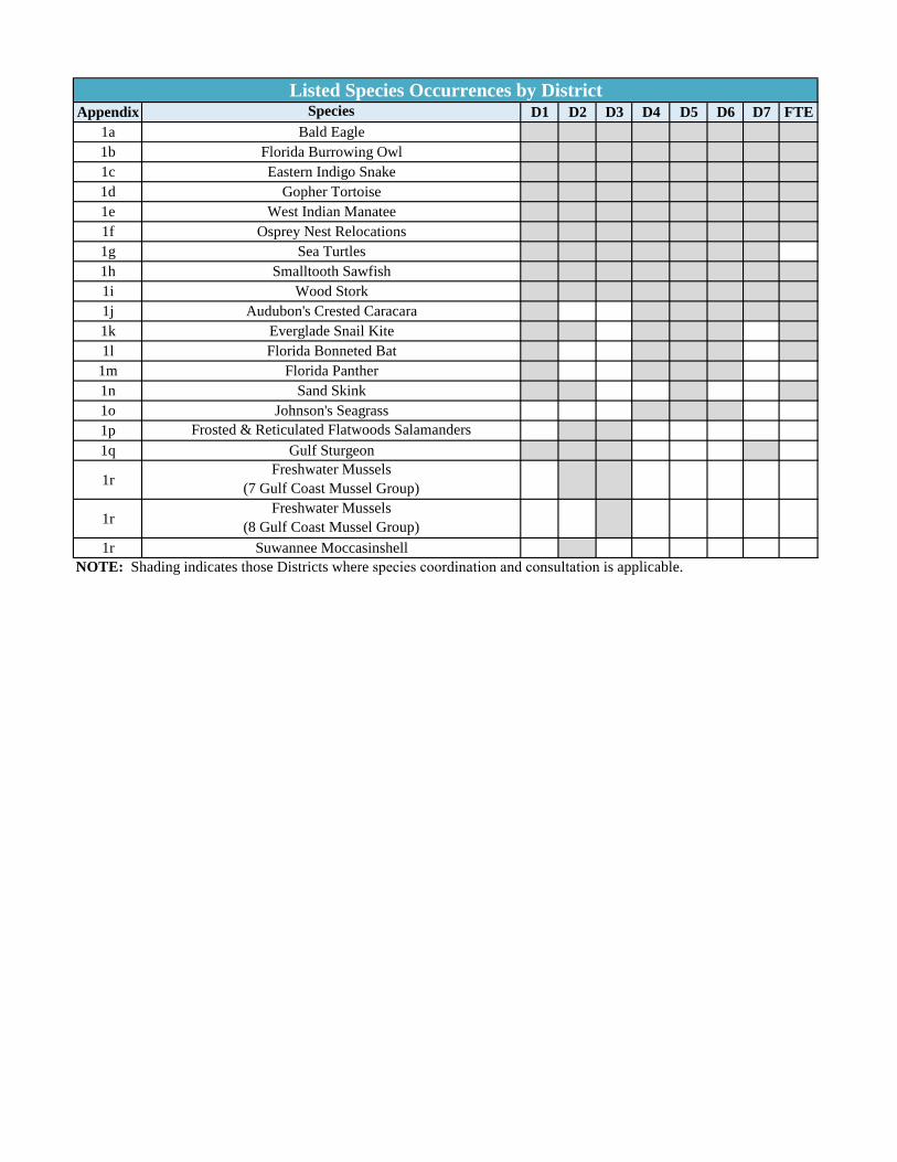
Appendix Species D1 D2 D3 D4 D5 D6 D7 FTE1a Bald Eagle1b Florida Burrowing Owl1c Eastern Indigo Snake1d Gopher Tortoise1e West Indian Manatee1f Osprey Nest Relocations1g Sea Turtles1h Smalltooth Sawfish1i Wood Stork1j Audubon's Crested Caracara1k Everglade Snail Kite1l Florida Bonneted Bat
1m Florida Panther1n Sand Skink1o Johnson's Seagrass1p Frosted & Reticulated Flatwoods Salamanders1q Gulf Sturgeon
1rFreshwater Mussels
(7 Gulf Coast Mussel Group)
1rFreshwater Mussels
(8 Gulf Coast Mussel Group)1r Suwannee Moccasinshell
NOTE: Shading indicates those Districts where species coordination and consultation is applicable.
Listed Species Occurrences by District

Appendix Permit Type D1 D2 D3 D4 D5 D6 D7 FTE2a Programmatic Agreements2b Regional General Permits2c Consumptive Water Use Permitting2d Wetland Mitigation2e Coastal Construction Control Line Permitting2f Section 408 Review & Permission2g Right-of-Way Occupancy Permit2h Water Control Districts2i Florida Keys National Marine Santuary Permitting2j Broward County Permitting2k Hillsborough County Permitting2l Leon County Permitting2m Miami-Dade County Permitting2n Palm Beach County Permitting
NOTE: Shading indicates those Districts where specialty permits are applicable.
Speciality Permits by District
2019 Appendix: Listed Species
LISTED SPECIES

2019 Appendix: Listed Species
APPENDIX 1a Bald Eagle
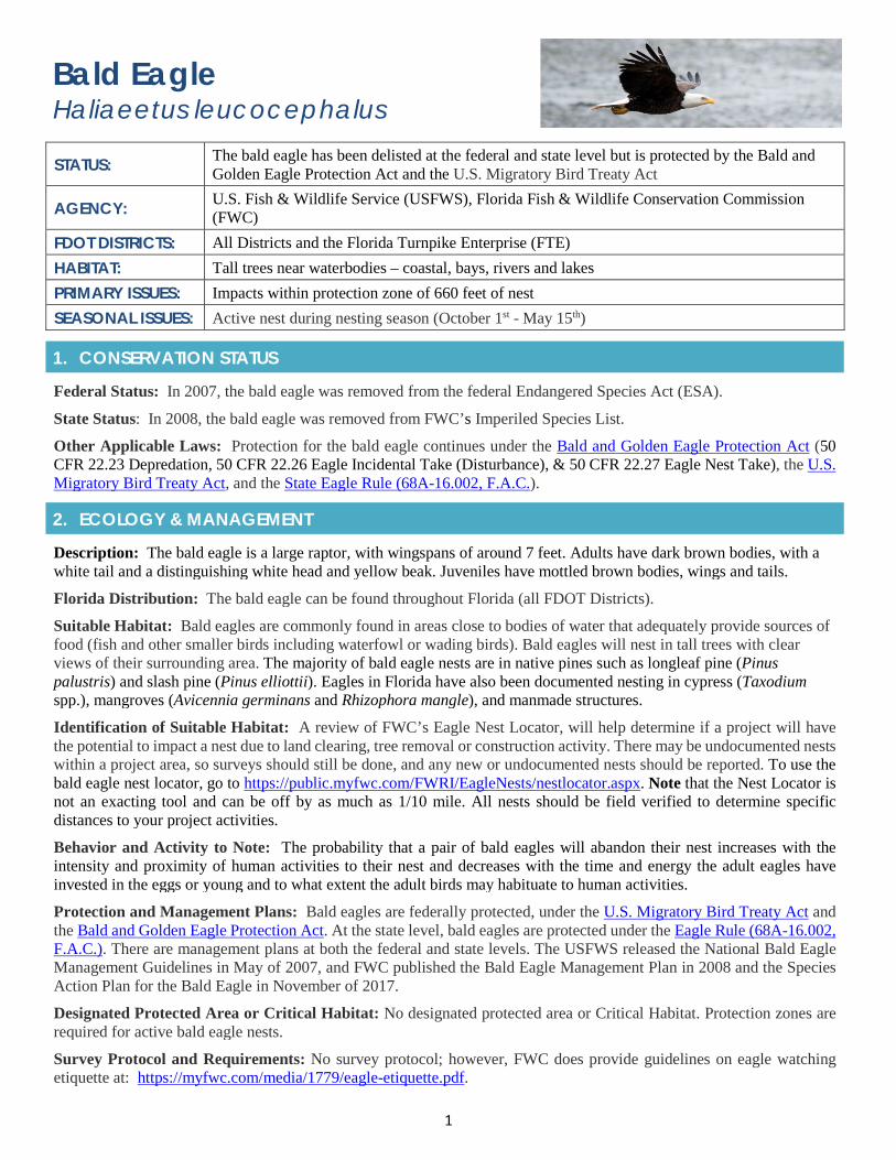
1
Bald Eagle Haliaeetus leucocephalus
STATUS: The bald eagle has been delisted at the federal and state level but is protected by the Bald and Golden Eagle Protection Act and the U.S. Migratory Bird Treaty Act
AGENCY: U.S. Fish & Wildlife Service (USFWS), Florida Fish & Wildlife Conservation Commission (FWC)
FDOT DISTRICTS: All Districts and the Florida Turnpike Enterprise (FTE) HABITAT: Tall trees near waterbodies – coastal, bays, rivers and lakes PRIMARY ISSUES: Impacts within protection zone of 660 feet of nest SEASONAL ISSUES: Active nest during nesting season (October 1st - May 15th)
1. CONSERVATION STATUS
Federal Status: In 2007, the bald eagle was removed from the federal Endangered Species Act (ESA).
State Status: In 2008, the bald eagle was removed from FWC’s Imperiled Species List.
Other Applicable Laws: Protection for the bald eagle continues under the Bald and Golden Eagle Protection Act (50 CFR 22.23 Depredation, 50 CFR 22.26 Eagle Incidental Take (Disturbance), & 50 CFR 22.27 Eagle Nest Take), the U.S. Migratory Bird Treaty Act, and the State Eagle Rule (68A-16.002, F.A.C.).
2. ECOLOGY & MANAGEMENT
Description: The bald eagle is a large raptor, with wingspans of around 7 feet. Adults have dark brown bodies, with a white tail and a distinguishing white head and yellow beak. Juveniles have mottled brown bodies, wings and tails.
Florida Distribution: The bald eagle can be found throughout Florida (all FDOT Districts).
Suitable Habitat: Bald eagles are commonly found in areas close to bodies of water that adequately provide sources of food (fish and other smaller birds including waterfowl or wading birds). Bald eagles will nest in tall trees with clear views of their surrounding area. The majority of bald eagle nests are in native pines such as longleaf pine (Pinus palustris) and slash pine (Pinus elliottii). Eagles in Florida have also been documented nesting in cypress (Taxodium spp.), mangroves (Avicennia germinans and Rhizophora mangle), and manmade structures.
Identification of Suitable Habitat: A review of FWC’s Eagle Nest Locator, will help determine if a project will have the potential to impact a nest due to land clearing, tree removal or construction activity. There may be undocumented nests within a project area, so surveys should still be done, and any new or undocumented nests should be reported. To use the bald eagle nest locator, go to https://public.myfwc.com/FWRI/EagleNests/nestlocator.aspx. Note that the Nest Locator is not an exacting tool and can be off by as much as 1/10 mile. All nests should be field verified to determine specific distances to your project activities.
Behavior and Activity to Note: The probability that a pair of bald eagles will abandon their nest increases with the intensity and proximity of human activities to their nest and decreases with the time and energy the adult eagles have invested in the eggs or young and to what extent the adult birds may habituate to human activities.
Protection and Management Plans: Bald eagles are federally protected, under the U.S. Migratory Bird Treaty Act and the Bald and Golden Eagle Protection Act. At the state level, bald eagles are protected under the Eagle Rule (68A-16.002, F.A.C.). There are management plans at both the federal and state levels. The USFWS released the National Bald Eagle Management Guidelines in May of 2007, and FWC published the Bald Eagle Management Plan in 2008 and the Species Action Plan for the Bald Eagle in November of 2017.
Designated Protected Area or Critical Habitat: No designated protected area or Critical Habitat. Protection zones are required for active bald eagle nests.
Survey Protocol and Requirements: No survey protocol; however, FWC does provide guidelines on eagle watching etiquette at: https://myfwc.com/media/1779/eagle-etiquette.pdf.
2
3. AGENCY COORDINATION (FEDERAL)
Responsible Agency(s): The USFWS and FWC are both responsible for the management of this species.
Type of Coordination: If an eagle or eagle nest may be affected by your project it may be necessary to obtain a federal (USFWS) eagle permit. To learn more, go to the USFWS Southeast Region eagle website. If you need additional technical assistance, please contact the USFWS Bald Eagle Biologist. For questions regarding the federal eagle permit application process, contact the USFWS Eagle Permit Coordinator. Coordination with the USFWS is necessary to determine if a permit is required when proposed activities exist within 660 feet, of a bald eagle’s nest.
Demonstrate Avoidance, Minimization, and Mitigation: Avoidance and minimization must be demonstrated to maintain a buffer of at least 660 feet between project activities and the nest, restrict any clearing, external construction or landscaping activities to outside the nesting season (outside the nesting season Oct 1- May 15), and; maintain established landscape buffers that screen the activity from the nest. To learn more, review the Bald Eagle Monitoring Guidelines.
Tools for Coordination: In 2016, USFWS published the Final Programmatic Environmental Impact Statement for the Eagle Rule Revision. This document provides a preferred alternative for updating permit regulations and regulatory compliance for incidental takes of bald eagles. Although not a formal species determination key, USFWS does provide step-by-step guidance in determining the level of coordination and permitting that may be necessary. Go to: https://www.fws.gov/southeast/our-services/eagle-technical-assistance/.
Special Provisions, or Standard Protection Measures: The FDOT special provision for bald eagles (SP0070104-2) should be included in the final specifications package. The 660-foot nesting buffer should be shown on project design plans and labelled accordingly.
General Timeframes for Consultation and Permitting: Consultation timeframes depend upon the level of proposed impacts, whether the nest is active or inactive, and distance of proposed work activity to a bald eagle’s nest.
4. PERMITTING
Prohibited Activities: The U.S. Migratory Bird Treaty Act and state wildlife code prohibits the take of birds, nests or eggs. No activity may injure, harm, harass or kill this species.
Activities Authorized by Permit: Permits can authorize incidental takes caused by public activities such as infrastructure development and maintenance and roadway construction. However, all efforts must be made to avoid disturbance and/or impact to eagles and their nests.
Note that an eagle nest removal permit is needed to remove or destroy an inactive eagle’s nest, and the USFWS Eagle Technical Assistance information should be consulted for guidance on proposed projects within 660 feet of the nest.
Note that since 2017, state permits are no longer needed for activities with the potential to take or disturb bald eagles or nests. Under a revision of the state’s Bald Eagle Rule (68A-16.002, F.A.C.), only a federal permit from USFWS is required. Two federal permitting regulations exist under the Bald and Golden Eagle Protection Act.
1. 50 CFR § 22.26 provides permits to take or disturb bald eagles when associated with but not the purpose ofthe activity and cannot practicably be avoided.
2. 50 CFR § 22.27 provides permits for removing eagle nests.
Permitting information, including applications and forms, can be found on the USFWS Southeast Region eagle website. Permitting questions can be directed to the USFWS Eagle Permit Coordinator at [email protected].
5. PRE-CONSTRUCTION & CONSTRUCTION COMPLIANCE
Review of Commitments: Bald Eagle commitments can be found within the Environmental Commitment Module in ProjectSuite Enterprise Edition (PSEE). If additional commitments are identified during design or permitting, coordinate with the Project Manager and add to the Environmental Commitment Module. The Design Project Manager will share the Project Commitment Module. The Design Project Manager will share the Project Commitment Record with Construction.
Review all Environmental Permits for Special Conditions: Review all environmental permits for Special Conditions related to bald eagle. Make sure that construction personnel have copies.
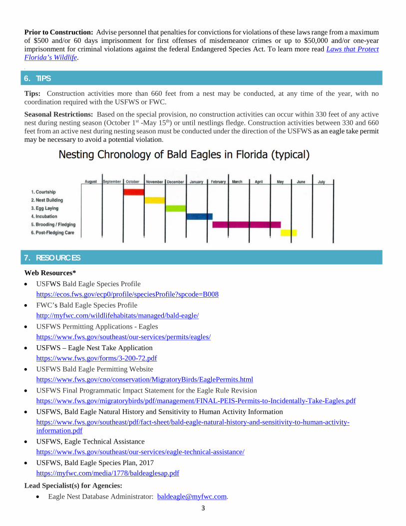
3
Prior to Construction: Advise personnel that penalties for convictions for violations of these laws range from a maximum of $500 and/or 60 days imprisonment for first offenses of misdemeanor crimes or up to $50,000 and/or one-year imprisonment for criminal violations against the federal Endangered Species Act. To learn more read Laws that Protect Florida’s Wildlife. .
6. TIPS
Tips: Construction activities more than 660 feet from a nest may be conducted, at any time of the year, with no coordination required with the USFWS or FWC.
Seasonal Restrictions: Based on the special provision, no construction activities can occur within 330 feet of any active nest during nesting season (October 1st -May 15th) or until nestlings fledge. Construction activities between 330 and 660 feet from an active nest during nesting season must be conducted under the direction of the USFWS as an eagle take permit may be necessary to avoid a potential violation.
7. RESOURCES
Web Resources*• USFWS Bald Eagle Species Profile
https://ecos.fws.gov/ecp0/profile/speciesProfile?spcode=B008• FWC’s Bald Eagle Species Profile
http://myfwc.com/wildlifehabitats/managed/bald-eagle/• USFWS Permitting Applications - Eagles
https://www.fws.gov/southeast/our-services/permits/eagles/• USFWS – Eagle Nest Take Application
https://www.fws.gov/forms/3-200-72.pdf• USFWS Bald Eagle Permitting Website
https://www.fws.gov/cno/conservation/MigratoryBirds/EaglePermits.html• USFWS Final Programmatic Impact Statement for the Eagle Rule Revision
https://www.fws.gov/migratorybirds/pdf/management/FINAL-PEIS-Permits-to-Incidentally-Take-Eagles.pdf• USFWS, Bald Eagle Natural History and Sensitivity to Human Activity Information
https://www.fws.gov/southeast/pdf/fact-sheet/bald-eagle-natural-history-and-sensitivity-to-human-activity-information.pdf
• USFWS, Eagle Technical Assistancehttps://www.fws.gov/southeast/our-services/eagle-technical-assistance/
• USFWS, Bald Eagle Species Plan, 2017https://myfwc.com/media/1778/baldeaglesap.pdf
Lead Specialist(s) for Agencies: • Eagle Nest Database Administrator: [email protected].
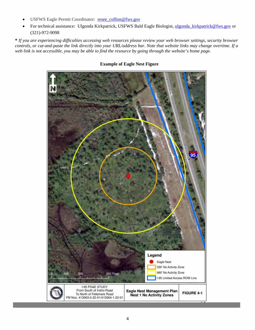
4
• USFWS Eagle Permit Coordinator: [email protected]• For technical assistance: Ulgonda Kirkpatrick, USFWS Bald Eagle Biologist, [email protected] or
(321)-972-9098
* If you are experiencing difficulties accessing web resources please review your web browser settings, security browsercontrols, or cut-and-paste the link directly into your URL/address bar. Note that website links may change overtime. If aweb link is not accessible, you may be able to find the resource by going through the website’s home page.
Example of Eagle Nest Figure

2019 Appendix: Listed Species
APPENDIX 1b Florida Burrowing Owl
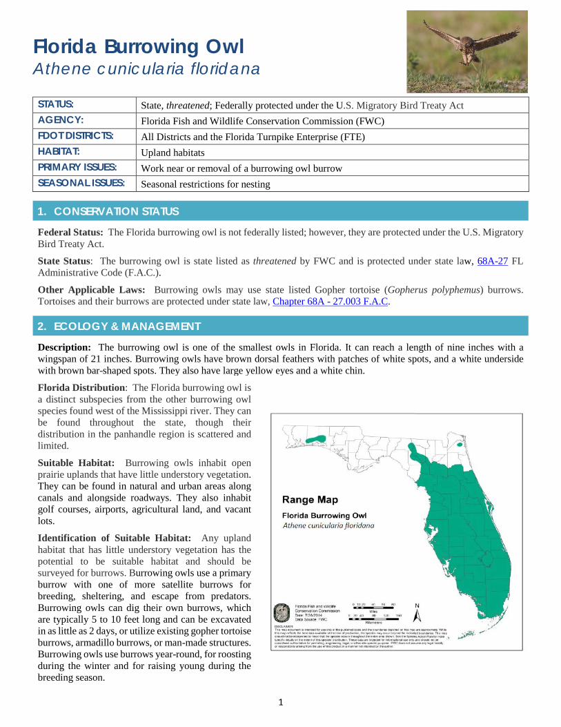
1
Florida Burrowing Owl Athene cunicularia floridana
STATUS: State, threatened; Federally protected under the U.S. Migratory Bird Treaty Act AGENCY: Florida Fish and Wildlife Conservation Commission (FWC) FDOT DISTRICTS: All Districts and the Florida Turnpike Enterprise (FTE) HABITAT: Upland habitats PRIMARY ISSUES: Work near or removal of a burrowing owl burrow SEASONAL ISSUES: Seasonal restrictions for nesting
1. CONSERVATION STATUS
Federal Status: The Florida burrowing owl is not federally listed; however, they are protected under the U.S. Migratory Bird Treaty Act.
State Status: The burrowing owl is state listed as threatened by FWC and is protected under state law, 68A-27 FL Administrative Code (F.A.C.).
Other Applicable Laws: Burrowing owls may use state listed Gopher tortoise (Gopherus polyphemus) burrows. Tortoises and their burrows are protected under state law, Chapter 68A - 27.003 F.A.C.
2. ECOLOGY & MANAGEMENT
Description: The burrowing owl is one of the smallest owls in Florida. It can reach a length of nine inches with a wingspan of 21 inches. Burrowing owls have brown dorsal feathers with patches of white spots, and a white underside with brown bar-shaped spots. They also have large yellow eyes and a white chin.
Florida Distribution: The Florida burrowing owl is a distinct subspecies from the other burrowing owl species found west of the Mississippi river. They can be found throughout the state, though their distribution in the panhandle region is scattered and limited.
Suitable Habitat: Burrowing owls inhabit open prairie uplands that have little understory vegetation. They can be found in natural and urban areas along canals and alongside roadways. They also inhabit golf courses, airports, agricultural land, and vacant lots.
Identification of Suitable Habitat: Any upland habitat that has little understory vegetation has the potential to be suitable habitat and should be surveyed for burrows. Burrowing owls use a primary burrow with one of more satellite burrows for breeding, sheltering, and escape from predators. Burrowing owls can dig their own burrows, which are typically 5 to 10 feet long and can be excavated in as little as 2 days, or utilize existing gopher tortoise burrows, armadillo burrows, or man-made structures. Burrowing owls use burrows year-round, for roosting during the winter and for raising young during the breeding season.
2
Behavior and Activity to Note: The burrowing owl can be found at the edge of their burrows or on a nearby post. They are active during both day and night and feed on insects, snakes, frogs, lizards, birds, and rodents. They ungulate while in flight and can also hover, which is often performed while foraging. Most often burrowing owls are found in a single breeding pair or loose colonies in open habitats that offer low groundcover.
Protection and Management Plans: An FWC Species Action Plan has been developed with the goal of improving the conservation status of the burrowing owl.
Designated Protection Area or Critical Habitat: The burrowing owl is protected state-wide. No specified Consultation or Focal Zones are established. Areas within 10-feet of an inactive burrow or 33 feet of an active burrow during nesting season (February 15 to July 10) require coordination with FWC.
Survey Protocol and Requirements: FWC has developed Recommended Burrowing Owl Survey Methodology. When surveying note that burrow entrances range from 3 to 8 inches in diameter. Established burrows may already be marked with white PVC pipes or T-perches placed for the birds.
3. AGENCY COORDINATION (STATE)
Responsible Agency(s): The burrowing owl is protected by FWC as a threatened species. They are also protected by the U.S. Fish and Wildlife Service (USFWS) through the U.S. Migratory Bird Treaty Act.
Type of Coordination: As a state listed species, consultation occurs with FWC if any impacts to owls or burrows is anticipated. Permits are required prior to construction for incidental take. If impacts to the species are known prior to construction, burrowing owls can be relocated through an incidental take permit issued by FWC, and mitigation is required. More information can be found in the Species Conservation Measures and Permitting Guidelines.
Demonstrate Avoidance, Minimization, and Mitigation: Avoidance strategies may include moving project limits to avoid burrowing owl habitat. Working around an owl burrow is often the best scenario for the owls and the contractor because no permits are required, and construction can take place if a 10-foot buffer zone is maintained for nests outside of the breeding season (inactive nests) and a 33-foot buffer for active nests during the breeding season (February 15 to July 10, though owls can breed earlier or later). To minimize the adverse impacts to the species when a nest is removed, the contractor is encouraged to place a “starter burrow” at a new location within the property. Additional options and criteria to determine which option is appropriate can be found in the Species Conservation Measures and Permitting Guidelines.
Special Provisions, or Standard Protection Measures: No special provisions; however, FWC does have Recommended Conservation Practices for borrowing owl listed within its Species Conservation Measures and Permitting Guidelines.
General Timeframes for Consultation and Permitting: Early consultation is highly recommended if impacts are anticipated to the Florida burrowing owl. Note that avoidance of the burrow is often the best scenario for the owls and the contractor because no permits are required.
4. PERMITTING
Prohibited Activities: Burrowing owls use their burrows year-round, so impacts to burrows can result in take via harassment by disrupting breeding and sheltering activities. Collapsing or blocking of burrows can result in harm if burrowing owls are injured or killed or if eggs are destroyed. Disturbance near burrows during the breeding season can disrupting breeding. Burrowing owls require sufficient foraging habitat around their burrows, and reducing available habitat can constitute take.
Exemptions: Minor projects that do not occur within 10 feet of a burrow outside of nesting season or within 33 feet of a burrow in the nesting season (February 15 to July 10, though owls can breed earlier or later ) do not require a permit.
Activities Authorized by Permit: FWC will permit the removal of an active burrow but the applicant will have to wait until the end of the nesting season before construction can begin. Burrowing owl nesting season is from February 15 through July 10. Note that even if no burrowing owls are observed at a burrow, the burrow may not be removed without a permit issued by the FWC. If an active nest needs to be relocated, FWC may issue a take permit for the owl burrow only as a last resort. FWC typically issues a permit only for collapse of burrows that do not contain eggs or flightless young, except in situations involving health and human safety. The applicant must demonstrate that all reasonable alternatives have been reviewed.
3
5. PRE-CONSTRUCTION & CONSTRUCTION COMPLIANCE
Review of Commitments: Commitments can be found within the Environmental Commitment Module in ProjectSuite Enterprise Edition (PSEE). If additional commitments are identified during design or permitting, coordinate with the Project Manager and add to the Environmental Commitment Module. The Design Project Manager will share the Project Commitment Record with Construction.
Review of Environmental Permits for Special Conditions: Review all environmental permits for Special Conditions related to burrowing owl. Make sure that construction personnel have copies.
Prior to Construction: Advise personnel that penalties for convictions for violations of these laws range from a maximum of $500 and/or 60 days imprisonment for first offenses of misdemeanor crimes or up to $50,000 and/or one year imprisonment for criminal violations against the federal Endangered Species Act. To learn more read Laws that Protect Florida’s Wildlife.
6. TIPS
Tips: In coordination with FDOT’s Office of Environmental Management (OEM), reach out to your local FWC representative. Field visits are needed to determine whether burrows are found within your project area.
Seasonal Restrictions: Projects occurring during the burrowing owl nesting season (February 15 to July 10) must get a permit if work activities are anticipated within a 33-foot buffer from the burrow, whereas the buffer is only 10-feet from the burrow outside of the nesting season.
Survey Restrictions: FWC requires that all burrowing owl surveys be conducted by an FWC certified agent that has the following level of expertise: • 10 hours observing burrowing owl behavior in the field• Documented experience using a burrow video-scope• Documentation of excavating 10 burrows
To learn more, go to FWC’s Species Conservation Measures and Permitting Guidelines.
7. RESOURCES
Web Resources*• FWC’s Burrowing Owl Guidelines
https://myfwc.com/wildlifehabitats/wildlife/species-guidelines/
• FWC’s Burrowing Owl Pagehttps://myfwc.com/wildlifehabitats/profiles/birds/owls/burrowing-owl/
• FWC’s Florida Burrowing Owl Biological Status Review Reporthttps://myfwc.com/media/1959/fl-burrowing-owl-bsr.pdf
• FWC’s Florida Burrowing Owl Biological Status Review Supplemental Informationhttps://myfwc.com/media/2163/burrowing-owl-supplemental-information.pdf
• FWC’s Florida’s Breeding Bird Atlashttp://legacy.myfwc.com/bba/docs/bba_BUOW.pdf
• FWC’s Burrowing Owl Species Conservation Measures and Permitting Guidelineshttps://myfwc.com/media/2028/floridaburrowingowlguidelines-2018.pdf
• FWC’s Burrowing Owl Species Action Planhttps://myfwc.com/media/2113/burrowing-owl-species-action-plan-final-draft.pdf
Lead Specialist(s) for Agencies: Please contact the FWC’s Protected Species Permitting Office with questions or for further assistance ([email protected], (850) 921-5990).
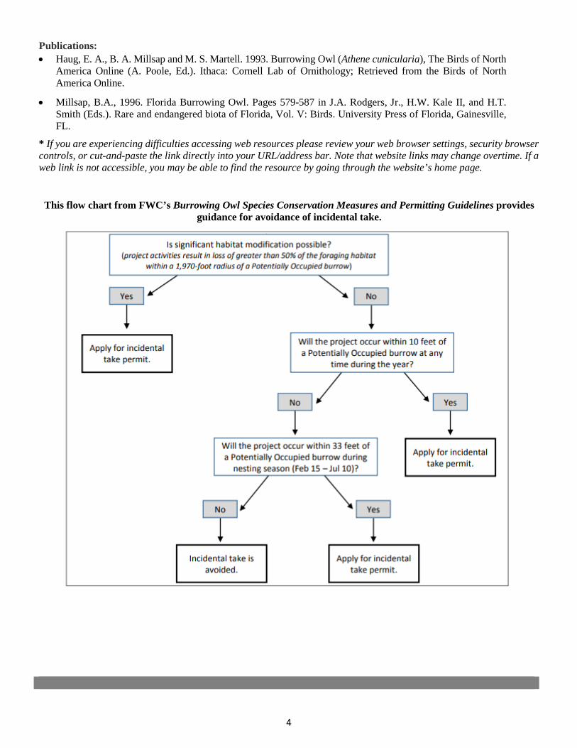
4
Publications: • Haug, E. A., B. A. Millsap and M. S. Martell. 1993. Burrowing Owl (Athene cunicularia), The Birds of North
America Online (A. Poole, Ed.). Ithaca: Cornell Lab of Ornithology; Retrieved from the Birds of NorthAmerica Online.
• Millsap, B.A., 1996. Florida Burrowing Owl. Pages 579-587 in J.A. Rodgers, Jr., H.W. Kale II, and H.T.Smith (Eds.). Rare and endangered biota of Florida, Vol. V: Birds. University Press of Florida, Gainesville,FL.
* If you are experiencing difficulties accessing web resources please review your web browser settings, security browsercontrols, or cut-and-paste the link directly into your URL/address bar. Note that website links may change overtime. If aweb link is not accessible, you may be able to find the resource by going through the website’s home page.
This flow chart from FWC’s Burrowing Owl Species Conservation Measures and Permitting Guidelines provides guidance for avoidance of incidental take.

2019 Appendix: Listed Species
APPENDIX 1c Eastern Indigo Snake
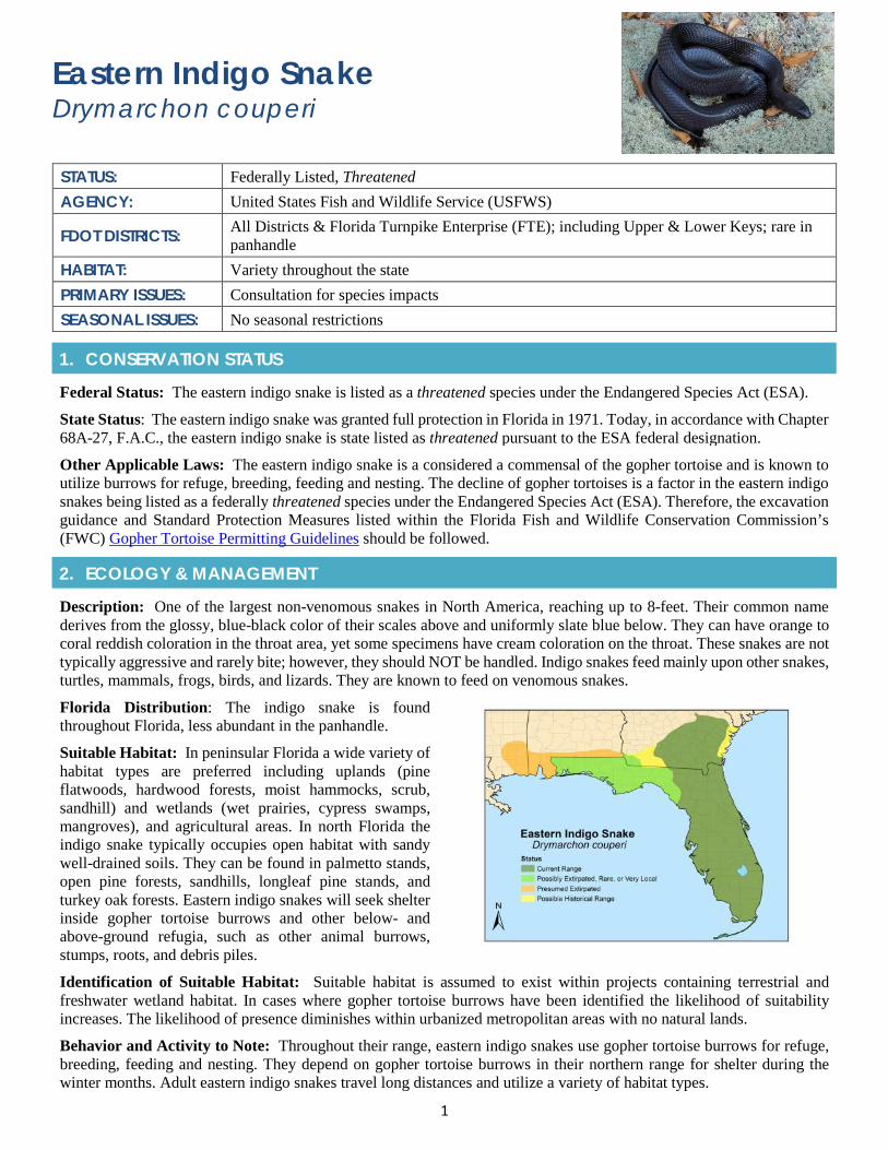
1
Eastern Indigo Snake Drymarchon couperi
STATUS: Federally Listed, Threatened AGENCY: United States Fish and Wildlife Service (USFWS)
FDOT DISTRICTS: All Districts & Florida Turnpike Enterprise (FTE); including Upper & Lower Keys; rare in panhandle
HABITAT: Variety throughout the state PRIMARY ISSUES: Consultation for species impacts SEASONAL ISSUES: No seasonal restrictions
1. CONSERVATION STATUS
Federal Status: The eastern indigo snake is listed as a threatened species under the Endangered Species Act (ESA).
State Status: The eastern indigo snake was granted full protection in Florida in 1971. Today, in accordance with Chapter 68A-27, F.A.C., the eastern indigo snake is state listed as threatened pursuant to the ESA federal designation.
Other Applicable Laws: The eastern indigo snake is a considered a commensal of the gopher tortoise and is known to utilize burrows for refuge, breeding, feeding and nesting. The decline of gopher tortoises is a factor in the eastern indigo snakes being listed as a federally threatened species under the Endangered Species Act (ESA). Therefore, the excavation guidance and Standard Protection Measures listed within the Florida Fish and Wildlife Conservation Commission’s (FWC) Gopher Tortoise Permitting Guidelines should be followed.
2. ECOLOGY & MANAGEMENT
Description: One of the largest non-venomous snakes in North America, reaching up to 8-feet. Their common name derives from the glossy, blue-black color of their scales above and uniformly slate blue below. They can have orange to coral reddish coloration in the throat area, yet some specimens have cream coloration on the throat. These snakes are not typically aggressive and rarely bite; however, they should NOT be handled. Indigo snakes feed mainly upon other snakes, turtles, mammals, frogs, birds, and lizards. They are known to feed on venomous snakes.
Florida Distribution: The indigo snake is found throughout Florida, less abundant in the panhandle.
Suitable Habitat: In peninsular Florida a wide variety of habitat types are preferred including uplands (pine flatwoods, hardwood forests, moist hammocks, scrub, sandhill) and wetlands (wet prairies, cypress swamps, mangroves), and agricultural areas. In north Florida the indigo snake typically occupies open habitat with sandy well-drained soils. They can be found in palmetto stands, open pine forests, sandhills, longleaf pine stands, and turkey oak forests. Eastern indigo snakes will seek shelter inside gopher tortoise burrows and other below- and above-ground refugia, such as other animal burrows, stumps, roots, and debris piles.
Identification of Suitable Habitat: Suitable habitat is assumed to exist within projects containing terrestrial and freshwater wetland habitat. In cases where gopher tortoise burrows have been identified the likelihood of suitability increases. The likelihood of presence diminishes within urbanized metropolitan areas with no natural lands.
Behavior and Activity to Note: Throughout their range, eastern indigo snakes use gopher tortoise burrows for refuge, breeding, feeding and nesting. They depend on gopher tortoise burrows in their northern range for shelter during the winter months. Adult eastern indigo snakes travel long distances and utilize a variety of habitat types.

2
Protection and Management Plans: The USFWS published its Eastern Indigo Snake Recovery Plan in 1982. The objective of the Recovery Plan is ensuring indigo snake populations exist and are reproducing and protected where suitable habitat still exists within the historic range of the species.
Protection Area or Critical Habitat: There is no designated critical habitat for the eastern indigo snake.
Survey Protocol and Requirements: The USFWS has developed survey protocol for northern and central Florida. The survey protocol is to provide a tool to improve the review of permit applications and proposed land clearing activities for potential effects on the eastern indigo snake.
3. AGENCY CONSULTATION (FEDERAL)
Responsible Agency(s): Under section 7(a)(2) of the ESA, USFWS consults with federal agencies proposing actions that may affect the eastern indigo snake. In addition, FWC provides comments regarding potential impacts to eastern indigo snake to Florida Department of Environmental Protection (FDEP) and Water Management Districts (WMD) under the authority of Chapter 20.331 Florida Statutes.
Federal Nexus for Consultation: Section 7(a)(2) of the ESA requires that all federal agencies consult with USFWS to ensure that any action authorized, funded, or carried out by the agency is not likely to jeopardize the continued existence of the eastern indigo snake.
Type of Consultation: The type of consultation, informal and formal, will depend on results of FDOT’s analysis of whether the proposed project will have an adverse effect on the species. If a proposed federal action is likely to adversely affect (May affect), the eastern indigo snake, then formal consultation is required. For May affect, but not likely to adversely affect an informal consultation would be required.
Demonstrate Avoidance, Minimization, and Mitigation: FDOT must demonstrate to USFWS that it is making all efforts to avoid and minimize impacts to the eastern indigo snake.
Tool for Section 7 ESA Consultation: The USFWS has developed an Eastern Indigo Snake Programmatic Effect Determination Key for south and north Florida. The purpose of the Key is to assist the federal action agency in making appropriate effects determinations under section 7 of the ESA and streamline informal consultation when the project action can be walked through the Key. If the use of the Key results in a determination of no effect or not likely to adversely affect (NLAA), the USFWS will concur with this determination and no additional correspondence will be necessary.
Special Provisions, or Standard Protection Measures: The USFWS has developed Standard Protection Measures for the Eastern Indigo Snake. In addition, FDOT has Special Provisions when eastern indigo snake are known to be found within the proposed project area.
General Timeframes for Consultation and Permitting: Early coordination is recommended if impacts are anticipated as Formal Consultation can take as long as 135 days.
4. PERMITTING
Prohibited Activities: Only individuals currently authorized through an issued Incidental Take Statement in association with a USFWS Biological Opinion, or by a Section 10(a)(1)(A) permit issued by the USFWS, can handle an eastern indigo snake.
Activities Authorized by Permit: Permit authorization is based on the proposed project location and description; the potential effects to the eastern indigo snake and any measures (such as project components, standard construction precautions, or special conditions included in the authorization) to avoid or minimize those effects.
5. PRE-CONSTRUCTION & CONSTRUCTION COMPLIANCE
Review of Commitments: Commitments can be found within the Environmental Commitment Module in ProjectSuite Enterprise Edition (PSEE). If additional commitments are identified during design or permitting, coordinate with the Project Manager and add to the Environmental Commitment Module. The Design Project Manager will share the Project Commitment Record with Construction.
Review of Environmental Permits for Special Conditions: Review all environmental permits for Special Conditions related to eastern indigo snake. Make sure construction personnel have copies.
3
Prior to Construction: Advise personnel that penalties for convictions for violations of these laws range from a maximum of $500 and/or 60 days imprisonment for first offenses of misdemeanor crimes or up to $50,000 and/or one year imprisonment for criminal violations against the federal Endangered Species Act. To learn more read Laws that Protect Florida’s Wildlife.
6. TIPS
Tips: The USFWS typically will concur with FDOT when the Department’s individual projects receives a not likely to adversely affect (NLAA) determination from the Species Determination Key and FDOT commits to following USFWS’s Standard Protection Measures for the Eastern Indigo Snake during project site preparation and project construction.
Seasonal Restrictions: No seasonal restrictions.
Survey Restrictions: Follow the USFWS survey protocol for northern and central Florida.
7. RESOURCES
Web Resources*
• USFWS Eastern Indigo Snake Survey Protocol – North and Central Floridahttps://www.fws.gov/northflorida/indigosnakes/20110930_NFESO_EIS_survey_protocol_no_appendices.pdf
• Eastern Indigo Snake Survey Protocol FAQ’shttps://www.fws.gov/northflorida/indigosnakes/20110930_NFESO_EIS_survey_protocol_Appendix_A.pdf
• USFWS Eastern Indigo Survey Data Sheethttps://www.fws.gov/northflorida/indigosnakes/20110930_NFESO_EIS_survey_protocol_Appendix_B.pdf
• USFWS Eastern Indigo Snake Brochurehttps://www.fws.gov/northflorida/indigosnakes/20130812_EIS%20Brochure_final.pdf
• USFWS Eastern Indigo Snake Posterhttps://www.fws.gov/northflorida/indigosnakes/20130812_EIS%20Poster_final.pdf
• USFWS Eastern Indigo Snake Protection Measureshttps://www.fws.gov/northflorida/indigosnakes/20130812_EIS%20Standard%20Protection%20Measures_final.pdf
• USFWS Eastern Indigo Snake Key Northern Florida (2013)https://www.fws.gov/northflorida/indigosnakes/20130813_ltr_Update_addendum_2010_COE_Programmatic_EIS_Key.pdf
• USFWS Eastern Indigo Snake Key Southern Florida (2017)https://www.fws.gov/verobeach/ReptilesPDFs/20170801_letter_Service%20to%20Corps_Revised%20EIS%20Key.pdf
• FWC Eastern Indigo Snake Profilehttp://myfwc.com/wildlifehabitats/imperiled/profiles/reptiles/eastern-indigo-snake/
• FNAI Eastern Indigo Snake Profilehttp://www.fnai.org/FieldGuide/pdf/Drymarchon_couperi.pdf
• UF Black Snake Identification Documenthttp://edis.ifas.ufl.edu/uw251
• Recognizing Florida’s Venomous Snakeshttp://ufwildlife.ifas.ufl.edu/pdfs/KnowFLVenomousSnakes.pdf
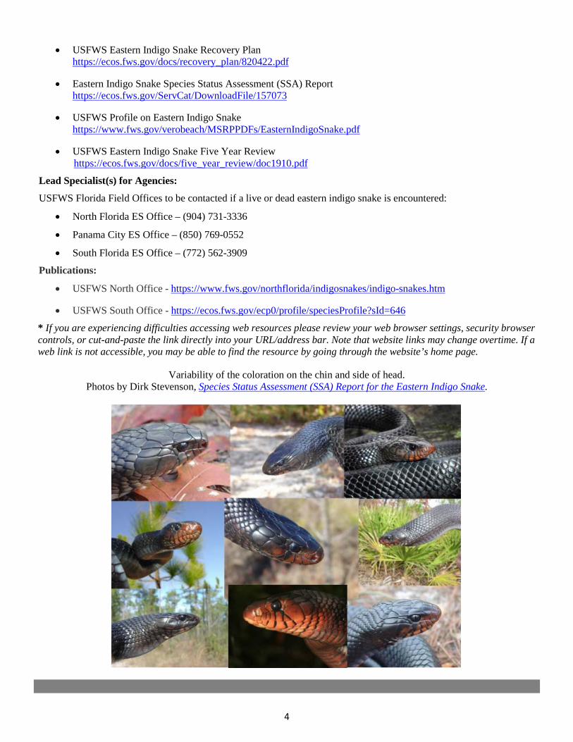
4
• USFWS Eastern Indigo Snake Recovery Planhttps://ecos.fws.gov/docs/recovery_plan/820422.pdf
• Eastern Indigo Snake Species Status Assessment (SSA) Reporthttps://ecos.fws.gov/ServCat/DownloadFile/157073
• USFWS Profile on Eastern Indigo Snakehttps://www.fws.gov/verobeach/MSRPPDFs/EasternIndigoSnake.pdf
• USFWS Eastern Indigo Snake Five Year Reviewhttps://ecos.fws.gov/docs/five_year_review/doc1910.pdf
Lead Specialist(s) for Agencies:
USFWS Florida Field Offices to be contacted if a live or dead eastern indigo snake is encountered:
• North Florida ES Office – (904) 731-3336
• Panama City ES Office – (850) 769-0552
• South Florida ES Office – (772) 562-3909
Publications:
• USFWS North Office - https://www.fws.gov/northflorida/indigosnakes/indigo-snakes.htm
• USFWS South Office - https://ecos.fws.gov/ecp0/profile/speciesProfile?sId=646
* If you are experiencing difficulties accessing web resources please review your web browser settings, security browsercontrols, or cut-and-paste the link directly into your URL/address bar. Note that website links may change overtime. If aweb link is not accessible, you may be able to find the resource by going through the website’s home page.
Variability of the coloration on the chin and side of head. Photos by Dirk Stevenson, Species Status Assessment (SSA) Report for the Eastern Indigo Snake.

2019 Appendix: Listed Species
APPENDIX 1d Gopher Tortoise
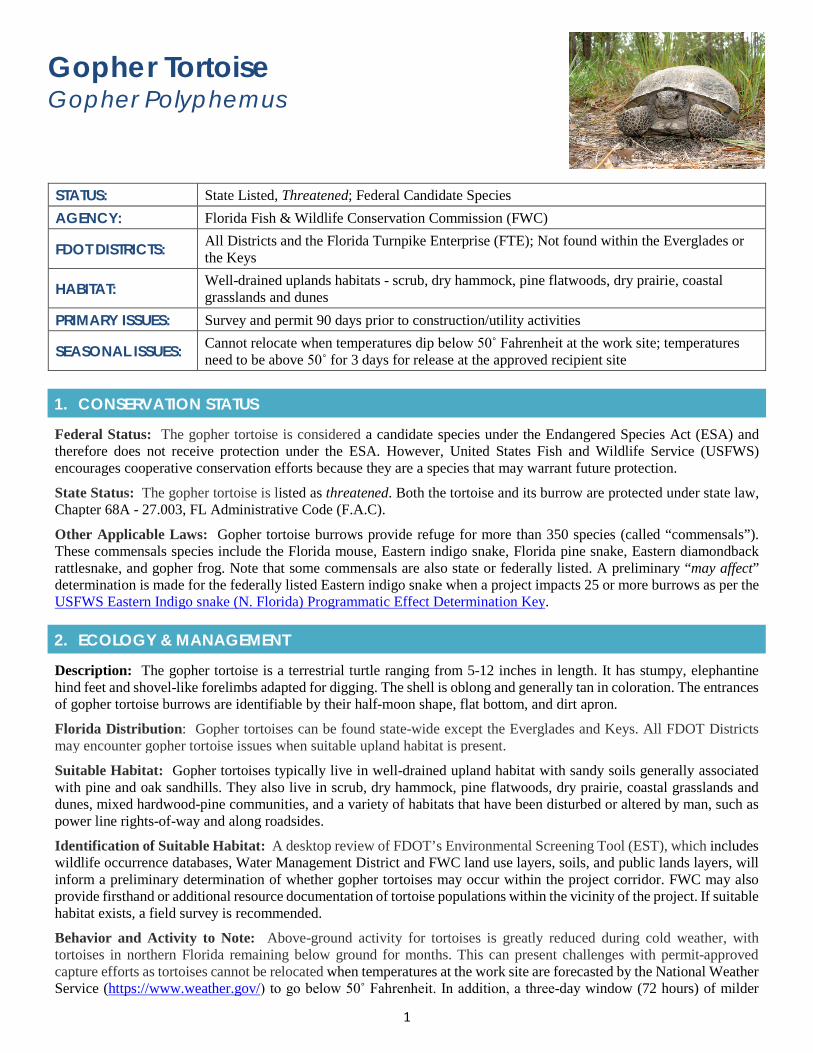
1
Gopher Tortoise Gopher Polyphemus
STATUS: State Listed, Threatened; Federal Candidate Species AGENCY: Florida Fish & Wildlife Conservation Commission (FWC)
FDOT DISTRICTS: All Districts and the Florida Turnpike Enterprise (FTE); Not found within the Everglades or the Keys
HABITAT: Well-drained uplands habitats - scrub, dry hammock, pine flatwoods, dry prairie, coastal grasslands and dunes
PRIMARY ISSUES: Survey and permit 90 days prior to construction/utility activities
SEASONAL ISSUES: Cannot relocate when temperatures dip below 50˚ Fahrenheit at the work site; temperatures need to be above 50˚ for 3 days for release at the approved recipient site
1. CONSERVATION STATUS
Federal Status: The gopher tortoise is considered a candidate species under the Endangered Species Act (ESA) and therefore does not receive protection under the ESA. However, United States Fish and Wildlife Service (USFWS) encourages cooperative conservation efforts because they are a species that may warrant future protection.
State Status: The gopher tortoise is listed as threatened. Both the tortoise and its burrow are protected under state law, Chapter 68A - 27.003, FL Administrative Code (F.A.C).
Other Applicable Laws: Gopher tortoise burrows provide refuge for more than 350 species (called “commensals”). These commensals species include the Florida mouse, Eastern indigo snake, Florida pine snake, Eastern diamondback rattlesnake, and gopher frog. Note that some commensals are also state or federally listed. A preliminary “may affect” determination is made for the federally listed Eastern indigo snake when a project impacts 25 or more burrows as per the USFWS Eastern Indigo snake (N. Florida) Programmatic Effect Determination Key.
2. ECOLOGY & MANAGEMENT
Description: The gopher tortoise is a terrestrial turtle ranging from 5-12 inches in length. It has stumpy, elephantine hind feet and shovel-like forelimbs adapted for digging. The shell is oblong and generally tan in coloration. The entrances of gopher tortoise burrows are identifiable by their half-moon shape, flat bottom, and dirt apron.
Florida Distribution: Gopher tortoises can be found state-wide except the Everglades and Keys. All FDOT Districts may encounter gopher tortoise issues when suitable upland habitat is present.
Suitable Habitat: Gopher tortoises typically live in well-drained upland habitat with sandy soils generally associated with pine and oak sandhills. They also live in scrub, dry hammock, pine flatwoods, dry prairie, coastal grasslands and dunes, mixed hardwood-pine communities, and a variety of habitats that have been disturbed or altered by man, such as power line rights-of-way and along roadsides.
Identification of Suitable Habitat: A desktop review of FDOT’s Environmental Screening Tool (EST), which includes wildlife occurrence databases, Water Management District and FWC land use layers, soils, and public lands layers, will inform a preliminary determination of whether gopher tortoises may occur within the project corridor. FWC may also provide firsthand or additional resource documentation of tortoise populations within the vicinity of the project. If suitable habitat exists, a field survey is recommended.
Behavior and Activity to Note: Above-ground activity for tortoises is greatly reduced during cold weather, with tortoises in northern Florida remaining below ground for months. This can present challenges with permit-approved capture efforts as tortoises cannot be relocated when temperatures at the work site are forecasted by the National Weather Service (https://www.weather.gov/) to go below 50˚ Fahrenheit. In addition, a three-day window (72 hours) of milder
2
overnight temperatures is required to allow the relocated tortoise(s) to settle into the recipient site and to reduce the chance of cold-related stress or mortality. If questions coordinate with FWC and your contracted recipient site.
Protection and Management Plans: A Gopher Tortoise Management Plan has been created in response to the continuing decline of the species and presents a suite of actions to achieve conservation objectives. These actions are organized into broad sections: regulations, permitting, local government coordination, law enforcement, habitat protection, habitat management, population management, disease management, incentives, monitoring, education and outreach, and research.
Designated Protection Area or Critical Habitat: There is no Critical Habitat designated for the gopher tortoise.
Survey Protocol and Requirements: FWC requires that all gopher tortoise surveys submitted for acquiring permits be performed by an Authorized Gopher Tortoise Agent and must be conducted no more than 90 days before an application is submitted to FWC. An authorized agent has completed FWC’s required training courses, and a list of agents can be found on FWC’s gopher tortoise permitting online website. More information can be found through FDOT’s Gopher Tortoise Guidance Document.
3. AGENCY COORDINATION (STATE)
Responsible Agency(s): The gopher tortoise is managed by the Fish and Wildlife Conservation Commission (FWC).
Agency Coordination: Coordination with FWC will be required through the gopher tortoise permitting process. If you have questions regarding gopher tortoise or permitting refer to the FWC Guidelines and/or FDOT Gopher Tortoise Guidelines.
Demonstrate Avoidance, Minimization, and Mitigation: There are three ways to address the presence of gopher tortoises: avoid disturbance of tortoise burrows, relocate tortoises on-site (permit required), or relocate them off-site (permit required). A disturbance is considered to include work within 25 feet of a tortoise burrow. Mitigation for gopher tortoise is the relocation of the animal to an FWC approved recipient site and the associated permit fees. Minimizing efforts can include, but are not limited to, installation of silt fencing to prevent tortoises from entering construction areas; education efforts for construction staff regarding gopher tortoise regulations; additional field surveys during construction; and tortoise signage (see FWC signage guidelines) within the construction footprint where appropriate to alert construction personal. Silt fencing is the most common way gopher tortoises are excluded from a project corridor. The silt fence must be installed according to FDOT’s Standard Specification 104-6.4.6 (trenched and taut). Repeated and diligent inspections and repairs are important to maintain functionality of the fence. It is important to note that gopher tortoises are attracted to recently cleared property and can enter a construction zone and dig a new burrow within one day.
Tools for Section 7 Consultation: No Federal Species Effects Determination Key has been developed for the tortoise.
Special Provisions, or Standard Protection Measures: There are no gopher tortoise standard protection provisions for construction; however, protective measures can be found within FWC’s Gopher Tortoise Permitting Guidelines and/or FDOT Gopher Tortoise Guidance Document. Note that the presence of gopher tortoises in the project area may be handled by using a Special Provisions, Modified Special Provisions (MSPs), project specific plan notes that include locations of burrows and exclusionary fencing and including copy of the permit in the contract package. The use of MSPs and Plan notes should be coordinated with the District Specifications Office before final plans are developed.
General Timeframes for Permitting: Gopher tortoise permitting can take 90 days, although most applications will be processed in 45 days or less. Timely issuance of permits is dependent on receipt of required documentation and permit fee. Note that a comprehensive, 100% burrow survey of all potential tortoise habitat proposed for development must be conducted no more than 90 days prior to, and no fewer than 72 hours before (excluding weekends and holidays) commencing gopher tortoise capture and relocation activities.
4. PERMITTING
Prohibited Activities: Activities that can lead to rule violations include, but are not limited to, clearing, grading, paving, bulldozing, digging, building construction, and site preparation for development without a permit. Examples of actions that are rule violations include the following: killing or causing direct harm to gopher tortoises; collapsing gopher tortoise burrow entrances or other parts of tortoise burrows without a permit; blocking, covering, or filling in gopher tortoise burrow entrances without a permit; placing harmful substances or devices inside gopher tortoise burrows; penning or
3
restricting gopher tortoises into small areas for more than 72 hours without a permit; altering gopher tortoise habitat to such an extent that resident tortoises are taken by such activities; excluding tortoises from their burrows without a permit; and, relocating or possessing tortoises without a permit.
Exemptions: Most typical activities associated with vegetation maintenance activities of the right-of-way (ROW) do not require a permit, provided they do not collapse gopher tortoise burrows or harm gopher tortoises. Examples include mowing and tree cutting.
Authorized Permitting Activities: The FWC uses a multi-tiered approach to permitting actions involving gopher tortoises. These permits are divided into three main types: 1) Authorized Agent permits, which authorize persons to survey, capture, transport, and release tortoises; 2) Site-specific relocation permits, which authorize capturing and relocation of tortoises either within the boundaries of the area being impacted (on-site) or from the area being impacted to a permitted recipient site (off-site); and 3) Recipient Site permits, which authorize the use of designated sites meeting specific criteria as recipient areas for tortoises.
Permit Fees: A mitigation contribution is required for all relocation permits. Mitigation contributions are assessed by determining the estimated number of tortoises impacted (typically the number of potentially occupied tortoise burrows to be impacted, divided by 2). A variable scale for additional contributions is based on the overall conservation value of the action being permitted and the estimated number of gopher tortoises being impacted. Preferred conservation actions, such as responsibly relocating tortoises to long-term protected lands, require a lower contribution per tortoise than relocations to short-term protected or unprotected lands or relocations associated with Disturbed Site permits. Other costs may be incurred by applicants obtaining permits or conducting activities related to gopher tortoises. Examples of such costs include fees paid to consultants, fees paid for on-site preparation for gopher tortoise related activities, and fees paid to owners of recipient areas. Establishing a method to pay the mitigation contributions associated with the permit, as well as per tortoise relocation fees, is important to identify early in order to ensure that fees do not hold up the process. See FDOT Mitigation Payment Processing Handbook.
5. PRE-CONSTRUCTION & CONSTRUCTION COMPLIANCE
Review of Commitments: Commitments can be found within the Environmental Commitment Module in ProjectSuite Enterprise Edition (PSEE). If additional commitments are identified during design or permitting coordinate with the Project Manager and add to the Environmental Commitment Module. The Design Project Manager will share the Project Commitment Record with Construction.
Review all Environmental Permits for Special Conditions: Review all environmental permits for Special Conditions related to gopher tortoise. Make sure construction personnel have copies. Note that FWC requires the Gopher Tortoise Agent to complete an After-Action Report once all the tortoises have been relocated.
Prior to Construction: Advise personnel that penalties for convictions for violations of these laws range from a maximum of $500 and/or 60 days imprisonment for first offenses of misdemeanor crimes or up to $50,000 and/or one-year imprisonment for criminal violations against the federal Endangered Species Act. To learn more read Laws that Protect Florida’s Wildlife, https://edis.ifas.ufl.edu/pdffiles/UW/UW07600.pdf.
6. TIPS
Tips: Watch out for utilities! They often conduct work prior to commencement of roadway construction and may require early relocation of gopher tortoises. When gopher tortoise burrows exist within the ROW for any FDOT project, the designated District office responsible for coordinating the gopher tortoise efforts should coordinate with the District Utility Office. This coordination should take place between 60 and 90 percent plans to address utility relocation (i.e., any earth disturbing utility work) anticipated for the project and, if conflicts exist, organize relocation efforts. The FWC Authorized Agent and/or backhoe operator must understand utility locations prior to digging.
Seasonal Restrictions: Above-ground activity for tortoises is greatly reduced during cold weather, with tortoises in northern Florida remaining below ground for months. This can present challenges with permit approved capture efforts as tortoise cannot be relocated when temperatures at the proposed work site are forecasted to go below 50˚ Fahrenheit. In addition, a three-day window (72 hours) of milder overnight temperatures is required to allow the relocated tortoise(s) to settle into the recipient site and to reduce the chance of cold-related stress or mortality. Moving a tortoise when temperatures are forecasted to be less than 50˚ at either the proposed construction site or the recipient site would be considered as a permit violation.
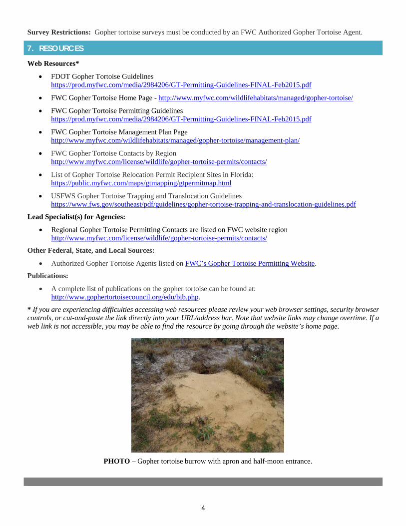
4
Survey Restrictions: Gopher tortoise surveys must be conducted by an FWC Authorized Gopher Tortoise Agent.
7. RESOURCES
Web Resources*
• FDOT Gopher Tortoise Guidelineshttps://prod.myfwc.com/media/2984206/GT-Permitting-Guidelines-FINAL-Feb2015.pdf
• FWC Gopher Tortoise Home Page - http://www.myfwc.com/wildlifehabitats/managed/gopher-tortoise/
• FWC Gopher Tortoise Permitting Guidelineshttps://prod.myfwc.com/media/2984206/GT-Permitting-Guidelines-FINAL-Feb2015.pdf
• FWC Gopher Tortoise Management Plan Pagehttp://www.myfwc.com/wildlifehabitats/managed/gopher-tortoise/management-plan/
• FWC Gopher Tortoise Contacts by Regionhttp://www.myfwc.com/license/wildlife/gopher-tortoise-permits/contacts/
• List of Gopher Tortoise Relocation Permit Recipient Sites in Florida:https://public.myfwc.com/maps/gtmapping/gtpermitmap.html
• USFWS Gopher Tortoise Trapping and Translocation Guidelineshttps://www.fws.gov/southeast/pdf/guidelines/gopher-tortoise-trapping-and-translocation-guidelines.pdf
Lead Specialist(s) for Agencies:
• Regional Gopher Tortoise Permitting Contacts are listed on FWC website regionhttp://www.myfwc.com/license/wildlife/gopher-tortoise-permits/contacts/
Other Federal, State, and Local Sources:
• Authorized Gopher Tortoise Agents listed on FWC’s Gopher Tortoise Permitting Website.
Publications:
• A complete list of publications on the gopher tortoise can be found at:http://www.gophertortoisecouncil.org/edu/bib.php.
* If you are experiencing difficulties accessing web resources please review your web browser settings, security browsercontrols, or cut-and-paste the link directly into your URL/address bar. Note that website links may change overtime. If aweb link is not accessible, you may be able to find the resource by going through the website’s home page.
PHOTO – Gopher tortoise burrow with apron and half-moon entrance.

2019 Appendix: Listed Species
APPENDIX 1e West Indian Manatee
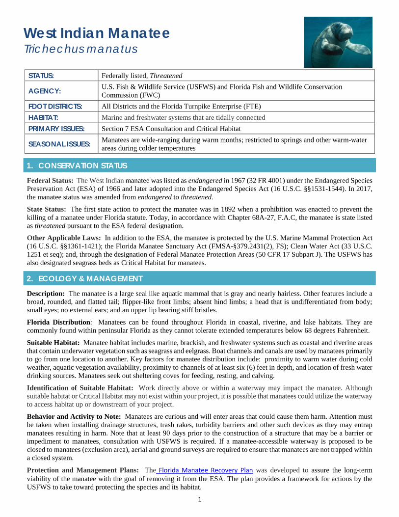
1
West Indian Manatee Trichechus manatus
STATUS: Federally listed, Threatened
AGENCY: U.S. Fish & Wildlife Service (USFWS) and Florida Fish and Wildlife Conservation Commission (FWC)
FDOT DISTRICTS: All Districts and the Florida Turnpike Enterprise (FTE) HABITAT: Marine and freshwater systems that are tidally connected PRIMARY ISSUES: Section 7 ESA Consultation and Critical Habitat
SEASONAL ISSUES: Manatees are wide-ranging during warm months; restricted to springs and other warm-water areas during colder temperatures
1. CONSERVATION STATUS
Federal Status: The West Indian manatee was listed as endangered in 1967 (32 FR 4001) under the Endangered Species Preservation Act (ESA) of 1966 and later adopted into the Endangered Species Act (16 U.S.C. §§1531-1544). In 2017, the manatee status was amended from endangered to threatened.
State Status: The first state action to protect the manatee was in 1892 when a prohibition was enacted to prevent the killing of a manatee under Florida statute. Today, in accordance with Chapter 68A-27, F.A.C, the manatee is state listed as threatened pursuant to the ESA federal designation.
Other Applicable Laws: In addition to the ESA, the manatee is protected by the U.S. Marine Mammal Protection Act (16 U.S.C. §§1361-1421); the Florida Manatee Sanctuary Act (FMSA-§379.2431(2), FS); Clean Water Act (33 U.S.C. 1251 et seq); and, through the designation of Federal Manatee Protection Areas (50 CFR 17 Subpart J). The USFWS has also designated seagrass beds as Critical Habitat for manatees.
2. ECOLOGY & MANAGEMENT
Description: The manatee is a large seal like aquatic mammal that is gray and nearly hairless. Other features include a broad, rounded, and flatted tail; flipper-like front limbs; absent hind limbs; a head that is undifferentiated from body; small eyes; no external ears; and an upper lip bearing stiff bristles.
Florida Distribution: Manatees can be found throughout Florida in coastal, riverine, and lake habitats. They are commonly found within peninsular Florida as they cannot tolerate extended temperatures below 68 degrees Fahrenheit.
Suitable Habitat: Manatee habitat includes marine, brackish, and freshwater systems such as coastal and riverine areas that contain underwater vegetation such as seagrass and eelgrass. Boat channels and canals are used by manatees primarily to go from one location to another. Key factors for manatee distribution include: proximity to warm water during cold weather, aquatic vegetation availability, proximity to channels of at least six (6) feet in depth, and location of fresh water drinking sources. Manatees seek out sheltering coves for feeding, resting, and calving.
Identification of Suitable Habitat: Work directly above or within a waterway may impact the manatee. Although suitable habitat or Critical Habitat may not exist within your project, it is possible that manatees could utilize the waterway to access habitat up or downstream of your project.
Behavior and Activity to Note: Manatees are curious and will enter areas that could cause them harm. Attention must be taken when installing drainage structures, trash rakes, turbidity barriers and other such devices as they may entrap manatees resulting in harm. Note that at least 90 days prior to the construction of a structure that may be a barrier or impediment to manatees, consultation with USFWS is required. If a manatee-accessible waterway is proposed to be closed to manatees (exclusion area), aerial and ground surveys are required to ensure that manatees are not trapped within a closed system.
Protection and Management Plans: The Florida Manatee Recovery Plan was developed to assure the long-term viability of the manatee with the goal of removing it from the ESA. The plan provides a framework for actions by the USFWS to take toward protecting the species and its habitat.
2
Designated Protection Area or Critical Habitat: Critical Habitat for the manatee is defined within the Code of Federal Regulations (CFR) 50 - Parts 1 to 199, revised as of October 1, 2000. Critical Habitat is defined as specific areas known to be occupied by manatee, which have physical or biological features essential to manatee conservation and/or may require special management considerations.
Survey Protocol and Requirements: No survey protocol. If working over or within a waterway assume manatees can access the area unless you can provide documentation that they cannot due to water control structures.
3. AGENCY CONSULTATION (FEDERAL)
Responsible Agency(s): The applicable agency for the manatee is the USFWS. The USFWS, through Section 7 of the ESA, reviews federal permit applications for projects that may affect manatees. As part of the review, the USFWS recommends ways to avoid or minimize the effects. The Florida Fish and Wildlife Conservation Commission (FWC) provides comments and recommendations to the state permitting agencies on environmental resource permits and sovereign submerged lands leases regarding project-related impacts to manatees.
Federal Nexus for Consultation: Any federally funded activity conducted, funded and/or permitted that may affect the manatee or their Critical Habitat requires an ESA effects determination and consultation with the USFWS.
Type of Consultation: To determine whether Informal or Formal Section 7 Consultation is required, first identify the proposed project location; the potential effects to manatees and manatee habitat, and/or manatee Critical Habitat; and any measures that could be utilized to avoid or minimize effects to manatees and/or Critical Habitat.
Demonstrate Avoidance, Minimization, and Mitigation: Provisions have been developed to avoid and minimized impacts to manatees and are listed within the FWC Standard Manatee Conditions for In-water Work (2011). Additional conditions may also include but are not limited to the use of dedicated observers; dredging during specific months (warm weather months vs cold weather months); working during daylight hours only; adjusting the number of workdays; and, limit activities to those that do not preclude or discourage manatee egress/ingress.
Tools for Section 7 ESA Consultation: A species effect determination key is available for establishing the potential effects of proposed projects. To download go to USFWS Effect Determination Key for the Manatee in Florida, April 2013.
Special Provisions, or Standard Protection Measures: The most common recommendation to offset impacts to manatees is the Standard Manatee Conditions for In-Water Work, July 2011. These conditions represent the minimum amount of protection for manatees for in-water work.
In addition, FDOT has Special Provisions expanding the existing requirements when manatees are known to occur within the project. Go to Legal Requirements and Responsibility to the Public, Laws to be observed, Compliance with Federal Endangered Species Act and Other Wildlife Regulations (Manatees).
Note that when installing drainage or other structures FDOT must commit to manatee exclusion devices (such as grating) over any existing or proposed pipes or culverts greater than 8 inches, but smaller than 8 feet in diameter that are submerged or partially submerged. If horizontal or vertical bars are used, no more than 8-inch gaps on center will be approved. Manatee exclusion devices should be identified within the project plans.
General Timeframes for Consultation and Permitting: Timely issuance of permits is dependent on completion of informal or formal consultation with the USFWS regarding potential impacts to manatee.
4. PERMITTING
Prohibited Activities: In-water work, and in some cases above water work, has the potential to impact manatees depending on the type and location of work being proposed. Consultation is required under section 7 of the ESA to evaluate impacts on manatees and their Critical Habitat and receive the necessary consultation concurrence and permitting.
Exemptions: Exceptions exist for waterways that are not accessible to manatees based on water control structures. To determine whether this applies coordinate with the USFWS. The USFWS Vero Office has a manatee structure accessibility table for the basins of south Florida.
Activities Authorized by Permit: Permit authorization is based on the proposed project location and description; the potential effects to manatees, manatee habitat, and/or manatee Critical Habitat; and any measures (such as project
3
components, standard construction precautions, or special conditions included in the authorization) to avoid or minimize effects to manatees or manatee Critical Habitat.
5. PRE-CONSTRUCTION & CONSTRUCTION COMPLIANCE
Review of Commitments: Commitments can be found within the Environmental Commitment Module in Project Suite Enterprise Edition (PSEE). IF additional commitments are identified during design or permitting, coordinate with the Project Manager and add to the Environmental Commitment Module. The Design Project Manager will share the Project Commitment Record with Construction.
Review of Environmental Permits for Special Conditions: Review all environmental permits for Special Conditions related to manatee and its Critical Habitat. Make sure construction personnel have copies.
Prior to Construction: Advise personnel that penalties for convictions for violations of these laws range from a maximum of $500 and/or 60 days imprisonment for first offenses of misdemeanor crimes or up to $50,000 and/or one year imprisonment for criminal violations against the federal Endangered Species Act. To learn more read Laws that Protect Florida’s Wildlife.
6. TIPS
Tips: Identify whether manatees have access to your project. If unsure, check with the USFWS regarding water control structures and whether these structures prevent access thus eliminating concerns. Shallow water alone is not always a limiting factor as storm events can raise water levels allowing access for curious manatees.
Seasonal restrictions: During warmer months, manatees are wide ranging. However, in the winter months manatees often take refuge in springs and other warm-water areas. Manatees cannot tolerate temperatures below 68 degrees Fahrenheit for extended periods of time. Many manatees rely on the warm water from natural springs and power plant outfalls.
7. RESOURCESWeb Resources*
• Federal Manatee Protection Areashttps://www.fws.gov/northflorida/manatee/federal-manatee-protection-areas.htm
• FWC Approved Manatee Signshttp://myfwc.com/wildlifehabitats/managed/manatee/education-for-marinas/
• FWC Grates and Other Manatee Exclusion Devices for Culverts and Pipes October 2015http://myfwc.com/media/3346830/manatee_grates.pdf
• FWC Manatee and Permittinghttp://myfwc.com/wildlifehabitats/managed/manatee/permit-review/
• USFWS Manatee Critical Habitathttps://www.fws.gov/verobeach/MammalsPDFs/WestIndianManateeCriticalHabitat.pdf
• FWC Manatee Watch Programhttp://myfwc.com/wildlifehabitats/managed/manatee/watch-program/
• USFWS Florida Manatee Key Programmatic Biological Opinionhttps://www.fws.gov/northflorida/manatee/Manate_Key_Programmatic/20110321_bo_2011_Florida_Manatee_Key_Programmatic_Biological_Opinion_final_updated_083011.pdf
• USFWS Entrapment Guidelineshttps://www.fws.gov/verobeach/MammalsPDFs/EntrapmentGuidelines120806.pdf
• USFWS Florida Manatee - Issues and Informationhttps://www.fws.gov/northflorida/Manatee/manatees.htm
• USFWS Manatee Recovery Planhttps://www.fws.gov/northflorida/Manatee/Recovery%20Plan/manatee-recovery-plan.htm
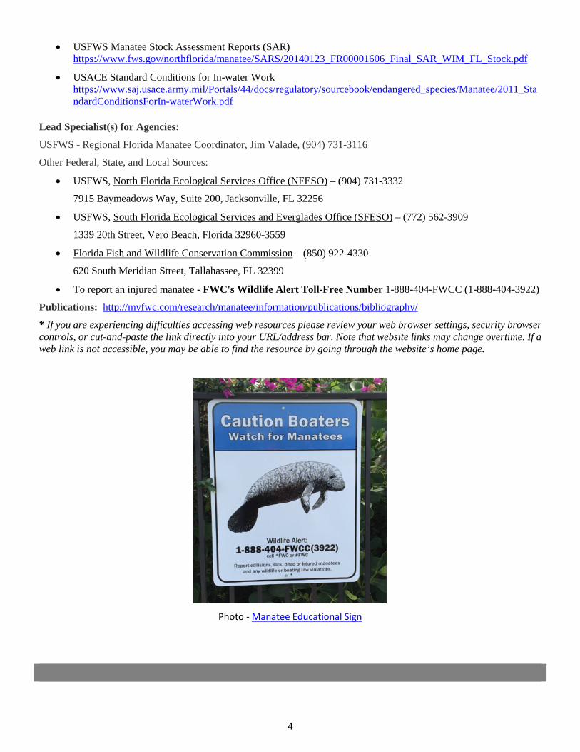
4
• USFWS Manatee Stock Assessment Reports (SAR)https://www.fws.gov/northflorida/manatee/SARS/20140123_FR00001606_Final_SAR_WIM_FL_Stock.pdf
• USACE Standard Conditions for In-water Workhttps://www.saj.usace.army.mil/Portals/44/docs/regulatory/sourcebook/endangered_species/Manatee/2011_StandardConditionsForIn-waterWork.pdf
Lead Specialist(s) for Agencies:
USFWS - Regional Florida Manatee Coordinator, Jim Valade, (904) 731-3116
Other Federal, State, and Local Sources:
• USFWS, North Florida Ecological Services Office (NFESO) – (904) 731-3332
7915 Baymeadows Way, Suite 200, Jacksonville, FL 32256
• USFWS, South Florida Ecological Services and Everglades Office (SFESO) – (772) 562-3909
1339 20th Street, Vero Beach, Florida 32960-3559
• Florida Fish and Wildlife Conservation Commission – (850) 922-4330
620 South Meridian Street, Tallahassee, FL 32399
• To report an injured manatee - FWC's Wildlife Alert Toll-Free Number 1-888-404-FWCC (1-888-404-3922)
Publications: http://myfwc.com/research/manatee/information/publications/bibliography/
* If you are experiencing difficulties accessing web resources please review your web browser settings, security browsercontrols, or cut-and-paste the link directly into your URL/address bar. Note that website links may change overtime. If aweb link is not accessible, you may be able to find the resource by going through the website’s home page.
Photo - Manatee Educational Sign

2019 Appendix: Listed Species
APPENDIX 1f Osprey Nest Relocations
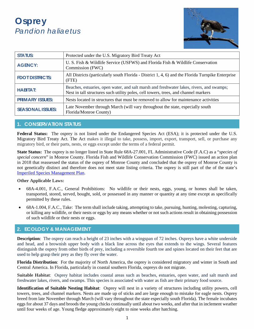
1
Osprey Pandion haliaetus
STATUS: Protected under the U.S. Migratory Bird Treaty Act
AGENCY: U. S. Fish & Wildlife Service (USFWS) and Florida Fish & Wildlife Conservation Commission (FWC)
FDOT DISTRICTS: All Districts (particularly south Florida - District 1, 4, 6) and the Florida Turnpike Enterprise (FTE)
HABITAT: Beaches, estuaries, open water, and salt marsh and freshwater lakes, rivers, and swamps; Nest in tall structures such utility poles, cell towers, trees, and channel markers
PRIMARY ISSUES: Nests located in structures that must be removed to allow for maintenance activities
SEASONAL ISSUES: Late November through March (will vary throughout the state, especially south Florida/Monroe County)
1. CONSERVATION STATUS
Federal Status: The osprey is not listed under the Endangered Species Act (ESA); it is protected under the U.S. Migratory Bird Treaty Act. The Act makes it illegal to take, possess, import, export, transport, sell, or purchase any migratory bird, or their parts, nests, or eggs except under the terms of a federal permit.
State Status: The osprey is no longer listed in State Rule 68A-27.001, FL Administrative Code (F.A.C) as a “species of special concern” in Monroe County. Florida Fish and Wildlife Conservation Commission (FWC) issued an action plan in 2018 that reassessed the status of the osprey of Monroe County and concluded that the osprey of Monroe County is not genetically distinct and therefore does not meet state listing criteria. The osprey is still part of the of the state’s Imperiled Species Management Plan.
Other Applicable Laws:
• 68A-4.001, F.A.C., General Prohibitions: No wildlife or their nests, eggs, young, or homes shall be taken,transported, stored, served, bought, sold, or possessed in any manner or quantity at any time except as specificallypermitted by these rules.
• 68A-1.004, F.A.C., Take: The term shall include taking, attempting to take, pursuing, hunting, molesting, capturing,or killing any wildlife, or their nests or eggs by any means whether or not such actions result in obtaining possessionof such wildlife or their nests or eggs.
2. ECOLOGY & MANAGEMENT
Description: The osprey can reach a height of 23 inches with a wingspan of 72 inches. Ospreys have a white underside and head, and a brownish upper body with a black line across the eyes that extends to the wings. Several features distinguish the osprey from other birds of prey, including a reversible fourth toe and spines located on their feet that are used to help grasp their prey as they fly over the water.
Florida Distribution: For the majority of North America, the osprey is considered migratory and winter in South and Central America. In Florida, particularly in coastal southern Florida, ospreys do not migrate.
Suitable Habitat: Osprey habitat includes coastal areas such as beaches, estuaries, open water, and salt marsh and freshwater lakes, rivers, and swamps. This species is associated with water as fish are their primary food source.
Identification of Suitable Nesting Habitat: Osprey will nest in a variety of structures including utility powers, cell towers, trees, and channel markers. Nests are made up of sticks and are large enough to mistake for eagle nests. Osprey breed from late November through March (will vary throughout the state especially south Florida). The female incubates eggs for about 37 days and broods the young chicks continually until about two weeks, and after that in inclement weather until four weeks of age. Young fledge approximately eight to nine weeks after hatching.
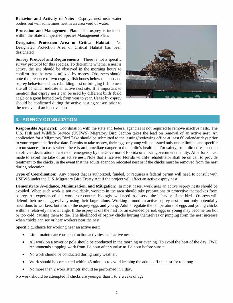
2
Behavior and Activity to Note: Ospreys nest near water bodies but will sometimes nest in an area void of water.
Protection and Management Plan: The osprey is included within the State’s Imperiled Species Management Plan.
Designated Protection Area or Critical Habitat: No Designated Protection Area or Critical Habitat has been designated.
Survey Protocol and Requirements: There is not a specific survey protocol for this species. To determine whether a nest is active, the site should be observed in the morning hours to confirm that the nest is utilized by osprey. Observers should note the presence of two osprey, fish bones below the nest and osprey behavior such as rebuilding nest or bringing fish to nest site all of which indicate an active nest site. It is important to mention that osprey nests can be used by different birds (bald eagle or a great horned owl) from year to year. Usage by osprey should be confirmed during the active nesting season prior to the removal of an inactive nest.
3. AGENCY CONSULTATION
Responsible Agency(s): Coordination with the state and federal agencies is not required to remove inactive nests. The U.S. Fish and Wildlife Service (USFWS) Migratory Bird Section takes the lead on removal of an active nest. An application for a Migratory Bird Take should be submitted to the issuing/reviewing office at least 60 calendar days prior to your requested effective date. Permits to take osprey, their eggs or young will be issued only under limited and specific circumstances, in cases where there is an immediate danger to the public’s health and/or safety, or in direct response to an official declaration of a state of emergency by the Governor of Florida or a local governmental entity. All efforts must made to avoid the take of an active nest. Note that a licensed Florida wildlife rehabilitator shall be on call to provide treatment to the chicks, in the event that the adults abandon relocated nest or if the chicks must be removed from the nest during relocation.
Type of Coordination: Any project that is authorized, funded, or requires a federal permit will need to consult with USFWS under the U.S. Migratory Bird Treaty Act if the project will affect an active osprey nest.
Demonstrate Avoidance, Minimization, and Mitigation: In most cases, work near an active osprey nests should be avoided. When such work is not avoidable, workers in the area should take precautions to protective themselves from osprey. An experienced site worker or contract biologist will need to observe the behavior of the birds. Ospreys will defend their nests aggressively using their large talons. Working around an active osprey nest is not only potentially hazardous to workers, but also to the osprey eggs and young. Adults regulate the temperature of eggs and young chicks within a relatively narrow range. If the osprey is off the nest for an extended period, eggs or young may become too hot or too cold, causing them to die. The likelihood of osprey chicks hurting themselves or jumping from the nest increase when chicks can see or hear workers near the nest.
Specific guidance for working near an active nest:
• Limit maintenance or construction activities near active nests.
• All work on a tower or pole should be conducted in the morning or evening. To avoid the heat of the day, FWCrecommends stopping work from 1½ hour after sunrise to 1½ hour before sunset.
• No work should be conducted during rainy weather.
• Work should be completed within 45 minutes to avoid keeping the adults off the nest for too long.
• No more than 2 work attempts should be performed in 1 day.
No work should be attempted if chicks are younger than 1 to 2 weeks of age.
3
Special Provisions, or Standard Protection Measures: No special provisions or standard protection measures; however, see FWC’s Species Conservation Measures and Permitting Guidelines for osprey.
General Timeframes for Coordination and Permitting: A permit is not needed to remove an inactive nest, only for active nests which is strongly discouraged. Limited maintenance and construction activities are allowed near an active nest (see FWC’s Species Conservation Measures and Permitting Guidelines).
4. PERMITTING
Prohibited Activities: A permit is required to remove an active nest (i.e., contains eggs or flightless young). The permit would be obtained from the USFWS Migratory Bird Division.
NOTE: A permit is not required from the USFWS if removing an inactive osprey nest.
Activities Authorized by Permit: Permits to take osprey, their eggs or young will be issued only under limited and specific circumstances, in cases where there is an immediate danger to the public’s health and/or safety, including imminent or existing power outages that threaten public safety, or in direct response to an official declaration of a state of emergency by the Governor of Florida or a local governmental entity. Applications submitted for this permit must include detailed information, along with a copy of the official declaration of a state of emergency, if any. In cases of a declaration of a state of emergency this permit process may be handled after the fact or at least after construction activities have already started. An intentional take permit may be issued for such extreme emergency purposes.
5. PRE-CONSTRUCTION & CONSTRUCTION COMPLIANCE
Review of Commitments: Commitments can be found within the Environmental Module in ProjectSuite Enterprise Edition (PSEE). If additional commitments are identified during design or permitting coordination with the Project Manager and add to the Environmental Commitment Module. The Design Project Manager will share the Project Commitment Record with Construction.
Review all Environmental Permits for Special Conditions: Review all environmental permits for Special Conditions related to osprey. Make sure that construction personnel have copies.
Prior to Construction: Advise personnel that penalties for convictions for violations of these laws range from a maximum of $500 and/or 60 days imprisonment for first offenses of misdemeanor crimes or up to $50,000 and/or one-year imprisonment for criminal violations against the federal Endangered Species Act. To learn more read Laws that Protect Florida’s Wildlife.
6. TIPS
Tips: Avoid or limit maintenance or construction activities near active nests.
Seasonal Restrictions: Avoid or limit working during the nesting season from late November through March (will vary throughout the state especially south Florida/Keys). A permit is only required if proposing to impact an active nest.
Survey Restrictions: Surveys are not required but can be used to determine if a nest is active (contain eggs or young). Nests are large, conspicuous, and usually in a tree or man-made structure. When a large nest is identified, it is important to distinguish if it is an eagle nest or an osprey nest.
7. RESOURCES
Web Resources*
• FWC’s A Species Action Plan for the Osprey of Monroe County (Draft)https://myfwc.com/media/16285/draft-osprey-sap.pdf
• FWC’s Species Conservation Measures and Permitting Guidelines - Ospreyhttps://myfwc.com/media/18642/osprey-guidelines.pdf
• FWC’s Species Information - Ospreyhttp://myfwc.com/wildlifehabitats/imperiled/profiles/birds/osprey
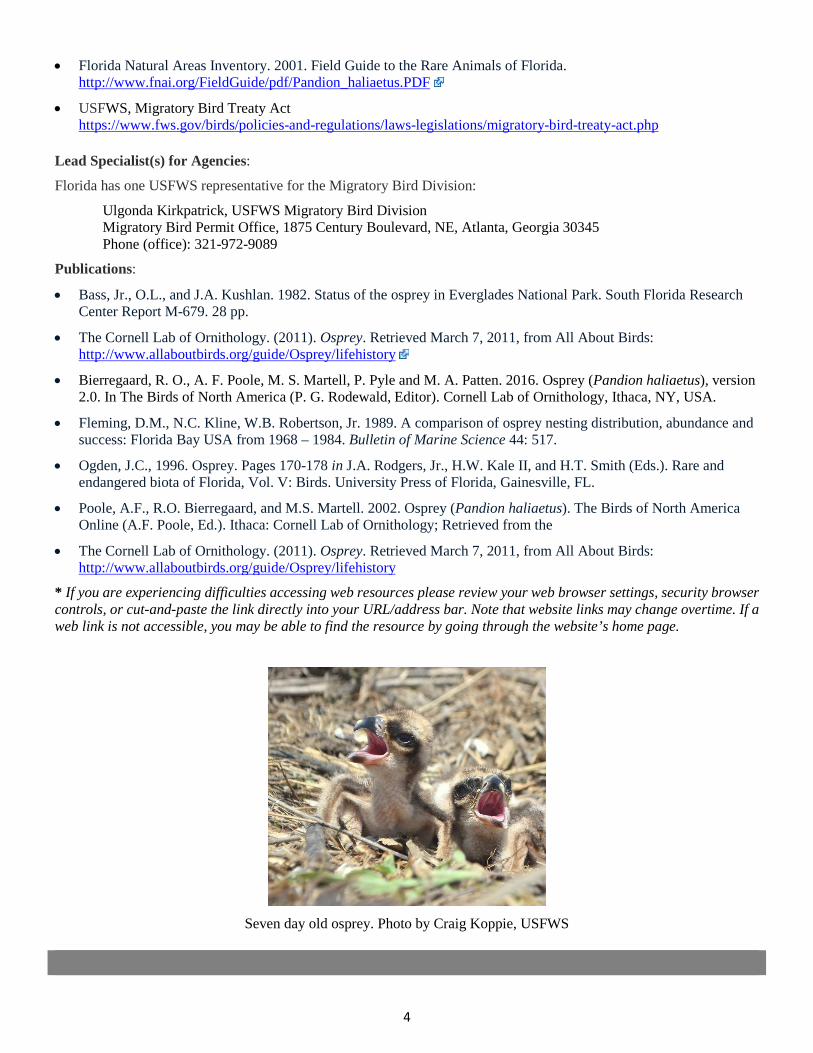
4
• Florida Natural Areas Inventory. 2001. Field Guide to the Rare Animals of Florida.http://www.fnai.org/FieldGuide/pdf/Pandion_haliaetus.PDF
• USFWS, Migratory Bird Treaty Acthttps://www.fws.gov/birds/policies-and-regulations/laws-legislations/migratory-bird-treaty-act.php
Lead Specialist(s) for Agencies:
Florida has one USFWS representative for the Migratory Bird Division:
Ulgonda Kirkpatrick, USFWS Migratory Bird Division Migratory Bird Permit Office, 1875 Century Boulevard, NE, Atlanta, Georgia 30345 Phone (office): 321-972-9089
Publications:
• Bass, Jr., O.L., and J.A. Kushlan. 1982. Status of the osprey in Everglades National Park. South Florida ResearchCenter Report M-679. 28 pp.
• The Cornell Lab of Ornithology. (2011). Osprey. Retrieved March 7, 2011, from All About Birds:http://www.allaboutbirds.org/guide/Osprey/lifehistory
• Bierregaard, R. O., A. F. Poole, M. S. Martell, P. Pyle and M. A. Patten. 2016. Osprey (Pandion haliaetus), version2.0. In The Birds of North America (P. G. Rodewald, Editor). Cornell Lab of Ornithology, Ithaca, NY, USA.
• Fleming, D.M., N.C. Kline, W.B. Robertson, Jr. 1989. A comparison of osprey nesting distribution, abundance andsuccess: Florida Bay USA from 1968 – 1984. Bulletin of Marine Science 44: 517.
• Ogden, J.C., 1996. Osprey. Pages 170-178 in J.A. Rodgers, Jr., H.W. Kale II, and H.T. Smith (Eds.). Rare andendangered biota of Florida, Vol. V: Birds. University Press of Florida, Gainesville, FL.
• Poole, A.F., R.O. Bierregaard, and M.S. Martell. 2002. Osprey (Pandion haliaetus). The Birds of North AmericaOnline (A.F. Poole, Ed.). Ithaca: Cornell Lab of Ornithology; Retrieved from the
• The Cornell Lab of Ornithology. (2011). Osprey. Retrieved March 7, 2011, from All About Birds:http://www.allaboutbirds.org/guide/Osprey/lifehistory
* If you are experiencing difficulties accessing web resources please review your web browser settings, security browsercontrols, or cut-and-paste the link directly into your URL/address bar. Note that website links may change overtime. If aweb link is not accessible, you may be able to find the resource by going through the website’s home page.
Seven day old osprey. Photo by Craig Koppie, USFWS

2019 Appendix: Listed Species
APPENDIX 1g Sea Turtles
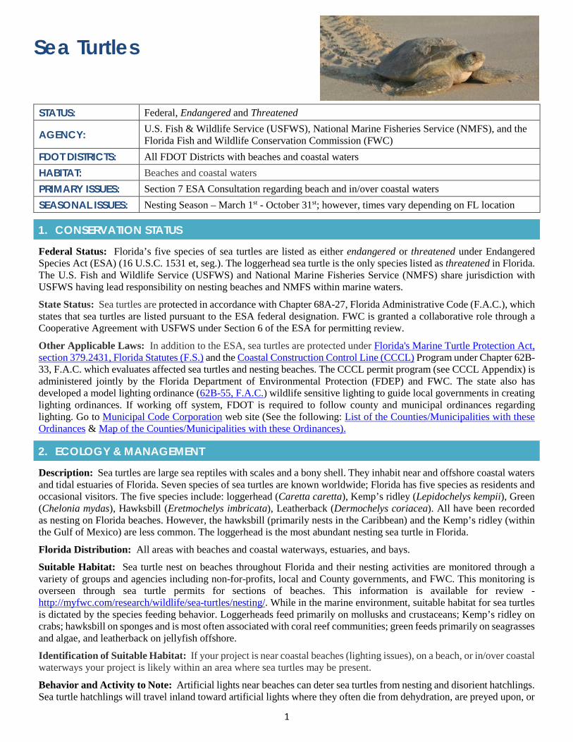
1
Sea Turtles
STATUS: Federal, Endangered and Threatened
AGENCY: U.S. Fish & Wildlife Service (USFWS), National Marine Fisheries Service (NMFS), and the Florida Fish and Wildlife Conservation Commission (FWC)
FDOT DISTRICTS: All FDOT Districts with beaches and coastal waters HABITAT: Beaches and coastal waters PRIMARY ISSUES: Section 7 ESA Consultation regarding beach and in/over coastal waters SEASONAL ISSUES: Nesting Season – March 1st - October 31st; however, times vary depending on FL location
1. CONSERVATION STATUS
Federal Status: Florida’s five species of sea turtles are listed as either endangered or threatened under Endangered Species Act (ESA) (16 U.S.C. 1531 et, seg.). The loggerhead sea turtle is the only species listed as threatened in Florida. The U.S. Fish and Wildlife Service (USFWS) and National Marine Fisheries Service (NMFS) share jurisdiction with USFWS having lead responsibility on nesting beaches and NMFS within marine waters.
State Status: Sea turtles are protected in accordance with Chapter 68A-27, Florida Administrative Code (F.A.C.), which states that sea turtles are listed pursuant to the ESA federal designation. FWC is granted a collaborative role through a Cooperative Agreement with USFWS under Section 6 of the ESA for permitting review.
Other Applicable Laws: In addition to the ESA, sea turtles are protected under Florida's Marine Turtle Protection Act, section 379.2431, Florida Statutes (F.S.) and the Coastal Construction Control Line (CCCL) Program under Chapter 62B-33, F.A.C. which evaluates affected sea turtles and nesting beaches. The CCCL permit program (see CCCL Appendix) is administered jointly by the Florida Department of Environmental Protection (FDEP) and FWC. The state also has developed a model lighting ordinance (62B-55, F.A.C.) wildlife sensitive lighting to guide local governments in creating lighting ordinances. If working off system, FDOT is required to follow county and municipal ordinances regarding lighting. Go to Municipal Code Corporation web site (See the following: List of the Counties/Municipalities with these Ordinances & Map of the Counties/Municipalities with these Ordinances).
2. ECOLOGY & MANAGEMENT
Description: Sea turtles are large sea reptiles with scales and a bony shell. They inhabit near and offshore coastal waters and tidal estuaries of Florida. Seven species of sea turtles are known worldwide; Florida has five species as residents and occasional visitors. The five species include: loggerhead (Caretta caretta), Kemp’s ridley (Lepidochelys kempii), Green (Chelonia mydas), Hawksbill (Eretmochelys imbricata), Leatherback (Dermochelys coriacea). All have been recorded as nesting on Florida beaches. However, the hawksbill (primarily nests in the Caribbean) and the Kemp’s ridley (within the Gulf of Mexico) are less common. The loggerhead is the most abundant nesting sea turtle in Florida.
Florida Distribution: All areas with beaches and coastal waterways, estuaries, and bays.
Suitable Habitat: Sea turtle nest on beaches throughout Florida and their nesting activities are monitored through a variety of groups and agencies including non-for-profits, local and County governments, and FWC. This monitoring is overseen through sea turtle permits for sections of beaches. This information is available for review - http://myfwc.com/research/wildlife/sea-turtles/nesting/. While in the marine environment, suitable habitat for sea turtles is dictated by the species feeding behavior. Loggerheads feed primarily on mollusks and crustaceans; Kemp’s ridley on crabs; hawksbill on sponges and is most often associated with coral reef communities; green feeds primarily on seagrasses and algae, and leatherback on jellyfish offshore.
Identification of Suitable Habitat: If your project is near coastal beaches (lighting issues), on a beach, or in/over coastal waterways your project is likely within an area where sea turtles may be present.
Behavior and Activity to Note: Artificial lights near beaches can deter sea turtles from nesting and disorient hatchlings. Sea turtle hatchlings will travel inland toward artificial lights where they often die from dehydration, are preyed upon, or
2
crawl onto roads or into drainage structures. To learn more, go to: http://myfwc.com/research/wildlife/sea-turtles/threats/artificial-lighting/. The following project relative activities can impact sea turtles, nesting, and hatchlings: beach armoring, artificial lighting, beach nourishment, seawalls, and vehicular traffic.
Protection and Management Plans: The USFWS and NMFS have created species specific recovery plans under Section 4 of the ESA. Each plan includes management actions to conserve the species; measurable criteria; and estimates of the time and funding required to achieve the plan’s goals. These plans break recovery efforts into regional units based on nesting assemblages.
Designated Protection Area or Critical Habitat: The USFWS designated critical coastal beach habitat in peninsular Florida and the panhandle as important for the recovery of the Northwest Atlantic Ocean population of the loggerhead sea turtles.
Survey Protocol and Requirements: An FWC Marine Turtle Permit is required for nesting surveys and protection activities (Rule 68E-1, F.A.C).
3. AGENCY CONSULTATION (FEDERAL)
Responsible Agency(s): The applicable agency for sea turtles in water is NMFS, and for beaches the USFWS and FWC. FWC issues permits for activities involving interactions with sea turtles, their nests, eggs, and hatchlings under the Marine Turtle Protection Act, Section 379.2431(1), Florida Statute. FWC also has authority granted to the state through a Cooperative Agreement with the USFWS under Section 6 of the ESA.
Federal Nexus for Consultation: Any federally funded activity conducted and/or permitted that may affect sea turtles requires an ESA effects determination and consultation.
Type of Consultation: Some beach activities, such as beach lighting, can be challenging to determine what level of consultation will be required. Begin with reaching out to your regional USFWS representative and/or FWC representative for your proposed project area. For over/in-water informal work, consult with the NMFS ETAT representative.
Demonstrate Avoidance, Minimization, and Mitigation: The regulatory agencies will look for ways in which FDOT can avoid and minimize impacts to sea turtles and beach habitat. For over/in-water work activities implement the NMFS’s Sea Turtle and Smalltooth Sawfish Constriction Conditions. For beaches options may include, but not limited to, avoiding work during sea turtle nesting season, using lighting fixtures approved by regulatory agencies, avoiding night work, daily surveys, and avoidance of materials that sea turtles may become entangled in.
Tools for Section 7 ESA Consultation: No federal sea turtle effects determination key.
Special Provisions, or Standard Protection Measures: For over/in-water activities, NMFS has created Sea turtle and Smalltooth Sawfish Construction Conditions. In addition, FDOT has Special Provisions expanding the existing requirements when sea turtle involvement exists within the project limits.
General Timeframes for Consultation and Permitting: Timely issuance of permits is dependent on completion of informal or formal consultation with the USFWS, FWC and/or NMFS regarding potential impacts to sea turtles. Consultation can be a lengthy process so begin early.
4. PERMITTING
Prohibited Activities: The ESA makes it illegal to harass, harm, pursue, wound, kill, capture, or collect, or to attempt to engage in any such conduct. Incidental take of sea turtles may occur due to beach armoring, artificial lighting, beach nourishment, vehicular traffic, or any coastal activity that might interfere with nesting adults, nests, or emergent hatchlings. Additional information about incidental take is available at:
https://www.fws.gov/endangered/permits/index.html.
Activities Authorized by Permit: Permit authorization is based on the proposed project scope, location, type of impact, and, measures (such as project components, standard construction precautions, or special conditions) taken to avoid or minimize effects to sea turtles or nesting beach habitat.
5. PRE-CONSTRUCTION & CONSTRUCTION COMPLIANCE
Review of Commitments: Commitments can be found within the Environmental Commitment Module in ProjectSuite Enterprise Edition (PSEE). If additional commitments are identified during design or permitting, coordinate with the
3
Project Manager and add to the Environmental Commitment Module. The Design Project Manager will share the Project Commitment Record with Construction.
Review all Environmental Permits for Special Conditions: Review all environmental permits for Special Conditions related to sea turtles. Make sure that construction personnel have copies.
Prior to Construction: Advise personnel that penalties for convictions for violations of these laws range from a maximum of $500 and/or 60 days imprisonment for first offenses of misdemeanor crimes or up to $50,000 and/or one year imprisonment for criminal violations against the federal Endangered Species Act. To learn more read Laws that Protect Florida’s Wildlife.
6. TIPS
Tips: Identify who has an FWC Sea Turtle Permit for the beach where work is proposed. Note those who are consultants, as not all FWC permit holders are authorized to work on construction projects.
Seasonal Restrictions: Avoid work activities on beaches during sea turtle nesting season, March through October.
Survey Restrictions: Annual nest monitoring occurs throughout the State’s beaches through the Florida Sea Turtle Nesting Beach Monitoring Program overseen by the Fish and Wildlife Research Institute (FWRI) and FWC. This data can be accessed through the Florida Sea Turtle Nesting Database. To request specific sea turtle nesting data for beach projects an informal email request can be made to FWC requesting.
7. RESOURCES
Web Resources*
• Florida's Marine Turtle Protection Act (379.2431, Florida Statutes)http://www.leg.state.fl.us/statutes/index.cfm?mode=View%20Statutes&SubMenu=1&App_mode=Display_Statute&Search_String=Marine+Turtle+Protection+Act&URL=0300-0399/0379/Sections/0379.2431.html
• FWC Sea Turtles and Artificial Lightinghttp://myfwc.com/research/wildlife/sea-turtles/threats/artificial-lighting/
• FDEP CCCL Programhttps://floridadep.gov/water/coastal-construction-control-line
• FWC Marine Turtle Handbookhttp://myfwc.com/media/4112794/fwc-mtconservationhandbook.pdf
• Memorandum of Understanding defining the roles of the U.S. Fish and Wildlife Service and NOAA Fisheriesin Joint Administration of the Endangered Species Act of 1973 as to sea turtles.https://www.fisheries.noaa.gov/resource/document/noaa-fisheries-and-us-fws-memorandum-understanding-sea-turtles
• NMFS designated marine critical habitat for the Northwest Atlantic Ocean.https://www.fws.gov/northflorida//SeaTurtles/2014_Loggerhead_CH/Terrestrial_critical_habitat_loggerhead.html
• NMFS has created Sea turtle and Smalltooth Sawfish Construction Conditions -https://sero.nmfs.noaa.gov/protected_resources/section_7/guidance_docs/documents/sea_turtle_and_smalltooth_sawfish_construction_conditions_3-23-06.pdf
Lead Specialist(s) for Agencies on this Species:
• Regional Sea Turtle Coordinator, U.S. Fish and Wildlife Service, 7915 Baymeadows Way, Suite 200,Jacksonville, Florida 32256, Telephone: (904) 731-3336; Email: seaturtle @ fws.gov
• To find a Sea Turtle Permit Holder: FWC 1-561-882-5975
Publications:
• Bjorndal, Karen A. (Editor). 1995. Biology and Conservation of Sea Turtles. Smithsonian Institution Press.
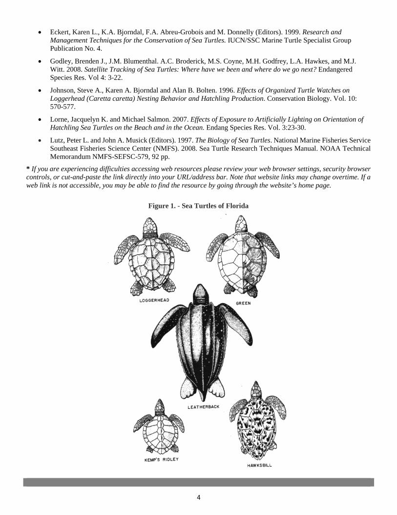
4
• Eckert, Karen L., K.A. Bjorndal, F.A. Abreu-Grobois and M. Donnelly (Editors). 1999. Research andManagement Techniques for the Conservation of Sea Turtles. IUCN/SSC Marine Turtle Specialist GroupPublication No. 4.
• Godley, Brenden J., J.M. Blumenthal. A.C. Broderick, M.S. Coyne, M.H. Godfrey, L.A. Hawkes, and M.J.Witt. 2008. Satellite Tracking of Sea Turtles: Where have we been and where do we go next? EndangeredSpecies Res. Vol 4: 3-22.
• Johnson, Steve A., Karen A. Bjorndal and Alan B. Bolten. 1996. Effects of Organized Turtle Watches onLoggerhead (Caretta caretta) Nesting Behavior and Hatchling Production. Conservation Biology. Vol. 10:570-577.
• Lorne, Jacquelyn K. and Michael Salmon. 2007. Effects of Exposure to Artificially Lighting on Orientation ofHatchling Sea Turtles on the Beach and in the Ocean. Endang Species Res. Vol. 3:23-30.
• Lutz, Peter L. and John A. Musick (Editors). 1997. The Biology of Sea Turtles. National Marine Fisheries ServiceSoutheast Fisheries Science Center (NMFS). 2008. Sea Turtle Research Techniques Manual. NOAA TechnicalMemorandum NMFS-SEFSC-579, 92 pp.
* If you are experiencing difficulties accessing web resources please review your web browser settings, security browsercontrols, or cut-and-paste the link directly into your URL/address bar. Note that website links may change overtime. If aweb link is not accessible, you may be able to find the resource by going through the website’s home page.
Figure 1. - Sea Turtles of Florida

2019 Appendix: Listed Species
APPENDIX 1h Smalltooth Sawfish
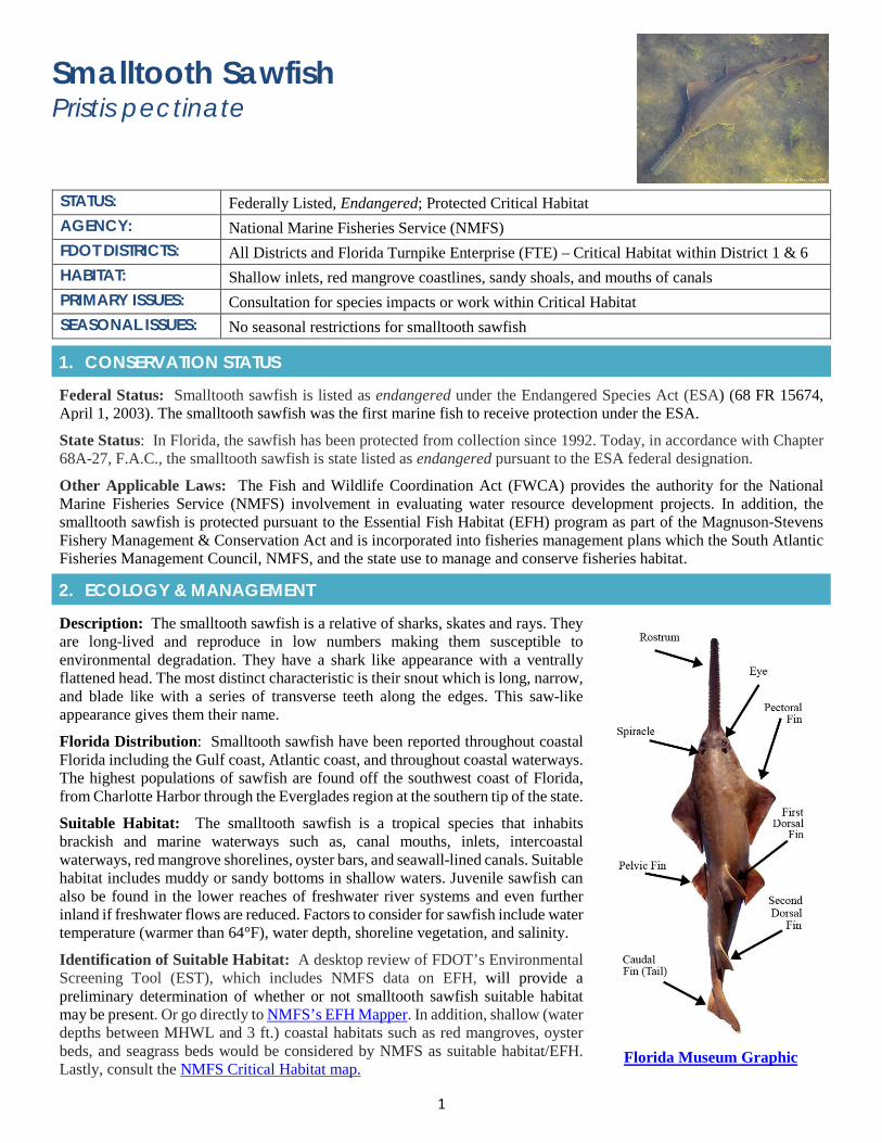
1
Smalltooth Sawfish Pristis pectinate
STATUS: Federally Listed, Endangered; Protected Critical Habitat AGENCY: National Marine Fisheries Service (NMFS) FDOT DISTRICTS: All Districts and Florida Turnpike Enterprise (FTE) – Critical Habitat within District 1 & 6 HABITAT: Shallow inlets, red mangrove coastlines, sandy shoals, and mouths of canals PRIMARY ISSUES: Consultation for species impacts or work within Critical Habitat SEASONAL ISSUES: No seasonal restrictions for smalltooth sawfish
1. CONSERVATION STATUS
Federal Status: Smalltooth sawfish is listed as endangered under the Endangered Species Act (ESA) (68 FR 15674, April 1, 2003). The smalltooth sawfish was the first marine fish to receive protection under the ESA.
State Status: In Florida, the sawfish has been protected from collection since 1992. Today, in accordance with Chapter 68A-27, F.A.C., the smalltooth sawfish is state listed as endangered pursuant to the ESA federal designation.
Other Applicable Laws: The Fish and Wildlife Coordination Act (FWCA) provides the authority for the National Marine Fisheries Service (NMFS) involvement in evaluating water resource development projects. In addition, the smalltooth sawfish is protected pursuant to the Essential Fish Habitat (EFH) program as part of the Magnuson-Stevens Fishery Management & Conservation Act and is incorporated into fisheries management plans which the South Atlantic Fisheries Management Council, NMFS, and the state use to manage and conserve fisheries habitat.
2. ECOLOGY & MANAGEMENT
Description: The smalltooth sawfish is a relative of sharks, skates and rays. They are long-lived and reproduce in low numbers making them susceptible to environmental degradation. They have a shark like appearance with a ventrally flattened head. The most distinct characteristic is their snout which is long, narrow, and blade like with a series of transverse teeth along the edges. This saw-like appearance gives them their name.
Florida Distribution: Smalltooth sawfish have been reported throughout coastal Florida including the Gulf coast, Atlantic coast, and throughout coastal waterways. The highest populations of sawfish are found off the southwest coast of Florida, from Charlotte Harbor through the Everglades region at the southern tip of the state.
Suitable Habitat: The smalltooth sawfish is a tropical species that inhabits brackish and marine waterways such as, canal mouths, inlets, intercoastal waterways, red mangrove shorelines, oyster bars, and seawall-lined canals. Suitable habitat includes muddy or sandy bottoms in shallow waters. Juvenile sawfish can also be found in the lower reaches of freshwater river systems and even further inland if freshwater flows are reduced. Factors to consider for sawfish include water temperature (warmer than 64°F), water depth, shoreline vegetation, and salinity.
Identification of Suitable Habitat: A desktop review of FDOT’s Environmental Screening Tool (EST), which includes NMFS data on EFH, will provide a preliminary determination of whether or not smalltooth sawfish suitable habitat may be present. Or go directly to NMFS’s EFH Mapper. In addition, shallow (water depths between MHWL and 3 ft.) coastal habitats such as red mangroves, oyster beds, and seagrass beds would be considered by NMFS as suitable habitat/EFH. Lastly, consult the NMFS Critical Habitat map.
Florida Museum Graphic
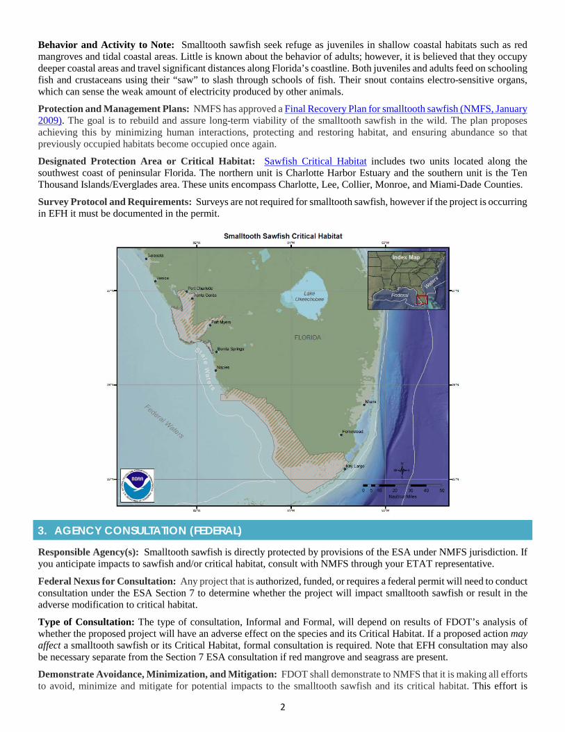
2
Behavior and Activity to Note: Smalltooth sawfish seek refuge as juveniles in shallow coastal habitats such as red mangroves and tidal coastal areas. Little is known about the behavior of adults; however, it is believed that they occupy deeper coastal areas and travel significant distances along Florida’s coastline. Both juveniles and adults feed on schooling fish and crustaceans using their “saw” to slash through schools of fish. Their snout contains electro-sensitive organs, which can sense the weak amount of electricity produced by other animals.
Protection and Management Plans: NMFS has approved a Final Recovery Plan for smalltooth sawfish (NMFS, January 2009). The goal is to rebuild and assure long-term viability of the smalltooth sawfish in the wild. The plan proposes achieving this by minimizing human interactions, protecting and restoring habitat, and ensuring abundance so that previously occupied habitats become occupied once again.
Designated Protection Area or Critical Habitat: Sawfish Critical Habitat includes two units located along the southwest coast of peninsular Florida. The northern unit is Charlotte Harbor Estuary and the southern unit is the Ten Thousand Islands/Everglades area. These units encompass Charlotte, Lee, Collier, Monroe, and Miami-Dade Counties.
Survey Protocol and Requirements: Surveys are not required for smalltooth sawfish, however if the project is occurring in EFH it must be documented in the permit.
3. AGENCY CONSULTATION (FEDERAL)
Responsible Agency(s): Smalltooth sawfish is directly protected by provisions of the ESA under NMFS jurisdiction. If you anticipate impacts to sawfish and/or critical habitat, consult with NMFS through your ETAT representative.
Federal Nexus for Consultation: Any project that is authorized, funded, or requires a federal permit will need to conduct consultation under the ESA Section 7 to determine whether the project will impact smalltooth sawfish or result in the adverse modification to critical habitat.
Type of Consultation: The type of consultation, Informal and Formal, will depend on results of FDOT’s analysis of whether the proposed project will have an adverse effect on the species and its Critical Habitat. If a proposed action may affect a smalltooth sawfish or its Critical Habitat, formal consultation is required. Note that EFH consultation may also be necessary separate from the Section 7 ESA consultation if red mangrove and seagrass are present.
Demonstrate Avoidance, Minimization, and Mitigation: FDOT shall demonstrate to NMFS that it is making all efforts to avoid, minimize and mitigate for potential impacts to the smalltooth sawfish and its critical habitat. This effort is
3
essential to the consultation process and may include such commitments as: modifying proposed plans to avoid EFH; altering construction methodology to avoid in-water work; creating pile driving ramp-up procedures that ensure that full hamming power was only administered after a period of low-energy blows; using pile driving cushion pads; and, adhering to the construction conditions found in the joint USACE/NMFS's Sea Turtle and Smalltooth Sawfish Construction Conditions.
Tools for Section 7 ESA Consultation: In 2017, the USACE and NMFS issued a Programmatic Biological Opinion (PBO), referred to as JaxBO (see Appendix on Programmatic Agreements and Biological Opinions), which allows for the streamlining of the Section 7 ESA process for groups of frequently occurring activities and Federal action agency policies, plans, programs that have well-understood effects on listed species and designated habitat including smalltooth sawfish and its Critical Habitat. The JaxBO provides a tool to address consultation for ten categories of “in-water” activities including: shoreline stabilization; pile-supported structures; maintenance, minor, and muck dredging; water-management outfall structures and associated endwalls; scientific survey devices; boat ramps; aquatic habitat enhancements, established, and restoration activities; transportation and utility lines; marine debris removal; and, temporary platforms, fill, and cofferdams.
Special Provisions, or Standard Protection Measures: Standard Construction Provisions are available through the joint USACE/NMFS's Sea Turtle and Smalltooth Sawfish Construction Conditions. In addition, FDOT has Special Provisions (REV 5-25-17) (FA 6-13-17) (1-19)( 7-1.4.1) expand the existing requirements when it is known that smalltooth sawfish involvement exists within the project limits.
General Timeframes for Consultation and Permitting: Early consultation is highly recommended if you have impacts to smalltooth sawfish, critical habitat, and/or EFH. Formal ESA Consultation can take as long as 180 days and may conclude with a finding of jeopardy thus preventing authorization of permits. Note that EFH consultation is separate from Section 7 ESA consultation and is often conducted concurrently.
4. PERMITTING
Prohibited Activities: Any direct (dredging, filling, etc.) or indirect impacts from a proposed project to smalltooth sawfish and its critical habitat without a permit would be considered unlawful under the ESA.
Activities Authorized by Permit: Permit authorization is based on the proposed project location and description; the potential effects to smalltooth sawfish, EFH, and/or sawfish critical habitat; and any measures (such as project components, standard construction precautions, or special conditions included in the authorization) to avoid or minimize effects to the smalltooth sawfish and its critical habitat.
5. PRE-CONSTRUCTION & CONSTRUCTION COMPLIANCE
Review of Commitments: Commitments can be found within the Environmental Commitment Module in ProjectSuite Enterprise Edition (PSEE). If additional commitments are identified during design or permitting, coordinate with the Project Manager and add to the Environmental Commitment Module. The Design Project Manager will share the Project Commitment Record with Construction.
Review all Environmental Permits for Special Conditions: Review all environmental permits for Special Conditions related to smalltooth sawfish and its Critical Habitat. Make sure that construction personnel have copies.
Prior to Construction: Advise personnel that penalties for convictions for violations of these laws range from a maximum of $500 and/or 60 days imprisonment for first offenses of misdemeanor crimes or up to $50,000 and/or one year imprisonment for criminal violations against the federal Endangered Species Act. To learn more read Laws that Protect Florida’s Wildlife.
6. TIPS
Tips: In coordination with FDOT’s Office of Environmental Management (OEM), reach out to your NMFS ETAT representative to informally discuss the consultation process, JaxBO PBO, and to receive guidance on possible avoidance, minimization, and mitigation options.
Seasonal Restrictions: No seasonal restrictions for smalltooth sawfish.
Survey Restrictions: No survey restrictions; however, determining whether suitable habitat exists will be required for consultation.
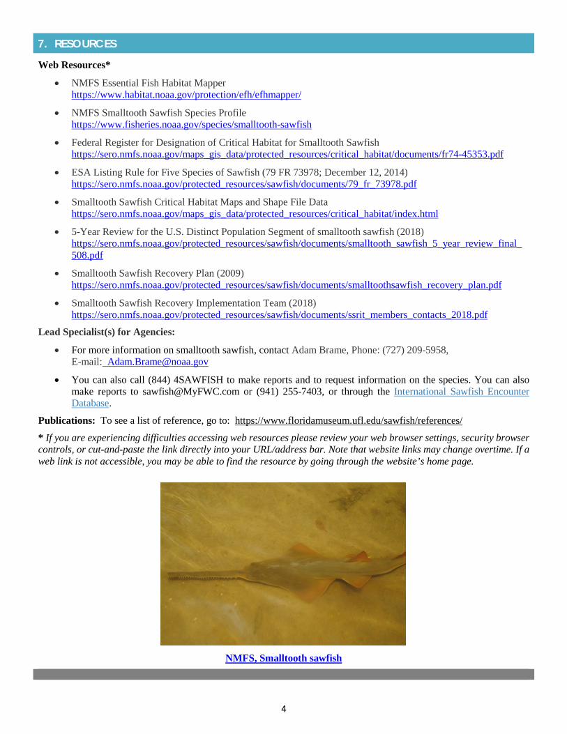
4
7. RESOURCES
Web Resources*
• NMFS Essential Fish Habitat Mapperhttps://www.habitat.noaa.gov/protection/efh/efhmapper/
• NMFS Smalltooth Sawfish Species Profilehttps://www.fisheries.noaa.gov/species/smalltooth-sawfish
• Federal Register for Designation of Critical Habitat for Smalltooth Sawfishhttps://sero.nmfs.noaa.gov/maps_gis_data/protected_resources/critical_habitat/documents/fr74-45353.pdf
• ESA Listing Rule for Five Species of Sawfish (79 FR 73978; December 12, 2014)https://sero.nmfs.noaa.gov/protected_resources/sawfish/documents/79_fr_73978.pdf
• Smalltooth Sawfish Critical Habitat Maps and Shape File Datahttps://sero.nmfs.noaa.gov/maps_gis_data/protected_resources/critical_habitat/index.html
• 5-Year Review for the U.S. Distinct Population Segment of smalltooth sawfish (2018)https://sero.nmfs.noaa.gov/protected_resources/sawfish/documents/smalltooth_sawfish_5_year_review_final_508.pdf
• Smalltooth Sawfish Recovery Plan (2009)https://sero.nmfs.noaa.gov/protected_resources/sawfish/documents/smalltoothsawfish_recovery_plan.pdf
• Smalltooth Sawfish Recovery Implementation Team (2018)https://sero.nmfs.noaa.gov/protected_resources/sawfish/documents/ssrit_members_contacts_2018.pdf
Lead Specialist(s) for Agencies:
• For more information on smalltooth sawfish, contact Adam Brame, Phone: (727) 209-5958,E-mail: [email protected]
• You can also call (844) 4SAWFISH to make reports and to request information on the species. You can alsomake reports to [email protected] or (941) 255-7403, or through the International Sawfish EncounterDatabase.
Publications: To see a list of reference, go to: https://www.floridamuseum.ufl.edu/sawfish/references/
* If you are experiencing difficulties accessing web resources please review your web browser settings, security browsercontrols, or cut-and-paste the link directly into your URL/address bar. Note that website links may change overtime. If aweb link is not accessible, you may be able to find the resource by going through the website’s home page.
NMFS, Smalltooth sawfish

2019 Appendix: Listed Species
APPENDIX 1i Wood Stork
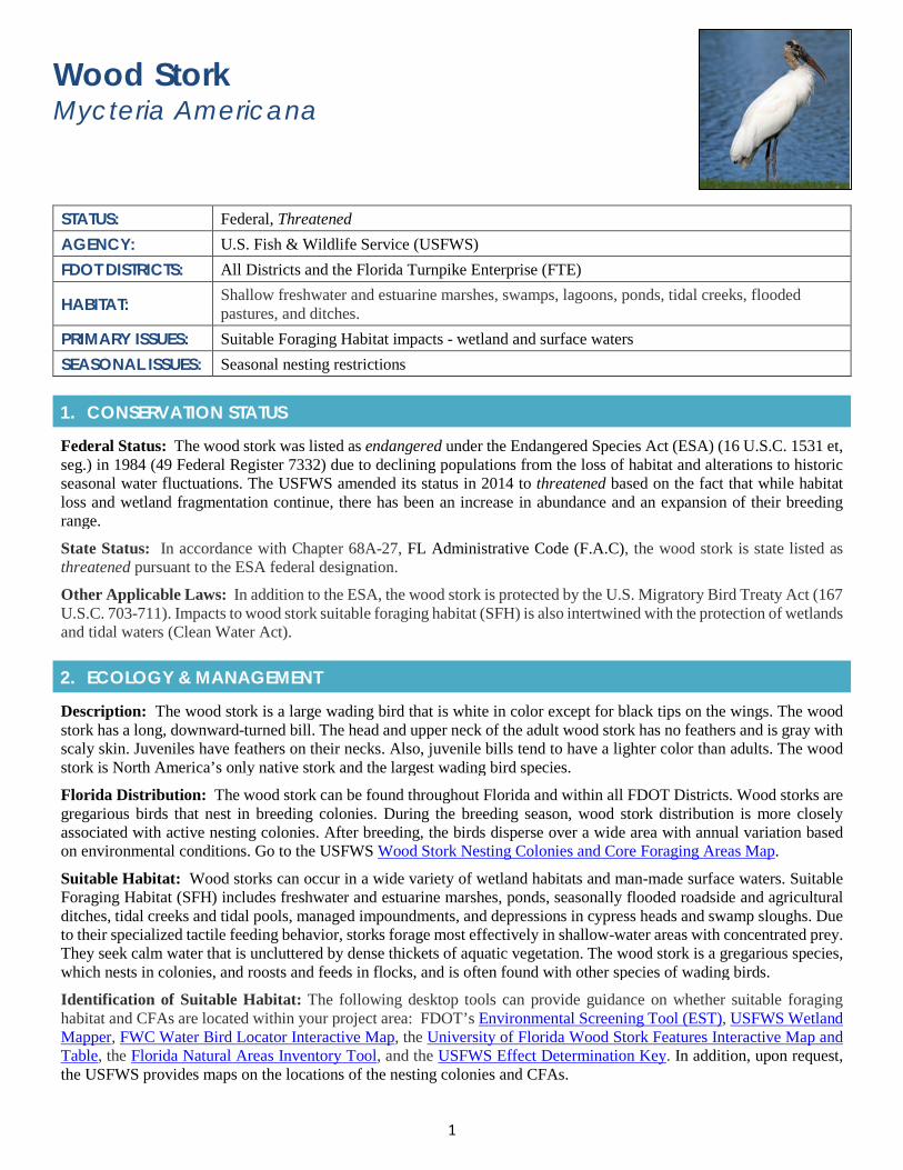
1
Wood Stork Mycteria Americana
STATUS: Federal, Threatened AGENCY: U.S. Fish & Wildlife Service (USFWS) FDOT DISTRICTS: All Districts and the Florida Turnpike Enterprise (FTE)
HABITAT: Shallow freshwater and estuarine marshes, swamps, lagoons, ponds, tidal creeks, flooded pastures, and ditches.
PRIMARY ISSUES: Suitable Foraging Habitat impacts - wetland and surface waters SEASONAL ISSUES: Seasonal nesting restrictions
1. CONSERVATION STATUS
Federal Status: The wood stork was listed as endangered under the Endangered Species Act (ESA) (16 U.S.C. 1531 et, seg.) in 1984 (49 Federal Register 7332) due to declining populations from the loss of habitat and alterations to historic seasonal water fluctuations. The USFWS amended its status in 2014 to threatened based on the fact that while habitat loss and wetland fragmentation continue, there has been an increase in abundance and an expansion of their breeding range.
State Status: In accordance with Chapter 68A-27, FL Administrative Code (F.A.C), the wood stork is state listed as threatened pursuant to the ESA federal designation.
Other Applicable Laws: In addition to the ESA, the wood stork is protected by the U.S. Migratory Bird Treaty Act (167 U.S.C. 703-711). Impacts to wood stork suitable foraging habitat (SFH) is also intertwined with the protection of wetlands and tidal waters (Clean Water Act).
2. ECOLOGY & MANAGEMENT
Description: The wood stork is a large wading bird that is white in color except for black tips on the wings. The wood stork has a long, downward-turned bill. The head and upper neck of the adult wood stork has no feathers and is gray with scaly skin. Juveniles have feathers on their necks. Also, juvenile bills tend to have a lighter color than adults. The wood stork is North America’s only native stork and the largest wading bird species.
Florida Distribution: The wood stork can be found throughout Florida and within all FDOT Districts. Wood storks are gregarious birds that nest in breeding colonies. During the breeding season, wood stork distribution is more closely associated with active nesting colonies. After breeding, the birds disperse over a wide area with annual variation based on environmental conditions. Go to the USFWS Wood Stork Nesting Colonies and Core Foraging Areas Map.
Suitable Habitat: Wood storks can occur in a wide variety of wetland habitats and man-made surface waters. Suitable Foraging Habitat (SFH) includes freshwater and estuarine marshes, ponds, seasonally flooded roadside and agricultural ditches, tidal creeks and tidal pools, managed impoundments, and depressions in cypress heads and swamp sloughs. Due to their specialized tactile feeding behavior, storks forage most effectively in shallow-water areas with concentrated prey. They seek calm water that is uncluttered by dense thickets of aquatic vegetation. The wood stork is a gregarious species, which nests in colonies, and roosts and feeds in flocks, and is often found with other species of wading birds.
Identification of Suitable Habitat: The following desktop tools can provide guidance on whether suitable foraging habitat and CFAs are located within your project area: FDOT’s Environmental Screening Tool (EST), USFWS Wetland Mapper, FWC Water Bird Locator Interactive Map, the University of Florida Wood Stork Features Interactive Map and Table, the Florida Natural Areas Inventory Tool, and the USFWS Effect Determination Key. In addition, upon request, the USFWS provides maps on the locations of the nesting colonies and CFAs.
2
Behavior and Activity to Note: Wood storks forage by touch in shallow water. Seasonal hydrology and available prey are key factors when conducting a Wood Stork Impact Functional Assessment (WSIFA).
Protection and Management Plans: A Wood Stork Recovery Plan was first created in 1986 and focused on wetland preservation and restoration, protection of nesting areas, and management of water flows. It was revised in 1997 and augmented with a south Florida recovery strategy in 1999 and a Wood Stork Recovery Action Plan in 2009.
Designated Protection Area or Critical Habitat: No Critical Habitat has been designated for the wood stork. However, the USFWS has designated Wood Stork Nesting Colonies (WSNC) and Core Foraging Areas (CFA). The USFWS recognizes an 18.6-mile CFA in south Florida; 15-mile CFA in central Florida; and 13-mile CFA in north Florida around wood stork colonies that have been documented as active within the last 10 years. The USFWS protects suitable forging habitat (SFH, i.e., wetlands) within CFA that if impacted may reduce foraging opportunities for the nesting colony. USFWS requires mitigation compensation for CFA impacts based on wetland type, location, function, and value (hydrology, vegetation, prey utilization) to ensure that wetland functions lost are adequately replaced. Wetland mitigation submitted must be of the same hydroperiod and located within the CFA of the affected colonies. In some special cases, through consultation, the USFWS may accept wetland credits purchased from a “Service Approved” mitigation bank located outside the CFA depending on location of impacted wetlands relative to the permitted service area of the bank, and whether the bank includes the same hydroperiod as the impacted wetland.
To determine the effect of a project on the wood stork, the USFWS has developed two helpful guides:
• Species effect determination key for establishing the potential effects of proposed projects.
South Florida
Central & North Florida
• A Wood Stork Impact Functional Assessment (WSIFA) guide to estimate the biomass of wood stork forage provided per unit quantity of wetland habitat. The assessment is to be applied to both wetlands being impacted and the wetlands proposed as mitigation. The USFWS has four parameters in the estimation of the biomass: vegetation density, wetland hydroperiod, prey size suitability, and competition with other wading bird species for forage. To download go to the USFWS WSIFA Methodology.
Survey Protocol and Requirements: No specific USFWS field survey protocol exists for wood storks. 3. AGENCY CONSULTATION (FEDERAL)
Responsible Agency(s): The USFWS, through section 7 of the ESA, reviews federal permit applications for projects that may impact wood storks and suitable foraging habitat. As part of the review, the USFWS will recommend ways to avoid or minimize the effects.
Federal Nexus for Consultation: Any federally funded activity conducted or permitted that may affect the wood stork (see effect determination key) requires an ESA effects determination and USFWS consultation.
Type of Consultation: To determine the type of consultation required (formal or informal), review the Wood Stork Effect Determination Keys. Wetland impact acreage and WSIFA may also be required by USFWS to determine impacts and the amount of mitigation required.
Demonstrate Avoidance, Minimization, and Mitigation: The USFWS will look for ways in which FDOT can avoid and minimize impacts to suitable foraging habitats. Unavoidable impacts will need to be mitigated for which may include conducting a foraging analysis of the prey biomass (WSIFA). The USFWS accepts the replacement in-kind of wet ditches and swales. NOTE that the USFWS foraging buffer radius changes based on location - South Florida Counties: 18.6 miles; Central Florida Counties; 15 miles; North Florida Counties: 13 miles.
Tools for Section 7 ESA Consultation:
• A species effect determination key is available for establishing the potential effects of proposed projects.
South Florida
Central & North Florida
• The use of the determination key will provide guidance on the type of consultation required.

3
Special Provisions, or Standard Protection Measures: No standard provisions. However, FDOT District Four and Six may commit to following the Habitat Management Guidelines for the Wood Stork in the Southeast Region.
General Timeframes for Consultation and Permitting: Timely issuance of permits is dependent on completion of informal or formal consultation with the USFWS regarding potential impacts to wood storks. USFWS may require wetland impact acreages and WSIFA.
4. PERMITTING
Prohibited Activities: Section 10 of the ESA regulates a range of activities that affect endangered or threatened species, including the wood stork. The Act prohibits activities affecting wood storks and the loss of their habitat unless authorized by a permit from the USFWS. Permitted activities must be consistent with the USFWS wood stork conservation management plans.
Activities Authorized by Permit: Permit authorization is based on your proposed project location to CFAs; the amount of suitable forging habitat impacted; results of WSIFA; and, measures (such as project components, standard construction precautions, or special conditions) taken to avoid or minimize effects to wood storks and suitable foraging habitat (SFH, i.e., wetlands). Impacts to wood stork suitable forage habitat are typically authorized as part of the stormwater or wetlandpermits. Wetland and wood stork mitigation are typically mitigated for together through the State Water ManagementDistricts and USACE.
5. PRE-CONSTRUCTION & CONSTRUCTION COMPLIANCE
Review of Commitments: Commitments can be found within the Environmental Commitment Module in ProjectSuite Enterprise Edition (PSEE). If additional commitments are identified during design or permitting, coordinate with the Project Manager and add to the Environmental Commitment Module. The Design Project Manager will share the Project Commitment Record with Construction.
Review of Environmental Permits for Special Conditions: Review all environmental permits for Special Conditions related to wood stork. Make sure construction personnel have copies.
Prior to Construction: Advise personnel that penalties for convictions for violations of these laws range from a maximum of $500 and/or 60 days imprisonment for first offenses of misdemeanor crimes or up to $50,000 and/or one year imprisonment for criminal violations against the federal Endangered Species Act. To learn more read Laws that Protect Florida’s Wildlife, https://edis.ifas.ufl.edu/pdffiles/UW/UW07600.pdf.
6. TIPS
Tips: For projects with less than 5 acres of wetland impacts, an individual WSIFA is not necessary. USFWS will accept the replacement in-kind of wet ditches and swales.
Seasonal Restrictions: There are seasonal restrictions if your project is within a primary zone (500 ft. to 1,500 ft.) or secondary zone (1,500 ft. to 2,500 ft.) of an active nesting colony. Nesting activity may begin as early as December or as late as March in southern Florida colonies, and between late February and April in colonies located in central and north Florida. Colonies may be active until June-July in south Florida, and as late as July-August at more northern sites. Colony sites may also be used for roosting during other times of the year.
Survey Restrictions: No survey restrictions, however, determining whether suitable habitat (wetlands) exists will be required for consultation.
7. RESOURCES
Web Resources*
• FWC Water Bird Locator Interactive Map (select wood stork and turn off all other waterbirds)http://atoll.floridamarine.org/waterBirds/
• University of Florida Wood Stork Features Interactive Map and Tablehttp://www.wec.ufl.edu/faculty/frederickp/woodstork/
4
• USFWS Wood Stork Foraging Habitat Assessment Methodology https://www.fws.gov/verobeach/BirdsPDFs/20120712_WOST%20Forage%20Assessment%20Methodology_Appendix.pdf
• USFWS Wood Stork Management Guidelines https://www.fws.gov/verobeach/BirdsPDFs/ManagementGuidelinesWoodStork.pdf
• USFWS Wood Stork Nest Colonies and Core Foraging Areas https://www.fws.gov/northflorida/WoodStorks/WOST_Data/2018_WOST_colonies_map_update_20180425.pdf
• USFWS Wood Stork Profile - https://ecos.fws.gov/ecp0/profile/speciesProfile?spcode=B06O#crithab
• Wood Stork Species Determination Keys
South Florida
https://www.fws.gov/verobeach/BirdsPDFs/20100518LetterServicetoCorpsFLProgrammaticStorkRevised1.pdf
North Florida
https://www.fws.gov/northflorida/WoodStorks/Documents/20080900_JAXESO_WOST_Key.pdf
Lead Specialist(s) for Agencies:
• Bill Brooks, U.S. Fish and Wildlife Service, 7915 Baymeadows Way, Suite 200, Jacksonville, Florida 32256; Telephone:(904)731-3136; Email: [email protected]
Publications:
• Kahl, M.P. 1964. Food Ecology of the Wood Stork (Mycteria americana) in Florida. Ecol. Monogr. 34:97-117.
• Ogden, J.C. 1996. Wood Stork (Mycteria americana). Pp. 31-41 in J.A. Rodgers Jr., H.W. Kale II, and H.T. Smith (eds). 1996, Vol. V. Birds, Rare and Endangered Biota of Florida. Univ. Florida Press, Gainesville, FL. 688 pages.
• U.S. Fish and Wildlife Service. 1996. Revised Recovery Plan for the U.S. Breeding Population of the Wood Stork. U.S. Fish and Wildlife Service, Atlanta, Georgia. 40 pages.\
• U.S. Fish and Wildlife Service. 1999. South Florida Multi-Species Recovery Plan for the threatened and endangered species. Vero Beach, Florida.
* If you are experiencing difficulties accessing web resources please review your web browser settings, security browser controls, or cut-and-paste the link directly into your URL/address bar. Note that website links may change overtime. If a web link is not accessible, you may be able to find the resource by going through the website’s home page.

2019 Appendix: Listed Species
APPENDIX 1j Audubon’s Crested Caracara
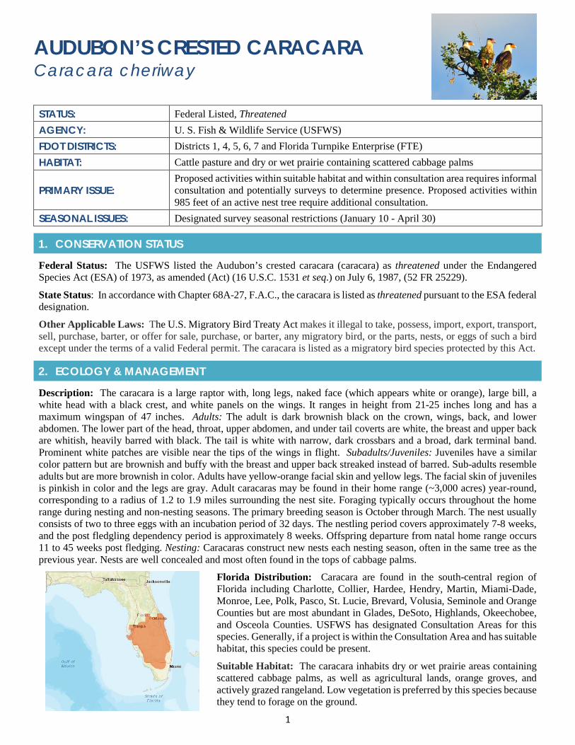
1
AUDUBON’S CRESTED CARACARA Caracara cheriway
STATUS: Federal Listed, Threatened AGENCY: U. S. Fish & Wildlife Service (USFWS) FDOT DISTRICTS: Districts 1, 4, 5, 6, 7 and Florida Turnpike Enterprise (FTE) HABITAT: Cattle pasture and dry or wet prairie containing scattered cabbage palms
PRIMARY ISSUE: Proposed activities within suitable habitat and within consultation area requires informal consultation and potentially surveys to determine presence. Proposed activities within 985 feet of an active nest tree require additional consultation.
SEASONAL ISSUES: Designated survey seasonal restrictions (January 10 - April 30)
1. CONSERVATION STATUS
Federal Status: The USFWS listed the Audubon’s crested caracara (caracara) as threatened under the Endangered Species Act (ESA) of 1973, as amended (Act) (16 U.S.C. 1531 et seq.) on July 6, 1987, (52 FR 25229).
State Status: In accordance with Chapter 68A-27, F.A.C., the caracara is listed as threatened pursuant to the ESA federal designation.
Other Applicable Laws: The U.S. Migratory Bird Treaty Act makes it illegal to take, possess, import, export, transport, sell, purchase, barter, or offer for sale, purchase, or barter, any migratory bird, or the parts, nests, or eggs of such a bird except under the terms of a valid Federal permit. The caracara is listed as a migratory bird species protected by this Act.
2. ECOLOGY & MANAGEMENT
Description: The caracara is a large raptor with, long legs, naked face (which appears white or orange), large bill, a white head with a black crest, and white panels on the wings. It ranges in height from 21-25 inches long and has a maximum wingspan of 47 inches. Adults: The adult is dark brownish black on the crown, wings, back, and lower abdomen. The lower part of the head, throat, upper abdomen, and under tail coverts are white, the breast and upper back are whitish, heavily barred with black. The tail is white with narrow, dark crossbars and a broad, dark terminal band. Prominent white patches are visible near the tips of the wings in flight. Subadults/Juveniles: Juveniles have a similar color pattern but are brownish and buffy with the breast and upper back streaked instead of barred. Sub-adults resemble adults but are more brownish in color. Adults have yellow-orange facial skin and yellow legs. The facial skin of juveniles is pinkish in color and the legs are gray. Adult caracaras may be found in their home range (~3,000 acres) year-round, corresponding to a radius of 1.2 to 1.9 miles surrounding the nest site. Foraging typically occurs throughout the home range during nesting and non-nesting seasons. The primary breeding season is October through March. The nest usually consists of two to three eggs with an incubation period of 32 days. The nestling period covers approximately 7-8 weeks, and the post fledgling dependency period is approximately 8 weeks. Offspring departure from natal home range occurs 11 to 45 weeks post fledging. Nesting: Caracaras construct new nests each nesting season, often in the same tree as the previous year. Nests are well concealed and most often found in the tops of cabbage palms.
Florida Distribution: Caracara are found in the south-central region of Florida including Charlotte, Collier, Hardee, Hendry, Martin, Miami-Dade, Monroe, Lee, Polk, Pasco, St. Lucie, Brevard, Volusia, Seminole and Orange Counties but are most abundant in Glades, DeSoto, Highlands, Okeechobee, and Osceola Counties. USFWS has designated Consultation Areas for this species. Generally, if a project is within the Consultation Area and has suitable habitat, this species could be present.
Suitable Habitat: The caracara inhabits dry or wet prairie areas containing scattered cabbage palms, as well as agricultural lands, orange groves, and actively grazed rangeland. Low vegetation is preferred by this species because they tend to forage on the ground.
2
Identification of Suitable Nesting Habitat: The primary nesting substrate is cabbage palm, although there have been rare reports of nesting in slash pine, cypress, oak, red cedar, Australian pine, saw palmetto, and black gum, and even more atypical locations such as an electrical substation, radio tower, and billboard. USFWS has two designated zones used for evaluating potential impacts to caracara consisting of a primary zone of 985 feet (300 meters) and a secondary zone of 4,921 ft. (1,500 meters) outward from a nest tree. Protection of the primary nest zone is the most important and habitat alteration within this nest radius is used for calculating impacts to this species. The secondary zone is generally defined as the foraging territory and used when evaluating potential survey limits.
Behavior and Activity to Note: Caracara eat carrion and are attracted to roadkill and discarded food this can place them in harm’s way in relationship to roadways and construction staging areas that are not kept free of trash. Possible project commitments included removing roadkill and keeping staging area free of trash.
Protection and Management Plans: A federal recovery plan for the caracara were issued in 1989 (USFWS 1989), and as part of the South Florida Multi-species Recovery Plan (USFWS 1999).
Designated Protection Area or Critical Habitat: No Critical Habitat rules have been created for the caracara.
Survey Protocol: USFWS has recommended management practices and survey protocols. The latest Draft Survey Protocol was issued in 2016.
3. AGENCY CONSULTATION (FEDERAL)
Responsible Agency(s): USFWS takes the lead on consultation for this species. The USFWS staff specialist on caracara is located within the Vero Beach office; however, the lead consultation office and dedicated FDOT reviewer will be dependent on the location of the project.
Federal Nexus for Consultation: Any project that is authorized, funded, or requires a federal permit will need to conduct consultation under Section 7 of the ESA to determine whether the project will impact caracara.
Type of Consultation: The type of consultation, Informal or Formal, will depend on results of FDOT’s analysis of whether the proposed project will have an adverse effect on the species. If a proposed federal action may affect a listed species, informal or formal consultation is required. Typically, a may affect determination is made if a project will alter caracara habitat within the primary zone (300 meters) of an active nest site.
Demonstrate Avoidance and Minimization: FDOT must demonstrate to the USFWS that it is making all efforts to avoid and minimize impacts to caracara from proposed projects. This effort is essential to the consultation processes and may include measures such as avoiding pond site alternatives that remove a nest tree or altering construction methodology such that construction in the vicinity of a nest site is outside of the nesting season.
Tools for Section 7 ESA Consultation: There is not a Programmatic Effects Determination Key for this species. There is not an established Standard Provision or Programmatic Biological Opinion (PBO) for this species.
Special Provisions, or Standard Protection Measures: No special provisions or standard protection measures.
General timeframes for Consultation and Permitting: Early coordination is highly recommended if you are anticipating land alteration within 300 meters (985 feet) of a caracara nest site. Formal Consultation can take as long as 135 days and though not typical, may conclude with a finding of jeopardy thus preventing authorization of permits.
4. PERMITTING
Prohibited Activities: Any land clearing within 985 ft. (300 meters) of a nest site without Formal Consultation with the USFWS and an approved Biological Opinion.
Activities Authorized by Permit: Effects to caracara can be authorized by USFWS by a BO during consultation through the USACE permitting process or the NEPA process. The BO can authorize impacts referred to as “incidental take” in the form of harm (i.e. loss of foraging habitat and/or disruption of breeding activity).
5. PRE-CONSTRUCTION & CONSTRUCTION COMPLIANCE
Review of Commitments: Commitments can be found within the Environmental Commitment Module in ProjectSuite Enterprise Edition (PSEE). If additional commitments are identified during design or permitting, coordinate with the
3
Project Manager and add to the Environmental Commitment Module. The Design Project Manager will share the Project Commitment Record with Construction.
Review of Environmental Permits for Special Conditions: Review all environmental permits for Special Conditions related caracara. Make sure that construction personnel have copies.
Prior to Construction: Advise personnel that penalties for convictions for violations of these laws range from a maximum of $500 and/or 60 days imprisonment for first offenses of misdemeanor crimes or up to $50,000 and/or one year imprisonment for criminal violations against the federal Endangered Species Act. To learn more read Laws that Protect Florida’s Wildlife, https://edis.ifas.ufl.edu/pdffiles/UW/UW07600.pdf.
6. TIPS
Tips: In coordination with FDOT’s Office of Environmental Management (OEM) or District Environmental Management Office, reach out to your USFWS representative to informally coordinate prior to conducting surveys, including submittal of a proposed survey plan and list of observers. Note that caracara surveys are typically recognized as valid for two survey seasons. Early internal coordination between DEMO and Design is important to avoid conducting a few surveys as possible.
Seasonal Restrictions: Surveys must start no later than January 10 and continue through April 30 to provide adequate data to conclude whether the site contains an active caracara nest and/or foraging habitat.
Survey Restrictions: Surveys must be conducted by a qualified biologist having at least two years of experience conducting bird surveys and at least 40 hours of caracara survey experience (i.e., equivalent to one survey season) under the supervision of an experienced caracara surveyor. If an observer does not meet these minimum qualifications, the observer should be accompanied by a qualified observer who will serve as the primary observer. Even in cases of qualified observers, and where staff resources allow it, having two observers at the same station can increase the probability of finding a nest.
7. RESOURCES
Web Resources*
• Federal Registry, Threatened Status for crested caracarahttps://www.law.cornell.edu/rio/citation/52_FR_25229
• Florida Fish and Wildlife Conservation Commission, Species Informationhttp://myfwc.com/wildlifehabitats/imperiled/profiles/birds/audubons-crested-caracara/
• FWS Draft Survey Protocol (Additional Guidance (2017-2017 Breeding Season)https://www.fws.gov/verobeach/BirdsPDFs/20161209_CCsurveyprotocol.pdf
• FWS ECOS Environmental Conservation Online System: Audubon's crested caracarahttps://ecos.fws.gov/ecp0/profile/speciesProfile?sId=8250
• South Florida Multi-Species Recovery Planhttps://www.fws.gov/verobeach/ListedSpeciesMSRP.html
Lead Specialist(s) for Agencies: For general information regarding the caracara, Steve Schubert is the designated lead species coordinator (contact number: 772-469-4249/ email: [email protected])
Publications:
• U.S. Fish and Wildlife Service. 1989. Recovery plan for the Florida population of Audubon's crested caracara. U.S.Fish and Wildlife Service; Atlanta, Georgia.
• U.S. Fish and Wildlife Service. 2004. Survey Protocol for Finding Caracara Nests. U.S. Fish and Wildlife Service;South Florida Ecological Services.
4
• U.S. Fish and Wildlife Service. 2009b. Florida Population of the Audubon’s Crested Caracara (Polyborus plancusaudubonii), Northern Crested Caracara (Caracara cheriway) 5-Year Review
• Morrison, J.L. 2001. Recommended management practices and survey protocols for Audubon's crested caracara(Caracara cheriway audubonii) in Florida. Technical Report Number 18. Bureau of Wildlife Diversity Conservation,Florida Fish and Wildlife Conservation Commission; Tallahassee, Florida.
• Morrison, J.L. and S.R. Humphrey. 2001. Conservation value of private lands for crested caracaras in Florida.Conservation Biology 15(3):675-684.
• Morrison, J.L. 1999. Breeding biology and productivity of Florida's Crested Caracaras. Condor 101(3):505-517.
* If you are experiencing difficulties accessing web resources please review your web browser settings, securitybrowser controls, or cut-and-paste the link directly into your URL/address bar. Note that website links may changeovertime. If a web link is not accessible, you may be able to find the resource by going through the website’s homepage.
Photo – Audubon’s Crested Caracara

2019 Appendix: Listed Species
APPENDIX 1k Everglade Snail Kite
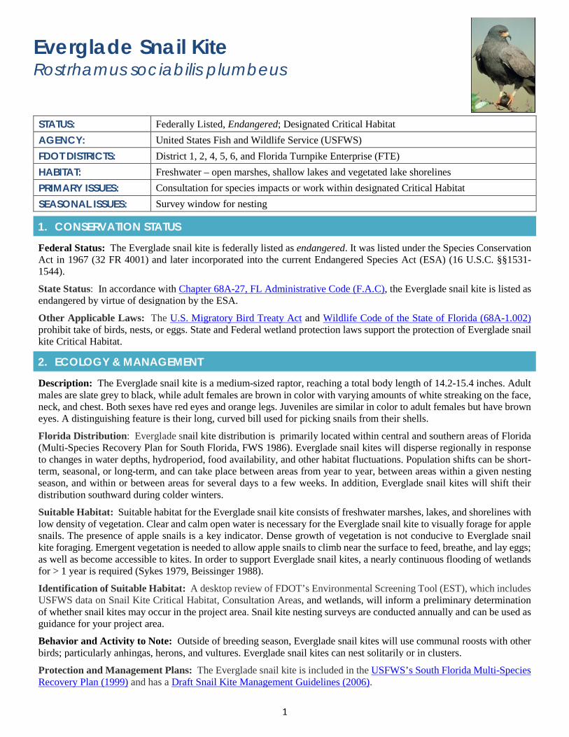
1
Everglade Snail Kite Rostrhamus sociabilis plumbeus
STATUS: Federally Listed, Endangered; Designated Critical Habitat AGENCY: United States Fish and Wildlife Service (USFWS) FDOT DISTRICTS: District 1, 2, 4, 5, 6, and Florida Turnpike Enterprise (FTE) HABITAT: Freshwater – open marshes, shallow lakes and vegetated lake shorelines PRIMARY ISSUES: Consultation for species impacts or work within designated Critical Habitat SEASONAL ISSUES: Survey window for nesting
1. CONSERVATION STATUS
Federal Status: The Everglade snail kite is federally listed as endangered. It was listed under the Species Conservation Act in 1967 (32 FR 4001) and later incorporated into the current Endangered Species Act (ESA) (16 U.S.C. §§1531-1544).
State Status: In accordance with Chapter 68A-27, FL Administrative Code (F.A.C), the Everglade snail kite is listed as endangered by virtue of designation by the ESA.
Other Applicable Laws: The U.S. Migratory Bird Treaty Act and Wildlife Code of the State of Florida (68A-1.002) prohibit take of birds, nests, or eggs. State and Federal wetland protection laws support the protection of Everglade snail kite Critical Habitat.
2. ECOLOGY & MANAGEMENT
Description: The Everglade snail kite is a medium-sized raptor, reaching a total body length of 14.2-15.4 inches. Adult males are slate grey to black, while adult females are brown in color with varying amounts of white streaking on the face, neck, and chest. Both sexes have red eyes and orange legs. Juveniles are similar in color to adult females but have brown eyes. A distinguishing feature is their long, curved bill used for picking snails from their shells.
Florida Distribution: Everglade snail kite distribution is primarily located within central and southern areas of Florida (Multi-Species Recovery Plan for South Florida, FWS 1986). Everglade snail kites will disperse regionally in response to changes in water depths, hydroperiod, food availability, and other habitat fluctuations. Population shifts can be short-term, seasonal, or long-term, and can take place between areas from year to year, between areas within a given nesting season, and within or between areas for several days to a few weeks. In addition, Everglade snail kites will shift their distribution southward during colder winters.
Suitable Habitat: Suitable habitat for the Everglade snail kite consists of freshwater marshes, lakes, and shorelines with low density of vegetation. Clear and calm open water is necessary for the Everglade snail kite to visually forage for apple snails. The presence of apple snails is a key indicator. Dense growth of vegetation is not conducive to Everglade snail kite foraging. Emergent vegetation is needed to allow apple snails to climb near the surface to feed, breathe, and lay eggs; as well as become accessible to kites. In order to support Everglade snail kites, a nearly continuous flooding of wetlands for > 1 year is required (Sykes 1979, Beissinger 1988).
Identification of Suitable Habitat: A desktop review of FDOT’s Environmental Screening Tool (EST), which includes USFWS data on Snail Kite Critical Habitat, Consultation Areas, and wetlands, will inform a preliminary determination of whether snail kites may occur in the project area. Snail kite nesting surveys are conducted annually and can be used as guidance for your project area.
Behavior and Activity to Note: Outside of breeding season, Everglade snail kites will use communal roosts with other birds; particularly anhingas, herons, and vultures. Everglade snail kites can nest solitarily or in clusters.
Protection and Management Plans: The Everglade snail kite is included in the USFWS’s South Florida Multi-Species Recovery Plan (1999) and has a Draft Snail Kite Management Guidelines (2006).
2
Designated Protection Area or Critical Habitat: In 1977, the USFWS designated Critical Habitat for the Everglade snail kite. Areas with designated Critical Habitat include Arthur R. Marshall Loxahatchee National Wildlife Refuge, Everglades Water Conservation Areas 2 and 3, Everglades National Park, Lake Okeechobee, Strazulla and Cloud Lake Reservoirs and St. Johns Marsh. Federal agencies must ensure that any action they authorize, fund, or permit will not destroy or adversely modify Critical Habitat.
Survey Protocol and Requirements: The USFWS has draft snail kite survey protocol (2004). Surveys should be conducted during breeding season from January to May. This survey can determine foraging and roosting patterns of individuals within the area and should document the location of each Everglade snail kite observed. Monitoring should occur during and after construction and reports should be sent to USFWS.
3. AGENCY CONSULTATION (FEDERAL)
Responsible Agency(s): The applicable agency for the snail kite is the USFWS. The USFWS, through Section 7 of the ESA, reviews permit applications for projects that may affect Everglade snail kite. As part of the review, the USFWS recommends ways to avoid or minimize the effects.
Federal Nexus for Consultation: Any project that is authorized, funded, or requires a federal permit will need to conduct consultation under the ESA Section 7 to determine whether the project will impact the Everglade snail kite or result in the adverse modification of designated Critical Habitat.
Type of Consultation: The type of consultation, Informal and Formal, will depend on results of FDOT’s analysis of whether the proposed project may have an adverse effect on the Everglade snail kite and its Critical Habitat. If a proposed federal action may affect, likely to adversely affect the snail kite or Critical Habitat, formal consultation is required.
Demonstrate Avoidance, Minimization, and Mitigation: FDOT shall demonstrate to the USFWS that it is making all efforts to avoid and minimize impacts to the Everglade snail kite and its Critical Habitat. This effort is essential to the consultation processes and may include such activities as implementing USFWS Conservation measures and/or aspects of the USFWS Draft Everglade Snail Kite Management Guidelines.
Tools for Section 7 ESA Consultation: The USFWS has not developed a snail kite effects determination key.
Special Provisions, or Standard Protection Measures: No standard provisions; however, the USFWS does have conservation measures for the Everglade snail kite.
General Timeframes for Consultation and Permitting: Early coordination is recommended if impacts are anticipated to the Everglade snail kite or its Critical Habitat. Formal Section 7 ESA Consultation can take as long as 180 days.
4. PERMITTING
Prohibited Activities: The ESA, U.S. Migratory Bird Treaty Act and state Wildlife Code prohibits the take of birds, nests or eggs. No activity may injure, harm, harass or kill this species. Project activities should cease if a nest or roost is found with 425 feet of any project activities.
Activities Authorized by Permit: Permit authorization is based on the proposed project location and description; the potential effects to snail kite, snail kite suitable habitat (wetlands), and/or snail kite Critical Habitat; and any measures (such as project components, standard construction precautions, or special conditions included in the authorization) to avoid or minimize effects to Everglade snail kite and/or Everglade snail kite Critical Habitat.
5. PRE-CONSTRUCTION & CONSTRUCTION COMPLIANCE
Review of Commitments: Commitments can be found within the Environmental Commitment Module in ProjectSuite Enterprise Edition (PSEE). If additional commitments are identified during design or permitting, coordinate with the Project Manager and add to the Environmental Commitment Module. The Design Project Manager will share the Project Commitment Record with Construction.
Review of Environmental Permits for Special Conditions: Review all environmental permits for Special Conditions related to the Everglade snail kite and Critical Habitat. Make sure that construction personnel have copies.
Prior to Construction: Advise personnel that penalties for convictions for violations of these laws range from a maximum of $500 and/or 60 days imprisonment for first offenses of misdemeanor crimes or up to $50,000 and/or one-
3
year imprisonment for criminal violations against the federal Endangered Species Act. To learn more read Laws that Protect Florida’s Wildlife, https://edis.ifas.ufl.edu/pdffiles/UW/UW07600.pdf.
6. TIPS
Tips: A field review of wetland habitat can indicate whether or not habitat conditions are suitable for Everglade snail kite. A review of wetland hydrology through the Water Management District could indicate whether wetlands support apple snails (nearly continuous flooding of wetlands for > 1 year is required).
Seasonal Restrictions: Everglade snail kite surveys should be conducted during breeding season to increase chances of observing snail kites. The breeding season varies widely from year to year in relation to rainfall and water levels. Generally nesting occurs from January to May.
Survey Restrictions: Surveys should be completed by a qualified avian biologist/ecologist. For additional requirements go to USFWS’s Draft Survey Protocol (2004).
7. RESOURCES
Web Resources*
• Federal Register for Everglade Snail Kite, March 11, 1967 - https://ecos.fws.gov/docs/federal_register/fr18.pdf
• FWC’s Listed Species Information – Everglade snail kitehttp://myfwc.com/wildlifehabitats/imperiled/profiles/birds/everglade-snail-kite/
• USFWS Species Profiles - https://ecos.fws.gov/ecp0/profile/speciesProfile?spcode=B00F
• USFWS Multi-Species Recovery Plan - https://www.fws.gov/verobeach/MSRPPDFs/EvergladeSnailKite.pdf
• USFWS Everglade Snail Kite Survey Protocol (Draft 2004)https://www.fws.gov/verobeach/BirdsPDFs/SnailKiteSurveyProtocol.pdf
• USFWS Everglade Snail Kite Management Guidelines (Draft 2006)https://www.fws.gov/verobeach/BirdsPDFs/20060221SnailKiteManagementGuidelines2.pdf
Lead Specialist(s) for Agencies:
Tylan Dean, Fish and Wildlife Biologist, South Florida Ecological Services Office, 1339 20th Street, Vero Beach, Florida 32960-3559; Telephone: (772) 562-3909, extension 284; E-mail: [email protected].
Publications:
• Beissinger, S. R. 1988. Snail kite. Pages 148-165 in R. S. Palmer, eds. Handbook of North American birds, vol. 4,Yale University Press, New Haven, Connecticut.
• Bennetts, R.E., and W.M. Kitchens. 1997. The demography and movements of snail kites in Florida. Final report.Florida Cooperative Fish and Wildlife Research Unit, National Biological Service, U.S. Department of the Interior;Gainesville, Florida.
• Bennetts, R.E., M.W. Collopy, and S.R. Beissinger. 1988. Nesting ecology of Snail Kites in Water Conservation Area3A. Department of Wildlife and Range Science, University of Florida, Gainesville. Florida Cooperative Fish andWildlife Research Unit, Technical Report No. 31, 174 p.
• Snyder, N.F.R., S.R. Beissinger, and R. Chandler. 1989. Reproduction and demography of the Florida Everglade(snail) kite. Condor 91:300-316.
• Sykes, P.W., Jr. 1982. Everglade Kite. Pages 43-44 in D.E. Davis, editor. CRC Handbook of Census Methods forTerrestrial Vertebrates. CRC Press, Boca Raton, Florida.
• Sykes, P.W. Jr. 1987. The feeding habits of the snail kite in Florida, USA. Colonial Waterbirds 10(1):84-92.
* If you are experiencing difficulties accessing web resources please review your web browser settings, security browsercontrols, or cut-and-paste the link directly into your URL/address bar. Note that website links may change overtime. If aweb link is not accessible, you may be able to find the resource by going through the website’s home page.

2019 Appendix: Listed Species
APPENDIX 1l Florida Bonneted Bat
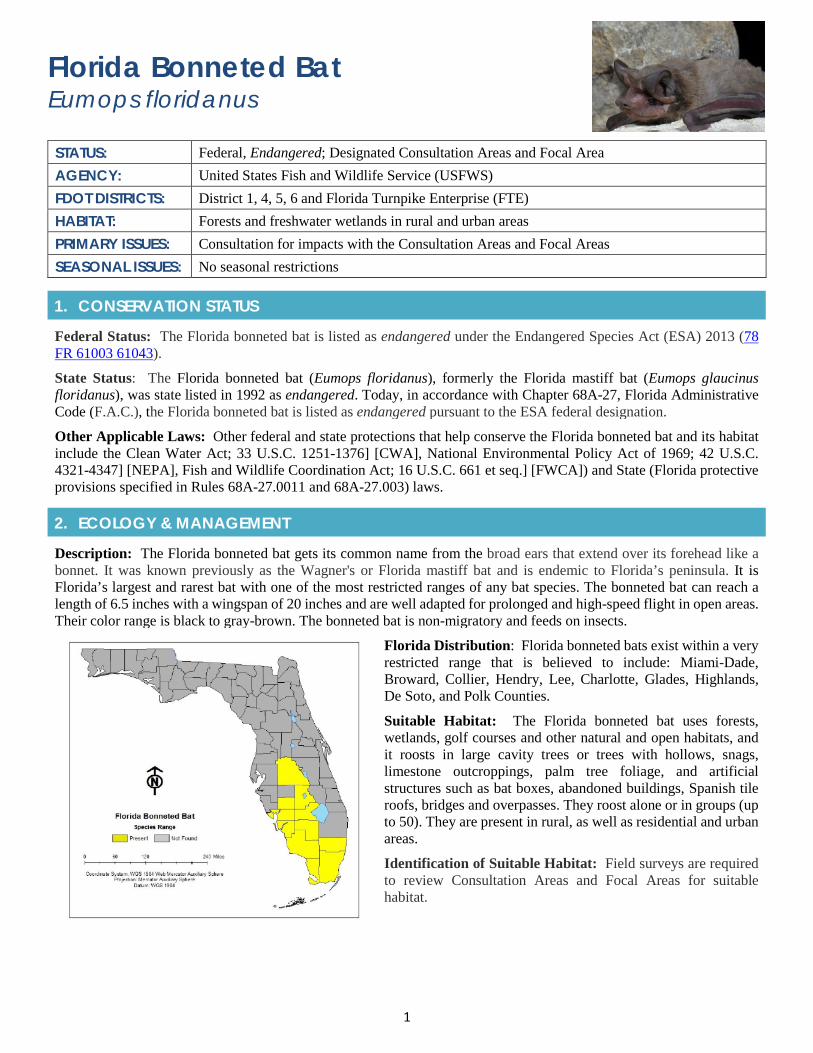
1
Florida Bonneted Bat Eumops floridanus
STATUS: Federal, Endangered; Designated Consultation Areas and Focal Area AGENCY: United States Fish and Wildlife Service (USFWS) FDOT DISTRICTS: District 1, 4, 5, 6 and Florida Turnpike Enterprise (FTE) HABITAT: Forests and freshwater wetlands in rural and urban areas PRIMARY ISSUES: Consultation for impacts with the Consultation Areas and Focal Areas SEASONAL ISSUES: No seasonal restrictions
1. CONSERVATION STATUS
Federal Status: The Florida bonneted bat is listed as endangered under the Endangered Species Act (ESA) 2013 (78 FR 61003 61043).
State Status: The Florida bonneted bat (Eumops floridanus), formerly the Florida mastiff bat (Eumops glaucinus floridanus), was state listed in 1992 as endangered. Today, in accordance with Chapter 68A-27, Florida Administrative Code (F.A.C.), the Florida bonneted bat is listed as endangered pursuant to the ESA federal designation.
Other Applicable Laws: Other federal and state protections that help conserve the Florida bonneted bat and its habitat include the Clean Water Act; 33 U.S.C. 1251-1376] [CWA], National Environmental Policy Act of 1969; 42 U.S.C. 4321-4347] [NEPA], Fish and Wildlife Coordination Act; 16 U.S.C. 661 et seq.] [FWCA]) and State (Florida protective provisions specified in Rules 68A-27.0011 and 68A-27.003) laws.
2. ECOLOGY & MANAGEMENT
Description: The Florida bonneted bat gets its common name from the broad ears that extend over its forehead like a bonnet. It was known previously as the Wagner's or Florida mastiff bat and is endemic to Florida’s peninsula. It is Florida’s largest and rarest bat with one of the most restricted ranges of any bat species. The bonneted bat can reach a length of 6.5 inches with a wingspan of 20 inches and are well adapted for prolonged and high-speed flight in open areas. Their color range is black to gray-brown. The bonneted bat is non-migratory and feeds on insects.
Florida Distribution: Florida bonneted bats exist within a very restricted range that is believed to include: Miami-Dade, Broward, Collier, Hendry, Lee, Charlotte, Glades, Highlands, De Soto, and Polk Counties.
Suitable Habitat: The Florida bonneted bat uses forests, wetlands, golf courses and other natural and open habitats, and it roosts in large cavity trees or trees with hollows, snags, limestone outcroppings, palm tree foliage, and artificial structures such as bat boxes, abandoned buildings, Spanish tile roofs, bridges and overpasses. They roost alone or in groups (up to 50). They are present in rural, as well as residential and urban areas.
Identification of Suitable Habitat: Field surveys are required to review Consultation Areas and Focal Areas for suitable habitat.
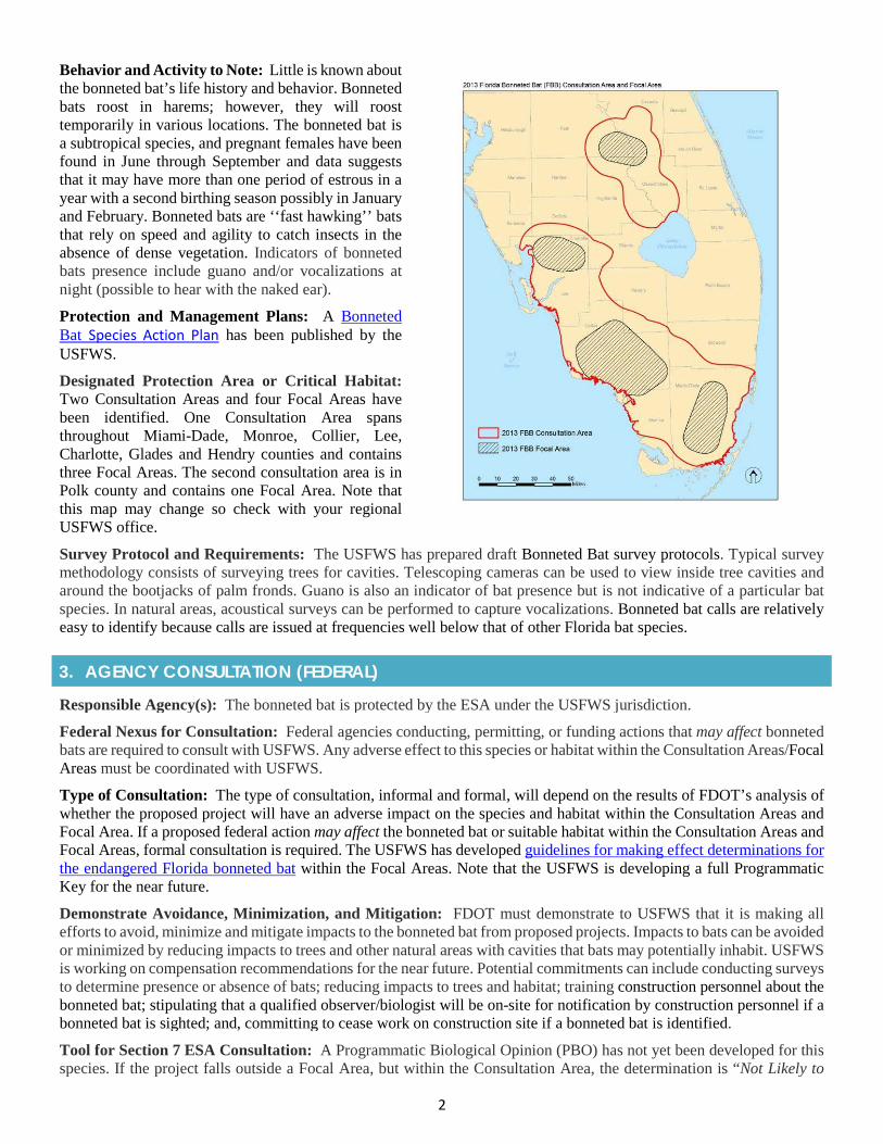
2
Behavior and Activity to Note: Little is known about the bonneted bat’s life history and behavior. Bonneted bats roost in harems; however, they will roost temporarily in various locations. The bonneted bat is a subtropical species, and pregnant females have been found in June through September and data suggests that it may have more than one period of estrous in a year with a second birthing season possibly in January and February. Bonneted bats are ‘‘fast hawking’’ bats that rely on speed and agility to catch insects in the absence of dense vegetation. Indicators of bonneted bats presence include guano and/or vocalizations at night (possible to hear with the naked ear).
Protection and Management Plans: A Bonneted Bat Species Action Plan has been published by the USFWS.
Designated Protection Area or Critical Habitat: Two Consultation Areas and four Focal Areas have been identified. One Consultation Area spans throughout Miami-Dade, Monroe, Collier, Lee, Charlotte, Glades and Hendry counties and contains three Focal Areas. The second consultation area is in Polk county and contains one Focal Area. Note that this map may change so check with your regional USFWS office.
Survey Protocol and Requirements: The USFWS has prepared draft Bonneted Bat survey protocols. Typical survey methodology consists of surveying trees for cavities. Telescoping cameras can be used to view inside tree cavities and around the bootjacks of palm fronds. Guano is also an indicator of bat presence but is not indicative of a particular bat species. In natural areas, acoustical surveys can be performed to capture vocalizations. Bonneted bat calls are relatively easy to identify because calls are issued at frequencies well below that of other Florida bat species.
3. AGENCY CONSULTATION (FEDERAL)
Responsible Agency(s): The bonneted bat is protected by the ESA under the USFWS jurisdiction.
Federal Nexus for Consultation: Federal agencies conducting, permitting, or funding actions that may affect bonneted bats are required to consult with USFWS. Any adverse effect to this species or habitat within the Consultation Areas/Focal Areas must be coordinated with USFWS.
Type of Consultation: The type of consultation, informal and formal, will depend on the results of FDOT’s analysis of whether the proposed project will have an adverse impact on the species and habitat within the Consultation Areas and Focal Area. If a proposed federal action may affect the bonneted bat or suitable habitat within the Consultation Areas and Focal Areas, formal consultation is required. The USFWS has developed guidelines for making effect determinations for the endangered Florida bonneted bat within the Focal Areas. Note that the USFWS is developing a full Programmatic Key for the near future.
Demonstrate Avoidance, Minimization, and Mitigation: FDOT must demonstrate to USFWS that it is making all efforts to avoid, minimize and mitigate impacts to the bonneted bat from proposed projects. Impacts to bats can be avoided or minimized by reducing impacts to trees and other natural areas with cavities that bats may potentially inhabit. USFWS is working on compensation recommendations for the near future. Potential commitments can include conducting surveys to determine presence or absence of bats; reducing impacts to trees and habitat; training construction personnel about the bonneted bat; stipulating that a qualified observer/biologist will be on-site for notification by construction personnel if a bonneted bat is sighted; and, committing to cease work on construction site if a bonneted bat is identified.
Tool for Section 7 ESA Consultation: A Programmatic Biological Opinion (PBO) has not yet been developed for this species. If the project falls outside a Focal Area, but within the Consultation Area, the determination is “Not Likely to

3
Adversely Affect”. If the project falls within the Focal Area, the determination is “Likely to Adversely Affect”. See USFWS’s guidelines for making effect determinations for the endangered Florida bonneted bat within the Focal Areas. The USFWS is developing a full programmatic key for the near future.
Special Provisions, or Standard Protection Measures: No standard provisions or protection measures.
General Timeframes for Consultation and Permitting: Early consultation is recommended if you have impacts to the bonneted bat or suitable habitat within the Consultation Areas and Focal Areas.
4. PERMITTING
Prohibited Activities: It is prohibited to impact trees, palms, limestone outcroppings, and artificial structures within the Consultation Area and Focal Area without surveying for evidence of the species and determining that no bats are present.
Activities Authorized by Permit: Permit authorization is based on the proposed project location (Consultation Areas and Focal Area), the potential effects to the bonneted bat, and any measures (such as project components, construction precautions, or special conditions included in the authorization) to avoid or minimize those effects.
5. PRE-CONSTRUCTION & CONSTRUCTION COMPLIANCEReview of Commitments: Commitments can be found within the Environmental Commitment Module in ProjectSuite Enterprise Edition (PSEE). If additional commitments are identified during design or permitting, coordinate with the Project Manager and add to the Environmental Commitment Module. The Design Project Manager will share the Project Commitment Record with Construction.
Review all Environmental Permits for Special Conditions: Review all environmental permits for Special Conditions related to the bonneted bat and its Consultation Areas and Focal Areas. Make sure that construction personnel have copies.
Prior to Construction: Advise personnel that penalties for convictions for violations of these laws range from a maximum of $500 and/or 60 days imprisonment for first offenses of misdemeanor crimes or up to $50,000 and/or one-year imprisonment for criminal violations against the federal Endangered Species Act. To learn more read Laws that Protect Florida’s Wildlife.
6. TIPS
Tips: In coordination with FDOT’s Office of Environmental Management (OEM), reach out to your USFWS ETAT representative for information regarding effect determinations and the consultation process for the bonneted bat.
Seasonal Restrictions: There are no seasonal restrictions for the bonneted bat. This species is active year-round throughout its range.
Survey Restrictions: Surveys do not need to be conducted outside of the Consultation Areas. Draft survey protocols have been developed by the USFWS.
7. RESOURCES
Web Resources*• Center for Biological Diversity, Florida Bonneted Bat Profile
https://www.biologicaldiversity.org/species/mammals/Florida_bonneted_bat/index.html
• Florida Bonneted Bat Biological Status Review Reporthttps://www.gpo.gov/fdsys/pkg/FR-2013-10-02/pdf/2013-23401.pdf
• USFWS Florida Bonneted Bat Profilehttps://ecos.fws.gov/ecp0/profile/speciesProfile?spcode=A0JB
• USFWS Guidelines for Making Effect Determinations for the Endangered Florida Bonneted Bathttp://www.saj.usace.army.mil/Portals/44/docs/regulatory/sourcebook/endangered_species/Florida%20Bonneted%20Bat/2013%20FBB%20Effect%20Determination%20Guidelines.pdf
4
• FWC Species Recovery Planhttps://myfwc.com/media/2117/florida-bonneted-bat-species-action-plan-final-draft.pdf
• UF/IFS Florida’s Bats: Florida Bonneted Bathttp://edis.ifas.ufl.edu/uw426
• UF/IFAS – Bats in Buildings?http://sfyl.ifas.ufl.edu/archive/hot_topics/environment/bats_buildings.shtml
• UF/IFAS – Have You Got Bats? (English and Spanish)https://www.speakcdn.com/assets/2440/have-you-got-bats-web-comp_english.pdfhttps://www.speakcdn.com/assets/2440/have-you-got-bats-web_spanishcomp.pdf
Lead Specialist(s) for Agencies:
If the project is within the Consultation Area for the Florida bonneted bat, you can contact:
Roxanna Hinzman; [email protected]; 772-469-4341 USFWS, 1339 20th Street, Vero Beach, FL 32960
Publications: • UF/IFAS – Bats of Florida Publications, https://edis.ifas.ufl.edu/topic_bats
• Owre, O. T., & Layne, J. N. (1978). The Florida mastiff bat, Eumops glaucinus floridanus. Rare and endangeredbiota of Florida, 1, 43-44.
• Belwood, J. J. (1992). Florida mastiff bat, Eumops glaucinus floridanus. Rare and endangered biota of Florida, 1,216-223.
* If you are experiencing difficulties accessing web resources please review your web browser settings, securitybrowser controls, or cut-and-paste the link directly into your URL/address bar. Note that website links may changeovertime. If a web link is not accessible, you may be able to find the resource by going through the website’s homepage.
PHOTO: Dustin Smith, https://www.zoomiami.org/florida-bonneted-bat

2019 Appendix: Listed Species
APPENDIX 1m Florida Panther
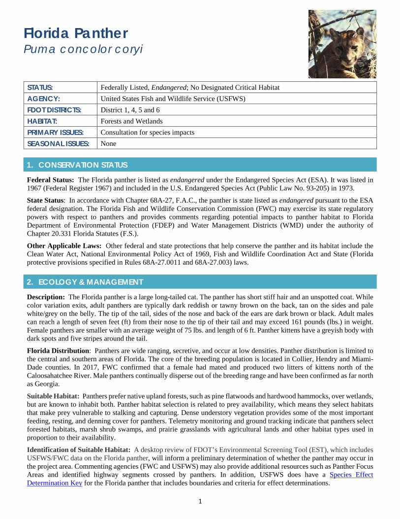
1
Florida Panther Puma concolor coryi
STATUS: Federally Listed, Endangered; No Designated Critical Habitat AGENCY: United States Fish and Wildlife Service (USFWS) FDOT DISTRICTS: District 1, 4, 5 and 6 HABITAT: Forests and Wetlands PRIMARY ISSUES: Consultation for species impacts SEASONAL ISSUES: None
1. CONSERVATION STATUS
Federal Status: The Florida panther is listed as endangered under the Endangered Species Act (ESA). It was listed in 1967 (Federal Register 1967) and included in the U.S. Endangered Species Act (Public Law No. 93-205) in 1973.
State Status: In accordance with Chapter 68A-27, F.A.C., the panther is state listed as endangered pursuant to the ESA federal designation. The Florida Fish and Wildlife Conservation Commission (FWC) may exercise its state regulatory powers with respect to panthers and provides comments regarding potential impacts to panther habitat to Florida Department of Environmental Protection (FDEP) and Water Management Districts (WMD) under the authority of Chapter 20.331 Florida Statutes (F.S.).
Other Applicable Laws: Other federal and state protections that help conserve the panther and its habitat include the Clean Water Act, National Environmental Policy Act of 1969, Fish and Wildlife Coordination Act and State (Florida protective provisions specified in Rules 68A-27.0011 and 68A-27.003) laws.
2. ECOLOGY & MANAGEMENT
Description: The Florida panther is a large long-tailed cat. The panther has short stiff hair and an unspotted coat. While color variation exits, adult panthers are typically dark reddish or tawny brown on the back, tan on the sides and pale white/grey on the belly. The tip of the tail, sides of the nose and back of the ears are dark brown or black. Adult males can reach a length of seven feet (ft) from their nose to the tip of their tail and may exceed 161 pounds (lbs.) in weight. Female panthers are smaller with an average weight of 75 lbs. and length of 6 ft. Panther kittens have a greyish body with dark spots and five stripes around the tail.
Florida Distribution: Panthers are wide ranging, secretive, and occur at low densities. Panther distribution is limited to the central and southern areas of Florida. The core of the breeding population is located in Collier, Hendry and Miami-Dade counties. In 2017, FWC confirmed that a female had mated and produced two litters of kittens north of the Caloosahatchee River. Male panthers continually disperse out of the breeding range and have been confirmed as far north as Georgia.
Suitable Habitat: Panthers prefer native upland forests, such as pine flatwoods and hardwood hammocks, over wetlands, but are known to inhabit both. Panther habitat selection is related to prey availability, which means they select habitats that make prey vulnerable to stalking and capturing. Dense understory vegetation provides some of the most important feeding, resting, and denning cover for panthers. Telemetry monitoring and ground tracking indicate that panthers select forested habitats, marsh shrub swamps, and prairie grasslands with agricultural lands and other habitat types used in proportion to their availability.
Identification of Suitable Habitat: A desktop review of FDOT’s Environmental Screening Tool (EST), which includes USFWS/FWC data on the Florida panther, will inform a preliminary determination of whether the panther may occur in the project area. Commenting agencies (FWC and USFWS) may also provide additional resources such as Panther Focus Areas and identified highway segments crossed by panthers. In addition, USFWS does have a Species Effect Determination Key for the Florida panther that includes boundaries and criteria for effect determinations.
2
Behavior and Activity to Note: The Florida panther breeding activity peaks between December and March. Litters are produced throughout the year, with 56 - 60% of births occurring between March and June. The greatest number of births occurs in May and June. Den sites are usually located in dense, understory vegetation, typically saw palmetto. Den sites are used for up to two months by female panthers and their litters from birth to weaning.
Protection and Management Plans: The USFWS issued its initial panther recovery plan in 1981. It was later revised in 1987 and again in 1995. In 1999, the USFWS approved the South Florida Multi-species Recovery Plan (MSRP) that identified recovery needs of 68 threatened and endangered species in south Florida including the panther. The most recent version (2008) includes specific strategies to maintain, restore, and expand the panther population and its habitat in south Florida, expand this population into south-central Florida, and reintroduce at least two additional viable populations within the historic range outside of south and south-central Florida.
Designated Protection Area or Critical Habitat: To date, no critical habitat has been designated for the Florida panther. However, the USFWS has identified a Panther Focus Area south of the Caloosahatchee River which is divided into Primary, Secondary, and Dispersal Zones. North of the Caloosahatchee River it is named the Primary Dispersal/Expansion Area. The Primary Zone is currently occupied and is important to the long-term viability of the panther in the wild. The Secondary Zone lands are contiguous with the Primary Zone and although these lands are used to a lesser extent, they are important to the long-term viability of the panther. The Dispersal Zone is a known corridor necessary to facilitate the dispersal of panthers and future panther population expansion to areas north of the Caloosahatchee River. The Primary Dispersal/Expansion Area is the Fisheating Creek/Babcock-Webb Wildlife Management Area region.
Survey Protocol and Requirements: The Florida panther is wide ranging, secretive, and occurs at low densities therefore surveys are not a useful tool. Rather the Species Effects Determination Key is to be utilized for determining potential impacts.
3. AGENCY CONSULTATION (FEDERAL)
Responsible Agency(s): Under section 7(a)(2) of the ESA, FWS consults with Federal agencies proposing actions that may affect the panther. In addition, FWC provides comments regarding potential impacts to panther habitat to FDEP and WMDs under the authority of Chapter 20.331 Florida Statutes.
Federal Nexus for Consultation: Section 7(a)(2) of the ESA requires that all Federal agencies consult with USFWS to ensure that any action authorized, funded, or carried out by the agency is not likely to jeopardize the continued existence of the Florida panther.
Type of Consultation: The type of consultation, Informal and Formal, will depend on results of FDOT’s analysis of whether the proposed project will have an adverse impact on the species. If a proposed federal action may affect the Florida panther than formal consultation is required. To determine the level of effect for the panther, the USFWS has published an Effect Determination Key (2007) for the Florida panther.
Demonstrate Avoidance, Minimization, and Mitigation: FDOT must demonstrate to USFWS that it is making all efforts to avoid and minimize impacts to the Florida panther. This effort is essential to the consultation processes and may include commitments such as modifying proposed plans, reducing speed limits, adding wildlife crossings (example I-75/Alligator Alley), and/or purchasing credits from an approved USFWS panther conservation bank.
Tool for Section 7 ESA Consultation: To help regulatory agencies determine the level of effect caused by a specific project, the USFWS created an Effect Determination Key (2007) for the Florida panther. Another tool also available is the USFWS Draft Panther Habitat Assessment Methodology (2002) to help guide the agency in evaluating permit applications for projects that could affect panthers and their habitat. This draft methodology is a way to assess the level of impacts and to evaluate the effect of any proposed compensation. The USFWS has not finalized the assessment methodology; however, it uses it to evaluate each project in detail within biological opinions.
Special Provisions, or Standard Protection Measures: No special provisions or standard protection measures.
General Timeframes for Consultation and Permitting: Early coordination is recommended if impacts are anticipated as Formal Consultation can take as long as 180 days.
3
4. PERMITTING
Prohibited Activities: Any direct, secondary, and cumulative impacts to the panther and habitat within its range.
Activities Authorized by Permit: Permit authorization is based on the proposed project location and description; the potential effects to panther and any measures (such as project components, standard construction precautions, or special conditions included in the authorization) to avoid or minimize those effects.
5. PRE-CONSTRUCTION & CONSTRUCTION COMPLIANCE
Review of Commitments: Commitments can be found within the Environmental Commitment Module in ProjectSuite Enterprise Edition (PSEE). If additional commitments are identified during design or permitting, coordinate with the Project Manager and add to the Environmental Commitment Module. The Design Project will share the Project Commitment Record with Construction.
Review all Environmental Permit Special Conditions: Review all environmental permits for Special Conditions related to Florida panther and its habitat. Make sure that construction personnel have copies. At the preconstruction conference, advise personnel to review any special conditions in the permits or Biological Opinions related to the Florida Panther. Florida panther educational training can be conducted with construction personal.
Prior to Construction: Advise personnel that penalties for convictions for violations of these laws range from a maximum of $500 and/or 60 days imprisonment for first offenses of misdemeanor crimes or up to $50,000 and/or one year imprisonment for criminal violations against the federal Endangered Species Act. To learn more read Laws that Protect Florida’s Wildlife.
6. TIPS
Tips: Early coordination with your USFWS ETAT member and the use of the Effect Determination Key (2007) for the Florida panther will assist in guiding consultation in a timely manner.
Seasonal Restrictions: No seasonal restrictions.
Survey Restrictions: The Florida panther is wide ranging, secretive, and occurs at low densities therefore surveys are not a useful tool. Rather the Species Effects Determination Key is to be utilize for determining potential impacts.
7. RESOURCES
Web Resources*
• FWC, Guide to Identifying Panther Trackshttps://myfwc.com/media/3108/ez-guide-to-identifying-panther-tracks.pdf
• FWC, Identifying Florida’s Native Catshttps://myfwc.com/media/20592/floridawildcatsidposterbobcat.pdf
• USFWS Florida Panther Recovery Implementation Teamhttps://www.fws.gov/verobeach/FloridaPantherRIT.html
• USFWS Panther Habitat Assessment Methodology, September 24, 2012https://www.fws.gov/verobeach/MammalsPDFs/20120924_Panther%20Habitat%20Assessment%20Method_Appendix.pdf
• USFWS Florida Panther Five Year Reviewhttps://ecos.fws.gov/docs/five_year_review/doc4352.pdf
• USFWS Florida Panther Profilehttps://ecos.fws.gov/ecp0/profile/speciesProfile?spcode=A008
• USFWS Florida Panther Response Team 2016 Annual Reporthttps://www.fws.gov/verobeach/MammalsPDFs/FloridaPantherResponseTeam2016Annual%20Report.pdf
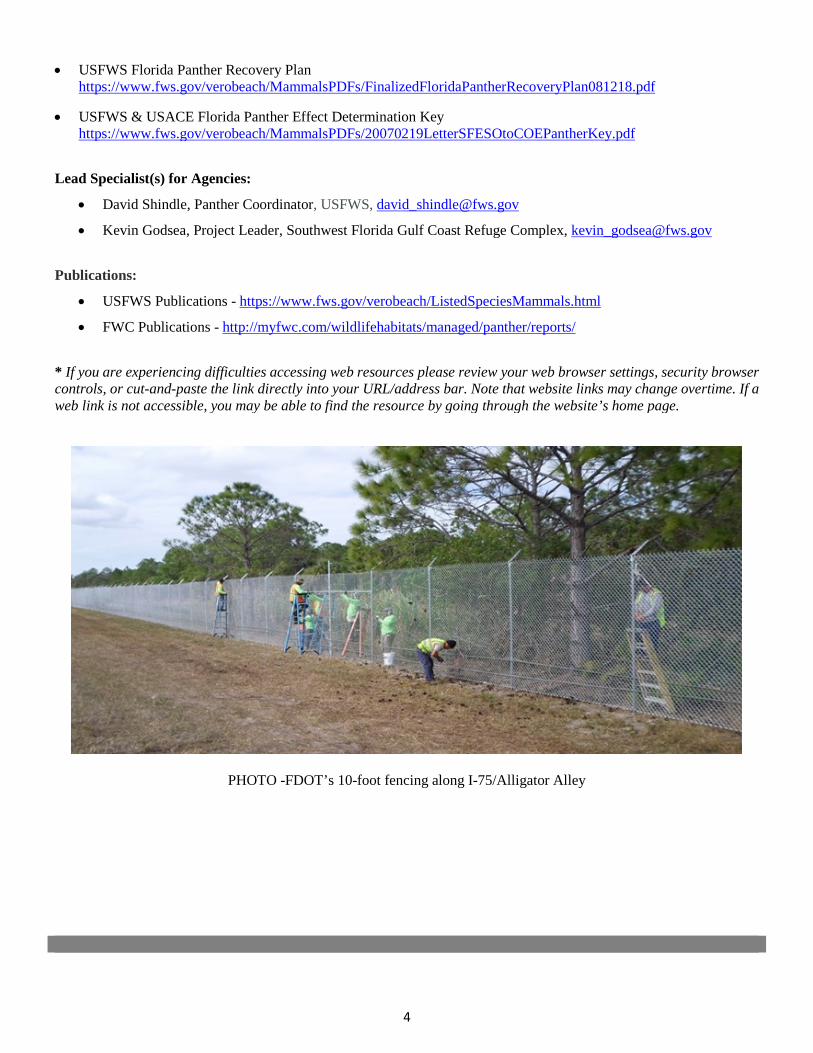
4
• USFWS Florida Panther Recovery Planhttps://www.fws.gov/verobeach/MammalsPDFs/FinalizedFloridaPantherRecoveryPlan081218.pdf
• USFWS & USACE Florida Panther Effect Determination Keyhttps://www.fws.gov/verobeach/MammalsPDFs/20070219LetterSFESOtoCOEPantherKey.pdf
Lead Specialist(s) for Agencies:
• David Shindle, Panther Coordinator, USFWS, [email protected]
• Kevin Godsea, Project Leader, Southwest Florida Gulf Coast Refuge Complex, [email protected]
Publications:
• USFWS Publications - https://www.fws.gov/verobeach/ListedSpeciesMammals.html
• FWC Publications - http://myfwc.com/wildlifehabitats/managed/panther/reports/
* If you are experiencing difficulties accessing web resources please review your web browser settings, security browsercontrols, or cut-and-paste the link directly into your URL/address bar. Note that website links may change overtime. If aweb link is not accessible, you may be able to find the resource by going through the website’s home page.
PHOTO -FDOT’s 10-foot fencing along I-75/Alligator Alley

2019 Appendix: Listed Species
APPENDIX 1n Sand Sink
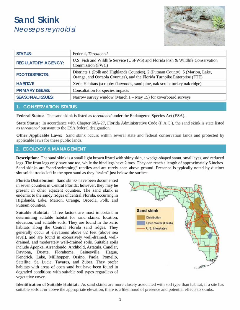
1
Sand Skink Neoseps reynoldsi
STATUS: Federal, Threatened
REGULATORY AGENCY: U.S. Fish and Wildlife Service (USFWS) and Florida Fish & Wildlife Conservation Commission (FWC)
FDOT DISTRICTS: Districts 1 (Polk and Highlands Counties), 2 (Putnam County), 5 (Marion, Lake, Orange, and Osceola Counties), and the Florida Turnpike Enterprise (FTE)
HABITAT: Xeric Habitats (scrubby flatwoods, sand pine, oak scrub, turkey oak ridge) PRIMARY ISSUES: Consultation for species impacts SEASONAL ISSUES: Narrow survey window (March 1 – May 15) for coverboard surveys
1. CONSERVATION STATUS
Federal Status: The sand skink is listed as threatened under the Endangered Species Act (ESA).
State Status: In accordance with Chapter 68A-27, Florida Administrative Code (F.A.C.), the sand skink is state listed as threatened pursuant to the ESA federal designation.
Other Applicable Laws: Sand skink occurs within several state and federal conservation lands and protected by applicable laws for these public lands.
2. ECOLOGY & MANAGEMENT
Description: The sand skink is a small light brown lizard with shiny skin, a wedge-shaped snout, small eyes, and reduced legs. The front legs only have one toe, while the hind legs have 2 toes. They can reach a length of approximately 5 inches. Sand skinks are “sand-swimming” reptiles and are rarely seen above ground. Presence is typically noted by distinct sinusoidal tracks left in the open sand as they “swim” just below the surface.
Florida Distribution: Sand skinks have been documented in seven counties in Central Florida; however, they may be present in other adjacent counties. The sand skink is endemic to the sandy ridges of central Florida, occurring in Highlands, Lake, Marion, Orange, Osceola, Polk, and Putnam counties.
Suitable Habitat: Three factors are most important in determining suitable habitat for sand skinks: location, elevation, and suitable soils. They are found in the xeric habitats along the Central Florida sand ridges. They generally occur at elevations above 82 feet (above sea level), and are found in excessively well-drained, well-drained, and moderately well-drained soils. Suitable soils include Apopka, Arrendondo, Archbold, Astatula, Candler, Daytona, Duette, Florahome, Gainesville, Hague, Kendrick, Lake, Millhopper, Orsino, Paola, Pomello, Satellite, St. Lucie, Tavares, and Zuber. They prefer habitats with areas of open sand but have been found in degraded conditions with suitable soil types regardless of vegetative cover.
Identification of Suitable Habitat: As sand skinks are more closely associated with soil type than habitat, if a site has suitable soils at or above the appropriate elevation, there is a likelihood of presence and potential effects to skinks.
2
Behavior and Activity to Note: Sand skinks are most active and breed between March 1st and May 1st.
Protection and Management Plans: The sand skink is addressed in the Multi-Species Recovery Plan for South Florida (Pages 4-541 – 4-552, USFWS 1999). The sand skink is protected by Florida’s Endangered and Threatened Species Rule (Chapter 68A – 27, F.A.C.).
Designated Protection Area or Critical Habitat: No Critical Habitat has been designated. The entirety of their range makes up the consultation area for the sand skink. Generally proposed actions inside the consultation area are more likely to affect sand skinks, and proposed actions outside the consultation area are less likely to affect skinks. Though the consultation area provides an initial analysis tool, users evaluating a proposed action should not consider the consultation area as the only factor in deciding whether or not consultation is required.
Survey Protocol and Requirements: USFWS coverboard survey protocols required. Survey restricted from March 1st to May 15th. Surveys should be conducted a minimum of four times in consecutive weeks within the survey time period to conclude that skinks are not present. Coverboards must be lifted and checked for tracks a minimum of once per week.
3. AGENCY CONSULTATION (FEDERAL)
Responsible Agency(s): The responsible agency for sand skink consultation is the USFWS. Consultation will be required for this species if positive survey results are documented and potential impacts are anticipated.
Federal Nexus for Consultation: Any project that is federally authorized, funded, or requires a federal permit which proposes impacts to sand skinks is required to request consultation. Due to the nature of the sand skink habitat types, it is possible that a project does not have the need for a USACE permit. If there is no nexus for consultation via permit, the nexus may be achieved via Section 10 of the ESA if FDOT is not the lead Agency through NEPA Assignment. Due to the length of this process, early coordination is essential.
Type of Consultation: Early coordination with USFWS regarding pedestrian surveys and the need for cover board surveys can help to establish a basis for informal consultation. Any positive survey results will necessitate formal consultation.
Demonstrate Avoidance, Minimization, and Mitigation: FDOT must demonstrate to the USFWS that it is making all efforts to avoid and/or minimize impacts to sand skink habitat from proposed projects. Unavoidable impacts must be mitigated for via the purchase of credits at an approved sand skink conservation bank. Mitigation typically consists of a 2:1 ratio of mitigation to impacts on a per acre basis.
Tools for Section 7 ESA Consultation: No species effects determination key has been developed for the sand skink.
Special Provisions, or Standard Protection Measures: There are no sand skink standard protection provisions or measures for applicants and their construction personnel.
General Timeframes for Consultation and Permitting: Timeframes may depend on the complexity of the project, though would follow the standard USFWS procedures. Early coordination is essential to schedule coverboard surveys and to limit prolonged review times. If a project does not have a federal nexus (OEM NEPA Assignment or USACE 404/USCG bridge permit) consultation under Section 10 of the ESA can take a considerable amount of time.
4. PERMITTING
Prohibited Activities: Activities that can impact habitat of sand skink are prohibited without prior project approval. There is not a specific permit for sand skink impacts. State ERPs and USACE permits are issued to approve the specific project activity. If there is no federal nexus (i.e. OEM NEPA Assignment, USACE 404, or USCG bridge permit) for a project, impacts to sand skinks must be consulted with USFWS via Section 10 of the ESA.
Activities Authorized by Permit: Projects are approved under the state and federal permitting systems and would be addressed in a Biological Opinion issued by USFWS.
5. PRE-CONSTRUCTION & CONSTRUCTION COMPLIANCE
Review of Commitments: Commitments can be found within the Environmental Commitment Module in ProjectSuite Enterprise Edition (PSEE). If additional commitments are identified during design or permitting, coordinate with the Project Manager and add to the Environmental Commitment Module. The Design Project Manager will share the Project Commitment Record with Construction.
3
Review all Environmental Permits for Special Conditions: Review all environmental permits for Special Conditions related to sand skink. Make sure that construction personnel have copies.
Prior to Construction: Advise personnel that penalties for convictions for violations of these laws range from a maximum of $500 and/or 60 days imprisonment for first offenses of misdemeanor crimes or up to $50,000 and/or one year imprisonment for criminal violations against the federal Endangered Species Act. To learn more read Laws that Protect Florida’s Wildlife.
6. TIPS
Tips: Sand skinks are a cryptic species and therefore care must be taken to determine whether they are present or not.
Seasonal Restrictions: In accordance with USFWS survey protocol, coverboard surveys are only allowed from March 1st to May 15th.
Survey Restrictions: Preparation for the survey is extensive. The surveys must cover a period of four weeks, so it is essential to be aware of the need for a survey several months prior to the start of survey season in order to plan and acquire the required materials. Coordination with USFWS staff in the planning stage can help to reduce survey area in some instances, and at a minimum to approve the survey plan and methodology. Missing a survey window can set a project back a full calendar year.
7. RESOURCES
Web Resources*
• Endangered Species Consultation Handbookhttps://www.fws.gov/endangered/esa-library/pdf/esa_section7_handbook.pdf
• USFWS Sand Skink Fact Sheet - https://www.fws.gov/northflorida/Skink/skinks.htm
• USFWS Skink Consultation Guidehttps://www.fws.gov/northflorida/Skink/20120206_Skink_Conservation_Consultation_Guide_Final.pdf
• USFWS Multi Species Recovery Plan Sand Skink - https://www.fws.gov/verobeach/MSRPPDFs/SandSkink.pd
• FWC Sand Skink Profile - http://myfwc.com/wildlifehabitats/imperiled/profiles/reptiles/sand-skink/
• USFWS Sand skink Survey Protocol (2011)https://www.fws.gov/verobeach/ReptilesPDFs/20110404SkinkSurveyProtocol.pdf
Lead Specialist(s) for Agencies: USFWS does not have a dedicated specialist for sand skinks though each office does have a staff member to specifically handle all FDOT projects within the region.
Publications:
• Ashton, K.G. (2005). Life History of a Fossorial Lizard, Neoseps reynoldsi. Journal of Herpetology. Vol. 39, No.3, pp. 389-395, Lake Placid, Florida.
• Christman, S.P 1988 Endemism in Florida’s interior sand pine scrub. Florida game and Freshwater FishCommission. Nongame Wildlife Program. Final Report, Tallahassee, FL.
• Christman, S.P.,1992. Sand skink, Neoseps reynoldsi (Stejneger). Pages 135-140 in P. E. Moler, editor. Rare andEndangered Biota of Florida. Volume III. Amphibians and reptiles. University Press of Florida, Gainesville,Florida, USA.
• Florida Natural Areas Inventory. 2001. Field guide to the rare animals of Florida.http://www.fnai.org/fieldguide/pdf/neoseps_reynoldsi.pdf
• Telford, S.R., Jr. 1959. A study of the sand skink, Neoseps reynoldsi. Copeia 1959 (2):100-119.
* If you are experiencing difficulties accessing web resources please review your web browser settings, security browsercontrols, or cut-and-paste the link directly into your URL/address bar. Note that website links may change overtime. If aweb link is not accessible, you may be able to find the resource by going through the website’s home page.

2019 Appendix: Listed Species
APPENDIX 1o Johnson’s Seagrass
1
Johnson’s Seagrass Halophila johnsonii
STATUS: Federal, Threatened; Designated Critical Habitat AGENCY: NOAA’s National Marine Fisheries Service (NMFS) FDOT DISTRICTS: District 4, 5 and 6 HABITAT: Marine - inlets, sandy shoals, and mouths of canals PRIMARY ISSUES: Formal consultation for species impacts or work within designated Critical Habitat.
SEASONAL ISSUES: Although not necessarily seasonally restricted, know that Johnson’s seagrass is highly transient with plants reaching maturity quickly and only persisting for a few months
1. CONSERVATION STATUS
Federal Status: Johnson’s seagrass is listed as Threatened under the Endangered Species Act (ESA).
State Status: Although not listed in the State’s Regulated Plant Index, Section 581.185, F.S. Preservation of native flora of Florida, provides for the automatic listing of all species determined to be endangered or threatened pursuant to the federal ESA.
Other Applicable Laws: There are several federal, state, and local regulations that provide oversight for seagrasses, including Johnson’s seagrass. The Fish and Wildlife Coordination Act (FWCA) provides the authority for USFWS and NMFS involvement in evaluating water resource development projects. They consult with various federal agencies to avoid, minimize, and mitigate impacts to seagrasses. Seagrasses are also identified as essential fish habitat (EFH) pursuant to the Magnuson-Stevens Fishery Management & Conservation Act and are incorporated into fisheries management plans which the South Atlantic Fisheries Management Council, NMFS, and the state use to manage and conserve fisheries habitat. In addition, seagrass habitat is protected under the ESA by the USFWS as Critical Habitat for the manatee.
2. ECOLOGY & MANAGEMENT
Description: Johnson’s seagrass can be identified by its long stems, a pair of leaves and a single root borne on the stem at 0.5 - 2-inch intervals. Leaves are 0.8 - 2 inches long – including the leaf stalk, linear, hairless, with brown midrib and veins, and entire margins; two small-scale leaves occur at the base of each leaf stalk. Johnson’s seagrass spreads via its roots and horizontal plant stem. It has vase-shaped female flowers and fruits at the nodes, with 3 long, curving styles. Note that a similar seagrass in appearance exists, paddle-grass (Halophila decipiens), which has more oval or oblong leaves with toothed margins.
Florida Distribution: Johnson’s seagrass is endemic to Southeastern Florida from Sebastian Inlet in Brevard County to north Biscayne Bay in Miami-Dade County.
Suitable Habitat: Johnson’s seagrass grows in tidal areas such as inlets, sandy shoals, and mouths of canals. It can be found at water depths from shallow intertidal to 9 feet deep and has been documented at depths deeper than many other species of seagrass. It is tolerant of varied salinity, temperature ranges, and turbidity levels. It can exist in turbid waters making it challenging to identify during benthic surveys. Johnson’s seagrass is often identified in discontinuous/patchy beds. It is highly ephemeral with plants reaching maturity quickly and only persisting for a few months.
Identification of Suitable Habitat: A desktop review of FDOT’s Environmental Screening Tool (EST), which includes NMFS data on Johnson’s seagrass Critical Habitat and bathymetry data, will inform a preliminary determination of whether Johnson’s seagrass may occur. In addition, NMFS has an EFH Mapper that identifies benthic resources including
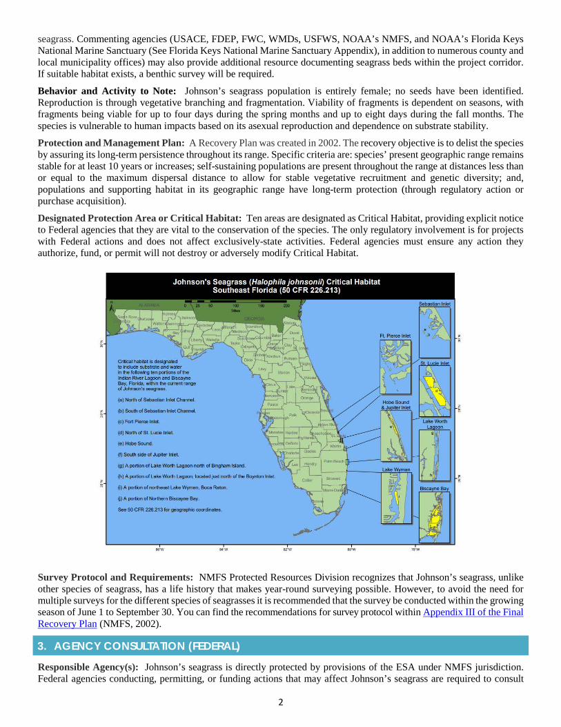
2
seagrass. Commenting agencies (USACE, FDEP, FWC, WMDs, USFWS, NOAA’s NMFS, and NOAA’s Florida Keys National Marine Sanctuary (See Florida Keys National Marine Sanctuary Appendix), in addition to numerous county and local municipality offices) may also provide additional resource documenting seagrass beds within the project corridor. If suitable habitat exists, a benthic survey will be required.
Behavior and Activity to Note: Johnson’s seagrass population is entirely female; no seeds have been identified. Reproduction is through vegetative branching and fragmentation. Viability of fragments is dependent on seasons, with fragments being viable for up to four days during the spring months and up to eight days during the fall months. The species is vulnerable to human impacts based on its asexual reproduction and dependence on substrate stability.
Protection and Management Plan: A Recovery Plan was created in 2002. The recovery objective is to delist the species by assuring its long-term persistence throughout its range. Specific criteria are: species’ present geographic range remains stable for at least 10 years or increases; self-sustaining populations are present throughout the range at distances less than or equal to the maximum dispersal distance to allow for stable vegetative recruitment and genetic diversity; and, populations and supporting habitat in its geographic range have long-term protection (through regulatory action or purchase acquisition).
Designated Protection Area or Critical Habitat: Ten areas are designated as Critical Habitat, providing explicit notice to Federal agencies that they are vital to the conservation of the species. The only regulatory involvement is for projects with Federal actions and does not affect exclusively-state activities. Federal agencies must ensure any action they authorize, fund, or permit will not destroy or adversely modify Critical Habitat.
Survey Protocol and Requirements: NMFS Protected Resources Division recognizes that Johnson’s seagrass, unlike other species of seagrass, has a life history that makes year-round surveying possible. However, to avoid the need for multiple surveys for the different species of seagrasses it is recommended that the survey be conducted within the growing season of June 1 to September 30. You can find the recommendations for survey protocol within Appendix III of the Final Recovery Plan (NMFS, 2002).
3. AGENCY CONSULTATION (FEDERAL)
Responsible Agency(s): Johnson’s seagrass is directly protected by provisions of the ESA under NMFS jurisdiction. Federal agencies conducting, permitting, or funding actions that may affect Johnson’s seagrass are required to consult
3
with NMFS Protected Resources Division. Note that Johnson’s seagrass is considered EFH, in addition to a federally listed species under the Endangered Species Act. Any adverse effect to this species or its Critical Habitat must be coordinated with two NMFS offices: Habitat Conservation Division and Protected Resource Division.
Federal Nexus for Consultation: Any project within the area of designated Critical Habitat that is authorized, funded, or requires a federal permit will need to conduct ESA and EFH consultation to determine whether the project will jeopardize Johnson’s seagrass or result in the adverse modification of designated Critical Habitat.
Type of Consultation: The type of ESA and EFH consultation, Informal or Formal, will depend on results of FDOT’s analysis of whether the proposed project will have an adverse effect on Johnson’s seagrass and its Critical Habitat. If the proposed federal action may affect Johnson’s seagrass or its Critical Habitat, formal consultation is required. If the proposed action is may affect, not likely to adversely affect Johnson’s seagrass or Critical Habitat than informal consultation is required. When no Johnson’s seagrass is identified from project benthic surveys (and had not been previously recorded) and no critical habitat exists than FDOT can make a no effect determination.
Demonstrate Avoidance, Minimization, and Mitigation: FDOT must demonstrate to NMFS that it is making all efforts to avoid, minimize and mitigate impacts to Johnson’s seagrass from the proposed project. This effort is essential to the consultation processes and may include implementing best management practices and/or commitment measures. Best practices can include, but are not limited to: restricting material placement, including turbidity barriers, and barge anchorage so as to avoid impacts to seagrasses; installing and maintaining turbidity barriers in such a manner as to avoid damaging the protected seagrass beds; avoiding the staging of any equipment in or over seagrass beds; restricting all small water crafts away from seagrasses or operating them at a no wake speed when it is necessary to transit areas containing seagrass to avoid prop scarring; and committing to having all vessels maintain a minimum clearance of 1 foot over any seagrass bed. Despite the lack of seagrass mitigation banks, regulatory authorities have approved the creation of new seagrass habitat including removing structures or filling in borrow areas to suitable elevations for seagrass growth.
Tools for Section 7 ESA Consultation: In 2017, NMFS issued a Programmatic Biological Opinion (PBO), referred to as JaxBO (see Appendix on Programmatic Agreements and Biological Opinions), which allows for the streamlining of the Section 7 ESA process for groups of frequently occurring activities and Federal action agency policies, plans, programs that have well-understood effects on listed species and designated habitat including Johnson’s Seagrass and its Critical Habitat. The JaxBO provides a tool to address consultation for ten categories of “in-water” activities including: (1) Shoreline Stabilization; (2) Pile-supported Structures; (3) Maintenance, Minor, and Muck Dredging; (4) Water-Management Outfall Structures and Associated Endwalls; (5) Scientific Survey Devices; (6) Boat Ramps; (7) Aquatic Habitat Enhancements, Established, and Restoration Activities; (8) Transportation and Utility Lines; (9) Marine Debris Removal; and, (10) Temporary Platforms, Fill, and Cofferdams.
Special Provisions, or Standard Protection Measures: No special provisions or standard protection measures for Johnson’s seagrass.
General Timeframes for Consultation and Permitting: Early consultation is highly recommended if you have impacts to Johnson’s seagrass and/or its Critical Habitat. Formal Consultation can take as long as 180 days and though not typical, may conclude with a finding of jeopardy thus preventing authorization of permits.
4. PERMITTING
Prohibited Activities: Any direct (dredging, filling, etc.) or indirect impacts from a proposed project to Johnson’s seagrass would be considered unlawful under the ESA without consultation.
Activities Authorized by Permit: The activities that can be authorized by permits will vary depending on the proposed impacts to Johnson’s seagrass. Early consultation is recommended to identify what activities will be permitted and what those impacts could mean in terms of project design, budgeting, and schedule.
5. PRE-CONSTRUCTION & CONSTRUCTION COMPLIANCE
Review of Commitments: Commitments can be found in the Environmental Commitment Module in ProjectSuite Enterprise Edition (PSEE). If additional commitments are identified during design or permitting, coordinate with the Project Manager and add to the Environmental Commitment Module. The Design Project Manager will share the Project Commitment Record with Construction.
Review of Environmental Permits for Special Conditions: Prior to construction, review any Special Conditions related to Johnson’s seagrass and its Critical Habitat.
4
Prior to the Construction: Advise personnel that penalties for convictions for violations of these laws range from a maximum of $500 and/or 60 days imprisonment for first offenses of misdemeanor crimes or up to $50,000 and/or one year imprisonment for criminal violations against the federal Endangered Species Act. To learn more read Laws that Protect Florida’s Wildlife.
6. TIPS
Tips: In coordination with FDOT’s Office of Environmental Management (OEM) or District Environmental Management Office, reach out to your NMFS ETAT representative to informally discuss the consultation process, JaxBO, and to receive guidance on possible avoidance, minimization, and mitigation options.
Seasonal Restrictions: Although not necessarily seasonally restricted, it is important to note that Johnson’s seagrass is highly transient with plants reaching maturity quickly and only persisting for a few months. Make sure your benthic surveys are complete and timely.
Survey Restrictions: Johnson’s seagrass project sampling is identified within Appendix III of the Final Recovery Plan for Johnson’s Seagrass (NMFS, 2002). Note that the absence of seagrass does not mean coordination is not required if the project area is located within Critical Habitat.
7. RESOURCES
Web Resources*
• Federal Registry, Designated Critical Habitat for Johnson's Seagrasshttps://www.federalregister.gov/documents/2000/04/05/00-8394/designated-critical-habitat-critical-habitat-for-johnsons-seagrass
• Federal Registry, Threatened Status for Johnson’s Seagrasshttp://sero.nmfs.noaa.gov/protected_resources/johnsons_seagrass/documents/listingrule.pdf
• Florida Natural Areas Inventory, Johnson Seagrass Identificationhttp://www.fnai.org/FieldGuide/pdf/Halophila_johnsonii.pdf
• NMFS Johnson’s Seagrass Recovery Planhttp://sero.nmfs.noaa.gov/protected_resources/johnsons_seagrass/documents/recoveryplan.pdf
• NMFS Programmatic Biological Opinion (PBO), JaxBOhttp://www.saj.usace.army.mil/Missions/Regulatory/Source-Book/
• NOAA’s Essential Fish Habitat Mapperhttps://www.habitat.noaa.gov/protection/efh/efhmapper/
• NOAA’s Fisheries, Southeast Regional Office, Johnson Seagrasshttp://sero.nmfs.noaa.gov/protected_resources/johnsons_seagrass/index.html
• NOAA’s Johnson's Seagrass Critical Habitat Maphttps://www.fisheries.noaa.gov/resource/map/johnsons-seagrass-critical-habitat-map
Lead Specialist(s) for Agencies: If the project is within the range of Johnson’s Seagrass contact [email protected], Johnson’s Seagrass Coordinator, NMFS Protected Resource Division.
Publications: National Marine Fisheries Service. 2002. Recovery Plan for Johnson's Seagrass (Halophila johnsonii). Prepared by the Johnson's Seagrass Recovery Team for the National Marine Fisheries Service, Silver Spring, Maryland. 134 pages.
* If you are experiencing difficulties accessing web resources please review your web browser settings, security browsercontrols, or cut-and-paste the link directly into your URL/address bar. Note that website links may change overtime. If aweb link is not accessible, you may be able to find the resource by going through the website’s home page.

2019 Appendix: Listed Species
APPENDIX 1p Frosted & Reticulated Flatwoods Salamanders
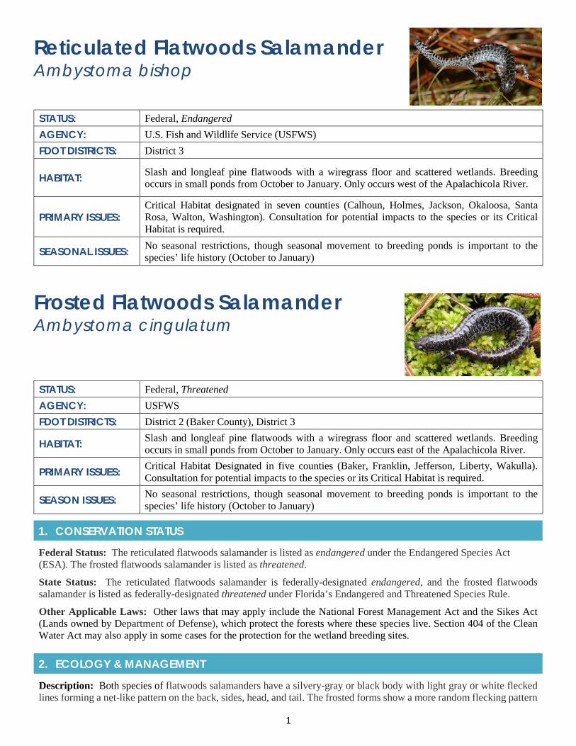
1
Reticulated Flatwoods Salamander Ambystoma bishop
STATUS: Federal, Endangered AGENCY: U.S. Fish and Wildlife Service (USFWS) FDOT DISTRICTS: District 3
HABITAT: Slash and longleaf pine flatwoods with a wiregrass floor and scattered wetlands. Breeding occurs in small ponds from October to January. Only occurs west of the Apalachicola River.
PRIMARY ISSUES: Critical Habitat designated in seven counties (Calhoun, Holmes, Jackson, Okaloosa, Santa Rosa, Walton, Washington). Consultation for potential impacts to the species or its Critical Habitat is required.
SEASONAL ISSUES: No seasonal restrictions, though seasonal movement to breeding ponds is important to the species’ life history (October to January)
Frosted Flatwoods Salamander Ambystoma cingulatum
STATUS: Federal, Threatened AGENCY: USFWS FDOT DISTRICTS: District 2 (Baker County), District 3
HABITAT: Slash and longleaf pine flatwoods with a wiregrass floor and scattered wetlands. Breeding occurs in small ponds from October to January. Only occurs east of the Apalachicola River.
PRIMARY ISSUES: Critical Habitat Designated in five counties (Baker, Franklin, Jefferson, Liberty, Wakulla). Consultation for potential impacts to the species or its Critical Habitat is required.
SEASON ISSUES: No seasonal restrictions, though seasonal movement to breeding ponds is important to the species’ life history (October to January)
1. CONSERVATION STATUS
Federal Status: The reticulated flatwoods salamander is listed as endangered under the Endangered Species Act (ESA). The frosted flatwoods salamander is listed as threatened.
State Status: The reticulated flatwoods salamander is federally-designated endangered, and the frosted flatwoods salamander is listed as federally-designated threatened under Florida’s Endangered and Threatened Species Rule.
Other Applicable Laws: Other laws that may apply include the National Forest Management Act and the Sikes Act (Lands owned by Department of Defense), which protect the forests where these species live. Section 404 of the Clean Water Act may also apply in some cases for the protection for the wetland breeding sites.
2. ECOLOGY & MANAGEMENT
Description: Both species of flatwoods salamanders have a silvery-gray or black body with light gray or white flecked lines forming a net-like pattern on the back, sides, head, and tail. The frosted forms show a more random flecking pattern
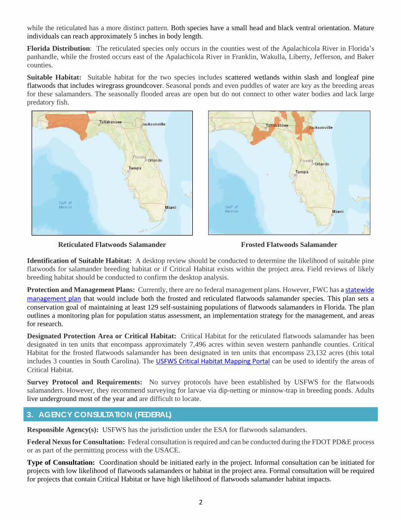
2
while the reticulated has a more distinct pattern. Both species have a small head and black ventral orientation. Mature individuals can reach approximately 5 inches in body length.
Florida Distribution: The reticulated species only occurs in the counties west of the Apalachicola River in Florida’s panhandle, while the frosted occurs east of the Apalachicola River in Franklin, Wakulla, Liberty, Jefferson, and Baker counties.
Suitable Habitat: Suitable habitat for the two species includes scattered wetlands within slash and longleaf pine flatwoods that includes wiregrass groundcover. Seasonal ponds and even puddles of water are key as the breeding areas for these salamanders. The seasonally flooded areas are open but do not connect to other water bodies and lack large predatory fish.
Reticulated Flatwoods Salamander Frosted Flatwoods Salamander
Identification of Suitable Habitat: A desktop review should be conducted to determine the likelihood of suitable pine flatwoods for salamander breeding habitat or if Critical Habitat exists within the project area. Field reviews of likely breeding habitat should be conducted to confirm the desktop analysis.
Protection and Management Plans: Currently, there are no federal management plans. However, FWC has a statewide management plan that would include both the frosted and reticulated flatwoods salamander species. This plan sets a conservation goal of maintaining at least 129 self-sustaining populations of flatwoods salamanders in Florida. The plan outlines a monitoring plan for population status assessment, an implementation strategy for the management, and areas for research.
Designated Protection Area or Critical Habitat: Critical Habitat for the reticulated flatwoods salamander has been designated in ten units that encompass approximately 7,496 acres within seven western panhandle counties. Critical Habitat for the frosted flatwoods salamander has been designated in ten units that encompass 23,132 acres (this total includes 3 counties in South Carolina). The USFWS Critical Habitat Mapping Portal can be used to identify the areas of Critical Habitat.
Survey Protocol and Requirements: No survey protocols have been established by USFWS for the flatwoods salamanders. However, they recommend surveying for larvae via dip-netting or minnow-trap in breeding ponds. Adults live underground most of the year and are difficult to locate.
3. AGENCY CONSULTATION (FEDERAL)
Responsible Agency(s): USFWS has the jurisdiction under the ESA for flatwoods salamanders.
Federal Nexus for Consultation: Federal consultation is required and can be conducted during the FDOT PD&E process or as part of the permitting process with the USACE.
Type of Consultation: Coordination should be initiated early in the project. Informal consultation can be initiated for projects with low likelihood of flatwoods salamanders or habitat in the project area. Formal consultation will be required for projects that contain Critical Habitat or have high likelihood of flatwoods salamander habitat impacts.
3
Demonstrate Avoidance, Minimization, and Mitigation: Standard avoidance and minimization for the project design during permitting will be necessary. Potential breeding ponds should be identified during wetland delineations. Mitigation for impacts to flatwoods salamanders has not been identified at this time.
Tools for Section 7 ESA Consultation: No species effects determination key has been developed for the flatwoods salamanders.
Special Provisions, or Standard Protection Measures: There are no current existing standard provisions for flatwoods salamanders.
General Timeframes for Consulting and Permitting: No specific time frames for permitting specific to flatwoods salamanders are documented. Should the project require formal consultation and a Biological Opinion, standard consultation time frames should be anticipated.
4. PERMITTING
Prohibited Activities: Activities that could adversely affect flatwoods salamanders or their habitat include dredging, disposal of dredged materials, contamination of water in breeding ponds, draining or changing the hydrology of breeding ponds, land use conversion of pine flatwoods, or timber management that does not follow the guidelines provided in the final ESA listing rule.
Activities Authorized by Permit: Only those activities that are either determined to be exempt or approved in a federal permit can be conducted.
5. PRE-CONSTRUCTION & CONSTRUCTION COMPLIANCE
Review of Commitments: Commitments can be found within the Environmental Commitment Module in ProjectSuite Enterprise Edition (PSEE). If additional commitments are identified during design or permitting, coordinate with the Project Manager and add to the Environmental Commitment Module. The Design Project Manager will share the Project Commitment Record with Construction.
Review of Environmental Permits for Special Conditions: Review all environmental permits for Special Conditions related to flatwoods salamanders. Make sure that construction personnel have copies.
Prior to Construction: Advise personnel that penalties for convictions for violations of these laws range from a maximum of $500 and/or 60 days imprisonment for first offenses of misdemeanor crimes or up to $50,000 and/or one-year imprisonment for criminal violations against the federal Endangered Species Act. To learn more read Laws that Protect Florida’s Wildlife.
6. TIPS
Tips: Flatwoods salamanders are cryptic species and therefore care must be taken to determine whether they are present.
Seasonal Restrictions: There are currently no seasonal restrictions, though seasonal movement to breeding ponds is important to the species’ life history. Flatwoods salamanders migrate to ponds or small puddles to breed from October to January during wet weather.
Survey Restrictions: There is not currently any USFWS designated survey protocol for flatwoods salamanders.
7. RESOURCES
Web Resources*
• USFWS Endangered Species Consultation Handbookhttps://www.fws.gov/endangered/esa-library/pdf/esa_section7_handbook.pdf
• USFWS Flatwoods Salamander Pagehttps://www.fws.gov/panamacity/flatwoodssalamander.html
• USFWS Environmental Conservation Online System Flatwoods Salamanders Profileshttps://ecos.fws.gov/ecp0/profile/speciesProfile?sId=8939
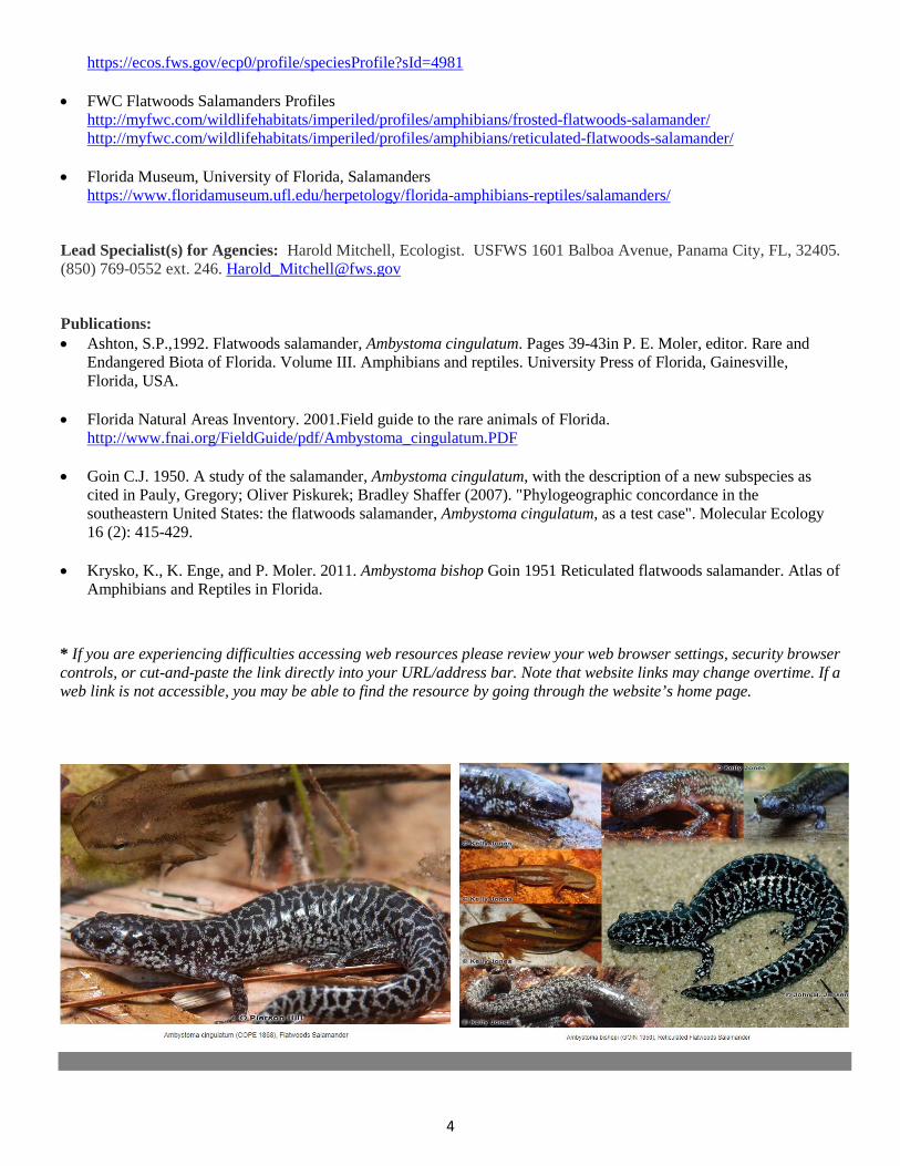
4
https://ecos.fws.gov/ecp0/profile/speciesProfile?sId=4981
• FWC Flatwoods Salamanders Profileshttp://myfwc.com/wildlifehabitats/imperiled/profiles/amphibians/frosted-flatwoods-salamander/http://myfwc.com/wildlifehabitats/imperiled/profiles/amphibians/reticulated-flatwoods-salamander/
• Florida Museum, University of Florida, Salamandershttps://www.floridamuseum.ufl.edu/herpetology/florida-amphibians-reptiles/salamanders/
Lead Specialist(s) for Agencies: Harold Mitchell, Ecologist. USFWS 1601 Balboa Avenue, Panama City, FL, 32405. (850) 769-0552 ext. 246. [email protected]
Publications: • Ashton, S.P.,1992. Flatwoods salamander, Ambystoma cingulatum. Pages 39-43in P. E. Moler, editor. Rare and
Endangered Biota of Florida. Volume III. Amphibians and reptiles. University Press of Florida, Gainesville,Florida, USA.
• Florida Natural Areas Inventory. 2001.Field guide to the rare animals of Florida.http://www.fnai.org/FieldGuide/pdf/Ambystoma_cingulatum.PDF
• Goin C.J. 1950. A study of the salamander, Ambystoma cingulatum, with the description of a new subspecies ascited in Pauly, Gregory; Oliver Piskurek; Bradley Shaffer (2007). "Phylogeographic concordance in thesoutheastern United States: the flatwoods salamander, Ambystoma cingulatum, as a test case". Molecular Ecology16 (2): 415-429.
• Krysko, K., K. Enge, and P. Moler. 2011. Ambystoma bishop Goin 1951 Reticulated flatwoods salamander. Atlas ofAmphibians and Reptiles in Florida.
* If you are experiencing difficulties accessing web resources please review your web browser settings, security browsercontrols, or cut-and-paste the link directly into your URL/address bar. Note that website links may change overtime. If aweb link is not accessible, you may be able to find the resource by going through the website’s home page.

2019 Appendix: Listed Species
APPENDIX 1q Gulf Sturgeon
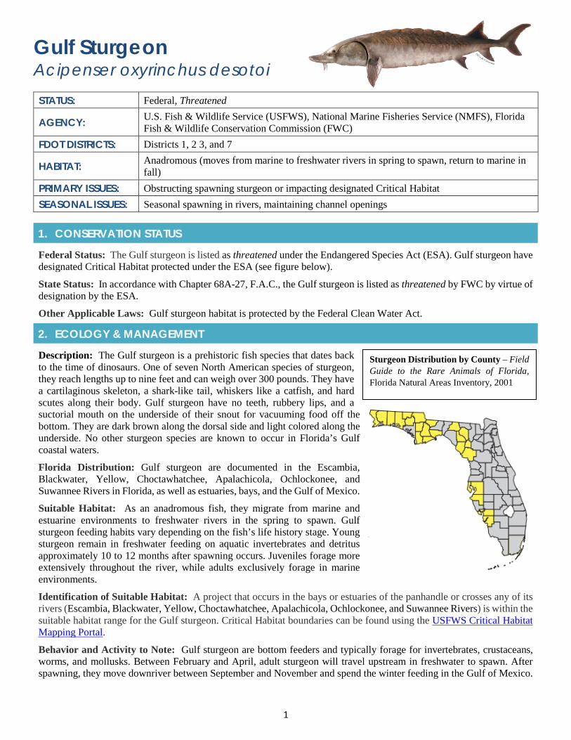
1
Gulf Sturgeon Acipenser oxyrinchus desotoi STATUS: Federal, Threatened
AGENCY: U.S. Fish & Wildlife Service (USFWS), National Marine Fisheries Service (NMFS), Florida Fish & Wildlife Conservation Commission (FWC)
FDOT DISTRICTS: Districts 1, 2 3, and 7
HABITAT: Anadromous (moves from marine to freshwater rivers in spring to spawn, return to marine in fall)
PRIMARY ISSUES: Obstructing spawning sturgeon or impacting designated Critical Habitat SEASONAL ISSUES: Seasonal spawning in rivers, maintaining channel openings
1. CONSERVATION STATUS
Federal Status: The Gulf sturgeon is listed as threatened under the Endangered Species Act (ESA). Gulf sturgeon have designated Critical Habitat protected under the ESA (see figure below).
State Status: In accordance with Chapter 68A-27, F.A.C., the Gulf sturgeon is listed as threatened by FWC by virtue of designation by the ESA.
Other Applicable Laws: Gulf sturgeon habitat is protected by the Federal Clean Water Act.
2. ECOLOGY & MANAGEMENT
Description: The Gulf sturgeon is a prehistoric fish species that dates back to the time of dinosaurs. One of seven North American species of sturgeon, they reach lengths up to nine feet and can weigh over 300 pounds. They have a cartilaginous skeleton, a shark-like tail, whiskers like a catfish, and hard scutes along their body. Gulf sturgeon have no teeth, rubbery lips, and a suctorial mouth on the underside of their snout for vacuuming food off the bottom. They are dark brown along the dorsal side and light colored along the underside. No other sturgeon species are known to occur in Florida’s Gulf coastal waters.
Florida Distribution: Gulf sturgeon are documented in the Escambia, Blackwater, Yellow, Choctawhatchee, Apalachicola, Ochlockonee, and Suwannee Rivers in Florida, as well as estuaries, bays, and the Gulf of Mexico.
Suitable Habitat: As an anadromous fish, they migrate from marine and estuarine environments to freshwater rivers in the spring to spawn. Gulf sturgeon feeding habits vary depending on the fish’s life history stage. Young sturgeon remain in freshwater feeding on aquatic invertebrates and detritus approximately 10 to 12 months after spawning occurs. Juveniles forage more extensively throughout the river, while adults exclusively forage in marine environments.
Identification of Suitable Habitat: A project that occurs in the bays or estuaries of the panhandle or crosses any of its rivers (Escambia, Blackwater, Yellow, Choctawhatchee, Apalachicola, Ochlockonee, and Suwannee Rivers) is within the suitable habitat range for the Gulf sturgeon. Critical Habitat boundaries can be found using the USFWS Critical Habitat Mapping Portal.
Behavior and Activity to Note: Gulf sturgeon are bottom feeders and typically forage for invertebrates, crustaceans, worms, and mollusks. Between February and April, adult sturgeon will travel upstream in freshwater to spawn. After spawning, they move downriver between September and November and spend the winter feeding in the Gulf of Mexico.
Sturgeon Distribution by County – Field Guide to the Rare Animals of Florida, Florida Natural Areas Inventory, 2001
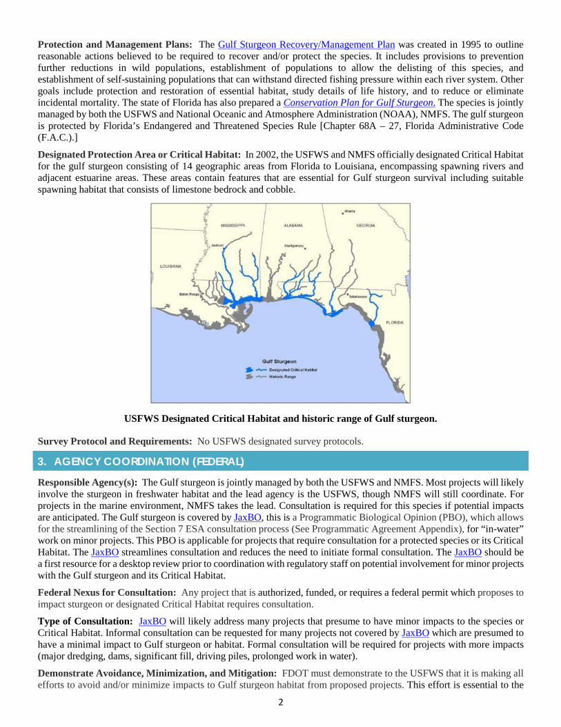
2
Protection and Management Plans: The Gulf Sturgeon Recovery/Management Plan was created in 1995 to outline reasonable actions believed to be required to recover and/or protect the species. It includes provisions to prevention further reductions in wild populations, establishment of populations to allow the delisting of this species, and establishment of self-sustaining populations that can withstand directed fishing pressure within each river system. Other goals include protection and restoration of essential habitat, study details of life history, and to reduce or eliminate incidental mortality. The state of Florida has also prepared a Conservation Plan for Gulf Sturgeon. The species is jointly managed by both the USFWS and National Oceanic and Atmosphere Administration (NOAA), NMFS. The gulf sturgeon is protected by Florida’s Endangered and Threatened Species Rule [Chapter 68A – 27, Florida Administrative Code (F.A.C.).]
Designated Protection Area or Critical Habitat: In 2002, the USFWS and NMFS officially designated Critical Habitat for the gulf sturgeon consisting of 14 geographic areas from Florida to Louisiana, encompassing spawning rivers and adjacent estuarine areas. These areas contain features that are essential for Gulf sturgeon survival including suitable spawning habitat that consists of limestone bedrock and cobble.
USFWS Designated Critical Habitat and historic range of Gulf sturgeon.
Survey Protocol and Requirements: No USFWS designated survey protocols.
3. AGENCY COORDINATION (FEDERAL)
Responsible Agency(s): The Gulf sturgeon is jointly managed by both the USFWS and NMFS. Most projects will likely involve the sturgeon in freshwater habitat and the lead agency is the USFWS, though NMFS will still coordinate. For projects in the marine environment, NMFS takes the lead. Consultation is required for this species if potential impacts are anticipated. The Gulf sturgeon is covered by JaxBO, this is a Programmatic Biological Opinion (PBO), which allows for the streamlining of the Section 7 ESA consultation process (See Programmatic Agreement Appendix), for “in-water” work on minor projects. This PBO is applicable for projects that require consultation for a protected species or its Critical Habitat. The JaxBO streamlines consultation and reduces the need to initiate formal consultation. The JaxBO should be a first resource for a desktop review prior to coordination with regulatory staff on potential involvement for minor projects with the Gulf sturgeon and its Critical Habitat.
Federal Nexus for Consultation: Any project that is authorized, funded, or requires a federal permit which proposes to impact sturgeon or designated Critical Habitat requires consultation.
Type of Consultation: JaxBO will likely address many projects that presume to have minor impacts to the species or Critical Habitat. Informal consultation can be requested for many projects not covered by JaxBO which are presumed to have a minimal impact to Gulf sturgeon or habitat. Formal consultation will be required for projects with more impacts (major dredging, dams, significant fill, driving piles, prolonged work in water).
Demonstrate Avoidance, Minimization, and Mitigation: FDOT must demonstrate to the USFWS that it is making all efforts to avoid and/or minimize impacts to Gulf sturgeon habitat from proposed projects. This effort is essential to the
3
consultation processes and may include commitments such as modifying proposed plans to avoid impacts to water bodies, altering construction methodology to avoid in-water work during spawning season, and likely include a commitment for Construction Special Provisions Gulf Sturgeon Protection Guidelines to be incorporated into any construction plans. Mitigation is not typically required Protection of existing spawning areas is critical; any main channel or tributary construction or maintenance should be avoided during spawning periods.
Minimizing impacts can include, but are not limited to, such activities as: Educating construction personnel on the identification of Gulf sturgeon; notifying personnel that there are penalties (both civil and criminal) for harming, harassing, or killing Gulf sturgeon; training onsite personnel to maintain constant surveillance and to initiate the cessation of activities until any sturgeon identified are clear of the construction area(s); posting of signs warning of Gulf sturgeon presence; controlling turbidity and using turbidity curtains to restrict access sturgeon from the construction area; eliminating bottom dredging; providing a spotter at appropriate times of the year during in-water construction activities to maintain constant surveillance for the species; and, maintaining channel openings.
Tools for Section 7 ESA Consultation: No species effects determination key.
Special Provisions, or Standard Protection Measures: Construction Special Provisions for Gulf Sturgeon Protection Guidelines (NMFS and USFWS) are to be incorporated into any construction plans if suitable habitat is present. In addition, FDOT has Special Provisions for Gulf sturgeon expanding the existing requirements when it is known that the sturgeon is present within the project footprint.
General Timeframes for Permitting: Timeframes may depend on the complexity of the project, though it would follow the standard USFWS procedures. Early coordination is essential to limit prolonged review times. Refer to section on “Type of Consultation”.
4. PERMITTING
Prohibited Activities: Activities that can impact habitat of Gulf sturgeon (dredging, filling, water quality degradation) or the animals themselves (boats and equipment in the water) are prohibited without prior project approval. There is not a specific permit for Gulf sturgeon impacts. State ERPs and USACE permits are issued to approve the specific project activity.
Activities Authorized by Permit: Projects are approved under the state and federal permitting systems. If impacts are proposed to sturgeon or Critical Habitat, they would be addressed in a Biological Opinion issued by USFWS.
5. PRE-CONSTRUCTION & CONSTRUCTION COMPLIANCE
Review of Commitments: Commitments can be found within the Environmental Commitment Module in ProjectSuite Enterprise Edition (PSEE). If additional commitments are identified during design or permitting, coordinate with the Project Manager and add to the Environmental Commitment Module. The Design Project Manager will share the Project Commitment Record with Construction.
Review of Environmental Permits for Special Conditions: Prior to construction, review any Special Conditions in the permits related to sturgeon and Critical Habitat. Make sure construction personnel have copies.
Prior to the Construction: Advise personnel that penalties for convictions for violations of these laws range from a maximum of $500 and/or 60 days imprisonment for first offenses of misdemeanor crimes or up to $50,000 and/or one year imprisonment for criminal violations against the federal Endangered Species Act. To learn more read Laws that Protect Florida’s Wildlife.
6. TIPS
Tips: The USFWS will be looking for FDOT to demonstrate that all erosion control and stormwater management efforts are being implemented, underwater noise is minimized to the greatest extent practicable, and that waterway passages are clear of obstruction.
Seasonal Restrictions: Depending on the size of the waterbody, restrictions may be placed on in-water work that would restrict the movement of sturgeon upriver early in the year to reach spawning grounds and downriver back to the Gulf of Mexico in late fall.
Survey Restrictions: Surveys are not required.
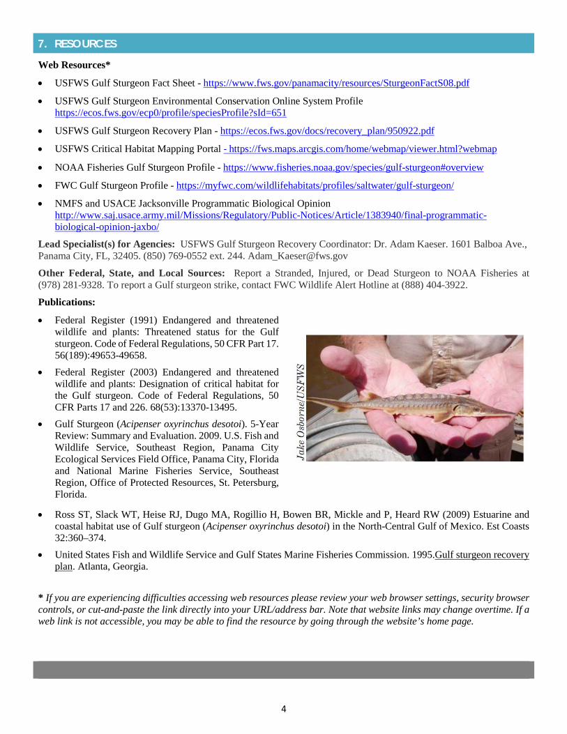
4
7. RESOURCES
Web Resources*
• USFWS Gulf Sturgeon Fact Sheet - https://www.fws.gov/panamacity/resources/SturgeonFactS08.pdf
• USFWS Gulf Sturgeon Environmental Conservation Online System Profilehttps://ecos.fws.gov/ecp0/profile/speciesProfile?sId=651
• USFWS Gulf Sturgeon Recovery Plan - https://ecos.fws.gov/docs/recovery_plan/950922.pdf
• USFWS Critical Habitat Mapping Portal - https://fws.maps.arcgis.com/home/webmap/viewer.html?webmap
• NOAA Fisheries Gulf Sturgeon Profile - https://www.fisheries.noaa.gov/species/gulf-sturgeon#overview
• FWC Gulf Sturgeon Profile - https://myfwc.com/wildlifehabitats/profiles/saltwater/gulf-sturgeon/
• NMFS and USACE Jacksonville Programmatic Biological Opinionhttp://www.saj.usace.army.mil/Missions/Regulatory/Public-Notices/Article/1383940/final-programmatic-biological-opinion-jaxbo/
Lead Specialist(s) for Agencies: USFWS Gulf Sturgeon Recovery Coordinator: Dr. Adam Kaeser. 1601 Balboa Ave., Panama City, FL, 32405. (850) 769-0552 ext. 244. [email protected]
Other Federal, State, and Local Sources: Report a Stranded, Injured, or Dead Sturgeon to NOAA Fisheries at (978) 281-9328. To report a Gulf sturgeon strike, contact FWC Wildlife Alert Hotline at (888) 404-3922.
Publications:
• Federal Register (1991) Endangered and threatenedwildlife and plants: Threatened status for the Gulfsturgeon. Code of Federal Regulations, 50 CFR Part 17.56(189):49653-49658.
• Federal Register (2003) Endangered and threatenedwildlife and plants: Designation of critical habitat forthe Gulf sturgeon. Code of Federal Regulations, 50CFR Parts 17 and 226. 68(53):13370-13495.
• Gulf Sturgeon (Acipenser oxyrinchus desotoi). 5-YearReview: Summary and Evaluation. 2009. U.S. Fish andWildlife Service, Southeast Region, Panama CityEcological Services Field Office, Panama City, Floridaand National Marine Fisheries Service, SoutheastRegion, Office of Protected Resources, St. Petersburg,Florida.
• Ross ST, Slack WT, Heise RJ, Dugo MA, Rogillio H, Bowen BR, Mickle and P, Heard RW (2009) Estuarine andcoastal habitat use of Gulf sturgeon (Acipenser oxyrinchus desotoi) in the North-Central Gulf of Mexico. Est Coasts32:360–374.
• United States Fish and Wildlife Service and Gulf States Marine Fisheries Commission. 1995.Gulf sturgeon recoveryplan. Atlanta, Georgia.
* If you are experiencing difficulties accessing web resources please review your web browser settings, security browsercontrols, or cut-and-paste the link directly into your URL/address bar. Note that website links may change overtime. If aweb link is not accessible, you may be able to find the resource by going through the website’s home page.

2019 Appendix: Listed Species
APPENDIX 1r Freshwater Mussels
(7 Gulf Coast Mussel Group)
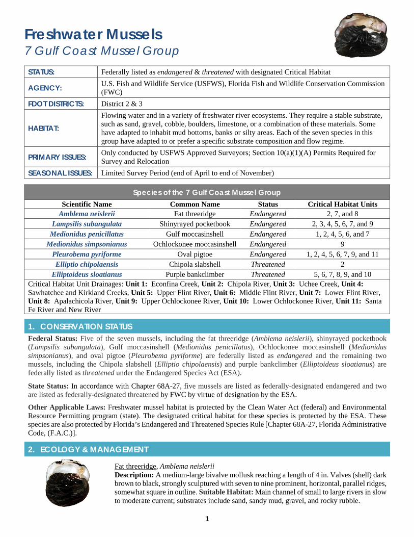
1
Freshwater Mussels 7 Gulf Coast Mussel Group STATUS: Federally listed as endangered & threatened with designated Critical Habitat
AGENCY: U.S. Fish and Wildlife Service (USFWS), Florida Fish and Wildlife Conservation Commission (FWC)
FDOT DISTRICTS: District 2 & 3
HABITAT: Flowing water and in a variety of freshwater river ecosystems. They require a stable substrate, such as sand, gravel, cobble, boulders, limestone, or a combination of these materials. Some have adapted to inhabit mud bottoms, banks or silty areas. Each of the seven species in this group have adapted to or prefer a specific substrate composition and flow regime.
PRIMARY ISSUES: Only conducted by USFWS Approved Surveyors; Section 10(a)(1)(A) Permits Required for Survey and Relocation
SEASONAL ISSUES: Limited Survey Period (end of April to end of November)
Species of the 7 Gulf Coast Mussel Group Scientific Name Common Name Status Critical Habitat Units
Amblema neislerii Fat threeridge Endangered 2, 7, and 8 Lampsilis subangulata Shinyrayed pocketbook Endangered 2, 3, 4, 5, 6, 7, and 9
Medionidus penicillatus Gulf moccasinshell Endangered 1, 2, 4, 5, 6, and 7 Medionidus simpsonianus Ochlockonee moccasinshell Endangered 9
Pleurobema pyriforme Oval pigtoe Endangered 1, 2, 4, 5, 6, 7, 9, and 11 Elliptio chipolaensis Chipola slabshell Threatened 2
Elliptoideus sloatianus Purple bankclimber Threatened 5, 6, 7, 8, 9, and 10 Critical Habitat Unit Drainages: Unit 1: Econfina Creek, Unit 2: Chipola River, Unit 3: Uchee Creek, Unit 4: Sawhatchee and Kirkland Creeks, Unit 5: Upper Flint River, Unit 6: Middle Flint River, Unit 7: Lower Flint River, Unit 8: Apalachicola River, Unit 9: Upper Ochlockonee River, Unit 10: Lower Ochlockonee River, Unit 11: Santa Fe River and New River
1. CONSERVATION STATUSFederal Status: Five of the seven mussels, including the fat threeridge (Amblema neislerii), shinyrayed pocketbook (Lampsilis subangulata), Gulf moccasinshell (Medionidus penicillatus), Ochlockonee moccasinshell (Medionidus simpsonianus), and oval pigtoe (Pleurobema pyriforme) are federally listed as endangered and the remaining two mussels, including the Chipola slabshell (Elliptio chipolaensis) and purple bankclimber (Elliptoideus sloatianus) are federally listed as threatened under the Endangered Species Act (ESA).
State Status: In accordance with Chapter 68A-27, five mussels are listed as federally-designated endangered and two are listed as federally-designated threatened by FWC by virtue of designation by the ESA.
Other Applicable Laws: Freshwater mussel habitat is protected by the Clean Water Act (federal) and Environmental Resource Permitting program (state). The designated critical habitat for these species is protected by the ESA. These species are also protected by Florida’s Endangered and Threatened Species Rule [Chapter 68A-27, Florida Administrative Code, (F.A.C.)].
2. ECOLOGY & MANAGEMENT
Fat threeridge, Amblema neislerii Description: A medium-large bivalve mollusk reaching a length of 4 in. Valves (shell) dark brown to black, strongly sculptured with seven to nine prominent, horizontal, parallel ridges, somewhat square in outline. Suitable Habitat: Main channel of small to large rivers in slow to moderate current; substrates include sand, sandy mud, gravel, and rocky rubble.
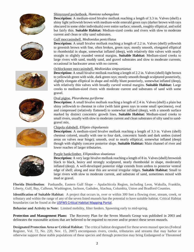
2
Shinyrayed pocketbook, Hamiota subangulata Description: A medium-sized bivalve mollusk reaching a length of 3.3 in. Valves (shell) a shiny light yellowish brown with medium-wide emerald green rays (darker brown with rays obscured in some older individuals) over entire surface; smooth, roughly elliptical, and solid but fairly thin. Suitable Habitat: Medium-sized creeks and rivers with slow to moderate current and clean or silty sand substrates. Gulf moccasinshell, Medionidus penicillatus Description: A small bivalve mollusk reaching a length of 2.2 in. Valves (shell) yellowish to greenish brown with fine, often broken, green rays; mostly smooth, elongated elliptical to rhomboidal in shape, somewhat inflated (deep), with relatively thin valves with nearly straight to slightly rounded ventral margins. Suitable Habitat: Medium-sized creeks to large rivers with sand, muddy sand, and gravel substrates and slow to moderate currents; occasional in backwater areas with no current. Ochlockonee moccasinshell, Medionidus simpsonianus Description: A small bivalve mollusk reaching a length of 2.2 in. Valves (shell) light brown to yellowish green with wide, dark green rays; mostly smooth though sculptured posteriorly, slightly elongate elliptical in shape and mildly blunt posteriorly, somewhat inflated (deep), with relatively thin valves with broadly curved ventral margins. Suitable Habitat: Large creeks to medium-sized rivers with moderate current and substrates of sand with some gravel. Oval pigtoe, Pleurobema pyriforme Description: A small bivalve mollusk reaching a length of 2.4 in. Valves (shell) a plain but shiny yellowish to chestnut in color (with faint green rays in some small specimens), oval and compressed (relatively flattened) to somewhat inflated (deep), with a smooth surface marked by distinct concentric growth lines. Suitable Habitat: Medium-sized creeks to small rivers, usually with slow to moderate current and clean substrates of silty sand to sand-gravel mix. Chipola slabshell, Elliptio chipolaensis Description: A medium-sized bivalve mollusk reaching a length of 3.3 in. Valves (shell) chestnut colored, usually with one to four dark, concentric bands and dark umbos (raised areas on valves near hinge); smooth, oval to nearly elliptical, somewhat inflated (deep) though with slightly concave posterior slope. Suitable Habitat: Main channel of river and lower reaches of larger tributaries.
Purple bankclimber, Elliptoideus sloatianus Description: A very large bivalve mollusk reaching a length of 8 in. Valves (shell) brownish black to black, heavy and strongly sculptured, nearly rhomboidal in shape, moderately inflated (deep). A well-developed posterior ridge extends from umbos to posterior ventral edge of shell; along and near this are several irregular ridges. Suitable Habitat: Small to large rivers with slow to moderate current, and substrate of sand, sometimes mixed with mud or gravel.
Florida Distribution: Panhandle, Eastern Gulf Slope – Apalachicola Region, including Leon, Wakulla, Franklin, Liberty, Gulf, Bay, Calhoun, Washington, Jackson, Gadsden, Alachua, Columbia, Union and Bradford Counties.
Identification of Suitable Habitat: A project that occurs in, over or within 300 feet a flowing river, stream, creek, or tributary and within the range of any of the seven listed mussels has the potential to have suitable habitat. Critical Habitat boundaries can be found at the USFWS Critical Habitat Mapping Portal. Behavior and Activity to Note: Limited mobility, filter feeders. Spawning early to mid-spring.
Protection and Management Plans: The Recovery Plan for the Seven Mussels Group was published in 2003 and delineates the reasonable actions that are believed to be required to recover and/or protect these seven mussels.
Designated Protection Area or Critical Habitat: The critical habitat designated for these seven mussel species (Federal Register, Vol. 72, No. 220, Nov. 15, 2007) encompasses rivers, creeks, tributaries and streams that may harbor or otherwise support these stable populations of these species and through protection may bring Endangered or Threatened
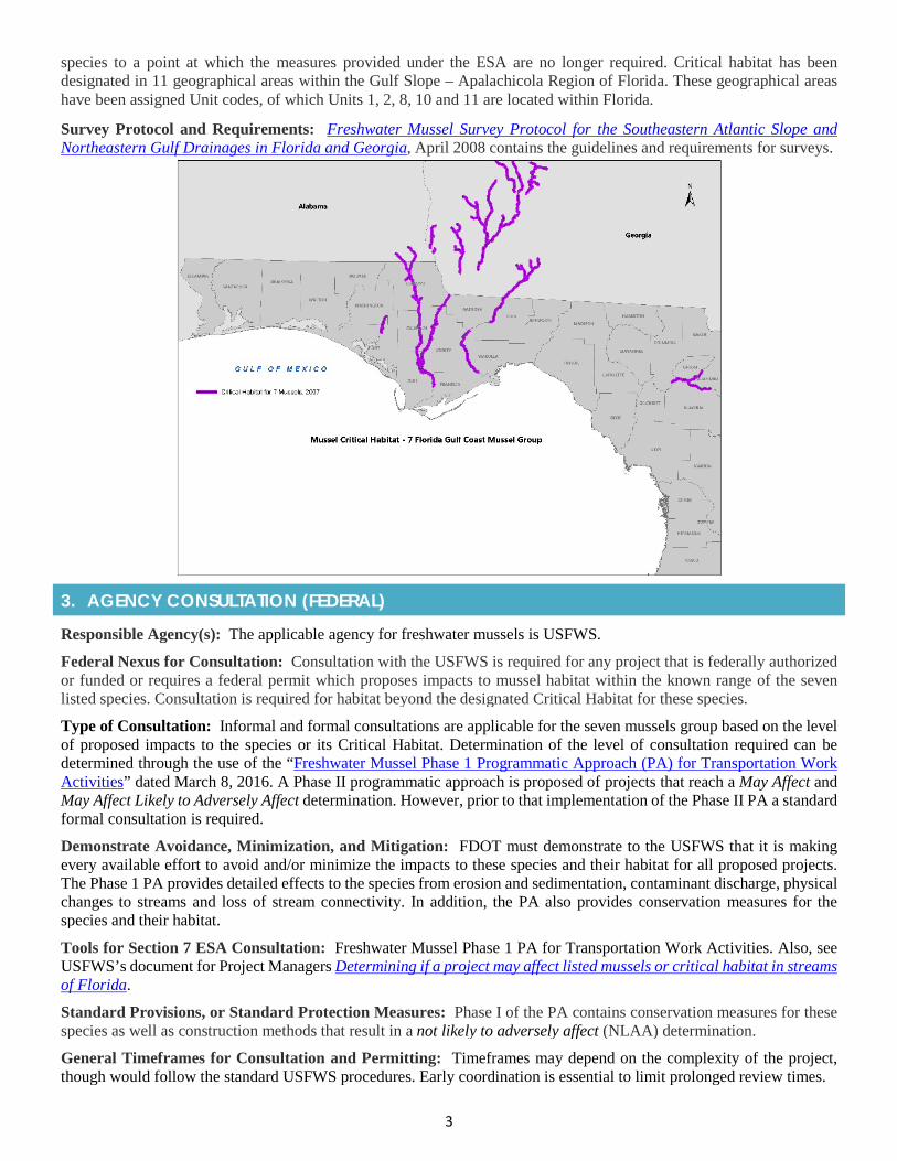
3
species to a point at which the measures provided under the ESA are no longer required. Critical habitat has been designated in 11 geographical areas within the Gulf Slope – Apalachicola Region of Florida. These geographical areas have been assigned Unit codes, of which Units 1, 2, 8, 10 and 11 are located within Florida.
Survey Protocol and Requirements: Freshwater Mussel Survey Protocol for the Southeastern Atlantic Slope and Northeastern Gulf Drainages in Florida and Georgia, April 2008 contains the guidelines and requirements for surveys.
3. AGENCY CONSULTATION (FEDERAL)
Responsible Agency(s): The applicable agency for freshwater mussels is USFWS.
Federal Nexus for Consultation: Consultation with the USFWS is required for any project that is federally authorized or funded or requires a federal permit which proposes impacts to mussel habitat within the known range of the seven listed species. Consultation is required for habitat beyond the designated Critical Habitat for these species.
Type of Consultation: Informal and formal consultations are applicable for the seven mussels group based on the level of proposed impacts to the species or its Critical Habitat. Determination of the level of consultation required can be determined through the use of the “Freshwater Mussel Phase 1 Programmatic Approach (PA) for Transportation Work Activities” dated March 8, 2016. A Phase II programmatic approach is proposed of projects that reach a May Affect and May Affect Likely to Adversely Affect determination. However, prior to that implementation of the Phase II PA a standard formal consultation is required.
Demonstrate Avoidance, Minimization, and Mitigation: FDOT must demonstrate to the USFWS that it is making every available effort to avoid and/or minimize the impacts to these species and their habitat for all proposed projects. The Phase 1 PA provides detailed effects to the species from erosion and sedimentation, contaminant discharge, physical changes to streams and loss of stream connectivity. In addition, the PA also provides conservation measures for the species and their habitat.
Tools for Section 7 ESA Consultation: Freshwater Mussel Phase 1 PA for Transportation Work Activities. Also, see USFWS’s document for Project Managers Determining if a project may affect listed mussels or critical habitat in streams of Florida.
Standard Provisions, or Standard Protection Measures: Phase I of the PA contains conservation measures for these species as well as construction methods that result in a not likely to adversely affect (NLAA) determination.
General Timeframes for Consultation and Permitting: Timeframes may depend on the complexity of the project, though would follow the standard USFWS procedures. Early coordination is essential to limit prolonged review times.
4
4. PERMITTINGProhibited Activities: Activities that can impact these species or their habitat (dredging, filling, water quality degradation, equipment or materials (piles)) are prohibited without prior project approval. There is no mussel specific permit for potential impacts, however approval for impacts is obtained through the consultation process and included as part of the State ERP and USACE permits for each project.
5. PRE-CONSTRUCTION & CONSTRUCTION COMPLIANCE
Review of Commitments: Commitments can be found within the Environmental Commitment Module in Project Suite Enterprise Edition (PSEE). If additional commitments are identified during design or permitting, coordinate with the Project Manager and add to the Environmental Commitment Module. The Design Project Manager will share the Project Commitment Record with Construction.
Review all Environmental Permits for Special Conditions: Review all environmental permits for Special Conditions related to listed freshwater mussels and Critical Habitat. Make sure construction personnel have copies.
Prior to Construction: Advise personnel that penalties for convictions for violations of these laws range from a maximum of $500 and/or 60 days imprisonment for first offenses of misdemeanor crimes or up to $50,000 and/or one-year imprisonment for criminal violations against the federal Endangered Species Act. To learn more read Laws that Protect Florida’s Wildlife, https://edis.ifas.ufl.edu/pdffiles/UW/UW07600.pdf.
6. TIPS
Tips: The seven mussel species are especially vulnerable as they are found in shallow shoals or riffles in restricted stream and river segments and are relatively immobile.
Seasonal Restrictions: Survey and relocation period is the end of April to end of November with flexibility based on unseasonable conditions and gravidity. Construction restrictions may be implemented outside of the survey period.
Survey Restrictions: Section 10(a)(1)(A) Permits Required for Survey and Relocation.
7. RESOURCESWeb Resources*• USFWS Panama City Field Office, Mussels Home Page - https://www.fws.gov/panamacity/mussels.html• Florida’s Natural Inventory- Field Guide (Description and Photos) - http://www.fnai.org/FieldGuide/• Seven Mussel Group Recovery Plan
https://www.fws.gov/panamacity/resources/7_Mussel_Recovery_Plan_Sep_2003.pdf• USFWS Critical Habitat Map (Overview) - Freshwater Mussel Critical Habitat Map- Overview
Lead Specialist(s) for Agencies: FDOT Liaison: Dr. Jeffery Ackley (ext. 226, [email protected]); Freshwater Mussel Recovery Coordinator: Sandra Pursifull, 1601 Balboa Avenue, Panama City, FL 32405. (850) 769-0552 ext. 240. [email protected]
Publications:
• USFWS. 2003. Recovery Plan for Endangered Fat Threeridge, Shinyrayed Pocketbook, Gulf Moccasinshell,Ochlockonee Moccasinshell, and Oval Pigtoe; and Threatened Chipola Slabshell, and Purple Bankclimber. Atlanta,Georgia. 142 pp.
• Carlson, S., A. Lawrence, H. Blalock-Herod, K. McCafferty, and S. Abbott. 2008. Freshwater mussel survey protocolfor the southeastern Atlantic slope and northeastern Gulf drainages in Florida & Georgia. USFWS, Ecological Services and Fisheries Resources Offices. Georgia Department of Transportation, Office of Environment and Location.
* If you are experiencing difficulties accessing web resources please review your web browser settings, security browsercontrols, or cut-and-paste the link directly into your URL/address bar. Note that website links may change overtime. If aweb link is not accessible, you may be able to find the resource by going through the website’s home page.
2019 Appendix: Listed Species
APPENDIX 1r Freshwater Mussels
(8 Gulf Coast Mussel Group)
1
Freshwater Mussels 8 Gulf Coast Mussel Group
STATUS: Federally Listed, endangered & threatened with Designated Critical Habitat
AGENCY: U.S. Fish and Wildlife Service (USFWS), Florida Fish and Wildlife Conservation Commission (FWC)
FDOT DISTRICTS: District 3
HABITAT: Require flowing water and inhabit a variety of river ecosystems. These species require a stable substrate, such as sand, gravel, cobble, boulders, limestone, or a combination of these materials. Some also inhabit mud bottoms, banks or silty areas.
PRIMARY ISSUES: Survey only conducted by USFWS Approved Surveyors; Section 10(a)(1)(A) Permits Required for Survey and Relocation
SEASONAL ISSUES: Limited Survey Period (end of April to end of November)
Species of the 8 Gulf Coast Mussel Group Scientific Name Common Name Status Critical Habitat Units
Margaritifera marrianae Alabama pearlshell Endangered AP1, AP2 Fusconaia rotulata Round ebonyshell Endangered GCM 1
Ptychobranchus jonesi Southern kidneyshell Endangered GCM 1, 3, 4, 6, 7 Villosa choctawensis Choctaw bean Endangered GCM 1,3, 4, 5, 6, 7
Fusconaia burkei Tapered pigtoe Threatened GCM 6, 7 Fusconaia escambia Narrow pigtoe Threatened GCM 1, 2, 3, 4, 5
Hamiota australis Southern sandshell Threatened GCM 1, 3, 4, 5, 6, 7 Pleurobema strodeanum Fuzzy pigtoe Threatened GCM 1, 3, 4, 5, 6, 7
Critical Habitat Unit Drainages: GCM 1: Lower Escambia River; GCM 2: Point A Lake and Gantt Lake Reservoirs; GCM 3: Patsaliga Creek; GCM 4: Upper Escambia River; GCM 5: Yellow River; GCM 6: Choctawhatchee River and Lower Pea River; GCM 7: Upper Pea River; AP 1: Big Flat Creek; AP 2: Burnt Creek, Murder Creek and Sepulga River
1. CONSERVATION STATUS
Federal Status: Four of the eight mussels, including the Alabama pearlshell (Margaritifera marrianae), round ebonyshell (Fusconaia rotulata), southern kidneyshell (Ptychobranchus jonesi), and choctaw bean (Villosa choctawensis) are federally listed as endangered and the remaining four mussels, including the tapered pigtoe (Fusconaia burkei), narrow pigtoe (Fusconaia escambia), southern sandshell (Hamiota australis), and fuzzy pigtoe (Pleurobema strodeanum) are federally listed as threatened under the Endangered Species Act (ESA).
State Status: In accordance with Chapter 68A-27, four are listed as Federally-designated endangered and four are listed as Federally-designated threatened by FWC by virtue of designation by the ESA.
Other Applicable Laws: Freshwater mussel habitat is protected by the Clean Water Act (federal) and Environmental Resource Permitting program (state). The designated Critical Habitat for these species is protected by the ESA.
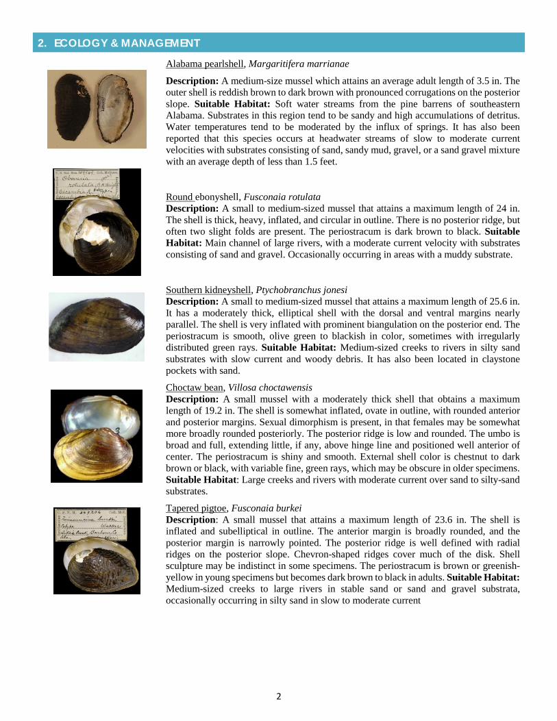
2
2. ECOLOGY & MANAGEMENT
Alabama pearlshell, Margaritifera marrianae
Description: A medium-size mussel which attains an average adult length of 3.5 in. The outer shell is reddish brown to dark brown with pronounced corrugations on the posterior slope. Suitable Habitat: Soft water streams from the pine barrens of southeastern Alabama. Substrates in this region tend to be sandy and high accumulations of detritus. Water temperatures tend to be moderated by the influx of springs. It has also been reported that this species occurs at headwater streams of slow to moderate current velocities with substrates consisting of sand, sandy mud, gravel, or a sand gravel mixture with an average depth of less than 1.5 feet.
Round ebonyshell, Fusconaia rotulata Description: A small to medium-sized mussel that attains a maximum length of 24 in. The shell is thick, heavy, inflated, and circular in outline. There is no posterior ridge, but often two slight folds are present. The periostracum is dark brown to black. Suitable Habitat: Main channel of large rivers, with a moderate current velocity with substrates consisting of sand and gravel. Occasionally occurring in areas with a muddy substrate.
Southern kidneyshell, Ptychobranchus jonesi Description: A small to medium-sized mussel that attains a maximum length of 25.6 in. It has a moderately thick, elliptical shell with the dorsal and ventral margins nearly parallel. The shell is very inflated with prominent biangulation on the posterior end. The periostracum is smooth, olive green to blackish in color, sometimes with irregularly distributed green rays. Suitable Habitat: Medium-sized creeks to rivers in silty sand substrates with slow current and woody debris. It has also been located in claystone pockets with sand.
Choctaw bean, Villosa choctawensis Description: A small mussel with a moderately thick shell that obtains a maximum length of 19.2 in. The shell is somewhat inflated, ovate in outline, with rounded anterior and posterior margins. Sexual dimorphism is present, in that females may be somewhat more broadly rounded posteriorly. The posterior ridge is low and rounded. The umbo is broad and full, extending little, if any, above hinge line and positioned well anterior of center. The periostracum is shiny and smooth. External shell color is chestnut to dark brown or black, with variable fine, green rays, which may be obscure in older specimens. Suitable Habitat: Large creeks and rivers with moderate current over sand to silty-sand substrates.
Tapered pigtoe, Fusconaia burkei Description: A small mussel that attains a maximum length of 23.6 in. The shell is inflated and subelliptical in outline. The anterior margin is broadly rounded, and the posterior margin is narrowly pointed. The posterior ridge is well defined with radial ridges on the posterior slope. Chevron-shaped ridges cover much of the disk. Shell sculpture may be indistinct in some specimens. The periostracum is brown or greenish-yellow in young specimens but becomes dark brown to black in adults. Suitable Habitat: Medium-sized creeks to large rivers in stable sand or sand and gravel substrata, occasionally occurring in silty sand in slow to moderate current
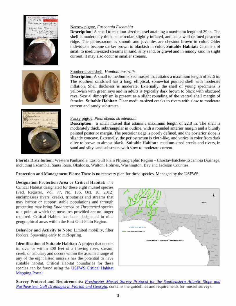
3
Narrow pigtoe, Fusconaia Escambia Description: A small to medium-sized mussel attaining a maximum length of 29 in. The shell is moderately thick, subcircular, slightly inflated, and has a well-defined posterior ridge. The periostracum is smooth and juveniles are chestnut brown in color. Older individuals become darker brown to blackish in color. Suitable Habitat: Channels of small to medium-sized streams in sand, silty sand, or gravel and in muddy sand in slight current. It may also occur in smaller streams.
Southern sandshell, Hamiota australis Description: A small to medium-sized mussel that attains a maximum length of 32.6 in. The southern sandshell has a long, elliptical, somewhat pointed shell with moderate inflation. Shell thickness is moderate. Externally, the shell of young specimens is yellowish with green rays and in adults is typically dark brown to black with obscured rays. Sexual dimorphism is present as a slight rounding of the ventral shell margin of females. Suitable Habitat: Clear medium-sized creeks to rivers with slow to moderate current and sandy substrates.
Fuzzy pigtoe, Pleurobema strodeanum Description: a small mussel that attains a maximum length of 22.8 in. The shell is moderately thick, subtriangular in outline, with a rounded anterior margin and a bluntly pointed posterior margin. The posterior ridge is poorly defined, and the posterior slope is slightly concave. Externally, the periostracum is cloth-like, and varies in color from dark olive to brown to almost black. Suitable Habitat: medium-sized creeks and rivers, in sand and silty sand substrates with slow to moderate current.
Florida Distribution: Western Panhandle, East Gulf Plain Physiographic Region – Choctawhatchee-Escambia Drainage, including Escambia, Santa Rosa, Okaloosa, Walton, Holmes, Washington, Bay and Jackson Counties.
Protection and Management Plans: There is no recovery plan for these species. Managed by the USFWS.
Designation Protection Area or Critical Habitat: The Critical Habitat designated for these eight mussel species (Fed. Register, Vol. 77, No. 196, Oct. 10, 2012) encompasses rivers, creeks, tributaries and streams that may harbor or support stable populations and through protection may bring Endangered or Threatened species to a point at which the measures provided are no longer required. Critical Habitat has been designated in nine geographical areas within the East Gulf Plain Region.
Behavior and Activity to Note: Limited mobility, filter feeders. Spawning early to mid-spring.
Identification of Suitable Habitat: A project that occurs in, over or within 300 feet of a flowing river, stream, creek, or tributary and occurs within the assumed range of any of the eight listed mussels has the potential to have suitable habitat. Critical Habitat boundaries for these species can be found using the USFWS Critical Habitat Mapping Portal.
Survey Protocol and Requirements: Freshwater Mussel Survey Protocol for the Southeastern Atlantic Slope and Northeastern Gulf Drainages in Florida and Georgia, contains the guidelines and requirements for mussel surveys.
4
3. AGENCY CONSULTATION (FEDERAL)Responsible Agency(s): The applicable agency for freshwater mussels is USFWS. Federal Nexus for Consultation: Consultation with the USFWS is required for any project that is authorized, funded, or requires a federal permit which proposes impacts to freshwater mussel habitat within the known range of the eight listed mussel species. Consultation (informal or formal) is required for habitat impacts beyond the designated Critical Habitat.
Type of Consultation: Informal and formal consultations are applicable for the eight mussels group based on the type of work proposed. Determination of the level of consultation required can be determined through the use of the “Freshwater Mussel Phase 1 Programmatic Approach (PA) for Transportation Work Activities” dated March 8, 2016. A Phase II programmatic approach is proposed of projects that reach a May Affect and May Affect Likely to Adversely Affect determination. However, prior to that implementation of the Phase II Programmatic Agreement (PA) a standard formal consultation is required (See Appendix on Programmatic Agreements). Demonstrate Avoidance, Minimization, and Mitigation: FDOT must demonstrate that it is making every available effort to avoid and/or minimize the impacts to these species and their habitat for all proposed projects. The Phase 1 Programmatic Approach provides detailed effects to the species from erosion and sedimentation, contaminant discharge, physical changes to streams and loss of stream connectivity. In addition, the Programmatic Approach also provides conservation measures for the species and their habitat.
Tools for Section 7 ESA Consultation: Freshwater Mussel Phase 1 Programmatic Approach for Transportation Work Activities. Also, see USFWS’s document for Project Managers Determining if a project may affect listed mussels or critical habitat in streams of Florida. Special Provisions, or Standard Protection Measures: Phase I of the programmatic approach contains conservation measures, as well as construction methods that result in a not likely to adversely affect (NLAA) determination.
General Timeframes for Permitting: Timeframes may depend on the complexity of the project, though would follow the standard USFWS procedures. Early coordination is essential to limit prolonged review times.
4. PERMITTINGProhibited Activities: Activities that can impact these species or their habitat (dredging, filling, water quality degradation, equipment, or materials (piles)) are prohibited without prior project approval. There is no mussel specific permit for potential impacts, however approval for impacts is obtained through the consultation process and included as part of the State ERP and USACE permits for each project.
Exemptions: There are transportation related activities that are exempt from federal and state permitting, however there are no activities that are exempt from informal and/or formal consultation with USFWS regarding freshwater mussels. However, the Phase I Programmatic Approach indicates activities that would result in an NLAA effects determination which would reduce the federal and state review for the project.
Activities Authorized by Permit: Project activities are approved under the federal and state permitting programs. If impacts are proposed to mussel species or their habitat, it would be addressed through a Biological Opinion (BO).
5. PRE-CONSTRUCTION & CONSTRUCTION COMPLIANCE
Review of Commitments: Commitments can be found within the Environmental Commitment Module in ProjectSuite Enterprise Edition (PSEE). If additional commitments are identified during design or permitting, coordination with the Project Manager and add to the Environmental Commitment Module. The Design Project Manager will share the Project Commitment Record with Construction.
Review all Environmental Permits for Special Conditions: Review all environmental permits for Special Conditions related to mussels and Critical Habitat. Make sure that construction personnel have copies. Prior to Construction: Advise personnel that penalties for convictions for violations of these laws range from a maximum of $500 and/or 60 days imprisonment for first offenses of misdemeanor crimes or up to $50,000 and/or one year imprisonment for criminal violations against the federal Endangered Species Act. To learn more read Laws that Protect Florida’s Wildlife, https://edis.ifas.ufl.edu/pdffiles/UW/UW07600.pdf.
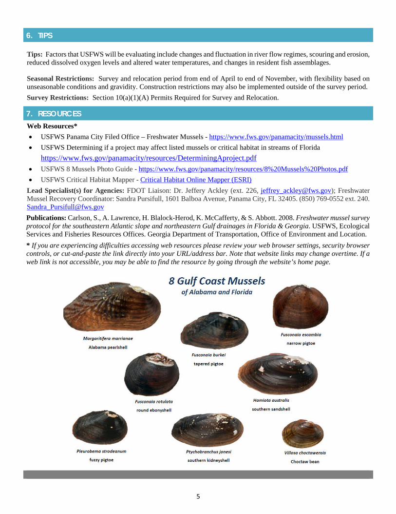
5
6. TIPS
Tips: Factors that USFWS will be evaluating include changes and fluctuation in river flow regimes, scouring and erosion, reduced dissolved oxygen levels and altered water temperatures, and changes in resident fish assemblages.
Seasonal Restrictions: Survey and relocation period from end of April to end of November, with flexibility based on unseasonable conditions and gravidity. Construction restrictions may also be implemented outside of the survey period. Survey Restrictions: Section 10(a)(1)(A) Permits Required for Survey and Relocation.
7. RESOURCES
Web Resources*• USFWS Panama City Filed Office – Freshwater Mussels - https://www.fws.gov/panamacity/mussels.html• USFWS Determining if a project may affect listed mussels or critical habitat in streams of Florida
https://www.fws.gov/panamacity/resources/DeterminingAproject.pdf• USFWS 8 Mussels Photo Guide - https://www.fws.gov/panamacity/resources/8%20Mussels%20Photos.pdf• USFWS Critical Habitat Mapper - Critical Habitat Online Mapper (ESRI)
Lead Specialist(s) for Agencies: FDOT Liaison: Dr. Jeffery Ackley (ext. 226, [email protected]); Freshwater Mussel Recovery Coordinator: Sandra Pursifull, 1601 Balboa Avenue, Panama City, FL 32405. (850) 769-0552 ext. 240. [email protected] Publications: Carlson, S., A. Lawrence, H. Blalock-Herod, K. McCafferty, & S. Abbott. 2008. Freshwater mussel survey protocol for the southeastern Atlantic slope and northeastern Gulf drainages in Florida & Georgia. USFWS, Ecological Services and Fisheries Resources Offices. Georgia Department of Transportation, Office of Environment and Location. * If you are experiencing difficulties accessing web resources please review your web browser settings, security browsercontrols, or cut-and-paste the link directly into your URL/address bar. Note that website links may change overtime. If aweb link is not accessible, you may be able to find the resource by going through the website’s home page.

2019 Appendix: Listed Species
APPENDIX 1r Suwannee Moccasinshell
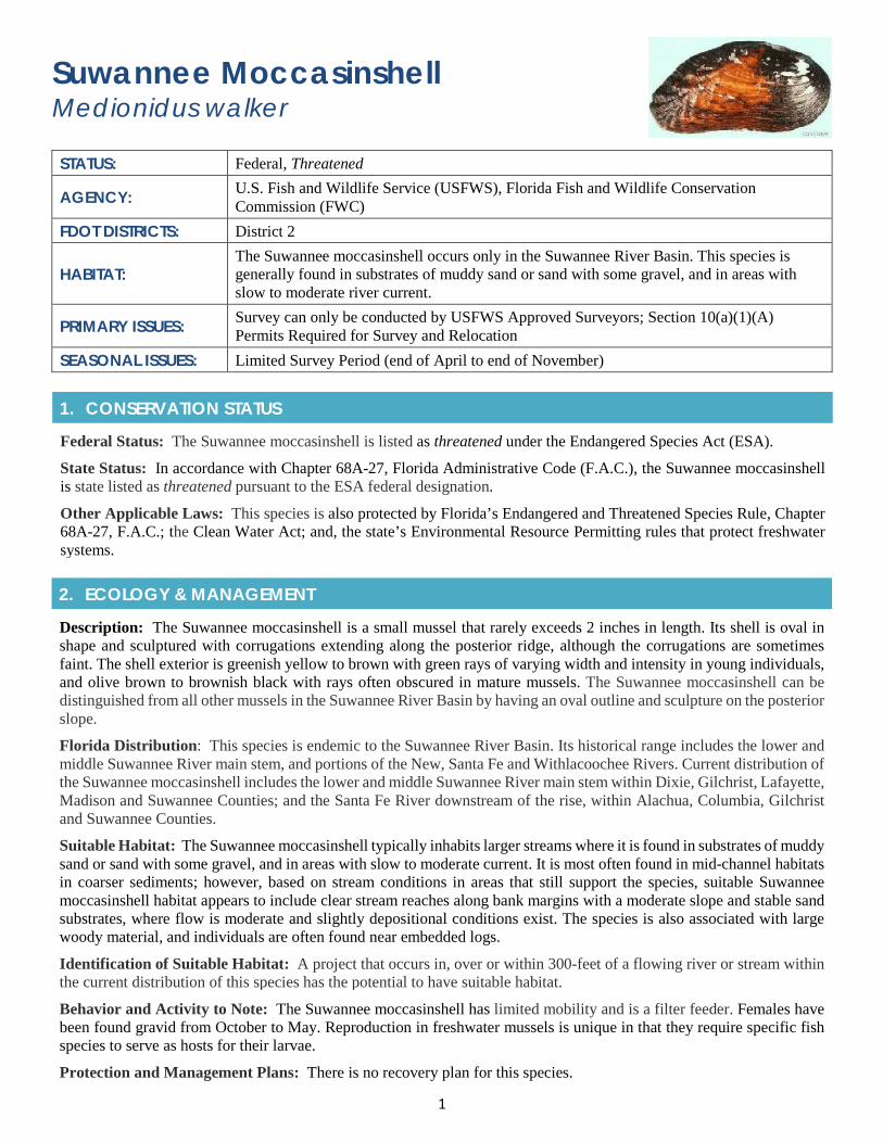
1
Suwannee Moccasinshell Medionidus walker
STATUS: Federal, Threatened
AGENCY: U.S. Fish and Wildlife Service (USFWS), Florida Fish and Wildlife Conservation Commission (FWC)
FDOT DISTRICTS: District 2
HABITAT: The Suwannee moccasinshell occurs only in the Suwannee River Basin. This species is generally found in substrates of muddy sand or sand with some gravel, and in areas with slow to moderate river current.
PRIMARY ISSUES: Survey can only be conducted by USFWS Approved Surveyors; Section 10(a)(1)(A) Permits Required for Survey and Relocation
SEASONAL ISSUES: Limited Survey Period (end of April to end of November)
1. CONSERVATION STATUS
Federal Status: The Suwannee moccasinshell is listed as threatened under the Endangered Species Act (ESA).
State Status: In accordance with Chapter 68A-27, Florida Administrative Code (F.A.C.), the Suwannee moccasinshell is state listed as threatened pursuant to the ESA federal designation.
Other Applicable Laws: This species is also protected by Florida’s Endangered and Threatened Species Rule, Chapter 68A-27, F.A.C.; the Clean Water Act; and, the state’s Environmental Resource Permitting rules that protect freshwater systems.
2. ECOLOGY & MANAGEMENT
Description: The Suwannee moccasinshell is a small mussel that rarely exceeds 2 inches in length. Its shell is oval in shape and sculptured with corrugations extending along the posterior ridge, although the corrugations are sometimes faint. The shell exterior is greenish yellow to brown with green rays of varying width and intensity in young individuals, and olive brown to brownish black with rays often obscured in mature mussels. The Suwannee moccasinshell can be distinguished from all other mussels in the Suwannee River Basin by having an oval outline and sculpture on the posterior slope.
Florida Distribution: This species is endemic to the Suwannee River Basin. Its historical range includes the lower and middle Suwannee River main stem, and portions of the New, Santa Fe and Withlacoochee Rivers. Current distribution of the Suwannee moccasinshell includes the lower and middle Suwannee River main stem within Dixie, Gilchrist, Lafayette, Madison and Suwannee Counties; and the Santa Fe River downstream of the rise, within Alachua, Columbia, Gilchrist and Suwannee Counties.
Suitable Habitat: The Suwannee moccasinshell typically inhabits larger streams where it is found in substrates of muddy sand or sand with some gravel, and in areas with slow to moderate current. It is most often found in mid-channel habitats in coarser sediments; however, based on stream conditions in areas that still support the species, suitable Suwannee moccasinshell habitat appears to include clear stream reaches along bank margins with a moderate slope and stable sand substrates, where flow is moderate and slightly depositional conditions exist. The species is also associated with large woody material, and individuals are often found near embedded logs.
Identification of Suitable Habitat: A project that occurs in, over or within 300-feet of a flowing river or stream within the current distribution of this species has the potential to have suitable habitat.
Behavior and Activity to Note: The Suwannee moccasinshell has limited mobility and is a filter feeder. Females have been found gravid from October to May. Reproduction in freshwater mussels is unique in that they require specific fish species to serve as hosts for their larvae.
Protection and Management Plans: There is no recovery plan for this species.
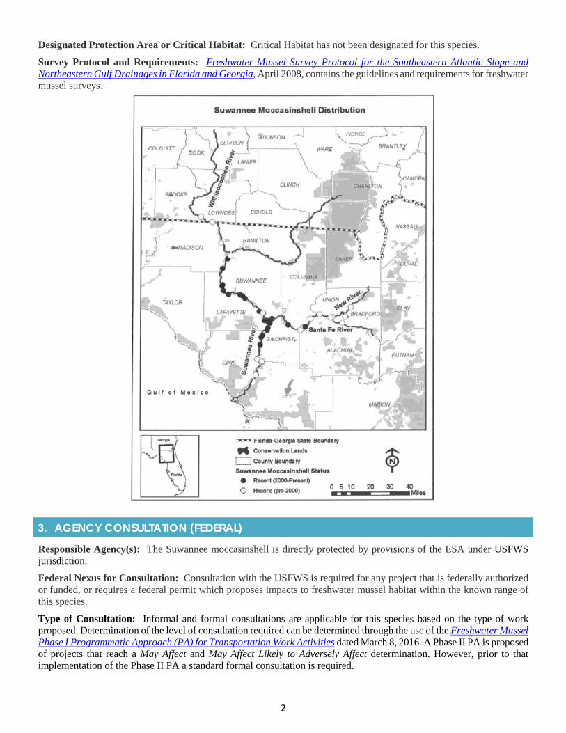
2
Designated Protection Area or Critical Habitat: Critical Habitat has not been designated for this species.
Survey Protocol and Requirements: Freshwater Mussel Survey Protocol for the Southeastern Atlantic Slope and Northeastern Gulf Drainages in Florida and Georgia, April 2008, contains the guidelines and requirements for freshwater mussel surveys.
3. AGENCY CONSULTATION (FEDERAL)
Responsible Agency(s): The Suwannee moccasinshell is directly protected by provisions of the ESA under USFWS jurisdiction.
Federal Nexus for Consultation: Consultation with the USFWS is required for any project that is federally authorized or funded, or requires a federal permit which proposes impacts to freshwater mussel habitat within the known range of this species.
Type of Consultation: Informal and formal consultations are applicable for this species based on the type of work proposed. Determination of the level of consultation required can be determined through the use of the Freshwater Mussel Phase I Programmatic Approach (PA) for Transportation Work Activities dated March 8, 2016. A Phase II PA is proposed of projects that reach a May Affect and May Affect Likely to Adversely Affect determination. However, prior to that implementation of the Phase II PA a standard formal consultation is required.
3
Demonstrate Avoidance, Minimization, and Mitigation: FDOT must demonstrate to the USFWS that it is making every available effort to avoid and/or minimize the impacts to this species and its habitat for all proposed projects. The Phase I Programmatic Agreement (PA) provides detailed effects to the species from erosion and sedimentation, contaminant discharge, physical changes to streams and loss of stream connectivity. In addition, the PA (See Appendix on Programmatic Agreements) also provides conservation measures for the species and its habitat.
Tools for Section 7 ESA Consultation: Freshwater Mussel Phase I Programmatic Agreement for Transportation Work Activities. Also, see USFWS’s document for Project Managers Determining if a project may affect listed mussels or critical habitat in streams of Florida.
Special Provisions, or Standard Protection Measures: No special provisions or standard protection measures; however, see existing freshwater mussel PA.
General Timeframes for Consultation and Permitting: Timeframes may depend on the complexity of the project, though would follow the standard USFWS procedures. Early coordination is essential to limit prolonged review times.
4. PERMITTING
Prohibited Activities: Activities that can impact these species or their habitat [dredging, filling, water quality degradation, equipment, or materials (piles)] are prohibited without prior project approval. There is no mussel specific permit for potential impacts; however, approval for impacts is obtained through the consultation process and included as part of the State Environmental Resources Permit (ERP) and United States Army Corps of Engineers (USACE) permits for each project.
Exemptions: There are transportation related activities that are exempt from federal and state permitting; however, there are no activities that are exempt from informal and/or formal consultation with USFWS regarding freshwater mussels. The Phase I PA lists activities that would result in a not likely to adversely affect (NLAA) effects determination, reducing the federal and state review for the project.
Activities Authorized by Permit: Project activities are approved under the federal and state permitting programs; however, if an adverse effect determination is made for the Suwannee moccasinshell, it would be addressed through a Biological Opinion (BO) issued by USFWS.
5. PRE-CONSTRUCTION & CONSTRUCTION COMPLIANCE
Review of Commitments: Commitments can be found within the Environmental Commitment Module in ProjectSuite Enterprise Edition (PSEE). If additional commitments are identified during design or permitting, coordinate with the Project Manager and enter into the Environmental Commitment Module. The Design Project Manager will share the Project Commitment Record with Construction.
Review of Environmental Permits for Special Conditions: Review all environmental permits for Special Conditions related to the Suwannee moccasinshell. Make sure construction personnel have copies.
Prior to Construction: Advise personnel that penalties for convictions for violations of these laws range from a maximum of $500 and/or 60 days imprisonment for first offenses of misdemeanor crimes or up to $50,000 and/or one year imprisonment for criminal violations against the federal Endangered Species Act. To learn more read Laws that Protect Florida’s Wildlife.
6. TIPS
Tips: Currently, nearly the entire population of Suwannee moccasinshell resides in the middle and lower reach of the Suwannee River main channel.
Seasonal Restrictions: Survey and relocation period is the end of April to end of November, with some flexibility based on unseasonable conditions and gravidity. Construction restrictions may also be implemented outside of the survey period.
Survey Restrictions: Section 10(a)(1)(A) Permits Required for Survey and Relocation.
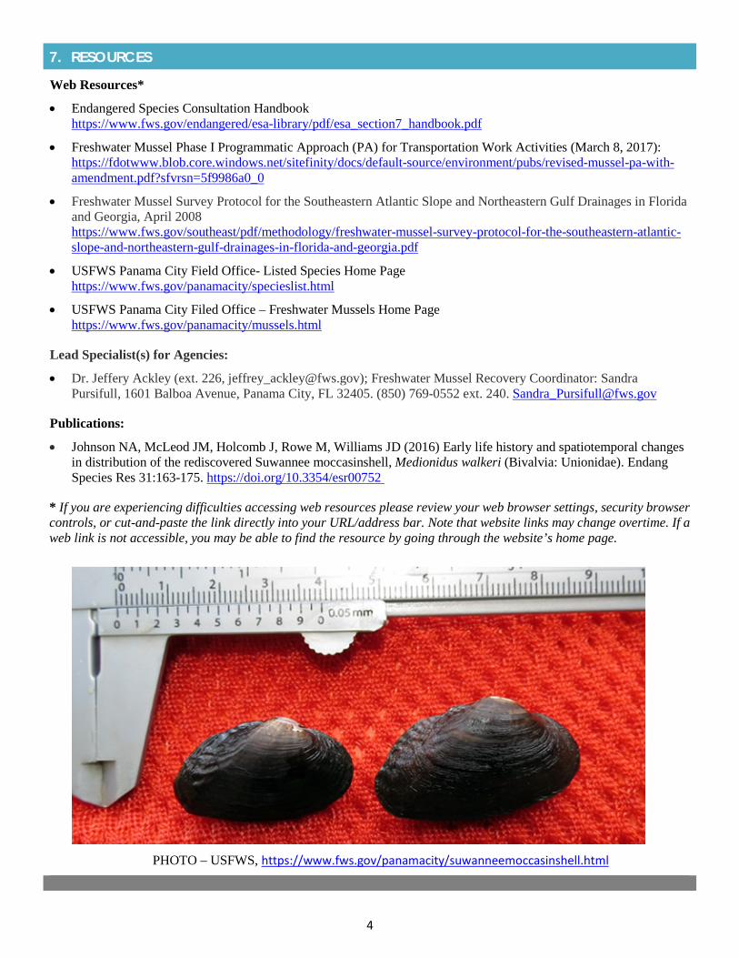
4
7. RESOURCES
Web Resources*
• Endangered Species Consultation Handbookhttps://www.fws.gov/endangered/esa-library/pdf/esa_section7_handbook.pdf
• Freshwater Mussel Phase I Programmatic Approach (PA) for Transportation Work Activities (March 8, 2017):https://fdotwww.blob.core.windows.net/sitefinity/docs/default-source/environment/pubs/revised-mussel-pa-with-amendment.pdf?sfvrsn=5f9986a0_0
• Freshwater Mussel Survey Protocol for the Southeastern Atlantic Slope and Northeastern Gulf Drainages in Floridaand Georgia, April 2008https://www.fws.gov/southeast/pdf/methodology/freshwater-mussel-survey-protocol-for-the-southeastern-atlantic-slope-and-northeastern-gulf-drainages-in-florida-and-georgia.pdf
• USFWS Panama City Field Office- Listed Species Home Pagehttps://www.fws.gov/panamacity/specieslist.html
• USFWS Panama City Filed Office – Freshwater Mussels Home Pagehttps://www.fws.gov/panamacity/mussels.html
Lead Specialist(s) for Agencies:
• Dr. Jeffery Ackley (ext. 226, [email protected]); Freshwater Mussel Recovery Coordinator: SandraPursifull, 1601 Balboa Avenue, Panama City, FL 32405. (850) 769-0552 ext. 240. [email protected]
Publications:
• Johnson NA, McLeod JM, Holcomb J, Rowe M, Williams JD (2016) Early life history and spatiotemporal changesin distribution of the rediscovered Suwannee moccasinshell, Medionidus walkeri (Bivalvia: Unionidae). EndangSpecies Res 31:163-175. https://doi.org/10.3354/esr00752
* If you are experiencing difficulties accessing web resources please review your web browser settings, security browsercontrols, or cut-and-paste the link directly into your URL/address bar. Note that website links may change overtime. If aweb link is not accessible, you may be able to find the resource by going through the website’s home page.
PHOTO – USFWS, https://www.fws.gov/panamacity/suwanneemoccasinshell.html

2019 Appendix: Specialty Permits
SPECIALTY PERMITS

2019 Appendix: Specialty Permits
APPENDIX 2a Programmatic Agreements
1
Programmatic AgreementsTools for Permit Streamlining
FDOT DISTRICTS: All Districts and the Florida Turnpike Enterprise
SUMMARY: Programmatic Agreements are legal documents that establish a streamlined process for handling routine environmental or historic heritage requirements for commonly encountered project types. They establish a process for consultation, review, and compliance with one or more federal laws.
1. OVERVIEW OF PROGRAMMATIC AGREEMENTS
Programmatic Agreement: A Programmatic Agreement (PA) is a document that lays out the terms of a formal, legally binding agreement between the Florida Department of Transportation (FDOT) and other state and/or federal agencies. The purpose of the PA is to establish a process for consultation, review, and compliance with one or more federal laws. PAs facilitate repetitive work to be handled on a program basis rather than on a project-by-project basis. PAs for natural resources typically involve the streamlining of environmental review through a process that allows for all parties to meet their compliance responsibilities for an agency program, a category of projects, a particular type of resource, and/or frequently encountered effects.
Compliance with an Environmental or Cultural Resource Law:
• Section 7 Endangered Species Act (ESA) Compliance: Compliance with Section 7 of the Endangered Species Act(ESA) can be accomplished through the use of programmatic consultations, resulting in the development ofprogrammatic biological assessments, and programmatic biological opinions (BO) prepared by either U.S. Fish andWildlife Service (USFWS) and/or the National Marine Fisheries Service (NMFS). The FDOT, USFWS, and NMFSuse programmatic assessments and BOs as guidance documents for future projects with frequent, routine activitieswith predictable outcomes. When one of these projects is initiated, the agencies use these programmatic consultationsto expedite and simplify Section 7 compliance, as opposed to completing a separate, Formal Section 7 ESAconsultation.
• Section 106 Compliance: In the context of Section 106 of the National Historic Preservation Act (NHPA), a PAdiffers from a Memorandum of Agreement (MOA) in that MOAs are used most often to resolve or conclude theSection 106 process for individual, federal undertakings where the project has specific and definable adverse effectson historic properties. Typically, PAs are used to outline or tailor how the Section 106 process will be implementedand followed for a historic preservation compliance program or components of these programs such as outlined inthe Advisory Council for Historic Preservation Guidance (36 CFR 800.14(b)(1):
I. When effects on historic properties are similar and repetitive or are multi-State or regional in scope;
II. When effects on historic properties cannot be fully determined prior to approval of an undertaking;
III. When non-federal parties are delegated major decision-making responsibilities;
IV. Where routine management activities are undertaken at Federal installations, facilities, or other land-management units; or
V. Where other circumstances warrant a departure from the normal Section 106 process.
2. LIST OF PROGRAMMATIC AGREEMENTS
JaxBO Programmatic Agreement: This is a Programmatic Biological Opinion (PBO) between USACE and NMFS, which allows for the streamlining of the Section 7 ESA consultation process during federal permitting for groups of frequently occurring activities and Federal action agency policies, plans, programs that have well-understood effects on listed species and designated habitat including Johnson’s Seagrass and its Critical Habitat. The JaxBO provides a tool to address consultation for ten categories of “in-water” activities including: (1) Shoreline Stabilization; (2) Pile-supported Structures and Anchored Buoys; (3) Maintenance, Minor, and Muck Dredging; (4) Water-Management Outfall Structures
2
and Associated Endwalls; (5) Scientific Survey Devices; (6) Boat Ramps; (7) Aquatic Habitat Enhancement, Establishment, and Restoration Activities; (8) Transmission and Utility Lines; (9) Marine Debris Removal; and, (10) Temporary Platforms, Fill, and Cofferdams. To learn more, go to:
http://www.saj.usace.army.mil/Missions/Regulatory/Source-Book/. Freshwater Mussel Programmatic Agreement, Phase I: This is a procedural PA developed in partnership between FDOT, Florida Fish and Wildlife Conservation Commission (FWC) and USFWS, with participation from the Federal Highway Administration (FHWA) and the U.S. Army Corps pf Engineers (USACE). The PA covers all fifteen species of federally protected mussels and their designated critical habitat (See separate appendix on Mussels). The purpose of the PA is to provide a clear, consistent, and predictable approach for complying with the requirements under the Endangered Species Act of 1973 (ESA), as amended (16 U.S.C. 1531 et. seq.). The Phase I PA focuses on FDOT actions that the participating agencies mutually agree will have either “no effect” (NE) on mussels or “may affect, but not likely to adversely affect” (MANLAA) mussels with incorporation of conservation measures. It also identifies actions that “may affect” (MA) mussels but will require further coordination with the USFWS. A Phase II PA is planned at a later time to address actions that MA mussels, including formal consultation for projects that are “likely to adversely affect” (MALAA) mussels. To learn more, go to:
https://fdotwww.blob.core.windows.net/sitefinity/docs/default-source/environment/pubs/revised-mussel-pa-with-amendment.pdf?sfvrsn=5f9986a0_0
Section 106 Programmatic Agreement: This is a procedural PA among FHWA, the Advisory Council of Historic Preservation (ACHP), the Florida Division of Historic Preservation (DHP), the Florida Division of Historical Resources (DHR), State Historic Preservation Officer (SHPO), and FDOT regarding the implementation of the Federal-Aid Highway Program in Florida. The objective of this PA is to increase the efficiency of the FHWA and FDOT reviews of individual undertakings that may affect historic properties and to establish the process by which FDOT, FHWA, the ACHP, the SHPO, and other consulting parties will be involved in any such reviews. Through this PA, FHWA delegates to FDOT certain decision-making tasks under the Section 106 process for the Federal-Aid Highway Program. These tasks include:
1. Establish whether there is an undertaking with the potential to affect historic properties;
2. Identify the consulting parties for each undertaking;
3. Inform FHWA when there are historic resources that may be of cultural and religious significance to the Tribes;
4. Seek public comment for individual project actions, and conduct public involvement activities;
5. Establish the Area of Potential Effect (APE) of an undertaking in coordination with SHPO/Tribal HistoricPreservation Officer (THPO);
6. Determine the appropriate level of effort through the project internal review and screening process, and inaccordance with the Agency Operating Agreement (AOA) and the provisions of this Agreement;
7. Identify historic resources located within the project APE in coordination with SHPO/THPO, other consultingparties, and Tribes;
8. Evaluate the NRHP eligibility of all historic resources identified within the project APE, in coordination withSHPO/THPO;
9. Apply the Criteria of Adverse Effect in historic properties as per 36 C.F.R. 800.5β in coordination withSHPO/THPO, Tribes and other consulting parties;
10. Initiate consultation on the resolution of adverse effects as per 36 C.F. R 800.6 β with FHWA and appropriateconsulting parties exclusive of the Tribes;
11. Consult, as appropriate, regarding the determination of the project APE, the evaluation of NRHP eligibility, andthe effects of a Program undertaking on historic properties;
12. Coordinate Section 106 review with other relevant project reviews, such as the National Environmental PolicyAct; and
13. Document individual undertakings and maintain a record of all project reviews carried out pursuant to theAgreement;
3
To learn more, go to:
https://fdotwww.blob.core.windows.net/sitefinity/docs/default-source/environment/pubs/section-106-pa-executed-version-1-via-email-15mar16-(3).pdf?sfvrsn=a145ca30_2
3. RESOURCES
Web Resources*
• Amendment to the Freshwater Mussel Phase 1 Programmatic Approach for Transportation Work Activitieshttps://fdotwww.blob.core.windows.net/sitefinity/docs/default-source/environment/pubs/revised-mussel-pa-with-amendment.pdf?sfvrsn=5f9986a0_0
• Center for Environmental Excellence by AASHTO – Programmatic Agreementshttps://environment.transportation.org/documents/programmatic_agreement_toolkit/WhatIsPA.html
• FDOT, Environmental Management, Publicationshttps://www.fdot.gov/environment/publications.shtm
• Section 106 Programmatic Agreementhttps://fdotwww.blob.core.windows.net/sitefinity/docs/default-source/environment/pubs/section-106-pa-executed-version-1-via-email-15mar16-(3).pdf?sfvrsn=a145ca30_2
• Roadmap for Developing and Implementing Programmatic Agreementsfile:///V:/2158/active/215810408/TWO%206%20Permitting%20Handbook/Permit%20Handbook%20Appendices/16.%20Programmatic%20Agreements/aashto_pa_roadmap_may2016.pdf
• AASHTO CEE Programmatic Agreement Libraryhttps://environment.transportation.org/pal_database/
• AASHTO CEE Programmatic Agreement Toolkithttp://environment.transportation.org/documents/programmatic_agreement_toolkit/main.htl
• Transportation Research Board report on “Agency Use of and Approach to FHWA Approved ProgrammaticAgreements”http://onlinepubs.trb.org/onlinepubs/archive/NotesDocs/25-25(13)_FR.pdf
* If you are experiencing difficulties accessing web resources please review your web browser settings, security browsercontrols, or cut-and-paste the link directly into your URL/address bar. Note that website links may change overtime. If aweb link is not accessible, you may be able to find the resource by going through the website’s home page.

2019 Appendix: Specialty Permits
APPENDIX 2b Regional General Permits
1
Regional General Permits United States Army Corps of Engineers (USACE)
FDOT DISTRICTS: All Districts (SAJ-92 & SPGP permits); Portions of Districts 1, 2, 4, & 5 (SAJ-111)
ISSUES: Minor impacts to wetlands and waters of the United States
SUMMARY:
The Florida Department of Transportation (FDOT) may apply for a regional general permit when a project’s impacts meet the requirements as detailed in the permit. These general permits have limits on wetland impacts or activity types in order to qualify for use. The USACE authorizes the use of SAJ-92 permits; the St. Johns River Water Management District (SJRWMD) authorizes the use of SAJ-111 permits, and the Florida Department of Environmental Protection (FDEP) or other USACE designee authorizes the use of Statewide Programmatic General Permits (SPGPs). Refer to the appropriate general permit for more details below.
1. GENERAL PERMITS
USACE General Permits Authorization: The USACE is the federal permitting agency that is responsible for overseeing navigable waters and all dredging and filling activities within “Waters of the United States”, which includes the nation’s wetlands and surface waters. According to 33 Code of Federal Regulations (CFR) Section 328.3(b), wetlands include swamps, marshes, and bogs and are defined as “areas that are inundated or saturated by surface or ground water at a frequency and duration sufficient to support and that under normal circumstances do support a prevalence of vegetation typically adapted for life in saturated soils.” As part of its jurisdictional role, USACE has the authority to issue general permits on a statewide and regional basis for specific categories of work.
2. GENERAL PERMIT OVERVIEW
General Permits (SAJs): USACE authorizes general permits on a nationwide or regional basis for specific and similar categories of work that are only anticipated to cause minimal wetland impacts. This type of permit was developed to streamline permit issuance while ensuring compliance with applicable laws and regulations. General permits are reviewed every five years, at which point a cumulative impact assessment of work authorized under the permit may be performed. If a project does not comply with the conditions of the general permit, a standard permit application must be submitted instead. Examples of general permits that could apply to FDOT projects are the SAJ-92 permit, the SAJ-111 permit, and the Statewide Programmatic General Permit (SPGP).
3. SAJ-92 PERMIT
SAJ-92 Permit: The SAJ-92 permit is a regional general permit that applies to FDOT projects that have gone through the Project Development and Environment (PD&E) process and are not anticipated to result in more than 5 acres of dredge and fill wetland/surface water impacts for any 1-mile segment of the project. The maximum allowable impact for projects covered under this regional general permit is 50 acres. This type of permit can only be used for linear transportation projects on existing roadway alignments that were reviewed in 2010 or later through the Efficient Transportation Decision Making (ETDM) and/or PD&E processes. It should be noted that this type of permit cannot be used for projects located in Monroe County.
Examples of project activities that may be covered by an SAJ-92 permit include, but are not limited to the following: lane additions, safety improvements, maintenance, bike lane/sidewalk additions, etc. It is beneficial to submit general permit applications early so adequate coordination with the appropriate reviewer can occur and project schedule impacts can be avoided.
Applying for a SAJ-92 Permit: SAJ-92 permits do not have an official issuance timeframe, so the amount of time required for the permit to be issued varies from 6 – 12 months. The SAJ-92 application should be submitted to the USACE during the design phase so that coordination can begin as early as possible. Compensatory mitigation is required for all unavoidable permanent wetland impacts and must be completed through one or more of the following mechanisms and preference hierarchy: 1) securing appropriate number and resource type of credits from approved mitigation bank within
2
the project’s service area 2) payment of mitigation fees to an approved in-lieu program within the project’s service area; 3) through a “permittee-responsible” mitigation, including those mitigation projects that are part of the FDOT MitigationProgram (Section 373.4137, Florida Statutes); on-site and in-kind compensatory mitigation; and/or off-site and/or out-of-kind compensatory mitigation. It is incumbent on FDOT to demonstrate to the USACE that the compensatorymitigation proposal is the environmentally preferable option to replace the ecological functions and services that wouldbe lost through the implementation of any work proposed. All compensatory mitigation proposals must be approved priorto verification of SAJ-92. For more information refer to USACE SAJ-92 Modification 1. It should be noted that this typeof permit includes 25 special conditions (including required documentation, listed species reviews, and cultural resourcesrequirements) that must all be reviewed and understood to confirm the SAJ-92 permit applies to the project. If allconditions are not met, FDOT must apply for the applicable standard permit instead. Once issued, the SAJ-92 permit willremain valid for a period of five years from the date of issuance. Within 60 days of completing the authorized work andmitigation, FDOT must complete and submit a Self-Certification Statement of Compliance form to the USACE. Thisform can be found in Attachment 4 of the SAJ-92 permit.
4. SAJ-111 PERMIT
SAJ-111 Permit: The SAJ-111 permit is a programmatic general permit that is only issued by St. Johns River Water Management District (SJRWMD) through a Cooperation Agreement with USACE. Because the SAJ-111 permit applies to projects involving residential, commercial, or institutional building foundations and building pads with up to 3 acres of wetland/surface water impacts, this type of permit does not typically apply directly to FDOT projects. However, the SAJ-111 permit could apply if an FDOT project includes an associated building structure and is in an area under SJRWMD’s jurisdiction.
To qualify for an SAJ-111 permit, a project must be in Baker, Clay, Duval, Flagler, Lake, Marion, Nassau, Orange, Putnam, Seminole, St. Johns, or Volusia county and must be west of I-95 if located in Brevard, Flagler, St. Johns, or Volusia county. The project must involve the construction of residential, commercial, or institutional building foundations and building pads, and may only impact up to 3 acres of wetland/surface water impacts. These wetland/surface water impacts may only involve low quality or urbanized non-tidal wetlands of the following types: wetlands in pine plantations with raised beds in production over 20 years, herbaceous wetlands in improved pasture, wetlands on parcels bordered by at least 75% development, and wetlands covered by greater than 80% invasive exotic vegetation.
Applying for a SAJ-111 Permit: The SAJ-111 permit application (including project design plans and a Preliminary Jurisdictional Determination Form) should be submitted to SJRWMD as early as possible during the design phase to avoid impacts to the project schedule. Compensatory mitigation for unavoidable wetland impacts is required and must be accomplished at a 1:1 ratio at a federal mitigation bank. The SAJ-111 permit contains 28 special conditions (including required documentation, listed species reviews, and cultural resource requirements) that must be complied with for the SAJ-111 permit to apply to the project. FDOT shall not begin construction until written authorization verifying issuance of SAJ-111 from SJRWMD has been received. Prior to construction, FDOT must also ensure that any other applicable permits and/or certifications required by FDEP or SJRWMD have been acquired. The SAJ-111 permit will remain valid for a period of five years following the date of issuance.
5. STATEWIDE PROGRAMMATIC GENERAL PERMIT
Statewide Programmatic General Permit (SPGP): The SPGP is a type of programmatic general permit that is issued by the (FDEP, SJRWMD, Southwest Florida Water Management District (SWFWMD), or other designee through an agreement with USACE. This permit reduces duplication of permitting effort between the USACE and the State of Florida, as it eliminates the need for separate USACE and USACE designee permits that cover the same scope of work. The current version of this permit is known as the SPGP V-R1. This permit applies to FDOT projects with minor activities that are currently authorized by existing USACE Nationwide and Regional General Permits, such as shoreline stabilization and utility relocations.
The SPGP V-R1 is typically obtained from a USACE Designee when a permit covering the same scope is also required by that same designee. Projects with relatively minor wetland/surface water impacts that involve shoreline stabilization, boat ramps, docks, piers and other minor piling-supported structures, maintenance dredging of canals and channels, and minor transient projects (such as derelict vessel removal, certain geotechnical investigations, and living shoreline projects) may be authorized under the SPGP V-R1.
Applying for an SPGP V-R1: The SPGP V-R1 application should be submitted (along with any applicable Project Design Criteria Checklists) to the appropriate FDEP or USACE Designee office as early as possible during the design
3
phase. There is no need to submit a separate application to the USACE. Once the application and checklists have been received, FDEP or the USACE Designee will review the application to determine if the SPGP V-R1 permit applies to the project. If the permit does apply, FDEP or the USACE Designee will process the project and provide verification of the State Exemption or General Permit confirming Federal Authorization under SPGP V-R1. If it is determined that the permit does not apply, FDOT must submit an appropriate permit application directly to the USACE. Prior to submitting the SPGP V-R1 application, FDOT should carefully review the permit to verify that the project complies with all requirements. The SPGP V-R1 was issued on December 31, 2018 and will expire on July 26, 2021. Once the SPGP V-R1 has been issued, FDOT is responsible for notifying USACE of commencement of authorized work within 10 days prior to initiation of construction. FDOT must also complete and submit the Self-Certification Statement of Compliance form to USACE within 60 days of construction completion. This form can be found in Attachment 32 of the SPGP V-R1 application.
6. TIPS
Tips:
SAJ-92: The SAJ-92 permit does not apply to projects in Monroe County. A modification to SAJ-92 special condition #10 was published on September 1, 2015 and can be found in the USACE Jacksonville District Source Book.
SAJ-111: The SAJ-111 permit does not authorize FDOT roadway projects independent of projects involving institutional building pads.
SPGP: Note that to reduce project schedule delays, ensure applicability of the SPGP V-R1 prior to submitting the permit application. If FDEP or the USACE Designee determines the permit does not apply, FDOT will have to prepare and submit another permit application directly to USACE.
7. RESOURCES
Web Resources*
• USACE Jacksonville District Source Bookhttps://www.saj.usace.army.mil/Missions/Regulatory/Source-Book/
• 33 Code of Federal Regulations (CFR) Part 328https://www.govinfo.gov/content/pkg/CFR-2012-title33-vol3/pdf/CFR-2012-title33-vol3-sec328-3.pdf
• Regional General Permit SAJ-92https://www.saj.usace.army.mil/Portals/44/docs/regulatory/sourcebook/permitting/general_permits/RGP/20150408_SAJ-92_FINAL.pdf
• Regional General Permit SAJ-92 Modification #1https://www.saj.usace.army.mil/Portals/44/docs/regulatory/sourcebook/permitting/general_permits/RGP/SAJ-92%20Final%20Modification%20_1%20signed%20for%20posting.pdf?ver=2016-08-01-145022-293
• Programmatic General Permit SAJ-111https://www.saj.usace.army.mil/Portals/44/docs/regulatory/sourcebook/permitting/general_permits/PGP/Signed%20SAJ-111.pdf
• SAJ-111 Permit Project Review Checklisthttps://www.sjrwmd.com/static/permitting/SJRWMD_PGP_SAJ-111_Checklist.docx
• State Programmatic General Permit - https://www.saj.usace.army.mil/SPGP/
• State Programmatic General Permit (SPGP V R1) / Large link - Cut & paste into URL/Address block
Contact Information - Jacksonville District Regulatory Division, 701 San Marco Blvd. Jacksonville, FL 32207-8175 Jacksonville Permitting (Regulatory): 904-232-1177 Email: [email protected]
* If you are experiencing difficulties accessing web resources please review your web browser settings, security browsercontrols, or cut-and-paste the link directly into your URL/address bar. Note that website links may change overtime. If aweb link is not accessible, you may be able to find the resource by going through the website’s home page.

2019 Appendix: Specialty Permits
APPENDIX 2c Consumptive Water Use Permitting
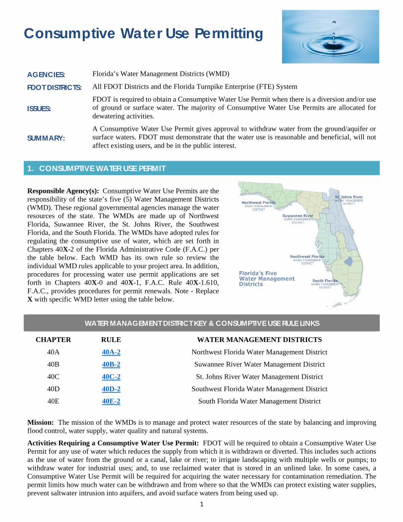
1
Consumptive Water Use Permitting
AGENCIES: Florida’s Water Management Districts (WMD)
FDOT DISTRICTS: All FDOT Districts and the Florida Turnpike Enterprise (FTE) System
ISSUES: FDOT is required to obtain a Consumptive Water Use Permit when there is a diversion and/or use of ground or surface water. The majority of Consumptive Water Use Permits are allocated for dewatering activities.
SUMMARY: A Consumptive Water Use Permit gives approval to withdraw water from the ground/aquifer or surface waters. FDOT must demonstrate that the water use is reasonable and beneficial, will not affect existing users, and be in the public interest.
1. CONSUMPTIVE WATER USE PERMIT
Responsible Agency(s): Consumptive Water Use Permits are the responsibility of the state’s five (5) Water Management Districts (WMD). These regional governmental agencies manage the water resources of the state. The WMDs are made up of Northwest Florida, Suwannee River, the St. Johns River, the Southwest Florida, and the South Florida. The WMDs have adopted rules for regulating the consumptive use of water, which are set forth in Chapters 40X-2 of the Florida Administrative Code (F.A.C.) per the table below. Each WMD has its own rule so review the individual WMD rules applicable to your project area. In addition, procedures for processing water use permit applications are set forth in Chapters 40X-0 and 40X-1, F.A.C. Rule 40X-1.610, F.A.C., provides procedures for permit renewals. Note - Replace X with specific WMD letter using the table below.
WATER MANAGEMENT DISTRICT KEY & CONSUMPTIVE USE RULE LINKS
CHAPTER RULE WATER MANAGEMENT DISTRICTS
40A 40A-2 Northwest Florida Water Management District
40B 40B-2 Suwannee River Water Management District
40C 40C-2 St. Johns River Water Management District
40D 40D-2 Southwest Florida Water Management District
40E 40E-2 South Florida Water Management District
Mission: The mission of the WMDs is to manage and protect water resources of the state by balancing and improving flood control, water supply, water quality and natural systems.
Activities Requiring a Consumptive Water Use Permit: FDOT will be required to obtain a Consumptive Water Use Permit for any use of water which reduces the supply from which it is withdrawn or diverted. This includes such actions as the use of water from the ground or a canal, lake or river; to irrigate landscaping with multiple wells or pumps; to withdraw water for industrial uses; and, to use reclaimed water that is stored in an unlined lake. In some cases, a Consumptive Water Use Permit will be required for acquiring the water necessary for contamination remediation. The permit limits how much water can be withdrawn and from where so that the WMDs can protect existing water supplies, prevent saltwater intrusion into aquifers, and avoid surface waters from being used up.
2
Exemptions: Applicants using seawater or reclaimed water to meet their total water needs are not required to obtain a Consumptive Water Use Permit. However, if the reclaimed water is discharged into an unlined pond, lake, or surface water management system, a water use permit will be required to ensure the proposed use is not harmful to the water resources of the area.
When: A Consumptive Water Use Permit can be acquired during the design phase if the designers have determined need. If not determined by the designers, FDOT’s contractor would acquire the permit based on their determination of construction means and methods or remediation activities.
2. PERMITTING
Pre-Application Meeting: If the permit application involves complex issues or if an applicant requires assistance in completing an application, a pre-application meeting with the corresponding WMD is encouraged. Note that some FDOT Districts participate in monthly Interagency Meetings that serve as a means to discuss upcoming permit applications with the WMDs. Participation in these meetings allows FDOT to submit a more complete Consumptive Water Use Permit application and may prevent or avoid delays in processing the permit application.
Submittal: Typically, Consumptive Water Use Permit applications will be submitted through ePermitting (after the pre-application or FDOT Interagency Meeting). Note that each Water Management District has an ePermitting system through which FDOT can apply:
• St. Johns River Water Management Districthttps://www.sjrwmd.com/permitting/#about-cups
• Southwest Florida Water Management Districthttps://www.swfwmd.state.fl.us/business/epermitting
• Suwannee River Water Management Districthttps://permitting.sjrwmd.com/srepermitting/jsp/start.jsp
• Northwest Florida Water Management Districthttps://permitting.sjrwmd.com/nwepermitting/jsp/start.jsp
• South Florida Water Management Districthttp://my.sfwmd.gov/ePermitting/MainPage.do;jsessionid=I0W6ZlveIqZe3ZDPlQ1riLNWvClcm4JLp0rqDRob
Demonstrating Need: Demonstrating "need" for the permit application is based on several factors including legal control over the project site; and, compatibility of the proposed water use with the land use at the project site or area to be supplied water.
Dewatering: The most common Consumptive Water Use Permit is for dewatering activities such as withdrawals of water for construction activities and minor uses such as Remedial Action Plans. There are different WMD permits for dewatering activities primarily based on the number of dewatering days, the amount of pumpage, whether the water will stay on or off site, impacts to natural resources, and the phasing of the project construction activities. If you are pursuing dewatering activities, review the appropriate WMD’s regulations and requirements for your project and conduct a pre-application meeting.
3. TIMEFRAMES FOR CONSUMPTIVE WATER USE PERMITTING
After an application is submitted, the WMD has a statutory time frame of 30 days to request additional information (RAI). Once an application is deemed complete the WMD will have between 60-90 days to issue the permit. Note that permitting fees vary between WMDs so review your individual WMD fees.
3
Required Information: The following information should be included in your application: • The quantity and source of the water requested;• The location of the water source;• The location of the wells (for groundwater) or points of withdrawal (for surface water), and/or culverts;• What the water will be used for;• Water conservation and recycling plans;• Impact assessment modeling;• Saline water and/or wetland monitoring plan (if applicable);• Reclaimed water evaluation;• Dewatering plans and calculations (dewatering permits only); and,• The appropriate permit application processing fee.
4. TIPS
Tips:
• Schedule a pre-application meeting with WMD Water Use staff prior to the submittal of a Consumptive Water UsePermit application. Note that depending on the complexity of the project, more than one meeting may be necessary.
• When applying for a Consumptive Water Use Permit for a remedial action plan, an approved copy of the RemedialAction Plan must be submitted as part of the application. Typically, this permit is acquired by FDOT’s ContaminationAssessment/Remediation Contractor (CAR) contractor.
• If a dewatering project will be discharging dewatering effluent off-site, documentation of approval for off-sitedischarge, from the entity owning the off-site conveyance system, will be required as part of the application package.
• Note that non-contiguous parcels in the same county may apply for one water use permit encompassing all suchparcels, provided it is shown that the water use for each parcel is for the same water use classification. If multiplewater use classifications such as drinking water and landscape irrigation are served by separate withdrawal facilitieson separate parcels, a water user should seek separate water use permits.
• Discuss in your pre-application the amount of hydrologic information they will require. This is especially importantfor projects in which there are concerns regarding water resource availability or potential impacts to wetlands as aresult of proposed withdrawals. The WMD will require detailed site-specific information in support of the applicationsuch as aquifer performance tests, water quality surveys, well inventories, and environmental assessments, asrequired. The need for this information will be based on the amount of the proposed withdrawal, characteristics ofthe requested water source in the region, potential for environmental harm, potential for interference with existinglegal uses, and proximity of applicable and relevant existing data. Note that all final plans, calculations, analyses, orother geologic/engineering documents submitted as part of a permit application are to be signed and sealed by aregistered professional.
5. PRE-CONSTRUCTION & CONSTRUCTION COMPLIANCE
Once you have received your Consumptive Water Use Permit make sure to review the section labeled “Standard and Special Permit Conditions.” These are the restrictions and requirements that are a part of the permit including the allocated amount of water, expiration date of the permit, and any information that needs to be submitted on a regular basis. Review these requirements and contact Water Use Compliance staff if you have questions.
Most permits require the permittee to keep a copy of the permit, as well as be available on-site, and when the WMD requests it. Failure to do so can result in fines and citations.
Note that it is important to apply for a renewal of your permit before it expires otherwise your next application may have a shorter duration.
4
6. RESOURCES
Web Resources*
• South Florida Water Management District, Water Use Permitting Manual Vol. III;https://www.sfwmd.gov/sites/default/files/documents/vol_iii_water_use.pdf
• South Florida Water Management District, Applicant’s Handbook for Water Use Permits Applications;https://www.sfwmd.gov/sites/default/files/documents/wu_applicants_handbook.pdf
• Water Use Permits fee schedule; Section 40-1.607 FAChttps://www.sfwmd.gov/sites/default/files/documents/water_use_fee_schedule.pdf
• Northwest Florida Water Management Districthttps://www.nwfwater.com/Permits/Water-Use-Permits
• Suwannee River Water Management District, Water Use Permitshttp://www.srwmd.state.fl.us/index.aspx?nid=89
• Suwannee River Water Management District, Water Use Permit Applicant’s Handbookhttp://www.srwmd.state.fl.us/DocumentCenter/View/8751
• St. Johns River Water Management District, Permittinghttps://www.sjrwmd.com/permitting/#about-cups
• Southwest Florida Water Management District, Water-Use Permitting Information Centerhttps://www.swfwmd.state.fl.us/business/epermitting/water-use-permit-information-center
• Florida Department of Environmental Protection, Division of Water Resource Managementhttps://floridadep.gov/water
• Florida’s Water Permitting Portal – Search for Consumptive Water Use Permitshttp://flwaterpermits.com/agws10/fppcup1/
* If you are experiencing difficulties accessing web resources please review your web browser settings, security browsercontrols, or cut-and-paste the link directly into your URL/address bar. Note that website links may change overtime. If aweb link is not accessible, you may be able to find the resource by going through the website’s home page.
2019 Appendix: Specialty Permits
APPENDIX 2d Wetland Mitigation
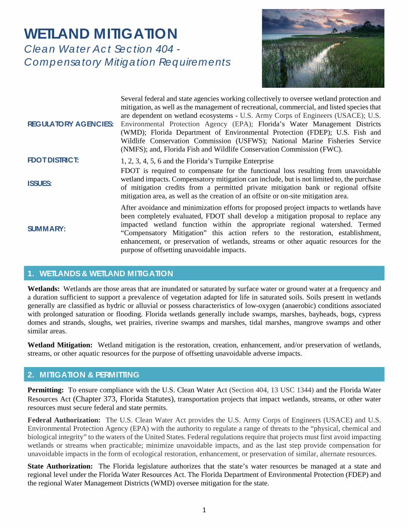
1
WETLAND MITIGATION Clean Water Act Section 404 - Compensatory Mitigation Requirements
REGULATORY AGENCIES:
Several federal and state agencies working collectively to oversee wetland protection and mitigation, as well as the management of recreational, commercial, and listed species that are dependent on wetland ecosystems - U.S. Army Corps of Engineers (USACE); U.S. Environmental Protection Agency (EPA); Florida’s Water Management Districts (WMD); Florida Department of Environmental Protection (FDEP); U.S. Fish and Wildlife Conservation Commission (USFWS); National Marine Fisheries Service (NMFS); and, Florida Fish and Wildlife Conservation Commission (FWC).
FDOT DISTRICT: 1, 2, 3, 4, 5, 6 and the Florida’s Turnpike Enterprise
ISSUES: FDOT is required to compensate for the functional loss resulting from unavoidable wetland impacts. Compensatory mitigation can include, but is not limited to, the purchase of mitigation credits from a permitted private mitigation bank or regional offsite mitigation area, as well as the creation of an offsite or on-site mitigation area.
SUMMARY:
After avoidance and minimization efforts for proposed project impacts to wetlands have been completely evaluated, FDOT shall develop a mitigation proposal to replace any impacted wetland function within the appropriate regional watershed. Termed “Compensatory Mitigation” this action refers to the restoration, establishment, enhancement, or preservation of wetlands, streams or other aquatic resources for the purpose of offsetting unavoidable impacts.
1. WETLANDS & WETLAND MITIGATION
Wetlands: Wetlands are those areas that are inundated or saturated by surface water or ground water at a frequency and a duration sufficient to support a prevalence of vegetation adapted for life in saturated soils. Soils present in wetlands generally are classified as hydric or alluvial or possess characteristics of low-oxygen (anaerobic) conditions associated with prolonged saturation or flooding. Florida wetlands generally include swamps, marshes, bayheads, bogs, cypress domes and strands, sloughs, wet prairies, riverine swamps and marshes, tidal marshes, mangrove swamps and other similar areas.
Wetland Mitigation: Wetland mitigation is the restoration, creation, enhancement, and/or preservation of wetlands, streams, or other aquatic resources for the purpose of offsetting unavoidable adverse impacts.
2. MITIGATION & PERMITTING
Permitting: To ensure compliance with the U.S. Clean Water Act (Section 404, 13 USC 1344) and the Florida Water Resources Act (Chapter 373, Florida Statutes), transportation projects that impact wetlands, streams, or other water resources must secure federal and state permits.
Federal Authorization: The U.S. Clean Water Act provides the U.S. Army Corps of Engineers (USACE) and U.S. Environmental Protection Agency (EPA) with the authority to regulate a range of threats to the “physical, chemical and biological integrity” to the waters of the United States. Federal regulations require that projects must first avoid impacting wetlands or streams when practicable; minimize unavoidable impacts, and as the last step provide compensation for unavoidable impacts in the form of ecological restoration, enhancement, or preservation of similar, alternate resources.
State Authorization: The Florida legislature authorizes that the state’s water resources be managed at a state and regional level under the Florida Water Resources Act. The Florida Department of Environmental Protection (FDEP) and the regional Water Management Districts (WMD) oversee mitigation for the state.
2
Other Applicable Laws: The Endangered Species Act (ESA) and Florida’s Endangered and Threatened Species Rule (Chapter 68A-27, Florida Administrative Code, F.A.C) provide authorization for the U.S. Fish and Wildlife Service (USFWS), the National Marine Fisheries Service (NMFS), and the Florida Fish and Wildlife Service (FWC) to provide guidance as part of their oversight and management role for recreational, commercial, and listed species dependent on wetland habitats. Note that the USFWS is often consulted regarding wetland and wood stork Core Foraging Habitat (CFH) impacts and mitigation through the Section 7 ESA Consultation process as part of NEPA or federal permitting process (See Wood Stork Appendix). Private mitigation banks must demonstrate that their wetland credits are also approved by the USFWS for replacing wood stork CFH.
3. WHEN TO MITIGATE
Once Design has provided project plans (60% plans) and wetland avoidance and minimization efforts have been thoroughly evaluated, FDOT shall develop a mitigation proposal to address the loss of wetland functions. The proposal should evaluate the loss of flood storage areas, drainage and drawdown of water in wetlands and wellfields, and water conservation. In addition, mitigation proposals for projects must be designed to protect and maintain existing natural wetland functions, including fish, wildlife, and listed species habitat. The mitigation proposal shall be included in the federal and state permitting applications as required. Note that regulatory agencies typically require a mitigation bank reservation letter, or if using credits already purchased or created by FDOT, a mitigation ledger showing the deduction from the bank or Permittee-Responsible Mitigation site prior to final permitting.
4. WETLAND MITIGATION APPROACHES
Applicable regulatory approaches to wetland mitigation:• Restoration: Re-establishment or the improvement of a wetland with the goal of returning natural or historic
functions and characteristics to a former or degraded wetland. The objective is to have the improvement result in again in wetland function and/or wetland acres. Activities could include removal of exotic vegetation, hydrologicimprovements, removal of fill, etc.
• Enhancement: Activities conducted within existing wetlands that improve one or more wetland functions such aswater quality, flood water retention or wildlife habitat.
• Preservation: Preservation includes the permanent protection of wetlands through the implementation of appropriatelegal and physical mechanisms, such as conservation easements, title transfers, etc. Preservation alone is not alwaysaccepted by regulatory agencies and may be used only in certain circumstances, including when the resources to bepreserved contribute significantly to the watershed.
• Creation: The development of a wetland where a wetland did not previously exist through manipulation of thephysical, chemical and/or biological characteristics of the site. This effort can present a number of challenges andcan be expensive in long-term maintenance. Generally, not a preferred method for FDOT; however, it may be theonly option in some cases. Avoid placing Permittee-Responsible Mitigation in locations that may be required forfuture transportation needs or in-locations that were not historically natural wetlands.
5. COMPENSATORY MITIGATION
Mitigation for Transportation projects can be viewed in Florida Statutes 373.4137, Mitigation Requirements for Specified Transportation Projects . Generally, wetland mitigation can be acquired through: • Mitigation Banking: Entrepreneurial ecological restoration firms (mitigation bankers) that invest in large restoration
projects (mitigation banks) and sell compensation credits (wetland and stream offsets) to permittees. FDOT canpurchase those credits to meet their requirements for compensatory mitigation. The mitigation bank is responsible forthe long-term success of the mitigation site. Note that the USACE has established a preference for using credits froma mitigation bank over other forms of compensation mechanisms.
• Permittee-Responsible Mitigation: Restoration, creation, enhancement or preservation of wetlands to compensatefor wetland functional loss. The permittee performs the mitigation and is responsible for implementation,maintenance, and long-term care. The mitigation can occur at the site of the proposed impacts or at a regulatoryapproved off-site location. Permittee-Responsible Mitigation is often used when no mitigation banks are availablewithin the project service area or when the type of wetland function lost is not available. Note that it is not FDOT’s
3
preference to have mitigation adjacent to its roadways and structures as it can cause complications with maintenance activities and limit future capacity needs. On-site mitigation is only used in unique project specific situations. Off-site Permittee-Responsible Mitigation can be done jointly, with other agencies or with County or local governments. Examples include restoration of wetlands within County parks or natural lands. Note that independent permits are required to create a Permittee-Responsible Mitigation site, as well as a Conservation Easement into perpetuity. Permittee-Responsible Mitigation sites cannot be proposed within areas already congressionally authorized for wetland restoration under the Comprehensive Everglades Restoration Plan (CERP).
• In-Lieu Fee Mitigation: FDOT provides funds to an in-lieu-fee sponsor (a public agency or non-profit organization). Usually, the sponsor collects funds from multiple permittees in order to pool the financial resources required to construct and maintain the mitigation site. The in-lieu fee sponsor is responsible for the success of site. The State Water Management Districts can provide sponsorship through the FDOT Mitigation Program, or “Senate Bill”; however, not all WMD participate in the program.
6. TIPS
Identifying Mitigation Banks: Mitigation Banks have designated Service Areas (e.g., watershed, county) where they can provide compensatory mitigation for impacts to wetlands and/or other aquatic resources. To identify mitigation banks available within your project area you can perform a desktop review of the Environmental Screening Tool (EST); the USACE Regulatory In-lieu Fee and Bank Information Tracking database (RIBITS), or the FDEP Geospatial Open Data for Mitigation Banks. You can also speak with your regulatory agencies to request guidance. They have considerable knowledge and experience with the options and opportunities available within each basin.
Tips: Review FDOT’s Environmental Mitigation Payment Processing Handbook for guidance on means and methods for purchasing wetland mitigation credits. Note that multiple private mitigation banks may exist within the project impact area and therefore FDOT may have to advertise for mitigation credits through a competitive bidding process. This should be accounted for within the project schedule. In addition, appropriate funding for purchasing mitigation should be reviewed and requested in advance of permitting. Note that mitigation banks use different wetland assessment methodologies (UMAM, MWRAP, WATER, etc.) to determine the ecological functions and the amount those functions provide compensatory mitigation. When identifying required mitigation for your project use the same methodology as the bank(s) within your service area.
7. RESOURCES
Web Resources*
• FDOT’s Environmental Mitigation Payment Processing Handbookhttp://www.fdot.gov/environment/pubs/Final%202017%20Mitigation%20Handbook.pdf
• USACE RIBITS – Regulatory In-lieu Fee and Bank Information Trackinghttps://ribits.usace.army.mil/ribits_apex/f?p=107:2
• USACE Mitigation and Compensatory Mitigationhttps://www.usace.army.mil/Missions/Civil-Works/Regulatory-Program-and-Permits/mitig_info/
• USACE Wetland Delineation Manual - https://el.erdc.dren.mil/elpubs/pdf/wlman87.pdf
• FDEP – Mitigation and Mitigation Banking
https://floridadep.gov/water/submerged-lands-environmental-resources-coordination/content/mitigation-and-mitigation-banking
• Mitigation Banks issued by SJRWMD - http://webapub.sjrwmd.com/agws10/mt/
• Mitigation Banks issued by SWFWMD - https://www.swfwmd.state.fl.us/projects/fdot-mitigation-program
• Mitigation Banks issued by SFWMD - http://my.sfwmd.gov/ePermitting/MainPage.do
• Mitigation Banks issues by NWFWMDhttps://fdep.maps.arcgis.com/home/webmap/viewer.html?webmap=e88e14fa17ad4a2ca49d63a6016f3eaf&extent=-88.8398,24.5257,-76.7108,31.5023

4
• Mitigation Banks issued by SRWMDhttps://fdep.maps.arcgis.com/home/webmap/viewer.html?webmap=e88e14fa17ad4a2ca49d63a6016f3eaf&extent=-88.8398,24.5257,-76.7108,31.5023
* If you are experiencing difficulties accessing web resources please review your web browser settings, security browsercontrols, or cut-and-paste the link directly into your URL/address bar. Note that website links may change overtime. If aweb link is not accessible, you may be able to find the resource by going through the website’s home page.
2019 Appendix: Specialty Permits
APPENDIX 2e Coastal Construction Control Line Permitting
1
Coastal Construction Control Line (CCCL) Permitting REGULATORY AGENCIES: Florida Department of Environmental Protection (FDEP)
FDOT DISTRICT: All FDOT Districts with coastal systems
ISSUES: Any work proposed seaward of the CCCL including, but not limited to, such activities as construction, excavation, sand or dune plant removal, coastal armoring, lighting, and other activities that could destabilize or destroy beach and dune systems.
SUMMARY: The CCCL Program regulates activities that can cause beach erosion, destabilize dunes, threaten upland properties, or interfere with public access. The program also protects sea turtles nesting beaches and dune plant communities.
1. COASTAL CONSTRUCTION CONTROL LINE REGULATIONS AND STATUTES
Coastal Construction Control Line (CCCL): In order to protect and manage Florida’s beaches and coastal systems, the State Legislature adopted the Florida Beach and Shore Preservation Act. The Act provides three interrelated programs administered by the FDEP including the CCCL Program, the Beach Management Funding Assistance Program, and the Beaches, Inlets and Ports Program. The CCCL Program protects the beach and dune system from construction activities that could weaken, damage or destroy their integrity. The following statutes and codes make up the program:
Chapter 161, Florida Statutes (F.S.), Part 1, Regulation of Construction, Reconstruction & Other Physical Activity
• Section 161.053, F.S., Coastal construction and excavation; regulation on county basis, entrusts the FDEP withthe protection of the beach and dune systems, establishing the CCCL, and the authority to regulate construction,excavation, dune vegetation removal and other activities seaward of the CCCL. The CCCL is established usinghistorical weather data (past hurricanes), tide cycles, offshore bathymetry, erosion trends, upland topography, andexisting vegetation and structures to develop predictive models and scientific principles that determine the uplandlimits of a one-hundred-year coastal storm.
• Section 161.085, F.S., Rigid coastal armoring structures, provides regulatory policies for coastal armoring,including temporary protective measures administered on an emergency basis following storm events.
• Section 161.052, F.S., Coastal construction and excavation, covers coastal construction on sandy “pocket” beachesin Florida’s Big Bend and in the Keys. On sandy beach areas where no CCCL has been established, coastalconstruction is prohibited within 50 feet of the line of mean high water except by waiver or variance. Theseregulations apply to the 50-foot area of beach inland from the mean high-water line on the small sand beaches frontingGulf of Mexico and Atlantic Ocean shorelines. No coastal construction regulations are applied under the CCCLprogram for marsh, mangrove or rocky shorelines; however, other regulations do apply (see Wetland Appendix).
Coastal Construction Rules
• Chapter 62B-33, Florida Administrative Code (F.A.C.), Rules and Procedures for Coastal Construction andExcavation (Permits for Construction Seaward of the Coastal Construction Control Line and Fifty-FootSetback), provides the general requirements to obtain a CCCL permit. Approval of a permit application is basedupon a review of the proposed impacts to the beach dune system, adjacent properties, dune vegetation, and sea turtles.
• Chapter 62B-34, F.A.C., General Permits for Activities Seaward of the Coastal Construction Control Line,sets policies and procedures for General Permit types. Under this rule, structures and activities located well landwardof the beach are approved through a streamlined, 30-day permit process. General permit lines established along manybeaches provide a means for determining if your project is eligible.
• Chapter 62B-55, F.A.C., Model Lighting Ordinance for Marine Turtle Protection, identifies policies for countiesand cities to follow for protecting nesting sea turtles and their hatchlings from light pollution.
2
Purpose of CCL: The CCCL Program aims to protect against improperly sited and designed structures that can destabilize or destroy the beach and dune environment. If destabilized, these valuable coastal resources can be lost, as well as the natural services they provide including recreation, storm protection and environmental habitat values (such as sea turtle nesting). The CCCL line establishes an area of jurisdiction in which special siting and design criteria are applied for construction and related activities. These standards are stringent because of the greater forces that occur within this dynamic seaward beach zone from storm events and the potential for damage to upland resources if these beach systems are lost.
Activities requiring a CCCL Permit: A permit is required from FDEP for construction and excavation activities seaward of the CCCL. Note that the CCCL is not a seaward limit for construction of upland structures (such as a setback line), rather it is an area wherein special siting and design considerations are required to protect the beach-dune system.
Exemptions: Maintenance, repairs, or modifications of existing structures are exempted as long as the activity does not involve additions to, repairs of, or modifications to the foundation. Routine maintenance of the foundation is also exempt and minor repairs may also be exempted after FDEP’s review. Chapter 62B-33, F.A.C., outlines other specific activities that are or may, after review, be exempt. Otherwise, construction activities will require either a field or an administrative permit from FDEP.
2. PERMITTING
The CCCL permit should be acquired during the initial design phase as a significant amount of coordination may be necessary.
Other Coordination & Permitting: Note that a Joint Coastal Permit (JCP) with the U.S. Army Corps may be necessary if work is within the high tide line. Section 404 states that the high tide line is the line of intersection of the land with the water's surface at the maximum height reached by a rising tide. The line encompasses spring high tides and other high tides that occur with periodic frequency but does not include storm surges.
Also, a Florida Fish and Wildlife Conservation Commission (FWC) plans review, including lighting plans, may be required to evaluate potential impacts to sea turtles and sea turtle nesting beaches (See Appendix on Marine/Sea Turtles). If there is potential for adverse impacts to sea turtles or their nesting habitat, Section 7 consultation with the USFWS is required under the Endangered Species Act (ESA).
3. APPLYING FOR A CCCL PERMIT
CCCL Permit Manager: The permit manager is responsible for reviewing permit applications, issuing permits, ensuring compliance and consulting with permit applicants for specific counties. Although CCCL permit managers are located in the Tallahassee office, they can provide guidance with permitting construction and other activities on their counties’ beaches.
Go to: https://floridadep.gov/water/coastal-construction-control-line/content/cccl-permit-managers
FDEP District CCCL Field Inspector(s): The field inspector is responsible for meeting people on site, inspecting permit projects, and observing construction and other activities on beach and dune systems. Inspectors work out of the FDEP district offices around the state. Field inspectors can meet you in the field to discuss specific issues and provide firsthand guidance.
Go to: https://floridadep.gov/water/coastal-construction-control-line/content/district-field-representatives-contact-list.
CCCL Application Guidelines: FDEP has a CCCL Permit Application Guideline document which provides details on completing and submitting for an Individual Administrative Permit, a General Permit, an Emergency Permit, or a Dune Core Permit.
Go to: https://floridadep.gov/sites/default/files/CCCL-PermitApplicationGuidelines.pdf.
Review Existing CCCL Permit Applications and Projects: OCULUS, FDEP’s Electronic Document Management System, can be used to conduct a search for existing CCCL permit applications and permitting documents. If you have questions about using OCULUS, contact the FDEP Information Technology Service Desk, 850-245-7555. If you need CCCL documents not found in OCULUS, please email [email protected] or call 850-245-8336.
Electronic Document Submission Instructions: To see instructions on how to submit electronic forms such as the CCCL Permit Application, and digital documents such as surveys and plans.
3
Go to: https://floridadep.gov/water/coastal-construction-control-line/documents/electronic-document-submission-instructions.
4. PERMITTING TIMEFRAMES
After an application is submitted, FDEP has up to 30 days to review for completeness. If FDEP deems the application as incomplete, a request for additional information (RAI) will be sent. Per Chapter 62B-33.008 F.A.C, FDOT has 180 days from the date that the FDEP mails an RAI to submit that information to FDEP. If FDOT requires more than 180 days to respond to a RAI request, then FDOTshall notify the FDEP in writing of the circumstances, at which time the application shall be held in active status for a period of up to 90 days. Additional extensions shall be granted for good cause shown by FDOT. A showing that FDOT is making a diligent effort to address the RAI shall constitute good cause. Failure of FDOT to provide a timely RAI response by the deadline shall result in denial of the application.
Information to Provide: To see what should be included within your application package, go to: https://floridadep.gov/sites/default/files/CCCL-PermitApplicationGuidelines.pdf
5. TIPS
Tips: Early informal coordination is recommended with CCCL Permit Manager and Field Inspector if beach work is proposed. Below are some of the areas that require special environmental considerations:
• Dune Vegetation: Follow FDEP’s Recommended Florida Native Beach and Dune Plants for Beachfront Propertiesand Dune Restoration Guidelines versus developing a project specific planting design. If FDOT follows the plantinglists, then it typically will not be required to have an individualized planting plan review at the time of permitapplication. Coastal construction permit applications that do not follow the FDEP’s planting guidelines must avoidand minimize adverse impacts to native salt tolerant plants that would result from maintenance and planting ofvegetation associated with the permit. Such applications shall include a detailed planting plan.
• Sea Turtles: Follow FDEP’s sea turtle criteria rather than developing a project specific plan. Activities seaward ofthe CCCL shall follow the marine turtle protection requirements including: if FDOT follows FDEP’s Marine TurtleLighting Guidelines as adopted by rule for all forms of lighting associated with the proposed activity, then it willhave minimized adverse impacts to marine turtles related to lighting and the FDEP will not require individualizedlighting plan review at the time of permit application. These guidelines do not supersede more stringent requirementsof local government marine turtle protection and lighting ordinances and FWC requirements. Coastal constructionpermit applications that do not follow FDEP’s lighting guidelines must avoid and minimize adverse impacts to marineturtle nesting habitat from lighting associated with the permit. Such applications shall include a detailed lighting planand are subject to review. Work seaward of the CCCL that may adversely impact sea turtle nesting beach requiresSection 7 ESA Consultation with the USFWS. FWC may provide technical assistance, but not final Section 7 ESAconcurrence (See Sea Turtle Appendix).
• Sand Quality Standards: Sand placed on the beach or in a dune system is required to be similar to the existing sandand shall maintain the engineering and ecological functions of the native sand occurring on the beach and in theadjacent dune system. See FDEP’s requirements for sand replacement. Sand is valued and cannot be removed fromthe beach without approval from FDEP. Note that FDEP tracks how much and where sand is relocated to.
• Avoidance and Minimization: It is important to clearly identify all avoidance and minimization measures in yourapplication. Proposed measures must reduce any action that disturbs the beach and coastal system, adjacent propertiesand existing structures. Examples would include reducing seaward encroachment; avoiding excavation of sediments;preventing the removal of, or damage to, beach-dune vegetation; circumventing alterations of dune topography;avoiding discharges directed toward the beach or adjacent properties; modifying the quantity, size and mass ofstructures; and otherwise preventing activities that interfere with the natural function of the beach dune system. Otheractions that could be considered for avoidance and minimization could include reducing adverse impacts fromerosion, wind, or water borne debris; or preventing any interference with marine turtle nesting, public access ornatural coastal system recovery processes following storm events.
• Mitigation: Potential mitigation activities could include enhancement of the coastal system or to marine turtleshabitat with the placement of beach quality sand; revegetation of natural plant communities; removal of invasiveexotic vegetation, structures, rubble and debris from the beach and dune system; replacement of non-conforming light
4
fixtures with fixtures that conform to FDEP’s Marine Turtle Lighting Guidelines; and other measures that show clear benefits to the coastal system, marine turtles, or public beach access.
6. PRE-CONSTRUCTION & CONSTRUCTION COMPLIANCE
Once you have received your permit make sure to review it thoroughly and be aware that it may include specific restrictions, conditions, or requirements. FDOT is required to keep a copy of the permit on-site should FDEP request it. Failure to do so can result in fines and citations.
7. RESOURCES
Web Resources*
• To locate the CCCL go to - FDEP Map Direct an interactive geographic information system (GIS)https://ca.dep.state.fl.us/mapdirect/?webmap=a8c9e92fbad5446d987a8dd4ee5dc5cc
• FDEP – Ask/ Have Questions about the CCCL?https://floridadep.gov/water/coastal-construction-control-line/content/ask-have-questions-about-coastal-construction
• FDEP – Apply, CCL Permittinghttps://floridadep.gov/water/coastal-construction-control-line/content/apply-coastal-construction-control-line-cccl
• To Find a FDEP CCCL Permit Managerhttps://floridadep.gov/water/coastal-construction-control-line/content/cccl-permit-managers
• To Find a FDEP District Field Representativehttps://floridadep.gov/water/coastal-construction-control-line/content/district-field-representatives-contact-list
• FDEP CCCL Formshttps://floridadep.gov/water/coastal-construction-control-line/content/coastal-construction-control-line-cccl-forms
• CCCL Publicationshttps://floridadep.gov/water/coastal-construction-control-line/content/coastal-construction-control-line-cccl-publications
• Beaches and Coastal Systems Rules & Statuteshttps://floridadep.gov/water/water/content/water-resource-management-rules
• FDEP Electronic Document Submission Instructionshttps://floridadep.gov/water/coastal-construction-control-line/documents/electronic-document-submission-instructions
• FWC Sea Turtle Programhttps://myfwc.com/wildlifehabitats/wildlife/sea-turtle/
• Coastal Construction Control Line Program Contenthttps://floridadep.gov/program-content/Water/Coastal-Construction-Control-Line
* If you are experiencing difficulties accessing web resources please review your web browser settings, security browsercontrols, or cut-and-paste the link directly into your URL/address bar. Note that website links may change overtime. If aweb link is not accessible, you may be able to find the resource by going through the website’s home page.

2019 Appendix: Specialty Permits
APPENDIX 2f Section 408 Review & Permission
1
Section 408 Review and Permission
REGULATORY AGENCY: United States Army Corps of Engineers (USACE)
FDOT DISTRICT: All Districts, especially District 4 & 6 in association with the USACE’s Central & South Florida Flood Control Project and the Comprehensive Everglades Restoration Plan
ISSUES: Any activity that proposes to build upon, alter, improve, move, occupy, or otherwise affect the usefulness, or the structural or ecological integrity, of any USACE federally authorized civil works project.
SUMMARY: The Section 408 Review is to ensure that Congressionally-authorized benefits of a USACE project are not undermined by an alteration made by others, and to ensure that proposed alterations are not injurious to the public interest.
1. SECTION 408 PROGRAM
USACE Section 408: Authorization for Section 408 is in Section 14 of the River and Harbors Appropriation Act of 1899 (33 USC 408) and provides that USACE may grant permission for the alteration of a public work so long as that alteration is not injurious to the public interest (e.g., flood risk management, coastal storm damage reduction, navigation) and will not impair the benefits of the project. The Act states: “It shall not be lawful for any person or persons to take possession of or make use of for any purpose, or build upon, alter, deface, destroy, move, injure, obstruct by fastening vessels thereto or otherwise, or in any manner whatever impair the usefulness of any sea wall, bulkhead, jetty, dike, levee, wharf, pier, or other work built by the United States, or any piece of plant, floating or otherwise, used in the construction of such work under the control of the United States, in whole or in part, for the preservation and improvement of any of its navigable waters or to prevent floods, or as boundary marks, tide gauges, surveying stations, buoys, or other established marks, nor remove for ballast or other purposes any stone or other material composing such works: Provided, that the Secretary of the Army may, on the recommendation of the Chief of Engineers, grant permission for the temporary occupation or use of any of the aforementioned public works when in his judgment such occupation or use will not be injurious to the public interest: Provided further, that the Secretary may, on the recommendation of the Chief of Engineers, grant permission for the alteration or permanent occupation or use of any of the aforementioned public works when in the judgment of the Secretary such occupation or use will not be injurious to the public interest and will not impair the usefulness of such work.”
Note that USACE projects may be managed by local sponsors, such as State Water Management Districts (WMD) for canals and levees. In these cases, project review and permitting will go through these agencies before being submitted to USACE.
Mission of the 408 Program: To provide a mechanism for others to alter an existing USACE Civil Works project without seeking reauthorization of the project from Congress; provide a consistent approach across all Civil Works projects for evaluating and documenting alterations; provide a process to help ensure that existing Civil Works projects continue to deliver the public benefits for which they were authorized and constructed; ensures compatibility of new infrastructure with existing Civil Works projects; and ensure that alterations to USACE projects do not have unintended negative impacts to the public.
Section 408 review is an engineering review conducted by the USACE to confirm that a proposed work will not adversely affect its projects. Part of its review includes National Environmental Policy Act (NEPA) compliance. If USACE is determined to be the lead agency, it will be responsible for the coordination required to ensure Endangered Species Act (ESA) compliance, Section 106 of the National Historic Preservation Act (NHPA) review, Flood Management (E.O. 11988), and Tribal Coordination. In addition, USACE is responsible for creating a Review Plan that includes a technical review and final approval of permissions.
Note that the granting or denial of permission pursuant to Section 408 is not a permit action handled by the USACE Regulatory Program. The FDOT has a Contributed Funds Agreement with the USACE Jacksonville District to expedite Section 408 review. The District Permit Coordinator should coordinate early with the Office of Environmental Management to include FDOT projects requiring a Section 408 permission on the review priority list.
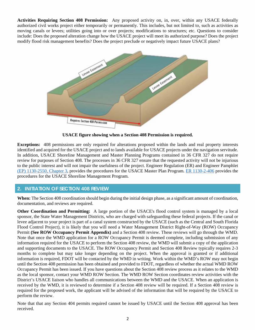
2
Activities Requiring Section 408 Permission: Any proposed activity on, in, over, within any USACE federally authorized civil works project either temporarily or permanently. This includes, but not limited to, such as activities as moving canals or levees; utilities going into or over projects; modifications to structures; etc. Questions to consider include: Does the proposed alteration change how the USACE project will meet its authorized purpose? Does the project modify flood risk management benefits? Does the project preclude or negatively impact future USACE plans?
USACE figure showing when a Section 408 Permission is required.
Exceptions: 408 permissions are only required for alterations proposed within the lands and real property interests identified and acquired for the USACE project and to lands available for USACE projects under the navigation servitude. In addition, USACE Shoreline Management and Master Planning Programs contained in 36 CFR 327 do not require review for purposes of Section 408. The processes in 36 CFR 327 ensure that the requested activity will not be injurious to the public interest and will not impair the usefulness of the project. Engineer Regulation (ER) and Engineer Pamphlet (EP) 1130-2550, Chapter 3, provides the procedures for the USACE Master Plan Program. ER 1130-2-406 provides the procedures for the USACE Shoreline Management Program.
2. INITIATION OF SECTION 408 REVIEW
When: The Section 408 coordination should begin during the initial design phase, as a significant amount of coordination, documentation, and reviews are required.
Other Coordination and Permitting: A large portion of the USACE's flood control system is managed by a local sponsor, the State Water Management Districts, who are charged with safeguarding these federal projects. If the canal or levee adjacent to your project is part of a canal system constructed by the USACE (such as the Central and South Florida Flood Control Project), it is likely that you will need a Water Management District Right-of-Way (ROW) Occupancy Permit (See ROW Occupancy Permit Appendix) and a Section 408 review. These reviews will go through the WMD. Note that once the WMD application for a ROW Occupancy Permit is deemed complete, including submission of any information required for the USACE to perform the Section 408 review, the WMD will submit a copy of the application and supporting documents to the USACE. The ROW Occupancy Permit and Section 408 Review typically requires 2-3 months to complete but may take longer depending on the project. When the approval is granted or if additional information is required, FDOT will be contacted by the WMD in writing. Work within the WMD’s ROW may not begin until the Section 408 permission has been obtained and provided to FDOT, regardless of whether the actual WMD ROW Occupancy Permit has been issued. If you have questions about the Section 408 review process as it relates to the WMD as the local sponsor, contact your WMD ROW Section. The WMD ROW Section coordinates review activities with the District’s USACE liaison who handles all communications between the WMD and the USACE. When an application is received by the WMD, it is reviewed to determine if a Section 408 review will be required. If a Section 408 review is required for the proposed work, the applicant will be advised of the information that will be required by the USACE to perform the review.
Note that that any Section 404 permits required cannot be issued by USACE until the Section 408 approval has been received.
3
3. APPLYING FOR SECTION 408 REVIEW AND PERMISSION
Because proposed alterations vary in size, level of complexity, and potential impacts, the procedures and required information to make such a determination can vary. Based on the proposed alteration, the local sponsor and/or USACE will determine data, analyses and documentation necessary in order to decide whether the proposed alteration does not impair the usefulness of the project and is not injurious to the public interest. Below are nine steps to consider:
Pre-Coordination: Conduct early coordination with USACE, or local sponsor, to identify procedures and potential issues. This will aid in focusing efforts, minimizing costs, and protecting sensitive information.
Written Request: This request officially initiates USACE involvement. The information provided will be the basis to determine documentation and approval requirements. The request must be submitted in writing to the District Commander of the Jacksonville office. However, this information may go through local sponsor if one exists. The request should include:
• a description of the proposed alteration including drawings, sketches, maps, and plans that are sufficient to makea preliminary determination as to the location, purpose and need, anticipated construction schedule, and level oftechnical documentation needed. Detailed engineering plans and specifications are not required, but could besubmitted at the same time if available;
• a statement regarding whether the requester is also pursuing authorization pursuant to the Clean WaterAct, Sections 10/404/103, and, if so, the date or anticipated date of application/pre-constructionnotification submittal;
• information regarding whether credit under Section 221 of the Flood Control Act of 1970, as amended, or otherlaw or whether approval under Section 204(f) of Water Resources Development Act (WRDA)1986 is being orwill be sought;
• a statement of whether the requester will require the use of federally-owned real property or property owned bythe non-federal sponsor; and,
• a statement from the non-federal sponsor endorsing the proposed alternation, if applicable.
Required Documentation: This step is to provide the necessary documentation including technical analysis (i.e. Basis of Design), hydrologic and hydraulics system performance analysis, geotechnical analysis, environmental compliance (NEPA) documents, real estate requirements, and FDOT’s design plans. The minimal level of detail will be 60% complete plans and specifications and supporting documents. NOTE that a proposed alteration pursuant to Section 408 must meet current USACE design and construction standards; however, FDOT is not required to bring those portions or features of the existing USACE project that are not impacted by the alteration up to current USACE design standards.
USACE District-Lead Agency Technical Review: The purpose of this step is to define the requirements, procedures, and specific details of how the USACE district-lead Agency Technical Review team will evaluate the following determinations: impair the usefulness of the project, injurious to the public interest, and legal and policy compliance.
Summary of Findings: Upon completion of the Agency Technical Review Team and the demonstration of environmental compliance, USACE will develop a Summary of Findings to summarize rationale and conclusions for recommending approval or denial. The Summary of Findings will serve as the basis for the final decision on the proposed alteration.
USACE Division Review (if required): Upon receipt of the Summary of Findings, the USACE Division will review the submittal and provide comments to the USACE District within a minimum of 30 days.
HQ USACE Review (if required): Upon receipt of the Section 408 submittal of the Summary of Findings from the USACE Division, the USACE HQ Office of Water Project Review will evaluate the application for policy compliance. This requires a minimum of 30 days.
Notification: The USACE District Commander is responsible for providing a written notification to FDOT for all Section 408 requests. At this time any special conditions, real estate issues, 404 permits, mitigation, and deficiency in design and construction are to be addressed.
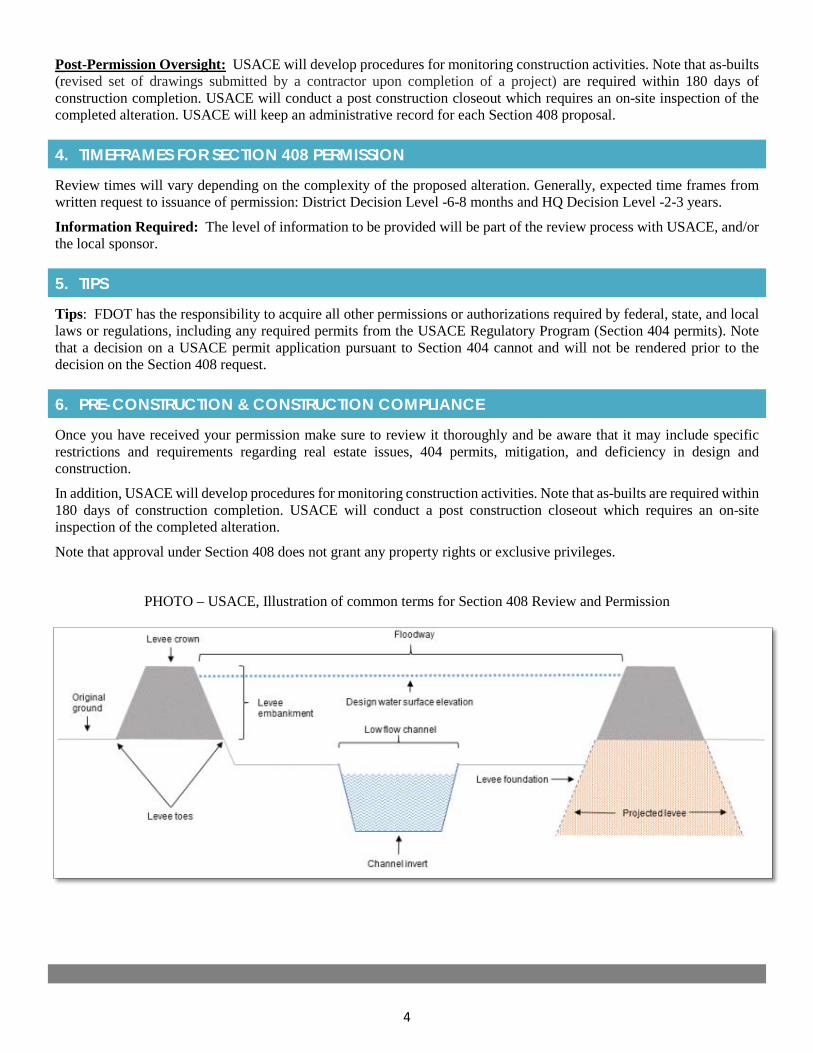
4
Post-Permission Oversight: USACE will develop procedures for monitoring construction activities. Note that as-builts (revised set of drawings submitted by a contractor upon completion of a project) are required within 180 days of construction completion. USACE will conduct a post construction closeout which requires an on-site inspection of the completed alteration. USACE will keep an administrative record for each Section 408 proposal.
4. TIMEFRAMES FOR SECTION 408 PERMISSION
Review times will vary depending on the complexity of the proposed alteration. Generally, expected time frames from written request to issuance of permission: District Decision Level -6-8 months and HQ Decision Level -2-3 years.
Information Required: The level of information to be provided will be part of the review process with USACE, and/or the local sponsor.
5. TIPS
Tips: FDOT has the responsibility to acquire all other permissions or authorizations required by federal, state, and local laws or regulations, including any required permits from the USACE Regulatory Program (Section 404 permits). Note that a decision on a USACE permit application pursuant to Section 404 cannot and will not be rendered prior to the decision on the Section 408 request.
6. PRE-CONSTRUCTION & CONSTRUCTION COMPLIANCE
Once you have received your permission make sure to review it thoroughly and be aware that it may include specific restrictions and requirements regarding real estate issues, 404 permits, mitigation, and deficiency in design and construction.
In addition, USACE will develop procedures for monitoring construction activities. Note that as-builts are required within 180 days of construction completion. USACE will conduct a post construction closeout which requires an on-site inspection of the completed alteration.
Note that approval under Section 408 does not grant any property rights or exclusive privileges.
PHOTO – USACE, Illustration of common terms for Section 408 Review and Permission

2019 Appendix: Specialty Permits
APPENDIX 2g Right of Way Occupancy Permit
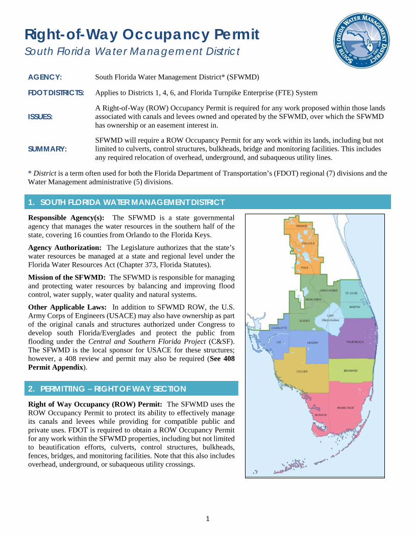
1
Right-of-Way Occupancy Permit South Florida Water Management District
AGENCY: South Florida Water Management District* (SFWMD)
FDOT DISTRICTS: Applies to Districts 1, 4, 6, and Florida Turnpike Enterprise (FTE) System
ISSUES: A Right-of-Way (ROW) Occupancy Permit is required for any work proposed within those lands associated with canals and levees owned and operated by the SFWMD, over which the SFWMD has ownership or an easement interest in.
SUMMARY: SFWMD will require a ROW Occupancy Permit for any work within its lands, including but not limited to culverts, control structures, bulkheads, bridge and monitoring facilities. This includes any required relocation of overhead, underground, and subaqueous utility lines.
* District is a term often used for both the Florida Department of Transportation’s (FDOT) regional (7) divisions and theWater Management administrative (5) divisions.
1. SOUTH FLORIDA WATER MANAGEMENT DISTRICT
Responsible Agency(s): The SFWMD is a state governmental agency that manages the water resources in the southern half of the state, covering 16 counties from Orlando to the Florida Keys.
Agency Authorization: The Legislature authorizes that the state’s water resources be managed at a state and regional level under the Florida Water Resources Act (Chapter 373, Florida Statutes).
Mission of the SFWMD: The SFWMD is responsible for managing and protecting water resources by balancing and improving flood control, water supply, water quality and natural systems.
Other Applicable Laws: In addition to SFWMD ROW, the U.S. Army Corps of Engineers (USACE) may also have ownership as part of the original canals and structures authorized under Congress to develop south Florida/Everglades and protect the public from flooding under the Central and Southern Florida Project (C&SF). The SFWMD is the local sponsor for USACE for these structures; however, a 408 review and permit may also be required (See 408 Permit Appendix).
2. PERMITTING – RIGHT OF WAY SECTION
Right of Way Occupancy (ROW) Permit: The SFWMD uses the ROW Occupancy Permit to protect its ability to effectively manage its canals and levees while providing for compatible public and private uses. FDOT is required to obtain a ROW Occupancy Permit for any work within the SFWMD properties, including but not limited to beautification efforts, culverts, control structures, bulkheads, fences, bridges, and monitoring facilities. Note that this also includes overhead, underground, or subaqueous utility crossings.
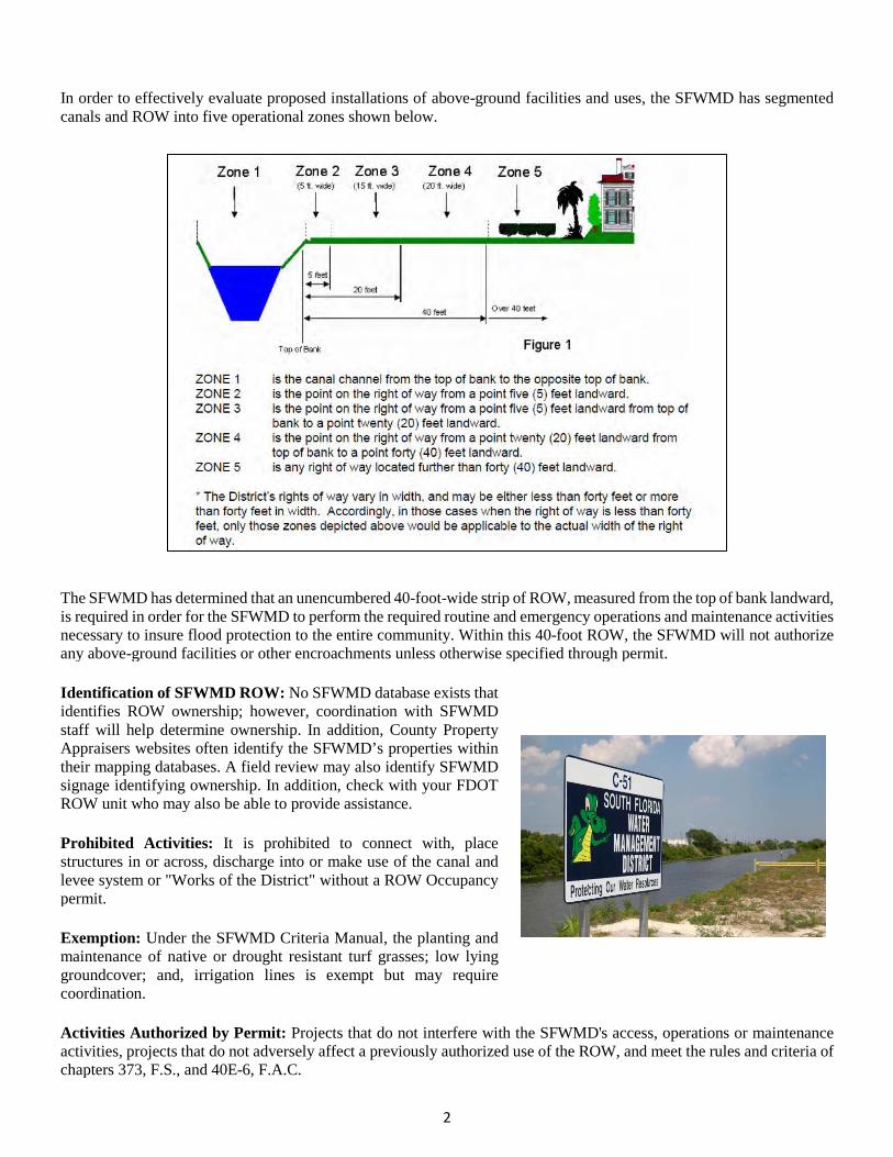
2
In order to effectively evaluate proposed installations of above-ground facilities and uses, the SFWMD has segmented canals and ROW into five operational zones shown below.
The SFWMD has determined that an unencumbered 40-foot-wide strip of ROW, measured from the top of bank landward, is required in order for the SFWMD to perform the required routine and emergency operations and maintenance activities necessary to insure flood protection to the entire community. Within this 40-foot ROW, the SFWMD will not authorize any above-ground facilities or other encroachments unless otherwise specified through permit.
Identification of SFWMD ROW: No SFWMD database exists that identifies ROW ownership; however, coordination with SFWMD staff will help determine ownership. In addition, County Property Appraisers websites often identify the SFWMD’s properties within their mapping databases. A field review may also identify SFWMD signage identifying ownership. In addition, check with your FDOT ROW unit who may also be able to provide assistance.
Prohibited Activities: It is prohibited to connect with, place structures in or across, discharge into or make use of the canal and levee system or "Works of the District" without a ROW Occupancy permit.
Exemption: Under the SFWMD Criteria Manual, the planting and maintenance of native or drought resistant turf grasses; low lying groundcover; and, irrigation lines is exempt but may require coordination.
Activities Authorized by Permit: Projects that do not interfere with the SFWMD's access, operations or maintenance activities, projects that do not adversely affect a previously authorized use of the ROW, and meet the rules and criteria of chapters 373, F.S., and 40E-6, F.A.C.
3
3. APPLYING FOR PERMIT
Acquiring a ROW Occupancy Permit: The ROW Occupancy Permit should be applied for during design. The coordination should start with a pre-application meeting with SFWMD ROW staff. An application for a ROW Occupancy Permit should be made concurrent with the Environmental Resource Permit (ERP) application if an ERP is required.
ROW Occupancy Permit Application Package: FDOT should have a pre-application meeting with SFWMD ROW staff prior to submitting the application or through participating in FDOT’s monthly Interagency Meetings held at the SFWMD’s Office. Note that participation in the Monthly Interagency meetings requires coordination through FDOT’s Drainage Units (FDOT District 4 & 6) as they organize the monthly agenda. When requesting to be on the monthly agenda for the Interagency Meeting be sure to specify the attendance of SFWMD’s ROW staff. During the pre-application meeting, SFWMD staff will advise FDOT and identify potential problems or conflicts with the proposed project. After the pre-application meeting, FDOT should submit the completed permit application with associated processing fee and required drawings.
Note that there is currently no ePermitting for ROW applications. Applications should be submitted to:
SFWMD Headquarters Building B-1 3301 Gun Club Road West Palm Beach, FL 33406 Phone: (561) 682-6973
SFWMD has 30 days to review the application package and ask for any necessary additional information. FDOT has a maximum of 90 days to respond to the requested information. In some instances, a second round of information may be needed; in those cases, the same 30/90-day time clock for both parties is in effect. If FDOT does not meet these deadlines, the application may be denied due to lack of response, unless FDOT requests, in writing, for a waiver of the 90-day response period. Once all additional information is received by the SFWMD, the SFWMD has 90 days to prepare a recommendation and present the application to its Governing Board (or, in the case of Notice General Permits, to the Deputy Executive Director) for their formal review and final agency action.
Required Application Information: SFWMD will request all information that will help them evaluate the application and its potential impacts on its ability to access, operate and maintain the canal or levee involved. The information requested varies according to the type and complexity of the project. The following information should be included:
• Applicant's name, address, and phone number, including zip and area codes;
• Project location relative to county, section, township and range; lot and block number and subdivision name; orbounds description;
• Whether the proposal is a modification of an existing use, an existing unauthorized use or a new use;
• Description of the proposed use of, or encroachment on, SFWMD’s ROW;
• Description of what portion of the ROW is to be utilized;
• Application processing fee in the specified amount for the proposed use;
• Drawings: utilize English units of measure or a combination of English/metric;
• Three copies of a legible, scaled or fully dimensioned 8.5" x 11" drawing, reflecting the proposed use in plan andprofile (elevation) views, showing the location of the proposed use tied to a well-known reference point; and,
• Recent property survey, indicating SFWMD’s ROW line. NOTE: engineering plans must be signed and sealed by aFlorida registered professional engineer.
Note that FDOT applications that propose pile-supported installations over SFWMD canals or utility crossing under canals should contact SFWMD in writing, requesting their specific design criteria. FDOT will be required by the SFWMD to provide recent cross sections of the canal(s) as well as the location and number of cross sections that are being proposed.
Application processing fees vary. To see the application processing fee schedule go here.
4
4. TIPS
Tips: Coordinate with your FDOT Surveying and Mapping Office to obtain the required ROW and surveying information, as well as to account for their required timeframes within the project schedule.
A pre-application meeting with SFWMD staff isn’t required but is strongly recommended. During the meeting, District staff will advise FDOT and can identify potential problems or conflicts with the proposed project.
Before starting a request for a design modification via letter or e-mail, to the SFWMD ROW section, all the pertinent elevation and existing cross section information associated with the affected canal needs to be clearly identified. Also, arrange for a pre-application meeting and complete Form 0122–OP, Application to SFWMD for Issuance of a Right of Way Occupancy Permit.
One common mistake is to assume that a SFWMD ROW Occupancy Permit is not required when crossing in areas outside the SFWMD canal ROW but not realizing that the project crosses a SFWMD flow-way easement.
In cases where FDOT and SFWMD ROW appear to overlap, the SFWMD ROW typically takes precedence.
5. PRE-CONSTRUCTION & CONSTRUCTION COMPLIANCE
Once you have received your permit make sure to review the section labeled “Standard and Special Permit Conditions.” These are the restrictions and requirements that are a part of the permit. It should be noted that the ROW Occupancy Permit does not convey property rights to the permittee but instead acknowledges that the requested use is consistent with the applicable rules and SFWMD missions. A ROW Occupancy Permit can be revoked at any time.
6. RESOURCES
Web Resources*
• SFWMD ROW Permits Pagehttps://www.sfwmd.gov/doing-business-with-us/permits/right-of-way
• SFWMD ROW Permits Formshttps://www.sfwmd.gov/documents-by-tag/ROW+Permit
• SFWMD Factsheet on Keeping the Canal ROW Clearhttps://www.sfwmd.gov/sites/default/files/documents/row_clear_canals.pdf
• SFWMD ROW Criteria Manualhttps://www.sfwmd.gov/sites/default/files/documents/row_criteria_manual.pdf
• Works of The District, Subject to Chapter 40E-6, F.A.C., Right of Way Occupancy Permitshttps://www.sfwmd.gov/sites/default/files/documents/row_works_of_the_district.pdf
SFWMD ROW Occupancy Permitting Section Contact:
• Section Administrator, Right of Way: John Hixenbaugh
• General Inquiries: Nancy Gregorio (561) 682-6171
* If you are experiencing difficulties accessing web resources please review your web browser settings, security browsercontrols, or cut-and-paste the link directly into your URL/address bar. Note that website links may change overtime. If aweb link is not accessible, you may be able to find the resource by going through the website’s home page.

2019 Appendix: Specialty Permits
APPENDIX 2h Water Control Districts
1
Water Control Districts “Special Districts”; “298 Districts”, or “Drainage Districts” AGENCY: Water Control Districts
FDOT DISTRICT: Central & South FL – FDOT Districts 1, 4, 5, 6 & Florida’s Turnpike Enterprise (FTE)
ISSUES: Impacts to secondary drainage (canal) systems and local water control elevations
SUMMARY: The Florida Department of Transportation (FDOT) will take into consideration and coordinate with local Water Control Districts regarding their water control elevations, property, structures, and conveyance activities in order to avoid adverse impacts.
1. WATER CONTROL DISTRICTS (LOCAL)
Responsible Agency(s): A Water Control District is a unit of local government created for a special purpose, as opposed to a general purpose, which has jurisdiction to operate within a limited geographic boundary. The Water Control Districts were created to reclaim lands by providing water control and supply for settlement and agriculture. Today, these local Water Control Districts continue to establish, construct, and maintain a system of canals, drains, ditches, levees, dikes, dams, revetments, locks, reservoirs, holding basins, floodways, pumping stations, and other works. Each seeks to facilitate economic development; control the effects of water, or lack of water, and manage water tables for the welfare of the public, agricultural and sanitary purposes.
Agency Authorization: The Water Control Districts were organized and exist under Chapters 189 and 298, Florida Statutes (F.S.); however, the local Water Control Districts became known as “Chapter 298 Districts”.
Chapter 298 of the Florida Statutes (F.S.): Chapter 298, F.S., is the law governing Water Control Districts and district membership, as well as providing for the election of a board of supervisors. The board of supervisors is responsible for adopting the district water control plan and levying assessments or issuing bonds necessary to pay for the costs of improvements authorized by the adopted water control plan.
Chapter 189 of the Florida Statutes F.S.: Chapter 189, F.S. provides the general provisions for the definition, creation, and operation of Water Control Districts. It was the specific intent of the Legislature that Districts be created at the prerogative of the counties and municipalities. The aim was that the Districts cooperate and coordinate their activities with the units of general-purpose local government in which they are located.
Mission of the Water Control District: Originally, the purpose of the drainage districts was to drain and irrigate lands to make them suitable for agriculture. However, today most drainage districts are responsible for stormwater management, operation of regional flood control systems, permitting of structures discharging into existing structures, maintenance of canals and rights-of-way, aquatic weed control, and providing recharge to the regional well fields.
Other Applicable Laws: The Florida Water Resources Act of 1972 contains the core principles as to Florida’s Water Policy. The act recognizes that the waters of the state are among its basic resources and that water resources had not previously been conserved or controlled so as to maximize their beneficial use. Thus, the protection and continued maintenance of the integrity of water resources, hydrologic systems, and the ecology associated with them are fundamental principles and goals of Florida water law. The act established and declared that water be a public resource to be managed in the public interest.
2. AGENCY COORDINATION
Activities Requiring Coordination with the Water Control Districts: Section 335.02(4), F.S., provides that FDOT is not subject to local regulations on the State Highway System and therefore is not required to obtain local Water Control District permits. However, there are times when FDOT is working off-system or within the boundaries of a local Water Control District (i.e., right-of-way impact, bridge construction over local/secondary canal system) or impacting water conveyance and/or capacity. In these cases, coordination with the local Water Control District with jurisdiction in that area is required. Note that coordination, in some cases, may identify the need to go through the permitting process. For specific questions, please consult with the FDOT Office of General Counsel to receive guidance.

2
3. PERMITTING
Prohibited Activities: No improvement shall be constructed across, under, along or within a canal or ROW over which a local Water Control District has jurisdiction, nor shall any use occur within a local District ROW, unless a valid application for a construction or use permit has been approved and issued by that local District. For off system work, note that no site development that alters the quantity and quality of surface water runoff within the jurisdictional limits of a local Water Control District shall occur unless a valid permit application has been reviewed and approved by that local District. Any proposed use, crossing, or connection to works of a local Water Control District shall not inhibit maintenance of the canal system. Note that easements may be required to facilitate uninterrupted maintenance access by the local District. Projects within local Water Control Districts’ boundaries which propose to discharge into a local Water Control District canal system shall meet water quality standards in accordance with laws and/or rules of the State of Florida; the Federal Government; and the regional State Water Management District.
Exemption: As applicable and in matters governing in-kind replacements or renovations to existing facilities, the local Water Control District may waive permitting when such action is determined to be in the best interest of that local District and general public, and consistent with the objectives of that District.
Activities Authorized by Permit: Permits are issued for projects that do not impact the ability of the local Water Control District to effectively and safely use the canal and levee systems within their ROW and continue to provide for existing and proposed compatible public and private uses.
4. TIPS
Tips: Local Water Control District permits are not required; however, FDOT staff should coordinate with the FDOT Office of General Counsel to receive project specific guidance for projects that may impact local Water Control District ROW or structures. It is beneficial to also coordinate with the local District(s) early so that they are aware of the project activities and can address any questions. For applications proposing large, complex projects, the District(s) may require a pre-application meeting to discuss criteria and other requirements. This is especially true for the connection of new drainage and for bridge crossings.
5. RESOURCES
Web Resources*
• Drainage and Water Control, Chapter 298, Florida Statuteshttp://www.leg.state.fl.us/Statutes/index.cfm?App_mode=Display_Statute&URL=0200-0299/0298/0298.html
• Florida Statutory Authority, Chapter 298, Florida Statuteshttp://www.leg.state.fl.us/statutes/index.cfm?App_mode=Display_Statute&URL=0200-0299/0298/0298ContentsIndex.html&StatuteYear=2018&Title=%2D%3E2018%2D%3EChapter%20298
• Florida Statutory Authority, Chapter 189, Florida Statuteshttp://www.leg.state.fl.us/statutes/index.cfm?App_mode=Display_Statute&URL=0100-0199/0189/0189.html
• Map of Water Control Districts within SFWMDhttps://www.sfwmd.gov/sites/default/files/documents/298_special_districts_map.pdf
• Uniform Special District Accountability Act, Chapter 189, Florida Statuteshttp://www.leg.state.fl.us/statutes/index.cfm?App_mode=Display_Statute&URL=0100-0199/0189/0189.html
• Web based tool to find Water Control Districts and Local Governments within the South Florida Water ManagementDistrict (SFWMD) - https://www.sfwmd.gov/our-work/flood-control
• Florida Special District Handbook - www.FloridaJobs.org/SpecialDistrictHandbook
• Official List of Special Districts - www.FloridaJobs.org/OfficialList
* If you are experiencing difficulties accessing web resources please review your web browser settings, security browsercontrols, or cut-and-paste the link directly into your URL/address bar. Note that website links may change overtime. If a weblink is not accessible, you may be able to find the resource by going through the website’s home page.
2019 Appendix: Specialty Permits
APPENDIX 2i Florida Keys National Marine
Sanctuary Permitting
1
Florida Keys National Marine Sanctuary Permitting AGENCY: NOAA’s Office of National Marine Sanctuaries (ONMS)
FDOT DISTRICTS: District 6
ISSUES: Work within the protected waters of the Florida Keys National Marine Sanctuary including bridges, pilings, and other in-water activities that may impact corals
SUMMARY: FDOT must demonstrate that it is making all efforts to avoid, minimize and mitigate impacts to benthic resources, particularly to coral within the protected waters of the Florida Keys National Marine Sanctuary.
1. NATIONAL MARINE SANCTUARY PROGRAM
National Marine Sanctuary Program: National Marine Sanctuaries are protected waters of the United States. The National Marine Sanctuaries Act (NMSA) allows the Secretary of Commerce to designate a marine sanctuary. In the Florida Keys, local and national recognition of the degradation of the Keys’ unique marine environment led Congress to pass the Florida Keys National Marine Sanctuary and Protection Act in 1990, (P.L. 101-605) (Appendix B) creating the Florida Keys National Marine Sanctuary.
Mission: To “identify, designate and manage areas of the marine environment of special national significance due to their conservation, recreational, ecological, research, educational, or aesthetic qualities”. That determination considers ecosystem values such as economically important or threatened species, health and resilience, and protection of resources that species depend upon for survival in a manner that complements existing regulation authorities.
Sanctuary Management: The Sanctuary is administered by NOAA’s Office of National Marine Sanctuaries and jointly managed under a co-trustee agreement with the State of Florida, which designates the Florida Department of Environmental Protection (FDEP) as the state management partner. The Florida Fish and Wildlife Conservation Commission (FWC), enforces Sanctuary regulations in partnership with NOAA Office of Law Enforcement.
2. FLORIDA KEYS NATIONAL MARINE SANCTUARY
Sanctuary History: The Sanctuary was established in 1990 and incorporates two preexisting sanctuaries, Key Largo (northern Keys) and Looe Key (lower Keys), to protect 2,900 square nautical miles of the Keys. The sanctuary overlaps four national wildlife refuges, six state parks, three state aquatic preserves, and shares boundaries with three national parks. In addition, the Florida Keys are home to the world’s third-largest barrier coral reef, extensive seagrass beds, mangrove islands, and more than 6,000 species of marine life including listed species. It also has extensive maritime archaeological resources such as shipwrecks, anchors, cannons and glassware.
Sanctuary Management Plan: A management plan, implemented in 1997, focused on 10 specific action plans and designated five types of marine zones to “reduce pressures in heavily used areas, protect critical habitats and species, and reduce user conflicts”. Revised in 2007, the plan includes the accomplishments of those implementation strategies, and provides new information regarding the Sanctuary management strategies.
Other Applicable Laws: The Florida Keys National Marine Sanctuary is classified as “Special Waters”, a subset of the Outstanding Florida Waters designation [(Section 403.061(27) Florida Statutes - FDEP)], and the entire sanctuary is also considered a Habitat Area of Particular Concern (HAPC) by NOAA’s Regional Fishery Management Council. HAPCs are specific subsets of Essential Fish Habitat (EFH) [50 CFR 600.815(a)(8)], in this case it is designated to protect the ecological role the Sanctuary provides in the life cycles of federally managed fish species. In addition, the Sanctuary’s rich habitats (seagrass beds, mangrove swamps, coral reefs) serve as Essential Fish Habitat for numerous federally-managed fish species. The Sanctuary further provides important and/or critical habitat for listed species such as the West Indian manatee, sea turtles, the American crocodile, and corals (elkhorn and staghorn).
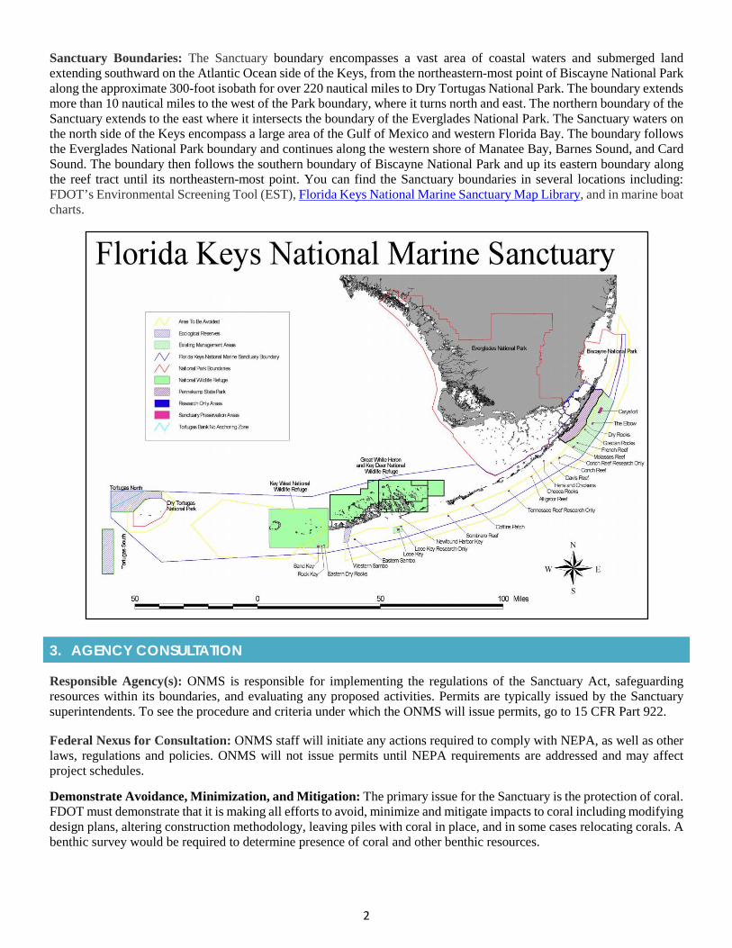
2
Sanctuary Boundaries: The Sanctuary boundary encompasses a vast area of coastal waters and submerged land extending southward on the Atlantic Ocean side of the Keys, from the northeastern-most point of Biscayne National Park along the approximate 300-foot isobath for over 220 nautical miles to Dry Tortugas National Park. The boundary extends more than 10 nautical miles to the west of the Park boundary, where it turns north and east. The northern boundary of the Sanctuary extends to the east where it intersects the boundary of the Everglades National Park. The Sanctuary waters on the north side of the Keys encompass a large area of the Gulf of Mexico and western Florida Bay. The boundary follows the Everglades National Park boundary and continues along the western shore of Manatee Bay, Barnes Sound, and Card Sound. The boundary then follows the southern boundary of Biscayne National Park and up its eastern boundary along the reef tract until its northeastern-most point. You can find the Sanctuary boundaries in several locations including: FDOT’s Environmental Screening Tool (EST), Florida Keys National Marine Sanctuary Map Library, and in marine boat charts.
3. AGENCY CONSULTATION
Responsible Agency(s): ONMS is responsible for implementing the regulations of the Sanctuary Act, safeguarding resources within its boundaries, and evaluating any proposed activities. Permits are typically issued by the Sanctuary superintendents. To see the procedure and criteria under which the ONMS will issue permits, go to 15 CFR Part 922.
Federal Nexus for Consultation: ONMS staff will initiate any actions required to comply with NEPA, as well as other laws, regulations and policies. ONMS will not issue permits until NEPA requirements are addressed and may affect project schedules.
Demonstrate Avoidance, Minimization, and Mitigation: The primary issue for the Sanctuary is the protection of coral. FDOT must demonstrate that it is making all efforts to avoid, minimize and mitigate impacts to coral including modifying design plans, altering construction methodology, leaving piles with coral in place, and in some cases relocating corals. A benthic survey would be required to determine presence of coral and other benthic resources.
3
Timeframes for Consultation and Permitting: Permit applications must be submitted at least thirty (30) calendar days in advance of the permit clear date to allow time for evaluation and processing. Environmentally sensitive requests which may require ONMS to undertake certain NEPA or consultation requirements should be submitted at least ninety (90) calendar days in advance, if not sooner. These dates are for more common types of impacts. If your project has more complex issues or larger resource impacts additional time may be required. Applications that require ONMS to prepare an environmental impact statement prior to issuance will require at least twelve months to process. To expedite processing, contact the appropriate sanctuary staff in advance of submitting a formal application (pre-application meeting) to discuss any questions or issues.
4. PERMITTING
Prohibited Activities: Any work below the surface of the water including such things as dredging; detonating explosives below the surface of the water; drilling the seabed; lowering, laying, positioning or raising any type of seabed cable or cable-laying device; and, discharging waste material into the water. A complete list of prohibited activities can be found in the National Marine Sanctuary Program Regulations, 15 CFR Part 922.43 and Part 922.61.
Activities Authorized by Permit: Regulations depend on how the proposed impact area within the Sanctuary has been categorized or zoned. Permitting, certification, notification and review processes allow certain activities that are otherwise prohibited to take place under carefully controlled circumstances. Early consultation is recommended to identify what activities will be permitted and what those impacts could mean in terms of design, budget and schedule.
Permit Fees: The NMSA allows the Office of National Marine Sanctuaries (ONMS) to assess and collect fees for permits. The Sanctuary determines the fee amount by calculating the costs expected to be incurred and determines a fair market value of the Sanctuary’s resource.
5. PRE-CONSTRUCTION & CONSTRUCTION COMPLIANCE
Review of Commitments: Existing FDOT commitments can be found within the Commitment Module in ProjectSuite. If additional commitments are identified, they can be added into the module. Coordination should be conducted with your specific FDOT District Environmental Management Office, Specifications Office, the Design PM, and the Construction Project Administrator to ensure the proper timing of all preconstruction activities. In addition, Sanctuary issues can be discussed at the construction kick-off meeting.
Review all environmental permits for Special Conditions related to the Sanctuary and corals. Make sure construction personnel have copies. Be certain to strictly follow conditions.
Prior to Construction: Advise personnel of environmental commitments, permit conditions, monitoring activities, coral protections, and other Sanctuary requirements.
6. TIPS
Tips: In coordination with FDOT’s Office of Environmental Management (OEM) or District Environmental Management Office (DEMO), reach out to your NMFS ETAT representative to informally discuss the corals/listed species, Habitat Area of Particular Concern (HAPC), and EFH consultations, and what types of avoidance and minimization activities NMFS might recommend. HAPC are a subset of EFH that exhibit one or more of the following traits: rare, stressed by development, provide important ecological functions for federally managed species, or are especially vulnerable to anthropogenic (or human impact) degradation. HAPC can cover a specific location (a bank or ledge, spawning location) or cover habitat that is found at many locations (e.g., coral, fish nurseries, etc.).
Early internal coordination between DEMO and Design will be necessary to identify avoidance and minimization efforts for the Sanctuary, budget funding, and to avoid scheduling issues.
Coordination is required with ONMS but may only necessitate a letter to file from the Sanctuary acknowledging coordination and a no effect determination.
4
7. RESOURCES
Web Resources*
• Florida Department of Environmental Protections – Outstanding Florida Waters Programhttps://floridadep.gov/dear/water-quality-standards/content/outstanding-florida-waters
• Florida Keys National Marine Sanctuary Management Planhttps://floridakeys.noaa.gov/mgmtplans/welcome.html
• Florida Keys National Marine Sanctuary and Protection Acthttps://floridakeys.noaa.gov/about/fknmsp_act.html
• Instructions for Submitting Applications for National Marine Sanctuary Permits & Authorizationshttps://nmssanctuaries.blob.core.windows.net/sanctuaries-prod/media/docs/nms_permit_instructions_july2021.pdf
• National Marine Sanctuaries Permitting FAQshttps://sanctuaries.noaa.gov/management/permits/welcome.html
• National Marine Sanctuary Program Regulationshttps://www.ecfr.gov/cgi-bin/text-idx?SID=675e7b9b26832bc4856f27eea830e77f&node=pt15.3.922&rgn=div5
• NOAA’s Habitat Areas of Particular Concernhttps://www.fisheries.noaa.gov/news/habitat-areas-particular-concern-within-essential-fish-habitat
Lead Specialist(s) for Agencies: Please direct questions to Joanne Delaney, FKNMS Resource Protection and Permit Coordinator, at [email protected] or (978) 471-9653.
Publications:
• Florida Keys National Marine Sanctuary Science Publications are listed at:https://floridakeys.noaa.gov/scipublications/welcome.html?s=science
* If you are experiencing difficulties accessing web resources please review your web browser settings, security browsercontrols, or cut-and-paste the link directly into your URL/address bar. Note that website links may change overtime. If aweb link is not accessible, you may be able to find the resource by going through the website’s home page.
PHOTO - An aerial view of the Florida Keys. Image courtesy of NASA.

2019 Appendix: Specialty Permits
APPENDIX 2j Broward County Permitting
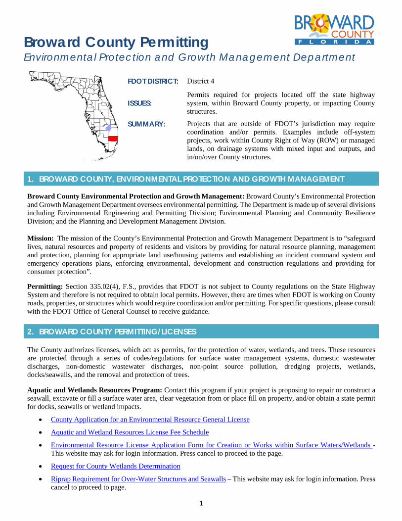
1
Broward County Permitting Environmental Protection and Growth Management Department
FDOT DISTRICT: District 4
ISSUES: Permits required for projects located off the state highway system, within Broward County property, or impacting County structures.
SUMMARY: Projects that are outside of FDOT’s jurisdiction may require coordination and/or permits. Examples include off-system projects, work within County Right of Way (ROW) or managed lands, on drainage systems with mixed input and outputs, and in/on/over County structures.
1. BROWARD COUNTY, ENVIRONMENTAL PROTECTION AND GROWTH MANAGEMENT
Broward County Environmental Protection and Growth Management: Broward County’s Environmental Protection and Growth Management Department oversees environmental permitting. The Department is made up of several divisions including Environmental Engineering and Permitting Division; Environmental Planning and Community Resilience Division; and the Planning and Development Management Division.
Mission: The mission of the County’s Environmental Protection and Growth Management Department is to “safeguard lives, natural resources and property of residents and visitors by providing for natural resource planning, management and protection, planning for appropriate land use/housing patterns and establishing an incident command system and emergency operations plans, enforcing environmental, development and construction regulations and providing for consumer protection”.
Permitting: Section 335.02(4), F.S., provides that FDOT is not subject to County regulations on the State Highway System and therefore is not required to obtain local permits. However, there are times when FDOT is working on County roads, properties, or structures which would require coordination and/or permitting. For specific questions, please consult with the FDOT Office of General Counsel to receive guidance.
2. BROWARD COUNTY PERMITTING/LICENSES
The County authorizes licenses, which act as permits, for the protection of water, wetlands, and trees. These resources are protected through a series of codes/regulations for surface water management systems, domestic wastewater discharges, non-domestic wastewater discharges, non-point source pollution, dredging projects, wetlands, docks/seawalls, and the removal and protection of trees.
Aquatic and Wetlands Resources Program: Contact this program if your project is proposing to repair or construct a seawall, excavate or fill a surface water area, clear vegetation from or place fill on property, and/or obtain a state permit for docks, seawalls or wetland impacts.
• County Application for an Environmental Resource General License
• Aquatic and Wetland Resources License Fee Schedule
• Environmental Resource License Application Form for Creation or Works within Surface Waters/Wetlands -This website may ask for login information. Press cancel to proceed to the page.
• Request for County Wetlands Determination
• Riprap Requirement for Over-Water Structures and Seawalls – This website may ask for login information. Presscancel to proceed to page.
2
Surface Water Management Program: Contact this program if you want to construct or modify a storm water system, obtain an Environmental Resource Permit, schedule a construction site inspection, and/or renew a surface water management license. The following information is available as it relates to surface water management:
• Checklist for Surface Water Management License Application
• Surface Water Management License Application Broward County ELBP Form 212-0006 Rev. 5/2013
• Fee Schedule for Surface Water Management License Application
• Application for Transfer of Surface Water Management License
• What to Expect When We Are Inspecting Surface Water Management Systems
• Florida Storm Water, Erosion, and Sedimentation Control Inspector's Manual
Tree Removal and Tree Relocation License: A license is required for the removal or relocation of trees, except for nuisance and exotic trees. In order to remove or relocate trees, the removal and relocation must be justified, and either relocation or replacement of trees must take place.
In addition, the County requires tree protection from construction activities to ensure that trees are not damaged. These include the installation and maintenance of highly visible tree protection barriers and conducting onsite pre-construction meetings to go over tree protection related issues. If impacts are unavoidable and new trees cannot be planted, then payment can be made to the County Tree Preservation Trust Fund. To learn more, go to the County’s Tree Preservation Program - Chapter 27 Article XIV of the Broward County Pollution Control Code, titled “Tree Preservation and Abuse Ordinance”.
https://library.municode.com/fl/broward_county/codes/code_of_ordinances?nodeId=PTIICOOR_CH27POCO_ARTXIVTRPRABOR
Mangrove Trimming: Due to their ecological importance and storm protection benefits, mangroves are designated as protected under State regulations concerning removal and trimming. In an effort to simplify the process, the Legislature passed legislation in 1995, amended in 1996, titled the Mangrove Protection Rule, Section 403.9321 through 403.9333 Florida Statutes. The Florida Department of Environmental Protection (FDEP) coordinates the implementation of the Rule in conjunction with local governments, such as Broward County, that are designated to act as the state’s local representatives. To learn more, go to:
http://www.broward.org/Environment/TreePreservation/Pages/MangroveTrimming.aspx
Environmental Inquiry and Resources System – ENVIROS The County’s ENVIROS system provides information on environmental permits, licenses and regulatory enforcement. To see examples of license applications and licenses go to:
http://www.broward.org/EnvironmentAndGrowth/EnvironmentalProgramsResources/Pages/Default.aspx
3. PRE-CONSTRUCTION & CONSTRUCTION COMPLIANCE
Review all Broward County Licenses for Special Conditions, provisions, monitoring requirements, and other specific requirements. Make sure construction personnel have copies. Be certain to strictly follow conditions.
Prior to Construction: Advise personnel of license Special Conditions, permit provisions, monitoring activities, and other Broward County requirements.
4. TIPS
Tips: It is beneficial to coordinate with Broward County early so that they are aware of the project activities and can address any questions. County staff are a good resource and can provide local knowledge and help avoid any planning inconsistencies. Schedule a pre-application meeting with Broward County in order to assess the need for a permit(s) and the correct forms that will be required.

3
5. RESOURCES
Web Resources*
• Environmental Protection and Growth Management Programshttp://www.broward.org/EnvironmentAndGrowth/EnvironmentalProgramsResources/Pages/Default.aspx
• Broward County Environmental Publications and Resourceshttp://www.broward.org/ENVIRONMENTANDGROWTH/ENVIRONMENTALPROGRAMSRESOURCES/PUBLICATIONS/Pages/Publications.aspx
• Broward County Environmental Inquiry and Resource System (ENVIROS)http://www.broward.org/EnvironmentAndGrowth/EnvironmentalProgramsResources/Pages/Default.aspx
• Broward County Geographic Information System with interactive Mapshttps://bcgis.broward.org/
• County’s Natural Resources Planning and Management Divisionhttp://www.broward.org/naturalresources/Pages/Default.aspx
• County’s Planning and Redevelopment Divisionhttp://www.broward.org/Planning/Pages/Default.aspx
• County’s Pollution Prevention, Remediation and Air Quality Divisionhttp://www.broward.org/Environment/Pages/Default.aspx
• County’s Environmental Licensing and Building Permitting; Environmental Engineering and Licensinghttp://www.broward.org/Environment/WaterPrograms/Pages/Default.aspx
• Delegation Agreement Among the Florida Department of Environmental Protection, the South FloridaWater Management District, and Broward Countyhttp://www.broward.org/EnvironmentAndGrowth/EnvironmentalProgramsResources/Applications/Documents/DelegationAgreement.pdf
Broward County – Contact Information: Environmental Protection and Growth Management Department Planning and Development Management Division 1 North University Drive, Room 102A Plantation, FL 33324 (954) 519-1250
* If you are experiencing difficulties accessing web resources please review your web browser settings, security browsercontrols, or cut-and-paste the link directly into your URL/address bar. Note that website links may change overtime. If aweb link is not accessible, you may be able to find the resource by going through the website’s home page.

2019 Appendix: Specialty Permits
APPENDIX 2k Hillsborough County Permitting
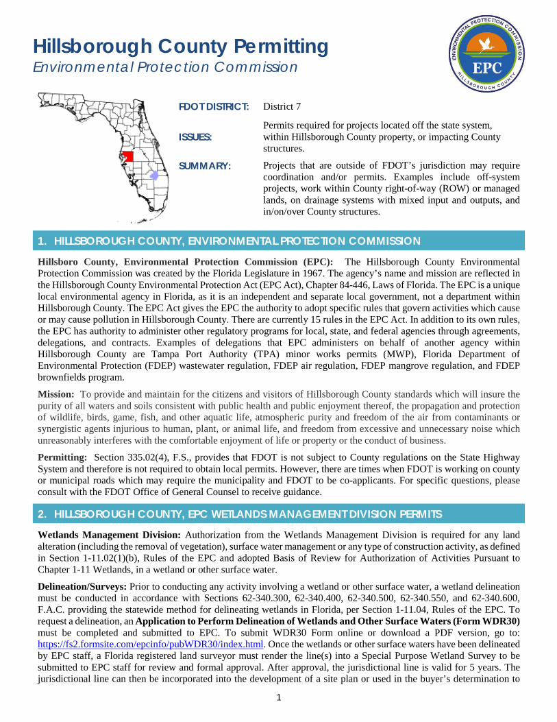
1
Hillsborough County Permitting Environmental Protection Commission
FDOT DISTRICT: District 7
ISSUES: Permits required for projects located off the state system, within Hillsborough County property, or impacting County structures.
SUMMARY: Projects that are outside of FDOT’s jurisdiction may require coordination and/or permits. Examples include off-system projects, work within County right-of-way (ROW) or managed lands, on drainage systems with mixed input and outputs, and in/on/over County structures.
1. HILLSBOROUGH COUNTY, ENVIRONMENTAL PROTECTION COMMISSION
Hillsboro County, Environmental Protection Commission (EPC): The Hillsborough County Environmental Protection Commission was created by the Florida Legislature in 1967. The agency’s name and mission are reflected in the Hillsborough County Environmental Protection Act (EPC Act), Chapter 84-446, Laws of Florida. The EPC is a unique local environmental agency in Florida, as it is an independent and separate local government, not a department within Hillsborough County. The EPC Act gives the EPC the authority to adopt specific rules that govern activities which cause or may cause pollution in Hillsborough County. There are currently 15 rules in the EPC Act. In addition to its own rules, the EPC has authority to administer other regulatory programs for local, state, and federal agencies through agreements, delegations, and contracts. Examples of delegations that EPC administers on behalf of another agency within Hillsborough County are Tampa Port Authority (TPA) minor works permits (MWP), Florida Department of Environmental Protection (FDEP) wastewater regulation, FDEP air regulation, FDEP mangrove regulation, and FDEP brownfields program.
Mission: To provide and maintain for the citizens and visitors of Hillsborough County standards which will insure the purity of all waters and soils consistent with public health and public enjoyment thereof, the propagation and protection of wildlife, birds, game, fish, and other aquatic life, atmospheric purity and freedom of the air from contaminants or synergistic agents injurious to human, plant, or animal life, and freedom from excessive and unnecessary noise which unreasonably interferes with the comfortable enjoyment of life or property or the conduct of business.
Permitting: Section 335.02(4), F.S., provides that FDOT is not subject to County regulations on the State Highway System and therefore is not required to obtain local permits. However, there are times when FDOT is working on county or municipal roads which may require the municipality and FDOT to be co-applicants. For specific questions, please consult with the FDOT Office of General Counsel to receive guidance.
2. HILLSBOROUGH COUNTY, EPC WETLANDS MANAGEMENT DIVISION PERMITS
Wetlands Management Division: Authorization from the Wetlands Management Division is required for any land alteration (including the removal of vegetation), surface water management or any type of construction activity, as defined in Section 1-11.02(1)(b), Rules of the EPC and adopted Basis of Review for Authorization of Activities Pursuant to Chapter 1-11 Wetlands, in a wetland or other surface water.
Delineation/Surveys: Prior to conducting any activity involving a wetland or other surface water, a wetland delineation must be conducted in accordance with Sections 62-340.300, 62-340.400, 62-340.500, 62-340.550, and 62-340.600, F.A.C. providing the statewide method for delineating wetlands in Florida, per Section 1-11.04, Rules of the EPC. To request a delineation, an Application to Perform Delineation of Wetlands and Other Surface Waters (Form WDR30) must be completed and submitted to EPC. To submit WDR30 Form online or download a PDF version, go to: https://fs2.formsite.com/epcinfo/pubWDR30/index.html. Once the wetlands or other surface waters have been delineated by EPC staff, a Florida registered land surveyor must render the line(s) into a Special Purpose Wetland Survey to be submitted to EPC staff for review and formal approval. After approval, the jurisdictional line is valid for 5 years. The jurisdictional line can then be incorporated into the development of a site plan or used in the buyer’s determination to
2
purchase new real estate. The jurisdictional line will aid in the planning of the property with emphasis on avoiding impacts to any on-site jurisdictional area(s).
Wetland Impacts/Mitigation: Chapter 1-11, Rules of the EPC and Chapter III of the adopted Basis of Review, prohibits wetland and other surface water impacts unless they are necessary for reasonable use of the property. “Reasonable Use” is defined in Section 3.2.1 of the adopted Basis of Review as an actual, present use or activity on a parcel of real property or such reasonably foreseeable, non-speculative land uses which are suitable for the subject parcel of property, and which are compatible with adjacent land uses. To obtain authorization from EPC to impact a wetland or other surface water, the applicant will need to seek approval for the impacts by submitting to EPC a Wetland Impact/Mitigation Proposal and the appropriate review fee, as provided in Chapter 1-6, Rules of the EPC, in which the applicant will need to demonstrate how the impacts are a reasonable use of the property and how adequate protection will be met in defining how the proposed adverse impacts will be addressed. If mitigation is proposed, a Uniform Mitigation Assessment Method (UMAM), per Chapter 62-345, F.A.C., must be performed. See Chapter 1-11, Rules of the EPC and Chapter III of the adopted Basis of Review for more details on what should be included in the proposal. A pre-application meeting with EPC Wetlands Management Division is always advised when planning to impact wetlands.
Mangrove Impacts: FDEP has delegated its authority to the EPC for the regulation of trimming and alteration of mangroves in Hillsborough County. The Mangrove Rule, Chapter 1-14, EPC Act, provides guidelines for these activities in Hillsborough County including permit requirements, exemptions and qualifications for professional mangrove trimmers. For more details, go to: http://www.epchc.org/home/showdocument?id=438
Miscellaneous Activities in Wetlands: Pursuant to Section 1-11.09(1)(c), Rules of the EPC, Miscellaneous Activities in Wetlands (MAIW) are those activities that constitute development under Section 1-11.02(2)(b) yet are considered to have minor impact on wetland or other surface water functions. Applications for authorization of these types of impacts will be reviewed pursuant to Section 1-11.10, Rules of the EPC. Applicants do not need to demonstrate that the impact is necessary for reasonable use of a property, but the impacts must be minimized to the greatest extent practicable and shall be conducted, located, designed, and/or constructed so that they cause the least environmentally adverse impact possible. Mitigation pursuant to Section 1-11.08 is not necessary for activities that qualify under Section 1-11.10, Rules of the EPC but the approval may include conditions to offset adverse impacts, such as replanting to ensure erosion control or ensure the area is properly re-vegetated. Eligible MAIW impacts include but are not limited to the following activities: Nuisance Vegetation Control, Swimming Access, Mulched Paths, Mowing, Boat Ramps, Fences, Elevated Boardwalks, Docks, and Shoreline Stabilization. To obtain authorization from EPC for Miscellaneous Activities in Wetlands, the applicant must submit to EPC an Application to Perform Miscellaneous Activities in Wetlands (Form MAIW20). To submit MAIW20 Form online or download a PDF version, go to: https://fs2.formsite.com/epcinfo/pubMAIW20/index.html.
Exemptions: Some activities in wetlands and other surface waters in Hillsborough County may be exempt from the application of Chapter 1-11 Wetlands, Rules of the EPC. For details on exempt activities, refer to Section 1-11.11 of the Rules of the EPC. If the proposed activity does qualify for an exemption, a Notice of Exempt Activities in Wetlands (Form WEA10) must be submitted to EPC. To submit WEA10 Form online or download a PDF version, go to: https://fs2.formsite.com/epcinfo/pubWEA10/index.html.
3. REVIEW TIMEFRAMES
Review is contingent on when the EPC receives a complete application and submittal of any applicable fee. The Wetlands Management Division has internal timeframes for in-house reviews:
• Field Delineations: Wetland delineations must be initiated within 30 days of receipt of a complete application.
• Wetland Impact & Mitigation Proposals: Within 30 days of receipt of a complete application, staff will issuecomments either through an Executive Director’s approval letter or a request for additional information. Withinthose 30 days, a mitigation committee meeting involving the applicant may be scheduled if staff determines thatmore information is needed to approve the proposal. At the end of the meeting, the applicant will receive a writtensummary of all information needed to allow staff to finalize a recommendation to the Executive Director.
• Miscellaneous Activities in Wetlands: A determination will be issued within 30 days of the receipt of a completeapplication.
• Noticed Exemptions: A default approval is given if there is no agency response within 30 days of receipt of acomplete application. In all cases, EPC will strive to provide a written response within the 30-day timeframe.
3
4. PRE-CONSTRUCTION & CONSTRUCTION COMPLIANCE
Review all Hillsborough County permits for Special Conditions, provisions, monitoring requirements, and other special requirements. Make sure construction personnel have copies. Be certain to strictly follow conditions.
Prior to Construction: Advise personnel of permit Special Conditions, permit provisions, monitoring activities, and other Hillsborough County requirements.
5. TIPS
Tips: It is beneficial to coordinate with Hillsborough County EPC early so that they are aware of the project activities and can address any questions. County staff are a good resource and can provide local knowledge, and help avoid any planning inconsistencies. Schedule a pre-application meeting with Hillsborough County in order to assess the need for a permit(s) and the correct forms that will be required.
6. RESOURCES
Web Resources*
• EPC Permitting Guide - http://www.epchc.org/home/showdocument?id=322
• Enabling Act, Rules and Final Orders - http://www.epchc.org/about/enabling-act-rules-and-final-orders
• Chapter 1-11 Wetlands, Rules of the EPC - http://www.epchc.org/home/showdocument?id=416
• EPC Applications and Forms - http://www.epchc.org/i-want-to/view-applications-and-forms
• EPC Wetlands Management Division - http://www.epchc.org/divisions/wetlands-mngt
• EPC Wetlands Management Division Permits & Exemptions - http://www.epchc.org/divisions/wetlands-mngt
• Rules of the EPC Chapter 1-6 Services – Fee Schedule - http://www.epchc.org/home/showdocument?id=1724
• EPC GIS Maps and Data - http://www.epchc.org/i-want-to/view-gis-maps-and-data
• EPC Directors & Organization Charts - http://www.epchc.org/about/directors-organization-charts
Hillsborough County - Contract Information:
The best contacts at EPC are the Management Division Heads for the separate units including: Air, Waste, Water, and Wetlands. All can be reached by calling 813-627-2600 at the following extensions: Air (extension 1060), Waste (extension 1316), Water (extension 1022), and Wetlands (extension 1239). The EPC also has an Environmental Resource Management Division, Legal Department, and Administration and Finance Division to assist the regulatory divisions and can also be contacted for permitting guidance. However, the four regulatory divisions (i.e., Air, Waste, Water, Wetlands) should be the primary point of contact for pre-application and application meetings.
Staff Directory - http://www.epchc.org/about/epc-staff-directory
Environmental Protection Commission of Hillsborough County 3629 Queen Palm Dr. Tampa, FL 33619 Phone: (813) 627-2600 Email: [email protected]
* If you are experiencing difficulties accessing web resources please review your web browser settings, security browsercontrols, or cut-and-paste the link directly into your URL/address bar. Note that website links may change overtime. If aweb link is not accessible, you may be able to find the resource by going through the website’s home page.

2019 Appendix: Specialty Permits
APPENDIX 2l Leon County Permitting
1
Leon County Permitting Department of Development Support & Environmental Management (DSEM)
FDOT DISTRICT: District 3
ISSUES: Permits required for projects located off the state highway system, within Leon County property, or impacting County structures.
SUMMARY: Projects that are outside of FDOT’s jurisdiction may require coordination and/or permits. Examples include off-system projects, work within County right-of-way (ROW) or managed lands, on drainage systems with mixed input and outputs, and in/on/over County structures.
1. LEON COUNTY, DEVELOPMENT SUPPORT AND ENVIRONMENTAL MANAGEMENT
Leon County, Development Support and Environmental Management (DSEM): A division within Leon County which provides permitting and processing services related to transportation and development activities. Environmental impacts are regulated under Leon County Code and include such things as stormwater runoff, tree removal and land clearing, grade changes, and paving.
Mission: The primary mission of DSEM is to “ensure the continued vitality of the County, including both the built and natural environments, by promoting awareness and compliance with the Board's adopted Growth Management Regulations”.
Permitting: Section 335.02(4), F.S., provides that FDOT is not subject to County regulations on the State Highway System and therefore is not required to obtain local permits. However, there are times when FDOT is working on County roads, properties, or structures which would require coordination and/or permitting. For specific questions, please consult with the FDOT Office of General Counsel to receive guidance.
2. LEON COUNTY PERMITTING
Leon County Permitting: For projects that are on County roads, within County ROW, or on/over/under County structures; a County permit for stormwater management, floodplain, landscaping, tree protection, or tree removal is required as part of any development project, right-of-way (ROW) placement, general permit, or vegetative management permit. Off-system projects will require a permit application, stormwater permit components, and environmental analysis. There are several permit types that are based on the scope of work. Most FDOT projects will either fall under a General Utility Permit or Short Form permit.
Municipal code: https://library.municode.com/fl/leon_county/codes/code_of_ordinances?nodeId=COLA_CH10LADECO.
Note that Leon County also requires concurrent review for project impacts to species such as: Gopher Tortoise (Gopherus polyphemus) and Bent Golden Aster (Pityopsis flexuosa).
Leon County Electronic Application Process: Leon County has an electronic permit application process on their website. Off-system projects will have to provide the necessary application form and environmental analysis documentation for review. All necessary permit application forms are provided on the County’s website at: http://cms.leoncountyfl.gov/Home/Departments/Development-Support-and-Environmental-Management/Applications
Permit Application Documentation: The permit application and supporting materials are dependent upon the size of the project. Minor projects will require the Short Form Application B, while larger projects will require the Standard Stormwater Application. All projects require a statement describing the intent and scope of the project, a site plan showing grading, contours, and erosion controls, and any engineering calculations to support the project. A Natural Features Inventory (NFI) is also required to identify all sensitive features on a project site. An Environmental Impact Analysis will be completed after the NFI has been approved.
2
Permit Application Submittal: FDOT should initiate the permit application process concurrent with the State’s Environmental Resource Permit (ERP) and United States Army Corps of Engineers (USACE) pre-application process. Timeframes for approval vary, from 7 days for tree removal, 20 days for Natural Features Inventory, 21 days for Short Form B, and 53 days for the Standard Form Application.
3. LEON COUNTY PERMIT APPLICATION FORMS
All application forms can be accessed from the County website along with supporting information and process guidelines at the following website:
http://cms.leoncountyfl.gov/Home/Departments/Development-Support-and-Environmental-Management/Applications.
Permit application forms commonly used:
• Short Form B – Low Intensity: Projects that do not have a significant impact on stormwater run-off. Typicallyconsidered activities that are temporary in nature and have very little or no impervious area associated with them.Examples include installation of buried service lines for water, sewer, gas, power, and communication serviceswithin the road ROW; the removal of impervious area and replacing it with previous area; storm drain system orchannel improvements; and minor roadway shoulder, ditch and stormwater facility activities necessary to meetcurrent code requirements not covered by a general permit. To learn more, go to:
http://cms.leoncountyfl.gov/Home/Departments/Development-Support-and-Environmental-Management/Environmental-Services/STORMWATER-SHORT-FORM-B-LOW-INTENSITY
• Short Form B – High Intensity: Projects which have significant impact on stormwater runoff. Typically,projects that either have an individual on-site stormwater management facility or a master stormwatermanagement facility. To learn more, go to:
http://cms.leoncountyfl.gov/Home/Departments/Development-Support-and-Environmental-Management/Environmental-Services/STORMWATER-SHORT-FORM-B-HI-INTENSITY
• Stormwater – Standard Application: Projects which have significant impact on stormwater runoff. Typically,involve projects that either have an individual on-site stormwater management facility or a master stormwatermanagement facility. These projects are required to complete the site plan review process. To learn more, go to:
http://cms.leoncountyfl.gov/Home/Departments/Development-Support-and-Environmental-Management/Environmental-Services/Stormwater-Standard
• Natural Features Inventory (NFI): An identification of environmentally significant features on a parcelproposed for development. These features include wetlands, waterbodies, watercourses, floodplain, native forest,listed species and their critical habitat. The NFI also identifies regulatory issues such as tree canopy roads,stormwater discharge availability, and special development zones, which all may have an impact on thedevelopment potential. NFI’s fall into 3 categories: NFI No Impact-where projects are limited in size and containno environmentally sensitive features on site; NFI without floodplain, and NFI with floodplain. NFI is requiredas a part of Short Form B and Standard Form Permits. The NFI is prepared by an environmental professional andsubmitted for review by a County Biologist prior to submitting an environmental permit application. County staffhave 15 days to complete the review. Approved NFI’s are valid for 3 years. To learn more, go to:
http://cms.leoncountyfl.gov/Portals/0/growth/environmentalservices/docs/NFI_Standard_IA.pdf?ver=2018-09-14-112029-870
• Environmental Impact Analysis: An analysis to address the specific impacts of any proposed developmentactivity. These are regulated under County Code and include stormwater runoff, tree removal, land clearing,grade changes, and paving. The EIA addresses how the applicant plans to mitigate for the environmental impactscaused by the proposed project. It includes the site plan and all environmentally sensitive features identified inthe NFI. The EIA application is submitted after the completion and approval of the NFI. It is reviewed bymembers of the Environmental Compliance Staff, who have 15 days to either approve the project or requestadditional information. To learn more, got to:
http://cms.leoncountyfl.gov/Portals/0/growth/environmentalservices/docs/EIA_IA.pdf
3
• Tree Removal Permit: A permit is required for removing protected trees within the County. Tree removalpermits for FDOT are more frequently issued in conjunction with other environmental permits required for thedevelopment of a property. Requirements are outlines in the Environmental Management Act, Chapter 10, LandDevelopment Code (LDC) of the Leon County Code of Laws. To learn more, go to:
http://cms.leoncountyfl.gov/Home/Departments/Development-Support-and-Environmental-Management/Environmental-Services/STORMWATER-TREE-REMOVAL-PERMIT
4. PRE-CONSTRUCTION & CONSTRUCTION COMPLIANCE
Review all Leon County Permits for Special Conditions, provisions, monitoring requirements, and other specific requirements. Make sure construction personnel have copies. Be certain to strictly follow conditions.
Prior to Construction: Advise personnel of Special Conditions, permit provisions, monitoring activities, and other Leon County requirements.
5. TIPS
Tips: It is beneficial to coordinate with Leon County early so that they are aware of project activities and can address any questions. County staff are a good resource and provide local knowledge, and help avoid any planning inconsistencies. Schedule a pre-application meeting with Leon County in order to assess the need for a permit(s) and the correct forms that will be required.
Utilize the electronic submittal option and document upload feature in the permit portal to transmit the applications and supporting materials directly to Environmental Review staff. The portal is located at: http://www.tlcpermits.org/.
6. RESOURCES
Web Resources*
• Leon County, Development Support and Environmental Managementhttp://cms.leoncountyfl.gov/Home/Departments/Development-Support-and-Environmental-Management/Environmental-Services
• Leon County, Code of Ordinance, Chapter 10 – Land Development Codehttps://library.municode.com/fl/leon_county/codes/code_of_ordinances?nodeId=COLA_CH10LADECO
• Leon County, Codes, Laws and Policy Manualshttps://cms.leoncountyfl.gov/Home/Departments/Development-Support-and-Environmental-Management/Building-Plans-Review-and-Inspection/Codes-Laws-and-Policy-Manuals
Leon County – Contact Information: John Kraynak Director of Environmental Services, Development Support and Environmental Management Office 435 N. Macomb Street, Renaissance Center, 2nd Floor Tallahassee, FL 32301 (850) [email protected]
* If you are experiencing difficulties accessing web resources please review your web browser settings, security browsercontrols, or cut-and-paste the link directly into your URL/address bar. Note that website links may change overtime. If aweb link is not accessible, you may be able to find the resource by going through the website’s home page.
2019 Appendix: Specialty Permits
APPENDIX 2m Miami-Dade County Permitting
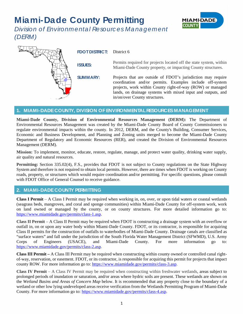
1
Miami-Dade County Permitting Division of Environmental Resources Management (DERM)
FDOT DISTRICT: District 6
ISSUES: Permits required for projects located off the state system, within Miami-Dade County property, or impacting County structures.
SUMMARY: Projects that are outside of FDOT’s jurisdiction may require coordination and/or permits. Examples include off-system projects, work within County right-of-way (ROW) or managed lands, on drainage systems with mixed input and outputs, and in/on/over County structures.
1. MIAMI-DADE COUNTY, DIVISION OF ENVIRONMENTAL RESOURCES MANAGEMENT
Miami-Dade County, Division of Environmental Resources Management (DERM): The Department of Environmental Resources Management was created by the Miami-Dade County Board of County Commissioners to regulate environmental impacts within the county. In 2012, DERM, and the County's Building, Consumer Services, Economic and Business Development, and Planning and Zoning units merged to become the Miami-Dade County Department of Regulatory and Economic Resources (RER), and created the Division of Environmental Resources Management (DERM).
Mission: To implement, monitor, educate, restore, regulate, manage, and protect water quality, drinking water supply, air quality and natural resources.
Permitting: Section 335.02(4), F.S., provides that FDOT is not subject to County regulations on the State Highway System and therefore is not required to obtain local permits. However, there are times when FDOT is working on County roads, property, or structures which would require coordination and/or permitting. For specific questions, please consult with FDOT Office of General Counsel to receive guidance.
2. MIAMI-DADE COUNTY PERMITTING
Class I Permit – A Class I Permit may be required when working in, on, over, or upon tidal waters or coastal wetlands (seagrass beds, mangroves, and coral and sponge communities) within Miami-Dade County for off-system work, work on land owned or managed by the county, or on county structures. For more detailed information go to: https://www.miamidade.gov/permits/class-1.asp.
Class II Permit – A Class II Permit may be required when FDOT is constructing a drainage system with an overflow or outfall in, on or upon any water body within Miami-Dade County. FDOT, or its contractor, is responsible for acquiring Class II permits for the construction of outfalls to waterbodies of Miami-Dade County. Drainage canals are classified as “surface waters” and fall under the jurisdiction of the South Florida Water Management District (SFWMD), U.S. Army Corps of Engineers (USACE), and Miami-Dade County. For more information go to: https://www.miamidade.gov/permits/class-2.asp.
Class III Permit – A Class III Permit may be required when constructing within county owned or controlled canal right-of-way, reservation, or easement. FDOT, or its contractor, is responsible for acquiring this permit for projects that impact county ROW. For more information go to: https://www.miamidade.gov/permits/class-3.asp.
Class IV Permit – A Class IV Permit may be required when constructing within freshwater wetlands, areas subject to prolonged periods of inundation or saturation, and/or areas where hydric soils are present. These wetlands are shown on the Wetland Basins and Areas of Concern Map below. It is recommended that any property close to the boundary of a wetland or other low lying undeveloped areas receive verification from the Wetlands Permitting Program of Miami-Dade County. For more information go to: https://www.miamidade.gov/permits/class-4.asp.
2
Class V Permit – A Class V Permit may be required for temporary dewatering or when water is removed from an excavation site. The purpose of this permit is to prevent adverse impacts to adjacent properties and existing waterways, as well as preclude the spread of contamination. FDOT, or its contractor, may be responsible for acquiring dewatering permits during construction. If dewatering was evaluated during design and deemed unnecessary but the contractor still wishes to dewater, the contractor will be responsible for preparing the application package and is responsible for all associated processing, issuance and extension fees. For more information go to:
https://www.miamidade.gov/permits/class-5.asp.
Class VI Permit – A Class VI Permit may be required for the construction of drainage systems to be installed in non-residential projects and/or near contaminated areas and landfills. FDOT, or its contractor, is responsible for acquiring a Class VI Permit for drainage/collection systems and for the installation of a pretreatment facility. This includes “mixed” drainage systems that have both county and FDOT components. For more information go to: https://www.miamidade.gov/permits/class-6.asp.
3. PRE-CONSTRUCTION & CONSTRUCTION COMPLIANCE
Review all Miami-Dade County permits for Special Conditions, provisions, monitoring requirements, and other specific requirements. Make sure construction personnel have copies. Be certain to strictly follow conditions.
Prior to Construction: Advise personnel of special conditions, permit provisions, monitoring activities, and other Miami-Dade County requirements.
4. TIPS
Tips: It is beneficial to coordinate with Miami-Dade County early so that they are aware of the project activities and can address any questions. County staff are a good resource and can provide local knowledge and help avoid planning inconsistencies. Schedule a pre-application meeting with Miami-Dade County in order to assess the need for a permit(s) and the correct forms that will be required.
5. RESOURCES
Web Resources*
• Miami-Dade County Environmental Permittinghttps://www.miamidade.gov/permits/home.asp?cat=environment
• Miami-Dade County Environmental One Time Permittinghttps://www.miamidade.gov/permits/environmental-one-time.asp
• Miami-Dade County Environmental Plans Reviewhttps://www.miamidade.gov/permits/plans/environmental-review.asp
• Miami-Dade County Environmental Fees and Citationshttp://www.miamidade.gov/environment/environmental-fees.asp
• Miami-Dade County Tree Relocation and Removalhttps://www.miamidade.gov/permits/tree-removal.asp
• Miami-Dade County Natural Forest Community Permithttps://www.miamidade.gov/permits/natural-forest-community.asp
Miami-Dade County - Contact Information:
The best contacts at DERM are the Division Heads for the separate units including: Coastal, Water Control, Contamination, Comprehensive Everglades Restoration Plan (CERP), and Freshwater Wetlands. All can be reached by calling 305-372-6789.
Environmental Resources Management Overtown Transit Village North 701 NW 1st Court
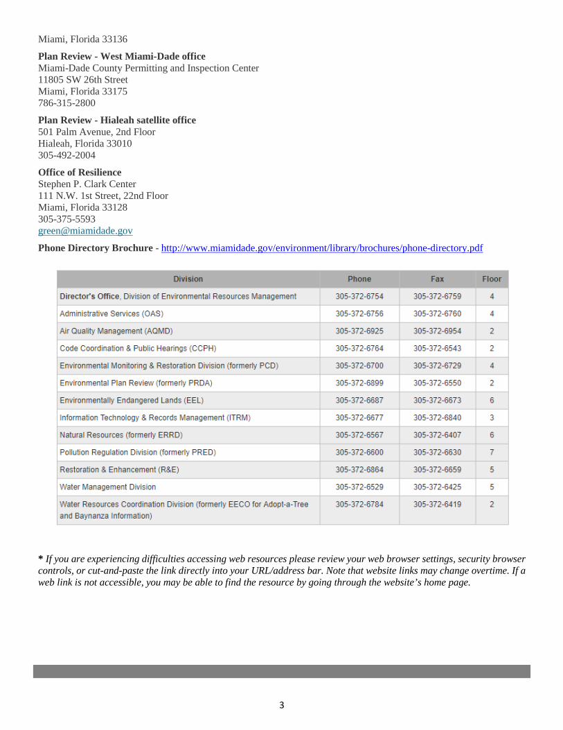
3
Miami, Florida 33136
Plan Review - West Miami-Dade office Miami-Dade County Permitting and Inspection Center 11805 SW 26th Street Miami, Florida 33175 786-315-2800
Plan Review - Hialeah satellite office 501 Palm Avenue, 2nd Floor Hialeah, Florida 33010 305-492-2004
Office of Resilience Stephen P. Clark Center 111 N.W. 1st Street, 22nd Floor Miami, Florida 33128 305-375-5593 [email protected]
Phone Directory Brochure - http://www.miamidade.gov/environment/library/brochures/phone-directory.pdf
* If you are experiencing difficulties accessing web resources please review your web browser settings, security browsercontrols, or cut-and-paste the link directly into your URL/address bar. Note that website links may change overtime. If aweb link is not accessible, you may be able to find the resource by going through the website’s home page.

2019 Appendix: Specialty Permits
APPENDIX 2n Palm Beach County Permitting
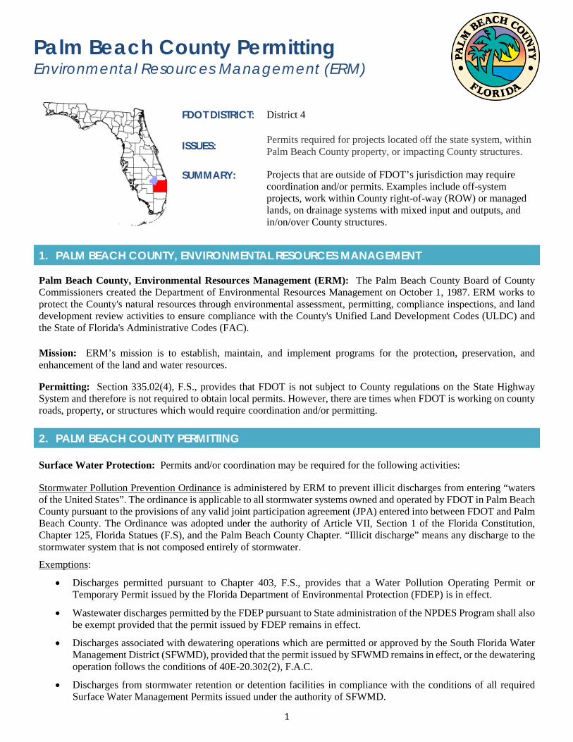
1
Palm Beach County Permitting Environmental Resources Management (ERM)
FDOT DISTRICT: District 4
ISSUES: Permits required for projects located off the state system, within Palm Beach County property, or impacting County structures.
SUMMARY: Projects that are outside of FDOT’s jurisdiction may require coordination and/or permits. Examples include off-system projects, work within County right-of-way (ROW) or managed lands, on drainage systems with mixed input and outputs, and in/on/over County structures.
1. PALM BEACH COUNTY, ENVIRONMENTAL RESOURCES MANAGEMENT
Palm Beach County, Environmental Resources Management (ERM): The Palm Beach County Board of County Commissioners created the Department of Environmental Resources Management on October 1, 1987. ERM works to protect the County's natural resources through environmental assessment, permitting, compliance inspections, and land development review activities to ensure compliance with the County's Unified Land Development Codes (ULDC) and the State of Florida's Administrative Codes (FAC).
Mission: ERM’s mission is to establish, maintain, and implement programs for the protection, preservation, and enhancement of the land and water resources.
Permitting: Section 335.02(4), F.S., provides that FDOT is not subject to County regulations on the State Highway System and therefore is not required to obtain local permits. However, there are times when FDOT is working on county roads, property, or structures which would require coordination and/or permitting.
2. PALM BEACH COUNTY PERMITTING
Surface Water Protection: Permits and/or coordination may be required for the following activities:
Stormwater Pollution Prevention Ordinance is administered by ERM to prevent illicit discharges from entering “waters of the United States”. The ordinance is applicable to all stormwater systems owned and operated by FDOT in Palm Beach County pursuant to the provisions of any valid joint participation agreement (JPA) entered into between FDOT and Palm Beach County. The Ordinance was adopted under the authority of Article VII, Section 1 of the Florida Constitution, Chapter 125, Florida Statues (F.S), and the Palm Beach County Chapter. “Illicit discharge” means any discharge to the stormwater system that is not composed entirely of stormwater.
Exemptions:
• Discharges permitted pursuant to Chapter 403, F.S., provides that a Water Pollution Operating Permit orTemporary Permit issued by the Florida Department of Environmental Protection (FDEP) is in effect.
• Wastewater discharges permitted by the FDEP pursuant to State administration of the NPDES Program shall alsobe exempt provided that the permit issued by FDEP remains in effect.
• Discharges associated with dewatering operations which are permitted or approved by the South Florida WaterManagement District (SFWMD), provided that the permit issued by SFWMD remains in effect, or the dewateringoperation follows the conditions of 40E-20.302(2), F.A.C.
• Discharges from stormwater retention or detention facilities in compliance with the conditions of all requiredSurface Water Management Permits issued under the authority of SFWMD.
2
• Discharges with valid NPDES Permits for Discharges Associated with Industrial Activities under the authorityof EPA.
Projects which require NPDES Construction Activity Permit coverage and discharge to the Palm Beach County MS4, must provide a copy of the Stormwater Pollution Prevention Plan to ERM, prior to construction activities. This is typically the responsibility of FDOT’s contractors.
Lake Excavation: Since 1992, ERM has regulated excavation and mining through the Palm Beach County ULDC Article 4, Chapter B, Section 10, Excavation Uses. See Ordinance - http://discover.pbcgov.org/erm/Publications/PBCULDCArticle4.pdf or go to: http://discover.pbcgov.org/erm/PermitsRegulation/Lake-Excavation.aspx.
Exemptions:
• Regulated by a National Pollutant Discharge Elimination System Permit; or
• Regulated by a FDEP industrial wastewater operation permit; or
• Located within an approved residential, commercial, industrial or mixed-use development and functioning as astormwater management facility pursuant to: a surface water management construction permit issued by theSFWMD; or, a conceptual permit issued by the SFWMD that delineates proposed littoral slopes of the excavatedlake(s) conducive for planting; or an applicable Land Development Permit depicting proposed littoral and uplandslopes of a mined lake. Note that lakes regulated by ERM larger than 1 acre OR deeper than 6 feet must have aplanted littoral area with 5 different species of native aquatic plants covering at least 80% and no more than 10%exotic plants.
Wellfield Protection: A business or entity located within a wellfield protection zone (note that there are 44 regulated wellfields within the County) that stores, uses or sells regulated substances in quantities greater than or equal to 5 gallons of a liquid or 25 pounds of a solid is required to apply for a Wellfield Operating Permit. The application for the permit will specify how the owner intends to comply with the terms of Article 14 Chapter B. In addition, this includes applying pesticides in wellfield zones. To learn more, go to: http://discover.pbcgov.org/erm/PermitsRegulation/Wellfield-Protection.aspx.
Coastal Lighting: Since 1987, ERM has regulated beachfront lighting through the ULDC Article 14.A, Sea Turtle Protection and Sand Preservation Ordinance. A permit from ERM is required when any light source is replaced or installed within the "Sea Turtle Protection Zone" in one of the following beachfront communities: Tequesta, Jupiter Inlet Colony, Jupiter, North Palm Beach, Riviera Beach (Singer Island), Palm Beach Shores, Lake Worth, Lantana, Manalapan, Briny Breezes, and Boynton Beach. To learn more, go to: http://discover.pbcgov.org/erm/PermitsRegulation/Beachfront-Lighting.aspx or http://discover.pbcgov.org/erm/Publications/BeachfrontLightingJurisdictions.pdf
Native Vegetation/Tree Removal and Protections: ERM regulates native vegetation removal through the ULDC Article 14.C and 14 D which limits unnecessary native vegetation removal, promotes the use of native vegetation, and requires eradication of invasive nonnative vegetation. This includes new construction of a utility; road ROW, and/or projects required to go through the Development Review Process. When native vegetation must be removed, the following actions shall apply: relocate on site, donate offsite, and mitigate (replace). Mitigation shall be native species ranked Florida Number One or better according to industry standards and shall be planted as follows: onsite incorporated in the landscape plan; offsite on public lands within the County (parks, schools, libraries, etc.); through voluntary contribution to County’s Natural Areas Fund; and, requires acceptance and a clear understanding of vegetation maintenance responsibilities for both parties until the mitigated vegetation is self-sustaining. To learn more, go to: http://discover.pbcgov.org/erm/PermitsRegulation/Native-Vegetation-Removal.aspx.
3. PRE-CONSTRUCTION & CONSTRUCTION COMPLIANCE
Review all Palm Beach County permits for Special Conditions, provisions, monitoring requirements, and other special requirements. Be certain to strictly follow conditions. Make sure construction personnel have copies.
3
Prior to Construction: Advise personnel of Special Conditions, permit provisions, monitoring activities, and other Palm Beach County requirements.
4. TIPS
Tips: It is beneficial to coordinate with Palm Beach County early so that they are aware of the project activities and can address any questions. County staff are a good resource and can provide local knowledge and help avoid any planning inconsistencies. Schedule a pre-application meeting with Palm Beach County ERM in order to assess the need for a permit(s) and the correct forms that will be required.
5. RESOURCES
Web Resources*
• Environmental Resources Management – Home Pagehttp://discover.pbcgov.org/erm/Pages/default.aspx
• Environmental Resources Management Publicationshttp://discover.pbcgov.org/erm/Pages/Publications.aspx
• Environmental Resources Management - Regulationshttp://discover.pbcgov.org/erm/Pages/Permitting-Regulation.aspx
• What type of tree do you want to cut?http://discover.pbcgov.org/erm/Publications/typespermittrees.pdf
• Surface Water Protection – Water Quality & Stormwater Dischargeshttp://discover.pbcgov.org/erm/PermitsRegulation/Surface-Water-Protection.aspx
• Lake Excavationhttp://discover.pbcgov.org/erm/PermitsRegulation/Lake-Excavation.aspx
• Wellfield-Protectionhttp://discover.pbcgov.org/erm/PermitsRegulation/Wellfield-Protection.aspx
• Beachfront-Lightinghttp://discover.pbcgov.org/erm/PermitsRegulation/Beachfront-Lighting.aspx
• Native Vegetation and Tree Removalhttp://discover.pbcgov.org/erm/PermitsRegulation/Native-Vegetation-Removal.aspx
Palm Beach County – Contact Information:
Palm Beach County Board of County Commissioners Environmental Resources Management 2300 North Jog Road, 4th Floor, West Palm Beach, FL 33411 Phone: 561-233-2400 & Email: [email protected]
* If you are experiencing difficulties accessing web resources please review your web browser settings, security browsercontrols, or cut-and-paste the link directly into your URL/address bar. Note that website links may change overtime. If aweb link is not accessible, you may be able to find the resource by going through the website’s home page.