evaluation of groundwater quality for irrigation in bangladesh using geographic information system
TRANSCRIPT
J. Hydrol. Hydromech., 54, 2006, 1, 3–14
3
EVALUATION OF GROUNDWATER QUALITY FOR IRRIGATION IN BANGLADESH USING GEOGRAPHIC INFORMATION SYSTEM SHAMSUDDIN SHAHID1), XIAOYONG CHEN2) AND MANZUL KUMAR HAZARIKA2)
1)Department of Applied Physics & Electronics, Rajshahi University, Rajshahi-6205, Bangladesh; mailto: [email protected] 2)School of Engineering and Technology, Asian Institute of Technology (AIT), Thailand.
About 75% of water for irrigation in Bangladesh comes from groundwater. As the crop yield is directly related to quality of water used for irrigation, an assessment of groundwater suitability for irrigation is essential for the growth of food production and poverty eradication. An attempt has been made in this paper to study the suitability of groundwater for irrigation in Bangladesh. Geographic information system (GIS) is used for the processing of groundwater quality data collected from 113 locations sporadically distributed over the country and the preparation of groundwater quality maps. The result shows that groundwater of the southwestern part of Bangladesh, which comprises 22.5% area of the country, is highly affected by salinity and sodium hazards. Groundwater in 10.54% area of the country is also contaminated by Arsenic above the permissible level recommended for irrigation.
KEY WORDS: Groundwater Quality, Irrigation, GIS, Bangladesh.
Shamsuddin Shahid, Xiaoyong Chen, Manzul Kumar Hazarika: VYHODNOTENIE KVALITY PODZEMNEJ VODY PRE ZÁVLAHY V BANGLADEŠI PRI VYUŽITÍ GEOGRAFICKÉHO INFORMAČNÉHO SYSTÉMU. J. Hydrol. Hydromech., 54, 2006, 1; 26 lit., 7 obr., 3 tab.
Okolo 75 % vody pre závlahy v Bangladeši pochádza z podzemných vôd. Pretože úroda priamo závisí od
kvality závlahovej vody, posúdenie vhodnosti vody pre závlahy je podstatné pre produkciu potravín a odstránenie chudoby. V štúdii je prezentovaný pokus o zhodnotenie vhodnosti podzemnej vody pre závlahy v Bangladeši. Na spracovanie údajov o kvalite podzemnej vody zo 113 lokalít rozmiestnených sporadicky po krajine a na prípravu máp kvality podzemnej vody sa použil geografický informačný systém (GIS). Výsledky naznačujú, že podzemná voda v juhozápadnej časti krajiny zaberajúcej 22,5 % jej plochy je silne ohrozená zasolenosťou a obsahom sodíka. Podzemná voda na ploche 10,54 % krajiny je tiež kontaminovaná obsahom arzénu nad prípustnú hranicu pre závlahovú vodu.
KĽÚČOVÉ SLOVÁ: kvalita podzemných vôd, závlahy, GIS, Bangladeš.
Introduction
Bangladesh is one of most densely populated countries of the world. The ever-increasing popula-tion of Bangladesh requires that agricultural pro-duction must be increased to meet the food needs of the population. During the last three decades, irriga-tion coverage has been increased significantly to raise food production levels. The total area under irrigation has been raised from 1.52 million hec-tares in 1982 to 4.04 millions in 2004. In the ab-sence of adequate surface water in the dry season, irrigation of Bangladesh is heavily dependent on groundwater. During the last twenty years, much of the increase in irrigation has been accomplished through installation of shallow tube-wells. It has
been observed that the area under irrigation by sur-face water has remained more or less static since the early eighties, while the area under irrigation by shallow tube-wells has increased by a factor of about five (Bari and Anwar, 2000). The contribu-tion of groundwater to total irrigated area has in-creased from 41% in 1982 to 75% in 2004. Accord-ing to a recent survey report (BADC, 2004), out of total 4.04 millions irrigated land, 3.03 million hec-tares of land are irrigated by groundwater in 2004. The use of groundwater in irrigation is supposed to increase more in the coming years. The quality of water used for irrigation has a direct effect on crop yields and land degradation (Bernstein, 1975; Solomon, 1985; Lauchli and Epstein, 1990; Malash, 2002). Therefore, assessment of groundwater qual-

S. Shahid, X. Chen, M. K. Hazarika
4
ity of Bangladesh is essential for agricultural water management and the growth of food production. Based on this concern, a study of groundwater qual-ity of Bangladesh as a source of irrigation is carried out in this paper.
There are number of factors that contribute to the quality of water for irrigation. Among those, four criteria are widely considered for the assessment of water quality for irrigation. Those area: (i) total soluble salt content in the water or salinity hazard, (ii) relative proportion of sodium cations to other cations or sodium hazard, (iii) excessive concentra-tion of elements that causes ionic imbalance in plants or toxicity, and (iv) excessive presence of other miscellaneous elements like bicarbonate an-ion (Ayers and Westcot, 1985). However, the first two criteria are of major concern in water quality for irrigation in Bangladesh. Excess salt increase the osmotic pressure of the soil solution that can result in a physiological drought condition. Even though the field appears to have plenty of moisture, the plants wilt as the water is absorbed by the roots is insufficient to replace that lost from transpiration (Shainberg 1984; Mashali, 1989). It has been found that the application of 1 centimeter of moderately saline irrigation water (640 mg l-1) contributes ap-proximately 69 kg of salt per hectar. Since the amount of irrigation water needed to supply during the rice cultivation period is approximately 122.6 cm ha-1, an amount of 8.5 tons of salt can accumu-late per hectar soil in a season. On the other hand, the main problem with a high sodium concentration is its effect on the physical properties of soil. It is always wise to avoid water with high sodium value if it is the only source of irrigation water, as the continued use of sodium water leads to a break-down in the physical structure of the soil (Hadas, 1982). High soil sodium causes soil clays and or-ganic matter to clog soil pores, reducing water infil-tration and soil aeration. Consequently, the soil becomes hard and compact when dry (Rhoades, 1987; Shainberg, 1990). These problems are greater on fine textured soils such as clays and loams. Be-sides salinity and sodium hazards, excess concen-tration of arsenic has become a major concern of water quality in Bangladesh. Arsenic at a given concentration in water may be toxic to crop and there is a high probability of inclusion of arsenic in the crop life cycle (Meharg, 2001; Huq, 2002).
A number of studies have been carried out to ob-serve the effect of groundwater quality on the yield and growth of crops in Bangladesh. Gain et al. (2004) reported that due to the high value of salin-
ity in the southern part of Bangladesh, growth and yield of rice are comparatively less than that is irri-gated with low saline water. They observed that growth of rice plants decreases with the increase of salinity in irrigation water. Miah et al. (2004) con-ducted a survey in the southwestern districts of Bangladesh and reported a reduction in crop yield due to low quality of irrigated water. They also observed that increasing trend of salinity in south-west region of Bangladesh is reducing the farmers’ interest to cultivate various agricultural crops. The fruit trees like mango, bettle nut, coconut, date palm, giant taro, jackfruit, black berry, wax jambu etc. are disappearing gradually. Besides the declin-ing tree species, reducing soil fertility, increasing disease and insect infestation in field crops, increas-ing human and animal diseases are the major im-pact of increasing salinity in the coastal areas of Bangladesh. Prolonged use of poor quality water for irrigation also causes a detrimental effect on soil and proper management is essential for reducing the soil degradation. In the present paper, besides the common groundwater quality survey, suitability of groundwater for irrigation of paddy and wheat, which are the main cultivation of Bangladesh, is also assessed. The groundwater quality data jointly collected by British Geological Survey (BGS) and Department of Public Health Engineering (DPHE), Bangladesh in 1998 are used for the study (Kinni-burgh, 2001).
For hydrogeological studies over a large area, it often requires to assimilate information from many sites, each with a unique geographic location. GIS is well suited for efficiently storing, manipulating, analyzing and display large amount of spatial data as well as non-spatial data (Shahid, 2000). There-fore, GIS is used in the study for the processing of groundwater quality data and mapping of ground-water quality for irrigation.
In the next section of the paper, a brief descrip-tion of geography and irrigation of Bangladesh is given. This follows a discussion on the methods used for the analysis of irrigation water quality. Next, the procedures for data processing and map-ping are described. The results obtained by the study are given in the last section of the paper. Geography and irrigation of Bangladesh
Bangladesh is a country situated in south Asia. Total land of the country is 143,998 km2 with a population of 149.7 million. The density of popula-tion is 1,039 per km2, which is among the highest in

Evaluation of groundwater quality for irrigation in Bangladesh using Geographic information system
5
the world. Geographically, it extends from 20°34'N to 26°38'N latitude and from 88°01'E to 92°41'E longitude. Except the hilly southeast, most of the country is a low-lying plain land. Climatically, the country belongs to sub-tropical regions where mon-soon weather prevails throughout the year. The average temperature of the country ranges from 7.20C to 12.80C during winter and 23.90C to 31.10C during summer. The average relative humidity for the whole year ranges from 78.1% to 70.5% with a maximum in September and a minimum in March (Rashid, 1991). The average annual rainfall varies from 1329 mm in the northwest to 4338 mm in the northeast.
Bangladesh is primarily an agrarian economy. Agriculture is the single largest producing sector of economy since it comprises about 30% of the coun-try's GDP and employing around 60% of the total labor force. Though nearly 100 different kinds of crops are presently grown in Bangladesh, rice is the principal one which grows in all the three crop growing seasons of the year and covers about 79% of the total cropped area. Crops in Bangladesh are grown both under rain-fed and irrigated conditions. However, irrigated agriculture is usually associated with high-productivity and more or less stability with an assured water supply. Consequently, the trend of irrigated agriculture has been increasing in Bangladesh. Before 1960’s, farmers were used to grow crops under rain-fed conditions. Systematic irrigation started in the early 1960s, with the intro-duction of deep tube-wells and low-lift pumps. Four types of irrigation methods are commonly used in Bangladesh viz. basin method, border method, furrow method and sprinkler method. However basin method is mostly used specially for the irrigation of paddy (Islam, 2003).
Almost 75% of irrigation water in Bangladesh comes from groundwater. There are three ground-water systems in Bangladesh (UNDP, 1982): Upper Shallow Unconfined Aquifer, Middle Confined Aquifer also known as Main Aquifer, and Deep Confined Aquifer. Over most of the country the uppermost shallow aquifer is used for extraction of water for irrigation. This aquifer exists below the upper clay and silt unit of depth ranging from less than a meter to several hundred meters. The thick-ness of the shallow aquifer ranges from a few me-ters in the northwest to a maximum of 60m in the south. The aquifer material varies from fine to very fine sand, in places inter bedded or mixed with medium sand. Discontinuous thin clay layers often found to separate these sand layers (UNDP, 1982).
Bangladesh has a large proportion of groundwa-ter potentially available for further development. However, despite plentiful water resources, poor groundwater quality for irrigation especially salin-ity is one of the major limitations to development. High salinity and sodium in some parts of Bangla-desh has affected the crop production and soil prob-lems (Islam, 2003). Methodology
There are four basic criteria for evaluating water quality for irrigational purposes, viz. salinity haz-ard, sodium hazard, excessive concentration of toxic elements and excessive presence of other miscellaneous elements. In groundwater of Bangla-desh salinity hazard, sodium hazard and excessive concentration of arsenic, nitrate-nitrogen and chlo-ride has been reported to occur. Measurement of these quantities in groundwater and their classifica-tions are described in the following subsections.
Salinity hazard: Salinity in groundwater can be measured either indirectly by measuring the ability of water to conduct an electrical current or directly measuring the presence of various salts in water. According the techniques used for the measurement of salinity, it is expressed in two different ways, either as electrical conductivity or total dissolved salts (TDS). Total dissolved salts are expressed in parts per million (ppm) or milligrams per liter (mg l-1). Irrigation water is classified into three catego-ries based on salinity, which considers the potential for damaging plants and the level of management needed for utilization as an irrigation source (Ayers and Westcot, 1985). The classification of irrigation water based on salinity by Ayers and Westcot (1985) is given in Tab. 1. Water with salinity less than 450 mg l-1 is generally suitable for irrigation without problems. Successful use of water with salinity in a range between 500 and 2000 mg l-1 depends upon soil conditions and plant tolerance to salinity. It might cause damage to plants with low tolerance to salinity. However, plant growth and quality can be improved with excess irrigation for leaching, and periodic use of low salinity water and good drainage. Under typical summer stress grow-ing conditions, salinity of irrigation water should ideally not exceed 1500 mg l-1 soluble salts. Irriga-tion water with salinity above this level damages plants even have high tolerance to salinity. It is unsuitable as an irrigation source for any length of time (Ayers and Westcot, 1985).

S. Shahid, X. Chen, M. K. Hazarika
6
Sodium hazard: Sodium hazard in groundwater is determined by calculating sodium absorption ration (SAR). SAR relates the concentration of sodium (Na+) to the concentration of calcium (Ca+) and magnesium (Mg+) as,
( )2
NaSARCa Mg
+
+ +=
+, (1)
where Na+, Ca+ and Mg+ are expressed in milli-equivalents per liter (meq l-1). The higher the Na+ in relation to Ca+ and Mg+, the higher the SAR. Irriga-tion water is classified into three groups (Ayers and Westcot, 1985) according the SAR values (Tab. 1). Water with SAR value less than 10 is suitable for any crop. Water with SAR within a range of 10 to 24 may cause problems on fine texture soils and sodium sensitive plants, especially under low-leaching conditions. For irrigation with water hav-ing SAR of this range requires good sodium toler-ant plants along with special management such as the use of gypsum. Irrigation water with SAR val-ues more than 24 are harmful for crops in most soils, except with high salinity (1280 mg l-1), high calcium levels, and the use of gypsum.
Toxic materials: Direct toxicity to crops may re-sult from some specific trace elements in irrigation water. When such element is added to the soil through irrigation, it may be inactivated by chemi-cal reaction, or it may build up in the soil until it reaches a toxic level. There is a long list of ele-
ments that can cause toxic effect on crops. How-ever, in groundwater of Bangladesh only Arsenics, Nitrate-Nitrogen and Chloride are found to exist beyond permissible level. Irrigation water is classi-fied into two to three groups according the concen-tration of those toxic elements (Ayers and Westcot, 1985), which is given in Tab. 1.
Water quality suitability for paddy and wheat: The level of salinity suitable for irrigation depends on crop tolerance and soil permeability. Salinity levels suitable for irrigating paddy and wheat in different soils are given in Tab. 2 (deHayr, 2004). Continued use of irrigation water with salinity greater than 3072 mg l-1 in clayey soil, 1728 mg l-1 in loom soil and 1024 mg l-1 in sandy soil reduces the growth and quality of rice. Detrimental effects are greatest during prolonged droughts when irriga-tion water is the sole source of water and irrigation amounts typically do not exceed evapotranspira-tion. For irrigation in wheat field, a salinity value less than 6016 mg l-1 is suitable in clayey soil, 3392 mg l-1 in loom soil and 1984 mg l-1 in sandy soil. Data processing and suitability mapping
For the study of arsenic contamination in groundwater, British Geological Survey (BGS) and Department of Public Health Engineering (DPHE), Bangladesh, jointly collected groundwater samples from 119 sites in Bangladesh in the month of July 1998 (Kinniburgh, 2001). They examined the water
T a b l e 1. Water quality criteria for irrigation (Ayers and Westcot, 1985). T a b u ľ k a 1. Kritériá kvality závlahovej vody (Ayers a Westcot, 1985).
Degree of restriction on use Quality parameters
None Moderate Severe Salinity [mg l-1] < 450 450 – 2000 > 2000 SAR < 10 10 – 24 > 24 Arsenics [mg l-1] < 0.1 > 0.1 Nitrate-Nitrogen [mg l-1] < 5 5 – 30 > 30 Chloride [mg l-1] < 4 4 – 10 > 10
T a b l e 2. Tolerance of paddy and wheat to salinity in different soils (deHayr, 2004). T a b u ľ k a 2. Hranice tolerancie ryže a pšenice na rôzne priepustných pôdach (deHayr, 2004).
Salinity threshold [mg l-1] for crops growing
Permeability Crops
High Moderate Low
Rice (Paddy) 3072 1728 1024 Wheat 6016 3392 1984

Evaluation of groundwater quality for irrigation in Bangladesh using Geographic information system
7
sample for measuring the contents of 53 constitu-ents of groundwater including Arsenic, Sodium, Calcium, Magnesium, Chloride and different salts, toxic and heavy elements. The data were collected mainly from tube-wells operating at shallow depth except in some places where data were collected from deeper aquifer. In the present study, data that were collected from shallow aquifer are used for the assessment of groundwater quality for irrigation as the shallow aquifer is mainly used for irrigation in Bangladesh. The location of groundwater sample collection points is shown in Fig. 1.
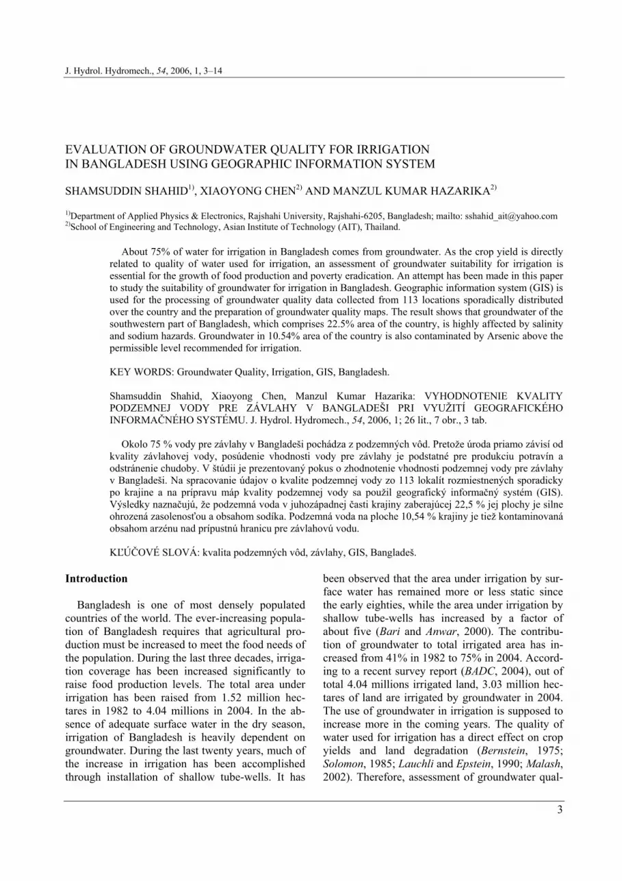
Fig. 1. The location of groundwater sample collection points. Obr. 1. Rozmiestnenie odberov vzoriek podzemnej vody.
The groundwater quality data are incorporated in a Geographic Information System (GIS) for pro-cessing and analysis. The contents of different salts values are added to get the value of salinity in groundwater. The SAR is calculated from the So-dium, Calcium and Magnesium contents using Eq. (1). The toxic and heavy elements, which exist above the permissible levels for irrigations are also identified. Only Arsenic, Nitrate-Nitrogen and Chloride contents in some extents are found in some places above the permissible level. The point values of salinity, SAR and toxic elements are used to prepare the corresponding raster grid maps using kriging method (Journel and Huijbregts, 1981; Isaaks and Srivastava, 1989). Variograms are com-puted to fit the data and obtain best interpolation.
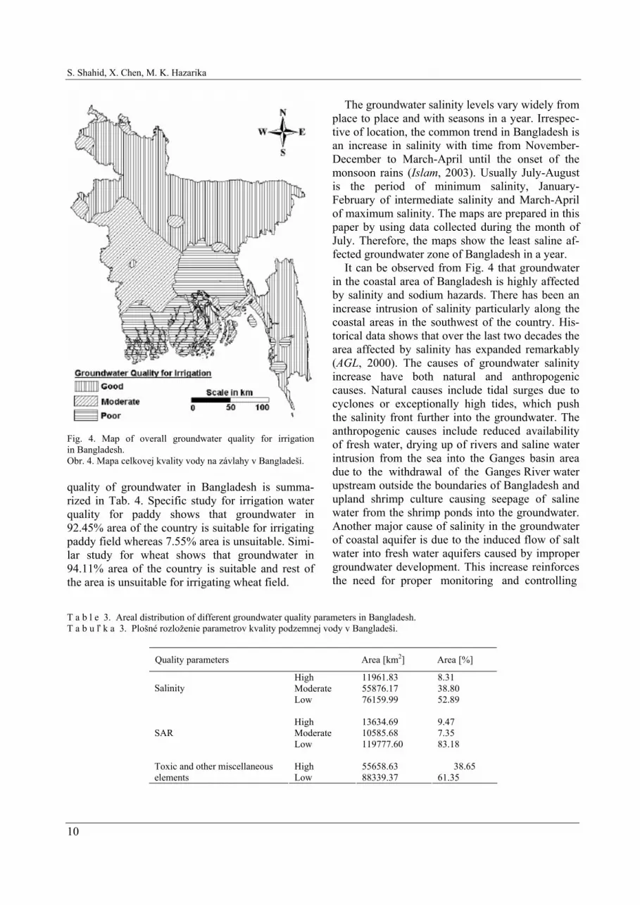
The grid values of the raster maps are classified according the ranges given in Tab. 1 to prepare thematic maps. First, the thematic maps of toxic and other miscellaneous elements in groundwater are prepared. Figs 2a), b) and c) are showing the maps of chlorides, nitrates-nitrogen and arsenics in groundwater of Bangladesh. These maps are inte-grated by using GIS to prepare the thematic maps of toxicity in groundwater, which is shown in Fig. 3a). Next, the maps of salinity and SAR are pre-pared as shown in Figs 3b) and c) respectively. Finally, the thematic maps of salinity, SAR and toxicity in groundwater are integrated using the intersect method in GIS to prepare the map of groundwater suitable for irrigation, which is shown in Fig. 4. The variograms used for kriging of groundwater quality data for the preparation of thematic maps of Chlorides, Nitrate-Nitrogen, Ar-senics, salinity and SAR are shown in Figs 5a), b), c), d) and e) respectively.
To study the suitability of groundwater for irriga-tion in paddy and wheat fields, thematic maps of salinity in groundwater and soil permeability are used. Soil map of Bangladesh given in Bangladesh Country Almanac (BCA, 2004) is used to regroup the polygons according their permeability values and the preparation of the thematic map of soil permeability of Bangladesh, which is shown in Fig. 6. Groundwater salinity map is first integrated with the soil permeability map. The polygons of the integrated map are then classified according the salt tolerance ranges of paddy and wheat in different soils given in Tab. 2 to prepare the maps of groundwater suitable for irrigating in paddy and wheat fields. The maps are shown in Figs 7a) and b) respectively. Results and discussion
The study shows that groundwater in 8.31% area of Bangladesh is contaminated by very high salin-ity, 9.47% with very high SAR and 38.65% with toxic and other miscellaneous elements. Groundwa-ter in 10.54% area of Bangladesh bears Arsenics above the permissible levels for irrigation. Areal distribution of salinity, SAR and toxicity in groundwater of Bangladesh is given in Tab. 3.
The groundwater suitability map for irrigation shows that groundwater in 22.5% area of Bangla-desh is unsuitable for high salinity, sodium or toxic-ity. 32.33% area is moderately suitable and 45.16% area is suitable for irrigating any crop. The overall

S. Shahid, X. Chen, M. K. Hazarika
8
a) b)
c) Fig. 2. Maps of a) chlorides, b) nitrate-nitrogen, and c) arsenics contents in groundwater of the Bangladesh. Obr. 2. Mapy a) chloridov, b) dusičnanového dusíka, c) arzénu v podzemných vodách Bangladeša.

Evaluation of groundwater quality for irrigation in Bangladesh using Geographic information system
9
a)
b) c)
Fig. 3. Thematic maps of a) toxic and miscellaneous elements, b) salinity, and c) sodium absorption ration (SAR) in groundwater of the Bangladesh. Obr. 3. Mapy a) toxických a ďalších prvkov, b) zasolenosti, c) sodíkového adsorpčného pomeru (SAR) v podzemných vodách Bangladeša.
S. Shahid, X. Chen, M. K. Hazarika
10
Fig. 4. Map of overall groundwater quality for irrigation in Bangladesh. Obr. 4. Mapa celkovej kvality vody na závlahy v Bangladeši. quality of groundwater in Bangladesh is summa-rized in Tab. 4. Specific study for irrigation water quality for paddy shows that groundwater in 92.45% area of the country is suitable for irrigating paddy field whereas 7.55% area is unsuitable. Simi-lar study for wheat shows that groundwater in 94.11% area of the country is suitable and rest of the area is unsuitable for irrigating wheat field.
The groundwater salinity levels vary widely from place to place and with seasons in a year. Irrespec-tive of location, the common trend in Bangladesh is an increase in salinity with time from November-December to March-April until the onset of the monsoon rains (Islam, 2003). Usually July-August is the period of minimum salinity, January-February of intermediate salinity and March-April of maximum salinity. The maps are prepared in this paper by using data collected during the month of July. Therefore, the maps show the least saline af-fected groundwater zone of Bangladesh in a year.
It can be observed from Fig. 4 that groundwater in the coastal area of Bangladesh is highly affected by salinity and sodium hazards. There has been an increase intrusion of salinity particularly along the coastal areas in the southwest of the country. His-torical data shows that over the last two decades the area affected by salinity has expanded remarkably (AGL, 2000). The causes of groundwater salinity increase have both natural and anthropogenic causes. Natural causes include tidal surges due to cyclones or exceptionally high tides, which push the salinity front further into the groundwater. The anthropogenic causes include reduced availability of fresh water, drying up of rivers and saline water intrusion from the sea into the Ganges basin area due to the withdrawal of the Ganges River water upstream outside the boundaries of Bangladesh and upland shrimp culture causing seepage of saline water from the shrimp ponds into the groundwater. Another major cause of salinity in the groundwater of coastal aquifer is due to the induced flow of salt water into fresh water aquifers caused by improper groundwater development. This increase reinforces the need for proper monitoring and controlling
T a b l e 3. Areal distribution of different groundwater quality parameters in Bangladesh. T a b u ľ k a 3. Plošné rozloženie parametrov kvality podzemnej vody v Bangladeši.
Quality parameters Area [km2] Area [%]
High 11961.83 8.31 Moderate 55876.17 38.80 Salinity Low 76159.99 52.89
High 13634.69 9.47 Moderate 10585.68 7.35 SAR Low 119777.60 83.18
High 55658.63 38.65 Toxic and other miscellaneous
elements Low 88339.37 61.35

Evaluation of groundwater quality for irrigation in Bangladesh using Geographic information system
11
a) b)
c) d)
e) Fig. 5. Variograms used for the preparation of thematic maps of a) chlorides, b) nitrate-nitrogen, c) arsenics, d) salinity and e) SAR by kriging. Obr. 5 Variogramy použité na prípravu máp a) chloridov, b) dusičnanového dusíka, c) arzénu, d) zasolenia, e) sodíkového ad-sorpčného pomeru interpolačnou metódou (kriging).

S. Shahid, X. Chen, M. K. Hazarika
12
Fig. 6. Soil permeability map of Bangladesh. Obr.6. Mapa priepustnosti pôdy v Bangladeši. methods for salt-water intrusion. To control the increased salinity in groundwater the proper bal-ance has to be maintained between water being pumped from the aquifer and the amount of water recharging it. Constant monitoring of the salt-water interface is necessary in determining proper control measures.
As the surface water in the southwestern region of Bangladesh is also highly saline, there is no al-ternative except to use deeper groundwater for irri-gation in the region, as the water of this aquifer is relatively low in salinity. As the exploration of groundwater from deep aquifers is sometimes ex-pensive, the crop variety having high salt tolerance could be cultivated in the coastal region. Gain et al. (Gain, 2004) reported that rice variety BR11 has tolerance to certain level of salinity in respect of
plant height, number of tillers and biomass produc-tion. Therefore, this variety of paddy could be cul-tivated in the saline zone of the coastal regions of Bangladesh. Some alternative cultivation of crops that have high salt and sodium tolerance can also be done in the region.
Continuous use of saline water for irrigation may cause high soil salinity. Good drainage is essential to leach soluble salts through the soil profile. The better the drainage, the better one can keep soluble salts in the root zone within tolerable limits. Poorly drained soils accumulate salts due to poor drainage. Sandy soils are usually best suited for saline irriga-tion because of easy drainage. Unfortunately, the soil in most of the southwestern coastal zone of Bangladesh is clayey in nature. Therefore, drainage, leaching and changes to more salt tolerant crops are necessary in the region to avoid the impact of long-term salinity build-up. Some cultural practices can also be adopted for possible short-term or tempo-rary control of salinity such as more frequent irriga-tion, land grading, timing of fertilization and meth-ods of seeding. In the area of high level of salinity, a soil drainage and reclamation program can be carried out and short-term cropping changes can be made. After soil reclamation, the permanent crop-ping pattern can be determined by water quality. In a few instances, an alternative water supply from deeper aquifer can be used periodically to diminish a quality-related hazard. Conclusions
Bangladesh is blessed by plenty of groundwater resources. A huge amount of this resource is used for irrigation, domestic and other uses. There is still a large proportion of groundwater potentially avail-able for further development. However, poor qual-ity of groundwater for irrigation in the coastal zone of Bangladesh is one of the major problems of this resource. Proper management steps to maintain the balance between groundwater charging and re-charging, and constant monitoring of the salt-water interface is necessary to control the land-ward ex-
T a b l e 4. Overall groundwater quality in Bangladesh. T a b u ľ k a 4. Celková kvalita podzemnej vody v Bangladeši.
Groundwater quality Area [km2] Area [%] Low 32402.82 22.50 Moderate 46560.66 32.33 High 65034.52 45.16

Evaluation of groundwater quality for irrigation in Bangladesh using Geographic information system
13
a) b) Fig. 7. Groundwater suitability maps for irrigating a) paddy, and (b) wheat fields. Obr. 7. Mapa vhodnosti podzemných vôd na zavlažovanie a) ryžových polí, b) pšenice. pansion of salinity. High salinity and sodium in southwestern coastal parts of Bangladesh has been affected the crop production and soil problems. Proper management and favorable cultural practices are necessary in the region to avoid the impact of long-term salinity build-up. REFERENCES AGL, 2000: Extent and Causes of Salt-affected Soils in Par-
ticipating Countries. Global Network on Integrated Soil Management for Sustainable Use of Salt-affected Soils, Land and Plant Nutrition Management Services, FAO, http://www.fao.org/ag/agl/agll/spush/ topic2.htm#bangladesh [Access Dated: 05-06-2005].
AYERS R.S., WESTCOT D.W., 1985: Water quality for agri-culture. Irrigation and Drainage Paper, 29, Rev. 1, FAO, Rome.
BADC, 2004: Survey report on irrigation equipment and irri-gated area in Boro/2003 season. Bangladesh Agricultural Development Corporation.
BARI M.F., ANWAR A.H.M.F., 2000: Effects on irrigated agriculture on groundwater quality in Northwestern Bangla-desh. Proceedings of Integrated Water Resources manage-ment for Sustainable Development, Vol. I, New Delhi, 419––427.
BCA, 2004: Bangladesh Country Almanac. BCA v.2.0, CIM-MYT Bangladesh, Dhaka-1230, Bangladesh, 2004, http://www.cimmytbd.org/bca/ [Dated: 30-10-2005].
BERNSTEIN L., 1975: Effects of salinity and sodicity on plant growth. Annual Review Phytopathology 13, 295–312.
DeHAYR R., GORDON, I., 2004: Irrigation water quality Salinity & soil structure stability. Department of Natural Resources, Mines and Energy, The State of Queensland, QNRME04191, http://www.nrm.qld.gov.au/factsheets/pdf/water/w55.pdf [Date: 27-05-2005].
GAIN P., MANNAN M.A., PAL P.S., HOSSAIN M.M., PARVIN S., 2004: Effect of Salinity on Some Yield Attrib-utes of Rice. Pakistan J. of Biological Sciences, 7, 5, 760– –762.
HADAS A., FRENKEL H., 1982: Infiltration as affected by long-term use of sodic-saline water for irrigation. Soil Sci-ence Society of America J., 46, 524–530.
HUQ S.M.I., NAIDU R., 2002: Arsenic in Groundwater of Bangladesh: Contamination in the Food Chain. Arsenic Contamination in Bangladesh, ITN Bangladesh.
ISAAKS H.E., SRIVASTAVA R.M., 1989: An Introduction to Applied Geostatisitics. Oxford University Press, New York.
ISLAM S., 2003: Banglapedia: National Encyclopedia of Bangladesh. Asiatic Society of Bangladesh, Dhaka.
JOURNEL A.G., HUIJBREGTS C.J., 1981: Mining Geostatis-tics. Academic Press. New York.
KINNIBURGH D.G., SMEDLEY P.L., 2001: Arsenic Con-tamination of Groundwater in Bangladesh. British Geologi-cal Survey Report, Vol. 2, British Geological Survey, Key-worth, Nottingham.
LAUCHLI A., EPSTEIN E., 1990: Plant responses to saline and sodic conditions. Agricultural Salinity Assessment and

S. Shahid, X. Chen, M. K. Hazarika
14
Management Manual, Tanji, K.K. ed., ASCE, New York, 113–137.
MALASH N., GHAIBEH A., YEO A., RAGAB R., CUAR-TERO J., 2002: Effect of Irrigation Water Salinity on Yield and Fruit Quality of Tomato. Acta Horticulturae, 573, 415––423.
MASHALI A.M., 1989: Salinization as a major process of soil degradation in the Near East. 10th Session of the Regional Commission on Land and Water Use in the Near East, Am-man, Jordan, 10–14 December 1989.
MEHARG A.A., ABEDIN M.J., RAHMAN M.M., FELDMANN J., COTTER-HOWELLS J., CRESSER M.S., 2001: Arsenic Uptake and Metabolism in Bangladesh Rice Varieties. Workshop on Arsenic in the Asia Pacific Region, Adelaide.
MIAH M.Y., MANNAN M.A., QUDDUS K.G., MAHMUD M.A.M., BAIDA T., 2004: Salinity on Cultivable Land and its Effects on Crops. Pakistan J. of Biological Sciences, 7, 8, 1322–1326.
RASHID H.E., 1991: Geography of Bangladesh. University Press Ltd, Dhaka.
RHOADES J.D., 1987: Use of saline water for irrigation. Water Quality Bulletin, 12, 14–20.
SHAHID S., ROY J., NATH S.K., 2000: Groundwater poten-tial modelling in a soft rock area using a GIS. Int. J. of Re-mote Sensing, 6, 1919–1924.
SHAINBERG I., LETEY J., 1984: Response of soils to sodic and saline conditions. Hilgardia, 52, 1–57.
SHAINBERG I., SINGER M.J., 1990: Soil response to saline and sodic conditions. Agricultural Salinity Assessment and Management Manual, Tanji, K.K. ed., ASCE, New York, 91–112.
SOLOMON K.H., 1985: Water-salinity-production functions. Transaction: American Society of Agricultural Engineering, 28, 1975–1980.
UNDP, 1982: Groundwater Survey, The hydrogeological Condition of Bangladesh. United Nations Development Program (UNDP) Technical Report DP/UN/BGD-74-009/1.
Received 29. November 2005
Scientific paper accepted 16. February 2006 VYHODNOTENIE KVALITY PODZEMNEJ VODY PRE ZÁVLAHY V BANGLADEŠI PRI VYUŽITÍ GEOGRAFICKÉHO INFORMAČNÉHO SYSTÉMU Shamsuddin Shahid, Xiaoyong Chen, Manzul Kumar Hazarika
Bangladeš je krajina požehnaná množstvom vodných zdrojov. Veľké množstvo týchto zdrojov sa používa na závlahy, zásobovanie domácností a ďalšie potreby. Ostáva však ešte veľká časť podzemných zdrojov vody na ďalší rozvoj. Žiaľ, nízka kvalita podzemných vôd na závlahy v pobrežnej zóne Bangladeša je jedným z hlavných problémov tohto zdroja vody. Na kontrolu postupu zasolovania vôd smerom do vnútrozemia sú potrebné vhodné opatrenia na vytvorenie rovnováhy medzi odbermi a doplňovaním podzemných vôd, ako aj sústavné monitorovanie hranice medzi slanou a sladkou vodou. Vysoké zasolenie a obsah sodíka v juhozápadnej pobrežnej časti Bangladeša ovplyvňuje poľnohospodár-sku úrodu a spôsobuje problémy poľnohospodárskym pôdam. Aby sa zabránilo postupnému trvalému zvy-šovaniu zasoľovania tohto regiónu, potrebné je vhodne riadiť hospodárenie s vodou a uplatňovať primerané poľnohospodárské postupy.