europeanization of the spatial planning system in bulgaria
TRANSCRIPT
Pavel YANCHEV Europeanization of Spatial Planning System in Bulgaria
1
Europeanization of the
Spatial Planning System
in Bulgaria
Thesis research paper
H02S0A
Student:
Pavel Yanchev
Promoter:
Loris Antonio Servillo
Readers:
Frank Moulaert
Jan Schreurs
Master of Human Settlements,
Faculty of Engineering,
ASRO, KU Leuven
2011-2012
Pavel YANCHEV Europeanization of Spatial Planning System in Bulgaria
2
Abstract
The paper examines the overall process of Europeanization of the spatial planning system of
Bulgaria in the period 1989-2011. The research follows the dynamics of the different
dimensions of the planning system through a timeline and marks significant episodes of
institutional changes. The paper argues that Bulgaria has done significant efforts to introduce
new planning instruments and legislation related mostly to regional development, but
abandoned the reformation and integration of the traditional modes of spatial planning. The
regional and spatial planning still addresses in extremely separated legal and practical
methods private and public investments.
Thesis submitted to KU Leuven ASRO Department of Architecture, Urbanism and Planning by Pavel
Yanchev in partial fulfilment of the requirements of the degree of Master of Human Settlements.
Note: This thesis has been elaborated as a parallel research to the one conducted in the same period by
Mircea Munteanu for the "Europeanization of the Spatial Planning System in Romania" under the
supervision of Loris Servillo, within the framework of a thesis for the Master of Science in Urbanism
and Strategic Planning of the same department of KU Leuven. The chapters "Literature Review",
"Methodology" and "Comparative study Romania-Bulgaria" have been co-authored with him.
Correspondence address: [email protected]
Pavel YANCHEV Europeanization of Spatial Planning System in Bulgaria
3
Contents
1. Introduction / Problem Statement ....................................................................................................... 5
2. Literature Review* ................................................................................................................................ 7 Spatial Planning as a System ....................................................................................................................... 7
Spatial Planning Systems Typologies ......................................................................................................... 8
The Social Construction of Planning Systems ............................................................................................ 9
Europeanization of Spatial Planning and its Mechanisms ......................................................................... 14
The Eastern European Context .................................................................................................................. 18
3. Methodology* ...................................................................................................................................... 22
4. Results from Empirical Research ...................................................................................................... 26 Spatial Planning System of Bulgaria before 1989 ..................................................................................... 26
Identifying Episodes of Europeanization after 1989 ................................................................................. 30
Episode 1 – In Search for Political Identity 1989 – 1999 .......................................................................... 32
- Socio-political dimension ............................................................................................................. 32
- Spatial Patterns ............................................................................................................................. 33
- Technical dimension ..................................................................................................................... 34
- Cognitive dimension ..................................................................................................................... 36
- Discoursive dimension .................................................................................................................. 37
- Conclusion .................................................................................................................................... 37
Episode 2 – Reformation period – 1998-2001........................................................................................... 38
- Socio-political dimension ............................................................................................................. 38
- Spatial Patterns ............................................................................................................................. 38
- Technical dimension ..................................................................................................................... 39
- Cognitive dimension ..................................................................................................................... 42
- Discursive dimension .................................................................................................................... 43
Episode 3 – Rise of Real Estate Mortgage Loans – 2002-2007 ................................................................ 44
- Socio-political dimension ............................................................................................................. 44
- Spatial Patterns: Rise in Real Estate Investments ......................................................................... 44
- Technical dimension ..................................................................................................................... 46
- Cognitive dimension: Planning Education in Bulgaria ................................................................. 51
- Discursive dimension .................................................................................................................... 52
- Conclusion .................................................................................................................................... 53
Episode 4 – Being a Member state – 2008-present ................................................................................... 53
- Socio-political dimension ............................................................................................................. 53
- Spatial Patterns ............................................................................................................................. 54
- Technical dimension ..................................................................................................................... 54
- Cognitive dimension ..................................................................................................................... 57
- Discursive dimension .................................................................................................................... 60
- Conclusion .................................................................................................................................... 60
5. Summary .............................................................................................................................................. 61 Spatial planning system in Bulgaria after 1989 ......................................................................................... 61
- Socio-political dimension ............................................................................................................. 61
- Spatial Patterns ............................................................................................................................. 61
- Technical dimension ..................................................................................................................... 62
- Discursive Dimension ................................................................................................................... 66
6. Findings and Discussion ..................................................................................................................... 69 Findings ..................................................................................................................................................... 69
Role of the EU ........................................................................................................................................... 72
Comparative Study Romania – Bulgaria* ................................................................................................. 74
7. Conclusions .......................................................................................................................................... 77
Bibliography ................................................................................................................................................. 78 * co-authored with Mircea Muneanu
Pavel YANCHEV Europeanization of Spatial Planning System in Bulgaria
4
Abbreviations CBC Cross Border Cooperation
CEC Commission of the European Communities
CEMAT European Conference of Ministers Responsible for Regional/Spatial Planning
DSP Detail Spatial Plan (Подробен устройствен план)
EC European Commission
EIA Environmental Impact Assessment
ESDP European Spatial Development Perspective
ESP European Spatial Planning
ESPON European Observation Network for Territorial Development and Cohesion
ETC European Territorial Co-operation (INTERREG)
EU European Union
GSP General Spatial Plan
ICZM Integrated Coastal Zone Management
IUDP Integrated Urban Development Plan
MEUF Ministry of the EU Funds (Министерство на европейските фондове)
MEW Ministry of Environment and Waters (Министерство на околната среда и водите)
MRDPW Ministry of Regional Development and Public Works (Министерство на регионалното развитие и
благоустройството)
NCRD National Centre for Regional Development (Национален център за териториално устрийство)
NDP National Development Plan
NICH National Institute for Cultural Heritage (Национален Институт за Недвижимо Културно
Наследство)
NSS National Spatial Scheme (Национална комплексна устройствена схема)
NSP National Spatial Plan
NSRD National Strategy for Regional Development
NSRF National Strategic Reference Framework
NSTD National Strategy for Territorial Development
OP Operative Program
RD Regional Development
RDA Regional Development Act (Закон за регионално развитие)
RSP Regional Spatial Plan
SEA Strategic Environmental Assessment
SP Spatial Planning
SPA Spatial Planning Act (Закон за устройство на територията)
TSPA Territorial and Settlement Planning Act (Закон за териториално и селищно устройство)
TC Territorial Cohesion
UACEG University of Architecture, Civil Engineering and Geodesy, Sofia (УАСГ, София)
UNDP United Nations Development Programme
Pavel YANCHEV Europeanization of Spatial Planning System in Bulgaria
5
1. Introduction / Problem Statement
This paper attempts to frame the overall process of Europeanization of the spatial planning
system in Bulgaria in the past decades. The aim is to describe how does the Bulgarian spatial
planning system transform and adapt to the context of the emerging European spatial planning
model. The research makes an overview of the history in the dynamics in spatial planning
approach after the falling apart of the Soviet Bloc until now. From all major changes occurred
the paper tries to distinct the influences from the EU policies and discourses in four socio-
economic episodes of the contemporary history of Bulgaria. In the episodes the story keeps
track on four major dimensions of transformation of the planning system. Those are: (1)
socio-political; (2) technical; (3) cognitive and (4) discursive dimensions. The paper
represents a co-work with Mircea Munteanu, whose parallel research on the process of
Europeanization of Romanian spatial planning system is taken into account and appears as a
comparison between the two countries in the findings and conclusions chapter.
Bulgaria is a Parliamentary Republic and is one of the newest EU member states and together
with Romania have been part of the last enlargement of the Union in 2007. This membership,
not only for those two countries, but for all new EU Member states, came as a political reward
for their efforts to manage the political confusion of their peoples in post-socialist period. The
years immediately after 1989 were a sudden paradigm shift, marked in history as the end of
the Cold War period of political and military tension between the Western countries and the
Soviet Bloc. The countries passed through crises, depopulation, radical change of values,
swinging from the extreme communism towards ultra-liberalism.
In order to understand the shifting attitude of the societies towards spatial planning in Eastern
Europe and particularly in Bulgaria, one should be aware of the planning as a tool of political
oppression. Planning was meant for the public and in the same time performed without the
public.
All those political concussions have certain impact on the adjustment and ability of the
societies in Eastern European countries to plan their future and more particularly their
territory. In Bulgaria “planning” and “spatial planning” was understood as an almost
forbidden word immediately after 1989 and in the same time extremely fashionable political
term at the end of 2010s. The strive to be part of the European community and to receive the
approval of Brussels had transformed totally some aspects and means of spatial planning and
Pavel YANCHEV Europeanization of Spatial Planning System in Bulgaria
6
have left absolutely unchanged others. The sectorial funding that has been adopted afterwards
has influenced the formation of new institutional structures. It also induced changes in the
discourses, planning education and actors’ behaviour that are all part of the territorial
governance process.
Currently Bulgaria is a country with a territory of around 110’994km² and population of
7’364’570 people1 and around 1/5 of them (1’291’591p.) live in the capital of Sofia. The
territory is quite equally spread with settlements and district centres. In the past 30 years there
has been gradual urbanization of population. Another trend has been shaped after 1989 – a
mass migration of population towards Western Europe and North America. For the period
1990-2011 the country’s population has dropped with nearly 1,3 million people. Looking at
the GDP per capita, Bulgaria is the poorest country in the EU.
For the purpose of this research the recent aspects of transformation of the spatial planning
system in Bulgaria will be classified in the broader frame of the Europeanization.
Europeanization is a broader concept used to explain political transformations in different EU
member states after their domestic institutions begin to interact with the European
institutional instruments. These dynamics are studied by the scholars as part of the debate
about the emerging of so called European spatial planning model. Some of the main trends of
Europeanization are discussed according to the social construction and transformation model
of planning systems of Servillo and Van den Broeck (2012). The aim is to describe the degree
to which Bulgarian planning system has been a part of the process of mutual transnational
learning and cooperation in what is described as European spatial planning.
1 National Statistical Institute (www.nsi.bg), census 2011
Pavel YANCHEV Europeanization of Spatial Planning System in Bulgaria
7
2. Literature Review*
* co-authored with Mircea Muneanu
Spatial Planning as a System
Spatial planning is not a term coming from the United Kingdom or deriving from English,
instead it is a Euro-English term. It appeared in the process of shaping an European position
in the field of planning and spatial development, intended as a neutral term and not directly
linked to any particular country (Böhme, 2002:11). The term spatial planning has been
appearing in the last decade in literature, education and media in its literal translation from
English into Bulgarian (пространствено планиране) or Romanian (planificare spațială), with
a similar meaning to the French aménagement du territoire (устройство на
територията/amenajarea teritoriului) and sometimes trying to substitute the existing one, but
also being challenged by new terms such as territorial development (dezvoltare teritorială).
Spatial planning includes all intentions, instruments and actors that take part in the
development of a certain territory. Spatial planning is seen as strongly connected to the
particular cultural and political background of nation states to develop their settlements,
landscape and natural resources, as well as a sign of sovereignty and identity. The need to
untangle the complexity of different actors in spatial planning and the dynamics of their
activities and interactions has led to the conceptualization of spatial planning as a system. The
systemic approach has been widely used in the fields of political science and governance
(Bache & Flinders, 2004; Meadows, 2009) in order to recognize and discuss the changing
environment in institutions and their relation to society. In the case of spatial planning, the
‘system’ refers to “the ensemble of territorial governance arrangements that seek to shape
patterns of spatial development in particular places” (Nadin and Stead, 2008) and “steer
spatial dynamics and process of land organization and transformation” (Servillo and Van den
Broeck, 2012).
Such a systemic approach does not necessarily imply that a particular ensemble of territorial
governance arrangements must have reached a certain degree of complexity in order to be
called “spatial planning system”. Instead it highlights that in a given territory the forces
seeking to shape spatial development are inter-linked and must be viewed in a holistic way.
Pavel YANCHEV Europeanization of Spatial Planning System in Bulgaria
8
The relevant context defining a spatial planning system varies from author to author, with
several approaches possible. First spatial planning can be considered in relation to its legal
and administrative structures, but according to Nadin and Stead (2008) this leads to an over-
emphasis on the formal system of planning. Second the focus can be enlarged also to the
system in operation, albeit still within the confines of the formal public sector structures.
Finally, spatial planning can be considered in relation to the broader societal environment,
closely linked to the concept of spatial planning culture. One such a model is the one
proposed by Servillo and Van den Broeck (2012) which sees the spatial planning system as a
multi-dimensional and multi-actor social construct.
Spatial Planning Systems Typologies
Following the previously described models, several attempts have been made to compare and
classify the European spatial planning systems. Davies et al. (1989) distinguish between the
planning systems rooted in the English common law (built up case-by-case as decisions of the
courts are recorded) and those linked to Napoleonic codes (seeking to create a complete set of
abstract rules and principles in advance of decision-making), categories identified also by
Faludi (1987) as 'indicative' and 'imperative' respectively. Newman and Thornley (1996)
expanded the scope to a broader selection of countries and, focusing also on the legal and
administrative structures, identified the Nordic, British, Napoleonic and East European types.
The process of shaping an European position in the field of planning also produced the EU
Compendium of Spatial Planning Systems (CEC, 1997) which, albeit still largely working
within the confines of the formal structures, enlarged the focus to include several other criteria
apart from the nature of system of law, such as the scope of the planning system, the extent
and type of planning at national and regional levels, the locus of power, the relative role of
public and private, the maturity and completeness of the system and the distance between
expressed objectives and outcomes. Instead of classifying the systems in fixed typologies, the
Compendium defined four planning traditions based on the 15 studied states: Regional
economic, Comprehensive integrated, Land use management, Urbanism. These traditions
were meant as mere 'ideal types', against which a system could be measured.
The ESPON 2.3.2. study on Governance of Territorial and Urban Policies from EU to Local
Level (2007), further attempted to extended the Compendium to assess also the New Member
States in relation to the four EU15 related traditions.

Pavel YANCHEV Europeanization of Spatial Planning System in Bulgaria
9
Classification of spatial planning systems in Europe. Source: Nadin & Stead (2008)
The Social Construction of Planning Systems
- Spatial Planning Culture
A useful concept in understanding the broader societal contextual complexity of spatial
planning analysed as a system is the concept of spatial planning culture. The underlying idea
is that spatial planning systems are embedded in and strongly influenced by their
environments.
Such contexts refer to “wider models of society” (Stead and Nadin 2009:283), “specific socio-
economic patterns and related cultural norms, values, traditions, and attitudes” (Knieling and
Othengrafen 2009, xxviii) and are structured by actors, actors constellations, rules, norms,
values or collective ethos (Getimis 2012). Several authors positioned planning culture in
Pavel YANCHEV Europeanization of Spatial Planning System in Bulgaria
10
relation to the spatial planning system, but definitions vary. We distinguish three main
categories among these.
First, planning culture can be seen as a broad realm including the planning system itself. More
than planning instruments and procedures, it is “the aggregate of the social, environmental,
and historical grounding of urban and regional planning” (Young 2008:35) and it includes
“the different planning systems and traditions, institutional arrangements of spatial
development and the broader cultural context of spatial planning and development” (Knieling
and Othengrafen 2009, xxiv).
Second, planning culture can be seen as complementary to, rather than including the planning
system, being the mechanisms operationalizing spatial planning. This mechanisms include
“the ways, both formal and informal, that spatial planning in a given multi-national region,
country or city is conceived, institutionalized and enacted” (Friedmann, 2005:184), „the
typical way of working (organizing, deciding, managing, communicating etc.) during the
process of planning, as a result of the accumulated attitudes, values, rules, standards and
beliefs shared by the group of people involved“ (CULTPLAN 2007:11), the “actual behaviour
of actors involved in planning processes (officials, politicians, investors), which may favour
particular economic interests on the account of their societal and environmental impacts”
(Maier 2012). Thus the notion of planning culture sits between the characteristics of spatial
planning system and the wider models of society in which it is embedded (Stead and Nadin
2009:283). In supporting this view, Nadin and Stead (2008) have also shown the underlying
correspondence between these social models and the models of planning presented in the
previous section.
Finally, planning culture can be seen as just the attitude of planners, more specifically “the
collective ethos and the dominant attitude of planners regarding the appropriate role of the
state, market forces and civil society in influencing social outcomes” (Faludi, 2005:285,
Sanyal 2005:22).
Concluding, despite the various approaches on planning cultures and their relation to spatial
planning systems, certain common characteristics emerge. These were synthesised by Getimis
(2012) as “the role perceptions, values, interpretations, beliefs, attitudes and collective ethos
of the actors involved in planning processes. In other words it refers to the mental
predispositions and shared values of those involved at all stages of the planning processes
Pavel YANCHEV Europeanization of Spatial Planning System in Bulgaria
11
(agenda setting, decision making and implementation) influencing their behaviour and
action.”
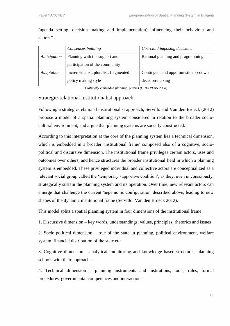
Consensus building Coercion/ imposing decisions
Anticipation
Planning with the support and
participation of the community
Rational planning and programming
Adaptation
Incrementalist, pluralist, fragmented
policy making style
Contingent and opportunistic top-down
decision-making
Culturally embedded planning systems (CULTPLAN 2008)
Strategic-relational institutionalist approach
Following a strategic-relational institutionalist approach, Servillo and Van den Broeck (2012)
propose a model of a spatial planning system considered in relation to the broader socio-
cultural environment, and argue that planning systems are socially constructed.
According to this interpretation at the core of the planning system lies a technical dimension,
which is embedded in a broader 'institutional frame' composed also of a cognitive, socio-
political and discursive dimension. The institutional frame privileges certain actors, uses and
outcomes over others, and hence structures the broader institutional field in which a planning
system is embedded. These privileged individual and collective actors are conceptualized as a
relevant social group called the ‘temporary supportive coalition’, as they, even unconsciously,
strategically sustain the planning system and its operation. Over time, new relevant actors can
emerge that challenge the current 'hegemonic configuration' described above, leading to new
shapes of the dynamic institutional frame (Servillo, Van den Broeck 2012).
This model splits a spatial planning system in four dimensions of the institutional frame:
1. Discursive dimension – key words, understandings, values, principles, rhetorics and issues
2. Socio-political dimension – role of the state in planning, political environment, welfare
system, financial distribution of the state etc.
3. Cognitive dimension – analytical, monitoring and knowledge based structures, planning
schools with their approaches
4. Technical dimension – planning instruments and institutions, tools, rules, formal
procedures, governmental competences and interactions
Pavel YANCHEV Europeanization of Spatial Planning System in Bulgaria
12
The discursive dimension (1) is represented by all understandings, values and principles that
are in the basis of all development and planning theories and practices in the given context.
Servillo (2010) gives a broader view on the discourses by naming some of them as
‘hegemonic’. That is a way to present the discursive dimension as a stage of debates between
hegemonic and counter-hegemonic values and viewpoints on the development and the
territory. The discourses of sustainability, territorial cohesion, competitiveness, subsidiarity,
etc. can be seen as ‘hegemonic’.
The socio-political dimension (2) encompasses the role of the national state of the planning
process and development, the economic and welfare model of the state, the financial system
etc. (e.g. the shift from communist one-party model of the state to capitalist free market model
in Romania and Bulgaria, with enormous implications on the planning discourses and
viewpoints).
The cognitive dimension (3) is the one that includes all analytical, monitoring and knowledge
based structures all spatial planning schools with their academic discourses towards the
spatial development and planning. Adams et al. (2011) distinguish between knowledge
resources (data, ideas, argument), knowledge arenas (arenas of action) and knowledge
channels (interface between the two above) in understanding the dynamics of this dimension.
The technical dimension (4) consists of all planning institutions, formal public and private
actors, rules and regulations. This is the part of the planning systems that have always been
the core of the policy debate (Servillo and Van Den Broeck, 2012) and were also central to
the typological studies presented before.
European Spatial Planning
European spatial planning is a concept that emerged in conjunction with the development of
the political system of the European Union. Formally, spatial planning has never been a filed
among those for which regulatory or financial instruments were adopted at the European
level, instead being a competence consciously left aside. Some member states perceived the
idea of supra-national political intrusion in the planning of their territory as a vulnerability, a
potential violation of sovereignty. However, increasingly more evidence showed that sectoral
policies emanating from the EU have a spatial component and clear implications upon the
territories of the Member states. These were in particular the sectors of environment, regional
policy, transport and agriculture (Dühr, et al., 2010). A debate emerged among scholars and
Pavel YANCHEV Europeanization of Spatial Planning System in Bulgaria
13
politicians on how far should Europe go in steering this development in the member states,
and the concept of European spatial planning was developed. Nevertheless “so far European
spatial planning has been a matter of voluntary cooperation among member states.” (Faludi,
2002)
The emergence of European spatial planning is often shown in contrast to the planning
traditions in the United States where the concept of the planning for the whole territory of the
country is lacking (Dühr, et al, 2010; Faludi, 2002). The territory of the US has been
envisioned mostly through city and regional planning – similar to the ‘town and country
planning’ practice in the UK. Thus the debate of the European spatial planning has been used
also in the US in order to raise the question of larger scale conceptualisation of spatial
development.
The debate process shaping the European position in the field of planning was marked by a
series of major events (Kunzmann, 2006):
1975 – European Commission establishes the European Regional Development Fund – an
idea of the British government that aims to help the regions that are lagging behind.
1983 – CEMAT (The Council of Ministers of Regional Development) adopts the
Torremolinos Charter where the term ‘spatial planning’ is probably used for the first time
(Kunzmann, 2006). According to the Charter ‘Regional/spatial planning seeks at one and the
same time to achieve, balanced socio-economic development of the regions, improvement of
the quality of life, responsible management of natural resources and protection of the
environment, and rational use of land’
1997 – The EU Compendium of Spatial Planning Systems report is prepared for the EU15
countries.
1999 – CEMAT publishes the European Spatial Development Perspective which is
considered to be the cornerstone document of the process, promoting a) polycentric spatial
development (polycentrism), b) a new urban-rural relationship, c) parity of access to
infrastructure and knowledge and d) wise management of the natural and cultural heritage.
A diffuse European model of spatial planning was thus emerging, as “a method of securing
convergence and coordination between various sectoral policies” (Report on Community
Policies and Spatial Planning 1999)", leading to a general "transformation of the style of
Pavel YANCHEV Europeanization of Spatial Planning System in Bulgaria
14
spatial planning, from allocating space for anticipated growth to stimulating economic
development by proactive measures" (Healey et al., 1997:290).
The process continued and, despite the lack of competency, the EU constructed an implicit
territorial agenda (Faludi, 2009), leading eventually to the current four 'pillars of European
spatial planning': (1) the institutionalization of the ESPON, (2) the mainstreaming of the
European Territorial Cooperation objective (former INTERREG IIIB/IVB programme), (3)
the process behind the adoption of the Territorial Agenda of the European Union' (DE
Presidency 2007a) and (4) the debate introduced by the publication of the 'Green Paper on
Territorial Cohesion' (CEC 2008) (Waterhout 2011).
Concluding, Giannakourou (2012) shows that European spatial planning "reflects mainly an
understanding of planning as a strategic tool for spatial integration with multi-sector and
multi-level cooperation and coordination as its core elements. This type of strategic and
coordinative planning implies fundamental departures from many national planning models,
especially those embedded in the urbanism' and land-use' traditions of planning (CEC, 1997)".
Europeanization of Spatial Planning and its Mechanisms
- The concept of Europeanization
Europeanization is quite a fashionable research topic especially in the field of political
sciences. It is a generic term used to explain the process of “domestic adaptations to the EU-
Europe” (Lenschaw, 2006). It is important to notice the broader sense of the term, including
not just the identification of top-down political influence over the member states but as well
all types of co-operation and the resulting mutual learning process. In that sense Lenschaw
(2006) makes the clear difference between Europeanization and European integration, as the
latter has the connotation of member states’ loss of identity. He argues that the mutual
learning, vertical and horizontal political co-operation between nation states can be seen as an
entire process of EU governance, rather than transfer of policies between EU levels.
“Europeanization research focuses on processes (and limits) of national
transformation. Such transformations affect shifts in capacity and responsibility, hence
issues of effectiveness and accountability; they also affect actor and power
constellations, hence issues of political voice and ultimately the legitimacy of
governance in Europe and the European states.”
Pavel YANCHEV Europeanization of Spatial Planning System in Bulgaria
15
According to Radaelli, Europeanization consists of processes of construction, diffusion, and
institutionalization of formal and informal rules, procedures, policy paradigms, styles, “ways
of doing things” and shared beliefs and norms which are first defined and consolidated in the
EU policy process and then incorporated in the logic of domestic (national and subnational)
discourse, political structures and public policies.’ (Radaelli, 2003:30).
An investigation into Europeanization is not an attempt to understand weather a nation is
Europeanizing or not, but rather seek to explore the complex dynamics - either vertical,
horizontal or circular in nature - that entwine and contribute to the modification of the
supranational and domestic spheres (Stead and Nadin 2011). In this sense Lenschow (2006)
concludes that there are three main directions of Europeanization: bottom-up (national
state→EU), top-down (EU→national state), horizontal (state→state) and roundabout
(national state→EU→national state).
Furthermore, this process of Europeanization, understood in its common sense of impact of
the EU on domestic policies and practices, is “not an end state, but rather an evolutionary
process of continuous interplay between the EU and Member States” (Waterhout, Mourato,
Böhme, 2009).
- Europeanization and Spatial Planning
Europeanization of spatial planning generally describes the process of “increasing influence
of EU policy within the member states, the support given to transnational cooperation on
spatial development, and the learning effects that are expected to come with such
cooperation” (Dühr, et al. 2010). This Europeanization process is directly connected with the
emergence of European spatial planning as a network among members states of diverse
planning systems, which cooperate and share knowledge at various scales. “The motto of the
EU ‘united in diversity’, could be applied equally to the diversity of planning systems in its
member states and the different disciplines involved in spatial planning” (Dühr, et al., 2010)
In the last decade there have been several attempts to show the impact of Europeanization on
specific domestic contexts. Among others, Tewdwr-Jones and Williams focused on the
impact on British Planning (2001), Böhme explored the 'echoes' in the Nordic countries
(2002), Giannakourou looked at the Mediterranean countries, Waterhout at the Dutch case
(2007), Peterlin and Kreitmayer McKenzie at the Slovenian case (2007), Zaucha at the Polish
one (2007) or Karel Maier at the Eastern countries with a focus on the Czech context (2012).
Pavel YANCHEV Europeanization of Spatial Planning System in Bulgaria
16
In the same time, several studies dealt with the effects of Europeanization in a comparative
manner looking at all territories involved in the process. Such were the various “territorial
impact assessments” of specific EU policies and initiatives, conducted through the ESPON
network or as part of the policy making process within the European Commission.
- Mechanisms of Europeanization
One EU level research focused on the application and effects of the ESDP in the Member
States (ESPON, 2007a). While the research does not directly refer to Europeanization, it
actually provides a good overview of the mechanims that characterize this process.
- Themes – refer to the discourses that are set in the ESDP e.g. polycentric spatial
development, new urban-rural relationship etc.
- Ways of impact – vertical, horizontal or spatial integration.
- Means – through cross-border co-operation (Interreg IIIA), transnational co-operation
(Interreg IIIB), urban governance or structural funds
- Effects – institutional changes, changes in planning policies, practices and culture,
changes in spatial representation
- Levels/Scales – European, national, regional or local
- Actors involved – European Commission, other EU institutions, national, regional or
local authorities
In close connection to such research, several attempts have been made recently to define
workable theoretical frameworks for studying the Europeanization of spatial planning
systems.
Threads
Böhme and Waterhout (2008) distinguish between three threads of Europeanization:
- Planning for Europe which includes policies for supra-national and cross-border
territorial development (ESDP, ESPON, Territorial Cooperation, Territorial Agenda of
the EU, Green Paper on Territorial Cohesion)
- The influence of planning-for-Europe policies on the planning in Europe as within the
planning systems in the member states.
Pavel YANCHEV Europeanization of Spatial Planning System in Bulgaria
17
- Influence of EU sectorial policies and European integration on planning in Europe.
Catalysts
According to Healey (2006), three driving forces can be identified in any process of change in
spatial planning: rules, resources and ideas. Böhme & Waterhout (2007) operationalized this
framework for the process of Europeanization of spatial planning in the Member states,
identifying the following catalysts of Europeanization:
- EU regulations
- EU spending policies
- EU spatial planning discourses
The EU regulations consist of all hard rules which the European Commission sets in the
directives and regulations. They have been adopted by the member states through the
domestic legal frame that regulates directly or indirectly also the spatial planning process. The
EU spending policies are connected to the funding and the way it is distributed among
priorities and projects. The discourses relate to the process related to the emerging European
spatial planning field described previously. It must be stressed however, that "whilst it is
possible to analytically distinguish between these three drivers, in reality the Europeanization
of planning will often be the result of a combination of all three of them." (Waterhout, 2007)
Ways
The ways proposed by Lenschow (2006) have been proved valid also for spatial planning
(Böhme and Waterhout 2008):
- top-down (EU→national state), relating mainly to the Europeanization thread of
influence of EU sectoral policies and European integration on national policy goals,
choices and instruments in spatial planning
- horizontal (state→state), referring to processes of cooperation and mutual learning
especially through transnational, cross-border and inter-regional territorial
cooperation, but also to "spatial positioning" (Williams 1996), which relates to the
growing awareness of domestic actors that they are part of something larger than a
member state
Pavel YANCHEV Europeanization of Spatial Planning System in Bulgaria
18
- round-about (national state→EU→national state) referring to processes through which
national positions and discourses are "uploaded" the European level, leading
eventually to a cyclical effect back on the domestic spatial planning system
Hard / Soft
Building on the other theoretical approaches, Giannakourou (2012) distinguishes other two
major mechanisms: Europeanization through soft coordination and learning and the one
through hard regulation and compliance. The first is connected more with the emergence of
the European spatial planning and the planning for Europe. It implies the process of
knowledge based horizontal communication and networking between communities. It does
not presupposes top-down pressure from the EU institutions but is more based upon Open
Method for Coordination. The hardware of Europeanization on the other hand refers to the
institutional changes, transformation of domestic regulatory frameworks in compliance with
the EU, or the creation of new institutional bodies and functions.
The Eastern European Context
Eastern European states share a common Soviet-dominated past which also had a strong
spatial planning style associated with it, marked by “totalitarian dirigisme” and classifiable as
“rational planning and programming” under the culturally defined planning styles (cf.
CULTPLAN 2008:127, Maier 2012).
As the transition to a market economy was proceeding, a set of similar characteristics
emerged, grounded in the common past:
- “The nation state is more important for people in East-Central Europe than in the
established democracies of the West.” (Maier 2012) Therefore every political decision
towards introducing and discussing supra-national political influence for spatial
planning or giving more power to regional authorities might create anxiety and
opposition.
- The development of self-reliant local governments (Altrock et al. 2006). After 1989
strong devolution was introduced, which made communities and municipalities the
‘local bases for democracy’, but with limited resources. The regions, on the contrary,
were given responsibilities but weak power. That configuration made coordinated
development hard to achieve. (Maier 2012)
Pavel YANCHEV Europeanization of Spatial Planning System in Bulgaria
19
- The issue of diversity which reflects two ways. Different local conditions and
governance which is not tolerated by the government and the result in growing spatial
and social disparities between regions , in particular “the ‘transformation winners’ in
the Western part and the ‘transformation losers’ in the Eastern part” of each New
Member state (Altrock et al 2006)
- “The privatization of the public domain has been the most significant change in the
countries of East-Central and Eastern Europe” (Maier 2012). That was a radical
transformation that started from a non-existent private sector.
- “The divestiture of the socialist production units (which also effectively ended the
dominant influence of socialist industrial policy on settlement systems)” (Altrock et al
2006).
Eastern European spatial planning has been distinguished as a distinct group from the
Western European models in the early transition period, as was the case in Newman and
Thornley’s work in 1996. Yet only some years had passed since the fall of the communist
regimes in 1989, they observed that “new planning systems in these countries do not yet exist.
The problems in creating a market in land and property, and in many countries the lack of
political stability needed to pass the necessary new legislation, have delayed the establishment
of a market-oriented planning system.” They also notice the spatial planning methods in the
Eastern countries to “involve using the previous planning approach and adapting it to new
conditions”. (Newman and Thornley, 1996)
A viewpoint from inside was also given by Maier (1998), who talked about the spatial
planning system transformations in Czech Republic. He emphasized the sharp difference
between the centralized governmental planning of the communism versus the abandonment of
planning in the post-socialist period. The analysis of the Czech spatial planning policy
transformation, while clearly contextualized, contained nevertheless certain aspects that can
be generalized to the neighbouring countries, in the context of similar spatial patterns
emerging in Eastern Europe immediately after 1989: “The challenge of basic changes from
real socialism towards a market-driven society caught Czech planners as well as most of their
colleagues in other East-Central European countries off guard. The overwhelming rejection of
any kind of planning, including urban and regional planning, was not only a result of a radical
revolutionary atmosphere but also a reaction to a lack of readiness, passivity and previous
Pavel YANCHEV Europeanization of Spatial Planning System in Bulgaria
20
conformity among planners” (Maier, 1998). But this rejection of planning was not necessarily
translated in the legal framework. On the contrary, Adams et al. (2011: 32) argue that “CEE
countries tend to be characterized by SP approaches of a more formal and regulatory nature
(…) partially in contrast with the prominence of 'softer' non-regulatory approaches in many
old Member States”.
"As the process of Europeanization was becoming increasingly consistent in the Eastern
European countries in the context of EU enlargement, there emerged also specific Eastern
patterns of adaptation to it. It has even been argued that the extent of change due to
Europeanization processes may be more profound in the new member states than in Western
Europe (Duhr et al., 2007), as the changes required in response to the acquis communitaire
prior to accession had many effects, including administrative and legal changes, new regional
institutions, new administrative boundaries and new powers (O’Dwyer, 2006), underlined by
less institutional resistance to policy change than in the old member states (Grabbe, 2001).
Furthermore, Adams et al. (2011) see “EU enlargement as a window of opportunity to
develop radical processes of change at the policy level”. However, while the influence of
Europeanization on planning systems are evident and manifold, “there are also concerns that
learning effects and cooperation results may not spread beyond the circle of spatial planners”
(Duhr et al. 2007)."
Apart from the various commonalities among the New Member states, it must be stressed
however that such generalizations are limited. These countries all have different geographical
specificities and pasts, which triggered different transition paths. Geographically, three
macro-regions can be distinguished within the Eastern European member states, in relation to
the EU and the supra-national territorial cooperation frameworks. First there are the Baltic
States, with a clearly distinguishable different position, but also a distinct recent past as part
of the Soviet Union itself. These differences were also translated in their partnership within
the Vision and Strategies Around the Baltic Sea cooperation framework. Then there are those
countries in Central-East Europe situated across the border from older Member states in
Central Europe and all part of the 2005 enlargement group. The spatial planning systems of
these countries are also all “embedded in the Hapsbug monarchy reforms of the eighteenth
and nineteenth centuries and the functionalist traditions from the inter-War period” (Finka
2011:108), with the particular case of Poland, which sits in-between the two categories from
above. Bulgaria and Romania on the other hand, formed a distinct and more distant group in
Pavel YANCHEV Europeanization of Spatial Planning System in Bulgaria
21
the enlargement process (joining the EU just in 2007), but have themselves quite different
backgrounds which will be presented in more detail in chapter 4.
Such differences have also been emphasized by specific studies, which showed for example
how Slovenia (Peterlin and McKenzie 2007) and Poland (Zaucha 2007) with the location
proximity advantage, had the favourable opportunity to develop faster their transnational co-
operation in the INTERREG programs and ESPON network. Both researches focus on the
‘spontaneous’ learning process, originating from the projects from the ‘soft’ transnational
planning.
Altrock et al. (2006) highlight as well the “highly heterogeneous situation“ in Eastern Europe,
with “ vast differences in the degree of fiscal and administrative decentralisation as well as in
geographical size“ and with re-considered “pre-soviet legacies (such as resurrected traditions
and historical (transport-connections)“.
Regarding the role of the EU in the East-Central European context, Maier concludes:
”The European spatial planning agenda has established a new layer above and/or apart from
the national planning systems, but it only started to penetrate and influence them through the
national planning policies. Instead of an adjustment in national structure of planning
instruments, the need to comply with formal requirements related to the EU structural funds
in some cases resulted in new ad hoc instruments that have been established solely for the
purpose of EU funding” (Maier 2012).
Pavel YANCHEV Europeanization of Spatial Planning System in Bulgaria
22
3. Methodology*
* co-authored with Mircea Muneanu
In building a methodology for addressing the recent dynamics of change in the spatial
planning systems in Romania and Bulgaria on the one hand, and highlighting those changes
brought about by Europeanization on the other hand, we started by framing the historical
background of spatial planning in each country. This provided relevant data on the underlying
traditions of the institutional and administrative arrangements, but also on the planning and
governance culture legacy.
The main body of the empirical research was focused on the period when Europeanization
was likely to have played a role and when significant changes in the spatial planning systems
occurred due to the transition from communist totalitarian regimes towards market economy
and democracy. The specific choice for the period resulted from the historical background
coupled with the information on the macro-regional context coming from the literature review
on the Eastern European particularities of spatial planning.
For structuring the empirical data, we chose a theoretical model of spatial planning systems
that could reveal the dynamics of implicit and explicit change, by relating to the broader
context, including formally external but highly relevant elements such as Europeanization.
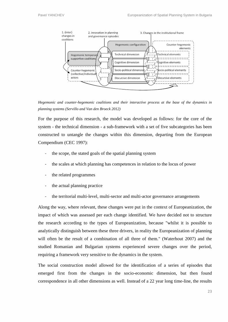
The model, developed by Servillo and Van den Broeck (2012), sees the spatial planning
system as a social construct enabled by and enabling particular actor groups and structured in
four dimensions: socio-political, technical, discursive and cognitive (explained in detail in the
Literature review chapter).
Pavel YANCHEV Europeanization of Spatial Planning System in Bulgaria
23
Hegemonic and counter-hegemonic coalitions and their interactive process at the base of the dynamics in
planning systems (Servillo and Van den Broeck 2012)
For the purpose of this research, the model was developed as follows: for the core of the
system - the technical dimension - a sub-framework with a set of five subcategories has been
constructed to untangle the changes within this dimension, departing from the European
Compendium (CEC 1997):
- the scope, the stated goals of the spatial planning system
- the scales at which planning has competences in relation to the locus of power
- the related programmes
- the actual planning practice
- the territorial multi-level, multi-sector and multi-actor governance arrangements
Along the way, where relevant, these changes were put in the context of Europeanization, the
impact of which was assessed per each change identified. We have decided not to structure
the research according to the types of Europeanization, because "whilst it is possible to
analytically distinguish between these three drivers, in reality the Europeanization of planning
will often be the result of a combination of all three of them." (Waterhout 2007) and the
studied Romanian and Bulgarian systems experienced severe changes over the period,
requiring a framework very sensitive to the dynamics in the system.
The social construction model allowed for the identification of a series of episodes that
emerged first from the changes in the socio-economic dimension, but then found
correspondence in all other dimensions as well. Instead of a 22 year long time-line, the results
Pavel YANCHEV Europeanization of Spatial Planning System in Bulgaria
24
of the empirical research were structured by these episodes, allowing for connections between
the different dimensions of the system to be made easier.
For gathering the empirical data we used 3 macro types of sources:
- academic literature addressing our spatial planning systems, but also other
Europeanization national case studies in order to verify the type of documents needed
to be analysed
- official documents
- opinions of experts or key figures from the process, expressed in journals or in direct
interviews, used to verify the official data and to collect evidence on the system in
operation and on planning and governance culture.
The selection of official documents, which formed the core of the data sources, followed 4
categories at every scale (EU, transnational-cross-border, national, regional, county
(Ro)/district (Bg) and local level). All categories refer to documents in the field of spatial
planning, but also those that should incorporate aspects of spatial planning (e.g. on
regional/economic/sustainable development):
- laws (directives or regulations in the case of the EU level; irrelevant for some levels
such as the regional one without legislative power)
- strategies, white papers, agendas
- policy and programmes documents, spending policies
- plans
Following a synthesis of the dynamics over the entire period, the interpretation of the results
was structured in two main parts: on the one hand the findings relating to the national spatial
planning system, on the other hand a comparative analysis of the Europeanization in the
Romanian and Bulgarian spatial planning systems.
The findings on the national case include a sub-chapter on the 'role of the EU' where the
changes brought about by Europeanization observed per each change and episode were
synthesised following the theoretical framework proposed by Böhme and Waterhout (2008)
following Healey (2006), structuring the drivers of Europeanization in rules (EU directives
Pavel YANCHEV Europeanization of Spatial Planning System in Bulgaria
25
and regulations), resources (EU spending policies) and discourses (European spatial planning
discourses).
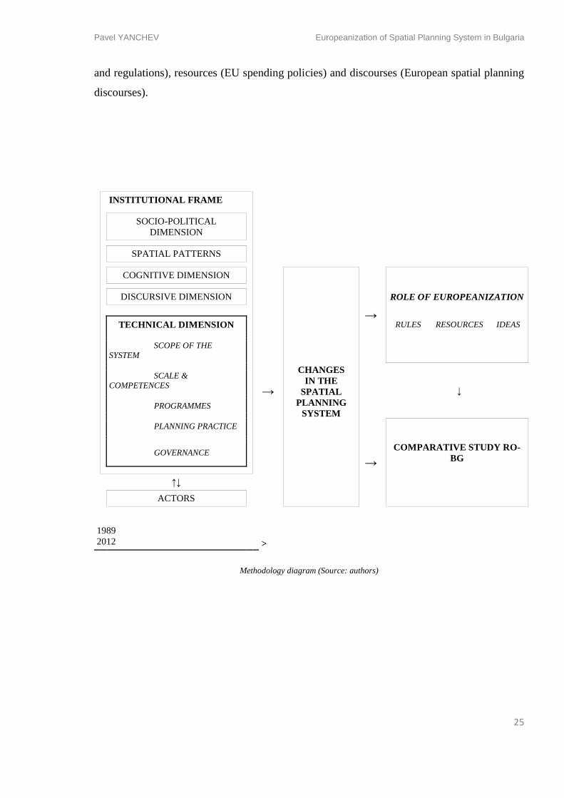
INSTITUTIONAL FRAME
SOCIO-POLITICAL
DIMENSION
SPATIAL PATTERNS
COGNITIVE DIMENSION
CHANGES
IN THE
SPATIAL
PLANNING
SYSTEM
→
DISCURSIVE DIMENSION ROLE OF EUROPEANIZATION
TECHNICAL DIMENSION
→
RULES RESOURCES IDEAS
SCOPE OF THE
SYSTEM
SCALE &
COMPETENCES
↓
PROGRAMMES
PLANNING PRACTICE
→
GOVERNANCE COMPARATIVE STUDY RO-
BG
↑↓
ACTORS
1989
2012 >
Methodology diagram (Source: authors)
Pavel YANCHEV Europeanization of Spatial Planning System in Bulgaria
26
4. Results from Empirical Research
Spatial Planning System of Bulgaria before 1989
Historical Overview
This chapter presents the spatial planning system’s development and transformation
throughout the new history of Bulgaria. “New history” is considered the period after 1878,
when the country gained partial autonomy and was no longer part of the Ottoman Empire,
until present days. In the first decades, due to the high urban migration, territorial planning
was focused mainly upon the cities and not so much on the rural lands. In the following
period 1944-1989 planning was totally reformed into totalitarian economic and spatial
planning that followed the communist ideas of centralised state development. The period
thereafter, can be viewed as a transition to democracy and a cultural shift towards the Euro-
Atlantic values. The last chapters focuses in detail on that last period 1989-2011, which is
divided into four main episodes according to the major changes in the socio-political
environment, and the levels of Europeanization that has brought changes in the spatial
planning system.
Planning the Kingdom of Bulgaria 1878-1944
The transformation of spatial planning in Bulgaria was a dynamic process that followed the
disruptions of the political discontinuity of the country’s political agenda from the end of XIX
century until now. In the years after the Liberation from the Ottoman Empire, quite a number
of territorial changes occurred under the tension of the wars in the region. Four major
moments of physical territorial change occurred and that were: San-Stefano Treaty in March
1878, Berlin Treaty in July 1878, Treaty of Neuilly-sur-Seine in 1919 and Treaty of Craiova
in 1940.
The reminiscences of the Ottoman administration and governance were abolished almost
completely. The new socio-political system accepted capitalism and tried to attract
investments and cultural influences from Western Europe. The private initiative was strongly
encouraged and that resulted in urban industrialization and economic growth.
The institutionalization of spatial planning in Bulgaria began with the formation of the
modern Bulgarian governmental structures, immediately after 1878 with the first Human
Pavel YANCHEV Europeanization of Spatial Planning System in Bulgaria
27
Settlements Public Work in the Kingdom of Bulgaria Act (1882). The act had to regulate the
development of the territories mostly within the human settlements. That was reducing spatial
planning to pure urban planning or urbanism practiced mostly by architects and landscape
architects. Planning education and practice were strongly influenced by the Austro-Hungarian
and German traditions. A new generation of Bulgarian architects received their education
abroad. They began to change completely the look of the cities. On a larger scale territorial
plans were done only for the development of the settlements’ street and green structure.
Foreign architects and town planners from Germany, Austria, Russia and France were
consulted or hired for those commissions. The urban plans were elaborated by the city
governments but they were not too rigid, marking nothing more than the position of the street
system. Yet in the 1930s the need for more comprehensive plans were realised (Hirt, 2005)
Most of the ideas of the Garden City movement and later on the Modern movement appeared
in some of the street patterns. Some of the town plans done at that period appeared to be more
sensitive towards the existing natural and street structure of the cities (e.g. Josef Schnitter’s
plan of Plovdiv, 1891). Others were extremely relentless towards any Ottoman legacy in the
city and have changed completely the city fabric (e.g. the first plan of Sofia, 1880).
The changes of the state borders, the transfer of territories and the continuous wars within the
Balkan countries brought along a vast amount of migrating population towards Bulgaria.
Meanwhile the cities began to industrialize and more and more population was employed by
that sector. Cities became even more attractive for migrants which were finding their way
from the villages to the poorer urban neighbourhoods. Those waves of migration were one of
the challenges for the spatial planning of the bigger cities, where new territories were
continuously annexed to the building limits of the towns and surrounding them villages. The
most extreme case was the city of Sofia which managed to grow in population from 20’000 to
105’000 people for the period 1879-1910 (Lampe, 1984). The elaboration of urban plans by
the city government was unable to catch up with the speed of migration. It has been simply
adding new territories to the city building limits by giving the outlines of basic street
structure. Nevertheless the city centres managed to bear modernization and development.
They changed completely the image of the previously shaped Ottoman towns where the
minarets of the mosques were the highest structures in the skyline.
Urban planning was mostly distracted from the citizen participation and actor involvement. A
striking example of that was the development of the First Sofia Master plan of Adolf
Pavel YANCHEV Europeanization of Spatial Planning System in Bulgaria
28
Muesmann made in 1938. Muesmann himself had visited Sofia six times and was reluctant in
his contacts with citizen groups, also refused to meet any local architects. The plan he
elaborated was kept in secret until it was adopted. Later the city government never managed
to implement it (Lampe, 1984; Hirt, 2005).
A change in the planning legislation was done in 1941 by adopting the The Human
Settlements Public Work Act whose role was to divide the planning instruments into sectors –
some regulated the street structure, others the land plots etc. That act brought also building
standards as a requirement. It was active until 1949. (Kovachev, 2009)
Planning the Communist Bulgaria 1944-1989
A strong shift in territorial values came in the post-war years. Bulgaria became part of the
Soviet Bloc as a satellite country of the Soviet Union together with Yugoslavia, Romania,
Poland, Czechoslovakia, Hungary and East Germany. The state adopted the single-party
communist governmental system that controls and plans the entire economy and hence the
development of the territory in its whole.
Spatial planning “proceeded within the institutional and ideological framework of a single-
party system; limited local autonomy, which implied that local governments simply
channelled down state decisions to the local level; and almost full state ownership of land,
property and means of production.” (Hirt, 2005). All private property was forcibly and in
cases violently nationalised and grouped. Territory was not any more perceived as a private
property but as a common asset that is developed only by the state government. Every spatial
development intervention beyond the single land plot was considered a governmental
planning concern. The first act that tackles this political shift was the Human Settlements
Planning Building Act (1949). This legal document was also the first that tackles the
development of the territory not only within the settlements but outside its building borders
(Kovatchev, 2009).
Spatial planning was distinctly separated but following the economic planning of the
government. The state had the famous “five-year plans” for the development of the economy
which was distributing the emergence of new economic, industrial and agricultural activity
throughout the territory of the country. The spatial planning of the regions and cities was
extremely technocratic. Plans were projected predominantly by planning professionals and
experts, the language of the plans were not understandable enough to be understood by the
Pavel YANCHEV Europeanization of Spatial Planning System in Bulgaria
29
wider public. Architects and planners have been given enormous power to shape territories
and cities according to their understandings and values. Lack of private initiative and the
totalitarian governance manner guaranteed no involvement in the planning process of citizen
groups or other actors whatsoever. The settlement planning was based on technocratic norms
of living deriving from Marxism. “Technocracy was the most defining characteristic of
communist urban planning” (Hirt, 2005). Level of settlement development was made upon a
prognosis how many people will be transferred to work in the newly projected industrial
enterprises.
The centralised state and the respective spatial development in the 1950s-1960s continued to
favour the very strong economic presence of the capital city Sofia. It had continued to be the
city with biggest growth and influx of working migration though it was strictly controlled by
the government.
A new act was issued in 1973 addressing already the whole territory of the country. Two
major planning zones were distinctly created in order to manage city growth – urban and
countryside zones. A hierarchy of spatial planning have been created in order to be able to
elaborate big scale visions and strategies for the development of the country. Meanwhile in
the 1960s and 1970s in order to analyse and plan the industrial transformation of the
settlements large planning state owned companies were founded. Those companies delivered
plans in various scales including development schemes for the territory of the whole country,
for regional, municipal and local scales. First plans and strategies for city agglomerations
have been produced. The principles of spatial planning were following strong segregation of
functions and systems – labour, habitation, leisure, public services, infrastructure and natural
environment. In charge of all development plans were only the Ministry of Territorial
Development and Public Works2. This was also one of the most reformed institutions by the
different governments. In particular moments it was also split in two Ministries – one
responsible for infrastructure and building regulation, another responsible for planning,
architecture and development. No competences or responsibilities for planning were delegated
to the lower levels – regions or municipalities.
2 The actual name and competences of that Ministry was changed 15 times for the period 1944-1989 thus this institution can
be found under different names in literature.
Pavel YANCHEV Europeanization of Spatial Planning System in Bulgaria
30
Identifying Episodes of Europeanization after 1989
Spatial Planning in Post-Communist Bulgaria after 1989
The Europeanization of spatial planning is a process that can be generally time-framed in the
post-communist period of Bulgaria after the falling of the Berlin Wall in 1989. This moment
is of political paradigm shift is also referred as “the Changes” or “the Transition”. The present
research is focusing mostly on that period by dividing it in basic socio-political episodes.
Those socio-political episodes are chosen on the basis of the general political tendencies –
political continuity, reformist political will, stages of European integration in the field of
spatial planning and territorial development. Four major episodes are distinguished:
- In Search for political identity – 1989-1997
- Reformation period – 1998-2001
- Rise of real estate mortgage loans – 2002-2007
- Being a Member state – 2008-present
After 1989 in the political regime of Bulgaria was transformed from single-party communist
state-owned economy to multi-party democratic market economy. The whole understanding
about spatial planning system has been reformed. The repressive experience of the state-
driven planning of the territory was still fresh in the collective memory. Spatial (similar to
economic) planning was totally overthrown and abandoned as limiting the entrepreneurship
and economic freedom. Less government control and more freedom for private economic
activities were proclaimed as a premise for economic growth and welfare. The land, once
totally nationalized in 1944 was fully returned in a period of 10 years. The process of land
restitution started right away with agricultural land and until 1999 all land and a significant
number of large industries were taken by private owners.
In the years 1989-1996 the political battle between the former communists and the newly
formed democrats resulted in political discontent, devaluation of the Bulgarian currency, and
great unemployment and inflation. The country has passed through one of its biggest
economic crises resulting in around 1 million Bulgarians migrating towards Western-
European and North-American countries – trend that can be observed for large number of the
Eastern European population.
Pavel YANCHEV Europeanization of Spatial Planning System in Bulgaria
31
The actors that led and steered the process Europeanization were changing gradually. At first
those were the democratic and liberal parties that emerged as opposition of the communist
regime. For long time the successors of the communist party were still trying to keep the
influence of Russia, its investments, projects and methods of planning. Still the pro-European
actors were gaining more and more positions. At some point they also could be differentiated
in two groups. Some were focusing on the values and discourses of the EU. They could be
able to argue and discuss the European values as well as to contribute to the politics on supra-
national level. Others just mentally substituted the leadership of the Soviet Union with the one
of the European Union and saw Bulgaria as an enclosed entity which has no common goals
with all European countries.
After 1997 the Bulgaria elected democratic government which was the first that was not
overthrown ahead the schedule. It had strong reformation will and introduced unpopular
moderate right-wing politics for recovery from a deep financial crisis of the post-communist
transition period. Bulgaria has issued its candidacy for the EU membership in 1998. The
decision made was crucial for the future values and geopolitical direction of the development
of the country. The territorial reform began by introducing two completely new acts that
treated the spatial planning and regional development in order to prepare Bulgaria for further
compliance with the European legal and financial frame. Bulgaria received access to pre-
accession European funding.
Due to the strong reforms after 1997 for the period 2002-2007 Bulgaria experienced strong
economic growth. The annual growth of economy was between 4,1 and 6,6%, GDP almost
doubled, the unemployment shrank from 20% to 5,6% and the direct foreign investments
raised 4,5 times3. After 2002 the accession period of Bulgaria as an EU candidate continued
with active change of the legal framework. Many acts contributed to the proper adoption of
the EU directives in the domestic context. The governments were following the previously set
pro-European direction. The period is marked with rise of real estate crediting and building
production resulting in wave of new development of settlements – in bigger cities as well as
in the mountain and sea coastal resorts. Strategic development documents were elaborated.
Still the planning was lacking the spatial plans and schemes for the settlements which had its
negative results in terms of shortage of infrastructure.
3 Data from Ministry of Finances of Bulgaria (http://www.minfin.bg/) and National Statistical Institute (www.nsi.bg)
Pavel YANCHEV Europeanization of Spatial Planning System in Bulgaria
32
The last period is connected mostly with the fact that in 2007 Bulgaria is already a EU
Member state as well as member of NATO from earlier in 2004. Bulgaria began to be more
active participator in those to absorb the European funding for domestic and international co-
operation projects. Meanwhile the world credit crisis struck Bulgaria after the end of 2008. As
in 2007 35,2% of all foreign investments were in the real estate market, the sector was one of
the most affected by the crisis. The austerity measures were and still are the major solution for
the government to invert the trend of the slowing economy.
The following chapters connect the four episodes and examine make a more detailed
overview of some major events and aspects of Europeanization of the spatial planning system
in Bulgaria. Each episode presents a short introduction of more detailed socio-political and
economical dimension; description of the basic spatial development patterns; technical
dimension; cognitive dimension; discursive dimension. Most extended is the technical
dimension – most of the reforms and changes in the spatial planning system are generalized
and listed.
Episode 1 – In Search for Political Identity 1989 – 1999
- Socio-political dimension
A new political turn, land reform and devolution
The period of political change in Bulgaria happened quite peacefully and was not supported
by casualties. Two main reasons behind the unrest against the communist regime can be
identified. First was the fight against human rights violation – between 1970s and 1989 the
Bulgarian Communist Party (BKP) had performed mass forced change of names among the
Muslim minority in the south of the country. The second was the environment – the wave of
environmentalism had appeared as a care for the nature destroyed by the state-owned
industrial enterprises. Those two facts were creating unrests and were perceived by anti-
communists as arguments, powerful enough, to rally the people against the totalitarian
government.
The actual change of the power happened within the government and the Communist Party
after the falling of the Berlin Wall on November 9th
1989. Shortly the first secretary Todor
Zhivkov resigned after 33 years of control. In the following months a multi-party government
system was introduced and the Communist party was deprived from its total power. The
Pavel YANCHEV Europeanization of Spatial Planning System in Bulgaria
33
country was flooded with street protests which supported either the ex-communist or the new
forming democratic organization. A Round table decided the future of the new Constitution
and the first democratic elections were held.
Bulgaria makes its first diplomatic contact with the EU in August, 1988. Due to the political
situation, the first trade agreements between Bulgaria and the EU are done after the changes
in May 1990. Soon after in September 1990, Bulgaria enters the PHARE program for
gratuitous financial aid for political reform and preparation for EU membership.
- Spatial Patterns
Meanwhile in the spatial and territorial policies major changes occur. The land which was
previously nationalized after 1944 was a subject of restitution – returned back to their
previous owners. People received the freedom to invest in and develop their land. The process
started with the agricultural land, which during communist regime, was grouped in collective
farms. The land was given back in their real borders or compensated with the same quantity
and quality of lands. Around 700’000 housing units in social housing blocks built by the state
between 1958 and 1989 was privatised in the favour of the present owners. Land restitution
and privatization might be assumed as one of the most significant spatial transformations, not
only in Bulgaria, but equally in the whole former Soviet bloc.
A strong reform towards devolution of administrative power was introduced by the approval
of the Local Self-Government and Local Administration Act in 1991. By the power of that
document the local level of the administration, the municipalities and settlements, received
exclusive rights to manage and develop their territory. Bulgaria was divided in 264
municipalities that could elect their local mayor and council and respectively to approve
spatial and strategic plans. Municipalities were gathered in 9 districts which did not have
elected government but it was assigned from the government and had mostly control
functions.
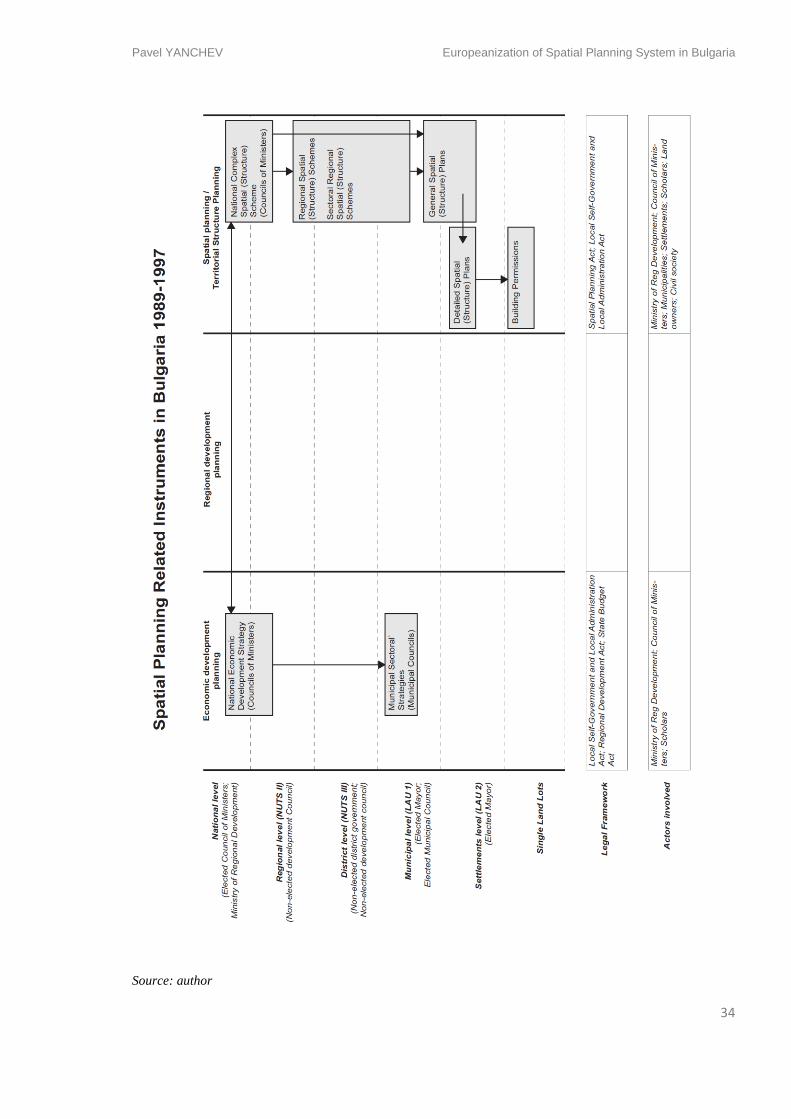
Pavel YANCHEV Europeanization of Spatial Planning System in Bulgaria
34
Source: author
Pavel YANCHEV Europeanization of Spatial Planning System in Bulgaria
35
- Technical dimension
Spatial planning system – reforms and reminiscence of the totalitarian state
Looking at the larger picture of spatial reform – spatial planning institutes that used to
produce all types of land-use plans were dismantled. Almost the entire production of land-use
plans was redirected towards the private sector – newly emerging private architectural (thus
spatial planning) companies made by people from the liquidated state project companies. The
exception was Sofia where the municipal planning company Sofproekt became entirely part
of the Municipal Urban Planning and Development Department. Other planning company –
the National Centre for Territorial Development – became part of the Ministry of Regional
Development and Public Works but was left without subsidy, to fully depend on the market
dynamics and compete for public procurements and tenders.
The main act which regulated the spatial planning process was the Territorial and Settlement
Planning Act (1973) which was cosmetically modified in order to regulate the building
permission process in the market environment. Even though the act had been substituted later
in 1998, the planning instruments by their nature remained the same as those in Communist
Bulgaria. Generally they were grouped in two main categories – spatial schemes and spatial
plans. Schemes were referring to larger scale – national, regional (district), and plans were
referring to municipalities, settlements, neighbourhoods. Plans were also divided in general
plans and detailed plans. All those documents have a hierarchical order. Similar to the
principles of the communist planning, the National Spatial Scheme was subordinated to the
National Economic Development Plan. All other spatial documents were subordinated to the
National Spatial Scheme. (Figure)
Following the totalitarian principles, those land-use plans were not able to communicate a
planning concept and become a stage for debate and agreement. Therefore they were
perceived by society and the emerging business more as restrictive technocratic documents
that slow down the freedom of land development, as merely useless governmental regulation
and repression. Spatial planning became just a bureaucratic means of issuing building permits
and architects making them were reduce to legal building advisors and land distributors. The
spatial planning remained too rigid and inadequate to react to the investment activities. Plans
were presenting a fixed state of the settlement being completely distracted the dynamics of
market forces and the budget frames.
Pavel YANCHEV Europeanization of Spatial Planning System in Bulgaria
36
Introducing the Environment Impact Assessment (EIA) and the Environment
Preservation Act
In the period 1989-1997 the main EU influences in the field of spatial planning policies
occurred in the environmental sector. As mentioned earlier the environment and its
preservation became a significant concern after the long period of planned creation of
industrial entities throughout the country’s territory. Until that moment the act which was
regulating the environment protection was the Nature Preservation Act from 1967. That Act
was in effect a mere recommendation character rather than an obligation to recognize and deal
with the problem of pollution and the dangers to the biodiversity in the country. From the
language of the act, one could not conclude, what is really under prohibition and even what
was exactly considered pollution.
After the Changes act that tackled the environment and its planning and protection the
Environment Preservation Act was approved in October, 1991. It has a basic character and
shapes the framework of the preservation of the environment by implementing the
Environment Impact Assessment (EIA) instrument. The act has followed the EU directive
85/337/ЕЕС for assessment of environmental effects.
One may consider EIA as one of the first implementation of EU legislation directly affecting
the spatial planning. EIA had to be developed for every spatial plan. The EIA basic principle
was to create multidisciplinary assessment of the plans by 30-40 different professionals. Also
EIA should have become a stage for public discussion of the plans – such was traditionally
foreseen in the Territorial and Settlement Planning Act from 1973, but no authority was
bound to follow the recommendations of the public. Professionals, qualified to elaborate EIA
for spatial plans, were inscribed in a register updated by the Ministry of Environment and
Waters (MEW).
- Cognitive dimension
The epistemic community that led the process of spatial planning were mostly the architects.
It was inherited form the communist regime that all spatial plans were done especially by
architects who have received their Master degree with town planning specialisation.
Architects and planners were educated only in the University of Architecture, Civil
engineering and Geodesy (UACEG) in the capital city Sofia. Most of the planning knowledge
before 1989 was condensed in the UACEG and in the big architecture and planning
Pavel YANCHEV Europeanization of Spatial Planning System in Bulgaria
37
companies. The dismantling of the state-owned companies and the following individualistic
behaviour disrupted strongly the planning community network. Great deal of experience from
the planning groups might be assumed could not be easily shared and transferred otherwise
than through architectural education. Besides that the first INTERREG cross-border co-
operation has joined forces of the border regions of Bulgaria and Greece in 1994.
- Discursive dimension
One of the hardest challenges of the spatial planning immediately after the Changes is to
escape the anonymity of technocracy and to find its new role in the free market economy.
And the liberal free market approach was standing pretty much against planning. Moreover
the planning itself has turned into a term with bad connotation, emanating ‘planning of
economy’, hence communism.
Nevertheless the need of urban planning in the state of totally liberalized market was clearly
realized by architecture and planning communities. Some began to express the necessity for
new urban plans especially in Sofia where the first signs of traffic congestion and
indiscriminate building patterns have emerged. Naturally civil calls for planning were heard
by the successors of the communist party which announced themselves pro-planning. Thus
planning as such hardly found supporters outside the planning community.
Important input of new spatial planning discourses comes from the presence of Bulgaria at the
CEMAT meetings. Those influences, however, affected only few professionals as the
language problem was still a barrier for absorbing knowledge and concepts from abroad. Also
influences were coming from Rio (1992), resulting in emerging environmental awareness.
- Conclusion
In conclusion one may assume that the period 1989-1997 was characterized with devolution
of power to the local municipal level. The private initiative was untied by starting the land
reform. The slow reaction of the planning instruments resulted in non-planning. The traditions
in spatial planning from the communism were partially abandonment and kept just as a
fictitious instrument without really reforming the planning system in depth. The major effect
of Europeanization is in the assessment of the environmental aspect and involving different
disciplines and the public in the spatial planning discussion through the EIA instrument. In a
later moment after 2004 the experience gained in EIA was used for the implementation of
Pavel YANCHEV Europeanization of Spatial Planning System in Bulgaria
38
Strategic Environment Assessment (SEA) in projecting the regional development plans. First
influences from outside
Episode 2 – Reformation period – 1998-2001
- Socio-political dimension
The year 1997 was marked by protests sparked by the severity of the economic and bank
crisis. After a period of stagnation and lack of reforms, in January 1997 the monthly inflation
reached 242%4. After massive national discontent Bulgaria elected the first government that
was not overthrown and managed to keep the political and economic stability of the state. It
had almost totally reformed some of the governmental systems – financial, banking, spatial
planning etc. Thereafter some of the biggest state owned enterprises and industrial grounds
were privatized. The country was stabilized. The candidacy of Bulgaria to become a Member
state of the EU has been accepted and negotiations between the two parties started in March,
1998.
- Spatial Patterns
As mentioned one of the partially reformed sectors was spatial planning. The Territorial and
Settlement Planning Act (1973) was cancelled and a new Spatial Planning Act (2001) was
elaborated and approved. A process of regionalization began by approving the Regional
Development Act (1999) which introduced a whole new set of planning and strategic
documents which followed the recommendations from the EU for planning and the adoption
of European funds.
The reformed financial sector allowed gradual increase in real estate development. The
patterns of the post-socialist cities development – indiscriminate, often illegal, building,
individualist approach towards property, weak or almost none public contribution in
infrastructure and public space – had strengthen their presence in the urban fabric. Certain
protected areas have been invaded by ad hoc investment projects.
4 Data from National Statistical Institute, Bulgaria; www.nsi.bg
Pavel YANCHEV Europeanization of Spatial Planning System in Bulgaria
39
- Technical dimension
A New Spatial Planning Act
The most important change in the spatial planning system was the cancellation of the
Territorial and Settlement Planning Act (1973) and the adoption of the new Spatial Planning
Act (though it was not influenced by the EU regulations and programs). This document and
the attached decrees tried to propose a new framework for negotiation between spatial
planning and the private land owners. There is quite a fundamental shift in the understanding
about the territory of the country. The previous act from 1973 was mostly focused on the
difference between two types of territory – urban and rural. Therefore the regimes of
development of those types of territories were different and it was supposed to be regulated
with the respective plans – urban (settlements) plans and rural (outside settlements) plans.
Those plans were embedded in a larger set of hierarchically structured spatial schemes and
plans that could exclude the possibility of unregulated development outside building limits.
With the new Spatial Planning Act (2001) the philosophy of managing the territory has
shifted – all territories received the same regime and possibilities for development. The
opportunities and restrictions of each plot were to be regulated by the General or Detailed
spatial plans which fixed the status and the functions that can be performed upon it. That
practically transferred all the land-use power in the plan itself and gave all land-use plans the
status of a law.
However no fundamental shift came for the methods of planning and developing spatial plans.
The plans kept unchanged their rigidity and technocracy towards private or public
interventions. The set of plans, their principles of content, structure and the way they are
elaborated were still timeless and non-negotiable. By that shift of territorial understanding
were stopped the speculations with land, done by including de jure land plots in the building
limits of the settlements. Nevertheless it resulted in different practice of introducing
individual changes of the land-use of the plots in the approved plan. Later, the history
revealed that in the times of the rise of mortgage loans, the Spatial Planning Act is the act
with most amendments, done by the Parliament (52 amendments until May 2012)
Actually the new Spatial Planning Act did not reform the planning documents and their
hierarchy. Nevertheless it gave them bigger importance, the responsibilities and time frames
for elaboration and renewal of spatial schemes and plans were not strictly defined. That
Pavel YANCHEV Europeanization of Spatial Planning System in Bulgaria
40
resulted in postponement of the National Spatial Scheme and many of the other spatial plans
until present days. Around 70 % of the municipalities followed the example of the Ministry
and did not produce General Spatial Plans because of low expert capacity and weak political
will. Many local governments are justifying this fact by declaring that the upper level spatial
plans in the hierarchy (national, regional, district) are missing so they lack guidelines for the
municipal level spatial priorities (Boesten, 2012).
Origins of Regionalization in Planning – approving the Regional Development
Act
The application of Bulgaria to become a Member state of the EU was followed by imminent
reform of the regional administrative structure and its role in spatial planning. We might
consider regionalization as one of the influences of the EU politics over the spatial planning
system in Bulgaria with strongest implications. Regionalization in Bulgaria was not
experienced so much in the shift of the territorial level of electoral power as it was in finding
new instruments for successful territorial governance, rather than in creating a parallel to the
existing planning level. Through the approval of the Regional Development Act there a
completely new set of strategic development documents were implemented. The strategic
planning has been seen as the better way of achieving the public investment in spatial
development than the existing inflexible land-use plans. In this case, most of the planning
documents (which were produced much later after 2004) were lacking the spatial component.
They had no legal relation with any of the already existing spatial planning documents,
regulated by the Spatial Planning Act. Nevertheless the new strategic development documents
had clear spatial effect upon the different territorial units.
In principle the Regional Development Act from 19995 aims at:
- creation of preconditions for sustainable and balanced development in the particular
regions of the country;
- decreasing of the interregional disparities in employment and income;
- carrying out the interregional and cross-border co-operation and European integration.
5 The Regional Development Act was remade and reintroduced once in 2004 and once more in 2008.
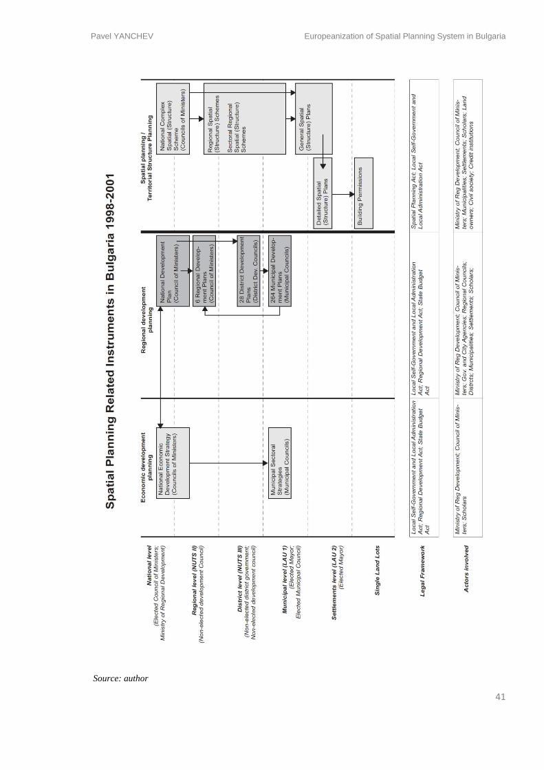
Pavel YANCHEV Europeanization of Spatial Planning System in Bulgaria
41
Source: author
Pavel YANCHEV Europeanization of Spatial Planning System in Bulgaria
42
Bulgaria accepted the system of NUTS (Nomenclature of Territorial Units for Statistics) and
according to their characteristics implemented planning instruments on all levels – NUTS I (2
regions); NUTS II (6 regions); NUTS III (28 districts) and LAU 1 (264 municipalities). In
order be able to get access to the European funds Bulgaria should have elaborated strategic
planning documents for all of these territorial units that formulate the regional and local
priorities. The strategic environmental impact of all those priorities also had to be assessed by
the Strategic Environment Assessment (SEA) instrument.
From the newly introduced planning levels, only the local (municipalities) has actually
government that is elected by the residents of that territorial unit. The 28 districts have
governors appointed by the Council of Ministers. All other higher territorial units have
Development Councils consisting of the district governors and municipal mayors.
In this still fully unreformed planning system, regional planning and its instruments found its
place almost displacing the current spatial plans, especially the upper level spatial schemes. In
the first years after the adoption of Regional Development Act none of the requested
strategies were produced. The actual fulfilment and elaboration of those planning documents
began after 2004. The reason was that after the introduction of set of completely new planning
documents, their purpose was not clearly assigned and explained by the requesting authority –
in that case MRDPW. Also they were not clearly linked with financial resources. The
Regional Development Act from 1999 did not considered the financial aid from the EU funds.
It neither created connections between the different sectors (financial, environmental,
transport and local institutions) that had to co-operate in a quite complex process of setting
priorities, planning and approving projects and financing and implementing them.
In the planning system some new levels of consideration of priorities have emerged. Strategic
regional planning documents have emerged on all governance levels. Nevertheless many of
them were not ‘dressed’ in electoral power, but mostly followed a regionalization model of
planning taken from the EU. The partially reformed spatial planning documents did not bear
any practical change but were given more importance for the process of physical development
of land and the building management.
- Cognitive dimension
After the acceptance of Bulgaria as a EU applicant, the parliament ratified the participation in
co-financing programs ISPA, SAPARD and PHARE. Territorial co-operation was introduced
Pavel YANCHEV Europeanization of Spatial Planning System in Bulgaria
43
and the INTERREG programs began activity. Co-operations are created with Romania
(1999), Serbia and Montenegro, Turkey and Macedonia (2003).
Until the 2004 the main actors participating in the INTERREG IIIB and INTERREG IIIC
were the Bulgarian Academy of Sciences, UACEG, Technical University, Sofia Muncipality,
the National Association of Municipalities in Bulgaria. Sole projects were done also by
smaller cities and municipalities but still by administrations with more significant expert
potential. Projects developed are
However either because of the distance and no direct border from the EU15, or because of
lack of momentum, the INTERREG programs did not gain lots of popularity in Bulgaria.
Projects were started but the effect on the process of sharing knowledge was not as rapid as in
the countries like Czech Republic., Poland and Slovenia.
In July 1999 the Local Agenda 21 UN program has been adopted and it resulted in financing
and supporting 30 projects all over the country. However the most funded fields has been
government (56%), infrastructure (17%) and industry (15%) and the rest supported healthcare
and social development.
Another attempt to introduce new methods of governance was made in 2000-2003. The World
Bank UN Habitat and Cities Alliance financed a Sofia City Development Strategy. The
strategy tried to organize as many stakeholders – citizen groups, NGOs, scholars and business
– in order to formulate priorities and goals. The process went through summits and workshops
for nearly two years. The strategy was fully integrated with the existing planning documents.
Such process of strategic integrated planning was not achieved thereafter in such scale.
- Discursive dimension
The implemented regional policy has followed the discourses presented in the Torremolinos
Charter (CoE, 1983). The Charter was proclaiming the region as the best planning scale in
order to achieve balanced development, improved quality of life, responsible management of
resources and environment as well as rational land-use all over EU Member states.
Between 1998 and 2001 the Protected Areas Act, Water Act, the Clean Air Act and the
Energy Efficiency Act are introduced for the first time. This might be perceived just as a piece
of legislature, but as well as shift in the strengthening of the environmental and sustainability
concerns in the spatial planning field. The decision for those acts comes as an aftermath of the
Pavel YANCHEV Europeanization of Spatial Planning System in Bulgaria
44
adoption of the Local Agenda 21 and co-operation between UN and the Ministry of
Environment and Waters of Bulgaria.
Curious fact from the post-socialist history is the ideological gaze at the totalitarian
monuments and buildings which symbolized the communist regime – some of them in the
urban cores, some among significant natural landmarks. More radical movements called for
destruction for some of them in the previous period when a Soviet Army monument was
approved to be dismantled (1993). Yet the Sofia Council decision was never accomplished.
The newly elected government was revanchist towards some of the urban artefacts and this
resulted in a dynamite destruction of the Mausoleum of the communist leader Georgi
Dimitrov in the centre of Sofia. The discussion about the communist build legacy is still on-
going.
Episode 3 – Rise of Real Estate Mortgage Loans – 2002-2007
- Socio-political dimension
The reformation of the financial system increased the confidence in the investment climate
and paved the road for private domestic and foreign investments in real estate. This create
enourmous momentum in real estate development. In the years after 2001 a new government
was elected. In the first years it was passive in continuing the reforms in the spatial planning
and developing strategies (Marinov, 2006). The European integration became a priority, a
spetial Ministry in the Council of Ministers was created in order to guide the institutional and
legistative transformation towards the acceptance in 2007.
- Spatial Patterns: Rise in Real Estate Investments
Meanwhile, as mentioned before, the newly created regional planning instruments, requested
from the EU, did not have much in common with the actual spatial plans. And the latter
gained much importance with the rise of direct foreign investment in real estate, the rise of
mortgage loans and respectively the rise of the construction after 2002. Similarly to how this
same process went in countries like Spain, the extensive investment in real estate was focused
into larger cities and regional centres, in the sea coast towns and resorts and in the mountain
ski resorts. The positive effect was increasing of tourism and employment. However, for
many of those settlements that experienced fast enlargement, new General Spatial Plans were
not prepared at all (Nesebar, Slanchev bryag). For others, the plans were delayed with
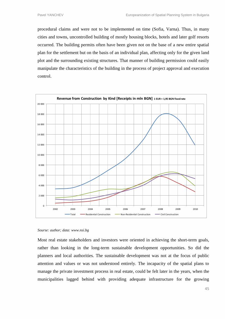
Pavel YANCHEV Europeanization of Spatial Planning System in Bulgaria
45
procedural claims and were not to be implemented on time (Sofia, Varna). Thus, in many
cities and towns, uncontrolled building of mostly housing blocks, hotels and later golf resorts
occurred. The building permits often have been given not on the base of a new entire spatial
plan for the settlement but on the basis of an individual plan, affecting only for the given land
plot and the surrounding existing structures. That manner of building permission could easily
manipulate the characteristics of the building in the process of project approval and execution
control.
Sourse: author; data: www.nsi.bg
Most real estate stakeholders and investors were oriented in achieving the short-term goals,
rather than looking in the long-term sustainable development opportunities. So did the
planners and local authorities. The sustainable development was not at the focus of public
attention and values or was not understood entirely. The incapacity of the spatial plans to
manage the private investment process in real estate, could be felt later in the years, when the
municipalities lagged behind with providing adequate infrastructure for the growing
0
2 000
4 000
6 000
8 000
10 000
12 000
14 000
16 000
18 000
20 000
2002 2003 2004 2005 2006 2007 2008 2009 2010
Revenue from Construction by Kind [Receipts in mln BGN] 1 EUR = 1,95 BGN fixed rate
Total Residential Construction Non-Residential Construction Civil Construction
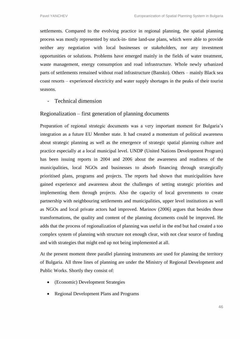
Pavel YANCHEV Europeanization of Spatial Planning System in Bulgaria
46
settlements. Compared to the evolving practice in regional planning, the spatial planning
process was mostly represented by stuck-in- time land-use plans, which were able to provide
neither any negotiation with local businesses or stakeholders, nor any investment
opportunities or solutions. Problems have emerged mainly in the fields of water treatment,
waste management, energy consumption and road infrastructure. Whole newly urbanized
parts of settlements remained without road infrastructure (Bansko). Others – mainly Black sea
coast resorts – experienced electricity and water supply shortages in the peaks of their tourist
seasons.
- Technical dimension
Regionalization – first generation of planning documents
Preparation of regional strategic documents was a very important moment for Bulgaria’s
integration as a future EU Member state. It had created a momentum of political awareness
about strategic planning as well as the emergence of strategic spatial planning culture and
practice especially at a local municipal level. UNDP (United Nations Development Program)
has been issuing reports in 2004 and 2006 about the awareness and readiness of the
municipalities, local NGOs and businesses to absorb financing through strategically
prioritised plans, programs and projects. The reports had shown that municipalities have
gained experience and awareness about the challenges of setting strategic priorities and
implementing them through projects. Also the capacity of local governments to create
partnership with neighbouring settlements and municipalities, upper level institutions as well
as NGOs and local private actors had improved. Marinov (2006) argues that besides those
transformations, the quality and content of the planning documents could be improved. He
adds that the process of regionalization of planning was useful in the end but had created a too
complex system of planning with structure not enough clear, with not clear source of funding
and with strategies that might end up not being implemented at all.
At the present moment three parallel planning instruments are used for planning the territory
of Bulgaria. All three lines of planning are under the Ministry of Regional Development and
Public Works. Shortly they consist of:
(Economic) Development Strategies
Regional Development Plans and Programs
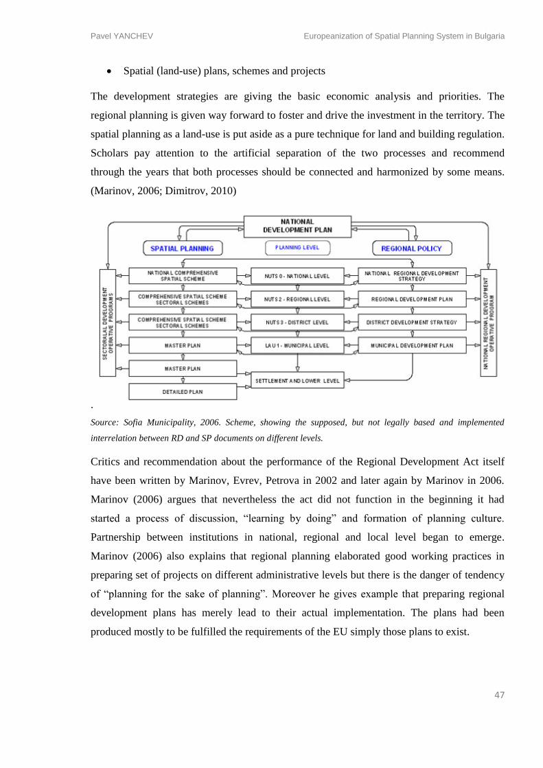
Pavel YANCHEV Europeanization of Spatial Planning System in Bulgaria
47
Spatial (land-use) plans, schemes and projects
The development strategies are giving the basic economic analysis and priorities. The
regional planning is given way forward to foster and drive the investment in the territory. The
spatial planning as a land-use is put aside as a pure technique for land and building regulation.
Scholars pay attention to the artificial separation of the two processes and recommend
through the years that both processes should be connected and harmonized by some means.
(Marinov, 2006; Dimitrov, 2010)
.
Source: Sofia Municipality, 2006. Scheme, showing the supposed, but not legally based and implemented
interrelation between RD and SP documents on different levels.
Critics and recommendation about the performance of the Regional Development Act itself
have been written by Marinov, Evrev, Petrova in 2002 and later again by Marinov in 2006.
Marinov (2006) argues that nevertheless the act did not function in the beginning it had
started a process of discussion, “learning by doing” and formation of planning culture.
Partnership between institutions in national, regional and local level began to emerge.
Marinov (2006) also explains that regional planning elaborated good working practices in
preparing set of projects on different administrative levels but there is the danger of tendency
of “planning for the sake of planning”. Moreover he gives example that preparing regional
development plans has merely lead to their actual implementation. The plans had been
produced mostly to be fulfilled the requirements of the EU simply those plans to exist.
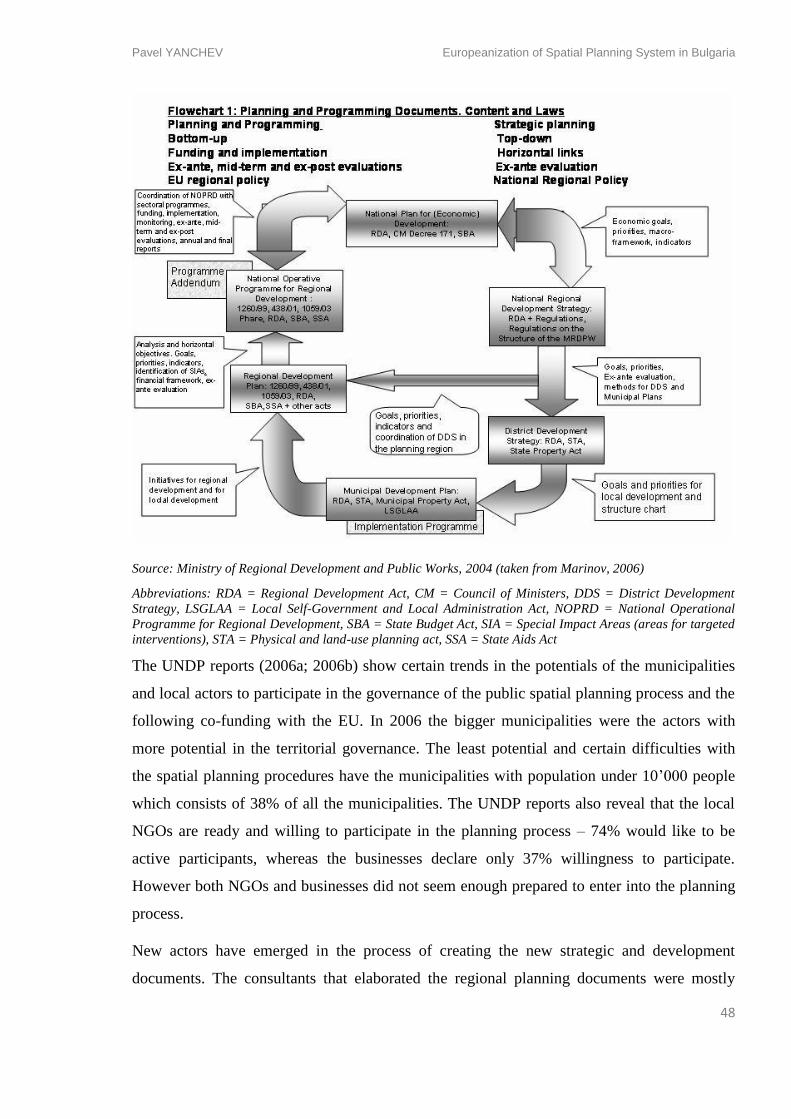
Pavel YANCHEV Europeanization of Spatial Planning System in Bulgaria
48
Source: Ministry of Regional Development and Public Works, 2004 (taken from Marinov, 2006)
Abbreviations: RDA = Regional Development Act, CM = Council of Ministers, DDS = District Development
Strategy, LSGLAA = Local Self-Government and Local Administration Act, NOPRD = National Operational
Programme for Regional Development, SBA = State Budget Act, SIA = Special Impact Areas (areas for targeted
interventions), STA = Physical and land-use planning act, SSA = State Aids Act
The UNDP reports (2006a; 2006b) show certain trends in the potentials of the municipalities
and local actors to participate in the governance of the public spatial planning process and the
following co-funding with the EU. In 2006 the bigger municipalities were the actors with
more potential in the territorial governance. The least potential and certain difficulties with
the spatial planning procedures have the municipalities with population under 10’000 people
which consists of 38% of all the municipalities. The UNDP reports also reveal that the local
NGOs are ready and willing to participate in the planning process – 74% would like to be
active participants, whereas the businesses declare only 37% willingness to participate.
However both NGOs and businesses did not seem enough prepared to enter into the planning
process.
New actors have emerged in the process of creating the new strategic and development
documents. The consultants that elaborated the regional planning documents were mostly
Pavel YANCHEV Europeanization of Spatial Planning System in Bulgaria
49
private subcontractors. The low financial and expert capacities in the municipalities have led
to the gradual withdrawal of professionals from the public administration in order to be
commissioned as a private strategic and development consultants. The practice often
criticized by professional is the lack certification required for the private actors to produced
development plans. Hence the evaluation of those plans’ efficiency was not enough clear and
straightforward positive. At some particular municipalities those facts have also contributed
for the superficiality of the planning process and the poor quality of the plans submitted and
approved.
Domestic legislation alignment – the case the Public Procurements Act
The period 2002-2007 was marked by a lot of changes in the legal framework of the country
under the tension of the EU requirements of aligning the legislation of Bulgaria with the one
of the EU. Changes have been done in quite a number of acts, each one with bigger or smaller
spatial impact. Some pieces of legislature with spatial dimension influenced directly from the
EU were introduced for first time. Such are Energy Efficiency Act (1999 and 2005),
Biodiversity Act (2002, following NATURA 2000 protected areas network), Waste
Management Act (2003), Chambers of Architects and Engineers Act (2003), Public
Procurements Act (2004). All those legal documents more or less have introduced new rules
and restrictions in the territorial governance process. A lot of them had given an answer to an
already growing concern in the domestic context that was waiting for its political and legal
action.
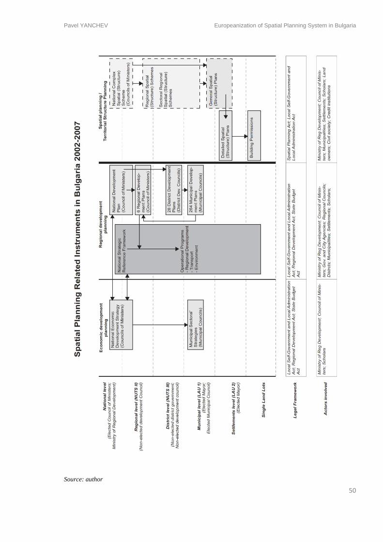
Pavel YANCHEV Europeanization of Spatial Planning System in Bulgaria
50
Source: author
Pavel YANCHEV Europeanization of Spatial Planning System in Bulgaria
51
One of them is the Public Procurements Act – a major improvement caused by the
implementation of a European practice through a directive 2004/18/EC. Public Procurement
Act has lot of non-spatial aspects; nevertheless the one aspect mainly related to spatial
planning is the possibility to regulate urban planning and architectural competitions. They
could potentially become more transparent and easily accessible for more professionals, hence
the results – open for the wider public and media. The act could provide opportunities for
debates and involvement of actors to enter the spatial planning process. As the first
architectural and planning competitions have been organized, it turned out that all other
procurements and planning activities cannot be assessed with the same criteria – lowest price
and shortest time for fulfilment. Those mismatches and misreading of the basic principles of
the act have brought a number of competitions that have been won by projects with contested
and arguable qualities, but accepted because of the lowest price and shortest project duration.
A decree was attached to the act later on (2009). It particularly recognized urban planning and
architectural competitions as a method of increasing the quality of the planning tools. Still the
act and the decree remained neither with obligatory, nor with encouraging character, for the
public institutions and entrepreneurs to take the initiative and organize competitions. Most of
the public spatial projects remain distributed and planned through in-close decision methods
by loopholes in the procedure. Projects, financed with a European funding, have similar
outcome with the explanation that for such financial instruments one could apply only with an
already prepared project. Some public institutions find their way out of the situation by
making the public projects through public procurements for “engineering service” which
meant that the architect or the urban planner would be subcontracted by the building
company.
In 2003 the Chamber of Architects has been legitimized by the relative act. The professional
body certifies the professional qualification, at first, of architects, and later of landscape
architects and urban planners. The merging of the three professions under the already
authoritative wing of the architecture might be one of the reasons why the other two are still
lacking acceptance among society and state administration.
- Cognitive dimension: Planning Education in Bulgaria
Until 2002, urban and spatial planning process was lead mainly by architects. This practice
remains as a legacy of the socialist planning approach that treats the architect as a leader of a
top-down territorial management. In 2002, a broader spatial planning bachelor and master
Pavel YANCHEV Europeanization of Spatial Planning System in Bulgaria
52
education was introduced, in order to satisfy the administrative need for planners. The
program was founded in the Urbanism Department in the University of Architecture, Civil
Engineering and Geodesy in Sofia and currently is training 25 urban planners every year. The
educational program had been prepared in collaboration with the planning departments of
Trinity College in Dublin and Heriot-Watt University in Edinburgh. In 2002 the recognition
of the Erasmus program had an effect and the first exchanges of students with European
planning universities occurred. In 2009, the Urbanism Department was accepted as full
member of the AESOP network of planning schools. This reform in architectural and
planning education was aiming to train more spatial planning professionals, with an emphasis
on sociological and institutional knowledge as well as interdisciplinary research approach.
The professionals should be equally acquainted with European trends in spatial planning as
well as the local planning traditions (Dimitrova pers. comm.).
In 2005, a Regional Development and Policy bachelor program had been introduced in the
Geography and Geology Department of Sofia University. The program is introduced as a
direct response to the political turn towards the EU discourse of regionalization of spatial
planning. The emphasis is on the political, social and geographical dimensions of planning
and territory. The education is less project-oriented than the Urban Planning in UACEG but
both programs try to tackle planning on all national scales. The European scale is presented
mostly as knowledge about the European realities and planning systems. GIS education is
introduced in both programs. However the GIS education in Sofia University ends up as being
more extensive and having success in training GIS professionals.
Since 2008 the Philosophical faculty of Sofia University began a Master program in Urban
Studies with more focus on project and cultural management, anthropology and sociology.
The program is open to all kinds of professionals and is aiming at creating a multi-
professional debate over contemporary problems in cities.
- Discursive dimension
In this period could be noticed much stronger influence and permeation of EU discourses.
However this happens mostly on the national level through the adoption of the first set of RD
plans and programs – National Development Plan, National Strategic Reference Framework.
The turn towards strategic planning and territorial governance can be noticed in the planning
documents. The concepts of polycentrism, competitiveness and territorial cohesion have been
Pavel YANCHEV Europeanization of Spatial Planning System in Bulgaria
53
used in the higher level documents. However the prioritizing of projects still shows that
Bulgaria develops two major points of centrality – Sofia and the Black Sea Coast.
- Conclusion
One could assume as the Europeanization process in Bulgaria in an early age led to quite a
transformation of the spatial planning system. The process opened up a lot of opportunities
for financing of wide range of spatial planning activities and instruments, education and
learning processes. Meanwhile it also restricted the development of the territory especially
with the means of sustainability, environment preservation, renewable energy and energy
efficiency. Some of the mechanically adopted policies though needed more time for
understanding and fitting in the already existing spatial planning system. Two independent set
of planning instruments in the spatial planning system were finally shaped – the regional and
the spatial. The regional ended up steering the public investments while the spatial regulated
the private. Besides the critics this segregation of functions receives from scholars and
professionals, the government has shown no signs so far that the two planning practices might
be bound together.
Episode 4 – Being a Member state – 2008-present
- Socio-political dimension
Becoming a Member state, hit by crisis
After being accepted as a member state in 2007, the momentum of the massive real estate
investments was still continuing for quite a long time. The socialist government at the same
time, did not recognize at all the signs of an upcoming crises, even long time after the first
strong reminders like the bankruptcy of Lehman Brothers in September, 2008. Indeed, some
political figures spread the belief that the Bulgarian economy was immune to the turmoil in
the global financial markets. The crisis was felt in Eastern Europe late after 2009. In 2009,
new liberal government was elected and the cabinet ‘Borisov’ has been composed. Huge part
of its strategy for fighting the crisis ended up being the adoption of the European funds, as
well as the better performance in setting priorities for future co-operation on European level.
Pavel YANCHEV Europeanization of Spatial Planning System in Bulgaria
54
- Spatial Patterns
The crisis of credit had considerably hampered the real estate boom from the beginning of
2000s. The small scale real estate development gave way to large rail and road infrastructure
projects, renewable energy solar and wind power plants, agricultural development – sectors
which were subsidized and were guaranteeing sustainability. Government promoted
renovation of the social housing blocks and urban regeneration projects.
- Technical dimension
Priority Projects in Transport
After 2007, Bulgarian government had adopted the Operational Programs, the main emphasis
of the priority projects was on the transport. Transport infrastructure is still seen as the factor
that will eventually drag Bulgaria out of the economic and financial crisis and will foster
growth in the regions. This decision was a continuation of a line of thought and a vision from
back in the 1970-80s, according to which Bulgaria was seen as a crossroad on the Balkans
and bridge between the continents. The country was lagging behind with the development of
the road infrastructure – projects for motorways, roads and railways had stayed unfinished in
appalling condition. In the last three governments, there were declared political will and
attempts those projects to be continued. Yet, the projects
Prioritization of the transport axes has its origin from two main supra-national factors:
- Pan-European transport Conference in Crete (1994) where the most important road
and rail transport networks throughout Central and Eastern Europe has been set up.
The conference was not an EU initiative but was organized by the CEE countries as a
response to the opening of the borders of the Soviet bloc after 1989. The axes were set
to shape a coherent transport network through all countries and to connect the old
EU15 with Asia. The corridors forming the Pan-European transport network are still
used as a reference for the future strategic planning of the national transport
infrastructure.
- TEN-T program and the priority transport projects that it developed after 2006 with
Bulgaria. Those projects are of EU importance and are set on supranational level
together with the different member states. They do not try to interfere in the domestic
spatial planning priorities but to shape points and axes of European importance – in
Pavel YANCHEV Europeanization of Spatial Planning System in Bulgaria
55
the case of Bulgaria those are a motorway, a railway, intermodal terminals, different
support infrastructure for ports, air traffic, navigation etc.
Operational Programs ‘Transport’, ‘Environment’ and ’Regional Development’ set priority
projects with highest overall budget among all other OPs. The biggest priorities are four
motorways, a metro system in the capital of Sofia, major rail corridors to Turkey and
Romania, a second bridge over the Danube to Romania. In the first years, there have been
identified abuses of power and frauds with adoption of EU funds. The problems were created
mainly because of the unclear management of European money. After once some of the funds
had been frozen from the EU, an administration reform was passed and a new Ministry of
European Funds had been created, responsible especially for auditing and supervising all
spending practices connected to EU funds. That helped for strengthening the partnership and
co-operation between domestic institutions on different levels and the EU authorities.
The regionalization of priorities and the attempt to improve the transport structure couldn’t
stop the strengthening of the capital city as a main point of investment attraction. That process
began back in the 1970s and had continued through the 1990s and 2000s with the mass
migration from the smaller settlements with high unemployment towards Sofia and the bigger
district centres. The newly planned and building infrastructure is favouring mainly those
attraction centres. The larger projects as lead by the government itself were and still are
implemented. The problems were experienced at the local level in the smaller municipalities
with not enough expert capacity to produce strategies, to prioritise projects and to follow them
through implementation (Dimitrov, 2010)
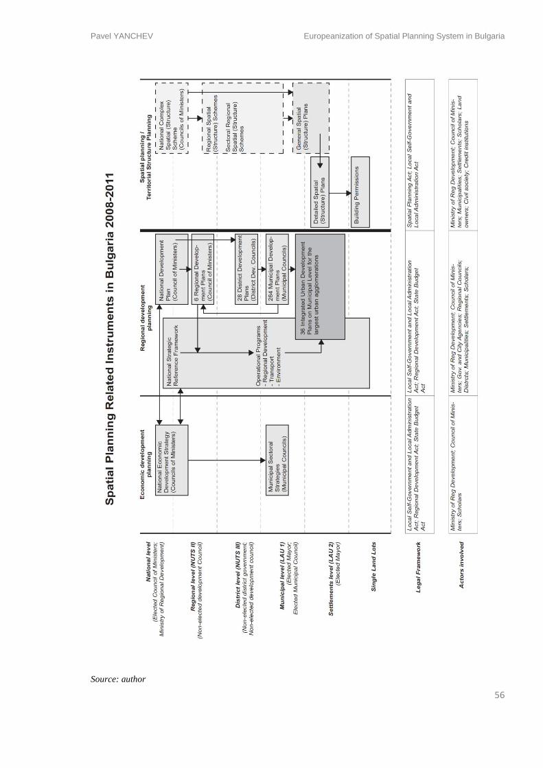
Pavel YANCHEV Europeanization of Spatial Planning System in Bulgaria
56
Source: author
Pavel YANCHEV Europeanization of Spatial Planning System in Bulgaria
57
Integrated Urban Planning
In 2010-2011 the MRDPW decided to implement a new planning tool in order to integrate the
different sectors in the urban development in some 36 agglomerations of settlements all over
Bulgaria. Those are the Integrated Plans for Urban Renewal and Development. Integrated
spatial planning is to be only on municipal level and have to be developed in the next 2 years
in order to be implemented in the next EU budgeting period 2014-2020. The integrated plans
are following the discourses of the Leipzig Chart (2007), the Toledo Declaration (2010) and
the EU Territorial Agenda 2020. The land-use plans legitimizing the planning procedures are
still going to be used as a tool for issuing of building permits. Nevertheless the integrated
plans are giving field for discussion and participation of different sectors like mobility,
environment, waste management and water cycle into implementing new territorial policies.
The problem emerging is the elaboration of these plans may become the next public scheme
where strategic documents are done because their existence is requested but there is no
political will to be followed and put into action.
Such suspicions can be found in scholars’ statements – Dimitrov (2010) claims that the
methodological guidelines for elaborating the integrated plans are not enough clear and all 36
agglomerations might end up each with a totally different outcome. Some of the plans he
argues will look like good old spatial plans, some will be more like a written strategy, some
other just an analysis of the current situation and development plan. Other problem is that
there is still no requirement for certification that will bind the plans to be elaborated by
companies with certain professional profile. These facts undermine the expectations about the
quality of the outcomes from those planning instruments and their future
The procurements on for those integrated plans are still on-going
- Cognitive dimension
The new professionals were meant to be able to manage the institutional change towards
territorial governance and introduce new forms of spatial planning approaches and tools.
Nevertheless the urban and spatial planner profession has hardly been recognized by politics,
legislation, institutions and private actors and involve them in the planning process. Urban
planners have not gained enough recognition in order to create their own professional body
that would stand for their position in the planning system. Thus until the present moment the
profession has not been enough institutionalized and included in the legal framework. An
Pavel YANCHEV Europeanization of Spatial Planning System in Bulgaria
58
example is that the national, regional and municipal development plans and strategies do not
require legal necessity of urban planners to take part in the planning process. At present the
education and the profession exists for already 10 years without enough implementation in the
planning process. At present the Urban Planning program bears discontinuity as the
department had randomly changed or entirely dropped educational modules which was caused
by the lack of lecturers, without actually trying to attract more qualified ones (Dimitrova,
pers. comm.).
European Territorial Co-operation Programs
One of the strongest effects for the spatial planning in Europe after the publishing of the
ESDP by the European Commission one was the INTERREG program. It is a program for
territorial co-operation between countries and regions within and around the territory of the
EU. INTERREG has three active dimensions:
Cross-border co-operation – aiming at strengthening regions in border areas of the EU
countries. Bulgaria formed co-operation with Greece (2000-2006) as a candidate
member state. Then in the 2007-2013 with Greece, Romania, Serbia, Macedonia,
Turkey and in the Black Sea region (with all coastal countries)
Transnational co-operation – connecting countries in programs by larger geographic
areas, sea basins or mountain ranges. Bulgaria is part of South-East Europe program
together with Italy, Austria, Albania, Croatia, Bosnia and Herzegovina, Slovenia,
Slovakia, Hungary, Romania, Serbia, Macedonia, Moldova, Greece and Montenegro.
Other co-operation project in the region is the Danube strategy among 5 countries.
Interregional co-operation – connecting regions from different countries throughout
the whole EU. This dimension contains also horizontal support programs like ESPON,
INTERACT and URBACT.
Bulgaria has taken part in those programs, applying with projects first in the period of
accession (2000-2006) and later already as a Member state (2007-2013). INTERREG is part
of the ‘soft’ approach towards planning on European level which fosters international co-
operation and creation of networks instead of ‘hard’ regulatory policies. The underlying aim
of projects of that kind is the ‘learning by doing’ process through working with people from
different cultural contexts and professional backgrounds. The effect upon Europeanization of
the planning systems can hardly be measured objectively beyond the statistics of number of
Pavel YANCHEV Europeanization of Spatial Planning System in Bulgaria
59
projects approved and budgets absorbed. That is why, due to time limitation, this paper
focuses only upon one exemplary project with its particularities that can give an idea what
kind of difficulties and privileges such co-operation might bring.
The project ATRIUM is approved under the co-operation program South-East Europe.
Initiated by the municipality of Forli, Italy, ATRIUM stands for ‘Architecture of Totalitarian
Regimes of XX century in Urban Managements’. The theme about the built heritage of the
communist and other totalitarian regimes has turned into apple of discord in most of the
Eastern European countries. Thus the project is an occasion for a scientific approach towards
the touchy subject, neglected for years in some regions.
ATRIUM project unites eleven countries from South-East Europe – six scientific and
educational institutions and twelve local governments. The aim of the project is to create a
cultural tourist route of the European Council and meanwhile to give a solution for the urban
management of the architectural heritage from the past century – a problem still not clearly
solved in Bulgaria. Differences in the approach towards totalitarian architecture artefacts
appear in the process of co-operation between actors in the project. For the Italian institutions
the question ‘should we keep and maintain the totalitarian legacy or not’ does not stand at all,
their goal is to achieve knowledge of maintaining it and presenting it as a tourist product the
same way they do with the Roman Empire heritage. They initiate the project with the idea that
the countries from the former Soviet Bloc might have already enough experience to share.
What they expect as an outcome from the project is a ‘prescription’ what to do, whereas for
the countries like Bulgaria the question of demolition still stands. The history after 1944 had
not been enough studied, there are strong disagreements upon certain themes, therefore the
question ‘is totalitarian architecture heritage?’ does not have an unilateral answer, yet.
The ATRIUM project is still on-going, some studies are already made and the first output is
already produced. Kaleva (2012), co-ordinator of the project from Bulgarian side and the
National Institute of Cultural Heritage, sees it as a good chance to study the communist
architectural heritage and to promote it for tourist purposes. Nevertheless the project had
faced dropping of some of the actors involved, Kaleva gives the project as an example of
good mutual learning between the institutions of all the 11 countries. The project gives useful
knowledge and experience of international project management, but Kaleva argues that it
might not be easy the activities behind the project to continue after its end in 2013. For
Pavel YANCHEV Europeanization of Spatial Planning System in Bulgaria
60
Kaleva and the institute she represents, the project is a way to get in contact with a broader
network of professionals in the field and search for eventual future collaborations.
- Discursive dimension
After 2008 Bulgaria has gained more experience in projects of the ESPON and INTERREG
networks, as well as with regional development planning. However the potential of those
epistemic networks have not been fully used as the projects and institutions involved are still
too small. A gradual change in professional generations occurs, more people in spatial
planning and public administration field had already received their education abroad and
brought back knowledge, different ways and approaches.
The director of Operational Program Regional Development in Bulgaria (Nikolova, 2012)
noted in an interview that the old spatial planning approach is outdated as it is too fixed for
the dynamics of the contemporary urban environment. The spatial planning should focus on
more territorial specificity, social, economic and cultural context of a given planned territory
(Nikolova, 2012, pers comm.). Ex-Deputy Chairman of the Sofia City Council (Zaimov,
2012) commented that the old General Spatial Plans are not at all sensitive towards the urban
fabric and the new Integrated Urban Plans should become more effective platform for the
lacking urban debate (Zaimov, 2012, pers. comm.).
- Conclusion
One might assume that the newly introduced planning tools inspired from the EU are
enriching the abilities of the authorities to achieve the public investments in spatial
development. Though it is clear that public and private investment still continue to go in
different pathways, to be regulated by different legislation and intuitions, and they hardly
might combine their interest in order to achieve common goals. The EU has influenced the
introduction of almost new spatial planning system that has displaced the previous
unreformed one without solving the problems of lack of resilience. On the other side the so
called ‘soft’ measures of European spatial planning like INTERREG have certain potential to
bring new networks of planning professionals and to raise unaddressed questions and put
them on the table.
Pavel YANCHEV Europeanization of Spatial Planning System in Bulgaria
61
5. Summary
Spatial planning system in Bulgaria after 1989
- Socio-political dimension
Looking back at the last 23 years, we might conclude that the socio-economic environment in
Bulgaria has gradually overcome the primary post-socialist confusion and moved towards
more balanced and clear of purpose political system that seeks to adapt to the values of the
EU. The free market values, once that have been introduced, now seem harder to be coerced.
The economy and the banking system have been gradually strengthened from the massive
crises and market instability of the early 1990s. The society has gain much respect for values
like private property, law supremacy, civil rights and sustainability. Spatial planning has
gained at first much hatred from society whereas later it became the panacea for the strategic
structuring of the public priorities and funding.
However the period of non-planning has broadened the gap of disparities between the capital
Sofia, the district centres and the smaller municipalities. Severozapaden in Bulgaria remains
the poorest EU region. The trend of population decline that have been observed throughout
the whole transition period, is still on-going. Population continues to migrate with slow temps
toward urban areas.
- Spatial Patterns
The liberal free market environment has unleashed massive real estate development, timid at
the early 1990s, and reaching its peak around 2005. The outdated spatial plans, that were
supposed to regulate the growth of the settlements and tourist resorts, did not manage with it.
Meanwhile, in contrast to the booming private investments, growing lack of infrastructure
was felt. More than a decade, settlements did not invest and modernize the water, sewage and
waste management, irrigation systems, energy grids, road and rail networks. The capital Sofia
became the extreme model of congested city with poor urban management and post-socialist
patterns of development.
The crisis of 2008 had turned the trends upside down – the private investments considerably
dropped whereas the governmental programs and urban managements gradually realized the
Pavel YANCHEV Europeanization of Spatial Planning System in Bulgaria
62
need of infrastructure investments. Authorities saw the subsidized with EU funds
infrastructure renewal as the revitalization for the stagnating economy.
- Technical dimension
As mentioned in the methodology, the transformation of the technical dimension of the spatial
planning system in Bulgaria is structured as follows: Scope; Scale; Plans and Programs;
Planning Practice; Governance
In Scope of the system
Looking back in the early 1990s, the spatial planning system in Bulgaria was entitled to only
land-use allotments and building permits. The government and the municipalities were
supposed to generate rigid and timeless spatial plans which had little in common with the
investment intentions of the property owners. Public spatial development was regulated with
the same plans, but shown as a still moment in the future without any link with funding
opportunities.
The transformation that occurred after the new Regional Development Act in 1999 did not
interfere in the relations between the local authorities and the private property owners. It did
however create a parallel level of spatial planning policies for the public investments. The
regionalization introduced more flexible time-framed strategic documents which allowed
project-driven development with feasible funding. Urban and interregional infrastructure
projects appeared to be possible and useful investment in the frame of the regional planning.
Spatial planning however remained on a certain insurmountable distance from the private
initiative, from the idea of territorial governance and actor involvement.
Thus, in Bulgaria at present there are two parallel levels inside the planning system. One is
regulated by the Regional Development Act, introduced in 1999 and changed in 2004 and
2008. The other is regulated by the Spatial Planning Act (2001) which formulates the land-use
planning instruments on different scales – from national to individual land lots. Both planning
levels work individually and have no connection in between whatsoever. The two Acts and
their sub decrees function independently without explicitly mentioning each other or sharing
spatial planning responsibilities. The strong differentiation has been born after the introducing
of the region as an important territorial unit. The political decision for that implementation
Pavel YANCHEV Europeanization of Spatial Planning System in Bulgaria
63
seems that took for granted the EU regionalization policies while trying to foster development
and investment.
Scale
The transition of locus of power fits in the model that emerged throughout most of the Eastern
European countries – significant power was transferred to the local level but without
delivering considerable resources. Regions were introduced as a territorial unit, but its
responsibilities in the development of territory are backed with power. The responsibility and
budgeting are spread between electoral and non-electoral bodies and hardly achieves effective
territorial governance process. Yet, structured in this way, the model continues to make the
whole territory of the country extremely dependent on decisions from the nation state –
tradition, kept unreformed from the communism in that sense.
Gradually, the projects through transnational co-operation on EU level has gained popularity
among institutions and created the arena for sharing knowledge for planning approaches
among EU member states.
Plans and Programs
Development and planning became more project-driven than plan-driven. Thus, plans already
did not have such strong power on the large visions of the territory whereas they were still
very powerful on the land-use level. The newly introduced two generations of development
strategies (in the period 2000-2013), plans and programs covered all territorial levels and
justified certain amount of public projects. However projects were more successful in bigger
municipalities or on national level. Some localities still lag behind with expert potential and
respectively with quality of planning documents.
Despite the obvious division of regional from spatial planning, steps towards integration
between them had not been taken despite the call of the scholars and planners.
Planning Practice
All spatial plans on national and regional levels, requested by the Spatial Planning Act, were
never updated after 1989. Attempts were made to be produced plans only on local municipal
level but the experience from bigger cities like Sofia and Varna proved that the process of
projecting and approving them takes around 5-10 years. Such a time span makes their primary
goals and analysis out of date in the moment of their approval. Spatial plans were simply not
Pavel YANCHEV Europeanization of Spatial Planning System in Bulgaria
64
introduced by nearly 70% of all municipalities as the legislation was not obliging them to do
so. In February 2012 only 87 from 264 local municipal governments had updated General
spatial plans. The lack of spatial plans did not actually stop municipalities to issue building
permits. Those facts show how the actual spatial planning, that is supposed to work on all
territorial levels, actually works only in municipal and settlement level. Another post-effect
was the almost complete disappearance of urban design as a means of creating quality urban
spaces.
We might as well conclude that since the regional development plans were assuring the
implementation of the public projects, the spatial plans turned into outdated and almost
useless documents that did not bear any conceptual change for the past 40 years.
On the other side stands the practice of regional planning which gradually gained momentum
in order to be able to prioritize more projects. During the first budget period (2007-2013) the
full capacity of the regional development was not utilised and the projects were not enough in
order to absorb the funding. Besides the successful projects, in some cases the regional
planning was done superficially and with hardly any relevant outcome.
The overall practice in the territorial co-operation programs and projects could hardly be
tracked down in this research. So far the ETC format has given stage for creation of fruitful
professional networks with sustainable outcome, but as well opportunities for superficial
absorption of funding.
Territorial Governance - public and private relations and actors involvement
The assessment of the transformation of the public and private will be done through looking
at two activities – the investments and the planning itself. Here the research focuses on how
these two activities are positioned in public/private relations.
Investments
Public investments in spatial development are strongly supported by the EU funds. Most are
driven by the state only through the development programs. Public-private partnerships are
rare as the act that is supposed to regulate those relations is still not fully active (Public-
private Partnership Act – approved in June, 2012). Thus in regional and local development
projects the private participation is hardly ever sought or achieved. The investments are often
Pavel YANCHEV Europeanization of Spatial Planning System in Bulgaria
65
a shared between municipal or governmental budgets and structural, cohesion or regional
development funds.
Most of private investments in spatial development are subject of regulation from the Spatial
Planning Act and its decrees. Building permits are issued under the supervision of the local
authorities and on the base of the spatial plans where they exist. If not the property owners
have the right to update the plans with own proposal.
Planning
Nevertheless the public investments in spatial planning and development increased in the past
10 years, public regional or spatial planning almost does not exist. The exceptions are the
company Sofproekt, which deals with the General Plan of Sofia. It is a municipal company
under the direct supervision of the architect-in-chief of Sofia. It is a successor of the project
enterprise which functioned before 1989. Sofproekt and its work upon the General Plan of
Sofia is described in more detail by Hirt (2005) as she doubts that the methods of planning the
socialist and the post-socialist city did not transform much.
Other public planning entity is the National Centre for Territorial Development which works
as part of the MRDPW. The Centre produces most of the development strategies on a national
level. However it is a government entity, it has no assigned budget and is participating in the
public procurements for different projects as a project company with a private status.
Actually spatial planning is with time became suddenly totally private and the two mentioned
public planning enterprises are the ones saved from dismantling. All other planning is done by
smaller companies with often not enough expert potential. When a project for a spatial land-
use plan is commissioned, the municipalities request a certificate for planning. The certifying
authority in that case is the Chamber of Architects in Bulgaria. That is not the case for the
regional development plans, regulated by the Regional Development Act. Plans and strategies
are often produced by NGOs and no certification is requested in order a regional strategy to
be produced. This fact undermines the quality of the spatial strategies and questions their
abilities to play as a visionary and priority setting documents.
Actors
The main actor in driving spatial planning in Bulgaria is the Ministry of Regional
Development and Public Works. It structures the priorities for spatial development and
Pavel YANCHEV Europeanization of Spatial Planning System in Bulgaria
66
follows their implementation. Together with the newly founded Ministry of European Funds,
it controls and the spending of the public funding in the direction of spatial and regional
development. MRDPW is also the one contributing most to the multi-level governance
process by leading the communication between municipalities, OPs and EU.
Other strong actors in the process are the municipalities and municipality coalitions. They
plan and execute their strategies often by subcontracting strategic planning to NGOs or other
private planners. The UNDP reports (2006a; 2006b) show certain trends in the potentials of
the municipalities and local actors to participate in the governance of the public spatial
planning process and the following co-funding with the EU. NGOs are much willing to
participate actively
- Cognitive dimension
Education system makes an attempt to adopt new concepts and readings of the spatial
planning process by introducing some new programs. The most important are the bachelors
and masters in Urban Planning programs in UACEG, Sofia and the Masters in Regional
Development and Policy program in Sofia University. The programs looked in the planning
discourses of the EU planning schools and combined them with the local planning knowledge
and values. Those programs have tried to fill in the gap of planning professionals in the
political environment. However there is an observation that the recognition of the planner’s
profession and activity by the authorities and society is still weak.
Cognitive influence is coming from the European Territorial Co-operation programs
(INTERREG) as the international projects contribute strongly to the learning process,
exchange of practices and knowledge. The created networks between scholars and
professionals seem in some cases to lead to continuous relations and further co-operation.
- Discursive Dimension
The conceptual debate in the spatial planning field has gradually moved from total rejection
of planning towards searching in the proper planning instruments that can be a platform for
debate. The first strong calls of the liberal free market movement was for no planning, as
planning was merely equal to communism. The first ideas of sustainability has emerged in the
early 1990s and got stronger towards the 2000s under the influence of Local Agenda 21.

Pavel YANCHEV Europeanization of Spatial Planning System in Bulgaria
67
The influences of CEMAT, ESDP, INTERREG and all mutual learning from transnational
and interior co-operation, professionals, educated abroad, have gradually given results in the
multi-level governance process. Planning professionals and the administration has been much
more aware about the specificity of the planning within different levels and among
institutions.
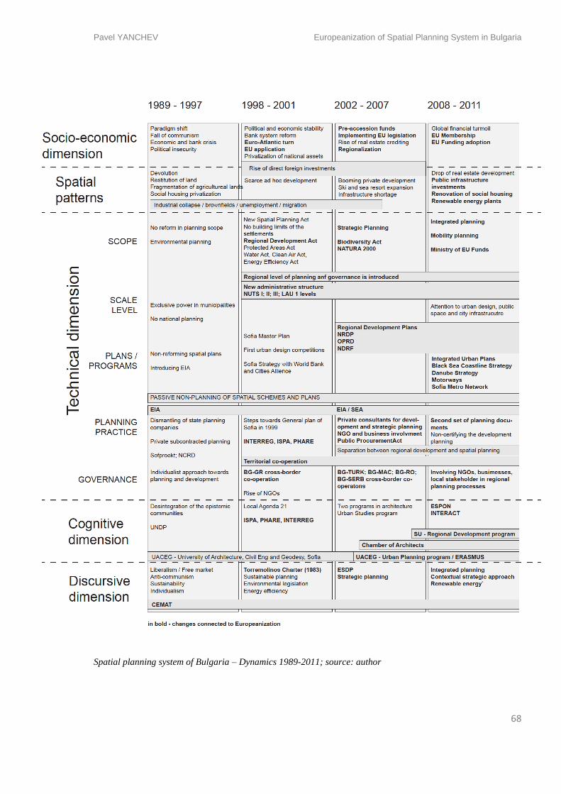
Pavel YANCHEV Europeanization of Spatial Planning System in Bulgaria
68
Spatial planning system of Bulgaria – Dynamics 1989-2011; source: author
Pavel YANCHEV Europeanization of Spatial Planning System in Bulgaria
69
6. Findings and Discussion
Findings
The active reform and gradual Europeanization of the spatial planning system in Bulgaria had
happened after the year 2001 when the two main normative documents, concerning spatial
planning, were approved: the Regional Development Act and the Spatial Planning Act. Since
then the regional development planning managed to carry out the public investment much
better than the traditional spatial planning. Moreover while the development planning was
gaining speed, the traditional spatial planning was abandoned by most of the municipalities
and the government. Spatial planning proved that has turned into an administrative step for
issuing building permits. In order to explain the reason for this transformation, one might see
who gained and who lost from this transformation.
The adoption and growth of the development planning separately from the spatial planning
has surely made a lot of public investments feasible – in terms of planning, funding,
supervision and quality. In this sense the national and local governments gained an instrument
that had given them much better opportunity to create a complete cycle of planning activities
and achieve goals.
Meanwhile, the adoption of development planning had created completely new stratum of
planners – private companies who are not necessarily certified spatial planners, but have the
opportunity to be experts and develop regional, district and municipal strategies, programs
and plans. Since large quantity of the architects and urban planners did not find necessity to
find their place among strategic regional planners, this additionally contributed to the
separation of the planning practices. Hence not all plans and programs have encountered the
strategic spatial component of the documents they elaborate.
The society is surely the winner from the growth of regional development planning because of
the influx of funds into the urban and rural spatial development. The quality of the projects
and their feasibility is not guaranteed by the authorities, because of the tendency of ‘planning
for the sake of planning’ (Marinov, 2006)
On the other side from the slowing down of the actual spatial planning was in favour mostly
for the private property owners. In the places where spatial plans were updated, they have
Pavel YANCHEV Europeanization of Spatial Planning System in Bulgaria
70
been postponed by heavy claim procedures initiated by property owners. Were plans were not
done, owners could apply, make proposal for an individual plan and issue a building permit.
The overall sustainable management of the non-urbanized territories, protected areas,
wetlands, forests etc. is heavily affected by the spatial non-planning. A third government in a
row has not been making the effort to start the national and regional spatial planning schemes.
This allows speculations and violations of forests and other protected areas to be performed
through loopholes in other acts (e.g. Forestry Act).
One might speculate that passive not-planning is favouring that model of plot-by-plot
individual planning practice as well as large scale projects that aim to take possession of
valuable landscapes in favour of tourist industry. The shift in planning practices and
instruments have kept strictly separated public from private planning not allowing
interrelation between the two sectors. Thus governing both public and private investments in
the whole spatial development process is still not often practice. Thus the planning system is
yet far from being fully integrated entity that functions efficient within all its dimensions. The
process of Europeanization has surely introduced new modes of territorial governance, but did
not achieved effective reform of the old ones. Besides the mechanical institutional change, the
Europeanization still did not manage to radically transform the paradigms, values and
understandings about spatial planning and territorial governance.
Bulgarian Spatial Planning System according to ESPON 2.3.2. (2007)
In 2007 the ESPON network issues the ESPON 2.3.2 report that attempts to give a broader
overview of the planning systems, based on the EU Compendium (CEC, 1997) criteria and
conclusions. As a new Member state Bulgaria is included in the research and its planning
system is compared within the European framework. The Compendium suggests four ideal
types of spatial planning system – land-use management; comprehensive integrated; regional
economic; and urbanism. The planning system of Bulgaria is classified under the ideal model
of “comprehensive integrated” planning system. The definition given to this ideal type is:
“It has a wide scope and its main goal is to provide horizontal (across sectors), vertical
(between levels) and geographical (across borders) integration spatial impacts of
sectorial policies. It does this by multi-level arrangement of plans that are intended to
coordinate spatial development. It has strong public sector component.” (Dühr, et al.,
2010)
Pavel YANCHEV Europeanization of Spatial Planning System in Bulgaria
71
ESPON 2.3.2. (2007) report gives an optimistic development prognosis for the evolution of
the spatial planning approach in Bulgaria based on the political will in the first years of
implementing the regional planning. The report examines the development and
implementation of the Sofia Master Plan (General Spatial Plan as referred here) developed
after 1999. The plan is given as an example for a representative planning practice in Bulgaria.
The practice in Bulgaria, according to the report, is based upon “the involvement of a number
of partners in the elaboration of plans”. Actually the General Spatial plan of Sofia has been
finished after numerous procedural difficulties in 2009 and it has given an insight how
prolonged could be the development of land-use plan on the basis of the outdated practice.
There are still doubts in the present moment if the General Spatial Plan of Sofia is really
followed and gives in reality the direction of city development. The type of plan that the law
expects to be developed is still too rigid and does not provide the opportunity for a
constructive debate over the problems of the settlements.
“[C]urrent political culture is marked by the replacement of old political elites by new ones,
with a more pluralistic outlook” states also the report. A quite objective observation is the
shift of the political elite which has been evolving throughout the years. There is an on-going
influx of younger generation of professional educated abroad that enter into the authorities.
However the reformation and integration of the planning instruments is a necessary step
towards providing more open and pluralist approach to spatial planning.
The report claims that the biggest difficulties in the Bulgarian spatial planning system are “the
implementation of the requirements for accession to the EU. It imposes the need of
strengthening and development of the framework with respect to the applied policy, the
programming and management capacity of the public administration in Bulgaria and of the
judicial system, so that the country can be in a position to introduce and apply the EU
legislation” (ESPON 2.3.2).
As the current research is revealing the Europeanization of spatial planning system has
gradually evolving in different directions and has adopting influences from outside. The
planning system is still on certain distance from being fully integrated. It surely still addresses
in extremely separated legal and practical methods private and public investments. The
system continues to be closed and sometimes non-transparent in the field of public projects
prioritization, whereas it often shows clientelist approach towards the private investments and
Pavel YANCHEV Europeanization of Spatial Planning System in Bulgaria
72
actors, instead of trying to attract them in the public debate. A continuing trend is the
segregation of spatial and regional planning approaches and the lack of integration between
the new emerging integrated planning methods with the unreformed outdated once.
Role of the EU
While establishing its mutual relations, Bulgaria and the EU have shaped certain manner of
communication and attitude. Every once in a while journalists make a note upon the
expectations of Bulgarian politicians to receive guidelines of behaviour, punishment or
assistance in internal affairs, referring to the relation Bulgaria-Soviet Union before 1989.
Nevertheless this is just a media exaggeration, it does give an idea about the ways EU policies
and rules has been used by Bulgaria as an opportunity to radically transform the spatial
planning system based on a ready-made model from outside. The model has been
implemented without fully reform and adjust the already existing planning model.
The role of the EU in the changes that occurred in Bulgarian spatial planning system will be
concluded and structured in several aspects – the influence of the EU spending policies, of the
EU regulations and finally the EU learning environment – professional networks and
programs (Böhme and Waterhout, 2008).
EU Regulations
The European legislation is the strongest and hardest top-down compliance that every
Member state has to perform. Bulgaria used the Europeanization as an opportunity to update
its legal framework with new approaches towards issues that have been neglected or
underestimated before. In the accession period a separate Ministry (of European Integration)
has been created to steer the process of compliance. One of the goals of the politicians was the
attempt to perform a radical change of the spatial planning system, hence but approaching
mostly towards the ‘hard’ regulatory part of it. In this sense the EU regulations, one might
assume, have been meticulously transferred into the Bulgarian legislation. That was not
always the case with ‘softer’ approaches to spatial planning like education and the recognition
of the planning profession.
EU regulations no doubt had created a transformation in the legal framework of the spatial
planning on a lot of levels. Some of the EU regulations addressing environment protection
have been transferred really early in 1991, followed by regulations in energy, water and waste
Pavel YANCHEV Europeanization of Spatial Planning System in Bulgaria
73
management, protected areas, clean air that created more regulations for the spatial planning
process but were accepted by the society and professionals as a progress. The regulation that
probably affected most the private investment process was and created collisions were the
introduction of the NATURA 2000 network of protected areas.
Spending policies and INTERREG
Spending policies remain a strong leverage of Europeanization that manages to drive political
action and reform of the spatial planning in Bulgaria. The principal of subsidiarity has forced
politicians to create a whole new set of institutions and levels of regional development
planning in order to be able to prioritize projects and later on finance them through EU funds.
The political system of absorbing funds did not work so well in the beginning and Bulgaria
faced restrictions and suspension of funding after famous corruption scandals. Thereafter, the
spending of the EU funds have been observed by a separate Ministry of EU Funds that
supports and stimulates the actual communication between different ministries, municipal,
district and regional authorities, as well as co-operates for the communication with the EU
level. The MEUF have proven far to be effective instrument in the governance process. The
mutual confidence between Bulgaria and the EU has been restored by the currently
guaranteed transparency.
In the case of INTERREG the spending policies had stimulated in the softer approaches
towards Europeanization, namely for acquiring and exchanging knowledge, and networking.
The Open Method of Coordination has not boosted the expected effect in Bulgaria in the
accession period. Later in the current budgeting period Bulgaria is already participant in
significant number of projects. The INTERREG and ESPON networks and still remain as an
unused potential for steering knowledge and discourse.
EU Discourses
EU discourses and knowledge is the European factor whose potential was not fully used by
the Bulgarian authorities, institutions and agencies. The idea behind European spatial
planning is still vaguely understood. The opportunities given by the knowledge networks have
been underestimated. The transformation of the knowledge institutions is not complementing
enough the lack of professionals and contemporary spatial planning knowledge in the overall
process of transformation of the system.
Pavel YANCHEV Europeanization of Spatial Planning System in Bulgaria
74
Europeanization permeated mostly through the harder institutional aspects of the planning
system, whereas the soft planning approaches and culture of planning is still experiencing
adaptation and transformation towards better.
Comparative Study Romania – Bulgaria*
* co-authored with Mircea Munteanu
Romania and Bulgaria emerged as a distinct duo in the EU accession process, being
confronted often with similar challenges and opportunities. Given our individual interest in
the dynamics of the Bulgarian or Romanian spatial planning systems in the context of
Europeanization, it made sense to develop our research in tandem. This proved particularly
beneficial as the need to contextualize the empirical findings in a broader frame emerged as
increasingly important throughout the research.
The empirical evidence revealed several common issues shared by both planning systems,
from the underlying path of slow reforms, to the emergence of regional development
instruments overlapping with spatial planning. However, a large array of differences emerged
as well, from the historical, cultural or geographical particularities to the distinct ways in
which certain spatial planning instruments adapted to the Europeanization process.
Historical backgrounds
The countries shared a common history from the brake away from Ottoman influence during
the 19th Century, going through the building of modern nation states following Western
European models and eventually under the Soviet influence. In the same time, aspects such as
the larger size and population, the Habsburg influence in North-West, the French affinities
facilitated by the language, or the pursue of a somewhat distinct policy in the last decades of
communism in Romania, show also major underlying historical differences between the two
states.
Changing institutional frames
Socio-political dimension
The countries entered the transition period simultaneously, both marked by poverty, a process
of privatization, with a shared slow path of reforms becoming the laggard duo of the EU
accession process. They experienced a booming growth in the mid-2000s followed by the
abrupt impact of the crisis in 2008, but also the demographic decline with mass migration
Pavel YANCHEV Europeanization of Spatial Planning System in Bulgaria
75
towards the West and the rise in social and spatial inequalities. This translated in similar
patterns of spatial development, with abandonment of industries, ad-hoc development or
underdeveloped infrastructure before the mainstreaming of EU funds. In the same time
particularities did exist, such as the more severe crisis in Bulgaria in the first half of the '90s
or its stronger commitment on the development of certain sectors such as its tourism industry.
Cognitive dimension
A common issue of both countries was the dismantling of planning institutes after
communism, the splintering of professional practices, and the challenging of the profession by
the emergence of other professionals with no spatial planning background elaborating
strategic development plans and programs. Over the two decades however it appears that
Romanian planners developed relatively more knowledge channels than their Bulgarian
counterparts, both within the profession and with the political sphere, due to the scale of the
country, but also to the different planning tradition.
Discursive dimension
Following the ideological shift, both countries were dominated by anti-planning discourse,
leading in Romania to a rebranding of the field and timid positioning on the political agenda
despite its unpopularity, while in Bulgaria even if the formal perception of planning did not
change in practice it was practically abandoned. The discourse on regional development
planning emerged in both cases as a clear sign of Europeanization and shadowed spatial
planning, but in Romania this served also as a legitimizing tool for spatial planning.
Technical dimension
Scope of the system, scale and competences
Even if spatial planning became a taboo in both countries, this was translated in very different
ways in the two cases: Bulgaria was cautious to adopt radical reforms of the planning
approach and instruments, so the communist planning act was kept and cosmetically amended
to accommodate building permits, while in Romania the law was repealed altogether to be
replaced by new instruments of French or German inspiration, which however were only
incorporated in bits of legislation and did not differ in nature to those in Bulgaria.
The radical change for both cases was the introduction of the regional level. In both cases
regional planning was steered from above, with a notion of local democracy through lower
Pavel YANCHEV Europeanization of Spatial Planning System in Bulgaria
76
level representatives (county presidents in Romania; municipality mayors in Bulgaria), albeit
with limited financial control leading to restrictive local development. In both countries
regional policy had no references to spatial planning. In Bulgaria the integration was never
achieved whereas in Romania spatial planning tries to reform itself in an attempt to underlie
regional policy. This can be linked to the French cultural affiliation and the fact that Romania
adopted 'amenajarea teritoriului' after 1990, as the French 'aménagement du territoire' played
an important role in the EU regional policy design itself by requiring the accompaniment of a
larger-scale plan or concept (Faludi and Waterhout 2002). Yet in both countries the making of
the development and spatial plans still remains a formalist process which in some cases only
seems to exist for EU funds absorption.
Plans, programmes and practices
EU funded programmes have played a central role for spatial planning in both countries, with
regional policy and the environmental assessment instruments being symbols of
Europeanization. A significant number of public investments in infrastructure, urban renewal
and environment had been implemented, but often the programming was just formal and had
no true strategic nature.
Formally, Romania seemed to develop more programmes related to spatial planning and to
draft plans at all levels and recently even integrate them with regional planning, while
Bulgaria didn't draft its larger scale spatial schemes and general plans in a lot of settlements
since 1989, and there appear no intentions to integrate spatial with regional development
planning. However in both countries the two types of planning largely overlapped and
contradicted each other, with only local exceptions of successful integrations.
Governance
The large gap between the stated goals of planning and the development outcomes was in
both countries the product of a governance tradition marked by hierarchy and authority with
funds still strongly steered from the central level, but also individualism, clientelism and
inequality, with principles of effectiveness, accountability and transparency gaining ground
only recently and to a limited extent. Positive experiences are linked in both countries to the
participation in territorial co-operation projects which catalysed the emergence of a different
planning and governance culture.
Pavel YANCHEV Europeanization of Spatial Planning System in Bulgaria
77
Private interest has been very strong throughout the transition in both cases, but recently
differences emerged. Romania strengthened the role of the public administration in
controlling land use, with the discretionary decisions moving towards less numerous but
financially more significant private interests, while in Bulgaria the freedom of most owners to
amend changes is still strong, given that it is in accord with the neighbours. Trying to create a
functiona dialogue between property owners, public authorities and society is still far.
Despite their particularities and the fact that both countries have built formal spatial planning
systems, these seem to produce similar effects, in particular in terms of the distance between
their goals and the outcomes. Thus the spatial development continues to be disintegrated and
only partially implemented.
7. Conclusions
The process of Europeanization in the last 23 years has introduced new aspects of the spatial
planning approach. The regional planning has managed to operate with public investments
and priorities, the ETC that has included Bulgaria in wider EU professional networking.
However some traditional aspects of the spatial planning has been left behind and unreformed
for quite a long time. Hence their functions were slowly taken over by the planning
instruments that were introduced in the process of Europeanization. The follow up attempts of
spatial planning reform should take into account the need of integration of different spatial
planning approaches. They will be a platform for better territorial governance process.
Pavel YANCHEV Europeanization of Spatial Planning System in Bulgaria
78
Bibliography
Adams N., Cotella G., Nunes R. (eds.) (2011), Territorial Development, Cohesion and Spatial Planning.
Knowledge and Policy Development in an Enlarged EU. London/New York: Routledge.
Adams N., Alden J, Harris N., (eds.), (2006), Regional Development and Spatial Planning in an Enlarged
European Union, Ashgate Publishing Ltd, Hampshire, England
Altrock, U., Guentner, S., Huning, S., & Peters, D. (2006) Spatial Planning and Urban Development in the
new EU Member States: From Adjustment to Reinvention (Aldershot, Hampshire: Ashgate).
Bache I., Flinders M., (2004), Multi-level Governance, Oxford University Press Inc., New York
Boesten R. (2012) – Environmental planning consultant, NGO sector, personal communication
Böhme K., (2002), Nordic Echoes in European Spatial Planning: Discursive Integration in Practice, PhD
Thesis, Nordregio Report 2002:8
Böhme K., & Waterhout, B., (2008), The Europeanization of planning, in: A. Carbonell & A. Faludi (Eds)
Gathering the Evidence – The Way Forward for European Planning?, pp.225–248 (Luxembourg: Lincoln
Institute of Land Policy)
CoE, (1983), European regional/spatial planning Charter / Torremolinos Charter; adopted on 20 May 1983 at
Torremolinos (Spain)
CoE, (2007), Leipzig Chart for Sustainable European Cities, adopted in Leipzig on May 24-25th
, 2007
CEC, (1997), EU Compendium of Spatial Planning Systems and Policies, Regional Development
Studies, Luxembourg: Office for Official Publications of the European Communities
CEC, (1999), European Spatial Development Perspective: Towards Balanced and Sustainable Development of
the Territory of the EU (ESDP), Luxembourg
CEMAT – European Conference of Ministers Responsible for Regional Planning (2007a) The Territorial
Agenda of the European Union: Towards a more Competitive and Sustainable Europe of Diverse Regions,
Luxembourg.
CEMAT – European Conference of Ministers Responsible for Regional Planning (2007b) The Territorial and
State Perspectives of the European Union, draft 29 January 2007, Luxembourg.
CULTPLAN (2007) Cultural Diversity in Europe – Inventory / Research concerning cultural diversity in
Europe. www.cultplan.org accessed 28.01.2010, cited in Maier, K. (2012) Europeanization and Changing
Planning in East-Central Europe: An Easterner's View. Planning Practice and Research 27(1): 137-154.
CULTPLAN (2008), Cultural Differences in European Co-operation. Learning from INTERREG Practice
www.cultplan.org accessed 28.01.2010, cited in Maier, K. (2012) Europeanization and Changing Planning in
East-Central Europe: An Easterner's View. Planning Practice and Research 27(1): 137-154.
Davies, H. W. E.; Edwards, D.; Hooper, A. J.; Punter, J.V. (1989): Comparative Study. In: Davies, H. W. E.
(ed.) Planning Control in Western Europe. London: HMSO, pp. 409–442.
De Arriba Bueno R., (2005), Restitution and Market in the Bulgarian Land Reform, Department of Applied
Economy University of Valencia (Spain), available here.
Dimitrov S., (2010), For Over 20 years Now There Is No Clear Concept for Regional Development (Вече
повече от 20 години няма ясна визия за регионалното развитие), interview (in Bulgarian)
Pavel YANCHEV Europeanization of Spatial Planning System in Bulgaria
79
Dimitrova E., (2012), Professor at Urbanism department at UACEG, Sofia, Bulgaria, personal communication
ESPON (2005) Project 3.2. Spatial Scenarios and Orientations in relation to the ESDP and Cohesion Policy.
Second Interim Report Accessed on 5.06.2012, available here.
ESPON (2007a) Project 2.3.1. Application and Effects of the ESDP in the Member States. Final Report,
Luxemburg. Accessed on 30.03.2012, available here.
ESPON (2007b) Project 2.3.2. Governance of Territorial and Urban Policies from EU to Local Level. Final
Report, Luxembourg. Accessed on 11.03.2012, available here.
Faludi A., (1987), A Decision-centred View of Environmental Planning. Oxford: Pergamon Press. As quoted in:
Nadin, V.; Stead, D. (2008) European Spatial Planning Systems, Social Models and Learning. DisP 172(1): 35-
47.
Faludi, A. (2005) The Netherlands: A culture with a soft spot for planning. In Sanyal, B. (ed.) Comparative
planning cultures: 285-308. Routledge, New York.
Finka, M. (2011) Evolving Frameworks for Regional Development and Spatial Planning in the New Regions of
the EU. In Adams, N., Cotella, G. and Nunes, R. (eds.) Territorial Development, Cohesion and Spatial Planning.
Knowledge and Policy Development in an Enlarged EU. London/New York: Routledge.
German Presidency (2007) Territorial Agenda of the European Union: Towards a More Competitive and
Sustainable Europe of Diverse Regions. Agreed at the occasion of the Informal Ministerial Meeting on Urban
Development and Territorial Cohesion (Leipzig, 24–25 May 2007). Accessed on 15.04.2012, available here.
Getimis P., (2012) Comparing Spatial Planning Systems and Planning Cultures in Europe. The Need for a
Multi-scalar Approach. Planning Practice and Research 27(1): 25-40.
Giannakourou G., (2012), The Europeanization of National Planning: Explaining the Causes and the
Potentials of Change, in Planning Practice and Research, No 27, Vol. 1, pp. 117-135, Routledge
Grabbe, H. (2001) How does Europeanisation affect CEE Governance? Conditionality, diffusion and diversity,
Journal of European Public Policy, 8(4), pp. 1013 – 1031
Healey, P.; Khakee, A.; Motte, A.; Needham, B. (1997): Making Strategic Spatial Plans: Innovation in
Europe. London: UCL Press.
Healey, P. (2004) The Treatment of Space and Place in the New Strategic Spatial Planning in Europe.
International Journal of Urban and Regional Research 281: 45-67
Hirt S., (2005), Planning the Post-Communist City: Experiences from Sofia, in International Planning Studies
Vol. 10, No. 3–4, 219–240, Routledge
Janin Rivolin U., (2012), Planning Systems as Institutional Technologies: a Proposed Conceptualization and
the Implications for Comparison, in Planning Practice and Research, No27. Vol. 1, pp. 63-85, Routledge
Kaleva E., (2012), Manager of the ATRIUM project (financed by South-East Europe ETC program) in National
Institute for Cultural Heritage, personal communication
Kotzev A., (2012), assistant professor in GIS, Sofia University, personal communication
Kovachev A., (2009), Territorial Development, Pensoft, Sofia (in Bulgarian)
Kunzmann K., (2006), The Europeanization of Spatial Planning in Adams N., Alden J., Harris N., eds.
Regional Development and Spatial Planning in an Enlarged European Union, Ashgate Publishing Ltd.,
Aldershot, Hampshire, England, pp 43-63
Pavel YANCHEV Europeanization of Spatial Planning System in Bulgaria
80
Lampe J.R., (1984), Interwar Sofia versus the Nazi-Style Garden City: The Struggle Over the Muesmann Plan,
Journal of Urban History, No 11, pp. 39-62.
Lenschaw A., (2006), Europeanisation of Public Policy in European Union Power and Policy-making, ed. J.
Richardson, 3rd
. ed., Abigdon, Oxon, Routledge, pp. 55-71
Maier K., (1998), Czech planning in transition: Assets and deficiencies, International Planning Studies, 3:3,
351-365
Maier K., (2012), Europeanization and Changing Planning in East-Central Europe: An Easterner's View, in
Planning Practice and Research, Vol. 27, No. 1, pp. 137–154, Routledge
Marinov V., (2006), The Regional Development Planning System in Bulgaria: Progress, Pitfalls, and Lessons
Learned, paper presented at the Conference “Regional Development: Policies and Practices in Central and
Eastern Europe”, Chisinau, Moldova, 28-29 June 2006
Medarova-Bergstrom K., (2011), Pathways to Sustainability: The Case of Environmental Policy Integration in
EU Structural and Cohesion Funds in Bulgaria, Budapest, Central European University, PhD Thesis
Medarova-Bergstrom K., (2012), Senior Policy Analyst in Institute for European Environmental Policy,
personal communication.
Meadows D.H., (2008), Thinking in Systems, ed. Diana Wright, Earthscan, London; (c) Sustainability Institute
Munteanu M., (2012), Europeanization of the Spatial Planning System in Romania, Master Thesis in ASRO,
Katholieke Universiteit Leuven, Belgium
Nadin V., & Stead D., (2008), European Spatial Planning Systems, Social Models and Learning, disP, 172, I
Newman, P.; Thornley, A. (1996), Urban Planning in Europe: International Competition, National Systems,
and Planning Projects. London: Routledge.
Nikolova D., (2012), Managing Director of Operational Program “Regional Development” in Bulgaria, personal
communication.
O’Dwyer, C. (2006) Reforming regional governance in East Central Europe: Europeanization or domestic
politics as usual? East European Politics and Societies, 20(2), pp. 219 – 253.
Peterlin M, Kreitmayer Mckenzie J., (2007), The Europeanization of spatial planning in Slovenia, Planning
Practice and Research, 22:3, 455 - 461
Radaelli C., (2004) Europeanisation: Solution or problem? In European Integration online Papers (EIoP) Vol. 8
(2004) N° 16; available here.
Sanyal, B. (2005): Hybrid Planning Cultures: The Search for the Global Cultural Commons. In Sanyal, B. (ed.)
Comparative planning cultures: 285-308. Routledge, New York.
Servillo L. A., & Van Den Broeck P., (2012), The Social Construction of Planning Systems: A Strategic-
Relational Institutionalist Approach, in Planning Practice and Research, Vol. 27, No. 1, pp. 1–24, Routledge
Thornley A. (1993), Letter from Sofia: Building the Foundations for a Market-oriented Planning System in
Bulgaria, Planning Practice & Research; Vol. 8, Issue 4, pp. 27,
Tsenkova S., (2011), Venturing into unknown territory: Strategic spatial planning in post-communist cities, in
Urbani izziv, vol 22, no. 1
Tewdwr-Jones, M. & Williams, R.H. (2001) The European Dimension of British Planning (London: Spon)
Tewdwr-Jones M., (2002), The Planning Polity – Planning, Government and the Policy Process, Routledge,
London
Pavel YANCHEV Europeanization of Spatial Planning System in Bulgaria
81
UNDP, (2006a), Assessment of the capacity of NGOs and Business for Participation in Absorbtion of Funding
from the Structural and Cohesion Funds, by Marinov, Garnizov, Georgiev (in Bulgarian)
UNDP, (2006b), Assessment of the capacity of Municipal and District Administrations for Participation in
Absorbtion of Funding from the Structural and Cohesion Funds, by Marinov, Garnizov, Georgiev (in Bulgarian)
Waterhout B., (2007), Episodes of Europeanization of Dutch national spatial planning in Planning
Practice and Research 22(3): 309–327.
Waterhout B., Mourat, J, Böhme K. (2009) The Impact of Europeanisation on Planning Cultures. In:
Knieling, J. & Othengrafen, F. (eds.) Planning Cultures in Europe: Decoding Cultural Phenomena in Urban and
Regional Planning: 283-299. Ashgate, Farnham UK and Burlington VT.
Waterhout B., (2011), European Spatial Planning: Current State and Future Challenges. In Adams, N.,
Cotella, G. and Nunes, R. (eds.) Territorial Development, Cohesion and Spatial Planning. Knowledge and Policy
Development in an Enlarged EU. London/New York: Routledge.
Williams, R.H. (1996) European Union Spatial Policy and Planning (London: Chapman).
Zaimov M., (2012), Ex-Deputy Chairman of the Sofia City Council, personal communication
Zauha J., Is Spatial Planning a Driver for Sustainable Development in Poland? Planning, Practice & Research,
Vol. 22, No. 3, pp. 463 – 471, August 2007