essentials of - assets.pearsonschool.com
TRANSCRIPT
Boston Columbus Indianapolis New York San Francisco Upper Saddle RiverAmsterdam Cape Town Dubai London Madrid Milan Munich Paris Montréal Toronto
Delhi Mexico City São Paulo Sydney Hong Kong Seoul Singapore Taipei Tokyo
E s s E n t i a l s o f
g E o l o g y
frederick K. lutgensEdward J. tarbuck
illUstRatED By
Dennis tasa
12e
A01_LUTG7734_12_NASTA_FM_i_xix.indd 1 12/10/13 2:57 PM
Copyright © 2015, 2012, 2009, 2006, 2003 by Pearson Education, Inc. All rights reserved. Manufactured in the United States of America. This publication is protected by Copyright, and permission should be obtained from the publisher prior to any prohibited reproduction, storage in a retrieval system, or transmission in any form or by any means: electronic, mechanical, photocopying, recording, or likewise. To obtain permission(s) to use material from this work, please submit a written request to Pearson Education, Inc., Permissions Depart-ment, One Lake Street, Upper Saddle River, New Jersey 07458.
Many of the designations by manufacturers and sellers to distinguish their products are claimed as trademarks. Where those designations appear in this book, and the publisher was aware of a trademark claim, the designations have been printed in initial caps or all caps.
Library of Congress Cataloging-in-Publication Data
Lutgens, Frederick K. Essentials of geology/Frederick K. Lutgens, Edward J. Tarbuck; illustrated by Dennis Tasa.–Twelfth edition. pages cm Includes index. ISBN-13: 978-0-321-94773-4 ISBN-10: 0-321-94773-81. Geology–Textbooks. I. Tarbuck, Edward J. II. Title. QE26.3.L87 2015 550–dc23 2014043897
1 2 3 4 5 6 7 8 9 10—CKV—18 17 16 15 14
ISBN-10: 0-133-54013-8 High School Binding ISBN-13: 978-0-133-54013-0 High School BindingPearsonSchool.com/Advanced
Acquisitions Editor: Andrew DunawaySenior Marketing Manager: Maureen McLaughlinProject Manager: Crissy DudonisProject Management Team Lead: Gina M. CheselkaExecutive Development Editor: Jonathan CheneyDirector of Development: Jennifer HartContent Producer: Timothy HainleyProject Manager, Instructor Media: Eddie LeeEditorial Assistant: Sarah ShefvelandSenior Marketing Assistant: Nicola HoustonFull Service/Composition: Cenveo® Publisher Services
Project Manager, Full Service: Heidi AllgairPhoto Manager: Maya MelenchukPhoto Researcher: Kristin PiljayText Permissions Manager: Alison BrucknerDesign Manager: Derek BacchusInterior Design: Elise Lansdon DesignCover Design: Derek BacchusPhoto and Illustration Support: International MappingOperations Specialist: Christy HallCover Image Credit: Michael Collier
Page 6: Quote from Aristotle, translated by Adams, F.D., in The Birth and Development of the Geological Sciences, Dover Publications, 1954; Page 7: Quote from James Hutton, Theory of the Earth, 1785; Page 7: Quote from William L. Stokes, Essentials of Earth History, Prentice Hall, Inc. 1973, p. 20; Page 8: Quote from James Hutton, Transactions of the Royal Society of Edinburgh, 1788; Page 10: Quote from Jacob Bronowski, The Common Sense of Science, p. 148, Har-vard University Press, 1953; Page 11: Quote from F. James Rutherford and Andrew Ahlgren, Science for All Americans (New York: Oxford University Press, 1990), p. 7; Page 11: Quote from Speech delivered at Douai on December 7, 1854 on the occasion of his formal inauguration to the Faculty of Letters of Douai and the Faculty of Sciences of Lille), reprinted in: Pasteur Vallery-Radot, ed., Oeuvres de Pasteur (Paris, France: Masson and Co., 1939), vol. 7, page 131; Page 37: Quote from Alfred Wegener, The Origin of Continents and Oceans, translated from the 4th revised German ed. of 1929 by J. Birman (London: Methuen, 1966); Page 38: R. T. Chamberlain, quoted from Hallam, A. (1973) A Revolution in the Earth Sciences. Clarendon Press, Oxford; Page 106: Quote from Lee Green, MD, an associate professor at the Univer-sity of Michigan Medical School; Page 170: Quote from Jack Eddy,
“A Fragile Seam of Dark Blue Light,” in Proceedings of the Global Change Research Forum. U.S. Geological Survey Circular 1086, 1993, p. 15; Page 259: Quote from Walter Mooney, a USGS seismologist; Page 353: Quote from Exploration of the Colorado River of the West (Washington, DC: Smithsonian Institution, 1875), p. 203; Page 417: Quote from J. D. Hays, John Imbrie, and N. J. Shackelton, “Variations in the Earth’s Orbit: Pacemaker of the Ice Ages,” Science 194 (1976): 1121–32. p. 1131; Page 435: Quote from R. A. Bagnold, The Physics of Blown Sand and Desert Dunes, 2005; Page 476: Quote from James Hutton, Transactions of the Royal Society of Edinburgh, 1805; Page 486: Quote from B. Bryson, A Short History of Nearly Everything (Broadway Books, 2003); Page 545: Quote from IPCC, “Summary for Policy Makers.” In Climate Change 2013: The Physical Science Basis; Page 551: Quote from J. T. Overpeck, et al., “Arctic System on Trajec-tory to New, Seasonally Ice-Free States,” EOS, Transactions, American Geophysical Union, 86 (34): 309, August 23, 2005; Page 553: National Assessment Synthesis Team, Climate Change Impacts on the United States: The Potential Consequences of Climate Variability and Change (Washington, DC: U.S. Global Research Program, 2000), p. 19.
Credits and acknowledgments borrowed from other sources and reproduced, with permission, in this textbook appear on the appropriate page within text or are listed below.
A01_LUTG7734_12_NASTA_FM_i_xix.indd 2 12/10/13 2:57 PM
In addition to the many informative and colorful illustrations and photos throughout this text, you will find two kinds of special figures that offer additional learning opportunities. These figures contain QR codes which the student can scan with a smart phone to explore exciting expanded online learning materials.
Find SmartFigures where you see this icon.
Chapter 11.5 Earth history—Written in the rocks (p. 7)1.7 Magnitude of geologic time (p. 9)1.16 Nebular theory (p. 17)1.18 Earth’s layers (p. 20)1.21 The rock cycle. (p. 23) 1.23 The continents (p. 26)
Chapter 22.2 Reconstructions of Pangaea (p. 35)2.9 Rigid lithosphere overlies the weak
asthenosphere (p. 40)2.14 Continental rifting: Formation of a new
ocean basin (p. 43)2.16 Three types of convergent plate boundaries (p. 44)2.20 Transform plate boundaries (p. 48)2.22 Movement along the San Andreas Fault (p. 49)2.30 Time scale of magnetic reversals (p. 55)
Chapter 33.3 Most rocks are aggregates of minerals (p. 69)3.12 Color variations in minerals (p. 74)3.15 Common crystal habits (p. 75)3.16 Hardness scales (p. 76)3.24 Five basic silicate structures (p. 80)
Chapter 44.3 Intrusive versus extrusive igneous rocks (p. 97)4.7 Igneous rock textures (p. 101)4.12 Classification of igneous rocks (p. 104)4.24 Partial melting (p. 113)4.27 Sill exposed in Sinbad country, Utah (p. 115)
Chapter 55.10 Anatomy of a volcano (p. 135)5.14 Cinder cone (p. 138)5.23 Super-eruptions at Yellowstone (p. 147)5.29 Earth’s zones of volcanism (p. 152)5.31 Large basalt provinces (p. 154)5.30 Subduction of the Juan de Fuca plate produced the Cascade
volcanoes (p. 154)
Chapter 66.4 Ice breaks rock (p. 164)6.5 Unloading leads to sheeting (p. 164)
6.10 The formation of rounded boulders (p. 168)6.11 Rock type influences weathering (p. 168)6.13 Monuments to weathering (p. 169)
Chapter 77.2 The big picture (p. 187)7.7 Sorting and particle shape (p. 190)7.17 Bonneville salt flats (p. 196)7.22 Utah’s Capitol Reef National Park (p. 201)7.24 Lateral change (p. 204)7.32 Common oil traps (p. 209)
Chapter 88.3 Sources of heat for metamorphism (p. 220)8.4 Confining pressure and differential stress (p. 220)8.14 Gneiss with garnet porphyroblasts, Adironacks, New York (p.
227)8.19 Rocks produced by contact metamorphism (p. 230)8.23 Metamorphism along a fault zone (p. 232)8.24 Textural variations caused by regional metamorphism) (p. 233)
Chapter 99.5 Elastic rebound 2429.10 Body waves (P and S waves) versus surface waves (p. 245)9.26 Turnagain Heights slide caused by the 1964 Alaska Earth-
quake (p. 253)9.34 Seismic gaps (p. 259)
Chapter 1010.4 Satellite altimeter (p. 271)10.8 Active continental margins (p. 274)10.17 Ridge segments that exhibit fast, intermediate, and slow
spreading rates (p. 280)10.22 Midcontinent rift map (p. 284)10.24 The demise of the Farallon plate (p. 285)
Chapter 1111.1 Deformed sedimentary strata (p. 292)11.6 Common types of folds (p. 296)11.7 Sheep Mountain, Wyoming (p. 297)11.8 Domes versus basins (p. 297)11.15 Normal dip-slip fault (p. 299)11.16 Normal faulting in the Basin and Range Province (p. 300)11.26 Collision and accretion of small crustal fragments to a conti-
nental margin (p. 307)11.29 India’s continued northward migration severely deformed
much of China and Southeast Asia (p. 309)
11.30 Formation of the Appalachian Mountains (p. 310)11.31 The Valley and Ridge Province (p. 311)11.33 The effects of isostatic adjustment and erosion on mountain-
ous topography (p. 312)
Find Smart Figures and Mobile Field Trip Figures
Find Mobile Field Trip Figures where you see this icon.
A01_LUTG7734_12_NASTA_FM_i_xix.indd 3 12/10/13 2:57 PM
Chapter 1212.2 Excavating the Grand Canyon (p. 321)12.15 Gros Ventre rockslide (p. 329)12.19 Creep (p. 332)12.21 When permafrost thaws (p. 333)
Chapter 1313.2 The hydrologic cycle (p. 341)13.4 Mississippi River drainage basin (p. 342)13.9 The Mighty Missippi near Memphis,
Tennesee (p. 345)13.12 Channel changes from head to mouth (p. 347)13.17 Formation of cut banks and point bars (p. 351)13.25 Incised meanders (p. 355)
Chapter 1414.5 Water beneath Earth’s surface (p. 371)14.12 Hypothetical groundwater flow system (p. 375)14.14 Cone of depression (p. 377)14.16 Artesian systems (p. 378)14.22 How a geyser works (p. 381)
Chapter 1515.6 Movement of a glacier (p. 400)15.9 Zones of a glacier (p. 401)15.14 Erosional landforms created by alpine
glaciers (p. 404)15.21 Formation of a medial moraine (p. 408)15.24 Common depositional landforms (p. 410)15.34 Orbital variations (p. 417)
Chapter 1616.1 Dry climates (p. 425)16.8 Landscape evolution in the Basin and Range region (p. 429)16.14 Formation of desert pavement (p. 433)
16.16 White Sands National Monument (p. 435)16.17 Cross-bedding (p. 435)16.19 Types of sand dunes (p. 436)
Chapter 1717.6 Passage of a wave (p. 446)17.10 Wave refraction (p. 448)17.11 The longshore transport system (p. 449)17.15 Some depositional features (p. 452)17.25 East coast estuaries (p. 454)17.29 Hurricane source regions and paths (p. 460)
Chapter 1818.7 Inclusions (p. 475)18.8 Formation of an angular unconformity (p. 475)18.13 Applying principles of relative dating (p. 478)18.18 Fossil assemblage (p. 482)18.21 Radioactive decay curve (p. 484)
Chapter 1919.4 Major events that led to the formation of early Earth (p. 500)19.10 Growth of continents (p. 505)19.12 The major geologic provinces of North America (p. 506)19.15 Connection between ocean circulation and the
climate in Antarctica (p. 508)19.28 Relationships of vertebrate groups and their divergence from
lobe-finned fish (p. 517)
Chapter 2020.5 Ice cores (p. 533)20.16 Paths taken by solar radiation (p. 539)20.18 The greenhouse effect (p. 540)20.24 Monthly CO2 concentrations (p. 544)20.34 Slope of the shoreline (p. 552)
About Our Sustainability InitiativesPearson recognizes the environmental challenges facing this planet and acknowledges our responsibility in making a difference. This book has been carefully crafted to minimize environmental impact. The binding, cover, and paper come from facilities that minimize waste, energy consumption, and the use of harmful chemicals.
Pearson closes the loop by recycling every out-of-date text returned to our warehouse. Along with developing and exploring digital solutions to our market’s needs, Pearson has a strong commitment to achieving carbon neutral-ity. As of 2009, Pearson became the first carbon- and climate-neutral publishing company. Since then, Pearson remains strongly committed to measuring, reducing, and offsetting our carbon footprint.
The future holds great promise for reducing our impact on Earth’s environment, and Pearson is proud to be leading the way. We strive to publish the best books with the most up-to-date and accurate content, and to do so in ways that minimize our impact on Earth. To learn more about our initiatives, please visit www.pearson.com/responsibility.
A01_LUTG7734_12_NASTA_FM_i_xix.indd 4 12/10/13 2:57 PM
v
Brief Contents
1 An Introduction to Geology 2
2 Plate Tectonics: A Scientific Revolution Unfolds 32
3 Matter and Minerals 66
4 Igneous Rocks and Intrusive Activity 94
5 Volcanoes and Volcanic Hazards 126
6 Weathering and Soils 160
7 Sedimentary Rocks 184
8 Metamorphism and Metamorphic Rocks 216
9 Earthquakes and Earth’s Interior 238
10 Origin and Evolution of the Ocean Floor 268
11 Crustal Deformation and Mountain Building 290
12 Mass Wasting: The Work of Gravity 318
13 Running Water 338
14 Groundwater 366
15 Glaciers and Glaciation 394
16 Deserts and Wind 422
17 Shorelines 440
18 Geologic Time 470
19 Earth’s Evolution Through Geologic Time 494
20 Global Climate Change 528
Appendix Metric and English Units Compared 558
Glossary 559
Index 568
A01_LUTG7734_12_NASTA_FM_i_xix.indd 5 12/10/13 2:57 PM
vi
Contents
2 Plate Tectonics: A Scientific Revolution Unfolds 32
2.1 From Continental Drift to Plate Tectonics 34 2.2 Continental Drift: An Idea Before Its Time 35
Evidence: The Continental Jigsaw Puzzle 35Evidence: Fossils Matching Across the Seas 36Evidence: Rock Types and Geologic Features 36Evidence: Ancient Climates 37
2.3 The Great Debate 38Rejection of the Drift Hypothesis 38
2.4 The Theory of Plate Tectonics 39Rigid Lithosphere Overlies Weak Asthenosphere 40Earth’s Major Plates 40Plate Boundaries 40
2.5 Divergent Plate Boundaries and Seafloor Spreading 42Oceanic Ridges and Seafloor Spreading 42Continental Rifting 43
2.6 Convergent Plate Boundaries and Subduction 44Oceanic–Continental Convergence 45Oceanic–Oceanic Convergence 46Continental–Continental Convergence 47
2.7 Transform Plate Boundaries 48 2.8 How Do Plates and Plate Boundaries Change? 50
The Breakup of Pangaea 51Plate Tectonics in the Future 51
2.9 Testing the Plate Tectonics Model 52Evidence: Ocean Drilling 52Evidence: Mantle Plumes and Hot Spots 53Evidence: Paleomagnetism 54
2.10 How Is Plate Motion Measured? 57Geologic Evidence for Plate Motion 57Measuring Plate Motion from Space 58
2.11 What Drives Plate Motions? 59
Forces That Drive Plate Motion 59Models of Plate–Mantle Convection 60
Concepts in Review 61 Give It Some Thought 64 MasteringGeology 65
preface xv
1 An Introduction to Geology 2
1.1 Geology: The Science of Earth 4Physical and Historical Geology 4Geology, People, and the Environment 5
1.2 The Development of Geology 6Catastrophism 6The Birth of Modern Geology 7Geology Today 7The Magnitude of Geologic Time 8
1.3 The Nature of Scientific Inquiry 9Hypothesis 10Theory 10Scientific Methods 11Plate Tectonics and Scientific Inquiry 11
1.4 Earth’s Spheres 12Hydrosphere 12Atmosphere 13Biosphere 14Geosphere 14
1.5 Earth as a System 15Earth System Science 15The Earth System 16
1.6 Early Evolution of Earth 17Origin of Planet Earth 17Formation of Earth’s Layered Structure 18
1.7 Earth’s Internal Structure 19Earth’s Crust 19Earth’s Mantle 19Earth’s Core 21
1.8 Rocks and the Rock Cycle 21The Basic Cycle 21Alternative Paths 22
1.9 The Face of Earth 24Major Features of the
Continents 26Major Features of the Ocean
Floor 27Concepts in Review 28 Give It Some Thought 31 MasteringGeology 31
A01_LUTG7734_12_NASTA_FM_i_xix.indd 6 12/10/13 2:57 PM
Contents vii
3 Matter and Minerals 66
3.1 Minerals: Building Blocks of Rock 68Defining a Mineral 68What Is a Rock? 69
3.2 Atoms: Building Blocks of Minerals 70Properties of Protons, Neutrons, and Electrons 70Elements: Defined by Their Number of Protons 70
3.3 Why Atoms Bond 72The Octet Rule and Chemical Bonds 72Ionic Bonds: Electrons Transferred 72Covalent Bonds: Electron Sharing 73Metallic Bonds: Electrons Free to Move 73
3.4 Properties of a Mineral 74Optical Properties 74Mineral Strength 75Density and Specific Gravity 77Other Properties of Minerals 77
3.5 Mineral Groups 78Classifying Minerals 78Silicate Versus Nonsilicate Minerals 78
3.6 The Silicates 79Silicate Structures 79Joining Silicate Structures 80
3.7 Common Silicate Minerals 81The Light Silicates 81The Dark Silicates 83
3.8 Important Nonsilicate Minerals 84 3.9 Minerals: A Nonrenewable Resource 87
Renewable Versus Nonrenewable Resources 87Mineral Resources and Ore Deposits 87Concepts in Review: 89 Give It Some Thought 92 MasteringGeology 93
4 Igneous Rocks and Intrusive Activity 94
4.1 Magma: Parent Material of Igneous Rock 96The Nature of Magma 96From Magma to Crystalline Rock 97Igneous Processes 97
4.2 Igneous Compositions 98Granitic (Felsic) Versus Basaltic (Mafic)
Compositions 98Other Compositional Groups 99Silica Content as an Indicator of Composition 99
4.3 Igneous Textures: What Can They Tell Us? 100Types of Igneous Textures 100
4.4 Naming Igneous Rocks 103
Granitic (Felsic) Igneous Rocks 103Andesitic (Intermediate) Igneous Rocks 106Basaltic (Mafic) Igneous Rocks 106Pyroclastic Rocks 106
4.5 Origin of Magma 107Generating Magma from Solid Rock 107
4.6 How Magmas Evolve 109Bowen’s Reaction Series and the Composition of
Igneous Rocks 109Magmatic Differentiation and Crystal Settling 110Assimilation and Magma Mixing 111
4.7 Partial Melting and Magma Composition 112Formation of Basaltic Magma 112Formation of Andesitic and Granitic Magmas 112
4.8 Intrusive Igneous Activity 113Nature of Intrusive Bodies 113Tabular Intrusive Bodies: Dikes and Sills 114Massive Intrusive Bodies: Batholiths, Stocks, and
Laccoliths 115 4.9 Mineral Resources and Igneous Processes 117
Magmatic Segregation and Ore Deposits 117Hydrothermal Deposits 119Origin of Diamonds 119Concepts in Review 120 Give It Some Thought 124 MasteringGeology 125
5 Volcanoes and Volcanic Hazards 126
5.1 Mount St. Helens Versus Kilauea 128 5.2 The Nature of Volcanic Eruptions 129
Factors Affecting Viscosity 129Quiescent Versus Explosive Eruptions 130
A01_LUTG7734_12_NASTA_FM_i_xix.indd 7 12/10/13 2:57 PM
viii
5.3 Materials Extruded During an Eruption 131Lava Flows 131Gases 133Pyroclastic Materials 133
5.4 Anatomy of a Volcano 135 5.5 Shield Volcanoes 136
Mauna Loa: Earth’s Largest Shield Volcano 136Kilauea, Hawaii: Eruption of a Shield Volcano 137
5.6 Cinder Cones 138Parícutin: Life of a Garden-Variety Cinder Cone 139
5.7 Composite Volcanoes 140 5.8 Volcanic Hazards 141
Pyroclastic Flow: A Deadly Force of Nature 141Lahars: Mudflows on Active and Inactive Cones 142Other Volcanic Hazards 143
5.9 Other Volcanic Landforms 145Calderas 145Fissure Eruptions and Basalt Plateaus 147Lava Domes 148Volcanic Necks and Pipes 148
5.10 Plate Tectonics and Volcanic Activity 150Volcanism at Convergent Plate Boundaries 151Volcanism at Divergent Plate Boundaries 151Intraplate Volcanism 154Concepts in Review 155 Give It Some Thought 158 MasteringGeology 159
6 Weathering and Soils 160
6.1 Weathering 162 6.2 Mechanical Weathering 163
Frost Wedging 163Salt Crystal Growth 164Sheeting 165Biological Activity 165
6.3 Chemical Weathering 166Water and Carbonic Acid 166How Granite Weathers 166Weathering of Silicate Minerals 167Spheroidal Weathering 167
6.4 Rates of Weathering 168Rock Characteristics 168Climate 169Differential Weathering 169
6.5 Soil 170An Interface in the Earth System 170What Is Soil? 170
6.6 Controls of Soil Formation 171Parent Material 171Time 171Climate 171Plants and Animals 172Topography 172
6.7 The Soil Profile 173 6.8 Classifying Soils 174 6.9 The Impact of Human Activities on Soil 176
Clearing the Tropical Rain Forest—A Case Study of Hu-man Impact on Soil 176
Soil Erosion: Losing a Vital Resource 177 6.10 Weathering and Ore Deposits 180
Bauxite 180Other Deposits 180Concepts in Review 180 Give It Some Thought 183 MasteringGeology 183
7 Sedimentary Rocks 184
7.1 The Importance of Sedimentary Rocks 186 7.2 Origins of Sedimentary Rock 187 7.3 Detrital Sedimentary Rocks 188
Shale 189Sandstone 190Conglomerate and Breccia 192
7.4 Chemical Sedimentary Rocks 192Limestone 192Dolostone 194Chert 195Evaporites 196
Contents
A01_LUTG7734_12_NASTA_FM_i_xix.indd 8 12/10/13 2:57 PM
ixContents
9 Earthquakes and Earth’s Interior 238
9.1 What Is an Earthquake? 240Discovering the Causes of Earthquakes 241Aftershocks and Foreshocks 242Faults and Large Earthquakes 243
9.2 Seismology: The Study of Earthquake Waves 244Instruments That Record Earthquakes 244Seismic Waves 245
9.3 Locating the Source of an Earthquake 246 9.4 Determining the Size of Earthquakes 248
Intensity Scales 248Magnitude Scales 248
9.5 Earthquake Destruction 251Destruction from Seismic Vibrations 251Landslides and Ground Subsidence 252Fire 252What Is a Tsunami? 253
9.6 Where Do Most Earthquakes Occur? 255Earthquakes Associated with Plate boundaries 255Damaging Earthquakes East of the Rockies 256
9.7 Can Earthquakes Be Predicted? 257Short-Range Predictions 257Long-Range Forecasts 259
9.8 Earth’s Interior 260Formation of Earth’s Layered Structure 261Probing Earth’s Interior: “Seeing” Seismic Waves 261
7.5 Coal: An Organic Sedimentary Rock 196 7.6 Turning Sediment into Sedimentary Rock: Dia-
genesis and Lithification 198Diagenesis 198Lithification 198
7.7 Classification of Sedimentary Rocks 199 7.8 Sedimentary Rocks Represent Past Environ-
ments 200Importance of Sedimentary Environments 200Sedimentary Facies 201Sedimentary Structures 204
7.9 Resources from Sedimentary Rocks 206Nonmetallic Mineral Resources 206Energy Resources 207
7.10 The Carbon Cycle and Sedimentary Rocks 209Concepts in Review 211 Give It Some Thought 214 MasteringGeology 215
8 Metamorphism and Metamorphic Rocks 216
8.1 What Is Metamorphism? 218 8.2 What Drives Metamorphism? 219
Heat as a Metamorphic Agent 219Confining Pressure 220Differential Stress 221Chemically Active Fluids 221The Importance of Parent Rock 222
8.3 Metamorphic Textures 222Foliation 222Foliated Textures 223Other Metamorphic Textures 224
8.4 Common Metamorphic Rocks 225Foliated Metamorphic Rocks 225Nonfoliated Metamorphic Rocks 226
8.5 Metamorphic Environments 228Contact or Thermal Metamorphism 228Hydrothermal Metamorphism 229Burial and Subduction Zone Metamorphism 230Regional Metamorphism 230Other Metamorphic Environments 231
8.6 Metamorphic Zones 231Textural Variations 232Index Minerals and Metamorphic Grade 232Concepts in Review 234 Give It Some Thought 236 MasteringGeology 237
A01_LUTG7734_12_NASTA_FM_i_xix.indd 9 12/10/13 2:57 PM
x
9.9 Earth’s Layers 262Crust 262Mantle 262Core 263Concepts in Review 263 Give It Some Thought 266 MasteringGeology 267
10 Origin and Evolution of the Ocean Floor 268
10.1 An Emerging Picture of the Ocean Floor 270Mapping the Seafloor 270Provinces of the Ocean Floor 272
10.2 Continental Margins 272Passive Continental Margins 272Active Continental Margins 273
10.3 Features of Deep-Ocean Basins 274Deep-Ocean Trenches 274Abyssal Plains 275Volcanic Structures on the Ocean Floor 275Explaining Coral Atolls—Darwin’s Hypothesis 276
10.4 Anatomy of the Oceanic Ridge 277 10.5 Oceanic Ridges and Seafloor Spreading 278
Seafloor Spreading 279Why Are Oceanic Ridges Elevated? 279Spreading Rates and Ridge Topography 279
10.6 The Nature of Oceanic Crust 280How Does Oceanic Crust Form? 281Interactions Between Seawater and Oceanic
Crust 281 10.7 Continental Rifting: The Birth of a New Ocean
Basin 282Evolution of an Ocean Basin 282
Failed Rifts 284 10.8 Destruction of Oceanic Lithosphere 284
Why Oceanic Lithosphere Subducts 284Subducting Plates: The Demise of Ocean Basins 285Concepts In Review 286 Give It Some Thought 289 MasteringGeology 289
11 Crustal Deformation and Mountain Building 290
11.1 Crustal Deformation 292What Causes Rocks to Deform? 293Types of Deformation 293Factors That Affect Rock Strength 294
11.2 Folds: Rock Structures Formed by Ductile Deformation 295Anticlines and Synclines 295Domes and Basins 296Monoclines 297
11.3 Faults and Joints: Rock Structures Formed by Brittle Deformation 298Dip-Slip Faults 299Strike-Slip Faults 300Joints 301
11.4 Mountain Building 303 11.5 Subduction and Mountain Building 304
Island Arc–Type Mountain Building 304Andean-Type Mountain Building 304Sierra Nevada, Coast Ranges, and Great Valley 305
11.6 Collisional Mountain Belts 306Cordilleran-Type Mountain Building 306Alpine-Type Mountain Building: Continental
Collisions 308The Himalayas 308The Appalachians 309
11.7 What Causes Earth’s Varied Topography? 312The Principle of Isostasy 312How High Is Too High? 313Concepts in Review 314 Give It Some Thought 316 MasteringGeology 317
12 Mass Wasting: The Work of Gravity 318
12.1 The Importance of Mass Wasting 320Landslides as Geologic Hazards 320The Role of Mass Wasting in Landform
Development 321
Contentsx
A01_LUTG7734_12_NASTA_FM_i_xix.indd 10 12/10/13 2:57 PM
xiContents
Slopes Change Through Time 321 12.2 Controls and Triggers of Mass Wasting 322
The Role of Water 322Oversteepened Slopes 323Removal of Vegetation 323Earthquakes as Triggers 324Landslides Without Triggers? 325The Potential for Landslides 325
12.3 Classification of Mass-Wasting Processes 326Type of Material 326Type of Motion 326Rate of Movement 327
12.4 Rapid Forms of Mass Wasting 327Rockslide 328Debris Flow 329Earthflow 330
12.5 Slow Movements 331Creep 331Solifluction 332The Sensitive Permafrost Landscape 332Concepts in Review 333 Give It Some Thought 336 MasteringGeology 337
13 Running Water 338
13.1 Earth as a System: The Hydrologic Cycle 340 13.2 Running Water 341
Drainage Basins 342River Systems 342Drainage Patterns 343
13.3 Streamflow 344Factors Affecting Flow Velocity 344Changes Downstream 346
13.4 The Work of Running Water 347Stream Erosion 347Transport of Sediment by Streams 348Deposition of Sediment by Streams 350
13.5 Stream Channels 350Bedrock Channels 350Alluvial Channels 350
13.6 Shaping Stream Valleys 352Base Level and Graded Streams 352Valley Deepening 353Valley Widening 354Incised Meanders and Stream Terraces 354
13.7 Depositional Landforms 356Deltas 356The Mississippi River Delta 357
Natural Levees 358Alluvial Fans 358
13.8 Floods and Flood Control 359Types of Floods 359Flood Control 360Concepts in Review 362 Give It Some Thought 364 MasteringGeology 365
14 Groundwater 366
14.1 The Importance of Groundwater 368Groundwater and the Hydrosphere 368Geologic Importance of Groundwater 368Groundwater: A Basic Resource 369
14.2 Groundwater and the Water Table 370Distribution of Groundwater 370The Water Table 370
14.3 Factors Influencing the Storage and Movement of Groundwater 373Porosity 373Permeability, Aquitards, and Aquifers 373
14.4 How Groundwater Moves 374A Simple Groundwater Flow System 374Measuring Groundwater Movement 375Different Scales of Movement 375
14.5 Wells 376 14.6 Artesian Systems 377 14.7 Springs, Hot Springs, and Geysers 379
Springs 379Hot Springs 379Geysers 380
14.8 Environmental Problems 382Mining Groundwater 382
A01_LUTG7734_12_NASTA_FM_i_xix.indd 11 12/10/13 2:57 PM
xii
15.6 The Ice Age 414Development of the Glacial Theory 414Causes of Ice Ages 415Concepts in Review 418 Give It Some Thought 420 MasteringGeology 421
16 Deserts and Wind 422
16.1 Distribution and Causes of Dry Lands 424What Is Meant by Dry? 424Subtropical Deserts and Steppes 424Middle-Latitude Deserts and Steppes 425
16.2 Geologic Processes in Arid Climates 426Weathering 427The Role of Water 427
16.3 Basin and Range: The Evolution of a Desert Landscape 428
16.4 Wind Erosion 430Transportation of Sediment by Wind 430Erosional Features 432
16.5 Wind Deposits 434Sand Deposits 434Types of Sand Dunes 435Loess (Silt) Deposits 437Concepts in Review 438 Give It Some Thought 439
17 Shorelines 440
17.1 The Shoreline: A Dynamic Interface 442The Coastal Zone 442Basic Features 442Beaches 443
17.2 Ocean Waves 445Wave Characteristics 445Circular Orbital Motion 445Waves in the Surf Zone 446
17.3 Shoreline Processes 447Wave Erosion 447Sand Movement on the Beach 447
17.4 Shoreline Features 450Erosional Features 450Depositional Features 450The Evolving Shore 451
17.5 Stabilizing the Shore 453Hard Stabilization 454Alternatives to Hard Stabilization 455
Contents
Subsidence 383Saltwater Contamination 384Groundwater Contamination 385
14.9 The Geologic Work of Groundwater 386Caverns 386Karst Topography 387Concepts in Review 390 Give It Some Thought 392 MasteringGeology 393
15 Glaciers and Glaciation 394
15.1 Glaciers: A Part of Two Basic Cycles 396Valley (Alpine) Glaciers 397Ice Sheets 397Other Types of Glaciers 398
15.2 Formation and Movement of Glacial Ice 399Glacial Ice Formation 399How Glaciers Move 399Observing and Measuring Movement 400Budget of a Glacier: Accumulation Versus
Wastage 401 15.3 Glacial Erosion 403
How Glaciers Erode 403Landforms Created by Glacial Erosion 404
15.4 Glacial Deposits 407Glacial Drift 407Moraines, Outwash Plains, and Kettles 408Drumlins, Eskers, and Kames 410
15.5 Other Effects of Ice Age Glaciers 411Crustal Subsidence and Rebound 411Sea-Level Changes 411Changes to Rivers and Valleys 412Ice Dams Create Proglacial Lakes 412Pluvial Lakes 413
A01_LUTG7734_12_NASTA_FM_i_xix.indd 12 12/10/13 2:57 PM
xiiiContents
17.6 Contrasting America’s Coasts 456Atlantic and Gulf Coasts 456Pacific Coast 457Coastal Classification 458
17.7 Hurricanes: The Ultimate Coastal Hazard 459Profile of a Hurricane 459Hurricane Destruction 461
17.8 Tides 463Causes of Tides 463Monthly Tidal Cycle 464Tidal Currents 464Concepts in Review 465 Give It Some Thought 468 MasteringGeology 469
18 Geologic Time 470
18.1 Creating a Time Scale: Relative Dating Principles 472The Importance of a Time Scale 472Numerical and Relative Dates 473Principle of Superposition 473Principle of Original Horizontality 473Principle of Lateral Continuity 474Principle of Cross-Cutting Relationships 474Inclusions 474Unconformities 475Applying Relative Dating Principles 477
18.2 Fossils: Evidence of Past Life 478Types of Fossils 478Conditions Favoring Preservation 479
18.3 Correlation of Rock Layers 480Correlation Within Limited Areas 480Fossils and Correlation 482
18.4 Dating with Radioactivity 483Reviewing Basic Atomic Structure 483Radioactivity 483Half-Life 484Using Various Isotopes 485Dating with Carbon-14 486
18.5 The Geologic Time Scale 487Structure of the Time Scale 488Precambrian Time 488Terminology and the Geologic Time Scale 488
18.6 Determining Numerical Dates for Sedimentary Strata 489Concepts in Review 490 Give It Some Thought 492 MasteringGeology 493
19 Earth’s Evolution Through Geologic Time 494
19.1 Is Earth Unique? 496The Right Planet 496The Right Location 497The Right Time 497Viewing Earth’s History 497
19.2 Birth of a Planet 499From the Big Bang to Heavy Elements 499From Planetesimals to Protoplanets 499Earth’s Early Evolution 499
19.3 Origin and Evolution of the Atmosphere and Oceans 501Earth’s Primitive Atmosphere 501Oxygen in the Atmosphere 501Evolution of the Oceans 502
19.4 Precambrian History: The Formation of Earth’s Continents 503Earth’s First Continents 504The Making of North America 505Supercontinents of the Precambrian 506
19.5 Geologic History of the Phanerozoic: The Formation of Earth’s Modern Continents 508Paleozoic History 508Mesozoic History 509Cenozoic History 510
19.6 Earth’s First Life 512Origin of Life 512Earth’s First Life: Prokaryotes 514
19.7 Paleozoic Era: Life Explodes 514Early Paleozoic Life-Forms 514Vertebrates Move to Land 516
A01_LUTG7734_12_NASTA_FM_i_xix.indd 13 12/10/13 2:57 PM
xiv
Energy from the Sun 538The Paths of Incoming Solar Energy 539Heating the Atmosphere: The Greenhouse Effect 539
20.5 Natural Causes of Climate Change 540Plate Movements and Orbital Variations 541Volcanic Activity and Climate Change 541Solar Variability and Climate 543
20.6 Human Impact on Global Climate 544Rising CO2 Levels 544The Atmosphere’s Response 545The Role of Trace Gases 546
20.7 Climate-Feedback Mechanisms 548Types of Feedback Mechanisms 548Computer Models of Climate: Important yet
Imperfect Tools 548 20.8 How Aerosols Influence Climate 549 20.9 Some Possible Consequences of Global
Warming 550Sea-Level Rise 550The Changing Arctic 551Increasing Ocean Acidity 553The Potential for “Surprises” 553Concepts in Review 554 Give It Some Thought 557 MasteringGeology 557
appendix a Metric and English Units Compared 558
glossary 559
index 568
Contents
Reptiles: The First True Terrestrial Vertebrates 516The Great Permian Extinction 516
19.8 Mesozoic Era: Age of the Dinosaurs 518Gymnosperms: The Dominant Mesozoic Trees 518Reptiles: Dominating the Land, Sea, and Sky 518Demise of the Dinosaurs 519
19.9 Cenozoic Era: Age of Mammals 521From Reptiles to Mammals 521Marsupial and Placental Mammals 522Humans: Mammals with Large Brains and Bipedal
Locomotion 522Large Mammals and Extinction 523Concepts in Review 524 Give It Some Thought 526 MasteringGeology 527
20 Global Climate Change 528
20.1 Climate and Geology 530The Climate System 530Climate–Geology Connections 530
20.2 Detecting Climate Change 531Seafloor Sediment—A Storehouse of Climate
Data 532Oxygen Isotope Analysis 532Climate Change Recorded in Glacial Ice 533Tree Rings—Archives of Environmental History 533Other Types of Proxy Data 534
20.3 Some Atmospheric Basics 535Composition of the Atmosphere 535Extent and Structure of the Atmosphere 536
20.4 Heating the Atmosphere 538
A01_LUTG7734_12_NASTA_FM_i_xix.indd 14 12/10/13 2:57 PM
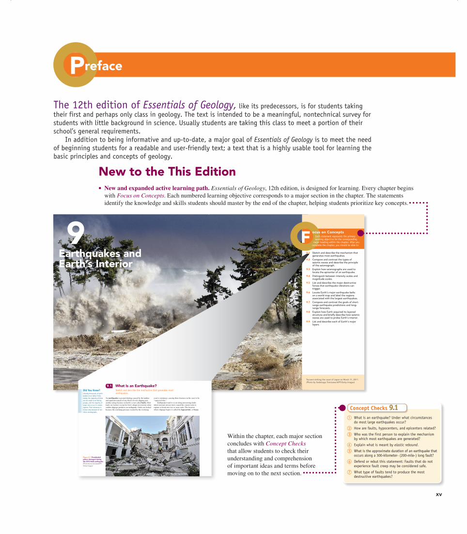
New to the This Edition•New and expanded active learning path. Essentials of Geology, 12th edition, is designed for learning. Every chapter begins
with Focus on Concepts. Each numbered learning objective corresponds to a major section in the chapter. The statements identify the knowledge and skills students should master by the end of the chapter, helping students prioritize key concepts.
The 12th edition of Essentials of Geology, like its predecessors, is for students taking their first and perhaps only class in geology. The text is intended to be a meaningful, nontechnical survey for students with little background in science. Usually students are taking this class to meet a portion of their school’s general requirements.
In addition to being informative and up-to-date, a major goal of Essentials of Geology is to meet the need of beginning students for a readable and user-friendly text; a text that is a highly usable tool for learning the basic principles and concepts of geology.
238
9Earthquakes and Earth’s Interior
M09_LUTG7734_12_C09.indd 238 12/5/13 2:12 PM
Tsunami striking the coast of Japan on March 11, 2011. (Photo by Sadatsugu Tomizawa/AFP/Getty Images)
Each statement represents the primary learning objective for the corresponding
major heading within the chapter. After you complete the chapter, you should be able to:
ocus on Concepts
9.1 Sketch and describe the mechanism that generates most earthquakes.
9.2 Compare and contrast the types of seismic waves and describe the principle of the seismograph.
9.3 Explain how seismographs are used to locate the epicenter of an earthquake.
9.4 Distinguish between intensity scales and magnitude scales.
9.5 List and describe the major destructive forces that earthquake vibrations can trigger.
9.6 Locate Earth’s major earthquake belts on a world map and label the regions associated with the largest earthquakes.
9.7 Compare and contrast the goals of short-range earthquake predictions and long-range forecasts.
9.8 Explain how Earth acquired its layered structure and briefly describe how seismic waves are used to probe Earth’s interior.
9.9 List and describe each of Earth’s major layers.
F
M09_LUTG7734_12_C09.indd 239 12/5/13 2:12 PM
Preface
xv
ChaptEr 9 Earthquakes and Earth’s Interior244
Seismograph recordingearthquake tremors
Bedrock
Bedrock
Pivot
Support
Suspendedweight
Wire
Rotating drumHorizontalground motion
A.
B.
and the largest earthquake yet recorded, the 1960 Chile quake (M 9.5).
Fault Propagation Slippage along large faults does not occur instantaneously. The initial slip begins at the hypocenter and propagates (travels) along the fault surface, at 2 to 4 kilometers per second—faster than a rifle shot. Slippage on one section of the fault adds strain to the adjacent segment, which may also slip. As this zone of slippage advances, it can slow down, speed up, or even jump to a nearby fault segment. The propagation of the rupture zone along a fault that is 300 kilometers (200 miles) long, for example, takes about 1.5 minutes, and it takes about 30 seconds for a fault that is 100 kilo-meters (60 miles) long. Earthquake waves are generated at every point along the fault as that portion of the fault begins to slip.
9.2 Seismology: The Study of Earthquake WavesCompare and contrast the types of seismic waves and describe the principle of the seismograph.
The study of earthquake waves, seismology, dates back to attempts made in China almost 2000 years ago to deter-mine the direction from which these waves originated. The earliest-known instrument, invented by Zhang Heng, was a large hollow jar that contained a weight suspended from the top (Figure 9.8). The suspended weight (similar to a clock pendulum) was connected to the jaws of several large dragon figurines that encircled the container. The jaws of each dragon held a metal ball. When earthquake waves reached the instru-ment, the relative motion between the suspended mass and the jar would dislodge some of the metal balls into the waiting mouths of frogs directly below.
Instruments That Record EarthquakesIn principle, modern seismographs, or seismometers, are similar to the instruments used in ancient China. A seismo-graph has a weight freely suspended from a support that is securely attached to bedrock (Figure 9.9). When vibra-
Did You Know?Humans have inadvertently triggered earthquakes. In 1962 Denver began experi-encing frequent tremors. The earthquakes were located near an army waste-disposal well used to inject waste into the ground. Investiga-tors concluded that the pressurized fluids made their way along a buried fault surface, which reduced fric-tion and triggered fault slip-page and earthquakes. Sure enough, when the pumping halted, so did the tremors.
Figure 9.9 Principle of the seismograph The inertia of the suspended weight tends to keep it motionless while the recording drum, which is anchored to bedrock, vibrates in response to seismic waves. The stationary weight provides a reference point from which to measure the amount of displacement occurring as a seismic wave passes through the ground. (Photo courtesy of Zephyr/Photo Researchers, Inc.)
Concept Checks 9.1 ① What is an earthquake? Under what circumstances
do most large earthquakes occur?
② How are faults, hypocenters, and epicenters related?
③ Who was the first person to explain the mechanism by which most earthquakes are generated?
④ Explain what is meant by elastic rebound.
⑤ What is the approximate duration of an earthquake that occurs along a 300-kilometer- (200-mile-) long fault?
⑥ Defend or rebut this statement: Faults that do not experience fault creep may be considered safe.
⑦ What type of faults tend to produce the most destructive earthquakes?
Balldropping
Figure 9.8 Ancient Chi-nese seismograph During an Earth tremor, the dragons located in the direction of the main vibrations would drop a ball into the mouth of a frog below. (Photo by James E. Patterson Collection)
M09_LUTG7734_12_C09.indd 244 12/5/13 2:12 PM
Within the chapter, each major section concludes with Concept Checks that allow students to check their understanding and comprehension of important ideas and terms before moving on to the next section.
Chapter 9 Earthquakes and Earth’s Interior240
9.1 What Is an Earthquake?Sketch and describe the mechanism that generates most earthquakes.
On January 12, 2010, an estimated 316,000 people lost their lives when a magnitude 7.0 earthquake struck the small Caribbean nation of Haiti, the poorest country in the Western Hemi-sphere. In addition to the staggering death toll, there were more than 300,000 injuries, and more than 280,000 houses were destroyed or damaged. The quake originated only 25 kilometers (15 miles) from the country’s densely populated capital city of Port-au-Prince (Figure 9.1). It occurred along a San Andreas–like fault system at a depth of just 10 kilometers (6 miles). Because of the quake’s shal-low depth, ground shaking was exceptional for an event of this magnitude.
Other factors that contributed to the Port-au-Prince disaster included the city’s geologic setting and the nature of its buildings. The city is built on sediment, which is quite susceptible to ground shaking during an earthquake. More importantly, inadequate or nonexistent building codes meant that buildings collapsed far more readily than they should have. At least 52 aftershocks, measuring magni-tude 4.5 or greater, jolted the area and added to the trauma survivors experienced for days after the original quake. An earthquake’s magnitude (abbreviation: M) is a measure of earthquake strength that will be discussed later in this chapter.
crust is enormous, causing these fractures in the crust to be “squeezed shut.”
Earthquakes tend to occur along preexisting faults where internal stresses have caused the crustal rocks to rupture or break into two or more units. The location where slippage begins is called the hypocenter, or focus.
An earthquake is ground shaking caused by the sudden and rapid movement of one block of rock slipping past another along fractures in Earth’s crust called faults. Most faults are locked, except for brief, abrupt movements when sudden slippage produces an earthquake. Faults are locked because the confining pressure exerted by the overlying
Figure 9.1 Presidential palace damaged during the 2010 Haiti earthquake (Photo by Luis Acosta/AFP/Getty Images)
Did You Know?Literally thousands of earth-quakes occur daily! Fortu-nately, the majority of them are too small to be felt by people, and the majority of larger ones occur in remote regions. Their existence is known only because of sen-sitive seismographs.
M09_LUTG7734_12_C09.indd 240 12/5/13 8:46 PM
A01_LUTG7734_12_NASTA_FM_i_xix.indd 15 12/10/13 2:57 PM
xvi
•Concepts in Review. This new end-of-chapter feature is an important part of the book’s revised active learning path. Each review is coordinated with the Focus on Concepts at the beginning of the chapter and with the numbered sections within the chapter. It is a readable and concise overview of key ideas, with photos, diagrams, and questions that also help students focus on important ideas and test their understanding of key concepts.
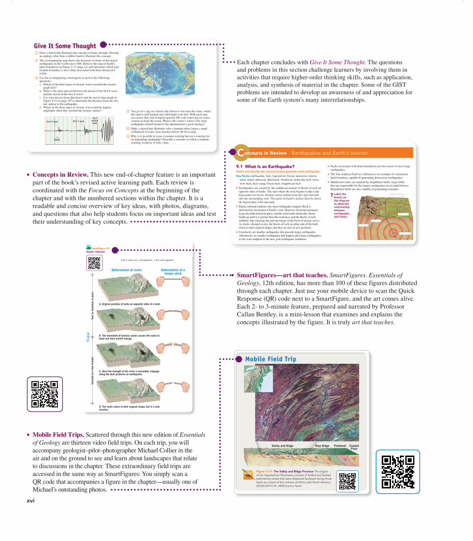
Each chapter concludes with Give It Some Thought. The questions and problems in this section challenge learners by involving them in activities that require higher-order thinking skills, such as application, analysis, and synthesis of material in the chapter. Some of the GIST problems are intended to develop an awareness of and appreciation for some of the Earth system’s many interrelationships.
ChaptEr 9 Earthquakes and Earth’s Interior242
Slippage along a fault produced
this offset in an orange grove
east of Calexico, California.
Slippage along a fault produced
this offset in an orange grove
east of Calexico, California.
This fence was offset2.5 meters (8.5 feet)during the1906 San Francisco earthquake.
Figure 9.4 Displacement of structures along a fault (Color photo by John S. Shelton/University of Washington Libraries; inset photo by G. K. Gilbert/USGS)
SmartFigure 9.5 Elastic rebound
A. Original position of rocks on opposite sides of a fault.
B. The movement of tectonic plates causes the rocks to bend and store elastic energy.
C. Once the strength of the rocks is exceeded, slippage along the fault produces an earthquake.
D. The rocks return to their original shape, but in a new location.
Deformation of rocks
Tim
e
Deformation of alimber stick
Tens
to h
undr
eds
of y
ears
Seco
nds
to a
few
min
utes
was accompanied by horizontal surface displacements of several meters along the northern portion of the San Andreas Fault. Field studies determined that during this single earthquake, the Pacific plate lurched as much as 9.7 meters (32 feet) northward past the adjacent North American plate. To better visualize this, imagine stand-ing on one side of the fault and watching a person on the other side suddenly slide horizontally 32 feet to your right.
What Reid concluded from his investigations is illustrated in Figure 9.5. Over tens to hundreds of years, differential stress slowly bends the crustal rocks on both sides of a fault. This is much like a person bend-ing a limber wooden stick, as shown in Figure 9.5A,B. Frictional resistance keeps the fault from rupturing and slipping. (Friction acts against slippage and is enhanced by irregularities that occur along the fault surface.) At some point, the stress along the fault overcomes the frictional resistance, and slip initiates. Slippage allows the deformed (bent) rock to “snap back” to its original, stress-free, shape; a series of earthquake waves radi-ate as it slides (see Figure 9.5C,D). Reid termed the “springing back” elastic rebound because the rock behaves elastically, much as a stretched rubber band does when it is released.
Aftershocks and ForeshocksStrong earthquakes are followed by numerous earth-quakes of lesser magnitude, called aftershocks, which result from crust along the fault surface adjusting to the displacement caused by the main shock. Aftershocks gradually diminish in frequency and intensity over a period of several months following an earthquake. In a little more than a month following the 2010 Haiti earth-quake, the U.S. Geological Survey detected nearly 60 aftershocks with magnitudes of 4.5 or greater. The two largest aftershocks had magnitudes of 6.0 and 5.9, both large enough to inflict damage. Hundreds of minor trem-ors were also felt.
extensive subsidence. In addition to these vertical displacements, offsets in fences, roads, and other structures indicate that horizontal movements between blocks of Earth’s crust are also common (Figure 9.4).
The actual mechanism of earthquake generation eluded geologists until H. F. Reid of Johns Hopkins University conduct-ed a landmark study following the 1906 San Francisco earthquake. This earthquake
M09_LUTG7734_12_C09.indd 242 12/5/13 2:12 PM
ChaptEr 9 Earthquakes and Earth’s Interior266
9.8 Earth’s Interiorexplain how earth acquired its layered structure and briefly describe how seismic waves are used to probe earth’s interior.
• The layered internal structure of Earth developed due to gravitational sorting of Earth materials early in the history of the planet. The densest material settled to form Earth’s center, while the least dense material rose to form the surface.
9.9 Earth’s Layerslist and describe each of earth’s major layers.Key Terms: crust, mantle, lithosphere, asthenosphere, core, outer core,
inner core
• Earth has two distinct kinds of crust: oceanic and continental. Oceanic crust is thinner, denser, and younger than continental crust. Oceanic crust also readily subducts, whereas the less dense continental crust does not.
• Seismic waves allow geoscientists to “look” into Earth’s interior, which would otherwise be invisible to scientific investigation. Like the x-rays used to image human bodies, seismic waves generated by large earthquakes reveal details about Earth’s layered structure.
• Earth’s mantle may be divided by density into upper and lower portions. The uppermost mantle makes up the bulk of rigid lithospheric plates, while a relatively weak layer, the asthenosphere, lies beneath it.
• The composition of Earth’s core is likely a mix of iron, nickel, and lighter elements. Iron and nickel are common heavy elements in meteorites, the leftover “building blocks” of Earth. The outer core is dense (around 10 times the density of water). It is known to be liquid, as S waves cannot pass through it. The inner core is solid and very dense (more than 13 times the density of water).
① Draw a sketch that illustrates the concept of elastic rebound. Develop an analogy other than a rubber band to illustrate this concept.
② The accompanying map shows the locations of many of the largest earthquakes in the world since 1900. Refer to the map of Earth’s plate boundaries in Figure 2.11 (page xx) and determine which type of plate boundary is most often associated with these destructive events.
③ Use the accompanying seismogram to answer the following questions:a. Which of the three types of seismic waves reached the seismo-
graph first?b. What is the time interval between the arrival of the first P wave
and the arrival of the first S wave?c. Use your answer from Question b and the travel–time graph in
Figure 9.15 on page 247 to determine the distance from the seis-mic station to the earthquake.
d. Which of the three types of seismic waves had the highest amplitude when they reached the seismic station?
Give It Some Thought
④ You go for a jog on a beach and choose to run near the water, where the sand is well packed and solid under your feet. With each step, you notice that your footprint quickly fills with water but not water coming in from the ocean. What is this water’s source? For what earthquake-related hazard is this phenomenon a good analogy?
⑤ Make a sketch that illustrates why a tsunami often causes a rapid withdrawal of water from beaches before the first surge.
⑥ Why is it possible to issue a tsunami warning but not a warning for an impending earthquake? Describe a scenario in which a tsunami warning would be of little value.
M09_LUTG7734_12_C09.indd 266 12/5/13 2:13 PM
2639.9 Earth’s Layers
CoreThe composition of the core is thought to be an iron–nickel alloy, with minor amounts of oxygen, silicon, and sulfur—elements that readily form compounds with iron. At the extreme pressure found in the core, this iron-rich material has an average density of more than 10 grams per cubic centimeter (10 times the density of water) and is about 13 grams per cubic centimeter (13 times the density of water) at Earth’s center. The core is divided into two regions that exhibit very different mechanical strengths. The outer core is a liquid layer 2270 kilome-ters (1410 miles) thick. The movement of metallic iron within this zone generates Earth’s magnetic field. The inner core is a sphere with a radius of 1216 kilometers (754 miles). Despite its higher temperature, the iron in the inner core is solid due to the immense pressures that exist in the center of the planet.
thick below the oldest portions of the continents (see Figure 9.37). Beneath this stiff layer to a depth of about 350 kilome-ters (217 miles) lies a soft, comparatively weak layer known as the asthenosphere (“weak sphere”). The top portion of the asthenosphere has a temperature/pressure regime that results in a small amount of melting. Within this very weak zone, the asthenosphere and lithosphere are mechanically detached from each other. The result is that the lithosphere is able to move independently of the asthenosphere.
It is important to emphasize that the strength of vari-ous Earth materials is a function of both their composition and the temperature and pressure of their environment. The entire lithosphere does not behave like a brittle solid similar to rocks found on the surface. Rather, the rocks of the lithosphere get progressively hotter and weaker (more easily deformed) with increasing depth. At the depth of the uppermost asthenosphere, the rocks are close enough to their melting temperature that they are very easily deformed, and some melting may actually occur. Thus, the uppermost asthenosphere is weak because it is near its melting point, just as hot wax is weaker than cold wax.
From 660 kilometers (410 miles) deep to the top of the core, at a depth of 2900 kilometers (1800 miles), is the lower mantle. Because of an increase in pressure (caused by the weight of the rock above), the mantle gradually strengthens with depth. Despite their strength, however, the rocks within the lower mantle are very hot and capable of very gradual flow.
Concept Checks 9.9 ① How do continental crust and oceanic crust differ?
② Contrast the physical makeup of the asthenosphere and the lithosphere.
③ How are Earth’s inner and outer cores different? How are they similar?
9.1 What Is an Earthquake?Sketch and describe the mechanism that generates most earthquakes.Key Terms: earthquake, fault, hypocenter (focus), epicenter, seismic
wave, elastic rebound, aftershock, foreshock, strike-slip fault, trans-form fault, fault creep, thrust fault, megathrust fault
• Earthquakes are caused by the sudden movement of blocks of rock on opposite sides of faults. The spot where the rock begins to slip is the hypocenter (or focus). Seismic waves radiate from this spot outward into the surrounding rock. The point on Earth’s surface directly above the hypocenter is the epicenter.
• Elastic rebound explains why most earthquakes happen: Rock is deformed by movement of Earth’s crust. However, frictional resistance keeps the fault locked in place, and the rock bends elastically. Strain builds up until it is greater than the resistance, and the blocks of rock suddenly slip, releasing the pent-up energy in the form of seismic waves. As elastic rebound occurs, the blocks of rock on either side of the fault return to their original shapes, but they are now in new positions.
• Foreshocks are smaller earthquakes that precede larger earthquakes. Aftershocks are smaller earthquakes that happen after large earthquakes, as the crust readjusts to the new, post-earthquake conditions.
oncepts in Review Earthquakes and Earth’s InteriorC• Faults associated with plate boundaries are the source of most large
earthquakes.
• The San Andreas Fault in California is an example of a transform fault boundary capable of generating destructive earthquakes.
• Subduction zones are marked by megathrust faults, large faults that are responsible for the largest earthquakes in recorded history. Megathrust faults are also capable of generating tsunamis.
? label the blanks on the diagram to show the relationship between earthquakes and faults.
M09_LUTG7734_12_C09.indd 263 12/5/13 2:13 PM
that ensued, called the Taconic Orogeny, caused the volcanic arc along with ocean sediments that were located on the upper plate to be thrust over the larger continental block. The remnants of this volcanic arc and oceanic sediments are recognized today as the metamorphic rocks found across much of the western Appalachians, especially in New York (Figure 11.30B). In addition to the pervasive regional metamorphism, numerous magma bodies intruded the crust-al rocks along the entire continental margin.
Acadian Orogeny A second episode of mountain building, called the Acadian Orogeny, occurred about 350 million years ago. The continued closing of this ancient ocean basin resulted in the collision of a microcontinent with North America (Figure 11.30C). This orogeny involved thrust fault-ing, metamorphism, and the intrusion of several large granite bodies. In addition, this event added substantially to the width of North American.
Alleghanian Orogeny The final orogeny, called the Alleghanian Orogeny, occurred between 250 and 300 million years ago, when Africa collided with North America. The result was the displacement of the material that was accreted earlier by as much as 250 kilometers (155 miles) toward the interior of North America. This event also displaced and further deformed the shelf sediments and sedimentary rocks that had once flanked the eastern margin of North America (Figure 11.30D). Today these folded and thrust-faulted sandstones, limestones, and shales make up the largely unmetamor-phosed rocks of the Valley and Ridge Province (Figure 11.31). Outcrops of the folded and thrust-faulted struc-tures that characterize collisional mountains are found as far inland as central Pennsylvania and West Virginia.
With the collision of Africa and North America, the Appalachians, perhaps as majestic as the Himalayas, lay in the interior of Pangaea. Then, about 180 million years ago, this newly formed supercontinent began to break into smaller fragments, a process that ultimately cre-ated the modern Atlantic Ocean. Because this new zone of rifting occurred east of the suture that formed when Africa and North America collided, remnants of Africa remain “welded” to the North American plate (Figure 11.30E). The crust underlying Florida is an example.
Other mountain ranges that exhibit evidence of conti-nental collisions include the Alps and the Urals. The Alps formed as Africa and at least two smaller crustal fragments
31111.6 Collisional Mountain Belts
Concept Checks 11.6 ① Differentiate between terrane and terrain.
② During the formation of the Himalayas, the conti-nental crust of Asia was deformed more than India proper. Why was this the case?
③ Where might magma be generated in a newly formed collisional mountain belt?
④ How does the plate tectonics theory help explain the existence of fossil marine life in rocks atop compres-sional mountains?
Figure 11.31 The Valley and Ridge Province This region of the Appalachian Mountains consists of folded and faulted sedimentary strata that were displaced landward along thrust faults as a result of the collision of Africa with North America. (NASA/GSFC/JPL, MISR Science Team)
Mobile Field Trip
Valley and Ridge Blue Ridge Piedmont CoastalPlain
collided with Europe during the closing of the Tethys Sea. Similarly, the Urals were uplifted during the assembly of Pangaea, when northern Europe and northern Asia col-lided, forming a major portion of Eurasia.
M11_LUTG7734_12_C11_p290-317.indd 311 12/9/13 2:53 PM
• SmartFigures—art that teaches. SmartFigures. Essentials of Geology, 12th edition, has more than 100 of these figures distributed through each chapter. Just use your mobile device to scan the Quick Response (QR) code next to a SmartFigure, and the art comes alive. Each 2- to 3-minute feature, prepared and narrated by Professor Callan Bentley, is a mini-lesson that examines and explains the concepts illustrated by the figure. It is truly art that teaches.
•Mobile Field Trips. Scattered through this new edition of Essentials of Geology are thirteen video field trips. On each trip, you will accompany geologist–pilot–photographer Michael Collier in the air and on the ground to see and learn about landscapes that relate to discussions in the chapter. These extraordinary field trips are accessed in the same way as SmartFigures: You simply scan a QR code that accompanies a figure in the chapter—usually one of Michael’s outstanding photos.
A01_LUTG7734_12_NASTA_FM_i_xix.indd 16 12/10/13 2:57 PM
xviiPreface
•An unparalleled visual program. In addition to more than 150 new, high-quality photos and satellite images, dozens of figures are new or have been redrawn by renowned geoscience illustrator Dennis Tasa. Maps and diagrams are frequently paired with photographs for greater effectiveness. Further, many new and revised figures have additional labels that narrate the process being illustrated and guide students as they examine the figures resulting in is a visual program that is clear and easy to understand.
•MasteringGeologyTM. MasteringGeology delivers engaging, dynamic learning opportunities—focused on course objectives and responsive to each student’s progress—that are proven to help students absorb course material and understand difficult concepts. Assignable activities in MasteringGeology include Encounter Earth activities using Google EarthTM, SmartFigure activities, GeoTutor activities, GigaPan® activities, Geoscience Animation activities, GEODe tutorials, and more. MasteringGeology also includes all instructor resources and a robust Study Area with resources for students.
•Revised organization. Earlier editions of this text had a more traditional chapter organization, in which the theory of plate tectonics was fully developed relatively late in the text. A major change to Essentials of Geology, 12th edition, is a reorganization in which this basic theory is presented in Chapter 2 to reflect the unifying role that plate tectonics plays in our understanding of planet Earth. With the basic framework of plate tectonics firmly established, we turn to discussions of Earth materials and the related processes of volcanism and metamorphism. This is followed by chapters that examine earthquakes, the origin and evolution of the ocean floor, and crustal deformation and mountain building. Along the way, students will clearly see the relationships among these phenomena and the theory of plate tectonics.
• Significant updating and revision of content. A basic function of a science textbook is to provide clear, understandable presentations that are accurate, engaging, and up-to-date. Our number-one goal is to keep Essentials of Geology current, relevant, and highly readable for beginning students. Every part of this text has been examined carefully with this goal in mind. Many discussions, case studies, and examples have been revised. The 12th edition represents perhaps the most extensive and thorough revision in the long history of this textbook.
Distinguishing FeaturesReadabilityThe language of this text is straightforward and written to be un-derstood. Clear, readable discussions with a minimum of techni-cal language are the rule. The frequent headings and subheadings help students follow discussions and identify the important ideas presented in each chapter. In the 12th edition, we have continued to improve readability by examining chapter organization and flow and by writing in a more personal style. Significant portions of several chapters were substantially rewritten in an effort to make the material easier to understand.
Focus on Basic Principles and Instructor FlexibilityAlthough many topical issues are treated in the 12th edition of Essentials of Geology, it should be emphasized that the main focus of this new edition remains the same as the focus of each of its predecessors: to promote student understanding of basic prin-ciples. As much as possible, we have attempted to provide the reader with a sense of the observational techniques and reasoning processes that constitute the science of geology.
As in previous editions, we have designed most chapters to be self-contained so that material may be taught in a different se-quence, according to the preference of the teacher or the dictates of the laboratory. Thus, a teacher who wishes to discuss erosional processes prior to earthquakes, plate tectonics, and mountain building may do so without difficulty.
A Strong Visual ComponentGeology is highly visual, and art and photographs play a critical role in an introductory textbook. As in previous editions, Dennis Tasa, a gifted artist and respected geoscience illustra-tor, has worked closely with the authors to plan and produce the diagrams, maps, graphs, and sketches that are so basic to student understanding. The result is art that is clearer and easier to under-stand than ever before.
Our aim is to get maximum effectiveness from the visual component of the text. Michael Collier, an award-winning geolo-gist–pilot–photographer, aided greatly in this quest. As you read through this text, you will see dozens of his extraordinary aerial photographs. His contributions truly help bring geology alive for the reader.
A01_LUTG7734_12_NASTA_FM_i_xix.indd 17 12/10/13 2:57 PM
xviii Preface
• Understand immediately where students are and adjust your lecture accordingly.
• Improve your students’ critical-thinking skills.
• Access rich analytics to understand student performance.
• Add your own questions to make Learning Catalytics fit your course exactly.
• Manage student interactions with intelligent grouping and timing.
Learning Catalytics is a technology that has grown out of twenty years of cutting edge research, innovation, and imple-mentation of interactive teaching and peer instruction. Available integrated with MasteringGeology. www.learningcatalytics.com
For the TeacherPearson continues to improve the teacher resources in this text, with the goal of saving you time in preparing for your classes.
Some of the teacher supplements and resources for this text are available electronically to qualified adopters on the Instructor Resource Center (IRC). Upon adoption or to preview, please go to www.pearsonschool.com/access _request and select Instruc-tor Resource Center. You will be required to complete a brief one-time registration subject to verification of educator status. Upon verification, access information and instructions will be sent to you via email. Once logged into the IRC, enter ISBN 978-0-13-354013-0 in the “Search our Catalog” box to locate re-sources. Electronic teacher supplements are also available within the Instructor’s tab of MasteringGeology.
Instructor’s Resource DVDThe IRDVD puts all your class resources in one easy-to-reach place:
• Three PowerPoint® presentations for each chapter
• The Geoscience Animation Library
• All the line art, tables, and photos from the text, in .jpg files
• “Images of Earth” photo gallery
• Instructor’s Manual in Microsoft Word
• Test Bank in Microsoft Word
• TestGen test-generation and management software
PowerPoints®
The IRDVD provides three PowerPoint files for each chapter to cut down on your preparation time, no matter what your lecture needs:
• Art. All the line art, tables, and photos from the text have been preloaded into PowerPoint slides for easy integration into your presentations.
• Lecture outline. Each set averages 35 slides per chapter and includes customizable lecture outlines with supporting art.
• Classroom Response System (CRS) questions. These questions have been authored for use in conjunction with any classroom response system. You can electronically poll your class for responses to questions, pop quizzes, attendance, and more.
The Teaching and Learning Package
MasteringGeology from Pearson is an online homework, tutorial, and assessment product designed to improve results by helping students quickly master concepts. Students using MasteringGeol-ogy benefit from self-paced tutorials that feature specific wrong-answer feedback and hints to keep them engaged and on track. MasteringGeology™ offers:
• Assignable activities, including Encounter Earth activities using Google Earth™, SmartFigure activities, GeoTutor activities, GigaPan® activities, Geoscience Animation activities, GEODe activities, and more
• Additional Concept Check and Give It Some Thought questions, Test Bank questions, and Reading Quizzes
• A student Study Area with Geoscience Animations, GEODe: Essentials of Geology activities, In the News RSS feeds, Self Study Quizzes, Web Links, Glossary, and Flashcards
• Pearson eText for Essentials of Geology, 12th edition, which gives students access to the text whenever and wherever they can access the Internet and includes powerful interactive and customization functions
See www.masteringgeology.com
Upon textbook purchase, students and teachers are granted access to MasteringGeology. High school teachers can obtain preview or adoption access for MasteringGeology in one of the following ways:
Preview Access
• Teachers can request preview access online by visitingPearsonSchool.com/Access_Request, select Initial Access
then Option 2. Preview Access information will be sent to the teacher via email.
Adoption Access
• With the purchase of this program, a Pearson Adoption Access Card with Instructor Manual, will be delivered with your textbook purchase. (ISBN: 0-13-353986-5)
•Ask your sales representative for an Pearson Adoption Access Card with Instructor Manual. (ISBN: 0-13-353986-5)
OR
•Visit PearsonSchool.com/Access_Request , select Initial Access then Option 3. Adoption access information will be sent to the teacher via email.
Students, ask your teacher for access.
Learning CatalyticsLearning Catalytics™ is a “bring your own device” student en-gagement, assessment, and classroom intelligence system. With Learning Catalytics you can:
• Assess students in real time, using open-ended tasks to probe student understanding.
A01_LUTG7734_12_NASTA_FM_i_xix.indd 18 12/10/13 2:57 PM
xixPreface
Animations and “Images of Earth”The Pearson Geoscience Animation Library includes more than 100 animations that illustrate many difficult-to-visualize topics of geology. Created through a unique collaboration among five of Pearson’s leading geoscience authors, these animations represent a significant step forward in class presentation aids. They are provided both as Flash files and, for your convenience, preloaded into PowerPoint slides.
“Images of Earth” allows you to supplement your personal and text-specific slides with an amazing collection of more than 300 geologic photos contributed by Marli Miller (University of Oregon) and other professionals in the field. The photos are avail-able on the Instructor’s Resource DVD.
Instructor’s Manual with Test BankThe Instructor’s Manual contains learning objectives, chapter outlines, answers to end-of-chapter questions, and suggested short demonstrations to spice up your class discussion. The Test Bank incorporates art and averages 75 multiple-choice, true/false, short-answer, and critical thinking questions per chapter.
TestGenUse this electronic version of the Test Bank to customize and manage your tests. Create multiple versions, add or edit ques-tions, add illustrations, and so on. This powerful software easily addresses your customization needs.
AcknowledgmentsWriting a college textbook requires the talents and cooperation of many people. It is truly a team effort, and the authors are fortu-nate to be part of an extraordinary team at Pearson Education. In addition to being great people to work with, all are committed to producing the best textbooks possible. Special thanks to our geol-ogy editor, Andy Dunaway, who invested a great deal of time, energy, and effort in this project. We appreciate his enthusiasm, hard work, and quest for excellence. We also appreciate our con-scientious project manager, Crissy Dudonis, whose job it was to keep track of all that was going on—and a lot was going on. The text’s new design and striking cover resulted from the creative talents of Derek Bacchus and his team. We think it is a job well done. As always, our marketing manager, Maureen McLaughlin, provided helpful advice and many good ideas. Essentials of Geol-ogy, 12th edition, was truly improved with the help of our devel-opmental editor Jonathan Cheney. Many thanks. It was the job of the production team, led by Heidi Allgair at Cenveo® Publisher Services, to turn our manuscript into a finished product. The team also included copyeditor Kitty Wilson, compositor Annamarie Boley, proofreader Heather Mann, and photo researcher Kristin Piljay. We think these talented people did great work. All are true professionals, with whom we are very fortunate to be associated.
The authors owe special thanks to three people who were very important contributors to this project:
•Working with Dennis Tasa, who is responsible for all of the text’s outstanding illustrations, is always special for us. He has been part of our team for more than 30 years. We not only value
his artistic talents, hard work, patience, and imagination but his friendship as well.
•As you read this text, you will see dozens of extraordinary photographs by Michael Collier. Most are aerial shots taken from his nearly 60-year-old Cessna 180. Michael was also responsible for preparing the remarkable Mobile Field Trips that are scattered through the text. Among his many awards is the American Geological Institute Award for Outstanding contribution to the Public Understanding of Geosciences. We think that Michael’s photographs and field trips are the next best thing to being there. We were very fortunate to have had Michael’s assistance on Essentials of Geology, 12th edition. Thanks, Michael.
•Callan Bentley has been an important addition to the Essentials of Geology team. Callan is an assistant professor of geology at Northern Virginia Community College in Annandale, where he has been honored many times as an outstanding teacher. He is a frequent contributor to Earth magazine and is author of the popular geology blog Mountain Beltway. Callan was responsible for preparing the SmartFigures that appear throughout the text. As you take advantage of these outstanding learning aids, you will hear his voice explaining the ideas. Callan also contributed to the Concepts in Review feature found at the end of each chapter. We appreciate Callan’s contributions to this new edition of Essentials of Geology.
Great thanks also go to those colleagues who prepared in-depth reviews. Their critical comments and thoughtful input helped guide our work and clearly strengthened the text. Special thanks to:
Tania Anders, Texas A&M University–Corpus ChristiJamie Barnes, University of Texas–AustinDavid Bradley, Georgia Southern UniversityAlan Coulson, Clemson UniversitySarah de la Rue, Purdue–CalumetNoah Fay, Pima Community CollegeThomas Gerber, Indiana University of PAWayne Henderson, California State University–FullertonEdgar Kessler, Northampton Community CollegeKatherine Knierim, University of ArkansasSam Matson, Boise State UniversityCharles Merguerian, Hofstra UniversityStephen Moysey, Clemson UniversityJodi Ryder, Central Michigan UniversityRobert Shuster, University of Nebraska–OmahaGordana Vlahovic, North Carolina Central CollegeMerry Wilson, Scottsdale Community CollegeChris Woltemade, Shippensburg UniversityAdam Woods, California State University–FullertonSally Zellers, University of Central MissouriJames Zollweg, Boise State University
Last, but certainly not least, we gratefully acknowledge the support and encouragement of our wives, Nancy Lutgens and Joanne Bannon. Preparation of Essentials of Geology, 12th edi-tion, would have been far more difficult without their patience and understanding.
Fred LutgensEd Tarbuck
A01_LUTG7734_12_NASTA_FM_i_xix.indd 19 12/10/13 2:57 PM