epilogue backmatter
TRANSCRIPT
294294
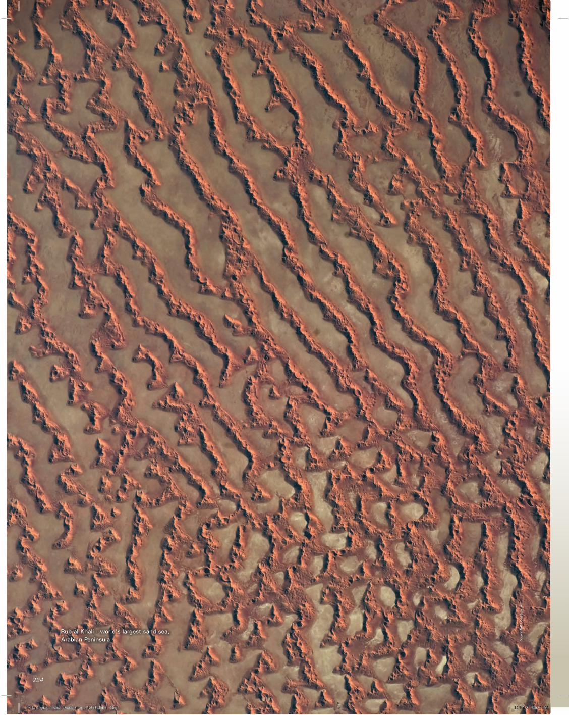
Rub al Khali - world’s largest sand sea, Arabian Peninsula So
urce
: NAS
A IS
S/Fl
ickr
.com
60_Epilogue_Index_BackMatter_112212.indd 294 11/5/13 12:37 PM
“There was no water and too much sand…”
EpiloguE
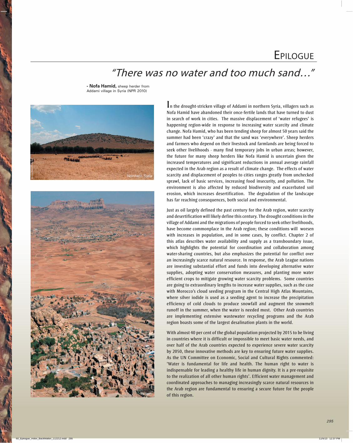
- Nofa Hamid, sheep herder from Addami village in Syria (NPR 2010)
In the drought-stricken village of Addami in northern Syria, villagers such as Nofa Hamid have abandoned their once-fertile lands that have turned to dust in search of work in cities. The massive displacement of ‘water refugees’ is happening region-wide in response to increasing water scarcity and climate change. Nofa Hamid, who has been tending sheep for almost 50 years said the summer had been ‘crazy’ and that the sand was ‘everywhere’. Sheep herders and farmers who depend on their livestock and farmlands are being forced to seek other livelihoods - many find temporary jobs in urban areas; however, the future for many sheep herders like Nofa Hamid is uncertain given the increased temperatures and significant reductions in annual average rainfall expected in the Arab region as a result of climate change. The effects of water scarcity and displacement of peoples to cities ranges greatly from unchecked sprawl, lack of basic services, increasing food insecurity, and pollution. The environment is also affected by reduced biodiversity and exacerbated soil erosion, which increases desertification. The degradation of the landscape has far reaching consequences, both social and environmental.
Just as oil largely defined the past century for the Arab region, water scarcity and desertification will likely define this century. The drought conditions in the village of Addami and the migrations of people forced to seek other livelihoods, have become commonplace in the Arab region; these conditions will worsen with increases in population, and in some cases, by conflict. Chapter 2 of this atlas describes water availability and supply as a transboundary issue, which highlights the potential for coordination and collaboration among water-sharing countries, but also emphasizes the potential for conflict over an increasingly scarce natural resource. In response, the Arab League nations are investing substantial effort and funds into developing alternative water supplies, adopting water conservation measures, and planting more water efficient crops to mitigate growing water scarcity problems. Some countries are going to extraordinary lengths to increase water supplies, such as the case with Morocco’s cloud seeding program in the Central High Atlas Mountains, where silver iodide is used as a seeding agent to increase the precipitation efficiency of cold clouds to produce snowfall and augment the snowmelt runoff in the summer, when the water is needed most. Other Arab countries are implementing extensive wastewater recycling programs and the Arab region boasts some of the largest desalination plants in the world.
With almost 40 per cent of the global population projected by 2015 to be living in countries where it is difficult or impossible to meet basic water needs, and over half of the Arab countries expected to experience severe water scarcity by 2050, these innovative methods are key to ensuring future water supplies. As the UN Committee on Economic, Social and Cultural Rights commented: ‘Water is fundamental for life and health. The human right to water is indispensable for leading a healthy life in human dignity. It is a pre-requisite to the realization of all other human rights’. Efficient water management and coordinated approaches to managing increasingly scarce natural resources in the Arab region are fundamental to ensuring a secure future for the people of this region.
295
Northern Syria
Sour
ce: H
ovic
/Flic
kr.c
om
Yemen
Sour
ce: W
ikic
omm
ons
60_Epilogue_Index_BackMatter_112212.indd 295 11/5/13 12:37 PM
ACSAD Arab Center for Studies of Arid Zones and Drylands
AFED Arab Forum for Environment and Development
ATDP Arab Trade and Development Program
BCE Before the Common Era
BCM billion (thousand million) cubic metres
bpd barrels per day
boe barrels of oil equivalent
°C Celsius
CAEU Council of the Arab Economic Unity
CBD Convention on Biological Diversity
CEDARE Center for Environment and Development for the Arab Region and Europe
cm centimeters
CO Carbon Monoxide
CO2 Carbon Dioxide
DAC Development Assistance Committee
EPA Environmental Protection Agency
ESCWA Economic and Social Commission for Western Asia
FAO Food and Agriculture Organization of the United Nations
GCC Gulf Cooperation Council
GDP Gross Domestic Product
GEF Global Environment Fund
GEO Group on Earth Observations
GHG Greenhouse Gases
GIS Geographic Information System
GNP Gross National Product
GWh Gigawatt Hour
ha hectares
HDI Human Development Indicator
HIPC Heavily Indebted Poor Countries
IBAs Important Bird Areas
IDPs Internally displaced persons
IGBP International Geosphere-Biosphere Programme
IPCC Intergovernmental Panel on Climate Change
IUCN International Union for Conservation of Nature and Natural Resources
kg kilograms
km kilometres
km2 square kilometres
km3 cubic kilometres
LDCs Least Developed Countries
m metres
m2 square metres
m3 cubic metres
m3/sec cubic metres per second
Mashreq region Egypt, Iraq, Jordan, Lebanon, Palestinian and Syria
Maghreb region African nations of Algeria, Libya, Morocco, Tunisia and Mauritania
MCM million cubic metres
MDRI Multilateral Debt Relief Initiative
MDGs Millennium Development Goals
mm millimetres
MODIS Moderate Resolution Imaging Spectoradiometer
MW Megawatt
n.d. no date
NO2 Nitrogen Dioxide
NOX nitrogen oxides
N2O Nitrous Oxide
NASA National Aeronautics and Space Administration, United States of America
NCSA National Capacity Self Assessments
NOAA National Oceanic and Atmospheric Administration, United States of America
O3 ozone
OPEC Organization of the Petroleum Exporting Countries
PCB Polychlorinated biphenyl
PERSGA Regional Organization for the Conservation of the Environment of the Red Sea
and Gulf of Aden
ppm parts per million
PM particulate matter
ROPME Regional Organisation for the Protection of the Marine Environment
RSA ROPME Sea Area
RSGA Red Sea and Gulf of Aden
SIDS Small Island Developing States
SOX sulphur oxides
UAE United Arab Emirates
µg microgram
UN United Nations
UNCCD UnitedNationsConventiontoCombatDesertification
UNDP United Nations Development Programme
UNEP United Nations Environment Programme
UNESCOUnitedNationsEducational,ScientificandCulturalOrganisation
UNFCCC United Nations Framework Convention on Climate Change
UNICEF United Nations Children’s Fund
UNSD United Nations Statistics Division
USAID United States Agency for International Development
USGS United States Geological Survey
WFP World Food Programme
WHO World Health Organization
WRI World Resources Institute
WTO World Trade Organization
WWF World Wildlife Fund
yr year
Acronyms And AbbrEviAtions
296
Sour
ce: M
artin
Alle
n/Fl
ickr
.com
60_Epilogue_Index_BackMatter_112212.indd 296 11/5/13 12:37 PM
AnnEx i
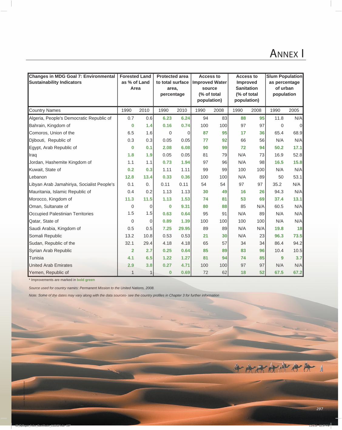
Changes in MDG Goal 7: Environmental Sustainability Indicators
5002099180020991800209910102099101020991semaN yrtnuoC
Algeria, People's Democratic Republic of 0.7 0.6 6.23 6.24 94 83 88 95 11.8 N/ABahrain, Kingdom of 0 1.4 0.16 0.74 100 100 97 97 0 0
006.15.6 eht fo noinU ,soromoC 87 95 17 36 65.4 68.93.03.0 fo cilbupeR ,ituobijD 0.05 0.05 77 92 66 56 N/A N/A
Egypt, Arab Republic of 0 0.1 2.08 6.08 90 99 72 94 50.2 17.1Iraq 1.8 1.9 0.05 0.05 81 79 N/A 73 16.9 52.8Jordan, Hashemite Kingdom of 1.1 1.1 0.73 1.94 97 96 N/A 98 16.5 15.8Kuwait, State of 0.2 0.3 1.11 1.11 99 99 100 100 N/A N/ALebanon 12.8 13.4 0.33 0.36 100 100 N/A 89 50 53.1Libyan Arab Jamahiriya, Socialist People's 0.1 0. 0.11 0.11 54 54 97 97 35.2 N/AMauritania, Islamic Republic of 0.4 0.2 1.13 1.13 30 49 16 26 94.3 N/AMorocco, Kingdom of 11.3 11.5 1.13 1.53 74 81 53 69 37.4 13.1
00 fo etanatluS ,namO 0 9.31 80 88 85 N/A 60.5 N/AOccupied Palestinian Territories 0.63 0.64 95 91 N/A 89 N/A N/A
00 fo etatS ,rataQ 0.89 1.39 100 100 100 100 N/A N/A5.05.0fo modgniK ,aibarA iduaS 7.25 29.95 89 89 N/A N/A 19.8 18
35.035.08.012.31cilbupeR ilamoS 21 30 N/A 23 96.3 73.52.494.684343755681.481.44.921.23eht fo cilbupeR ,naduS
Syrian Arab Republic 2 2.7 0.25 0.64 85 89 83 96 10.4 10.5Tunisia 4.1 6.5 1.22 1.27 81 94 74 85 9 3.7United Arab Emirates 2.9 3.8 0.27 4.71 100 100 97 97 N/A N/A
11 fo cilbupeR ,nemeY 0 0.69 72 62 18 52 67.5 67.2* Improvements are marked in bold green
Source used for country names: Permanent Mission to the United Nations, 2008.
Note: Some of the dates may vary along with the data sources- see the country profiles in Chapter 3 for further information
Slum Population as percentage
of urban population
Forested Land as % of Land
Area
Protected area to total surface
area,percentage
Access to Improved Water
source(% of total
population)
Access to ImprovedSanitation(% of total
population)
1.5 1.5
297297
Sour
ce: M
artin
Alle
n/Fl
ickr
.com
60_Epilogue_Index_BackMatter_112212.indd 297 11/5/13 12:37 PM
The field of Remote Sensing has grown considerably since its infancy in the early 1970s when the initial earth-observing satellite of the Landsat program was launched. The Landsat program, jointly managed by NASA and the U.S. Geological Survey, has collected and archived images of the Earth’s surface for nearly 40 years. This valuable historical record provides a unique opportunity for identifying and documenting environmental change anywhere on the planet. This atlas relies heavily, although not completely, on the images provided by the Landsat Program to depict environmental change in the Arab region. Since the initial earth-observing satellite of the Landsat Program was launched in the 1970s several new satellites with improved sensors (EO-1, OrbView, IKONOS etc.) collected data at higher resolutions and with an ability to capture different portions of electromagnetic radiation (e.g. radio waves, microwaves, visible light, infrared). The improved imagery from non-Landsat satellites proved invaluable in documenting change in the Arab region. Additionally, this atlas benefited from declassified satellite data, such as the images from the CORONA program, which allowed for documenting change in the Arab region from as early as the 1960s.
Satellites, like Landsat, use “multispectral” sensors to collect reflected electromagnetic energy from the visible range (400 to 700 nanometers), as well as wavelengths that the human eye cannot see (700 to 2 350 nanometers), and thermal energy to create images of the Earth. Multi-spectral sensors divide electromagnetic radiation into a small number of “bands” or ranges of wavelength. For example Landsat-7 collects electromagnetic radiation in eight different bands or ranges of wavelength (see table). Each of these ranges of “light” can tell us something different about the Earth’s surface.
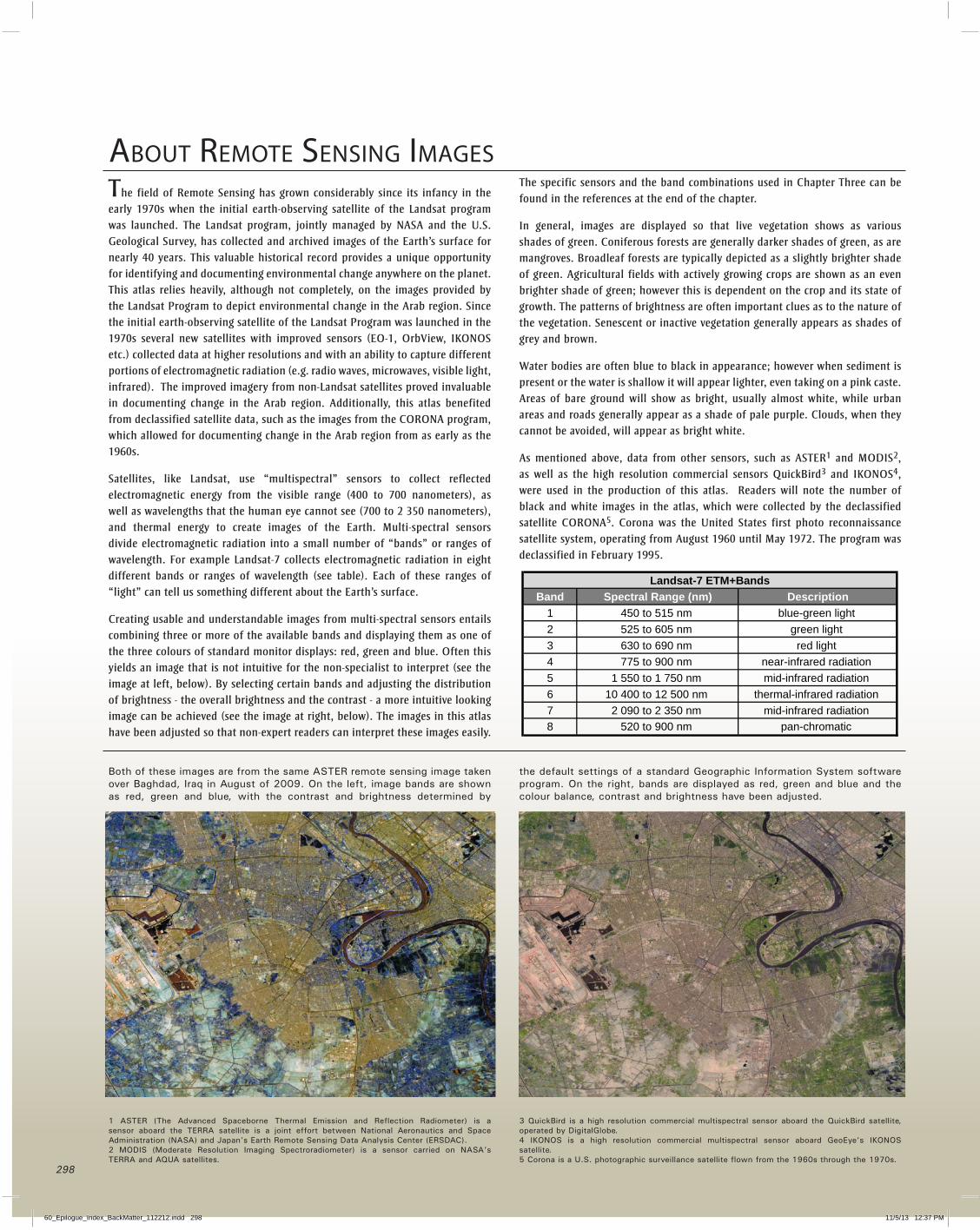
Creating usable and understandable images from multi-spectral sensors entails combining three or more of the available bands and displaying them as one of the three colours of standard monitor displays: red, green and blue. Often this yields an image that is not intuitive for the non-specialist to interpret (see the image at left, below). By selecting certain bands and adjusting the distribution of brightness - the overall brightness and the contrast - a more intuitive looking image can be achieved (see the image at right, below). The images in this atlas have been adjusted so that non-expert readers can interpret these images easily.
The specific sensors and the band combinations used in Chapter Three can be found in the references at the end of the chapter.
In general, images are displayed so that live vegetation shows as various shades of green. Coniferous forests are generally darker shades of green, as are mangroves. Broadleaf forests are typically depicted as a slightly brighter shade of green. Agricultural fields with actively growing crops are shown as an even brighter shade of green; however this is dependent on the crop and its state of growth. The patterns of brightness are often important clues as to the nature of the vegetation. Senescent or inactive vegetation generally appears as shades of grey and brown.
Water bodies are often blue to black in appearance; however when sediment is present or the water is shallow it will appear lighter, even taking on a pink caste. Areas of bare ground will show as bright, usually almost white, while urban areas and roads generally appear as a shade of pale purple. Clouds, when they cannot be avoided, will appear as bright white.
As mentioned above, data from other sensors, such as ASTER1 and MODIS2, as well as the high resolution commercial sensors QuickBird3 and IKONOS4, were used in the production of this atlas. Readers will note the number of black and white images in the atlas, which were collected by the declassified satellite CORONA5. Corona was the United States first photo reconnaissance satellite system, operating from August 1960 until May 1972. The program was declassified in February 1995.
About rEmotE sEnsing imAgEs
Both of these images are from the same ASTER remote sensing image taken over Baghdad, Iraq in August of 2009. On the left, image bands are shown as red, green and blue, with the contrast and brightness determined by
the default settings of a standard Geographic Information System software program. On the right, bands are displayed as red, green and blue and the colour balance, contrast and brightness have been adjusted.
1 ASTER (The Advanced Spaceborne Thermal Emission and Reflection Radiometer) is a sensor aboard the TERRA satellite is a joint effort between National Aeronautics and Space Administration (NASA) and Japan’s Earth Remote Sensing Data Analysis Center (ERSDAC).2 MODIS (Moderate Resolution Imaging Spectroradiometer) is a sensor carried on NASA’s TERRA and AQUA satellites.
3 QuickBird is a high resolution commercial multispectral sensor aboard the QuickBird satellite, operated by DigitalGlobe.4 IKONOS is a high resolution commercial multispectral sensor aboard GeoEye’s IKONOS satellite.5 Corona is a U.S. photographic surveillance satellite flown from the 1960s through the 1970s.
Band Spectral Range (nm) Description1 450 to 515 nm blue-green light 2 525 to 605 nm green light 3 630 to 690 nm red light 4 775 to 900 nm near-infrared radiation 5 1 550 to 1 750 nm mid-infrared radiation 6 10 400 to 12 500 nm thermal-infrared radiation 7 2 090 to 2 350 nm mid-infrared radiation 8 520 to 900 nm pan-chromatic
Landsat-7 ETM+Bands
298
60_Epilogue_Index_BackMatter_112212.indd 298 11/5/13 12:37 PM
indEx
AAbu Dhabi (UAE) 12, 23, 25, 48, 74, 75, 88, 268,
269, 274Aden (Yemen) xiv, 282, 283afforestation 105, 106, 107, 113, 173, 275 Also see reforestationagriculture xii-xiv, 10, 14, 26, 27, 61, 99, 140, 141,
163, 170-171Ahaggar Mountains (Algeria) 6air pollution xiii, 73-75 Air Quality Index 74 Asian brown cloud 79 fire75,79,176 gasflares49 major air pollutants 74, 104 oil and gas industry xiv, xv, 49, 74, 75,
149, 165, 168, 175-177, 181, 227 secondary air pollutants 74, 104 transboundary 74, 75, 77-79 vehicle emissions 74, 75, 77-79Al Ain (UAE) 270-271Al Muharraq Island (Bahrain) 120-121Al Wahda Reservoir (Morocco) 200-201Algeria xi, xiv, xv, 3-6, 10, 12, 13, 16, 20-22, 24-28,
31, 34, 40, 41, 43, 46-49, 58, 60-61, 70-71, 74, 75, 79, 82, 83, 91, 106-113, 297
Algiers (Algeria) 23, 75, 107-111Amman (Jordan) 22, 23, 68, 158, 159, 162, 163An Nafud Desert (Saudi Arabia) 6Anjouan Island (Comoros) 126-129Aqaba (Jordan) 68, 160-161aquifer systems 14, 15, 53, 54, 62, 68 Nubian Sandstone Aquifer 69, 184, 185 QaDisi Aquifer 68 North Sahara Aquifer 70Arab League x, xiv, xv, 17, 61, 81, 105, 295aridity zones 57Asian Brown Cloud 79Asi-Orontes River Basin 62, 63, 67Asir Mountains 6, 37Atlantic Ocean 47, 78, 194, 203Atlas Mountains 4, 6, 10, 61, 113, 196Az Zarqa River (Jordan) 156Azraq Wetland Reserve (Jordan) 162-163
bBaghdad (Iraq) 22, 23, 28, 29, 74, 150, 151, 298Bahrain x, xiv, 12, 20-22, 24-27, 34, 41, 43, 58, 60,
74, 75, 83, 91, 114-121, 297Barada River (Syria) 255Basrah (Iraq) 94, 95, 148, 149Beirut (Lebanon) 22, 23, 29, 75, 92, 172, 174-175,
177Beqaa Valley 6, 172biodiversity xi, 31-39 hotspots 32, 33 loss xiii, xiv, 20, 36, 58, 59, 84-88, 96,
139, 161, 179, 242, 243, 245, 253, 269
threats and conservation xiv, 11, 36-39, 97, 115, 123, 126, 127, 136, 137, 157, 213, 237, 282, 283
flyways35
cCairo (Egypt) 20, 22, 23, 28, 29, 75, 79, 139-143carbon dioxide (CO2) emissions xiii, 58, 59, 74, 75,Casablanca (Morocco) 23, 196, 198, 199charcoal production 10, 123, 179, 237, 241-243,
259chlorophyll 88climate 4, 5, 10, 11, 46, 47 climateclassification4,5 climate change xii, xiii, 4, 14-17, 48, 49,
56-59, 74-75, 91 139-140, 157 Mediterranean climate 4, 5 Global Land Surface Temperature 46 Global Sea Surface Temperature 47Comoros Islands xiv, 16, 17, 21, 22, 24, 26, 27, 33,
41, 43, 59, 60, 75, 83, 122-129conflictxv,12,20,24,26,42,62,63,64 and environmental degradation xv, 93-95, 148-
150 and displacement xv, 90-93, 98, 99, 239, 245coral reefs 83-85, 87, 123, 131, 136, 137, 157, 213,
221, 269, 272-273, 282Crown of Thorns 85, 137culture 28, 29, 102, 153Cyclone Gonu 16, 17, 47, 215, 218, 219
dDamascus (Syria) 23, 29, 75, 92, 254, 255Damietta River (Egypt) 39, 140, 141Dammam (Saudi Arabia) 234, 235dams 33, 67 Al Wahda 200, 201 Aswan High Dam 29, 66, 139,140, 146, 149, 249 Ataturk 154 Bou Hertma 266, 267 Dlama 194, 195 Foum Gleita 192, 193 Manantall 194, 195 Merowe Dam 248 ,249 Mosul Dam 65 Sidi el Barrak 267Darfur (Sudan) 47, 99, 245Dead Sea 6, 7, 89, 156, 204, 206, 207deforestation xiii, xiv, 10, 99, 105, 107, 112, 113,
122, 123, 126, 127, 149, 157, 173, 205, 237, 243, 253, 258, 259
desalination 14, 71, 87, 106, 107, 119, 165, 181, 213, 225, 228, 229, 261, 268
desert xiii, 4-6, 11, 49 An Nafud 6 Al Dhana 6 Danakil 134 Eastern Desert 138 Rub Al Khali 6, 228, 274, 276 Sahara 4-6, 16, 76-78, 106, 182, 188, 189, 191,
260 Syrian 6, 154 Western Desert 69, 138desertificationxiii,xiv,10,11,49,57,91,96,107,
131, 149, 157, 165, 181, 189, 191, 197, 221, 229, 237, 243, 245, 253, 261, 269, 277
Dhahran (Saudi Arabia) 88, 168, 234Dhofar Mountains (Oman) 38, 216, 217Djibouti xiv, 6, 12, 17, 20, 21, 22, 24, 26, 27, 41,
43, 58, 60, 75, 83, 91, 130-137, 297Djibouti City (Djibouti) 132-133, 137Doha (Qatar) 220, 222-223, 225Dubai (UAE) 22, 23, 26, 29, 74, 75, 272-273dugong 30, 36, 38, 83, 123, 221Durrat Al Bahrain Island (Bahrain) 118-119dust storms 16, 17, 74-78, 212
EEarth Observations 44-47, 49, 296earthquakes 16, 17economics xi, xii, 12, 14, 15, 24-28, 42, 43, 62education 20, 21, 24, 42, 43, 104Egypt xiv, 4, 12-14, 16, 20-29, 35, 40, 41, 43, 44,
46, 59, 60, 62, 63, 66, 67, 69, 74-77, 83, 91, 96, 138-147, 297
elephant 237, 245Ethiopian Highlands 6, 66Euphrates River 15, 33, 58eutrophication 88, 145, 263
FFertile Crescent 58, 150fertility rates 20, 41, 277fires17,75,79,112,149,168,169,173,177,178,
179, 197, 250, 253, 258, 259fisheriesresources81-83,115,123,131,171,189,
221, 283 overfishing82,83,136,137,189,264,283forests xiii, 10, 32-34, 37, 83, 105, 107, 112, 113,
123, 126, 127, 149, 173, 178, 179, 189, 197, 210, 211, 216, 217, 237, 242, 245, 252, 253, 258, 261, 297
Foum Gleita Dam (Mauritania) 192, 193
gGaddafi,Muammar184gasflaring49Gaza Strip (Palestine) 23, 98, 204, 205geology 7, 12 tectonic plates and faults 7, 8, 9, 16 rock types 7geomorphology 6Golan Heights 62, 98Gorgol River (Mauritania) 192, 193Great Man-made River Project (Libya) 69, 180,
182, 184Great Rift Valley 6, 7, 16, 80Greater Burgan Oil Field (Kuwait) 12, 168, 169greenhouse gases 46, 58, 59, 74, 75, 105, 297
299
60_Epilogue_Index_BackMatter_112212.indd 299 11/5/13 12:37 PM
gasflaring49Gross Domestic Product (GDP) 26-28, 42Gross National Income (GNI) 26Gulf Cooperation Council (GCC) x-xiii, 10, 13, 14,
20, 24, 27, 28, 71, 75Gulf of Aden 82, 83, 87, 88, 134, 282Gulf of Aqaba 87, 156, 157, 160, 161Gulf of Suez 87Gulf War 87, 92, 159, 165, 170
HHadramawt Mountains (Yemen) 6Hail Province (Saudi Arabia) 232, 233Hajar Mountains (Oman, UAE) 214, 268, 270Hargeysa (Somalia) 240, 241Harrat Khaybar (Saudi Arabia) 6, 7Hauran-Hammad Plateau (Syria) 6Hejaz Mountains (Saudi Arabia) 6Horn of Africa 6, 32, 33, 91, 132, 136Human Development Indicator (HDI) 24hydrocarbon exploration 47, 186, 187 production xii, 3, 12, 13, 25, 75, 107, 116, 165,
181, 212, 220, 222, 229, 244, 245, 269 geology 7, 12 reserves 3, 12, 13, 25, 114, 181, 182, 244 oil fields 12, 13, 116, 117, 130, 131, 160, 169,
171, 228 dependency 12, 26-28, 114, 212, 245hydropower 64-67, 195, 200, 248
iImportant Bird Areas (IBAs) 33-35, 154Indian Ocean 6, 16, 33, 47, 58, 59, 131Internally Displaced Persons (IDPs) 91, 93, 99, 149,
241, 244 also see Migrationinvasive species 36, 39, 85, 89, 123, 125, 139, 253Iraq xiv, 3, 5, 12, 14, 21, 22, 24-27, 29, 31-33, 40,
41, 43, 49, 58, 60-65, 74-76, 83, 91-97, 148-155, 297
JJabal Abu Ghneim (Palestine) 210, 211JebelHafitMountain(UAE)270,271Jiyeh Power Plant (Lebanon) 92, 173, 176, 177Jonglei (Sudan) 250, 251Jordan xiv, 5, 11-14, 21, 22, 24-27, 29, 40, 41, 43,
58, 60, 63, 68, 75, 76, 83, 89, 91, 93, 98, 156-163, 297
Jordan River 6, 15, 58, 63, 89, 176, 205-207Jordan Valley (Palestine) 156, 206-207Jubba River (Somalia) 236, 237
KKarkaar Mountains (Somalia) 6Karthala Volcano (Comoros) xii, 122, 124, 125Khartoum (Sudan) 246-248King Fahd Causeway 114, 116
Kismaayo (Somalia) 242, 243Kuwait xiv, 11, 12, 17, 21, 22, 24-28, 30, 40, 41, 43,
48, 58, 60, 71, 75, 82, 83, 91, 92, 96, 97, 164-171, 297
Kuwait City (Kuwait) 23, 74, 165-167, 169
lLake Assal (Djibouti) 6, 134, 135Lake Assal 6, 134, 135 Bizerte 61 Burullus 140, 144, 145 Dead Sea 6, 7, 89, 156, 204, 206, 207 Foum Gleita 192, 193 Hawr al habbaniya 154, 155 Ichkeul 61 Idku 140 Lawzi 115 Manzala 140, 141 Maryut 140, 141 Nasser 66, 139, 171 Razazah 154, 155land reclamation 33, 115, 117-119, 145, 223, 235,
259land conversion 105, 157, 183, 247 cover 10, 11, 49, 253 degradation xii-xiv, 11, 49, 54, 76, 99, 157, 163,
165, 167, 179, 191, 197, 199, 205, 221, 229, 245, 251, 253, 259, 261, 269, 277
resources 10-13, 170 use 11-13, 48, 49, 97, 116, 123, 131, 133, 165,
197, 235, 277Latakia (Syria) 258, 259Lawzi Lake (Bahrain) 115Least Developed Countries (LDCs) 27, 42, 104Lebanon xiv, 6, 12, 14, 16, 17, 19-22, 24, 26, 27,
29, 40, 41, 43, 58, 63, 67, 75, 83, 91, 92, 96, 172-179, 297
Lebanon Mountains 5, 6, 173Lessepsian species 85Libya xiv, 6, 12-14, 21, 22, 24-28, 40, 41, 43, 47, 60,
69-71, 75, 79, 91, 180-187, 297Literacy 19-21, 28, 42, 104Liwa (UAE) 274, 275Lusail City (Qatar) 224, 225
mMa’ale Adumim Colony (West Bank, Palestine)
208, 209Maghreb x, 24, 27, 32, 36malnutrition 22, 23, 131, 148, 237Manama (Bahrain) 74, 116, 117, 120, 121Mandab Strait 6mangrove ecosystems 10, 33, 34, 48, 83, 115, 215,
221, 276, 282Manzala Lake (Egypt) 140, 141Marsh Arabs 93, 149, 153Mashreq x, 10, 13, 20, 24, 25, 27, 32, 82Maskali Island (Djibouti) 131, 136, 137
Mauritania x, xiv, 12-14, 20-22, 24-27, 40, 41, 43, 60-63, 76, 83, 91, 188-195, 297
Merowe Dam (Sudan) 248, 249Mesaieed Industrial City (Qatar) 226, 227Mesopotamian Marshlands (Iraq) 33, 93, 149, 152,
153migration 20, 54, 59, 91, 92, 106, 159, 181, 254migratory birds 35Millennium Development Goals (MDGs) xiii, 23,
35, 42, 103-105, 297mineral resources 7, 13, 25, 47, 156Mogadishu (Somalia) 236, 238, 239mountains Ahaggar 6 Asir 6, 37 Atlas 4, 6, 10, 61, 113, 196 Hadramawt 6 Hajar 214, 268, 270 Hejaz 6 JebelHafit270,271 Karkaar 6 Lebanon 5, 6, 173 Taurus 6, 7 Zagros 6, 7, 32Morocco xiv, 6, 12, 13, 16, 17, 20-22, 24-27, 34, 40-
41, 43, 58, 60, 75, 78, 82, 83, 91, 129-203, 297Moroni (Comoros) 122Muscat (Oman) 17, 213-215Musha Island (Djibouti) 136, 137Mutsamudu (Comoros) 128, 129
nnatural gas 3, 2, 13, 49, 75, 107, 181, 212Nasser Lake (Egypt) 66, 139, 171natural hazards 16, 17 fires16,17,57,75,79,112,258,259 cyclones 16, 17, 47, 122, 215, 218, 219, 280, 281 earthquakes 16, 17 floods16,17,58,59,91,106,202,203,290,291 dust storms 16, 17, 74-78, 212 Asian Brown Cloud 79Nile Delta 26, 58, 59, 66, 140, 141, 146, 147Nile River 59, 66, 67, 138-141, 146, 147, 244, 245,
248North Sahara Aquifer System 70Nouadhibou (Mauritania) 188Nouakchott (Mauritania) xiii, 188-191Nubian Sandstone Aquifer 69, 184, 185
oOccupied Palestinian Territories xiv, 14, 20-22, 24,
26, 27, 29, 41, 43, 58, 60, 63, 75, 91, 98, 204-211, 297
oil dependency 12, 26-28, 114, 212, 245 exploration 47, 186, 187 fields12,13,116,117,130,131,160,169,171,
228 production xii, 3, 12, 13, 25, 75, 107, 116, 181,
165, 212, 220, 222, 229, 244, 245, 269
in d E x
300
60_Epilogue_Index_BackMatter_112212.indd 300 11/5/13 12:37 PM
in d E x reserves 3, 12, 13, 25, 114, 181, 182, 244Oman xiv, 12, 21, 22, 24, 26-28, 38, 40, 41, 43, 47,
48, 60, 75, 83, 88, 91, 212-219, 297Organization of the Petroleum Exporting Countries
(OPEC) 12, 13
pPalm Islands (Lebanon) 34, 177Pearl City (Qatar) 224, 225phosphate 13, 25, 156, 161, 261, 264phytoplankton 79, 89 bloom 89, 110, 111pollution air xiii, 73-75, 77-79, 49, 104, 109, 165, 168, 175-
177, 181, 199, 205, 227, 261 marine 82, 85-87, 107, 111, 115, 123, 131, 173,
181, 197, 213, 227, 261 Mediterranean 86-88 Red Sea and Gulf of Aden 86-88 ROPME Sea Area 71, 86-88population demographics 20, 91, 220population growth xii-xiv, 14, 19-23, 26, 28, 41, 91,
107, 122, 139, 140, 142, 149, 150, 166, 173, 205, 221, 226, 229, 230, 252, 258, 271, 277, 278
poverty 20, 22, 26, 27, 42, 91-93, 98, 99, 122, 130, 236, 237
protected areas xi, xii, 11, 34-36, 43, 54, 55, 96, 97, 106
QQassim Province (Saudi Arabia) 232, 233Qatar xiv, 12-14, 20-22, 24-28, 41-43, 48, 58, 60, 75,
83, 91, 220-227, 297Qatif Island (Saudi Arabia) 234, 235Quryat (Oman) 218, 219
rRabat (Morocco) 23, 75, 202, 203Red Sea 6, 7, 34-36, 80-89, 156reforestation 105-107, 113, 123, 173 Also see afforestationrefugee camps Baqa (Jordan) 159 Beach (Gaza Strip, Palestine) 205 Marka (Jordan) 159Refugees 91-93, 98, 99, 205, 244, 254 Also see migrationremote sensing 45-49, 298river basin Asi-Orontes River Basin 62, 63, 67 Euphrates-Tigris River Basin 62-65 Jordan River Basin 63 Juba-Shebeli River Basin 62, 63 Medjedra River Basin 61, 62 Nahr el Kabir Janoubi 62 Senegal River Basin 63, 194 Yarmouk 62
river Asi 67 Az Zarqa 156 Barada 255 Damietta 59, 140, 141 Euphrates 15, 33, 58, 64, 65 Gorgol 192, 193 Jordan 6, 15, 58, 63, 89, 176, 205-207 Juba 236, 237 Nile 59, 66, 67, 138-141, 146-147, 244, 245, 248 Orontes 67 Rosetta59, 140, 141 Senegal 14, 62, 63, 188, 189, 194, 195 Shabeelle 236, 237 Tigris 64, 65, 149-152 Yarmuk 156Riyadh (Saudi Arabia) 23, 230, 231ROPME Sea Area 34, 58, 82, 83, 84, 87, 88Rosetta Promontory (Egypt) 146, 147Rosetta River (Egypt) 59, 140, 141Rub Al Khali Desert (Empty Quarter) 6, 228, 274,
276
sSahara Desert 4-6, 16, 76-78, 106, 182, 188-191,
260Sana’a (Yemen) 22, 23, 74, 278, 279Saudi Arabia xiv, 11-14, 20-22, 24-28, 34, 37, 40-43,
46, 68, 71, 75, 78, 87, 91, 96, 228-235, 297Seagrasses 38, 48, 83, 84, 87seas Atlantic Ocean 47, 78, 194, 203 Indian Ocean 6, 16, 33, 47, 58, 59, 131 Mediterranean 39, 82-86 Red Sea 6, 7, 34-36, 80-89, 156 ROPME Sea Area 34, 58, 82-84, 87, 88 transboundary issues 81, 82, 84-86, 88, 110security 24, 43, 92, 93, 98, 99seismic hazard zones 8, 9, 16Senegal River (Mauritania) 14, 62, 63, 188, 189,
194, 195Shabeelle River (Somalia) 236, 237Sinai Peninsula 6, 7, 16Sitrah Island (Bahrain) 116Skikda (Algeria) 112, 113Small Island Developing States (SIDS) 59Socotra Island (Yemen) 33, 43, 83, 276Soils 11Somalia xiv, 10, 12, 20-22, 24, 26, 27, 40-43, 60, 63,
83, 91, 99, 236-243, 297Strait of Gibraltar 6Strait of Hormuz 6, 87Sudan xiv, 10, 12, 20-28, 40-43, 60, 63, 66, 67, 75,
82-84, 91, 99, 244-251, 297Suez Canal 6, 13, 95-97Syria xiv, 5, 12-14, 17, 21, 22, 24-27, 29, 40, 43, 60,
62-65, 67, 75, 83, 91, 92, 98, 252-259, 297
tTartus (Syria) 256, 257Tarut Island (Saudi Arabia) 234, 235Taurus Mountains 6, 7threatened species Arabian leopard 36-38 Arabian wolf 37 Arabian oryx 36, 38, 157, 220 Caracal 37 rock hyrax 37 striped hyena 36, 37 dorcas gazelle 36, 38 Northern Bald Ibis 36, 38 Dugong 30, 36, 38, 83, 123, 221 Mediterranean monk seal 36, 38, 39, 94Tigris River (Iraq) 64, 65, 149-152Tunisia xiv, 12, 13, 20-22, 24-27, 40, 41, 43, 58, 60,
70, 74, 75, 83, 91, 260-267, 297
uUNESCO World Heritage Sites 25, 29, 43United Arab Emirates (UAE) xiv, 12-14, 20-22, 24-
27, 40, 41, 43, 45, 58, 60, 71, 74, 75, 83, 91, 268-275, 297
Wwater quality 15, 62, 64, 70, 98, 115, 131, 143, 145,
183, 205, 207, 229, 247, 253, 261, 277water resources 14, 15, 22, 40, 58, 60-63, 68, 71,
91, 98, 107, 131, 157, 185, 189, 205, 213, 221, 237, 245, 253, 260, 261, 269
water scarcity (illustration in Chap 2) xii, xiv, 14, 15, 20, 22, 60, 62, 107, 131, 139, 157, 165, 181, 189, 197, 205, 213, 221, 229, 237, 245, 253, 261, 269, 277
wetlands 10, 33-35, 99, 115, 149, 188, 250, 252Wetlands of International Importance 33, 107, 152-
154, 162, 163
yYemen xiv, 12, 16, 17, 20-24, 26, 27, 33, 37, 40-43,
58, 60, 63, 75, 82, 83, 91, 99, 276-283, 297
ZZagros Mountains (Iraq) 6, 7, 32
301
60_Epilogue_Index_BackMatter_112212.indd 301 11/5/13 12:37 PM
Collaborating PartnerseMISKEnvironment Public Authority, KuwaitRegional Organization for the Protection of the Marine Environment
Atlas Production Team
Core Team
Adel Abdel-Kader, UNEPAshbindu Singh, UNEPMatthew Broughton, UNEPYasmina Adra, UNEP (formerly)Cathrine Armour, AGEDI (formerly)Faris Sayegh, Geographic Planning Collaborative, Inc (formerly)Jane Glavan, AGEDI Zach Hill, Ecosystem Sciences
Coordinating Lead Authors
Shannon Campbell, Ecosystem SciencesZach Hill, Ecosystem Sciences
Scientific and Technical Editor
Shannon Campbell, Ecosystem Sciences
Mapping and Cartography
Tim Maguire, Ecosystem SciencesZach Hill, Ecosystem Sciences
Reviewing Editor
Yasmin Aziz, UNEP Consultant
Design, Layout and Graphics
Zach Hill, Ecosystem Sciences
Satellite Image Processing and Scientific Research
Aditya Agrawal, Geographic Planning Collaborative, Inc Bruce Pengra, UNEPDerek Risso, Ecosystem SciencesTim Maguire, Ecosystem Sciences Zach Hill, Ecosystem Sciences
Scientific Data and Research Support Team
Rania Bou Kheir, Lebanese UniversityTamsen Binggeli, Ecosystem Sciences Zach Herzfeld, Ecosystem Sciences
Web Development
Michelle Anthony, UNEP
Lead AuthorsAbdullah Droubi, ACSAD (formerly)Ahmed El-Kholei, Menofia UniversityFarid Chaaban, American University of BeirutKarim Jisr, EcoditMahmoud Khamis El-Sayed, Alexandria UniversityMohammad S. Abido, Damascus University/Arabian Gulf UniversityMohammad Khawlie, National Centre for Remote SensingRami Zurayk, American University of BeirutShannon Campbell, Ecosystem Sciences (formerly)Tim Maguire, Ecosystem SciencesZach Hill, Ecosystem Sciences
Other ContributorsAbdellatif Elmahrari, MoroccoAbdu Solh, YemenAhmad Hussein Abdul Rahman, QatarAl Mahdi Rahmani, QatarAndrew Bauman, CanadaBalgis Elasha, SudanChadi Badra, SyriaDavid Feary, CanadaEdwin Grandcourt, UAEEnas Obeidat, JordanFahad Alarifi, Saudi ArabiaGhada Mahmoud, EgyptHassan Mohammadi, ROPME, KuwaitHuda Al-Munayes, KuwaitHuda Al Houqani, UAEHussein Shahin, JordanJohn Burt, UAEJoy Jadam, LebanonKamel Sheikho, Saudi ArabiaKhaled Salem, Occupied Palestinian TerritoriesMarwan Dimashki, eMISK, KuwaitMohamed Dawoud, UAEMohammad Dawod Al-Ahmad, eMISK, KuwaitMohammed Bukhari, Saudi ArabiaMohammed Al-Ghamdi, Saudi ArabiaMona Kamal, EgyptMorad Sola, LibyaMouza Al Mansouri, UAEMubarak Khalifa Al-Dosari, QatarMyyas Al Quarqaz, UAENasra Al-Harthy, OmanNouri Soussi, TunisiaPatty Farah, LebanonRashid Al Kuwari, QatarSaadeldin Mohamed, SudanSaif Al-Bahry, OmanSanaa Sairawan, LebanonSuhad Al Shehabi, BahrainWisam Mohammed, BahrainYasser Othman, UAEZainab AlHerz, Bahrain
ReviewersAdel Yehia, EIN Shams University Ali Amasha, Regional Center for Disaster Risk ReductionAnil Kumar, Environment Agency Abu DhabiAsma Abahussain, Arabian Gulf UniversityDerek Risso, Ecosystem SciencesEdwin Grandcourt, Environment Agency Abu DhabiEssam Ahmed, Egyptian Environmental Affairs AgencyFaris Sayegh, Geographic Planning Collaborative, IncHesham Mohamed, Arabian Gulf UniversityIslam Abou El-Magd, CSci, National Authority for Remote Sensing and Space Sciences - EgyptJane Glavan, Environment Agency Abu DhabiKhaled Salem, Environment Quality Authority - PalestineLaila Al Hassan, Environment Agency Abu DhabiMahmoud Ali Abdelfattah, Environment Agency Abu DhabiMark Hill, Ecosystem SciencesMohamed Dawoud, Environment Agency Abu DhabiMohammad Abido, Arabian Gulf UniversityMostafa Foda, Egyptian Environmental Affairs AgencyPeter Petrov, Regional Organization for the Protection of the Marine EnvironmentRabah Lahmar, UR Systemes de Culture AnnuelsRichard Perry, Environment Agency Abu DhabiScot Smith, University of FloridaWadid Erian, Arab Center for the Study of Arid Zones and Dry Lands
UNEP Extended TeamCharles DaviesCharles SebukeeraFrank TuryatungaHabib El-HabrIyad AbumoghliMelanie HutchinsonMona RadwanMonika MacDevettePeter Gilruth
EAD Extended TeamAnil KumarEdwin GrandcourtEntesar Al HosaniHuda Al HouqaniMohamed DawoudMouza Al MansouriYasser Othman
Outreach and CommunicationsLarissa Owen, AGEDIMarie Daher Corthay, UNEPNeeyati Patel, UNEPNick Nuttall, UNEP
AcKnoWlEdgEmEntsThis publication was generously funded by the Abu Dhabi Global Environmental Data Initiative (AGEDI) and the Environment Agency Abu Dhabi (EAD), in addition to funding from the United Nations Environment Programme (UNEP) and the State of Qatar.
302
60_Epilogue_Index_BackMatter_112212.indd 302 11/5/13 12:37 PM
303
Sour
ce: N
ASA
ISS/
Flic
kr.c
om
60_Epilogue_Index_BackMatter_112212.indd 303 11/5/13 12:37 PM