environmental impact statement - major projects
TRANSCRIPT

i
Environmental Impact Statement Jindabyne Education Campus (SSD 15788005)
Prepared on behalf of NSW Department of Education
December 2021

ii
Project Director Georgia Sedgmen
Project Planners Jack Rixon
Revision Revision Date Status Authorised
Name Signature
A 18/08/2021 Draft Georgia Sedgmen
B 22/11/2021 Consistency Review Version
Georgia Sedgmen
C 22/12/2022 Final Georgia Sedgmen
* This document is for discussion purposes only unless signed and dated by the persons identified. This document has been reviewed by the Project Director.
Contact Mecone Suite 1204b, Level 12, 179 Elizabeth Street Sydney, New South Wales 2000 [email protected] mecone.com.au © Mecone All Rights Reserved. No part of this document may be reproduced, transmitted, stored in a retrieval system, or translated into any language in any form by any means without the written permission of Mecone.
i
Table of Contents Statement of validity ............................................................................................ 7
Glossary and abbreviations ................................................................................ 8
1 Introduction .................................................................................................. 16
1.1 Project Overview ............................................................................................ 16 1.2 Proposal Objectives ....................................................................................... 17 1.3 Project Background and Need ................................................................... 17 1.4 Alternatives Considered ............................................................................... 18 1.5 SEARs ................................................................................................................ 19
2 Site Analysis ................................................................................................... 36
2.1 Local Context ................................................................................................. 36 2.2 Site Context ..................................................................................................... 37 2.3 Site Description ............................................................................................... 38 2.4 Existing, Proposed and Commenced Development .............................. 39 2.5 Surrounding Development ........................................................................... 42 2.6 Transport Infrastructure ................................................................................. 44 2.7 Vegetation, Topography, and Natural Features ...................................... 45 2.8 Heritage ........................................................................................................... 45
3 Project Description ...................................................................................... 46
3.1 Demolition ....................................................................................................... 47 3.2 Earthworks ........................................................................................................ 48 3.3 Tree Retention and Removal ....................................................................... 48 3.4 Built Form ......................................................................................................... 49 3.5 Landscaping ................................................................................................... 55 3.6 Access, Parking, and Circulation ................................................................ 56 3.7 Infrastructure to be Delivered by Other Public Authorities ..................... 57 3.8 Security and Fencing .................................................................................... 57 3.9 Staging ............................................................................................................. 58 3.10 Construction ................................................................................................... 58 3.11 Operational Details........................................................................................ 59 3.12 Stormwater Drainage .................................................................................... 59 3.13 Services ............................................................................................................ 59 3.14 Waste Management ..................................................................................... 60 3.15 Signage ............................................................................................................ 60
ii
4 Strategic Context ......................................................................................... 63
5 Statutory Context ......................................................................................... 66
5.1 Planning Approval Pathway ........................................................................ 66 5.2 Owner’s Consent ........................................................................................... 66 5.3 Permissibility ..................................................................................................... 66 5.4 Additional Approvals Required ................................................................... 67 5.5 Environment Protection and Biodiversity Conservation Act 1999 ......... 68 5.6 Environmental Planning and Assessment Act 1979 ................................. 68 5.7 Biodiversity Conservation Act 2016 ............................................................. 70 5.8 State Environmental Planning Policies ....................................................... 70 5.9 Snowy River Local Environmental Plan 2013 ............................................. 73 5.10 Snowy River Development Control Plan 2013 ........................................... 78 5.11 Development Contribution Plans ................................................................ 98
6 Consultation ................................................................................................. 99
6.1 Community engagement ............................................................................ 99 6.2 Public Authority Engagement ................................................................... 100
7 Assessment of Key Issues .......................................................................... 109
7.1 Built Form and Urban Design ...................................................................... 109 7.2 Environmental Amenity ............................................................................... 114 7.3 Transport and Accessibility ......................................................................... 122 7.4 Ecologically Sustainable Design (ESD) ..................................................... 139 7.5 Heritage ......................................................................................................... 146 7.6 Aboriginal Cultural Heritage ...................................................................... 148 7.7 Social Impact Assessment .......................................................................... 153 7.8 Noise and Vibration ..................................................................................... 159 7.9 Biodiversity ..................................................................................................... 164 7.10 Tree Removal ................................................................................................ 170 7.11 Stormwater Drainage .................................................................................. 173 7.12 Bushfire ........................................................................................................... 174 7.13 Flooding ......................................................................................................... 177 7.14 Soils and Water ............................................................................................. 179 7.15 Waste ............................................................................................................. 179 7.16 Hazardous Materials .................................................................................... 181 7.17 Contamination ............................................................................................. 181 7.18 Aviation .......................................................................................................... 187 7.19 Utilities ............................................................................................................. 189
iii
8 Assessment of other Issues ....................................................................... 191
8.1 Geotechnical ............................................................................................... 191 8.2 Accessibility ................................................................................................... 191 8.3 BCA ................................................................................................................. 191
9 Environmental Risk Assessment ............................................................... 192
10 Mitigation Measures ................................................................................. 197
11 Conclusion and Justification ................................................................... 201
Schedule of Figures Figure 1-1 Rural Queanbeyan Network Schools Community Groups ........................................... 18 Figure 2-1 Site context plan .................................................................................................................. 36 Figure 2-2 Local context map .............................................................................................................. 37 Figure 2-3 Site aerial image .................................................................................................................. 38 Figure 2-4 Site looking north from existing JSRC vehicle entrance ................................................. 40 Figure 2-5 View of existing cottage on site ........................................................................................ 40 Figure 2-6 looking west towards Barry Way from centre of site ...................................................... 41 Figure 2-7 looking east towards JSRC from western boundary of site ........................................... 41 Figure 2-8 Site looking east towards JSRC .......................................................................................... 42 Figure 2-9 Newly constructed BMX track to east of site within JSRC ............................................. 43 Figure 2-10 Construction of the Dry Jump and Ski Jump to north-east of site within JSRC ........ 43 Figure 2-11 View looking north towards new residential subdivision on edge of Jindabyne
township ........................................................................................................................................... 44 Figure 2-12 New Southern Connector Road ...................................................................................... 45 Figure 3-1 Demolition plan .................................................................................................................... 48 Figure 3-2 Tree retention Plan ............................................................................................................... 49 Figure 3-3 Site Layout ............................................................................................................................. 50 Figure 3-4 Elevations of primary school, high school, and central zone ....................................... 51 Figure 3-5 Setbacks and interface with surrounding development .............................................. 52 Figure 3-6 Northern Elevation - Plaza .................................................................................................. 53 Figure 3-7 West Elevation – primary school ........................................................................................ 53 Figure 3-8 East Elevation – high school ............................................................................................... 53 Figure 3-9 Sample external materials and inspiration ...................................................................... 54 Figure 3-10 Landscape plan ................................................................................................................. 56 Figure 3-11 Pedestrian and vehicle circulation diagram ................................................................ 56 Figure 3-12 Fencing strategy ................................................................................................................ 58 Figure 3-13 Proposed Pylon sign location ........................................................................................... 61 Figure 3-14 Proposed Pylon sign at northern entrance (colours to be confirmed) ..................... 61 Figure 3-15 Signage locations on site ................................................................................................. 62 Figure 3-16 Western Elevation – signage locations ........................................................................... 62 Figure 5-1 Land use zoning map .......................................................................................................... 67 Figure 5-2 Section detail showing topography of site from west to east ...................................... 77 Figure 7-1 Section detail showing topography of site from west to east .................................... 110 Figure 7-2 Section detail showing topography of site from south to north ................................. 110 Figure 7-3 Ventilation diagram .......................................................................................................... 111 Figure 7-4 Shadow diagram – Mid-winter 9am ............................................................................... 114 Figure 7-5 Shadow diagram – Mid-winter 12pm ............................................................................. 115 Figure 7-6 Shadow diagram – Mid-winter 2pm ............................................................................... 115
iv
Figure 7-7 Viewpoint locations ........................................................................................................... 117 Figure 7-8 View 1 – On approach to subject site travelling north along Barry Way .................. 118 Figure 7-9 View 2 – On approach to site travelling south along Barry Way ............................... 118 Figure 7-10 View 3 – Tinworth Drive, adjacent to Local item 147, Leesville Hotel ...................... 119 Figure 7-11 View 4 – Adventist Alpine Village and or viewpoint from Tinworth Drive ............... 119 Figure 7-12 View 5 – From heritage building, Lodge 5 ................................................................... 120 Figure 7-13 View 6 – From JSRC accommodation lodges............................................................. 120 Figure 7-14 Existing access off Barry Way ......................................................................................... 123 Figure 7-15 SIDRA Network Layout .................................................................................................... 126 Figure 7-16 Vehicle Access and internal school road parking layout ......................................... 131 Figure 7-17 Public transport access ................................................................................................... 132 Figure 7-18 Construction vehicle route ............................................................................................. 138 Figure 7-19 Site and climate overview.............................................................................................. 141 Figure 7-20 Locally listed heritage items ........................................................................................... 147 Figure 7-21 Survey results ..................................................................................................................... 150 Figure 7-22 Surrounding receivers and noise monitoring locations .............................................. 160 Figure 7-23 Vegetation zones ............................................................................................................ 165 Figure 7-24 Tree removal plan ............................................................................................................ 171 Figure 7-25 Asset Protection Zone ..................................................................................................... 176 Figure 7-26 Waste room location ....................................................................................................... 181 Figure 7-27 Impacted Areas of Environmental Concern Plan ...................................................... 186 Figure 7-28 Site relative to Jindabyne Airstrip .................................................................................. 188
Schedule of Tables Table 1-1 Options considered .............................................................................................................. 18 Table 1-2 Project SEARs ......................................................................................................................... 19 Table 3-1 Project Summary ................................................................................................................... 46 Table 4-1 Assessment against strategic plans ................................................................................... 63 Table 5-1 Objects of the EP&A Act ..................................................................................................... 68 Table 5-2 SEPP assessment .................................................................................................................... 70 Table 5-3 Snowy River LEP assessment ................................................................................................ 73 Table 5-4 Snowy River DCP assessment .............................................................................................. 78 Table 6-1 GANSW engagement outcomes ..................................................................................... 100 Table 6-2 Public authority and stakeholder engagement outcomes ......................................... 107 Table 7-1 Barry Way peak hours traffic volumes ............................................................................ 124 Table 7-2 Mode Share Targets ........................................................................................................... 125 Table 7-3 School Access/Barry Way AM Modelling Results ........................................................... 126 Table 7-4 School Access/Barry Way PM Modelling Results ........................................................... 127 Table 7-5 Tinworth Drive/Barry Way AM Modelling Results ............................................................ 128 Table 7-6 Tinworth Drive/Barry Way PM Modelling Results............................................................. 129 Table 7-7 Infrastructure to be delivered by Other .......................................................................... 133 Table 7-8 ESD principles assessment ................................................................................................. 139 Table 7-9 Sustainability Strategies ...................................................................................................... 142 Table 7-10 Social Baseline ................................................................................................................... 154 Table 7-11 Expected and Perceived Impacts ................................................................................. 156 Table 7-12 Summary of tree protection measures .......................................................................... 172 Table 7-13 Demolition and construction waste details .................................................................. 180 Table 7-14 Operational waste details ............................................................................................... 180 Table 7-15 Utilities details ..................................................................................................................... 189 Table 9-1 Risk assessment matrix ........................................................................................................ 192 Table 9-2 Environmental risk assessment .......................................................................................... 193 Table 10-1 Mitigation measures ......................................................................................................... 197
v
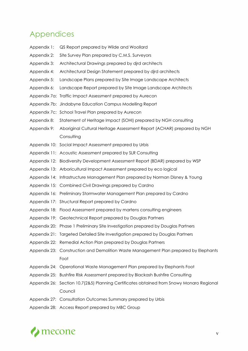
Appendices
Appendix 1: QS Report prepared by Wilde and Woollard
Appendix 2: Site Survey Plan prepared by C.M.S. Surveyors
Appendix 3: Architectural Drawings prepared by djrd architects
Appendix 4: Architectural Design Statement prepared by djrd architects
Appendix 5: Landscape Plans prepared by Site Image Landscape Architects
Appendix 6: Landscape Report prepared by Site Image Landscape Architects
Appendix 7a: Traffic Impact Assessment prepared by Aurecon
Appendix 7b: Jindabyne Education Campus Modelling Report
Appendix 7c: School Travel Plan prepared by Aurecon
Appendix 8: Statement of Heritage Impact (SOHI) prepared by NGH consulting
Appendix 9: Aboriginal Cultural Heritage Assessment Report (ACHAR) prepared by NGH
Consulting
Appendix 10: Social Impact Assessment prepared by Urbis
Appendix 11: Acoustic Assessment prepared by SLR Consulting
Appendix 12: Biodiversity Development Assessment Report (BDAR) prepared by WSP
Appendix 13: Arboricultural Impact Assessment prepared by eco logical
Appendix 14: Infrastructure Management Plan prepared by Norman Disney & Young
Appendix 15: Combined Civil Drawings prepared by Cardno
Appendix 16: Preliminary Stormwater Management Plan prepared by Cardno
Appendix 17: Structural Report prepared by Cardno
Appendix 18: Flood Assessment prepared by martens consulting engineers
Appendix 19: Geotechnical Report prepared by Douglas Partners
Appendix 20: Phase 1 Preliminary Site Investigation prepared by Douglas Partners
Appendix 21: Targeted Detailed Site Investigation prepared by Douglas Partners
Appendix 22: Remedial Action Plan prepared by Douglas Partners
Appendix 23: Construction and Demolition Waste Management Plan prepared by Elephants
Foot
Appendix 24: Operational Waste Management Plan prepared by Elephants Foot
Appendix 25: Bushfire Risk Assessment prepared by Blackash Bushfire Consulting
Appendix 26: Section 10.7(2&5) Planning Certificates obtained from Snowy Monaro Regional
Council
Appendix 27: Consultation Outcomes Summary prepared by Urbis
Appendix 28: Access Report prepared by MBC Group

vi
Appendix 29: BCA Assessment Report prepared by MBC Group
Appendix 30: Aviation Impact Assessment prepared by SLR Consulting
Appendix 31: Hazardous Materials Register and Asbestos Management Plan prepared by Coffey
Appendix 32: CPTED Report prepared by Mecone
Appendix 33: ESD Report prepared by Steensen Varming
Appendix 34: SEPP 64 Assessment prepared by Mecone
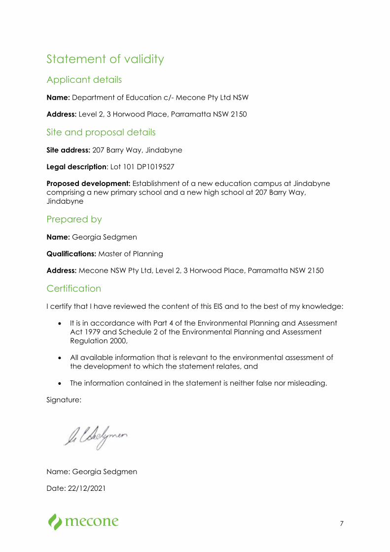
7
Statement of validity Applicant details
Name: Department of Education c/- Mecone Pty Ltd NSW
Address: Level 2, 3 Horwood Place, Parramatta NSW 2150
Site and proposal details
Site address: 207 Barry Way, Jindabyne
Legal description: Lot 101 DP1019527
Proposed development: Establishment of a new education campus at Jindabyne comprising a new primary school and a new high school at 207 Barry Way, Jindabyne
Prepared by
Name: Georgia Sedgmen
Qualifications: Master of Planning
Address: Mecone NSW Pty Ltd, Level 2, 3 Horwood Place, Parramatta NSW 2150
Certification
I certify that I have reviewed the content of this EIS and to the best of my knowledge:
• It is in accordance with Part 4 of the Environmental Planning and Assessment Act 1979 and Schedule 2 of the Environmental Planning and Assessment Regulation 2000,
• All available information that is relevant to the environmental assessment of the development to which the statement relates, and
• The information contained in the statement is neither false nor misleading.
Signature:
Name: Georgia Sedgmen
Date: 22/12/2021
8
Glossary and abbreviations
Term/acronym Description
AEP Annual Exceedance Probability
AS Australian Standards
BCA Building Code of Australia
BC Act Biodiversity Conservation Act 2016
CEMP Construction Environmental Management Plan
COLA Covered Outdoor learning Area
Council Snowy Monaro Regional Council
CPTED Crime Prevention through Environmental Design
DA Development Application
DCP Development Control Plan
DoE Department of Education
DPIE Department of Planning Industry and Environment
EFSG Educational Facilities Standards & Guidelines
EIS Environmental Impact Statement
EP&A Act Environmental Planning and Assessment Act 1979
ESD Ecologically Sustainable Development
GFA Gross Floor Area
Homebase A primary school classroom
HVAC Heating, Ventilation and Air Conditioning system
General Learning Space A high school classroom
INP Industrial Noise Policy
LALC Local Aboriginal Land Council
9
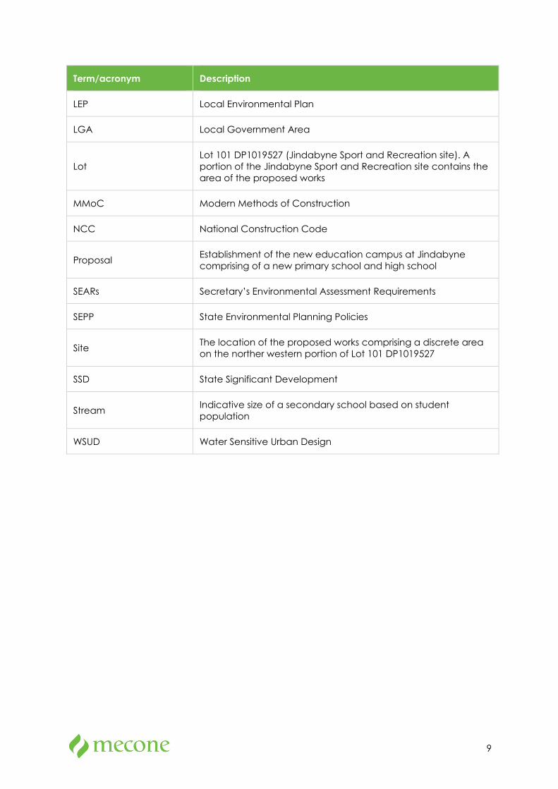
Term/acronym Description
LEP Local Environmental Plan
LGA Local Government Area
Lot Lot 101 DP1019527 (Jindabyne Sport and Recreation site). A portion of the Jindabyne Sport and Recreation site contains the area of the proposed works
MMoC Modern Methods of Construction
NCC National Construction Code
Proposal Establishment of the new education campus at Jindabyne comprising of a new primary school and high school
SEARs Secretary’s Environmental Assessment Requirements
SEPP State Environmental Planning Policies
Site The location of the proposed works comprising a discrete area on the norther western portion of Lot 101 DP1019527
SSD State Significant Development
Stream Indicative size of a secondary school based on student population
WSUD Water Sensitive Urban Design
10
Executive Summary Purpose of report
This Environmental Impact Statement (EIS) has been prepared on behalf of the NSW Department of Education (DoE) to accompany a development application for a new education campus at Jindabyne, comprising a new primary school and new high school in Jindabyne, NSW (Jindabyne Education Campus). This EIS is submitted to the Minister for Planning pursuant to Part 4 of the Environmental Planning and Assessment Act 1979 (EP&A Act).
The proposal is for a new school (with a capital investment value of more than $20 million) and is therefore classified as State significant development (SSD) in accordance with Schedule 1 of State Environmental Planning Policy (State and Regional Development) 2011.
The EIS addresses the Secretary's Environmental Assessment Requirements (SEARs) issued by the Department of Planning, Industry and Environment (DPIE) on 7 April 2021.
Overview of the Proposal
The proposal seeks approval for development of the Jindabyne Education Campus at a new site within the Jindabyne Sport and Recreation Centre at 207 Barry Way, to replace the existing Jindabyne Central School (JCS) located in the centre of Jindabyne,
The key objectives of the proposal are to:
• expand capacity to meet the growing demand for schools and programs in the area
• increase available outdoor play space for students,
• create more flexible, future-focused learning spaces to accommodate new ways of teaching and learning, and
• provide for a safe, accessible, and comfortable environment for students, teachers, and community.
The proposed works generally include:
• site preparation works including demolition of existing structures, earthworks, and tree removal,
• construction of a core 21 primary school comprising of 20 home base units, support learning spaces, games courts, active outdoor play spaces and outdoor learning environments,
11
• construction of a stream two (2) high school comprising of 20 general and specialised learning spaces, support learning spaces, games courts, sports field, and agricultural plot,
• central plaza area which will be accessible to both the primary school and high school, and the community (after hours) comprising of administration and staff facilities, hall, indoor multipurpose court, libraries, special programs facilities, and canteen,
• new access road off Barry Way along the western boundary of the site via two new roundabouts to be delivered under the Snowy Mountains Special Activation Precinct (refer to infrastructure to be delivered by other authorities below),
• provision of road and pedestrian infrastructure including at grade car parking, kiss and ride spaces, bus bays, shared paths, and crossings, and
• integrated landscaping, fencing, utilities (including on-site stormwater detention system) and signage.
Snowy Mountains Special Activation Precinct
A draft master plan for the Snowy Mountains SAP was exhibited for 56 days (ending 23 August 2021) for the Jindabyne area (inclusive of the subject site) with a vision for the Snowy Mountains to become Australia’s Alpine Capital. The master plan focuses on increasing year-round tourism and employment opportunities for the area as well as investing in the region’s infrastructure to attract more visitors to the region.
A key element of the master plan includes the relocation of the JCS on Park Road to the new Sports and Recreation Precinct off Barry Way with the construction of the new primary school and high school (as proposed under this application).
SINSW has been consulting and engaging with the SAP team to ensure consistent alignment between the preparation of the draft SAP and the proposal. As outlined above, the new roundabouts proposed on Barry Way and other necessary transport infrastructure are to be identified in the finalisation of the Snowy Mountains SAP Master Plan and delivered as part of the Snowy Mountains SAP prior to the opening of the Jindabyne Education Campus.
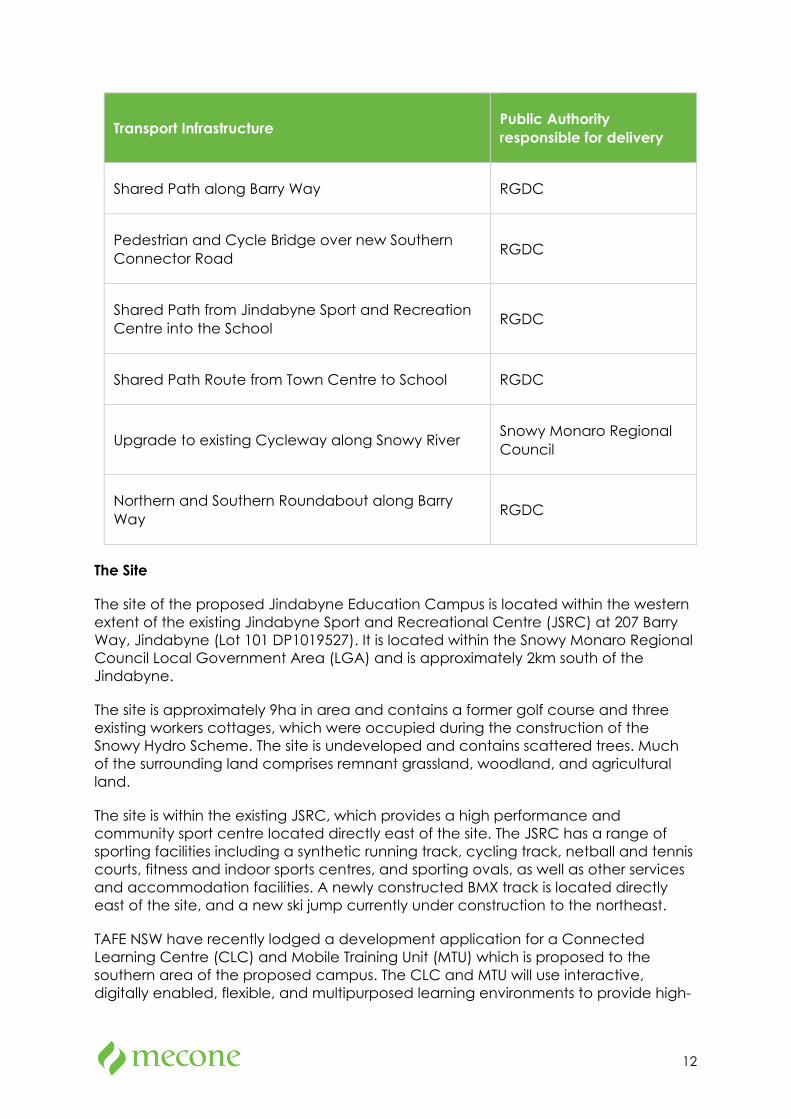
Infrastructure to be Delivered by Other Public Authorities
SINSW has been working in collaboration with the Department of Regional NSW, the Regional Growth Development Corporation (RGDC) and the Department of Planning Industry and Environment (DPIE) to ensure the transport infrastructure to be delivered under the Snowy Mountains SAP is sufficient for the needs of the new education campus at Jindabyne. The transport infrastructure outlined in the table below is to be delivered separately to this EIS by the public authorities identified prior to the opening of the Jindabyne Education Campus in 2023.
12
Transport Infrastructure Public Authority responsible for delivery
Shared Path along Barry Way RGDC
Pedestrian and Cycle Bridge over new Southern Connector Road RGDC
Shared Path from Jindabyne Sport and Recreation Centre into the School RGDC
Shared Path Route from Town Centre to School RGDC
Upgrade to existing Cycleway along Snowy River Snowy Monaro Regional Council
Northern and Southern Roundabout along Barry Way RGDC
The Site
The site of the proposed Jindabyne Education Campus is located within the western extent of the existing Jindabyne Sport and Recreational Centre (JSRC) at 207 Barry Way, Jindabyne (Lot 101 DP1019527). It is located within the Snowy Monaro Regional Council Local Government Area (LGA) and is approximately 2km south of the Jindabyne.
The site is approximately 9ha in area and contains a former golf course and three existing workers cottages, which were occupied during the construction of the Snowy Hydro Scheme. The site is undeveloped and contains scattered trees. Much of the surrounding land comprises remnant grassland, woodland, and agricultural land.
The site is within the existing JSRC, which provides a high performance and community sport centre located directly east of the site. The JSRC has a range of sporting facilities including a synthetic running track, cycling track, netball and tennis courts, fitness and indoor sports centres, and sporting ovals, as well as other services and accommodation facilities. A newly constructed BMX track is located directly east of the site, and a new ski jump currently under construction to the northeast.
TAFE NSW have recently lodged a development application for a Connected Learning Centre (CLC) and Mobile Training Unit (MTU) which is proposed to the southern area of the proposed campus. The CLC and MTU will use interactive, digitally enabled, flexible, and multipurposed learning environments to provide high-
13
quality training and learning experiences for TAFE students in the mid Snowy Mountains region. The TAFE site will accommodate for a maximum of 20-25 students and three (3) teachers and provides 10 car parking spaces.
Project Background and Need
The existing JCS located at 8-20 Park Rd, Jindabyne, is currently operating a K-12 campus with more than 700 students on a 2.7ha site in the heart of Jindabyne. The site is highly constrained, and the school has been operating beyond capacity in recent years. The main constraints of the existing JCS site include:
• 21 demountable classrooms have become permanent teaching spaces equating to 48% of all teaching spaces, and are not best suited to the local climate conditions,
• the demountable classrooms occupy a large portion of greenspace limiting play space to 6.7m2 per student (below the 10m2 Education Facilities Standards and Guidelines entitlement),
• core facilities are undersized and unfit for purpose, and
• high school specialist teaching spaces do not meet the curriculum demand, particularly future focused learning, and vocation education training courses.
Given the growing demand for primary and high school students within the JCS live-in catchment area and inadequacies of the existing JCS, there is clearly a need for a new contemporary primary and high school to be provided on a larger site.
Alternatives
DoE considered a number of alternatives to the proposal including:
Option A: Do nothing,
Option B: Upgrade the existing Jindabyne Central School, and
Option C: New primary school and high school at 207 Barry Way
Option A was discarded as it would not address the additional demand for services.
Option B was also discarded because it would also fail to meet demand. The school has outgrown its current location, and further expansion at the existing location is not capable of meeting student enrolment demand.
Option C proposed in this application addresses the identified service need and allows for a new facility specifically designed to meet the needs of students. This option also maintains additional land area for future expansion.
Consultation
14
Pre-lodgement consultation was conducted with various stakeholders including Snowy Monaro Council officers, State agencies including Government Architect NSW, Transport for NSW, TAFE NSW, the local community, and local Aboriginal stakeholders. Comments provided by these stakeholders have been instrumental in the preparation of the EIS. Section 6 describes the consultation activities undertaken.
Planning Context
The EIS has been prepared in accordance with the relevant legislative requirements of the EP&A Act and Environmental Planning and Assessment Regulation 2000 (EP&A Regulation). Section 5 of the EIS considers all applicable legislation in detail.
Snowy River Local Environmental Plan 2013 (SRLEP 2013) applies to the site. The proposed ‘educational establishment’ is permitted with consent in the RU1 Primary Production zone and is generally consistent with relevant planning provisions in SRLEP 2013, with the exception of a variation to the height standard. Clause 42 of the Education SEPP identifies that development consent may be granted for development for a school that is SSD even though the development would contravene a development standard imposed by an environmental planning instrument. This is discussed in further detail at section 5.9.1 of the EIS.
Environmental Impacts and Mitigation Measures
Sections 7 and 8 of the EIS provide an assessment of the environmental impacts of the proposal in accordance with the SEARs. The key environmental matters considered include:
• Built form and urban design,
• Environmental amenity,
• Transport and accessibility,
• Ecologically Sustainable Design,
• Heritage,
• Aboriginal heritage,
• Noise and vibration,
• Biodiversity,
• Tree removal,
• Stormwater drainage,
• Bushfire hazard,
• Flooding,
• Soil and water,
15
• Waste,
• Contamination,
• Aviation, and
• Utilities
A range of mitigation measures have been recommended based upon the input of specialists. Section 10 sets out a consolidated list of the proposed mitigation measures.
Subject to implementation of the identified mitigation measures, the potential environmental impacts of the proposal will be acceptable and manageable.
Conclusion
The proposal has been designed to avoid environmental impacts where possible. The proposal provides for a low-scale built form which is compatible with its local context, respects the surrounding local heritage items and been designed to appropriately manage environmental and planning impacts including bushfire risks and acoustic impacts.
Test excavations for identified potential archaeological deposit sites are currently being undertaken. The results and findings will be provided to DPIE once complete. Given the extent and density of any archaeological material is likely to be limited, it is considered that the findings of the test excavations can be assessed following submission of the proposal and prior to determination. This matter is addressed further in Section 7.6 in this EIS.
The EIS fulfils the requirements of the EP&A Act and EP&A Regulation, addresses all relevant matters for consideration prescribed by the SEARs and demonstrates that the potential impacts of the proposal can be satisfactorily managed or mitigated. Given the clear benefits of the proposal and lack of significant environmental impacts, it is recommended that consent be granted to the application.
16
1 Introduction This Environmental Impact Statement (EIS) has been prepared by Mecone NSW Pty Ltd on behalf of the NSW Department of Education (DoE) to support an application for State Significant Development (SSD). This EIS is submitted to the Minister for Planning pursuant to Part 4 of the Environmental Planning and Assessment Act 1979 (EP&A Act).
DoE is seeking approval for a new education campus at Jindabyne, comprising a new primary and a high school at 207 Barry Way, Jindabyne. The proposed primary school and high school are to replace the existing Jindabyne Central School (JCS) located in centre of Jindabyne.
The proposal is for a new school (with a capital investment value of more than $20 million) and is therefore classified as State Significant Development (SSD) in accordance with Schedule 1 of State Environmental Planning Policy (State and Regional Development) 2011 (SRD SEPP).
The EIS has been prepared in accordance with the requirements of the Environmental Planning and Assessment Act 1979 (EP&A Act), the Environmental Planning and Assessment Regulation 2000 (EP&A Regulation) and the Secretary’s Environmental Assessment Requirements (SEARs).
1.1 Project Overview
The key components of the proposal include:
• site preparation works including demolition of existing structures, earthworks, and tree removal,
• construction of core 21 primary school comprising of 20 home base units, support learning spaces, games courts, active outdoor play spaces and outdoor learning environments,
• construction of stream 2 high school comprising of 20 general and specialised learning spaces, support learning spaces, games courts, sports field, and agricultural plot,
• central plaza area which will be accessible to both the primary school and high school, and the community (after hours) comprising of administration and staff facilities, hall, indoor multipurpose court, libraries, special programs facilities, and canteen,
• new access road off Barry Way along the western boundary of the site via two new roundabouts planned to be delivered under the Snowy Mountains SAP,
• provision of road and pedestrian infrastructure including at grade car parking, kiss and ride spaces, bus bays, shared paths, and crossings, and
• integrated landscaping, fencing, utilities (including on-site detention system) and signage.
17
1.2 Proposal Objectives
The key objectives of the proposal are to:
• expand capacity to meet the growing demand for schools and programs in the area,
• increase available outdoor play space for students,
• create more flexible, future-focused learning spaces to accommodate new ways of teaching and learning, and
• provide for a safe, accessible, and comfortable environment for students, teachers, and community.
1.3 Project Background and Need
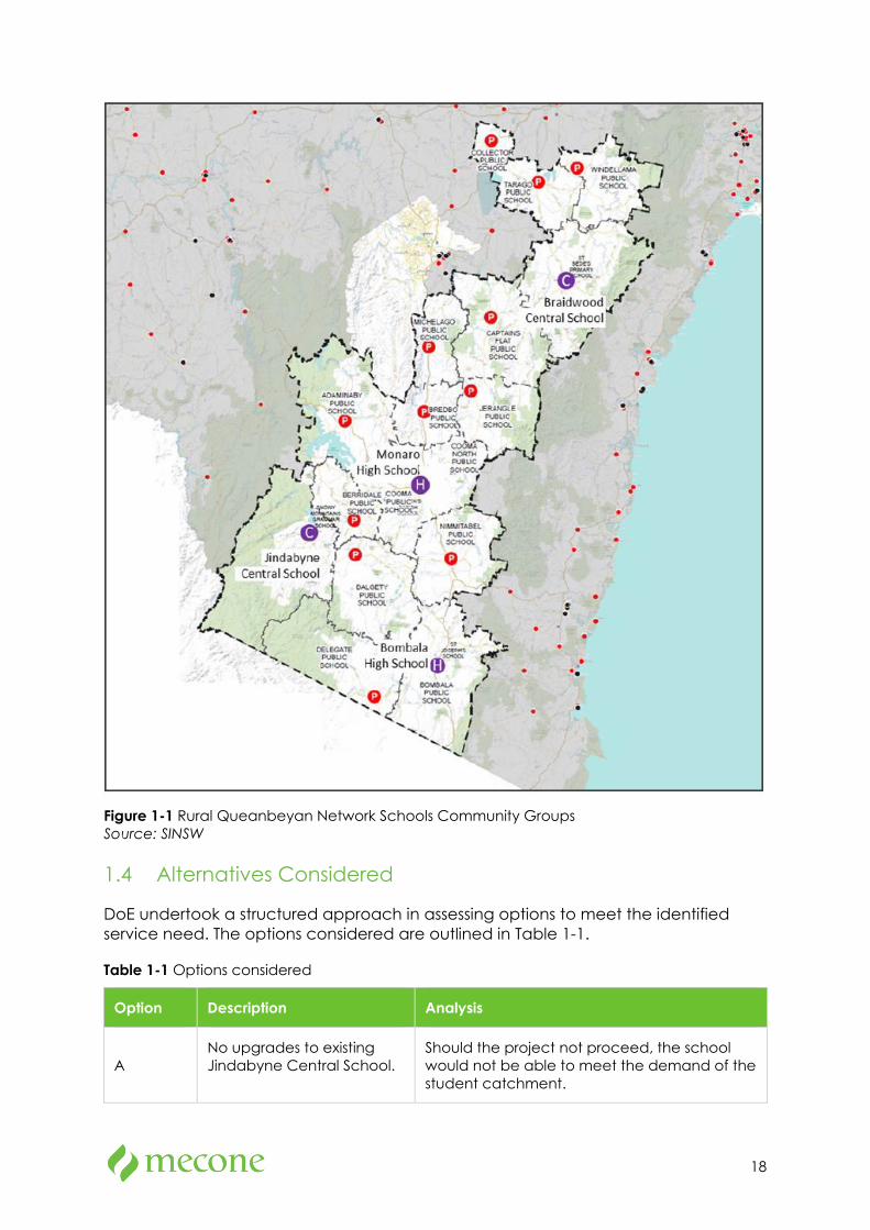
Jindabyne Central School (JCS), located at 8-20 Park Road, Jindabyne is the main school which currently serves the Jindabyne area. The school falls within the Rural Queanbeyan Network Schools Community Group (the school group) and covers a wide geographical area which contains 19 public schools. Only four of these cater to secondary students (refer to Figure 1-1).
Jindabyne Central School currently has capacity for 812 students, with 415 places for primary school students and 397 places for secondary school students. Enrolment numbers accessed from Australian Curriculum, Assessment and Reporting Authority (ACARA) for the past five years show that the school has generally experienced year on year growth from 2015 (736 students) to 2019 (856 students). However, the school did experience a drop in enrolment numbers in 2021 to 707 (Eagle Eye). Enrolments are expected to increase to 913 students by year 2031.
The school is located on a 2.7ha site and currently has 24 permanent teaching spaces and 21 demountable teaching spaces. On the small block, the existing buildings occupy a large portion of green space and constrain the operation and function of the school. The demountables have become permanent teaching spaces and are not best suited to the local climate conditions. They also lack flexibility and can limit learning and teaching opportunities.
Core facilities are also undersized and not fit for purpose, and specialist teaching spaces for the high school do not meet the curriculum demand, particularly future-focused learning, and vocational education training courses.
Given the growing demand for primary and high school students within the JCS live-in catchment area, a new site is required to accommodate a new primary school and high school.
18
Figure 1-1 Rural Queanbeyan Network Schools Community Groups Source: SINSW
1.4 Alternatives Considered
DoE undertook a structured approach in assessing options to meet the identified service need. The options considered are outlined in Table 1-1.
Table 1-1 Options considered
Option Description Analysis
A No upgrades to existing Jindabyne Central School.
Should the project not proceed, the school would not be able to meet the demand of the student catchment.
19
Option Description Analysis
B
Maintain Jindabyne Central School in existing location with functional upgrades.
The school has outgrown its current site location, and any functional upgrades would not be capable in meeting demand of the student catchment.
C
New primary school and high school at 207 Barry Way
This option best addresses the identified service need and allows for a new facility designed to meet the needs of students. This option also maintains additional land area for future expansion.
1.5 SEARs
The project SEARs were first issued on 7 April 2021. The table below identifies where the SEARs are addressed within the EIS.
Table 1-2 Project SEARs
SEAR Location in EIS
The Environmental Impact Statement (EIS) must be prepared in accordance with and meet the minimum requirements of clauses 6 and 7 of Schedule 2 the Environmental Planning and Assessment Regulation 2000 (the Regulation).
Throughout EIS
Notwithstanding the key issues specified below, the EIS must include an environmental risk assessment to identify the potential environmental impacts associated with the development.
Section 9
In addition, the EIS must include:
• an executive summary
Executive summary (front of report)
a complete description of the development, including:
• the need for the development.
• justification for the development.
• suitability of the site.
• alternatives considered.
• likely interactions between the development and existing, approved and proposed operations in the vicinity of the site.
• a description of any proposed building works.
• a description of proposed operations, including staff and student numbers, hours of operation, and details of any proposed before/after school care services and/or community use of school facilities.
Section 1
Section 3
Appendix 2
Appendix 3
Appendix 4
20
SEAR Location in EIS
• site survey plan, showing existing levels, location and height of existing and adjacent structures / buildings and site boundaries.
• a detailed constraints map identifying the key environmental and other land use constraints that have informed the final design of the development.
• plans, elevations and sections of the proposed development.
• cladding, window and floor details, including external materials.
• a site plan showing all infrastructure and facilities (including any infrastructure that would be required for the development, but the subject of a separate approvals process).
• plans and details of any advertising/business identification signs to be installed, including size, location and finishes.
• a description of any proposed construction or operational staging including relevant timing and dependencies.
• details of construction and decommissioning including timing.
• an estimate of the retained and new jobs that would be created during the construction and operational phases of the development along with details of the methodology to determine the figures provided.
a detailed assessment of the key issues identified below, and any other significant issues identified in the risk assessment, including:
• a description of the existing environment, using sufficient baseline data and methodology to establish baseline conditions.
• an assessment of the potential impacts of all stages of the development on all potentially impacted environments, sensitive receivers, stakeholders and future developments. The assessment must consider any relevant legislation, policies and guidelines.
• consideration of the cumulative impacts due to other related development proposed or underway on the site, including development progressed under other assessment pathways and all other developments in the vicinity (completed, underway or proposed).
• identification of all proposed monitoring or required changes to existing monitoring programs.
• measures to avoid, minimise and if necessary, offset predicted impacts, including detailed contingency plans for managing any significant risks to the environment and triggers for each action.
• details of alternative measures considered.
Section 7
21
SEAR Location in EIS
a consolidated summary of all the proposed environmental management and monitoring measures, identifying all commitments included in the EIS.
Section 9
Section 10
the reasons why the development should be approved and a detailed evaluation of the merits of the development, including consequences of not carrying out the development.
Section 1.3
Section 7
Section 11
The EIS must be accompanied by a report from a qualified quantity surveyor providing a detailed calculation of the capital investment value (CIV) (as defined in clause 3 of the Regulation) of the proposal, including details of all assumptions and components from which the CIV calculation is derived.
Appendix 1
Key issues
The EIS must address the following specific matters:
1. Statutory and Strategic Context
Address the statutory provisions contained in all relevant environmental planning instruments, including but not limited to:
• State Environmental Planning Policy (State and Regional Development) 2011
• State Environmental Planning Policy (Educational Establishments and Child Care Facilities) 2017.
• State Environmental Planning Policy No 64 – Advertising and Signage.
• State Environmental Planning Policy No 55 – Remediation of Land.
• State Environmental Planning Policy (Activation Precincts) 2020.
• Draft State Environmental Planning Policy (Remediation of Land).
• Draft State Environmental Planning Policy (Environment).
• Draft State Environmental Planning Policy (Educational Establishments and Child Care Facilities).
• Snowy River Local Environmental Plan 2013.
Having regard to the relevant environmental planning instruments:
• address the permissibility of the development, including the nature and extent of any prohibitions
• identify compliance with the development standards applying to the site and provide justification for any contravention of the development standards
Section 4
Section 5
Appendix 34
22
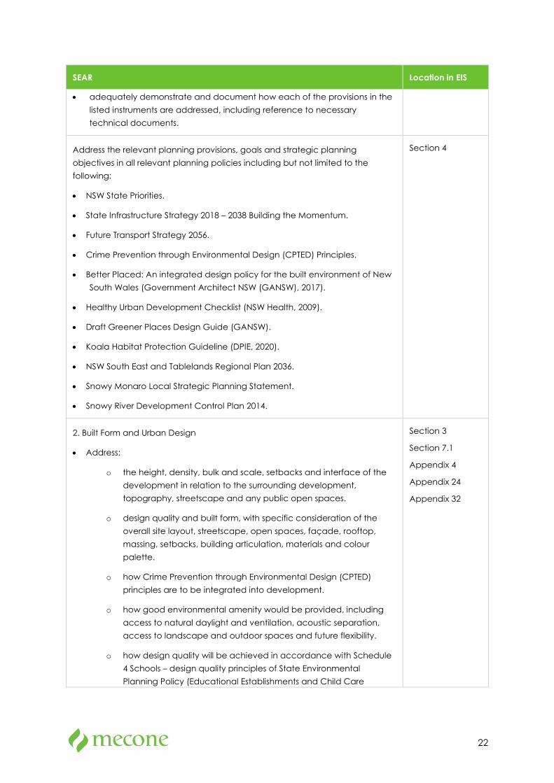
SEAR Location in EIS
• adequately demonstrate and document how each of the provisions in the listed instruments are addressed, including reference to necessary technical documents.
Address the relevant planning provisions, goals and strategic planning objectives in all relevant planning policies including but not limited to the following:
• NSW State Priorities.
• State Infrastructure Strategy 2018 – 2038 Building the Momentum.
• Future Transport Strategy 2056.
• Crime Prevention through Environmental Design (CPTED) Principles.
• Better Placed: An integrated design policy for the built environment of New South Wales (Government Architect NSW (GANSW), 2017).
• Healthy Urban Development Checklist (NSW Health, 2009).
• Draft Greener Places Design Guide (GANSW).
• Koala Habitat Protection Guideline (DPIE, 2020).
• NSW South East and Tablelands Regional Plan 2036.
• Snowy Monaro Local Strategic Planning Statement.
• Snowy River Development Control Plan 2014.
Section 4
2. Built Form and Urban Design
• Address:
o the height, density, bulk and scale, setbacks and interface of the development in relation to the surrounding development, topography, streetscape and any public open spaces.
o design quality and built form, with specific consideration of the overall site layout, streetscape, open spaces, façade, rooftop, massing, setbacks, building articulation, materials and colour palette.
o how Crime Prevention through Environmental Design (CPTED) principles are to be integrated into development.
o how good environmental amenity would be provided, including access to natural daylight and ventilation, acoustic separation, access to landscape and outdoor spaces and future flexibility.
o how design quality will be achieved in accordance with Schedule 4 Schools – design quality principles of State Environmental Planning Policy (Educational Establishments and Child Care
Section 3
Section 7.1
Appendix 4
Appendix 24
Appendix 32
23
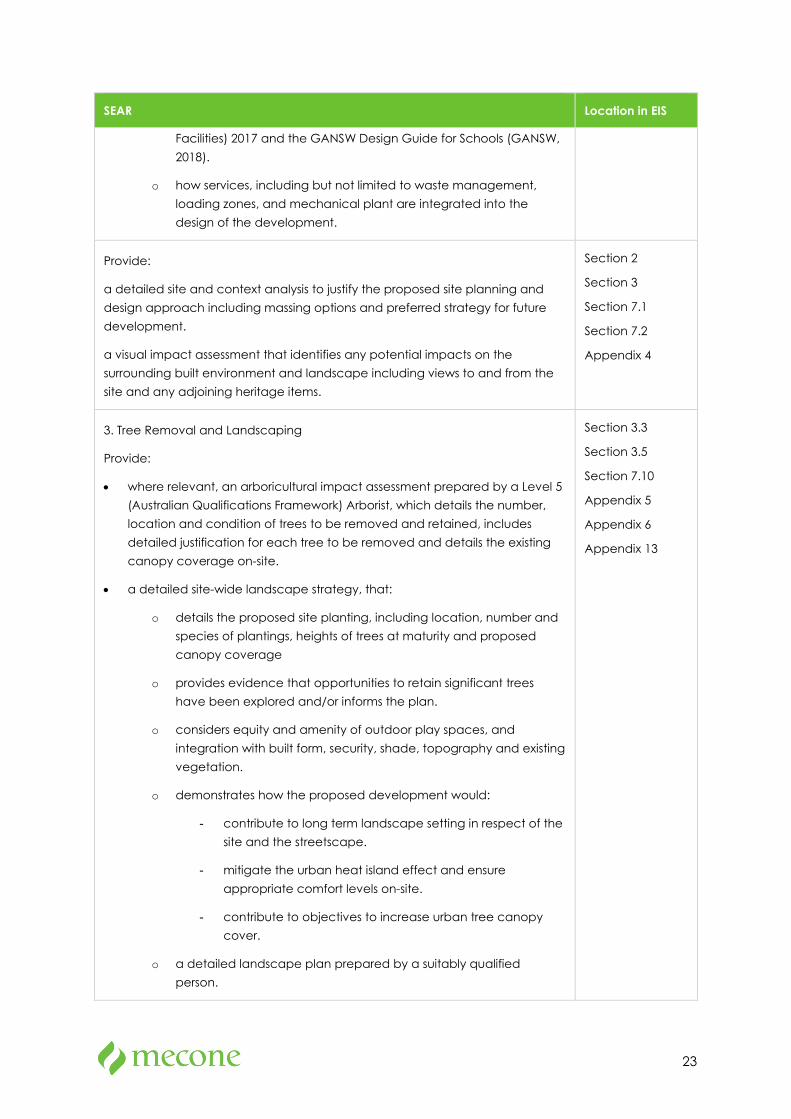
SEAR Location in EIS
Facilities) 2017 and the GANSW Design Guide for Schools (GANSW, 2018).
o how services, including but not limited to waste management, loading zones, and mechanical plant are integrated into the design of the development.
Provide:
a detailed site and context analysis to justify the proposed site planning and design approach including massing options and preferred strategy for future development.
a visual impact assessment that identifies any potential impacts on the surrounding built environment and landscape including views to and from the site and any adjoining heritage items.
Section 2
Section 3
Section 7.1
Section 7.2
Appendix 4
3. Tree Removal and Landscaping
Provide:
• where relevant, an arboricultural impact assessment prepared by a Level 5 (Australian Qualifications Framework) Arborist, which details the number, location and condition of trees to be removed and retained, includes detailed justification for each tree to be removed and details the existing canopy coverage on-site.
• a detailed site-wide landscape strategy, that:
o details the proposed site planting, including location, number and species of plantings, heights of trees at maturity and proposed canopy coverage
o provides evidence that opportunities to retain significant trees have been explored and/or informs the plan.
o considers equity and amenity of outdoor play spaces, and integration with built form, security, shade, topography and existing vegetation.
o demonstrates how the proposed development would:
- contribute to long term landscape setting in respect of the site and the streetscape.
- mitigate the urban heat island effect and ensure appropriate comfort levels on-site.
- contribute to objectives to increase urban tree canopy cover.
o a detailed landscape plan prepared by a suitably qualified person.
Section 3.3
Section 3.5
Section 7.10
Appendix 5
Appendix 6
Appendix 13
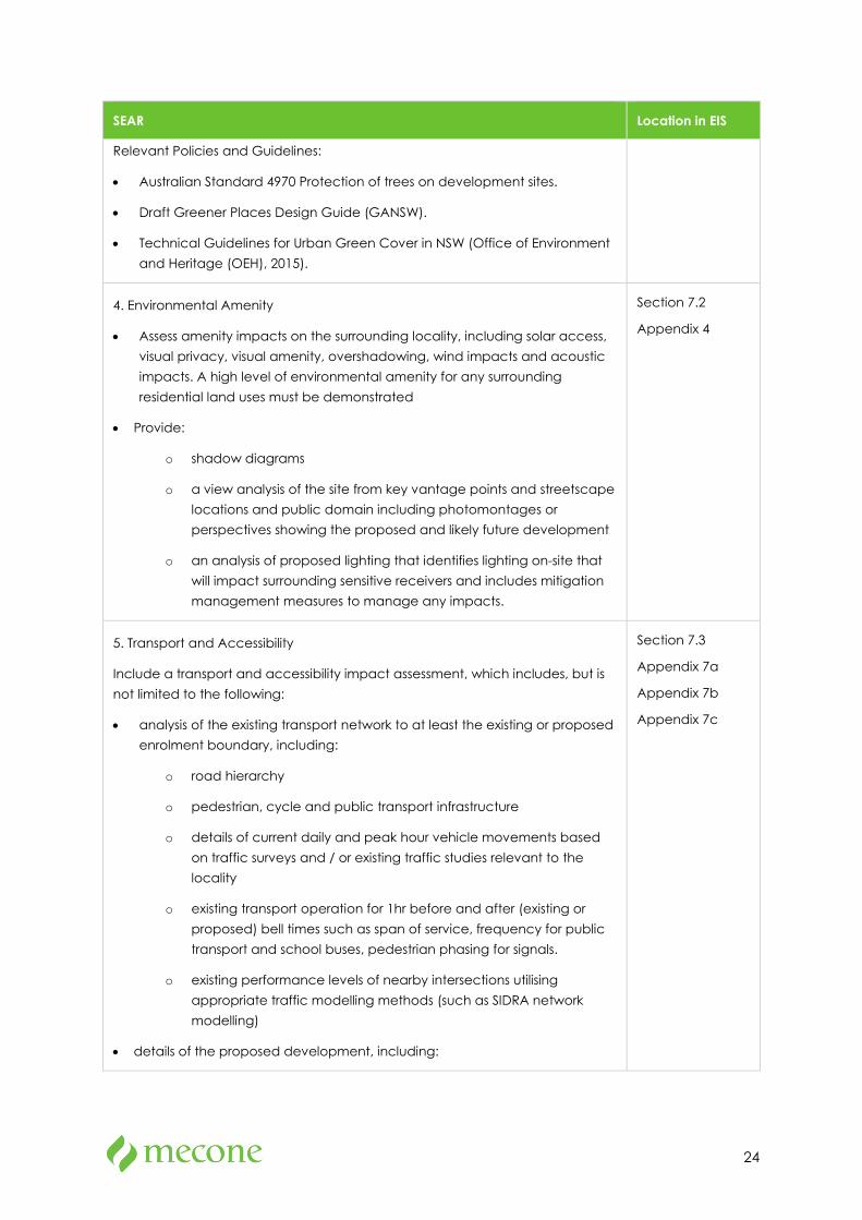
24
SEAR Location in EIS
Relevant Policies and Guidelines:
• Australian Standard 4970 Protection of trees on development sites.
• Draft Greener Places Design Guide (GANSW).
• Technical Guidelines for Urban Green Cover in NSW (Office of Environment and Heritage (OEH), 2015).
4. Environmental Amenity
• Assess amenity impacts on the surrounding locality, including solar access, visual privacy, visual amenity, overshadowing, wind impacts and acoustic impacts. A high level of environmental amenity for any surrounding residential land uses must be demonstrated
• Provide:
o shadow diagrams
o a view analysis of the site from key vantage points and streetscape locations and public domain including photomontages or perspectives showing the proposed and likely future development
o an analysis of proposed lighting that identifies lighting on-site that will impact surrounding sensitive receivers and includes mitigation management measures to manage any impacts.
Section 7.2
Appendix 4
5. Transport and Accessibility
Include a transport and accessibility impact assessment, which includes, but is not limited to the following:
• analysis of the existing transport network to at least the existing or proposed enrolment boundary, including:
o road hierarchy
o pedestrian, cycle and public transport infrastructure
o details of current daily and peak hour vehicle movements based on traffic surveys and / or existing traffic studies relevant to the locality
o existing transport operation for 1hr before and after (existing or proposed) bell times such as span of service, frequency for public transport and school buses, pedestrian phasing for signals.
o existing performance levels of nearby intersections utilising appropriate traffic modelling methods (such as SIDRA network modelling)
• details of the proposed development, including:
Section 7.3
Appendix 7a
Appendix 7b
Appendix 7c
25
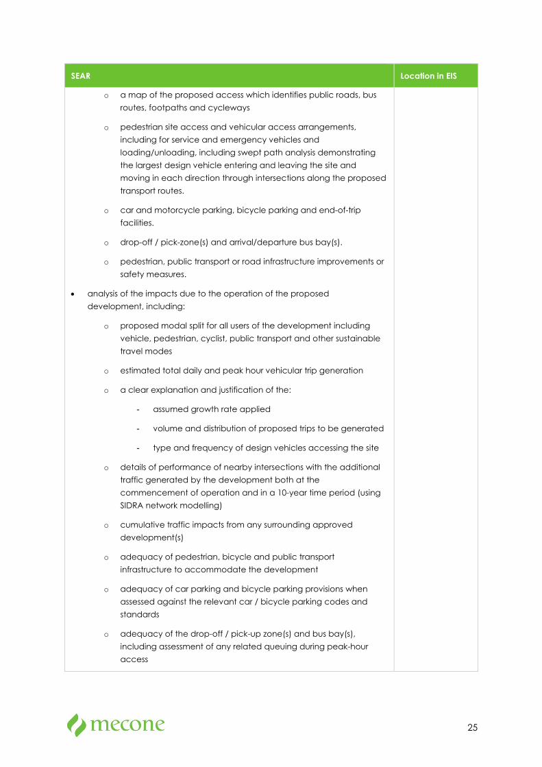
SEAR Location in EIS
o a map of the proposed access which identifies public roads, bus routes, footpaths and cycleways
o pedestrian site access and vehicular access arrangements, including for service and emergency vehicles and loading/unloading, including swept path analysis demonstrating the largest design vehicle entering and leaving the site and moving in each direction through intersections along the proposed transport routes.
o car and motorcycle parking, bicycle parking and end-of-trip facilities.
o drop-off / pick-zone(s) and arrival/departure bus bay(s).
o pedestrian, public transport or road infrastructure improvements or safety measures.
• analysis of the impacts due to the operation of the proposed development, including:
o proposed modal split for all users of the development including vehicle, pedestrian, cyclist, public transport and other sustainable travel modes
o estimated total daily and peak hour vehicular trip generation
o a clear explanation and justification of the:
- assumed growth rate applied
- volume and distribution of proposed trips to be generated
- type and frequency of design vehicles accessing the site
o details of performance of nearby intersections with the additional traffic generated by the development both at the commencement of operation and in a 10-year time period (using SIDRA network modelling)
o cumulative traffic impacts from any surrounding approved development(s)
o adequacy of pedestrian, bicycle and public transport infrastructure to accommodate the development
o adequacy of car parking and bicycle parking provisions when assessed against the relevant car / bicycle parking codes and standards
o adequacy of the drop-off / pick-up zone(s) and bus bay(s), including assessment of any related queuing during peak-hour access
26
SEAR Location in EIS
o adequacy of the existing / proposed pedestrian infrastructure to enable convenient and safe access to and from the site for all users.
• measures to ameliorate any adverse traffic and transport impacts due to the development based on the above analysis, including:
o travel demand management measures to encourage sustainable transport (such as a Green Travel Plan and / or specific Workplace Travel Plan)
o arrangements for the Travel Coordinator roles.
o governance arrangements or relationships with state and local government transport providers to update roads safety.
o infrastructure improvements, including details of timing and method of delivery.
• a preliminary school transport plan detailing an operational traffic and access management plan for the site, pedestrian entries, the drop-off / pick-up zone(s) and bus bay(s).
• analysis of the impacts of the traffic generated during construction of the proposed development, including:
o construction vehicle routes, types and volumes
o construction program (duration and milestones).
o on-site car parking and access arrangements for construction, emergency and construction worker vehicles.
o cumulative impacts associated with other construction activities in the locality (if any).
o road safety at identified intersections near the site due to conflicts between construction vehicles and existing traffic in the locality.
o measures to mitigate impacts, including to ensure the safety of pedestrian and cyclists during construction
o a preliminary Construction Traffic and Pedestrian Management Plan.
Note: Further guidance is provided in the TfNSW advice attached to the SEARs.
Relevant Policies and Guidelines:
• Guide to Traffic Generating Developments (Roads and Maritime Services, 2002)
• EIS Guidelines - Road and Related Facilities (Department of Urban Affairs and Planning (DUAP), 1996).
27
SEAR Location in EIS
• Cycling Aspects of Austroads Guides.
• NSW Planning Guidelines for Walking and Cycling (Department of Infrastructure, Planning and Natural Resources (DIPNR), 2004).
• Guide to Traffic Management Part 12: Integrated Transport Assessments for Developments (Austroads, 2020).
• Australian Standard 2890.3 Parking facilities, Part 3: Bicycle parking (AS 2890.3).
6. Ecologically Sustainable Development (ESD)
• Identify:
o how ESD principles (as defined in clause 7(4) of Schedule 2 of the Regulation) would be incorporated in the design and ongoing operation phases of the development
o proposed measures to minimise consumption of resources, water (including water sensitive urban design) and energy.
o how the future development would be designed to consider and reflect national best practice sustainable building principles to improve environmental performance and reduce ecological impact. This should be based on a materiality assessment and include waste reduction design measures, future proofing, use of sustainable and low-carbon materials, energy and water efficient design (including water sensitive urban design) and technology and use of renewable energy.
o how environmental design will be achieved in accordance with the GANSW Environmental Design in Schools Manual (GANSW, 2018).
Provide:
o an assessment against an accredited ESD rating system or an equivalent program of ESD performance. This should include a minimum rating scheme target level
o a statement regarding how the design of the future development is responsive to the CSIRO projected impacts of climate change
o an Integrated Water Management Plan detailing any proposed alternative water supplies, proposed end uses of potable and non-potable water, and water sensitive urban design.
Relevant Policies and Guidelines:
• NSW and ACT Government Regional Climate Modelling (NARCliM) climate change projections.
Section 7.4
Appendix 33

28
SEAR Location in EIS
7. Heritage
• Identify any archaeological potential or archaeological significance on and adjacent to the site and the impacts the development may have on this significance.
• Provide a statement of significance and an assessment of the impact on the heritage significance of the heritage items on and adjacent to the site in accordance with the guidelines in the NSW Heritage Manual (Heritage Office and DUAP, 1996) and Assessing Heritage Significance (OEH, 2015).
Section 7.5
Appendix 8
8. Aboriginal Cultural Heritage
• Provide an Aboriginal Cultural Heritage Assessment Report (ACHAR) that:
o identifies and describes the Aboriginal cultural heritage values that exist across the site includes surface surveys and test excavations where necessary.
o has been prepared in accordance with the Guide to investigating, assessing and reporting on Aboriginal Cultural Heritage in NSW (OEH, 2011) and Code of Practice for Archaeological Investigations of Aboriginal Objects in NSW (OEH, 2010).
o incorporates consultation with Aboriginal people in accordance with Aboriginal Cultural Heritage Consultation Requirements for Proponents (Department of Environment, Climate Change and Water, 2010).
o documents the significance of cultural heritage values of Aboriginal people who have a cultural association with the land.
o identifies, assesses and documents all impacts on the Aboriginal cultural heritage values.
o demonstrates attempts to avoid any impact upon cultural heritage values and identify any conservation outcomes. Where impacts are unavoidable, the ACHAR and EIS must outline measures proposed to mitigate impacts.
o demonstrates attempts to interpret the Aboriginal cultural heritage significance identified into the development.
• Any Aboriginal objects recorded as part of the Aboriginal Cultural Heritage Assessment Report must be documented and notified to the Aboriginal Heritage Information Management System (AHIMS) within Heritage NSW of the Department of Premier and Cabinet.
Section 7.6
Appendix 9
9. Social Impacts Section 7.7
Appendix 10
29
SEAR Location in EIS
• Provide a Social Impact Assessment prepared in accordance with the draft Social Impact Assessment Guideline 2020.
Relevant Policies and Guidelines:
• Draft Social Impact Assessment Guideline 2020 (Department of Planning, Industry and Environment)
10. Noise and Vibration
• ·Provide a noise and vibration impact assessment that:
o includes a quantitative assessment of the main noise and vibration generating sources during demolition, site preparation, bulk excavation and construction
o details the proposed construction hours and provide details of, and justification for, instances where it is expected that works would be carried out outside standard construction hours
o includes a quantitative assessment of the main sources of operational noise, including consideration of any public-address system, school bell, mechanical services (e.g. air conditioning plant), use of any school hall for concerts etc. (both during and outside school hours) and any out of hours community use of school facilities
o outlines measures to minimise and mitigate the potential noise impacts on nearby sensitive receivers
o considers sources of external noise intrusion in proximity to the site (including, road rail and aviation operations) and identifies building performance requirements for the proposed development to achieve appropriate internal amenity standards
o demonstrates that the assessment has been prepared in accordance with polices and guidelines relevant to the context of the site and the nature of the proposed development.
Relevant Policies and Guidelines:
• NSW Noise Policy for Industry 2017 (NSW Environment Protection Authority (EPA)
• Interim Construction Noise Guideline (Department of Environment and Climate Change, 2009)
• Assessing Vibration: A Technical Guideline 2006 (Department of Environment and Conservation, 2006)
• Australian Standard 2263 Acoustics – Measurement of noise from helicopter operations (AS 2363)
Section 7.8
Appendix 11
30
SEAR Location in EIS
11. Biodiversity
• Provide a Biodiversity Development Assessment Report (BDAR) that assesses the biodiversity impacts of the proposed development in accordance with the requirements of the Biodiversity Conservation Act 2016, Biodiversity Conservation Regulation 2017 and Biodiversity Assessment Method, except where a BDAR waiver has been issued in relation to the development or the development is located on biodiversity certified land
• Where a BDAR is not required because a BDAR waiver has been issued in relation to the development, provide:
o a copy of the BDAR waiver and demonstrate that the proposed development is consistent with that covered in BDAR waiver
o an assessment of flora and fauna impacts where significant vegetation or flora and fauna values would be affected by the proposed development.
Note: Further guidance is provided in the Biodiversity and Conservation Division Standard Environmental Assessment Requirements attached to the SEARs.
Section 7.9
Appendix 12
12. Contributions
• Identify:
o any Section 7.11/7.12 Contribution Plans, Voluntary Planning Agreements or Special Infrastructure Contribution Plans that affect land to which the application relates or the proposed development type
o any contributions applicable to the proposed development under the identified plans and/or agreements. Justification is to be provided where it is considered that the proposed development is exempt from making a contribution
o any actions required by a Voluntary Planning Agreement or draft Voluntary Planning Agreement affecting the site or amendments required to a Voluntary Planning Agreement affected by the proposed development.
Section 5.11
13. Staging
• Assess impacts of staging where it is proposed and detail how construction works and operations would be managed to ensure public safety and amenity on and surrounding the site.
Section 3.7
14. Utilities
• In consultation with relevant service providers:
Section 7.19
Appendix 14
31
SEAR Location in EIS
o assess of the impacts of the development on existing utility infrastructure and service provider assets surrounding the site
o identify any infrastructure upgrades required off-site to facilitate the development and any arrangements to ensure that the upgrades will be implemented on time and be maintained
o provide an infrastructure delivery and staging plan, including a description of how infrastructure requirements would be co-ordinated, funded and delivered to facilitate the development.
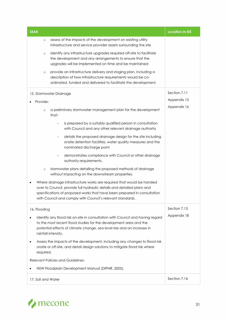
15. Stormwater Drainage
• Provide:
o a preliminary stormwater management plan for the development that:
- is prepared by a suitably qualified person in consultation with Council and any other relevant drainage authority
- details the proposed drainage design for the site including onsite detention facilities, water quality measures and the nominated discharge point
- demonstrates compliance with Council or other drainage authority requirements.
o stormwater plans detailing the proposed methods of drainage without impacting on the downstream properties.
• Where drainage infrastructure works are required that would be handed over to Council, provide full hydraulic details and detailed plans and specifications of proposed works that have been prepared in consultation with Council and comply with Council’s relevant standards.
Section 7.11
Appendix 15
Appendix 16
16. Flooding
• Identify any flood risk on-site in consultation with Council and having regard to the most recent flood studies for the development area and the potential effects of climate change, sea level rise and an increase in rainfall intensity.
• Assess the impacts of the development, including any changes to flood risk onsite or off-site, and detail design solutions to mitigate flood risk where required.
Relevant Policies and Guidelines:
• NSW Floodplain Development Manual (DIPNR, 2005).
Section 7.13
Appendix 18
17. Soil and Water Section 7.14
32
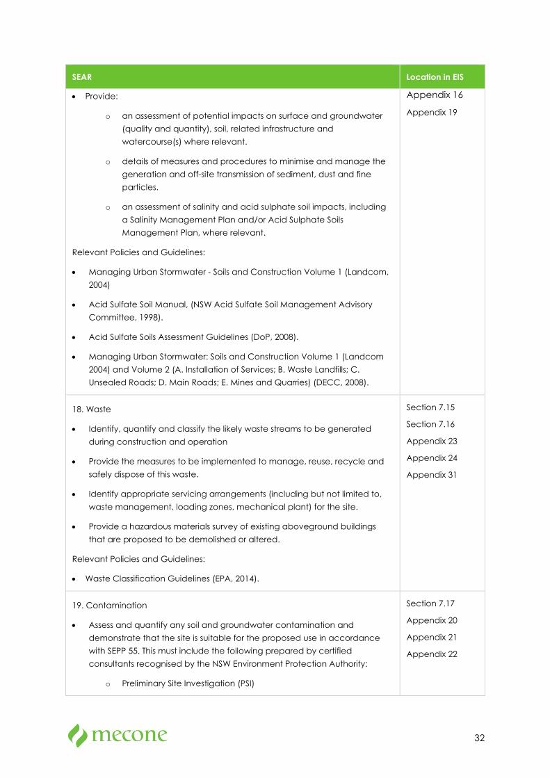
SEAR Location in EIS
• Provide:
o an assessment of potential impacts on surface and groundwater (quality and quantity), soil, related infrastructure and watercourse(s) where relevant.
o details of measures and procedures to minimise and manage the generation and off-site transmission of sediment, dust and fine particles.
o an assessment of salinity and acid sulphate soil impacts, including a Salinity Management Plan and/or Acid Sulphate Soils Management Plan, where relevant.
Relevant Policies and Guidelines:
• Managing Urban Stormwater - Soils and Construction Volume 1 (Landcom, 2004)
• Acid Sulfate Soil Manual, (NSW Acid Sulfate Soil Management Advisory Committee, 1998).
• Acid Sulfate Soils Assessment Guidelines (DoP, 2008).
• Managing Urban Stormwater: Soils and Construction Volume 1 (Landcom 2004) and Volume 2 (A. Installation of Services; B. Waste Landfills; C. Unsealed Roads; D. Main Roads; E. Mines and Quarries) (DECC, 2008).
Appendix 16
Appendix 19
18. Waste
• Identify, quantify and classify the likely waste streams to be generated during construction and operation
• Provide the measures to be implemented to manage, reuse, recycle and safely dispose of this waste.
• Identify appropriate servicing arrangements (including but not limited to, waste management, loading zones, mechanical plant) for the site.
• Provide a hazardous materials survey of existing aboveground buildings that are proposed to be demolished or altered.
Relevant Policies and Guidelines:
• Waste Classification Guidelines (EPA, 2014).
Section 7.15
Section 7.16
Appendix 23
Appendix 24
Appendix 31
19. Contamination
• Assess and quantify any soil and groundwater contamination and demonstrate that the site is suitable for the proposed use in accordance with SEPP 55. This must include the following prepared by certified consultants recognised by the NSW Environment Protection Authority:
o Preliminary Site Investigation (PSI)
Section 7.17
Appendix 20
Appendix 21
Appendix 22
33
SEAR Location in EIS
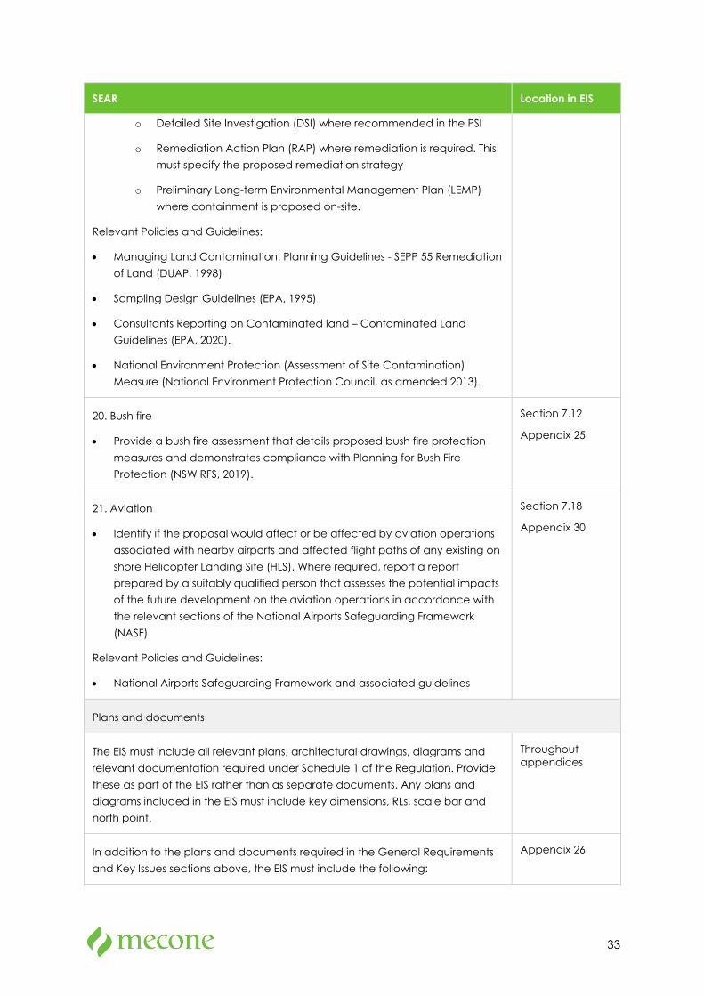
o Detailed Site Investigation (DSI) where recommended in the PSI
o Remediation Action Plan (RAP) where remediation is required. This must specify the proposed remediation strategy
o Preliminary Long-term Environmental Management Plan (LEMP) where containment is proposed on-site.
Relevant Policies and Guidelines:
• Managing Land Contamination: Planning Guidelines - SEPP 55 Remediation of Land (DUAP, 1998)
• Sampling Design Guidelines (EPA, 1995)
• Consultants Reporting on Contaminated land – Contaminated Land Guidelines (EPA, 2020).
• National Environment Protection (Assessment of Site Contamination) Measure (National Environment Protection Council, as amended 2013).
20. Bush fire
• Provide a bush fire assessment that details proposed bush fire protection measures and demonstrates compliance with Planning for Bush Fire Protection (NSW RFS, 2019).
Section 7.12
Appendix 25
21. Aviation
• Identify if the proposal would affect or be affected by aviation operations associated with nearby airports and affected flight paths of any existing on shore Helicopter Landing Site (HLS). Where required, report a report prepared by a suitably qualified person that assesses the potential impacts of the future development on the aviation operations in accordance with the relevant sections of the National Airports Safeguarding Framework (NASF)
Relevant Policies and Guidelines:
• National Airports Safeguarding Framework and associated guidelines
Section 7.18
Appendix 30
Plans and documents
The EIS must include all relevant plans, architectural drawings, diagrams and relevant documentation required under Schedule 1 of the Regulation. Provide these as part of the EIS rather than as separate documents. Any plans and diagrams included in the EIS must include key dimensions, RLs, scale bar and north point.
Throughout appendices
In addition to the plans and documents required in the General Requirements and Key Issues sections above, the EIS must include the following:
Appendix 26

34
SEAR Location in EIS
• Section 10.7(2) and (5) Planning Certificates (previously Section 149(2) and (5) Planning Certificate)
Design report to demonstrate how design quality would be achieved in accordance with the above Key Issues including:
• architectural design statement
• diagrams, structure plan, illustrations and drawings to clarify the design
• detailed site and context analysis
• analysis of options considered to justify the proposed site planning and design approach
• summary of feedback provided by GANSW and NSW State Design Review Panel (SDRP) and responses to this advice
• summary report of consultation with the community and response to any feedback provided.
Appendix 4
Geotechnical and Structural Report Appendix 19
Accessibility Report. Appendix 28
Consultation
During the preparation of the EIS, you must consult with the relevant local, State or Commonwealth Government authorities, service providers, community groups, relevant special interest groups, including local Aboriginal land councils and registered Aboriginal stakeholders and affected landowners. In particular, you must consult with:
• the relevant Council
• Government Architect NSW (through the NSW SDRP process).
• Transport for NSW.
• The Jindabyne Aero Club.
• the Department of Planning, Industry and Environment having regard to preparation of policies and masterplans for the Snowy Mountains Special Activation Precinct.
Consultation should commence as soon as practicable to inform the scope of investigation and progression of the proposed development.
The EIS must describe and include evidence of the consultation process and the issues raised and identify where the design of the development has been amended in response to these issues. Where amendments have not been made to address an issue, a short explanation should be provided.
Targeted consultation in accordance with the draft Social Impact Assessment Guideline 2020 (Department of Planning, Industry and Environment) must also
Section 6
Appendix 27
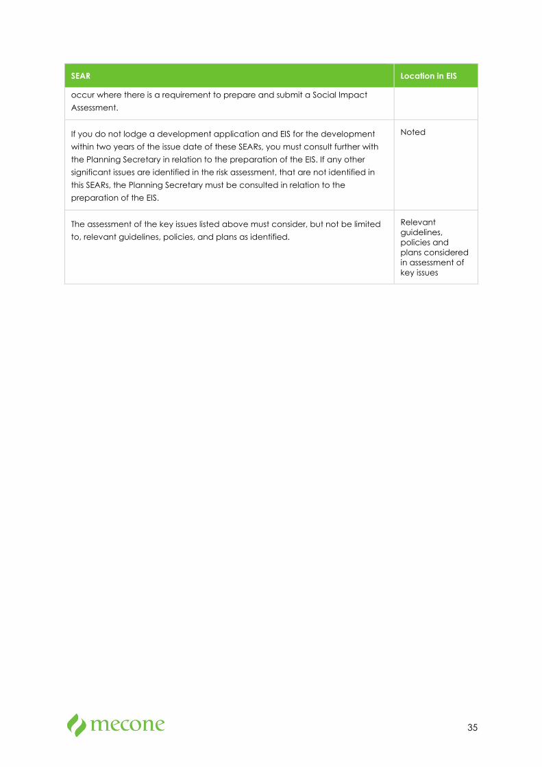
35
SEAR Location in EIS
occur where there is a requirement to prepare and submit a Social Impact Assessment.
If you do not lodge a development application and EIS for the development within two years of the issue date of these SEARs, you must consult further with the Planning Secretary in relation to the preparation of the EIS. If any other significant issues are identified in the risk assessment, that are not identified in this SEARs, the Planning Secretary must be consulted in relation to the preparation of the EIS.
Noted
The assessment of the key issues listed above must consider, but not be limited to, relevant guidelines, policies, and plans as identified.
Relevant guidelines, policies and plans considered in assessment of key issues
36
2 Site Analysis
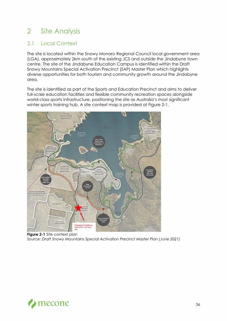
2.1 Local Context
The site is located within the Snowy Monaro Regional Council local government area (LGA), approximately 2km south of the existing JCS and outside the Jindabyne town centre. The site of the Jindabyne Education Campus is identified within the Draft Snowy Mountains Special Activation Precinct (SAP) Master Plan which highlights diverse opportunities for both tourism and community growth around the Jindabyne area.
The site is identified as part of the Sports and Education Precinct and aims to deliver full-scale education facilities and flexible community recreation spaces alongside world-class sports infrastructure, positioning the site as Australia’s most significant winter sports training hub. A site context map is provided at Figure 2-1.
Figure 2-1 Site context plan Source: Draft Snowy Mountains Special Activation Precinct Master Plan (June 2021)
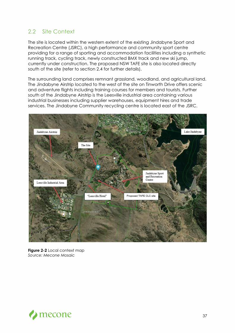
37
2.2 Site Context
The site is located within the western extent of the existing Jindabyne Sport and Recreation Centre (JSRC), a high performance and community sport centre providing for a range of sporting and accommodation facilities including a synthetic running track, cycling track, newly constructed BMX track and new ski jump, currently under construction. The proposed NSW TAFE site is also located directly south of the site (refer to section 2.4 for further details).
The surrounding land comprises remnant grassland, woodland, and agricultural land. The Jindabyne Airstrip located to the west of the site on Tinworth Drive offers scenic and adventure flights including training courses for members and tourists. Further south of the Jindabyne Airstrip is the Leesville industrial area containing various industrial businesses including supplier warehouses, equipment hires and trade services. The Jindabyne Community recycling centre is located east of the JSRC.
Figure 2-2 Local context map Source: Mecone Mosaic
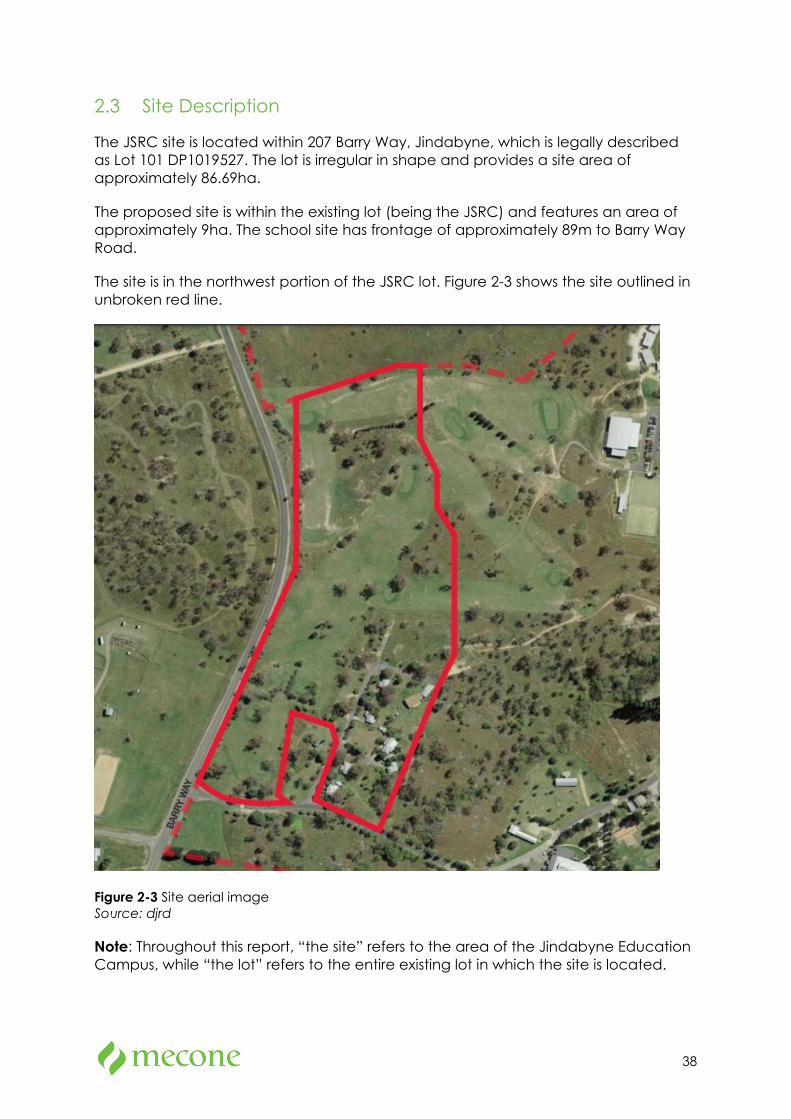
38
2.3 Site Description
The JSRC site is located within 207 Barry Way, Jindabyne, which is legally described as Lot 101 DP1019527. The lot is irregular in shape and provides a site area of approximately 86.69ha.
The proposed site is within the existing lot (being the JSRC) and features an area of approximately 9ha. The school site has frontage of approximately 89m to Barry Way Road.
The site is in the northwest portion of the JSRC lot. Figure 2-3 shows the site outlined in unbroken red line.
Figure 2-3 Site aerial image Source: djrd
Note: Throughout this report, “the site” refers to the area of the Jindabyne Education Campus, while “the lot” refers to the entire existing lot in which the site is located.
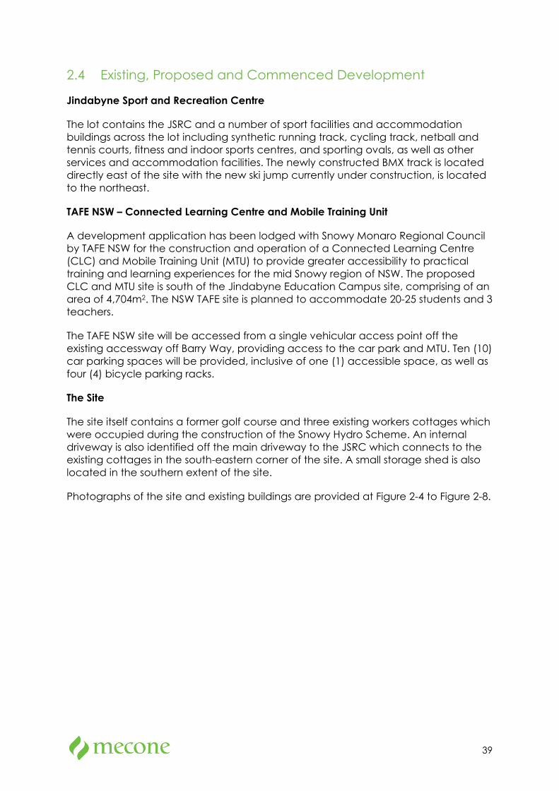
39
2.4 Existing, Proposed and Commenced Development
Jindabyne Sport and Recreation Centre
The lot contains the JSRC and a number of sport facilities and accommodation buildings across the lot including synthetic running track, cycling track, netball and tennis courts, fitness and indoor sports centres, and sporting ovals, as well as other services and accommodation facilities. The newly constructed BMX track is located directly east of the site with the new ski jump currently under construction, is located to the northeast.
TAFE NSW – Connected Learning Centre and Mobile Training Unit
A development application has been lodged with Snowy Monaro Regional Council by TAFE NSW for the construction and operation of a Connected Learning Centre (CLC) and Mobile Training Unit (MTU) to provide greater accessibility to practical training and learning experiences for the mid Snowy region of NSW. The proposed CLC and MTU site is south of the Jindabyne Education Campus site, comprising of an area of 4,704m2. The NSW TAFE site is planned to accommodate 20-25 students and 3 teachers.
The TAFE NSW site will be accessed from a single vehicular access point off the existing accessway off Barry Way, providing access to the car park and MTU. Ten (10) car parking spaces will be provided, inclusive of one (1) accessible space, as well as four (4) bicycle parking racks.
The Site
The site itself contains a former golf course and three existing workers cottages which were occupied during the construction of the Snowy Hydro Scheme. An internal driveway is also identified off the main driveway to the JSRC which connects to the existing cottages in the south-eastern corner of the site. A small storage shed is also located in the southern extent of the site.
Photographs of the site and existing buildings are provided at Figure 2-4 to Figure 2-8.
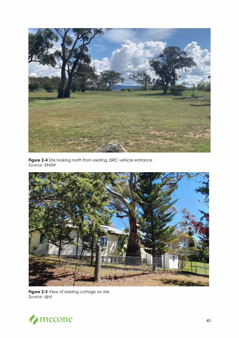
40
Figure 2-4 Site looking north from existing JSRC vehicle entrance Source: SINSW
Figure 2-5 View of existing cottage on site Source: djrd
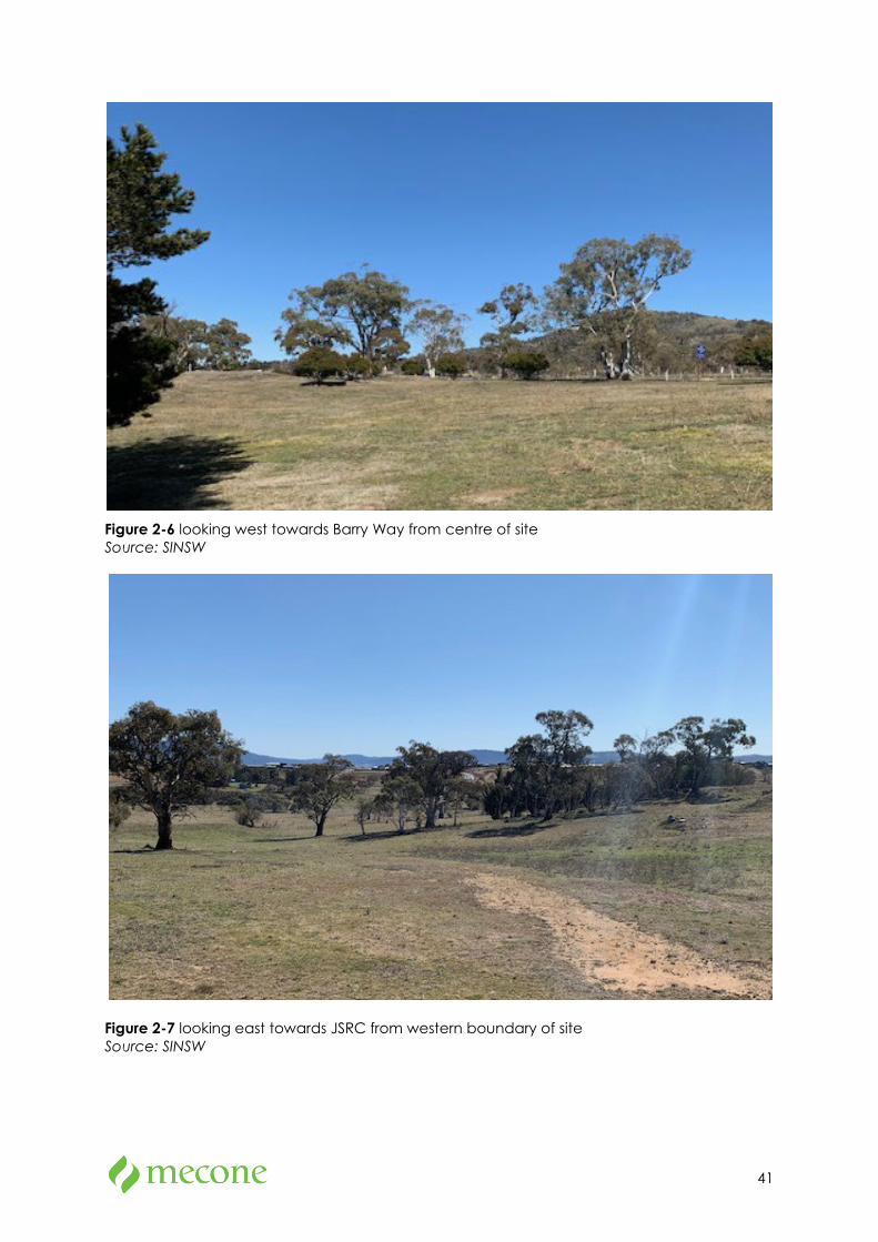
41
Figure 2-6 looking west towards Barry Way from centre of site Source: SINSW
Figure 2-7 looking east towards JSRC from western boundary of site Source: SINSW
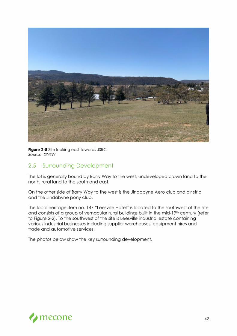
42
Figure 2-8 Site looking east towards JSRC Source: SINSW
2.5 Surrounding Development
The lot is generally bound by Barry Way to the west, undeveloped crown land to the north, rural land to the south and east.
On the other side of Barry Way to the west is the Jindabyne Aero club and air strip and the Jindabyne pony club.
The local heritage item no. 147 “Leesville Hotel” is located to the southwest of the site and consists of a group of vernacular rural buildings built in the mid-19th century (refer to Figure 2-2). To the southwest of the site is Leesville industrial estate containing various industrial businesses including supplier warehouses, equipment hires and trade and automotive services.
The photos below show the key surrounding development.
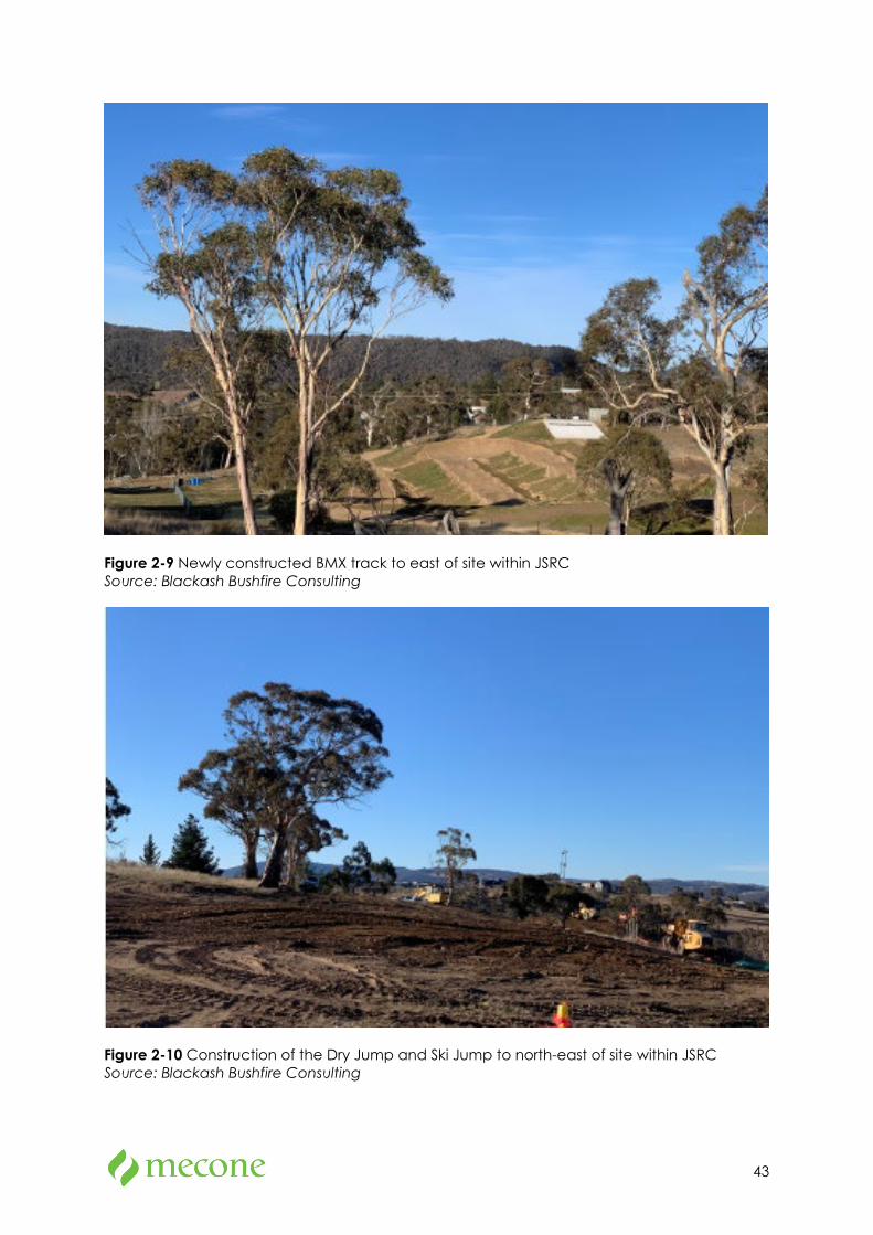
43
Figure 2-9 Newly constructed BMX track to east of site within JSRC Source: Blackash Bushfire Consulting
Figure 2-10 Construction of the Dry Jump and Ski Jump to north-east of site within JSRC Source: Blackash Bushfire Consulting
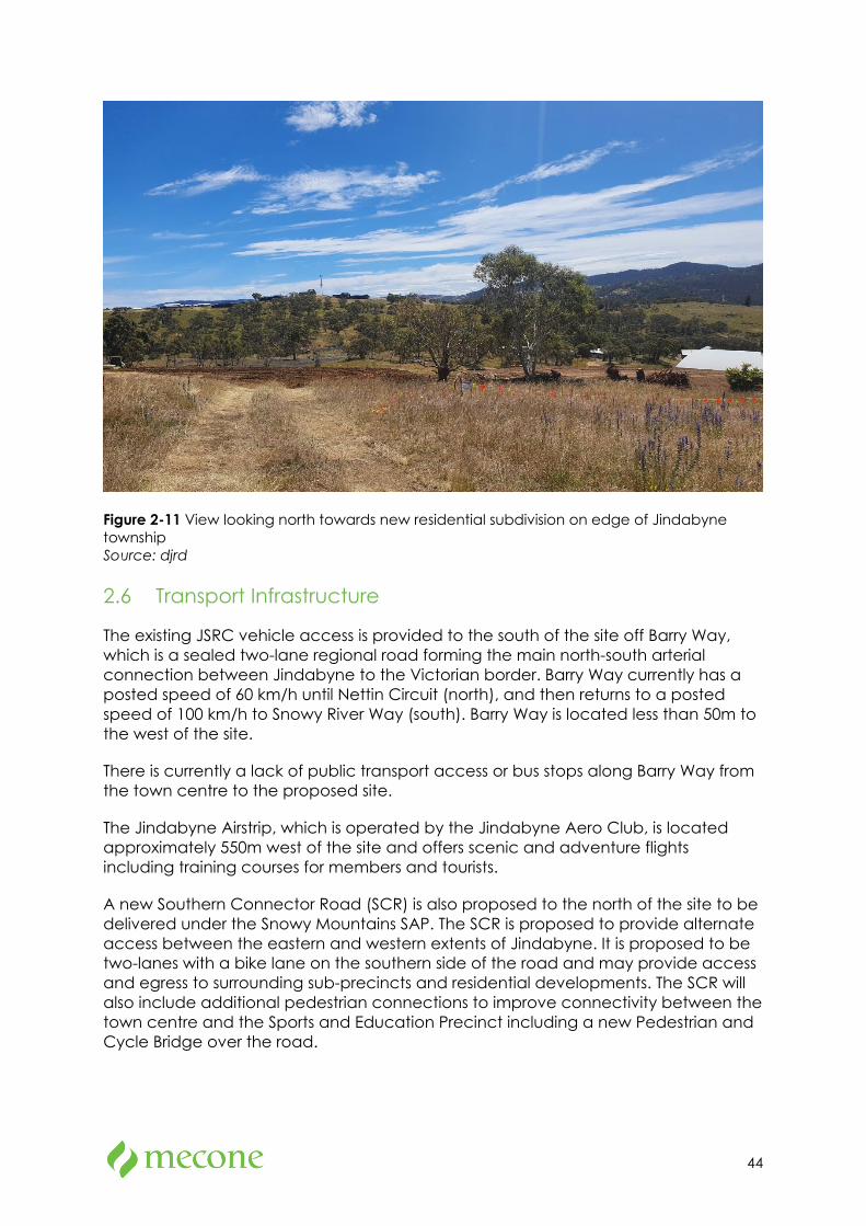
44
Figure 2-11 View looking north towards new residential subdivision on edge of Jindabyne township Source: djrd
2.6 Transport Infrastructure
The existing JSRC vehicle access is provided to the south of the site off Barry Way, which is a sealed two-lane regional road forming the main north-south arterial connection between Jindabyne to the Victorian border. Barry Way currently has a posted speed of 60 km/h until Nettin Circuit (north), and then returns to a posted speed of 100 km/h to Snowy River Way (south). Barry Way is located less than 50m to the west of the site.
There is currently a lack of public transport access or bus stops along Barry Way from the town centre to the proposed site.
The Jindabyne Airstrip, which is operated by the Jindabyne Aero Club, is located approximately 550m west of the site and offers scenic and adventure flights including training courses for members and tourists.
A new Southern Connector Road (SCR) is also proposed to the north of the site to be delivered under the Snowy Mountains SAP. The SCR is proposed to provide alternate access between the eastern and western extents of Jindabyne. It is proposed to be two-lanes with a bike lane on the southern side of the road and may provide access and egress to surrounding sub-precincts and residential developments. The SCR will also include additional pedestrian connections to improve connectivity between the town centre and the Sports and Education Precinct including a new Pedestrian and Cycle Bridge over the road.
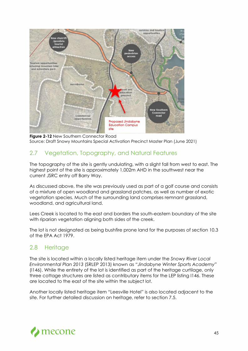
45
Figure 2-12 New Southern Connector Road Source: Draft Snowy Mountains Special Activation Precinct Master Plan (June 2021)
2.7 Vegetation, Topography, and Natural Features
The topography of the site is gently undulating, with a slight fall from west to east. The highest point of the site is approximately 1,002m AHD in the southwest near the current JSRC entry off Barry Way.
As discussed above, the site was previously used as part of a golf course and consists of a mixture of open woodland and grassland patches, as well as number of exotic vegetation species. Much of the surrounding land comprises remnant grassland, woodland, and agricultural land.
Lees Creek is located to the east and borders the south-eastern boundary of the site with riparian vegetation aligning both sides of the creek.
The lot is not designated as being bushfire prone land for the purposes of section 10.3 of the EPA Act 1979.
2.8 Heritage
The site is located within a locally listed heritage item under the Snowy River Local Environmental Plan 2013 (SRLEP 2013) known as “Jindabyne Winter Sports Academy” (I146). While the entirety of the lot is identified as part of the heritage curtilage, only three cottage structures are listed as contributary items for the LEP listing I146. These are located to the east of the site within the subject lot.
Another locally listed heritage item “Leesville Hotel” is also located adjacent to the site. For further detailed discussion on heritage, refer to section 7.5.
46
3 Project Description The table below provides a summary of the key elements of the proposed development. The elements are described in further detail in the subsections below the table.
The new-build components of the school are to be constructed via Modern Methods of Construction (MMoC).
Table 3-1 Project Summary
Proposal element Brief description
Demolition The proposal requires demolition of the existing accommodation buildings located in the south-eastern extent of the site as well as the removal of existing bitumen road and fencing to the eastern boundary of the site.
Tree retention and removal
The proposal requires removal of 134 trees.
72 trees within the site will be retained.
4 trees to retain with mitigation measures.
Earthworks
Total cut volume = 32,287m3
Total fill volume = 31,941m3
Balance = 326m3 cut
Built form
The primary school home bases are arranged in a U-shape surrounding a central play space area.
The alignment of the high school learning spaces is more linear shape consisting of a double storey height running adjacent to the sports field.
The administration, hall, gym library and performance buildings in the centre of the centre of the site will comprise of two storey buildings.
Site area Approx. 9ha
Gross floor area (GFA) 9,559m2
Maximum height 1007m AHD
Land use Education Establishment (schools)
Student capacity 925 students
Access Access will be provided to the proposed site via a new northern and southern roundabout (delivered by others) on Barry Way, connecting Barry
47
Proposal element Brief description
Way with the internal driveway. The internal driveway will provide two-lane vehicle access and include kiss and drop, bus bay, and car parking.
Car parking 113 on-site car parking spaces are proposed for staff, visitor, and year 12 students.
Four bus bays are proposed within the internal driveway
Landscaping 175 new trees proposed, plus numerous shrubs and groundcovers.
14.9% of site covered by tree canopy.
Jobs Construction: 91 (construction and consultant positions)
Operation: 90
Construction hours
Monday to Friday: 7.00am to 6.00pm
Saturdays: 8.00am to 1.00pm
No work on Sunday or public holidays
Hours of operation
7:00am to 6:00pm Monday to Friday
The hall/gym will also be used outside of standard hours on weekdays until 10pm for special school events such as presentation nights, drama, or music recitals.
3.1 Demolition
The proposal requires demolition of all buildings and structures on the site including:
• Three accommodation buildings,
• Bitumen road, and
• Site fence.
Figure 3-1 below shows an extract of the demolition plan.
Hazardous materials survey for the three existing buildings are attached at Appendix 31.
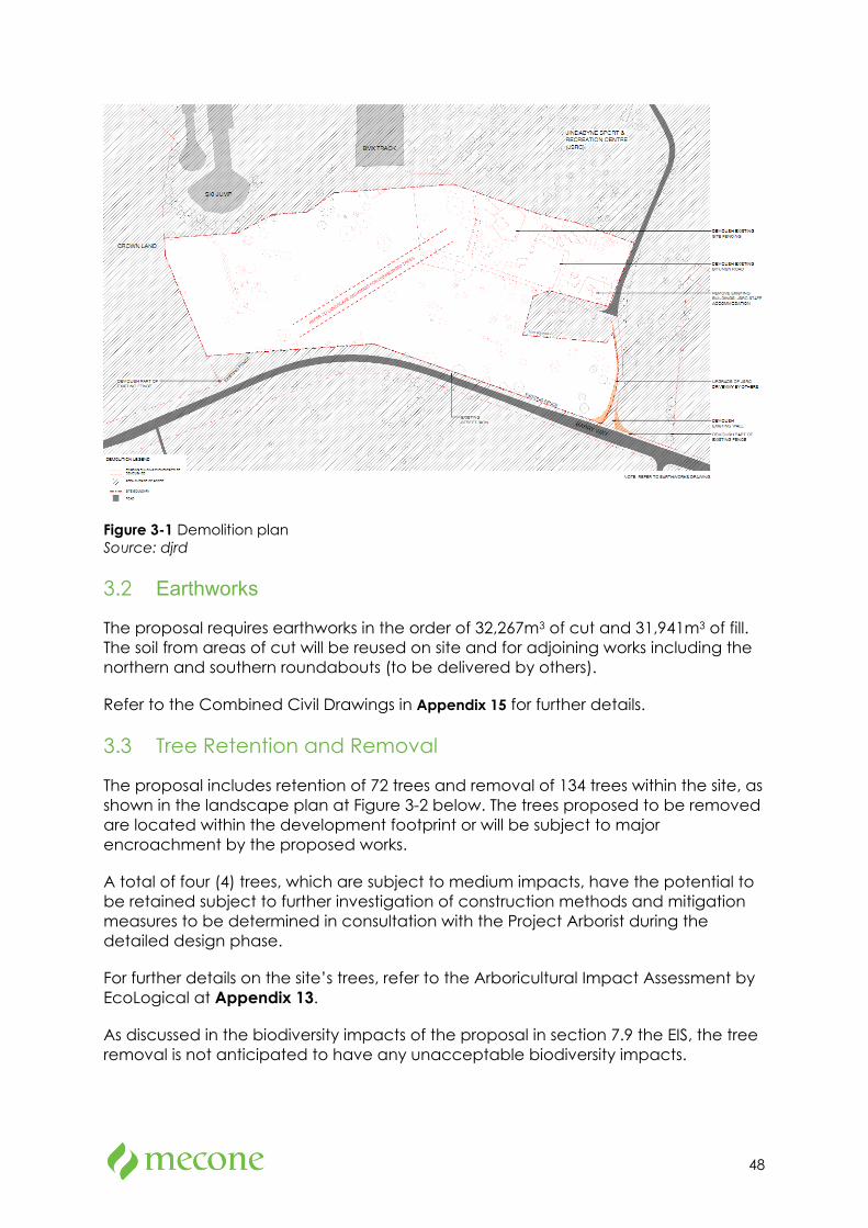
48
Figure 3-1 Demolition plan Source: djrd
3.2 Earthworks
The proposal requires earthworks in the order of 32,267m3 of cut and 31,941m3 of fill. The soil from areas of cut will be reused on site and for adjoining works including the northern and southern roundabouts (to be delivered by others).
Refer to the Combined Civil Drawings in Appendix 15 for further details.
3.3 Tree Retention and Removal
The proposal includes retention of 72 trees and removal of 134 trees within the site, as shown in the landscape plan at Figure 3-2 below. The trees proposed to be removed are located within the development footprint or will be subject to major encroachment by the proposed works.
A total of four (4) trees, which are subject to medium impacts, have the potential to be retained subject to further investigation of construction methods and mitigation measures to be determined in consultation with the Project Arborist during the detailed design phase.
For further details on the site’s trees, refer to the Arboricultural Impact Assessment by EcoLogical at Appendix 13.
As discussed in the biodiversity impacts of the proposal in section 7.9 the EIS, the tree removal is not anticipated to have any unacceptable biodiversity impacts.
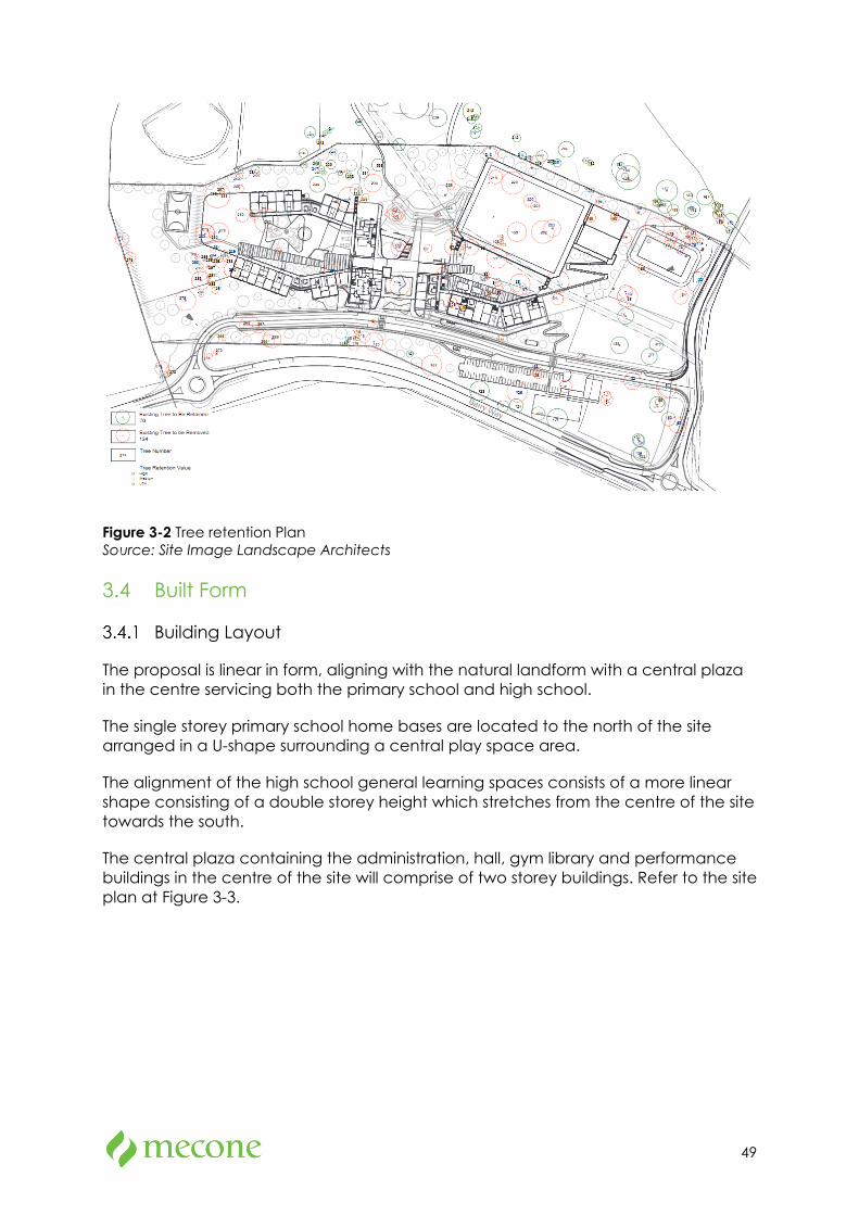
49
Figure 3-2 Tree retention Plan Source: Site Image Landscape Architects
3.4 Built Form
Building Layout
The proposal is linear in form, aligning with the natural landform with a central plaza in the centre servicing both the primary school and high school.
The single storey primary school home bases are located to the north of the site arranged in a U-shape surrounding a central play space area.
The alignment of the high school general learning spaces consists of a more linear shape consisting of a double storey height which stretches from the centre of the site towards the south.
The central plaza containing the administration, hall, gym library and performance buildings in the centre of the site will comprise of two storey buildings. Refer to the site plan at Figure 3-3.
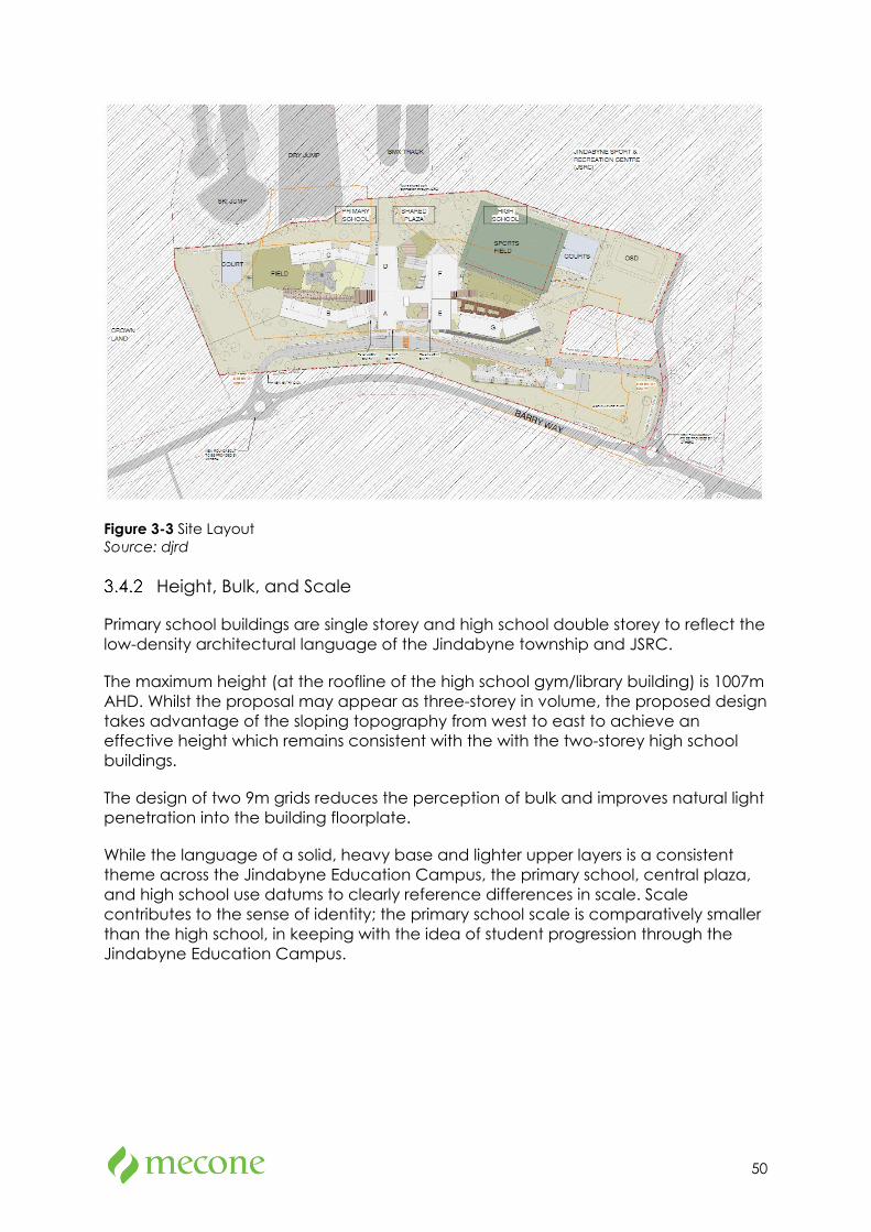
50
Figure 3-3 Site Layout Source: djrd
Height, Bulk, and Scale
Primary school buildings are single storey and high school double storey to reflect the low-density architectural language of the Jindabyne township and JSRC.
The maximum height (at the roofline of the high school gym/library building) is 1007m AHD. Whilst the proposal may appear as three-storey in volume, the proposed design takes advantage of the sloping topography from west to east to achieve an effective height which remains consistent with the with the two-storey high school buildings.
The design of two 9m grids reduces the perception of bulk and improves natural light penetration into the building floorplate.
While the language of a solid, heavy base and lighter upper layers is a consistent theme across the Jindabyne Education Campus, the primary school, central plaza, and high school use datums to clearly reference differences in scale. Scale contributes to the sense of identity; the primary school scale is comparatively smaller than the high school, in keeping with the idea of student progression through the Jindabyne Education Campus.
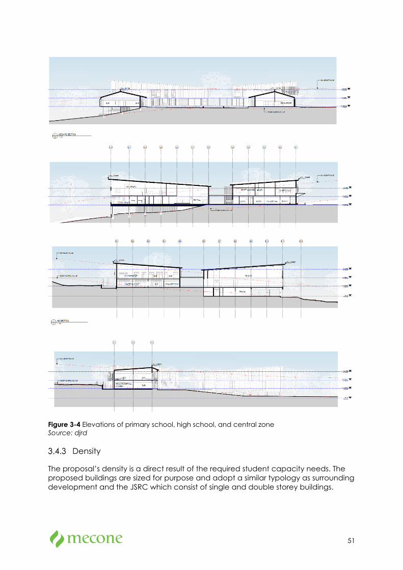
51
Figure 3-4 Elevations of primary school, high school, and central zone Source: djrd
Density
The proposal’s density is a direct result of the required student capacity needs. The proposed buildings are sized for purpose and adopt a similar typology as surrounding development and the JSRC which consist of single and double storey buildings.
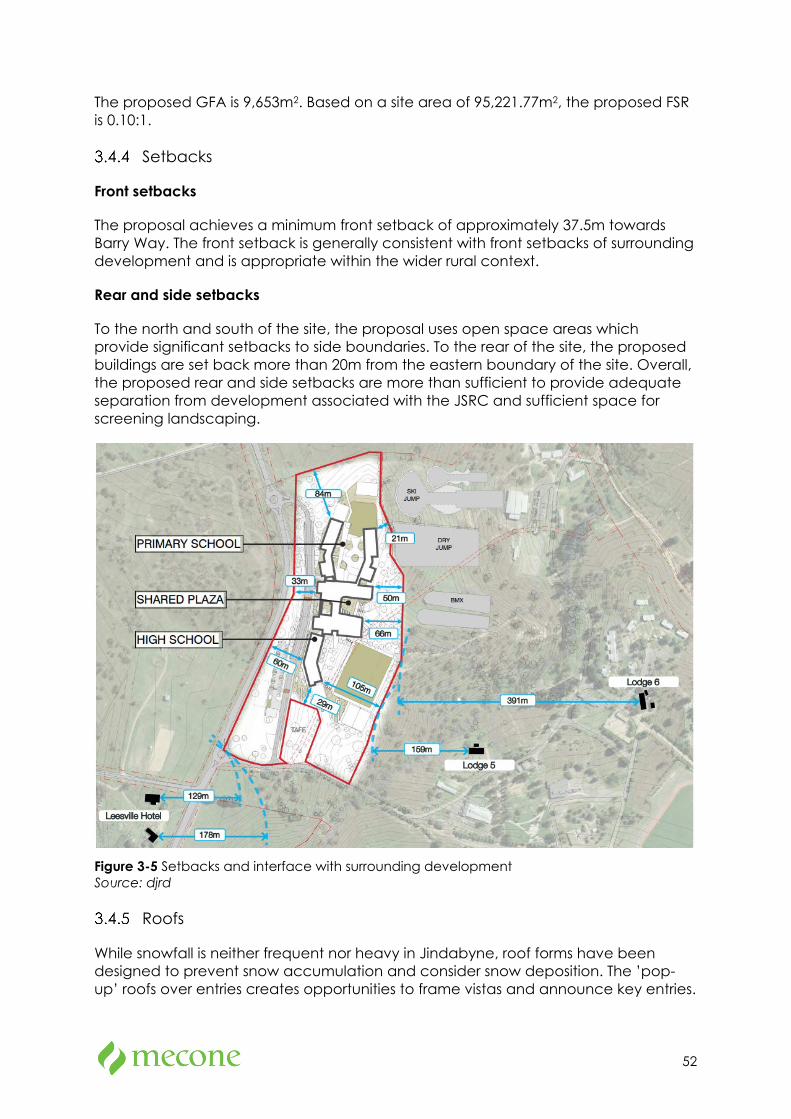
52
The proposed GFA is 9,653m2. Based on a site area of 95,221.77m2, the proposed FSR is 0.10:1.
Setbacks
Front setbacks
The proposal achieves a minimum front setback of approximately 37.5m towards Barry Way. The front setback is generally consistent with front setbacks of surrounding development and is appropriate within the wider rural context.
Rear and side setbacks
To the north and south of the site, the proposal uses open space areas which provide significant setbacks to side boundaries. To the rear of the site, the proposed buildings are set back more than 20m from the eastern boundary of the site. Overall, the proposed rear and side setbacks are more than sufficient to provide adequate separation from development associated with the JSRC and sufficient space for screening landscaping.
Figure 3-5 Setbacks and interface with surrounding development Source: djrd
Roofs
While snowfall is neither frequent nor heavy in Jindabyne, roof forms have been designed to prevent snow accumulation and consider snow deposition. The ’pop-up’ roofs over entries creates opportunities to frame vistas and announce key entries.
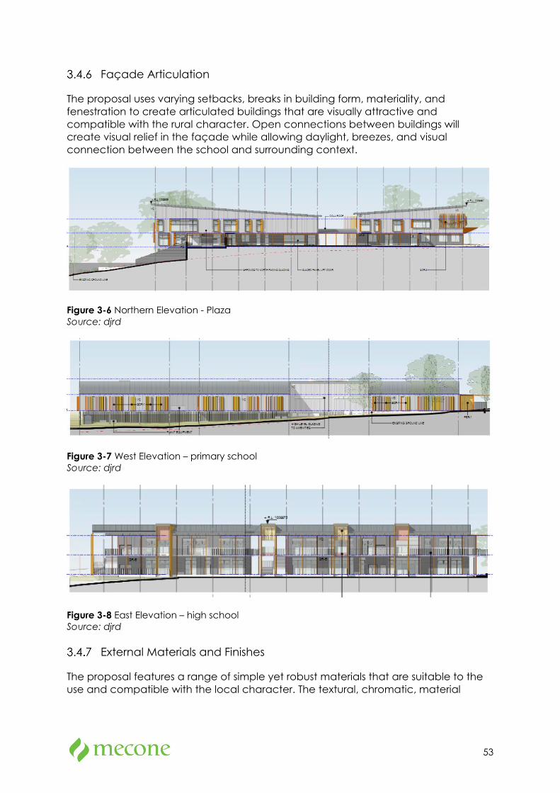
53
Façade Articulation
The proposal uses varying setbacks, breaks in building form, materiality, and fenestration to create articulated buildings that are visually attractive and compatible with the rural character. Open connections between buildings will create visual relief in the façade while allowing daylight, breezes, and visual connection between the school and surrounding context.
Figure 3-6 Northern Elevation - Plaza Source: djrd
Figure 3-7 West Elevation – primary school Source: djrd
Figure 3-8 East Elevation – high school Source: djrd
External Materials and Finishes
The proposal features a range of simple yet robust materials that are suitable to the use and compatible with the local character. The textural, chromatic, material
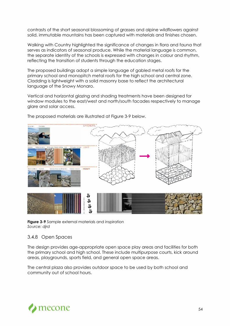
54
contrasts of the short seasonal blossoming of grasses and alpine wildflowers against solid, immutable mountains has been captured with materials and finishes chosen.
Walking with Country highlighted the significance of changes in flora and fauna that serves as indicators of seasonal produce. While the material language is common, the separate identity of the schools is expressed with changes in colour and rhythm, reflecting the transition of students through the education stages.
The proposed buildings adopt a simple language of gabled metal roofs for the primary school and monopitch metal roofs for the high school and central zone. Cladding is lightweight with a solid masonry base to reflect the architectural language of the Snowy Monaro.
Vertical and horizontal glazing and shading treatments have been designed for window modules to the east/west and north/south facades respectively to manage glare and solar access.
The proposed materials are illustrated at Figure 3-9 below.
Figure 3-9 Sample external materials and inspiration Source: djrd
Open Spaces
The design provides age-appropriate open space play areas and facilities for both the primary school and high school. These include multipurpose courts, kick around areas, playgrounds, sports field, and general open space areas.
The central plaza also provides outdoor space to be used by both school and community out of school hours.
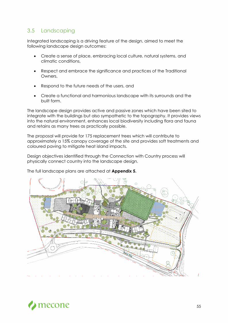
55
3.5 Landscaping
Integrated landscaping is a driving feature of the design, aimed to meet the following landscape design outcomes:
• Create a sense of place, embracing local culture, natural systems, and climatic conditions,
• Respect and embrace the significance and practices of the Traditional Owners,
• Respond to the future needs of the users, and
• Create a functional and harmonious landscape with its surrounds and the built form.
The landscape design provides active and passive zones which have been sited to integrate with the buildings but also sympathetic to the topography. It provides views into the natural environment, enhances local biodiversity including flora and fauna and retains as many trees as practically possible.
The proposal will provide for 175 replacement trees which will contribute to approximately a 15% canopy coverage of the site and provides soft treatments and coloured paving to mitigate heat island impacts.
Design objectives identified through the Connection with Country process will physically connect country into the landscape design.
The full landscape plans are attached at Appendix 5.
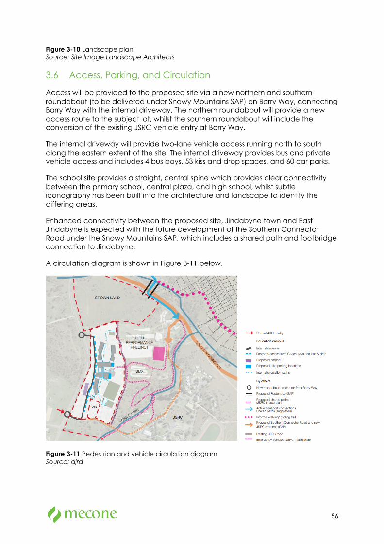
56
Figure 3-10 Landscape plan Source: Site Image Landscape Architects
3.6 Access, Parking, and Circulation
Access will be provided to the proposed site via a new northern and southern roundabout (to be delivered under Snowy Mountains SAP) on Barry Way, connecting Barry Way with the internal driveway. The northern roundabout will provide a new access route to the subject lot, whilst the southern roundabout will include the conversion of the existing JSRC vehicle entry at Barry Way.
The internal driveway will provide two-lane vehicle access running north to south along the eastern extent of the site. The internal driveway provides bus and private vehicle access and includes 4 bus bays, 53 kiss and drop spaces, and 60 car parks.
The school site provides a straight, central spine which provides clear connectivity between the primary school, central plaza, and high school, whilst subtle iconography has been built into the architecture and landscape to identify the differing areas.
Enhanced connectivity between the proposed site, Jindabyne town and East Jindabyne is expected with the future development of the Southern Connector Road under the Snowy Mountains SAP, which includes a shared path and footbridge connection to Jindabyne.
A circulation diagram is shown in Figure 3-11 below.
Figure 3-11 Pedestrian and vehicle circulation diagram Source: djrd
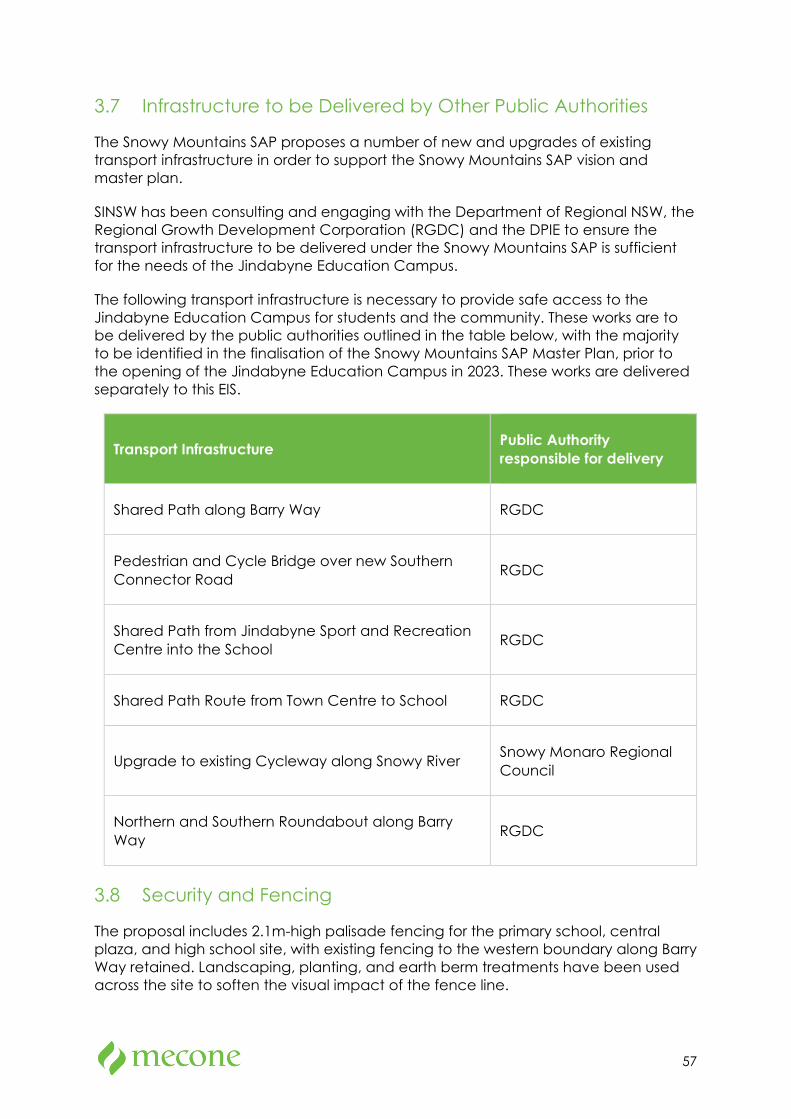
57
3.7 Infrastructure to be Delivered by Other Public Authorities
The Snowy Mountains SAP proposes a number of new and upgrades of existing transport infrastructure in order to support the Snowy Mountains SAP vision and master plan.
SINSW has been consulting and engaging with the Department of Regional NSW, the Regional Growth Development Corporation (RGDC) and the DPIE to ensure the transport infrastructure to be delivered under the Snowy Mountains SAP is sufficient for the needs of the Jindabyne Education Campus.
The following transport infrastructure is necessary to provide safe access to the Jindabyne Education Campus for students and the community. These works are to be delivered by the public authorities outlined in the table below, with the majority to be identified in the finalisation of the Snowy Mountains SAP Master Plan, prior to the opening of the Jindabyne Education Campus in 2023. These works are delivered separately to this EIS.
Transport Infrastructure Public Authority responsible for delivery
Shared Path along Barry Way RGDC
Pedestrian and Cycle Bridge over new Southern Connector Road RGDC
Shared Path from Jindabyne Sport and Recreation Centre into the School RGDC
Shared Path Route from Town Centre to School RGDC
Upgrade to existing Cycleway along Snowy River Snowy Monaro Regional Council
Northern and Southern Roundabout along Barry Way RGDC
3.8 Security and Fencing
The proposal includes 2.1m-high palisade fencing for the primary school, central plaza, and high school site, with existing fencing to the western boundary along Barry Way retained. Landscaping, planting, and earth berm treatments have been used across the site to soften the visual impact of the fence line.
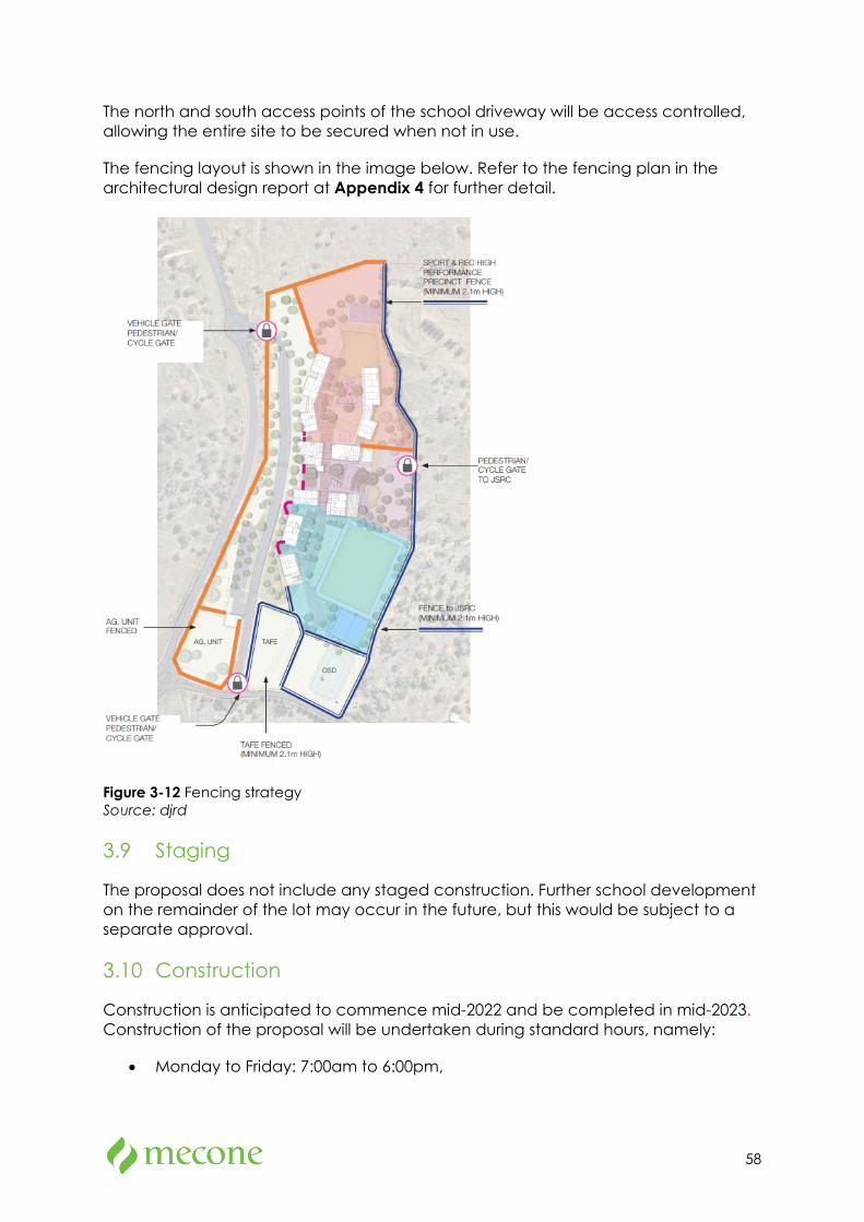
58
The north and south access points of the school driveway will be access controlled, allowing the entire site to be secured when not in use.
The fencing layout is shown in the image below. Refer to the fencing plan in the architectural design report at Appendix 4 for further detail.
Figure 3-12 Fencing strategy Source: djrd
3.9 Staging
The proposal does not include any staged construction. Further school development on the remainder of the lot may occur in the future, but this would be subject to a separate approval.
3.10 Construction
Construction is anticipated to commence mid-2022 and be completed in mid-2023. Construction of the proposal will be undertaken during standard hours, namely:
• Monday to Friday: 7:00am to 6:00pm,

59
• Saturdays: 8:00am to 1:00pm, and
• No work on Sunday and public holidays.
Approximately 75 construction jobs and 16 consultant positions will be created by the proposal.
3.11 Operational Details
The school will accommodate approximately 925 students and employ approximately 90 operational staff. The operational hours will be between 7:00am and 6:00pm including out of school hours care.
The hall/gym will also be used outside of standard hours on weekdays until 10pm for special school events such as presentation nights, drama, or music recitals.
3.12 Stormwater Drainage
The proposed stormwater system has been designed in accordance with the Snowy Monaro Regional Council’s Development Engineering Specifications for Engineering works. The proposed stormwater system includes:
• On-site detention system including above ground detention basin located in the south-eastern extent of the site,
• Rainwater tanks, and
• Series of downpipes, stormwater pits and stormwater pipes.
For full details, refer to the Combined Civil Drawings in Appendix 15 and Preliminary Stormwater Management Plan in Appendix 16.
3.13 Services
The proposal seeks to provide the following utilities services to the site either via the upgrade existing of existing service infrastructure, or through the provision of new service infrastructure:
• Potable water,
• Sewer,
• Gas (via bottled storage only),
• Photovoltaic Solar Power, and
• Telecommunications.
For further details, refer to section 7.19 and Appendix 14 in this EIS.
60
3.14 Waste Management
A council or private contractor collection vehicle will be engaged to service the waste and recycling bins for the proposed Jindabyne Education Campus per an agreed schedule.
On the day of service, a council or private contractor waste collection vehicle will enter the site from Barry Way and park in front of the waste holding room. The waste caretaker/facilities manager will provide the driver with access to the waste holding room. Once the bins are serviced, the collection vehicle will exit the site onto Barry Way in a forward direction.
For further details, refer to section 7.15.2 of this EIS and the Operational Waste Management Plan at Appendix 24.
3.15 Signage
Four signs are proposed as part of this application:
• A digital pylon sign located at the northern entry, located just outside of the site boundary, subject to final agreement with Council. The digital pylon sign will have a digital content area of 1,800mm x 4400mm with a maximum height of 4,390mm.
• Three Individual letter signage, approximately 150mm high, depicting the main entries for the primary school, high school, and visitor/administration building.
It is noted that the naming of the schools has yet to be determined, therefore signage details are indicatively shown in the western elevations of the architectural plans. Assessment against State Environmental Planning Policy No 64—Advertising and Signage is discussed in detail in section 5.8 of the EIS.
Directional signage on approach to the site along Barry Way is also identified for the site. This does not form part of the EIS and is to be delivered by others.
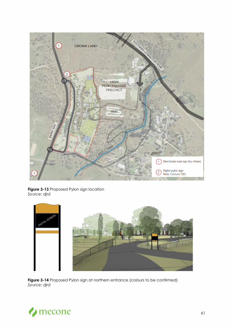
61
Figure 3-13 Proposed Pylon sign location Source: djrd
Figure 3-14 Proposed Pylon sign at northern entrance (colours to be confirmed) Source: djrd
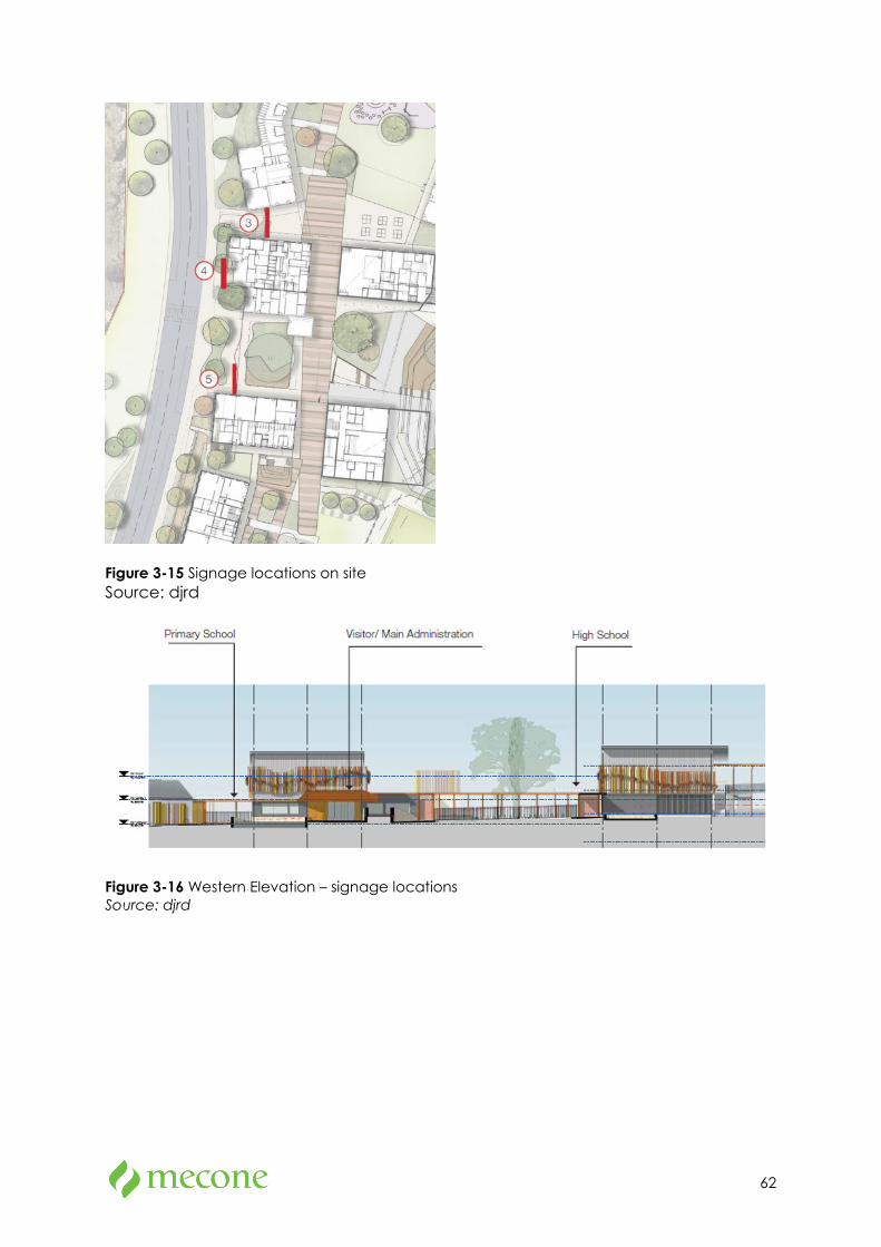
62
Figure 3-15 Signage locations on site Source: djrd
Figure 3-16 Western Elevation – signage locations Source: djrd
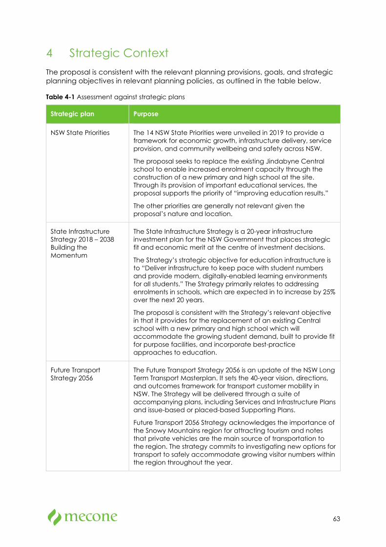
63
4 Strategic Context The proposal is consistent with the relevant planning provisions, goals, and strategic planning objectives in relevant planning policies, as outlined in the table below.
Table 4-1 Assessment against strategic plans
Strategic plan Purpose
NSW State Priorities The 14 NSW State Priorities were unveiled in 2019 to provide a framework for economic growth, infrastructure delivery, service provision, and community wellbeing and safety across NSW.
The proposal seeks to replace the existing Jindabyne Central school to enable increased enrolment capacity through the construction of a new primary and high school at the site. Through its provision of important educational services, the proposal supports the priority of “improving education results.”
The other priorities are generally not relevant given the proposal’s nature and location.
State Infrastructure Strategy 2018 – 2038 Building the Momentum
The State Infrastructure Strategy is a 20-year infrastructure investment plan for the NSW Government that places strategic fit and economic merit at the centre of investment decisions.
The Strategy’s strategic objective for education infrastructure is to “Deliver infrastructure to keep pace with student numbers and provide modern, digitally-enabled learning environments for all students.” The Strategy primarily relates to addressing enrolments in schools, which are expected in to increase by 25% over the next 20 years.
The proposal is consistent with the Strategy’s relevant objective in that it provides for the replacement of an existing Central school with a new primary and high school which will accommodate the growing student demand, built to provide fit for purpose facilities, and incorporate best-practice approaches to education.
Future Transport Strategy 2056
The Future Transport Strategy 2056 is an update of the NSW Long Term Transport Masterplan. It sets the 40-year vision, directions, and outcomes framework for transport customer mobility in NSW. The Strategy will be delivered through a suite of accompanying plans, including Services and Infrastructure Plans and issue-based or placed-based Supporting Plans.
Future Transport 2056 Strategy acknowledges the importance of the Snowy Mountains region for attracting tourism and notes that private vehicles are the main source of transportation to the region. The strategy commits to investigating new options for transport to safely accommodate growing visitor numbers within the region throughout the year.
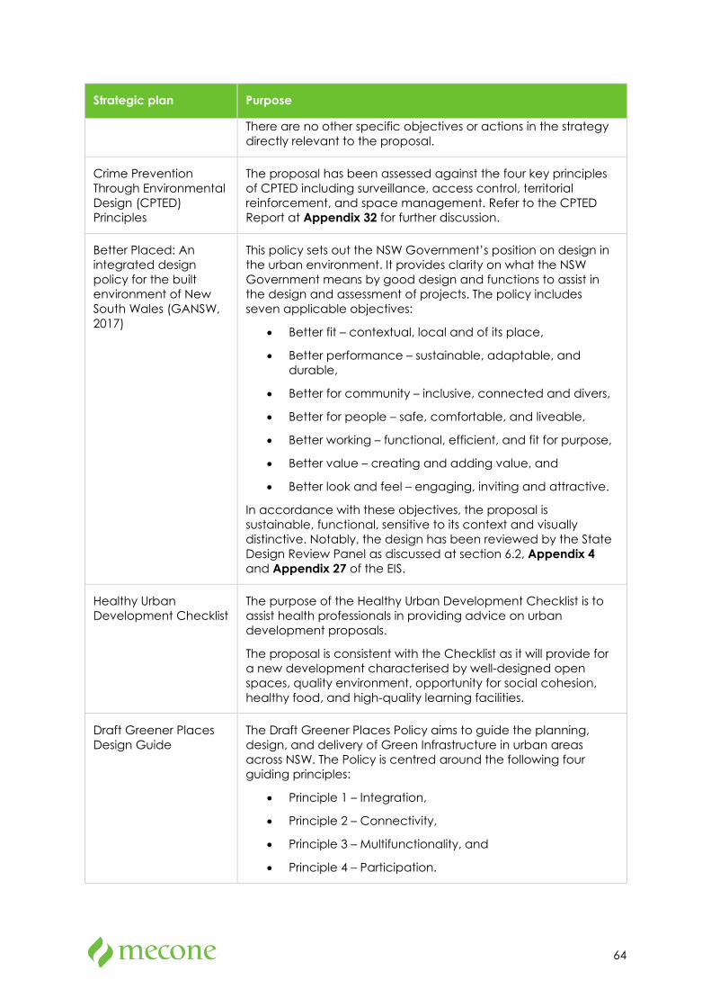
64
Strategic plan Purpose
There are no other specific objectives or actions in the strategy directly relevant to the proposal.
Crime Prevention Through Environmental Design (CPTED) Principles
The proposal has been assessed against the four key principles of CPTED including surveillance, access control, territorial reinforcement, and space management. Refer to the CPTED Report at Appendix 32 for further discussion.
Better Placed: An integrated design policy for the built environment of New South Wales (GANSW, 2017)
This policy sets out the NSW Government’s position on design in the urban environment. It provides clarity on what the NSW Government means by good design and functions to assist in the design and assessment of projects. The policy includes seven applicable objectives:
• Better fit – contextual, local and of its place,
• Better performance – sustainable, adaptable, and durable,
• Better for community – inclusive, connected and divers,
• Better for people – safe, comfortable, and liveable,
• Better working – functional, efficient, and fit for purpose,
• Better value – creating and adding value, and
• Better look and feel – engaging, inviting and attractive.
In accordance with these objectives, the proposal is sustainable, functional, sensitive to its context and visually distinctive. Notably, the design has been reviewed by the State Design Review Panel as discussed at section 6.2, Appendix 4 and Appendix 27 of the EIS.
Healthy Urban Development Checklist
The purpose of the Healthy Urban Development Checklist is to assist health professionals in providing advice on urban development proposals.
The proposal is consistent with the Checklist as it will provide for a new development characterised by well-designed open spaces, quality environment, opportunity for social cohesion, healthy food, and high-quality learning facilities.
Draft Greener Places Design Guide
The Draft Greener Places Policy aims to guide the planning, design, and delivery of Green Infrastructure in urban areas across NSW. The Policy is centred around the following four guiding principles:
• Principle 1 – Integration,
• Principle 2 – Connectivity,
• Principle 3 – Multifunctionality, and
• Principle 4 – Participation.
65
Strategic plan Purpose
In accordance with these principles, the proposal successfully integrates building form and green open space; provides for a series of accessible connected open space; features multifunctional green space that simultaneously provides environmental performance and enhances facility amenity; and incorporates the needs of various stakeholders including students, staff, community, and local Aboriginal stakeholders.
NSW South East and Tablelands Regional Plan 2036
The NSW South East and Tablelands Regional Plan sets a 20-year vision for the future of the region. The Plan provides a strategic policy, planning, and decision-making framework to guide the region to sustainable growth over the next 20 years.
While the Plan does not provide any specific objectives or actions directly relevant to the proposal, a key direction of the Regional Plan is to increase access to health and education services. The proposal seeks to provide a new site to accommodate a new primary school and high school to meet the growing student demand within the JCS live-in catchment area.
Snowy Monaro Local Strategic Planning Statement
The Snowy Monaro Local Strategic Planning Statement (LSPS) plans for the Snowy Monaro community’s environmental, social, and economic land use needs over the next 20 years.
While the LSPS does not provide any specific objectives or actions directly relevant to the proposal, a key objective for the Jindabyne area to “maintain Jindabyne as an accessible and modern community, with good existing recreation and education facilities.” The proposal seeks to provide a new site to accommodate a new primary school and high school to meet the growing student demand within the JCS live-in catchment area which provides fit-for-purpose and modern facilities.
Koala Habitat Protection Guideline
The Koala Habitat Protection Guideline supports the aims of SEPP (Koala Habitat Protection) 2019 by guiding councils on how to prepare Koala Plan of Managements, define criteria and requirements for applicants to follow and consent authorities to implement, and inform the wider community about the role of the SEPP.
A survey and rapid targeted scat surveys conducted as part of the Biodiversity Development Assessment Report (BDAR) failed to detect potential occurrences of koalas. However, potential foraging habitat is present on site due to the presence of secondary feed tree species.
The proposed development has been assessed as being unlikely to significantly impact on the species. Nonetheless, any suggested management measures which are appropriate for the site can be implemented as required in accordance with the management measures outlined within the guideline.
66
5 Statutory Context
5.1 Planning Approval Pathway
The State Environmental Planning Policy (State and Regional Development) 2011 (SRD SEPP) nominates certain types of development as either SSD, State significant infrastructure or regionally significant development.
Under clause 15(1) of Schedule 1 of the SRD SEPP, development for the purpose of a new school (with a capital investment value of more than $20 million), is categorised as SSD.
Although the proposal involves relocation of an existing school, it must be characterised as a new school for the purposes of the SRD SEPP because the site is not technically an existing school site. Therefore, the proposal must be classified as SSD. The consent authority under section 4.5 of the EP&A Act is the Minister for Planning and Public Spaces or their delegate.
The EP&A Act establishes the assessment framework for the proposal. Section 4.12(8) requires that a development application for an SSD be accompanied by an EIS prepared by or on behalf of the applicant in the form prescribed by Schedule 2 of the Environmental Planning and Assessment Regulation 2000 (the Regulation).
5.2 Owner’s Consent
In accordance with Clause 49(2) of the Regulation, consent of the owner is not required for a development application made by a public authority if the applicant instead gives notice of the application to the owner of the land before the application is made.
A letter dated 26 July 2021 was sent to the owner of the land (NSW Office of Sport) notifying them of the intent to lodge the SSD application for the new education campus at Jindabyne, which fulfils the requirement of 49(2) of the Regulation.
5.3 Permissibility
The site is zoned RU1 Primary Production under the Snowy River Local Environmental Plan 2013 (SRLEP 2013). ‘Educational establishments,’ which includes schools, are permitted with consent in the zone under SRLEP 2013.
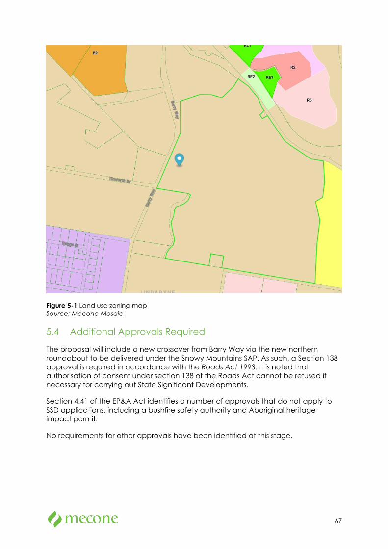
67
Figure 5-1 Land use zoning map Source: Mecone Mosaic
5.4 Additional Approvals Required
The proposal will include a new crossover from Barry Way via the new northern roundabout to be delivered under the Snowy Mountains SAP. As such, a Section 138 approval is required in accordance with the Roads Act 1993. It is noted that authorisation of consent under section 138 of the Roads Act cannot be refused if necessary for carrying out State Significant Developments.
Section 4.41 of the EP&A Act identifies a number of approvals that do not apply to SSD applications, including a bushfire safety authority and Aboriginal heritage impact permit.
No requirements for other approvals have been identified at this stage.
68
5.5 Environment Protection and Biodiversity Conservation Act 1999
The Environment Protection and Biodiversity Conservation Act 1999 is federal legislation which provides a legal framework to protect and manage nationally important flora, fauna, ecological communities, and heritage places defined as “matters of national environmental significance” (MNES). A referral must be made to the Australian Government Minister for the Environment for actions that are likely to have a significant impact on MNES.
As the proposal is unlikely to have a significant impact on MNES, referral is not required.
5.6 Environmental Planning and Assessment Act 1979
The Environmental Planning and Assessment Act 1979 (EP&A Act) is the primary land use planning statute in NSW which governs matters such as planning administration, planning instruments, development assessments, building certification, infrastructure finance, appeals and enforcement.
The table below provides consideration of the proposal in the context of the objects of the EP&A Act.
Table 5-1 Objects of the EP&A Act
Objects of the EP&A Act Comments
(a) to promote the social and economic welfare of the community and a better environment by the proper management, development, and conservation of the State’s natural and other resources
The proposal aims to provide for a new primary school and high school which will increase the capacity for enrolment and facilities which are fit-for-purpose.
(b) to facilitate ecologically sustainable development by integrating relevant economic, environmental and social considerations in decision-making about environmental planning and assessment,
The proposal incorporates a number of ESD measures outlined in section 7.4of the EIS. The proposal is targeting a 4 Star Green Star rating.
(c) to promote the orderly and economic use and development of land
The proposal promotes the orderly and economic use of land by placing a new school on relatively unconstrained land while allowing flexibility for future school development on the remainder of the lot.
(d) to promote the delivery and maintenance of affordable housing
This objective is not applicable to the proposal.
(e) to protect the environment, including the conservation of threatened and other
The proposal has been designed to avoid impacts on the environment. The design
69
Objects of the EP&A Act Comments
species of native animals and plants, ecological communities and their habitats
minimises tree removal and avoids impacts on the nearby watercourse.
A worst-case scenario of clearing within the site has been assumed within the accompanying Biodiversity Development Assessment Report (BDAR) at Appendix 12. Where impacts have been assumed or identified, appropriate offsets have been calculated to compensate for the removal of vegetation on site.
(f) to promote the sustainable management of built and cultural heritage (including Aboriginal cultural heritage)
Heritage impacts are addressed at section 7.5 of the EIS. In summary, the assessment has found the demolition of the cottage buildings on site will not result in a loss of material significance for the site as the significant items will remain extant.
Aboriginal cultural heritage is addressed at Appendix 9 and section 7.6 of the EIS. In summary, the assessment has found that further test excavations are required to investigate identified Potential Archaeological Deposit (PAD) sites. The test excavations are currently being undertaken at the site. Refer to Appendix 9 and section 7.6 of the EIS for further details.
(g) to promote good design and amenity of the built environment
The proposal features a high quality, purpose-built design that provides high amenity for users.
(h) to promote the proper construction and maintenance of buildings, including the protection of the health and safety of their occupants
The proposal has been designed in compliance with relevant BCA and DDA standards for building construction.
(i) to promote the sharing of the responsibility for environmental planning and assessment between the different levels of government in the State
Prior to lodgement, consultation was carried out with a range of State government agencies and the Snowy Monaro Regional Council as detailed in section 6 of this EIS. Also refer to the consultation report at Appendix 27.
(j) to provide increased opportunity for community participation in environmental planning and assessment.
The local community and other stakeholders were consulted prior to lodgement as discussed in section 6 of this EIS, and the community will be able to provide further input during the formal exhibition process.
70
5.7 Biodiversity Conservation Act 2016
The Biodiversity Conservation Act 2016 (BC Act) is the key piece of legislation that identifies and protects threatened species, populations, and ecological communities within NSW.
Cl. 7.9 of the BC Act requires any application for SSD to include a biodiversity development assessment report (BDAR). Accordingly, a BDAR has been prepared for the proposal and is attached at Appendix 12 . The results of the BDAR are discussed at section 7.9 of the EIS.
The BDAR has recorded one Plant Community Type (PCT) on site (PCT 1191). PCT 1191 corresponds to the Monaro Tableland Cool Temperate Grassy Woodland in the South Highlands Bioregion which is listed as a Critically Endangered Ecological Community under the BC Act.
The BDAR assumes direct impact to five (5) threatened plant species and five threatened animal species. Additionally, direct impacts to Serious and Irreversible Impact (SAII) entities are estimated as follows:
• Monaro Tableland Cool Temperate Grassy Woodland in The South Eastern Highlands Bioregion: 8.6 ha
• Calotis glandulosa: 1.02 ha (potential habitat).
The BDAR outlines the ecosystem credit requirements for the proposal calculated by the BAM-C at 165 credits.
5.8 State Environmental Planning Policies
The relevant State Environmental Planning Policies (SEPPs) are addressed in the table below.
Table 5-2 SEPP assessment
SEPP Comment
State Environmental Planning Policy (State and Regional Development) 2011 (SRD SEPP)
Clause. 15 of Schedule 1 of the SRD SEPP identifies that development for the purpose of a new school (with a capital investment value of more than $20 million) is SSD. The proposal is for the purposes of a new school and is over this threshold, and is therefore classified as SSD.
State Environmental Planning Policy (Infrastructure) 2007 (ISEPP)
Clause 101 relates to development on land that has frontage to a classified road. As the proposed site has frontage to a classified road ‘Barry Way,’ this clause applies. The proposal has been suitably designed to ensure safe and practical vehicle access is provided to the site ensuring the safety, efficiency and ongoing operation of classified road will continue to be suitable. The proposed Jindabyne Education Campus has also been appropriately located and designed to
71
SEPP Comment
ameliorate potential traffic noise or vehicle emissions arising from the classified road.
Clause 102 applies to development for the purpose of an education establishment that is on land in or adjacent to a road corridor for a freeway, a tollway, or any other road with an annual average daily traffic volume of more than 20,000 vehicles (based on traffic volume data published on the website of TfNSW). Barry Way is not identified on data published by TfNSW as having an annual average daily traffic volume of 20,000 vehicles. Nevertheless, an Acoustic Report prepared by SLR Consulting has found that appropriate design measures would ensure no adverse impacts to the proposed educational establishment.
It is noted that consultation with Transport for NSW and Council has occurred throughout the development of the proposal as detailed in section 6 of the EIS, with no objection to the proposal.
State Environmental Planning Policy (Educational Establishments and Child Care Facilities) 2017 (ESEPP)
Part 4 of the ESEPP contains specific development controls for schools. However, given that the proposal does not rely upon the ESEPP for permissibility, the controls under this part are generally not relevant. Notwithstanding, the following clauses apply to this proposal and addressed below:
Cl. 35 (6) requires the consideration of the Schedule 4 design quality principles for development of a kind referred to in subclause (1), (3) or (5). Whilst the proposal is not a development of a kind referred to in these subclauses, the entirety of the school has been assessed against the schedule 4 design quality principles in section 7.1.6 of this EIS given it is a requirement of the project SEARs.
Cl. 42 allows for a school SSD to contravene a development standard in the LEP. As such, development consent may be granted despite the proposal contravening the maximum building height under clause 4.3 of the Snowy River Local Environmental Plan 2013.
Cl. 57 of the ESEPP requires that new school development resulting in an additional 50 or more students be referred to TfNSW for comment. Given the proposal will provide for 925 students, this clause applies. The consent authority must consider the accessibility of the site and potential traffic safety, road congestion and parking implications are required. These matters are addressed at section 7.3 of the EIS.
An Explanation of Intended Effect has been exhibited for proposed changes to the ESEPP. The proposed changes focus on resolving operational issues, clarifying
72
SEPP Comment
provisions and other housekeeping issues. The changes are not directly relevant to this SSD application.
State Environmental Planning Policy No 64—Advertising and Signage (SEPP 64)
Four signs are proposed as part of the application. The signs are consistent with the aims of SEPP 64 in that they are compatible with the desired amenity and character of the area, provide effective communication in suitable locations and are of high-quality design and finish. Consultation with TfNSW is not required given the size and location of the signage.
An assessment against the general criteria in Schedule 1 of the SEPP is provided at Appendix 34 of the EIS. In summary, the signage will have no adverse impacts in relation to character of the area; special areas; views and vistas; streetscape, setting or landscaping; site and building; associated devices and logos; illumination; or safety.
State Environmental Planning Policy No. 55 Remediation of Land (SEPP 55)
Cl. 7 of SEPP 55 requires that the consent authority consider whether the land is contaminated and whether it is or can be made suitable for the proposed use.
Contamination is discussed in section 7.17 of the EIS. The contamination assessment has concluded that the site can be made suitable for the proposed use subject to the implementation of the remedial action plan (RAP). Refer to section 7.17 for further details.
State Environmental Planning Policy (Koala Habitat Protection) 2019
State Environmental Planning Policy (Koala Habitat Protection 2020 (Koala SEPP) is now the relevant version (commenced on 20 November 2020).
The provisions of the Koala SEPP apply to determinations made by councils and therefore do not apply to this SSD application. Nonetheless, it is noted that the submitted BDAR at Appendix 12 concludes that the proposal is unlikely to represent significant impact on the koala species.
State Environmental Planning Policy (Activation Precincts) 2020 (Activation Precincts SEPP)
The Activation Precincts SEPP provides a simplified statutory process and framework development within the identified SAP. It largely replaces the relevant local environmental plan applying to the SAP area, providing new land use and development controls. A master plan and delivery plan are also required to be prepared for each SAP, to ensure that development is consistent with the vision, staging and planning controls.
The proposal site is located within the draft Snowy Mountains Special Activation Precinct Master Plan within the Sports and Education sub-precinct. The draft Master Plan is on exhibition for 56 days until the 23 August 2021. The construction of a new primary school and high
73
SEPP Comment
school (the proposal) is identified within the draft Master Plan.
An amendment to the Activation Precincts SEPP is proposed to introduce new controls to land within the Snowy Mountains SAP, guiding development within each sub precinct.
As the Master Plan is still in draft form, no draft amendments to the Activation Precincts SEPP have been exhibited for the inclusion of the Snowy Mountains SAP. As such, the requirement to obtain an Activation Precinct Certificate is not required for the proposal.
Nevertheless, SINSW have been in regular discussions with DPIE and the Snowy SAP to ensure that the proposal is consistent with the master planning of the Sports and Education sub-precinct.
Draft State Environmental Planning Policy (Remediation of Land)
The Explanation of Intended Effect (EIE) for the draft SEPP was on exhibition from 31 January 2018 until 13 April 2018. The draft SEPP will retain the key operational framework of SEPP 55 and add new provisions relating to remediation works. The proposed new conditions are not relevant to the proposal given that no remediation works are proposed.
Draft State Environmental Planning Policy (Environment)
The draft Environment SEPP consolidates and simplifies seven existing SEPPs. The EIE for the draft Environment SEPP was on exhibition from 31 October 2017 until 31 January 2018. None of the SEPPs to be consolidated are applicable to the proposal.
Draft State Environmental Planning Policy (Educational Establishments and Child Care Facilities)
An EIE has been exhibited for proposed changes to the ESEPP. The proposed changes focus on resolving operational issues, clarifying provisions and other housekeeping issues. The changes are not directly relevant to this SSD application.
5.9 Snowy River Local Environmental Plan 2013
The table below addresses key sections of SRLEP 2013.
Table 5-3 Snowy River LEP assessment
Clause Comment
Land use table The site is zoned RU1 Primary Production. Educational establishments, which includes schools, are permitted with consent in the zone.
74
Clause Comment
Zone objectives The RU1 zone objectives are:
• To encourage sustainable primary industry production by maintaining and enhancing the natural resource base.
• To encourage diversity in primary industry enterprises and systems appropriate for the area.
• To minimise the fragmentation and alienation of resource lands.
• To minimise conflict between land uses within this zone and land uses within adjoining zones.
• To promote tourism, educational and recreational development and living opportunities that are compatible with agricultural activities and the environmental, historical, and cultural values of the zone.
• To ensure that development maintains and protects the scenic values and rural landscape characteristics of the zone through compatible, small-scale development.
The proposal meets the zone objective in providing educational development which is compatible with the agricultural activities and rural environmental, historical, and cultural values of the zone. The proposal will not displace or fragment any current primary production and will maintain the scenic values and rural landscape characteristics of the zone through compatible development.
4.1 Minimum subdivision lot size SRLEP 2013 mapping identifies the site as subject to a 40ha minimum lot size control. Subdivision is not part of the is EIS and will be dealt with separately through the acquisition process.
4.3 Height of buildings SRLEP 2013 mapping identifies the site as subject to a 9m maximum building height. The overall building height for some buildings proposed will exceed 9m above existing ground level. As such, the proposal will contravene this standard.
Refer to section 5.9.1 for detailed discussion.
4.4 Floor space ratio No FSR control applies to the site.
5.1 Relevant acquisition authority
SRLEP 2013 mapping does not identify any part of the site as land reserved for public purposes.
5.10 Heritage conservation The proposal is located within a portion of the lot currently listed as an item of local heritage significance “Jindabyne
75
Clause Comment
Winter Sports Academy” (I146). Three structures (including the ‘Love Shack’ are listed as contributory items for the LEP listing I146 which are integral to the heritage significance of the site for their association with the snowy scheme. These structures are located outside of the proposal boundary.
“Leesville Hotel” (I147) is another local listed heritage item under SRLEP 2013 which is in proximity to the site.
Heritage impacts are addressed at Appendix 8 and section 7.5 of the EIS. In summary, the assessment has found the demolition of the cottage buildings on site will not result in a loss of material significance for the site as the significant items will remain extant.
Aboriginal cultural heritage is addressed at Appendix 9 and section 7.6 of the EIS. In summary, the assessment has found that further test excavations are required to investigate identified potential archaeological deposit (PAD) sites. The test excavations are currently being undertaken at the site. Refer to Appendix 9 and section 7.6 of the EIS for further details.
7.1 Flood planning SRLEP 2013 mapping does not identify the site as flood planning land. A flood assessment has shown that the proposal will remain generally unaffected by flooding. Refer to section 7.13 and Appendix 18 of the EIS for further discussion.
7.2 Terrestrial biodiversity Part of the site is mapped as containing terrestrial biodiversity within the SRLEP 2013. A BDAR has been prepared in support of the proposal to the assess the biodiversity values of the site and assessment of impacts.
The proposal has been designed and sited to avoid adverse impacts as much as practicable and includes appropriate mitigation measures and biodiversity offsets.
7.3 Riparian land and watercourses
SRLEP 2013 mapping does not identify any part of the site as containing riparian land or watercourse.
7.7 Scenic Protection SRLEP 2013 mapping does not identify the site as being within the eastern approaches to Kosciuszko National Park.
7.9 Essential services The site is serviced by all essential infrastructure including water, electricity, and sewage. Refer to the utilities advice at Appendix 14 or details.
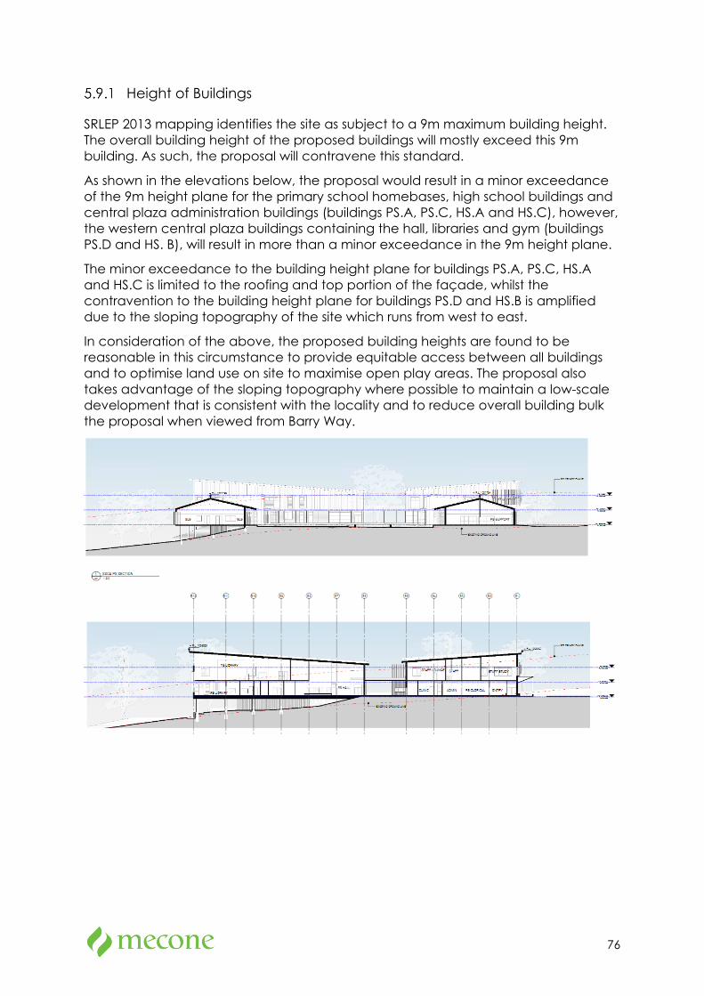
76
Height of Buildings
SRLEP 2013 mapping identifies the site as subject to a 9m maximum building height. The overall building height of the proposed buildings will mostly exceed this 9m building. As such, the proposal will contravene this standard.
As shown in the elevations below, the proposal would result in a minor exceedance of the 9m height plane for the primary school homebases, high school buildings and central plaza administration buildings (buildings PS.A, PS.C, HS.A and HS.C), however, the western central plaza buildings containing the hall, libraries and gym (buildings PS.D and HS. B), will result in more than a minor exceedance in the 9m height plane.
The minor exceedance to the building height plane for buildings PS.A, PS.C, HS.A and HS.C is limited to the roofing and top portion of the façade, whilst the contravention to the building height plane for buildings PS.D and HS.B is amplified due to the sloping topography of the site which runs from west to east.
In consideration of the above, the proposed building heights are found to be reasonable in this circumstance to provide equitable access between all buildings and to optimise land use on site to maximise open play areas. The proposal also takes advantage of the sloping topography where possible to maintain a low-scale development that is consistent with the locality and to reduce overall building bulk the proposal when viewed from Barry Way.
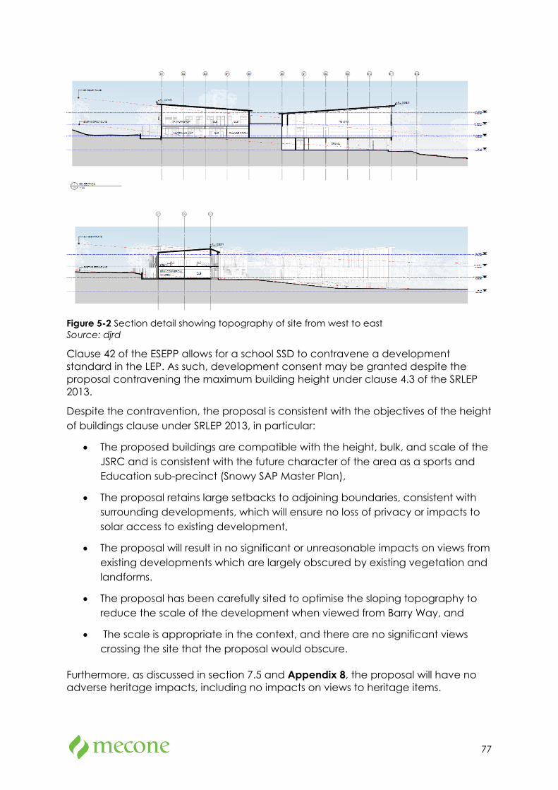
77
Figure 5-2 Section detail showing topography of site from west to east Source: djrd
Clause 42 of the ESEPP allows for a school SSD to contravene a development standard in the LEP. As such, development consent may be granted despite the proposal contravening the maximum building height under clause 4.3 of the SRLEP 2013.
Despite the contravention, the proposal is consistent with the objectives of the height of buildings clause under SRLEP 2013, in particular:
• The proposed buildings are compatible with the height, bulk, and scale of the JSRC and is consistent with the future character of the area as a sports and Education sub-precinct (Snowy SAP Master Plan),
• The proposal retains large setbacks to adjoining boundaries, consistent with surrounding developments, which will ensure no loss of privacy or impacts to solar access to existing development,
• The proposal will result in no significant or unreasonable impacts on views from existing developments which are largely obscured by existing vegetation and landforms.
• The proposal has been carefully sited to optimise the sloping topography to reduce the scale of the development when viewed from Barry Way, and
• The scale is appropriate in the context, and there are no significant views crossing the site that the proposal would obscure.
Furthermore, as discussed in section 7.5 and Appendix 8, the proposal will have no adverse heritage impacts, including no impacts on views to heritage items.
78
It is also noted that the proposal has been designed with regard to the design quality principles in Schedule 4 of the Education SEPP and responds positively to its locality.
5.10 Snowy River Development Control Plan 2013
Clause 11 of the SRD SEPP states that development control plans do not apply to SSD applications. However, the project SEARs require the application to address the Snowy River Development Control Plan 2013 (the DCP) as a relevant policy.
The DCP contains general controls and specific controls in relation to the development of educational establishments. These controls are addressed in the table below.
Table 5-4 Snowy River DCP assessment
Control Provision Comment
Chapter C: General Planning Considerations
Visual Impact
C2.1-1 Visual Landscape Character Assessment
(a) Before granting development consent for development involving the carrying out of any works or building construction, the consent authority must have regard to the likely visual impacts of carrying out the development, including the visual impacts of ancillary uses like driveways and fencing and of the provision of electricity and other services to the site of the development.
(b) When assessing visual impacts of the proposed development consideration must be given to:
• Important visual features and the landscape character of the site and surrounding land;
• Minimising the visual impact of the development on views from public areas, including public roads;
• Reducing the visual impact of driveways and of the provision of services to the development;
• Reducing the visual impact of proposed buildings by ensuring that external finishes are non-reflective and of a colour that blends in with the surroundings; and
• Ensuring fencing and building styles are compatible with the visual character of the area.
The architectural design statement at Appendix 4 of this EIS provides a view analysis and visual impact assessment of the proposal is provided in section 7.2.3 of this EIS.
79
Control Provision Comment
C2.1-5 Building Design
(a) The design and site coverage of the development should reflect the slope of the site and it may be desirable to leave steeply sloping parts of sites in their natural state.
(b) All structures are designed and sited in order to minimise the need for excavation or fill for foundations and associated hardstand areas.
(c) Buildings should utilise suspended slab construction, pole or steel frame, or brick and/or steel piers in order to minimise the disturbance to the natural grade caused by the building. Where areas on a site are already disturbed, those areas should be used for siting of buildings.
(d) On steeply sloping sites and treed hillsides, building height and bulk, particularly on the downhill side is to be minimised and the need for cut and fill is to be reduced by designs which minimise the building footprint and allow the building mass to step down the slope.
(e) Sub-floor areas must be enclosed or otherwise treated so that they do not look untidy when viewed from a public place.
(f) Building heights are similar to those in the surrounding landscape with taller buildings sited so as to minimise impacts on the landscape.
(g) New structures are designed to blend rather than contrast with the existing environment and the use of external reflective finishes is restricted.
(h) The building design is not to include highly reflective surfaces such as ‘zincalume’ or tinted glass panels. External finishes may be natural or untreated, or where colours are used, these should have a light reflectivity index of 12% or below.
The proposal has been designed to ensure equitable access is provided across the site. This has required cut and fill works to manage the topography of the site. Cut and fill has been minimised as much as practicable.
The proposal achieves a low-scale development with the height and bulk of the development carefully considered to remain consistent with the surrounding locality, particularly when viewed from Barry Way.
The colour and materials chosen by the proposal is consistent with the rural context and is sympathetic to the rural amenity.
Refer to the architectural design statement at Appendix 4 of this EIS which adequately addresses the DCP’s general criteria for site analysis, building design and materials.
C2.1-6 Landscaping
(a) The design of any new development must integrate with the landscape, by building on and incorporating existing landscape features such as vegetation and rocky outcrops.
(b) Development must not involve the removal of bush rock or significant areas of vegetation.
(c) Planting is to be located to soften the view of the development from any existing public roads and public vantage points.
The proposed landscape plan, which is discussed at section 3.5 and attached at Appendix 5 of this EIS, generally accords with the DCP’s requirements.
80
Control Provision Comment
C2.1-7 View sharing
a) All property owners should be able to develop their property within existing planning controls however views should not be substantially affected where it is possible to design to share views.
b) The location and design of dwellings and outbuildings must reasonably maintain existing developed view corridors or vistas from the neighbouring dwellings, streets and public open space areas.
c) In assessing potential view loss impacts on neighbouring dwellings, retaining existing views from the living areas (living room, dining room, lounge and kitchen) should be given a priority over those obtained from the bedrooms and non-habitable rooms.
d) The design of fences and selection of plant species must minimise obstruction of views from the neighbouring dwellings and the public domain.
The proposal has been designed and positioned to not impede existing views of other property owners.
2. Crime Prevention Through Environmental Design
2.2-1 – 2.2.6 C2.2-1 Site and Building Layout
C2.2-2 Lighting
C2.2-3 Landscaping
C2.2-4 Security and Operational Management
C2.2-5 Building Identification and Ownership
C2.2-6 Building Ownership and Maintenance
The proposal has been designed to incorporate the four key principles of CTPTED. This is further discussed at Appendix 32 of the EIS.
3. Vehicle Access
C3.1-1 Permanent and Practical Legal Access
a) All development, including all allotments created by subdivision (including boundary adjustments) must have coinciding legal and practical (properly constructed) access in accordance with Councils development design and construction specifications.
b) Access roads are to be designed to minimise road infrastructure by utilising the most direct, and where possible the existing, legal routes.
c) An applicant wishing to construct a Crown public road is required to obtain Council’s concurrence to the ownership of the road being transferred to Council.
The proposal will provide a dedicated internal driveway via two new roundabouts on Barry Way (to be delivered by RGDC). The proposed access requirements are generally in accordance with the requirements of the DCP. Refer to Appendix 7a for further details.
81
Control Provision Comment
Where the applicant cannot obtain the concurrence of Council to the transfer of ownership, the application for road construction will not be accepted.
d) Access by undedicated roads (including undedicated Crown reserve roads, Forestry roads and Livestock Health and Pest Authority reserves) requires the consent of the public authority (eg. Roads and Maritime Services) and will only be permitted in similar circumstances to those for rights of carriageway and subject to the same conditions applicable to rights of carriageway.
e) Where the development requires a second bushfire access/egress route, this is to be a permanent legal and practical access.
f) Where the existing road alignment does not match the dedicated or legally recognised road alignment, the road alignment should be rectified through realignment, closure, road construction or dedication.
g) Any additional length of public road created as part of the development and proposed to be transferred to the control of Council is to be minimised.
h) Direct access from either the Alpine Way or Kosciuszko Road is not to be provided to a development unless the site has no other practical alternatives that exist or can be created.
i) Consideration must be given to whether traffic associated with the proposed development will cause the condition of the roads to deteriorate and whether funds are or will be available for road maintenance and whether any financial contributions from the proposed development are sufficient to upgrade the roads likely to be affected.
C3.1-4 Development fronting Main or Arterial Roads
a) Where development is proposed land which: fronts a classified or arterial road; or relies solely on a classified or arterial road for it access; or has access to a road which intersects with a classified or arterial road, where the point of access is within 90 metres of the intersection of the road and the classified or arterial road, the following must be considered:
- whether the traffic likely to be generated by the development will cause a traffic
A Transport Assessment is provided in Appendix 7a of the EIS and addresses potential traffic impacts for the proposed development.
The impact of the proposed development on Barry Way has been assessed as being acceptable and will not result in any significant hazard or
82
Control Provision Comment
hazard or reduce the capacity and efficiency of the classified or arterial road;
- access points and on-site management plans for vehicle movement and parking;
- the effect the development will have on future improvements or realignment of the classified or arterial road.
reduction in the efficiency or capacity of Barry Way.
The proposal has also been developed with consideration of future improvements being undertaken as part of the Snowy Mountains SAP. These will provide important pedestrian and cycle links from the town centre to the site for staff and students.
C3.1-5 Adequacy of Access
a) The standard of all weather access roads to the development is to adequately cater for existing and potential traffic.
b) The road reserve width is to be sufficient to cater for all functions that the road is expected to fulfill, including the safe and efficient movement of all users and acting as a buffer from traffic nuisance for residents.
c) The carriageway width is to allow vehicles to proceed safely at the operating speed intended for that road.
d) The design of intersections is to allow all movement to occur safely and projected traffic volumes are to be used in designing all intersections.
e) All intersections and vehicular entrances are to satisfy the relevant design standards published by the Roads and Maritime Authority.
f) Access is designed in accordance with the design criteria set out in the Aust Roads Guide to Road Design and the Council’s Development Design and Construction Specifications.
The proposed access to the site has been designed to cater for existing and potential traffic and is generally in accordance with the DCP. Refer to Appendix 7a for further details.
C3.1-6 Minimising Impacts
a) Consideration is to be given to the impact the traffic associated with the proposed development will have on existing roads, road safety and other road users.
b) Physical impact on the environment and on the visual landscape are to be minimised through site planning and design.
c) Car parking areas and access roads to be designed, surfaced and sloped to facilitate stormwater infiltration on-site.
d) Access roads are not to exceed 12% slope and are to be designed to work with
A Transport Assessment is provided in Appendix 7a and a Modelling Report in Appendix 7b of the EIS. The proposed road infrastructure proposed has been designed to minimise impacts on existing roads, road safety and other road users.
83
Control Provision Comment
the contours of the land (minimising cut and fill).
e) Access roads are not to proceed through rock outcrops, natural features or existing vegetation stands and are not to be located on prominent hill faces or ridgelines.
C3 – 4. Pedestrian and Cycle Access
C3.2-1 Pedestrian and Cycle Access
a) All development is to provide high quality accessible routes to public and semipublic areas, including major entries, communal open space, site facilities, parking areas and pedestrian pathways.
b) All pedestrian links are to have appropriate levels of illumination.
c) All entrances to buildings are to be accessible from the street and are to integrate ramps into the overall building and landscape design to promote equity of access.
d) The design of commercial premises or other non-residential forms of development shall consider staff change rooms and shower facilities to encourage bike riding as a form of transport.
e) Potential pedestrian and vehicle conflict is to be minimised by ensuring clear sight lines at pedestrian and vehicle crossings, utilising traffic calming devices and separating and clearly distinguishing pedestrian and vehicular accessways (eg using bollards or changes in pavement treatment).
f) All vehicle access points to a development are to provide a minimum 1.5 metres landscaped setback to neighbouring properties.
The proposal is to be supported by pedestrian and cycle infrastructure to be delivered as part of the Snowy Mountains SAP. This will provide high amenity walking and cycling infrastructure which will connect the town centre with the site.
End of Trip facilities and bike parking is to be provided at the site for both students and staff. Thus will assist in encouraging walking and bike riding as a form of transport to the school.
Pedestrian and cycle access is addressed further Appendix 7a of the EIS.
5. Car Park Design
C3.3-1 Design a) The design of all car parking is to be in accordance with Council’s car parking design specifications.
b) The design of car parking areas, including entry and exit points, is not to create traffic conflicts or impact on pedestrian and cyclists movements.
c) All car parking spaces are to be sited behind the front building line.
The proposed car park design addressed Appendix 7a of the EIS, is generally in accordance with the DCP.
The design of car parking areas and entry/exit points have been appropriately designed for the purposes of a primary and high school.
The proposal is or can be made compliant with Council’s
84
Control Provision Comment
d) All car parking spaces must be designed to enable vehicles to enter and exit a site in a forward direction. This may be modified for single dwelling houses provided safe manoeuvring can be demonstrated. e) The appearance of car parking and service vehicle entries located within a development are to be improved by:
• screening and locating garbage collection, loading and servicing areas within the development; and
• avoiding black holes in the façade by providing security doors to car park entries.
f) Where doors are not provided to a car park, the visible interior of the car park is to be incorporated into the façade design and material selection and the building services pipes and ducts are to be concealed.
g) The design and construction of driveways, roads and car parking areas must conform to the requirements of Council’s Engineering Guidelines for Subdivision and Developments.
h) All development in residential, business, industrial and village zones must incorporate a concrete or bitumen sealed driveway apron that extends from 1.0m inside the property boundary to the edge of the road.
i) Parking spaces and areas are to be designed in accordance with the following diagrams: AS/NZS 2890.1 2004 Figure 2.2.
Engineering Guidelines and Australian standards.
Refer to the Transport Assessment in Appendix 7a for further details.
C3.3-2 Safety a) Car parking is to be designed to providing clear, safe and easily accessible paths of travel for both cars and pedestrians.
b) Safe and secure access is to be provided for building users, including direct access for residential apartments.
c) Parking and storage of bicycles (both resident and visitor) is to be provided at convenient and secure locations.
The proposed car parking arrangement has been designed to ensure safe, clear, and easily accessible paths of travel for pedestrians and cars. Parking and bicycle parking has been provided in convenient and secure locations at the front of the site. Refer to Appendix 7a for further details.
C3.3-3 Landscaping
a) Landscaping of car parking areas to improve the appearance of the car park and provide shade and shelter from weather is to be provided in all development.
b) Proposals for car parking areas are to be accompanied by a landscape plan,
The proposal is accompanied by a landscape plan which provides landscaping treatments to the car parking and internal driveway. Existing trees have been retained where possible and new shade
85
Control Provision Comment
prepared by a qualified landscape architect or designer, illustrating means to soften the visual impact of parked care and any associated structures.
c) Significant environmental features within the land such as rock outcrops, benches and trees are to be retained as a landscaped feature of the car parking area.
d) Landscaping is to be included car park design, within and on the perimeter of the car parking area. Accordingly, the following is required:
o Planting beds fronting a street or public place are to have a minimum width of one (1) metre;
o Shade trees are to be provided in open car parking areas at the ratio of one (1) shade tree for every six (6) car parking spaces; and
o Plants to avoid are those that have a short life, drop branches, gum or fruit or those that interfere with underground pipes.
e) Parking areas are to incorporate a 150mm concrete kerb or edge treatment to reduce the likelihood of vehicles damaging adjoining landscaped areas. The use of bollards should also be considered.
f) The choice of landscaping species and design for the car parking area is to create a safe environment through selecting plants that do not provide the opportunity for concealment. Refer to Chapter C5 Appendix C5-01 Recommended Species for Landscaping.
trees and understorey planting have been proposed to improve the visual appearance of these areas.
The proposed landscape plan is provided in Appendix 5 and is discussed further at section 3.5 Appendix 6.
6. Car Parking Provision
C.4-1 Car Parking a) Sufficient on site car parking is to be provided to accommodate the parking demands of the development.
b) The amount of on-site car parking for specific types of development is to be in accordance with the Table of Parking Requirements (below).
c) In calculating the number of car spaces required, Council takes into consideration the:
o type of development (or land use) proposed;
The proposed car parking spaces have been designed to be consistent with sustainable active transport objectives for the proposal and the targeted Green Star rating.
With the additional high amenity walking and cycling infrastructure to be provided under the Snowy Mountains SAP, it is likely that some staff will shift to active transport as their preferred mode choice to access the school. As such, the
86
Control Provision Comment
o size and scale of the development;
o intensity of the development, and
o street hierarchy and existing traffic situation.
d) Car parking requirements may be reduced where it can be demonstrated that separate uses can share a single parking facility or where there are different and complementary demands for car parking space on a site.
e) Council does not encourage, but may consider stacked parking for parked spaces in a controlled parking situation which:
o allow no more than two cars in the stacked parking arrangement;
o is likely to maintain a very low turnover; or
o is able to function easily within the management of the site’s future operation.
f) Where a development involves a change of use between any of the following uses within an existing premises, where:
o a change of use is proposed from one type of food and drink premises (restaurant, café, take away food and drink premises or pub) to another food and drink premises, no additional parking is required;
o a change of use is proposed from a retail premises, office premises or business premises to a food and drink premises (restaurants, cafe, take-away food and drink premise or pub), the following parking requirements will apply:
- the public area in the proposed use is less than 100 sqm, no additional parking is required;
- the public area in the proposed use is equal to or greater than 100 sqm the existing parking requirements in this Chapter will continue to apply.
g) Council will consider waving the increased parking requirements, where the gross leaseable floor area (GLFA) and gross floor area (GFA) is not being increased.
h) For certain tourist and visitor accommodation and eco-tourist facilities development (ie motels and resorts only), consideration will be given to a maximum 25% discount in the total provision of on-site car parking spaces provided that it can be
need for car parking on site is reduced.
The proposed car parking rates are sufficient for the needs of the site. Please refer to section 0 and Appendix 7a of the EIS for further detailed discussion in addressing the DCP car parking requirements.
87
Control Provision Comment
demonstrated than any shortfall in on-site car spaces can be met by the provision of dedicated on-site bus bays. To demonstrate, an applicant will need to submit a traffic impact study prepared by a Traffic Engineer indicating that the design of the bus bays and all associated car parking and manoeuvring areas for the proposed development complies fully with Council’s and the RMS’s requirements.
i) Council will determine the minimum parking requirements, in consultation with the applicant, where a development application is received for a development type or use that is not listed in the Table of Parking Requirements (below).
Educational Establishments
1 parking space per employee;
1 parking space per 10 students in Year 12 (where applicable); and
1 bus parking space per 100 enrolled students.
C4 Heritage
C4.1-1 Design and Character
(a) Development must not adversely impact on the significance of the European cultural heritage of the site. This includes the seven heritage values; historic, associational, architectural, social, technical/research, rarity and representativeness.
(b) The evolution of a place should be appreciated and retained.
(c) Street elevations and visible side elevations must not be significantly changed. Additions must be located to the rear or to one side of the building to minimise the impact on the streetscape.
(d) The design of any proposed additions or alterations must complement the existing building in its scale, form and detailing. However, it should be possible on close inspection to distinguish the new work from the old.
(e) All new work and additions must respect the proportions of major elements of significant existing fabric including doors, windows, openings and verandahs.
(f) Designs, materials, techniques and finishes of alterations and extensions should
A Statement of Heritage Impact is provided in Appendix 8 and discussed in section 7.5 of the EIS. The proposal has been sited and designed so as to avoid the contributary items for the SRLEP 2013 listing I146 and surrounding heritage items and result in a low heritage impact on the significance of the site.
Refer to Appendix 8 and section 7.5 for further details.
88
Control Provision Comment
be traditional and harmonise with the original architecture, although new building work should not be an exact replication of an earlier era.
C4.1-2 Scale and Form
(a) New building work should have minimal impact on the place’s heritage significance and not overwhelm in bulk, mass or scale.
(b) Additions to heritage items must not visually dominate, compete with or conceal the original form and massing of the existing buildings.
(c) Additions to heritage items must not contain any major or prominent design elements that complete with the architectural features or detailing of the existing building.
(d) Where single storey rear additions are proposed to dwelling houses, the addition must not compromise the integrity of the main roof and is to be lower in scale and secondary to it.
(e) Upper floor additions to the main roof of any single storey dwelling house may be acceptable if contained wholly within the existing roof space without change to the roof pitch or eaves height
C4.1-3 Siting and Setbacks
(a) Development must confirm to the predominant front setbacks in the streetscape.
(b) Development must respect side setbacks and rear alignments or setbacks of surrounding development.
(c) Front and rear setbacks should be adequate to ensure the retention of the existing landscape character of the heritage item or conservation area and important landscape features.
C5 Tree Preservation and Landscaping
1.1 Clearing of native vegetation and trees for rural landholders
This chapter does not regulate clearing of native vegetation and trees on rural land, which includes zones RU1 Primary Production, RU2 Rural Landscape, RU3 Forestry and RU4 Small Lot Primary Production. This clearing is managed by the Local Land Services Act. Please contact [email protected]. Rural landholders in zones RU1 through RU4 should refer to the Local Land Services Act 2013 to determine requirements for native
An assessment of the native vegetation and trees to be removed for the proposal is addressed in section 7.9 and 7.10 and Appendix 12 and Appendix 13 of this EIS. The proposal has minimised impacts to existing native vegetation and planting as much as possible and provided
89
Control Provision Comment
tree and vegetation removal on their properties.
additional planning to offset where clearing is unavoidable.
2 Landscaping
Landscaping Category 3: includes proposals that are highly visible or are of such value that they require high quality landscape design and construction. These developments are likely to have a major impact on the visual environment. All types of development may fall into this category including dwelling houses in rural areas.
• written submission from a landscape designer that outlines:
o objectives of the landscaping; o location and mature height of existing and proposed trees and shrubs; o how existing vegetation and site features are to be retained;
o how landscaping will provide a setting to soften the starkness of buildings when viewed from a distance; o where perimeter planting will be carried out to screen the development;
o proposed water supply to service landscaped areas; and
o proposed maintenance arrangements for landscaping.
• detailed Landscape Plan drawn to scale that shows:
o name (botanical and common) of all species of trees, shrubs and grasses proposed to be planted;
o number, location and average height of each tree and shrub;
o position of landscaping to site boundaries;
o schedule of planting and treatment of landscaped areas
The proposed landscape plan, which is discussed at section 3.5 and Appendix 6 and attached at Appendix 5 of this EIS, generally accords with the DCP’s requirements.
C6 Signage and Advertising
C6.1-1 All Signage and Advertising
(a) Signage should recognise the legitimate needs for directional advice, business identification and promotion.
(b) Signage must complement and be compatible with the development on
The proposed signage has been designed to be compatible with the new school buildings and not obscure any architecturally decorative details or features of buildings. The signage will not
90
Control Provision Comment
which it is situated, adjoining development and the character of the area.
(c) Signage should not obscure architecturally decorative details or features of buildings or dominate building facades. It should be placed on the undecorated wall surfaces or designed sign panels provided.
(d) Entire building facades and/or walls must not be painted or covered with cladding or other material to act as a large billboard sign.
(e) Where a building or site contains multiple tenancies or uses, a coordinated approach for all signs is required.
(f) Signage erected or displayed on heritage items or within heritage conservation areas must not detract from the architectural character and heritage significance of the buildings or areas.
(g) Signage must respect the viewing rights of other proprieties and must not obscure or dominate other signs on the site or adjacent land.
(h) Signage must not detrimentally impact on traffic safety by detracting driver attention at critical driving points, conflicting with traffic control information or tourist directional signage or providing visual obstruction to pedestrians and vehicles.
(i) Outdoor advertising attached to vehicles or trailers, which are parked for advertising purposes, will not be permitted.
(j) Signage must not be flashing or animated. Note: flashing or animated signs include mechanical moving signs, moving LED signs and other flashing, intermittently illuminated or sequenced lighting signs.
impact on the viewing rights of other properties and been designed so as to not have detrimental impacts on traffic safety.
C6.1-5 Signage in Rural, Environmental and Recreation Zones
Recreation zoned areas can accommodate a variety of activities and land uses including public and private recreation facilities. There is a need for adequate directional and identification signage in these areas. Rural and environmental zoned areas are visually and environmentally sensitive and therefore the design and location of signage and its affect on landscape character is an important consideration.
(a) The location, number and size of signs and the use of shapes, colours and
The signage location, number and size and use of colours, shapes and materials have been designed to integrate with the design of the proposal and will appear as a low-key element to the proposal.
91
Control Provision Comment
construction materials should ensure that signage and advertising is low key in appearance.
C6.2 Pole or Pylon signs
(a) One (1) pole sign is permitted for each separate shopping centre or one commercial pole sign on land with not less than 30 metres frontage.
(b) Pole signs are to be less than 5.5 metres in height and the sign is not to be less than 2.6 metres from the ground. A clear pole and sign area must be evident
A pylon sign is proposed for the site located at the northern vehicle entrance of the site and will be less than 5.5m and no less than 2.6m from the ground. Dimensions of the pylon sign are provided in section 3.12 of the EIS.
C7 Natural Hazard Management
1. Bushfire prone land New development on Bush Fire Prone Land
must comply with the provisions of Planning for Bush Fire Protection 2006 (PBP).
All development applications on Bush Fire Prone Land must be accompanied by a Bush Fire Assessment Report (BFAR)and the outcomes and recommendations of this report must be considered within the statement of environmental effects. Information requirements for development within Bush Fire Prone Areas are included on the NSW Rural Fire Service website www.rfs.nsw.gov.au.
Asset Protection Zones must be wholly located on the land/site on which the proposed development is located. Asset Protection Zones must not be located in E2 Environmental Conservation or E3 Environmental
Bushfire is addressed at section 7.12 of the EIS. In summary, the proposal is capable of complying with the requirements of the Planning for Bushfire Protection 2019.
2. Flood prone land
(a) All development should be located above the flood planning level.
(b) All development including roads and internal property access should be located higher than 300mm above the highest recorded flood level. Any works are not to impede the flow of floodwaters to the extent than that occurring prior to development.
(c) The use or storage of toxic or potentially polluting goods will not be permitted on flood liable land below the design floor level. Any proposal that involves the
The site is not identified as being flood prone. This is addressed further at section 7.13 of the EIS.
92
Control Provision Comment
storage of such goods must be accompanied by an Emergency Management Plan.
(d) Materials to be used for construction below the design floor level must be flood compatible.
(e) Council will not consent to any development on flood liable land where there is sufficient land above the flood standard on which to carry out the development.
(f) Where the land is below the flood standard any buildings must be constructed above the design floor level.
(g) Where extensive additions are proposed to lightweight buildings, Council may require the whole building to be raised to the design floor level.
C8 Environmental Management
C8.1-1 Minimising Conflicts
(a) Locate residential, eco-tourist facilities and tourist and visitor accommodation to minimise land use conflicts between other land uses in rural areas including agriculture, intensive agriculture, and extractive industries.
(b) Where proposed residential or tourist based development adjoins or is in the vicinity of existing agriculture, intensive agriculture or extractive uses, the development application must be accompanied by an assessment demonstrating how land use conflicts have been considered and addressed.
(c) In assessing development adjoining the existing uses, the Council must:
• Consider whether or not the development is likely to have a significant impact on the use that, in the opinion of the Council having regard to land use trends, is likely to be the preferred use of the land in the vicinity of the development.
• Evaluate any measures proposed by the applicant to avoid or minimise any incompatibility.
• Design and site the development in a way to minimise land use conflicts between other uses
Despite the site being zoned for Primary Production uses, the proposal is located on land previously used as a golf course within the JSRC. Given the existing context and considerable separation between other existing rural uses, the proposal is unlikely to result in any significant land use conflict.
93
Control Provision Comment
including existing residential development.
(g) Where proposed tourist and visitor accommodation or eco-tourist facility development adjoins or is in the vicinity of existing residential development, the development application is to be accompanied by an assessment demonstrating how land use conflicts have been considered and addressed.
(h) In assessing development adjoining the existing residential uses, the Council must consider whether or not the development is likely to have a significant impact on the residential uses including increased vehicle movement and noise.
C8.2-1 Land Contamination
A consent authority must not consent to the carrying out of any development on land unless it has considered whether the land is contaminated, and the requirements of State Environmental Planning Policy No.55 – Remediation of Land (SEPP 55) are met.
Contamination is addressed at section 7.16 of the EIS. In summary the assessment has found some evidence of contaminants on site as a result of previous development and activities on the site. As such, a Remedial Action Plan has been prepared which to render the site suitable for the purposes of a school.
C8.3-1 Erosion and Sediment Control
(a) Measures are to be implemented during development construction to ensure that the land form is stabilised and erosion is controlled and that water quality in streams and lakes downstream of the development site is protected.
(b) Systems are designed to optimise the interception, detention and removal of water-borne pollutants prior to discharge to receiving waters.
(c) Vegetated riparian buffers to waterways are to be maintained.
(d) A development application is to be accompanied by a stormwater and soil management plan demonstrating:
- how sedimentation and erosion of fill and soil is to be managed on the site; and
- development adjacent to the bank or the bed of a watercourse, addressed the environmental impact on the receiving waters.
(e) Stormwater or surface water runoff is not to be redirected or concentrated onto
Erosion and sedimentation controls are addressed in Section 7.14 and Appendix 16 of this EIS in accordance with Council’s DCP controls.
94
Control Provision Comment
adjoining properties or to create worsening effect on adjoining properties.
(f) All disturbed areas are to be re-stabilised and re-vegetated as soon as practicable.
(g) Landscaping is to use native species suitable to the locality and with consideration of bush fire requirements (Refer Recommended Landscaping Species – Appendix C5-1).
C8.3-2 Slopes and Batters
(a) Cut and fill within sites are to be sensitively treated through gentle slopes and adequate stability to avoid erosion and slippage.
(b) Where the foundation strata of the area permits slopes in excess of 1:3, and where supported by technical documentation prepared by a suitably qualified professional, steeper slopes will be considered.
Proposed earthworks are addressed in the Civil Plans in Appendix 15, and generally in accordance with the requirements in the DCP.
C8.4-1 Weed Management
(a) Development should occur in a manner that does not increase the potential for, or result in, the spread of noxious weeds.
(b) Where development is to be located on a property with a current weed notice or history of weed notices, a weed management plan is to accompany the development application. The weed management plan must identify: weeds to be controlled and in what area they are to be controlled; and timeframe and method of control to be employed.
The BDAR at Appendix 12 of the EIS outlines mitigation measures which will be appropriately implemented to manage weed dispersal.
C8.5-1 Ecological Impacts
(a) The development is to minimise any impact on the local ecology including water quality, aquatic habitats and fish passage.
(b) Where development may have an impact on threatened species, populations or ecological communities (including development on land significant for flora and fauna), an Assessment of Significance (AOS) is to be undertaken. Where it is found that there would be a significant impact on threatened species, their habitats or endangered ecological communities a Species Impact Statement (SIS) would be required.
The proposal’s biodiversity impacts are addressed at section 7.9 and in the BDAR at Appendix 12 of the EIS. The proposal has avoided ecological impacts where possible, and where impacts could not be avoided, appropriate offsets have been identified within the BDAR.
C9 Energy and Water Efficiency, Water Supply and Effluent Disposal
2. Water Supply The following controls apply to development on sites where the
The proposal will be connected to reticulated water which is
95
Control Provision Comment
connection to reticulated town water is available.
(a) The applicant is to consult with Council to determine if reticulated town water is available to the site and the development.
(b) All connections to reticulated town water must be to Council standards.
available on site. Refer to Appendix 14 for further details.
C10 Waste Management and Recycling
Waste Management and Recycling
4.1 Design Stage
4.2 Demolition & Construction
4.3 On-going Operation
The proposal’s waste management measures, which are addressed at section 7.15 and Appendix 23 and Appendix 24 of this EIS, generally in accordance with the DCP’s requirements.
Chapter E Non-Residential Development
6. Educational Establishments
E6.1-1 Access for people with a disability
(a) Reasonable provision within the building and access areas is to be made for movement and circulation by people with disabilities.
(b) The development must comply with the provisions of the Disability Discrimination Act 1992 (Commonwealth).
(c) Where existing buildings are identified as heritage items, an assessment may be made on the balance between providing disabled access and the required modification of the original building fabric.
An Access Design Assessment Report is attached at Appendix 28. The report identifies the extent to which the design complies with the accessibility provisions of the BCA. The report concludes that the proposal can comply with the accessibility provisions of the BCA, either by meeting the deemed-to-satisfy requirements or via a performance-based approach.
E6.1-2 Amenity (a) Noise and odour impacts must be assessed and determined not to adversely impact on the amenity of neighbours or other land holders within the vicinity of the site.
(b) Suitable documentation is to accompany the development application that clearly demonstrates that no impacts on land uses in the vicinity of the development will result from noise or odour emissions from the subject development.
Noise and Vibration is addressed in section 7.8 and Appendix 11 of this EIS. Given the proposed development is for the purposes of a school which is not recognised as a significant odour generating development, the proposal is unlikely to result in any adverse odour.
E6.1-3 Year-Round Operation Basis
(a) The educational facility is to provide sufficient diversity to maintain a year round operation.
(b) The educational facility is managed to achieve at least 75% of its student capacity during any NSW school term, whether
The proposal will provide for year-round operation of the school.
96
Control Provision Comment
through student term rotation or full year attendance by students; or
(c) Where seasonal operation is proposed, the applicant is to provide with the development application sufficient justification to demonstrate why year round operation is not possible and justify the need for seasonal operations.
E6.1-4 Waste Management
(a) Waste is to be managed in a safe, tidy and environmentally responsible manner and in accordance with legislative requirements.
(b) Waste management is to be based on the principles of waste avoidance and maximising reuse and recycling of material.
(c) Details of the waste management strategy for the educational facility (both construction and operational phases) are to be submitted to Council when a development application is lodged.
(d) Any processes that generate liquid waste must have measures in place to dispose of the waste. A trade waste application must be made to Council under section 68 of the Local Government Act when liquid trade waste is proposed to be discharged to Council’s sewer.
The proposal’s waste management measures, which are addressed at section 7.15 and Appendices 20 and 21 of this EIS, generally in accordance with the DCP’s requirements.
E6.1-5 Car Parking
(a) Car parking and manoeuvring is to be sufficient to ensure safe and adequate on-site parking.
(b) Car parking, loading and manoeuvring areas are to be visually attractive and located, designed and constructed to ensure safe use and minimise conflict between vehicles and pedestrians.
(c) A car parking plan is to be provided that demonstrates adequate on-site parking and manoeuvring and sufficient screening through design and landscape treatment to minimise visual impact of car parking areas. The car parking plan must show:
o Car parking layout
o Landscape treatment
o Site entry and exit points
o Loading and unloading areas (where required)
o Manoeuvring
The proposal’s car parking and access are addressed in section 7.3 and Appendices 7a and 7b of this EIS.

97
Control Provision Comment
o Disabled access and parking (where required) must meet the requirements of the Building Code of Australia.
98
5.11 Development Contribution Plans
The following section 7.11/7.12 contribution plans apply to the proposal:
• Snowy River Development Contributions Plan 2008 • Draft Snowy River Shire Council S94A Development Contributions Plan 2013
Whilst Council’s Contribution Plan does not expressly exclude Crown developments or educational establishments from the payment of the relevant contribution, an exemption is considered appropriate in this case as discussed further below.
The Department of Education (DoE) is a public authority which relies on government funding to deliver new school infrastructure. The imposition of development contributions from the DoE to fund infrastructure is contrary to the purpose of the contribution plan.
Section 4.33 of the EP&A Act refers to the determination of Crown development applications whereby:
(1) A consent authority (other than the Minister) must not—
(a) refuse its consent to a Crown development application, except with the approval of the Minister, or
(b) impose a condition on its consent to a Crown development application, except with the approval of the applicant or the Minister.
On this basis, the consent authority does not have power to issue a refusal or issue an approval subject to conditions of consent to which DoE does not agree. This limitation extends to the consent authority’s ability to require contributions to be paid pursuant to section 7.11 and 7.12.
Consideration should be given to the Crown’s role in providing important social and community infrastructure in the form of a new primary school and high school. It is identified that given the proposal will provide considerable public benefits in providing additional student capacity and fit-for-purpose facilities, DPIE should not require contributions to be payable for this proposal. This is consistent with approvals for upgrades to existing schools and new schools such as:
• Alex Avenue Public School (SSD-9368)
• Fort Street Public School Redevelopment (SSD-10340)
• Parramatta West Public School (SSD 8790)
• Jordan Springs Public School (SSD 9354)
99
6 Consultation Consultation has been undertaken in accordance with SEARs requirements with government authorities, service providers, community groups, relevant special interest groups including Aboriginal land councils and registered Aboriginal stakeholders and affected landowners. In particular, the SEARs have required evidence of consultation with:
• Snowy Monaro Regional Council,
• Government Architect NSW (through the NSW SDRP process),
• Transport for NSW,
• The Jindabyne Aero Club, and
• DPIE having regard to preparation of policies and masterplans for the Snowy Mountains Special Activation Precinct.
A comprehensive Consultation Report prepared by Urbis is attached at Appendix 27 of the EIS. Key consultation activities and outcomes are outlined in the subsections below.
6.1 Community engagement
DoE conducted the following community engagement activities prior to lodgement:
• Four community information sessions and surveys between 8-11 December 2020 which included 120 attendees and 68 survey responses,
• Online project updates in March and April 2021 including overview of survey responses from December and information on second online survey,
• Online survey between April-May 2021 which included 311 survey responses,
• A teacher information session, parent and carers information session and community information session between 9-10 June 2021 which included 131 attendees,
• Online project update of online survey results.
The main findings from the survey show that:
• General sentiment that the student population has outgrown the existing school,
• General support for the overall design of the school and additional open space available at the proposed site,
• Embedding sustainable design principles and ensuring adequate transport options were identified as top priorities, and
100
• Accessibility, safety, and parking were key items raised by the community.
6.2 Public Authority Engagement
Government Architect NSW
The proposal was presented to the Government Architect NSW (GANSW) twice, first on 17 February 2021 and then on 12 May 2021.
The key recommendations from the two meetings are addressed in the table below. GANSW’s comments are also addressed in detail in the design report at Appendix 4 of the EIS.
Table 6-1 GANSW engagement outcomes
SDRP Comment Response
SDRP meeting 1 – 17/02/2021
The commitment to engage with the local Ngarigo Community, and the initial ideas to respond to Country across the campus are noted and supported, including collaboration with the SAP and Office of Sport in this regard. The project is well positioned to respond to the Draft Connecting with Country Framework. With an appropriately qualified Aboriginal consultant, develop a strategy for embedding what is learnt, including how to manage knowledge that is shared, how to demonstrate a response to that knowledge through the project and how to ‘report back’ – a continuing relationship. The following areas could be explored to inform the CwC response:
• Cultural practices, including cultural land management and living culture
• Place names and language
• The stories of the Ngarigo nation and their neighbours – both of and beyond the site
• A response to the human and non-human requirements of the site and surroundings
On the 20th of April, DJRD joined Aunty Iris White to Walk Country, listening as she shared her story, the stories of the Monaro-Ngarigo peoples and their connection to the Alpine Country surrounding Jindabyne. She was accompanied by her brother Jason and noted that when consulting they will often take both a man and a woman as there are sites and customs that relate to men’s business and others that relate to women’s business.
Some of the stories shared included:
• The significance of the Snowy Rover, particularly to Ngarigo women,
• The significance of all the Alps, not Mt Kosciusko alone, as a place to connect with the ancestors,
• The importance of truth-telling, including about the stolen generation, to face the past and move forward,
• Important Ngarigo historical figures including trackers and stockmen,
• The significance of seasonal plants as indicators of hunting and fishing seasons, and
• The ancient walking trail from the High Country to the Victorian coast, now roughly marked by the Barry Way.
Aunty Iris also noted that opportunities for gathering and learning on Country should be encouraged, perhaps
101
SDRP Comment Response
• Repair of the site from its previous use as a golf course
• Use of local materials and colours in the architecture and landscape design
• Relationship of the built form and landscape to key significant views
In addition to the above, it was strongly recommended to take the opportunity of walking Country with local knowledge holders, if this is presented.
including landscape amphitheatres, interpretive trails, and moments for sharing traditional knowledge.
Refer to Section 5.0 of the Architectural Design Statement for full Connecting with Country response.
As articulated by the design team, the new school is a unique opportunity to embrace the potential of indoor / outdoor learning and harness the special qualities of the site. The JSCR and its seasonal facilities provide unique opportunities for a school.
• Ensure the masterplan delivers many, legible and pragmatic connections into the adjacent JSCR campus and surrounding suburbs
• Limit fencing and where fencing is required, ensure design and landscape limit visual impacts
• The approach to using topography and landscape design to create a range of large and small spaces for the students to gather is supported, look to increase smaller and more intimate spaces across the high school campus where larger spaces currently predominate
• The specification of local species for landscaping is supported
• Maximum retention of trees is encouraged
• Avoid ‘over-design’ of the landscape, work with the natural topography, materials and setting where possible
Improved connectivity from the site to Jindabyne town centre proposes new roundabout access from Barry Way. Shared path proposals dovetail with the SAP and JSRC masterplans providing a holistic approach to active transport connectivity in the Sport and Education Precinct.
The site secure lines strategy has two objectives:
• Ensure the safety of students, staff, and visitors, and
• Provide welcoming interfaces to the public, without the stigma of institutional barriers.
The use of landscaping, planting, and earth berms softens the visual impact of the fence line.
The developed landscape concept design includes:
• A range of large and small, active, and passive play spaces,
• Intimate spaces in the High School, such as a sensory alpine garden, kitchen gardens, landscaped grove, and semi-enclosed outdoor learning space,
• Retention of significant mature trees,
• A variety of planting types including local, native, and some non-native species where deciduous foliage is preferred for winter sun, and
• Proposed new tree planting to provide shelter from western and sun / winds and provide an inviting entry and approach to the schools.
102
SDRP Comment Response
• The network of roads at the entry of the campus is currently extensive and exposed –reduce where possible and demonstrate how soft landscaping and trees will ensure an inviting entry environment and address to the school.
Provide further information on:
• The scale and materiality of entry zones
Entry zones are significant thresholds, opportunities to welcome the public, but also by necessity a secure line to protect students and staff. The scale of entry is in keeping with the landscape context. The wrapping awning roofs provide a sheltered path and assist wayfinding. The uplift of this awning over the administration entrance provides a strong visual cue for visitors and establishes a hierarchy of entries. A landscaped forecourt in front of the central plaza provides a transition zone between public and privileged spaces. Trees, planting, and seating visually soften the fence line. There is also potential for artworks, sculptures, or inlays in the ground plane. The materiality of the entry zone is welcoming and respectful of Country.
Within the schools ’pop-up’ roofs create opportunities to frame vistas and announce key entry zones to the learning commons. The variation in the scale of this gesture between the single-storey primary school and two-storey high school contributes to their unique identities.
Provide further information on:
• How the proposed active transport routes will operate across the day e.g., when the school is open / closed / at night etc.
The entire site is able to be secured. However, during the normal school day, when afterhours activities are in place, or when the school facilities are used by Community the school driveway and gates to JSRC active transport shared paths are open.
Provide further information on:
• Connection of active transport routes to the centre of Jindabyne
Shared path proposals dovetail with the SAP and JSRC masterplans providing a holistic approach to active transport connectivity in the Sport and Education Precinct. The fulfillment of the active transport connectivity back to Jindabyne hinges on the construction of the Southern Connector Road footbridge and shared paths (by others).
Provide further information on: While these are two distinct schools, students may not arrive separately. Siblings or carshare arrangements may
103
SDRP Comment Response
• Wayfinding, specifically with regards to the shared main entry to both schools (primary and secondary), to different school areas from secondary entry points and to the adjacent JSCR campus.
mean some primary and high school students arrive in the same vehicle. If the current transport mode share is maintained the majority of students will arrive by coach, which transport both primary and high school students. Recognising natural desire lines, a number of entry points are considered that consider to both primary and high school students. A single point of entry is provided for visitors, however, the school administrations are co-located not combined.
The Songline that maps a path through the Jindabyne Education Campus also delineates key pathways and entries. The naming of Place is intended to be in the Ngarigo language. Acknowledging that language is multidimensional the intention is that the naming of place is expressed as words (Ngarigo and English), symbols, and icons. Colours of Country provide both a gradient of progression from Primary School to High School and highlight entry points. The wayfinding strategy is a design intent, a framework that will be built upon further through dialogue with Traditional owners and Knowledge holders.
SDRP meeting 2 – 12/05/2021
Further embed and present the stories of the Barry Way, Snowy River and Bundian Way walking trails into the architecture
DJRD have undertaken additional consultation with a Ngarigo elder Aunty Iris White with whom we initially walked Country and helped inform the Connecting with Country framework. This consultation highlighted that the authenticity of the Bundian Way as an ancient walking trail is under review by NSW Heritage, and noted it was not significant to the Monaro-Ngarigo. The importance of the Snowy River and the walk from the Alps to the coast (the Barry Way) was reinforced in this consultation, and opportunities for referencing the poem The Nimbling, by Aunty Rachel which recounts this walk were discussed.
DJRD have adjusted the Songline concept to reflect the geographic journey of the Snowy River from the Alps to the Coast. This is a journey of changing landscapes, seasonal migrations, and cultural practice. The Jindabyne Education Campus creates unique opportunity for Connecting and Designing with Country
Explore how the arrangement of built form elements could be ‘loosened’ to
Following SDRP 02, and subsequent advice that reduced the site’s western APZ, DJRD explored opportunities to realign the Primary School built form. The concept of the
104
SDRP Comment Response
create pathways and courtyards that are less orthogonal and more organic
‘embrace’ and strategic positioning of buildings to shelter outdoor space from prevailing winds is maintained but the rigid orthogonal quadrangle is ‘loosened’ in the cranking of the East and West facing buildings.
The relocation of the North building opens the Primary School to the north-east, increasing the active outdoor play space. The relocation of the games court to the north and outside of the central zone allows for a more organic landscape response, and improved passive play space better placed for direct connection to learning spaces
Provide developed details of the materiality for the elevations, window screenings, elevated walkway balustrades and covered areas
The design response considers the unique landscape context of permanent (mountains) vs. ephemeral (seasonal foliage). This is reflected in the material language of heavy vs. light. A solid base of stone or masonry anchors the built form to Country and echoes the granite boulders of the site landscape. Lighter coloured lightweight cladding elements above echo the muted hues of the snow gum bark.
Walking with Country highlighted the significance of changes in flora and fauna that serves as indicators of seasonal produce, for example time to migrate to the coast for the lobster. These colours are reflected in the vertical (east and west facades) and horizontal (north facades) window screening elements. While the material language is common, the separate identity of the schools is expressed with changes in scale, colour, and rhythm, reflecting the transition of students through the education stages.
A comprehensive explanation of the active and passive approaches to ESD should form part of the next SDRP presentation including details on water use/harvesting, renewable energy, and sun shading.
ESD initiatives have been developed in conjunction with the ESD consultant Steenson Varming, including the implementation of 4-star Green Star. For greater detail please refer to their report. In summary: Water saving strategies include potable water use reduction, aim for zero potable water where alternative sources could be used (e.g., Irrigation / Toilet flushing). WSUD strategies include minimising stormwater runoff through paving design and landscaping.
Vertical sun shading screens are proposed on west and east facades, horizontal sun shading is proposed on the north facades. The project also includes PV array for energy generation.

105
SDRP Comment Response
A mixed mode ventilation approach is proposed for the schools. Given the climatic conditions in Jindabyne, it is likely that natural ventilation could be used during most of summer and mid-seasons.
Snowy Monaro Regional Council
DoE and key members of the project team met with Council officers on 3 May and 2 July 2021.
Key matters discussed in the first meeting were in relation to early works (including utility infrastructure) and the appropriate planning pathway to undertake early works. A summary of the matters discussed is provided below:
• Demolition not permitted under ISEPP and therefore not able to be pursued as early works,
• Some concerns from Council that there will be water discharge over the adjoining land and confirmation that stormwater will be addressed in the EIS,
• All specifications for electricity to comply with Council civil requirements and DCP requirements on street lighting,
• The option to complete a roundabout on Barry Road as part of early works, Council advised the requirement for a Section 138 application with an accompanying Traffic Impact Assessment for this type of works,
• Council advised the need for SINSW to undertake, and provide them with, water and pressure flow testing and water calculations to inform any future need for reservoir works, and
• Council advised that the Sewer Treatment Plant is also at capacity and that this is being looked at as part of the Snowy Mountains SAP work.
Early works and infrastructure were also the focus in the second meeting with Council on 2 July 2021. Key matters discussed at the second meeting included:
• Confirmation that early works will include sewer main relocations, cut into Barry Way water main, and stormwater basin and associated works (it should be noted that early works was not pursued for the proposal with all works addressed as part of this SSD),
• The appropriate location of the stormwater basin and sewer lines, with more detailed designs to be developed for the EIS, and
• An update on the progress of electricity and road design being undertaken by technical experts.
106
Consultation with Council had also occurred during the Transport Working Group (TWG) meetings held with the project team, Council, TfNSW, NSW Sport and Recreation and TAFE NSW. This is discussed further in section 6.2.4 below.
NSW Department of Planning, Industry and Environment
Between 2 December 2020 and 1 July 2021, seven SAP working group meetings were held online between representatives of the project team, DPIE, SAP Team and the Regional Growth and Development Corporation (RGDC). These meetings involved:
• Jindabyne Education Campus program and updates,
• Snowy Mountains SAP program and updates,
• Establishment of the TWG, and
• Key infrastructure upgrade discussions.
Transport for NSW
Consultation with TfNSW also occurred through TWG meetings held on 1 July and 15 July 2021. During these online sessions Aurecon (technical consultants engaged to undertake the Transport Assessment) presented relevant transport and traffic data. Key matters discussed within the TWG meetings and SAP working group meetings included:
• Connectivity between the proposed school site and Jindabyne town centre including vehicular, public transport, pedestrian and cycling access. In particular, there was discussion about the:
o Conduciveness of the current environment for pedestrian access to the site along Barry Way.
o Need to explore shared use networks to encourage walking and cycling to and from the site.
o Potential cycling and pedestrian infrastructure to connect the site with the Lakewood Estate.
o Need to investigate the number of Year 11 and 12 students lively to be driving to school to ensure appropriate parking provision.
o Need to review bus movements to avoid turning conflicts,
• Delivery of surrounding infrastructure to meet the timeframe earmarked for the opening of the Jindabyne Education Campus, and
• Funding of supporting infrastructure projects.
Key issues and outcomes of these meetings has been addressed within the Transport Assessment provided in Appendix 7a, Appendix 7b and Appendix 7c.

107
TAFE NSW
Consultation with TAFE NSW occurred during seven design meetings held between 16 July 2021 and 17 September 2021. During these meetings, the project team met with TAFE NSW to coordinate the development program and design details of the proposed Connected Learning Centre (CLC) adjacent to the site (shown in Figure 3-3).
Key matters discussed during the TAFE NSW design meetings included:
• Coordination and alignment of SINSW’s and TAFE NSW’s proposals, reporting and EIS documentation.
• Coordination and resolution of specific engineering and design requirements, including stormwater, geotechnical works, cut and fill works, utilities, electrical, and sewer alignment.
• Alignment between the proposed design of the new schools and the CLC, including Aboriginal design concepts and landscape design.
• Transport arrangements and the provision of safe access to, from and between the proposed school site and CLC.
TAFE NSW have since lodged their development application (10.2021.313.001) on 5 October 2021 which is now under assessment with Snowy Monaro Regional Council.
Other Public Authorities and Stakeholders
Details regarding consultation with other public authorities and stakeholders is provided in Table 6-2.
Table 6-2 Public authority and stakeholder engagement outcomes
Agency Issues discussed Response
Aunty Iris White On 20th of April, DJRD joined Aunty Iris White, a Ngarigo Women, to Walk Country, listening as she shared her stories of the Monaro-Ngarigo peoples and their connection to the Alpine Country surrounding Jindabyne
The learnings and stories shared by Aunty Iris have been incorporated into the design of the Jindabyne Education Campus including the physical representation of important key items such as the Barry Way and Snowy River in planning and has informed the material palettes, landscaping and plant selection and wayfinding strategies.
Bega Local Aboriginal Land Council and Registered
The Bega Local Aboriginal Land Council and other Aboriginal stakeholders have registered their interest as a Registered Aboriginal Party
Feedback from the RAP members and Aboriginal Land Council is outstanding and will be provided following the finalisation of the
108
Agency Issues discussed Response
Aboriginal Stakeholders
(RAP) in the preparation of the ACHAR.
ACHAR. Refer to section 7.6 for further details.
Jindabyne Aero Club
Consultation with Jindabyne Aero Club discussed the operations of the airstrip to determine any potential impacts to or from the proposal.
The design of proposal has taken into consideration potential impacts to and from the Jindabyne airstrip. As discussed in the Aviation Impact Assessment in Appendix 30, the proposal will satisfy all safety guidelines, however, ongoing consultation should occur with the Jindabyne Aeroclub, particularly during construction activities.
Essential Energy An application for connection has been submitted to Essential Energy
As discussed in the infrastructure management plan at Appendix 14, a design information package has been received by Essential Energy. The proposal is able to comply with the requirements of Essential Energy.
nbn nbn personnel have been approached to discuss communication connection solutions for the site.
As discussed in the infrastructure management plan at Appendix 14, an application is currently under evaluation with nbn.
109
7 Assessment of Key Issues This section contains an assessment of the key issues identified in the project SEARs. It is informed by, and should be read in conjunction with, the specialist reports and drawings appended to the EIS.
7.1 Built Form and Urban Design
Methodology
An Architectural Design Report prepared by DJRD is attached at Appendix 4. The report explains the proposal’s design rationale based on analysis of the site and context, and comments on the proposal’s consistency with relevant guidelines and principles. Key points from the report are outlined below.
It is noted that section 3.4 of this EIS contains a description of the proposal’s layout, height, bulk and scale, density, setbacks, facade articulation, and external finishes and materials.
Existing Environment
The proposed site is approximately 9ha of land located on the eastern boundary of the JSRC. Both the site and JSRC currently have a single point of entry off Barry Way, opposite the Jindabyne Airstrip.
The site contains a former golf course and three existing workers cottages which were occupied during the construction of the Snowy Hydro Scheme.
The site is undeveloped and contains scattered trees. Much of the surrounding land comprises remnant grassland, woodland, and agricultural land.
Photos of existing development are provided at section 2.4 of the EIS.
Interface with Surrounding Development, Topography, and Streetscape
Surrounding Development
Located on a large site in a rural context, much of the surrounding land predominately consists of undeveloped rural land. A new TAFE CLC proposed to the southern area of the proposed campus. Substantial boundary setbacks of the proposed building footprints provide further separation to existing and future developments/uses.
Significant neighbouring structures including the Leesville Hotel and JSRC structures are located over 200m from the site and are unlikely to be impacted by the development.
Notwithstanding, the proposal provides single and double storey buildings which reflect the low-density architectural language of the Jindabyne township and JSRC.
Topography
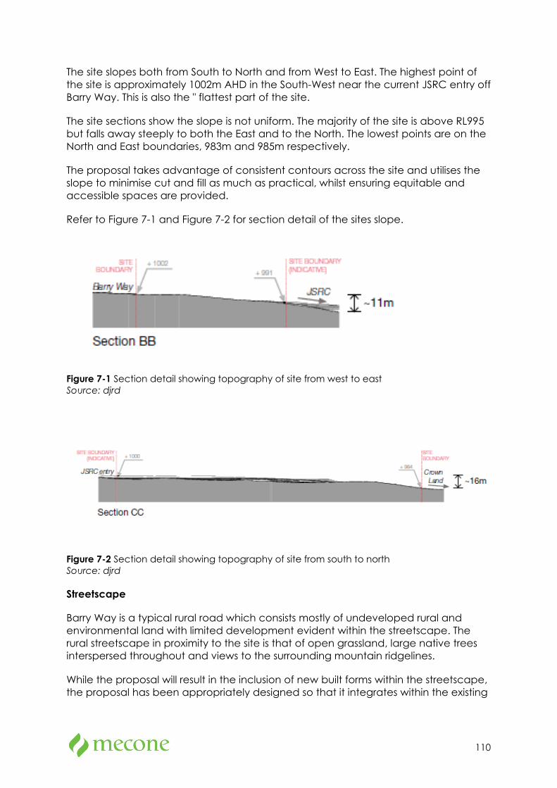
110
The site slopes both from South to North and from West to East. The highest point of the site is approximately 1002m AHD in the South-West near the current JSRC entry off Barry Way. This is also the " flattest part of the site.
The site sections show the slope is not uniform. The majority of the site is above RL995 but falls away steeply to both the East and to the North. The lowest points are on the North and East boundaries, 983m and 985m respectively.
The proposal takes advantage of consistent contours across the site and utilises the slope to minimise cut and fill as much as practical, whilst ensuring equitable and accessible spaces are provided.
Refer to Figure 7-1 and Figure 7-2 for section detail of the sites slope.
Figure 7-1 Section detail showing topography of site from west to east Source: djrd
Figure 7-2 Section detail showing topography of site from south to north Source: djrd
Streetscape
Barry Way is a typical rural road which consists mostly of undeveloped rural and environmental land with limited development evident within the streetscape. The rural streetscape in proximity to the site is that of open grassland, large native trees interspersed throughout and views to the surrounding mountain ridgelines.
While the proposal will result in the inclusion of new built forms within the streetscape, the proposal has been appropriately designed so that it integrates within the existing
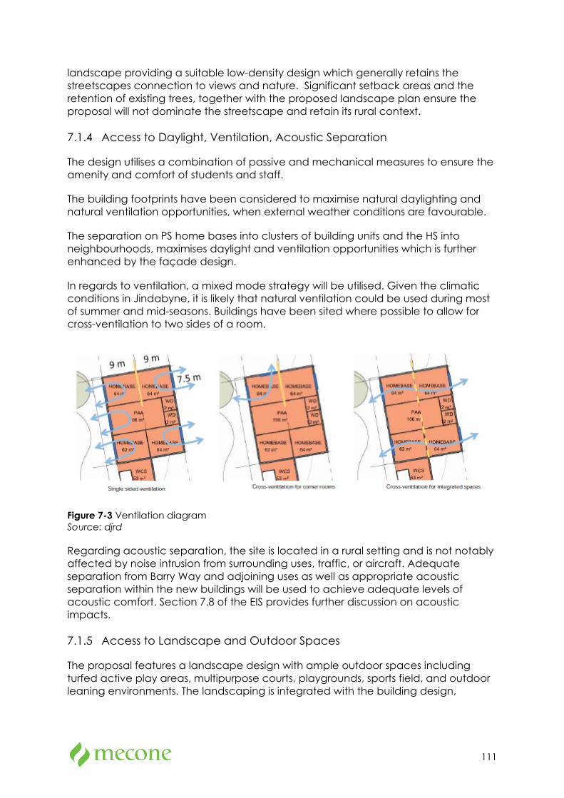
111
landscape providing a suitable low-density design which generally retains the streetscapes connection to views and nature. Significant setback areas and the retention of existing trees, together with the proposed landscape plan ensure the proposal will not dominate the streetscape and retain its rural context.
Access to Daylight, Ventilation, Acoustic Separation
The design utilises a combination of passive and mechanical measures to ensure the amenity and comfort of students and staff.
The building footprints have been considered to maximise natural daylighting and natural ventilation opportunities, when external weather conditions are favourable.
The separation on PS home bases into clusters of building units and the HS into neighbourhoods, maximises daylight and ventilation opportunities which is further enhanced by the façade design.
In regards to ventilation, a mixed mode strategy will be utilised. Given the climatic conditions in Jindabyne, it is likely that natural ventilation could be used during most of summer and mid-seasons. Buildings have been sited where possible to allow for cross-ventilation to two sides of a room.
Figure 7-3 Ventilation diagram Source: djrd
Regarding acoustic separation, the site is located in a rural setting and is not notably affected by noise intrusion from surrounding uses, traffic, or aircraft. Adequate separation from Barry Way and adjoining uses as well as appropriate acoustic separation within the new buildings will be used to achieve adequate levels of acoustic comfort. Section 7.8 of the EIS provides further discussion on acoustic impacts.
Access to Landscape and Outdoor Spaces
The proposal features a landscape design with ample outdoor spaces including turfed active play areas, multipurpose courts, playgrounds, sports field, and outdoor leaning environments. The landscaping is integrated with the building design,
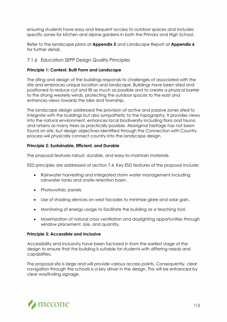
112
ensuring students have easy and frequent access to outdoor spaces and includes specific zones for kitchen and alpine gardens in both the Primary and High School.
Refer to the landscape plans at Appendix 5 and Landscape Report at Appendix 6 for further detail.
Education SEPP Design Quality Principles
Principle 1: Context, Built Form and Landscape
The siting and design of the buildings responds to challenges of associated with the site and embraces unique location and landscape. Buildings have been sited and positioned to reduce cut and fill as much as possible and to create a physical barrier to the strong westerly winds, protecting the outdoor spaces to the east and enhances views towards the lake and township.
The landscape design addressed the provision of active and passive zones sited to integrate with the buildings but also sympathetic to the topography. It provides views into the natural environment, enhances local biodiversity including flora and fauna and retains as many trees as practically possible. Aboriginal heritage has not been found on site, but design objectives identified through the Connection with Country process will physically connect country into the landscape design.
Principle 2: Sustainable, Efficient, and Durable
The proposal features robust, durable, and easy-to-maintain materials.
ESD principles are addressed at section 7.4. Key ESD features of the proposal include:
• Rainwater harvesting and integrated storm water management including rainwater tanks and onsite retention basin.
• Photovoltaic panels
• Use of shading devices on west facades to minimize glare and solar gain.
• Monitoring of energy usage to facilitate the building as a teaching tool.
• Maximization of natural cross ventilation and daylighting opportunities through window placement, size, and quantity.
Principle 3: Accessible and Inclusive
Accessibility and inclusivity have been factored in from the earliest stage of the design to ensure that the building is suitable for students with differing needs and capabilities.
The proposal site is large and will provide various access points. Consequently, clear navigation through the schools is a key driver in the design. This will be enhanced by clear wayfinding signage.
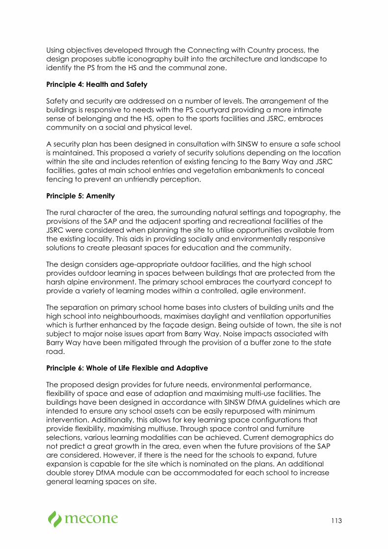
113
Using objectives developed through the Connecting with Country process, the design proposes subtle iconography built into the architecture and landscape to identify the PS from the HS and the communal zone.
Principle 4: Health and Safety
Safety and security are addressed on a number of levels. The arrangement of the buildings is responsive to needs with the PS courtyard providing a more intimate sense of belonging and the HS, open to the sports facilities and JSRC, embraces community on a social and physical level.
A security plan has been designed in consultation with SINSW to ensure a safe school is maintained. This proposed a variety of security solutions depending on the location within the site and includes retention of existing fencing to the Barry Way and JSRC facilities, gates at main school entries and vegetation embankments to conceal fencing to prevent an unfriendly perception.
Principle 5: Amenity
The rural character of the area, the surrounding natural settings and topography, the provisions of the SAP and the adjacent sporting and recreational facilities of the JSRC were considered when planning the site to utilise opportunities available from the existing locality. This aids in providing socially and environmentally responsive solutions to create pleasant spaces for education and the community.
The design considers age-appropriate outdoor facilities, and the high school provides outdoor learning in spaces between buildings that are protected from the harsh alpine environment. The primary school embraces the courtyard concept to provide a variety of learning modes within a controlled, agile environment.
The separation on primary school home bases into clusters of building units and the high school into neighbourhoods, maximises daylight and ventilation opportunities which is further enhanced by the façade design. Being outside of town, the site is not subject to major noise issues apart from Barry Way. Noise impacts associated with Barry Way have been mitigated through the provision of a buffer zone to the state road.
Principle 6: Whole of Life Flexible and Adaptive
The proposed design provides for future needs, environmental performance, flexibility of space and ease of adaption and maximising multi-use facilities. The buildings have been designed in accordance with SINSW DfMA guidelines which are intended to ensure any school assets can be easily repurposed with minimum intervention. Additionally, this allows for key learning space configurations that provide flexibility, maximising multiuse. Through space control and furniture selections, various learning modalities can be achieved. Current demographics do not predict a great growth in the area, even when the future provisions of the SAP are considered. However, if there is the need for the schools to expand, future expansion is capable for the site which is nominated on the plans. An additional double storey DfMA module can be accommodated for each school to increase general learning spaces on site.
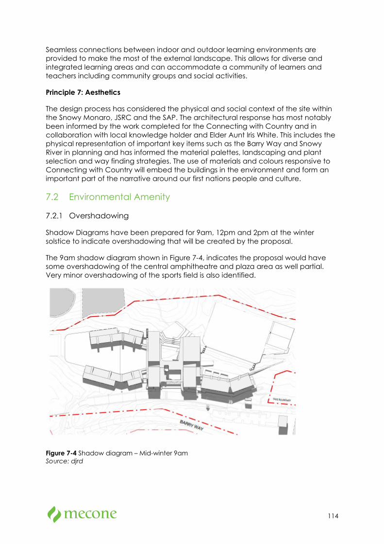
114
Seamless connections between indoor and outdoor learning environments are provided to make the most of the external landscape. This allows for diverse and integrated learning areas and can accommodate a community of learners and teachers including community groups and social activities.
Principle 7: Aesthetics
The design process has considered the physical and social context of the site within the Snowy Monaro, JSRC and the SAP. The architectural response has most notably been informed by the work completed for the Connecting with Country and in collaboration with local knowledge holder and Elder Aunt Iris White. This includes the physical representation of important key items such as the Barry Way and Snowy River in planning and has informed the material palettes, landscaping and plant selection and way finding strategies. The use of materials and colours responsive to Connecting with Country will embed the buildings in the environment and form an important part of the narrative around our first nations people and culture.
7.2 Environmental Amenity
Overshadowing
Shadow Diagrams have been prepared for 9am, 12pm and 2pm at the winter solstice to indicate overshadowing that will be created by the proposal.
The 9am shadow diagram shown in Figure 7-4, indicates the proposal would have some overshadowing of the central amphitheatre and plaza area as well partial. Very minor overshadowing of the sports field is also identified.
Figure 7-4 Shadow diagram – Mid-winter 9am Source: djrd
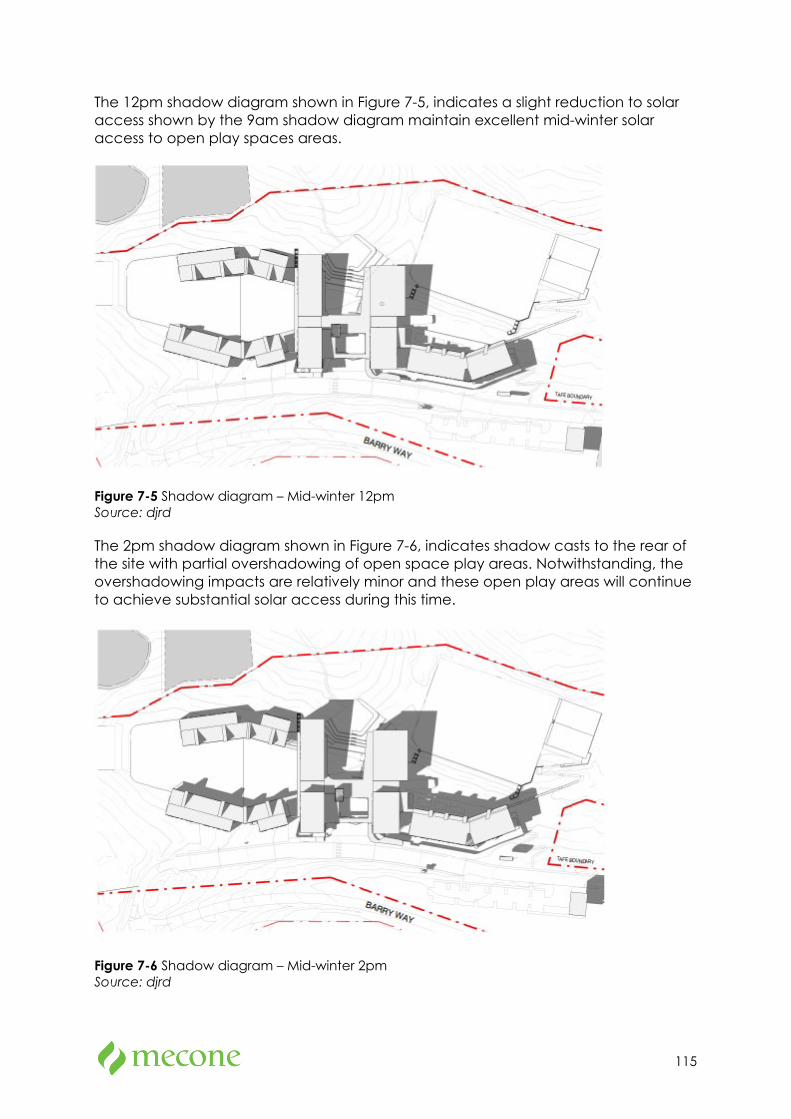
115
The 12pm shadow diagram shown in Figure 7-5, indicates a slight reduction to solar access shown by the 9am shadow diagram maintain excellent mid-winter solar access to open play spaces areas.
Figure 7-5 Shadow diagram – Mid-winter 12pm Source: djrd
The 2pm shadow diagram shown in Figure 7-6, indicates shadow casts to the rear of the site with partial overshadowing of open space play areas. Notwithstanding, the overshadowing impacts are relatively minor and these open play areas will continue to achieve substantial solar access during this time.
Figure 7-6 Shadow diagram – Mid-winter 2pm Source: djrd
116
As demonstrated in the mid-winter (worst-case) shadow diagrams above, the shadow cast by the proposal is wholly contained within the site area. Given the significant boundary setbacks of the proposal, the proposal will not result in any significant overshadowing to surrounding development.
In addition, the siting and scale of buildings have been appropriately considered to maximise solar access to outdoor play areas and ensure no adverse overshadowing.
Visual Privacy
As identified above, the proposal is located on a large site in a semi-rural context with no significant interfaces to surrounding development. The proposed built form benefits from considerable setbacks from the site boundary resulting in significant distancing between surrounding developments and uses including the TAFE NSW site.
Furthermore, the retention of existing trees and proposed landscaping around the boundary of the site will provide further screening for the proposal.
As such, the proposal is unlikely to cause any privacy impacts on the adjoining developments and JSRC.
No mitigation measures regarding privacy impacts have been identified.
View Impacts
Methodology
View analysis has taken the form of a review by the planner supported by site photographs and renders of the proposal prepared by the architect. The proposed buildings are of one and two storey scale above ground, and there are no significant views that cross the site. Specialist analysis is therefore considered unnecessary.
Existing Environment
The site is situated in a rural locality to the south of the Jindabyne township. The surrounding area predominately consists of undeveloped rural land with rural residential agricultural buildings dotted throughout the area.
The topography of the site slopes from south to north and west to east away from Barry Way.
The site is located within a local heritage item known as “Jindabyne Winter Sports Academy” (I146). The three structures listed on the inventory sheet for heritage item I146 are located to the east of the site and do not benefit from significant views over the site.
Other surrounding heritage items including the “Leesville Hotel” have been significantly distanced from the site and separated by vegetation growth.
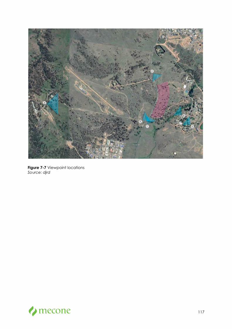
117
Figure 7-7 Viewpoint locations Source: djrd
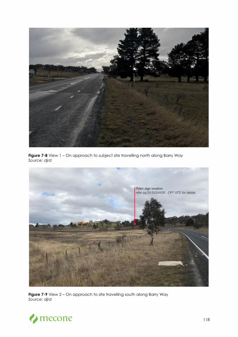
118
Figure 7-8 View 1 – On approach to subject site travelling north along Barry Way Source: djrd
Figure 7-9 View 2 – On approach to site travelling south along Barry Way Source: djrd
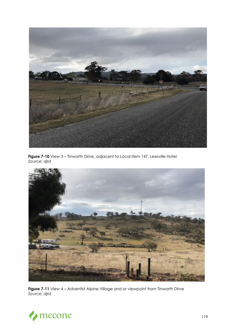
119
Figure 7-10 View 3 – Tinworth Drive, adjacent to Local item 147, Leesville Hotel Source: djrd
Figure 7-11 View 4 – Adventist Alpine Village and or viewpoint from Tinworth Drive Source: djrd
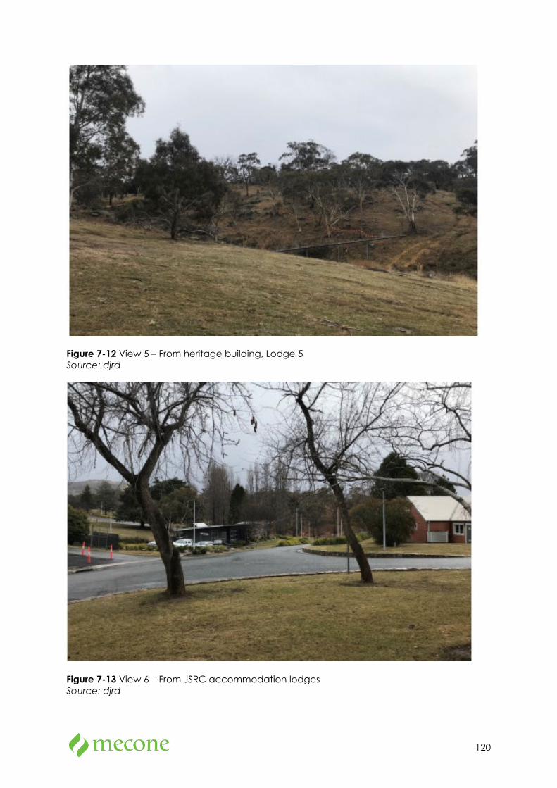
120
Figure 7-12 View 5 – From heritage building, Lodge 5 Source: djrd
Figure 7-13 View 6 – From JSRC accommodation lodges Source: djrd
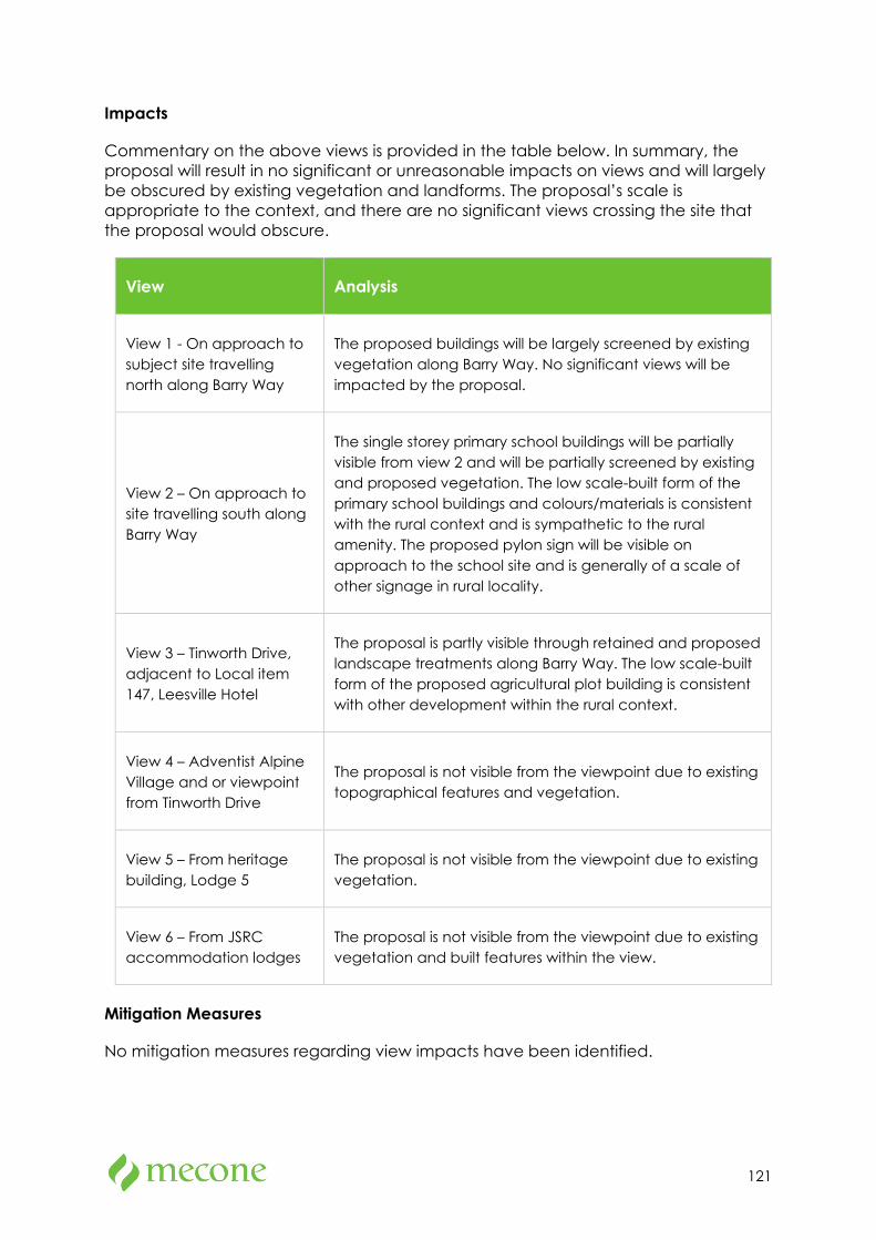
121
Impacts
Commentary on the above views is provided in the table below. In summary, the proposal will result in no significant or unreasonable impacts on views and will largely be obscured by existing vegetation and landforms. The proposal’s scale is appropriate to the context, and there are no significant views crossing the site that the proposal would obscure.
View Analysis
View 1 - On approach to subject site travelling north along Barry Way
The proposed buildings will be largely screened by existing vegetation along Barry Way. No significant views will be impacted by the proposal.
View 2 – On approach to site travelling south along Barry Way
The single storey primary school buildings will be partially visible from view 2 and will be partially screened by existing and proposed vegetation. The low scale-built form of the primary school buildings and colours/materials is consistent with the rural context and is sympathetic to the rural amenity. The proposed pylon sign will be visible on approach to the school site and is generally of a scale of other signage in rural locality.
View 3 – Tinworth Drive, adjacent to Local item 147, Leesville Hotel
The proposal is partly visible through retained and proposed landscape treatments along Barry Way. The low scale-built form of the proposed agricultural plot building is consistent with other development within the rural context.
View 4 – Adventist Alpine Village and or viewpoint from Tinworth Drive
The proposal is not visible from the viewpoint due to existing topographical features and vegetation.
View 5 – From heritage building, Lodge 5
The proposal is not visible from the viewpoint due to existing vegetation.
View 6 – From JSRC accommodation lodges
The proposal is not visible from the viewpoint due to existing vegetation and built features within the view.
Mitigation Measures
No mitigation measures regarding view impacts have been identified.
122
Lighting
External lighting will be designed to comply with the following standards:
• AS/NZS 4282 – Control of the obtrusive effects of outdoor lighting, and
• AS/NZS 1158.3.1 – Pedestrian area (Category P) lighting – Performance and design requirements.
The lighting will give due consideration to CPTED principles and minimisation of light spillage to surrounding sensitive receivers. The following approaches will be incorporated into the external lighting design to minimise obtrusive lighting:
• Luminaire mounting heights selected to minimise spill and cater for better lighting control,
• Where possible, light fittings will be set back from property boundary to reduce light spill,
• Light fillings with narrow beam or sharp cut of angles, and
• Light fittings with low vertical aiming angles.
Wind
The site is located in a rural context and is not known to suffer from any acute or unusual adverse wind impacts.
Given the low height of the proposal, it is considered that the proposal will not result in any unacceptable adverse wind impacts. Specialist input is considered unnecessary.
No mitigation measures have been identified.
7.3 Transport and Accessibility
Methodology
A Traffic Impact Assessment prepared by Aurecon is attached at Appendix 7a. The report analyses the existing transport network and assesses the potential traffic impacts associated with the proposed development during the construction and operation phases.
A Jindabyne Education Campus Modelling Report prepared by Aurecon is also attached in Appendix 7b which provides an additional assessment on the potential impact of the development and road network performance adjacent to the site.
The reports use SIDRA modelling (version 9) to determine potential traffic impacts of the proposal.
Existing Environment
Existing Access and Surrounding Road Network
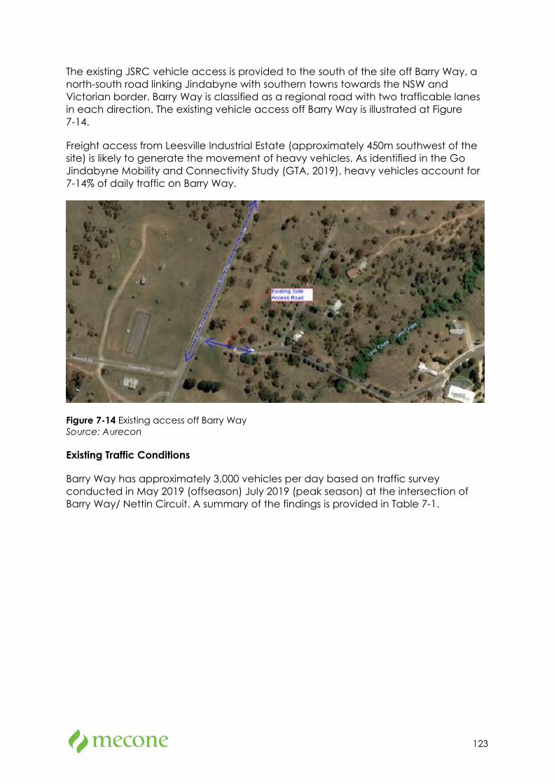
123
The existing JSRC vehicle access is provided to the south of the site off Barry Way, a north-south road linking Jindabyne with southern towns towards the NSW and Victorian border. Barry Way is classified as a regional road with two trafficable lanes in each direction. The existing vehicle access off Barry Way is illustrated at Figure 7-14.
Freight access from Leesville Industrial Estate (approximately 450m southwest of the site) is likely to generate the movement of heavy vehicles. As identified in the Go Jindabyne Mobility and Connectivity Study (GTA, 2019), heavy vehicles account for 7-14% of daily traffic on Barry Way.
Figure 7-14 Existing access off Barry Way Source: Aurecon
Existing Traffic Conditions
Barry Way has approximately 3,000 vehicles per day based on traffic survey conducted in May 2019 (offseason) July 2019 (peak season) at the intersection of Barry Way/ Nettin Circuit. A summary of the findings is provided in Table 7-1.
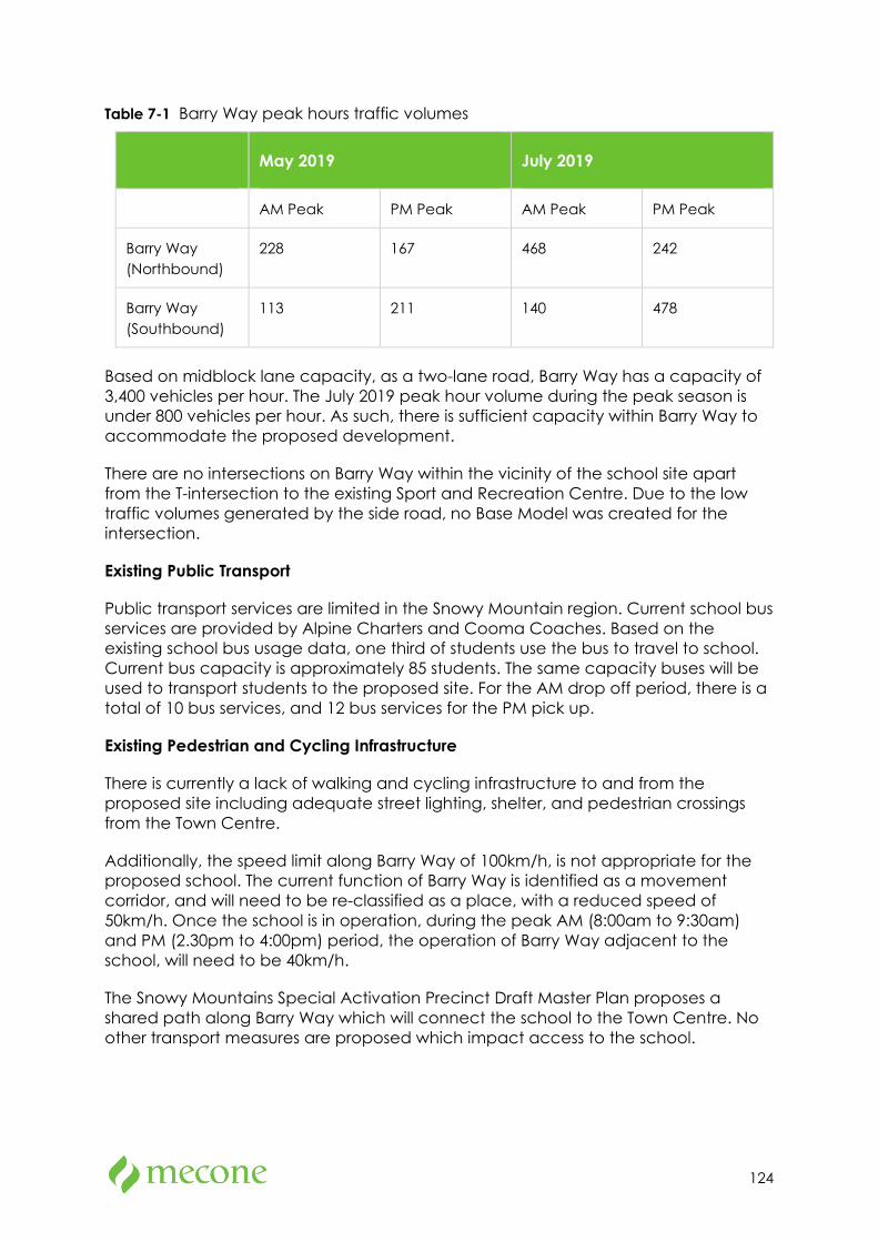
124
Table 7-1 Barry Way peak hours traffic volumes
May 2019 July 2019
AM Peak PM Peak AM Peak PM Peak
Barry Way (Northbound)
228 167 468 242
Barry Way (Southbound)
113 211 140 478
Based on midblock lane capacity, as a two-lane road, Barry Way has a capacity of 3,400 vehicles per hour. The July 2019 peak hour volume during the peak season is under 800 vehicles per hour. As such, there is sufficient capacity within Barry Way to accommodate the proposed development.
There are no intersections on Barry Way within the vicinity of the school site apart from the T-intersection to the existing Sport and Recreation Centre. Due to the low traffic volumes generated by the side road, no Base Model was created for the intersection.
Existing Public Transport
Public transport services are limited in the Snowy Mountain region. Current school bus services are provided by Alpine Charters and Cooma Coaches. Based on the existing school bus usage data, one third of students use the bus to travel to school. Current bus capacity is approximately 85 students. The same capacity buses will be used to transport students to the proposed site. For the AM drop off period, there is a total of 10 bus services, and 12 bus services for the PM pick up.
Existing Pedestrian and Cycling Infrastructure
There is currently a lack of walking and cycling infrastructure to and from the proposed site including adequate street lighting, shelter, and pedestrian crossings from the Town Centre.
Additionally, the speed limit along Barry Way of 100km/h, is not appropriate for the proposed school. The current function of Barry Way is identified as a movement corridor, and will need to be re-classified as a place, with a reduced speed of 50km/h. Once the school is in operation, during the peak AM (8:00am to 9:30am) and PM (2.30pm to 4:00pm) period, the operation of Barry Way adjacent to the school, will need to be 40km/h.
The Snowy Mountains Special Activation Precinct Draft Master Plan proposes a shared path along Barry Way which will connect the school to the Town Centre. No other transport measures are proposed which impact access to the school.
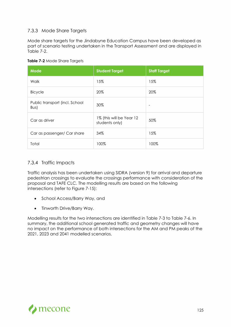
125
Mode Share Targets
Mode share targets for the Jindabyne Education Campus have been developed as part of scenario testing undertaken in the Transport Assessment and are displayed in Table 7-2.
Table 7-2 Mode Share Targets
Mode Student Target Staff Target
Walk 15% 15%
Bicycle 20% 20%
Public transport (incl. School Bus) 30% -
Car as driver 1% (this will be Year 12 students only) 50%
Car as passenger/ Car share 34% 15%
Total 100% 100%
Traffic Impacts
Traffic analysis has been undertaken using SIDRA (version 9) for arrival and departure pedestrian crossings to evaluate the crossings performance with consideration of the proposal and TAFE CLC. The modelling results are based on the following intersections (refer to Figure 7-15):
• School Access/Barry Way, and
• Tinworth Drive/Barry Way.
Modelling results for the two intersections are identified in Table 7-3 to Table 7-6. In summary, the additional school generated traffic and geometry changes will have no impact on the performance of both intersections for the AM and PM peaks of the 2021, 2023 and 2041 modelled scenarios.
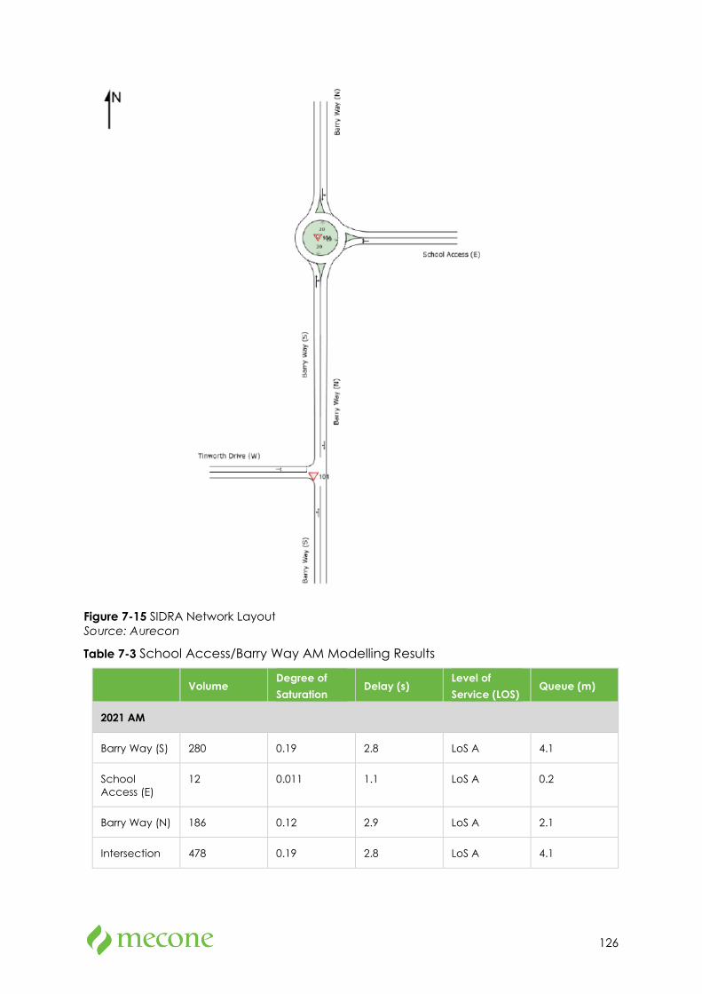
126
Figure 7-15 SIDRA Network Layout Source: Aurecon
Table 7-3 School Access/Barry Way AM Modelling Results
Volume Degree of Saturation
Delay (s) Level of Service (LOS)
Queue (m)
2021 AM
Barry Way (S) 280 0.19 2.8 LoS A 4.1
School Access (E)
12 0.011 1.1 LoS A 0.2
Barry Way (N) 186 0.12 2.9 LoS A 2.1
Intersection 478 0.19 2.8 LoS A 4.1
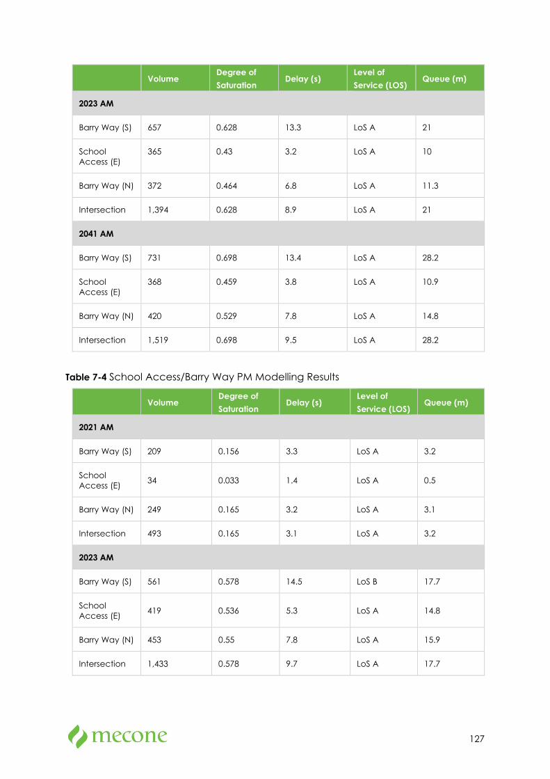
127
Volume Degree of Saturation
Delay (s) Level of Service (LOS)
Queue (m)
2023 AM
Barry Way (S) 657 0.628 13.3 LoS A 21
School Access (E)
365 0.43 3.2 LoS A 10
Barry Way (N) 372 0.464 6.8 LoS A 11.3
Intersection 1,394 0.628 8.9 LoS A 21
2041 AM
Barry Way (S) 731 0.698 13.4 LoS A 28.2
School Access (E)
368 0.459 3.8 LoS A 10.9
Barry Way (N) 420 0.529 7.8 LoS A 14.8
Intersection 1,519 0.698 9.5 LoS A 28.2
Table 7-4 School Access/Barry Way PM Modelling Results
Volume Degree of Saturation
Delay (s) Level of Service (LOS)
Queue (m)
2021 AM
Barry Way (S) 209 0.156 3.3 LoS A 3.2
School Access (E) 34 0.033 1.4 LoS A 0.5
Barry Way (N) 249 0.165 3.2 LoS A 3.1
Intersection 493 0.165 3.1 LoS A 3.2
2023 AM
Barry Way (S) 561 0.578 14.5 LoS B 17.7
School Access (E) 419 0.536 5.3 LoS A 14.8
Barry Way (N) 453 0.55 7.8 LoS A 15.9
Intersection 1,433 0.578 9.7 LoS A 17.7
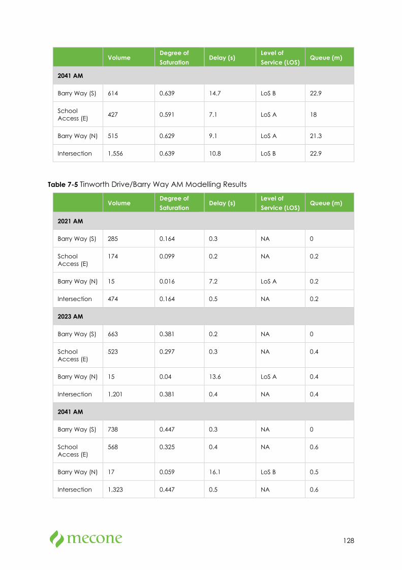
128
Volume Degree of Saturation
Delay (s) Level of Service (LOS)
Queue (m)
2041 AM
Barry Way (S) 614 0.639 14.7 LoS B 22.9
School Access (E) 427 0.591 7.1 LoS A 18
Barry Way (N) 515 0.629 9.1 LoS A 21.3
Intersection 1,556 0.639 10.8 LoS B 22.9
Table 7-5 Tinworth Drive/Barry Way AM Modelling Results
Volume Degree of Saturation
Delay (s) Level of Service (LOS)
Queue (m)
2021 AM
Barry Way (S) 285 0.164 0.3 NA 0
School Access (E)
174 0.099 0.2 NA 0.2
Barry Way (N) 15 0.016 7.2 LoS A 0.2
Intersection 474 0.164 0.5 NA 0.2
2023 AM
Barry Way (S) 663 0.381 0.2 NA 0
School Access (E)
523 0.297 0.3 NA 0.4
Barry Way (N) 15 0.04 13.6 LoS A 0.4
Intersection 1,201 0.381 0.4 NA 0.4
2041 AM
Barry Way (S) 738 0.447 0.3 NA 0
School Access (E)
568 0.325 0.4 NA 0.6
Barry Way (N) 17 0.059 16.1 LoS B 0.5
Intersection 1,323 0.447 0.5 NA 0.6
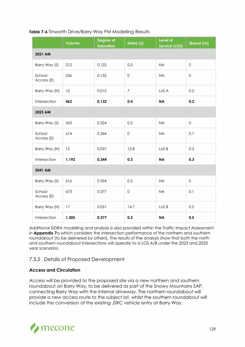
129
Table 7-6 Tinworth Drive/Barry Way PM Modelling Results
Volume Degree of Saturation
Delay (s) Level of Service (LOS)
Queue (m)
2021 AM
Barry Way (S) 212 0.122 0.3 NA 0
School Access (E)
236 0.132 0 NA 0
Barry Way (N) 15 0.015 7 LoS A 0.2
Intersection 462 0.132 0.4 NA 0.2
2023 AM
Barry Way (S) 563 0.324 0.2 NA 0
School Access (E)
614 0.344 0 NA 0.1
Barry Way (N) 15 0.037 12.8 LoS B 0.3
Intersection 1,192 0.344 0.3 NA 0.3
2041 AM
Barry Way (S) 616 0.354 0.2 NA 0
School Access (E)
673 0.377 0 NA 0.1
Barry Way (N) 17 0.051 14.7 LoS B 0.5
Intersection 1,305 0.377 0.3 NA 0.5
Additional SIDRA modelling and analysis is also provided within the Traffic Impact Assessment in Appendix 7a which considers the intersection performance of the northern and southern roundabout (to be delivered by others). The results of the analysis show that both the north and southern roundabout intersections will operate to a LOS A/B under the 2023 and 2033 year scenarios.
Details of Proposed Development
Access and Circulation
Access will be provided to the proposed site via a new northern and southern roundabout on Barry Way, to be delivered as part of the Snowy Mountains SAP, connecting Barry Way with the internal driveway. The northern roundabout will provide a new access route to the subject lot, whilst the southern roundabout will include the conversion of the existing JSRC vehicle entry at Barry Way.

130
The internal driveway will provide two-lane vehicle access running north to south along the eastern extent of the site. The internal driveway provides bus and private vehicle access and includes four bus bays, 53 kiss and drop spaces, and 113 car parking spaces (refer to sections below for further details).
The design vehicle for the proposed school access is Class 9 vehicle as classified in Austroads Guide for Road Design. A swept path analysis (refer to Appendix B of Appendix 7) has been undertaken for the following vehicles:
• 12.5m school bus,
• 8.8m waste, and
• 5.5m private car.
There are no access issues for these vehicle types within the internal school road and at the roundabouts.
Internal shared paths, pedestrian crossings and other active transport infrastructure is provided to ensure safe and legible pedestrian routes throughout the site.
Staff Car Parking
The Snowy River DCP requires that 1 parking space per employee be provided for all educational establishments. The proposed school design allows for 50 staff car parks on site in accordance with sustainable active transport guidelines and mode share targets identified in Table 7-2. This is more than the 20 staff parking spaces at the current school location.
With the addition of high amenity walking and cycling infrastructure to be provided by the SAP, it is likely that some staff will shift to active transport as their preferred mode choice to access the school. Staff will also be encouraged to car share with each other, which will further reduce the need to provide parking spaces and achieves the Green Star rating.
Visitor and Year 12 Car Parking
Visitor parking is provided near the School Administration building, just before the bus bays. Of the four Visitor Spaces provided, two spaces will have EV charging facilities.
Outside of pick-up and drop off peak times, visitors will be able to park in the kiss and drop spaces.
According to the DCP requirement of one car parking bay for every ten Year 12 students is required. Based on the assumption that the average demand of Year 12 students is approximately 50 students, a total of five car parks is required. The proposal will provide for six-year 12 student car parks adjacent to the staff parking.
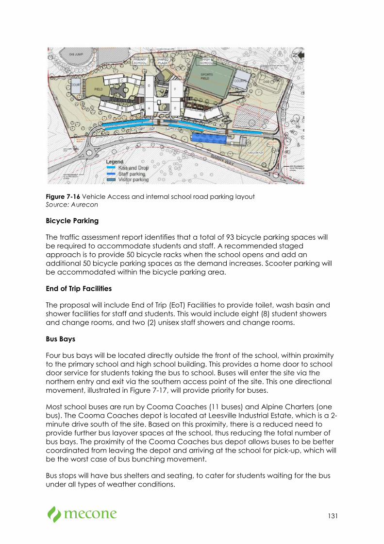
131
Figure 7-16 Vehicle Access and internal school road parking layout Source: Aurecon
Bicycle Parking
The traffic assessment report identifies that a total of 93 bicycle parking spaces will be required to accommodate students and staff. A recommended staged approach is to provide 50 bicycle racks when the school opens and add an additional 50 bicycle parking spaces as the demand increases. Scooter parking will be accommodated within the bicycle parking area.
End of Trip Facilities
The proposal will include End of Trip (EoT) Facilities to provide toilet, wash basin and shower facilities for staff and students. This would include eight (8) student showers and change rooms, and two (2) unisex staff showers and change rooms.
Bus Bays
Four bus bays will be located directly outside the front of the school, within proximity to the primary school and high school building. This provides a home door to school door service for students taking the bus to school. Buses will enter the site via the northern entry and exit via the southern access point of the site. This one directional movement, illustrated in Figure 7-17, will provide priority for buses.
Most school buses are run by Cooma Coaches (11 buses) and Alpine Charters (one bus). The Cooma Coaches depot is located at Leesville Industrial Estate, which is a 2-minute drive south of the site. Based on this proximity, there is a reduced need to provide further bus layover spaces at the school, thus reducing the total number of bus bays. The proximity of the Cooma Coaches bus depot allows buses to be better coordinated from leaving the depot and arriving at the school for pick-up, which will be the worst case of bus bunching movement.
Bus stops will have bus shelters and seating, to cater for students waiting for the bus under all types of weather conditions.
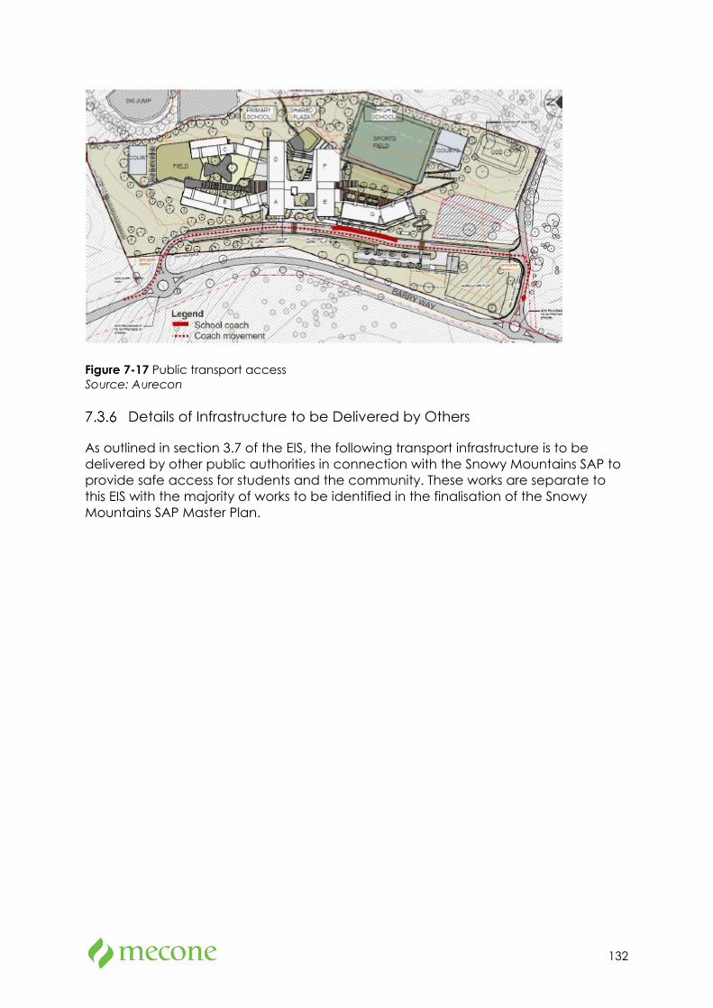
132
Figure 7-17 Public transport access Source: Aurecon
Details of Infrastructure to be Delivered by Others
As outlined in section 3.7 of the EIS, the following transport infrastructure is to be delivered by other public authorities in connection with the Snowy Mountains SAP to provide safe access for students and the community. These works are separate to this EIS with the majority of works to be identified in the finalisation of the Snowy Mountains SAP Master Plan.
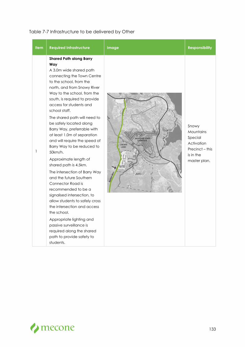
133
Table 7-7 Infrastructure to be delivered by Other
Item Required Infrastructure Image Responsibility
1
Shared Path along Barry Way A 3.0m wide shared path connecting the Town Centre to the school, from the north, and from Snowy River Way to the school, from the south, is required to provide access for students and school staff.
The shared path will need to be safely located along Barry Way, preferrable with at least 1.0m of separation and will require the speed of Barry Way to be reduced to 50km/h.
Approximate length of shared path is 4.5km.
The intersection of Barry Way and the future Southern Connector Road is recommended to be a signalised intersection, to allow students to safely cross the intersection and access the school.
Appropriate lighting and passive surveillance is required along the shared path to provide safety to students.
Snowy Mountains Special Activation Precinct – this is in the master plan.
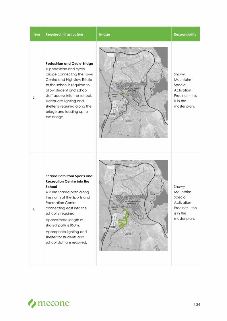
134
Item Required Infrastructure Image Responsibility
2
Pedestrian and Cycle Bridge A pedestrian and cycle bridge connecting the Town Centre and Highview Estate to the school is required to allow student and school staff access into the school. Adequate lighting and shelter is required along the bridge and leading up to the bridge.
Snowy Mountains Special Activation Precinct – this is in the master plan.
3
Shared Path from Sports and Recreation Centre into the School A 3.0m shared path along the north of the Sports and Recreation Centre, connecting east into the school is required.
Approximate length of shared path is 850m.
Appropriate lighting and shelter for students and school staff are required.
Snowy Mountains Special Activation Precinct – this is in the master plan.
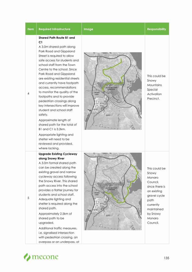
135
Item Required Infrastructure Image Responsibility
4
Shared Path Route B1 and C1 A 3.0m shared path along Park Road and Gippsland Street is required to allow safe access for students and school staff from the Town Centre to the school. Since Park Road and Gippsland are existing residential streets and currently have footpath access, recommendations to monitor the quality of the footpaths and to provide pedestrian crossings along key intersections will improve student and school staff safety.
Approximate length of shared path for the total of B1 and C1 is 3.2km.
Appropriate lighting and shelter will need to be reviewed and provided, where lacking.
This could be Snowy Mountains Special Activation Precinct.
5
Upgrade Existing Cycleway along Snowy River A 3.0m formal shared path can be created along the existing gravel and narrow cycleway access following the Snowy River. This shared path access into the school provides a flatter journey for students and school staff. Adequate lighting and shelter is required along the shared path.
Approximately 2.5km of shared path to be upgraded.
Additional traffic measures, i.e. signalised intersection with pedestrian crossing, an overpass or an underpass, at
This could be Snowy Monaro Council, since there is an existing gravel cycle path currently maintained by Snowy Monaro Council.
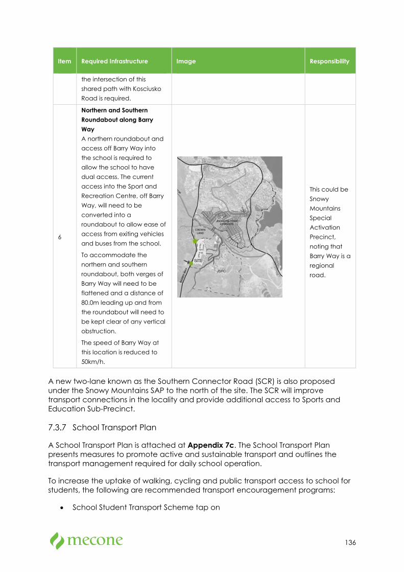
136
Item Required Infrastructure Image Responsibility
the intersection of this shared path with Kosciusko Road is required.
6
Northern and Southern Roundabout along Barry Way A northern roundabout and access off Barry Way into the school is required to allow the school to have dual access. The current access into the Sport and Recreation Centre, off Barry Way, will need to be converted into a roundabout to allow ease of access from exiting vehicles and buses from the school.
To accommodate the northern and southern roundabout, both verges of Barry Way will need to be flattened and a distance of 80.0m leading up and from the roundabout will need to be kept clear of any vertical obstruction.
The speed of Barry Way at this location is reduced to 50km/h.
This could be Snowy Mountains Special Activation Precinct, noting that Barry Way is a regional road.
A new two-lane known as the Southern Connector Road (SCR) is also proposed under the Snowy Mountains SAP to the north of the site. The SCR will improve transport connections in the locality and provide additional access to Sports and Education Sub-Precinct.
School Transport Plan
A School Transport Plan is attached at Appendix 7c. The School Transport Plan presents measures to promote active and sustainable transport and outlines the transport management required for daily school operation.
To increase the uptake of walking, cycling and public transport access to school for students, the following are recommended transport encouragement programs:
• School Student Transport Scheme tap on
137
• New starter kit with transport policies, transport access options for student induction (prep and mid-term new starters)
• Independent travel training to walk/ ride or travel with a buddy (after Year 4)
• Walk to school day and Walk Part Way to School programs
• Ride to school day
• Walk and Wheel Wednesdays (an example from City of Sydney)
• RideScore (an example from We Ride Australia and Sunshine Coast Council)
• GoGet sign up
• Carpool matching app/ incentives
• Remote car parking
• Remote kiss-and-drop
• Road safety
• PRG-generated programs
The Transport Plan also recommends several general strategies for promoting and educating staff about sustainable travel, including:
• The preparation of a transport access guide before Day 1 2023 to all staff, parents/guardians, and students,
• Communication plan for stakeholders to converse and champion sustainable travel behaviour,
• Periodical review of Travel Plan every year,
• Annual survey,
• Appointment of a travel coordinator,
• Form internal and external group to manage the implementation of the transport plan.
Construction Traffic Management
Construction Vehicle Routes and Access
It is proposed that construction vehicles enter and exit the construction site via Barry Way and the Sport and Recreation access road, shown by the blue lines in Figure 7-18, below. A copy of the truck route maps shall be provided to all drivers prior to attending the construction site.
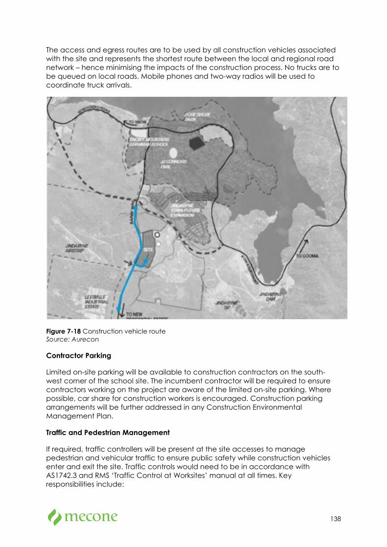
138
The access and egress routes are to be used by all construction vehicles associated with the site and represents the shortest route between the local and regional road network – hence minimising the impacts of the construction process. No trucks are to be queued on local roads. Mobile phones and two-way radios will be used to coordinate truck arrivals.
Figure 7-18 Construction vehicle route Source: Aurecon
Contractor Parking
Limited on-site parking will be available to construction contractors on the south-west corner of the school site. The incumbent contractor will be required to ensure contractors working on the project are aware of the limited on-site parking. Where possible, car share for construction workers is encouraged. Construction parking arrangements will be further addressed in any Construction Environmental Management Plan.
Traffic and Pedestrian Management
If required, traffic controllers will be present at the site accesses to manage pedestrian and vehicular traffic to ensure public safety while construction vehicles enter and exit the site. Traffic controls would need to be in accordance with AS1742.3 and RMS ‘Traffic Control at Worksites’ manual at all times. Key responsibilities include:
139
• Pedestrian and cyclist management, to ensure that adverse conflicts between vehicle movements and pedestrians do not occur
• Supervision of all vehicle movements
• Supervision of all loading and unloading of construction materials during the deliveries in the construction phase of the project
Should any unforeseen activities require the temporary closure of any existing pedestrian access to the Sport and Recreation Centre, a Traffic Guidance Scheme should be developed and implemented by the contractor to ensure a safe alternative for pedestrians traversing these routes in the vicinity of the site.
Mitigation Measures
It is recommended that the measures in the Transport Assessment and School Transport Plan be implemented.
7.4 Ecologically Sustainable Design (ESD)
The Sustainable Development Plan prepared by Steensen Varming at Appendix 33 has been developed to support the sustainability strategy development for the proposal addressing the main ESD objectives for the development, and sustainable design principles.
Principles of ESD
There are four ESD principles defined by cl. 7(4) of Schedule 2 of the EP&A Regulation that must be considered in the assessment of the proposal. These are addressed in the table below.
Table 7-8 ESD principles assessment
Principle Description Comment
Precautionary principle
The precautionary principle says that if there are threats of serious or irreversible environmental damage, lack of full scientific certainty should not be used as a reason for postponing measures to prevent environmental degradation.
The proposal provides for a development that avoids environmental impacts where possible and locates new buildings on previously disturbed land.
Intergenerational equity
The principle of intergenerational equity says that the present generation should ensure that the health, diversity, and productivity of the environment are maintained or
The proposal seeks to maintain the environmental assets of the site by maintaining existing trees where possible. The proposal seeks to improve the environmental character of the site through new and improved
140
Principle Description Comment
enhanced for the benefit of future generations.
landscaping, and to minimise the consumption of resources where possible.
A Climate Adaption Plan has also been developed for the proposal with design solutions specifically included within the building design of the proposal.
Conservation of biological diversity and ecological integrity
This principle says that conservation of biological diversity and ecological integrity should be a fundamental concern.
The proposal is generally located on land which has been previously disturbed with existing biodiversity mostly identified as being of poor quality. Any biodiversity impacts associated with the proposal will be offset by replacement tree planting improving the ecological value of the site.
Improved valuation, pricing, and incentive mechanisms
This principle says that environmental factors should be included in the valuation of assets and services.
The project will integrate several initiatives which aim to minimise pollution and other undesirable environmental outcomes. Contractors will be required to provide and abide by an environmental management plan which is in accordance with NSW Environmental Management Systems Guidelines or a similar standard.
Site and Climate Review
The site is in southern NSW, at an altitude of approximately 1,000 above sea level. The climate is sub-alpine, with cool temperate characteristics. An overview of climate conditions is provided in Figure 7-19.
Average temperatures for the site show that the climate is comfortable during summer and cold during winter. Summer averages range from 9-250C and 0-110C in winter. Wind is consistent through the year with a strong prevailing wind coming from the west.
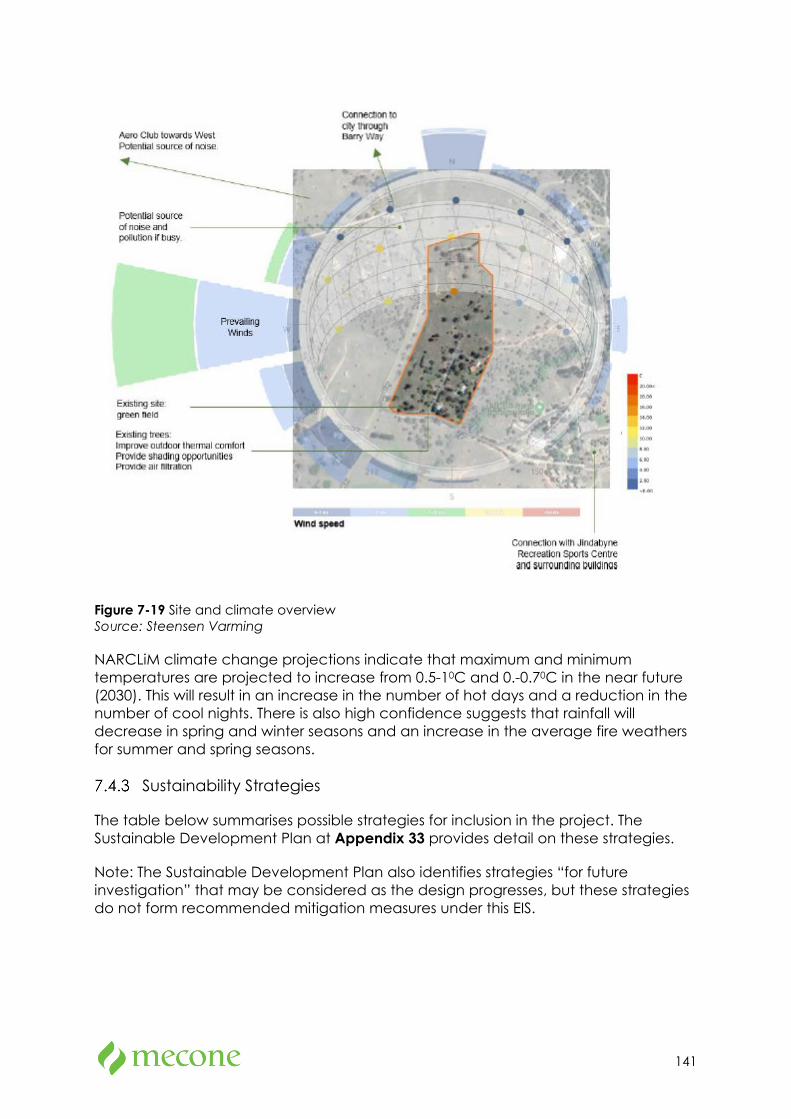
141
Figure 7-19 Site and climate overview Source: Steensen Varming
NARCLiM climate change projections indicate that maximum and minimum temperatures are projected to increase from 0.5-10C and 0.-0.70C in the near future (2030). This will result in an increase in the number of hot days and a reduction in the number of cool nights. There is also high confidence suggests that rainfall will decrease in spring and winter seasons and an increase in the average fire weathers for summer and spring seasons.
Sustainability Strategies
The table below summarises possible strategies for inclusion in the project. The Sustainable Development Plan at Appendix 33 provides detail on these strategies.
Note: The Sustainable Development Plan also identifies strategies “for future investigation” that may be considered as the design progresses, but these strategies do not form recommended mitigation measures under this EIS.
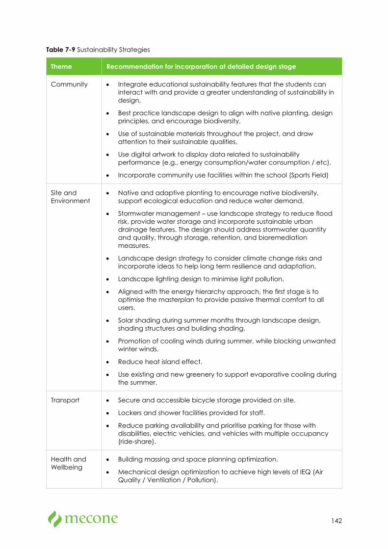
142
Table 7-9 Sustainability Strategies
Theme Recommendation for incorporation at detailed design stage
Community • Integrate educational sustainability features that the students can interact with and provide a greater understanding of sustainability in design,
• Best practice landscape design to align with native planting, design principles, and encourage biodiversity,
• Use of sustainable materials throughout the project, and draw attention to their sustainable qualities,
• Use digital artwork to display data related to sustainability performance (e.g., energy consumption/water consumption / etc).
• Incorporate community use facilities within the school (Sports Field)
Site and Environment
• Native and adaptive planting to encourage native biodiversity, support ecological education and reduce water demand.
• Stormwater management – use landscape strategy to reduce flood risk, provide water storage and incorporate sustainable urban drainage features. The design should address stormwater quantity and quality, through storage, retention, and bioremediation measures.
• Landscape design strategy to consider climate change risks and incorporate ideas to help long term resilience and adaptation.
• Landscape lighting design to minimise light pollution.
• Aligned with the energy hierarchy approach, the first stage is to optimise the masterplan to provide passive thermal comfort to all users.
• Solar shading during summer months through landscape design, shading structures and building shading.
• Promotion of cooling winds during summer, while blocking unwanted winter winds.
• Reduce heat island effect.
• Use existing and new greenery to support evaporative cooling during the summer.
Transport • Secure and accessible bicycle storage provided on site.
• Lockers and shower facilities provided for staff.
• Reduce parking availability and prioritise parking for those with disabilities, electric vehicles, and vehicles with multiple occupancy (ride-share).
Health and Wellbeing
• Building massing and space planning optimization.
• Mechanical design optimization to achieve high levels of IEQ (Air Quality / Ventilation / Pollution).
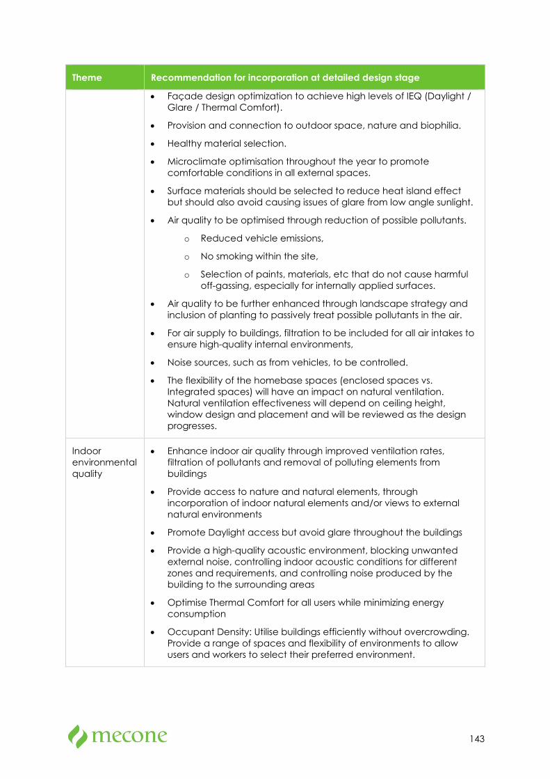
143
Theme Recommendation for incorporation at detailed design stage
• Façade design optimization to achieve high levels of IEQ (Daylight / Glare / Thermal Comfort).
• Provision and connection to outdoor space, nature and biophilia.
• Healthy material selection.
• Microclimate optimisation throughout the year to promote comfortable conditions in all external spaces.
• Surface materials should be selected to reduce heat island effect but should also avoid causing issues of glare from low angle sunlight.
• Air quality to be optimised through reduction of possible pollutants.
o Reduced vehicle emissions,
o No smoking within the site,
o Selection of paints, materials, etc that do not cause harmful off-gassing, especially for internally applied surfaces.
• Air quality to be further enhanced through landscape strategy and inclusion of planting to passively treat possible pollutants in the air.
• For air supply to buildings, filtration to be included for all air intakes to ensure high-quality internal environments,
• Noise sources, such as from vehicles, to be controlled.
• The flexibility of the homebase spaces (enclosed spaces vs. Integrated spaces) will have an impact on natural ventilation. Natural ventilation effectiveness will depend on ceiling height, window design and placement and will be reviewed as the design progresses.
Indoor environmental quality
• Enhance indoor air quality through improved ventilation rates, filtration of pollutants and removal of polluting elements from buildings
• Provide access to nature and natural elements, through incorporation of indoor natural elements and/or views to external natural environments
• Promote Daylight access but avoid glare throughout the buildings
• Provide a high-quality acoustic environment, blocking unwanted external noise, controlling indoor acoustic conditions for different zones and requirements, and controlling noise produced by the building to the surrounding areas
• Optimise Thermal Comfort for all users while minimizing energy consumption
• Occupant Density: Utilise buildings efficiently without overcrowding. Provide a range of spaces and flexibility of environments to allow users and workers to select their preferred environment.
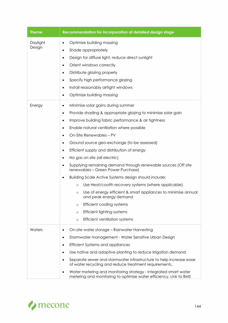
144
Theme Recommendation for incorporation at detailed design stage
Daylight Design
• Optimize building massing
• Shade appropriately
• Design for diffuse light, reduce direct sunlight
• Orient windows correctly
• Distribute glazing properly
• Specify high performance glazing
• Install reasonably airtight windows
• Optimize building massing
Energy • Minimise solar gains during summer
• Provide shading & appropriate glazing to minimise solar gain
• Improve building fabric performance & air tightness
• Enable natural ventilation where possible
• On-Site Renewables – PV
• Ground source geo-exchange (to be assessed)
• Efficient supply and distribution of energy
• No gas on site (all electric)
• Supplying remaining demand through renewable sources (Off site renewables – Green Power Purchase)
• Building Scale Active Systems design should include:
o Use Heat/coolth recovery systems (where applicable)
o Use of energy efficient & smart appliances to minimise annual and peak energy demand
o Efficient cooling systems
o Efficient lighting systems
o Efficient ventilation systems
Waters • On-site water storage – Rainwater Harvesting
• Stormwater management - Water Sensitive Urban Design
• Efficient Systems and appliances
• Use native and adaptive planting to reduce irrigation demand.
• Separate sewer and stormwater infrastructure to help increase ease of water recycling and reduce treatment requirements.
• Water metering and monitoring strategy - Integrated smart water metering and monitoring to optimise water efficiency. Link to BMS
145
Theme Recommendation for incorporation at detailed design stage
system to check usage and identify leaks and inefficiencies immediately.
Materials and Waste
• Optimise cut and fill activities onsite to avoid waste production
• Use prefabricated or modular materials to reduce wasted materials
• Targets for all contractors for construction and demolition works:
o !00% of Construction Waste (minimum 95%) diverted from landfill
• Centralised waste management to improve efficiencies of waste storage and recycling rates
• Use of organic waste for composting and possible anaerobic digestion for biogas generation:
o Consider partnering with adjacent Sports Centre for additional BioGas production for use onsite.
Resilience • Climate Adaptation Plan to address risks
• Resilience to future climate and hazards
• Reduction of Heat Island Effect through green infrastructure
• Flexibility of building to adapt to future uses
• Maximising the building lifespan
Sustainability Management and Optimisation
• Advanced metering and monitoring strategy
• Integrated smart technology to optimise all strategies, including energy, water, waste.
• Free Wi-Fi to pupils, staff, and visitors
• High speed connectivity
Assessment Against Accredited Rating Scheme
The project is seeking a formal certification under the 4 Star Green Star rating using the Design and As Built v1.3 rating. In addition to the rating tool, the project will seek to implement best practice ESD features that will support the outcomes intended by Green Star.
A detailed Green Star Pre-Assessment score card has been prepared for the project which is provided in Appendix 33 of the EIS.
146
7.5 Heritage
Methodology
A Statement of Heritage Impact (SOHI) assessment prepared by NGH is attached at Appendix 8. The report assesses the potential impact upon the heritage sites and values as a result of the proposed works. The report is informed by desktop investigation and site inspection. Key points from the report are outlined below.
Existing Environment
The site is located within a locally listed heritage item under the Snowy River Local Environmental Plan 2013 known as “Jindabyne Winter Sports Academy” (I146). A statement from the NSW Heritage (2016) listings provides the following in relation to the local heritage item, I146:
The lodges are significant because of their association with the snowy Scheme. They are tangible evidence of post World War II temporary workers' single accommodation. The Love Shack is particularly significant as it was used by Sir William Hudson when visiting the Scheme.
Date significance updated: 7/07/2011
Another locally listed heritage item “Leesville Hotel” is also located adjacent to the proposed site. The “Leesville Hotel” was originally constructed in c.1850s and was a significant early building within the region that was used as accommodation for gold digging travellers that travelled to the Thredbo Valley in the 1860s.
Other locally listed heritage items including the Jindabyne cemetery are substantially distanced from the site and have therefore not been included within the Heritage Impact Statement.
A search of the Australian Heritage Database and State Heritage Register indicated that there were no heritage items of state, national or world significance located near the site.

147
Figure 7-20 Locally listed heritage items Source: NGH
Archaeological Impacts
Assessment of the archaeological potential associated with the Jindabyne Winter Sports Academy in the SOHI highlighted that whilst there is potential for archaeological remains associated with the Snowy Hydro lodges to be present within the project area, specifically within the previous locations of the buildings, the assessment of significance has highlighted that any remains that are uncovered would be unlikely to reveal significant further information about the site that is not already known.
As the buildings were removed in the 1980s due to poor condition and only the best three cottages retained, any remains of the removed buildings would not add to the overall significance of the site. As a result, no specific statement of significance has been written for the Jindabyne Winter Sports Academy to include archaeological potential considerations, as this is not assessed to add to the overall significance of the site.
Impacts
Jindabyne Winter Sports Academy
The proposed works will result in the demolition of two cottages associated with the Snowy Hydro workers accommodation, however, it will not impact on the three structures (including the Love Shack) which are listed as contributary items for the LEP
148
listing I146. As such, the proposal is identified as having an overall low impact on the locally listed Jindabyne Winter Sports Academy.
The demolition of the non-contributary cottages will not impact the heritage listing, and aerial imagery as well as topographic maps provide information regarding the original alignment of the structures.
Leesville Hotel
The proposed new buildings will not have a negative visual impact on the locally listed Leesville Hotel as the sight lines to and from the listing to the proposal are obscured due to vegetation as well as distance.
Mitigation Measures
Mitigation measures are not considered necessary as the contributary elements of the listed item I146 will remain extant, and the lives of the Snowy Hydro workers is well-documented, as is the technical / architectural style of these cottages.
In the event any unexpected heritage finds are identified of high significance with regard to the heritage listing, works must cease temporarily, and the ‘Unexpected Finds Procedure’ described in Appendix A of the SOHI should be adhered to.
7.6 Aboriginal Cultural Heritage
Methodology
A draft Aboriginal Cultural Heritage Assessment Report (ACHAR) has been prepared by NGH and is attached at Appendix 9. The draft ACHAR has been prepared in accordance with the Code of Practice for Archaeological Investigation of Aboriginal Objects in New South Wales (DECCW 2010b) (the Code), Guide to Investigating, Assessing and Reporting on Aboriginal Cultural Heritage in NSW (OEH 2011) (the Guide) and Applying for an Aboriginal Heritage Impact Permit: Guide for Applicants 2011.
Finalisation of the report requires the completion of a sub-surface testing program including assessment of findings and incorporation of feedback and comments from Registered Aboriginal Parties (RAP). This is currently being undertaken as discussed further below. The final report will be made available to DPIE once available.
Existing Environment
One second order drainage line, Lees Creek, lies to the south of the site with an unnamed tributary of Lees Creek to the north. Lees Creek flows into Stinky Bay, Lake Jindabyne 1 km to the east but would have joined with the Snowy River just over 2 km away prior to the construction of the dam. It is expected that Aboriginal activity would have been focussed on the more permanent drainage lines but as the region is well watered, Aboriginal use of the landscape would not have been restricted to the main water courses.
149
Given the nature of the terrain, the steeper slopes within the site are assessed to be unlikely to have been used by Aboriginal people for occupation. However, there are sections that contain elevated, level terrain that may have been a focus for Aboriginal camping, particularly given the proximity of Lees Creek. These level areas have a higher archaeological potential. Additionally, any old growth mature native trees within the Proposal Area have the potential to have been culturally modified. It is considered that prior to European land modifications, this area may have provided resources, shelter, water, and food for Aboriginal people.
A basic AHIMS search conducted on 26th of March 2021did not identify any previously recorded AHIMS sites within or adjacent to the proposal site.
Archaeological Investigations
A survey of the site was undertaken on 25 June 2021 with one NGH archaeologist and four Aboriginal representatives.
The survey was conducted in transects with participants walking parallel and spaced approximately 10 metres apart in lower potential areas and 5 metres apart where the potential was higher. The strategy therefore was to walk across the landscape and sample as many landform types as possible to achieve maximum coverage in areas where the level of vegetation permitted this to occur.
Visibility was low across the site, ranging from 5% to a maximum of 40%. During the survey, four Potential Archaeological Deposits (PADs) were recorded, PAD 1 in the southwestern portion, PAD 2 in the central western, PAD 3 in the central northern portion and PAD 4 in the eastern central portion of the site. In addition, four other artefact sites were recorded as follows: Jindabyne Campus AFT1 (Isolated find in the southwestern portion), Jindabyne Campus AFT2 (Isolated find in the southwestern portion), Jindabyne Campus AFT3 (Artefact Scatter in the central western portion) and Jindabyne Campus AFT4 (Isolated find in the north-eastern corner).
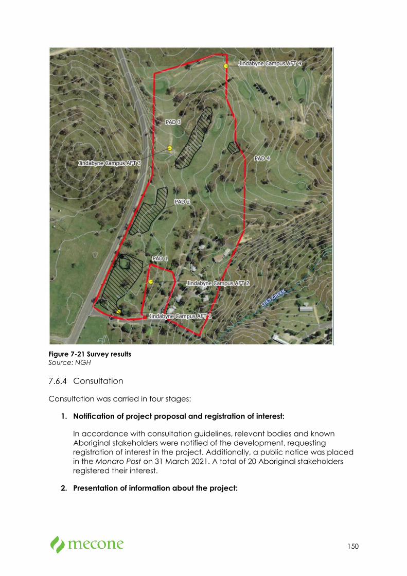
150
Figure 7-21 Survey results Source: NGH
Consultation
Consultation was carried in four stages:
1. Notification of project proposal and registration of interest:
In accordance with consultation guidelines, relevant bodies and known Aboriginal stakeholders were notified of the development, requesting registration of interest in the project. Additionally, a public notice was placed in the Monaro Post on 31 March 2021. A total of 20 Aboriginal stakeholders registered their interest.
2. Presentation of information about the project:
151
On 11 May 2021, an assessment methodology document for the proposal was sent to all registered Aboriginal parties (RAPs) which included details of the background to the proposal, a summary of previous archaeological surveys, and the proposed heritage assessment methodology for the proposal. The document invited comments regarding the methodology and sought any information regarding known Aboriginal cultural significance values associated with the site and/or any Aboriginal objects contained therein.
None of the registered parties raised any objections to the methodology and many expressed interest in participating in fieldwork.
3. Gathering information about cultural significance:
The Assessment Methodology outlined in Stage 2 included a written request to provide any information that may be relevant to the cultural heritage assessment of the site. No response regarding cultural information was received in response to the methodology however comments were made regarding the treatment of any cultural materials located.
The survey fieldwork was organised, and four of the twenty registered groups were selected for fieldwork participation. The survey fieldwork was conducted on 25 June 2021 by one archaeologist from NGH and four Aboriginal RAP’s.
4. Review of draft ACHAR:
A draft version of this Aboriginal Cultural Heritage Assessment Report for the proposal) will be forwarded to the RAPs inviting comment on the results, the significance assessment, and the recommendations post completion of the testing program. A minimum of 28 days will be allowed for responses.
Statement of Significance
Four archaeological sites (an artefact and three isolated finds) and four areas of PAD were recorded during the survey conducted on 25 June 2021 within the site.
Archaeological sites
These sites contain a majority of quartz artefacts which is completely representative of the material found in site within the surrounding region. The research potential and scientific value of the artefacts themselves is low, given some are likely out of context, there are limited numbers to make a detailed analysis and the generally disturbed nature of the sites.
The sites are not considered to be rare as many others have been recorded in the region and still more remain unrecorded. They are also not particularly representative, given their mostly disturbed contexts, other better-preserved examples will exist outside development footprints.
Potential Archaeological Deposits (PADs)
The poor visibility and the presence of relatively less disturbed and even intact portions of landforms indicates there is potential for subsurface deposits containing
152
stone artefacts to occur. This has led to the identification of four areas considered to be PAD, although it is acknowledged that parts of these have also been disturbed, most notably by the preparation for the golf course. Nevertheless, there is also evidence to suggest some portions of the sensitive landforms remain relatively intact.
It is likely that the archaeological evidence present within the PAD areas consists of low-density stone artefacts, probably debitage from incidental flaking activity of Aboriginal people camping or traversing the landscape. There is no surface evidence to suggest that extensive and thus scientifically significant archaeological deposits are present. Nonetheless, the poor visibility and the context of the landforms with some stone artefacts present identifies these landforms as likely to contain Aboriginal stone artefacts.
Test Excavations
Given the identification of the four PAD sites within the proposal site, test excavation is required to establish the extent and scientific significance of the PADs. At the time of writing the EIS, coordination and planning to undertake test excavations is currently underway. Assessment and analysis of the test excavations will occur in accordance with the Code of Practice for Archaeological Investigations of Aboriginal Objects in NSW (OEH, 2010) and provided to DPIE as soon as it is complete.
As identified in the ACHAR, the site is modified land or land which is not archaeologically sensitive. Given the extent and density of any archaeological material is likely to be limited, the ACHAR considers the risk to the proposal proceeding to be low. As such, it is recognised that the findings of the test excavations can be considered following submission of the proposal and prior to determination.
Mitigation Measures
Mitigation measures have been identified within the draft report however it is recognised that these will be revised following test excavations. The draft mitigation measures include:
• Test excavation is required to establish the extent and scientific significance of the four identified areas of PAD. Test excavation may be carried out in accordance with the requirements of the Code of Practice for Archaeological Investigation in NSW for the four areas of PAD identified within the Proposal Area.
• Aboriginal community representatives continue to be engaged and consulted about the project and Aboriginal heritage impacts. They should also be provided an opportunity to assist in the test excavation programme.
• The two sites (Jindabyne Campus AFT 1 and Jindabyne Campus AFT 4) should be avoided if possible by the project. Their presence, although not their exact location, could be used as a teaching tool about Aboriginal use of the land.
153
• For any sites not able to be avoided by the development, community collection of surface artefacts should be incorporated into the pre-construction phase.
• All cultural material recovered from a subsurface testing programme and community collection will be in temporary care until an appropriate time when it can be returned to site. The artefacts must be buried in line with Requirement 26 of the Code of Practice for Archaeological Investigation of Aboriginal Objects in New South Wales and in an appropriate location within the Proposal Area that will not be subject to any ground disturbance. The burial location will be submitted to the AHIMS database.
• An Aboriginal Site Impact Recording Form must be completed and submitted to AHIMS following the test excavation.
• In the unlikely event that human remains are discovered during the subsurface testing programme, all work must cease in the immediate vicinity. The appropriate heritage team within Heritage NSW and the local police should be notified. Further assessment would be undertaken to determine if the remains were Aboriginal or non-Aboriginal. If the remains are deemed to be Aboriginal in origin the Registered Aboriginal Parties should be advised of the find as directed by the appropriate heritage team within Heritage NSW. Heritage NSW would advise the Proponent on the appropriate actions required.
• The subsurface testing results for the Proposal Area should be detailed in an additional Aboriginal Cultural Heritage Assessment Report.
• Further archaeological assessment would be required if the proposal activity extends beyond the area assessed in this report. This would include consultation with the registered Aboriginal parties and may include further field survey.
7.7 Social Impact Assessment
Methodology
A Social Impact Assessment prepared by Urbis is attached at Appendix 10. The report identifies and analyses the potential positive and negative social impacts associated with the proposal. It involves a detailed and independent study to outline social impacts, identify mitigation measures and provides recommendations in accordance with professional standards and statutory obligations.
Social Baseline
The proposed Jindabyne Education Campus is located at 207 Barry Way within the lot of the existing Jindabyne Sport and Recreation Centre, on the outskirts of the township of Jindabyne.
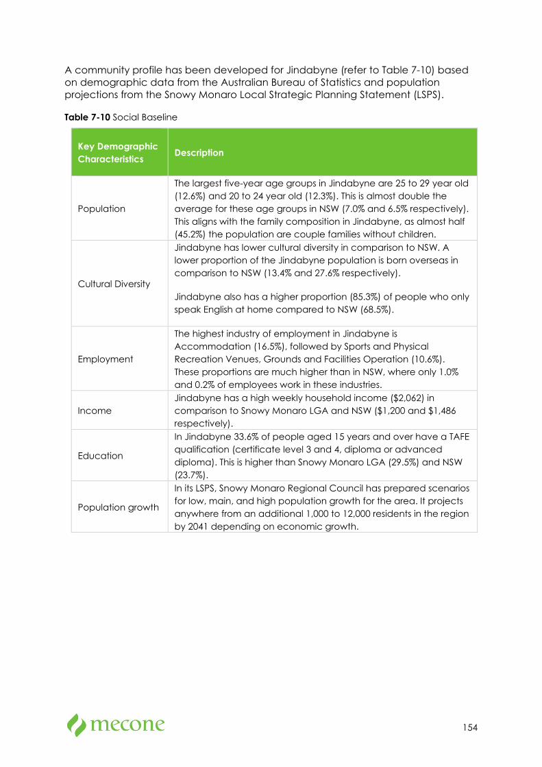
154
A community profile has been developed for Jindabyne (refer to Table 7-10) based on demographic data from the Australian Bureau of Statistics and population projections from the Snowy Monaro Local Strategic Planning Statement (LSPS).
Table 7-10 Social Baseline
Key Demographic Characteristics Description
Population
The largest five-year age groups in Jindabyne are 25 to 29 year old (12.6%) and 20 to 24 year old (12.3%). This is almost double the average for these age groups in NSW (7.0% and 6.5% respectively). This aligns with the family composition in Jindabyne, as almost half (45.2%) the population are couple families without children.
Cultural Diversity
Jindabyne has lower cultural diversity in comparison to NSW. A lower proportion of the Jindabyne population is born overseas in comparison to NSW (13.4% and 27.6% respectively).
Jindabyne also has a higher proportion (85.3%) of people who only speak English at home compared to NSW (68.5%).
Employment
The highest industry of employment in Jindabyne is Accommodation (16.5%), followed by Sports and Physical Recreation Venues, Grounds and Facilities Operation (10.6%). These proportions are much higher than in NSW, where only 1.0% and 0.2% of employees work in these industries.
Income Jindabyne has a high weekly household income ($2,062) in comparison to Snowy Monaro LGA and NSW ($1,200 and $1,486 respectively).
Education
In Jindabyne 33.6% of people aged 15 years and over have a TAFE qualification (certificate level 3 and 4, diploma or advanced diploma). This is higher than Snowy Monaro LGA (29.5%) and NSW (23.7%).
Population growth
In its LSPS, Snowy Monaro Regional Council has prepared scenarios for low, main, and high population growth for the area. It projects anywhere from an additional 1,000 to 12,000 residents in the region by 2041 depending on economic growth.
155
Engagement Outcomes
Community feedback
SINSW has undertaken the following engagement activities to ascertain community feedback on the proposal:
• December 2020: Community Information Hub in Jindabyne over four weekdays providing the local community with an overview of the building process, opportunity to ask questions and complete a survey to inform the concept design. 68 survey responses were collected.
• March 2021: Online planning update with project progress update and overview of survey responses from December.
• April 2021: Online planning update with project progress update and second online survey open for one month (26 April – 24 May 2021).
Feedback from the Community Information Hub surveys identified that:
• 88% of respondents believe the Jindabyne Education Campus will provide modern facilities for students,
• 85% agree that the proposal addresses the need for new high school facilities in the local community,
• 84% agree that the proposal addresses the need for new primary school facilities in the local community,
• 76% believe the stages of building a new school have been explained clearly and will be delivered in an appropriate timeframe,
• 75% agree that the concept of the Jindabyne Education Campus fits appropriately in its surrounding environment.
Stakeholder Feedback
In additional to consultation with the community, the following stakeholders have been engaged as part of the preparation of the EIS and associated reports:
• Bega Local Aboriginal Land Council
• Registered Aboriginal Stakeholders:
o Southern Kosciuszko Aboriginal Working Group
o Ngarigo Elders
o Ngarigo and Djiringanj People
• Snowy Monaro Regional Council
156
• Government Architect NSW (through the NSW SDRP process)
• Transport for NSW
• Jindabyne Aero Club
• Department of Planning Industry and Environment
• TAFE
Key feedback from these stakeholders has been incorporated into technical reports that have informed this SIA. These include:
• Aboriginal Cultural Heritage Assessment, NGH Consultants
• Acoustic Report, SLR Consultants
• Architectural Design Statement, DJRD Architects
• Landscape Concept Design Report, Site Image Landscape Architects
• Transport Assessment, Aurecon
Social Impact Assessment
The expected and perceived impacts of the proposal are outline in Table 7-11 below:
Table 7-11 Expected and Perceived Impacts
Potential Impact
Social Impact Category Assessment Overview
Noise, dust, and vibrations
Way of Life
Surroundings
There are no residential uses located near the site as the predominant resident population is located 3km north in the town centre.
Impacts caused by noise, dust and vibrations is considered to be low.
Enabling potential future delivery of the TAFE training facility
Accessibility
Livelihoods
TAFE NSW has requested that 5,500sqm of the proposed site be made available for an onsite training. This is likely to include facilities such as group and outdoor learning spaces, media lounge, computer hub, print room, maker space, technology bar and a connected learning centre which could be used by TAFE and the school. The delivery of the TAFE will be subject to a separate development and approval pathway. This impact has therefore not been assessed further
Likely some increased
Way of Life It is likely that the increased capacity of the proposal will require the need for additional
157
Potential Impact
Social Impact Category Assessment Overview
employment opportunities
teachers. It is also likely that the new school will require an additional school Principal as it is intended to have two Principals – one for primary school and one for secondary school. This will have a low positive impact on the community.
Engagement with Aboriginal culture and heritage
Community
Culture
The inclusion of Indigenous spaces, cultural awareness through landscape design and integration of the school with the natural environment will assist in creating a welcoming and inclusive environment for Aboriginal students, staff, and visitors to the school. It will also enhance student, family, and staff engagement with and awareness of the local Aboriginal culture which aligns with the GANSW Designing with Country framework suggested strategies to continue learning from Country. Engagement with Aboriginal culture and heritage is likely to have a high positive impact on the community.
Increased student capacity
Way of Life
Accessibility
Surroundings
The construction of Jindabyne Education Campus will increase the enrolment capacity by 113 students to a total of 925 students. This will see an increase to 515 places for primary school students and 410 places for secondary school students. The additional student places will help support the existing demand for education services, as well as future planned growth for the area. Most survey respondents agreed that the proposal will address the need for primary and secondary education facilities in Jindabyne.
The proposed Jindabyne Education Campus will increase student capacity to respond to the growing enrolment demand in the area. It is likely the proposal will have a high positive impact on the community.
Access to modern, high quality education facilities
Way of Life
Accessibility
Surroundings
The proposal will provide students and staff with access to modern, high quality education facilities by providing new buildings and facilities such as a commercial kitchen and agricultural learning unit, and a significant increase in open space and recreation. This is likely to provide an improved learning environment for students and have a high positive impact on the community.
158
Potential Impact
Social Impact Category Assessment Overview
Designing a safe school environment
Way of Life
Accessibility
Overall, the proposal will likely provide a safe and secure environment for students and staff with perimeter fencing, internal fencing, separate access arrangements and separate sporting fields for primary and high school students. This will create a high positive impact for students and staff.
Lack of Active and Public Transport Options
Way of Life
Accessibility
As part of the draft Snowy Mountains SAP master plan a southern connecter road (SCR) is proposed to the north-east of the school site. The SCR is intended to provide direct access between Kosciusko Road and Barry Way, bypassing Jindabyne town centre. Additional to the SCR, a pedestrian and cycling shared path is earmarked as part of the draft master plan and would include a bridge over the proposed SCR, linking the site to Jindabyne town centre. However, it is currently unclear whether this infrastructure will be delivered prior to the opening of the Jindabyne Education Campus.
Without the development of infrastructure and services, the lack of pedestrian, cycling and public transport access will likely have a high negative impact on staff and students attending the Jindabyne Education Campus, as well as families of students who may need to alter daily routines to transport students to school.
Mitigation Measures and Recommendations
The Social Impact Assessment provides the following recommendations to further manage and improve the potential impacts arising from the proposal:
• Engage with local Indigenous artist/s to design and fabricate the proposed artwork/s for the school.
• Engage with the local Aboriginal community to provide advice on final designs for the yarning circle, Indigenous gardens and use of materials and colour.
• Undertake ongoing consultation with the community and existing families and students to maintain communication about project progress, the school catchment and transition processes to the Jindabyne Education Campus.
159
• Preparation of a Plan of Management for the school to address accessibility outside of school hours and management responsibilities of shared use areas
• Implement the recommendations of the TA, including developing active and public transport infrastructure and the establishing transport encouragement programs.
• Continue to hold Transport Working Group meetings to agree the way in which TA recommendations will be funded and delivered.
7.8 Noise and Vibration
Methodology
An Acoustic Report prepared by SLR Consulting is attached at Appendix 11. The report assesses the impacts associated with noise emissions from the site during the operational and construction phases and noise intrusion to the site from surrounding noise sources.
Unattended noise monitoring was conducted in the study area during June 2021. The monitoring equipment was positioned to measure existing noise levels that are representative of receivers most affected by the proposal, within constraints such as accessibility, security, and landowner permission.
Existing Conditions
The existing noise environment at the site is generally influenced by road traffic from the surrounding road network with the nearest major road being Barry Way, which is directly adjacent to the site. Other existing noises include local flora and fauna and aircraft noises from the Jindabyne Air Strip approximately 600m west of the site.
As shown in Figure 7-22, the nearest noise sensitive receivers are located to the west and south-west of the site across Barry Way, with further sensitive receivers to the north.
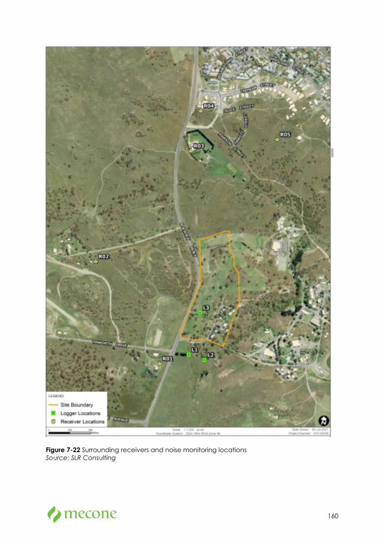
160
Figure 7-22 Surrounding receivers and noise monitoring locations Source: SLR Consulting
161
Noise Emission from School
Operational Noise
Key sources of noise emissions from operation of the future school include standard operations (i.e., noise from outdoor play areas during school hours), out of school hours operations (i.e., out of school hours events in the hall), and noise impacts from mechanical plant and school related equipment (i.e., school bells and public address (PA) system.
Regarding outdoor play, it is assumed that noise levels from play activities will be in the order of 41 dBA at the nearest sensitive receiver (218 Barry Way, Jindabyne). Based on a subjective assessment under the Association of Australasian Acoustical Consultant’s “Guideline for Child Care Centre Acoustic Assessment”, this noise is unlikely to be considered offensive.
Regarding noise breakout from the new multi-purpose court, the highest noise impact is considered to occur during live music events. Based on previously measured source noise levels from a comparable environment, the predicted noise levels at the nearest sensitive receiver (218 Barry Way, Jindabyne), is unlikely to be considered offensive. No specific upgrade to the proposed construction of the hall is required.
Regarding the mechanical plant and equipment, technical specifications are not available at this early stage of the project design and will need to be assessed in greater depth during the detailed design stage of the project. It is recognised that noise impacts from mechanical plant and equipment can be well controlled through appropriate acoustic treatments.
Construction Noise
Predicted noise levels from construction activities have been calculated, and a detailed assessment is provided in section 7 of the acoustic report.
For all surrounding receivers, predicted noise levels from the proposed construction equipment indicate that compliance is predicted at all sensitive receptors for work during standard hours, except for R01 (218 Barry Way, Jindabyne), during demolition and earthworks. As such, best practice construction noise mitigation measures are to be implemented.
Although only minor exceedances of the noise management levels are expected, noise or vibration impacts may be apparent at the nearest receivers at certain times during construction of the proposal. The project should apply all feasible and reasonable mitigation measures to minimise the impacts, particularly during noise intensive works, such as demolition. These mitigation measures are included in section 7.8.5 below.
Construction Vibration
Vibration offset distances have been determined from the Roads and Maritime Construction Noise and Vibration Guideline minimum working distances for cosmetic
162
damage and human response. All receivers are outside of the safe work distances for cosmetic damage and human comfort.
Noise intrusion into school spaces
Traffic Noise
Based on the unattended measured road traffic noise levels at the proposed building façade and the internal noise criteria, the most exposed facade is required to achieve an overall outdoor-to-indoor noise reduction of at least 20 dBA for the first row of classrooms located directly along Barry Way.
Analysis of the measurement results indicates that the required Rw ratings can be achieved for the site using conventional proprietary systems including solid external wall elements and glazing designed to achieve the minimum acoustic performance requirement.
Aircraft/Helicopter Noise
Worst-case noise emissions from the use of the Jindabyne Air Strip would be a Navy style “Squirrel” helicopter. Helicopters would typically fly in the opposite direction to the school using the runway in an east to west direction, however they would potentially fly directly over the proposed school site in the case of adverse weather conditions or occasional charted flights.
Noise emissions from the helicopter were modelled using SoundPlan 8.0 for these fly over paths. The maximum noise was found to be 58 dBA. Aircraft noise intrusion through the building facades will be required to be controlled such that the design internal sound levels listed in AS 2021 can be achieved. The minimum recommended façade acoustic ratings are listed in table 20 of the Acoustic Report.
Mitigation Measures
The Acoustic Report provides the following mitigation measures as outlined in table 25 of Appendix 11:
• Highly noisy intensive works should only be undertaken during the following Standard Construction Hours, unless otherwise assessed and justified: - 7 am to 6 pm Mondays to Fridays, inclusive; and - 8 am to 1 pm Saturdays; and - at no time on Sundays or public holidays.
• Provide appropriate respite periods as per the CNVG when noise intensive works are undertaken or during periods of high noise impacts.
• Carry out community consultation to determine the need and frequency of respite periods, if necessary.
• Avoid loading and unloading of materials / deliveries outside of daytime hours.
• Site entry and exit points should be located as far as possible from sensitive receivers.
163
• Compounds and work areas should be one-way to minimise the need for vehicles to reverse.
• Work compounds, parking areas, equipment and stockpiles should be positioned away from noise sensitive locations and/or in shielded locations.
• Trucks should not idle near to residential receivers.
• Stationary sources of noise, such as generators, should be located away from sensitive receivers.
• Training should be provided to project personnel, including relevant sub-contractors, on noise and vibration requirements and the location of sensitive receivers during inductions and toolbox talks.
• Delivery vehicles should be fitted with straps rather than chains for unloading, wherever possible.
• Truck drivers should avoid compression braking as far as practicable.
• Where night-time works are required, trucks should use broadband reversing alarms.
• Use the minimum sized equipment necessary to complete the work and where possible, use alternative, low-impact construction techniques.
• Power tools should use mains power where possible rather than generators.
• Shut down machinery, including generators, when not in operation.
• Avoid dropping materials from a height and dampen or line metal trays, as necessary.
• Ensure equipment is operated in the correct manner.
• All equipment should be appropriately maintained and fitted with noise control devices, where practicable, including acoustic lining of engine bays and air intake / discharge silencers, etc.
• Provide appropriate notice to the affected sensitive receivers prior to starting works and before any noisy periods of works.
• Provide signage with a 24-hour contact number.
• Where there are complaints regarding noise, review and implement additional control measures, where feasible and reasonable.
• Conduct noise and/or vibration monitoring in response to any valid complaints received.
164
• Conduct vibration monitoring whenever vibration intensive works are undertaken within the minimum working distances of sensitive receivers or structures.
7.9 Biodiversity
Methodology
A Biodiversity Development Assessment Report (BDAR) prepared by WSP is attached at Appendix 12. The BDAR includes information in the format detailed in the BC Act (s.6.7), Biodiversity Conservation Regulation 2017 (s6.8) and the Biodiversity Assessment Method (BAM). The author of the report is BAM-accredited.
The purpose of the report is to assess the biodiversity impacts of the proposal in accordance with Stage 1 (Biodiversity Assessment) and Stage 2 (Impact Assessment) of the BAM.
Key findings from the report are outlined below.
Existing Environment
The native vegetation within the site identifies with Plant Community Type (PCT) 1191 which is part of a Threatened Ecological Community (TEC) and potential habitat for threatened species.
The location of the site however is within a previously disturbed area in which a substantial portion of the site was formerly used as a golf course, cottages, and areas where buildings have been previously demolished. As such, the site is not within an area of undisturbed or intact habitat.
Overall, the subject site is dominated by areas of native vegetation that are in poor condition and areas of grassland that contains a mix of native and exotic species, with some areas of moderate condition vegetation across the site. These vegetation areas are outlined in Figure 7-23.
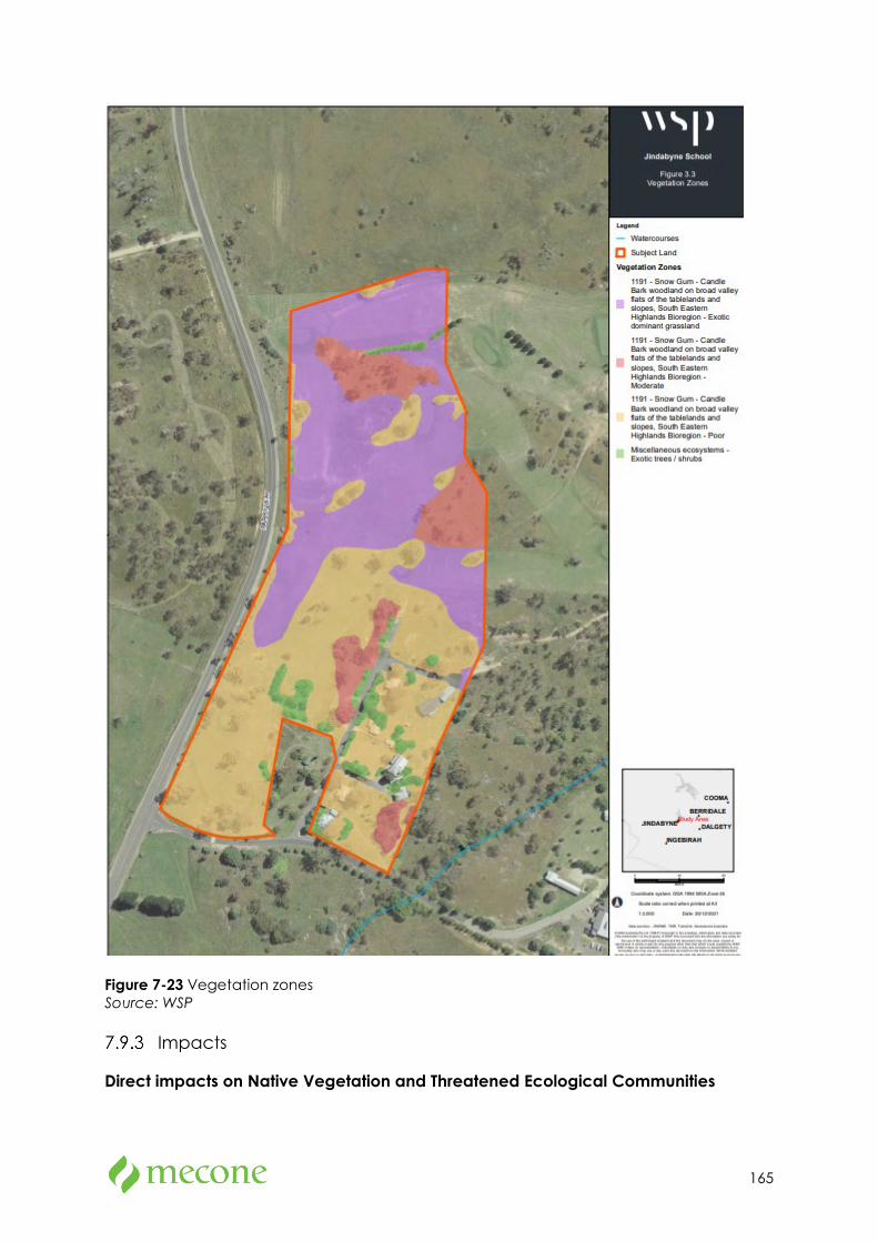
165
Figure 7-23 Vegetation zones Source: WSP
Impacts
Direct impacts on Native Vegetation and Threatened Ecological Communities
166
Assuming a worst-case scenario, the proposal will result in a direct impact to 8.29ha of PCT 1191 and the Monaro Tableland Cool Temperate Grassy Woodland in the South-eastern Highlands Bioregion Threatened Ecological Community (TEC). 7.26ha (or 88%) of this vegetation is recognised to be of relatively poor quality or contains exotic dominant grassland, with 1.04ha recognised as being of moderate condition.
Direct Impacts on Threatened Plant Species and Habitat
The proposal’s impacts on threatened plant species and habitat include:
• Removal of 1.02ha of potential habitat for Calotis glndulosa (Mauve Burr-daisy).
• Removal of 1.02ha of potential habitat for Leucochrysum abicans var tricolor (Hoary Sunray)
• Removal of 1.02ha of potential habitat for Prasophyllum petilum (Tarengo Leek Orchid)
• Removal of 1.02ha of potential habitat for Swainsona sericea (Silky Swainson-pea)
• Removal of 7.22ha of potential habitat for thesium austral (Austral Toadflax)
Colatois glandulosa, Leucochrysum abicans var tricolor, prasophyllum petilum and thesium australe are listed as threatened species under the EPBC Act. These threatened species are known to occur in PCT 1191 so broadly suitable habitat on the site. Targeted surveys for these species have not been undertaken so according to the BAM, these species are assumed to be present.
Direct Impacts on Threatened Animal Species and Habitat
The proposal’s impacts on threatened animal species and habitat include:
• Removal of potential breeding habitat trees (identified but not confirmed) for Callocephalon fimbriatum (Gang-gang Cockatoo)
• Removal of 0.79ha of known breeding habitat for Hieraaetus morphnoides (Little Eagle)
• Removal of 2.06ha potential breeding habitat trees (identified not confirmed) for Ninox connivens (Barking Owl) and Ninox strenua (Powerful Owl)
• 5ha of potential habitat for Petrocia rodinogaster (Pink Robin)
Serious and Irreversible Impacts
Monaro Tableland Cool Temperate Grassy Woodland in the South-eastern Highlands Bioregion is listed as a Critically Endangered Ecological Community under the BC Act and is identified as a threatened entity at risk of serious and irreversible impact (SAII)
167
Colatois glandulosa (Maurve Burr-daisy), is a threatened species that is considered to be an entity risk of SAII, and it is assumed to be present in the site based on the presence of an associated PCT (PCT 1191).
There are no fauna species SAII entities that would be affected by the proposal.
Indirect and Prescribed Impacts
The proposal will result in potential indirect impacts including:
• Inadvertent impacts on adjacent habitat or vegetation,
• Reduced viability of adjacent habitat due to edge effects,
• Reduced viability of habitat due to noise, dust, or light spill,
• Transport of weeds and pathogens from the site to adjacent vegetation,
• Increased risk of starvation or exposure, and loss of shade or shelter,
• Loss of breeding habitats,
• Trampling of threatened flora species,
• Rubbish dumping,
• Wood collection, and
• Removal and disturbance of rocks (including bush rock).
Prescribed impacts (including indirect and direct impacts) identified for the proposal include impacts on:
• On the habitat of threatened entities including:
o Human made structures
o Non-native vegetation
• On areas connecting threatened species habitat, such as movement corridors
• On water quality, water bodies and hydrological processes that sustain threatened entities
• On threatened species or fauna that are part of a TEC from vehicle strikes.
Biodiversity Offset Credits
It is noted that a worst-case impact scenario of clearing within the entire the subject land has been assumed.
168
The ecosystem credit requirement for the proposal is calculated by the BAM-C at 158 credits to be retired for PCT 1191: Snow Gum – Candle Bark woodland on broad valley flats of the tablelands and slopes, South-Eastern Highlands Bioregion.
For threatened species including Calitis glandulosa, Prasophyllum petilum, Swainsona sericea and Thesium austral, the impact and offset requirement assumes that these species are present in the habitats and that all habitats would be removed. The species credit requirement for the proposal as calculated by BAM-C for these species is:
• Calitis glandulosa 46 credits
• Prasophyllum petilum 31 credits
• Swainsona sericea 31 credits
• Thesium austral 80 credits
For threatened animal species including Little Eagle and Pink Robin, the species credit requirement for the proposal as calculated by BAM-C is:
• Little Eagle 8 credits
• Pink Robin 99 credits
• Gang-gang Cockatoo 99 credits
• Barking Owl or Powerful Owl 38 credits
Mitigation Measures
The BDAR recommends the following mitigation measures to manage potential impacts:
• The final disturbance area will seek to avoid the clearing of native vegetation and habitats as a far as practicable. In particular TEC’s and habitat for threatened species including hollow-bearing trees.
• Where vegetation disturbance activities are required in areas that have not been previously subject to biodiversity survey, additional survey, carried out prior to works occurring in any such areas and to inform detailed design. These surveys will be carried out by a suitably qualified ecologist.
• Opportunities to locate site offices, compounds, and ancillary facilities in areas of limited biodiversity value (e.g., exotic dominated grassland areas) will be prioritised during detailed design.
• Existing tracks and clearings will be used, where possible, to avoid the construction of new tracks. Where this is not possible, the design will seek to minimise impacts to native vegetation.
169
• Pre-clearing surveys will be completed prior to construction by a suitably qualified ecologist. Clearing protocol, including pre-clearing surveys, daily surveys and staged clearing will be implemented, using a trained ecologist or licensed wildlife handler during clearing events.
• Adoption of clearing protocols that identify vegetation to be retained, prevent inadvertent damage, and reduce soil disturbance. A chainsaw is preferable to heavy machinery to remove native vegetation in any areas where there would only be partial clearing.
• Nest boxes will be provided to minimise habitat loss to hollow-bearing fauna (and species that may be living in the buildings) in accordance with a Nest box strategy.
• Biodiversity exclusion zones (temporary fencing) for retained vegetation, including any identified habitat for threatened flora populations that have a high susceptibility to trampling and compaction, will be clearly identified by a suitably qualified ecologist prior to the commencement of construction.
• Construction workforce will be supplied with sensitive area maps (showing clearing boundaries and exclusion zones) including updates as required. Training of staff and conducting site briefings to communicate environmental features to be protected and measures to be implemented.
• The predicted clearing of native vegetation by the proposal will be monitored against the recorded clearing to inform any final biodiversity offset requirements within the biodiversity offset package.
• Timing of works will be such to avoid critical life cycle events, such as breeding or nursing.
• A threatened species unexpected finds protocol will be implemented if threatened flora and fauna species, not assessed in the biodiversity assessment, are identified in the disturbance area.
• Relocating habitat features (e.g., fallen timber, hollow logs) from the development footprint to adjacent retained vegetation will be undertaken where practicable.
• Hygiene protocols will be implemented to prevent the introduction and or spread of weeds or pathogens
• Preparing a vegetation management plan to regulate activity in vegetation and habitats adjacent to the school. The plan may include controls on rubbish disposal, wood collection, rock collection, fire management, and disturbance and other niche habitats.
• Providing for the ecological restoration, rehabilitation and/or ongoing maintenance of retained native vegetation and habitat on, or adjacent to, the development to industry best practice and standards.
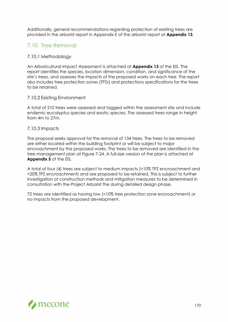
170
Additionally, general recommendations regarding protection of existing trees are provided in the arborist report in Appendix E of the arborist report at Appendix 13.
7.10 Tree Removal
Methodology
An Arboricultural Impact Assessment is attached at Appendix 13 of the EIS. The report identifies the species, location dimension, condition, and significance of the site’s trees, and assesses the impacts of the proposed works on each tree. The report also includes tree protection zones (TPZs) and protections specifications for the trees to be retained.
Existing Environment
A total of 210 trees were assessed and tagged within the assessment site and include endemic eucalyptus species and exotic species. The assessed trees range in height from 4m to 27m.
Impacts
The proposal seeks approval for the removal of 134 trees. The trees to be removed are either located within the building footprint or will be subject to major encroachment by the proposed works. The trees to be removed are identified in the tree management plan at Figure 7-24. A full-size version of the plan is attached at Appendix 5 of the EIS.
A total of four (4) trees are subject to medium impacts (>10% TPZ encroachment and <20% TPZ encroachment) and are proposed to be retained. This is subject to further investigation of construction methods and mitigation measures to be determined in consultation with the Project Arborist the during detailed design phase.
72 trees are identified as having low (<10% tree protection zone encroachment) or no impacts from the proposed development.
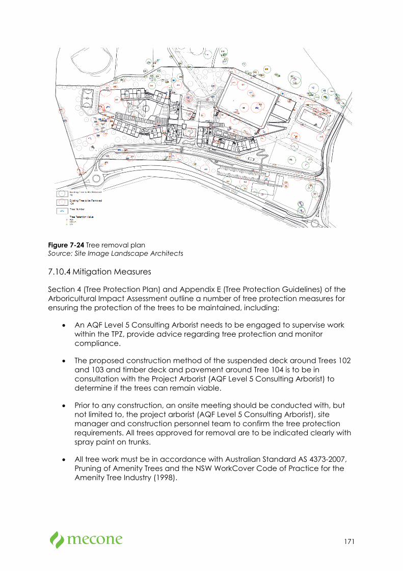
171
Figure 7-24 Tree removal plan Source: Site Image Landscape Architects
Mitigation Measures
Section 4 (Tree Protection Plan) and Appendix E (Tree Protection Guidelines) of the Arboricultural Impact Assessment outline a number of tree protection measures for ensuring the protection of the trees to be maintained, including:
• An AQF Level 5 Consulting Arborist needs to be engaged to supervise work within the TPZ, provide advice regarding tree protection and monitor compliance.
• The proposed construction method of the suspended deck around Trees 102 and 103 and timber deck and pavement around Tree 104 is to be in consultation with the Project Arborist (AQF Level 5 Consulting Arborist) to determine if the trees can remain viable.
• Prior to any construction, an onsite meeting should be conducted with, but not limited to, the project arborist (AQF Level 5 Consulting Arborist), site manager and construction personnel team to confirm the tree protection requirements. All trees approved for removal are to be indicated clearly with spray paint on trunks.
• All tree work must be in accordance with Australian Standard AS 4373-2007, Pruning of Amenity Trees and the NSW WorkCover Code of Practice for the Amenity Tree Industry (1998).
172
• Permission must be granted from the relevant consent authority prior to removing or pruning of any of the subject trees. Approved tree works should not be carried out before the installation of tree protection measures.
• Any additional construction activities within the TPZ of the subject trees must be assessed and approved by the project arborist and must comply with AS 4970-2009 - Protection of trees on development sites.
175 trees are proposed to be planted as part of the landscape plan for the site to offset the loss of trees identified for removal.
Tree’s identified to be retained will be subject to tree protection measures summarised in Table 7-12 below and provided in further detail in Appendix E of the Arboricultural Impact Assessment (Appendix 13).
Table 7-12 Summary of tree protection measures
Type More Details Comment
Signage Appendix E1 Prominently sign posted with 300 mm x 450 mm boards stating,
“NO ACCESS - TREE PROTECTION ZONE”.
Tree protection fencing
Appendix E1 Protective cyclone chain wire link fence to be erected around the TPZ to protect and isolate retained trees from the construction works. Existing boundary fencing may be used.
Crown protection Appendix E2
Where required, crown protection may include the installation of a physical barrier, pruning selected branches to establish clearance, or the tying/bracing of branches.
Trunk and branch protection
Appendix E3
When fencing is not practical or prior to any activities within the TPZ, trunk protection is required and consist of a layer geotextile fabric or similar followed by 1.8 m lengths of softwood timbers spaced evenly around the trunk and secured with a galvanised hoop strap.
Ground protection Appendix E4
Install and maintain 100mm thick layer of mulch around tree in TPZ. For machine or vehicle access within TPZ geotextile fabric beneath crushed rock or rumble boards may be required.
Soil moisture Soil moisture levels should be regularly monitored by the project arborist. Temporary irrigation or watering may be required within TPZ.
Root Protection and investigation
Appendix E5
If incursions/excavation within the TPZ are unavoidable, root investigation may be needed to determine the extent and location of roots within the area of construction activity using non-destructive excavation (NDE) methods.
Underground services Appendix E6
All underground services should be routed outside of the TPZ. If underground services need to be installed within the TPZ, they should be installed using horizontal directional drilling (HDD), non-destructive excavation (NDE) methods such as hydro-vacuum, Air Spade or manually excavated trenches.
173
7.11 Stormwater Drainage
Methodology
A Stormwater Management Plan and preliminary stormwater plans prepared by Cardno are attached at Appendix 16. Combined Civil drawings are also provided in Appendix 15. The report has been prepared in accordance with the Snowy Monaro Regional Council’s Development Engineering Specifications for Engineering works – Design part D5 – Stormwater drainage design.
Proposed Stormwater System
Rainwater Tanks
All roof rainwater is to be collected and piped directly into rainwater tanks through the roof drainage systems, which consists of gutters and pipes. Overflow from rainwater tanks will be piped into the minor stormwater network and conveyed via a trunk stormwater network running along the eastern edge of proposed school discharging onto a combined On-Site Detention Basin(OSD) and Bioretention Basin.
The retained water will be treated for quality and slowly discharged at the rate of pre-development rates to Lees Creek. An easement will be sought over the length of pipe from the site to the designated outfall.
Surface Stormwater
Surface stormwater from the carpark catchment and other areas will be collected by the inlet pit and treated. Such treated runoff will then join other paved areas and conveyed via the minor and trunk stormwater conveyance system to the dual-purpose basin.
On-site detention system is designed for up to 100-year ARI storm events. In case of exceedance of the storm, events greater than 100-year ARI, overflow will flow towards the Lees Creek.
Consultation
A meeting was held with Council staff on 2 July 2021 during which the stormwater management plan and concept drawings were presented. Council confirmed their approval in principle.
Mitigation Measures
Implementation of the proposed stormwater system will ensure adequate capture and treatment of stormwater. Dimensions of downpipes, stormwater pipes, stormwater pits will be determined in the detailed design stage. Water sensitive design is necessary to reduce the impact of urban development on waterways/creek.
No additional mitigation measures are required.
174
7.12 Bushfire
Methodology
A Bushfire Hazard Assessment prepared by Blackash Bushfire Consulting is attached at Appendix 25. The author of the report is accredited by the Fire Protection Association of Australia as a suitably qualified consultant to undertake alternative solution proposals.
The report details proposed bushfire protection measures and demonstrates compliance with Planning for Bush Fire Protection 2019 and demonstrates performance of the development against requirements for Special Fire Protection Purpose development.
Note: A school is a special fire protection purpose under section 100B of the Rural Fires Act 1997. Schools affected by bushfire hazard are required to obtain a bush fire safety authority (BFSA) from the Rural Fire Service and are also “integrated developments” under section 4.45 of the EP&A Act. However, SSD projects are exempt from requiring a BFSA and are not integrated development.
Existing Environment
The site is not designated as ‘bushfire prone land’ for the purposes of section 10.3 of the EPA Act 1979.
While the site is not designated as being Bushfire Prone, the NSW Rural Fire Service Letter dated 1 April 2021 states:
Although the subject site is not currently mapped as bush fire prone land, the vegetation on and surrounding the site constitutes a bushfire hazard.
The land surrounding the site contains remnant grassland and woodland vegetation to the north, northwest and east of the site. A narrow band of remnant trees are within a gully to south of the site. Grassland is to the southwest and southeast of the site and western side of Barry Way.
Slopes to the north and east of the site are in the 0-5 and 5-10 degree downslope range, whilst land to the west and south of the site are generally unsloped.
Asset Protection Zone (APZ)
The development is required to provide an APZ between 36-60m around the site as shown in Figure 7-25. An APZ of approximately 3,232m2 is proposed off site as the High-Performance ski jumps are being built. This area will be managed as part of the APZ by JSRC. All land within the site will be managed as an Inner Protection Area. The areas within the school site include built areas, sports fields, and managed areas. The road verge between Barry Way and the site is to be maintained.
A small area of APZ is offsite to the northeast of the site. This area is currently being developed for the Alpine Winter Sports complex. The hazard in these areas has been removed and developed.

175
A small area (3,232m2) of grassland will be managed by the Department of Education under license from the Department of Sport and Recreation. The off-site APZ will be maintained as an Inner Protection Area until such time as the areas is developed for more ski jumps associated with the High-Performance Winter Sport Precinct within the NSW Sport and Recreation site. The license will include a termination clause when this work is commenced and managed by Sport and Recreation.
All areas within the site (see Figure 7-25) and the small off site APZ will be managed as an Inner Protection Area.
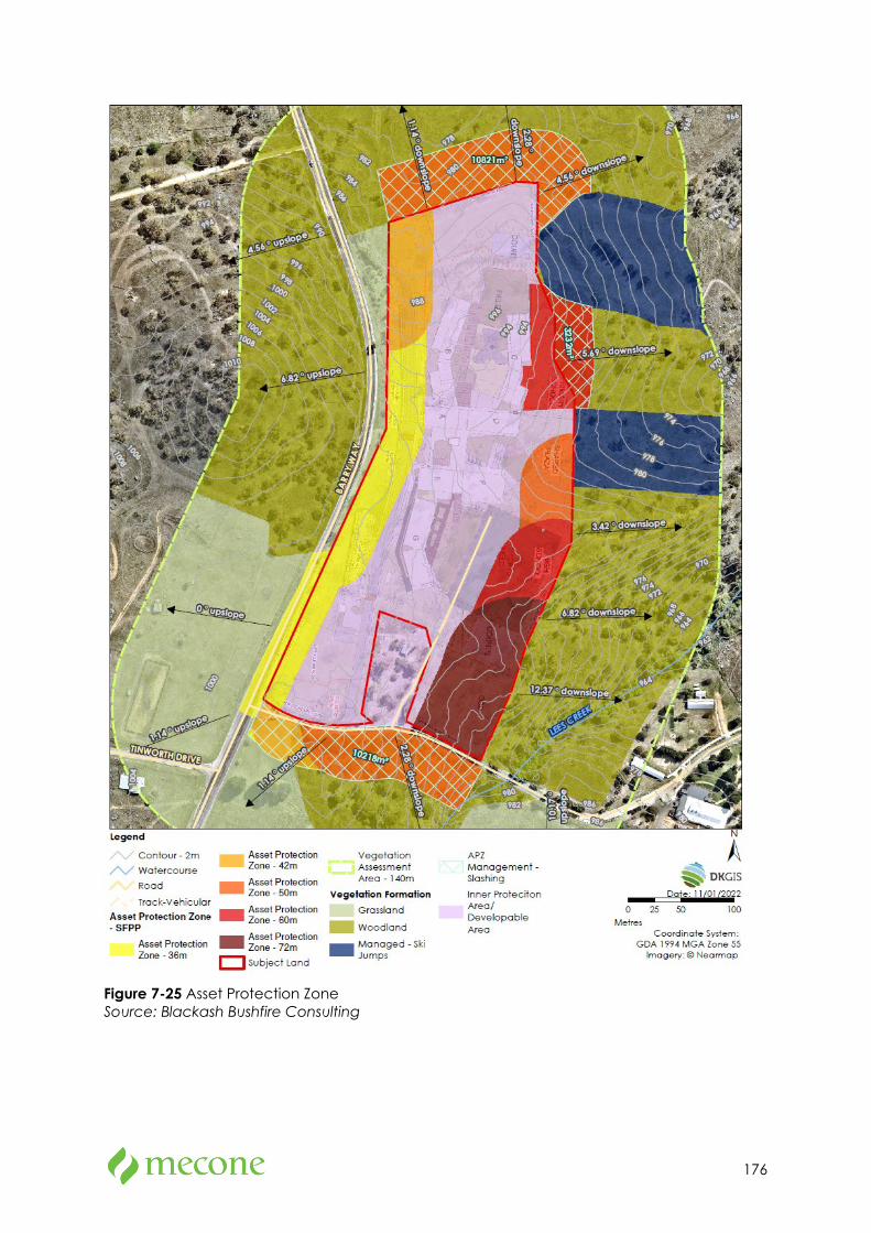
176
Figure 7-25 Asset Protection Zone Source: Blackash Bushfire Consulting
177
Mitigation Measures
The following bushfire protection measures identified in section 17 of Appendix 25 are recommended to ensure compliance with PBP:
• Buildings within the site are built to BAL 12.5 in accordance with the Australian Standard for Construction of Buildings in Bushfire Prone Areas.
• Prior to the issue of a Construction Certificate for the new building, the school shall update the Bushfire Emergency Management and Evacuation Plan that is locally relevant and tailored with key stakeholders to a range of scenarios.
• APZs are provided in accordance with Figure 7 within the Bush Fire Hazard Assessment.
7.13 Flooding
Methodology
A Flood Assessment has been prepared by Martens & Associates Pty Ltd is attached at Appendix 18. The assessment was prepared using the following methodology:
• Prepare a hydrologic model (RAFTS) for the site to determine the peak flow of the 1% annual exceedance probability (AEP) flood with and without climate change and probable maximum flood (PMF) events.
• Prepare a hydraulic model (TUFLOW) for the site under existing conditions.
• Prepare relevant flood maps including flood extents, depths, levels, velocities, and hazards.
• Comment on flood characteristics and model outcomes in existing and proposed conditions.
• Prepare preliminary flood emergency response plan (FERP) comments.
• Prepare a compliance assessment in accordance with Snowy Monaro Regional Council (SMRC) floodplain development controls.
Existing Environment
The lot is approximately 985 AHD at the northern boundary and 1001m AHD at the western boundary. The lot is primarily grassed at higher elevations and low-density bushland at lower elevations.
Lees Creek is located to the east of the site running from south to north. There are several minor pipelines on Barry Road and the internal road along the site boundary to the south.
178
Flood Modelling
The DRAINS software package was used with the RAFTS hydrological engine to assess the 1% AEP flood (with and without climate change) and PMF peak flow rates for a range of storm durations between 5 minutes and 168 hours. The results of the peak flow rates for catchments arriving at the site for the critical duration 1% annual expected probability (AEP) flood event with climate change to be a total of 51.5m3 per second.
The TUFLOW hydraulic model was also used to determine flood characteristics including flood extents, levels, depths, velocities, and hydraulic hazard for the critical 1% AEP flood with and without climate change and probable maximum flood (PMF) events for existing conditions.
The results of the hydraulic modelling found that the primary source of site flooding is overbank flows from Lees Creek and shallow overland flow in local drainage depressions. The peak 1% AEP flood and PMF levels in Lees Creek adjacent to the proposed development area are approximately 969.6 m AHD and 970.0 m AHD respectively. Proposed building ground FFLs range between 994.5-996.2 m AHD, hence Lees Creek flood waters do not affect the proposed development.
Assessment and Impacts
Based on hydraulic and hydraulic modelling conducted, the proposed flooding conditions are expected to be unchanged from existing conditions as:
• The proposed development area is predominately flood free with all building finished floor levels above Flood Planning Levels (FPL) and PML, and
• The proposed development is located well above the mainstream flooding levels in Lees Creek.
As the proposed development area is flood free in all flood events to and including PMF, the proposal would have acceptable offsite flood impacts.
Flood risks to life on site are low, and both evacuation and shelter-in-place emergency response strategies are available to further mitigate flood risks.
Furthermore, a compliance assessment prepared in the Flood Assessment demonstrates the site can be developed in accordance with Council flood planning requirements.
Mitigation Measures
Whilst the proposed development is not affected by flood hazards during all events up to and including the PMF event, it is recommended that school management subscribes to the relevant flood warning systems and maintain communication with SES and local police at all times with respect to flood emergency response.
The proposed development has been designed to ensure compatibility with the existing floodplain environment. As the proposed development has been designed
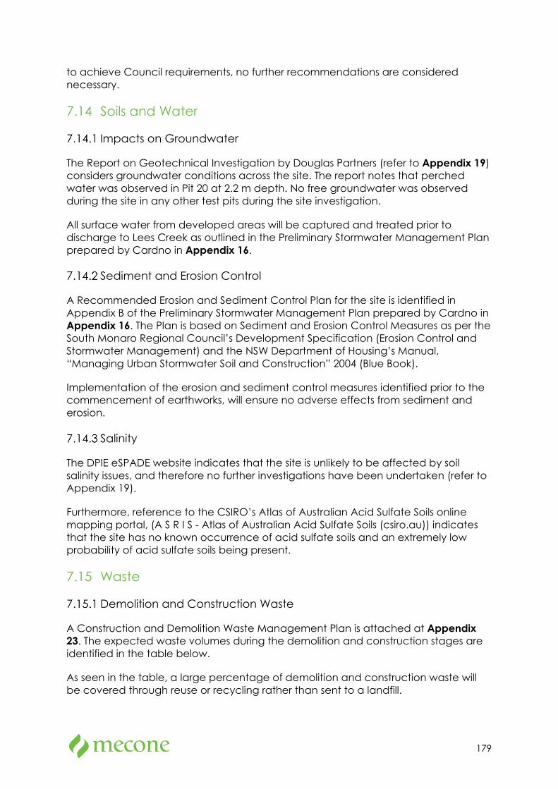
179
to achieve Council requirements, no further recommendations are considered necessary.
7.14 Soils and Water
Impacts on Groundwater
The Report on Geotechnical Investigation by Douglas Partners (refer to Appendix 19) considers groundwater conditions across the site. The report notes that perched water was observed in Pit 20 at 2.2 m depth. No free groundwater was observed during the site in any other test pits during the site investigation.
All surface water from developed areas will be captured and treated prior to discharge to Lees Creek as outlined in the Preliminary Stormwater Management Plan prepared by Cardno in Appendix 16.
Sediment and Erosion Control
A Recommended Erosion and Sediment Control Plan for the site is identified in Appendix B of the Preliminary Stormwater Management Plan prepared by Cardno in Appendix 16. The Plan is based on Sediment and Erosion Control Measures as per the South Monaro Regional Council’s Development Specification (Erosion Control and Stormwater Management) and the NSW Department of Housing’s Manual, “Managing Urban Stormwater Soil and Construction” 2004 (Blue Book).
Implementation of the erosion and sediment control measures identified prior to the commencement of earthworks, will ensure no adverse effects from sediment and erosion.
Salinity
The DPIE eSPADE website indicates that the site is unlikely to be affected by soil salinity issues, and therefore no further investigations have been undertaken (refer to Appendix 19).
Furthermore, reference to the CSIRO’s Atlas of Australian Acid Sulfate Soils online mapping portal, (A S R I S - Atlas of Australian Acid Sulfate Soils (csiro.au)) indicates that the site has no known occurrence of acid sulfate soils and an extremely low probability of acid sulfate soils being present.
7.15 Waste
Demolition and Construction Waste
A Construction and Demolition Waste Management Plan is attached at Appendix 23. The expected waste volumes during the demolition and construction stages are identified in the table below.
As seen in the table, a large percentage of demolition and construction waste will be covered through reuse or recycling rather than sent to a landfill.
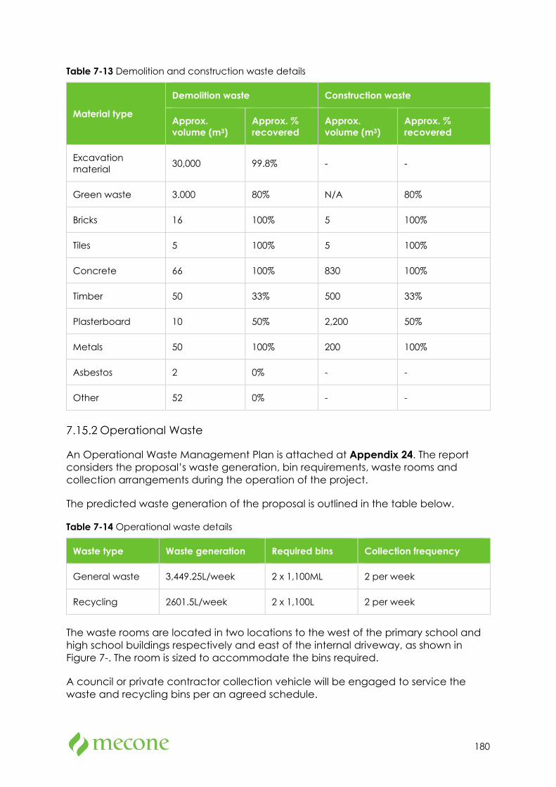
180
Table 7-13 Demolition and construction waste details
Material type
Demolition waste Construction waste
Approx. volume (m3)
Approx. % recovered
Approx. volume (m3)
Approx. % recovered
Excavation material 30,000 99.8% - -
Green waste 3.000 80% N/A 80%
Bricks 16 100% 5 100%
Tiles 5 100% 5 100%
Concrete 66 100% 830 100%
Timber 50 33% 500 33%
Plasterboard 10 50% 2,200 50%
Metals 50 100% 200 100%
Asbestos 2 0% - -
Other 52 0% - -
Operational Waste
An Operational Waste Management Plan is attached at Appendix 24. The report considers the proposal’s waste generation, bin requirements, waste rooms and collection arrangements during the operation of the project.
The predicted waste generation of the proposal is outlined in the table below.
Table 7-14 Operational waste details
Waste type Waste generation Required bins Collection frequency
General waste 3,449.25L/week 2 x 1,100ML 2 per week
Recycling 2601.5L/week 2 x 1,100L 2 per week
The waste rooms are located in two locations to the west of the primary school and high school buildings respectively and east of the internal driveway, as shown in Figure 7-. The room is sized to accommodate the bins required.
A council or private contractor collection vehicle will be engaged to service the waste and recycling bins per an agreed schedule.
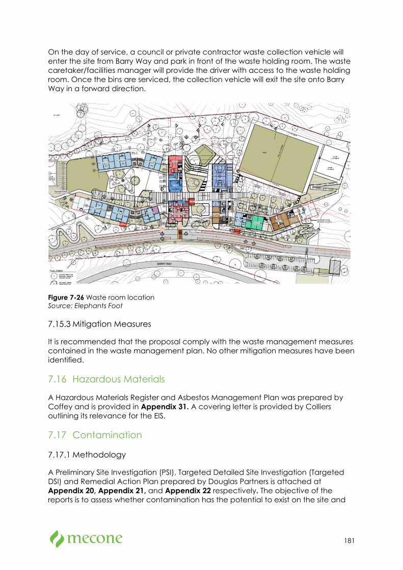
181
On the day of service, a council or private contractor waste collection vehicle will enter the site from Barry Way and park in front of the waste holding room. The waste caretaker/facilities manager will provide the driver with access to the waste holding room. Once the bins are serviced, the collection vehicle will exit the site onto Barry Way in a forward direction.
Figure 7-26 Waste room location Source: Elephants Foot
Mitigation Measures
It is recommended that the proposal comply with the waste management measures contained in the waste management plan. No other mitigation measures have been identified.
7.16 Hazardous Materials
A Hazardous Materials Register and Asbestos Management Plan was prepared by Coffey and is provided in Appendix 31. A covering letter is provided by Colliers outlining its relevance for the EIS.
7.17 Contamination
Methodology
A Preliminary Site Investigation (PSI), Targeted Detailed Site Investigation (Targeted DSI) and Remedial Action Plan prepared by Douglas Partners is attached at Appendix 20, Appendix 21, and Appendix 22 respectively. The objective of the reports is to assess whether contamination has the potential to exist on the site and
182
identify measures to ensure the site is suitable or can be made suitable for the proposed use.
Site History
The site history information suggests that the site was used for agricultural purposes (pastoral land) from between 1916 to 1952. From 1952 to 1972, the site was owned by the Snowy Mountains Hydro-Electric Authority before becoming Crown land in 1972. Residential structures were noted in the aerial photograph from 1964 and removed prior to 1979 (based on aerial imagery), possibly after the land was transferred as Crown land.
From 1994 to 2006, the land was owned by the Minister for Education until the land was transferred to the current owner in 2006 to the Minister Administrating the Sporting Venues Management Act 2002. The aerial photograph from 1992 suggests that sometime between 1988 and 1992, part of a golf course had been constructed on the site. The site still appears to be part of a golf course in the 2018 aerial photograph.
Existing Environment
Douglas Partner’s site walkover identified the following existing site features relevant to contamination assessment within the Preliminary Site Investigation:
• The site comprised a former golf course and was moderately to heavily grassed with sporadic clumps of mature trees located across the site,
• A small storage shed was located on the southern half of the eastern boundary of the site. The storage shed was in good condition and appeared to have been recently constructed. At the time of the walkover, the shed was inaccessible. There were no obvious signs of chemical or fuel storage around the storage shed,
• Shallow rock and some rock outcroppings were present across the southern half of the site. The rock appeared to be moderately to slightly weathered granodiorite. Along the central eastern boundary and central northern portion of the site, some surface rock was observed. The surface rock also appeared to be moderately weathered granodiorite,
• Five small areas of sand and remnant topsoil were noted within the southern portion of the site. It is likely that they were once greens from the previous golf course,
• A potential fill pad or potential site cut was noted south of the storage shed, along the eastern portion of the site,
• Five fill pads were noted within the central portion and north-west corner of the site. The fill pads appeared to be remnant tee-off points and greens from the former golf course,
• Potential surface fill was noted across the north-east corner of the site,
183
• Services were noted across the site including water and irrigation services and communication services. The service trenches have to potential to contain uncontrolled/undocumented fill,
• Two concrete blocks were noted within the ground along the eastern boundary. The blocks were potentially old foundations from the previous residential dwellings noted in the 1962 Aerial Photograph,
• Sporadic inert waste was observed across the site. The waste included fragments of PVC pipe, concrete fragments, minor amounts of brick and plastic food packaging,
• An unsealed track was present through the northern portion of the site. The unsealed track was a haulage road for machinery and trucks for the construction of a BMX track north of the site,
• Part of a ski-jump construction site is located within the central northern portion of the site. The construction site comprised a number of large spoil stockpiles from excavations north-east of the site. The spoil comprises of residual clay and rock of varying degrees of weathering. The spoil was in the process of being sorted for the filling of the ski-jump,
• The south-eastern portion of the site comprised an undulating area that had an overall slope from the west, down towards the east. Several existing residential properties were noted across the area. Underground services were also present in this area,
• No evidence of staining or odorous soils was noted during the site inspection,
• No evidence of underground fuel storage tanks or above fuel storage tanks were noted during the site inspection, and
• Two potential asbestos containing material (PACM) fragments were noted during the site walkover within the south-eastern portion of the site. It is noted that DP’s scope did not include a hazardous building materials assessment.
Preliminary Site Investigation
Based on the findings of the PSI, the following potential sources of contamination and associated contaminants of potential concern (COPC) were identified.
1. Fill: Associated with levelling and development of the golf course, demolition of former residential dwellings on the site and former unsealed roads that were present across the site.
o COPC include metals, total recoverable hydrocarbons (TRH), benzene, toluene, ethylbenzene, xylene (BTEX), polycyclic aromatic hydrocarbons (PAH), polychlorinated biphenyls (PCB), organochlorine pesticides (OCP), phenols and asbestos.
2. Former residential dwellings and underground services dating back to the 1960’s.
184
o COPC include asbestos, synthetic mineral fibres (SMF), lead (in paint) and PCB.
3. Application of pesticides, herbicides, and fungicides to the golf course.
o COPC include metals, OCP/OPP, herbicides and fungicides.
A limited targeted sampling strategy and opportunistic sampling from the concurrent geotechnical test pits was adopted for further analysis. Locations were selected primarily to target areas of the proposed development for geotechnical purposes with concurrent sampling for contaminated land investigation purposes.
The field work comprised of 28 test pits consisting of variable subsurface conditions including topsoil/topsoil fill, fill, natural soils and intrusive volcanics. Analytical results for all contaminants tested in all samples were below the site assessment criteria (SAC) except for zinc in sample Pit25/0.1, chlordane in sample Pit23/0.1, Chrysotile asbestos, Amosite asbestos, and Crocidolite asbestos in and near Pit 25.
While the reported chemical exceedances of the adopted SAC are marginal, given the limited nature of the PSI undertaken to date, it is considered appropriate that further intrusive investigation should be undertaken on these identified areas and other areas of the site with the same potential sources of contamination that have not yet been intrusively investigated.
Furthermore, based on the identified presence of fragments of asbestos containing material in the area of former residential development in the south-eastern portion of the site, it is considered appropriate that further asbestos investigation should be undertaken in this area.
Targeted Detailed Site Investigation
This targeted DSI was undertaken to further assess Areas of Environmental Concerns (AEC) identified during previous works undertaken at the site by the PSI. Previous investigations had identified asbestos, metals/metalloids and pesticide use as the primary contaminants of concern, associated with previous residential dwellings located within the south-eastern portion of the site and the former golf course which had comprised the remaining portions of the site.
The analytical results indicated that bonded asbestos was identified within the material samples collected from test pit spoil (Pits 102, 116 and 117) and a material sample (M113) collected from the ground surface of the south-eastern portion of the site. The findings indicated that the presence of asbestos on the ground surface exceeded the adopted Health Screening Level-A.
All soil results for TRH, BTEX, PAH, OCP, OPP and PCB were below the laboratory’s practical quantitation limit (PQL) except for aldrin and dieldrin in samples Pit 127/0.1 m (0.1 mg/kg) and Pit 130/0.1 m (0.1 mg/kg) but were below the adopted SAC. Total chlordane in samples Pit 127/0.1 m (0.6 mg/kg) and Pit 130/0.1 m (0.7 mg/kg) were above the PQL but below the adopted SAC. All soil results for metals were above the PQL except for arsenic, cadmium, and mercury, but below the adopted site criteria.
185
Based on the results of the targeted DSI, it is considered that the site is not currently suitable for the proposed use as a school, due to the presence of asbestos in topsoil fill material present within the south-eastern portion of the site. Further analysis of past pesticide use and presence of metals/metalloids within the topsoil fill indicated that there is a low risk for metal/metalloids and pesticide contamination, however, it is considered that fill associated with the tees and greens should be managed/remediated appropriately.
The targeted DSI recommends that a Remedial Action Plan (RAP) should be developed to address contamination identified at the site to render the site suitable for the proposed development. The targeted DSI also recommends the following measures are undertaken at the site during any future development works:
• A Construction Environment Management Plan (CEMP) should also be prepared including an ‘unexpected finds protocol’ which would include an asbestos finds protocol, and implemented during the works (i.e., hydrocarbon staining and/or odours, PACM in other areas of the site etc. be observed during future earthworks),
• Should any fill material (i.e., the tee and green pads on site) be required to be disposed off-site, the material must be assessed in accordance with NSW EPA Waste Classification Guidelines Part 1 Classifying Waste (2014) and assigned a waste classification prior to off-site disposal.
Remedial Action Plan
The Remedial Action Plan provides a strategy for the remediation of the site including environmental safeguards and procedures required to render the site suitable for the proposed education establishment.
Remediation Goal
The goal/objective of the remediation will be to render the site compatible with the proposed land use (primary school and high school).
Extent of Remediation
The extent of remediation is summarised below:
• Asbestos Containing Material (ACM) impact identified in the area of where the former residential dwellings were once located,
• Identified OCP (chlordane) and potential OCP associated with the former golf course greens and tees, and
• Aesthetic impacts (fill areas i.e. tees, greens and where previous and current residential dwellings were/are located)
The likely extent of the identified impacts is shown in Figure 7- . It is noted that once current residential dwellings are removed, some additional ACM is likely to be encountered and may require similar treatment.
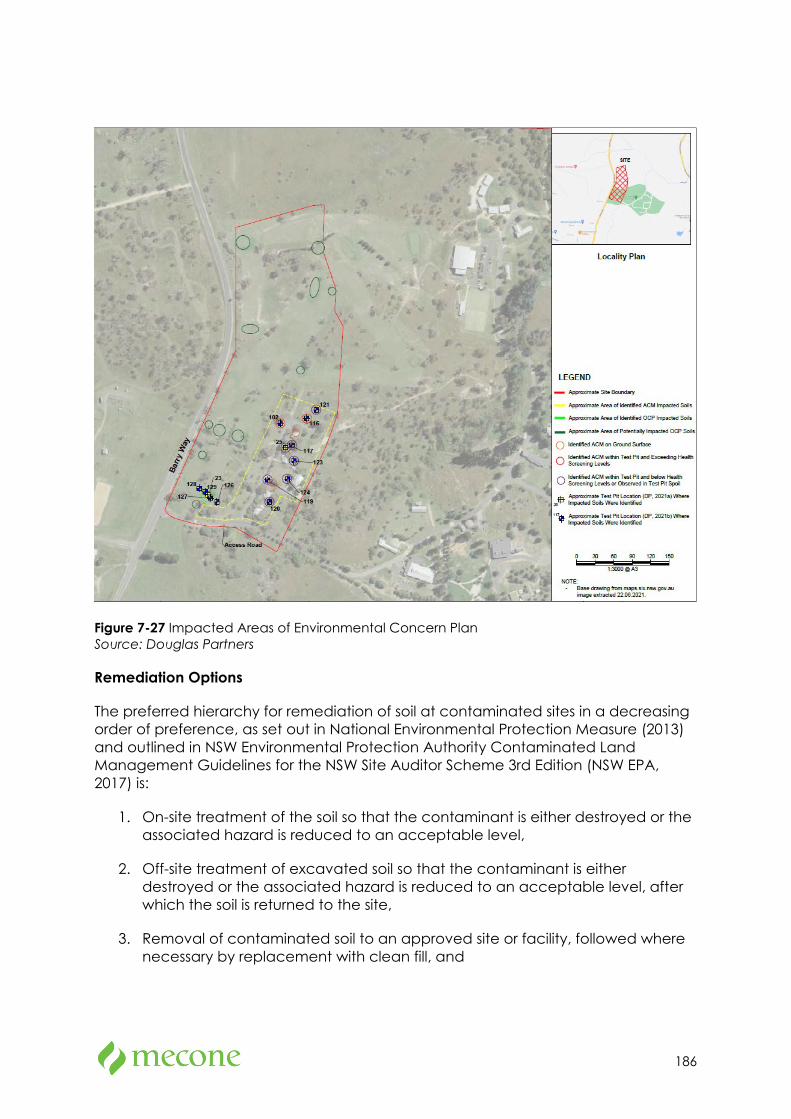
186
Figure 7-27 Impacted Areas of Environmental Concern Plan Source: Douglas Partners
Remediation Options
The preferred hierarchy for remediation of soil at contaminated sites in a decreasing order of preference, as set out in National Environmental Protection Measure (2013) and outlined in NSW Environmental Protection Authority Contaminated Land Management Guidelines for the NSW Site Auditor Scheme 3rd Edition (NSW EPA, 2017) is:
1. On-site treatment of the soil so that the contaminant is either destroyed or the associated hazard is reduced to an acceptable level,
2. Off-site treatment of excavated soil so that the contaminant is either destroyed or the associated hazard is reduced to an acceptable level, after which the soil is returned to the site,
3. Removal of contaminated soil to an approved site or facility, followed where necessary by replacement with clean fill, and
187
4. Consolidation and isolation of the soil by on-site containment within a properly designed barrier.
Douglas Partners have been advised by the client would prefer to remediate the site using Options 2 and 4.
Regarding OCP and Aesthetic impact remediation, Douglas Partners recommends that option 4 is utilised.
Details of the envisaged scope of works for each option recommended by Douglas Partners is addressed in section 11 of the Remedial Action Plan in Appendix 22.
Remediation Strategy
Considering the nature and potential extent of remediation required and the proposed development, the recommended remediation approaches are summarised below (in general order). It is noted that remediation works should not commence until the current site residential dwellings have been demolished and further inspections for the presence of ACM conducted:
1. Set up the remediation area,
2. Remediate areas containing ACM, OCP and aesthetic impacts (Refer to Drawing 3, Appendix B in Appendix 22 for known lateral extent of impact),
3. For any material that is proposed to be disposed off-site, the material will need to be sampled to prepare a waste classification assessment, and
4. Validate excavation footprints of remediated areas.
Detailed procedures and sequence for remediation work will rest with the contractor and will depend upon the equipment to be used and the overall sequence of the remediation or development. It is the contractor's responsibility to devise a safe work method statement and to implement proper controls that enable the personnel undertaking the remediation to work in a safe environment.
Mitigation Measures
The remediation of the site is required to render the site suitable for the proposed land use and must be carried out in accordance with all mitigation measures outlined within the RAP in Appendix 22.
7.18 Aviation
Methodology
An Aviation Safeguarding Assessment is attached at Appendix 30. The report assesses the proposal’s potential impacts on the operations of the nearby airports and affected flight paths in the context of the relevant regulatory requirements and guidelines.
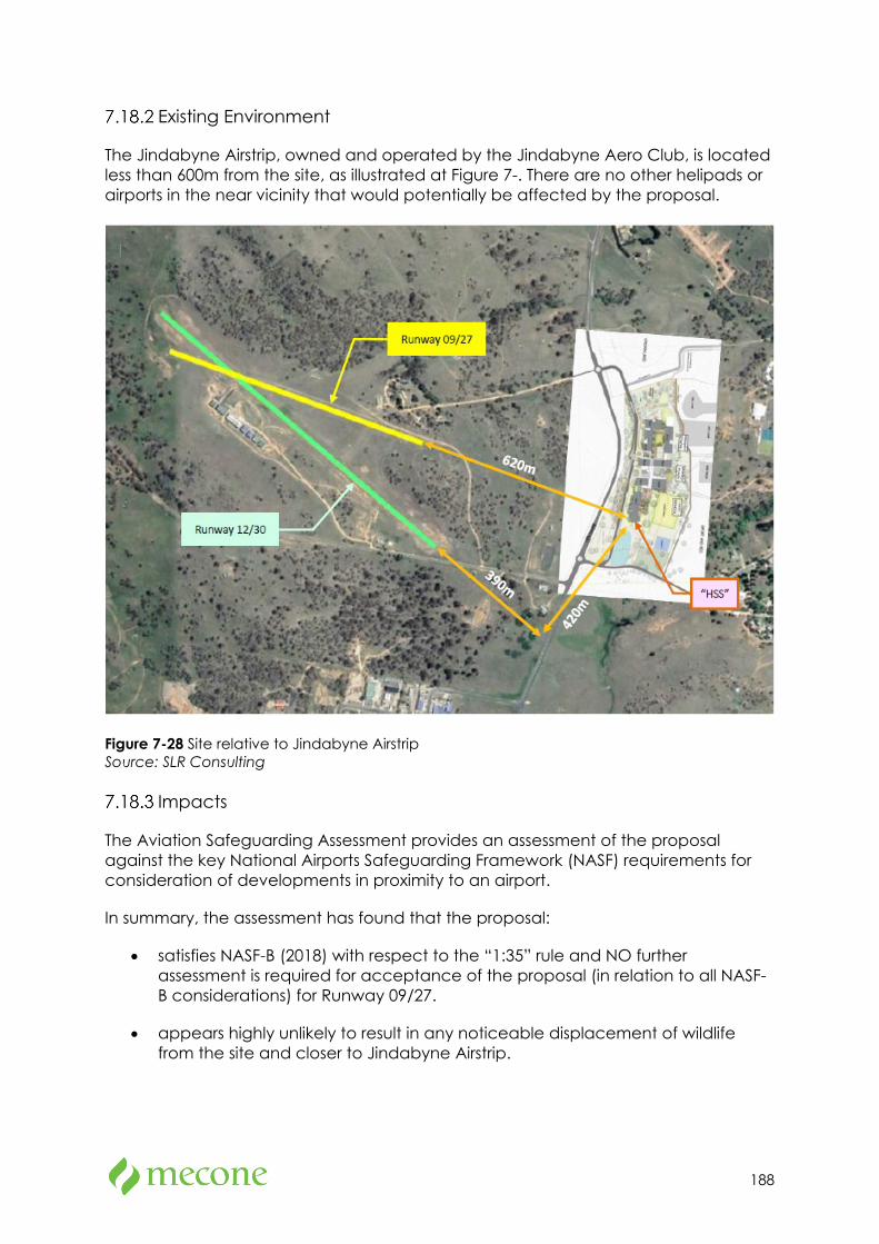
188
Existing Environment
The Jindabyne Airstrip, owned and operated by the Jindabyne Aero Club, is located less than 600m from the site, as illustrated at Figure 7-. There are no other helipads or airports in the near vicinity that would potentially be affected by the proposal.
Figure 7-28 Site relative to Jindabyne Airstrip Source: SLR Consulting
Impacts
The Aviation Safeguarding Assessment provides an assessment of the proposal against the key National Airports Safeguarding Framework (NASF) requirements for consideration of developments in proximity to an airport.
In summary, the assessment has found that the proposal:
• satisfies NASF-B (2018) with respect to the “1:35” rule and NO further assessment is required for acceptance of the proposal (in relation to all NASF-B considerations) for Runway 09/27.
• appears highly unlikely to result in any noticeable displacement of wildlife from the site and closer to Jindabyne Airstrip.
189
• requires further assessment of lighting design during detailed design to ensure NASF-E lighting recommendations can be adhered to if Jindabyne Aero Club are to confirm the expansion of the airstrip to involve night-time operations.
• if lighting towers used for the proposal Sports Field are less than 50 m in height, no lighting towers associated with the proposal would penetrate Jindabyne Airstrip’s OLS.
• would have no impacts on the communication, navigation, and surveillance (CNS) facilities of the Jindabyne Airstrip (which currently has no CNS) in relation to NASF-G.
• would have no impact on the conceivable helicopter-related obstacle limitation surface (OLS) at Jindabyne airstrip.
Mitigation Measures
The following mitigation measures are recommended:
• Communication with Jindabyne Aero Club be continued in relation to any future airstrip master planning to ensure that the objectives of NASF-E (2014), NASF-G (2016) and NASF-I (2018) continue to be addressed where relevant.
• Communication with Jindabyne Aero Club be made in relation to the siting and maximum height of the construction cranes to be used for the proposal, once these details are known.
• Following consultation with Jindabyne Aero Club regarding potential future operations at the airstrip, the above recommendations should be reviewed as to any potential obstacle marking and/or lighting requirements for the proposal construction cranes and Sports Field flood lighting.
7.19 Utilities
An infrastructure management plan prepared by the NDY is provided at Appendix 14. The existing site infrastructure and proposed upgrades are summarised in the table below.
Table 7-15 Utilities details
Utility Existing Required upgrades
Potable water The site is serviced by incoming water mains.
A new potable water connection shall be made to the existing Snowy Monaro Council potable water main located within Barry Road. Final connection location to be confirmed upon application for a new connection to the council.
Sewer There is an existing Snowy Monaro Regional Council
The sewer connection shall be completed with boundary trap, overflow relief gully and an IPMF. Venting to waste pipes will be
190
Utility Existing Required upgrades
sewer line which traverses the site.
provided to maintain fixture trap seals and adequate flow throughout the systems.
The existing sewer line traversing the site will need to be modified to suit the new building locations and site levels. The realignment will consider access for maintenance and minimise the amount of access to the school site.
Gas There is no natural gas infrastructure in the vicinity of the site available for connection or extension
8kL LPG gas tank will be provided for the proposed new school to meet the gas demands. Final location of the tank must be coordinated during detailed design.
Electricity Currently, there is no HV power supply to the site, apart from an existing pole mounted substation which is proposed to be demolished to accommodate the sports field.
The electrical supply to the site is proposed to be from a new 1500KV Essential Energy padmount substation.
The consumer mains cabling reticulation will be via underground electrical conduits and pits to the main switchboard, which will be located inside the main switchboard room (MSR).
A high voltage easement will be required from the coupling point on Barry Way to the new transformer location in front of the site.
An application for connection has been submitted and a Design Information Package (DIP) has been received from Essential Energy. The new connection requires approximately 1.2km of new HV network extension to the north and south of the site.
Photovoltaic Solar Power (PV system)
Nil A 70kW photovoltaic (PV) solar power grid-connect rooftop system shall be provided to offset power consumption costs at the school. The PV system will require approval from Essential Energy, an application to connect the PV system will be required detailing the installed system.
Telecommunications
There is an existing Telstra/NBN pit in front of the site and existing underground conduits alongside Barry Way.
The proposal will connect to the existing infrastructure as required.
191
8 Assessment of other Issues
8.1 Geotechnical
A Report on Geotechnical Investigation prepared by Douglas Partners is attached at Appendix 19. The report provides the results of intrusive geotechnical investigations to inform the schematic and detailed design of the proposal. The report concludes that the site is geotechnically suitable for the proposed development and provides comments regarding site preparation, likely reactivity site classifications, retaining wall design parameters, foot design parameters. Drainage and pavement design considerations.
8.2 Accessibility
An Access Report prepared by MBC Group is attached at Appendix 28. The report identifies the extent to which the design complies with the accessibility provisions of the BCA. The report concludes that the proposal can comply with the accessibility provisions of the BCA, either by meeting the deemed-to-satisfy requirements or via a performance-based approach.
8.3 BCA
A BCA Assessment Report prepared by MBC Group is attached at Appendix 29. The assessment confirms that the proposal can comply with the relevant requirements of the BCA, subject to resolution of several minor items. These minor items do not require changes to the overall design and can be addressed at the construction certificate stage.
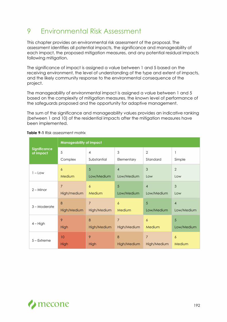
192
9 Environmental Risk Assessment This chapter provides an environmental risk assessment of the proposal. The assessment identifies all potential impacts, the significance and manageability of each impact, the proposed mitigation measures, and any potential residual impacts following mitigation.
The significance of impact is assigned a value between 1 and 5 based on the receiving environment, the level of understanding of the type and extent of impacts, and the likely community response to the environmental consequence of the project.
The manageability of environmental impact is assigned a value between 1 and 5 based on the complexity of mitigation measures, the known level of performance of the safeguards proposed and the opportunity for adaptive management.
The sum of the significance and manageability values provides an indicative ranking (between 1 and 10) of the residential impacts after the mitigation measures have been implemented.
Table 9-1 Risk assessment matrix
Significance of impact
Manageability of impact
5
Complex
4
Substantial
3
Elementary
2
Standard
1
Simple
1 – Low 6
Medium
5
Low/Medium
4
Low/Medium
3
Low
2
Low
2 – Minor 7
High/medium
6
Medium
5
Low/Medium
4
Low/Medium
3
Low
3 – Moderate 8
High/Medium
7
High/Medium
6
Medium
5
Low/Medium
4
Low/Medium
4 – High 9
High
8
High/Medium
7
High/Medium
6
Medium
5
Low/Medium
5 – Extreme 10
High
9
High
8
High/Medium
7
High/Medium
6
Medium

193
Table 9-2 Environmental risk assessment
Item Potential Impact
Sign
ifica
nce
of
impa
ct
Man
agea
bilit
y of
impa
ct
Mitigation measure
Resid
ual
impa
ct
Environmental amenity
Minor potential changes to wind conditions at the site
1 1 No mitigation measures identified
2 (Low)
Views to and from the site will change
2 1 No mitigation measures identified
3 (Low)
Light spillage visible to surrounding properties
1 2 Implement standard measures to reduce light spill
3 Low
Transport and accessibility
Potential conflict between construction vehicles and other vehicles/pedestrians
2 2 Finalise and implement construction traffic management plan
4 (Low / medium)
Increased vehicular traffic during operation
2 2 Implement the School Transport Plan
4 (Low / medium)
Pedestrian and Bicycle Infrastructure upgrades are not delivered before the commencement of the proposal
4 2 Maintain regular correspondence and program updates from Snowy SAP team to ensure infrastructure is delivered in a timely manner.
6 (medium)
ESD Potential inefficient use of energy and resources
1 2 Green Star 4-star certification
Assessment of climate change scenarios as recommended in the ESD report
3 (Low)
Heritage Archaeological potential associated with existing cottages on site
2 1 No mitigation measures identified
2 (Low)
Aboriginal heritage
Damage to archaeological artefacts
3 3 Test excavations are currently being undertaken to establish extent and scientific
6 (medium)
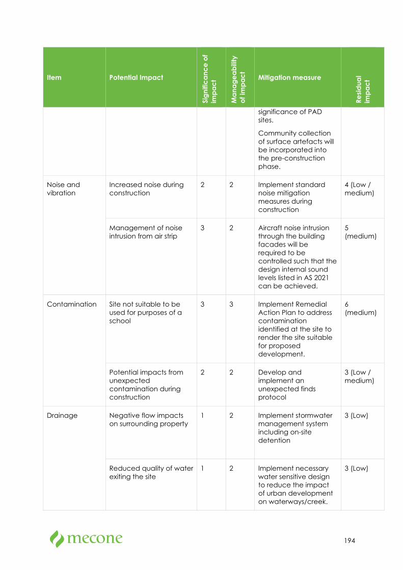
194
Item Potential Impact
Sign
ifica
nce
of
impa
ct
Man
agea
bilit
y of
impa
ct
Mitigation measure
Resid
ual
impa
ct
significance of PAD sites.
Community collection of surface artefacts will be incorporated into the pre-construction phase.
Noise and vibration
Increased noise during construction
2 2 Implement standard noise mitigation measures during construction
4 (Low / medium)
Management of noise intrusion from air strip
3 2 Aircraft noise intrusion through the building facades will be required to be controlled such that the design internal sound levels listed in AS 2021 can be achieved.
5 (medium)
Contamination Site not suitable to be used for purposes of a school
3 3 Implement Remedial Action Plan to address contamination identified at the site to render the site suitable for proposed development.
6 (medium)
Potential impacts from unexpected contamination during construction
2 2 Develop and implement an unexpected finds protocol
3 (Low / medium)
Drainage Negative flow impacts on surrounding property
1 2 Implement stormwater management system including on-site detention
3 (Low)
Reduced quality of water exiting the site
1 2 Implement necessary water sensitive design to reduce the impact of urban development on waterways/creek.
3 (Low)
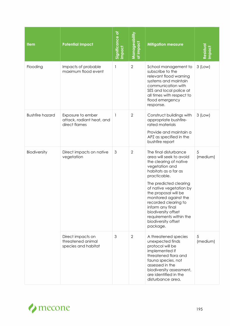
195
Item Potential Impact
Sign
ifica
nce
of
impa
ct
Man
agea
bilit
y of
impa
ct
Mitigation measure
Resid
ual
impa
ct
Flooding Impacts of probable maximum flood event
1 2 School management to subscribe to the relevant flood warning systems and maintain communication with SES and local police at all times with respect to flood emergency response.
3 (Low)
Bushfire hazard Exposure to ember attack, radiant heat, and direct flames
1 2 Construct buildings with appropriate bushfire-rated materials
Provide and maintain a APZ as specified in the bushfire report
3 (Low)
Biodiversity Direct impacts on native vegetation
3 2 The final disturbance area will seek to avoid the clearing of native vegetation and habitats as a far as practicable.
The predicted clearing of native vegetation by the proposal will be monitored against the recorded clearing to inform any final biodiversity offset requirements within the biodiversity offset package.
5 (medium)
Direct impacts on threatened animal species and habitat
3 2 A threatened species unexpected finds protocol will be implemented if threatened flora and fauna species, not assessed in the biodiversity assessment, are identified in the disturbance area.
5 (medium)
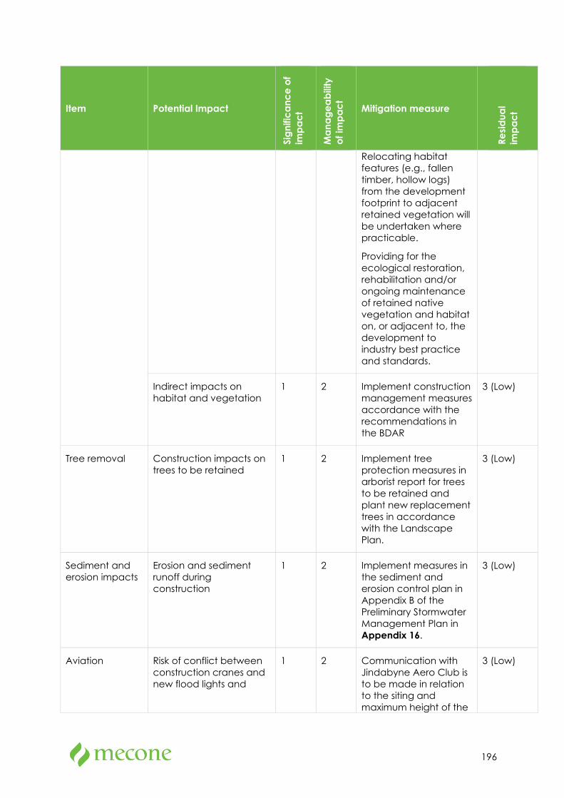
196
Item Potential Impact
Sign
ifica
nce
of
impa
ct
Man
agea
bilit
y of
impa
ct
Mitigation measure
Resid
ual
impa
ct
Relocating habitat features (e.g., fallen timber, hollow logs) from the development footprint to adjacent retained vegetation will be undertaken where practicable.
Providing for the ecological restoration, rehabilitation and/or ongoing maintenance of retained native vegetation and habitat on, or adjacent to, the development to industry best practice and standards.
Indirect impacts on habitat and vegetation
1 2 Implement construction management measures accordance with the recommendations in the BDAR
3 (Low)
Tree removal Construction impacts on trees to be retained
1 2 Implement tree protection measures in arborist report for trees to be retained and plant new replacement trees in accordance with the Landscape Plan.
3 (Low)
Sediment and erosion impacts
Erosion and sediment runoff during construction
1 2 Implement measures in the sediment and erosion control plan in Appendix B of the Preliminary Stormwater Management Plan in Appendix 16.
3 (Low)
Aviation Risk of conflict between construction cranes and new flood lights and
1 2 Communication with Jindabyne Aero Club is to be made in relation to the siting and maximum height of the
3 (Low)
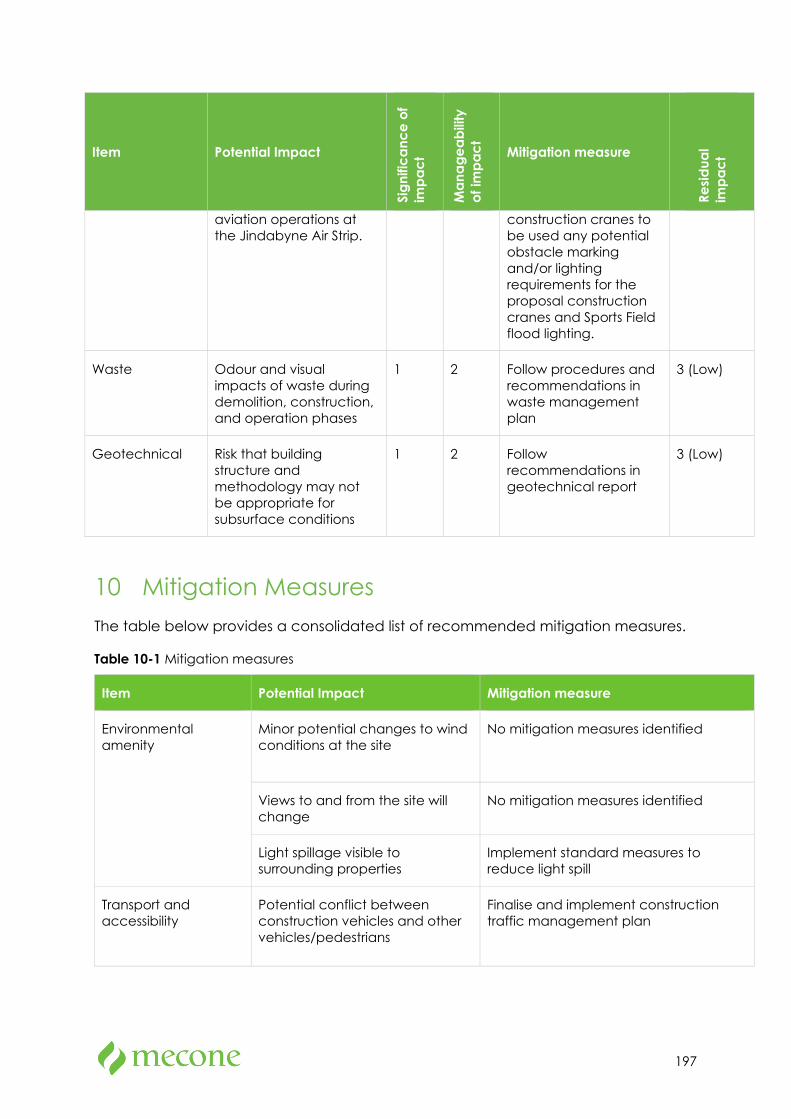
197
Item Potential Impact
Sign
ifica
nce
of
impa
ct
Man
agea
bilit
y of
impa
ct
Mitigation measure
Resid
ual
impa
ct
aviation operations at the Jindabyne Air Strip.
construction cranes to be used any potential obstacle marking and/or lighting requirements for the proposal construction cranes and Sports Field flood lighting.
Waste Odour and visual impacts of waste during demolition, construction, and operation phases
1 2 Follow procedures and recommendations in waste management plan
3 (Low)
Geotechnical Risk that building structure and methodology may not be appropriate for subsurface conditions
1 2 Follow recommendations in geotechnical report
3 (Low)
10 Mitigation Measures The table below provides a consolidated list of recommended mitigation measures.
Table 10-1 Mitigation measures
Item Potential Impact Mitigation measure
Environmental amenity
Minor potential changes to wind conditions at the site
No mitigation measures identified
Views to and from the site will change
No mitigation measures identified
Light spillage visible to surrounding properties
Implement standard measures to reduce light spill
Transport and accessibility
Potential conflict between construction vehicles and other vehicles/pedestrians
Finalise and implement construction traffic management plan
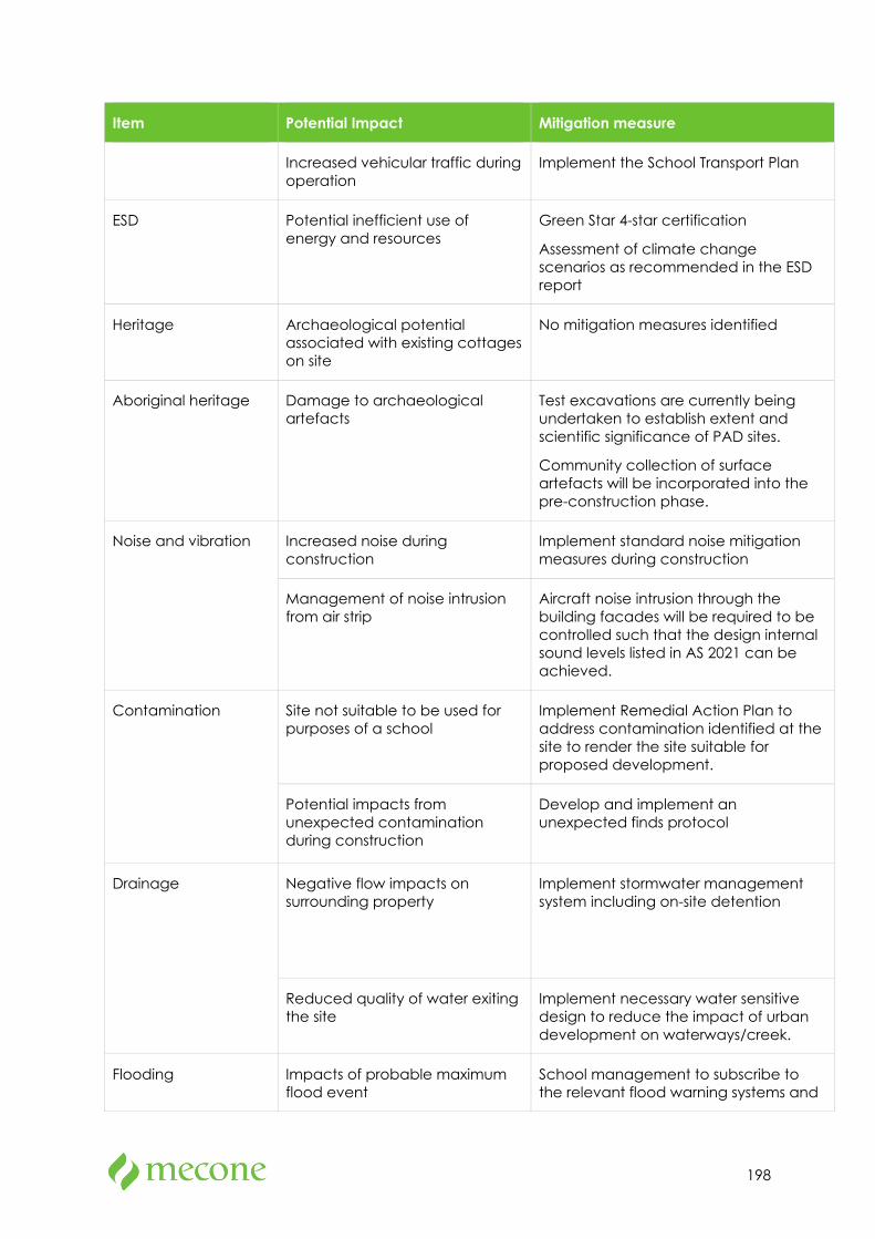
198
Item Potential Impact Mitigation measure
Increased vehicular traffic during operation
Implement the School Transport Plan
ESD Potential inefficient use of energy and resources
Green Star 4-star certification
Assessment of climate change scenarios as recommended in the ESD report
Heritage Archaeological potential associated with existing cottages on site
No mitigation measures identified
Aboriginal heritage Damage to archaeological artefacts
Test excavations are currently being undertaken to establish extent and scientific significance of PAD sites.
Community collection of surface artefacts will be incorporated into the pre-construction phase.
Noise and vibration Increased noise during construction
Implement standard noise mitigation measures during construction
Management of noise intrusion from air strip
Aircraft noise intrusion through the building facades will be required to be controlled such that the design internal sound levels listed in AS 2021 can be achieved.
Contamination Site not suitable to be used for purposes of a school
Implement Remedial Action Plan to address contamination identified at the site to render the site suitable for proposed development.
Potential impacts from unexpected contamination during construction
Develop and implement an unexpected finds protocol
Drainage Negative flow impacts on surrounding property
Implement stormwater management system including on-site detention
Reduced quality of water exiting the site
Implement necessary water sensitive design to reduce the impact of urban development on waterways/creek.
Flooding Impacts of probable maximum flood event
School management to subscribe to the relevant flood warning systems and
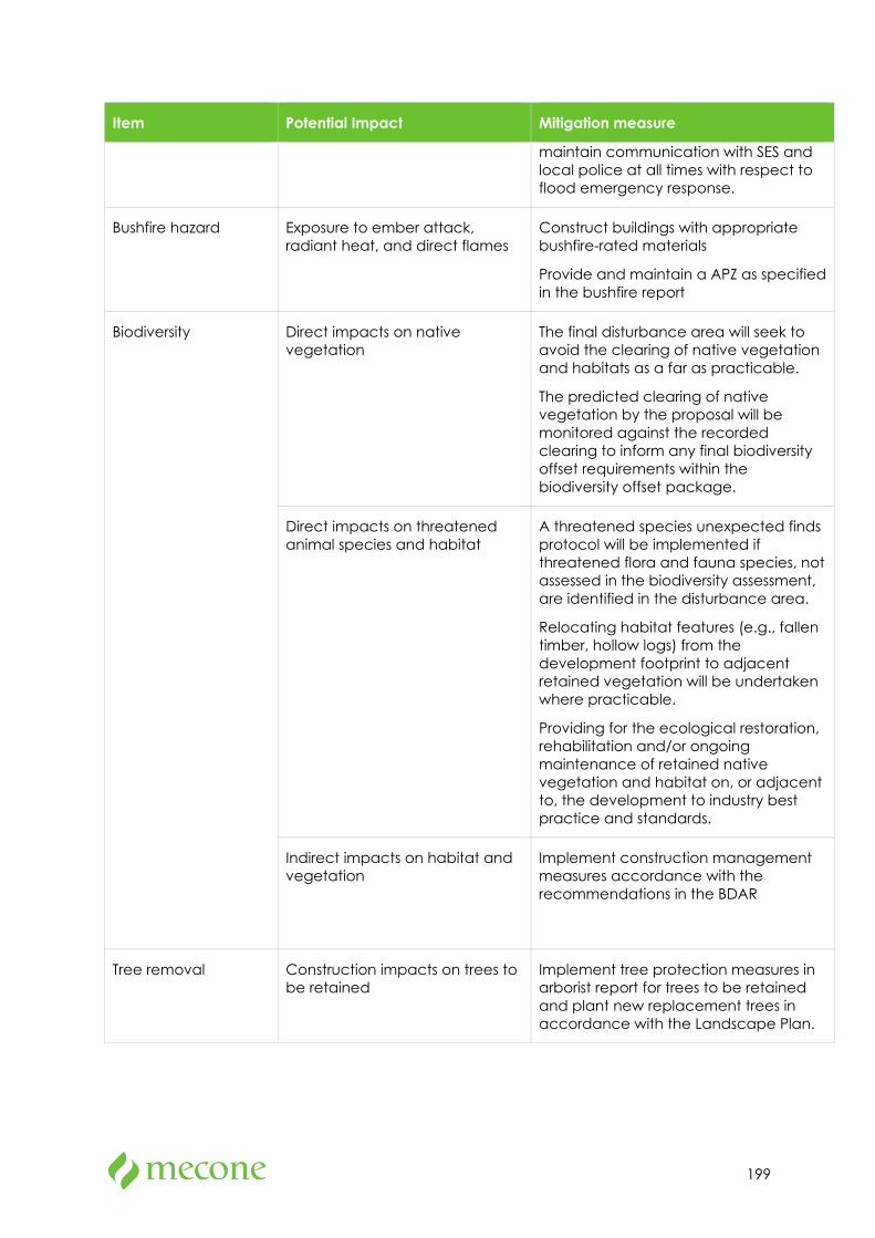
199
Item Potential Impact Mitigation measure
maintain communication with SES and local police at all times with respect to flood emergency response.
Bushfire hazard Exposure to ember attack, radiant heat, and direct flames
Construct buildings with appropriate bushfire-rated materials
Provide and maintain a APZ as specified in the bushfire report
Biodiversity Direct impacts on native vegetation
The final disturbance area will seek to avoid the clearing of native vegetation and habitats as a far as practicable.
The predicted clearing of native vegetation by the proposal will be monitored against the recorded clearing to inform any final biodiversity offset requirements within the biodiversity offset package.
Direct impacts on threatened animal species and habitat
A threatened species unexpected finds protocol will be implemented if threatened flora and fauna species, not assessed in the biodiversity assessment, are identified in the disturbance area.
Relocating habitat features (e.g., fallen timber, hollow logs) from the development footprint to adjacent retained vegetation will be undertaken where practicable.
Providing for the ecological restoration, rehabilitation and/or ongoing maintenance of retained native vegetation and habitat on, or adjacent to, the development to industry best practice and standards.
Indirect impacts on habitat and vegetation
Implement construction management measures accordance with the recommendations in the BDAR
Tree removal Construction impacts on trees to be retained
Implement tree protection measures in arborist report for trees to be retained and plant new replacement trees in accordance with the Landscape Plan.
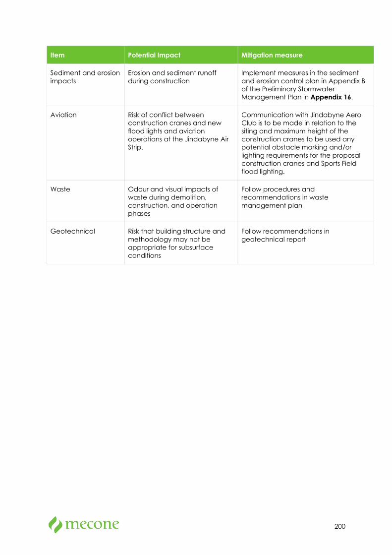
200
Item Potential Impact Mitigation measure
Sediment and erosion impacts
Erosion and sediment runoff during construction
Implement measures in the sediment and erosion control plan in Appendix B of the Preliminary Stormwater Management Plan in Appendix 16.
Aviation Risk of conflict between construction cranes and new flood lights and aviation operations at the Jindabyne Air Strip.
Communication with Jindabyne Aero Club is to be made in relation to the siting and maximum height of the construction cranes to be used any potential obstacle marking and/or lighting requirements for the proposal construction cranes and Sports Field flood lighting.
Waste Odour and visual impacts of waste during demolition, construction, and operation phases
Follow procedures and recommendations in waste management plan
Geotechnical Risk that building structure and methodology may not be appropriate for subsurface conditions
Follow recommendations in geotechnical report
201
11 Conclusion and Justification This EIS is submitted to the Minister for Planning to accompany an SSD application for establishment of the Jindabyne Education Campus at 207 Barry Way, Jindabyne, to replace the existing Jindabyne Central School at 8-20 Park Road, Jindabyne.
This EIS has considered the relevant statutory instruments and strategic documents and provided an assessment of the potential impacts of the proposal on the built and natural environments as well as an assessment of social impacts. All environmental impacts identified within the EIS are negligible or can be suitably managed in accordance with mitigation measures identified.
Test excavations for identified potential archaeological deposit sites are currently being undertaken. The results and findings will be provided to DPIE once complete. Given the extent and density of any archaeological material is likely to be limited, it is considered that the findings of the test excavations can be addressed following submission of the proposal and prior to determination.
This EIS fulfils the requirements of the EP&A Act and Regulation, addresses all relevant matters prescribed by the SEARs and demonstrates that the potential impacts of the proposal can be satisfactorily managed or mitigated.
In summary, the development should be approved for the following reasons:
• The proposal will increase the capacity for primary school and high school students to meet identified demand within the catchment area,
• The proposal will provide for a contemporary, purpose-built facilities to replace the existing Jindabyne Central School, which is outdated, overcrowded and ill-suited for providing optimal educational outcomes,
• The proposal will generate jobs, both short-term and ongoing,
• The proposal’s design is the result of detailed analysis of the site and consultation with the community, key stakeholders, DoE and GANSW,
• The proposal presents potential opportunities for shared use arrangements between the JSRC and the community,
• The potential environmental impacts of the proposal can be satisfactorily mitigated subject to the recommendations of the technical supporting documentation accompanying this EIS,
• The site is suitable for the proposal, and
• The proposal is in the public interest.