environmental impact assessment for proposed exploratory
TRANSCRIPT
WHEN YOU NEED TO BE SURE
DRAFT REPORT
OIL INDIA LIMITEDDULIAJAN, ASSAM
PREPARED BY:
SGS India Private Limited226 Udyog Vihar Phase IGurgaon – 122 016, Haryana, India
Tel: +91 124 6776300Fax: +91 124 6776403/04
http://www.sgsgroup.in/
ENVIRONMENTAL IMPACT ASSESSMENT FOR PROPOSEDEXPLORATORY DRILLING OF SEVEN (07) WELLS &TESTING OF HYDROCARBONS AT JORHAT DISTRICT,ASSAM.
PROJECT REFERENCE NUMBER:IN/ES-EIA/2014-286
(VERSION 1.0)
CONTRACT NO: 6108699/DCO/NNTENDER NO: DCO4597P15
ENVIRONMENTAL IMPACT ASSESSMENT FOR PROPOSED EXPLORATORYDRILLING OF SEVEN (07) WELLS & TESTING OF HYDROCARBONS ATJORHAT DISTRICT, ASSAM
ENVIRONMENTAL IMPACT ASSESSMENT FOR PROPOSED EXPLORATORYDRILLING OF SEVEN (07) WELLS & TESTING OF HYDROCARBONS ATJORHAT DISTRICT, ASSAM
ENVIRONMENTAL IMPACT ASSESSMENT FOR PROPOSED EXPLORATORYDRILLING OF SEVEN (07) WELLS & TESTING OF HYDROCARBONS ATJORHAT DISTRICT, ASSAM
SGS INDIA PVT LIMITED 1 | P a g e
CONTENTS
ABBREVIATIONS 4
LIST OF TABLES 6
LIST OF FIGURES 8
CHAPTER 1: INTRODUCTION 18
1.1 Preamble ............................................................................................................................................................... 181.2 Project Proponent................................................................................................................................................. 181.3 Need and Objectives of Project ........................................................................................................................... 191.4 Block Location and Accessibility ........................................................................................................................ 191.5 Objectives and Need of the EIA Study ................................................................................................................ 211.6 Scope of the EIA Study ........................................................................................................................................ 211.6.1 Base line data generation .................................................................................................................................... 211.6.2 Impact Assessment .............................................................................................................................................. 231.6.3 Risk Assessment .................................................................................................................................................. 231.6.4 Environmental Management & Monitoring Plan ................................................................................................. 231.7 Approach and Methodology................................................................................................................................. 241.8 Structure of the Report......................................................................................................................................... 25
CHAPTER 2: PROJECT DESCRIPTION 35
2.1 Preamble ............................................................................................................................................................... 352.2 Location of Proposed Wells................................................................................................................................. 362.3 Exploratory Drilling of Wells ................................................................................................................................ 382.4 Proposed Infrastructure ....................................................................................................................................... 512.5 Project Cost .......................................................................................................................................................... 51
CHAPTER 3: DESCRIPTION OF THE ENVIRONMENT 53
3.1 Introduction........................................................................................................................................................... 533.2 Environmental Setting.......................................................................................................................................... 533.3 Land Environment ................................................................................................................................................ 593.3.1 Topography& Drainage ........................................................................................................................................ 593.3.2 Geology ................................................................................................................................................................. 603.3.3 Seismicity and Floods .......................................................................................................................................... 623.3.4 Hydro-Geology...................................................................................................................................................... 653.3.5 Land Use and Land Classification ....................................................................................................................... 663.4 Meteorology .......................................................................................................................................................... 713.4.1 Regional Meteorology .......................................................................................................................................... 713.4.2 Site Specific Micro-Meteorology.......................................................................................................................... 763.5 Ambient Air Quality .............................................................................................................................................. 783.5.1 Results of Ambient Air Quality ............................................................................................................................ 823.6 Noise Environment ............................................................................................................................................... 863.6.1 Results of Ambient Noise Quality........................................................................................................................ 863.7 Water Resource Quality ....................................................................................................................................... 883.7.1 Results & Discussions ......................................................................................................................................... 913.8 Soil Quality............................................................................................................................................................ 1023.8.1 Results and Discussions ..................................................................................................................................... 1023.9 Ecological Environment ....................................................................................................................................... 1083.9.1 Methodology ......................................................................................................................................................... 1103.9.2 Floristic Compositions within Study Area .......................................................................................................... 1123.9.3 Faunal Compositions within Study Area............................................................................................................. 1233.10 Socio Economic Environment ............................................................................................................................. 1333.10.1 The Study Area ................................................................................................................................................ 1333.10.2 Methodology .................................................................................................................................................... 1333.10.3 Baseline Socio-economic Status of The Study Area ..................................................................................... 1343.10.3.1 Demographic Profile........................................................................................................................................ 1343.10.3.2 Infrastructure Resource Base ......................................................................................................................... 1353.10.3.3 Economic Resource Base ............................................................................................................................... 1373.10.3.4 Occupational PATTERN WITHIN Study Area ................................................................................................. 1373.10.3.4.1 Livelihood in the Surveyed Villages .......................................................................................................... 1383.10.3.5 Cultural and Aesthetic Attributes ................................................................................................................... 1383.10.3.6 Medical & Public Health Facilities................................................................................................................... 1393.10.3.7 Outcome Of Socio-economic Survey ............................................................................................................. 1403.10.3.7.1 Tea Garden Labours and Their Living Conditions .................................................................................... 1443.10.3.7.2 Awareness and Opinion of People about the Project ............................................................................... 1453.10.3.7.3 Community Consultation............................................................................................................................ 145
ENVIRONMENTAL IMPACT ASSESSMENT FOR PROPOSED EXPLORATORYDRILLING OF SEVEN (07) WELLS & TESTING OF HYDROCARBONS ATJORHAT DISTRICT, ASSAM
SGS INDIA PVT LIMITED 2 | P a g e
CHAPTER 4: ANTICIPATED ENVIRONMENTAL IMPACTS AND MITIGATION MEASURES 149
4.1 Preamble ............................................................................................................................................................... 1494.2 Impacts/Risks During Exploratory Drilling of Wells ........................................................................................... 1514.2.1 Components Creating Risks/Impacting to Natural Environment....................................................................... 1524.2.2 Risks/Impacts to Natural Environment................................................................................................................ 1534.2.2.1 Land Use Pattern ............................................................................................................................................. 1534.2.2.2 Ecology............................................................................................................................................................. 1544.2.2.3 Water Resources ............................................................................................................................................. 1544.2.2.4 Water Quality.................................................................................................................................................... 1554.2.2.5 Soil Quality & Contamination .......................................................................................................................... 1564.2.2.6 Air environment ............................................................................................................................................... 1574.2.2.7 Noise Environment .......................................................................................................................................... 1634.2.3 Components Creating Risks to Socio-Economic Environment ......................................................................... 1654.3 Risk/ Impact Mitigation Techniques .................................................................................................................... 1674.4 Impact Evaluation ................................................................................................................................................. 172
CHAPTER 5: ANALYSIS OF ALTERNATIVES 176
5.1 Alternative Location for the Proposed Project ................................................................................................... 1765.2 Alternative Drilling Locations .............................................................................................................................. 1765.3 Alternative Drilling Technologies ........................................................................................................................ 1765.4 Alternative Resources .......................................................................................................................................... 1765.5 Alternative Treatment Options............................................................................................................................. 176
CHAPTER 6: RISK ANALYSIS AND DISASTER MANANGEMENT PLAN 178
6.1 Introduction........................................................................................................................................................... 1786.2 Hazard Identification ............................................................................................................................................ 1796.2.1 Minor Oil Spill ....................................................................................................................................................... 1796.2.2 Major Oil Spill........................................................................................................................................................ 1796.2.3 Blowout ................................................................................................................................................................. 1806.2.4 Other Hazards at Drilling Rig Operations............................................................................................................ 1826.2.4.1 Hazard during Setting Up the Substructure ................................................................................................... 1826.2.4.2 Hazard during Setting Up The Rig Floor and Mast or Derrick....................................................................... 1826.2.4.3 Hazard in Rigging Up the Circulating System................................................................................................ 1836.2.4.4 Hazards during Installing the Auxiliary Equipment ....................................................................................... 1836.3 Consequence Analysis......................................................................................................................................... 1836.4 Failure Frequency................................................................................................................................................. 1896.4.1 Blowout and Well Release Frequencies .............................................................................................................. 1896.4.2 Structural Failure Frequency ............................................................................................................................... 1906.5 Risk Mitigation Measures ..................................................................................................................................... 1906.5.1 Risk Mitigation to Control Hazards...................................................................................................................... 1906.5.2 Blowout ................................................................................................................................................................. 1916.5.3 Control Measures for H2S during Drilling ........................................................................................................... 1936.5.4 Safety System for Drilling Rigs............................................................................................................................ 1956.5.5 Ensure Availability and Provisions before Spudding of the well....................................................................... 1966.5.6 General Safe Practices during Drilling Operation .............................................................................................. 1966.5.7 Emergency Preparedness .................................................................................................................................... 1976.5.8 Fire Fighting Facility for Drilling Rig ................................................................................................................... 1976.5.9 Control of Hydrocarbon due and subsequently fire & explosion during exploration and testing................... 1976.5.10 Medical Facilities ............................................................................................................................................. 1996.6 Disaster Management Plan .................................................................................................................................. 1996.6.1 Introduction........................................................................................................................................................... 1996.6.2 Crisis Management Team..................................................................................................................................... 2006.6.3 Emergency Classification .................................................................................................................................... 2006.6.3.1 Level 1 Emergency .......................................................................................................................................... 2006.6.3.2 Level 2 Emergency .......................................................................................................................................... 2006.6.3.3 Level 3 Emergency .......................................................................................................................................... 2016.6.4 On-Site Disaster Management Plan ..................................................................................................................... 2016.6.4.1 Responsibilities of SIC Supervisors ............................................................................................................... 2046.6.4.2 Responsibilities of ATC Supervisors.............................................................................................................. 204
CHAPTER 7: ENVIRONMENTAL MANANGEMENT PLAN 207
7.1 Preamble ............................................................................................................................................................... 2077.2 Good Neighbour Practises................................................................................................................................... 2077.3 Environment Control Measures (ECM)................................................................................................................ 2107.4 Environment Monitoring Program (EMP) ............................................................................................................ 2107.4.1 Role of OIL ............................................................................................................................................................ 2117.4.2 Role of Contractor ................................................................................................................................................ 2117.5 Audit ...................................................................................................................................................................... 2227.5.1 Performance Monitoring ...................................................................................................................................... 223
ENVIRONMENTAL IMPACT ASSESSMENT FOR PROPOSED EXPLORATORYDRILLING OF SEVEN (07) WELLS & TESTING OF HYDROCARBONS ATJORHAT DISTRICT, ASSAM
SGS INDIA PVT LIMITED 3 | P a g e
7.6 Environment Management Cell............................................................................................................................ 2257.7 Training ................................................................................................................................................................. 2277.8 Record Keeping .................................................................................................................................................... 228
CHAPTER 8: PROJECT BENEFITS 230
8.1 Preamble ............................................................................................................................................................... 2308.2 Benefits for the Country ....................................................................................................................................... 2308.3 Benefits for the Region ........................................................................................................................................ 230
CHAPTER 9: SUMMARY AND CONCLUSIONS 233
9.1 Salient Features of the Project ............................................................................................................................ 233
CHAPTER 10: DISCLOSURE OF CONSULTANTS ENGAGED 236
ANNEXURE 1 242
APPLICATION FOR GROUND WATER PERMISSION 242
ANNEXURE 2 243
NOC FROM GOVERNMENT OF ASSAM 243
ANNEXURE 3 244
LETTER FROM PCCF, ASSAM 244
ANNEXURE 4 245
DEMOGRAPHIC DETAILS 245
ANNEXURE 5 249
INFRASTRUCTURE RESOURCE BASE IN THE STUDY AREA 249
ANNEXURE 6 258
WORKERS PARTICIPATION DETAILS 258
ANNEXURE 7 261
DECLARATION REGARDING LITIGATION 261
ENVIRONMENTAL IMPACT ASSESSMENT FOR PROPOSED EXPLORATORYDRILLING OF SEVEN (07) WELLS & TESTING OF HYDROCARBONS ATJORHAT DISTRICT, ASSAM
SGS INDIA PVT LIMITED 4 | P a g e
ABBREVIATIONS
APHA : American Public Health Association
ASTM : American Society for Testing and Materials
AWWA : American Water Works Association
bbl : Billion Barrels
BOD : Biological Oxygen Demand
BTEX : Benzene Toluene Ethylene Xylene
CAGR : Compound Annual Growth Rate
CCoE : Chief Controller of Explosives
CF : Contamination Factor
CI : Corrosion Inhibitor
COD : Chemical Oxygen Demand
CPCB : Central Pollution Control Board
CRZ : Coastal Regulation Zone
DGH : Directorate General of Hydrocarbons
DO : Dissolved Oxygen
DTS : Distributed Temperature System
EC : Electrical Conductivity
ECP : External Casing Packers
EIA : Environmental Impact Assessment
EMARC : Environmental Management Apex Review Committee
EMP : Environmental Management Plan
GHG : Green House Gas
GPS : Geographical Positioning System
HAZOP : Hazard Operability
HC : Hydrocarbons
IPSEM : Institute of Petroleum Safety and Environment Management
ISRS : International Safety Rating System
MMSCMD : Metric Standard Cubic Meters per Day
MOEF : Ministry of Environment and Forests
MSDS : Material Safety Data Sheet
NABET : National Accreditation Board of Education and Training
ND : Not Detected
PAH : Polycyclic Aromatic Hydrocarbon
PARCOM : Paris Commission
PEL : Petroleum Exploration License
PFP : Flare Platform
PHC : Petroleum Hydrocarbon Content
PVC : Polyvinyl Chlroide
QCI : Quality Council of India
SPCB : State Pollution Control Board
SS : Suspended Solids
ENVIRONMENTAL IMPACT ASSESSMENT FOR PROPOSED EXPLORATORYDRILLING OF SEVEN (07) WELLS & TESTING OF HYDROCARBONS ATJORHAT DISTRICT, ASSAM
SGS INDIA PVT LIMITED 5 | P a g e
TDS : Total Dissolved Solids
TOR : Terms of Reference
TPH : Total Petroleum Hydrocarbon
TSS : Total Suspended Solids
USEPA : United States Environmental Protection Agency
UTM : Universal Transverse Mercator
ENVIRONMENTAL IMPACT ASSESSMENT FOR PROPOSED EXPLORATORYDRILLING OF SEVEN (07) WELLS & TESTING OF HYDROCARBONS ATJORHAT DISTRICT, ASSAM
SGS INDIA PVT LIMITED 6 | P a g e
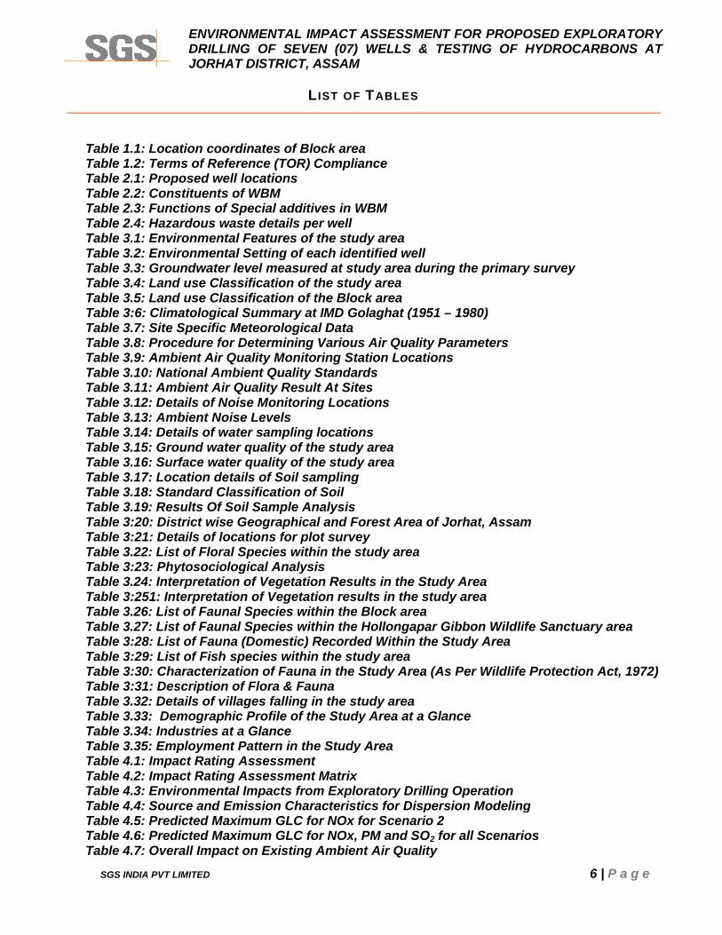
L IST OF TABLES
Table 1.1: Location coordinates of Block areaTable 1.2: Terms of Reference (TOR) ComplianceTable 2.1: Proposed well locationsTable 2.2: Constituents of WBMTable 2.3: Functions of Special additives in WBMTable 2.4: Hazardous waste details per wellTable 3.1: Environmental Features of the study areaTable 3.2: Environmental Setting of each identified wellTable 3.3: Groundwater level measured at study area during the primary surveyTable 3.4: Land use Classification of the study areaTable 3.5: Land use Classification of the Block areaTable 3:6: Climatological Summary at IMD Golaghat (1951 – 1980)Table 3.7: Site Specific Meteorological DataTable 3.8: Procedure for Determining Various Air Quality ParametersTable 3.9: Ambient Air Quality Monitoring Station LocationsTable 3.10: National Ambient Quality StandardsTable 3.11: Ambient Air Quality Result At SitesTable 3.12: Details of Noise Monitoring LocationsTable 3.13: Ambient Noise LevelsTable 3.14: Details of water sampling locationsTable 3.15: Ground water quality of the study areaTable 3.16: Surface water quality of the study areaTable 3.17: Location details of Soil samplingTable 3.18: Standard Classification of SoilTable 3.19: Results Of Soil Sample AnalysisTable 3:20: District wise Geographical and Forest Area of Jorhat, AssamTable 3:21: Details of locations for plot surveyTable 3.22: List of Floral Species within the study areaTable 3:23: Phytosociological AnalysisTable 3.24: Interpretation of Vegetation Results in the Study AreaTable 3:251: Interpretation of Vegetation results in the study areaTable 3.26: List of Faunal Species within the Block areaTable 3.27: List of Faunal Species within the Hollongapar Gibbon Wildlife Sanctuary areaTable 3:28: List of Fauna (Domestic) Recorded Within the Study AreaTable 3:29: List of Fish species within the study areaTable 3:30: Characterization of Fauna in the Study Area (As Per Wildlife Protection Act, 1972)Table 3:31: Description of Flora & FaunaTable 3.32: Details of villages falling in the study areaTable 3.33: Demographic Profile of the Study Area at a GlanceTable 3.34: Industries at a GlanceTable 3.35: Employment Pattern in the Study AreaTable 4.1: Impact Rating AssessmentTable 4.2: Impact Rating Assessment MatrixTable 4.3: Environmental Impacts from Exploratory Drilling OperationTable 4.4: Source and Emission Characteristics for Dispersion ModelingTable 4.5: Predicted Maximum GLC for NOx for Scenario 2Table 4.6: Predicted Maximum GLC for NOx, PM and SO2 for all ScenariosTable 4.7: Overall Impact on Existing Ambient Air Quality
ENVIRONMENTAL IMPACT ASSESSMENT FOR PROPOSED EXPLORATORYDRILLING OF SEVEN (07) WELLS & TESTING OF HYDROCARBONS ATJORHAT DISTRICT, ASSAM
SGS INDIA PVT LIMITED 7 | P a g e
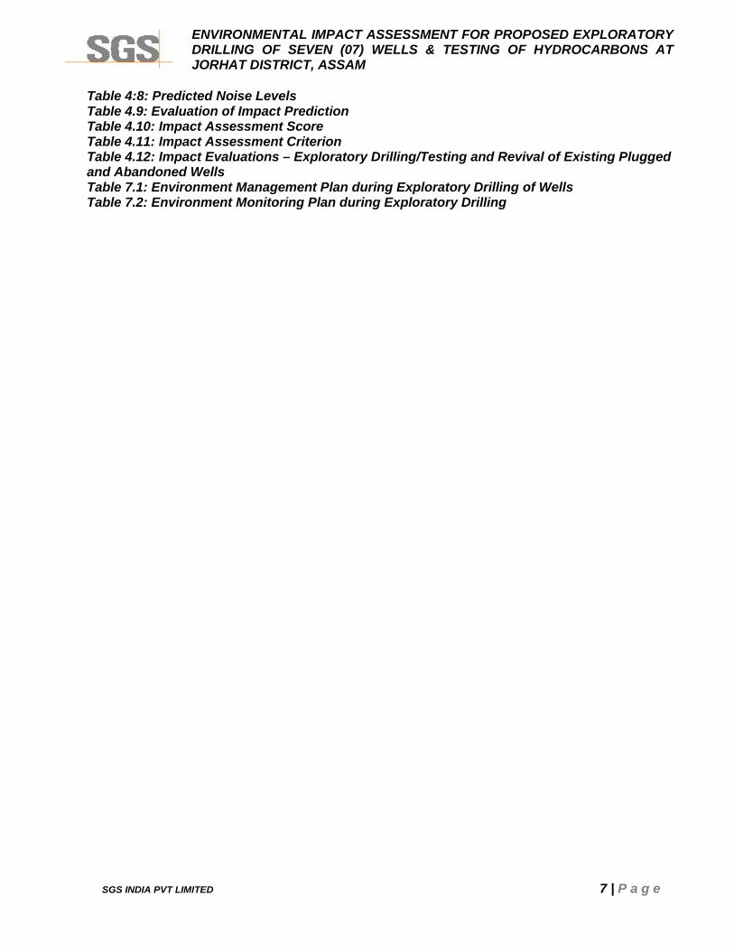
Table 4:8: Predicted Noise LevelsTable 4.9: Evaluation of Impact PredictionTable 4.10: Impact Assessment ScoreTable 4.11: Impact Assessment CriterionTable 4.12: Impact Evaluations – Exploratory Drilling/Testing and Revival of Existing Pluggedand Abandoned WellsTable 7.1: Environment Management Plan during Exploratory Drilling of WellsTable 7.2: Environment Monitoring Plan during Exploratory Drilling
ENVIRONMENTAL IMPACT ASSESSMENT FOR PROPOSED EXPLORATORYDRILLING OF SEVEN (07) WELLS & TESTING OF HYDROCARBONS ATJORHAT DISTRICT, ASSAM
SGS INDIA PVT LIMITED 8 | P a g e
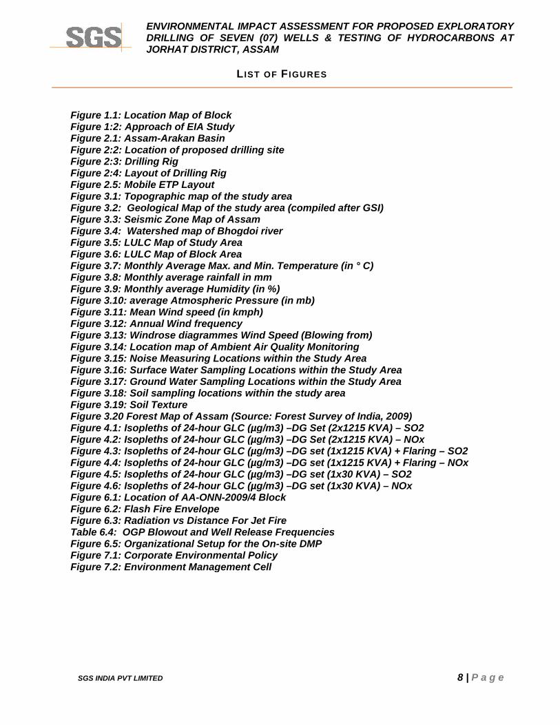
L IST OF F IGURES
Figure 1.1: Location Map of BlockFigure 1:2: Approach of EIA StudyFigure 2.1: Assam-Arakan BasinFigure 2:2: Location of proposed drilling siteFigure 2:3: Drilling RigFigure 2:4: Layout of Drilling RigFigure 2.5: Mobile ETP LayoutFigure 3.1: Topographic map of the study areaFigure 3.2: Geological Map of the study area (compiled after GSI)Figure 3.3: Seismic Zone Map of AssamFigure 3.4: Watershed map of Bhogdoi riverFigure 3.5: LULC Map of Study AreaFigure 3.6: LULC Map of Block AreaFigure 3.7: Monthly Average Max. and Min. Temperature (in ° C)Figure 3.8: Monthly average rainfall in mmFigure 3.9: Monthly average Humidity (in %)Figure 3.10: average Atmospheric Pressure (in mb)Figure 3.11: Mean Wind speed (in kmph)Figure 3.12: Annual Wind frequencyFigure 3.13: Windrose diagrammes Wind Speed (Blowing from)Figure 3.14: Location map of Ambient Air Quality MonitoringFigure 3.15: Noise Measuring Locations within the Study AreaFigure 3.16: Surface Water Sampling Locations within the Study AreaFigure 3.17: Ground Water Sampling Locations within the Study AreaFigure 3.18: Soil sampling locations within the study areaFigure 3.19: Soil TextureFigure 3.20 Forest Map of Assam (Source: Forest Survey of India, 2009)Figure 4.1: Isopleths of 24-hour GLC (µg/m3) –DG Set (2x1215 KVA) – SO2Figure 4.2: Isopleths of 24-hour GLC (µg/m3) –DG Set (2x1215 KVA) – NOxFigure 4.3: Isopleths of 24-hour GLC (µg/m3) –DG set (1x1215 KVA) + Flaring – SO2Figure 4.4: Isopleths of 24-hour GLC (µg/m3) –DG set (1x1215 KVA) + Flaring – NOxFigure 4.5: Isopleths of 24-hour GLC (µg/m3) –DG set (1x30 KVA) – SO2Figure 4.6: Isopleths of 24-hour GLC (µg/m3) –DG set (1x30 KVA) – NOxFigure 6.1: Location of AA-ONN-2009/4 BlockFigure 6.2: Flash Fire EnvelopeFigure 6.3: Radiation vs Distance For Jet FireTable 6.4: OGP Blowout and Well Release FrequenciesFigure 6.5: Organizational Setup for the On-site DMPFigure 7.1: Corporate Environmental PolicyFigure 7.2: Environment Management Cell
ENVIRONMENTAL IMPACT ASSESSMENT FOR PROPOSED EXPLORATORYDRILLING OF SEVEN (07) WELLS & TESTING OF HYDROCARBONS ATJORHAT DISTRICT, ASSAM
SGS INDIA PVT LIMITED 9 | P a g e
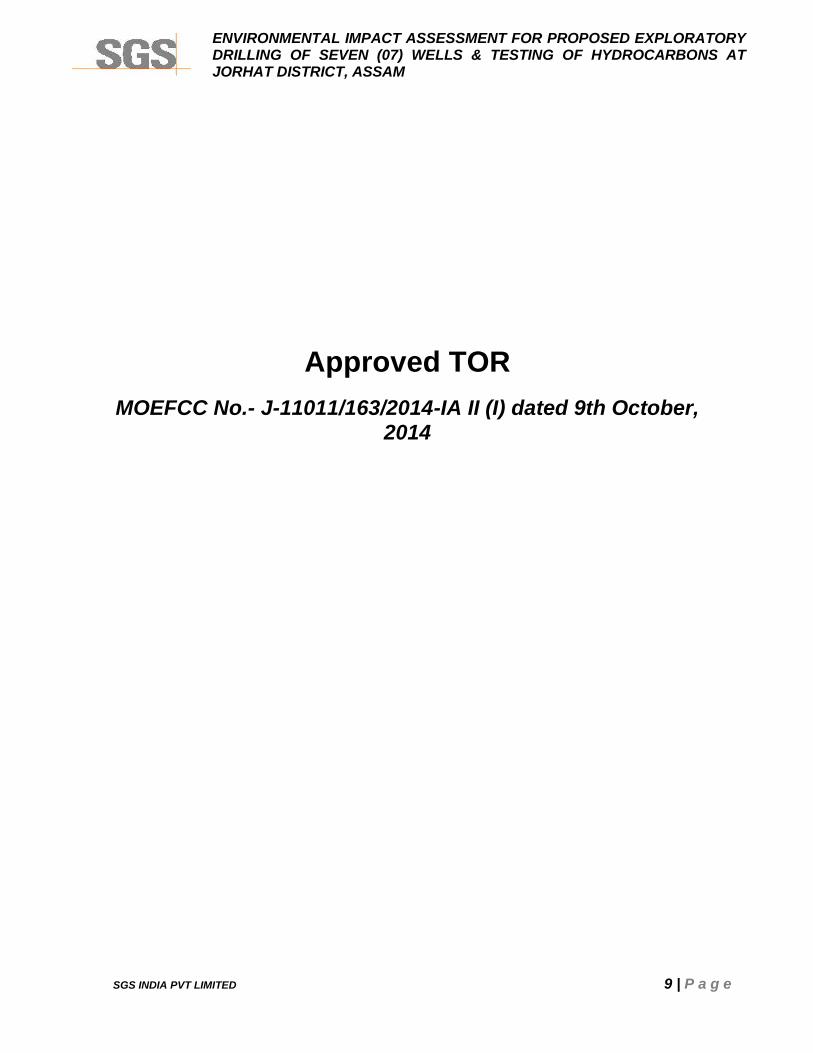
Approved TORMOEFCC No.- J-11011/163/2014-IA II (I) dated 9th October,
2014
ENVIRONMENTAL IMPACT ASSESSMENT FOR PROPOSED EXPLORATORYDRILLING OF SEVEN (07) WELLS & TESTING OF HYDROCARBONS ATJORHAT DISTRICT, ASSAM
SGS INDIA PVT LIMITED 10 | P a g e
ENVIRONMENTAL IMPACT ASSESSMENT FOR PROPOSED EXPLORATORYDRILLING OF SEVEN (07) WELLS & TESTING OF HYDROCARBONS ATJORHAT DISTRICT, ASSAM
SGS INDIA PVT LIMITED 11 | P a g e
ENVIRONMENTAL IMPACT ASSESSMENT FOR PROPOSED EXPLORATORYDRILLING OF SEVEN (07) WELLS & TESTING OF HYDROCARBONS ATJORHAT DISTRICT, ASSAM
SGS INDIA PVT LIMITED 12 | P a g e
ENVIRONMENTAL IMPACT ASSESSMENT FOR PROPOSED EXPLORATORYDRILLING OF SEVEN (07) WELLS & TESTING OF HYDROCARBONS ATJORHAT DISTRICT, ASSAM
SGS INDIA PVT LIMITED 13 | P a g e
ENVIRONMENTAL IMPACT ASSESSMENT FOR PROPOSED EXPLORATORYDRILLING OF SEVEN (07) WELLS & TESTING OF HYDROCARBONS ATJORHAT DISTRICT, ASSAM
SGS INDIA PVT LIMITED 14 | P a g e
ENVIRONMENTAL IMPACT ASSESSMENT FOR PROPOSED EXPLORATORYDRILLING OF SEVEN (07) WELLS & TESTING OF HYDROCARBONS ATJORHAT DISTRICT, ASSAM
SGS INDIA PVT LIMITED 15 | P a g e
NABET Accreditation
ENVIRONMENTAL IMPACT ASSESSMENT FOR PROPOSED EXPLORATORYDRILLING OF SEVEN (07) WELLS & TESTING OF HYDROCARBONS ATJORHAT DISTRICT, ASSAM
SGS INDIA PVT LIMITED 16 | P a g e
ENVIRONMENTAL IMPACT ASSESSMENT FOR PROPOSED EXPLORATORYDRILLING OF SEVEN (07) WELLS & TESTING OF HYDROCARBONS ATJORHAT DISTRICT, ASSAM
SGS INDIA PVT LIMITED 17 | P a g e
CHAPTER 1
INTRODUCTION
ENVIRONMENTAL IMPACT ASSESSMENT FOR PROPOSED EXPLORATORYDRILLING OF SEVEN (07) WELLS & TESTING OF HYDROCARBONS ATJORHAT DISTRICT, ASSAM
SGS INDIA PVT LIMITED 18 | P a g e
CHAPTER 1: INTRODUCTION
1.1 PREAMBLE
Consortium of M/s Oil India Limited (herein after referred in as OIL) & M/s Oil and Natural
Gas Corporation Limited (herein after referred in as ONGC) has been awarded onshore
Block AA-ONN-2009/4 in Jorhat district of Assam state for exploration of hydrocarbons.
The Block was awarded under NELP-VIII round of bidding by Ministry of Petroleum and
Natural Gas, Government of India. The production sharing contracts for the block was
signed on 30th June 2010 and Petroleum Exploration License (PEL) effective from
09.12.2011 for seven years was granted. OIL is the operator for this Block and propose to
carryout exploratory drilling of seven wells with testing.
As per notification dated 14 September 2006, proposed exploratory drilling of sevenwells and testing of Hydrocarbons within block is designated as “Category A” projectand require environment clearance from Ministry of Environment and Forest, Govt. ofIndia, Delhi.
M/s SGS India Private Limited (hereinafter referred as SGS) Gurgaon, has been engaged
by OIL to carry out an Environment Impact Assessment (EIA) study and to prepare an
Environment Management Plan (EMP) for getting environment clearance. The study has
been carried out as per the guidelines of Ministry of Environment, Forests (MoEF) and
Assam State Pollution Control Board (ASPCB).
1.2 PROJECT PROPONENT
Oil India Limited, a Government of India Navaratna Enterprise, is the second largest
hydrocarbon exploration & production (E&P) Indian public sector Company and its
operational headquarters is in Duliajan, Assam, India under the administrative control of the
Ministry of Petroleum and Natural Gas of the Government of India. OIL is engaged in the
business of exploration, development and production of crude oil and natural gas,
transportation of crude oil and production of liquid petroleum gas.
M/s. Oil and Natural Gas Corporation Limited is an India-based Oil Exploration and
Production Company. The Company is the producer of crude oil and natural gas in India.
The company has organized into the geographical and business segments. The
geographical segment includes operations in two categories onshore and offshore. The
business segment includes exploration & production and refining activities. The Company’s
ENVIRONMENTAL IMPACT ASSESSMENT FOR PROPOSED EXPLORATORYDRILLING OF SEVEN (07) WELLS & TESTING OF HYDROCARBONS ATJORHAT DISTRICT, ASSAM
SGS INDIA PVT LIMITED 19 | P a g e
wholly owned subsidiaries include ONGC Videsh Limited and Mangalore Refinery and
Petrochemicals Ltd. (MRPL).
1.3 NEED AND OBJECTIVES OF PROJECT
India is heavily dependent on the imports to meet the rapidly growing demand of petroleum
products. The rising population and the consequent increase in demands on petroleum have
put lot of pressure on Indian economy. Despite its best efforts, India has to meet 80% of its
total oil and gas demand from international market. Substantial efforts are therefore
necessary to boost the exploration activities in the country so that level of crude oil and gas
production can further significantly increase self sufficiency in the years to come.
A total in-place resource as 13.564 MMSKLS and recoverable resources as 3.422 MMSKLS
has been estimated for the identified prospects.
1.4 BLOCK LOCATION AND ACCESSIBILITY
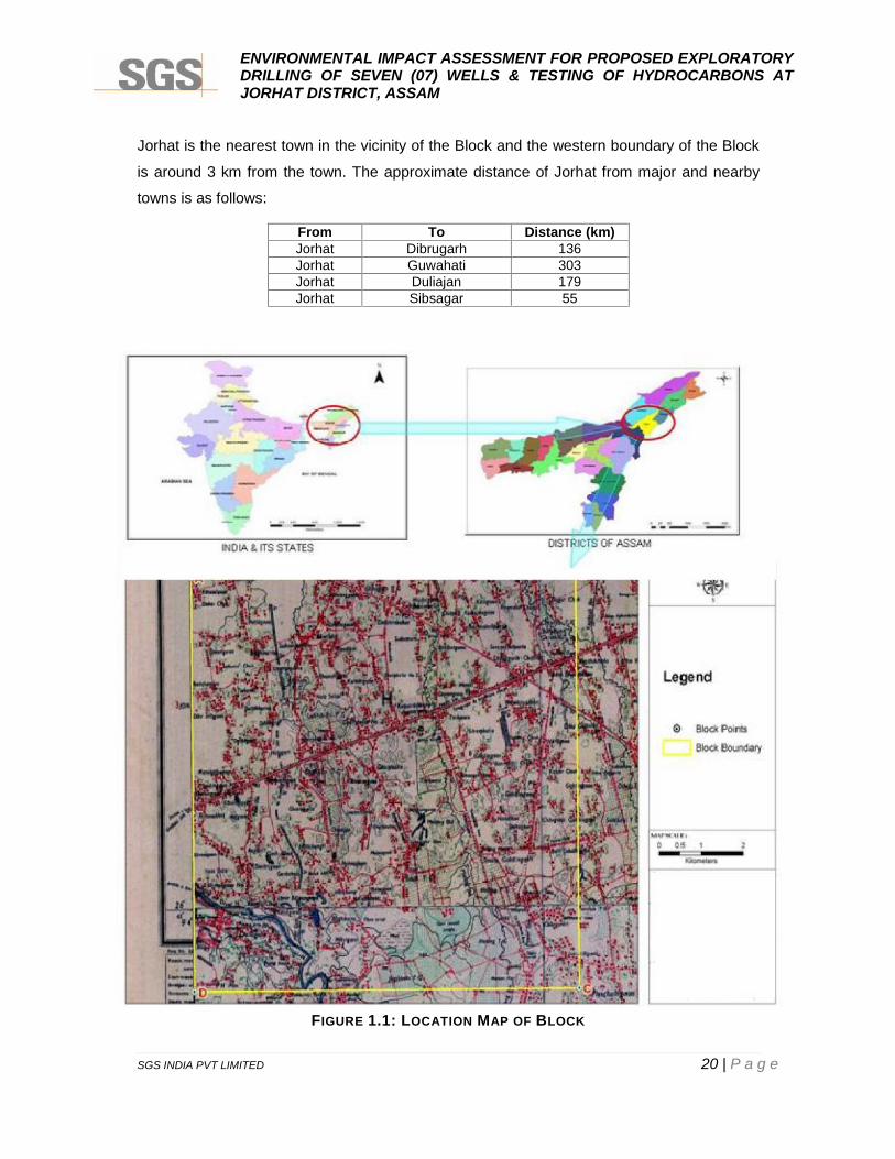
The Block AA-ONN-2009/4 covers an area of 84 sq km is located Jorhat district of Assam in
south of the Brahmaputra River and in the vicinity of already proven fields in Assam Plains
and Belt of Schuppen, with major oilfields like Lakwa, Geleki, Rudrasagar, Amguri in east
and Borhola-Champang and Khoraghat fields in south-west having established Miocene-
Oligocene-Eocene (Tipam-Barail-Tura) hydrocarbon system. The Block AA-ONN-2009/4 is
depicted Figure 1.1 with block coordinates given in Table 1.1:
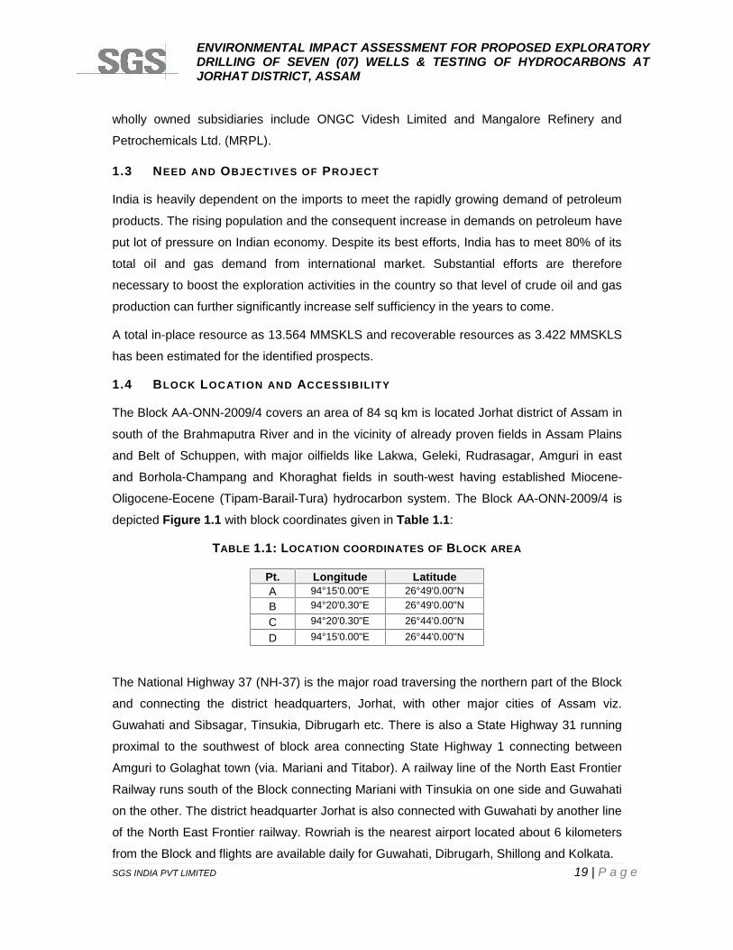
TABLE 1.1: LOCATION COORDINATES OF BLOCK AREA
Pt. Longitude LatitudeA 94°15'0.00"E 26°49'0.00"NB 94°20'0.30"E 26°49'0.00"N
C 94°20'0.30"E 26°44'0.00"N
D 94°15'0.00"E 26°44'0.00"N
The National Highway 37 (NH-37) is the major road traversing the northern part of the Block
and connecting the district headquarters, Jorhat, with other major cities of Assam viz.
Guwahati and Sibsagar, Tinsukia, Dibrugarh etc. There is also a State Highway 31 running
proximal to the southwest of block area connecting State Highway 1 connecting between
Amguri to Golaghat town (via. Mariani and Titabor). A railway line of the North East Frontier
Railway runs south of the Block connecting Mariani with Tinsukia on one side and Guwahati
on the other. The district headquarter Jorhat is also connected with Guwahati by another line
of the North East Frontier railway. Rowriah is the nearest airport located about 6 kilometers
from the Block and flights are available daily for Guwahati, Dibrugarh, Shillong and Kolkata.
ENVIRONMENTAL IMPACT ASSESSMENT FOR PROPOSED EXPLORATORYDRILLING OF SEVEN (07) WELLS & TESTING OF HYDROCARBONS ATJORHAT DISTRICT, ASSAM
SGS INDIA PVT LIMITED 20 | P a g e
Jorhat is the nearest town in the vicinity of the Block and the western boundary of the Block
is around 3 km from the town. The approximate distance of Jorhat from major and nearby
towns is as follows:
From To Distance (km)Jorhat Dibrugarh 136Jorhat Guwahati 303Jorhat Duliajan 179Jorhat Sibsagar 55
FIGURE 1.1: LOCATION MAP OF BLOCK
ENVIRONMENTAL IMPACT ASSESSMENT FOR PROPOSED EXPLORATORYDRILLING OF SEVEN (07) WELLS & TESTING OF HYDROCARBONS ATJORHAT DISTRICT, ASSAM
SGS INDIA PVT LIMITED 21 | P a g e
1.5 OBJECTIVES AND NEED OF THE EIA STUDY
The EIA/ EMP study is a planning tool to confirm the environmental acceptability, in addition
to the statutory requirements. This report presents the results of the EIA process, which is
intended to:
Establish and review the existing baseline conditions within block and its surrounding
area;
Identify and assess the environmental impacts during proposed exploratory drilling of
seven wells ; and
Advise and assist in identification of appropriate measures, for mitigation of adverse
impacts, to be adopted under the Environment Management Plan (EMP), for all
specified significant environmental impacts that are likely to emerge.
The proposed onshore exploratory drilling is designated to be developed under the
Environmental Impact Assessment (EIA) Notification and amendments under Environment
(Protection) Act, 1986. All the projects related to offshore and onshore Oil and Gas
exploration, development and production are listed in para 1(b) of schedule of EIA
Notification, 2006 covered under category ‘A’ and appraised at central level by the
MOEF&CC.
1.6 SCOPE OF THE EIA STUDY
The EIA/ EMP report termed as draft EIA report is prepared based on the basis of Terms of
Reference (TOR) prescribed by the MoEF&CC for public hearing vide F. No J-
11011/163/2014-IA II (I) dated 9th October,2014 on the basis of duly filled Form-1 submitted
and subsequent presentation made to the Appraisal Committee of the MoEF&CC on 24th
June 2014.
For generation of site specific baseline data, environment monitoring and surveys within
block and in surrounding area of 10 km radius have been conducted for three
(3) months continuously from 6th February 2015 to 6th May, 2015, as per details given
hereunder:
1.6.1 BASE LINE DAT A GENERATION
Ambient Air Quality
Ambient Air Quality monitoring was carried out at eight (8) locations in and around the Block
area for PM10, SO2, NOx and CO and background levels of hydrocarbons (methane and non-
ENVIRONMENTAL IMPACT ASSESSMENT FOR PROPOSED EXPLORATORYDRILLING OF SEVEN (07) WELLS & TESTING OF HYDROCARBONS ATJORHAT DISTRICT, ASSAM
SGS INDIA PVT LIMITED 22 | P a g e
methane) and VOCs. The frequency of monitoring was twice in a week for three (3) months
during the study period.
Meteorology at the Site
Site specific meteorological data was collected near to the site at one (1) location (Jorhat
Institute of Science and Technology) for wind speed, wind direction, temperature, humidity,
rainfall and cloud cover on hourly basis during the study period. Details of meteorology of the
region have also been collected from the nearest India Meteorological Department (IMD)
Observatory.
Noise Level
Noise levels were monitored at fifteen (15) locations on hourly basis for 24 hours during the
study period. The levels were monitored once during the study period. The results of the
finding have been reported in terms of Leq Day and Leq Night for all locations.
Traffic Volume Counts
Traffic volume counts were monitored at five (5) locations on hourly basis for 24 hours, once
during the study period.
Water Quality
Samples for surface water from seven (07) locations and groundwater from eight (08)
locations were collected and analyzed for essential parameters as stated in the BIS
10500:2012, BIS 2296 and additional relevant parameters. The samples were collected once
during the study period.
Soil Quality
Soil samples at eight (8) locations were collected and analyzed for physical and chemical
parameters. The samples were collected once during the study period.
Biological Environment (Flora and Fauna)
Survey was undertaken in the study area as per the guidelines of the MOEF&CC. Species of
flora have been listed as trees, medicinal plants, bamboos, cane, orchids & ferns and others.
Faunal species have been identified as per the Wildlife Protection Act, 1972 (and as
amended subsequently) and associated Schedule.
ENVIRONMENTAL IMPACT ASSESSMENT FOR PROPOSED EXPLORATORYDRILLING OF SEVEN (07) WELLS & TESTING OF HYDROCARBONS ATJORHAT DISTRICT, ASSAM
SGS INDIA PVT LIMITED 23 | P a g e
Socio-economic
During socio-economic survey, discussion with local people and president of Gaon
Panchayat was carried out to assess the existing socio-economic status of the people and
availability of infrastructure resource base in the study area. Moreover, secondary data viz.
demographic profile, employment pattern and basic amenities based on the Census 2011
were collected from statistical office, Jorhat and different Government departments. Primary
and secondary information on socio-economic parameters within the study area were
collected for the following details:
Household; population; villages and tehsil/blocks; population distribution; literacy levels;
scheduled castes; scheduled tribes; employment pattern; primary health care facilities;
transport, communication and welfare facilities as well as perception of local people towards
proposed project.
Remote Sensing Study
This study was carried out based on the satellite imagery of the study area in order to
assess the land use pattern, drainage pattern, habitation, vegetation cover, etc of the study
area.
1.6.2 IMPACT ASSESSMENT
Identification of various existing pollution sources due to any industrial and domestic
activities within the study area; Prediction of incremental levels of pollutants in the study area
due to the proposed project activities; Evaluation of the predicted impacts on the various
environmental attributes in the study area by using scientifically developed and widely
accepted environmental impact assessment methodologies/ models; Identification of critical
environmental attributes required to monitor regularly;
1.6.3 R ISK ASSESSMENT
Identification and analysis of risk; Preparing disaster management plan to deal with
emergency situation.
1.6.4 ENVIRONMENTAL MANAGEMENT & MONITORING PLAN
Identification of mitigation measures; Preparation of Environmental Management Plan (EMP)
outlining the measures for environment protection; Details of monitoring, auditing and
reporting.
ENVIRONMENTAL IMPACT ASSESSMENT FOR PROPOSED EXPLORATORYDRILLING OF SEVEN (07) WELLS & TESTING OF HYDROCARBONS ATJORHAT DISTRICT, ASSAM
SGS INDIA PVT LIMITED 24 | P a g e
The response to each item as suggested by the EAC, MOEF as per the approved TOR is
provided in Table 1.2 below.
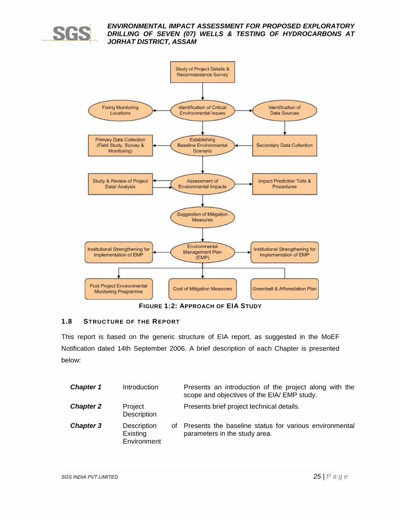
1.7 APPROACH AND METHODOLOGY
This EIA/ EMP report is based on the observations made by the SGS team during visits to
the study area and collection of primary and secondary environmental data. Literatures were
reviewed and relevant informations were collected for environmental and social baseline.
Reconnaissance surveys were conducted to identify the major environmental issues in the
study area. The sampling locations were identified on the basis of:
Existing topography;
Location of water bodies;
Location of villages/ towns/ sensitive areas;
Accessibility, power availability, security of monitoring equipment;
Areas which represent baseline conditions.
SGS followed the standard EIA methodology and technique during the entire study and
whenever necessary, it used its own judgment based on its experience and knowledge.
During the entire study, appropriate quality checks were taken into consideration and best
management practices were followed in order to produce a quality output. Discussions were
also undertaken with State Government agencies during the survey of the area.
Impacts were identified based on the actual and foreseeable events resulting due to
exploratory drilling. Processes that may create risks to the natural environment and socio-
economic environment were considered in terms of key potential environmental impacts.
Mitigation measures to be adopted under the EMP for all the specified significant
environmental impacts that are likely to result during exploratory drilling are also a part of
the EIA/ EMP report.
The identified likely impacts and recommended mitigation measures are based on the
following:
Project information provided by the project proponent;
Baseline information and reconnaissance survey of the study area conducted by
SGS; and
Standard National/ International environmental management guidelines/ practices.
The schematic diagram for approach and methodology adopted for the EIA Study is
shown below in 02.
ENVIRONMENTAL IMPACT ASSESSMENT FOR PROPOSED EXPLORATORYDRILLING OF SEVEN (07) WELLS & TESTING OF HYDROCARBONS ATJORHAT DISTRICT, ASSAM
SGS INDIA PVT LIMITED 25 | P a g e
FIGURE 1:2: APPROACH OF EIA STUDY
1.8 STRUCTURE OF THE REPORT
This report is based on the generic structure of EIA report, as suggested in the MoEF
Notification dated 14th September 2006. A brief description of each Chapter is presented
below:
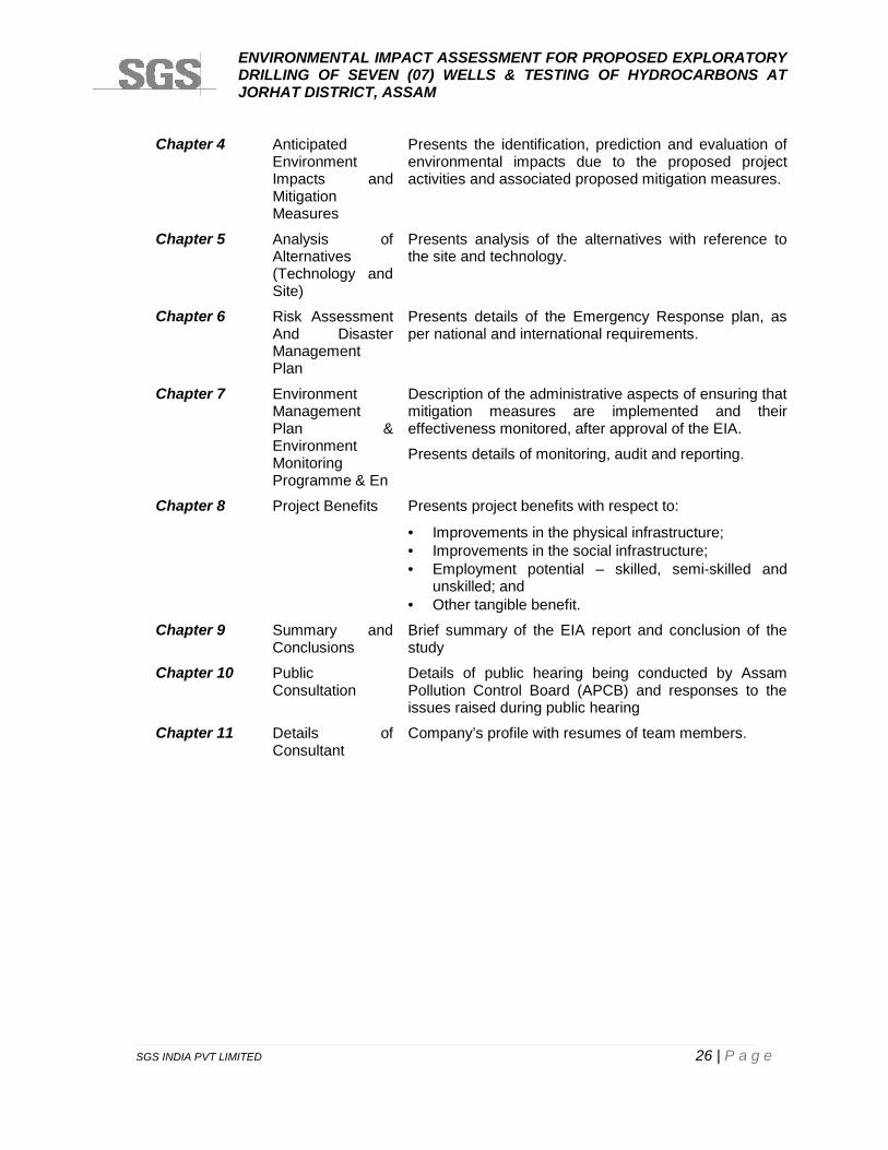
Chapter 1 Introduction Presents an introduction of the project along with thescope and objectives of the EIA/ EMP study.
Chapter 2 ProjectDescription
Presents brief project technical details.
Chapter 3 Description ofExistingEnvironment
Presents the baseline status for various environmentalparameters in the study area.
ENVIRONMENTAL IMPACT ASSESSMENT FOR PROPOSED EXPLORATORYDRILLING OF SEVEN (07) WELLS & TESTING OF HYDROCARBONS ATJORHAT DISTRICT, ASSAM
SGS INDIA PVT LIMITED 26 | P a g e
Chapter 4 AnticipatedEnvironmentImpacts andMitigationMeasures
Presents the identification, prediction and evaluation ofenvironmental impacts due to the proposed projectactivities and associated proposed mitigation measures.
Chapter 5 Analysis ofAlternatives(Technology andSite)
Presents analysis of the alternatives with reference tothe site and technology.
Chapter 6 Risk AssessmentAnd DisasterManagementPlan
Presents details of the Emergency Response plan, asper national and international requirements.
Chapter 7 EnvironmentManagementPlan &EnvironmentMonitoringProgramme & En
Description of the administrative aspects of ensuring thatmitigation measures are implemented and theireffectiveness monitored, after approval of the EIA.
Presents details of monitoring, audit and reporting.
Chapter 8 Project Benefits Presents project benefits with respect to:
Improvements in the physical infrastructure; Improvements in the social infrastructure; Employment potential – skilled, semi-skilled and
unskilled; and Other tangible benefit.
Chapter 9 Summary andConclusions
Brief summary of the EIA report and conclusion of thestudy
Chapter 10 PublicConsultation
Details of public hearing being conducted by AssamPollution Control Board (APCB) and responses to theissues raised during public hearing
Chapter 11 Details ofConsultant
Company’s profile with resumes of team members.
ENVIRONMENTAL IMPACT ASSESSMENT FOR PROPOSED EXPLORATORYDRILLING OF SEVEN (07) WELLS & TESTING OF HYDROCARBONS ATJORHAT DISTRICT, ASSAM
SGS INDIA PVT LIMITED 27 | P a g e
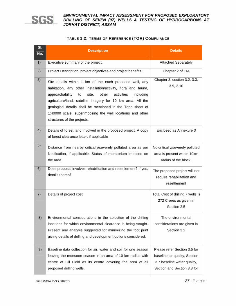
TABLE 1.2: TERMS OF REFERENCE (TOR) COMPLIANCE
Sl.No.
Description Details
1) Executive summary of the project. Attached Separately
2) Project Description, project objectives and project benefits. Chapter 2 of EIA
3) Site details within 1 km of the each proposed well, any
habitation, any other installation/activity, flora and fauna,
approachability to site, other activities including
agriculture/land, satellite imagery for 10 km area. All the
geological details shall be mentioned in the Topo sheet of
1:40000 scale, superimposing the well locations and other
structures of the projects.
Chapter 3, section 3.2, 3.3,
3.9, 3.10
4) Details of forest land involved in the proposed project. A copy
of forest clearance letter, if applicable
Enclosed as Annexure 3
5) Distance from nearby critically/severely polluted area as per
Notification, if applicable. Status of moratorium imposed on
the area.
No critically/severely polluted
area is present within 10km
radius of the block.
6) Does proposal involves rehabilitation and resettlement? If yes,
details thereof.The proposed project will not
require rehabilitation and
resettlement
7) Details of project cost. Total Cost of drilling 7 wells is
272 Crores as given in
Section 2.5
8) Environmental considerations in the selection of the drilling
locations for which environmental clearance is being sought.
Present any analysis suggested for minimizing the foot print
giving details of drilling and development options considered.
The environmental
considerations are given in
Section 2.2
9) Baseline data collection for air, water and soil for one season
leaving the monsoon season in an area of 10 km radius with
centre of Oil Field as its centre covering the area of all
proposed drilling wells.
Please refer Section 3.5 for
baseline air quality, Section
3.7 baseline water quality,
Section and Section 3.8 for
ENVIRONMENTAL IMPACT ASSESSMENT FOR PROPOSED EXPLORATORYDRILLING OF SEVEN (07) WELLS & TESTING OF HYDROCARBONS ATJORHAT DISTRICT, ASSAM
SGS INDIA PVT LIMITED 28 | P a g e
Sl.No.
Description Details
baseline soil quality
respectively.
10) Topography of the project site. Chapter3, Section 3.3.1
11) Action plan for ambient air quality parameters as per
NAAQES Standards for PM10, PM2.5, SO2 and NOX and
Benzene, etc as per GSR 826(E) dated 16th November, 2009.
Chapter3, Section 3.5
12) Details of Ambient Air Quality monitoring at 8 locations for
PM10, SO2, NOx, VOCs, Methane and non-methane HC.
Ambient Air Quality provided
in Section 3.5.1
13) Soil sample analysis (physical and chemical properties) at the
areas located at 5 locations
Result of Soil Sample
Analyses Section 3.8.1
14) Ground and surface water quality in the vicinity of the
proposed wells site.
Result of Ground and Surface
Water given in Section 3.7.1
15) Climatology and Meteorology including wind speed, wind
direction, temperature rainfall relative humidity etc.
Provided in Chapter3, section
3.4
16) Measurement of Noise levels within 1 km radius of the
proposed wells.
Provided in Chapter3,
Section 3.6.1
17) Vegetation and land use; flora/fauna in the study area with
details of endangered species, if any.
Provided in Chapter3, section
3.9
18) Incremental GLC as a result of DG set operation. Provided in Chapter 4,
section 4.2.2.5
19) Potential environmental impact envisages during various
stages of project activities such as site activation,
development, operation/ maintenance and decommissioning.
Please refer Chapter 4
20) Actual source of water and ‘Permission’ for the drawl of water
from the Competent Authority. Detailed water balance,
wastewater generation and discharge
Refer Annexure 1
21) Noise abatement measures and measures to minimize Chapter 7, refer table 7.1
ENVIRONMENTAL IMPACT ASSESSMENT FOR PROPOSED EXPLORATORYDRILLING OF SEVEN (07) WELLS & TESTING OF HYDROCARBONS ATJORHAT DISTRICT, ASSAM
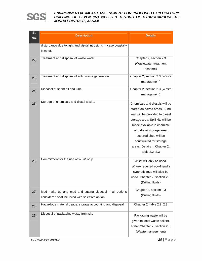
SGS INDIA PVT LIMITED 29 | P a g e
Sl.No.
Description Details
disturbance due to light and visual intrusions in case coastally
located.
22) Treatment and disposal of waste water. Chapter 2, section 2.3
(Wastewater treatment
scheme)
23) Treatment and disposal of solid waste generation Chapter 2, section 2.3 (Waste
management)
24) Disposal of spent oil and lube. Chapter 2, section 2.3 (Waste
management)
25) Storage of chemicals and diesel at site. Chemicals and diesels will be
stored on paved areas, Bund
wall will be provided to diesel
storage area, Spill kits will be
made available in chemical
and diesel storage area,
covered shed will be
constructed for storage
areas. Details in Chapter 2,
table 2.2, 2.3
26) Commitment for the use of WBM only WBM will only be used.
Where required eco-friendly
synthetic mud will also be
used. Chapter 2, section 2.3
(Drilling fluids)
27) Mud make up and mud and cutting disposal – all options
considered shall be listed with selective option
Chapter 2, section 2.3
(Drilling fluids)
28) Hazardous material usage, storage accounting and disposal Chapter 2, table 2.2, 2.3
29) Disposal of packaging waste from site Packaging waste will be
given to local waste sellers.
Refer Chapter 2, section 2.3
(Waste management)
ENVIRONMENTAL IMPACT ASSESSMENT FOR PROPOSED EXPLORATORYDRILLING OF SEVEN (07) WELLS & TESTING OF HYDROCARBONS ATJORHAT DISTRICT, ASSAM
SGS INDIA PVT LIMITED 30 | P a g e
Sl.No.
Description Details
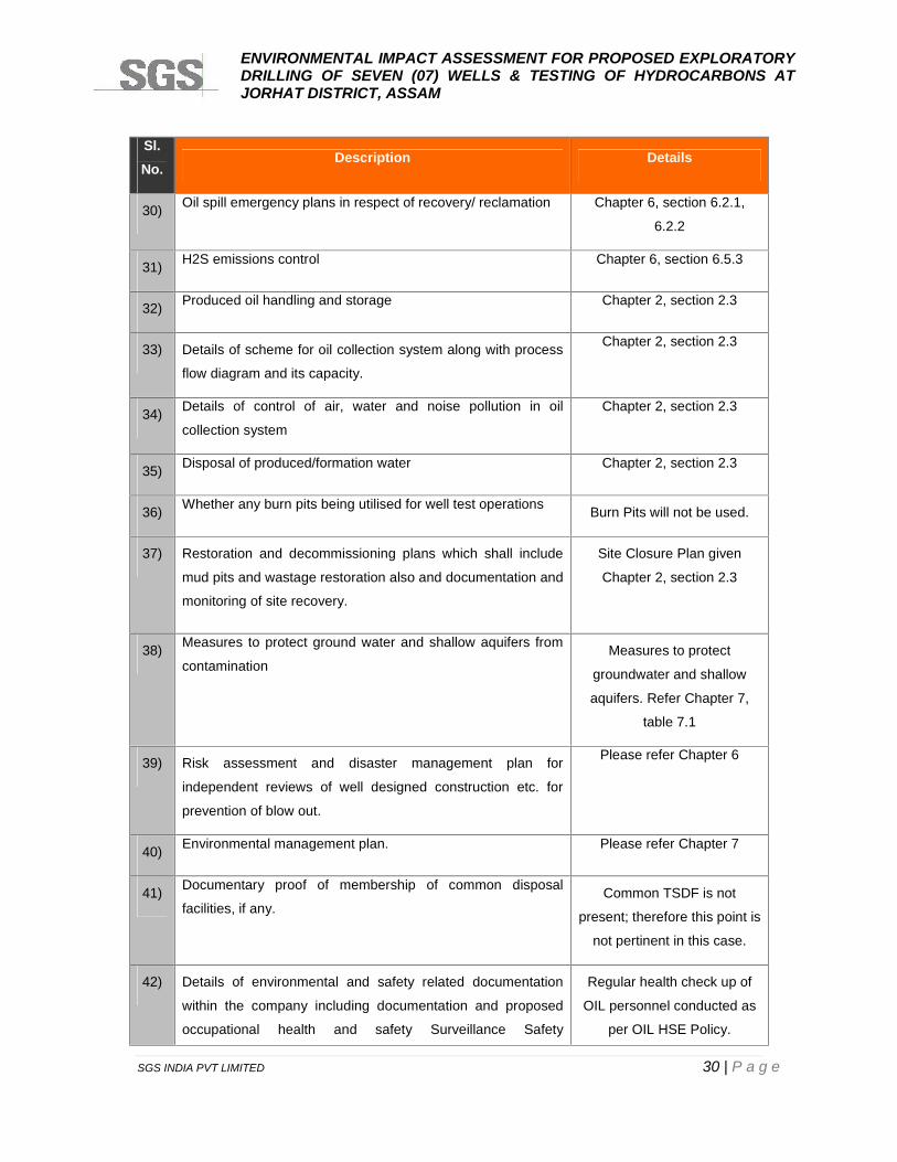
30) Oil spill emergency plans in respect of recovery/ reclamation Chapter 6, section 6.2.1,
6.2.2
31) H2S emissions control Chapter 6, section 6.5.3
32) Produced oil handling and storage Chapter 2, section 2.3
33) Details of scheme for oil collection system along with process
flow diagram and its capacity.
Chapter 2, section 2.3
34) Details of control of air, water and noise pollution in oil
collection system
Chapter 2, section 2.3
35) Disposal of produced/formation water Chapter 2, section 2.3
36) Whether any burn pits being utilised for well test operations Burn Pits will not be used.
37) Restoration and decommissioning plans which shall include
mud pits and wastage restoration also and documentation and
monitoring of site recovery.
Site Closure Plan given
Chapter 2, section 2.3
38) Measures to protect ground water and shallow aquifers from
contaminationMeasures to protect
groundwater and shallow
aquifers. Refer Chapter 7,
table 7.1
39) Risk assessment and disaster management plan for
independent reviews of well designed construction etc. for
prevention of blow out.
Please refer Chapter 6
40) Environmental management plan. Please refer Chapter 7
41) Documentary proof of membership of common disposal
facilities, if any.Common TSDF is not
present; therefore this point is
not pertinent in this case.
42) Details of environmental and safety related documentation
within the company including documentation and proposed
occupational health and safety Surveillance Safety
Regular health check up of
OIL personnel conducted as
per OIL HSE Policy.
ENVIRONMENTAL IMPACT ASSESSMENT FOR PROPOSED EXPLORATORYDRILLING OF SEVEN (07) WELLS & TESTING OF HYDROCARBONS ATJORHAT DISTRICT, ASSAM
SGS INDIA PVT LIMITED 31 | P a g e
Sl.No.
Description Details
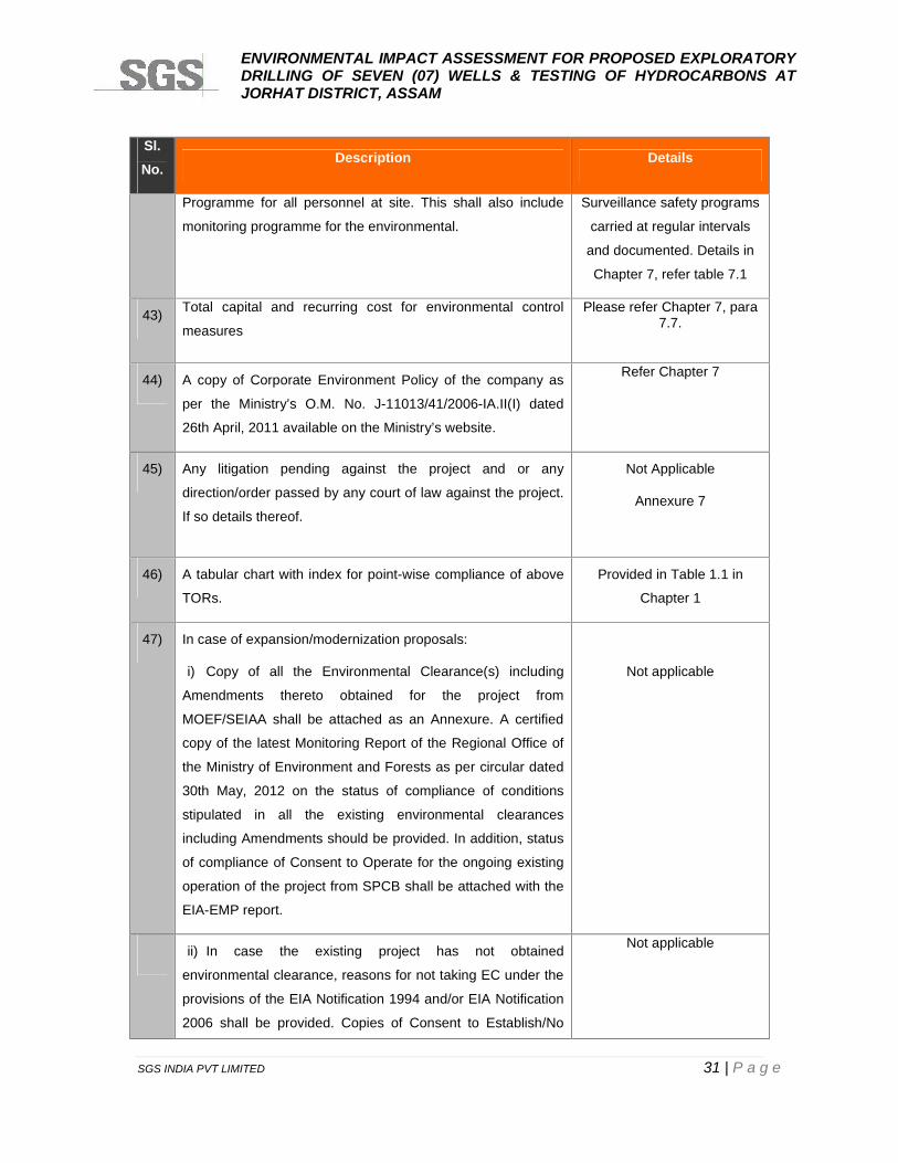
Programme for all personnel at site. This shall also include
monitoring programme for the environmental.
Surveillance safety programs
carried at regular intervals
and documented. Details in
Chapter 7, refer table 7.1
43) Total capital and recurring cost for environmental control
measures
Please refer Chapter 7, para7.7.
44) A copy of Corporate Environment Policy of the company as
per the Ministry’s O.M. No. J-11013/41/2006-IA.II(I) dated
26th April, 2011 available on the Ministry’s website.
Refer Chapter 7
45) Any litigation pending against the project and or any
direction/order passed by any court of law against the project.
If so details thereof.
Not Applicable
Annexure 7
46) A tabular chart with index for point-wise compliance of above
TORs.
Provided in Table 1.1 in
Chapter 1
47) In case of expansion/modernization proposals:
i) Copy of all the Environmental Clearance(s) including
Amendments thereto obtained for the project from
MOEF/SEIAA shall be attached as an Annexure. A certified
copy of the latest Monitoring Report of the Regional Office of
the Ministry of Environment and Forests as per circular dated
30th May, 2012 on the status of compliance of conditions
stipulated in all the existing environmental clearances
including Amendments should be provided. In addition, status
of compliance of Consent to Operate for the ongoing existing
operation of the project from SPCB shall be attached with the
EIA-EMP report.
Not applicable
ii) In case the existing project has not obtained
environmental clearance, reasons for not taking EC under the
provisions of the EIA Notification 1994 and/or EIA Notification
2006 shall be provided. Copies of Consent to Establish/No
Not applicable
ENVIRONMENTAL IMPACT ASSESSMENT FOR PROPOSED EXPLORATORYDRILLING OF SEVEN (07) WELLS & TESTING OF HYDROCARBONS ATJORHAT DISTRICT, ASSAM
SGS INDIA PVT LIMITED 32 | P a g e
Sl.No.
Description Details
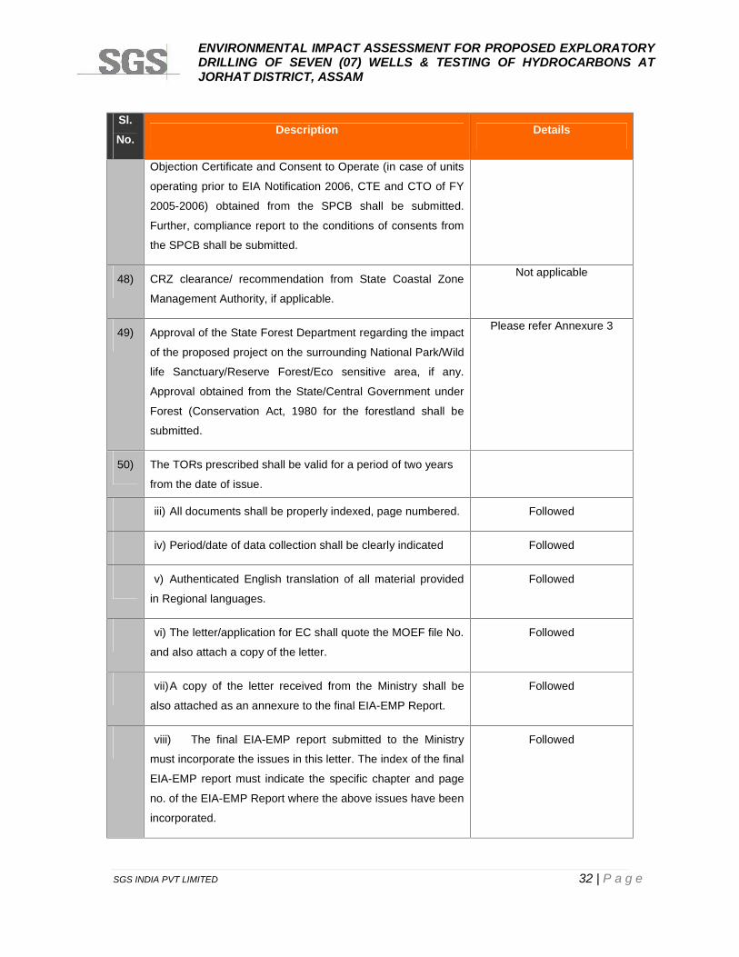
Objection Certificate and Consent to Operate (in case of units
operating prior to EIA Notification 2006, CTE and CTO of FY
2005-2006) obtained from the SPCB shall be submitted.
Further, compliance report to the conditions of consents from
the SPCB shall be submitted.
48) CRZ clearance/ recommendation from State Coastal Zone
Management Authority, if applicable.
Not applicable
49) Approval of the State Forest Department regarding the impact
of the proposed project on the surrounding National Park/Wild
life Sanctuary/Reserve Forest/Eco sensitive area, if any.
Approval obtained from the State/Central Government under
Forest (Conservation Act, 1980 for the forestland shall be
submitted.
Please refer Annexure 3
50) The TORs prescribed shall be valid for a period of two years
from the date of issue.
iii) All documents shall be properly indexed, page numbered. Followed
iv) Period/date of data collection shall be clearly indicated Followed
v) Authenticated English translation of all material provided
in Regional languages.
Followed
vi) The letter/application for EC shall quote the MOEF file No.
and also attach a copy of the letter.
Followed
vii)A copy of the letter received from the Ministry shall be
also attached as an annexure to the final EIA-EMP Report.
Followed
viii) The final EIA-EMP report submitted to the Ministry
must incorporate the issues in this letter. The index of the final
EIA-EMP report must indicate the specific chapter and page
no. of the EIA-EMP Report where the above issues have been
incorporated.
Followed
ENVIRONMENTAL IMPACT ASSESSMENT FOR PROPOSED EXPLORATORYDRILLING OF SEVEN (07) WELLS & TESTING OF HYDROCARBONS ATJORHAT DISTRICT, ASSAM
SGS INDIA PVT LIMITED 33 | P a g e
Sl.No.
Description Details
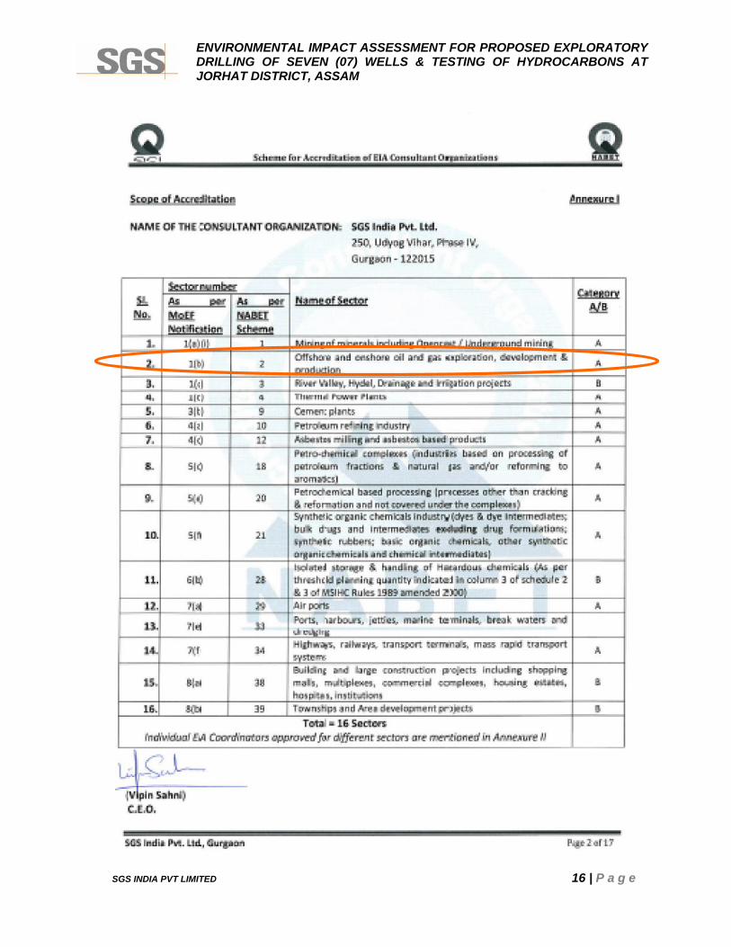
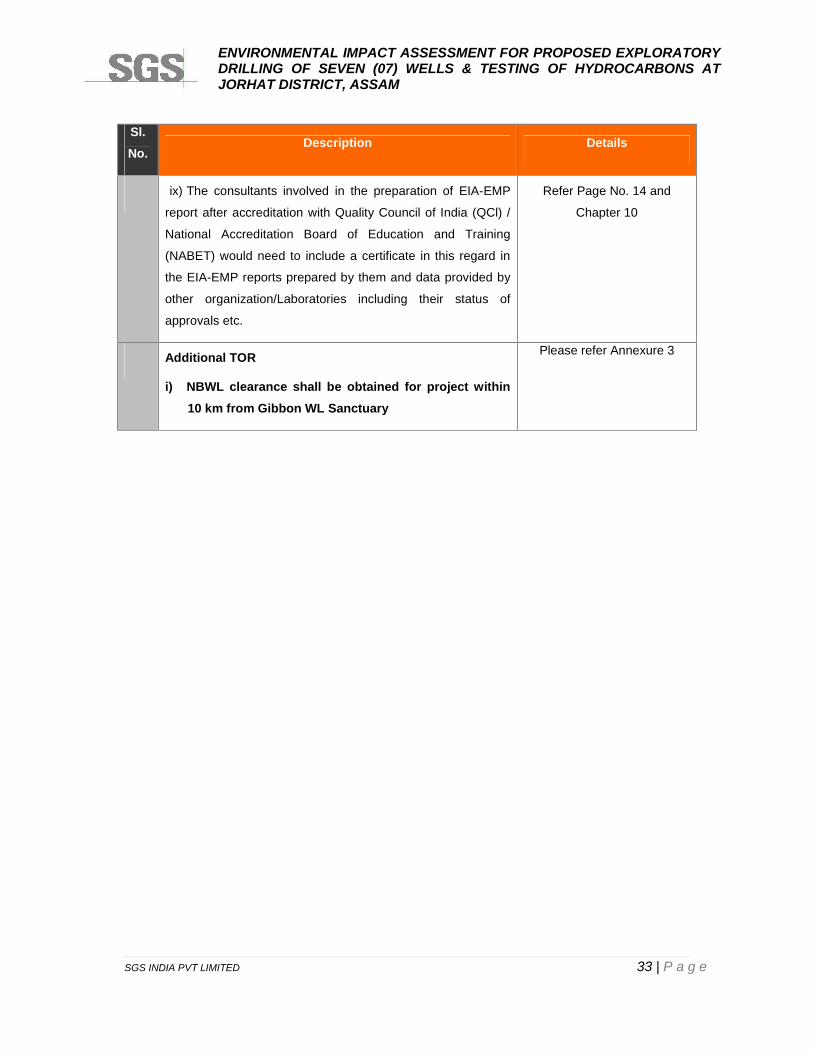
ix) The consultants involved in the preparation of EIA-EMP
report after accreditation with Quality Council of India (QCl) /
National Accreditation Board of Education and Training
(NABET) would need to include a certificate in this regard in
the EIA-EMP reports prepared by them and data provided by
other organization/Laboratories including their status of
approvals etc.
Refer Page No. 14 and
Chapter 10
Additional TOR
i) NBWL clearance shall be obtained for project within10 km from Gibbon WL Sanctuary
Please refer Annexure 3

ENVIRONMENTAL IMPACT ASSESSMENT FOR PROPOSED EXPLORATORYDRILLING OF SEVEN (07) WELLS & TESTING OF HYDROCARBONS ATJORHAT DISTRICT, ASSAM
SGS INDIA PVT LIMITED 34 | P a g e
CHAPTER 2
PROJECT DESCRIPTION
ENVIRONMENTAL IMPACT ASSESSMENT FOR PROPOSED EXPLORATORYDRILLING OF SEVEN (07) WELLS & TESTING OF HYDROCARBONS ATJORHAT DISTRICT, ASSAM
SGS INDIA PVT LIMITED 35 | P a g e
CHAPTER 2: PROJECT DESCRIPTION
2.1 PREAMBLE
OIL intends to drill seven (07) exploratory Wells in entire block to explore the possibility of
commercial production of hydrocarbons within onshore block AA-ONN-2009/4 of about 84
sq. Km in Jorhat district of Assam.
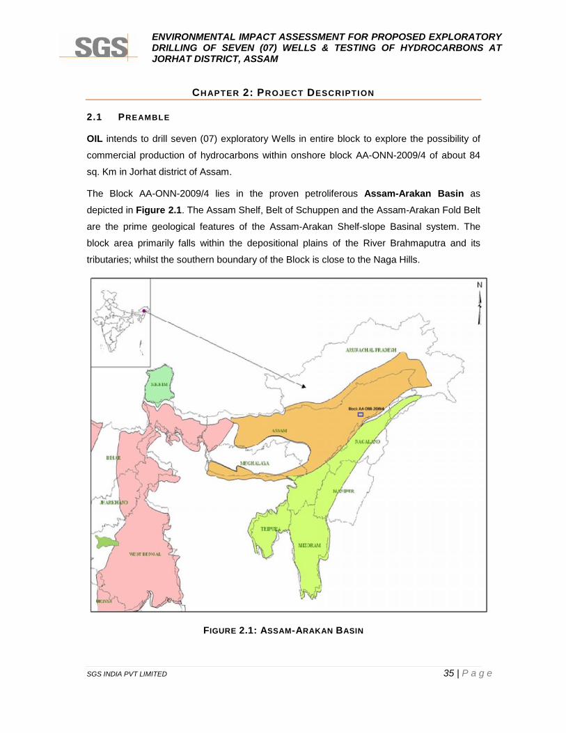
The Block AA-ONN-2009/4 lies in the proven petroliferous Assam-Arakan Basin as
depicted in Figure 2.1. The Assam Shelf, Belt of Schuppen and the Assam-Arakan Fold Belt
are the prime geological features of the Assam-Arakan Shelf-slope Basinal system. The
block area primarily falls within the depositional plains of the River Brahmaputra and its
tributaries; whilst the southern boundary of the Block is close to the Naga Hills.
FIGURE 2.1: ASSAM-ARAKAN BASIN
ENVIRONMENTAL IMPACT ASSESSMENT FOR PROPOSED EXPLORATORYDRILLING OF SEVEN (07) WELLS & TESTING OF HYDROCARBONS ATJORHAT DISTRICT, ASSAM
SGS INDIA PVT LIMITED 36 | P a g e
Source: Hydrocarbon Exploration and Production Activities, India- 2011-12 Published by Director General ofHydrocarbons
The Block AA-ONN-2009/4 is geologically located in the vicinity of already proven fields in
Assam Plains and Belt of Schuppen, with major oil fileds like Lakwa, Geleki, Rudrasagar,
Amguri in east and Borhola-Champang and Khoraghat fields in south-west having
established Miocene-Oligocene-Eocene (Tipam-Barail-Tura) hydrocarbon system.
The Block area was initially investigated by 2D seismic survey back in the 1980s by ONGC.
A number of gas seepages have been observed in the surrounding areas while the proximal
Amguri field has produced gas from TS-2 Sand reservoir in one of the wells. Recently a gas
show was encountered at Khatisona, located around 7km from well Holongapar-1; drilled
near the Jorhat Fault zone. These gas seepages could be linked to the intense fault network
which also runs through the Block area.
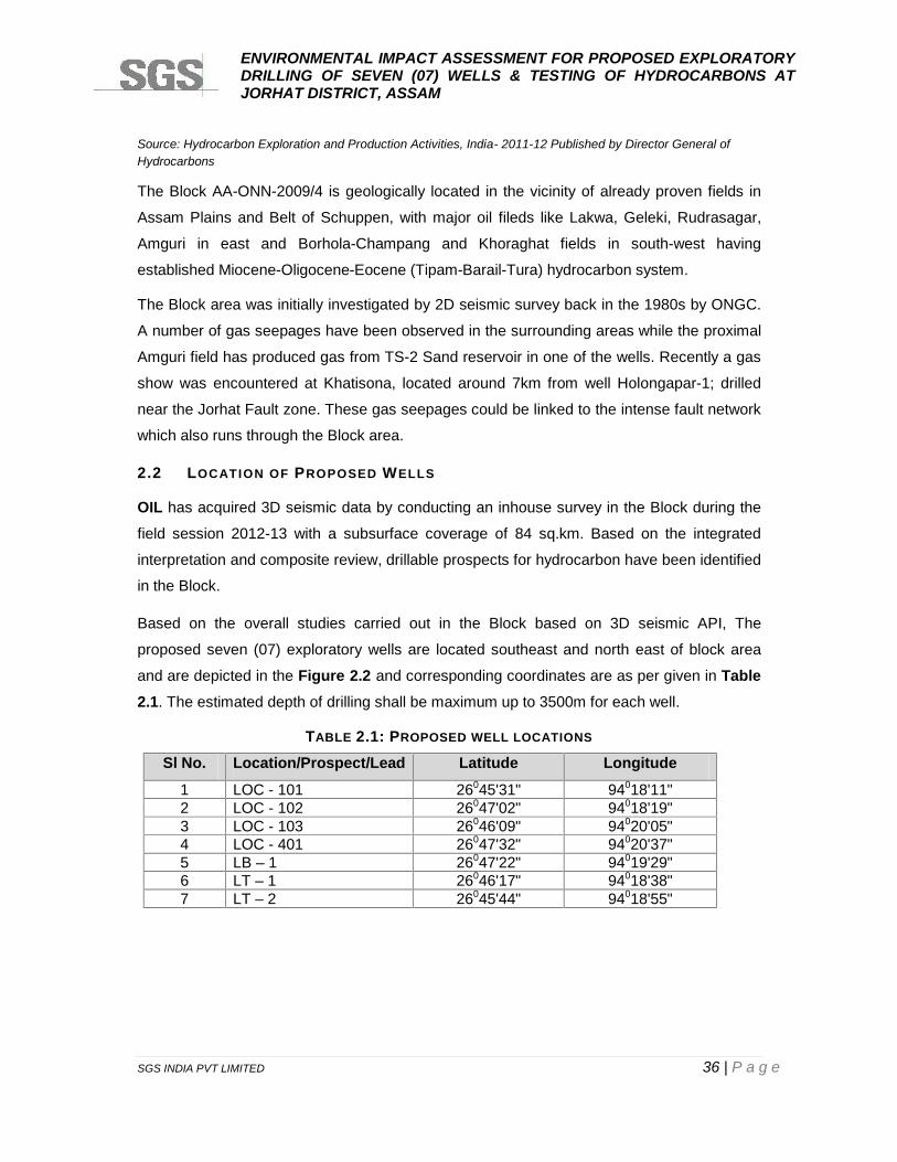
2.2 LOCATION OF PROPOSED WELLS
OIL has acquired 3D seismic data by conducting an inhouse survey in the Block during the
field session 2012-13 with a subsurface coverage of 84 sq.km. Based on the integrated
interpretation and composite review, drillable prospects for hydrocarbon have been identified
in the Block.
Based on the overall studies carried out in the Block based on 3D seismic API, The
proposed seven (07) exploratory wells are located southeast and north east of block area
and are depicted in the Figure 2.2 and corresponding coordinates are as per given in Table2.1. The estimated depth of drilling shall be maximum up to 3500m for each well.
TABLE 2.1: PROPOSED WELL LOCATIONS
Sl No. Location/Prospect/Lead Latitude Longitude
1 LOC - 101 26045'31" 94018'11"2 LOC - 102 26047'02" 94018'19"3 LOC - 103 26046'09" 94020'05"4 LOC - 401 26047'32" 94020'37"5 LB – 1 26047'22" 94019'29"6 LT – 1 26046'17" 94018'38"7 LT – 2 26045'44" 94018'55"
ENVIRONMENTAL IMPACT ASSESSMENT FOR PROPOSED EXPLORATORYDRILLING OF SEVEN (07) WELLS & TESTING OF HYDROCARBONS ATJORHAT DISTRICT, ASSAM
SGS INDIA PVT LIMITED 37 | P a g e
FIGURE 2:2: LOCATION OF PROPOSED DRILLING SITE
ENVIRONMENTAL IMPACT ASSESSMENT FOR PROPOSED EXPLORATORYDRILLING OF SEVEN (07) WELLS & TESTING OF HYDROCARBONS ATJORHAT DISTRICT, ASSAM
SGS INDIA PVT LIMITED 38 | P a g e
2.3 EXPLORATORY DRILLING OF WELLS
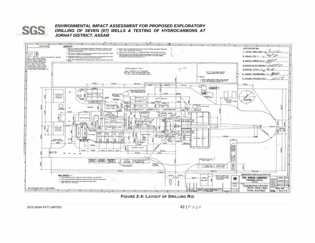
Land required for each well site during drilling will be 150 m x 150 m, i.e., 2.25 ha each well
site, including site facilities as per layout plan depicted in Figure 2.3 and area for camp site
shall be 1.5-2.0 ha. .
The proposed drilling sites will be restricted and fenced all round with round the clock watch
and ward facility. Entry of vehicles into the drilling site area will be prohibited except for
material movement. Adequate parking facilities will be provided outside the drilling location.
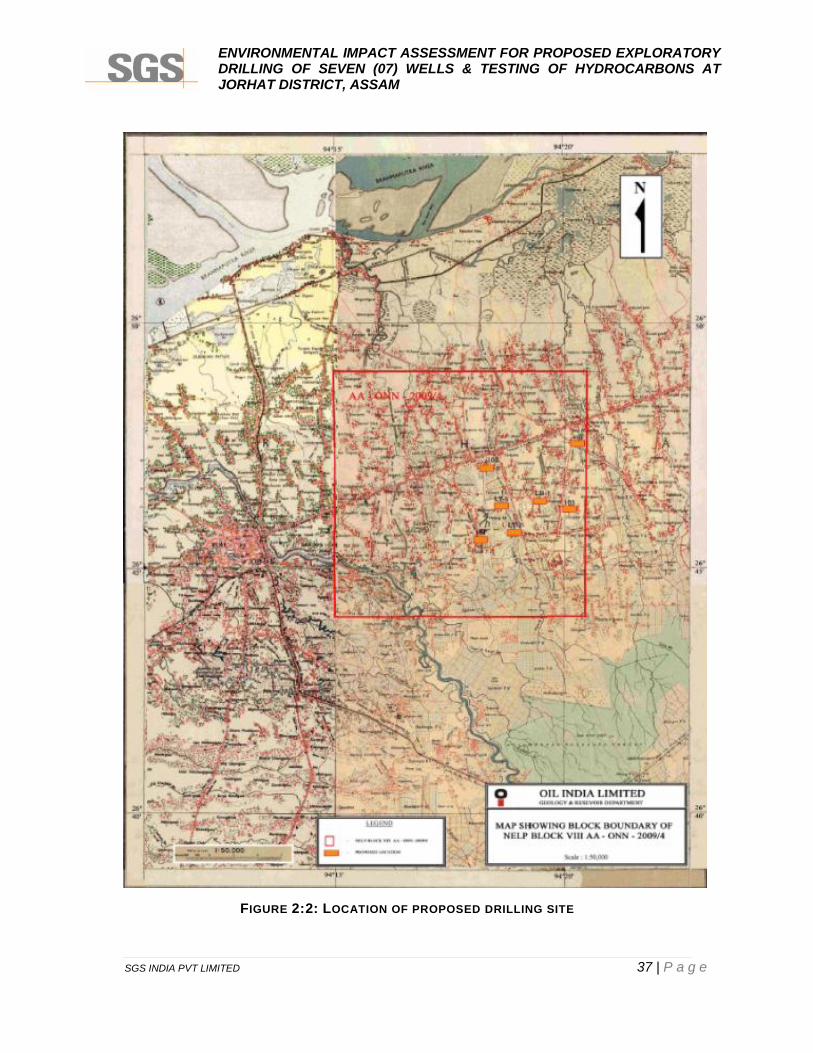
A standard electric onshore rig of 1400/2000 HP with Rotary/Top drive System will be
installed at the potential site of drilling after thorough inspection for its working capability and
quality standards. Details of proposed Drilling rig are depicted in Figure 2.3.
FIGURE 2:3: DRILLING RIG
Source: Joint E&P Forum/ UNEP Technical Publication
Well spudding shall be the start of drilling activity. Top-hole section will be drilled to a desired
depth based on well design. After drilling top-hole section, it will be cased with a pipe called
“Casing”. “Casing” provides support to hole wall and secures hole section. Other than that, it
ENVIRONMENTAL IMPACT ASSESSMENT FOR PROPOSED EXPLORATORYDRILLING OF SEVEN (07) WELLS & TESTING OF HYDROCARBONS ATJORHAT DISTRICT, ASSAM
SGS INDIA PVT LIMITED 39 | P a g e
isolates problematic hole sections such as loss zones, shale sections, over pressurized
formations etc. After running casing, space between hole wall and “Casing” (annulus) will be
cemented. This process of drilling and casing the hole section continues until the final well
depth (target) is achieved. Drilling process is associated with various hazards such as well
active situation (kicks), blowouts, H2S situation etc. The other details are described in brief
as per given hereunder:
i) Well kick situationWhile drilling, if the formation pressure exceeds the hydrostatic pressure exerted by the
drilling fluid, formation fluids break out in to the well bore. This is called kick. Primary means
of well control is to have sufficient over-balance over formation pressure. For some reason if
an unexpected over-pressurized formation is encountered while drilling and if the well control
situation arises, rig is equipped with equipment to control this situation.
ii) BlowoutUncontrolled “well control situation” eventually leads to a blowout. Blow out can cause a
partial or total destruction of drilling rig. Blowouts are often associated with hydrocarbon spill
followed by fire.
iii) Well controlThis set of equipment is called “Blowout Preventers (BOP)”. Blow Out Preventer consists of,
“Annular Preventer”, which can generally close on any size or shape of tubular in the well
bore and closes the annular space between drill string and casing. Another type of blowout
preventer is a “Ram Preventer”. Ram preventers are of two types i.e., Pipe Rams and Shear
Rams. Pipe rams also close the annulus between drill string and casing, but they have a
fixed size. As such a specific pipe rams can be closed on a specific size of pipe.
Shear rams are generally the last choice of preventer to be operated as they shear drill
string and shut off the well bore. After determining the existing formation pressure and other
geological complexities from the seismic data, appropriate BOP will be used as per standard
oil field guideline for the same.
Drilling Fluids (Mud)The role of the drilling fluid (mud) in pressure control is especially important. If the drill bit
penetrates a formation containing oil, gas or water under pressure, these fluids are
prevented from flowing into the borehole by ensuring that the drilling mud is of sufficient
density to the natural formation pressures. The density of the mud can be increased by the
addition of barite weighting material. Bentonite is employed to improve the theological

ENVIRONMENTAL IMPACT ASSESSMENT FOR PROPOSED EXPLORATORYDRILLING OF SEVEN (07) WELLS & TESTING OF HYDROCARBONS ATJORHAT DISTRICT, ASSAM
SGS INDIA PVT LIMITED 40 | P a g e
properties and enable the drill cuttings to be transported from the hole while drilling and also
be suspended in the fluid while the drill bit is being changed. The barite used in the drilling
mud would be as per API standard specifications.
Based on geological prognosis and predicted formation pressures, Water Based Mud (WBM)
will be used for all the wells considering environmental constraints and hazards. The main
components of drilling mud are slurry of inert solids suspended in a liquid phase. The main
constituents of the WBM are bentonite and barites, both of which are natural minerals. In
case if the WBM is not able to be used due to geological formation complexities then low
toxic OBM (Oil Based Mud) with less than 1% aromatic contents may be used after
intimating the MOEF&CC and/or Assam State Pollution Control Board. The vegetable oil i.,e
linseed oil or EP lube oil shall be used as lubricating in oil based mud.
ENVIRONMENTAL IMPACT ASSESSMENT FOR PROPOSED EXPLORATORYDRILLING OF SEVEN (07) WELLS & TESTING OF HYDROCARBONS ATJORHAT DISTRICT, ASSAM
SGS INDIA PVT LIMITED 41 | P a g e
FIGURE 2:4: LAYOUT OF DRILLING RIG
ENVIRONMENTAL IMPACT ASSESSMENT FOR PROPOSED EXPLORATORYDRILLING OF SEVEN (07) WELLS & TESTING OF HYDROCARBONS ATJORHAT DISTRICT, ASSAM
SGS INDIA PVT LIMITED 42 | P a g e
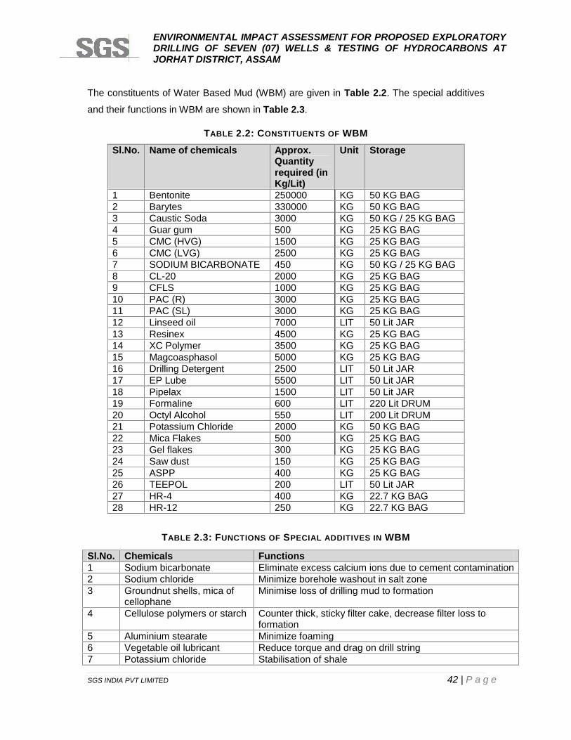
The constituents of Water Based Mud (WBM) are given in Table 2.2. The special additives
and their functions in WBM are shown in Table 2.3.
TABLE 2.2: CONSTITUENTS OF WBMSl.No. Name of chemicals Approx.
Quantityrequired (inKg/Lit)
Unit Storage
1 Bentonite 250000 KG 50 KG BAG2 Barytes 330000 KG 50 KG BAG3 Caustic Soda 3000 KG 50 KG / 25 KG BAG4 Guar gum 500 KG 25 KG BAG5 CMC (HVG) 1500 KG 25 KG BAG6 CMC (LVG) 2500 KG 25 KG BAG7 SODIUM BICARBONATE 450 KG 50 KG / 25 KG BAG8 CL-20 2000 KG 25 KG BAG9 CFLS 1000 KG 25 KG BAG10 PAC (R) 3000 KG 25 KG BAG11 PAC (SL) 3000 KG 25 KG BAG12 Linseed oil 7000 LIT 50 Lit JAR13 Resinex 4500 KG 25 KG BAG14 XC Polymer 3500 KG 25 KG BAG15 Magcoasphasol 5000 KG 25 KG BAG16 Drilling Detergent 2500 LIT 50 Lit JAR17 EP Lube 5500 LIT 50 Lit JAR18 Pipelax 1500 LIT 50 Lit JAR19 Formaline 600 LIT 220 Lit DRUM20 Octyl Alcohol 550 LIT 200 Lit DRUM21 Potassium Chloride 2000 KG 50 KG BAG22 Mica Flakes 500 KG 25 KG BAG23 Gel flakes 300 KG 25 KG BAG24 Saw dust 150 KG 25 KG BAG25 ASPP 400 KG 25 KG BAG26 TEEPOL 200 LIT 50 Lit JAR27 HR-4 400 KG 22.7 KG BAG28 HR-12 250 KG 22.7 KG BAG
TABLE 2.3: FUNCTIONS OF SPECIAL ADDITIVES IN WBM
Sl.No. Chemicals Functions1 Sodium bicarbonate Eliminate excess calcium ions due to cement contamination2 Sodium chloride Minimize borehole washout in salt zone3 Groundnut shells, mica of
cellophaneMinimise loss of drilling mud to formation
4 Cellulose polymers or starch Counter thick, sticky filter cake, decrease filter loss toformation
5 Aluminium stearate Minimize foaming6 Vegetable oil lubricant Reduce torque and drag on drill string7 Potassium chloride Stabilisation of shale
ENVIRONMENTAL IMPACT ASSESSMENT FOR PROPOSED EXPLORATORYDRILLING OF SEVEN (07) WELLS & TESTING OF HYDROCARBONS ATJORHAT DISTRICT, ASSAM
SGS INDIA PVT LIMITED 43 | P a g e
The drilling fluids circulation system consists of several items of equipment. The mud pump
takes in mud from the mud pits and sends it out a discharge line to a standpipe. The
standpipe is a steel pipe mounted vertically on one leg of the derrick. The mud is pumped up
the standpipe into a flexible reinforced rubber hose called the Kelly hose. The Kelly hose is
connected to the swivel; goes down the Kelly, drill pipe and drill collars and exits at the bit.
The mud then does a sharp U-turn and heads back up the hole in the annulus. The annulus
is the space between the outside of the drill string and the wall of the hole. Finally, the mud
leaves the hole through a steel pipe called the mud return pipe and falls over a vibrating
screen like device called the shale shaker. The shale shaker screens out the cuttings from
the mud. The mud drains back into the mud tanks and is recycled back into the well via the
mud pump, while the drill cuttings which are inert materials of shale, sand, and clay fall into
the lined waste pits. The drilling fluids left over at the end of the particular well will be
discharged into the lined waste pits and dried. The pits will be provided with plastic liners to
maintain integrity and prevent any leakage. The drill cuttings cut by the bit are removed from
the mud by the shale shakers and other solids removal equipment and transferred to the
waste pits. Once the mud is cleaned it is pumped down the drill string again.
The drilling mud, which is pumped through the drill string, through the drill bit and then
returns up the annulus between the drill string and bore hole, serves a number of important
functions, including:
Removal of drilled solids (i.e. cuttings) from the bottom of the hole and their transport to
the surface for separation from the mud;
Lubrication and cooling of the drill bit and string;
Deposition of an impermeable cake on the well bore wall to seal the formation being
drilled; and
Countering the natural formation pressures and preventing uncontrolled flow of fluid from
the formations.
At the end of drilling of each well, whatever the fluid left in the pits will be treated &
transported to the next drilling location or disposed off in pit lined with HDPE sheet.
Drill CuttingThe drill cuttings, cut by the bit, shall be removed from the mud by the shale shakers and
centrifuges and transferred to the mud tank. Once the mud shall be cleaned, it is pumped
down the drill string again. The drilling fluid will be re-used after extraction of drill cuttings
and necessary treatment. It is estimated that per well, around 440 cu.m of drill cuttings will
ENVIRONMENTAL IMPACT ASSESSMENT FOR PROPOSED EXPLORATORYDRILLING OF SEVEN (07) WELLS & TESTING OF HYDROCARBONS ATJORHAT DISTRICT, ASSAM
SGS INDIA PVT LIMITED 44 | P a g e
be generated as waste, which will be stored in an impervious pit with liner at the site and the
pit will be covered or treated as per waste disposal guidelines for such wastes. At the end of
drilling of each well, dried cuttings will be disposed off in secured HDPE lined pit.
i) Drill-stem testingIf the geologist detects the presence of oil or gas in the drill cuttings, a drill-stem test is
frequently performed to evaluate the formation or zone from which the oil show was
observed. Drill-stem tests may also be performed when the driller observes a decrease in
the time required to drill a foot of rock, known as a "drilling break." Since porous rock may be
drilled easier than nonporous or less porous rock, a drilling break indicates the presence of
porosity, one of the qualities of reservoir rock. A drill-stem test enables the exploration
company to obtain a sample of the fluids and gases contained in the formation or interval
being tested as well as pressure information, which is determined by special gauges within
the test tool.
Drill-stem testing is accomplished by removing the drill string from the bore hole. The drill bit
is removed and a drill-stem test tool with a packer is attached. The test tool, packer, and drill
string are inserted back into the bore hole to the desired depth. The packer, which is an
expandable device, is set and expanded at the predetermined depth to isolate the zone to be
tested. The test tool contains a valve which may be opened and closed to allow formation
fluids to enter the test tool and drill string. If there is sufficient fluid and pressure within the
zone being tested, the formation fluid (oil, gas, water) may rise to the surface and flow into
special test tanks used for that purpose. If gas is present, it is burned at the surface as a
flare. By analyzing the rate of flow or the amount of formation fluid recovered in the drill
string and the formation pressures recorded, obtaining a good indication of reservoir
characteristics such as porosity, permeability, and the nature of the fluids or gas contained
therein is possible.
ii) Surface Testing & FlaringIn case hydrocarbons are detected in the well, the quantity and quality will be tested. The
fluids & gases coming out from the well will be separated by temporary test separators with
facility of flow metering. The produced water & oil will be stored separately for further
processing and the gas will be flared. The flaring will be intermittent and last only for few
days. However, for flaring all the flaring guidelines for onshore wells will be followed and the
design, size and location of flaring stack will be decided based on surrounding habitations
and the flaring guidelines.
ENVIRONMENTAL IMPACT ASSESSMENT FOR PROPOSED EXPLORATORYDRILLING OF SEVEN (07) WELLS & TESTING OF HYDROCARBONS ATJORHAT DISTRICT, ASSAM
SGS INDIA PVT LIMITED 45 | P a g e
Extremities of flare lines will be located at least 90 m from roads, public works, processing
units or tanks. They will be at least 50 m from a well, gas/oil separator, site drainage or other
possible source of ignitable vapours. It should be ensured that a flare line will be:
Equipped with a pilot flame or other ignition device to ensure continuous Ignition of
vented gas; and
Equipped with a guard to protect the flame from being extinguished by the wind.
The zones expected to be Oil and Gas bearing will be identified based on the wire line log
data and same will undergo testing to confirm the same.
Approximately duration of the test flaring is around six hours per day and for four days during
exploratory drilling.
iii) Well loggingDrilling operations continue until the predetermined total depth of the well is reached. The
drill string is removed from the well bore to allow the insertion of logging tools, which are
lowered all the way to the bottom of the hole by means of a special cable. This cable
contains numerous electrical circuits. Signals detected by the tools are recorded in a
recording truck at the surface by means of the electrical circuits contained in the cable.
Electrical logs measure the natural electric potential and the effect of induced electricity on
the formations. Radioactivity logs measure the natural radioactivity and the effect of induced
radioactivity on the formations. Sonic logs measure the velocity of sound waves in the
formations. By analyzing these logs, experienced geologists and engineers can determine
the depth from the surface to various formations and intervals, formation characteristics such
as rock type and porosity, and indications of the presence of oil or gas and quantity.
iv) Completing the wellOn completion of drill-stem testing and well-logging operations, company management must
decide whether to complete the well as a producing well or to plug it as a dry hole on the
basis of data collected. If the evidence indicates that no oil or gas are present, or they are
not present in sufficient quantity to allow for the recovery of drilling, completion, and
production costs and provide a profit on investment, the well will probably be plugged and
abandoned as a dry hole. If, on the other hand, evidence indicates the presence of oil or gas
in sufficient quantity to allow the recovery of these costs and provide a profit to the company,
an attempt will be made to develop the well as a producer.
If the well is to be plugged and abandoned as a dry hole, the well bore is filled with drilling
fluid, which contains additives which give it special properties that prevent its movement
ENVIRONMENTAL IMPACT ASSESSMENT FOR PROPOSED EXPLORATORYDRILLING OF SEVEN (07) WELLS & TESTING OF HYDROCARBONS ATJORHAT DISTRICT, ASSAM
SGS INDIA PVT LIMITED 46 | P a g e
from the well bore into the surrounding rock. Cement plugs are required within the well bore
at intervals where porosity has been detected to isolate these porosity zones and prevent
the movement of formation fluids from one formation to another. The cement is pumped into
the well bore through the drill string. The cement is mixed at the surface in special trucks
which are equipped with high-volume pumps. The pumps are connected to the drill string
which has been inserted into the well bore to a predetermined depth. A quantity of cement is
pumped into the well bore through the drill string and displaced out of the bottom of the drill
string with drilling fluid. The drill string is then pulled up to the next interval that is to be
cemented. This process is repeated until all the required plugs have been set. A cement plug
is also set at the base of the surface casing, which remains in the hole, and another plug is
set at the surface. In cultivated areas the surface casing is cut off below plow depth. A steel
plate is welded at the top of the surface casing. All drilling equipment and materials are
removed from the drill site. The pits are allowed to dry up and are backfilled and the site is
restored as nearly as possible to its original condition.
If a decision is made to attempt to develop the well as a producer, casing is delivered to the
site. The well bore is filled with drilling fluid that contains additives to prevent corrosion of the
casing and to prevent the movement of the fluid from the well bore into the surrounding rock.
The casing is threaded together and inserted into the well bore much in the same manner as
the drill string. Casing may be inserted to a total depth of the hole or a cement plug may
have been set at a specific depth and the casing set on top of it. Cement is mixed at the
surface just as if the well were to be plugged. The cement is then pumped down the casing
and displaced out of the bottom with drilling fluid or water. The cement then flows up and
around the casing, filling the space between the casing and the well bore to a predetermined
height.
v) Restoration of Cutting Containment AreaAt the conclusion of well testing at each drilling site, solar drying will dewater the waste pits.
All residual solids and liner will be covered with thick column of native soil. The cutting mud
is inert and with HDPE (High Density Poly-ethylene) linings of the pit in place it will not pose
any scope of environmental hazard. Grading will take place to ensure natural run-off. Any
remaining topsoil that has been stocked during the site clearance will be re-spread over
appropriate portions of the site. Plantation of saplings will be commenced during the next
rainy seasons to restore the site and conduct afforestation in and around the site.

ENVIRONMENTAL IMPACT ASSESSMENT FOR PROPOSED EXPLORATORYDRILLING OF SEVEN (07) WELLS & TESTING OF HYDROCARBONS ATJORHAT DISTRICT, ASSAM
SGS INDIA PVT LIMITED 47 | P a g e
vi) Drilling ScheduleTotal estimated time required for drilling and testing of one well will be about 60 Days and 30
days respectively.
vii) Restoration of Drilling SiteIn the event that appraisal drilling is unsuccessful at any particular site then the site will be
cordoned off to avoid any accidents. The sludge will take long time to dry and accidents like
someone falling into the sludge may take place. OIL shall actively manage the reinstatement
process till the time the site is reinstated to its original condition. The restoration process
includes the following activities:
Demobilization of equipment and machinery from the site;
Dismantling of all civil structures except disposal pits;
Covering of drill cutting and mud disposal pits after adequate drying and secure land
filling;
Decontamination of soil, if any; etc.
viii) Power RequirementThe power requirement of drill rig will be met by three (03) x 1215 KVA DG. At a time,
maximum two DG sets shall be in operation except during test flaring and one DG set shall
be kept as stand by. During test flaring, only one DG set shall be in operation to meet the
power requirement.
The power requirement for the campsite will be catered through one (01) DG Set of 30 KVA.
ix) Water RequirementWater is basically required for preparing drilling mud, direct washing of drill cuttings, cooling
of engines and for meeting domestic needs of the campsite. Typically, the water
consumption for each well will be 10 kilolitres per day (KLD). The camp will normally operate
with around 50 personnel and will consume water @ 3 KLD for domestic purpose only.
However, the drilling and domestic water requirement would depend on the time required to
drill the well, which is primarily dependent on the proposed depth.
The water will be sourced by drilling two numbers of shallow water wells (100ft depth with 4'
dia) in each well location to meet the water requirement of 10KLD/well. OIL has obtained
CGWB permission for sourcing ground water for the two priority well locations, the same is
attached as Annexure 1.
ENVIRONMENTAL IMPACT ASSESSMENT FOR PROPOSED EXPLORATORYDRILLING OF SEVEN (07) WELLS & TESTING OF HYDROCARBONS ATJORHAT DISTRICT, ASSAM
SGS INDIA PVT LIMITED 48 | P a g e
x) Fuel Requirements & StorageEstimated consumption of HSD shall be about 3.5 KLD (max.) for entire operation and
majority of it will be used for power generation via DG sets and stored temporarily in 200 litre
drums at the drilling site.
xi) Air Emissions & NoiseSources of air emissions and noise will be limited to generators, well test flaring, vehicles etc
during the proposed exploratory drilling activities. By careful design of well test flaring and
regular maintenance of all vehicles and other machines shall keep air emissions and noise
to a minimum. Average cumulative noise from DG sets and drilling equipment will be in the
range of ~ 70 to 80 dB.
xii) Waste DisposalAbout 5KLD of waste water generated from drilling shall be treated in mobile ETP as per
details given bleow and the flow chart as Figure 2.5.
Effluent Treatment scheme
Stage 1 - From the Raw Effluent Collection Pit, the liquid Effluent is lifted by a centrigual
pump and chemically treated with coagulants in a flash mixing chamber (coagulation
method) and then flocculated in a flocculation chamber (flocculation method).
State 2- The flocculated particles are separated next in clarification units where the
separated solids are collected at the bottom of the unit, and discharged to Sludge Pit.
Stage 3 - The separated effluent coming from the previous process are further processed in
a corrugated plate interceptor (CPI). This CPI unit removes all the free and floating oil and
settlable fine solids from the effluent. The low density oil floats on the tank surface and
collected through an OIl Skimmer channel. The heavy solids are collected at the bottom of
the unit, and discharged to Sludge Pit.
Stage 4 - The clarified effluent coming from the previous process is filtered through a multi-
media filter for removing all the colloidal fine particles from the effluent. In this filteration
process the solid particles from the previous stage are arrested.
Stage 5 - The treated effluent is collected in a treated water collection tank, from which it is
re-circulated for drilling equipment washing, plantation and dust suppression purposes.
ENVIRONMENTAL IMPACT ASSESSMENT FOR PROPOSED EXPLORATORYDRILLING OF SEVEN (07) WELLS & TESTING OF HYDROCARBONS ATJORHAT DISTRICT, ASSAM
SGS INDIA PVT LIMITED 49 | P a g e
FIGURE 2.5: MOBILE ETP LAYOUT
Concrete pads will be built to collect wastewater from kitchens, toilets, bathing and washing
areas. Wastewater from toilets shall be sent to soak pit after passing through Septic tank
while same from other sources shall be sent to soak pit for final disposal.
On completion of the exploration activities, all the installations will be removed without
leaving debris. Kitchen waste will be dumped in humus pit for its future use as manure.
Other solid wastes such as plastics, metals, and workshop waste will be removed by a
contracting agent.
Hazardous materials, such as batteries and aerosols, used & waste oil, oily cotton etc will be
placed in a separate container, appropriately marked, and disposed off as per relevant
guidelines via authorized vendors by Assam State Pollution Control Board (ASPCB). Medical
waste will be bagged and binned in a separate container appropriately labelled. This waste
will be disposed of either at a local hospital or as per guidelines for disposal of medical
waste.
The waste and spent mud generated from drilling of wells would be disposed in HDPE lined
pits and impervious sheeting will be underlined for all the chemical storage areas. The mud
component during the storage forms a bentonite (clay) lining along the pit wall preventing the
ENVIRONMENTAL IMPACT ASSESSMENT FOR PROPOSED EXPLORATORYDRILLING OF SEVEN (07) WELLS & TESTING OF HYDROCARBONS ATJORHAT DISTRICT, ASSAM
SGS INDIA PVT LIMITED 50 | P a g e
seepage of water to the underground strata. Any hydrocarbon contamination will be
skimmed off from site before proceeding to the next site. This would ensure that no leaching
or subsurface contamination finally reaches the groundwater table.
Summary of Waste Generation Quantities and Treatment and disposal Method
The quantum of wastes that would be generated from each well depends upon its target
depth and duration of testing. The estimated drill cuttings & drilling mud that would generate
from each type of well is given in Table 2.4.
TABLE 2.4: HAZARDOUS WASTE DETAILS PER WELL
Sl.No. Hazardouswaste
Category Quantity Method of disposal
1 SludgecontainingOil
2.2 Generation is dependenton type and duration oftesting operations (10 –15 m3)
Disposed toASPCB/CPCBregistered waste oilreprocessor
2 Drilling mud andother drillingwastes
2.3 Drill Cutting : 400-500 m3/wellDrilling Mud : 600 m3/well
Drill cuttings anddrilling mud will beanalysed throughMoEF/ASPCBauthorised laboratoryand then disposed on-site in lined pits aftertreatment throughbioremediationtechniques
3 Used/spent oil 5.1 2-3 KL per well Disposed to CPCB/ASPCB registeredused oil reprocessor
4 Wastes/residuescontaining oil
5.2 - Disposed to CPCB/ASPCB registeredwaste oil reprocessor
Drill cuttings which are inert materials of shale, sand, and clay fall into the lined waste pits.
The drilling fluids left over at the end of the particular well will be discharged into the lined
waste pits and dried. The drill cuttings cut by the bit are removed from the mud by the shale
shakers and other solids removal equipment and transferred to the waste pits.
xiii) Staffing and Project EmploymentThe overall management and coordination of the exploration drilling of wells program will be
the responsibility of the head office. Local staff will comprise individuals hired for different
project activities. The head office will be responsible for:
Providing all necessary backup information to the Contractor;
ENVIRONMENTAL IMPACT ASSESSMENT FOR PROPOSED EXPLORATORYDRILLING OF SEVEN (07) WELLS & TESTING OF HYDROCARBONS ATJORHAT DISTRICT, ASSAM
SGS INDIA PVT LIMITED 51 | P a g e
Logistical details;
Providing spare parts, food and all necessary equipment;
Data shipments;
Liaison with the contractor’s office;
Taking care of other administrative matters such as explosive licenses, flight
authorizations, import licenses, etc.
Around 50 personnel including technical and other labors will be involved during drillingphase.
Base campThe staff will be housed in one base camp established at a convenient location for the
program. Typically, such camps have trailer and tented accommodation for staff, storage
space for equipment, parking spaces for the vehicles and cooking facilities. Small secondary
or field camps may be set up for limited periods of time as the need arises. Arrangement
shall be made for 90-100 personnel
PermittingAs per the permission of administrative authority, the land for the drilling work will be
acquired on from the respective landowners and will adequate compensation be paid for the
same. The NOC from the District administration and Central Jorhat Anchalik Panchayat are
obtained and are attached as Annexure 2.
2.4 PROPOSED INFRASTRUCTURE
The proposed exploratory drilling of well will involve temporary construction of foundation for
stability of rig and pits for storage of water, waste water and drill cutting.
2.5 PROJECT COST
The estimated expenditure as per bid document is 43.2 Million USD.
ENVIRONMENTAL IMPACT ASSESSMENT FOR PROPOSED EXPLORATORYDRILLING OF SEVEN (07) WELLS & TESTING OF HYDROCARBONS ATJORHAT DISTRICT, ASSAM
SGS INDIA PVT LIMITED 52 | P a g e
CHAPTER 3
DESCRIPTION OF ENVIRONMENT
ENVIRONMENTAL IMPACT ASSESSMENT FOR PROPOSED EXPLORATORYDRILLING OF SEVEN (07) WELLS & TESTING OF HYDROCARBONS ATJORHAT DISTRICT, ASSAM
SGS INDIA PVT LIMITED 53 | P a g e
CHAPTER 3: DESCRIPTION OF THE ENVIRONMENT
3.1 INTRODUCTION
To assess the baseline environmental status within study area, a comprehensive primary
and secondary data collection programme was undertaken for carrying out EIA study during
the study period i.e., from February 2015 to May 2015 by SGS Laboratory, Kolkata. An area
of 10 km radius from the centre of block has been considered for the study.
The environmental monitoring was carried out for ambient air quality, water quality, soil
quality, noise levels, traffic density and micrometeorology. The data from Secondary data
have been incorporated from authentic sources viz. Government/Non Government agencies,
universities, census Department, Irrigation Department, Indian Meteorological department
(IMD), Ground water board etc.
The detailed information on the geology, hydrogeology, prevailing natural hazards of the
area have been collected from literature reviews, past studies and information made
available by government departments/local agencies.
Detailed reconnaissance field survey have been carried out for assessment of ecological
status, socio-economic profile etc.,and consultations were also carried out with local people
and government departments/agencies to understand and record the biological and social
environment prevailing in the area and the same was verified against published information
and literature.
3.2 ENVIRONMENTAL SETTING
The major purposes of describing the environmental settings of the study area are:
To understand environmental characteristics of the study area.
To assess the environmental impacts of the future operations being carried out.
To identify environmentally significant factors or areas that could preclude any future
development; etc.
Details of environment setting within study area are as per given hereunder:
ENVIRONMENTAL IMPACT ASSESSMENT FOR PROPOSED EXPLORATORYDRILLING OF SEVEN (07) WELLS & TESTING OF HYDROCARBONS ATJORHAT DISTRICT, ASSAM
SGS INDIA PVT LIMITED 54 | P a g e
TABLE 3.1: ENVIRONMENTAL FEATURES OF THE STUDY AREA
Sl. No. Environmental Features Details
1 Presence of Wildlife Sanctuary/ National
Park/ Reserve/ Protected Forests/ Wetland
Holongapar Gibbon WL sanctuary is
about 3km from the block boundary.
2 Migratory route for Wild animals None
3 Breeding area for Fishes None
4 Water Bodies Bhogdoi River is passing through the
Block area towards southwest corner
and is 4km away from the proposed
nearest well location LOC101.
5 Important access route NH 37 is passing through the Block and
all the wells proposed fall south of NH
37. NH 37 is connecting Jorhat and
Dibrugarh.
6 Archeological monuments None
7 Defense installations None
8 Major habitations Jorhat town (3 Km west side from Block
boundary and 8 Km west side from well
no. LOC-101)
ENVIRONMENTAL IMPACT ASSESSMENT FOR PROPOSED EXPLORATORYDRILLING OF SEVEN (07) WELLS & TESTING OF HYDROCARBONS ATJORHAT DISTRICT, ASSAM
SGS INDIA PVT LIMITED 55 | P a g e
TABLE 3.2: ENVIRONMENTAL SETTING OF EACH IDENTIFIED WELL
Nameof Well
Coordinates of well RoadInfrastructure (name ofapproachroad)
Distanceanddirectionof WildlifeSantuary(Holongapar Gibbon)
Distance anddirection ofnearestriver(Bhogdoi)
Land usepattern(within 2 kmradius ofeach well)
Habitationdetails(majorhumanestablishments etc.)
Villages/teagarden/historicalmonuments/schools/colleges etc
Waterbodies(if any)likestreams,ponds,riversetc.
Latitude Longitude
Loc -101
26045'31" 94018'11"
The roadconnectingNH37 andSatoi teagarden will bethe approachroad to thewell location.
7 Km southeastdirection
3.4 KmSouthWestdirection
55% of land istea plantationand rest issmallsettlements,agricultureland andhomesteadplantation
No majorhumanhabitation &establishments arelocatedwithin 2kmradius fromthe welllocation
Satoi TeaGarden,Bhakatgaon,Gharphiliagaon villageandMalaugaonhamlet
BhogdoiRiver is4kmawaytowardssouthwest
Loc -102
26047'02" 94018'19"
NH 37 ispassing about500m towardsnorth of welllocation. Inaddition to the
9.7 Kmsouth Eastdirection
5.3 KmtowardsSouthwestdirection
50% of land istea plantationand the rest isagricultureland
No majorhumanhabitation &establishments arelocated
Tinikania TeaGarden,Gayangaonvillage andhamlet(Kaparadhar,
BhogdoiRiver is5.5kmawaytowardssouthwes
ENVIRONMENTAL IMPACT ASSESSMENT FOR PROPOSED EXPLORATORYDRILLING OF SEVEN (07) WELLS & TESTING OF HYDROCARBONS ATJORHAT DISTRICT, ASSAM
SGS INDIA PVT LIMITED 56 | P a g e
NH37, othervillage road ispassing northto south andis located600m towardseast of welllocation.
within 2kmradius fromthe welllocation
gharphalia no2)
t
Loc -103
26046'09" 94020'05"
A village roadis passing400m towardswest of welllocationconnectingNH37
7.5 KmtowardsSouthSouthWestdirection
6.8 KmtowardsSouthwestdirection
20% teaplantation,30%agriculture, 10Shrubs, 30barren land,10% otherswhich includeroads,settlements
No majorhumanhabitation &establishments arelocatedwithin 2kmradius fromthe welllocation
Changmaivillage,Gohaingaonvillage andhamlets(Handikal,Dekagaon,Kahar chuk)
BhogdoiRiver is~7.5kmawaytowardssouthwest
Loc -401
26047'32" 94020'37"
The approachroad to thewell locationis fromLahdoigarhroad, NH37 ispassing about
10 KmtowardsSouthSouthWestdirection
8.72 KmtowardsSouthwestdirection
40%Teaplantation,homsteadplantation,barren landandagriculture
No majorhumanestablishments arelocatedwithin 2kmradius from
Garihabi TeaGarden,Bam-DhekiaKhowa gaonvillage andhamlet (DihiGajpuria,Nara
BhogdoiRiver is~8.5kmawaytowardssouthwest
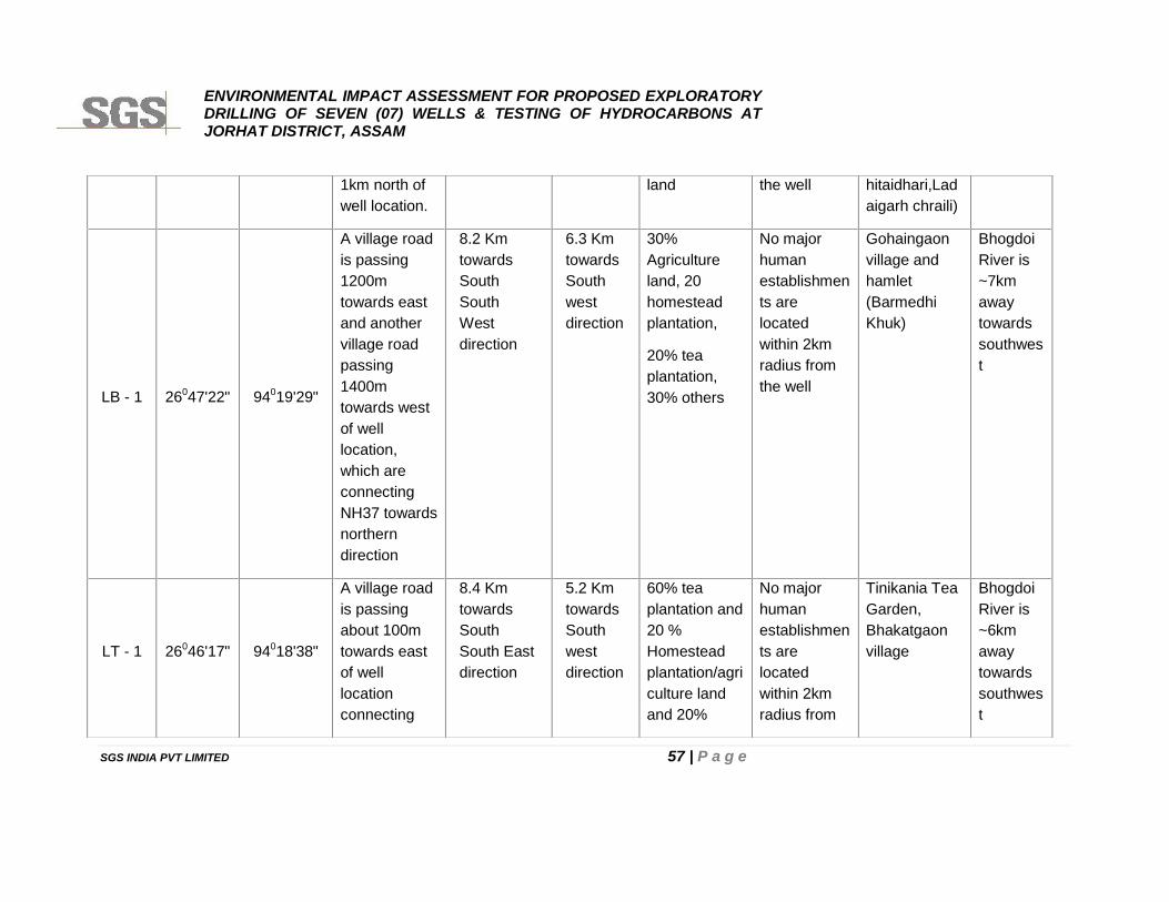
ENVIRONMENTAL IMPACT ASSESSMENT FOR PROPOSED EXPLORATORYDRILLING OF SEVEN (07) WELLS & TESTING OF HYDROCARBONS ATJORHAT DISTRICT, ASSAM
SGS INDIA PVT LIMITED 57 | P a g e
1km north ofwell location.
land the well hitaidhari,Ladaigarh chraili)
LB - 1 26047'22" 94019'29"
A village roadis passing1200mtowards eastand anothervillage roadpassing1400mtowards westof welllocation,which areconnectingNH37 towardsnortherndirection
8.2 KmtowardsSouthSouthWestdirection
6.3 KmtowardsSouthwestdirection
30%Agricultureland, 20homesteadplantation,
20% teaplantation,30% others
No majorhumanestablishments arelocatedwithin 2kmradius fromthe well
Gohaingaonvillage andhamlet(BarmedhiKhuk)
BhogdoiRiver is~7kmawaytowardssouthwest
LT - 1 26046'17" 94018'38"
A village roadis passingabout 100mtowards eastof welllocationconnecting
8.4 KmtowardsSouthSouth Eastdirection
5.2 KmtowardsSouthwestdirection
60% teaplantation and20 %Homesteadplantation/agriculture landand 20%
No majorhumanestablishments arelocatedwithin 2kmradius from
Tinikania TeaGarden,Bhakatgaonvillage
BhogdoiRiver is~6kmawaytowardssouthwest
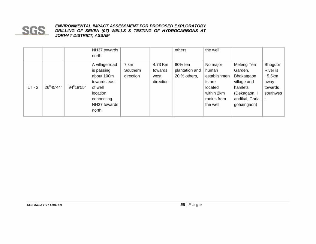
ENVIRONMENTAL IMPACT ASSESSMENT FOR PROPOSED EXPLORATORYDRILLING OF SEVEN (07) WELLS & TESTING OF HYDROCARBONS ATJORHAT DISTRICT, ASSAM
SGS INDIA PVT LIMITED 58 | P a g e
NH37 towardsnorth.
others, the well
LT - 2 26045'44" 94018'55"
A village roadis passingabout 100mtowards eastof welllocationconnectingNH37 towardsnorth.
7 kmSoutherndirection
4.73 Kmtowardswestdirection
80% teaplantation and20 % others,
No majorhumanestablishments arelocatedwithin 2kmradius fromthe well
Meleng TeaGarden,Bhakatgaonvillage andhamlets(Dekagaon, Handikal, Garlagohaingaon)
BhogdoiRiver is~5.5kmawaytowardssouthwest
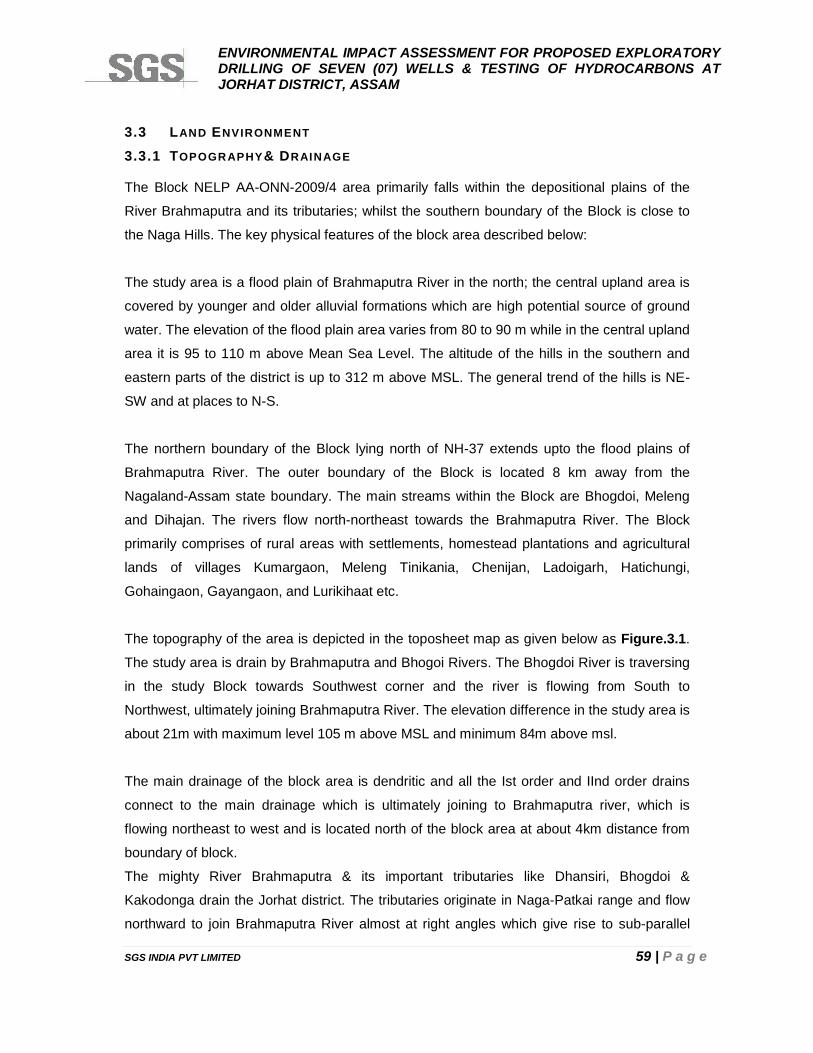
ENVIRONMENTAL IMPACT ASSESSMENT FOR PROPOSED EXPLORATORYDRILLING OF SEVEN (07) WELLS & TESTING OF HYDROCARBONS ATJORHAT DISTRICT, ASSAM
SGS INDIA PVT LIMITED 59 | P a g e
3.3 LAND ENVIRONMENT
3.3.1 TOPOGRAPHY& DRAINAGE
The Block NELP AA-ONN-2009/4 area primarily falls within the depositional plains of the
River Brahmaputra and its tributaries; whilst the southern boundary of the Block is close to
the Naga Hills. The key physical features of the block area described below:
The study area is a flood plain of Brahmaputra River in the north; the central upland area is
covered by younger and older alluvial formations which are high potential source of ground
water. The elevation of the flood plain area varies from 80 to 90 m while in the central upland
area it is 95 to 110 m above Mean Sea Level. The altitude of the hills in the southern and
eastern parts of the district is up to 312 m above MSL. The general trend of the hills is NE-
SW and at places to N-S.
The northern boundary of the Block lying north of NH-37 extends upto the flood plains of
Brahmaputra River. The outer boundary of the Block is located 8 km away from the
Nagaland-Assam state boundary. The main streams within the Block are Bhogdoi, Meleng
and Dihajan. The rivers flow north-northeast towards the Brahmaputra River. The Block
primarily comprises of rural areas with settlements, homestead plantations and agricultural
lands of villages Kumargaon, Meleng Tinikania, Chenijan, Ladoigarh, Hatichungi,
Gohaingaon, Gayangaon, and Lurikihaat etc.
The topography of the area is depicted in the toposheet map as given below as Figure.3.1.
The study area is drain by Brahmaputra and Bhogoi Rivers. The Bhogdoi River is traversing
in the study Block towards Southwest corner and the river is flowing from South to
Northwest, ultimately joining Brahmaputra River. The elevation difference in the study area is
about 21m with maximum level 105 m above MSL and minimum 84m above msl.
The main drainage of the block area is dendritic and all the Ist order and IInd order drains
connect to the main drainage which is ultimately joining to Brahmaputra river, which is
flowing northeast to west and is located north of the block area at about 4km distance from
boundary of block.
The mighty River Brahmaputra & its important tributaries like Dhansiri, Bhogdoi &
Kakodonga drain the Jorhat district. The tributaries originate in Naga-Patkai range and flow
northward to join Brahmaputra River almost at right angles which give rise to sub-parallel
ENVIRONMENTAL IMPACT ASSESSMENT FOR PROPOSED EXPLORATORYDRILLING OF SEVEN (07) WELLS & TESTING OF HYDROCARBONS ATJORHAT DISTRICT, ASSAM
SGS INDIA PVT LIMITED 60 | P a g e
type of drainage. The river and streams are highly meandering in nature & sudden changes
in course of these rivers possibly due to heavy siltation and epiorogenic movements which
causes the flood havocs.
FIGURE 3.1: TOPOGRAPHIC MAP OF THE STUDY AREA
3.3.2 GEOLOGY
The study area is located within the proven petroliferous Assam-Arakan Basin. The Assam
Shelf, Belt of Schuppen and the Assam-Arakan Fold Belt are the prime geological features
of the Assam-Arakan Shelf-Slope Basinal system as depicted in Figure 3.2. The Block AA-
ONN-2009/4 is geologically located in the vicinity of already proven fields in Assam Plains
and Belt of Schuppen, with major oilfields like Lakwa, Geleki, Rudrasagar, Amguri in east
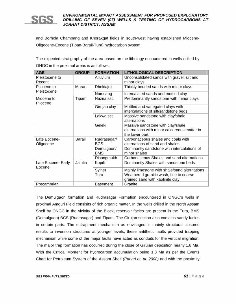
ENVIRONMENTAL IMPACT ASSESSMENT FOR PROPOSED EXPLORATORYDRILLING OF SEVEN (07) WELLS & TESTING OF HYDROCARBONS ATJORHAT DISTRICT, ASSAM
SGS INDIA PVT LIMITED 61 | P a g e
and Borhola Champang and Khorakgat fields in south-west having established Miocene-
Oligocene-Eocene (Tipan-Barail-Tura) hydrocarbon system.
The expected stratigraphy of the area based on the lithology encountered in wells drilled by
ONGC in the proximal areas is as follows;
AGE GROUP FORMATION LITHOLOGICAL DESCRIPTIONPleistocene toRecent
Alluvium Unconsolidated sands with gravel, silt andminor clays
Pliocene toPleistocene
Moran Dhekiajuli Thickly bedded sands with minor clays
Namsang Intercalated sands and mottled clayMiocene toPliocene
Tipam Nazira sst. Predominantly sandstone with minor clays
Girujan clay Mottled and variegated clays withintercalations of silt/sandstone beds
Lakwa sst. Massive sandstone with clay/shalealternations
Geleki Massive sandstone with clay/shalealternations with minor calcareous matter inthe lower part.
Late Eocene-Oligocene
Barail Rudrasagar/BCS
Carbonaceous shales and coals withalternations of sand and shales
Demulgaon/BMS
Dominantly sandstone with intercalations ofminor shales
Disangmukh Carbonaceous Shales and sand alternationsLate Eocene- EarlyEocene
Jaintia Kopili Dominantly Shales with sandstone beds
Sylhet Mainly limestone with shale/sand alternationsTura Weathered granitic wash, fine to coarse
grained sand with kaolinite clayPrecambrian Basement Granite
The Demulgaon formation and Rudrasagar Formation encountered in ONGC's wells in
proximal Amguri Field consisits of rich organic matter. In the wells drilled in the North Assam
Shelf by ONGC in the vicinity of the Block, reservoir facies are present in the Tura, BMS
(Demulgaon) BCS (Rudrasagar) and Tipam. The Girujan section also contains sandy facies
in certain parts. The entrapment mechanism as envisaged is mainly structural closures
results to inversion structures at younger levels, these antithetic faults provided trapping
mechanism while some of the major faults have acted as conduits for the vertical migration.
The major trap formation has occurred during the close of Girujan deposition nearly 1.8 Ma.
With the Critical Moment for hydrocarbon accumulation being 1.8 Ma as per the Events
Chart for Petroleum System of the Assam Shelf (Pahari et. al. 2008) and with the proximity
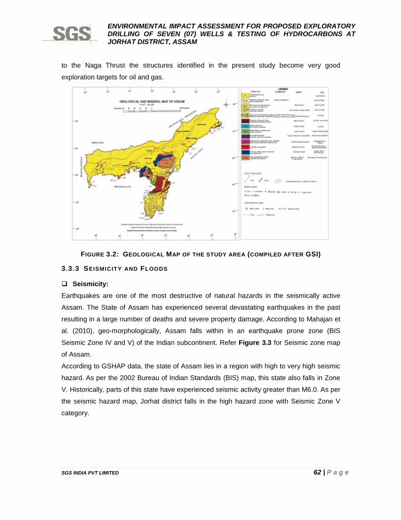
ENVIRONMENTAL IMPACT ASSESSMENT FOR PROPOSED EXPLORATORYDRILLING OF SEVEN (07) WELLS & TESTING OF HYDROCARBONS ATJORHAT DISTRICT, ASSAM
SGS INDIA PVT LIMITED 62 | P a g e
to the Naga Thrust the structures identified in the present study become very good
exploration targets for oil and gas.
FIGURE 3.2: GEOLOGICAL MAP OF THE STUDY AREA (COMPILED AFTER GSI)
3.3.3 SEISMICITY AND FLOODS
Seismicity:Earthquakes are one of the most destructive of natural hazards in the seismically active
Assam. The State of Assam has experienced several devastating earthquakes in the past
resulting in a large number of deaths and severe property damage. According to Mahajan et
al. (2010), geo-morphologically, Assam falls within in an earthquake prone zone (BIS
Seismic Zone IV and V) of the Indian subcontinent. Refer Figure 3.3 for Seismic zone map
of Assam.
According to GSHAP data, the state of Assam lies in a region with high to very high seismic
hazard. As per the 2002 Bureau of Indian Standards (BIS) map, this state also falls in Zone
V. Historically, parts of this state have experienced seismic activity greater than M6.0. As per
the seismic hazard map, Jorhat district falls in the high hazard zone with Seismic Zone V
category.
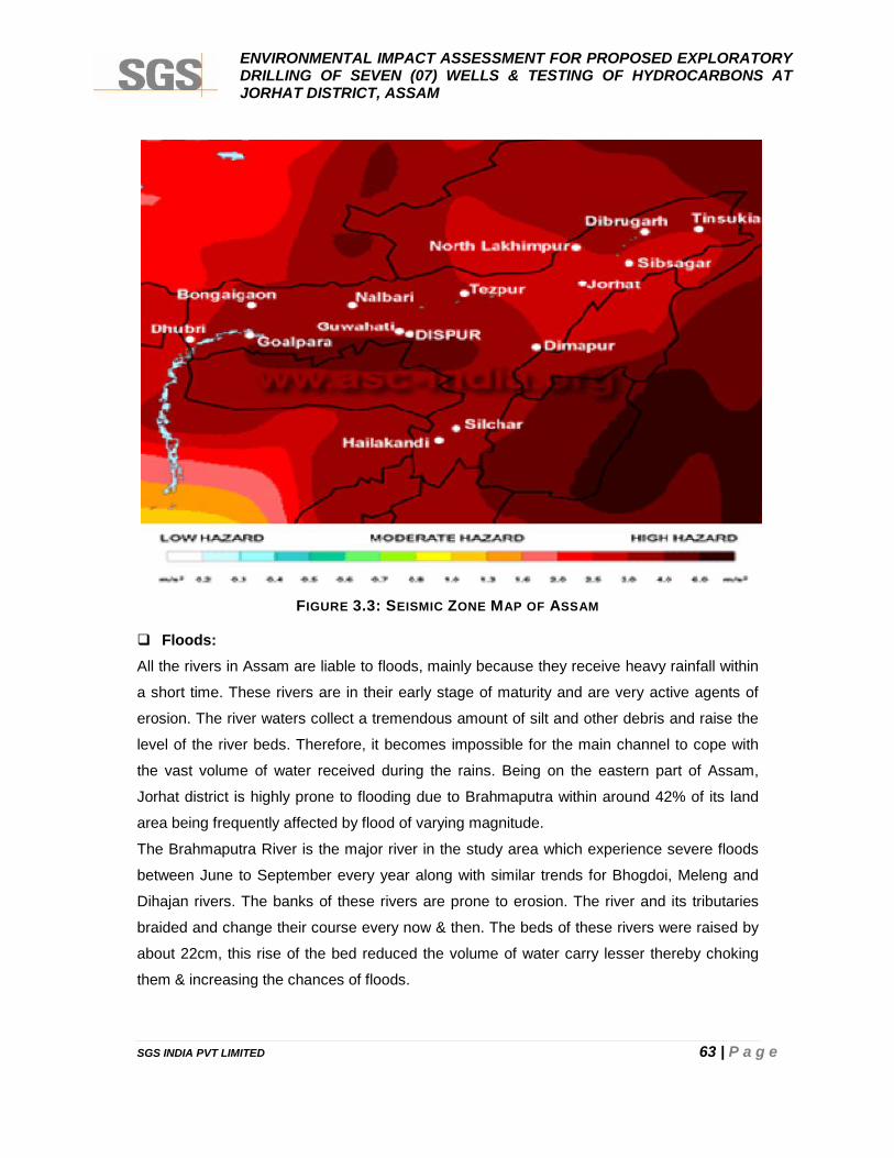
ENVIRONMENTAL IMPACT ASSESSMENT FOR PROPOSED EXPLORATORYDRILLING OF SEVEN (07) WELLS & TESTING OF HYDROCARBONS ATJORHAT DISTRICT, ASSAM
SGS INDIA PVT LIMITED 63 | P a g e
FIGURE 3.3: SEISMIC ZONE MAP OF ASSAM
Floods:All the rivers in Assam are liable to floods, mainly because they receive heavy rainfall within
a short time. These rivers are in their early stage of maturity and are very active agents of
erosion. The river waters collect a tremendous amount of silt and other debris and raise the
level of the river beds. Therefore, it becomes impossible for the main channel to cope with
the vast volume of water received during the rains. Being on the eastern part of Assam,
Jorhat district is highly prone to flooding due to Brahmaputra within around 42% of its land
area being frequently affected by flood of varying magnitude.
The Brahmaputra River is the major river in the study area which experience severe floods
between June to September every year along with similar trends for Bhogdoi, Meleng and
Dihajan rivers. The banks of these rivers are prone to erosion. The river and its tributaries
braided and change their course every now & then. The beds of these rivers were raised by
about 22cm, this rise of the bed reduced the volume of water carry lesser thereby choking
them & increasing the chances of floods.
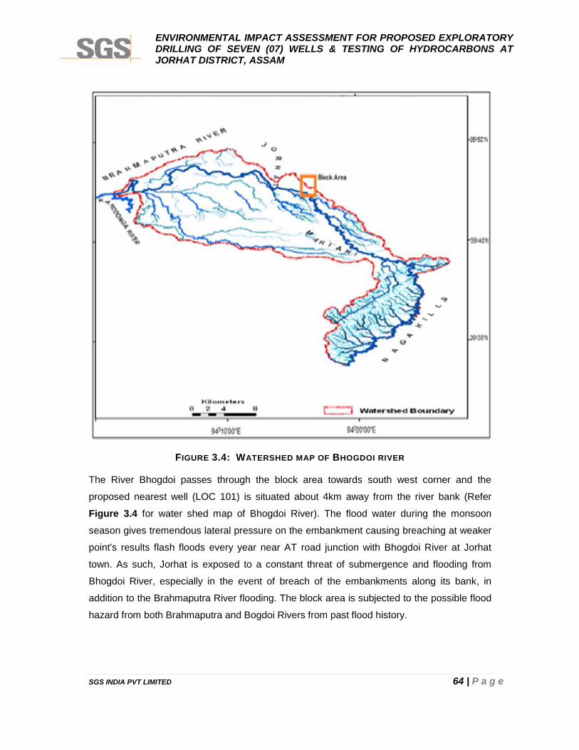
ENVIRONMENTAL IMPACT ASSESSMENT FOR PROPOSED EXPLORATORYDRILLING OF SEVEN (07) WELLS & TESTING OF HYDROCARBONS ATJORHAT DISTRICT, ASSAM
SGS INDIA PVT LIMITED 64 | P a g e
FIGURE 3.4: WATERSHED MAP OF BHOGDOI RIVER
The River Bhogdoi passes through the block area towards south west corner and the
proposed nearest well (LOC 101) is situated about 4km away from the river bank (Refer
Figure 3.4 for water shed map of Bhogdoi River). The flood water during the monsoon
season gives tremendous lateral pressure on the embankment causing breaching at weaker
point's results flash floods every year near AT road junction with Bhogdoi River at Jorhat
town. As such, Jorhat is exposed to a constant threat of submergence and flooding from
Bhogdoi River, especially in the event of breach of the embankments along its bank, in
addition to the Brahmaputra River flooding. The block area is subjected to the possible flood
hazard from both Brahmaputra and Bogdoi Rivers from past flood history.
ENVIRONMENTAL IMPACT ASSESSMENT FOR PROPOSED EXPLORATORYDRILLING OF SEVEN (07) WELLS & TESTING OF HYDROCARBONS ATJORHAT DISTRICT, ASSAM
SGS INDIA PVT LIMITED 65 | P a g e
3.3.4 HYDRO-GEOLOGY
The area is underlain by unconsolidated alluvial sediments of the Quaternary age, which can
be differentiated into i) Older and ii) Younger alluvium. The Older alluvium occupies the
upland areas with sediments of oxidized and relatively compact nature, while the Younger
alluvium occurs along the low-lying tracts of the area along the river courses. The southern
part of the area, adjacent to the Naga hill range is covered by surficial blanket of clay,
belonging to Younger alluvium and probably has been derived from the adjacent hills which
are composed of the rocks of Tertiary age.
Ground water in the district occurs under water table to semi-confined conditions in the near
surface conditions and in the deeper horizon, under semi-confined to confine conditions.
Depth to water level in the water table zone varies from 0.41 to 3.07 m bgl in the pre-
monsoon period and 0.56 to 3.41 m bgl during post-monsoon period. Based on available
sub-surface data indicates that in the central parts, three to four prolific aquifer system exist
down to explored depth of 300 m and in the vicinity of Brahmaputra River, five to six aquifer
systems with limited thickness exist within the depth range of 400 m. In the southern parts,
the aquifer system fades out due to mixing of finer particles of sand and clay leading to
decrease in thickness of aquifer system. The geometry of the aquifer system varies widely.
In the northeastern and northwestern parts, the thickness of the aquifer increases and clear
sand beds exists. Throughout the district, varied thickness of clay beds overlying and
underlying the aquifer system exist. The thickness of the clay beds increases southwards i.e.
towards Titabar where it attains a maximum thickness of 103 m.
The predominance of clay formation in the depth of 30 to 50 m poses problem in storage of
ground water in the district, however, local variation in the existence of very limited thickness
of sand beds mixed with clay performing as conduits of ground water is also observed.
Central Ground Water Board had carried out exploratory drilling activities in various
hydrogeological situations by deploying appropriate drilling Rigs in Jorhat district of Assam.
The Board has drilled 18 exploratory wells in Jorhat district, out of which, three wells are
abandoned and thirteen wells are under operation. The range of drilling depth varies from
79.72 to 457.30 m bgl with the discharge of 8 to 211.44 m3/ hr. The yield of the tube wells
varies from 30 to 35 m3/ hr and it irrigates about 3.5 ha. The ground water levels measured
in the study area during the primary survey is as given in Table 3.3.
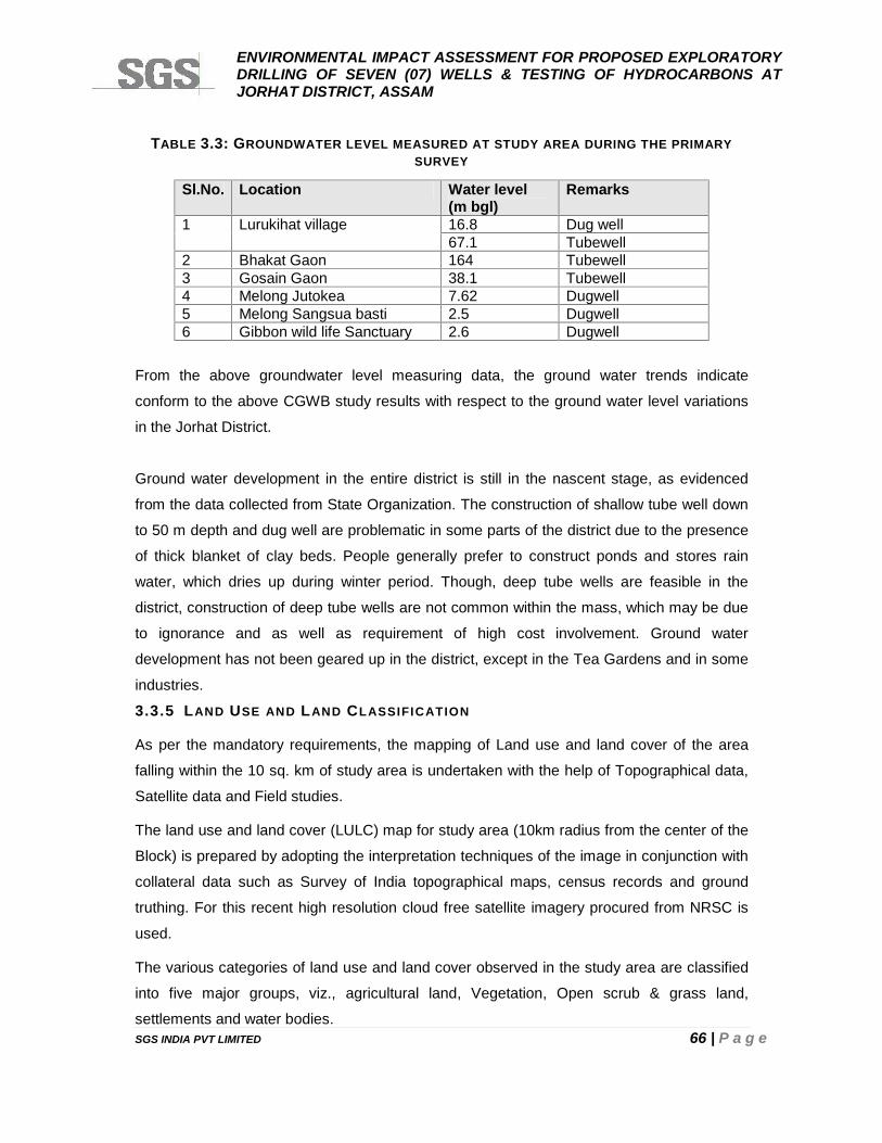
ENVIRONMENTAL IMPACT ASSESSMENT FOR PROPOSED EXPLORATORYDRILLING OF SEVEN (07) WELLS & TESTING OF HYDROCARBONS ATJORHAT DISTRICT, ASSAM
SGS INDIA PVT LIMITED 66 | P a g e
TABLE 3.3: GROUNDWATER LEVEL MEASURED AT STUDY AREA DURING THE PRIMARYSURVEY
Sl.No. Location Water level(m bgl)
Remarks
1 Lurukihat village 16.8 Dug well67.1 Tubewell
2 Bhakat Gaon 164 Tubewell3 Gosain Gaon 38.1 Tubewell4 Melong Jutokea 7.62 Dugwell5 Melong Sangsua basti 2.5 Dugwell6 Gibbon wild life Sanctuary 2.6 Dugwell
From the above groundwater level measuring data, the ground water trends indicate
conform to the above CGWB study results with respect to the ground water level variations
in the Jorhat District.
Ground water development in the entire district is still in the nascent stage, as evidenced
from the data collected from State Organization. The construction of shallow tube well down
to 50 m depth and dug well are problematic in some parts of the district due to the presence
of thick blanket of clay beds. People generally prefer to construct ponds and stores rain
water, which dries up during winter period. Though, deep tube wells are feasible in the
district, construction of deep tube wells are not common within the mass, which may be due
to ignorance and as well as requirement of high cost involvement. Ground water
development has not been geared up in the district, except in the Tea Gardens and in some
industries.
3.3.5 LAND USE AND LAND CLASSIFICATION
As per the mandatory requirements, the mapping of Land use and land cover of the area
falling within the 10 sq. km of study area is undertaken with the help of Topographical data,
Satellite data and Field studies.
The land use and land cover (LULC) map for study area (10km radius from the center of the
Block) is prepared by adopting the interpretation techniques of the image in conjunction with
collateral data such as Survey of India topographical maps, census records and ground
truthing. For this recent high resolution cloud free satellite imagery procured from NRSC is
used.
The various categories of land use and land cover observed in the study area are classified
into five major groups, viz., agricultural land, Vegetation, Open scrub & grass land,
settlements and water bodies.
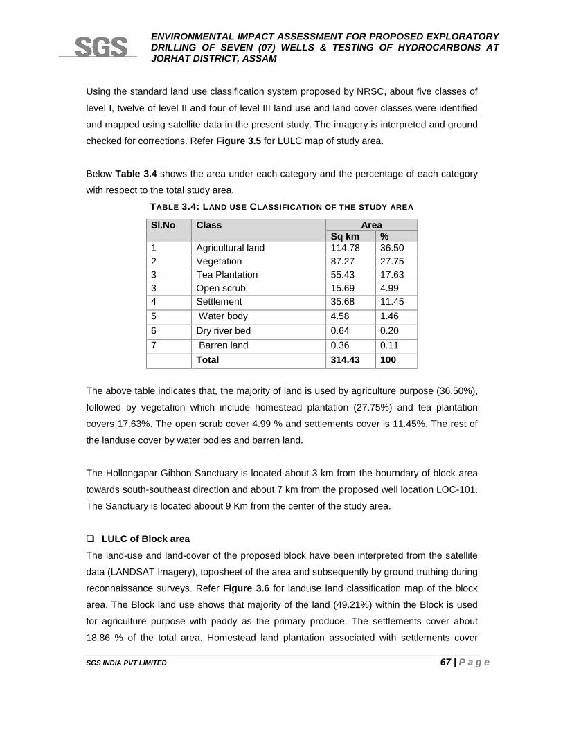
ENVIRONMENTAL IMPACT ASSESSMENT FOR PROPOSED EXPLORATORYDRILLING OF SEVEN (07) WELLS & TESTING OF HYDROCARBONS ATJORHAT DISTRICT, ASSAM
SGS INDIA PVT LIMITED 67 | P a g e
Using the standard land use classification system proposed by NRSC, about five classes of
level I, twelve of level II and four of level III land use and land cover classes were identified
and mapped using satellite data in the present study. The imagery is interpreted and ground
checked for corrections. Refer Figure 3.5 for LULC map of study area.
Below Table 3.4 shows the area under each category and the percentage of each category
with respect to the total study area.
TABLE 3.4: LAND USE CLASSIFICATION OF THE STUDY AREA
Sl.No Class AreaSq km %
1 Agricultural land 114.78 36.502 Vegetation 87.27 27.753 Tea Plantation 55.43 17.633 Open scrub 15.69 4.994 Settlement 35.68 11.455 Water body 4.58 1.466 Dry river bed 0.64 0.207 Barren land 0.36 0.11
Total 314.43 100
The above table indicates that, the majority of land is used by agriculture purpose (36.50%),
followed by vegetation which include homestead plantation (27.75%) and tea plantation
covers 17.63%. The open scrub cover 4.99 % and settlements cover is 11.45%. The rest of
the landuse cover by water bodies and barren land.
The Hollongapar Gibbon Sanctuary is located about 3 km from the bourndary of block area
towards south-southeast direction and about 7 km from the proposed well location LOC-101.
The Sanctuary is located aboout 9 Km from the center of the study area.
LULC of Block areaThe land-use and land-cover of the proposed block have been interpreted from the satellite
data (LANDSAT Imagery), toposheet of the area and subsequently by ground truthing during
reconnaissance surveys. Refer Figure 3.6 for landuse land classification map of the block
area. The Block land use shows that majority of the land (49.21%) within the Block is used
for agriculture purpose with paddy as the primary produce. The settlements cover about
18.86 % of the total area. Homestead land plantation associated with settlements cover
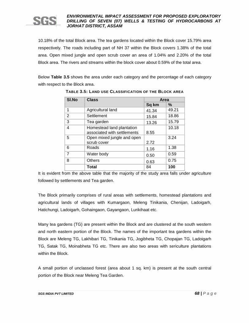
ENVIRONMENTAL IMPACT ASSESSMENT FOR PROPOSED EXPLORATORYDRILLING OF SEVEN (07) WELLS & TESTING OF HYDROCARBONS ATJORHAT DISTRICT, ASSAM
SGS INDIA PVT LIMITED 68 | P a g e
10.18% of the total Block area. The tea gardens located within the Block cover 15.79% area
respectively. The roads including part of NH 37 within the Block covers 1.38% of the total
area. Open mixed jungle and open scrub cover an area of 1.04% and 2.20% of the total
Block area. The rivers and streams within the block cover about 0.59% of the total area.
Below Table 3.5 shows the area under each category and the percentage of each category
with respect to the Block area.
TABLE 3.5: LAND USE CLASSIFICATION OF THE BLOCK AREA
Sl.No Class AreaSq km %
1 Agricultural land 41.34 49.212 Settlement 15.84 18.863 Tea garden 13.26 15.794 Homestead land plantation
associated with settlements 8.5510.18
5 Open mixed jungle and openscrub cover 2.72
3.24
6 Roads 1.16 1.387 Water body 0.50 0.598 Others 0.63 0.75
Total 84 100It is evident from the above table that the majority of the study area falls under agriculture
followed by settlements and Tea garden.
The Block primarily comprises of rural areas with settlements, homestead plantations and
agricultural lands of villages with Kumargaon, Meleng Tinikania, Chenijan, Ladoigarh,
Hatichungi, Ladoigarh, Gohaingaon, Gayangaon, Lurikihaat etc.
Many tea gardens (TG) are present within the Block and are clustered at the south western
and north eastern portion of the Block. The names of the important tea gardens within the
Block are Meleng TG, Lakhibari TG, Tinikania TG, Jogibheta TG, Chopajan TG, Ladoigarh
TG, Satak TG, Moinabheta TG etc. There are also two areas with sericulture plantations
within the Block.
A small portion of unclassed forest (area about 1 sq. km) is present at the south central
portion of the Block near Meleng Tea Garden.
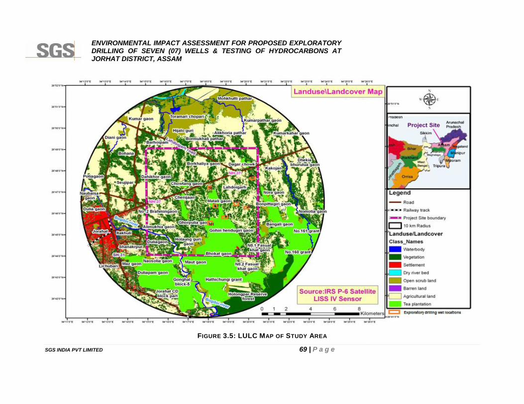
ENVIRONMENTAL IMPACT ASSESSMENT FOR PROPOSED EXPLORATORYDRILLING OF SEVEN (07) WELLS & TESTING OF HYDROCARBONS ATJORHAT DISTRICT, ASSAM
SGS INDIA PVT LIMITED 69 | P a g e
FIGURE 3.5: LULC MAP OF STUDY AREA
ENVIRONMENTAL IMPACT ASSESSMENT FOR PROPOSED EXPLORATORYDRILLING OF SEVEN (07) WELLS & TESTING OF HYDROCARBONS ATJORHAT DISTRICT, ASSAM
SGS INDIA PVT LIMITED 69 | P a g e
FIGURE 3.5: LULC MAP OF STUDY AREA
ENVIRONMENTAL IMPACT ASSESSMENT FOR PROPOSED EXPLORATORYDRILLING OF SEVEN (07) WELLS & TESTING OF HYDROCARBONS ATJORHAT DISTRICT, ASSAM
SGS INDIA PVT LIMITED 69 | P a g e
FIGURE 3.5: LULC MAP OF STUDY AREA
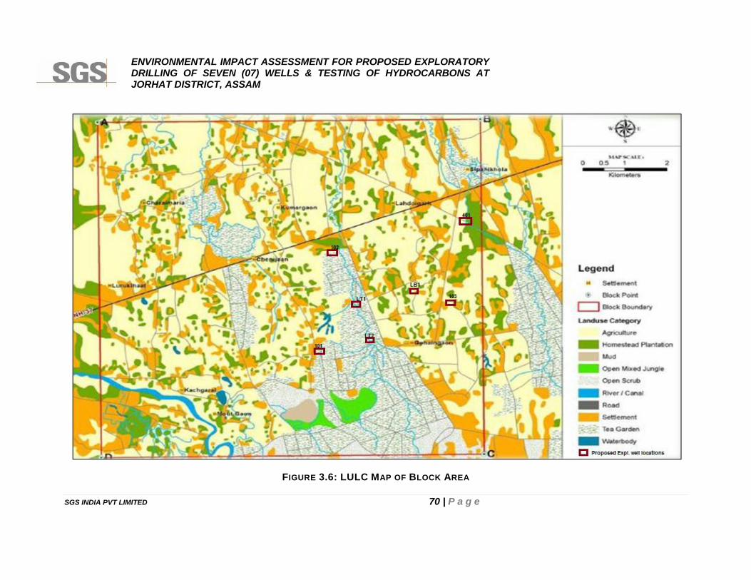
ENVIRONMENTAL IMPACT ASSESSMENT FOR PROPOSED EXPLORATORYDRILLING OF SEVEN (07) WELLS & TESTING OF HYDROCARBONS ATJORHAT DISTRICT, ASSAM
SGS INDIA PVT LIMITED 70 | P a g e
FIGURE 3.6: LULC MAP OF BLOCK AREA
ENVIRONMENTAL IMPACT ASSESSMENT FOR PROPOSED EXPLORATORYDRILLING OF SEVEN (07) WELLS & TESTING OF HYDROCARBONS ATJORHAT DISTRICT, ASSAM
SGS INDIA PVT LIMITED 71 | P a g e
3.4 METEOROLOGY
Johrat has semi arid climate with four seasons each characterized by a different set of
weather conditions at Jorhat region of Assam:
• Winter Season from December to February;
• Pre monsoon season during March to May;
• Monsoon or rainy season during June to September; and
• Postmonsoon season from October to mid November.
3.4.1 REGIONAL METEOROLOGY
Climate of the region is characterised on the basis of the nearest Indian Meteorological
Department (IMD) observatory station at Golaghat, Assam located about 40 km South west
direction as given below:
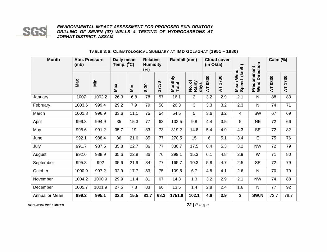
ENVIRONMENTAL IMPACT ASSESSMENT FOR PROPOSED EXPLORATORYDRILLING OF SEVEN (07) WELLS & TESTING OF HYDROCARBONS ATJORHAT DISTRICT, ASSAM
SGS INDIA PVT LIMITED 72 | P a g e
TABLE 3:6: CLIMATOLOGICAL SUMMARY AT IMD GOLAGHAT (1951 – 1980)
Month Atm. Pressure(mb)
Daily meanTemp. (0C)
RelativeHumidity(%)
Rainfall (mm) Cloud cover(in Okta)
Mea
n W
ind
Spee
d (k
m/h
)
Pred
omin
ant
Win
d D
irect
ion
Calm (%)
Max
Min
Max
Min
8:30
17:3
0
Mon
thly
Tota
l
No.
of
Rai
nyda
ysA
T 08
30
AT
1730
AT
0830
AT
1730
January 1007 1002.2 26.3 6.8 78 57 16.1 2 3.2 2.9 2.1 N 88 83
February 1003.6 999.4 29.2 7.9 79 58 26.3 3 3.3 3.2 2.3 N 74 71
March 1001.8 996.9 33.6 11.1 75 54 54.5 5 3.6 3.2 4 SW 67 69
April 999.3 994.9 35 15.3 77 63 132.5 9.8 4.4 3.5 5 NE 72 66
May 995.6 991.2 35.7 19 83 73 319.2 14.8 5.4 4.9 4.3 SE 72 82
June 992.1 988.4 36 21.6 85 77 270.5 15 6 5.1 3.4 E 75 76
July 991.7 987.5 35.8 22.7 86 77 330.7 17.5 6.4 5.3 3.2 NW 72 79
August 992.6 988.9 35.6 22.8 86 76 299.1 15.3 6.1 4.8 2.9 W 71 80
September 995.8 992 35.6 21.9 84 77 165.7 10.3 5.8 4.7 2.5 SE 72 79
October 1000.9 997.2 32.9 17.7 83 75 109.5 6.7 4.8 4.1 2.6 N 70 79
November 1004.2 1000.9 29.9 11.4 81 67 14.3 1.3 3.2 2.9 2.1 NW 74 88
December 1005.7 1001.9 27.5 7.8 83 66 13.5 1.4 2.8 2.4 1.6 N 77 92
Annual or Mean 999.2 995.1 32.8 15.5 81.7 68.3 1751.9 102.1 4.6 3.9 3 SW,N 73.7 78.7
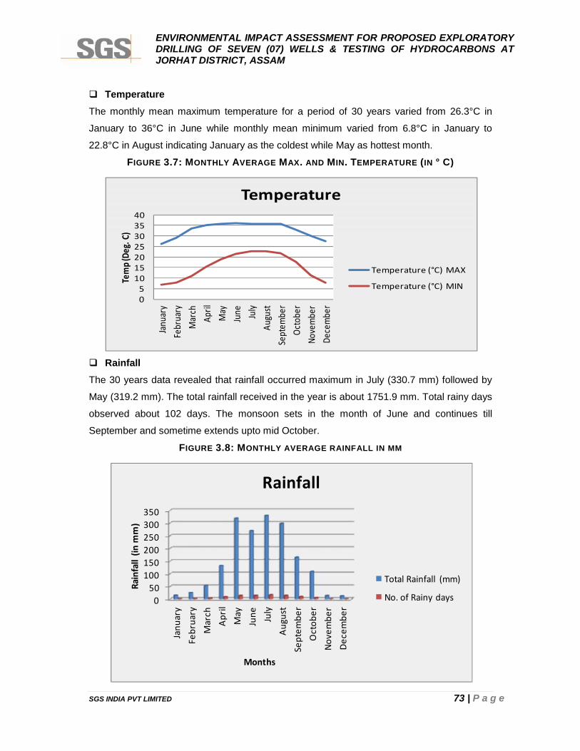
ENVIRONMENTAL IMPACT ASSESSMENT FOR PROPOSED EXPLORATORYDRILLING OF SEVEN (07) WELLS & TESTING OF HYDROCARBONS ATJORHAT DISTRICT, ASSAM
SGS INDIA PVT LIMITED 73 | P a g e
TemperatureThe monthly mean maximum temperature for a period of 30 years varied from 26.3°C in
January to 36°C in June while monthly mean minimum varied from 6.8°C in January to
22.8°C in August indicating January as the coldest while May as hottest month.
FIGURE 3.7: MONTHLY AVERAGE MAX. AND MIN. TEMPERATURE (IN ° C)
RainfallThe 30 years data revealed that rainfall occurred maximum in July (330.7 mm) followed by
May (319.2 mm). The total rainfall received in the year is about 1751.9 mm. Total rainy days
observed about 102 days. The monsoon sets in the month of June and continues till
September and sometime extends upto mid October.
FIGURE 3.8: MONTHLY AVERAGE RAINFALL IN MM
05
10152025303540
Janu
ary
Febr
uary
Mar
chAp
rilM
ayJu
ne July
Augu
stSe
ptem
ber
Octo
ber
Nove
mbe
rDe
cem
ber
Tem
p (De
g. C
)
Temperature
Temperature (°C) MAX
Temperature (°C) MIN
050
100150200250300350
Janu
ary
Febr
uary
Mar
chAp
rilM
ayJu
ne July
Augu
stSe
ptem
ber
Oct
ober
Nove
mbe
rDe
cem
ber
Rain
fall
(in m
m)
Months
Rainfall
Total Rainfall (mm)
No. of Rainy days
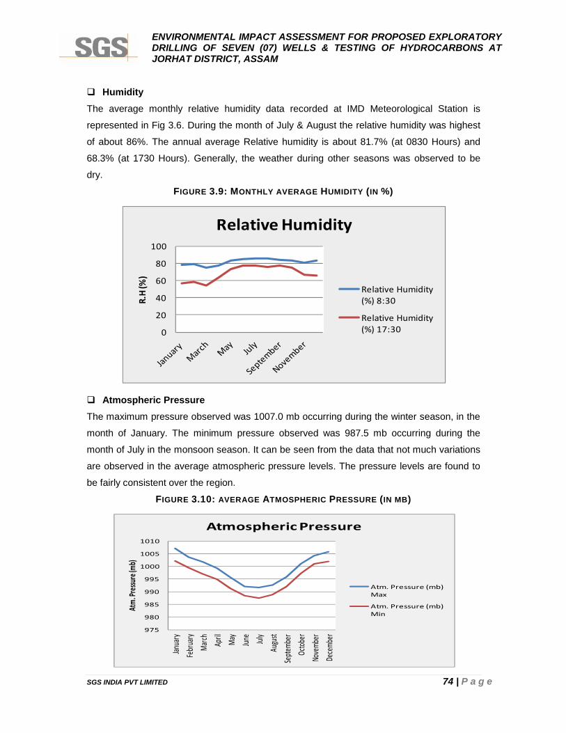
ENVIRONMENTAL IMPACT ASSESSMENT FOR PROPOSED EXPLORATORYDRILLING OF SEVEN (07) WELLS & TESTING OF HYDROCARBONS ATJORHAT DISTRICT, ASSAM
SGS INDIA PVT LIMITED 74 | P a g e
HumidityThe average monthly relative humidity data recorded at IMD Meteorological Station is
represented in Fig 3.6. During the month of July & August the relative humidity was highest
of about 86%. The annual average Relative humidity is about 81.7% (at 0830 Hours) and
68.3% (at 1730 Hours). Generally, the weather during other seasons was observed to be
dry.
FIGURE 3.9: MONTHLY AVERAGE HUMIDITY (IN %)
Atmospheric PressureThe maximum pressure observed was 1007.0 mb occurring during the winter season, in the
month of January. The minimum pressure observed was 987.5 mb occurring during the
month of July in the monsoon season. It can be seen from the data that not much variations
are observed in the average atmospheric pressure levels. The pressure levels are found to
be fairly consistent over the region.
FIGURE 3.10: AVERAGE ATMOSPHERIC PRESSURE (IN MB)
0
20
40
60
80
100
R.H
(%)
Relative Humidity
Relative Humidity(%) 8:30
Relative Humidity(%) 17:30
975
980
985
990
995
1000
1005
1010
Janua
ryFe
bruary
March Ap
ril May
June
July
Augu
stSe
ptemb
erOc
tober
Nove
mber
Dece
mber
Atm.
Press
ure (m
b)
Atmospheric Pressure
Atm. Pressure (mb)Max
Atm. Pressure (mb)Min

ENVIRONMENTAL IMPACT ASSESSMENT FOR PROPOSED EXPLORATORYDRILLING OF SEVEN (07) WELLS & TESTING OF HYDROCARBONS ATJORHAT DISTRICT, ASSAM
SGS INDIA PVT LIMITED 75 | P a g e
Wind Speed/ DirectionGenerally, light to moderate winds prevails throughout the year. Winds were light and
moderate particularly during the morning hours. While during the afternoon hours the winds
were stronger.
FIGURE 3.11: MEAN WIND SPEED (IN KMPH)
FIGURE 3.12: ANNUAL WIND FREQUENCY
0830 Hours:A review of the wind rose diagram shows that predominant winds are mostly from NW and
SE directions followed by NE direction. Calm conditions prevailed for 76.2% of the total time.
0
1
2
3
4
5
6
Janu
ary
Febr
uary
Mar
ch
April
May
June July
Augu
st
Sept
embe
r
Octo
ber
Nove
mbe
r
Dece
mbe
r
Win
d sp
eed
(KM
PH)
Mean wind speed (KMPH)
Mean wind speed(KMPH)
0
20
40
60
80
100
Janu
ary
Febr
uary
Mar
ch
April
May
June July
Augu
st
Sept
embe
r
Oct
ober
Nove
mbe
r
Dece
mbe
r
Calm
(%)
Month
Annual Wind Frequency
Calm (%) AT 0830
Calm (%) AT 1730
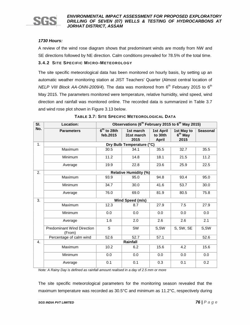
ENVIRONMENTAL IMPACT ASSESSMENT FOR PROPOSED EXPLORATORYDRILLING OF SEVEN (07) WELLS & TESTING OF HYDROCARBONS ATJORHAT DISTRICT, ASSAM
SGS INDIA PVT LIMITED 76 | P a g e
1730 Hours:A review of the wind rose diagram shows that predominant winds are mostly from NW and
SE directions followed by NE direction. Calm conditions prevailed for 78.5% of the total time.
3.4.2 S ITE SPECIFIC M ICRO-METEOROLOGY
The site specific meteorological data has been monitored on hourly basis, by setting up an
automatic weather monitoring station at JIST Teachers' Quarter (Almost central location of
NELP VIII Block AA-ONN-2009/4). The data was monitored from 6th February 2015 to 6th
May 2015. The parameters monitored were temperature, relative humidity, wind speed, wind
direction and rainfall was monitored online. The recorded data is summarized in Table 3.7
and wind rose plot shown in Figure 3.13 below.
TABLE 3.7: SITE SPECIFIC METEOROLOGICAL DATA
Sl.No.
Location: Observations (6th February 2015 to 6th May 2015)Parameters 6th to 28th
feb.20151st march
31st march2015
1st Aprilto 30thApril
1st May to6th May
2015
Seasonal
1. Dry Bulb Temperature (C)Maximum 30.5 34.1 35.5 32.7 35.5
Minimum 11.2 14.8 18.1 21.5 11.2
Average 19.9 22.8 23.6 25.9 22.5
2. Relative Humidity (%)Maximum 93.9 95.0 94.8 93.4 95.0
Minimum 34.7 30.0 41.6 53.7 30.0
Average 76.0 69.0 81.9 80.5 75.8
3. Wind Speed (m/s)Maximum 12.3 8.7 27.9 7.5 27.9
Minimum 0.0 0.0 0.0 0.0 0.0
Average 1.6 2.0 2.6 2.6 2.1
Predominant Wind Direction(From)
S SW S,SW S, SW, SE S,SW
Percentage of calm wind 52.6 52.7 57.1 52.64. Rainfall
Maximum 10.2 6.2 15.6 4.2 15.6
Minimum 0.0 0.0 0.0 0.0 0.0
Average 0.1 0.1 0.3 0.1 0.2
Note: A Rainy Day is defined as rainfall amount realised in a day of 2.5 mm or more
The site specific meteorological parameters for the monitoring season revealed that the
maximum temperature was recorded as 30.5°C and minimum as 11.2°C, respectively during
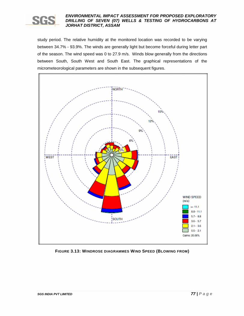
ENVIRONMENTAL IMPACT ASSESSMENT FOR PROPOSED EXPLORATORYDRILLING OF SEVEN (07) WELLS & TESTING OF HYDROCARBONS ATJORHAT DISTRICT, ASSAM
SGS INDIA PVT LIMITED 77 | P a g e
study period. The relative humidity at the monitored location was recorded to be varying
between 34.7% - 93.9%. The winds are generally light but become forceful during letter part
of the season. The wind speed was 0 to 27.9 m/s. Winds blow generally from the directions
between South, South West and South East. The graphical representations of the
micrometeorological parameters are shown in the subsequent figures.
FIGURE 3.13: WINDROSE DIAGRAMMES WIND SPEED (BLOWING FROM)

ENVIRONMENTAL IMPACT ASSESSMENT FOR PROPOSED EXPLORATORYDRILLING OF SEVEN (07) WELLS & TESTING OF HYDROCARBONS ATJORHAT DISTRICT, ASSAM
SGS INDIA PVT LIMITED 78 | P a g e
3.5 AMBIENT AIR QUALITY
The ambient air monitoring was carried out at eight (08) locations during study period withinblock. The frequency of monitoring was 24 hrs twice a week at each station for threemonths. The parameters monitored are Particulate Matter (PM10 & PM2.5), Sulphur Dioxide(SO2), Nitrogen Oxides (NOx), Benzene, Toluene, Ethylfenzene, p-Xylene, o-Xylene,Methane, Ethane, Propane, n-Butane, iso-Butane, Pentane as per details given in tablebelow.
TABLE 3.8: PROCEDURE FOR DETERMINING VARIOUS AIR QUALITY PARAMETERS
Parameters Technical Protocol Minimum Detectable Limit
PM10 IS 5182 (Part-XXIII) 5 (µg/m3)
Sulphur Dioxide IS-5182 (Part-II):2001 5 (µg/m3)
Nitrogen Dioxide IS-5182 (Part-VI):2006 7 (µg/m3)
Benzene ASTM D3686-2013 & ASTM D3687-2007 2 (µg/m3)
Toluene,µg/m3 ASTM D3686-2013 & ASTM D3687-2007 <2.0
Ethylfenzene,µg/m3 ASTM D3686-2013 & ASTM D3687-2007 <2.0
p-Xylene,µg/m3 ASTM D3686-2013 & ASTM D3687-2007 <2.0
o-Xylene,µg/m3 ASTM D3686-2013 & ASTM D3687-2007 <2.0
Methane,ppm IS:5182(Pt-17):1979 <2.0
Ethane,ppm IS:5182(Pt-17):1979 <2.0
Propane,ppm IS:5182(Pt-17):1979 <2.0
n-Butane,ppm IS:5182(Pt-17):1979 <2.0
iso-Butane,ppm IS:5182(Pt-17):1979 <2.0
Pentane,ppm IS:5182(Pt-17):1979 <2.0
20.1
33.3
27.2
15.8
3.4
0.1 0.10
5
10
15
20
25
30
35
40
%
Wind Class Frequency Distribution
Wind Class (m/s)Calms 0.5 - 2.1 2.1 - 3.6 3.6 - 5.7 5.7 - 8.8 8.8 - 11.1 >= 11.1
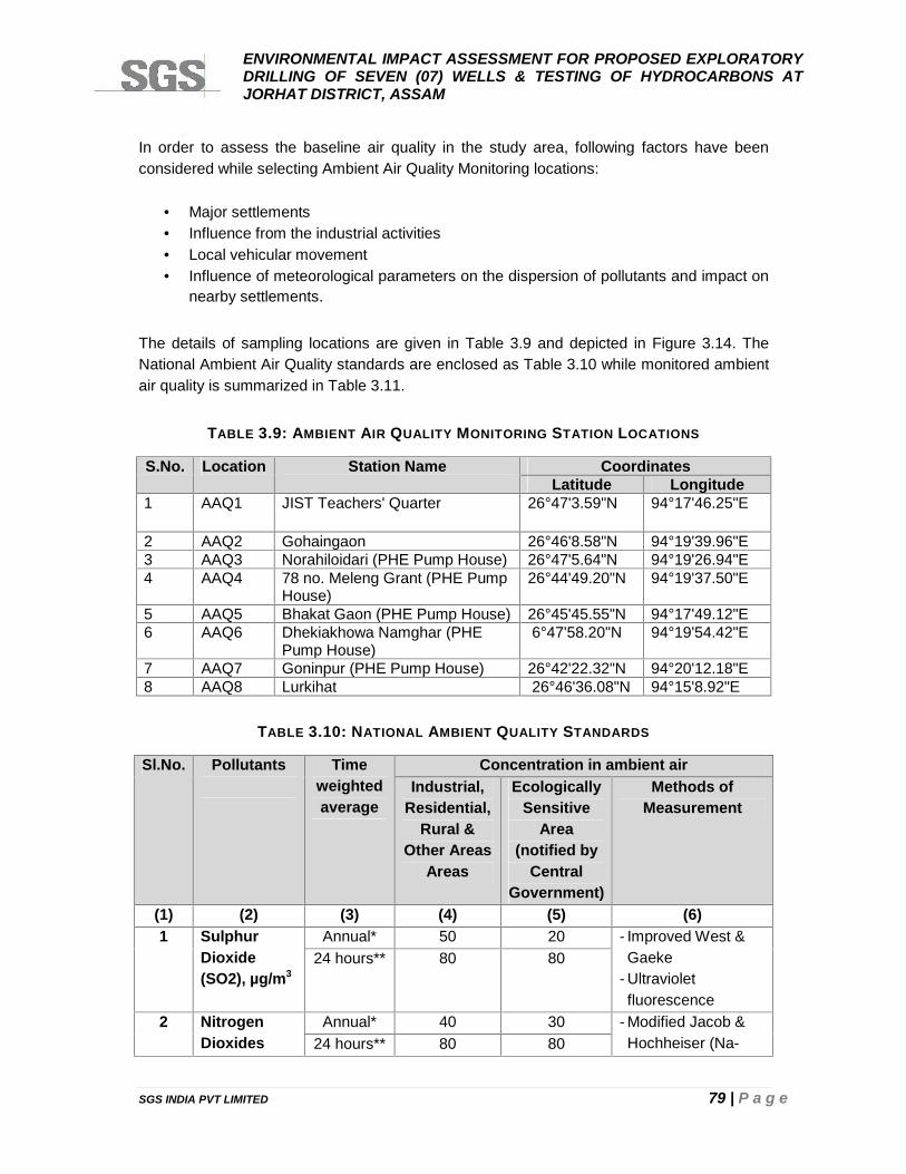
ENVIRONMENTAL IMPACT ASSESSMENT FOR PROPOSED EXPLORATORYDRILLING OF SEVEN (07) WELLS & TESTING OF HYDROCARBONS ATJORHAT DISTRICT, ASSAM
SGS INDIA PVT LIMITED 79 | P a g e
In order to assess the baseline air quality in the study area, following factors have beenconsidered while selecting Ambient Air Quality Monitoring locations:
Major settlements Influence from the industrial activities Local vehicular movement Influence of meteorological parameters on the dispersion of pollutants and impact on
nearby settlements.
The details of sampling locations are given in Table 3.9 and depicted in Figure 3.14. TheNational Ambient Air Quality standards are enclosed as Table 3.10 while monitored ambientair quality is summarized in Table 3.11.
TABLE 3.9: AMBIENT AIR QUALITY MONITORING STATION LOCATIONS
S.No. Location Station Name CoordinatesLatitude Longitude
1 AAQ1 JIST Teachers' Quarter 26°47'3.59"N 94°17'46.25"E
2 AAQ2 Gohaingaon 26°46'8.58"N 94°19'39.96"E3 AAQ3 Norahiloidari (PHE Pump House) 26°47'5.64"N 94°19'26.94"E4 AAQ4 78 no. Meleng Grant (PHE Pump
House)26°44'49.20"N 94°19'37.50"E
5 AAQ5 Bhakat Gaon (PHE Pump House) 26°45'45.55"N 94°17'49.12"E6 AAQ6 Dhekiakhowa Namghar (PHE
Pump House)6°47'58.20"N 94°19'54.42"E
7 AAQ7 Goninpur (PHE Pump House) 26°42'22.32"N 94°20'12.18"E8 AAQ8 Lurkihat 26°46'36.08"N 94°15'8.92"E
TABLE 3.10: NATIONAL AMBIENT QUALITY STANDARDS
Sl.No. Pollutants Timeweightedaverage
Concentration in ambient airIndustrial,
Residential,Rural &
Other AreasAreas
EcologicallySensitive
Area(notified by
CentralGovernment)
Methods ofMeasurement
(1) (2) (3) (4) (5) (6)1 Sulphur
Dioxide(SO2), µg/m3
Annual* 50 20 - Improved West &Gaeke
- Ultravioletfluorescence
24 hours** 80 80
2 NitrogenDioxides
Annual* 40 30 - Modified Jacob &Hochheiser (Na-24 hours** 80 80
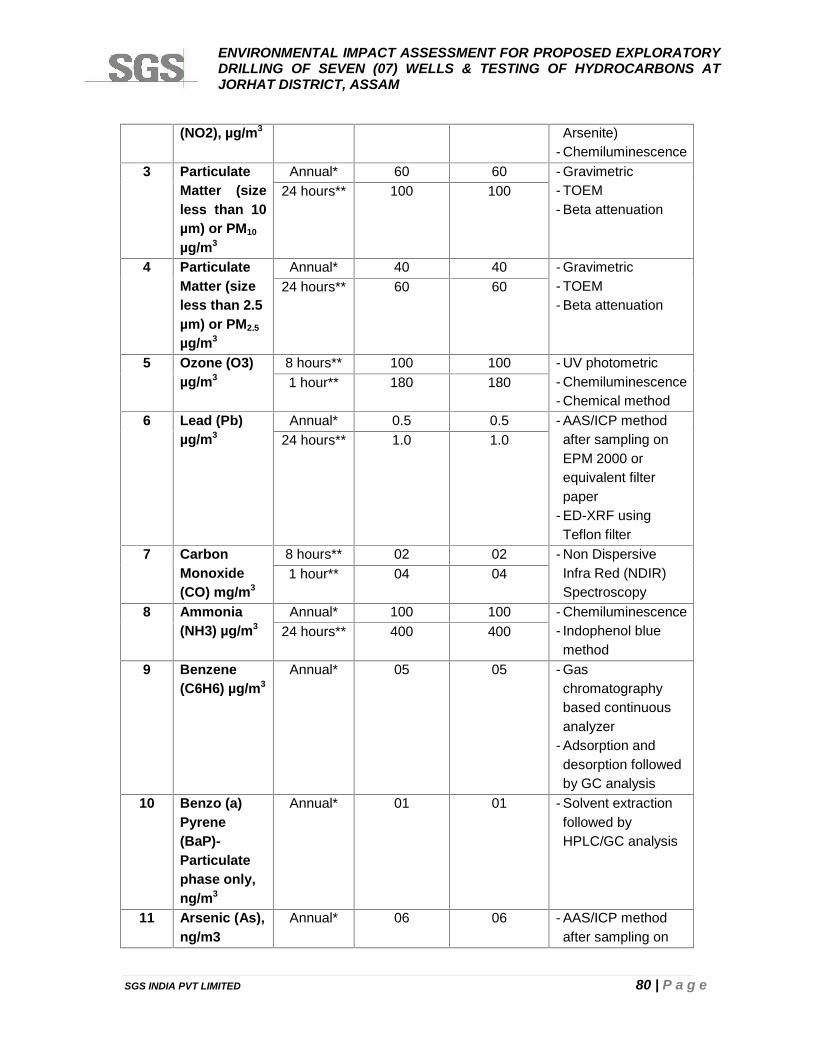
ENVIRONMENTAL IMPACT ASSESSMENT FOR PROPOSED EXPLORATORYDRILLING OF SEVEN (07) WELLS & TESTING OF HYDROCARBONS ATJORHAT DISTRICT, ASSAM
SGS INDIA PVT LIMITED 80 | P a g e
(NO2), µg/m3 Arsenite)- Chemiluminescence
3 ParticulateMatter (sizeless than 10µm) or PM10
µg/m3
Annual* 60 60 - Gravimetric- TOEM- Beta attenuation
24 hours** 100 100
4 ParticulateMatter (sizeless than 2.5µm) or PM2.5
µg/m3
Annual* 40 40 - Gravimetric- TOEM- Beta attenuation
24 hours** 60 60
5 Ozone (O3)µg/m3
8 hours** 100 100 - UV photometric- Chemiluminescence- Chemical method
1 hour** 180 180
6 Lead (Pb)µg/m3
Annual* 0.5 0.5 - AAS/ICP methodafter sampling onEPM 2000 orequivalent filterpaper
- ED-XRF usingTeflon filter
24 hours** 1.0 1.0
7 CarbonMonoxide(CO) mg/m3
8 hours** 02 02 - Non DispersiveInfra Red (NDIR)Spectroscopy
1 hour** 04 04
8 Ammonia(NH3) µg/m3
Annual* 100 100 - Chemiluminescence- Indophenol bluemethod
24 hours** 400 400
9 Benzene(C6H6) µg/m3
Annual* 05 05 - Gaschromatographybased continuousanalyzer
- Adsorption anddesorption followedby GC analysis
10 Benzo (a)Pyrene(BaP)-Particulatephase only,ng/m3
Annual* 01 01 - Solvent extractionfollowed byHPLC/GC analysis
11 Arsenic (As),ng/m3
Annual* 06 06 - AAS/ICP methodafter sampling on
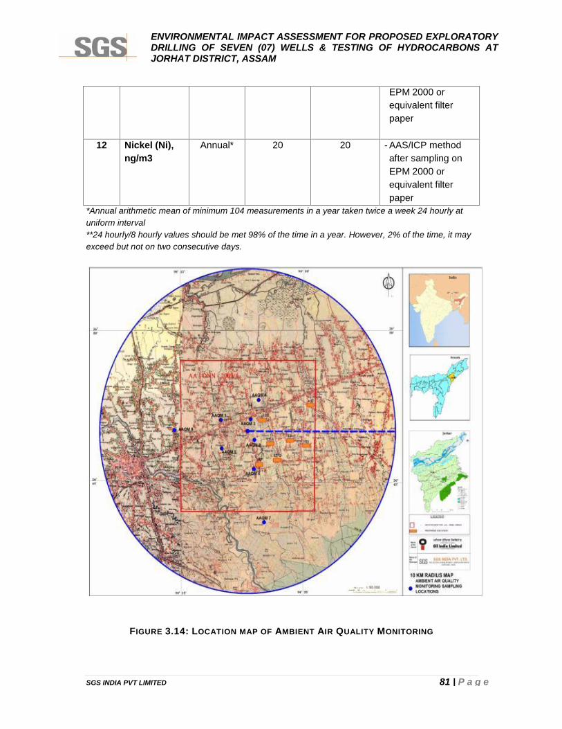
ENVIRONMENTAL IMPACT ASSESSMENT FOR PROPOSED EXPLORATORYDRILLING OF SEVEN (07) WELLS & TESTING OF HYDROCARBONS ATJORHAT DISTRICT, ASSAM
SGS INDIA PVT LIMITED 81 | P a g e
EPM 2000 orequivalent filterpaper
12 Nickel (Ni),ng/m3
Annual* 20 20 - AAS/ICP methodafter sampling onEPM 2000 orequivalent filterpaper
*Annual arithmetic mean of minimum 104 measurements in a year taken twice a week 24 hourly atuniform interval**24 hourly/8 hourly values should be met 98% of the time in a year. However, 2% of the time, it mayexceed but not on two consecutive days.
FIGURE 3.14: LOCATION MAP OF AMBIENT AIR QUALITY MONITORING
ENVIRONMENTAL IMPACT ASSESSMENT FOR PROPOSED EXPLORATORYDRILLING OF SEVEN (07) WELLS & TESTING OF HYDROCARBONS ATJORHAT DISTRICT, ASSAM
SGS INDIA PVT LIMITED 82 | P a g e
3.5.1 RESULTS OF AMBIENT AIR QUALITY
Particulate Matter- size less than 10 μm (PM10)Out of the eight (8) locations within the study area, maximum concentration for PM10 of 58.2
g/m3 was recorded at Dhekiakhowa Namghar (AAQ6). The minimum concentration of 17.2
g/m3 was recorded at Bhakat Gaon (AAQ5). The 98th percentile value of PM10 within the
study area varied between 45.2 g/m3 to 57.6 g/m3.
Oxides of Nitrogen (NOx)Out of the eight (8) locations within the study area, maximum concentration for NOX of 27.9
g/m3 was recorded at Meleng Grant (AAQ4). The minimum concentration of 8.9 g/m3 was
recorded at Dhekiakhowa Namghar (AAQ6). The 98th percentile value of NOX within the
study area varied between 15.1 g/m3 to 27.2 g/m3.
Sulphur Dioxide (SO2)Sulphur Dioxide (SO2) was found to be below the detection limits in all locations.
Volatile Organic Compounds (VOCs)The VOCs (Benzene, Toluene, Ethylfenzene, p-Xylene, o-Xylene, Methane, Ethane,
Propane, n-Butane, iso-Butane, Pentane) of all the location is not detected.
Overall Baseline Ambient Air qualityResults of the ambient air quality at all the above locations were found to be well below the
standards prescribed in National Ambient Air Quality (NAAQ) standards.
ENVIRONMENTAL IMPACT ASSESSMENT FOR PROPOSED EXPLORATORYDRILLING OF SEVEN (07) WELLS & TESTING OF HYDROCARBONS ATJORHAT DISTRICT, ASSAM
SGS INDIA PVT LIMITED 83 | P a g e
TABLE 3.11: AMBIENT AIR QUALITY RESULT AT SITES
Locations Statistics PM10(µg/m3)
NOx(µg/m3)
SO2(µg/m3)
Ben
zene
µg/m
3
Tolu
ene
(µg/
m3)
Ethy
lfenz
ene
µg/m
3
p-Xy
lene
,µg
/m3
o-Xy
lene
µg/m
3
m-X
ylen
e,µg
/m3
Met
hane
ppm
Etha
nepp
m
Prop
ane
ppm
n-B
utan
epp
m
iso-
But
ane
ppm
AAQ1 Maximum 52.6 21.8 <5.0 <2.0 <2.0 <2.0 <2.0 <2.0 <2.0 <2.0 <2.0 <2.0 <2.0 <2.0
Minimum 22.2 13.5 <5.0 <2.0 <2.0 <2.0 <2.0 <2.0 <2.0 <2.0 <2.0 <2.0 <2.0 <2.0
Average 39.0 16.5 <5.0 <2.0 <2.0 <2.0 <2.0 <2.0 <2.0 <2.0 <2.0 <2.0 <2.0 <2.0
98th Percentile 51.5 21.6 <5.0 <2.0 <2.0 <2.0 <2.0 <2.0 <2.0 <2.0 <2.0 <2.0 <2.0 <2.0
AAQ2 Maximum 57.8 19.8 <5.0 <2.0 <2.0 <2.0 <2.0 <2.0 <2.0 <2.0 <2.0 <2.0 <2.0 <2.0
Minimum 44.6 11.5 <5.0 <2.0 <2.0 <2.0 <2.0 <2.0 <2.0 <2.0 <2.0 <2.0 <2.0 <2.0
Average 51.9 14.7 <5.0 <2.0 <2.0 <2.0 <2.0 <2.0 <2.0 <2.0 <2.0 <2.0 <2.0 <2.0
98th Percentile 57.6 19.6 <5.0 <2.0 <2.0 <2.0 <2.0 <2.0 <2.0 <2.0 <2.0 <2.0 <2.0 <2.0
AAQ3 Maximum 45.5 18.9 <5.0 <2.0 <2.0 <2.0 <2.0 <2.0 <2.0 <2.0 <2.0 <2.0 <2.0 <2.0
Minimum 38.0 9.6 <5.0 <2.0 <2.0 <2.0 <2.0 <2.0 <2.0 <2.0 <2.0 <2.0 <2.0 <2.0
Average 41.2 12.7 <5.0 <2.0 <2.0 <2.0 <2.0 <2.0 <2.0 <2.0 <2.0 <2.0 <2.0 <2.0
98th Percentile 45.2 18.4 <5.0 <2.0 <2.0 <2.0 <2.0 <2.0 <2.0 <2.0 <2.0 <2.0 <2.0 <2.0
AAQ4 Maximum 56.9 27.9 5.4 <2.0 <2.0 <2.0 <2.0 <2.0 <2.0 <2.0 <2.0 <2.0 <2.0 <2.0
Minimum 22.8 14.9 <5.0 <2.0 <2.0 <2.0 <2.0 <2.0 <2.0 <2.0 <2.0 <2.0 <2.0 <2.0
ENVIRONMENTAL IMPACT ASSESSMENT FOR PROPOSED EXPLORATORYDRILLING OF SEVEN (07) WELLS & TESTING OF HYDROCARBONS ATJORHAT DISTRICT, ASSAM
SGS INDIA PVT LIMITED 84 | P a g e
Locations Statistics PM10(µg/m3)
NOx(µg/m3)
SO2(µg/m3)
Ben
zene
µg/m
3
Tolu
ene
(µg/
m3)
Ethy
lfenz
ene
µg/m
3
p-Xy
lene
,µg
/m3
o-Xy
lene
µg/m
3
m-X
ylen
e,µg
/m3
Met
hane
ppm
Etha
nepp
m
Prop
ane
ppm
n-B
utan
epp
m
iso-
But
ane
ppm
Average 38.5 20.1 5.4 <2.0 <2.0 <2.0 <2.0 <2.0 <2.0 <2.0 <2.0 <2.0 <2.0 <2.0
98th Percentile 56.7 27.2 5.4 <2.0 <2.0 <2.0 <2.0 <2.0 <2.0 <2.0 <2.0 <2.0 <2.0 <2.0
AAQ5 Maximum 56.5 23.4 <5.0 <2.0 <2.0 <2.0 <2.0 <2.0 <2.0 <2.0 <2.0 <2.0 <2.0 <2.0
Minimum 17.2 9.8 <5.0 <2.0 <2.0 <2.0 <2.0 <2.0 <2.0 <2.0 <2.0 <2.0 <2.0 <2.0
Average 37.5 15.8 <5.0 <2.0 <2.0 <2.0 <2.0 <2.0 <2.0 <2.0 <2.0 <2.0 <2.0 <2.0
98th Percentile 55.8 22.8 <5.0 <2.0 <2.0 <2.0 <2.0 <2.0 <2.0 <2.0 <2.0 <2.0 <2.0 <2.0
AAQ6 Maximum 58.2 15.2 <5.0 <2.0 <2.0 <2.0 <2.0 <2.0 <2.0 <2.0 <2.0 <2.0 <2.0 <2.0
Minimum 21.3 8.9 <5.0 <2.0 <2.0 <2.0 <2.0 <2.0 <2.0 <2.0 <2.0 <2.0 <2.0 <2.0
Average 37.9 11.9 <5.0 <2.0 <2.0 <2.0 <2.0 <2.0 <2.0 <2.0 <2.0 <2.0 <2.0 <2.0
98th Percentile 56.6 15.1 <5.0 <2.0 <2.0 <2.0 <2.0 <2.0 <2.0 <2.0 <2.0 <2.0 <2.0 <2.0
AAQ7 Maximum 56.7 18.7 <5.0 <2.0 <2.0 <2.0 <2.0 <2.0 <2.0 <2.0 <2.0 <2.0 <2.0 <2.0
Minimum 25.7 11.8 <5.0 <2.0 <2.0 <2.0 <2.0 <2.0 <2.0 <2.0 <2.0 <2.0 <2.0 <2.0
Average 39.0 13.9 <5.0 <2.0 <2.0 <2.0 <2.0 <2.0 <2.0 <2.0 <2.0 <2.0 <2.0 <2.0
98th Percentile 56.1 18.3 <5.0 <2.0 <2.0 <2.0 <2.0 <2.0 <2.0 <2.0 <2.0 <2.0 <2.0 <2.0
AAQ8 Maximum 56.1 25.6 <5.0 <2.0 <2.0 <2.0 <2.0 <2.0 <2.0 <2.0 <2.0 <2.0 <2.0 <2.0
ENVIRONMENTAL IMPACT ASSESSMENT FOR PROPOSED EXPLORATORYDRILLING OF SEVEN (07) WELLS & TESTING OF HYDROCARBONS ATJORHAT DISTRICT, ASSAM
SGS INDIA PVT LIMITED 85 | P a g e
Locations Statistics PM10(µg/m3)
NOx(µg/m3)
SO2(µg/m3)
Ben
zene
µg/m
3
Tolu
ene
(µg/
m3)
Ethy
lfenz
ene
µg/m
3
p-Xy
lene
,µg
/m3
o-Xy
lene
µg/m
3
m-X
ylen
e,µg
/m3
Met
hane
ppm
Etha
nepp
m
Prop
ane
ppm
n-B
utan
epp
m
iso-
But
ane
ppm
Minimum 30.4 12.8 <5.0 <2.0 <2.0 <2.0 <2.0 <2.0 <2.0 <2.0 <2.0 <2.0 <2.0 <2.0
Average 43.1 17.4 <5.0 <2.0 <2.0 <2.0 <2.0 <2.0 <2.0 <2.0 <2.0 <2.0 <2.0 <2.0
98th Percentile 55.5 25.1 <5.0 <2.0 <2.0 <2.0 <2.0 <2.0 <2.0 <2.0 <2.0 <2.0 <2.0 <2.0
NAAQS,CPCB,2009
Annual 60 40 50
24 Hrs. 100 80 80
ENVIRONMENTAL IMPACT ASSESSMENT FOR PROPOSED EXPLORATORYDRILLING OF SEVEN (07) WELLS & TESTING OF HYDROCARBONS ATJORHAT DISTRICT, ASSAM
SGS INDIA PVT LIMITED 86 | P a g e
3.6 NOISE ENVIRONMENT
The main objective of noise monitoring in the study area is to establish the baseline noise
levels, and assess the impact of the total noise expected to be generated by proposed
activity. The noise monitoring has been conducted at 10 locations as per the details given in
Table 3.12 and depicted in Figure 3.15 in the study area. Noise levels were recorded hourly
basis for a continuous 24-hour period.
TABLE 3.12: DETAILS OF NOISE MONITORING LOCATIONS
Sl.No.
Location LocationCode
Date ofSampling
Description Coordinates
Lattitude Longitude
1 JIST Teachers'Quarter
N1 13.02.2015-14.02.2015
ResidentialArea
26°47'3.59"N; 94°17'46.25"E
2 Gohaingaon N2 15.02.2015-16.02.2015
ResidentialArea
26°46'8.58"N; 94°19'39.96"E
3 Norahiloidari(PHE PumpHouse)
N3 17.02.2015-18.02.2015
ResidentialArea
26°47'5.64"N; 94°19'26.94"E
4 78 no. MelengGrant (PHEPump House)
N4 18.02.2015-19.02.2015
ResidentialArea
26°44'49.20"N; 94°19'37.50"E
5 Bhakat Gaon(PHE PumpHouse)
N5 20.02.2015-21.02.2015
ResidentialArea
26°45'45.55"N; 94°17'49.12"E
6 DhekiakhowaNamghar(PHE PumpHouse)
N6 22.02.2015-23.02.2015
ResidentialArea
26°47'58.20"N; 94°19'54.42"E
7 Goninpur(PHE PumpHouse)
N7 24.02.2015-25.02.2015
ResidentialArea
26°42'22.32"N; 94°20'12.18"E
8 Lurkihat N8 25.02.2015-26.02.2015
ResidentialArea
26°46'36.08"N; 94°15'8.92"E
3.6.1 RESULTS OF AMBIENT NOISE QUALITY
As evident from summarized noise level within the study area in Table 3.13, the higher value
of day time noise was observed at Dhekuakhowa Namghar (N6) location and which is
marginally higher than the standards. It is due to the vehicular traffic and other
anthropogenic activities during day time. The overall noise level found to be well below the
standards value for both day time and night time.
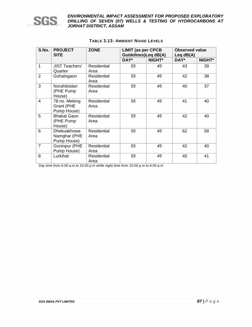
ENVIRONMENTAL IMPACT ASSESSMENT FOR PROPOSED EXPLORATORYDRILLING OF SEVEN (07) WELLS & TESTING OF HYDROCARBONS ATJORHAT DISTRICT, ASSAM
SGS INDIA PVT LIMITED 87 | P a g e
TABLE 3.13: AMBIENT NOISE LEVELS
S.No. PROJECTSITE
ZONE LIMIT (as per CPCBGuidelines)Leq dB(A)
Observed valueLeq dB(A)
DAY* NIGHT* DAY* NIGHT*1 JIST Teachers'
QuarterResidentialArea
55 45 43 39
2 Gohaingaon ResidentialArea
55 45 42 38
3 Norahiloidari(PHE PumpHouse)
ResidentialArea
55 45 40 37
4 78 no. MelengGrant (PHEPump House)
ResidentialArea
55 45 41 40
5 Bhakat Gaon(PHE PumpHouse)
ResidentialArea
55 45 42 40
6 DhekuakhowaNamghar (PHEPump House)
ResidentialArea
55 45 62 58
7 Goninpur (PHEPump House)
ResidentialArea
55 45 42 40
8 Lurkihat ResidentialArea
55 45 45 41
Day time from 6.00 a.m to 10.00 p.m while night time from 10.00 p.m to 6.00 a.m
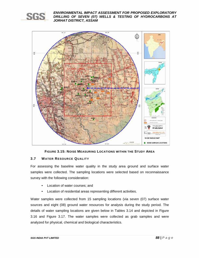
ENVIRONMENTAL IMPACT ASSESSMENT FOR PROPOSED EXPLORATORYDRILLING OF SEVEN (07) WELLS & TESTING OF HYDROCARBONS ATJORHAT DISTRICT, ASSAM
SGS INDIA PVT LIMITED 88 | P a g e
FIGURE 3.15: NOISE MEASURING LOCATIONS WITHIN THE STUDY AREA
3.7 WATER RESOURCE QUALITY
For assessing the baseline water quality in the study area ground and surface water
samples were collected. The sampling locations were selected based on reconnaissance
survey with the following consideration:
• Location of water courses; and
• Location of residential areas representing different activities.
Water samples were collected from 15 sampling locations (via seven (07) surface water
sources and eight (08) ground water resources for analysis during the study period. The
details of water sampling locations are given below in Tables 3.14 and depicted in Figure
3.16 and Figure 3.17. The water samples were collected as grab samples and were
analyzed for physical, chemical and biological characteristics.
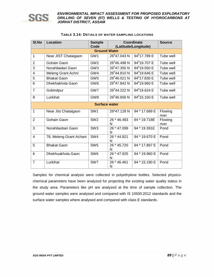
ENVIRONMENTAL IMPACT ASSESSMENT FOR PROPOSED EXPLORATORYDRILLING OF SEVEN (07) WELLS & TESTING OF HYDROCARBONS ATJORHAT DISTRICT, ASSAM
SGS INDIA PVT LIMITED 89 | P a g e
TABLE 3.14: DETAILS OF WATER SAMPLING LOCATIONS
Sl.No Location SampleCode
Coordinate(Latitude/Longitude)
Source
Ground Water1 Near JIST Chataigaon GW1 26047.043 N 94017.789 E Tube well
2 Gohain Gaon GW2 26046.498 N 94019.707 E Tube well3 Norahilaidari Gaon GW3 26047.355 N 94019.550 E Tube well4 Meleng Grant Achni GW4 26044.810 N 94019.646 E Tube well5 Bhakat Gaon GW5 26046.021 N 94017.830 E Tube well6 Dhekhakhola Gaon GW6 26047.842 N 94019.960 E Tube well
7 Gobindpur GW7 26044.222 N 94019.624 E Tube well
8 Lurkihat GW8 26046.656 N 94015.150 E Tube well
Surface water
1 Near Jist Chataigaon SW1 26º47.128 N 94 º 17.689 E Flowingriver
2 Gohain Gaon SW2 26 º 46.483N
94 º 19.718E Flowingriver
3 Norahilaobari Gaon SW3 26 º 47.099N
94 º 19.391E Pond
4 78, Meleng Grant Achani SW4 26 º 44.821N
94 º 19.670 E Pond
5 Bhakat Gaon SW5 26 º 45.720N
94 º 17.897 E Pond
6 Dhekhuakhola Gaon SW6 26 º 47.925N
94 º 19.960 E Pond
7 Lurkihat SW7 26 º 46.461N
94 º 15.190 E Pond
Samples for chemical analysis were collected in polyethylene bottles. Selected physico-
chemical parameters have been analyzed for projecting the existing water quality status in
the study area. Parameters like pH are analyzed at the time of sample collection. The
ground water samples were analysed and compared with IS 10500:2012 standards and the
surface water samples where analysed and compared with class E standards.
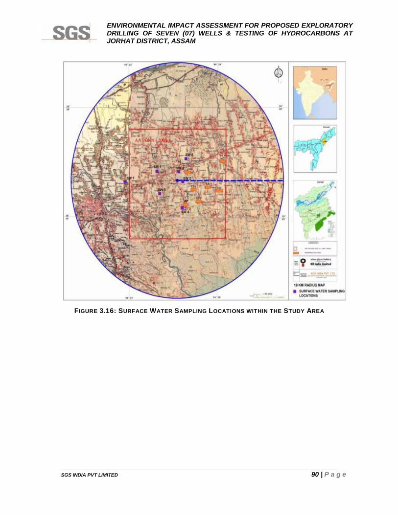
ENVIRONMENTAL IMPACT ASSESSMENT FOR PROPOSED EXPLORATORYDRILLING OF SEVEN (07) WELLS & TESTING OF HYDROCARBONS ATJORHAT DISTRICT, ASSAM
SGS INDIA PVT LIMITED 90 | P a g e
FIGURE 3.16: SURFACE WATER SAMPLING LOCATIONS WITHIN THE STUDY AREA
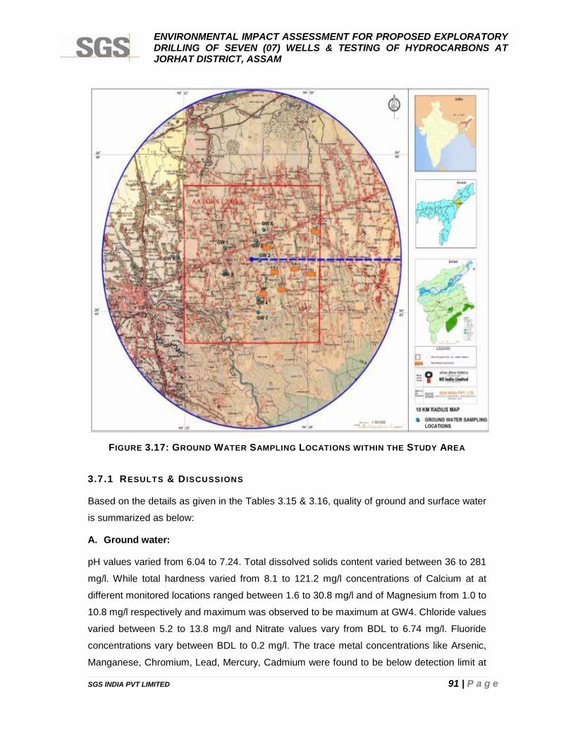
ENVIRONMENTAL IMPACT ASSESSMENT FOR PROPOSED EXPLORATORYDRILLING OF SEVEN (07) WELLS & TESTING OF HYDROCARBONS ATJORHAT DISTRICT, ASSAM
SGS INDIA PVT LIMITED 91 | P a g e
FIGURE 3.17: GROUND WATER SAMPLING LOCATIONS WITHIN THE STUDY AREA
3.7.1 RESULTS & D ISCUSSIONS
Based on the details as given in the Tables 3.15 & 3.16, quality of ground and surface water
is summarized as below:
A. Ground water:
pH values varied from 6.04 to 7.24. Total dissolved solids content varied between 36 to 281
mg/l. While total hardness varied from 8.1 to 121.2 mg/l concentrations of Calcium at at
different monitored locations ranged between 1.6 to 30.8 mg/l and of Magnesium from 1.0 to
10.8 mg/l respectively and maximum was observed to be maximum at GW4. Chloride values
varied between 5.2 to 13.8 mg/l and Nitrate values vary from BDL to 6.74 mg/l. Fluoride
concentrations vary between BDL to 0.2 mg/l. The trace metal concentrations like Arsenic,
Manganese, Chromium, Lead, Mercury, Cadmium were found to be below detection limit at
ENVIRONMENTAL IMPACT ASSESSMENT FOR PROPOSED EXPLORATORYDRILLING OF SEVEN (07) WELLS & TESTING OF HYDROCARBONS ATJORHAT DISTRICT, ASSAM
SGS INDIA PVT LIMITED 92 | P a g e
all locations. The Mineral Oil concentrations at all the groundwater samples were found to be
below detection limit. Similarly, the phenolic compounds and cyanide concentrations are
observed to be below detection limit. Total coliform found in all the ground water samples
which is not permissible as per IS 10500: 2012 standards. Though the other parameters are
well within standards but due to presence of total coliform the water is not suitable for
drinking purposes without suitable treatment.
A. Surface water:
The pH values ranging from 5.72 to 6.26 being maximum at SW7. The suspended solids
content varied between 13.2 to 31.7 mg/l. while Total Dissolve Solid (TDS) varied from 35 to
108 mg/l and was found to be maximum at SW7. The parameters like BOD found to be
higher in SW6 which is 10.5 mg/l and minimum at SW3 which is 4 mg/l. Dissolved Oxygen
varied from 3.2 mg/l to 4.6 in all the samples. The trace metal concentrations like Chromium,
Mercury and Lead were found to be below detection limit at all locations. The turbidity varies
between 14.3 to 86.8 NTU and found to maximum for SW5. Feacal Coliform is found absent
in all samples and the Total Coliform present in most of the samples.
From the above discussion, it is evident that the surface water quality of the study area
conforms to the Class E as recommended by CPCB at almost all locations.
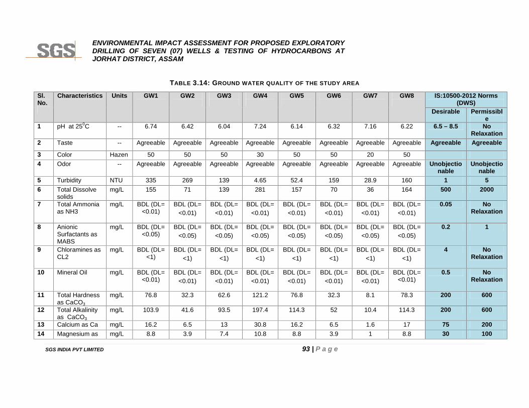
ENVIRONMENTAL IMPACT ASSESSMENT FOR PROPOSED EXPLORATORYDRILLING OF SEVEN (07) WELLS & TESTING OF HYDROCARBONS ATJORHAT DISTRICT, ASSAM
SGS INDIA PVT LIMITED 93 | P a g e
TABLE 3.14: GROUND WATER QUALITY OF THE STUDY AREA
Sl.No.
Characteristics Units GW1 GW2 GW3 GW4 GW5 GW6 GW7 GW8 IS:10500-2012 Norms(DWS)
Desirable Permissible
1 pH at 250C -- 6.74 6.42 6.04 7.24 6.14 6.32 7.16 6.22 6.5 – 8.5 NoRelaxation
2 Taste -- Agreeable Agreeable Agreeable Agreeable Agreeable Agreeable Agreeable Agreeable Agreeable Agreeable
3 Color Hazen 50 50 50 30 50 50 20 504 Odor -- Agreeable Agreeable Agreeable Agreeable Agreeable Agreeable Agreeable Agreeable Unobjectio
nableUnobjectio
nable5 Turbidity NTU 335 269 139 4.65 52.4 159 28.9 160 1 56 Total Dissolve
solidsmg/L 155 71 139 281 157 70 36 164 500 2000
7 Total Ammoniaas NH3
mg/L BDL (DL=<0.01)
BDL (DL=<0.01)
BDL (DL=<0.01)
BDL (DL=<0.01)
BDL (DL=<0.01)
BDL (DL=<0.01)
BDL (DL=<0.01)
BDL (DL=<0.01)
0.05 NoRelaxation
8 AnionicSurfactants asMABS
mg/L BDL (DL=<0.05)
BDL (DL=<0.05)
BDL (DL=<0.05)
BDL (DL=<0.05)
BDL (DL=<0.05)
BDL (DL=<0.05)
BDL (DL=<0.05)
BDL (DL=<0.05)
0.2 1
9 Chloramines asCL2
mg/L BDL (DL=<1)
BDL (DL=<1)
BDL (DL=<1)
BDL (DL=<1)
BDL (DL=<1)
BDL (DL=<1)
BDL (DL=<1)
BDL (DL=<1)
4 NoRelaxation
10 Mineral Oil mg/L BDL (DL=<0.01)
BDL (DL=<0.01)
BDL (DL=<0.01)
BDL (DL=<0.01)
BDL (DL=<0.01)
BDL (DL=<0.01)
BDL (DL=<0.01)
BDL (DL=<0.01)
0.5 NoRelaxation
11 Total Hardnessas CaCO3
mg/L 76.8 32.3 62.6 121.2 76.8 32.3 8.1 78.3 200 600
12 Total Alkalinityas CaCO3
mg/L 103.9 41.6 93.5 197.4 114.3 52 10.4 114.3 200 600
13 Calcium as Ca mg/L 16.2 6.5 13 30.8 16.2 6.5 1.6 17 75 20014 Magnesium as mg/L 8.8 3.9 7.4 10.8 8.8 3.9 1 8.8 30 100
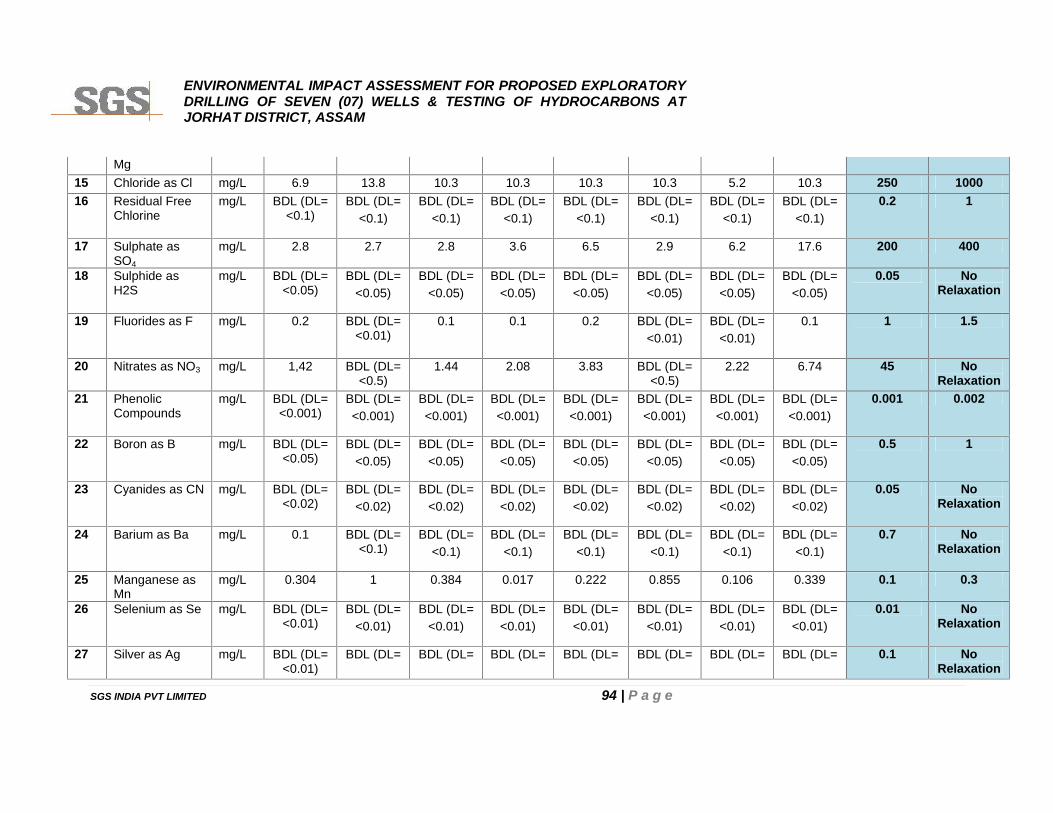
ENVIRONMENTAL IMPACT ASSESSMENT FOR PROPOSED EXPLORATORYDRILLING OF SEVEN (07) WELLS & TESTING OF HYDROCARBONS ATJORHAT DISTRICT, ASSAM
SGS INDIA PVT LIMITED 94 | P a g e
Mg15 Chloride as Cl mg/L 6.9 13.8 10.3 10.3 10.3 10.3 5.2 10.3 250 100016 Residual Free
Chlorinemg/L BDL (DL=
<0.1)BDL (DL=
<0.1)BDL (DL=
<0.1)BDL (DL=
<0.1)BDL (DL=
<0.1)BDL (DL=
<0.1)BDL (DL=
<0.1)BDL (DL=
<0.1)0.2 1
17 Sulphate asSO4
mg/L 2.8 2.7 2.8 3.6 6.5 2.9 6.2 17.6 200 400
18 Sulphide asH2S
mg/L BDL (DL=<0.05)
BDL (DL=<0.05)
BDL (DL=<0.05)
BDL (DL=<0.05)
BDL (DL=<0.05)
BDL (DL=<0.05)
BDL (DL=<0.05)
BDL (DL=<0.05)
0.05 NoRelaxation
19 Fluorides as F mg/L 0.2 BDL (DL=<0.01)
0.1 0.1 0.2 BDL (DL=<0.01)
BDL (DL=<0.01)
0.1 1 1.5
20 Nitrates as NO3 mg/L 1,42 BDL (DL=<0.5)
1.44 2.08 3.83 BDL (DL=<0.5)
2.22 6.74 45 NoRelaxation
21 PhenolicCompounds
mg/L BDL (DL=<0.001)
BDL (DL=<0.001)
BDL (DL=<0.001)
BDL (DL=<0.001)
BDL (DL=<0.001)
BDL (DL=<0.001)
BDL (DL=<0.001)
BDL (DL=<0.001)
0.001 0.002
22 Boron as B mg/L BDL (DL=<0.05)
BDL (DL=<0.05)
BDL (DL=<0.05)
BDL (DL=<0.05)
BDL (DL=<0.05)
BDL (DL=<0.05)
BDL (DL=<0.05)
BDL (DL=<0.05)
0.5 1
23 Cyanides as CN mg/L BDL (DL=<0.02)
BDL (DL=<0.02)
BDL (DL=<0.02)
BDL (DL=<0.02)
BDL (DL=<0.02)
BDL (DL=<0.02)
BDL (DL=<0.02)
BDL (DL=<0.02)
0.05 NoRelaxation
24 Barium as Ba mg/L 0.1 BDL (DL=<0.1)
BDL (DL=<0.1)
BDL (DL=<0.1)
BDL (DL=<0.1)
BDL (DL=<0.1)
BDL (DL=<0.1)
BDL (DL=<0.1)
0.7 NoRelaxation
25 Manganese asMn
mg/L 0.304 1 0.384 0.017 0.222 0.855 0.106 0.339 0.1 0.3
26 Selenium as Se mg/L BDL (DL=<0.01)
BDL (DL=<0.01)
BDL (DL=<0.01)
BDL (DL=<0.01)
BDL (DL=<0.01)
BDL (DL=<0.01)
BDL (DL=<0.01)
BDL (DL=<0.01)
0.01 NoRelaxation
27 Silver as Ag mg/L BDL (DL=<0.01)
BDL (DL= BDL (DL= BDL (DL= BDL (DL= BDL (DL= BDL (DL= BDL (DL= 0.1 NoRelaxation
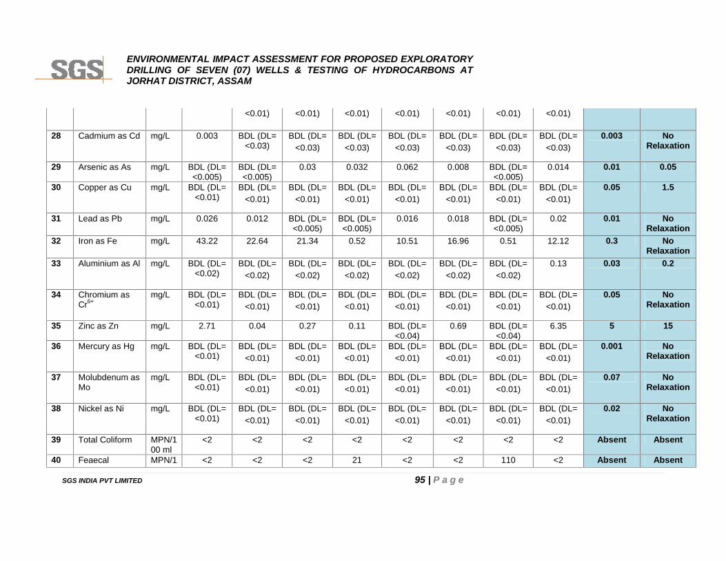
ENVIRONMENTAL IMPACT ASSESSMENT FOR PROPOSED EXPLORATORYDRILLING OF SEVEN (07) WELLS & TESTING OF HYDROCARBONS ATJORHAT DISTRICT, ASSAM
SGS INDIA PVT LIMITED 95 | P a g e
<0.01) <0.01) <0.01) <0.01) <0.01) <0.01) <0.01)
28 Cadmium as Cd mg/L 0.003 BDL (DL=<0.03)
BDL (DL=<0.03)
BDL (DL=<0.03)
BDL (DL=<0.03)
BDL (DL=<0.03)
BDL (DL=<0.03)
BDL (DL=<0.03)
0.003 NoRelaxation
29 Arsenic as As mg/L BDL (DL=<0.005)
BDL (DL=<0.005)
0.03 0.032 0.062 0.008 BDL (DL=<0.005)
0.014 0.01 0.05
30 Copper as Cu mg/L BDL (DL=<0.01)
BDL (DL=<0.01)
BDL (DL=<0.01)
BDL (DL=<0.01)
BDL (DL=<0.01)
BDL (DL=<0.01)
BDL (DL=<0.01)
BDL (DL=<0.01)
0.05 1.5
31 Lead as Pb mg/L 0.026 0.012 BDL (DL=<0.005)
BDL (DL=<0.005)
0.016 0.018 BDL (DL=<0.005)
0.02 0.01 NoRelaxation
32 Iron as Fe mg/L 43.22 22.64 21.34 0.52 10.51 16.96 0.51 12.12 0.3 NoRelaxation
33 Aluminium as Al mg/L BDL (DL=<0.02)
BDL (DL=<0.02)
BDL (DL=<0.02)
BDL (DL=<0.02)
BDL (DL=<0.02)
BDL (DL=<0.02)
BDL (DL=<0.02)
0.13 0.03 0.2
34 Chromium asCr6+
mg/L BDL (DL=<0.01)
BDL (DL=<0.01)
BDL (DL=<0.01)
BDL (DL=<0.01)
BDL (DL=<0.01)
BDL (DL=<0.01)
BDL (DL=<0.01)
BDL (DL=<0.01)
0.05 NoRelaxation
35 Zinc as Zn mg/L 2.71 0.04 0.27 0.11 BDL (DL=<0.04)
0.69 BDL (DL=<0.04)
6.35 5 15
36 Mercury as Hg mg/L BDL (DL=<0.01)
BDL (DL=<0.01)
BDL (DL=<0.01)
BDL (DL=<0.01)
BDL (DL=<0.01)
BDL (DL=<0.01)
BDL (DL=<0.01)
BDL (DL=<0.01)
0.001 NoRelaxation
37 Molubdenum asMo
mg/L BDL (DL=<0.01)
BDL (DL=<0.01)
BDL (DL=<0.01)
BDL (DL=<0.01)
BDL (DL=<0.01)
BDL (DL=<0.01)
BDL (DL=<0.01)
BDL (DL=<0.01)
0.07 NoRelaxation
38 Nickel as Ni mg/L BDL (DL=<0.01)
BDL (DL=<0.01)
BDL (DL=<0.01)
BDL (DL=<0.01)
BDL (DL=<0.01)
BDL (DL=<0.01)
BDL (DL=<0.01)
BDL (DL=<0.01)
0.02 NoRelaxation
39 Total Coliform MPN/100 ml
<2 <2 <2 <2 <2 <2 <2 <2 Absent Absent
40 Feaecal MPN/1 <2 <2 <2 21 <2 <2 110 <2 Absent Absent

ENVIRONMENTAL IMPACT ASSESSMENT FOR PROPOSED EXPLORATORYDRILLING OF SEVEN (07) WELLS & TESTING OF HYDROCARBONS ATJORHAT DISTRICT, ASSAM
SGS INDIA PVT LIMITED 96 | P a g e
coliform 00 ml41 DDT(O.P and
PP-Isomers ofOF DDT,DDEand DDD)
µg/L BDL (DL=<0.01)
BDL (DL=<0.01)
BDL (DL=<0.01)
BDL (DL=<0.01)
BDL (DL=<0.01)
BDL (DL=<0.01)
BDL (DL=<0.01)
BDL (DL=<0.01)
1 NoRelaxation
42 Gamma HCH µg/L BDL (DL=<0.01)
BDL (DL=<0.01)
BDL (DL=<0.01)
BDL (DL=<0.01)
BDL (DL=<0.01)
BDL (DL=<0.01)
BDL (DL=<0.01)
BDL (DL=<0.01)
2 NoRelaxation
43 Alpha HCH µg/L BDL (DL=<0.01)
BDL (DL=<0.01)
BDL (DL=<0.01)
BDL (DL=<0.01)
BDL (DL=<0.01)
BDL (DL=<0.01)
BDL (DL=<0.01)
BDL (DL=<0.01)
0.01 NoRelaxation
44 Beta HCH µg/L BDL (DL=<0.01)
BDL (DL=<0.01)
BDL (DL=<0.01)
BDL (DL=<0.01)
BDL (DL=<0.01)
BDL (DL=<0.01)
BDL (DL=<0.01)
BDL (DL=<0.01)
0.04 NoRelaxation
45 Delta HCH µg/L BDL (DL=<0.01)
BDL (DL=<0.01)
BDL (DL=<0.01)
BDL (DL=<0.01)
BDL (DL=<0.01)
BDL (DL=<0.01)
BDL (DL=<0.01)
BDL (DL=<0.01)
0.04 NoRelaxation
46 Endosulfan(Alpha,Beta andSulphate)
µg/L BDL (DL=<0.01)
BDL (DL=<0.01)
BDL (DL=<0.01)
BDL (DL=<0.01)
BDL (DL=<0.01)
BDL (DL=<0.01)
BDL (DL=<0.01)
BDL (DL=<0.01)
0.4 NoRelaxation
47 Butachlor µg/L BDL (DL=<0.01)
BDL (DL=<0.01)
BDL (DL=<0.01)
BDL (DL=<0.01)
BDL (DL=<0.01)
BDL (DL=<0.01)
BDL (DL=<0.01)
BDL (DL=<0.01)
125 NoRelaxation
48 Alachlor µg/L BDL (DL=<0.01)
BDL (DL=<0.01)
BDL (DL=<0.01)
BDL (DL=<0.01)
BDL (DL=<0.01)
BDL (DL=<0.01)
BDL (DL=<0.01)
BDL (DL=<0.01)
20 norelaxation
49 Aldrin/Dieldrin µg/L BDL (DL=<0.01)
BDL (DL=<0.01)
BDL (DL=<0.01)
BDL (DL=<0.01)
BDL (DL=<0.01)
BDL (DL=<0.01)
BDL (DL=<0.01)
BDL (DL=<0.01)
0.03 norelaxation
50 Isoprturon µg/L BDL (DL=<0.01)
BDL (DL=<0.01)
BDL (DL=<0.01)
BDL (DL=<0.01)
BDL (DL=<0.01)
BDL (DL=<0.01)
BDL (DL=<0.01)
BDL (DL=<0.01)
9 norelaxation
51 2.4-D µg/L BDL (DL= BDL (DL= BDL (DL= BDL (DL= BDL (DL= BDL (DL= BDL (DL= BDL (DL= 30 norelaxation
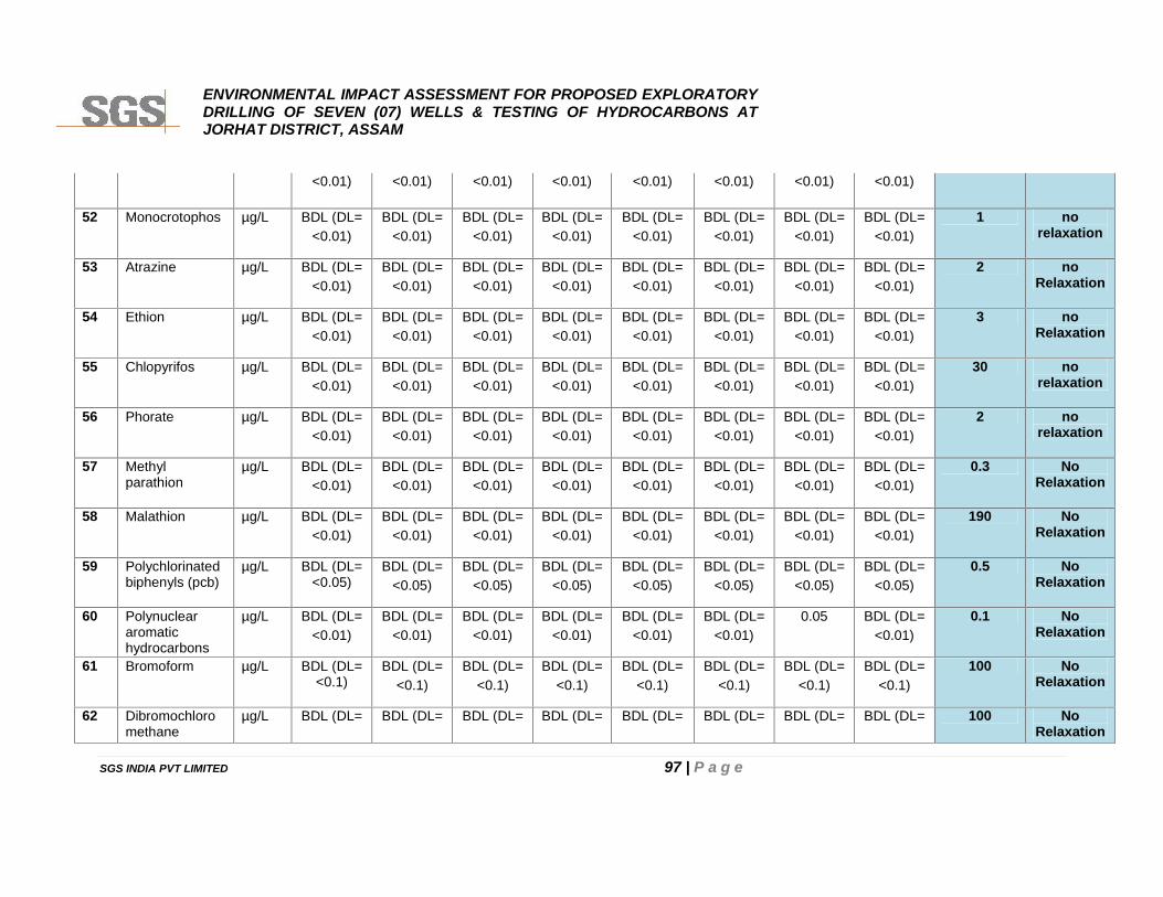
ENVIRONMENTAL IMPACT ASSESSMENT FOR PROPOSED EXPLORATORYDRILLING OF SEVEN (07) WELLS & TESTING OF HYDROCARBONS ATJORHAT DISTRICT, ASSAM
SGS INDIA PVT LIMITED 97 | P a g e
<0.01) <0.01) <0.01) <0.01) <0.01) <0.01) <0.01) <0.01)
52 Monocrotophos µg/L BDL (DL=<0.01)
BDL (DL=<0.01)
BDL (DL=<0.01)
BDL (DL=<0.01)
BDL (DL=<0.01)
BDL (DL=<0.01)
BDL (DL=<0.01)
BDL (DL=<0.01)
1 norelaxation
53 Atrazine µg/L BDL (DL=<0.01)
BDL (DL=<0.01)
BDL (DL=<0.01)
BDL (DL=<0.01)
BDL (DL=<0.01)
BDL (DL=<0.01)
BDL (DL=<0.01)
BDL (DL=<0.01)
2 noRelaxation
54 Ethion µg/L BDL (DL=<0.01)
BDL (DL=<0.01)
BDL (DL=<0.01)
BDL (DL=<0.01)
BDL (DL=<0.01)
BDL (DL=<0.01)
BDL (DL=<0.01)
BDL (DL=<0.01)
3 noRelaxation
55 Chlopyrifos µg/L BDL (DL=<0.01)
BDL (DL=<0.01)
BDL (DL=<0.01)
BDL (DL=<0.01)
BDL (DL=<0.01)
BDL (DL=<0.01)
BDL (DL=<0.01)
BDL (DL=<0.01)
30 norelaxation
56 Phorate µg/L BDL (DL=<0.01)
BDL (DL=<0.01)
BDL (DL=<0.01)
BDL (DL=<0.01)
BDL (DL=<0.01)
BDL (DL=<0.01)
BDL (DL=<0.01)
BDL (DL=<0.01)
2 norelaxation
57 Methylparathion
µg/L BDL (DL=<0.01)
BDL (DL=<0.01)
BDL (DL=<0.01)
BDL (DL=<0.01)
BDL (DL=<0.01)
BDL (DL=<0.01)
BDL (DL=<0.01)
BDL (DL=<0.01)
0.3 NoRelaxation
58 Malathion µg/L BDL (DL=<0.01)
BDL (DL=<0.01)
BDL (DL=<0.01)
BDL (DL=<0.01)
BDL (DL=<0.01)
BDL (DL=<0.01)
BDL (DL=<0.01)
BDL (DL=<0.01)
190 NoRelaxation
59 Polychlorinatedbiphenyls (pcb)
µg/L BDL (DL=<0.05)
BDL (DL=<0.05)
BDL (DL=<0.05)
BDL (DL=<0.05)
BDL (DL=<0.05)
BDL (DL=<0.05)
BDL (DL=<0.05)
BDL (DL=<0.05)
0.5 NoRelaxation
60 Polynucleararomatichydrocarbons
µg/L BDL (DL=<0.01)
BDL (DL=<0.01)
BDL (DL=<0.01)
BDL (DL=<0.01)
BDL (DL=<0.01)
BDL (DL=<0.01)
0.05 BDL (DL=<0.01)
0.1 NoRelaxation
61 Bromoform µg/L BDL (DL=<0.1)
BDL (DL=<0.1)
BDL (DL=<0.1)
BDL (DL=<0.1)
BDL (DL=<0.1)
BDL (DL=<0.1)
BDL (DL=<0.1)
BDL (DL=<0.1)
100 NoRelaxation
62 Dibromochloromethane
µg/L BDL (DL= BDL (DL= BDL (DL= BDL (DL= BDL (DL= BDL (DL= BDL (DL= BDL (DL= 100 NoRelaxation
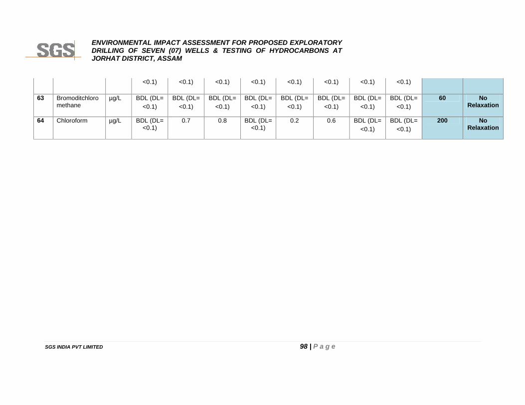
ENVIRONMENTAL IMPACT ASSESSMENT FOR PROPOSED EXPLORATORYDRILLING OF SEVEN (07) WELLS & TESTING OF HYDROCARBONS ATJORHAT DISTRICT, ASSAM
SGS INDIA PVT LIMITED 98 | P a g e
<0.1) <0.1) <0.1) <0.1) <0.1) <0.1) <0.1) <0.1)
63 Bromoditchloromethane
µg/L BDL (DL=<0.1)
BDL (DL=<0.1)
BDL (DL=<0.1)
BDL (DL=<0.1)
BDL (DL=<0.1)
BDL (DL=<0.1)
BDL (DL=<0.1)
BDL (DL=<0.1)
60 NoRelaxation
64 Chloroform µg/L BDL (DL=<0.1)
0.7 0.8 BDL (DL=<0.1)
0.2 0.6 BDL (DL=<0.1)
BDL (DL=<0.1)
200 NoRelaxation
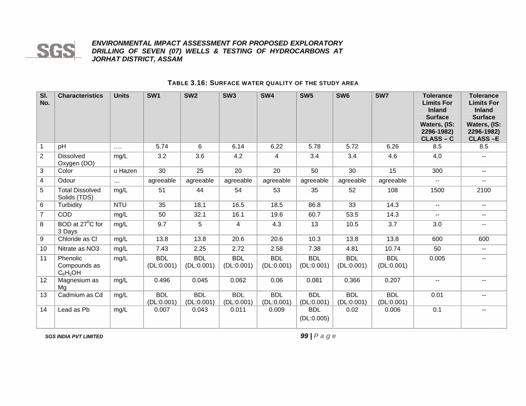
ENVIRONMENTAL IMPACT ASSESSMENT FOR PROPOSED EXPLORATORYDRILLING OF SEVEN (07) WELLS & TESTING OF HYDROCARBONS ATJORHAT DISTRICT, ASSAM
SGS INDIA PVT LIMITED 99 | P a g e
TABLE 3.16: SURFACE WATER QUALITY OF THE STUDY AREA
Sl.No.
Characteristics Units SW1 SW2 SW3 SW4 SW5 SW6 SW7 ToleranceLimits For
InlandSurface
Waters, (IS:2296-1982)CLASS – C
ToleranceLimits For
InlandSurface
Waters, (IS:2296-1982)CLASS –E
1 pH …. 5.74 6 6.14 6.22 5.78 5.72 6.26 8.5 8.52 Dissolved
Oxygen (DO)mg/L 3.2 3.6 4.2 4 3.4 3.4 4.6 4.0 --
3 Color u Hazen 30 25 20 20 50 30 15 300 --4 Odour … agreeable agreeable agreeable agreeable agreeable agreeable agreeable -- --5 Total Dissolved
Solids (TDS)mg/L 51 44 54 53 35 52 108 1500 2100
6 Turbidity NTU 35 18.1 16.5 18.5 86.8 33 14.3 -- --7 COD mg/L 50 32.1 16.1 19.6 60.7 53.5 14.3 -- --8 BOD at 270C for
3 Daysmg/L 9.7 5 4 4.3 13 10.5 3.7 3.0 --
9 Chloride as Cl mg/L 13.8 13.8 20.6 20.6 10.3 13.8 13.8 600 60010 Nitrate as NO3 mg/L 7.43 2.25 2.72 2.58 7.38 4.81 10.74 50 --11 Phenolic
Compounds asC6H5OH
mg/L BDL(DL:0.001)
BDL(DL:0.001)
BDL(DL:0.001)
BDL(DL:0.001)
BDL(DL:0.001)
BDL(DL:0.001)
BDL(DL:0.001)
0.005 --
12 Magnesium asMg
mg/L 0.496 0.045 0.062 0.06 0.081 0.366 0.207 -- --
13 Cadmium as Cd mg/L BDL(DL:0.001)
BDL(DL:0.001)
BDL(DL:0.001)
BDL(DL:0.001)
BDL(DL:0.001)
BDL(DL:0.001)
BDL(DL:0.001)
0.01 --
14 Lead as Pb mg/L 0.007 0.043 0.011 0.009 BDL(DL:0.005)
0.02 0.006 0.1 --
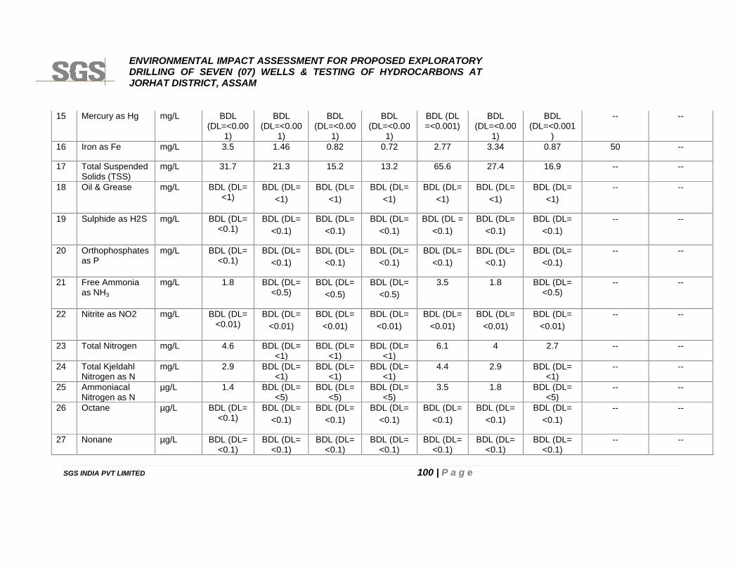
ENVIRONMENTAL IMPACT ASSESSMENT FOR PROPOSED EXPLORATORYDRILLING OF SEVEN (07) WELLS & TESTING OF HYDROCARBONS ATJORHAT DISTRICT, ASSAM
SGS INDIA PVT LIMITED 100 | P a g e
15 Mercury as Hg mg/L BDL(DL=<0.00
1)
BDL(DL=<0.00
1)
BDL(DL=<0.00
1)
BDL(DL=<0.00
1)
BDL (DL=<0.001)
BDL(DL=<0.00
1)
BDL(DL=<0.001
)
-- --
16 Iron as Fe mg/L 3.5 1.46 0.82 0.72 2.77 3.34 0.87 50 --
17 Total SuspendedSolids (TSS)
mg/L 31.7 21.3 15.2 13.2 65.6 27.4 16.9 -- --
18 Oil & Grease mg/L BDL (DL=<1)
BDL (DL=<1)
BDL (DL=<1)
BDL (DL=<1)
BDL (DL=<1)
BDL (DL=<1)
BDL (DL=<1)
-- --
19 Sulphide as H2S mg/L BDL (DL=<0.1)
BDL (DL=<0.1)
BDL (DL=<0.1)
BDL (DL=<0.1)
BDL (DL =<0.1)
BDL (DL=<0.1)
BDL (DL=<0.1)
-- --
20 Orthophosphatesas P
mg/L BDL (DL=<0.1)
BDL (DL=<0.1)
BDL (DL=<0.1)
BDL (DL=<0.1)
BDL (DL=<0.1)
BDL (DL=<0.1)
BDL (DL=<0.1)
-- --
21 Free Ammoniaas NH3
mg/L 1.8 BDL (DL=<0.5)
BDL (DL=<0.5)
BDL (DL=<0.5)
3.5 1.8 BDL (DL=<0.5)
-- --
22 Nitrite as NO2 mg/L BDL (DL=<0.01)
BDL (DL=<0.01)
BDL (DL=<0.01)
BDL (DL=<0.01)
BDL (DL=<0.01)
BDL (DL=<0.01)
BDL (DL=<0.01)
-- --
23 Total Nitrogen mg/L 4.6 BDL (DL=<1)
BDL (DL=<1)
BDL (DL=<1)
6.1 4 2.7 -- --
24 Total KjeldahlNitrogen as N
mg/L 2.9 BDL (DL=<1)
BDL (DL=<1)
BDL (DL=<1)
4.4 2.9 BDL (DL=<1)
-- --
25 AmmoniacalNitrogen as N
µg/L 1.4 BDL (DL=<5)
BDL (DL=<5)
BDL (DL=<5)
3.5 1.8 BDL (DL=<5)
-- --
26 Octane µg/L BDL (DL=<0.1)
BDL (DL=<0.1)
BDL (DL=<0.1)
BDL (DL=<0.1)
BDL (DL=<0.1)
BDL (DL=<0.1)
BDL (DL=<0.1)
-- --
27 Nonane µg/L BDL (DL=<0.1)
BDL (DL=<0.1)
BDL (DL=<0.1)
BDL (DL=<0.1)
BDL (DL=<0.1)
BDL (DL=<0.1)
BDL (DL=<0.1)
-- --
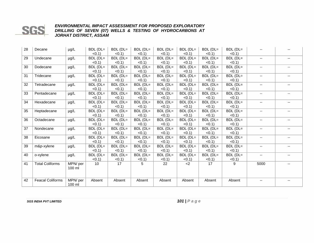
ENVIRONMENTAL IMPACT ASSESSMENT FOR PROPOSED EXPLORATORYDRILLING OF SEVEN (07) WELLS & TESTING OF HYDROCARBONS ATJORHAT DISTRICT, ASSAM
SGS INDIA PVT LIMITED 101 | P a g e
28 Decane µg/L BDL (DL=<0.1)
BDL (DL=<0.1)
BDL (DL=<0.1)
BDL (DL=<0.1)
BDL (DL=<0.1)
BDL (DL=<0.1)
BDL (DL=<0.1)
-- --
29 Undecane µg/L BDL (DL=<0.1)
BDL (DL=<0.1)
BDL (DL=<0.1)
BDL (DL=<0.1)
BDL (DL=<0.1)
BDL (DL=<0.1)
BDL (DL=<0.1)
-- --
30 Dodecane µg/L BDL (DL=<0.1)
BDL (DL=<0.1)
BDL (DL=<0.1)
BDL (DL=<0.1)
BDL (DL=<0.1)
BDL (DL=<0.1)
BDL (DL=<0.1)
-- --
31 Tridecane µg/L BDL (DL=<0.1)
BDL (DL=<0.1)
BDL (DL=<0.1)
BDL (DL=<0.1)
BDL (DL=<0.1)
BDL (DL=<0.1)
BDL (DL=<0.1)
-- --
32 Tetradecane µg/L BDL (DL=<0.1)
BDL (DL=<0.1)
BDL (DL=<0.1)
BDL (DL=<0.1)
BDL (DL=<0.1)
BDL (DL=<0.1)
BDL (DL=<0.1)
-- --
33 Pentadecane µg/L BDL (DL=<0.1)
BDL (DL=<0.1)
BDL (DL=<0.1)
BDL (DL=<0.1)
BDL (DL=<0.1)
BDL (DL=<0.1)
BDL (DL=<0.1)
-- --
34 Hexadecane µg/L BDL (DL=<0.1)
BDL (DL=<0.1)
BDL (DL=<0.1)
BDL (DL=<0.1)
BDL (DL=<0.1)
BDL (DL=<0.1)
BDL (DL=<0.1)
-- --
35 Heptadecane µg/L BDL (DL=<0.1)
BDL (DL=<0.1)
BDL (DL=<0.1)
BDL (DL=<0.1)
BDL (DL=<0.1)
BDL (DL=<0.1)
BDL (DL=<0.1)
-- --
36 Octadecane µg/L BDL (DL=<0.1)
BDL (DL=<0.1)
BDL (DL=<0.1)
BDL (DL=<0.1)
BDL (DL=<0.1)
BDL (DL=<0.1)
BDL (DL=<0.1)
-- --
37 Nondecane µg/L BDL (DL=<0.1)
BDL (DL=<0.1)
BDL (DL=<0.1)
BDL (DL=<0.1)
BDL (DL=<0.1)
BDL (DL=<0.1)
BDL (DL=<0.1)
-- --
38 Eicosane µg/L BDL (DL=<0.1)
BDL (DL=<0.1)
BDL (DL=<0.1)
BDL (DL=<0.1)
BDL (DL=<0.1)
BDL (DL=<0.1)
BDL (DL=<0.1)
-- --
39 m&p-xylene µg/L BDL (DL=<0.1)
BDL (DL=<0.1)
BDL (DL=<0.1)
BDL (DL=<0.1)
BDL (DL=<0.1)
BDL (DL=<0.1)
BDL (DL=<0.1)
-- --
40 o-xylene µg/L BDL (DL=<0.1)
BDL (DL=<0.1)
BDL (DL=<0.1)
BDL (DL=<0.1)
BDL (DL=<0.1)
BDL (DL=<0.1)
BDL (DL=<0.1)
-- --
41 Total Coliforms MPN/ per100 ml
10 17 5 22 <2 17 9 5000 --
42 Feacal Coliforms MPN/ per100 ml
Absent Absent Absent Absent Absent Absent Absent -- --
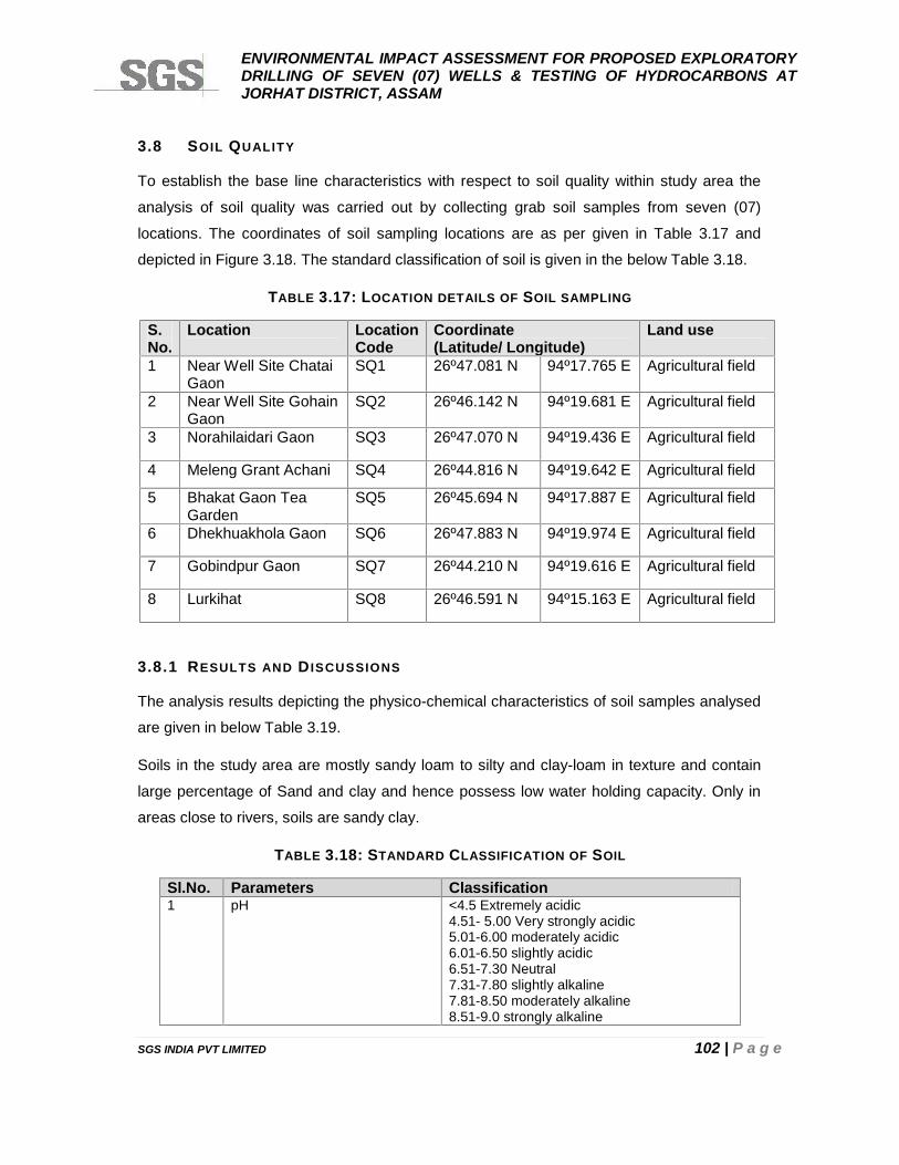
ENVIRONMENTAL IMPACT ASSESSMENT FOR PROPOSED EXPLORATORYDRILLING OF SEVEN (07) WELLS & TESTING OF HYDROCARBONS ATJORHAT DISTRICT, ASSAM
SGS INDIA PVT LIMITED 102 | P a g e
3.8 SOIL QUALITY
To establish the base line characteristics with respect to soil quality within study area the
analysis of soil quality was carried out by collecting grab soil samples from seven (07)
locations. The coordinates of soil sampling locations are as per given in Table 3.17 and
depicted in Figure 3.18. The standard classification of soil is given in the below Table 3.18.
TABLE 3.17: LOCATION DETAILS OF SOIL SAMPLING
S.No.
Location LocationCode
Coordinate(Latitude/ Longitude)
Land use
1 Near Well Site ChataiGaon
SQ1 26º47.081 N 94º17.765 E Agricultural field
2 Near Well Site GohainGaon
SQ2 26º46.142 N 94º19.681 E Agricultural field
3 Norahilaidari Gaon SQ3 26º47.070 N 94º19.436 E Agricultural field
4 Meleng Grant Achani SQ4 26º44.816 N 94º19.642 E Agricultural field
5 Bhakat Gaon TeaGarden
SQ5 26º45.694 N 94º17.887 E Agricultural field
6 Dhekhuakhola Gaon SQ6 26º47.883 N 94º19.974 E Agricultural field
7 Gobindpur Gaon SQ7 26º44.210 N 94º19.616 E Agricultural field
8 Lurkihat SQ8 26º46.591 N 94º15.163 E Agricultural field
3.8.1 RESULTS AND D ISCUSSIONS
The analysis results depicting the physico-chemical characteristics of soil samples analysed
are given in below Table 3.19.
Soils in the study area are mostly sandy loam to silty and clay-loam in texture and contain
large percentage of Sand and clay and hence possess low water holding capacity. Only in
areas close to rivers, soils are sandy clay.
TABLE 3.18: STANDARD CLASSIFICATION OF SOIL
Sl.No. Parameters Classification1 pH <4.5 Extremely acidic
4.51- 5.00 Very strongly acidic5.01-6.00 moderately acidic6.01-6.50 slightly acidic6.51-7.30 Neutral7.31-7.80 slightly alkaline7.81-8.50 moderately alkaline8.51-9.0 strongly alkaline
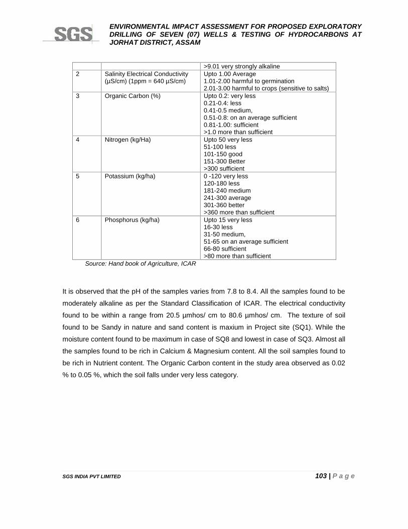
ENVIRONMENTAL IMPACT ASSESSMENT FOR PROPOSED EXPLORATORYDRILLING OF SEVEN (07) WELLS & TESTING OF HYDROCARBONS ATJORHAT DISTRICT, ASSAM
SGS INDIA PVT LIMITED 103 | P a g e
>9.01 very strongly alkaline2 Salinity Electrical Conductivity
(µS/cm) (1ppm = 640 µS/cm)Upto 1.00 Average1.01-2.00 harmful to germination2.01-3.00 harmful to crops (sensitive to salts)
3 Organic Carbon (%) Upto 0.2: very less0.21-0.4: less0.41-0.5 medium,0.51-0.8: on an average sufficient0.81-1.00: sufficient>1.0 more than sufficient
4 Nitrogen (kg/Ha) Upto 50 very less51-100 less101-150 good151-300 Better>300 sufficient
5 Potassium (kg/ha) 0 -120 very less120-180 less181-240 medium241-300 average301-360 better>360 more than sufficient
6 Phosphorus (kg/ha) Upto 15 very less16-30 less31-50 medium,51-65 on an average sufficient66-80 sufficient>80 more than sufficient
Source: Hand book of Agriculture, ICAR
It is observed that the pH of the samples varies from 7.8 to 8.4. All the samples found to be
moderately alkaline as per the Standard Classification of ICAR. The electrical conductivity
found to be within a range from 20.5 µmhos/ cm to 80.6 µmhos/ cm. The texture of soil
found to be Sandy in nature and sand content is maxium in Project site (SQ1). While the
moisture content found to be maximum in case of SQ8 and lowest in case of SQ3. Almost all
the samples found to be rich in Calcium & Magnesium content. All the soil samples found to
be rich in Nutrient content. The Organic Carbon content in the study area observed as 0.02
% to 0.05 %, which the soil falls under very less category.

ENVIRONMENTAL IMPACT ASSESSMENT FOR PROPOSED EXPLORATORYDRILLING OF SEVEN (07) WELLS & TESTING OF HYDROCARBONS ATJORHAT DISTRICT, ASSAM
SGS INDIA PVT LIMITED 104 | P a g e
FIGURE 3.18: SOIL SAMPLING LOCATIONS WITHIN THE STUDY AREA
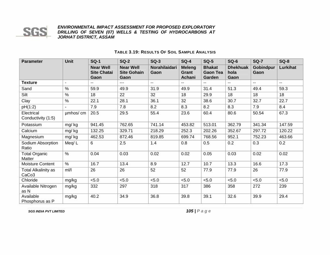
ENVIRONMENTAL IMPACT ASSESSMENT FOR PROPOSED EXPLORATORYDRILLING OF SEVEN (07) WELLS & TESTING OF HYDROCARBONS ATJORHAT DISTRICT, ASSAM
SGS INDIA PVT LIMITED 105 | P a g e
TABLE 3.19: RESULTS OF SOIL SAMPLE ANALYSIS
Parameter Unit SQ-1 SQ-2 SQ-3 SQ-4 SQ-5 SQ-6 SQ-7 SQ-8Near WellSite ChataiGaon
Near WellSite GohainGaon
NorahilaidariGaon
MelengGrantAchani
BhakatGaon TeaGarden
DhekhuakholaGaon
GobindpurGaon
Lurkihat
Texture - -- --- -- -- -- -- -- --Sand % 59.9 49.9 31.9 49.9 31.4 51.3 49.4 59.3Silt % 18 22 32 18 29.9 18 18 18Clay % 22.1 28.1 36.1 32 38.6 30.7 32.7 22.7pH(1:2) - 7.9 7.8 8.2 8.3 8.2 8.3 7.9 8.4ElectricalConductivity (1:5)
µmhos/ cm 20.5 29.5 55.4 23.6 60.4 80.6 50.54 67.3
Potassium mg/ kg 941.45 762.65 741.14 453.82 513.01 362.79 341.34 147.59Calcium mg/ kg 132.25 329.71 218.29 252.3 202.26 352.67 297.72 120.22Magnesium mg/ kg 462.53 872.46 819.85 699.74 768.56 952.1 752.23 463.66Sodium AbsorptionRatio
Meq/ L 6 2.5 1.4 0.8 0.5 0.2 0.3 0.2
Total OrganicMatter
% 0.04 0.03 0.02 0.02 0.05 0.03 0.02 0.02
Moisture Content % 16.7 13.4 8.9 12.7 10.7 13.3 16.6 17.3Total Alkalinity asCaCo3
ml/l 26 26 52 52 77.9 77.9 26 77.9
Chloride mg/kg <5.0 <5.0 <5.0 <5.0 <5.0 <5.0 <5.0 <5.0Available Nitrogenas N
mg/kg 332 297 318 317 386 358 272 239
AvailablePhosphorus as P
mg/kg 40.2 34.9 36.8 39.8 39.1 32.6 39.9 29.4
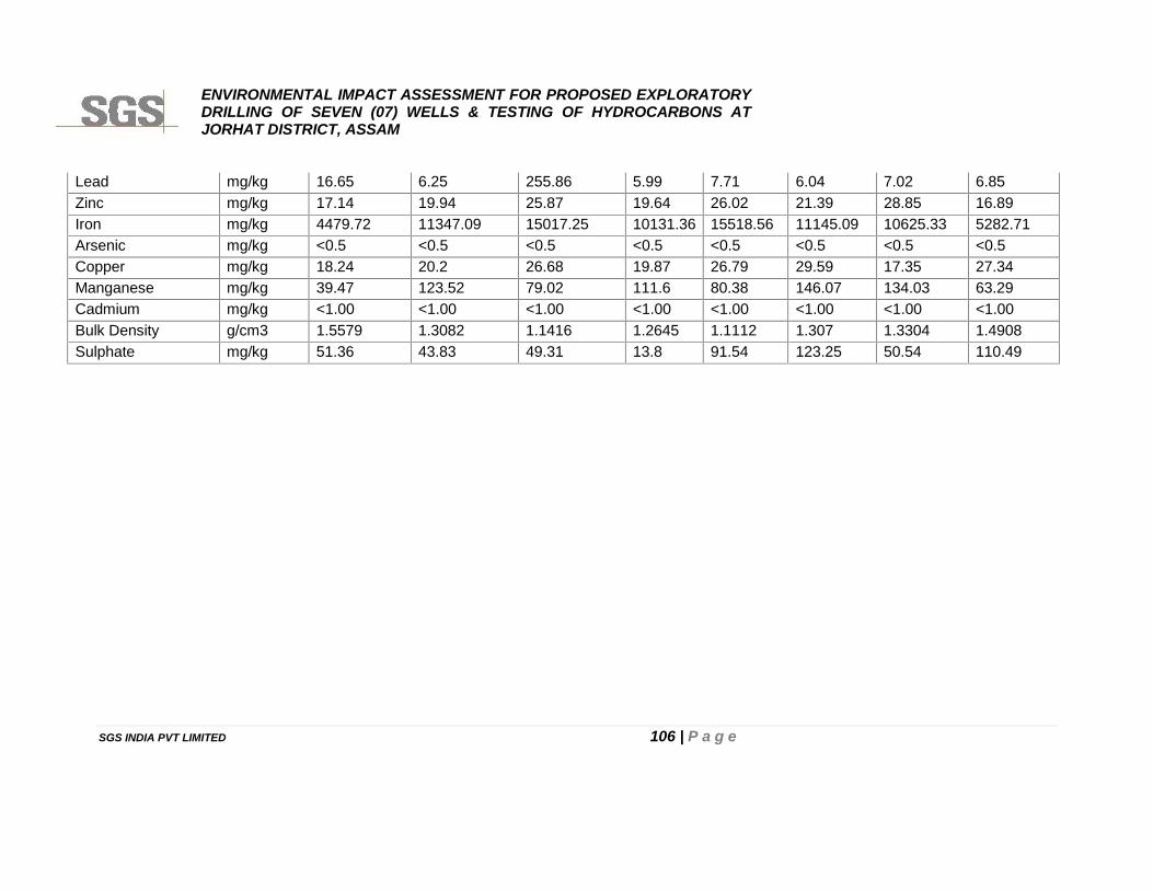
ENVIRONMENTAL IMPACT ASSESSMENT FOR PROPOSED EXPLORATORYDRILLING OF SEVEN (07) WELLS & TESTING OF HYDROCARBONS ATJORHAT DISTRICT, ASSAM
SGS INDIA PVT LIMITED 106 | P a g e
Lead mg/kg 16.65 6.25 255.86 5.99 7.71 6.04 7.02 6.85Zinc mg/kg 17.14 19.94 25.87 19.64 26.02 21.39 28.85 16.89Iron mg/kg 4479.72 11347.09 15017.25 10131.36 15518.56 11145.09 10625.33 5282.71Arsenic mg/kg <0.5 <0.5 <0.5 <0.5 <0.5 <0.5 <0.5 <0.5Copper mg/kg 18.24 20.2 26.68 19.87 26.79 29.59 17.35 27.34Manganese mg/kg 39.47 123.52 79.02 111.6 80.38 146.07 134.03 63.29Cadmium mg/kg <1.00 <1.00 <1.00 <1.00 <1.00 <1.00 <1.00 <1.00Bulk Density g/cm3 1.5579 1.3082 1.1416 1.2645 1.1112 1.307 1.3304 1.4908Sulphate mg/kg 51.36 43.83 49.31 13.8 91.54 123.25 50.54 110.49
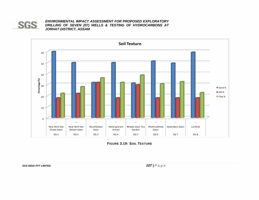
ENVIRONMENTAL IMPACT ASSESSMENT FOR PROPOSED EXPLORATORYDRILLING OF SEVEN (07) WELLS & TESTING OF HYDROCARBONS ATJORHAT DISTRICT, ASSAM
SGS INDIA PVT LIMITED 107 | P a g e
FIGURE 3.19: SOIL TEXTURE
0
10
20
30
40
50
60
-- --- -- -- -- -- -- --
Near Well SiteChatai Gaon
Near Well SiteGohain Gaon
NorahilaidariGaon
Meleng GrantAchani
Bhakat Gaon TeaGarden
DhekhuakholaGaon
Gobindpur Gaon Lurkihat
SQ-1 SQ-2 SQ-3 SQ-4 SQ-5 SQ-6 SQ-7 SQ-8
Perc
enta
ge (%
)
Soil Texture
Sand %
Silt %
Clay %
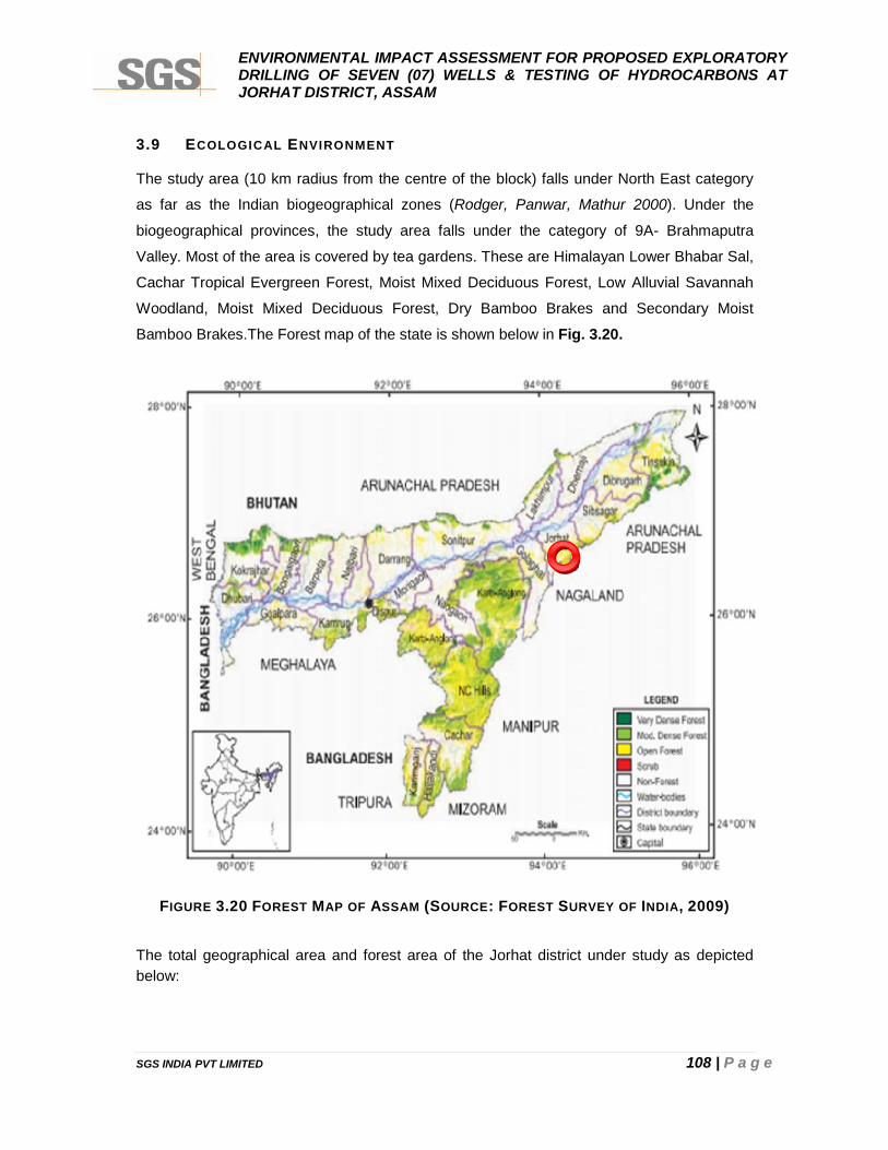
ENVIRONMENTAL IMPACT ASSESSMENT FOR PROPOSED EXPLORATORYDRILLING OF SEVEN (07) WELLS & TESTING OF HYDROCARBONS ATJORHAT DISTRICT, ASSAM
SGS INDIA PVT LIMITED 108 | P a g e
3.9 ECOLOGICAL ENVIRONMENT
The study area (10 km radius from the centre of the block) falls under North East category
as far as the Indian biogeographical zones (Rodger, Panwar, Mathur 2000). Under the
biogeographical provinces, the study area falls under the category of 9A- Brahmaputra
Valley. Most of the area is covered by tea gardens. These are Himalayan Lower Bhabar Sal,
Cachar Tropical Evergreen Forest, Moist Mixed Deciduous Forest, Low Alluvial Savannah
Woodland, Moist Mixed Deciduous Forest, Dry Bamboo Brakes and Secondary Moist
Bamboo Brakes.The Forest map of the state is shown below in Fig. 3.20.
FIGURE 3.20 FOREST MAP OF ASSAM (SOURCE: FOREST SURVEY OF INDIA, 2009)
The total geographical area and forest area of the Jorhat district under study as depictedbelow:
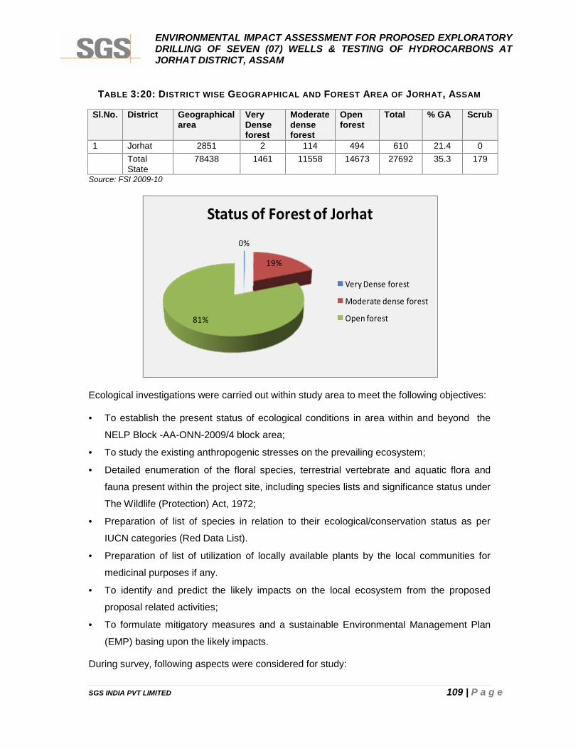
ENVIRONMENTAL IMPACT ASSESSMENT FOR PROPOSED EXPLORATORYDRILLING OF SEVEN (07) WELLS & TESTING OF HYDROCARBONS ATJORHAT DISTRICT, ASSAM
SGS INDIA PVT LIMITED 109 | P a g e
TABLE 3:20: DISTRICT WISE GEOGRAPHICAL AND FOREST AREA OF JORHAT, ASSAM
Sl.No. District Geographicalarea
VeryDenseforest
Moderatedenseforest
Openforest
Total % GA Scrub
1 Jorhat 2851 2 114 494 610 21.4 0TotalState
78438 1461 11558 14673 27692 35.3 179
Source: FSI 2009-10
Ecological investigations were carried out within study area to meet the following objectives:
To establish the present status of ecological conditions in area within and beyond the
NELP Block -AA-ONN-2009/4 block area;
To study the existing anthropogenic stresses on the prevailing ecosystem;
Detailed enumeration of the floral species, terrestrial vertebrate and aquatic flora and
fauna present within the project site, including species lists and significance status under
The Wildlife (Protection) Act, 1972;
Preparation of list of species in relation to their ecological/conservation status as per
IUCN categories (Red Data List).
Preparation of list of utilization of locally available plants by the local communities for
medicinal purposes if any.
To identify and predict the likely impacts on the local ecosystem from the proposed
proposal related activities;
To formulate mitigatory measures and a sustainable Environmental Management Plan
(EMP) basing upon the likely impacts.
During survey, following aspects were considered for study:
0%
19%
81%
Status of Forest of Jorhat
Very Dense forest
Moderate dense forest
Open forest
ENVIRONMENTAL IMPACT ASSESSMENT FOR PROPOSED EXPLORATORYDRILLING OF SEVEN (07) WELLS & TESTING OF HYDROCARBONS ATJORHAT DISTRICT, ASSAM
SGS INDIA PVT LIMITED 110 | P a g e
Assessment of present status of flora and fauna;
Identification of rare and endangered species of plants and animals (if any);
Identification of ecologically sensitive areas within the study area;
Assessment of migratory route of wildlife (if any); and
Assessment of Aquatic Ecology with specific reference to aquatic birds and fishery
resources
3.9.1 METHODOLOGY
Terrestrial investigations for flora and fauna records were collected by random field survey
via checklist. During field survey, discussion with the local people was conducted to collect
information related to local biodiversity in and around the villages. The ecological status of
the study area has been assessed based on the following methodology:
Primary field surveys to establish primary baseline of the study area;
Compilation of secondary information available in published literatures/working plan was
referred from State Forest Department.
Site Verification and finalization in consultation with project proponent, local inhabitants
and local forest department.
Vegetation analysis through quadrate method using sampling plots of 10m X 10m.
10m X 10m for tree species (record trees >25cm in GBHOB /species);
3m X 3m [four plots] was laid along diagonals wherein all the shrubs recorded.
1m X 1m [five plots], one at the centre and four at one per quadrate was laid and
herbs, grasses in five plots to be noted.
Protocol for Sampling through Quadrate Method
The standard method chosen for the assessment of plant diversity involves the use of
square vegetation quadrats (‘plots’). These Quadrates were used to measure most
vegetation attributes in most vegetation types. Quadrate location marked by pegs or
sometimes by grid system.
After demarcation the study area is divided into sampling units, i.e. the areas which are
approximately true representative of the whole area, and are sampled for the identification of
plant and animal species.
ENVIRONMENTAL IMPACT ASSESSMENT FOR PROPOSED EXPLORATORYDRILLING OF SEVEN (07) WELLS & TESTING OF HYDROCARBONS ATJORHAT DISTRICT, ASSAM
SGS INDIA PVT LIMITED 111 | P a g e
A. Floral Study
The assessment of the flora of the study area is done by an extensive field survey of the
area.
As the plants are static, identified based on their specific diagonistic characters of family,
genus and species using available floral, other related literature of Botanical Survey of
India.
Besides the identification of plant species, information is collected on the vernacular
names and uses of plants made by local inhabitants.
Qualitative analysis of vegetation is made by two different methods such as floristic (by
simple studying various genera and species of various plant groups i.e. herbs, shrubs,
trees etc).
B. Phyto-sociology
A nested quadrates technique is used for sampling the vegetation. All the plots sampled
were representative of most common types, sampling i.e. 10m x 10m for trees and 3m x 3m
for shrubs, 1m x 1m for herbs square meter quadrates. Selection of sites for sampling of
vegetation is done by random sampling procedure. However, in general to study the
phytosociological attributes, quadrates of 10 m × 10 m size for tree species are randomly
laid out at each site at different elevations. Then the observation on the following parameters
is recorded:
1. Name of the species.
2. Diameter of the species.
3. Number of the occurrence of each species in each quadrate.
Vegetation data was quantitatively analyzed for Frequency, Density and Dominance using
standard methodologies. The relative values of frequency, density, and dominance of all the
species is summed up to represent Importance Value Index (IVI). Not only IVI facilitates
comparison between species of a community, but also the data collected on dispersion,
number and cover can be profitably used in comparing the vegetation structure of two or
more stands or of the same stand over a period of time. Vegetation structure with respect of
varying environmental factors can also be studied through such studies in sets of varying
environmental conditions. The IVI was determined as the sum of the relative frequency,
relative density and relative dominance. It thus incorporate three important parameters that
measures of productivity and diversity of every species therefore.
IVI = Relative frequency + Relative density + Relative dominance
ENVIRONMENTAL IMPACT ASSESSMENT FOR PROPOSED EXPLORATORYDRILLING OF SEVEN (07) WELLS & TESTING OF HYDROCARBONS ATJORHAT DISTRICT, ASSAM
SGS INDIA PVT LIMITED 112 | P a g e
C. Faunal Study
Terrestrial Fauna
Ground surveys were carried out by trekking the study area for identification of important
animal groups such as birds, mammals and reptiles for sampling of animals through the
following methods.
For sampling birds/ avifauna ‘point sampling’ along the fixed transects (foot trails) were
done to record all the species of birds with the help of binoculars; field guides and
photography for more than 1 hour on each transect (n=4).
For sampling mammals, ‘direct count on open width (20 m) transect’ were used on the
same transects. Besides, information on recent sightings/records of mammals from
locals was also collected from the study areas.
‘Reptiles’ mainly lizards are sampled by ‘direct count on open width transects’.
Secondary information collected from local villagers, published government data etc.
List of the endangered and endemic species as per the schedule of The WildlifeProtection Act, 1972
Emphasis is given to identify avifauna and mammals to determine the presence and
absence of Schedule-1 species, listed in The Wildlife Protection Act 1972, as well as in Red
List of IUCN. Various methods used for study animals are as follows:
A. Point Survey Method: Observations were made in each site for 15-20 min duration.
B. Road Side Counts: The observer travelled by motor vehicles from site to site and all
sightings were recorded.
3.9.2 FLORISTIC COMPOSITIONS WITHIN STUDY AREA
Many of villages had ponds harboring moderate diversity of bird species. The villages
covered during the present survey were Norahiloidori, Kotohaboria, near Goria Cha bagicha,
Melang grant, Koporadora, Badulipukuri, Garaguri namghar village.
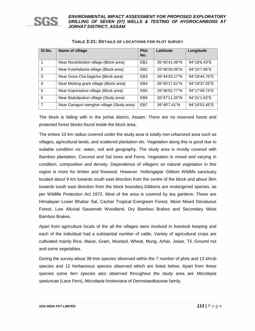
ENVIRONMENTAL IMPACT ASSESSMENT FOR PROPOSED EXPLORATORYDRILLING OF SEVEN (07) WELLS & TESTING OF HYDROCARBONS ATJORHAT DISTRICT, ASSAM
SGS INDIA PVT LIMITED 113 | P a g e
TABLE 3:21: DETAILS OF LOCATIONS FOR PLOT SURVEY
Sl.No. Name of village PlotNo.
Lattitude Longitude
1 Near Norahiloidori village (Block area) EB1 26°45'41.06"N 94°18'6.43"E
2 Near Kotohaboria village (Block area) EB2 26°46'30.06"N 94°15'7.95"E
3 Near Goria Cha bagicha (Block area) EB3 26°44'43.17"N 94°19'44.70"E
4 Near Melang grant village (Block area) EB4 26°45'17.61"N 94°19'37.55"E
5 Near Koporadora village (Block area) EB5 26°46'52.77"N 94°17'49.73"E
6 Near Badulipukuri village (Study area) EB6 26°47'11.20"N 94°21'1.62"E
7 Near Garaguri namghar village (Study area) EB7 26°49'7.41"N 94°16'53.45"E
The block is falling with in the jorhat district, Assam. There are no reserved forest and
protected forest blocks found inside the block area.
The entore 10 km radius covered under the study area is totally non-urbanized area such as
villages, agricultural lands, and scattered plantation etc. Vegetation along this is good due to
suitable condition viz. water, soil and geography. The study area is mostly covered with
Bamboo plantation, Coconut and Sal trees and Ferns. Vegetation is mixed and varying in
condition, composition and density. Dependence of villagers on natural vegetation in this
region is more for timber and firewood. However, Hollongapar Gibbon Wildlife sanctuary
located about 9 km towards south east direction from the centre of the block and about 3km
towards south east direction from the block boundary.Gibbons are endangered species, as
per Wildlife Protection Act 1972. Most of the area is covered by tea gardens. These are
Himalayan Lower Bhabar Sal, Cachar Tropical Evergreen Forest, Moist Mixed Deciduous
Forest, Low Alluvial Savannah Woodland, Dry Bamboo Brakes and Secondary Moist
Bamboo Brakes.
Apart from agriculture locals of the all the villages were involved in livestock keeping and
each of the individual had a substantial number of cattle. Variety of agricultural crops are
cultivated mainly Rice, Maize, Gram, Mustard, Wheat, Mung, Arhar, Jowar, Til, Ground nut
and some vegetables.
During the survey about 39 tree species observed within the 7 number of plots and 13 shrub
species and 12 herbaceous species observed which are listed below. Apart from these
species some fern species also observed throughout the study area are Microlepia
speluncae (Lace Fern), Microlepia hookeriana of Dennstaedtiaceae family.
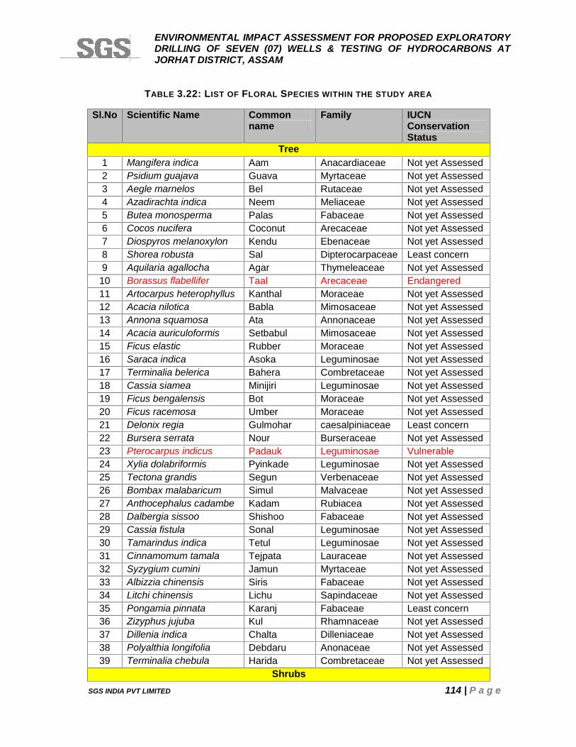
ENVIRONMENTAL IMPACT ASSESSMENT FOR PROPOSED EXPLORATORYDRILLING OF SEVEN (07) WELLS & TESTING OF HYDROCARBONS ATJORHAT DISTRICT, ASSAM
SGS INDIA PVT LIMITED 114 | P a g e
TABLE 3.22: LIST OF FLORAL SPECIES WITHIN THE STUDY AREA
Sl.No Scientific Name Commonname
Family IUCNConservationStatus
Tree1 Mangifera indica Aam Anacardiaceae Not yet Assessed2 Psidium guajava Guava Myrtaceae Not yet Assessed3 Aegle marnelos Bel Rutaceae Not yet Assessed4 Azadirachta indica Neem Meliaceae Not yet Assessed5 Butea monosperma Palas Fabaceae Not yet Assessed6 Cocos nucifera Coconut Arecaceae Not yet Assessed7 Diospyros melanoxylon Kendu Ebenaceae Not yet Assessed8 Shorea robusta Sal Dipterocarpaceae Least concern9 Aquilaria agallocha Agar Thymeleaceae Not yet Assessed
10 Borassus flabellifer Taal Arecaceae Endangered11 Artocarpus heterophyllus Kanthal Moraceae Not yet Assessed12 Acacia nilotica Babla Mimosaceae Not yet Assessed13 Annona squamosa Ata Annonaceae Not yet Assessed14 Acacia auriculoformis Setbabul Mimosaceae Not yet Assessed15 Ficus elastic Rubber Moraceae Not yet Assessed16 Saraca indica Asoka Leguminosae Not yet Assessed17 Terminalia belerica Bahera Combretaceae Not yet Assessed18 Cassia siamea Minijiri Leguminosae Not yet Assessed19 Ficus bengalensis Bot Moraceae Not yet Assessed20 Ficus racemosa Umber Moraceae Not yet Assessed21 Delonix regia Gulmohar caesalpiniaceae Least concern22 Bursera serrata Nour Burseraceae Not yet Assessed23 Pterocarpus indicus Padauk Leguminosae Vulnerable24 Xylia dolabriformis Pyinkade Leguminosae Not yet Assessed25 Tectona grandis Segun Verbenaceae Not yet Assessed26 Bombax malabaricum Simul Malvaceae Not yet Assessed27 Anthocephalus cadambe Kadam Rubiacea Not yet Assessed28 Dalbergia sissoo Shishoo Fabaceae Not yet Assessed29 Cassia fistula Sonal Leguminosae Not yet Assessed30 Tamarindus indica Tetul Leguminosae Not yet Assessed31 Cinnamomum tamala Tejpata Lauraceae Not yet Assessed32 Syzygium cumini Jamun Myrtaceae Not yet Assessed33 Albizzia chinensis Siris Fabaceae Not yet Assessed34 Litchi chinensis Lichu Sapindaceae Not yet Assessed35 Pongamia pinnata Karanj Fabaceae Least concern36 Zizyphus jujuba Kul Rhamnaceae Not yet Assessed37 Dillenia indica Chalta Dilleniaceae Not yet Assessed38 Polyalthia longifolia Debdaru Anonaceae Not yet Assessed39 Terminalia chebula Harida Combretaceae Not yet Assessed
Shrubs
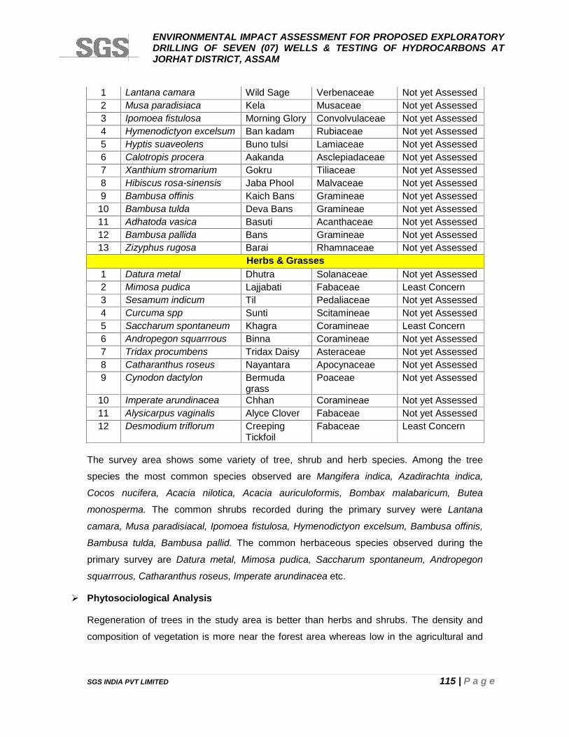
ENVIRONMENTAL IMPACT ASSESSMENT FOR PROPOSED EXPLORATORYDRILLING OF SEVEN (07) WELLS & TESTING OF HYDROCARBONS ATJORHAT DISTRICT, ASSAM
SGS INDIA PVT LIMITED 115 | P a g e
1 Lantana camara Wild Sage Verbenaceae Not yet Assessed2 Musa paradisiaca Kela Musaceae Not yet Assessed3 Ipomoea fistulosa Morning Glory Convolvulaceae Not yet Assessed4 Hymenodictyon excelsum Ban kadam Rubiaceae Not yet Assessed5 Hyptis suaveolens Buno tulsi Lamiaceae Not yet Assessed6 Calotropis procera Aakanda Asclepiadaceae Not yet Assessed7 Xanthium stromarium Gokru Tiliaceae Not yet Assessed8 Hibiscus rosa-sinensis Jaba Phool Malvaceae Not yet Assessed9 Bambusa offinis Kaich Bans Gramineae Not yet Assessed
10 Bambusa tulda Deva Bans Gramineae Not yet Assessed11 Adhatoda vasica Basuti Acanthaceae Not yet Assessed12 Bambusa pallida Bans Gramineae Not yet Assessed13 Zizyphus rugosa Barai Rhamnaceae Not yet Assessed
Herbs & Grasses1 Datura metal Dhutra Solanaceae Not yet Assessed2 Mimosa pudica Lajjabati Fabaceae Least Concern3 Sesamum indicum Til Pedaliaceae Not yet Assessed4 Curcuma spp Sunti Scitamineae Not yet Assessed5 Saccharum spontaneum Khagra Coramineae Least Concern6 Andropegon squarrrous Binna Coramineae Not yet Assessed7 Tridax procumbens Tridax Daisy Asteraceae Not yet Assessed8 Catharanthus roseus Nayantara Apocynaceae Not yet Assessed9 Cynodon dactylon Bermuda
grassPoaceae Not yet Assessed
10 Imperate arundinacea Chhan Coramineae Not yet Assessed11 Alysicarpus vaginalis Alyce Clover Fabaceae Not yet Assessed12 Desmodium triflorum Creeping
TickfoilFabaceae Least Concern
The survey area shows some variety of tree, shrub and herb species. Among the tree
species the most common species observed are Mangifera indica, Azadirachta indica,
Cocos nucifera, Acacia nilotica, Acacia auriculoformis, Bombax malabaricum, Butea
monosperma. The common shrubs recorded during the primary survey were Lantana
camara, Musa paradisiacal, Ipomoea fistulosa, Hymenodictyon excelsum, Bambusa offinis,
Bambusa tulda, Bambusa pallid. The common herbaceous species observed during the
primary survey are Datura metal, Mimosa pudica, Saccharum spontaneum, Andropegon
squarrrous, Catharanthus roseus, Imperate arundinacea etc.
Phytosociological Analysis
Regeneration of trees in the study area is better than herbs and shrubs. The density and
composition of vegetation is more near the forest area whereas low in the agricultural and
ENVIRONMENTAL IMPACT ASSESSMENT FOR PROPOSED EXPLORATORYDRILLING OF SEVEN (07) WELLS & TESTING OF HYDROCARBONS ATJORHAT DISTRICT, ASSAM
SGS INDIA PVT LIMITED 116 | P a g e
village areas. Grasses mainly cover open degraded land. Herbs and shrubs are abundant
mostly during monsoon whereas during the summer land turns dry.
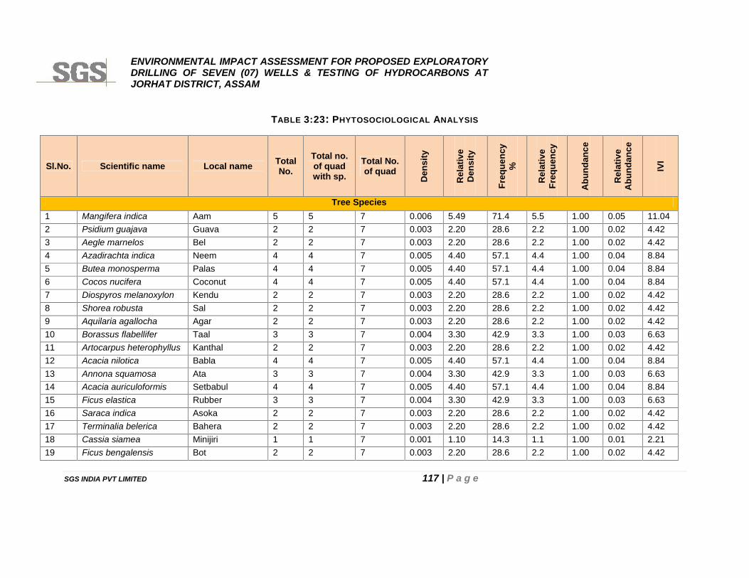
ENVIRONMENTAL IMPACT ASSESSMENT FOR PROPOSED EXPLORATORYDRILLING OF SEVEN (07) WELLS & TESTING OF HYDROCARBONS ATJORHAT DISTRICT, ASSAM
SGS INDIA PVT LIMITED 117 | P a g e
TABLE 3:23: PHYTOSOCIOLOGICAL ANALYSIS
Sl.No. Scientific name Local name TotalNo.
Total no.of quadwith sp.
Total No.of quad
Den
sity
Rel
ativ
eD
ensi
ty
Freq
uenc
y%
Rel
ativ
eFr
eque
ncy
Abu
ndan
ce
Rel
ativ
eA
bund
ance
IVI
Tree Species1 Mangifera indica Aam 5 5 7 0.006 5.49 71.4 5.5 1.00 0.05 11.042 Psidium guajava Guava 2 2 7 0.003 2.20 28.6 2.2 1.00 0.02 4.423 Aegle marnelos Bel 2 2 7 0.003 2.20 28.6 2.2 1.00 0.02 4.424 Azadirachta indica Neem 4 4 7 0.005 4.40 57.1 4.4 1.00 0.04 8.845 Butea monosperma Palas 4 4 7 0.005 4.40 57.1 4.4 1.00 0.04 8.846 Cocos nucifera Coconut 4 4 7 0.005 4.40 57.1 4.4 1.00 0.04 8.847 Diospyros melanoxylon Kendu 2 2 7 0.003 2.20 28.6 2.2 1.00 0.02 4.428 Shorea robusta Sal 2 2 7 0.003 2.20 28.6 2.2 1.00 0.02 4.429 Aquilaria agallocha Agar 2 2 7 0.003 2.20 28.6 2.2 1.00 0.02 4.4210 Borassus flabellifer Taal 3 3 7 0.004 3.30 42.9 3.3 1.00 0.03 6.6311 Artocarpus heterophyllus Kanthal 2 2 7 0.003 2.20 28.6 2.2 1.00 0.02 4.4212 Acacia nilotica Babla 4 4 7 0.005 4.40 57.1 4.4 1.00 0.04 8.8413 Annona squamosa Ata 3 3 7 0.004 3.30 42.9 3.3 1.00 0.03 6.6314 Acacia auriculoformis Setbabul 4 4 7 0.005 4.40 57.1 4.4 1.00 0.04 8.8415 Ficus elastica Rubber 3 3 7 0.004 3.30 42.9 3.3 1.00 0.03 6.6316 Saraca indica Asoka 2 2 7 0.003 2.20 28.6 2.2 1.00 0.02 4.4217 Terminalia belerica Bahera 2 2 7 0.003 2.20 28.6 2.2 1.00 0.02 4.4218 Cassia siamea Minijiri 1 1 7 0.001 1.10 14.3 1.1 1.00 0.01 2.2119 Ficus bengalensis Bot 2 2 7 0.003 2.20 28.6 2.2 1.00 0.02 4.42
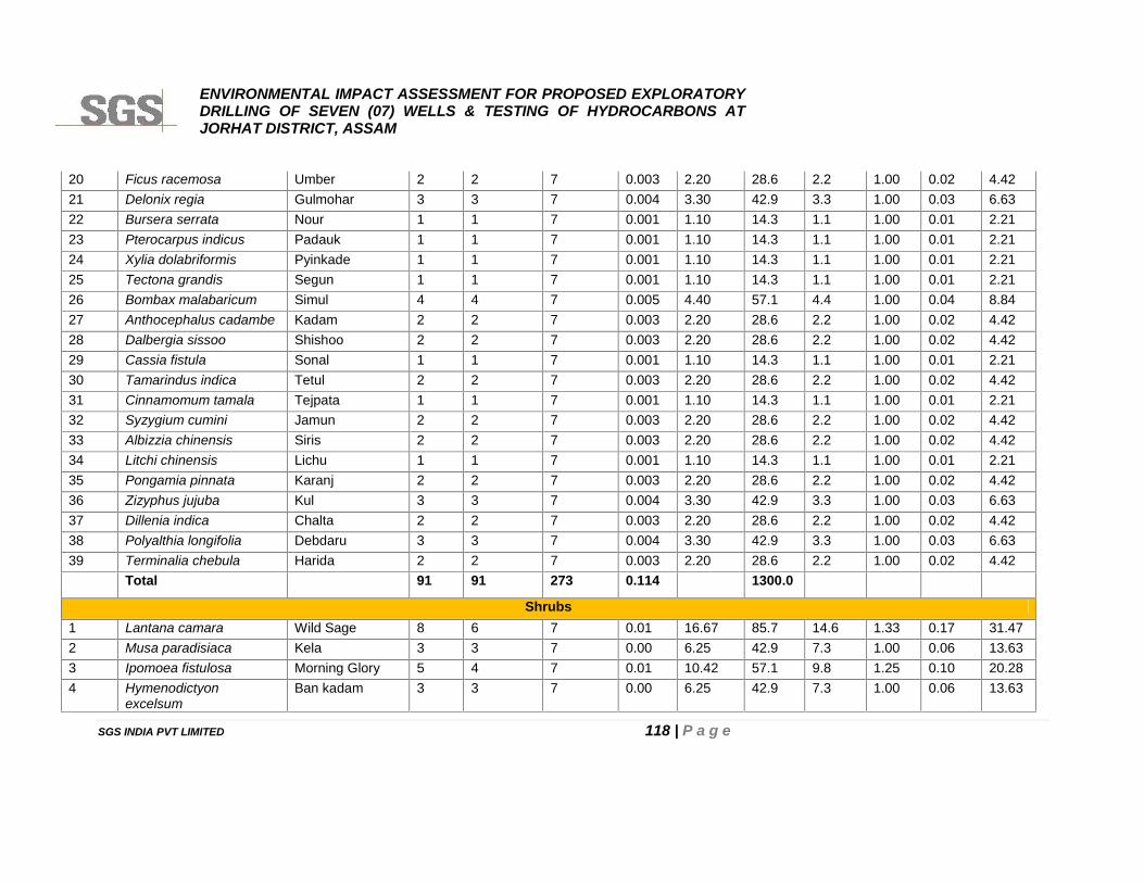
ENVIRONMENTAL IMPACT ASSESSMENT FOR PROPOSED EXPLORATORYDRILLING OF SEVEN (07) WELLS & TESTING OF HYDROCARBONS ATJORHAT DISTRICT, ASSAM
SGS INDIA PVT LIMITED 118 | P a g e
20 Ficus racemosa Umber 2 2 7 0.003 2.20 28.6 2.2 1.00 0.02 4.4221 Delonix regia Gulmohar 3 3 7 0.004 3.30 42.9 3.3 1.00 0.03 6.6322 Bursera serrata Nour 1 1 7 0.001 1.10 14.3 1.1 1.00 0.01 2.2123 Pterocarpus indicus Padauk 1 1 7 0.001 1.10 14.3 1.1 1.00 0.01 2.2124 Xylia dolabriformis Pyinkade 1 1 7 0.001 1.10 14.3 1.1 1.00 0.01 2.2125 Tectona grandis Segun 1 1 7 0.001 1.10 14.3 1.1 1.00 0.01 2.2126 Bombax malabaricum Simul 4 4 7 0.005 4.40 57.1 4.4 1.00 0.04 8.8427 Anthocephalus cadambe Kadam 2 2 7 0.003 2.20 28.6 2.2 1.00 0.02 4.4228 Dalbergia sissoo Shishoo 2 2 7 0.003 2.20 28.6 2.2 1.00 0.02 4.4229 Cassia fistula Sonal 1 1 7 0.001 1.10 14.3 1.1 1.00 0.01 2.2130 Tamarindus indica Tetul 2 2 7 0.003 2.20 28.6 2.2 1.00 0.02 4.4231 Cinnamomum tamala Tejpata 1 1 7 0.001 1.10 14.3 1.1 1.00 0.01 2.2132 Syzygium cumini Jamun 2 2 7 0.003 2.20 28.6 2.2 1.00 0.02 4.4233 Albizzia chinensis Siris 2 2 7 0.003 2.20 28.6 2.2 1.00 0.02 4.4234 Litchi chinensis Lichu 1 1 7 0.001 1.10 14.3 1.1 1.00 0.01 2.2135 Pongamia pinnata Karanj 2 2 7 0.003 2.20 28.6 2.2 1.00 0.02 4.4236 Zizyphus jujuba Kul 3 3 7 0.004 3.30 42.9 3.3 1.00 0.03 6.6337 Dillenia indica Chalta 2 2 7 0.003 2.20 28.6 2.2 1.00 0.02 4.4238 Polyalthia longifolia Debdaru 3 3 7 0.004 3.30 42.9 3.3 1.00 0.03 6.6339 Terminalia chebula Harida 2 2 7 0.003 2.20 28.6 2.2 1.00 0.02 4.42
Total 91 91 273 0.114 1300.0
Shrubs1 Lantana camara Wild Sage 8 6 7 0.01 16.67 85.7 14.6 1.33 0.17 31.472 Musa paradisiaca Kela 3 3 7 0.00 6.25 42.9 7.3 1.00 0.06 13.633 Ipomoea fistulosa Morning Glory 5 4 7 0.01 10.42 57.1 9.8 1.25 0.10 20.284 Hymenodictyon
excelsumBan kadam 3 3 7 0.00 6.25 42.9 7.3 1.00 0.06 13.63
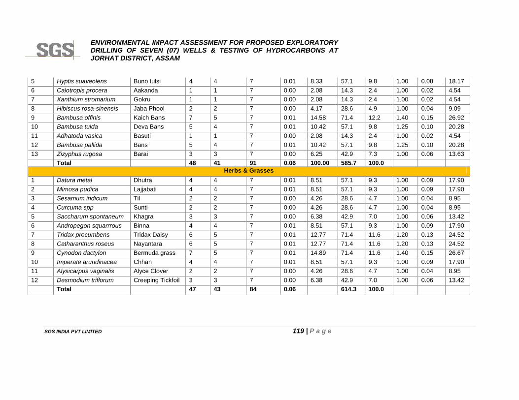
ENVIRONMENTAL IMPACT ASSESSMENT FOR PROPOSED EXPLORATORYDRILLING OF SEVEN (07) WELLS & TESTING OF HYDROCARBONS ATJORHAT DISTRICT, ASSAM
SGS INDIA PVT LIMITED 119 | P a g e
5 Hyptis suaveolens Buno tulsi 4 4 7 0.01 8.33 57.1 9.8 1.00 0.08 18.176 Calotropis procera Aakanda 1 1 7 0.00 2.08 14.3 2.4 1.00 0.02 4.547 Xanthium stromarium Gokru 1 1 7 0.00 2.08 14.3 2.4 1.00 0.02 4.548 Hibiscus rosa-sinensis Jaba Phool 2 2 7 0.00 4.17 28.6 4.9 1.00 0.04 9.099 Bambusa offinis Kaich Bans 7 5 7 0.01 14.58 71.4 12.2 1.40 0.15 26.9210 Bambusa tulda Deva Bans 5 4 7 0.01 10.42 57.1 9.8 1.25 0.10 20.2811 Adhatoda vasica Basuti 1 1 7 0.00 2.08 14.3 2.4 1.00 0.02 4.5412 Bambusa pallida Bans 5 4 7 0.01 10.42 57.1 9.8 1.25 0.10 20.2813 Zizyphus rugosa Barai 3 3 7 0.00 6.25 42.9 7.3 1.00 0.06 13.63
Total 48 41 91 0.06 100.00 585.7 100.0Herbs & Grasses
1 Datura metal Dhutra 4 4 7 0.01 8.51 57.1 9.3 1.00 0.09 17.902 Mimosa pudica Lajjabati 4 4 7 0.01 8.51 57.1 9.3 1.00 0.09 17.903 Sesamum indicum Til 2 2 7 0.00 4.26 28.6 4.7 1.00 0.04 8.954 Curcuma spp Sunti 2 2 7 0.00 4.26 28.6 4.7 1.00 0.04 8.955 Saccharum spontaneum Khagra 3 3 7 0.00 6.38 42.9 7.0 1.00 0.06 13.426 Andropegon squarrrous Binna 4 4 7 0.01 8.51 57.1 9.3 1.00 0.09 17.907 Tridax procumbens Tridax Daisy 6 5 7 0.01 12.77 71.4 11.6 1.20 0.13 24.528 Catharanthus roseus Nayantara 6 5 7 0.01 12.77 71.4 11.6 1.20 0.13 24.529 Cynodon dactylon Bermuda grass 7 5 7 0.01 14.89 71.4 11.6 1.40 0.15 26.6710 Imperate arundinacea Chhan 4 4 7 0.01 8.51 57.1 9.3 1.00 0.09 17.9011 Alysicarpus vaginalis Alyce Clover 2 2 7 0.00 4.26 28.6 4.7 1.00 0.04 8.9512 Desmodium triflorum Creeping Tickfoil 3 3 7 0.00 6.38 42.9 7.0 1.00 0.06 13.42
Total 47 43 84 0.06 614.3 100.0
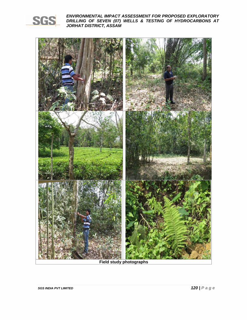
ENVIRONMENTAL IMPACT ASSESSMENT FOR PROPOSED EXPLORATORYDRILLING OF SEVEN (07) WELLS & TESTING OF HYDROCARBONS ATJORHAT DISTRICT, ASSAM
SGS INDIA PVT LIMITED 120 | P a g e
Field study photographs
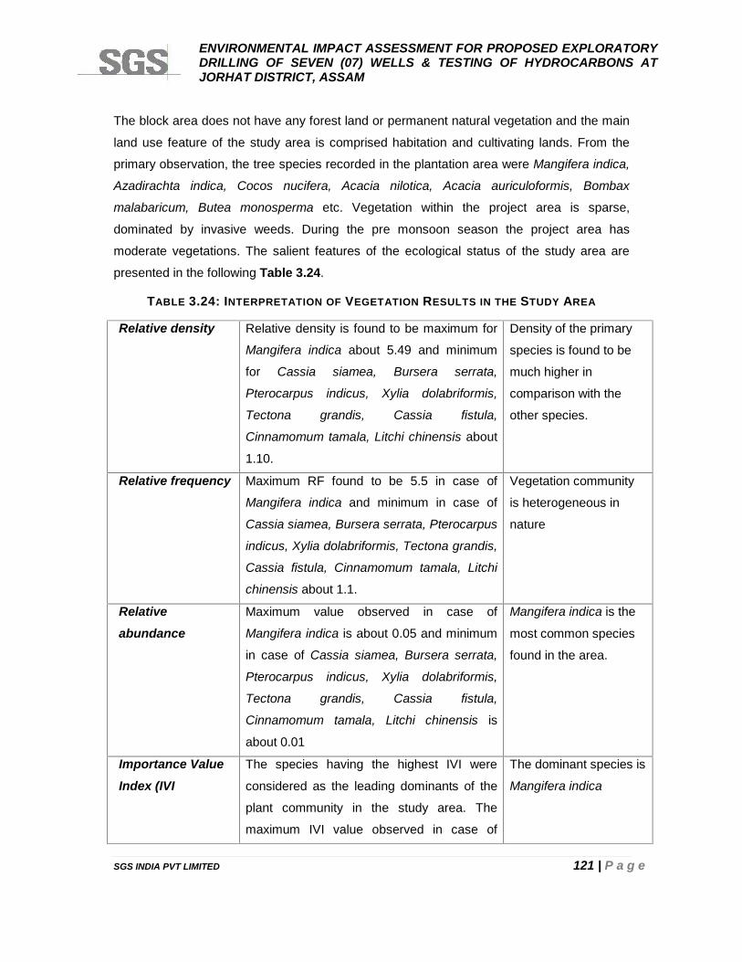
ENVIRONMENTAL IMPACT ASSESSMENT FOR PROPOSED EXPLORATORYDRILLING OF SEVEN (07) WELLS & TESTING OF HYDROCARBONS ATJORHAT DISTRICT, ASSAM
SGS INDIA PVT LIMITED 121 | P a g e
The block area does not have any forest land or permanent natural vegetation and the main
land use feature of the study area is comprised habitation and cultivating lands. From the
primary observation, the tree species recorded in the plantation area were Mangifera indica,
Azadirachta indica, Cocos nucifera, Acacia nilotica, Acacia auriculoformis, Bombax
malabaricum, Butea monosperma etc. Vegetation within the project area is sparse,
dominated by invasive weeds. During the pre monsoon season the project area has
moderate vegetations. The salient features of the ecological status of the study area are
presented in the following Table 3.24.
TABLE 3.24: INTERPRETATION OF VEGETATION RESULTS IN THE STUDY AREA
Relative density Relative density is found to be maximum for
Mangifera indica about 5.49 and minimum
for Cassia siamea, Bursera serrata,
Pterocarpus indicus, Xylia dolabriformis,
Tectona grandis, Cassia fistula,
Cinnamomum tamala, Litchi chinensis about
1.10.
Density of the primary
species is found to be
much higher in
comparison with the
other species.
Relative frequency Maximum RF found to be 5.5 in case of
Mangifera indica and minimum in case of
Cassia siamea, Bursera serrata, Pterocarpus
indicus, Xylia dolabriformis, Tectona grandis,
Cassia fistula, Cinnamomum tamala, Litchi
chinensis about 1.1.
Vegetation community
is heterogeneous in
nature
Relativeabundance
Maximum value observed in case of
Mangifera indica is about 0.05 and minimum
in case of Cassia siamea, Bursera serrata,
Pterocarpus indicus, Xylia dolabriformis,
Tectona grandis, Cassia fistula,
Cinnamomum tamala, Litchi chinensis is
about 0.01
Mangifera indica is the
most common species
found in the area.
Importance ValueIndex (IVI
The species having the highest IVI were
considered as the leading dominants of the
plant community in the study area. The
maximum IVI value observed in case of
The dominant species is
Mangifera indica
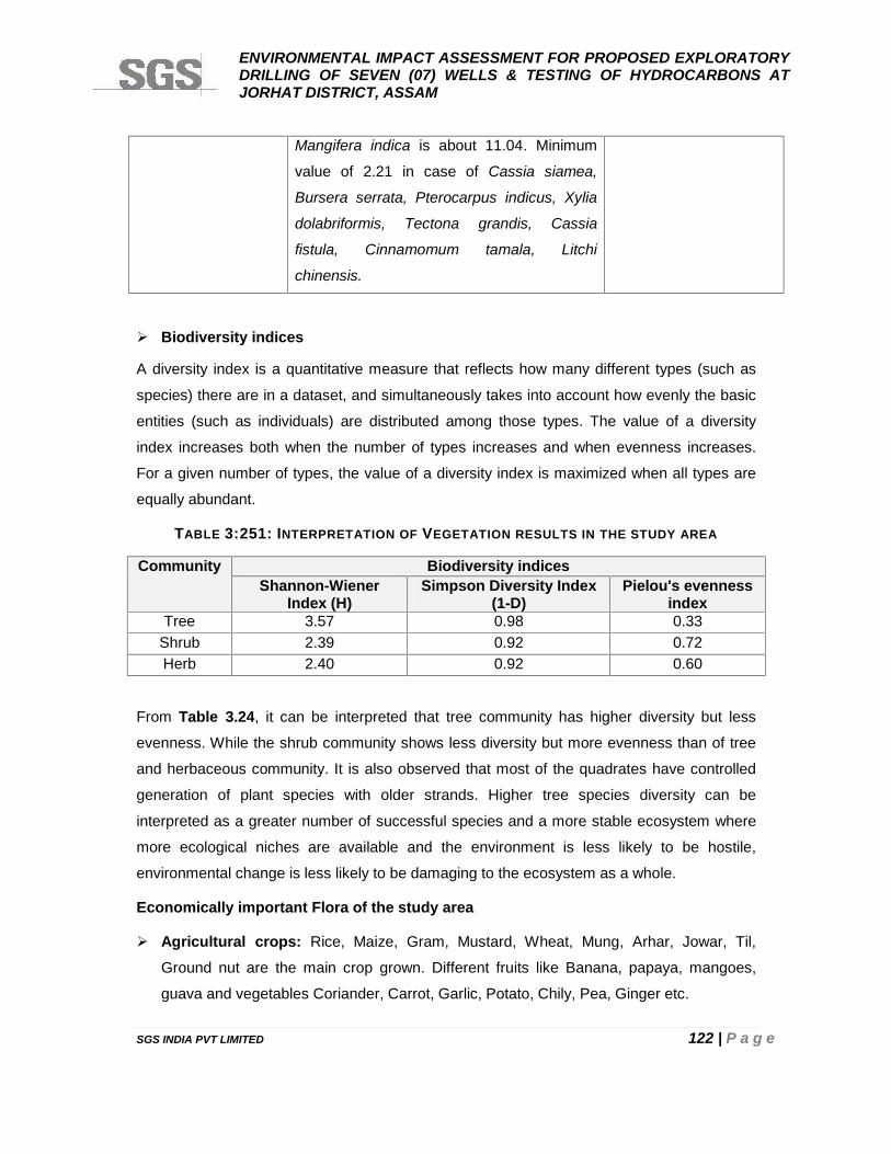
ENVIRONMENTAL IMPACT ASSESSMENT FOR PROPOSED EXPLORATORYDRILLING OF SEVEN (07) WELLS & TESTING OF HYDROCARBONS ATJORHAT DISTRICT, ASSAM
SGS INDIA PVT LIMITED 122 | P a g e
Mangifera indica is about 11.04. Minimum
value of 2.21 in case of Cassia siamea,
Bursera serrata, Pterocarpus indicus, Xylia
dolabriformis, Tectona grandis, Cassia
fistula, Cinnamomum tamala, Litchi
chinensis.
Biodiversity indices
A diversity index is a quantitative measure that reflects how many different types (such as
species) there are in a dataset, and simultaneously takes into account how evenly the basic
entities (such as individuals) are distributed among those types. The value of a diversity
index increases both when the number of types increases and when evenness increases.
For a given number of types, the value of a diversity index is maximized when all types are
equally abundant.
TABLE 3:251: INTERPRETATION OF VEGETATION RESULTS IN THE STUDY AREA
Community Biodiversity indicesShannon-Wiener
Index (H)Simpson Diversity Index
(1-D)Pielou's evenness
indexTree 3.57 0.98 0.33
Shrub 2.39 0.92 0.72Herb 2.40 0.92 0.60
From Table 3.24, it can be interpreted that tree community has higher diversity but less
evenness. While the shrub community shows less diversity but more evenness than of tree
and herbaceous community. It is also observed that most of the quadrates have controlled
generation of plant species with older strands. Higher tree species diversity can be
interpreted as a greater number of successful species and a more stable ecosystem where
more ecological niches are available and the environment is less likely to be hostile,
environmental change is less likely to be damaging to the ecosystem as a whole.
Economically important Flora of the study area
Agricultural crops: Rice, Maize, Gram, Mustard, Wheat, Mung, Arhar, Jowar, Til,
Ground nut are the main crop grown. Different fruits like Banana, papaya, mangoes,
guava and vegetables Coriander, Carrot, Garlic, Potato, Chily, Pea, Ginger etc.
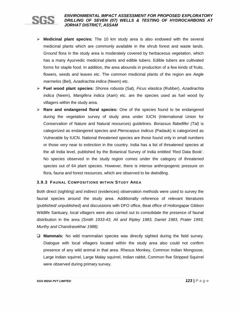
ENVIRONMENTAL IMPACT ASSESSMENT FOR PROPOSED EXPLORATORYDRILLING OF SEVEN (07) WELLS & TESTING OF HYDROCARBONS ATJORHAT DISTRICT, ASSAM
SGS INDIA PVT LIMITED 123 | P a g e
Medicinal plant species: The 10 km study area is also endowed with the several
medicinal plants which are commonly available in the shrub forest and waste lands.
Ground flora in the study area is moderately covered by herbaceous vegetation, which
has a many Ayurvedic medicinal plants and edible tubers. Edible tubers are cultivated
forms for staple food. In addition, the area abounds in production of a few kinds of fruits,
flowers, seeds and leaves etc. The common medicinal plants of the region are Aegle
marmelos (Bel), Azadirachta indica (Neem) etc.
Fuel wood plant species: Shorea robusta (Sal), Ficus elastica (Rubber), Azadirachta
indica (Neem), Mangifera indica (Aam) etc. are the species used as fuel wood by
villagers within the study area.
Rare and endangered floral species: One of the species found to be endangered
during the vegetation survey of study area under IUCN (International Union for
Conservation of Nature and Natural resources) guidelines. Borassus flabellifer (Tal) is
categorized as endangered species and Pterocarpus indicus (Padauk) is categorized as
Vulnerable by IUCN. National threatened species are those found only in small numbers
or those very near to extinction in the country. India has a list of threatened species at
the all India level, published by the Botanical Survey of India entitled ‘Red Data Book‘.
No species observed in the study region comes under the category of threatened
species out of 64 plant species. However, there is intense anthropogenic pressure on
flora, fauna and forest resources, which are observed to be dwindling.
3.9.3 FAUNAL COMPOSITIONS WITHIN STUDY AREA
Both direct (sighting) and indirect (evidences) observation methods were used to survey the
faunal species around the study area. Additionally reference of relevant literatures
(published/ unpublished) and discussions with DFO office, Beat office of Hollongapar Gibbon
Wildlife Santuary, local villagers were also carried out to consolidate the presence of faunal
distribution in the area (Smith 1933-43, Ali and Ripley 1983, Daniel 1983, Prater 1993,
Murthy and Chandrasekhar 1988).
Mammals: No wild mammalian species was directly sighted during the field survey.
Dialogue with local villagers located within the study area also could not confirm
presence of any wild animal in that area. Rhesus Monkey, Common Indian Mongoose,
Large Indian squirrel, Large Malay squirrel, Indian rabbit, Common five Stripped Squirrel
were observed during primary survey.
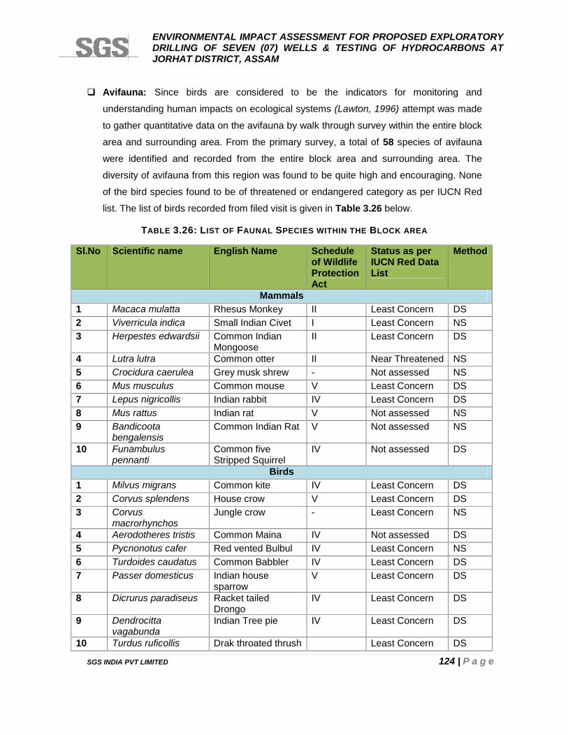
ENVIRONMENTAL IMPACT ASSESSMENT FOR PROPOSED EXPLORATORYDRILLING OF SEVEN (07) WELLS & TESTING OF HYDROCARBONS ATJORHAT DISTRICT, ASSAM
SGS INDIA PVT LIMITED 124 | P a g e
Avifauna: Since birds are considered to be the indicators for monitoring and
understanding human impacts on ecological systems (Lawton, 1996) attempt was made
to gather quantitative data on the avifauna by walk through survey within the entire block
area and surrounding area. From the primary survey, a total of 58 species of avifauna
were identified and recorded from the entire block area and surrounding area. The
diversity of avifauna from this region was found to be quite high and encouraging. None
of the bird species found to be of threatened or endangered category as per IUCN Red
list. The list of birds recorded from filed visit is given in Table 3.26 below.
TABLE 3.26: LIST OF FAUNAL SPECIES WITHIN THE BLOCK AREA
Sl.No Scientific name English Name Scheduleof WildlifeProtectionAct
Status as perIUCN Red DataList
Method
Mammals1 Macaca mulatta Rhesus Monkey II Least Concern DS2 Viverricula indica Small Indian Civet I Least Concern NS3 Herpestes edwardsii Common Indian
MongooseII Least Concern DS
4 Lutra lutra Common otter II Near Threatened NS5 Crocidura caerulea Grey musk shrew - Not assessed NS6 Mus musculus Common mouse V Least Concern DS7 Lepus nigricollis Indian rabbit IV Least Concern DS8 Mus rattus Indian rat V Not assessed NS9 Bandicoota
bengalensisCommon Indian Rat V Not assessed NS
10 Funambuluspennanti
Common fiveStripped Squirrel
IV Not assessed DS
Birds1 Milvus migrans Common kite IV Least Concern DS2 Corvus splendens House crow V Least Concern DS3 Corvus
macrorhynchosJungle crow - Least Concern NS
4 Aerodotheres tristis Common Maina IV Not assessed DS5 Pycnonotus cafer Red vented Bulbul IV Least Concern NS6 Turdoides caudatus Common Babbler IV Least Concern DS7 Passer domesticus Indian house
sparrowV Least Concern DS
8 Dicrurus paradiseus Racket tailedDrongo
IV Least Concern DS
9 Dendrocittavagabunda
Indian Tree pie IV Least Concern DS
10 Turdus ruficollis Drak throated thrush Least Concern DS
ENVIRONMENTAL IMPACT ASSESSMENT FOR PROPOSED EXPLORATORYDRILLING OF SEVEN (07) WELLS & TESTING OF HYDROCARBONS ATJORHAT DISTRICT, ASSAM
SGS INDIA PVT LIMITED 125 | P a g e
11 Orthotomus sutorius Tailor bird IV Least Concern DS12 Motacilla cinerea Gray wagtail Least Concern DS13 Chloropis aurifrons Green Bulbul IV Not assessed DS14 Cisticola juncidis Streaked fantail
warblerLeast Concern NS
15 Lonchura punctulata Spotted Munia IV Least Concern NS16 Pericrocotus
flammeusScarlet Minivet Least Concern DS
17 Aethopyga siparaja Indian Yellowbacked sunbird
IV Least Concern NS
18 Nectarinia asiatica Purple sunbird IV Least Concern DS19 Picus canus Grey headed wood
peackerIV Least Concern DS
20 Dendrocopasmahrattensis
Yellow wood pecker IV Not assessed DS
21 Coracias benhalensis Indian Roller IV Not assessed DS22 Pericrocotus
cinnamomausSmall minivet IV Not assessed DS
23 Merops orientalis Common bee eaters IV Least Concern DS24 Alcedo atthis Common kingfisher IV Least Concern DS25 Halcyon smyrnenssis White breasted king
fisherIV Not assessed DS
26 Eudynamysscolopceae
Koel IV Not assessed DS
27 Cuculus varius Cuckoo IV Least Concern DS28 Psittacula krameri Rose ringed
parakeetIV Least Concern DS
29 Psittacula alexandri Indian Red breastedParakeet
IV Near Threatened DS
30 Ketupa zeylonensis Brown fish owl IV Least Concern NS31 Athene brama spotted owlet IV Least Concern NS32 Gallus gallus Red jungle fowl IV Least Concern NS33 Streptopelia
chinensisIndian Spotted Dove IV Not assessed DS
34 Grus grus Common crane IV Least Concern DS35 Burhinus
oedicenemusStone curlew IV Not assessed DS
36 Vanellus indicus Redwattled lapping - Least Concern DS37 Ciconia epsioopus White necked stork IV Not assessed DS38 Nicticorax nycticorax Night Hiran IV Not assessed DS39 Bubulcus ibis Cattle egret IV Least Concern DS40 Ixobrychus
cinnamomeusChestnut bittern IV Least Concern DS
41 Treron phoenicoptera Common greenpigeon
IV Least Concern DS
42 Ardeo grayeli Pond heron IV Not assessed DS
ENVIRONMENTAL IMPACT ASSESSMENT FOR PROPOSED EXPLORATORYDRILLING OF SEVEN (07) WELLS & TESTING OF HYDROCARBONS ATJORHAT DISTRICT, ASSAM
SGS INDIA PVT LIMITED 126 | P a g e
43 Anas clypeata Northern shoveler - Least Concern DS44 Anas creaca Common Teal IV Not assessed DS45 Columba livia Blue rock pigeon IV Least Concern DS46 Cotuenix coturnix Common or grey
quailIV Not assessed DS
47 Copsychus saularis Southern magpierobin
IV Least Concern DS
48 Gampsorhynchusrufulus
White hoodedbabbler
IV Least Concern NS
49 Copsychusmalabaricus
White-rumpedshama
- Least Concern NS
50 Acrocephalusagricola
Paddy field warbler - Least Concern NS
51 Motacilla alba White Wagtail - Least Concern DS52 Pelargopsis capensis Brown headed
storkbilledIV Least Concern DS
53 Dendrocygnajavanica
Whistling teal IV Least Concern DS
54 Ceryle rudis Pied kingfisher IV Least Concern DS55 Centropus
bengalensisLesser coucal - Least Concern NS
56 Cypsiurusbalasiensis
Asian palm swift IV Least Concern DS
57 Dicrurusmacrocercus
Black Drongo IV Least Concern DS
58 Dicrurusleucophaeus
Ashy Drngo IV Least Concern DS
Reptiles1 Bungarus caerulens Common Krait IV Not assessed NS2 Vipera russelli Russell’s viper IV Not assessed NS3 Ptyas mucosas Yellow rat snake II Not assessed NS4 Naja naja Cobra IV Not assessed NS5 Calotes versicolur Common Garden
Lizard- Not assessed NS
6 Varanus varanus Tree lizard II Not assessed DSAmphibians
1 Rana tigrina Common yellow frog IV Least Concern NS2 Bufo melanostictus Toad IV Least Concern NS3 Hoplobatrachus
tigerinusIndian bull frog - Least Concern DS
Butterfly1 Eurema hecabe Common Grass
YellowIV Not assessed DS
2 Junonia hierta Yellow pansy IV Least Concern DS3 Danaus chrysippus plain tiger IV Not assessed DS4 Junonia atlites Grey pansy IV Not assessed DS
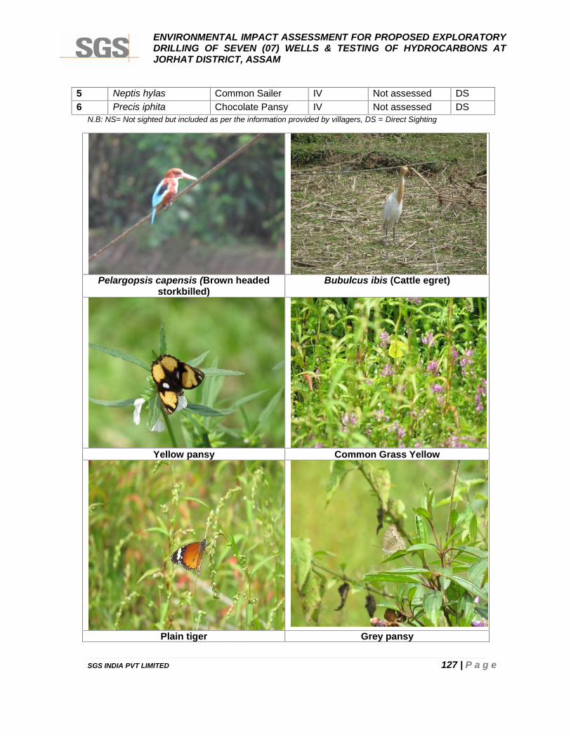
ENVIRONMENTAL IMPACT ASSESSMENT FOR PROPOSED EXPLORATORYDRILLING OF SEVEN (07) WELLS & TESTING OF HYDROCARBONS ATJORHAT DISTRICT, ASSAM
SGS INDIA PVT LIMITED 127 | P a g e
5 Neptis hylas Common Sailer IV Not assessed DS6 Precis iphita Chocolate Pansy IV Not assessed DS
N.B: NS= Not sighted but included as per the information provided by villagers, DS = Direct Sighting
Pelargopsis capensis (Brown headedstorkbilled)
Bubulcus ibis (Cattle egret)
Yellow pansy Common Grass Yellow
Plain tiger Grey pansy
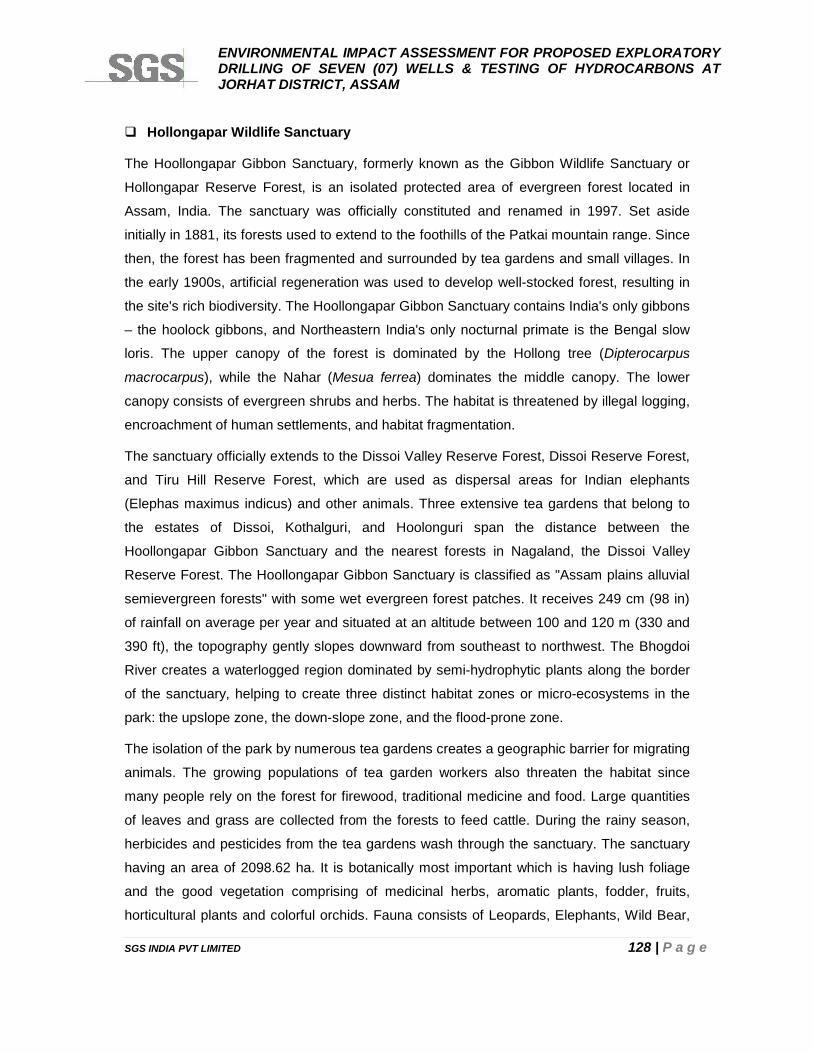
ENVIRONMENTAL IMPACT ASSESSMENT FOR PROPOSED EXPLORATORYDRILLING OF SEVEN (07) WELLS & TESTING OF HYDROCARBONS ATJORHAT DISTRICT, ASSAM
SGS INDIA PVT LIMITED 128 | P a g e
Hollongapar Wildlife Sanctuary
The Hoollongapar Gibbon Sanctuary, formerly known as the Gibbon Wildlife Sanctuary or
Hollongapar Reserve Forest, is an isolated protected area of evergreen forest located in
Assam, India. The sanctuary was officially constituted and renamed in 1997. Set aside
initially in 1881, its forests used to extend to the foothills of the Patkai mountain range. Since
then, the forest has been fragmented and surrounded by tea gardens and small villages. In
the early 1900s, artificial regeneration was used to develop well-stocked forest, resulting in
the site's rich biodiversity. The Hoollongapar Gibbon Sanctuary contains India's only gibbons
– the hoolock gibbons, and Northeastern India's only nocturnal primate is the Bengal slow
loris. The upper canopy of the forest is dominated by the Hollong tree (Dipterocarpus
macrocarpus), while the Nahar (Mesua ferrea) dominates the middle canopy. The lower
canopy consists of evergreen shrubs and herbs. The habitat is threatened by illegal logging,
encroachment of human settlements, and habitat fragmentation.
The sanctuary officially extends to the Dissoi Valley Reserve Forest, Dissoi Reserve Forest,
and Tiru Hill Reserve Forest, which are used as dispersal areas for Indian elephants
(Elephas maximus indicus) and other animals. Three extensive tea gardens that belong to
the estates of Dissoi, Kothalguri, and Hoolonguri span the distance between the
Hoollongapar Gibbon Sanctuary and the nearest forests in Nagaland, the Dissoi Valley
Reserve Forest. The Hoollongapar Gibbon Sanctuary is classified as "Assam plains alluvial
semievergreen forests" with some wet evergreen forest patches. It receives 249 cm (98 in)
of rainfall on average per year and situated at an altitude between 100 and 120 m (330 and
390 ft), the topography gently slopes downward from southeast to northwest. The Bhogdoi
River creates a waterlogged region dominated by semi-hydrophytic plants along the border
of the sanctuary, helping to create three distinct habitat zones or micro-ecosystems in the
park: the upslope zone, the down-slope zone, and the flood-prone zone.
The isolation of the park by numerous tea gardens creates a geographic barrier for migrating
animals. The growing populations of tea garden workers also threaten the habitat since
many people rely on the forest for firewood, traditional medicine and food. Large quantities
of leaves and grass are collected from the forests to feed cattle. During the rainy season,
herbicides and pesticides from the tea gardens wash through the sanctuary. The sanctuary
having an area of 2098.62 ha. It is botanically most important which is having lush foliage
and the good vegetation comprising of medicinal herbs, aromatic plants, fodder, fruits,
horticultural plants and colorful orchids. Fauna consists of Leopards, Elephants, Wild Bear,
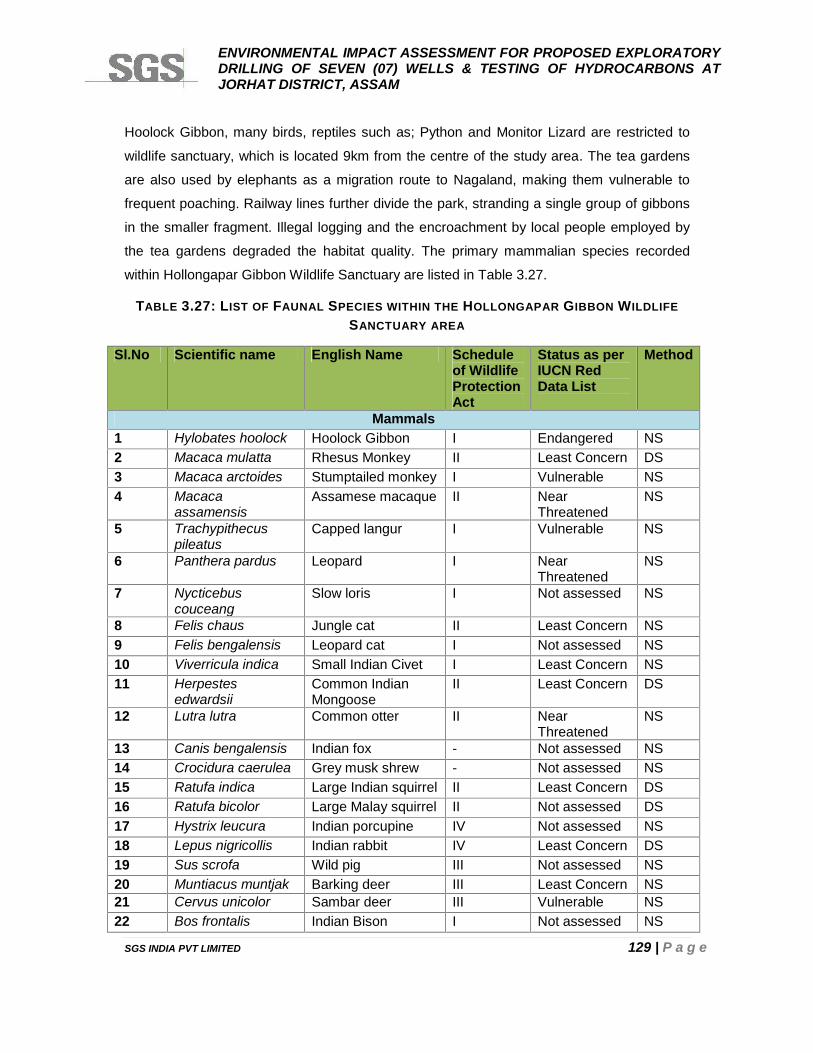
ENVIRONMENTAL IMPACT ASSESSMENT FOR PROPOSED EXPLORATORYDRILLING OF SEVEN (07) WELLS & TESTING OF HYDROCARBONS ATJORHAT DISTRICT, ASSAM
SGS INDIA PVT LIMITED 129 | P a g e
Hoolock Gibbon, many birds, reptiles such as; Python and Monitor Lizard are restricted to
wildlife sanctuary, which is located 9km from the centre of the study area. The tea gardens
are also used by elephants as a migration route to Nagaland, making them vulnerable to
frequent poaching. Railway lines further divide the park, stranding a single group of gibbons
in the smaller fragment. Illegal logging and the encroachment by local people employed by
the tea gardens degraded the habitat quality. The primary mammalian species recorded
within Hollongapar Gibbon Wildlife Sanctuary are listed in Table 3.27.
TABLE 3.27: LIST OF FAUNAL SPECIES WITHIN THE HOLLONGAPAR GIBBON WILDLIFESANCTUARY AREA
Sl.No Scientific name English Name Scheduleof WildlifeProtectionAct
Status as perIUCN RedData List
Method
Mammals1 Hylobates hoolock Hoolock Gibbon I Endangered NS2 Macaca mulatta Rhesus Monkey II Least Concern DS3 Macaca arctoides Stumptailed monkey I Vulnerable NS4 Macaca
assamensisAssamese macaque II Near
ThreatenedNS
5 Trachypithecuspileatus
Capped langur I Vulnerable NS
6 Panthera pardus Leopard I NearThreatened
NS
7 Nycticebuscouceang
Slow loris I Not assessed NS
8 Felis chaus Jungle cat II Least Concern NS9 Felis bengalensis Leopard cat I Not assessed NS10 Viverricula indica Small Indian Civet I Least Concern NS11 Herpestes
edwardsiiCommon IndianMongoose
II Least Concern DS
12 Lutra lutra Common otter II NearThreatened
NS
13 Canis bengalensis Indian fox - Not assessed NS14 Crocidura caerulea Grey musk shrew - Not assessed NS15 Ratufa indica Large Indian squirrel II Least Concern DS16 Ratufa bicolor Large Malay squirrel II Not assessed DS17 Hystrix leucura Indian porcupine IV Not assessed NS18 Lepus nigricollis Indian rabbit IV Least Concern DS19 Sus scrofa Wild pig III Not assessed NS20 Muntiacus muntjak Barking deer III Least Concern NS21 Cervus unicolor Sambar deer III Vulnerable NS22 Bos frontalis Indian Bison I Not assessed NS
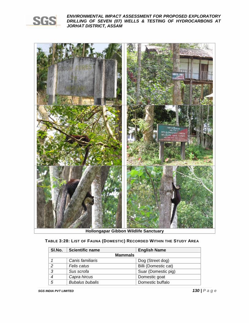
ENVIRONMENTAL IMPACT ASSESSMENT FOR PROPOSED EXPLORATORYDRILLING OF SEVEN (07) WELLS & TESTING OF HYDROCARBONS ATJORHAT DISTRICT, ASSAM
SGS INDIA PVT LIMITED 130 | P a g e
Hollongapar Gibbon Wildlife Sanctuary
TABLE 3:28: LIST OF FAUNA (DOMESTIC) RECORDED WITHIN THE STUDY AREA
Sl.No. Scientific name English NameMammals
1 Canis familiaris Dog (Street dog)2 Felis catus Billi (Domestic cat)3 Sus scrofa Suar (Domestic pig)4 Capra hircus Domestic goat5 Bubalus bubalis Domestic buffalo
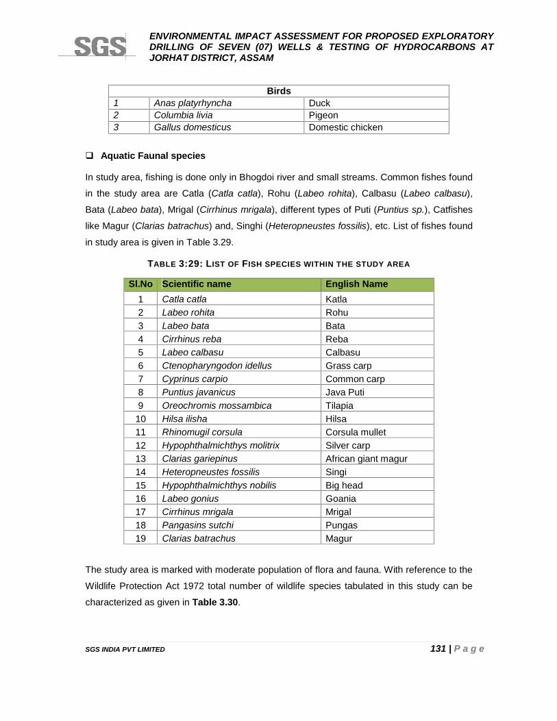
ENVIRONMENTAL IMPACT ASSESSMENT FOR PROPOSED EXPLORATORYDRILLING OF SEVEN (07) WELLS & TESTING OF HYDROCARBONS ATJORHAT DISTRICT, ASSAM
SGS INDIA PVT LIMITED 131 | P a g e
Birds1 Anas platyrhyncha Duck2 Columbia livia Pigeon3 Gallus domesticus Domestic chicken
Aquatic Faunal species
In study area, fishing is done only in Bhogdoi river and small streams. Common fishes found
in the study area are Catla (Catla catla), Rohu (Labeo rohita), Calbasu (Labeo calbasu),
Bata (Labeo bata), Mrigal (Cirrhinus mrigala), different types of Puti (Puntius sp.), Catfishes
like Magur (Clarias batrachus) and, Singhi (Heteropneustes fossilis), etc. List of fishes found
in study area is given in Table 3.29.
TABLE 3:29: LIST OF FISH SPECIES WITHIN THE STUDY AREA
Sl.No Scientific name English Name1 Catla catla Katla2 Labeo rohita Rohu3 Labeo bata Bata4 Cirrhinus reba Reba5 Labeo calbasu Calbasu6 Ctenopharyngodon idellus Grass carp7 Cyprinus carpio Common carp8 Puntius javanicus Java Puti9 Oreochromis mossambica Tilapia
10 Hilsa ilisha Hilsa11 Rhinomugil corsula Corsula mullet12 Hypophthalmichthys molitrix Silver carp13 Clarias gariepinus African giant magur14 Heteropneustes fossilis Singi15 Hypophthalmichthys nobilis Big head16 Labeo gonius Goania17 Cirrhinus mrigala Mrigal18 Pangasins sutchi Pungas19 Clarias batrachus Magur
The study area is marked with moderate population of flora and fauna. With reference to the
Wildlife Protection Act 1972 total number of wildlife species tabulated in this study can be
characterized as given in Table 3.30.
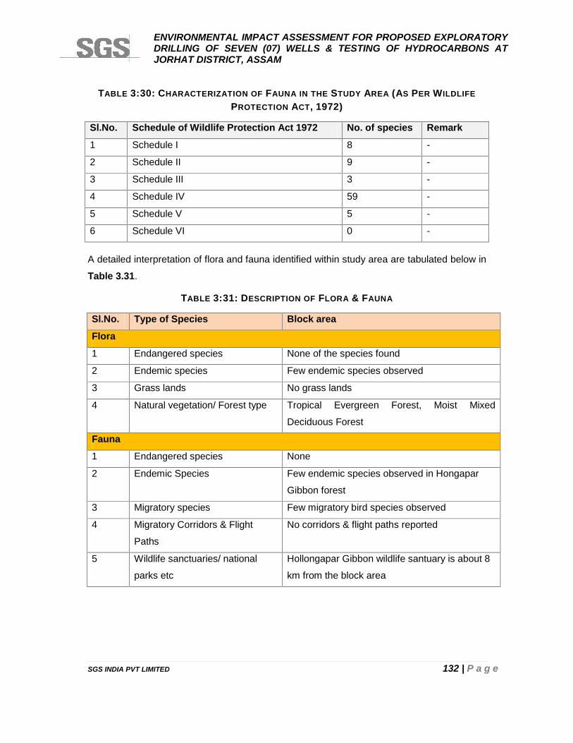
ENVIRONMENTAL IMPACT ASSESSMENT FOR PROPOSED EXPLORATORYDRILLING OF SEVEN (07) WELLS & TESTING OF HYDROCARBONS ATJORHAT DISTRICT, ASSAM
SGS INDIA PVT LIMITED 132 | P a g e
TABLE 3:30: CHARACTERIZATION OF FAUNA IN THE STUDY AREA (AS PER WILDLIFEPROTECTION ACT, 1972)
Sl.No. Schedule of Wildlife Protection Act 1972 No. of species Remark
1 Schedule I 8 -
2 Schedule II 9 -
3 Schedule III 3 -
4 Schedule IV 59 -
5 Schedule V 5 -
6 Schedule VI 0 -
A detailed interpretation of flora and fauna identified within study area are tabulated below in
Table 3.31.
TABLE 3:31: DESCRIPTION OF FLORA & FAUNA
Sl.No. Type of Species Block area
Flora
1 Endangered species None of the species found
2 Endemic species Few endemic species observed
3 Grass lands No grass lands
4 Natural vegetation/ Forest type Tropical Evergreen Forest, Moist Mixed
Deciduous Forest
Fauna
1 Endangered species None
2 Endemic Species Few endemic species observed in Hongapar
Gibbon forest
3 Migratory species Few migratory bird species observed
4 Migratory Corridors & Flight
Paths
No corridors & flight paths reported
5 Wildlife sanctuaries/ national
parks etc
Hollongapar Gibbon wildlife santuary is about 8
km from the block area
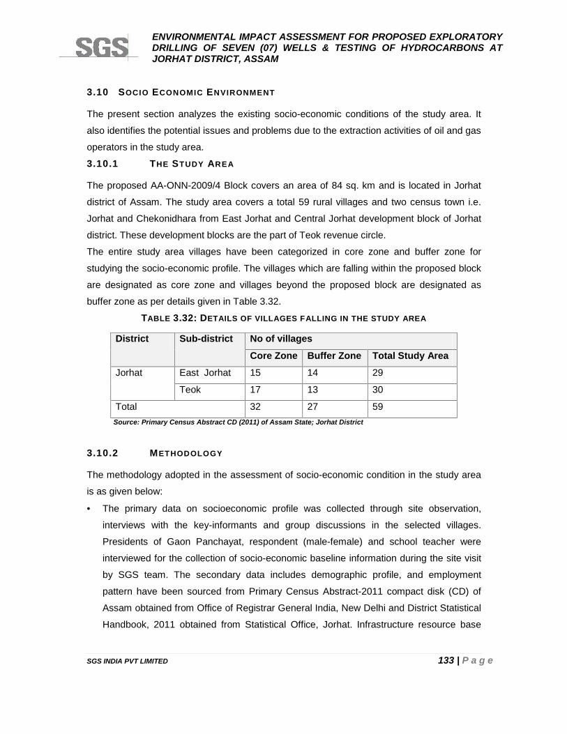
ENVIRONMENTAL IMPACT ASSESSMENT FOR PROPOSED EXPLORATORYDRILLING OF SEVEN (07) WELLS & TESTING OF HYDROCARBONS ATJORHAT DISTRICT, ASSAM
SGS INDIA PVT LIMITED 133 | P a g e
3.10 SOCIO ECONOMIC ENVIRONMENT
The present section analyzes the existing socio-economic conditions of the study area. It
also identifies the potential issues and problems due to the extraction activities of oil and gas
operators in the study area.
3.10.1 THE STUDY AREA
The proposed AA-ONN-2009/4 Block covers an area of 84 sq. km and is located in Jorhat
district of Assam. The study area covers a total 59 rural villages and two census town i.e.
Jorhat and Chekonidhara from East Jorhat and Central Jorhat development block of Jorhat
district. These development blocks are the part of Teok revenue circle.
The entire study area villages have been categorized in core zone and buffer zone for
studying the socio-economic profile. The villages which are falling within the proposed block
are designated as core zone and villages beyond the proposed block are designated as
buffer zone as per details given in Table 3.32.
TABLE 3.32: DETAILS OF VILLAGES FALLING IN THE STUDY AREA
District Sub-district No of villages
Core Zone Buffer Zone Total Study Area
Jorhat East Jorhat 15 14 29
Teok 17 13 30
Total 32 27 59Source: Primary Census Abstract CD (2011) of Assam State; Jorhat District
3.10.2 METHODOLOGY
The methodology adopted in the assessment of socio-economic condition in the study area
is as given below:
The primary data on socioeconomic profile was collected through site observation,
interviews with the key-informants and group discussions in the selected villages.
Presidents of Gaon Panchayat, respondent (male-female) and school teacher were
interviewed for the collection of socio-economic baseline information during the site visit
by SGS team. The secondary data includes demographic profile, and employment
pattern have been sourced from Primary Census Abstract-2011 compact disk (CD) of
Assam obtained from Office of Registrar General India, New Delhi and District Statistical
Handbook, 2011 obtained from Statistical Office, Jorhat. Infrastructure resource base
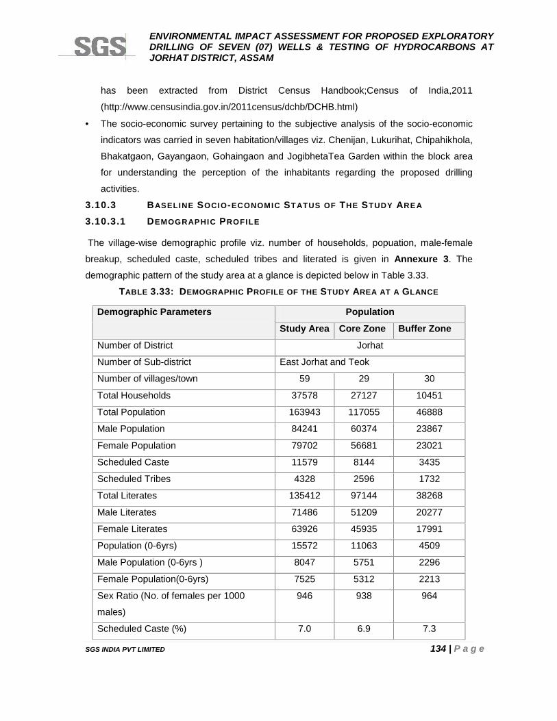
ENVIRONMENTAL IMPACT ASSESSMENT FOR PROPOSED EXPLORATORYDRILLING OF SEVEN (07) WELLS & TESTING OF HYDROCARBONS ATJORHAT DISTRICT, ASSAM
SGS INDIA PVT LIMITED 134 | P a g e
has been extracted from District Census Handbook;Census of India,2011
(http://www.censusindia.gov.in/2011census/dchb/DCHB.html)
The socio-economic survey pertaining to the subjective analysis of the socio-economic
indicators was carried in seven habitation/villages viz. Chenijan, Lukurihat, Chipahikhola,
Bhakatgaon, Gayangaon, Gohaingaon and JogibhetaTea Garden within the block area
for understanding the perception of the inhabitants regarding the proposed drilling
activities.
3.10.3 BASELINE SOCIO-ECONOMIC STATUS OF THE STUDY AREA
3.10.3.1 DEMOGRAPHIC PROFILE
The village-wise demographic profile viz. number of households, popuation, male-female
breakup, scheduled caste, scheduled tribes and literated is given in Annexure 3. The
demographic pattern of the study area at a glance is depicted below in Table 3.33.
TABLE 3.33: DEMOGRAPHIC PROFILE OF THE STUDY AREA AT A GLANCE
Demographic Parameters Population
Study Area Core Zone Buffer Zone
Number of District Jorhat
Number of Sub-district East Jorhat and Teok
Number of villages/town 59 29 30
Total Households 37578 27127 10451
Total Population 163943 117055 46888
Male Population 84241 60374 23867
Female Population 79702 56681 23021
Scheduled Caste 11579 8144 3435
Scheduled Tribes 4328 2596 1732
Total Literates 135412 97144 38268
Male Literates 71486 51209 20277
Female Literates 63926 45935 17991
Population (0-6yrs) 15572 11063 4509
Male Population (0-6yrs ) 8047 5751 2296
Female Population(0-6yrs) 7525 5312 2213
Sex Ratio (No. of females per 1000
males)
946 938 964
Scheduled Caste (%) 7.0 6.9 7.3
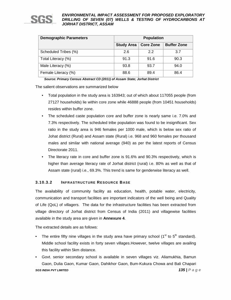
ENVIRONMENTAL IMPACT ASSESSMENT FOR PROPOSED EXPLORATORYDRILLING OF SEVEN (07) WELLS & TESTING OF HYDROCARBONS ATJORHAT DISTRICT, ASSAM
SGS INDIA PVT LIMITED 135 | P a g e
Demographic Parameters Population
Study Area Core Zone Buffer Zone
Scheduled Tribes (%) 2.6 2.2 3.7
Total Literacy (%) 91.3 91.6 90.3
Male Literacy (%) 93.8 93.7 94.0
Female Literacy (%) 88.6 89.4 86.4Source: Primary Census Abstract CD (2011) of Assam State; Jorhat District
The salient observations are summarized below
Total population in the study area is 163943; out of which about 117055 people (from
27127 households) lie within core zone while 46888 people (from 10451 households)
resides within buffer zone.
The scheduled caste population core and buffer zone is nearly same i.e. 7.0% and
7.3% respectively. The scheduled tribe population was found to be insignificant. Sex
ratio in the study area is 946 females per 1000 male, which is below sex ratio of
Johat district (Rural) and Assam state (Rural) i.e. 968 and 960 females per thousand
males and similar with national average (940) as per the latest reports of Census
Directorate 2011.
The literacy rate in core and buffer zone is 91.6% and 90.3% respectively, which is
higher than average literacy rate of Jorhat district (rural) i.e. 80% as well as that of
Assam state (rural) i.e., 69.3%. This trend is same for genderwise literacy as well.
3.10.3.2 INFRASTRUCTURE RESOURCE BASE
The availability of community facility as education, health, potable water, electricity,
communication and transport facilities are important indicators of the well being and Quality
of Life (QoL) of villagers. The data for the infrastructure facilities has been extracted from
village directory of Jorhat district from Census of India (2011) and villagewise facilities
available in the study area are given in Annexure 4.
The extracted details are as follows:
The entire fifty nine villages in the study area have primary school (1st to 5th standard).
Middle school facility exists in forty seven villages.However, twelve villages are availing
this facility within 5km distance.
Govt. senior secondary school is available in seven villages viz. Aliamukhia, Bamun
Gaon, Dulia Gaon, Kumar Gaon, Dahikhor Gaon, Bum-Kukura Chowa and Bali Chapari

ENVIRONMENTAL IMPACT ASSESSMENT FOR PROPOSED EXPLORATORYDRILLING OF SEVEN (07) WELLS & TESTING OF HYDROCARBONS ATJORHAT DISTRICT, ASSAM
SGS INDIA PVT LIMITED 136 | P a g e
Gaon. Out of remaining (52 villages), Twenty four and twenty eight villages are availing
this facility within a distance of 5kms and 5-10kms,respectively. Degree education (Arts,
Science and Commerce) available in five villages i.e. Mout Gaon, No 1 and 2 (Bamun
Gaon), Changmai Gohain Gaon, Bum-Kukura Gaon. Peole in the study area visit Jorhat
and Teok town to avail higher educatin viz. polytechnic, engineering and medical degree.
Primary Health Centre (PHC) exists in four villages i.e. Bam-Dhekia Khowa,Mout
Gaon,No.1 Bamun Gaon and Sonari Gaon whereas Primary Health Sub-centres (PHS)
exist in ten villages. Rest forty nine villages are availing this facility within 5kms and -
10kms distance from their village. Four villages have medical facility of Allopathy.
Hospital with surgical facilities is available in Jorhat and Teok town.
Medicine shop is available in forty five villages. However, rest fourteen villages are
availing this facility with 5kms distance.
Supply of Tap water is available in fifty two villages. However, other sources also exists
like hand pumps, open wells and tube wells.
Power supply facility is available in all villages for domestic use. However, only twenty
four villages have facility of water for irrigation purposes.
The state transport bus service is available in fifty one villages and remaining eight
villages are availing this facility within 5-10 kms distance.
Railway station facility available in four villages viz. Na Pam Guhain Gaon, Changmai
Gohain Gaon, Gajpuria Gaon and Borkhat Gaon. Residents of thirty six and nineteen
villages have to travel (above 10kms) and (5-10kms) distance to avail this facility..
Postal office is available in three villages i.e Arandhara Gaon, Changmai Gohain Gaon
and Bhokat Gaon. Out of remaining (56 villages), twenty eight are availing this facility
within 5kms, fifteen villages (5-10kms) and five villages (above 10km) distance.
Only 26 villages are connected with pucca road network.
Rice, wheat, sugar and kerosene are being distributed to those families who are having
valid ration cards under public distribution system (PDS) run by the government which is
available in fourty four villages.
Weekly haat (market) exists in 38 villages however eleven villages visit market within 5-
10 kms distance.
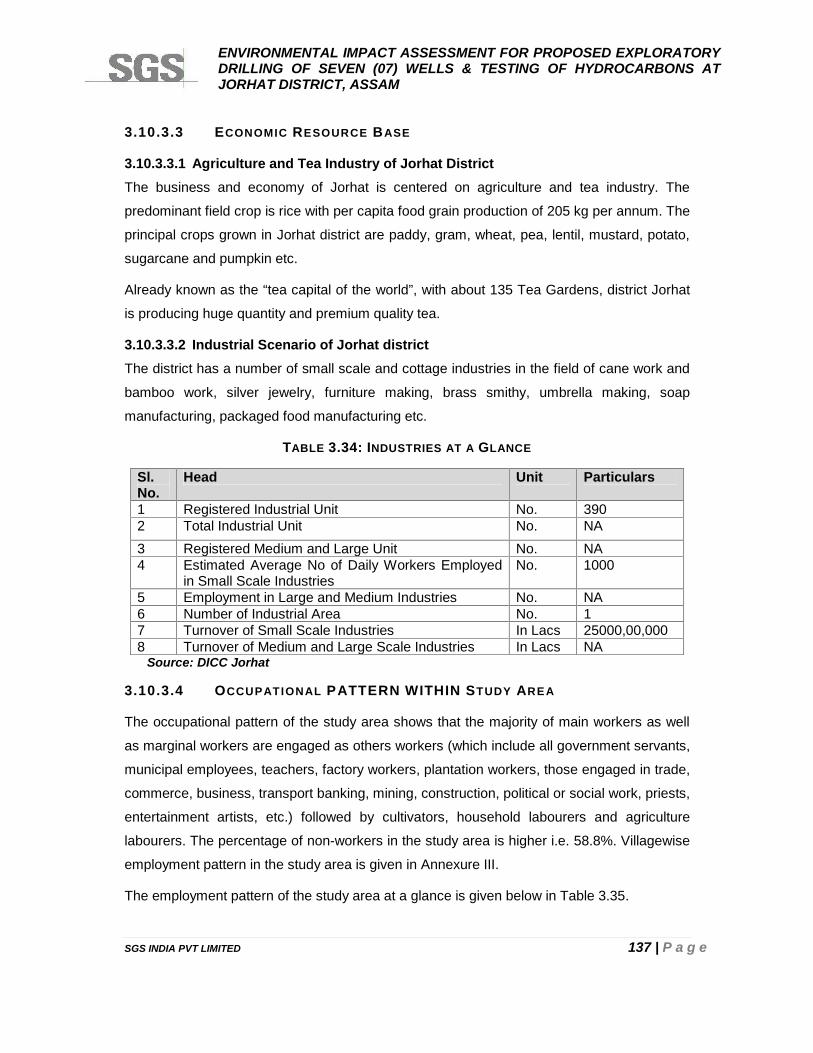
ENVIRONMENTAL IMPACT ASSESSMENT FOR PROPOSED EXPLORATORYDRILLING OF SEVEN (07) WELLS & TESTING OF HYDROCARBONS ATJORHAT DISTRICT, ASSAM
SGS INDIA PVT LIMITED 137 | P a g e
3.10.3.3 ECONOMIC RESOURCE BASE
3.10.3.3.1 Agriculture and Tea Industry of Jorhat DistrictThe business and economy of Jorhat is centered on agriculture and tea industry. The
predominant field crop is rice with per capita food grain production of 205 kg per annum. The
principal crops grown in Jorhat district are paddy, gram, wheat, pea, lentil, mustard, potato,
sugarcane and pumpkin etc.
Already known as the “tea capital of the world”, with about 135 Tea Gardens, district Jorhat
is producing huge quantity and premium quality tea.
3.10.3.3.2 Industrial Scenario of Jorhat districtThe district has a number of small scale and cottage industries in the field of cane work and
bamboo work, silver jewelry, furniture making, brass smithy, umbrella making, soap
manufacturing, packaged food manufacturing etc.
TABLE 3.34: INDUSTRIES AT A GLANCE
Sl.No.
Head Unit Particulars
1 Registered Industrial Unit No. 3902 Total Industrial Unit No. NA3 Registered Medium and Large Unit No. NA4 Estimated Average No of Daily Workers Employed
in Small Scale IndustriesNo. 1000
5 Employment in Large and Medium Industries No. NA6 Number of Industrial Area No. 17 Turnover of Small Scale Industries In Lacs 25000,00,0008 Turnover of Medium and Large Scale Industries In Lacs NA
Source: DICC Jorhat
3.10.3.4 OCCUPATIONAL PATTERN WITHIN STUDY AREA
The occupational pattern of the study area shows that the majority of main workers as well
as marginal workers are engaged as others workers (which include all government servants,
municipal employees, teachers, factory workers, plantation workers, those engaged in trade,
commerce, business, transport banking, mining, construction, political or social work, priests,
entertainment artists, etc.) followed by cultivators, household labourers and agriculture
labourers. The percentage of non-workers in the study area is higher i.e. 58.8%. Villagewise
employment pattern in the study area is given in Annexure III.
The employment pattern of the study area at a glance is given below in Table 3.35.
ENVIRONMENTAL IMPACT ASSESSMENT FOR PROPOSED EXPLORATORYDRILLING OF SEVEN (07) WELLS & TESTING OF HYDROCARBONS ATJORHAT DISTRICT, ASSAM
SGS INDIA PVT LIMITED 138 | P a g e
TABLE 3.35: EMPLOYMENT PATTERN IN THE STUDY AREA
Particulars Study Area Core Zone Buffer Zone
Total Population 163943 117055 46888
Main Workers (%) 49631 (30.3) 36120 (30.8) 13511 (28.8)
Marginal workers (%) 17864 (10.9) 10634 (9.2) 7230 (15.4)
Non Workers (%) 96448 (58.8) 70301 (60.0) 26147 (55.8)Source: Primary Census Abstract CD (2011) of Assam State; Jorhat District
3.10.3.4.1 L IVELIHOOD IN THE SURVEYED V ILLAGES
During survey and interaction with local peole it was revealed that majoriy of people are
engaged as government servants, teachers, plantation workers, small business, construction
etc. A small proportion of households are involved in agriculture as a source of livelihood.
These households are mostly depending upon rain water to carry out agriculture activities.
The main crop is rice. Green vegetable such as potato, pumpkin and cauliflower are also
grown. The villagers sell these products in weekly market of surrounding area and main
market of Jorhat. Besides, people are also engaged as permanent and casual tea garden
working labours in the surrounding tea gardens.
3.10.3.5 CULTURAL AND AESTHETIC ATTRIBUTES
Proposed study area does not involve any major place with religious, archaeological and
historical importance but Jorhat being a historical city has bored numbers of historical
monments which are the major attractions for the tourist. The places of major tourist
importance are given below:
Majuli, the biggest River Island of the world along with its heritage as cultural caital of
Assam, situated at a distance of 24km from block boundary.
The Hollongapar Gibbon Wildlife Sanctuary, which is situated 19km away from Jorhat
town, and approximately 3 Km from south east of proposed block boundary is famous for
Hollock Gibbon monkey.
The Mouchapori of Nimati Ghat and Kakilamukh Shanty Ashram are noteworthy places of
tourist attraction located at a distance of 15km from proposed block boundary.
Gymkhana Club is located at a distance of 4 kms from the Jorhat City; The Gymkhana Club
was founded by D. Slimmon in 1876. Since the time of its establishment, it has served as an
ENVIRONMENTAL IMPACT ASSESSMENT FOR PROPOSED EXPLORATORYDRILLING OF SEVEN (07) WELLS & TESTING OF HYDROCARBONS ATJORHAT DISTRICT, ASSAM
SGS INDIA PVT LIMITED 139 | P a g e
ideal spot for horse races. A major event, named as The Governor's Cup is organized every
year at this place.
Festival Celebrated in the Study Area
Bihu: The Bihus are the national festivals of Assam and have been celebrated from ancient
times. There are three such festivals: in the months of Bohaag (Baisakh, the middle of April),
Maagh (the middle of January), and Kaati (Kartik, the middle of October). Each Bihu
coincides with a distinctive phase in the farming calendar. The Bohaag Bihu marks the New
Year at the advent of seeding time, the Kaati Bihu marks the completion of sowing and
transplanting of paddies, and the Maagh Bihu marks the end of the harvesting period.
Durga Puja and Deul Mahotshav (Holi) is widely celebrated in the study area and all partsof Assam.
3.10.3.6 MEDICAL & PUBLIC HEALTH FACILIT IES
During consultation, it was revealed that the existing health infrastructure and services in the
study area comprises of Primary Health Centre (PHC) and Health Clinics run by Private
Practitioners. PHC exists in Kakojan, Chenijan, Chipakhola and Noborachuk. All PHCs is
staffed with a medical officer supported by a pharmacist, a senior clerk and an aya (midwife)
and caters to a population of nearby villages. It was also informed that doctors and staff of
PHCs organizes general health checkup and awareness programme on maternal and child
care, eye care and immunization camps in the surrounding villages on a regular basis.
EXISTING HEALTH CONDITIONS AND CONCERNS
No major diseases were reported by local people in the study area except routine cough,
cold and fever etc. and annual expenditure on health is above Rs. 500-800 per family of 5
members. Presidents of gaon panchayat stated that due to the lack of equipments,
infrastructure and poor coverage of the existing health services, the people consult private
practitioners at Jorhat town which is time consuming and expensive also.The private
hospitals in Jorhat city are equipped with better facilities than the PHCs in the study area.
These private clinics mostly cater to the affluent class residents i.e., mostly belonging to
middle income group in the area and hence people are expecting health infrastructure with
adequate staff shall be provided by project authorities under welfare scheme/CSR plan.
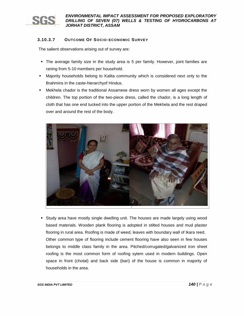
ENVIRONMENTAL IMPACT ASSESSMENT FOR PROPOSED EXPLORATORYDRILLING OF SEVEN (07) WELLS & TESTING OF HYDROCARBONS ATJORHAT DISTRICT, ASSAM
SGS INDIA PVT LIMITED 140 | P a g e
3.10.3.7 OUTCOME OF SOCIO-ECONOMIC SURVEY
The salient observations arising out of survey are:
The average family size in the study area is 5 per family. However, joint families are
raning from 5-10 members per household.
Majority households belong to Kalita community which is considered next only to the
Brahmins in the caste-hierarchyof Hindus.
Mekhela chador is the traditional Assamese dress worn by women all ages except the
children. The top portion of the two-piece dress, called the chador, is a long length of
cloth that has one end tucked into the upper portion of the Mekhela and the rest draped
over and around the rest of the body.
Study area have mostly single dwelling unit. The houses are made largely using wood
based materials. Wooden plank flooring is adopted in stilted houses and mud plaster
flooring in rural area. Roofing is made of weed, leaves with boundary wall of Ikara reed.
Other common type of flooring include cement flooring have also seen in few houses
belongs to middle class family in the area. Pitched/corrugated/galvanized iron sheet
roofing is the most common form of roofing sytem used in modern buildings. Open
space in front (chotal) and back side (bari) of the house is common in majority of
households in the area.
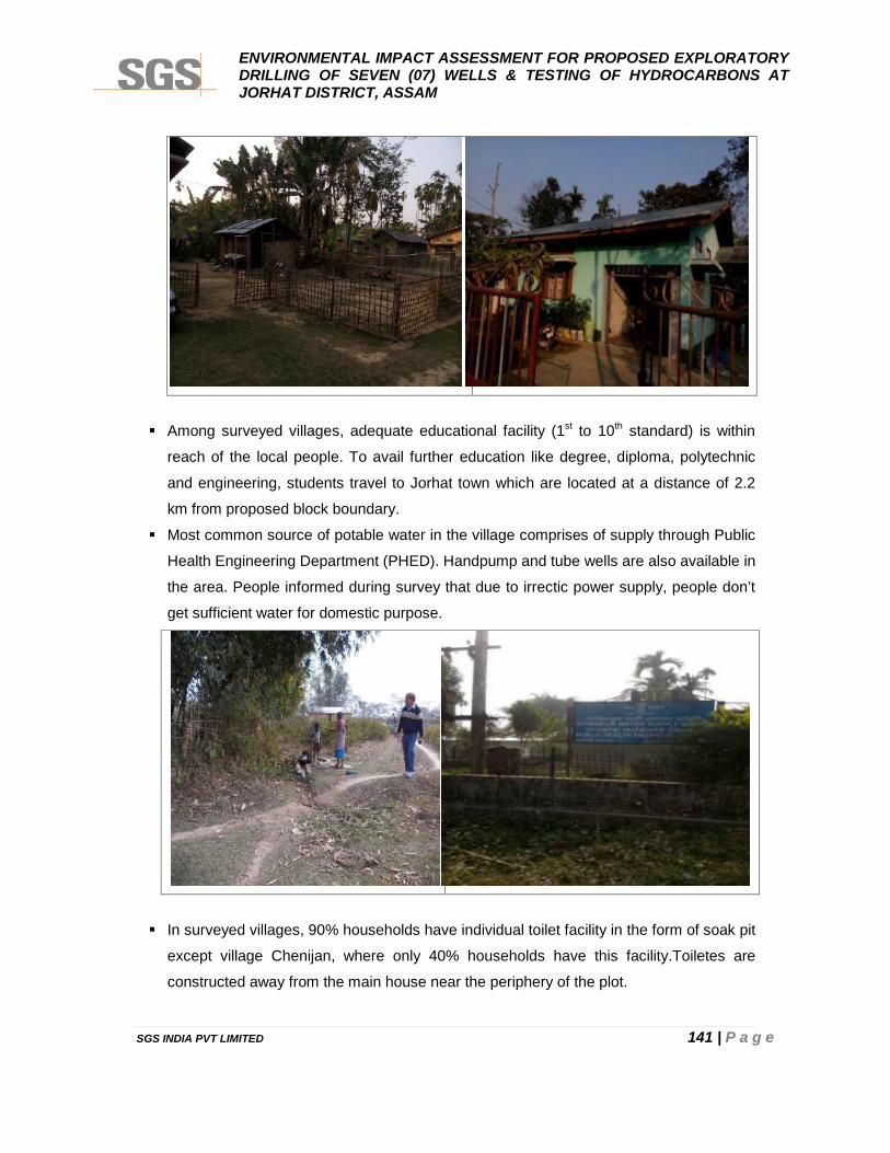
ENVIRONMENTAL IMPACT ASSESSMENT FOR PROPOSED EXPLORATORYDRILLING OF SEVEN (07) WELLS & TESTING OF HYDROCARBONS ATJORHAT DISTRICT, ASSAM
SGS INDIA PVT LIMITED 141 | P a g e
Among surveyed villages, adequate educational facility (1st to 10th standard) is within
reach of the local people. To avail further education like degree, diploma, polytechnic
and engineering, students travel to Jorhat town which are located at a distance of 2.2
km from proposed block boundary.
Most common source of potable water in the village comprises of supply through Public
Health Engineering Department (PHED). Handpump and tube wells are also available in
the area. People informed during survey that due to irrectic power supply, people don’t
get sufficient water for domestic purpose.
In surveyed villages, 90% households have individual toilet facility in the form of soak pit
except village Chenijan, where only 40% households have this facility.Toiletes are
constructed away from the main house near the periphery of the plot.
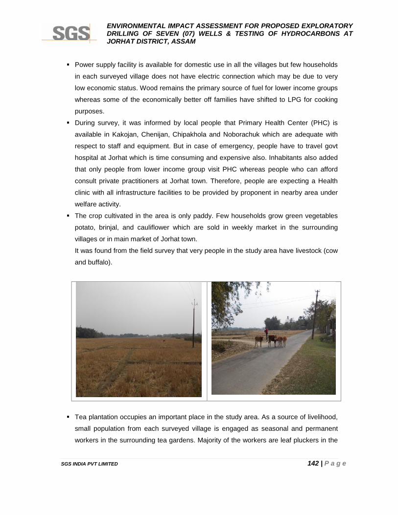
ENVIRONMENTAL IMPACT ASSESSMENT FOR PROPOSED EXPLORATORYDRILLING OF SEVEN (07) WELLS & TESTING OF HYDROCARBONS ATJORHAT DISTRICT, ASSAM
SGS INDIA PVT LIMITED 142 | P a g e
Power supply facility is available for domestic use in all the villages but few households
in each surveyed village does not have electric connection which may be due to very
low economic status. Wood remains the primary source of fuel for lower income groups
whereas some of the economically better off families have shifted to LPG for cooking
purposes.
During survey, it was informed by local people that Primary Health Center (PHC) is
available in Kakojan, Chenijan, Chipakhola and Noborachuk which are adequate with
respect to staff and equipment. But in case of emergency, people have to travel govt
hospital at Jorhat which is time consuming and expensive also. Inhabitants also added
that only people from lower income group visit PHC whereas people who can afford
consult private practitioners at Jorhat town. Therefore, people are expecting a Health
clinic with all infrastructure facilities to be provided by proponent in nearby area under
welfare activity.
The crop cultivated in the area is only paddy. Few households grow green vegetables
potato, brinjal, and cauliflower which are sold in weekly market in the surrounding
villages or in main market of Jorhat town.
It was found from the field survey that very people in the study area have livestock (cow
and buffalo).
Tea plantation occupies an important place in the study area. As a source of livelihood,
small population from each surveyed village is engaged as seasonal and permanent
workers in the surrounding tea gardens. Majority of the workers are leaf pluckers in the
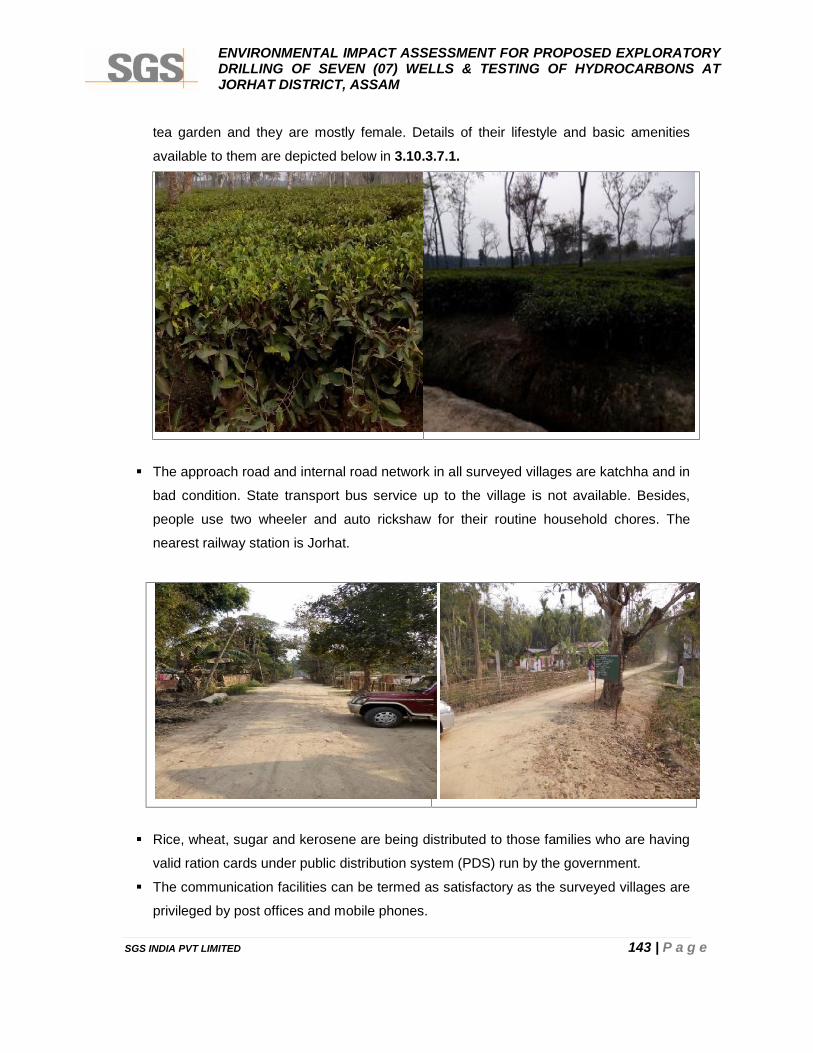
ENVIRONMENTAL IMPACT ASSESSMENT FOR PROPOSED EXPLORATORYDRILLING OF SEVEN (07) WELLS & TESTING OF HYDROCARBONS ATJORHAT DISTRICT, ASSAM
SGS INDIA PVT LIMITED 143 | P a g e
tea garden and they are mostly female. Details of their lifestyle and basic amenities
available to them are depicted below in 3.10.3.7.1.
The approach road and internal road network in all surveyed villages are katchha and in
bad condition. State transport bus service up to the village is not available. Besides,
people use two wheeler and auto rickshaw for their routine household chores. The
nearest railway station is Jorhat.
Rice, wheat, sugar and kerosene are being distributed to those families who are having
valid ration cards under public distribution system (PDS) run by the government.
The communication facilities can be termed as satisfactory as the surveyed villages are
privileged by post offices and mobile phones.
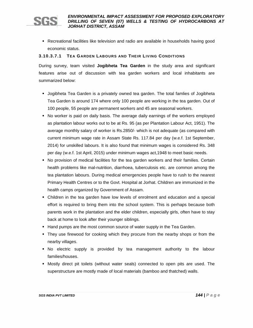
ENVIRONMENTAL IMPACT ASSESSMENT FOR PROPOSED EXPLORATORYDRILLING OF SEVEN (07) WELLS & TESTING OF HYDROCARBONS ATJORHAT DISTRICT, ASSAM
SGS INDIA PVT LIMITED 144 | P a g e
Recreational facilities like television and radio are available in households having good
economic status.
3.10.3.7.1 TEA GARDEN LABOURS AND THEIR L IVING CONDITIONS
During survey, team visited Jogibheta Tea Garden in the study area and significant
features arise out of discussion with tea garden workers and local inhabitants are
summarized below:
Jogibheta Tea Garden is a privately owned tea garden. The total famlies of Jogibheta
Tea Garden is around 174 where only 100 people are working in the tea garden. Out of
100 people, 55 people are permanent workers and 45 are seasonal workers.
No worker is paid on daily basis. The average daily earnings of the workers employed
as plantation labour works out to be at Rs. 95 (as per Plantation Labour Act, 1951). The
average monthly salary of worker is Rs.2850/- which is not adequate (as compared with
current minimum wage rate in Assam State Rs. 117.84 per day (w.e.f. 1st September,
2014) for unskilled labours. It is also found that minimum wages is considered Rs. 348
per day (w.e.f. 1st April, 2015) under minimum wages act,1948 to meet basic needs.
No provision of medical facilities for the tea garden workers and their families. Certain
health problems like mal-nutrition, diarrhoea, tuberculosis etc. are common among the
tea plantation labours. During medical emergencies people have to rush to the nearest
Primary Health Centres or to the Govt. Hospital at Jorhat. Children are immunized in the
health camps organized by Government of Assam.
Children in the tea garden have low levels of enrolment and education and a special
effort is required to bring them into the school system. This is perhaps because both
parents work in the plantation and the elder children, especially girls, often have to stay
back at home to look after their younger siblings.
Hand pumps are the most common source of water supply in the Tea Garden.
They use firewood for cooking which they procure from the nearby shops or from the
nearby villages.
No electric supply is provided by tea management authority to the labour
families/houses.
Mostly direct pit toilets (without water seals) connected to open pits are used. The
superstructure are mostly made of local materials (bamboo and thatched) walls.
ENVIRONMENTAL IMPACT ASSESSMENT FOR PROPOSED EXPLORATORYDRILLING OF SEVEN (07) WELLS & TESTING OF HYDROCARBONS ATJORHAT DISTRICT, ASSAM
SGS INDIA PVT LIMITED 145 | P a g e
3.10.3.7.2 AWARENESS AND OPINION OF PEOPLE ABOUT THE PROJECT
An attempt has been made to know the awareness and opinion of the people about
proposed project activities. Project awareness amongst the public is very low in the surveyed
villages. The respondents expect employment and improvement in basic infrastructure of the
surrounding villages. They informed SGS team about their expectation of improvement in
road condition and health facilities and drinking water supply which is of prime concern to
them.
In general, the people in the study area are happy with their existing social environment and
lifestyle. Some of the concerning issues as identified by SGS team during the socio-
economic survey refer to:
People expect that all social welfare activities should be planned considering the basic
problems of the villages and the villagers should be consulted while deciding the welfare
programmes by project proponent.
The people are not against the setting up of various types of industries in the area as this
will surely result into improvement in quality of life provided it is equipped with adequate
measures for environmental pollution control and preference should be given to local
people in job opportunities on the basis of their qualification, experience and skill.
3.10.3.7.3 COMMUNITY CONSULTATION
It will be of profound importance to study the perception as well as reaction of the community
people towards the proposed project activity. In-depth interview with president and school
teacher of selected villages was done to gather the existing baseline socio-economic
information on a various parameters of Quality of Life.
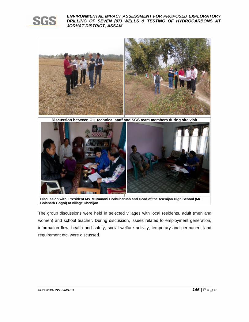
ENVIRONMENTAL IMPACT ASSESSMENT FOR PROPOSED EXPLORATORYDRILLING OF SEVEN (07) WELLS & TESTING OF HYDROCARBONS ATJORHAT DISTRICT, ASSAM
SGS INDIA PVT LIMITED 146 | P a g e
Discussion between OIL technical staff and SGS team members during site visit
Discussion with President Ms. Mutumoni Borbubaruah and Head of the Asenijan High School (Mr.Bolanath Gogoi) at village Chenijan
The group discussions were held in selected villages with local residents, adult (men and
women) and school teacher. During discussion, issues related to employment generation,
information flow, health and safety, social welfare activity, temporary and permanent land
requirement etc. were discussed.
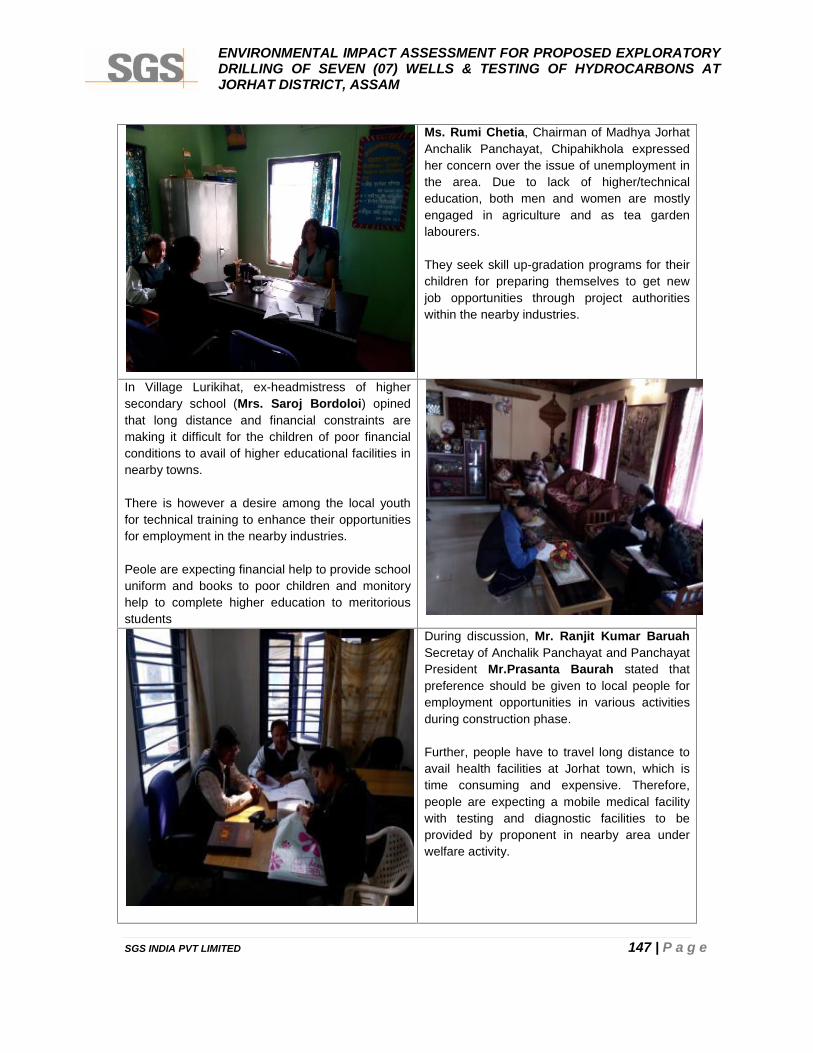
ENVIRONMENTAL IMPACT ASSESSMENT FOR PROPOSED EXPLORATORYDRILLING OF SEVEN (07) WELLS & TESTING OF HYDROCARBONS ATJORHAT DISTRICT, ASSAM
SGS INDIA PVT LIMITED 147 | P a g e
Ms. Rumi Chetia, Chairman of Madhya JorhatAnchalik Panchayat, Chipahikhola expressedher concern over the issue of unemployment inthe area. Due to lack of higher/technicaleducation, both men and women are mostlyengaged in agriculture and as tea gardenlabourers.
They seek skill up-gradation programs for theirchildren for preparing themselves to get newjob opportunities through project authoritieswithin the nearby industries.
In Village Lurikihat, ex-headmistress of highersecondary school (Mrs. Saroj Bordoloi) opinedthat long distance and financial constraints aremaking it difficult for the children of poor financialconditions to avail of higher educational facilities innearby towns.
There is however a desire among the local youthfor technical training to enhance their opportunitiesfor employment in the nearby industries.
Peole are expecting financial help to provide schooluniform and books to poor children and monitoryhelp to complete higher education to meritoriousstudents
During discussion, Mr. Ranjit Kumar BaruahSecretay of Anchalik Panchayat and PanchayatPresident Mr.Prasanta Baurah stated thatpreference should be given to local people foremployment opportunities in various activitiesduring construction phase.
Further, people have to travel long distance toavail health facilities at Jorhat town, which istime consuming and expensive. Therefore,people are expecting a mobile medical facilitywith testing and diagnostic facilities to beprovided by proponent in nearby area underwelfare activity.

ENVIRONMENTAL IMPACT ASSESSMENT FOR PROPOSED EXPLORATORYDRILLING OF SEVEN (07) WELLS & TESTING OF HYDROCARBONS ATJORHAT DISTRICT, ASSAM
SGS INDIA PVT LIMITED 148 | P a g e
CHAPTER 4
ANTICIPATED ENVIRONMENTAL IMPACTSAND MITIGATION MEASURES
ENVIRONMENTAL IMPACT ASSESSMENT FOR PROPOSED EXPLORATORYDRILLING OF SEVEN (07) WELLS & TESTING OF HYDROCARBONS ATJORHAT DISTRICT, ASSAM
SGS INDIA PVT LIMITED 149 | P a g e
CHAPTER 4: ANTICIPATED ENVIRONMENTAL IMPACTS AND M IT IGATIONMEASURES
4.1 PREAMBLE
Generally, the environmental and social impacts can be categorized as either primary or
secondary. Primary impacts are those, which are attributed directly by the project and
secondary impacts are those, which are indirectly induced and typically include the
associated investment and changed patterns of social and economic activities by the
proposed actions. The details of criteria opted for impacts assessment are as per described
hereunder:
Actual and foreseeable events, including operational and typical events are discussed in this
chapter. Processes that may create risk to the environment are considered and are analyzed
in terms of key potential environmental impacts.
The environmental impacts may include all those that are beneficial or adverse, short or long
term (acute or chronic), temporary or permanent, direct or indirect and local or regional. The
adverse impacts may include all those leading to harm to living resources, damage to human
health, hindrance to other activities, impairment of quality for use, reduction of amenities,
damage to cultural and heritage resources, and damage to physical structures. For each
identified potential environmental impact, the associated environmental risk is assessed
based on its likelihood and significance. For the proposed proposal, the impacts assessment
is being performed in three steps:
Step 1 : Identification of interactions between activities and environmental
receptors
Step 2 : Identification of potentially significant environmental impacts
Step 3 : Evaluation of all significant environmental impacts
In Step 1, based on the description of activity proposed to be undertaken and environmental
baseline description, a detailed matrix of activities and environmental receptors is prepared.
Then based on the legal framework and baseline environment data, it is determined whether
an interaction exists between an activity and a receptor.
In Step 2, based on the interactions identified in Step 1, potentially significant impacts due to
the proposed changes are identified. The impacts may be beneficial/adverse, direct/indirect,
reversible/irreversible and short-term/long-term as per criteria given below in Table 4.1.
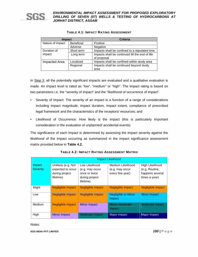
ENVIRONMENTAL IMPACT ASSESSMENT FOR PROPOSED EXPLORATORYDRILLING OF SEVEN (07) WELLS & TESTING OF HYDROCARBONS ATJORHAT DISTRICT, ASSAM
SGS INDIA PVT LIMITED 150 | P a g e
TABLE 4.1: IMPACT RATING ASSESSMENT
Impact CriteriaNature of impact Beneficial Positive
Adverse NegativeDuration ofimpact
Short term Impacts shall be confined to a stipulated timeLong term Impacts shall be continued till the end of life
of proposalImpacted Area Localized Impacts shall be confined within study area
Regional Impacts shall be continued beyond studyarea
In Step 3, all the potentially significant impacts are evaluated and a qualitative evaluation is
made. An impact level is rated as “low”, “medium” or “high”. The impact rating is based on
two parameters i.e. the “severity of impact” and the “likelihood of occurrence of impact”.
Severity of Impact: The severity of an impact is a function of a range of considerations
including impact magnitude, impact duration, impact extent, compliance of prescribed
legal framework and the characteristics of the receptors/ resources; and
Likelihood of Occurrence: How likely is the impact (this is particularly important
consideration in the evaluation of unplanned/ accidental events)
The significance of each impact is determined by assessing the impact severity against the
likelihood of the impact occurring as summarized in the impact significance assessment
matrix provided below in Table 4.2.
TABLE 4.2: IMPACT RATING ASSESSMENT MATRIX
ImpactSeverity
Impact Likelihood
Unlikely (e.g. Notexpected to occurduring projectlifetime)
Low Likelihood(e.g. may occuronce or twiceduring projectlifetime)
Medium Likelihood(e.g. may occurevery few year)
High Likelihood(e.g. Routine,happens severaltimes a year)
Slight Negligible Impact Negligible Impact Negligible Impact Negligible Impact
Low Negligible Impact Negligible Impact Negligible to MinorImpact
Minor Impact
Medium Negligible Impact Minor Impact Minor–ModerateImpact
Moderate Impact
High Minor Impact Moderate Impact Major Impact Major Impact
Notes:
ENVIRONMENTAL IMPACT ASSESSMENT FOR PROPOSED EXPLORATORYDRILLING OF SEVEN (07) WELLS & TESTING OF HYDROCARBONS ATJORHAT DISTRICT, ASSAM
SGS INDIA PVT LIMITED 151 | P a g e
Negligible Impact : Defined as magnitude of change comparable to natural variation
Minor Impact : Defined as detectable but not significant
Moderate Impact : Defined as insignificant; amenable to mitigation; should bemitigated where practicable
Major Impact : Defined as significant; amenable to mitigation; must be mitigated
OIL’s primary purpose and need for the proposed activities is firstly to establish the
availability of commercial quantity of the hydrocarbons by exploratory drilling of seven (7)
wells over the entire block.
The key potential environmental aspects associated with proposed exploration drilling of
seven (7) wells include the following:
• Transportation of equipment;
• Fuel and HAZCHEM (explosives etc.) handling;
• Discharges of drilling cutting, slurries and wastewater;
• Atmospheric emissions from diesel engines and test flaring, if any (on discovery of
petroleum products) ;
• Loss of crops and flora due to acquisition of land on temporary basis;
• Interface on the terrestrial environment viz. landuse, soil quality flora and fauna;
• Acoustic disturbance;
• Timing of activities (in areas of temporal significance);
• Interface to the surrounding villages communities, having bearing on socio-economic
status of the human population, their health and amenities; and
• Rehabilitation of the well site areas in case commercial reserves of hydrocarbon is
confirmed.
4.2 IMPACTS /R ISKS DURING EXPLORATORY DRILLING OF WELLS
The drilling site will contain all equipment, storage, workshops, etc. using distances between
various rig components in line with existing rules and regulations for the area of operation
and the hazardous area drawing of the drilling/work over rig.
Drilling operation basically involves two steps; first – drilling of wells and second – testing of
well. Drilling process is associated with various hazards such as well active situation (kicks),
blowouts, H2S situation (if any) etc., in addition to discharges of air emissions, waste water
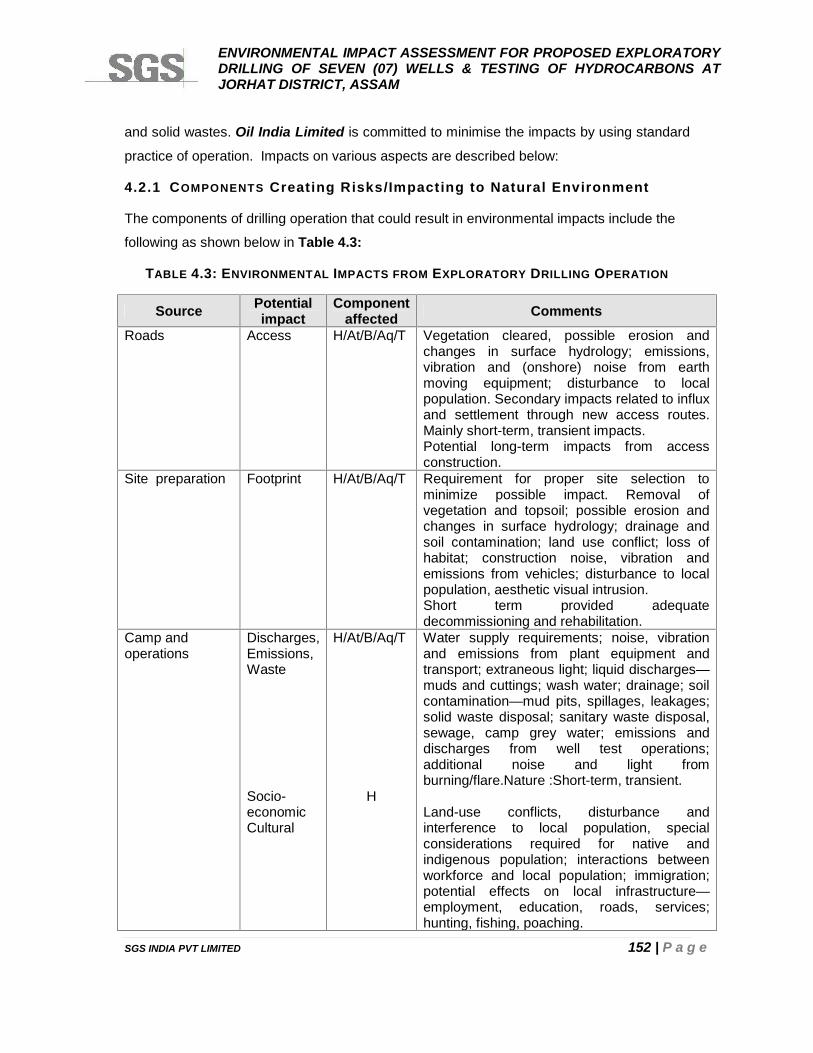
ENVIRONMENTAL IMPACT ASSESSMENT FOR PROPOSED EXPLORATORYDRILLING OF SEVEN (07) WELLS & TESTING OF HYDROCARBONS ATJORHAT DISTRICT, ASSAM
SGS INDIA PVT LIMITED 152 | P a g e
and solid wastes. Oil India Limited is committed to minimise the impacts by using standard
practice of operation. Impacts on various aspects are described below:
4.2.1 COMPONENTS Creating Risks/Impacting to Natural Environment
The components of drilling operation that could result in environmental impacts include the
following as shown below in Table 4.3:
TABLE 4.3: ENVIRONMENTAL IMPACTS FROM EXPLORATORY DRILLING OPERATION
Source Potentialimpact
Componentaffected Comments
Roads Access H/At/B/Aq/T Vegetation cleared, possible erosion andchanges in surface hydrology; emissions,vibration and (onshore) noise from earthmoving equipment; disturbance to localpopulation. Secondary impacts related to influxand settlement through new access routes.Mainly short-term, transient impacts.Potential long-term impacts from accessconstruction.
Site preparation Footprint H/At/B/Aq/T Requirement for proper site selection tominimize possible impact. Removal ofvegetation and topsoil; possible erosion andchanges in surface hydrology; drainage andsoil contamination; land use conflict; loss ofhabitat; construction noise, vibration andemissions from vehicles; disturbance to localpopulation, aesthetic visual intrusion.Short term provided adequatedecommissioning and rehabilitation.
Camp andoperations
Discharges,Emissions,Waste
Socio-economicCultural
H/At/B/Aq/T
H
Water supply requirements; noise, vibrationand emissions from plant equipment andtransport; extraneous light; liquid discharges—muds and cuttings; wash water; drainage; soilcontamination—mud pits, spillages, leakages;solid waste disposal; sanitary waste disposal,sewage, camp grey water; emissions anddischarges from well test operations;additional noise and light fromburning/flare.Nature :Short-term, transient.
Land-use conflicts, disturbance andinterference to local population, specialconsiderations required for native andindigenous population; interactions betweenworkforce and local population; immigration;potential effects on local infrastructure—employment, education, roads, services;hunting, fishing, poaching.
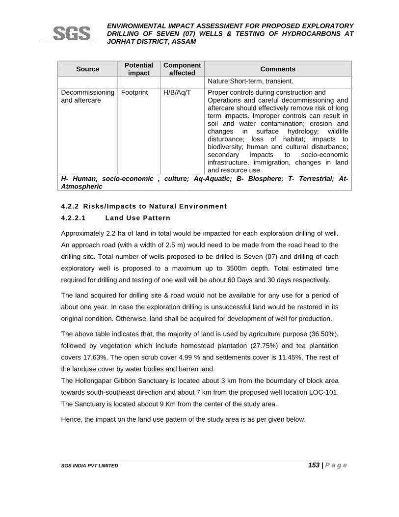
ENVIRONMENTAL IMPACT ASSESSMENT FOR PROPOSED EXPLORATORYDRILLING OF SEVEN (07) WELLS & TESTING OF HYDROCARBONS ATJORHAT DISTRICT, ASSAM
SGS INDIA PVT LIMITED 153 | P a g e
Source Potentialimpact
Componentaffected Comments
Nature:Short-term, transient.
Decommissioningand aftercare
Footprint H/B/Aq/T Proper controls during construction andOperations and careful decommissioning andaftercare should effectively remove risk of longterm impacts. Improper controls can result insoil and water contamination; erosion andchanges in surface hydrology; wildlifedisturbance; loss of habitat; impacts tobiodiversity; human and cultural disturbance;secondary impacts to socio-economicinfrastructure, immigration, changes in landand resource use.
H- Human, socio-economic , culture; Aq-Aquatic; B- Biosphere; T- Terrestrial; At-Atmospheric
4.2.2 Risks/Impacts to Natural Environment4.2.2.1 Land Use Pattern
Approximately 2.2 ha of land in total would be impacted for each exploration drilling of well.
An approach road (with a width of 2.5 m) would need to be made from the road head to the
drilling site. Total number of wells proposed to be drilled is Seven (07) and drilling of each
exploratory well is proposed to a maximum up to 3500m depth. Total estimated time
required for drilling and testing of one well will be about 60 Days and 30 days respectively.
The land acquired for drilling site & road would not be available for any use for a period of
about one year. In case the exploration drilling is unsuccessful land would be restored in its
original condition. Otherwise, land shall be acquired for development of well for production.
The above table indicates that, the majority of land is used by agriculture purpose (36.50%),
followed by vegetation which include homestead plantation (27.75%) and tea plantation
covers 17.63%. The open scrub cover 4.99 % and settlements cover is 11.45%. The rest of
the landuse cover by water bodies and barren land.
The Hollongapar Gibbon Sanctuary is located about 3 km from the bourndary of block area
towards south-southeast direction and about 7 km from the proposed well location LOC-101.
The Sanctuary is located aboout 9 Km from the center of the study area.
Hence, the impact on the land use pattern of the study area is as per given below.
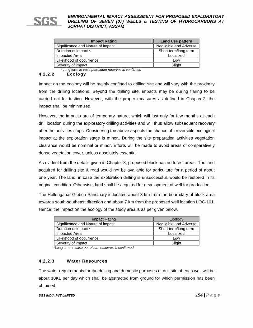
ENVIRONMENTAL IMPACT ASSESSMENT FOR PROPOSED EXPLORATORYDRILLING OF SEVEN (07) WELLS & TESTING OF HYDROCARBONS ATJORHAT DISTRICT, ASSAM
SGS INDIA PVT LIMITED 154 | P a g e
Impact Rating Land Use patternSignificance and Nature of impact Negligible and AdverseDuration of impact * Short term/long termImpacted Area LocalizedLikelihood of occurrence LowSeverity of impact Slight
*Long term in case petroleum reserves is confirmed4.2.2.2 Ecology
Impact on the ecology will be mainly confined to drilling site and will vary with the proximity
from the drilling locations. Beyond the drilling site, impacts may be during flaring to be
carried out for testing. However, with the proper measures as defined in Chapter-2, the
impact shall be mininmized.
However, the impacts are of temporary nature, which will last only for few months at each
drill location during the exploratory drilling activities and will thus allow subsequent recovery
after the activities stops. Considering the above aspects the chance of irreversible ecological
impact at the exploration stage is minor.. During the site preparation activities vegetation
clearance would be nominal or minor. Efforts will be made to avoid areas of comparatively
dense vegetation cover, unless absolutely essential.
As evident from the details given in Chapter 3, proposed block has no forest areas. The land
acquired for drilling site & road would not be available for agriculture for a period of about
one year. The land, in case the exploration drilling is unsuccessful, would be restored in its
original condition. Otherwise, land shall be acquired for development of well for production.
The Hollongapar Gibbon Sanctuary is located about 3 km from the bourndary of block area
towards south-southeast direction and about 7 km from the proposed well location LOC-101.
Hence, the impact on the ecology of the study area is as per given below.
Impact Rating EcologySignificance and Nature of impact Negligible and AdverseDuration of impact * Short term/long termImpacted Area LocalizedLikelihood of occurrence LowSeverity of impact Slight
*Long term in case petroleum reserves is confirmed.
4.2.2.3 Water Resources
The water requirements for the drilling and domestic purposes at drill site of each well will be
about 10KL per day which shall be abstracted from ground for which permission has been
obtained,
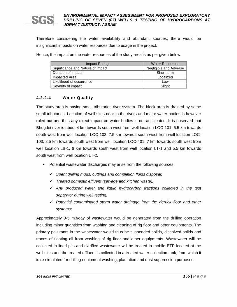
ENVIRONMENTAL IMPACT ASSESSMENT FOR PROPOSED EXPLORATORYDRILLING OF SEVEN (07) WELLS & TESTING OF HYDROCARBONS ATJORHAT DISTRICT, ASSAM
SGS INDIA PVT LIMITED 155 | P a g e
Therefore considering the water availability and abundant sources, there would be
insignificant impacts on water resources due to usage in the project.
Hence, the impact on the water resources of the study area is as per given below.
Impact Rating Water ResourcesSignificance and Nature of impact Negligible and AdverseDuration of impact Short termImpacted Area LocalizedLikelihood of occurrence LowSeverity of impact Slight
4.2.2.4 Water Quality
The study area is having small tributaries river system. The block area is drained by some
small tributaries. Location of well sites near to the rivers and major water bodies is however
ruled out and thus any direct impact on water bodies is not anticipated. It is observed that
Bhogdoi river is about 4 km towards south west from well location LOC-101, 5.5 km towards
south west from well location LOC-102, 7.5 km towards south west from well location LOC-
103, 8.5 km towards south west from well location LOC-401, 7 km towards south west from
well location LB-1, 6 km towards south west from well location LT-1 and 5.5 km towards
south west from well location LT-2.
Potential wastewater discharges may arise from the following sources:
Spent drilling muds, cuttings and completion fluids disposal;
Treated domestic effluent (sewage and kitchen waste);
Any produced water and liquid hydrocarbon fractions collected in the test
separator during well testing.
Potential contaminated storm water drainage from the derrick floor and other
systems;
Approximately 3-5 m3/day of wastewater would be generated from the drilling operation
including minor quantities from washing and cleaning of rig floor and other equipments. The
primary pollutants in the wastewater would thus be suspended solids, dissolved solids and
traces of floating oil from washing of rig floor and other equipments. Wastewater will be
collected in lined pits and clarified wastewater will be treated in mobile ETP located at the
well sites and the treated effluent is collected in a treated water collection tank, from which it
is re-circulated for drilling equipment washing, plantation and dust suppression purposes.
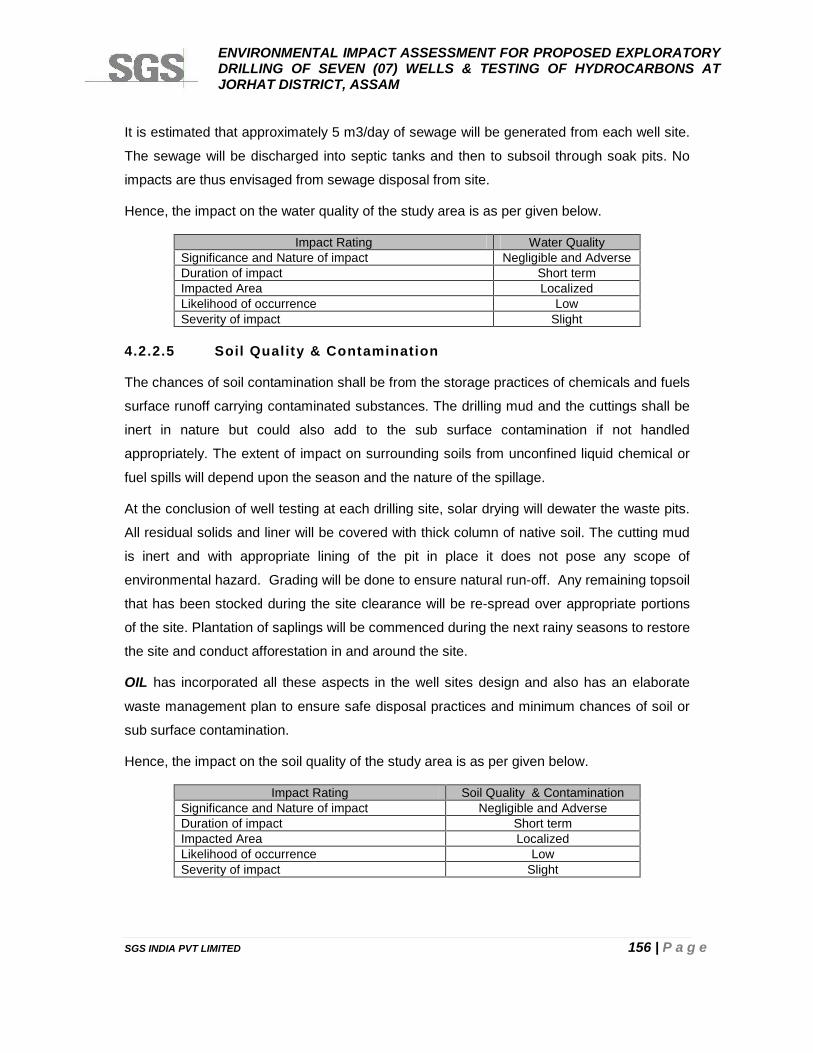
ENVIRONMENTAL IMPACT ASSESSMENT FOR PROPOSED EXPLORATORYDRILLING OF SEVEN (07) WELLS & TESTING OF HYDROCARBONS ATJORHAT DISTRICT, ASSAM
SGS INDIA PVT LIMITED 156 | P a g e
It is estimated that approximately 5 m3/day of sewage will be generated from each well site.
The sewage will be discharged into septic tanks and then to subsoil through soak pits. No
impacts are thus envisaged from sewage disposal from site.
Hence, the impact on the water quality of the study area is as per given below.
Impact Rating Water QualitySignificance and Nature of impact Negligible and AdverseDuration of impact Short termImpacted Area LocalizedLikelihood of occurrence LowSeverity of impact Slight
4.2.2.5 Soil Quality & Contamination
The chances of soil contamination shall be from the storage practices of chemicals and fuels
surface runoff carrying contaminated substances. The drilling mud and the cuttings shall be
inert in nature but could also add to the sub surface contamination if not handled
appropriately. The extent of impact on surrounding soils from unconfined liquid chemical or
fuel spills will depend upon the season and the nature of the spillage.
At the conclusion of well testing at each drilling site, solar drying will dewater the waste pits.
All residual solids and liner will be covered with thick column of native soil. The cutting mud
is inert and with appropriate lining of the pit in place it does not pose any scope of
environmental hazard. Grading will be done to ensure natural run-off. Any remaining topsoil
that has been stocked during the site clearance will be re-spread over appropriate portions
of the site. Plantation of saplings will be commenced during the next rainy seasons to restore
the site and conduct afforestation in and around the site.
OIL has incorporated all these aspects in the well sites design and also has an elaborate
waste management plan to ensure safe disposal practices and minimum chances of soil or
sub surface contamination.
Hence, the impact on the soil quality of the study area is as per given below.
Impact Rating Soil Quality & ContaminationSignificance and Nature of impact Negligible and AdverseDuration of impact Short termImpacted Area LocalizedLikelihood of occurrence LowSeverity of impact Slight
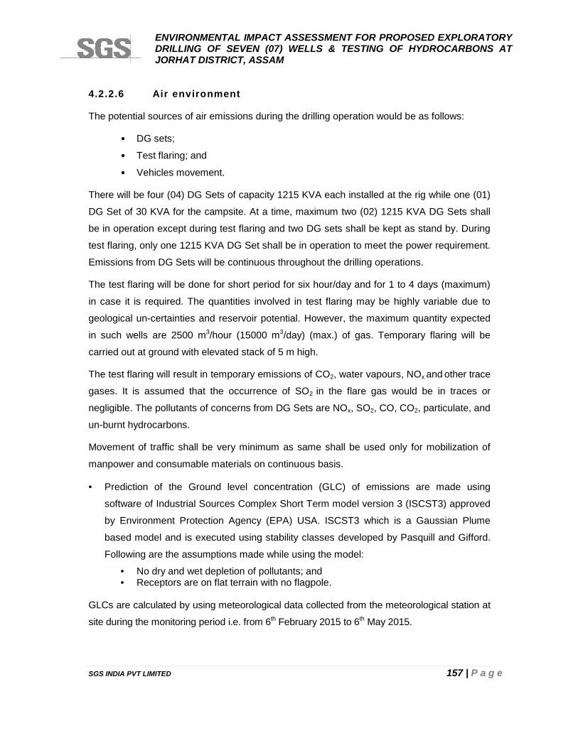
ENVIRONMENTAL IMPACT ASSESSMENT FOR PROPOSED EXPLORATORYDRILLING OF SEVEN (07) WELLS & TESTING OF HYDROCARBONS ATJORHAT DISTRICT, ASSAM
SGS INDIA PVT LIMITED 157 | P a g e
4.2.2.6 Air environment
The potential sources of air emissions during the drilling operation would be as follows:
• DG sets;
• Test flaring; and
• Vehicles movement.
There will be four (04) DG Sets of capacity 1215 KVA each installed at the rig while one (01)
DG Set of 30 KVA for the campsite. At a time, maximum two (02) 1215 KVA DG Sets shall
be in operation except during test flaring and two DG sets shall be kept as stand by. During
test flaring, only one 1215 KVA DG Set shall be in operation to meet the power requirement.
Emissions from DG Sets will be continuous throughout the drilling operations.
The test flaring will be done for short period for six hour/day and for 1 to 4 days (maximum)
in case it is required. The quantities involved in test flaring may be highly variable due to
geological un-certainties and reservoir potential. However, the maximum quantity expected
in such wells are 2500 m3/hour (15000 m3/day) (max.) of gas. Temporary flaring will be
carried out at ground with elevated stack of 5 m high.
The test flaring will result in temporary emissions of CO2, water vapours, NOx and other trace
gases. It is assumed that the occurrence of SO2 in the flare gas would be in traces or
negligible. The pollutants of concerns from DG Sets are NOx, SO2, CO, CO2, particulate, and
un-burnt hydrocarbons.
Movement of traffic shall be very minimum as same shall be used only for mobilization of
manpower and consumable materials on continuous basis.
Prediction of the Ground level concentration (GLC) of emissions are made using
software of Industrial Sources Complex Short Term model version 3 (ISCST3) approved
by Environment Protection Agency (EPA) USA. ISCST3 which is a Gaussian Plume
based model and is executed using stability classes developed by Pasquill and Gifford.
Following are the assumptions made while using the model:
• No dry and wet depletion of pollutants; and• Receptors are on flat terrain with no flagpole.
GLCs are calculated by using meteorological data collected from the meteorological station at
site during the monitoring period i.e. from 6th February 2015 to 6th May 2015.
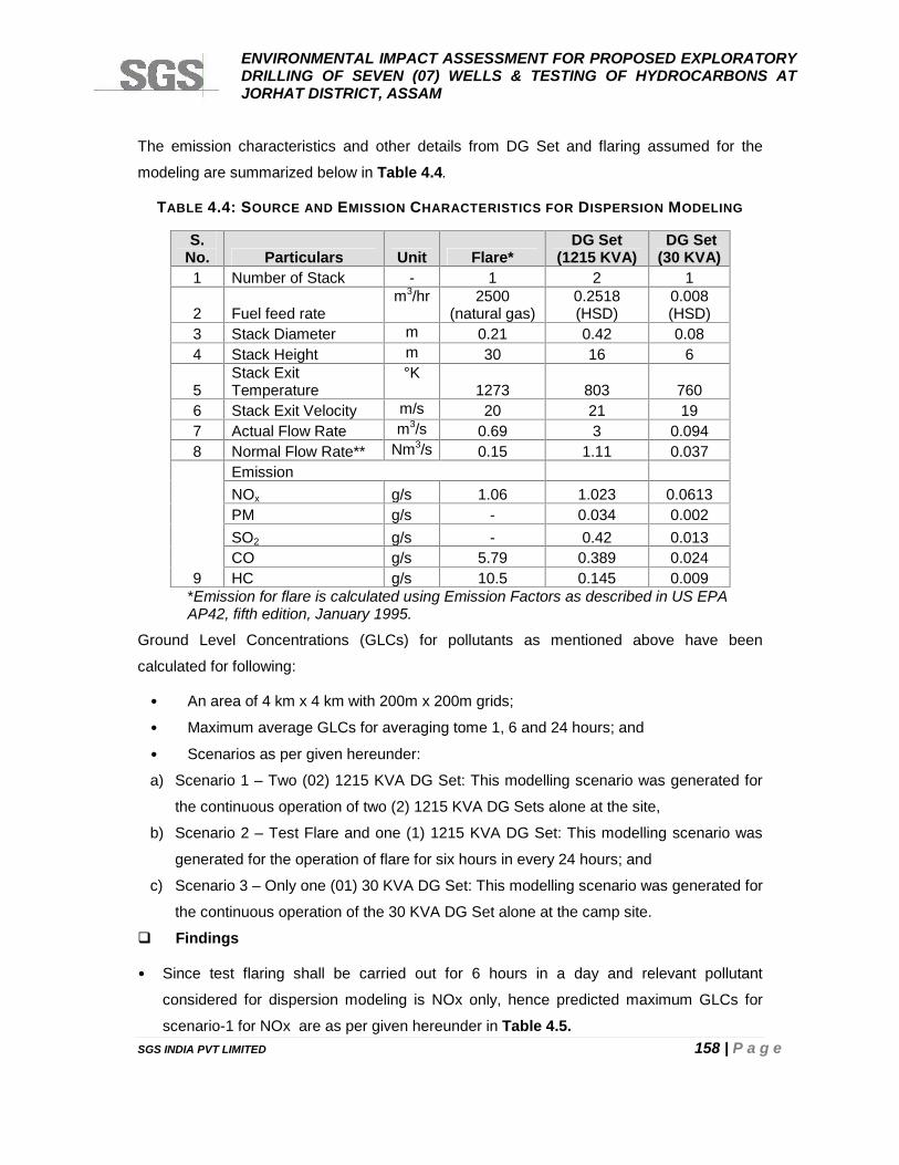
ENVIRONMENTAL IMPACT ASSESSMENT FOR PROPOSED EXPLORATORYDRILLING OF SEVEN (07) WELLS & TESTING OF HYDROCARBONS ATJORHAT DISTRICT, ASSAM
SGS INDIA PVT LIMITED 158 | P a g e
The emission characteristics and other details from DG Set and flaring assumed for the
modeling are summarized below in Table 4.4.
TABLE 4.4: SOURCE AND EMISSION CHARACTERISTICS FOR DISPERSION MODELING
S.No. Particulars Unit Flare*
DG Set(1215 KVA)
DG Set(30 KVA)
1 Number of Stack - 1 2 1
2 Fuel feed ratem3/hr 2500
(natural gas)0.2518(HSD)
0.008(HSD)
3 Stack Diameter m 0.21 0.42 0.084 Stack Height m 30 16 6
5Stack ExitTemperature
°K1273 803 760
6 Stack Exit Velocity m/s 20 21 197 Actual Flow Rate m3/s 0.69 3 0.0948 Normal Flow Rate** Nm3/s 0.15 1.11 0.037
9
EmissionNOx g/s 1.06 1.023 0.0613PM g/s - 0.034 0.002SO2 g/s - 0.42 0.013CO g/s 5.79 0.389 0.024HC g/s 10.5 0.145 0.009
*Emission for flare is calculated using Emission Factors as described in US EPAAP42, fifth edition, January 1995.
Ground Level Concentrations (GLCs) for pollutants as mentioned above have been
calculated for following:
• An area of 4 km x 4 km with 200m x 200m grids;
• Maximum average GLCs for averaging tome 1, 6 and 24 hours; and
• Scenarios as per given hereunder:
a) Scenario 1 – Two (02) 1215 KVA DG Set: This modelling scenario was generated for
the continuous operation of two (2) 1215 KVA DG Sets alone at the site,
b) Scenario 2 – Test Flare and one (1) 1215 KVA DG Set: This modelling scenario was
generated for the operation of flare for six hours in every 24 hours; and
c) Scenario 3 – Only one (01) 30 KVA DG Set: This modelling scenario was generated for
the continuous operation of the 30 KVA DG Set alone at the camp site.
Findings
• Since test flaring shall be carried out for 6 hours in a day and relevant pollutant
considered for dispersion modeling is NOx only, hence predicted maximum GLCs for
scenario-1 for NOx are as per given hereunder in Table 4.5.
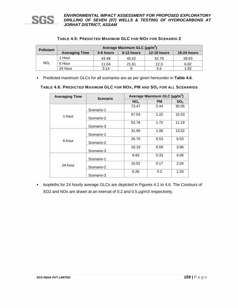
ENVIRONMENTAL IMPACT ASSESSMENT FOR PROPOSED EXPLORATORYDRILLING OF SEVEN (07) WELLS & TESTING OF HYDROCARBONS ATJORHAT DISTRICT, ASSAM
SGS INDIA PVT LIMITED 159 | P a g e
TABLE 4.5: PREDICTED MAXIMUM GLC FOR NOX FOR SCENARIO 2
Pollutant Average Maximum GLC (µg/m3)Averaging Time 0-6 hours 6-12 hours 12-18 hours 18-24 hours
NOx
1 Hour 43.48 45.62 42.79 28.636 Hour 11.04 21.61 12.3 6.8224 Hour 3.14 6 5.5 1.82
• Predicted maximum GLCs for all scenarios are as per given hereunder in Table 4.6.
TABLE 4.6: PREDICTED MAXIMUM GLC FOR NOX, PM AND SO2 FOR ALL SCENARIOS
Averaging Time Scenario Average Maximum GLC (µg/m3)NOx PM SO2
1-hour
Scenario-173.47 2.44 30.05
Scenario-267.03 1.22 15.03
Scenario-352.78 1.72 11.19
6-hour
Scenario-131.99 1.06 13.02
Scenario-226.75 0.53 6.53
Scenario-318.19 0.59 3.86
24-hour
Scenario-19.93 0.33 4.06
Scenario-210.52 0.17 2.04
Scenario-36.26 0.2 1.33
• Isopleths for 24 hourly average GLCs are depicted in Figures 4.1 to 4.6. The Contours of
SO2 and NOx are drawn at an interval of 0.2 and 0.5 μg/m3 respectively.
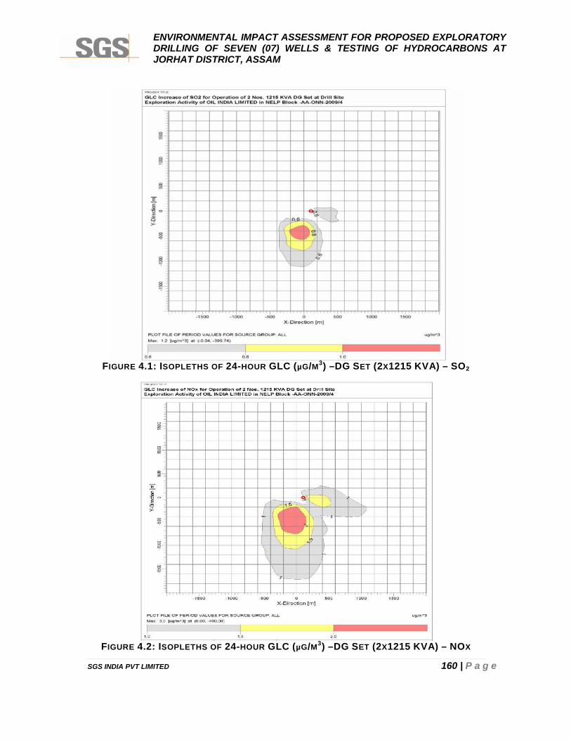
ENVIRONMENTAL IMPACT ASSESSMENT FOR PROPOSED EXPLORATORYDRILLING OF SEVEN (07) WELLS & TESTING OF HYDROCARBONS ATJORHAT DISTRICT, ASSAM
SGS INDIA PVT LIMITED 160 | P a g e
FIGURE 4.1: ISOPLETHS OF 24-HOUR GLC (µG/M3) –DG SET (2X1215 KVA) – SO2
FIGURE 4.2: ISOPLETHS OF 24-HOUR GLC (µG/M3) –DG SET (2X1215 KVA) – NOX
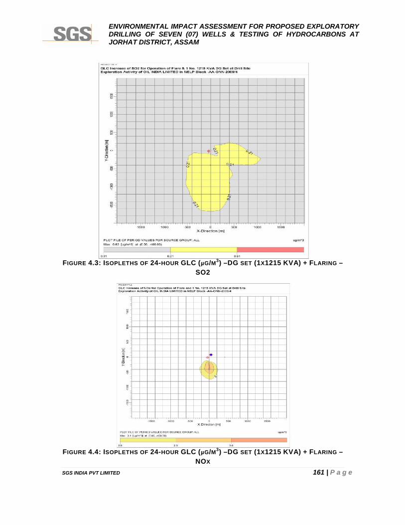
ENVIRONMENTAL IMPACT ASSESSMENT FOR PROPOSED EXPLORATORYDRILLING OF SEVEN (07) WELLS & TESTING OF HYDROCARBONS ATJORHAT DISTRICT, ASSAM
SGS INDIA PVT LIMITED 161 | P a g e
FIGURE 4.3: ISOPLETHS OF 24-HOUR GLC (µG/M3) –DG SET (1X1215 KVA) + FLARING –SO2
FIGURE 4.4: ISOPLETHS OF 24-HOUR GLC (µG/M3) –DG SET (1X1215 KVA) + FLARING –NOX
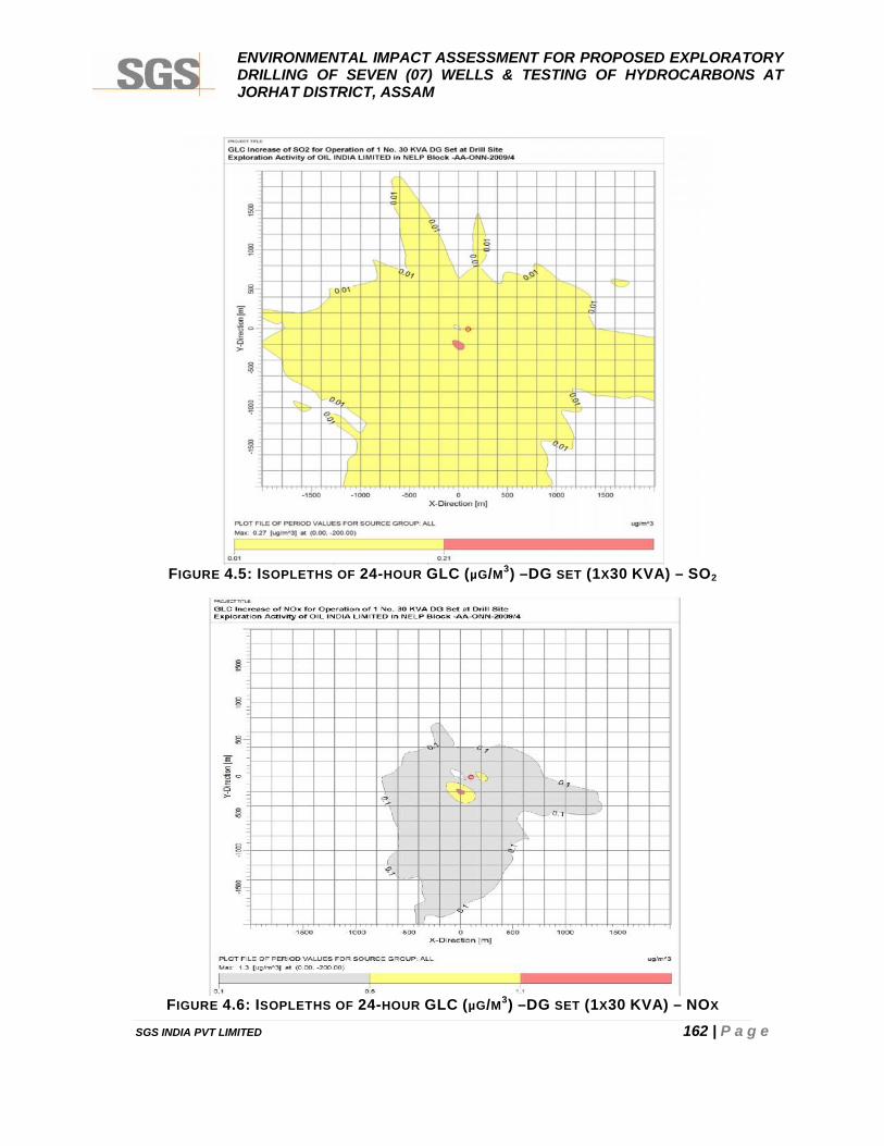
ENVIRONMENTAL IMPACT ASSESSMENT FOR PROPOSED EXPLORATORYDRILLING OF SEVEN (07) WELLS & TESTING OF HYDROCARBONS ATJORHAT DISTRICT, ASSAM
SGS INDIA PVT LIMITED 162 | P a g e
FIGURE 4.5: ISOPLETHS OF 24-HOUR GLC (µG/M3) –DG SET (1X30 KVA) – SO2
FIGURE 4.6: ISOPLETHS OF 24-HOUR GLC (µG/M3) –DG SET (1X30 KVA) – NOX
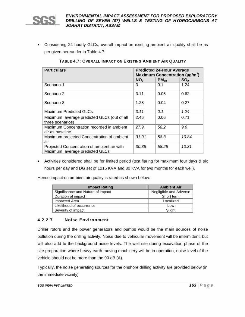
ENVIRONMENTAL IMPACT ASSESSMENT FOR PROPOSED EXPLORATORYDRILLING OF SEVEN (07) WELLS & TESTING OF HYDROCARBONS ATJORHAT DISTRICT, ASSAM
SGS INDIA PVT LIMITED 163 | P a g e
• Considering 24 hourly GLCs, overall impact on existing ambient air quality shall be as
per given hereunder in Table 4.7:
TABLE 4.7: OVERALL IMPACT ON EXISTING AMBIENT AIR QUALITY
Particulars Predicted 24-Hour AverageMaximum Concentration (µg/m3)NOx PM10 SO2
Scenario-1 3 0.1 1.24
Scenario-2 3.11 0.05 0.62
Scenario-3 1.28 0.04 0.27
Maximum Predicted GLCs 3.11 0.1 1.24Maximum average predicted GLCs (out of allthree scenarios)
2.46 0.06 0.71
Maximum Concentration recorded in ambientair as baseline
27.9 58.2 9.6
Maximum projected Concentration of ambientair
31.01 58.3 10.84
Projected Concentration of ambient air withMaximum average predicted GLCs
30.36 58.26 10.31
• Activities considered shall be for limited period (test flaring for maximum four days & six
hours per day and DG set of 1215 KVA and 30 KVA for two months for each well).
Hence impact on ambient air quality is rated as shown below:
Impact Rating Ambient AirSignificance and Nature of impact Negligible and AdverseDuration of impact Short termImpacted Area LocalizedLikelihood of occurrence LowSeverity of impact Slight
4.2.2.7 Noise Environment
Driller rotors and the power generators and pumps would be the main sources of noise
pollution during the drilling activity. Noise due to vehicular movement will be intermittent, but
will also add to the background noise levels. The well site during excavation phase of the
site preparation where heavy earth moving machinery will be in operation, noise level of the
vehicle should not be more than the 90 dB (A).
Typically, the noise generating sources for the onshore drilling activity are provided below (in
the immediate vicinity)
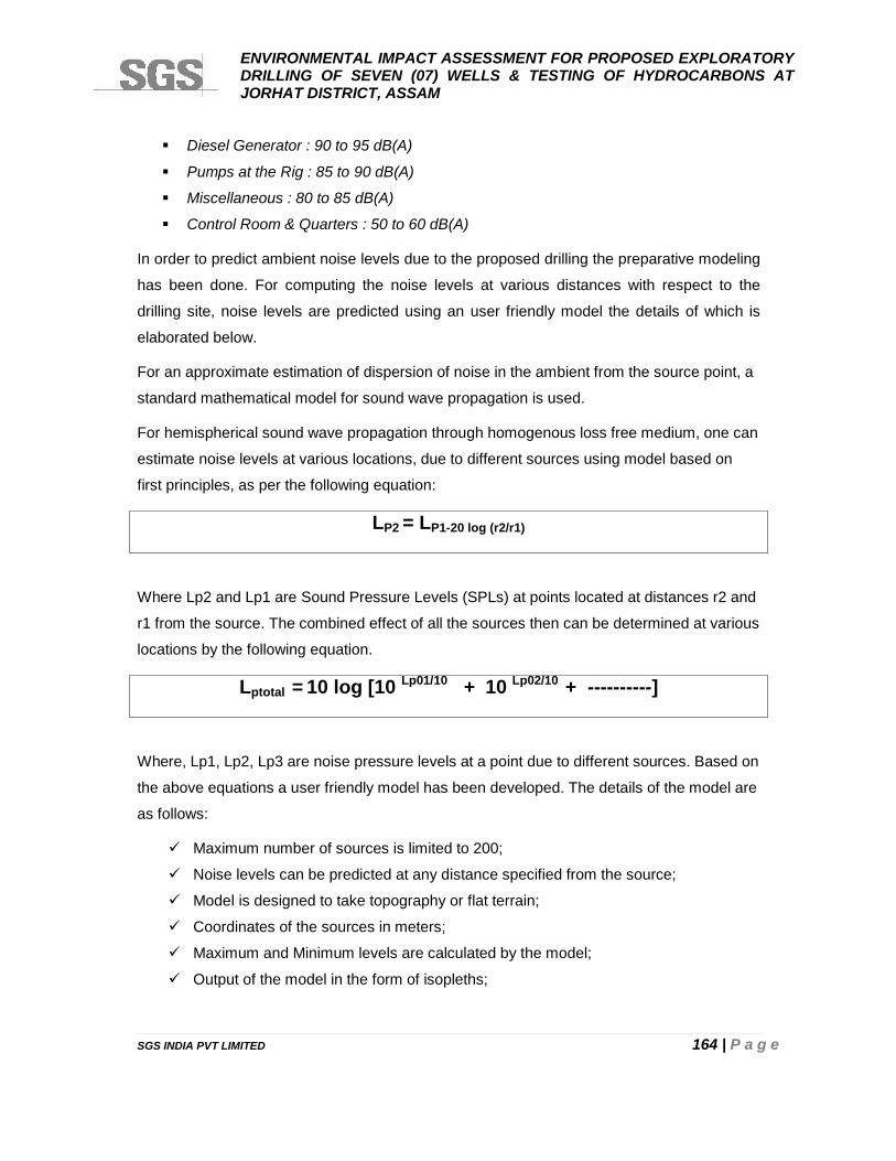
ENVIRONMENTAL IMPACT ASSESSMENT FOR PROPOSED EXPLORATORYDRILLING OF SEVEN (07) WELLS & TESTING OF HYDROCARBONS ATJORHAT DISTRICT, ASSAM
SGS INDIA PVT LIMITED 164 | P a g e
Diesel Generator : 90 to 95 dB(A)
Pumps at the Rig : 85 to 90 dB(A)
Miscellaneous : 80 to 85 dB(A)
Control Room & Quarters : 50 to 60 dB(A)
In order to predict ambient noise levels due to the proposed drilling the preparative modeling
has been done. For computing the noise levels at various distances with respect to the
drilling site, noise levels are predicted using an user friendly model the details of which is
elaborated below.
For an approximate estimation of dispersion of noise in the ambient from the source point, a
standard mathematical model for sound wave propagation is used.
For hemispherical sound wave propagation through homogenous loss free medium, one can
estimate noise levels at various locations, due to different sources using model based on
first principles, as per the following equation:
LP2 = LP1-20 log (r2/r1)
Where Lp2 and Lp1 are Sound Pressure Levels (SPLs) at points located at distances r2 and
r1 from the source. The combined effect of all the sources then can be determined at various
locations by the following equation.
Lptotal = 10 log [10 Lp01/10 + 10 Lp02/10 + ----------]
Where, Lp1, Lp2, Lp3 are noise pressure levels at a point due to different sources. Based on
the above equations a user friendly model has been developed. The details of the model are
as follows:
Maximum number of sources is limited to 200;
Noise levels can be predicted at any distance specified from the source;
Model is designed to take topography or flat terrain;
Coordinates of the sources in meters;
Maximum and Minimum levels are calculated by the model;
Output of the model in the form of isopleths;
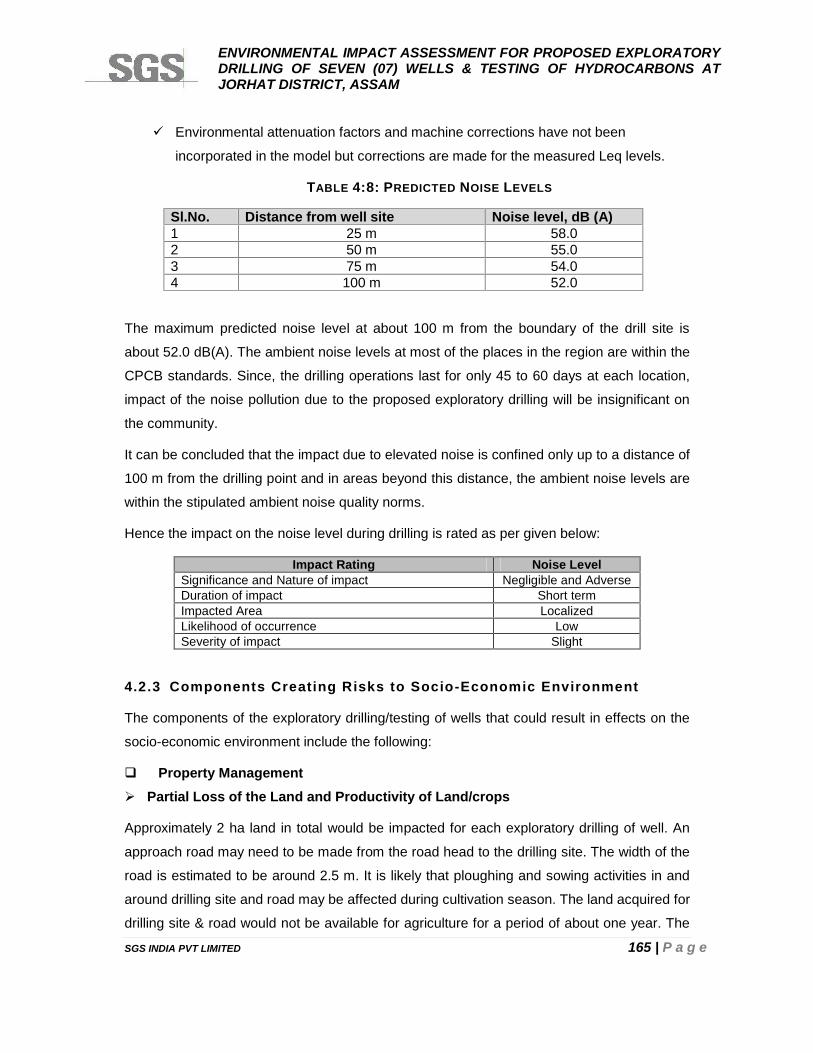
ENVIRONMENTAL IMPACT ASSESSMENT FOR PROPOSED EXPLORATORYDRILLING OF SEVEN (07) WELLS & TESTING OF HYDROCARBONS ATJORHAT DISTRICT, ASSAM
SGS INDIA PVT LIMITED 165 | P a g e
Environmental attenuation factors and machine corrections have not been
incorporated in the model but corrections are made for the measured Leq levels.
TABLE 4:8: PREDICTED NOISE LEVELS
Sl.No. Distance from well site Noise level, dB (A)1 25 m 58.02 50 m 55.03 75 m 54.04 100 m 52.0
The maximum predicted noise level at about 100 m from the boundary of the drill site is
about 52.0 dB(A). The ambient noise levels at most of the places in the region are within the
CPCB standards. Since, the drilling operations last for only 45 to 60 days at each location,
impact of the noise pollution due to the proposed exploratory drilling will be insignificant on
the community.
It can be concluded that the impact due to elevated noise is confined only up to a distance of
100 m from the drilling point and in areas beyond this distance, the ambient noise levels are
within the stipulated ambient noise quality norms.
Hence the impact on the noise level during drilling is rated as per given below:
Impact Rating Noise LevelSignificance and Nature of impact Negligible and AdverseDuration of impact Short termImpacted Area LocalizedLikelihood of occurrence LowSeverity of impact Slight
4.2.3 Components Creating Risks to Socio-Economic Environment
The components of the exploratory drilling/testing of wells that could result in effects on the
socio-economic environment include the following:
Property Management Partial Loss of the Land and Productivity of Land/crops
Approximately 2 ha land in total would be impacted for each exploratory drilling of well. An
approach road may need to be made from the road head to the drilling site. The width of the
road is estimated to be around 2.5 m. It is likely that ploughing and sowing activities in and
around drilling site and road may be affected during cultivation season. The land acquired for
drilling site & road would not be available for agriculture for a period of about one year. The
ENVIRONMENTAL IMPACT ASSESSMENT FOR PROPOSED EXPLORATORYDRILLING OF SEVEN (07) WELLS & TESTING OF HYDROCARBONS ATJORHAT DISTRICT, ASSAM
SGS INDIA PVT LIMITED 166 | P a g e
land, in case the exploration drilling is unsuccessful, would be restored in its original
condition.
The landowners would be adequately compensated for loss of standing crop as well as for
inability to cultivate the land for that particular period. In case the crop has already been
sown, the landowners would be compensated for loss of income from that crop. The loss of
crop production for that particular cropping season as well as partial loss of productivity of
the soil in affected areas will be adequately compensated.
During the test flaring loss of any standing crops in the vicinity will be adequately
compensated based on the loss of income from the crop.
In case, extraction of petroleum products shall be economic viable then land as mentioned
above shall be acquired and compensation shall be paid as per the existing regulations.
Loss of Physical Assets/ Common Property Rights
In the event that some dug wells, tube wells, private trees, cattle sheds and tool sheds etc
are to be removed for the exploration drilling, OIL will either shift these assets or
compensate for the losses at the prevailing market price.
Hence, the impact on the property management is as per given below.
Impact Rating Noise & VibrationSignificance and Nature of impact Negligible and BeneficialDuration of impact Short termImpacted Area LocalizedLikelihood of occurrence LowSeverity of impact Slight
Employment
The labour strength engaged during exploratory drilling will depend upon activities, since
many activities are labour intensive. Most of the unskilled labour will be by and large
available from the nearby villages and towns. Thus, impact on the physical and aesthetic
resources will be minimal.
In addition to direct employment, several opportunities for locals will be available in terms of
supply of construction materials & machinery, vehicles and other essential commodities.
Hence, overall impact is rated as shown below:
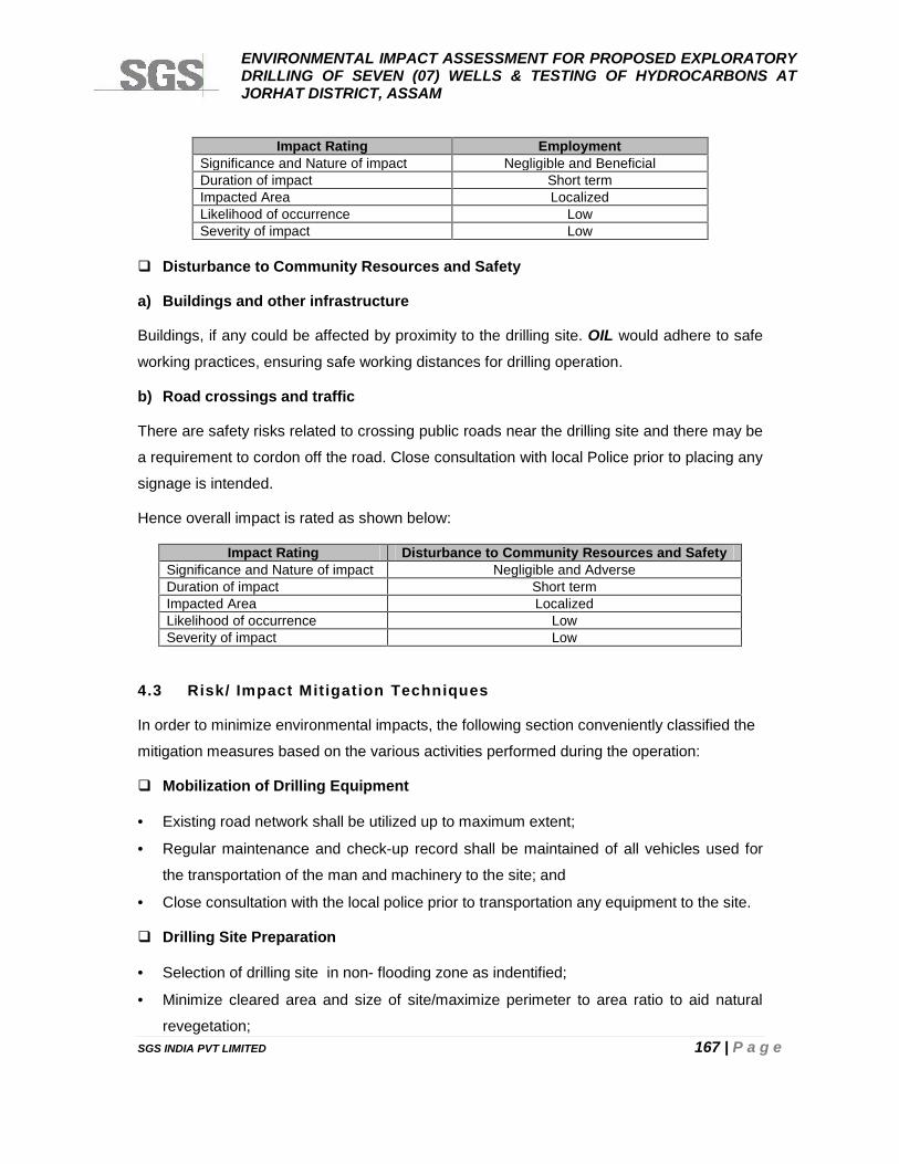
ENVIRONMENTAL IMPACT ASSESSMENT FOR PROPOSED EXPLORATORYDRILLING OF SEVEN (07) WELLS & TESTING OF HYDROCARBONS ATJORHAT DISTRICT, ASSAM
SGS INDIA PVT LIMITED 167 | P a g e
Impact Rating EmploymentSignificance and Nature of impact Negligible and BeneficialDuration of impact Short termImpacted Area LocalizedLikelihood of occurrence LowSeverity of impact Low
Disturbance to Community Resources and Safety
a) Buildings and other infrastructure
Buildings, if any could be affected by proximity to the drilling site. OIL would adhere to safe
working practices, ensuring safe working distances for drilling operation.
b) Road crossings and traffic
There are safety risks related to crossing public roads near the drilling site and there may be
a requirement to cordon off the road. Close consultation with local Police prior to placing any
signage is intended.
Hence overall impact is rated as shown below:
Impact Rating Disturbance to Community Resources and SafetySignificance and Nature of impact Negligible and AdverseDuration of impact Short termImpacted Area LocalizedLikelihood of occurrence LowSeverity of impact Low
4.3 Risk/ Impact Mitigation Techniques
In order to minimize environmental impacts, the following section conveniently classified the
mitigation measures based on the various activities performed during the operation:
Mobilization of Drilling Equipment
Existing road network shall be utilized up to maximum extent;
Regular maintenance and check-up record shall be maintained of all vehicles used for
the transportation of the man and machinery to the site; and
Close consultation with the local police prior to transportation any equipment to the site.
Drilling Site Preparation
Selection of drilling site in non- flooding zone as indentified;
Minimize cleared area and size of site/maximize perimeter to area ratio to aid natural
revegetation;

ENVIRONMENTAL IMPACT ASSESSMENT FOR PROPOSED EXPLORATORYDRILLING OF SEVEN (07) WELLS & TESTING OF HYDROCARBONS ATJORHAT DISTRICT, ASSAM
SGS INDIA PVT LIMITED 168 | P a g e
Use hand cutting to clear vegetation initially—where necessary be selective in using
machinery;
Not removing top humus soil stripping to a depth of 0.35 m.
Conserve root stock and topsoil, store for later rehabilitation;
Limit levelling activity;
Do not burn brush and uprooted materials;
Natural drainage patterns of the area should be considered in the location of equipment,
pads, and pits so that storm water runoff does not create an environmental hazard by
erosion of base material, which could lead to equipment instability, or by flooding of pits,
which could cause a discharge of oil or other fluids into the local surface waters;
Construction designs should include installation of erosion and sedimentation control
systems;
Each site (except for the locations of the waste containment area and freshwater storage
facility) will be covered with up to 100 mm (4 inches) of suitable base. This would help to
provide sufficient load-bearing capacity to enable all construction and drilling operations
to be executed safely and with minimum impact on the environment;
Incorporate drainage and minimize disturbance to natural drainage patterns. Engineer
slopes and drainage to minimize erosion. Design for storm conditions/ensure offsite
natural runoff does not wash over site/use perimeter drainage ditches;
Seal bund and ensure proper drainage of machinery areas, fuel and chemical storage,
and mud mixing areas;
Provide base material compatible with local ground conditions. Hard core should be laid
on geotextile membrane. Avoid concreting sites;
Protect water courses from contamination and siltation;
Protect groundwater from drill stem penetration and shallow aquifers from possible site
contamination;
Where water courses and aquifers are deemed sensitive, consider a fully sealed site,
avoid use of mud pits, preferentially use steel tanks, but if used must be lined. Pits if
used must be lined;
Mud and burn pits, if used, must have adequate contingency capacity especially in areas
of high rainfall, and must be fully lined and bunded.
To prevent erosion of the soil on slopes, check banks and spur drains would be
constructed;
ENVIRONMENTAL IMPACT ASSESSMENT FOR PROPOSED EXPLORATORYDRILLING OF SEVEN (07) WELLS & TESTING OF HYDROCARBONS ATJORHAT DISTRICT, ASSAM
SGS INDIA PVT LIMITED 169 | P a g e
Earth moving equipment, typically a bulldozer with a grader blade and ripper type and a
bucket type bulldozer for excavation work, will be used;
As the site is graded and levelled, site berms, culverts, drains and drainage treatment
facilities will be provided to control run-off and enable the site to be operational
throughout the dry season; and
Following types of erosion control should be provided: (whichever is feasible)
Rip Raps
Stone walls
Rock berms
Gabions
Drilling Operation
The approximate area of one well site would be about 2 hectares. As per the standard
practice of operation, in practice, waste minimization will be achieved through a number of
measures:
Employing industry standard technologies;
Extremities of flare lines will be located at least 90 m from roads, public works,
processing units or tanks. They will be at least 50 m from a well, gas/oil separator, site
drainage or other possible source of ignitable vapours. The flaring would be elevated
type with a height of 5m;
Loading & unloading of fuel and various materials should be properly handled and
controlled;
Maintain good housekeeping to avoid any accidental spill;
Bulk storage of lubricants and fuels will be permitted only within the designated places
and fuel tanks must be properly marked by content and chemicals;
Drip trays will be required to contain any leaks under stationary vehicles, items of plant
and large vehicles carrying such fuels;
Provide spill kit near oil storage area i.e. sand bags, absorbing pad, shovels etc;
Any soil contaminated at the site will be removed and disposed off at the landfill, burn pit,
as appropriate;
Carefully designing the fluid handling system so as to maximize recycling of fluids and
treatment of cuttings;
ENVIRONMENTAL IMPACT ASSESSMENT FOR PROPOSED EXPLORATORYDRILLING OF SEVEN (07) WELLS & TESTING OF HYDROCARBONS ATJORHAT DISTRICT, ASSAM
SGS INDIA PVT LIMITED 170 | P a g e
Provision of treatment facilities so as to maximize recycling of fluids and minimizing
quantities of effluents;
Contracting and procurement of appropriate equipment so as to minimize breakdowns;
Residue disposal ; after drilling completion, solids from de-watered drilling fluids (solids)
and cuttings will be filled in solar drying beds and covered with soil;
Non-contaminated run-off from the majority of the drilling site will be routed, possibly via
a silt trap, through a discharge pipeline to a suitable off-site location;
Potentially contaminated surface run-off from the drill pad will be routed via an oil trap
system where oils will be skimmed off and put in drums for removal from site;
Equipment maintained in good working order. Workers near noise source provided with
noise protection equipment (ear muffs);
Acoustic mufflers in large engines (where practicable);
Duration of well testing shall be minimized by careful planning;
High combustion efficiency, smokeless/burner will be used;
Any dry, dusty materials (chemicals, muds etc.) shall be sealed in containers; etc.
Demobilization & Restoration of the Drilling site
Restoration plan must be followed and site restored to its restoration original condition;
Remove all debris and contaminated soils;
Reform contours to natural surroundings;
Restore natural drainage patterns;
All residual solids and liner shall be covered with thick column of native soil. The cutting
mud is inert and with appropriate lining of the pit in place it does not pose any scope of
environmental hazard;
Grading shall take place to ensure natural run-off;
Any remaining topsoil that has been stocked during the site clearance shall be re-spread
over appropriate portions of the site;
Break-up base material/re-spread topsoil and brash, vegetation, leaf litter and organic
material. Use specialized techniques where sensitivities dictate, e.g. brushwood barriers,
seeding, turf, etc.
Mud pits, where used, should be de-watered and filled in to 1m cover
Block access routes, or if required, hand over to local authorities;
ENVIRONMENTAL IMPACT ASSESSMENT FOR PROPOSED EXPLORATORYDRILLING OF SEVEN (07) WELLS & TESTING OF HYDROCARBONS ATJORHAT DISTRICT, ASSAM
SGS INDIA PVT LIMITED 171 | P a g e
In the event that economic quantities of hydrocarbons are found, the well shall be
suspended with a wellhead in place, but all other equipment and materials will be
removed from the site;
In the event that no economic quantities of hydrocarbons are found, a full abandonment
plan shall be implemented for the drilling sites in accordance with the applicable national
and international petroleum regulations. All concrete or steel installations would be
removed to at least 1 m below ground level. So as to ensure that there are no protruding
surface structures;
All empty drums wastes, used and unused drilling fluids, fuel and lubricants shall be
removed from the drilling site;
Water supply and effluent discharge hoses and associated equipment shall be removed;
The access road(s) would be reinstated; and
Document and monitor site recovery;
Coloured photographs would be taken, wherever possible, before and after the drilling
operations. These photographs would be properly identified and catalogued.
Campsite and Access
Ensure all requirements addressed in planning phase are fully met.
Initiate consultation and liaison with local authorities.
Use local expertise.
Campsites would be located well away from major watercourses, springs, wells and
pastoral property infrastructure;
Disposal pits would be constructed above water table, away from watercourses, and
water holes and shall be of an adequate size to contain all of the waste and to allow for
deep burial;
Kitchen and sanitary wastewater must empty into earth drains that allow rapid infiltration,
prevent discharge to surface waters and be of an adequate size to ensure that water is
directed away from areas frequented by camp personnel and vehicles;
Adequate and properly maintained firefighting equipment would be present at the
campsite and all fires and ignition sources to be controlled to prevent bush fire;
Litter, rubbish and other wastes that have not been buried must be removed from
campsites within one week of abandonment and the sites put in such a condition as to
encourage rapid rehabilitation;

ENVIRONMENTAL IMPACT ASSESSMENT FOR PROPOSED EXPLORATORYDRILLING OF SEVEN (07) WELLS & TESTING OF HYDROCARBONS ATJORHAT DISTRICT, ASSAM
SGS INDIA PVT LIMITED 172 | P a g e
Rubbish, dumps, sewerage drains, etc; shall be filled to ensure a minimum cover of 1
meter, in such a manner as to restore the land surface and to avoid surface
contamination and disturbance by animals. During construction topsoil would be
stockpiled and returned after filling to encourage regeneration; and
There would be no burial in sensitive areas (wetlands, reserve forests, etc.). All rubbish
would be removed and disposed of in a satisfactory manner.
Workforce should keep within defined boundary and to the agreed access routes.
Control workforce activities, e.g. hunting, interaction with local population. Purchase food
from recognized local suppliers, not directly from local people without evaluating
implications.
Consult local authorities and other stakeholders regarding preferred location;
Choose site to encourage natural rehabilitation by indigenous flora/ avoid removal of
vegetation and topsoil/ preserve topsoil, and seed source for decommissioning;
Select site to minimize effects on environment and local communities/minimize clearing;
Use existing access if available;
Avoid or minimize road construction/minimize clearing and disturbance/minimize
footprint, use existing infrastructure;
Use hand cutting techniques/ avoid use of heavy machinery e.g. bulldozers/ selectively
use machinery;
Minimize size of camp/ facilities consistent with operational, health and safety
requirements;
Take account of topography, natural drainage and site runoff;
Ensure adequate and proper drainage;
Ensure proper handling and storage of fuels and hazardous materials (e.g. explosives);
Control workforce activities e.g. hunting, interaction with local population;
Minimize waste, control waste disposal (solids, sewerage);
Prepare contingency plans for spillages, fire risk; and
Minimize extraneous noise and light sources.
4.4 IMPACT EVALUATION
The evaluation of the impacts of the proposed activities on the environment, both in terms of
quality & quantity have been made. For quantification of impacts, matrix system as modified
to some extent has been used as per given below:
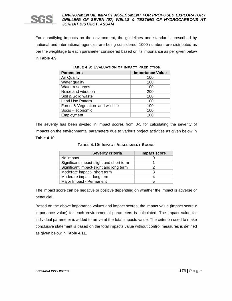
ENVIRONMENTAL IMPACT ASSESSMENT FOR PROPOSED EXPLORATORYDRILLING OF SEVEN (07) WELLS & TESTING OF HYDROCARBONS ATJORHAT DISTRICT, ASSAM
SGS INDIA PVT LIMITED 173 | P a g e
For quantifying impacts on the environment, the guidelines and standards prescribed by
national and international agencies are being considered. 1000 numbers are distributed as
per the weightage to each parameter considered based on its importance as per given below
in Table 4.9.
TABLE 4.9: EVALUATION OF IMPACT PREDICTION
Parameters Importance ValueAir Quality 100Water quality 100Water resources 100Noise and vibration 200Soil & Solid waste 100Land Use Pattern 100Forest & Vegetation and wild life 100Socio – economic 100Employment 100
The severity has been divided in impact scores from 0-5 for calculating the severity of
impacts on the environmental parameters due to various project activities as given below in
Table 4.10.TABLE 4.10: IMPACT ASSESSMENT SCORE
Severity criteria Impact scoreNo impact 0Significant impact-slight and short term 1Significant impact-slight and long term 2Moderate impact- short term 3Moderate impact- long term 4Major Impact - Permanent 5
The impact score can be negative or positive depending on whether the impact is adverse or
beneficial.
Based on the above importance values and impact scores, the impact value (impact score x
importance value) for each environmental parameters is calculated. The impact value for
individual parameter is added to arrive at the total impacts value. The criterion used to make
conclusive statement is based on the total impacts value without control measures is defined
as given below in Table 4.11.
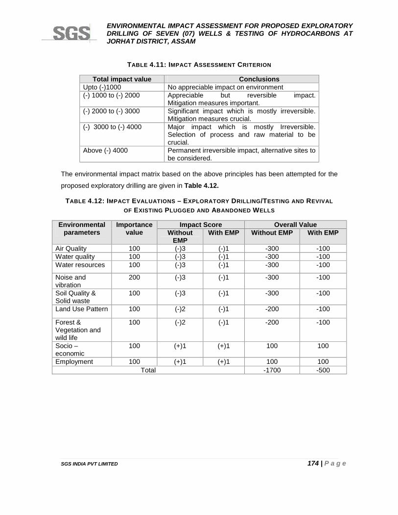
ENVIRONMENTAL IMPACT ASSESSMENT FOR PROPOSED EXPLORATORYDRILLING OF SEVEN (07) WELLS & TESTING OF HYDROCARBONS ATJORHAT DISTRICT, ASSAM
SGS INDIA PVT LIMITED 174 | P a g e
TABLE 4.11: IMPACT ASSESSMENT CRITERION
Total impact value ConclusionsUpto (-)1000 No appreciable impact on environment(-) 1000 to (-) 2000 Appreciable but reversible impact.
Mitigation measures important.(-) 2000 to (-) 3000 Significant impact which is mostly irreversible.
Mitigation measures crucial.(-) 3000 to (-) 4000 Major impact which is mostly Irreversible.
Selection of process and raw material to becrucial.
Above (-) 4000 Permanent irreversible impact, alternative sites tobe considered.
The environmental impact matrix based on the above principles has been attempted for the
proposed exploratory drilling are given in Table 4.12.
TABLE 4.12: IMPACT EVALUATIONS – EXPLORATORY DRILLING/TESTING AND REVIVALOF EXISTING PLUGGED AND ABANDONED WELLS
Environmentalparameters
Importancevalue
Impact Score Overall ValueWithout
EMPWith EMP Without EMP With EMP
Air Quality 100 (-)3 (-)1 -300 -100Water quality 100 (-)3 (-)1 -300 -100Water resources 100 (-)3 (-)1 -300 -100
Noise andvibration
200 (-)3 (-)1 -300 -100
Soil Quality &Solid waste
100 (-)3 (-)1 -300 -100
Land Use Pattern 100 (-)2 (-)1 -200 -100
Forest &Vegetation andwild life
100 (-)2 (-)1 -200 -100
Socio –economic
100 (+)1 (+)1 100 100
Employment 100 (+)1 (+)1 100 100Total -1700 -500
ENVIRONMENTAL IMPACT ASSESSMENT FOR PROPOSED EXPLORATORYDRILLING OF SEVEN (07) WELLS & TESTING OF HYDROCARBONS ATJORHAT DISTRICT, ASSAM
SGS INDIA PVT LIMITED 175 | P a g e
CHAPTER 5
ANALYSIS OF ALTERNATIVES
ENVIRONMENTAL IMPACT ASSESSMENT FOR PROPOSED EXPLORATORYDRILLING OF SEVEN (07) WELLS & TESTING OF HYDROCARBONS ATJORHAT DISTRICT, ASSAM
SGS INDIA PVT LIMITED 176 | P a g e
CHAPTER 5: ANALYSIS OF ALTERNATIVES
5.1 ALTERNATIVE LOCATION FOR THE PROPOSED PROJECT
The proposed onshore Block AA-ONN-2009/4 was awarded to Consortium of Oil India
Limited (OIL) and Oil and Natural Gas Corporation (ONGC) for exploration of hydrocarbons
by Governmenet of India (GOI) under NELP-VIII license round of bidding with each having a
participating interest of 50% stake and OIL being the operator in this block. The Block area is
located in Jorhat district of Assam. The consortium has also signed the Production Sharing
Contract (PSC) with Government of India for exploration of hydrocarbons in the block.
Due to this reason No alternate site is examined as the block is awarded by Ministry of
Petroleum and Natural Gas, Government of India.
5.2 ALTERNATIVE DRILLING LOCATIONS
The identified locations for exploratory drilling have been selected based on data analysis
and interpretation collected via seismic survey within the block area. However, all safe
distances shall be kept mentioned in chapter-2 (as per relevant standards and guidelines).
5.3 ALTERNATIVE DRILLING TECHNOLOGIES
Standard practice shall be followed in which a standard electric onshore rig of 1400/2000 HP
with Rotary/Top drive System will be used (rotary drilling with WBM stabilization).
5.4 ALTERNATIVE RESOURCES
The entire water requirements will be met from a deep tube well adjacent to the drilling site
for which permission has been obtained.
5.5 ALTERNATIVE TREATMENT OPTIONS
Drill cutting will be separated from drilling mud and analyzed for Oil and Grease (O&G)
content. If O&G content is found to be less than 10 g/kg, the cutting will be disposed off (in-
situ) in an imperviouslined pit and after drying it will be covered by an impervious liner and
soil layer. If O&G content is found to be higher than the 10 g/kg, drill cuttings will be
temporarily stored in HDPE lined pits /packed in bags and then disposed to secured landfill
site (TSDF).
However, mobile ETP shall be provided treat the waste water for reuse.
ENVIRONMENTAL IMPACT ASSESSMENT FOR PROPOSED EXPLORATORYDRILLING OF SEVEN (07) WELLS & TESTING OF HYDROCARBONS ATJORHAT DISTRICT, ASSAM
SGS INDIA PVT LIMITED 177 | P a g e
CHAPTER 6
RISK ASSESSMENT AND DISASTERMANAGEMENT PLAN
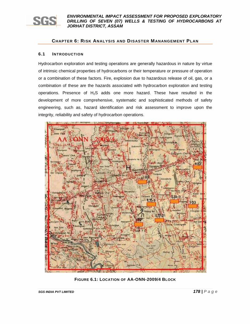
ENVIRONMENTAL IMPACT ASSESSMENT FOR PROPOSED EXPLORATORYDRILLING OF SEVEN (07) WELLS & TESTING OF HYDROCARBONS ATJORHAT DISTRICT, ASSAM
SGS INDIA PVT LIMITED 178 | P a g e
CHAPTER 6: R ISK ANALYSIS AND D ISASTER MANANGEMENT PLAN
6.1 INTRODUCTION
Hydrocarbon exploration and testing operations are generally hazardous in nature by virtue
of intrinsic chemical properties of hydrocarbons or their temperature or pressure of operation
or a combination of these factors. Fire, explosion due to hazardous release of oil, gas, or a
combination of these are the hazards associated with hydrocarbon exploration and testing
operations. Presence of H2S adds one more hazard. These have resulted in the
development of more comprehensive, systematic and sophisticated methods of safety
engineering, such as, hazard identification and risk assessment to improve upon the
integrity, reliability and safety of hydrocarbon operations.
FIGURE 6.1: LOCATION OF AA-ONN-2009/4 BLOCK
ENVIRONMENTAL IMPACT ASSESSMENT FOR PROPOSED EXPLORATORYDRILLING OF SEVEN (07) WELLS & TESTING OF HYDROCARBONS ATJORHAT DISTRICT, ASSAM
SGS INDIA PVT LIMITED 179 | P a g e
The primary emphasis in safety engineering is to reduce risk to human life and environment.
The broad tools attempt to minimize the chances of accidents occurring. Yet, there always
exists, no matter how remote, that small probability of a major accident occurring. If the
accident involves hydrocarbon in sufficient large quantities, the consequences may be
serious to the project site, to surrounding area and the population therein.
Derrick floor is the center stage of all the exploratory drilling operations and it is most
susceptible to accidents. Safety precaution with utmost care is required to be taken during
drilling as per the prevailing regulations and practices so that accidents can be avoided. Due
to advancement in technology, numbers of equipment have been developed over a period to
cater the need of smooth operation on derrick floor. Various standards are required to be
referred to cover the variety of equipments used for safe operation in drilling and it is
desirable to use a properly prepared manual for occupational safety while working or drilling
over rig.
6.2 HAZARD IDENTIFICATION
6.2.1 M INOR O IL SPILL
A minor oil spill is confined within the well plinth area. The conditions which can result in
minor oil spill are as follows:
Diesel Fuel Storage System: Oil spillage from tanker unloading, leaking valves, lines
and storage tank.
Exploration or Testing Well Site: Drill stem testing leading to an oil spillage from lines,
valves, separator and tank failure.
During the exploration & testing operation of well, there exists a possibility of hydrocarbon oil
& gases being released from a failure upstream of crude stabilization facilities. Once the flow
of oil is stopped, then on-site access for clean-up is possible. If flow from well can not be
stopped, a blowout situation exists.
6.2.2 MAJOR O IL SPILL
Significant hydrocarbon inventories are not maintained at a well drilling site. A major spill
can, therefore, only arise as a result of an uncontrolled flow from a well either during drilling
resulting from a failure of the surface equipment. Provided that ignition does not take place
and the well head is not obstructed the well can be shut in manually at the wellhead. If
ignition occurs or other damage prevents access to the wellhead then a blowout situation
exists and appropriate measures must be implemented.
ENVIRONMENTAL IMPACT ASSESSMENT FOR PROPOSED EXPLORATORYDRILLING OF SEVEN (07) WELLS & TESTING OF HYDROCARBONS ATJORHAT DISTRICT, ASSAM
SGS INDIA PVT LIMITED 180 | P a g e
6.2.3 BLOWOUT
Blowout means uncontrolled violent escape of hydrocarbon fluids from a well. Blowout
followed by ignition, which prevents access to the wellhead is a major hazard. Contributors
to blowout are:
Primary
Failure to keep the hole full; Mud weight too low; Swabbing during trips; Lost circulation; and Failure of differential fill-up equipment.
Secondary
Failure to detect and control a kick as quickly as possible; Mechanical failure of Blow Out Preventer (BOP); Failure to test BOP equipment properly; Damage to or failure of wellhead equipment; Failure of casing; and Failure of formation or cement bond around casing.
If the hydrostatic head exerted by the column of drilling fluid is allowed to drop below the
formation pressure then formation fluids will enter the well bore (this is known as a kick) and
a potential blowout situation has developed.
Fast and efficient action by operating personnel in recognizing the above situations and
taking precautionary measure can avert a blowout.
Presence of Sour Gas (Hydrogen Sulphide-H2S) in Blowout
Presence of H2S in blowouts wells can pose immediate dangers to life and health. Operators
drilling wells where H2S is a known hazard may or may not have a clear-cut policy regarding
ignition of the well if a blowout occurs. Burning H2S creates sulfur dioxide (SO2) that is also
highly toxic. Therefore, the situation is still dangerous, and a safety system should be put in
place to monitor for SO2.
Hydrogen Sulphide gas (H2S) is extremely toxic, even very low concentrations can be lethal
depending upon the duration of exposure. Without any warning, H2S may render victims
unconscious and death can follow shortly afterwards. In addition it is corrosive and can lead
to failure of the drill string or other tubular components in a well.
ENVIRONMENTAL IMPACT ASSESSMENT FOR PROPOSED EXPLORATORYDRILLING OF SEVEN (07) WELLS & TESTING OF HYDROCARBONS ATJORHAT DISTRICT, ASSAM
SGS INDIA PVT LIMITED 181 | P a g e
The Occupational Safety and Health Act (OSHA regulations) set a 10 ppm ceiling for an
eight hourly continuous exposure (TWA limit), a 15 ppm concentration for short term
exposure limit for 15 minutes (STEL) and a peak exposure of 50 ppm for 10 minutes.
Important characteristics of H2S gas are given below:
i. H2S is a toxic colourless gas heavier than air.ii. It has an odour of rotten eggs but see ‘point 6’ below.iii. In concentrations greater than 100 ppm, it will cause loss of senses in 3 to 15
minutes and death within 48 hours.iv. In concentrations greater than 600 ppm death occurs in less than 2 minutes.v. The safe concentration for a normal working period without protection is 10 ppm.vi. In concentration greater than 10 ppm, the olfactory sense to smell the gas is lost, the
need for detectors is apparent.vii. It attacks the body through the respiratory organs.viii. It dissolves in the blood and attacks through the nervous system.ix. It is very irritating for the eyes as it forms sulphurous acid together with water.x. The Occupational Safety and Health Act (OSHA) sets a 10 ppm ceiling for an 8
(eight) hour continuous exposure (TWA limit), a limit of 15 ppm for short termexposure limit for 15 minutes (STEL) and a peak exposure concentration of 50 ppmfor 10 minutes.
xi. The best protection is breathing apparatus, with mask covering the whole face and abottle containing breathing air.
xii. It burns with a blue flame to sulphur dioxide which is almost as dangerous as H2S.xiii. It forms an explosive mixture with air at concentrations from 4% to 46%.xiv. Short exposure of high tensile steel to as little as 1 ppm in aqueous solution can
cause failures.xv. Concentrations greater than 15 ppm can cause failure to steel harder than Rockwell
C-22. High stress levels and corrosive environments accelerate failures.xvi. When pH is above 9 and solubility is relatively high, it is readily soluble in mud and
especially in oil muds.xvii. The compressibility factor (Z) is higher than that for natural gas and H2S will thus
expand at rather lower pressures; or further up in the bore hole than natural gas.xviii. A 35% hydrogen peroxide solution will neutralize H2S gas in the mud or 20 gallons of
H2O2 per 100 barrels of mud.xix. It occurs together with natural gas in all oil provinces of the world.xx. In characteristic H2S gas areas concentration above 42% in natural gas have been
reported.xxi. H2S may also be formed in significant amounts from the degradation of modified
lignosulphonates at temperatures exceeding 2040C.xxii. Coughing, eye burning and pain, throat irritation, and sleepiness are observed from
exposure to low concentrations of H2S.
ENVIRONMENTAL IMPACT ASSESSMENT FOR PROPOSED EXPLORATORYDRILLING OF SEVEN (07) WELLS & TESTING OF HYDROCARBONS ATJORHAT DISTRICT, ASSAM
SGS INDIA PVT LIMITED 182 | P a g e
xxiii. Exposure to high concentrations of H2S produces systems such as panting, pallor,cramps, paralysis of the pupil and loss of speech. This is generally followed byimmediate loss of consciousness. Death may occur quickly from respiratory andcardiac paralysis.
6.2.4 OTHER HAZARDS AT DRILLING R IG OPERATIONS
6.2.4.1 HAZARD DURING SETTING UP THE SUBSTRUCTURE
Equipment is unloaded and positioned at or near the exact location that it will occupy during
drilling operation operations. The substructure is assembled, pinned together, leveled, and
made ready for other rig components on the floor. Equipping the cellar begins but can be
done throughout the rigging up process. This includes welding on a drilling nipple to the
conductor pipe and attaching a flow line.
Potential Hazards
Being struck by the crane, load, truck, or forklift tipping.
Pinched fingers when assembling equipment.
Burns from cutting and welding on the drilling nipple.
Temporary eye irritation from welding light flash.
Falling from heights.
6.2.4.2 HAZARD DURING SETTING UP THE R IG FLOOR AND MAST OR DERRICK
Once the substructure is set in place, the process of setting up the rig floor begins. Begin by
installing stairways and guardrails to allow access to the rig floor. Then, the draw works is
set in place and secured to the substructure. On mechanical rigs, the engines are set in
place and the compound and associated equipment connected to the draw works. On
electric rigs, the electric cables (lines) are strung to the draw works.
The bottom of the mast is raised to the rig floor and pinned in place. The crown section is
then raised into place on the derrick stand. The "A-legs" are raised and pinned into place.
The monkey board is pinned in place on the mast and all lines and cables are laid out to
prevent tangling when the mast is raised. A thorough inspection of the mast should be made
before raising the mast/derrick. The mast is now ready to be raised. The engines are started,
and the drilling line is spooled onto the draw works drum. Once the mast has been raised
and pinned, the remaining floor equipment can be set into place. If the rig has safety guy
lines, they must be attached to the anchors and properly tensioned prior to continuing the
rigging up process. A derrick emergency escape device is installed on the mast.
ENVIRONMENTAL IMPACT ASSESSMENT FOR PROPOSED EXPLORATORYDRILLING OF SEVEN (07) WELLS & TESTING OF HYDROCARBONS ATJORHAT DISTRICT, ASSAM
SGS INDIA PVT LIMITED 183 | P a g e
Potential Hazards
Falling or tripping during rigging up.
Falling from rig floor.
Being struck by swinging equipment.
Being struck by falling tools.
Being crushed or struck by equipment due to failure or overloading of hoisting
equipment.
Getting entangled in lines during rising of the derrick or mast.
Failure to properly install derrick emergency escape device.
6.2.4.3 HAZARD IN R IGGING UP THE C IRCULATING SYSTEM
While one crew finishes preparing the rig floor, another crew might be rigging up the
circulating system. The mud tanks and mud pumps are set into the predetermined location.
The mud lines are then connected and electric cords are strung.
Potential Hazards
Being struck by or crushed by equipment being set into place.
Getting caught in pinch points.
Being struck by crane, load, truck or forklift tipping.
Being struck by hammer when connecting mud line unions.
6.2.4.4 HAZARDS DURING INSTALLING THE AUXILIARY EQUIPMENT
All remaining drilling and auxiliary equipment must be set into place and installed where
needed. The catwalk and pipe racks are positioned and the pipe and drill collars are set on
the racks.
Potential Hazards:
Getting struck or pinched by, or caught in between, tubulars being loaded onto racks.
Having feet pinched or crushed when setting up the pipe racks and catwalk.
6.3 CONSEQUENCE ANALYSIS
The risk presented by a blowout (hydrocarbons release event) is determined by the
frequency and consequence of its possible outcomes. The consequence of igniting a
hydrocarbon release during blowout depends on the type of material released, the mass
ENVIRONMENTAL IMPACT ASSESSMENT FOR PROPOSED EXPLORATORYDRILLING OF SEVEN (07) WELLS & TESTING OF HYDROCARBONS ATJORHAT DISTRICT, ASSAM
SGS INDIA PVT LIMITED 184 | P a g e
release rate, the timing of the ignition, and the environment into which the hydrocarbon is
released. Briefly, typical outcomes are:
Jet fires: produced by an ignited jet of gas or liquid spray released under pressure;
Pool fires: produced by ignition of a liquid release that accumulates on the surface
and ignites;
Flash fires: produced by igniting a gas cloud so that a fire propagates through the
gas cloud (without generating a significant overpressure);
Explosions: produced by igniting a gas cloud in conditions where the resultant
accelerating flame front produces a significant overpressure.
Jet fire emanating from the release source may follow a flash fire or explosion.
1. Early Ignition
In the risk assessment, gas and two-phase events that ignite early are modeled as jet fires.
Liquid releases that ignite early are modeled as pool fires.
Briefly, jet fires are modeled as follows:
Mass release rate is determined (for each representative hole size) based on the
operating temperature and pressure at the point of release.
From the mass release rate, the jet flame length and associated fatality area.
2. Late Ignition
In the event of two-phase releases that ignite late are modeled as explosions.
Delayed ignition is not assumed to occur for oil releases. The consequential effect of a
hydrocarbon gas explosion on personnel is determined by a variety of factors, including:
Direct effects of blast overpressure;
Whole body translation due to the blast wave;
Thermal effects on personnel inside the burning gas cloud.
It is assumed that all personnel caught inside the burning gas cloud are likely to be fatally
injured due to thermal radiation effects and inhalation of burning gases. Outside the gas
cloud, personnel may still suffer from the effects of flash fire.
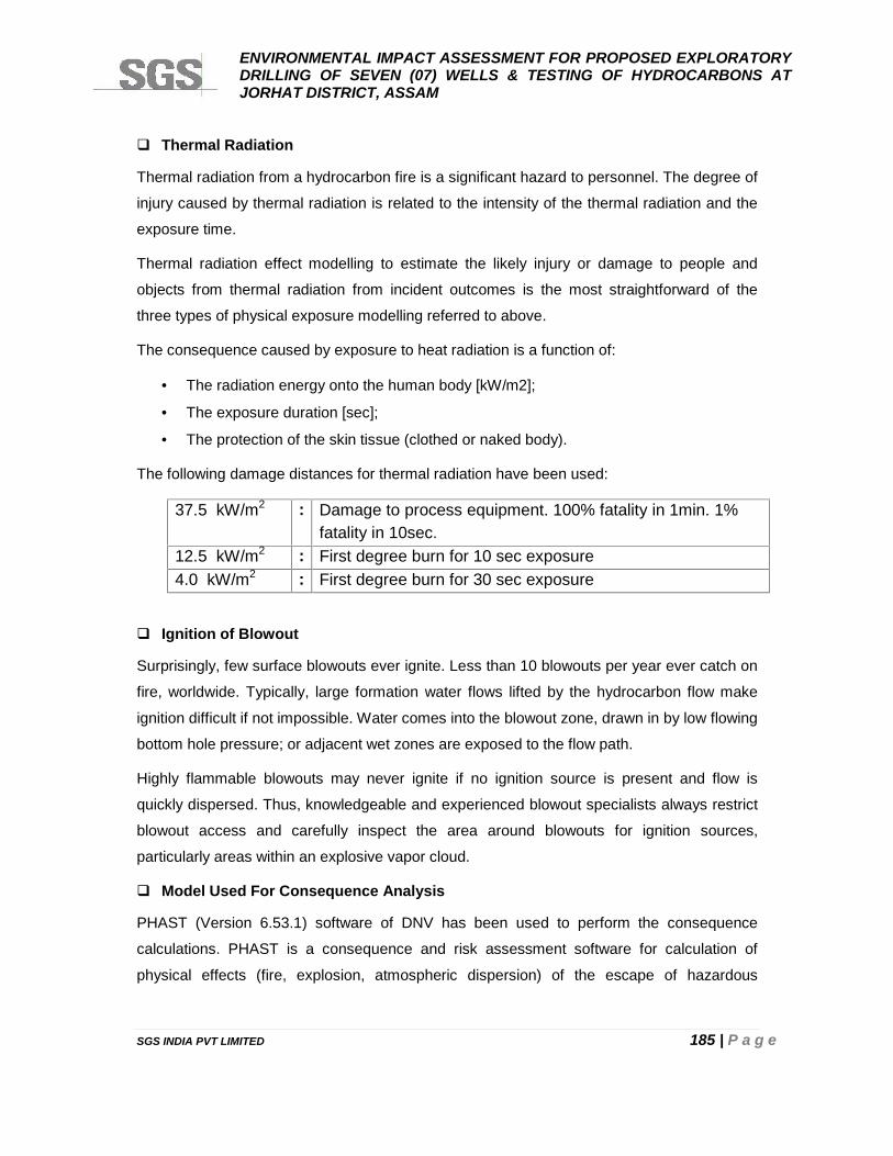
ENVIRONMENTAL IMPACT ASSESSMENT FOR PROPOSED EXPLORATORYDRILLING OF SEVEN (07) WELLS & TESTING OF HYDROCARBONS ATJORHAT DISTRICT, ASSAM
SGS INDIA PVT LIMITED 185 | P a g e
Thermal Radiation
Thermal radiation from a hydrocarbon fire is a significant hazard to personnel. The degree of
injury caused by thermal radiation is related to the intensity of the thermal radiation and the
exposure time.
Thermal radiation effect modelling to estimate the likely injury or damage to people and
objects from thermal radiation from incident outcomes is the most straightforward of the
three types of physical exposure modelling referred to above.
The consequence caused by exposure to heat radiation is a function of:
The radiation energy onto the human body [kW/m2];
The exposure duration [sec];
The protection of the skin tissue (clothed or naked body).
The following damage distances for thermal radiation have been used:
37.5 kW/m2 : Damage to process equipment. 100% fatality in 1min. 1%fatality in 10sec.
12.5 kW/m2 : First degree burn for 10 sec exposure4.0 kW/m2 : First degree burn for 30 sec exposure
Ignition of Blowout
Surprisingly, few surface blowouts ever ignite. Less than 10 blowouts per year ever catch on
fire, worldwide. Typically, large formation water flows lifted by the hydrocarbon flow make
ignition difficult if not impossible. Water comes into the blowout zone, drawn in by low flowing
bottom hole pressure; or adjacent wet zones are exposed to the flow path.
Highly flammable blowouts may never ignite if no ignition source is present and flow is
quickly dispersed. Thus, knowledgeable and experienced blowout specialists always restrict
blowout access and carefully inspect the area around blowouts for ignition sources,
particularly areas within an explosive vapor cloud.
Model Used For Consequence Analysis
PHAST (Version 6.53.1) software of DNV has been used to perform the consequence
calculations. PHAST is a consequence and risk assessment software for calculation of
physical effects (fire, explosion, atmospheric dispersion) of the escape of hazardous
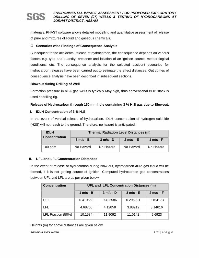
ENVIRONMENTAL IMPACT ASSESSMENT FOR PROPOSED EXPLORATORYDRILLING OF SEVEN (07) WELLS & TESTING OF HYDROCARBONS ATJORHAT DISTRICT, ASSAM
SGS INDIA PVT LIMITED 186 | P a g e
materials. PHAST software allows detailed modelling and quantitative assessment of release
of pure and mixtures of liquid and gaseous chemicals.
Scenarios wise Findings of Consequence Analysis
Subsequent to the accidental release of hydrocarbon, the consequence depends on various
factors e.g. type and quantity, presence and location of an ignition source, meteorological
conditions, etc. The consequence analysis for the selected accident scenarios for
hydrocarbon releases have been carried out to estimate the effect distances. Out comes of
consequence analysis have been described in subsequent sections.
Blowout during Drilling of Well
Formation pressure in oil & gas wells is typically May high, thus conventional BOP stack is
used at drilling rig.
Release of Hydrocarbon through 150 mm hole containing 3 % H2S gas due to Blowout.
I. IDLH Concentration of 3 % H2S
In the event of vertical release of hydrocarbon, IDLH concentration of hydrogen sulphide
(H2S) will not reach to the ground. Therefore, no hazard is anticipated.
IDLHConcentration
Thermal Radiation Level Distances (m)
3 m/s - B 3 m/s - D 2 m/s – E 1 m/s - F
100 ppm No Hazard No Hazard No Hazard No Hazard
II. UFL and LFL Concentration Distances
In the event of release of hydrocarbon during blow-out, hydrocarbon /fluid gas cloud will be
formed, if it is not getting source of ignition. Computed hydrocarbon gas concentrations
between UFL and LFL are as per given below:
Concentration UFL and LFL Concentration Distances (m)
1 m/s - B 3 m/s - D 3 m/s - E 2 m/s – F
UFL 0.410653 0.422586 0.296991 0.154173
LFL 4.68768 4.12858 3.88912 3.14616
LFL Fraction (50%) 10.1584 11.9092 11.0142 9.6923
Heights (m) for above distances are given below:
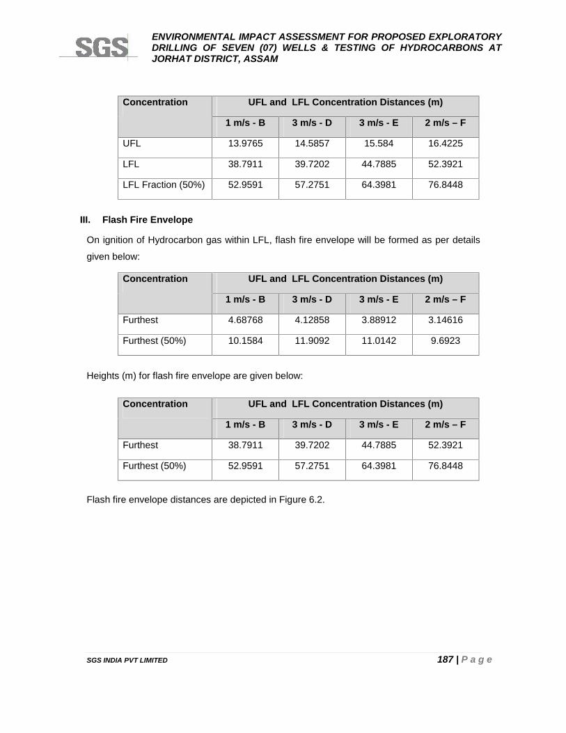
ENVIRONMENTAL IMPACT ASSESSMENT FOR PROPOSED EXPLORATORYDRILLING OF SEVEN (07) WELLS & TESTING OF HYDROCARBONS ATJORHAT DISTRICT, ASSAM
SGS INDIA PVT LIMITED 187 | P a g e
Concentration UFL and LFL Concentration Distances (m)
1 m/s - B 3 m/s - D 3 m/s - E 2 m/s – F
UFL 13.9765 14.5857 15.584 16.4225
LFL 38.7911 39.7202 44.7885 52.3921
LFL Fraction (50%) 52.9591 57.2751 64.3981 76.8448
III. Flash Fire Envelope
On ignition of Hydrocarbon gas within LFL, flash fire envelope will be formed as per details
given below:
Concentration UFL and LFL Concentration Distances (m)
1 m/s - B 3 m/s - D 3 m/s - E 2 m/s – F
Furthest 4.68768 4.12858 3.88912 3.14616
Furthest (50%) 10.1584 11.9092 11.0142 9.6923
Heights (m) for flash fire envelope are given below:
Concentration UFL and LFL Concentration Distances (m)
1 m/s - B 3 m/s - D 3 m/s - E 2 m/s – F
Furthest 38.7911 39.7202 44.7885 52.3921
Furthest (50%) 52.9591 57.2751 64.3981 76.8448
Flash fire envelope distances are depicted in Figure 6.2.
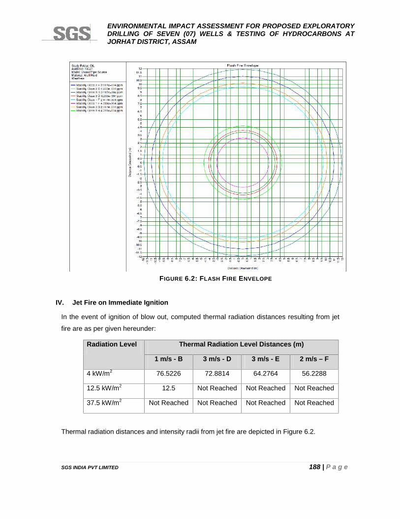
ENVIRONMENTAL IMPACT ASSESSMENT FOR PROPOSED EXPLORATORYDRILLING OF SEVEN (07) WELLS & TESTING OF HYDROCARBONS ATJORHAT DISTRICT, ASSAM
SGS INDIA PVT LIMITED 188 | P a g e
IV. Jet Fire on Immediate Ignition
In the event of ignition of blow out, computed thermal radiation distances resulting from jet
fire are as per given hereunder:
Radiation Level Thermal Radiation Level Distances (m)
1 m/s - B 3 m/s - D 3 m/s - E 2 m/s – F
4 kW/m2 76.5226 72.8814 64.2764 56.2288
12.5 kW/m2 12.5 Not Reached Not Reached Not Reached
37.5 kW/m2 Not Reached Not Reached Not Reached Not Reached
Thermal radiation distances and intensity radii from jet fire are depicted in Figure 6.2.
FIGURE 6.2: FLASH FIRE ENVELOPE
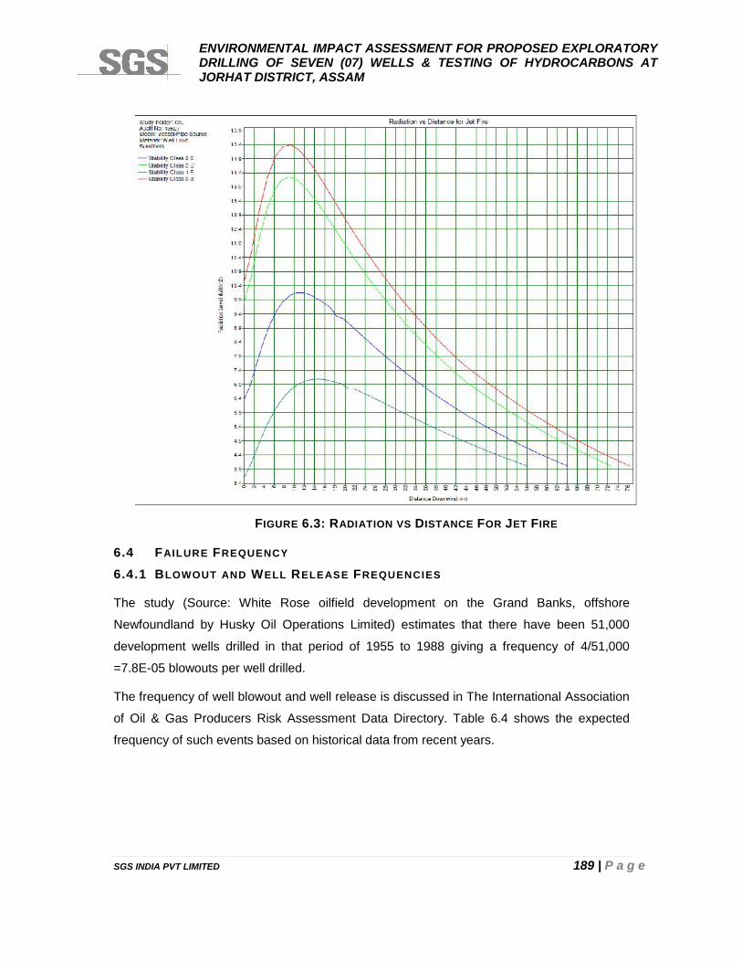
ENVIRONMENTAL IMPACT ASSESSMENT FOR PROPOSED EXPLORATORYDRILLING OF SEVEN (07) WELLS & TESTING OF HYDROCARBONS ATJORHAT DISTRICT, ASSAM
SGS INDIA PVT LIMITED 189 | P a g e
6.4 FAILURE FREQUENCY
6.4.1 BLOWOUT AND WELL RELEASE FREQUENCIES
The study (Source: White Rose oilfield development on the Grand Banks, offshore
Newfoundland by Husky Oil Operations Limited) estimates that there have been 51,000
development wells drilled in that period of 1955 to 1988 giving a frequency of 4/51,000
=7.8E-05 blowouts per well drilled.
The frequency of well blowout and well release is discussed in The International Association
of Oil & Gas Producers Risk Assessment Data Directory. Table 6.4 shows the expected
frequency of such events based on historical data from recent years.
FIGURE 6.3: RADIATION VS DISTANCE FOR JET FIRE
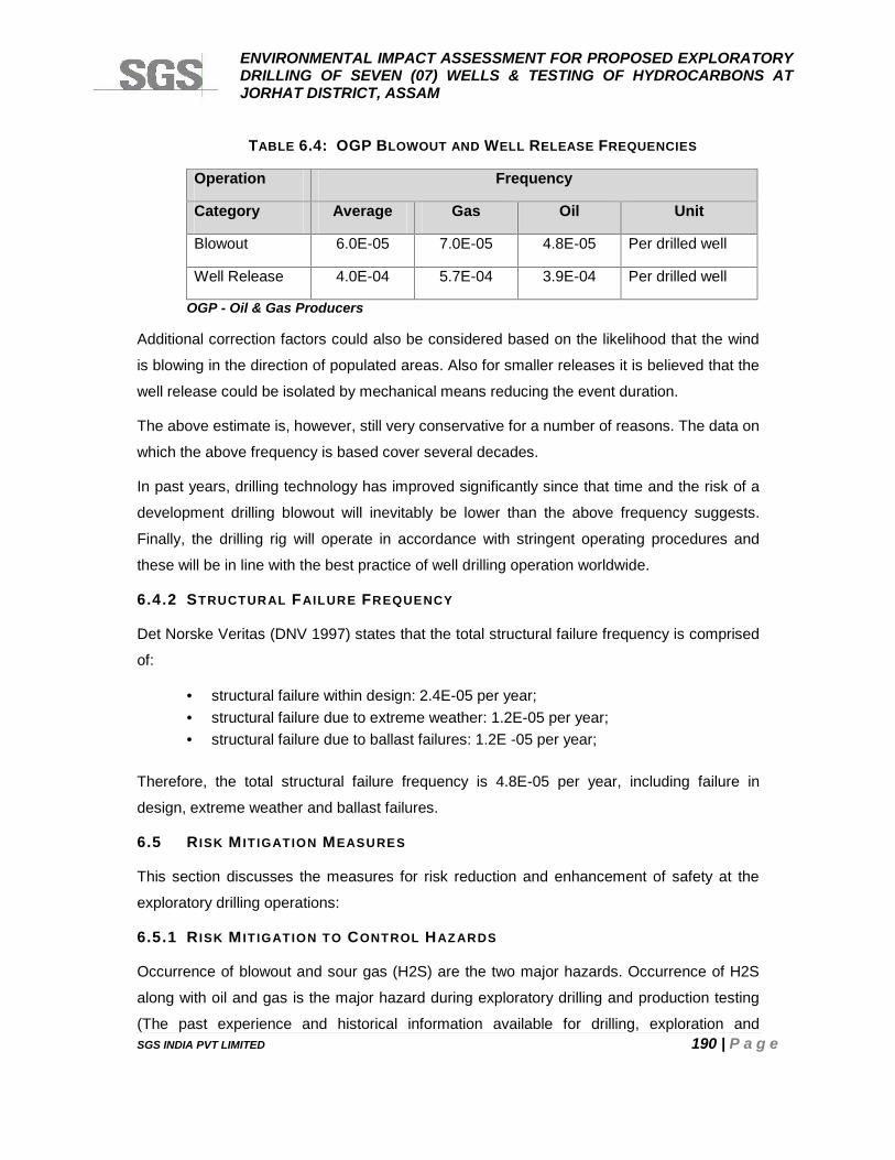
ENVIRONMENTAL IMPACT ASSESSMENT FOR PROPOSED EXPLORATORYDRILLING OF SEVEN (07) WELLS & TESTING OF HYDROCARBONS ATJORHAT DISTRICT, ASSAM
SGS INDIA PVT LIMITED 190 | P a g e
TABLE 6.4: OGP BLOWOUT AND WELL RELEASE FREQUENCIES
Operation Frequency
Category Average Gas Oil Unit
Blowout 6.0E-05 7.0E-05 4.8E-05 Per drilled well
Well Release 4.0E-04 5.7E-04 3.9E-04 Per drilled well
OGP - Oil & Gas Producers
Additional correction factors could also be considered based on the likelihood that the wind
is blowing in the direction of populated areas. Also for smaller releases it is believed that the
well release could be isolated by mechanical means reducing the event duration.
The above estimate is, however, still very conservative for a number of reasons. The data on
which the above frequency is based cover several decades.
In past years, drilling technology has improved significantly since that time and the risk of a
development drilling blowout will inevitably be lower than the above frequency suggests.
Finally, the drilling rig will operate in accordance with stringent operating procedures and
these will be in line with the best practice of well drilling operation worldwide.
6.4.2 STRUCTURAL FAILURE FREQUENCY
Det Norske Veritas (DNV 1997) states that the total structural failure frequency is comprised
of:
structural failure within design: 2.4E-05 per year; structural failure due to extreme weather: 1.2E-05 per year; structural failure due to ballast failures: 1.2E -05 per year;
Therefore, the total structural failure frequency is 4.8E-05 per year, including failure in
design, extreme weather and ballast failures.
6.5 R ISK M IT IGATION MEASURES
This section discusses the measures for risk reduction and enhancement of safety at the
exploratory drilling operations:
6.5.1 R ISK M IT IGATION TO CONTROL HAZARDS
Occurrence of blowout and sour gas (H2S) are the two major hazards. Occurrence of H2S
along with oil and gas is the major hazard during exploratory drilling and production testing
(The past experience and historical information available for drilling, exploration and
ENVIRONMENTAL IMPACT ASSESSMENT FOR PROPOSED EXPLORATORYDRILLING OF SEVEN (07) WELLS & TESTING OF HYDROCARBONS ATJORHAT DISTRICT, ASSAM
SGS INDIA PVT LIMITED 191 | P a g e
production of hydrocarbons in the area revel that H2S gas may found in hydrocarbon
reserves of the region. In the event of occurrence of H2S during drilling operations,
associated hazards and risk are considered for completeness of the study). Control
measures for occurrence of blowout and H2S gas are discussed in following sub-sections:
6.5.2 BLOWOUT
The precautionary and control measures used for blowout prevention are discussed below:
Precaution against Blowout
The following control equipments for drilling mud system should be installed and kept in use
during drilling operations to prevent the blowout:
A pit level indicator registering increase or reduction in the drilling mud volume and
shall include a visual and audio –warning device near the driller stand.
A device to accurately measure the volume of mud required to keep the well filled at
the all times.
A gas detector or explosimeter at the primary shale shaker and connected to audible
or visual alarm near the driller stand.
A device to ensure filling of well with mud when the string is being pulled out.
A control device near driller stand to close the mud pump when well kicks.
Blowout prevention drill shall be carried out once every week near the well during
drilling.
Suitable control valves shall be kept available near the well which can be used in
case of emergency to control the well.
When running in or pulling out tubing, gate valve and tubing hanger shall be pre-
assembled and kept readily available at the well.
Precaution in case of Blowout
On appearance of any sign indicating the blowout of well, all persons, other than those
whose presence is deemed necessary for controlling blowout, shall be withdrawn from the
well.
During the whole time while any work of controlling a blowout is in progress, the following
precautions shall be taken:
A competent person shall be present on the spot throughout.
ENVIRONMENTAL IMPACT ASSESSMENT FOR PROPOSED EXPLORATORYDRILLING OF SEVEN (07) WELLS & TESTING OF HYDROCARBONS ATJORHAT DISTRICT, ASSAM
SGS INDIA PVT LIMITED 192 | P a g e
An area within the 500 meters of the well on the down wind direction shall be
demarcated as danger zone.
All electrical installations shall be de-energized.
Approved safety lamps or torches shall only be used within the danger zone.
No naked light or vehicular traffic shall be permitted within the danger zone.
A competent person shall ascertain the condition of ventilation and presence of gases with
an approved instrument as far as safety of persons is concerned.
There shall be available at or near the place, two approved type of self containing breathing
apparatus or any other breathing apparatus of approved type for use in an emergency.
Adequate fire fighting equipment shall be kept readily available for immediate use.
Blowout Preventor Assembly
To prevent the blow out during drilling operations following steps should be taken:
After the surface casing is set in a well no drilling shall be carried out unless blowout
preventor assembly is securely installed and maintained.
Blowout preventor assembly shall consist of:
One bag type of preventor for closing regardless whether drilling equipment is in the
hole or not.
One blind ram preventor closing against an open hole.
One pipe ram preventor closing against drill pipe in use in the hole.
In blow out preventor assembly, there shall be provided two seamless steel pipes at least 50
mm of diameter connected below each set of blow out preventor, one for bleeding off
pressure and the other for killing the well. These pipes shall be straight and lead directly into
the well.
Each pipeline shall consist of component having a working pressure equal to that of the
blowout preventor.
Blowout Preventor (BOP) Control Units: Location and Conditions
BOP control units should be located at a distance of nearly 30 m from well center.
Status of following should be checked and maintained in good condition:
Pressure gauges;
ENVIRONMENTAL IMPACT ASSESSMENT FOR PROPOSED EXPLORATORYDRILLING OF SEVEN (07) WELLS & TESTING OF HYDROCARBONS ATJORHAT DISTRICT, ASSAM
SGS INDIA PVT LIMITED 193 | P a g e
Pressure steel lines/fire resistant hoses;
Level of hydraulic oil;
Charging of unit; and
Availability of sufficient number of charged bottles.
Control System for Blowout Preventors
All manual control for manually operated blowout preventor shall be located at least
0.60 meters out side the derrick substructures. Instructions for operating the controls
shall be posted prominently near the control wheel.
A control of power operated blowout preventor shall be located within easy reach of
driller floor:
A remote control panel for blowout preventors shall also be installed around floor
level at a safe distance from the derrick floor.
All control for blow out preventors shall be clearly identified with suitable markers.
6.5.3 CONTROL MEASURES FOR H2S DURING DRILLING
H2S Detection System
A four channels H2S gas detection system should be provided. Sensors should be
positioned at optimum points for detection, actual locations being decided on site but likely to
be:
Well Nipple
Rig Floor
Shaker header tank
Substructure cellar
The detection system should be connected to an audio visual (siren and lights) alarm
system. This system should be set to be activated at a concentration of 15 ppm H2S.
The mud logging will have a completely independent detection system which is connected to
an alarm in the cabin. This system will be adjusted to sound an alarm at a concentration
level of 10 ppm H2S as suggested in the Drilling and Production Safety Code for Onshore
Operators issued by The Institute of Petroleum.
A stock of H2S scavenger will be kept at drilling site for emergency use.
ENVIRONMENTAL IMPACT ASSESSMENT FOR PROPOSED EXPLORATORYDRILLING OF SEVEN (07) WELLS & TESTING OF HYDROCARBONS ATJORHAT DISTRICT, ASSAM
SGS INDIA PVT LIMITED 194 | P a g e
Small Levels of H2S
Small levels of H2S (less than 10 ppm) will not activate the well site alarms. Such levels do
not create an immediate safety hazard but could be a first indication of high levels of H2S to
follow.
H2S will cause a sudden drop of mud pH. The mud man will therefore organize and
supervise continuous pH checks while drilling. Checks should be as frequent as required
depending on ROP and always made following a formation change.
Following control measures will be taken in case of small level of detection:
Add H2S scavenger to mud.
Check H2S levels at regular intervals for possible increase.
Inform all personnel of the rig about the presence of H2S and current wind direction.
Commence operations in pairs.
Render sub base and cellar out-of-bounds without further checking levels in this
area.
High Levels of H2S
Higher levels of H2S (greater than 10 ppm) do not necessarily cause an immediate safety
hazard. However some risk does exist and, therefore, any levels greater than 10 ppm should
be treated in the same manner. Occurrence of 10 ppm or greater H2S concentration will
sound an alarm in the mud logging unit.
If higher levels of H2S greater than 10 ppm are found, following steps will be taken:
Driller to shut down rotary and pumps, pick-up the string so that drill pipe is in the
BOP and chain down the break.
One pre-assigned roughneck will go to the doghouse and put on the breathing
apparatus. All other rig personnel will evacuate the rig and move up wind to
designated muster points.
Driller and roughneck will return to the rig floor and commence circulating H2S
scavenger slowly and reciprocating the pipe string.
The level of H2S will be checked in all work areas. H2S scavenger will be added to
the mud and circulated. If H2S levels drop, drilling will be continued with scavenger in
the mud. Approximately 30 % of hydrogen peroxide (H2O2) solution will neutralize
H2S gas in the mud at 20 gallon of H2O2 per 100 barrels of mud.
ENVIRONMENTAL IMPACT ASSESSMENT FOR PROPOSED EXPLORATORYDRILLING OF SEVEN (07) WELLS & TESTING OF HYDROCARBONS ATJORHAT DISTRICT, ASSAM
SGS INDIA PVT LIMITED 195 | P a g e
Control Measures for H2S during Experimental Production Testing
H2S scavenging chemicals (caustic soda solution, calcium hydroxide or iron oxide slurry) will
be continuously injected in the recovered gas/oil/formation water after pressure reduction
through choke before sending the same to separator.
6.5.4 SAFETY SYSTEM FOR DRILLING R IGS
Operational Safety is the foremost concern while working on drilling rig. Derrick floor is the
center stage of all the operations and it is most susceptible to accidents. Safety precaution
with utmost care is required to be taken as per the prevailing regulation and practice so that
accidents can be avoided. Due to advancement in technology, number of equipment has
been developed over a period to cater the need of smooth operation on derrick floor. Various
standards are required to be referred to cover the variety of equipment used for safe
operation in drilling and become cumbersome at times to refer standards for each
equipment.
Twin stop safety device (crown-o-matic and floor-o-matic)
Fall prevention device on mast ladder with safety belt.
Emergency Escape device for top man.
First aid box with Stretcher and Blanket.
Fire bell /siren.
Emergency vehicle.
Fire extinguishers
Flame proof portable hand lamp /safety torch
Railling with toe board
Guards on all moving parts.
Breathing apparatus (wherever required)
Gas detector for hydrocarbon gas & H2S gas (if required)
Safety lines for power tongs
Rotary brake
Hoisting brake lever with safety chain
Emergency shutoff system for draw works
Safety chain for inclined ramp (to prevent fall of any person)
safety belt for top-man with lane yard
Railing on stair case at mud tank/walkways and derrick floor
ENVIRONMENTAL IMPACT ASSESSMENT FOR PROPOSED EXPLORATORYDRILLING OF SEVEN (07) WELLS & TESTING OF HYDROCARBONS ATJORHAT DISTRICT, ASSAM
SGS INDIA PVT LIMITED 196 | P a g e
6.5.5 ENSURE AVAILABILITY AND PROVISIONS BEFORE SPUDDING OF THE WELL
To enhance the safety at the drilling rig during drilling operation following should be ensured:
Geo-technical Order (GTO)/drilling program with shift in-charge
PPE for crew should be available
First aid box
Wash pipe should be greased and after every 8 hours or as specified by the
manufacturer.
Kelly bushes to be greased after every 24 hours or as specified by the manufacturer.
Lower & upper kelly cock (its operating lever should be kept at designated place at
derrick floor)
Kelly saver sub on kelly
Mud check valve /full opening safety valve
BOP control panel on derrick floor.
Before lowering casing, inspect all the instruments such as, weight indicator,
pressure gauges, rotary torque, SPM counter, RPM counter mud volume totaliser,
flow meter & trip tank.
Required Number of drill collars and heavy weight D/Ps
Ensure availability of two mud pumps in good working condition
Rat hole and mouse hole be drilled
Twin stop safety device should be made in working order
6.5.6 GENERAL SAFE PRACTICES DURING DRILLING OPERATION
Penetration rate shall be monitored. In case of any drilling break, stop rotary table,
pull out the Kelly, stop mud pump and check for self flow.
Different type of drill pipes should not be mixed up during making up the string.
Protectors should be used on drill pipes while lifting and laying down the pipes on
catwalk.
Drill pipe rubber protector should be installed on drill pipes body while being used
inside the casing.
Before starting drilling, hole should be centered to avoid touching of kelly with casing
/ wellhead and ensure that no damage is done to well head and BOP.
Continuous monitoring of the gain/loss of mud during.
ENVIRONMENTAL IMPACT ASSESSMENT FOR PROPOSED EXPLORATORYDRILLING OF SEVEN (07) WELLS & TESTING OF HYDROCARBONS ATJORHAT DISTRICT, ASSAM
SGS INDIA PVT LIMITED 197 | P a g e
BOP mock drill should be carried during drilling / tripping and under mentioned
operations.
Safe Working Conditions and Practices to be Adopted During Drilling Operations
6.5.7 EMERGENCY PREPAREDNESS
BOP drills and trip drills should be done once a week.
Deficiency observed in BOP drill should be recorded and corrective measures should
be taken.
6.5.8 F IRE F IGHTING FACILITY FOR DRILLING R IG
For the drilling rigs following fire fighting system/equipments should be provided:
Fire water system; and
First aid fire fighting system.
6.5.9 CONTROL OF HYDROCARBON DUE AND SUBSEQUENTLY FIRE & EXPLOSION
DURING EXPLORATION AND TESTING
To detect the release of hydrocarbon during exploration and testing, hydrocarbon detectors
should be placed, so that control measures may be taken to prevent fire and explosion.
As per Oil Industry Safety Directorate (OISD) Standard, for the drilling rigs and well testing
following fire fighting system/equipments should be provided:
Fire water system; and
First aid fire fighting system.
Fire Water System
One water tank/pit of minimum capacity of 50 kl should be located at the approach of
the drilling site.
For experimental production testing, one additional tank/pit of 50 kl should be
provided.
One diesel engine driven trailer fire pump of capacity 1800 lpm should be placed at
the approach area of drilling site.
One fire water distribution single line with minimum 4” size pipe/casing should be
installed at drilling site with a minimum distance of 15 m from the well.
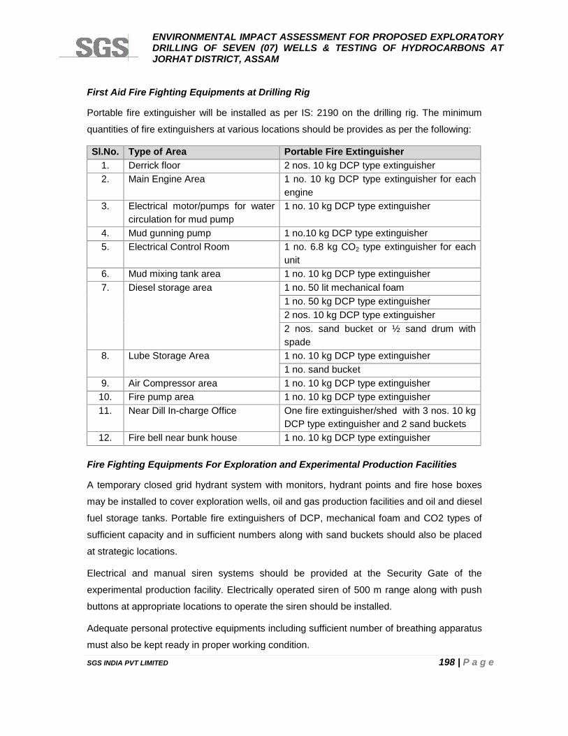
ENVIRONMENTAL IMPACT ASSESSMENT FOR PROPOSED EXPLORATORYDRILLING OF SEVEN (07) WELLS & TESTING OF HYDROCARBONS ATJORHAT DISTRICT, ASSAM
SGS INDIA PVT LIMITED 198 | P a g e
First Aid Fire Fighting Equipments at Drilling Rig
Portable fire extinguisher will be installed as per IS: 2190 on the drilling rig. The minimum
quantities of fire extinguishers at various locations should be provides as per the following:
Sl.No. Type of Area Portable Fire Extinguisher1. Derrick floor 2 nos. 10 kg DCP type extinguisher2. Main Engine Area 1 no. 10 kg DCP type extinguisher for each
engine3. Electrical motor/pumps for water
circulation for mud pump1 no. 10 kg DCP type extinguisher
4. Mud gunning pump 1 no.10 kg DCP type extinguisher5. Electrical Control Room 1 no. 6.8 kg CO2 type extinguisher for each
unit6. Mud mixing tank area 1 no. 10 kg DCP type extinguisher7. Diesel storage area 1 no. 50 lit mechanical foam
1 no. 50 kg DCP type extinguisher2 nos. 10 kg DCP type extinguisher2 nos. sand bucket or ½ sand drum withspade
8. Lube Storage Area 1 no. 10 kg DCP type extinguisher1 no. sand bucket
9. Air Compressor area 1 no. 10 kg DCP type extinguisher10. Fire pump area 1 no. 10 kg DCP type extinguisher11. Near Dill In-charge Office One fire extinguisher/shed with 3 nos. 10 kg
DCP type extinguisher and 2 sand buckets12. Fire bell near bunk house 1 no. 10 kg DCP type extinguisher
Fire Fighting Equipments For Exploration and Experimental Production Facilities
A temporary closed grid hydrant system with monitors, hydrant points and fire hose boxes
may be installed to cover exploration wells, oil and gas production facilities and oil and diesel
fuel storage tanks. Portable fire extinguishers of DCP, mechanical foam and CO2 types of
sufficient capacity and in sufficient numbers along with sand buckets should also be placed
at strategic locations.
Electrical and manual siren systems should be provided at the Security Gate of the
experimental production facility. Electrically operated siren of 500 m range along with push
buttons at appropriate locations to operate the siren should be installed.
Adequate personal protective equipments including sufficient number of breathing apparatus
must also be kept ready in proper working condition.
ENVIRONMENTAL IMPACT ASSESSMENT FOR PROPOSED EXPLORATORYDRILLING OF SEVEN (07) WELLS & TESTING OF HYDROCARBONS ATJORHAT DISTRICT, ASSAM
SGS INDIA PVT LIMITED 199 | P a g e
Emergency control measures should also be adopted as per Mines Act 1952, Oil Mines
Regulation 1984 and Oil Industry Safety Directorate Standard 2000.
6.5.10 MEDICAL FACILIT IES
Even though negligible accident occurs during exploratory drilling and production testing at
the well site since observation of necessary safety requirements has to be strictly followed.
However, first aid should be made available at the core drilling site and a 24 hour standby
vehicle (ambulance) should also be available at the well site for quick transfer of any injured
personnel to the nearest hospital, in case an accident occurs and medical emergency arises.
Prior arrangements should be made with the near by hospitals to look after the injured
persons in case of medical emergency during core hole drilling and experimental production
testing operations.
6.6 D ISASTER MANAGEMENT PLAN
6.6.1 INTRODUCTION
For meeting the emergencies caused by major accidents, planning response strategies are
termed as Disaster Management Plan (DMP). DMP cannot be considered in isolation or act
as a substitute for maintaining good safety standards in a plant. The best way to protect
against major accidents occurrence is by maintaining very high levels of safety standards.
Generally, the following five phases are involved in an emergency:
Discovery and Notification: An event with an imminent threat of turning into an accident
must first be discovered and the discoverer quickly notifies the same to the plant safety
officer.
Evaluation and Accident Control Initiation: Based on the evaluation of available
information, the safety officer makes a rapid assessment of the severity of the likely accident
and initiates the best course of action.
Containment and Counter Measures: Action is first taken to contain and control the
accident by eliminating the causes which may lead to the spread of accident. Measures are
also taken to minimize the damage to personnel, property and environment.
Clean-up and Disposal: After the accident is effectively contained and controlled, the
cleanup of the site of the accident and safe disposal of waste generated due to the accident
are undertaken.
ENVIRONMENTAL IMPACT ASSESSMENT FOR PROPOSED EXPLORATORYDRILLING OF SEVEN (07) WELLS & TESTING OF HYDROCARBONS ATJORHAT DISTRICT, ASSAM
SGS INDIA PVT LIMITED 200 | P a g e
Documentation: All aspects of accidents, including the way it started and progressed as
well as the steps taken to contain and the extent of the damage and injury, must be
documented for subsequent analysis of accident for prevention in future, damage estimation,
insurance recovery and compensation payment. It may be noted that some aspects of
documentation, such as, photographs of the site of accident and main objects involved in the
accident, survey for damage estimation, etc. may have to be carried out before the cleanup
and disposal phase. However, the effort in all cases is to recommence the operation as soon
as possible.
6.6.2 CRISIS MANAGEMENT TEAM
Oil India Limited will have on site and off site emergency plan which will consider linkages
with local administration, local communities and other operators in the area to provide
necessary support to Oil India Limited to manage the emergency and also to disseminate
information on the hazards associated with the emergency.
Oil India Limited will follow safety guidelines and emergency response procedures as per the
detailed regulations given in the Oil Mines Regulation 1984 and Oil Industry Safety
Directorate (OISD) Standard 2000. However, a brief outline of a desirable onsite Disaster
Management Plan (DMP) has been provided as per given hereunder:
6.6.3 EMERGENCY CLASSIFICATION
Severity of accident and its likely impact area will determine the level of emergency and the
disaster management plan required for appropriate handling of an emergency. Emergency
levels and the action needed for each level are indicated below:
6.6.3.1 LEVEL 1 EMERGENCY
A local accident with a likely impact only to immediate surroundings of accident site, such as,
local fires and limited release of inflammable material. The impact distance may not be more
than 15 m from the site of primary accident and may require evacuation of the building/area
where accident occurred and utmost the adjacent building/area.
6.6.3.2 LEVEL 2 EMERGENCY
A major accident with potential threats to life and property upto 500 m distance requiring the
evacuation of all personnel from the threatened area except the emergency response
personnel. Larger fires, release of large quantities of inflammable materials may belong to
emergency level 2.
ENVIRONMENTAL IMPACT ASSESSMENT FOR PROPOSED EXPLORATORYDRILLING OF SEVEN (07) WELLS & TESTING OF HYDROCARBONS ATJORHAT DISTRICT, ASSAM
SGS INDIA PVT LIMITED 201 | P a g e
6.6.3.3 LEVEL 3 EMERGENCY
An accident involving a very serious hazard and with likely impact area extending beyond
500 m from the operational area, that is, drilling area limits, such as, major fire, very large
release of inflammable material. Major fires will usually have the triggering effect resulting in
the propagation of explosion. In a level 3 emergency, evacuation of population in villages, if
any, adjoining the operational area may sometime become necessary if threatened area
extend to populated village area adjoining the site of the primary accident in a direction of
maximum impact.
On-site Disaster Management Plan (DMP) will meet the hazards created due to all Level 1
emergencies and most of the Level 2 emergencies. In addition to on-site DMP, off-site DMP
may also have to be put into operation for some Level 2 and all Level 3 emergencies.
District Magistrate with the assistance of other relevant authorities.
Luckily the maximum vulnerable zone may not extend much beyond exploratory drilling and
testing area due to blow out and fire around HSD storage area in a sparsely populated area
around chosen drilling locations. Therefore, Level 3 Emergency requiring evacuation of
surrounding village population is not applicable in case of drilling and testing area. Even the
Level 2 emergency is likely to be confined within a limited distance from the drilling site and
HSD storage area, the evacuation of personnel only from affected area will be required.
Even under the worst accident scenario, evacuation of less than 30 persons may be involved
and damage, if any, to nearby installations is expected to remain confined within the
operational area.
6.6.4 ON-S ITE D ISASTER MANAGEMENT PLAN
Site Main Controller
In Figure 6.4 depicts the organizational setup for the on-site DMP. The Party Chief, or the
senior most officers in the absence of the Party Chief, will lead this organization as the Site
Main Controller (SMC). The SMC will have the following two teams working under him:
Site Incident Controller Team
Auxiliary Team
The Site Incident Controller Team
This team will be lead by the Site Incident Controller (SIC) and will consist of five supervisors
and other supporting personnel. The Site Emergency Controller, or in his absence the HSE
ENVIRONMENTAL IMPACT ASSESSMENT FOR PROPOSED EXPLORATORYDRILLING OF SEVEN (07) WELLS & TESTING OF HYDROCARBONS ATJORHAT DISTRICT, ASSAM
SGS INDIA PVT LIMITED 202 | P a g e
Supervisor, will act as SIC. As far as possible, the supervisors should be drawn from the unit
in which the primary accident has occurred.
The Auxiliary Team
This team will be lead by the Auxiliary Team Controller (ATC) and will consist of five
supervisors and other supporting personnel. The Manager- Administration and Security, or in
his absence Administrative Officer will act as ATC.
Responsibilities of Site Main Controller (SMC)
The responsibilities of SMC will be as under:
Set up Emergency Control Centre (ECC) to direct emergency operations.
Determine the severity of accident; declare appropriate emergency level and
changing the emergency level, if considered essential.
Exercise direct control of units not affected by accident.
Determine most probable course of events by continuously reviewing and assessing
the developments.
Direct the safe shutting down of the installations in consultation with SIC,
ATC and other important officers, if necessary.
Ensure proper evacuation and treatment to injured personnel.
Liaison with District Magistrate, Police, Fire Brigade and other agencies, if necessary.
Maintain emergency logbook.
Issue authorized statements to media.
Look after safe operation of the plant and rehabilitation of affected persons.
Declare all clear situations after the emergency is cover.
Responsibilities of Site Incident Controller (SIC)
The responsibilities of SIC be as under:
Assess the severity of the accident.
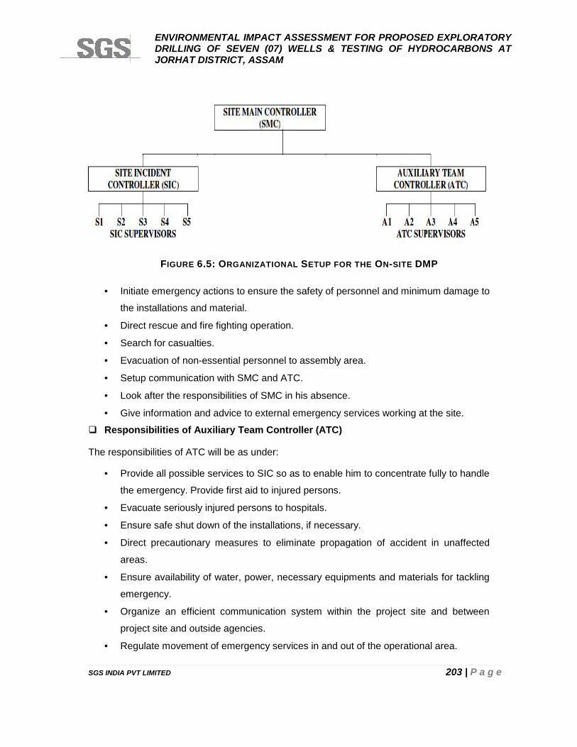
ENVIRONMENTAL IMPACT ASSESSMENT FOR PROPOSED EXPLORATORYDRILLING OF SEVEN (07) WELLS & TESTING OF HYDROCARBONS ATJORHAT DISTRICT, ASSAM
SGS INDIA PVT LIMITED 203 | P a g e
Initiate emergency actions to ensure the safety of personnel and minimum damage to
the installations and material.
Direct rescue and fire fighting operation.
Search for casualties.
Evacuation of non-essential personnel to assembly area.
Setup communication with SMC and ATC.
Look after the responsibilities of SMC in his absence.
Give information and advice to external emergency services working at the site.
Responsibilities of Auxiliary Team Controller (ATC)
The responsibilities of ATC will be as under:
Provide all possible services to SIC so as to enable him to concentrate fully to handle
the emergency. Provide first aid to injured persons.
Evacuate seriously injured persons to hospitals.
Ensure safe shut down of the installations, if necessary.
Direct precautionary measures to eliminate propagation of accident in unaffected
areas.
Ensure availability of water, power, necessary equipments and materials for tackling
emergency.
Organize an efficient communication system within the project site and between
project site and outside agencies.
Regulate movement of emergency services in and out of the operational area.
FIGURE 6.5: ORGANIZATIONAL SETUP FOR THE ON-SITE DMP
ENVIRONMENTAL IMPACT ASSESSMENT FOR PROPOSED EXPLORATORYDRILLING OF SEVEN (07) WELLS & TESTING OF HYDROCARBONS ATJORHAT DISTRICT, ASSAM
SGS INDIA PVT LIMITED 204 | P a g e
6.6.4.1 RESPONSIBILIT IES OF SIC SUPERVISORS
Five SIC supervisors will have the following responsibilities:
- S1 - Control of emergency including fire fighting
- S2 - Search, rescue and evacuation.
- S3 - Communication with Emergency Control Centre.
- S4 - Liaison with external emergency services, if required.
- S5 - Available for deployment as per the need.
6.6.4.2 RESPONSIBILIT IES OF ATC SUPERVISORS
- A1 - First aid to injured personnel.
- A2 - Evacuation of seriously injured persons to hospital.
- A3 - Ensure safe shut down of the installations and take steps to prevent propagation
of accident.
- A4 - Ensure availability of critical facilities, equipments and materials for tackling
emergency.
- A5 - Communication within the plant and with outside agencies.
Warning System
A high pitch warning system may be installed at exploratory drilling and testing site for
announcing the emergency and giving the all clear signal. SMC will declare the emergency
level and operational personnel and, if necessary, public in surrounding villages will be
notified about the nature of the emergency by using alarm system in the following manner:
- Level 1 Emergency – Single beep every five seconds
- Level 2 Emergency – Double beep every five seconds
- Level 3 Emergency – Continuous wailing of alarm
Emergency Plan Initiation
On declaration of emergency, SMC, SIC and ATC will take charge in their respective control
rooms and confer with one another about the best way to deal with the emergency.
Emergency response personnel will report to their respective control centers and
immediately take charge of their duties. It is of paramount importance that the measures to
contain and control the accident as well as those for rescue and evacuation are implemented
immediately.
ENVIRONMENTAL IMPACT ASSESSMENT FOR PROPOSED EXPLORATORYDRILLING OF SEVEN (07) WELLS & TESTING OF HYDROCARBONS ATJORHAT DISTRICT, ASSAM
SGS INDIA PVT LIMITED 205 | P a g e
Emergency ProceduresA. Level 1 Emergencies
Accident is small and isolated and may not require the shut down of any installation/unit at
the drilling/testing site. Effort shall be made to arrest its propagation. Level 1 fire may be
extinguished with water, sand, earth or fire extinguishers. Level 1 hazardous chemical
release, if any, can be contained and controlled quickly without requiring shut down of any
installation/unit or the evacuation of persons working in the affected area.
B. Level 2 Emergencies
The affected unit will be brought to a safe shut down while continuing emergency supplies of
water and power. Level 2 fires will be extinguished by mobilizing fire tenders and foam
extinguishers. Level 2 hazardous chemical release, if any, will require evacuation of
personnel including those working in downwind direction towards upwind or cross wind
direction to minimize the injurious effect of hazardous gas release.
C. Level 3 Emergencies
Level 3 emergencies are not applicable to drilling and testing operational area.
Accident Site Clean Up
While cleaning the site after explosion and fire accidents, care shall be taken against the
probability of fire of flammable material lying buried in the debris of fire accident. Information
regarding the cleaning up of spills of hazardous materials, if used, is available in material
safety data sheets.
Emergency Response Personnel Safety
All emergency response personnel from the OIL and outside agencies shall enter the
accident site under instruction of SIC. These persons shall invariably wear appropriate
protective gear, such as, fire suits, helmets, boots, respirators and gas masks, before
entering the accident site.
All Clear Signal and Public Statement
For Level 1 and 2 emergencies Site Main Controller will authorize an all clear signal in the
form of long high pitched alarm with intermittent pauses, say, two minutes alarm followed by
one minute pause repeatedly. Public statements regarding the emergency will be issued
only by SMC.
ENVIRONMENTAL IMPACT ASSESSMENT FOR PROPOSED EXPLORATORYDRILLING OF SEVEN (07) WELLS & TESTING OF HYDROCARBONS ATJORHAT DISTRICT, ASSAM
SGS INDIA PVT LIMITED 206 | P a g e
CHAPTER 7
ENVIRONMENTAL MANAGEMENT ANDMONITORING PLAN
ENVIRONMENTAL IMPACT ASSESSMENT FOR PROPOSED EXPLORATORYDRILLING OF SEVEN (07) WELLS & TESTING OF HYDROCARBONS ATJORHAT DISTRICT, ASSAM
SGS INDIA PVT LIMITED 207 | P a g e
CHAPTER 7: ENVIRONMENTAL MANANGEMENT PLAN
7.1 PREAMBLE
Environmental Management Plan is the key to ensure that the environmental quality of the
study area does not deteriorate due to the proposed activities.
The Environment Management & Monitoring Plan (EMMP) focuses on direct impacts, which
are identified as having the potential to cause significant impacts on the environment and
identifies:
Specific control measures that will be taken to prevent, reduce or manage the
environmental impacts due to proposed activities; and
Where it is not possible to specify these at this stage, the level of environmental
performance that will be expected due to proposed activities.
OIL’s management is committed of using best environment management practices during
proposed exploratory drilling of wells. OIL will ensure that environmentally critical actions are
undertaken as per the various regulatory requirements. There will be an Environment
Management Cell overseeing all environment and safety responses to ensure that
implementation of mitigation measures and monitoring programme including findings /
recommendation of third party audit and monitoring results.
Corporate EHS Policy
The corporate Environmental policy of OIL is shown in Figure 7.1 below:
7.2 GOOD NEIGHBOUR PRACTISES
A number of probable negative impacts on environment due to proposed activities have
been identified. These impacts can be mitigated or neutralized if proper environmental
control measures are undertaken. It may be noted that there needs to be specific
environmental clauses in the contract to ensure maintaining environmental quality.
OIL is dedicated to responsible development of oil and natural gas resources. Responsible
development includes good relationships with neighbors and a commitment to environmental
protection and compliance with all applicable federal, state, and local regulations.
.

ENVIRONMENTAL IMPACT ASSESSMENT FOR PROPOSED EXPLORATORYDRILLING OF SEVEN (07) WELLS & TESTING OF HYDROCARBONS ATJORHAT DISTRICT, ASSAM
SGS INDIA PVT LIMITED 208 | P a g e
FIGURE 7.1: CORPORATE ENVIRONMENTAL POLICY
ENVIRONMENTAL IMPACT ASSESSMENT FOR PROPOSED EXPLORATORYDRILLING OF SEVEN (07) WELLS & TESTING OF HYDROCARBONS ATJORHAT DISTRICT, ASSAM
SGS INDIA PVT LIMITED 208 | P a g e
FIGURE 7.1: CORPORATE ENVIRONMENTAL POLICY
ENVIRONMENTAL IMPACT ASSESSMENT FOR PROPOSED EXPLORATORYDRILLING OF SEVEN (07) WELLS & TESTING OF HYDROCARBONS ATJORHAT DISTRICT, ASSAM
SGS INDIA PVT LIMITED 208 | P a g e
FIGURE 7.1: CORPORATE ENVIRONMENTAL POLICY
ENVIRONMENTAL IMPACT ASSESSMENT FOR PROPOSED EXPLORATORYDRILLING OF SEVEN (07) WELLS & TESTING OF HYDROCARBONS ATJORHAT DISTRICT, ASSAM
SGS INDIA PVT LIMITED 209 | P a g e
To be a “good neighbor” in the areas, three objectives are to be followed:
Protection of public safety;
Protection of the environment; and
Respect for the property rights of others.
These objectives shall be achieved through use of sound management processes as part of
the responsibility to act as a “good neighbor.”
Listen to the land owner or surface user concerns and respond appropriately
Respect rights-of-way;
Take precautions to protect livestock;
Take precautions not to harm wildlife with our operations;
Drive safely;
Report damages to public or private property to the appropriate parties;
Maintain production equipment and systems; and
Train personnel on the rules and regulations applicable to operations.
Communicate with land owners and surface users
Be willing to discuss issues with respect to surface use rights and compensation due
to temporary loss of crops and others;
Designate a company contact person who is responsible for responding to
community questions;
Listen to and discuss the concerns of the land owner or surface user affected by
operations; and
Attempt to notify the landowner or surface user when commencing significant activity
that will impact their land.
Respect the property and the rights of others
Minimize surface disturbances;
Take precautions to protect livestock with appropriate measures;
Practice good housekeeping;
Remediate and restore the site in a timely manner in compliance with applicable
regulations; and
Drive responsibly on public and private roads.
Promote safety of the general public
Train personnel in safe operating practices;
Conduct emergency planning where applicable; and

ENVIRONMENTAL IMPACT ASSESSMENT FOR PROPOSED EXPLORATORYDRILLING OF SEVEN (07) WELLS & TESTING OF HYDROCARBONS ATJORHAT DISTRICT, ASSAM
SGS INDIA PVT LIMITED 210 | P a g e
Post signage and warnings in accordance with regulations.
Protect the environment:
Train personnel on environmental protection in compliance with applicable
regulations; and
Maintain equipment and utilize good work practices;
Seek to understand the land owner, and surface user concerns and possible
questions regarding:
Groundwater aquifers and surface water;
Air quality;
Wildlife and livestock protection;
Housekeeping;
Noise;
Surface disturbance;
Noxious weeds and brush; and
Follow regulations for waste management and environmental protection.
7.3 ENVIRONMENT CONTROL MEASURES (ECM)
Details of proposed ECM during exploratory drilling of wells in addition to mitigation
measures mentioned in Chapter-2 and Chapter-4, are as per given in Table 7.1 respectively.
This is subjected to be modified as per condition(s) stipulated by MoEFCC and APCB.
7.4 ENVIRONMENT MONITORING PROGRAM (EMP)
Prior to exploratory drilling of seven (07) wells, the following aspects shall be identified and
information used in consultation with the relevant parties (e.g., Administrative authorities,
Department of Archaeological Survey, Divisional & local Forest and Irrigation Departments,
and all concerned State government agencies) for logistical and planning purposes with
respect to affected area.
Ecological details;
Land use pattern;
Details of land ownership;
Details of habitat and other infrastructure;
Pollution and waste management;
Safe working practices;
Rehabilitation (when applicable);
ENVIRONMENTAL IMPACT ASSESSMENT FOR PROPOSED EXPLORATORYDRILLING OF SEVEN (07) WELLS & TESTING OF HYDROCARBONS ATJORHAT DISTRICT, ASSAM
SGS INDIA PVT LIMITED 211 | P a g e
Employment;
Compensation; and
Cultural heritage
OIL is committed to implement good environmental and community management practices
to be able to ensure site-specific environmental, social impacts of project actions are
understood and minimized. During the period of exploratory drilling of wells, OIL would
evaluate and assess aspects as given above on regular basis through its field management
personnel and prepare a monthly monitoring report.
Environmental monitoring and audits will be carried out before, during & after the proposed
exploratory drilling of wells to check that the environmental management measures are
being satisfactorily implemented and that they are delivering the appropriate level of
environmental performance.
7.4.1 ROLE OF OIL
OIL has the ultimate responsibility for implementing the provisions of the EMP. The role
includes ongoing management of environmental impacts and measuring environmental
performance through inspections/audits and monitoring. The contractor performance as well
as development of mechanism for dealing with HSE is an integral part of the environment
management. It is recommended that HSE requirements shall be made integral part of
contract document and prior to tender for assigning any contract.
7.4.2 ROLE OF CONTRACTOR
OIL’s management shall be responsible for the performance of all it’s contractors/sub-
contractors and ensuring that all commitments and policy requirement are translated into
contractor’s requirements and implemented to the full intent and extent of OIL’s commitment.
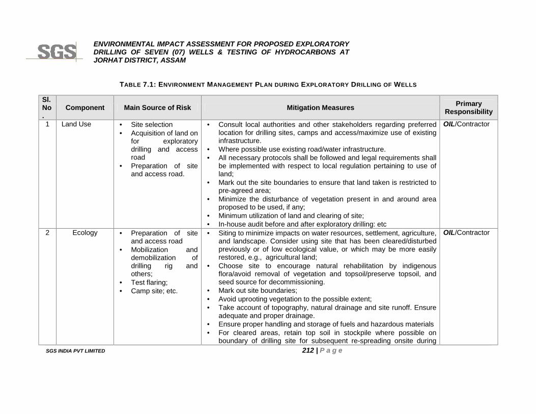
ENVIRONMENTAL IMPACT ASSESSMENT FOR PROPOSED EXPLORATORYDRILLING OF SEVEN (07) WELLS & TESTING OF HYDROCARBONS ATJORHAT DISTRICT, ASSAM
SGS INDIA PVT LIMITED 212 | P a g e
TABLE 7.1: ENVIRONMENT MANAGEMENT PLAN DURING EXPLORATORY DRILLING OF WELLS
Sl.No.
Component Main Source of Risk Mitigation Measures PrimaryResponsibility
1 Land Use Site selection Acquisition of land on
for exploratorydrilling and accessroad
Preparation of siteand access road.
Consult local authorities and other stakeholders regarding preferredlocation for drilling sites, camps and access/maximize use of existinginfrastructure.
Where possible use existing road/water infrastructure. All necessary protocols shall be followed and legal requirements shall
be implemented with respect to local regulation pertaining to use ofland;
Mark out the site boundaries to ensure that land taken is restricted topre-agreed area;
Minimize the disturbance of vegetation present in and around areaproposed to be used, if any;
Minimum utilization of land and clearing of site; In-house audit before and after exploratory drilling: etc
OIL/Contractor
2 Ecology Preparation of siteand access road
Mobilization anddemobilization ofdrilling rig andothers;
Test flaring; Camp site; etc.
Siting to minimize impacts on water resources, settlement, agriculture,and landscape. Consider using site that has been cleared/disturbedpreviously or of low ecological value, or which may be more easilyrestored, e.g., agricultural land;
Choose site to encourage natural rehabilitation by indigenousflora/avoid removal of vegetation and topsoil/preserve topsoil, andseed source for decommissioning.
Mark out site boundaries; Avoid uprooting vegetation to the possible extent; Take account of topography, natural drainage and site runoff. Ensure
adequate and proper drainage. Ensure proper handling and storage of fuels and hazardous materials For cleared areas, retain top soil in stockpile where possible on
boundary of drilling site for subsequent re-spreading onsite during
OIL/Contractor
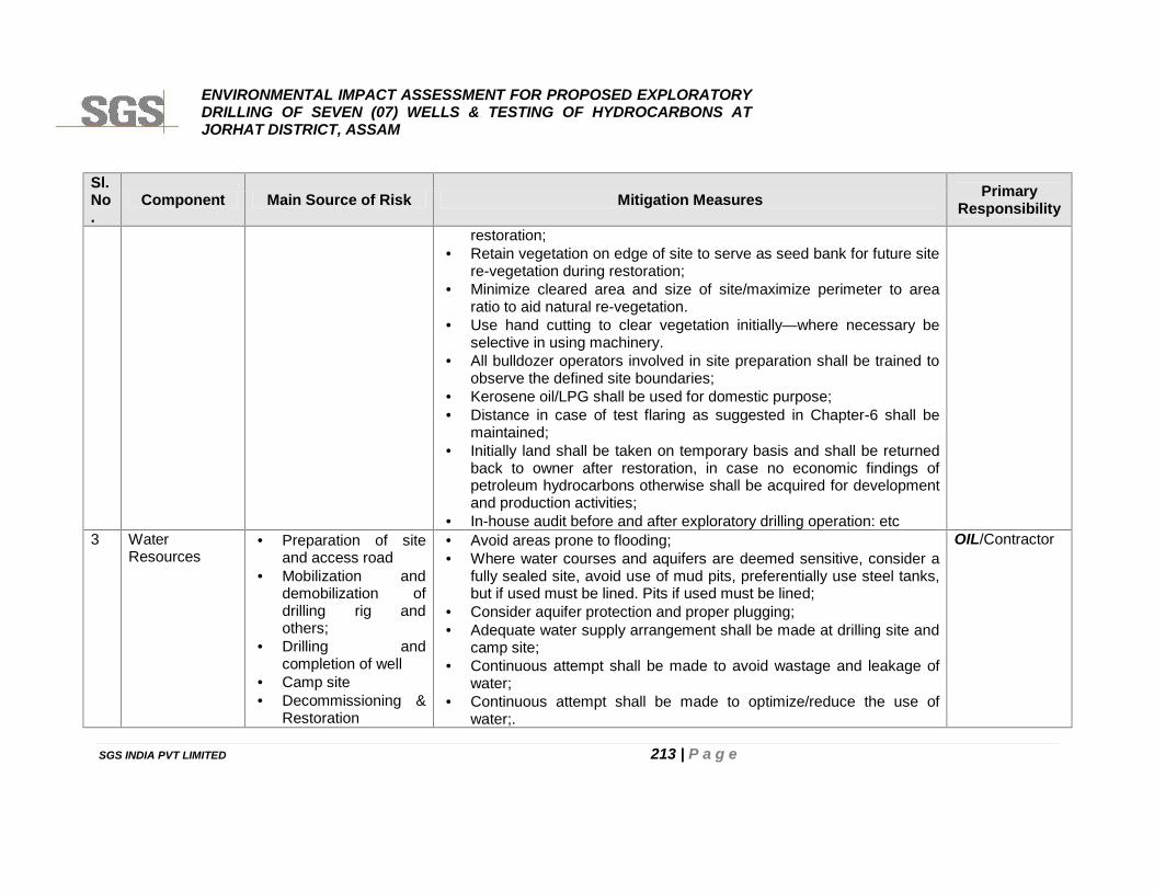
ENVIRONMENTAL IMPACT ASSESSMENT FOR PROPOSED EXPLORATORYDRILLING OF SEVEN (07) WELLS & TESTING OF HYDROCARBONS ATJORHAT DISTRICT, ASSAM
SGS INDIA PVT LIMITED 213 | P a g e
Sl.No.
Component Main Source of Risk Mitigation Measures PrimaryResponsibility
restoration; Retain vegetation on edge of site to serve as seed bank for future site
re-vegetation during restoration; Minimize cleared area and size of site/maximize perimeter to area
ratio to aid natural re-vegetation. Use hand cutting to clear vegetation initially—where necessary be
selective in using machinery. All bulldozer operators involved in site preparation shall be trained to
observe the defined site boundaries; Kerosene oil/LPG shall be used for domestic purpose; Distance in case of test flaring as suggested in Chapter-6 shall be
maintained; Initially land shall be taken on temporary basis and shall be returned
back to owner after restoration, in case no economic findings ofpetroleum hydrocarbons otherwise shall be acquired for developmentand production activities;
In-house audit before and after exploratory drilling operation: etc3 Water
Resources Preparation of site
and access road Mobilization and
demobilization ofdrilling rig andothers;
Drilling andcompletion of well
Camp site Decommissioning &
Restoration
Avoid areas prone to flooding; Where water courses and aquifers are deemed sensitive, consider a
fully sealed site, avoid use of mud pits, preferentially use steel tanks,but if used must be lined. Pits if used must be lined;
Consider aquifer protection and proper plugging; Adequate water supply arrangement shall be made at drilling site and
camp site; Continuous attempt shall be made to avoid wastage and leakage of
water; Continuous attempt shall be made to optimize/reduce the use of
water;.
OIL/Contractor
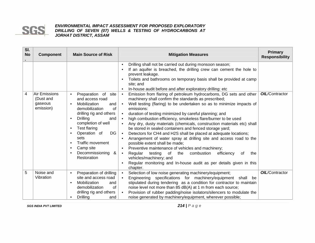
ENVIRONMENTAL IMPACT ASSESSMENT FOR PROPOSED EXPLORATORYDRILLING OF SEVEN (07) WELLS & TESTING OF HYDROCARBONS ATJORHAT DISTRICT, ASSAM
SGS INDIA PVT LIMITED 214 | P a g e
Sl.No.
Component Main Source of Risk Mitigation Measures PrimaryResponsibility
Drilling shall not be carried out during monsoon season; If an aquifer is breached, the drilling crew can cement the hole to
prevent leakage. Toilets and bathrooms on temporary basis shall be provided at camp
site; and In-house audit before and after exploratory drilling: etc
4 A Air Emissions(Dust andgaseousemission)
Preparation of siteand access road
Mobilization anddemobilization ofdrilling rig and others
Drilling andcompletion of well
Test flaring Operation of DG
sets Traffic movement Camp site Decommissioning &
Restoration
Emission from flaring of petroleum hydrocarbons, DG sets and othermachinery shall confirm the standards as prescribed;
Well testing (flaring) to be undertaken so as to minimize impacts ofemissions:
duration of testing minimized by careful planning; and high combustion efficiency, smokeless flare/burner to be used Any dry, dusty materials (chemicals, construction materials etc) shall
be stored in sealed containers and fenced storage yard; Detectors for CH4 and H2S shall be placed at adequate locations; Arrangement of water spray at drilling site and access road to the
possible extent shall be made; Preventive maintenance of vehicles and machinery; Regular testing of the combustion efficiency of the
vehicles/machinery; and Regular monitoring and In-house audit as per details given in this
chapter.
OIL/Contractor
5 Noise andVibration
Preparation of drillingsite and access road
Mobilization anddemobilization ofdrilling rig and others
Drilling and
Selection of low noise generating machinery/equipment; Engineering specifications for machinery/equipment shall be
stipulated during tendering as a condition for contractor to maintainnoise level not more than 85 dB(A) at 1 m from each source;
Provision of rubber padding/noise isolators/silencers to modulate thenoise generated by machinery/equipment, wherever possible;
OIL/Contractor
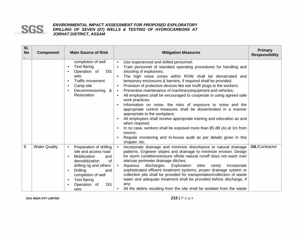
ENVIRONMENTAL IMPACT ASSESSMENT FOR PROPOSED EXPLORATORYDRILLING OF SEVEN (07) WELLS & TESTING OF HYDROCARBONS ATJORHAT DISTRICT, ASSAM
SGS INDIA PVT LIMITED 215 | P a g e
Sl.No.
Component Main Source of Risk Mitigation Measures PrimaryResponsibility
completion of well Test flaring Operation of DG
sets Traffic movement Camp site Decommissioning &
Restoration
Use experienced and skilled personnel; Train personnel of standard operating procedures for handling and
shooting of explosives; The high noise zones within ROW shall be demarcated and
temporary enclosures & barriers, if required shall be provided; Provision of protective devices like ear muff/ plugs to the workers; Preventive maintenance of machinery/equipment and vehicles; All employees shall be encouraged to cooperate in using agreed safe
work practices; Information on noise, the risks of exposure to noise and the
appropriate control measures shall be disseminated in a mannerappropriate to the workplace;
All employees shall receive appropriate training and education as andwhen required;
In no case, workers shall be exposed more than 85 dB (A) at 1m fromsource;
Regular monitoring and In-house audit as per details given in thischapter; etc.
6 Water Quality Preparation of drillingsite and access road
Mobilization anddemobilization ofdrilling rig and others
Drilling andcompletion of well
Test flaring Operation of DG
sets
Incorporate drainage and minimize disturbance to natural drainagepatterns. Engineer slopes and drainage to minimize erosion. Designfor storm conditions/ensure offsite natural runoff does not wash oversite/use perimeter drainage ditches.
Aqueous discharges. Exploration sites rarely incorporatesophisticated effluent treatment systems, proper drainage system orcollection pits shall be provided for transportation/collection of wastewater and adequate treatment shall be provided before discharge, ifany;
All the debris resulting from the site shall be isolated from the waste
OIL/Contractor
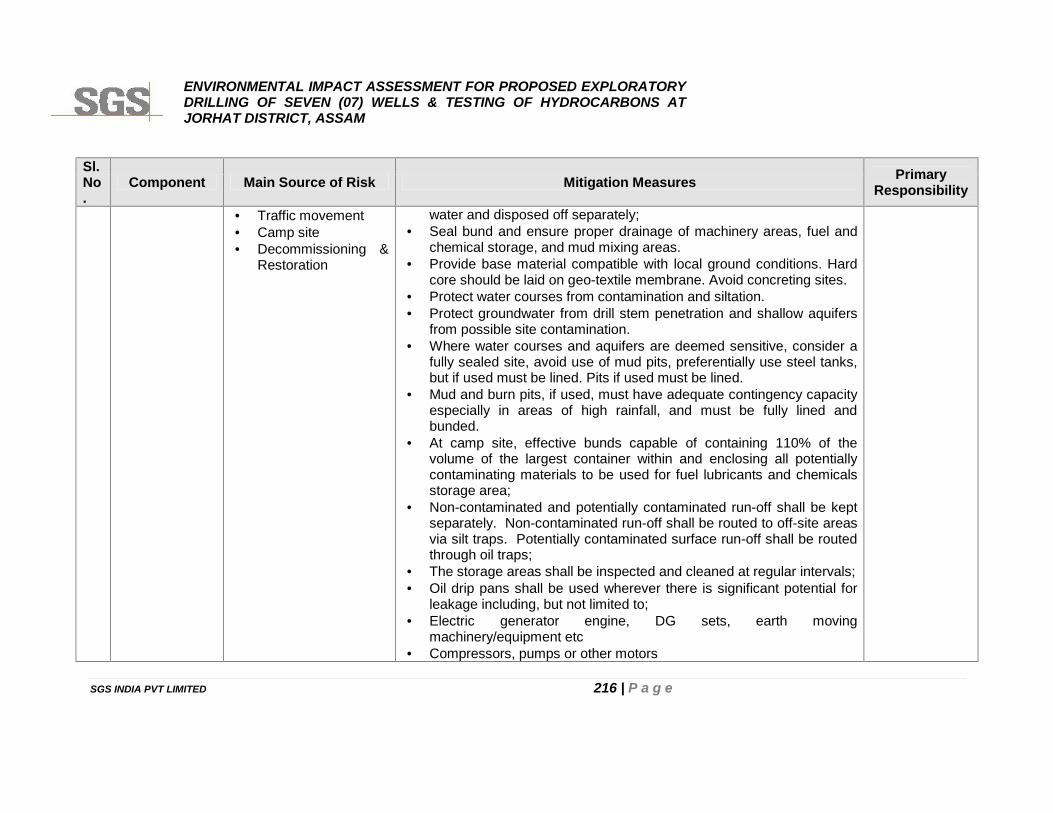
ENVIRONMENTAL IMPACT ASSESSMENT FOR PROPOSED EXPLORATORYDRILLING OF SEVEN (07) WELLS & TESTING OF HYDROCARBONS ATJORHAT DISTRICT, ASSAM
SGS INDIA PVT LIMITED 216 | P a g e
Sl.No.
Component Main Source of Risk Mitigation Measures PrimaryResponsibility
Traffic movement Camp site Decommissioning &
Restoration
water and disposed off separately; Seal bund and ensure proper drainage of machinery areas, fuel and
chemical storage, and mud mixing areas. Provide base material compatible with local ground conditions. Hard
core should be laid on geo-textile membrane. Avoid concreting sites. Protect water courses from contamination and siltation. Protect groundwater from drill stem penetration and shallow aquifers
from possible site contamination. Where water courses and aquifers are deemed sensitive, consider a
fully sealed site, avoid use of mud pits, preferentially use steel tanks,but if used must be lined. Pits if used must be lined.
Mud and burn pits, if used, must have adequate contingency capacityespecially in areas of high rainfall, and must be fully lined andbunded.
At camp site, effective bunds capable of containing 110% of thevolume of the largest container within and enclosing all potentiallycontaminating materials to be used for fuel lubricants and chemicalsstorage area;
Non-contaminated and potentially contaminated run-off shall be keptseparately. Non-contaminated run-off shall be routed to off-site areasvia silt traps. Potentially contaminated surface run-off shall be routedthrough oil traps;
The storage areas shall be inspected and cleaned at regular intervals; Oil drip pans shall be used wherever there is significant potential for
leakage including, but not limited to; Electric generator engine, DG sets, earth moving
machinery/equipment etc Compressors, pumps or other motors
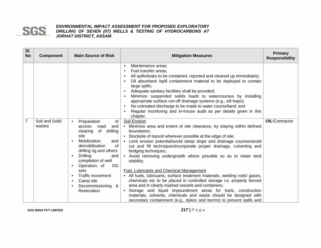
ENVIRONMENTAL IMPACT ASSESSMENT FOR PROPOSED EXPLORATORYDRILLING OF SEVEN (07) WELLS & TESTING OF HYDROCARBONS ATJORHAT DISTRICT, ASSAM
SGS INDIA PVT LIMITED 217 | P a g e
Sl.No.
Component Main Source of Risk Mitigation Measures PrimaryResponsibility
Maintenance areas Fuel transfer areas. All spills/leaks to be contained, reported and cleaned up immediately; Oil absorbent /spill containment material to be deployed to contain
large spills; Adequate sanitary facilities shall be provided; Minimize suspended solids loads to watercourses by installing
appropriate surface run-off drainage systems (e.g., silt traps); No untreated discharge to be made to water course/land; and Regular monitoring and In-house audit as per details given in this
chapter.7 Soil and Solid
wastes Preparation of
access road andclearing of drillingsite
Mobilization anddemobilization ofdrilling rig and others
Drilling andcompletion of well
Operation of DGsets
Traffic movement Camp site Decommissioning &
Restoration
Soil Erosion Minimize area and extent of site clearance, by staying within defined
boundaries; Stockpile of topsoil wherever possible at the edge of site; Limit erosion potential/avoid steep slope and drainage courses/avoid
cut and fill techniques/incorporate proper drainage, culverting andbridging techniques;
Avoid removing undergrowth where possible so as to retain landstability;
Fuel, Lubricants and Chemical Management All fuels, lubricants, surface treatment materials, welding rods/ gases,
chemicals etc to be placed in controlled storage i.e. properly fencedarea and in clearly marked vessels and containers;
Storage and liquid impoundment areas for fuels, constructionmaterials, solvents, chemicals and waste should be designed withsecondary containment (e.g., dykes and berms) to prevent spills and
OIL/Contractor
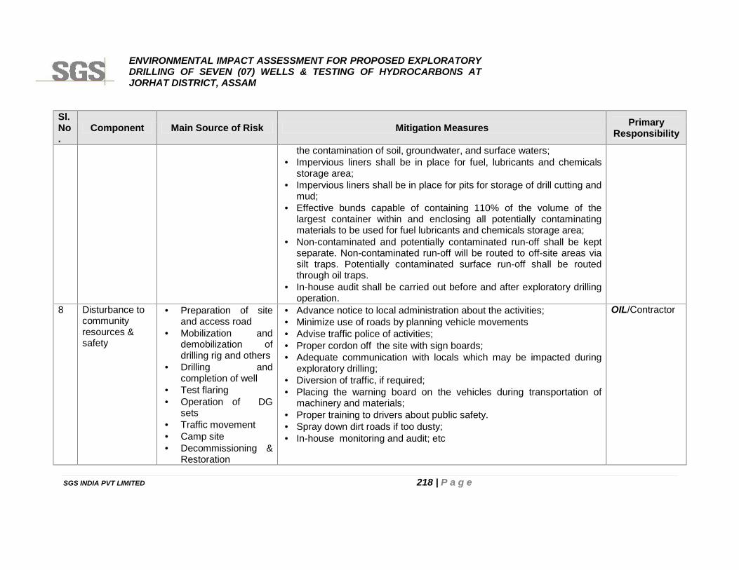
ENVIRONMENTAL IMPACT ASSESSMENT FOR PROPOSED EXPLORATORYDRILLING OF SEVEN (07) WELLS & TESTING OF HYDROCARBONS ATJORHAT DISTRICT, ASSAM
SGS INDIA PVT LIMITED 218 | P a g e
Sl.No.
Component Main Source of Risk Mitigation Measures PrimaryResponsibility
the contamination of soil, groundwater, and surface waters; Impervious liners shall be in place for fuel, lubricants and chemicals
storage area; Impervious liners shall be in place for pits for storage of drill cutting and
mud; Effective bunds capable of containing 110% of the volume of the
largest container within and enclosing all potentially contaminatingmaterials to be used for fuel lubricants and chemicals storage area;
Non-contaminated and potentially contaminated run-off shall be keptseparate. Non-contaminated run-off will be routed to off-site areas viasilt traps. Potentially contaminated surface run-off shall be routedthrough oil traps.
In-house audit shall be carried out before and after exploratory drillingoperation.
8 Disturbance tocommunityresources &safety
Preparation of siteand access road
Mobilization anddemobilization ofdrilling rig and others
Drilling andcompletion of well
Test flaring Operation of DG
sets Traffic movement Camp site Decommissioning &
Restoration
Advance notice to local administration about the activities; Minimize use of roads by planning vehicle movements Advise traffic police of activities; Proper cordon off the site with sign boards; Adequate communication with locals which may be impacted during
exploratory drilling; Diversion of traffic, if required; Placing the warning board on the vehicles during transportation of
machinery and materials; Proper training to drivers about public safety. Spray down dirt roads if too dusty; In-house monitoring and audit; etc
OIL/Contractor
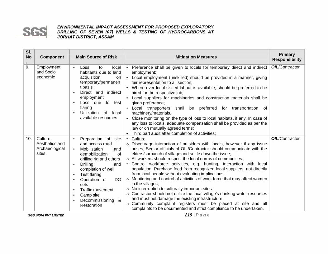
ENVIRONMENTAL IMPACT ASSESSMENT FOR PROPOSED EXPLORATORYDRILLING OF SEVEN (07) WELLS & TESTING OF HYDROCARBONS ATJORHAT DISTRICT, ASSAM
SGS INDIA PVT LIMITED 219 | P a g e
Sl.No.
Component Main Source of Risk Mitigation Measures PrimaryResponsibility
9. Employmentand Socioeconomic
Loss to localhabitants due to landacquisition ontemporary/permanent basis
Direct and indirectemployment
Loss due to testflaring
Utilization of localavailable resources
Preference shall be given to locals for temporary direct and indirectemployment;
Local employment (unskilled) should be provided in a manner, givingfair representation to all section;
Where ever local skilled labour is available, should be preferred to behired for the respective job;
Local suppliers for machineries and construction materials shall begiven preference;
Local transporters shall be preferred for transportation ofmachinery/materials.
Close monitoring on the type of loss to local habitats, if any. In case ofany loss to locals, adequate compensation shall be provided as per thelaw or on mutually agreed terms;
Third part audit after completion of activities;
OIL/Contractor
10. Culture,Aesthetics andArchaeologicalsites
Preparation of siteand access road
Mobilization anddemobilization ofdrilling rig and others
Drilling andcompletion of well
Test flaring Operation of DG
sets Traffic movement Camp site Decommissioning &
Restoration
Cultureo Discourage interaction of outsiders with locals, however if any issue
arises, Senior officials of OIL/Contractor should communicate with theelders/sarpanch of village and settle down the issue;
o All workers should respect the local norms of communities.; Control workforce activities, e.g. hunting, interaction with local
population. Purchase food from recognized local suppliers, not directlyfrom local people without evaluating implications.
o Monitoring and control of activities of work force that may affect womenin the villages;
o No interruption to culturally important sites.o Contractor should not utilize the local village's drinking water resources
and must not damage the existing infrastructure.o Community complaint registers must be placed at site and all
complaints to be documented and strict compliance to be undertaken.
OIL/Contractor
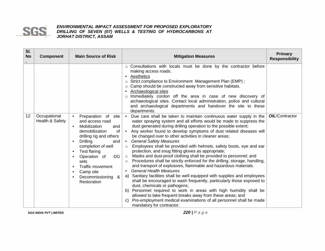
ENVIRONMENTAL IMPACT ASSESSMENT FOR PROPOSED EXPLORATORYDRILLING OF SEVEN (07) WELLS & TESTING OF HYDROCARBONS ATJORHAT DISTRICT, ASSAM
SGS INDIA PVT LIMITED 220 | P a g e
Sl.No.
Component Main Source of Risk Mitigation Measures PrimaryResponsibility
o Consultations with locals must be done by the contractor beforemaking access roads.
Aestheticso Strict compliance to Environment Management Plan (EMP) ;o Camp should be constructed away from sensitive habitats. Archaeological siteso Immediately cordon off the area in case of new discovery of
archaeological sites. Contact local administration, police and culturaland archaeological departments and handover the site to thesedepartments.
12 OccupationalHealth & Safety
Preparation of siteand access road
Mobilization anddemobilization ofdrilling rig and others
Drilling andcompletion of well
Test flaring Operation of DG
sets Traffic movement Camp site Decommissioning &
Restoration
Due care shall be taken to maintain continuous water supply in thewater spraying system and all efforts would be made to suppress thedust generated during drilling operation to the possible extent;
Any worker found to develop symptoms of dust related diseases willbe changed over to other activities in cleaner areas;
General Safety Measureso Employees shall be provided with helmets, safety boots, eye and ear
protection, and snug fitting gloves as appropriate;o Masks and dust-proof clothing shall be provided to personnel; ando Procedures shall be strictly enforced for the drilling, storage, handling,
and transport of explosives, flammable and hazardous materials. General Health Measuresa) Sanitary facilities shall be well equipped with supplies and employees
shall be encouraged to wash frequently, particularly those exposed todust, chemicals or pathogens;
b) Personnel required to work in areas with high humidity shall beallowed to take frequent breaks away from these areas; and
c) Pre-employment medical examinations of all personnel shall be mademandatory for contractor.
OIL/Contractor
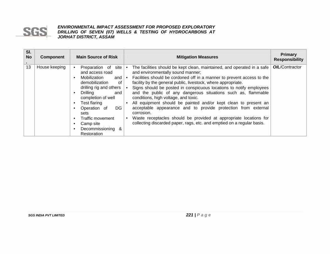
ENVIRONMENTAL IMPACT ASSESSMENT FOR PROPOSED EXPLORATORYDRILLING OF SEVEN (07) WELLS & TESTING OF HYDROCARBONS ATJORHAT DISTRICT, ASSAM
SGS INDIA PVT LIMITED 221 | P a g e
Sl.No.
Component Main Source of Risk Mitigation Measures PrimaryResponsibility
13 House keeping Preparation of siteand access road
Mobilization anddemobilization ofdrilling rig and others
Drilling andcompletion of well
Test flaring Operation of DG
sets Traffic movement Camp site Decommissioning &
Restoration
The facilities should be kept clean, maintained, and operated in a safeand environmentally sound manner;
Facilities should be cordoned off in a manner to prevent access to thefacility by the general public, livestock, where appropriate.
Signs should be posted in conspicuous locations to notify employeesand the public of any dangerous situations such as, flammableconditions, high voltage, and toxic.
All equipment should be painted and/or kept clean to present anacceptable appearance and to provide protection from externalcorrosion.
Waste receptacles should be provided at appropriate locations forcollecting discarded paper, rags, etc. and emptied on a regular basis.
OIL/Contractor
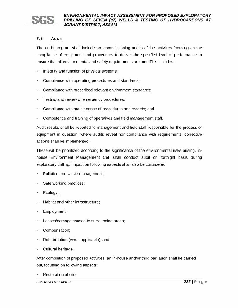
ENVIRONMENTAL IMPACT ASSESSMENT FOR PROPOSED EXPLORATORYDRILLING OF SEVEN (07) WELLS & TESTING OF HYDROCARBONS ATJORHAT DISTRICT, ASSAM
SGS INDIA PVT LIMITED 222 | P a g e
7.5 AUDIT
The audit program shall include pre-commissioning audits of the activities focusing on the
compliance of equipment and procedures to deliver the specified level of performance to
ensure that all environmental and safety requirements are met. This includes:
Integrity and function of physical systems;
Compliance with operating procedures and standards;
Compliance with prescribed relevant environment standards;
Testing and review of emergency procedures;
Compliance with maintenance of procedures and records; and
Competence and training of operatives and field management staff.
Audit results shall be reported to management and field staff responsible for the process or
equipment in question, where audits reveal non-compliance with requirements, corrective
actions shall be implemented.
These will be prioritized according to the significance of the environmental risks arising. In-
house Environment Management Cell shall conduct audit on fortnight basis during
exploratory drilling. Impact on following aspects shall also be considered:
Pollution and waste management;
Safe working practices;
Ecology ;
Habitat and other infrastructure;
Employment;
Losses/damage caused to surrounding areas;
Compensation;
Rehabilitation (when applicable); and
Cultural heritage.
After completion of proposed activities, an in-house and/or third part audit shall be carried
out, focusing on following aspects:
Restoration of site;
ENVIRONMENTAL IMPACT ASSESSMENT FOR PROPOSED EXPLORATORYDRILLING OF SEVEN (07) WELLS & TESTING OF HYDROCARBONS ATJORHAT DISTRICT, ASSAM
SGS INDIA PVT LIMITED 223 | P a g e
Habitat and other infrastructure
Losses to crops and ecology to the surrounding area;
Compensation; etc.
7.5.1 PERFORMANCE MONITORING
Environment & Safety Aspects
Safety features, ambient working environment and Occupational Health and Safety (OHS)-
indicators are subjected to regular monitoring and review. The compiled information and any
corrective measures taken shall be applied in a continuous process to improve the OHS
management system (OHSMS) which will be responsible for management of environment,
health and safety aspects related to proposed exploratory drilling of wells.
The OHSMS shall include specifications for performance monitoring, evaluation, and
improvement of the system as well as for recording and reporting accidents.
OHSMS: The performance and achievements of the OHSMS responsible for
management of overall environment, Health & Safety aspects shall be re-assessed on
fortnightly basis.
Safety Inspection, Testing and Calibration: OIL shall arrange for third party inspection
and testing of all safety features including gas detectors and hazard control measures
once during exploratory drilling of each well. The inspection will focus on engineering
and personal protective features, work procedures, places of work, installations,
equipment, and tools used. The inspection shall ensure that issued personal protective
equipment continues to provide adequate protection and is being worn as required. All
instruments installed or used for monitoring and recording of working environment
parameters shall be regularly tested and calibrated. Records shall be kept of all
inspections, tests, and calibrations.
Monitoring of the Working Environment: Environment Monitoring shall be carried out by
using an appropriate combination of portable and stationary sampling and monitoring
instruments for keeping healthy and hygienic environment to the possible extent. The
monitoring as per details given hereunder Tables 7.2 (subjected to be modified as per
conditions stipulated by MoEFCC and APCB) shall be carried out during exploratory
drilling of well:
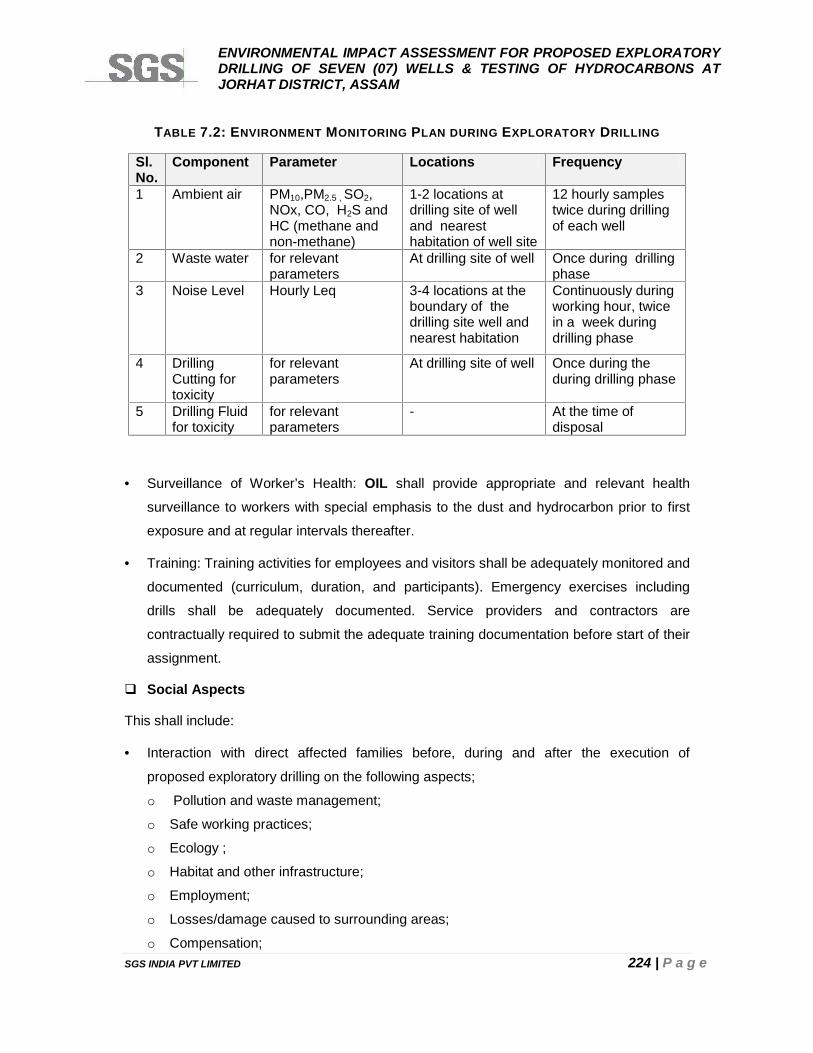
ENVIRONMENTAL IMPACT ASSESSMENT FOR PROPOSED EXPLORATORYDRILLING OF SEVEN (07) WELLS & TESTING OF HYDROCARBONS ATJORHAT DISTRICT, ASSAM
SGS INDIA PVT LIMITED 224 | P a g e
TABLE 7.2: ENVIRONMENT MONITORING PLAN DURING EXPLORATORY DRILLING
Sl.No.
Component Parameter Locations Frequency
1 Ambient air PM10,PM2.5 , SO2,NOx, CO, H2S andHC (methane andnon-methane)
1-2 locations atdrilling site of welland nearesthabitation of well site
12 hourly samplestwice during drillingof each well
2 Waste water for relevantparameters
At drilling site of well Once during drillingphase
3 Noise Level Hourly Leq 3-4 locations at theboundary of thedrilling site well andnearest habitation
Continuously duringworking hour, twicein a week duringdrilling phase
4 DrillingCutting fortoxicity
for relevantparameters
At drilling site of well Once during theduring drilling phase
5 Drilling Fluidfor toxicity
for relevantparameters
- At the time ofdisposal
Surveillance of Worker’s Health: OIL shall provide appropriate and relevant health
surveillance to workers with special emphasis to the dust and hydrocarbon prior to first
exposure and at regular intervals thereafter.
Training: Training activities for employees and visitors shall be adequately monitored and
documented (curriculum, duration, and participants). Emergency exercises including
drills shall be adequately documented. Service providers and contractors are
contractually required to submit the adequate training documentation before start of their
assignment.
Social Aspects
This shall include:
Interaction with direct affected families before, during and after the execution of
proposed exploratory drilling on the following aspects;
o Pollution and waste management;
o Safe working practices;
o Ecology ;
o Habitat and other infrastructure;
o Employment;
o Losses/damage caused to surrounding areas;
o Compensation;
ENVIRONMENTAL IMPACT ASSESSMENT FOR PROPOSED EXPLORATORYDRILLING OF SEVEN (07) WELLS & TESTING OF HYDROCARBONS ATJORHAT DISTRICT, ASSAM
SGS INDIA PVT LIMITED 225 | P a g e
o Rehabilitation (when applicable); and
o Cultural heritage.
Monitoring of project impacts and verification of damage to resources; and
Reporting so as to required.
7.6 ENVIRONMENT MANAGEMENT CELL
It is necessary to have a permanent organizational set up charged with the task of ensuring
effective implementation of all identified mitigation measures. Conscious of this, OIL will
establish an Environment Management cell consisting of officers from various disciplines to
coordinate the activities concerned with the management and implementation of the
environmental control measures during proposed exploratory drilling. OIL shall also develop
a well-documented system to monitor and control pollution. The organization and
responsibility of the Environmental Management Cell (EMC) is presented below in Figure7.2.
Basically, this department will undertake monitoring of the environmental pollution levels by
measuring fugitive emissions, ambient air quality, water and effluent quality, noise level etc.,
either departmentally or by appointing external agencies wherever necessary. In case, the
monitored results of environmental pollution are found to exceeding the allowable values, the
EMC suggests remedial action and gets these suggestions implemented through the
concerned head of activities. EMC shall also co-ordinate all the related activities such as
collection of statistics w.r.t. health of workers, restoration of site, losses to crops and ecology
and compensation.
OIL’s environmental officer for investigation shall have the following responsibilities in
general:
Shall modify proposed EMP as described in Table 7.1 and monitoring plan as mentioned
in Table 7.2 in line with the conditions stipulated by MoEF& CC and APCB.
Thoroughly familiarize himself with the existing information about habitat, sensitivities
and baseline environment scenario etc present in the study area, making use of the EIA
report;
If applicable, liaise with the contractor in order to develop a common understanding of
the goals of the EMP during execution of various activities for completion of the
proposed exploratory drilling;
To work actively with the teams involved in vegetation clearing so as to identify any
specific local areas of habitat sensitivity;
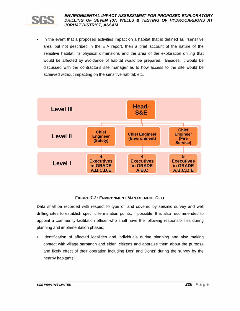
ENVIRONMENTAL IMPACT ASSESSMENT FOR PROPOSED EXPLORATORYDRILLING OF SEVEN (07) WELLS & TESTING OF HYDROCARBONS ATJORHAT DISTRICT, ASSAM
SGS INDIA PVT LIMITED 226 | P a g e
In the event that a proposed activities impact on a habitat that is defined as ‘sensitive
area’ but not described in the EIA report, then a brief account of the nature of the
sensitive habitat, its physical dimensions and the area of the exploration drilling that
would be affected by avoidance of habitat would be prepared. Besides, it would be
discussed with the contractor’s site manager as to how access to the site would be
achieved without impacting on the sensitive habitat; etc.
FIGURE 7.2: ENVIRONMENT MANAGEMENT CELL
Data shall be recorded with respect to type of land covered by seismic survey and well
drilling sites to establish specific termination points, if possible. It is also recommended to
appoint a community-facilitation officer who shall have the following responsibilities during
planning and implementation phases;
Identification of affected localities and individuals during planning and also making
contact with village sarpanch and elder citizens and appraise them about the purpose
and likely effect of their operation including Dos’ and Donts’ during the survey by the
nearby habitants;
Level I
Level II
Level III
ChiefEngineer(Safety)
4Executivesin GRADEA,B,C,D,E
ENVIRONMENTAL IMPACT ASSESSMENT FOR PROPOSED EXPLORATORYDRILLING OF SEVEN (07) WELLS & TESTING OF HYDROCARBONS ATJORHAT DISTRICT, ASSAM
SGS INDIA PVT LIMITED 226 | P a g e
In the event that a proposed activities impact on a habitat that is defined as ‘sensitive
area’ but not described in the EIA report, then a brief account of the nature of the
sensitive habitat, its physical dimensions and the area of the exploration drilling that
would be affected by avoidance of habitat would be prepared. Besides, it would be
discussed with the contractor’s site manager as to how access to the site would be
achieved without impacting on the sensitive habitat; etc.
FIGURE 7.2: ENVIRONMENT MANAGEMENT CELL
Data shall be recorded with respect to type of land covered by seismic survey and well
drilling sites to establish specific termination points, if possible. It is also recommended to
appoint a community-facilitation officer who shall have the following responsibilities during
planning and implementation phases;
Identification of affected localities and individuals during planning and also making
contact with village sarpanch and elder citizens and appraise them about the purpose
and likely effect of their operation including Dos’ and Donts’ during the survey by the
nearby habitants;
Head-S&E
ChiefEngineer(Safety)
4Executivesin GRADEA,B,C,D,E
Chief Engineer(Environment)
4Executivesin GRADE
A,B,C
ChiefEngineer
(FireService)
5Executivesin GRADEA,B,C,D,E
ENVIRONMENTAL IMPACT ASSESSMENT FOR PROPOSED EXPLORATORYDRILLING OF SEVEN (07) WELLS & TESTING OF HYDROCARBONS ATJORHAT DISTRICT, ASSAM
SGS INDIA PVT LIMITED 226 | P a g e
In the event that a proposed activities impact on a habitat that is defined as ‘sensitive
area’ but not described in the EIA report, then a brief account of the nature of the
sensitive habitat, its physical dimensions and the area of the exploration drilling that
would be affected by avoidance of habitat would be prepared. Besides, it would be
discussed with the contractor’s site manager as to how access to the site would be
achieved without impacting on the sensitive habitat; etc.
FIGURE 7.2: ENVIRONMENT MANAGEMENT CELL
Data shall be recorded with respect to type of land covered by seismic survey and well
drilling sites to establish specific termination points, if possible. It is also recommended to
appoint a community-facilitation officer who shall have the following responsibilities during
planning and implementation phases;
Identification of affected localities and individuals during planning and also making
contact with village sarpanch and elder citizens and appraise them about the purpose
and likely effect of their operation including Dos’ and Donts’ during the survey by the
nearby habitants;
ChiefEngineer
(FireService)
5Executivesin GRADEA,B,C,D,E
ENVIRONMENTAL IMPACT ASSESSMENT FOR PROPOSED EXPLORATORYDRILLING OF SEVEN (07) WELLS & TESTING OF HYDROCARBONS ATJORHAT DISTRICT, ASSAM
SGS INDIA PVT LIMITED 227 | P a g e
Inspection and documentation of the conditions preceding the survey and drilling in the
area of operations to account for any permitting/operational damage which may occur
through dialogue with the owners of the resources and village Head;
Negotiation and agreement concerning asset inventories and payment of compensation
as per land revenue records of land yields;
Monitoring of project impacts and verification of damage to resources; and
Reporting so as to required.
7.7 TRAINING
To achieve the objective of environment management, it is essential not only to provide best
pollution control system but also to provide trained manpower resources to operate the
same. Training facilities shall be in place for environmental control. This training shall cover
the items listed below:
Awareness of pollution control and environmental protection;
Operation and maintenance of pollution control equipment;
Knowledge of norms, regulations and procedures; and
Occupational health and safety.
OIL shall ensure that workers prior to commencement of new assignments receive adequate
training and information enabling them to understand the hazards of work and to protect their
health from hazardous ambient factors that may be present. The training will adequately
cover:
a) Knowledge of materials, equipment, and tools;
b) Known hazards in the operations and how they are controlled;
c) Potential risks to health;
d) Precautions to prevent exposure;
e) Hygiene requirements;
f) Wearing and use of protective equipment and clothing; and
g) Appropriate response to operation extremes, incidents and accidents.
A basic occupational training program and specialty courses shall be provided as needed to
ensure that workers are oriented to the specific hazards of individual work assignments.
Training shall generally be provided to management, supervisors, workers, and occasional
ENVIRONMENTAL IMPACT ASSESSMENT FOR PROPOSED EXPLORATORYDRILLING OF SEVEN (07) WELLS & TESTING OF HYDROCARBONS ATJORHAT DISTRICT, ASSAM
SGS INDIA PVT LIMITED 228 | P a g e
visitors to areas of risks and hazards. Training shall also be provided to account for new or
changed risks whenever procedures are altered or new materials/equipment introduced. The
salient features of the training program are as given hereunder:
Employees will be trained on the hazards, precautions and procedures for the safe
storage and handling of equipments/machinery, material etc relevant to each employee's
task and work area;
Training will incorporate information from the Material Safety Data Sheets (MSDSs) for
all material proposed to be handled;
Personnel will be trained in environmental, health and safety matters including accident
prevention, safe lifting practices, the use of MSDSs, safe chemical handling practices,
and proper control and maintenance of equipment and facilities;
Training will also include emergency response, including the location and proper use of
emergency equipment, use of personal protective equipment, procedures for raising the
alarm and notifying emergency response teams, and proper response actions for each
foreseeable emergency situation;
Training will be repeated periodically and supported by feasible incentives;
Workers with rescue and first-aid duties will receive dedicated training so as not to
inadvertently aggravate exposures and health hazards to themselves or their co-
workers.; and
OIL through appropriate contract specifications and monitoring shall ensure that service
providers, as well as contracted and subcontracted labor is appropriately trained before
start of their assignments.
7.8 RECORD KEEPING
Records of significant environmental matters, including monitoring data, accidents and
occupational illnesses, and leaks/spills, fires and other emergencies shall be maintained;
and Recorded information will be reviewed and evaluated to improve the effectiveness of the
environmental, health and safety program by OIL.
ENVIRONMENTAL IMPACT ASSESSMENT FOR PROPOSED EXPLORATORYDRILLING OF SEVEN (07) WELLS & TESTING OF HYDROCARBONS ATJORHAT DISTRICT, ASSAM
SGS INDIA PVT LIMITED 229 | P a g e
CHAPTER 8
PROJECT BENEFITS
ENVIRONMENTAL IMPACT ASSESSMENT FOR PROPOSED EXPLORATORYDRILLING OF SEVEN (07) WELLS & TESTING OF HYDROCARBONS ATJORHAT DISTRICT, ASSAM
SGS INDIA PVT LIMITED 230 | P a g e
CHAPTER 8: PROJECT BENEFITS
8.1 PREAMBLE
The proposed exploration program will establish status of availability of economical viable
hydrocarbons in the block. On confirmation, the development of the oil field will result in
considerable growth of service sector and will also generate new industrial and business
opportunities in the area. Small and medium scale industries may be developed as
consequence. The major benefits of the project include reduction of the oil import bill of the
nation as well as reduction of the imbalance in oil production and consumption.
The commercial development will also lead to investment in Assam, bringing oil and gas
revenues both to the State and to the Central Government. The presence of OIL in the
region will substantially improve the socio-economic conditions of the region.
In development and production phase, OIL will require significant work force of non-technical
and technical persons. Migration of persons with better education and professional
experience will result in increase of population and literacy in the surrounding villages.
8.2 BENEFITS FOR THE COUNTRY
The demand for petroleum has recorded a considerable increase over the year from 30
million tones in 1980-81 to about 170 million tones at present. This growing demand poses a
big challenge to oil producing company including Oil India. Also new oil/gas finds in the block
will lead to reduction in India’s dependence on imported crude oil and thereby results in
considerable saving in foreign exchange.
There will be a beneficial effect of a flourishing production unit that will directly and indirectly
boost the living standards of the people, and will create more jobs in the local economy.
8.3 BENEFITS FOR THE REGION
In the event that commercial quantities of hydrocarbon reserves are discovered, more long-
term employment opportunities would be created. Besides, the hydrocarbons brought to the
surface shall help in contributing the ongoing efforts of the government to meet the national
demand of petroleum resources.
Development of ancillary activities resulting into indirect jobs and requirement of more skills.
ENVIRONMENTAL IMPACT ASSESSMENT FOR PROPOSED EXPLORATORYDRILLING OF SEVEN (07) WELLS & TESTING OF HYDROCARBONS ATJORHAT DISTRICT, ASSAM
SGS INDIA PVT LIMITED 231 | P a g e
Employment Potential
The impact of the project on the economic aspects can be clearly observed. The proposed
project activities will provide direct and indirect employment to persons of different skills and
trades. The local population will be given preference to employment. The employment
potential will ameliorate economic conditions of these families directly and provide
employment to many other families indirectly who are involved in business and service
oriented activities.
The employment of local people in primary and secondary sectors of project shall upgrade
the prosperity of the region. This in-turn will improve the socio-economic conditions of the
area.
Improvement in the Social Infrastructure
It is due to the following:
Generation of employment: The project will create opportunities for direct and indirect
employment;
Increase in purchasing power and improved standard of living of the area;
Establishment of small and medium scale industries may be developed as
consequence;
Increased revenue to the state by way of royalty, taxes and duties;
Regular Fund flow to local market;
ENVIRONMENTAL IMPACT ASSESSMENT FOR PROPOSED EXPLORATORYDRILLING OF SEVEN (07) WELLS & TESTING OF HYDROCARBONS ATJORHAT DISTRICT, ASSAM
SGS INDIA PVT LIMITED 232 | P a g e
CHAPTER 9
SUMMARY AND CONCLUSIONS
ENVIRONMENTAL IMPACT ASSESSMENT FOR PROPOSED EXPLORATORYDRILLING OF SEVEN (07) WELLS & TESTING OF HYDROCARBONS ATJORHAT DISTRICT, ASSAM
SGS INDIA PVT LIMITED 233 | P a g e
CHAPTER 9: SUMM ARY AND CONCLUSIONS
Oil India Limited (OIL), a Government of India Navaratna Enterprise, has awarded
Exploration Block AA-ONN-2009/4 in the Assam-Arakan Basin having surface coverage of
84 sq. km situated in Jorhat districts of Assam to consortium consisting of two National Oil
Companies, Oil India Limited (OIL) & Oil and Natural Gas Corporation Limited (ONGC) for
exploration of hydrocarbons by Government of India(GOI) under NELP-VII/ license round of
bidding with participating interest of 50% stake by each and OIL being the operator in this
Block.
The regulatory approval for the exploration program has been obtained from Petroleum
Exploration License (PEL) with production sharing contract (PSC) for the Block being singed
on 30.06.2010. The PEL for the Block is effective from 09.12.2011 for a period of seven
years. However, the four year Initial Exploration Period of the Block AA-ONN-2009/4 expires
after 08.12.2015.
An Environment Impact Assessment report has been prepared for this exploratory drilling for
seven (07) wells based on existing baseline environmental quality data collected for pre-
monsoon season 2015 (February to May 2015); Identification and prediction of significant
environmental impacts due to the proposed exploratory drilling activity followed by
delineation of appropriate impact mitigation measures and suggestion for implementing
these measures are detailed in the Environmental Management Plan (EMP).
The proposed project intends to ensure that the developmental activities related to the
project are environmentally sound and does not have any adverse effects on the natural
environment in the surroundings of the site. The purpose of this Environmental Impact
Assessment (EIA) study is to provide information on the nature and extent of environmental
impacts arising from the construction and operation of the proposed project and related
activities taking place concurrently
9.1 SALIENT FEATURES OF THE PROJECT
Sl. No. Features Details1 Location Details Block AA-ONN-2009/4 is located in Jorhat
District, Assam having an area of 84 sq.km.
2 Number of exploratory wells to bedrilled
OIL proposed to drill 07 wells forexploration of hydrocarbons
3 Depth of drilling Maximum upto 3500 m/Basement4 Activity involved Purchase of land/Temporary land lease,
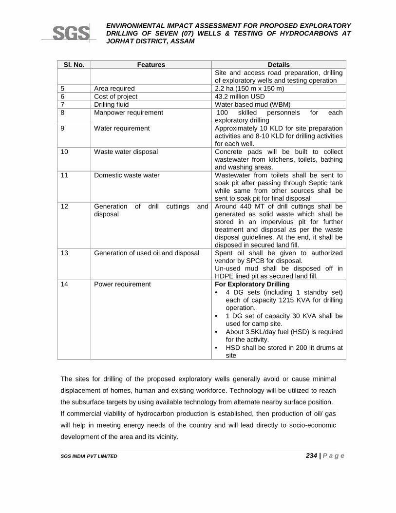
ENVIRONMENTAL IMPACT ASSESSMENT FOR PROPOSED EXPLORATORYDRILLING OF SEVEN (07) WELLS & TESTING OF HYDROCARBONS ATJORHAT DISTRICT, ASSAM
SGS INDIA PVT LIMITED 234 | P a g e
Sl. No. Features DetailsSite and access road preparation, drillingof exploratory wells and testing operation
5 Area required 2.2 ha (150 m x 150 m)6 Cost of project 43.2 million USD7 Drilling fluid Water based mud (WBM)8 Manpower requirement 100 skilled personnels for each
exploratory drilling9 Water requirement Approximately 10 KLD for site preparation
activities and 8-10 KLD for drilling activitiesfor each well.
10 Waste water disposal Concrete pads will be built to collectwastewater from kitchens, toilets, bathingand washing areas.
11 Domestic waste water Wastewater from toilets shall be sent tosoak pit after passing through Septic tankwhile same from other sources shall besent to soak pit for final disposal
12 Generation of drill cuttings anddisposal
Around 440 MT of drill cuttings shall begenerated as solid waste which shall bestored in an impervious pit for furthertreatment and disposal as per the wastedisposal guidelines. At the end, it shall bedisposed in secured land fill.
13 Generation of used oil and disposal Spent oil shall be given to authorizedvendor by SPCB for disposal.Un-used mud shall be disposed off inHDPE lined pit as secured land fill.
14 Power requirement For Exploratory Drilling 4 DG sets (including 1 standby set)
each of capacity 1215 KVA for drillingoperation.
1 DG set of capacity 30 KVA shall beused for camp site.
About 3.5KL/day fuel (HSD) is requiredfor the activity.
HSD shall be stored in 200 lit drums atsite
The sites for drilling of the proposed exploratory wells generally avoid or cause minimal
displacement of homes, human and existing workforce. Technology will be utilized to reach
the subsurface targets by using available technology from alternate nearby surface position.
If commercial viability of hydrocarbon production is established, then production of oil/ gas
will help in meeting energy needs of the country and will lead directly to socio-economic
development of the area and its vicinity.
ENVIRONMENTAL IMPACT ASSESSMENT FOR PROPOSED EXPLORATORYDRILLING OF SEVEN (07) WELLS & TESTING OF HYDROCARBONS ATJORHAT DISTRICT, ASSAM
SGS INDIA PVT LIMITED 235 | P a g e
CHAPTER 10
DISCLOSURE OF CONSULTANTS
ENVIRONMENTAL IMPACT ASSESSMENT FOR PROPOSED EXPLORATORYDRILLING OF SEVEN (07) WELLS & TESTING OF HYDROCARBONS ATJORHAT DISTRICT, ASSAM
SGS INDIA PVT LIMITED 236 | P a g e
CHAPTER 10: D ISCLOSURE OF CONSULTANTS ENGAGED
PROJECT PROPONENT: M/S OIL INDIA LIMITED
PROJECT NAME: ENVIRONMENTAL IMPACT ASSESSMENT FOR PROPOSEDEXPLORATORY DRILLING OF SEVEN (07) WELLS & TESTING OF HYDROCARBONSAT JORHAT DISTRICT, ASSAM.
CONSULTANT: SGS India Private Limited, a member of SGS (Société Générale deSurveillance), is one of the pioneers in providing Inspection, Testing, Certification andConsultancy services to the trade in India.
SGS is represented in more than 140 countries, by 210 affiliated companies. Vast network of
companies yields more than 2,000 offices (39,000 employees) that maintain over 340
laboratories. SGS is recognized globally for analytical and technical excellence in
environmental assessment. This undisputed reputation is based upon an exceptional record
of progressive growth and development by continuing to exceed the standards of most full-
service environmental laboratories. SGS India was founded in 1950 and has expanded
Environmental Services and resources at Gurgaon, Bangalore, Ahmedabad, Chennai and
Kolkata. The growth of SGS India Private Limited is a prodigy of SGS’s strength and
experience, designed to fulfill the necessary demands of our Clientele by keeping abreast
with ever-changing environmental standards.
This report is released for the use of M/s.Oil India Limited, Regulators and relevant stake
holders solely as a part of the subject project’s Environmental clearance process.
Information provided (unless attributed to referenced third parties) is otherwise copyrighted
and shall not to be used for any other purpose without the written consent of SGS.
ENVIRONMENTAL IMPACT ASSESSMENT FOR PROPOSED EXPLORATORYDRILLING OF SEVEN (07) WELLS & TESTING OF HYDROCARBONS ATJORHAT DISTRICT, ASSAM
SGS INDIA PVT LIMITED 237 | P a g e
PROJECT DETAILS
Name ofPublication
M/S. OIL INDIA LIMITED
ENVIRONMENTAL IMPACT ASSESSMENT FOR PROPOSEDEXPLORATORY DRILLING OF SEVEN (07) WELLS & TESTING OFHYDROCARBONS AT JORHAT DISTRICT, ASSAM.
Project Number IN/ES-EIA/2014-286 VERSION 2 RELEASED AUGUST 2015
CONTACT DETAILS
SGS India Pvt Ltd226 Udyog Vihar, Phase I,
Gurgaon- 122016, Haryana, IndiaPhone: +91 124-6776434, 6776434(Direct)
Mobile: +91 9871794628Fax: +91 124 6776403/04
DISCLAIMER
SGS has taken all reasonable precautions in the preparation of this report as per its auditable
quality plan. SGS also believes that the facts presented in this report are accurate as on date it
was written. However, it is impossible to dismiss absolutely, the possibility of errors or omissions.
SGS therefore, specifically disclaim any liability resulting from the use or application of the
information contained in this report. The information is not intended to serve as legal advice
related to the individual section.
ENVIRONMENTAL IMPACT ASSESSMENT FOR PROPOSED EXPLORATORYDRILLING OF SEVEN (07) WELLS & TESTING OF HYDROCARBONS ATJORHAT DISTRICT, ASSAM
SGS INDIA PVT LIMITED 238 | P a g e
DECLARATION BY EXPERTS CONTRIBUTING TO THIS REPORT
“I, hereby, certify that I was a part of the EIA team in the following capacity that developed thisReport”.
EIA Sector Numberas per NABET
2 Name of Sector as perNABET
Offshore and onshore oil andgas exploration,development and production
EIA COORDINATOR
Name Sunil C Gupta
Period of involvement From: June 2014 – Ongoing Signature & DateContact Information Address: 13/342, Near Azad
Public School & RajeshwariPublic School, Bulandshahr-203001 (UP), India.
Mobile No: +91 9759955477
SGS Team MemberAssisting EIA Coordinator Mr. M.S.Bhaskar
FUNCTIONAL AREA EXPERTS (FAE)
Functional Areas Name of theExpert
Signature & Date Involvement (Period &Task)
Air PollutionMonitoring &Control (AP), AirQuality Modelingand Prediction (AQ)and Noise
Dr. SankalpAnand
Period of Involvement:December 2014 – May 2015
Tasks: Project and clientcoordination; site visit foridentification of ambient airquality, meteorology, trafficand noise location, discussionwith client and preparation ofrelevant sections in the EIAreport.
Landuse (LU),Geology (Geo) andHydrogeology (HG)
MS Bhaskar Period of Involvement:February 2015 – Ongoing
Task: Client coordination forpublic hearing, Site visit forprimary and secondary datacollection, ground truthing,discussion with client andpreparation of relevantsections in the EIA report.
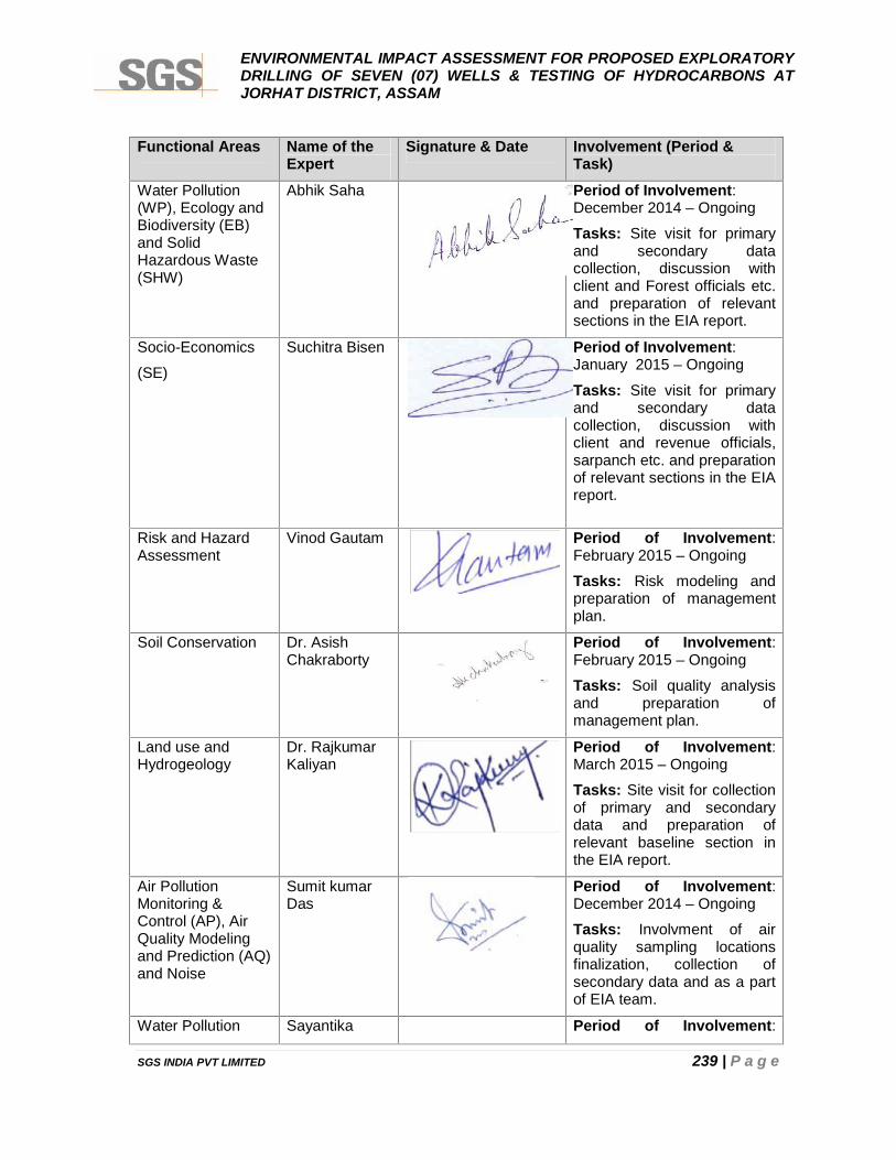
ENVIRONMENTAL IMPACT ASSESSMENT FOR PROPOSED EXPLORATORYDRILLING OF SEVEN (07) WELLS & TESTING OF HYDROCARBONS ATJORHAT DISTRICT, ASSAM
SGS INDIA PVT LIMITED 239 | P a g e
Functional Areas Name of theExpert
Signature & Date Involvement (Period &Task)
Water Pollution(WP), Ecology andBiodiversity (EB)and SolidHazardous Waste(SHW)
Abhik Saha Period of Involvement:December 2014 – Ongoing
Tasks: Site visit for primaryand secondary datacollection, discussion withclient and Forest officials etc.and preparation of relevantsections in the EIA report.
Socio-Economics
(SE)
Suchitra Bisen Period of Involvement:January 2015 – Ongoing
Tasks: Site visit for primaryand secondary datacollection, discussion withclient and revenue officials,sarpanch etc. and preparationof relevant sections in the EIAreport.
Risk and HazardAssessment
Vinod Gautam Period of Involvement:February 2015 – Ongoing
Tasks: Risk modeling andpreparation of managementplan.
Soil Conservation Dr. AsishChakraborty
Period of Involvement:February 2015 – Ongoing
Tasks: Soil quality analysisand preparation ofmanagement plan.
Land use andHydrogeology
Dr. RajkumarKaliyan
Period of Involvement:March 2015 – Ongoing
Tasks: Site visit for collectionof primary and secondarydata and preparation ofrelevant baseline section inthe EIA report.
Air PollutionMonitoring &Control (AP), AirQuality Modelingand Prediction (AQ)and Noise
Sumit kumarDas
Period of Involvement:December 2014 – Ongoing
Tasks: Involvment of airquality sampling locationsfinalization, collection ofsecondary data and as a partof EIA team.
Water Pollution Sayantika Period of Involvement:
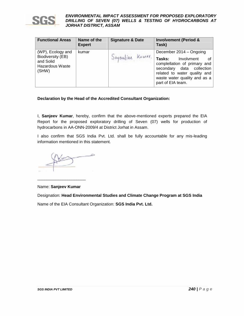
ENVIRONMENTAL IMPACT ASSESSMENT FOR PROPOSED EXPLORATORYDRILLING OF SEVEN (07) WELLS & TESTING OF HYDROCARBONS ATJORHAT DISTRICT, ASSAM
SGS INDIA PVT LIMITED 240 | P a g e
Functional Areas Name of theExpert
Signature & Date Involvement (Period &Task)
(WP), Ecology andBiodiversity (EB)and SolidHazardous Waste(SHW)
kumar December 2014 – Ongoing
Tasks: Involvment ofcomplellation of primary andsecondary data collectionrelated to water quality andwaste water quality and as apart of EIA team.
Declaration by the Head of the Accredited Consultant Organization:
I, Sanjeev Kumar, hereby, confirm that the above-mentioned experts prepared the EIAReport for the proposed exploratory drilling of Seven (07) wells for production ofhydrocarbons in AA-ONN-2009/4 at District Jorhat in Assam.
I also confirm that SGS India Pvt. Ltd. shall be fully accountable for any mis-leadinginformation mentioned in this statement.
_____________________
Name: Sanjeev Kumar
Designation: Head Environmental Studies and Climate Change Program at SGS India
Name of the EIA Consultant Organization: SGS India Pvt. Ltd.
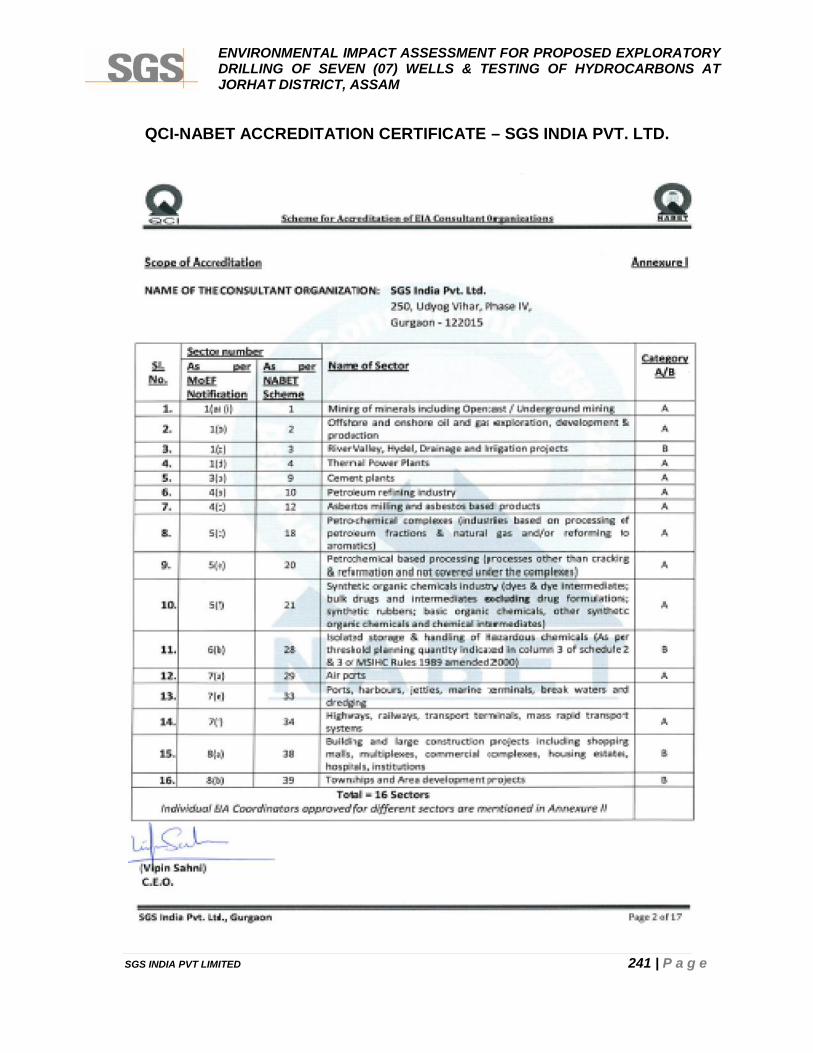
ENVIRONMENTAL IMPACT ASSESSMENT FOR PROPOSED EXPLORATORYDRILLING OF SEVEN (07) WELLS & TESTING OF HYDROCARBONS ATJORHAT DISTRICT, ASSAM
SGS INDIA PVT LIMITED 241 | P a g e
QCI-NABET ACCREDITATION CERTIFICATE – SGS INDIA PVT. LTD.
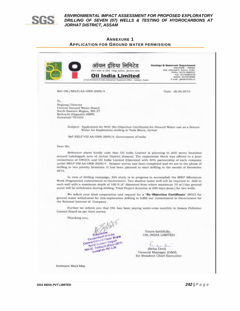
ENVIRONMENTAL IMPACT ASSESSMENT FOR PROPOSED EXPLORATORYDRILLING OF SEVEN (07) WELLS & TESTING OF HYDROCARBONS ATJORHAT DISTRICT, ASSAM
SGS INDIA PVT LIMITED 242 | P a g e
ANNEXURE 1APPLICATION FOR GROUND WATER PERMISSION
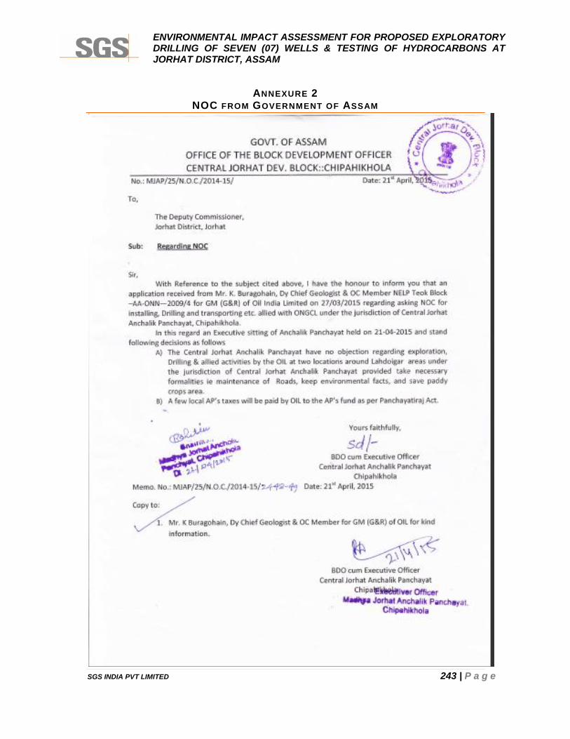
ENVIRONMENTAL IMPACT ASSESSMENT FOR PROPOSED EXPLORATORYDRILLING OF SEVEN (07) WELLS & TESTING OF HYDROCARBONS ATJORHAT DISTRICT, ASSAM
SGS INDIA PVT LIMITED 243 | P a g e
ANNEXURE 2NOC FROM GOVERNMENT OF ASSAM
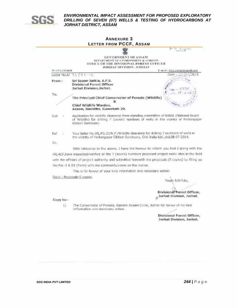
ENVIRONMENTAL IMPACT ASSESSMENT FOR PROPOSED EXPLORATORYDRILLING OF SEVEN (07) WELLS & TESTING OF HYDROCARBONS ATJORHAT DISTRICT, ASSAM
SGS INDIA PVT LIMITED 244 | P a g e
ANNEXURE 3LETTER FROM PCCF, ASSAM
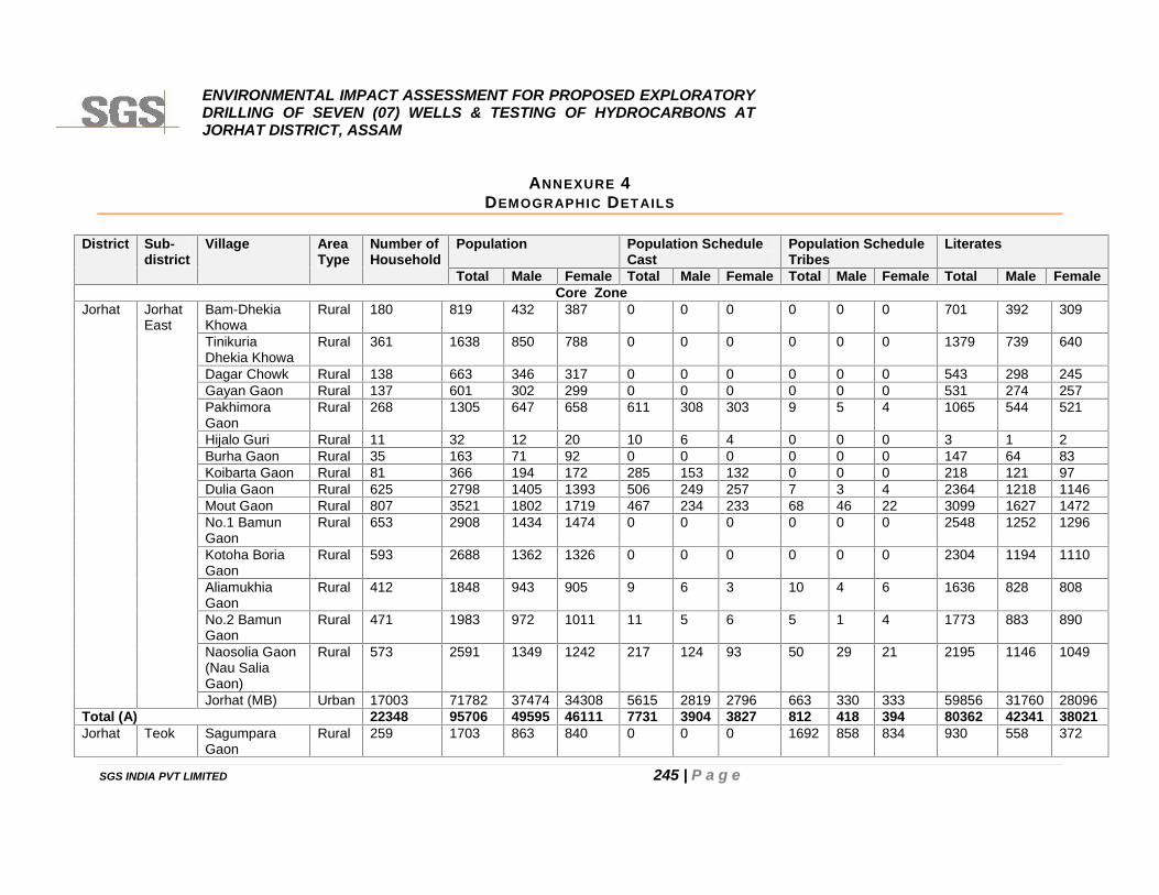
ENVIRONMENTAL IMPACT ASSESSMENT FOR PROPOSED EXPLORATORYDRILLING OF SEVEN (07) WELLS & TESTING OF HYDROCARBONS ATJORHAT DISTRICT, ASSAM
SGS INDIA PVT LIMITED 245 | P a g e
ANNEXURE 4DEMOGRAPHIC DETAILS
District Sub-district
Village AreaType
Number ofHousehold
Population Population ScheduleCast
Population ScheduleTribes
Literates
Total Male Female Total Male Female Total Male Female Total Male FemaleCore Zone
Jorhat JorhatEast
Bam-DhekiaKhowa
Rural 180 819 432 387 0 0 0 0 0 0 701 392 309
TinikuriaDhekia Khowa
Rural 361 1638 850 788 0 0 0 0 0 0 1379 739 640
Dagar Chowk Rural 138 663 346 317 0 0 0 0 0 0 543 298 245Gayan Gaon Rural 137 601 302 299 0 0 0 0 0 0 531 274 257PakhimoraGaon
Rural 268 1305 647 658 611 308 303 9 5 4 1065 544 521
Hijalo Guri Rural 11 32 12 20 10 6 4 0 0 0 3 1 2Burha Gaon Rural 35 163 71 92 0 0 0 0 0 0 147 64 83Koibarta Gaon Rural 81 366 194 172 285 153 132 0 0 0 218 121 97Dulia Gaon Rural 625 2798 1405 1393 506 249 257 7 3 4 2364 1218 1146Mout Gaon Rural 807 3521 1802 1719 467 234 233 68 46 22 3099 1627 1472No.1 BamunGaon
Rural 653 2908 1434 1474 0 0 0 0 0 0 2548 1252 1296
Kotoha BoriaGaon
Rural 593 2688 1362 1326 0 0 0 0 0 0 2304 1194 1110
AliamukhiaGaon
Rural 412 1848 943 905 9 6 3 10 4 6 1636 828 808
No.2 BamunGaon
Rural 471 1983 972 1011 11 5 6 5 1 4 1773 883 890
Naosolia Gaon(Nau SaliaGaon)
Rural 573 2591 1349 1242 217 124 93 50 29 21 2195 1146 1049
Jorhat (MB) Urban 17003 71782 37474 34308 5615 2819 2796 663 330 333 59856 31760 28096Total (A) 22348 95706 49595 46111 7731 3904 3827 812 418 394 80362 42341 38021Jorhat Teok Sagumpara
GaonRural 259 1703 863 840 0 0 0 1692 858 834 930 558 372
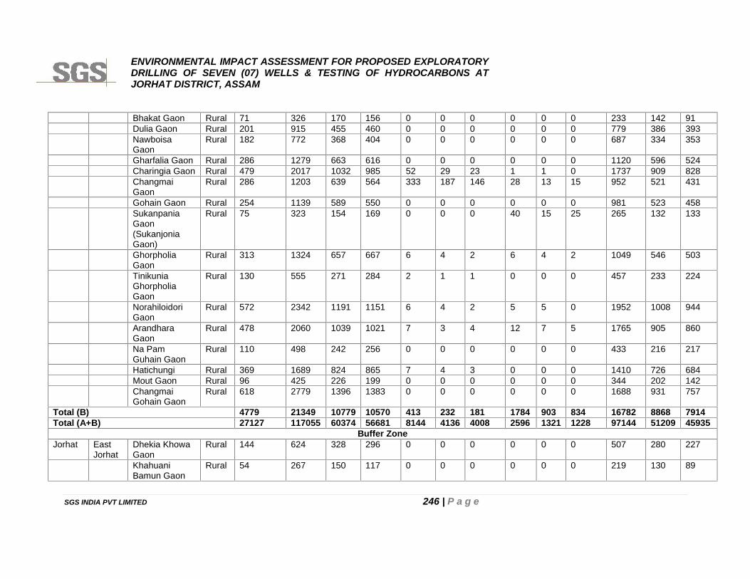
ENVIRONMENTAL IMPACT ASSESSMENT FOR PROPOSED EXPLORATORYDRILLING OF SEVEN (07) WELLS & TESTING OF HYDROCARBONS ATJORHAT DISTRICT, ASSAM
SGS INDIA PVT LIMITED 246 | P a g e
Bhakat Gaon Rural 71 326 170 156 0 0 0 0 0 0 233 142 91Dulia Gaon Rural 201 915 455 460 0 0 0 0 0 0 779 386 393NawboisaGaon
Rural 182 772 368 404 0 0 0 0 0 0 687 334 353
Gharfalia Gaon Rural 286 1279 663 616 0 0 0 0 0 0 1120 596 524Charingia Gaon Rural 479 2017 1032 985 52 29 23 1 1 0 1737 909 828ChangmaiGaon
Rural 286 1203 639 564 333 187 146 28 13 15 952 521 431
Gohain Gaon Rural 254 1139 589 550 0 0 0 0 0 0 981 523 458SukanpaniaGaon(SukanjoniaGaon)
Rural 75 323 154 169 0 0 0 40 15 25 265 132 133
GhorpholiaGaon
Rural 313 1324 657 667 6 4 2 6 4 2 1049 546 503
TinikuniaGhorpholiaGaon
Rural 130 555 271 284 2 1 1 0 0 0 457 233 224
NorahiloidoriGaon
Rural 572 2342 1191 1151 6 4 2 5 5 0 1952 1008 944
ArandharaGaon
Rural 478 2060 1039 1021 7 3 4 12 7 5 1765 905 860
Na PamGuhain Gaon
Rural 110 498 242 256 0 0 0 0 0 0 433 216 217
Hatichungi Rural 369 1689 824 865 7 4 3 0 0 0 1410 726 684Mout Gaon Rural 96 425 226 199 0 0 0 0 0 0 344 202 142ChangmaiGohain Gaon
Rural 618 2779 1396 1383 0 0 0 0 0 0 1688 931 757
Total (B) 4779 21349 10779 10570 413 232 181 1784 903 834 16782 8868 7914Total (A+B) 27127 117055 60374 56681 8144 4136 4008 2596 1321 1228 97144 51209 45935
Buffer ZoneJorhat East
JorhatDhekia KhowaGaon
Rural 144 624 328 296 0 0 0 0 0 0 507 280 227
KhahuaniBamun Gaon
Rural 54 267 150 117 0 0 0 0 0 0 219 130 89
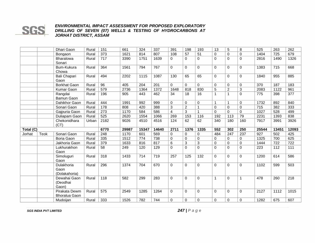
ENVIRONMENTAL IMPACT ASSESSMENT FOR PROPOSED EXPLORATORYDRILLING OF SEVEN (07) WELLS & TESTING OF HYDROCARBONS ATJORHAT DISTRICT, ASSAM
SGS INDIA PVT LIMITED 247 | P a g e
Dhari Gaon Rural 151 661 324 337 391 198 193 13 5 8 525 263 262Bongaon Rural 373 1621 814 807 108 57 51 0 0 0 1404 725 679BharalowaSonari
Rural 717 3390 1751 1639 0 0 0 0 0 0 2816 1490 1326
Bum-KukuraChowa
Rural 364 1561 794 767 0 0 0 0 0 0 1383 715 668
Bali ChapariGaon
Rural 494 2202 1115 1087 130 65 65 0 0 0 1840 955 885
Borkhat Gaon Rural 96 405 204 201 0 0 0 0 0 0 370 187 183Kumar Gaon Rural 579 2736 1364 1372 1648 818 830 5 2 3 2083 1122 961RangdaiBamun Gaon
Rural 196 905 443 462 34 18 16 1 1 0 775 398 377
Dahikhor Gaon Rural 444 1991 992 999 0 0 0 1 1 0 1732 892 840Sonari Gaon Rural 178 808 420 388 3 2 1 0 0 0 715 382 333Gajpuria Gaon Rural 273 1170 584 586 4 3 1 0 0 0 1027 528 499Duliapam Gaon Rural 525 2620 1554 1066 269 153 116 192 113 79 2231 1393 838Chekonidhara(CT)
Urban 2182 9026 4510 4516 124 62 62 340 180 160 7917 3991 3926
Total (C) 6770 29987 15347 14640 2711 1376 1335 552 302 250 25544 13451 12093Jorhat Teok Sonari Gaon Rural 248 1170 601 569 0 0 0 484 247 237 927 502 425
Boria Gaon Rural 335 1512 774 738 0 0 0 0 0 0 1325 700 625Jakhoria Gaon Rural 379 1633 816 817 6 3 3 0 0 0 1444 722 722LukhurakhonGaon
Rural 58 249 120 129 0 0 0 0 0 0 223 112 111
SimoluguriGaon
Rural 318 1433 714 719 257 125 132 0 0 0 1200 614 586
DulakhoriaGaon(Dolakahoria)
Rural 296 1374 704 670 0 0 0 0 0 0 1102 599 503
Dewahai Gaon(DeodhaiGaon)
Rural 118 582 299 283 0 0 0 1 0 1 478 260 218
Pirakata DewmBhoralua Gaon
Rural 575 2549 1285 1264 0 0 0 0 0 0 2127 1112 1015
Mudoijan Rural 333 1526 782 744 0 0 0 0 0 0 1282 675 607
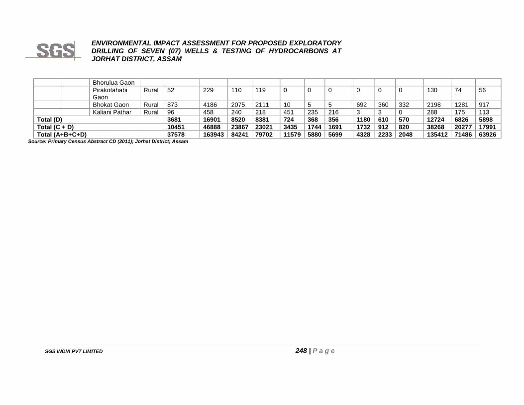
ENVIRONMENTAL IMPACT ASSESSMENT FOR PROPOSED EXPLORATORYDRILLING OF SEVEN (07) WELLS & TESTING OF HYDROCARBONS ATJORHAT DISTRICT, ASSAM
SGS INDIA PVT LIMITED 248 | P a g e
Bhorulua GaonPirakotahabiGaon
Rural 52 229 110 119 0 0 0 0 0 0 130 74 56
Bhokat Gaon Rural 873 4186 2075 2111 10 5 5 692 360 332 2198 1281 917Kaliani Pathar Rural 96 458 240 218 451 235 216 3 3 0 288 175 113
Total (D) 3681 16901 8520 8381 724 368 356 1180 610 570 12724 6826 5898Total (C + D) 10451 46888 23867 23021 3435 1744 1691 1732 912 820 38268 20277 17991Total (A+B+C+D) 37578 163943 84241 79702 11579 5880 5699 4328 2233 2048 135412 71486 63926
Source: Primary Census Abstract CD (2011); Jorhat District; Assam
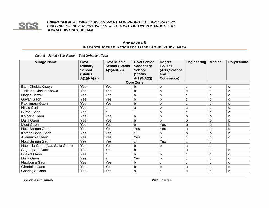
ENVIRONMENTAL IMPACT ASSESSMENT FOR PROPOSED EXPLORATORYDRILLING OF SEVEN (07) WELLS & TESTING OF HYDROCARBONS ATJORHAT DISTRICT, ASSAM
SGS INDIA PVT LIMITED 249 | P a g e
ANNEXURE 5INFRASTRUCTURE RESOURCE BASE IN THE STUDY AREA
District – Jorhat : Sub-district – East Jorhat and Teok
Village Name GovtPrimarySchool(StatusA(1)/NA(2))
Govt MiddleSchool (StatusA(1)/NA(2))
Govt SeniorSecondarySchool(StatusA(1)/NA(2))
DegreeCollege(Arts,ScienceandCommerce)
Engineering Medical Polytechnic
Core ZoneBam-Dhekia Khowa Yes Yes b b c c cTinikuria Dhekia Khowa Yes Yes b b c c cDagar Chowk Yes Yes a b c c cGayan Gaon Yes Yes b b c c cPakhimora Gaon Yes Yes b b c c cHijalo Guri Yes a a b c c cBurha Gaon Yes a b c c cKoibarta Gaon Yes Yes a b b b bDulia Gaon Yes Yes b b b b bMout Gaon Yes Yes b Yes b b bNo.1 Bamun Gaon Yes Yes Yes Yes c c cKotoha Boria Gaon Yes Yes c b b b bAliamukhia Gaon Yes Yes Yes b c c cNo.2 Bamun Gaon Yes Yes c Yes c cNaosolia Gaon (Nau Salia Gaon) Yes Yes b b c cSagumpara Gaon Yes Yes b c c c cBhakat Gaon Yes b b b c c cDulia Gaon Yes a Yes b c c cNawboisa Gaon Yes Yes b c c c cGharfalia Gaon Yes Yes b b c c cCharingia Gaon Yes Yes a c c c c
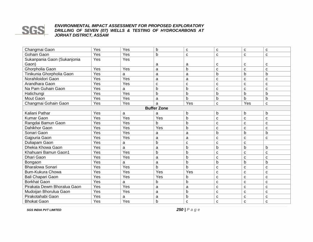
ENVIRONMENTAL IMPACT ASSESSMENT FOR PROPOSED EXPLORATORYDRILLING OF SEVEN (07) WELLS & TESTING OF HYDROCARBONS ATJORHAT DISTRICT, ASSAM
SGS INDIA PVT LIMITED 250 | P a g e
Changmai Gaon Yes Yes b c c c cGohain Gaon Yes Yes b c c c cSukanpania Gaon (SukanjoniaGaon)
Yes Yesa a c c c
Ghorpholia Gaon Yes Yes a b c c cTinikunia Ghorpholia Gaon Yes a a a b b bNorahiloidori Gaon Yes Yes a a c c cArandhara Gaon Yes Yes c c c c cNa Pam Guhain Gaon Yes a b b c c cHatichungi Yes Yes b b b b bMout Gaon Yes Yes a b b b bChangmai Gohain Gaon Yes Yes a Yes c Yes c
Buffer ZoneKaliani Pathar Yes a a b b b bKumar Gaon Yes Yes Yes b c c cRangdai Bamun Gaon Yes Yes b b c c cDahikhor Gaon Yes Yes Yes b c c cSonari Gaon Yes Yes a a b b bGajpuria Gaon Yes Yes a a c c cDuliapam Gaon Yes a b c c cDhekia Khowa Gaon Yes a a b b b bKhahuani Bamun Gaon1 Yes Yes b b c c cDhari Gaon Yes Yes a b c c cBongaon Yes a a b b b bBharalowa Sonari Yes Yes b b c c cBum-Kukura Chowa Yes Yes Yes Yes c c cBali Chapari Gaon Yes Yes Yes b c c cBorkhat Gaon Yes a b b c c cPirakata Dewm Bhoralua Gaon Yes Yes a a c c cMudoijan Bhorulua Gaon Yes Yes a b c c cPirakotahabi Gaon Yes a a b c c cBhokat Gaon Yes Yes b c c c c
ENVIRONMENTAL IMPACT ASSESSMENT FOR PROPOSED EXPLORATORYDRILLING OF SEVEN (07) WELLS & TESTING OF HYDROCARBONS ATJORHAT DISTRICT, ASSAM
SGS INDIA PVT LIMITED 251 | P a g e
Sonari Gaon Yes Yes b b c c cBoria Gaon Yes Yes a a c c cJakhoria Gaon Yes Yes a a c c cLukhurakhon Gaon Yes Yes a c c c cSimoluguri Gaon Yes Yes b c c c cDulakhoria Gaon (Dolakahoria) Yes Yes a a c c cDewahai Gaon (Deodhai Gaon) Yes Yes a a c c c
Cont…….
Village Name Primary HealthCentre(PHC)
Primary HealthSub-centre(PHS)
Maternity and ChildWelfare (MCW)
HospitalAllopathic
Number ofMedicine Shop
Core ZoneBam-Dhekia Khowa Yes b b c 2Tinikuria Dhekia Khowa a a b c 1Dagar Chowk a a b c 0Gayan Gaon a a a c 0Pakhimora Gaon a a b c 1Hijalo Guri a a b c 0Burha Gaon a a c c 2Koibarta Gaon a a b b 2Dulia Gaon b Yes a b 1Mout Gaon Yes b b b 5No.1 Bamun Gaon Yes b b c 5Kotoha Boria Gaon a Yes b b 1Aliamukhia Gaon a a a c 3No.2 Bamun Gaon a a c 3Naosolia Gaon (Nau Salia Gaon) a Yes a b 1Sagumpara Gaon a b c c 1Bhakat Gaon b b c c 0Dulia Gaon a a a c 1Nawboisa Gaon b b c c 0
ENVIRONMENTAL IMPACT ASSESSMENT FOR PROPOSED EXPLORATORYDRILLING OF SEVEN (07) WELLS & TESTING OF HYDROCARBONS ATJORHAT DISTRICT, ASSAM
SGS INDIA PVT LIMITED 252 | P a g e
Gharfalia Gaon b Yes b c 1Charingia Gaon a c c 1Changmai Gaon b a b b 1Gohain Gaon b Yes b b 1Sukanpania Gaon (Sukanjonia Gaon) b a b b 0Ghorpholia Gaon b Yes c c 1Tinikunia Ghorpholia Gaon a a a c 0Norahiloidori Gaon c b c b 1Arandhara Gaon c c c c 1Na Pam Guhain Gaon b b c c 0Hatichungi b b b b 1Mout Gaon b b b b 0Changmai Gohain Gaon a b a c 1
Buffer ZoneKaliani Pathar a a a b 1Kumar Gaon a a b c 5Rangdai Bamun Gaon a Yes b c 1Dahikhor Gaon a a a c 1Sonari Gaon Yes b a b 1Gajpuria Gaon a a a c 2Duliapam Gaon a a c c 1Dhekia Khowa Gaon a a a b 0Khahuani Bamun Gaon a a a c 0Dhari Gaon a a a c 0Bongaon a a a b 1Bharalowa Sonari a a a c 1Bum-Kukura Chowa a a a c 2Bali Chapari Gaon b Yes b c 2Borkhat Gaon a Yes b c 0Pirakata Dewm Bhoralua Gaon a a a c 1Mudoijan Bhorulua Gaon b b c c 1Pirakotahabi Gaon b b c c 0
ENVIRONMENTAL IMPACT ASSESSMENT FOR PROPOSED EXPLORATORYDRILLING OF SEVEN (07) WELLS & TESTING OF HYDROCARBONS ATJORHAT DISTRICT, ASSAM
SGS INDIA PVT LIMITED 253 | P a g e
Bhokat Gaon b b b b 1Sonari Gaon a a c a 1Boria Gaon a c b a 1Jakhoria Gaon a a c a 1Lukhurakhon Gaon b a c c 0Simoluguri Gaon b Yes c b 1Dulakhoria Gaon (Dolakahoria) a 1Dewahai Gaon (Deodhai Gaon) b 0
Cont…
Village Name Tap Water Well water Hand Pump Tube Wells/ Bore well Post Office TelephoneLand line
Core ZoneBam-Dhekia Khowa Yes Yes Yes Yes a aTinikuria Dhekia Khowa Yes No Yes Yes a aDagar Chowk Yes Yes Yes Yes b aGayan Gaon Yes No Yes Yes c aPakhimora Gaon No No Yes No b aHijalo Guri No Yes No Yes a aBurha Gaon No No Yes Yes a aKoibarta Gaon No Yes Yes Yes a YesDulia Gaon Yes Yes Yes Yes a aMout Gaon Yes Yes Yes Yes b YesNo.1 Bamun Gaon Yes Yes Yes Yes YesKotoha Boria Gaon Yes Yes Yes Yes a YesAliamukhia Gaon Yes Yes Yes Yes b aNo.2 Bamun Gaon Yes Yes Yes Yes aNaosolia Gaon (Nau Salia Gaon) Yes Yes Yes Yes b aSagumpara Gaon Yes Yes Yes Yes a aBhakat Gaon Yes No Yes Yes c bDulia Gaon Yes No Yes No a a
ENVIRONMENTAL IMPACT ASSESSMENT FOR PROPOSED EXPLORATORYDRILLING OF SEVEN (07) WELLS & TESTING OF HYDROCARBONS ATJORHAT DISTRICT, ASSAM
SGS INDIA PVT LIMITED 254 | P a g e
Nawboisa Gaon Yes Yes Yes Yes b bGharfalia Gaon Yes Yes Yes Yes a aCharingia Gaon Yes Yes Yes Yes YesChangmai Gaon Yes Yes Yes Yes b bGohain Gaon Yes Yes Yes Yes a aSukanpania Gaon (SukanjoniaGaon) Yes Yes Yes Yes b aGhorpholia Gaon Yes Yes Yes Yes b aTinikunia Ghorpholia Gaon Yes Yes Yes Yes a YesNorahiloidori Gaon Yes Yes Yes Yes b YesArandhara Gaon Yes Yes Yes Yes Yes bNa Pam Guhain Gaon No Yes No Yes a bHatichungi Yes Yes Yes Yes b bMout Gaon Yes Yes Yes Yes b bChangmai Gohain Gaon Yes Yes Yes Yes Yes Yes
Buffer ZoneKaliani Pathar Yes No Yes Yes a aKumar Gaon Yes Yes Yes Yes b YesRangdai Bamun Gaon Yes Yes Yes Yes a YesDahikhor Gaon Yes Yes Yes Yes a YesSonari Gaon Yes Yes Yes Yes YesGajpuria Gaon Yes No Yes Yes a aDuliapam Gaon Yes Yes Yes Yes a YesDhekia Khowa Gaon Yes Yes Yes Yes a YesKhahuani Bamun Gaon Yes Yes Yes Yes a aDhari Gaon Yes Yes Yes Yes a aBongaon Yes Yes Yes Yes a aBharalowa Sonari Yes Yes Yes Yes a aBum-Kukura Chowa Yes Yes Yes Yes a YesBali Chapari Gaon Yes Yes Yes Yes c YesBorkhat Gaon Yes Yes Yes Yes b aPirakata Dewm Bhoralua Gaon Yes Yes Yes Yes a Yes
ENVIRONMENTAL IMPACT ASSESSMENT FOR PROPOSED EXPLORATORYDRILLING OF SEVEN (07) WELLS & TESTING OF HYDROCARBONS ATJORHAT DISTRICT, ASSAM
SGS INDIA PVT LIMITED 255 | P a g e
Cont……
Village Name Public/PrivateBus Service
RailwayStation
PuccaRoads
KutchchaRoads
PublicDistributionSystem(PDS)
WeeklyHaat
PowerSupply ForDomesticUse (Status
PowerSupply ForAgricultureUse (Status
Core ZoneBam-Dhekia Khowa Yes c b Yes Yes Yes Yes YesTinikuria Dhekia Khowa Yes c Yes Yes a a Yes NoDagar Chowk Yes c b Yes Yes Yes Yes NoGayan Gaon Yes c a Yes Yes Yes Yes YesPakhimora Gaon Yes b b Yes Yes Yes Yes YesHijalo Guri Yes c b Yes Yes Yes Yes YesBurha Gaon Yes c b Yes Yes Yes Yes NoKoibarta Gaon Yes b b Yes a b Yes YesDulia Gaon Yes b Yes Yes Yes Yes Yes YesMout Gaon Yes b Yes Yes a b Yes NoNo.1 Bamun Gaon Yes c Yes Yes Yes Yes Yes YesKotoha Boria Gaon Yes b Yes Yes a a Yes NoAliamukhia Gaon Yes c Yes Yes a a Yes YesNo.2 Bamun Gaon Yes Yes Yes Yes Yes Yes YesNaosolia Gaon (Nau Salia Gaon) Yes b Yes Yes Yes Yes Yes NoSagumpara Gaon Yes c Yes Yes a b Yes NoBhakat Gaon c b b Yes Yes Yes Yes No
Mudoijan Bhorulua Gaon Yes Yes Yes Yes YesPirakotahabi Gaon No Yes No Yes a aBhokat Gaon Yes Yes Yes Yes Yes aSonari Gaon Yes Yes Yes Yes a YesBoria Gaon Yes Yes Yes Yes a YesJakhoria Gaon Yes Yes Yes Yes aLukhurakhon Gaon Yes No Yes Yes bSimoluguri Gaon Yes Yes Yes Yes b bDulakhoria Gaon (Dolakahoria) Yes Yes Yes Yes c aDewahai Gaon (Deodhai Gaon) Yes Yes Yes No c a
ENVIRONMENTAL IMPACT ASSESSMENT FOR PROPOSED EXPLORATORYDRILLING OF SEVEN (07) WELLS & TESTING OF HYDROCARBONS ATJORHAT DISTRICT, ASSAM
SGS INDIA PVT LIMITED 256 | P a g e
Dulia Gaon Yes a b Yes Yes Yes Yes NoNawboisa Gaon Yes c b Yes Yes Yes Yes NoGharfalia Gaon Yes c b Yes a a Yes NoCharingia Gaon Yes c Yes Yes a a Yes NoChangmai Gaon a b a Yes Yes Yes Yes NoGohain Gaon a b b Yes Yes Yes Yes NoSukanpania Gaon (SukanjoniaGaon) b a b Yes a a Yes NoGhorpholia Gaon Yes c b Yes Yes Yes Yes NoTinikunia Ghorpholia Gaon Yes c b Yes c a Yes NoNorahiloidori Gaon Yes c Yes Yes Yes a Yes NoArandhara Gaon Yes c Yes Yes Yes Yes Yes YesNa Pam Guhain Gaon b Yes a Yes Yes Yes Yes NoHatichungi Yes b Yes Yes Yes Yes Yes NoMout Gaon b b b Yes Yes Yes Yes NoChangmai Gohain Gaon Yes Yes Yes Yes Yes Yes Yes No
Buffer ZoneKaliani Pathar Yes b b Yes Yes Yes Yes NoKumar Gaon Yes c Yes Yes Yes Yes Yes YesRangdai Bamun Gaon Yes c b Yes Yes Yes Yes YesDahikhor Gaon Yes c Yes Yes Yes Yes Yes YesSonari Gaon Yes b b Yes Yes Yes Yes YesGajpuria Gaon Yes Yes b Yes Yes Yes Yes YesDuliapam Gaon Yes Yes Yes Yes Yes Yes NoDhekia Khowa Gaon Yes B b Yes Yes b Yes YesKhahuani Bamun Gaon Yes C b Yes a b Yes YesDhari Gaon Yes C b Yes Yes a Yes YesBongaon Yes B Yes Yes Yes Yes Yes YesBharalowa Sonari Yes B Yes Yes Yes Yes Yes YesBum-Kukura Chowa Yes C Yes Yes Yes Yes Yes YesBali Chapari Gaon Yes A Yes Yes a a Yes NoBorkhat Gaon Yes Yes b Yes Yes Yes Yes NoPirakata Dewm Bhoralua Gaon Yes C Yes Yes Yes Yes Yes NoMudoijan Bhorulua Gaon Yes C Yes Yes Yes a Yes NoPirakotahabi Gaon a C b Yes Yes Yes Yes No
ENVIRONMENTAL IMPACT ASSESSMENT FOR PROPOSED EXPLORATORYDRILLING OF SEVEN (07) WELLS & TESTING OF HYDROCARBONS ATJORHAT DISTRICT, ASSAM
SGS INDIA PVT LIMITED 257 | P a g e
Bhokat Gaon Yes C Yes Yes Yes a Yes NoSonari Gaon Yes C b Yes Yes Yes Yes YesBoria Gaon Yes Yes Yes Yes Yes Yes NoJakhoria Gaon Yes C Yes Yes Yes a Yes NoLukhurakhon Gaon Yes C b Yes b c Yes NoSimoluguri Gaon Yes C b Yes Yes Yes Yes NoDulakhoria Gaon (Dolakahoria) Yes C b Yes Yes Yes Yes YesDewahai Gaon (Deodhai Gaon) Yes C b Yes a a Yes Yes
Source: District Census Handbook; Census of India (2011); Jorhat District (http://www.censusindia.gov.in/2011census/dchb/DCHB.html)
Abbreviations: (a) - <5kms (b) – 5-10kms (c) – Above 10+
ENVIRONMENTAL IMPACT ASSESSMENT FOR PROPOSED EXPLORATORYDRILLING OF SEVEN (07) WELLS & TESTING OF HYDROCARBONS ATJORHAT DISTRICT, ASSAM
SGS INDIA PVT LIMITED 258 | P a g e
ANNEXURE 6WORKERS PARTICIPATION DETAILS
District Sub-district
Village AreaType
Number ofHousehold
Population Main Workers Marginal Workers Non Workers
Jorhat JorhatEast
Bam-Dhekia Khowa Rural 180 819 222 22 575Tinikuria Dhekia Khowa Rural 361 1638 333 449 856Dagar Chowk Rural 138 663 148 129 386Gayan Gaon Rural 137 601 140 66 395Pakhimora Gaon Rural 268 1305 307 143 855Hijalo Guri Rural 11 32 7 0 25Burha Gaon Rural 35 163 16 24 123Koibarta Gaon Rural 81 366 108 22 236Dulia Gaon Rural 625 2798 665 337 1796Mout Gaon Rural 807 3521 868 553 2100No.1 Bamun Gaon Rural 653 2908 928 487 1493Kotoha Boria Gaon Rural 593 2688 724 421 1543Aliamukhia Gaon Rural 412 1848 637 101 1110No.2 Bamun Gaon Rural 471 1983 591 91 1301Naosolia Gaon (Nau Salia Gaon) Rural 573 2591 629 180 1782Jorhat (MB) Urban 17003 71782 24310 4325 43147
Total (A) 22348 95706 30633 7350 57723
Jorhat Teok Sagumpara Gaon Rural 259 1703 894 36 773Bhakat Gaon Rural 71 326 92 102 132Dulia Gaon Rural 201 915 169 131 615Nawboisa Gaon Rural 182 772 137 89 546Gharfalia Gaon Rural 286 1279 310 265 704Charingia Gaon Rural 479 2017 362 516 1139Changmai Gaon Rural 286 1203 363 242 598Gohain Gaon Rural 254 1139 284 209 646Sukanpania Gaon (Sukanjonia Gaon) Rural 75 323 105 2 216
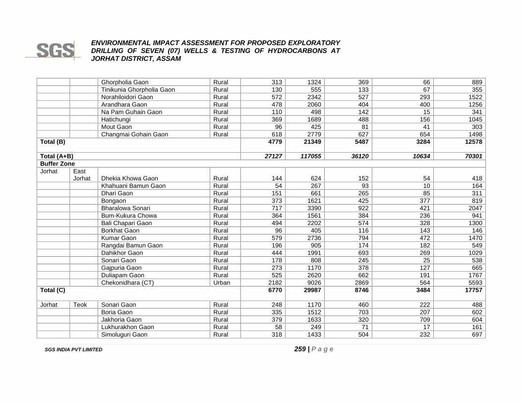
ENVIRONMENTAL IMPACT ASSESSMENT FOR PROPOSED EXPLORATORYDRILLING OF SEVEN (07) WELLS & TESTING OF HYDROCARBONS ATJORHAT DISTRICT, ASSAM
SGS INDIA PVT LIMITED 259 | P a g e
Ghorpholia Gaon Rural 313 1324 369 66 889Tinikunia Ghorpholia Gaon Rural 130 555 133 67 355Norahiloidori Gaon Rural 572 2342 527 293 1522Arandhara Gaon Rural 478 2060 404 400 1256Na Pam Guhain Gaon Rural 110 498 142 15 341Hatichungi Rural 369 1689 488 156 1045Mout Gaon Rural 96 425 81 41 303Changmai Gohain Gaon Rural 618 2779 627 654 1498
Total (B) 4779 21349 5487 3284 12578
Total (A+B) 27127 117055 36120 10634 70301Buffer ZoneJorhat East
Jorhat Dhekia Khowa Gaon Rural 144 624 152 54 418Khahuani Bamun Gaon Rural 54 267 93 10 164Dhari Gaon Rural 151 661 265 85 311Bongaon Rural 373 1621 425 377 819Bharalowa Sonari Rural 717 3390 922 421 2047Bum-Kukura Chowa Rural 364 1561 384 236 941Bali Chapari Gaon Rural 494 2202 574 328 1300Borkhat Gaon Rural 96 405 116 143 146Kumar Gaon Rural 579 2736 794 472 1470Rangdai Bamun Gaon Rural 196 905 174 182 549Dahikhor Gaon Rural 444 1991 693 269 1029Sonari Gaon Rural 178 808 245 25 538Gajpuria Gaon Rural 273 1170 378 127 665Duliapam Gaon Rural 525 2620 662 191 1767Chekonidhara (CT) Urban 2182 9026 2869 564 5593
Total (C) 6770 29987 8746 3484 17757
Jorhat Teok Sonari Gaon Rural 248 1170 460 222 488Boria Gaon Rural 335 1512 703 207 602Jakhoria Gaon Rural 379 1633 320 709 604Lukhurakhon Gaon Rural 58 249 71 17 161Simoluguri Gaon Rural 318 1433 504 232 697
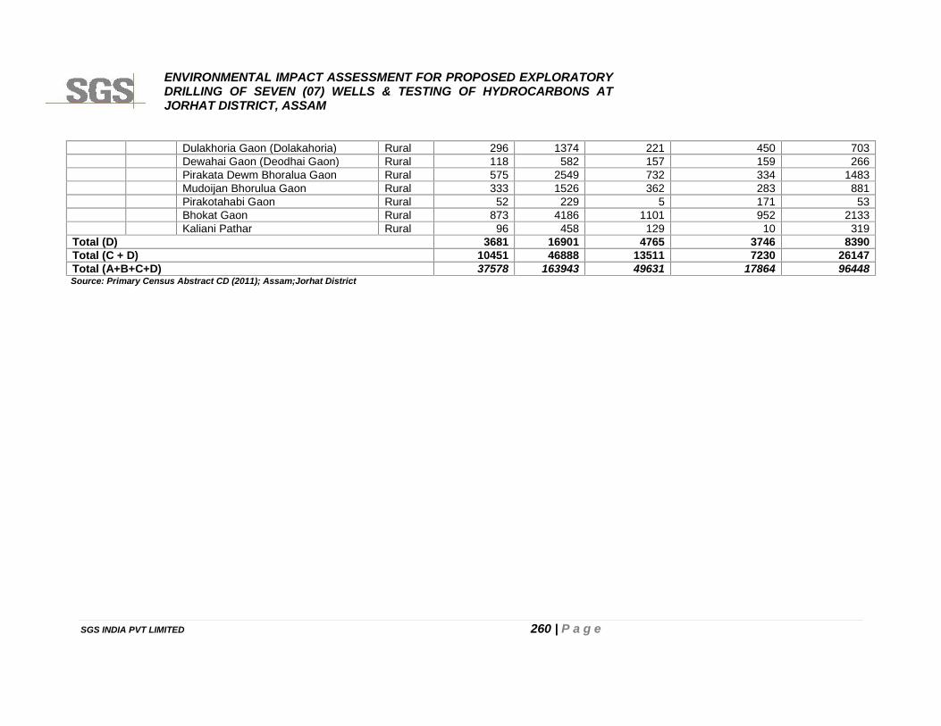
ENVIRONMENTAL IMPACT ASSESSMENT FOR PROPOSED EXPLORATORYDRILLING OF SEVEN (07) WELLS & TESTING OF HYDROCARBONS ATJORHAT DISTRICT, ASSAM
SGS INDIA PVT LIMITED 260 | P a g e
Dulakhoria Gaon (Dolakahoria) Rural 296 1374 221 450 703Dewahai Gaon (Deodhai Gaon) Rural 118 582 157 159 266Pirakata Dewm Bhoralua Gaon Rural 575 2549 732 334 1483Mudoijan Bhorulua Gaon Rural 333 1526 362 283 881Pirakotahabi Gaon Rural 52 229 5 171 53Bhokat Gaon Rural 873 4186 1101 952 2133Kaliani Pathar Rural 96 458 129 10 319
Total (D) 3681 16901 4765 3746 8390Total (C + D) 10451 46888 13511 7230 26147Total (A+B+C+D) 37578 163943 49631 17864 96448Source: Primary Census Abstract CD (2011); Assam;Jorhat District
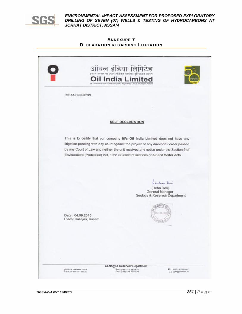
ENVIRONMENTAL IMPACT ASSESSMENT FOR PROPOSED EXPLORATORYDRILLING OF SEVEN (07) WELLS & TESTING OF HYDROCARBONS ATJORHAT DISTRICT, ASSAM
SGS INDIA PVT LIMITED 261 | P a g e
ANNEXURE 7DECLARATION REGARDING L IT IGATION