energy-specific solar radiation data from meteosat second generation (msg): the heliosat-3 project
TRANSCRIPT

Project title:
Project Acronym:
Project No.:
Energy-Specific Solar Radiation Data from Meteosat Second Generation (MSG):The Heliosat-3 Project
NNE5-2000-00413
Title:
Main Author:
HELIOSAT-3
Sunsat the new program for processing high resolutiondata of Meteosat-8
R. Kuhlemann (Oldenburg University)
Contract No.: NNK5-CT-2000-00322
Date: June 2005
Contributing Author: A. Hammer (Oldenburg University)
Deliverable: D 8.2; D13.1

Preface
The work presented in this report is part of the deliverables D8.2 and D13.1for the European research project Heliosat-3. It belongs to workpackages 3020(cloudy sky scheme) and 4010 (solar energy processing chain). The Heliosat-3project is supported by the fifth frame-work program of the European Commis-sion under contract number NNK5-CT-2000-00322.

Sunsatthe new program for processing high resolution data of Meteosat-8
Rolf Kuhlemann and Annette Hammer
20.6.2005
Outline:
• Introduction
• Data base improvement
– Wrong image information
– Necessary geolocation
– Satellite movement compensation
• Adapting the Heliosat-1 procedure
– Formats
– Parameters
– Atmospheric correction
– Errors caused by cloud shades
• The new program Sunsat
– Structure
– Headers and names
– Usage
• Results

Introduction
A first step towards the implementation of the Heliosat-3 procedures has beenthe adaption of the “old” Heliosat-1 [1] software to the data of Meteosat-8 inVCS/XPIF format [2]. The development was focused on high resolution data inthe visible wavelength range (HRV channel) with 1 * 1 km2 spatial (Nadir) and15 minutes temporal resolution.Prior the description of the new program it is necessary to mention of the database, some image failures and how to get around with them. Furthermore, it hasbeen necessary to geolocate the data. Distortions and shifted images have beenobserved, and it is described how to compensate for these effects.The next step has been the adaption of the “old” Heliosat-1 procedure and itsfeatures to the new type of data. An arising problem with shades, especiallycloud shades and a way to solve this problem is described.Finally, the structure, the properties, and the usage of the new program arepresented.
Data base improvement: Wrong image information
The data base of raw images in Oldenburg was checked, in order to find thosewith missing segments and other disturbances. They have been extracted fromthe data base togehter with images shifted with respect to the majority of allimages have been extracted from the data base. This has obviously reduced thedata base, but not to critical amounts. Nevertheless, there have been 20 - 30images each in July, August, and September for example.
Data base improvement: Necessary geolocation
It was found by projection of the received VCS-XPIF data on accurate mapsof Europe, that the high resolution data of Meteosat-8 are distorted [3]. Thisinvestigation revealed, that an individual geolocation of many sites is necessaryand that it is possible to correct for the found mistakes by modifying line- andcolumn-offsets. Therefore, the new program includes options for additional offsetsto recorrect the local geolocation (see chapter: The new program Sunsat - Usage).Site lists containing the found values has been generated [3].Later, it was found that the detected distortions are a specific property of theVCS-XPIF data, generated by the receiving software of the company VCS. Theoriginal HRIT data, transmitted by EUMETSAT, contain only a few shiftedimages. Consequently, the switch of the whole data processing chain to theseHRIT data is planned.
Data base improvement: Satellite movement compensation
A colocation (spatial match) of the high resolution images of Meteosat-8 wasfound to be necessary. Because the investigation of shifted images would have
4
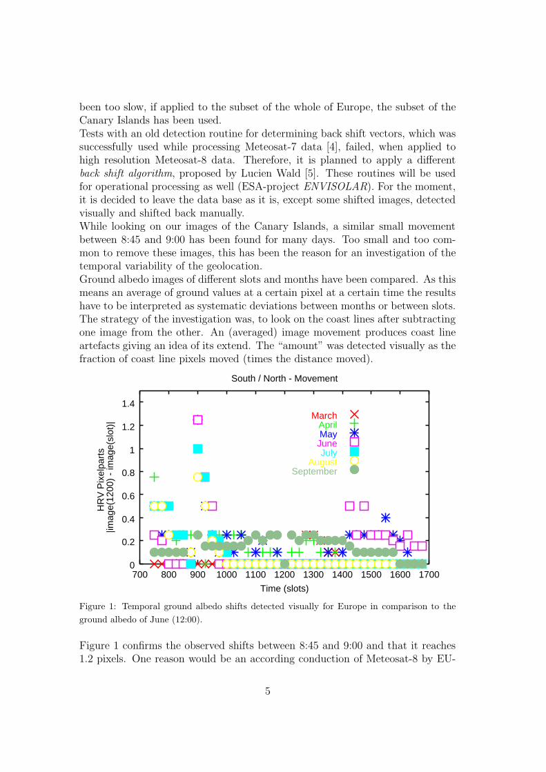
been too slow, if applied to the subset of the whole of Europe, the subset of theCanary Islands has been used.Tests with an old detection routine for determining back shift vectors, which wassuccessfully used while processing Meteosat-7 data [4], failed, when applied tohigh resolution Meteosat-8 data. Therefore, it is planned to apply a differentback shift algorithm, proposed by Lucien Wald [5]. These routines will be usedfor operational processing as well (ESA-project ENVISOLAR). For the moment,it is decided to leave the data base as it is, except some shifted images, detectedvisually and shifted back manually.While looking on our images of the Canary Islands, a similar small movementbetween 8:45 and 9:00 has been found for many days. Too small and too com-mon to remove these images, this has been the reason for an investigation of thetemporal variability of the geolocation.Ground albedo images of different slots and months have been compared. As thismeans an average of ground values at a certain pixel at a certain time the resultshave to be interpreted as systematic deviations between months or between slots.The strategy of the investigation was, to look on the coast lines after subtractingone image from the other. An (averaged) image movement produces coast lineartefacts giving an idea of its extend. The “amount” was detected visually as thefraction of coast line pixels moved (times the distance moved).
0
0.2
0.4
0.6
0.8
1
1.2
1.4
700 800 900 1000 1100 1200 1300 1400 1500 1600 1700
HR
V P
ixel
part
s |i
mag
e(12
00)
- im
age(
slot
)|
Time (slots)
South / North - Movement
MarchAprilMay
JuneJuly
AugustSeptember
Figure 1: Temporal ground albedo shifts detected visually for Europe in comparison to the
ground albedo of June (12:00).
Figure 1 confirms the observed shifts between 8:45 and 9:00 and that it reaches1.2 pixels. One reason would be an according conduction of Meteosat-8 by EU-
5

METSAT, but for approving that, a more detailed analysis would be necessary.A comparison between monthes and different directions revealed shifts up to 1.5pixels.Altogether, these results show that satellite movement is recognizable, but notcritical and, this is of importance, completely within the range, the planned back
shift algorithm (3 pixels in one direction) is able to compensate.
Adapting the Heliosat-1 procedure: Formats
To process Meteosat-8 data, the “old” software code was modified in the waythat it is able to process 2 byte data for each pixel, to read and use the headerinformation of each image, and to write all generated images with similar headers.According to the fact that it has not been possible to write headers of the samelength (256 bytes), all written images have headers with 260 bytes length, and thenew program distinguishs between these types by recognizing the ending (XPIF,X260).
Adapting the Heliosat-1 procedure: Parameters
Within the Heliosat-1 procedure in its present form [6] there are some parametersto optimize and adapt to new satellite data. The first is the radiometer offsetCR to be determined for each channel of interest (here HRV, VIS006, VIS008).It was found to be the same for all three channels (CR = 51).For reasons of comparability the counts C are normalized to get reflectivitiesρ = (C − CR)/(cos(Θ)). With these reflectivities it is possible to determine thenext parameter, the maximum cloud reflectivity ρc. According to its optimizationwithin the SoDa project, it should be defined in the way that 96% of all countsare below this value [7]. The resulting value for all three channels of Meteosat-8has been ρc = 650.The cloud index, giving the attenuation of irradiance under clouds, is determinedby n = (ρ − ρg)/(ρc − ρg). ρg is the ground reflectivity of the earth surface. Toget results of good quality, ρg images should be free of artefacts (cloud rests andshadows). ρg is generated by using the frequency distribution of all reflectivities ρof a monthly slot at a certain pixel. Within such distributions ground reflectionvalues ρ are assumed to accumulate around the value ρg and build up a landpeak. Consequently, the half width σground of such land peaks is used to deter-mine ρg, where the parameter σground has to be optimized. This optimizationhas been tried by minimizing the bias between calculated and measured globalirradiances (Figure 2). This has been done for two Clear Sky models, one of the“old” Heliosat-1 method [6], and another with the SOLIS method, developed byMuller et al. within the Heliosat-3 project [8].While the rmse remains stable with varying σground, the bias increases with in-creasing σground. The minimization of the bias ended up with such different valuesfor the three months (April, May, June), that this “mathematical” optimization
6

failed.Therefore, a visual determination of σground has been applied and has given avalue of σground = 23. For such a qualitative optimization the amount of cloudrests should be as small as possible, but the iteration should not collapse in theway of producing a significant amount of “dark pixels” (see chapter: Adaptingthe Heliosat-1 procedure: Errors caused by cloud shades).
-4
-3
-2
-1
0
1
2
3
4
10 15 20 25 30
Bia
s [%
]
Sigma
MSG-Heliosat: Juni LyonMSG-SOLIS: Juni Lyon
MSG-Heliosat: April LyonMSG-SOLIS: April LyonMSG-Heliosat: Mai Lyon
MSG-SOLIS: Mai Lyon0
Figure 2: Bias between calculated and measured data of Vaulx-en-Velin for the months April,
May, and June. Calculated data are derived with two different Clear Sky models (Heliosat-1,
SOLIS).
Adapting the Heliosat-1 procedure: Atmospheric correction
To extend the angular validity of the procedure to large sun zenith angles a newatmospheric correction was developed for all visible channels, just like A. Ham-mer did it for data of Meteosat-7 [6]. To get the whole range for all three angles(sun zenith angle Θ, satellite zenith angle Φ, sun satellite angle Ψ) subsets of theequatorial region and Southern Africa were added to those of Europe and theCanary Islands.By taking only ocean pixels into account, which are assumed to represent van-ishing reflectance, the atmospheric backscatter was put in angle bins for all threeangles and step by step parameterized.
Catm(Θ, Φ, Ψ) = f1(Θ) ∗ f2(Φ) ∗ f3(Ψ) =C − CR
cos(Θ)(1)
7

0
20
40
60
80
100
120
140
0 10 20 30 40 50 60 70 80 90
Cor
rect
ed c
ount
s
Satellite zenith angle [°]
Northern EuropeSouthern Europe
Canary IslandsEquator
Africa
Approximation: 57.595/cos(φ-31.917°)**1.727Approximation: 51.148/cos(φ)**0.491
Count correction:
CC = (C - CR)/cos (θ)
0
0.5
1
1.5
2
-0.2 0 0.2 0.4 0.6 0.8 1
Cor
rect
ed c
ount
s
Cosin (sun satellite angle)
Northern EuropeSouthern Europe
Approximation - northern Europe: 0.970+cos(ψ)**4.904/3.137Approximation - southern Europe: 0.980+cos(ψ)**39.692/2.438
Count correction:
CC = (C - CR) ∗ cos (φ)0.491 ∗ cos(θ)0.399
cos (θ) 40.948
0
0.5
1
1.5
2
0 10 20 30 40 50 60 70 80 90
Cor
rect
ed c
ount
s
Solar zenith angle [°]
Northern EuropeSouthern Europe
Canary IslandsEquator
Africa
Approximation without equator: 0.801/cos(θ)**0.399
Count correction:
CC = (C - CR) ∗ cos (φ)0.491
cos (θ) 51.148
Figure 3: Step by step parameterization of the backscatter signal of the atmosphere and its
dependency on the satellite zenith angle (top), the solar zenith angle (middle), and the sun-
satellite angle (bottom). Every approximation has been done with the corrected counts of the
previous steps.
8

Figure 3 gives as example the development of the atmospheric correction for highresolution data of Meteosat-8. It was found, that the data of the equatorial re-gion are strongly influenced by total reflections of the ocean surface. The smallersatellite angle and solar zenith angle are, the stronger is this effect [9]. There-fore, the parameterization has been developed without equatorial data. After theapproximation of the dependency of the satellite zenith angle (Figure 3 (top)),the counts, pre-corrected with the radiometer offset CR and the cosin correctionensuring comparability, have been manipulated in the found way. The next angledependency has been parameterized with the recorrected count of all former steps(Figure 3 (middle, bottom)).The adaption of the Rayleigh-like dependency on the sun satellite angle, formerlyused by Hammer et al. [6], failed. Furthermore, it has been necessary to dis-tinguish between Northern and Southern Europe for the approximation of thisdependency. The resulting structure of the atmospheric correction, developedhere, is:
Ccorr. =C − CR
cos(Θ)− Catm; Catm =
a
cos(Φ)b∗ cos(Θ)c
∗
(
d +cos(Ψ)e
f
)
(2)
Channel a b c d e f
HRV North 40.948 0.491 0.399 0.970 4.904 3.137
HRV South 40.948 0.491 0.399 0.980 39.692 2.438
VIS008 North 22.914 0.646 0.414 0.957 14.888 3.562
VIS008 South 22.914 0.646 0.414 1.028 13.235 4.811
VIS006 North 37.901 0.506 0.379 0.956 7.369 3.627
VIS006 South 37.901 0.506 0.379 1.021 14.014 8.491
Table 1: Coefficients of the atmospheric correction for different channels and regions.
The derived atmospheric correction has been included in the computer code to-gether with a new maximun cloud reflectivity (ρc = 580), necessary for suchcalculations, if an atmospheric correction is applied.Calculated global irradiances have been compared with ground measured data forVaulx-en-Velin in April, May, and June 2004 as well as such calculations with-out an atmospheric correction. It was found, that the quality is not improvedby using an atmospheric correction. Therefore, the atmospheric correction wasomitted, because it lowers the calculation speed. Table 2 gives first validatonresults, generated by Elke Lorenz with 41 measuring stations in Germany. Theybelong to operational processing, which means, that the actual ground albedo iscalculated with the last 30 days.
9

Satellite Met-7 Met-7 Met-8 Met-8
Error bias rmse bias rmse
March (16.3.-) -3.48 25.55 -5.03 22.39
April -0.88 26.17 -3.52 20.90
May -6.3 22.93 -4.67 19.35
June (-16.6.) -3.38 22.28 -4.92 18.97
Table 2: RMSE (%) and BIAS (%) for validations between calculated irradiance data (hourly
values) for Meteosat-7 and Meteosat-8 compared with ground measurements in Germany (41
stations).
Adapting the Heliosat-1 procedure: Errors caused by cloud shades
The physical reason for dark pixels within raw data and calculated ground albedoshas been found to be shades, especially cloud shades. In contrast to Meteosat-7the data of Meteosat-8 (HRV) is strongly contaminated with such effects due totheir higher spatial resolution of 1 km * 1 km (Nadir).To overcome this problem within the Cloudy Sky module a modified groundalbedo algorithm was developed. It takes the increment of the ground albedoiteration into account. Assuming that the sequence of iterative steps is a mono-tone decreasing function without shade contamination, an increasing incrementdetects shades by a sudden increase of the step width. This type of detectionavoids the input of fixed thresholds between ground and shade reflectances whichwould not be valid for all places and times.To maintain the shade detection process a new parameter σshade is introduced,which gives the necessary enlargement of the increment. After the detection of ashade, the according grey value is omitted from the sequence.Figure 4 shows, that the shade problem has been solved perfectly, although a dif-ferent problem arises. With decreasing number of slot counts (suppressed shadevalues) the probability of cloud rests increases. This happens, if there are onlycloud values left in the sequence of a slot.As shade looks like a Clear Sky situation with dark ground albedo, although it isa Cloudy Sky, the next step is the construction of a sensible cloud index value forthese cases. This is done in the way of a reconstruction by taking advantage ofthe used Clear Sky model. The used model within Heliosat-1 has been developedby Fontoynont et al. within the European project Satel-light [10]. Such a modeldetermines a clear sky index for a given cloud index. Therefore, a shade valuegives an according clear sky index and allows the assignment of a correspond-ing cloud index. Such a reconstruction conserves the statistical properties of thewhole procedure.
10

11:15 11:30
σground = 23
σshade = 0
σground = 23
σshade = 5
Figure 4: Calculated ground albedos of Teneriffa for December 2004 and slots 11:15 and 11:30
using HRV data of Meteosat-8. Top images are generated without shade detection (σshade = 0)
and bottom images with cloud detection (σshade = 5).
A comparison of calculated global irradiances with ground measured data al-lows the optimization of both parameters σground and σshade. First results forVaulx-en-Velin between March 2004 and January 2005 show, that the opportu-nity to reduce σground improves the procedure significantly (∆ rmse > 1%).It was found, that the best results are generated with values of σground = σshade =1. This means, that the procedure iterates the lowest available ground value be-side clouds and shades. It seems, that systematic errors caused by a fixed valueof ρc are compensated under these circumstances. Such an effect was alreadyfound by E. Lorenz within the ESA project ENVISOLAR.Further validations for other sites in Europe and on the Canary Islands for allavailable HRV data (March 2004 - now) are ongoing.Although it is not validated up to now, a modified algorithm for the calculationof the ground albedo is included in the new program Sunsat, containing routineswhich detect and suppress cloud shades (see chapter: The new program Sunsat:Usage).
New program Sunsat: Structure
The final version of the new program to generate ground albedo and cloud index
values from data of Meteosat-8 has not only a new name, it is also reorganizedin order to get an easier overview and a more comfortable program management.
11

While the main code is as short as possible, functions and algorithms are excludedand collected according to their character. The following list gives an overview:
• info new.fkt (all header informations of the images)
• msg new.fkt (geosat, geomsg, EOT, coszen, timeoffset - library of func-tions)
• algo new.fkt (cos correction new, ground albedo, ground albedo shade - li-brary of algorithms)
• msg new.h (header informations about functions and algorithms)
• nrutil.h, ... (numerical recipes)
New program Sunsat: Headers and names
The new program Sunsat is able to process data with headers of both 256 and260 header length, even different types in one slot list are possible. It identifiesthis length by interpreting the format name “.XPIF” for original VCS/XPIFor “.X260” for selfproduced pseudo-XPIF data. According to this convention,original HRIT data transmitted by EUMETSAT and processed directly, havean “.X260” format. Cloud index images have still the old “.hel” name, groundalbedos “.alb”.
New program Sunsat: Usage
The usage of the new program is similar to the past. A list of all images of aslot of a certain month and the pathes for all images are needed. The necessaryadditional column- and line-offsets are determined by x and y (see site list in[3]). Because of the included cloud shade algoritm, it is possible to maintain thestatistical parameters for the ground albedo and the cloud shade algorithm byoptions a and s.The best results have been found with a ground albedo parameter σground = 23if cloud shade detection is switched off (σshade = 0). That’s why they are defaultvalues.If the cloud shade algorithm is switched on, the program prints out some infor-mation about the amount and relation of the found shades compared with theamount of all pixels. Summarizing, the following options need to be fixed to startSunsat:
• -l slotlist
• -b image path
• -g ground albedo path
12

• -c cloud index path
• -a σg (default: 23)
• -s σshade (default: 0 (no shade algorithm))
• -x additional column − offset
• -y additional line − offset
Results
With the new program Sunsat the Heliosat-1 procedure is adapted to data ofMeteosat-8 (VCS/XPIF-format). All necessary parameters have been optimized,but a newly developed atmospheric correction did not gain improvements. Fail-ures of the procedure when processing high resolution data are mainly caused bycloud shades. Therefore, the algorithm to iterate the ground albedo was modifiedand better results were reached.It was found, that an accurate data base in terms of geolocation and colocationis necessary to process high resolution data.
References
[1] C. Cano, J.M. Monget, M. Albuisson, H. Guillard, N. Regas, L. Wald: Amethod for the determination of the global solar radiation from meteorolog-ical satellite data. Solar Energy 37, 31-39 (1986)
[2] http://rst.vcs.de/download/content/show/03142154113
[3] Heliosat-3 deliverable of Kuhlemann et al. (Geolocation of high resolutiondata of Meteosat-8 (VCS-XPIF format))
[4] A. Hammer, D. Heinemann, C. Hoyer, E. Lorenz: Treatment of errors inMETEOSAT derived cloud index images due to partial sensor failures orsatellite displacements. Fourth SoDa meeting report Lyon ( 6 / 2001)
[5] IEA standard quoted by Lucien Wald in personal communication
[6] A. Hammer: Anwendungsspezifische Solarstrahlungsinformationen ausMeteosat-Daten, Phd Thesis, 56 (2000)
[7] A. Hammer, D. Heinemann, C. Hoyer: Effect of Meteosat VIS Sensor Prop-erties on Cloud Reflectivity Third SoDa meeting report Bern ( 1 / 2001)
13

[8] Muller, R. W., Dagestad, K. F., Ineichen, P., Schroedter, M., Cros, S., Du-mortier, D., Kuhlemann, R., Olseth, J. A., Piernavieja, C., Reise, C., Wald,L. and Heinemann, D.: Rethinking satellite based solar irradiance modelling- The SOLIS clear sky module. Remote Sensing of the Environment 91 160- 174 (2004)
[9] see e.g.: F.M. Breon, Remote Sens. Environ. 43, 193-207 (1993)
[10] M. Fontoynont et al.: Satellight: A WWW server which provides high quality
daylight and solar radiation data for Western and Central Europe. 9th Con-ference on Satellite Meteorology and Oceanography, Paris 1998, 434-437.
14