economic and social benefits of completing the baltimore
TRANSCRIPT
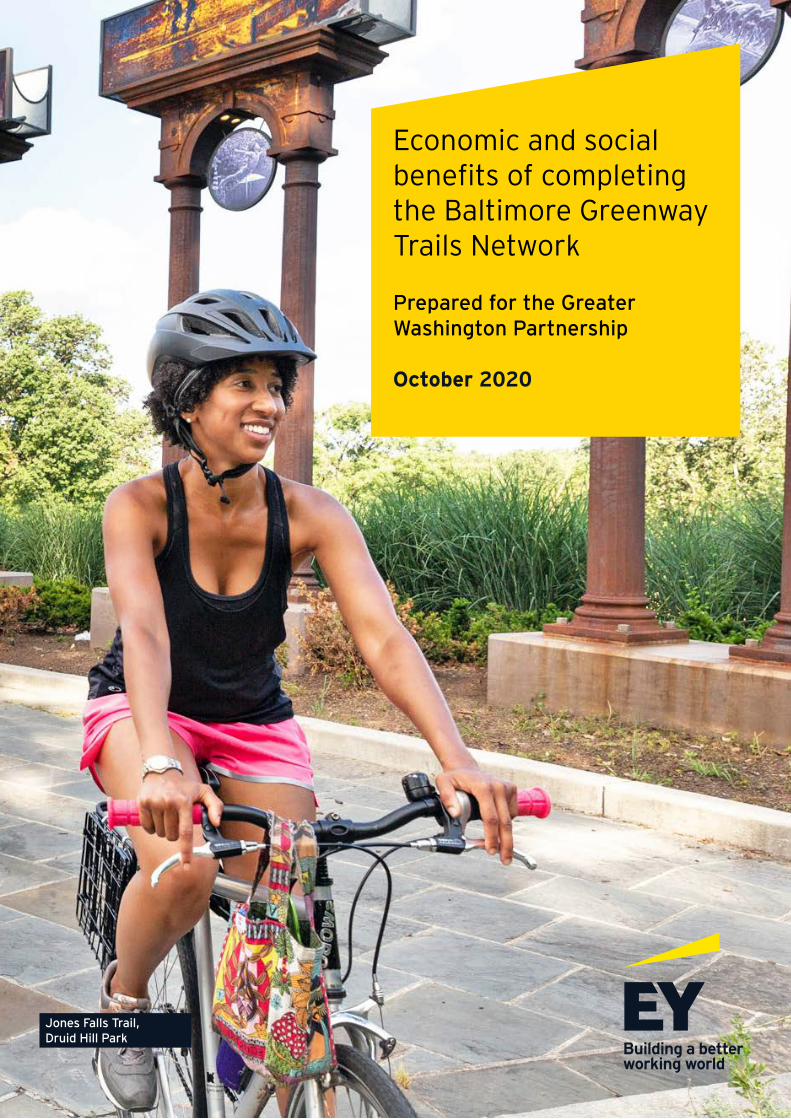
Economic and social benefits of completing the Baltimore Greenway Trails Network
Prepared for the Greater Washington Partnership
October 2020
Jones Falls Trail, Druid Hill Park
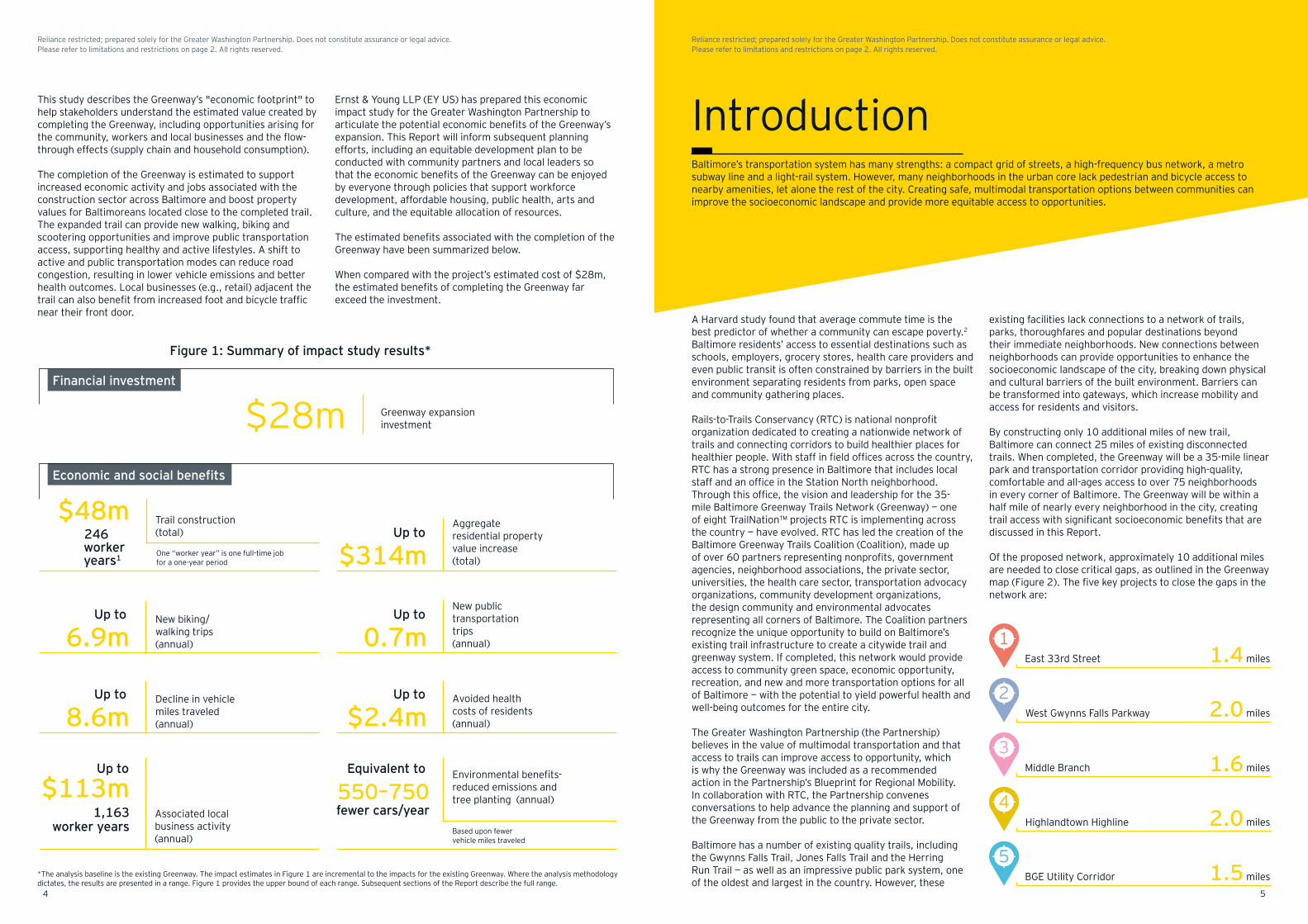
This study examines the potential economic and social benefits of a $28m plan to expand and connect existing trails in the city of Baltimore (Baltimore) to create the Baltimore Greenway Trails Network (the Greenway). By building an additional 10 miles of new trails, Baltimore can complete a 35-mile network, providing safe, healthy access to an off-street network that connects 75 neighborhoods to the trails and offers new opportunities. The neighborhoods within a half mile of the Greenway are composed of 58% African-American residents and have a home ownership rate of 48%, which represents similar demographic diversity and home ownership rates to Baltimore.* The completed trail will bring potential economic and social benefits to a wide cross section of Baltimore’s population.
This Report, in conjunction with the Appendix (collectively and individually the “Report”), dated October 2020 represents a deliverable required under the terms of the contract agreement between the Greater Washington Partnership (Client) and Ernst & Young LLP (EY US or we) dated 1 June 2017 (Agreement) and Statement of Work (SOW) dated 20 May 2020. In preparing the Report, EY US relied upon certain data and information provided by Rails-to-Trails Conservancy (RTC) staff, management and the city of Baltimore (Baltimore). No procedures were performed by EY US to evaluate the accuracy or completeness of data and information provided or contained in the IMPLAN economic models of Baltimore, and no such procedures were included in the agreed-upon scope of work in the Agreement between Client and EY US. Accordingly, EY US expresses no opinion and issues no other form of assurance regarding the data and information provided. The procedures EY US performed do not constitute an audit of historical financial statements or an examination of prospective financial statements in accordance with standards established by the American Institute of Certified Public Accountants (AICPA).
The services performed by EY US were advisory in nature. Our scope of work was determined by Client and agreed to by EY US pursuant to the terms of the Agreement. Certain analyses and findings in the Report are based on estimates and/or assumptions about future events that were provided by Client. There will usually be differences between estimated and actual results because future events and circumstances frequently do not occur as expected, and those differences may be material. We make no representation of, nor do we take any responsibility over, the achievement of estimated or projected results. The findings and analyses contained in the Report are based on data and information made available to EY US through the date hereof. Should additional relevant data or information become available subsequent to the date of the Report, such data or information may have a material impact on the findings in the Report. EY US has no future obligation to update the Report.
Neither the Report nor any of our work constitutes legal opinion or advice. No representation is made relating to matters of a legal nature, including, without limitation, matters of title or ownership, legal description, encumbrances, liens, priority, easements and/or land use restrictions, the validity or enforceability of legal documents, present or future national or local legislation, regulation, ordinance or the like, or legal or equitable defenses.
The Report is intended solely for use by Client. While we believe the work performed is responsive to Client’s request pursuant to the scope of work in the SOW, we make no representation as to the sufficiency of the Report and our work for any other purposes. Any third parties reading the Report should be aware that the Report is subject to limitations, and the scope of the Report was not designed for use or reliance by third parties for investment purposes, or any other purpose. We assume no duty, obligation or responsibility whatsoever to any third parties that may obtain access to the Report.
A key driver and coordinating collaborator in the Baltimore Greenway Trails Network is Rails-to-Trails Conservancy (RTC), the nation’s largest trails organization — with a grassroots community more than 1m strong — dedicated to connecting people and communities by creating a nationwide network of public trails, many from former rail lines. The Baltimore Greenway Trails Network is one of RTC’s TrailNation™ projects, a portfolio of trail-network-building projects designed to prove what is possible when you connect people and places by trail.
The Greater Washington Partnership (the Partnership) is a first-of-its-kind civic alliance of CEOs in the region, drawing from the leading employers and entrepreneurs committed to making the Capital Region — from Baltimore to Richmond — one of the world’s best places to live, work and build a business. The Partnership has identified transportation as a key initiative, and the expansion of the Baltimore Greenway Trails Network represents an important opportunity to build a more equitable transportation system and prosperous regional economy.
About the Greater Washington Partnership About Rails-to-Trails Conservancy
* Baltimore Department of Housing and Community Development (DHCD)
Limitations and restrictions
3 Executive summary
5 Introduction
8 Economic and social benefits
10 • Trail construction
11 • Residential property valuation
12 • Transportation and safety
13 • Local business spending
14 • Environment
15 • Health
16 Neighborhood snapshots
21 Conclusion
22 Appendix
23 Endnotes
Contents Executive summary
32
Reliance restricted; prepared solely for the Greater Washington Partnership. Does not constitute assurance or legal advice. Please refer to limitations and restrictions on page 2. All rights reserved.
Reliance restricted; prepared solely for the Greater Washington Partnership. Does not constitute assurance or legal advice. Please refer to limitations and restrictions on page 2. All rights reserved.
Jones Falls Trail, Druid Hill Park
Economic and social benefits
1.5
1.6
1.4
2.0
2.0
$113m1,163
worker yearsAssociated local business activity (annual)
Based upon fewer vehicle miles traveled
Up to
550–750fewer cars/year
Equivalent to Environmental benefits- reduced emissions and tree planting (annual)
One “worker year” is one full-time job for a one-year period
$48m Trail construction (total)246
workeryears1 $314m
Up toAggregate residential property value increase (total)
8.6mUp to Decline in vehicle
miles traveled (annual) $2.4m
Up to Avoided health costs of residents (annual)
6.9mUp to New biking/
walking trips (annual) 0.7m
Up toNew public transportation trips(annual)
Financial investment
Introduction
East 33rd Street
West Gwynns Falls Parkway
Middle Branch
Highlandtown Highline
BGE Utility Corridor
$28m Greenway expansion investment
miles
miles
miles
miles
miles
*The analysis baseline is the existing Greenway. The impact estimates in Figure 1 are incremental to the impacts for the existing Greenway. Where the analysis methodology dictates, the results are presented in a range. Figure 1 provides the upper bound of each range. Subsequent sections of the Report describe the full range.
Figure 1: Summary of impact study results*
existing facilities lack connections to a network of trails, parks, thoroughfares and popular destinations beyond their immediate neighborhoods. New connections between neighborhoods can provide opportunities to enhance the socioeconomic landscape of the city, breaking down physical and cultural barriers of the built environment. Barriers can be transformed into gateways, which increase mobility and access for residents and visitors.
By constructing only 10 additional miles of new trail, Baltimore can connect 25 miles of existing disconnected trails. When completed, the Greenway will be a 35-mile linear park and transportation corridor providing high-quality, comfortable and all-ages access to over 75 neighborhoods in every corner of Baltimore. The Greenway will be within a half mile of nearly every neighborhood in the city, creating trail access with significant socioeconomic benefits that are discussed in this Report.
Of the proposed network, approximately 10 additional miles are needed to close critical gaps, as outlined in the Greenway map (Figure 2). The five key projects to close the gaps in the network are:
A Harvard study found that average commute time is the best predictor of whether a community can escape poverty.2 Baltimore residents’ access to essential destinations such as schools, employers, grocery stores, health care providers and even public transit is often constrained by barriers in the built environment separating residents from parks, open space and community gathering places.
Rails-to-Trails Conservancy (RTC) is national nonprofit organization dedicated to creating a nationwide network of trails and connecting corridors to build healthier places for healthier people. With staff in field offices across the country, RTC has a strong presence in Baltimore that includes local staff and an office in the Station North neighborhood. Through this office, the vision and leadership for the 35-mile Baltimore Greenway Trails Network (Greenway) — one of eight TrailNation™ projects RTC is implementing across the country — have evolved. RTC has led the creation of the Baltimore Greenway Trails Coalition (Coalition), made up of over 60 partners representing nonprofits, government agencies, neighborhood associations, the private sector, universities, the health care sector, transportation advocacy organizations, community development organizations, the design community and environmental advocates representing all corners of Baltimore. The Coalition partners recognize the unique opportunity to build on Baltimore’s existing trail infrastructure to create a citywide trail and greenway system. If completed, this network would provide access to community green space, economic opportunity, recreation, and new and more transportation options for all of Baltimore — with the potential to yield powerful health and well-being outcomes for the entire city.
The Greater Washington Partnership (the Partnership) believes in the value of multimodal transportation and that access to trails can improve access to opportunity, which is why the Greenway was included as a recommended action in the Partnership’s Blueprint for Regional Mobility. In collaboration with RTC, the Partnership convenes conversations to help advance the planning and support of the Greenway from the public to the private sector.
Baltimore has a number of existing quality trails, including the Gwynns Falls Trail, Jones Falls Trail and the Herring Run Trail — as well as an impressive public park system, one of the oldest and largest in the country. However, these
This study describes the Greenway’s "economic footprint" to help stakeholders understand the estimated value created by completing the Greenway, including opportunities arising for the community, workers and local businesses and the flow-through effects (supply chain and household consumption).
The completion of the Greenway is estimated to support increased economic activity and jobs associated with the construction sector across Baltimore and boost property values for Baltimoreans located close to the completed trail. The expanded trail can provide new walking, biking and scootering opportunities and improve public transportation access, supporting healthy and active lifestyles. A shift to active and public transportation modes can reduce road congestion, resulting in lower vehicle emissions and better health outcomes. Local businesses (e.g., retail) adjacent the trail can also benefit from increased foot and bicycle traffic near their front door.
Ernst & Young LLP (EY US) has prepared this economic impact study for the Greater Washington Partnership to articulate the potential economic benefits of the Greenway’s expansion. This Report will inform subsequent planning efforts, including an equitable development plan to be conducted with community partners and local leaders so that the economic benefits of the Greenway can be enjoyed by everyone through policies that support workforce development, affordable housing, public health, arts and culture, and the equitable allocation of resources.
The estimated benefits associated with the completion of the Greenway have been summarized below.
When compared with the project’s estimated cost of $28m, the estimated benefits of completing the Greenway far exceed the investment.
Baltimore’s transportation system has many strengths: a compact grid of streets, a high-frequency bus network, a metro subway line and a light-rail system. However, many neighborhoods in the urban core lack pedestrian and bicycle access to nearby amenities, let alone the rest of the city. Creating safe, multimodal transportation options between communities can improve the socioeconomic landscape and provide more equitable access to opportunities.
4
1
2
3
5
54
Reliance restricted; prepared solely for the Greater Washington Partnership. Does not constitute assurance or legal advice. Please refer to limitations and restrictions on page 2. All rights reserved.
Reliance restricted; prepared solely for the Greater Washington Partnership. Does not constitute assurance or legal advice. Please refer to limitations and restrictions on page 2. All rights reserved.
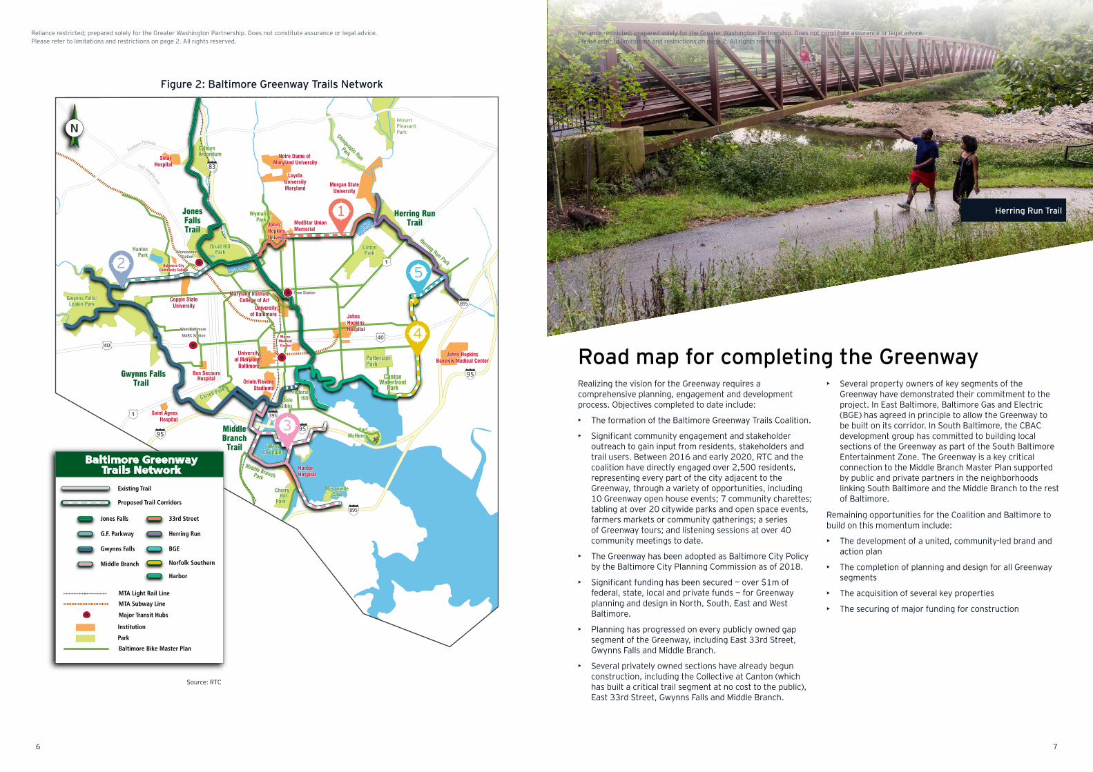
Figure 2: Baltimore Greenway Trails Network
Source: RTC
• Several property owners of key segments of the Greenway have demonstrated their commitment to the project. In East Baltimore, Baltimore Gas and Electric (BGE) has agreed in principle to allow the Greenway to be built on its corridor. In South Baltimore, the CBAC development group has committed to building local sections of the Greenway as part of the South Baltimore Entertainment Zone. The Greenway is a key critical connection to the Middle Branch Master Plan supported by public and private partners in the neighborhoods linking South Baltimore and the Middle Branch to the rest of Baltimore.
Remaining opportunities for the Coalition and Baltimore to build on this momentum include:
• The development of a united, community-led brand and action plan
• The completion of planning and design for all Greenway segments
• The acquisition of several key properties
• The securing of major funding for construction
Realizing the vision for the Greenway requires a comprehensive planning, engagement and development process. Objectives completed to date include:
• The formation of the Baltimore Greenway Trails Coalition.
• Significant community engagement and stakeholder outreach to gain input from residents, stakeholders and trail users. Between 2016 and early 2020, RTC and the coalition have directly engaged over 2,500 residents, representing every part of the city adjacent to the Greenway, through a variety of opportunities, including 10 Greenway open house events; 7 community charettes; tabling at over 20 citywide parks and open space events, farmers markets or community gatherings; a series of Greenway tours; and listening sessions at over 40 community meetings to date.
• The Greenway has been adopted as Baltimore City Policy by the Baltimore City Planning Commission as of 2018.
• Significant funding has been secured — over $1m of federal, state, local and private funds — for Greenway planning and design in North, South, East and West Baltimore.
• Planning has progressed on every publicly owned gap segment of the Greenway, including East 33rd Street, Gwynns Falls and Middle Branch.
• Several privately owned sections have already begun construction, including the Collective at Canton (which has built a critical trail segment at no cost to the public), East 33rd Street, Gwynns Falls and Middle Branch.
Existing Trail
Proposed Trail Corridors
Institution
MTA Light Rail Line
MTA Subway Line
Baltimore Bike Master Plan
Baltimore GreenwayTrails Network
Major Transit Hubs
Jones Falls
Gwynns Falls
G.F. Parkway Herring Run
33rd Street
Middle Branch
BGE
Norfolk Southern
Harbor
Park
MondawminStation
WymanPark
Middle BranchPark
SoloGibbs
HanlonPark
Gwynns Falls/Leakin Park
Carroll Park
Druid HillPark
CantonWaterfront
Park
Cherry Hill
Park
PattersonPark
CliftonPark
Herring Run Park
FortMcHenry
MountPleasantPark
WestCovington
Masonville Cove
FederalHill
Harbor Hospital
Oriole/RavensStadiums
Baltimore CityCommunity College
Mercy Medical Center
Penn Station
West Baltimore MARC Station
Universityof Maryland,
Baltimore
Universityof Baltimore
Maryland InstituteCollege of ArtCoppin State
University
Morgan StateUniversity
LoyolaUniversityMaryland
JohnsHopkinsUniversity
MedStar UnionMemorial
JohnsHopkinsHospital
Johns HopkinsBayview Medical Center
Bon SecoursHospital
Notre Dame of Maryland University
Sinai Hospital
Chinquapin Run
ParkCylburnArboretum
Saint Agnes Hospital
Park Heights Ave.
Northern Parkway
Lake
Montebello
Druid Lake
Herring RunTrail
Gwynns FallsTrail
MiddleBranch
Trail
JonesFallsTrail
83
9595
95
895
895
4040
1
1 395
For more information, please contact Jim Brown at
[email protected] | 202.974.5109
Road map for completing the Greenway4
1
2
3
5
Existing Trail
Proposed Trail Corridors
Institution
MTA Light Rail Line
MTA Subway Line
Baltimore Bike Master Plan
Baltimore GreenwayTrails Network
Major Transit Hubs
Jones Falls
Gwynns Falls
G.F. Parkway Herring Run
33rd Street
Middle Branch
BGE
Norfolk Southern
Harbor
Park
MondawminStation
WymanPark
Middle BranchPark
SoloGibbs
HanlonPark
Gwynns Falls/Leakin Park
Carroll Park
Druid HillPark
CantonWaterfront
Park
Cherry Hill
Park
PattersonPark
CliftonPark
Herring Run Park
FortMcHenry
MountPleasantPark
WestCovington
Masonville Cove
FederalHill
Harbor Hospital
Oriole/RavensStadiums
Baltimore CityCommunity College
Mercy Medical Center
Penn Station
West Baltimore MARC Station
Universityof Maryland,
Baltimore
Universityof Baltimore
Maryland InstituteCollege of ArtCoppin State
University
Morgan StateUniversity
LoyolaUniversityMaryland
JohnsHopkinsUniversity
MedStar UnionMemorial
JohnsHopkinsHospital
Johns HopkinsBayview Medical Center
Bon SecoursHospital
Notre Dame of Maryland University
Sinai Hospital
Chinquapin Run
ParkCylburnArboretum
Saint Agnes Hospital
Park Heights Ave.
Northern Parkway
Lake
Montebello
Druid Lake
Herring RunTrail
Gwynns FallsTrail
MiddleBranch
Trail
JonesFallsTrail
83
9595
95
895
895
4040
1
1 395
76
Reliance restricted; prepared solely for the Greater Washington Partnership. Does not constitute assurance or legal advice. Please refer to limitations and restrictions on page 2. All rights reserved.
Reliance restricted; prepared solely for the Greater Washington Partnership. Does not constitute assurance or legal advice. Please refer to limitations and restrictions on page 2. All rights reserved.
Herring Run Trail
• New access to transportation, including:• Increased pedestrian/bike demand• Road users shifted to trails and public transport as a result of improved walking and biking access
• Improved road safety outcomes resulting from fewer vehicle miles traveled
For the proposed 10-mile Greenway expansion, this section discusses the following:
• Economic and social benefits of trail construction, residential property values, transportation and safety, local business spending, the environment and health
• Each benefit category’s value to Baltimore
• Methodology to estimate benefits
• Results and interpretationTransportation and safety
Health• Avoided health care costs due to increased physical activity
Environment• Mode shift to active and public transportation, reducing emissions
• Carbon sequestration/storage associated with tree planting and increased park acreage
Local business spending• Increased trail demand driving increased retail and associated spending adjacent to the trail from:
• Baltimore residents• Tourists
Residential property valuation• Increased property values for owners
• Potential impact on renters
• Direct construction expenditures generate spillover impacts through:• Spending on goods and services purchased within Baltimore (indirect impacts) • Spending resulting from the labor income generated by the initial activity that ripples through the region
(induced impacts)
Trail construction Economic and social benefits
8 9
Reliance restricted; prepared solely for the Greater Washington Partnership. Does not constitute assurance or legal advice. Please refer to limitations and restrictions on page 2. All rights reserved.
Reliance restricted; prepared solely for the Greater Washington Partnership. Does not constitute assurance or legal advice. Please refer to limitations and restrictions on page 2. All rights reserved.
Jones Falls Trail Druid Hill Farmers Market
Source: EY analysis based on data provided by RTC management and the IMPLAN input-output economic model of Baltimore.
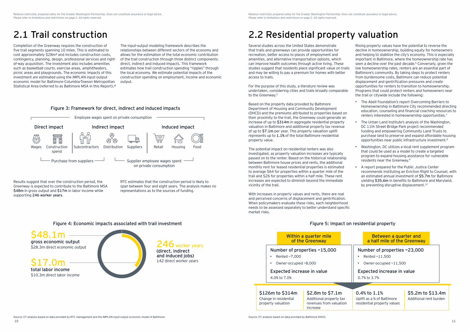
Figure 3: Framework for direct, indirect and induced impacts
Employee wages spent on private consumption
Wages
Purchase from suppliers
Construction spend
Subcontractors Distribution Suppliers Retail Housing Food
Supplier employee wages spent on private consumption
Direct impact Indirect impact Induced impact
Figure 5: Impact on residential property
Within a quarter mile of the Greenway
Between a quarter and a half mile of the Greenway
$126m to $314mChange in residential property valuation
$5.2m to $13.4mAdditional rent burden
$2.8m to $7.1mAdditional property tax revenues from valuation increase
0.4% to 1.1%Uplift as a % of Baltimore residential property values
Number of properties ~15,000 Number of properties ~23,000
Expected increase in value Expected increase in value
• Rented ~7,000
• Owner-occupied ~8,000
• Rented ~11,500
• Owner-occupied ~11,500
4.0% to 7.0% 0.7% to 3.7%
2.1 Trail constructionThe input-output modeling framework describes the relationships between different sectors of the economy and allows for the estimation of the total economic contribution of the trail construction through three distinct components: direct, indirect and induced impacts. This framework estimates how trail construction spending “ripples” through the local economy. We estimate potential impacts of the construction spending on employment, income and economic output.
Completion of the Greenway requires the construction of five trail segments spanning 10 miles. This is estimated to cost approximately $28m³ and includes construction costs, contingency, planning, design, professional services and right- of-way acquisition. The investment also includes amenities such as basketball courts, exercise areas, amphitheaters, picnic areas and playgrounds. The economic impacts of this investment are estimated using the IMPLAN input-output economic model for Baltimore-Columbia-Towson Metropolitan Statistical Area (referred to as Baltimore MSA in this Report).4
Results suggest that over the construction period, the Greenway is expected to contribute to the Baltimore MSA $48m in gross output and $17m in labor income while supporting 246 worker years.
RTC estimates that the construction period is likely to span between four and eight years. The analysis makes no representations as to the sources of funding.
Rising property values have the potential to reverse the decline in homeownership, building equity for homeowners and helping to stabilize the city’s economy. This is especially important in Baltimore, where the homeownership rate has seen a decline over the past decade.6 Conversely, given the low homeownership rates, renters are an essential part of Baltimore’s community. By taking steps to protect renters from burdensome costs, Baltimore can reduce potential displacement and gentrification pressures and create opportunities for renters to transition to homeownership. Programs that could protect renters and homeowners near the trail or citywide include the following:
• The Abell Foundation’s report Overcoming Barriers to Homeownership in Baltimore City recommended directing education, counseling and financial coaching resources to renters interested in homeownership opportunities.7
• The Urban Land Institute’s analysis of the Washington, DC 11th Street Bridge Park project recommended funding and empowering Community Land Trusts to purchase land to preserve and expand affordable housing opportunities near public infrastructure investment.8
• Washington, DC utilizes a local rent supplement program that could be used as a model to create a targeted program to expand housing assistance for vulnerable residents near the Greenway.9
• A report prepared for the Public Justice Center recommends instituting an Eviction Right to Counsel, with an estimated annual investment of $5.7m for Baltimore yielding $35.6m in benefits to Baltimore and Maryland, by preventing disruptive displacement.10
Several studies across the United States demonstrate that trails and greenways can provide opportunities for recreation, better access to places of employment and amenities, and alternative transportation options, which can improve health outcomes through active living. These studies suggest that residents place significant value on trails and may be willing to pay a premium for homes with better access to trails.
For the purpose of this study, a literature review was undertaken, considering cities and trails broadly comparable to the Greenway.5
Based on the property data provided by Baltimore Department of Housing and Community Development (DHCD) and the premiums attributed to properties based on their proximity to the trail, the Greenway could generate an increase of up to $314m in aggregate residential property valuation in Baltimore and additional property tax revenue of up to $7.1m per year. This property valuation uplift represents up to 1.1% of the total Baltimore residential property value.
The potential impact on residential renters was also investigated, as property valuation increases are typically passed on to the renter. Based on the historical relationship between Baltimore house prices and rents, the additional monthly rent for leased residential properties is estimated to average $64 for properties within a quarter mile of the trail and $26 for properties within a half mile. These rent increases are expected to diminish beyond the immediate vicinity of the trail.
With increases in property values and rents, there are real and perceived concerns of displacement and gentrification. When policymakers evaluate these risks, each neighborhood needs to be assessed separately to better understand specific market risks.
2.2 Residential property valuation
Source: EY analysis based on data provided by Baltimore DHCD.
Figure 4: Economic impacts associated with trail investment
$48.1m246
$17.0m
gross economic output
(direct, indirect and induced jobs)
worker years
total labor income
$28.3m direct economic output
142 direct worker years
$10.3m direct labor income
1110
Reliance restricted; prepared solely for the Greater Washington Partnership. Does not constitute assurance or legal advice. Please refer to limitations and restrictions on page 2. All rights reserved.
Reliance restricted; prepared solely for the Greater Washington Partnership. Does not constitute assurance or legal advice. Please refer to limitations and restrictions on page 2. All rights reserved.
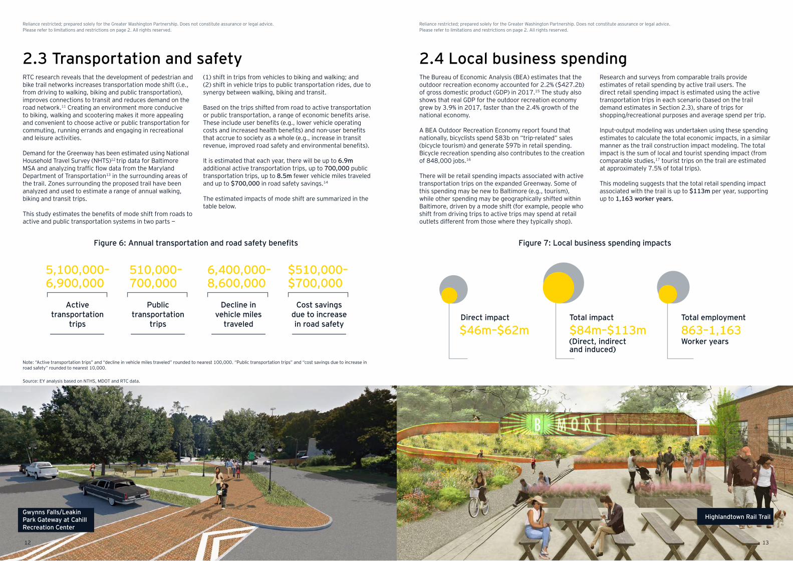
Figure 6: Annual transportation and road safety benefits Figure 7: Local business spending impacts
Direct impact
$46m–$62m 863–1,163Total employment
Worker years(Direct, indirect and induced)
Total impact
$84m–$113m
2.3 Transportation and safety(1) shift in trips from vehicles to biking and walking; and (2) shift in vehicle trips to public transportation rides, due to synergy between walking, biking and transit.
Based on the trips shifted from road to active transportation or public transportation, a range of economic benefits arise. These include user benefits (e.g., lower vehicle operating costs and increased health benefits) and non-user benefits that accrue to society as a whole (e.g., increase in transit revenue, improved road safety and environmental benefits).
It is estimated that each year, there will be up to 6.9m additional active transportation trips, up to 700,000 public transportation trips, up to 8.5m fewer vehicle miles traveled and up to $700,000 in road safety savings.14
The estimated impacts of mode shift are summarized in the table below.
RTC research reveals that the development of pedestrian and bike trail networks increases transportation mode shift (i.e., from driving to walking, biking and public transportation), improves connections to transit and reduces demand on the road network.11 Creating an environment more conducive to biking, walking and scootering makes it more appealing and convenient to choose active or public transportation for commuting, running errands and engaging in recreational and leisure activities.
Demand for the Greenway has been estimated using National Household Travel Survey (NHTS)12 trip data for Baltimore MSA and analyzing traffic flow data from the Maryland Department of Transportation13 in the surrounding areas of the trail. Zones surrounding the proposed trail have been analyzed and used to estimate a range of annual walking, biking and transit trips.
This study estimates the benefits of mode shift from roads to active and public transportation systems in two parts —
Note: “Active transportation trips” and “decline in vehicle miles traveled” rounded to nearest 100,000. “Public transportation trips” and “cost savings due to increase in road safety” rounded to nearest 10,000.
Source: EY analysis based on NTHS, MDOT and RTC data.
Active transportation
trips
5,100,000– 6,900,000
Public transportation
trips
510,000– 700,000
Decline in vehicle miles
traveled
6,400,000– 8,600,000
Cost savings due to increase in road safety
$510,000– $700,000
2.4 Local business spendingThe Bureau of Economic Analysis (BEA) estimates that the outdoor recreation economy accounted for 2.2% ($427.2b) of gross domestic product (GDP) in 2017.15 The study also shows that real GDP for the outdoor recreation economy grew by 3.9% in 2017, faster than the 2.4% growth of the national economy.
A BEA Outdoor Recreation Economy report found that nationally, bicyclists spend $83b on “trip-related” sales (bicycle tourism) and generate $97b in retail spending. Bicycle recreation spending also contributes to the creation of 848,000 jobs.16
There will be retail spending impacts associated with active transportation trips on the expanded Greenway. Some of this spending may be new to Baltimore (e.g., tourism), while other spending may be geographically shifted within Baltimore, driven by a mode shift (for example, people who shift from driving trips to active trips may spend at retail outlets different from those where they typically shop).
Research and surveys from comparable trails provide estimates of retail spending by active trail users. The direct retail spending impact is estimated using the active transportation trips in each scenario (based on the trail demand estimates in Section 2.3), share of trips for shopping/recreational purposes and average spend per trip.
Input-output modeling was undertaken using these spending estimates to calculate the total economic impacts, in a similar manner as the trail construction impact modeling. The total impact is the sum of local and tourist spending impact (from comparable studies,17 tourist trips on the trail are estimated at approximately 7.5% of total trips).
This modeling suggests that the total retail spending impact associated with the trail is up to $113m per year, supporting up to 1,163 worker years.
1312
Reliance restricted; prepared solely for the Greater Washington Partnership. Does not constitute assurance or legal advice. Please refer to limitations and restrictions on page 2. All rights reserved.
Reliance restricted; prepared solely for the Greater Washington Partnership. Does not constitute assurance or legal advice. Please refer to limitations and restrictions on page 2. All rights reserved.
Gwynns Falls/Leakin Park Gateway at Cahill Recreation Center
Highlandtown Rail Trail
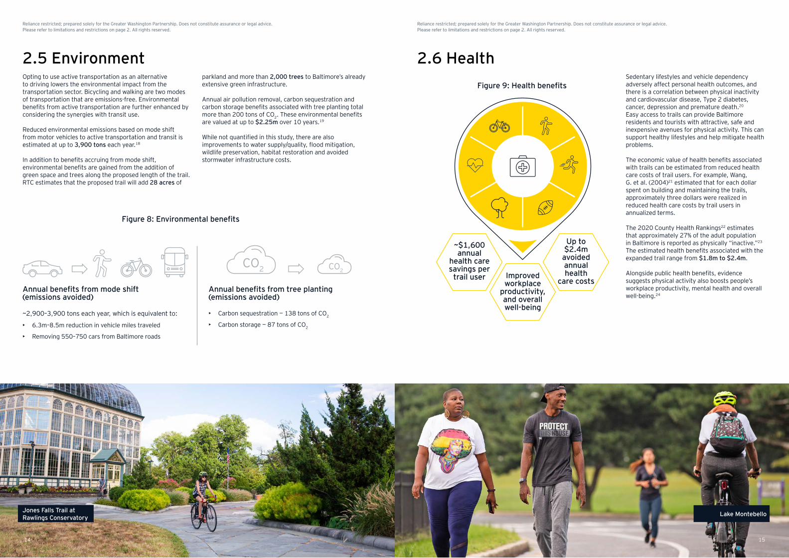
Figure 8: Environmental benefits
Figure 9: Health benefitsOpting to use active transportation as an alternative to driving lowers the environmental impact from the transportation sector. Bicycling and walking are two modes of transportation that are emissions-free. Environmental benefits from active transportation are further enhanced by considering the synergies with transit use.
Reduced environmental emissions based on mode shift from motor vehicles to active transportation and transit is estimated at up to 3,900 tons each year.18
In addition to benefits accruing from mode shift, environmental benefits are gained from the addition of green space and trees along the proposed length of the trail. RTC estimates that the proposed trail will add 28 acres of
parkland and more than 2,000 trees to Baltimore’s already extensive green infrastructure.
Annual air pollution removal, carbon sequestration and carbon storage benefits associated with tree planting total more than 200 tons of CO2. These environmental benefits are valued at up to $2.25m over 10 years.19
While not quantified in this study, there are also improvements to water supply/quality, flood mitigation, wildlife preservation, habitat restoration and avoided stormwater infrastructure costs.
Annual benefits from mode shift (emissions avoided)
~2,900–3,900 tons each year, which is equivalent to:
• 6.3m–8.5m reduction in vehicle miles traveled
• Removing 550–750 cars from Baltimore roads
Annual benefits from tree planting (emissions avoided)
• Carbon sequestration — 138 tons of CO2
• Carbon storage — 87 tons of CO2
2.5 Environment 2.6 Health
Improved workplace
productivity, and overall well-being
Up to $2.4m avoided annual health
care costs
~$1,600 annual
health care savings per
trail user
Sedentary lifestyles and vehicle dependency adversely affect personal health outcomes, and there is a correlation between physical inactivity and cardiovascular disease, Type 2 diabetes, cancer, depression and premature death.20
Easy access to trails can provide Baltimore residents and tourists with attractive, safe and inexpensive avenues for physical activity. This can support healthy lifestyles and help mitigate health problems.
The economic value of health benefits associated with trails can be estimated from reduced health care costs of trail users. For example, Wang, G. et al. (2004)21 estimated that for each dollar spent on building and maintaining the trails, approximately three dollars were realized in reduced health care costs by trail users in annualized terms.
The 2020 County Health Rankings22 estimates that approximately 27% of the adult population in Baltimore is reported as physically “inactive.”23 The estimated health benefits associated with the expanded trail range from $1.8m to $2.4m.
Alongside public health benefits, evidence suggests physical activity also boosts people’s workplace productivity, mental health and overall well-being.24
CO2 CO2
14 15
Reliance restricted; prepared solely for the Greater Washington Partnership. Does not constitute assurance or legal advice. Please refer to limitations and restrictions on page 2. All rights reserved.
Reliance restricted; prepared solely for the Greater Washington Partnership. Does not constitute assurance or legal advice. Please refer to limitations and restrictions on page 2. All rights reserved.
Jones Falls Trail at Rawlings Conservatory Lake Montebello
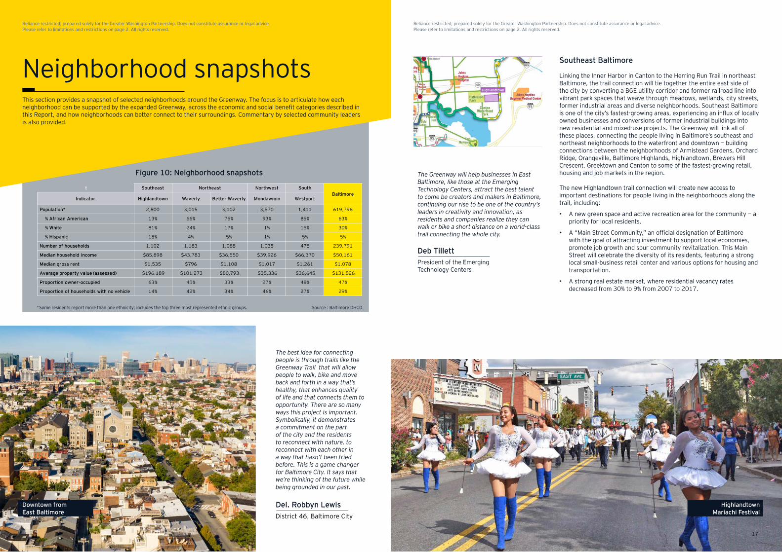
Figure 10: Neighborhood snapshots
This section provides a snapshot of selected neighborhoods around the Greenway. The focus is to articulate how each neighborhood can be supported by the expanded Greenway, across the economic and social benefit categories described in this Report, and how neighborhoods can better connect to their surroundings. Commentary by selected community leaders is also provided.
Source : Baltimore DHCD*Some residents report more than one ethnicity; includes the top three most represented ethnic groups.
Del. Robbyn LewisDistrict 46, Baltimore City
The best idea for connecting people is through trails like the Greenway Trail that will allow people to walk, bike and move back and forth in a way that’s healthy, that enhances quality of life and that connects them to opportunity. There are so many ways this project is important. Symbolically, it demonstrates a commitment on the part of the city and the residents to reconnect with nature, to reconnect with each other in a way that hasn’t been tried before. This is a game changer for Baltimore City. It says that we’re thinking of the future while being grounded in our past.
Deb TillettPresident of the Emerging Technology Centers
Southeast Baltimore
Linking the Inner Harbor in Canton to the Herring Run Trail in northeast Baltimore, the trail connection will tie together the entire east side of the city by converting a BGE utility corridor and former railroad line into vibrant park spaces that weave through meadows, wetlands, city streets, former industrial areas and diverse neighborhoods. Southeast Baltimore is one of the city’s fastest-growing areas, experiencing an influx of locally owned businesses and conversions of former industrial buildings into new residential and mixed-use projects. The Greenway will link all of these places, connecting the people living in Baltimore’s southeast and northeast neighborhoods to the waterfront and downtown — building connections between the neighborhoods of Armistead Gardens, Orchard Ridge, Orangeville, Baltimore Highlands, Highlandtown, Brewers Hill Crescent, Greektown and Canton to some of the fastest-growing retail, housing and job markets in the region.
The new Highlandtown trail connection will create new access to important destinations for people living in the neighborhoods along the trail, including:
• A new green space and active recreation area for the community — a priority for local residents.
• A “Main Street Community,” an official designation of Baltimore with the goal of attracting investment to support local economies, promote job growth and spur community revitalization. This Main Street will celebrate the diversity of its residents, featuring a strong local small-business retail center and various options for housing and transportation.
• A strong real estate market, where residential vacancy rates decreased from 30% to 9% from 2007 to 2017.
The Greenway will help businesses in East Baltimore, like those at the Emerging Technology Centers, attract the best talent to come be creators and makers in Baltimore, continuing our rise to be one of the country’s leaders in creativity and innovation, as residents and companies realize they can walk or bike a short distance on a world-class trail connecting the whole city.
t Southeast Northeast Northwest SouthBaltimore
Indicator Highlandtown Waverly Better Waverly Mondawmin Westport
Population* 2,800 3,015 3,102 3,570 1,411 619,796
% African American 13% 66% 75% 93% 85% 63%
% White 81% 24% 17% 1% 15% 30%
% Hispanic 18% 4% 5% 1% 5% 5%
Number of households 1,102 1,183 1,088 1,035 478 239,791
Median household income $85,898 $43,783 $36,550 $39,926 $66,370 $50,161
Median gross rent $1,535 $796 $1,108 $1,017 $1,261 $1,078
Average property value (assessed) $196,189 $101,273 $80,793 $35,336 $36,645 $131,526
Proportion owner-occupied 63% 45% 33% 27% 48% 47%
Proportion of households with no vehicle 14% 42% 34% 46% 27% 29%
Highlandtown
Neighborhood snapshots
17
Reliance restricted; prepared solely for the Greater Washington Partnership. Does not constitute assurance or legal advice. Please refer to limitations and restrictions on page 2. All rights reserved.
Reliance restricted; prepared solely for the Greater Washington Partnership. Does not constitute assurance or legal advice. Please refer to limitations and restrictions on page 2. All rights reserved.
Downtown from East Baltimore
Highlandtown Mariachi Festival
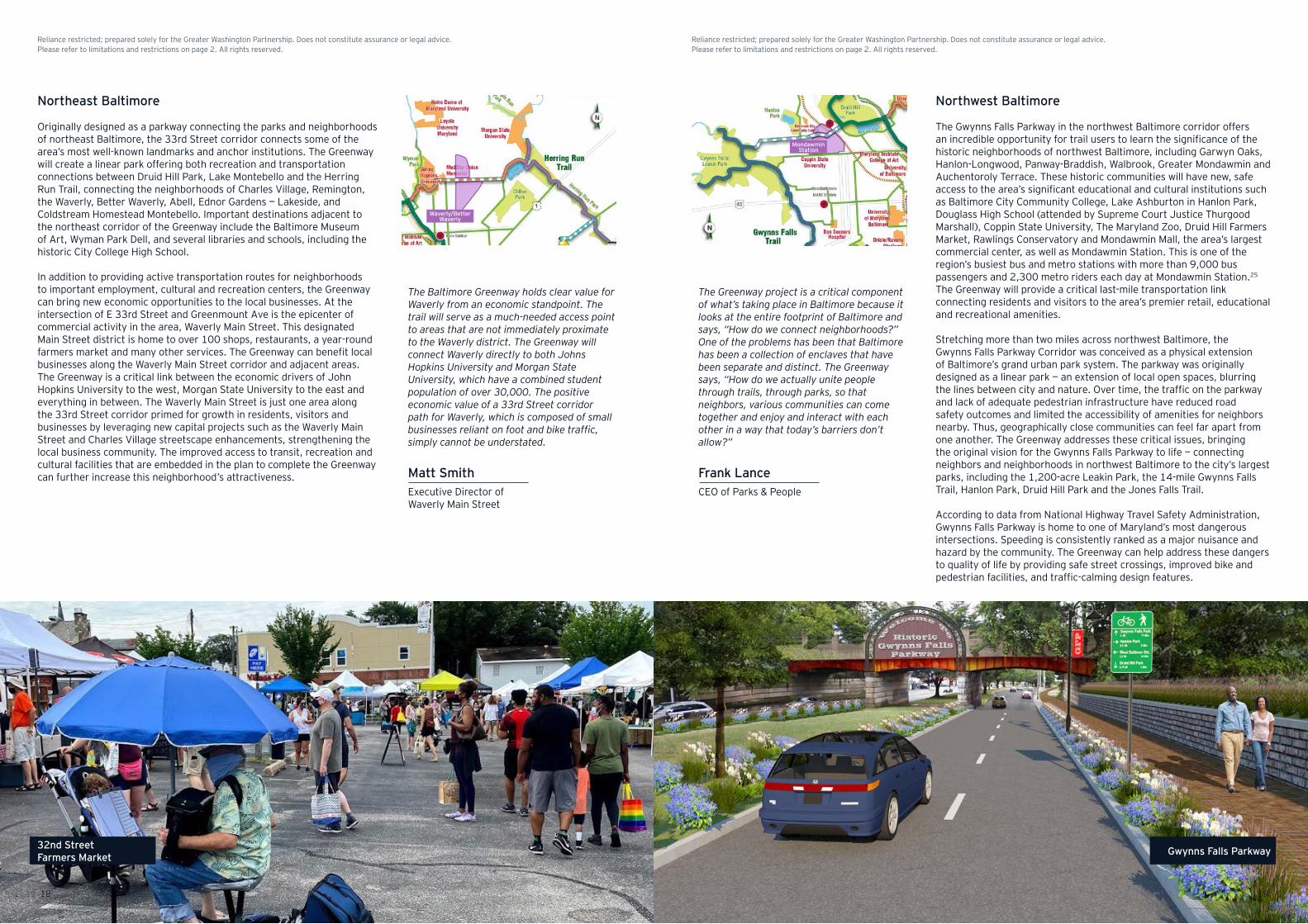
Northwest Baltimore
The Gwynns Falls Parkway in the northwest Baltimore corridor offers an incredible opportunity for trail users to learn the significance of the historic neighborhoods of northwest Baltimore, including Garwyn Oaks, Hanlon-Longwood, Panway-Braddish, Walbrook, Greater Mondawmin and Auchentoroly Terrace. These historic communities will have new, safe access to the area’s significant educational and cultural institutions such as Baltimore City Community College, Lake Ashburton in Hanlon Park, Douglass High School (attended by Supreme Court Justice Thurgood Marshall), Coppin State University, The Maryland Zoo, Druid Hill Farmers Market, Rawlings Conservatory and Mondawmin Mall, the area’s largest commercial center, as well as Mondawmin Station. This is one of the region’s busiest bus and metro stations with more than 9,000 bus passengers and 2,300 metro riders each day at Mondawmin Station.25 The Greenway will provide a critical last-mile transportation link connecting residents and visitors to the area’s premier retail, educational and recreational amenities.
Stretching more than two miles across northwest Baltimore, the Gwynns Falls Parkway Corridor was conceived as a physical extension of Baltimore’s grand urban park system. The parkway was originally designed as a linear park — an extension of local open spaces, blurring the lines between city and nature. Over time, the traffic on the parkway and lack of adequate pedestrian infrastructure have reduced road safety outcomes and limited the accessibility of amenities for neighbors nearby. Thus, geographically close communities can feel far apart from one another. The Greenway addresses these critical issues, bringing the original vision for the Gwynns Falls Parkway to life — connecting neighbors and neighborhoods in northwest Baltimore to the city’s largest parks, including the 1,200-acre Leakin Park, the 14-mile Gwynns Falls Trail, Hanlon Park, Druid Hill Park and the Jones Falls Trail.
According to data from National Highway Travel Safety Administration, Gwynns Falls Parkway is home to one of Maryland’s most dangerous intersections. Speeding is consistently ranked as a major nuisance and hazard by the community. The Greenway can help address these dangers to quality of life by providing safe street crossings, improved bike and pedestrian facilities, and traffic-calming design features.
Northeast Baltimore
Originally designed as a parkway connecting the parks and neighborhoods of northeast Baltimore, the 33rd Street corridor connects some of the area’s most well-known landmarks and anchor institutions. The Greenway will create a linear park offering both recreation and transportation connections between Druid Hill Park, Lake Montebello and the Herring Run Trail, connecting the neighborhoods of Charles Village, Remington, the Waverly, Better Waverly, Abell, Ednor Gardens — Lakeside, and Coldstream Homestead Montebello. Important destinations adjacent to the northeast corridor of the Greenway include the Baltimore Museum of Art, Wyman Park Dell, and several libraries and schools, including the historic City College High School.
In addition to providing active transportation routes for neighborhoods to important employment, cultural and recreation centers, the Greenway can bring new economic opportunities to the local businesses. At the intersection of E 33rd Street and Greenmount Ave is the epicenter of commercial activity in the area, Waverly Main Street. This designated Main Street district is home to over 100 shops, restaurants, a year-round farmers market and many other services. The Greenway can benefit local businesses along the Waverly Main Street corridor and adjacent areas. The Greenway is a critical link between the economic drivers of John Hopkins University to the west, Morgan State University to the east and everything in between. The Waverly Main Street is just one area along the 33rd Street corridor primed for growth in residents, visitors and businesses by leveraging new capital projects such as the Waverly Main Street and Charles Village streetscape enhancements, strengthening the local business community. The improved access to transit, recreation and cultural facilities that are embedded in the plan to complete the Greenway can further increase this neighborhood’s attractiveness.
The Baltimore Greenway holds clear value for Waverly from an economic standpoint. The trail will serve as a much-needed access point to areas that are not immediately proximate to the Waverly district. The Greenway will connect Waverly directly to both Johns Hopkins University and Morgan State University, which have a combined student population of over 30,000. The positive economic value of a 33rd Street corridor path for Waverly, which is composed of small businesses reliant on foot and bike traffic, simply cannot be understated.
Matt SmithExecutive Director of Waverly Main Street
The Greenway project is a critical component of what’s taking place in Baltimore because it looks at the entire footprint of Baltimore and says, “How do we connect neighborhoods?” One of the problems has been that Baltimore has been a collection of enclaves that have been separate and distinct. The Greenway says, “How do we actually unite people through trails, through parks, so that neighbors, various communities can come together and enjoy and interact with each other in a way that today’s barriers don’t allow?”
Frank LanceCEO of Parks & People
Waverly/Better Waverly
Mondawmin Station
Waverly/Better Waverly
1918
Reliance restricted; prepared solely for the Greater Washington Partnership. Does not constitute assurance or legal advice. Please refer to limitations and restrictions on page 2. All rights reserved.
Reliance restricted; prepared solely for the Greater Washington Partnership. Does not constitute assurance or legal advice. Please refer to limitations and restrictions on page 2. All rights reserved.
32nd Street Farmers Market Gwynns Falls Parkway
WESTPORT WATERFRONT SHARED-USE PATHAs the Westport waterfront property develops, creating a shared-use path through the site will beincluded. The shared-use path traverses the Westport waterfront between Clare Street and MiddleBranch Park. This shared-use path provides a safer, more relaxing alternative route to the current GwynnsFalls Trail alignment on Kloman Street.
Lisa HodgesExecutive Director of Westport CEDC
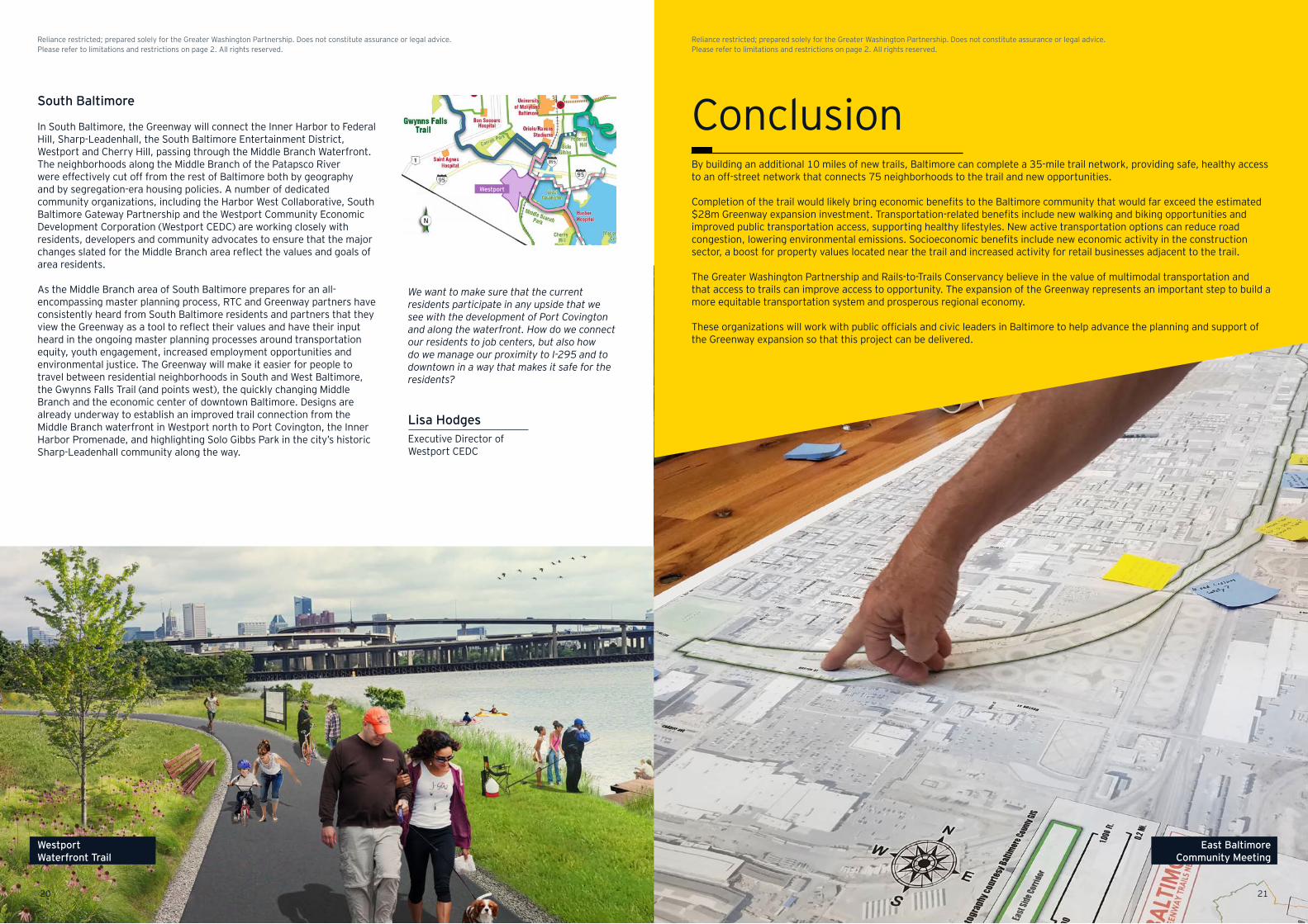
South Baltimore
In South Baltimore, the Greenway will connect the Inner Harbor to Federal Hill, Sharp-Leadenhall, the South Baltimore Entertainment District, Westport and Cherry Hill, passing through the Middle Branch Waterfront. The neighborhoods along the Middle Branch of the Patapsco River were effectively cut off from the rest of Baltimore both by geography and by segregation-era housing policies. A number of dedicated community organizations, including the Harbor West Collaborative, South Baltimore Gateway Partnership and the Westport Community Economic Development Corporation (Westport CEDC) are working closely with residents, developers and community advocates to ensure that the major changes slated for the Middle Branch area reflect the values and goals of area residents.
As the Middle Branch area of South Baltimore prepares for an all-encompassing master planning process, RTC and Greenway partners have consistently heard from South Baltimore residents and partners that they view the Greenway as a tool to reflect their values and have their input heard in the ongoing master planning processes around transportation equity, youth engagement, increased employment opportunities and environmental justice. The Greenway will make it easier for people to travel between residential neighborhoods in South and West Baltimore, the Gwynns Falls Trail (and points west), the quickly changing Middle Branch and the economic center of downtown Baltimore. Designs are already underway to establish an improved trail connection from the Middle Branch waterfront in Westport north to Port Covington, the Inner Harbor Promenade, and highlighting Solo Gibbs Park in the city’s historic Sharp-Leadenhall community along the way.
We want to make sure that the current residents participate in any upside that we see with the development of Port Covington and along the waterfront. How do we connect our residents to job centers, but also how do we manage our proximity to I-295 and to downtown in a way that makes it safe for the residents?
Westport
ConclusionBy building an additional 10 miles of new trails, Baltimore can complete a 35-mile trail network, providing safe, healthy access to an off-street network that connects 75 neighborhoods to the trail and new opportunities.
Completion of the trail would likely bring economic benefits to the Baltimore community that would far exceed the estimated $28m Greenway expansion investment. Transportation-related benefits include new walking and biking opportunities and improved public transportation access, supporting healthy lifestyles. New active transportation options can reduce road congestion, lowering environmental emissions. Socioeconomic benefits include new economic activity in the construction sector, a boost for property values located near the trail and increased activity for retail businesses adjacent to the trail.
The Greater Washington Partnership and Rails-to-Trails Conservancy believe in the value of multimodal transportation and that access to trails can improve access to opportunity. The expansion of the Greenway represents an important step to build a more equitable transportation system and prosperous regional economy.
These organizations will work with public officials and civic leaders in Baltimore to help advance the planning and support of the Greenway expansion so that this project can be delivered.
Westport
2120
Reliance restricted; prepared solely for the Greater Washington Partnership. Does not constitute assurance or legal advice. Please refer to limitations and restrictions on page 2. All rights reserved.
Reliance restricted; prepared solely for the Greater Washington Partnership. Does not constitute assurance or legal advice. Please refer to limitations and restrictions on page 2. All rights reserved.
Westport Waterfront Trail
East Baltimore Community Meeting
Endnotes
1 “Worker years” denotes jobs lasting one year each. For example, a four-year construction period, supporting 246 worker years would represent an average of 61 people employed per year.
2 Matthew Kahn, Jordan Rappaport and Edward Glaeser, “Why Do the Poor Live in Cities? The Role of Public Transportation,” Journal of Urban Economics, 2006.
3 Baltimore Greenway Trail, Financial Plan 2018.
4 IMPLAN LLC 2018 Input-Output Economic Model.
5 Literature was analyzed that investigated the value of residential properties close to trails to those properties situated elsewhere. Seven studies were identified to inform this Report; they analyzed the property valuation impacts for two study zones from the trail: (1) within ¼ mile and (2) between ¼ and ½ mile. The results of this exercise suggest that properties within ¼ mile of the trail are associated with a property value increase of 4%–7%.* For properties located between ¼ and ½ mile, a premium of 0.7%–3.7% is associated.** Across the studies, there is agreement that trails have had no negative impacts on property values.
*Amardeep Dhanju and David P. Racca, Property Value/Desirability Effects of Bike Paths Adjacent to Residential Areas (Center for Applied Demography and Research, University of Delaware, 2006); Sarah Nicholls and John L. Crompton, “The Impact of Greenways on Property Values: Evidence from Austin, Texas,” Journal of Leisure Research, 2005; Paul Asabere and Forrest Huffman, “The Relative Impacts of Trails and Greenbelts on Home Price,” The Journal of Real Estate Finance and Economics, 2009; Youngre Noh, “Does converting abandoned railways to greenways impact neighboring housing prices?” Landscape and Urban Planning, 2019.
**Greg Lindsey, Joyce Man, Seth Payton and Kelly Dickson, “Property Values, Recreation Values, and Urban Greenways,” The Journal of Park and Recreation Administration, 2004; East Coast Greenway Alliance, “Quantifying the Impact of Completing the East Coast Greenway in the Delaware River Watershed"; Duygu Karadeniz, “The Impact of the Little Miami Scenic Trail on Single Family Residential Property Values,” 2008.
6 Sally J. Scott, “Overcoming Barriers to Homeownership in Baltimore City,” The Abell Report, July 2020 Volume 33, Number 6 (The Abell Foundation), available at abell.org/sites/default/files/files/2020_Abell_Howeownership%20Report_FINAL2_web%20(dr).pdf, accessed September 2020.
7 Ibid.
8 Mary Bogle, Somala Diby and Mychal Cohen, Equitable Development and Urban Park Space: Results and Insights from the First Two Years of Implementation of the Equitable Development Plan of DC’s 11th Street Bridge Park Project (Urban Institute, 2019), available at www.urban.org/sites/default/files/publication/99850/equitable_development_and_urban_park_space_1.pdf.
9 "The Local Rent Supplement Program" (DC Fiscal Policy Institute, 2016), available at www.dcfpi.org/wp-content/uploads/2016/04/16-04-LRSP-Brief.pdf.
10 The Economic Impact of an Eviction Right to Counsel in Baltimore City (Stout, 8 May 2020), prepared for The Public Justice Center, available at cdn2.hubspot.net/hubfs/4408380/PDF/Eviction-Reports-Articles-Cities-States/baltimore-rtc-report-final-5-8-2020.pdf.
11 Active Transportation Transforms America (Rails to Trails Conservancy, 2019).
12 National Household Travel Survey, 2017 (U.S. Department of Transportation Federal Highway Administration), available at nhts.ornl.gov/.
13 Maryland.gov data map available at data.imap.maryland.gov/datasets/3f4b959826c34480be3e4740e4ee025f_1.
14 Historical accident data has been sourced from the Fatality Analysis Reporting System (FARS) by the National Highway Traffic Safety Administration (NHTSA). Value of statistical life was sourced from Guidance on Treatment of the Economic Value of a Statistical Life in U.S. Department of Transportation Analyses (2016) and adjusted to 2020 prices. Fuel savings and emissions savings are calculated using vehicle miles of travel (VMT) avoided. VMT avoided in each scenario has been calculated using the number of car trips avoided and the average length of these trips. Savings associated with increased road safety have been estimated using historical accident rates in Baltimore and estimated economic costs of each accident type.
15 BEA Satellite Accounts, 2019 (www.bea.gov/news/2019/outdoor-recreation-satellite-account-us-and-prototype-states-2017) BEA Satellite Accounts, 2019 (www.bea.gov/news/2019/outdoor-recreation-satellite-account-us-and-prototype-states-2017).
16 Outdoor Recreation Economy Report (Outdoor Industry Association, 2017), available at oia.outdoorindustry.org/OIA-receconomy.
17 Jennifer Dill and John Gliebe, Understanding and Measuring Bicycling Behavior: a Focus on Travel Time and Route Choice (Final report OTREC-RR-08-03 prepared for Oregon Transportation Research and Education Consortium (OTREC), December 2008); East Village Shoppers Study: A Snapshot of Travel and Spending Patterns of Residents and Visitors in the East Village (Transportation Alternatives, 2012); and Natalie Popovich and Susan L. Handy, “Bicyclists as Consumers,” Transportation Research Record: Journal of the Transportation Research Board, 2014.
18 Calculated using the VMT avoided estimates from Section 2.3.
19 Calculated using the iTree canopy model developed by USDA Forest Services. i-Tree Canopy v7.0 from the i-Tree software suite by the USDA Forest Service. Available at canopy.itreetools.org/.
20 Frank W. Booth, Christian K. Roberts and Matthew J. Laye, “Lack of exercise is a major cause of chronic diseases,” Comprehensive Physiology, 2012.
21 Guijing, Wang, et al., “Cost Analysis of the Built Environment: The Case of Bike and Pedestrian Trials in Lincoln, Neb,” American Journal of Public Health, 2004.
22 County Health Rankings, Robert Wood Johnson Foundation, available at www.countyhealthrankings.org/.
23 Physical inactivity is defined as percentage of adults aged 20 and over reporting no leisure-time physical activity. Insufficiently active means some reported physical activity but not enough to meet CDC guidelines of 150 minutes of physical activity per week.
24 “Why Bikes are Good for Business” (Michigan Complete Streets Coalition, 2014), available at michigancompletestreets.wordpress.com/2014/01/27/why-bikes-are-good-for-business/; and “Biking to work makes you productive and the boss happy” (Bicycle Network, Australia, 2019), available at www.bicyclenetwork.com.au/newsroom/2019/09/12/biking-to-work-makes-youproductive-and-the-boss-happy/.
25 Maryland.gov data map available at data.imap.maryland.gov/datasets/maryland-transit-mta-bus-stops-1?geometry=-76.656%2C39.317%2C-76.649%2C39.319.
Technical descriptions of data and limitations
Technical details on study methodology
The estimated economic output, labor income and jobs presented in this study are based on information regarding the Greenway provided by RTC or estimated by EY US. The economic contributions related to this activity were estimated using IMPLAN input-output modeling for the Baltimore MSA, which describes relationships between businesses, households and governments.
This model follows financial flows, as purchases of local goods by companies and employees support sales, jobs and labor income. IMPLAN is used by the public sector, as well as by private-sector businesses and other researchers, and is based on widely accepted methodology for estimating these types of economic linkages.
The magnitude of each economic effect is described in terms of an economic multiplier. The multipliers in the IMPLAN model are based on the Leontief matrix, which estimates the total economic requirements for every unit of direct output in a given industry using detailed interindustry relationships documented in the input-output model. The input-output framework connects commodity supply from one industry to commodity demand by another. The multipliers estimated by using this approach capture all of the backward linkages related to an industry’s production by attaching technical coefficients to expenditures. These output coefficients (dollars of demand) are then translated into dollars of economic output, labor income and number of employees based on industry averages. A static input-output model is based on observed historical relationships and therefore does not account for supply-side constraints, price changes, labor-capital substitution or other market dynamics.
The three types of effects estimated by the IMPLAN model — direct, indirect and induced effects — describe the nature of the economic “ripple” effects generated by the expenditure
Limitations
The reader should be aware of the following limitations and assumptions of this analysis: • The potential economic impacts presented in this study
(including employment and labor income) reflect the work location. These are jobs that could be filled by Baltimore MSA residents or nonresidents.
• The indirect and induced economic contributions are estimated using a static input-output economic model reflecting historical purchasing relationships.
• Indirect economic impacts were estimated based on relationships in the IMPLAN input-output model, which describe the mix of locally supplied goods and services, by industry, based-on historical purchasing relationships. The IMPLAN industry models were chosen to most closely resemble the mix of activities related to the estimated expenditures.
• The economic impacts presented in this report quantify the economic activity supported by Greenway investments and associated spending. In some cases, the indirect and induced jobs may not be new to Baltimore but temporarily supported by these expenditures.
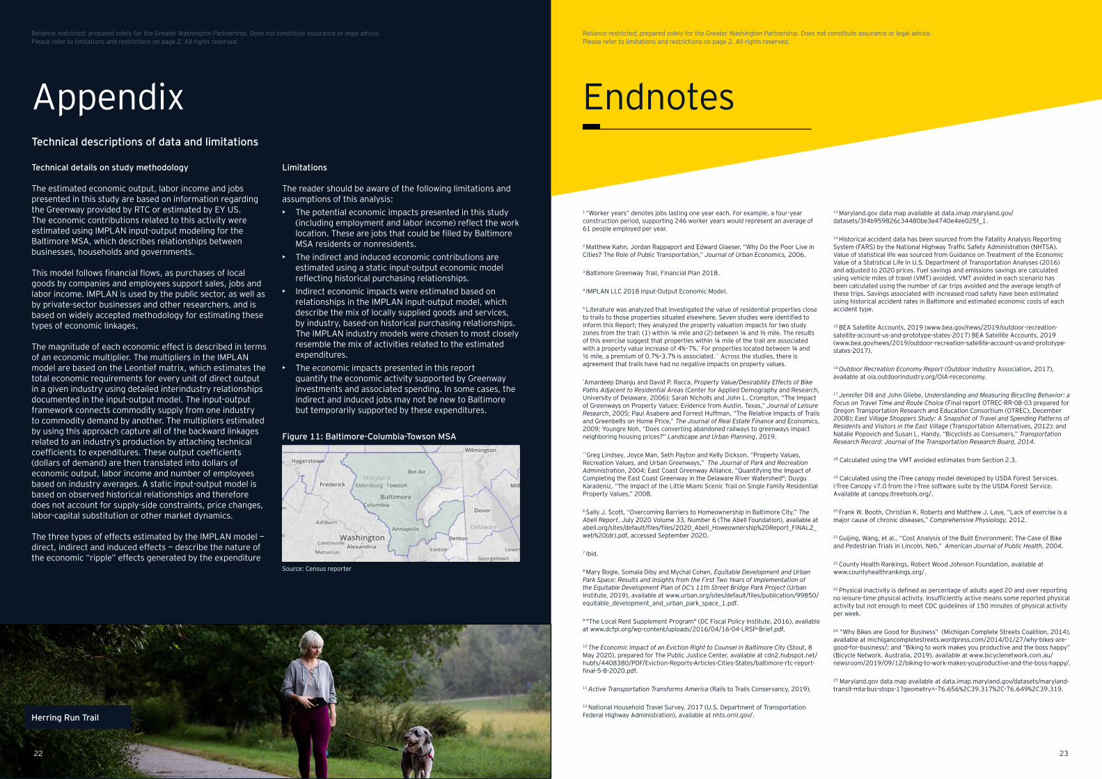
Figure 11: Baltimore-Columbia-Towson MSA
Source: Census reporter
Appendix
2322
Reliance restricted; prepared solely for the Greater Washington Partnership. Does not constitute assurance or legal advice. Please refer to limitations and restrictions on page 2. All rights reserved.
Reliance restricted; prepared solely for the Greater Washington Partnership. Does not constitute assurance or legal advice. Please refer to limitations and restrictions on page 2. All rights reserved.
Herring Run Trail

EY | Assurance | Tax | Strategy and Transactions | ConsultingAbout EYEY is a global leader in assurance, tax, strategy, transaction and consulting services. The insights and quality services we deliver help build trust and confidence in the capital markets and in economies the world over. We develop outstanding leaders who team to deliver on our promises to all of our stakeholders. In so doing, we play a critical role in building a better working world for our people, for our clients and for our communities.
EY refers to the global organization, and may refer to one or more, of the member firms of Ernst & Young Global Limited, each of which is a separate legal entity. Ernst & Young Global Limited, a UK company limited by guarantee, does not provide services to clients. Information about how EY collects and uses personal data and a description of the rights individuals have under data protection legislation are available via ey.com/privacy. For more information about our organization, please visit ey.com.
Ernst & Young LLP is a client-serving member firm of Ernst & Young Global Limited operating in the US.
© 2020 Ernst & Young LLP. All Rights Reserved.
US SCORE no. 10676-201US
2009-3581826 ED None
This material has been prepared for general informational purposes only and is not intended to be relied upon as accounting, tax or other professional advice. Please refer to your advisors for specific advice.
ey.com
Herring Run Trail