e2014 gypsum report - atlantic canada conservation data
TRANSCRIPT
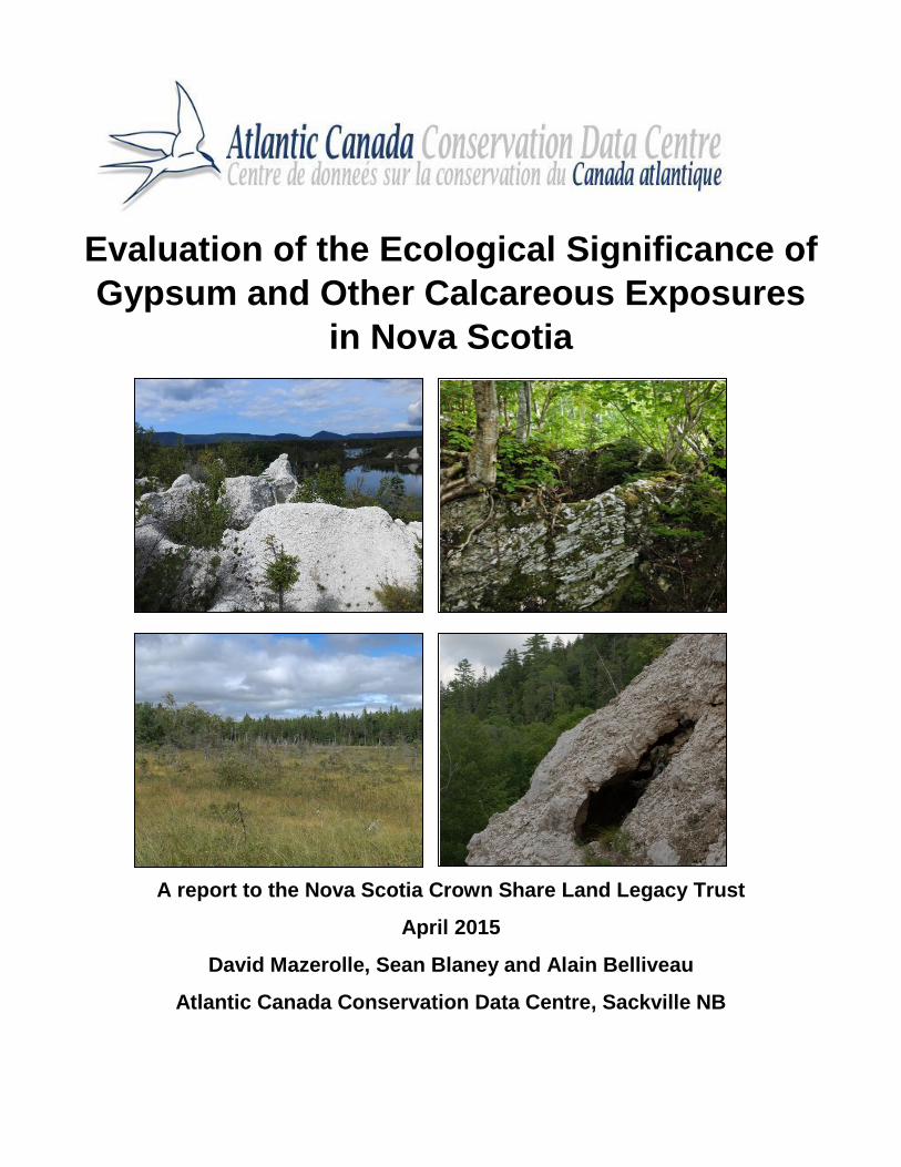
Evaluation of the Ecological Significance of
Gypsum and Other Calcareous Exposures
in Nova Scotia
A report to the Nova Scotia Crown Share Land Legacy Trust
April 2015
David Mazerolle, Sean Blaney and Alain Belliveau
Atlantic Canada Conservation Data Centre, Sackville NB
1
Introduction
Project Background and Rationale
Due to the particular environmental conditions created by gypsum1-influenced soils, areas with
surficial deposits support distinct upland and wetland plant communities, some of which are of
conservation concern. Gypsum-associated natural communities are globally uncommon and very rare
in northeastern North America. Nova Scotia contains the region’s largest and most widespread
examples of these communities, despite the fact that its Windsor Group bedrock geology (which
includes all provincial deposits of gypsum as well as deposits of limestone and other sedimentary
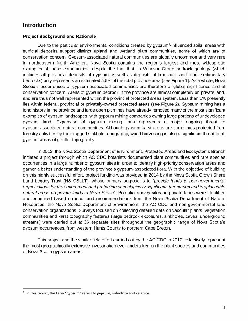
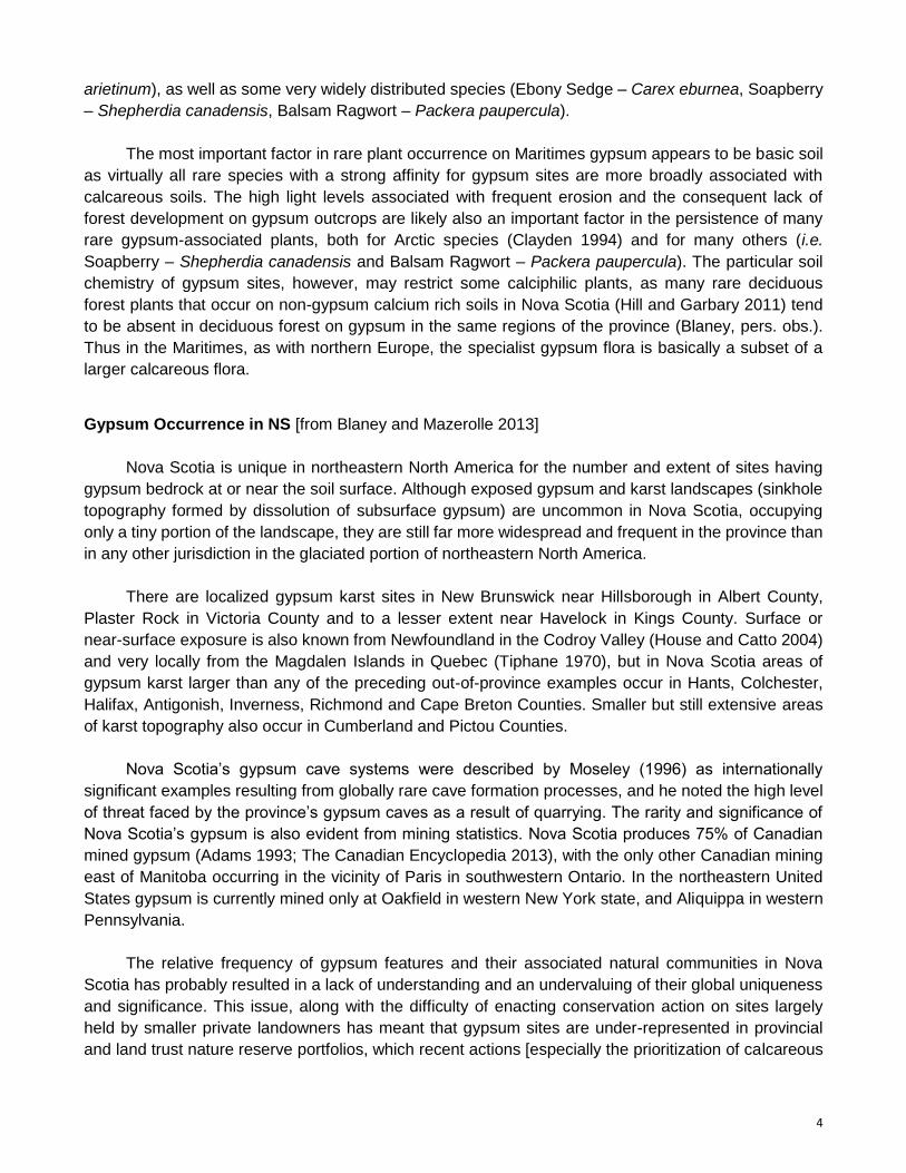
bedrocks) only represents an estimated 5.5% of the total province area (see Figure 1). As a whole, Nova
Scotia’s occurrences of gypsum-associated communities are therefore of global significance and of
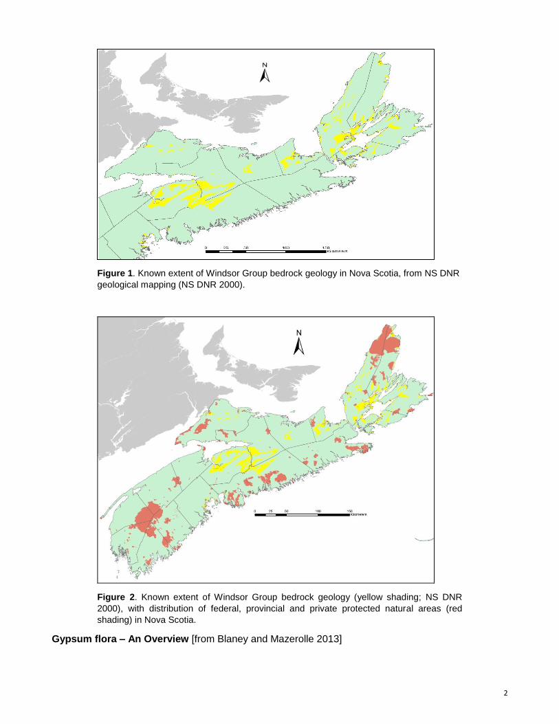
conservation concern. Areas of gypsum bedrock in the province are almost completely on private land,
and are thus not well represented within the provincial protected areas system. Less than 1% presently
lies within federal, provincial or privately-owned protected areas (see Figure 2). Gypsum mining has a
long history in the province and large open pit mines have already removed many of the most significant
examples of gypsum landscapes, with gypsum mining companies owning large portions of undeveloped
gypsum land. Expansion of gypsum mining thus represents a major ongoing threat to
gypsum-associated natural communities. Although gypsum karst areas are sometimes protected from
forestry activities by their rugged sinkhole topography, wood harvesting is also a significant threat to all
gypsum areas of gentler topography.
In 2012, the Nova Scotia Department of Environment, Protected Areas and Ecosystems Branch
initiated a project through which AC CDC botanists documented plant communities and rare species
occurrences in a large number of gypsum sites in order to identify high-priority conservation areas and
garner a better understanding of the province’s gypsum-associated flora. With the objective of building
on this highly successful effort, project funding was provided in 2014 by the Nova Scotia Crown Share
Land Legacy Trust (NS CSLLT), whose primary purpose is to “provide funds to non-governmental
organizations for the securement and protection of ecologically significant, threatened and irreplaceable
natural areas on private lands in Nova Scotia”. Potential survey sites on private lands were identified
and prioritized based on input and recommendations from the Nova Scotia Department of Natural
Resources, the Nova Scotia Department of Environment, the AC CDC and non-governmental land
conservation organizations. Surveys focused on collecting detailed data on vascular plants, vegetation
communities and karst topography features (large bedrock exposures, sinkholes, caves, underground
streams) were carried out at 36 separate sites throughout the geographic range of Nova Scotia’s
gypsum occurrences, from western Hants County to northern Cape Breton.
This project and the similar field effort carried out by the AC CDC in 2012 collectively represent
the most geographically extensive investigation ever undertaken on the plant species and communities
of Nova Scotia gypsum areas.
1 In this report, the term “gypsum” refers to gypsum, anhydrite and selenite.
2
Figure 1. Known extent of Windsor Group bedrock geology in Nova Scotia, from NS DNR
geological mapping (NS DNR 2000).
Figure 2. Known extent of Windsor Group bedrock geology (yellow shading; NS DNR
2000), with distribution of federal, provincial and private protected natural areas (red
shading) in Nova Scotia.
Gypsum flora – An Overview [from Blaney and Mazerolle 2013]
3
Gypsum bedrock is widespread globally, with commercial exploitation occurring in at least 90
countries (USGS 2006). The chemistry of gypsum (CaSO4·2H2O) presents physiological challenges for
plants growing on gypsum outcrops or in soils with a high proportion of gypsum (Parsons 1976; Palacio
et al. 2007, with citations below mostly from that reference). Gypsum soils contain very low levels of
nitrogen and phosphorus, and their very high concentration of soluble calcium interferes with the
uptake of the macronutrients phosphorus, potassium and magnesium and reduces availability of some
micronutrients (Meyer et al. 1992; Guerrero Campo et al. 1999b). Toxicity due to high concentrations of
sulfate ions can also occur (Duvigneaud 1968; Ruiz et al. 2003). These effects on plant growth are
especially acute in arid environments (Palacio et al. 2007) where several physical properties that may
be present in gypsum soils (mechanical instability due to weak aggregation and cohesion of soil
particles, poor water retention and formation of hard gypsum crusts impeding root development) create
further difficulties for plant growth (Guerrero Campo et al. 1999a,b; Romao and Escudero 2005).
The harsh and particular conditions of gypsum soils, along with their occurrence as isolated
“islands” within a non-gypsum matrix, have resulted in the evolution of many narrow endemic plant
species in arid gypsum regions [i.e. southwestern United States and Mexico (Johnston 1941; Meyer
1986; Meyer and García-Moya 1989; Moore and Jansen 2007 and references therein), southern Spain
(Cerillo et al. 2002; Mota et al. 2004) and Australia (Symon 2007); see also Turner and Powell 1979].
Almost all the readily available scientific literature on gypsum-adapted flora has focused on arid
regions, often with a focus on narrow endemic species having an obligate or near-obligate relationship
with gypsum soils (gypsophiles), and references tend to define gypsum or “gypsiferous“ soils as
requiring semi-arid or arid climates for their formation (i.e. FAO UN 1990).
We were unable to find any English literature on plant physiology relative to gypsum in non-arid
regions like Nova Scotia or northern Europe, but some or most of the same factors noted above likely
apply when plants are growing directly on gypsum outcrops or on gypsum scree slopes. We were also
unable to find any more than very cursory information on plant communities of gypsum regions in
northern European sites (i.e. Great Britain, France and Germany, Schmeisky et al. 2002; Eurogypsum
2010), having climates similar to Nova Scotia. In those countries, while some rare plant species occur
in areas of gypsum bedrock, the gypsum flora appears to be a subset of species requiring calcareous
(basic) soils.
In the Canadian Maritimes, the existence of a distinctive flora occurring on gypsum has been
fairly well known to botanists at least since Fernald’s (1921) description of collections made by Arthur
Pease and Bayard Long along the Five Mile River in Hants County. Further notes on the flora of Nova
Scotia’s gypsum are found in Roland and Smith (1969, and earlier editions) and Erskine (1976), and a
description of some of the unique flora of the Albert Mines gypsum site in New Brunswick is given in
Clayden (1994). None of the plant species found in gypsum sites in the Canadian Maritimes are
endemics (not unexpected given the limited evolutionary time since glaciation and the very limited
number of endemics in our flora as a whole), and none are obligate gypsophiles. Relatively few of our
gypsum-associated plant species are restricted to gypsum sites within the Maritimes, with most species
also occurring in other calcareous habitats. Rare and uncommon plant species associated with gypsum
include species with Arctic or northern affinity [Mountain Avens (Dryas integrifolia), Myrtle-leaved
Willow (Salix myrtillifolia), Mountain Goldenrod (Solidago multiradiata) and Northern Anemone
(Anemone parviflora) in Albert County, New Brunswick (Clayden 1994) and Hyssop-leaved Fleabane
(Erigeron hyssopifolia) in Nova Scotia] and species of the eastern deciduous forest region with more
southern affinity, i.e. Canada Violet (Viola canadensis) and Ram’s-head Lady’s-slipper (Cypripedium
4
arietinum), as well as some very widely distributed species (Ebony Sedge – Carex eburnea, Soapberry
– Shepherdia canadensis, Balsam Ragwort – Packera paupercula).
The most important factor in rare plant occurrence on Maritimes gypsum appears to be basic soil
as virtually all rare species with a strong affinity for gypsum sites are more broadly associated with
calcareous soils. The high light levels associated with frequent erosion and the consequent lack of
forest development on gypsum outcrops are likely also an important factor in the persistence of many
rare gypsum-associated plants, both for Arctic species (Clayden 1994) and for many others (i.e.
Soapberry – Shepherdia canadensis and Balsam Ragwort – Packera paupercula). The particular soil
chemistry of gypsum sites, however, may restrict some calciphilic plants, as many rare deciduous
forest plants that occur on non-gypsum calcium rich soils in Nova Scotia (Hill and Garbary 2011) tend
to be absent in deciduous forest on gypsum in the same regions of the province (Blaney, pers. obs.).
Thus in the Maritimes, as with northern Europe, the specialist gypsum flora is basically a subset of a
larger calcareous flora.
Gypsum Occurrence in NS [from Blaney and Mazerolle 2013]
Nova Scotia is unique in northeastern North America for the number and extent of sites having
gypsum bedrock at or near the soil surface. Although exposed gypsum and karst landscapes (sinkhole
topography formed by dissolution of subsurface gypsum) are uncommon in Nova Scotia, occupying
only a tiny portion of the landscape, they are still far more widespread and frequent in the province than
in any other jurisdiction in the glaciated portion of northeastern North America.
There are localized gypsum karst sites in New Brunswick near Hillsborough in Albert County,
Plaster Rock in Victoria County and to a lesser extent near Havelock in Kings County. Surface or
near-surface exposure is also known from Newfoundland in the Codroy Valley (House and Catto 2004)
and very locally from the Magdalen Islands in Quebec (Tiphane 1970), but in Nova Scotia areas of
gypsum karst larger than any of the preceding out-of-province examples occur in Hants, Colchester,
Halifax, Antigonish, Inverness, Richmond and Cape Breton Counties. Smaller but still extensive areas
of karst topography also occur in Cumberland and Pictou Counties.
Nova Scotia’s gypsum cave systems were described by Moseley (1996) as internationally
significant examples resulting from globally rare cave formation processes, and he noted the high level
of threat faced by the province’s gypsum caves as a result of quarrying. The rarity and significance of
Nova Scotia’s gypsum is also evident from mining statistics. Nova Scotia produces 75% of Canadian
mined gypsum (Adams 1993; The Canadian Encyclopedia 2013), with the only other Canadian mining
east of Manitoba occurring in the vicinity of Paris in southwestern Ontario. In the northeastern United
States gypsum is currently mined only at Oakfield in western New York state, and Aliquippa in western
Pennsylvania.
The relative frequency of gypsum features and their associated natural communities in Nova
Scotia has probably resulted in a lack of understanding and an undervaluing of their global uniqueness
and significance. This issue, along with the difficulty of enacting conservation action on sites largely
held by smaller private landowners has meant that gypsum sites are under-represented in provincial
and land trust nature reserve portfolios, which recent actions [especially the prioritization of calcareous
5
soil sites in the Colin Stewart Forest Forum (2009) process and in Nova Scotia’s new parks and
protected areas plan, NS DOEL 2013] have only begun to address.
Methods
Site Selection
Potential sites were initially selected based primarily on Adams (1991), a report on fieldwork
investigating potential commercially exploitable occurrences of gypsum in Nova Scotia. This report
describes gypsum sites throughout Nova Scotia and includes drill core information on thickness and
depth of gypsum deposits as well as general descriptions of the nature of gypsum karst topography by
site. Based on this information and previous fieldwork carried out by the AC CDC, the Nova Scotia
Department of Natural Resources and the Nova Scotia Department of Environment, potential survey
sites were identified by the scientific advisory committee of the NS CSLLT. In accordance with the
mission of the NS CSLLT, site selection was strongly focused on privately owned land. The most
promising sites were examined by the committee and prioritized based on site condition (mainly
evaluated from aerial photography), existing botanical knowledge, prior survey effort and land
ownership. From a list of roughly 40 sites identified as being of medium or high priority through this
process, 36 sites were selected by the AC CDC for survey.
Field Survey
Fieldwork was conducted over 25 calendar days between June 30th and September 19th, 2014 by
Sean Blaney, David Mazerolle and Alain Belliveau of the AC CDC, with Sean Basquill (NS DNR)
accompanying one of the AC CDC botanists on four field days and Patrick Nussey (Nature
Conservancy Canada) accompanying one of the AC CDC botanists on two field days.
Each field site was covered by one AC CDC botanist over one field day, with the exception of
three sites surveyed in Victoria County: Beinn Bhreagh (covered by both David Mazerolle and Alain
Belliveau, each surveying separate sections of the site), Hunters Mountain (covered by David
Mazerolle over half a day) and McRae Brook (covered by David Mazerolle over half a day). In total, AC
CDC botanists devoted 36 person days (amounting to about 58 work days, including overtime) to
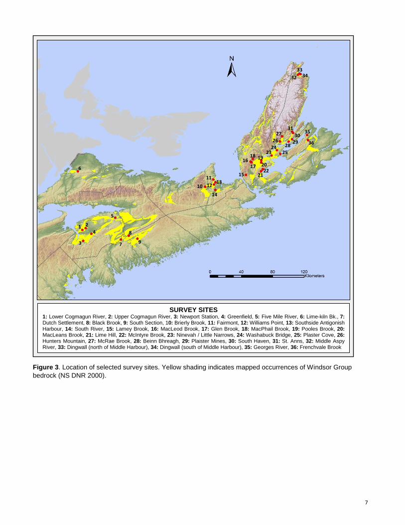
fieldwork for this project. Figure 3 maps the general location of the 36 survey sites. Observers and
survey dates for each site are compiled in Table 1.
During surveys, botanists focused on areas showing evidence of surficial gypsum deposits
(sinkhole topography, cliffs, outcrops) and wetland habitats potentially influenced by underlying
calcareous bedrock, but we generally also covered other nearby habitats, especially where those had a
high potential for supporting rare species occurrences. Each botanist utilized a GPS unit to precisely
document survey coverage while in the field; track logs recorded by these units are mapped in Figures
4 to 39 under “Results - Site Summaries”. Karst features of interest, including caves, large gypsum
exposures and emerging / submerging streams, were documented, as were any significant plant
communities encountered. We compiled full vascular plant species lists for each site (with the
exception of site #6 - Five Mile River), and a general description of abundance for each observed
species was noted for most sites. For provincially rare species (those with provincial status ranks, or
6
S-ranks, of S1 to S3S4; see Appendix 1 for rank definitions), we recorded precise locations by GPS,
along with information on population size and extent, habitat and associated species. In the
documentation of rare species occurrences, each indidividual or group of individuals separated by
others by a distance of more than 10 m was recorded separately. Most rare species were also
documented by voucher specimens that will be deposited at the E.C. Smith Herbarium (ACAD) at
Acadia University and the Nova Scotia Museum of Natural History Herbarium (NSPM) in Halifax.
In addition to vascular plant data, incidental observations for rare or COSEWIC (Committee on
the Status of Endangered Wildlife in Canada)-listed animals were recorded whenever these species
were detected. Sean Blaney also recorded breeding birds using breeding status codes of the Maritimes
Breeding Bird Atlas during early and mid-summer fieldwork.
All species data (species lists by site with generalized locations and precisely documented
records of rare species and collections) have been permanently documented in the Atlantic Canada
Conservation Data Centre database.
7
Figure 3. Location of selected survey sites. Yellow shading indicates mapped occurrences of Windsor Group
bedrock (NS DNR 2000).
SURVEY SITES 1: Lower Cogmagun River, 2: Upper Cogmagun River, 3: Newport Station, 4: Greenfield, 5: Five Mile River, 6: Lime-kiln Bk., 7: Dutch Settlement, 8: Black Brook, 9: South Section, 10: Brierly Brook, 11: Fairmont, 12: Williams Point, 13: Southside Antigonish Harbour, 14: South River, 15: Lamey Brook, 16: MacLeod Brook, 17: Glen Brook, 18: MacPhail Brook, 19: Pooles Brook, 20: MacLeans Brook, 21: Lime Hill, 22: McIntyre Brook, 23: Ninevah / Little Narrows, 24: Washabuck Bridge, 25: Plaster Cove, 26: Hunters Mountain, 27: McRae Brook, 28: Beinn Bhreagh, 29: Plaister Mines, 30: South Haven, 31: St. Anns, 32: Middle Aspy River, 33: Dingwall (north of Middle Harbour), 34: Dingwall (south of Middle Harbour), 35: Georges River, 36: Frenchvale Brook
1 2
13
14
12
11
10
9
8
7
6
5
4
3
16 17
19
20
21 22
18
15
23 24
26
27
25
28 29 30
31
32
33 34
35
36
8
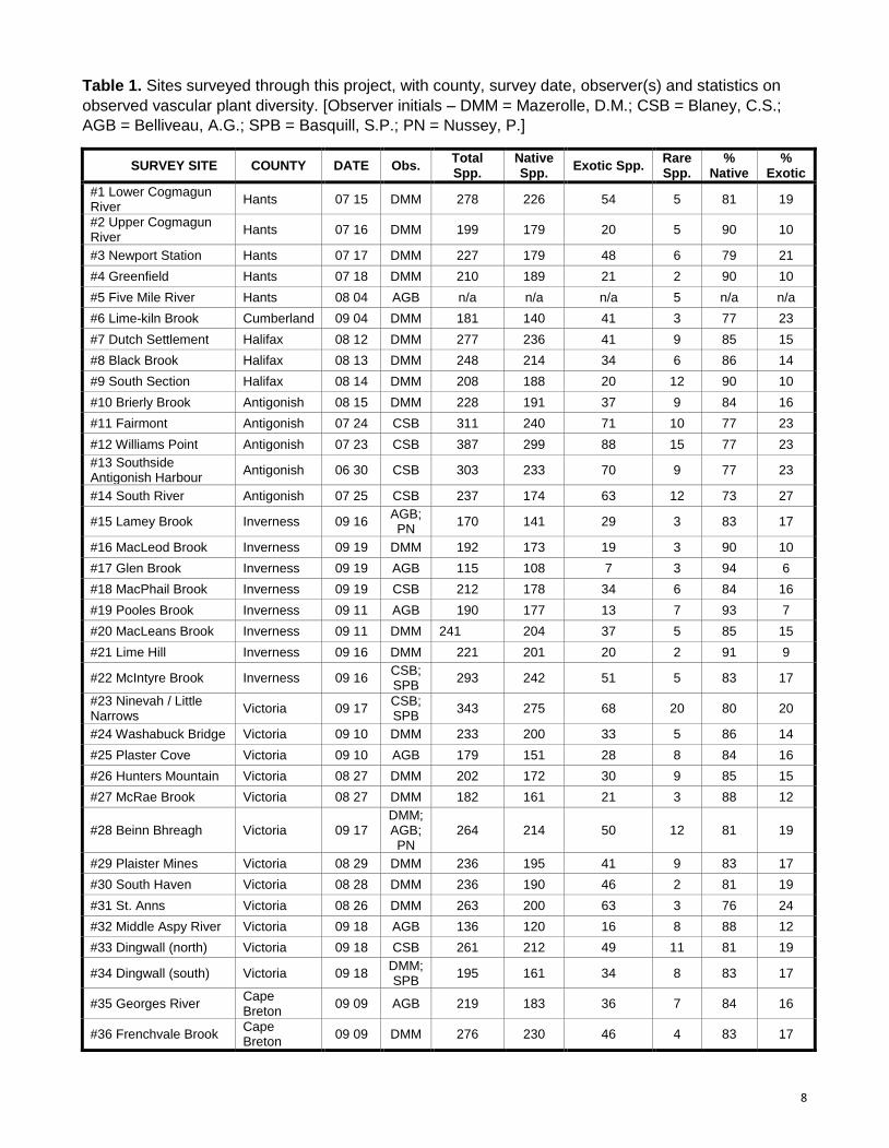
Table 1. Sites surveyed through this project, with county, survey date, observer(s) and statistics on
observed vascular plant diversity. [Observer initials – DMM = Mazerolle, D.M.; CSB = Blaney, C.S.;
AGB = Belliveau, A.G.; SPB = Basquill, S.P.; PN = Nussey, P.]
SURVEY SITE COUNTY DATE Obs. Total Spp.
Native Spp.
Exotic Spp. Rare Spp.
% Native
% Exotic
#1 Lower Cogmagun River
Hants 07 15 DMM 278 226 54 5 81 19
#2 Upper Cogmagun River
Hants 07 16 DMM 199 179 20 5 90 10
#3 Newport Station Hants 07 17 DMM 227 179 48 6 79 21
#4 Greenfield Hants 07 18 DMM 210 189 21 2 90 10
#5 Five Mile River Hants 08 04 AGB n/a n/a n/a 5 n/a n/a
#6 Lime-kiln Brook Cumberland 09 04 DMM 181 140 41 3 77 23
#7 Dutch Settlement Halifax 08 12 DMM 277 236 41 9 85 15
#8 Black Brook Halifax 08 13 DMM 248 214 34 6 86 14
#9 South Section Halifax 08 14 DMM 208 188 20 12 90 10
#10 Brierly Brook Antigonish 08 15 DMM 228 191 37 9 84 16
#11 Fairmont Antigonish 07 24 CSB 311 240 71 10 77 23
#12 Williams Point Antigonish 07 23 CSB 387 299 88 15 77 23
#13 Southside Antigonish Harbour
Antigonish 06 30 CSB 303 233 70 9 77 23
#14 South River Antigonish 07 25 CSB 237 174 63 12 73 27
#15 Lamey Brook Inverness 09 16 AGB; PN
170 141 29 3 83 17
#16 MacLeod Brook Inverness 09 19 DMM 192 173 19 3 90 10
#17 Glen Brook Inverness 09 19 AGB 115 108 7 3 94 6
#18 MacPhail Brook Inverness 09 19 CSB 212 178 34 6 84 16
#19 Pooles Brook Inverness 09 11 AGB 190 177 13 7 93 7
#20 MacLeans Brook Inverness 09 11 DMM 241 204 37 5 85 15
#21 Lime Hill Inverness 09 16 DMM 221 201 20 2 91 9
#22 McIntyre Brook Inverness 09 16 CSB; SPB
293 242 51 5 83 17
#23 Ninevah / Little Narrows
Victoria 09 17 CSB; SPB
343 275 68 20 80 20
#24 Washabuck Bridge Victoria 09 10 DMM 233 200 33 5 86 14
#25 Plaster Cove Victoria 09 10 AGB 179 151 28 8 84 16
#26 Hunters Mountain Victoria 08 27 DMM 202 172 30 9 85 15
#27 McRae Brook Victoria 08 27 DMM 182 161 21 3 88 12
#28 Beinn Bhreagh Victoria 09 17 DMM; AGB; PN
264 214 50 12 81 19
#29 Plaister Mines Victoria 08 29 DMM 236 195 41 9 83 17
#30 South Haven Victoria 08 28 DMM 236 190 46 2 81 19
#31 St. Anns Victoria 08 26 DMM 263 200 63 3 76 24
#32 Middle Aspy River Victoria 09 18 AGB 136 120 16 8 88 12
#33 Dingwall (north) Victoria 09 18 CSB 261 212 49 11 81 19
#34 Dingwall (south) Victoria 09 18 DMM; SPB
195 161 34 8 83 17
#35 Georges River Cape Breton
09 09 AGB 219 183 36 7 84 16
#36 Frenchvale Brook Cape Breton
09 09 DMM 276 230 46 4 83 17
9
Results and Discussion
Vascular Plant Species Richness
Across all surveyed sites, we documented 8,145 vascular plant records of approximately 857
taxa, 673 of which are native to Nova Scotia and 184 of which are exotic. Appendix 3 lists all vascular
plants documented by site, along with general indication of on-site abundance (where noted). Statistics
summarizing plant diversity at each site are compiled in Table 1.
Native species richness ranged from 108 at the Glen Brook (site #17) to 299 at Williams Point
(site #12) and averaged 194 across all sites. Native species counts equalling or exceeding 200 taxa
were recorded at fourteen additional sites; Ninevah / Little Narrows (site #23), McIntyre Brook (site
#22), Fairmont (site #11), Dutch Settlement (site #7), Southside Antigonish Harbour (site #13),
Frenchvale Brook (site #36), Lower Cogmagun River (site #1), Beinn Bhreagh (site #28), Black Brook
(site #8), Dingwall - north of Middle Harbour (site #33), MacLeans Brook (site #20), Lime Hill (site #21),
St. Anns (site #31) and Washabuck Bridge (site #24).
Exotic species richness was also lowest at Glen Brook (site #17), with 7 species and highest at
Williams Point (site #12), with 88 species. As was noted in 2012 (Blaney and Mazerolle 2013), the
proportion of exotic species by site was relatively consistent, varying from 6% to 23%, with an average
of roughly 16% among all sites.
Although it provides a general indication of a site’s habitat diversity and richness, native plant
count should not be considered a robust indicator of site condition or relative conservation value.
Likewise, exotic species counts do not always provide an accurate measure of the level of disturbance
and ecological integrity of a site. Both metrics are influenced by factors such as search effort, survey
coverage, the extent to which anthropogenic habitats were traversed and the observer’s level of
expertise.
Exotic Invasive Species
In general terms, an exotic species’ invasive potential is a measure of its ability to disperse,
colonize and become locally dominant in natural habitats undisturbed by human activity. Habitats which
are subjected to frequent natural disturbances, such as shorelines, are often more prone to invasion
and can become dominated not only by highly invasive species but also by ruderal species which are
largely restricted to anthropogenic habitats elsewhere on the landscape. In highly karstic areas,
openings created through outcrop erosion and sinkhole collapse likely contribute to making habitats
more susceptible to invasion. Due to their productive soils, areas with surficial or near-surface
calcareous bedrock also often support a higher diversity of species (both native and exotic) and tend to
have a greater history of agricultural disturbance as well as associated intentional or accidental species
introductions. For these reasons, even gypsum lands untouched by intensive anthropogenic
disturbance may present relatively higher exotic species richness and dominance than other types of
natural landscapes in Nova Scotia.
Throughout this project, we documented occurrences of over 40 different species which have
been noted as having at least some invasive potential in the Maritimes Region or elsewhere in
temperate North America. These range from species that are highly invasive and regarded as being of
10
great concern for biodiversity conservation in the region to species mainly limited to highly disturbed
sites. The following species were documented at over 10 survey sites and noted as being at least
locally common at one site or more: Colt’s Foot (Tussilago farfara), Creeping Buttercup (Ranunculus
repens), Black Starthistle (Centaurea nigra), Common Hawkweed (Hieracium lachenalii), Creeping
Thistle (Cirsium arvense), Kentucky Bluegrass (Poa pratensis), Tansy Ragwort (Senecio jacobaea),
Tall Rye Grass (Lolium arundinaceum), Meadow Hawkweed (Hieracium caespitosum), Reed Canary
Grass (Phalaris arundinacea), Field Sowthistle (Sonchus arvensis), White Sweetclover (Melilotus
albus), and Purple Loosestrife (Lythrum salicaria). Most of these represent species that are often
restricted to anthropogenic habitats but readily spread and become common in natural habitats where
frequent disturbances create suitable microsites for their establishment.
Glossy Buckthorn (Frangula alnus), an aggressively-spreading shrub that represents one of the
most problematic invasive species in the Maritimes Region, was detected at Lime-kiln Brook (site #6) in
Cumberland County and at Dutch Settlement (site #7) in Halifax County. At the former site, the species
was found to be widespread and abundant in a wide variety of anthropogenic and natural wet to mesic
habitats, including mature forest understories.
Other notable invasive species documented include Woodland Angelica (Angelica sylvestris),
which was found to be rare at eight survey sites and Rugosa Rose (Rosa rugosa), which was noted as
locally common in coastal habitats at two sites in Victoria County.
We also documented occurrences of two provincially rare moderately invasive exotic species:
Forest Woodrush (Luzula luzuloides) and Marsh Thistle (Cirsium palustre). Forest Woodrush, which
was found to be locally dominant in mature hardwood and Eastern Hemlock (Tsuga canadensis) forest
at Beinn Bhreagh (site #28), had only previously been reported in Nova Scotia from a site in Pictou
County (found by M.L. Fernald in the 1920s) and from Kejimkujik National Park (found by A.E. Roland
in the 1970s). Prior to 2012, Marsh Thistle had only been reported from two locations in Nova Scotia, in
Inverness County and Halifax County. Through fieldwork carried out in gypsum areas in 2012, AC CDC
botanists discovered an additional 4 sites for this species in Victoria and Inverness counties (Blaney
and Mazerolle 2013). The species, which seems to have an affinity for high-pH wetland habitats, was
discovered at four more sites in 2014, in Hants, Inverness and Victoria counties.
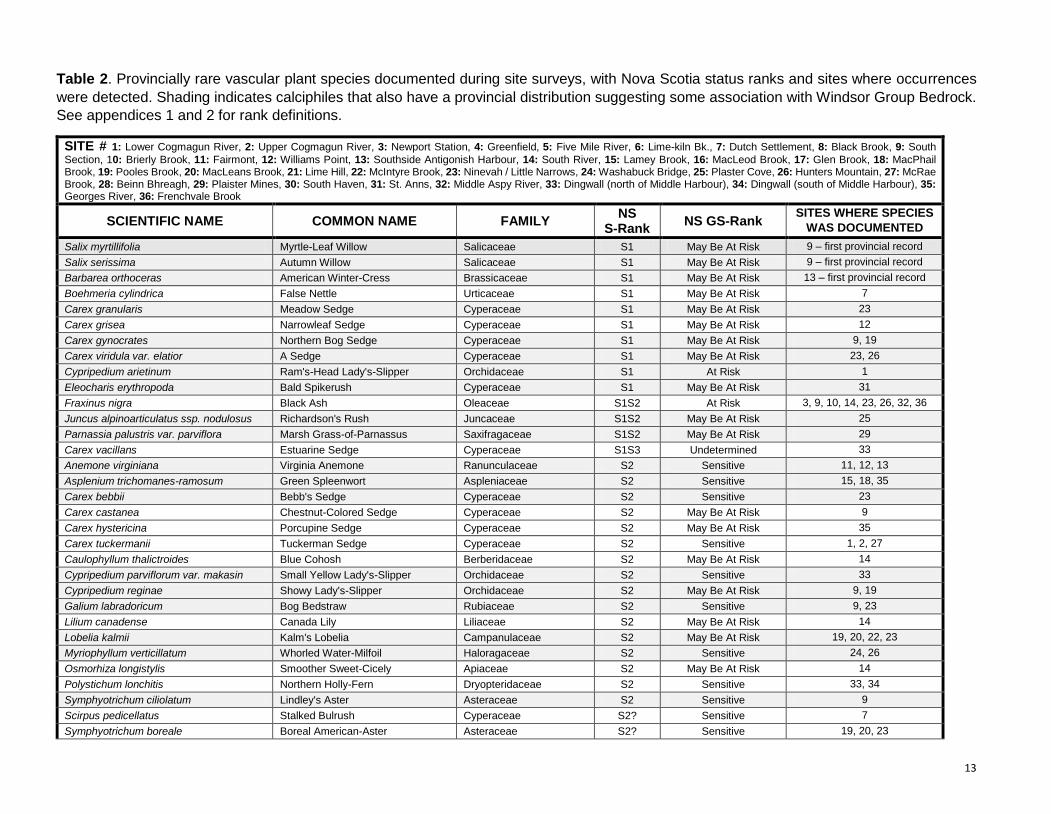
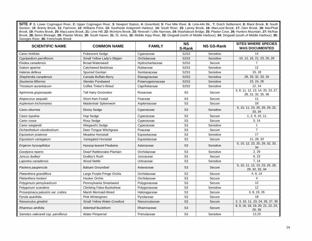
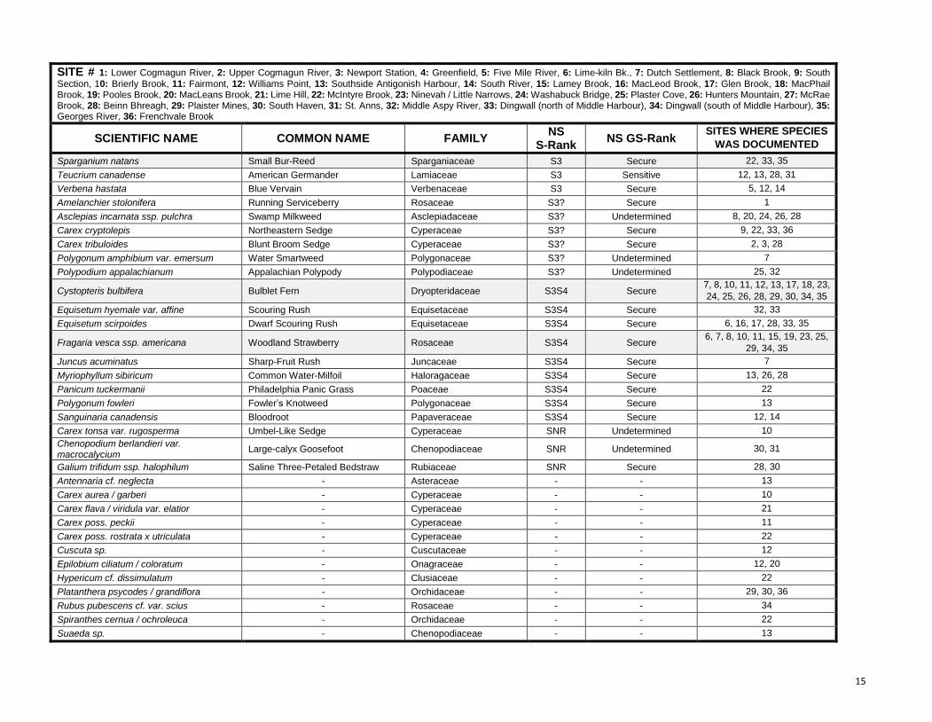
Rare Vascular Plant Species
Through this project, AC CDC botanists discovered populations of 83 provincially rare vascular
plant species, including 13 critically imperiled species (S1 and S1S2), 28 imperiled species (S2 and
S2S3) and 42 vulnerable species (S3 and S3S4). Across all sites, we documented 1,330 rare plant
locations, comprising 54 locations for critically imperiled species, 359 locations for imperiled species and
917 locations for vulnerable species. These recorded occurrences represent 245 species x survey site
combinations. Numbers presented here only reflect occurrences for which we were able to provide a
confident identification; expert review of some difficult specimens will slightly increase the total number
of rare species discovered through this project. Information on rare plants found at each survey site,
including Nova Scotia status ranks, is compiled in Table 2. Additional notes on significant species are
also provided in the “Site Summaries” section below.
11
Rare species diversity was found to be highest at Ninevah / Little Narrows (site #23) and Williams
Point (site #12), with 20 and 15 species respectively, and lowest at Greenfield (site #4), Lime Hill (site
#30) and South Haven (site #30), which each had 2 species. Average provincially rare plant diversity
among all 36 survey sites was roughly 7 species. Variability between sites is likely a function of habitat
diversity, amount of exposed calcareous bedrock, depth of overburden, nature of surrounding bedrock,
soil and till, as well as search effort.
Our fieldwork led to the discovery of three species that were not previously known to occur in Nova
Scotia: Autumn Willow (Salix serissima), Myrtle-Leaf Willow (Salix myrtillifolia) and American Yellow
Rocket (Barbarea orthoceras). Small populations of Autumn Willow and Myrtle-Leaf Willow, each
comprised of very few individuals, were found in close proximity to one another in a rich calcareous
swamp at South Section (site #9). Both of these mainly boreal willow species are rare east of Ontario
and each was previously only known in the Maritimes Region from a single population in New
Brunswick. The identification of the Myrtle-Leaf Willow occurrence is less than 100% certain since it ,
could instead be the very similar Ball’s Willow (Salix ballii – called Salix myrtillifolia var. brachypoda in
some taxonomic treatments). Ball’s Willow is only known from the Northwest Territories, Ontario,
Quebec, Labrador and Newfoundland, but could also occur in the Maritimes. Collected specimens were
verified by willow specialist George W. Argus (Canadian Museum of Nature), but a definitive
identification could not be reached. Based on various leaf characteristics and habitat, however, the
occurrence is most likely Myrtle-Leaf Willow (G.W. Argus, pers. comm.). American Yellow Rocket, a
species of open high-pH shores, is widespread in northern and western North America but rare in
Quebec, New England and the Atlantic Provinces. This species was discovered at Southside Antigonish
Harbour (site #13), where it was found at several locations on the upper margins of brackish marsh and
along small streams over a 1 km stretch of shoreline.
Provincially rare species encountered at the most sites during this project were Bulblet Fern
(Cystopteris bulbifera), Woodland Strawberry (Fragaria vesca ssp. americana), Alderleaf Buckthorn
(Rhamnus alnifolia), Balsam Groundsel (Packera paupercula), Ebony Sedge (Carex eburnea),
Hyssop-leaved Fleabane (Erigeron hyssopifolius), Small Yellow Lady’s-Slipper (Cypripedium
parviflorum), Small Yellow Water-Crowfoot (Ranunculus gmelinii), Tall Hairy Groovebur (Agrimonia
gryposepala), Black Ash (Fraxinus nigra) and Dwarf Scouring Rush (Equisetum scirpoides). The first
eight species occur in close association with surficial or near-surface gypsum and limestone deposits in
Nova Scotia, while the latter four occur in a wider range of habitats but show some affinity for high-pH
soils.
Of the thirteen critically imperiled (S1 and S1S2) species discovered through this project, eight
represent calciphiles with provincial distributions that are very strongly associated with gypsum and
limestone exposures or seepage wetlands influenced by underlying Windsor Group bedrock bedrock:
Autumn Willow (Salix serissima), Myrtle-Leaf Willow (Salix myrtillifolia), Meadow Sedge (Carex
granularis), Ram’s Head Lady’s-Slipper (Cypripedium arietinum), Bald Spikerush (Eleocharis
erythropoda), Northern Bog Sedge (Carex gynocrates), Long-Stalked Yellow Sedge (Carex viridula var.
elatior) and Marsh Grass-of-Parnassus (Parnassia palustris var. parviflora). Out of the 83 rare species
found, roughly 30 have a fairly high affinity for calcareous habitats as well as provincial distributions
showing some association with Windsor Group bedrock. These species are highlighted in Table 2.
A brief examination of previous botanical knowledge and plant occurrence data collected through
AC CDC fieldwork in 2012 and 2014 shows several differences between the rare gypsum-associated

12
floras of different regions within Nova Scotia. The distinctiveness of karst communities between regions
is especially evident in terms of the rarest species, several of which are restricted to one or very few sites
in a single region. A detailed multivariate analysis using all data collected to date would provide greater
insight into the level of distinctiveness of regional karst floras.
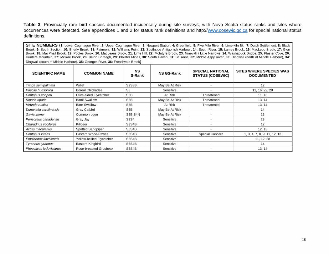
Animals
We documented 210 incidental animal observations during site surveys (Table 3). Of these, 198
were records of 72 different bird species, including 42 records for 13 provincially rare breeding birds
and 15 site occurrences for the COSEWIC-listed Olive-sided Flycatcher (Contopus cooperi,
Threatened), Bank Swallow (Riparia riparia, Threatened), Barn Swallow (Hirundo rustica, Threatened)
and Eastern Wood-Pewee (Contopus virens, Special Concern).
13
Table 2. Provincially rare vascular plant species documented during site surveys, with Nova Scotia status ranks and sites where occurrences
were detected. Shading indicates calciphiles that also have a provincial distribution suggesting some association with Windsor Group Bedrock.
See appendices 1 and 2 for rank definitions.
SITE # 1: Lower Cogmagun River, 2: Upper Cogmagun River, 3: Newport Station, 4: Greenfield, 5: Five Mile River, 6: Lime-kiln Bk., 7: Dutch Settlement, 8: Black Brook, 9: South
Section, 10: Brierly Brook, 11: Fairmont, 12: Williams Point, 13: Southside Antigonish Harbour, 14: South River, 15: Lamey Brook, 16: MacLeod Brook, 17: Glen Brook, 18: MacPhail Brook, 19: Pooles Brook, 20: MacLeans Brook, 21: Lime Hill, 22: McIntyre Brook, 23: Ninevah / Little Narrows, 24: Washabuck Bridge, 25: Plaster Cove, 26: Hunters Mountain, 27: McRae Brook, 28: Beinn Bhreagh, 29: Plaister Mines, 30: South Haven, 31: St. Anns, 32: Middle Aspy River, 33: Dingwall (north of Middle Harbour), 34: Dingwall (south of Middle Harbour), 35: Georges River, 36: Frenchvale Brook
SCIENTIFIC NAME COMMON NAME FAMILY NS
S-Rank NS GS-Rank
SITES WHERE SPECIES
WAS DOCUMENTED
Salix myrtillifolia Myrtle-Leaf Willow Salicaceae S1 May Be At Risk 9 – first provincial record
Salix serissima Autumn Willow Salicaceae S1 May Be At Risk 9 – first provincial record
Barbarea orthoceras American Winter-Cress Brassicaceae S1 May Be At Risk 13 – first provincial record
Boehmeria cylindrica False Nettle Urticaceae S1 May Be At Risk 7
Carex granularis Meadow Sedge Cyperaceae S1 May Be At Risk 23
Carex grisea Narrowleaf Sedge Cyperaceae S1 May Be At Risk 12
Carex gynocrates Northern Bog Sedge Cyperaceae S1 May Be At Risk 9, 19
Carex viridula var. elatior A Sedge Cyperaceae S1 May Be At Risk 23, 26
Cypripedium arietinum Ram's-Head Lady's-Slipper Orchidaceae S1 At Risk 1
Eleocharis erythropoda Bald Spikerush Cyperaceae S1 May Be At Risk 31
Fraxinus nigra Black Ash Oleaceae S1S2 At Risk 3, 9, 10, 14, 23, 26, 32, 36
Juncus alpinoarticulatus ssp. nodulosus Richardson's Rush Juncaceae S1S2 May Be At Risk 25
Parnassia palustris var. parviflora Marsh Grass-of-Parnassus Saxifragaceae S1S2 May Be At Risk 29
Carex vacillans Estuarine Sedge Cyperaceae S1S3 Undetermined 33
Anemone virginiana Virginia Anemone Ranunculaceae S2 Sensitive 11, 12, 13
Asplenium trichomanes-ramosum Green Spleenwort Aspleniaceae S2 Sensitive 15, 18, 35
Carex bebbii Bebb's Sedge Cyperaceae S2 Sensitive 23
Carex castanea Chestnut-Colored Sedge Cyperaceae S2 May Be At Risk 9
Carex hystericina Porcupine Sedge Cyperaceae S2 May Be At Risk 35
Carex tuckermanii Tuckerman Sedge Cyperaceae S2 Sensitive 1, 2, 27
Caulophyllum thalictroides Blue Cohosh Berberidaceae S2 May Be At Risk 14
Cypripedium parviflorum var. makasin Small Yellow Lady's-Slipper Orchidaceae S2 Sensitive 33
Cypripedium reginae Showy Lady's-Slipper Orchidaceae S2 May Be At Risk 9, 19
Galium labradoricum Bog Bedstraw Rubiaceae S2 Sensitive 9, 23
Lilium canadense Canada Lily Liliaceae S2 May Be At Risk 14
Lobelia kalmii Kalm's Lobelia Campanulaceae S2 May Be At Risk 19, 20, 22, 23
Myriophyllum verticillatum Whorled Water-Milfoil Haloragaceae S2 Sensitive 24, 26
Osmorhiza longistylis Smoother Sweet-Cicely Apiaceae S2 May Be At Risk 14
Polystichum lonchitis Northern Holly-Fern Dryopteridaceae S2 Sensitive 33, 34
Symphyotrichum ciliolatum Lindley's Aster Asteraceae S2 Sensitive 9
Scirpus pedicellatus Stalked Bulrush Cyperaceae S2? Sensitive 7
Symphyotrichum boreale Boreal American-Aster Asteraceae S2? Sensitive 19, 20, 23
14
SITE # 1: Lower Cogmagun River, 2: Upper Cogmagun River, 3: Newport Station, 4: Greenfield, 5: Five Mile River, 6: Lime-kiln Bk., 7: Dutch Settlement, 8: Black Brook, 9: South
Section, 10: Brierly Brook, 11: Fairmont, 12: Williams Point, 13: Southside Antigonish Harbour, 14: South River, 15: Lamey Brook, 16: MacLeod Brook, 17: Glen Brook, 18: MacPhail Brook, 19: Pooles Brook, 20: MacLeans Brook, 21: Lime Hill, 22: McIntyre Brook, 23: Ninevah / Little Narrows, 24: Washabuck Bridge, 25: Plaster Cove, 26: Hunters Mountain, 27: McRae Brook, 28: Beinn Bhreagh, 29: Plaister Mines, 30: South Haven, 31: St. Anns, 32: Middle Aspy River, 33: Dingwall (north of Middle Harbour), 34: Dingwall (south of Middle Harbour), 35: Georges River, 36: Frenchvale Brook
SCIENTIFIC NAME COMMON NAME FAMILY NS
S-Rank NS GS-Rank
SITES WHERE SPECIES
WAS DOCUMENTED
Carex hirtifolia Pubescent Sedge Cyperaceae S2S3 Sensitive 14
Cypripedium parviflorum Small Yellow Lady's-Slipper Orchidaceae S2S3 Sensitive 10, 12, 16, 21, 23, 25, 29
Elodea canadensis Broad Waterweed Hydrocharitaceae S2S3 Secure 7
Galium aparine Catchweed Bedstraw Rubiaceae S2S3 Sensitive 12
Halenia deflexa Spurred Gentian Gentianaceae S2S3 Sensitive 15, 18
Shepherdia canadensis Canada Buffalo-Berry Elaeagnaceae S2S3 Sensitive 28, 29, 32, 33, 34
Stuckenia filiformis Slender Pondweed Potamogetonaceae S2S3 Sensitive 23, 24, 28
Triosteum aurantiacum Coffee Tinker's-Weed Caprifoliaceae S2S3 Sensitive 12, 14
Agrimonia gryposepala Tall Hairy Groovebur Rosaceae S3 Secure 3, 8, 11, 12, 13, 14, 20, 23, 27,
28, 31, 32, 35, 36
Alopecurus aequalis Short-Awn Foxtail Poaceae S3 Secure 11
Asplenium trichomanes Maidenhair Spleenwort Aspleniaceae S3 Secure 18
Carex eburnea Ebony Sedge Cyperaceae S3 Sensitive 5, 10, 11, 23, 25, 28, 29, 32,
33, 34
Carex lupulina Hop Sedge Cyperaceae S3 Secure 1, 2, 9, 10, 11
Carex rosea Rosy Sedge Cyperaceae S3 Secure 5, 14
Carex wiegandii Wiegand's Sedge Cyperaceae S3 Sensitive 1
Dichanthelium clandestinum Deer-Tongue Witchgrass Poaceae S3 Secure 7
Equisetum pratense Meadow Horsetail Equisetaceae S3 Sensitive 17
Equisetum variegatum Variegated Horsetail Equisetaceae S3 Secure 11, 28, 33
Erigeron hyssopifolius Hyssop-leaved Fleabane Asteraceae S3 Sensitive 5, 10, 12, 23, 25, 29, 32, 33,
34
Goodyera repens Dwarf Rattlesnake-Plantain Orchidaceae S3 Sensitive 2, 29
Juncus dudleyi Dudley's Rush Juncaceae S3 Secure 6, 23
Laportea canadensis Wood Nettle Urticaceae S3 Sensitive 7, 14
Packera paupercula Balsam Groundsel Asteraceae S3 Secure 5, 10, 11, 12, 13, 23, 25, 28,
29, 32, 33, 34
Platanthera grandiflora Large Purple-Fringe Orchis Orchidaceae S3 Secure 4, 9, 14
Platanthera hookeri Hooker Orchis Orchidaceae S3 Secure 4
Polygonum pensylvanicum Pennsylvania Smartweed Polygonaceae S3 Secure 12
Polygonum scandens Climbing False-Buckwheat Polygonaceae S3 Sensitive 12
Proserpinaca palustris var. crebra Marsh Mermaid-Weed Haloragaceae S3 Secure 3, 8, 19, 26
Pyrola asarifolia Pink Wintergreen Pyrolaceae S3 Secure 18
Ranunculus gmelinii Small Yellow Water-Crowfoot Ranunculaceae S3 Secure 2, 3, 10, 11, 23, 24, 26, 27, 30
Rhamnus alnifolia Alderleaf Buckthorn Rhamnaceae S3 Secure 8, 9, 16, 18, 19, 20, 21, 22, 23,
26, 36
Samolus valerandi ssp. parviflorus Water Pimpernel Primulaceae S3 Sensitive 12,23
15
SITE # 1: Lower Cogmagun River, 2: Upper Cogmagun River, 3: Newport Station, 4: Greenfield, 5: Five Mile River, 6: Lime-kiln Bk., 7: Dutch Settlement, 8: Black Brook, 9: South
Section, 10: Brierly Brook, 11: Fairmont, 12: Williams Point, 13: Southside Antigonish Harbour, 14: South River, 15: Lamey Brook, 16: MacLeod Brook, 17: Glen Brook, 18: MacPhail Brook, 19: Pooles Brook, 20: MacLeans Brook, 21: Lime Hill, 22: McIntyre Brook, 23: Ninevah / Little Narrows, 24: Washabuck Bridge, 25: Plaster Cove, 26: Hunters Mountain, 27: McRae Brook, 28: Beinn Bhreagh, 29: Plaister Mines, 30: South Haven, 31: St. Anns, 32: Middle Aspy River, 33: Dingwall (north of Middle Harbour), 34: Dingwall (south of Middle Harbour), 35: Georges River, 36: Frenchvale Brook
SCIENTIFIC NAME COMMON NAME FAMILY NS
S-Rank NS GS-Rank
SITES WHERE SPECIES
WAS DOCUMENTED
Sparganium natans Small Bur-Reed Sparganiaceae S3 Secure 22, 33, 35
Teucrium canadense American Germander Lamiaceae S3 Sensitive 12, 13, 28, 31
Verbena hastata Blue Vervain Verbenaceae S3 Secure 5, 12, 14
Amelanchier stolonifera Running Serviceberry Rosaceae S3? Secure 1
Asclepias incarnata ssp. pulchra Swamp Milkweed Asclepiadaceae S3? Undetermined 8, 20, 24, 26, 28
Carex cryptolepis Northeastern Sedge Cyperaceae S3? Secure 9, 22, 33, 36
Carex tribuloides Blunt Broom Sedge Cyperaceae S3? Secure 2, 3, 28
Polygonum amphibium var. emersum Water Smartweed Polygonaceae S3? Undetermined 7
Polypodium appalachianum Appalachian Polypody Polypodiaceae S3? Undetermined 25, 32
Cystopteris bulbifera Bulblet Fern Dryopteridaceae S3S4 Secure 7, 8, 10, 11, 12, 13, 17, 18, 23,
24, 25, 26, 28, 29, 30, 34, 35
Equisetum hyemale var. affine Scouring Rush Equisetaceae S3S4 Secure 32, 33
Equisetum scirpoides Dwarf Scouring Rush Equisetaceae S3S4 Secure 6, 16, 17, 28, 33, 35
Fragaria vesca ssp. americana Woodland Strawberry Rosaceae S3S4 Secure 6, 7, 8, 10, 11, 15, 19, 23, 25,
29, 34, 35
Juncus acuminatus Sharp-Fruit Rush Juncaceae S3S4 Secure 7
Myriophyllum sibiricum Common Water-Milfoil Haloragaceae S3S4 Secure 13, 26, 28
Panicum tuckermanii Philadelphia Panic Grass Poaceae S3S4 Secure 22
Polygonum fowleri Fowler’s Knotweed Polygonaceae S3S4 Secure 13
Sanguinaria canadensis Bloodroot Papaveraceae S3S4 Secure 12, 14
Carex tonsa var. rugosperma Umbel-Like Sedge Cyperaceae SNR Undetermined 10
Chenopodium berlandieri var. macrocalycium
Large-calyx Goosefoot Chenopodiaceae SNR Undetermined 30, 31
Galium trifidum ssp. halophilum Saline Three-Petaled Bedstraw Rubiaceae SNR Secure 28, 30
Antennaria cf. neglecta - Asteraceae - - 13
Carex aurea / garberi - Cyperaceae - - 10
Carex flava / viridula var. elatior - Cyperaceae - - 21
Carex poss. peckii - Cyperaceae - - 11
Carex poss. rostrata x utriculata - Cyperaceae - - 22
Cuscuta sp. - Cuscutaceae - - 12
Epilobium ciliatum / coloratum - Onagraceae - - 12, 20
Hypericum cf. dissimulatum - Clusiaceae - - 22
Platanthera psycodes / grandiflora - Orchidaceae - - 29, 30, 36
Rubus pubescens cf. var. scius - Rosaceae - - 34
Spiranthes cernua / ochroleuca - Orchidaceae - - 22
Suaeda sp. - Chenopodiaceae - - 13
16
Table 3. Provincially rare bird species documented incidentally during site surveys, with Nova Scotia status ranks and sites where
occurrences were detected. See appendices 1 and 2 for status rank definitions and http://www.cosewic.gc.ca for special national status
definitions.
SITE NUMBERS {1: Lower Cogmagun River, 2: Upper Cogmagun River, 3: Newport Station, 4: Greenfield, 5: Five Mile River, 6: Lime-kiln Bk., 7: Dutch Settlement, 8: Black
Brook, 9: South Section, 10: Brierly Brook, 11: Fairmont, 12: Williams Point, 13: Southside Antigonish Harbour, 14: South River, 15: Lamey Brook, 16: MacLeod Brook, 17: Glen Brook, 18: MacPhail Brook, 19: Pooles Brook, 20: MacLeans Brook, 21: Lime Hill, 22: McIntyre Brook, 23: Ninevah / Little Narrows, 24: Washabuck Bridge, 25: Plaster Cove, 26: Hunters Mountain, 27: McRae Brook, 28: Beinn Bhreagh, 29: Plaister Mines, 30: South Haven, 31: St. Anns, 32: Middle Aspy River, 33: Dingwall (north of Middle Harbour), 34:
Dingwall (south of Middle Harbour), 35: Georges River, 36: Frenchvale Brook}
SCIENTIFIC NAME COMMON NAME NS
S-Rank NS GS-Rank
SPECIAL NATIONAL STATUS (COSEWIC)
SITES WHERE SPECIES WAS DOCUMENTED
Tringa semipalmata Willet S2S3B May Be At Risk - 12
Poecile hudsonica Boreal Chickadee S3 Sensitive - 11, 16, 22, 28
Contopus cooperi Olive-sided Flycatcher S3B At Risk Threatened 11, 13
Riparia riparia Bank Swallow S3B May Be At Risk Threatened 13, 14
Hirundo rustica Barn Swallow S3B At Risk Threatened 13, 14
Dumetella carolinensis Gray Catbird S3B May Be At Risk - 14
Gavia immer Common Loon S3B,S4N May Be At Risk - 13
Perisoreus canadensis Gray Jay S3S4 Sensitive - 23
Charadrius vociferus Killdeer S3S4B Sensitive - 12
Actitis macularius Spotted Sandpiper S3S4B Sensitive - 12, 13
Contopus virens Eastern Wood-Pewee S3S4B Sensitive Special Concern 1, 3, 4, 7, 8, 9, 11, 12, 13
Empidonax flaviventris Yellow-bellied Flycatcher S3S4B Sensitive - 11, 12, 28
Tyrannus tyrannus Eastern Kingbird S3S4B Sensitive - 14
Pheucticus ludovicianus Rose-breasted Grosbeak S3S4B Sensitive - 13, 14

17
#1. Lower Cogmagun River
Observer(s): Mazerolle, D.M.
Survey date: July 15th 2014
Rare Species
Scientific Name Common Name S-Rank GS-Rank Records
Cypripedium arietinum Ram's-Head Lady's-Slipper S1 At Risk 4
Carex tuckermanii Tuckerman’s Sedge S2 Sensitive 2
Carex lupulina Hop Sedge S3 Secure 1
Carex wiegandii Wiegand’s Sedge S3 Sensitive 1
Amelanchier stolonifera Running Serviceberry S3? Secure 4
Site Summary
Though the entire 4.6 km-long section surveyed along the lower Cogmagun River is underlain by
Windsor Group sedimentary rock, few signs of surficial gypsum were observed at this site. Subtle karst
topography was noted at several locations along the river valley slopes and in adjacent forest within a
few hundred meters of the valley bottom. These very subdued features, which suggest that any
gypsum deposits in this area are covered by a significant amount of overburden, included very shallow
sinkhole-like depressions and somewhat pronounced runoff gulleys and intermittent brook gulleys.
Shallow depressions were also noted at a few locations within the wide marshy river floodplain.
The river valley bottom along this section of the Cogmagun River is generally fairly wide (varying from
100 m to 500 m in width), with an extensive open graminoid marsh floodplain that gradually transitions
from tidal saltmarsh communities to freshwater marsh communities within the surveyed area. Forest
throughout much of the area has been heavily degraded by clear cutting, selective wood harvesting
and to a lesser extent, agricultural use. Stands of intact mature forest form narrow bands adjacent to
the river floodplain and can be found in isolated locations further away from the river, mainly in seepage
wetlands. Red Maple (Acer rubrum) and Black Spruce (Picea mariana) seepage swamps are fairly
common throughout and are prevalent in the eastern half of the surveyed area, where some areas of
heavy seepage still contain stands of mature forest. Mature upland forest along the lower Cogmagun
River mainly consists of mixed hardwood and coniferous stands dominated by Red Maple, Eastern
Hemlock (Tsuga canadensis), Red Spruce (Picea rubens), Balsam Fir (Abies balsamea), Yellow Birch
(Betula alleghaniensis) and Large-Tooth Aspen (Populus grandidentata). The most notable discovery
at this site was four small colonies of the globally rare and provincially endangered Ram's-Head
Lady's-Slipper (Cypripedium arietinum, G3, S1, At Risk) in a small remnant band of mature Sugar
Maple (Acer saccharum), Red Oak (Quercus rubra), Eastern Hemlock and White Ash (Fraxinus
americana) forest. Other notable finds include small populations of the very rare Tuckerman’s Sedge
(Carex tuckermanii, S2, Sensitive) and rare Hop Sedge (Carex lupulina, S3, Secure) in seepy forested
backwaters and depressions within the river floodplain.
18
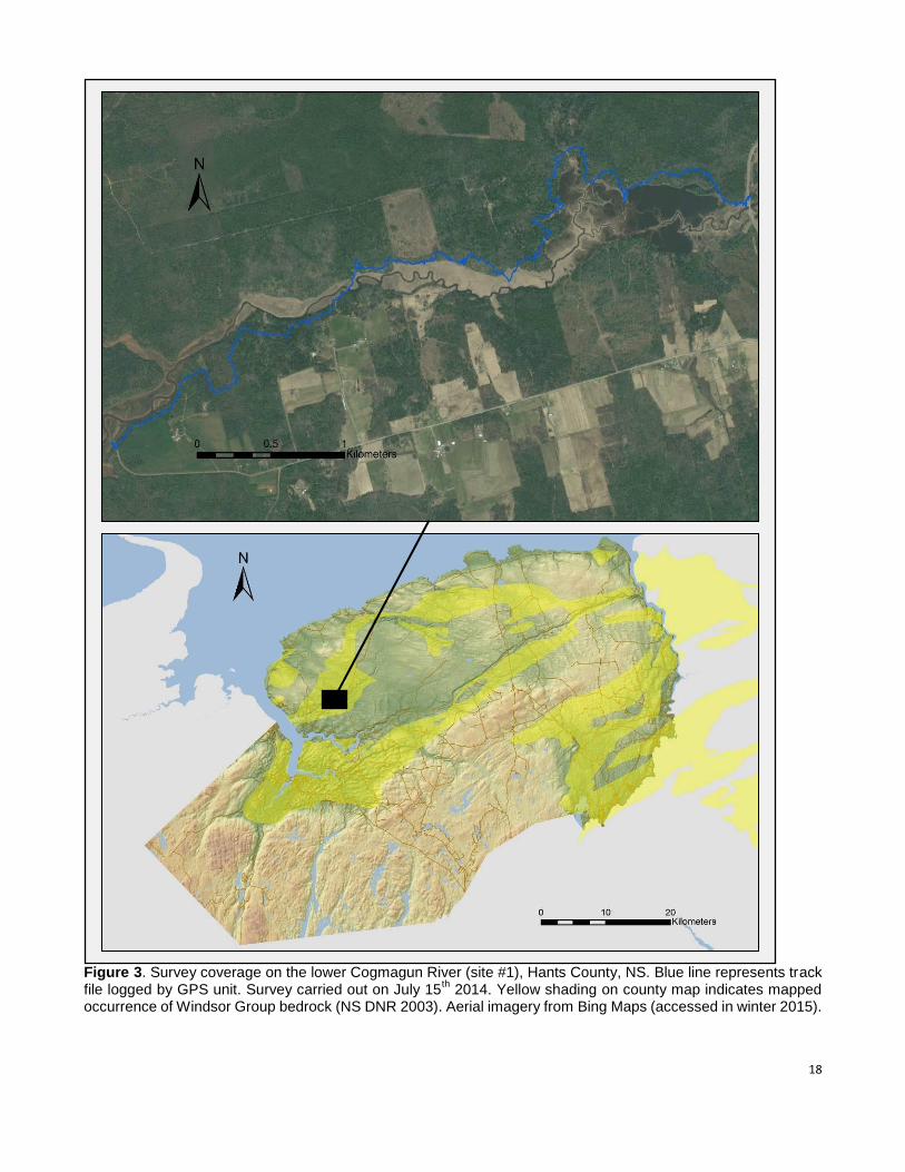
Figure 3. Survey coverage on the lower Cogmagun River (site #1), Hants County, NS. Blue line represents track file logged by GPS unit. Survey carried out on July 15
th 2014. Yellow shading on county map indicates mapped
occurrence of Windsor Group bedrock (NS DNR 2003). Aerial imagery from Bing Maps (accessed in winter 2015).
19
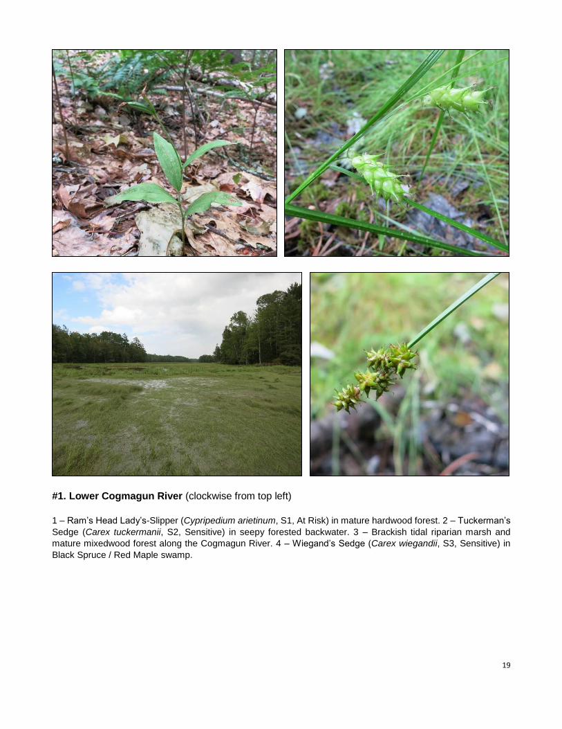
#1. Lower Cogmagun River (clockwise from top left)
1 – Ram’s Head Lady’s-Slipper (Cypripedium arietinum, S1, At Risk) in mature hardwood forest. 2 – Tuckerman’s
Sedge (Carex tuckermanii, S2, Sensitive) in seepy forested backwater. 3 – Brackish tidal riparian marsh and
mature mixedwood forest along the Cogmagun River. 4 – Wiegand’s Sedge (Carex wiegandii, S3, Sensitive) in
Black Spruce / Red Maple swamp.
20
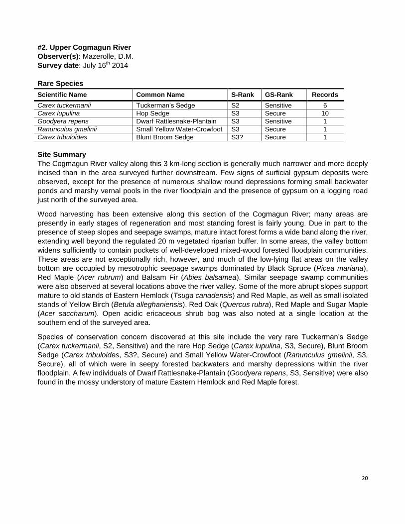
#2. Upper Cogmagun River
Observer(s): Mazerolle, D.M.
Survey date: July 16th 2014
Rare Species
Scientific Name Common Name S-Rank GS-Rank Records
Carex tuckermanii Tuckerman’s Sedge S2 Sensitive 6
Carex lupulina Hop Sedge S3 Secure 10
Goodyera repens Dwarf Rattlesnake-Plantain S3 Sensitive 1
Ranunculus gmelinii Small Yellow Water-Crowfoot S3 Secure 1
Carex tribuloides Blunt Broom Sedge S3? Secure 1
Site Summary
The Cogmagun River valley along this 3 km-long section is generally much narrower and more deeply
incised than in the area surveyed further downstream. Few signs of surficial gypsum deposits were
observed, except for the presence of numerous shallow round depressions forming small backwater
ponds and marshy vernal pools in the river floodplain and the presence of gypsum on a logging road
just north of the surveyed area.
Wood harvesting has been extensive along this section of the Cogmagun River; many areas are
presently in early stages of regeneration and most standing forest is fairly young. Due in part to the
presence of steep slopes and seepage swamps, mature intact forest forms a wide band along the river,
extending well beyond the regulated 20 m vegetated riparian buffer. In some areas, the valley bottom
widens sufficiently to contain pockets of well-developed mixed-wood forested floodplain communities.
These areas are not exceptionally rich, however, and much of the low-lying flat areas on the valley
bottom are occupied by mesotrophic seepage swamps dominated by Black Spruce (Picea mariana),
Red Maple (Acer rubrum) and Balsam Fir (Abies balsamea). Similar seepage swamp communities
were also observed at several locations above the river valley. Some of the more abrupt slopes support
mature to old stands of Eastern Hemlock (Tsuga canadensis) and Red Maple, as well as small isolated
stands of Yellow Birch (Betula alleghaniensis), Red Oak (Quercus rubra), Red Maple and Sugar Maple
(Acer saccharum). Open acidic ericaceous shrub bog was also noted at a single location at the
southern end of the surveyed area.
Species of conservation concern discovered at this site include the very rare Tuckerman’s Sedge
(Carex tuckermanii, S2, Sensitive) and the rare Hop Sedge (Carex lupulina, S3, Secure), Blunt Broom
Sedge (Carex tribuloides, S3?, Secure) and Small Yellow Water-Crowfoot (Ranunculus gmelinii, S3,
Secure), all of which were in seepy forested backwaters and marshy depressions within the river
floodplain. A few individuals of Dwarf Rattlesnake-Plantain (Goodyera repens, S3, Sensitive) were also
found in the mossy understory of mature Eastern Hemlock and Red Maple forest.
21
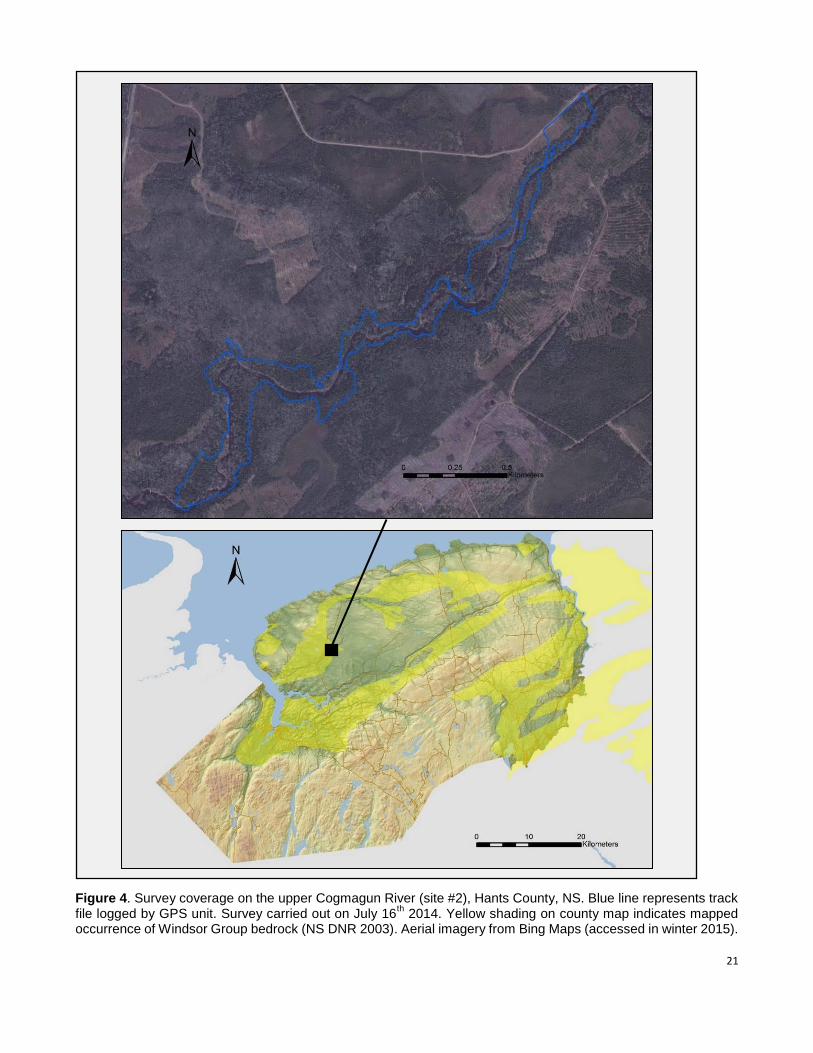
Figure 4. Survey coverage on the upper Cogmagun River (site #2), Hants County, NS. Blue line represents track file logged by GPS unit. Survey carried out on July 16
th 2014. Yellow shading on county map indicates mapped
occurrence of Windsor Group bedrock (NS DNR 2003). Aerial imagery from Bing Maps (accessed in winter 2015).
22
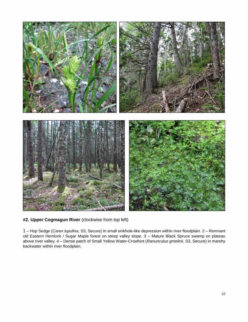
#2. Upper Cogmagun River (clockwise from top left)
1 – Hop Sedge (Carex lupulina, S3, Secure) in small sinkhole-like depression within river floodplain. 2 – Remnant
old Eastern Hemlock / Sugar Maple forest on steep valley slope. 3 – Mature Black Spruce swamp on plateau
above river valley. 4 – Dense patch of Small Yellow Water-Crowfoot (Ranunculus gmelinii, S3, Secure) in marshy
backwater within river floodplain.
23
#3. Newport Station
Observer(s): Mazerolle, D.M.
Survey date: July 17th 2014
Rare Species
Scientific Name Common Name S-Rank GS-Rank Records
Fraxinus nigra Black Ash S1S2 At Risk 2
Carex bebbii Bebb’s Sedge S2 Sensitive 1
Agrimonia gryposepala Tall Hairy Groovebur S3 Secure 2
Proserpinaca palustris var. crebra Marsh Mermaid-Weed S3 Secure 5
Ranunculus gmelinii Small Yellow Water-Crowfoot S3 Secure 1
Carex tribuloides Blunt Broom Sedge S3? Secure 1
Site Summary
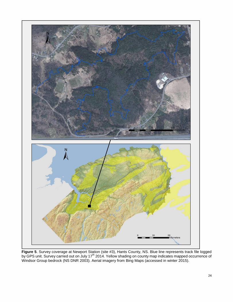
Located between Newport Station and Gypsum Mines, the surveyed area at this site is delimited by
Route 14, Wentworth Road and Irishmans Road. The site is on privately owned land adjacent to a large
gypsum quarry held by the Fundy Gypsum Company (presently not in operation) and lies within what
was historically one of Nova Scotia’s most extensively quarried gypsum areas. Moderate to heavy
karst topography extends over the majority of the surveyed area, with several large ridges and
numerous medium to large sinkholes found throughout. Exposed outcrops of fine-grained very friable
gypsum are fairly common and particularly abundant at the site’s northwest end, in a fairly extensive
area of very pronounced karst characterized by successive abrupt sinkholes, pits and ridges. The
eastern half of the site also includes several sinkhole ponds ranging from 50 to over 100 m in width.
Most mature karst forest in the surveyed area consists of nearly pure Eastern Hemlock (Tsuga
canadensis) stands and mixed stands of Eastern Hemlock, Red Maple (Acer rubrum), White Spruce
(Picea glauca), Balsam Fir (Abies balsamea), Trembling Aspen (Populus tremuloides), Large-Toothed
Aspen (Populus grandidentata) and Sugar Maple (Acer saccharum). The site’s central section includes
a fairly large area of Red Maple (Acer rubrum) / Tamarack (Larix laricina) / Speckled Alder (Alnus
incana ssp. rugosa) seepage swamp and Black Spruce (Picea mariana) / American Elm (Ulmus
americana) / Yellow Birch (Betula alleghaniensis) seepage swamp. The latter, which represents a
provincially rare or uncommon wetland forest community type, contained a small population of the
provincially protected Black Ash (Fraxinus nigra, S1S2, At Risk). Sinkhole ponds and sinkhole wetlands
at the site include various graminoid and forb marsh communities and support large populations of
Marsh Mermaid-Weed (Proserpinaca palustris var. crebra, S3, Secure) as well as small populations of
Bebb’s Sedge (Carex bebbii, S2, Sensitive), Blunt Broom Sedge (Carex tribuloides, S3?, Secure) and
Small Yellow Water-Crowfoot (Ranunculus gmelinii, S3, Secure).
This site represents a somewhat intact remnant natural area within a highly fragmented landscape.
Moderate anthropogenic disturbance is evident throughout the site, mainly in the form of numerous
walking trails, and a few areas show signs of historic agricultural use. Selective wood harvesting has
also significantly degraded the forest at the western end of the surveyed area.
24
Figure 5. Survey coverage at Newport Station (site #3), Hants County, NS. Blue line represents track file logged by GPS unit. Survey carried out on July 17
th 2014. Yellow shading on county map indicates mapped occurrence of
Windsor Group bedrock (NS DNR 2003). Aerial imagery from Bing Maps (accessed in winter 2015).
25
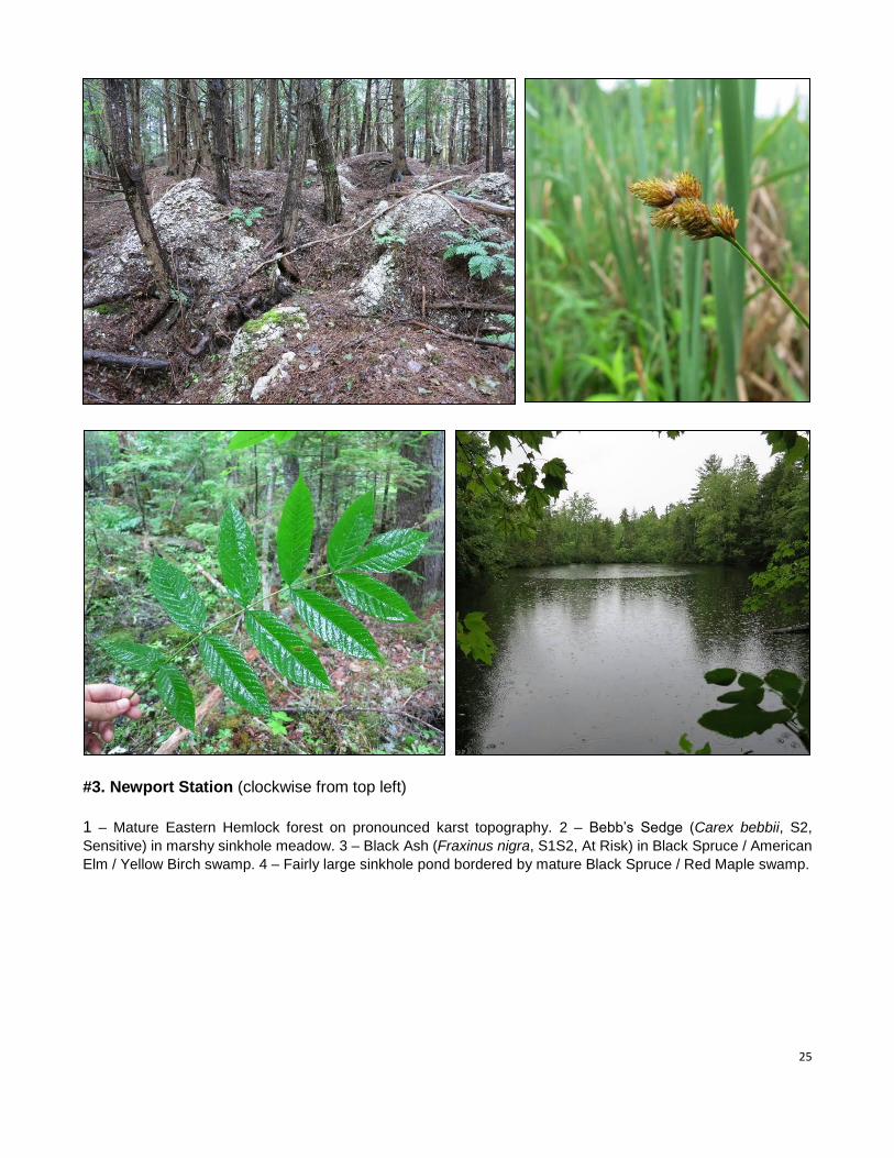
#3. Newport Station (clockwise from top left)
1 – Mature Eastern Hemlock forest on pronounced karst topography. 2 – Bebb’s Sedge (Carex bebbii, S2,
Sensitive) in marshy sinkhole meadow. 3 – Black Ash (Fraxinus nigra, S1S2, At Risk) in Black Spruce / American
Elm / Yellow Birch swamp. 4 – Fairly large sinkhole pond bordered by mature Black Spruce / Red Maple swamp.
26
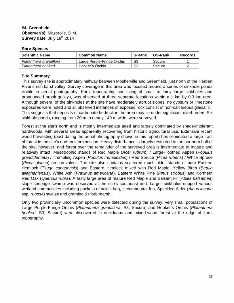
#4. Greenfield
Observer(s): Mazerolle, D.M.
Survey date: July 18th 2014
Rare Species
Scientific Name Common Name S-Rank GS-Rank Records
Platanthera grandiflora Large Purple-Fringe Orchis S3 Secure 1
Platanthera hookeri Hooker’s Orchis S3 Secure 2
Site Summary
This survey site is approximately halfway between Mosherville and Greenfield, just north of the Herbert
River’s rich karst valley. Survey coverage in this area was focused around a series of sinkhole ponds
visible in aerial photography. Karst topography, consisting of small to fairly large sinkholes and
pronounced brook gulleys, was observed at three separate locations within a 1 km by 0.3 km area.
Although several of the sinkholes at the site have moderately abrupt slopes, no gypsum or limestone
exposures were noted and all observed instances of exposed rock consist of non-calcareous glacial till.
This suggests that deposits of carbonate bedrock in the area may lie under significant overburden. Six
sinkhole ponds, ranging from 20 m to nearly 140 m wide, were surveyed.
Forest at the site’s north end is mostly intermediate aged and largely dominated by shade-intolerant
hardwoods, with several areas apparently recovering from historic agricultural use. Extensive recent
wood harvesting (post-dating the aerial photography shown in this report) has eliminated a large tract
of forest in the site’s northeastern section. Heavy disturbance is largely restricted to the northern half of
the site, however, and forest over the remainder of the surveyed area is intermediate to mature and
relatively intact. Mesotrophic stands of Red Maple (Acer rubrum) / Large-Toothed Aspen (Populus
grandidentata) / Trembling Aspen (Populus tremuloides) / Red Spruce (Picea rubens) / White Spruce
(Picea glauca) are prevalent. The site also contains scattered much older stands of pure Eastern
Hemlock (Tsuga canadensis) and Eastern Hemlock mixed with Red Maple, Yellow Birch (Betula
alleghaniensis), White Ash (Fraxinus americana), Eastern White Pine (Pinus strobus) and Northern
Red Oak (Quercus rubra). A fairly large area of mature Red Maple and Balsam Fir (Abies balsamea)
slope seepage swamp was observed at the site’s southeast end. Larger sinkholes support various
wetland communities including pockets of acidic bog, circumneutral fen, Speckled Alder (Alnus incana
ssp. rugosa) swales and graminoid / forb marsh.
Only two provincially uncommon species were detected during the survey; very small populations of
Large Purple-Fringe Orchis (Platanthera grandiflora, S3, Secure) and Hooker’s Orchis (Platanthera
hookeri, S3, Secure) were discovered in deciduous and mixed-wood forest at the edge of karst
topography.
27
Figure 6. Survey coverage at Greenfield (site #4), Hants County, NS. Blue line represents track file logged by GPS unit. Survey carried out on July 18th
2014. Yellow shading on county map indicates mapped occurrence of Windsor Group bedrock (NS DNR 2003). Aerial imagery from Bing Maps (accessed in winter 2015).
28
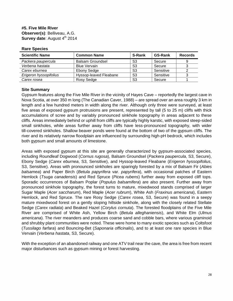
#5. Five Mile River
Observer(s): Belliveau, A.G.
Survey date: August 4th 2014
Rare Species
Scientific Name Common Name S-Rank GS-Rank Records
Packera paupercula Balsam Groundsel S3 Secure 9
Verbena hastata Blue Vervain S3 Secure 3
Carex eburnea Ebony Sedge S3 Sensitive 2
Erigeron hyssopifolius Hyssop-leaved Fleabane S3 Sensitive 3
Carex rosea Rosy Sedge S3 Secure 1
Site Summary
Gypsum features along the Five Mile River in the vicinity of Hayes Cave – reportedly the largest cave in
Nova Scotia, at over 350 m long (The Canadian Caver, 1988) – are spread over an area roughly 3 km in
length and a few hundred meters in width along the river. Although only three were surveyed, at least
five areas of exposed gypsum protrusions are present, represented by tall (5 to 25 m) cliffs with thick
accumulations of scree and by variably pronounced sinkhole topography in areas adjacent to these
cliffs. Areas immediately behind or uphill from cliffs are typically highly karstic, with exposed steep-sided
small sinkholes, while areas further away from cliffs have less-pronounced topography, with wider
till-covered sinkholes. Shallow beaver ponds were found at the bottom of two of the gypsum cliffs. The
river and its relatively narrow floodplain are influenced by surrounding high-pH bedrock, which includes
both gypsum and small amounts of limestone.
Areas with exposed gypsum at this site are generally characterized by gypsum-associated species,
including Roundleaf Dogwood (Cornus rugosa), Balsam Groundsel (Packera paupercula, S3, Secure),
Ebony Sedge (Carex eburnea, S3, Sensitive), and Hyssop-leaved Fleabane (Erigeron hyssopifolius,
S3, Sensitive). Areas with pronounced sinkholes are sparingly forested by a mix of Balsam Fir (Abies
balsamea) and Paper Birch (Betula papyrifera var. papyrifera), with occasional patches of Eastern
Hemlock (Tsuga canadensis) and Red Spruce (Picea rubens) further away from exposed cliff tops.
Sporadic occurrences of Balsam Poplar (Populus balsamifera) are also present. Further away from
pronounced sinkhole topography, the forest turns to mature, mixedwood stands comprised of larger
Sugar Maple (Acer saccharum), Red Maple (Acer rubrum), White Ash (Fraxinus americana), Eastern
Hemlock, and Red Spruce. The rare Rosy Sedge (Carex rosea, S3, Secure) was found in a seepy
mature mixedwood forest on a gently sloping hillside sinkhole, along with the closely related Stellate
Sedge (Carex radiata) and Beaked Hazel (Corylus cornuta). The forested floodplains of the Five Mile
River are comprised of White Ash, Yellow Birch (Betula alleghaniensis), and White Elm (Ulmus
americana). The river meanders and produces coarse sand and cobble bars, where various graminoid
and shrubby plant communities were noted. These were home to many exotic species such as Coltsfoot
(Tussilago farfara) and Bouncing-Bet (Saponaria officinalis), and to at least one rare species in Blue
Vervain (Verbena hastata, S3, Secure).
With the exception of an abandoned railway and one ATV trail near the cave, the area is free from recent
major disturbances such as gypsum mining or forest harvesting.
29
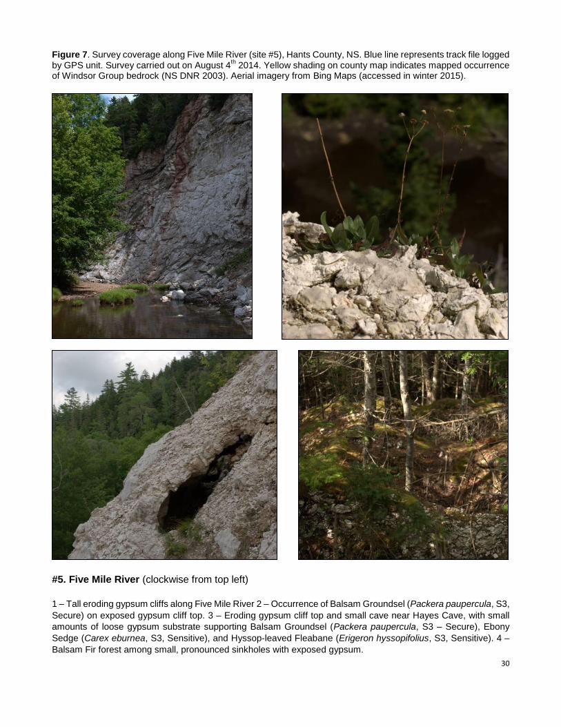
30
Figure 7. Survey coverage along Five Mile River (site #5), Hants County, NS. Blue line represents track file logged by GPS unit. Survey carried out on August 4
th 2014. Yellow shading on county map indicates mapped occurrence
of Windsor Group bedrock (NS DNR 2003). Aerial imagery from Bing Maps (accessed in winter 2015).
#5. Five Mile River (clockwise from top left)
1 – Tall eroding gypsum cliffs along Five Mile River 2 – Occurrence of Balsam Groundsel (Packera paupercula, S3,
Secure) on exposed gypsum cliff top. 3 – Eroding gypsum cliff top and small cave near Hayes Cave, with small
amounts of loose gypsum substrate supporting Balsam Groundsel (Packera paupercula, S3 – Secure), Ebony
Sedge (Carex eburnea, S3, Sensitive), and Hyssop-leaved Fleabane (Erigeron hyssopifolius, S3, Sensitive). 4 –
Balsam Fir forest among small, pronounced sinkholes with exposed gypsum.
31
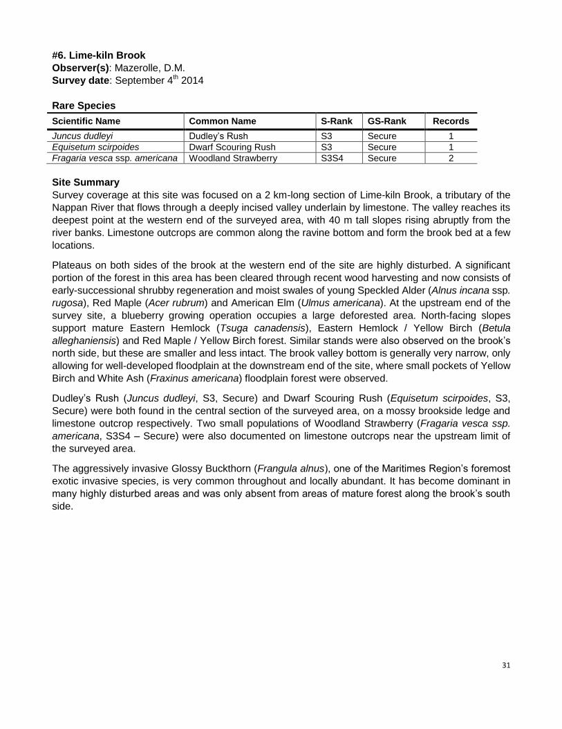
#6. Lime-kiln Brook
Observer(s): Mazerolle, D.M.
Survey date: September 4th 2014
Rare Species
Scientific Name Common Name S-Rank GS-Rank Records
Juncus dudleyi Dudley’s Rush S3 Secure 1
Equisetum scirpoides Dwarf Scouring Rush S3 Secure 1
Fragaria vesca ssp. americana Woodland Strawberry S3S4 Secure 2
Site Summary
Survey coverage at this site was focused on a 2 km-long section of Lime-kiln Brook, a tributary of the
Nappan River that flows through a deeply incised valley underlain by limestone. The valley reaches its
deepest point at the western end of the surveyed area, with 40 m tall slopes rising abruptly from the
river banks. Limestone outcrops are common along the ravine bottom and form the brook bed at a few
locations.
Plateaus on both sides of the brook at the western end of the site are highly disturbed. A significant
portion of the forest in this area has been cleared through recent wood harvesting and now consists of
early-successional shrubby regeneration and moist swales of young Speckled Alder (Alnus incana ssp.
rugosa), Red Maple (Acer rubrum) and American Elm (Ulmus americana). At the upstream end of the
survey site, a blueberry growing operation occupies a large deforested area. North-facing slopes
support mature Eastern Hemlock (Tsuga canadensis), Eastern Hemlock / Yellow Birch (Betula
alleghaniensis) and Red Maple / Yellow Birch forest. Similar stands were also observed on the brook’s
north side, but these are smaller and less intact. The brook valley bottom is generally very narrow, only
allowing for well-developed floodplain at the downstream end of the site, where small pockets of Yellow
Birch and White Ash (Fraxinus americana) floodplain forest were observed.
Dudley’s Rush (Juncus dudleyi, S3, Secure) and Dwarf Scouring Rush (Equisetum scirpoides, S3,
Secure) were both found in the central section of the surveyed area, on a mossy brookside ledge and
limestone outcrop respectively. Two small populations of Woodland Strawberry (Fragaria vesca ssp.
americana, S3S4 – Secure) were also documented on limestone outcrops near the upstream limit of
the surveyed area.
The aggressively invasive Glossy Buckthorn (Frangula alnus), one of the Maritimes Region’s foremost
exotic invasive species, is very common throughout and locally abundant. It has become dominant in
many highly disturbed areas and was only absent from areas of mature forest along the brook’s south
side.
32
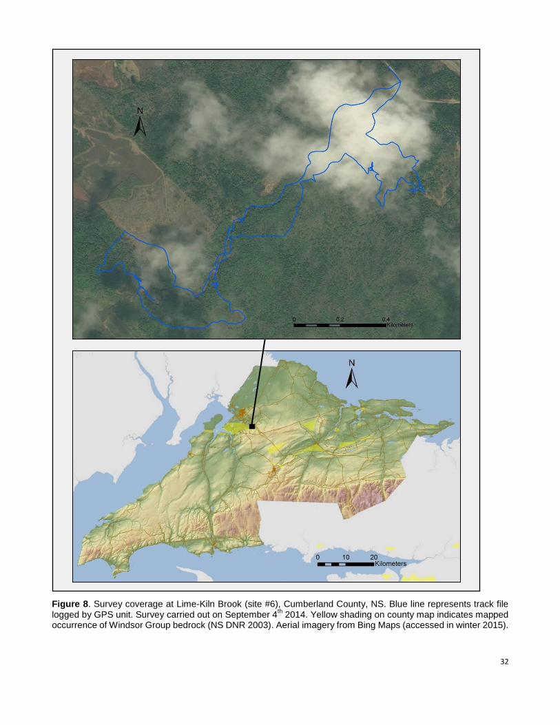
Figure 8. Survey coverage at Lime-Kiln Brook (site #6), Cumberland County, NS. Blue line represents track file logged by GPS unit. Survey carried out on September 4
th 2014. Yellow shading on county map indicates mapped
occurrence of Windsor Group bedrock (NS DNR 2003). Aerial imagery from Bing Maps (accessed in winter 2015).
33
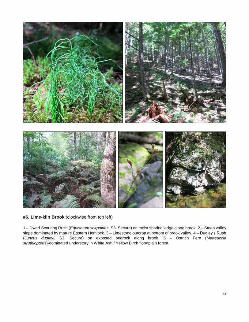
#6. Lime-kiln Brook (clockwise from top left)
1 – Dwarf Scouring Rush (Equisetum scirpoides, S3, Secure) on moist shaded ledge along brook. 2 – Steep valley
slope dominated by mature Eastern Hemlock. 3 – Limestone outcrop at bottom of brook valley. 4 – Dudley’s Rush
(Juncus dudleyi, S3, Secure) on exposed bedrock along brook. 5 – Ostrich Fern (Matteuccia
struthiopteris)-dominated understory in White Ash / Yellow Birch floodplain forest.
34
#7. Dutch Settlement
Observer(s): Mazerolle, D.M.
Survey date: August 12th 2014
Rare Species
Scientific Name Common Name S-Rank GS-Rank Records
Boehmeria cylindrica False Nettle S1 May Be At Risk 2
Scirpus pedicellatus Stalked Bulrush S2? Sensitive 3
Elodea canadensis Broad Waterweed S2S3 Secure 2
Dichanthelium clandestinum Deer-Tongue Witchgrass S3 Secure 1
Laportea canadensis Wood Nettle S3 Sensitive 2
Polygonum amphibium var. emersum Water Smartweed S3? Undetermined 1
Cystopteris bulbifera Bulblet Fern S3S4 Secure 7
Fragria vesca ssp. americana Woodland Strawberry S3S4 Secure 4
Juncus acuminatus Sharp-Fruit Rush S3S4 Secure 1
Site Summary
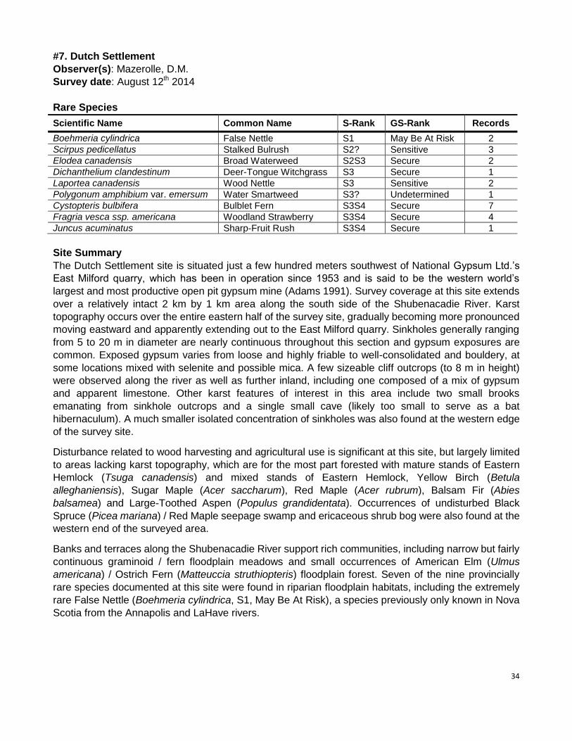
The Dutch Settlement site is situated just a few hundred meters southwest of National Gypsum Ltd.’s
East Milford quarry, which has been in operation since 1953 and is said to be the western world’s
largest and most productive open pit gypsum mine (Adams 1991). Survey coverage at this site extends
over a relatively intact 2 km by 1 km area along the south side of the Shubenacadie River. Karst
topography occurs over the entire eastern half of the survey site, gradually becoming more pronounced
moving eastward and apparently extending out to the East Milford quarry. Sinkholes generally ranging
from 5 to 20 m in diameter are nearly continuous throughout this section and gypsum exposures are
common. Exposed gypsum varies from loose and highly friable to well-consolidated and bouldery, at
some locations mixed with selenite and possible mica. A few sizeable cliff outcrops (to 8 m in height)
were observed along the river as well as further inland, including one composed of a mix of gypsum
and apparent limestone. Other karst features of interest in this area include two small brooks
emanating from sinkhole outcrops and a single small cave (likely too small to serve as a bat
hibernaculum). A much smaller isolated concentration of sinkholes was also found at the western edge
of the survey site.
Disturbance related to wood harvesting and agricultural use is significant at this site, but largely limited
to areas lacking karst topography, which are for the most part forested with mature stands of Eastern
Hemlock (Tsuga canadensis) and mixed stands of Eastern Hemlock, Yellow Birch (Betula
alleghaniensis), Sugar Maple (Acer saccharum), Red Maple (Acer rubrum), Balsam Fir (Abies
balsamea) and Large-Toothed Aspen (Populus grandidentata). Occurrences of undisturbed Black
Spruce (Picea mariana) / Red Maple seepage swamp and ericaceous shrub bog were also found at the
western end of the surveyed area.
Banks and terraces along the Shubenacadie River support rich communities, including narrow but fairly
continuous graminoid / fern floodplain meadows and small occurrences of American Elm (Ulmus
americana) / Ostrich Fern (Matteuccia struthiopteris) floodplain forest. Seven of the nine provincially
rare species documented at this site were found in riparian floodplain habitats, including the extremely
rare False Nettle (Boehmeria cylindrica, S1, May Be At Risk), a species previously only known in Nova
Scotia from the Annapolis and LaHave rivers.
35
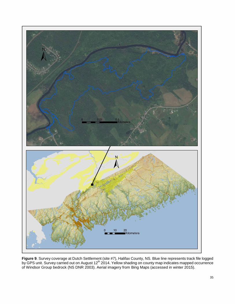
Figure 9. Survey coverage at Dutch Settlement (site #7), Halifax County, NS. Blue line represents track file logged by GPS unit. Survey carried out on August 12
th 2014. Yellow shading on county map indicates mapped occurrence
of Windsor Group bedrock (NS DNR 2003). Aerial imagery from Bing Maps (accessed in winter 2015).
36
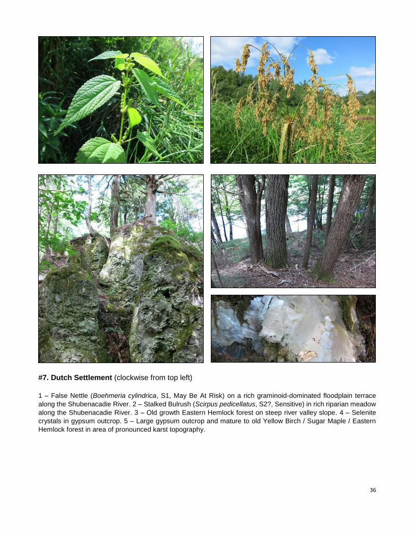
#7. Dutch Settlement (clockwise from top left)
1 – False Nettle (Boehmeria cylindrica, S1, May Be At Risk) on a rich graminoid-dominated floodplain terrace
along the Shubenacadie River. 2 – Stalked Bulrush (Scirpus pedicellatus, S2?, Sensitive) in rich riparian meadow
along the Shubenacadie River. 3 – Old growth Eastern Hemlock forest on steep river valley slope. 4 – Selenite
crystals in gypsum outcrop. 5 – Large gypsum outcrop and mature to old Yellow Birch / Sugar Maple / Eastern
Hemlock forest in area of pronounced karst topography.
37
#8. Black Brook
Observer(s): Mazerolle, D.M.
Survey date: August 13th 2014
Scientific Name Common Name S-Rank GS-Rank Records
Agrimonia gryposepala Tall Hairy Groovebur S3 Secure 1
Proserpinaca palustris var. crebra Marsh Mermaid-Weed S3 Secure 1
Rhamnus alnifolia Alderleaf Buckthorn S3 Secure 2
Asclepias incarnata ssp. pulchra Swamp Milkweed S3? Undetermined 28
Cystopteris bulbifera Bulblet Fern S3S4 Secure 3
Fragaria vesca ssp. americana Woodland Strawberry S3S4 Secure 8
Site Summary
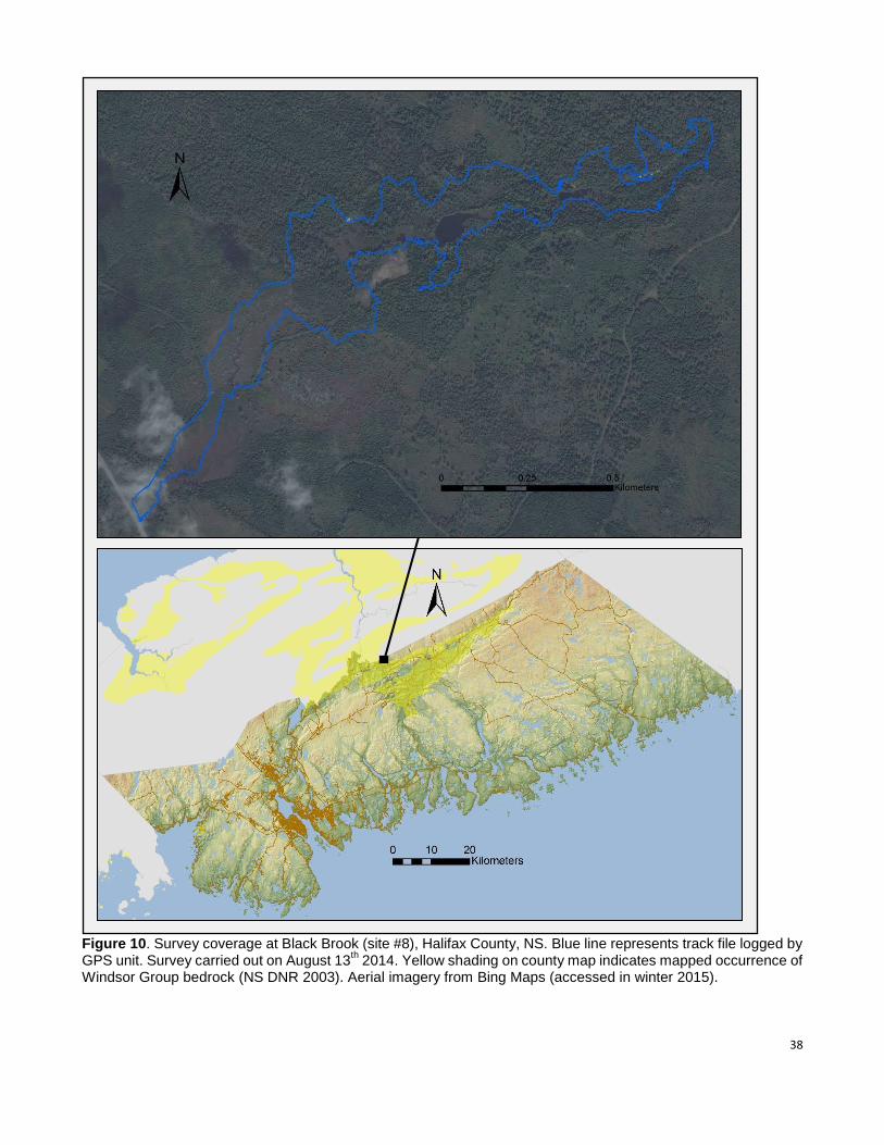
Survey coverage at this site was focused on a 2 km section of Black Brook, a small tributary of the main
branch of the Gays River. The slow-flowing brook originates at the eastern end of the surveyed area,
where it is fed by abundant groundwater seepage and several springs, some of which emanate from
the base of gypsum cliff outcrops on the valley bottom. Sinkholes and gypsum outcrops are both fairly
continuous over the eastern half of the site and especially evident along the brook’s north side. This
area contains a difficult-to-traverse zone of very pronounced sinkhole and pit karst, numerous sinkhole
ponds and five separate gypsum cliffs, some reaching heights of 15 m or more with significant talus
accumulations. Several small cave openings were noted at the base of these cliffs, including one with
an entrance roughly 1 m in width and 0.2 m in height. Large deep sinkholes with exposed outcrop
bottoms and diameters ranging up to 40 m were observed at the eastern end of the surveyed area. At a
few locations, well-developed runoff gulleys channel water into small caves at the bottom of sinkholes;
the largest of these sinkhole cave entrances was measured at roughly 70 cm in diameter. Karst
features on the south side of the brook are generally much more subtle and span a smaller area than
those on the north side.
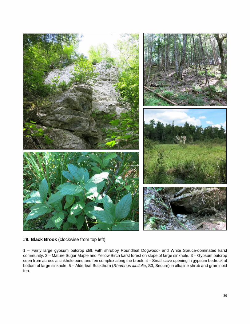
Wood harvesting has been extensive along Black Brook; large swaths have recently been clearcut and
most remaining forest is early-successional. Intact mature forest communities are largely restricted to
areas of moderate to pronounced karst topography, which support fairly old stands of Eastern Hemlock
(Tsuga canadensis), Eastern Hemlock / Yellow Birch (Betula alleghaniensis) / Sugar Maple (Acer
saccharum) and Eastern White Pine (Pinus strobus) / Sugar Maple / Yellow Birch / Eastern Hemlock.
Areas of abundant exposed gypsum also contain shrubby karst communities dominated by Roundleaf
Dogwood (Cornus rugosa), stunted hardwoods and Red Spruce (Picea rubens) that also contain
populations of Bulblet Fern (Cystopteris bulbifera, S3S4, Secure) and Woodland Strawberry (Fragaria
vesca ssp. americana, S3S4, Secure).
The surveyed area contains an extensive riparian marsh and fen complex comprised of open
Blue-Joint Reedgrass (Calamagrostis canadensis) / Water Sedge (Carex aquatilis) / Tussock Sedge
(Carex stricta) / Sweet gale (Myrica gale) fen, slightly calcareous Speckled Alder (Alnus incana ssp.
rugosa) swamp and beaver meadows. Most sinkhole ponds found at the site are situated along the
brook in these riparian wetlands.
38
Figure 10. Survey coverage at Black Brook (site #8), Halifax County, NS. Blue line represents track file logged by GPS unit. Survey carried out on August 13
th 2014. Yellow shading on county map indicates mapped occurrence of
Windsor Group bedrock (NS DNR 2003). Aerial imagery from Bing Maps (accessed in winter 2015).
39
#8. Black Brook (clockwise from top left)
1 – Fairly large gypsum outcrop cliff, with shrubby Roundleaf Dogwood- and White Spruce-dominated karst
community. 2 – Mature Sugar Maple and Yellow Birch karst forest on slope of large sinkhole. 3 – Gypsum outcrop
seen from across a sinkhole pond and fen complex along the brook. 4 – Small cave opening in gypsum bedrock at
bottom of large sinkhole. 5 – Alderleaf Buckthorn (Rhamnus alnifolia, S3, Secure) in alkaline shrub and graminoid
fen.
40
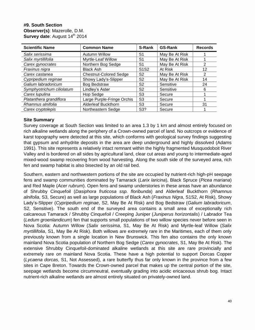
#9. South Section
Observer(s): Mazerolle, D.M.
Survey date: August 14th 2014
Scientific Name Common Name S-Rank GS-Rank Records
Salix serissima Autumn Willow S1 May Be At Risk 1
Salix myrtillifolia Myrtle-Leaf Willow S1 May Be At Risk 1
Carex gynocrates Northern Bog Sedge S1 May Be At Risk 2
Fraxinus nigra Black Ash S1S2 At Risk 12
Carex castanea Chestnut-Colored Sedge S2 May Be At Risk 2
Cypripedium reginae Showy Lady’s-Slipper S2 May Be At Risk 14
Galium labradoricum Bog Bedstraw S2 Sensitive 24
Symphyotrichum ciliolatum Lindley’s Aster S2 Sensitive 6
Carex lupulina Hop Sedge S3 Secure 1
Platanthera grandiflora Large Purple-Fringe Orchis S3 Secure 1
Rhamnus alnifolia Alderleaf Buckthorn S3 Secure 31
Carex cryptolepis Northeastern Sedge S3? Secure 1
Site Summary
Survey coverage at South Section was limited to an area 1.3 by 1 km and almost entirely focused on
rich alkaline wetlands along the periphery of a Crown-owned parcel of land. No outcrops or evidence of
karst topography were detected at this site, which conforms with geological survey findings suggesting
that gypsum and anhydrite deposits in the area are deep underground and highly dissolved (Adams
1991). This site represents a relatively intact remnant within the highly fragmented Musquodoboit River
Valley and is bordered on all sides by agricultural land, clear cut areas and young to intermediate-aged
mixed-wood swamp recovering from wood harvesting. Along the south side of the surveyed area, rich
fen and swamp habitat is also bisected by an old rail bed.
Southern, eastern and northwestern portions of the site are occupied by nutrient-rich high-pH seepage
fens and swamp communities dominated by Tamarack (Larix laricina), Black Spruce (Picea mariana)
and Red Maple (Acer rubrum). Open fens and swamp understories in these areas have an abundance
of Shrubby Cinquefoil (Dasiphora fruticosa ssp. floribunda) and Alderleaf Buckthorn (Rhamnus
alnifolia, S3, Secure) as well as large populations of Black Ash (Fraxinus Nigra, S1S2, At Risk), Showy
Lady’s-Slipper (Cypripedium reginae, S2, May Be At Risk) and Bog Bedstraw (Galium labradoricum,
S2, Sensitive). The south end of the surveyed area contains a small area of exceptionally rich
calcareous Tamarack / Shrubby Cinquefoil / Creeping Juniper (Juniperus horizontalis) / Labrador Tea
(Ledum groenlandicum) fen that supports small populations of two willow species never before seen in
Nova Scotia: Autumn Willow (Salix serissima, S1, May Be At Risk) and Myrtle-leaf Willow (Salix
myrtillifolia, S1, May Be At Risk). Both willows are extremely rare in the Maritimes, each of them only
previously known from a single location in New Brunswick. This fen also contains the only known
mainland Nova Scotia population of Northern Bog Sedge (Carex gynocrates, S1, May Be At Risk). The
extensive Shrubby Cinquefoil-dominated alkaline wetlands at this site are rare provincially and
extremely rare on mainland Nova Scotia. These have a high potential to support Dorcas Copper
(Lycaena dorcas, S1, Not Assessed), a rare butterfly thus far only known in the province from a few
sites in Cape Breton. Towards the Crown-owned parcel that makes up the central portion of the site,
seepage wetlands become circumneutral, eventually grading into acidic ericaceous shrub bog. Intact
nutrient-rich alkaline wetlands are almost entirely situated on privately-owned land.
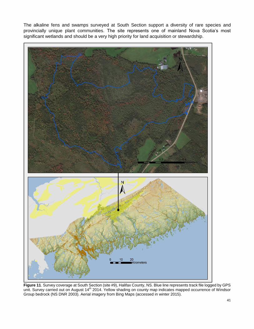
41
The alkaline fens and swamps surveyed at South Section support a diversity of rare species and
provincially unique plant communities. The site represents one of mainland Nova Scotia’s most
significant wetlands and should be a very high priority for land acquisition or stewardship.
Figure 11. Survey coverage at South Section (site #9), Halifax County, NS. Blue line represents track file logged by GPS unit. Survey carried out on August 14
th 2014. Yellow shading on county map indicates mapped occurrence of Windsor
Group bedrock (NS DNR 2003). Aerial imagery from Bing Maps (accessed in winter 2015).
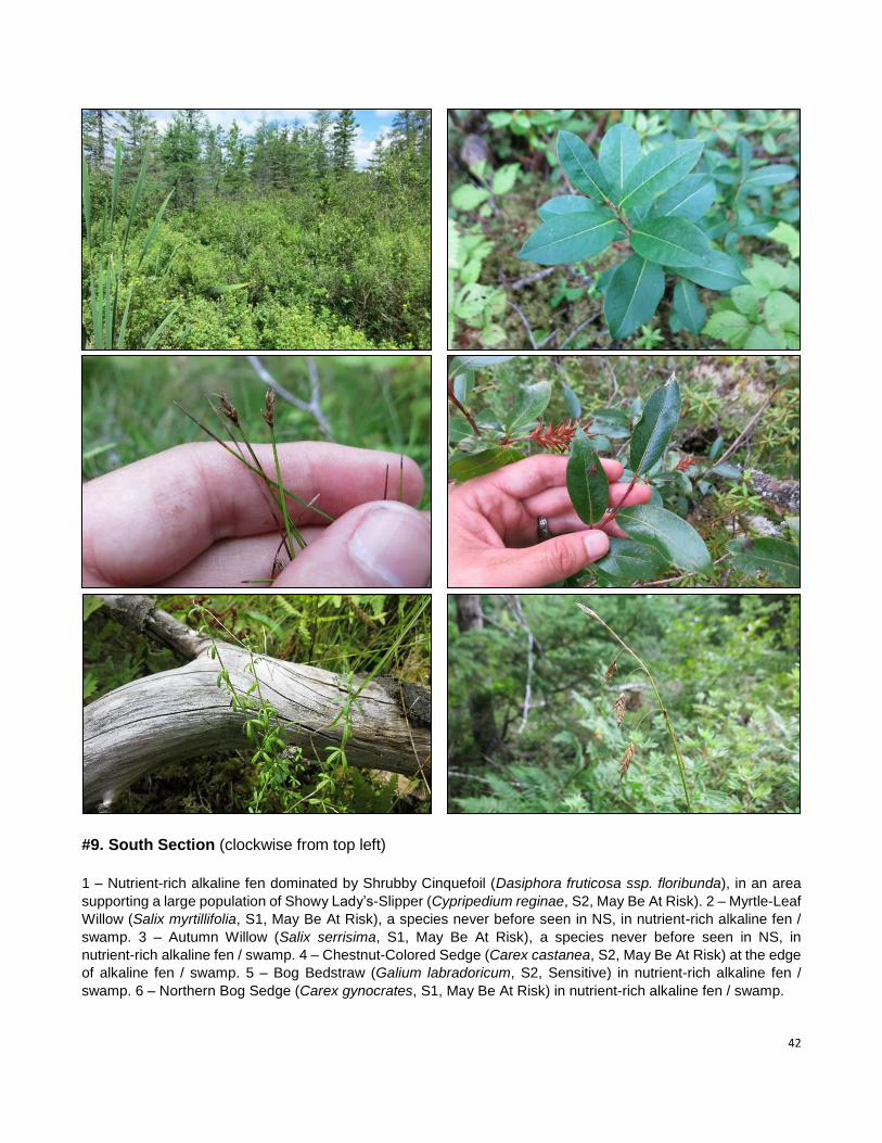
42
#9. South Section (clockwise from top left)
1 – Nutrient-rich alkaline fen dominated by Shrubby Cinquefoil (Dasiphora fruticosa ssp. floribunda), in an area
supporting a large population of Showy Lady’s-Slipper (Cypripedium reginae, S2, May Be At Risk). 2 – Myrtle-Leaf
Willow (Salix myrtillifolia, S1, May Be At Risk), a species never before seen in NS, in nutrient-rich alkaline fen /
swamp. 3 – Autumn Willow (Salix serrisima, S1, May Be At Risk), a species never before seen in NS, in
nutrient-rich alkaline fen / swamp. 4 – Chestnut-Colored Sedge (Carex castanea, S2, May Be At Risk) at the edge
of alkaline fen / swamp. 5 – Bog Bedstraw (Galium labradoricum, S2, Sensitive) in nutrient-rich alkaline fen /
swamp. 6 – Northern Bog Sedge (Carex gynocrates, S1, May Be At Risk) in nutrient-rich alkaline fen / swamp.
43
#10. Brierly Brook
Observer(s): Mazerolle, D.M.
Survey date: August 15th 2014
Scientific Name Common Name S-Rank GS-Rank Records
Fraxinus nigra Black Ash S1S2 At Risk 1
Cypripedium parviflorum Small Yellow Lady’s-Slipper S2S3 Sensitive 4
Carex eburnea Ebony Sedge S3 Sensitive 1
Carex lupulina Hop Sedge S3 Secure 1
Erigeron hyssopifolius Hyssop-leaved Fleabane S3 Sensitive 3
Packera paupercula Balsam Groundsel S3 Secure 3
Ranunculus gmelinii Small Yellow Water-Crowfoot S3 Secure 1
Cystopteris bulbifera Bulblet Fern S3S4 Secure 7
Fragaria vesca ssp. americana Woodland Strawberry S3S4 Secure 1
Carex tonsa var. rugosperma Umbel-Like Sedge SNR Undetermined 1
Carex aurea / garberi sedge sp. - - 1
Site Summary
Located roughly 6 km west-southwest of Antigonish at the foot of the Pictou-Antigonish Highlands, the
area surveyed along Brierly Brook extends 2 km from Deadman Lake to the Nova Construction gypsum
quarry at the settlement of Brierly Brook. Karst topography is evident throughout the site and varies in
nature from very large sinkholes and sinkhole ponds around Deadman Lake to very pronounced pit
karst and gypsum cliffs in the central portion of the surveyed area. The 400 m-long Deadman Lake,
itself the result of gypsum subsidence, is bordered to the east and west by other large sinkholes and
sinkhole ponds reaching diameters of 130 m. Marshy wetlands and sinkhole ponds in this area
constitute the headwaters of both Brierly Brook and Pushies brook. The central portion of the surveyed
area, situated on the valley slope south of Brierly Brook, includes a sizeable area of very pronounced
sinkholes, pits and gypsum cliffs. Exposed bedrock is abundant in this section, with some gypsum
slopes and cliffs rising nearly 30 m. Most provincially rare species documented at Brierly Brook were
found within this area of pronounced karst, which supports populations of Black Ash (Fraxinus nigra,
S1S2, At Risk), Small Yellow Lady’s-Slipper (Cypripedium parviflorum, S2S3, Sensitive), Ebony Sedge
(Carex eburnea, S3, Sensitive), Hyssop-leaved Fleabane (Erigeron hyssopifolius, S3, Secure), Balsam
Groundsel (Packera paupercula, S3, Secure), Bulbet Fern (Cystopteris bulbifera, S3S4, Secure) and
Woodland Strawberry (Fragaria vesca ssp. americana, S3S4, Secure). Karst topography remains very
evident and locally pronounced along the abrupt valley slope throughout the eastern half of the
surveyed area, although outcrops become scarce.
Disturbances related to quarrying, agriculture, wood harvesting, road and railroad construction have
collectively had a significant impact in the area. Remnant stands of mature late-seral forest are
restricted to abrupt slopes and areas of pronounced karst. These mainly consist of pure Eastern
Hemlock (Tsuga canadensis), Eastern Hemlock / Sugar Maple (Acer saccharum) / Yellow Birch (Betula
alleghaniensis) / White Ash (Fraxinus americana) and White Ash / Yellow Birch karst forest
communities. A small stand of old Eastern White Pine (Pinus strobus) / Eastern Hemlock / White Ash /
Red Spruce (Picea rubens) was also seen on a steep slope at the eastern end of the surveyed area
and scattered intact stands of mesic Red Maple (Acer rubrum) / White Ash were observed near
Deadman Lake as well as along the brook.
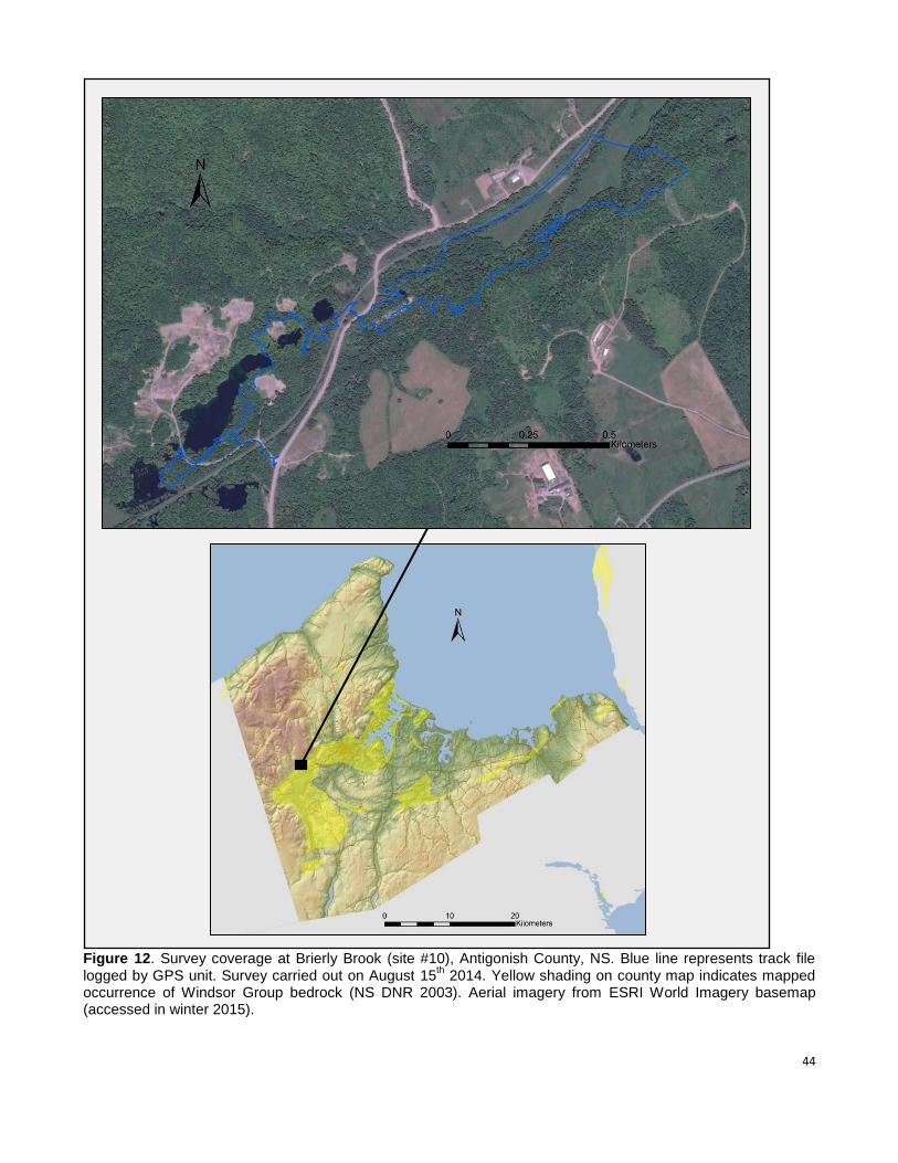
44
Figure 12. Survey coverage at Brierly Brook (site #10), Antigonish County, NS. Blue line represents track file logged by GPS unit. Survey carried out on August 15
th 2014. Yellow shading on county map indicates mapped
occurrence of Windsor Group bedrock (NS DNR 2003). Aerial imagery from ESRI World Imagery basemap (accessed in winter 2015).
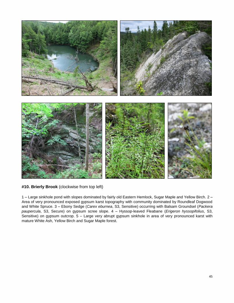
45
#10. Brierly Brook (clockwise from top left)
1 – Large sinkhole pond with slopes dominated by fairly old Eastern Hemlock, Sugar Maple and Yellow Birch. 2 –
Area of very pronounced exposed gypsum karst topography with community dominated by Roundleaf Dogwood
and White Spruce. 3 – Ebony Sedge (Carex eburnea, S3, Sensitive) occurring with Balsam Groundsel (Packera
paupercula, S3, Secure) on gypsum scree slope. 4 – Hyssop-leaved Fleabane (Erigeron hyssopifolius, S3,
Sensitive) on gypsum outcrop. 5 – Large very abrupt gypsum sinkhole in area of very pronounced karst with
mature White Ash, Yellow Birch and Sugar Maple forest.
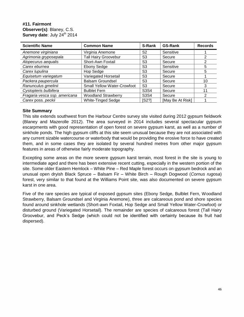
46
#11. Fairmont
Observer(s): Blaney, C.S.
Survey date: July 24th 2014
Scientific Name Common Name S-Rank GS-Rank Records
Anemone virginiana Virginia Anemone S2 Sensitive 1
Agrimonia gryposepala Tall Hairy Groovebur S3 Secure 2
Alopecurus aequalis Short-Awn Foxtail S3 Secure 2
Carex eburnea Ebony Sedge S3 Sensitive 5
Carex lupulina Hop Sedge S3 Secure 5
Equisetum variegatum Variegated Horsetail S3 Secure 1
Packera paupercula Balsam Groundsel S3 Secure 10
Ranunculus gmelinii Small Yellow Water-Crowfoot S3 Secure 3
Cystopteris bulbifera Bulblet Fern S3S4 Secure 11
Fragaria vesca ssp. americana Woodland Strawberry S3S4 Secure 2
Carex poss. peckii White-Tinged Sedge [S2?] [May Be At Risk] 1
Site Summary
This site extends southwest from the Harbour Centre survey site visited during 2012 gypsum fieldwork
(Blaney and Mazerolle 2012). The area surveyed in 2014 includes several spectacular gypsum
escarpments with good representation of open forest on severe gypsum karst, as well as a number of
sinkhole ponds. The high gypsum cliffs at this site seem unusual because they are not associated with
any current sizable watercourse or waterbody that would be providing the erosive force to have created
them, and in some cases they are isolated by several hundred metres from other major gypsum
features in areas of otherwise fairly moderate topography.
Excepting some areas on the more severe gypsum karst terrain, most forest in the site is young to
intermediate aged and there has been extensive recent cutting, especially in the western portion of the
site. Some older Eastern Hemlock – White Pine – Red Maple forest occurs on gypsum bedrock and an
unusual open dryish Black Spruce – Balsam Fir – White Birch – Rough Dogwood (Cornus rugosa)
forest, very similar to that found at the Williams Point site, was also documented on severe gypsum
karst in one area.
Five of the rare species are typical of exposed gypsum sites (Ebony Sedge, Bulblet Fern, Woodland
Strawberry, Balsam Groundsel and Virginia Anemone), three are calcareous pond and shore species
found around sinkhole wetlands (Short-awn Foxtail, Hop Sedge and Small Yellow Water-Crowfoot) or
disturbed ground (Variegated Horsetail). The remainder are species of calcareous forest (Tall Hairy
Groovebur, and Peck’s Sedge (which could not be identified with certainty because its fruit had
dispersed).
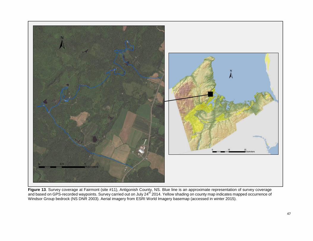
47
Figure 13. Survey coverage at Fairmont (site #11), Antigonish County, NS. Blue line is an approximate representation of survey coverage and based on GPS-recorded waypoints. Survey carried out on July 24
th 2014. Yellow shading on county map indicates mapped occurrence of
Windsor Group bedrock (NS DNR 2003). Aerial imagery from ESRI World Imagery basemap (accessed in winter 2015).
48
#11. Fairmont (clockwise from top left) 1. Rich streambed at base of gypsum cliff; 2. High gypsum cliff with mesic
Eastern White Pine – Eastern Hemlock – Red Spruce – Red Maple forest at crest. 3. Gypsum sinkhole pond in mixed
forest. 4. Ebony Sedge (Carex eburnea, S2 – Sensitive) dominated community on very steep slope of loose gypsum
scree; 5 and 6. Open Black Spruce – Balsam Fir – White Birch forest on severe karst topography at top of gypsum cliff.
The common shrub in photo 5 is Rough Dogwood (Cornus rugosa).
49
#12. Williams Point
Observer(s): Blaney, C.S.
Survey date: July 23rd
2014
Scientific Name Common Name S-Rank GS-Rank Records
Carex grisea Narrowleaf Sedge S1 May Be At Risk 1
Anemone virginiana Virginia Anemone S2 Sensitive 3
Cypripedium parviflorum Small Yellow Lady’s-Slipper S2S3 Sensitive 7
Galium aparine Catchweed Bedstraw S2S3 Sensitive 1
Triosteum aurantiacum Coffee Tinker’s-Weed S2S3 Sensitive 2
Agrimonia gryposepala Tall Hairy Groovebur S3 Secure 9
Erigeron hyssopifolius Hyssop-leaved Fleabane S3 Sensitive 2
Packera paupercula Balsam Groundsel S3 Secure 3
Polygonum pensylvanicum Pennsylvania Smartweed S3 Secure 1
Polygonum scandens Climbing False-Buckwheat S3 Sensitive 3
Samolus valerandi ssp. parviflorus Water Pimpernel S3 Sensitive 2
Teucrium canadense American Germander S3 Sensitive 3
Verbena hastata Blue Vervain S3 Secure 2
Cystopteris bulbifera Bulblet Fern S3S4 Secure 3
Sanguinaria canadensis Bloodroot S3S4 Secure 3
Cuscuta sp. dodder sp. - - 1
Epilobium ciliatum / coloratum willowherb sp. - - 1
Site Summary
Surveys at Williams Point extended from the lowermost portion of the South River near its mouth
northwest about 3 km to the area around Plaster Cove on Antigonish Harbour. The site has good
representation of gypsum landforms and gypsum-associated plant species, the most significant of
which were just west of the southernmost tip of Antigonish Harbour, where severe gypsum karst is
present with an unusual dryish open community of Black Spruce – Balsam Fir – White Birch and
Rough Dogwood (Cornus rugosa), along with good populations of the provincially uncommon
gypsum associates Bulblet Fern, Hyssop-leaved Fleabane, Balsam Ragwort, Yellow
Lady’s-Slipper and Virginia Anemone. Further north at Plaster Cove, gypsum exposure is less
extensive and mostly limited to cliffs along the harbour shore. Topography away from the shore is
gently to strongly undulating with some deep sinkholes and sinkhole ponds. The forest in this area
is mostly hemlock-dominated and was the most mature observed on site. Elsewhere in the
surveyed area, forest is mostly young to intermediate-aged, with the most western areas
especially young. The ponds in the southwestern part of the area were anthropogenic, or at least
anthropogenically enhanced, rather than natural sinkholes.
The South River floodplain had some highly disturbed remnant rich floodplain communities that
supported a number of rare species. The most significant of these is Narrow-leaved Inflated Sedge
(Carex grisea, S1 – May Be At Risk), first found nearby by 2012 AC CDC fieldwork surveying the
site of the new TransCanada Highway crossing. We found a small population in a hawthorn
(Crataegus sp.) – Choke Cherry floodplain thicket on an island just downstream of the new bridge.
Other significant rich floodplain species in this area were Bloodroot, Blue Vervain and Climbing
False-Buckwheat.
Near the mouth of the South River, the site has good representation of estuarine brackish marsh
communities of Tall Cordgrass (Spartina pectinata) and Three-square Bulrush (Schoenoplectus
pungens), with large numbers of Water Pimpernel (Samolus valerandi ssp. parviflorus, S3 –
Sensitive), a specialist of this type of habitat. These brackish marsh communities grade directly
into the severe gypsum karst in some areas forming transitional calcareous wetland communities.
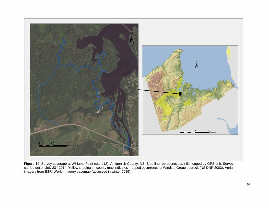
50
Figure 14. Survey coverage at Williams Point (site #12), Antigonish County, NS. Blue line represents track file logged by GPS unit. Survey carried out on July 23
rd 2014. Yellow shading on county map indicates mapped occurrence of Windsor Group bedrock (NS DNR 2003). Aerial
imagery from ESRI World Imagery basemap (accessed in winter 2015).
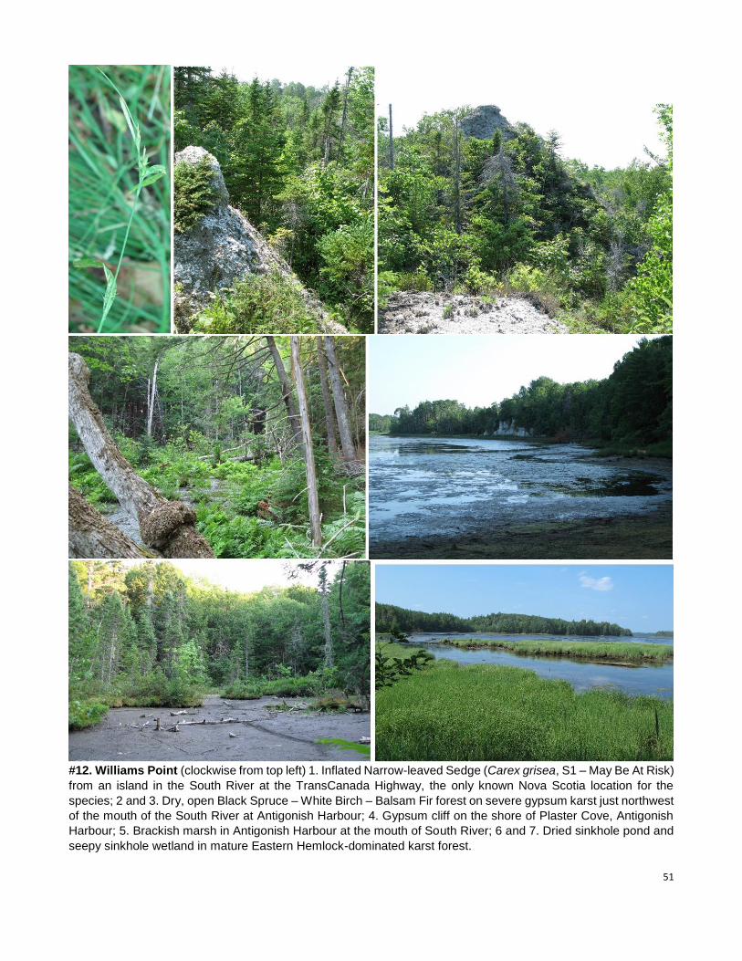
51
#12. Williams Point (clockwise from top left) 1. Inflated Narrow-leaved Sedge (Carex grisea, S1 – May Be At Risk)
from an island in the South River at the TransCanada Highway, the only known Nova Scotia location for the
species; 2 and 3. Dry, open Black Spruce – White Birch – Balsam Fir forest on severe gypsum karst just northwest
of the mouth of the South River at Antigonish Harbour; 4. Gypsum cliff on the shore of Plaster Cove, Antigonish
Harbour; 5. Brackish marsh in Antigonish Harbour at the mouth of South River; 6 and 7. Dried sinkhole pond and
seepy sinkhole wetland in mature Eastern Hemlock-dominated karst forest.

52
#13. Southside Antigonish Harbour Observer(s): Blaney, C.S.
Survey date: June 30th 2014
Scientific Name Common Name S-Rank GS-Rank Records
Barbarea orthoceras American Winter-Cress S1 May Be At Risk 7
Anemone virginiana Virginia Anemone S2 Sensitive 3
Eleocharis ovata Ovate Spikerush S2? Sensitive 1
Agrimonia gryposepala Tall Hairy Groovebur S3 Secure 13
Packera paupercula Balsam Groundsel S3 Secure 4
Teucrium canadense American Germander S3 Sensitive 7
Cystopteris bulbifera Bulblet Fern S3S4 Secure 7
Polygonum fowleri Fowler Knotweed S3S4 Secure 1
Antennaria neglecta Field Pussytoes SNR Undetermined 1
Myriophyllum sibiricum Siberian Water-Milfoil S3S4 Secure 1
Site Summary
Gypsum karst features are quite evident at this site, with limestone outcrops also present locally around
the sand and gravel quarry in the north end of the property and on the island just to the north. Most of
the area covered appears to have regenerated following clearance for agriculture, and north of the road
accessing the quarry some of the forest is in current use as cow pasture. As a result of the site’s
agricultural use and history, much of the forest understory is quite exotic-dominated. Forest of more
natural composition including various combinations of Eastern Hemlock, Red Spruce, White Spruce,
Red Maple and White Ash is present in some of the most severe gypsum karst in the south end of the
area. Impressive gypsum cliffs occur along the harbour shore in this area. A new road (purpose
unknown, but suggestive of cottage development based on the effort involved) was in the process of
being bulldozed through the middle of the site’s best gypsum karst forest during the site visit.
The most significant species observed was the first Nova Scotia record of American Winter-Cress
(Barbarea orthoceras, S1 – May Be At Risk), which was present at seven locations along the upper
margins of beaches and saltmarshes and along small streams near the harbour shore. Another
noteworthy feature of the site was the large colony (65 nest holes) of Bank Swallows (S3 – At Risk;
COSEWIC Threatened) in the large sand and gravel pit at the north end of the area.
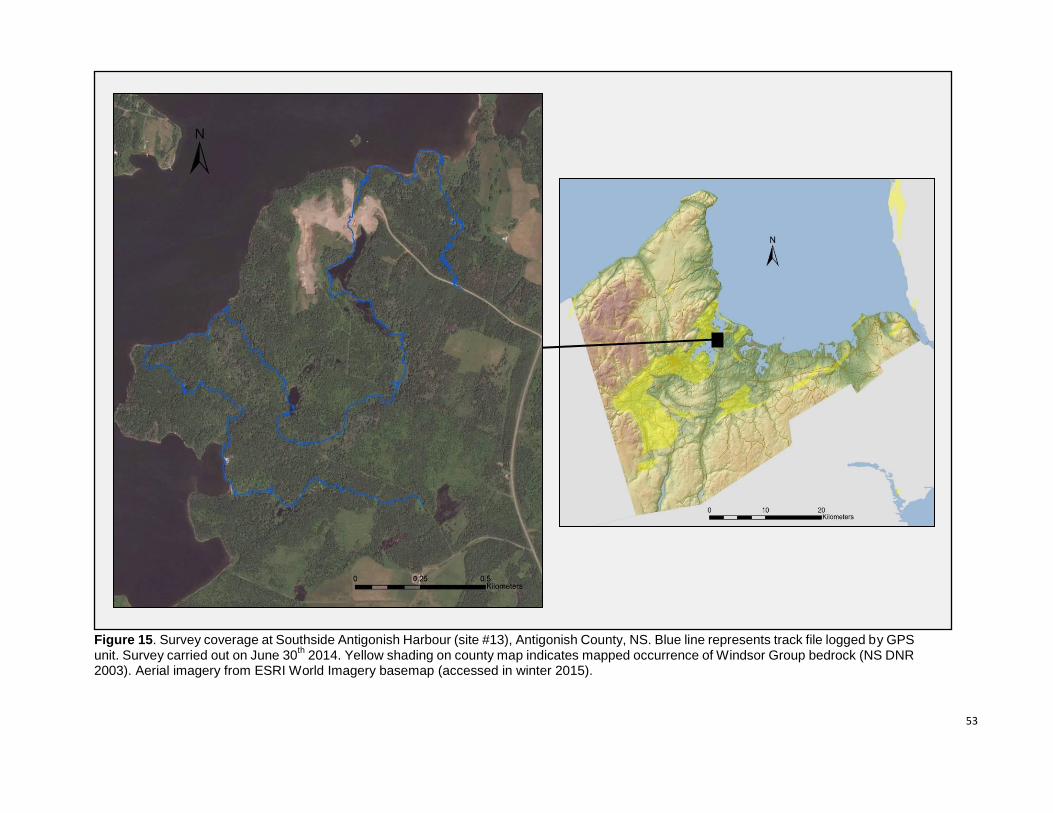
53
Figure 15. Survey coverage at Southside Antigonish Harbour (site #13), Antigonish County, NS. Blue line represents track file logged by GPS unit. Survey carried out on June 30
th 2014. Yellow shading on county map indicates mapped occurrence of Windsor Group bedrock (NS DNR
2003). Aerial imagery from ESRI World Imagery basemap (accessed in winter 2015).
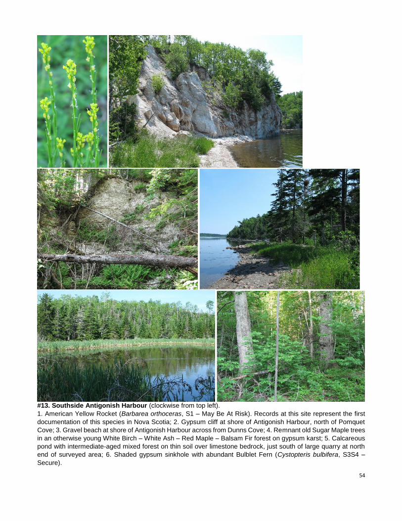
54
#13. Southside Antigonish Harbour (clockwise from top left).
1. American Yellow Rocket (Barbarea orthoceras, S1 – May Be At Risk). Records at this site represent the first
documentation of this species in Nova Scotia; 2. Gypsum cliff at shore of Antigonish Harbour, north of Pomquet
Cove; 3. Gravel beach at shore of Antigonish Harbour across from Dunns Cove; 4. Remnant old Sugar Maple trees
in an otherwise young White Birch – White Ash – Red Maple – Balsam Fir forest on gypsum karst; 5. Calcareous
pond with intermediate-aged mixed forest on thin soil over limestone bedrock, just south of large quarry at north
end of surveyed area; 6. Shaded gypsum sinkhole with abundant Bulblet Fern (Cystopteris bulbifera, S3S4 –
Secure).

55
#14. South River – Frasers Mills Observer(s): Blaney, C.S.
Survey date: July 25th 2014
Scientific Name Common Name S-Rank GS-Rank Records
Fraxinus nigra Black Ash S1S2 At Risk 3
Caulophyllum thalictroides Blue Cohosh S2 May Be At Risk 3
Lilium canadense Canada Lily S2 May Be At Risk 1
Osmorhiza longistylis Smoother Sweet-Cicely S2 May Be At Risk 2
Carex hirtifolia Pubescent Sedge S2S3 Sensitive 5
Triosteum aurantiacum Coffee Tinker’s-Weed S2S3 Sensitive 31
Agrimonia gryposepala Tall Hairy Groovebur S3 Secure 19
Carex rosea Rosy Sedge S3 Secure 1
Laportea canadensis Wood Nettle S3 Sensitive 2
Platanthera grandiflora Large Purple-Fringe Orchis S3 Secure 2
Verbena hastata Blue Vervain S3 Secure 15
Sanguinaria canadensis Bloodroot S3S4 Secure 25
Site Summary
Survey coverage at this site extended over about 3.5 km of river distance downstream from the Frasers Mills
bridge on Old Pinevale Road at the provincial fish hatchery. Much of the land between Dunmore Road on the
west side of the river and Highway 316 on the east has been converted to agriculture, or is regenerating after
past clearance. High quality natural areas in this stretch are limited to a narrow bands along the river
(generally less than 200 m wide) and to few larger patches, mostly in the upstream (southern) half of the area
surveyed.
The southernmost patch of more extensive forest just north of the Frasers Mills bridge included some
excellent remnant mature hardwood floodplain terrace forest of White Ash – Sugar Maple – Ironwood –
Beech. Although bedrock outcrops were not present anywhere in the surveyed area, bedrock effects on the
flora are evident. This southernmost area of mature remnant floodplain hardwoods had limited representation
the significant rich forest flora found further downstream in the zone noted as being underlain by Windsor
Group bedrock (probably limestone in this site). The small mature floodplain hardwood forest remnants over
Windsor Group bedrock supported massive patches of Bloodroot (Sanguisorba canadensis, S3S4 – Secure),
frequent Coffee Tinker’s-Weed (a.k.a. Wild Coffee; Triosteum aurantiacum, S2S3 – Sensitive), and smaller
amounts of Pubescent Sedge (Carex hirtifolia, S2S3 – Sensitive; locally abundant), Blue Cohosh
(Caulophyllum thalictroides, S2 – May Be At Risk; rare), and Canada Lily (Lilium canadense, S2 – May Be At
Risk; rare) under Sugar Maple – White Ash forest. The presence of this suite of species and the abundance
of Bloodroot and Orange-fruited Tinker’s-Weed suggests soils as rich as any in Nova Scotia. The most
significant of these remnant rich floodplain habitats were concentrated in a short stretch of river within about
250 m of the sharp bend 900 m northeast of the Frasers Mills bridge.
Most of the habitat along the river has been subject to a history of intensive human disturbance, and much of
the unmanaged vegetation within the floodplain is Speckled Alder (Alnus rugosa ssp. incana), Choke Cherry
(Prunus virginiana) and hawthorn (Crataegus spp.) thicket regenerating after past agricultural use, or in
slightly drier areas various combinations of White Spruce, White Ash, Apple (Malus pumila), and other shade
intolerant trees. The presence of numerous wild, mature and extensively reproducing European Linden (Tilia
x vulgaris) over at least 1.5 km of river was an unusual feature of the site. We have not noted this exotic
species being as thoroughly established in the wild anywhere else in Nova Scotia. Exotic herbaceous
species are frequent throughout, especially on the gravel river bars.
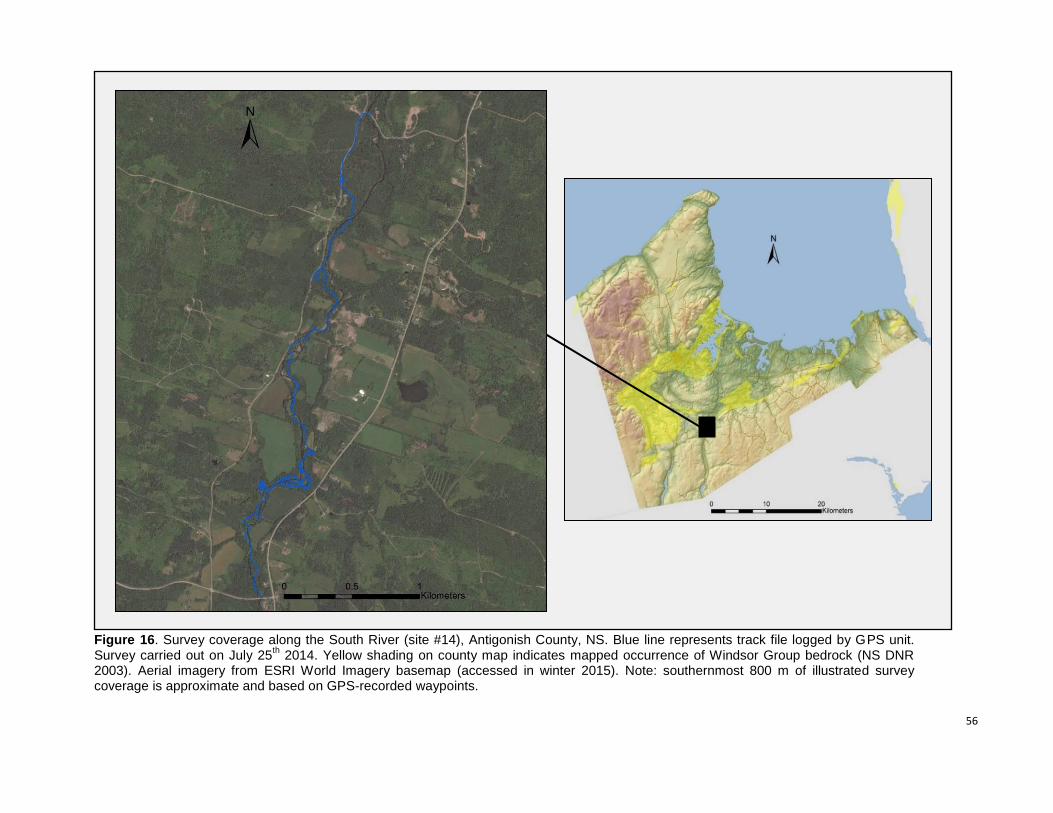
56
Figure 16. Survey coverage along the South River (site #14), Antigonish County, NS. Blue line represents track file logged by GPS unit. Survey carried out on July 25
th 2014. Yellow shading on county map indicates mapped occurrence of Windsor Group bedrock (NS DNR
2003). Aerial imagery from ESRI World Imagery basemap (accessed in winter 2015). Note: southernmost 800 m of illustrated survey coverage is approximate and based on GPS-recorded waypoints.
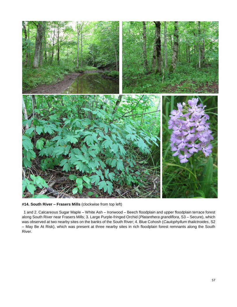
57
#14. South River – Frasers Mills (clockwise from top left)
1 and 2. Calcareous Sugar Maple – White Ash – Ironwood – Beech floodplain and upper floodplain terrace forest
along South River near Frasers Mills; 3. Large Purple-fringed Orchid (Platanthera grandiflora, S3 – Secure), which
was observed at two nearby sites on the banks of the South River; 4. Blue Cohosh (Caulophyllum thalictroides, S2
– May Be At Risk), which was present at three nearby sites in rich floodplain forest remnants along the South
River.
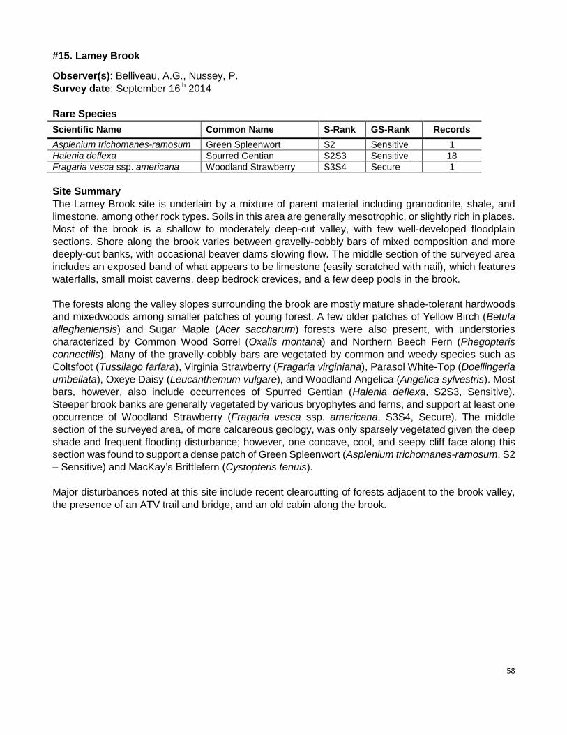
58
#15. Lamey Brook
Observer(s): Belliveau, A.G., Nussey, P.
Survey date: September 16th 2014
Rare Species
Scientific Name Common Name S-Rank GS-Rank Records
Asplenium trichomanes-ramosum Green Spleenwort S2 Sensitive 1
Halenia deflexa Spurred Gentian S2S3 Sensitive 18
Fragaria vesca ssp. americana Woodland Strawberry S3S4 Secure 1
Site Summary
The Lamey Brook site is underlain by a mixture of parent material including granodiorite, shale, and
limestone, among other rock types. Soils in this area are generally mesotrophic, or slightly rich in places.
Most of the brook is a shallow to moderately deep-cut valley, with few well-developed floodplain
sections. Shore along the brook varies between gravelly-cobbly bars of mixed composition and more
deeply-cut banks, with occasional beaver dams slowing flow. The middle section of the surveyed area
includes an exposed band of what appears to be limestone (easily scratched with nail), which features
waterfalls, small moist caverns, deep bedrock crevices, and a few deep pools in the brook.
The forests along the valley slopes surrounding the brook are mostly mature shade-tolerant hardwoods
and mixedwoods among smaller patches of young forest. A few older patches of Yellow Birch (Betula
alleghaniensis) and Sugar Maple (Acer saccharum) forests were also present, with understories
characterized by Common Wood Sorrel (Oxalis montana) and Northern Beech Fern (Phegopteris
connectilis). Many of the gravelly-cobbly bars are vegetated by common and weedy species such as
Coltsfoot (Tussilago farfara), Virginia Strawberry (Fragaria virginiana), Parasol White-Top (Doellingeria
umbellata), Oxeye Daisy (Leucanthemum vulgare), and Woodland Angelica (Angelica sylvestris). Most
bars, however, also include occurrences of Spurred Gentian (Halenia deflexa, S2S3, Sensitive).
Steeper brook banks are generally vegetated by various bryophytes and ferns, and support at least one
occurrence of Woodland Strawberry (Fragaria vesca ssp. americana, S3S4, Secure). The middle
section of the surveyed area, of more calcareous geology, was only sparsely vegetated given the deep
shade and frequent flooding disturbance; however, one concave, cool, and seepy cliff face along this
section was found to support a dense patch of Green Spleenwort (Asplenium trichomanes-ramosum, S2
– Sensitive) and MacKay’s Brittlefern (Cystopteris tenuis).
Major disturbances noted at this site include recent clearcutting of forests adjacent to the brook valley,
the presence of an ATV trail and bridge, and an old cabin along the brook.
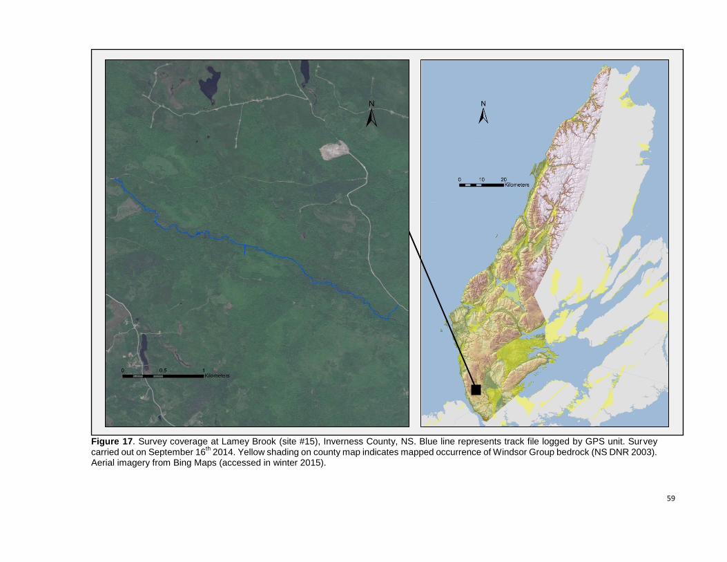
59
Figure 17. Survey coverage at Lamey Brook (site #15), Inverness County, NS. Blue line represents track file logged by GPS unit. Survey carried out on September 16
th 2014. Yellow shading on county map indicates mapped occurrence of Windsor Group bedrock (NS DNR 2003).
Aerial imagery from Bing Maps (accessed in winter 2015).
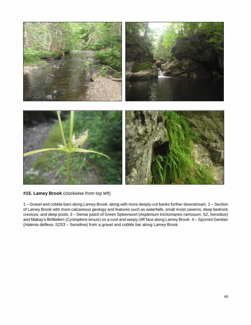
60
#15. Lamey Brook (clockwise from top left)
1 – Gravel and cobble bars along Lamey Brook, along with more deeply-cut banks further downstream. 2 – Section
of Lamey Brook with more calcareous geology and features such as waterfalls, small moist caverns, deep bedrock
crevices, and deep pools. 3 – Dense patch of Green Spleenwort (Asplenium trichomanes-ramosum, S2, Sensitive)
and Makay’s Brittlefern (Cystopteris tenuis) on a cool and seepy cliff face along Lamey Brook. 4 – Spurred Gentian
(Halenia deflexa, S2S3 – Sensitive) from a gravel and cobble bar along Lamey Brook.
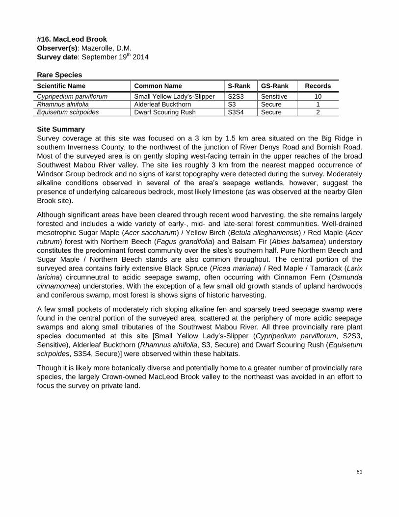
61
#16. MacLeod Brook
Observer(s): Mazerolle, D.M.
Survey date: September 19th 2014
Rare Species
Scientific Name Common Name S-Rank GS-Rank Records
Cypripedium parviflorum Small Yellow Lady’s-Slipper S2S3 Sensitive 10
Rhamnus alnifolia Alderleaf Buckthorn S3 Secure 1
Equisetum scirpoides Dwarf Scouring Rush S3S4 Secure 2
Site Summary
Survey coverage at this site was focused on a 3 km by 1.5 km area situated on the Big Ridge in
southern Inverness County, to the northwest of the junction of River Denys Road and Bornish Road.
Most of the surveyed area is on gently sloping west-facing terrain in the upper reaches of the broad
Southwest Mabou River valley. The site lies roughly 3 km from the nearest mapped occurrence of
Windsor Group bedrock and no signs of karst topography were detected during the survey. Moderately
alkaline conditions observed in several of the area’s seepage wetlands, however, suggest the
presence of underlying calcareous bedrock, most likely limestone (as was observed at the nearby Glen
Brook site).
Although significant areas have been cleared through recent wood harvesting, the site remains largely
forested and includes a wide variety of early-, mid- and late-seral forest communities. Well-drained
mesotrophic Sugar Maple (Acer saccharum) / Yellow Birch (Betula alleghaniensis) / Red Maple (Acer
rubrum) forest with Northern Beech (Fagus grandifolia) and Balsam Fir (Abies balsamea) understory
constitutes the predominant forest community over the sites’s southern half. Pure Northern Beech and
Sugar Maple / Northern Beech stands are also common throughout. The central portion of the
surveyed area contains fairly extensive Black Spruce (Picea mariana) / Red Maple / Tamarack (Larix
laricina) circumneutral to acidic seepage swamp, often occurring with Cinnamon Fern (Osmunda
cinnamomea) understories. With the exception of a few small old growth stands of upland hardwoods
and coniferous swamp, most forest is shows signs of historic harvesting.
A few small pockets of moderately rich sloping alkaline fen and sparsely treed seepage swamp were
found in the central portion of the surveyed area, scattered at the periphery of more acidic seepage
swamps and along small tributaries of the Southwest Mabou River. All three provincially rare plant
species documented at this site [Small Yellow Lady’s-Slipper (Cypripedium parviflorum, S2S3,
Sensitive), Alderleaf Buckthorn (Rhamnus alnifolia, S3, Secure) and Dwarf Scouring Rush (Equisetum
scirpoides, S3S4, Secure)] were observed within these habitats.
Though it is likely more botanically diverse and potentially home to a greater number of provincially rare
species, the largely Crown-owned MacLeod Brook valley to the northeast was avoided in an effort to
focus the survey on private land.
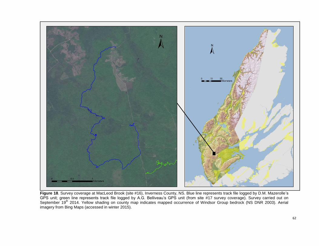
62
Figure 18. Survey coverage at MacLeod Brook (site #16), Inverness County, NS. Blue line represents track file logged by D.M. Mazerolle ’s GPS unit; green line represents track file logged by A.G. Belliveau’s GPS unit (from site #17 survey coverage). Survey carried out on September 19
th 2014. Yellow shading on county map indicates mapped occurrence of Windsor Group bedrock (NS DNR 2003). Aerial
imagery from Bing Maps (accessed in winter 2015).
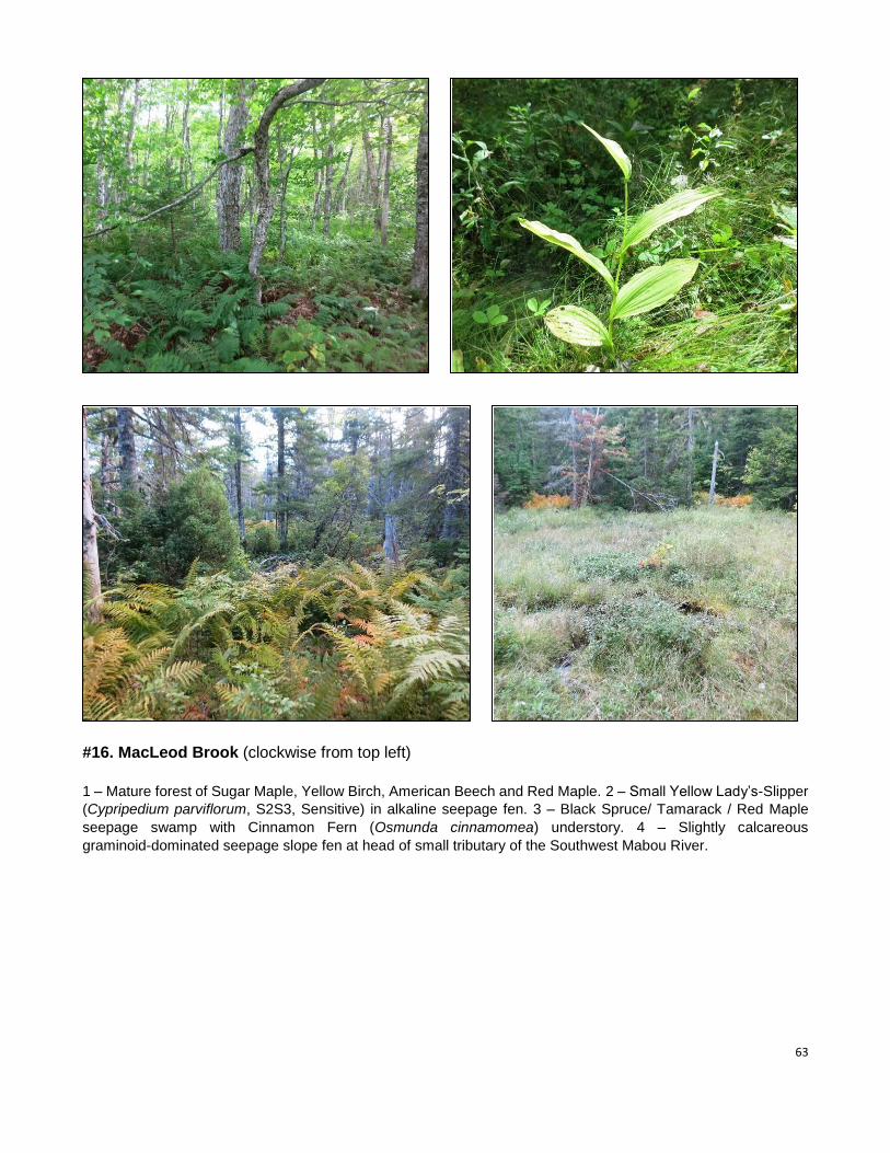
63
#16. MacLeod Brook (clockwise from top left)
1 – Mature forest of Sugar Maple, Yellow Birch, American Beech and Red Maple. 2 – Small Yellow Lady’s-Slipper
(Cypripedium parviflorum, S2S3, Sensitive) in alkaline seepage fen. 3 – Black Spruce/ Tamarack / Red Maple
seepage swamp with Cinnamon Fern (Osmunda cinnamomea) understory. 4 – Slightly calcareous
graminoid-dominated seepage slope fen at head of small tributary of the Southwest Mabou River.
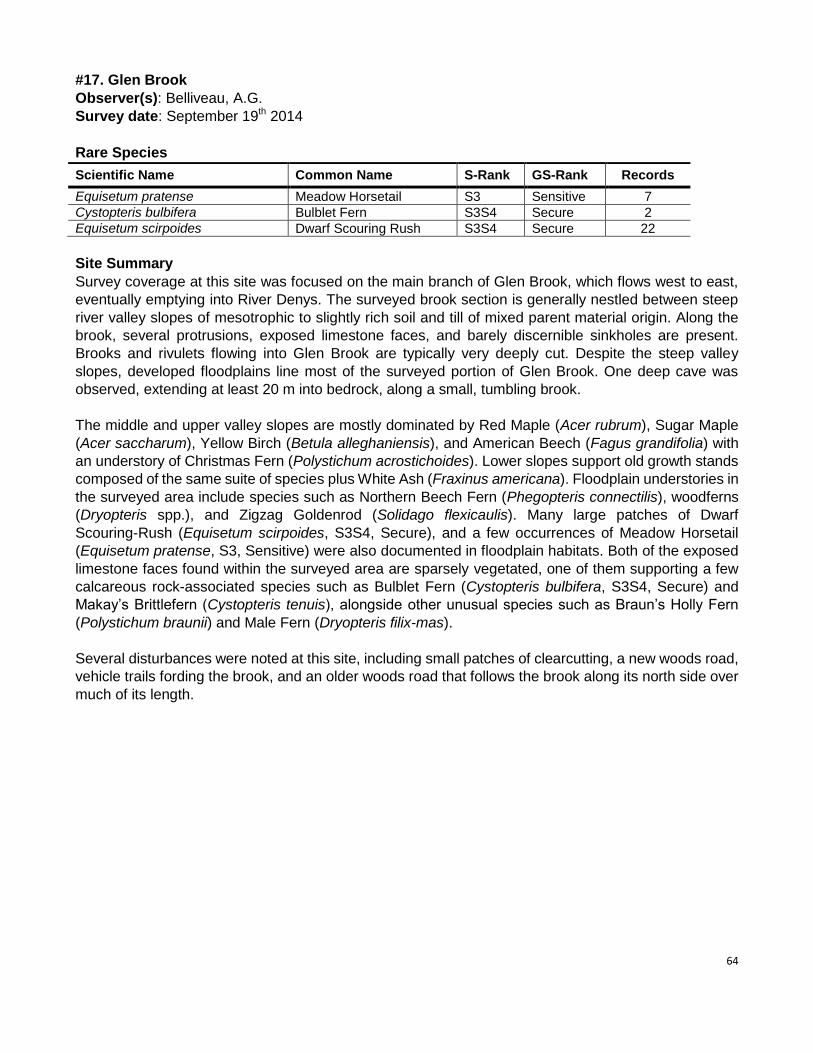
64
#17. Glen Brook
Observer(s): Belliveau, A.G.
Survey date: September 19th 2014
Rare Species
Scientific Name Common Name S-Rank GS-Rank Records
Equisetum pratense Meadow Horsetail S3 Sensitive 7
Cystopteris bulbifera Bulblet Fern S3S4 Secure 2
Equisetum scirpoides Dwarf Scouring Rush S3S4 Secure 22
Site Summary
Survey coverage at this site was focused on the main branch of Glen Brook, which flows west to east,
eventually emptying into River Denys. The surveyed brook section is generally nestled between steep
river valley slopes of mesotrophic to slightly rich soil and till of mixed parent material origin. Along the
brook, several protrusions, exposed limestone faces, and barely discernible sinkholes are present.
Brooks and rivulets flowing into Glen Brook are typically very deeply cut. Despite the steep valley
slopes, developed floodplains line most of the surveyed portion of Glen Brook. One deep cave was
observed, extending at least 20 m into bedrock, along a small, tumbling brook.
The middle and upper valley slopes are mostly dominated by Red Maple (Acer rubrum), Sugar Maple
(Acer saccharum), Yellow Birch (Betula alleghaniensis), and American Beech (Fagus grandifolia) with
an understory of Christmas Fern (Polystichum acrostichoides). Lower slopes support old growth stands
composed of the same suite of species plus White Ash (Fraxinus americana). Floodplain understories in
the surveyed area include species such as Northern Beech Fern (Phegopteris connectilis), woodferns
(Dryopteris spp.), and Zigzag Goldenrod (Solidago flexicaulis). Many large patches of Dwarf
Scouring-Rush (Equisetum scirpoides, S3S4, Secure), and a few occurrences of Meadow Horsetail
(Equisetum pratense, S3, Sensitive) were also documented in floodplain habitats. Both of the exposed
limestone faces found within the surveyed area are sparsely vegetated, one of them supporting a few
calcareous rock-associated species such as Bulblet Fern (Cystopteris bulbifera, S3S4, Secure) and
Makay’s Brittlefern (Cystopteris tenuis), alongside other unusual species such as Braun’s Holly Fern
(Polystichum braunii) and Male Fern (Dryopteris filix-mas).
Several disturbances were noted at this site, including small patches of clearcutting, a new woods road,
vehicle trails fording the brook, and an older woods road that follows the brook along its north side over
much of its length.
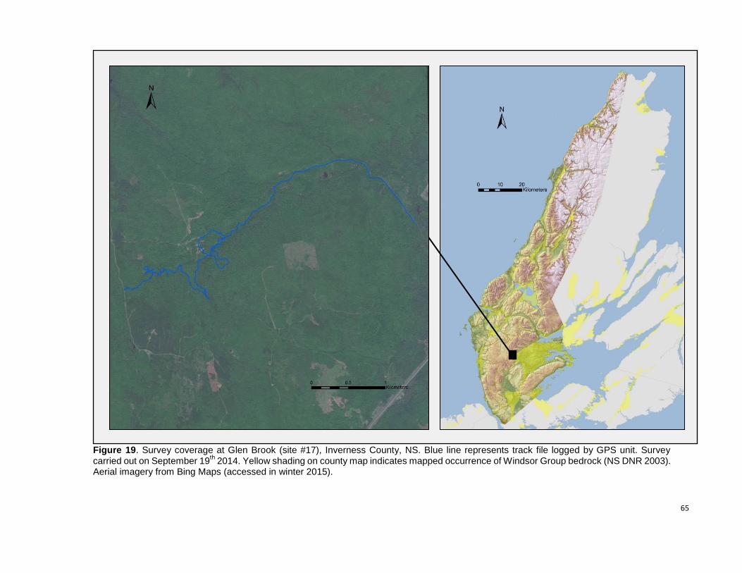
65
Figure 19. Survey coverage at Glen Brook (site #17), Inverness County, NS. Blue line represents track file logged by GPS unit. Survey carried out on September 19
th 2014. Yellow shading on county map indicates mapped occurrence of Windsor Group bedrock (NS DNR 2003).
Aerial imagery from Bing Maps (accessed in winter 2015).
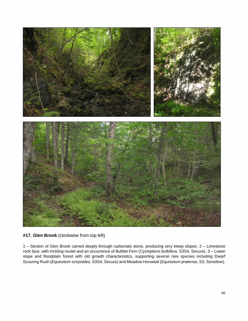
66
#17. Glen Brook (clockwise from top left)
1 – Section of Glen Brook carved deeply through carbonate stone, producing very steep slopes. 2 – Limestone
rock face, with trickling rivulet and an occurrence of Bulblet Fern (Cystopteris bulbifera, S3S4, Secure). 3 – Lower
slope and floodplain forest with old growth characteristics, supporting several rare species including Dwarf
Scouring Rush (Equisetum scirpoides, S3S4, Secure) and Meadow Horsetail (Equisetum pratense, S3, Sensitive).
67
#18. MacPhail Brook
Observer(s): Blaney, C.S.
Survey date: September 19th 2014
Rare Species
Scientific Name Common Name S-Rank GS-Rank Records
Asplenium trichomanes-ramosum Green Spleenwort S2 Sensitive 2
Halenia deflexa Spurred Gentian S2S3 Sensitive 1
Asplenium trichomanes Maidenhair Spleenwort S3 Secure 2
Pyrola asarifolia Pink Wintergreen S3 Secure 3
Rhamnus alnifolia Alderleaf Buckthorn S3 Secure 2
Cystopteris bulbifera Bulblet Fern S3S4 Secure 21
Site Summary
Survey coverage at this site was focused primarily along 2.7 km of the MacPhail Brook valley.
The stream runs almost due east in this area in a deep, narrow, steep-sided valley. The
south-facing slope is dominated by Sugar Maple with varying proportions of Beech and
Yellow Birch, while the north facing slope has more spruce (probably mostly Red Spruce,
although attention to spruces was limited). Almost all of the stream distance surveyed was
underlain by limestone, with extensive outcrops present immediately along MacPhail Brook
and forming several small waterfalls. Bulblet Fern was common over much of the stream
distance surveyed on mossy shoreline limestone outcrops. Some larger outcrops partway up
the steep valley slopes supported two additional rare ferns (Green and Maidenhair
Spleenwort, Asplenium trichmanes-ramosum and A. trichomanes). Because site coverage
was mostly along the stream and outcrops partway up the forested slopes were generally not
visible from the valley bottom, it is likely that additional interesting limestone outcrops are
present in the area but undocumented. The stream valley is mostly too narrow and steep
sided to have well-developed floodplain communities, but we did document a few locations
for Pink Wintergreen (Pyrola asarifolia, S3 – Secure), typical of calcareous floodplain
terraces, and fairly rich calcareous seepage communities were frequent near the slope bases
just up from the brook.
A small pond occurs at the far northwest end of the surveyed area. Water levels there were
reduced because of a recently broken beaver dam. The pond margins were mostly marshy to
peaty sedge and shrub dominated communities, and the area supported a small population
of Alderleaf Buckthorn (Rhamnus alnifolia, S3 – Secure) which was also locally present
further northwest in a seepy side channel stream within a cut-over area.
The steep valley slopes along MacPhail Brook were generally in excellent condition with little
or no human disturbance, many old trees and some portions that would likely qualify as old
growth. Forest on the north side of the plateau along the Upper Glencoe Road, and along the
western most area surveyed is more disturbed, with extensive heavy selective cutting for
firewood and local regenerating clearcuts of various ages. Aerial photos suggest that
unsurveyed forest on the plateau south of the MacPhail Brook valley appears to include
extensive mature, undisturbed hardwood and mixed stands.
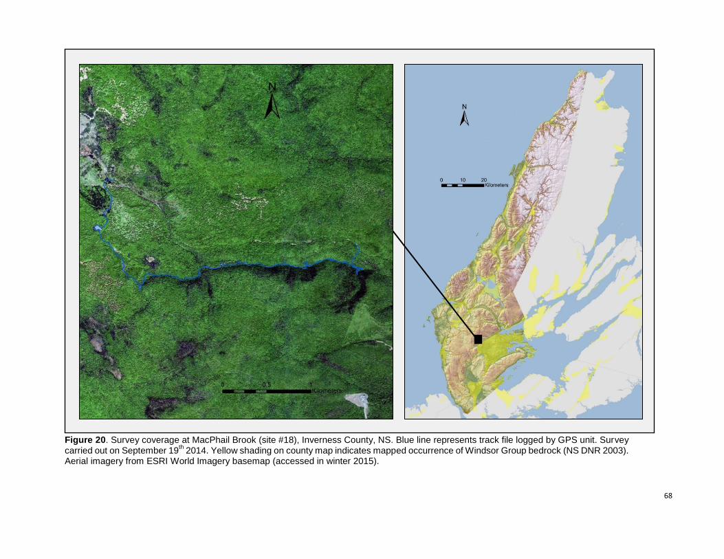
68
Figure 20. Survey coverage at MacPhail Brook (site #18), Inverness County, NS. Blue line represents track file logged by GPS unit. Survey carried out on September 19
th 2014. Yellow shading on county map indicates mapped occurrence of Windsor Group bedrock (NS DNR 2003).
Aerial imagery from ESRI World Imagery basemap (accessed in winter 2015).
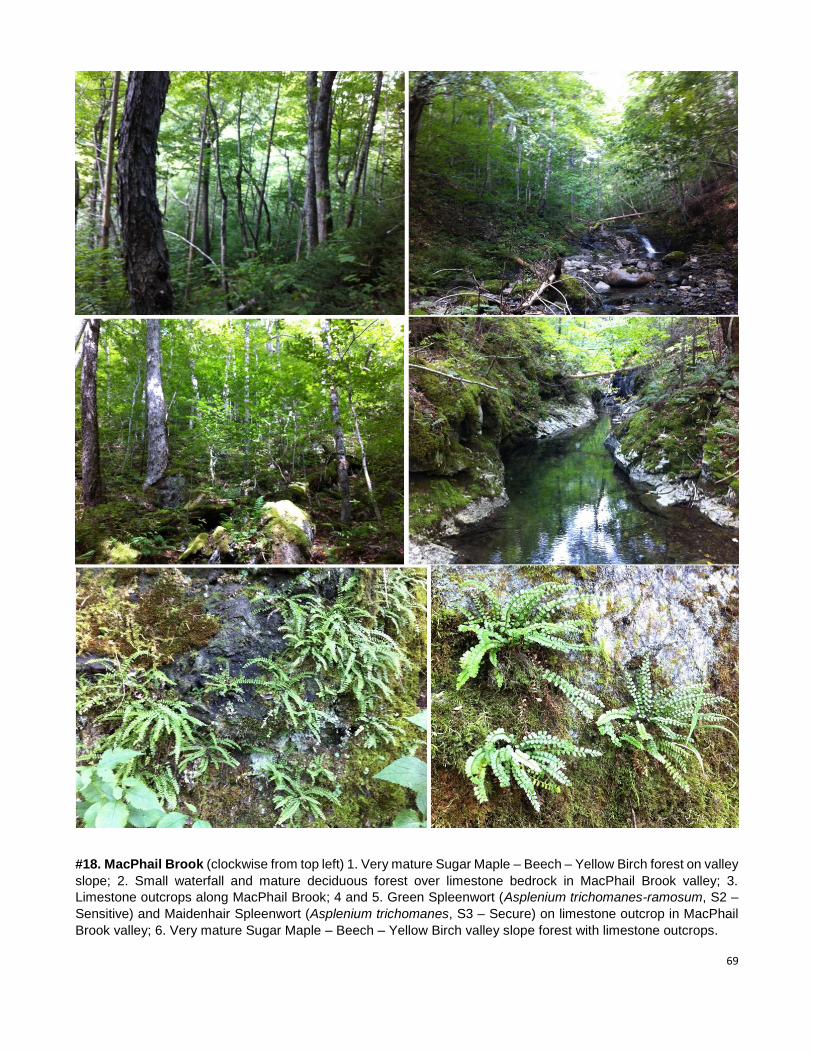
69
#18. MacPhail Brook (clockwise from top left) 1. Very mature Sugar Maple – Beech – Yellow Birch forest on valley
slope; 2. Small waterfall and mature deciduous forest over limestone bedrock in MacPhail Brook valley; 3.
Limestone outcrops along MacPhail Brook; 4 and 5. Green Spleenwort (Asplenium trichomanes-ramosum, S2 –
Sensitive) and Maidenhair Spleenwort (Asplenium trichomanes, S3 – Secure) on limestone outcrop in MacPhail
Brook valley; 6. Very mature Sugar Maple – Beech – Yellow Birch valley slope forest with limestone outcrops.
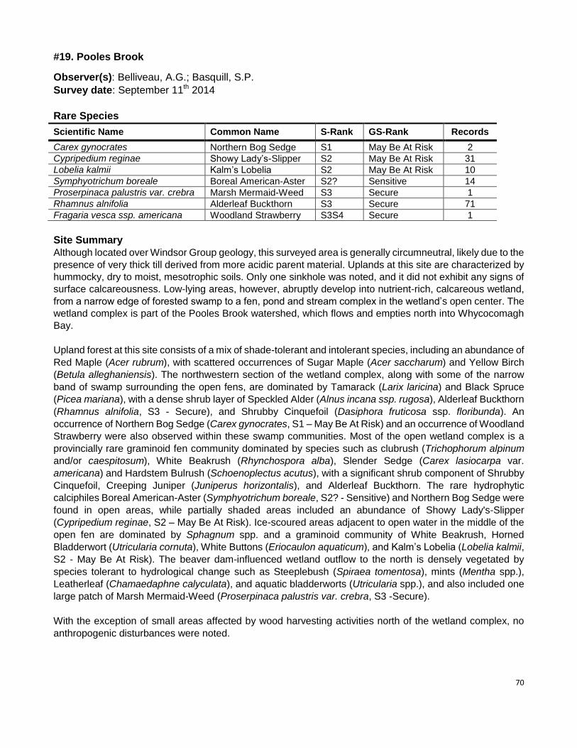
70
#19. Pooles Brook
Observer(s): Belliveau, A.G.; Basquill, S.P.
Survey date: September 11th 2014
Rare Species
Scientific Name Common Name S-Rank GS-Rank Records
Carex gynocrates Northern Bog Sedge S1 May Be At Risk 2
Cypripedium reginae Showy Lady’s-Slipper S2 May Be At Risk 31
Lobelia kalmii Kalm’s Lobelia S2 May Be At Risk 10
Symphyotrichum boreale Boreal American-Aster S2? Sensitive 14
Proserpinaca palustris var. crebra Marsh Mermaid-Weed S3 Secure 1
Rhamnus alnifolia Alderleaf Buckthorn S3 Secure 71
Fragaria vesca ssp. americana Woodland Strawberry S3S4 Secure 1
Site Summary
Although located over Windsor Group geology, this surveyed area is generally circumneutral, likely due to the
presence of very thick till derived from more acidic parent material. Uplands at this site are characterized by
hummocky, dry to moist, mesotrophic soils. Only one sinkhole was noted, and it did not exhibit any signs of
surface calcareousness. Low-lying areas, however, abruptly develop into nutrient-rich, calcareous wetland,
from a narrow edge of forested swamp to a fen, pond and stream complex in the wetland’s open center. The
wetland complex is part of the Pooles Brook watershed, which flows and empties north into Whycocomagh
Bay.
Upland forest at this site consists of a mix of shade-tolerant and intolerant species, including an abundance of
Red Maple (Acer rubrum), with scattered occurrences of Sugar Maple (Acer saccharum) and Yellow Birch
(Betula alleghaniensis). The northwestern section of the wetland complex, along with some of the narrow
band of swamp surrounding the open fens, are dominated by Tamarack (Larix laricina) and Black Spruce
(Picea mariana), with a dense shrub layer of Speckled Alder (Alnus incana ssp. rugosa), Alderleaf Buckthorn
(Rhamnus alnifolia, S3 - Secure), and Shrubby Cinquefoil (Dasiphora fruticosa ssp. floribunda). An
occurrence of Northern Bog Sedge (Carex gynocrates, S1 – May Be At Risk) and an occurrence of Woodland
Strawberry were also observed within these swamp communities. Most of the open wetland complex is a
provincially rare graminoid fen community dominated by species such as clubrush (Trichophorum alpinum
and/or caespitosum), White Beakrush (Rhynchospora alba), Slender Sedge (Carex lasiocarpa var.
americana) and Hardstem Bulrush (Schoenoplectus acutus), with a significant shrub component of Shrubby
Cinquefoil, Creeping Juniper (Juniperus horizontalis), and Alderleaf Buckthorn. The rare hydrophytic
calciphiles Boreal American-Aster (Symphyotrichum boreale, S2? - Sensitive) and Northern Bog Sedge were
found in open areas, while partially shaded areas included an abundance of Showy Lady's-Slipper
(Cypripedium reginae, S2 – May Be At Risk). Ice-scoured areas adjacent to open water in the middle of the
open fen are dominated by Sphagnum spp. and a graminoid community of White Beakrush, Horned
Bladderwort (Utricularia cornuta), White Buttons (Eriocaulon aquaticum), and Kalm’s Lobelia (Lobelia kalmii,
S2 - May Be At Risk). The beaver dam-influenced wetland outflow to the north is densely vegetated by
species tolerant to hydrological change such as Steeplebush (Spiraea tomentosa), mints (Mentha spp.),
Leatherleaf (Chamaedaphne calyculata), and aquatic bladderworts (Utricularia spp.), and also included one
large patch of Marsh Mermaid-Weed (Proserpinaca palustris var. crebra, S3 -Secure).
With the exception of small areas affected by wood harvesting activities north of the wetland complex, no
anthropogenic disturbances were noted.
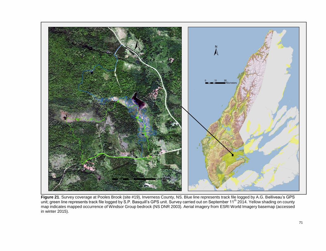
71
Figure 21. Survey coverage at Pooles Brook (site #19), Inverness County, NS. Blue line represents track file logged by A.G. Belliveau’s GPS unit; green line represents track file logged by S.P. Basquill’s GPS unit. Survey carried out on September 11
th 2014. Yellow shading on county
map indicates mapped occurrence of Windsor Group bedrock (NS DNR 2003). Aerial imagery from ESRI World Imagery basemap (accessed in winter 2015).
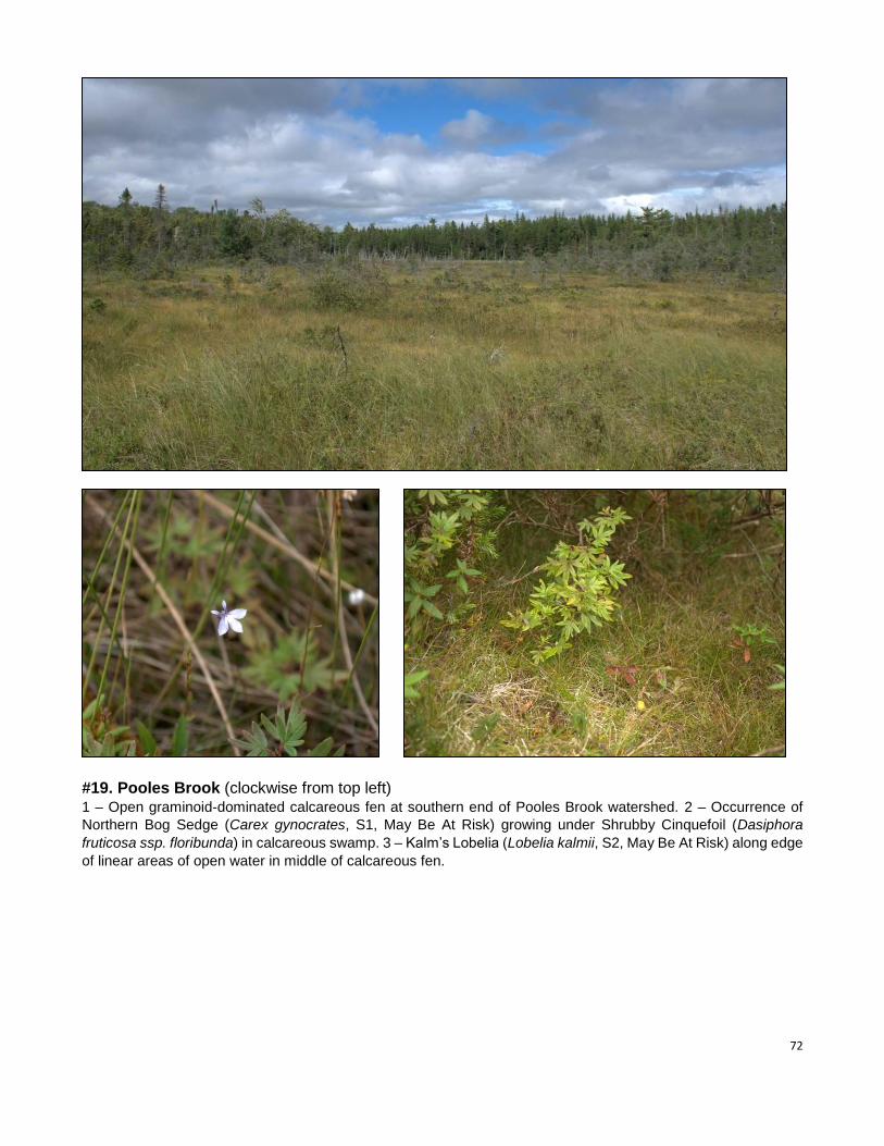
72
#19. Pooles Brook (clockwise from top left) 1 – Open graminoid-dominated calcareous fen at southern end of Pooles Brook watershed. 2 – Occurrence of
Northern Bog Sedge (Carex gynocrates, S1, May Be At Risk) growing under Shrubby Cinquefoil (Dasiphora
fruticosa ssp. floribunda) in calcareous swamp. 3 – Kalm’s Lobelia (Lobelia kalmii, S2, May Be At Risk) along edge
of linear areas of open water in middle of calcareous fen.
73
#20. MacLeans Brook
Observer(s): Mazerolle, D.M.
Survey date: September 11th 2014
Rare Species
Scientific Name Common Name S-Rank GS-Rank Records
Lobelia kalmii Kalm’s Lobelia S2 May Be At Risk 3
Symphyotrichum boreale Boreal American-Aster S2? Sensitive 2
Agrimonia gryposepala Tall Hairy Groovebur S3 Secure 2
Rhamnus alnifolia Alderleaf Buckthorn S3 Secure 11
Asclepias incarnata ssp. pulchra Swamp Milkweed S3? Undetermined 1
Epilobium ciliatum / coloratum willowherb sp. - - 2
Site Summary
Situated near Seal Cove at the eastern end of Denys Basin, surveys at this site extended over 3.5 km
along MacLeans Brook and included an area of open peatland south of Ashfield. Small occurrences of
light karst topography are evident roughly 1 km northwest of the mouth of MacLeans Brook and 1.5 km
further to the southwest, where gentle sinkholes, shallow sinkhole ponds and moderately incised
gulleys were observed. These karstic areas also include small pockets of fairly alkaline seepage
wetland, which provide further evidence of underlying calcareous bedrock. The very limited surficial
expression of Windsor Group bedrock at this site, however, suggests the presence of significant
overburden.
A large majority of the MacLeans Brook area has been heavily disturbed through extensive wood
harvesting activities which have cleared large swaths of forest, leaving very few intact mature stands.
Much of the remaining forest along the brook is second growth and presently dominated by Red Maple
(Acer rubrum), White Spruce (Picea glauca) and shade intolerant hardwoods such as Trembling Aspen
(Populus tremuloides) and Paper Birch (Betula papyrifera var. papyrifera). Oligotrophic acidic Black
Spruce (Picea mariana) seepage swamp is also locally common. Along the upper surveyed section of
the brook, remnant riparian bands and sheltered gulleys contain small stands of mature shade-tolerant
hardwoods and mixedwood forest composed of Red Maple, Yellow Birch (Betula alleghaniensis),
Sugar Maple (Acer saccharum), Eastern Hemlock (Tsuga canadensis) and Eastern White Pine (Pinus
strobus).
The western end of the surveyed area includes a nutrient-rich alkaline fen fed by groundwater seepage
through calcareous bedrock and characterized by a community of Alpine Cotton-Grass (Trichophorum
alpinum), Creeping Juniper (Juniperus horizontalis), Twig Rush (Cladium mariscoides), Sweet Gale
(Myrica gale) and Shrubby Cinquefoil (Dasiphora fruticosa ssp. floribunda). This small graminoid and
low shrub peatland (roughly 350 m x 100 m in size), which represents the most floristically significant
area at the site, supports small populations of the very rare Kalm’s Lobelia (Lobelia kalmii, S2, May Be
At Risk) and Boreal American-Aster (Symphyotrichum boreale, S2?, Sensitive). Moderately calcareous
Speckled Alder (Alnus incana ssp. rugosa) swales and shrubby fens, some of which contain large
populations of Alderleaf Buckthorn (Rhamnus alnifolia, S3S4, Secure), were also observed at the
western and southern ends of the surveyed area.
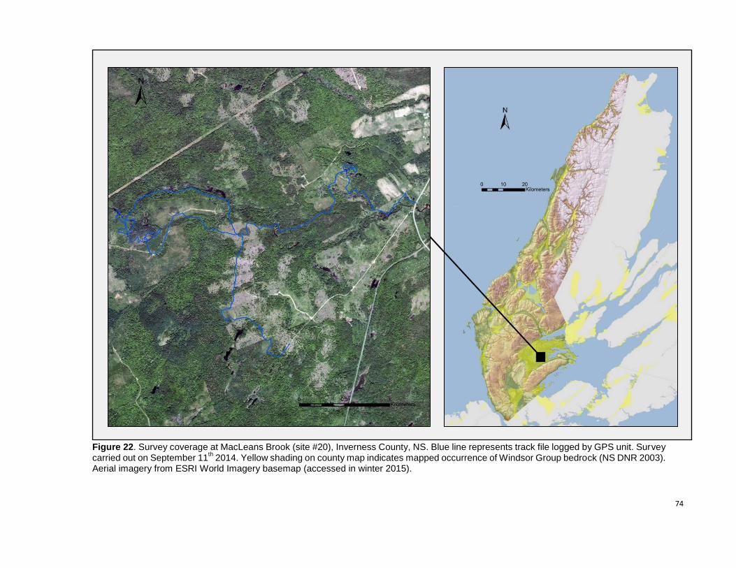
74
Figure 22. Survey coverage at MacLeans Brook (site #20), Inverness County, NS. Blue line represents track file logged by GPS unit. Survey carried out on September 11
th 2014. Yellow shading on county map indicates mapped occurrence of Windsor Group bedrock (NS DNR 2003).
Aerial imagery from ESRI World Imagery basemap (accessed in winter 2015).
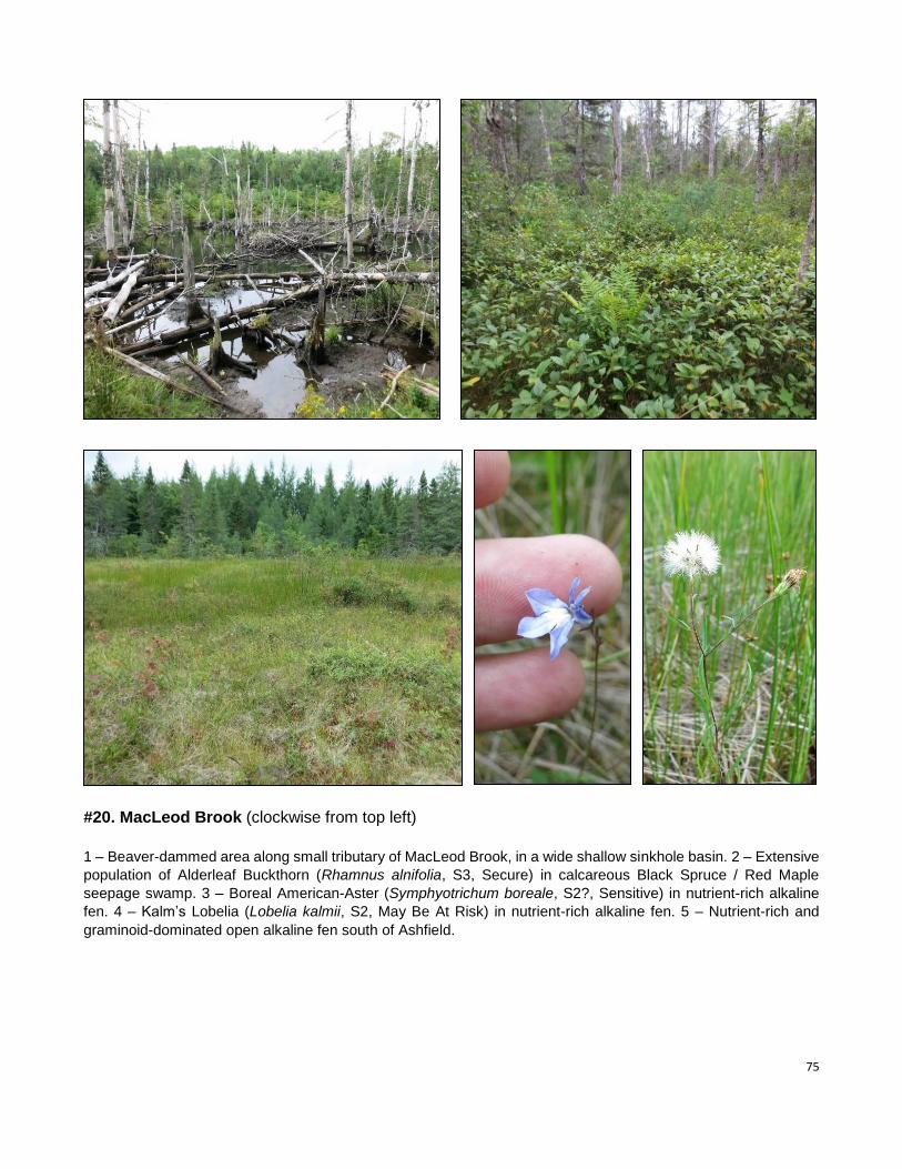
75
#20. MacLeod Brook (clockwise from top left)
1 – Beaver-dammed area along small tributary of MacLeod Brook, in a wide shallow sinkhole basin. 2 – Extensive
population of Alderleaf Buckthorn (Rhamnus alnifolia, S3, Secure) in calcareous Black Spruce / Red Maple
seepage swamp. 3 – Boreal American-Aster (Symphyotrichum boreale, S2?, Sensitive) in nutrient-rich alkaline
fen. 4 – Kalm’s Lobelia (Lobelia kalmii, S2, May Be At Risk) in nutrient-rich alkaline fen. 5 – Nutrient-rich and
graminoid-dominated open alkaline fen south of Ashfield.
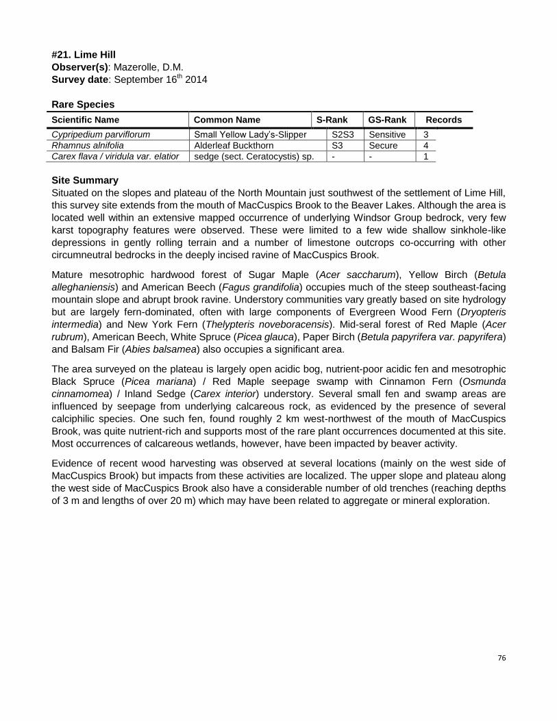
76
#21. Lime Hill
Observer(s): Mazerolle, D.M.
Survey date: September 16th 2014
Rare Species
Scientific Name Common Name S-Rank GS-Rank Records
Cypripedium parviflorum Small Yellow Lady’s-Slipper S2S3 Sensitive 3
Rhamnus alnifolia Alderleaf Buckthorn S3 Secure 4
Carex flava / viridula var. elatior sedge (sect. Ceratocystis) sp. - - 1
Site Summary
Situated on the slopes and plateau of the North Mountain just southwest of the settlement of Lime Hill,
this survey site extends from the mouth of MacCuspics Brook to the Beaver Lakes. Although the area is
located well within an extensive mapped occurrence of underlying Windsor Group bedrock, very few
karst topography features were observed. These were limited to a few wide shallow sinkhole-like
depressions in gently rolling terrain and a number of limestone outcrops co-occurring with other
circumneutral bedrocks in the deeply incised ravine of MacCuspics Brook.
Mature mesotrophic hardwood forest of Sugar Maple (Acer saccharum), Yellow Birch (Betula
alleghaniensis) and American Beech (Fagus grandifolia) occupies much of the steep southeast-facing
mountain slope and abrupt brook ravine. Understory communities vary greatly based on site hydrology
but are largely fern-dominated, often with large components of Evergreen Wood Fern (Dryopteris
intermedia) and New York Fern (Thelypteris noveboracensis). Mid-seral forest of Red Maple (Acer
rubrum), American Beech, White Spruce (Picea glauca), Paper Birch (Betula papyrifera var. papyrifera)
and Balsam Fir (Abies balsamea) also occupies a significant area.
The area surveyed on the plateau is largely open acidic bog, nutrient-poor acidic fen and mesotrophic
Black Spruce (Picea mariana) / Red Maple seepage swamp with Cinnamon Fern (Osmunda
cinnamomea) / Inland Sedge (Carex interior) understory. Several small fen and swamp areas are
influenced by seepage from underlying calcareous rock, as evidenced by the presence of several
calciphilic species. One such fen, found roughly 2 km west-northwest of the mouth of MacCuspics
Brook, was quite nutrient-rich and supports most of the rare plant occurrences documented at this site.
Most occurrences of calcareous wetlands, however, have been impacted by beaver activity.
Evidence of recent wood harvesting was observed at several locations (mainly on the west side of
MacCuspics Brook) but impacts from these activities are localized. The upper slope and plateau along
the west side of MacCuspics Brook also have a considerable number of old trenches (reaching depths
of 3 m and lengths of over 20 m) which may have been related to aggregate or mineral exploration.
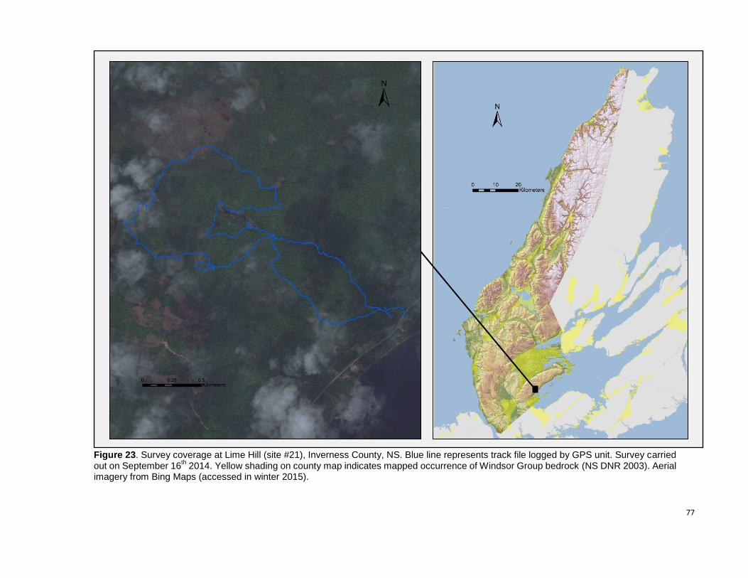
77
Figure 23. Survey coverage at Lime Hill (site #21), Inverness County, NS. Blue line represents track file logged by GPS unit. Survey carried out on September 16
th 2014. Yellow shading on county map indicates mapped occurrence of Windsor Group bedrock (NS DNR 2003). Aerial
imagery from Bing Maps (accessed in winter 2015).
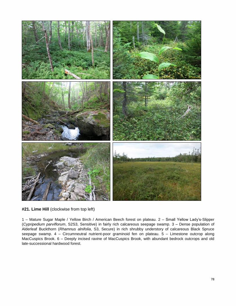
78
#21. Lime Hill (clockwise from top left)
1 – Mature Sugar Maple / Yellow Birch / American Beech forest on plateau. 2 – Small Yellow Lady’s-Slipper
(Cypripedium parviflorum, S2S3, Sensitive) in fairly rich calcareous seepage swamp. 3 – Dense population of
Alderleaf Buckthorn (Rhamnus alnifolia, S3, Secure) in rich shrubby understory of calcareous Black Spruce
seepage swamp. 4 – Circumneutral nutrient-poor graminoid fen on plateau. 5 – Limestone outcrop along
MacCuspics Brook. 6 – Deeply incised ravine of MacCuspics Brook, with abundant bedrock outcrops and old
late-successional hardwood forest.
79
#22. McIntyre Brook
Observer(s): Blaney, C.S.; Basquill, S.P.
Survey date: September 16th 2014
Rare Species
Scientific Name Common Name S-Rank GS-Rank Records
Lobelia kalmii Kalm’s Lobelia S2 May Be At Risk 2
Rhamnus alnifolia Alderleaf Buckthorn S3 Secure 1
Sparganium natans Small Bur-Reed S3 Secure 1
Carex cryptolepis Northeastern Sedge S3 Secure 3
Panicum tuckermanii Philadelphia Panic Grass S3S4 Secure 1
Hypericum cf. dissimulatum Disguised St. John's-Wort [S2S3] [Sensitive] 2
Carex poss. rostrata x utriculata hybrid sedge sp. - - 1
Spiranthes cernua / ochroleuca ladies’-tresses sp. - - 1
Site Summary
Coverage at McIntyre Brook involved overlapping surveys by Sean Basquill and Sean
Blaney. The site did not include any exposed bedrock, but calcareous soil conditions were
locally present in and around the fen at the north end of the area. This site was significant in
supporting good examples of a provincially rare calcareous Shrubby Cinquefoil (Dasiphora
fruticosa ssp. floribunda)-dominated fen that would be a good site for Dorcas Copper butterfly
(Lycaena dorcas, S1 and only recently documented for Nova Scotia from several similar sites
in southern Cape Breton). The wetter, graminoid-dominated parts of this fen had a large
population of a curious hybrid sedge that may have been Carex rostrata x utriculata, a hybrid
never before documented in Nova Scotia. Carex rostrata (Narrow-leaved Beaked Sedge,
S1? – May Be At Risk) is a somewhat calciphilic boreal species that is otherwise known in
Nova Scotia from only one record on St. Paul Island off the northern tip of Cape Breton. This
fen was also the location for the records of Kalm’s Lobelia (Lobelia kalmii, S2 - May Be At
Risk), Alderleaf Buckthorn (Rhamnus alnifolia, S3 – Secure) and Small Bur-Reed
(Sparganium natans, S3 – Secure)
The two larger ponds south of the fen may be of sinkhole origin. Shoreline at these ponds
exposed by receding water levels supported the occurrences of Northeastern Sedge (Carex
cryptolepis, S3 – Secure), St. John’s-Wort (grading toward Disguised St. John’s-Wort,
Hypericum dissimulatum, S2S3 – Sensitive) and ladies’-tresses (possibly Spiranthes
ochroleuca, S3 – Secure, but not yet in flower).
The forest at the site included some good intermediate to mature Beech – Sugar Maple –
Yellow Birch upland forest on the upper slopes of North Mountain, and some calcareous
Black Spruce – Tamarack swamp forest around the calcareous fen margins. The lower
slopes of North Mountain were younger, open, post-agricultural mixed forest regeneration
with an understory that included a large portion of exotic species in some areas.
The occurrence of Philadelphia Panic Grass (Panicum tuckermanii, S3S4 – Secure) was an
introduced population along Marble Mountain Road that represented the first Cape Breton
record.
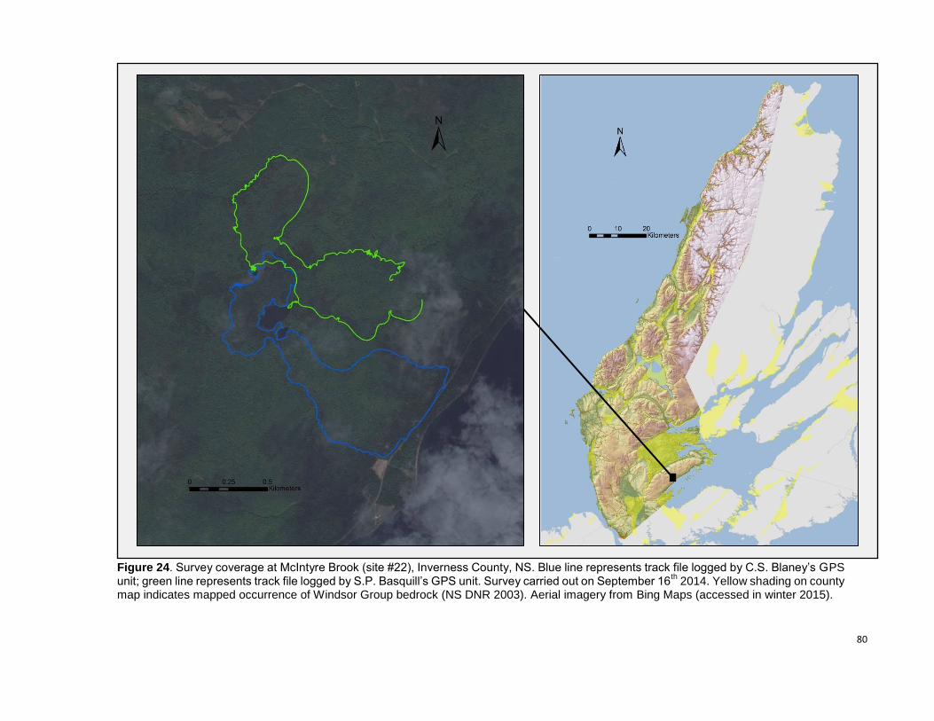
80
Figure 24. Survey coverage at McIntyre Brook (site #22), Inverness County, NS. Blue line represents track file logged by C.S. Blaney’s GPS unit; green line represents track file logged by S.P. Basquill’s GPS unit. Survey carried out on September 16
th 2014. Yellow shading on county
map indicates mapped occurrence of Windsor Group bedrock (NS DNR 2003). Aerial imagery from Bing Maps (accessed in winter 2015).
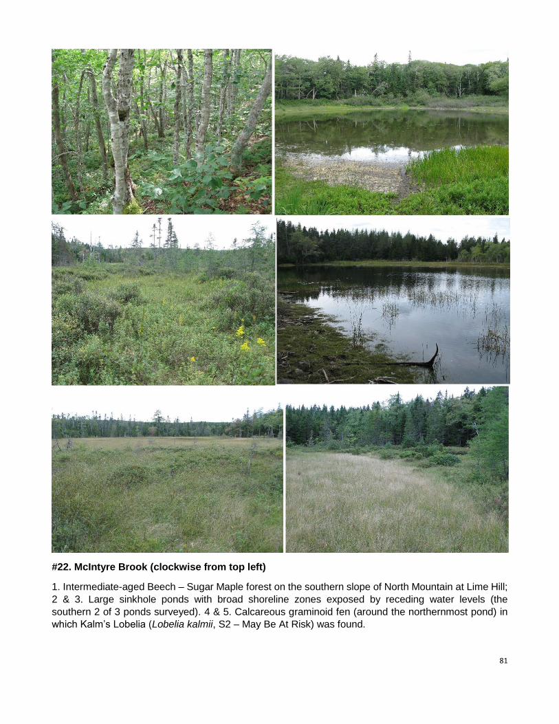
81
#22. McIntyre Brook (clockwise from top left)
1. Intermediate-aged Beech – Sugar Maple forest on the southern slope of North Mountain at Lime Hill;
2 & 3. Large sinkhole ponds with broad shoreline zones exposed by receding water levels (the
southern 2 of 3 ponds surveyed). 4 & 5. Calcareous graminoid fen (around the northernmost pond) in
which Kalm’s Lobelia (Lobelia kalmii, S2 – May Be At Risk) was found.
82
#23. Ninevah / Little Narrows
Observer(s): Blaney, C.S.; Basquill, S.P.
Survey date: September 17th 2014
Rare Species
Scientific Name Common Name S-Rank GS-Rank Records
Carex granularis Meadow Sedge S1 May Be At Risk 2
Carex viridula var. elatior Long-Stalked Yellow Sedge S1 May Be At Risk 1
Fraxinus nigra Black Ash S1S2 At Risk 2
Carex bebbii Bebb’s Sedge S2 Sensitive 1
Galium labradoricum Bog Bedstraw S2 Sensitive 4
Lobelia kalmii Kalm’s Lobelia S2 May Be At Risk 2
Symphyotrichum boreale Boreal American-Aster S2? Sensitive 7
Cypripedium parviflorum Small Yellow Lady’s-Slipper S2S3 Sensitive 3
Stuckenia filiformis Slender Pondweed S2S3 Sensitive 1
Agrimonia gryposepala Tall Hairy Groovebur S3 Secure 2
Carex eburnea Ebony Sedge S3 Sensitive 4
Erigeron hyssopifolius Hyssop-leaved Fleabane S3 Sensitive 3
Juncus dudleyi Dudley’s Rush S3 Secure 2
Packera paupercula Balsam Groundsel S3 Secure 3
Ranunculus gmelinii Small Yellow Water-Crowfoot S3 Secure 5
Rhamnus alnifolia Alderleaf Buckthorn S3 Secure 2
Samolus valerandi ssp. parviflorus Water Pimpernel S3 Sensitive 2
Cystopteris bulbifera Bulblet Fern S3S4 Secure 2
Fragaria vesca ssp. americana Woodland Strawberry S3S4 Secure 2
Site Summary
Survey effort at this site involved separate surveys by Sean Basquill and Sean Blaney at sites
about 2 km apart. Sean Basquill covered the site near Little Narrows about 2 km northeast of
Campbells Cove and Sean Blaney covered the Ninevah area from Campbells Cove, south
and east to Campbells Road near Whycocomagh Portage. Sean Basquill’s Little Narrows site
included good representation of exposed gypsum features and a number of sinkhole ponds
and supported the provincially rare gypsum associates Ebony Sedge, Balsam Groundsel,
Yellow Lady’s-Slipper, Bulblet Fern and Woodland Strawberry that were not present in the
Ninevah area covered by Sean Blaney.
The Ninevah site included calcareous brackish marsh around Campbells Cove, grading
landward into significant calcareous fen communities that supported good populations of the
rare species Long-stalked Yellow Sedge (Carex viridula var. elatior, S1 – May Be At Risk),
Bog Bedstraw (Galium labradoricum, S2 – Sensitive), Kalm’s Lobelia (Lobelia kalmii, S2 –
May Be At Risk), and Boreal American-Aster (Symphyotrichum boreale, S2? – Sensitive).
Small numbers of Water Pimpernel (Samolus valerandi ssp. parviflorus, S3 – Sensitive;
second Cape Breton record) were present on brackish tidal shores and calcareous streams
supported Slender Pondweed (Stuckenia filiformis, S2S3 – Sensitive) and Small Yellow
Water Crowfoot (Ranunculus gmelinii, S3 – Secure). A single, fairly healthy Black Ash
(Fraxinus nigra, S1S2 – At Risk) large enough to reproduce (18cm diameter) was also
present in a rich thicket swamp near a fen margin on Campbells Cove.
The remaining rare species documented at the site were mostly from calcareous disturbed
ground along logging trails in the southernmost part of the area covered. These were:
83
Meadow Sedge (Carex granularis, S1 – May Be At Risk and otherwise known in Nova Scotia
only from adjacent areas near Plaster Ponds), Bebb’s Sedge (Carex bebbii, S2 – Sensitive),
Dudley’s Rush (Juncus dudleyi, S3 – Secure) and Tall Hairy Groovebur, (Agrimonia
gryposepala, S3 – Secure).
The flora of the site indicates strongly calcareous soils around Campbells Cove and in the
southern area near Campbells Road. There was, however, no exposed bedrock observed
and little evidence of karst features although some gently pitted topography and the
occurrence of several small ponds in the southern part of the survey area likely the result of
gypsum sinkholes buried under till. The elongated pond 500 m southeast of Campbells Cove
had a narrow band of slightly calcareous peaty marsh around much of its shore, and the
smaller pond a further 500 m southwest of there was within a shrubby acidic peatland. The
southernmost ponds were more disturbed, with water levels altered by berms associated with
the logging road.
Forests on the site were not especially noteworthy, including various intermediate aged
stands, some young post-agricultural regeneration around the southeast end of Campbells
Cove, and some younger stands regenerating from agriculture and/or forest harvesting in the
southern end.
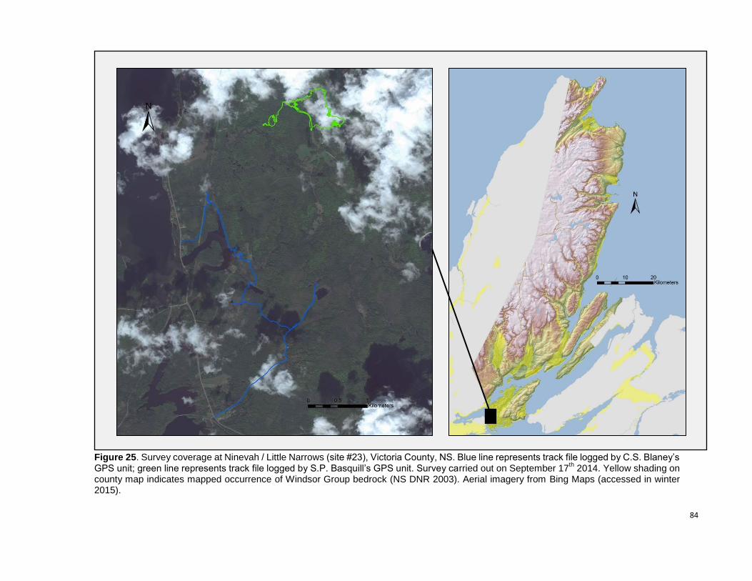
84
Figure 25. Survey coverage at Ninevah / Little Narrows (site #23), Victoria County, NS. Blue line represents track file logged by C.S. Blaney’s GPS unit; green line represents track file logged by S.P. Basquill’s GPS unit. Survey carried out on September 17
th 2014. Yellow shading on
county map indicates mapped occurrence of Windsor Group bedrock (NS DNR 2003). Aerial imagery from Bing Maps (accessed in winter 2015).
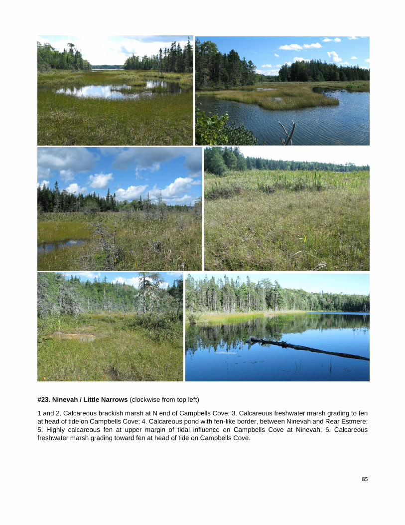
85
#23. Ninevah / Little Narrows (clockwise from top left)
1 and 2. Calcareous brackish marsh at N end of Campbells Cove; 3. Calcareous freshwater marsh grading to fen
at head of tide on Campbells Cove; 4. Calcareous pond with fen-like border, between Ninevah and Rear Estmere;
5. Highly calcareous fen at upper margin of tidal influence on Campbells Cove at Ninevah; 6. Calcareous
freshwater marsh grading toward fen at head of tide on Campbells Cove.
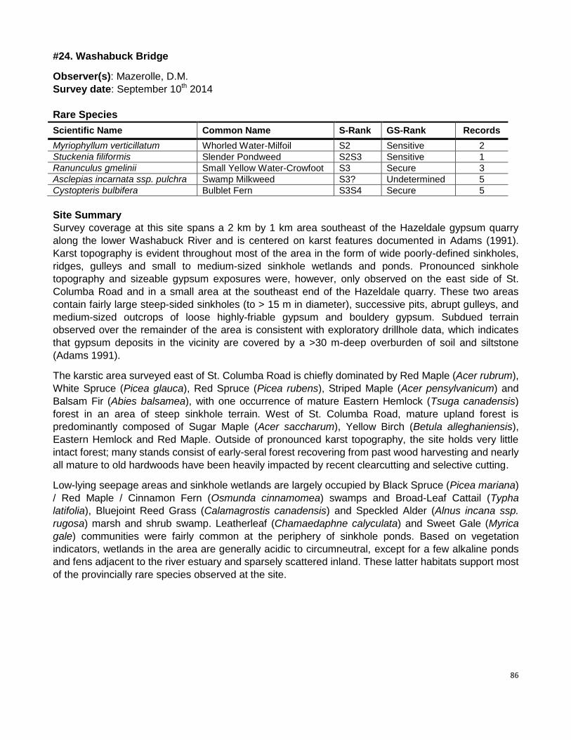
86
#24. Washabuck Bridge
Observer(s): Mazerolle, D.M.
Survey date: September 10th 2014
Rare Species
Scientific Name Common Name S-Rank GS-Rank Records
Myriophyllum verticillatum Whorled Water-Milfoil S2 Sensitive 2
Stuckenia filiformis Slender Pondweed S2S3 Sensitive 1
Ranunculus gmelinii Small Yellow Water-Crowfoot S3 Secure 3
Asclepias incarnata ssp. pulchra Swamp Milkweed S3? Undetermined 5
Cystopteris bulbifera Bulblet Fern S3S4 Secure 5
Site Summary
Survey coverage at this site spans a 2 km by 1 km area southeast of the Hazeldale gypsum quarry
along the lower Washabuck River and is centered on karst features documented in Adams (1991).
Karst topography is evident throughout most of the area in the form of wide poorly-defined sinkholes,
ridges, gulleys and small to medium-sized sinkhole wetlands and ponds. Pronounced sinkhole
topography and sizeable gypsum exposures were, however, only observed on the east side of St.
Columba Road and in a small area at the southeast end of the Hazeldale quarry. These two areas
contain fairly large steep-sided sinkholes (to > 15 m in diameter), successive pits, abrupt gulleys, and
medium-sized outcrops of loose highly-friable gypsum and bouldery gypsum. Subdued terrain
observed over the remainder of the area is consistent with exploratory drillhole data, which indicates
that gypsum deposits in the vicinity are covered by a >30 m-deep overburden of soil and siltstone
(Adams 1991).
The karstic area surveyed east of St. Columba Road is chiefly dominated by Red Maple (Acer rubrum),
White Spruce (Picea glauca), Red Spruce (Picea rubens), Striped Maple (Acer pensylvanicum) and
Balsam Fir (Abies balsamea), with one occurrence of mature Eastern Hemlock (Tsuga canadensis)
forest in an area of steep sinkhole terrain. West of St. Columba Road, mature upland forest is
predominantly composed of Sugar Maple (Acer saccharum), Yellow Birch (Betula alleghaniensis),
Eastern Hemlock and Red Maple. Outside of pronounced karst topography, the site holds very little
intact forest; many stands consist of early-seral forest recovering from past wood harvesting and nearly
all mature to old hardwoods have been heavily impacted by recent clearcutting and selective cutting.
Low-lying seepage areas and sinkhole wetlands are largely occupied by Black Spruce (Picea mariana)
/ Red Maple / Cinnamon Fern (Osmunda cinnamomea) swamps and Broad-Leaf Cattail (Typha
latifolia), Bluejoint Reed Grass (Calamagrostis canadensis) and Speckled Alder (Alnus incana ssp.
rugosa) marsh and shrub swamp. Leatherleaf (Chamaedaphne calyculata) and Sweet Gale (Myrica
gale) communities were fairly common at the periphery of sinkhole ponds. Based on vegetation
indicators, wetlands in the area are generally acidic to circumneutral, except for a few alkaline ponds
and fens adjacent to the river estuary and sparsely scattered inland. These latter habitats support most
of the provincially rare species observed at the site.
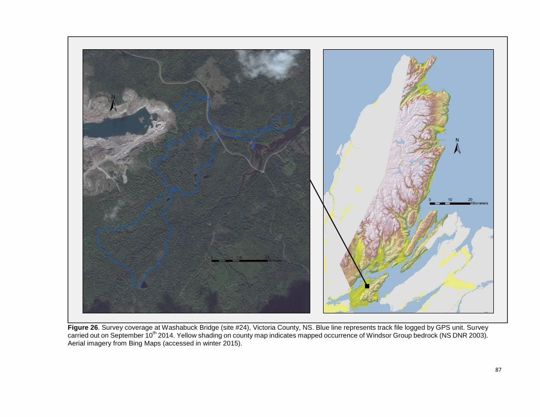
87
Figure 26. Survey coverage at Washabuck Bridge (site #24), Victoria County, NS. Blue line represents track file logged by GPS unit. Survey carried out on September 10
th 2014. Yellow shading on county map indicates mapped occurrence of Windsor Group bedrock (NS DNR 2003).
Aerial imagery from Bing Maps (accessed in winter 2015).
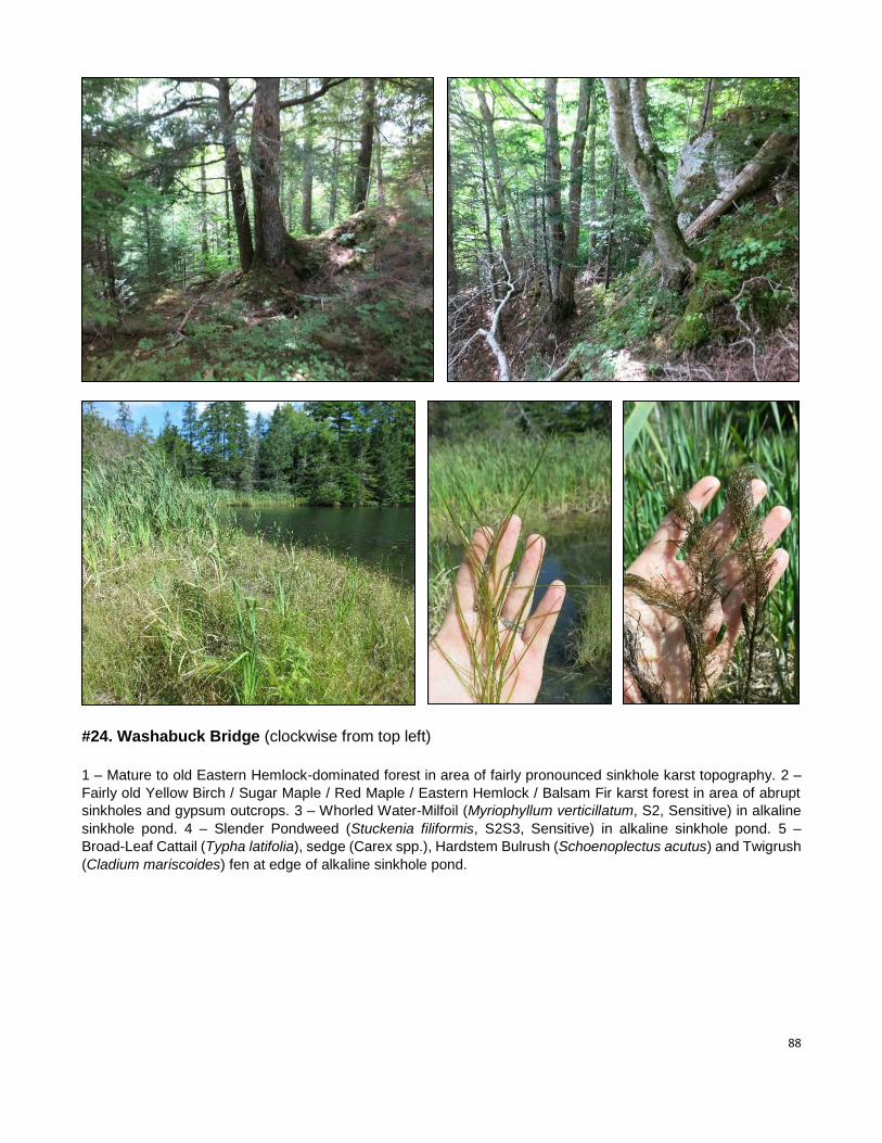
88
#24. Washabuck Bridge (clockwise from top left)
1 – Mature to old Eastern Hemlock-dominated forest in area of fairly pronounced sinkhole karst topography. 2 –
Fairly old Yellow Birch / Sugar Maple / Red Maple / Eastern Hemlock / Balsam Fir karst forest in area of abrupt
sinkholes and gypsum outcrops. 3 – Whorled Water-Milfoil (Myriophyllum verticillatum, S2, Sensitive) in alkaline
sinkhole pond. 4 – Slender Pondweed (Stuckenia filiformis, S2S3, Sensitive) in alkaline sinkhole pond. 5 –
Broad-Leaf Cattail (Typha latifolia), sedge (Carex spp.), Hardstem Bulrush (Schoenoplectus acutus) and Twigrush
(Cladium mariscoides) fen at edge of alkaline sinkhole pond.
89
#25. Plaster Cove
Observer(s): Belliveau, A.G.
Survey date: September 10th 2014
Rare Species
Scientific Name Common Name S-Rank GS-Rank Records
Juncus alpinoarticulatus ssp. nodosus Richardson’s Rush S1S2 May Be At Risk 1
Cypripedium parviflorum Small Yellow Lady’s-Slipper S2S3 Sensitive 7
Carex eburnea Ebony Sedge S3 Sensitive 35
Erigeron hyssopifolius Hyssop-leaved Fleabane S3 Sensitive 9
Packera paupercula Balsam Groundsel S3 Secure 28
Polypodium appalachianum Appalachian Polypody S3? Undetermined 1
Cystopteris bulbifera Bulblet Fern S3S4 Secure 56
Fragaria vesca ssp. americana Woodland Strawberry S3S4 Secure 1
Site Summary
As its name implies, Plaster Cove has prominent gypsum exposures situated around a brackish pond,
with sinkholes, deep vertical pits, thick scree accumulations and tower-like gypsum formations. Surficial
and near-surface gypsum extends northward and westward from the cove to just north of Barra Glen
Road and Nashs Brook. This karst occurrence is characterized by a large area (at least ~500 m x ~500
m) of variably pronounced sinkholes, at least three gypsum cliffs (5 to 25 m in height) with large
accumulations of gypsum scree, and several sinkhole pond complexes. Exposed gypsum is present in
approximately half of all sinkholes, either along the upper sinkhole edges or as scree along inner
slopes. At least one deep cave was noted from the side and bottom of a large sinkhole.
The surveyed gypsum formation in Plaster Cove is sparsely forested with White Spruce (Picea glauca),
Balsam Fir (Abies balsamea) and American Mountain Ash (Sorbus americana). The understory is
characterized by Northern Bayberry (Morella pensylvanica), Common Juniper (Juniperus communis
var. depressa), and an unusual abundance of exotic Fairy Flax (Linum catharticum). Areas of exposed
gypsum support substantial amounts of Balsam Groundsel (Packera paupercula, S3, Secure) and
Hyssop-leaved Fleabane (Erigeron hyssopifolius, S3, Sensitive). The large area just north of Nashs
Brook is a mosaic of mostly old forest composed of Yellow Birch (Betula alleghaniensis), Sugar Maple
(Acer saccharum), and Eastern Hemlock (Tsuga canadensis), with occasional small young patches of
Balsam Fir. Gypsum cliffs and adjacent outcrop sinkholes support a suite of gypsum-associated
species, including Bulblet Fern (Cystopteris bulbifera, S3S4, Secure), Small Yellow Lady's-Slipper
(Cypripedium parviflorum, S2S3, Sensitive), Roundleaf Dogwood (Cornus rugosa), Balsam Groundsel
and Ebony Sedge (Carex eburnea, S3, Sensitive). In shaded forested sinkhole areas, Bulblet Fern is
dominant – often carpeting large areas of the forest floor – and a few other gypsum-related species
were observed, including Appalachian Polypody (Polypodium appalachianum, S3, Undetermined),
Woodland Strawberry (Fragaria vesca ssp. americana, S3S4, Secure), and American Spikenard (Aralia
racemosa). The peaty shore of one sinkhole pond had a dense patch of Richardson's Rush (Juncus
alpinoarticulatus ssp. nodulosus, S1S2, May Be At Risk), a rare species associated with alkaline
shores.
Of the three large gypsum formations in Plaster Cove, one has been quarried and another has been
developed residentially, while the third is still fully intact. The area of karst topography just north of
Nashs Brook is almost completely intact, with one old field and one old abandoned road noted at its
periphery.
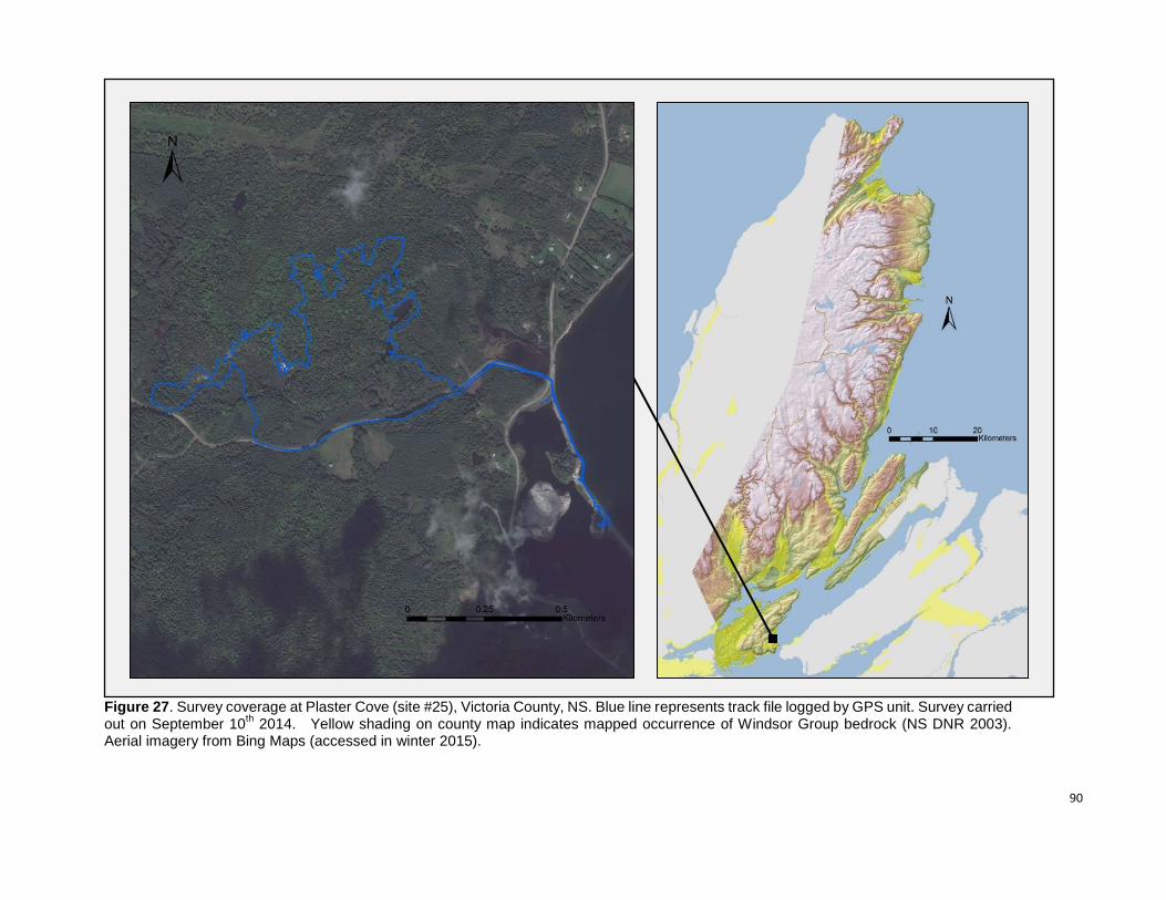
90
Figure 27. Survey coverage at Plaster Cove (site #25), Victoria County, NS. Blue line represents track file logged by GPS unit. Survey carried out on September 10
th 2014. Yellow shading on county map indicates mapped occurrence of Windsor Group bedrock (NS DNR 2003).
Aerial imagery from Bing Maps (accessed in winter 2015).
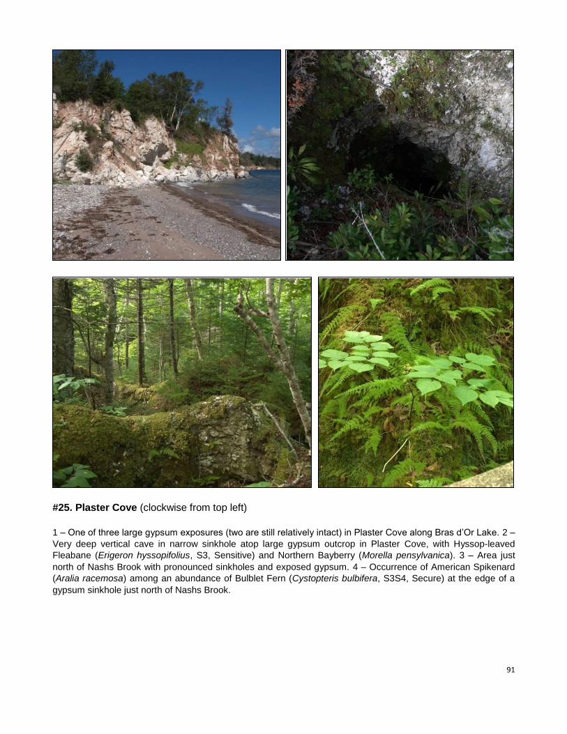
91
#25. Plaster Cove (clockwise from top left)
1 – One of three large gypsum exposures (two are still relatively intact) in Plaster Cove along Bras d’Or Lake. 2 –
Very deep vertical cave in narrow sinkhole atop large gypsum outcrop in Plaster Cove, with Hyssop-leaved
Fleabane (Erigeron hyssopifolius, S3, Sensitive) and Northern Bayberry (Morella pensylvanica). 3 – Area just
north of Nashs Brook with pronounced sinkholes and exposed gypsum. 4 – Occurrence of American Spikenard
(Aralia racemosa) among an abundance of Bulblet Fern (Cystopteris bulbifera, S3S4, Secure) at the edge of a
gypsum sinkhole just north of Nashs Brook.
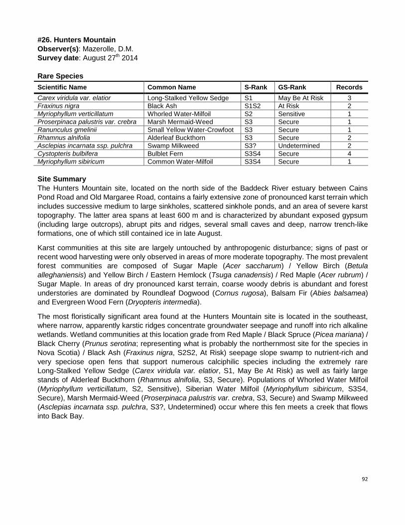
92
#26. Hunters Mountain
Observer(s): Mazerolle, D.M.
Survey date: August 27th 2014
Rare Species
Scientific Name Common Name S-Rank GS-Rank Records
Carex viridula var. elatior Long-Stalked Yellow Sedge S1 May Be At Risk 3
Fraxinus nigra Black Ash S1S2 At Risk 2
Myriophyllum verticillatum Whorled Water-Milfoil S2 Sensitive 1
Proserpinaca palustris var. crebra Marsh Mermaid-Weed S3 Secure 1
Ranunculus gmelinii Small Yellow Water-Crowfoot S3 Secure 1
Rhamnus alnifolia Alderleaf Buckthorn S3 Secure 2
Asclepias incarnata ssp. pulchra Swamp Milkweed S3? Undetermined 2
Cystopteris bulbifera Bulblet Fern S3S4 Secure 4
Myriophyllum sibiricum Common Water-Milfoil S3S4 Secure 1
Site Summary
The Hunters Mountain site, located on the north side of the Baddeck River estuary between Cains
Pond Road and Old Margaree Road, contains a fairly extensive zone of pronounced karst terrain which
includes successive medium to large sinkholes, scattered sinkhole ponds, and an area of severe karst
topography. The latter area spans at least 600 m and is characterized by abundant exposed gypsum
(including large outcrops), abrupt pits and ridges, several small caves and deep, narrow trench-like
formations, one of which still contained ice in late August.
Karst communities at this site are largely untouched by anthropogenic disturbance; signs of past or
recent wood harvesting were only observed in areas of more moderate topography. The most prevalent
forest communities are composed of Sugar Maple (Acer saccharum) / Yellow Birch (Betula
alleghaniensis) and Yellow Birch / Eastern Hemlock (Tsuga canadensis) / Red Maple (Acer rubrum) /
Sugar Maple. In areas of dry pronounced karst terrain, coarse woody debris is abundant and forest
understories are dominated by Roundleaf Dogwood (Cornus rugosa), Balsam Fir (Abies balsamea)
and Evergreen Wood Fern (Dryopteris intermedia).
The most floristically significant area found at the Hunters Mountain site is located in the southeast,
where narrow, apparently karstic ridges concentrate groundwater seepage and runoff into rich alkaline
wetlands. Wetland communities at this location grade from Red Maple / Black Spruce (Picea mariana) /
Black Cherry (Prunus serotina; representing what is probably the northernmost site for the species in
Nova Scotia) / Black Ash (Fraxinus nigra, S2S2, At Risk) seepage slope swamp to nutrient-rich and
very speciose open fens that support numerous calciphilic species including the extremely rare
Long-Stalked Yellow Sedge (Carex viridula var. elatior, S1, May Be At Risk) as well as fairly large
stands of Alderleaf Buckthorn (Rhamnus alnifolia, S3, Secure). Populations of Whorled Water Milfoil
(Myriophyllum verticillatum, S2, Sensitive), Siberian Water Milfoil (Myriophyllum sibiricum, S3S4,
Secure), Marsh Mermaid-Weed (Proserpinaca palustris var. crebra, S3, Secure) and Swamp Milkweed
(Asclepias incarnata ssp. pulchra, S3?, Undetermined) occur where this fen meets a creek that flows
into Back Bay.
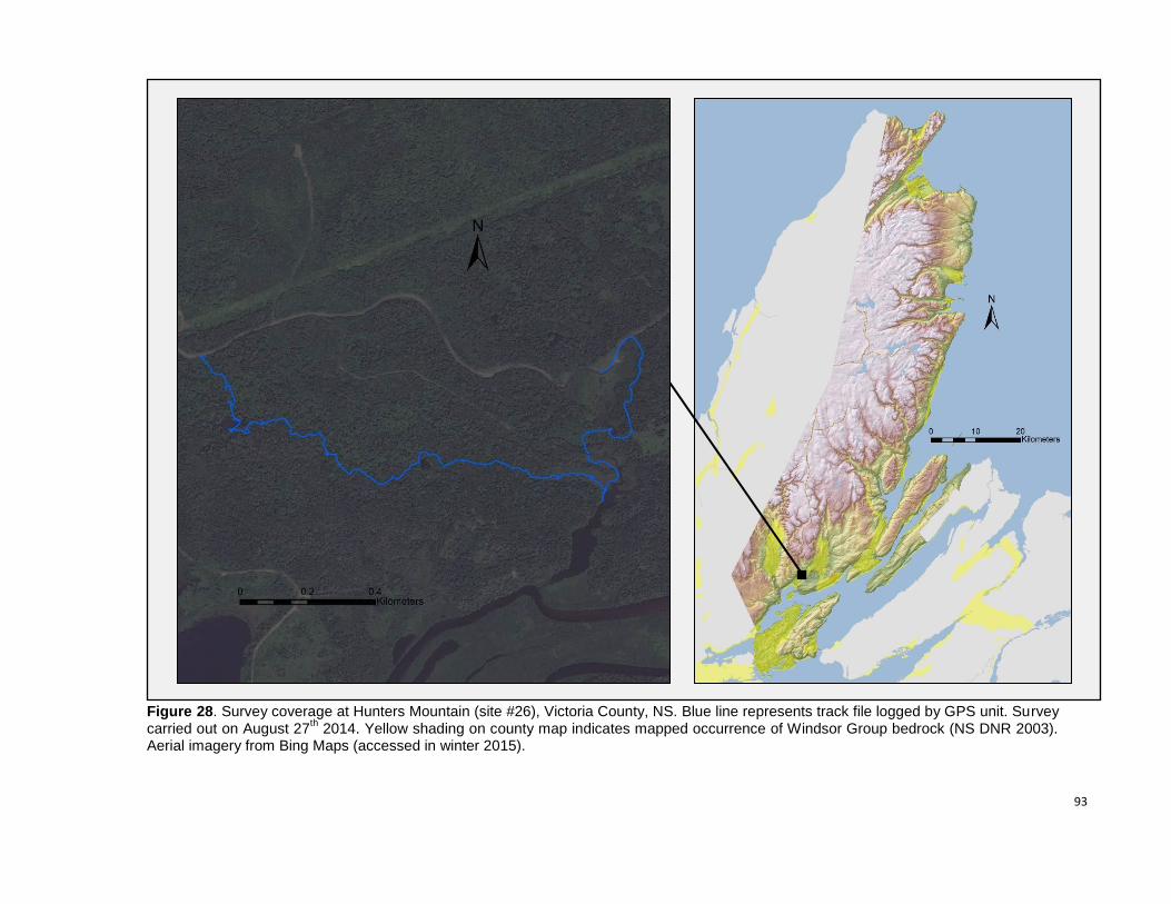
93
Figure 28. Survey coverage at Hunters Mountain (site #26), Victoria County, NS. Blue line represents track file logged by GPS unit. Survey carried out on August 27
th 2014. Yellow shading on county map indicates mapped occurrence of Windsor Group bedrock (NS DNR 2003).
Aerial imagery from Bing Maps (accessed in winter 2015).
94
#26. Hunters Mountain (clockwise from top left)
1 – Highly eroded outcrop of friable gypsum in area of very pronounced karst with deep abrupt trench-like
formations. 2 – Nutrient-rich open alkaline fen and Black Spruce / Red Maple swamp. 3 – Long-Stalked Yellow
Sedge (Carex viridula var. elatior, S1, May Be At Risk) in rich alkaline fen. 4 – Black Ash (Fraxinus nigra, S1S2, At
Risk), occurring in a seepage swamp along with Red Maple, Balsam Fir and Black Cherry. 5 – Mature Sugar Maple
/ Red Maple / Yellow Birch forest in area of fairly pronounced karst topography.
95
#27. MacRae Brook
Observer(s): Mazerolle, D.M.
Survey date: August 27th 2014
Rare Species
Scientific Name Common Name S-Rank GS-Rank Records
Carex tuckermanii Tuckerman’s Sedge S2 Sensitive 2
Agrimonia gryposepala Tall Hairy Groovebur S3 Secure 1
Ranunculus gmelinii Small Yellow Water-Crowfoot S3 Secure 2
Site Summary
We devoted a half a day to the survey of the MacRae Brook area, situated west of Forks Baddeck in
the upper Baddeck River valley. The entire surveyed area is karstic to some extent, with regions of
moderate karst topography linked by regions of very shallow sinkholes and gently rolling terrain. The
site contains numerous sinkhole ponds reaching diameters of over 150 m, many of which collect water
from springs and groundwater seepage and form the headwaters of small tributaries of MacRae Brook.
The wide gently-sloped sinkholes observed at the site support various pond, marsh, bog and fen
communities and experience significant seasonal water level fluctuations, collectively representing
significant vernal pool habitat. The area bounded by MacRae Brook to the south and a small logging
road to the north contains large abrupt-sided sinkholes scattered in otherwise fairly flat terrain. These
features, some of which have mostly unvegetated slopes of loose soil and till and contain an
abundance of coarse woody debris, may represent sites of recent collapse or further subsidence. Small
gypsum and limestone outcrops were also observed in a few sinkholes in this section of the site. Based
on the presence of sinkhole ponds visible on aerial photography, the MacRae Brook karst occurrence
apparently extends further northwest past the area surveyed to the foot of the east-facing slopes of
Crowdis Mountain.
Mature and mostly intact forest of Sugar Maple (Acer saccharum) / Red Maple (Acer rubrum) / Yellow
Birch (Betula alleghaniensis) / Balsam Fir (Abies balsamea) is prevalent south of MacRae Brook. North
of the brook, a few small stands of mature Red Maple / Yellow Birch / Evergreen Wood Fern
(Dryopteris intermedia) / Wild Sarsaparilla (Aralia nudicaulis) forest are scattered within a matrix of
young- to intermediate-aged shade-intolerant hardwoods and young regenerating Balsam Fir. At one
location, the narrow bottom of the brook valley widens sufficiently to include pockets of moderately rich
floodplain forest. A fairly extensive occurrence of Black Spruce (Picea mariana) / Red Maple /
Cinnamon Fern (Osmunda cinnamomea) swamp was also observed at the south end of the surveyed
area.
The most notable find at this site was a small population of Tuckerman’s Sedge (Carex tuckermanii,
S2, Sensitive) in a marshy sinkhole meadow of Sensitive Fern (Onoclea sensibilis) and Cottongrass
Bulrush (Scirpus cyperinus). This species had never before been documented in Cape Breton.
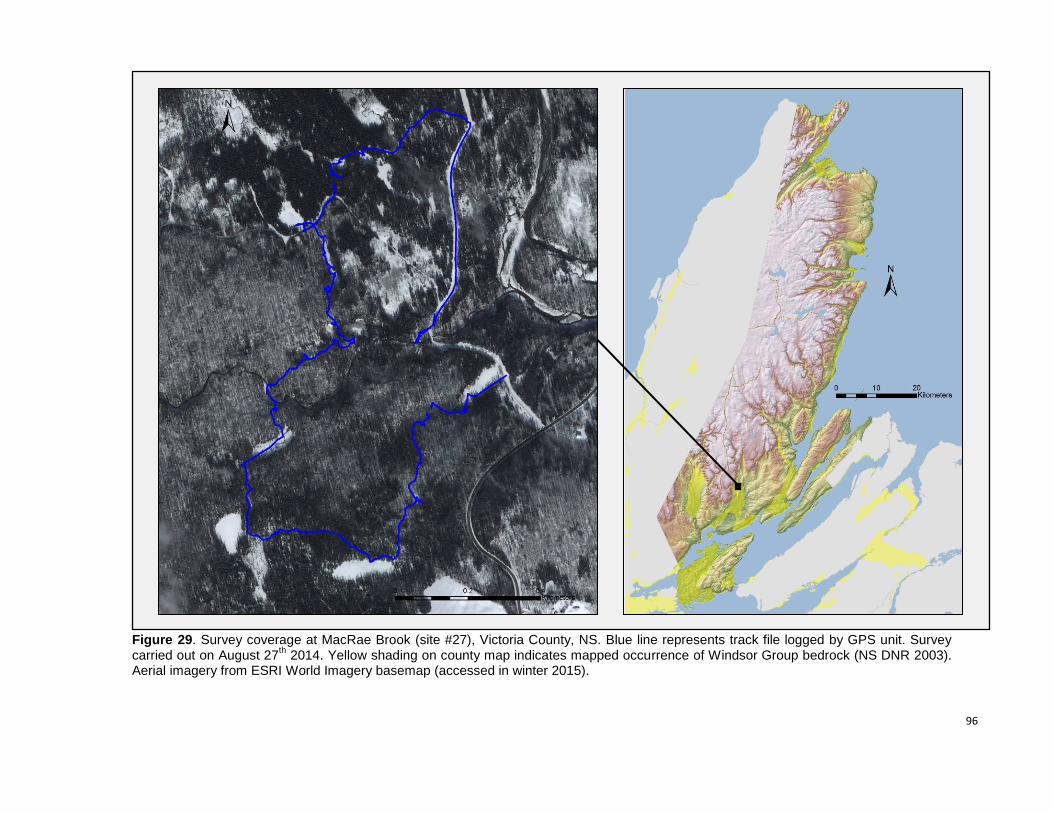
96
Figure 29. Survey coverage at MacRae Brook (site #27), Victoria County, NS. Blue line represents track file logged by GPS unit. Survey carried out on August 27
th 2014. Yellow shading on county map indicates mapped occurrence of Windsor Group bedrock (NS DNR 2003).
Aerial imagery from ESRI World Imagery basemap (accessed in winter 2015).
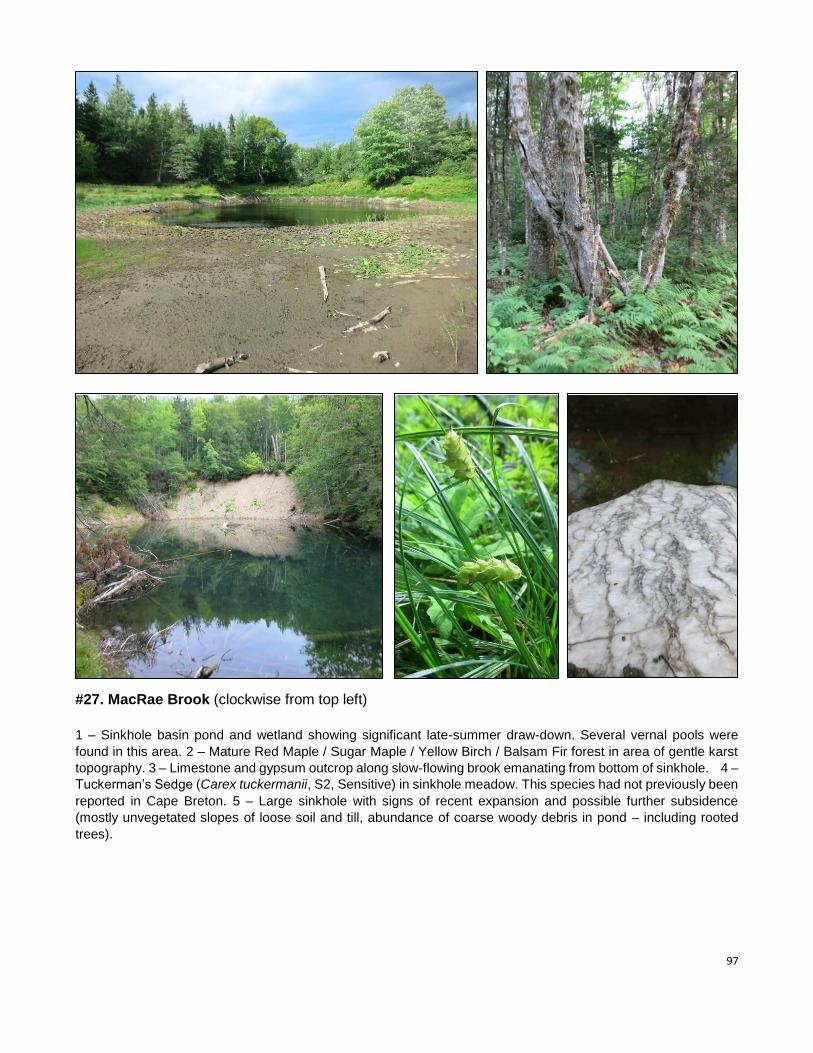
97
#27. MacRae Brook (clockwise from top left)
1 – Sinkhole basin pond and wetland showing significant late-summer draw-down. Several vernal pools were
found in this area. 2 – Mature Red Maple / Sugar Maple / Yellow Birch / Balsam Fir forest in area of gentle karst
topography. 3 – Limestone and gypsum outcrop along slow-flowing brook emanating from bottom of sinkhole. 4 –
Tuckerman’s Sedge (Carex tuckermanii, S2, Sensitive) in sinkhole meadow. This species had not previously been
reported in Cape Breton. 5 – Large sinkhole with signs of recent expansion and possible further subsidence
(mostly unvegetated slopes of loose soil and till, abundance of coarse woody debris in pond – including rooted
trees).
98
#28. Beinn Bhreagh Observer(s): Mazerolle, D.M.; Belliveau, A.G.; Nussey, P.
Survey date: September 17th 2014
Rare Species
Scientific Name Common Name S-Rank GS-Rank Records
Shepherdia canadensis Soapberry S2S3 Sensitive 20
Stuckenia filiformis Slender Pondweed S2S3 Sensitive 2
Agrimonia gryposepala Tall Hairy Groovebur S3 Secure 1
Carex eburnea Ebony Sedge S3 Sensitive 1
Equisetum variegatum Variegated Horsetail S3 Secure 2
Packera paupercula Balsam Groundsel S3 Secure 7
Teucrium canadense American Germander S3 Sensitive 3
Asclepias incarnata ssp. pulchra Swamp Milkweed S3? Undetermined 1
Carex tribuloides Blunt Broom Sedge S3? Secure 1
Cystopteris bulbifera Bulblet Fern S3S4 Secure 4
Equisetum scirpoides Dwarf Scouring Rush S3S4 Secure 1
Myriophyllum sibiricum Common Water-Milfoil S3S4 Secure 3
Galium trifidum ssp. halophilum Saline Three-Petaled Bedstraw SNR Secure 1
Site Summary
This site represents the southwestern end of the extensive and dramatic Plaister Mines - Beinn
Bhreagh karst occurrence. Sinkholes and gypsum outcrops are found throughout the eastern half of the
surveyed area but are restricted to the coast in the western half. The site’s karstic portion is mainly
characterized by a series of alkaline and slightly brackish coastal sinkhole ponds sheltered by cobble,
gravel and sand bars. The largest of these, MacKillops Pond and Poker Dans Pond, are mostly
encircled by areas of pronounced sinkhole, pit and ridge topography. Numerous outcrops occur along
the northern and eastern shores of MacKillops Pond, on the steep slopes of a highly karstic peninsula.
The southwestern end of Poker Dans Pond contains a striking 50 m by 75 m exposed gypsum island
that stands roughly 15 m-tall with cliff walls along most of its periphery. Outcrops observed along the
shore of Great Bras D’Or Channel feature a mix of gypsum and Horton Group siltstone.
Most intact late-successional karst forest at the site is composed of Red Maple (Acer rubrum), Sugar
Maple (Acer saccharum), Yellow Birch (Betula alleghaniensis) and Balsam Fir (Abies balsamea), with
scattered stands of old Eastern Hemlock (Tsuga canadensis). A fairly small occurrence of mature
American Beech (Fagus grandifolia) karst forest was also observed at the northeast end of Poker Dans
Pond. Based on fieldwork carried out in gypsum lands in 2012 (Blaney & Mazerolle 2012) and 2014,
this karst forest community type appears to be quite uncommon. The non-karstic south-facing slope of
Beinn Bhreagh largely consists of mature Sugar Maple / Red Maple / Yellow Birch forest, which grades
into narrow bands of old growth pure Eastern Hemlock on the lower slope at the upper margin of karst
terrain.
Sparsely vegetated gypsum outcrops, gypsum-influenced till slopes and alkaline ponds found at this
site are floristically significan, supporting a number of provincially rare species. Larger coastal sinkhole
ponds had a particularly wide range of wetland and shoreline communities.
The northeastern portion of the site and the area between Mackillops and Poker Dans ponds are
heavily disturbed due to residential / cottage development, historical wood harvesting and historical
agricultural activity. Several areas were quite weedy and we noted four moderately invasive species:
Common Hawkweed (Hieracium lachenalii), Japanese Barberry (Berberis thunbergii), Rugosa Rose
(Rosa rugosa) and Forest Woodrush (Luzula luzuloides).

99
Figure 30. Survey coverage at Beinn Bhreagh (site #28), Victoria County, NS. Blue line represents track file logged by GPS unit. Survey carried out on September 17
th 2014. Yellow shading on county map indicates mapped occurrence of Windsor Group bedrock (NS DNR 2003).
Aerial imagery from Bing Maps (accessed in winter 2015).
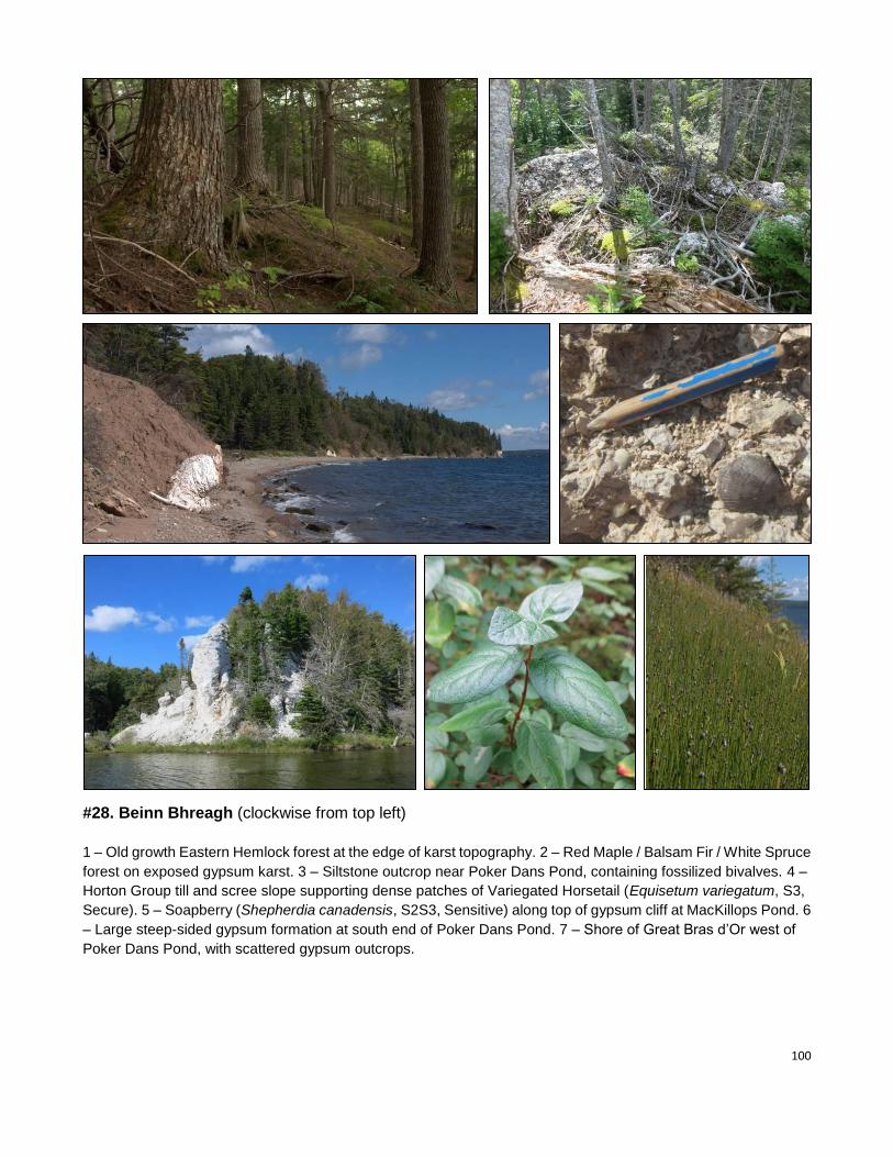
100
#28. Beinn Bhreagh (clockwise from top left)
1 – Old growth Eastern Hemlock forest at the edge of karst topography. 2 – Red Maple / Balsam Fir / White Spruce
forest on exposed gypsum karst. 3 – Siltstone outcrop near Poker Dans Pond, containing fossilized bivalves. 4 –
Horton Group till and scree slope supporting dense patches of Variegated Horsetail (Equisetum variegatum, S3,
Secure). 5 – Soapberry (Shepherdia canadensis, S2S3, Sensitive) along top of gypsum cliff at MacKillops Pond. 6
– Large steep-sided gypsum formation at south end of Poker Dans Pond. 7 – Shore of Great Bras d’Or west of
Poker Dans Pond, with scattered gypsum outcrops.
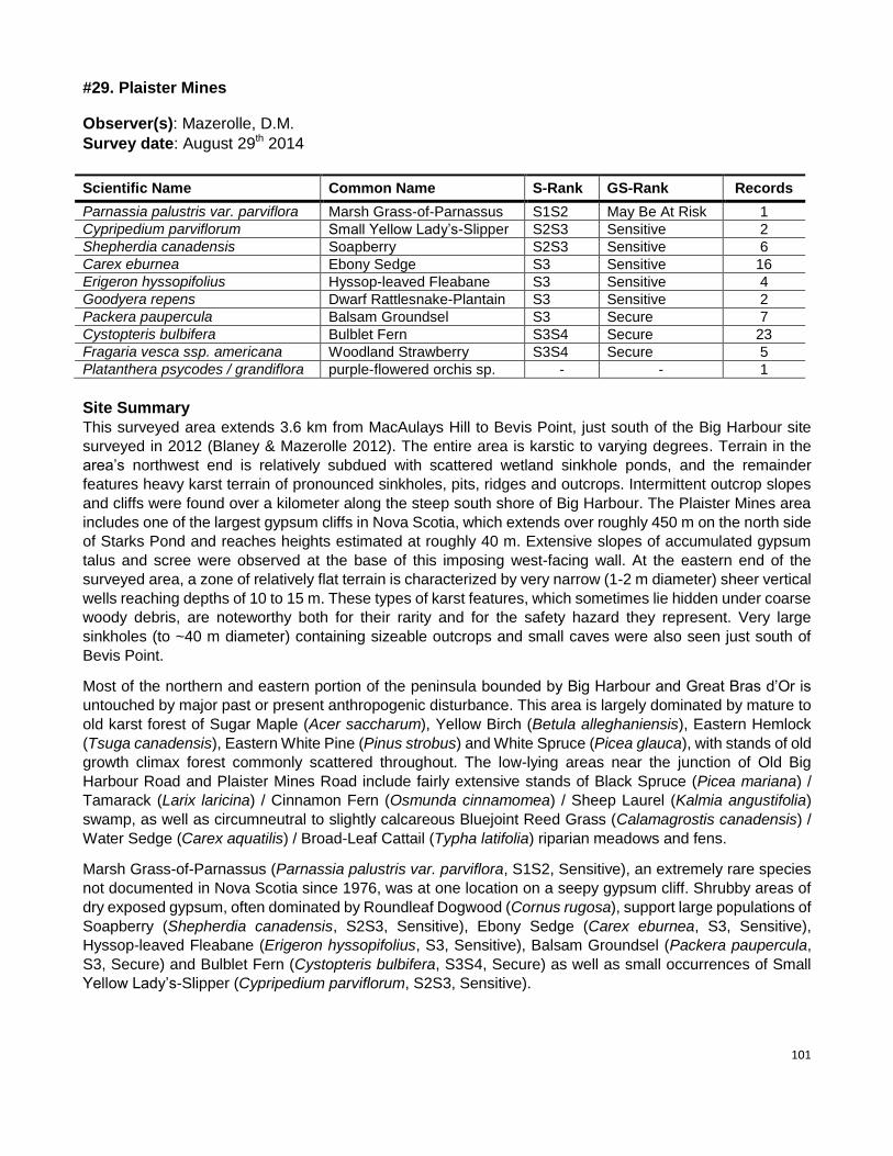
101
#29. Plaister Mines
Observer(s): Mazerolle, D.M.
Survey date: August 29th 2014
Scientific Name Common Name S-Rank GS-Rank Records
Parnassia palustris var. parviflora Marsh Grass-of-Parnassus S1S2 May Be At Risk 1
Cypripedium parviflorum Small Yellow Lady’s-Slipper S2S3 Sensitive 2
Shepherdia canadensis Soapberry S2S3 Sensitive 6
Carex eburnea Ebony Sedge S3 Sensitive 16
Erigeron hyssopifolius Hyssop-leaved Fleabane S3 Sensitive 4
Goodyera repens Dwarf Rattlesnake-Plantain S3 Sensitive 2
Packera paupercula Balsam Groundsel S3 Secure 7
Cystopteris bulbifera Bulblet Fern S3S4 Secure 23
Fragaria vesca ssp. americana Woodland Strawberry S3S4 Secure 5
Platanthera psycodes / grandiflora purple-flowered orchis sp. - - 1
Site Summary
This surveyed area extends 3.6 km from MacAulays Hill to Bevis Point, just south of the Big Harbour site
surveyed in 2012 (Blaney & Mazerolle 2012). The entire area is karstic to varying degrees. Terrain in the
area’s northwest end is relatively subdued with scattered wetland sinkhole ponds, and the remainder
features heavy karst terrain of pronounced sinkholes, pits, ridges and outcrops. Intermittent outcrop slopes
and cliffs were found over a kilometer along the steep south shore of Big Harbour. The Plaister Mines area
includes one of the largest gypsum cliffs in Nova Scotia, which extends over roughly 450 m on the north side
of Starks Pond and reaches heights estimated at roughly 40 m. Extensive slopes of accumulated gypsum
talus and scree were observed at the base of this imposing west-facing wall. At the eastern end of the
surveyed area, a zone of relatively flat terrain is characterized by very narrow (1-2 m diameter) sheer vertical
wells reaching depths of 10 to 15 m. These types of karst features, which sometimes lie hidden under coarse
woody debris, are noteworthy both for their rarity and for the safety hazard they represent. Very large
sinkholes (to ~40 m diameter) containing sizeable outcrops and small caves were also seen just south of
Bevis Point.
Most of the northern and eastern portion of the peninsula bounded by Big Harbour and Great Bras d’Or is
untouched by major past or present anthropogenic disturbance. This area is largely dominated by mature to
old karst forest of Sugar Maple (Acer saccharum), Yellow Birch (Betula alleghaniensis), Eastern Hemlock
(Tsuga canadensis), Eastern White Pine (Pinus strobus) and White Spruce (Picea glauca), with stands of old
growth climax forest commonly scattered throughout. The low-lying areas near the junction of Old Big
Harbour Road and Plaister Mines Road include fairly extensive stands of Black Spruce (Picea mariana) /
Tamarack (Larix laricina) / Cinnamon Fern (Osmunda cinnamomea) / Sheep Laurel (Kalmia angustifolia)
swamp, as well as circumneutral to slightly calcareous Bluejoint Reed Grass (Calamagrostis canadensis) /
Water Sedge (Carex aquatilis) / Broad-Leaf Cattail (Typha latifolia) riparian meadows and fens.
Marsh Grass-of-Parnassus (Parnassia palustris var. parviflora, S1S2, Sensitive), an extremely rare species
not documented in Nova Scotia since 1976, was at one location on a seepy gypsum cliff. Shrubby areas of
dry exposed gypsum, often dominated by Roundleaf Dogwood (Cornus rugosa), support large populations of
Soapberry (Shepherdia canadensis, S2S3, Sensitive), Ebony Sedge (Carex eburnea, S3, Sensitive),
Hyssop-leaved Fleabane (Erigeron hyssopifolius, S3, Sensitive), Balsam Groundsel (Packera paupercula,
S3, Secure) and Bulblet Fern (Cystopteris bulbifera, S3S4, Secure) as well as small occurrences of Small
Yellow Lady’s-Slipper (Cypripedium parviflorum, S2S3, Sensitive).
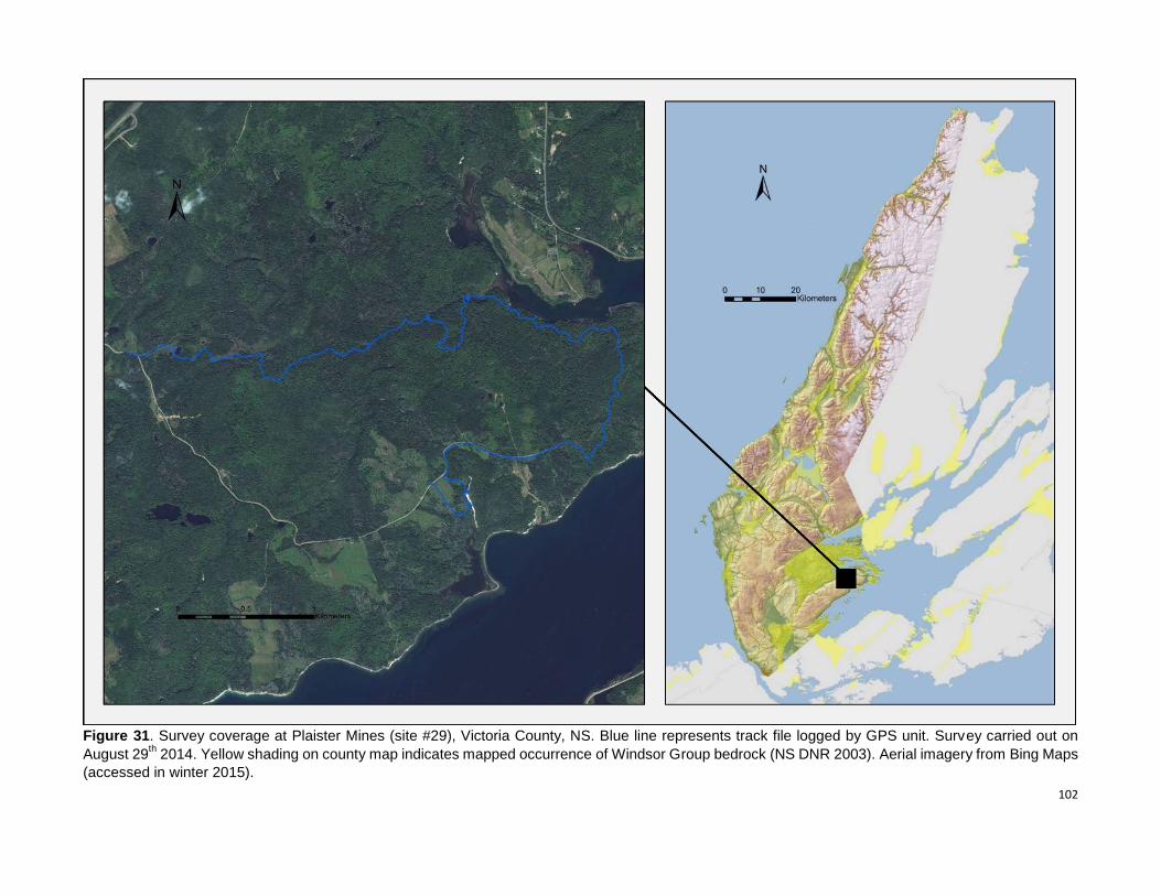
102
Figure 31. Survey coverage at Plaister Mines (site #29), Victoria County, NS. Blue line represents track file logged by GPS unit. Survey carried out on
August 29th 2014. Yellow shading on county map indicates mapped occurrence of Windsor Group bedrock (NS DNR 2003). Aerial imagery from Bing Maps
(accessed in winter 2015).
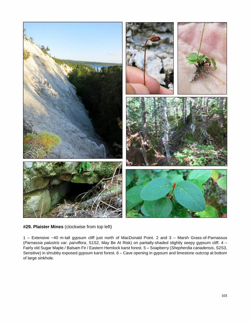
103
#29. Plaister Mines (clockwise from top left)
1 – Extensive ~40 m-tall gypsum cliff just north of MacDonald Point. 2 and 3 – Marsh Grass-of-Parnassus
(Parnassia palustris var. parviflora, S1S2, May Be At Risk) on partially-shaded slightly seepy gypsum cliff. 4 –
Fairly old Sugar Maple / Balsam Fir / Eastern Hemlock karst forest. 5 – Soapberry (Shepherdia canadensis, S2S3,
Sensitive) in shrubby exposed gypsum karst forest. 6 – Cave opening in gypsum and limestone outcrop at bottom
of large sinkhole.
104
#30. South Haven
Observer(s): Mazerolle, D.M.
Survey date: August 28th 2014
Rare Species
Scientific Name Common Name S-Rank GS-Rank Records
Ranunculus gmelinii Small Yellow Water-Crowfoot S3 Secure 2
Cystopteris bulbifera Bulblet Fern S3S4 Secure 11
Chenopodium berlandieri var. macrocalycium
Large-calyx Goosefoot SNR Undetermined 1
Galium trifidum ssp. halophilum Saline Three-Petaled Bedstraw SNR Secure 1
Platanthera psycodes / grandiflora purple-flowered orchis sp. - - 2
Site Summary
The entire 3.5 km length of this surveyed area, extending from the tip of MacKillops Point southward
towards Glen Tosh along the west side of Highway 105, features moderate to pronounced karst
topography. This karst occurrence forms a nearly continuous band up to several hundred meters wide
running along the west shore of South Gut (north of the Cabot Trail) and along the valley of an
unnamed brook flowing southwest to northeast (south of the Cabot Trail). The west shore of South Gut
includes an extensive shoreline gypsum outcrop cliff that spans roughly 500 m and is overtopped by a
zone of abrupt sinkholes and shrubby exposed gypsum pit karst. MacKillops Pond and Black Cove, two
large sharply indented tidal bays, are also prominent features along this shore. Both are at least
partially bounded by heavy karst and may be the result of sinkhole subsidence. The pronounced terrain
along the shore of South Gut grades inland into zones of less clearly defined sinkholes.
South of the Cabot Trail, nearly continuous heavy karst topography of large uniform sinkholes (to 40 m
diameter), outcrops and very pronounced pits and ridges occurred over 2 km, mainly along the south
side of a small unnamed brook. One area of abundant exposed gypsum in this section of the site
contained several small caves and impressive column-like formations. Based on the numerous
sinkhole ponds and rugged terrain evident on aerial photography, karst topography likely extends, at
least intermittently, for several kilometers further southward to Glen Tosh.
Forest composed of Red Maple (Acer rubrum), White Spruce (Picea glauca), Yellow Birch (Betula
alleghaniensis) and Balsam Fir (Abies balsamea) is most prevalent throughout the surveyed area, with
White Spruce being a major component of most forest communities observed. Heavy karst areas at the
south end of the site contain intact mature Sugar Maple (Acer saccharum) / Yellow Birch communities,
including stands of old growth forest. Forest in the site’s north half is generally younger, weedier and
moderately disturbed through cottage development and wood harvesting. Recent blowdowns have also
affected sizeable portions of mature karst forest in this area. Other localized habitats and plant
communities noted include Black Spruce (Picea mariana) swamp, Red Maple / Speckled Alder (Alnus
incana ssp. rugosa) swamp, graminoid-dominated sinkhole basin meadows and sinkhole ponds.
Though not exceptional in terms of provincially rare species, the South Haven site is significant for its
extensive area of relatively intact karst landscape.
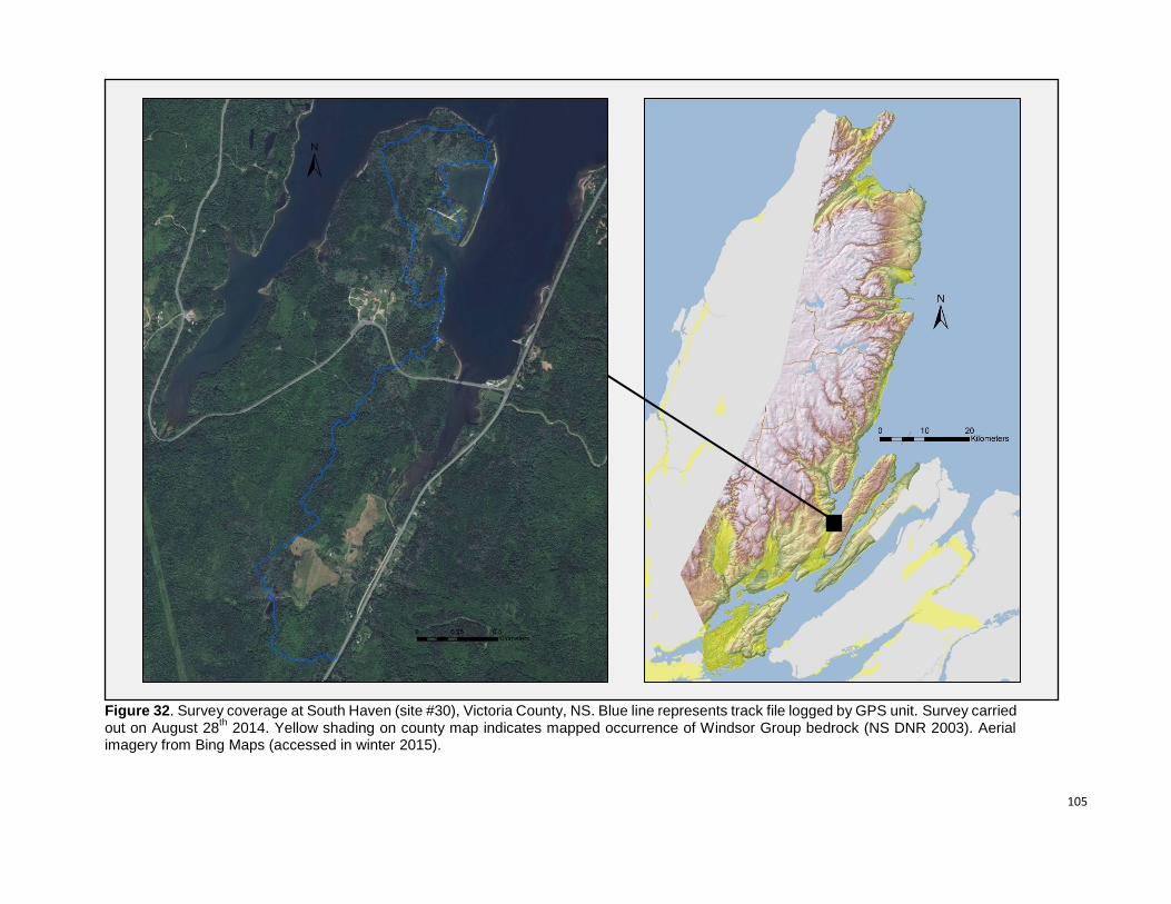
105
Figure 32. Survey coverage at South Haven (site #30), Victoria County, NS. Blue line represents track file logged by GPS unit. Survey carried out on August 28
th 2014. Yellow shading on county map indicates mapped occurrence of Windsor Group bedrock (NS DNR 2003). Aerial
imagery from Bing Maps (accessed in winter 2015).
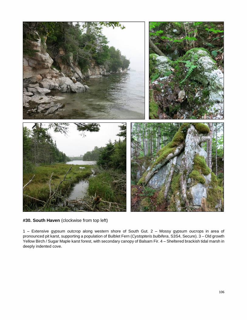
106
#30. South Haven (clockwise from top left)
1 – Extensive gypsum outcrop along western shore of South Gut. 2 – Mossy gypsum oucrops in area of
pronounced pit karst, supporting a population of Bulblet Fern (Cystopteris bulbifera, S3S4, Secure). 3 – Old growth
Yellow Birch / Sugar Maple karst forest, with secondary canopy of Balsam Fir. 4 – Sheltered brackish tidal marsh in
deeply indented cove.
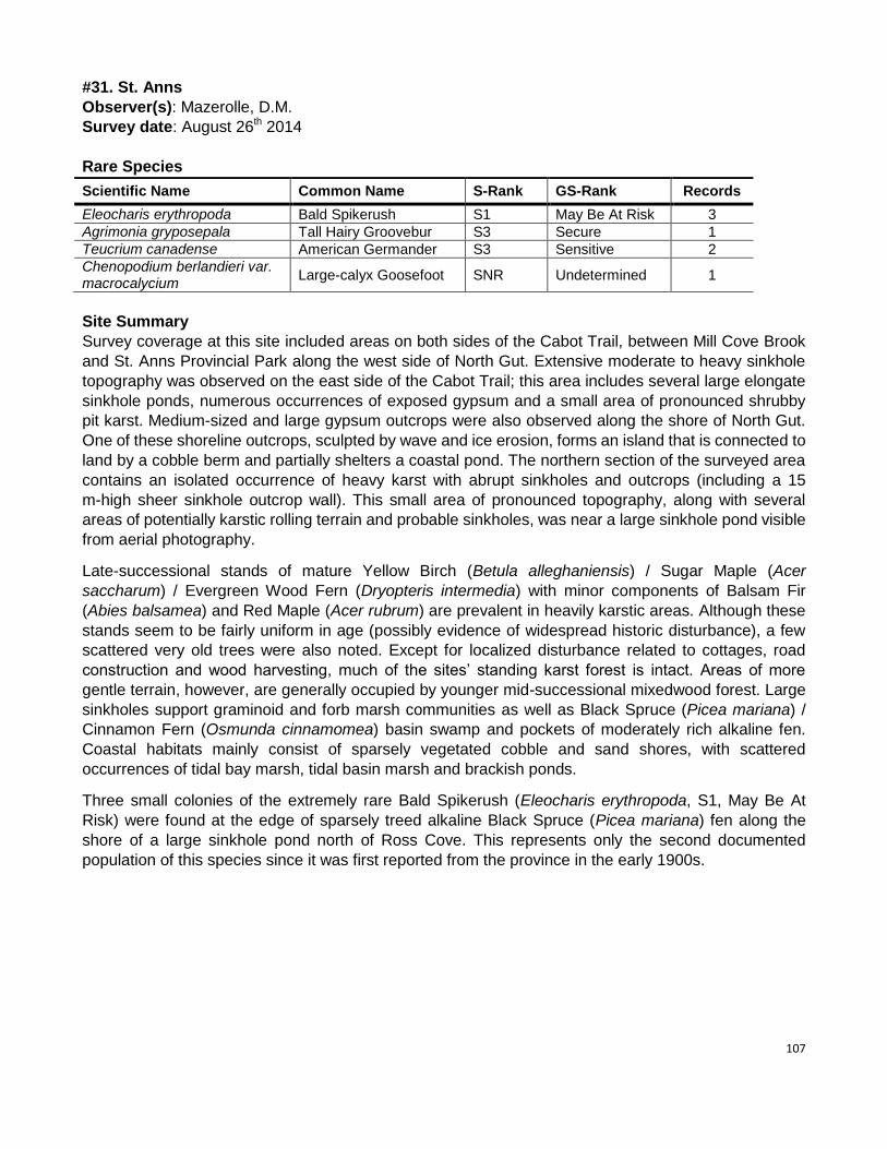
107
#31. St. Anns
Observer(s): Mazerolle, D.M.
Survey date: August 26th 2014
Rare Species
Scientific Name Common Name S-Rank GS-Rank Records
Eleocharis erythropoda Bald Spikerush S1 May Be At Risk 3
Agrimonia gryposepala Tall Hairy Groovebur S3 Secure 1
Teucrium canadense American Germander S3 Sensitive 2
Chenopodium berlandieri var. macrocalycium
Large-calyx Goosefoot SNR Undetermined 1
Site Summary
Survey coverage at this site included areas on both sides of the Cabot Trail, between Mill Cove Brook
and St. Anns Provincial Park along the west side of North Gut. Extensive moderate to heavy sinkhole
topography was observed on the east side of the Cabot Trail; this area includes several large elongate
sinkhole ponds, numerous occurrences of exposed gypsum and a small area of pronounced shrubby
pit karst. Medium-sized and large gypsum outcrops were also observed along the shore of North Gut.
One of these shoreline outcrops, sculpted by wave and ice erosion, forms an island that is connected to
land by a cobble berm and partially shelters a coastal pond. The northern section of the surveyed area
contains an isolated occurrence of heavy karst with abrupt sinkholes and outcrops (including a 15
m-high sheer sinkhole outcrop wall). This small area of pronounced topography, along with several
areas of potentially karstic rolling terrain and probable sinkholes, was near a large sinkhole pond visible
from aerial photography.
Late-successional stands of mature Yellow Birch (Betula alleghaniensis) / Sugar Maple (Acer
saccharum) / Evergreen Wood Fern (Dryopteris intermedia) with minor components of Balsam Fir
(Abies balsamea) and Red Maple (Acer rubrum) are prevalent in heavily karstic areas. Although these
stands seem to be fairly uniform in age (possibly evidence of widespread historic disturbance), a few
scattered very old trees were also noted. Except for localized disturbance related to cottages, road
construction and wood harvesting, much of the sites’ standing karst forest is intact. Areas of more
gentle terrain, however, are generally occupied by younger mid-successional mixedwood forest. Large
sinkholes support graminoid and forb marsh communities as well as Black Spruce (Picea mariana) /
Cinnamon Fern (Osmunda cinnamomea) basin swamp and pockets of moderately rich alkaline fen.
Coastal habitats mainly consist of sparsely vegetated cobble and sand shores, with scattered
occurrences of tidal bay marsh, tidal basin marsh and brackish ponds.
Three small colonies of the extremely rare Bald Spikerush (Eleocharis erythropoda, S1, May Be At
Risk) were found at the edge of sparsely treed alkaline Black Spruce (Picea mariana) fen along the
shore of a large sinkhole pond north of Ross Cove. This represents only the second documented
population of this species since it was first reported from the province in the early 1900s.
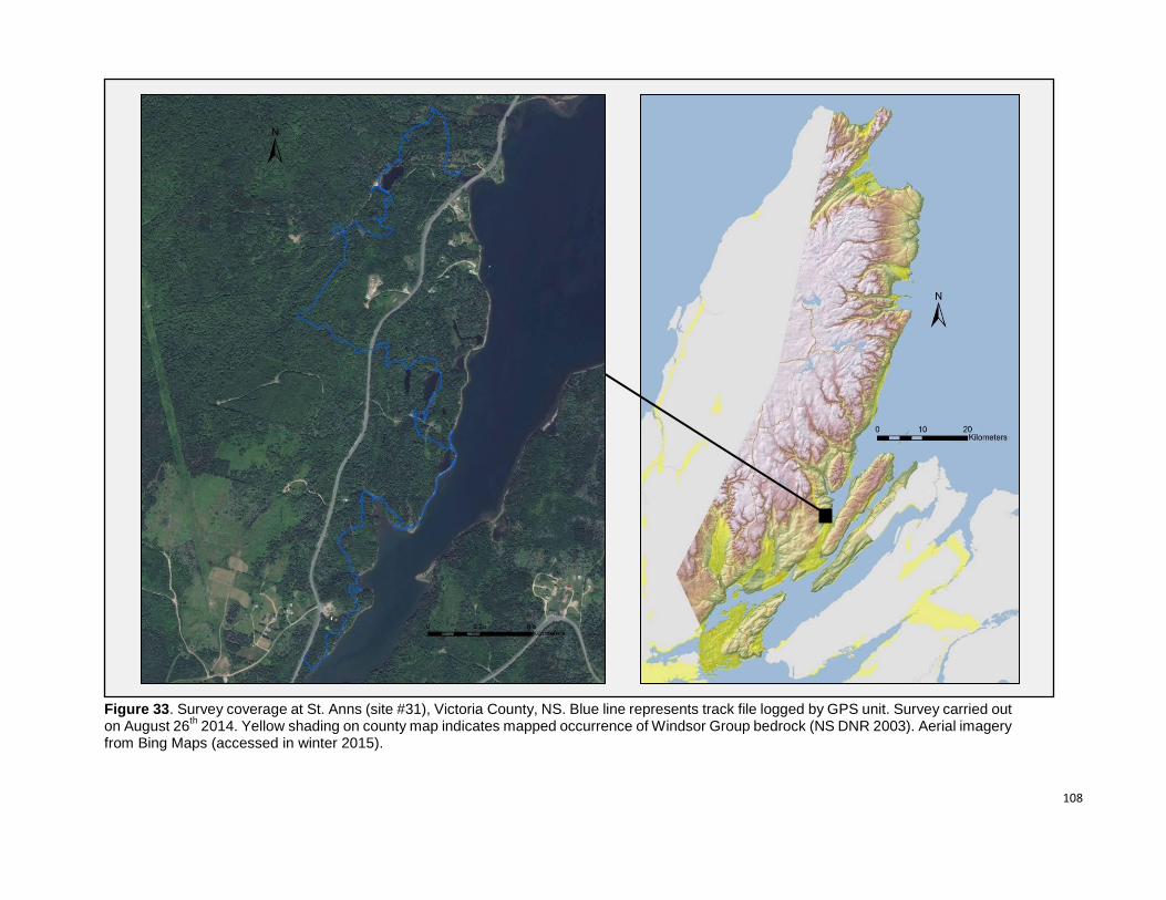
108
Figure 33. Survey coverage at St. Anns (site #31), Victoria County, NS. Blue line represents track file logged by GPS unit. Survey carried out on August 26
th 2014. Yellow shading on county map indicates mapped occurrence of Windsor Group bedrock (NS DNR 2003). Aerial imagery
from Bing Maps (accessed in winter 2015).
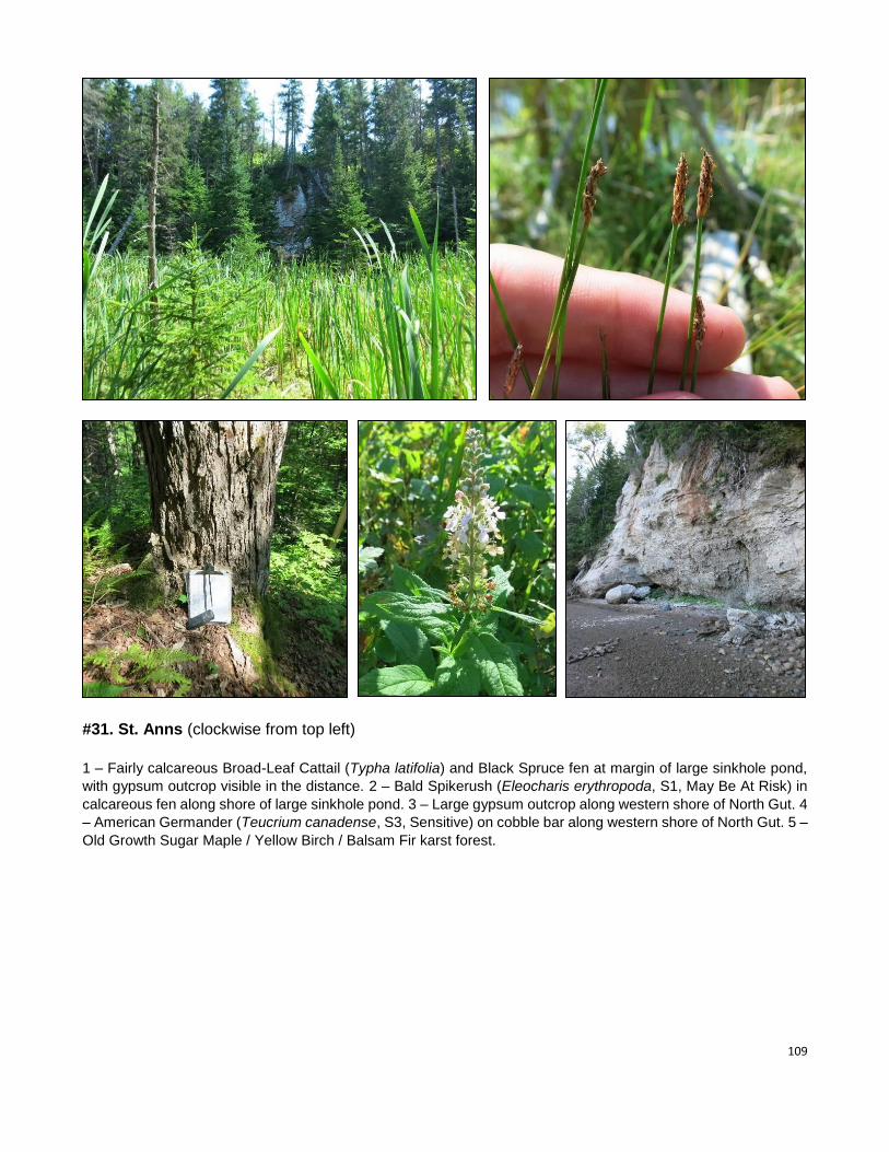
109
#31. St. Anns (clockwise from top left)
1 – Fairly calcareous Broad-Leaf Cattail (Typha latifolia) and Black Spruce fen at margin of large sinkhole pond,
with gypsum outcrop visible in the distance. 2 – Bald Spikerush (Eleocharis erythropoda, S1, May Be At Risk) in
calcareous fen along shore of large sinkhole pond. 3 – Large gypsum outcrop along western shore of North Gut. 4
– American Germander (Teucrium canadense, S3, Sensitive) on cobble bar along western shore of North Gut. 5 –
Old Growth Sugar Maple / Yellow Birch / Balsam Fir karst forest.
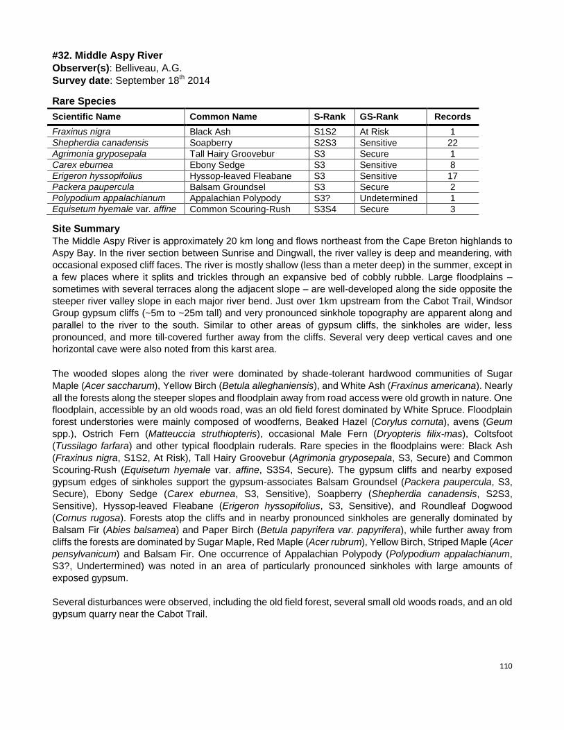
110
#32. Middle Aspy River
Observer(s): Belliveau, A.G.
Survey date: September 18th 2014
Rare Species
Scientific Name Common Name S-Rank GS-Rank Records
Fraxinus nigra Black Ash S1S2 At Risk 1
Shepherdia canadensis Soapberry S2S3 Sensitive 22
Agrimonia gryposepala Tall Hairy Groovebur S3 Secure 1
Carex eburnea Ebony Sedge S3 Sensitive 8
Erigeron hyssopifolius Hyssop-leaved Fleabane S3 Sensitive 17
Packera paupercula Balsam Groundsel S3 Secure 2
Polypodium appalachianum Appalachian Polypody S3? Undetermined 1
Equisetum hyemale var. affine Common Scouring-Rush S3S4 Secure 3
Site Summary
The Middle Aspy River is approximately 20 km long and flows northeast from the Cape Breton highlands to
Aspy Bay. In the river section between Sunrise and Dingwall, the river valley is deep and meandering, with
occasional exposed cliff faces. The river is mostly shallow (less than a meter deep) in the summer, except in
a few places where it splits and trickles through an expansive bed of cobbly rubble. Large floodplains –
sometimes with several terraces along the adjacent slope – are well-developed along the side opposite the
steeper river valley slope in each major river bend. Just over 1km upstream from the Cabot Trail, Windsor
Group gypsum cliffs (~5m to ~25m tall) and very pronounced sinkhole topography are apparent along and
parallel to the river to the south. Similar to other areas of gypsum cliffs, the sinkholes are wider, less
pronounced, and more till-covered further away from the cliffs. Several very deep vertical caves and one
horizontal cave were also noted from this karst area.
The wooded slopes along the river were dominated by shade-tolerant hardwood communities of Sugar
Maple (Acer saccharum), Yellow Birch (Betula alleghaniensis), and White Ash (Fraxinus americana). Nearly
all the forests along the steeper slopes and floodplain away from road access were old growth in nature. One
floodplain, accessible by an old woods road, was an old field forest dominated by White Spruce. Floodplain
forest understories were mainly composed of woodferns, Beaked Hazel (Corylus cornuta), avens (Geum
spp.), Ostrich Fern (Matteuccia struthiopteris), occasional Male Fern (Dryopteris filix-mas), Coltsfoot
(Tussilago farfara) and other typical floodplain ruderals. Rare species in the floodplains were: Black Ash
(Fraxinus nigra, S1S2, At Risk), Tall Hairy Groovebur (Agrimonia gryposepala, S3, Secure) and Common
Scouring-Rush (Equisetum hyemale var. affine, S3S4, Secure). The gypsum cliffs and nearby exposed
gypsum edges of sinkholes support the gypsum-associates Balsam Groundsel (Packera paupercula, S3,
Secure), Ebony Sedge (Carex eburnea, S3, Sensitive), Soapberry (Shepherdia canadensis, S2S3,
Sensitive), Hyssop-leaved Fleabane (Erigeron hyssopifolius, S3, Sensitive), and Roundleaf Dogwood
(Cornus rugosa). Forests atop the cliffs and in nearby pronounced sinkholes are generally dominated by
Balsam Fir (Abies balsamea) and Paper Birch (Betula papyrifera var. papyrifera), while further away from
cliffs the forests are dominated by Sugar Maple, Red Maple (Acer rubrum), Yellow Birch, Striped Maple (Acer
pensylvanicum) and Balsam Fir. One occurrence of Appalachian Polypody (Polypodium appalachianum,
S3?, Undertermined) was noted in an area of particularly pronounced sinkholes with large amounts of
exposed gypsum.
Several disturbances were observed, including the old field forest, several small old woods roads, and an old
gypsum quarry near the Cabot Trail.
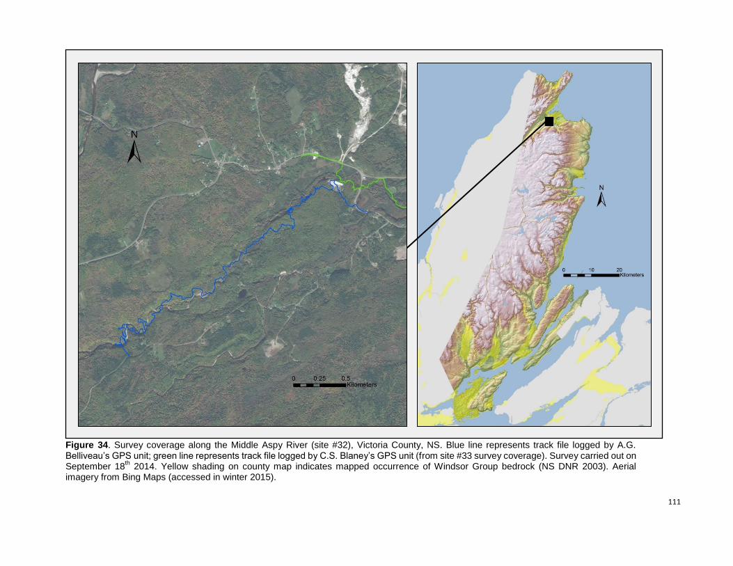
111
Figure 34. Survey coverage along the Middle Aspy River (site #32), Victoria County, NS. Blue line represents track file logged by A.G. Belliveau’s GPS unit; green line represents track file logged by C.S. Blaney’s GPS unit (from site #33 survey coverage). Survey carried out on September 18
th 2014. Yellow shading on county map indicates mapped occurrence of Windsor Group bedrock (NS DNR 2003). Aerial
imagery from Bing Maps (accessed in winter 2015).
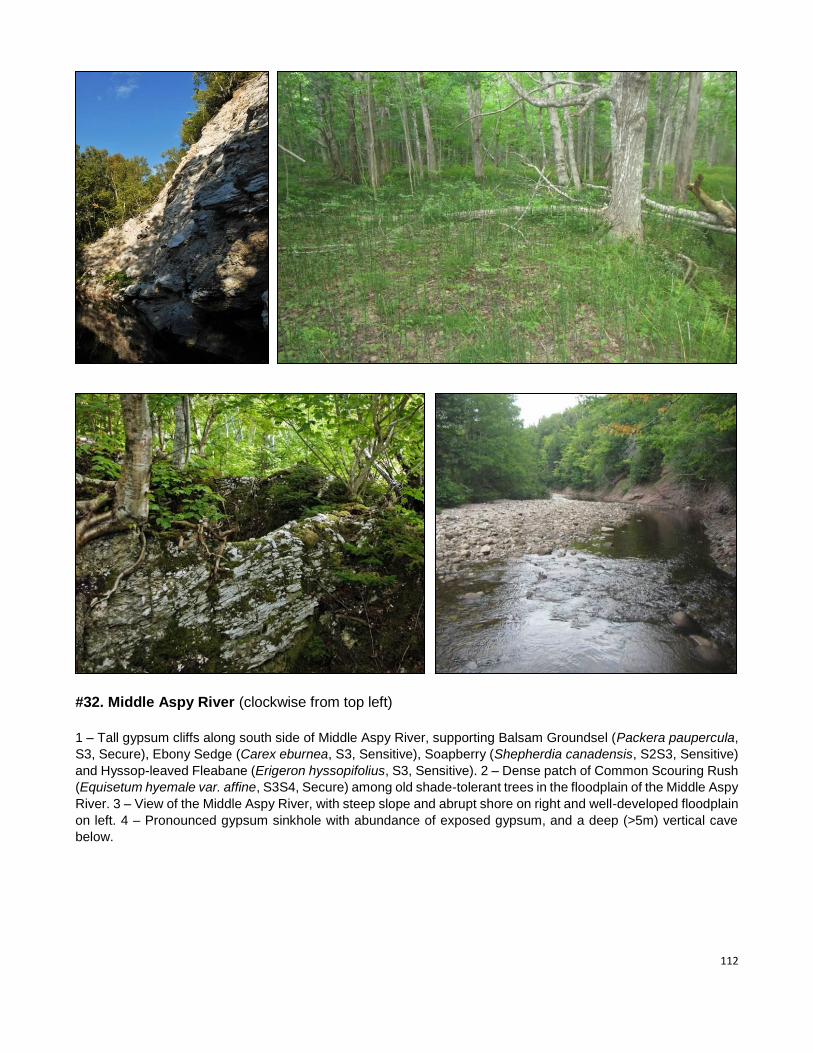
112
#32. Middle Aspy River (clockwise from top left)
1 – Tall gypsum cliffs along south side of Middle Aspy River, supporting Balsam Groundsel (Packera paupercula,
S3, Secure), Ebony Sedge (Carex eburnea, S3, Sensitive), Soapberry (Shepherdia canadensis, S2S3, Sensitive)
and Hyssop-leaved Fleabane (Erigeron hyssopifolius, S3, Sensitive). 2 – Dense patch of Common Scouring Rush
(Equisetum hyemale var. affine, S3S4, Secure) among old shade-tolerant trees in the floodplain of the Middle Aspy
River. 3 – View of the Middle Aspy River, with steep slope and abrupt shore on right and well-developed floodplain
on left. 4 – Pronounced gypsum sinkhole with abundance of exposed gypsum, and a deep (>5m) vertical cave
below.
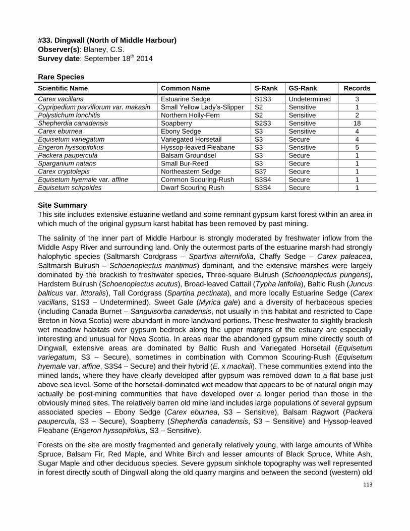
113
#33. Dingwall (North of Middle Harbour)
Observer(s): Blaney, C.S.
Survey date: September 18th 2014
Rare Species
Scientific Name Common Name S-Rank GS-Rank Records
Carex vacillans Estuarine Sedge S1S3 Undetermined 3
Cypripedium parviflorum var. makasin Small Yellow Lady’s-Slipper S2 Sensitive 1
Polystichum lonchitis Northern Holly-Fern S2 Sensitive 2
Shepherdia canadensis Soapberry S2S3 Sensitive 18
Carex eburnea Ebony Sedge S3 Sensitive 4
Equisetum variegatum Variegated Horsetail S3 Secure 4
Erigeron hyssopifolius Hyssop-leaved Fleabane S3 Sensitive 5
Packera paupercula Balsam Groundsel S3 Secure 1
Sparganium natans Small Bur-Reed S3 Secure 1
Carex cryptolepis Northeastern Sedge S3? Secure 1
Equisetum hyemale var. affine Common Scouring-Rush S3S4 Secure 1
Equisetum scirpoides Dwarf Scouring Rush S3S4 Secure 1
Site Summary
This site includes extensive estuarine wetland and some remnant gypsum karst forest within an area in
which much of the original gypsum karst habitat has been removed by past mining.
The salinity of the inner part of Middle Harbour is strongly moderated by freshwater inflow from the
Middle Aspy River and surrounding land. Only the outermost parts of the estuarine marsh had strongly
halophytic species (Saltmarsh Cordgrass – Spartina alternifolia, Chaffy Sedge – Carex paleacea,
Saltmarsh Bulrush – Schoenoplectus maritimus) dominant, and the extensive marshes were largely
dominated by the brackish to freshwater species, Three-square Bulrush (Schoenoplectus pungens),
Hardstem Bulrush (Schoenoplectus acutus), Broad-leaved Cattail (Typha latifolia), Baltic Rush (Juncus
balticus var. littoralis), Tall Cordgrass (Spartina pectinata), and more locally Estuarine Sedge (Carex
vacillans, S1S3 – Undetermined). Sweet Gale (Myrica gale) and a diversity of herbaceous species
(including Canada Burnet – Sanguisorba canadensis, not usually in this habitat and restricted to Cape
Breton in Nova Scotia) were abundant in more landward portions. These freshwater to slightly brackish
wet meadow habitats over gypsum bedrock along the upper margins of the estuary are especially
interesting and unusual for Nova Scotia. In areas near the abandoned gypsum mine directly south of
Dingwall, extensive areas are dominated by Baltic Rush and Variegated Horsetail (Equisetum
variegatum, S3 – Secure), sometimes in combination with Common Scouring-Rush (Equisetum
hyemale var. affine, S3S4 – Secure) and their hybrid (E. x mackaii). These communities extend into the
mined lands, where they have clearly developed after gypsum was removed down to a flat base just
above sea level. Some of the horsetail-dominated wet meadow that appears to be of natural origin may
actually be post-mining communities that have developed over a longer period than those in the
obviously mined sites. The relatively barren old mine land includes large populations of several gypsum
associated species – Ebony Sedge (Carex eburnea, S3 – Sensitive), Balsam Ragwort (Packera
paupercula, S3 – Secure), Soapberry (Shepherdia canadensis, S3 – Sensitive) and Hyssop-leaved
Fleabane (Erigeron hyssopifolius, S3 – Sensitive).
Forests on the site are mostly fragmented and generally relatively young, with large amounts of White
Spruce, Balsam Fir, Red Maple, and White Birch and lesser amounts of Black Spruce, White Ash,
Sugar Maple and other deciduous species. Severe gypsum sinkhole topography was well represented
in forest directly south of Dingwall along the old quarry margins and between the second (western) old

114
gypsum mine south of the river and the Cabot Trail. The first of these locations supported two locations
of Northern Holly Fern (Polystichum lonchitis, S2 – Sensitive, a rare species restricted in Nova Scotia to
northern Cape Breton and not known on gypsum outside the Dingwall area).
The north margin of the Middle Aspy River has a slightly raised terrace that has allowed a very narrow
band (generally 5 to 20 m) of rich hardwood floodplain forest to develop between the river and the lower
wet meadow / rough hayfield habitats just northward. This terrace supports some indicator plants of
calcareous soils but few significant species. The aggressively invasive exotic shrub honeysuckle
Lonicera x xylosteoides, which was never previously documented for Nova Scotia, is established and
clearly spreading in this area.
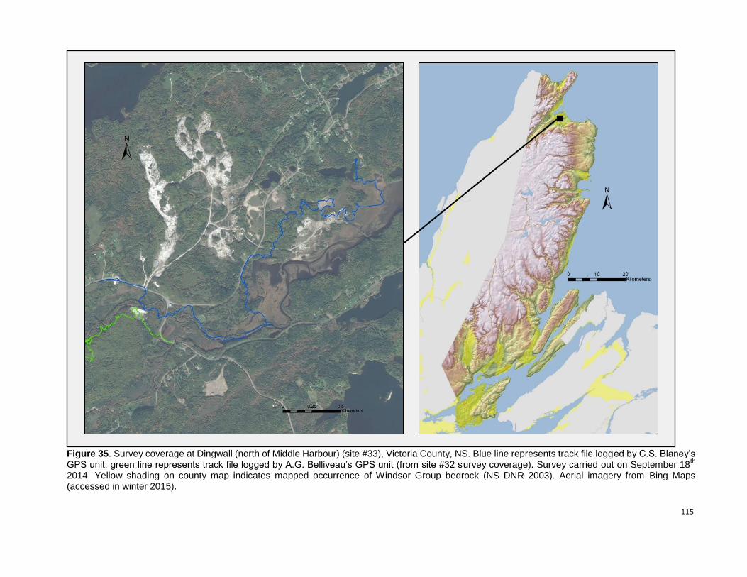
115
Figure 35. Survey coverage at Dingwall (north of Middle Harbour) (site #33), Victoria County, NS. Blue line represents track file logged by C.S. Blaney’s GPS unit; green line represents track file logged by A.G. Belliveau’s GPS unit (from site #32 survey coverage). Survey carried out on September 18
th
2014. Yellow shading on county map indicates mapped occurrence of Windsor Group bedrock (NS DNR 2003). Aerial imagery from Bing Maps (accessed in winter 2015).
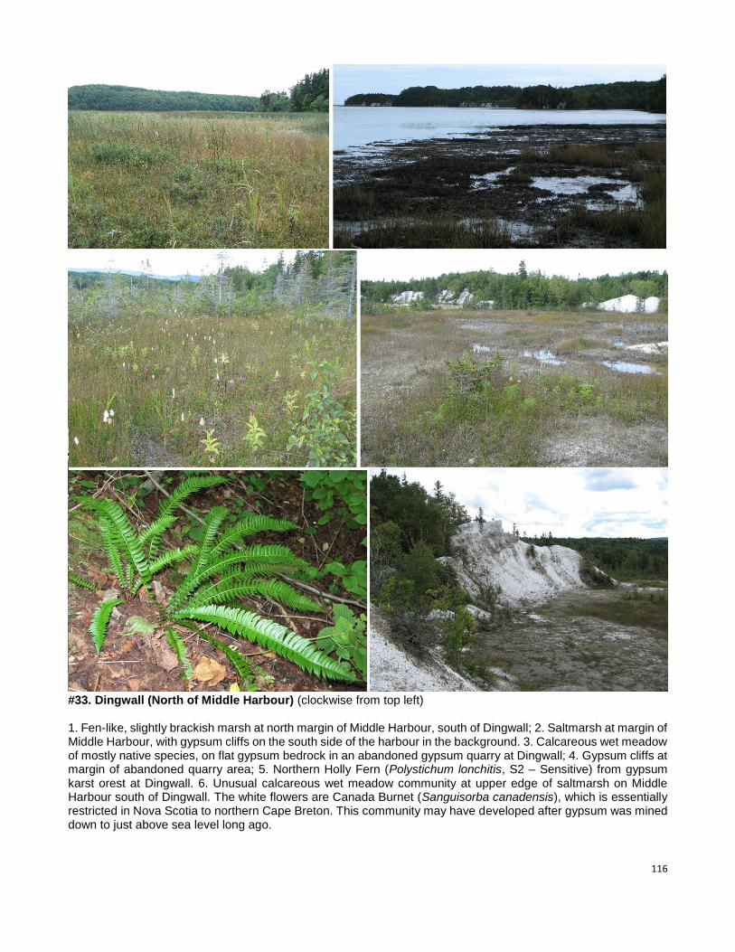
116
#33. Dingwall (North of Middle Harbour) (clockwise from top left) 1. Fen-like, slightly brackish marsh at north margin of Middle Harbour, south of Dingwall; 2. Saltmarsh at margin of Middle Harbour, with gypsum cliffs on the south side of the harbour in the background. 3. Calcareous wet meadow of mostly native species, on flat gypsum bedrock in an abandoned gypsum quarry at Dingwall; 4. Gypsum cliffs at margin of abandoned quarry area; 5. Northern Holly Fern (Polystichum lonchitis, S2 – Sensitive) from gypsum karst orest at Dingwall. 6. Unusual calcareous wet meadow community at upper edge of saltmarsh on Middle Harbour south of Dingwall. The white flowers are Canada Burnet (Sanguisorba canadensis), which is essentially restricted in Nova Scotia to northern Cape Breton. This community may have developed after gypsum was mined down to just above sea level long ago.
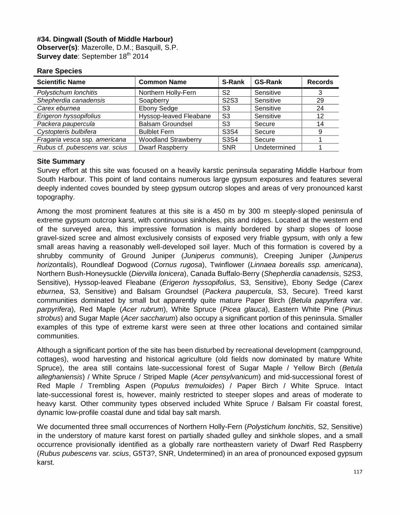
117
#34. Dingwall (South of Middle Harbour) Observer(s): Mazerolle, D.M.; Basquill, S.P.
Survey date: September 18th 2014
Rare Species
Scientific Name Common Name S-Rank GS-Rank Records
Polystichum lonchitis Northern Holly-Fern S2 Sensitive 3
Shepherdia canadensis Soapberry S2S3 Sensitive 29
Carex eburnea Ebony Sedge S3 Sensitive 24
Erigeron hyssopifolius Hyssop-leaved Fleabane S3 Sensitive 12
Packera paupercula Balsam Groundsel S3 Secure 14
Cystopteris bulbifera Bulblet Fern S3S4 Secure 9
Fragaria vesca ssp. americana Woodland Strawberry S3S4 Secure 1
Rubus cf. pubescens var. scius Dwarf Raspberry SNR Undetermined 1
Site Summary
Survey effort at this site was focused on a heavily karstic peninsula separating Middle Harbour from
South Harbour. This point of land contains numerous large gypsum exposures and features several
deeply indented coves bounded by steep gypsum outcrop slopes and areas of very pronounced karst
topography.
Among the most prominent features at this site is a 450 m by 300 m steeply-sloped peninsula of
extreme gypsum outcrop karst, with continuous sinkholes, pits and ridges. Located at the western end
of the surveyed area, this impressive formation is mainly bordered by sharp slopes of loose
gravel-sized scree and almost exclusively consists of exposed very friable gypsum, with only a few
small areas having a reasonably well-developed soil layer. Much of this formation is covered by a
shrubby community of Ground Juniper (Juniperus communis), Creeping Juniper (Juniperus
horizontalis), Roundleaf Dogwood (Cornus rugosa), Twinflower (Linnaea borealis ssp. americana),
Northern Bush-Honeysuckle (Diervilla lonicera), Canada Buffalo-Berry (Shepherdia canadensis, S2S3,
Sensitive), Hyssop-leaved Fleabane (Erigeron hyssopifolius, S3, Sensitive), Ebony Sedge (Carex
eburnea, S3, Sensitive) and Balsam Groundsel (Packera paupercula, S3, Secure). Treed karst
communities dominated by small but apparently quite mature Paper Birch (Betula papyrifera var.
parpyrifera), Red Maple (Acer rubrum), White Spruce (Picea glauca), Eastern White Pine (Pinus
strobus) and Sugar Maple (Acer saccharum) also occupy a significant portion of this peninsula. Smaller
examples of this type of extreme karst were seen at three other locations and contained similar
communities.
Although a significant portion of the site has been disturbed by recreational development (campground,
cottages), wood harvesting and historical agriculture (old fields now dominated by mature White
Spruce), the area still contains late-successional forest of Sugar Maple / Yellow Birch (Betula
alleghaniensis) / White Spruce / Striped Maple (Acer pensylvanicum) and mid-successional forest of
Red Maple / Trembling Aspen (Populus tremuloides) / Paper Birch / White Spruce. Intact
late-successional forest is, however, mainly restricted to steeper slopes and areas of moderate to
heavy karst. Other community types observed included White Spruce / Balsam Fir coastal forest,
dynamic low-profile coastal dune and tidal bay salt marsh.
We documented three small occurrences of Northern Holly-Fern (Polystichum lonchitis, S2, Sensitive)
in the understory of mature karst forest on partially shaded gulley and sinkhole slopes, and a small
occurrence provisionally identified as a globally rare northeastern variety of Dwarf Red Raspberry
(Rubus pubescens var. scius, G5T3?, SNR, Undetermined) in an area of pronounced exposed gypsum
karst.
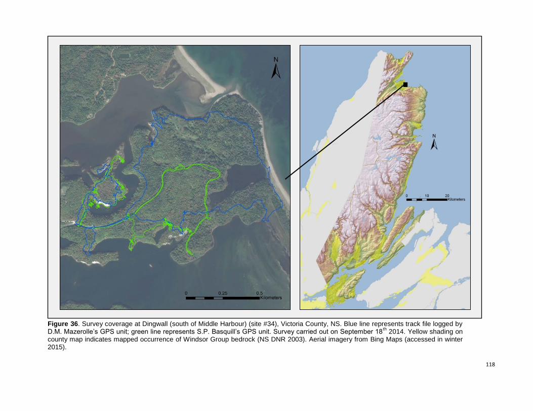
118
Figure 36. Survey coverage at Dingwall (south of Middle Harbour) (site #34), Victoria County, NS. Blue line represents track file logged by D.M. Mazerolle’s GPS unit; green line represents S.P. Basquill’s GPS unit. Survey carried out on September 18
th 2014. Yellow shading on
county map indicates mapped occurrence of Windsor Group bedrock (NS DNR 2003). Aerial imagery from Bing Maps (accessed in winter 2015).
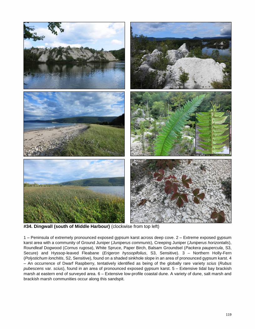
119
#34. Dingwall (south of Middle Harbour) (clockwise from top left)
1 – Peninsula of extremely pronounced exposed gypsum karst across deep cove. 2 – Extreme exposed gypsum
karst area with a community of Ground Juniper (Juniperus communis), Creeping Juniper (Juniperus horizontalis),
Roundleaf Dogwood (Cornus rugosa), White Spruce, Paper Birch, Balsam Groundsel (Packera paupercula, S3,
Secure) and Hyssop-leaved Fleabane (Erigeron hyssopifolius, S3, Sensitive). 3 – Northern Holly-Fern
(Polystichum lonchitis, S2, Sensitive), found on a shaded sinkhole slope in an area of pronounced gypsum karst. 4
– An occurrence of Dwarf Raspberry, tentatively identified as being of the globally rare variety scius (Rubus
pubescens var. scius), found in an area of pronounced exposed gypsum karst. 5 – Extensive tidal bay brackish
marsh at eastern end of surveyed area. 6 – Extensive low-profile coastal dune. A variety of dune, salt marsh and
brackish marsh communities occur along this sandspit.
120
#35. Georges River
Observer(s): Belliveau, A.G.
Survey date: September 9th 2014
Rare Species
Scientific Name Common Name S-Rank GS-Rank Records
Asplenium trichomanes-ramosum Green Spleenwort S2 Sensitive 1
Carex hystericina Porcupine Sedge S2 May Be At Risk 1
Agrimonia gryposepala Tall Hairy Groovebur S3 Secure 2
Sparganium natans Small Bur-Reed S3 Secure 1
Cystopteris bulbifera Bulblet Fern S3S4 Secure 35
Equisetum scirpoides Dwarf Scouring-Rush S3S4 Secure 2
Fragaria vesca ssp. americana Woodland Strawberry S3S4 Secure 1
Site Summary
The Georges River cuts through gypsum and limestone between slopes of non-calcareous till, and several
outcrops occur along the surveyed portion of the river, mostly in steep-sloped, shady forested habitats. One
cave, known locally as MacLeod Cave, extends about 10 m into gypsum bedrock. Larger, relatively shallow
sinkholes, mostly lacking exposed gypsum, line the bottom and edge of the river valley. Coarse gypsum and
limestone rubble dots the clear waters and shores of the river from the large open wetland in the southwest to
the large quarry in the northeast. Further downstream, the river slows and meanders with some floodplain
terraces and finer substrates forming occasional gravel bars. The northern shore below the quarry rises
steeply and is mostly of coarse, less calcareous scree. Less pronounced karst topography occurs to the
northeast end of the area.
The river valley is dominated by older forests of Eastern Hemlock (Tsuga canadensis), Sugar Maple (Acer
saccharum), Yellow Birch (Betula alleghaniensis), and American Beech (Fagus grandifolia) which grades into
younger, less shade-tolerant forests further upslope and north of the quarry. Although understory diversity is
fairly low, a few areas of dry, sloped forest included Dwarf Scouring-Rush (Equisetum scirpoides, S3S4,
Secure) and Woodland Strawberry (Fragaria vesca ssp. americana, S3S4, Secure). The open wetland at the
southwest end of the surveyed area is dominated by graminoid species such as Bluejoint Reed Grass
(Calamagrostis canadensis), Slender Sedge (Carex lasiocarpa var. americana), Cottongrass Bulrush
(Scirpus cyperinus), Leatherleaf (Chamaedaphne calyculata), Broad-leaved Cattail (Typha latifolia), and
Softstem Bulrush (Schoenoplectus tabernaemontani). Bulblet Fern (Cystopteris bulbifera, S3S4, Secure) is
often the prevalent species on exposed gypsum and limestone along the river and adjacent steep slopes. A
few fairly deep, seepy, cool sinkholes are home to species such as Braun’s Holly Fern (Polystichum braunii),
Silvery Spleenwort (Deparia acrostichoides), and Herb Robert (Geranium robertianum). The largest exposed
face of limestone noted along the river also supports one occurrence of Green Spleenwort (Asplenium
trichomanes-ramosum, S2, Sensitive) and one occurrence of Dwarf Scouring-Rush (Equisetum scirpoides,
S3S4, Secure). Two occurrences of Hooked Agrimony (Agrimonia gryposepala, S3, Secure) and a single
plant of Porcupine Sedge (Carex hystericina, S2, May Be At Risk) were noted from the edge of the river in
narrow sections of open, somewhat rich floodplains. Small Burreed (Sparganium natans, S3 – Secure) was
also found in the clear shallow waters of a slow-flowing section of the river.
Recent disturbances to the site include an old woods road and bridge, an abandoned field edging the river
valley, the large limestone quarry (with access road and bridge), and a small, abandoned log-driving dam.
The ~1 km stretch of river in which rare species and exposed gypsum and limestone occur is, however,
relatively unaffected by any recent disturbance.
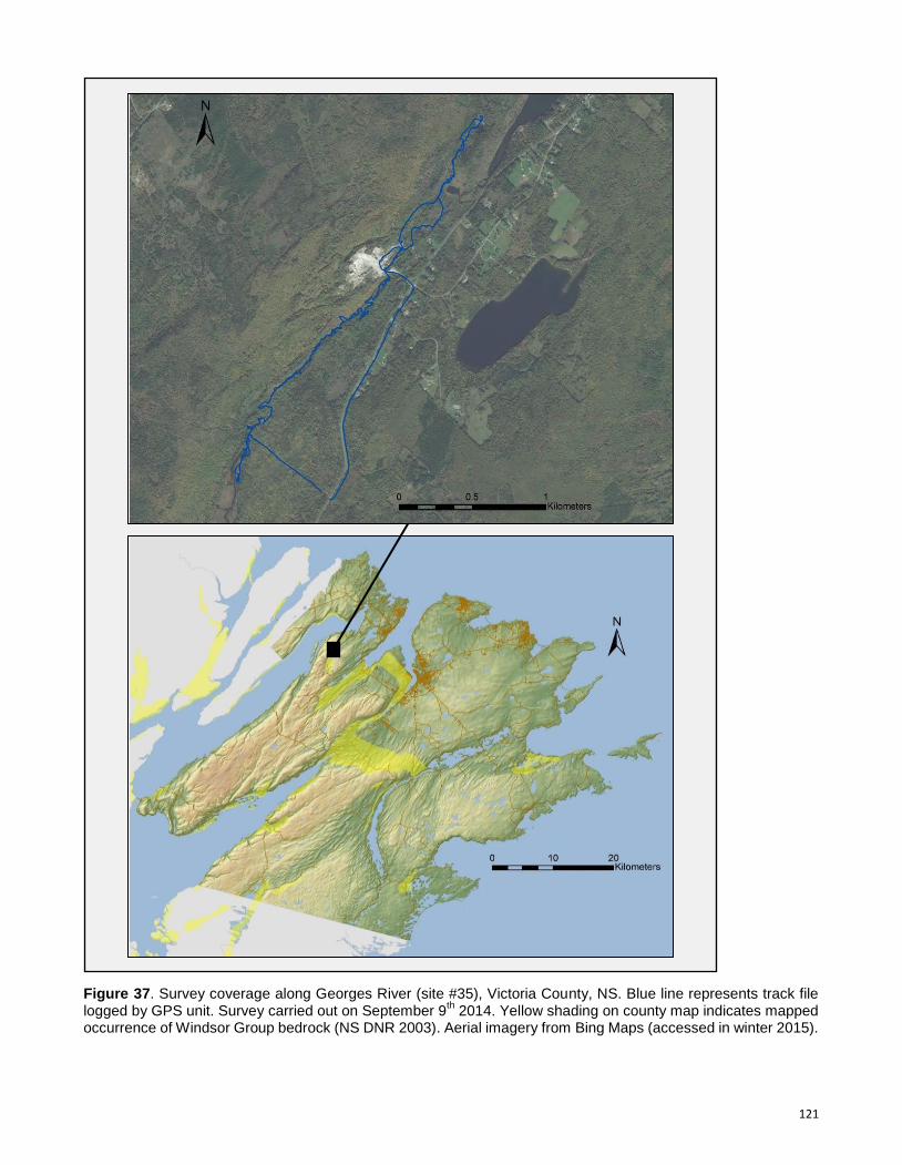
121
Figure 37. Survey coverage along Georges River (site #35), Victoria County, NS. Blue line represents track file logged by GPS unit. Survey carried out on September 9
th 2014. Yellow shading on county map indicates mapped
occurrence of Windsor Group bedrock (NS DNR 2003). Aerial imagery from Bing Maps (accessed in winter 2015).
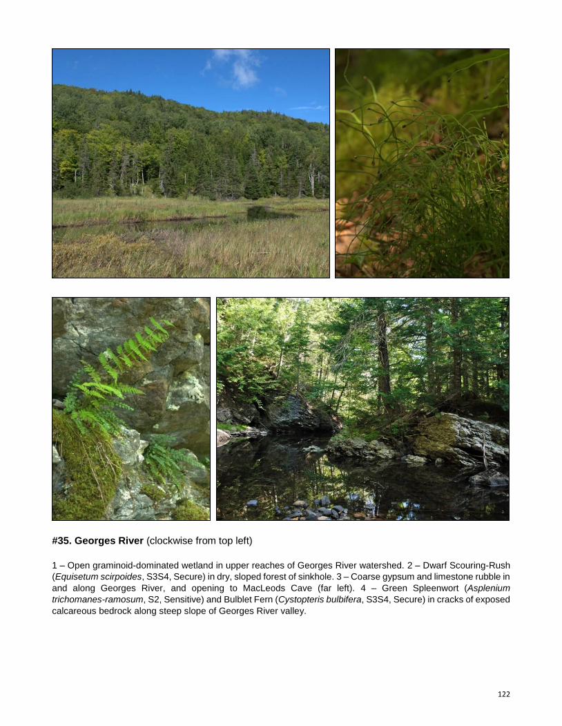
122
#35. Georges River (clockwise from top left)
1 – Open graminoid-dominated wetland in upper reaches of Georges River watershed. 2 – Dwarf Scouring-Rush
(Equisetum scirpoides, S3S4, Secure) in dry, sloped forest of sinkhole. 3 – Coarse gypsum and limestone rubble in
and along Georges River, and opening to MacLeods Cave (far left). 4 – Green Spleenwort (Asplenium
trichomanes-ramosum, S2, Sensitive) and Bulblet Fern (Cystopteris bulbifera, S3S4, Secure) in cracks of exposed
calcareous bedrock along steep slope of Georges River valley.
123
#36. Frenchvale Brook
Observer(s): Mazerolle, D.M.
Survey date: September 9th 2014
Rare Species
Scientific Name Common Name S-Rank GS-Rank Records
Fraxinus nigra Black Ash S1S2 At Risk 1
Agrimonia gryposepala Tall Hairy Groovebur S3 Secure 2
Rhamnus alnifolia Alderleaf Buckthorn S3 Secure 1
Carex cryptolepis Northeastern Sedge S3? Secure 3
Site Summary
Survey effort at this site was focused on a 5.5 km section of the shallow and gently-sloping Frenchvale
Brook valley, from Rear Balls Creek to Gouthro Lake. Despite the large area covered, very little surface
gypsum was seen. Gypsum features were limited to scattered occurrences of small sinkholes in the
brook floodplain, a few wide shallow depressions forming basin wetlands, and a few small areas of
calcareous riparian wetland.
Due in part to its gentle terrain and proximity to Cape Breton’s most densely populated centre, the
Frenchvale Brook valley has been highly disturbed through wood harvesting. Extensive areas are
presently regenerating from recent clear-cutting and most standing forest in the surveyed area consists
of early- and mid-successional mixedwood communities. Quarrying and agricultural activities have also
cumulatively caused significant deforestation. Stands of mature mesic Red Maple (Acer rubrum), White
Ash (Fraxinus americana) / Red Maple and Red Maple / Balsam Fir (Abies balsamea) are common
throughout, though mostly restricted to lower valley slopes and riparian areas. The site’s northeastern
end contains a few very localized occurrences of moderately rich mature floodplain hardwoods
dominated by Red Maple (Acer rubrum), White Ash (Fraxinus americana) and Yellow Birch (Betula
alleghaniensis). Remnant stands of mature to old pure Eastern Hemlock (Tsuga canadensis) and
Eastern Hemlock / Red Maple / Eastern White Pine (Pinus strobus) were also found at two locations.
A sizeable area of Red Maple / Black Spruce (Picea mariana) / Tamarack (Larix laricina) / Balsam Fir
(Abies balsamea) swamp was observed south of the brook in the eastern half of the site, in an area
characterized by large shallow sinkhole-like depressions. Black Ash (Fraxinus nigra, S1S2, At Risk,
Threatened) was found within this swamp, in an area locally influenced by calcareous groundwater
seepage. Wetlands around MacMullin Lake are moderately calcareous, supporting shrubby Red Maple
riparian swamp and Shrubby Cinquefoil (Dasiphora fruticosa ssp. floribunda) / Broad-Leaf Cattail
(Typha latifolia) / Slender Sedge (Carex lasiocarpa) / Royal Fern (Osmunda regalis var. spectabilis) fen
communities, as well as a number of calciphilic species including Buxbaum’s Sedge (Carex
buxbaumii). Extensive Beaver-influenced Speckled Alder (Alnus incana ssp. rugosa) / Blue Joint
Reed Grass (Calamagrostis canadensis) meadows were observed where Frenchvale Brook meets a
small tributary from MacMullin Lake. Shallow sinkhole basins, mainly observed in the site’s north end,
also include vernal pools and various marsh and fen communities.
124
Figure 38. Survey coverage along Frenchvale Brook (site #36), Cape Breton County, NS. Blue line represents track file logged by GPS unit. Survey carried out on September 9
th 2014. Yellow shading on county map indicates mapped
occurrence of Windsor Group bedrock (NS DNR 2003). Aerial imagery from Bing Maps (2015).
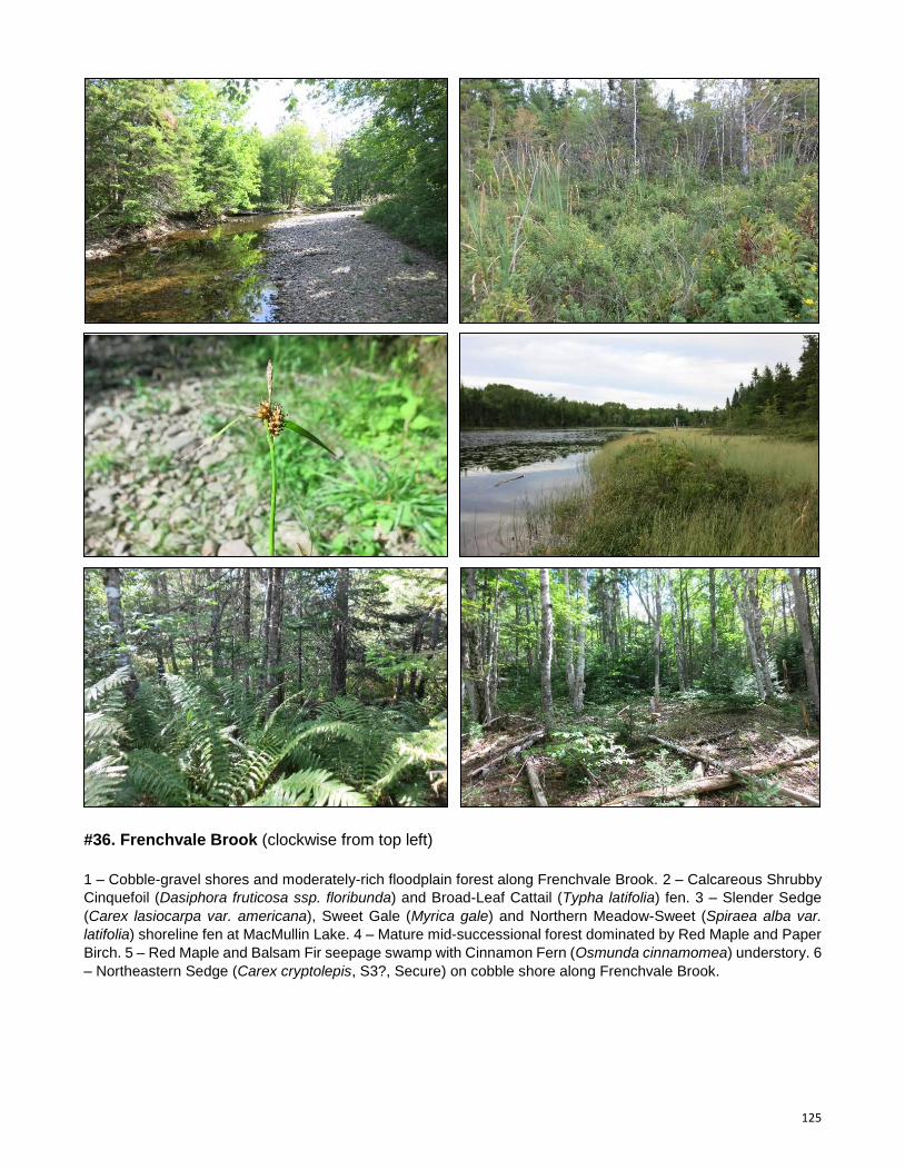
125
#36. Frenchvale Brook (clockwise from top left)
1 – Cobble-gravel shores and moderately-rich floodplain forest along Frenchvale Brook. 2 – Calcareous Shrubby
Cinquefoil (Dasiphora fruticosa ssp. floribunda) and Broad-Leaf Cattail (Typha latifolia) fen. 3 – Slender Sedge
(Carex lasiocarpa var. americana), Sweet Gale (Myrica gale) and Northern Meadow-Sweet (Spiraea alba var.
latifolia) shoreline fen at MacMullin Lake. 4 – Mature mid-successional forest dominated by Red Maple and Paper
Birch. 5 – Red Maple and Balsam Fir seepage swamp with Cinnamon Fern (Osmunda cinnamomea) understory. 6
– Northeastern Sedge (Carex cryptolepis, S3?, Secure) on cobble shore along Frenchvale Brook.
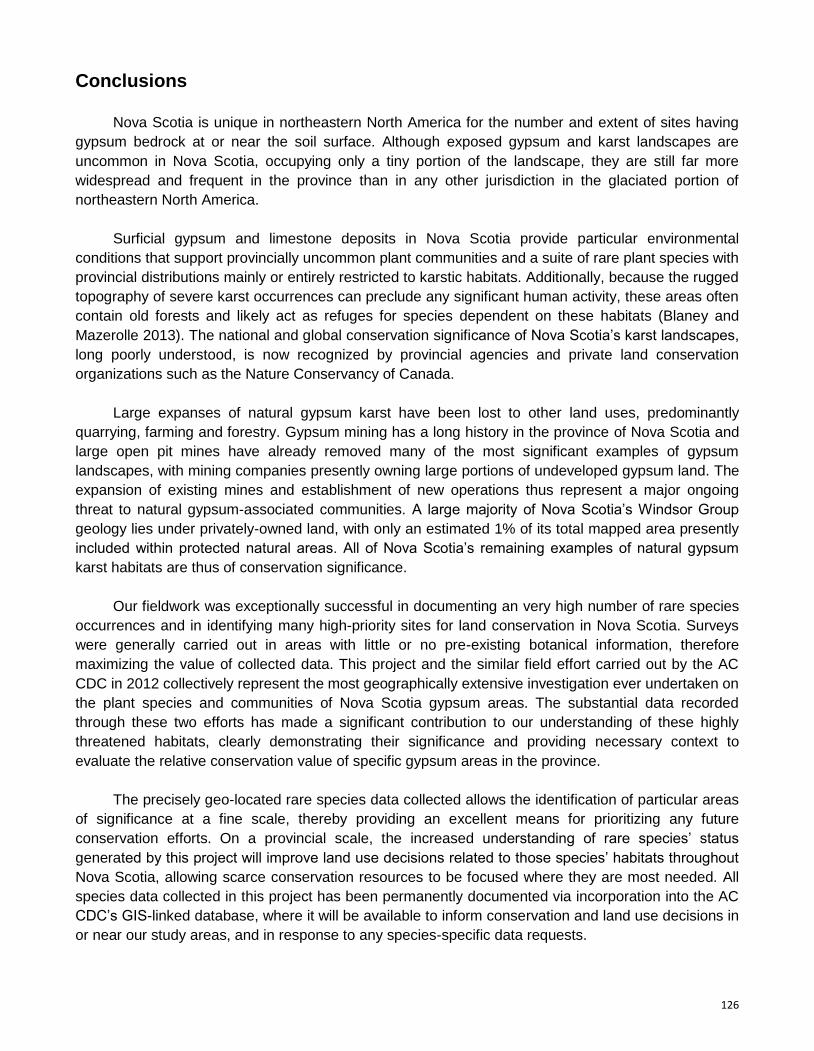
126
Conclusions
Nova Scotia is unique in northeastern North America for the number and extent of sites having
gypsum bedrock at or near the soil surface. Although exposed gypsum and karst landscapes are
uncommon in Nova Scotia, occupying only a tiny portion of the landscape, they are still far more
widespread and frequent in the province than in any other jurisdiction in the glaciated portion of
northeastern North America.
Surficial gypsum and limestone deposits in Nova Scotia provide particular environmental
conditions that support provincially uncommon plant communities and a suite of rare plant species with
provincial distributions mainly or entirely restricted to karstic habitats. Additionally, because the rugged
topography of severe karst occurrences can preclude any significant human activity, these areas often
contain old forests and likely act as refuges for species dependent on these habitats (Blaney and
Mazerolle 2013). The national and global conservation significance of Nova Scotia’s karst landscapes,
long poorly understood, is now recognized by provincial agencies and private land conservation
organizations such as the Nature Conservancy of Canada.
Large expanses of natural gypsum karst have been lost to other land uses, predominantly
quarrying, farming and forestry. Gypsum mining has a long history in the province of Nova Scotia and
large open pit mines have already removed many of the most significant examples of gypsum
landscapes, with mining companies presently owning large portions of undeveloped gypsum land. The
expansion of existing mines and establishment of new operations thus represent a major ongoing
threat to natural gypsum-associated communities. A large majority of Nova Scotia’s Windsor Group
geology lies under privately-owned land, with only an estimated 1% of its total mapped area presently
included within protected natural areas. All of Nova Scotia’s remaining examples of natural gypsum
karst habitats are thus of conservation significance.
Our fieldwork was exceptionally successful in documenting an very high number of rare species
occurrences and in identifying many high-priority sites for land conservation in Nova Scotia. Surveys
were generally carried out in areas with little or no pre-existing botanical information, therefore
maximizing the value of collected data. This project and the similar field effort carried out by the AC
CDC in 2012 collectively represent the most geographically extensive investigation ever undertaken on
the plant species and communities of Nova Scotia gypsum areas. The substantial data recorded
through these two efforts has made a significant contribution to our understanding of these highly
threatened habitats, clearly demonstrating their significance and providing necessary context to
evaluate the relative conservation value of specific gypsum areas in the province.
The precisely geo-located rare species data collected allows the identification of particular areas
of significance at a fine scale, thereby providing an excellent means for prioritizing any future
conservation efforts. On a provincial scale, the increased understanding of rare species’ status
generated by this project will improve land use decisions related to those species’ habitats throughout
Nova Scotia, allowing scarce conservation resources to be focused where they are most needed. All
species data collected in this project has been permanently documented via incorporation into the AC
CDC’s GIS-linked database, where it will be available to inform conservation and land use decisions in
or near our study areas, and in response to any species-specific data requests.
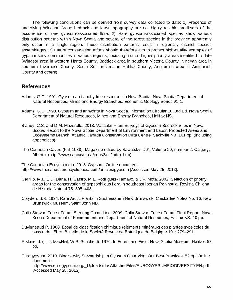
127
The following conclusions can be derived from survey data collected to date: 1) Presence of
underlying Windsor Group bedrock and karst topography are not highly reliable predictors of the
occurrence of rare gypsum-associated flora. 2) Rare gypsum-associated species show various
distribution patterns within Nova Scotia and several of the rarest species in the province apparently
only occur in a single region. These distribution patterns result in regionally distinct species
assemblages. 3) Future conservation efforts should therefore aim to protect high-quality examples of
gypsum karst communities in various regions, focusing first on higher-priority areas identified to date
(Windsor area in western Hants County, Baddeck area in southern Victoria County, Ninevah area in
southern Inverness County, South Section area in Halifax County, Antigonish area in Antigonish
County and others).
References Adams, G.C. 1991. Gypsum and andhydrite resources in Nova Scotia. Nova Scotia Department of
Natural Resources, Mines and Energy Branches. Economic Geology Series 91-1. Adams, G.C. 1993. Gypsum and anhydrite in Nova Scotia. Information Circular 16, 3rd Ed. Nova Scotia
Department of Natural Resources, Mines and Energy Branches, Halifax NS. Blaney, C.S. and D.M. Mazerolle. 2013. Vascular Plant Surveys of Gypsum Bedrock Sites in Nova
Scotia. Report to the Nova Scotia Department of Environment and Labor, Protected Areas and Ecosystems Branch. Atlantic Canada Conservation Data Centre, Sackville NB. 161 pp. (including appendices).
The Canadian Caver. (Fall 1988). Magazine edited by Sawatsky, D.K. Volume 20, number 2. Calgary,
Alberta. (http://www.cancaver.ca/pubs2/cc/index.htm).
The Canadian Encyclopedia. 2013. Gypsum. Online document: http://www.thecanadianencyclopedia.com/articles/gypsum [Accessed May 25, 2013]. Cerrillo, M.I., E.D. Dana, H. Castro, M.L. Rodriguez-Tamayo, & J.F. Mota. 2002. Selection of priority
areas for the conservation of gypsophilous flora in southeast Iberian Peninsula. Revista Chilena de Historia Natural 75: 395–408.
Clayden, S.R. 1994. Rare Arctic Plants in Southeastern New Brunswick. Chickadee Notes No. 16. New
Brunswick Museum, Saint John NB. Colin Stewart Forest Forum Steering Committee. 2009. Colin Stewart Forest Forum Final Report. Nova
Scotia Department of Environment and Department of Natural Resources, Halifax NS. 40 pp. Duvigneaud P. 1968. Essai de classification chimique (éléments minéraux) des plantes gypsicoles du
bassin de l’Ebre. Bulletin de la Société Royale de Botanique de Belgique 101: 279–291. Erskine, J. (ill. J. MacNeil, W.B. Schofield). 1976. In Forest and Field. Nova Scotia Museum, Halifax. 52
pp. Eurogypsum. 2010. Biodiversity Stewardship in Gypsum Quarrying: Our Best Practices. 52 pp. Online
document: http://www.eurogypsum.org/_Uploads/dbsAttachedFiles/EUROGYPSUMBIODIVERSITYEN.pdf [Accessed May 25, 2013].
128
FAO UN (Food and Agriculture Organization of the United Nations). 1990. Management of Gypsiferous Soils. FAO Soils Bulletin 62. Soil Resources, Management and Conservation Service, Land and Water Development Division, Food and Agriculture Organization of the United Nations, Rome. Online document: http://www.fao.org/docrep/t0323e/t0323e02.htm [Accessed May 28, 2013].
Fernald, M.L. 1921. The Gray Herbarium expedition to Nova Scotia 1920. Rhodora 23: 89-111,
130-152, 153-171, 184-195, 233-245, 257-78, 284-300. Guerrero Campo, J., F. Alberto, J. Hodgson, J.M. García Ruiz, & G. Montserrat Martí. 1999a. Plant
community patterns in a gypsum area of NE Spain. I. Interactions with topographic factors and soil erosion. Journal of Arid Environments 41: 401–410. 125.
Guerrero Campo, J., F. Alberto, J. Hodgson, J.M. García Ruiz, & G. Montserrat Martí. 1999b. Plant
community patterns in a gypsum area of NE Spain. II. Effects of ion washing on topographic distribution of vegetation. Journal of Arid Environments 41: 411–419.
Hill, N.M. & C.S. Blaney. 2009. Exotic and invasive vascular plants of the Atlantic Maritime Ecozone. In
Assessment of Species Diversity in Exotic and invasive vascular plants of the Atlantic Maritime Ecozone. Edited by D.F. McAlpine and I.M. Smith. NRC Research Press, Ottawa, Canada. pp. 1–18.
Hill, N.M. & D.J. Garbary. 2011. Habitat may limit herb migration at the northern edge of the
Appalachian deciduous forest. Botany 89: 635–645. doi:10.1139/B11-055. House, K., & N.R. Catto. 2004. Active gypsum karst, Woodville, Newfoundland. Proceedings of the
Annual Meeting of the Canadian Association of Geographers. Tuesday, May 25 – Saturday, May 29, 2004. Jointly organised by Université de Moncton and Mount Allison University. Moncton, New Brunswick.
IPANE (Invasive Plant Atlas of New England). 2013. Catalog of Species. Website:
http://www.eddmaps.org/ipane/ipanespecies/species_list.htm [Accessed May 25, 2013]. Johnston, I.M. 1941. Gypsophily among Mexican desert plants. Journal of the Arnold Arboretum 22:
145–170. Meyer, S.E. 1986. The ecology of gypsophile endemism in the Eastern Mojave desert. Ecology 67:
1303–1313. Meyer, S.E. & E. García-Moya. 1989. Plant community patterns and soil moisture regime in gypsum
grasslands of north central Mexico. Journal of Arid Environments 16: 147–155. Meyer S., E. García-Moya & L.C. Lagunei-Spinosa. 1992. Topographic and soil surface effects on
gypsophile plant community patterns in central Mexico. Journal of Vegetation Science 3: 429–438.
Moore, M. J., & R.K. Jansen. 2007. Origins and biogeography of gypsophily in the Chihuahuan Desert
plant group Tiquilia subg. Eddya (Boraginaceae). Systematic Botany 32: 392-414. Mosely, M. 1996. The gypsum karsts and caves of the Canadian Maritimes. Cave Karst Sci. 23: 5-16. Moseley, M. 2007. Acadian biospeleology: composition and ecology of cave fauna of Nova Scotia and
southern New Brunswick, Canada. International Journal of Speleology, 36: 1-21. Bologna (Italy). ISSN 0392-6672.
129
Mota, J.F., A.J. Sola, M.L. Jimenez-Sanchez, F.J. Perez-Garcia & M.E. Merlo. 2004. Gypsicolous flora, conservation and restoration of quarries in the southeast of the Iberian Peninsula. Biodiversity and Conservation 13: 1797–1808.
Nova Scotia Environment. 2013. Our Parks and Protected Areas: A Proposed Plan for Nova Scotia.
Nova Scotia Environment, Halifax NS. 69 pp. Nova Scotia Department of Natural Resources. 2000. Geological map of the province of Nova Scotia.
Keppie, J.D. (compiler). Nova Scotia Department of Natural Resources, Minerals and Energy Branch, Halifax NS.
Palacio, S., A. Escudero, G. Montserrat-Martí, M. Maestro, R.Milla, and M.J. Albert. 2007. Plants Living
on Gypsum: Beyond the Specialist Model. Ann Bot. 99: 333–343. Parsons RF. 1976. Gypsophily in plants. A review. American Midland Naturalist 96: 1–20. Roland, A.E., and E.C. Smith. 1969. The Flora of Nova Scotia. Nova Scotia Museum, Halifax. 743 pp. Romao, R.L., A. Escudero. 2005. Gypsum physical soil crusts and the existence of gypsophytes in
semi-arid central Spain. Plant Ecology 181: 127–137. Ruiz, J.M., I. Lopez-Cantarero, R.M. Rivero, & L. Romero. 2003. Sulphur phytoaccumulation in plant
species characteristic of gypsipherous soils. International Journal of Phytoremediation 5: 203–210.
Schmeisky, H., U. Tränkle, & M. Reimann. 2002. Gypsum habitats and biodiversity - Gypsum extraction
and nature conservation are compatible, Quarry-Environment 1. Symon, D.E.. 2007. Lists of gypsophilous plants from southern Australia. J. Adelaide Bot. Gard. 21:
45–54. Tiphane, M. 1970. Gypsum deposits of the Magdalen Islands. Quebec Mines Branch Special Paper 7.
Province of Québec. Mineral Deposits Service.27 pp. Turner B.L. and Powell A.M. 1979. Desert gypsum and endemism. In: Goodin J.R. and Northington
D.K. (eds) Proceedings of the International Arid Lands Conference on Plant Resources, pp. 96–116.
USGS (United States Geological Survey). 2006. Mineral Commodity Summaries, Gypsum. Online
document: www.minerals/usgs.gov/minerals/pubs/gypsum/gypsumcs06 [Accessed May 30,
2013].
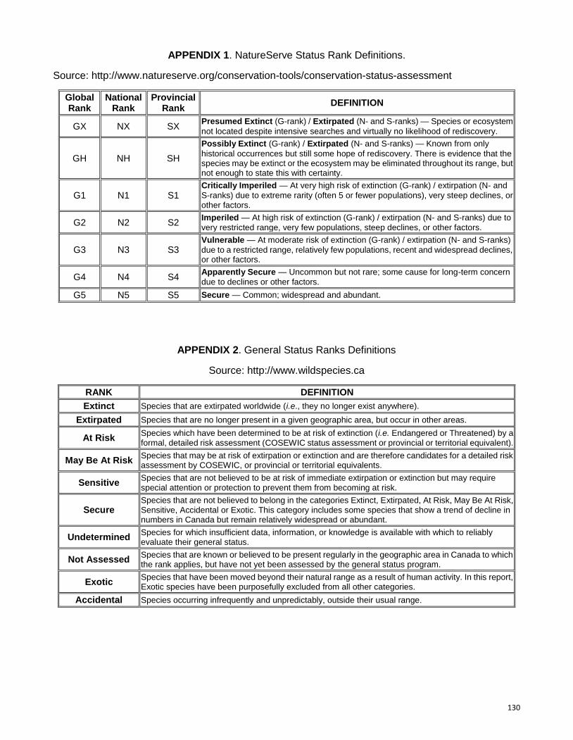
130
APPENDIX 1. NatureServe Status Rank Definitions.
Source: http://www.natureserve.org/conservation-tools/conservation-status-assessment
Global Rank
National Rank
Provincial Rank
DEFINITION
GX NX SX Presumed Extinct (G-rank) / Extirpated (N- and S-ranks) — Species or ecosystem
not located despite intensive searches and virtually no likelihood of rediscovery.
GH NH SH
Possibly Extinct (G-rank) / Extirpated (N- and S-ranks) — Known from only
historical occurrences but still some hope of rediscovery. There is evidence that the species may be extinct or the ecosystem may be eliminated throughout its range, but not enough to state this with certainty.
G1 N1 S1 Critically Imperiled — At very high risk of extinction (G-rank) / extirpation (N- and
S-ranks) due to extreme rarity (often 5 or fewer populations), very steep declines, or other factors.
G2 N2 S2 Imperiled — At high risk of extinction (G-rank) / extirpation (N- and S-ranks) due to
very restricted range, very few populations, steep declines, or other factors.
G3 N3 S3 Vulnerable — At moderate risk of extinction (G-rank) / extirpation (N- and S-ranks)
due to a restricted range, relatively few populations, recent and widespread declines, or other factors.
G4 N4 S4 Apparently Secure — Uncommon but not rare; some cause for long-term concern
due to declines or other factors.
G5 N5 S5 Secure — Common; widespread and abundant.
APPENDIX 2. General Status Ranks Definitions
Source: http://www.wildspecies.ca
RANK DEFINITION
Extinct Species that are extirpated worldwide (i.e., they no longer exist anywhere).
Extirpated Species that are no longer present in a given geographic area, but occur in other areas.
At Risk Species which have been determined to be at risk of extinction (i.e. Endangered or Threatened) by a formal, detailed risk assessment (COSEWIC status assessment or provincial or territorial equivalent).
May Be At Risk Species that may be at risk of extirpation or extinction and are therefore candidates for a detailed risk assessment by COSEWIC, or provincial or territorial equivalents.
Sensitive Species that are not believed to be at risk of immediate extirpation or extinction but may require special attention or protection to prevent them from becoming at risk.
Secure Species that are not believed to belong in the categories Extinct, Extirpated, At Risk, May Be At Risk, Sensitive, Accidental or Exotic. This category includes some species that show a trend of decline in numbers in Canada but remain relatively widespread or abundant.
Undetermined Species for which insufficient data, information, or knowledge is available with which to reliably evaluate their general status.
Not Assessed Species that are known or believed to be present regularly in the geographic area in Canada to which the rank applies, but have not yet been assessed by the general status program.
Exotic Species that have been moved beyond their natural range as a result of human activity. In this report, Exotic species have been purposefully excluded from all other categories.
Accidental Species occurring infrequently and unpredictably, outside their usual range.
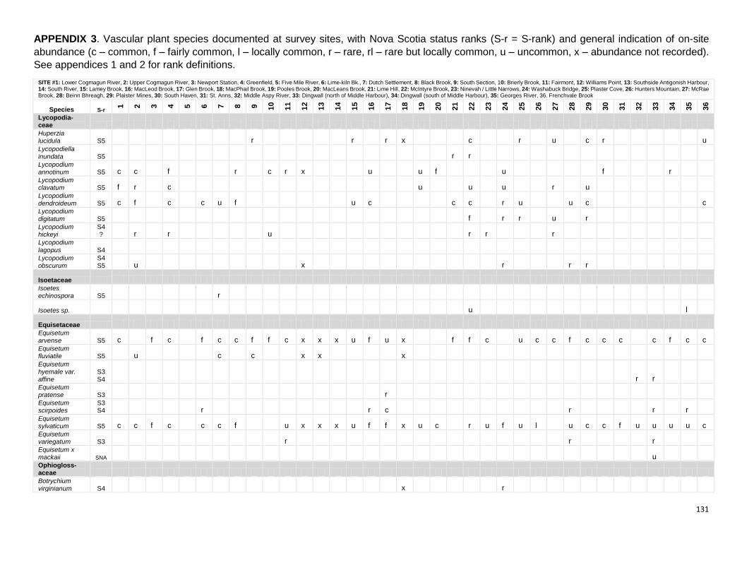
131
APPENDIX 3. Vascular plant species documented at survey sites, with Nova Scotia status ranks (S-r = S-rank) and general indication of on-site
abundance (c – common, f – fairly common, l – locally common, r – rare, rl – rare but locally common, u – uncommon, x – abundance not recorded).
See appendices 1 and 2 for rank definitions.
SITE #1: Lower Cogmagun River, 2: Upper Cogmagun River, 3: Newport Station, 4: Greenfield, 5: Five Mile River, 6: Lime-kiln Bk., 7: Dutch Settlement, 8: Black Brook, 9: South Section, 10: Brierly Brook, 11: Fairmont, 12: Williams Point, 13: Southside Antigonish Harbour, 14: South River, 15: Lamey Brook, 16: MacLeod Brook, 17: Glen Brook, 18: MacPhail Brook, 19: Pooles Brook, 20: MacLeans Brook, 21: Lime Hill, 22: McIntyre Brook, 23: Ninevah / Little Narrows, 24: Washabuck Bridge, 25: Plaster Cove, 26: Hunters Mountain, 27: McRae Brook, 28: Beinn Bhreagh, 29: Plaister Mines, 30: South Haven, 31: St. Anns, 32: Middle Aspy River, 33: Dingwall (north of Middle Harbour), 34: Dingwall (south of Middle Harbour), 35: Georges River, 36. Frenchvale Brook
Species S-r
1
2
3
4
5
6
7
8
9
10
11
12
13
14
15
16
17
18
19
20
21
22
23
24
25
26
27
28
29
30
31
32
33
34
35
36
Lycopodia- ceae Huperzia lucidula S5 r r r x c r u c r u Lycopodiella inundata S5 r r Lycopodium annotinum S5 c c f r c r x u u f u f r Lycopodium clavatum S5 f r c u u u r u Lycopodium dendroideum S5 c f c c u f u c c c r u u c c Lycopodium digitatum S5 f r r u r Lycopodium hickeyi
S4? r r u r r r
Lycopodium
lagopus S4 Lycopodium obscurum
S4S5 u x r r r
Isoetaceae Isoetes echinospora S5 r
Isoetes sp. u l
Equisetaceae Equisetum arvense S5 c f c f c c f f c x x x u f u x f f c u c c f c c c c f c c Equisetum fluviatile S5 u c c x x x Equisetum hyemale var. affine
S3S4 r r
Equisetum pratense S3 r Equisetum scirpoides
S3S4 r r c r r r
Equisetum sylvaticum S5 c c f c c c f u x x x u f f x u c r u f u l u c c f u u u u c Equisetum variegatum S3 r r r Equisetum x mackaii SNA u Ophiogloss- aceae Botrychium virginianum S4 x r
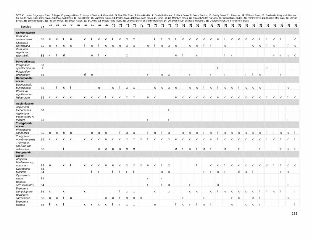
132
SITE #1: Lower Cogmagun River, 2: Upper Cogmagun River, 3: Newport Station, 4: Greenfield, 5: Five Mile River, 6: Lime-kiln Bk., 7: Dutch Settlement, 8: Black Brook, 9: South Section, 10: Brierly Brook, 11: Fairmont, 12: Williams Point, 13: Southside Antigonish Harbour, 14: South River, 15: Lamey Brook, 16: MacLeod Brook, 17: Glen Brook, 18: MacPhail Brook, 19: Pooles Brook, 20: MacLeans Brook, 21: Lime Hill, 22: McIntyre Brook, 23: Ninevah / Little Narrows, 24: Washabuck Bridge, 25: Plaster Cove, 26: Hunters Mountain, 27: McRae Brook, 28: Beinn Bhreagh, 29: Plaister Mines, 30: South Haven, 31: St. Anns, 32: Middle Aspy River, 33: Dingwall (north of Middle Harbour), 34: Dingwall (south of Middle Harbour), 35: Georges River, 36. Frenchvale Brook
Species S-r
1
2
3
4
5
6
7
8
9
10
11
12
13
14
15
16
17
18
19
20
21
22
23
24
25
26
27
28
29
30
31
32
33
34
35
36
Osmundaceae Osmunda cinnamomea S5 c c l u c l c c l c x x l f x f c c c c c u l c c c c l f c l c Osmunda
claytoniana S5 c r c c f c f c c u x x u f u x u c u f f c c c f u f c Osmunda regalis var. spectabilis S5 c l rl u f c x u f r l r r r u c
Polypodiaceae Polypodium appalachianum
S3? r r
Polypodium virginianum S5 rl u r u x r r r r l u r Dennstaedti- aceae Dennstaedtia punctilobula S5 l c f u c f x x c c x u u c f c f c c f c c c u Pteridium aquilinum var. latiusculum S5 c c c c c c c l c c x x u c u c c c c c u c c c c c c f c c f c
Aspleniaceae Asplenium trichomanes S3 r Asplenium trichomanes-ramosum S2 r r r Thelypterid- aceae Phegopteris connectilis S5 c c c c c u u f x x f c f x c c c r c f c c c c c c f f c c l Thelypteris noveboracensis S5 c c c c c c c u c c x x x f c c x u c c c c u f c c c c c c f c f c l Thelypteris palustris var. pubescens S5 l c c u u x x c f u f c f c r f r u l Dryopterid- aceae Athyrium filix-femina ssp. angustum S5 u c f c c c u u c x x x u c f x f c c f c c c c c c f f c c Cystopteris bulbifera
S3S4 l r l f r f c c r r c r rl c l r c
Cystopteris tenuis S4 r r Deparia acrostichoides S4 r r x r x r Dryopteris campyloptera S5 c c c f x x c x c c c f u c c c c f f u f f Dryopteris carthusiana S5 c c f c c c f x x x r r r u c f u Dryopteris cristata S5 f c l c r c c l r x x u f c r f u f u c c r l
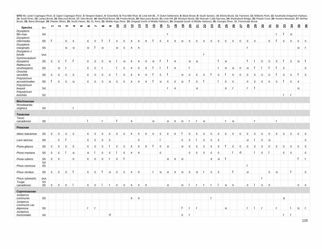
133
SITE #1: Lower Cogmagun River, 2: Upper Cogmagun River, 3: Newport Station, 4: Greenfield, 5: Five Mile River, 6: Lime-kiln Bk., 7: Dutch Settlement, 8: Black Brook, 9: South Section, 10: Brierly Brook, 11: Fairmont, 12: Williams Point, 13: Southside Antigonish Harbour, 14: South River, 15: Lamey Brook, 16: MacLeod Brook, 17: Glen Brook, 18: MacPhail Brook, 19: Pooles Brook, 20: MacLeans Brook, 21: Lime Hill, 22: McIntyre Brook, 23: Ninevah / Little Narrows, 24: Washabuck Bridge, 25: Plaster Cove, 26: Hunters Mountain, 27: McRae Brook, 28: Beinn Bhreagh, 29: Plaister Mines, 30: South Haven, 31: St. Anns, 32: Middle Aspy River, 33: Dingwall (north of Middle Harbour), 34: Dingwall (south of Middle Harbour), 35: Georges River, 36. Frenchvale Brook
Species S-r
1
2
3
4
5
6
7
8
9
10
11
12
13
14
15
16
17
18
19
20
21
22
23
24
25
26
27
28
29
30
31
32
33
34
35
36
Dryopteris filix-mas S4 r r f u Dryopteris intermedia S5 f c c c c f f c c x x x f c c x u c c c c c c c c c c c f c c c c Dryopteris marginalis S5 u u u f u u c x x r u r Dryopteris x boottii SNA r Gymnocarpium dryopteris S5 c c f f c c c u l u x x x u f f x u u f u f l c c c f c u f Matteuccia struthiopteris S5 u r c c r l c x x x f l f x l r u u c u f l f f c c Onoclea sensibilis S5 c c c c c c c c l c x x x f c f u c c c f c f c c c c c c f c c f c Polystichum acrostichoides S5 f c c u c c c u c c x x x f u c x u f c f l c c c c c c c f c x Polystichum braunii S4 r x u x r r f u Polystichum lonchitis S2 r r
Blechnaceae Woodwardia virginica S4 r
Taxaceae Taxus canadensis S5 l r f x u u x u r r u r u r r
Pinaceae
Abies balsamea S5 c c c c c c c c c c x x x c c c x f c c c c c c c c c c c c c c c c c
Larix laricina S5 c f c c c c x l c c l c c c u l c u c
Picea glauca S5 c c c c c c c l c c x x x f c u u c c c c c f c c c c c c c c c c c
Picea mariana S5 c c l u u l c c l c x x c c c c c c l rl l c l c c c
Picea rubens S5 c c c c c c r c f u x u x u f f r
Pinus resinosa S4S5 l
Pinus strobus S5 c c c f c c f u c c x x r u u x u c u r c c f u c u f c
Pinus sylvestris SNA r Tsuga canadensis
S4S5 c c c l c c l r c c x x x u u l r r r l u c c l c c c c
Cupressaceae Juniperus communis S5 x x r u Juniperus communis var. depressa S5 r r f r r u r l r r l u r Juniperus horizontalis S4 rl c r r l
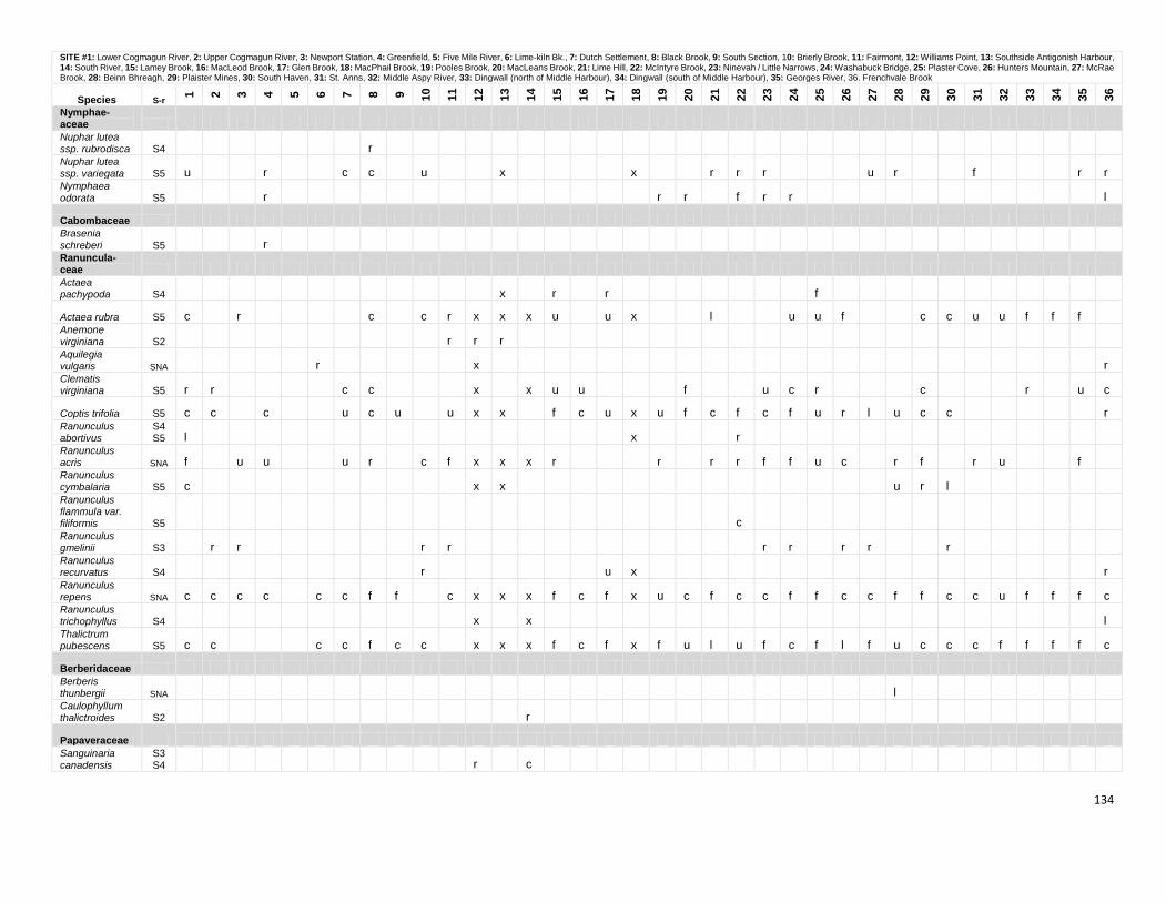
134
SITE #1: Lower Cogmagun River, 2: Upper Cogmagun River, 3: Newport Station, 4: Greenfield, 5: Five Mile River, 6: Lime-kiln Bk., 7: Dutch Settlement, 8: Black Brook, 9: South Section, 10: Brierly Brook, 11: Fairmont, 12: Williams Point, 13: Southside Antigonish Harbour, 14: South River, 15: Lamey Brook, 16: MacLeod Brook, 17: Glen Brook, 18: MacPhail Brook, 19: Pooles Brook, 20: MacLeans Brook, 21: Lime Hill, 22: McIntyre Brook, 23: Ninevah / Little Narrows, 24: Washabuck Bridge, 25: Plaster Cove, 26: Hunters Mountain, 27: McRae Brook, 28: Beinn Bhreagh, 29: Plaister Mines, 30: South Haven, 31: St. Anns, 32: Middle Aspy River, 33: Dingwall (north of Middle Harbour), 34: Dingwall (south of Middle Harbour), 35: Georges River, 36. Frenchvale Brook
Species S-r
1
2
3
4
5
6
7
8
9
10
11
12
13
14
15
16
17
18
19
20
21
22
23
24
25
26
27
28
29
30
31
32
33
34
35
36
Nymphae- aceae Nuphar lutea ssp. rubrodisca S4 r Nuphar lutea ssp. variegata S5 u r c c u x x r r r u r f r r Nymphaea odorata S5 r r r f r r l
Cabombaceae Brasenia
schreberi S5 r Ranuncula- ceae Actaea pachypoda S4 x r r f
Actaea rubra S5 c r c c r x x x u u x l u u f c c u u f f f Anemone virginiana S2 r r r Aquilegia vulgaris SNA r x r Clematis virginiana S5 r r c c x x u u f u c r c r u c
Coptis trifolia S5 c c c u c u u x x f c u x u f c f c f u r l u c c r Ranunculus abortivus
S4S5 l x r
Ranunculus acris SNA f u u u r c f x x x r r r r f f u c r f r u f Ranunculus cymbalaria S5 c x x u r l Ranunculus flammula var. filiformis S5 c Ranunculus gmelinii S3 r r r r r r r r r Ranunculus recurvatus S4 r u x r Ranunculus repens SNA c c c c c c f f c x x x f c f x u c f c c f f c c f f c c u f f f c Ranunculus trichophyllus S4 x x l Thalictrum pubescens S5 c c c c f c c x x x f c f x f u l u f c f l f u c c c f f f f c
Berberidaceae Berberis thunbergii SNA l Caulophyllum thalictroides S2 r
Papaveraceae Sanguinaria canadensis
S3S4 r c
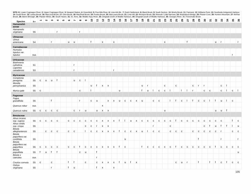
135
SITE #1: Lower Cogmagun River, 2: Upper Cogmagun River, 3: Newport Station, 4: Greenfield, 5: Five Mile River, 6: Lime-kiln Bk., 7: Dutch Settlement, 8: Black Brook, 9: South Section, 10: Brierly Brook, 11: Fairmont, 12: Williams Point, 13: Southside Antigonish Harbour, 14: South River, 15: Lamey Brook, 16: MacLeod Brook, 17: Glen Brook, 18: MacPhail Brook, 19: Pooles Brook, 20: MacLeans Brook, 21: Lime Hill, 22: McIntyre Brook, 23: Ninevah / Little Narrows, 24: Washabuck Bridge, 25: Plaster Cove, 26: Hunters Mountain, 27: McRae Brook, 28: Beinn Bhreagh, 29: Plaister Mines, 30: South Haven, 31: St. Anns, 32: Middle Aspy River, 33: Dingwall (north of Middle Harbour), 34: Dingwall (south of Middle Harbour), 35: Georges River, 36. Frenchvale Brook
Species S-r
1
2
3
4
5
6
7
8
9
10
11
12
13
14
15
16
17
18
19
20
21
22
23
24
25
26
27
28
29
30
31
32
33
34
35
36
Hamamelid- aceae Hamamelis virginiana S5 r r
Ulmaceae Ulmus americana S4 r u u f x x x f u r r
Cannabaceae Humulus lupulus var. lupulus SNA r
Urticaceae Boehmeria cylindrica S1 r Laportea canadensis S3 r r
Myricaceae Comptonia peregrina S5 c u u f u c l Morella pensylvanica S5 u f x x u r c c c r r c l
Myrica gale S5 c c l u f u l c c l l l r c c c l c l
Fagaceae Fagus grandifolia S5 f r c u x x u c c x u c c l f c l f c c l f u l c
Quercus robur SNA x
Quercus rubra S5 c c c c c r u u x x u u u f
Betulaceae Alnus incana
ssp. rugosa S5 c c c c c c c c c c x x x f l u x c c c c c c f c c c c c c c c f c Alnus viridis ssp. crispa S5 c c r x x r c c f u f f l u Betula alleghaniensis S5 c c c c c l c c x x x f c c x u l c c c c c c c c c c r c c Betula
papyrifera var. cordifolia S5 u f r r Betula papyrifera var. papyrifera S5 c c c c c c f c c c x x x f c f c c c c c f c c c c c c f c c c c Betula populifolia S5 f u f f c u f u Betula x caerulea SNA r
Corylus cornuta S5 c c f f c c x x x f u f x c u r f f f c f c c Ostrya virginiana S5 r f u f x x
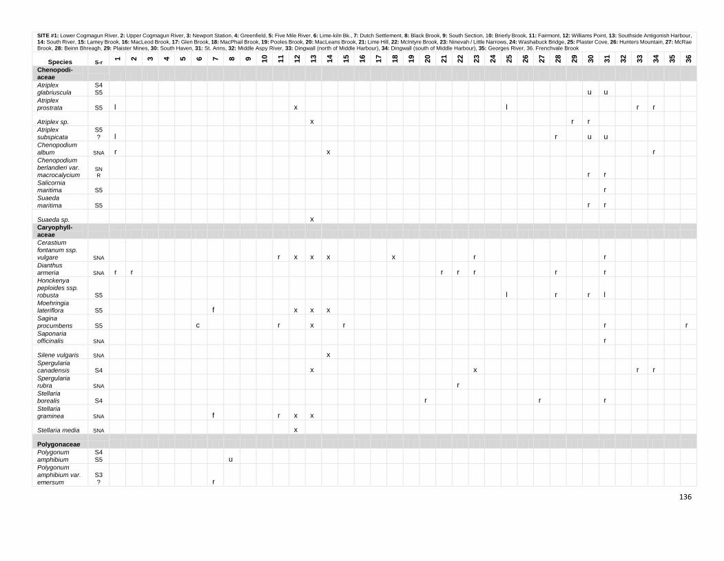
136
SITE #1: Lower Cogmagun River, 2: Upper Cogmagun River, 3: Newport Station, 4: Greenfield, 5: Five Mile River, 6: Lime-kiln Bk., 7: Dutch Settlement, 8: Black Brook, 9: South Section, 10: Brierly Brook, 11: Fairmont, 12: Williams Point, 13: Southside Antigonish Harbour, 14: South River, 15: Lamey Brook, 16: MacLeod Brook, 17: Glen Brook, 18: MacPhail Brook, 19: Pooles Brook, 20: MacLeans Brook, 21: Lime Hill, 22: McIntyre Brook, 23: Ninevah / Little Narrows, 24: Washabuck Bridge, 25: Plaster Cove, 26: Hunters Mountain, 27: McRae Brook, 28: Beinn Bhreagh, 29: Plaister Mines, 30: South Haven, 31: St. Anns, 32: Middle Aspy River, 33: Dingwall (north of Middle Harbour), 34: Dingwall (south of Middle Harbour), 35: Georges River, 36. Frenchvale Brook
Species S-r
1
2
3
4
5
6
7
8
9
10
11
12
13
14
15
16
17
18
19
20
21
22
23
24
25
26
27
28
29
30
31
32
33
34
35
36
Chenopodi- aceae Atriplex glabriuscula
S4S5 u u
Atriplex prostrata S5 l x l r r
Atriplex sp. x r r Atriplex subspicata
S5? l r u u
Chenopodium
album SNA r x r Chenopodium berlandieri var. macrocalycium
SNR r r
Salicornia maritima S5 r Suaeda
maritima S5 r r
Suaeda sp. x Caryophyll- aceae Cerastium fontanum ssp. vulgare SNA r x x x x r r Dianthus armeria SNA r r r r r r r Honckenya peploides ssp. robusta S5 l r r l Moehringia lateriflora S5 f x x x Sagina procumbens S5 c r x r r r Saponaria officinalis SNA r
Silene vulgaris SNA x Spergularia canadensis S4 x x r r Spergularia rubra SNA r Stellaria borealis S4 r r r Stellaria graminea SNA f r x x
Stellaria media SNA x
Polygonaceae Polygonum amphibium
S4S5 u
Polygonum
amphibium var. emersum
S3? r
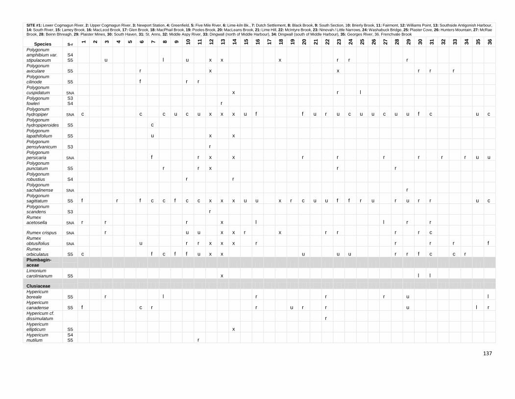
137
SITE #1: Lower Cogmagun River, 2: Upper Cogmagun River, 3: Newport Station, 4: Greenfield, 5: Five Mile River, 6: Lime-kiln Bk., 7: Dutch Settlement, 8: Black Brook, 9: South Section, 10: Brierly Brook, 11: Fairmont, 12: Williams Point, 13: Southside Antigonish Harbour, 14: South River, 15: Lamey Brook, 16: MacLeod Brook, 17: Glen Brook, 18: MacPhail Brook, 19: Pooles Brook, 20: MacLeans Brook, 21: Lime Hill, 22: McIntyre Brook, 23: Ninevah / Little Narrows, 24: Washabuck Bridge, 25: Plaster Cove, 26: Hunters Mountain, 27: McRae Brook, 28: Beinn Bhreagh, 29: Plaister Mines, 30: South Haven, 31: St. Anns, 32: Middle Aspy River, 33: Dingwall (north of Middle Harbour), 34: Dingwall (south of Middle Harbour), 35: Georges River, 36. Frenchvale Brook
Species S-r
1
2
3
4
5
6
7
8
9
10
11
12
13
14
15
16
17
18
19
20
21
22
23
24
25
26
27
28
29
30
31
32
33
34
35
36
Polygonum amphibium var. stipulaceum
S4S5 u l u x x x r r r
Polygonum aviculare S5 r x x r r r Polygonum cilinode S5 f r r Polygonum cuspidatum SNA x r l Polygonum fowleri
S3S4 r
Polygonum hydropiper SNA c c c u c u x x x u f f u r u c u u c u u f c u c Polygonum hydropiperoides S5 c Polygonum lapathifolium S5 u x x Polygonum pensylvanicum S3 r Polygonum persicaria SNA f r x x r r r r r r u u Polygonum punctatum S5 r r x r r Polygonum robustius S4 r r Polygonum sachalinense SNA r Polygonum sagittatum S5 f r f c c f c c x x x u u x r c u u f f r u r u r r u c Polygonum scandens S3 r Rumex acetosella SNA r r r x l l r r
Rumex crispus SNA r u u x x r x r r r r c Rumex obtusifolius SNA u r r x x x r r r r f Rumex orbiculatus S5 c f c f f u x x u u u r r f c c r Plumbagin- aceae Limonium carolinianum S5 x l l
Clusiaceae Hypericum boreale S5 r l r r r u l Hypericum canadense S5 f c r r u r r u l r Hypericum cf.
dissimulatum r Hypericum ellipticum S5 x Hypericum mutilum
S4S5 r
138
SITE #1: Lower Cogmagun River, 2: Upper Cogmagun River, 3: Newport Station, 4: Greenfield, 5: Five Mile River, 6: Lime-kiln Bk., 7: Dutch Settlement, 8: Black Brook, 9: South Section, 10: Brierly Brook, 11: Fairmont, 12: Williams Point, 13: Southside Antigonish Harbour, 14: South River, 15: Lamey Brook, 16: MacLeod Brook, 17: Glen Brook, 18: MacPhail Brook, 19: Pooles Brook, 20: MacLeans Brook, 21: Lime Hill, 22: McIntyre Brook, 23: Ninevah / Little Narrows, 24: Washabuck Bridge, 25: Plaster Cove, 26: Hunters Mountain, 27: McRae Brook, 28: Beinn Bhreagh, 29: Plaister Mines, 30: South Haven, 31: St. Anns, 32: Middle Aspy River, 33: Dingwall (north of Middle Harbour), 34: Dingwall (south of Middle Harbour), 35: Georges River, 36. Frenchvale Brook
Species S-r
1
2
3
4
5
6
7
8
9
10
11
12
13
14
15
16
17
18
19
20
21
22
23
24
25
26
27
28
29
30
31
32
33
34
35
36
Hypericum perforatum SNA l c f f c u c u x x x u u x u r f f f c l r l r Triadenum fraseri S5 c r u c l f x x u u x f f r c c c u f u c f c r u l
Tiliaceae
Tilia cordata SNA r Sarraceni- aceae Sarracenia purpurea S5 r l f r l c c r
Droseraceae Drosera intermedia S5 u r r r Drosera rotundifolia S5 r r rl r l r r x r u l u u r rl r r
Violaceae Viola blanda var. palustriformis S5 r u f u r u c r r u
Viola cucullata S5 c c c f c u x u r c u u u f u r r f Viola labradorica S5 r r r x r x r r r r r r Viola
macloskeyi ssp. pallens S5 f u f x r x u r r f c r u u r
Viola renifolia S4 x r
Viola sororia S5 f u c c r x x u x r r c f u r u
Cucurbitaceae Echinocystis lobata SNA u u f r x
Salicaceae
Populus alba SNA x r Populus balsamifera S4 r r r u u f f u r u c f Populus grandidentata S5 c c c c l l l c u x x x u u Populus tremuloides S5 c c c c c c u l c c x x x c c c u c c c c c c c c Populus x canescens SNA r
Salix alba SNA x
Salix bebbiana S5 u c u c f c x x u x u u r x c f u f c f f f r f c c f u
Salix discolor S5 u u f c c x u x r f r r r f f
139
SITE #1: Lower Cogmagun River, 2: Upper Cogmagun River, 3: Newport Station, 4: Greenfield, 5: Five Mile River, 6: Lime-kiln Bk., 7: Dutch Settlement, 8: Black Brook, 9: South Section, 10: Brierly Brook, 11: Fairmont, 12: Williams Point, 13: Southside Antigonish Harbour, 14: South River, 15: Lamey Brook, 16: MacLeod Brook, 17: Glen Brook, 18: MacPhail Brook, 19: Pooles Brook, 20: MacLeans Brook, 21: Lime Hill, 22: McIntyre Brook, 23: Ninevah / Little Narrows, 24: Washabuck Bridge, 25: Plaster Cove, 26: Hunters Mountain, 27: McRae Brook, 28: Beinn Bhreagh, 29: Plaister Mines, 30: South Haven, 31: St. Anns, 32: Middle Aspy River, 33: Dingwall (north of Middle Harbour), 34: Dingwall (south of Middle Harbour), 35: Georges River, 36. Frenchvale Brook
Species S-r
1
2
3
4
5
6
7
8
9
10
11
12
13
14
15
16
17
18
19
20
21
22
23
24
25
26
27
28
29
30
31
32
33
34
35
36
Salix eriocephala S5 u u l f x x x u r r f f f r
Salix humilis S5 f f u c f x x u r r f
Salix lucida S5 r
Salix myrtillifolia S1 r
Salix pyrifolia S5 r r c u r u
Salix serissima S1 r
Salix viminalis SNA x
Salix x rubens SNA r x x Salix cf. x
sericans. SNA r
Brassicaceae Barbarea orthoceras S1 u Barbarea vulgaris SNA u r r r x x x x r r
Cakile edentula S5 l l l l Cardamine diphylla S4 x Cardamine pensylvanica S5 f r c c u x x r r r r r f r r r r c Cardamine pratensis SNA x x Erysimum cheiranthoides
SNR r x x
Hesperis matronalis SNA x x Lepidium campestre SNA x x Raphanus raphanistrum SNA r r x x l Rorippa palustris S4 u x u r Sisymbrium officinale SNA r
Thlaspi arvense SNA r
Empetraceae Empetrum nigrum S5 l r l r
Ericaceae Andromeda
polifolia var. glaucophylla S5 x r l u r Arctostaphylos uva-ursi S4 r
140
SITE #1: Lower Cogmagun River, 2: Upper Cogmagun River, 3: Newport Station, 4: Greenfield, 5: Five Mile River, 6: Lime-kiln Bk., 7: Dutch Settlement, 8: Black Brook, 9: South Section, 10: Brierly Brook, 11: Fairmont, 12: Williams Point, 13: Southside Antigonish Harbour, 14: South River, 15: Lamey Brook, 16: MacLeod Brook, 17: Glen Brook, 18: MacPhail Brook, 19: Pooles Brook, 20: MacLeans Brook, 21: Lime Hill, 22: McIntyre Brook, 23: Ninevah / Little Narrows, 24: Washabuck Bridge, 25: Plaster Cove, 26: Hunters Mountain, 27: McRae Brook, 28: Beinn Bhreagh, 29: Plaister Mines, 30: South Haven, 31: St. Anns, 32: Middle Aspy River, 33: Dingwall (north of Middle Harbour), 34: Dingwall (south of Middle Harbour), 35: Georges River, 36. Frenchvale Brook
Species S-r
1
2
3
4
5
6
7
8
9
10
11
12
13
14
15
16
17
18
19
20
21
22
23
24
25
26
27
28
29
30
31
32
33
34
35
36
Chamaedaphne calyculata S5 rl rl u rl l l r x f r l f c rl l l r u rl
Epigaea repens S5 f c c u r x u u u f c u c r f f r u Gaultheria
hispidula S5 c c r c x c u u f c c c u c l u c l c r Gaultheria procumbens S5 c c c c x u r u u c f c r f l Gaylussacia baccata S5 rl rl u x u rl r Gaylussacia
bigeloviana S5 r r Kalmia angustifolia S5 c c rl c f l c c x l f c l r f rl l l c l c l
Kalmia polifolia S5 u r l r Ledum groenlandicum S5 l rl rl r c rl c x l f l u f rl l l l c Rhododendron canadense S5 l c rl l x u l r l r Vaccinium angustifolium S5 c c c c f c x x c x u r f c c l c u c c Vaccinium macrocarpon S5 l r u l r x l u f r r r Vaccinium myrtilloides S5 c c c c c c u c x c c f r r f u c c c c Vaccinium oxycoccos S5 r rl l r c l f f r l Vaccinium vitis-idaea ssp. minus S5 r
Pyrolaceae Chimaphila umbellata ssp. cisatlantica S4 l r x r r r Moneses uniflora S5 r x x r Orthilia
secunda S5 c u c r r r u x u u u r r u u u r u r u Pyrola americana S5 r
Pyrola asarifolia S3 r Pyrola chlorantha S4 r r r
Pyrola elliptica S5 f f r u c r x x u f u x r u r u c r u r c u r u u Monotrop- aceae Monotropa hypopithys S4 r r x r r r r r Monotropa uniflora S5 r f f f r x u r x r f u u u r r r c r r c
141
SITE #1: Lower Cogmagun River, 2: Upper Cogmagun River, 3: Newport Station, 4: Greenfield, 5: Five Mile River, 6: Lime-kiln Bk., 7: Dutch Settlement, 8: Black Brook, 9: South Section, 10: Brierly Brook, 11: Fairmont, 12: Williams Point, 13: Southside Antigonish Harbour, 14: South River, 15: Lamey Brook, 16: MacLeod Brook, 17: Glen Brook, 18: MacPhail Brook, 19: Pooles Brook, 20: MacLeans Brook, 21: Lime Hill, 22: McIntyre Brook, 23: Ninevah / Little Narrows, 24: Washabuck Bridge, 25: Plaster Cove, 26: Hunters Mountain, 27: McRae Brook, 28: Beinn Bhreagh, 29: Plaister Mines, 30: South Haven, 31: St. Anns, 32: Middle Aspy River, 33: Dingwall (north of Middle Harbour), 34: Dingwall (south of Middle Harbour), 35: Georges River, 36. Frenchvale Brook
Species S-r
1
2
3
4
5
6
7
8
9
10
11
12
13
14
15
16
17
18
19
20
21
22
23
24
25
26
27
28
29
30
31
32
33
34
35
36
Primulaceae
Glaux maritima S5 x Lysimachia ciliata S4 c f f x x x f Lysimachia nummularia SNA x Lysimachia punctata SNA r Lysimachia terrestris S5 c c u u c c c x x x u r f u c c c u c u c Lysimachia thyrsiflora S4 x x r r u r r Lysimachia vulgaris SNA x Samolus valerandi ssp. parviflorus S3 r r Trientalis borealis S5 c c f c c c l l l c x x x c x u c f c c f c f c c c f c f l Grossulari- aceae Ribes glandulosum S5 r x r r
Ribes hirtellum S5 u r f x x x x u r f r r r r
Ribes lacustre S5 c u r c u x u u x u f c c f c r f f f r u r
Ribes rubrum SNA r x x r r
Ribes triste S4 r u r r x u r r u r
Crassulaceae Hylotelephium
telephium SNA u x x x r
Saxifragaceae Chrysosplenium americanum S5 u r r r x x r r u x r r u r
Mitella nuda S5 f l f r x x u x u f f u u u f r l r f Parnassia
palustris var. parviflora
S1S2 r
Rosaceae Agrimonia gryposepala S3 r r r f f f r r r r r r r r Agrimonia striata S5 r r r f u x x x f r u x u r u u r f r r f r c u c Amelanchier bartramiana S5 r
Amelanchier sp. u r c c f c c x x x x f r f c f x c f c
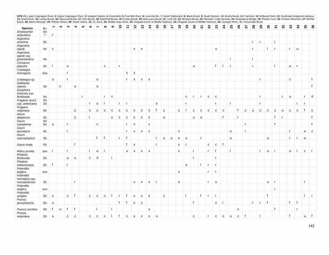
142
SITE #1: Lower Cogmagun River, 2: Upper Cogmagun River, 3: Newport Station, 4: Greenfield, 5: Five Mile River, 6: Lime-kiln Bk., 7: Dutch Settlement, 8: Black Brook, 9: South Section, 10: Brierly Brook, 11: Fairmont, 12: Williams Point, 13: Southside Antigonish Harbour, 14: South River, 15: Lamey Brook, 16: MacLeod Brook, 17: Glen Brook, 18: MacPhail Brook, 19: Pooles Brook, 20: MacLeans Brook, 21: Lime Hill, 22: McIntyre Brook, 23: Ninevah / Little Narrows, 24: Washabuck Bridge, 25: Plaster Cove, 26: Hunters Mountain, 27: McRae Brook, 28: Beinn Bhreagh, 29: Plaister Mines, 30: South Haven, 31: St. Anns, 32: Middle Aspy River, 33: Dingwall (north of Middle Harbour), 34: Dingwall (south of Middle Harbour), 35: Georges River, 36. Frenchvale Brook
Species S-r
1
2
3
4
5
6
7
8
9
10
11
12
13
14
15
16
17
18
19
20
21
22
23
24
25
26
27
28
29
30
31
32
33
34
35
36
Amelanchier stolonifera
S3? r
Argentina anserina S5 r r r Argentina egedii S5 c x x u r l r r u Argentina egedii ssp. groenlandica S5 l l Comarum palustre S5 l u c r u f l r r l u r Crataegus monogyna SNA r x x
Crataegus sp. u r u r x x x r c f Dalibarda repens S5 c u u f Dasiphora
fruticosa ssp. floribunda S4 r r c c r r c c r r u r rl Fragaria vesca ssp. americana
S3S4 r u l r r s r r r r r r
Fragaria virginiana S5 c c c c c c c x x x f c x r c c c c c f c u c c c u c c f c Geum aleppicum S5 c r c c c x x x u u u f r f r f Geum canadense
S4S5 u r c r x x r f f
Geum laciniatum S5 r r x x x x u r r u c Geum
macrophyllum S5 f f r f r u u x u r u u r r u
Geum rivale S5 f f x r x r c c f
Malus pumila SNA r r r u r u x x x x r r f l r u r u r c l Photinia floribunda S5 u u c rl l r r Photinia
melanocarpa S5 f r u l r r Potentilla anglica SNA x r r Potentilla norvegica ssp. monspeliensis S5 r x x x r x r u u r l Potentilla anglica SNA r Potentilla simplex S5 c c f c c c f r f x x x c l f r r f l r Prunus pensylvanica S5 u f f x x f x l r r f f f
Prunus serotina S5 f u f f l l x c f r Prunus virginiana S5 u c c c c c l f c x x x u c r c c u c f l f u f
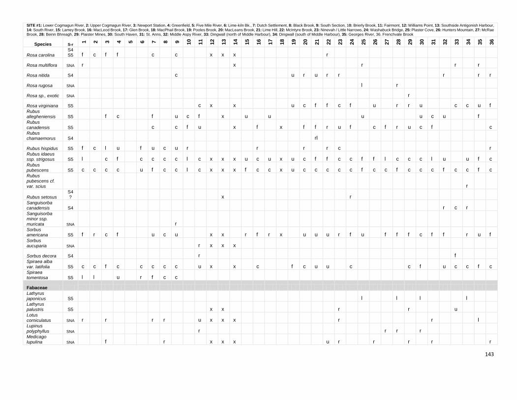
143
SITE #1: Lower Cogmagun River, 2: Upper Cogmagun River, 3: Newport Station, 4: Greenfield, 5: Five Mile River, 6: Lime-kiln Bk., 7: Dutch Settlement, 8: Black Brook, 9: South Section, 10: Brierly Brook, 11: Fairmont, 12: Williams Point, 13: Southside Antigonish Harbour, 14: South River, 15: Lamey Brook, 16: MacLeod Brook, 17: Glen Brook, 18: MacPhail Brook, 19: Pooles Brook, 20: MacLeans Brook, 21: Lime Hill, 22: McIntyre Brook, 23: Ninevah / Little Narrows, 24: Washabuck Bridge, 25: Plaster Cove, 26: Hunters Mountain, 27: McRae Brook, 28: Beinn Bhreagh, 29: Plaister Mines, 30: South Haven, 31: St. Anns, 32: Middle Aspy River, 33: Dingwall (north of Middle Harbour), 34: Dingwall (south of Middle Harbour), 35: Georges River, 36. Frenchvale Brook
Species S-r
1
2
3
4
5
6
7
8
9
10
11
12
13
14
15
16
17
18
19
20
21
22
23
24
25
26
27
28
29
30
31
32
33
34
35
36
Rosa carolina S4S5 f c f f c c x x x r
Rosa multiflora SNA r x r r r
Rosa nitida S4 c u r u r r r r r
Rosa rugosa SNA l r
Rosa sp., exotic SNA r
Rosa virginiana S5 c x x u c f f c f u r r u c c u f Rubus allegheniensis S5 f c f u c f x u u u u c u f Rubus
canadensis S5 c c f u x f x f f r u f c f r u c f c Rubus chamaemorus S4 rl
Rubus hispidus S5 f c l u f u c u r r r r c r Rubus idaeus ssp. strigosus S5 l c f c c c c l c x x x u c u x u c f f c c f f l c c c l u u f c Rubus pubescens S5 c c c c u f c c l c x x x f c c x u c c c c c f c c f c c c f c c f c Rubus pubescens cf. var. scius r
Rubus setosus S4? x r
Sanguisorba canadensis S4 r c r Sanguisorba minor ssp. muricata SNA r Sorbus americana S5 f r c f u c u x x r f r x u u u r f u f f f c f f r u f Sorbus aucuparia SNA r x x x
Sorbus decora S4 r f Spiraea alba var. latifolia S5 c c f c c c c c u x x c f c u u c c f u c c f c Spiraea
tomentosa S5 l l u r f c c
Fabaceae Lathyrus japonicus S5 l l l l Lathyrus palustris S5 x x r r u Lotus corniculatus SNA r r r r u x x x r r l Lupinus polyphyllus SNA r r r r Medicago lupulina SNA f r x x x u r r r r r
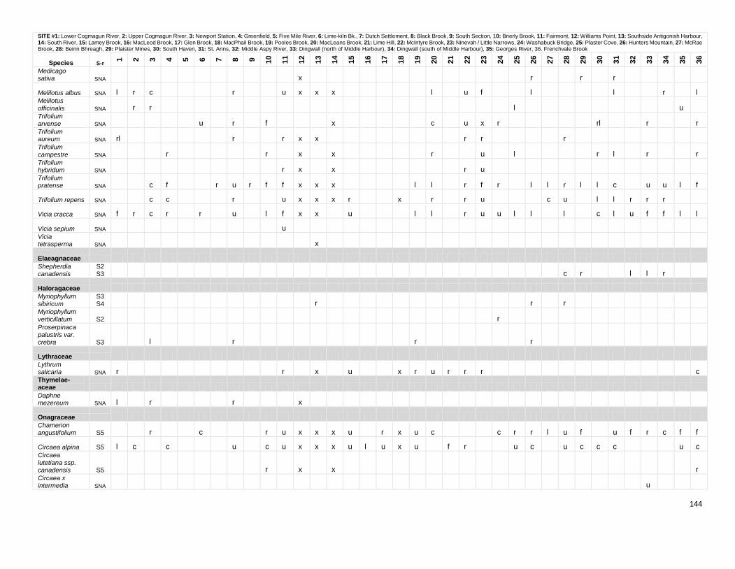
144
SITE #1: Lower Cogmagun River, 2: Upper Cogmagun River, 3: Newport Station, 4: Greenfield, 5: Five Mile River, 6: Lime-kiln Bk., 7: Dutch Settlement, 8: Black Brook, 9: South Section, 10: Brierly Brook, 11: Fairmont, 12: Williams Point, 13: Southside Antigonish Harbour, 14: South River, 15: Lamey Brook, 16: MacLeod Brook, 17: Glen Brook, 18: MacPhail Brook, 19: Pooles Brook, 20: MacLeans Brook, 21: Lime Hill, 22: McIntyre Brook, 23: Ninevah / Little Narrows, 24: Washabuck Bridge, 25: Plaster Cove, 26: Hunters Mountain, 27: McRae Brook, 28: Beinn Bhreagh, 29: Plaister Mines, 30: South Haven, 31: St. Anns, 32: Middle Aspy River, 33: Dingwall (north of Middle Harbour), 34: Dingwall (south of Middle Harbour), 35: Georges River, 36. Frenchvale Brook
Species S-r
1
2
3
4
5
6
7
8
9
10
11
12
13
14
15
16
17
18
19
20
21
22
23
24
25
26
27
28
29
30
31
32
33
34
35
36
Medicago sativa SNA x r r r
Melilotus albus SNA l r c r u x x x l u f l l r l Melilotus
officinalis SNA r r l u Trifolium arvense SNA u r f x c u x r rl r r Trifolium aureum SNA rl r r x x r r r Trifolium
campestre SNA r r x x r u l r l r r Trifolium hybridum SNA r x x r u Trifolium pratense SNA c f r u r f f x x x l l r f r l l r l l c u u l f
Trifolium repens SNA c c r u x x x r x r r u c u l l r r r
Vicia cracca SNA f r c r r u l f x x u l l r u u l l l c l u f f l l
Vicia sepium SNA u Vicia tetrasperma SNA x
Elaeagnaceae Shepherdia canadensis
S2S3 c r l l r
Haloragaceae Myriophyllum sibiricum
S3S4 r r r
Myriophyllum verticillatum S2 r Proserpinaca palustris var. crebra S3 l r r r
Lythraceae Lythrum salicaria SNA r r x u x r u r r r c Thymelae- aceae Daphne mezereum SNA l r r x
Onagraceae Chamerion angustifolium S5 r c r u x x x u r x u c c r r l u f u f r c f f
Circaea alpina S5 l c c u c u x x x u l u x u f r u c u c c c u c Circaea lutetiana ssp. canadensis S5 r x x r Circaea x intermedia SNA u
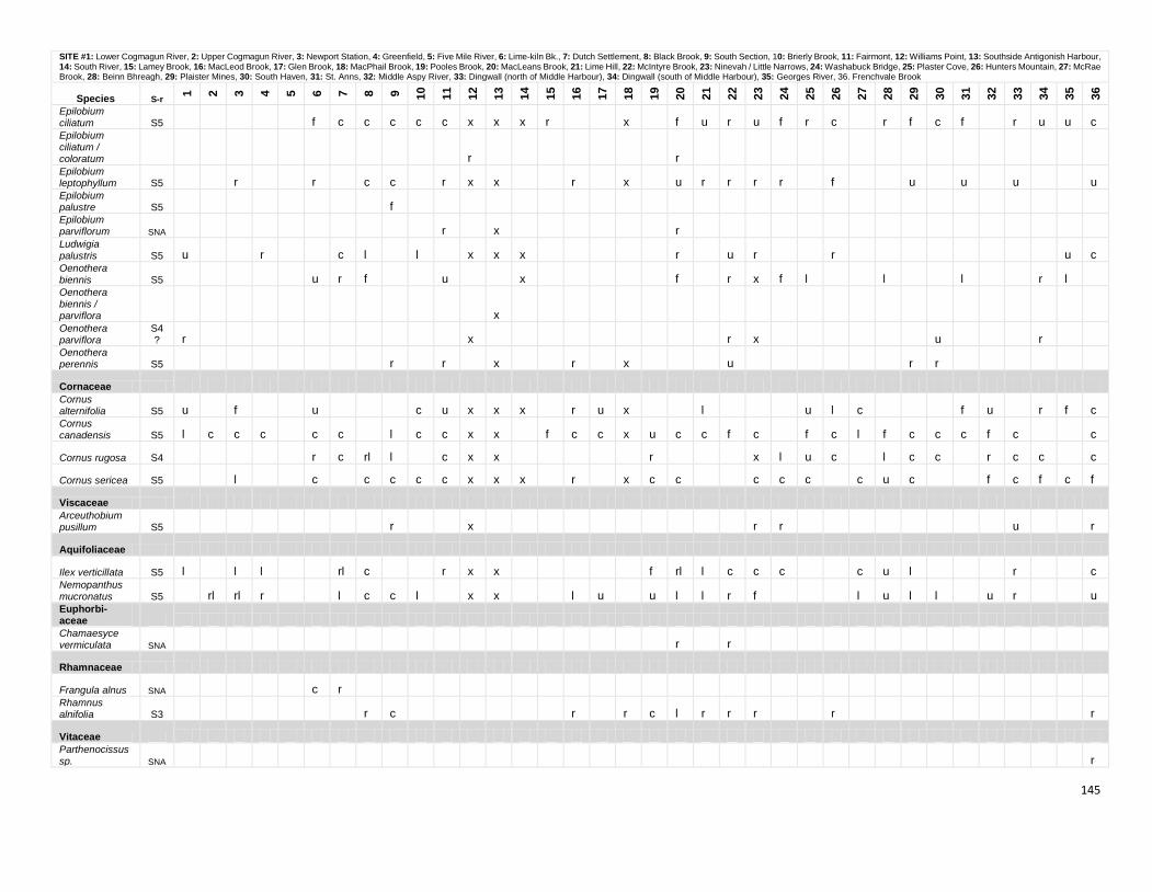
145
SITE #1: Lower Cogmagun River, 2: Upper Cogmagun River, 3: Newport Station, 4: Greenfield, 5: Five Mile River, 6: Lime-kiln Bk., 7: Dutch Settlement, 8: Black Brook, 9: South Section, 10: Brierly Brook, 11: Fairmont, 12: Williams Point, 13: Southside Antigonish Harbour, 14: South River, 15: Lamey Brook, 16: MacLeod Brook, 17: Glen Brook, 18: MacPhail Brook, 19: Pooles Brook, 20: MacLeans Brook, 21: Lime Hill, 22: McIntyre Brook, 23: Ninevah / Little Narrows, 24: Washabuck Bridge, 25: Plaster Cove, 26: Hunters Mountain, 27: McRae Brook, 28: Beinn Bhreagh, 29: Plaister Mines, 30: South Haven, 31: St. Anns, 32: Middle Aspy River, 33: Dingwall (north of Middle Harbour), 34: Dingwall (south of Middle Harbour), 35: Georges River, 36. Frenchvale Brook
Species S-r
1
2
3
4
5
6
7
8
9
10
11
12
13
14
15
16
17
18
19
20
21
22
23
24
25
26
27
28
29
30
31
32
33
34
35
36
Epilobium ciliatum S5 f c c c c c x x x r x f u r u f r c r f c f r u u c Epilobium ciliatum / coloratum r r Epilobium leptophyllum S5 r r c c r x x r x u r r r r f u u u u Epilobium palustre S5 f Epilobium parviflorum SNA r x r Ludwigia palustris S5 u r c l l x x x r u r r u c Oenothera biennis S5 u r f u x f r x f l l l r l Oenothera biennis / parviflora x Oenothera parviflora
S4? r x r x u r
Oenothera perennis S5 r r x r x u r r
Cornaceae Cornus alternifolia S5 u f u c u x x x r u x l u l c f u r f c Cornus canadensis S5 l c c c c c l c c x x f c c x u c c f c f c l f c c c f c c
Cornus rugosa S4 r c rl l c x x r x l u c l c c r c c c
Cornus sericea S5 l c c c c c x x x r x c c c c c c u c f c f c f
Viscaceae Arceuthobium pusillum S5 r x r r u r
Aquifoliaceae
Ilex verticillata S5 l l l rl c r x x f rl l c c c c u l r c Nemopanthus mucronatus S5 rl rl r l c c l x x l u u l l r f l u l l u r u Euphorbi- aceae Chamaesyce vermiculata SNA r r
Rhamnaceae
Frangula alnus SNA c r Rhamnus alnifolia S3 r c r r c l r r r r r
Vitaceae Parthenocissus sp. SNA r

146
SITE #1: Lower Cogmagun River, 2: Upper Cogmagun River, 3: Newport Station, 4: Greenfield, 5: Five Mile River, 6: Lime-kiln Bk., 7: Dutch Settlement, 8: Black Brook, 9: South Section, 10: Brierly Brook, 11: Fairmont, 12: Williams Point, 13: Southside Antigonish Harbour, 14: South River, 15: Lamey Brook, 16: MacLeod Brook, 17: Glen Brook, 18: MacPhail Brook, 19: Pooles Brook, 20: MacLeans Brook, 21: Lime Hill, 22: McIntyre Brook, 23: Ninevah / Little Narrows, 24: Washabuck Bridge, 25: Plaster Cove, 26: Hunters Mountain, 27: McRae Brook, 28: Beinn Bhreagh, 29: Plaister Mines, 30: South Haven, 31: St. Anns, 32: Middle Aspy River, 33: Dingwall (north of Middle Harbour), 34: Dingwall (south of Middle Harbour), 35: Georges River, 36. Frenchvale Brook
Species S-r
1
2
3
4
5
6
7
8
9
10
11
12
13
14
15
16
17
18
19
20
21
22
23
24
25
26
27
28
29
30
31
32
33
34
35
36
Linaceae Linum catharticum SNA r r u r c x x x r f c u f
Aceraceae
Acer negundo SNA r Acer pensylvanicum S5 rl c c l c c x x f c f x l c f f c c c c f c c c f c c f f
Acer rubrum S5 c c c c c c c c c c x x x c c c x u c c c c c c c c c c c c c c c c Acer saccharum S5 c c c c f l c f x x x f c x u l c c r c f x c c c c c c c c c c
Acer spicatum S5 u u r u c x x f f f x u r f f f r c c c c r f f
Anacardiaceae
Rhus typhina S4S5 r r r r r r x
Toxicodendron rydbergii S5 r r c c f r x x r r u
Oxalidaceae
Oxalis montana S5 c c c c u u x f c f x u r f c u f c u c c f u
Oxalis stricta S5 f c f f x x x u r x f u f f r u c
Geraniaceae Geranium robertianum S4 u c x x x u x x r u r r u r r u Balsamin- aceae Impatiens capensis S5 c c l c c c c c c c x x x u c f x c c c c c u u c f f c f u c c u c
Araliaceae
Aralia hispida S5 r Aralia nudicaulis S5 c c c c c c c l c c x x x f c c x u c c c c f f l c c c c c f c c f c Aralia racemosa S4 r r
Apiaceae Aegopodium podagraria SNA r r Angelica sylvestris SNA r r r r r r r r
Cicuta bulbifera S5 c r r c f u x u u u r u u f r u
Cicuta maculata S5 c r x x r
Daucus carota SNA l r l r r r u r x x x r r u r u f r u l r l f u r Heracleum maximum S5 r x x x r x u r u u f f
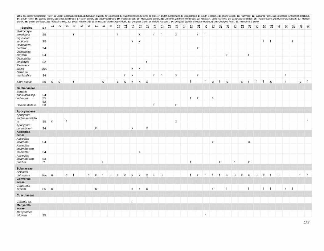
147
SITE #1: Lower Cogmagun River, 2: Upper Cogmagun River, 3: Newport Station, 4: Greenfield, 5: Five Mile River, 6: Lime-kiln Bk., 7: Dutch Settlement, 8: Black Brook, 9: South Section, 10: Brierly Brook, 11: Fairmont, 12: Williams Point, 13: Southside Antigonish Harbour, 14: South River, 15: Lamey Brook, 16: MacLeod Brook, 17: Glen Brook, 18: MacPhail Brook, 19: Pooles Brook, 20: MacLeans Brook, 21: Lime Hill, 22: McIntyre Brook, 23: Ninevah / Little Narrows, 24: Washabuck Bridge, 25: Plaster Cove, 26: Hunters Mountain, 27: McRae Brook, 28: Beinn Bhreagh, 29: Plaister Mines, 30: South Haven, 31: St. Anns, 32: Middle Aspy River, 33: Dingwall (north of Middle Harbour), 34: Dingwall (south of Middle Harbour), 35: Georges River, 36. Frenchvale Brook
Species S-r
1
2
3
4
5
6
7
8
9
10
11
12
13
14
15
16
17
18
19
20
21
22
23
24
25
26
27
28
29
30
31
32
33
34
35
36
Hydrocotyle americana S5 r r x r r x r f Ligusticum scoticum S5 x x l l r Osmorhiza berteroi S4 r Osmorhiza claytonii S4 r r Osmorhiza longistylis S2 r Pastinaca sativa SNA x x Sanicula marilandica S4 r x r r x r r
Sium suave S5 c c r c c c x x x f f u f u c r f f c r u f
Gentianaceae Bartonia paniculata ssp. iodandra
S4S5 r r r
Halenia deflexa S2S3 f r
Apocynaceae Apocynum
androsaemifolium S5 c f x r Apocynum cannabinum S4 c x x Asclepiad- aceae Asclepias incarnata S4 c x Asclepias incarnata ssp. Incarnata S4 x Asclepias incarnata ssp. pulchra
S3? l r r r r
Solanaceae Solanum dulcamara SNA u c f c c f u c c x x x u u f r f f f u u c u u c f u f c Convolvul- aceae Calystegia
sepium S5 c c x x x r l l l l r l
Cuscutaceae
Cuscuta sp. r Menyanth- aceae Menyanthes trifoliata S5 r
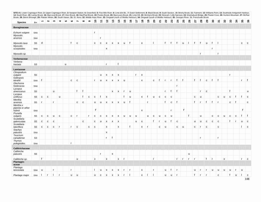
148
SITE #1: Lower Cogmagun River, 2: Upper Cogmagun River, 3: Newport Station, 4: Greenfield, 5: Five Mile River, 6: Lime-kiln Bk., 7: Dutch Settlement, 8: Black Brook, 9: South Section, 10: Brierly Brook, 11: Fairmont, 12: Williams Point, 13: Southside Antigonish Harbour, 14: South River, 15: Lamey Brook, 16: MacLeod Brook, 17: Glen Brook, 18: MacPhail Brook, 19: Pooles Brook, 20: MacLeans Brook, 21: Lime Hill, 22: McIntyre Brook, 23: Ninevah / Little Narrows, 24: Washabuck Bridge, 25: Plaster Cove, 26: Hunters Mountain, 27: McRae Brook, 28: Beinn Bhreagh, 29: Plaister Mines, 30: South Haven, 31: St. Anns, 32: Middle Aspy River, 33: Dingwall (north of Middle Harbour), 34: Dingwall (south of Middle Harbour), 35: Georges River, 36. Frenchvale Brook
Species S-r
1
2
3
4
5
6
7
8
9
10
11
12
13
14
15
16
17
18
19
20
21
22
23
24
25
26
27
28
29
30
31
32
33
34
35
36
Boraginaceae
Echium vulgare SNA r Myosotis arvensis SNA r
Myosotis laxa S5 rl f c c c x x x u f x l f f f u l f f u f l c c Myosotis scorpioides SNA x r
Myosotis sp. r r
Verbenaceae Verbena
hastata S3 u r f
Lamiaceae Clinopodium vulgare S5 u x x x r x r Galeopsis tetrahit SNA f c c r u x x x u x c f r r f f f f c f f r f Glechoma hederacea SNA r Lycopus americanus S5 u f f x x r u r f f r c f u Lycopus uniflorus S5 c c u f c c f x f u x f u c c c c u c u c f f c Mentha arvensis S5 r r c c u u x x x u f r f c f f r f f r c f c Mentha x piperita or other hybrid SNA r x r r r Prunella vulgaris S5 c c u c c r r c c x x x u u u u c u c u f u c c u c c f f Scutellaria galericulata S5 c c c c c u x x x u x f r u f c u u c c c f r u c Scutellaria lateriflora S5 c c c r r c c c x x f x r c u c u c r c c l c Stachys palustris SNA x Teucrium canadense S3 r f r r Thymus pulegioides SNA r
Callitrichaceae Callitriche palustris S5 r x u
Callitriche sp. f u x x x r r r r r r f r x r c Plantagin- aceae Plantago lanceolata SNA u r r l u x x x r r x r u f r u r r u u u u r u
Plantago major SNA l r l r u u u c x x x r l x l l u u r f r r c f u l c
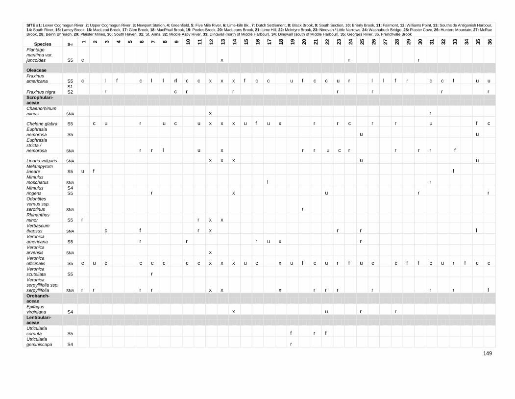
149
SITE #1: Lower Cogmagun River, 2: Upper Cogmagun River, 3: Newport Station, 4: Greenfield, 5: Five Mile River, 6: Lime-kiln Bk., 7: Dutch Settlement, 8: Black Brook, 9: South Section, 10: Brierly Brook, 11: Fairmont, 12: Williams Point, 13: Southside Antigonish Harbour, 14: South River, 15: Lamey Brook, 16: MacLeod Brook, 17: Glen Brook, 18: MacPhail Brook, 19: Pooles Brook, 20: MacLeans Brook, 21: Lime Hill, 22: McIntyre Brook, 23: Ninevah / Little Narrows, 24: Washabuck Bridge, 25: Plaster Cove, 26: Hunters Mountain, 27: McRae Brook, 28: Beinn Bhreagh, 29: Plaister Mines, 30: South Haven, 31: St. Anns, 32: Middle Aspy River, 33: Dingwall (north of Middle Harbour), 34: Dingwall (south of Middle Harbour), 35: Georges River, 36. Frenchvale Brook
Species S-r
1
2
3
4
5
6
7
8
9
10
11
12
13
14
15
16
17
18
19
20
21
22
23
24
25
26
27
28
29
30
31
32
33
34
35
36
Plantago maritima var. juncoides S5 c x r r
Oleaceae Fraxinus americana S5 c l f c l l rl c c x x x f c c u f c c u r l l f r c c f u u
Fraxinus nigra S1S2 r c r r r r r r
Scrophulari- aceae Chaenorhinum minus SNA x r
Chelone glabra S5 c u r u c u x x x u f u x r r c r r u f c Euphrasia nemorosa S5 u u Euphrasia stricta / nemorosa SNA r r l u x r r u c r r r r f
Linaria vulgaris SNA x x x u u Melampyrum lineare S5 u f f Mimulus moschatus SNA l r Mimulus ringens
S4S5 r x u r r
Odontites vernus ssp. serotinus SNA r Rhinanthus minor S5 r r x x Verbascum thapsus SNA c f r x r r l Veronica americana S5 r r r u x r Veronica arvensis SNA x Veronica officinalis S5 c u c c c c c c x x x u c x u f c u r f u c c f f c u r f c c Veronica scutellata S5 r Veronica serpyllifolia ssp. serpyllifolia SNA r r r r x x x r r r r r r f Orobanch- aceae Epifagus virginiana S4 x u r r Lentibulari- aceae Utricularia cornuta S5 f r f Utricularia geminiscapa S4 r
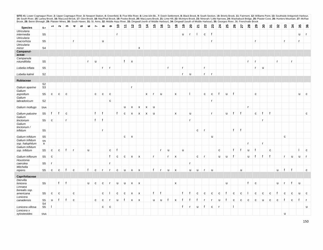
150
SITE #1: Lower Cogmagun River, 2: Upper Cogmagun River, 3: Newport Station, 4: Greenfield, 5: Five Mile River, 6: Lime-kiln Bk., 7: Dutch Settlement, 8: Black Brook, 9: South Section, 10: Brierly Brook, 11: Fairmont, 12: Williams Point, 13: Southside Antigonish Harbour, 14: South River, 15: Lamey Brook, 16: MacLeod Brook, 17: Glen Brook, 18: MacPhail Brook, 19: Pooles Brook, 20: MacLeans Brook, 21: Lime Hill, 22: McIntyre Brook, 23: Ninevah / Little Narrows, 24: Washabuck Bridge, 25: Plaster Cove, 26: Hunters Mountain, 27: McRae Brook, 28: Beinn Bhreagh, 29: Plaister Mines, 30: South Haven, 31: St. Anns, 32: Middle Aspy River, 33: Dingwall (north of Middle Harbour), 34: Dingwall (south of Middle Harbour), 35: Georges River, 36. Frenchvale Brook
Species S-r
1
2
3
4
5
6
7
8
9
10
11
12
13
14
15
16
17
18
19
20
21
22
23
24
25
26
27
28
29
30
31
32
33
34
35
36
Utricularia intermedia S5 r u r l c f u r Utricularia macrorhiza S5 r u r r r r Utricularia minor S4 x Campanul- aceae Campanula rotundifolia S5 r u f x r r r r
Lobelia inflata S5 r r r r r r u
Lobelia kalmii S2 r u r r
Rubiaceae
Galium aparine S2S3 r
Galium asprellum S5 c c c c c c x r u x l c c f u f c u c Galium labradoricum S2 c r
Galium mollugo SNA u x x x u r
Galium palustre S5 f f c f f f c x x x u x u r u f f c f f c Galium tinctorium S5 c r f f r r Galium tinctorium / trifidum S5 r c r f f
Galium trifidum S5 c x u c Galium trifidum ssp. halophilum
SNR r r
Galium trifidum ssp. trifidum S5 c c f r u c f r u u c f f u f c l c
Galium triflorum S5 c f c c x x r r x c r u u f u f f f r u u r Houstonia caerulea S5 r r r Mitchella repens S5 c c f c f c r r c u x x f r u x u u r u u u f f c
Caprifoliaceae Diervilla lonicera S5 f f u c c r u u x x x u f c u r f u Linnaea borealis ssp. americana S5 c c c c l c c x x f f f f c c c c f c c l c c c f c c u c Lonicera canadensis S5 u f f c c c r u f x x u u f x f f f r r u f c c c c u c c f c f r
Lonicera villosa S4S5 l c c f r u f c r l u
Lonicera x xylosteoides SNA u
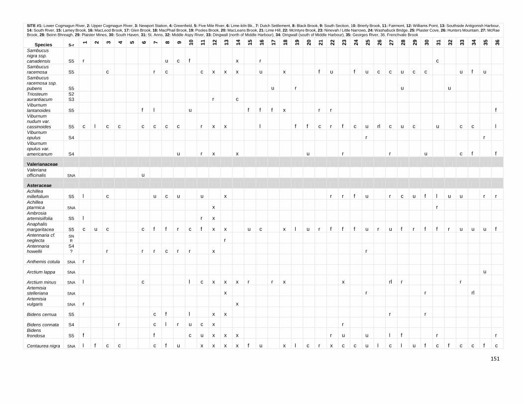
151
SITE #1: Lower Cogmagun River, 2: Upper Cogmagun River, 3: Newport Station, 4: Greenfield, 5: Five Mile River, 6: Lime-kiln Bk., 7: Dutch Settlement, 8: Black Brook, 9: South Section, 10: Brierly Brook, 11: Fairmont, 12: Williams Point, 13: Southside Antigonish Harbour, 14: South River, 15: Lamey Brook, 16: MacLeod Brook, 17: Glen Brook, 18: MacPhail Brook, 19: Pooles Brook, 20: MacLeans Brook, 21: Lime Hill, 22: McIntyre Brook, 23: Ninevah / Little Narrows, 24: Washabuck Bridge, 25: Plaster Cove, 26: Hunters Mountain, 27: McRae Brook, 28: Beinn Bhreagh, 29: Plaister Mines, 30: South Haven, 31: St. Anns, 32: Middle Aspy River, 33: Dingwall (north of Middle Harbour), 34: Dingwall (south of Middle Harbour), 35: Georges River, 36. Frenchvale Brook
Species S-r
1
2
3
4
5
6
7
8
9
10
11
12
13
14
15
16
17
18
19
20
21
22
23
24
25
26
27
28
29
30
31
32
33
34
35
36
Sambucus nigra ssp. canadensis S5 r u c f x r c Sambucus racemosa S5 c r c c x x x u x f u f u c c u c c u f u Sambucus racemosa ssp. pubens S5 u r u u Triosteum aurantiacum
S2S3 r c
Viburnum
lantanoides S5 f l u f f f x r r f Viburnum nudum var. cassinoides S5 c l c c c c c c r x x l f f c r f c u rl c u c u c c l Viburnum opulus S4 r r Viburnum
opulus var. americanum S4 u r x x u r r u c f f
Valerianaceae Valeriana officinalis SNA u
Asteraceae Achillea millefolium S5 l c u c u u x r r f u r c u f l u u r r Achillea ptarmica SNA x r Ambrosia artemisiifolia S5 l r x Anaphalis
margaritacea S5 c u c c f f r c f x x u c x l u r f f f u r u f r f f r u u u f Antennaria cf. neglecta
SNR r
Antennaria howellii
S4? r r r c r r x r
Anthemis cotula SNA r
Arctium lappa SNA u
Arctium minus SNA l c l c x x x r r x x rl r r Artemisia stelleriana SNA x r r rl Artemisia vulgaris SNA r x
Bidens cernua S5 c f l x x r r
Bidens connata S4 r c l r u c x r Bidens frondosa S5 f f c u x x x r u u l f r r
Centaurea nigra SNA l f c c c f u x x x x f u x l c r x c c u l c l u f c f c c f c
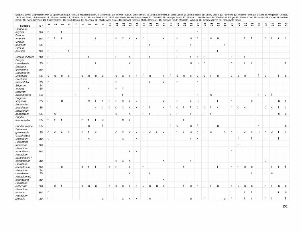
152
SITE #1: Lower Cogmagun River, 2: Upper Cogmagun River, 3: Newport Station, 4: Greenfield, 5: Five Mile River, 6: Lime-kiln Bk., 7: Dutch Settlement, 8: Black Brook, 9: South Section, 10: Brierly Brook, 11: Fairmont, 12: Williams Point, 13: Southside Antigonish Harbour, 14: South River, 15: Lamey Brook, 16: MacLeod Brook, 17: Glen Brook, 18: MacPhail Brook, 19: Pooles Brook, 20: MacLeans Brook, 21: Lime Hill, 22: McIntyre Brook, 23: Ninevah / Little Narrows, 24: Washabuck Bridge, 25: Plaster Cove, 26: Hunters Mountain, 27: McRae Brook, 28: Beinn Bhreagh, 29: Plaister Mines, 30: South Haven, 31: St. Anns, 32: Middle Aspy River, 33: Dingwall (north of Middle Harbour), 34: Dingwall (south of Middle Harbour), 35: Georges River, 36. Frenchvale Brook
Species S-r
1
2
3
4
5
6
7
8
9
10
11
12
13
14
15
16
17
18
19
20
21
22
23
24
25
26
27
28
29
30
31
32
33
34
35
36
Cichorium intybus SNA r r r Cirsium arvense SNA rl f r r l u x x x r x u u f u u u u l f f c l r c Cirsium muticum S5 r r r Cirsium palustre SNA r r r r
Cirsium vulgare SNA r r r x r r r x r r r r Conyza
canadensis S5 l r x u u r r l r l u r Dittrichia graveolens SNA Doellingeria umbellata S5 c c c c c c c c c x x x f c x f c c c c c f c c c c f c f c Erechtites hieraciifolia S5 r r r x r r Erigeron annuus
S4S5 r u x
Erigeron hyssopifolius S3 r l r r u r r u l Erigeron strigosus S5 l rl x l r f r x x x x r x u l r c u r Eupatorium maculatum S5 c c c c x x x f f x f c l f c c f c r c c c c f c Eupatorium perfoliatum S5 c u x r r u r r r r r r c c Eurybia macrophylla S5 f f f r f f u x x r
Eurybia radula S5 u f f u u f u r c Euthamia graminifolia S5 c c c c c f c c x x x u c r x l f r u c l u c c l c c u c c l c Gnaphalium uliginosum SNA u r c x x r r r x r rl f r l Helianthus
tuberosus SNA r Hieracium aurantiacum SNA x x r Hieracium aurantiacum / caespitosum SNA u x x x r u Hieracium caespitosum SNA c c f f c r x r f f r f c c r f f Hieracium canadense
S4S5 x r r u u
Hieracium cf. tridentatum SNA x Hieracium
lachenalii SNA rl f c c c c c x x x u u u x f u r l f c c u c c r r c c Hieracium murorum SNA r u r r r u Hieracium pilosella SNA l u f x x x u u r f u f l l r f f f
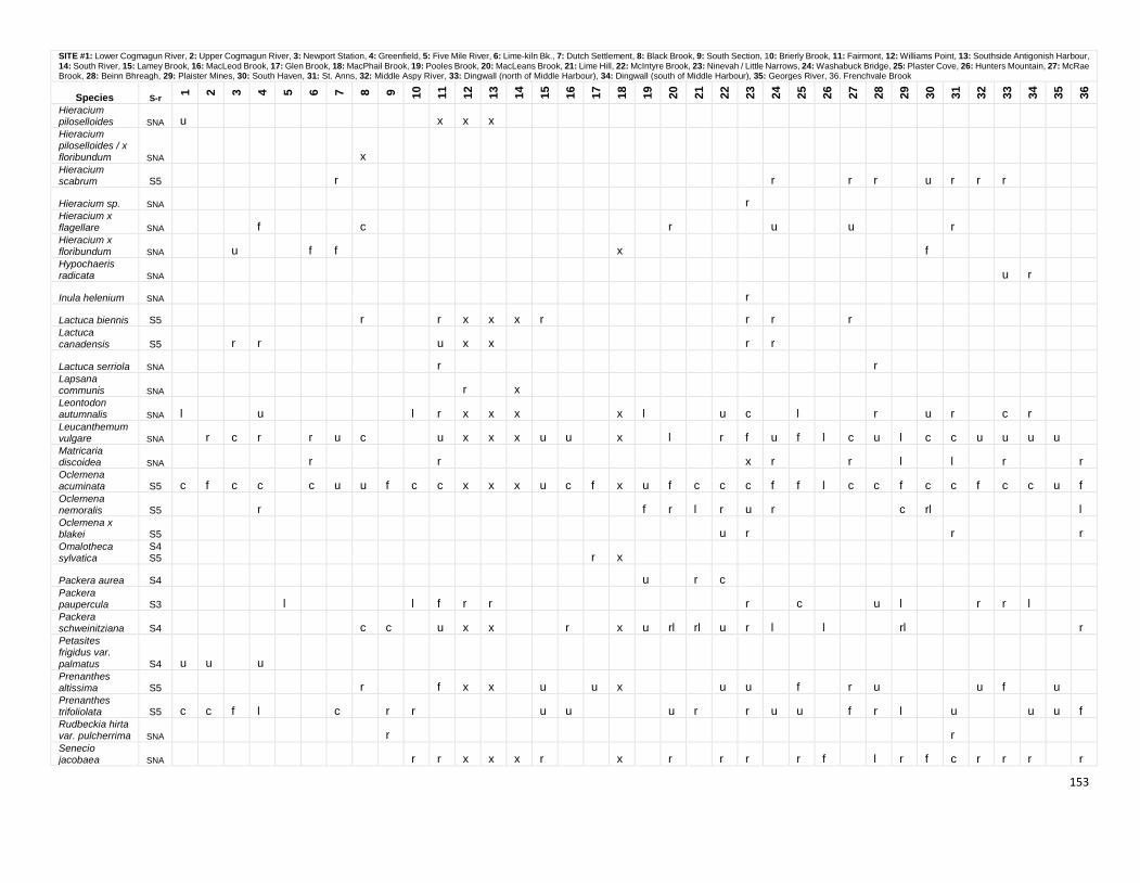
153
SITE #1: Lower Cogmagun River, 2: Upper Cogmagun River, 3: Newport Station, 4: Greenfield, 5: Five Mile River, 6: Lime-kiln Bk., 7: Dutch Settlement, 8: Black Brook, 9: South Section, 10: Brierly Brook, 11: Fairmont, 12: Williams Point, 13: Southside Antigonish Harbour, 14: South River, 15: Lamey Brook, 16: MacLeod Brook, 17: Glen Brook, 18: MacPhail Brook, 19: Pooles Brook, 20: MacLeans Brook, 21: Lime Hill, 22: McIntyre Brook, 23: Ninevah / Little Narrows, 24: Washabuck Bridge, 25: Plaster Cove, 26: Hunters Mountain, 27: McRae Brook, 28: Beinn Bhreagh, 29: Plaister Mines, 30: South Haven, 31: St. Anns, 32: Middle Aspy River, 33: Dingwall (north of Middle Harbour), 34: Dingwall (south of Middle Harbour), 35: Georges River, 36. Frenchvale Brook
Species S-r
1
2
3
4
5
6
7
8
9
10
11
12
13
14
15
16
17
18
19
20
21
22
23
24
25
26
27
28
29
30
31
32
33
34
35
36
Hieracium piloselloides SNA u x x x Hieracium piloselloides / x floribundum SNA x Hieracium scabrum S5 r r r r u r r r
Hieracium sp. SNA r Hieracium x flagellare SNA f c r u u r Hieracium x floribundum SNA u f f x f Hypochaeris radicata SNA u r
Inula helenium SNA r
Lactuca biennis S5 r r x x x r r r r Lactuca
canadensis S5 r r u x x r r
Lactuca serriola SNA r r Lapsana communis SNA r x Leontodon autumnalis SNA l u l r x x x x l u c l r u r c r Leucanthemum vulgare SNA r c r r u c u x x x u u x l r f u f l c u l c c u u u u Matricaria discoidea SNA r r x r r l l r r Oclemena acuminata S5 c f c c c u u f c c x x x u c f x u f c c c f f l c c f c c f c c u f Oclemena nemoralis S5 r f r l r u r c rl l Oclemena x blakei S5 u r r r Omalotheca sylvatica
S4S5 r x
Packera aurea S4 u r c Packera paupercula S3 l l f r r r c u l r r l Packera schweinitziana S4 c c u x x r x u rl rl u r l l rl r Petasites frigidus var.
palmatus S4 u u u Prenanthes altissima S5 r f x x u u x u u f r u u f u Prenanthes trifoliolata S5 c c f l c r r u u u r r u u f r l u u u f Rudbeckia hirta var. pulcherrima SNA r r Senecio jacobaea SNA r r x x x r x r r r r f l r f c r r r r
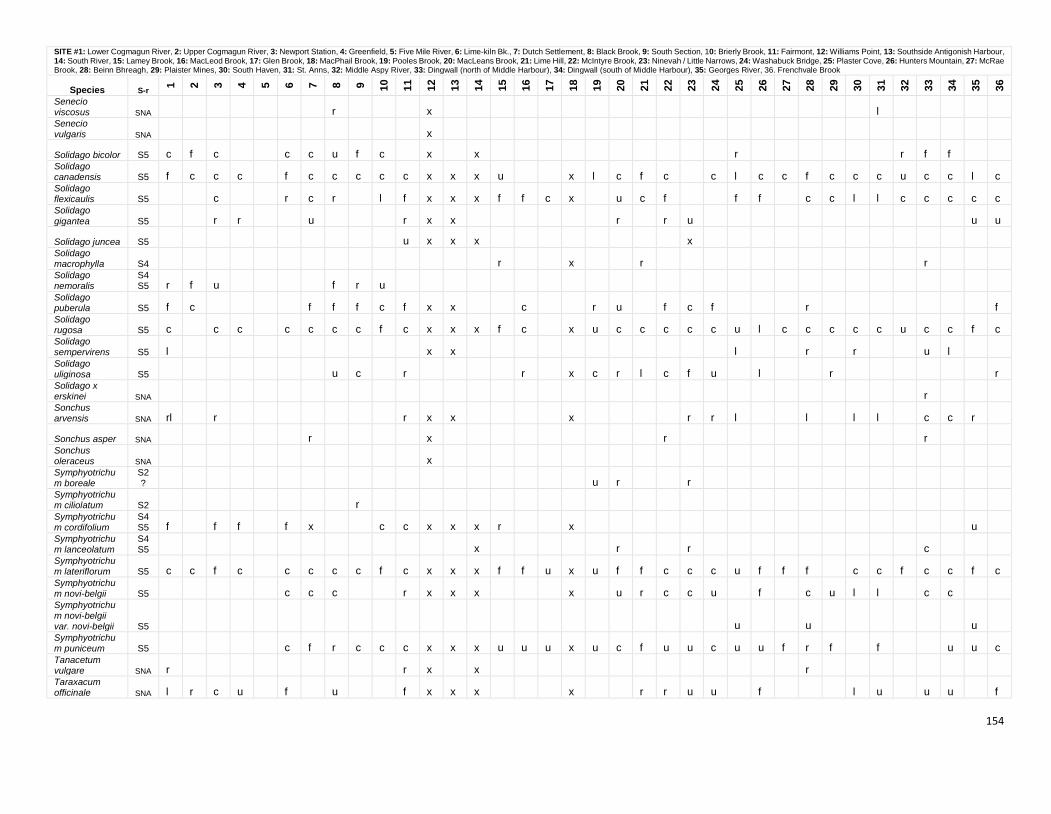
154
SITE #1: Lower Cogmagun River, 2: Upper Cogmagun River, 3: Newport Station, 4: Greenfield, 5: Five Mile River, 6: Lime-kiln Bk., 7: Dutch Settlement, 8: Black Brook, 9: South Section, 10: Brierly Brook, 11: Fairmont, 12: Williams Point, 13: Southside Antigonish Harbour, 14: South River, 15: Lamey Brook, 16: MacLeod Brook, 17: Glen Brook, 18: MacPhail Brook, 19: Pooles Brook, 20: MacLeans Brook, 21: Lime Hill, 22: McIntyre Brook, 23: Ninevah / Little Narrows, 24: Washabuck Bridge, 25: Plaster Cove, 26: Hunters Mountain, 27: McRae Brook, 28: Beinn Bhreagh, 29: Plaister Mines, 30: South Haven, 31: St. Anns, 32: Middle Aspy River, 33: Dingwall (north of Middle Harbour), 34: Dingwall (south of Middle Harbour), 35: Georges River, 36. Frenchvale Brook
Species S-r
1
2
3
4
5
6
7
8
9
10
11
12
13
14
15
16
17
18
19
20
21
22
23
24
25
26
27
28
29
30
31
32
33
34
35
36
Senecio viscosus SNA r x l Senecio vulgaris SNA x
Solidago bicolor S5 c f c c c u f c x x r r f f Solidago canadensis S5 f c c c f c c c c c x x x u x l c f c c l c c f c c c u c c l c Solidago flexicaulis S5 c r c r l f x x x f f c x u c f f f c c l l c c c c c Solidago
gigantea S5 r r u r x x r r u u u
Solidago juncea S5 u x x x x Solidago macrophylla S4 r x r r Solidago nemoralis
S4S5 r f u f r u
Solidago puberula S5 f c f f f c f x x c r u f c f r f Solidago rugosa S5 c c c c c c c f c x x x f c x u c c c c c u l c c c c c u c c f c Solidago sempervirens S5 l x x l r r u l Solidago uliginosa S5 u c r r x c r l c f u l r r Solidago x erskinei SNA r Sonchus arvensis SNA rl r r x x x r r l l l l c c r
Sonchus asper SNA r x r r Sonchus oleraceus SNA x Symphyotrichum boreale
S2? u r r
Symphyotrichum ciliolatum S2 r Symphyotrichum cordifolium
S4S5 f f f f x c c x x x r x u
Symphyotrichum lanceolatum
S4S5 x r r c
Symphyotrichum lateriflorum S5 c c f c c c c c f c x x x f f u x u f f c c c u f f f c c f c c f c Symphyotrichum novi-belgii S5 c c c r x x x x u r c c u f c u l l c c Symphyotrichum novi-belgii var. novi-belgii S5 u u u Symphyotrichum puniceum S5 c f r c c c x x x u u u x u c f u u c u u f r f f u u c Tanacetum vulgare SNA r r x x r Taraxacum officinale SNA l r c u f u f x x x x r r u u f l u u u f
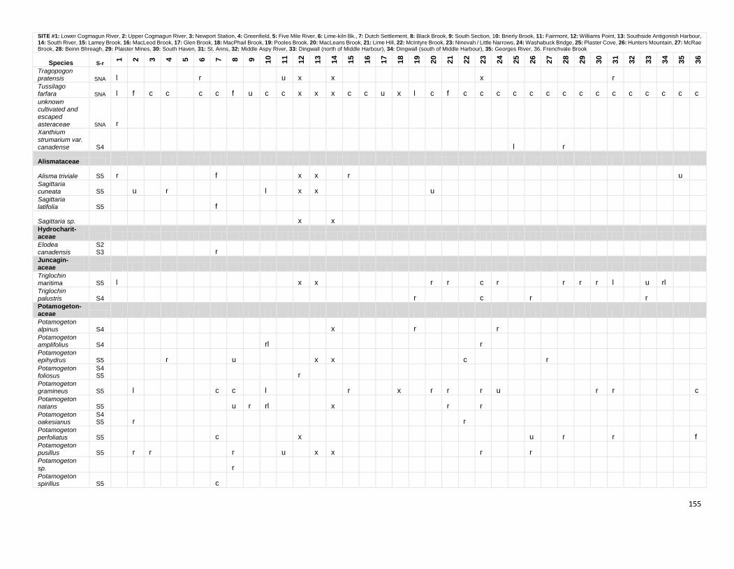
155
SITE #1: Lower Cogmagun River, 2: Upper Cogmagun River, 3: Newport Station, 4: Greenfield, 5: Five Mile River, 6: Lime-kiln Bk., 7: Dutch Settlement, 8: Black Brook, 9: South Section, 10: Brierly Brook, 11: Fairmont, 12: Williams Point, 13: Southside Antigonish Harbour, 14: South River, 15: Lamey Brook, 16: MacLeod Brook, 17: Glen Brook, 18: MacPhail Brook, 19: Pooles Brook, 20: MacLeans Brook, 21: Lime Hill, 22: McIntyre Brook, 23: Ninevah / Little Narrows, 24: Washabuck Bridge, 25: Plaster Cove, 26: Hunters Mountain, 27: McRae Brook, 28: Beinn Bhreagh, 29: Plaister Mines, 30: South Haven, 31: St. Anns, 32: Middle Aspy River, 33: Dingwall (north of Middle Harbour), 34: Dingwall (south of Middle Harbour), 35: Georges River, 36. Frenchvale Brook
Species S-r
1
2
3
4
5
6
7
8
9
10
11
12
13
14
15
16
17
18
19
20
21
22
23
24
25
26
27
28
29
30
31
32
33
34
35
36
Tragopogon pratensis SNA l r u x x x r Tussilago farfara SNA l f c c c c f u c c x x x c c u x l c f c c c c c c c c c c c c c c c unknown cultivated and escaped asteraceae SNA r Xanthium strumarium var. canadense S4 l r
Alismataceae
Alisma triviale S5 r f x x r u Sagittaria cuneata S5 u r l x x u Sagittaria latifolia S5 f
Sagittaria sp. x x Hydrocharit- aceae Elodea canadensis
S2S3 r
Juncagin- aceae Triglochin maritima S5 l x x r r c r r r r l u rl Triglochin palustris S4 r c r r Potamogeton- aceae Potamogeton alpinus S4 x r r Potamogeton amplifolius S4 rl r Potamogeton epihydrus S5 r u x x c r Potamogeton foliosus
S4S5 r
Potamogeton gramineus S5 l c c l r x r r r u r r c Potamogeton natans S5 u r rl x r r Potamogeton oakesianus
S4S5 r r
Potamogeton perfoliatus S5 c x u r r f Potamogeton pusillus S5 r r r u x x r r Potamogeton
sp. r Potamogeton spirillus S5 c
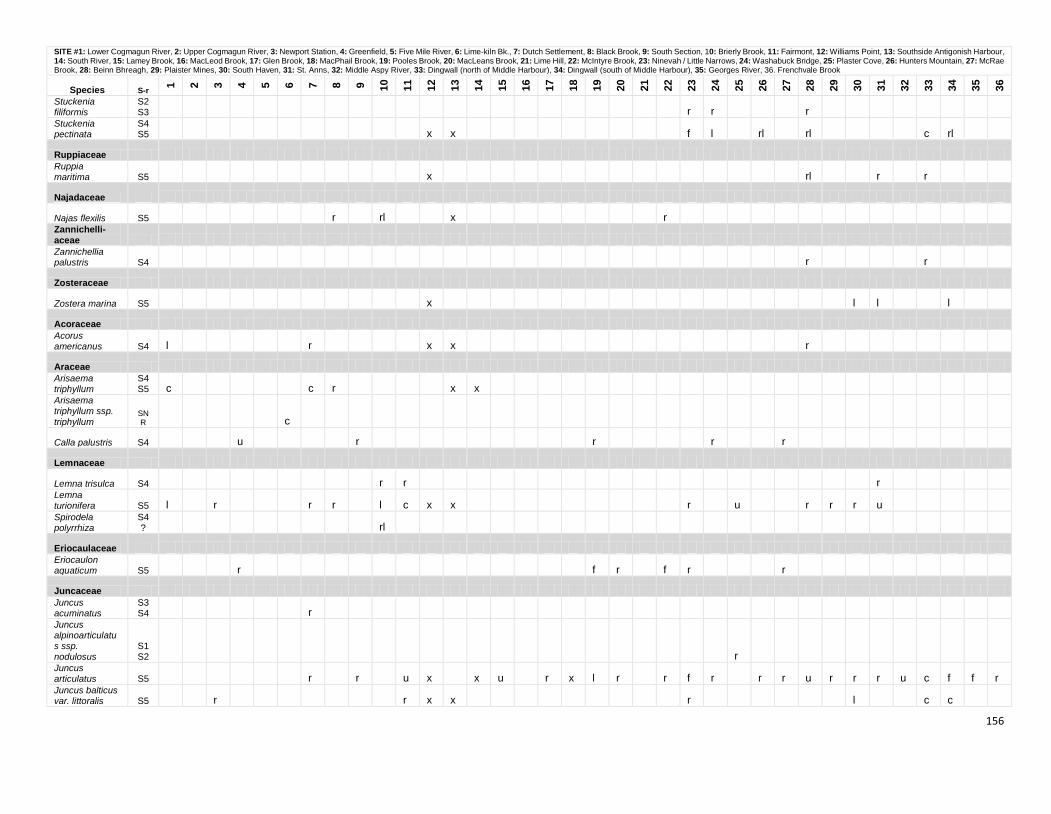
156
SITE #1: Lower Cogmagun River, 2: Upper Cogmagun River, 3: Newport Station, 4: Greenfield, 5: Five Mile River, 6: Lime-kiln Bk., 7: Dutch Settlement, 8: Black Brook, 9: South Section, 10: Brierly Brook, 11: Fairmont, 12: Williams Point, 13: Southside Antigonish Harbour, 14: South River, 15: Lamey Brook, 16: MacLeod Brook, 17: Glen Brook, 18: MacPhail Brook, 19: Pooles Brook, 20: MacLeans Brook, 21: Lime Hill, 22: McIntyre Brook, 23: Ninevah / Little Narrows, 24: Washabuck Bridge, 25: Plaster Cove, 26: Hunters Mountain, 27: McRae Brook, 28: Beinn Bhreagh, 29: Plaister Mines, 30: South Haven, 31: St. Anns, 32: Middle Aspy River, 33: Dingwall (north of Middle Harbour), 34: Dingwall (south of Middle Harbour), 35: Georges River, 36. Frenchvale Brook
Species S-r
1
2
3
4
5
6
7
8
9
10
11
12
13
14
15
16
17
18
19
20
21
22
23
24
25
26
27
28
29
30
31
32
33
34
35
36
Stuckenia filiformis
S2S3 r r r
Stuckenia pectinata
S4S5 x x f l rl rl c rl
Ruppiaceae Ruppia maritima S5 x rl r r
Najadaceae
Najas flexilis S5 r rl x r Zannichelli- aceae Zannichellia palustris S4 r r
Zosteraceae
Zostera marina S5 x l l l
Acoraceae Acorus americanus S4 l r x x r
Araceae Arisaema triphyllum
S4S5 c c r x x
Arisaema triphyllum ssp.
triphyllum SNR c
Calla palustris S4 u r r r r
Lemnaceae
Lemna trisulca S4 r r r Lemna turionifera S5 l r r r l c x x r u r r r u Spirodela polyrrhiza
S4? rl
Eriocaulaceae Eriocaulon aquaticum S5 r f r f r r
Juncaceae Juncus acuminatus
S3S4 r
Juncus alpinoarticulatus ssp. nodulosus
S1S2 r
Juncus articulatus S5 r r u x x u r x l r r f r r r u r r r u c f f r Juncus balticus var. littoralis S5 r r x x r l c c
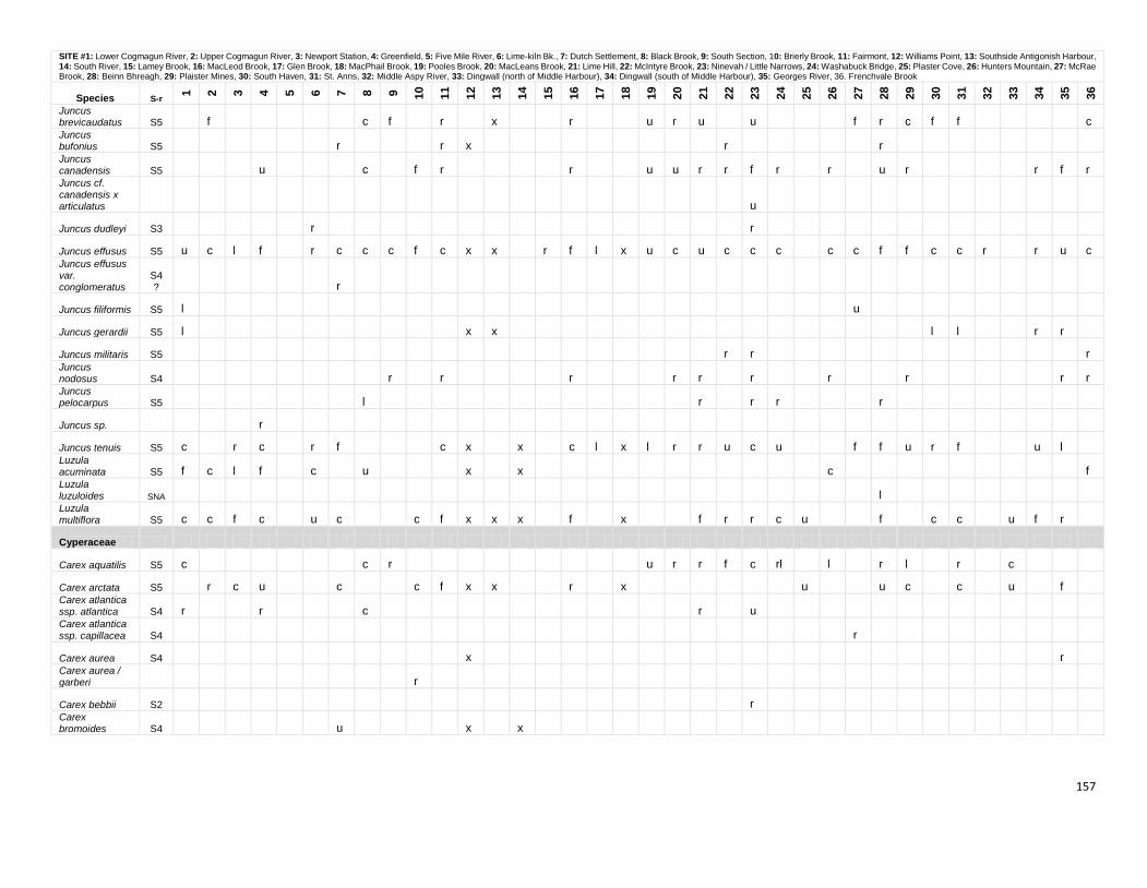
157
SITE #1: Lower Cogmagun River, 2: Upper Cogmagun River, 3: Newport Station, 4: Greenfield, 5: Five Mile River, 6: Lime-kiln Bk., 7: Dutch Settlement, 8: Black Brook, 9: South Section, 10: Brierly Brook, 11: Fairmont, 12: Williams Point, 13: Southside Antigonish Harbour, 14: South River, 15: Lamey Brook, 16: MacLeod Brook, 17: Glen Brook, 18: MacPhail Brook, 19: Pooles Brook, 20: MacLeans Brook, 21: Lime Hill, 22: McIntyre Brook, 23: Ninevah / Little Narrows, 24: Washabuck Bridge, 25: Plaster Cove, 26: Hunters Mountain, 27: McRae Brook, 28: Beinn Bhreagh, 29: Plaister Mines, 30: South Haven, 31: St. Anns, 32: Middle Aspy River, 33: Dingwall (north of Middle Harbour), 34: Dingwall (south of Middle Harbour), 35: Georges River, 36. Frenchvale Brook
Species S-r
1
2
3
4
5
6
7
8
9
10
11
12
13
14
15
16
17
18
19
20
21
22
23
24
25
26
27
28
29
30
31
32
33
34
35
36
Juncus brevicaudatus S5 f c f r x r u r u u f r c f f c Juncus bufonius S5 r r x r r Juncus canadensis S5 u c f r r u u r r f r r u r r f r Juncus cf. canadensis x articulatus u
Juncus dudleyi S3 r r
Juncus effusus S5 u c l f r c c c f c x x r f l x u c u c c c c c f f c c r r u c Juncus effusus var. conglomeratus
S4? r
Juncus filiformis S5 l u
Juncus gerardii S5 l x x l l r r
Juncus militaris S5 r r r Juncus nodosus S4 r r r r r r r r r r Juncus pelocarpus S5 l r r r r
Juncus sp. r
Juncus tenuis S5 c r c r f c x x c l x l r r u c u f f u r f u l Luzula acuminata S5 f c l f c u x x c f Luzula luzuloides SNA l Luzula multiflora S5 c c f c u c c f x x x f x f r r c u f c c u f r
Cyperaceae
Carex aquatilis S5 c c r u r r f c rl l r l r c
Carex arctata S5 r c u c c f x x r x u u c c u f Carex atlantica ssp. atlantica S4 r r c r u Carex atlantica ssp. capillacea S4 r
Carex aurea S4 x r Carex aurea / garberi r
Carex bebbii S2 r Carex bromoides S4 u x x
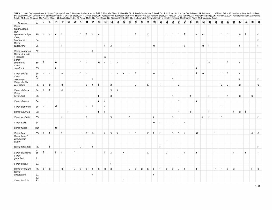
158
SITE #1: Lower Cogmagun River, 2: Upper Cogmagun River, 3: Newport Station, 4: Greenfield, 5: Five Mile River, 6: Lime-kiln Bk., 7: Dutch Settlement, 8: Black Brook, 9: South Section, 10: Brierly Brook, 11: Fairmont, 12: Williams Point, 13: Southside Antigonish Harbour, 14: South River, 15: Lamey Brook, 16: MacLeod Brook, 17: Glen Brook, 18: MacPhail Brook, 19: Pooles Brook, 20: MacLeans Brook, 21: Lime Hill, 22: McIntyre Brook, 23: Ninevah / Little Narrows, 24: Washabuck Bridge, 25: Plaster Cove, 26: Hunters Mountain, 27: McRae Brook, 28: Beinn Bhreagh, 29: Plaister Mines, 30: South Haven, 31: St. Anns, 32: Middle Aspy River, 33: Dingwall (north of Middle Harbour), 34: Dingwall (south of Middle Harbour), 35: Georges River, 36. Frenchvale Brook
Species S-r
1
2
3
4
5
6
7
8
9
10
11
12
13
14
15
16
17
18
19
20
21
22
23
24
25
26
27
28
29
30
31
32
33
34
35
36
Carex brunnescens ssp. sphaerostachya S5 c c c f u f f c c f x f r r f c c r c u f c Carex
buxbaumii S4 r Carex canescens S5 r f x r u u u r r r
Carex castanea S2 r Carex cf. lurida x lupulina x Carex communis S5 f u f r u r x x x c u f r r Carex crawfordii S5 r r
Carex crinita S5 c c u c f c x x x u f u f f u c f r Carex cryptolepis
S3? r r r r
Carex debilis var. rudgei S5 c c c c r f x u x f c c u u u
Carex deflexa S4 r f c u u x x Carex deweyana S5 r x r r r r u u
Carex diandra S4 r r r r
Carex disperma S5 c rl r r l r u
Carex eburnea S3 r r r r c r l r u l
Carex echinata S5 r r x r r r u r r r r
Carex exilis S4 u r l u u r
Carex flacca SNA u
Carex flava S5 r f f u c c r x x u r x f r r c u rl f u c c Carex flava / viridula var. elatior r
Carex folliculata S5 f u r r r
Carex gracillima S4S5 f f r f f x x x c r r r r r f
Carex granularis S1 r
Carex grisea S1 r
Carex gynandra S5 c c c u c c f c c x u c u x r f c c u f f r f c u l c Carex gynocrates S1 r r
Carex hirtifolia S2S3 r
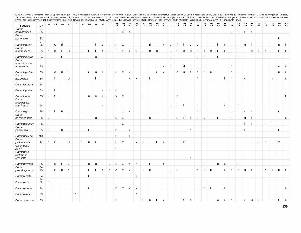
159
SITE #1: Lower Cogmagun River, 2: Upper Cogmagun River, 3: Newport Station, 4: Greenfield, 5: Five Mile River, 6: Lime-kiln Bk., 7: Dutch Settlement, 8: Black Brook, 9: South Section, 10: Brierly Brook, 11: Fairmont, 12: Williams Point, 13: Southside Antigonish Harbour, 14: South River, 15: Lamey Brook, 16: MacLeod Brook, 17: Glen Brook, 18: MacPhail Brook, 19: Pooles Brook, 20: MacLeans Brook, 21: Lime Hill, 22: McIntyre Brook, 23: Ninevah / Little Narrows, 24: Washabuck Bridge, 25: Plaster Cove, 26: Hunters Mountain, 27: McRae Brook, 28: Beinn Bhreagh, 29: Plaister Mines, 30: South Haven, 31: St. Anns, 32: Middle Aspy River, 33: Dingwall (north of Middle Harbour), 34: Dingwall (south of Middle Harbour), 35: Georges River, 36. Frenchvale Brook
Species S-r
1
2
3
4
5
6
7
8
9
10
11
12
13
14
15
16
17
18
19
20
21
22
23
24
25
26
27
28
29
30
31
32
33
34
35
36
Carex hormathodes
S4S5 l x x u r r r
Carex hystericina S2 r
Carex interior S4S5 l c rl r l c r r x rl x u f l c c l rl r r u l u l
Carex intumescens S5 c c f u f f f r c f x x x f c u u r c c c c x f c u f c f c f c
Carex lacustris S4 l r c u c r r r Carex
lasiocarpa var. americana S5 r x c rl c l r c rl
Carex leptalea S5 c rl l r u l u x x r x c u f c f u r u r Carex leptonervia S5 f u f x x f r f f f c u u
Carex lucorum S4 r
Carex lupulina S3 r l r r r
Carex lurida S5 u f u c u x x r r f Carex magellanica ssp. irrigua S5 r u r l r rl r r
Carex nigra S5 r l u f x x r u r r r Carex novae-angliae S5 u u u x c u f f r u r r u f u
Carex paleacea S5 l x l r f r Carex pallescens S5 u u f r x r u r r
Carex panicea SNA r x Carex pedunculata S4 rl r u f u r u x x u f x r u r x Carex poss. peckii r Carex poss. rostrata x utriculata r
Carex projecta S5 f u l c c u c u x x x r x r f u u f Carex pseudocyperus
S4S5 r u r r f c c c x x u u u u f r u u r r u f u c u u c
Carex radiata S4 l x
Carex recta S4? r
Carex retrorsa S4 r r x x x r r r u
Carex rosea S3 r r
Carex scabrata S5 r u f u f x f c c u r r u u f u
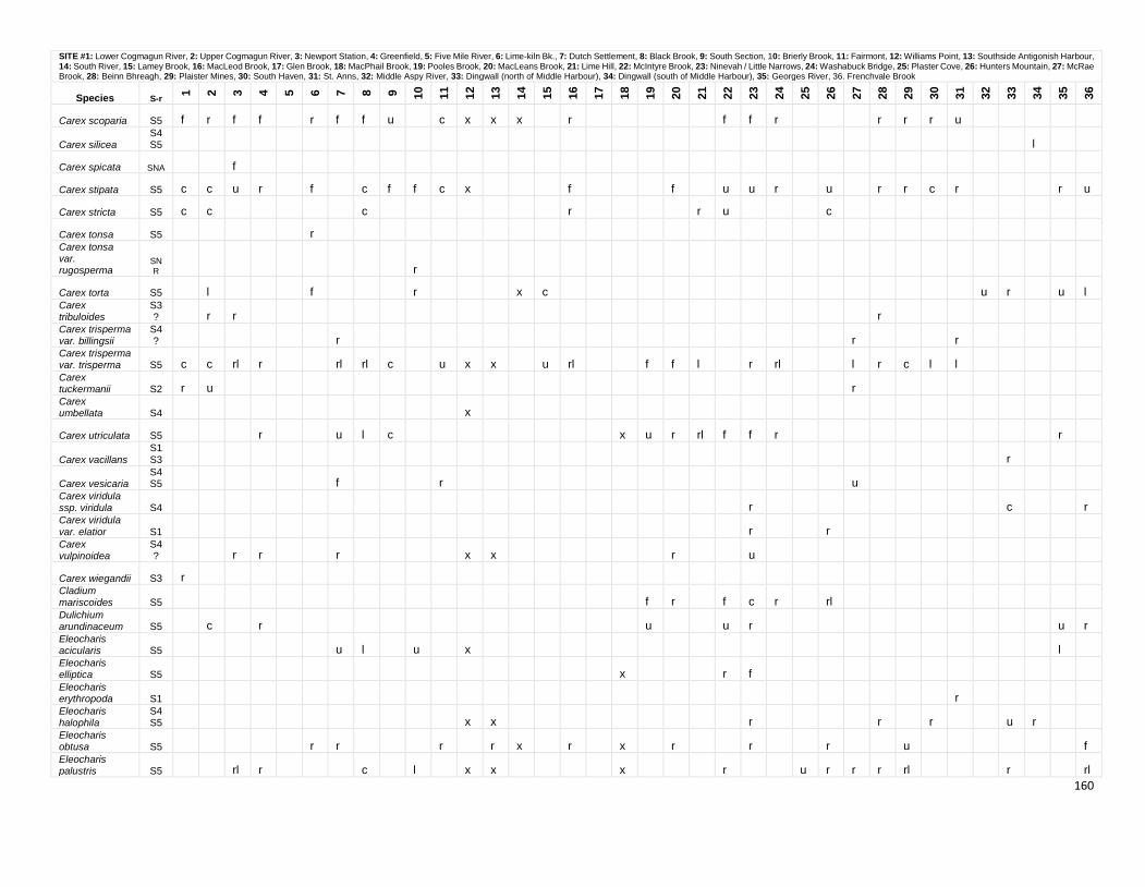
160
SITE #1: Lower Cogmagun River, 2: Upper Cogmagun River, 3: Newport Station, 4: Greenfield, 5: Five Mile River, 6: Lime-kiln Bk., 7: Dutch Settlement, 8: Black Brook, 9: South Section, 10: Brierly Brook, 11: Fairmont, 12: Williams Point, 13: Southside Antigonish Harbour, 14: South River, 15: Lamey Brook, 16: MacLeod Brook, 17: Glen Brook, 18: MacPhail Brook, 19: Pooles Brook, 20: MacLeans Brook, 21: Lime Hill, 22: McIntyre Brook, 23: Ninevah / Little Narrows, 24: Washabuck Bridge, 25: Plaster Cove, 26: Hunters Mountain, 27: McRae Brook, 28: Beinn Bhreagh, 29: Plaister Mines, 30: South Haven, 31: St. Anns, 32: Middle Aspy River, 33: Dingwall (north of Middle Harbour), 34: Dingwall (south of Middle Harbour), 35: Georges River, 36. Frenchvale Brook
Species S-r
1
2
3
4
5
6
7
8
9
10
11
12
13
14
15
16
17
18
19
20
21
22
23
24
25
26
27
28
29
30
31
32
33
34
35
36
Carex scoparia S5 f r f f r f f u c x x x r f f r r r r u
Carex silicea S4S5 l
Carex spicata SNA f
Carex stipata S5 c c u r f c f f c x f f u u r u r r c r r u
Carex stricta S5 c c c r r u c
Carex tonsa S5 r Carex tonsa var. rugosperma
SNR r
Carex torta S5 l f r x c u r u l Carex tribuloides
S3? r r r
Carex trisperma var. billingsii
S4? r r r
Carex trisperma var. trisperma S5 c c rl r rl rl c u x x u rl f f l r rl l r c l l Carex tuckermanii S2 r u r Carex umbellata S4 x
Carex utriculata S5 r u l c x u r rl f f r r
Carex vacillans
S1S3 r
Carex vesicaria S4S5 f r u
Carex viridula ssp. viridula S4 r c r Carex viridula
var. elatior S1 r r Carex vulpinoidea
S4? r r r x x r u
Carex wiegandii S3 r Cladium mariscoides S5 f r f c r rl Dulichium arundinaceum S5 c r u u r u r Eleocharis acicularis S5 u l u x l Eleocharis elliptica S5 x r f Eleocharis erythropoda S1 r Eleocharis halophila
S4S5 x x r r r u r
Eleocharis obtusa S5 r r r r x r x r r r u f Eleocharis palustris S5 rl r c l x x x r u r r r rl r rl
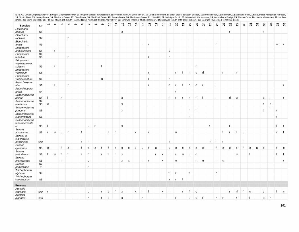
161
SITE #1: Lower Cogmagun River, 2: Upper Cogmagun River, 3: Newport Station, 4: Greenfield, 5: Five Mile River, 6: Lime-kiln Bk., 7: Dutch Settlement, 8: Black Brook, 9: South Section, 10: Brierly Brook, 11: Fairmont, 12: Williams Point, 13: Southside Antigonish Harbour, 14: South River, 15: Lamey Brook, 16: MacLeod Brook, 17: Glen Brook, 18: MacPhail Brook, 19: Pooles Brook, 20: MacLeans Brook, 21: Lime Hill, 22: McIntyre Brook, 23: Ninevah / Little Narrows, 24: Washabuck Bridge, 25: Plaster Cove, 26: Hunters Mountain, 27: McRae Brook, 28: Beinn Bhreagh, 29: Plaister Mines, 30: South Haven, 31: St. Anns, 32: Middle Aspy River, 33: Dingwall (north of Middle Harbour), 34: Dingwall (south of Middle Harbour), 35: Georges River, 36. Frenchvale Brook
Species S-r
1
2
3
4
5
6
7
8
9
10
11
12
13
14
15
16
17
18
19
20
21
22
23
24
25
26
27
28
29
30
31
32
33
34
35
36
Eleocharis parvula S4 x r r Eleocharis robbinsii S4 r Eleocharis tenuis S5 u u r rl u r Eriophorum angustifolium S5 r u Eriophorum tenellum
S4S5 r r r
Eriophorum vaginatum var. spissum S5 r l r Eriophorum virginicum S5 r rl r r l r u rl r r Eriophorum viridicarinatum S4 u r r Rhynchospora alba S5 r r r c r l c c r l r Rhynchospora fusca S4 r Schoenoplectus acutus S4 l r x f r r r f l l rl u c l r Schoenoplectus maritimus
S4S5 c x r rl
Schoenoplectus pungens S5 x r f c l r Schoenoplectus subterminalis S5 r r Schoenoplectus tabernaemontani S5 l u r x r r l r Scirpus atrocinctus S5 r u u r f l r x r u f r r u r f Scirpus cf. cyperinus x atrocinctus SNA r r r r r r r Scirpus cyperinus S5 c f c f c c f f c x x x u f u u c c c c c f c c c f c u c f c Scirpus hattorianus S5 f u f f r c r r f x r x l r u u c u f l f Scirpus microcarpus S5 r u r x x r r x u r u r u r Scirpus pedicellatus
S2? r
Trichophorum alpinum S4 f r f rl Trichophorum caespitosum S5 x r l
Poaceae Agrostis capillaris SNA r l f u r c f x x r l x l r f c r rl f u c l c Agrostis gigantea SNA r r l x r r u u r r r r l u r
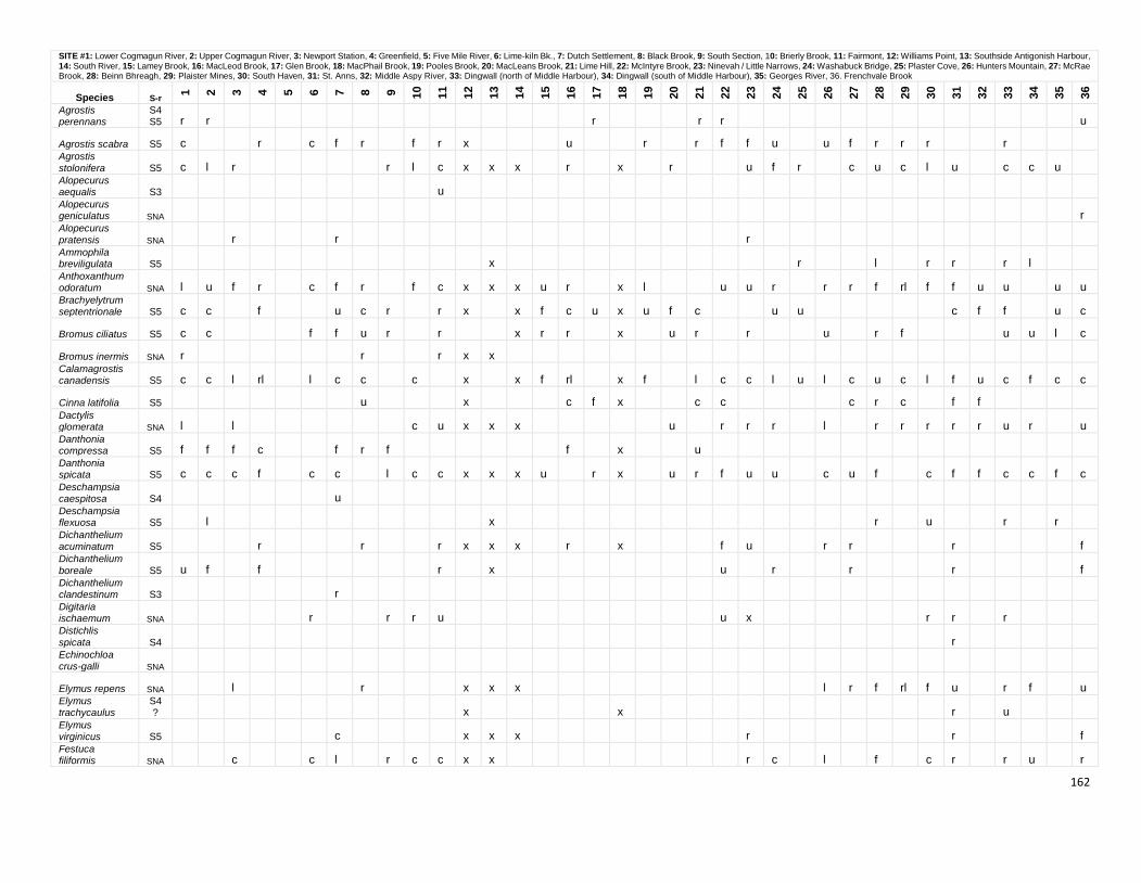
162
SITE #1: Lower Cogmagun River, 2: Upper Cogmagun River, 3: Newport Station, 4: Greenfield, 5: Five Mile River, 6: Lime-kiln Bk., 7: Dutch Settlement, 8: Black Brook, 9: South Section, 10: Brierly Brook, 11: Fairmont, 12: Williams Point, 13: Southside Antigonish Harbour, 14: South River, 15: Lamey Brook, 16: MacLeod Brook, 17: Glen Brook, 18: MacPhail Brook, 19: Pooles Brook, 20: MacLeans Brook, 21: Lime Hill, 22: McIntyre Brook, 23: Ninevah / Little Narrows, 24: Washabuck Bridge, 25: Plaster Cove, 26: Hunters Mountain, 27: McRae Brook, 28: Beinn Bhreagh, 29: Plaister Mines, 30: South Haven, 31: St. Anns, 32: Middle Aspy River, 33: Dingwall (north of Middle Harbour), 34: Dingwall (south of Middle Harbour), 35: Georges River, 36. Frenchvale Brook
Species S-r
1
2
3
4
5
6
7
8
9
10
11
12
13
14
15
16
17
18
19
20
21
22
23
24
25
26
27
28
29
30
31
32
33
34
35
36
Agrostis perennans
S4S5 r r r r r u
Agrostis scabra S5 c r c f r f r x u r r f f u u f r r r r Agrostis
stolonifera S5 c l r r l c x x x r x r u f r c u c l u c c u Alopecurus aequalis S3 u Alopecurus geniculatus SNA r Alopecurus
pratensis SNA r r r Ammophila breviligulata S5 x r l r r r l Anthoxanthum odoratum SNA l u f r c f r f c x x x u r x l u u r r r f rl f f u u u u Brachyelytrum septentrionale S5 c c f u c r r x x f c u x u f c u u c f f u c
Bromus ciliatus S5 c c f f u r r x r r x u r r u r f u u l c
Bromus inermis SNA r r r x x Calamagrostis canadensis S5 c c l rl l c c c x x f rl x f l c c l u l c u c l f u c f c c
Cinna latifolia S5 u x c f x c c c r c f f Dactylis glomerata SNA l l c u x x x u r r r l r r r r r u r u Danthonia compressa S5 f f f c f r f f x u Danthonia spicata S5 c c c f c c l c c x x x u r x u r f u u c u f c f f c c f c Deschampsia caespitosa S4 u Deschampsia flexuosa S5 l x r u r r Dichanthelium acuminatum S5 r r r x x x r x f u r r r f Dichanthelium
boreale S5 u f f r x u r r r f Dichanthelium clandestinum S3 r Digitaria ischaemum SNA r r r u u x r r r Distichlis
spicata S4 r Echinochloa crus-galli SNA
Elymus repens SNA l r x x x l r f rl f u r f u Elymus trachycaulus
S4? x x r u
Elymus virginicus S5 c x x x r r f Festuca filiformis SNA c c l r c c x x r c l f c r r u r
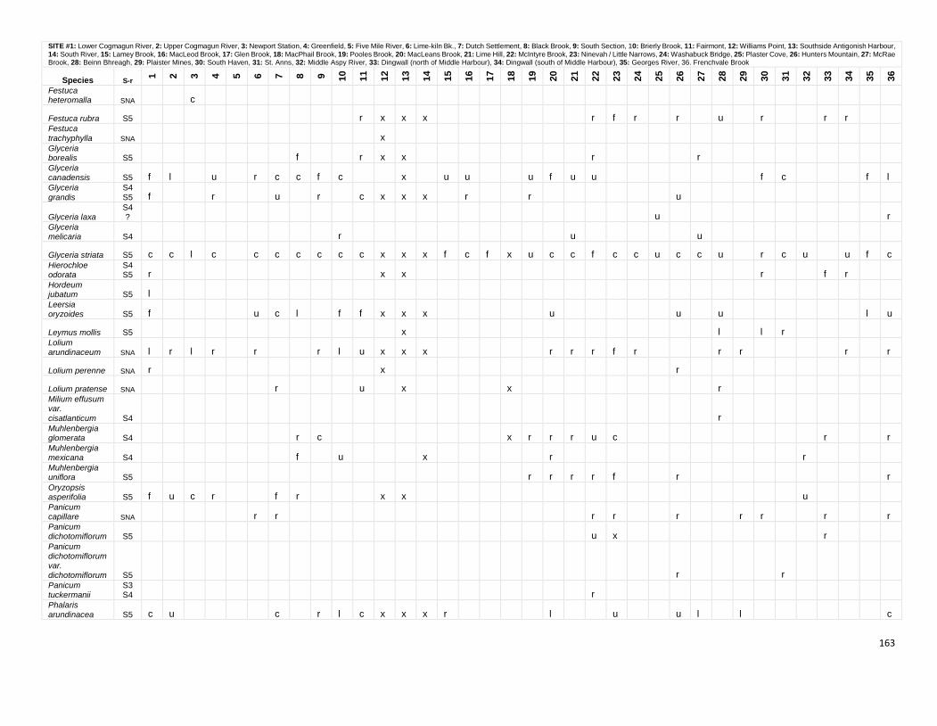
163
SITE #1: Lower Cogmagun River, 2: Upper Cogmagun River, 3: Newport Station, 4: Greenfield, 5: Five Mile River, 6: Lime-kiln Bk., 7: Dutch Settlement, 8: Black Brook, 9: South Section, 10: Brierly Brook, 11: Fairmont, 12: Williams Point, 13: Southside Antigonish Harbour, 14: South River, 15: Lamey Brook, 16: MacLeod Brook, 17: Glen Brook, 18: MacPhail Brook, 19: Pooles Brook, 20: MacLeans Brook, 21: Lime Hill, 22: McIntyre Brook, 23: Ninevah / Little Narrows, 24: Washabuck Bridge, 25: Plaster Cove, 26: Hunters Mountain, 27: McRae Brook, 28: Beinn Bhreagh, 29: Plaister Mines, 30: South Haven, 31: St. Anns, 32: Middle Aspy River, 33: Dingwall (north of Middle Harbour), 34: Dingwall (south of Middle Harbour), 35: Georges River, 36. Frenchvale Brook
Species S-r
1
2
3
4
5
6
7
8
9
10
11
12
13
14
15
16
17
18
19
20
21
22
23
24
25
26
27
28
29
30
31
32
33
34
35
36
Festuca heteromalla SNA c
Festuca rubra S5
r x x x
r f r
r
u
r
r r
Festuca
trachyphylla SNA
x
Glyceria borealis S5
f
r x x
r
r
Glyceria canadensis S5 f l
u
r c c f c
x
u u
u f u u
f c
f l
Glyceria
grandis
S4
S5 f
r
u
r
c x x x
r
r
u
Glyceria laxa
S4?
u
r
Glyceria melicaria S4
r
u
u
Glyceria striata S5 c c l c
c c c c c c x x x f c f x u c c f c c u c c u
r c u
u f c
Hierochloe odorata
S4S5 r
x x
r
f r
Hordeum jubatum S5 l
Leersia oryzoides S5 f
u c l
f f x x x
u
u
u
l u
Leymus mollis S5
x
l
l r
Lolium arundinaceum SNA l r l r
r
r l u x x x
r r r f r
r r
r
r
Lolium perenne SNA r
x
r
Lolium pratense SNA
r
u
x
x
r
Milium effusum var.
cisatlanticum S4
r
Muhlenbergia glomerata S4
r c
x r r r u c
r
r
Muhlenbergia mexicana S4
f
u
x
r
r
Muhlenbergia uniflora S5
r r r r f
r
r
Oryzopsis asperifolia S5 f u c r
f r
x x
u
Panicum capillare SNA
r r
r r
r
r r
r
r
Panicum dichotomiflorum S5
u x
r
Panicum dichotomiflorum var. dichotomiflorum S5
r
r
Panicum tuckermanii
S3S4
r
Phalaris
arundinacea S5 c u
c
r l c x x x r
l
u
u l
l
c
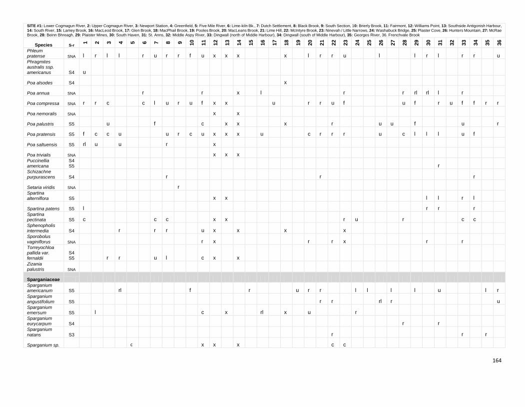
164
SITE #1: Lower Cogmagun River, 2: Upper Cogmagun River, 3: Newport Station, 4: Greenfield, 5: Five Mile River, 6: Lime-kiln Bk., 7: Dutch Settlement, 8: Black Brook, 9: South Section, 10: Brierly Brook, 11: Fairmont, 12: Williams Point, 13: Southside Antigonish Harbour, 14: South River, 15: Lamey Brook, 16: MacLeod Brook, 17: Glen Brook, 18: MacPhail Brook, 19: Pooles Brook, 20: MacLeans Brook, 21: Lime Hill, 22: McIntyre Brook, 23: Ninevah / Little Narrows, 24: Washabuck Bridge, 25: Plaster Cove, 26: Hunters Mountain, 27: McRae Brook, 28: Beinn Bhreagh, 29: Plaister Mines, 30: South Haven, 31: St. Anns, 32: Middle Aspy River, 33: Dingwall (north of Middle Harbour), 34: Dingwall (south of Middle Harbour), 35: Georges River, 36. Frenchvale Brook
Species S-r
1
2
3
4
5
6
7
8
9
10
11
12
13
14
15
16
17
18
19
20
21
22
23
24
25
26
27
28
29
30
31
32
33
34
35
36
Phleum pratense SNA l r l l
r u r r f u x x x
x
l r r u
l
l r l
r r
u
Phragmites australis ssp. americanus S4 u
Poa alsodes S4
x
Poa annua SNA
r
r
x
l
r
r rl rl l
r
Poa compressa SNA r r c
c l u r u f x x
u
r r u f
u f
r u f f r r
Poa nemoralis SNA
x
x
Poa palustris S5
u
f
c
x x
x
r
u u
f
u
r
Poa pratensis S5 f c c u
u r c u x x x
u
c r r r
u
c l l l
u f
Poa saltuensis S5 rl u
u
r
x
Poa trivialis SNA
x x x
Puccinellia americana
S4S5
r
Schizachne purpurascens S4
r
r
r
Setaria viridis SNA
r
Spartina alterniflora S5
x x
l l
r l
Spartina patens S5 l
r r
r
Spartina pectinata S5 c
c c
x x
r u
r
c c
Sphenopholis intermedia S4
r
r r
u x
x
x
x
Sporobolus vaginiflorus SNA
r x
r
r x
r
r
Torreyochloa pallida var. fernaldii
S4S5
r r
u l
c x
x
Zizania palustris SNA
Sparganiaceae Sparganium americanum S5
rl
f
r
u r r
l l
l
l
u
l r
Sparganium angustifolium S5
r r
rl r
u
Sparganium emersum S5
l
c
x
rl
x
u
r
Sparganium eurycarpum S4
r
r
Sparganium
natans S3
r
r
r
Sparganium sp.
c
x x
x
c c
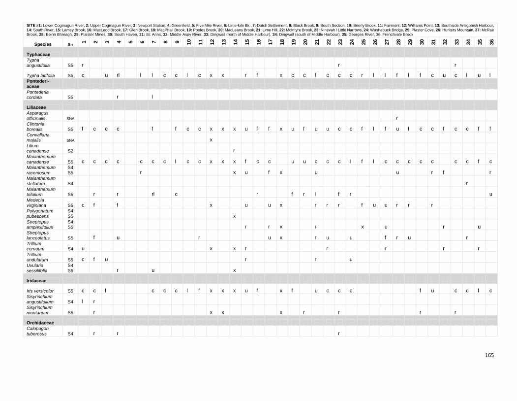
165
SITE #1: Lower Cogmagun River, 2: Upper Cogmagun River, 3: Newport Station, 4: Greenfield, 5: Five Mile River, 6: Lime-kiln Bk., 7: Dutch Settlement, 8: Black Brook, 9: South Section, 10: Brierly Brook, 11: Fairmont, 12: Williams Point, 13: Southside Antigonish Harbour, 14: South River, 15: Lamey Brook, 16: MacLeod Brook, 17: Glen Brook, 18: MacPhail Brook, 19: Pooles Brook, 20: MacLeans Brook, 21: Lime Hill, 22: McIntyre Brook, 23: Ninevah / Little Narrows, 24: Washabuck Bridge, 25: Plaster Cove, 26: Hunters Mountain, 27: McRae Brook, 28: Beinn Bhreagh, 29: Plaister Mines, 30: South Haven, 31: St. Anns, 32: Middle Aspy River, 33: Dingwall (north of Middle Harbour), 34: Dingwall (south of Middle Harbour), 35: Georges River, 36. Frenchvale Brook
Species S-r
1
2
3
4
5
6
7
8
9
10
11
12
13
14
15
16
17
18
19
20
21
22
23
24
25
26
27
28
29
30
31
32
33
34
35
36
Typhaceae Typha angustifolia S5 r
r
r
Typha latifolia S5 c
u rl
l l c c l c x x
r f
x c c f c c c r l l f l f c u c l u l
Pontederi- aceae Pontederia cordata S5
r
l
Liliaceae Asparagus
officinalis SNA
r
Clintonia borealis S5 f c c c
f
f c c x x x u f f x u f u u c c f l f u l c c f c c f f
Convallaria majalis SNA
x
Lilium canadense S2
r
Maianthemum canadense S5 c c c c
c c c l c c x x x f c c
u u c c c l f l c c c c c
c c f c
Maianthemum racemosum
S4S5
r
x u
f x
u
u
r f
r
Maianthemum stellatum S4
r
Maianthemum trifolium S5
r
r
rl
c
r
f r l
f r
u
Medeola virginiana S5 c f
f
x
u
u x
r r r
f u u r r
r
Polygonatum pubescens
S4S5
x
Streptopus amplexifolius
S4S5
r
r x
r
x
u
r
u
Streptopus lanceolatus S5
f
u
r
u x
r u
u
f r u
r
Trillium cernuum S4 u
x
x r
r
r
r
r
Trillium undulatum S5 c f u
r
r
u
Uvularia sessilifolia
S4S5
r
u
x
Iridaceae
Iris versicolor S5 c c l
c c c l f x x x u f
x f
u c c c
f u
c c l c
Sisyrinchium angustifolium S4 l r
Sisyrinchium montanum S5
r
x x
x
r
r
r
r
Orchidaceae Calopogon
tuberosus S4
r
r
r
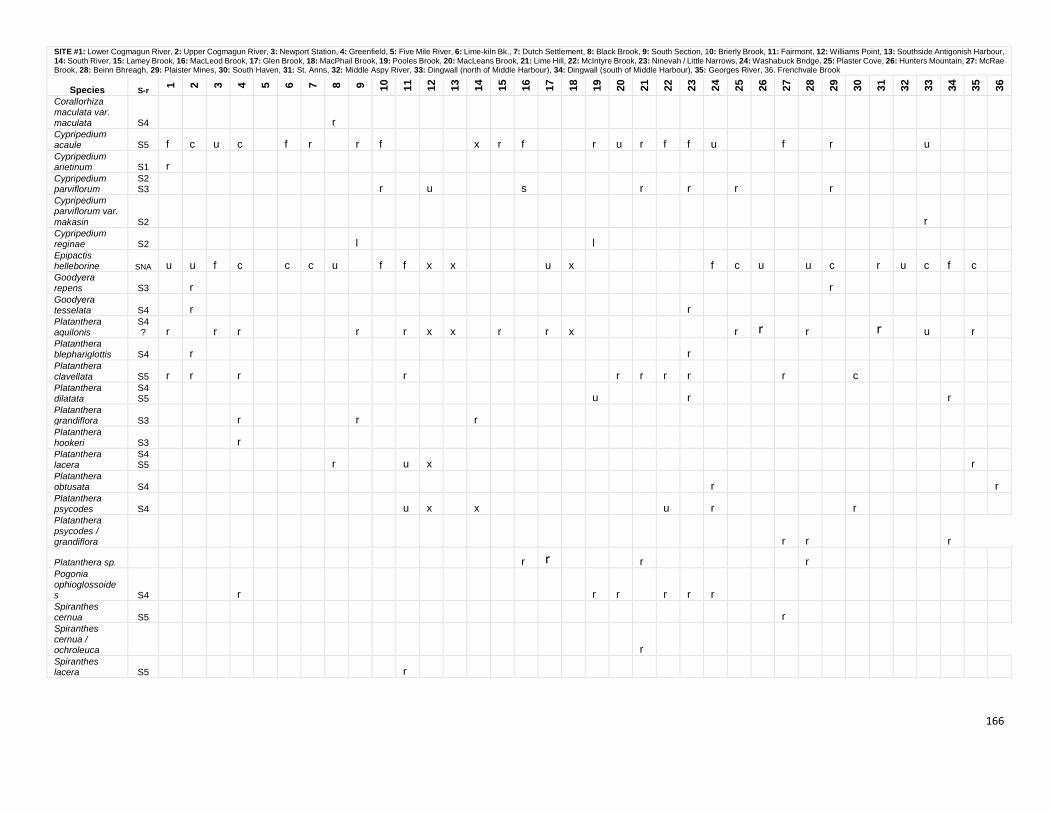
166
SITE #1: Lower Cogmagun River, 2: Upper Cogmagun River, 3: Newport Station, 4: Greenfield, 5: Five Mile River, 6: Lime-kiln Bk., 7: Dutch Settlement, 8: Black Brook, 9: South Section, 10: Brierly Brook, 11: Fairmont, 12: Williams Point, 13: Southside Antigonish Harbour, 14: South River, 15: Lamey Brook, 16: MacLeod Brook, 17: Glen Brook, 18: MacPhail Brook, 19: Pooles Brook, 20: MacLeans Brook, 21: Lime Hill, 22: McIntyre Brook, 23: Ninevah / Little Narrows, 24: Washabuck Bridge, 25: Plaster Cove, 26: Hunters Mountain, 27: McRae Brook, 28: Beinn Bhreagh, 29: Plaister Mines, 30: South Haven, 31: St. Anns, 32: Middle Aspy River, 33: Dingwall (north of Middle Harbour), 34: Dingwall (south of Middle Harbour), 35: Georges River, 36. Frenchvale Brook
Species S-r
1
2
3
4
5
6
7
8
9
10
11
12
13
14
15
16
17
18
19
20
21
22
23
24
25
26
27
28
29
30
31
32
33
34
35
36
Corallorhiza maculata var. maculata S4
r
Cypripedium acaule S5 f c u c
f r
r f
x r f
r u r f f u
f
r
u
Cypripedium arietinum S1 r
Cypripedium parviflorum
S2S3
r
u
s
r
r
r
r
Cypripedium parviflorum var.
makasin S2
r
Cypripedium reginae S2
l
l
Epipactis helleborine SNA u u f c
c c u
f f x x
u x
f c u
u c
r u c f c
Goodyera repens S3
r
r
Goodyera tesselata S4
r
r
Platanthera aquilonis
S4? r
r r
r
r x x
r
r x
r r
r
r
u
r
Platanthera blephariglottis S4
r
r
Platanthera clavellata S5 r r
r
r
r r r r
r
c
Platanthera dilatata
S4S5
u
r
r
Platanthera grandiflora S3
r
r
r
Platanthera hookeri S3
r
Platanthera lacera
S4S5
r
u x
r
Platanthera obtusata S4
r
r
Platanthera psycodes S4
u x
x
u
r
r
Platanthera psycodes / grandiflora
r r
r
Platanthera sp.
r r
r
r
Pogonia ophioglossoides S4
r
r r
r r r
Spiranthes cernua S5
r
Spiranthes cernua / ochroleuca
r
Spiranthes lacera S5
r