district census handbook
TRANSCRIPT
Directorate of Census Operations, Bihar
th ud x.r kj ukk kH
CE A
N
I
S
D
U N S
I FO
PART XII-A
VILLAGE AND TOWN DIRECTORY
CENSUS OF INDIA 2011
lR;eso t;rs
BIHAR
SERIES-11
DISTRICT CENSUS HANDBOOK
KAIMUR (BHABUA)

�

R
R
R
R
R
R
RR
R
R
P !
!
!
!
!
!
!
!
!
DISTRICT KAIMUR (BHABUA)5 05
B I H A R
D I S T
RI
CT
R
OH
TA
S
U
T
TA
R
PR
A
DE
S H
NUAON
RAMGARH
DURGAWATI
CHAND
CHAINPUR
BHAGWANPURRAMPUR
BHABUA
MOHANIA
KUDRA
ADHAURA
NH 02
SH
SH
RS
BUXAR
To Sasaram
From Moghalsarai
DISTRICT
KILOMETRES
I N D I A
Canal
Gahu
war N
Gurwat N
Kuhir
a N
Shuaro N
Shura
N
Karsoth a N
Durgau
ti N
Durgauti N
Durgauti N
Kudra N
Goria N
Karamn a sa N
Jahanabad
Chainpur
Mohania
Ikhlaspur
Ramgarh
Ghatawan
Hata
Mokri
BOUNDARY, STATE ....................................................................... '' DISTRICT .................................................................. '' C.D. BLOCK ..............................................................HEADQUARTERS: DISTRICT ......................................................... '' C.D.BLOCK .......................................................VILLAGES HAVING 8000 AND ABOVE POPULATION WITH NAMEURBAN AREA WITH POPULATION SIZE:- IIINATIONAL HIGHWAY ......................................................................STATE HIGHWAY .............................................................................IMPORTANT METALLED ROADS .....................................................RAILWAY LINE WITH STATION, BROAD GAUGE ............................RIVER AND STREAM .......................................................................CANAL WITH DISTRIBUTARY ..........................................................
PR
ìììRS
NH 02SH
!
!MAKRI
ììì
Total Rural UrbanArea (Sq.Km) 3332.00 3319.55 12.45Population 1626384 1560813 65571No. of Villages 1695 No. of Towns 01No. of C.D. Blocks 11Distance of District HQ to State HQ 195 Km
Bhabua

CENSUS OF INDIA 2011 SERIES-11 BIHAR
DISTRICT CENSUS HANDBOOK
PART - A
KAIMUR (BHABUA)
VILLAGE AND TOWN DIRECTORY
Directorate of Census Operations, Bihar

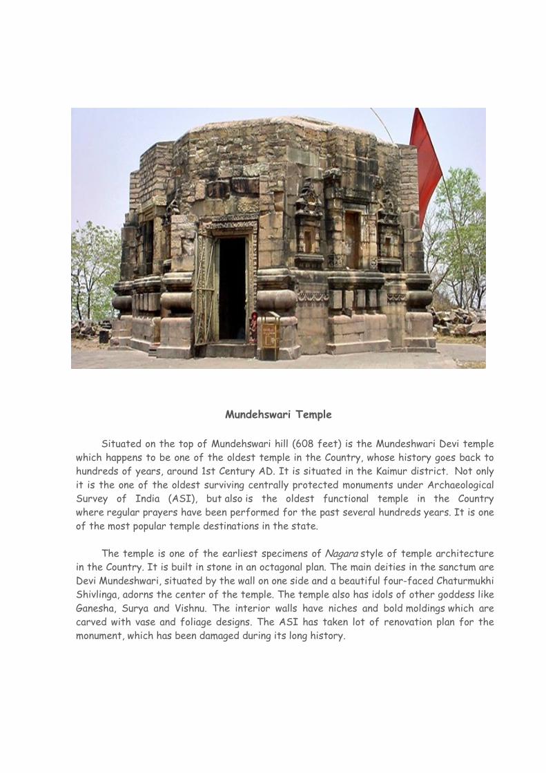
Mundehswari Temple
Situated on the top of Mundehswari hill (608 feet) is the Mundeshwari Devi temple
which happens to be one of the oldest temple in the Country, whose history goes back to
hundreds of years, around 1st Century AD. It is situated in the Kaimur district. Not only
it is the one of the oldest surviving centrally protected monuments under Archaeological
Survey of India (ASI), but also is the oldest functional temple in the Country
where regular prayers have been performed for the past several hundreds years. It is one
of the most popular temple destinations in the state.
The temple is one of the earliest specimens of Nagara style of temple architecture in the Country. It is built in stone in an octagonal plan. The main deities in the sanctum are
Devi Mundeshwari, situated by the wall on one side and a beautiful four-faced Chaturmukhi
Shivlinga, adorns the center of the temple. The temple also has idols of other goddess like
Ganesha, Surya and Vishnu. The interior walls have niches and bold moldings which are
carved with vase and foliage designs. The ASI has taken lot of renovation plan for the
monument, which has been damaged during its long history.

Contents
Pages
Foreword 9
Preface 13
Acknowledgements 15
History and Scope of the District Census Handbook 17
Brief History of the District 19
Analytical Note
(i) Physical features 23
(ii) Census Concepts 31
(iii) Non-Census Concepts 39
(iv) 2011 Census findings - Population, its distribution 40
(v) Brief analysis of PCA data based on inset tables 1 to 35 43
(vi) Brief analysis of the Village Directory and Town Directory data based on 74
inset tables 36 to 45
(vii) Major social and cultural events, natural and administrative developments
and significant activities during the decade 84
(viii) Brief description of places of religious, historical or archaeological importance
in villages and places of tourist interest in the towns of the district 84
(ix) Major characteristics of the district, contribution of the district in the form of
any historical figure associated with the district 85
(x) Scope of Village Directory and Town Directory - column heading wise
explanation and coverage of data 86
VILLAGE AND TOWN DIRECTORY
Brief Note on Village and Town Directory 97
Section-I : Village Directory
(a) List of villages merged in towns and outgrowths at 2011 Census 113
(b) C.D. Block Maps 115
(c) Alphabetical list of Villages along with location code 2001 and 2011 137
(d) CD Block wise Village Directory 184
(e) Appendices to Village Directory
Appendix-I : Summary showing total number of villages having Educational,
Medical and other amenities in villages – C.D. Block level 882
Appendix IA : Villages by number of Primary Schools 892
Appendix IB : Villages by Primary, Middle and Secondary Schools 893
Appendix IC : Villages with different sources of drinking water facilities
available 894
Appendix II : Villages with 5,000 and above population which do not
have one or more amenities available 895
Appendix III : Land utilization data in respect of Census towns 896
Appendix IV : C.D. Blockwise list of inhabited villages where no amenity
other than drinking water facility is available 897
Appendix V : Summary showing number of villages not having
Scheduled Castes population 898
Appendix VI : Summary showing number of villages not having
Scheduled Tribes population 899
Appendix VIIA : List of villages according to the proportion of the Scheduled
Castes to the total population by ranges 900
Appendix VIIB : List of villages according to the proportion of the Scheduled
Tribes to the total population by ranges 935
Appendix VIII : Number of Villages under each Gram Panchayat
(C.D. block wise) 969
Section-II: Town Directory
(a) Statement I : Status and Growth history 972
(b) Statement II : Physical aspects and location of towns, 2009 974
(c) Statement III : Civic and other amenities, 2009 976
(d) Statement IV : Medical Facilities, 2009 978
(e) Statement V : Educational, Recreational and Cultural facilities, 2009 980
(f) Statement VI : Industry and Banking, 2009 984
(g) Statement VII : Civic and other amenities in slums, 2009 986
(h) Appendix to Town Directory – Towns showing their outgrowth with population 988
9
FOREWORD
he District Census Handbook (DCHB) is an important publication of the Census Organization since 1951. It contains both Census and non Census
data of urban and rural areas for each District. The Census data provide information on demographic and socio-economic characteristics of population at the lowest administrative unit i.e. of each Village and Town and ward of the District. The Primary Census Abstract (PCA) part of this publication contains Census data including data on household amenities collected during 1st.phase of the Census i.e. House Listing and Housing Census. The non Census data presented in the DCHB is in the form of Village Directory and Town Directory contain information on various infrastructure facilities available in the village and town viz; education, medical, drinking water, communication and transport, post and telegraph, electricity, banking, and other miscellaneous facilities. Later on, the Telegraph Services were closed by the Government of India on 15th. July, 2013. The data of DCHB are of considerable importance in the context of planning and development at the grass-root level.
2. In the 1961 Census, DCHB provided a descriptive account of the District, administrative statistics, Census tables and Village and Town Directory including Primary Census Abstract. This pattern was changed in 1971 Census and the DCHB was published in three parts: Part-A related to Village and Town Directory, Part-B to Village and Town PCA and Part-C comprised analytical report, administrative statistics, District Census tables and certain analytical tables based on PCA and amenity data in respect of Villages. The 1981 Census DCHB was published in two parts: Part-A contained Village and Town Directory and Part-B the PCA of Village and Town including the SCs and STs PCA up to Tahsil/Town levels. New features along with restructuring of the formats of Village and Town Directory were added. In Village Directory, all amenities except electricity were brought together and if any amenity was not available in the referent Village, the distance in broad ranges from the nearest place having such an amenity, was given.
3. The pattern of 1981 Census was followed by and large for the DCHB of 1991 Census except the format of PCA. It was restructured. Nine-fold industrial classification of main workers was given against the four-fold industrial classification presented in the 1981 Census. In addition, sex wise population in 0-6 age group was included in the PCA for the first time with a view to enable the data users to compile more realistic literacy rate as all children below 7 years of age had been treated as illiterate at the time of 1991 Census. One of the important innovations in the 1991 Census was the Community Development Block (CD Block) level presentation of Village Directory and PCA data instead of the traditional Tahsil/Taluk/PS level presentation.
T
10
4. As regards DCHB of 2001 Census, the scope of Village Directory was improved by including some other amenities like banking, recreational and cultural facilities, newspapers & magazines and `most important commodity’ manufactured in a Village in addition to prescribed facilities of earlier Censuses. In Town Directory, the statement on Slums was modified and its coverage was enlarged by including details on all slums instead of ‘notified slums’.
5. The scope and coverage of Village Directory of 2011 DCHB has been widened by including a number of new amenities in addition to those of 2001. These newly added amenities are: Pre-Primary School, Engineering College, Medical College, Management Institute, Polytechnic, Non-formal Training Centre, Special School for Disabled, Community Health Centre, Veterinary Hospital, Mobile Health Clinic, Medical Practitioner with MBBS Degree, Medical Practitioner with no degree, Traditional Practitioner and faith Healer, Medicine Shop, Community Toilet, Rural Sanitary Mart or Sanitary Hardware Outlet in the Village, Community Bio- gas, Sub Post Office, Village Pin Code, Public Call Office, Mobile Phone Coverage, Internet Cafes/ Common Service Centre, Private Courier Facility, Auto/Modified Autos, Taxis and Vans, Tractors, Cycle-pulled Rickshaws, Carts driven by Animals, Village connected to National Highway, State Highway, Major District Road, and Other District Road, Availability of Water Bounded Macadam Roads in Village, ATM, Self-Help Group, Public Distribution System(PDS) Shop, Mandis/Regular Market, Weekly Haat, Agricultural Marketing Society, Nutritional Centers (ICDS), Anganwadi Centre, ASHA (Accredited Social Health Activist), Sports Field, Public Library, Public Reading Room, Assembly Polling station, Birth & Death Registration Office. In the Town Directory, seven Statements containing the details and the data of each Town have been presented viz.; (i)-Status and Growth History of Towns,(ii)- Physical Aspects and Location of Towns, (iii)-Civic and other Amenities, (iv)-Medical Facilities, (v)-Educational, Recreational & Cultural Facilities, (vi)- Industry & Banking, and (vii)- Civic & other amenities in Slums respectively. CD Block wise data of Village Directory and Village PCA have been presented in DCHB of 2011 Census as presented in earlier Census.
6. The data of DCHB 2011 Census have been presented in two parts, Part-A contains Village and Town Directory and Part-B contains Village and Town wise Primary Census Abstract. Both the Parts have been published in separate volumes in 2011 Census. 7. The Village and Town level amenities data have been collected, compiled and computerized under the supervision of Shri Krishnamoorthy Senthil Kumar, Director of Census Operation, Bihar. The task of Planning, Designing and Co-ordination of this publication was carried out by Dr. Pratibha Kumari, Assistant Registrar General (SS) under the guidance & supervision of Dr. R.C.Sethi, Ex-Addl. RGI and Shri Deepak Rastogi present Addl.RGI. Shri A.P. Singh, Deputy Registrar General, (Map) provided the technical guidance in the preparation of maps. Shri A.K. Arora, Joint Director of Data Processing

11
Division under the overall supervision of Shri M.S.Thapa, Addl. Director (EDP) provided full cooperation in preparation of record structure for digitization and validity checking of Village and Town Directory data and the programme for the generation of Village Directory and Town Directory including various analytical inset tables as well as Primary Census Abstract (PCA). The work of preparation of DCHB, 2011 Census has been monitored in the Social Studies Division. I am thankful to all of them and others who have contributed to bring out this publication in time.
(C.Chandramouli) Registrar General &
Census Commissioner, India New Delhi. Dated:- 16-06-2014

12
13
Preface
he history of the publication of District Census Handbooks goes back to the
1951 Census and these are printed in every Census because of their wide
ranging utility. Census after Census much innovations/modifications have taken
place in the District Census Handbooks in terms of coverage and content of
population data. This is the most valuable district level publication brought out by
the Census Organization on behalf of the State Government. Its inter-alia provides
data/information on some of the basic demographic and socio-economic
characteristics and availability of certain important civic amenities/facilities in
each village and town of the respective district. This publication has, thus, proved
to be of immense utility to the planners, administrators, academicians and
researchers. It is hoped that this publication will serve the purpose of the ever
increasing demand for the micro-level data in this era of planned development.
The District Census Handbook project is joint venture of the State
Government and the Census organization, and is brought out in two parts, viz. (i)
part A– the village and town directory and (ii) part B – containing village and town
wise Primary Census Abstracts pertaining to total population. It also contains the
District Primary Census Abstracts for the total population and the Scheduled Caste
and the Scheduled Tribe Population by rural-urban break-up. Keeping in view the
pace of development and demand by the data users, the scope of Village Directory
Data has been further widened up by incorporating more data parameters on
Educational, Medical, Banking Communication facilities. Town Directory data is
presented in seven statements covering Status and Growth History of towns,
Physical Aspects and Location of Towns, Civic and other Amenities, Medical
Facilities, Educational, Recreational & Cultural Facilities, Industry & Banking and
Civic & other amenities in Slums respectively.
This volume of the District Census Handbook (DCHB) is concerned with
Part-A of the Publication dealing with Village & Town Directory Data of the
district. It is worth mentioning that the District Census Handbooks of the Census of
India, 2011 are being made available in electronic format in addition to printed
volumes keeping in view the demands of the data users.
The analytical note has been prepared on the basis of the inset tables
generated from the computerized data of Village/Urban Primary Census Abstract
and Village/Town Directory. It takes note of the social, economic and demographic
changes which have taken place in the districts during the decade.
I am grateful to the State Government agencies for their co-operation in
collection of such a huge mass of data. I would like to make a special mention of
the warm and whole hearted co-operation which was throughout extended by the
T
14
District Magistrates, the Sub-divisional Officers, the District Census Officers and
the Block Development Officers.
In my office Shri Mritunjay Kumar, Deputy Director, Shri Manjul Mayank
Pandey and Shri Ramesh Prasad, Assistant Directors supervised the project at
different stages. District and C. D. Block Maps were prepared in Map Section under
the overall supervision of Shri Dhirendra Kumar, Deputy Director and Shri
Debatosh Biswas, Senior Geographer (Map). I am thankful to all of them. The name
of other officers and officials who were associated with different stages of this
project and made significant contribution in preparation of this publication is shown
under Acknowledgement and I acknowledge their contribution.
I am very privileged to be associated with this important project. I express my
heartfelt gratitude to Shri Sailesh, Registrar General & Census Commissioner,
India under whose guidance this important project is completed. I am personally
indebted to Dr. C. Chandramouli, ex-Registrar General & Census Commissioner,
India under whose guidance it has been rare privilege to strive for results. I am also
grateful to Shri Senthil Kumar, ex-Director of Census Operations, Bihar, Patna for
their sustained support and unfailing guidance throughout our endeavours. I am
equally indebted to Dr. Pratibha Kumari, Assistant Registrar General of Social
Studies Division, Dr. A.P. Singh, ex-Deputy Registrar General (Map) and
Dr. R. Joseph, Deputy Registrar General (Map) for spontaneous help and
encouragement at different stages of the work of this project. I am also thankful to
Shri M.S. Thapa, Additional Director, Shri Anil Kumar Arora, Joint Director and
Shri Ramesh Kumar, Deputy Director of D.P.Division of Office of the Registrar
General, India, New Delhi who supplied software, finalised data and tables.
Arun Kumar Saxena
15.01.2016 Joint Director of Census Operations,
Bihar, Patna
15
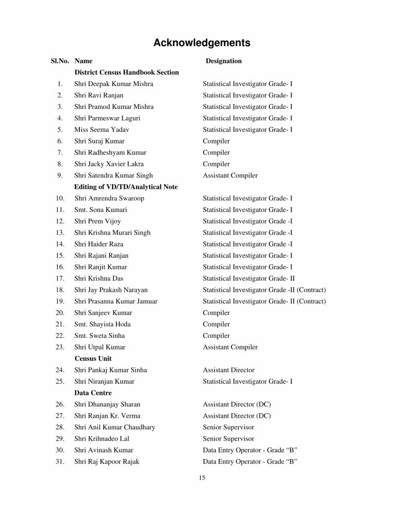
Acknowledgements
Sl.No. Name Designation
District Census Handbook Section
1. Shri Deepak Kumar Mishra Statistical Investigator Grade- I
2. Shri Ravi Ranjan Statistical Investigator Grade- I
3. Shri Pramod Kumar Mishra Statistical Investigator Grade- I
4. Shri Parmeswar Laguri Statistical Investigator Grade- I
5. Miss Seema Yadav Statistical Investigator Grade- I
6. Shri Suraj Kumar Compiler
7. Shri Radheshyam Kumar Compiler
8. Shri Jacky Xavier Lakra Compiler
9. Shri Satendra Kumar Singh Assistant Compiler
Editing of VD/TD/Analytical Note
10. Shri Amrendra Swaroop Statistical Investigator Grade- I
11. Smt. Sona Kumari Statistical Investigator Grade- I
12. Shri Prem Vijoy Statistical Investigator Grade -I
13. Shri Krishna Murari Singh Statistical Investigator Grade -I
14. Shri Haider Raza Statistical Investigator Grade -I
15. Shri Rajani Ranjan Statistical Investigator Grade- I
16. Shri Ranjit Kumar Statistical Investigator Grade- I
17. Shri Krishna Das Statistical Investigator Grade- II
18. Shri Jay Prakash Narayan Statistical Investigator Grade -II (Contract)
19. Shri Prasanna Kumar Jamuar Statistical Investigator Grade- II (Contract)
20. Shri Sanjeev Kumar Compiler
21. Smt. Shayista Hoda Compiler
22. Smt. Sweta Sinha Compiler
23. Shri Utpal Kumar Assistant Compiler
Census Unit
24. Shri Pankaj Kumar Sinha Assistant Director
25. Shri Niranjan Kumar Statistical Investigator Grade- I
Data Centre
26. Shri Dhananjay Sharan Assistant Director (DC)
27. Shri Ranjan Kr. Verma Assistant Director (DC)
28. Shri Anil Kumar Chaudhary Senior Supervisor
29. Shri Krihnadeo Lal Senior Supervisor
30. Shri Avinash Kumar Data Entry Operator - Grade “B”
31. Shri Raj Kapoor Rajak Data Entry Operator - Grade “B”

16
32. Shri Shashi Ranjan Sinha Data Entry Operator - Grade “B”
33. Shri Srikant Kumar Singh Data Entry Operator - Grade “B”
Map Section
34. Shri Md. Nasimuddin Khan Senior Draughtsman
35. Miss Alka Thakur Geographer
36. Shri Sharad Chandra Dwivedi Geographer
37. Shri Premjeet Kumar Sinha Data Entry Operator - Grade “B”
Management Section
38. Shri Cornelius Dungdung Assistant Director
39. Shri Sanjay Kumar Sinha Senior Supervisor
40. Shri Krishna Mohan Sahay Data Entry Operator - Grade “B”
41. Shri Subodh Kumar Assistant Compiler
List of Officers/Officials involved in preparation of DCHBs of Census of 2011
in the ORGI, Data Processing Division, Pushpa Bhawan, New Delhi
Name Designation
Shri Jaspal Singh Lamba DD (EDP)
Ms. Usha AD (EDP)
Shri Anurag Gupta DPA Grade ‘A’
Shri Mukesh Kumar Mahawar DPA Grade ‘A’
Ms. Shagufta Nasreen Bhat DPA Grade ‘A’
Ms. Kiran Bala Saxena Sr. Supervisor
Shri Khem Verma Jadon Sr. Consultant
Shri Yashwant Singh Jr. Consultant

����
HISTORY AND SCOPE OF THE DISTRICT CENSUS HANDBOOK
The need of data at the grass root level for the administrative and planning purposes at sub micro
level as well as academic studies prompted the innovation of District Census Handbook. District Census
Handbook is a unique publication from the Census organization which provides most authentic details of
census and non-census information from village and town level to district level. The District Census
Handbook was firstly introduced during the 1951 Census. It contains both census and non census data of
urban as well as rural areas for each district. The census data contain several demographic and
socioeconomic characteristics of the lowest administrative unit i.e. of each village and town and ward of
the district. The non census data comprise of data on availability of various civic amenities and
infrastructural facilities etc. at the town and village level which constitute Village Directory and Town
Directory part of the DCHB. The data of DCHB are of considerable importance in the context of planning
and development at grass-root level.
In1961 census DCHB provided a descriptive account of the district, administrative statistics, census
tables and village and town directory including Primary Census Abstract. This pattern was changed in
1971 Census and the DCHB was published in three parts: Part-A related to village and town directory,
Part-B to village and town PCA and Part-C comprised analytical report, administrative statistics, district
census tables and certain analytical tables based on PCA and amenity data in respect of villages. The 1981
census DCHB was published in two parts: Part-A contained village and town directory and Part-B the
PCA of village and town including the SCs and STs PCA up to tahsil/town levels. New features along
with restructuring of the formats of village and town directory were added into it. In Village Directory, all
amenities except electricity were brought together and if any amenity was not available in the referent
village, the distance in broad ranges from the nearest place having such an amenity, was given.
The pattern of 1981 census was followed by and large for the DCHB of 1991 Census except the
format of PCA. It was restructured. Nine-fold industrial classification of main workers was given against
thefour-fold industrial classification presented in the 1981 census. In addition, sex wise population in 0-6
age group was included in the PCA for the first time with a view to enable the data users to compile more
realistic literacy rate as all children below 7 years of age had been treated as illiterate at the time of 1991
census. One of the important innovations in the 1991 census was the Community Development Block(CD
Block) level presentation of village directory and PCA data instead of the traditional tahsil/taluk/PS level
presentation.
As regards DCHB of 2001 Census, the scope of Village Directory was improved by including some
other amenities like banking, recreational and cultural facilities, news papers & magazines and `most
important commodity’ manufactured in a village in addition to prescribed facilities of earlier censuses. In
����
Town Directory, the statement on Slums was modified and its coverage was enlarged by including details
on all slums instead of ‘notified slums’.
The scope and coverage of Village Directory of 2011 DCHB has been widened by including a
number of new amenities in addition to those of 2001. In the Town Directory, seven Statements
containing the details and the data of each town have been presented viz.;(i)-Status and Growth History of
towns,(ii)-Physical Aspects and Location of Towns,(iii)-Civic and other Amenities,(iv)-Medical
Facilities,(v)-Educational, Recreational & Cultural Facilities,(vi)-Industry & Banking, and (vii)-Civic&
other amenities in Slums respectively.CD Block wise data of Village Directory and Village PCA have
been presented in DCHB of 2011 census as presented in earlier census. The data of DCHB 2011Census
have been presented in two parts, Part-A contains Village and Town Directory and Part-B contains
Village and Town wise Primary Census Abstract. Both the Parts have been published in separate volumes
in 2011 Census.
--------------------------------------------------------
����
Brief history of the district
The district of Kaimur, which till the 1991 Census was a part of Rohtas district as one of its
subdivisions named as Bhabua, was elevated to the status of a district named Bhabua on 17th March,
1991 by the Government of Bihar vide its Notification No. 16@ft0iq02&30@90@46 iVuk fnukad 13
ekpZ 1991. On 17th March 1994 the name of district was changed from Bhabua to Kaimur. The district
is situated on the western part of the state of Bihar. It is bounded on the north by the district of Buxar of
the state of Bihar and the district of Ghazipur of the state of Uttar Pradesh, on the south by the district of
Garhwa of the state of Jharkhand, on the west by the districts of Chandauli and Mirjapur of the state of
Uttar Pradesh and on the east by the district of Rohtas of the state of Bihar. The district has two
subdivisions viz. Mohania and Bhabua and eleven Community Development Blocks viz., Bhabua, Chan,
Chainpur, Bhagwanpur, Rampur, Adhaura, Durgawati, Mohania, Kudra, Ramgarh and Nuaon. Bhabua is
the only town in the district. There are altogether 1695 villages in the district.
Kaimur has an old and interesting history. In pre-historic days the plateau region of the district has
been the abode of the aboriginals whose chief representatives now are the Bhars, the Cheros and the
Savers. According to some legends, the Kharwars were the original settlers in the hilly tracts of Rohtas.
The Oraons also claim that they ruled over the stretch falling between Rohtas and Patna. One local legend
also connects Sasaram the present headquarters of Rohtas with king Sahasrarjun, who was killed by Saint
Parshuram in a fight.
The district of Kaimur formed part of the mighty Magadh empire from 6th century B.C. to 5th
century A.D., under the Mauryan and Gupta rulers of Magadh. In the 7th century A.D., this district came
under the control of Harshawardhan, the ruler of Kannouj. An inscription in the Mundeshwari temple near
Bhabua, refers to the king Udaysena as the ruling chief of the area. The Seal of king Sasanka of Guada in
Bengal is inscribed at Rohtasgarh in the district of Rohtas. The famous Chinese pilgrim Hieun-Tsang,
who journeyed through the country in the 7th century A.D., passed through Arrah, the headquarters of the
old Shahabad district through this region of newly formed Kaimur district. The area of the district
successively came under the rulers of Shail dynasty of central India and Pal dynasty of Bengal. According
to C.Mark, a historian, the first ruler of Pal dynasty controlled this region. Later on Chandawali controlled
Varanasi-Chandawali and also the Kaimur district in the 12th century, as confirmed by the Tarachandi
inscription near Sasaram. After the fall of the Guptas the district in all probability relapsed into the hands
of the aboriginal tribes and came under the control of petty chieftains. The Rajputs who came from Ujjain
and the province of Mallwa had a series of conflicts with the aboriginals and it took them many handred
years to subdue the aboriginal completely. The Census report of 1961 describes that when Bakhtiar Khilji
����
attacked Bihar in 1193 A.D., he found Shahabad in the hands of petty Rajput chiefs often fighting among
themselves. They were not united and strong enough to offer powerful resistance to the Muslim invaders.
Hence Bakhtiyar Khiliji had an easy victory over them and the district soon became a part of his
kingdom. Later it was annexed, along with the rest of Bihar, to the kingdom of Jaunpur. A hundred year
later, it passed under the direct control of the Muslim empire of Delhi.
Sher Shah’s father, Hassan Khan sur, got the Jagir of Sasaram. Later Baler invaded the area in
1529 and has mentioned Hindu superstitions about river Karmanasha. In 1537 the old Shahabad district
witnessed advancement of Humayun and his subsequent conflict with Sher Shah at Chausa. Later the
district of Shahabad (which includes present Kaimur district also) was included in Akbar’s empire.
In 1758, Shah Alam during his conflict with Lord Clive of East India company, went to Durgawati
and with the help of local Zamindar Pahalwan Singh crossed the Karmanasha river. Subsequently
Pahalwan Singh succumbed to comply and live on the latter’s terms. In 1764, the old Shahabad district
witnessed conflict for supremacy and the English became absolute masters of the area after defeating
Siraj-ud-daula in the battle of Buxar. Again the area was shaken by the rebellion of Raja Chait Singh of
Benaras but eventually the English succeeded in suppressing the revolt.
Lastly the historic 1857 mutiny under command of Kunwar Singh had its impact in the district. As
a result, during the independence movement the district had a substantial contribution to the freedom of
India. Much after independence in the year 1972 Rohtas district was formed out of the old Shahabad
district and in the year 1991. The present Kaimur district was formed out of the Rohtas district.
--------------------------------------------------------

21
Analytical Note

22
23
(i) Physical Features
Kaimur district’s headquarters is located on global map between 25°02'13'' North
latitude and 83°33'33' 'East longitude. The district occupies an area of 931square kilometers.
The rank of the district in comparison to other districts of Bihar in terms of area is 35th. The
district is bounded on the north by the district of Buxar and the state of Uttar Pradesh, on the
south by the district of Rohtas, on the west by the state of Uttar Pradesh and on the east by the
district of Rohtas.
Natural divisions
The district may be divided into plain and plateau regions. The Plain area consists of
fertile alluvial lands, which become rocky as one proceeds southwards. As one approaches the
Kaimur foothills, the soil becomes stony and poor in fertility. The Kaimur plateau is an
undulated tableland having thin shrubby jungles, spreading about 1200 sq. kms.
Rivers
The main Rivers of the district are Karmanasha and Durgawati. Originating from the
Kaimur hills, the river Karmanasha passes through Mirzapur district of U.P. and forms the
western boundary of the district for about 170 kms. the river Kundra, which forms eastern
boundary separating Rohtas district, is a branch of the river Dhoba rising in Kaimur Plateau
south-West of Tilauthu, and ultimately joins the river Karmanasha. The river Durgawati
originates from Kaimur hills and flows in the northern direction. It is joined by the Kundra
river before it merges finally into the river Karmanasha. The river Durgawati is perennial in
nature and inundates a large area of land during heavy rains.
Climatic condition
In summer the climate of the district is hot and dry but winter months are quite cool
and pleasant. Winter comes towards the middle of October after the rains are over. The
temperature begins falling and January is the coldest month of the year with mercury falling to
about 4ºC. The blowing of westerly wind accompanied by dust storms about the middle of
March marks the beginning of hot weather. The mercury starts shooting upward and May is
the hottest month of the year when the maximum temperature goes up to 45ºC. The summer
continues till the end of June when the onset of rains brings the much awaited relief and the
temperature falls, though the humidity is still high the rise in humidity often makes the heat
only more oppressive during the rainy season which lasts till the end of September. From

24
November to February the district has a pleasant climate. The district also gets some winter
rain. <
Rainfall
As per the data available with the Directorate of Statistics and Evaluation of the State,
the average annual rainfall in the district varies between 490.5 and 1,079.6 mm during 2006-
09. Maximum rainfall occurs during the month of June to September when the district receives
almost 80 percent of its average total rainfall. The district receives minimum rainfall during
the month of December. Weather conditions become hot and humid during the rainy season.
The average number of rainy days in district varies between 23.5 and 48.1 during 2006-09.
Actual Rainfall and Average No. of Rainy Days figures are as follows:-
Source- Directorate of Statistics and Evaluation, Bihar
Flora and Fauna
The Forests found in the Kaimur hills have suffered indiscriminate felling of trees in
the recent past. The plateau is generally covered with long grasses, viz, kush and khas. Sal
trees of poor quality and vast stretches of bamboo are also found. Firewood, Kendu leaf and
Chiraunji are the important forest products. A large forest covers part of Kaimur and contains
the Kaimur Wildlife Sanctuary which is home to tigers, leopards and chinkaras.
Land use Pattern
Agriculture is the main occupation of the people of the district and also the main
source of livelihood of the people. Rainfall still controls the agricultural economy of Kaimur
district. Paddy, Wheat, Barley and Maize are the main cereal crops of the district. Among
pulses, gram occupies the maximum area of cultivation, followed by Mansur, Arhar, Moong
and Urad. Sugar cane and potatoes are the main cash crops. Timber, Bamboo, Firewood,
Chiraunji and Kendu leaf are the main forest produce while the minor produce consists of
honey, and fodder grass.
ANNUAL AVERAGE RAINY DAYS AND ACTUAL RAINFALL IN M.M
2006 2007 2008 2009
Average
No. of
Rainy
Days
Actual
Rainfall
Average
No. of
Rainy
Days
Actual
Rainfall
Average
No. of
Rainy
Days
Actual
Rainfall
Average
No. of
Rainy
Days
Actual
Rainfall
1 2 3 4 5 6 7 8
45.8 1,079.6 44.2 1,045.6 48.1 902.6 23.5 490.5

25
Land use pattern figures are as follows:-
Total Forest Area(in
Hectares)
Total Irrigated Land Area (in
Hectares)
Total Unirrigated
Land Area (in Hectares
Culturable Waste Land
Area (in Hectares)
Barren & Un-cultivable
Land Area (in Hectares)
Area under Non-
Agricultural Uses (in Hectares
94709.9 148608.4 39667.2 6769 2518.1 22839.9
Irrigational facilities
Irrigation plays a very important role in agriculture. It is often said that agriculture is a
gamble in the hands of monsoon. This is only because of inadequate and uncertain irrigational
facilities. Crop harvest can be raised to a great extent through assured irrigation. Agriculture
depends mainly on the availability of water at proper time and in proper quantity. In the past
the main source of water had been rain fall. However, on account of failure of monsoon at
times or premature cessation of rainfall the need pro irrigation was felt. Consequently dams
were constructed on the rivers and canals and channels were made by the Zamindars
previously wells were also dug for irrigation facility. The district mostly depends upon
traditional system of irrigation. There is hardly any big works of irrigation
After independence, considerable attention has been paid to implementation of various
irrigational projects. A number of Medium Irrigation schemes, Minor Irrigation schemes,
Open borings, irrigation wells and tube wells have been introduced in the district during the
different plan periods. The government has tried to create irrigation facilities through state
tube wells and lift irrigation schemes.
Durgawati and Karmanasha rivers are the perennial sources of surface water. A high
level canal from Indrapuri (Dehri) has been constructed irrigates its southern parts of this
district. The canal is about 84 kms long and irrigates about 34000 hectares of land during
Kharif season and about 9000 hectares of land during Rabi season. The northern part of
Kaimur district has a number of canal systems such as Durgawati Main Canal, Garachaube
canal etc. In the hilly tracts of Adhaura, Chainpur and Bhagwanpur blocks, only ditches and
ponds are used to conserve rainwater. New techniques of water conservation and harvesting
practices are needed in plain as well as these hilly areas to utilise rainwater. Reservoir tanks
can store water from hill streams and rivulets especially when “Hathia” rain falls, which also
provide irrigation during Rabi season. Water table in the plain areas is low and high yielding
tube wells can sustain at a depth of 70-100 metres whereas small tube wells may get the

26
aquifer jone within 25-30 metres depth. The normal depth of water table is 510 meters in
winters and up to 15 meters in summers.
Mines and Minerals
Sands of the Durgawati and the Kundra river are exploited as building material. The
hilly tracts of Kaimur ranges are a part of very old Vindhyan system of mountains, hence, there
is possibility of limestone, sulpher and pyretic iron ores to be found here. The mineral wealth
needs more study and is yet to be explored properly.
Forestry
The alluvial plain extending up to the foothills of Kaimur ranges, is extensively
cultivated. Rice, wheat, pulses are the chief crops and the area is dotted with bamboo clumps
and mango orchards. The Forests found in the Kaimur hills have suffered indiscriminate
felling of trees in the recent past. The plateau is generally covered with long grasses, viz, kush
and khas. Sal trees of poor quality and vast stretches of bamboo are also found. Firewood,
Kendu leaf and Chiraunji are the important forest products. The number of fauna and game-
birds has gone down considerably with the increase in the area of cultivation due to increase in
irrigation facilities.
Fishery
Fish are abundant in Kaimur. The principal species include the well known rohu,
mirgal, katla, etc.
Industrialization
The district is scantily industrialised. A few private rice mills, however, are found here
mainly in Mohania Subdivision. Mohania C. D. Block in credited with a DRDA sponsored Dairy
and a BSTDC hotel known as, The Kaimur Hotel.
As per data given in “Brief Industrial Profile of Kaimur District” published by Ministry of
Micro, Small and Medium Enterprises, Govt. of India, there were altogether 628 small scale
registered units during 2008-09 which were employing 1968 persons.
Livestock
The term ‘livestock’ includes cattle (Cows, Bulls and Bullocks), Buffaloes, Sheep,
Goats and Pigs. Livestock is very important in a district like Kaimur with a predominantly
agricultural economy. Cows and Buffaloes are used for milching purpose. The usual fodder
for the cattle consists of scanty grass which grows along the road side and weeds spring up
after harvesting of crops. High breed livestock of animals are still needed here. The
government has taken up various measures to improve the breed of the cattle. For
27
improvement of the quality of breed artificial insemination centers have been set up. A
number of veterinary hospitals and dispensaries including the artificial insemination centres
are functioning at various places in the district for general welfare of the animals.
Considerable attention has been paid to poultry development in different community
development Blocks in the district.
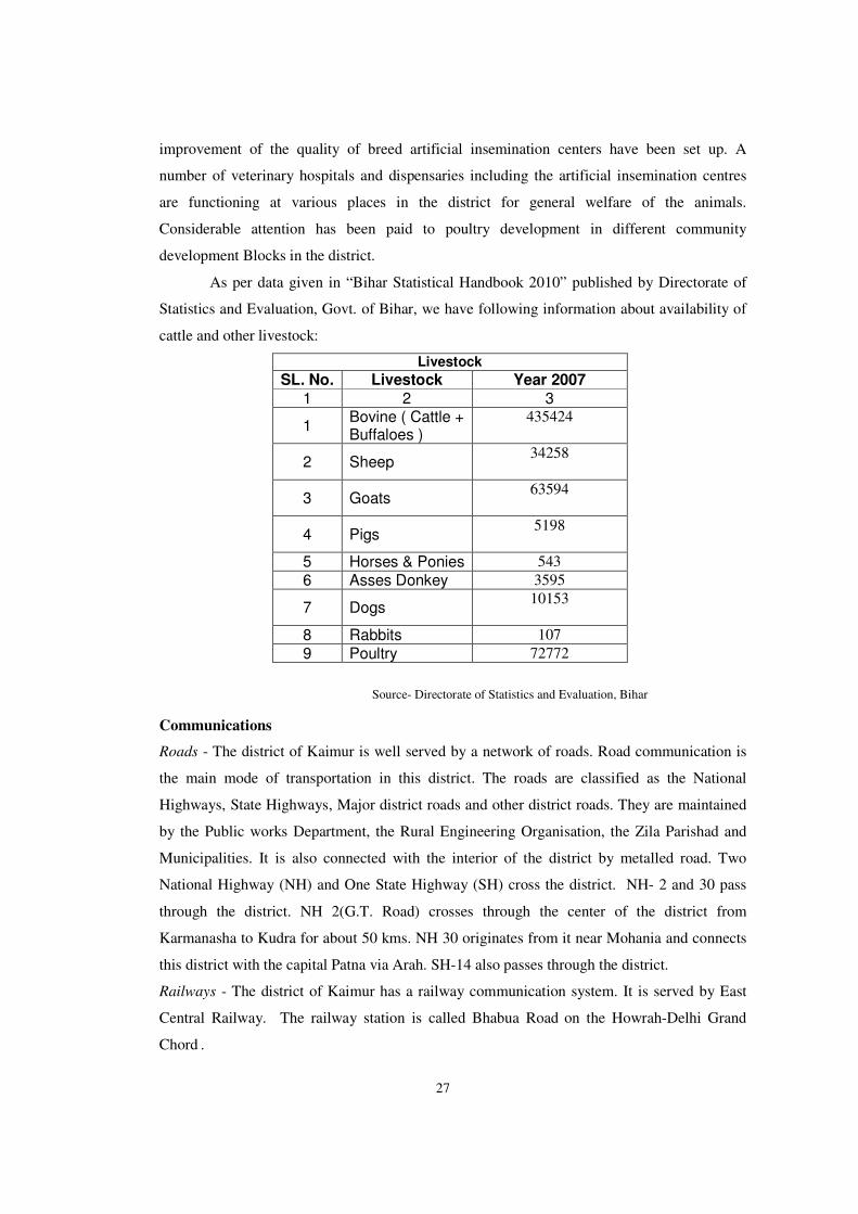
As per data given in “Bihar Statistical Handbook 2010” published by Directorate of
Statistics and Evaluation, Govt. of Bihar, we have following information about availability of
cattle and other livestock:
Livestock
SL. No. Livestock Year 2007
1 2 3
1 Bovine ( Cattle + Buffaloes )
435424
2 Sheep 34258
3 Goats 63594
4 Pigs 5198
5 Horses & Ponies 543
6 Asses Donkey 3595
7 Dogs 10153
8 Rabbits 107
9 Poultry 72772
Source- Directorate of Statistics and Evaluation, Bihar
Communications
Roads - The district of Kaimur is well served by a network of roads. Road communication is
the main mode of transportation in this district. The roads are classified as the National
Highways, State Highways, Major district roads and other district roads. They are maintained
by the Public works Department, the Rural Engineering Organisation, the Zila Parishad and
Municipalities. It is also connected with the interior of the district by metalled road. Two
National Highway (NH) and One State Highway (SH) cross the district. NH- 2 and 30 pass
through the district. NH 2(G.T. Road) crosses through the center of the district from
Karmanasha to Kudra for about 50 kms. NH 30 originates from it near Mohania and connects
this district with the capital Patna via Arah. SH-14 also passes through the district.
Railways - The district of Kaimur has a railway communication system. It is served by East
Central Railway. The railway station is called Bhabua Road on the Howrah-Delhi Grand
Chord .
28
Airway - Airways facilities are not available in the district.
Boats – Waterways facilities are not available in the district.
Mohania Block is situated on Gaya-Mughalsarai Section of Grand Chord Railway line; The
district headquarters is located at a distance of 14 kms southward from the railway station or
the G.T. Road.
Trade and Commerce
The development of the means of communication has had a great impact on the trade
and commerce of the district. The district may now be said to be fairly well- connected by
Road and Rail.
Banarasi Sari, Silk, Kaleen, Dari and Agricultural produces are the main articles which
are traded in and out of the district.
The district is covered with net-work of markets consisting of a number of permanent
shops dealing mainly in grains and vegetables. In the rural areas haats (village markets) are
held twice a week.
Electricity and Power
The district receives its entire power supply from Bihar State Electricity Board. All the
towns of Kaimur district have electricity. In the rural areas, the Government is trying to
extended electric line to the maximum number of villages by implementing various schemes
for rural electrification. Pusauli power station is being constructed at a distance of 8-10 kms,
form the Subdivisional Headquarters of Mohania. The possibility of tapping solar energy is
also great in the district. 931 Villages of the district are electrified.
Gram Panchayats, its composition, jurisdiction and role in the Development of Village
and its economy.
Panchayati Raj (Rule of Village Committee) system is a three-tier system in the state
with elected bodies at the Village, CD Block and District levels. It ensures greater
participation of people and more effective implementation of rural development programmes.
There will be a Gram Panchayat for a village or group of villages, a CD Block level Panchayat
Samiti and Zilla Parishad at the district level. India has a plaid history of Panchayati
Raj starting from a self-sufficient and self-governing village communities that survived the
rise and fall of empires in the past to the modern institutions of governance at the third tier
provided with Constitutional support.
The idea which produced the 73rd Amendment was not a response to pressure from the
grassroots, but to an increasing recognition that the institutional initiatives of the preceding

29
decade had not delivered, that the extent of rural poverty was still much too large and thus the
existing structure of government needed to be reformed. It is interesting to note that this idea
evolved from the Centre and the State governments. It was a political drive to see PRIs as a
solution to the governmental crises that this country was experiencing. The Constitutional
(73rd Amendment) Act, passed in 1992 by the Narasimha Rao government, came into force on
April 24, 1993. It was meant to provide constitutional sanction to establish "democracy at the
grassroots level as it is at the state level or national level".
Composition of Gram Panchayat
(1) The Gram Panchayat consist of –
(a) The Mukhiya elected under the provisions of this Act;
(b) Such number of directly elected members as may be notified from time to time by the
District Magistrate and each of such members representing as nearly as possible a population
of five hundred of the Panchayat Area.
(2) For the convenience of election, the District Magistrate, in accordance with such rules as
prescribed in this behalf by the State Government, divides the area of the Gram Panchayat
under the direction, control and supervision of the State Election Commission into territorial
constituencies in such manner that the population of each constituency, so far as practicable,
be the same throughout the Panchayat area.
(3) One member is elected from each territorial constituency through direct election in the
manner prescribed.
(4) Every Gram Panchayat is notified in the District Gazette and shall come into office with
effect from the date appointed for its first meeting.
Reservation of seats — (1) In every Gram Panchayat, as nearly as but not exceeding fifty
percent of the total seats of members of Gram Panchayat is reserved for
(a) Scheduled Castes;
(b) Scheduled Tribes; and
(c) Backward Classes.
(2) As nearly as but not exceeding fifty percent of the total number of seats reserved under
Sub-section (1) is reserved for women belonging to the Scheduled Castes, the Scheduled
Tribes and the Backward Classes, as the case may be. (3) As nearly as but not exceeding fifty
30
percent of the total number of seats not reserved for Scheduled Castes, Scheduled Tribes and
Backward Classes shall be reserved for women.
(4) Such total number of seats reserved for women belonging to the Scheduled Castes, the
Scheduled Tribes, the Backward Classes and unreserved category may be allotted by rotation
by the District Magistrate under the direction, control and supervision of the State Election
Commission to different constituencies in a Gram Panchayat in such manner as may be
prescribed by it.
Jurisdiction and Role of Panchayat in the Development of Village and its economy
As per the Constitution, Panchayats in their respective areas would prepare plans for
economic development and social justice and also execute them. To facilitate this, states are
supposed to devolve functions to Panchayats (29 subjects as mandated) and also make funds
available for doing these (as per State Finance Commission’s recommendations). The
functions of Panchayats are divided among different Committees (as ministries are formed in
state and union governments), which are called Standing Committees/Sthayee Samitis/Upa
Samitis etc. One of the members remains in charge of each of such committees while the over-
all charge rests with the chairperson of the Panchayat. Panchayats are supported by a host of
other of officials, the number of which varies from state to state.
Apart from grants received from the government under the recommendation of the
Finance Commission, Panchayats receive schematic funds for implementation of several
schemes. They can also raise revenue by imposing taxes, fees, penalties etc. as per rule of the
state.
Main features of Jurisdiction and role of panchayats are as follows:
• The Gram Shabha or village assembly as a deliberative body to decentralised governance has
been envisaged as the foundation of the Panchayati Raj System.
• All the seats in a panchayat at every level are to be filled by elections from respective
territorial constituencies.
• An indicative list of 29 items has been given in Eleventh Schedule of the Constitution. Gram
Sabha assigns work to the Gram Panchayats and Panchayats are expected to play an effective
role in planning and implementation of works related to these 29 items mentioned in the 11th
schedule of the constitution.

31
• Different Ministries/Departments of the State Govt. have delegated or intended to delegate
financial powers to PRIs through various letters and notifications issued on 24/09/2001,
25/092001, 26/09/2001, 02/07/2008 and 21/10/2008.
There are 151 Gram Panchayats spread over the length and breadth of the district.
The Constitution visualises panchayats as institutions of self-governance. However,
giving due consideration to the federal structure of our polity, most of the financial powers and
authorities to be endowed on panchayats have been left at the discretion of concerned state
legislatures. Consequently, the powers and functions vested in PRIs vary from state to state.
These provisions combine representative and direct democracy into a synergy and are
expected to result in an extension and deepening of democracy in India. Hence, panchayats
have journeyed from an institution within the culture of India to attain constitutional status.
This is one of the biggest democracies in the world where village level democratic
structures are functioning for their development.
(ii) Census concepts
Building: A ‘Building’ is generally a single structure on the ground. Usually a structure will
have four walls and a roof. Sometimes it is made up of more than one component unit which
are used or likely to be used as dwellings (residences) or establishments such as shops,
business houses, offices, factories, workshops, work sheds, Schools, places of entertainment,
places of worship, godowns, stores etc. It is also possible that building which have component
units may be used for a combination of purposes such as shop-cum-residence, workshop-cum-
residence, office-cum-residence etc. But in some areas the very nature of construction of
houses is such that there may not be any wall. Such is the case of conical structures where
entrance is also provided but they may not have any walls. Therefore, such of the conical
structures are also treated as separate buildings.
Pucca houses: Houses, the walls and roof of which are made of permanent materials. The
material of walls can be any one from the following, namely, Stones (duly packed with lime or
cement mortar), G.I/metal/ asbestos sheets, Burnt bricks, Cement bricks, Concrete. Roof may
be made of from any one of the following materials, namely, Machine-made tiles, Cement
tiles, Burnt bricks, Cement bricks, Stone, Slate, G.I/Metal/Asbestos sheets, Concrete. Such
houses are treated as Pucca house.
32
Kutcha houses: Houses in which both walls and roof are made of materials, which have to be
replaced frequently. Walls may be made from any one of the following temporary materials,
namely, grass, Unburnt bricks, bamboos, mud, grass, reeds, thatch, plastic /polythene, loosed
packed stone, etc. Such houses are treated as Kutcha house.
Dwelling Room: A room is treated as a dwelling room if it has walls with a doorway and a
roof and should be wide and long enough for a person to sleep in, i.e. it should have a length
of not less than 2 meters and a breadth of at least 1.5 meters and a height of 2 meters. A
dwelling room would include living room, bedroom, dining room, drawing room, study room,
servant’s room and other habitable rooms. Kitchen, bathroom, latrine, store room, passageway
and verandah which are not normally usable for living are not considered as dwelling rooms.
A room, used for multipurpose such as sleeping, sitting, dining, storing, cooking, etc., is
regarded as a dwelling room. In a situation where a census house is used as a shop or office,
etc., and the household also stays in it then the room is not considered as a dwelling room. But
if a garage or servant quarter is used by a servant and if she/ he also lives in it as a separate
household then this has been considered as a dwelling room available to the servant’s
household. Tent or conical shaped hut if used for living by any household is also considered as
dwelling room. A dwelling room, which is shared by more than one household, has not been
counted for any of them. If two households have a dwelling room each but in addition also
share a common dwelling room, then the common room has not been counted for either of the
households.
Census House : A ‘census house’ is a building or part of a building used or recognized as a
separate unit because of having a separate main entrance from the road or common courtyard
or staircase, etc. It may be occupied or vacant. It may be used for residential or non-
residential purpose or both. If a building has a number of Flats or Blocks/Wings, which are
independent of one another having separate entrances of their own from the road or a common
staircase or a common courtyard leading to a main gate, these are considered as a separate
Census house.
Village: The basic unit for rural areas is the revenue village, which has definite surveyed
boundaries. The revenue village may comprise of one or more hamlets but the entire village is
treated as one unit for presentation of data. In un surveyed areas, like villages within forest
areas, each habitation area with locally recognized boundaries is treated as one village.
33
Rural-Urban area: The data in the census are presented separately for rural and urban areas.
The unit of classification in this regard is ‘town’ for urban areas and ‘village’ for rural areas.
The urban area comprises two types of towns viz; Statutory towns and Census towns. In
the Census of India 2011, the definition of urban area adopted is as follows:
(a) Statutory Towns : All places with a municipality, corporation, cantonment board or
notified town area committee, etc are known as statutory towns.
(b) Census Towns: All other places satisfying the following three criteria simultaneously are
treated as Census Towns.
i) A minimum population of 5,000;
ii) At least 75 per cent of male working population engaged in non-agricultural pursuits; and
iii) A density of population of at least 400 per sq. km. (1,000 per sq. mile)
For identification of places which would qualify to be classified as ‘urban’ all villages, which,
as per the 2001 Census had a population of 4,000 and above, a population density of 400
persons per sq. km. and having at least 75 per cent of male working population engaged in
non-agricultural activity were considered. To work out the proportion of male working
population referred to above against b) (ii), the data relating to main workers were taken into
account. In addition the above stated towns, urban areas also constitutes of OGs which are the
parts of UAs.
Urban Agglomeration: An Urban Agglomeration is a continuous urban spread constituting a
town and its adjoining urban outgrowths (OGs) or two or more physically contiguous towns
together with or without urban outgrowths of such towns. In some cases, railway colonies,
university campuses, port areas, military camps etc; may come up near a statutory town
outside its statutory limits but within the revenue limits of a village or villages contiguous to
the town. Each such individual area by itself may not satisfy the minimum population limit to
qualify it to be treated as an independent urban unit but may qualify to be clubbed with the
exiting town as their continuous urban spread (i.e., an Out Growth). Each such town together
with its outgrowth(s) is treated as an integrated urban area and is designated as an ‘urban
agglomeration’. For the purpose of delineation of Urban Agglomerations during Census of
India 2011, following criteria has been adopted:
34
(a) The core town or at least one of the constituent towns of an urban agglomeration
should necessarily be a statutory town; and
(b) The total population of an Urban Agglomeration (i.e. all the constituents put
together) should not be less than 20,000 as per the 2001 Census. In varying local conditions,
there were similar other combinations which have been treated as urban agglomerations
satisfying the basic condition of contiguity.
Out Growth (OG): The outgrowth is a viable unit such as a village or a hamlet or an
enumeration block and clearly identifiable in terms of its boundaries and location. While
determining the outgrowth of a town, it has been ensured that it possesses the urban features in
terms of infrastructure and amenities such as pucca roads, electricity, taps, drainage system for
disposal of waste water etc., educational institutions, post offices, medical facilities, banks etc
and physically contiguous with the core town of the UA.
City: Towns with population of 100,000 and above are called cities.
Household: A ‘household’ is usually a group of persons who normally live together and take
their meals from a common kitchen unless the exigencies of work prevent any of them from
doing so. Persons in a household may be related or unrelated or a mix of both. However, if a
group of unrelated persons live in a census house but do not take their meals from the common
kitchen, then they are not constituent of a common household. Each such person was to be
treated as a separate household. The important link in finding out whether it was a household
or not was a common kitchen/common cooking. There may be one member households, two
member households or multi-member households.
Institutional Household: A group of unrelated persons who live in an institution and take
their meals from a common kitchen is called an Institutional Household. Examples of
Institutional Households are boarding houses, messes, hostels, hotels, rescue homes,
observation homes, beggars homes, jails, ashrams, old age homes, children homes,
orphanages, etc. To make the definition more clearly perceptible to the enumerators at the
Census 2011, it was specifically mentioned that this category or households would cover only
those households where a group of unrelated persons live in an institution and share a common
kitchen.
35
Houseless household : Households who do not live in buildings or census houses but live in
the open or roadside, pavements, in hume pipes, under flyovers and staircases, or in the open
in places of worship, mandaps, railway platforms, etc., are treated as Houseless Households.
Scheduled Caste and Scheduled Tribe :
Article 341 of the Constitution provides that the President may, with respect to any
State or Union territory, specify the castes, races or tribes or parts of or groups within castes,
races or tribes which shall for the purposes of the Constitution be deemed to be Scheduled
Castes in relation to that State or Union territory. Article 342 similarly provides for
specification of tribes or tribal communities or parts of or groups within tribes or tribal
communities which are to be deemed for the purposes of the Constitution to be Scheduled
Tribes in relation to the various States and Union territories. In pursuance of these provisions,
the list of Scheduled Castes and/or Scheduled Tribes are notified for each State and Union
territory and are valid only within the jurisdiction of that State or Union territory and not
outside.—It is important to mention here that under the Constitution (Scheduled Castes)
Order, 1950, no person who professed a religion different from Hinduism was deemed to be a
member of a Scheduled Caste in addition to every member of the Ramdasi, Kabirpanthi,
Majhabi or Sikligar caste resident in Punjab or Patiala and East Punjab States Union were in
relation to that State whether they professed the Hindu or the Sikh religion. Subsequently, in
September 1956, by an amendment, the Presidential Order of 1950 and in all subsequent
Presidential Orders relating to Scheduled Castes, the Hindu and the Sikh religions were placed
on the same footing with regard to the specification of Scheduled Castes. Later on, as per the
amendment made in the Constitution (Scheduled Castes) Order 1990, the Hindu, the Sikh and
the Buddhist were placed on the same footing with regard to the recognition of the Scheduled
Castes.-
The lists containing the names of the Scheduled Castes and the Scheduled Tribes
applicable for the Census of India 2011 in the State of Bihar are given below :
Scheduled Castes :
1. Bantar 2. Bauri 3. Bhogta 4. Bhuiya 5. Bhumij 6. Chamar, Mochi, Chamar-Rabidas, Chamar-Ravidas, Chamar-Rohidas, Charmakar

36
7. Chaupal 8. Dabgar 9. Dhobi, Rajak 10. Dom, Dhangad, Bansphor, Dharikar, Dharkar, Domra 11. Dusadh, Dhari, Dharhi 12. Ghasi 13. Halalkhor 14. Hari, Mehtar, Bhangi 15. Kanjar 16. Kurariar 17. Lalbegi 18. Musahar 19. Nat 20. Pan, Swasi, Panr 21. Pasi 22. Rajwar 23. Turi Scheduled Tribes : 1. Asur, Agaria 2. Baiga 3. Banjara 4. Bathudi 5. Bedia 6. Binjhia 7. Birhor 8. Birjia 9. Chero 10. Chik Baraik 11. Gond 12. Gorait 13. Ho 14. Karmali 15. Kharia, Dhelki Kharia, Dudh Kharia, Hill Kharia 16. Kharwar 17. Khond 18. Kisan,Nagesia 19. Kora, Mudi-Kora 20. Korwa 21. Lohara, Lohra 22. Mahli 23. Mal Paharia, Kumarbhag Paharia 24. Munda, Patar 25. Oraon, Dhangar (Oraon) 26. Parhaiya 27. Santal 28. Sauria Paharia 29. Savar 30. Kawar 31. Kol
37
32. Tharu
Language and Mother tongue: As per the census concept, each language is a group of
mother tongues. The census questionnaire collects information on the mother tongue of each
person. Mother tongue is the language spoken in childhood by the person’s mother to the
person. If the mother died in infancy, the language mainly spoken in the person’s home in
childhood will be the mother tongue. In the case of infants and deaf mutes, the language
usually spoken by the mother is considered as mother tongue. It is not necessary that the
language spoken as mother tongue should have a script. The mother tongues returned by the
respondents in census are classified and grouped under appropriate languages according to
their linguistic characteristics.
Literate: A person aged 7 years and above who can both read and write with understanding in
any language is taken as literate. A person who can only read but cannot write is not literate. It
is not necessary that to be considered as literate, a person should have received any formal
education or passed any minimum educational standard. Literacy could have been achieved
through adult literacy classes or through any non-formal educational system. People who are
blind and can read in Braille are treated as literates.
Literacy rate: Literacy rate of the population is defined as the percentage of literates in the
age-group seven years and above. For different age-groups the percentage of literates in that
age-group gives the literacy rate.
Educational level: The highest level of education a person has completed.
Work: Work is defined as participation in any economically productive activity with or
without compensation, wages or profit. Such participation may be physical and/or mental in
nature. Work involves not only actual work but also includes effective supervision and
direction of work. It even includes part time help or unpaid work on farm, family enterprise or
in any other economic activity. All persons engaged in ‘work’ as defined above are workers.
The main point to note is that the activity should be economically productive. Reference
period for determining a person as worker and non-worker is one year preceding the date of
enumeration.
38
Main worker: A person who has worked for major part of the reference period (i.e. six
months or more during the last one year preceding the date of enumeration) in any
economically productive activity is termed as ‘Main worker’.
Marginal worker: A person who worked for 3 months or less but less than six months of the
reference period (i.e. in the last one year preceding the date of enumeration) in any economic
activity is termed as ‘Marginal worker’.
Non-worker: A person who has not worked at all in any economically productive activity
during the reference period (i.e. last one year preceding the date of enumeration) is termed as
‘Non worker’.
Cultivator: For purposes of the Census, a person is classified as cultivator if he or she is
engaged in cultivation of land owned or from government or from private persons or
institutions for payment in money, kind or share. Cultivation also includes effective
supervision or direction in cultivation. Cultivation involves ploughing, sowing, harvesting and
production of cereals and millet crops such as wheat, paddy, jowar, bajra, ragi, etc., and other
crops such as sugarcane, tobacco, ground-nuts, tapioca, etc., and pulses, raw jute and kindred
fiber crop, cotton, cinchona and other medicinal plants, fruit growing, vegetable growing or
keeping orchards or groves, etc. Cultivation does not include the plantation crops like– tea,
coffee, rubber, coconut and betel nuts (areca). The workers engaged in Plantation crops are
recorded under “other workers”.
Agricultural labourer: A person who works on another person’s land for wages in cash or
kind or share is regarded as an agricultural labourer. She/he has no risk in the cultivation, but
merely works on another person’s land for wages. An agricultural labourer has no right of
lease or contract on land on which she/he works.
Household industry worker: Household industry is defined as an industry conducted by one
or more members of the household at home or within the village in rural areas and only within
the precincts of the house where the household lives in urban areas. The larger proportion of
workers in household industry should consist of members of the household. The industry
should not be run on the scale of a registered factory which would qualify or has to be
registered under the Indian Factories Act and should be engaged in manufacturing, processing,
39
servicing and repairs of goods. The activity relate to production, processing, servicing,
repairing or making and selling of goods. It does not include professions such as a pleader,
Doctor, Musician, Dancer, Waterman, Astrologer, Dhobi, Barber, etc. or merely trade or
business, even if such professions, trade or services are run at home by members of the
household.
Other worker: A person, who has been engaged in some economic activity during the last
year of reference period but not as a cultivator or agricultural labourer or worker in Household
Industry. The type of workers that come under this category include all government servants,
municipal employees, teachers, factory workers, plantation workers, those engaged in trade,
commerce, business, transport, banking, mining, construction, political or social work, priests,
entertainment artists, etc. In fact, all those workers other than cultivators or agricultural
labourers or household industry workers are ‘Other Workers’.
Work participation rate: Percentage of Workers (Main + Marginal) to total population.
Population density: Population density is the number of persons inhabited per square
kilometer of the area.
Age: Age is measured in terms of the completed number of years.
Sex Ratio: Number of females per 1,000 males in a population.
(iii) Non-Census Concepts
Civic status of urban units: Civic Status of a town/city is determined on the basis of Civic
Administrative Authority of the town e.g., Municipal Corporation / Corporation, Municipal
Committee / Municipal council, Municipality etc.
Size class of U.A./town: Size-class of U.A./Town is based on the population size of the
U.A./City/Town.
U.A.s/Towns with 100,000 and above population is classified as Class I U.A.s/ Towns.
Towns with 50,000 to 99,999 population are classified as Class II towns, 20,000 to 49,999
population are Class III towns, population with 10,000- 19,999 are Class IV towns, population

40
with 5,000 and 9,999 are Class V towns and towns with less than 5,000 population are Class
VI towns.
Slum area : The Slum Areas (Improvement and Clearance) Act, 1956, which was enacted by
the Central Government defined slums as (a) Areas where buildings are in any respect unfit
for human habitation; or (b) are by reasons of dilapidation, overcrowding, faulty arrangement
and design of such buildings, narrowness or faulty arrangement of streets, lack of ventilation,
light or sanitation facilities, or any combination of these factors, are detrimental to safety,
health or morals.
Mega city : The concept of ‘Mega city’ is a recent phenomenon in the Urban Sociology and is
defined in term of metropolitan city in the form of large size, problem of management of civic
amenities and capacity to absorb the relatively high growth of population. Indian Census in
1991 treated the population size of 5 million and above as the cutoff point to identify a place
as the mega city. Whereas, for the purpose of inclusion in Centrally Sponsored Scheme for
Infrastructure Development in Mega cities the Ministry of Urban Affairs and employment,
Department of Urban Development adopted the criteria of 4 million and above population as
per 1991 Census for Mega Cities. In 2001 Census, cities with 10 millions and above
population have been treated as Mega cities and the same criteria of population have been
adopted in 2011 census.
(iv) 2011 Census Findings–Population and its Distribution
The district of Kaimur with a population of 16,26,384 according to 2011 Census, is divided
into 11 Community Development Blocks, Comprising 1695 villages and 1 statutory town. With 1.5
percent of the total population of the state comprised within the district, Kaimur is a small sized
district and ranks 32th in the state in order of population. The population of males and females are
8,47,006 and 7,79,378 spread over 3.5 percent area of the State. Bhabua C.D. Block is the most
populous while Adhaura is the least populated C.D. Block in the district. Tables 1 to 45 presented
below are based on Primary Census Abstract, Village Directory and Town Directory data of 2011
Census which give insight into the socio-economic and demographic characteristics of the
population in the district.
41
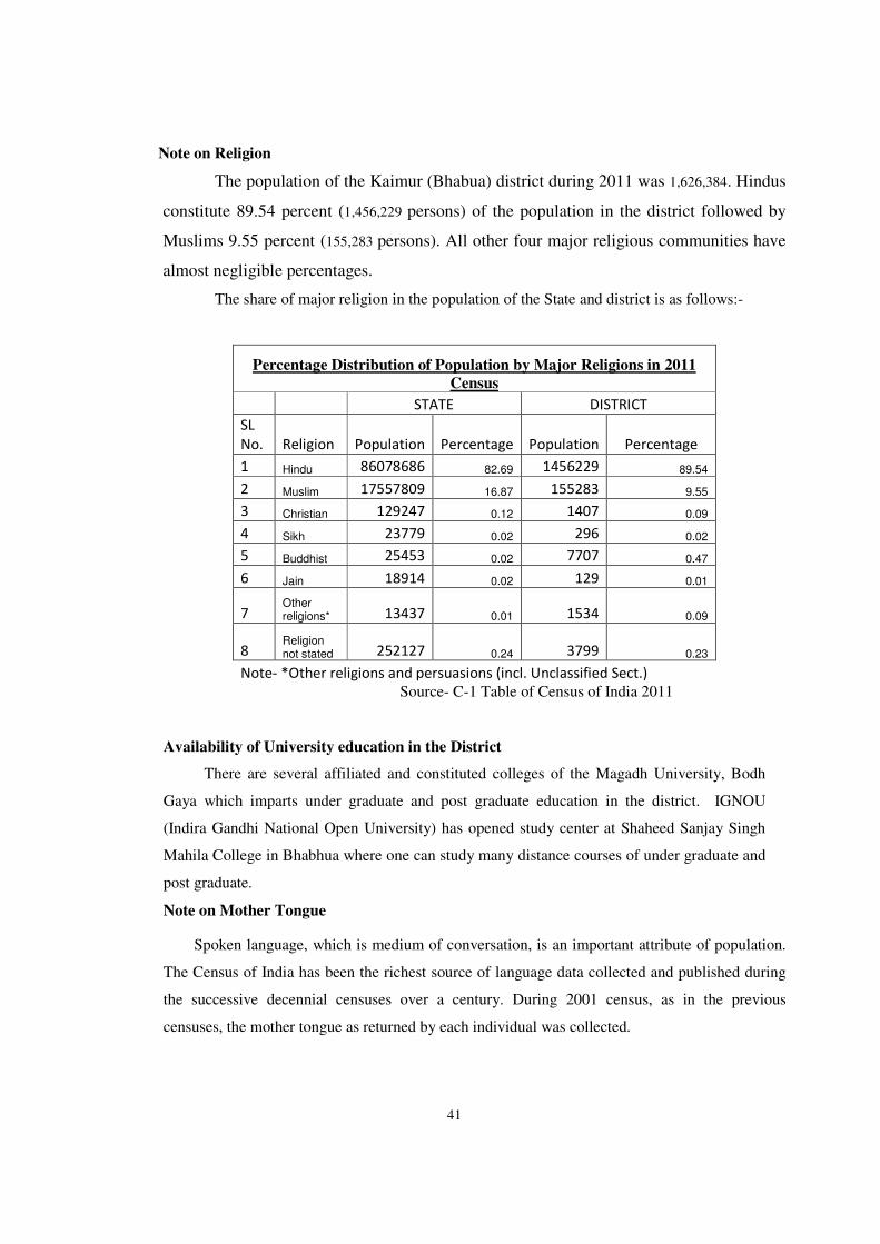
Note on Religion
The population of the Kaimur (Bhabua) district during 2011 was 1,626,384. Hindus
constitute 89.54 percent (1,456,229 persons) of the population in the district followed by
Muslims 9.55 percent (155,283 persons). All other four major religious communities have
almost negligible percentages.
The share of major religion in the population of the State and district is as follows:-
Percentage Distribution of Population by Major Religions in 2011
Census
STATE DISTRICT
SL
No. Religion Population Percentage Population Percentage
1 Hindu 86078686 82.69 1456229 89.54
2 Muslim 17557809 16.87 155283 9.55
3 Christian 129247 0.12 1407 0.09
4 Sikh 23779 0.02 296 0.02
5 Buddhist 25453 0.02 7707 0.47
6 Jain 18914 0.02 129 0.01
7 Other religions* 13437 0.01 1534 0.09
8 Religion not stated 252127 0.24 3799 0.23
Note- *Other religions and persuasions (incl. Unclassified Sect.)
Source- C-1 Table of Census of India 2011
Availability of University education in the District
There are several affiliated and constituted colleges of the Magadh University, Bodh
Gaya which imparts under graduate and post graduate education in the district. IGNOU
(Indira Gandhi National Open University) has opened study center at Shaheed Sanjay Singh
Mahila College in Bhabhua where one can study many distance courses of under graduate and
post graduate.
Note on Mother Tongue
Spoken language, which is medium of conversation, is an important attribute of population.
The Census of India has been the richest source of language data collected and published during
the successive decennial censuses over a century. During 2001 census, as in the previous
censuses, the mother tongue as returned by each individual was collected.
42
The population of the Kaimur district during 2001census was 12,89,074. As per distribution
of different mother tongues (languages mentioned under 8th Schedule of Constitution of India)
Hindi, the main mother tongue of the district was 96.0 percent (12,37,776 persons) of the
population. The corresponding percentage for the Urdu, the second most prominent language
spoken in Kaimur district, was 3.7 percent (47,848 persons). Speakers of other Scheduled
languages were very thin in number than the two described above.
Note on important Scheduled Castes (SCs) and Scheduled Tribes (STs) in the district of
Kaimur district during 2001 Census
The population of the Scheduled Castes in the district of Kaimur was 2,86,291 according to
2001 Census. Numerically the five most prominent SCs in the district were (i) Chamar,
Mochi(1,92,014) (ii) Dusadh, Dhari,Dharhi (44,506) (iii) Pasi (16,083) (iv) Musahar (15,510) and
(v) Dhobi (11,893) while Chamar constituted the maximum proportion of Scheduled Castes
population the percentages being 67.1 (more than two-third of the total SC population) Dusadh
and Pasi though numerically second and third in order comprised only 15.5 and 5.6 percent of the
SC population in the district. Musahar comprised 5.4 percent of the SC population in the district
though numerically fourth position of SC population in the district and Dhobi are much less in
number as compared to the other four SCs mentioned above with only 4.2 percent of the total SC
population of the district. Remaining Scheduled Castes Dom, Nat, Hari, Halalkhor, Turi, Rajwar,
Kurariar, Bhuiya, Ghasi, Lalbegi, Dabgar, Bauri, Bhogta etc. were comparatively very less in
number than the five SCs described above as their percentages to total SC population was less
than even 1.0 percent .
The population of the Scheduled Tribes in the district of Kaimur during 2001 Census
was 35,662.Numerically, the five important STs were namely (i) Kharwar (ii) Gond (iii) Oraon
(iv) Chero and (iv) Lohara etc. Kharwar had 22,990 population, which constituted 64.5 percent
of the Scheduled Tribes population in the district, Gond with 5,736 population constituted 16.1
percent of the ST population. Oraon, which were 3,317 in number, constituted 9.3 percent of the
ST population. Chero comprised 2,665 persons and constituted 7.5 percent of ST population
while Lohara etc with 461 population constituted 1.3 percent of the total ST population in the
district. The other Scheduled Tribes were almost negligible in proportion.
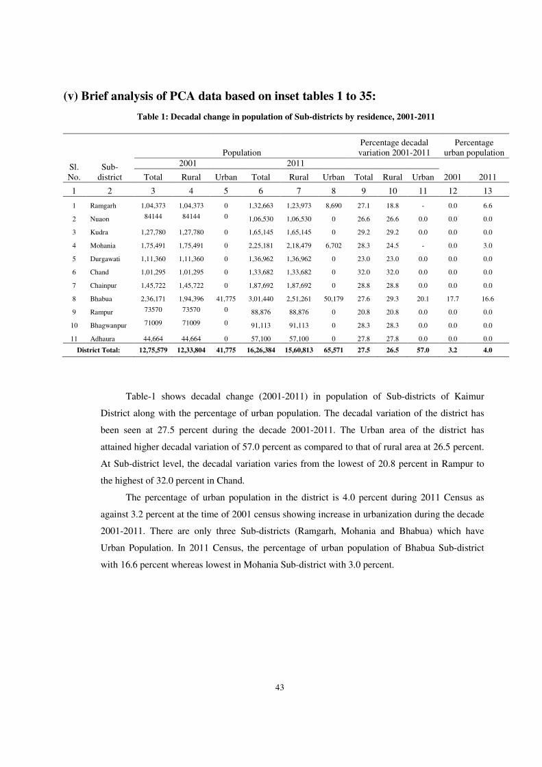
43
(v) Brief analysis of PCA data based on inset tables 1 to 35:
Table 1: Decadal change in population of Sub-districts by residence, 2001-2011
Sl. No.
Sub-district
Population Percentage decadal variation 2001-2011
Percentage urban population
2001 2011
Total Rural Urban Total Rural Urban Total Rural Urban 2001 2011
1 2 3 4 5 6 7 8 9 10 11 12 13
1 Ramgarh 1,04,373 1,04,373 0 1,32,663 1,23,973 8,690 27.1 18.8 - 0.0 6.6
2 Nuaon 84144 84144 0 1,06,530 1,06,530 0 26.6 26.6 0.0 0.0 0.0
3 Kudra 1,27,780 1,27,780 0 1,65,145 1,65,145 0 29.2 29.2 0.0 0.0 0.0
4 Mohania 1,75,491 1,75,491 0 2,25,181 2,18,479 6,702 28.3 24.5 - 0.0 3.0
5 Durgawati 1,11,360 1,11,360 0 1,36,962 1,36,962 0 23.0 23.0 0.0 0.0 0.0
6 Chand 1,01,295 1,01,295 0 1,33,682 1,33,682 0 32.0 32.0 0.0 0.0 0.0
7 Chainpur 1,45,722 1,45,722 0 1,87,692 1,87,692 0 28.8 28.8 0.0 0.0 0.0
8 Bhabua 2,36,171 1,94,396 41,775 3,01,440 2,51,261 50,179 27.6 29.3 20.1 17.7 16.6
9 Rampur 73570 73570 0 88,876 88,876 0 20.8 20.8 0.0 0.0 0.0
10 Bhagwanpur 71009 71009 0 91,113 91,113 0 28.3 28.3 0.0 0.0 0.0
11 Adhaura 44,664 44,664 0 57,100 57,100 0 27.8 27.8 0.0 0.0 0.0
District Total: 12,75,579 12,33,804 41,775 16,26,384 15,60,813 65,571 27.5 26.5 57.0 3.2 4.0
Table-1 shows decadal change (2001-2011) in population of Sub-districts of Kaimur
District along with the percentage of urban population. The decadal variation of the district has
been seen at 27.5 percent during the decade 2001-2011. The Urban area of the district has
attained higher decadal variation of 57.0 percent as compared to that of rural area at 26.5 percent.
At Sub-district level, the decadal variation varies from the lowest of 20.8 percent in Rampur to
the highest of 32.0 percent in Chand.
The percentage of urban population in the district is 4.0 percent during 2011 Census as
against 3.2 percent at the time of 2001 census showing increase in urbanization during the decade
2001-2011. There are only three Sub-districts (Ramgarh, Mohania and Bhabua) which have
Urban Population. In 2011 Census, the percentage of urban population of Bhabua Sub-district
with 16.6 percent whereas lowest in Mohania Sub-district with 3.0 percent.
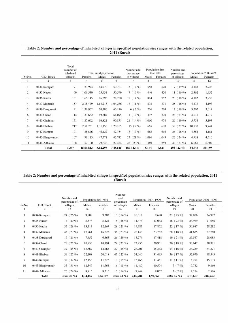
44
Table 2: Number and percentage of inhabited villages in specified population size ranges with the related population,
2011 (Rural)
Sr.No. C.D. Block
Total number of inhabited villages
Total rural population Number and percentage of villages
Population less than 200
Number and percentage of villages
Population 200 - 499
Persons Males Females Males Females Males Females
1 2 3 4 5 6 7 8 9 10 11 12
1 0434-Ramgarh 91 1,23,973 64,270 59,703 13 ( 14 %) 558 520 17 ( 19 %) 3,148 2,928
2 0435-Nuaon 69 1,06,530 55,931 50,599 7 ( 10 %) 446 420 11 ( 16 %) 2,362 1,952
3 0436-Kudra 131 1,65,145 86,395 78,750 18 ( 14 %) 814 752 23 ( 18 %) 4,182 3,953
4 0437-Mohania 157 2,18,479 1,14,213 1,04,266 17 ( 11 %) 878 831 25 ( 16 %) 4,473 4,193
5 0438-Durgawati 91 1,36,962 70,786 66,176 6 ( 7 %) 226 205 17 ( 19 %) 3,202 3,014
6 0439-Chand 114 1,33,682 69,587 64,095 11 ( 10 %) 397 370 26 ( 23 %) 4,631 4,219
7 0440-Chainpur 151 1,87,692 96,821 90,871 21 ( 14 %) 1,060 974 29 ( 19 %) 5,754 5,193
8 0441-Bhabua 217 2,51,261 1,31,156 1,20,105 15 ( 7 %) 665 630 58 ( 27 %) 10,830 9,744
9 0442-Rampur 101 88,876 46,122 42,754 13 ( 13 %) 665 616 26 ( 26 %) 4,584 4,181
10 0443-Bhagwanpur 107 91,113 47,371 43,742 23 ( 21 %) 1,086 1,043 26 ( 24 %) 4,918 4,510
11 0444-Adhaura 108 57,100 29,646 27,454 25 ( 23 %) 1,369 1,259 40 ( 37 %) 6,661 6,302
Total 1,337 15,60,813 8,12,298 7,48,515 169 ( 13 %) 8,164 7,620 298 ( 22 %) 54,745 50,189
Table 2: Number and percentage of inhabited villages in specified population size ranges with the related population, 2011
(Rural)
Sr.No. C.D. Block
Number and percentage of
villages
Population 500 - 999
Number and
percentage of villages
Population 1000 - 1999 Number and percentage of
villages
Population 2000 - 4999
Males Females Males Females Males Females
1 2 13 14 15 16 17 18 19 20 21
1 0434-Ramgarh 24 ( 26 %) 9,808 9,202 13 ( 14 %) 10,312 9,690 23 ( 25 %) 37,806 34,987
2 0435-Nuaon 14 ( 20 %) 5,578 5,121 18 ( 26 %) 14,376 13,062 16 ( 23 %) 23,969 21,656
3 0436-Kudra 37 ( 28 %) 13,314 12,167 28 ( 21 %) 19,387 17,862 22 ( 17 %) 30,987 28,212
4 0437-Mohania 45 ( 29 %) 17,761 16,323 36 ( 23 %) 26,143 23,762 28 ( 18 %) 41,685 37,760
5 0438-Durgawati 19 ( 21 %) 7,452 6,865 26 ( 29 %) 18,774 17,418 19 ( 21 %) 29,567 28,083
6 0439-Chand 28 ( 25 %) 10,956 10,194 29 ( 25 %) 22,956 20,931 20 ( 18 %) 30,647 28,381
7 0440-Chainpur 37 ( 25 %) 13,562 12,765 37 ( 25 %) 26,901 25,342 24 ( 16 %) 36,239 34,321
8 0441-Bhabua 59 ( 27 %) 22,108 20,018 47 ( 22 %) 34,040 31,495 36 ( 17 %) 52,970 48,543
9 0442-Rampur 32 ( 32 %) 12,156 11,373 19 ( 19 %) 12,466 11,451 11 ( 11 %) 16,251 15,133
10 0443-Bhagwanpur 33 ( 31 %) 12,549 11,764 16 ( 15 %) 11,480 10,504 7 ( 7 %) 10,782 9,860
11 0444-Adhaura 26 ( 24 %) 8,913 8,315 15 ( 14 %) 9,949 9,052 2 ( 2 %) 2,754 2,526
Total 354 ( 26 %) 1,34,157 1,24,107 284 ( 21 %) 2,06,784 1,90,569 208 ( 16 %) 3,13,657 2,89,462
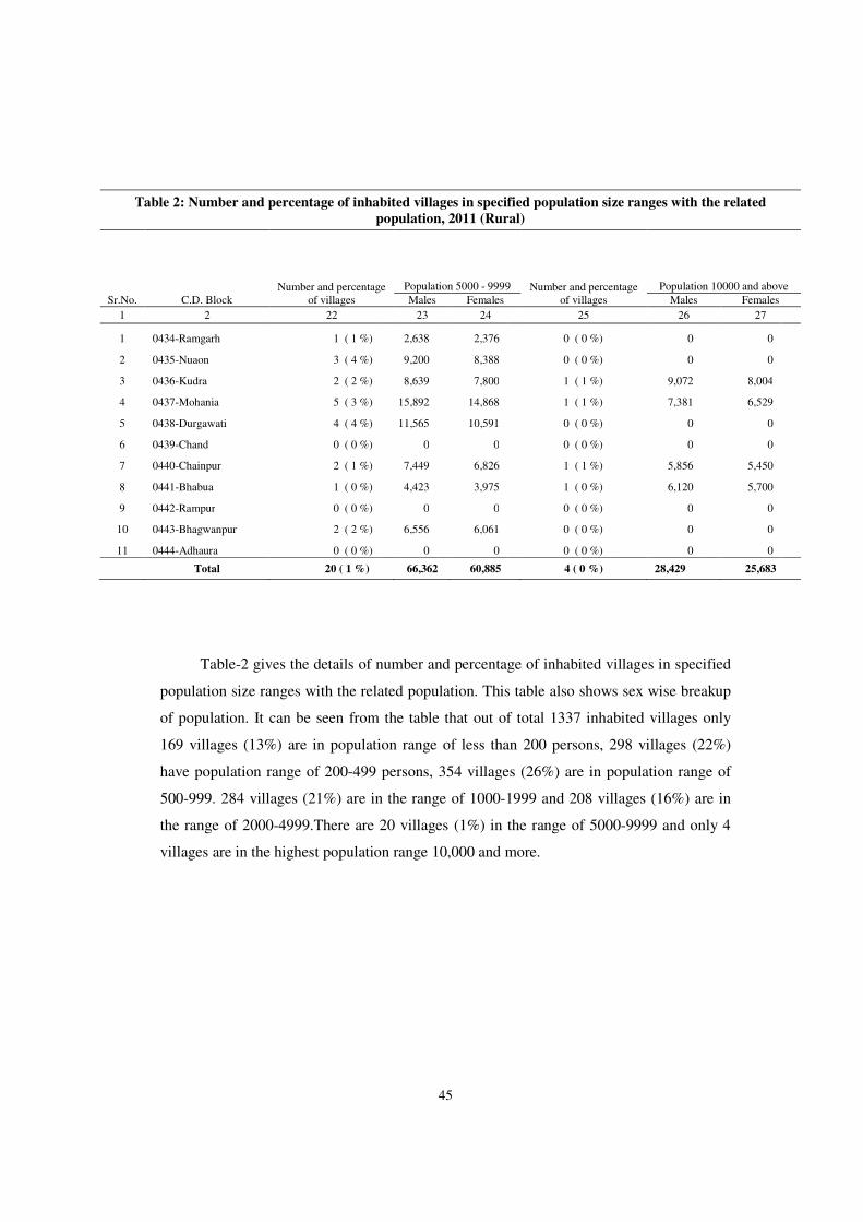
45
Table 2: Number and percentage of inhabited villages in specified population size ranges with the related
population, 2011 (Rural)
Sr.No. C.D. Block Number and percentage
of villages
Population 5000 - 9999 Number and percentage of villages
Population 10000 and above
Males Females Males Females
1 2 22 23 24 25 26 27
1 0434-Ramgarh 1 ( 1 %) 2,638 2,376 0 ( 0 %) 0 0
2 0435-Nuaon 3 ( 4 %) 9,200 8,388 0 ( 0 %) 0 0
3 0436-Kudra 2 ( 2 %) 8,639 7,800 1 ( 1 %) 9,072 8,004
4 0437-Mohania 5 ( 3 %) 15,892 14,868 1 ( 1 %) 7,381 6,529
5 0438-Durgawati 4 ( 4 %) 11,565 10,591 0 ( 0 %) 0 0
6 0439-Chand 0 ( 0 %) 0 0 0 ( 0 %) 0 0
7 0440-Chainpur 2 ( 1 %) 7,449 6,826 1 ( 1 %) 5,856 5,450
8 0441-Bhabua 1 ( 0 %) 4,423 3,975 1 ( 0 %) 6,120 5,700
9 0442-Rampur 0 ( 0 %) 0 0 0 ( 0 %) 0 0
10 0443-Bhagwanpur 2 ( 2 %) 6,556 6,061 0 ( 0 %) 0 0
11 0444-Adhaura 0 ( 0 %) 0 0 0 ( 0 %) 0 0
Total 20 ( 1 %) 66,362 60,885 4 ( 0 %) 28,429 25,683
Table-2 gives the details of number and percentage of inhabited villages in specified
population size ranges with the related population. This table also shows sex wise breakup
of population. It can be seen from the table that out of total 1337 inhabited villages only
169 villages (13%) are in population range of less than 200 persons, 298 villages (22%)
have population range of 200-499 persons, 354 villages (26%) are in population range of
500-999. 284 villages (21%) are in the range of 1000-1999 and 208 villages (16%) are in
the range of 2000-4999.There are 20 villages (1%) in the range of 5000-9999 and only 4
villages are in the highest population range 10,000 and more.
46
Table 3: New towns, de-notified, declassified and merged town in 2011 census
(a) New
(i) Statutory town NIL
(ii) Census town
Ramgarh (CT)
Anwari (CT)
(b) Denotified NIL (i)Statutory towns of 2001 census denotified and also did not satisfy the criteria to be treated as census towns.
(ii)Statutory towns of 2001 census denotified but identified as census towns based on demographic and economic criteria.
(iii)Census towns of 2001 census are notified as statutory town in 2011 census.
(c) Declassified NIL
(d) Wholly merged with other town(s). NIL
*Declassified means the census towns of 2001 census which failed to satisfy the demographic and economic criteria.
Table-3 is self explanatory.
Table 4: Sex ratio of the state and district, 1901-2011
Census Year
State District
Total Rural Urban Total Rural Urban
1 2 3 4 5 6 7
1901 1,061 1,064 1,003 1,096 1,096 1,103 1911
1,051 1,056 942 1,062 1,062 1,052 1921
1,020 1,027 886 1,029 1,029 990 1931
995 1,005 820 995 998 864 1941
1,002 1,012 842 981 983 881 1951
1,000 1,010 859 963 964 892 1961
1,005 1,020 832 976 979 839 1971
957 968 833 932 935 859 1981
948 959 852 907 910 806 1991
907 913 857 884 885 848 2001
919 926 868 902 905 832 2011 918 921 895 920 921 889
Note :- Sex ratio has been defined here as the
number of females per 1000 males
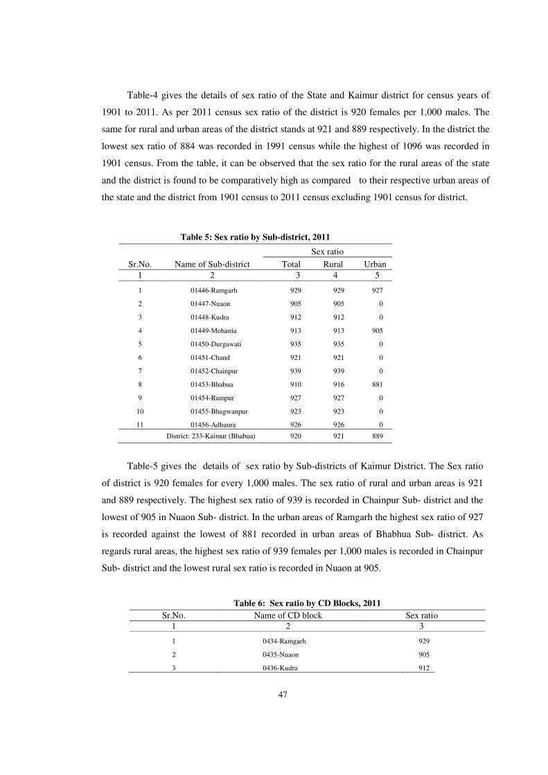
47
Table-4 gives the details of sex ratio of the State and Kaimur district for census years of
1901 to 2011. As per 2011 census sex ratio of the district is 920 females per 1,000 males. The
same for rural and urban areas of the district stands at 921 and 889 respectively. In the district the
lowest sex ratio of 884 was recorded in 1991 census while the highest of 1096 was recorded in
1901 census. From the table, it can be observed that the sex ratio for the rural areas of the state
and the district is found to be comparatively high as compared to their respective urban areas of
the state and the district from 1901 census to 2011 census excluding 1901 census for district.
Table 5: Sex ratio by Sub-district, 2011
Sr.No. Name of Sub-district
Sex ratio
Total Rural Urban
1 2 3 4 5
1 01446-Ramgarh 929 929 927
2 01447-Nuaon 905 905 0
3 01448-Kudra 912 912 0
4 01449-Mohania 913 913 905
5 01450-Durgawati 935 935 0
6 01451-Chand 921 921 0
7 01452-Chainpur 939 939 0
8 01453-Bhabua 910 916 881
9 01454-Rampur 927 927 0
10 01455-Bhagwanpur 923 923 0
11 01456-Adhaura 926 926 0
District: 233-Kaimur (Bhabua) 920 921 889
Table-5 gives the details of sex ratio by Sub-districts of Kaimur District. The Sex ratio
of district is 920 females for every 1,000 males. The sex ratio of rural and urban areas is 921
and 889 respectively. The highest sex ratio of 939 is recorded in Chainpur Sub- district and the
lowest of 905 in Nuaon Sub- district. In the urban areas of Ramgarh the highest sex ratio of 927
is recorded against the lowest of 881 recorded in urban areas of Bhabhua Sub- district. As
regards rural areas, the highest sex ratio of 939 females per 1,000 males is recorded in Chainpur
Sub- district and the lowest rural sex ratio is recorded in Nuaon at 905.
Table 6: Sex ratio by CD Blocks, 2011
Sr.No. Name of CD block Sex ratio
1 2 3
1 0434-Ramgarh 929
2 0435-Nuaon 905
3 0436-Kudra 912
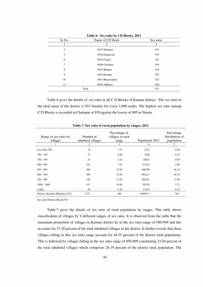
48
Table 6: Sex ratio by CD Blocks, 2011
Sr.No. Name of CD block Sex ratio
1 2 3
4 0437-Mohania 913
5 0438-Durgawati 935
6 0439-Chand 921
7 0440-Chainpur 939
8 0441-Bhabua 916
9 0442-Rampur 927
10 0443-Bhagwanpur 923
11 0444-Adhaura 926
Total 921
Table-6 gives the details of sex ratio in all C.D Blocks of Kaimur district. The sex ratio in
the rural areas of the district is 921 females for every 1,000 males. The highest sex ratio among
C.D Blocks is recorded in Chainpur at 939 against the lowest of 905 in Nuaon.
Table 7: Sex ratio of rural population by ranges, 2011
Range of sex ratio for villages
Number of inhabited villages
Percentage of villages in each
range Population 2011
Percentage distribution of
population 1 2 3 4 5
Less than 700 18 1.35 1251 0.08
700 - 749 12 0.90 3446 0.22
750 - 799 31 2.32 10825 0.69
800 - 849 101 7.55 63415 4.06
850 - 899 308 23.04 408799 26.19
900 - 949 445 33.28 692213 44.35
950 - 999 236 17.65 280232 17.95
1000 - 1099 147 10.99 89259 5.72
1100+ 39 2.92 11373 0.73
District: Kaimur (Bhabua) (233) 1337 100 1560813 100
Sex ratio District (Rural):921
Table-7 gives the details of sex ratio of rural population by ranges. This table shows
classification of villages by 9 different ranges of sex ratio. It is observed from the table that the
maximum proportion of villages in Kaimur district lie in the sex ratio range of 900-949 and this
accounts for 33.28 percent of the total inhabited villages in the district. It further reveals that these
villages falling in this sex ratio range account for 44.35 percent of the district rural population.
This is followed by villages falling in the sex ratio range of 850-899 constituting 23.04 percent of
the total inhabited villages which comprises 26.19 percent of the district rural population. The
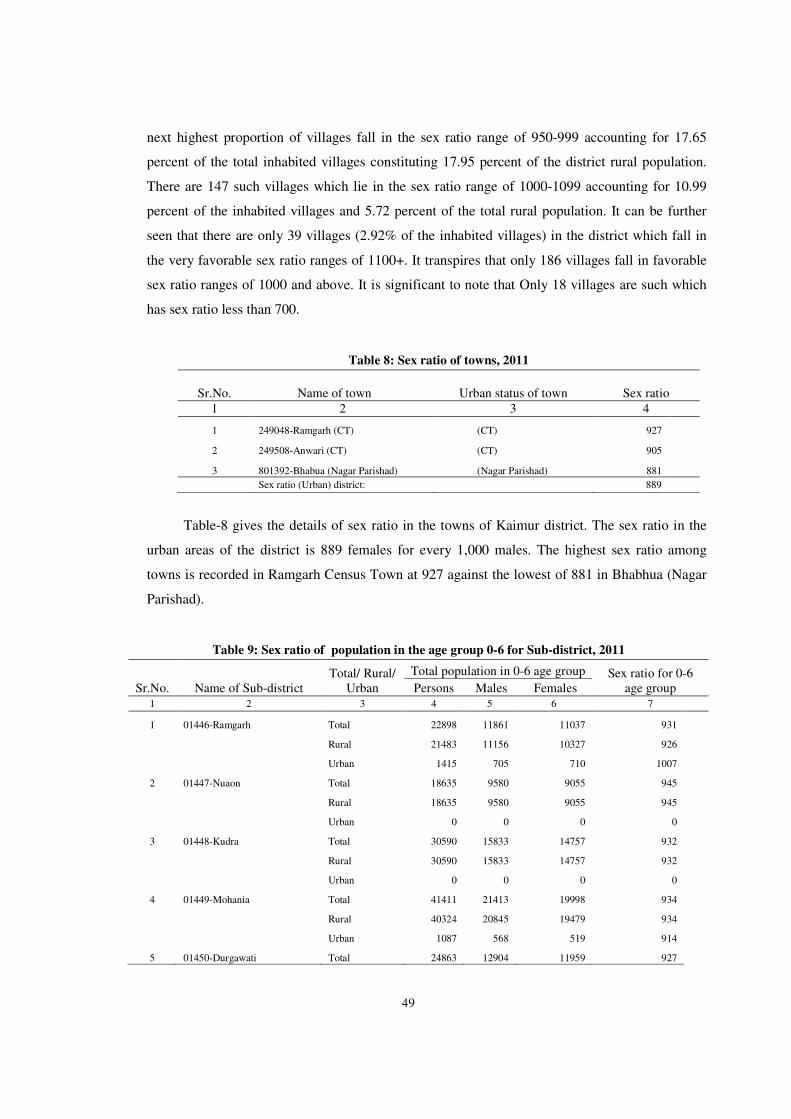
49
next highest proportion of villages fall in the sex ratio range of 950-999 accounting for 17.65
percent of the total inhabited villages constituting 17.95 percent of the district rural population.
There are 147 such villages which lie in the sex ratio range of 1000-1099 accounting for 10.99
percent of the inhabited villages and 5.72 percent of the total rural population. It can be further
seen that there are only 39 villages (2.92% of the inhabited villages) in the district which fall in
the very favorable sex ratio ranges of 1100+. It transpires that only 186 villages fall in favorable
sex ratio ranges of 1000 and above. It is significant to note that Only 18 villages are such which
has sex ratio less than 700.
Table 8: Sex ratio of towns, 2011
Sr.No. Name of town Urban status of town Sex ratio
1 2 3 4
1 249048-Ramgarh (CT) (CT) 927
2 249508-Anwari (CT) (CT) 905
3 801392-Bhabua (Nagar Parishad) (Nagar Parishad) 881
Sex ratio (Urban) district: 889
Table-8 gives the details of sex ratio in the towns of Kaimur district. The sex ratio in the
urban areas of the district is 889 females for every 1,000 males. The highest sex ratio among
towns is recorded in Ramgarh Census Town at 927 against the lowest of 881 in Bhabhua (Nagar
Parishad).
Table 9: Sex ratio of population in the age group 0-6 for Sub-district, 2011
Sr.No. Name of Sub-district Total/ Rural/
Urban
Total population in 0-6 age group Sex ratio for 0-6 age group Persons Males Females
1 2 3 4 5 6 7
1 01446-Ramgarh Total 22898 11861 11037 931
Rural 21483 11156 10327 926
Urban 1415 705 710 1007
2 01447-Nuaon Total 18635 9580 9055 945
Rural 18635 9580 9055 945
Urban 0 0 0 0
3 01448-Kudra Total 30590 15833 14757 932
Rural 30590 15833 14757 932
Urban 0 0 0 0
4 01449-Mohania Total 41411 21413 19998 934
Rural 40324 20845 19479 934
Urban 1087 568 519 914
5 01450-Durgawati Total 24863 12904 11959 927

50
Table 9: Sex ratio of population in the age group 0-6 for Sub-district, 2011
Sr.No. Name of Sub-district Total/ Rural/
Urban
Total population in 0-6 age group Sex ratio for 0-6 age group Persons Males Females
1 2 3 4 5 6 7
Rural 24863 12904 11959 927
Urban 0 0 0 0
6 01451-Chand Total 24405 12621 11784 934
Rural 24405 12621 11784 934
Urban 0 0 0 0
7 01452-Chainpur Total 37145 18874 18271 968
Rural 37145 18874 18271 968
Urban 0 0 0 0
8 01453-Bhabua Total 54291 27977 26314 941
Rural 47164 24215 22949 948
Urban 7127 3762 3365 894
9 01454-Rampur Total 16113 8326 7787 935
Rural 16113 8326 7787 935
Urban 0 0 0 0
10 01455-Bhagwanpur Total 16968 8607 8361 971
Rural 16968 8607 8361 971
Urban 0 0 0 0
11 01456-Adhaura Total 11962 6109 5853 958
Rural 11962 6109 5853 958
Urban 0 0 0 0
District: 233-Kaimur (Bhabua) Total 299281 154105 145176 942
Rural 289652 149070 140582 943
Urban 9629 5035 4594 912
Table-9 gives the details of sex ratio of population in the age group 0-6 for sub-districts of
Kaimur district. It is observed from the table that sex ratio of population in the age group 0-6,
which works out to 942, is higher than the sex ratio of the total population (920) in the district of
kaimur. While the sex ratio of (0-6) population in the rural areas of the district is 943, the sex
ratio of (0-6) population for the urban areas is only 912. Among sub-districts, Bhagwanpur has
the highest sex ratio of 971 females for every 1,000 males in the age group of 0-6 years. The
lowest sex ratio in the age group of 0-6 years is registered in Durgawati at 927 females per 1,000
males. In rural areas, Bhagwanpur has highest sex ratio at 971 and Durgawati has lowest sex ratio
at 927 in the age group of 0-6 years. In urban areas, Bhabhua has lowest sex ratio at 894 while
Ramgarh has highest sex ratio at 1007 in the age group of 0-6 years.

51
Table 10: Sex ratio of population in the age group 0-6 for CD Blocks, 2011
Sr.No. Name of CD Block
Total population in 0-6 age group Sex ratio for 0-6 age group Persons Males Females
1 2 3 4 5 6
1 0434-Ramgarh 21483 11156 10327 926
2 0435-Nuaon 18635 9580 9055 945
3 0436-Kudra 30590 15833 14757 932
4 0437-Mohania 40324 20845 19479 934
5 0438-Durgawati 24863 12904 11959 927
6 0439-Chand 24405 12621 11784 934
7 0440-Chainpur 37145 18874 18271 968
8 0441-Bhabua 47164 24215 22949 948
9 0442-Rampur 16113 8326 7787 935
10 0443-Bhagwanpur 16968 8607 8361 971
11 0444-Adhaura 11962 6109 5853 958
Total 289652 149070 140582 943
Table-10 gives the details of sex ratio of population in the age group 0-6 for all C.D Blocks
of Kaimur district. The sex ratio in the age group 0-6 of the rural areas of the district is 943
females for every 1,000 males. The highest sex ratio in the age group 0-6 among C.D Blocks is
recorded in Bhagwanpur at 971 against the lowest of 926 in Ramgarh.
Table 11: Sex ratio of rural population in the age group 0-6 by ranges, 2011
Range of sex ratio for villages
Number of inhabited villages
Percentage distribution of
villages Population
2011
Percentage distribution of
population
1 2 3 4 5
Less than 700 116 8.68 6530 2.25
700 - 749 57 4.26 7104 2.45
750 - 799 73 5.46 12600 4.35
800 - 849 105 7.85 24758 8.55
850 - 899 156 11.67 50722 17.51
900 - 949 165 12.34 50572 17.46
950 - 999 131 9.80 41343 14.27
1000 - 1099 275 20.57 68077 23.50
1100+ 259 19.37 27946 9.65
District: Kaimur (Bhabua) (233) 1337 100 289652 100
Sex ratio District (Rural):943
Table-11 gives the details of sex ratio of rural populations in the age group 0-6 by ranges.
This table shows classification of villages by 9 different ranges of sex ratio of rural populations in
the age group 0-6. It also shows number of inhabited villages, percentage distribution of villages,
population and percentage distribution of population among these ranges. Of the total number of

52
inhabited villages (1337) of the district 37.92 percent are such which have sex ratio below 900.
Even among them 116 and 57 villages have sex ratio less than 700 and between 700 to 749
respectively. It is significant to note that 534 (39.94 percent) of the total inhabited villages have
sex ratio favoring females i.e. 1000 or more females per thousand males.
Table 12: Sex ratio of population in the age group 0-6 of towns, 2011
Sr.No. Name of town Urban status
of town
Total population in 0-6 age group Sex ratio for 0-6 age group Persons Males Females
1 2 3 4 5 6 7
1 249048-Ramgarh (CT) (CT) 1415 705 710 1007
2 249508-Anwari (CT) (CT) 1087 568 519 914
3 801392-Bhabua (Nagar Parishad) (Nagar Parishad) 7127 3762 3365 894
District (Urban): 233-Kaimur (Bhabua) 9629 5035 4594 912
Table-12 gives the details of sex ratio of urban populations in the age group 0-6. This table
also shows urban status of town, total population, male and female population in 0-6 age group of
town. The sex ratio in the age group 0-6 of the urban areas of the district is 912 females for every
1,000 males. The highest sex ratio for 0-6 age group among towns is recorded in Ramgarh (CT) at
1007 against the lowest of 894 in Bhabhua (Nagar Parishad).
Table 13: Number and percentage of scheduled castes and scheduled tribes population in Sub-districts, 2011
Sr.No. Name of Sub-District
Total/ Rural/ Urban
Total population
Total scheduled
castes population
Total scheduled
tribes population
Percentage of scheduled castes
population to total population
Percentage of scheduled tribes
population to total population
1 2 3 4 5 6 7 8
1 01446-Ramgarh Total 132663 30106 763 22.69 0.58
Rural 123973 28040 763 22.62 0.62
Urban 8690 2066 0 23.77 0
2 01447-Nuaon Total 106530 21035 514 19.75 0.48
Rural 106530 21035 514 19.75 0.48
Urban 0 0 0 0 0
3 01448-Kudra Total 165145 36005 446 21.8 0.27
Rural 165145 36005 446 21.8 0.27
Urban 0 0 0 0 0
4 01449-Mohania Total 225181 60272 2382 26.77 1.06
Rural 218479 59494 2371 27.23 1.09
Urban 6702 778 11 11.61 0.16
5 01450-Durgawati Total 136962 36222 1691 26.45 1.23
Rural 136962 36222 1691 26.45 1.23
Urban 0 0 0 0 0

53
Table 13: Number and percentage of scheduled castes and scheduled tribes population in Sub-districts, 2011
Sr.No. Name of Sub-District
Total/ Rural/ Urban
Total population
Total scheduled
castes population
Total scheduled
tribes population
Percentage of scheduled castes
population to total population
Percentage of scheduled tribes
population to total population
1 2 3 4 5 6 7 8
6 01451-Chand Total 133682 28740 2911 21.5 2.18
Rural 133682 28740 2911 21.5 2.18
Urban 0 0 0 0 0
7 01452-Chainpur Total 187692 37657 9139 20.06 4.87
Rural 187692 37657 9139 20.06 4.87
Urban 0 0 0 0 0
8 01453-Bhabua Total 301440 60190 6844 19.97 2.27
Rural 251261 55058 5235 21.91 2.08
Urban 50179 5132 1609 10.23 3.21
9 01454-Rampur Total 88876 26642 1314 29.98 1.48
Rural 88876 26642 1314 29.98 1.48
Urban 0 0 0 0 0
10 01455-Bhagwanpur Total 91113 24834 2297 27.26 2.52
Rural 91113 24834 2297 27.26 2.52
Urban 0 0 0 0 0
11 01456-Adhaura Total 57100 7385 29680 12.93 51.98
Rural 57100 7385 29680 12.93 51.98
Urban 0 0 0 0 0
233-Kaimur (Bhabua) Total 1626384 369088 57981 22.69 3.57
Rural 1560813 361112 56361 23.14 3.61
Urban 65571 7976 1620 12.16 2.47
Table-13 gives the details of number and percentage of scheduled castes and scheduled
tribes population in all sub- districts of Kaimur district. This table also shows total population,
scheduled castes and scheduled tribes population in Sub-districts of the district. From the table, it
is observed that the proportion of scheduled castes and scheduled tribes population to the total
population of the district is found to be only 22.69 and 3.57 percent respectively. For rural areas,
the respective proportion of scheduled castes and scheduled tribes to the total population of the
district comes out to be 23.14 and 3.61 percent respectively. Similarly in urban areas, the
percentage of scheduled castes and scheduled tribes population to the total population of the
district comes out to 12.16 and 2.47 percent respectively. At sub- district level, the proportion of
scheduled castes to total population varies from 12.93 percent in Adhaura to and the proportion of
scheduled tribes to the total population varies from 0.27 percent in Kudra to 51.98 percent in
Adhaura respectively.
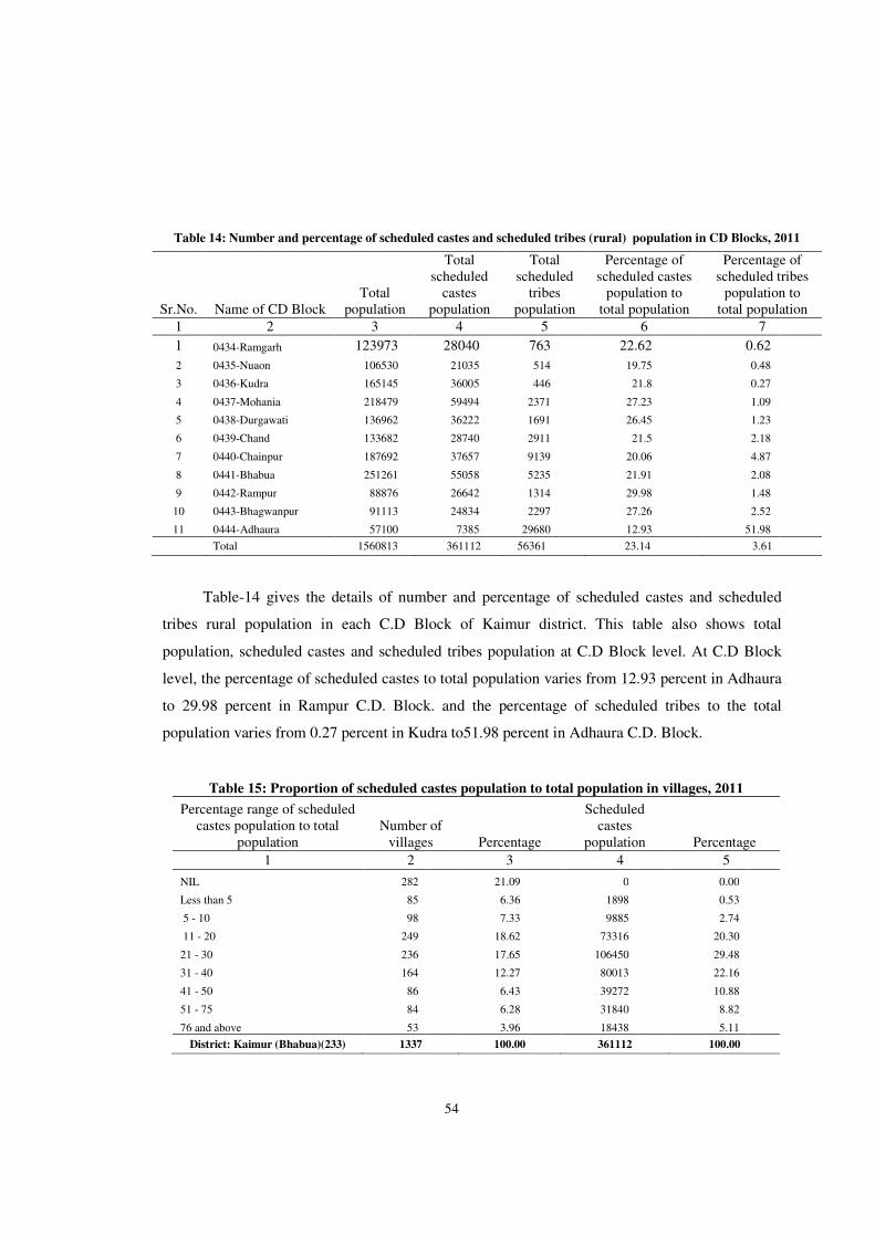
54
Table 14: Number and percentage of scheduled castes and scheduled tribes (rural) population in CD Blocks, 2011
Sr.No. Name of CD Block Total
population
Total scheduled
castes population
Total scheduled
tribes population
Percentage of scheduled castes
population to total population
Percentage of scheduled tribes
population to total population
1 2 3 4 5 6 7
1 0434-Ramgarh 123973 28040 763 22.62 0.62
2 0435-Nuaon 106530 21035 514 19.75 0.48
3 0436-Kudra 165145 36005 446 21.8 0.27
4 0437-Mohania 218479 59494 2371 27.23 1.09
5 0438-Durgawati 136962 36222 1691 26.45 1.23
6 0439-Chand 133682 28740 2911 21.5 2.18
7 0440-Chainpur 187692 37657 9139 20.06 4.87
8 0441-Bhabua 251261 55058 5235 21.91 2.08
9 0442-Rampur 88876 26642 1314 29.98 1.48
10 0443-Bhagwanpur 91113 24834 2297 27.26 2.52
11 0444-Adhaura 57100 7385 29680 12.93 51.98
Total 1560813 361112 56361 23.14 3.61
Table-14 gives the details of number and percentage of scheduled castes and scheduled
tribes rural population in each C.D Block of Kaimur district. This table also shows total
population, scheduled castes and scheduled tribes population at C.D Block level. At C.D Block
level, the percentage of scheduled castes to total population varies from 12.93 percent in Adhaura
to 29.98 percent in Rampur C.D. Block. and the percentage of scheduled tribes to the total
population varies from 0.27 percent in Kudra to51.98 percent in Adhaura C.D. Block.
Table 15: Proportion of scheduled castes population to total population in villages, 2011
Percentage range of scheduled castes population to total
population Number of
villages Percentage
Scheduled castes
population Percentage
1 2 3 4 5
NIL 282 21.09 0 0.00
Less than 5 85 6.36 1898 0.53
5 - 10 98 7.33 9885 2.74
11 - 20 249 18.62 73316 20.30
21 - 30 236 17.65 106450 29.48
31 - 40 164 12.27 80013 22.16
41 - 50 86 6.43 39272 10.88
51 - 75 84 6.28 31840 8.82
76 and above 53 3.96 18438 5.11
District: Kaimur (Bhabua)(233) 1337 100.00 361112 100.00
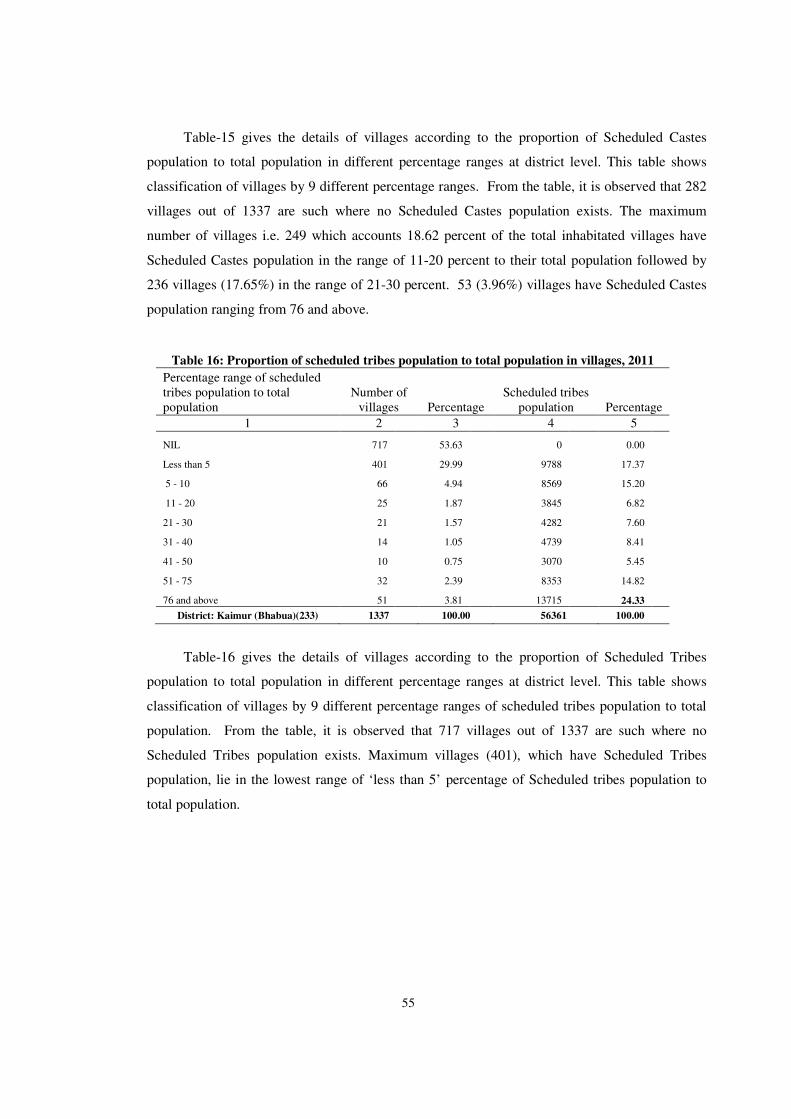
55
Table-15 gives the details of villages according to the proportion of Scheduled Castes
population to total population in different percentage ranges at district level. This table shows
classification of villages by 9 different percentage ranges. From the table, it is observed that 282
villages out of 1337 are such where no Scheduled Castes population exists. The maximum
number of villages i.e. 249 which accounts 18.62 percent of the total inhabitated villages have
Scheduled Castes population in the range of 11-20 percent to their total population followed by
236 villages (17.65%) in the range of 21-30 percent. 53 (3.96%) villages have Scheduled Castes
population ranging from 76 and above.
Table 16: Proportion of scheduled tribes population to total population in villages, 2011
Percentage range of scheduled tribes population to total population
Number of villages Percentage
Scheduled tribes population Percentage
1 2 3 4 5
NIL 717 53.63 0 0.00
Less than 5 401 29.99 9788 17.37
5 - 10 66 4.94 8569 15.20
11 - 20 25 1.87 3845 6.82
21 - 30 21 1.57 4282 7.60
31 - 40 14 1.05 4739 8.41
41 - 50 10 0.75 3070 5.45
51 - 75 32 2.39 8353 14.82
76 and above 51 3.81 13715 24.33
District: Kaimur (Bhabua)(233) 1337 100.00 56361 100.00
Table-16 gives the details of villages according to the proportion of Scheduled Tribes
population to total population in different percentage ranges at district level. This table shows
classification of villages by 9 different percentage ranges of scheduled tribes population to total
population. From the table, it is observed that 717 villages out of 1337 are such where no
Scheduled Tribes population exists. Maximum villages (401), which have Scheduled Tribes
population, lie in the lowest range of ‘less than 5’ percentage of Scheduled tribes population to
total population.
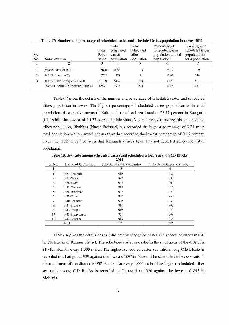
56
Table 17: Number and percentage of scheduled castes and scheduled tribes population in towns, 2011
Sr.No. Name of town
Total Popu-lation
Total scheduled castes population
Total scheduled tribes population
Percentage of scheduled castes population to total population
Percentage of scheduled tribes population to total population
1 2 3 4 5 6 7
1 249048-Ramgarh (CT) 8690 2066 0 23.77 0
2 249508-Anwari (CT) 6702 778 11 11.61 0.16
3 801392-Bhabua (Nagar Parishad) 50179 5132 1609 10.23 3.21
District (Urban) : 233-Kaimur (Bhabua) 65571 7976 1620 12.16 2.47
Table-17 gives the details of the number and percentage of scheduled castes and scheduled
tribes population in towns. The highest percentage of scheduled castes population to the total
population of respective towns of Kaimur district has been found at 23.77 percent in Ramgarh
(CT) while the lowest of 10.23 percent in Bhabhua (Nagar Parishad). As regards to scheduled
tribes population, Bhabhua (Nagar Parishad) has recorded the highest percentage of 3.21 to its
total population while Anwari census town has recorded the lowest percentage of 0.16 percent.
From the table it can be seen that Ramgarh census town has not reported scheduled tribes
population.
Table 18: Sex ratio among scheduled castes and scheduled tribes (rural) in CD Blocks,
2011
Sr.No. Name of C.D.Block Scheduled castes sex ratio Scheduled tribes sex ratio
1 2 3 4
1 0434-Ramgarh 919 937
2 0435-Nuaon 897 890
3 0436-Kudra 902 1000
4 0437-Mohania 918 845
5 0438-Durgawati 922 1020
6 0439-Chand 902 952
7 0440-Chainpur 939 960
8 0441-Bhabua 914 908
9 0442-Rampur 919 973
10 0443-Bhagwanpur 924 1008
11 0444-Adhaura 913 958
Total 916 952
Table-18 gives the details of sex ratio among scheduled castes and scheduled tribes (rural)
in CD Blocks of Kaimur district. The scheduled castes sex ratio in the rural areas of the district is
916 females for every 1,000 males. The highest scheduled castes sex ratio among C.D Blocks is
recorded in Chainpur at 939 against the lowest of 897 in Nuaon. The scheduled tribes sex ratio in
the rural areas of the district is 952 females for every 1,000 males. The highest scheduled tribes
sex ratio among C.D Blocks is recorded in Durawati at 1020 against the lowest of 845 in
Mohania.

57
Table 19: Sex ratio among scheduled castes and scheduled tribes in towns, 2011
Sr.No. Name of town Scheduled castes sex ratio Scheduled tribes sex ratio
1 2 3 4
1 249048-Ramgarh (CT) 888 0
2 249508-Anwari (CT) 935 571
3 801392-Bhabua (Nagar Parishad) 868 925
District (Urban): 233-Kaimur (Bhabua) 880 922
Table-19 gives the details of sex ratio among scheduled castes and scheduled tribes
in towns of Kaimur district. The scheduled castes sex ratio in the towns of the district is
880 females for every 1,000 males. The highest scheduled castes sex ratio among towns is
recorded in Anwari Cenus Town at 935 against the lowest of 868 in Bhabhua (Nagar
Parishad). The scheduled tribes sex ratio in the towns of the district is 922 females for
every 1,000 males. The highest scheduled tribes sex ratio among towns is recorded in
Bhabhua (Nagar Parishad) at 925 against the lowest of 571 in Anwari (CT). It is
observed that Ramgarg Census Town has no scheduled tribes population so sex ratio is be
Zero (0) in this Census Town.
Table 20: Number of literates and illiterates, literacy rate by sex in sub-districts, 2011
Sr.No. Name of Sub-district
Total/ Rural/ Urban
Number of literates and illiterates
Literacy rate
Gap in male-female literacy rate
Number of literates Number of illiterates
Persons Males Females Persons Males Females Persons Males Females
1 2 3 4 5 6 7 8 9 10 11 12 13
1 01446-Ramgarh Total 79889 47027 32862 52774 21752 31022 72.78 82.62 62.18 20.44
Rural 74088 43681 30407 49885 20589 29296 72.29 82.24 61.58 20.66
Urban 5801 3346 2455 2889 1163 1726 79.74 87.96 70.73 17.23
2 01447-Nuaon Total 62009 37363 24646 44521 18568 25953 70.55 80.61 59.33 21.28
Rural 62009 37363 24646 44521 18568 25953 70.55 80.61 59.33 21.28
Urban 0 0 0 0 0 0 0 0 0 0
3 01448-Kudra Total 98798 58207 40591 66347 28188 38159 73.43 82.49 63.43 19.06
Rural 98798 58207 40591 66347 28188 38159 73.43 82.49 63.43 19.06
Urban 0 0 0 0 0 0 0 0 0 0
4 01449-Mohania Total 134612 79869 54743 90569 37862 52707 73.25 82.92 62.6 20.32
Rural 129769 77162 52607 88710 37051 51659 72.84 82.64 62.05 20.59
Urban 4843 2707 2136 1859 811 1048 86.25 91.76 80.15 11.61
5 01450-Durgawati Total 79696 47314 32382 57266 23472 33794 71.09 81.74 59.73 22.01
Rural 79696 47314 32382 57266 23472 33794 71.09 81.74 59.73 22.01
Urban 0 0 0 0 0 0 0 0 0 0
6 01451-Chand Total 73494 44309 29185 60188 25278 34910 67.25 77.78 55.79 21.99
Rural 73494 44309 29185 60188 25278 34910 67.25 77.78 55.79 21.99
Urban 0 0 0 0 0 0 0 0 0 0
7 01452-Chainpur Total 94139 56930 37209 93553 39891 53662 62.53 73.04 51.25 21.79
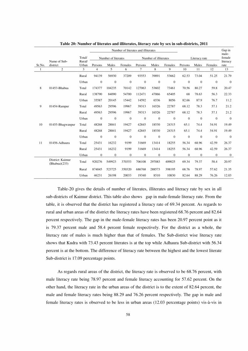
58
Table 20: Number of literates and illiterates, literacy rate by sex in sub-districts, 2011
Sr.No. Name of Sub-district
Total/ Rural/ Urban
Number of literates and illiterates
Literacy rate
Gap in male-female literacy rate
Number of literates Number of illiterates
Persons Males Females Persons Males Females Persons Males Females
1 2 3 4 5 6 7 8 9 10 11 12 13
Rural 94139 56930 37209 93553 39891 53662 62.53 73.04 51.25 21.79
Urban 0 0 0 0 0 0 0 0 0 0
8 01453-Bhabua Total 174377 104235 70142 127063 53602 73461 70.56 80.27 59.8 20.47
Rural 138790 84090 54700 112471 47066 65405 68 78.63 56.3 22.33
Urban 35587 20145 15442 14592 6536 8056 82.66 87.9 76.7 11.2
9 01454-Rampur Total 49563 29596 19967 39313 16526 22787 68.12 78.3 57.1 21.2
Rural 49563 29596 19967 39313 16526 22787 68.12 78.3 57.1 21.2
Urban 0 0 0 0 0 0 0 0 0 0
10 01455-Bhagwanpur Total 48268 28841 19427 42845 18530 24315 65.1 74.4 54.91 19.49
Rural 48268 28841 19427 42845 18530 24315 65.1 74.4 54.91 19.49
Urban 0 0 0 0 0 0 0 0 0 0
11 01456-Adhaura Total 25431 16232 9199 31669 13414 18255 56.34 68.96 42.59 26.37
Rural 25431 16232 9199 31669 13414 18255 56.34 68.96 42.59 26.37
Urban 0 0 0 0 0 0 0 0 0 0
District: Kaimur (Bhabua)(233)
Total 920276 549923 370353 706108 297083 409025 69.34 79.37 58.4 20.97
Rural 874045 523725 350320 686768 288573 398195 68.76 78.97 57.62 21.35
Urban 46231 26198 20033 19340 8510 10830 82.64 88.29 76.26 12.03
Table-20 gives the details of number of literates, illiterates and literacy rate by sex in all
sub-districts of Kaimur district. This table also shows gap in male-female literacy rate. From the
table, it is observed that the district has registered a literacy rate of 69.34 percent. As regards to
rural and urban areas of the district the literacy rates have been registered 68.76 percent and 82.64
percent respectively. The gap in the male-female literacy rates has been 20.97 percent point as it
is 79.37 percent male and 58.4 percent female respectively. For the district as a whole, the
literacy rate of males is much higher than that of females. The Sub-district wise literacy rate
shows that Kudra with 73.43 percent literates is at the top while Adhaura Sub-district with 56.34
percent is at the bottom. The difference of literacy rate between the highest and the lowest literate
Sub-district is 17.09 percentage points.
As regards rural areas of the district, the literacy rate is observed to be 68.76 percent, with
male literacy rate being 78.97 percent and female literacy accounting for 57.62 percent. On the
other hand, the literacy rate in the urban areas of the district is to the extent of 82.64 percent, the
male and female literacy rates being 88.29 and 76.26 percent respectively. The gap in male and
female literacy rates is observed to be less in urban areas (12.03 percentage points) vis-à-vis in
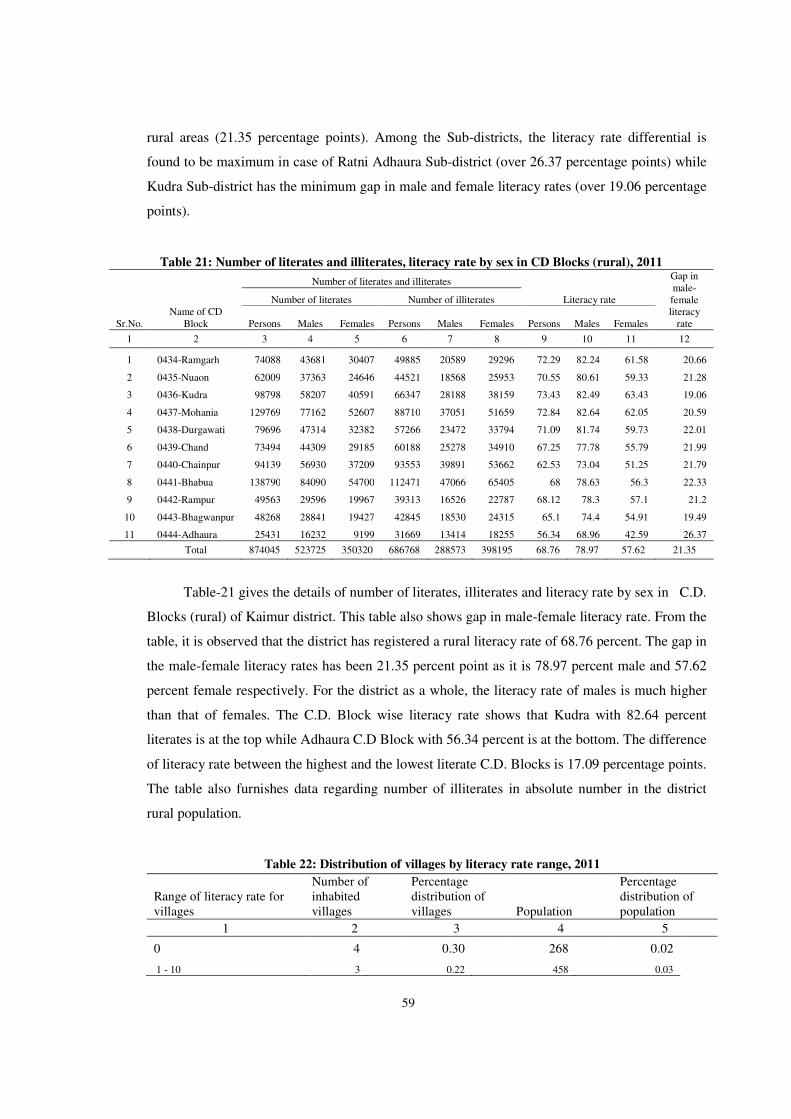
59
rural areas (21.35 percentage points). Among the Sub-districts, the literacy rate differential is
found to be maximum in case of Ratni Adhaura Sub-district (over 26.37 percentage points) while
Kudra Sub-district has the minimum gap in male and female literacy rates (over 19.06 percentage
points).
Table 21: Number of literates and illiterates, literacy rate by sex in CD Blocks (rural), 2011
Sr.No. Name of CD
Block
Number of literates and illiterates
Literacy rate
Gap in male-female literacy
rate
Number of literates Number of illiterates
Persons Males Females Persons Males Females Persons Males Females
1 2 3 4 5 6 7 8 9 10 11 12
1 0434-Ramgarh 74088 43681 30407 49885 20589 29296 72.29 82.24 61.58 20.66
2 0435-Nuaon 62009 37363 24646 44521 18568 25953 70.55 80.61 59.33 21.28
3 0436-Kudra 98798 58207 40591 66347 28188 38159 73.43 82.49 63.43 19.06
4 0437-Mohania 129769 77162 52607 88710 37051 51659 72.84 82.64 62.05 20.59
5 0438-Durgawati 79696 47314 32382 57266 23472 33794 71.09 81.74 59.73 22.01
6 0439-Chand 73494 44309 29185 60188 25278 34910 67.25 77.78 55.79 21.99
7 0440-Chainpur 94139 56930 37209 93553 39891 53662 62.53 73.04 51.25 21.79
8 0441-Bhabua 138790 84090 54700 112471 47066 65405 68 78.63 56.3 22.33
9 0442-Rampur 49563 29596 19967 39313 16526 22787 68.12 78.3 57.1 21.2
10 0443-Bhagwanpur 48268 28841 19427 42845 18530 24315 65.1 74.4 54.91 19.49
11 0444-Adhaura 25431 16232 9199 31669 13414 18255 56.34 68.96 42.59 26.37
Total 874045 523725 350320 686768 288573 398195 68.76 78.97 57.62 21.35
Table-21 gives the details of number of literates, illiterates and literacy rate by sex in C.D.
Blocks (rural) of Kaimur district. This table also shows gap in male-female literacy rate. From the
table, it is observed that the district has registered a rural literacy rate of 68.76 percent. The gap in
the male-female literacy rates has been 21.35 percent point as it is 78.97 percent male and 57.62
percent female respectively. For the district as a whole, the literacy rate of males is much higher
than that of females. The C.D. Block wise literacy rate shows that Kudra with 82.64 percent
literates is at the top while Adhaura C.D Block with 56.34 percent is at the bottom. The difference
of literacy rate between the highest and the lowest literate C.D. Blocks is 17.09 percentage points.
The table also furnishes data regarding number of illiterates in absolute number in the district
rural population.
Table 22: Distribution of villages by literacy rate range, 2011
Range of literacy rate for villages
Number of inhabited villages
Percentage distribution of villages Population
Percentage distribution of population
1 2 3 4 5
0 4 0.30 268 0.02
1 - 10 3 0.22 458 0.03
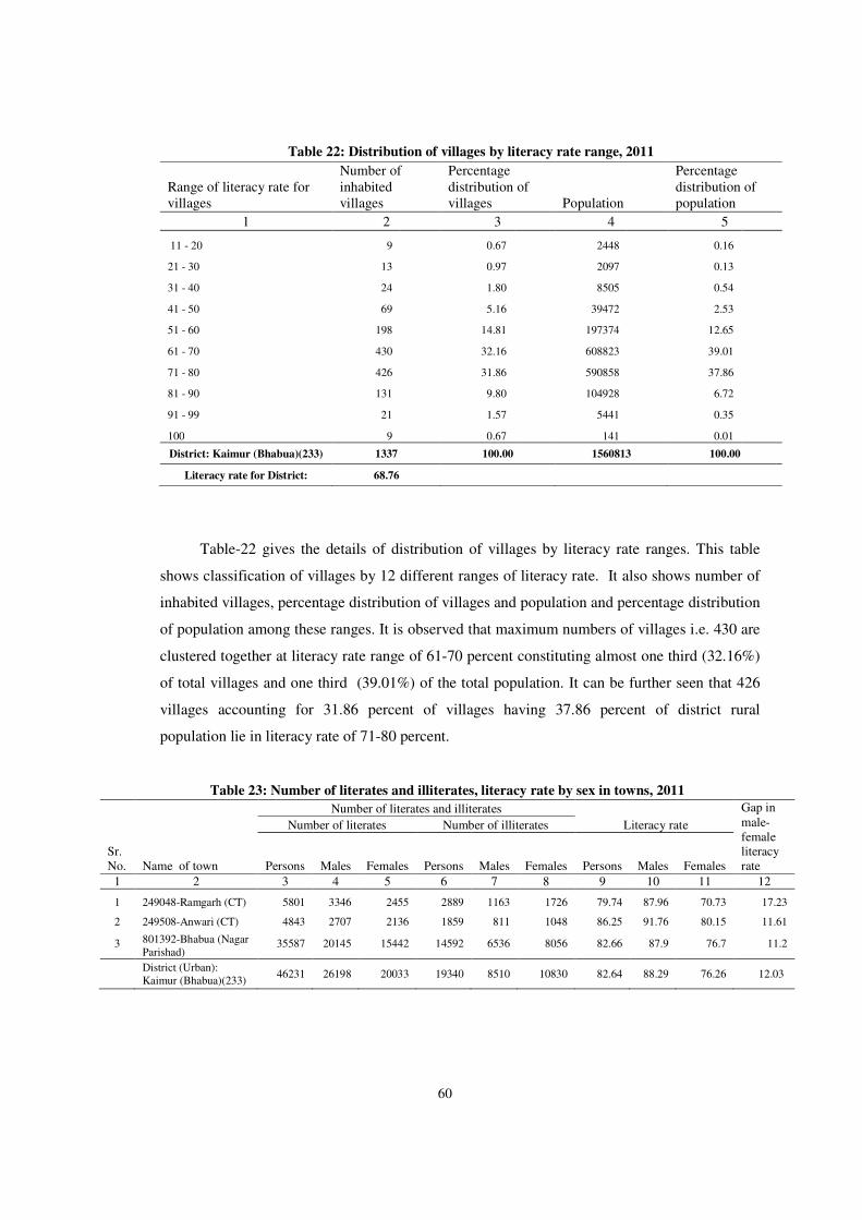
60
Table 22: Distribution of villages by literacy rate range, 2011
Range of literacy rate for villages
Number of inhabited villages
Percentage distribution of villages Population
Percentage distribution of population
1 2 3 4 5
11 - 20 9 0.67 2448 0.16
21 - 30 13 0.97 2097 0.13
31 - 40 24 1.80 8505 0.54
41 - 50 69 5.16 39472 2.53
51 - 60 198 14.81 197374 12.65
61 - 70 430 32.16 608823 39.01
71 - 80 426 31.86 590858 37.86
81 - 90 131 9.80 104928 6.72
91 - 99 21 1.57 5441 0.35
100 9 0.67 141 0.01
District: Kaimur (Bhabua)(233) 1337 100.00 1560813 100.00
Literacy rate for District: 68.76
Table-22 gives the details of distribution of villages by literacy rate ranges. This table
shows classification of villages by 12 different ranges of literacy rate. It also shows number of
inhabited villages, percentage distribution of villages and population and percentage distribution
of population among these ranges. It is observed that maximum numbers of villages i.e. 430 are
clustered together at literacy rate range of 61-70 percent constituting almost one third (32.16%)
of total villages and one third (39.01%) of the total population. It can be further seen that 426
villages accounting for 31.86 percent of villages having 37.86 percent of district rural
population lie in literacy rate of 71-80 percent.
Table 23: Number of literates and illiterates, literacy rate by sex in towns, 2011
Sr. No. Name of town
Number of literates and illiterates
Literacy rate
Gap in male-female literacy rate
Number of literates Number of illiterates
Persons Males Females Persons Males Females Persons Males Females
1 2 3 4 5 6 7 8 9 10 11 12
1 249048-Ramgarh (CT) 5801 3346 2455 2889 1163 1726 79.74 87.96 70.73 17.23
2 249508-Anwari (CT) 4843 2707 2136 1859 811 1048 86.25 91.76 80.15 11.61
3 801392-Bhabua (Nagar Parishad)
35587 20145 15442 14592 6536 8056 82.66 87.9 76.7 11.2
District (Urban): Kaimur (Bhabua)(233)
46231 26198 20033 19340 8510 10830 82.64 88.29 76.26 12.03
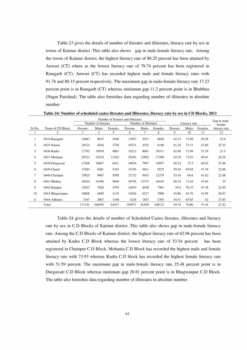
61
Table-23 gives the details of number of literates and illiterates, literacy rate by sex in
towns of Kaimur district. This table also shows gap in male-female literacy rate. Among
the towns of Kaimur district, the highest literacy rate of 86.25 percent has been attained by
Anwari (CT) where as the lowest literacy rate of 79.74 percent has been registered in
Ramgarh (CT). Anwari (CT) has recorded highest male and female literacy rates with
91.76 and 80.15 percent respectively. The maximum gap in male-female literacy rate 17.23
percent point is in Ramgarh (CT) whereas minimum gap 11.2 percent point is in Bhabhua
(Nagar Parishad). The table also furnishes data regarding number of illiterates in absolute
number.
Table 24: Number of scheduled castes literates and illiterates, literacy rate by sex in CD Blocks, 2011
Sr.No. Name of CD Block
Number of literates and illiterates
Literacy rate Gap in male-
female literacy rate
Number of literates Number of illiterates
Persons Males Females Persons Males Females Persons Males Females
1 2 3 4 5 6 7 8 9 10 11 12
1 0434-Ramgarh 14083 8675 5408 13957 5937 8020 62.15 72.88 50.28 22.6
2 0435-Nuaon 10314 6564 3750 10721 4525 6196 61.34 73.11 47.86 25.25
3 0436-Kudra 17793 10930 6863 18212 8001 10211 62.96 73.09 51.59 21.5
4 0437-Mohania 29312 18210 11102 30182 12802 17380 62.39 73.93 49.67 24.26
5 0438-Durgawati 17268 10847 6421 18954 7997 10957 60.14 72.3 46.82 25.48
6 0439-Chand 13584 8481 5103 15156 6631 8525 59.16 69.84 47.18 22.66
7 0440-Chainpur 15925 9967 5958 21732 9453 12279 53.54 64.6 41.62 22.98
8 0441-Bhabua 26264 16396 9868 28794 12375 16419 60.24 71.64 47.64 24
9 0442-Rampur 12623 7828 4795 14019 6058 7961 59.4 70.33 47.38 22.95
10 0443-Bhagwanpur 10808 6689 4119 14026 6217 7809 54.86 64.76 43.95 20.81
11 0444-Adhaura 3167 2007 1160 4218 1853 2365 54.51 65.85 42 23.85
Total 171141 106594 64547 189971 81849 108122 59.74 70.86 47.44 23.42
Table-24 gives the details of number of Scheduled Castes literates, illiterates and literacy
rate by sex in C.D Blocks of Kaimur district. This table also shows gap in male-female literacy
rate. Among the C.D Blocks of Kaimur district, the highest literacy rate of 62.96 percent has been
attained by Kudra C.D Block whereas the lowest literacy rate of 53.54 percent has been
registered in Chainpur C.D Block. Mohania C.D Block has recorded the highest male and female
literacy rate with 73.93 whereas Kudra C.D block has recorded the highest female literacy rate
with 51.59 percent. The maximum gap in male-female literacy rate 25.48 percent point is in
Durgawati C.D Block whereas minimum gap 20.81 percent point is in Bhagwanpur C.D Block.
The table also furnishes data regarding number of illiterates in absolute number.

62
Table 25: Distribution of villages by literacy rate range for scheduled castes population (rural), 2011
Range of literacy rate for villages
Number of inhabited villages having
Scheduled castes
Percentage distribution of
villages Scheduled castes
population
Percentage distribution of
population
1 2 3 4 5
0 13 1.23 296 0.08
1 - 10 6 0.57 555 0.15
11 - 20 13 1.23 2024 0.56
21 - 30 24 2.27 2883 0.80
31 - 40 46 4.36 11127 3.08
41 - 50 120 11.37 42902 11.88
51 - 60 283 26.82 121302 33.59
61 - 70 340 32.23 130809 36.22
71 - 80 149 14.12 40751 11.28
81 - 90 40 3.79 7540 2.09
91 - 99 7 0.66 869 0.24
100 14 1.33 54 0.01
Total 1055 100.00 361112 100.00
District Scheduled
castes Literacy rate: 59.74
Table-25 gives the details of distribution of villages by literacy rate ranges for scheduled
castes population (rural). This table shows classification of villages by 12 different ranges of
literacy rate. It also shows number of inhabited villages having Scheduled castes, percentage
distribution of villages and Scheduled castes population and their percentage distribution among
these ranges. It is evident from the table above that maximum number of villages (340) lie in
literacy range 61-70 percent covering almost one third (32.23%) of total number of villages
accounting for around one third (36.22 %) of the total rural population of the district. This range
is followed by the literacy rate 51-60 and 71-80 with 283 and 149 villages respectively.
Table 26: Number of scheduled castes literates and illiterates, literacy rate by sex in towns, 2011
Sr.No. Name of Town
Number of literates and illiterates
Literacy rate
Gap in male-female literacy rate
Number of literates Number of illiterates
Persons
Males
Females
Persons
Males
Females
Persons
Males
Females
1 2 3 4 5 6 7 8 9 10 11 12
1 249048-Ramgarh (CT) 902 593 309 1164 501 663 55.03 68.08 40.23 27.85
2 249508-Anwari (CT) 480 274 206 298 128 170 77.42 85.62 68.67 16.95
3 801392-Bhabua (Nagar Parishad)
2794 1685 1109 2338 1062 1276 67.03 75.32 57.43 17.89
District: Kaimur (Bhabua) (233)
4176 2552 1624 3800 1691 2109 64.98 74.45 54.15 20.3

63
Table-26 gives the details of number of scheduled castes literates and illiterates,
literacy rate by sex in all towns of Kaimur district. This table also shows gap in male-
female literacy rate. Among the towns of Kaimur district, the highest literacy rate of 77.42
percent has been attained by Anwari (CT) whereas the lowest literacy rate of 55.03 percent
has been registered in Ramgarh Census Town. Anwari (CT) has recorded the highest male
and female literacy rate 85.62 percent and 68.67 percent respectively. The maximum gap in
male-female literacy rate 27.85 percent point is in Ramgarh (CT). Whereas minimum gap
16.95 percent point is in Anwari (CT). Ramgarh (CT) has recorded the lowest male and
female literacy rate 68.08 and 40.23 percent respectively. The table also furnishes data
regarding number of illiterates in absolute number.
Table 27: Number and percentage of scheduled tribes literates and illiterates by sex in CD Blocks, 2011
Sr.No. Name of CD
Block
Number of literates and illiterates
Literacy rate Gap in male-
female literacy rate
Number of literates Number of illiterates
Persons Males Females Persons Males Females Persons Males Females
1 2 3 4 5 6 7 8 9 10 11 12
1 0434-Ramgarh 452 281 171 311 113 198 72.09 84.38 58.16 26.22
2 0435-Nuaon 303 175 128 211 97 114 70.14 78.48 61.24 17.24
3 0436-Kudra 224 122 102 222 101 121 62.4 67.4 57.3 10.1
4 0437-Mohania 1349 865 484 1022 420 602 70.11 83.25 54.69 28.56
5 0438-Durgawati 973 560 413 718 277 441 70.76 80.46 60.82 19.64
6 0439-Chand 1525 934 591 1386 557 829 63.33 75.08 50.77 24.31
7 0440-Chainpur 4178 2565 1613 4961 2098 2863 56.7 67.89 44.92 22.97
8 0441-Bhabua 2621 1651 970 2614 1093 1521 63.11 74.88 49.79 25.09
9 0442-Rampur 627 380 247 687 286 401 63.02 76.15 49.8 26.35
10 0443-Bhagwanpur 987 599 388 1310 545 765 54.32 65.54 42.97 22.57
11 0444-Adhaura 11830 7604 4226 17850 7551 10299 51.02 64.07 37.34 26.73
Total 25069 15736 9333 31292 13138 18154 56.15 68.48 43.08 25.4
Table-27 gives the details of number of scheduled tribes literates, illiterates and literacy
rate by sex in all C.D Blocks of Kaimur district. This table also shows gap in male-female
literacy rate. Among the C.D Blocks having scheduled tribes population, the highest literacy
rate of 72.09 percent has been attained by Ramgarh C.D Block whereas the lowest literacy rate
of 51.02 percent has been registered in Adhaura C.D Block. Ramgarh and Adhaura C.D Block
has recorded the highest and lowest male literacy rate with 84.38 and 64.07 percent respectively
while the highest and lowest female literacy rate has recorded in Nuaon and Adhaura C.D Block
with 61.24 and 37.34 percent respectively. The maximum gap in male-female literacy rate 28.56
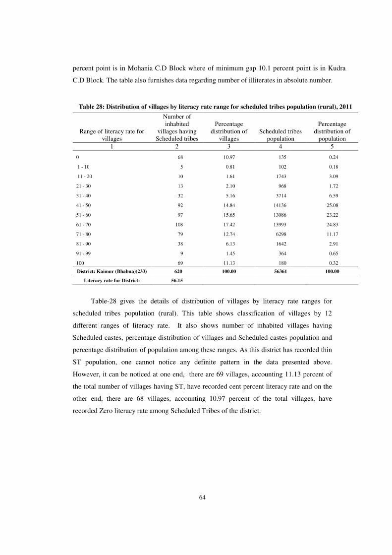
64
percent point is in Mohania C.D Block where of minimum gap 10.1 percent point is in Kudra
C.D Block. The table also furnishes data regarding number of illiterates in absolute number.
Table 28: Distribution of villages by literacy rate range for scheduled tribes population (rural), 2011
Range of literacy rate for villages
Number of inhabited
villages having Scheduled tribes
Percentage distribution of
villages Scheduled tribes
population
Percentage distribution of
population
1 2 3 4 5
0 68 10.97 135 0.24
1 - 10 5 0.81 102 0.18
11 - 20 10 1.61 1743 3.09
21 - 30 13 2.10 968 1.72
31 - 40 32 5.16 3714 6.59
41 - 50 92 14.84 14136 25.08
51 - 60 97 15.65 13086 23.22
61 - 70 108 17.42 13993 24.83
71 - 80 79 12.74 6298 11.17
81 - 90 38 6.13 1642 2.91
91 - 99 9 1.45 364 0.65
100 69 11.13 180 0.32
District: Kaimur (Bhabua)(233) 620 100.00 56361 100.00
Literacy rate for District: 56.15
Table-28 gives the details of distribution of villages by literacy rate ranges for
scheduled tribes population (rural). This table shows classification of villages by 12
different ranges of literacy rate. It also shows number of inhabited villages having
Scheduled castes, percentage distribution of villages and Scheduled castes population and
percentage distribution of population among these ranges. As this district has recorded thin
ST population, one cannot notice any definite pattern in the data presented above.
However, it can be noticed at one end, there are 69 villages, accounting 11.13 percent of
the total number of villages having ST, have recorded cent percent literacy rate and on the
other end, there are 68 villages, accounting 10.97 percent of the total villages, have
recorded Zero literacy rate among Scheduled Tribes of the district.
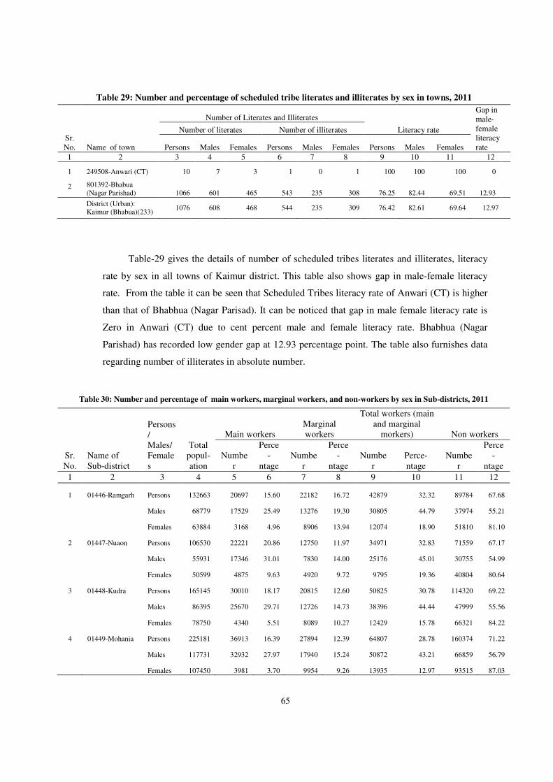
65
Table 29: Number and percentage of scheduled tribe literates and illiterates by sex in towns, 2011
Sr.No. Name of town
Number of Literates and Illiterates
Literacy rate
Gap in male-female literacy rate
Number of literates Number of illiterates
Persons Males Females Persons Males Females Persons Males Females
1 2 3 4 5 6 7 8 9 10 11 12
1 249508-Anwari (CT) 10 7 3 1 0 1 100 100 100 0
2 801392-Bhabua (Nagar Parishad) 1066 601 465 543 235 308 76.25 82.44 69.51 12.93
District (Urban): Kaimur (Bhabua)(233)
1076 608 468 544 235 309 76.42 82.61 69.64 12.97
Table-29 gives the details of number of scheduled tribes literates and illiterates, literacy
rate by sex in all towns of Kaimur district. This table also shows gap in male-female literacy
rate. From the table it can be seen that Scheduled Tribes literacy rate of Anwari (CT) is higher
than that of Bhabhua (Nagar Parisad). It can be noticed that gap in male female literacy rate is
Zero in Anwari (CT) due to cent percent male and female literacy rate. Bhabhua (Nagar
Parishad) has recorded low gender gap at 12.93 percentage point. The table also furnishes data
regarding number of illiterates in absolute number.
Table 30: Number and percentage of main workers, marginal workers, and non-workers by sex in Sub-districts, 2011
Sr.No.
Name of Sub-district
Persons/ Males/ Females
Total popul-ation
Main workers Marginal workers
Total workers (main and marginal
morkers) Non workers
Number
Perce-
ntage Numbe
r
Perce-
ntage Numbe
r Perce-ntage
Number
Perce-
ntage
1 2 3 4 5 6 7 8 9 10 11 12
1 01446-Ramgarh Persons 132663 20697 15.60 22182 16.72 42879 32.32 89784 67.68
Males 68779 17529 25.49 13276 19.30 30805 44.79 37974 55.21
Females 63884 3168 4.96 8906 13.94 12074 18.90 51810 81.10
2 01447-Nuaon Persons 106530 22221 20.86 12750 11.97 34971 32.83 71559 67.17
Males 55931 17346 31.01 7830 14.00 25176 45.01 30755 54.99
Females 50599 4875 9.63 4920 9.72 9795 19.36 40804 80.64
3 01448-Kudra Persons 165145 30010 18.17 20815 12.60 50825 30.78 114320 69.22
Males 86395 25670 29.71 12726 14.73 38396 44.44 47999 55.56
Females 78750 4340 5.51 8089 10.27 12429 15.78 66321 84.22
4 01449-Mohania Persons 225181 36913 16.39 27894 12.39 64807 28.78 160374 71.22
Males 117731 32932 27.97 17940 15.24 50872 43.21 66859 56.79
Females 107450 3981 3.70 9954 9.26 13935 12.97 93515 87.03
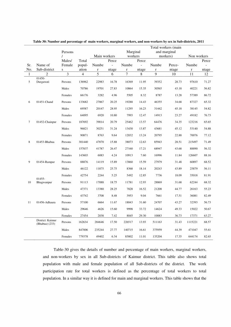
66
Table 30: Number and percentage of main workers, marginal workers, and non-workers by sex in Sub-districts, 2011
Sr.No.
Name of Sub-district
Persons/ Males/ Females
Total popul-ation
Main workers Marginal workers
Total workers (main and marginal
morkers) Non workers
Number
Perce-
ntage Numbe
r
Perce-
ntage Numbe
r Perce-ntage
Number
Perce-
ntage
1 2 3 4 5 6 7 8 9 10 11 12
5 01450-Durgawati Persons 136962 22983 16.78 16369 11.95 39352 28.73 97610 71.27
Males 70786 19701 27.83 10864 15.35 30565 43.18 40221 56.82
Females 66176 3282 4.96 5505 8.32 8787 13.28 57389 86.72
6 01451-Chand Persons 133682 27067 20.25 19288 14.43 46355 34.68 87327 65.32
Males 69587 20147 28.95 11295 16.23 31442 45.18 38145 54.82
Females 64095 6920 10.80 7993 12.47 14913 23.27 49182 76.73
7 01452-Chainpur Persons 187692 39014 20.79 25462 13.57 64476 34.35 123216 65.65
Males 96821 30251 31.24 13430 13.87 43681 45.12 53140 54.88
Females 90871 8763 9.64 12032 13.24 20795 22.88 70076 77.12
8 01453-Bhabua Persons 301440 47870 15.88 38073 12.63 85943 28.51 215497 71.49
Males 157837 41787 26.47 27160 17.21 68947 43.68 88890 56.32
Females 143603 6083 4.24 10913 7.60 16996 11.84 126607 88.16
9 01454-Rampur Persons 88876 14119 15.89 13860 15.59 27979 31.48 60897 68.52
Males 46122 11875 25.75 8368 18.14 20243 43.89 25879 56.11
Females 42754 2244 5.25 5492 12.85 7736 18.09 35018 81.91
10 01455-Bhagwanpur Persons 91113 17088 18.75 11781 12.93 28869 31.68 62244 68.32
Males 47371 13380 28.25 7828 16.52 21208 44.77 26163 55.23
Females 43742 3708 8.48 3953 9.04 7661 17.51 36081 82.49
11 01456-Adhaura Persons 57100 6664 11.67 18043 31.60 24707 43.27 32393 56.73
Males 29646 4626 15.60 9998 33.72 14624 49.33 15022 50.67
Females 27454 2038 7.42 8045 29.30 10083 36.73 17371 63.27
District: Kaimur (Bhabua) (233)
Persons 162634 284646 17.50 226517 13.93 511163 31.43 1115221 68.57
Males 847006 235244 27.77 140715 16.61 375959 44.39 471047 55.61
Females 779378 49402 6.34 85802 11.01 135204 17.35 644174 82.65
Table-30 gives the details of number and percentage of main workers, marginal workers,
and non-workers by sex in all Sub-districts of Kaimur district. This table also shows total
population with male and female population of all Sub-districts of the district. The work
participation rate for total workers is defined as the percentage of total workers to total
population. In a similar way it is defined for main and marginal workers. This table shows that the
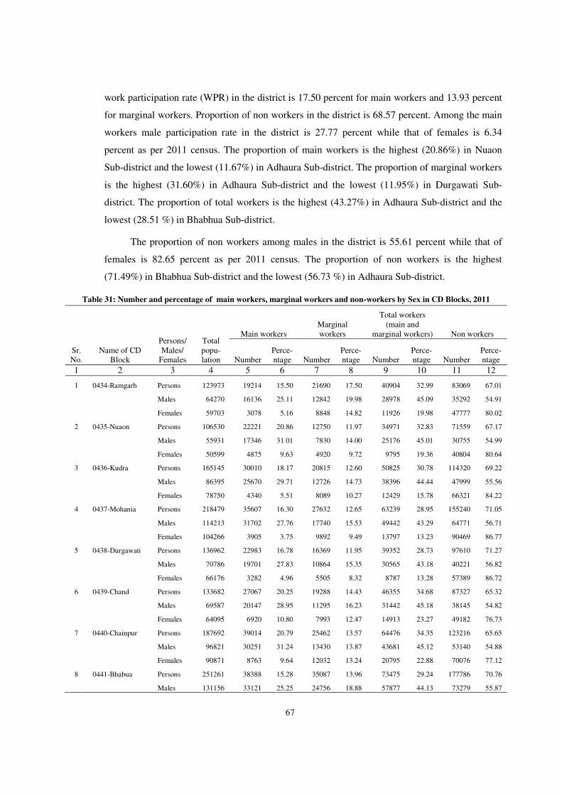
67
work participation rate (WPR) in the district is 17.50 percent for main workers and 13.93 percent
for marginal workers. Proportion of non workers in the district is 68.57 percent. Among the main
workers male participation rate in the district is 27.77 percent while that of females is 6.34
percent as per 2011 census. The proportion of main workers is the highest (20.86%) in Nuaon
Sub-district and the lowest (11.67%) in Adhaura Sub-district. The proportion of marginal workers
is the highest (31.60%) in Adhaura Sub-district and the lowest (11.95%) in Durgawati Sub-
district. The proportion of total workers is the highest (43.27%) in Adhaura Sub-district and the
lowest (28.51 %) in Bhabhua Sub-district.
The proportion of non workers among males in the district is 55.61 percent while that of
females is 82.65 percent as per 2011 census. The proportion of non workers is the highest
(71.49%) in Bhabhua Sub-district and the lowest (56.73 %) in Adhaura Sub-district.
Table 31: Number and percentage of main workers, marginal workers and non-workers by Sex in CD Blocks, 2011
Sr. No.
Name of CD Block
Persons/ Males/
Females
Total popu-lation
Main workers Marginal workers
Total workers (main and
marginal workers) Non workers
Number Perce-ntage Number
Perce-ntage Number
Perce-ntage Number
Perce-ntage
1 2 3 4 5 6 7 8 9 10 11 12
1 0434-Ramgarh Persons 123973 19214 15.50 21690 17.50 40904 32.99 83069 67.01
Males 64270 16136 25.11 12842 19.98 28978 45.09 35292 54.91
Females 59703 3078 5.16 8848 14.82 11926 19.98 47777 80.02
2 0435-Nuaon Persons 106530 22221 20.86 12750 11.97 34971 32.83 71559 67.17
Males 55931 17346 31.01 7830 14.00 25176 45.01 30755 54.99
Females 50599 4875 9.63 4920 9.72 9795 19.36 40804 80.64
3 0436-Kudra Persons 165145 30010 18.17 20815 12.60 50825 30.78 114320 69.22
Males 86395 25670 29.71 12726 14.73 38396 44.44 47999 55.56
Females 78750 4340 5.51 8089 10.27 12429 15.78 66321 84.22
4 0437-Mohania Persons 218479 35607 16.30 27632 12.65 63239 28.95 155240 71.05
Males 114213 31702 27.76 17740 15.53 49442 43.29 64771 56.71
Females 104266 3905 3.75 9892 9.49 13797 13.23 90469 86.77
5 0438-Durgawati Persons 136962 22983 16.78 16369 11.95 39352 28.73 97610 71.27
Males 70786 19701 27.83 10864 15.35 30565 43.18 40221 56.82
Females 66176 3282 4.96 5505 8.32 8787 13.28 57389 86.72
6 0439-Chand Persons 133682 27067 20.25 19288 14.43 46355 34.68 87327 65.32
Males 69587 20147 28.95 11295 16.23 31442 45.18 38145 54.82
Females 64095 6920 10.80 7993 12.47 14913 23.27 49182 76.73
7 0440-Chainpur Persons 187692 39014 20.79 25462 13.57 64476 34.35 123216 65.65
Males 96821 30251 31.24 13430 13.87 43681 45.12 53140 54.88
Females 90871 8763 9.64 12032 13.24 20795 22.88 70076 77.12
8 0441-Bhabua Persons 251261 38388 15.28 35087 13.96 73475 29.24 177786 70.76
Males 131156 33121 25.25 24756 18.88 57877 44.13 73279 55.87
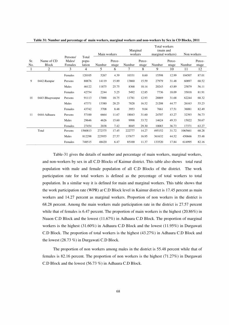
68
Table 31: Number and percentage of main workers, marginal workers and non-workers by Sex in CD Blocks, 2011
Sr. No.
Name of CD Block
Persons/ Males/
Females
Total popu-lation
Main workers Marginal workers
Total workers (main and
marginal workers) Non workers
Number Perce-ntage Number
Perce-ntage Number
Perce-ntage Number
Perce-ntage
1 2 3 4 5 6 7 8 9 10 11 12
Females 120105 5267 4.39 10331 8.60 15598 12.99 104507 87.01
9 0442-Rampur Persons 88876 14119 15.89 13860 15.59 27979 31.48 60897 68.52
Males 46122 11875 25.75 8368 18.14 20243 43.89 25879 56.11
Females 42754 2244 5.25 5492 12.85 7736 18.09 35018 81.91
10 0443-Bhagwanpur Persons 91113 17088 18.75 11781 12.93 28869 31.68 62244 68.32
Males 47371 13380 28.25 7828 16.52 21208 44.77 26163 55.23
Females 43742 3708 8.48 3953 9.04 7661 17.51 36081 82.49
11 0444-Adhaura Persons 57100 6664 11.67 18043 31.60 24707 43.27 32393 56.73
Males 29646 4626 15.60 9998 33.72 14624 49.33 15022 50.67
Females 27454 2038 7.42 8045 29.30 10083 36.73 17371 63.27
Total Persons 1560813 272375 17.45 222777 14.27 495152 31.72 1065661 68.28
Males 812298 223955 27.57 137677 16.95 361632 44.52 450666 55.48
Females 748515 48420 6.47 85100 11.37 133520 17.84 614995 82.16
Table-31 gives the details of number and percentage of main workers, marginal workers,
and non-workers by sex in all C.D Blocks of Kaimur district. This table also shows total rural
population with male and female population of all C.D Blocks of the district. The work
participation rate for total workers is defined as the percentage of total workers to total
population. In a similar way it is defined for main and marginal workers. This table shows that
the work participation rate (WPR) at C.D Block level in Kaimur district is 17.45 percent as main
workers and 14.27 percent as marginal workers. Proportion of non workers in the district is
68.28 percent. Among the main workers male participation rate in the district is 27.57 percent
while that of females is 6.47 percent. The proportion of main workers is the highest (20.86%) in
Nuaon C.D Block and the lowest (11.67%) in Adhaura C.D Block. The proportion of marginal
workers is the highest (31.60%) in Adhaura C.D Block and the lowest (11.95%) in Durgawati
C.D Block. The proportion of total workers is the highest (43.27%) in Adhaura C.D Block and
the lowest (28.73 %) in Durgawati C.D Block.
The proportion of non workers among males in the district is 55.48 percent while that of
females is 82.16 percent. The proportion of non workers is the highest (71.27%) in Durgawati
C.D Block and the lowest (56.73 %) in Adhaura C.D Block.
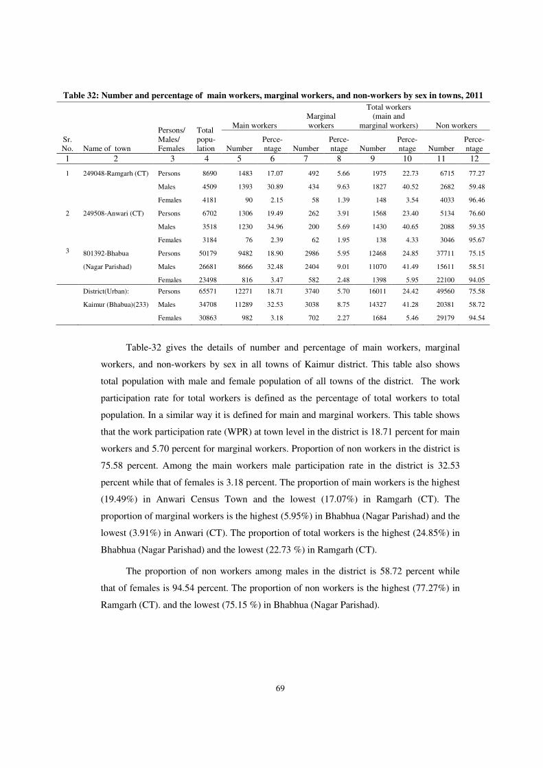
69
Table 32: Number and percentage of main workers, marginal workers, and non-workers by sex in towns, 2011
Sr. No. Name of town
Persons/ Males/ Females
Total popu-lation
Main workers Marginal workers
Total workers (main and
marginal workers) Non workers
Number Perce-ntage Number
Perce-ntage Number
Perce-ntage Number
Perce-ntage
1 2 3 4 5 6 7 8 9 10 11 12
1 249048-Ramgarh (CT) Persons 8690 1483 17.07 492 5.66 1975 22.73 6715 77.27
Males 4509 1393 30.89 434 9.63 1827 40.52 2682 59.48
Females 4181 90 2.15 58 1.39 148 3.54 4033 96.46
2 249508-Anwari (CT) Persons 6702 1306 19.49 262 3.91 1568 23.40 5134 76.60
Males 3518 1230 34.96 200 5.69 1430 40.65 2088 59.35
Females 3184 76 2.39 62 1.95 138 4.33 3046 95.67
3 801392-Bhabua Persons 50179 9482 18.90 2986 5.95 12468 24.85 37711 75.15
(Nagar Parishad) Males 26681 8666 32.48 2404 9.01 11070 41.49 15611 58.51
Females 23498 816 3.47 582 2.48 1398 5.95 22100 94.05
District(Urban): Persons 65571 12271 18.71 3740 5.70 16011 24.42 49560 75.58
Kaimur (Bhabua)(233) Males 34708 11289 32.53 3038 8.75 14327 41.28 20381 58.72
Females 30863 982 3.18 702 2.27 1684 5.46 29179 94.54
Table-32 gives the details of number and percentage of main workers, marginal
workers, and non-workers by sex in all towns of Kaimur district. This table also shows
total population with male and female population of all towns of the district. The work
participation rate for total workers is defined as the percentage of total workers to total
population. In a similar way it is defined for main and marginal workers. This table shows
that the work participation rate (WPR) at town level in the district is 18.71 percent for main
workers and 5.70 percent for marginal workers. Proportion of non workers in the district is
75.58 percent. Among the main workers male participation rate in the district is 32.53
percent while that of females is 3.18 percent. The proportion of main workers is the highest
(19.49%) in Anwari Census Town and the lowest (17.07%) in Ramgarh (CT). The
proportion of marginal workers is the highest (5.95%) in Bhabhua (Nagar Parishad) and the
lowest (3.91%) in Anwari (CT). The proportion of total workers is the highest (24.85%) in
Bhabhua (Nagar Parishad) and the lowest (22.73 %) in Ramgarh (CT).
The proportion of non workers among males in the district is 58.72 percent while
that of females is 94.54 percent. The proportion of non workers is the highest (77.27%) in
Ramgarh (CT). and the lowest (75.15 %) in Bhabhua (Nagar Parishad).
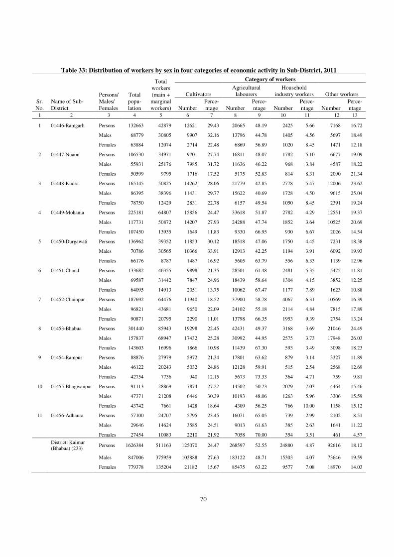
70
Table 33: Distribution of workers by sex in four categories of economic activity in Sub-District, 2011
Sr. No.
Name of Sub-District
Persons/ Males/ Females
Total popu-lation
Total workers (main + marginal workers)
Category of workers
Cultivators Agricultural
labourers Household
industry workers Other workers
Number Perce-ntage Number
Perce-ntage Number
Perce-ntage Number
Perce-ntage
1 2 3 4 5 6 7 8 9 10 11 12 13
1 01446-Ramgarh Persons 132663 42879 12621 29.43 20665 48.19 2425 5.66 7168 16.72
Males 68779 30805 9907 32.16 13796 44.78 1405 4.56 5697 18.49
Females 63884 12074 2714 22.48 6869 56.89 1020 8.45 1471 12.18
2 01447-Nuaon Persons 106530 34971 9701 27.74 16811 48.07 1782 5.10 6677 19.09
Males 55931 25176 7985 31.72 11636 46.22 968 3.84 4587 18.22
Females 50599 9795 1716 17.52 5175 52.83 814 8.31 2090 21.34
3 01448-Kudra Persons 165145 50825 14262 28.06 21779 42.85 2778 5.47 12006 23.62
Males 86395 38396 11431 29.77 15622 40.69 1728 4.50 9615 25.04
Females 78750 12429 2831 22.78 6157 49.54 1050 8.45 2391 19.24
4 01449-Mohania Persons 225181 64807 15856 24.47 33618 51.87 2782 4.29 12551 19.37
Males 117731 50872 14207 27.93 24288 47.74 1852 3.64 10525 20.69
Females 107450 13935 1649 11.83 9330 66.95 930 6.67 2026 14.54
5 01450-Durgawati Persons 136962 39352 11853 30.12 18518 47.06 1750 4.45 7231 18.38
Males 70786 30565 10366 33.91 12913 42.25 1194 3.91 6092 19.93
Females 66176 8787 1487 16.92 5605 63.79 556 6.33 1139 12.96
6 01451-Chand Persons 133682 46355 9898 21.35 28501 61.48 2481 5.35 5475 11.81
Males 69587 31442 7847 24.96 18439 58.64 1304 4.15 3852 12.25
Females 64095 14913 2051 13.75 10062 67.47 1177 7.89 1623 10.88
7 01452-Chainpur Persons 187692 64476 11940 18.52 37900 58.78 4067 6.31 10569 16.39
Males 96821 43681 9650 22.09 24102 55.18 2114 4.84 7815 17.89
Females 90871 20795 2290 11.01 13798 66.35 1953 9.39 2754 13.24
8 01453-Bhabua Persons 301440 85943 19298 22.45 42431 49.37 3168 3.69 21046 24.49
Males 157837 68947 17432 25.28 30992 44.95 2575 3.73 17948 26.03
Females 143603 16996 1866 10.98 11439 67.30 593 3.49 3098 18.23
9 01454-Rampur Persons 88876 27979 5972 21.34 17801 63.62 879 3.14 3327 11.89
Males 46122 20243 5032 24.86 12128 59.91 515 2.54 2568 12.69
Females 42754 7736 940 12.15 5673 73.33 364 4.71 759 9.81
10 01455-Bhagwanpur Persons 91113 28869 7874 27.27 14502 50.23 2029 7.03 4464 15.46
Males 47371 21208 6446 30.39 10193 48.06 1263 5.96 3306 15.59
Females 43742 7661 1428 18.64 4309 56.25 766 10.00 1158 15.12
11 01456-Adhaura Persons 57100 24707 5795 23.45 16071 65.05 739 2.99 2102 8.51
Males 29646 14624 3585 24.51 9013 61.63 385 2.63 1641 11.22
Females 27454 10083 2210 21.92 7058 70.00 354 3.51 461 4.57
District: Kaimur (Bhabua) (233)
Persons 1626384 511163 125070 24.47 268597 52.55 24880 4.87 92616 18.12
Males 847006 375959 103888 27.63 183122 48.71 15303 4.07 73646 19.59
Females 779378 135204 21182 15.67 85475 63.22 9577 7.08 18970 14.03
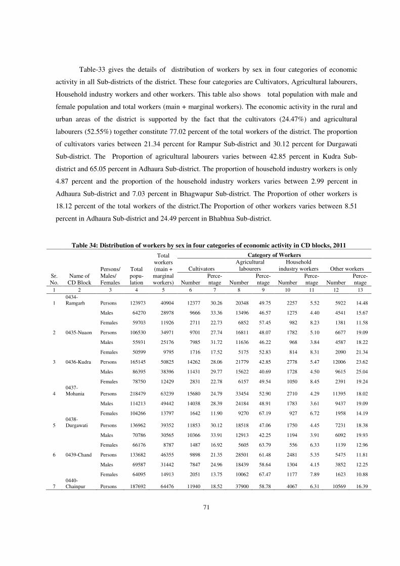
71
Table-33 gives the details of distribution of workers by sex in four categories of economic
activity in all Sub-districts of the district. These four categories are Cultivators, Agricultural labourers,
Household industry workers and other workers. This table also shows total population with male and
female population and total workers (main + marginal workers). The economic activity in the rural and
urban areas of the district is supported by the fact that the cultivators (24.47%) and agricultural
labourers (52.55%) together constitute 77.02 percent of the total workers of the district. The proportion
of cultivators varies between 21.34 percent for Rampur Sub-district and 30.12 percent for Durgawati
Sub-district. The Proportion of agricultural labourers varies between 42.85 percent in Kudra Sub-
district and 65.05 percent in Adhaura Sub-district. The proportion of household industry workers is only
4.87 percent and the proportion of the household industry workers varies between 2.99 percent in
Adhaura Sub-district and 7.03 percent in Bhagwapur Sub-district. The Proportion of other workers is
18.12 percent of the total workers of the district.The Proportion of other workers varies between 8.51
percent in Adhaura Sub-district and 24.49 percent in Bhabhua Sub-district.
Table 34: Distribution of workers by sex in four categories of economic activity in CD blocks, 2011
Sr. No.
Name of CD Block
Persons/ Males/ Females
Total popu-lation
Total workers (main + marginal workers)
Category of Workers
Cultivators Agricultural
labourers Household
industry workers Other workers
Number Perce-ntage Number
Perce-ntage Number
Perce-ntage Number
Perce-ntage
1 2 3 4 5 6 7 8 9 10 11 12 13
1 0434-Ramgarh Persons 123973 40904 12377 30.26 20348 49.75 2257 5.52 5922 14.48
Males 64270 28978 9666 33.36 13496 46.57 1275 4.40 4541 15.67
Females 59703 11926 2711 22.73 6852 57.45 982 8.23 1381 11.58
2 0435-Nuaon Persons 106530 34971 9701 27.74 16811 48.07 1782 5.10 6677 19.09
Males 55931 25176 7985 31.72 11636 46.22 968 3.84 4587 18.22
Females 50599 9795 1716 17.52 5175 52.83 814 8.31 2090 21.34
3 0436-Kudra Persons 165145 50825 14262 28.06 21779 42.85 2778 5.47 12006 23.62
Males 86395 38396 11431 29.77 15622 40.69 1728 4.50 9615 25.04
Females 78750 12429 2831 22.78 6157 49.54 1050 8.45 2391 19.24
4 0437-Mohania Persons 218479 63239 15680 24.79 33454 52.90 2710 4.29 11395 18.02
Males 114213 49442 14038 28.39 24184 48.91 1783 3.61 9437 19.09
Females 104266 13797 1642 11.90 9270 67.19 927 6.72 1958 14.19
5 0438-Durgawati Persons 136962 39352 11853 30.12 18518 47.06 1750 4.45 7231 18.38
Males 70786 30565 10366 33.91 12913 42.25 1194 3.91 6092 19.93
Females 66176 8787 1487 16.92 5605 63.79 556 6.33 1139 12.96
6 0439-Chand Persons 133682 46355 9898 21.35 28501 61.48 2481 5.35 5475 11.81
Males 69587 31442 7847 24.96 18439 58.64 1304 4.15 3852 12.25
Females 64095 14913 2051 13.75 10062 67.47 1177 7.89 1623 10.88
7 0440-Chainpur Persons 187692 64476 11940 18.52 37900 58.78 4067 6.31 10569 16.39
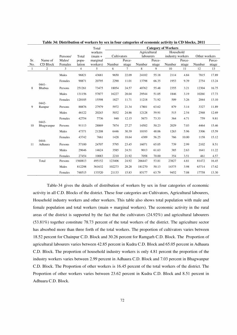
72
Table 34: Distribution of workers by sex in four categories of economic activity in CD blocks, 2011
Sr. No.
Name of CD Block
Persons/ Males/ Females
Total popu-lation
Total workers (main + marginal workers)
Category of Workers
Cultivators Agricultural
labourers Household
industry workers Other workers
Number Perce-ntage Number
Perce-ntage Number
Perce-ntage Number
Perce-ntage
1 2 3 4 5 6 7 8 9 10 11 12 13
Males 96821 43681 9650 22.09 24102 55.18 2114 4.84 7815 17.89
Females 90871 20795 2290 11.01 13798 66.35 1953 9.39 2754 13.24
8 0441-Bhabua Persons 251261 73475 18054 24.57 40762 55.48 2355 3.21 12304 16.75
Males 131156 57877 16227 28.04 29544 51.05 1846 3.19 10260 17.73
Females 120105 15598 1827 11.71 11218 71.92 509 3.26 2044 13.10
9 0442-Rampur Persons 88876 27979 5972 21.34 17801 63.62 879 3.14 3327 11.89
Males 46122 20243 5032 24.86 12128 59.91 515 2.54 2568 12.69
Females 42754 7736 940 12.15 5673 73.33 364 4.71 759 9.81
10 0443-Bhagwanpur Persons 91113 28869 7874 27.27 14502 50.23 2029 7.03 4464 15.46
Males 47371 21208 6446 30.39 10193 48.06 1263 5.96 3306 15.59
Females 43742 7661 1428 18.64 4309 56.25 766 10.00 1158 15.12
11 0444-Adhaura Persons 57100 24707 5795 23.45 16071 65.05 739 2.99 2102 8.51
Males 29646 14624 3585 24.51 9013 61.63 385 2.63 1641 11.22
Females 27454 10083 2210 21.92 7058 70.00 354 3.51 461 4.57
Total Persons 1560813 495152 123406 24.92 266447 53.81 23827 4.81 81472 16.45
Males 812298 361632 102273 28.28 181270 50.13 14375 3.98 63714 17.62
Females 748515 133520 21133 15.83 85177 63.79 9452 7.08 17758 13.30
Table-34 gives the details of distribution of workers by sex in four categories of economic
activity in all C.D. Blocks of the district. These four categories are Cultivators, Agricultural labourers,
Household industry workers and other workers. This table also shows total population with male and
female population and total workers (main + marginal workers). The economic activity in the rural
areas of the district is supported by the fact that the cultivators (24.92%) and agricultural labourers
(53.81%) together constitute 78.73 percent of the total workers of the district. The agriculture sector
has absorbed more than three forth of the total workers. The proportion of cultivators varies between
18.52 percent for Chainpur C.D. Block and 30.26 percent for Ramgarh C.D. Block. The Proportion of
agricultural labourers varies between 42.85 percent in Kudra C.D. Block and 65.05 percent in Adhaura
C.D. Block. The proportion of household industry workers is only 4.81 percent the proportion of the
industry workers varies between 2.99 percent in Adhaura C.D. Block and 7.03 percent in Bhagwanpur
C.D. Block. The Proportion of other workers is 16.45 percent of the total workers of the district. The
Proportion of other workers varies between 23.62 percent in Kudra C.D. Block and 8.51 percent in
Adhuara C.D. Block.
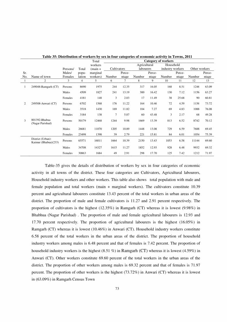
73
Table-35 gives the details of distribution of workers by sex in four categories of economic
activity in all towns of the district. These four categories are Cultivators, Agricultural labourers,
Household industry workers and other workers. This table also shows total population with male and
female population and total workers (main + marginal workers). The cultivators constitute 10.39
percent and agricultural labourers constitute 13.43 percent of the total workers in urban areas of the
district. The proportion of male and female cultivators is 11.27 and 2.91 percent respectively. The
proportion of cultivators is the highest (12.35%) in Ramgarh (CT) whereas it is lowest (9.98%) in
Bhabhua (Nagar Parishad) . The proportion of male and female agricultural labourers is 12.93 and
17.70 percent respectively. The proportion of agricultural labourers is the highest (16.05%) in
Ramgarh (CT) whereas it is lowest (10.46%) in Anwari (CT). Household industry workers constitute
6.58 percent of the total workers in the urban areas of the district. The proportion of household
industry workers among males is 6.48 percent and that of females is 7.42 percent. The proportion of
household industry workers is the highest (8.51 %) in Ramgarh (CT) whereas it is lowest (4.59%) in
Anwari (CT). Other workers constitute 69.60 percent of the total workers in the urban areas of the
district. The proportion of other workers among males is 69.32 percent and that of females is 71.97
percent. The proportion of other workers is the highest (73.72%) in Anwari (CT) whereas it is lowest
in (63.09%) in Ramgarh Census Town
Table 35: Distribution of workers by sex in four categories of economic activity in Towns, 2011
Sr. No. Name of town
Persons/ Males/ Females
Total popu-lation
Total workers (main + marginal workers)
Category of workers
Cultivators Agricultural
labourers Household
industry workers Other workers
Number Perce-ntage Number
Perce-ntage Number
Perce-ntage Number
Perce-ntage
1 2 3 4 5 6 7 8 9 10 11 12 13
1 249048-Ramgarh (CT) Persons 8690 1975 244 12.35 317 16.05 168 8.51 1246 63.09
Males 4509 1827 241 13.19 300 16.42 130 7.12 1156 63.27
Females 4181 148 3 2.03 17 11.49 38 25.68 90 60.81
2 249508-Anwari (CT) Persons 6702 1568 176 11.22 164 10.46 72 4.59 1156 73.72
Males 3518 1430 169 11.82 104 7.27 69 4.83 1088 76.08
Females 3184 138 7 5.07 60 43.48 3 2.17 68 49.28
3 801392-Bhabua (Nagar Parishad)
Persons 50179 12468 1244 9.98 1669 13.39 813 6.52 8742 70.12
Males 26681 11070 1205 10.89 1448 13.08 729 6.59 7688 69.45
Females 23498 1398 39 2.79 221 15.81 84 6.01 1054 75.39
District (Urban): Kaimur (Bhabua)(233)
Persons 65571 16011 1664 10.39 2150 13.43 1053 6.58 11144 69.60
Males 34708 14327 1615 11.27 1852 12.93 928 6.48 9932 69.32
Females 30863 1684 49 2.91 298 17.70 125 7.42 1212 71.97
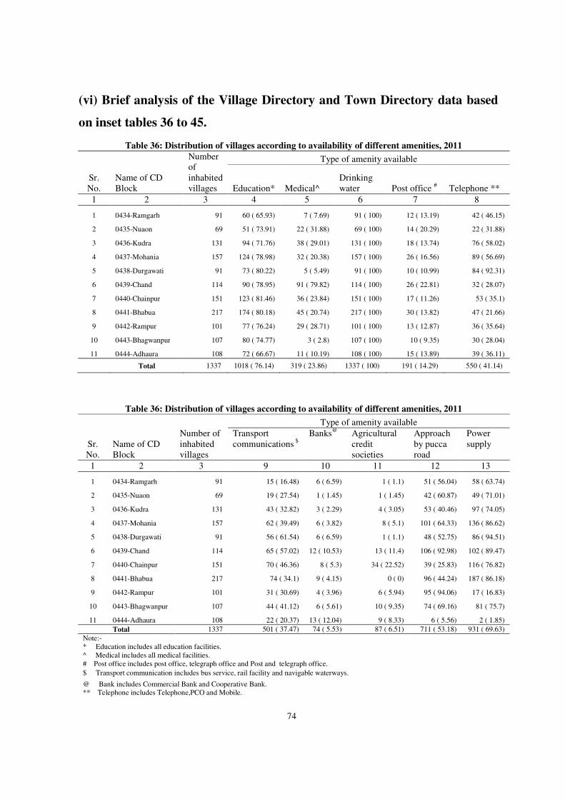
74
(vi) Brief analysis of the Village Directory and Town Directory data based
on inset tables 36 to 45.
Table 36: Distribution of villages according to availability of different amenities, 2011
Sr. No.
Name of CD Block
Number of inhabited villages
Type of amenity available
Education* Medical^ Drinking water Post office # Telephone **
1 2 3 4 5 6 7 8
1 0434-Ramgarh 91 60 ( 65.93) 7 ( 7.69) 91 ( 100) 12 ( 13.19) 42 ( 46.15)
2 0435-Nuaon 69 51 ( 73.91) 22 ( 31.88) 69 ( 100) 14 ( 20.29) 22 ( 31.88)
3 0436-Kudra 131 94 ( 71.76) 38 ( 29.01) 131 ( 100) 18 ( 13.74) 76 ( 58.02)
4 0437-Mohania 157 124 ( 78.98) 32 ( 20.38) 157 ( 100) 26 ( 16.56) 89 ( 56.69)
5 0438-Durgawati 91 73 ( 80.22) 5 ( 5.49) 91 ( 100) 10 ( 10.99) 84 ( 92.31)
6 0439-Chand 114 90 ( 78.95) 91 ( 79.82) 114 ( 100) 26 ( 22.81) 32 ( 28.07)
7 0440-Chainpur 151 123 ( 81.46) 36 ( 23.84) 151 ( 100) 17 ( 11.26) 53 ( 35.1)
8 0441-Bhabua 217 174 ( 80.18) 45 ( 20.74) 217 ( 100) 30 ( 13.82) 47 ( 21.66)
9 0442-Rampur 101 77 ( 76.24) 29 ( 28.71) 101 ( 100) 13 ( 12.87) 36 ( 35.64)
10 0443-Bhagwanpur 107 80 ( 74.77) 3 ( 2.8) 107 ( 100) 10 ( 9.35) 30 ( 28.04)
11 0444-Adhaura 108 72 ( 66.67) 11 ( 10.19) 108 ( 100) 15 ( 13.89) 39 ( 36.11)
Total 1337 1018 ( 76.14) 319 ( 23.86) 1337 ( 100) 191 ( 14.29) 550 ( 41.14)
Table 36: Distribution of villages according to availability of different amenities, 2011
Sr. No.
Name of CD Block
Number of inhabited villages
Type of amenity available
Transport communications $
Banks@ Agricultural credit societies
Approach by pucca road
Power supply
1 2 3 9 10 11 12 13
1 0434-Ramgarh 91 15 ( 16.48) 6 ( 6.59) 1 ( 1.1) 51 ( 56.04) 58 ( 63.74)
2 0435-Nuaon 69 19 ( 27.54) 1 ( 1.45) 1 ( 1.45) 42 ( 60.87) 49 ( 71.01)
3 0436-Kudra 131 43 ( 32.82) 3 ( 2.29) 4 ( 3.05) 53 ( 40.46) 97 ( 74.05)
4 0437-Mohania 157 62 ( 39.49) 6 ( 3.82) 8 ( 5.1) 101 ( 64.33) 136 ( 86.62)
5 0438-Durgawati 91 56 ( 61.54) 6 ( 6.59) 1 ( 1.1) 48 ( 52.75) 86 ( 94.51)
6 0439-Chand 114 65 ( 57.02) 12 ( 10.53) 13 ( 11.4) 106 ( 92.98) 102 ( 89.47)
7 0440-Chainpur 151 70 ( 46.36) 8 ( 5.3) 34 ( 22.52) 39 ( 25.83) 116 ( 76.82)
8 0441-Bhabua 217 74 ( 34.1) 9 ( 4.15) 0 ( 0) 96 ( 44.24) 187 ( 86.18)
9 0442-Rampur 101 31 ( 30.69) 4 ( 3.96) 6 ( 5.94) 95 ( 94.06) 17 ( 16.83)
10 0443-Bhagwanpur 107 44 ( 41.12) 6 ( 5.61) 10 ( 9.35) 74 ( 69.16) 81 ( 75.7)
11 0444-Adhaura 108 22 ( 20.37) 13 ( 12.04) 9 ( 8.33) 6 ( 5.56) 2 ( 1.85)
Total 1337 501 ( 37.47) 74 ( 5.53) 87 ( 6.51) 711 ( 53.18) 931 ( 69.63)
Note:- * Education includes all education facilities. ^ Medical includes all medical facilities. # Post office includes post office, telegraph office and Post and telegraph office.
$ Transport communication includes bus service, rail facility and navigable waterways.
@ Bank includes Commercial Bank and Cooperative Bank. ** Telephone includes Telephone,PCO and Mobile.
75
Table 36 gives the details of distribution of villages according to the availability of
different amenities in the district.
Educational amenity: - There are as many as 1018 villages accounting for 76.14
percent of the total number of inhabited villages (1337) in the district where educational
facility is available. Chainpur C.D. Block has the maximum proportion of villages having
educational facility (81.46%). The minimum proportion of villages with educational
facility is observed in Ramgarh C.D. Block with 65.93 percent.
Medical amenity: - There are as many as 319 villages accounting for 23.86 percent
of the total number of inhabited villages (1337) in the district where medical facility is
available. Among the C.D. Blocks, Chand has the largest proportion of villages with
medical facility, the percentage being 79.82 percent. It is followed by Nuaon C.D. Block
with 31.88 percent. Bhagwanpur C.D. Block, on the other hand, has the minimum
proportion of villages (2.8%) where medical amenity is available.
Drinking water: - There are as many as 1337 villages accounting for 100 percent of
the total inhabited villages in the district where improved drinking water facility is
available.
Post Office: - Postal facility is available in 191 villages(14.29%) out of 1337
inhabited villages in the district. Chand C.D. Block has the maximum proportion of
villages having postal facility (22.81%) followed by Nuaon C.D. Block with 20.29 percent.
Bhagwanpur C.D. Block has the minimum proportion of villages having postal facility
(9.35%).
Telephone: -Availability of telephone facility in the villages is 41.14 percent.
Among the C.D. Blocks, Durgawati has the maximum proportion of villages having
telephone facility of (92.31%) followed by Kudra with 58.02 percent while Bhabhua has
the minimum proportion of villages having telephone facility of (21.66%) only.
,
Transport communication: - Transport communication facilities are available only
in 501 villages (37.47%) out of 1337 inhabited villages in the district. Durgawati C.D.
Block has the maximum proportion of villages of (61.54%) which are connected by bus or
76
rail or navigable river/canal services, etc., followed by Chand C.D. Block with 57.02
percent while Ramgarh C.D. Block has the minimum proportion of villages with only
16.48 percent.
Bank: - Banking facility is available only in 74 villages (5.53%) out of 1337
inhabited villages in the district. Among the C.D. Blocks, Adhaura has the maximum
proportion of villages having banking facility with 12.04 percent and Nuaon has the
minimum proportion of villages having banking facility with 1.45 percent.
Agricultural Credit Societies: - Agricultural credit societies are available in 87
villages (6.51%) out of 1337 inhabited villages in the district. Among the C.D. Blocks,
Chainpur C.D Block has maximum proportion of villages having agricultural Credit
Societies with 22.52 percent while Ramgarh and Durgawati has minimum proportion of
villages having agricultural Credit Societies facility with 1.1 percent respectively. Bhabhua
C.D Block does not have any agricultural Credit Society.
Approach by pucca road :- This facility is available in 711 villages (53.18%) out of
1337 inhabited villages in the district. Among the C.D. Blocks, Rampur has the maximum
proportion of villages having pucca approach road facility with 94.06% and Adhaura has
the minimum proportion of villages having pucca approach road facility with 5.56 percent.
Power supply: - Electrified villages in the district constitute 69.63 percent (931) of
the total number of inhabited villages. Among the C.D. Blocks, 86 villages of Durgawati
C.D Block have reported with 94.51 percent having power supply facility while Adhaura
C.D. Block has the minimum proportion of villages with 1.85 percent having power supply
facility.
77
Table 37: Number and percentage of rural population served by different amenities, 2011
Sr. No.
Name of CD Block
Total population
of inhabited villages
Type of amenity available
Education* Medical^ Drinking
water Post office
# Telephone **
1 2 3 4 5 6 7 8
1 0434-Ramgarh 123973 100274 ( 80.88) 17900 ( 14.44) 123973 ( 100) 25756 ( 20.78) 68899 ( 55.58)
2 0435-Nuaon 106530 93179 ( 87.47) 44724 ( 41.98) 106530 ( 100) 46726 ( 43.86) 45605 ( 42.81)
3 0436-Kudra 165145 149184 ( 90.34) 64448 ( 39.03) 165145 ( 100) 49965 ( 30.26) 114766 ( 69.49)
4 0437-Mohania 218479 206586 ( 94.56) 52344 ( 23.96) 218479 ( 100) 69891 ( 31.99) 154313 ( 70.63)
5 0438-Durgawati 136962 129769 ( 94.75) 14238 ( 10.4) 136962 ( 100) 34878 ( 25.47) 133045 ( 97.14)
6 0439-Chand 133682 123942 ( 92.71) 116463 ( 87.12) 133682 ( 100) 45616 ( 34.12) 41682 ( 31.18)
7 0440-Chainpur 187692 179290 ( 95.52) 71705 ( 38.2) 187692 ( 100) 53802 ( 28.67) 90532 ( 48.23)
8 0441-Bhabua 251261 235767 ( 93.83) 87412 ( 34.79) 251261 ( 100) 76183 ( 30.32) 57120 ( 22.73)
9 0442-Rampur 88876 81153 ( 91.31) 30727 ( 34.57) 88876 ( 100) 24098 ( 27.11) 35741 ( 40.21)
10 0443-Bhagwanpur 91113 85193 ( 93.5) 10012 ( 10.99) 91113 ( 100) 21577 ( 23.68) 32548 ( 35.72)
11 0444-Adhaura 57100 45418 ( 79.54) 12001 ( 21.02) 57100 ( 100) 8847 ( 15.49) 23452 ( 41.07)
Total 1560813 1429755 ( 91.6) 521974 ( 33.44) 1560813 ( 100) 457339 ( 29.3) 797703 ( 51.11)
Table 37: Number and percentage of rural population served by different amenities, 2011
Sr. No.
Name of CD Block
Total population
of inhabited villages
Type of amenity available
Transport communications
$ Banks@
Agricultural credit
societies Approach by pucca road
Power supply
1 2 3 9 10 11 12 13
1 0434-Ramgarh 123973 29093 ( 23.47) 16108 ( 12.99) 2646 ( 2.13) 80244 ( 64.73) 81509 ( 65.75)
2 0435-Nuaon 106530 51073 ( 47.94) 5292 ( 4.97) 732 ( 0.69) 77508 ( 72.76) 73703 ( 69.19)
3 0436-Kudra 165145 73948 ( 44.78) 27481 ( 16.64) 31921 ( 19.33) 98704 ( 59.77) 139477 ( 84.46)
4 0437-Mohania 218479 115879 ( 53.04) 30433 ( 13.93) 26382 ( 12.08) 158006 ( 72.32) 205233 ( 93.94)
5 0438-Durgawati 136962 85048 ( 62.1) 20091 ( 14.67) 2231 ( 1.63) 92433 ( 67.49) 131368 ( 95.92)
6 0439-Chand 133682 87122 ( 65.17) 13642 ( 10.2) 17781 ( 13.3) 122854 ( 91.9) 118814 ( 88.88)
7 0440-Chainpur 187692 123252 ( 65.67) 27059 ( 14.42) 63127 ( 33.63) 94220 ( 50.2) 172202 ( 91.75)
8 0441-Bhabua 251261 135566 ( 53.95) 30110 ( 11.98) 0 ( 0) 153866 ( 61.24) 230073 ( 91.57)
9 0442-Rampur 88876 40229 ( 45.26) 9494 ( 10.68) 10706 ( 12.05) 85730 ( 96.46) 18085 ( 20.35)
10 0443-Bhagwanpur 91113 52504 ( 57.63) 15410 ( 16.91) 9758 ( 10.71) 70571 ( 77.45) 80492 ( 88.34)
11 0444-Adhaura 57100 14718 ( 25.78) 9572 ( 16.76) 7210 ( 12.63) 6293 ( 11.02) 3201 ( 5.61)
Total 1560813 808432 ( 51.8)
204692 ( 13.11)
172494 ( 11.05) 1040429 (
66.66) 1254157 (
80.35)
Note:-
* Education includes all education facilities.
^ Medical includes all medical facilities.
# Post office includes post office, telegraph office and Post and telegraph office.
$ Transport communication includes bus service, rail facility and navigable waterways.
@ Bank includes Commercial Bank and Cooperative Bank.
** Telephone includes Telephone,PCO and Mobile.
Table-37 shows number and percentage of rural population served by different amenities.
Educational amenity: - It would be seen from table that educational facility is available to
91.6 percent of the rural population of the district. The proportion varies between the maximum
78
of 95.52 percent in Chainpur C.D. Block and the minimum of 79.54 percent in Adhaura C.D.
Block.
Medical amenity:- It would be seen from table that 33.44 percent persons have medical
facility in the district. Proportion of population having access to medical facilities varies between
the maximum of 87.12 percent in Chand C. D. Block and the minimum of 10.4 percent in
Durgawati CD Block.
Drinking water: - It transpires from Table-37 that entire rural population of the district is
served by this amenity.
Post Office: - This table shows that post office facility is available to 29.3 percent of rural
population. The proportion varies between the maximum of 43.86 percent in Nuaon C.D. Block
and the minimum of 15.49 percent in Adhaura C.D. Block.
Telephone: - This table also shows that telephone facility is available to 51.11 percent of
rural population of the district. The proportion varies between the maximum of 97.14 percent in
Durgawati C.D. Block and the minimum of 22.73 percent in Bhabhua C.D. Block.
Transport communication: - It would be seen from table that transport communication
facility is available to only 51.8 percent of the rural population of the district. The proportion
varies between the maximum of 65.67 percent in Chainpur C.D. Block and the minimum of 23.47
percent in Ramgarh C.D. Block.
Bank: - It would be seen from table that only 13.11 percent of district rural population
have banking facility. The proportion varies between the maximum of 16.91 percent in
Bhagwanpur C.D. Block and the minimum of 4.97 percent in Nuaon C.D. Block.
Agricultural Credit Societies: - This table also shows that agricultural credit societies
facility is available to 11.05 percent of the district rural population. The proportion varies
between the maximum of 33.63 percent in Chainpur C.D. Block and the minimum of 0.69 percent
in Nuaon C.D.Block. Bhabhua C.D Block does not have any Agricultural Credit Society.
Approach by pucca road :- Approach by pucca road facility has available to 66.66
percent persons. The proportion varies between the maximum of 96.46 percent in Rampur C.D.
Block and the minimum of 11.02 percent in Adhaura C.D. Block.
Power supply: - From the table, it is observed that 80.35 percent of rural population of the
district have power supply facility. The proportion varies between the maximum of 95.92 percent
in Durgawati C.D. Block and the minimum of 5.61 percent in Adhaura C.D. Block.
79
Table 38: Distribution of villages not having certain amenities, arranged by
distance ranges from the places where these are available, 2011
Village not having the amenity of
Distance range of place from the villages where the amenity is available
Less than 5 kilometres
5-10 kilometres
10+ kilometres
Total (Col. 2-4)
1 2 3 4 5
1. Education:-
(a) Primary school 239 105 0 344
(b) Middle school 636 262 15 913
(c) Degree college 70 343 916 1329
2. Medical:-
(a) Hospital 19 105 1213 1337
(b) PHC 171 566 581 1318
3. Post office- 740 406 0 1146
4. Telephone 263 416 108 787
5. Bus service 367 450 179 996
6. Bank:-
(a) Commercial Bank 202 460 618 1280
(b) Cooperative bank 170 515 621 1306
7. Agricultural credit societies 117 541 592 1250
Degree college includes Art,Engineering and Medicine
Hospital includes Allopathic & Alternative Medicine
Post office includes post office, telegraph office and post & telegraph office
Telephone includes Telephone,PCO and mobiles Bus includes private and public
Table-38 gives the details of distribution of villages not having certain amenities,
arranged by distance ranges from the places where these are available. As regards
educational facility it would be seen that there are 344 villages in the district (25.73 %)
which do not have any primary school but the facility is available at places situated within
5 kms for 239 villages and 105 villages within the range of 5-10 kms. There are as many
as 913 villages in the district (68.29%) which do not have middle school but the facility is
available at places situated within 5 kms. for 636 villages and 262 and 15 villages are in the
range of 5-10 kms and10+ kms respectively. It is interesting to observe that there are 1329
villages in the district (99.40%) which do not have any degree college but this facility is
available within 5 kms for 70 villages, between 5 to 10 km for 343 villages and at a
distance range of 10+ km for 916 villages.
There are as many as 1337 villages in the district (100%) which are without the
facility of hospital and as many as 19 villages enjoy this facility at a distance within 5 kms.,
105 villages at a distance of 5-10 kms and 1213 villages in the district at the range of 10 +
kms. There are as many as 1318 villages which do not have the facility of primary health

80
centre but the facility is available at a distance within 5 kms for 171 villages, 566 villages
at a distance of 5-10 kms and 581 villages at a distance of 10+ kms.
Similar trend can be observed in respect of other amenities in the district.
Table 39: Distribution of villages according to the distance from the nearest statutory town and availability
of different amenities, 2011
Distance Range from the nearest Statutory Town (In Kilometres)
Number\ Percentage
Number of Inhabited Villages in Each Range
Type of amenity available
Educa-tion* Medical^
Post Office#
Telep-hone **
Transport Commu-nications $
Banks @
Agric-ultural Credit Societies
Appr-oach by Pucca Road
1 2 3 4 5 6 7 8 9 10 11
Less than 5 Number 19 15 5 2 8 9 2 0 12 Percentage 78.95 26.32 10.53 42.11 47.37 10.53 0 63.16
5 - 15 Number 266 211 49 35 98 107 17 17 135 Percentage
79.32 18.42 13.16 36.84 40.23 6.39 6.39 50.75
16- 50 Number 942 711 248 144 408 359 44 61 546 Percentage 75.48 26.33 15.29 43.31 38.11 4.67 6.48 57.96
51+ Number 110 81 17 10 36 26 11 9 18 Percentage 73.64 15.45 9.09 32.73 23.64 10 8.18 16.36
Unspecified Number 0 0 0 0 0 0 0 0 0 Percentage 0 0 0 0 0 0 0 0
Total Number 1337 1018 319 191 550 501 74 87 711
Percentage 76.14 23.86 14.29 41.14 37.47 5.53 6.51 53.18
Note:-
* Education includes all education facilities.
^ Medical includes all medical facilities.
# Post office includes post office, telegraph office and Post and telegraph office.
$ Transport communication includes bus service, railway facility and navigable waterways.
@ Bank includes Commercial Bank and Cooperative Bank.
** Telephone includes Telephone,PCO and Mobile.
Table-39 gives the details of distribution of villages according to the distance from the
nearest statutory town and availability of different amenities. Majority of the inhabited
villages i.e 942 have any nearest statutory town at a distance of 16 to 50 K.M. followed by 266
villages at a distance of 5-15 K.M. It is interesting to observe that villages having proximity to
statutory towns are comparatively well equipped with Transport Communications, Banks and
Approach by Pucca road facility than other villages which are situated at distance range of 5-
15 km,16-50 KM and 51+.

81
Table 40: Distribution of villages according to population range and amenities available, 2011
Population range
Number\ Percentage
Number of
inhabited villages in each range
Type of amenity available
Educ-ation* Medical^
Drinking water
Post office
#
Telep-hone **
Trans-port
commun-ications $
Banks@
Agricu-ltural credit
societies
Appr-oach by
pucca road
Power supply
1 2 3 4 5 6 7 8 9 10 11 12 13
1-499 Number 467 237 86 467 27 151 124 15 19 183 261 Percentage
50.75 18.42 100 5.78 32.33 26.55 3.21 4.07 39.19 55.89
500-999 Number 354 284 63 354 29 145 118 11 21 195 247 Percentage
80.23 17.8 100 8.19 40.96 33.33 3.11 5.93 55.08 69.77
1000 - 1999 Number 284 273 82 284 44 120 118 11 20 161 226 Percentage
96.13 28.87 100 15.49 42.25 41.55 3.87 7.04 56.69 79.58
2000 - 4999 Number 208 200 76 208 75 116 121 26 23 149 174 Percentage
96.15 36.54 100 36.06 55.77 58.17 12.5 11.06 71.63 83.65
5000 - 9999 Number 20 20 8 20 12 15 16 8 2 19 19 Percentage
100 40 100 60 75 80 40 10 95 95
10000 + Number 4 4 4 4 4 3 4 3 2 4 4 Percentage
100 100 100 100 75 100 75 50 100 100
District
Total Number 1337 1018 319 1337 191 550 501 74 87 711 931
Percentage
76.14 23.86 100 14.29 41.14 37.47 5.53 6.51 53.18 69.63
Note:-
* Education includes all education facilities.
^ Medical includes all medical facilities.
# Post office includes post office, telegraph office and Post and telegraph office.
$ Transport communication includes bus service, railway facility and navigable waterways.
@ Bank includes Commercial Bank and Cooperative Bank.
** Telephone includes Telephone,PCO and Mobile.
Table-40 gives the details of distribution of villages according to population range and
amenities available. In this table inhabited villages of the district are distributed in 6 population
ranges. Of the total inhabited villages 1337, majority (467) of them have population range of 1-
499. It is followed by 354 villages in the range of 500-999. There are 284 and 208 such villages
which have population range of 1000-1999 and 2000-4999 respectively. It can be further seen
that four villages fall in population range of 10000+.
As the population size of villages’ increases, the proportion of availabilities of amenities
which are being available to them also increases. Most of the amenities are available to higher
proportion of villages in the population range of 5000-9999 and 10,000+.

82
Table 41: Distribution of villages according to land use, 2011
Sr.No. Name of CD Block
Number of inhabited villages
Total area (in Hectares)
Percentage of cultivable area to total area
Percentage of irrigated area to total cultivable area
1 2 3 4 5 6
1 0434-Ramgarh 91 13742.00 81.90 71.93
2 0435-Nuaon 69 14337.00 94.25 92.51
3 0436-Kudra 131 19112.85 69.76 68.48
4 0437-Mohania 157 25565.39 86.00 85.31
5 0438-Durgawati 91 15869.00 87.13 88.62
6 0439-Chand 114 19408.99 80.12 81.07
7 0440-Chainpur 151 44193.44 45.22 77.09
8 0441-Bhabua 217 29119.00 87.41 67.01
9 0442-Rampur 101 11858.00 77.67 73.33
10 0443-Bhagwanpur 107 22377.54 45.06 72.55
11 0444-Adhaura 108 80578.49 20.25 91.72
Total 1337 296161.70 57.57 79.08
Note:- Cultivable area= irrigated area + unirrigated area
Table-41 gives the details of distribution of villages according to land use. It also gives
details of total area and percentage of cultivable area to total area and percentage of irrigated
area to total cultivable area. There are 1337 inhabited villages in the district having total area of
296161.70 hectares. It can be seen that 57.57 percent of total area is cultivable in the district
while 79.08 percent of total cultivable area of the district is irrigated. Among C.D. Blocks, the
highest percentage of cultivable area is found in Nuaon C.D. Block with 94.25 percent closely
followed by Bhabua C.D. Block with 87.41 percent. The lowest cultivable area is found in
Adhaura C.D. Block which is 20.25 percent.
The highest percentage of irrigated area (92.51%) to total cultivable areas is found in
Nuaon C.D. Block followed by Adhuara C.D. Blocks with 91.72 percent. The least proportion
of irrigated areas is found in Bhabhua C.D. Block with 67.01 percent which indicates that the
villages in this block are deprived of required irrigational facilities.
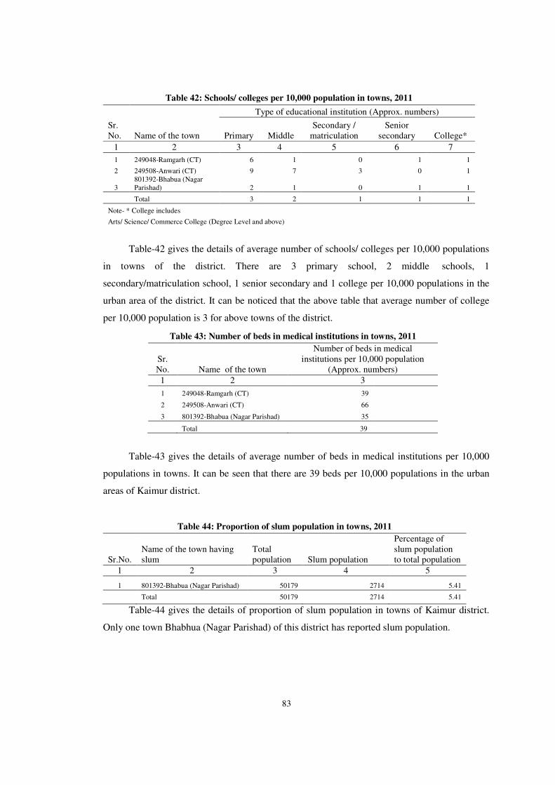
83
Table 42: Schools/ colleges per 10,000 population in towns, 2011
Sr. No. Name of the town
Type of educational institution (Approx. numbers)
Primary Middle Secondary /
matriculation Senior
secondary College*
1 2 3 4 5 6 7
1 249048-Ramgarh (CT) 6 1 0 1 1
2 249508-Anwari (CT) 9 7 3 0 1
3 801392-Bhabua (Nagar Parishad) 2 1 0 1 1
Total 3 2 1 1 1
Note- * College includes
Arts/ Science/ Commerce College (Degree Level and above)
Table-42 gives the details of average number of schools/ colleges per 10,000 populations
in towns of the district. There are 3 primary school, 2 middle schools, 1
secondary/matriculation school, 1 senior secondary and 1 college per 10,000 populations in the
urban area of the district. It can be noticed that the above table that average number of college
per 10,000 population is 3 for above towns of the district.
Table 43: Number of beds in medical institutions in towns, 2011
Sr. No. Name of the town
Number of beds in medical institutions per 10,000 population
(Approx. numbers)
1 2 3
1 249048-Ramgarh (CT) 39
2 249508-Anwari (CT) 66
3 801392-Bhabua (Nagar Parishad) 35
Total 39
Table-43 gives the details of average number of beds in medical institutions per 10,000
populations in towns. It can be seen that there are 39 beds per 10,000 populations in the urban
areas of Kaimur district.
Table 44: Proportion of slum population in towns, 2011
Sr.No. Name of the town having slum
Total population Slum population
Percentage of slum population to total population
1 2 3 4 5
1 801392-Bhabua (Nagar Parishad) 50179 2714 5.41
Total 50179 2714 5.41
Table-44 gives the details of proportion of slum population in towns of Kaimur district.
Only one town Bhabhua (Nagar Parishad) of this district has reported slum population.
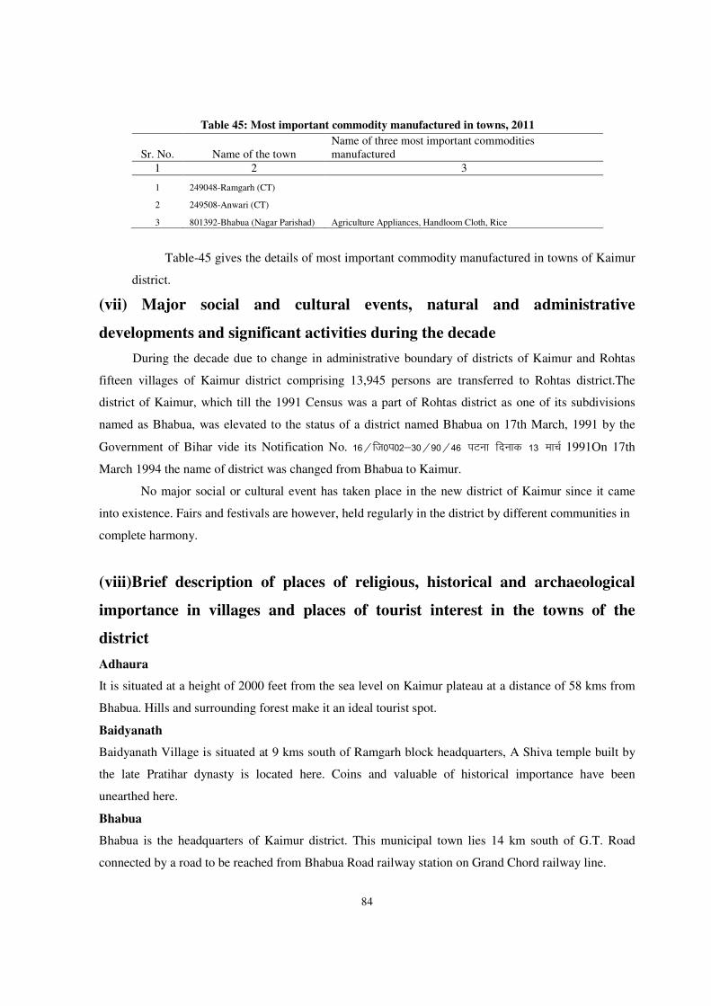
84
Table 45: Most important commodity manufactured in towns, 2011
Sr. No. Name of the town Name of three most important commodities manufactured
1 2 3
1 249048-Ramgarh (CT)
2 249508-Anwari (CT)
3 801392-Bhabua (Nagar Parishad) Agriculture Appliances, Handloom Cloth, Rice
Table-45 gives the details of most important commodity manufactured in towns of Kaimur
district.
(vii) Major social and cultural events, natural and administrative
developments and significant activities during the decade
During the decade due to change in administrative boundary of districts of Kaimur and Rohtas
fifteen villages of Kaimur district comprising 13,945 persons are transferred to Rohtas district.The
district of Kaimur, which till the 1991 Census was a part of Rohtas district as one of its subdivisions
named as Bhabua, was elevated to the status of a district named Bhabua on 17th March, 1991 by the
Government of Bihar vide its Notification No. 16@ft0i02&30@90@46 iVuk fnukd 13 ekpZ 1991On 17th
March 1994 the name of district was changed from Bhabua to Kaimur.
No major social or cultural event has taken place in the new district of Kaimur since it came
into existence. Fairs and festivals are however, held regularly in the district by different communities in
complete harmony.
(viii)Brief description of places of religious, historical and archaeological
importance in villages and places of tourist interest in the towns of the
district
Adhaura
It is situated at a height of 2000 feet from the sea level on Kaimur plateau at a distance of 58 kms from
Bhabua. Hills and surrounding forest make it an ideal tourist spot.
Baidyanath
Baidyanath Village is situated at 9 kms south of Ramgarh block headquarters, A Shiva temple built by
the late Pratihar dynasty is located here. Coins and valuable of historical importance have been
unearthed here.
Bhabua
Bhabua is the headquarters of Kaimur district. This municipal town lies 14 km south of G.T. Road
connected by a road to be reached from Bhabua Road railway station on Grand Chord railway line.

85
Bhagwanpur
Bhagwanpur is situated 11 km south of Bhabua near the Kaimur hills. It is said to have been the seat of
power of Kumar Chandrasen Saran Singh, who claimed his descent from Paras. It was confiscated by
sher shah from Raja Shaliwahan but later restored to his successor during the reign of Akbar.
Chainpur
Situated 11 km west of Bhabua headquarters, it is credited with a great mausoleum of Bakhtiar Khan,
who is said to have married the daughter of sher shah. The Hindu shrine of “Harsu Brahm” is famous
in the locality. It is said that Kanyalkubya priest of Raja Shaliwahan, named Harshu pandey, ended his
life in protest against demolition of his house but during his cremation was seen standing at the
cremation site at Varanasi.
Chargotia
Chargotia village in Adhaura block is an excellent beauty spot with a water fall amidst beautiful
scenery.
Durauli
Durauli village situated 8 kms north-east of Ramgarh contains two old temples built by the Cheros.
Ramgarh
Ramgarh village in the Bhagwanpur block in Bhabua Subdivision contains the famous Mundeshwari
temple, built on a hill top at a height of about 600 feet. Inscriptions of archaeological importance found
here describe the temple to be old enough to have been built around the year 635 A.D.
(ix)Major characteristics of the district, contribution of the district in the
form of any historical figure associated with the district.
The district may be divided into plain and plateau regions. The Plain area consists of fertile
alluvial lands, which become rocky as one proceeds southwards. As one approaches the Kaimur
foothills, the soil becomes stony and poor in fertility. The Kaimur plateau is an undulated tableland
having thin shrubby jungles, spreading about 1200 sq. kms. Bhabua is the headquarters of Kaimur
district. This municipal town lies 14 km south of G.T. Road connected by a road to be reached from
Bhabua Road railway station on Grand Chord railway line. Ramgarh village in the Bhagwanpur block in
Bhabua Subdivision contains the famous Mundeshwari temple, built on a hill top at a height of about
600 feet. Inscriptions of archeological importance found here describe the temple to be old enough to
have been built around the year 635 A.D.
86
(x) Scope of Village and Town Directory – column heading wise
explanation and coverage of data
Village Directory 2011 Census:-
The Village Directory is being compiled for both inhabited and un-inhabited villages. In the
village directory both private and government facilities/institutions have been given. In case of
un-inhabited /depopulated villages, the location code number, name and area of the village is
being given universally in Village Directory and Village PCA. The columns relating to the
amenities and land use pattern, etc. being left blank and it will be noted against the name of the
village that it is un-inhabited/depopulated. The Appendices to Village Directory and Inset
Tables based on village Directory data are also prepared for inhabited villages.
In the Village Directory format for 2011 Census there are 121 columns and the details thereon are as follows:
Columns 1: Serial Number: -
Self explanatory. All the villages within the CD Block are presented serially in the
ascending order of their location code number.
Columns 2: Name of village: -
Self explanatory. The name of the villages are shown against this column. This also
includes the forest and uninhabited villages. Columns 3: Location Code Number of village: -
The location code number of the villages are shown against this column.
Columns 4: Area of the Village: -
The area of the villages has been given in hectares. Column 5: Total Population: -
The total population of the village as per 2011 Census has been given against this column. Column6: Number of Households: -
The number of households as per 2011 Census have been given in this column.
Amenities: - The availability of different infrastructural amenities such as education, medical, drinking
water, post, telegraph, banks, credit societies, recreation and cultural facilities, communication,
87
power, etc. in each village have been given in the Village Directory. Wherever the amenities are
not available in the village, the distance range code viz; ‘a’ for <5 Kms, ‘b’ for 5-10 Kms and
‘c’ for 10+ Kms of the nearest where facility is available is given. Column wise details are
given below:
Columns No. 7 – 20 Educational Facilities: -
All the different educational facilities available in the village have been given under these
columns. Nursery/LKG//UKG classes are included in Pre-Primary Schools, Classes up to class
V included in Primary School; Classes from VI to VIII are included in the Middle school.
Classes from IX and X included in Secondary School. Classes from XI and XII are included in
Senior Secondary School. In case of composite schools like middle school with primary school
or secondary school with middle school, these are also included in the number of primary and
middle schools, respectively. The information on the entire educational institutes is given under
these columns.
Columns No. 21 to 38 - Medical Facilities: -
All the different medical facilities available in the village have been given under these
columns.
Columns No. 39 to 46 -Drinking Water: -
The information on availability of various types of the drinking water facility within the
village has been given under these columns.
Columns No. 47 to 50 – Availability of Toilet and others:-
The information on availability of toilet and Bio-Gas etc. available in the village has been
given under these columns.
Columns No. 51 to 67 Communication (Post & Telegraph and transport):-
The information on communication and Post Office, Sub-Post Office, & Telegraph Office,
Village PIN Code number, Phone-Landlines, Mobile Phone, Private Courier Facility, Internet
Café, etc; available in the village has been given under these columns. The information on all
various transport facilities whether public/private transport like Bus, Railway Station, or
Navigable waterways, Taxi , Van, Tractors etc. available in the village has also been given
under these columns.
88
Columns No.68 to 79 – Village connected to High ways, Village Roads, Banks and
Credit Societies:-
The information on all roads connected to village has been given under these columns.
These include National Highway, State Highway, District Roads and other district roads
connected to the village, Pucca roads, Kutchcha Roads, Water Bounded Macadam Roads,
Navigable Water Ways and Foot Paths has been given under these columns. Further, the
information on availability of banks, ATM and Agricultural Credit societies in the village has
been given under these columns.
Column No. 80 to 97 Miscellaneous Facilities:-
The information on various miscellaneous facilities available in the village has been given
under these columns. These includes Self -Help Group, Public Distribution Shop (PDS), Mandi
/Regular Market, Weekly Haat, Agricultural Marketing Society, Nutrition
Centre(ICDS),Anganwadi Centre, ASHA, Community Centre, Sports Fields, Sports
Club/Recreation Centre, Cinema/Video Halls, Public Library, Public Reading Room, News
Paper Supply, Assembly Polling Station, Birth and Death Registration Office.
Columns No. 98 to 101 – Electricity:-
Availability of Power Supply in the village, whatever may be the form of its use has been
given in these columns. These include Electricity for Domestic Use, Electricity for Agriculture
Use Electricity for Commercial Use, and Electricity for all purpose Domestic Uses.
Column No. 102 and 103 -Nearest Town:-
The name of the nearest town along with the distance range code has been in these columns. Land use and Irrigation: -
The land use pattern in the Village Directory conform to the pattern of classification of land
use as recommended by the Ministry of Agriculture, Government of India. The Ministry has
recommended the maintenance of records of land use pattern under the following 9 categories.
(i)-Column No. 104 -Forests:-
This includes all lands classed as forest under any legal enactment dealing with forests or
administered as forests, whether state-owned or private, and whether wooded or maintained as
89
potential forest land. The area of crops raised in the forest and grazing lands or areas open for
grazing within the forests remain included under the forest area.
(ii)-Column No. 105- Area under non-agricultural use:-
This includes all lands occupied by buildings, roads and railways or under water, e.g. rivers
and canals and other lands put to uses other than agriculture.
(iii)-Columns No. 106- Barren and un-culturable land:-
This includes all barren and unculturable land like mountains, deserts, etc. Land which
cannot be brought under cultivation except at an exorbitant cost should be classed as
unculturable whether such land is in isolated blocks or within cultivated holdings.
(iv)-Column No. 107- Permanent Pastures and other Grazing Lands:-
This includes all grazing lands whether they are permanent pastures and meadows or not.
Village common grazing land is included under this head.
(v)-Column No. 108- Land under Miscellaneous Tree Crops, etc.:-
This includes all cultivable land which is not included in ‘Net area sown’ but is put to some
agricultural uses. Lands under Causing trees, thatching grasses, bamboo bushes and other
groves for fuel, etc. which are not included under ‘Orchards’ are classed under this category.
(vi)-Column No. 109- Culturable Waste Land:-
This includes lands available for cultivation, whether not taken up for cultivation or taken
up for cultivation once but not cultivated during the current year and the last five years or more
in succession for one reason or other. Such lands may be either fallow or covered with shrubs
and jungles which are not put to any use. They may be assessed or unassessed and may lie in
isolated blocks or within cultivated holdings. Land once cultivated but not cultivated for five
years in succession is also included in this category at the end of the five years.
(vii)-Column No. 110- Fallow Lands other than Current Fallows:-
This includes all lands which were taken up for cultivation but are temporarily out of
cultivation for a period of not less than one year and not more than five years.
90
(viii)-Column No. 111- Current Fallows:-
This represents cropped area, which is kept fallow during the current year. For example, if
any seeding area is not cropped against the same year it may be treated as current fallow.
(ix)-Column No. 112- Net Area Sown:-
This represents the total area sown with crops and orchards. Area sown more than once; in
the same year is counted only once.
Column No. 113- Total Irrigated Land Area:-
It includes all land which is cultivable and irrigated by any source of irrigation. The total
irrigated area of the village has been given under this column.
Column No. 114- Total Un-Irrigated land Area:-
Un-Irrigated area includes all land which is cultivable but not irrigated by any source of
irrigation. The total un-irrigated land area of the village has been given under this column.
Column No. 115 to 119 Area Irrigated by source:-
The area irrigated by various source of irrigation in the village has been given under these
columns. The different source of irrigation facilities available in the village are as follows:
(i)-Canals(C)-Govt. or Pvt., (ii)-Wells/Tube-wells (W/TW), (iii)-Tanks/Lake(T/L), (iv)-
Waterfall,(WF) and (v)-Others(O).
Columns No.120 to 122-Three most important commodities manufactured:- The names of three most important commodities manufactured in the village are indicated
in this column.
C.D.Block level totals of the Village Directory:-
At the end of entries for the Village Directory of each C.D. Block, the totals of different
columns are being given wherever possible. However, in case of some of the columns, it may
not be possible to work out the CD Block level totals, in such cases the particular of relevant
columns are being left blank against C.D.Block level.
91
Appendices to Village Directory: - The Village Directory also includes the following
appendices:- Appendix –I: Summary showing total number of villages having Educational, Medical and
other amenities in villages – C.D. Block level.
Appendix I A: Villages by number of Primary Schools.
Appendix I B: Villages by Primary, Middle and Secondary Schools.
Appendix I C: Villages with different sources of drinking water facilities available.
Appendix II: Villages with 5,000 and above population which do not have one or more
amenities available.
Appendix -III: Land utilization data in respect of Census towns.
Appendix -IV: C.D. Block wise list of inhabited villages where no amenity other than
drinking water facility is available.
Appendix -V: Summary showing number of Villages not having Scheduled Caste
population.
Appendix -VI: Summary showing number of Villages not having Scheduled Tribe
population.
Appendix -VII A: List of villages according to the proportion of the Scheduled Castes to the
total population by ranges.
Appendix- VII B: List of villages according to the proportion of the Scheduled Tribes to the
total population by ranges.
Appendix -VIII: Number of villages under each Gram Panchayat (C.D. block wise).
92
Town Directory 2011 Census:-
Statement I :- Status and Growth History:- Column 1 – Serial Number:- Self explanatory Column 2:- Class, Name and civic status of town:- The Class is presented according to
population of the towns in 2011 Census as follows:
Population Class Population Class
100,000 and above I 10,000 – 19,999 IV
50,000 – 99,999 II 5,000 – 9,999 V
20,000 – 49,999 III Below - 5,000 VI
The following abbreviations are used to denote the Civic Status of the town.
Civic Status Codes Civic Status Codes
i-Municipal Corporation M.Corp. xii – Notified Town Area NTA
ii-Municipal Committee MC xiii – Industrial Notified Area INA
iii-Municipal Council M Cl/Nagar Parishad
xiv – Industrial Township ITS
iv-City Municipal Council
CMC xv – Township TS
v-Town Municipal Council
MC xvi – Town Panchayat TP
vi- Municipal Board MB xvii – Nagar Panchayat NP
vii –Municipality M xviii – Town Committee/ Town Area Committee
TC
viii-Cantonment Board/Cantonment
CB xix – Small Town Committee ST
ix- Notified Area NA xx – Estate Office EO
x –Notified Town NT xxi –Gram Panchayat GP
xi - Notified Area Committee/ Notified Area Council
NAC xxii – Census Town CT
Column 3 - 25: - These columns are self explanatory
Statement II: - Physical Aspects and Location of town, 2009:-
Column 1 - 2 Serial number and Name of town: - Self explanatory
93
Columns 3 to 5 - Physical Aspects:-In these columns the Rainfall and Maximum and
Minimum Temperature of the town is recorded.
Columns 6 to 12:- Name and road distance of the town (in kms.) from the State
headquarters, District headquarters, Sub-divisional/Taluk/Tahsil/ Police station/Development
Block/Island HQ., Nearest city with population of one lakh and more, Nearest city with
population of five lakh and more, Railway station and Bus route is recorded in these columns
respectively. If
the names mentioned in these columns are the same as the referent town itself, the distance
is recorded as (0) zero.
Statement III – Civic and other Amenities, 2009:-
Column 1 - 2 Serial number and Name of town: - Self explanatory
Column 3 – Road length (in km.):- The information about the road length (in km.) within
the limit of the town is recorded in this column.
Columns 4 to 7- System of drainage: - The system of drainage available in the town is
indicated in these columns by the following codes:
System of drainage Codes
Open drains OD
Closed drains CD
Both drains BD
Columns 8 to 11-Number of latrines: - The number of various types of latrines available in
the town is indicated in these columns.
Columns No. 12 & 13 – Protected water supply: - The information on source of water
supply and system of water storage with capacity available in the town are given in these
columns in the following codes:
Column 12 (Source of water supply):-
(i) Tap water T
(ii) Tube-well water TW
94
(iii) Tank Water TK
(iv) Well water W
Column 13 (System of water storage):-
(i) Over Head Tank OHT
(ii) Service Reservoir SR
(iii) River Infiltration Gallery RIG
(iv) Bore Well Pumping System BWP
(v) Pressure Tank PT
The information on 2 major source of water supply is given in column 12 and the system of
water storage with capacity against each in kilo-litres (in bracket) is presented in column 13.
Columns 14 Fire Fighting Service: - In case the fire fighting service is available in the
referent town, `yes’ is recorded. If the facility is not available within the town, the name of the
nearest place having this facility with its distance from the referent town has been recorded.
Columns 15 to 19- Electrification (Number of connections):-Different types of electric
connections have been shown in these columns, i.e., Domestic, Industrial, Commercial, Road
lighting (points) & others.
Statement IV: Medical Facilities, 2009:-
Columns 1 - 2 Serial number and Name of town: - Self explanatory
Columns 3 to 13 :- The number of various medical institutions such as Hospitals,
Dispensaries, Health Center, Family Welfare Center, Maternity and Child Welfare Center,
Maternity Homes, T.B. Hospital/clinic, Nursing Homes, Charitable Hospital/Nursing Home,
Mobile Health Clinic and Others as available in the town, are indicated in these columns (along
with number of beds in brackets).
If a medical facility is not available in the town, the name of the nearest place and its
distance in kilometers from the town where the facility is available is mentioned.
95
Column 14 - Veterinary Hospital:-The Number of Veterinary Hospitals available in the
town is given in this column.
Column 15 - Medicine Shop:-The number of Medicine shops available in the town is given
in this column.
Statement V: Educational, Recreational and Cultural Facilities, 2009:-
Columns 1 - 2 Serial number and Name of town: - Self explanatory
Columns 3 to 15 Educational Facilities:- The information on number of Primary school,
Middle school, Secondary school, Senior Secondary school, Arts/Science/ Commerce colleges
(of degree level and above), Medical colleges, Engineering colleges, Management
Institute/Colleges, Polytechnics, Recognized Shorthand, Typewriting and vocational training
Institutions, Non-formal Education Center (Sarva Shiksha Abhiyan Center), Special School for
disabled and Others available in the town, are indicated in these columns.
If an educational facility is not available in the town, the name of the nearest place and its
distance in kilometers from the town where the facility is available is mentioned.
Columns 16 to 23 – Number of Social, Recreational and Culture Facilities :- The
information on No. of Home Orphanage, Working women’s hostels (with No. of seats in
bracket), No. of Old Age Home, Stadium, Cinema Theatre, Auditorium/Community halls,
Public libraries and Reading rooms available in the town are given under these column.
Statement VI: Industry and Banking 2009:-
Columns 1 - 2 Serial number and Name of town: - Self explanatory
Columns 3 to 5 - Names of three most important commodities manufactured:- The names of
three most important commodities manufactured in the town are given under these columns.
96
Columns 6 to 8 - Number of banks: - The number of banks available in the referent town
both Commercial and Co-operative banks are recorded against these columns.
Columns 9 & 10 – Number of Agricultural and Non Agricultural Credit Societies: - The
number of Agricultural and Non Agricultural Credit Societies available in the referent town are
given in these columns.
Statement VII: Civic and other Amenities in Slums, 2009:-
This statement VII provides information on civic and other amenities in all slums whether
notified or not and for all towns having statutory bodies, like Municipality, Municipal
Corporation, Town area committee etc.
--------------

����
�
������������� ��������
�

����

����
Brief Note on Concepts used in Village Directory and Town Directory:
1. Educational Amenities:-The type of different educational facilities available in the village is
given in numbers. Both Government and private educational facilities / institutions are
considered for this-purpose. If there are composite schools like Middle schools with
Primary classes, or Secondary schools with middle classes, these are included in the number
of Primary and Middle schools respectively. For example, if in a village there are two
Primary schools and one Middle school with primary classes, the number of Primary
schools in the village are given as three and that of Middle school as one even though there
may be only three educational institutions. So also in case of Secondary schools. For better
understanding, the distinctiveness of different types of schools is depicted hereunder:
1. Pre-primary (PP): Now-a-days, the children are sent to schools at a very early stage. Lot
of pre-primary schools, private schools in particular, have come up in villages and towns.
These may or may not be recognized by the competent authorities. Even many Secondary
schools have classes starting from preprimary level. Pre-primary classes include Nursery,
K.G., Pre-basic, Play school, etc.
2. Primary School (P): Schools providing education from Standard 1 and upward up to and
inclusive of
Standard V are classified as Primary Schools.
1.3 Middle School (M): Schools providing education from Standard VI and upward up to and
inclusive of Standard VIII are classified as Middle Schools. A School with Class 1 to VIII
is treated as two units, i.e. one Primary School and one Middle School.
1.4 Secondary School (S): Schools providing education from Standard IX and upwards up to
and inclusive of Standard X are classified as Secondary Schools. A composite school with
1 to X standard is treated as three separate units and counted separately under the
categories of Primary School, Middle School and Secondary School.
1.5 Senior Secondary School (SS): Schools and colleges that provide education for Standards
XI and XII and first and second year of the Pre-University Course fall under this category.
There are Senior Secondary Schools with Standard I and upwards up to Standard XII.
1.6. Degree College: (i) Arts/Science/Commerce : These are all educational institutions that
provide post-PUC level education leading to University degree/diploma in any subject or
combination of subjects and also post-graduate levels of education. The college offering
courses in Arts, Science or Commerce either separately or in combination are covered
under this category.
�����
(ii) Engineering College (E): It is a graduate/post-graduate degree college providing Bachelor
of Engineering (BE) or Bachelor of Technology (B. Tech.) or post-graduate engineering
degrees like M.Tech.
(iii) Medical Colleges: These are graduate/post-graduate degree colleges providing MBBS or
equivalent degree in alternative medicine like Ayurveda, Unani, Homeopathy etc. or post-
graduate medical degrees like M.D or equivalent in the above branches of medicine.
1.7. Management College/ Institute (MI): It offers courses like Diploma in Management,
Post-Graduate Diploma in Management, Masters of Business Administration (MBA) and
specializations in different disciplines of Management like Marketing, Human Resources
Development (HRD) etc.
1.8. Polytechnic (Pt): An Institution providing certificate/diploma (not equivalent to degree) in
any technical subject like engineering, vocational courses like embroidery, fashion
designing etc. It may be both Government and Private.
1.9. Vocational School/ITI: It is a vocational training institute imparting trainings in specific
fields acquiring necessary skill, which will make the trainees employable or create them
opportunities of self-employment. Trainings offered by Industrial Training Institutes (ITI)
fall under this category.
1.10. Non-formal Education/Training Centre (NFTC): Non-vocational education centers,
established by the Central and State Governments provide educational facilities to the
interested persons irrespective of educational qualification, and age. These education
centers are open to all.
1.11. Special School for Disabled: There are Government and Government recognized
institutions/organizations engaged for providing education to different groups of disabled
persons.
2. Medical Facilities: 2.1 Hospital-Allopathic and Hospital-Alternative medicine: A
hospital is an Institution, where sick or injured are given medical or surgical care. Bed
strength differs from hospital to hospital ranging from 31 to 500 depending upon whether
these are sub-district, sub-divisional or district hospitals. If there is hospitals providing
facilities under different systems of medicines such as, Allopathy, Ayuveda, Unani and
Homeopathy etc., these details are given separately.
(a) Allopathy: The system of medical practice, which treats disease by the use of remedies
which produce effects different from those produced by the disease under treatment.
�����
(b) Ayurveda: Ayurveda means ‘Science of life’. The philosophy of Ayurveda is based on
the theory of Pancha Mahabhootas (Five elements) of which all the objects and living
bodies are composed of. The combination of these five elements are represented in the
form of Tridosha: Vata, Pitta and Kapha. These three ‘doshas’ are physiological entities
of living beings. Ayurveda developed into eight distinct specialities, i.e., Internal
Medicine, Pediatrics, Psychiatry, Eye and ENT, Surgery, Toxicology, Geriatrics and
Science of virility. Two types of treatments, Preventive and Curative, are given in
Ayurveda.
(c) Unani: Treatment of Unani consists of three components, namely, preventive, promotive
and curative. Unani system of medicine has been found to be efficacious in conditions
like Rheumatic Artharitis. Jaundice, Filarisis, Eczema, Sinusitis and Bronchial Asthma.
For the prevention of the disease and promotion of health, the Unani System emphasizes
six essentials: pure air, food and water, physical movement and rest, psychic movement
and rest, sleep and wakefulness and retention of useful materials and evacuation of waste
materials from the body.
(d) Homoeopathy: Treatment in Homoeopathy, which is holistic in nature, focuses on an
individual’s response to a specific environment. Homoeopathic medicines are prepared
mainly from natural substances such as plant products, minerals and animal sources.
Homoeopathic medicines do not have any toxic, poisonous or side effects. Homoeopathic
treatment is economical as well and has a very broad public acceptance.
2.2 Community Health Centre (CHC): Community Health Centres are designed to provide
referral health care for cases from PHC and those in need of specialist health care
approaching the CHC directly. 4 PHCs are included under each CHC thus catering
approximately 80,000 populations in tribal/hilly areas and 1, 20,000 populations for plain
areas. CHC is a 30- bedded hospital providing specialist care in Medicine, Obstetrics and
Gynaecology, Surgery and Paediatrics.
2.3 Primary Health Centre (PHC): A Primary Health Centre is the first contact point
between a village community and the Government medical officer. A PHC covers a
population of 20,000 in hilly, tribal or difficult areas and 30,000 populations in plain
areas with 4-6 indoor/observation beds. It acts as a referral unit for 6 sub-centres. It has a
medical officer and para medical staff.
2.4 Primary Health Sub- Centre (PHS): A Primary Health Sub-centre is the first contact
point between the primary health care system and the community. As per the population
norms, one PHS is established for every 5,000 population in plain areas and 3,000

�����
population in hilly/ tribal/ desert areas. Each PHS has a sanctioned strength of one male
and one female health worker.
2.5 Maternity and Child Welfare Centre (MCW): It provides pre-natal and post-natal
services for both mother and child. The services include regular check-up of pregnant
women, giving folic tablets, counseling, delivery, immunization of children with check-
up etc.
2.6 TB Clinic (TBC): The diagnosis and treatment of TB are functions of the general health
services and hence it is a part and parcel of Primary Health Care. Specialized units such
as the District Tuberculosis Centre (DTC) act as referral centres. TB clinics are
established by the Government of India under the National Tuberculosis Control
Programme and implemented through a network of DTC. The DTC is the nodal point for
TB control activities in the district and it also functions as a specialized referral centre.
The functions of sub-district level Tuberculosis Unit (TU) are implementation,
monitoring and supervision of TB control activities in its designated geographical areas.
2.7 Health Centre: Clinic where medicine and medical supplies are dispensed. It has no in-
patient facility. A clinic (or an outpatient clinic) is a small private or public health facility
that is devoted to the care of outpatients, often in a community, in contrast to larger
hospitals, which also treat inpatients.
2.8 Dispensary: Place where patients are treated and medicines provided but with no in-
patient facility. Immunizations, MCH Services and sometimes pathological tests are
carried out here. It may be of allopathic or any alternative medicine.
2.9 Veterinary Hospital: Mostly run by the State Government or local body for treatment
and preventive measures against diseases of domestic animals like cows, buffaloes etc in
rural areas.
2.10 Mobile Health Clinic: These are Mobile vans well equipped with a range of health
services to villages located far away from the CHCs, PHCs or any public health sources.
The vans visit villages on designated days to deliver the health care services. The
services generally offered are OPD, ante-natal and post-natal, B.P. examination, X-ray,
ECG, Immunization, First Aid etc.
2.11 Family Welfare Centre: Check-up and counseling is provided to the pregnant and
married women regarding small family norm and devices for having a small family.
Temporary and permanent contraceptive devices are provided here.
�����
2.12 Nursing Home: A nursing home is a long –term care facility licensed by the state that
offers 24-hour room and board and health care services including basic and skilled
nursing care, rehabilitation and a full range of other therapies, treatments and programs
to old and sick people. The difference between a hospital and a nursing home is that a
nursing home gives importance to convalescence from a disease while a hospital gives
medical treatment for the disease.
2.13 Medicine Shop: A shop which sells drugs and medicines of any system of medicine viz.
allopathic, homeopathic, ayurvedic or unani medicines, is considered as a medicine shop.
Sometimes some shops and Paan shops also keep ordinary medicines, like Crocin,
Burnol etc. These shops are not taken as medicine shops.
3. Drinking water: The following are the main source of drinking water facility (ies)
available in the village.
3.1 Tap Water-treated: This source of drinking water refers to a source of drinking water
which is provided to the villagers through pipes within their premises or to the villagers
through common taps (public taps/community water points) by the Government
departments, local bodies, panchayats, public or private estate agencies, etc. after
treatment. Such a source is treated as ‘Tap water from treated source’.
3.2 Tap Water-un-treated: If the villagers are drawing drinking water through pipes either
directly from a well or bore well or after pumping the well or tube well water, or the
water is supplied through pipes to the households of the village or through public taps
without treatment. Such a source is treated as ‘Tap water from un-treated source’.
3.3 Covered Well (CW): A well that is (1) covered on sides from run-off water (i.e., excess
water from rain, snowmelt or other sources flows over the land) through a wall lining or
casting that is raised above ground level on a platform that diverts spilled water away
from the well and (2) covered so that bird droppings and animals cannot fall down the
hole. It is considered as covered well.
3.4 Un-covered Well (UW): A well which is (1) un-covered on sides from runoff water, (2)
un-covered from bird droppings and animals; or (3) both.
3.5 Hand Pump (HP): Hand pump means where ground water is taken out manually by
operating a hand pump.
3.6 Tube Well / Borehole (TW): Tube well denotes the ground water source from where
ground water is taken out through electrical or diesel pump. Spring, River/Canal,
Tank/Pond/Lark are self explanatory.

����
4. Community Toilet Complex : Community Toilet may be constructed and maintained
by Gram Panchayats or Private NGOs like Sulabh Sauchalaya or likes.
5. Rural Sanitary Mart or Sanitary Hardware Outlet (RSM): It is an outlet dealing with
the materials, hardware and designs required for the construction of not only sanitary
latrines but other sanitary facilities such as compost pit, washing platform and other
sanitation and hygiene accessories required for individuals, households and the
environment in the rural areas.
6. Community bio-gas or recycle of waste for productive use: Many of the solid wastes
having economic values but put for disposal can be recycled for reuse. For example,
food, cow dung, leaves, vegetable, paper, wood, plastics, old cloth etc. However, some
of the wastes are not recyclable. These are carbon paper, thermo coal etc. When
recyclable solid wastes is subjected to decomposition, bio-gas could be produced under
favourable conditions. These systems of recycling may be there at the village level
organized by Gram Panchayats with technical support from Governments or non-
government organizations.
7. Communication and transport Facilities:
7.1 Post Office (PO): Self-explanatory.
7.2 Sub-Post Office (SPO): Sub-post office includes Extra Departmental Post Offices and
those providing franchise postal services and also part time services in lieu of some
honorarium. The limited postal services include sale of stamps, receipt of letters and
money orders and also distribution of letters.
7.3 Post & Telegraph Office (PTO): Telegraph office is set up by the Government to
enable people to send or receive telegrams. If the phonogram facility is available (though
the Telegraph office may not be equipped with Morse Code Transmitters), the village is
considered to be having telegraph facility.
7.4 Telephones (landlines): If the village is having the Public Call Office (PCO) either run
by the Post Office or by individuals or by a private shop, then the village is considered to
be having telephone facility. 7.5 Public Call Office (PCO)/Mobile PCO: Self
explanatory.
7.6 Mobile Phone Coverage: Mobile phones are now very common particularly in urban
areas. Some villages by virtue of being in close proximity to the urban areas also enjoy
����
the benefits of the mobile phone services. Even if a few villagers avail the services of
mobile phones, then the village is considered to be having access to mobile phone.
7.7 Internet Cafes/Common Service Centres (CSC): If the village is having the facility of
Cyber Cafes or shops owned by private individuals providing the facility of surfing of
the internet, then the village is considered to be having access to internet/cyber cafe
facility. Government of India formulated the scheme of CSC with the vision of
providing all government services in an integrated manner at the door step of the citizen
at an affordable cost even in the remotest corners of the country through a combination
of it based as well as non-IT based services.
7.8 National Highway (NH): These are main highways running through the length and
breadth of the country. Each NH is numbered like NH-1, NH-2 for easy identification.
7.9 State Highway (SH): These are roads of a state linking district headquarters and
important cities within a State and connecting them with NHs or Highways of the
neighboring States.
7.10 Major District Roads (MDR): These are important roads within a district, serving areas
of production and markets and connecting these with each other or with the main
Highways.
7.11 Other District Roads (ODR): These are roads serving rural areas of production and
providing them with outlet to market centres, taluka headquarters, block development
head quarters or other main roads.
7.12 Village Road: The approach to village refers to the state of road etc., leading to the
village. This is to see whether the village is approachable both in fair and foul weather,
and whether it is inaccessible only for some time in the year.
7.13. Black-Topped (Pucca) Road (BTR): A road provided with a bituminous surfacing.
7.14 Gravel (Kuchha) Road (GR): A road constructed using well compacted crushed rock or
gravel material (coarse sand, small stones), which is fairly resilient and does not become
slippery when wet.
7.15 Water Bound Macadam (WBM): This is the road layer made of crushed or broken
mixture of sand and rock fragments mechanically interlocked by rolling and voids filled
with screening and binding material with the assistance of water.
�����
7.16 Foot Path (FP): A trodden path for the use by pedestrians and in some cases bicycles.
The Foot Paths are not suitable for vehicular traffic except bicycles in some cases. Most
of the interior/forest villages are connected by Foot Paths.
8. Banks and Credit Societies: - Banking facility means a place where a person can
operate a bank account. 8.1 Commercial Bank (CB): These may be banks wholly
owned by the Government of India. or by Indian or Foreign Companies.
8.2 Cooperative Banks (Coop. B): A co-operative bank is a financial entity which belongs
to its members, who are at the same time the owners and the customers of their bank.
Cooperative banks are often created by persons belonging to the some local or
professional community or sharing a common interest. These banks are registered under
the Cooperative Societies Act. The cooperative banks are regulated by RBI and are
covered by the Banking Regulations Act, 1949.
8.3 Agricultural Credit Society (ACS): Major objectives of the ACS are to supply
agricultural credit to meet the requirements of funds for agricultural production, the
distribution of essential consumer commodities, the provision of storage and marketing
facilities and for light agricultural implements and machinery.
8.4 Non-Agricultural Credit Society (NCS): These societies include consumer cooperative
societies and also credit cooperative societies of certain categories of persons like
teachers, health workers, etc.
9. Miscellaneous Facilities:
9.1 Self-help Group (SHG): Self-Help Groups are groups of between 10-25 women created
by either NGOs or under the SGSY (Swarnjayanti Gram Swarozgar Yojana) for the
purposes of meeting local credit needs. They are sometimes called Mahila Mandals in
villages.
9.2. Public Distribution System (PDS) shop: The shops through which some essential
commodities are sold by the government at subsidized rates. They may also be known as
ration shops and control shops.
9.3. Mandis/Regular Market: These are those clusters of shops with or without fixed
premises which are open on at least six days a week and opens at least from morning
hours to dusk.
9.4. Weekly Haat: These are those clusters of shops with or without fixed premises which
are open once a week.

�����
9.5. Agricultural Marketing Society: It is a common platform to analyse the issues among
all the individuals and institutions in the field of agricultural marketing.
9.6. Nutrition Centre: Integrated Child Development Services (ICDS): The Integrated
Child Development Services (ICDS) Scheme set up by the Government of India with the
objective of providing following package of services to the children under 6 years and
pregnant and lactating mothers in villages such as; Immunization, Health Check-up,
Referral Services, Pre-school Non-formal Education and Nutrition & Health Education.
9.7. Anganwadi Centre: Each centre under the ICDS scheme is run by an Anganwadi
Worker. One Anganwadi worker is appointed for specified population of the village.
They are basically local women. They are assisted by Anganwadi helper. They provide
pre-school non-formal education at the Centre and provide food to the children.
9.8. Accredited Social Health Activist (ASHA): ASHA is a health activist in the
community who will create awareness on health and its social determinants and mobilize
the community towards local health planning and increased utilization and accountability
of the existing health services. She would be a promoter of good health practices. She
will also provide a minimum package of curative care as appropriate and feasible for that
level and make timely referrals. She will act as a motivator of different types of health
related activities. Unlike ANM, she will not be involved in any clinical activities like
immunization.
9.9. Sports Club/Recreation Centre: Indoor and out-door games are arranged by the Club
and activities like wrestling, Judo Karate etc. are also done there.
9.10. Cinema/Video Hall (CV): If regular cinema houses licensed by Government is
available, then the town/village is considered to be having the facility of Cinema Hall.
Video hall owners screen films in their own or hired premises.
9.11. Public Library: Books are kept there which can be accessed by the public on loan basis.
These may be sponsored by Government or Local Body or Panchayat or any influential
person. Free service or nominal charges are made for using the facility.
9.12. Public Reading Room: Here the public may read newspapers and magazines. These
may be sponsored by Government or Local Body or Panchayat or any influential person.
9.13. Newspaper Supply: The availability of the Newspaper(s), both in English or vernacular,
in the village is considered to having the said facility.

�����
10. Availability of Electricity/Power. If power is actually available, whatever may be the
form of its use, it is indicated affirmative. If the village is having electricity for domestic
purposes and the residents are using the same for domestic use, then it is considered that
domestic power supply is available. If the electricity authority has not given domestic
supply to the households on their request and people are using unauthorized electricity
either by stealthily or misuse the supply meant for agricultural or industrial purposes,
then it is not considered as availability of electricity for domestic purposes. However, if
the village goes out of power due to temporary technical problems such as, transformer
failures, theft of electrical equipment, etc., it is considered that electricity is available.
Supply of electricity is considered available even when there is a temporary ban on new
domestic connections. Connections to residential houses, bungalows, clubs, hostels and
hospitals run on non-commercial basis, charitable, educational and religious institutions
are included in the domestic category.
10.1 Power Supply for domestic use: This category includes electricity used only for domestic
consumption.
10.2 Power supply for agricultural use: This category includes all electricity connections
given to the farmers for conducting various agricultural activities including irrigation.
10.3 Power supply for commercial use: This category includes electricity connections given
for workshops, industries etc. or for any commercial purposes.
10.4 Power supply for all uses: This category includes electricity connection is available for
domestic use, agricultural use, and for any commercial purposes.
11. Land Use Pattern: The land use area of the villages is given in hectares. The land use
pattern in the Village Directory conform to the pattern of classification of land use as
recommended by the Ministry of Agriculture, Government of India. The Ministry has
recommended the maintenance of records of land use pattern under the 9 categories as
indicated in the Village Directory.
12. System of drainage : Generally, by drainage system, we mean the network of mains and
branches of underground conduits for the conveyance of sewerage to the point of disposal.
Sewers that carry only household and industrial wastage are called separate sewers; those
that carry storm water from roofs, streets and other surfaces are known as storm water
drains, while those carrying both sewage and storm water are called combined sewers.
However, in towns, which are not provided with such underground sewerage system, it is
�����
mentioned whether it has open drainage system. There may be possibility of the town
having both closed as well as open drainage systems.
13. Type of latrines: The data on various types of latrines both public and private together are
collected. The three types of latrines considered here are, Pit Latrine, Flush/Pour Flush
Latrine and Service Latrine. (i) Pit System: The latrines are attached to the pit that is
dug into the ground for the reception of night soil, are reckoned as pit latrine. (ii)
Flush/pour flush: A flush latrine uses a cistern or holding tank for flushing water and has a
water seal, which is a U-shaped pipe, below the seat or squatting pan that prevents the
passage of flies and odours. A pour flush latrine uses a water seal, but unlike a flush latrine,
a pour flush latrine uses water poured by hand for flushing (no cistern is used). (iii)
Service: Type of latrine from where night soil is removed manually by scavengers. All
other types of latrines are covered under “Others” category.
14. Protected Water Supply- Source and capacity of Storage system: There are various
sources of water supply and its storage system in the town.
14.1 Service Reservoir: A service reservoir is a water storage container that holds clean water
after it has been treated in a water plant, and before it is piped to the end users. These
containers are covered, and are designed to keep the water safe from contamination.
Their main purpose is to provide a buffer within the water supply system so that water
supplies can be maintained across periods of varying demand.
14.2 River Infiltration Gallery: Infiltration Galleries are capable of supplying large
quantities of water, and are used where wells are unable to supply water needs, i.e. where
an impermeable rock barrier affects well efficiency, or where surface water sources are
too shallow for intake screens. Infiltration galleries are one or more horizontal screens
placed adjacent to (on-shore), or directly underneath (bed-mounted), a surface water
source.
14.3 Bore Well Pumping System: A bore well is a well of 6" to 12" in diameter drilled into the earth for
retrieving water. The depth of a bore well can vary from 50 feet to 3000 feet. Water is pumped out to surface
through electricity/generator.
14.4 Pressure Tank: Tank that is used to ensure consistent water pressure and for storage of
water. Usually located in basement of house but sometimes (in older settings) located in
well pit.
15. Road lighting (Points): Road lighting means the number of street lights that are
maintained in the town.
�����
16. Home Orphanage: Orphanage is the name to describe a residential institution devoted
to the care of orphans – children whose parents are deceased or otherwise unable to care
for them. Parents, and sometimes grandparents, are legally responsible for supporting
children, but in the absence of these or other relatives willing to care for the children,
they become a ward of the state, and orphanages are a way of providing for their care
and housing.
17. Working women's hostel: These may be recognised or non-recognised by any public
authority. The data on number of working women's hostels available in the town are
collected with number of seats.
18. Old Age Home: There are two types of Old Age Homes in India. One is the "Free" type
which cares for the destitute old people who have no one else to care for them. They are
given shelter, food, clothing and medical care. The second type is the "Paid" home where
care is provided for a fee. Nowadays, such "Retirement" homes have become very
popular in India and they are well worth considering.
19. Stadium: A stadium is a place, or venue, for (mostly) outdoor sports, concerts or other
events, consisting of a field or stage partly or completely surrounded by a structure
designed to allow spectators to stand or sit and view the event.
20. Auditorium/Community Hall: These are the places where meetings, social functions etc.
are organised.

�����
�����
SECTION I-Village Directory

Serial number Name of Towns
Name of
villages merged
in towns
Name of
villages
identified for
outgrowth
Location Code
Number 2001
Census
Location Code
Number 2011
Census (in case of
partly OG)
� � � � � �
LIST OF VILLAGES MERGED IN TOWNS AND OUTGROWTHS AT 2011 CENSUS
��
���

���
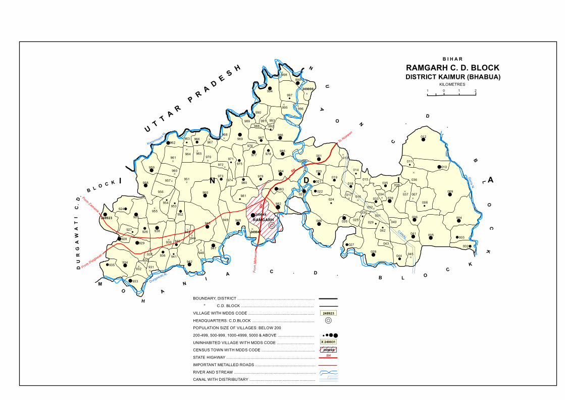
R
D
!!
D
!
D
(
D
( (
!
(
!
D!
D !!!!!D
!
(
!!
! !D
D
D
D!
D
!!
!
!
!!
!
D
!
D
D
! !
D
!(
(
!
!D
!!
!
!D
(
(
!
!
!
DD
!
!
!! !
!
!!
D
!
D
! D
!(
!
!D
!
!(
!
!
(
!
!
! D
!
!D
!
! !D
!
!
D
D
!
!!!
( !
!
D
D
!
!
!
!!
(
D!
D
D
!
!
SH
From Zamania
From DurgawatiFro
m Mo
hania
To Noawan
SH
CANAL
Goria N.
Durgawati N.
Karamnasa N.
RAMGARH
11 2 0
B I H A RRAMGARH C. D. BLOCKDISTRICT KAIMUR (BHABUA)
U T T A R P R A D E S H
D U
R G
A W
A T
I C
. D.
B L O C K
N
UA
O N
C
.
D.
BL
OC
K
MO
HA
NI
A C . D . B L OC
K
I N D I A
KILOMETRES
958
959
962
961
963 966
964 965970
967969
968
971975
951
960
957
956
972
973974
950
980
977
976
987
989
990
991988 992
993
986
985978
979984
983
924
248923 925955
954953
952
945
944943
940939
938926927
928929
934
937930
932935
936
931
941942
946947
949 948
981
933
249048
982
023
021
020019
001 013
018
017024
026
022
046
994997
998999
249000
996995
014
015
016 033034
035 038
039
032030
025
027028
029031
042
043
044 045
041
040
037 007
008
006
005 003
002
004
009
011
036
010
012
249047
SH
BOUNDARY, DISTRICT .................................................................... '' C.D. BLOCK ................................................................VILLAGE WITH MDDS CODE ..........................................................HEADQUARTERS: C.D.BLOCK .......................................................POPULATION SIZE OF VILLAGES: BELOW 200200-499, 500-999, 1000-4999, 5000 & ABOVE ................................UNINHABITED VILLAGE WITH MDDS CODE .................................CENSUS TOWN WITH MDDS CODE ...............................................STATE HIGHWAY ..............................................................................IMPORTANT METALLED ROADS .....................................................RIVER AND STREAM ........................................................................CANAL WITH DISTRIBUTARY ..........................................................
R
X 249931
249048
248923
!!!( !

�����
�

R
!
!
!
!!
!!
(
!
!
!
!
!
!
!
D
! !
! D!
!
!
!
D
(
! !D
D
!
! !
!
!
!
!
!
(
D
!!
!(
D
!
!D
!
!D
D
(
!
D
( DD
D !!
D
!
! ! D
!
!
!
!
!
DD
!
!
D !
!D
!
!
! D!
!
D
!
(
!D
!
!
To K
hiri
From Kudr
a
From Kudra
From Ram
garh
To Bairampur
SH
Distributary
Distributary
Distributary
Goria N.
Dharmauti N.
CANA
LCA
NAL
Karamnasa N.NUAON C. D. BLOCK
NUAON
D I S T R I C T B U X A R
DISTRICT KAIMUR (BHABUA)
B I H A R
U T T A R P R A D E S H
2101
R A
M G
A R H C . D . B L O C K
C. D. BLOCK
MOHANIA
KUDRA C. D. BLOCK
DI
S
T
RI
CT
RO
HTAS
I N D I A
KILOMETRES
050 065
249049
054
053
055 056
057
131
132133
130
058
059
061062
052
051
064
066
067 068
073
072
069070
071
083
074
075063
060
076
077
125129
128126
124 078
079
081
080
084082
087086
090
091085
092093
094
095097098
100
089088
099
101 102
104
109
108105
106
134 137
135136
127
107
112 111110
113
114
122
123
139249140
138
119
120
121
118
117116
115
103
096
AREA TRANSFERRED FROM NUAON C.D. BLOCK
BOUNDARY, C.D. BLOCK
NUAON C. D. BLOCKCHANGE IN JURISDICTION 2001-2011
5 0 5 KILOMETRES
BOUNDARY, DISTRICT
KOCHAS C. D. BLOCK(DISTRICT ROHTAS)
NUAON C. D. BLOCK(DISTRICT KAIMUR)
SH
BOUNDARY, STATE .......................................................................... '' DISTRICT .................................................................... '' C.D. BLOCK ................................................................VILLAGE WITH MDDS CODE ..........................................................HEADQUARTERS: C.D.BLOCK .......................................................POPULATION SIZE OF VILLAGES: BELOW 200200-499, 500-999, 1000-4999, 5000 & ABOVE ................................UNINHABITED VILLAGE WITH MDDS CODE .................................STATE HIGHWAY ..............................................................................IMPORTANT METALLED ROADS .....................................................RIVER AND STREAM........................................................................CANAL WITH DISTRIBUTARY ..........................................................
R
X 249100
249140
! !!!(

�����
�
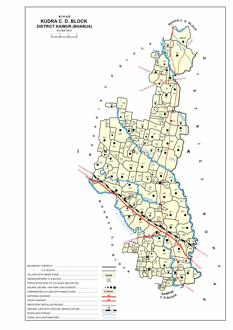
R
!
!
!!
!
!
!
D !
!
!
!!
!
! !
!!
!
!
!!
D
!(
!
!
!
(
!
!D
!
!
D(
(
D
!!!
!
!D
!!(
!
D
D
D
!
!D
!
!
D
D
D
!D
!
!
!
!
!
D
!
!D!
!
! !!!
!
!!
D !!
D
D
!
(
! D
!
(
!
!
!!!
!
!!
(!
!!
!
!
!!
D
!
!!
! !
!
D
!
!(!
!
! !!
!
!
!
D
!
((
!! !
!
!
D
!
!
!
!
D
!!
!(
D
!
!!D( !( (
!(
D
(
(
!
SH
Dehri-on-son Jn.
NH 2
To Sasaram
To Chenari
From Bhabhua
From Mohania
From Muthania
From Bhabhua Rd
From Dandwas
To Kochas
To Khijr
i
DistributaryDistributory
Bhagra N.
CANAL
KUDRA
B H A B
U A C
. D. B
L O C K
C. D. BLO CKRA MPUR
NUAON C. D. BLOCKDISTRICT KAIMUR (BHABUA)
B I H A RKUDRA C. D. BLOCK
2 101
M
O
H
A
N
I
A
C
.
D .
B
L O C K
DI
ST
RI
CT
R
OH
TA
S
Du
rg
au
ti N
K
u d r a
N.
I N D I A
KILOMETRES
249141
143
142144
146
147 145
148
149
156
150151
155152
153154
168169
172171
173174175 178
170
179
180177
176199
198188 187
186
182
165
166167
203 201 200
202197
196195
204
164
163
205
162
160
161
206 207 194
209
210208
193
191189 185
181183184
190192
217 218
219227
226220
224225
228229
216
215230
212
211
159
158
157
214213
234
235236
238239
240
241
243
237
231232
233 222
223
221
252
251 253
244245
246
242 247 250254
256
257 258
260
255249273272
271
270
286287
269268285
288290
289 284276
274
275
278277
283291292
293294 282 281
280279
262261
259
266267
265
264
263
296 297298295
249299
BOUNDARY, DISTRICT ..................................................................... '' C.D. BLOCK ................................................................VILLAGE WITH MDDS CODE ..........................................................HEADQUARTERS: C.D.BLOCK .......................................................POPULATION SIZE OF VILLAGES: BELOW 200200-499, 500-999, 1000-4999, 5000 & ABOVE ................................UNINHABITED VILLAGE WITH MDDS CODE .................................NATIONAL HIGHWAY ........................................................................STATE HIGHWAY ..............................................................................IMPORTANT METALLED ROADS .....................................................RAILWAY LINE WITH STATION, BROAD GAUGE ...........................RIVER AND STREAM ........................................................................CANAL WITH DISTRIBUTARY ..........................................................
X 249245
SH
RS
NH
ììì
R! ! ! !(
249299

�����
�
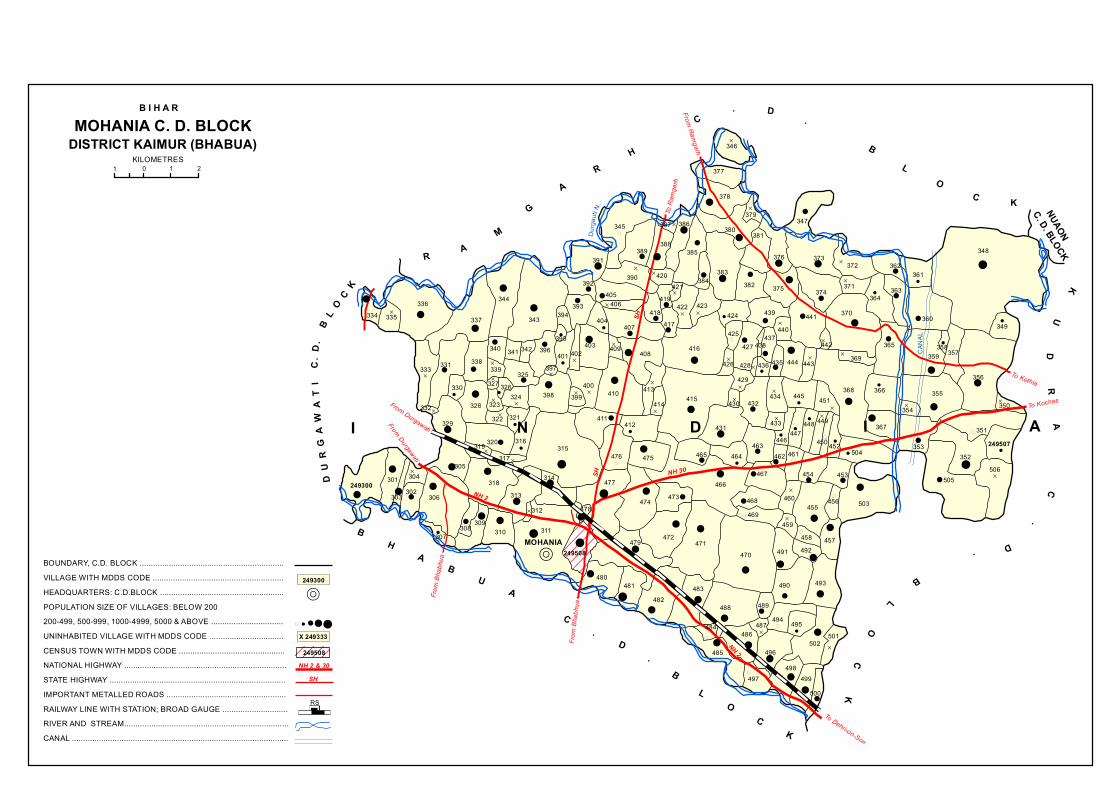
R
D
(
!!
D
(
!!
!
!
D
! !!
(
!
!
D
!!
!
!
!
!
D
!!
!
!
!
D
!!
D
!
!
!
D
D D
!
!
!
!!
!
!
D
D
!
!
!!
(
!
!D
!( !(
D
!!
!
(D
!!
!
!!
!
D!
!
!D
!
!
DD
!
D
D!
!
D
! D
D
D
!
D!
!
!
!
!
D
D
!
!!
DD
D
D
D D D
!
D
!
DD
!
!
!
!
!
(
! !D
!
D
(! !
!
!
!
!
(
!
!
!
!!
!
!
!
D
! (
!
!
D
!!
!
!D
D!
!!!
!!
!D
!
! ! (
!
!
!!
D
!! ! (
! D
!
!!
!
(
!
!!
!!
!
!!
!
!!
(
!!D
!(
D!
!
!(
!!
CANA
L
Durga
ut i N. NUAON
C. D. BLOCK
MOHANIA
DISTRICT KAIMUR (BHABUA)
B I H A RMOHANIA C. D. BLOCK
2 1 10
D U
R G
A W
A T
I C
. D.
B L
O C
K
R AM
GA
RH
C
. D.
B
LO
C K
BH
AB
UA
C
.D
.B
LO
CK
KU
DR
A
C.
D.
BL
OC
K
NH 30
SH
SH
To Dehri-on-Son
To Kothia
To Kochas
From
Bhab
hua
From
Bhab
hua
NH 2
NH 2
From Durgawati
From Durgawati
From Ramgarh
To R
amga
rh
I N D I A
KILOMETRES
334 335336
337
331333
332
329
330
338
328
320
305
306
304302303
301249300
307308 309
310
313312
311
318
319317
327339
340 341
325326
324323322 321
316315
314
478
477
474 473
472471
466
465475476
412411
399400
398
397
396395
401342
343
344
394393
392405
406
407404
403402 409
418419
421
422 423
417
416408
413410414 415
424
425427
426
429
430
431
464
249508
480
479
481482
483
470
488
484
485
486
497
496
498499
500
502501
495494487
489
491
490 493
492457458
459469468
467
460455 456 503
453454
461462463
432
428
439
440
438437
435436
434
433
446447
448 449
450 452504
368451445
444 443
441
375382383
374
370
442369
367
366
365
364363
360
359358357
355
354
353352
505506
249507351
350
356
349
348
361362
371
372376 373
347381380
379
378
377
346
386
385
384
345
389391
390
388
387
420
NH 2 & 30
BOUNDARY, C.D. BLOCK ................................................................VILLAGE WITH MDDS CODE ..........................................................HEADQUARTERS: C.D.BLOCK .......................................................POPULATION SIZE OF VILLAGES: BELOW 200200-499, 500-999, 1000-4999, 5000 & ABOVE ................................UNINHABITED VILLAGE WITH MDDS CODE .................................CENSUS TOWN WITH MDDS CODE ...............................................NATIONAL HIGHWAY ........................................................................STATE HIGHWAY ..............................................................................IMPORTANT METALLED ROADS .....................................................RAILWAY LINE WITH STATION; BROAD GAUGE .............................RIVER AND STREAM.........................................................................CANAL ................................................................................................
R
X 249333
249508
249300
SH
ìììRS
! !!!(

�����
�
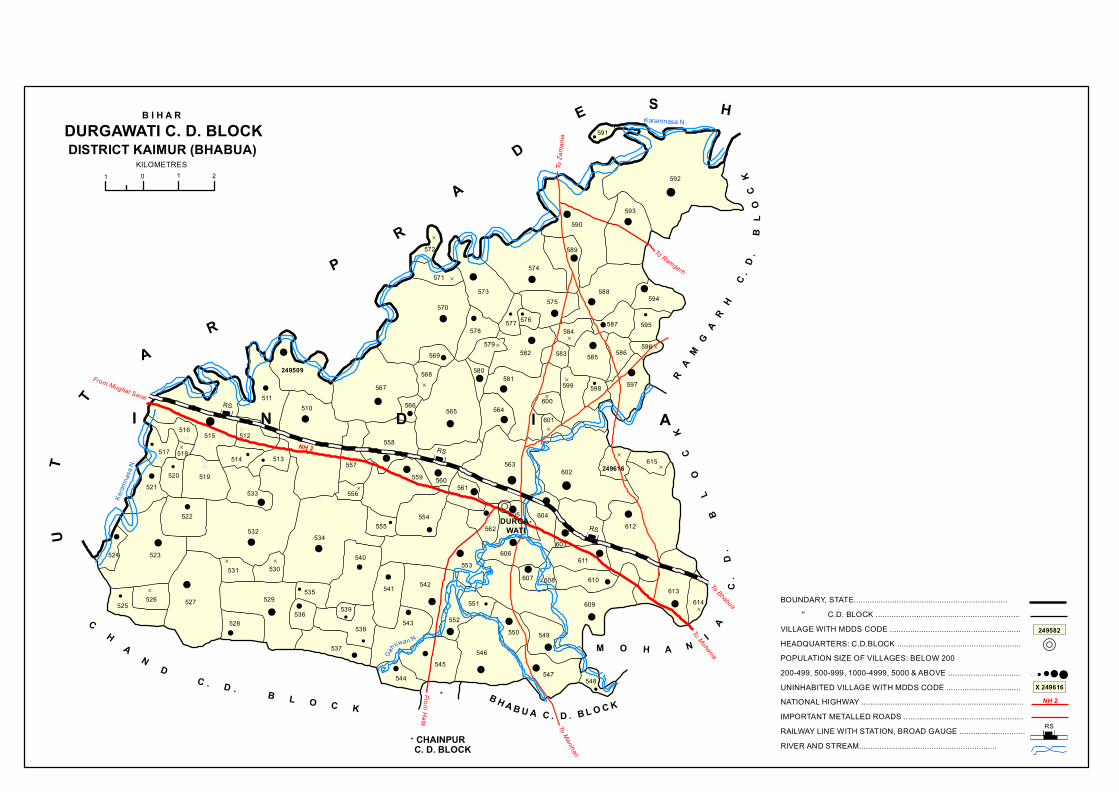
R
!
!
!!
D
!
!
!D
!
!
!
!!
!!
!!
D!
!!
(
D D(
!
!
!
!!
!
D
!
!
D!
!
D
!!
D
(
(
!(
!
!
!
!
!
D
D!
D(
!
!!
!
!
!!
D
!
!
!
!
!!
!
!!
!
!!
!
!
!
!
D
(
D
!
!
!
!
!
D
!
!
!D
!
!
!
!!
!
!
!
!
!
! !
!!
!
Gahuwan N.
Karamnasa N.Ka
ramna
sa N.
B H A B U A C . D . B L O C K
DURGA-WATI
C. D. BLOCKCHAINPUR
*
B I H A RDURGAWATI C. D. BLOCKDISTRICT KAIMUR (BHABUA)
2 1 10
C H A N D C . D . B L O C K
M O H A N I A
C
. D
.
B
L
O
C
KR A
M G
A R
H
C.
D.
B
L O
C K
To Bhabua
RS
RS
RS
To Manihari
To Mohania
NH 2
From Mughal Sarai
From Hata
To Ramgarh
To Za
mania
UT
T
AR
P
R
A
D
E S H
I N D I A
KILOMETRES
*
525
523524
522532
527
531 530
529
528536
535
534
540
539
538
537
521
517
516
518
520 519
533
514 513
512515
511510
249509
567
557
556
559
558
555554
553
542541
543
545546
552
551
550 549
547
609
607 608 610
606611
603
612
613614
562605
561560
565566
568 580581
564600
599
601
598 597
586
602563 615
249616
604
570
569
578579
582
577 576
573571
572
574
575
589
590
588
584
583 585
587 595
596
591
592
593
594
548
526
544
BOUNDARY, STATE.................................................................... '' C.D. BLOCK ................................................................VILLAGE WITH MDDS CODE ..........................................................HEADQUARTERS: C.D.BLOCK .......................................................POPULATION SIZE OF VILLAGES: BELOW 200200-499, 500-999, 1000-4999, 5000 & ABOVE ................................UNINHABITED VILLAGE WITH MDDS CODE .................................NATIONAL HIGHWAY ........................................................................IMPORTANT METALLED ROADS .....................................................RAILWAY LINE WITH STATION, BROAD GAUGE .............................RIVER AND STREAM.............................................................
R
X 249616
ìììRS
249582
NH 2
! !!!(
ììì
ììì
ììì

�����
�
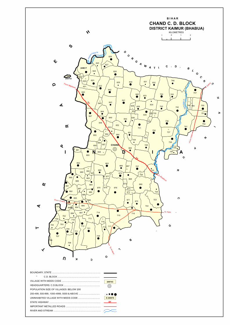
R
!
!
!
!
! !D
!
D
!
D
!!
!
!
(
!
!
!
(
!
!
!
!!
!
!
!
D
D
D
!
!
!!D
!! !
!
D
!D
D
!
!( !
!!
D
!
!(
!
!
!D
!!
D
D
!
!
!!
!D!!
! !D
!!!
!D
(
!
!D
! (!
D
!!
!
!!
!
!
!D
(
!
!
!!(!
!D
!
!
!
!!!!!
!
!
(
!
! !
!
!
!
(
D
!
!
D
!
!
!
!
!!!
!
!
!
(
SH
SH
To Bhabhua
To Hata
From Chakia
To Anapur
To Dahia
From
Hata
From Majhwar
Gahu
wan N
.
Karam
nasa N.
CHAND
DISTRICT KAIMUR (BHABUA)2101
B I H A RCHAND C. D. BLOCK
CH
AI
N
P
U
R
C.
D.
B
L
OCKU
T
TA
R
PR
AD
ES
H
DU
RG A W A T I C . D . B L
OC
K
I N D I A
KILOMETRES
249617
618249753 619
624
625
626
627
628
622
623620
621
646642
629 630 631
633640
641643645
632
744
746
745
742743634639
635
638
637
636
731
733
734 735
736
748 749 750
747
751
752741
732 737
738
739740
728
729
651
665
664
652653
649
654
648
655
656659
658
657
663666 667 727
725
730
647
644
662
661
660
690
691
688
689 682681
680
677
678679 676
675
674
673672
669
668726
724
723
722
670671
683
684687
686685692
700701
702704
705 703
707
709
710
698
699 694 695
693696
714
713
697
712
711
708706
721
718
720
719 717
715716
650
SH
BOUNDARY, STATE .......................................................................... '' C.D. BLOCK ................................................................VILLAGE WITH MDDS CODE ..........................................................HEADQUARTERS: C.D.BLOCK .......................................................POPULATION SIZE OF VILLAGES: BELOW 200200-499, 500-999, 1000-4999, 5000 & ABOVE ................................UNINHABITED VILLAGE WITH MDDS CODE .................................STATE HIGHWAY ..............................................................................IMPORTANT METALLED ROADS .....................................................RIVER AND STREAM ........................................................................
R
X 249574
249743
! ! ! !(

�����
�

R
(
(
!
D
!
D
!!
!
!!
!
! D(D
!
!
!
!
!
!
! !
!
(
!
!D
!! !
!
D
!!
!
!!
!
!( !
!
!
!!!
! !!
!
! !D
!(
!
!
D
D
!
!!
!
D !!!
!
!!
!
!
D
!! !!
(
!!
!
!
!
!!
!
!!
!(
DD
(
(!
!
!
!D D
!D
!
!
D!D !D!
!
! (
!
!
!
!
!
D
!
!
D
!
!
!!
!
D
! (
!
!
!
!
!!!
!!
D!
D
! !(
!
!(
!
!
!
D
!!
(
D
!
(
!
(
!
! (
!
!
(
!
!
(
(
!
!
!
!
!
From Dewane
SH
To Bhabhua
To Bhabhua
To Saraiya
From Chand
From Lohdan
From Dahia
Gurwat N.
Gurwat N.Kuh
ira N
.
Kuhir
a N.
CHAINPUR
B H A B U A C . D. B L O C K
1 0 1 2
DISTRICT KAIMUR (BHABUA)
B I H A RCHAINPUR C. D. BLOCK
B H
A G
W A
N
P U
R
C.
D.
B L O C K
DURGAWATIC. D. BLOCK
CH
A
ND
C
.D
.
BL
O
CK
UT
TA
R
PR
AD
ES
H
A D H A U R A C.
D.
B
LO
CK
KILOMETRES
I N D I A
839
841 840
842
851852
853843844845
838
836
832 835
833
834
837858
846847
848849850
856854
855
857
862859
860 864
861 865
866867
825
826827828
829830831
821
820
819818 817
822
823
816824 870
869868890
891 892
893 894 914913
912
897 911 910
909898896
895889871
872815
814 873 874 888887
760 761
762
758756
757
767766
765763 764 768 769
755 782
249754783
784786
785 787793779780
781
771770
772774773
778
777
794
788790792
791
789813
811812
795804
796
797776775
799798 803
805
810
809 875 879
878807
808
876 877
806
802801800
882886
885
883
881
880884
899 907908
906
900901 902 903
905
904
863
916
915
917
918
919 921
920
926
925
927
924
922
923
929249930
928
759
SH
BOUNDARY, STATE .......................................................................... '' C.D. BLOCK ................................................................VILLAGE WITH MDDS CODE ..........................................................HEADQUARTERS: C.D.BLOCK .......................................................POPULATION SIZE OF VILLAGES: BELOW 200200-499, 500-999, 1000-4999, 5000 & ABOVE ................................UNINHABITED VILLAGE WITH MDDS CODE .................................STATE HIGHWAY ..............................................................................IMPORTANT METALLED ROADS .....................................................RIVER AND STREAM ........................................................................
R
X 249770
249920
! ! ! !(

�����
�

R
!! !
!
! !
!
!
!
D
!
!
!!
(
!
!
!
!
!
!
!D
!!
!
!D
!
D
!!
D
!D
!
!!
! DD
D
!
D
!
(
!
!
!!
!
!
!
!
D
!
!
!
D
D
!!
! !
!!!
!
!!
!!
!
!!
D
!D
! D
!!
!D!
( DD
!
!
!D
(
! D
!
D
!
!
!
!!
!
D
!! !
D
! !
! !
!
!
!
!!
D
!
!
D
!
D!
!!
D
! D
!
!!
D
!
!
!
!
!!
!
!
(
! !
D
!
!D
D
(
!!
D !
!!
!
!
!
D
!
!
D
D
D
!
(
!
DD
!
D
!!
!
!
D !
D
! !
!!
(
!
!! D
(
!
!
!!
!
!
!!
D
(
!D
!
!
! !D
!D
D (
!
!
(
!
!
!
!!
!
!!
!
D
!
!
!
!(
D
!
D
!
D
!
!!
! !!!
!
!
D
DD
!
!
D
!
!
!D
!!
! D!
!
D
!D
!D
!
!
!
(D
!
!
(!
!
!
!!
D
! !D !D
!D
D
SH
SH
From Fakhrabad
From ChandTo Bhagwanpur
To Chenari
To Kudra
To Bhab
hua
To U
sri
Shur a
N.
Durgauti N.
DISTRICT KAIMUR (BHABUA)BHABUA C. D. BLOCK
B I H A R
2101M O H A N I A C . D . B L O C K
R A M P U R C . D . B L O CK
B H A G W A N P U R C . D . B L O C K
CH
AI
NP
UR
C
.D
.
BL
OC
K
BHABUA
D U R G A W A T IC . D . B L O C K
KU
DR
A
C.
D.
B
L
O
CK
KILOMETRES
(NP)
I N D I A
249931 933
932 938939
940
937935
936 941
934 962
961
963
965
964
960
942943
944945
946
956
947076
077 078 082083
084
085081080
079075948
968 969970971
972 973
959957
958953
954
955
952
951
950
949
059
074073
071070
072086
087088 089
101
102
103
105
106
090
092 099
091
067
066
068069
060966 967 974
976977 975057
058
984
981982983
985 986
980
978
056
979
987988
989
054
055 062
063061064
052053
051
047
050
990
993
992991 997
998049
048044
045
043
801392
999996
995994
250000003
001 002
004
026
005
025027
024023
028 021 020
150
017
008
038
039
041
040
042
093094 095
098 097
107
109
100
108
117 116115
118096
036
034 033 119
035
037 031
029030
018022
016015014
019155
153
151
032149148
120 123147
152
154
121
110 111
112
113
114
122
129
130
128 131
132
136127
125 126137
135
133134
138
143
144124
146145 142
141 140139
181180
179163
159
161160
158 165 164 169
168167166157156013
009007 010
006 215
011 012
250216214 212
213 211 210
171
170
176
177 182186
187188
183185
189
190184
174175
173172
198199 200
197 196
202
195 194
201 203193 192
204205
191 206207208209
104
178
046
SH
BOUNDARY, C.D. BLOCK ................................................................VILLAGE WITH MDDS CODE ..........................................................HEADQUARTERS: C.D. BLOCK ......................................................POPULATION SIZE OF VILLAGES: BELOW 200200-499, 500-999, 1000-4999, 5000 & ABOVE ................................UNINHABITED VILLAGE WITH MDDS CODE .................................STATUTORY TOWN WITH MDDS CODE .........................................STATE HIGHWAY ..............................................................................IMPORTANT METALLED ROADS .....................................................RIVER AND STREAM.........................................................................
R
X 250983
801392
250216
! !!!(

�����
�

R
!
D
!
(!
!
D
!
!!
D
!
!
!
!!
D
!
!
!
!
D !
!
D!
!D
(! !
(
!
D
!
!!
!! D
! !
(
!
D
!
!!
!
!
DD
(
!
!
!! !
!
!!
!
!
D
!
D D
!
!
D
! !
!
!
D
!!
! !
!!
! D
!!!
!
!
!!
!
D(
!
!!
D
!
D !
(
!
!
D
D
!
D(
(
!
!
!!
!
!
D
D! (
!
D
!(
D
D
D
!
(
D
D
D
(
D
!
D
D
!
From Bhagwanpur
From BhabuaTo Chenari
Karsotha N.
RAMPUR
D I
S
T R
I
C
T
R
O
H T
A S
DISTRICT KAIMUR (BHABUA)RAMPUR C. D. BLOCK
B I H A R
KUD R A C.D. BLOCK
2 101
A
D
H
A
U
RA
C
.D
.
B
LO C K
Du r g a u t i N .
KILOMETRES
I N D I AB
H A
G W
A N P U R C . D . B L O
C K
B H A B U A C . D . B L O C K
274
275
280279
281278
277
276
273 272271270
265 264
266
269268
267219
218
250217
220
222263
262261
259
258
221
224
225226 227
228229
230
231
249
250
251
223 255254
256257260
253252
248 247 246245 244 243
242
232
235 234
233
236241
240238
237
239
311310309
307305
306 308304303302
294293284283
282289 288
287
286285
291
292 295 300
301315 314 313
312
317316
321320
319318296
297298 299
322 323 324326
290 325
329328
327
331
330
338 332333
334336
337
335
339340
348 347346
345
344341
351343
342
350
349
352 250353
AREA TRANSFERRED FROM RAMPUR C.D. BLOCK
BOUNDARY, C.D. BLOCK
RAMPUR C. D. BLOCKCHANGE IN JURISDICTION 2001-2011
5 0 5 KILOMETRES
BOUNDARY, DISTRICT
RAMPUR C. D. BLOCKBHAGWANPUR C. D. BLOCKBOUNDARY, DISTRICT .................................................... " , C.D. BLOCK ................................................................VILLAGE WITH MDDS CODE ..........................................................HEADQUARTERS: C.D.BLOCK .......................................................POPULATION SIZE OF VILLAGES: BELOW 200200-499, 500-999, 1000-4999, 5000 & ABOVE ................................UNINHABITED VILLAGE WITH MDDS CODE .................................IMPORTANT METALLED ROADS .....................................................RIVER AND STREAM ........................................................................
R
X 250351
250353
! ! !!!

�����
�
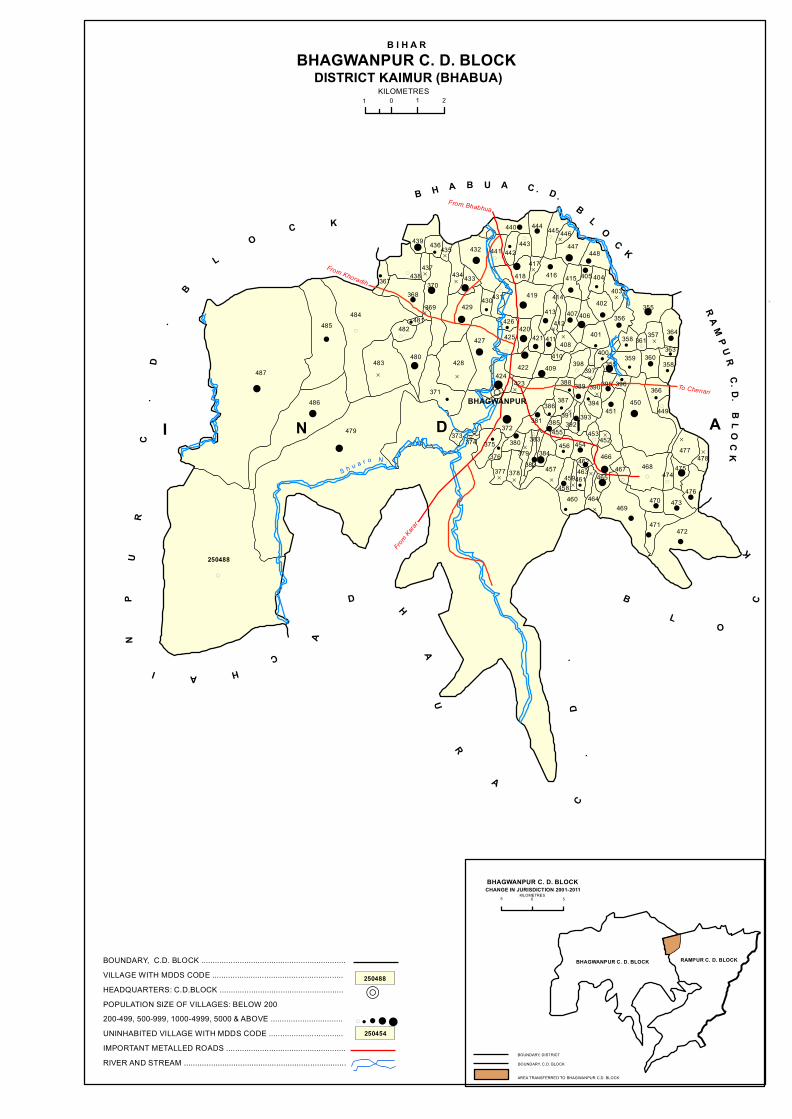
R
(!
!
D
!! (
!
(
!
!D
D
( D
!
! D !!
!
!
! !
D!
(
!
!
( (
!
!
!
!!
!!
D
D
!
!
!
!
!(
!
!
(
!
D
D D !
!!(
(
(
!
!D
D
!
!
!
!
!D !
!
!
!!
!
(
!D (
!!
!
((
(! D
!D
(
!!
D!
!
D
! D
(DD (
!D (
!
! D
!
!
D
(
D
!
!
! !!
!!
!
!
!
!
D!
!!
(
!
!
!
!
!
From Bhabhua
From Kara
r
To Chenari
From Khoradih
BHAGWANPUR
B H A B U A C . D . B L O C K
R A M P U R C. D. B L O C K
CHAI
NP
UR
C
.D
.B
LO
C K
A
D H
AU
R
A
C.
D.
BL
O
CK
I N D I A
DISTRICT KAIMUR (BHABUA)
B I H A RBHAGWANPUR C. D. BLOCK
2101KILOMETRES
S h u a r o N .
AREA TRANSFERRED TO BHAGWANPUR C.D. BLOCK
BOUNDARY, C.D. BLOCK
BHAGWANPUR C. D. BLOCKCHANGE IN JURISDICTION 2001-2011
5 0 5 KILOMETRES
BOUNDARY, DISTRICT
RAMPUR C. D. BLOCKBHAGWANPUR C. D. BLOCK
358487
485484
367 438
439 436435
437
370368
481
483
486
482
480
434
432
433
429
428
371
427
430
440
442443
444 445 446447
448
416417
418
441
431 419
415 405 404403
402406
414413
421412
407 356
401408
410
411420
426
425
422
355
364357361358400
397398
389388
372
386 387 394
390 395
355 359 360363
366450
449
477478
476
475474
468
470 473
472471
469464460
465467
466
452
451
453454
462463
461459458
457377 378
376375 380
379382
383384
456455
393392
391385381
373479
250488
369
374
424423
409
396
BOUNDARY, C.D. BLOCK ................................................................VILLAGE WITH MDDS CODE ..........................................................HEADQUARTERS: C.D.BLOCK .......................................................POPULATION SIZE OF VILLAGES: BELOW 200200-499, 500-999, 1000-4999, 5000 & ABOVE ................................UNINHABITED VILLAGE WITH MDDS CODE .................................IMPORTANT METALLED ROADS .....................................................RIVER AND STREAM ........................................................................
R
250454
250488
! ! ! !(

�����
�
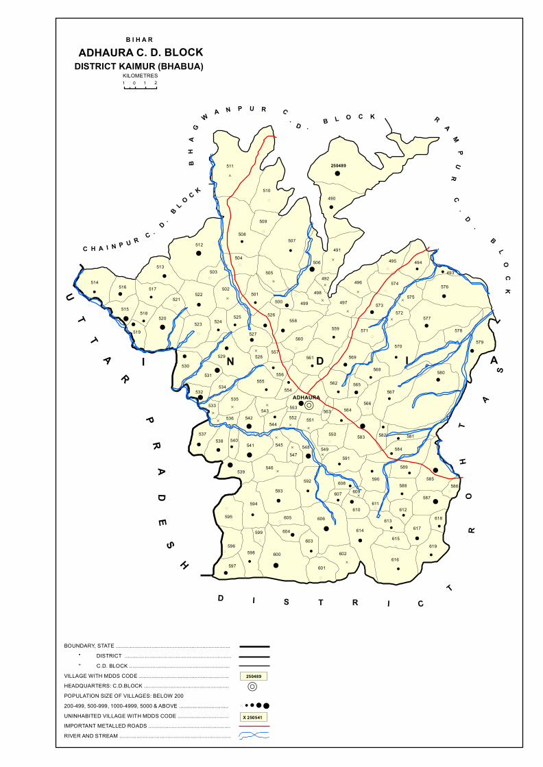
R
D !
(
!
!
!
(
!D
! !(!
(
D
! (
D! (
D
!!
!D
!!
D D
!
D
(
!
(
!!
D!
! !! !
!
!
(!
((
!
!
(
!
!
!!
(
D
!
!
!!
!
!!
!!
(
!
!(
!
D
!
D(
!
D
!
D
D
D !
!
!
!
(
!!
! D
D
! !
!!
D
!
D
!!
!
!
(
!
!
!
D
!
(
!!
(
!
!
(
!!
!!
!
!
(
(
!
!!
(
D
!
!(
ADHAURA
I N D I A
UT
TA
R
PR
AD
ES
H
BH
AG
WA N P U R C
. D . B L O C K
D I S T R I CT
R
OH
T
A
S
R
AM
PU
R
C.
D
.
B
LO
CK
B I H A RADHAURA C. D. BLOCK
DISTRICT KAIMUR (BHABUA)211 0
KILOMETRES
C H A I N P U R C . D . B L O C K
514516
515 518
519
520
517
513
522521
523
530531
529
524
527
525
502
503
512508
504
501
505
500
526558
560
557528
555556
535532
534
543
554
561
559
497499
506
507
490
491
492
498496
511
510
509
250489
495 494
575
574 576
493
577
578
579570
572573
571
569
562 565
568
567
580
566564563553
537
533
536
538 540
542544
541 545547
552 551
550
549548
539 546
583 582 581
584
585586
589
590
591
608609607
610
614
588
611612
613617
587
618
619615
616
606
602
601
603604
605
593592
594
595
596
599
598
597
600
BOUNDARY, STATE .......................................................................... " DISTRICT ..................................................................... '' C.D. BLOCK .................................................................VILLAGE WITH MDDS CODE ..........................................................HEADQUARTERS: C.D.BLOCK .......................................................POPULATION SIZE OF VILLAGES: BELOW 200200-499, 500-999, 1000-4999, 5000 & ABOVE ................................UNINHABITED VILLAGE WITH MDDS CODE .................................IMPORTANT METALLED ROADS .....................................................RIVER AND STREAM ........................................................................
R
X 250541
250489
! ! ! !(

�����
�
Alphabetical list of Villages (C.D. block wise)
Name of the District:Kaimur (Bhabua)
Serial
number Name of village
2011 Census location
code number
2001 Census location code
number
1 2 3 4
Name of CD Block: Ramgarh
Code of CD Block: 01446
1 Abhaideh 248980 1031000103313200
2 Ahiwans 249005 1031000103315800
3 Akorhi 248984 1031000103313700
4 Alipur 249021 1031000103317400
5 Anantpura 248953 1031000103310500
6 Ansi 249047 1031000103320000
7 Antdih 248999 1031000103315200
8 Asapur 249031 1031000103318400
9 Asaura 249028 1031000103318100
10 Ashaideh 248971 1031000103312300
11 Bagarhi 249035 1031000103318800
12 Bahpura 249018 1031000103317100
13 Baijnath 248925 1031000103307700
14 Bairpur 249016 1031000103316900
15 Balha 248955 1031000103310700
16 Balpur 248992 1031000103314500
17 Baluwa 249042 1031000103319500
18 Bamhangawan 248974 1031000103312600
19 Bandipur 248983 1031000103313600
20 Banwari Chak 249037 1031000103319000
21 Baraura 248994 1031000103314700
22 Barbigha 248988 1031000103314100
23 Bedaman Chak 249006 1031000103315900
24 Bharaula 248990 1031000103314300
25 Bhargawan 248973 1031000103312500
26 Bharheria 248934 1031000103308600
27 Bhatauni 248923 1031000103307500
28 Bishunpura 248927 1031000103307900
29 Bishunpura 248981 1031000103313300
30 Bisrampur 248946 1031000103309800
31 Chakkupur 248949 1031000103310100
32 Chandarmanpur 248937 1031000103308900
33 Chhatarpura 248928 1031000103308000
34 Chhewari 248977 1031000103312900
35 Chitahan 249029 1031000103318200
36 Chitahan 249032 1031000103318500
37 Dahrak 248948 1031000103310000
38 Darwansurat 249024 1031000103317700
39 Debahalia 248929 1031000103308100
40 Dhanautia 249027 1031000103318000
137
Alphabetical list of Villages (C.D. block wise)
Name of the District:Kaimur (Bhabua)
Serial
number Name of village
2011 Census location
code number
2001 Census location code
number
1 2 3 4
41 Dharahara 248932 1031000103308400
42 Gadeya 248931 1031000103308300
43 Gaura 249011 1031000103316400
44 Gogarhi 248926 1031000103307800
45 Gogasaray 249040 1031000103319300
46 Goria 248989 1031000103314200
47 Gorsara 248982 1031000103313500
48 Gorsara 249023 1031000103317600
49 Hajra 249007 1031000103316000
50 Hamzapur 248995 1031000103314800
51 Imlia 248962 1031000103311400
52 Isri 248985 1031000103313800
53 Jalalpur 249017 1031000103317000
54 Jamurna 248947 1031000103309900
55 Jandaha Magrahi 248963 1031000103311500
56 Jandaha Mashraki 248966 1031000103311800
57 Jangalchhera 248951 1031000103310300
58 Jangalchhera Bhargawan 248972 1031000103312400
59 Jangalchhera Imlia 248961 1031000103311300
60 jangalchhera Magrabi 248964 1031000103311600
61 Jangalchhera Mashraki 248965 1031000103311700
62 Jangalchhera Nonar 248970 1031000103312200
63 Jangalchhera Sahodarpur 248956 1031000103310800
64 Jangalchhera Saray 248957 1031000103310900
65 Jangalchhera Taraiya 248960 1031000103311200
66 Jorar 248986 1031000103313900
67 Judunandan Patti 249025 1031000103317800
68 Kalani 249010 1031000103316300
69 Kalyanpur 249036 1031000103318900
70 Kamsaray 249015 1031000103316800
71 Kanpura 249030 1031000103318300
72 Karari 248930 1031000103308200
73 Kathidih 248996 1031000103314900
74 Khanethi 248987 1031000103314000
75 Khorahra 248979 1031000103313100
76 Kishunpura 249019 1031000103317200
77 Kohraula 248935 1031000103308700
78 Labedaha 248936 1031000103308800
79 Labedahi 248941 1031000103309300
80 Lachhanpura 249043 1031000103319600
81 Lahang Patti 249000 1031000103315300
82 Lasra 248978 1031000103313000
138

Alphabetical list of Villages (C.D. block wise)
Name of the District:Kaimur (Bhabua)
Serial
number Name of village
2011 Census location
code number
2001 Census location code
number
1 2 3 4
83 Madanwan 248968 1031000103312000
84 Maheshpur 249013 1031000103316600
85 Mahuari 249039 1031000103319200
86 Mahuwar 248950 1031000103310200
87 Masarhi 248938 1031000103309000
88 Matiari 248933 1031000103308500
89 Mera 248940 1031000103309200
90 Mohanpur Bharula 248991 1031000103314400
91 Murlidarwan 249026 1031000103317900
92 Nagaitha 248967 1031000103311900
93 Narhan 248942 1031000103309400
94 Narhan 248997 1031000103315000
95 Nathua 249038 1031000103319100
96 Natwa 248993 1031000103314600
97 Nonar 248969 1031000103312100
98 Oriadih 249020 1031000103317300
99 Pachgain 248952 1031000103310400
100 Paikauli 249004 1031000103315700
101 Patkhaulia 249033 1031000103318600
102 Piparia 248975 1031000103312700
103 Prainpur 248998 1031000103315100
104 Rewra 248939 1031000103309100
105 Rupanandpur 248954 1031000103310600
106 Sadullahpur 249046 1031000103319900
107 Sangapur 248924 1031000103307600
108 Sarai 248958 1031000103311000
109 Sehuka 248945 1031000103309700
110 Senisaray 249014 1031000103316700
111 Sijhua 249009 1031000103316200
112 Siktha 249045 1031000103319800
113 Sisaunra 249001 1031000103315400
114 Sultanpur 249044 1031000103319700
115 Sumerpur Barka 248943 1031000103309500
116 Sumerpur Chotka 248944 1031000103309600
117 Taiyan 249002 1031000103315500
118 Tenua 249022 1031000103317500
119 Thakura 249012 1031000103316500
120 Tilsara 248976 1031000103312800
121 Toroiya 248959 1031000103311100
122 Tulshipur 249034 1031000103318700
123 Upadhya Sagar 249008 1031000103316100
124 Upari 249041 1031000103319400
125 Uprauli 249003 1031000103315600
139

Alphabetical list of Villages (C.D. block wise)
Name of the District:Kaimur (Bhabua)
Serial
number Name of village
2011 Census location
code number
2001 Census location code
number
1 2 3 4
Name of CD Block: Nuaon
Code of CD Block: 01447
1 Akhani 249050 1031000203320200
2 Akolhi 249066 1031000203321800
3 Baddha 249073 1031000203322500
4 Banbahuara 249104 1031000203325600
5 Bararhi 249069 1031000203322100
6 Baruna 249140 1031000203330700
7 Basanpur 249059 1031000203321100
8 Belahri 249065 1031000203321700
9 Belarhi 249137 1031000203330400
10 Bhaluhari 249125 1031000203329200
11 Bhatpurwa 249114 1031000203326600
12 Bhatwalia 249082 1031000203323400
13 Bhoganpur 249061 1031000203321300
14 Bhupatpur 249085 1031000203323700
15 Chandes 249099 1031000203325100
16 Chandes 249101 1031000203325300
17 Chandraui 249138 1031000203330500
18 Chaprang 249079 1031000203323100
19 Chaubepur 249119 1031000203328500
20 Chhata Bararhi 249070 1031000203322200
21 Chintamanpur 249053 1031000203320500
22 Chintamanpur 249120 1031000203328600
23 Darabpur 249126 1031000203329300
24 Darauli 249133 1031000203330000
25 Deuria 249083 1031000203323500
26 Dumduma 249106 1031000203325800
27 Dungurpura 249128 1031000203329500
28 Ewati 249088 1031000203324000
29 Ewati Bhopatpur 249086 1031000203323800
30 Ewati English 249081 1031000203323300
31 Fatehpur 249078 1031000203323000
32 Gai Chakl 249139 1031000203330600
33 Gaira 249063 1031000203321500
34 Garra 249062 1031000203321400
35 Gaura 249121 1031000203328700
36 Goriari 249087 1031000203323900
37 Gorsara 249077 1031000203322900
38 Guria 249108 1031000203326000
39 Harakhpur Chander 249100 1031000203325200
40 Hemrajpur 249056 1031000203320800
140

Alphabetical list of Villages (C.D. block wise)
Name of the District:Kaimur (Bhabua)
Serial
number Name of village
2011 Census location
code number
2001 Census location code
number
1 2 3 4
41 Hemrajpur 249127 1031000203329400
42 Jaitpura 249068 1031000203322000
43 Jaruman English 249090 1031000203324200
44 Jujharpur 249051 1031000203320300
45 Kamhari 249102 1031000203325400
46 Kanhua 249130 1031000203329700
47 Karamhari 249122 1031000203328900
48 Kariram 249067 1031000203321900
49 Kathaunra 249111 1031000203326300
50 Khairanti 249098 1031000203325000
51 Khudra 249076 1031000203322800
52 Konahra 249096 1031000203324800
53 Kota 249118 1031000203328400
54 Kota Hissa 249116 1031000203328200
55 kota Hissa Safdar Ali Khan 249115 1031000203328100
56 Kota Jadunath Singh 249117 1031000203328300
57 kurhani 249107 1031000203325900
58 Kusumpur 249058 1031000203321000
59 Lahang Patti 249110 1031000203326200
60 Madhopur 249113 1031000203326500
61 Mahartha 249064 1031000203321600
62 Mahila 249094 1031000203324600
63 Mahro 249052 1031000203320400
64 Mapatpur 249060 1031000203321200
65 Morath 249093 1031000203324500
66 Mukhrawan 249109 1031000203326100
67 Musia 249135 1031000203330200
68 Nakta Ghat 249080 1031000203323200
69 Noawan 249075 1031000203322700
70 Pajrawan 249071 1031000203322300
71 Paranpur 249084 1031000203323600
72 Parasia 249123 1031000203329000
73 Pariari 249095 1031000203324700
74 Parmanandpur 249105 1031000203325700
75 Parsotimpur 249136 1031000203330300
76 Partabpur 249074 1031000203322600
77 Pira Ghat 249055 1031000203320700
78 Ramkarpur 249112 1031000203326400
79 Rampur 249072 1031000203322400
80 Rampur 249097 1031000203324900
81 Rasanandpur 249124 1031000203329100
82 Rashidpur 249131 1031000203329800
141
Alphabetical list of Villages (C.D. block wise)
Name of the District:Kaimur (Bhabua)
Serial
number Name of village
2011 Census location
code number
2001 Census location code
number
1 2 3 4
83 Ruhiya 249132 1031000203329900
84 Sagra 249103 1031000203325500
85 Sarae Bala 249089 1031000203324100
86 Sarbasipur 249129 1031000203329600
87 Shahpur 249134 1031000203330100
88 Sonbarsa 249091 1031000203324300
89 Sotwa 249092 1031000203324400
90 Surajpura 249057 1031000203320900
91 Taraitha 249054 1031000203320600
92 Tira 249049 1031000203320100
142

Alphabetical list of Villages (C.D. block wise)
Name of the District:Kaimur (Bhabua)
Serial
number Name of village
2011 Census location
code number
2001 Census location code
number
1 2 3 4
Name of CD Block: Kudra
Code of CD Block: 01448
1 Abdalpur 249275 1031000303344200
2 Ahraulia 249237 1031000303340400
3 Ajgara 249206 1031000303337300
4 Ajgari 249209 1031000303337600
5 Amiaura 249191 1031000303335800
6 Amirtha 249239 1031000303340600
7 Asraulia 249232 1031000303339900
8 Auraiya 249210 1031000303337700
9 Babhanganwan 249236 1031000303340300
10 Bagra 249259 1031000303342600
11 Bahera 249215 1031000303338200
12 Bahuara 249202 1031000303336900
13 Baina 249221 1031000303338800
14 Bajarha 249145 1031000303331200
15 Bajarkona 249244 1031000303341100
16 Bamhanganwan 249155 1031000303332200
17 Banrughat 249165 1031000303333200
18 Barheta 249185 1031000303335200
19 Barka Nimdihra 249284 1031000303345100
20 Barna 249213 1031000303338000
21 Baruar 249299 1031000303346600
22 Basahi 249183 1031000303335000
23 Basantpur 249172 1031000303333900
24 Basawanpur 249224 1031000303339100
25 Bastalwa 249179 1031000303334600
26 Belbhadra 249263 1031000303343000
27 Bhadaula 249216 1031000303338300
28 Bhainsaula 249250 1031000303341700
29 Bhainslot 249195 1031000303336200
30 Bhairwa 249188 1031000303335500
31 Bhaisadih 249207 1031000303337400
32 Bhargawan 249241 1031000303340800
33 Bhatauli 249293 1031000303346000
34 Bhataulia 249164 1031000303333100
35 Bhelma 249159 1031000303332600
36 Bhunrwa 249225 1031000303339200
37 Biro 249269 1031000303343600
38 Bishunathpur 249268 1031000303343500
39 Bishunpura 249150 1031000303331700
40 Burahar 249176 1031000303334300
143

Alphabetical list of Villages (C.D. block wise)
Name of the District:Kaimur (Bhabua)
Serial
number Name of village
2011 Census location
code number
2001 Census location code
number
1 2 3 4
41 Chakia 249248 1031000303341500
42 Chanda 249186 1031000303335300
43 Chanrui 249266 1031000303343300
44 Chanwakh 249261 1031000303342800
45 Chaubepur 249192 1031000303335900
46 Chaukhara 249291 1031000303345800
47 Chhatauna 249169 1031000303333600
48 Chhotka Kajhar 249270 1031000303343700
49 Chhotka Nimdihra 249276 1031000303344300
50 Chibili 249242 1031000303340900
51 Daindih 249256 1031000303342300
52 Dangri 249151 1031000303331800
53 Danrori 249152 1031000303331900
54 Deokali 249279 1031000303344600
55 Deoraha 249280 1031000303344700
56 Deorarh 249233 1031000303340000
57 Derwan 249278 1031000303344500
58 Dewasdehra 249168 1031000303333500
59 Dhanarhi 249283 1031000303345000
60 Dhanta 249267 1031000303343400
61 Dhaturha 249201 1031000303336800
62 Dihra 249253 1031000303342000
63 Dubaulia 249218 1031000303338500
64 Dumri 249178 1031000303334500
65 Dusadhi Chak 249255 1031000303342200
66 Gajirhan 249230 1031000303339700
67 Gajrarhi 249246 1031000303341300
68 Gangvalia 249219 1031000303338600
69 Gayghat 249166 1031000303333300
70 Ghari 249193 1031000303336000
71 Ghatawan 249214 1031000303338100
72 Ghateyan 249158 1031000303332500
73 Gokhulpur 249282 1031000303344900
74 Golaudih 249254 1031000303342100
75 Gora 249285 1031000303345200
76 Gurra 249262 1031000303342900
77 Hardaspur 249258 1031000303342500
78 Harpur 249148 1031000303331500
79 Hasanpura 249175 1031000303334200
80 Inaulia 249281 1031000303344800
81 Itahi 249220 1031000303338700
82 Jagatpura 249157 1031000303332400
144
Alphabetical list of Villages (C.D. block wise)
Name of the District:Kaimur (Bhabua)
Serial
number Name of village
2011 Census location
code number
2001 Census location code
number
1 2 3 4
83 Jagdishpur 249154 1031000303332100
84 Jahanabad 249247 1031000303341400
85 Jajara 249290 1031000303345700
86 Jalkhoria 249161 1031000303332800
87 Jamunipur 249286 1031000303345300
88 Jaruha 249227 1031000303339400
89 Kadai 249272 1031000303343900
90 Kahua 249223 1031000303339000
91 Kaithia 249156 1031000303332300
92 Kakrahi 249205 1031000303337200
93 Kandehra 249181 1031000303334800
94 Karanpura 249287 1031000303345400
95 Karman 249243 1031000303341000
96 Kewrhi 249222 1031000303338900
97 Khaira 249252 1031000303341900
98 Khalopur 249295 1031000303346200
99 Khalopur 249298 1031000303346500
100 Khalsapur 249208 1031000303337500
101 Khanethi 249217 1031000303338400
102 Kharahna 249162 1031000303332900
103 Kishunpura 249231 1031000303339800
104 Laravandehra 249171 1031000303333800
105 Likhiya 249229 1031000303339600
106 Manpur 249163 1031000303333000
107 Masudnapur 249226 1031000303339300
108 Maudehra 249203 1031000303337000
109 Meura 249274 1031000303344100
110 Mohammadpur 249194 1031000303336100
111 Mohanpur 249141 1031000303330800
112 Mokaram 249264 1031000303343100
113 Munjia 249265 1031000303343200
114 Nado Khar 249211 1031000303337800
115 Nasej 249234 1031000303340100
116 Nataya 249204 1031000303337100
117 Nathopur 249240 1031000303340700
118 Neoras 249251 1031000303341800
119 Nimia 249228 1031000303339500
120 Ojhaulia 249173 1031000303334000
121 Orgain 249292 1031000303345900
122 Pachara 249170 1031000303333700
123 Pachpokhri 249260 1031000303342700
124 Parsotimpur 249296 1031000303346300
145

Alphabetical list of Villages (C.D. block wise)
Name of the District:Kaimur (Bhabua)
Serial
number Name of village
2011 Census location
code number
2001 Census location code
number
1 2 3 4
125 Patakpura 249160 1031000303332700
126 Pathkhaulia 249245 1031000303341200
127 Patkhaulia 249238 1031000303340500
128 Patti 249235 1031000303340200
129 Paunra 249277 1031000303344400
130 Phulli 249182 1031000303334900
131 Pipra 249180 1031000303334700
132 Puraini 249190 1031000303335700
133 Rampur 249196 1031000303336300
134 Rampur 249273 1031000303344000
135 Ratti Chak 249147 1031000303331400
136 Sabdalpur 249143 1031000303331000
137 Sahajpura 249289 1031000303345600
138 Sahpur 249198 1031000303336500
139 Saidpur 249294 1031000303346100
140 Sakri 249249 1031000303341600
141 Salthua 249142 1031000303330900
142 Salthua Bahuara 249144 1031000303331100
143 Saraya 249184 1031000303335100
144 Sariawan 249197 1031000303336400
145 Sarmanpur 249146 1031000303331300
146 Sarmanpur 249288 1031000303345500
147 Sarodih 249167 1031000303333400
148 Sasna 249153 1031000303332000
149 Semaria 249189 1031000303335600
150 Shahpur 249271 1031000303343800
151 Shekhapur 249200 1031000303336700
152 Silaundha 249149 1031000303331600
153 Singhsaira 249297 1031000303346400
154 Siswar 249187 1031000303335400
155 Sonawan 249212 1031000303337900
156 Sonbarsa 249199 1031000303336600
157 Tarhani 249257 1031000303342400
158 Taruhan 249174 1031000303334100
159 Turki 249177 1031000303334400
146
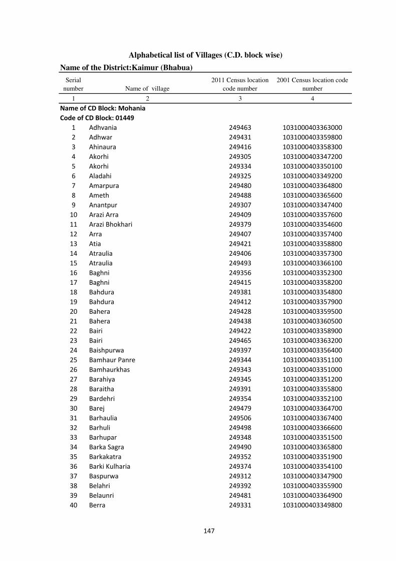
Alphabetical list of Villages (C.D. block wise)
Name of the District:Kaimur (Bhabua)
Serial
number Name of village
2011 Census location
code number
2001 Census location code
number
1 2 3 4
Name of CD Block: Mohania
Code of CD Block: 01449
1 Adhvania 249463 1031000403363000
2 Adhwar 249431 1031000403359800
3 Ahinaura 249416 1031000403358300
4 Akorhi 249305 1031000403347200
5 Akorhi 249334 1031000403350100
6 Aladahi 249325 1031000403349200
7 Amarpura 249480 1031000403364800
8 Ameth 249488 1031000403365600
9 Anantpur 249307 1031000403347400
10 Arazi Arra 249409 1031000403357600
11 Arazi Bhokhari 249379 1031000403354600
12 Arra 249407 1031000403357400
13 Atia 249421 1031000403358800
14 Atraulia 249406 1031000403357300
15 Atraulia 249493 1031000403366100
16 Baghni 249356 1031000403352300
17 Baghni 249415 1031000403358200
18 Bahdura 249381 1031000403354800
19 Bahdura 249412 1031000403357900
20 Bahera 249428 1031000403359500
21 Bahera 249438 1031000403360500
22 Bairi 249422 1031000403358900
23 Bairi 249465 1031000403363200
24 Baishpurwa 249397 1031000403356400
25 Bamhaur Panre 249344 1031000403351100
26 Bamhaurkhas 249343 1031000403351000
27 Barahiya 249345 1031000403351200
28 Baraitha 249391 1031000403355800
29 Bardehri 249354 1031000403352100
30 Barej 249479 1031000403364700
31 Barhaulia 249506 1031000403367400
32 Barhuli 249498 1031000403366600
33 Barhupar 249348 1031000403351500
34 Barka Sagra 249490 1031000403365800
35 Barkakatra 249352 1031000403351900
36 Barki Kulharia 249374 1031000403354100
37 Baspurwa 249312 1031000403347900
38 Belahri 249392 1031000403355900
39 Belaunri 249481 1031000403364900
40 Berra 249331 1031000403349800
147
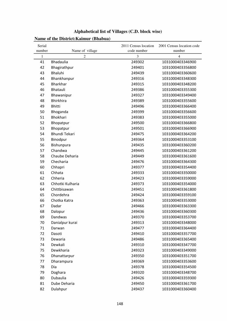
Alphabetical list of Villages (C.D. block wise)
Name of the District:Kaimur (Bhabua)
Serial
number Name of village
2011 Census location
code number
2001 Census location code
number
1 2 3 4
41 Bhadaulia 249302 1031000403346900
42 Bhagirathpur 249401 1031000403356800
43 Bhaluhi 249439 1031000403360600
44 Bhankhanpur 249316 1031000403348300
45 Bharkhar 249315 1031000403348200
46 Bhatauli 249386 1031000403355300
47 Bhawanipur 249327 1031000403349400
48 Bhirkhira 249389 1031000403355600
49 Bhitti 249496 1031000403366400
50 Bhoganda 249399 1031000403356600
51 Bhokhari 249383 1031000403355000
52 Bhopatpur 249500 1031000403366800
53 Bhopatpur 249501 1031000403366900
54 Bhundi Tekari 249475 1031000403364200
55 Binodpur 249364 1031000403353100
56 Bishunpura 249435 1031000403360200
57 Chandwa 249445 1031000403361200
58 Chaube Deharia 249449 1031000403361600
59 Checharia 249476 1031000403364300
60 Chhapri 249377 1031000403354400
61 Chhata 249333 1031000403350000
62 Chheria 249423 1031000403359000
63 Chhotki Kulharia 249373 1031000403354000
64 Chittbisawan 249451 1031000403361800
65 Chordehra 249424 1031000403359100
66 Chotka Katra 249363 1031000403353000
67 Dadar 249466 1031000403363300
68 Dalopur 249436 1031000403360300
69 Dandwas 249370 1031000403353700
70 Danialpur kurai 249313 1031000403348000
71 Darwan 249477 1031000403364400
72 Dasoti 249410 1031000403357700
73 Dewaria 249486 1031000403365400
74 Dewkali 249310 1031000403347700
75 Dewkharia 249323 1031000403349000
76 Dhanattarpur 249350 1031000403351700
77 Dharampura 249369 1031000403353600
78 Dia 249378 1031000403354500
79 Doghara 249320 1031000403348700
80 Dubaulia 249426 1031000403359300
81 Dube Deharia 249450 1031000403361700
82 Dulahpur 249437 1031000403360400
148
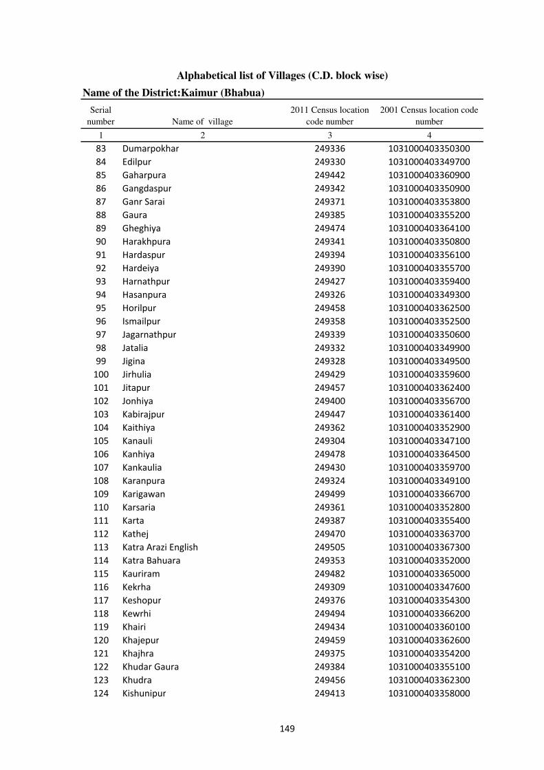
Alphabetical list of Villages (C.D. block wise)
Name of the District:Kaimur (Bhabua)
Serial
number Name of village
2011 Census location
code number
2001 Census location code
number
1 2 3 4
83 Dumarpokhar 249336 1031000403350300
84 Edilpur 249330 1031000403349700
85 Gaharpura 249442 1031000403360900
86 Gangdaspur 249342 1031000403350900
87 Ganr Sarai 249371 1031000403353800
88 Gaura 249385 1031000403355200
89 Gheghiya 249474 1031000403364100
90 Harakhpura 249341 1031000403350800
91 Hardaspur 249394 1031000403356100
92 Hardeiya 249390 1031000403355700
93 Harnathpur 249427 1031000403359400
94 Hasanpura 249326 1031000403349300
95 Horilpur 249458 1031000403362500
96 Ismailpur 249358 1031000403352500
97 Jagarnathpur 249339 1031000403350600
98 Jatalia 249332 1031000403349900
99 Jigina 249328 1031000403349500
100 Jirhulia 249429 1031000403359600
101 Jitapur 249457 1031000403362400
102 Jonhiya 249400 1031000403356700
103 Kabirajpur 249447 1031000403361400
104 Kaithiya 249362 1031000403352900
105 Kanauli 249304 1031000403347100
106 Kanhiya 249478 1031000403364500
107 Kankaulia 249430 1031000403359700
108 Karanpura 249324 1031000403349100
109 Karigawan 249499 1031000403366700
110 Karsaria 249361 1031000403352800
111 Karta 249387 1031000403355400
112 Kathej 249470 1031000403363700
113 Katra Arazi English 249505 1031000403367300
114 Katra Bahuara 249353 1031000403352000
115 Kauriram 249482 1031000403365000
116 Kekrha 249309 1031000403347600
117 Keshopur 249376 1031000403354300
118 Kewrhi 249494 1031000403366200
119 Khairi 249434 1031000403360100
120 Khajepur 249459 1031000403362600
121 Khajhra 249375 1031000403354200
122 Khudar Gaura 249384 1031000403355100
123 Khudra 249456 1031000403362300
124 Kishunipur 249413 1031000403358000
149

Alphabetical list of Villages (C.D. block wise)
Name of the District:Kaimur (Bhabua)
Serial
number Name of village
2011 Census location
code number
2001 Census location code
number
1 2 3 4
125 Kormahri 249355 1031000403352200
126 Kurra 249318 1031000403348500
127 Kutbanpur 249420 1031000403358700
128 Lahuribari 249367 1031000403353400
129 Lakhanpatti 249351 1031000403351800
130 Lakhmipur 249418 1031000403358500
131 Laria 249393 1031000403356000
132 Lodia 249319 1031000403348600
133 Lorpurwa 249395 1031000403356200
134 Lurpurwa 249329 1031000403349600
135 Machhanhat 249504 1031000403367200
136 Majhari 249471 1031000403363800
137 Mallupur 249414 1031000403358100
138 Mamade 249472 1031000403363900
139 Mamrezpur 249495 1031000403366300
140 Maniarpur 249335 1031000403350200
141 Mankawatia 249382 1031000403354900
142 Marha 249440 1031000403360700
143 Maricha 249441 1031000403360800
144 Mehro 249301 1031000403346800
145 Misraulia 249464 1031000403363100
146 Mobarakpur 249303 1031000403347000
147 Mohammadpur 249405 1031000403357200
148 Mohania 249311 1031000403347800
149 Mujan 249368 1031000403353500
150 Murharia 249491 1031000403365900
151 Muthani 249485 1031000403365300
152 Naraura 249365 1031000403353200
153 Narayanpur 249460 1031000403362700
154 Narsinghpur 249357 1031000403352400
155 Narwat 249322 1031000403348900
156 Naseja 249346 1031000403351300
157 Nawada 249402 1031000403356900
158 Nawagawan 249448 1031000403361500
159 Pakrihar 249483 1031000403365100
160 Panapur 249408 1031000403357500
161 Pandepur 249497 1031000403366500
162 Panre Deharia 249453 1031000403362000
163 Panre Pipra 249446 1031000403361300
164 Panserwa 249388 1031000403355500
165 Parashurampur 249444 1031000403361100
166 Paspipra 249467 1031000403363400
150
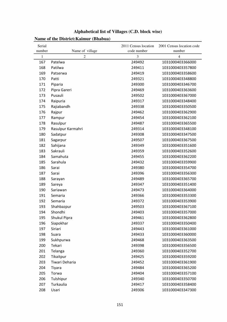
Alphabetical list of Villages (C.D. block wise)
Name of the District:Kaimur (Bhabua)
Serial
number Name of village
2011 Census location
code number
2001 Census location code
number
1 2 3 4
167 Patelwa 249492 1031000403366000
168 Patilwa 249411 1031000403357800
169 Patserwa 249419 1031000403358600
170 Patti 249321 1031000403348800
171 Piparia 249300 1031000403346700
172 Pipra Gareri 249469 1031000403363600
173 Pusauli 249502 1031000403367000
174 Raipuria 249317 1031000403348400
175 Rajiabandh 249338 1031000403350500
176 Rajpur 249462 1031000403362900
177 Rampur 249454 1031000403362100
178 Rasulpur 249487 1031000403365500
179 Rasulpur Karmahri 249314 1031000403348100
180 Sadatpur 249308 1031000403347500
181 Sagarpur 249507 1031000403367500
182 Sahijana 249349 1031000403351600
183 Sakrauli 249359 1031000403352600
184 Samahuta 249455 1031000403362200
185 Sarahula 249432 1031000403359900
186 Sarai 249380 1031000403354700
187 Sarai 249396 1031000403356300
188 Sarayan 249489 1031000403365700
189 Sareya 249347 1031000403351400
190 Sariawan 249473 1031000403364000
191 Semaria 249366 1031000403353300
192 Semaria 249372 1031000403353900
193 Shahbazpur 249503 1031000403367100
194 Shondhi 249403 1031000403357000
195 Shukul Pipra 249461 1031000403362800
196 Siapokhar 249337 1031000403350400
197 Siriari 249443 1031000403361000
198 Suara 249433 1031000403360000
199 Sukhpurwa 249468 1031000403363500
200 Tekari 249398 1031000403356500
201 Telanga 249360 1031000403352700
202 Tikaitpur 249425 1031000403359200
203 Tiwari Deharia 249452 1031000403361900
204 Tiyara 249484 1031000403365200
205 Torwa 249404 1031000403357100
206 Tulshipur 249340 1031000403350700
207 Turkaulia 249417 1031000403358400
208 Usari 249306 1031000403347300
151
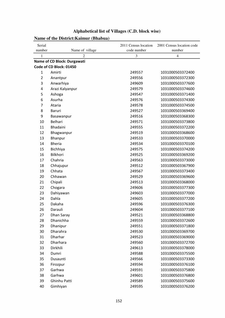
Alphabetical list of Villages (C.D. block wise)
Name of the District:Kaimur (Bhabua)
Serial
number Name of village
2011 Census location
code number
2001 Census location code
number
1 2 3 4
Name of CD Block: Durgawati
Code of CD Block: 01450
1 Amirti 249557 1031000503372400
2 Anantpur 249556 1031000503372300
3 Anwarhiya 249609 1031000503377600
4 Arazi Kalyanpur 249579 1031000503374600
5 Ashoga 249547 1031000503371400
6 Asurha 249576 1031000503374300
7 Ataria 249578 1031000503374500
8 Baruri 249527 1031000503369400
9 Basawanpur 249516 1031000503368300
10 Belhari 249571 1031000503373800
11 Bhadaini 249555 1031000503372200
12 Bhagwanpur 249519 1031000503368600
13 Bhanpur 249533 1031000503370000
14 Bheria 249534 1031000503370100
15 Bichhiya 249575 1031000503374200
16 Bilkhori 249525 1031000503369200
17 Chahria 249563 1031000503373000
18 Chhajupur 249512 1031000503367900
19 Chhata 249567 1031000503373400
20 Chhawan 249529 1031000503369600
21 Chipali 249513 1031000503368000
22 Chogara 249606 1031000503377300
23 Dahiyawan 249603 1031000503377000
24 Dahla 249605 1031000503377200
25 Dakaha 249596 1031000503376300
26 Darauli 249604 1031000503377100
27 Dhan Saray 249521 1031000503368800
28 Dhanichha 249559 1031000503372600
29 Dhanipur 249551 1031000503371800
30 Dharahra 249530 1031000503369700
31 Dharhar 249523 1031000503369000
32 Dharhara 249560 1031000503372700
33 Dirkhili 249613 1031000503378000
34 Dumri 249588 1031000503375500
35 Dusaunti 249566 1031000503373300
36 Firozpur 249594 1031000503376100
37 Garhwa 249591 1031000503375800
38 Garhwa 249601 1031000503376800
39 Ghinhu Patti 249589 1031000503375600
40 Gimhiyan 249595 1031000503376200
152
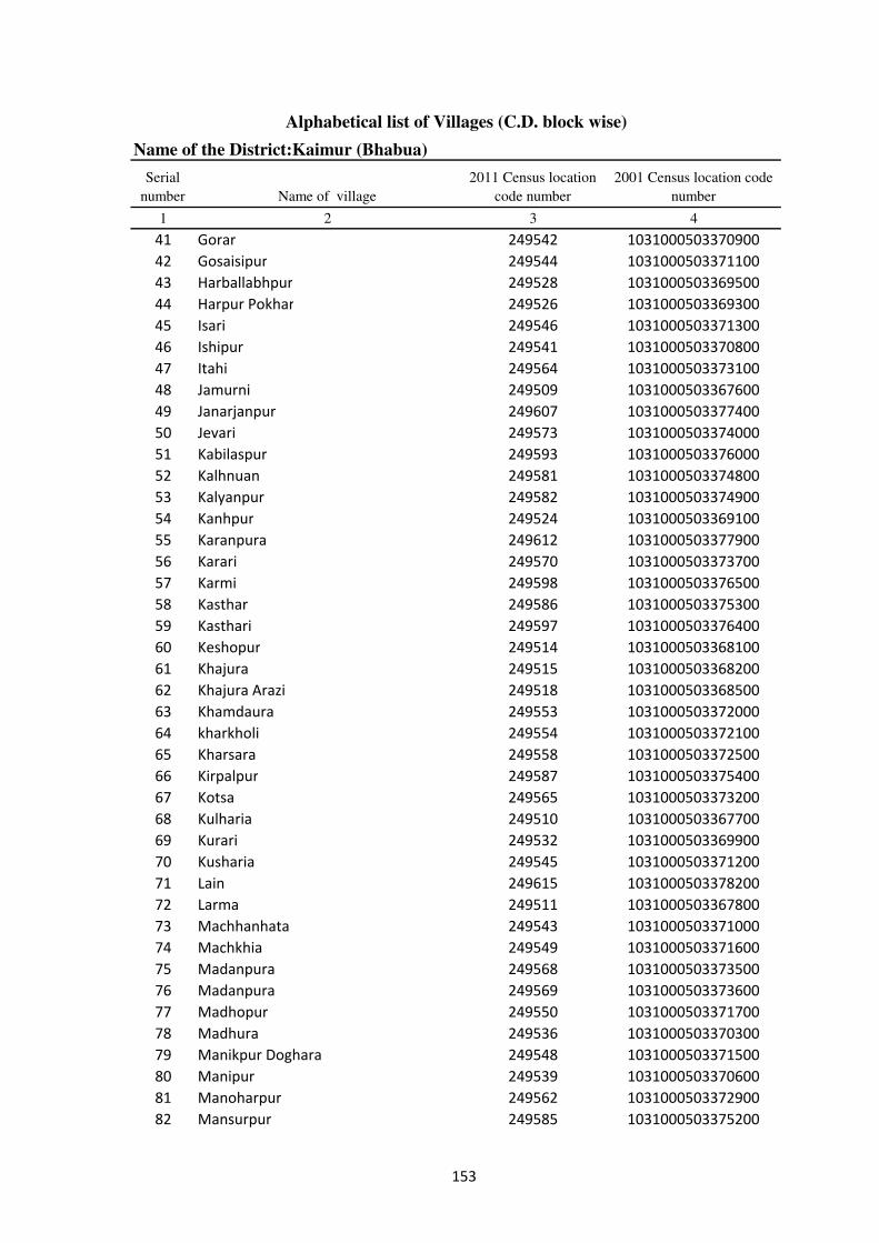
Alphabetical list of Villages (C.D. block wise)
Name of the District:Kaimur (Bhabua)
Serial
number Name of village
2011 Census location
code number
2001 Census location code
number
1 2 3 4
41 Gorar 249542 1031000503370900
42 Gosaisipur 249544 1031000503371100
43 Harballabhpur 249528 1031000503369500
44 Harpur Pokhar 249526 1031000503369300
45 Isari 249546 1031000503371300
46 Ishipur 249541 1031000503370800
47 Itahi 249564 1031000503373100
48 Jamurni 249509 1031000503367600
49 Janarjanpur 249607 1031000503377400
50 Jevari 249573 1031000503374000
51 Kabilaspur 249593 1031000503376000
52 Kalhnuan 249581 1031000503374800
53 Kalyanpur 249582 1031000503374900
54 Kanhpur 249524 1031000503369100
55 Karanpura 249612 1031000503377900
56 Karari 249570 1031000503373700
57 Karmi 249598 1031000503376500
58 Kasthar 249586 1031000503375300
59 Kasthari 249597 1031000503376400
60 Keshopur 249514 1031000503368100
61 Khajura 249515 1031000503368200
62 Khajura Arazi 249518 1031000503368500
63 Khamdaura 249553 1031000503372000
64 kharkholi 249554 1031000503372100
65 Kharsara 249558 1031000503372500
66 Kirpalpur 249587 1031000503375400
67 Kotsa 249565 1031000503373200
68 Kulharia 249510 1031000503367700
69 Kurari 249532 1031000503369900
70 Kusharia 249545 1031000503371200
71 Lain 249615 1031000503378200
72 Larma 249511 1031000503367800
73 Machhanhata 249543 1031000503371000
74 Machkhia 249549 1031000503371600
75 Madanpura 249568 1031000503373500
76 Madanpura 249569 1031000503373600
77 Madhopur 249550 1031000503371700
78 Madhura 249536 1031000503370300
79 Manikpur Doghara 249548 1031000503371500
80 Manipur 249539 1031000503370600
81 Manoharpur 249562 1031000503372900
82 Mansurpur 249585 1031000503375200
153
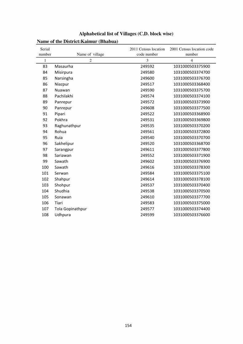
Alphabetical list of Villages (C.D. block wise)
Name of the District:Kaimur (Bhabua)
Serial
number Name of village
2011 Census location
code number
2001 Census location code
number
1 2 3 4
83 Masaurha 249592 1031000503375900
84 Misirpura 249580 1031000503374700
85 Narsingha 249600 1031000503376700
86 Niazpur 249517 1031000503368400
87 Nuawan 249590 1031000503375700
88 Pachilakhi 249574 1031000503374100
89 Panrepur 249572 1031000503373900
90 Panrepur 249608 1031000503377500
91 Pipari 249522 1031000503368900
92 Pokhra 249531 1031000503369800
93 Raghunathpur 249535 1031000503370200
94 Rohua 249561 1031000503372800
95 Ruia 249540 1031000503370700
96 Sakhelipur 249520 1031000503368700
97 Sarangpur 249611 1031000503377800
98 Sariawan 249552 1031000503371900
99 Sawath 249602 1031000503376900
100 Sawath 249616 1031000503378300
101 Serwan 249584 1031000503375100
102 Shahpur 249614 1031000503378100
103 Shohpur 249537 1031000503370400
104 Shudhia 249538 1031000503370500
105 Sonawan 249610 1031000503377700
106 Tiari 249583 1031000503375000
107 Tola Gopinathpur 249577 1031000503374400
108 Udhpura 249599 1031000503376600
154
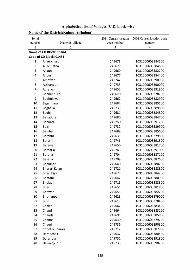
Alphabetical list of Villages (C.D. block wise)
Name of the District:Kaimur (Bhabua)
Serial
number Name of village
2011 Census location
code number
2001 Census location code
number
1 2 3 4
Name of CD Block: Chand
Code of CD Block: 01451
1 Ailae Khurd 249678 1031000603384500
2 Ailae Patna 249679 1031000603384600
3 Akauni 249660 1031000603382700
4 Alipur 249677 1031000603384400
5 Amawan 249742 1031000603390900
6 Asthanpur 249733 1031000603390000
7 Auraiya 249652 1031000603381900
8 Babhanpura 249620 1031000603378700
9 Babhniawan 249662 1031000603382900
10 Bagchhara 249684 1031000603385100
11 Baghaila 249731 1031000603389800
12 Baghi 249681 1031000603384800
13 Bahadura 249680 1031000603384700
14 Bahuara 249750 1031000603391700
15 Bairi 249732 1031000603389900
16 Bamhani 249689 1031000603385600
17 Barahni 249631 1031000603379800
18 Bararhi 249746 1031000603391300
19 Barawan 249650 1031000603381700
20 Barharia 249743 1031000603391000
21 Baruna 249704 1031000603387100
22 Basaha 249709 1031000603387600
23 Bhaluhari 249640 1031000603380700
24 Bharari Kalan 249721 1031000603388800
25 Bharuhiya 249675 1031000603384200
26 Bhatani 249642 1031000603380900
27 Bheladih 249716 1031000603388300
28 Bheri 249651 1031000603381800
29 Bhewar 249655 1031000603382200
30 Birbhanpur 249623 1031000603379000
31 Biuri 249617 1031000603378400
32 Chakia 249667 1031000603383400
33 Chand 249664 1031000603383100
34 Chanda 249691 1031000603385800
35 Chanos 249630 1031000603379700
36 Chauri 249736 1031000603390300
37 Chhotki Bharari 249712 1031000603387900
38 Darabchak 249637 1031000603380400
39 Darunpur 249751 1031000603391800
40 Dewaitpur 249735 1031000603390200
155
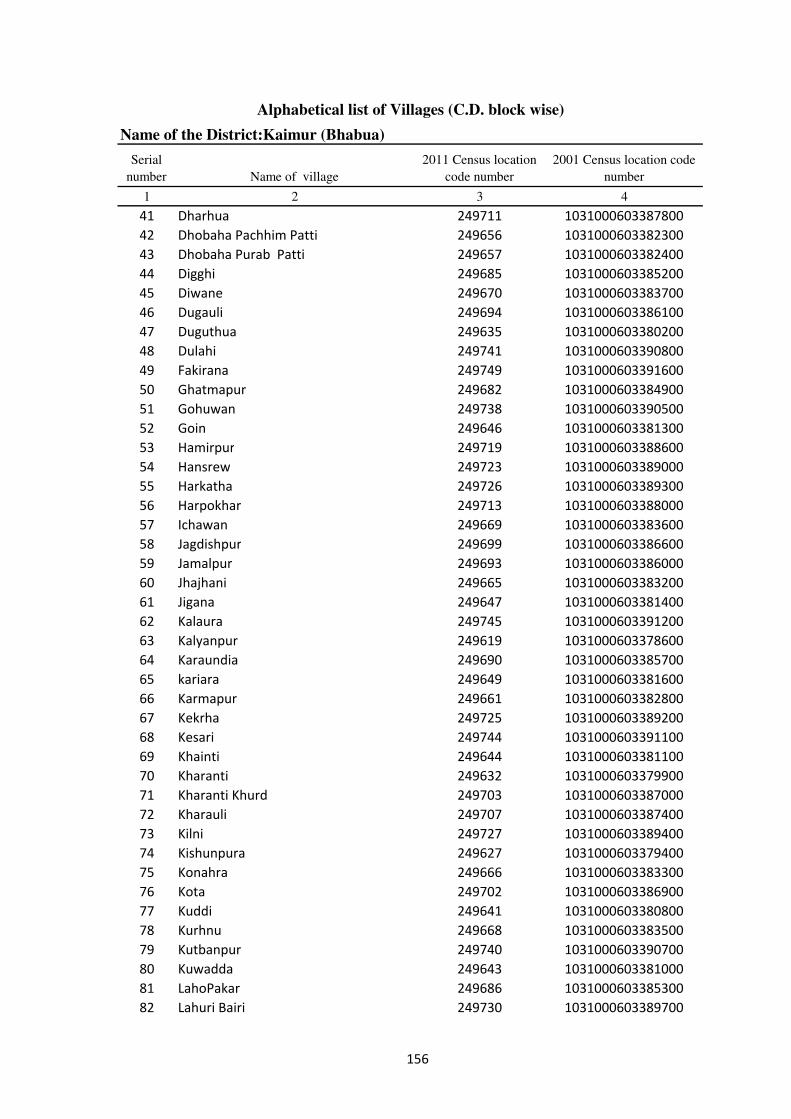
Alphabetical list of Villages (C.D. block wise)
Name of the District:Kaimur (Bhabua)
Serial
number Name of village
2011 Census location
code number
2001 Census location code
number
1 2 3 4
41 Dharhua 249711 1031000603387800
42 Dhobaha Pachhim Patti 249656 1031000603382300
43 Dhobaha Purab Patti 249657 1031000603382400
44 Digghi 249685 1031000603385200
45 Diwane 249670 1031000603383700
46 Dugauli 249694 1031000603386100
47 Duguthua 249635 1031000603380200
48 Dulahi 249741 1031000603390800
49 Fakirana 249749 1031000603391600
50 Ghatmapur 249682 1031000603384900
51 Gohuwan 249738 1031000603390500
52 Goin 249646 1031000603381300
53 Hamirpur 249719 1031000603388600
54 Hansrew 249723 1031000603389000
55 Harkatha 249726 1031000603389300
56 Harpokhar 249713 1031000603388000
57 Ichawan 249669 1031000603383600
58 Jagdishpur 249699 1031000603386600
59 Jamalpur 249693 1031000603386000
60 Jhajhani 249665 1031000603383200
61 Jigana 249647 1031000603381400
62 Kalaura 249745 1031000603391200
63 Kalyanpur 249619 1031000603378600
64 Karaundia 249690 1031000603385700
65 kariara 249649 1031000603381600
66 Karmapur 249661 1031000603382800
67 Kekrha 249725 1031000603389200
68 Kesari 249744 1031000603391100
69 Khainti 249644 1031000603381100
70 Kharanti 249632 1031000603379900
71 Kharanti Khurd 249703 1031000603387000
72 Kharauli 249707 1031000603387400
73 Kilni 249727 1031000603389400
74 Kishunpura 249627 1031000603379400
75 Konahra 249666 1031000603383300
76 Kota 249702 1031000603386900
77 Kuddi 249641 1031000603380800
78 Kurhnu 249668 1031000603383500
79 Kutbanpur 249740 1031000603390700
80 Kuwadda 249643 1031000603381000
81 LahoPakar 249686 1031000603385300
82 Lahuri Bairi 249730 1031000603389700
156

Alphabetical list of Villages (C.D. block wise)
Name of the District:Kaimur (Bhabua)
Serial
number Name of village
2011 Census location
code number
2001 Census location code
number
1 2 3 4
83 Lanka 249645 1031000603381200
84 Lasanri 249639 1031000603380600
85 Ledari 249747 1031000603391400
86 Lohdan 249722 1031000603388900
87 Mahdaich 249700 1031000603386700
88 Maheshpur 249734 1031000603390100
89 Majhgain 249653 1031000603382000
90 Majhgawan 249654 1031000603382100
91 Mararia 249705 1031000603387200
92 Milki 249672 1031000603383900
93 Mohammadpur 249638 1031000603380500
94 Mohammadpur 249673 1031000603384000
95 Mohammadpur 249753 1031000603392000
96 Morawa 249739 1031000603390600
97 Mutmuria 249708 1031000603387500
98 Nandiha Bhzrug 249698 1031000603386500
99 Narayanpur 249624 1031000603379100
100 Nauan 249724 1031000603389100
101 Naubant 249628 1031000603379500
102 Naudiha Khurd 249701 1031000603386800
103 Naukata 249629 1031000603379600
104 Nindaur 249696 1031000603386300
105 Pahraicha 249671 1031000603383800
106 PanrePur 249658 1031000603382500
107 Parasia 249683 1031000603385000
108 Parasrampur 249748 1031000603391500
109 Parei 249659 1031000603382600
110 Parhi 249663 1031000603383000
111 Pasoiya 249710 1031000603387700
112 Pateri 249692 1031000603385900
113 Patesar 249714 1031000603388100
114 Paura 249633 1031000603380000
115 Piparia 249728 1031000603389500
116 Rajpur 249674 1031000603384100
117 Rampur 249697 1031000603386400
118 Rampur Pathra 249688 1031000603385500
119 Ramtali 249718 1031000603388500
120 Rasulpur 249621 1031000603378800
121 RatanPurwa 249706 1031000603387300
122 Rebhanpur 249618 1031000603378500
123 Safi 249737 1031000603390400
124 Salaunja 249636 1031000603380300
157

Alphabetical list of Villages (C.D. block wise)
Name of the District:Kaimur (Bhabua)
Serial
number Name of village
2011 Census location
code number
2001 Census location code
number
1 2 3 4
125 Saraila 249729 1031000603389600
126 Saukhara 249715 1031000603388200
127 Seha 249687 1031000603385400
128 Sendura 249634 1031000603380100
129 Shiv 249626 1031000603379300
130 Shiwrampur 249695 1031000603386200
131 Sihoria 249648 1031000603381500
132 Silauta 249622 1031000603378900
133 Sirihra 249676 1031000603384300
134 Sonao 249752 1031000603391900
135 Songar 249720 1031000603388700
136 Surha 249717 1031000603388400
137 Tikara 249625 1031000603379200
158

Alphabetical list of Villages (C.D. block wise)
Name of the District:Kaimur (Bhabua)
Serial
number Name of village
2011 Census location
code number
2001 Census location code
number
1 2 3 4
Name of CD Block: Chainpur
Code of CD Block: 01452
1 Amawan 249831 1031000703399800
2 Anapur 249775 1031000703394200
3 Arail 249853 1031000703402000
4 Asanda 249928 1031000703409500
5 Awnkhara 249824 1031000703399100
6 Babhan Parsia 249906 1031000703407300
7 Babhaniawan 249846 1031000703401300
8 Baburtara 249779 1031000703394600
9 Baghaila 249927 1031000703409400
10 Balubheria 249839 1031000703400600
11 Banpur 249778 1031000703394500
12 Bararhi 249857 1031000703402400
13 Bardiha 249774 1031000703394100
14 Barhauna 249767 1031000703393400
15 Bari Takia 249872 1031000703403900
16 Basawanpur 249910 1031000703407700
17 Basra 249905 1031000703407200
18 Baurai 249900 1031000703406700
19 Bhadaura 249861 1031000703402800
20 Bhaganda 249760 1031000703392700
21 Bhaganda 249930 1031000703409700
22 Bhagwanpur 249889 1031000703405600
23 Bhagwatipur 249829 1031000703399600
24 Bhaluburan 249916 1031000703408300
25 Bhualpur 249871 1031000703403800
26 Biddi 249868 1031000703403500
27 Birna 249913 1031000703408000
28 Biur 249866 1031000703403300
29 Bukna Mahula 249899 1031000703406600
30 Chainpur 249874 1031000703404100
31 Chalania 249780 1031000703394700
32 Chanda 249911 1031000703407800
33 Chauth Parbatpur 249798 1031000703396500
34 Chauthi 249854 1031000703402100
35 Chitarhi 249795 1031000703396200
36 Damodarpur 249887 1031000703405400
37 Danrwa 249858 1031000703402500
38 Danrwa 249860 1031000703402700
39 Danrwa 249908 1031000703407500
40 Deua 249849 1031000703401600
159

Alphabetical list of Villages (C.D. block wise)
Name of the District:Kaimur (Bhabua)
Serial
number Name of village
2011 Census location
code number
2001 Census location code
number
1 2 3 4
41 Dharahra 249781 1031000703394800
42 Dhumardeo 249929 1031000703409600
43 Dih Bhujaina 249769 1031000703393600
44 Diha 249782 1031000703394900
45 Dobhri 249841 1031000703400800
46 Dubepur 249772 1031000703393900
47 Dulahra 249892 1031000703405900
48 Dumaria 249783 1031000703395000
49 Dumarkon 249924 1031000703409100
50 Fakhrabad 249862 1031000703402900
51 Gangapur 249827 1031000703399400
52 Gangudih 249901 1031000703406800
53 Gazipur 249867 1031000703403400
54 Ghanti 249758 1031000703392500
55 Gobindpur 249879 1031000703404600
56 Gonai 249869 1031000703403600
57 Gosara 249918 1031000703408500
58 Halka 249790 1031000703395700
59 Harbanspur 249828 1031000703399500
60 Hargawan 249762 1031000703392900
61 Harnampur 249844 1031000703401100
62 Harnathpur 249865 1031000703403200
63 Harsoti 249925 1031000703409200
64 Hata 249817 1031000703398400
65 Hukkasarai 249851 1031000703401800
66 Humaun Mardan 249819 1031000703398600
67 Isapur 249878 1031000703404500
68 Isia 249855 1031000703402200
69 Ismailpur 249761 1031000703392800
70 Ismailpur Arazi 249763 1031000703393000
71 Israrhi 249909 1031000703407600
72 Jagaria 249890 1031000703405700
73 Jagdishpur 249895 1031000703406200
74 Jairampur 249882 1031000703404900
75 Jharia 249920 1031000703408700
76 Jigina 249807 1031000703397400
77 Kakrikundi 249773 1031000703394000
78 Kalyanipur 249802 1031000703396900
79 Kamharia 249919 1031000703408600
80 Karaundia 249822 1031000703398900
81 Karaundia 249914 1031000703408100
82 Karjav 249837 1031000703400400
160
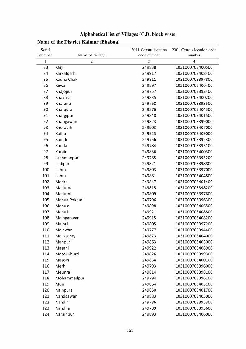
Alphabetical list of Villages (C.D. block wise)
Name of the District:Kaimur (Bhabua)
Serial
number Name of village
2011 Census location
code number
2001 Census location code
number
1 2 3 4
83 Karji 249838 1031000703400500
84 Karkatgarh 249917 1031000703408400
85 Kauria Chak 249811 1031000703397800
86 Kewa 249897 1031000703406400
87 Khajopur 249757 1031000703392400
88 Khakhra 249835 1031000703400200
89 Kharanti 249768 1031000703393500
90 Kharaura 249876 1031000703404300
91 Khargipur 249848 1031000703401500
92 Kharigawan 249823 1031000703399000
93 Khoradih 249903 1031000703407000
94 Koilra 249923 1031000703409000
95 Koindi 249756 1031000703392300
96 Kunda 249784 1031000703395100
97 Kurain 249836 1031000703400300
98 Lakhmanpur 249785 1031000703395200
99 Lodipur 249821 1031000703398800
100 Lohra 249803 1031000703397000
101 Lohra 249881 1031000703404800
102 Madra 249847 1031000703401400
103 Madurna 249815 1031000703398200
104 Madurni 249809 1031000703397600
105 Mahua Pokhar 249796 1031000703396300
106 Mahula 249898 1031000703406500
107 Mahuli 249921 1031000703408800
108 Majhganwan 249915 1031000703408200
109 Majhui 249805 1031000703397200
110 Malawan 249777 1031000703394400
111 Maliksaray 249873 1031000703404000
112 Manpur 249863 1031000703403000
113 Masani 249922 1031000703408900
114 Masoi Khurd 249826 1031000703399300
115 Masoin 249834 1031000703400100
116 Merh 249793 1031000703396000
117 Meunra 249814 1031000703398100
118 Mohammadpur 249794 1031000703396100
119 Muri 249864 1031000703403100
120 Nainpura 249850 1031000703401700
121 Nandgawan 249883 1031000703405000
122 Nandih 249786 1031000703395300
123 Nandna 249789 1031000703395600
124 Narainpur 249893 1031000703406000
161
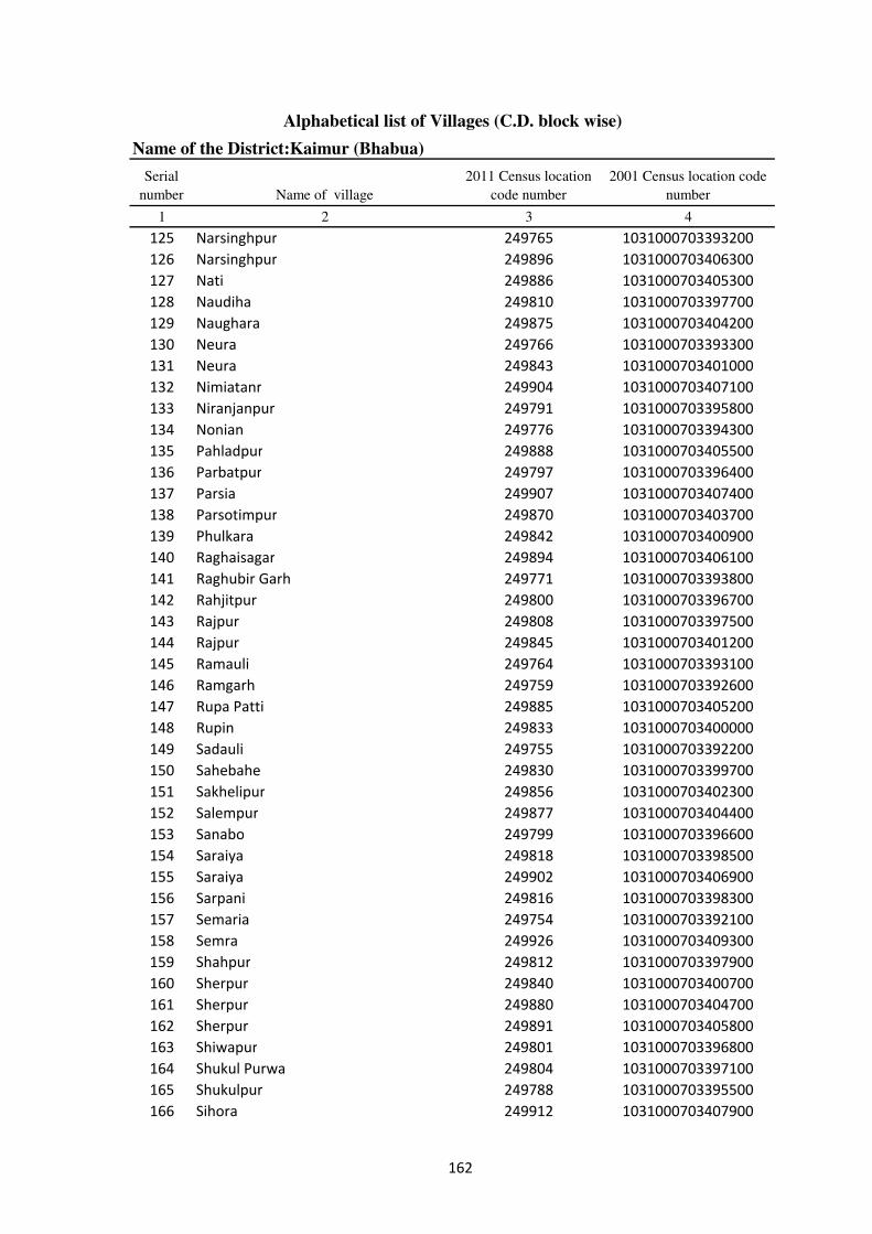
Alphabetical list of Villages (C.D. block wise)
Name of the District:Kaimur (Bhabua)
Serial
number Name of village
2011 Census location
code number
2001 Census location code
number
1 2 3 4
125 Narsinghpur 249765 1031000703393200
126 Narsinghpur 249896 1031000703406300
127 Nati 249886 1031000703405300
128 Naudiha 249810 1031000703397700
129 Naughara 249875 1031000703404200
130 Neura 249766 1031000703393300
131 Neura 249843 1031000703401000
132 Nimiatanr 249904 1031000703407100
133 Niranjanpur 249791 1031000703395800
134 Nonian 249776 1031000703394300
135 Pahladpur 249888 1031000703405500
136 Parbatpur 249797 1031000703396400
137 Parsia 249907 1031000703407400
138 Parsotimpur 249870 1031000703403700
139 Phulkara 249842 1031000703400900
140 Raghaisagar 249894 1031000703406100
141 Raghubir Garh 249771 1031000703393800
142 Rahjitpur 249800 1031000703396700
143 Rajpur 249808 1031000703397500
144 Rajpur 249845 1031000703401200
145 Ramauli 249764 1031000703393100
146 Ramgarh 249759 1031000703392600
147 Rupa Patti 249885 1031000703405200
148 Rupin 249833 1031000703400000
149 Sadauli 249755 1031000703392200
150 Sahebahe 249830 1031000703399700
151 Sakhelipur 249856 1031000703402300
152 Salempur 249877 1031000703404400
153 Sanabo 249799 1031000703396600
154 Saraiya 249818 1031000703398500
155 Saraiya 249902 1031000703406900
156 Sarpani 249816 1031000703398300
157 Semaria 249754 1031000703392100
158 Semra 249926 1031000703409300
159 Shahpur 249812 1031000703397900
160 Sherpur 249840 1031000703400700
161 Sherpur 249880 1031000703404700
162 Sherpur 249891 1031000703405800
163 Shiwapur 249801 1031000703396800
164 Shukul Purwa 249804 1031000703397100
165 Shukulpur 249788 1031000703395500
166 Sihora 249912 1031000703407900
162
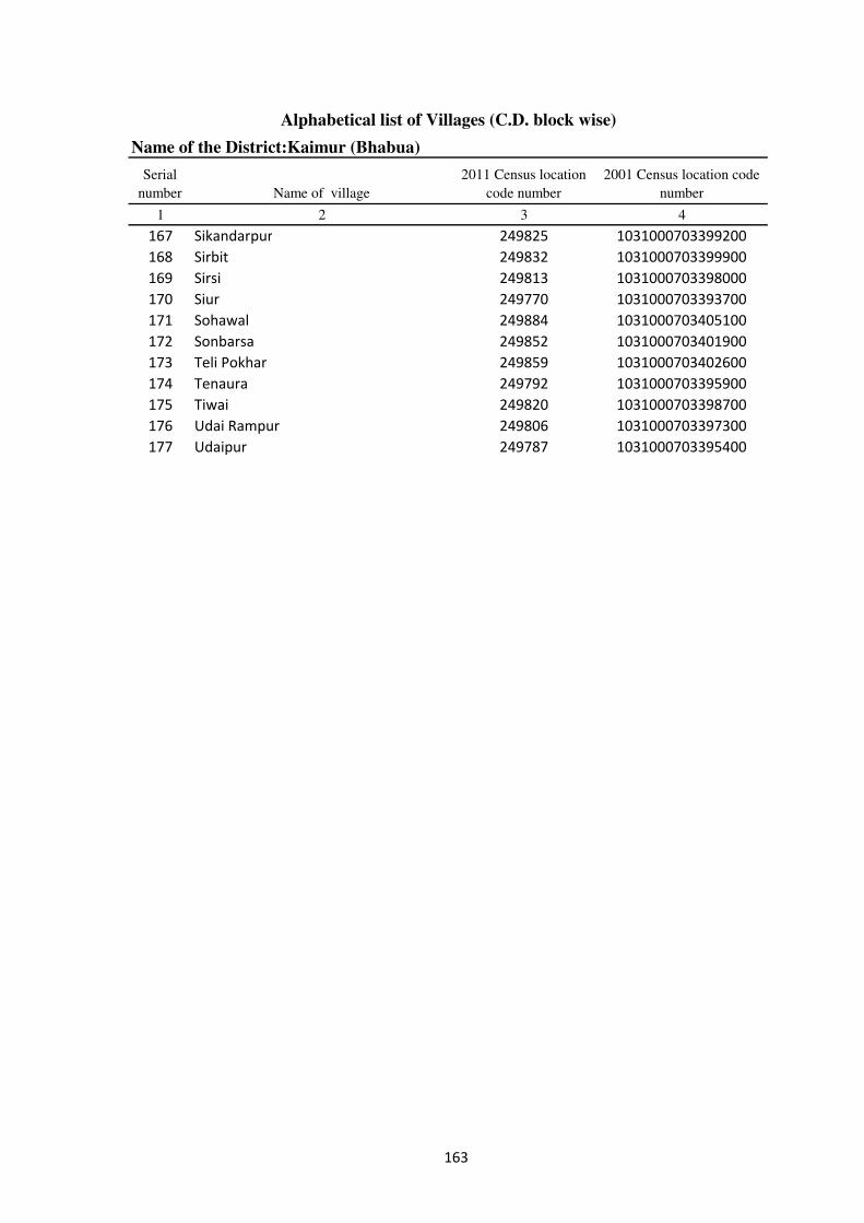
Alphabetical list of Villages (C.D. block wise)
Name of the District:Kaimur (Bhabua)
Serial
number Name of village
2011 Census location
code number
2001 Census location code
number
1 2 3 4
167 Sikandarpur 249825 1031000703399200
168 Sirbit 249832 1031000703399900
169 Sirsi 249813 1031000703398000
170 Siur 249770 1031000703393700
171 Sohawal 249884 1031000703405100
172 Sonbarsa 249852 1031000703401900
173 Teli Pokhar 249859 1031000703402600
174 Tenaura 249792 1031000703395900
175 Tiwai 249820 1031000703398700
176 Udai Rampur 249806 1031000703397300
177 Udaipur 249787 1031000703395400
163

Alphabetical list of Villages (C.D. block wise)
Name of the District:Kaimur (Bhabua)
Serial
number Name of village
2011 Census location
code number
2001 Census location code
number
1 2 3 4
Name of CD Block: Bhabua
Code of CD Block: 01453
1 Ahopur 250034 1031000803420100
2 Akhtiarpur 250022 1031000803418900
3 Akhtiarpur 250037 1031000803420400
4 Akorhi 250180 1031000803434700
5 Akri 250052 1031000803421900
6 Alipur 250191 1031000803435800
7 Amarhi 250024 1031000803419100
8 Amraha 249935 1031000803410200
9 Amrha 250193 1031000803436000
10 Arazi English 250205 1031000803437200
11 Asrarhi 250105 1031000803427200
12 Auraiya Dei 249972 1031000803413900
13 Auraiya Dewa 249973 1031000803414000
14 Babura 250043 1031000803421000
15 Bagahi 249947 1031000803411400
16 Baghi 250167 1031000803433400
17 Baghraulia 250035 1031000803420200
18 Bahera 250122 1031000803428900
19 Baheri 250064 1031000803423100
20 Bahuwan 250118 1031000803428500
21 Bahuwara 250124 1031000803429100
22 Balua 250190 1031000803435700
23 Banjaria 250090 1031000803425700
24 Barahuli 250150 1031000803431700
25 Bare 250086 1031000803425300
26 Bariarchak 250088 1031000803425500
27 Barigawan 250070 1031000803423700
28 Barka Danrowan 250203 1031000803437000
29 Barka Deharma 250174 1031000803434100
30 Barka Kajhar 250188 1031000803435500
31 Barkakir 250137 1031000803430400
32 Baruna 249931 1031000803409800
33 Basantpur 249958 1031000803412500
34 Basgitia 250098 1031000803426500
35 Basgitia 250127 1031000803429400
36 Beguda 250154 1031000803432100
37 Belarhi 250182 1031000803434900
38 Belkatra 250208 1031000803437500
39 Betri 249990 1031000803415700
40 Bhadari 249966 1031000803413300
164
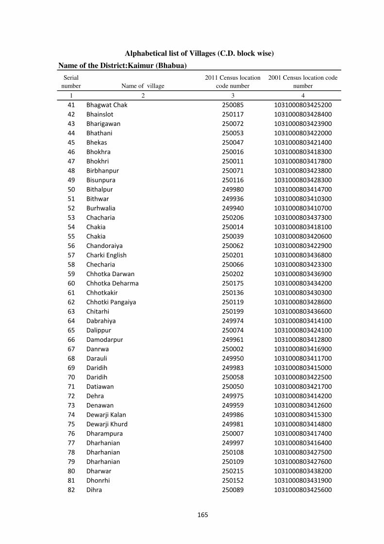
Alphabetical list of Villages (C.D. block wise)
Name of the District:Kaimur (Bhabua)
Serial
number Name of village
2011 Census location
code number
2001 Census location code
number
1 2 3 4
41 Bhagwat Chak 250085 1031000803425200
42 Bhainslot 250117 1031000803428400
43 Bharigawan 250072 1031000803423900
44 Bhathani 250053 1031000803422000
45 Bhekas 250047 1031000803421400
46 Bhokhra 250016 1031000803418300
47 Bhokhri 250011 1031000803417800
48 Birbhanpur 250071 1031000803423800
49 Bisunpura 250116 1031000803428300
50 Bithalpur 249980 1031000803414700
51 Bithwar 249936 1031000803410300
52 Burhwalia 249940 1031000803410700
53 Chacharia 250206 1031000803437300
54 Chakia 250014 1031000803418100
55 Chakia 250039 1031000803420600
56 Chandoraiya 250062 1031000803422900
57 Charki English 250201 1031000803436800
58 Checharia 250066 1031000803423300
59 Chhotka Darwan 250202 1031000803436900
60 Chhotka Deharma 250175 1031000803434200
61 Chhotkakir 250136 1031000803430300
62 Chhotki Pangaiya 250119 1031000803428600
63 Chitarhi 250199 1031000803436600
64 Dabrahiya 249974 1031000803414100
65 Dalippur 250074 1031000803424100
66 Damodarpur 249961 1031000803412800
67 Danrwa 250002 1031000803416900
68 Darauli 249950 1031000803411700
69 Daridih 249983 1031000803415000
70 Daridih 250058 1031000803422500
71 Datiawan 250050 1031000803421700
72 Dehra 249975 1031000803414200
73 Denawan 249959 1031000803412600
74 Dewarji Kalan 249986 1031000803415300
75 Dewarji Khurd 249981 1031000803414800
76 Dharampura 250007 1031000803417400
77 Dharhanian 249997 1031000803416400
78 Dharhanian 250108 1031000803427500
79 Dharhanian 250109 1031000803427600
80 Dharwar 250215 1031000803438200
81 Dhonrhi 250152 1031000803431900
82 Dihra 250089 1031000803425600
165
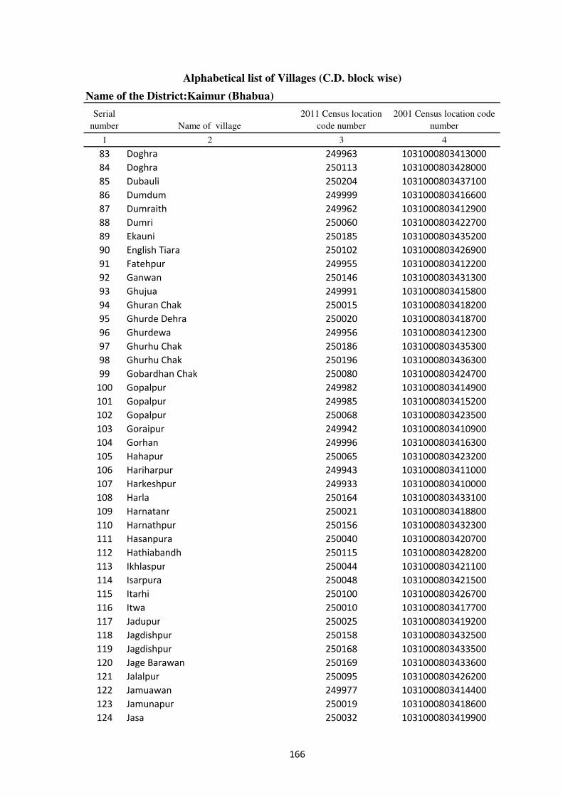
Alphabetical list of Villages (C.D. block wise)
Name of the District:Kaimur (Bhabua)
Serial
number Name of village
2011 Census location
code number
2001 Census location code
number
1 2 3 4
83 Doghra 249963 1031000803413000
84 Doghra 250113 1031000803428000
85 Dubauli 250204 1031000803437100
86 Dumdum 249999 1031000803416600
87 Dumraith 249962 1031000803412900
88 Dumri 250060 1031000803422700
89 Ekauni 250185 1031000803435200
90 English Tiara 250102 1031000803426900
91 Fatehpur 249955 1031000803412200
92 Ganwan 250146 1031000803431300
93 Ghujua 249991 1031000803415800
94 Ghuran Chak 250015 1031000803418200
95 Ghurde Dehra 250020 1031000803418700
96 Ghurdewa 249956 1031000803412300
97 Ghurhu Chak 250186 1031000803435300
98 Ghurhu Chak 250196 1031000803436300
99 Gobardhan Chak 250080 1031000803424700
100 Gopalpur 249982 1031000803414900
101 Gopalpur 249985 1031000803415200
102 Gopalpur 250068 1031000803423500
103 Goraipur 249942 1031000803410900
104 Gorhan 249996 1031000803416300
105 Hahapur 250065 1031000803423200
106 Hariharpur 249943 1031000803411000
107 Harkeshpur 249933 1031000803410000
108 Harla 250164 1031000803433100
109 Harnatanr 250021 1031000803418800
110 Harnathpur 250156 1031000803432300
111 Hasanpura 250040 1031000803420700
112 Hathiabandh 250115 1031000803428200
113 Ikhlaspur 250044 1031000803421100
114 Isarpura 250048 1031000803421500
115 Itarhi 250100 1031000803426700
116 Itwa 250010 1031000803417700
117 Jadupur 250025 1031000803419200
118 Jagdishpur 250158 1031000803432500
119 Jagdishpur 250168 1031000803433500
120 Jage Barawan 250169 1031000803433600
121 Jalalpur 250095 1031000803426200
122 Jamuawan 249977 1031000803414400
123 Jamunapur 250019 1031000803418600
124 Jasa 250032 1031000803419900
166

Alphabetical list of Villages (C.D. block wise)
Name of the District:Kaimur (Bhabua)
Serial
number Name of village
2011 Census location
code number
2001 Census location code
number
1 2 3 4
125 Jhigridehra 250096 1031000803426300
126 Jigni 249960 1031000803412700
127 Kaithi 250110 1031000803427700
128 Kamalpur 250142 1031000803430900
129 Kamta 250099 1031000803426600
130 Kamti 250092 1031000803425900
131 Kanpara 250133 1031000803430000
132 Kanpara Ujari 250132 1031000803429900
133 Karaundi 250171 1031000803433800
134 Kariganwan 250125 1031000803429200
135 Karman 250018 1031000803418500
136 Karmi Chak 249951 1031000803411800
137 Kathaura 250123 1031000803429000
138 Katra 249938 1031000803410500
139 Kawai 250179 1031000803434600
140 Kawar 250051 1031000803421800
141 Khadaura 250003 1031000803417000
142 Khaira 249954 1031000803412100
143 Khaira 250036 1031000803420300
144 Khaira 250187 1031000803435400
145 Khaira Khurd 249953 1031000803412000
146 Khajurahia 250057 1031000803422400
147 Khajuria 250149 1031000803431600
148 Khajuria Kalan 250147 1031000803431400
149 Khajuria Khurd 250148 1031000803431500
150 Khanawan 249937 1031000803410400
151 Khanethi 250114 1031000803428100
152 Khanethi Gurdas 250128 1031000803429500
153 Khurmabad 250170 1031000803433700
154 Kishunpur 250173 1031000803434000
155 Kishunpura 250083 1031000803425000
156 Kohari 249952 1031000803411900
157 Kolaunj 250063 1031000803423000
158 Kori 250041 1031000803420800
159 Kukrarh 250029 1031000803419600
160 Kukurhi 250176 1031000803434300
161 Kunj 250061 1031000803422800
162 Kurasan 249988 1031000803415500
163 Kusdihra 250073 1031000803424000
164 Lakkudih 250075 1031000803424200
165 Lilapur 250209 1031000803437600
166 Machiawan 250101 1031000803426800
167

Alphabetical list of Villages (C.D. block wise)
Name of the District:Kaimur (Bhabua)
Serial
number Name of village
2011 Census location
code number
2001 Census location code
number
1 2 3 4
167 Madanpura 250184 1031000803435100
168 Madarpur 250120 1031000803428700
169 Madhopur 250216 1031000803438300
170 Madhupur 250042 1031000803420900
171 Mahsua 249976 1031000803414300
172 Mahsua 249978 1031000803414500
173 Mahuat 250183 1031000803435000
174 Mahuwari 250155 1031000803432200
175 Maital 249965 1031000803413200
176 Malahpurwa 250023 1031000803419000
177 Maldah 250094 1031000803426100
178 Mamhan 249968 1031000803413500
179 Manchahalpur 250153 1031000803432000
180 Manihari 249941 1031000803410800
181 Manikpur 249984 1031000803415100
182 Manikpur 250162 1031000803432900
183 Manpur 250081 1031000803424800
184 Manpur 250104 1031000803427100
185 Marha 250027 1031000803419400
186 Mehiyan 249995 1031000803416200
187 Mirchawan 249949 1031000803411600
188 Miria 250134 1031000803430100
189 Mithapur 249957 1031000803412400
190 Miun Sukharipur 250210 1031000803437700
191 Mohammadpur 250046 1031000803421300
192 Mohammadpur 250079 1031000803424600
193 Mokri 249993 1031000803416000
194 Naktaul 249964 1031000803413100
195 Narawan 249967 1031000803413400
196 Narayanpur 250126 1031000803429300
197 Narotapur 249934 1031000803410100
198 Nati 250112 1031000803427900
199 Naua Jhoti 250056 1031000803422300
200 Naua Shahmal 250055 1031000803422200
201 Nawagawan 250212 1031000803437900
202 Nazrabad 250121 1031000803428800
203 Nibi 249932 1031000803409900
204 Nibi Kalan 250078 1031000803424500
205 Nibi Khurd 250077 1031000803424400
206 Nimi 250157 1031000803432400
207 Nonra 249987 1031000803415400
208 Pachgawan 250031 1031000803419800
168

Alphabetical list of Villages (C.D. block wise)
Name of the District:Kaimur (Bhabua)
Serial
number Name of village
2011 Census location
code number
2001 Census location code
number
1 2 3 4
209 Paiyan 250172 1031000803433900
210 Palka 249994 1031000803416100
211 Panchi 250107 1031000803427400
212 Pangaiyan 250033 1031000803420000
213 Paranpur 250151 1031000803431800
214 Parasia 250091 1031000803425800
215 Parasrampur 250207 1031000803437400
216 Parmalpur 250129 1031000803429600
217 Patrihan 250093 1031000803426000
218 Patti 250111 1031000803427800
219 Pian 250189 1031000803435600
220 Pokhara 250195 1031000803436200
221 Rampur 249946 1031000803411300
222 Rampur 250106 1031000803427300
223 Rampur 250130 1031000803429700
224 Rampur 250139 1031000803430600
225 Rampur 250197 1031000803436400
226 Rattichak 250028 1031000803419500
227 Ratwar 250082 1031000803424900
228 Rawan 250165 1031000803433200
229 Rehari 249992 1031000803415900
230 Rehi 250166 1031000803433300
231 Rudarwar Kalan 250211 1031000803437800
232 Ruiya 250059 1031000803422600
233 Ruppur 249944 1031000803411100
234 Sadekawai 250163 1031000803433000
235 Sagar 250159 1031000803432600
236 Saitha 250005 1031000803417200
237 Sandalpur 250192 1031000803435900
238 Sapnautia 250017 1031000803418400
239 Sarai Manrup 250144 1031000803431100
240 Saraiya 250135 1031000803430200
241 Sarangpur 249998 1031000803416500
242 Sarewa 249979 1031000803414600
243 Sarmandapur 250178 1031000803434500
244 Sathri 250160 1031000803432700
245 Saunrudih 250131 1031000803429800
246 Sedra 249969 1031000803413600
247 Sedra 249971 1031000803413800
248 Sedra Nisf 249970 1031000803413700
249 Sekhwa 250030 1031000803419700
250 Semaria 250006 1031000803417300
169
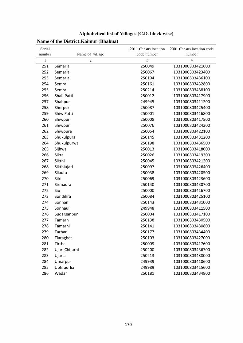
Alphabetical list of Villages (C.D. block wise)
Name of the District:Kaimur (Bhabua)
Serial
number Name of village
2011 Census location
code number
2001 Census location code
number
1 2 3 4
251 Semaria 250049 1031000803421600
252 Semaria 250067 1031000803423400
253 Semaria 250194 1031000803436100
254 Semra 250161 1031000803432800
255 Semra 250214 1031000803438100
256 Shah Patti 250012 1031000803417900
257 Shahpur 249945 1031000803411200
258 Sherpur 250087 1031000803425400
259 Shiw Patti 250001 1031000803416800
260 Shiwpur 250008 1031000803417500
261 Shiwpur 250076 1031000803424300
262 Shiwpura 250054 1031000803422100
263 Shukulpura 250145 1031000803431200
264 Shukulpurwa 250198 1031000803436500
265 Sijhwa 250013 1031000803418000
266 Sikra 250026 1031000803419300
267 Sikthi 250045 1031000803421200
268 Sikthiujari 250097 1031000803426400
269 Silauta 250038 1031000803420500
270 Silri 250069 1031000803423600
271 Sirmaura 250140 1031000803430700
272 Siu 250000 1031000803416700
273 Sondihra 250084 1031000803425100
274 Sonhan 250143 1031000803431000
275 Sonhauli 249948 1031000803411500
276 Sudarsanpur 250004 1031000803417100
277 Tamarh 250138 1031000803430500
278 Tamarhi 250141 1031000803430800
279 Tarhani 250177 1031000803434400
280 Tiaraghat 250103 1031000803427000
281 Tirtha 250009 1031000803417600
282 Ujari Chitarhi 250200 1031000803436700
283 Ujaria 250213 1031000803438000
284 Umarpur 249939 1031000803410600
285 Uphraurlia 249989 1031000803415600
286 Wadar 250181 1031000803434800
170

Alphabetical list of Villages (C.D. block wise)
Name of the District:Kaimur (Bhabua)
Serial
number Name of village
2011 Census location
code number
2001 Census location code
number
1 2 3 4
Name of CD Block: Rampur
Code of CD Block: 01454
1 Admapur 250334 1031000903451400
2 Ahirawan 250295 1031000903447500
3 Akorhi 250257 1031000903442500
4 Arazi Baghi 250313 1031000903449300
5 Arnawan 250327 1031000903450700
6 Atrauli 250303 1031000903448300
7 Baghi 250315 1031000903449500
8 Bahera 250268 1031000903443600
9 Baheri 250301 1031000903448100
10 Bairiadih 250351 1031000903453100
11 Bakharam 250339 1031000903451900
12 Banauli 250251 1031000903441900
13 Baradih 250340 1031000903452000
14 Baramhtali 250265 1031000903443300
15 Barawan 250336 1031000903451600
16 Barkagawan 250224 1031000903439200
17 Barli 250321 1031000903450100
18 Basantpur 250244 1031000903441200
19 Basni 250252 1031000903442000
20 Basuhari 250263 1031000903443100
21 Bazidpur 250314 1031000903449400
22 Belawan 250261 1031000903442900
23 Benipur 250333 1031000903451300
24 Bhaluhan 250243 1031000903441100
25 Bhitribandh 250345 1031000903452500
26 Bhorean 250284 1031000903446400
27 Bichhiya 250279 1031000903445700
28 Bidesarpur 250320 1031000903450000
29 Bijra 250309 1031000903448900
30 Bogadahan 250323 1031000903450300
31 Burhbarawan 250335 1031000903451500
32 Chamariawan 250264 1031000903443200
33 Chanela 250290 1031000903447000
34 Chanki 250300 1031000903448000
35 Chanrudean 250254 1031000903442200
36 Damodarpur 250249 1031000903441700
37 Dariawan 250322 1031000903450200
38 Dhanawal 250341 1031000903452100
39 Dharu Khoh 250349 1031000903452900
40 Dhaupokhar 250235 1031000903440300
171
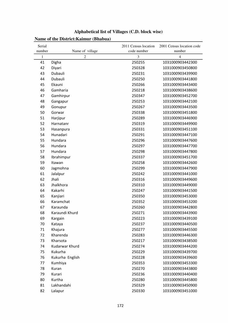
Alphabetical list of Villages (C.D. block wise)
Name of the District:Kaimur (Bhabua)
Serial
number Name of village
2011 Census location
code number
2001 Census location code
number
1 2 3 4
41 Digha 250255 1031000903442300
42 Diyari 250328 1031000903450800
43 Dubauli 250231 1031000903439900
44 Dubauli 250250 1031000903441800
45 Ekauni 250266 1031000903443400
46 Gamharia 250218 1031000903438600
47 Gamhirpur 250347 1031000903452700
48 Gangapur 250253 1031000903442100
49 Gonupur 250267 1031000903443500
50 Gorwar 250338 1031000903451800
51 Harjipur 250289 1031000903446900
52 Harnatanr 250319 1031000903449900
53 Hasanpura 250331 1031000903451100
54 Hunadari 250291 1031000903447100
55 Hundara 250296 1031000903447600
56 Hundara 250297 1031000903447700
57 Hundara 250298 1031000903447800
58 Ibrahimpur 250337 1031000903451700
59 Itawan 250258 1031000903442600
60 Jagmohna 250299 1031000903447900
61 Jalalpur 250242 1031000903441000
62 Jhali 250316 1031000903449600
63 Jhalkhora 250310 1031000903449000
64 Kakarhi 250247 1031000903441500
65 Kanjiari 250350 1031000903453000
66 Karamchat 250352 1031000903453200
67 Karaunda 250260 1031000903442800
68 Karaundi Khurd 250271 1031000903443900
69 Kargain 250223 1031000903439100
70 Kataya 250237 1031000903440500
71 Khajura 250277 1031000903445500
72 Kharenda 250283 1031000903446300
73 Kharsota 250217 1031000903438500
74 Kudarwar Khurd 250274 1031000903444200
75 Kukurha 250229 1031000903439700
76 Kukurha English 250228 1031000903439600
77 Kumhiya 250353 1031000903453300
78 Kuran 250270 1031000903443800
79 Kurari 250236 1031000903440400
80 Kurtha 250280 1031000903445800
81 Lakhandahi 250329 1031000903450900
82 Lalapur 250330 1031000903451000
172

Alphabetical list of Villages (C.D. block wise)
Name of the District:Kaimur (Bhabua)
Serial
number Name of village
2011 Census location
code number
2001 Census location code
number
1 2 3 4
83 Larui Kharui 250348 1031000903452800
84 Lewa 250285 1031000903446500
85 Lewa 250332 1031000903451200
86 Lilli 250245 1031000903441300
87 Lohandi 250306 1031000903448600
88 Madhopur 250269 1031000903443700
89 Maheshpur 250246 1031000903441400
90 Maidanr Kalan 250273 1031000903444100
91 Maidanr Khurd 250272 1031000903444000
92 Majhaganwan 250241 1031000903440900
93 Majhiawan 250318 1031000903449800
94 Majhiyawan 250281 1031000903445900
95 Maraicha 250324 1031000903450400
96 Maraicha 250326 1031000903450600
97 Narjo 250222 1031000903439000
98 Nauhatta 250294 1031000903447400
99 Nawadih 250227 1031000903439500
100 Nawadih 250346 1031000903452600
101 Nirbispur 250276 1031000903445400
102 Nisja 250239 1031000903440700
103 Pachhehra 250302 1031000903448200
104 Pali 250240 1031000903440800
105 Panail English 250221 1031000903438900
106 Panapur 250293 1031000903447300
107 Panrepur 250317 1031000903449700
108 Parmalpur 250308 1031000903448800
109 Pasain 250275 1031000903445300
110 Patila 250248 1031000903441600
111 Patna 250220 1031000903438800
112 Punawan 250286 1031000903446600
113 Rajadeo 250343 1031000903452300
114 Rajandih 250342 1031000903452200
115 Rajpur 250344 1031000903452400
116 Rampur 250262 1031000903443000
117 Rampur 250311 1031000903449100
118 Salempur 250325 1031000903450500
119 Sawar 250312 1031000903449200
120 Shivpur 250233 1031000903440100
121 Sihora 250225 1031000903439300
122 Sisarma 250238 1031000903440600
123 Siswar 250232 1031000903440000
124 Sonara 250259 1031000903442700
173

Alphabetical list of Villages (C.D. block wise)
Name of the District:Kaimur (Bhabua)
Serial
number Name of village
2011 Census location
code number
2001 Census location code
number
1 2 3 4
125 Sonawan Pachhim Patti 250288 1031000903446800
126 Sonawan Purab Patti 250287 1031000903446700
127 Sonbarsa 250219 1031000903438700
128 Sonbarsa 250278 1031000903445600
129 Tarawan 250282 1031000903446200
130 Tenua 250234 1031000903440200
131 Tetihan 250256 1031000903442400
132 Thakurhat 250307 1031000903448700
133 Thiloin 250230 1031000903439800
134 Tulshipur 250305 1031000903448500
135 Uchanar 250292 1031000903447200
136 Ujari Danrivan 250226 1031000903439400
137 Uphrauli 250304 1031000903448400
174
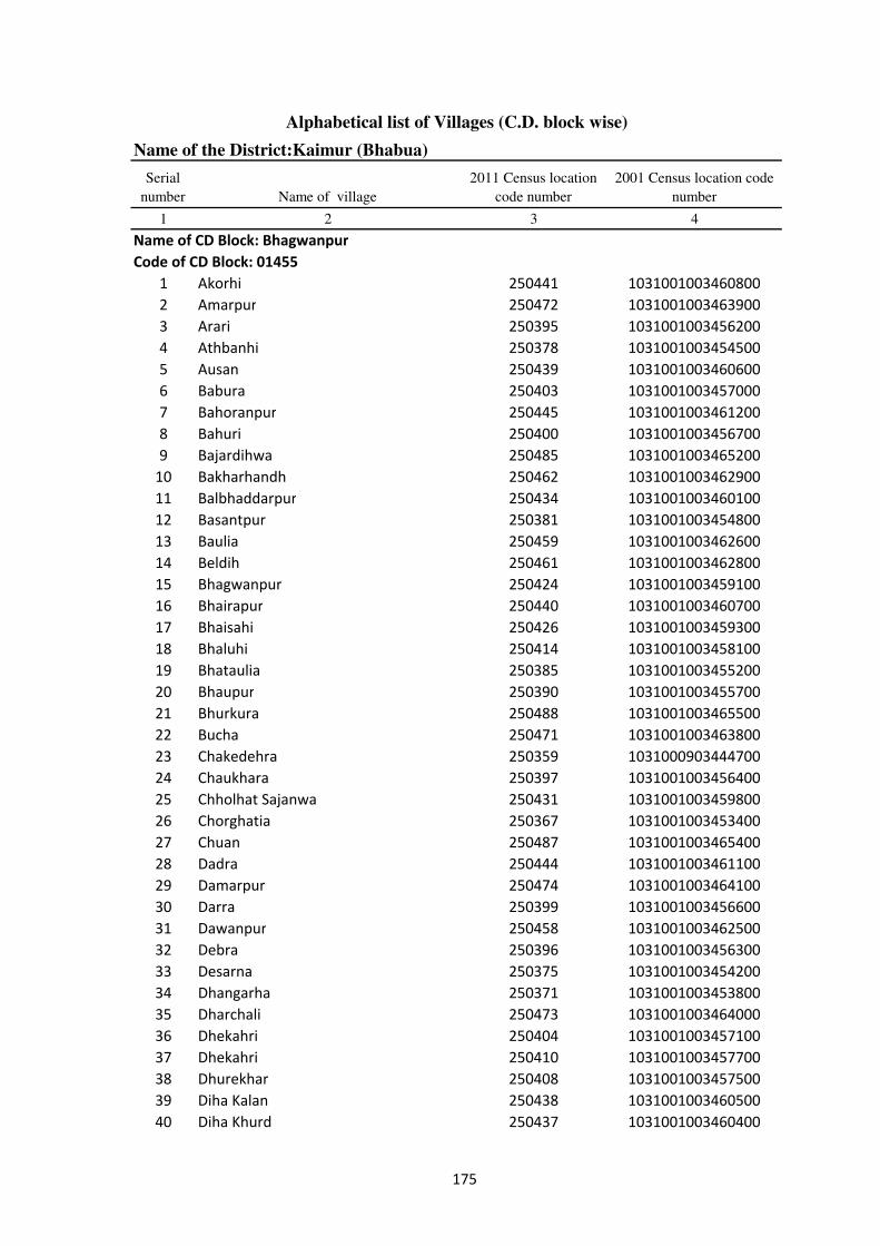
Alphabetical list of Villages (C.D. block wise)
Name of the District:Kaimur (Bhabua)
Serial
number Name of village
2011 Census location
code number
2001 Census location code
number
1 2 3 4
Name of CD Block: Bhagwanpur
Code of CD Block: 01455
1 Akorhi 250441 1031001003460800
2 Amarpur 250472 1031001003463900
3 Arari 250395 1031001003456200
4 Athbanhi 250378 1031001003454500
5 Ausan 250439 1031001003460600
6 Babura 250403 1031001003457000
7 Bahoranpur 250445 1031001003461200
8 Bahuri 250400 1031001003456700
9 Bajardihwa 250485 1031001003465200
10 Bakharhandh 250462 1031001003462900
11 Balbhaddarpur 250434 1031001003460100
12 Basantpur 250381 1031001003454800
13 Baulia 250459 1031001003462600
14 Beldih 250461 1031001003462800
15 Bhagwanpur 250424 1031001003459100
16 Bhairapur 250440 1031001003460700
17 Bhaisahi 250426 1031001003459300
18 Bhaluhi 250414 1031001003458100
19 Bhataulia 250385 1031001003455200
20 Bhaupur 250390 1031001003455700
21 Bhurkura 250488 1031001003465500
22 Bucha 250471 1031001003463800
23 Chakedehra 250359 1031000903444700
24 Chaukhara 250397 1031001003456400
25 Chholhat Sajanwa 250431 1031001003459800
26 Chorghatia 250367 1031001003453400
27 Chuan 250487 1031001003465400
28 Dadra 250444 1031001003461100
29 Damarpur 250474 1031001003464100
30 Darra 250399 1031001003456600
31 Dawanpur 250458 1031001003462500
32 Debra 250396 1031001003456300
33 Desarna 250375 1031001003454200
34 Dhangarha 250371 1031001003453800
35 Dharchali 250473 1031001003464000
36 Dhekahri 250404 1031001003457100
37 Dhekahri 250410 1031001003457700
38 Dhurekhar 250408 1031001003457500
39 Diha Kalan 250438 1031001003460500
40 Diha Khurd 250437 1031001003460400
175

Alphabetical list of Villages (C.D. block wise)
Name of the District:Kaimur (Bhabua)
Serial
number Name of village
2011 Census location
code number
2001 Census location code
number
1 2 3 4
41 Dubauli 250364 1031000903445200
42 Dullahpur 250389 1031001003455600
43 Dumri 250477 1031001003464400
44 Gaura 250430 1031001003459700
45 Ghosa 250360 1031000903444800
46 Gobrachh 250418 1031001003458500
47 Haripur 250377 1031001003454400
48 Harjipur 250464 1031001003463100
49 Henauta 250443 1031001003461000
50 Jagdishpur 250455 1031001003462200
51 Jaitpur Kalan 250466 1031001003463300
52 Jaitpur Khurd 250393 1031001003456000
53 Jaitpur Kohna 250392 1031001003455900
54 Jaitpurpai 250391 1031001003455800
55 Jalaibar 250411 1031001003457800
56 Jasaunwan 250452 1031001003461900
57 Jharia 250483 1031001003465000
58 Kaser 250409 1031001003457600
59 Kasturi Sarai 250361 1031000903444900
60 Kathaura Khamari 250388 1031001003455500
61 Katkara 250356 1031000903444400
62 Keshriganj 250425 1031001003459200
63 Khaira 250365 1031000903446000
64 Khardiha 250470 1031001003463700
65 Khiri 250422 1031001003458900
66 Kinarchola 250465 1031001003463200
67 Kishunapur 250376 1031001003454300
68 Kochari 250447 1031001003461400
69 Kochra 250446 1031001003461300
70 Kunrwa 250358 1031000903444600
71 Kunrwa 250467 1031001003463400
72 Kunrwa 250481 1031001003464800
73 Kurna 250435 1031001003460200
74 Kusdehra 250448 1031001003461500
75 Kuwan Pokhar 250463 1031001003463000
76 Lahra 250363 1031000903445100
77 Mahran 250412 1031001003457900
78 Majhiyawan 250456 1031001003462300
79 Makrikhoh 250479 1031001003464600
80 Manikpur 250421 1031001003458800
81 Marari 250373 1031001003454000
82 Masahi 250427 1031001003459400
176

Alphabetical list of Villages (C.D. block wise)
Name of the District:Kaimur (Bhabua)
Serial
number Name of village
2011 Census location
code number
2001 Census location code
number
1 2 3 4
83 Matar 250368 1031001003453500
84 Mehandwar 250416 1031001003458300
85 Mirchi 250407 1031001003457400
86 Mokaram Pachhim Patti 250451 1031001003461800
87 Mokaram Purab Patti 250450 1031001003461700
88 Nadula 250383 1031001003455000
89 Naugarh Pachhim Patti 250475 1031001003464200
90 Naugarh Purab Patti 250476 1031001003464300
91 Nawadih 250369 1031001003453600
92 Nawagawan 250398 1031001003456500
93 Nawanagar 250460 1031001003462700
94 Netpur 250468 1031001003463500
95 Nibi 250436 1031001003460300
96 Nimian 250386 1031001003455300
97 Nokhilla 250423 1031001003459000
98 Ora 250355 1031000903444300
99 Paharia 250432 1031001003459900
100 Papahra 250428 1031001003459500
101 Parari 250401 1031001003456800
102 Parari 250486 1031001003465300
103 Parhauti 250419 1031001003458600
104 Parmalpur 250420 1031001003458700
105 Pathraur 250374 1031001003454100
106 Patriha 250454 1031001003462100
107 Paunra 250484 1031001003465100
108 Pihra 250406 1031001003457300
109 Radha khanr 250380 1031001003454700
110 Rajbandhwa 250482 1031001003464900
111 Rajpur 250413 1031001003458000
112 Ramawatpur 250469 1031001003463600
113 Ramgarh 250480 1031001003464700
114 Reghiya 250382 1031001003454900
115 Sabai Kundi 250394 1031001003456100
116 Samda 250478 1031001003464500
117 Sangrampur 250417 1031001003458400
118 Saraiya 250429 1031001003459600
119 Sareyan 250449 1031001003461600
120 Sariawan 250453 1031001003462000
121 Semra 250379 1031001003454600
122 Shahpur 250433 1031001003460000
123 Shivpur Padmadehri 250354 1031000903438400
124 Singhi 250366 1031000903446100
177

Alphabetical list of Villages (C.D. block wise)
Name of the District:Kaimur (Bhabua)
Serial
number Name of village
2011 Census location
code number
2001 Census location code
number
1 2 3 4
125 Sisaundha 250362 1031000903445000
126 Sonadih 250457 1031001003462400
127 Sundri 250357 1031000903444500
128 Tekra 250402 1031001003456900
129 Tendua 250387 1031001003455400
130 Tori 250372 1031001003453900
131 Umapur 250370 1031001003453700
132 Urgain 250405 1031001003457200
133 Urgain 250415 1031001003458200
134 Urgawan 250384 1031001003455100
135 Walipur 250442 1031001003460900
178

Alphabetical list of Villages (C.D. block wise)
Name of the District:Kaimur (Bhabua)
Serial
number Name of village
2011 Census location
code number
2001 Census location code
number
1 2 3 4
Name of CD Block: Adhaura
Code of CD Block: 01456
1 Adhaura 250553 1031001103472000
2 Amahra 250514 1031001103468100
3 Atara 250503 1031001103467000
4 Athan 250587 1031001103475400
5 Babhani Kalan 250541 1031001103470800
6 Baghauta 250518 1031001103468500
7 Baghmanian 250497 1031001103466400
8 Bahabar 250566 1031001103473300
9 Bahadag 250576 1031001103474300
10 Bahera 250610 1031001103477700
11 Bala Khoh 250504 1031001103467100
12 Bandha 250561 1031001103472800
13 Bandha 250614 1031001103478100
14 Banodag 250574 1031001103474100
15 Baragaon Khurd 250558 1031001103472500
16 Barap 250577 1031001103474400
17 Bardiha 250555 1031001103472200
18 Bargaon Kalan 250526 1031001103469300
19 Barikarak 250615 1031001103478200
20 Barwan Kalan 250489 1031001103465600
21 Barwan Khurd 250490 1031001103465700
22 Basnara 250494 1031001103466100
23 Beno 250547 1031001103471400
24 Bhanrehra 250502 1031001103466900
25 Bhuiphor 250565 1031001103473200
26 Bhuruli 250493 1031001103466000
27 Biduri 250556 1031001103472300
28 Chanpura 250548 1031001103471500
29 Chaphana 250593 1031001103476000
30 Chargori 250492 1031001103465900
31 Chathans 250590 1031001103475700
32 Chaudharna 250515 1031001103468200
33 Chaya 250592 1031001103475900
34 Chikta 250543 1031001103471000
35 Chikta 250594 1031001103476100
36 Chorpanian 250559 1031001103472600
37 Chumurka 250596 1031001103476300
38 Dahar 250506 1031001103467300
39 Darihara 250534 1031001103470100
40 Dewri 250529 1031001103469600
179
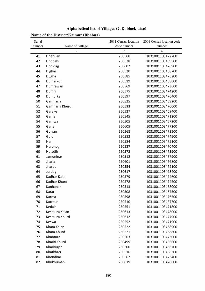
Alphabetical list of Villages (C.D. block wise)
Name of the District:Kaimur (Bhabua)
Serial
number Name of village
2011 Census location
code number
2001 Census location code
number
1 2 3 4
41 Dhenuan 250560 1031001103472700
42 Dhobahi 250528 1031001103469500
43 Dholdag 250602 1031001103476900
44 Dighar 250520 1031001103468700
45 Dugha 250585 1031001103475200
46 Dumarkon 250519 1031001103468600
47 Dumrawan 250569 1031001103473600
48 Dumri 250575 1031001103474200
49 Dumurka 250597 1031001103476400
50 Gamharia 250525 1031001103469200
51 Gamharia Khurd 250533 1031001103470000
52 Garake 250527 1031001103469400
53 Garha 250545 1031001103471200
54 Garhwa 250505 1031001103467200
55 Garle 250605 1031001103477200
56 Goiyan 250568 1031001103473500
57 Gulu 250582 1031001103474900
58 Har 250584 1031001103475100
59 Harbhog 250537 1031001103470400
60 Holadih 250572 1031001103473900
61 Jamuninar 250512 1031001103467900
62 Jharia 250601 1031001103476800
63 Jharpa 250554 1031001103472100
64 Jordag 250617 1031001103478400
65 Kadhar Kalan 250579 1031001103474600
66 Kadhar Khurd 250578 1031001103474500
67 Kanhanar 250513 1031001103468000
68 Karar 250508 1031001103467500
69 Karma 250598 1031001103476500
70 Katraur 250510 1031001103467700
71 Kedala 250551 1031001103471800
72 Kesraura Kalan 250613 1031001103478000
73 Kesraura Khurd 250612 1031001103477900
74 Keswa 250552 1031001103471900
75 Kham Kalan 250522 1031001103468900
76 Kham Khurd 250521 1031001103468800
77 Kharaura 250563 1031001103473000
78 Kharki Khurd 250499 1031001103466600
79 Kharkiujar 250500 1031001103466700
80 Khatkhari 250516 1031001103468300
81 Khondhar 250567 1031001103473400
82 Khukhuman 250619 1031001103478600
180
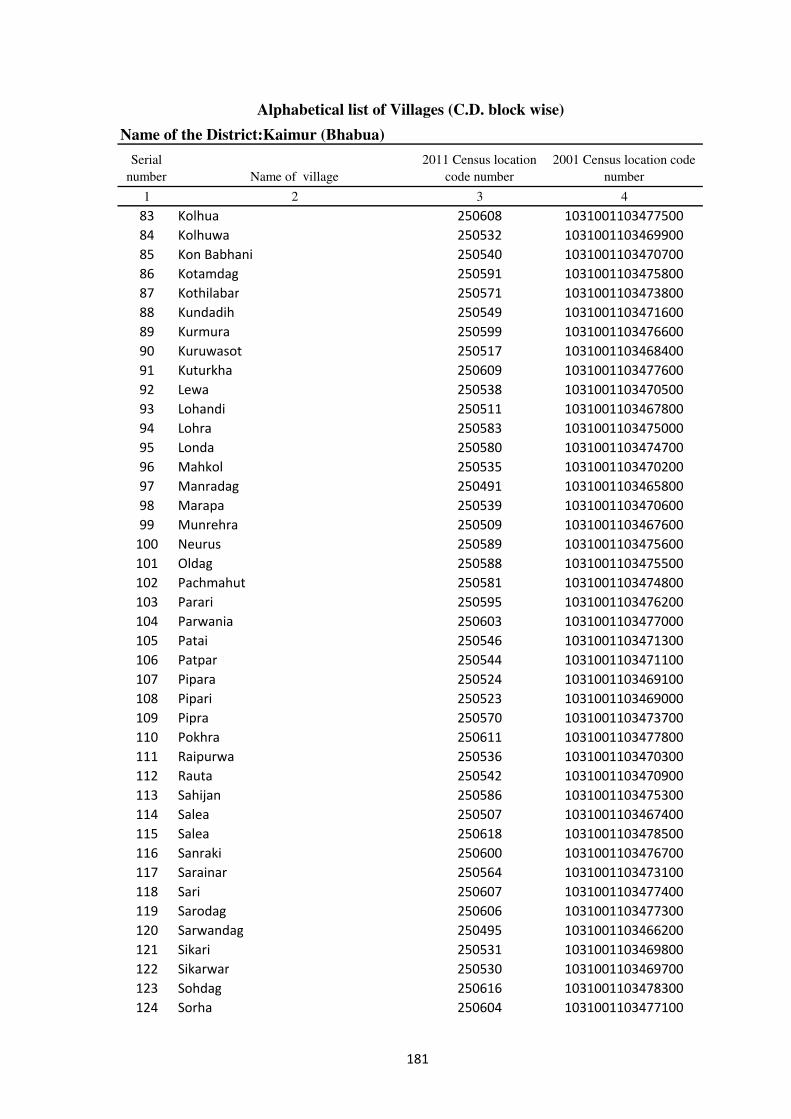
Alphabetical list of Villages (C.D. block wise)
Name of the District:Kaimur (Bhabua)
Serial
number Name of village
2011 Census location
code number
2001 Census location code
number
1 2 3 4
83 Kolhua 250608 1031001103477500
84 Kolhuwa 250532 1031001103469900
85 Kon Babhani 250540 1031001103470700
86 Kotamdag 250591 1031001103475800
87 Kothilabar 250571 1031001103473800
88 Kundadih 250549 1031001103471600
89 Kurmura 250599 1031001103476600
90 Kuruwasot 250517 1031001103468400
91 Kuturkha 250609 1031001103477600
92 Lewa 250538 1031001103470500
93 Lohandi 250511 1031001103467800
94 Lohra 250583 1031001103475000
95 Londa 250580 1031001103474700
96 Mahkol 250535 1031001103470200
97 Manradag 250491 1031001103465800
98 Marapa 250539 1031001103470600
99 Munrehra 250509 1031001103467600
100 Neurus 250589 1031001103475600
101 Oldag 250588 1031001103475500
102 Pachmahut 250581 1031001103474800
103 Parari 250595 1031001103476200
104 Parwania 250603 1031001103477000
105 Patai 250546 1031001103471300
106 Patpar 250544 1031001103471100
107 Pipara 250524 1031001103469100
108 Pipari 250523 1031001103469000
109 Pipra 250570 1031001103473700
110 Pokhra 250611 1031001103477800
111 Raipurwa 250536 1031001103470300
112 Rauta 250542 1031001103470900
113 Sahijan 250586 1031001103475300
114 Salea 250507 1031001103467400
115 Salea 250618 1031001103478500
116 Sanraki 250600 1031001103476700
117 Sarainar 250564 1031001103473100
118 Sari 250607 1031001103477400
119 Sarodag 250606 1031001103477300
120 Sarwandag 250495 1031001103466200
121 Sikari 250531 1031001103469800
122 Sikarwar 250530 1031001103469700
123 Sohdag 250616 1031001103478300
124 Sorha 250604 1031001103477100
181
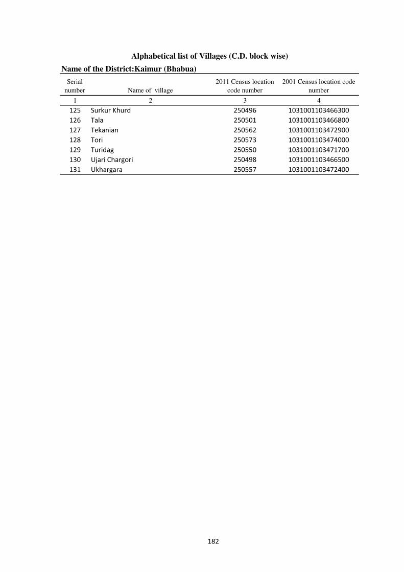
Alphabetical list of Villages (C.D. block wise)
Name of the District:Kaimur (Bhabua)
Serial
number Name of village
2011 Census location
code number
2001 Census location code
number
1 2 3 4
125 Surkur Khurd 250496 1031001103466300
126 Tala 250501 1031001103466800
127 Tekanian 250562 1031001103472900
128 Tori 250573 1031001103474000
129 Turidag 250550 1031001103471700
130 Ujari Chargori 250498 1031001103466500
131 Ukhargara 250557 1031001103472400
182

183
�������������������
Village Directory

DISTRICT CENSUS HANDBOOK : KAIMUR (BHABUA)
Census of India 2011-
Amenities and Land use
Pre
-Pri
mar
y s
chool
(PP
)
Pri
mar
y s
chool
(P)
Mid
dle
sch
ool
(M)
Sec
ondar
y S
chool
(S)
Sen
ior
Sec
ondar
y s
chool
(SS
)
Deg
ree
coll
ege
of
arts
sc
ience
& c
om
mer
ce
(AS
C)
Engin
eeri
ng c
oll
ege(
EC
)
Med
ical
coll
ege
(MC
)
Man
agem
ent
inst
itute
(M
I)
Poly
tech
nic
(P
t)
Voca
tional
tra
inin
g s
chool
/IT
I
Non-f
orm
al t
rain
ing c
entr
e (N
FT
C)
Spec
ial
school
for
dis
able
d (
SS
D)
Oth
ers
(spec
ify)
1 2 3 4 5 6 7 8 9 10 11 12 13 14 15 16 17 18 19 20
Name of District:-Kaimur (Bhabua) Location CodeNo:-233
Name of CD Block:-Ramgarh Location CodeNo:-0434
1 Bhatauni 248923 149 2172 318 a a a a a c c c c c c c c
2 Sangapur 248924 128 964 148 b 1 a a a c c c c c c c c c
3 Baijnath 248925 231 2482 380 b 1 1 a a c c c c c c c c
4 Gogarhi 248926 108 918 148 a 1 a a b b c c c c c c c
5 Bishunpura 248927 62 386 65 a 1 a a c c c c c c c c c
6 Chhatarpura 248928 36 1423 233 a 2 a b b a c c c c b c c
7 Debahalia 248929 191 3967 574 1 3 3 3 2 c c c c c c c c
8 Karari 248930 24 0 0
9 Gadeya 248931 38 0 0
10 Dharahara 248932 52 0 0
11 Matiari 248933 100 1464 193 b 2 a b b c c c c c b c c
12 Bharheria 248934 236 1770 258 b 2 a b b c c c c c b c c
13 Kohraula 248935 143 956 122 a 2 a a a c c c c c b c c
14 Labedaha 248936 118 942 152 b 1 b b b c c c c c c c c
15 Chandarmanpur 248937 26 6 2 b a c c c c c c c c c c c
16 Masarhi 248938 149 3207 440 a 1 1 a b c c c c c c c c
17 Rewra 248939 100 0 0
18 Mera 248940 100 612 93 a 1 a a b c c c c c b c c
19 Labedahi 248941 74 380 57 b b b b b c c c c c c c c
Loca
tion c
ode
no.
Nam
e vil
lage
Ser
ial
Num
ber
Tota
l popula
tion (
2011 c
ensu
s )
Tota
l ar
ea o
f th
e vil
lage
( in
hec
tare
s ro
unded
up t
o
one
dec
imal
pla
ce)
Number of educational amenities available. (If not available
within the village , the distance range code viz; a for < 5
Kms, b for 5-10 Kms and c for 10+ kms of nearest place
where facility is available is given).
Num
ber
of
house
hold
s (2
011 c
ensu
s)
���
VILLAGE DIRECTORY
Village Directory
( As in 2009 )
Com
munit
y h
ealt
h c
entr
e (C
HC
)
Pri
mar
y h
ealt
h c
entr
e (P
HC
)
Pri
mar
y h
ealt
h s
ub c
entr
e (P
HS
)
Mat
ernit
y a
nd c
hil
d w
elfa
re c
entr
e (M
CW
)
T.B
. cl
inic
(T
BC
)
Hosp
ital
-all
opat
hic
(H
A)
Hosp
ital
-alt
ernat
ive
med
icin
e (H
O)
Dis
pen
sary
(D
)
Vet
erin
ary h
osp
ital
(V
H)
Mobil
e hea
lth c
linic
(M
HC
)
Fam
ily w
elfa
re c
entr
e (F
WC
)
Char
itab
le n
on G
ovt.
hosp
ital
/Nurs
ing h
om
e.
Med
ical
pra
ctit
ioner
wit
h M
BB
S D
egre
e
Med
ical
pra
ctit
ioner
wit
h o
ther
deg
ree
Med
ical
pra
ctit
ioner
wit
h n
o d
egre
e
Tra
dit
ional
pra
ctit
ioner
an
d f
aith
hea
ler
.
Med
icin
e S
hop
Oth
ers
21 22 23 24 25 26 27 28 29 30 31 32 33 34 35 36 37 38 2 1
c c c c c c c c c c c 0 0 0 0 0 0 0 Bhatauni 1
c c c c c c c c c c c 0 0 0 0 0 0 0 Sangapur 2
c c c c c c c c c c c 0 0 0 0 0 0 0 Baijnath 3
b b b b b c c b b c b 0 0 0 0 0 0 0 Gogarhi 4
b b c b c c c c c c c 0 0 0 0 0 0 0 Bishunpura 5
b b a b b c c b b c b 0 0 0 0 0 0 0 Chhatarpura 6
c b b b b c c b b c b 0 0 0 0 0 0 0 Debahalia 7
Karari 8
Gadeya 9
Dharahara 10
b b a b b c c c c c c 0 0 0 0 0 0 0 Matiari 11
b b a b b c c c c c c 0 0 0 0 0 0 0 Bharheria 12
a a b a a c c c b c b 0 0 0 0 0 0 0 Kohraula 13
b b b b c c c b b c b 0 0 0 0 0 0 0 Labedaha 14
c c b c c c c b b c b 0 0 0 0 0 0 0 Chandarmanpur 15
c b b b b c c b b c b 0 0 0 0 0 0 0 Masarhi 16
Rewra 17
b b b b b c c b b c b 0 0 0 0 0 0 0 Mera 18
b b b b c c c b b c b 0 0 0 0 0 0 0 Labedahi 19
Number of Non-Government
Medical Amenities available.
Number of Medical Amenities available. (If not
available within the village , the distance range
code viz; a for < 5 Kms, b for 5-10 Kms and c
for 10+ kms of nearest place where facility is
available is given).
Nam
e vil
lage
Ser
ial
Num
ber
���

DISTRICT CENSUS HANDBOOK : KAIMUR (BHABUA)
Census of India 2011-
Amenities and Land use
Tap
wat
er (
Tre
ated
/Untr
eate
d)
Wel
l w
ater
(Cover
ed /
Unco
ver
ed w
ell)
Han
d P
um
p
Tube
wel
ls /
Bore
wel
l
Spri
ng
Riv
er /
Can
al
Tan
k /
Pond /
L
ake
Oth
ers
Com
munit
y t
oil
et i
ncl
udin
g
bat
h.
Com
munit
y t
oil
et e
xcl
udin
g b
ath.
Rura
l s
anit
ary m
art
or
sanit
ary
har
dw
are
outl
et
avai
lable
nea
r th
e vil
lage.
Com
munit
y b
io-
gas
or
recy
cle
of
was
te f
or
pro
duct
ive
use
.
1 2 39 40 41 42 43 44 45 46 47 48 49 50
1 Bhatauni No Yes Yes No No No No No No No No No
2 Sangapur No Yes Yes No No Yes No No No Yes No No
3 Baijnath No Yes Yes Yes No Yes No No No No No No
4 Gogarhi No Yes Yes Yes No Yes No No No No No No
5 Bishunpura No Yes Yes Yes No Yes No No No No No No
6 Chhatarpura No No Yes No No No No No No No No No
7 Debahalia No Yes Yes Yes No Yes No No No No No No
8 Karari
9 Gadeya
10 Dharahara
11 Matiari No No Yes Yes No Yes No No No No No No
12 Bharheria No No Yes No No No No No No No No No
13 Kohraula No No Yes Yes No No No No No No No No
14 Labedaha No Yes Yes No No No No No No No No No
15 Chandarmanpur No No Yes No No No No No No No No No
16 Masarhi No Yes Yes Yes No Yes No No No No No No
17 Rewra
18 Mera No Yes Yes Yes No No No No No No No No
19 Labedahi No Yes Yes No No No No No No No No No
Availability of toilet & others
Yes / No Availability of drinking water - Yes / No
Nam
e vil
lage
Ser
ial
Num
ber
���

VILLAGE DIRECTORY
Village Directory
( As in 2009 )
Post
off
ice(
PO
)
Sub p
ost
off
ice
(SP
O)
Post
& T
eleg
raph o
ffic
e
(P&
TO
)
Vil
lage
Pin
Code
Tel
ephones
(L
and l
ines
)
Publi
c ca
ll o
ffic
e (P
CO
)
Mobil
e phone
cover
age
Inte
rnet
caf
es/
Com
mon s
ervic
e ce
ntr
e (C
SC
)
Pri
vat
e co
uri
er f
acil
ity
Bus
serv
ice
(P
ubli
c &
Pri
vat
e)
Rai
lway
sta
tions
Auto
/Modif
ied A
uto
s
Tax
is a
nd V
ans
Tra
ctors
Cycl
e-pull
ed r
icksh
aws(
Man
ual
& M
achin
e
dri
ven
)
Car
ts d
riven
by a
nim
als
Sea
/R
iver
fer
ry s
ervic
e51 52 53 54 55 56 57 58 59 60 61 62 63 64 65 66 67 2 1
a a c a a a a a a a a a Yes Yes Yes a Bhatauni 1
a a c 821110 c c Yes c c c b Yes Yes Yes Yes b c Sangapur 2
a a c a a a a a a b c Yes Yes Yes Yes c Baijnath 3
a a c 821110 Yes Yes Yes Yes a a Yes c Yes Yes Yes a a Gogarhi 4
a a Yes a a a c c a c c b a a b Bishunpura 5
a a c b b b b b b c c c Yes Yes b Chhatarpura 6
Yes b Yes 821110 Yes Yes Yes Yes b Yes c Yes Yes Yes Yes Yes Debahalia 7
Karari 8
Gadeya 9
Dharahara 10
a a c b b b b b b b c a Yes Yes b Matiari 11
a a c b b b b b b c c c Yes Yes b Bharheria 12
a a c a a a b a a a c a a a b Kohraula 13
b b c b b b b b b c b b b b b b Labedaha 14
b b c c c c c c c c b b c b b b Chandarmanpur 15
a b c Yes Yes a b b a c Yes Yes Yes Yes Yes Masarhi 16
Rewra 17
a b c a a a b b a c c b b b b Mera 18
b b c b b b b b b c b b b a a a Labedahi 19
Communication and transport facilities (If amenities available code -Yes is given except for
Village Pin Code ,If not available within the village , the distance range code viz; a for < 5
Kms, b for 5-10 Kms and c for 10+ kms of nearest place where facility is available is given).
Ser
ial
Num
ber
Nam
e vil
lage
���
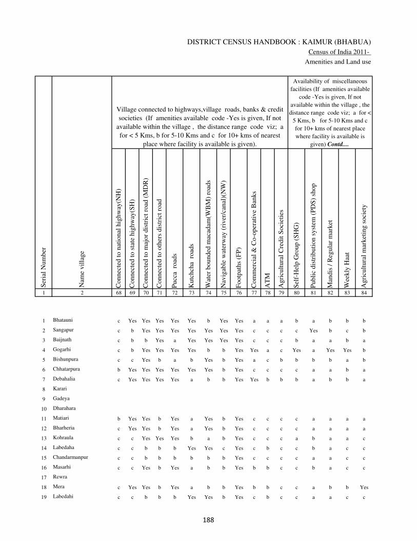
DISTRICT CENSUS HANDBOOK : KAIMUR (BHABUA)
Census of India 2011-
Amenities and Land use
Connec
ted t
o n
atio
nal
hig
hw
ay(N
H)
Connec
ted t
o s
tate
hig
hw
ay(S
H)
Connec
ted t
o m
ajor
dis
tric
t ro
ad (
MD
R)
Connec
ted t
o o
ther
s dis
tric
t ro
ad
Pucc
a r
oad
s
Kutc
hch
a r
oad
s
Wat
er b
ounded
mac
adam
(WB
M)
road
s
Nav
igab
le w
ater
way
(ri
ver
/can
al)(
NW
)
Footp
aths
(FP
)
Com
mer
cial
& C
o-o
per
ativ
e B
anks
AT
M
Agri
cult
ura
l C
redit
Soci
etie
s
Sel
f-H
elp G
roup (
SH
G)
Publi
c dis
trib
uti
on s
yst
em (
PD
S)
shop
Man
dis
/ R
egula
r m
arket
Wee
kly
Haa
t
Agri
cult
ura
l m
arket
ing s
oci
ety
1 2 68 69 70 71 72 73 74 75 76 77 78 79 80 81 82 83 84
1 Bhatauni c Yes Yes Yes Yes Yes b Yes Yes a a a b a b b b
2 Sangapur c b Yes Yes Yes Yes Yes Yes Yes c c c c Yes b c b
3 Baijnath c b b Yes a Yes Yes Yes Yes c c c b a a b a
4 Gogarhi c b Yes Yes Yes Yes b b Yes Yes a c Yes a Yes Yes b
5 Bishunpura c c Yes b a b Yes b Yes a c b b b b a b
6 Chhatarpura b Yes Yes Yes Yes Yes Yes b Yes c c c c a a b a
7 Debahalia c Yes Yes Yes Yes a b b Yes Yes b b b a b b a
8 Karari
9 Gadeya
10 Dharahara
11 Matiari b Yes Yes b Yes a Yes b Yes c c c c a a a a
12 Bharheria c Yes Yes b Yes a Yes b Yes c c c c a a a a
13 Kohraula c c Yes Yes Yes b a b Yes c c c a b a a c
14 Labedaha c c b b b Yes Yes c Yes c b c c b a c c
15 Chandarmanpur c c b b b b b b Yes c c c c a a c c
16 Masarhi c c Yes b Yes a b b Yes b b c c b a c c
17 Rewra
18 Mera c Yes Yes b Yes a b b Yes b b c c a b b Yes
19 Labedahi c c b b b Yes Yes b Yes c b c c a a c c
Village connected to highways,village roads, banks & credit
societies (If amenities available code -Yes is given, If not
available within the village , the distance range code viz; a
for < 5 Kms, b for 5-10 Kms and c for 10+ kms of nearest
place where facility is available is given).
Ser
ial
Num
ber
Nam
e vil
lage
Availability of miscellaneous
facilities (If amenities available
code -Yes is given, If not
available within the village , the
distance range code viz; a for <
5 Kms, b for 5-10 Kms and c
for 10+ kms of nearest place
where facility is available is
given) Contd....
���

VILLAGE DIRECTORY
Village Directory
( As in 2009 )
Inte
gra
ted C
hil
d D
evel
opm
ent
Sch
eme
(Nutr
itio
nal
Cen
tres
)
Angan
wad
i C
entr
e (N
utr
itio
nal
Cen
tres
)
Oth
ers
(Nutr
itio
nal
Cen
tres
)
AS
HA
(A
ccre
dit
ed S
oci
al H
ealt
h A
ctiv
ist)
Com
munit
y c
entr
e w
ith/w
ithout
TV
Sport
s F
ield
,
Sport
s C
lub /
Rec
reat
ion C
entr
e
Cin
ema
/ V
ideo
Hal
l
Publi
c L
ibra
ry
Publi
c R
eadin
g R
oom
New
spap
er S
upply
Ass
embly
Poll
ing s
tati
on
Bir
th &
Dea
th R
egis
trat
ion O
ffic
e
Pow
er S
upply
for
Dom
esti
c U
se (
ED
)
Pow
er S
upply
for
Agri
cult
ura
l U
se (
EA
G)
Pow
er S
upply
for
Com
mer
cial
Use
(E
C)
Pow
er S
upply
for
All
Use
s (E
A)
85 86 87 88 89 90 91 92 93 94 95 96 97 98 99 100 101 2 1
c Yes Yes b c c c c c c b Yes b No No No No Bhatauni 1
c Yes Yes Yes c a c c c c b a b Yes Yes Yes Yes Sangapur 2
c Yes Yes a a c c c c c a Yes a Yes Yes No No Baijnath 3
c Yes Yes b b Yes Yes c c a b a b Yes Yes No No Gogarhi 4
c Yes Yes Yes a a b c b c b a a Yes Yes Yes Yes Bishunpura 5
c a a a a a a c b b a a a No No No No Chhatarpura 6
c Yes Yes Yes Yes Yes Yes c Yes Yes b Yes Yes Yes Yes No No Debahalia 7
Karari 8
Gadeya 9
Dharahara 10
c a Yes a a a b b b b b a a No Yes No No Matiari 11
c Yes Yes a a a a c b b b a a No Yes No No Bharheria 12
c a a a a a c a a a c a a Yes Yes No No Kohraula 13
c Yes Yes Yes b a c c c c b Yes a No No No No Labedaha 14
c b Yes b b a c c c c c a b No No No No Chandarmanpur 15
c Yes Yes Yes b a b b b b a Yes Yes Yes Yes No No Masarhi 16
Rewra 17
c Yes Yes Yes b b b b b b b a a Yes Yes No No Mera 18
c b Yes b a a c c c c b Yes a No No No No Labedahi 19
Availability of
electricity (Yes/No)
Availability of miscellaneous facilities (If amenities available code -
Yes is given, If not available within the village , the distance range
code viz; a for < 5 Kms, b for 5-10 Kms and c for 10+ kms of
nearest place where facility is available is given) Concluded
Nam
e vil
lage
Ser
ial
Num
ber
���
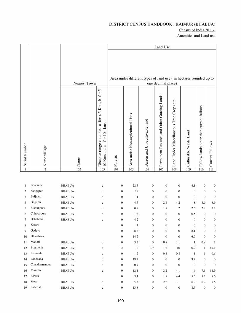
DISTRICT CENSUS HANDBOOK : KAIMUR (BHABUA)
Census of India 2011-
Amenities and Land use
Nam
e
Dis
tance
ran
ge
code
i.e
. a
fo
r <
5 K
ms,
b
for
5-
10 K
ms
and c
f
or
10+
km
s .
Fore
sts
Are
a under
Non-a
gri
cult
ura
l U
ses
Bar
ren a
nd U
n-c
ult
ivab
le l
and
Per
man
ent
Pas
ture
s an
d O
ther
Gra
zing L
ands
Lan
d U
nder
Mis
cell
aneo
us
Tre
e C
rops
etc.
Cult
ura
ble
Was
te L
and
Fal
low
lan
ds
oth
er t
han
curr
ent
fall
ow
s
Curr
ent
Fal
low
s
1 2 102 103 104 105 106 107 108 109 110 111
1 Bhatauni BHABUA c 0 22.5 0 0 0 4.1 0 0
2 Sangapur BHABUA c 0 28 0 0 0 0 0 0
3 Baijnath BHABUA c 0 31 0 0 0 0 0 0
4 Gogarhi BHABUA c 0 4.5 0 2.1 4.2 8 8.6 8.9
5 Bishunpura BHABUA c 0 0.8 0 1.8 2 2.6 2.8 3.2
6 Chhatarpura BHABUA c 0 1.8 0 0 0 0.5 0 0
7 Debahalia BHABUA c 0 4.2 0 0 0 0 0 0
8 Karari 0 4 0 0 0 0 0 0
9 Gadeya 0 8.3 0 0 0 8.1 0 0
10 Dharahara 0 14.2 0 0 0 6.9 0 0
11 Matiari BHABUA c 0 3.2 0 0.8 1.1 1 0.9 1
12 Bharheria BHABUA c 3.2 0 0.9 1.2 10 0.9 1 67.1
13 Kohraula BHABUA c 0 1.2 0 0.4 0.8 1 1 0.6
14 Labedaha BHABUA c 0 19.7 0 0 0 9.4 0 0
15 Chandarmanpur BHABUA c 0 0.7 0 0 0 0 0 0
16 Masarhi BHABUA c 0 12.1 0 2.2 4.1 6 7.1 11.9
17 Rewra 0 3.1 0 1.8 4.4 5.6 5.2 8.6
18 Mera BHABUA c 0 5.5 0 2.2 3.1 6.2 6.2 7.6
19 Labedahi BHABUA c 0 13.8 0 0 0 8.5 0 0
Ser
ial
Num
ber
Nam
e vil
lage
Area under different types of land use ( in hectares rounded up to
one decimal place)
Land Use
Nearest Town
���

VILLAGE DIRECTORY
Village Directory
( As in 2009 )
Net
Are
a S
ow
n
Tota
l Ir
rigat
ed L
and A
rea
Tota
l U
n-i
rrig
ated
Lan
d A
rea
Can
als
( C
)
Wel
ls/T
ube-
wel
ls(W
/TW
)
Tan
ks/
Lak
es(T
/L)
Wat
er F
alls
(WF
)
Oth
ers(
O)
Fir
st
Sec
ond
Thir
d
112 113 114 115 116 117 118 119 120 121 122 2 1
122.4 72 50.4 0 68 4 0 0 Bhatauni 1
100 80 20 0 60 0 0 20 Sangapur 2
200 150 50 0 130 0 0 20 Baijnath 3
71.7 55.4 16.3 51.4 4 0 0 0 Gogarhi 4
48.7 48 0.7 48 0 0 0 0 Bishunpura 5
33.7 17.4 16.3 0 17.4 0 0 0 Chhatarpura 6
186.8 123 63.8 0 123 0 0 0 Debahalia 7
20 9.2 10.8 0 9.2 0 0 0 Karari 8
21.6 12.8 8.8 0 12.8 0 0 0 Gadeya 9
30.9 17.9 13 0 17.9 0 0 0 Dharahara 10
92 29.3 62.8 12.9 0 0 0 16.4 Matiari 11
151.8 76.6 75.2 2.9 54.1 0 0 19.6 Bharheria 12
138 54.2 83.8 0 54.2 0 0 0 Kohraula 13
88.9 64.9 24 0 64.9 0 0 0 Labedaha 14
25.3 14.2 11.1 0 14.2 0 0 0 Chandarmanpur 15
105.7 105.1 0.6 105.1 0 0 0 0 Masarhi 16
71.4 70.8 0.6 68.8 2 0 0 0 Rewra 17
69.2 69 0.2 66 3 0 0 0 Mera 18
51.7 40 11.7 0 40 0 0 0 Labedahi 19
Ser
ial
Num
ber
Name of three
most important
commodities
manufacturedArea irrigated by source (in hectare).
Nam
e of
Vil
lage
Area under different types of
land use ( in hectares rounded
up to one decimal place)
Land Use
���

DISTRICT CENSUS HANDBOOK : KAIMUR (BHABUA)
Census of India 2011-
Amenities and Land use
Pre
-Pri
mar
y s
chool
(PP
)
Pri
mar
y s
chool
(P)
Mid
dle
sch
ool
(M)
Sec
ondar
y S
chool
(S)
Sen
ior
Sec
ondar
y s
chool
(SS
)
Deg
ree
coll
ege
of
arts
sc
ience
& c
om
mer
ce
(AS
C)
Engin
eeri
ng c
oll
ege(
EC
)
Med
ical
coll
ege
(MC
)
Man
agem
ent
inst
itute
(M
I)
Poly
tech
nic
(P
t)
Voca
tional
tra
inin
g s
chool
/IT
I
Non-f
orm
al t
rain
ing c
entr
e (N
FT
C)
Spec
ial
school
for
dis
able
d (
SS
D)
Oth
ers
(spec
ify)
1 2 3 4 5 6 7 8 9 10 11 12 13 14 15 16 17 18 19 20
Loca
tion c
ode
no.
Nam
e vil
lage
Ser
ial
Num
ber
Tota
l popula
tion (
2011 c
ensu
s )
Tota
l ar
ea o
f th
e vil
lage
( in
hec
tare
s ro
unded
up t
o
one
dec
imal
pla
ce)
Number of educational amenities available. (If not available
within the village , the distance range code viz; a for < 5
Kms, b for 5-10 Kms and c for 10+ kms of nearest place
where facility is available is given).
Num
ber
of
house
hold
s (2
011 c
ensu
s)
20 Narhan 248942 247 2849 482 b 1 1 a c c c c c c c c c
21 Sumerpur Barka 248943 41 0 0
22 Sumerpur Chotka 248944 34 0 0
23 Sehuka 248945 357 4716 782 b 1 1 a b c c c c c c c c
24 Bisrampur 248946 44 0 0
25 Jamurna 248947 127 2108 294 b 1 1 c c c c c c c c c c
26 Dahrak 248948 299 3805 638 a a a c c c c c c c c c c
27 Chakkupur 248949 107 171 34 a a a a a c c c c c b c c
28 Mahuwar 248950 424 3701 528 1 1 1 b b c c c c c c c c
29 Jangalchhera 248951 342 0 0
30 Pachgain 248952 74 962 134 b 1 a b b c c c c c c c c
31 Anantpura 248953 86 274 41 b 1 a b b c c c c c c c c
32 Rupanandpur 248954 53 365 58 a 1 b b b c c c c c c c c
33 Balha 248955 170 0 0
34
Jangalchhera
Sahodarpur 248956 91 41 7 b b b b b c c c c c b c c b
35 Jangalchhera Saray 248957 88 0 0
36 Sarai 248958 248 1783 263 b 1 b a b c c c c c c c c
37 Toroiya 248959 99 1095 175 a 1 a a c c c c c c c c c
38 Jangalchhera Taraiya 248960 80 0 0
39 Jangalchhera Imlia 248961 134 0 0
��

VILLAGE DIRECTORY
Village Directory
( As in 2009 )
Com
munit
y h
ealt
h c
entr
e (C
HC
)
Pri
mar
y h
ealt
h c
entr
e (P
HC
)
Pri
mar
y h
ealt
h s
ub c
entr
e (P
HS
)
Mat
ernit
y a
nd c
hil
d w
elfa
re c
entr
e (M
CW
)
T.B
. cl
inic
(T
BC
)
Hosp
ital
-all
opat
hic
(H
A)
Hosp
ital
-alt
ernat
ive
med
icin
e (H
O)
Dis
pen
sary
(D
)
Vet
erin
ary h
osp
ital
(V
H)
Mobil
e hea
lth c
linic
(M
HC
)
Fam
ily w
elfa
re c
entr
e (F
WC
)
Char
itab
le n
on G
ovt.
hosp
ital
/Nurs
ing h
om
e.
Med
ical
pra
ctit
ioner
wit
h M
BB
S D
egre
e
Med
ical
pra
ctit
ioner
wit
h o
ther
deg
ree
Med
ical
pra
ctit
ioner
wit
h n
o d
egre
e
Tra
dit
ional
pra
ctit
ioner
an
d f
aith
hea
ler
.
Med
icin
e S
hop
Oth
ers
21 22 23 24 25 26 27 28 29 30 31 32 33 34 35 36 37 38 2 1
Number of Non-Government
Medical Amenities available.
Number of Medical Amenities available. (If not
available within the village , the distance range
code viz; a for < 5 Kms, b for 5-10 Kms and c
for 10+ kms of nearest place where facility is
available is given).
Nam
e vil
lage
Ser
ial
Num
ber
b b b b c c c b b c b 0 0 0 0 0 0 0 Narhan 20
Sumerpur Barka 21
Sumerpur Chotka 22
b b b b b c c b b c b 0 0 0 0 0 0 0 Sehuka 23
Bisrampur 24
b b b b c c c b b c b 0 0 0 0 0 0 0 Jamurna 25
c c b c c c c b b c b 0 0 0 0 0 0 0 Dahrak 26
a a a a a c c a a c a 0 0 0 0 0 0 0 Chakkupur 27
b b b b b c c b b c b 0 0 0 0 0 0 0 Mahuwar 28
Jangalchhera 29
b b b b b c c b b c b 0 0 0 0 0 0 0 Pachgain 30
b b b b b c c b b c b 0 0 0 0 0 0 0 Anantpura 31
b b b b b c c b b c b 0 0 0 0 0 0 0 Rupanandpur 32
Balha 33
b b b b b c c b b c b 0 0 0 0 0 0 0 Jangalchhera Sahodarpur 34
Jangalchhera Saray 35
b b b b b c c b b c b 0 0 0 0 0 0 0 Sarai 36
c c c c c c c c c c c 0 0 0 0 0 0 0 Toroiya 37
Jangalchhera Taraiya 38
Jangalchhera Imlia 39
��

DISTRICT CENSUS HANDBOOK : KAIMUR (BHABUA)
Census of India 2011-
Amenities and Land use
Tap
wat
er (
Tre
ated
/Untr
eate
d)
Wel
l w
ater
(Cover
ed /
Unco
ver
ed w
ell)
Han
d P
um
p
Tube
wel
ls /
Bore
wel
l
Spri
ng
Riv
er /
Can
al
Tan
k /
Pond /
L
ake
Oth
ers
Com
munit
y t
oil
et i
ncl
udin
g
bat
h.
Com
munit
y t
oil
et e
xcl
udin
g b
ath.
Rura
l s
anit
ary m
art
or
sanit
ary
har
dw
are
outl
et
avai
lable
nea
r th
e vil
lage.
Com
munit
y b
io-
gas
or
recy
cle
of
was
te f
or
pro
duct
ive
use
.
1 2 39 40 41 42 43 44 45 46 47 48 49 50
Availability of toilet & others
Yes / No Availability of drinking water - Yes / No
Nam
e vil
lage
Ser
ial
Num
ber
20 Narhan No Yes Yes No No No No No No No No No
21 Sumerpur Barka
22 Sumerpur Chotka
23 Sehuka Yes No Yes Yes No No No No No No No No
24 Bisrampur
25 Jamurna No Yes Yes Yes No No No No No No No No
26 Dahrak No No Yes Yes No No No No No No No No
27 Chakkupur No No Yes Yes No No No No No No No No
28 Mahuwar No Yes Yes Yes No No No No No No No No
29 Jangalchhera
30 Pachgain No Yes Yes Yes No Yes No No No No No No
31 Anantpura No Yes Yes Yes No Yes No No No No No No
32 Rupanandpur No Yes Yes Yes No Yes No No No No No No
33 Balha
34 Jangalchhera Sahodarpur No Yes Yes Yes No No No No No No No No
35 Jangalchhera Saray
36 Sarai No Yes Yes Yes No Yes No No No No No No
37 Toroiya No Yes Yes Yes No Yes No No No No No No
38 Jangalchhera Taraiya
39 Jangalchhera Imlia
���
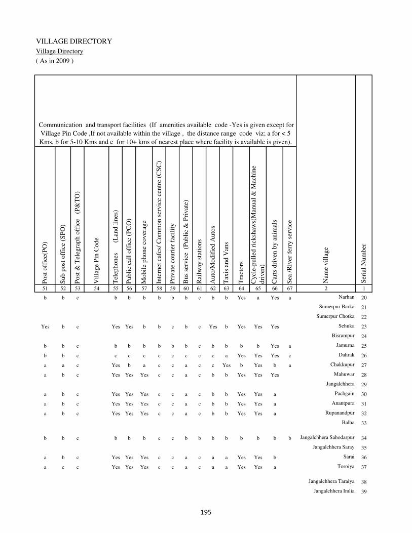
VILLAGE DIRECTORY
Village Directory
( As in 2009 )
Post
off
ice(
PO
)
Sub p
ost
off
ice
(SP
O)
Post
& T
eleg
raph o
ffic
e
(P&
TO
)
Vil
lage
Pin
Code
Tel
ephones
(L
and l
ines
)
Publi
c ca
ll o
ffic
e (P
CO
)
Mobil
e phone
cover
age
Inte
rnet
caf
es/
Com
mon s
ervic
e ce
ntr
e (C
SC
)
Pri
vat
e co
uri
er f
acil
ity
Bus
serv
ice
(P
ubli
c &
Pri
vat
e)
Rai
lway
sta
tions
Auto
/Modif
ied A
uto
s
Tax
is a
nd V
ans
Tra
ctors
Cycl
e-pull
ed r
icksh
aws(
Man
ual
& M
achin
e
dri
ven
)
Car
ts d
riven
by a
nim
als
Sea
/R
iver
fer
ry s
ervic
e51 52 53 54 55 56 57 58 59 60 61 62 63 64 65 66 67 2 1
Communication and transport facilities (If amenities available code -Yes is given except for
Village Pin Code ,If not available within the village , the distance range code viz; a for < 5
Kms, b for 5-10 Kms and c for 10+ kms of nearest place where facility is available is given).
Ser
ial
Num
ber
Nam
e vil
lage
b b c b b b b b b c b b Yes a Yes a Narhan 20
Sumerpur Barka 21
Sumerpur Chotka 22
Yes b c Yes Yes b b c b c Yes b Yes Yes Yes Sehuka 23
Bisrampur 24
b b c b b b b b b c b b b b Yes a Jamurna 25
b b c c c c c c c c c a Yes Yes Yes c Dahrak 26
a a c Yes b a c c a c c Yes b Yes b a Chakkupur 27
a b c Yes Yes Yes c c a c b b Yes Yes Yes Mahuwar 28
Jangalchhera 29
a b c Yes Yes Yes c c a c b b Yes Yes a Pachgain 30
a b c Yes Yes Yes c c a c b b Yes Yes a Anantpura 31
a b c Yes Yes Yes c c a c b b Yes Yes a Rupanandpur 32
Balha 33
b b c b b b c c b b b b b b b b Jangalchhera Sahodarpur 34
Jangalchhera Saray 35
a b c Yes Yes Yes c c a c a a Yes Yes b Sarai 36
a c c Yes Yes Yes c c a c a a Yes Yes a Toroiya 37
Jangalchhera Taraiya 38
Jangalchhera Imlia 39
���

DISTRICT CENSUS HANDBOOK : KAIMUR (BHABUA)
Census of India 2011-
Amenities and Land use
Connec
ted t
o n
atio
nal
hig
hw
ay(N
H)
Connec
ted t
o s
tate
hig
hw
ay(S
H)
Connec
ted t
o m
ajor
dis
tric
t ro
ad (
MD
R)
Connec
ted t
o o
ther
s dis
tric
t ro
ad
Pucc
a r
oad
s
Kutc
hch
a r
oad
s
Wat
er b
ounded
mac
adam
(WB
M)
road
s
Nav
igab
le w
ater
way
(ri
ver
/can
al)(
NW
)
Footp
aths
(FP
)
Com
mer
cial
& C
o-o
per
ativ
e B
anks
AT
M
Agri
cult
ura
l C
redit
Soci
etie
s
Sel
f-H
elp G
roup (
SH
G)
Publi
c dis
trib
uti
on s
yst
em (
PD
S)
shop
Man
dis
/ R
egula
r m
arket
Wee
kly
Haa
t
Agri
cult
ura
l m
arket
ing s
oci
ety
1 2 68 69 70 71 72 73 74 75 76 77 78 79 80 81 82 83 84
Village connected to highways,village roads, banks & credit
societies (If amenities available code -Yes is given, If not
available within the village , the distance range code viz; a
for < 5 Kms, b for 5-10 Kms and c for 10+ kms of nearest
place where facility is available is given).
Ser
ial
Num
ber
Nam
e vil
lage
Availability of miscellaneous
facilities (If amenities available
code -Yes is given, If not
available within the village , the
distance range code viz; a for <
5 Kms, b for 5-10 Kms and c
for 10+ kms of nearest place
where facility is available is
given) Contd....
20 Narhan c b b b b Yes Yes b Yes c b c c a a c c
21 Sumerpur Barka
22 Sumerpur Chotka
23 Sehuka c c b b Yes a b b Yes Yes b c c b b b c
24 Bisrampur
25 Jamurna c c b b b Yes Yes b Yes c b c c a a c c
26 Dahrak c c b b b b b b Yes c c c c a a a c
27 Chakkupur b b a a Yes a b b Yes a a c c a a a c
28 Mahuwar c b a Yes Yes a Yes b Yes b b c c Yes b b c
29 Jangalchhera
30 Pachgain c b a Yes Yes Yes Yes b Yes b b b Yes a b b c
31 Anantpura c b a Yes Yes Yes Yes b Yes Yes b c b a b b c
32 Rupanandpur c c a Yes Yes Yes Yes b Yes b b c c b b b c
33 Balha
34 Jangalchhera Sahodarpur b b b b a Yes b b Yes b b b b b b c c
35 Jangalchhera Saray
36 Sarai c c a Yes Yes Yes Yes b Yes a b c b Yes a b c
37 Toroiya c c a Yes Yes Yes Yes b Yes a c c b a a b c
38 Jangalchhera Taraiya
39 Jangalchhera Imlia
���
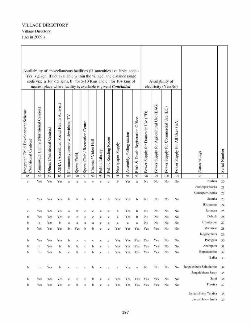
VILLAGE DIRECTORY
Village Directory
( As in 2009 )
Inte
gra
ted C
hil
d D
evel
opm
ent
Sch
eme
(Nutr
itio
nal
Cen
tres
)
Angan
wad
i C
entr
e (N
utr
itio
nal
Cen
tres
)
Oth
ers
(Nutr
itio
nal
Cen
tres
)
AS
HA
(A
ccre
dit
ed S
oci
al H
ealt
h A
ctiv
ist)
Com
munit
y c
entr
e w
ith/w
ithout
TV
Sport
s F
ield
,
Sport
s C
lub /
Rec
reat
ion C
entr
e
Cin
ema
/ V
ideo
Hal
l
Publi
c L
ibra
ry
Publi
c R
eadin
g R
oom
New
spap
er S
upply
Ass
embly
Poll
ing s
tati
on
Bir
th &
Dea
th R
egis
trat
ion O
ffic
e
Pow
er S
upply
for
Dom
esti
c U
se (
ED
)
Pow
er S
upply
for
Agri
cult
ura
l U
se (
EA
G)
Pow
er S
upply
for
Com
mer
cial
Use
(E
C)
Pow
er S
upply
for
All
Use
s (E
A)
85 86 87 88 89 90 91 92 93 94 95 96 97 98 99 100 101 2 1
Availability of
electricity (Yes/No)
Availability of miscellaneous facilities (If amenities available code -
Yes is given, If not available within the village , the distance range
code viz; a for < 5 Kms, b for 5-10 Kms and c for 10+ kms of
nearest place where facility is available is given) Concluded
Nam
e vil
lage
Ser
ial
Num
ber
c Yes Yes Yes a a c c c c b Yes a No No No No Narhan 20
Sumerpur Barka 21
Sumerpur Chotka 22
c Yes Yes Yes b b b b c b Yes Yes b No No No No Sehuka 23
Bisrampur 24
c Yes Yes Yes a b c c c c b Yes b No No No No Jamurna 25
b Yes Yes Yes c c c c c c c Yes b No No No No Dahrak 26
b a Yes b a a a a c a a a a No No No No Chakkupur 27
b Yes Yes Yes b Yes b b c c Yes Yes Yes Yes Yes No No Mahuwar 28
Jangalchhera 29
b Yes Yes Yes b a c c c c Yes Yes Yes Yes Yes No No Pachgain 30
b b Yes b b b c b c c Yes Yes Yes Yes Yes No No Anantpura 31
b b Yes b c b c b c c Yes Yes Yes Yes Yes No No Rupanandpur 32
Balha 33
b b Yes b c c c b c c a Yes a No No No No Jangalchhera Sahodarpur 34
Jangalchhera Saray 35
b Yes Yes Yes c c c b c c Yes Yes Yes Yes Yes No No Sarai 36
b Yes Yes Yes c b c b c c Yes Yes Yes Yes Yes No No Toroiya 37
Jangalchhera Taraiya 38
Jangalchhera Imlia 39
���

DISTRICT CENSUS HANDBOOK : KAIMUR (BHABUA)
Census of India 2011-
Amenities and Land use
Nam
e
Dis
tance
ran
ge
code
i.e
. a
fo
r <
5 K
ms,
b
for
5-
10 K
ms
and c
f
or
10+
km
s .
Fore
sts
Are
a under
Non-a
gri
cult
ura
l U
ses
Bar
ren a
nd U
n-c
ult
ivab
le l
and
Per
man
ent
Pas
ture
s an
d O
ther
Gra
zing L
ands
Lan
d U
nder
Mis
cell
aneo
us
Tre
e C
rops
etc.
Cult
ura
ble
Was
te L
and
Fal
low
lan
ds
oth
er t
han
curr
ent
fall
ow
s
Curr
ent
Fal
low
s
1 2 102 103 104 105 106 107 108 109 110 111
Ser
ial
Num
ber
Nam
e vil
lage
Area under different types of land use ( in hectares rounded up to
one decimal place)
Land Use
Nearest Town
20 Narhan BHABUA c 0 91.7 0 0 0 20 0 0
21 Sumerpur Barka 0 1.8 0 0.8 1.8 2 2.1 2.6
22 Sumerpur Chotka 0 1.6 0 2 2.3 2 2.7 2.4
23 Sehuka BHABUA c 0 3.6 0 2.2 10.3 10.6 0.8 10.6
24 Bisrampur 0 12.8 0 0 0 1.3 0 0
25 Jamurna BHABUA c 0 4 0 0 0 1.2 0 0
26 Dahrak BHABUA c 0 52 0 0 0 0.3 0 0
27 Chakkupur BHABUA c 0 1.2 0 0.8 0.8 0.2 2.2 26.3
28 Mahuwar BHABUA c 0 60 0 0 0 0 0 0
29 Jangalchhera 0 139.7 0 0 1.1 0 0 0
30 Pachgain BHABUA c 0 3.7 0 0 0 0 0 0
31 Anantpura BHABUA c 0 13.3 0 0 0 0 0 0
32 Rupanandpur BHABUA c 0 2 0 0 0 0 0 0
33 Balha 0 12.5 0 2.9 5.4 9.5 10.3 14.6
34
Jangalchhera
Sahodarpur BHABUA c 0 36.7 0 0 0 0 0 0
35 Jangalchhera Saray 0 37.3 0 0 0 0 0 0
36 Sarai BHABUA c 0 32.1 0 0 0 4.2 0 0
37 Toroiya BHABUA c 0 6.7 0 0 0 8.3 0 0
38 Jangalchhera Taraiya 0 18.9 0 0 0 0 0 0
39 Jangalchhera Imlia 0 34.7 0 0 0 0 0 0
���
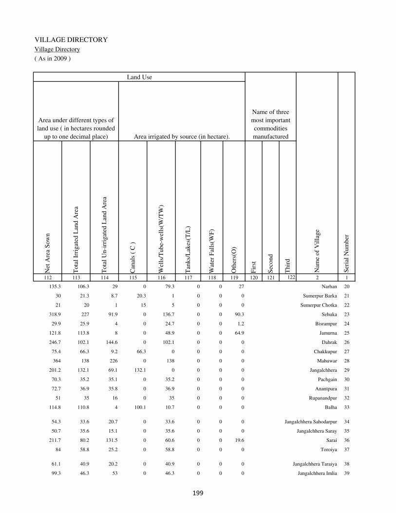
VILLAGE DIRECTORY
Village Directory
( As in 2009 )
Net
Are
a S
ow
n
Tota
l Ir
rigat
ed L
and A
rea
Tota
l U
n-i
rrig
ated
Lan
d A
rea
Can
als
( C
)
Wel
ls/T
ube-
wel
ls(W
/TW
)
Tan
ks/
Lak
es(T
/L)
Wat
er F
alls
(WF
)
Oth
ers(
O)
Fir
st
Sec
ond
Thir
d
112 113 114 115 116 117 118 119 120 121 122 2 1
Ser
ial
Num
ber
Name of three
most important
commodities
manufacturedArea irrigated by source (in hectare).
Nam
e of
Vil
lage
Area under different types of
land use ( in hectares rounded
up to one decimal place)
Land Use
135.3 106.3 29 0 79.3 0 0 27 Narhan 20
30 21.3 8.7 20.3 1 0 0 0 Sumerpur Barka 21
21 20 1 15 5 0 0 0 Sumerpur Chotka 22
318.9 227 91.9 0 136.7 0 0 90.3 Sehuka 23
29.9 25.9 4 0 24.7 0 0 1.2 Bisrampur 24
121.8 113.8 8 0 48.9 0 0 64.9 Jamurna 25
246.7 102.1 144.6 0 102.1 0 0 0 Dahrak 26
75.4 66.3 9.2 66.3 0 0 0 0 Chakkupur 27
364 138 226 0 138 0 0 0 Mahuwar 28
201.2 132.1 69.1 132.1 0 0 0 0 Jangalchhera 29
70.3 35.2 35.1 0 35.2 0 0 0 Pachgain 30
72.7 36.9 35.8 0 36.9 0 0 0 Anantpura 31
51 35 16 0 35 0 0 0 Rupanandpur 32
114.8 110.8 4 100.1 10.7 0 0 0 Balha 33
54.3 33.6 20.7 0 33.6 0 0 0 Jangalchhera Sahodarpur 34
50.7 35.6 15.1 0 35.6 0 0 0 Jangalchhera Saray 35
211.7 80.2 131.5 0 60.6 0 0 19.6 Sarai 36
84 58.8 25.2 0 58.8 0 0 0 Toroiya 37
61.1 40.9 20.2 0 40.9 0 0 0 Jangalchhera Taraiya 38
99.3 46.3 53 0 46.3 0 0 0 Jangalchhera Imlia 39
���

DISTRICT CENSUS HANDBOOK : KAIMUR (BHABUA)
Census of India 2011-
Amenities and Land use
Pre
-Pri
mar
y s
chool
(PP
)
Pri
mar
y s
chool
(P)
Mid
dle
sch
ool
(M)
Sec
ondar
y S
chool
(S)
Sen
ior
Sec
ondar
y s
chool
(SS
)
Deg
ree
coll
ege
of
arts
sc
ience
& c
om
mer
ce
(AS
C)
Engin
eeri
ng c
oll
ege(
EC
)
Med
ical
coll
ege
(MC
)
Man
agem
ent
inst
itute
(M
I)
Poly
tech
nic
(P
t)
Voca
tional
tra
inin
g s
chool
/IT
I
Non-f
orm
al t
rain
ing c
entr
e (N
FT
C)
Spec
ial
school
for
dis
able
d (
SS
D)
Oth
ers
(spec
ify)
1 2 3 4 5 6 7 8 9 10 11 12 13 14 15 16 17 18 19 20
Loca
tion c
ode
no.
Nam
e vil
lage
Ser
ial
Num
ber
Tota
l popula
tion (
2011 c
ensu
s )
Tota
l ar
ea o
f th
e vil
lage
( in
hec
tare
s ro
unded
up t
o
one
dec
imal
pla
ce)
Number of educational amenities available. (If not available
within the village , the distance range code viz; a for < 5
Kms, b for 5-10 Kms and c for 10+ kms of nearest place
where facility is available is given).
Num
ber
of
house
hold
s (2
011 c
ensu
s)
40 Imlia 248962 176 1366 214 b 1 1 c c c c c c c c c c
41 Jandaha Magrahi 248963 65 491 76 b b b c b c c c c c c c c
42 jangalchhera Magrabi 248964 55 0 0
43
Jangalchhera
Mashraki 248965 59 0 0
44 Jandaha Mashraki 248966 98 758 104 c 1 b b b c c c c c c c c
45 Nagaitha 248967 67 0 0
46 Madanwan 248968 44 0 0
47 Nonar 248969 301 4039 605 c 1 1 b b c c c c c c c c
48 Jangalchhera Nonar 248970 76 0 0
49 Ashaideh 248971 113 486 57 a 1 b a a c c c c c c c c
50
Jangalchhera
Bhargawan 248972 62 0 0
51 Bhargawan 248973 87 720 131 b b a b b c c c c c c c c b
52 Bamhangawan 248974 58 68 11 b b b b a c c c c c c c c
53 Piparia 248975 108 530 68 b 1 b a a c c c c c b c c
54 Tilsara 248976 35 155 22 b b b b b c c c c c b c c
55 Chhewari 248977 161 2041 286 a 1 1 a a c c c c c b c c
56 Lasra 248978 55 787 119 b 1 1 a a c c c c c b c c
57 Khorahra 248979 168 974 161 a b a a a c c c c c c c c
��
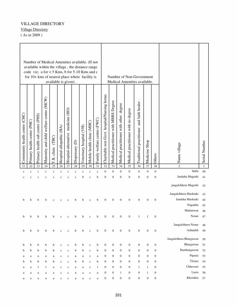
VILLAGE DIRECTORY
Village Directory
( As in 2009 )
Com
munit
y h
ealt
h c
entr
e (C
HC
)
Pri
mar
y h
ealt
h c
entr
e (P
HC
)
Pri
mar
y h
ealt
h s
ub c
entr
e (P
HS
)
Mat
ernit
y a
nd c
hil
d w
elfa
re c
entr
e (M
CW
)
T.B
. cl
inic
(T
BC
)
Hosp
ital
-all
opat
hic
(H
A)
Hosp
ital
-alt
ernat
ive
med
icin
e (H
O)
Dis
pen
sary
(D
)
Vet
erin
ary h
osp
ital
(V
H)
Mobil
e hea
lth c
linic
(M
HC
)
Fam
ily w
elfa
re c
entr
e (F
WC
)
Char
itab
le n
on G
ovt.
hosp
ital
/Nurs
ing h
om
e.
Med
ical
pra
ctit
ioner
wit
h M
BB
S D
egre
e
Med
ical
pra
ctit
ioner
wit
h o
ther
deg
ree
Med
ical
pra
ctit
ioner
wit
h n
o d
egre
e
Tra
dit
ional
pra
ctit
ioner
an
d f
aith
hea
ler
.
Med
icin
e S
hop
Oth
ers
21 22 23 24 25 26 27 28 29 30 31 32 33 34 35 36 37 38 2 1
Number of Non-Government
Medical Amenities available.
Number of Medical Amenities available. (If not
available within the village , the distance range
code viz; a for < 5 Kms, b for 5-10 Kms and c
for 10+ kms of nearest place where facility is
available is given).
Nam
e vil
lage
Ser
ial
Num
ber
c c c c c c c c c c c 0 0 0 0 0 0 0 Imlia 40
c c c c c c c c b c b 0 0 0 0 0 0 0 Jandaha Magrahi 41
jangalchhera Magrabi 42
Jangalchhera Mashraki 43
b b b b c c c b b c b 0 0 0 0 0 0 0 Jandaha Mashraki 44
Nagaitha 45
Madanwan 46
b b b b b c c b b c b 0 0 0 0 1 1 0 Nonar 47
Jangalchhera Nonar 48
b b b b b c c b b c b 0 0 0 0 0 0 0 Ashaideh 49
Jangalchhera Bhargawan 50
b b b b b c c b b c b 0 0 0 0 0 0 0 Bhargawan 51
b b b b b c c b b c b 0 0 0 0 0 0 0 Bamhangawan 52
a a a a a c c a a c a 0 0 0 0 0 0 0 Piparia 53
b b b b b c c b b c b 0 0 0 0 0 0 0 Tilsara 54
a a 1 1 a c c a a c 1 0 0 0 0 1 1 0 Chhewari 55
a a a a a c c a a c a 0 0 1 0 0 1 0 Lasra 56
a a a a a c c a a c a 0 0 0 0 0 0 0 Khorahra 57
��
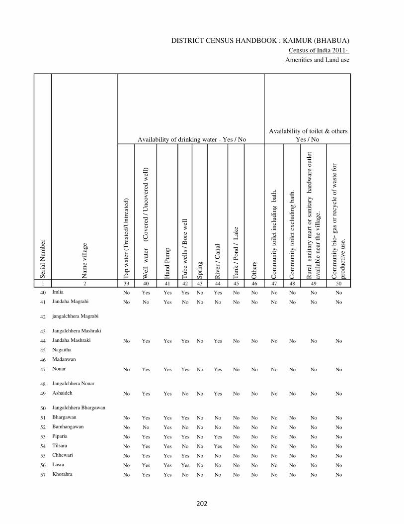
DISTRICT CENSUS HANDBOOK : KAIMUR (BHABUA)
Census of India 2011-
Amenities and Land use
Tap
wat
er (
Tre
ated
/Untr
eate
d)
Wel
l w
ater
(Cover
ed /
Unco
ver
ed w
ell)
Han
d P
um
p
Tube
wel
ls /
Bore
wel
l
Spri
ng
Riv
er /
Can
al
Tan
k /
Pond /
L
ake
Oth
ers
Com
munit
y t
oil
et i
ncl
udin
g
bat
h.
Com
munit
y t
oil
et e
xcl
udin
g b
ath.
Rura
l s
anit
ary m
art
or
sanit
ary
har
dw
are
outl
et
avai
lable
nea
r th
e vil
lage.
Com
munit
y b
io-
gas
or
recy
cle
of
was
te f
or
pro
duct
ive
use
.
1 2 39 40 41 42 43 44 45 46 47 48 49 50
Availability of toilet & others
Yes / No Availability of drinking water - Yes / No
Nam
e vil
lage
Ser
ial
Num
ber
40 Imlia No Yes Yes Yes No Yes No No No No No No
41 Jandaha Magrahi No No Yes No No No No No No No No No
42 jangalchhera Magrabi
43 Jangalchhera Mashraki
44 Jandaha Mashraki No Yes Yes Yes No Yes No No No No No No
45 Nagaitha
46 Madanwan
47 Nonar No Yes Yes Yes No Yes No No No No No No
48 Jangalchhera Nonar
49 Ashaideh No Yes Yes No No Yes No No No No No No
50 Jangalchhera Bhargawan
51 Bhargawan No Yes Yes Yes No No No No No No No No
52 Bamhangawan No No Yes No No No No No No No No No
53 Piparia No Yes Yes Yes No Yes No No No No No No
54 Tilsara No Yes Yes No No Yes No No No No No No
55 Chhewari No Yes Yes Yes No No No No No No No No
56 Lasra No Yes Yes Yes No No No No No No No No
57 Khorahra No Yes Yes No No No No No No No No No
�
VILLAGE DIRECTORY
Village Directory
( As in 2009 )
Post
off
ice(
PO
)
Sub p
ost
off
ice
(SP
O)
Post
& T
eleg
raph o
ffic
e
(P&
TO
)
Vil
lage
Pin
Code
Tel
ephones
(L
and l
ines
)
Publi
c ca
ll o
ffic
e (P
CO
)
Mobil
e phone
cover
age
Inte
rnet
caf
es/
Com
mon s
ervic
e ce
ntr
e (C
SC
)
Pri
vat
e co
uri
er f
acil
ity
Bus
serv
ice
(P
ubli
c &
Pri
vat
e)
Rai
lway
sta
tions
Auto
/Modif
ied A
uto
s
Tax
is a
nd V
ans
Tra
ctors
Cycl
e-pull
ed r
icksh
aws(
Man
ual
& M
achin
e
dri
ven
)
Car
ts d
riven
by a
nim
als
Sea
/R
iver
fer
ry s
ervic
e51 52 53 54 55 56 57 58 59 60 61 62 63 64 65 66 67 2 1
Communication and transport facilities (If amenities available code -Yes is given except for
Village Pin Code ,If not available within the village , the distance range code viz; a for < 5
Kms, b for 5-10 Kms and c for 10+ kms of nearest place where facility is available is given).
Ser
ial
Num
ber
Nam
e vil
lage
a c c Yes Yes Yes c c a c a a Yes Yes b Imlia 40
b c c b b a c c b c b b a Yes b Jandaha Magrahi 41
jangalchhera Magrabi 42
Jangalchhera Mashraki 43
Yes b c Yes Yes Yes c c b c b b Yes Yes b Jandaha Mashraki 44
Nagaitha 45
Madanwan 46
b a c b Yes Yes b b b c Yes Yes Yes Yes Yes Nonar 47
Jangalchhera Nonar 48
a a c a a a a a a c a Yes Yes Yes b Ashaideh 49
Jangalchhera Bhargawan 50
b b c b b b b b b b b b b b b b Bhargawan 51
b b c a b b b b a c b b b a b Bamhangawan 52
a a c a a Yes a a a c a a Yes Yes b Piparia 53
b a c b b Yes b b b c b b Yes Yes b Tilsara 54
Yes b c a a Yes a a a c a a Yes Yes Yes Chhewari 55
a a c a a Yes a a a c Yes Yes Yes Yes b Lasra 56
a a c Yes Yes Yes b a a c b Yes Yes Yes b Khorahra 57
�
DISTRICT CENSUS HANDBOOK : KAIMUR (BHABUA)
Census of India 2011-
Amenities and Land use
Connec
ted t
o n
atio
nal
hig
hw
ay(N
H)
Connec
ted t
o s
tate
hig
hw
ay(S
H)
Connec
ted t
o m
ajor
dis
tric
t ro
ad (
MD
R)
Connec
ted t
o o
ther
s dis
tric
t ro
ad
Pucc
a r
oad
s
Kutc
hch
a r
oad
s
Wat
er b
ounded
mac
adam
(WB
M)
road
s
Nav
igab
le w
ater
way
(ri
ver
/can
al)(
NW
)
Footp
aths
(FP
)
Com
mer
cial
& C
o-o
per
ativ
e B
anks
AT
M
Agri
cult
ura
l C
redit
Soci
etie
s
Sel
f-H
elp G
roup (
SH
G)
Publi
c dis
trib
uti
on s
yst
em (
PD
S)
shop
Man
dis
/ R
egula
r m
arket
Wee
kly
Haa
t
Agri
cult
ura
l m
arket
ing s
oci
ety
1 2 68 69 70 71 72 73 74 75 76 77 78 79 80 81 82 83 84
Village connected to highways,village roads, banks & credit
societies (If amenities available code -Yes is given, If not
available within the village , the distance range code viz; a
for < 5 Kms, b for 5-10 Kms and c for 10+ kms of nearest
place where facility is available is given).
Ser
ial
Num
ber
Nam
e vil
lage
Availability of miscellaneous
facilities (If amenities available
code -Yes is given, If not
available within the village , the
distance range code viz; a for <
5 Kms, b for 5-10 Kms and c
for 10+ kms of nearest place
where facility is available is
given) Contd....
40 Imlia c b a Yes Yes Yes Yes b Yes a c c b a a b c
41 Jandaha Magrahi c b b b a b a a Yes b b c b b b b c
42 jangalchhera Magrabi
43 Jangalchhera Mashraki
44 Jandaha Mashraki c b b Yes Yes Yes b a Yes b b b b Yes b b c
45 Nagaitha
46 Madanwan
47 Nonar c c Yes Yes Yes Yes Yes b Yes b b b b Yes b b c
48 Jangalchhera Nonar
49 Ashaideh c Yes Yes Yes Yes Yes Yes a Yes a a a b b b b c
50 Jangalchhera Bhargawan
51 Bhargawan b b b b b Yes a b Yes b b b b a b b c
52 Bamhangawan b b b b a a a b Yes b b b b a b b c
53 Piparia c b Yes Yes Yes Yes Yes b Yes a a a a a a a c
54 Tilsara c c Yes Yes a Yes a c Yes b b b b a b b c
55 Chhewari c c Yes Yes Yes Yes Yes b Yes a a a a Yes a a c
56 Lasra c c Yes Yes Yes Yes Yes b Yes a a a a a a a c
57 Khorahra c c a b Yes a b b Yes a a b a a a a c
��

VILLAGE DIRECTORY
Village Directory
( As in 2009 )
Inte
gra
ted C
hil
d D
evel
opm
ent
Sch
eme
(Nutr
itio
nal
Cen
tres
)
Angan
wad
i C
entr
e (N
utr
itio
nal
Cen
tres
)
Oth
ers
(Nutr
itio
nal
Cen
tres
)
AS
HA
(A
ccre
dit
ed S
oci
al H
ealt
h A
ctiv
ist)
Com
munit
y c
entr
e w
ith/w
ithout
TV
Sport
s F
ield
,
Sport
s C
lub /
Rec
reat
ion C
entr
e
Cin
ema
/ V
ideo
Hal
l
Publi
c L
ibra
ry
Publi
c R
eadin
g R
oom
New
spap
er S
upply
Ass
embly
Poll
ing s
tati
on
Bir
th &
Dea
th R
egis
trat
ion O
ffic
e
Pow
er S
upply
for
Dom
esti
c U
se (
ED
)
Pow
er S
upply
for
Agri
cult
ura
l U
se (
EA
G)
Pow
er S
upply
for
Com
mer
cial
Use
(E
C)
Pow
er S
upply
for
All
Use
s (E
A)
85 86 87 88 89 90 91 92 93 94 95 96 97 98 99 100 101 2 1
Availability of
electricity (Yes/No)
Availability of miscellaneous facilities (If amenities available code -
Yes is given, If not available within the village , the distance range
code viz; a for < 5 Kms, b for 5-10 Kms and c for 10+ kms of
nearest place where facility is available is given) Concluded
Nam
e vil
lage
Ser
ial
Num
ber
b Yes Yes Yes c Yes c c c c Yes Yes Yes Yes Yes No No Imlia 40
b b Yes b c b c c c c b a a No No No No Jandaha Magrahi 41
jangalchhera Magrabi 42
Jangalchhera Mashraki 43
b Yes Yes a c b c c c c Yes Yes a Yes Yes No No Jandaha Mashraki 44
Nagaitha 45
Madanwan 46
b Yes Yes Yes Yes Yes b b c b Yes Yes b Yes Yes Yes Yes Nonar 47
Jangalchhera Nonar 48
c b Yes b c b c c c c b a a No No No No Ashaideh 49
Jangalchhera Bhargawan 50
b Yes Yes Yes c c c c c c b Yes a No No No No Bhargawan 51
b b Yes b c b c c c c b a a No No No No Bamhangawan 52
b a Yes a c a c c c a a a a Yes Yes Yes Yes Piparia 53
b a Yes a c b c b c b b a b Yes Yes Yes Yes Tilsara 54
b Yes Yes Yes c a a c c a a Yes a Yes Yes Yes Yes Chhewari 55
b Yes Yes Yes c a c c c a a Yes a Yes Yes Yes Yes Lasra 56
b Yes Yes Yes c b c c c a a Yes b Yes Yes Yes Yes Khorahra 57
��

DISTRICT CENSUS HANDBOOK : KAIMUR (BHABUA)
Census of India 2011-
Amenities and Land use
Nam
e
Dis
tance
ran
ge
code
i.e
. a
fo
r <
5 K
ms,
b
for
5-
10 K
ms
and c
f
or
10+
km
s .
Fore
sts
Are
a under
Non-a
gri
cult
ura
l U
ses
Bar
ren a
nd U
n-c
ult
ivab
le l
and
Per
man
ent
Pas
ture
s an
d O
ther
Gra
zing L
ands
Lan
d U
nder
Mis
cell
aneo
us
Tre
e C
rops
etc.
Cult
ura
ble
Was
te L
and
Fal
low
lan
ds
oth
er t
han
curr
ent
fall
ow
s
Curr
ent
Fal
low
s
1 2 102 103 104 105 106 107 108 109 110 111
Ser
ial
Num
ber
Nam
e vil
lage
Area under different types of land use ( in hectares rounded up to
one decimal place)
Land Use
Nearest Town
40 Imlia BHABUA c 0 9.4 0 0 0 24.3 0 0
41 Jandaha Magrahi BHABUA c 0 1.7 0 2.1 3.4 2.8 2 2.6
42 jangalchhera Magrabi 0 0 0 0 1.3 0 0 0
43
Jangalchhera
Mashraki 0 0.3 0 0 0 3.3 0 0
44 Jandaha Mashraki BHABUA c 0 7.1 0 0 0 0 0 0
45 Nagaitha 0 3.5 0 1 3.8 13 1.8 3.8
46 Madanwan 0 0 4.4 0 0 0 0 0
47 Nonar BHABUA c 0 18.5 0 6.1 44.9 15.4 7 8.1
48 Jangalchhera Nonar 0 5 0 1.6 3.2 7.6 5.1 5.9
49 Ashaideh BHABUA c 0 14.7 0 0 0 8.3 0 0
50
Jangalchhera
Bhargawan 0 0 0 0 0 5 0 0
51 Bhargawan BHABUA c 0 27 0 0 0 0 0 0
52 Bamhangawan BHABUA c 0 6.6 0 2.1 2.5 2.5 2.4 1
53 Piparia BHABUA c 0 8 0 1.7 4.9 6.1 4.8 6
54 Tilsara BHABUA c 0 1.2 0 1 1.6 2 1.5 2
55 Chhewari BHABUA c 0 19.7 0 3.7 7.7 5.7 4 4.6
56 Lasra BHABUA c 0 1.4 0 0.6 4.4 3.1 2.8 2.5
57 Khorahra BHABUA c 0 30 0 0 0 22.5 0 0
��
VILLAGE DIRECTORY
Village Directory
( As in 2009 )
Net
Are
a S
ow
n
Tota
l Ir
rigat
ed L
and A
rea
Tota
l U
n-i
rrig
ated
Lan
d A
rea
Can
als
( C
)
Wel
ls/T
ube-
wel
ls(W
/TW
)
Tan
ks/
Lak
es(T
/L)
Wat
er F
alls
(WF
)
Oth
ers(
O)
Fir
st
Sec
ond
Thir
d
112 113 114 115 116 117 118 119 120 121 122 2 1
Ser
ial
Num
ber
Name of three
most important
commodities
manufacturedArea irrigated by source (in hectare).
Nam
e of
Vil
lage
Area under different types of
land use ( in hectares rounded
up to one decimal place)
Land Use
142.3 88.7 53.6 0 83.5 0 0 5.2 Imlia 40
50.5 47.8 2.8 47.8 0 0 0 0 Jandaha Magrahi 41
53.7 24.6 29.1 0 24.6 0 0 0 jangalchhera Magrabi 42
55.4 18.4 37 0 18.4 0 0 0 Jangalchhera Mashraki 43
90.9 56.6 34.3 0 56.6 0 0 0 Jandaha Mashraki 44
40.1 40.1 0 0 40.1 0 0 0 Nagaitha 45
39.6 28.3 11.3 0 28.3 0 0 0 Madanwan 46
201 199.5 1.5 99 100.5 0 0 0 Nonar 47
47.6 40.8 6.8 0 40.8 0 0 0 Jangalchhera Nonar 48
90 54.6 35.4 0 54.6 0 0 0 Ashaideh 49
57 44.8 12.2 0 44.8 0 0 0 Jangalchhera Bhargawan 50
60 50 10 0 40 0 0 10 Bhargawan 51
40.9 30.9 10 20 10.9 0 0 0 Bamhangawan 52
76.5 75.5 1 41.3 34.2 0 0 0 Piparia 53
25.6 25.1 0.5 15 10.1 0 0 0 Tilsara 54
115.6 115.3 0.3 0 115.3 0 0 0 Chhewari 55
40.2 25.3 14.8 0 25.3 0 0 0 Lasra 56
115.5 68.6 46.9 0 68.6 0 0 0 Khorahra 57
��

DISTRICT CENSUS HANDBOOK : KAIMUR (BHABUA)
Census of India 2011-
Amenities and Land use
Pre
-Pri
mar
y s
chool
(PP
)
Pri
mar
y s
chool
(P)
Mid
dle
sch
ool
(M)
Sec
ondar
y S
chool
(S)
Sen
ior
Sec
ondar
y s
chool
(SS
)
Deg
ree
coll
ege
of
arts
sc
ience
& c
om
mer
ce
(AS
C)
Engin
eeri
ng c
oll
ege(
EC
)
Med
ical
coll
ege
(MC
)
Man
agem
ent
inst
itute
(M
I)
Poly
tech
nic
(P
t)
Voca
tional
tra
inin
g s
chool
/IT
I
Non-f
orm
al t
rain
ing c
entr
e (N
FT
C)
Spec
ial
school
for
dis
able
d (
SS
D)
Oth
ers
(spec
ify)
1 2 3 4 5 6 7 8 9 10 11 12 13 14 15 16 17 18 19 20
Loca
tion c
ode
no.
Nam
e vil
lage
Ser
ial
Num
ber
Tota
l popula
tion (
2011 c
ensu
s )
Tota
l ar
ea o
f th
e vil
lage
( in
hec
tare
s ro
unded
up t
o
one
dec
imal
pla
ce)
Number of educational amenities available. (If not available
within the village , the distance range code viz; a for < 5
Kms, b for 5-10 Kms and c for 10+ kms of nearest place
where facility is available is given).
Num
ber
of
house
hold
s (2
011 c
ensu
s)
58 Abhaideh 248980 111 930 142 a 1 1 a c c c c c c c c c
59 Bishunpura 248981 111 474 83 a 1 a a a c c c c c b c c
60 Gorsara 248982 201 5014 715 4 1 a 1 2 1 c c c c c c c
61 Bandipur 248983 187 4448 721 b 1 1 1 a c c c c c c c c
62 Akorhi 248984 299 2632 418 b b a a a c c c c c b c c
63 Isri 248985 207 1859 298 b 1 1 a a c c c c c a c c
64 Jorar 248986 227 1665 238 b 1 1 a a c c c c c b c c
65 Khanethi 248987 104 560 83 b 1 1 b b c c c c c b c c
66 Barbigha 248988 21 0 0
67 Goria 248989 59 30 6 a 1 a c c c c c c c c c c
68 Bharaula 248990 78 130 18 b a a b b c c c c c c c c
69 Mohanpur Bharula 248991 37 179 24 b a b b b c c c c c c c c
70 Balpur 248992 16 303 59 a b b b b c c c c c b c c
71 Natwa 248993 81 200 32 b a a b b b c c c c c c c
72 Baraura 248994 276 4571 652 1 2 2 b b b c c c c c c c
73 Hamzapur 248995 88 0 0
74 Kathidih 248996 93 0 0
75 Narhan 248997 206 435 76 b 1 a b b b c c c c c c c c
76 Prainpur 248998 66 0 0
77 Antdih 248999 66 1630 219 a b a c b c c c c c c c c b
78 Lahang Patti 249000 76 0 0
��
VILLAGE DIRECTORY
Village Directory
( As in 2009 )
Com
munit
y h
ealt
h c
entr
e (C
HC
)
Pri
mar
y h
ealt
h c
entr
e (P
HC
)
Pri
mar
y h
ealt
h s
ub c
entr
e (P
HS
)
Mat
ernit
y a
nd c
hil
d w
elfa
re c
entr
e (M
CW
)
T.B
. cl
inic
(T
BC
)
Hosp
ital
-all
opat
hic
(H
A)
Hosp
ital
-alt
ernat
ive
med
icin
e (H
O)
Dis
pen
sary
(D
)
Vet
erin
ary h
osp
ital
(V
H)
Mobil
e hea
lth c
linic
(M
HC
)
Fam
ily w
elfa
re c
entr
e (F
WC
)
Char
itab
le n
on G
ovt.
hosp
ital
/Nurs
ing h
om
e.
Med
ical
pra
ctit
ioner
wit
h M
BB
S D
egre
e
Med
ical
pra
ctit
ioner
wit
h o
ther
deg
ree
Med
ical
pra
ctit
ioner
wit
h n
o d
egre
e
Tra
dit
ional
pra
ctit
ioner
an
d f
aith
hea
ler
.
Med
icin
e S
hop
Oth
ers
21 22 23 24 25 26 27 28 29 30 31 32 33 34 35 36 37 38 2 1
Number of Non-Government
Medical Amenities available.
Number of Medical Amenities available. (If not
available within the village , the distance range
code viz; a for < 5 Kms, b for 5-10 Kms and c
for 10+ kms of nearest place where facility is
available is given).
Nam
e vil
lage
Ser
ial
Num
ber
a b a a a c c a a c a 0 0 0 0 0 0 0 Abhaideh 58
a b b a a c c b b c b 0 0 0 0 0 0 0 Bishunpura 59
a b 1 1 a c c 1 c c 1 0 3 0 0 0 3 0 Gorsara 60
a a a a a c c b a c a 0 0 0 0 0 0 0 Bandipur 61
a b a b b c c b b c b 0 0 0 0 0 0 0 Akorhi 62
a a a a a c c a a c a 0 0 0 1 1 1 0 Isri 63
c a a a a c c b a c b 0 0 0 0 0 0 0 Jorar 64
c a a a a c c a a c a 0 0 0 0 0 0 0 Khanethi 65
Barbigha 66
c c a c b c c a c c b 0 0 0 0 0 0 0 Goria 67
b b a b b c c c b c b 0 0 0 0 0 0 0 Bharaula 68
b b a b b c c c b c b 0 0 0 0 0 0 0 Mohanpur Bharula 69
b b b b b c c c b c b 0 0 0 0 0 0 0 Balpur 70
b b a b b c c b b c b 0 0 0 0 0 0 0 Natwa 71
b b a b b c c c b c b 0 0 0 0 0 0 0 Baraura 72
Hamzapur 73
Kathidih 74
b b a b b c c b b c b 0 0 0 0 0 0 0 Narhan 75
Prainpur 76
b b b b b c c b b c b 0 0 0 0 0 0 0 Antdih 77
Lahang Patti 78
��

DISTRICT CENSUS HANDBOOK : KAIMUR (BHABUA)
Census of India 2011-
Amenities and Land use
Tap
wat
er (
Tre
ated
/Untr
eate
d)
Wel
l w
ater
(Cover
ed /
Unco
ver
ed w
ell)
Han
d P
um
p
Tube
wel
ls /
Bore
wel
l
Spri
ng
Riv
er /
Can
al
Tan
k /
Pond /
L
ake
Oth
ers
Com
munit
y t
oil
et i
ncl
udin
g
bat
h.
Com
munit
y t
oil
et e
xcl
udin
g b
ath.
Rura
l s
anit
ary m
art
or
sanit
ary
har
dw
are
outl
et
avai
lable
nea
r th
e vil
lage.
Com
munit
y b
io-
gas
or
recy
cle
of
was
te f
or
pro
duct
ive
use
.
1 2 39 40 41 42 43 44 45 46 47 48 49 50
Availability of toilet & others
Yes / No Availability of drinking water - Yes / No
Nam
e vil
lage
Ser
ial
Num
ber
58 Abhaideh No Yes Yes Yes No No No No No No No No
59 Bishunpura No Yes Yes Yes No Yes No No No No No No
60 Gorsara Yes Yes Yes Yes No Yes No No No No No No
61 Bandipur No Yes Yes Yes No No No No No No No No
62 Akorhi No No Yes Yes No No No No No No No No
63 Isri No Yes Yes Yes No Yes No No No No No No
64 Jorar No No Yes Yes No Yes No No No No No No
65 Khanethi No No Yes Yes No No No No No No No No
66 Barbigha
67 Goria Yes Yes Yes No No Yes No No No No No No
68 Bharaula No No Yes Yes No No No No No No No No
69 Mohanpur Bharula No No Yes Yes No No No No No No No No
70 Balpur No No Yes Yes No No No No No No No No
71 Natwa No No Yes Yes No No No No No No No No
72 Baraura No No Yes Yes No Yes No No No No No No
73 Hamzapur
74 Kathidih
75 Narhan No No Yes Yes No Yes No No No No No No
76 Prainpur
77 Antdih No Yes Yes Yes No Yes No No No No No No
78 Lahang Patti
��
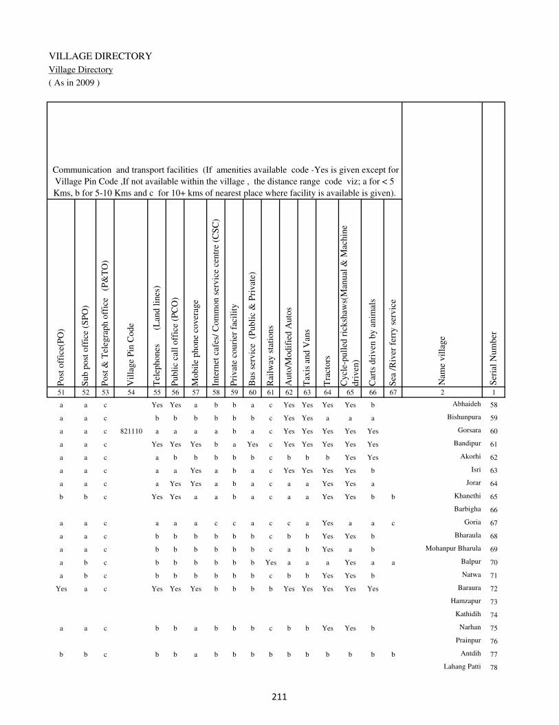
VILLAGE DIRECTORY
Village Directory
( As in 2009 )
Post
off
ice(
PO
)
Sub p
ost
off
ice
(SP
O)
Post
& T
eleg
raph o
ffic
e
(P&
TO
)
Vil
lage
Pin
Code
Tel
ephones
(L
and l
ines
)
Publi
c ca
ll o
ffic
e (P
CO
)
Mobil
e phone
cover
age
Inte
rnet
caf
es/
Com
mon s
ervic
e ce
ntr
e (C
SC
)
Pri
vat
e co
uri
er f
acil
ity
Bus
serv
ice
(P
ubli
c &
Pri
vat
e)
Rai
lway
sta
tions
Auto
/Modif
ied A
uto
s
Tax
is a
nd V
ans
Tra
ctors
Cycl
e-pull
ed r
icksh
aws(
Man
ual
& M
achin
e
dri
ven
)
Car
ts d
riven
by a
nim
als
Sea
/R
iver
fer
ry s
ervic
e51 52 53 54 55 56 57 58 59 60 61 62 63 64 65 66 67 2 1
Communication and transport facilities (If amenities available code -Yes is given except for
Village Pin Code ,If not available within the village , the distance range code viz; a for < 5
Kms, b for 5-10 Kms and c for 10+ kms of nearest place where facility is available is given).
Ser
ial
Num
ber
Nam
e vil
lage
a a c Yes Yes a b b a c Yes Yes Yes Yes b Abhaideh 58
a a c b b b b b b c Yes Yes a a a Bishunpura 59
a a c 821110 a a a a b a c Yes Yes Yes Yes Yes Gorsara 60
a a c Yes Yes Yes b a Yes c Yes Yes Yes Yes Yes Bandipur 61
a a c a b b b b b c b b b Yes Yes Akorhi 62
a a c a a Yes a b a c Yes Yes Yes Yes b Isri 63
a a c a Yes Yes a b a c a a Yes Yes a Jorar 64
b b c Yes Yes a a b a c a a Yes Yes b b Khanethi 65
Barbigha 66
a a c a a a c c a c c a Yes a a c Goria 67
a a c b b b b b b c b b Yes Yes b Bharaula 68
a a c b b b b b b c a b Yes a b Mohanpur Bharula 69
a b c b b b b b b Yes a a a Yes a a Balpur 70
a b c b b b b b b c b b Yes Yes b Natwa 71
Yes a c Yes Yes Yes b b b b Yes Yes Yes Yes Yes Baraura 72
Hamzapur 73
Kathidih 74
a a c b b a b b b c b b Yes Yes b Narhan 75
Prainpur 76
b b c b b a b b b b b b b b b b Antdih 77
Lahang Patti 78
��

DISTRICT CENSUS HANDBOOK : KAIMUR (BHABUA)
Census of India 2011-
Amenities and Land use
Connec
ted t
o n
atio
nal
hig
hw
ay(N
H)
Connec
ted t
o s
tate
hig
hw
ay(S
H)
Connec
ted t
o m
ajor
dis
tric
t ro
ad (
MD
R)
Connec
ted t
o o
ther
s dis
tric
t ro
ad
Pucc
a r
oad
s
Kutc
hch
a r
oad
s
Wat
er b
ounded
mac
adam
(WB
M)
road
s
Nav
igab
le w
ater
way
(ri
ver
/can
al)(
NW
)
Footp
aths
(FP
)
Com
mer
cial
& C
o-o
per
ativ
e B
anks
AT
M
Agri
cult
ura
l C
redit
Soci
etie
s
Sel
f-H
elp G
roup (
SH
G)
Publi
c dis
trib
uti
on s
yst
em (
PD
S)
shop
Man
dis
/ R
egula
r m
arket
Wee
kly
Haa
t
Agri
cult
ura
l m
arket
ing s
oci
ety
1 2 68 69 70 71 72 73 74 75 76 77 78 79 80 81 82 83 84
Village connected to highways,village roads, banks & credit
societies (If amenities available code -Yes is given, If not
available within the village , the distance range code viz; a
for < 5 Kms, b for 5-10 Kms and c for 10+ kms of nearest
place where facility is available is given).
Ser
ial
Num
ber
Nam
e vil
lage
Availability of miscellaneous
facilities (If amenities available
code -Yes is given, If not
available within the village , the
distance range code viz; a for <
5 Kms, b for 5-10 Kms and c
for 10+ kms of nearest place
where facility is available is
given) Contd....
58 Abhaideh c c b b b a a b Yes b b b b b b a b
59 Bishunpura c b b Yes a Yes Yes b Yes a a b b a b b c
60 Gorsara c c b Yes a a a a Yes a a b a b a a b
61 Bandipur c c Yes Yes Yes a a a Yes a a c a Yes Yes Yes b
62 Akorhi a c b b Yes Yes Yes a Yes b b b b b a b b
63 Isri c c Yes Yes Yes Yes Yes b Yes a a b a Yes a a b
64 Jorar c c Yes Yes Yes a a a Yes a a a a a a a b
65 Khanethi c c a a Yes a Yes b Yes a a a Yes a a b b
66 Barbigha
67 Goria c c a Yes a Yes Yes a Yes b c c c a a b c
68 Bharaula c c Yes Yes Yes a a a Yes b b b b a b b b
69 Mohanpur Bharula c c a Yes Yes a a a Yes b b b a a b b b
70 Balpur c c Yes Yes Yes b b a Yes b b b a b b b b
71 Natwa c c Yes Yes Yes a b a Yes b b b a Yes b b b
72 Baraura c c Yes Yes Yes a a a Yes b b b Yes Yes b b Yes
73 Hamzapur
74 Kathidih
75 Narhan c c b b a Yes a a Yes b b b Yes a b b b
76 Prainpur
77 Antdih b b b b a Yes a a Yes b b b b b b b b
78 Lahang Patti
�

VILLAGE DIRECTORY
Village Directory
( As in 2009 )
Inte
gra
ted C
hil
d D
evel
opm
ent
Sch
eme
(Nutr
itio
nal
Cen
tres
)
Angan
wad
i C
entr
e (N
utr
itio
nal
Cen
tres
)
Oth
ers
(Nutr
itio
nal
Cen
tres
)
AS
HA
(A
ccre
dit
ed S
oci
al H
ealt
h A
ctiv
ist)
Com
munit
y c
entr
e w
ith/w
ithout
TV
Sport
s F
ield
,
Sport
s C
lub /
Rec
reat
ion C
entr
e
Cin
ema
/ V
ideo
Hal
l
Publi
c L
ibra
ry
Publi
c R
eadin
g R
oom
New
spap
er S
upply
Ass
embly
Poll
ing s
tati
on
Bir
th &
Dea
th R
egis
trat
ion O
ffic
e
Pow
er S
upply
for
Dom
esti
c U
se (
ED
)
Pow
er S
upply
for
Agri
cult
ura
l U
se (
EA
G)
Pow
er S
upply
for
Com
mer
cial
Use
(E
C)
Pow
er S
upply
for
All
Use
s (E
A)
85 86 87 88 89 90 91 92 93 94 95 96 97 98 99 100 101 2 1
Availability of
electricity (Yes/No)
Availability of miscellaneous facilities (If amenities available code -
Yes is given, If not available within the village , the distance range
code viz; a for < 5 Kms, b for 5-10 Kms and c for 10+ kms of
nearest place where facility is available is given) Concluded
Nam
e vil
lage
Ser
ial
Num
ber
a b Yes b c b c c c c b a a No No No No Abhaideh 58
a b Yes b c b b c c c b a b Yes Yes No No Bishunpura 59
a Yes Yes Yes c c b c c a Yes Yes Yes Yes Yes No No Gorsara 60
a Yes Yes Yes c Yes b a c a Yes Yes a Yes Yes Yes Yes Bandipur 61
a Yes Yes Yes b b b c c c b Yes a No No No No Akorhi 62
a Yes Yes Yes Yes Yes Yes c c a a Yes a Yes Yes Yes Yes Isri 63
b Yes Yes Yes a a a c c a a Yes a Yes Yes No No Jorar 64
b Yes Yes Yes a a a c c a a a a No No No No Khanethi 65
Barbigha 66
b Yes Yes Yes b a c c c c a a a No No No No Goria 67
b a Yes a a a b c c b b a a No Yes No No Bharaula 68
b a Yes a b b b c c b b a b No Yes No No Mohanpur Bharula 69
b a Yes a b b b c c b b a a Yes Yes No No Balpur 70
b a Yes a b b b c b b b a a Yes Yes No No Natwa 71
b Yes Yes Yes Yes Yes b c b b Yes Yes Yes Yes Yes Yes Yes Baraura 72
Hamzapur 73
Kathidih 74
b a Yes Yes a a b a b b b a a Yes Yes No No Narhan 75
Prainpur 76
b Yes Yes Yes b b c c c c b a a No No No No Antdih 77
Lahang Patti 78
�

DISTRICT CENSUS HANDBOOK : KAIMUR (BHABUA)
Census of India 2011-
Amenities and Land use
Nam
e
Dis
tance
ran
ge
code
i.e
. a
fo
r <
5 K
ms,
b
for
5-
10 K
ms
and c
f
or
10+
km
s .
Fore
sts
Are
a under
Non-a
gri
cult
ura
l U
ses
Bar
ren a
nd U
n-c
ult
ivab
le l
and
Per
man
ent
Pas
ture
s an
d O
ther
Gra
zing L
ands
Lan
d U
nder
Mis
cell
aneo
us
Tre
e C
rops
etc.
Cult
ura
ble
Was
te L
and
Fal
low
lan
ds
oth
er t
han
curr
ent
fall
ow
s
Curr
ent
Fal
low
s
1 2 102 103 104 105 106 107 108 109 110 111
Ser
ial
Num
ber
Nam
e vil
lage
Area under different types of land use ( in hectares rounded up to
one decimal place)
Land Use
Nearest Town
58 Abhaideh BHABUA c 0 11.5 0 0 0 0 0 0
59 Bishunpura BHABUA c 0 12.2 0 0 0 0 0 0
60 Gorsara BHABUA c 0 21 0 0 0 0 0 0
61 Bandipur BHABUA c 0 16.5 0 0 0 3 0 0
62 Akorhi BHABUA c 0 40.7 0 0 0 19 0 0
63 Isri BHABUA c 0 21.2 0 4.9 31.6 8 4 4.7
64 Jorar BHABUA c 0 16.2 0 2.8 27.9 11.1 16.3 12.1
65 Khanethi BHABUA c 0 4.6 0 2.1 10.5 6 7.6 6
66 Barbigha 0 0.9 0 0.2 0.6 7.7 1.2 1.2
67 Goria BHABUA c 0 4.9 0 0 0 0.4 0 0
68 Bharaula BHABUA c 0 4.9 0 0.8 1.1 1 1 0.9
69 Mohanpur Bharula BHABUA c 0 7 0 0 0 0 0 0
70 Balpur BHABUA c 0 0.8 0 0.2 0.5 1.1 1 0.8
71 Natwa BHABUA c 0 16.3 0 1 1.6 1 1.2 1
72 Baraura BHABUA c 0 25.1 0 2.8 8.3 18.6 10 10
73 Hamzapur 0 8.1 0 1 2.6 4.8 2.8 1
74 Kathidih 0 4.1 0 0.8 1 0.5 1 1
75 Narhan BHABUA c 0 16.2 0 1 0.8 1.5 2.4 2.1
76 Prainpur 0 8.5 0 0.2 0.3 1.1 1.2 0.8
77 Antdih BHABUA c 0 6 0 0 0 0 0 0
78 Lahang Patti 0 2 0 0.8 2.8 4.1 5.4 4.7
��

VILLAGE DIRECTORY
Village Directory
( As in 2009 )
Net
Are
a S
ow
n
Tota
l Ir
rigat
ed L
and A
rea
Tota
l U
n-i
rrig
ated
Lan
d A
rea
Can
als
( C
)
Wel
ls/T
ube-
wel
ls(W
/TW
)
Tan
ks/
Lak
es(T
/L)
Wat
er F
alls
(WF
)
Oth
ers(
O)
Fir
st
Sec
ond
Thir
d
112 113 114 115 116 117 118 119 120 121 122 2 1
Ser
ial
Num
ber
Name of three
most important
commodities
manufacturedArea irrigated by source (in hectare).
Nam
e of
Vil
lage
Area under different types of
land use ( in hectares rounded
up to one decimal place)
Land Use
99.5 66.4 33.1 0 66.4 0 0 0 Abhaideh 58
98.8 68.1 30.7 0 68.1 0 0 0 Bishunpura 59
180 150 30 0 130 0 0 20 Gorsara 60
167.5 136 31.5 0 136 0 0 0 Bandipur 61
239.3 66 173.3 0 66 0 0 0 Akorhi 62
132.6 130.7 1.9 0 130.7 0 0 0 Isri 63
140.6 120.8 19.8 60.6 60.2 0 0 0 Jorar 64
67.1 66.7 0.4 0 66.7 0 0 0 Khanethi 65
9.1 8.9 0.2 0 8.9 0 0 0 Barbigha 66
53.7 27.6 26.1 0 18.4 0 0 9.2 Goria 67
68.4 67.9 0.5 0 67.9 0 0 0 Bharaula 68
30 25 5 0 20 0 0 5 Mohanpur Bharula 69
11.5 11.5 0 0 11.5 0 0 0 Balpur 70
58.7 58.1 0.7 0 58.1 0 0 0 Natwa 71
201.1 192.4 8.8 91.2 101.2 0 0 0 Baraura 72
67.7 67 0.7 0 67 0 0 0 Hamzapur 73
84.6 84.1 0.5 37 47.1 0 0 0 Kathidih 74
182 181.7 0.2 80 101.7 0 0 0 Narhan 75
53.8 50.1 3.7 0 50.1 0 0 0 Prainpur 76
60 50 10 0 40 0 0 10 Antdih 77
56.2 55.8 0.4 30.8 25 0 0 0 Lahang Patti 78
��

DISTRICT CENSUS HANDBOOK : KAIMUR (BHABUA)
Census of India 2011-
Amenities and Land use
Pre
-Pri
mar
y s
chool
(PP
)
Pri
mar
y s
chool
(P)
Mid
dle
sch
ool
(M)
Sec
ondar
y S
chool
(S)
Sen
ior
Sec
ondar
y s
chool
(SS
)
Deg
ree
coll
ege
of
arts
sc
ience
& c
om
mer
ce
(AS
C)
Engin
eeri
ng c
oll
ege(
EC
)
Med
ical
coll
ege
(MC
)
Man
agem
ent
inst
itute
(M
I)
Poly
tech
nic
(P
t)
Voca
tional
tra
inin
g s
chool
/IT
I
Non-f
orm
al t
rain
ing c
entr
e (N
FT
C)
Spec
ial
school
for
dis
able
d (
SS
D)
Oth
ers
(spec
ify)
1 2 3 4 5 6 7 8 9 10 11 12 13 14 15 16 17 18 19 20
Loca
tion c
ode
no.
Nam
e vil
lage
Ser
ial
Num
ber
Tota
l popula
tion (
2011 c
ensu
s )
Tota
l ar
ea o
f th
e vil
lage
( in
hec
tare
s ro
unded
up t
o
one
dec
imal
pla
ce)
Number of educational amenities available. (If not available
within the village , the distance range code viz; a for < 5
Kms, b for 5-10 Kms and c for 10+ kms of nearest place
where facility is available is given).
Num
ber
of
house
hold
s (2
011 c
ensu
s)
79 Sisaunra 249001 323 3587 497 b b a b b c c c c c c c c b
80 Taiyan 249002 110 621 91 c b b a a a c c c c c c c
81 Uprauli 249003 140 943 125 c 1 b c c c c c c c c c c
82 Paikauli 249004 309 2094 304 c 1 a c c c c c c c c c c
83 Ahiwans 249005 354 2117 292 c 1 a c c c c c c c c c c
84 Bedaman Chak 249006 164 1313 187 c 1 a c c c c c c c c c c
85 Hajra 249007 57 0 0
86 Upadhya Sagar 249008 123 408 54 a 1 a c c c c c c c c c c
87 Sijhua 249009 552 2739 402 b 1 1 c c c c c c c c c c b
88 Kalani 249010 197 3172 382 b 1 1 c c c c c c c c c c
89 Gaura 249011 71 286 36 b b a b b b c c c c b c c
90 Thakura 249012 431 3093 438 1 1 1 c c c c c c c c c c
91 Maheshpur 249013 60 0 0
92 Senisaray 249014 89 437 54 b a a b b c c c c c c c c
93 Kamsaray 249015 69 18 3 b b b b b c c c c c c c c
94 Bairpur 249016 86 0 0
95 Jalalpur 249017 19 0 0
96 Bahpura 249018 114 700 82 b b a b a c c c c c c c c
97 Kishunpura 249019 148 881 138 a b a b a c c c c c c c c
98 Oriadih 249020 92 688 111 b b b a a c c c c c c c c
99 Alipur 249021 110 528 53 b 1 a c c c c c c c c c c
��

VILLAGE DIRECTORY
Village Directory
( As in 2009 )
Com
munit
y h
ealt
h c
entr
e (C
HC
)
Pri
mar
y h
ealt
h c
entr
e (P
HC
)
Pri
mar
y h
ealt
h s
ub c
entr
e (P
HS
)
Mat
ernit
y a
nd c
hil
d w
elfa
re c
entr
e (M
CW
)
T.B
. cl
inic
(T
BC
)
Hosp
ital
-all
opat
hic
(H
A)
Hosp
ital
-alt
ernat
ive
med
icin
e (H
O)
Dis
pen
sary
(D
)
Vet
erin
ary h
osp
ital
(V
H)
Mobil
e hea
lth c
linic
(M
HC
)
Fam
ily w
elfa
re c
entr
e (F
WC
)
Char
itab
le n
on G
ovt.
hosp
ital
/Nurs
ing h
om
e.
Med
ical
pra
ctit
ioner
wit
h M
BB
S D
egre
e
Med
ical
pra
ctit
ioner
wit
h o
ther
deg
ree
Med
ical
pra
ctit
ioner
wit
h n
o d
egre
e
Tra
dit
ional
pra
ctit
ioner
an
d f
aith
hea
ler
.
Med
icin
e S
hop
Oth
ers
21 22 23 24 25 26 27 28 29 30 31 32 33 34 35 36 37 38 2 1
Number of Non-Government
Medical Amenities available.
Number of Medical Amenities available. (If not
available within the village , the distance range
code viz; a for < 5 Kms, b for 5-10 Kms and c
for 10+ kms of nearest place where facility is
available is given).
Nam
e vil
lage
Ser
ial
Num
ber
b b b b b c c b b c b 0 0 0 0 0 0 0 Sisaunra 79
b b b c c c c b c c c 0 0 0 0 0 0 0 Taiyan 80
c c a c c c c b c c c 0 0 0 0 0 0 0 Uprauli 81
c c a c c c c b c c c 0 0 0 0 0 0 0 Paikauli 82
c c a c c c c c c c c 0 0 0 0 0 0 0 Ahiwans 83
c c a c c c c c c c c 0 0 0 0 0 0 0 Bedaman Chak 84
Hajra 85
c c a c c c c c c c c 0 0 0 0 0 0 0 Upadhya Sagar 86
b b b b b c c b b c b 0 0 0 0 0 0 0 Sijhua 87
c a a c c c c b c c c 0 0 0 0 0 0 0 Kalani 88
b b a b b c c c b c c 0 0 0 0 0 0 0 Gaura 89
a c a c c c c a c c c 0 0 0 0 0 0 0 Thakura 90
Maheshpur 91
a c b c c c c b c c c 0 0 0 0 0 0 0 Senisaray 92
a c b c c c c b a c c 0 0 0 0 0 0 0 Kamsaray 93
Bairpur 94
Jalalpur 95
a c b b c c c c b c c 0 0 0 0 0 0 0 Bahpura 96
b c b c c c c c b c c 0 0 0 0 0 0 0 Kishunpura 97
b c b b c c c c b c c 0 0 0 0 0 0 0 Oriadih 98
a c b b c c c c b c c 0 0 0 0 0 0 0 Alipur 99
��

DISTRICT CENSUS HANDBOOK : KAIMUR (BHABUA)
Census of India 2011-
Amenities and Land use
Tap
wat
er (
Tre
ated
/Untr
eate
d)
Wel
l w
ater
(Cover
ed /
Unco
ver
ed w
ell)
Han
d P
um
p
Tube
wel
ls /
Bore
wel
l
Spri
ng
Riv
er /
Can
al
Tan
k /
Pond /
L
ake
Oth
ers
Com
munit
y t
oil
et i
ncl
udin
g
bat
h.
Com
munit
y t
oil
et e
xcl
udin
g b
ath.
Rura
l s
anit
ary m
art
or
sanit
ary
har
dw
are
outl
et
avai
lable
nea
r th
e vil
lage.
Com
munit
y b
io-
gas
or
recy
cle
of
was
te f
or
pro
duct
ive
use
.
1 2 39 40 41 42 43 44 45 46 47 48 49 50
Availability of toilet & others
Yes / No Availability of drinking water - Yes / No
Nam
e vil
lage
Ser
ial
Num
ber
79 Sisaunra No Yes Yes Yes No No Yes No No No No No
80 Taiyan No No Yes No No No No No No No No No
81 Uprauli No Yes Yes No No Yes No No No No No No
82 Paikauli No Yes Yes No No No No No No No No No
83 Ahiwans No No Yes Yes No No No No No No No No
84 Bedaman Chak No Yes Yes Yes No Yes No No No No No No
85 Hajra
86 Upadhya Sagar No Yes Yes No No Yes No No No No No No
87 Sijhua No Yes Yes Yes No No No No No No No No
88 Kalani Yes Yes Yes Yes No Yes Yes No No No No No
89 Gaura No No Yes Yes No No No No No No No No
90 Thakura Yes Yes Yes No No Yes No No No No No No
91 Maheshpur
92 Senisaray No No Yes No No No No No No No No No
93 Kamsaray No No Yes No No No No No No No No No
94 Bairpur
95 Jalalpur
96 Bahpura No No Yes No No No No No No No No No
97 Kishunpura No No Yes No No No No No No No No No
98 Oriadih No No Yes No No No No No No No No No
99 Alipur No Yes Yes No No No No No No No No No
��
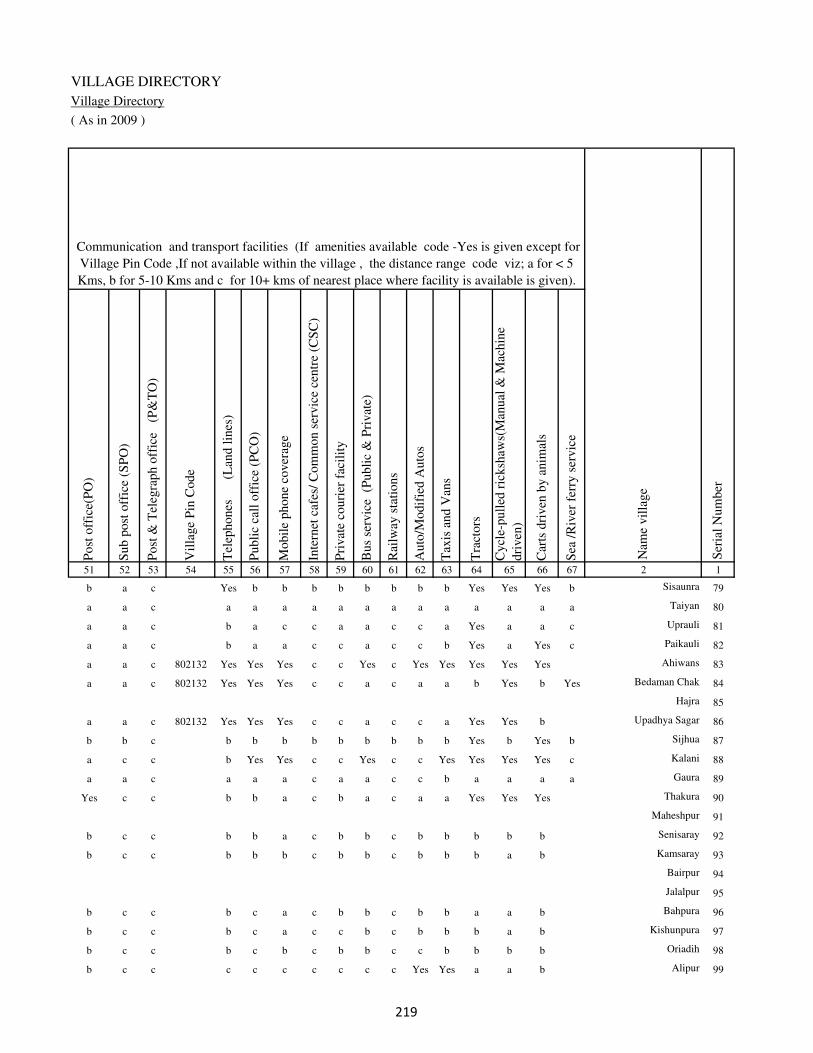
VILLAGE DIRECTORY
Village Directory
( As in 2009 )
Post
off
ice(
PO
)
Sub p
ost
off
ice
(SP
O)
Post
& T
eleg
raph o
ffic
e
(P&
TO
)
Vil
lage
Pin
Code
Tel
ephones
(L
and l
ines
)
Publi
c ca
ll o
ffic
e (P
CO
)
Mobil
e phone
cover
age
Inte
rnet
caf
es/
Com
mon s
ervic
e ce
ntr
e (C
SC
)
Pri
vat
e co
uri
er f
acil
ity
Bus
serv
ice
(P
ubli
c &
Pri
vat
e)
Rai
lway
sta
tions
Auto
/Modif
ied A
uto
s
Tax
is a
nd V
ans
Tra
ctors
Cycl
e-pull
ed r
icksh
aws(
Man
ual
& M
achin
e
dri
ven
)
Car
ts d
riven
by a
nim
als
Sea
/R
iver
fer
ry s
ervic
e51 52 53 54 55 56 57 58 59 60 61 62 63 64 65 66 67 2 1
Communication and transport facilities (If amenities available code -Yes is given except for
Village Pin Code ,If not available within the village , the distance range code viz; a for < 5
Kms, b for 5-10 Kms and c for 10+ kms of nearest place where facility is available is given).
Ser
ial
Num
ber
Nam
e vil
lage
b a c Yes b b b b b b b b Yes Yes Yes b Sisaunra 79
a a c a a a a a a a a a a a a a Taiyan 80
a a c b a c c a a c c a Yes a a c Uprauli 81
a a c b a a c c a c c b Yes a Yes c Paikauli 82
a a c 802132 Yes Yes Yes c c Yes c Yes Yes Yes Yes Yes Ahiwans 83
a a c 802132 Yes Yes Yes c c a c a a b Yes b Yes Bedaman Chak 84
Hajra 85
a a c 802132 Yes Yes Yes c c a c c a Yes Yes b Upadhya Sagar 86
b b c b b b b b b b b b Yes b Yes b Sijhua 87
a c c b Yes Yes c c Yes c c Yes Yes Yes Yes c Kalani 88
a a c a a a c a a c c b a a a a Gaura 89
Yes c c b b a c b a c a a Yes Yes Yes Thakura 90
Maheshpur 91
b c c b b a c b b c b b b b b Senisaray 92
b c c b b b c b b c b b b a b Kamsaray 93
Bairpur 94
Jalalpur 95
b c c b c a c b b c b b a a b Bahpura 96
b c c b c a c c b c b b b a b Kishunpura 97
b c c b c b c b b c c b b b b Oriadih 98
b c c c c c c c c c Yes Yes a a b Alipur 99
��

DISTRICT CENSUS HANDBOOK : KAIMUR (BHABUA)
Census of India 2011-
Amenities and Land use
Connec
ted t
o n
atio
nal
hig
hw
ay(N
H)
Connec
ted t
o s
tate
hig
hw
ay(S
H)
Connec
ted t
o m
ajor
dis
tric
t ro
ad (
MD
R)
Connec
ted t
o o
ther
s dis
tric
t ro
ad
Pucc
a r
oad
s
Kutc
hch
a r
oad
s
Wat
er b
ounded
mac
adam
(WB
M)
road
s
Nav
igab
le w
ater
way
(ri
ver
/can
al)(
NW
)
Footp
aths
(FP
)
Com
mer
cial
& C
o-o
per
ativ
e B
anks
AT
M
Agri
cult
ura
l C
redit
Soci
etie
s
Sel
f-H
elp G
roup (
SH
G)
Publi
c dis
trib
uti
on s
yst
em (
PD
S)
shop
Man
dis
/ R
egula
r m
arket
Wee
kly
Haa
t
Agri
cult
ura
l m
arket
ing s
oci
ety
1 2 68 69 70 71 72 73 74 75 76 77 78 79 80 81 82 83 84
Village connected to highways,village roads, banks & credit
societies (If amenities available code -Yes is given, If not
available within the village , the distance range code viz; a
for < 5 Kms, b for 5-10 Kms and c for 10+ kms of nearest
place where facility is available is given).
Ser
ial
Num
ber
Nam
e vil
lage
Availability of miscellaneous
facilities (If amenities available
code -Yes is given, If not
available within the village , the
distance range code viz; a for <
5 Kms, b for 5-10 Kms and c
for 10+ kms of nearest place
where facility is available is
given) Contd....
79 Sisaunra b b b b a Yes b a Yes Yes b b b b b b b
80 Taiyan c Yes Yes Yes Yes Yes Yes b Yes a a a b a b b b
81 Uprauli c c a a a Yes a b Yes a c c b a a c b
82 Paikauli c c a a a Yes Yes a Yes a c c c Yes a a c
83 Ahiwans c c Yes Yes b a Yes b Yes b c c c Yes b c b
84 Bedaman Chak c c a a a a Yes Yes Yes c c c c a b c c
85 Hajra
86 Upadhya Sagar c Yes a Yes Yes a Yes a Yes c c c c a b c c
87 Sijhua b b b b b Yes b a Yes b b b b a b b c
88 Kalani c c Yes Yes Yes Yes Yes a Yes c c c c Yes Yes Yes Yes
89 Gaura c c a a a Yes a a Yes b b b c a b b b
90 Thakura c c Yes Yes Yes Yes Yes b Yes c c b c Yes a a c
91 Maheshpur
92 Senisaray c c b b b a b b Yes c c b b a b b c
93 Kamsaray c c b b b a a b Yes c c c b a b b b
94 Bairpur
95 Jalalpur
96 Bahpura c c b b a a a a Yes c b c b a b b c
97 Kishunpura c c c b b a a b Yes c b b b b b b b
98 Oriadih c c b b a a a b Yes c b c b a b b b
99 Alipur c Yes b b Yes Yes Yes b Yes c c c b a b c b
�

VILLAGE DIRECTORY
Village Directory
( As in 2009 )
Inte
gra
ted C
hil
d D
evel
opm
ent
Sch
eme
(Nutr
itio
nal
Cen
tres
)
Angan
wad
i C
entr
e (N
utr
itio
nal
Cen
tres
)
Oth
ers
(Nutr
itio
nal
Cen
tres
)
AS
HA
(A
ccre
dit
ed S
oci
al H
ealt
h A
ctiv
ist)
Com
munit
y c
entr
e w
ith/w
ithout
TV
Sport
s F
ield
,
Sport
s C
lub /
Rec
reat
ion C
entr
e
Cin
ema
/ V
ideo
Hal
l
Publi
c L
ibra
ry
Publi
c R
eadin
g R
oom
New
spap
er S
upply
Ass
embly
Poll
ing s
tati
on
Bir
th &
Dea
th R
egis
trat
ion O
ffic
e
Pow
er S
upply
for
Dom
esti
c U
se (
ED
)
Pow
er S
upply
for
Agri
cult
ura
l U
se (
EA
G)
Pow
er S
upply
for
Com
mer
cial
Use
(E
C)
Pow
er S
upply
for
All
Use
s (E
A)
85 86 87 88 89 90 91 92 93 94 95 96 97 98 99 100 101 2 1
Availability of
electricity (Yes/No)
Availability of miscellaneous facilities (If amenities available code -
Yes is given, If not available within the village , the distance range
code viz; a for < 5 Kms, b for 5-10 Kms and c for 10+ kms of
nearest place where facility is available is given) Concluded
Nam
e vil
lage
Ser
ial
Num
ber
b Yes Yes Yes b b c c c a b Yes a No No No No Sisaunra 79
b b Yes b c b c c c c b a a No No No No Taiyan 80
b Yes Yes Yes b a c c c c b Yes a No No No No Uprauli 81
b Yes Yes Yes c b c c c c b Yes a No No No No Paikauli 82
b Yes Yes Yes c a c b c c b Yes a Yes Yes Yes Yes Ahiwans 83
c Yes Yes Yes c a c c c c b Yes a Yes Yes Yes Yes Bedaman Chak 84
Hajra 85
c Yes Yes Yes c a c c c c b Yes a Yes Yes Yes Yes Upadhya Sagar 86
c Yes Yes Yes c b c c c c b Yes a No No No No Sijhua 87
c Yes Yes Yes c Yes c c c c Yes Yes a No No No No Kalani 88
c a Yes a c b b c c b b a a No Yes No No Gaura 89
c Yes Yes Yes c Yes c c c b b Yes a No Yes No No Thakura 90
Maheshpur 91
c b Yes b c b c c c c b a a No No No No Senisaray 92
c b Yes b c b c c c c b a a No No No No Kamsaray 93
Bairpur 94
Jalalpur 95
c b Yes b c b c c c c b a b No No No No Bahpura 96
c b Yes b c b c c c c b a a No No No No Kishunpura 97
c b Yes b c c c c c c b a a No No No No Oriadih 98
c b Yes b c c c c c c b a a Yes No No No Alipur 99
�
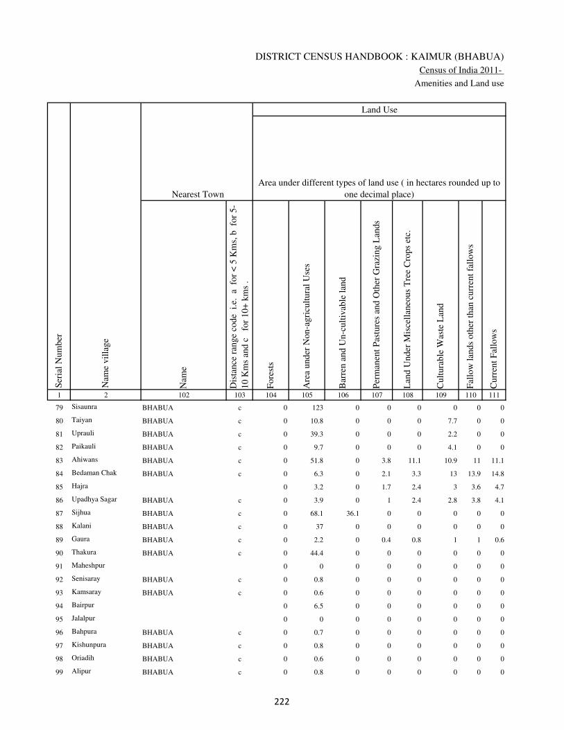
DISTRICT CENSUS HANDBOOK : KAIMUR (BHABUA)
Census of India 2011-
Amenities and Land use
Nam
e
Dis
tance
ran
ge
code
i.e
. a
fo
r <
5 K
ms,
b
for
5-
10 K
ms
and c
f
or
10+
km
s .
Fore
sts
Are
a under
Non-a
gri
cult
ura
l U
ses
Bar
ren a
nd U
n-c
ult
ivab
le l
and
Per
man
ent
Pas
ture
s an
d O
ther
Gra
zing L
ands
Lan
d U
nder
Mis
cell
aneo
us
Tre
e C
rops
etc.
Cult
ura
ble
Was
te L
and
Fal
low
lan
ds
oth
er t
han
curr
ent
fall
ow
s
Curr
ent
Fal
low
s
1 2 102 103 104 105 106 107 108 109 110 111
Ser
ial
Num
ber
Nam
e vil
lage
Area under different types of land use ( in hectares rounded up to
one decimal place)
Land Use
Nearest Town
79 Sisaunra BHABUA c 0 123 0 0 0 0 0 0
80 Taiyan BHABUA c 0 10.8 0 0 0 7.7 0 0
81 Uprauli BHABUA c 0 39.3 0 0 0 2.2 0 0
82 Paikauli BHABUA c 0 9.7 0 0 0 4.1 0 0
83 Ahiwans BHABUA c 0 51.8 0 3.8 11.1 10.9 11 11.1
84 Bedaman Chak BHABUA c 0 6.3 0 2.1 3.3 13 13.9 14.8
85 Hajra 0 3.2 0 1.7 2.4 3 3.6 4.7
86 Upadhya Sagar BHABUA c 0 3.9 0 1 2.4 2.8 3.8 4.1
87 Sijhua BHABUA c 0 68.1 36.1 0 0 0 0 0
88 Kalani BHABUA c 0 37 0 0 0 0 0 0
89 Gaura BHABUA c 0 2.2 0 0.4 0.8 1 1 0.6
90 Thakura BHABUA c 0 44.4 0 0 0 0 0 0
91 Maheshpur 0 0 0 0 0 0 0 0
92 Senisaray BHABUA c 0 0.8 0 0 0 0 0 0
93 Kamsaray BHABUA c 0 0.6 0 0 0 0 0 0
94 Bairpur 0 6.5 0 0 0 0 0 0
95 Jalalpur 0 0 0 0 0 0 0 0
96 Bahpura BHABUA c 0 0.7 0 0 0 0 0 0
97 Kishunpura BHABUA c 0 0.8 0 0 0 0 0 0
98 Oriadih BHABUA c 0 0.6 0 0 0 0 0 0
99 Alipur BHABUA c 0 0.8 0 0 0 0 0 0
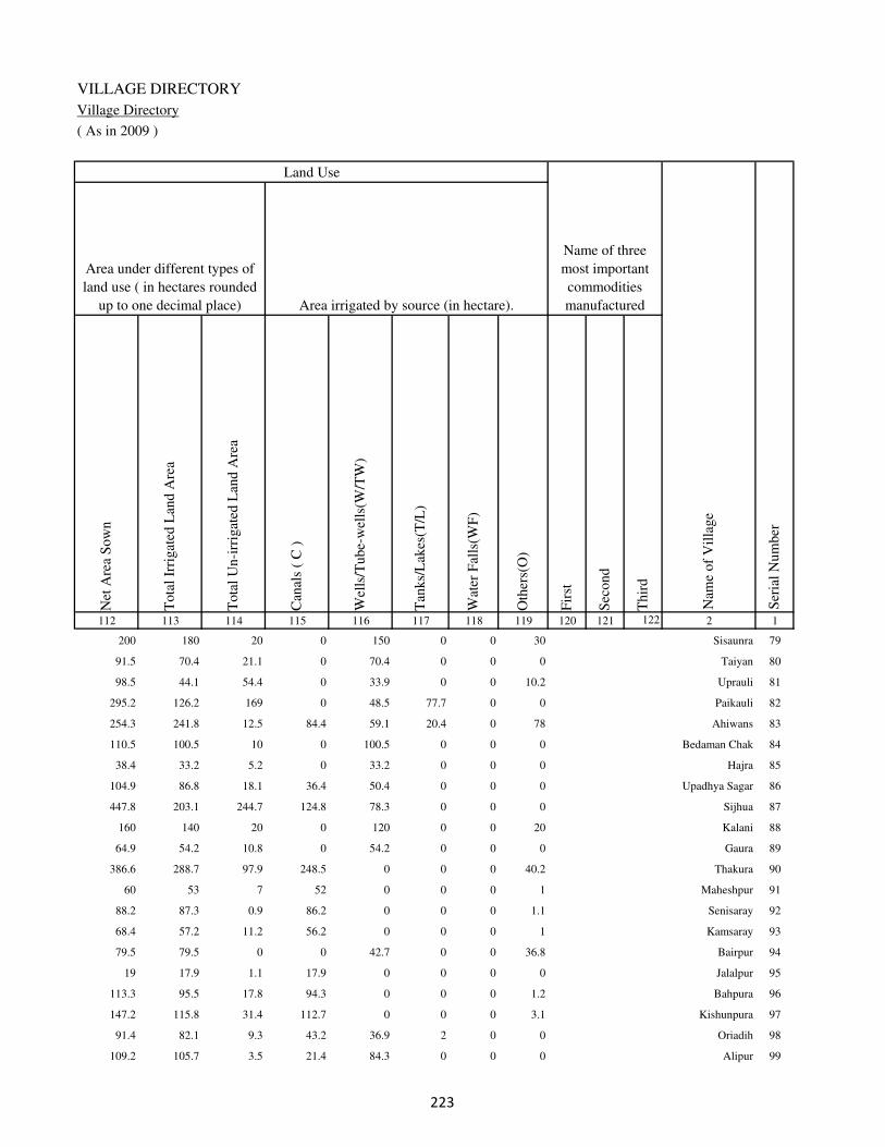
VILLAGE DIRECTORY
Village Directory
( As in 2009 )
Net
Are
a S
ow
n
Tota
l Ir
rigat
ed L
and A
rea
Tota
l U
n-i
rrig
ated
Lan
d A
rea
Can
als
( C
)
Wel
ls/T
ube-
wel
ls(W
/TW
)
Tan
ks/
Lak
es(T
/L)
Wat
er F
alls
(WF
)
Oth
ers(
O)
Fir
st
Sec
ond
Thir
d
112 113 114 115 116 117 118 119 120 121 122 2 1
Ser
ial
Num
ber
Name of three
most important
commodities
manufacturedArea irrigated by source (in hectare).
Nam
e of
Vil
lage
Area under different types of
land use ( in hectares rounded
up to one decimal place)
Land Use
200 180 20 0 150 0 0 30 Sisaunra 79
91.5 70.4 21.1 0 70.4 0 0 0 Taiyan 80
98.5 44.1 54.4 0 33.9 0 0 10.2 Uprauli 81
295.2 126.2 169 0 48.5 77.7 0 0 Paikauli 82
254.3 241.8 12.5 84.4 59.1 20.4 0 78 Ahiwans 83
110.5 100.5 10 0 100.5 0 0 0 Bedaman Chak 84
38.4 33.2 5.2 0 33.2 0 0 0 Hajra 85
104.9 86.8 18.1 36.4 50.4 0 0 0 Upadhya Sagar 86
447.8 203.1 244.7 124.8 78.3 0 0 0 Sijhua 87
160 140 20 0 120 0 0 20 Kalani 88
64.9 54.2 10.8 0 54.2 0 0 0 Gaura 89
386.6 288.7 97.9 248.5 0 0 0 40.2 Thakura 90
60 53 7 52 0 0 0 1 Maheshpur 91
88.2 87.3 0.9 86.2 0 0 0 1.1 Senisaray 92
68.4 57.2 11.2 56.2 0 0 0 1 Kamsaray 93
79.5 79.5 0 0 42.7 0 0 36.8 Bairpur 94
19 17.9 1.1 17.9 0 0 0 0 Jalalpur 95
113.3 95.5 17.8 94.3 0 0 0 1.2 Bahpura 96
147.2 115.8 31.4 112.7 0 0 0 3.1 Kishunpura 97
91.4 82.1 9.3 43.2 36.9 2 0 0 Oriadih 98
109.2 105.7 3.5 21.4 84.3 0 0 0 Alipur 99

DISTRICT CENSUS HANDBOOK : KAIMUR (BHABUA)
Census of India 2011-
Amenities and Land use
Pre
-Pri
mar
y s
chool
(PP
)
Pri
mar
y s
chool
(P)
Mid
dle
sch
ool
(M)
Sec
ondar
y S
chool
(S)
Sen
ior
Sec
ondar
y s
chool
(SS
)
Deg
ree
coll
ege
of
arts
sc
ience
& c
om
mer
ce
(AS
C)
Engin
eeri
ng c
oll
ege(
EC
)
Med
ical
coll
ege
(MC
)
Man
agem
ent
inst
itute
(M
I)
Poly
tech
nic
(P
t)
Voca
tional
tra
inin
g s
chool
/IT
I
Non-f
orm
al t
rain
ing c
entr
e (N
FT
C)
Spec
ial
school
for
dis
able
d (
SS
D)
Oth
ers
(spec
ify)
1 2 3 4 5 6 7 8 9 10 11 12 13 14 15 16 17 18 19 20
Loca
tion c
ode
no.
Nam
e vil
lage
Ser
ial
Num
ber
Tota
l popula
tion (
2011 c
ensu
s )
Tota
l ar
ea o
f th
e vil
lage
( in
hec
tare
s ro
unded
up t
o
one
dec
imal
pla
ce)
Number of educational amenities available. (If not available
within the village , the distance range code viz; a for < 5
Kms, b for 5-10 Kms and c for 10+ kms of nearest place
where facility is available is given).
Num
ber
of
house
hold
s (2
011 c
ensu
s)
100 Tenua 249022 84 930 142 b 1 a a a a c c c c c c c
101 Gorsara 249023 49 2646 398 4 2 a b c c c c c c c c c
102 Darwansurat 249024 476 210 28 1 1 1 c b c c c c c c c c
103 Judunandan Patti 249025 40 43 4 b 1 1 c b c c c c c c c c
104 Murlidarwan 249026 86 1218 163 b 1 1 c b c c c c c c c c
105 Dhanautia 249027 125 539 73 b 1 a c c c c c c c c c c
106 Asaura 249028 324 1514 234 b 1 a c a c c c c c b c c
107 Chitahan 249029 75 391 49 b b a c a c c c c c c c c
108 Kanpura 249030 34 259 34 b 1 b c b c c c c c c c c
109 Asapur 249031 81 33 5 b b b c b c c c c c c c c
110 Chitahan 249032 36 0 0
111 Patkhaulia 249033 100 839 100 a a a c a c c c c c c c c
112 Tulshipur 249034 35 0 0
113 Bagarhi 249035 164 957 126 b b b c a c c c c c c c c
114 Kalyanpur 249036 150 0 0
115 Banwari Chak 249037 135 0 0
116 Nathua 249038 27 164 21 b a a c c c c c c c c c c
117 Mahuari 249039 156 1902 283 b 1 1 c b c c c c c c c c
118 Gogasaray 249040 45 0 0
119 Upari 249041 206 2152 318 b 1 1 c c c c c c c c c c
120 Baluwa 249042 97 291 54 b 1 a c c c c c c c c c c
�

VILLAGE DIRECTORY
Village Directory
( As in 2009 )
Com
munit
y h
ealt
h c
entr
e (C
HC
)
Pri
mar
y h
ealt
h c
entr
e (P
HC
)
Pri
mar
y h
ealt
h s
ub c
entr
e (P
HS
)
Mat
ernit
y a
nd c
hil
d w
elfa
re c
entr
e (M
CW
)
T.B
. cl
inic
(T
BC
)
Hosp
ital
-all
opat
hic
(H
A)
Hosp
ital
-alt
ernat
ive
med
icin
e (H
O)
Dis
pen
sary
(D
)
Vet
erin
ary h
osp
ital
(V
H)
Mobil
e hea
lth c
linic
(M
HC
)
Fam
ily w
elfa
re c
entr
e (F
WC
)
Char
itab
le n
on G
ovt.
hosp
ital
/Nurs
ing h
om
e.
Med
ical
pra
ctit
ioner
wit
h M
BB
S D
egre
e
Med
ical
pra
ctit
ioner
wit
h o
ther
deg
ree
Med
ical
pra
ctit
ioner
wit
h n
o d
egre
e
Tra
dit
ional
pra
ctit
ioner
an
d f
aith
hea
ler
.
Med
icin
e S
hop
Oth
ers
21 22 23 24 25 26 27 28 29 30 31 32 33 34 35 36 37 38 2 1
Number of Non-Government
Medical Amenities available.
Number of Medical Amenities available. (If not
available within the village , the distance range
code viz; a for < 5 Kms, b for 5-10 Kms and c
for 10+ kms of nearest place where facility is
available is given).
Nam
e vil
lage
Ser
ial
Num
ber
a b b b c c c b b c c 0 0 0 0 0 0 0 Tenua 100
b b 1 1 c c c 1 a c 1 0 0 3 0 0 3 0 Gorsara 101
b b b b c c c c b c b 0 0 0 0 0 0 0 Darwansurat 102
b b b b c c c c b c b 0 0 0 0 0 0 0 Judunandan Patti 103
b b b b c c c b b c b 0 0 0 0 0 0 0 Murlidarwan 104
c c c c c c c c c c c 0 0 0 0 0 0 0 Dhanautia 105
c a a a a c c a a c a 0 0 0 0 1 1 0 Asaura 106
c b b b b c c b b c b 0 0 0 0 0 0 0 Chitahan 107
c b b b b c c b b c b 0 0 0 0 0 0 0 Kanpura 108
c b b b c c c b b c b 0 0 0 0 0 0 0 Asapur 109
Chitahan 110
c b b b c c c c b c b 0 0 0 0 0 0 0 Patkhaulia 111
Tulshipur 112
c b b b c c c c b c c 0 0 0 0 0 0 0 Bagarhi 113
Kalyanpur 114
Banwari Chak 115
c c c c c c c c c c c 0 0 0 0 0 0 0 Nathua 116
c b b b b c c b b c b 0 0 0 0 0 0 0 Mahuari 117
Gogasaray 118
c c b c c c c c c c c 0 0 0 0 0 0 0 Upari 119
c c b c c c c c c c c 0 0 0 0 0 0 0 Baluwa 120
�
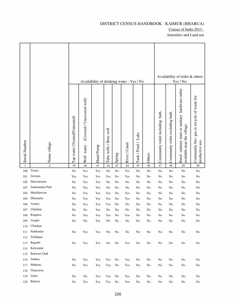
DISTRICT CENSUS HANDBOOK : KAIMUR (BHABUA)
Census of India 2011-
Amenities and Land use
Tap
wat
er (
Tre
ated
/Untr
eate
d)
Wel
l w
ater
(Cover
ed /
Unco
ver
ed w
ell)
Han
d P
um
p
Tube
wel
ls /
Bore
wel
l
Spri
ng
Riv
er /
Can
al
Tan
k /
Pond /
L
ake
Oth
ers
Com
munit
y t
oil
et i
ncl
udin
g
bat
h.
Com
munit
y t
oil
et e
xcl
udin
g b
ath.
Rura
l s
anit
ary m
art
or
sanit
ary
har
dw
are
outl
et
avai
lable
nea
r th
e vil
lage.
Com
munit
y b
io-
gas
or
recy
cle
of
was
te f
or
pro
duct
ive
use
.
1 2 39 40 41 42 43 44 45 46 47 48 49 50
Availability of toilet & others
Yes / No Availability of drinking water - Yes / No
Nam
e vil
lage
Ser
ial
Num
ber
100 Tenua No Yes Yes No No Yes No No No No No No
101 Gorsara Yes Yes Yes Yes No Yes No No No No No No
102 Darwansurat No Yes Yes No No No No No No No No No
103 Judunandan Patti No Yes Yes No No No No No No No No No
104 Murlidarwan No Yes Yes Yes No Yes No No No No No No
105 Dhanautia No Yes Yes Yes No Yes No No No No No No
106 Asaura No Yes Yes Yes No No No No No No No No
107 Chitahan No No Yes No No No No No No No No No
108 Kanpura No Yes Yes Yes No Yes No No No No No No
109 Asapur No No Yes No No No No No No No No No
110 Chitahan
111 Patkhaulia No Yes Yes No No No No No No No No No
112 Tulshipur
113 Bagarhi No Yes Yes No No Yes No No No No No No
114 Kalyanpur
115 Banwari Chak
116 Nathua No Yes Yes Yes No Yes No No No No No No
117 Mahuari No Yes Yes Yes No Yes No No No No No No
118 Gogasaray
119 Upari No No Yes Yes No Yes No No No No No No
120 Baluwa No Yes Yes Yes No Yes No No No No No No
�
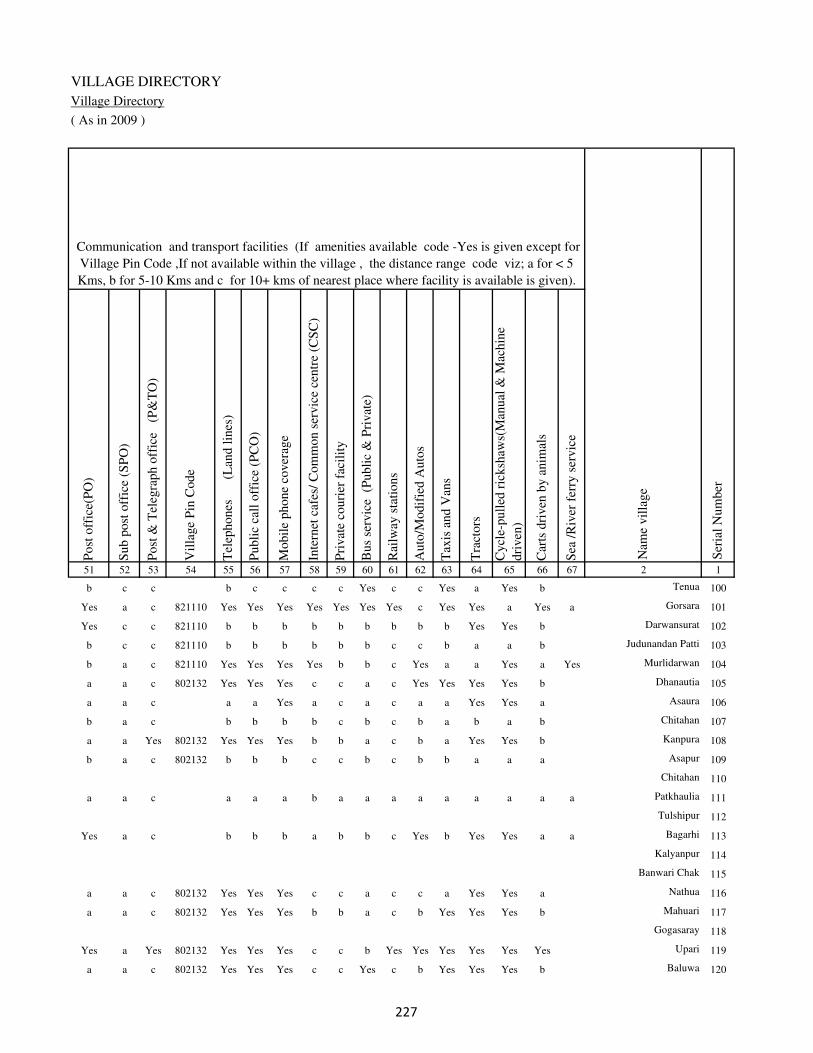
VILLAGE DIRECTORY
Village Directory
( As in 2009 )
Post
off
ice(
PO
)
Sub p
ost
off
ice
(SP
O)
Post
& T
eleg
raph o
ffic
e
(P&
TO
)
Vil
lage
Pin
Code
Tel
ephones
(L
and l
ines
)
Publi
c ca
ll o
ffic
e (P
CO
)
Mobil
e phone
cover
age
Inte
rnet
caf
es/
Com
mon s
ervic
e ce
ntr
e (C
SC
)
Pri
vat
e co
uri
er f
acil
ity
Bus
serv
ice
(P
ubli
c &
Pri
vat
e)
Rai
lway
sta
tions
Auto
/Modif
ied A
uto
s
Tax
is a
nd V
ans
Tra
ctors
Cycl
e-pull
ed r
icksh
aws(
Man
ual
& M
achin
e
dri
ven
)
Car
ts d
riven
by a
nim
als
Sea
/R
iver
fer
ry s
ervic
e51 52 53 54 55 56 57 58 59 60 61 62 63 64 65 66 67 2 1
Communication and transport facilities (If amenities available code -Yes is given except for
Village Pin Code ,If not available within the village , the distance range code viz; a for < 5
Kms, b for 5-10 Kms and c for 10+ kms of nearest place where facility is available is given).
Ser
ial
Num
ber
Nam
e vil
lage
b c c b c c c c Yes c c Yes a Yes b Tenua 100
Yes a c 821110 Yes Yes Yes Yes Yes Yes Yes c Yes Yes a Yes a Gorsara 101
Yes c c 821110 b b b b b b b b b Yes Yes b Darwansurat 102
b c c 821110 b b b b b b c c b a a b Judunandan Patti 103
b a c 821110 Yes Yes Yes Yes b b c Yes a a Yes a Yes Murlidarwan 104
a a c 802132 Yes Yes Yes c c a c Yes Yes Yes Yes b Dhanautia 105
a a c a a Yes a c a c a a Yes Yes a Asaura 106
b a c b b b b c b c b a b a b Chitahan 107
a a Yes 802132 Yes Yes Yes b b a c b a Yes Yes b Kanpura 108
b a c 802132 b b b c c b c b b a a a Asapur 109
Chitahan 110
a a c a a a b a a a a a a a a a Patkhaulia 111
Tulshipur 112
Yes a c b b b a b b c Yes b Yes Yes a a Bagarhi 113
Kalyanpur 114
Banwari Chak 115
a a c 802132 Yes Yes Yes c c a c c a Yes Yes a Nathua 116
a a c 802132 Yes Yes Yes b b a c b Yes Yes Yes b Mahuari 117
Gogasaray 118
Yes a Yes 802132 Yes Yes Yes c c b Yes Yes Yes Yes Yes Yes Upari 119
a a c 802132 Yes Yes Yes c c Yes c b Yes Yes Yes b Baluwa 120
�

DISTRICT CENSUS HANDBOOK : KAIMUR (BHABUA)
Census of India 2011-
Amenities and Land use
Connec
ted t
o n
atio
nal
hig
hw
ay(N
H)
Connec
ted t
o s
tate
hig
hw
ay(S
H)
Connec
ted t
o m
ajor
dis
tric
t ro
ad (
MD
R)
Connec
ted t
o o
ther
s dis
tric
t ro
ad
Pucc
a r
oad
s
Kutc
hch
a r
oad
s
Wat
er b
ounded
mac
adam
(WB
M)
road
s
Nav
igab
le w
ater
way
(ri
ver
/can
al)(
NW
)
Footp
aths
(FP
)
Com
mer
cial
& C
o-o
per
ativ
e B
anks
AT
M
Agri
cult
ura
l C
redit
Soci
etie
s
Sel
f-H
elp G
roup (
SH
G)
Publi
c dis
trib
uti
on s
yst
em (
PD
S)
shop
Man
dis
/ R
egula
r m
arket
Wee
kly
Haa
t
Agri
cult
ura
l m
arket
ing s
oci
ety
1 2 68 69 70 71 72 73 74 75 76 77 78 79 80 81 82 83 84
Village connected to highways,village roads, banks & credit
societies (If amenities available code -Yes is given, If not
available within the village , the distance range code viz; a
for < 5 Kms, b for 5-10 Kms and c for 10+ kms of nearest
place where facility is available is given).
Ser
ial
Num
ber
Nam
e vil
lage
Availability of miscellaneous
facilities (If amenities available
code -Yes is given, If not
available within the village , the
distance range code viz; a for <
5 Kms, b for 5-10 Kms and c
for 10+ kms of nearest place
where facility is available is
given) Contd....
100 Tenua c b c c a Yes Yes a Yes b b b b a b b b
101 Gorsara c b c Yes Yes Yes Yes a Yes Yes Yes Yes Yes b Yes Yes c
102 Darwansurat c Yes c Yes Yes Yes a b Yes b b b Yes Yes b b b
103 Judunandan Patti c b b b b a b a Yes c b c Yes Yes b b c
104 Murlidarwan c b c a b Yes Yes Yes Yes b b c b Yes b c b
105 Dhanautia c b Yes Yes Yes b a a Yes c Yes c b a c c c
106 Asaura c b Yes Yes Yes Yes b a Yes a a a a a a a c
107 Chitahan c b c b b a b a Yes b b b b b b b b
108 Kanpura c c c a a Yes Yes a Yes b b b b a b b c
109 Asapur c c b b b a a b Yes b b b b a b b c
110 Chitahan
111 Patkhaulia c Yes Yes Yes Yes Yes Yes b Yes a a b c b b b c
112 Tulshipur
113 Bagarhi c Yes Yes Yes Yes Yes Yes b Yes b b b b a c b b
114 Kalyanpur
115 Banwari Chak
116 Nathua c c b Yes a Yes b b Yes c c c c a c c c
117 Mahuari c c Yes Yes a a Yes a Yes b b b b Yes b b b
118 Gogasaray
119 Upari c c Yes Yes Yes a a b Yes c c c c Yes c c c
120 Baluwa c c b Yes Yes a a b Yes c c c c a c c c
�
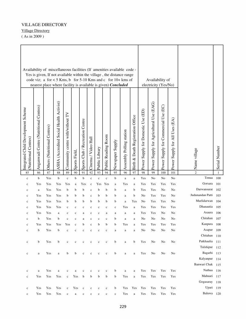
VILLAGE DIRECTORY
Village Directory
( As in 2009 )
Inte
gra
ted C
hil
d D
evel
opm
ent
Sch
eme
(Nutr
itio
nal
Cen
tres
)
Angan
wad
i C
entr
e (N
utr
itio
nal
Cen
tres
)
Oth
ers
(Nutr
itio
nal
Cen
tres
)
AS
HA
(A
ccre
dit
ed S
oci
al H
ealt
h A
ctiv
ist)
Com
munit
y c
entr
e w
ith/w
ithout
TV
Sport
s F
ield
,
Sport
s C
lub /
Rec
reat
ion C
entr
e
Cin
ema
/ V
ideo
Hal
l
Publi
c L
ibra
ry
Publi
c R
eadin
g R
oom
New
spap
er S
upply
Ass
embly
Poll
ing s
tati
on
Bir
th &
Dea
th R
egis
trat
ion O
ffic
e
Pow
er S
upply
for
Dom
esti
c U
se (
ED
)
Pow
er S
upply
for
Agri
cult
ura
l U
se (
EA
G)
Pow
er S
upply
for
Com
mer
cial
Use
(E
C)
Pow
er S
upply
for
All
Use
s (E
A)
85 86 87 88 89 90 91 92 93 94 95 96 97 98 99 100 101 2 1
Availability of
electricity (Yes/No)
Availability of miscellaneous facilities (If amenities available code -
Yes is given, If not available within the village , the distance range
code viz; a for < 5 Kms, b for 5-10 Kms and c for 10+ kms of
nearest place where facility is available is given) Concluded
Nam
e vil
lage
Ser
ial
Num
ber
c b Yes b c b b c c c b a a Yes No No No Tenua 100
c Yes Yes Yes Yes a Yes c Yes Yes a Yes a Yes Yes Yes Yes Gorsara 101
c a Yes Yes b b b c b b b a b Yes Yes No No Darwansurat 102
c Yes Yes Yes b b b c b b b a b No Yes Yes No Judunandan Patti 103
c Yes Yes Yes b b b b b b b a Yes No Yes Yes No Murlidarwan 104
c Yes Yes Yes c c c c c c c Yes a Yes Yes Yes Yes Dhanautia 105
c Yes Yes a c c a c c a a a a Yes Yes No No Asaura 106
c b Yes b c c a c c c b a a No No No No Chitahan 107
c Yes Yes Yes Yes c b c b b b Yes a Yes Yes Yes Yes Kanpura 108
c b Yes b c c c c c c a a a No No No No Asapur 109
Chitahan 110
c b Yes b c c c c c c b a b Yes No No No Patkhaulia 111
Tulshipur 112
c a Yes a b b c c c c b a a Yes No No No Bagarhi 113
Kalyanpur 114
Banwari Chak 115
c a Yes a c a c c c c b a a Yes Yes Yes Yes Nathua 116
c Yes Yes Yes c Yes b b b b b Yes a Yes Yes Yes Yes Mahuari 117
Gogasaray 118
c Yes Yes Yes c Yes c c c c b Yes Yes Yes Yes Yes Yes Upari 119
c Yes Yes Yes c a c c c c c Yes a Yes Yes Yes Yes Baluwa 120
�

DISTRICT CENSUS HANDBOOK : KAIMUR (BHABUA)
Census of India 2011-
Amenities and Land use
Nam
e
Dis
tance
ran
ge
code
i.e
. a
fo
r <
5 K
ms,
b
for
5-
10 K
ms
and c
f
or
10+
km
s .
Fore
sts
Are
a under
Non-a
gri
cult
ura
l U
ses
Bar
ren a
nd U
n-c
ult
ivab
le l
and
Per
man
ent
Pas
ture
s an
d O
ther
Gra
zing L
ands
Lan
d U
nder
Mis
cell
aneo
us
Tre
e C
rops
etc.
Cult
ura
ble
Was
te L
and
Fal
low
lan
ds
oth
er t
han
curr
ent
fall
ow
s
Curr
ent
Fal
low
s
1 2 102 103 104 105 106 107 108 109 110 111
Ser
ial
Num
ber
Nam
e vil
lage
Area under different types of land use ( in hectares rounded up to
one decimal place)
Land Use
Nearest Town
100 Tenua BHABUA c 0 0.9 0 0 0 0 0 0
101 Gorsara BHABUA c 0 0 0.8 1.6 0.4 0.2 0.2 0
102 Darwansurat BHABUA c 0 1.3 0 0 0 0 0 0
103 Judunandan Patti BHABUA c 0 0.6 0 0 0 0 0 0
104 Murlidarwan BHABUA c 0 48.8 0 0 0 0 0 0
105 Dhanautia BHABUA c 0 13.2 0 1.1 2 5.6 6.1 8
106 Asaura BHABUA c 0 4.7 0 5.3 11.7 5 4.8 4.2
107 Chitahan BHABUA c 0 1.8 0 1.1 2 1.4 2.2 2.4
108 Kanpura BHABUA c 0 2.4 0 0.8 2 2 2 3.2
109 Asapur BHABUA c 0 6.8 0 1.1 2 2.3 3.5 3.1
110 Chitahan 0 3.2 0 2.5 3.1 2.3 2.5 3.4
111 Patkhaulia BHABUA c 0 1.5 0 0 0 0 0 0
112 Tulshipur 0 3.5 0 0 0 0 0 0
113 Bagarhi BHABUA c 0 2.3 0 0 0 0 0 0
114 Kalyanpur 0 14.7 0 0 0 31.3 0 0
115 Banwari Chak 0 6.6 0 1.6 2.1 5.7 6.1 10.5
116 Nathua BHABUA c 0 1.9 0 1 1.8 0.6 0.7 1
117 Mahuari BHABUA c 0 4.4 0 1.1 2 1.4 1.8 0.2
118 Gogasaray 0 2.6 0 1.2 2.2 2 2.5 2.8
119 Upari BHABUA c 0 15.7 0 3.1 5.6 4 4.4 5.8
120 Baluwa BHABUA c 0 7.3 0 2 1.8 5.4 5.7 5.8
�
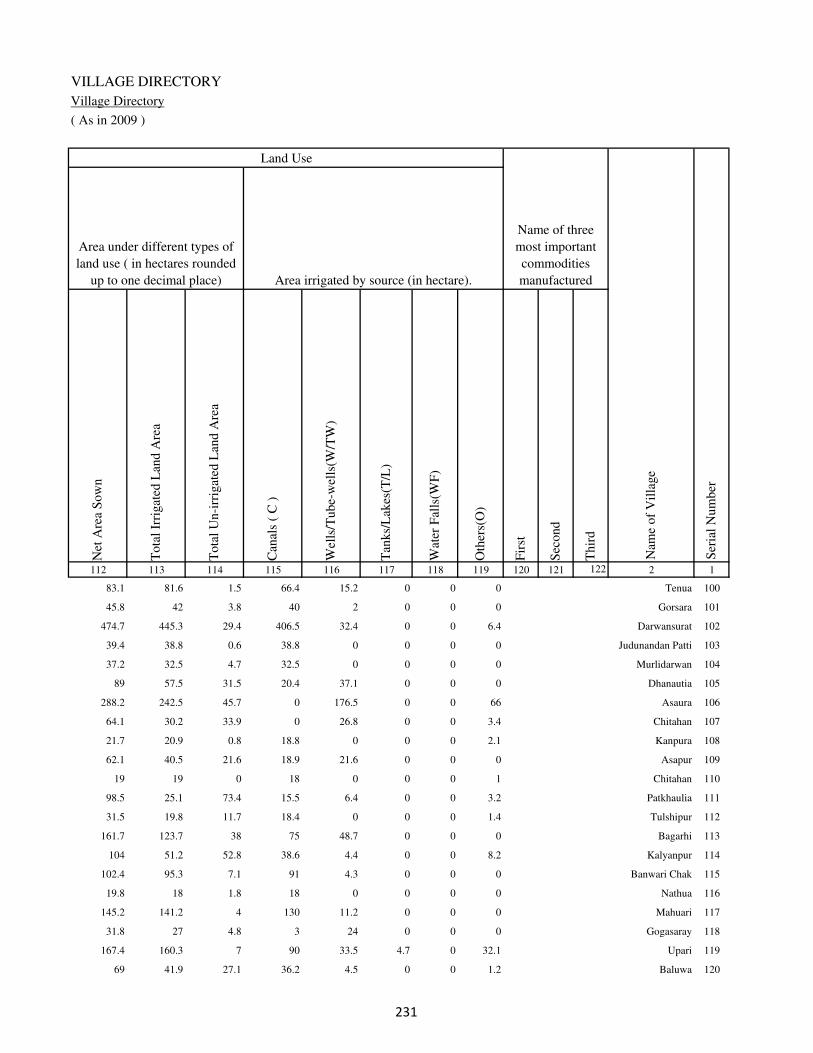
VILLAGE DIRECTORY
Village Directory
( As in 2009 )
Net
Are
a S
ow
n
Tota
l Ir
rigat
ed L
and A
rea
Tota
l U
n-i
rrig
ated
Lan
d A
rea
Can
als
( C
)
Wel
ls/T
ube-
wel
ls(W
/TW
)
Tan
ks/
Lak
es(T
/L)
Wat
er F
alls
(WF
)
Oth
ers(
O)
Fir
st
Sec
ond
Thir
d
112 113 114 115 116 117 118 119 120 121 122 2 1
Ser
ial
Num
ber
Name of three
most important
commodities
manufacturedArea irrigated by source (in hectare).
Nam
e of
Vil
lage
Area under different types of
land use ( in hectares rounded
up to one decimal place)
Land Use
83.1 81.6 1.5 66.4 15.2 0 0 0 Tenua 100
45.8 42 3.8 40 2 0 0 0 Gorsara 101
474.7 445.3 29.4 406.5 32.4 0 0 6.4 Darwansurat 102
39.4 38.8 0.6 38.8 0 0 0 0 Judunandan Patti 103
37.2 32.5 4.7 32.5 0 0 0 0 Murlidarwan 104
89 57.5 31.5 20.4 37.1 0 0 0 Dhanautia 105
288.2 242.5 45.7 0 176.5 0 0 66 Asaura 106
64.1 30.2 33.9 0 26.8 0 0 3.4 Chitahan 107
21.7 20.9 0.8 18.8 0 0 0 2.1 Kanpura 108
62.1 40.5 21.6 18.9 21.6 0 0 0 Asapur 109
19 19 0 18 0 0 0 1 Chitahan 110
98.5 25.1 73.4 15.5 6.4 0 0 3.2 Patkhaulia 111
31.5 19.8 11.7 18.4 0 0 0 1.4 Tulshipur 112
161.7 123.7 38 75 48.7 0 0 0 Bagarhi 113
104 51.2 52.8 38.6 4.4 0 0 8.2 Kalyanpur 114
102.4 95.3 7.1 91 4.3 0 0 0 Banwari Chak 115
19.8 18 1.8 18 0 0 0 0 Nathua 116
145.2 141.2 4 130 11.2 0 0 0 Mahuari 117
31.8 27 4.8 3 24 0 0 0 Gogasaray 118
167.4 160.3 7 90 33.5 4.7 0 32.1 Upari 119
69 41.9 27.1 36.2 4.5 0 0 1.2 Baluwa 120
�
DISTRICT CENSUS HANDBOOK : KAIMUR (BHABUA)
Census of India 2011-
Amenities and Land use
Pre
-Pri
mar
y s
chool
(PP
)
Pri
mar
y s
chool
(P)
Mid
dle
sch
ool
(M)
Sec
ondar
y S
chool
(S)
Sen
ior
Sec
ondar
y s
chool
(SS
)
Deg
ree
coll
ege
of
arts
sc
ience
& c
om
mer
ce
(AS
C)
Engin
eeri
ng c
oll
ege(
EC
)
Med
ical
coll
ege
(MC
)
Man
agem
ent
inst
itute
(M
I)
Poly
tech
nic
(P
t)
Voca
tional
tra
inin
g s
chool
/IT
I
Non-f
orm
al t
rain
ing c
entr
e (N
FT
C)
Spec
ial
school
for
dis
able
d (
SS
D)
Oth
ers
(spec
ify)
1 2 3 4 5 6 7 8 9 10 11 12 13 14 15 16 17 18 19 20
Loca
tion c
ode
no.
Nam
e vil
lage
Ser
ial
Num
ber
Tota
l popula
tion (
2011 c
ensu
s )
Tota
l ar
ea o
f th
e vil
lage
( in
hec
tare
s ro
unded
up t
o
one
dec
imal
pla
ce)
Number of educational amenities available. (If not available
within the village , the distance range code viz; a for < 5
Kms, b for 5-10 Kms and c for 10+ kms of nearest place
where facility is available is given).
Num
ber
of
house
hold
s (2
011 c
ensu
s)
121 Lachhanpura 249043 42 40 10 b a a c c c c c c c c c c
122 Sultanpur 249044 121 771 144 b 1 a c c c c c c c c c c
123 Siktha 249045 135 0 0
124 Sadullahpur 249046 305 4455 683 b 1 1 c b c c c c c c c c
125 Ansi 249047 94 0 0
Block T O T A L : 16448 123973 18375 13 68 29 5 4 1 0 0 0 0 0 0 0 0

VILLAGE DIRECTORY
Village Directory
( As in 2009 )
Com
munit
y h
ealt
h c
entr
e (C
HC
)
Pri
mar
y h
ealt
h c
entr
e (P
HC
)
Pri
mar
y h
ealt
h s
ub c
entr
e (P
HS
)
Mat
ernit
y a
nd c
hil
d w
elfa
re c
entr
e (M
CW
)
T.B
. cl
inic
(T
BC
)
Hosp
ital
-all
opat
hic
(H
A)
Hosp
ital
-alt
ernat
ive
med
icin
e (H
O)
Dis
pen
sary
(D
)
Vet
erin
ary h
osp
ital
(V
H)
Mobil
e hea
lth c
linic
(M
HC
)
Fam
ily w
elfa
re c
entr
e (F
WC
)
Char
itab
le n
on G
ovt.
hosp
ital
/Nurs
ing h
om
e.
Med
ical
pra
ctit
ioner
wit
h M
BB
S D
egre
e
Med
ical
pra
ctit
ioner
wit
h o
ther
deg
ree
Med
ical
pra
ctit
ioner
wit
h n
o d
egre
e
Tra
dit
ional
pra
ctit
ioner
an
d f
aith
hea
ler
.
Med
icin
e S
hop
Oth
ers
21 22 23 24 25 26 27 28 29 30 31 32 33 34 35 36 37 38 2 1
Number of Non-Government
Medical Amenities available.
Number of Medical Amenities available. (If not
available within the village , the distance range
code viz; a for < 5 Kms, b for 5-10 Kms and c
for 10+ kms of nearest place where facility is
available is given).
Nam
e vil
lage
Ser
ial
Num
ber
c c a c c c c c c c c 0 0 0 0 0 0 0 Lachhanpura 121
c c a c c c c c c c c 0 0 0 0 0 0 0 Sultanpur 122
Siktha 123
b b b b c c c c b c b 0 0 0 0 0 0 0 Sadullahpur 124
Ansi 125
0 0 3 3 0 0 0 2 0 0 3 0 3 4 1 4 11 0

DISTRICT CENSUS HANDBOOK : KAIMUR (BHABUA)
Census of India 2011-
Amenities and Land use
Tap
wat
er (
Tre
ated
/Untr
eate
d)
Wel
l w
ater
(Cover
ed /
Unco
ver
ed w
ell)
Han
d P
um
p
Tube
wel
ls /
Bore
wel
l
Spri
ng
Riv
er /
Can
al
Tan
k /
Pond /
L
ake
Oth
ers
Com
munit
y t
oil
et i
ncl
udin
g
bat
h.
Com
munit
y t
oil
et e
xcl
udin
g b
ath.
Rura
l s
anit
ary m
art
or
sanit
ary
har
dw
are
outl
et
avai
lable
nea
r th
e vil
lage.
Com
munit
y b
io-
gas
or
recy
cle
of
was
te f
or
pro
duct
ive
use
.
1 2 39 40 41 42 43 44 45 46 47 48 49 50
Availability of toilet & others
Yes / No Availability of drinking water - Yes / No
Nam
e vil
lage
Ser
ial
Num
ber
121 Lachhanpura No No Yes Yes No Yes No No No No No No
122 Sultanpur No Yes Yes Yes No Yes No No No No No No
123 Siktha
124 Sadullahpur No Yes Yes Yes No No No No No Yes No No
125 Ansi
Block T O T A L : 6 60 91 59 0 43 2 0 0 2 0 0
�

VILLAGE DIRECTORY
Village Directory
( As in 2009 )
Post
off
ice(
PO
)
Sub p
ost
off
ice
(SP
O)
Post
& T
eleg
raph o
ffic
e
(P&
TO
)
Vil
lage
Pin
Code
Tel
ephones
(L
and l
ines
)
Publi
c ca
ll o
ffic
e (P
CO
)
Mobil
e phone
cover
age
Inte
rnet
caf
es/
Com
mon s
ervic
e ce
ntr
e (C
SC
)
Pri
vat
e co
uri
er f
acil
ity
Bus
serv
ice
(P
ubli
c &
Pri
vat
e)
Rai
lway
sta
tions
Auto
/Modif
ied A
uto
s
Tax
is a
nd V
ans
Tra
ctors
Cycl
e-pull
ed r
icksh
aws(
Man
ual
& M
achin
e
dri
ven
)
Car
ts d
riven
by a
nim
als
Sea
/R
iver
fer
ry s
ervic
e51 52 53 54 55 56 57 58 59 60 61 62 63 64 65 66 67 2 1
Communication and transport facilities (If amenities available code -Yes is given except for
Village Pin Code ,If not available within the village , the distance range code viz; a for < 5
Kms, b for 5-10 Kms and c for 10+ kms of nearest place where facility is available is given).
Ser
ial
Num
ber
Nam
e vil
lage
a a c 802132 Yes Yes Yes c c a c c a Yes Yes a Lachhanpura 121
a a c 802132 Yes Yes Yes c c a c b a Yes Yes b Sultanpur 122
Siktha 123
b a c 821110 b b b b b b c Yes Yes Yes Yes Yes Sadullahpur 124
Ansi 125
10 0 4 21 32 33 36 4 1 7 4 19 26 60 60 24 2
�

DISTRICT CENSUS HANDBOOK : KAIMUR (BHABUA)
Census of India 2011-
Amenities and Land use
Connec
ted t
o n
atio
nal
hig
hw
ay(N
H)
Connec
ted t
o s
tate
hig
hw
ay(S
H)
Connec
ted t
o m
ajor
dis
tric
t ro
ad (
MD
R)
Connec
ted t
o o
ther
s dis
tric
t ro
ad
Pucc
a r
oad
s
Kutc
hch
a r
oad
s
Wat
er b
ounded
mac
adam
(WB
M)
road
s
Nav
igab
le w
ater
way
(ri
ver
/can
al)(
NW
)
Footp
aths
(FP
)
Com
mer
cial
& C
o-o
per
ativ
e B
anks
AT
M
Agri
cult
ura
l C
redit
Soci
etie
s
Sel
f-H
elp G
roup (
SH
G)
Publi
c dis
trib
uti
on s
yst
em (
PD
S)
shop
Man
dis
/ R
egula
r m
arket
Wee
kly
Haa
t
Agri
cult
ura
l m
arket
ing s
oci
ety
1 2 68 69 70 71 72 73 74 75 76 77 78 79 80 81 82 83 84
Village connected to highways,village roads, banks & credit
societies (If amenities available code -Yes is given, If not
available within the village , the distance range code viz; a
for < 5 Kms, b for 5-10 Kms and c for 10+ kms of nearest
place where facility is available is given).
Ser
ial
Num
ber
Nam
e vil
lage
Availability of miscellaneous
facilities (If amenities available
code -Yes is given, If not
available within the village , the
distance range code viz; a for <
5 Kms, b for 5-10 Kms and c
for 10+ kms of nearest place
where facility is available is
given) Contd....
121 Lachhanpura c c Yes Yes a Yes Yes b Yes c c c c a c c c
122 Sultanpur c c c Yes Yes a Yes a Yes c c c c a c c c
123 Siktha
124 Sadullahpur c b b a Yes Yes Yes b Yes b b b b Yes b c b
125 Ansi
Block T O T A L : 0 13 35 49 51 50 45 5 91 6 2 1 8 20 4 4 3
�
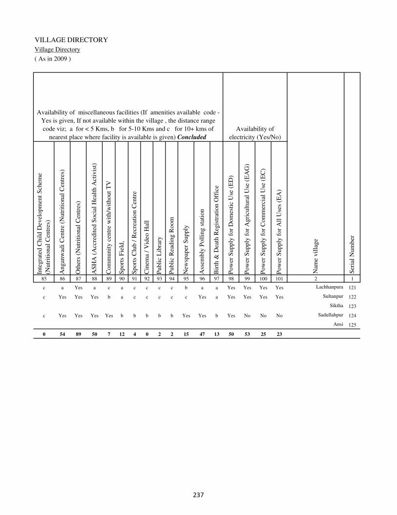
VILLAGE DIRECTORY
Village Directory
( As in 2009 )
Inte
gra
ted C
hil
d D
evel
opm
ent
Sch
eme
(Nutr
itio
nal
Cen
tres
)
Angan
wad
i C
entr
e (N
utr
itio
nal
Cen
tres
)
Oth
ers
(Nutr
itio
nal
Cen
tres
)
AS
HA
(A
ccre
dit
ed S
oci
al H
ealt
h A
ctiv
ist)
Com
munit
y c
entr
e w
ith/w
ithout
TV
Sport
s F
ield
,
Sport
s C
lub /
Rec
reat
ion C
entr
e
Cin
ema
/ V
ideo
Hal
l
Publi
c L
ibra
ry
Publi
c R
eadin
g R
oom
New
spap
er S
upply
Ass
embly
Poll
ing s
tati
on
Bir
th &
Dea
th R
egis
trat
ion O
ffic
e
Pow
er S
upply
for
Dom
esti
c U
se (
ED
)
Pow
er S
upply
for
Agri
cult
ura
l U
se (
EA
G)
Pow
er S
upply
for
Com
mer
cial
Use
(E
C)
Pow
er S
upply
for
All
Use
s (E
A)
85 86 87 88 89 90 91 92 93 94 95 96 97 98 99 100 101 2 1
Availability of
electricity (Yes/No)
Availability of miscellaneous facilities (If amenities available code -
Yes is given, If not available within the village , the distance range
code viz; a for < 5 Kms, b for 5-10 Kms and c for 10+ kms of
nearest place where facility is available is given) Concluded
Nam
e vil
lage
Ser
ial
Num
ber
c a Yes a c a c c c c b a a Yes Yes Yes Yes Lachhanpura 121
c Yes Yes Yes b a c c c c c Yes a Yes Yes Yes Yes Sultanpur 122
Siktha 123
c Yes Yes Yes Yes b b b b b Yes Yes b Yes No No No Sadullahpur 124
Ansi 125
0 54 89 50 7 12 4 0 2 2 15 47 13 50 53 25 23
�
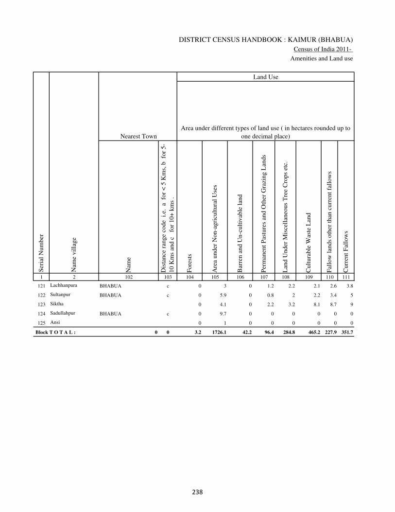
DISTRICT CENSUS HANDBOOK : KAIMUR (BHABUA)
Census of India 2011-
Amenities and Land use
Nam
e
Dis
tance
ran
ge
code
i.e
. a
fo
r <
5 K
ms,
b
for
5-
10 K
ms
and c
f
or
10+
km
s .
Fore
sts
Are
a under
Non-a
gri
cult
ura
l U
ses
Bar
ren a
nd U
n-c
ult
ivab
le l
and
Per
man
ent
Pas
ture
s an
d O
ther
Gra
zing L
ands
Lan
d U
nder
Mis
cell
aneo
us
Tre
e C
rops
etc.
Cult
ura
ble
Was
te L
and
Fal
low
lan
ds
oth
er t
han
curr
ent
fall
ow
s
Curr
ent
Fal
low
s
1 2 102 103 104 105 106 107 108 109 110 111
Ser
ial
Num
ber
Nam
e vil
lage
Area under different types of land use ( in hectares rounded up to
one decimal place)
Land Use
Nearest Town
121 Lachhanpura BHABUA c 0 3 0 1.2 2.2 2.1 2.6 3.8
122 Sultanpur BHABUA c 0 5.9 0 0.8 2 2.2 3.4 5
123 Siktha 0 4.1 0 2.2 3.2 8.1 8.7 9
124 Sadullahpur BHABUA c 0 9.7 0 0 0 0 0 0
125 Ansi 0 1 0 0 0 0 0 0
Block T O T A L : 0 0 3.2 1726.1 42.2 96.4 284.8 465.2 227.9 351.7
�

VILLAGE DIRECTORY
Village Directory
( As in 2009 )
Net
Are
a S
ow
n
Tota
l Ir
rigat
ed L
and A
rea
Tota
l U
n-i
rrig
ated
Lan
d A
rea
Can
als
( C
)
Wel
ls/T
ube-
wel
ls(W
/TW
)
Tan
ks/
Lak
es(T
/L)
Wat
er F
alls
(WF
)
Oth
ers(
O)
Fir
st
Sec
ond
Thir
d
112 113 114 115 116 117 118 119 120 121 122 2 1
Ser
ial
Num
ber
Name of three
most important
commodities
manufacturedArea irrigated by source (in hectare).
Nam
e of
Vil
lage
Area under different types of
land use ( in hectares rounded
up to one decimal place)
Land Use
27.1 23.1 4 18.9 4.2 0 0 0 Lachhanpura 121
101.7 48.6 53.1 30.6 18 0 0 0 Sultanpur 122
99.7 54.3 45.4 26.9 13.2 0 0 14.2 Siktha 123
295.3 113.1 182.2 68.7 4.4 0 0 40 Sadullahpur 124
93 85 8 0 83.9 0 0 1.1 Ansi 125
13249.7 9637 3613 3510.7 5276.3 108.8 0 741.3
�

DISTRICT CENSUS HANDBOOK : KAIMUR (BHABUA)
Census of India 2011-
Amenities and Land use
Pre
-Pri
mar
y s
chool
(PP
)
Pri
mar
y s
chool
(P)
Mid
dle
sch
ool
(M)
Sec
ondar
y S
chool
(S)
Sen
ior
Sec
ondar
y s
chool
(SS
)
Deg
ree
coll
ege
of
arts
sc
ience
& c
om
mer
ce
(AS
C)
Engin
eeri
ng c
oll
ege(
EC
)
Med
ical
coll
ege
(MC
)
Man
agem
ent
inst
itute
(M
I)
Poly
tech
nic
(P
t)
Voca
tional
tra
inin
g s
chool
/IT
I
Non-f
orm
al t
rain
ing c
entr
e (N
FT
C)
Spec
ial
school
for
dis
able
d (
SS
D)
Oth
ers
(spec
ify)
1 2 3 4 5 6 7 8 9 10 11 12 13 14 15 16 17 18 19 20
Loca
tion c
ode
no.
Nam
e vil
lage
Ser
ial
Num
ber
Tota
l popula
tion (
2011 c
ensu
s )
Tota
l ar
ea o
f th
e vil
lage
( in
hec
tare
s ro
unded
up t
o
one
dec
imal
pla
ce)
Number of educational amenities available. (If not available
within the village , the distance range code viz; a for < 5
Kms, b for 5-10 Kms and c for 10+ kms of nearest place
where facility is available is given).
Num
ber
of
house
hold
s (2
011 c
ensu
s)
Name of District:-Kaimur (Bhabua) Location CodeNo:-233
Name of CD Block:-Nuaon Location CodeNo:-0435
126 Tira 249049 231 3487 500 b 1 1 c b c c c c c c c c
127 Akhani 249050 418 4954 742 1 1 1 c b c c c c c c c c
128 Jujharpur 249051 164 642 101 b a a c b c c c c c c c c c
129 Mahro 249052 52 516 72 a 1 a c a c c c c c c c c
130 Chintamanpur 249053 103 964 139 b 1 a b b c c c c c c c c
131 Taraitha 249054 385 2937 423 b a b c b c c c c c c c c
132 Pira Ghat 249055 230 145 16 b b b c c c c c c c c c c
133 Hemrajpur 249056 30 0 0
134 Surajpura 249057 203 1207 171 a 1 b c b c c c c c c c c
135 Kusumpur 249058 39 0 0
136 Basanpur 249059 98 199 27 b a a c b c c c c c c c c
137 Mapatpur 249060 134 1080 146 b 1 a c b c c c c c c c c
138 Bhoganpur 249061 45 299 40 b 1 a c b c c c c c c c c
139 Garra 249062 217 2133 320 b 1 1 c b c c c c c c c c
140 Gaira 249063 90 1221 191 b 1 b c b c c c c c c c c
141 Mahartha 249064 197 1823 275 b 2 a c b c c c c c c c c
142 Belahri 249065 217 90 14 b 1 a c c c c c c c c c c
143 Akolhi 249066 295 2576 359 b 2 2 1 b c c c c c c c c
144 Kariram 249067 146 1519 196 b 1 1 c b c c c c c c c c
��

VILLAGE DIRECTORY
Village Directory
( As in 2009 )
Com
munit
y h
ealt
h c
entr
e (C
HC
)
Pri
mar
y h
ealt
h c
entr
e (P
HC
)
Pri
mar
y h
ealt
h s
ub c
entr
e (P
HS
)
Mat
ernit
y a
nd c
hil
d w
elfa
re c
entr
e (M
CW
)
T.B
. cl
inic
(T
BC
)
Hosp
ital
-all
opat
hic
(H
A)
Hosp
ital
-alt
ernat
ive
med
icin
e (H
O)
Dis
pen
sary
(D
)
Vet
erin
ary h
osp
ital
(V
H)
Mobil
e hea
lth c
linic
(M
HC
)
Fam
ily w
elfa
re c
entr
e (F
WC
)
Char
itab
le n
on G
ovt.
hosp
ital
/Nurs
ing h
om
e.
Med
ical
pra
ctit
ioner
wit
h M
BB
S D
egre
e
Med
ical
pra
ctit
ioner
wit
h o
ther
deg
ree
Med
ical
pra
ctit
ioner
wit
h n
o d
egre
e
Tra
dit
ional
pra
ctit
ioner
an
d f
aith
hea
ler
.
Med
icin
e S
hop
Oth
ers
21 22 23 24 25 26 27 28 29 30 31 32 33 34 35 36 37 38 2 1
Number of Non-Government
Medical Amenities available.
Number of Medical Amenities available. (If not
available within the village , the distance range
code viz; a for < 5 Kms, b for 5-10 Kms and c
for 10+ kms of nearest place where facility is
available is given).
Nam
e vil
lage
Ser
ial
Num
ber
b b a b c c c b a c b 0 0 0 0 0 0 0 Tira 126
b b 1 1 c c c b b c 1 0 0 0 0 0 0 0 Akhani 127
b b a a c c c a a c a 0 0 0 0 0 0 0 Jujharpur 128
a a a a c c c a a c a 0 0 0 0 0 0 0 Mahro 129
b b b b c c c b b c b 0 0 0 0 0 0 0 Chintamanpur 130
a a b a c c c a b c b 0 0 0 0 0 0 0 Taraitha 131
b b a b b c c b a c a 0 2 2 2 2 2 0 Pira Ghat 132
Hemrajpur 133
b a a b c c c a a c b 0 2 2 2 2 2 0 Surajpura 134
Kusumpur 135
b b b b c c c b b c b 0 0 0 0 0 0 0 Basanpur 136
a a a c c c c a a c c 0 0 0 0 0 0 0 Mapatpur 137
b b b c c c c b b c c 0 0 0 0 0 0 0 Bhoganpur 138
c b 1 1 c c c c c c 1 0 0 0 0 0 0 2 Garra 139
c b a c c c c b b c b 0 0 0 0 0 0 0 Gaira 140
c c b a c c c b b c c 0 0 0 0 0 0 0 Mahartha 141
c c b b c c c b b c b 0 0 0 0 0 0 0 Belahri 142
c b 1 1 b c c 1 c c 1 0 3 1 0 0 2 0 Akolhi 143
c b b b a c c a b c b 0 0 0 0 0 0 0 Kariram 144
��

DISTRICT CENSUS HANDBOOK : KAIMUR (BHABUA)
Census of India 2011-
Amenities and Land use
Tap
wat
er (
Tre
ated
/Untr
eate
d)
Wel
l w
ater
(Cover
ed /
Unco
ver
ed w
ell)
Han
d P
um
p
Tube
wel
ls /
Bore
wel
l
Spri
ng
Riv
er /
Can
al
Tan
k /
Pond /
L
ake
Oth
ers
Com
munit
y t
oil
et i
ncl
udin
g
bat
h.
Com
munit
y t
oil
et e
xcl
udin
g b
ath.
Rura
l s
anit
ary m
art
or
sanit
ary
har
dw
are
outl
et
avai
lable
nea
r th
e vil
lage.
Com
munit
y b
io-
gas
or
recy
cle
of
was
te f
or
pro
duct
ive
use
.
1 2 39 40 41 42 43 44 45 46 47 48 49 50
Availability of toilet & others
Yes / No Availability of drinking water - Yes / No
Nam
e vil
lage
Ser
ial
Num
ber
126 Tira No No Yes No No Yes No No No No No No
127 Akhani No No Yes Yes No Yes No No No No No No
128 Jujharpur No No Yes No No Yes No No No No No No
129 Mahro No No Yes No No Yes No No No No No No
130 Chintamanpur No No Yes No No No No No No No No No
131 Taraitha No Yes Yes No No Yes No No No No No No
132 Pira Ghat No Yes Yes No No No No No No No No No
133 Hemrajpur
134 Surajpura No Yes Yes No No No No No No No No No
135 Kusumpur
136 Basanpur No Yes Yes No No No No No No No No No
137 Mapatpur No Yes Yes No No No No No No No No No
138 Bhoganpur No Yes Yes No No No No No No No No No
139 Garra No Yes Yes No No Yes No No No No No No
140 Gaira No Yes Yes No No Yes No No No No No No
141 Mahartha No Yes Yes No No No No No No No No No
142 Belahri No Yes Yes No No No No No No No No No
143 Akolhi No Yes Yes No No No No No No No No No
144 Kariram No Yes Yes Yes No No No No No No No No
�
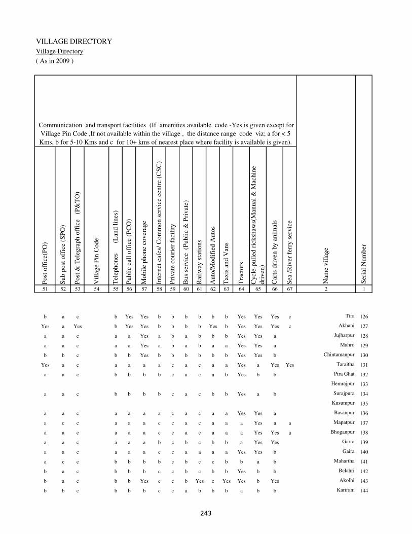
VILLAGE DIRECTORY
Village Directory
( As in 2009 )
Post
off
ice(
PO
)
Sub p
ost
off
ice
(SP
O)
Post
& T
eleg
raph o
ffic
e
(P&
TO
)
Vil
lage
Pin
Code
Tel
ephones
(L
and l
ines
)
Publi
c ca
ll o
ffic
e (P
CO
)
Mobil
e phone
cover
age
Inte
rnet
caf
es/
Com
mon s
ervic
e ce
ntr
e (C
SC
)
Pri
vat
e co
uri
er f
acil
ity
Bus
serv
ice
(P
ubli
c &
Pri
vat
e)
Rai
lway
sta
tions
Auto
/Modif
ied A
uto
s
Tax
is a
nd V
ans
Tra
ctors
Cycl
e-pull
ed r
icksh
aws(
Man
ual
& M
achin
e
dri
ven
)
Car
ts d
riven
by a
nim
als
Sea
/R
iver
fer
ry s
ervic
e51 52 53 54 55 56 57 58 59 60 61 62 63 64 65 66 67 2 1
Communication and transport facilities (If amenities available code -Yes is given except for
Village Pin Code ,If not available within the village , the distance range code viz; a for < 5
Kms, b for 5-10 Kms and c for 10+ kms of nearest place where facility is available is given).
Ser
ial
Num
ber
Nam
e vil
lage
b a c b Yes Yes b b b b b b Yes Yes Yes c Tira 126
Yes a Yes b Yes Yes b b b b Yes b Yes Yes Yes c Akhani 127
a a c a a Yes a b a b b b Yes Yes a Jujharpur 128
a a c a a Yes a b a b a a Yes Yes a Mahro 129
b b c b b Yes b b b b b b Yes Yes b Chintamanpur 130
Yes a c a a a a c a c a a Yes a Yes Yes Taraitha 131
a a c b b b b c a c a b Yes b b Pira Ghat 132
Hemrajpur 133
a a c b b b b c a c b b Yes a b Surajpura 134
Kusumpur 135
a a c a a a a c a c a a Yes Yes a Basanpur 136
a c c a a a c c a c a a a Yes a a Mapatpur 137
a a c a a a c c a c a a a Yes Yes a Bhoganpur 138
a a c a a a b c b c b b a Yes Yes Garra 139
a a c a a a c c a a a a Yes Yes b Gaira 140
a c c b b b b c b c c b b a b Mahartha 141
b a c b b b c c b c b b Yes b b Belahri 142
b a c b b Yes c c b Yes c Yes Yes b Yes Akolhi 143
b b c b b b c c a b b b a b b Kariram 144
�
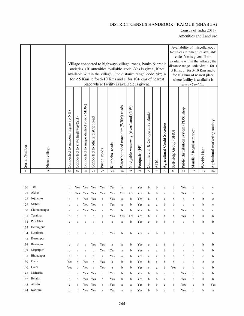
DISTRICT CENSUS HANDBOOK : KAIMUR (BHABUA)
Census of India 2011-
Amenities and Land use
Connec
ted t
o n
atio
nal
hig
hw
ay(N
H)
Connec
ted t
o s
tate
hig
hw
ay(S
H)
Connec
ted t
o m
ajor
dis
tric
t ro
ad (
MD
R)
Connec
ted t
o o
ther
s dis
tric
t ro
ad
Pucc
a r
oad
s
Kutc
hch
a r
oad
s
Wat
er b
ounded
mac
adam
(WB
M)
road
s
Nav
igab
le w
ater
way
(ri
ver
/can
al)(
NW
)
Footp
aths
(FP
)
Com
mer
cial
& C
o-o
per
ativ
e B
anks
AT
M
Agri
cult
ura
l C
redit
Soci
etie
s
Sel
f-H
elp G
roup (
SH
G)
Publi
c dis
trib
uti
on s
yst
em (
PD
S)
shop
Man
dis
/ R
egula
r m
arket
Wee
kly
Haa
t
Agri
cult
ura
l m
arket
ing s
oci
ety
1 2 68 69 70 71 72 73 74 75 76 77 78 79 80 81 82 83 84
Village connected to highways,village roads, banks & credit
societies (If amenities available code -Yes is given, If not
available within the village , the distance range code viz; a
for < 5 Kms, b for 5-10 Kms and c for 10+ kms of nearest
place where facility is available is given).
Ser
ial
Num
ber
Nam
e vil
lage
Availability of miscellaneous
facilities (If amenities available
code -Yes is given, If not
available within the village , the
distance range code viz; a for <
5 Kms, b for 5-10 Kms and c
for 10+ kms of nearest place
where facility is available is
given) Contd....
126 Tira b Yes Yes Yes Yes Yes a a Yes b b c b Yes b c c
127 Akhani b Yes Yes Yes Yes Yes Yes Yes Yes b b c b Yes b c c
128 Jujharpur a a Yes Yes a Yes a b Yes a a c b a b b c
129 Mahro a a Yes Yes a Yes a b Yes a a b b a a b c
130 Chintamanpur a a Yes Yes a Yes b b Yes b b b b Yes b b c
131 Taraitha c a a a a Yes Yes Yes Yes b a b b Yes b b b
132 Pira Ghat c a a a a a a b Yes c b b b a b b b
133 Hemrajpur
134 Surajpura c a a a b Yes b b Yes c b b b a b b b
135 Kusumpur
136 Basanpur c a a Yes Yes a a b Yes c a b b a b b b
137 Mapatpur c a a b Yes Yes a b Yes c a b b a b b b
138 Bhoganpur c b a a a Yes a b Yes c a b b b c c b
139 Garra Yes b Yes b Yes a b b Yes b a b b a c c c
140 Gaira Yes b Yes a Yes a b b Yes c a b Yes a b c b
141 Mahartha c a Yes Yes b Yes b b Yes b b c b Yes b b b
142 Belahri c a Yes Yes b Yes b b Yes b b c a Yes c b b
143 Akolhi c b Yes Yes b Yes a a Yes b b c b Yes c b Yes
144 Kariram c b Yes Yes a Yes a a Yes b b c b Yes c b a
��
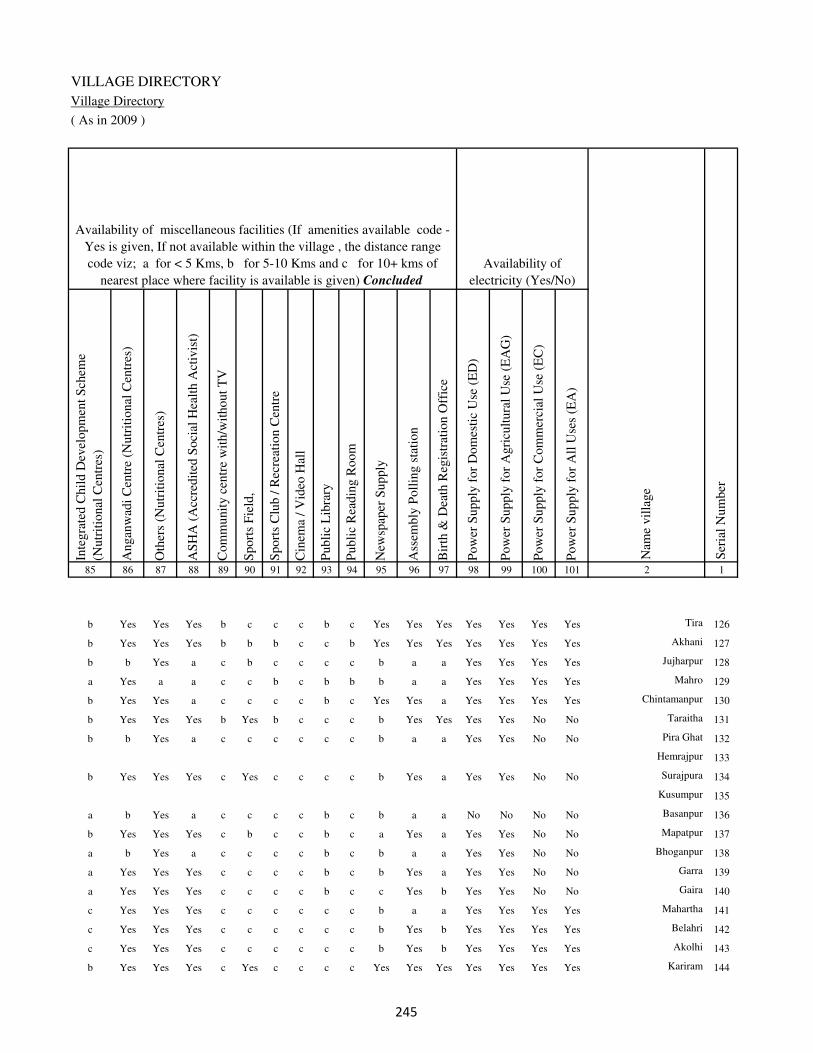
VILLAGE DIRECTORY
Village Directory
( As in 2009 )
Inte
gra
ted C
hil
d D
evel
opm
ent
Sch
eme
(Nutr
itio
nal
Cen
tres
)
Angan
wad
i C
entr
e (N
utr
itio
nal
Cen
tres
)
Oth
ers
(Nutr
itio
nal
Cen
tres
)
AS
HA
(A
ccre
dit
ed S
oci
al H
ealt
h A
ctiv
ist)
Com
munit
y c
entr
e w
ith/w
ithout
TV
Sport
s F
ield
,
Sport
s C
lub /
Rec
reat
ion C
entr
e
Cin
ema
/ V
ideo
Hal
l
Publi
c L
ibra
ry
Publi
c R
eadin
g R
oom
New
spap
er S
upply
Ass
embly
Poll
ing s
tati
on
Bir
th &
Dea
th R
egis
trat
ion O
ffic
e
Pow
er S
upply
for
Dom
esti
c U
se (
ED
)
Pow
er S
upply
for
Agri
cult
ura
l U
se (
EA
G)
Pow
er S
upply
for
Com
mer
cial
Use
(E
C)
Pow
er S
upply
for
All
Use
s (E
A)
85 86 87 88 89 90 91 92 93 94 95 96 97 98 99 100 101 2 1
Availability of
electricity (Yes/No)
Availability of miscellaneous facilities (If amenities available code -
Yes is given, If not available within the village , the distance range
code viz; a for < 5 Kms, b for 5-10 Kms and c for 10+ kms of
nearest place where facility is available is given) Concluded
Nam
e vil
lage
Ser
ial
Num
ber
b Yes Yes Yes b c c c b c Yes Yes Yes Yes Yes Yes Yes Tira 126
b Yes Yes Yes b b b c c b Yes Yes Yes Yes Yes Yes Yes Akhani 127
b b Yes a c b c c c c b a a Yes Yes Yes Yes Jujharpur 128
a Yes a a c c b c b b b a a Yes Yes Yes Yes Mahro 129
b Yes Yes a c c c c b c Yes Yes a Yes Yes Yes Yes Chintamanpur 130
b Yes Yes Yes b Yes b c c c b Yes Yes Yes Yes No No Taraitha 131
b b Yes a c c c c c c b a a Yes Yes No No Pira Ghat 132
Hemrajpur 133
b Yes Yes Yes c Yes c c c c b Yes a Yes Yes No No Surajpura 134
Kusumpur 135
a b Yes a c c c c b c b a a No No No No Basanpur 136
b Yes Yes Yes c b c c b c a Yes a Yes Yes No No Mapatpur 137
a b Yes a c c c c b c b a a Yes Yes No No Bhoganpur 138
a Yes Yes Yes c c c c b c b Yes a Yes Yes No No Garra 139
a Yes Yes Yes c c c c b c c Yes b Yes Yes No No Gaira 140
c Yes Yes Yes c c c c c c b a a Yes Yes Yes Yes Mahartha 141
c Yes Yes Yes c c c c c c b Yes b Yes Yes Yes Yes Belahri 142
c Yes Yes Yes c c c c c c b Yes b Yes Yes Yes Yes Akolhi 143
b Yes Yes Yes c Yes c c c c Yes Yes Yes Yes Yes Yes Yes Kariram 144
��
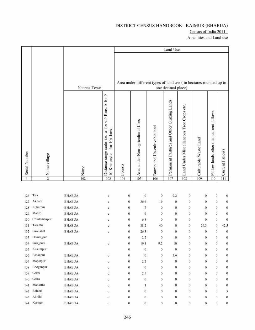
DISTRICT CENSUS HANDBOOK : KAIMUR (BHABUA)
Census of India 2011-
Amenities and Land use
Nam
e
Dis
tance
ran
ge
code
i.e
. a
fo
r <
5 K
ms,
b
for
5-
10 K
ms
and c
f
or
10+
km
s .
Fore
sts
Are
a under
Non-a
gri
cult
ura
l U
ses
Bar
ren a
nd U
n-c
ult
ivab
le l
and
Per
man
ent
Pas
ture
s an
d O
ther
Gra
zing L
ands
Lan
d U
nder
Mis
cell
aneo
us
Tre
e C
rops
etc.
Cult
ura
ble
Was
te L
and
Fal
low
lan
ds
oth
er t
han
curr
ent
fall
ow
s
Curr
ent
Fal
low
s
1 2 102 103 104 105 106 107 108 109 110 111
Ser
ial
Num
ber
Nam
e vil
lage
Area under different types of land use ( in hectares rounded up to
one decimal place)
Land Use
Nearest Town
126 Tira BHABUA c 0 0 0 9.2 0 0 0 0
127 Akhani BHABUA c 0 36.6 19 0 0 0 0 0
128 Jujharpur BHABUA c 0 7 0 0 0 0 0 0
129 Mahro BHABUA c 0 6 0 0 0 0 0 0
130 Chintamanpur BHABUA c 0 6.8 0 0 0 0 0 0
131 Taraitha BHABUA c 0 88.2 40 0 0 26.3 0 42.5
132 Pira Ghat BHABUA c 0 26.3 0 0 0 0 0 0
133 Hemrajpur 0 2.2 0 0 0 0 0 0
134 Surajpura BHABUA c 0 19.1 9.2 10 0 0 0 0
135 Kusumpur 0 0 0 0 0 0 0 0
136 Basanpur BHABUA c 0 0 0 3.6 0 0 0 0
137 Mapatpur BHABUA c 0 2.2 0 0 0 0 0 0
138 Bhoganpur BHABUA c 0 0 0 0 0 0 0 0
139 Garra BHABUA c 0 2.5 0 0 0 0 0 0
140 Gaira BHABUA c 0 0 0 0 0 0 0 0
141 Mahartha BHABUA c 0 1 0 0 0 0 0 0
142 Belahri BHABUA c 0 0 0 0 0 0 0 5
143 Akolhi BHABUA c 0 0 0 0 0 0 0 0
144 Kariram BHABUA c 0 0 0 0 0 0 0 0
��
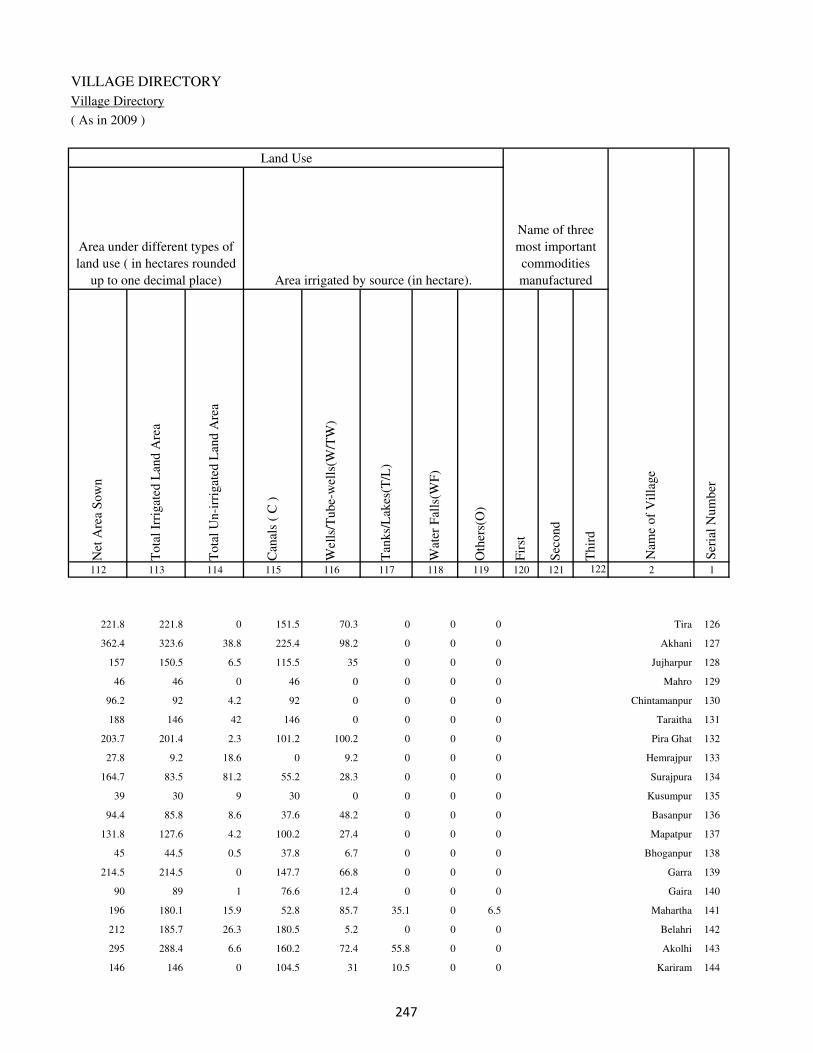
VILLAGE DIRECTORY
Village Directory
( As in 2009 )
Net
Are
a S
ow
n
Tota
l Ir
rigat
ed L
and A
rea
Tota
l U
n-i
rrig
ated
Lan
d A
rea
Can
als
( C
)
Wel
ls/T
ube-
wel
ls(W
/TW
)
Tan
ks/
Lak
es(T
/L)
Wat
er F
alls
(WF
)
Oth
ers(
O)
Fir
st
Sec
ond
Thir
d
112 113 114 115 116 117 118 119 120 121 122 2 1
Ser
ial
Num
ber
Name of three
most important
commodities
manufacturedArea irrigated by source (in hectare).
Nam
e of
Vil
lage
Area under different types of
land use ( in hectares rounded
up to one decimal place)
Land Use
221.8 221.8 0 151.5 70.3 0 0 0 Tira 126
362.4 323.6 38.8 225.4 98.2 0 0 0 Akhani 127
157 150.5 6.5 115.5 35 0 0 0 Jujharpur 128
46 46 0 46 0 0 0 0 Mahro 129
96.2 92 4.2 92 0 0 0 0 Chintamanpur 130
188 146 42 146 0 0 0 0 Taraitha 131
203.7 201.4 2.3 101.2 100.2 0 0 0 Pira Ghat 132
27.8 9.2 18.6 0 9.2 0 0 0 Hemrajpur 133
164.7 83.5 81.2 55.2 28.3 0 0 0 Surajpura 134
39 30 9 30 0 0 0 0 Kusumpur 135
94.4 85.8 8.6 37.6 48.2 0 0 0 Basanpur 136
131.8 127.6 4.2 100.2 27.4 0 0 0 Mapatpur 137
45 44.5 0.5 37.8 6.7 0 0 0 Bhoganpur 138
214.5 214.5 0 147.7 66.8 0 0 0 Garra 139
90 89 1 76.6 12.4 0 0 0 Gaira 140
196 180.1 15.9 52.8 85.7 35.1 0 6.5 Mahartha 141
212 185.7 26.3 180.5 5.2 0 0 0 Belahri 142
295 288.4 6.6 160.2 72.4 55.8 0 0 Akolhi 143
146 146 0 104.5 31 10.5 0 0 Kariram 144
��

DISTRICT CENSUS HANDBOOK : KAIMUR (BHABUA)
Census of India 2011-
Amenities and Land use
Pre
-Pri
mar
y s
chool
(PP
)
Pri
mar
y s
chool
(P)
Mid
dle
sch
ool
(M)
Sec
ondar
y S
chool
(S)
Sen
ior
Sec
ondar
y s
chool
(SS
)
Deg
ree
coll
ege
of
arts
sc
ience
& c
om
mer
ce
(AS
C)
Engin
eeri
ng c
oll
ege(
EC
)
Med
ical
coll
ege
(MC
)
Man
agem
ent
inst
itute
(M
I)
Poly
tech
nic
(P
t)
Voca
tional
tra
inin
g s
chool
/IT
I
Non-f
orm
al t
rain
ing c
entr
e (N
FT
C)
Spec
ial
school
for
dis
able
d (
SS
D)
Oth
ers
(spec
ify)
1 2 3 4 5 6 7 8 9 10 11 12 13 14 15 16 17 18 19 20
Loca
tion c
ode
no.
Nam
e vil
lage
Ser
ial
Num
ber
Tota
l popula
tion (
2011 c
ensu
s )
Tota
l ar
ea o
f th
e vil
lage
( in
hec
tare
s ro
unded
up t
o
one
dec
imal
pla
ce)
Number of educational amenities available. (If not available
within the village , the distance range code viz; a for < 5
Kms, b for 5-10 Kms and c for 10+ kms of nearest place
where facility is available is given).
Num
ber
of
house
hold
s (2
011 c
ensu
s)
145 Jaitpura 249068 321 2204 332 b 1 a c b c c c c c c c c
146 Bararhi 249069 130 486 63 a b b c b c c c c c c c c
147 Chhata Bararhi 249070 220 1873 272 b 1 1 c b c c c c c c c c
148 Pajrawan 249071 553 4546 617 1 1 1 c b c c c c c c c c
149 Rampur 249072 49 248 42 b 1 1 c a c c c c c c c c
150 Baddha 249073 193 2620 393 1 1 2 1 b c c c c c c c c
151 Partabpur 249074 85 906 150 a b 1 1 1 c c c c c c c c
152 Noawan 249075 178 5292 798 1 1 1 1 1 c c c c c c c c
153 Khudra 249076 176 2081 311 b b a c b c c c c c c c c
154 Gorsara 249077 190 2050 258 b 2 2 c b c c c c c c c c
155 Fatehpur 249078 126 0 0
156 Chaprang 249079 93 2630 420 b 2 2 c a c c c c c c c c
157 Nakta Ghat 249080 25 0 0
158 Ewati English 249081 36 0 0
159 Bhatwalia 249082 58 441 57 b 1 a c a c c c c c c c c
160 Deuria 249083 295 2162 298 b 1 a c a c c c c c c c c
161 Paranpur 249084 176 0 0
162 Bhupatpur 249085 46 0 0
163 Ewati Bhopatpur 249086 81 41 4 b a b c a c c c c c c c c
164 Goriari 249087 25 253 29 a 1 2 c a c c c c c c c c
165 Ewati 249088 274 5051 756 a 2 2 c a c c c c c c c c
��

VILLAGE DIRECTORY
Village Directory
( As in 2009 )
Com
munit
y h
ealt
h c
entr
e (C
HC
)
Pri
mar
y h
ealt
h c
entr
e (P
HC
)
Pri
mar
y h
ealt
h s
ub c
entr
e (P
HS
)
Mat
ernit
y a
nd c
hil
d w
elfa
re c
entr
e (M
CW
)
T.B
. cl
inic
(T
BC
)
Hosp
ital
-all
opat
hic
(H
A)
Hosp
ital
-alt
ernat
ive
med
icin
e (H
O)
Dis
pen
sary
(D
)
Vet
erin
ary h
osp
ital
(V
H)
Mobil
e hea
lth c
linic
(M
HC
)
Fam
ily w
elfa
re c
entr
e (F
WC
)
Char
itab
le n
on G
ovt.
hosp
ital
/Nurs
ing h
om
e.
Med
ical
pra
ctit
ioner
wit
h M
BB
S D
egre
e
Med
ical
pra
ctit
ioner
wit
h o
ther
deg
ree
Med
ical
pra
ctit
ioner
wit
h n
o d
egre
e
Tra
dit
ional
pra
ctit
ioner
an
d f
aith
hea
ler
.
Med
icin
e S
hop
Oth
ers
21 22 23 24 25 26 27 28 29 30 31 32 33 34 35 36 37 38 2 1
Number of Non-Government
Medical Amenities available.
Number of Medical Amenities available. (If not
available within the village , the distance range
code viz; a for < 5 Kms, b for 5-10 Kms and c
for 10+ kms of nearest place where facility is
available is given).
Nam
e vil
lage
Ser
ial
Num
ber
c b c b b c c b b c b 0 0 0 0 0 0 0 Jaitpura 145
a a a a a c c a a c a 0 2 2 2 2 2 2 Bararhi 146
b a a a a c c a a c a 0 0 0 0 0 0 2 Chhata Bararhi 147
b b b b b c c a a c a 0 0 0 0 0 0 0 Pajrawan 148
c c b b c c c b b c b 0 0 0 0 0 0 0 Rampur 149
c c b b c c c b a c b 0 0 0 0 0 0 0 Baddha 150
c c b b c c c b b c b 0 2 2 2 2 2 2 Partabpur 151
a b 1 1 c c c a a c 1 0 0 2 0 2 2 2 Noawan 152
b c b c c c c b c c b 0 0 0 0 0 0 0 Khudra 153
c b b c c c c a a c a 0 2 2 2 2 2 2 Gorsara 154
Fatehpur 155
c b b c c c c a a c a 0 2 2 2 2 2 2 Chaprang 156
Nakta Ghat 157
Ewati English 158
c b b c c c c b c c c 0 0 0 0 0 0 0 Bhatwalia 159
b b b b c c c b c c c 0 0 0 0 0 0 0 Deuria 160
Paranpur 161
Bhupatpur 162
b b b c c c c a a c c 0 0 0 0 0 0 0 Ewati Bhopatpur 163
c b b c c c c a a c a 0 2 2 2 2 2 2 Goriari 164
c b b c c c c a a c a 0 2 2 2 2 2 0 Ewati 165
��

DISTRICT CENSUS HANDBOOK : KAIMUR (BHABUA)
Census of India 2011-
Amenities and Land use
Tap
wat
er (
Tre
ated
/Untr
eate
d)
Wel
l w
ater
(Cover
ed /
Unco
ver
ed w
ell)
Han
d P
um
p
Tube
wel
ls /
Bore
wel
l
Spri
ng
Riv
er /
Can
al
Tan
k /
Pond /
L
ake
Oth
ers
Com
munit
y t
oil
et i
ncl
udin
g
bat
h.
Com
munit
y t
oil
et e
xcl
udin
g b
ath.
Rura
l s
anit
ary m
art
or
sanit
ary
har
dw
are
outl
et
avai
lable
nea
r th
e vil
lage.
Com
munit
y b
io-
gas
or
recy
cle
of
was
te f
or
pro
duct
ive
use
.
1 2 39 40 41 42 43 44 45 46 47 48 49 50
Availability of toilet & others
Yes / No Availability of drinking water - Yes / No
Nam
e vil
lage
Ser
ial
Num
ber
145 Jaitpura No Yes Yes No No No No No No No No No
146 Bararhi No Yes Yes No No Yes No No No No No No
147 Chhata Bararhi No Yes Yes No No Yes No No No No No No
148 Pajrawan No Yes Yes No No Yes No No No No No No
149 Rampur No Yes Yes Yes No No No No No No No No
150 Baddha No Yes Yes Yes No No No No No No No No
151 Partabpur No Yes Yes Yes No No No No No No No No
152 Noawan No Yes Yes No No Yes No No No No No No
153 Khudra No Yes Yes No No Yes No No No No No No
154 Gorsara No Yes Yes Yes No Yes No No No No No No
155 Fatehpur
156 Chaprang No Yes Yes Yes No Yes No No No No No No
157 Nakta Ghat
158 Ewati English
159 Bhatwalia No Yes Yes No No Yes No No No No No No
160 Deuria No Yes Yes No No Yes No No No No No No
161 Paranpur
162 Bhupatpur
163 Ewati Bhopatpur No Yes Yes Yes No Yes No No No No No No
164 Goriari No Yes Yes Yes No Yes No No No No No No
165 Ewati No Yes Yes Yes No Yes No No No No No No
��
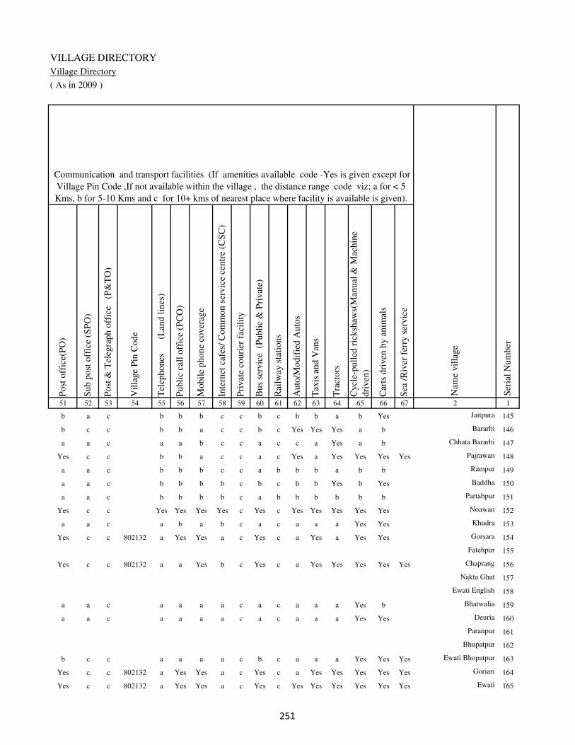
VILLAGE DIRECTORY
Village Directory
( As in 2009 )
Post
off
ice(
PO
)
Sub p
ost
off
ice
(SP
O)
Post
& T
eleg
raph o
ffic
e
(P&
TO
)
Vil
lage
Pin
Code
Tel
ephones
(L
and l
ines
)
Publi
c ca
ll o
ffic
e (P
CO
)
Mobil
e phone
cover
age
Inte
rnet
caf
es/
Com
mon s
ervic
e ce
ntr
e (C
SC
)
Pri
vat
e co
uri
er f
acil
ity
Bus
serv
ice
(P
ubli
c &
Pri
vat
e)
Rai
lway
sta
tions
Auto
/Modif
ied A
uto
s
Tax
is a
nd V
ans
Tra
ctors
Cycl
e-pull
ed r
icksh
aws(
Man
ual
& M
achin
e
dri
ven
)
Car
ts d
riven
by a
nim
als
Sea
/R
iver
fer
ry s
ervic
e51 52 53 54 55 56 57 58 59 60 61 62 63 64 65 66 67 2 1
Communication and transport facilities (If amenities available code -Yes is given except for
Village Pin Code ,If not available within the village , the distance range code viz; a for < 5
Kms, b for 5-10 Kms and c for 10+ kms of nearest place where facility is available is given).
Ser
ial
Num
ber
Nam
e vil
lage
b a c b b b c c b c b b a b Yes Jaitpura 145
b c c b b a c c b c Yes Yes Yes a b Bararhi 146
a a c a a b c c a c c a Yes a b Chhata Bararhi 147
Yes c c b b a c c a c Yes a Yes Yes Yes Yes Pajrawan 148
a a c b b b c c a b b b a b b Rampur 149
a a c b b b b c b c b b Yes b Yes Baddha 150
a a c b b b b c a b b b b b b Partabpur 151
Yes c c Yes Yes Yes Yes c Yes c Yes Yes Yes Yes Yes Noawan 152
a a c a b a b c a c a a a Yes Yes Khudra 153
Yes c c 802132 a Yes Yes a c Yes c a Yes a Yes Yes Gorsara 154
Fatehpur 155
Yes c c 802132 a a Yes b c Yes c a Yes Yes Yes Yes Yes Chaprang 156
Nakta Ghat 157
Ewati English 158
a a c a a a a c a c a a a Yes b Bhatwalia 159
a a c a a a a c a c a a a Yes Yes Deuria 160
Paranpur 161
Bhupatpur 162
b c c a a a a c b c a a a Yes Yes Yes Ewati Bhopatpur 163
Yes c c 802132 a Yes Yes a c Yes c a Yes Yes Yes Yes Yes Goriari 164
Yes c c 802132 a Yes Yes a c Yes c Yes Yes Yes Yes Yes Yes Ewati 165
��

DISTRICT CENSUS HANDBOOK : KAIMUR (BHABUA)
Census of India 2011-
Amenities and Land use
Connec
ted t
o n
atio
nal
hig
hw
ay(N
H)
Connec
ted t
o s
tate
hig
hw
ay(S
H)
Connec
ted t
o m
ajor
dis
tric
t ro
ad (
MD
R)
Connec
ted t
o o
ther
s dis
tric
t ro
ad
Pucc
a r
oad
s
Kutc
hch
a r
oad
s
Wat
er b
ounded
mac
adam
(WB
M)
road
s
Nav
igab
le w
ater
way
(ri
ver
/can
al)(
NW
)
Footp
aths
(FP
)
Com
mer
cial
& C
o-o
per
ativ
e B
anks
AT
M
Agri
cult
ura
l C
redit
Soci
etie
s
Sel
f-H
elp G
roup (
SH
G)
Publi
c dis
trib
uti
on s
yst
em (
PD
S)
shop
Man
dis
/ R
egula
r m
arket
Wee
kly
Haa
t
Agri
cult
ura
l m
arket
ing s
oci
ety
1 2 68 69 70 71 72 73 74 75 76 77 78 79 80 81 82 83 84
Village connected to highways,village roads, banks & credit
societies (If amenities available code -Yes is given, If not
available within the village , the distance range code viz; a
for < 5 Kms, b for 5-10 Kms and c for 10+ kms of nearest
place where facility is available is given).
Ser
ial
Num
ber
Nam
e vil
lage
Availability of miscellaneous
facilities (If amenities available
code -Yes is given, If not
available within the village , the
distance range code viz; a for <
5 Kms, b for 5-10 Kms and c
for 10+ kms of nearest place
where facility is available is
given) Contd....
145 Jaitpura c b Yes Yes a Yes a a Yes b b c b Yes c b b
146 Bararhi Yes b b b Yes Yes b c Yes b b c c Yes c b b
147 Chhata Bararhi Yes a a b Yes a b a Yes c a c b b c a b
148 Pajrawan c a a Yes Yes a a Yes Yes c a c b Yes c b b
149 Rampur c c Yes Yes a Yes a a Yes a a c b Yes c b b
150 Baddha c a Yes Yes a Yes a a Yes a a c c Yes c b c
151 Partabpur c a Yes Yes Yes a b a Yes a a c b Yes b c c
152 Noawan Yes b c b Yes a Yes b Yes Yes Yes b Yes Yes Yes c b
153 Khudra c a c Yes Yes a a b Yes b a b b a a b b
154 Gorsara c a Yes Yes Yes a a b Yes a a c b Yes b b c
155 Fatehpur
156 Chaprang a a Yes Yes Yes a a Yes Yes c a b b Yes b b c
157 Nakta Ghat
158 Ewati English
159 Bhatwalia c a c Yes Yes Yes a a Yes c a b c a a b c
160 Deuria Yes a c a Yes Yes a b Yes c a b b b b c c
161 Paranpur
162 Bhupatpur
163 Ewati Bhopatpur c b c b a Yes b Yes Yes c b b b a b b c
164 Goriari a a Yes Yes Yes a a Yes Yes c a b b Yes b b c
165 Ewati c a Yes Yes Yes a b Yes Yes c a b b Yes b b b
�

VILLAGE DIRECTORY
Village Directory
( As in 2009 )
Inte
gra
ted C
hil
d D
evel
opm
ent
Sch
eme
(Nutr
itio
nal
Cen
tres
)
Angan
wad
i C
entr
e (N
utr
itio
nal
Cen
tres
)
Oth
ers
(Nutr
itio
nal
Cen
tres
)
AS
HA
(A
ccre
dit
ed S
oci
al H
ealt
h A
ctiv
ist)
Com
munit
y c
entr
e w
ith/w
ithout
TV
Sport
s F
ield
,
Sport
s C
lub /
Rec
reat
ion C
entr
e
Cin
ema
/ V
ideo
Hal
l
Publi
c L
ibra
ry
Publi
c R
eadin
g R
oom
New
spap
er S
upply
Ass
embly
Poll
ing s
tati
on
Bir
th &
Dea
th R
egis
trat
ion O
ffic
e
Pow
er S
upply
for
Dom
esti
c U
se (
ED
)
Pow
er S
upply
for
Agri
cult
ura
l U
se (
EA
G)
Pow
er S
upply
for
Com
mer
cial
Use
(E
C)
Pow
er S
upply
for
All
Use
s (E
A)
85 86 87 88 89 90 91 92 93 94 95 96 97 98 99 100 101 2 1
Availability of
electricity (Yes/No)
Availability of miscellaneous facilities (If amenities available code -
Yes is given, If not available within the village , the distance range
code viz; a for < 5 Kms, b for 5-10 Kms and c for 10+ kms of
nearest place where facility is available is given) Concluded
Nam
e vil
lage
Ser
ial
Num
ber
c Yes Yes Yes c b c c c c a Yes a No No No No Jaitpura 145
b Yes Yes Yes c Yes c c c c b Yes Yes No No No No Bararhi 146
b Yes Yes Yes c Yes c c c c b Yes b No No No No Chhata Bararhi 147
b Yes Yes Yes c Yes Yes c c b Yes Yes Yes No No No No Pajrawan 148
c b Yes a c b b c c c b a a Yes Yes Yes Yes Rampur 149
c Yes Yes a c b b c c c b Yes b Yes Yes Yes Yes Baddha 150
c Yes Yes Yes c a b c c c c Yes b Yes Yes Yes Yes Partabpur 151
b Yes Yes Yes Yes Yes b c c b Yes Yes Yes Yes Yes Yes Yes Noawan 152
a Yes Yes Yes c Yes Yes c c c a Yes b Yes Yes No No Khudra 153
b Yes Yes Yes c b b c c c Yes Yes Yes No Yes No No Gorsara 154
Fatehpur 155
b Yes Yes Yes c Yes b c c c Yes Yes Yes No Yes No No Chaprang 156
Nakta Ghat 157
Ewati English 158
a b Yes a c b c c c c a a a No No No No Bhatwalia 159
a Yes Yes Yes c a b c c c b Yes b Yes Yes No No Deuria 160
Paranpur 161
Bhupatpur 162
b b Yes a c b c c c c b a a No Yes No No Ewati Bhopatpur 163
a Yes Yes Yes b Yes b c c c Yes Yes Yes No Yes No No Goriari 164
b Yes Yes Yes c Yes c c c c Yes Yes Yes No Yes No No Ewati 165
�
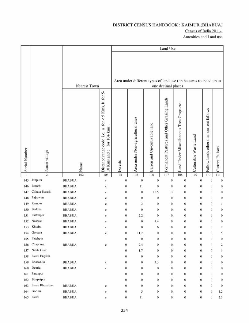
DISTRICT CENSUS HANDBOOK : KAIMUR (BHABUA)
Census of India 2011-
Amenities and Land use
Nam
e
Dis
tance
ran
ge
code
i.e
. a
fo
r <
5 K
ms,
b
for
5-
10 K
ms
and c
f
or
10+
km
s .
Fore
sts
Are
a under
Non-a
gri
cult
ura
l U
ses
Bar
ren a
nd U
n-c
ult
ivab
le l
and
Per
man
ent
Pas
ture
s an
d O
ther
Gra
zing L
ands
Lan
d U
nder
Mis
cell
aneo
us
Tre
e C
rops
etc.
Cult
ura
ble
Was
te L
and
Fal
low
lan
ds
oth
er t
han
curr
ent
fall
ow
s
Curr
ent
Fal
low
s
1 2 102 103 104 105 106 107 108 109 110 111
Ser
ial
Num
ber
Nam
e vil
lage
Area under different types of land use ( in hectares rounded up to
one decimal place)
Land Use
Nearest Town
145 Jaitpura BHABUA c 0 0 0 0 0 0 0 0
146 Bararhi BHABUA c 0 11 0 0 0 0 0 0
147 Chhata Bararhi BHABUA c 0 0 13.5 3 0 0 0 0
148 Pajrawan BHABUA c 0 0 0 0 0 0 0 0
149 Rampur BHABUA c 0 2 0 0 0 0 0 1
150 Baddha BHABUA c 0 0 0 0 0 0 0 0
151 Partabpur BHABUA c 0 2.2 0 0 0 0 0 0
152 Noawan BHABUA c 0 0 4.4 0 0 0 0 0
153 Khudra BHABUA c 0 0 6 0 0 0 0 2
154 Gorsara BHABUA c 0 11.2 0 0 0 0 0 5
155 Fatehpur 0 0 0 0 0 0 0 0
156 Chaprang BHABUA c 0 2.4 0 0 0 0 0 2
157 Nakta Ghat 0 1.7 0 0 0 0 0 1
158 Ewati English 0 0 0 0 0 0 0 0
159 Bhatwalia BHABUA c 0 0 4.3 0 0 0 0 0
160 Deuria BHABUA c 0 0 0 0 0 0 0 0
161 Paranpur 0 0 0 0 0 0 0 0
162 Bhupatpur 0 0 0 0 0 0 0 0
163 Ewati Bhopatpur BHABUA c 0 0 0 0 0 0 0 0
164 Goriari BHABUA c 0 5 0 0 0 0 0 1.2
165 Ewati BHABUA c 0 11 0 0 0 0 0 2.3
��

VILLAGE DIRECTORY
Village Directory
( As in 2009 )
Net
Are
a S
ow
n
Tota
l Ir
rigat
ed L
and A
rea
Tota
l U
n-i
rrig
ated
Lan
d A
rea
Can
als
( C
)
Wel
ls/T
ube-
wel
ls(W
/TW
)
Tan
ks/
Lak
es(T
/L)
Wat
er F
alls
(WF
)
Oth
ers(
O)
Fir
st
Sec
ond
Thir
d
112 113 114 115 116 117 118 119 120 121 122 2 1
Ser
ial
Num
ber
Name of three
most important
commodities
manufacturedArea irrigated by source (in hectare).
Nam
e of
Vil
lage
Area under different types of
land use ( in hectares rounded
up to one decimal place)
Land Use
321 315 6 270 45 0 0 0 Jaitpura 145
119 112 7 104 8 0 0 0 Bararhi 146
203.5 193.2 10.3 160.2 33 0 0 0 Chhata Bararhi 147
553 522.8 30.2 435.5 87.3 0 0 0 Pajrawan 148
46 44.5 1.5 36.2 8.3 0 0 0 Rampur 149
193 188.8 4.2 153.2 35.6 0 0 0 Baddha 150
82.8 76.6 6.2 64.5 12.1 0 0 0 Partabpur 151
173.6 137.4 36.2 98.6 38.8 0 0 0 Noawan 152
168 164.8 3.2 130.2 34.6 0 0 0 Khudra 153
173.8 163.6 10.2 120.9 38.5 4.2 0 0 Gorsara 154
126 120.5 5.5 120.5 0 0 0 0 Fatehpur 155
88.6 80.5 8.1 20.2 60.3 0 0 0 Chaprang 156
22.3 22.3 0 7.1 15.2 0 0 0 Nakta Ghat 157
36 28 8 0 28 0 0 0 Ewati English 158
53.7 48.6 5.1 28.6 20 0 0 0 Bhatwalia 159
295 295 0 209.6 85.4 0 0 0 Deuria 160
176 175 1 124.4 50.6 0 0 0 Paranpur 161
46 45 1 0 45 0 0 0 Bhupatpur 162
81 65.7 15.3 5.2 60.5 0 0 0 Ewati Bhopatpur 163
18.8 16.8 2 10.6 6.2 0 0 0 Goriari 164
260.7 133.7 127 0 133.7 0 0 0 Ewati 165
��

DISTRICT CENSUS HANDBOOK : KAIMUR (BHABUA)
Census of India 2011-
Amenities and Land use
Pre
-Pri
mar
y s
chool
(PP
)
Pri
mar
y s
chool
(P)
Mid
dle
sch
ool
(M)
Sec
ondar
y S
chool
(S)
Sen
ior
Sec
ondar
y s
chool
(SS
)
Deg
ree
coll
ege
of
arts
sc
ience
& c
om
mer
ce
(AS
C)
Engin
eeri
ng c
oll
ege(
EC
)
Med
ical
coll
ege
(MC
)
Man
agem
ent
inst
itute
(M
I)
Poly
tech
nic
(P
t)
Voca
tional
tra
inin
g s
chool
/IT
I
Non-f
orm
al t
rain
ing c
entr
e (N
FT
C)
Spec
ial
school
for
dis
able
d (
SS
D)
Oth
ers
(spec
ify)
1 2 3 4 5 6 7 8 9 10 11 12 13 14 15 16 17 18 19 20
Loca
tion c
ode
no.
Nam
e vil
lage
Ser
ial
Num
ber
Tota
l popula
tion (
2011 c
ensu
s )
Tota
l ar
ea o
f th
e vil
lage
( in
hec
tare
s ro
unded
up t
o
one
dec
imal
pla
ce)
Number of educational amenities available. (If not available
within the village , the distance range code viz; a for < 5
Kms, b for 5-10 Kms and c for 10+ kms of nearest place
where facility is available is given).
Num
ber
of
house
hold
s (2
011 c
ensu
s)
166 Sarae Bala 249089 195 0 0
167 Jaruman English 249090 28 0 0
168 Sonbarsa 249091 132 837 119 b 1 b c a c c c c c c c c
169 Sotwa 249092 172 909 118 b 1 b c a c c c c c c c c
170 Morath 249093 694 2282 347 b 1 1 c a c c c c c c c c
171 Mahila 249094 167 1488 230 b 1 a c a c c c c c c c c
172 Pariari 249095 467 1982 272 b 1 1 c a c c c c c c c c
173 Konahra 249096 113 1199 170 b 1 2 c b c c c c c c c c
174 Rampur 249097 133 169 21 b b b c a c c c c c c c c
175 Khairanti 249098 121 717 68 b 1 b c a c c c c c c c c
176 Chandes 249099 32 0 0
177 Harakhpur Chander 249100 180 0 0
178 Chandes 249101 413 3243 395 b 1 1 b a c c c c c c c c
179 Kamhari 249102 156 2119 275 b 2 2 c a c c c c c c c c
180 Sagra 249103 87 398 51 b 1 a c a c c c c c c c c
181 Banbahuara 249104 340 1583 213 b 1 2 1 a c c c c c c c c b
182 Parmanandpur 249105 47 0 0
183 Dumduma 249106 889 3601 491 b 2 b c a c c c c c c c c
184 kurhani 249107 110 1540 250 b 2 b c b c c c c c c c c
185 Guria 249108 87 450 102 b b a c b c c c c c c c c
��

VILLAGE DIRECTORY
Village Directory
( As in 2009 )
Com
munit
y h
ealt
h c
entr
e (C
HC
)
Pri
mar
y h
ealt
h c
entr
e (P
HC
)
Pri
mar
y h
ealt
h s
ub c
entr
e (P
HS
)
Mat
ernit
y a
nd c
hil
d w
elfa
re c
entr
e (M
CW
)
T.B
. cl
inic
(T
BC
)
Hosp
ital
-all
opat
hic
(H
A)
Hosp
ital
-alt
ernat
ive
med
icin
e (H
O)
Dis
pen
sary
(D
)
Vet
erin
ary h
osp
ital
(V
H)
Mobil
e hea
lth c
linic
(M
HC
)
Fam
ily w
elfa
re c
entr
e (F
WC
)
Char
itab
le n
on G
ovt.
hosp
ital
/Nurs
ing h
om
e.
Med
ical
pra
ctit
ioner
wit
h M
BB
S D
egre
e
Med
ical
pra
ctit
ioner
wit
h o
ther
deg
ree
Med
ical
pra
ctit
ioner
wit
h n
o d
egre
e
Tra
dit
ional
pra
ctit
ioner
an
d f
aith
hea
ler
.
Med
icin
e S
hop
Oth
ers
21 22 23 24 25 26 27 28 29 30 31 32 33 34 35 36 37 38 2 1
Number of Non-Government
Medical Amenities available.
Number of Medical Amenities available. (If not
available within the village , the distance range
code viz; a for < 5 Kms, b for 5-10 Kms and c
for 10+ kms of nearest place where facility is
available is given).
Nam
e vil
lage
Ser
ial
Num
ber
Sarae Bala 166
Jaruman English 167
b b b b b c c a b c b 0 2 2 2 2 2 2 Sonbarsa 168
b b b b b c c b b c b 1 2 0 0 0 0 0 Sotwa 169
c 1 1 1 1 c c 1 1 c 1 0 0 0 0 0 0 0 Morath 170
c c c c c c c a c c c 0 0 0 0 0 0 0 Mahila 171
c c 1 1 c c c c c c 1 0 0 0 2 1 0 0 Pariari 172
c b 1 1 b c c b b c 1 2 0 0 0 0 0 0 Konahra 173
c b b b b c c b b c b 0 0 0 0 0 0 0 Rampur 174
b b b b b c c b b c b 1 2 0 0 0 0 0 Khairanti 175
Chandes 176
Harakhpur Chander 177
c c a c c c c c c c c 2 0 0 0 0 0 0 Chandes 178
c c a c c c c c c c c 0 0 0 0 0 0 0 Kamhari 179
c c b c c c c c c c c 1 2 0 0 0 0 0 Sagra 180
b b b b b c c b b c b 0 0 0 0 0 0 0 Banbahuara 181
Parmanandpur 182
c 1 1 1 1 c c 1 1 c 1 0 0 1 0 0 0 0 Dumduma 183
c c c c c c c a a c c 0 0 0 0 0 0 0 kurhani 184
c c c a c c c c c c c 0 0 0 0 0 0 0 Guria 185
��
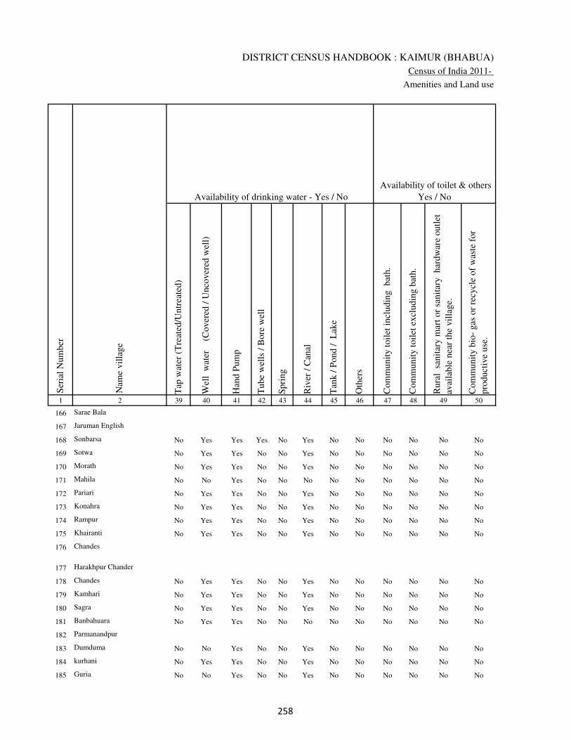
DISTRICT CENSUS HANDBOOK : KAIMUR (BHABUA)
Census of India 2011-
Amenities and Land use
Tap
wat
er (
Tre
ated
/Untr
eate
d)
Wel
l w
ater
(Cover
ed /
Unco
ver
ed w
ell)
Han
d P
um
p
Tube
wel
ls /
Bore
wel
l
Spri
ng
Riv
er /
Can
al
Tan
k /
Pond /
L
ake
Oth
ers
Com
munit
y t
oil
et i
ncl
udin
g
bat
h.
Com
munit
y t
oil
et e
xcl
udin
g b
ath.
Rura
l s
anit
ary m
art
or
sanit
ary
har
dw
are
outl
et
avai
lable
nea
r th
e vil
lage.
Com
munit
y b
io-
gas
or
recy
cle
of
was
te f
or
pro
duct
ive
use
.
1 2 39 40 41 42 43 44 45 46 47 48 49 50
Availability of toilet & others
Yes / No Availability of drinking water - Yes / No
Nam
e vil
lage
Ser
ial
Num
ber
166 Sarae Bala
167 Jaruman English
168 Sonbarsa No Yes Yes Yes No Yes No No No No No No
169 Sotwa No Yes Yes No No Yes No No No No No No
170 Morath No Yes Yes No No Yes No No No No No No
171 Mahila No No Yes No No No No No No No No No
172 Pariari No Yes Yes No No Yes No No No No No No
173 Konahra No Yes Yes No No Yes No No No No No No
174 Rampur No Yes Yes No No Yes No No No No No No
175 Khairanti No Yes Yes No No Yes No No No No No No
176 Chandes
177 Harakhpur Chander
178 Chandes No Yes Yes No No Yes No No No No No No
179 Kamhari No Yes Yes No No Yes No No No No No No
180 Sagra No Yes Yes No No Yes No No No No No No
181 Banbahuara No Yes Yes No No No No No No No No No
182 Parmanandpur
183 Dumduma No No Yes No No Yes No No No No No No
184 kurhani No Yes Yes No No Yes No No No No No No
185 Guria No No Yes No No Yes No No No No No No
��

VILLAGE DIRECTORY
Village Directory
( As in 2009 )
Post
off
ice(
PO
)
Sub p
ost
off
ice
(SP
O)
Post
& T
eleg
raph o
ffic
e
(P&
TO
)
Vil
lage
Pin
Code
Tel
ephones
(L
and l
ines
)
Publi
c ca
ll o
ffic
e (P
CO
)
Mobil
e phone
cover
age
Inte
rnet
caf
es/
Com
mon s
ervic
e ce
ntr
e (C
SC
)
Pri
vat
e co
uri
er f
acil
ity
Bus
serv
ice
(P
ubli
c &
Pri
vat
e)
Rai
lway
sta
tions
Auto
/Modif
ied A
uto
s
Tax
is a
nd V
ans
Tra
ctors
Cycl
e-pull
ed r
icksh
aws(
Man
ual
& M
achin
e
dri
ven
)
Car
ts d
riven
by a
nim
als
Sea
/R
iver
fer
ry s
ervic
e51 52 53 54 55 56 57 58 59 60 61 62 63 64 65 66 67 2 1
Communication and transport facilities (If amenities available code -Yes is given except for
Village Pin Code ,If not available within the village , the distance range code viz; a for < 5
Kms, b for 5-10 Kms and c for 10+ kms of nearest place where facility is available is given).
Ser
ial
Num
ber
Nam
e vil
lage
Sarae Bala 166
Jaruman English 167
b a c b b c b c b c c b Yes b b Sonbarsa 168
b a c Yes b Yes b b Yes c c b a b a c Sotwa 169
Yes Yes c 802132 Yes c b b c c c c b a b Yes c Morath 170
Yes c c b b b c c b c c b b b b Mahila 171
a c c b b b c c b c c b a a b Pariari 172
b a c Yes b a b c b c c b b b b c Konahra 173
b a c b b b b c b c c b b b b c Rampur 174
b a c 802132 Yes b Yes b b a c c b c b b c Khairanti 175
Chandes 176
Harakhpur Chander 177
Yes c c 802132 Yes c Yes c c Yes c c c Yes Yes Yes c Chandes 178
b c c Yes Yes b b c Yes c Yes Yes Yes Yes Yes c Kamhari 179
b a c Yes c Yes c c a c c b c a b c Sagra 180
b b c b b b b b b b b b b b b b Banbahuara 181
Parmanandpur 182
Yes a c Yes b Yes c c b c c Yes Yes Yes Yes c Dumduma 183
a a c Yes Yes c c b Yes b Yes Yes Yes Yes a c kurhani 184
a c c a Yes a c c Yes c c Yes Yes Yes b Guria 185
��

DISTRICT CENSUS HANDBOOK : KAIMUR (BHABUA)
Census of India 2011-
Amenities and Land use
Connec
ted t
o n
atio
nal
hig
hw
ay(N
H)
Connec
ted t
o s
tate
hig
hw
ay(S
H)
Connec
ted t
o m
ajor
dis
tric
t ro
ad (
MD
R)
Connec
ted t
o o
ther
s dis
tric
t ro
ad
Pucc
a r
oad
s
Kutc
hch
a r
oad
s
Wat
er b
ounded
mac
adam
(WB
M)
road
s
Nav
igab
le w
ater
way
(ri
ver
/can
al)(
NW
)
Footp
aths
(FP
)
Com
mer
cial
& C
o-o
per
ativ
e B
anks
AT
M
Agri
cult
ura
l C
redit
Soci
etie
s
Sel
f-H
elp G
roup (
SH
G)
Publi
c dis
trib
uti
on s
yst
em (
PD
S)
shop
Man
dis
/ R
egula
r m
arket
Wee
kly
Haa
t
Agri
cult
ura
l m
arket
ing s
oci
ety
1 2 68 69 70 71 72 73 74 75 76 77 78 79 80 81 82 83 84
Village connected to highways,village roads, banks & credit
societies (If amenities available code -Yes is given, If not
available within the village , the distance range code viz; a
for < 5 Kms, b for 5-10 Kms and c for 10+ kms of nearest
place where facility is available is given).
Ser
ial
Num
ber
Nam
e vil
lage
Availability of miscellaneous
facilities (If amenities available
code -Yes is given, If not
available within the village , the
distance range code viz; a for <
5 Kms, b for 5-10 Kms and c
for 10+ kms of nearest place
where facility is available is
given) Contd....
166 Sarae Bala
167 Jaruman English
168 Sonbarsa Yes b c Yes Yes Yes b a Yes c b c b a c b Yes
169 Sotwa c b c b b Yes Yes b Yes b b b b Yes c b b
170 Morath c c c c Yes Yes Yes b Yes b b c c Yes b b b
171 Mahila c Yes c c Yes Yes Yes a Yes c c c c a b b b
172 Pariari c c c b b a b a Yes c c c b b b b c
173 Konahra c Yes c b Yes Yes Yes Yes Yes b b b b a b b c
174 Rampur c b b b Yes Yes Yes b Yes c b b b a b b c
175 Khairanti c c b b Yes Yes Yes b Yes b b c c b b b b
176 Chandes
177 Harakhpur Chander
178 Chandes c c c c Yes Yes Yes b Yes c c c b Yes b Yes b
179 Kamhari Yes Yes Yes Yes Yes Yes Yes b Yes c c c b b b a b
180 Sagra c c c c a Yes a b Yes c c c b b b b b
181 Banbahuara b b b b b Yes b b Yes b b b b b b b b
182 Parmanandpur
183 Dumduma c c Yes Yes Yes Yes Yes Yes Yes c c c b b b b c
184 kurhani Yes Yes Yes Yes Yes Yes Yes Yes Yes c c c b Yes b b c
185 Guria c c Yes Yes a Yes Yes a Yes c c c b Yes b c c
��

VILLAGE DIRECTORY
Village Directory
( As in 2009 )
Inte
gra
ted C
hil
d D
evel
opm
ent
Sch
eme
(Nutr
itio
nal
Cen
tres
)
Angan
wad
i C
entr
e (N
utr
itio
nal
Cen
tres
)
Oth
ers
(Nutr
itio
nal
Cen
tres
)
AS
HA
(A
ccre
dit
ed S
oci
al H
ealt
h A
ctiv
ist)
Com
munit
y c
entr
e w
ith/w
ithout
TV
Sport
s F
ield
,
Sport
s C
lub /
Rec
reat
ion C
entr
e
Cin
ema
/ V
ideo
Hal
l
Publi
c L
ibra
ry
Publi
c R
eadin
g R
oom
New
spap
er S
upply
Ass
embly
Poll
ing s
tati
on
Bir
th &
Dea
th R
egis
trat
ion O
ffic
e
Pow
er S
upply
for
Dom
esti
c U
se (
ED
)
Pow
er S
upply
for
Agri
cult
ura
l U
se (
EA
G)
Pow
er S
upply
for
Com
mer
cial
Use
(E
C)
Pow
er S
upply
for
All
Use
s (E
A)
85 86 87 88 89 90 91 92 93 94 95 96 97 98 99 100 101 2 1
Availability of
electricity (Yes/No)
Availability of miscellaneous facilities (If amenities available code -
Yes is given, If not available within the village , the distance range
code viz; a for < 5 Kms, b for 5-10 Kms and c for 10+ kms of
nearest place where facility is available is given) Concluded
Nam
e vil
lage
Ser
ial
Num
ber
Sarae Bala 166
Jaruman English 167
a Yes Yes Yes c b c c c c a Yes Yes Yes Yes No No Sonbarsa 168
a Yes Yes Yes c b c c c c b Yes b No No No No Sotwa 169
Yes Yes Yes Yes c b c c c c b Yes b No No No No Morath 170
a Yes Yes a c b c c c c b Yes b No No No No Mahila 171
a Yes Yes Yes c b c c c c Yes Yes Yes No No No No Pariari 172
a Yes Yes Yes c b c c c c a a a No No No No Konahra 173
b b Yes a c c c c c c b a a No No No No Rampur 174
b Yes Yes Yes c b c c c c b Yes a No No No No Khairanti 175
Chandes 176
Harakhpur Chander 177
c Yes Yes Yes c b c c c c b Yes Yes No No No No Chandes 178
c Yes Yes Yes c Yes c c c c Yes Yes Yes Yes Yes No No Kamhari 179
c b Yes a c c c c c c a a a No No No No Sagra 180
c Yes Yes a c b c c c c b a a No No No No Banbahuara 181
Parmanandpur 182
c Yes Yes Yes c Yes c c c Yes Yes Yes a Yes Yes No No Dumduma 183
c Yes Yes Yes c Yes c c c c Yes Yes Yes Yes Yes No No kurhani 184
c Yes Yes Yes c Yes c c c c Yes Yes Yes Yes Yes No No Guria 185
��

DISTRICT CENSUS HANDBOOK : KAIMUR (BHABUA)
Census of India 2011-
Amenities and Land use
Nam
e
Dis
tance
ran
ge
code
i.e
. a
fo
r <
5 K
ms,
b
for
5-
10 K
ms
and c
f
or
10+
km
s .
Fore
sts
Are
a under
Non-a
gri
cult
ura
l U
ses
Bar
ren a
nd U
n-c
ult
ivab
le l
and
Per
man
ent
Pas
ture
s an
d O
ther
Gra
zing L
ands
Lan
d U
nder
Mis
cell
aneo
us
Tre
e C
rops
etc.
Cult
ura
ble
Was
te L
and
Fal
low
lan
ds
oth
er t
han
curr
ent
fall
ow
s
Curr
ent
Fal
low
s
1 2 102 103 104 105 106 107 108 109 110 111
Ser
ial
Num
ber
Nam
e vil
lage
Area under different types of land use ( in hectares rounded up to
one decimal place)
Land Use
Nearest Town
166 Sarae Bala 0 20.5 0 0 0 0 0 3
167 Jaruman English 0 1 0 0 0 0 0 1
168 Sonbarsa BHABUA c 0 0 1.5 0 0 0 0 3.5
169 Sotwa BHABUA c 0 3 0 0 0 0 0 1
170 Morath BHABUA c 0 9 0 0 0 0 0 10
171 Mahila BHABUA c 0 7 0 0 0 0 0 8.5
172 Pariari BHABUA c 0 6.6 0 0 0 0 0 0
173 Konahra BHABUA c 0 1.8 0 0 0 0 0 0
174 Rampur BHABUA c 0 0 0 0 0 0 0 0
175 Khairanti BHABUA c 0 0 0 0 0 0 0 0
176 Chandes 0 1.5 0 0 0 0 0 1
177 Harakhpur Chander 0 25.2 0 0 0 0 0 10.4
178 Chandes BHABUA c 0 19.6 0 0 0 0 0 0
179 Kamhari BHABUA c 0 7.2 0 0 0 1 0.5 0
180 Sagra BHABUA c 0 5 0 0 0 0 0 7
181 Banbahuara BHABUA c 0 16 22 0 0 0 0 0
182 Parmanandpur 0 0 0 0 0 0 0 0
183 Dumduma BHABUA c 0 13.2 0 2 0 8.4 0 0
184 kurhani BHABUA c 0 6.2 0 0 0 0 0 2
185 Guria BHABUA c 0 4.4 0 0 0 0 0 2
�
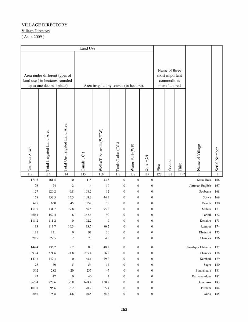
VILLAGE DIRECTORY
Village Directory
( As in 2009 )
Net
Are
a S
ow
n
Tota
l Ir
rigat
ed L
and A
rea
Tota
l U
n-i
rrig
ated
Lan
d A
rea
Can
als
( C
)
Wel
ls/T
ube-
wel
ls(W
/TW
)
Tan
ks/
Lak
es(T
/L)
Wat
er F
alls
(WF
)
Oth
ers(
O)
Fir
st
Sec
ond
Thir
d
112 113 114 115 116 117 118 119 120 121 122 2 1
Ser
ial
Num
ber
Name of three
most important
commodities
manufacturedArea irrigated by source (in hectare).
Nam
e of
Vil
lage
Area under different types of
land use ( in hectares rounded
up to one decimal place)
Land Use
171.5 161.5 10 118 43.5 0 0 0 Sarae Bala 166
26 24 2 14 10 0 0 0 Jaruman English 167
127 120.2 6.8 108.2 12 0 0 0 Sonbarsa 168
168 152.5 15.5 108.2 44.3 0 0 0 Sotwa 169
675 630 45 552 78 0 0 0 Morath 170
151.5 131.7 19.8 56.5 75.2 0 0 0 Mahila 171
460.4 452.4 8 362.4 90 0 0 0 Pariari 172
111.2 111.2 0 102.2 9 0 0 0 Konahra 173
133 113.7 19.3 33.5 80.2 0 0 0 Rampur 174
121 121 0 91 30 0 0 0 Khairanti 175
29.5 27.5 2 23 4.5 0 0 0 Chandes 176
144.4 136.2 8.2 88 48.2 0 0 0 Harakhpur Chander 177
393.4 371.6 21.8 285.4 86.2 0 0 0 Chandes 178
147.3 147.3 0 68.1 79.2 0 0 0 Kamhari 179
75 70 5 54 16 0 0 0 Sagra 180
302 282 20 237 45 0 0 0 Banbahuara 181
47 47 0 40 7 0 0 0 Parmanandpur 182
865.4 828.6 36.8 698.4 130.2 0 0 0 Dumduma 183
101.8 95.6 6.2 70.2 25.4 0 0 0 kurhani 184
80.6 75.8 4.8 40.5 35.3 0 0 0 Guria 185
�

DISTRICT CENSUS HANDBOOK : KAIMUR (BHABUA)
Census of India 2011-
Amenities and Land use
Pre
-Pri
mar
y s
chool
(PP
)
Pri
mar
y s
chool
(P)
Mid
dle
sch
ool
(M)
Sec
ondar
y S
chool
(S)
Sen
ior
Sec
ondar
y s
chool
(SS
)
Deg
ree
coll
ege
of
arts
sc
ience
& c
om
mer
ce
(AS
C)
Engin
eeri
ng c
oll
ege(
EC
)
Med
ical
coll
ege
(MC
)
Man
agem
ent
inst
itute
(M
I)
Poly
tech
nic
(P
t)
Voca
tional
tra
inin
g s
chool
/IT
I
Non-f
orm
al t
rain
ing c
entr
e (N
FT
C)
Spec
ial
school
for
dis
able
d (
SS
D)
Oth
ers
(spec
ify)
1 2 3 4 5 6 7 8 9 10 11 12 13 14 15 16 17 18 19 20
Loca
tion c
ode
no.
Nam
e vil
lage
Ser
ial
Num
ber
Tota
l popula
tion (
2011 c
ensu
s )
Tota
l ar
ea o
f th
e vil
lage
( in
hec
tare
s ro
unded
up t
o
one
dec
imal
pla
ce)
Number of educational amenities available. (If not available
within the village , the distance range code viz; a for < 5
Kms, b for 5-10 Kms and c for 10+ kms of nearest place
where facility is available is given).
Num
ber
of
house
hold
s (2
011 c
ensu
s)
186 Mukhrawan 249109 1354 7245 1140 b 1 1 c b c c c c c c c c c
187 Lahang Patti 249110 66 437 43 b 1 1 c b c c c c c c c c c
188 Kathaunra 249111 54 513 70 b b a c b c c c c c b c c b
189 Ramkarpur 249112 83 0 0
190 Madhopur 249113 24 0 0
191 Bhatpurwa 249114 51 732 98 b b b c b c c c c c c c c
192
kota Hissa Safdar Ali
Khan 249115 257 1843 260 b 1 a c b c c c c c c c c
193 Kota Hissa 249116 242 1764 249 b 1 1 c b c c c c c c c c
194 Kota Jadunath Singh 249117 134 0 0
195 Kota 249118 57 0 0
196 Chaubepur 249119 34 733 84 b b b c c c c c c c c c c
197 Chintamanpur 249120 20 0 0
198 Gaura 249121 105 846 107 b b b c b c c c c c c c c
199 Karamhari 249122 498 1154 175 b 1 a c b c c c c c c c c
200 Parasia 249123 342 1050 158 b 2 1 c b c c c c c c c c
201 Rasanandpur 249124 53 0 0
202 Bhaluhari 249125 45 0 0
203 Darabpur 249126 59 0 0
204 Hemrajpur 249127 56 0 0
205 Dungurpura 249128 66 372 50 b 1 b c b c c c c c c c c
��
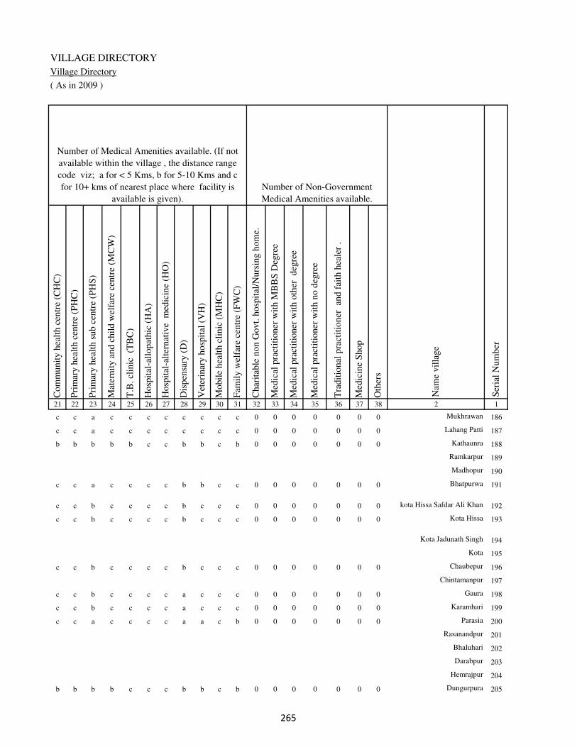
VILLAGE DIRECTORY
Village Directory
( As in 2009 )
Com
munit
y h
ealt
h c
entr
e (C
HC
)
Pri
mar
y h
ealt
h c
entr
e (P
HC
)
Pri
mar
y h
ealt
h s
ub c
entr
e (P
HS
)
Mat
ernit
y a
nd c
hil
d w
elfa
re c
entr
e (M
CW
)
T.B
. cl
inic
(T
BC
)
Hosp
ital
-all
opat
hic
(H
A)
Hosp
ital
-alt
ernat
ive
med
icin
e (H
O)
Dis
pen
sary
(D
)
Vet
erin
ary h
osp
ital
(V
H)
Mobil
e hea
lth c
linic
(M
HC
)
Fam
ily w
elfa
re c
entr
e (F
WC
)
Char
itab
le n
on G
ovt.
hosp
ital
/Nurs
ing h
om
e.
Med
ical
pra
ctit
ioner
wit
h M
BB
S D
egre
e
Med
ical
pra
ctit
ioner
wit
h o
ther
deg
ree
Med
ical
pra
ctit
ioner
wit
h n
o d
egre
e
Tra
dit
ional
pra
ctit
ioner
an
d f
aith
hea
ler
.
Med
icin
e S
hop
Oth
ers
21 22 23 24 25 26 27 28 29 30 31 32 33 34 35 36 37 38 2 1
Number of Non-Government
Medical Amenities available.
Number of Medical Amenities available. (If not
available within the village , the distance range
code viz; a for < 5 Kms, b for 5-10 Kms and c
for 10+ kms of nearest place where facility is
available is given).
Nam
e vil
lage
Ser
ial
Num
ber
c c a c c c c c c c c 0 0 0 0 0 0 0 Mukhrawan 186
c c a c c c c c c c c 0 0 0 0 0 0 0 Lahang Patti 187
b b b b b c c b b c b 0 0 0 0 0 0 0 Kathaunra 188
Ramkarpur 189
Madhopur 190
c c a c c c c b b c c 0 0 0 0 0 0 0 Bhatpurwa 191
c c b c c c c b c c c 0 0 0 0 0 0 0 kota Hissa Safdar Ali Khan 192
c c b c c c c b c c c 0 0 0 0 0 0 0 Kota Hissa 193
Kota Jadunath Singh 194
Kota 195
c c b c c c c b c c c 0 0 0 0 0 0 0 Chaubepur 196
Chintamanpur 197
c c b c c c c a c c c 0 0 0 0 0 0 0 Gaura 198
c c b c c c c a c c c 0 0 0 0 0 0 0 Karamhari 199
c c a c c c c a a c b 0 0 0 0 0 0 0 Parasia 200
Rasanandpur 201
Bhaluhari 202
Darabpur 203
Hemrajpur 204
b b b b c c c b b c b 0 0 0 0 0 0 0 Dungurpura 205
��
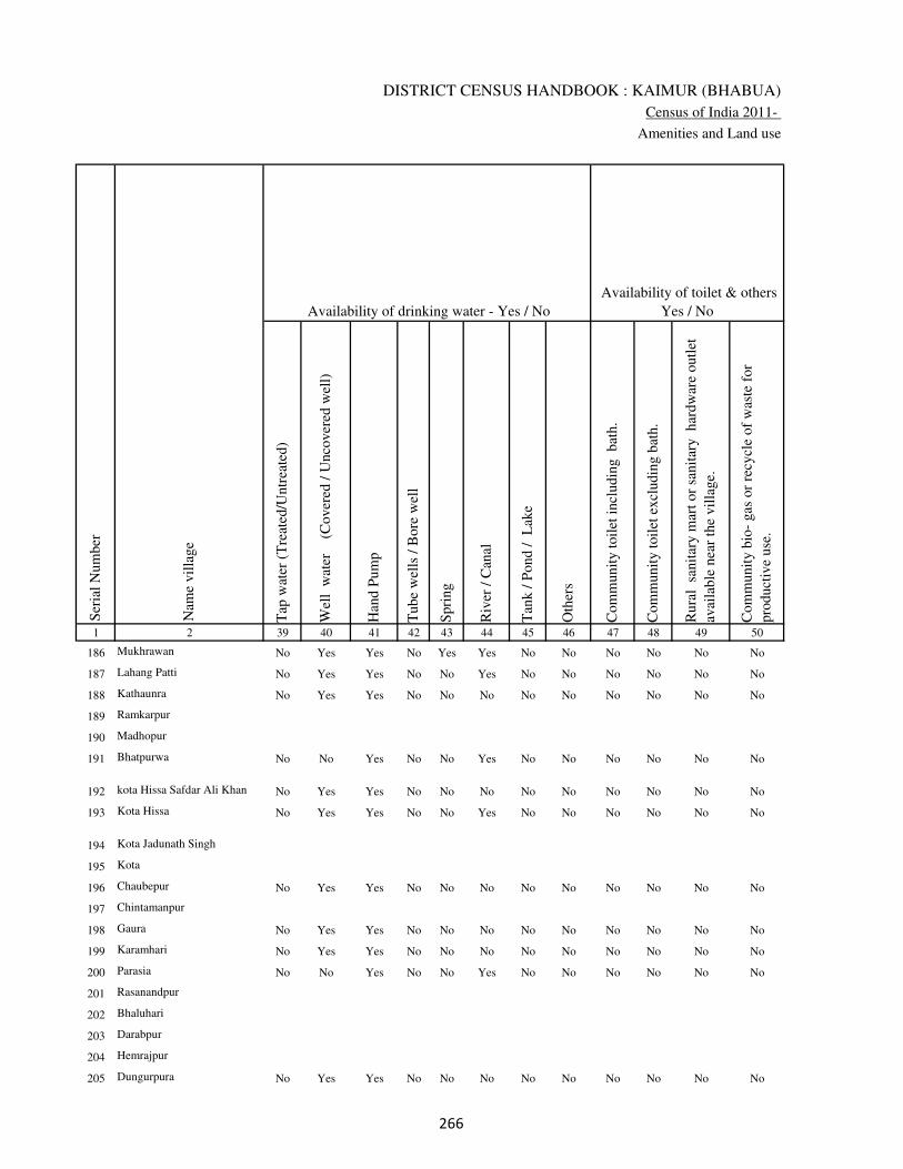
DISTRICT CENSUS HANDBOOK : KAIMUR (BHABUA)
Census of India 2011-
Amenities and Land use
Tap
wat
er (
Tre
ated
/Untr
eate
d)
Wel
l w
ater
(Cover
ed /
Unco
ver
ed w
ell)
Han
d P
um
p
Tube
wel
ls /
Bore
wel
l
Spri
ng
Riv
er /
Can
al
Tan
k /
Pond /
L
ake
Oth
ers
Com
munit
y t
oil
et i
ncl
udin
g
bat
h.
Com
munit
y t
oil
et e
xcl
udin
g b
ath.
Rura
l s
anit
ary m
art
or
sanit
ary
har
dw
are
outl
et
avai
lable
nea
r th
e vil
lage.
Com
munit
y b
io-
gas
or
recy
cle
of
was
te f
or
pro
duct
ive
use
.
1 2 39 40 41 42 43 44 45 46 47 48 49 50
Availability of toilet & others
Yes / No Availability of drinking water - Yes / No
Nam
e vil
lage
Ser
ial
Num
ber
186 Mukhrawan No Yes Yes No Yes Yes No No No No No No
187 Lahang Patti No Yes Yes No No Yes No No No No No No
188 Kathaunra No Yes Yes No No No No No No No No No
189 Ramkarpur
190 Madhopur
191 Bhatpurwa No No Yes No No Yes No No No No No No
192 kota Hissa Safdar Ali Khan No Yes Yes No No No No No No No No No
193 Kota Hissa No Yes Yes No No Yes No No No No No No
194 Kota Jadunath Singh
195 Kota
196 Chaubepur No Yes Yes No No No No No No No No No
197 Chintamanpur
198 Gaura No Yes Yes No No No No No No No No No
199 Karamhari No Yes Yes No No No No No No No No No
200 Parasia No No Yes No No Yes No No No No No No
201 Rasanandpur
202 Bhaluhari
203 Darabpur
204 Hemrajpur
205 Dungurpura No Yes Yes No No No No No No No No No
��
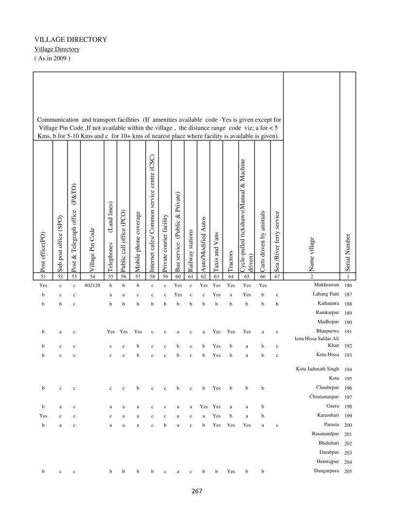
VILLAGE DIRECTORY
Village Directory
( As in 2009 )
Post
off
ice(
PO
)
Sub p
ost
off
ice
(SP
O)
Post
& T
eleg
raph o
ffic
e
(P&
TO
)
Vil
lage
Pin
Code
Tel
ephones
(L
and l
ines
)
Publi
c ca
ll o
ffic
e (P
CO
)
Mobil
e phone
cover
age
Inte
rnet
caf
es/
Com
mon s
ervic
e ce
ntr
e (C
SC
)
Pri
vat
e co
uri
er f
acil
ity
Bus
serv
ice
(P
ubli
c &
Pri
vat
e)
Rai
lway
sta
tions
Auto
/Modif
ied A
uto
s
Tax
is a
nd V
ans
Tra
ctors
Cycl
e-pull
ed r
icksh
aws(
Man
ual
& M
achin
e
dri
ven
)
Car
ts d
riven
by a
nim
als
Sea
/R
iver
fer
ry s
ervic
e51 52 53 54 55 56 57 58 59 60 61 62 63 64 65 66 67 2 1
Communication and transport facilities (If amenities available code -Yes is given except for
Village Pin Code ,If not available within the village , the distance range code viz; a for < 5
Kms, b for 5-10 Kms and c for 10+ kms of nearest place where facility is available is given).
Ser
ial
Num
ber
Nam
e vil
lage
Yes c c 802128 b b b c c Yes c Yes Yes Yes Yes Yes Mukhrawan 186
b c c a a c c c Yes c c Yes a Yes b c Lahang Patti 187
b b c b b b b b b b b b b b b b Kathaunra 188
Ramkarpur 189
Madhopur 190
b a c Yes Yes Yes c c a c a Yes Yes Yes a c Bhatpurwa 191
b c c c c b c c b c b Yes b a b c
kota Hissa Safdar Ali
Khan 192
b c c c c b c c b c b Yes b a b c Kota Hissa 193
Kota Jadunath Singh 194
Kota 195
b c c c c b c c b c b Yes b b b Chaubepur 196
Chintamanpur 197
b a c a a a c c a a Yes Yes a a b Gaura 198
Yes c c c a a c c a c a Yes b a b Karamhari 199
b a c a a a c b a c b Yes Yes Yes a c Parasia 200
Rasanandpur 201
Bhaluhari 202
Darabpur 203
Hemrajpur 204
b c c b b b b c a c b b Yes b b Dungurpura 205
��

DISTRICT CENSUS HANDBOOK : KAIMUR (BHABUA)
Census of India 2011-
Amenities and Land use
Connec
ted t
o n
atio
nal
hig
hw
ay(N
H)
Connec
ted t
o s
tate
hig
hw
ay(S
H)
Connec
ted t
o m
ajor
dis
tric
t ro
ad (
MD
R)
Connec
ted t
o o
ther
s dis
tric
t ro
ad
Pucc
a r
oad
s
Kutc
hch
a r
oad
s
Wat
er b
ounded
mac
adam
(WB
M)
road
s
Nav
igab
le w
ater
way
(ri
ver
/can
al)(
NW
)
Footp
aths
(FP
)
Com
mer
cial
& C
o-o
per
ativ
e B
anks
AT
M
Agri
cult
ura
l C
redit
Soci
etie
s
Sel
f-H
elp G
roup (
SH
G)
Publi
c dis
trib
uti
on s
yst
em (
PD
S)
shop
Man
dis
/ R
egula
r m
arket
Wee
kly
Haa
t
Agri
cult
ura
l m
arket
ing s
oci
ety
1 2 68 69 70 71 72 73 74 75 76 77 78 79 80 81 82 83 84
Village connected to highways,village roads, banks & credit
societies (If amenities available code -Yes is given, If not
available within the village , the distance range code viz; a
for < 5 Kms, b for 5-10 Kms and c for 10+ kms of nearest
place where facility is available is given).
Ser
ial
Num
ber
Nam
e vil
lage
Availability of miscellaneous
facilities (If amenities available
code -Yes is given, If not
available within the village , the
distance range code viz; a for <
5 Kms, b for 5-10 Kms and c
for 10+ kms of nearest place
where facility is available is
given) Contd....
186 Mukhrawan c c c Yes Yes Yes Yes a Yes c c c b Yes b b c
187 Lahang Patti c b b b Yes Yes Yes b Yes c c c b Yes b b b
188 Kathaunra b b b b b Yes b a Yes b b b b b b b b
189 Ramkarpur
190 Madhopur
191 Bhatpurwa c Yes Yes Yes Yes Yes Yes b Yes c c Yes b Yes b b b
192
kota Hissa Safdar Ali
Khan b c b Yes b Yes b b Yes c c b b b b b c
193 Kota Hissa b c c Yes Yes a a b Yes c c b b Yes b b b
194 Kota Jadunath Singh
195 Kota
196 Chaubepur b c a b Yes a a b Yes c c b b a b a c
197 Chintamanpur
198 Gaura a c a a Yes b a a Yes c c c b a a a c
199 Karamhari b c a b Yes a b a Yes c c c b Yes b b c
200 Parasia c Yes Yes Yes Yes Yes Yes b Yes c c a b b b b b
201 Rasanandpur
202 Bhaluhari
203 Darabpur
204 Hemrajpur
205 Dungurpura c a a a b Yes b b Yes c c c b b b b b
��

VILLAGE DIRECTORY
Village Directory
( As in 2009 )
Inte
gra
ted C
hil
d D
evel
opm
ent
Sch
eme
(Nutr
itio
nal
Cen
tres
)
Angan
wad
i C
entr
e (N
utr
itio
nal
Cen
tres
)
Oth
ers
(Nutr
itio
nal
Cen
tres
)
AS
HA
(A
ccre
dit
ed S
oci
al H
ealt
h A
ctiv
ist)
Com
munit
y c
entr
e w
ith/w
ithout
TV
Sport
s F
ield
,
Sport
s C
lub /
Rec
reat
ion C
entr
e
Cin
ema
/ V
ideo
Hal
l
Publi
c L
ibra
ry
Publi
c R
eadin
g R
oom
New
spap
er S
upply
Ass
embly
Poll
ing s
tati
on
Bir
th &
Dea
th R
egis
trat
ion O
ffic
e
Pow
er S
upply
for
Dom
esti
c U
se (
ED
)
Pow
er S
upply
for
Agri
cult
ura
l U
se (
EA
G)
Pow
er S
upply
for
Com
mer
cial
Use
(E
C)
Pow
er S
upply
for
All
Use
s (E
A)
85 86 87 88 89 90 91 92 93 94 95 96 97 98 99 100 101 2 1
Availability of
electricity (Yes/No)
Availability of miscellaneous facilities (If amenities available code -
Yes is given, If not available within the village , the distance range
code viz; a for < 5 Kms, b for 5-10 Kms and c for 10+ kms of
nearest place where facility is available is given) Concluded
Nam
e vil
lage
Ser
ial
Num
ber
c Yes Yes Yes c b c c c c Yes Yes Yes No No No No Mukhrawan 186
c Yes Yes Yes c b c c c c b Yes b No No No No Lahang Patti 187
c Yes Yes Yes c b c c c c b Yes b No No No No Kathaunra 188
Ramkarpur 189
Madhopur 190
c Yes Yes a c Yes c c c c Yes a Yes Yes Yes No No Bhatpurwa 191
c Yes Yes a c c c c c c a a a Yes Yes No No
kota Hissa Safdar Ali
Khan 192
c Yes Yes a c b c c c c b a a Yes Yes No No Kota Hissa 193
Kota Jadunath Singh 194
Kota 195
c a b b c c c c c c b a Yes Yes Yes No No Chaubepur 196
Chintamanpur 197
c Yes Yes a c c c c c c b Yes b Yes Yes No No Gaura 198
c Yes c a c b c c c c b Yes b Yes Yes No No Karamhari 199
c Yes Yes Yes c Yes c c c c b Yes Yes Yes Yes No No Parasia 200
Rasanandpur 201
Bhaluhari 202
Darabpur 203
Hemrajpur 204
b Yes Yes Yes c b c c c c b a a Yes Yes No No Dungurpura 205
��

DISTRICT CENSUS HANDBOOK : KAIMUR (BHABUA)
Census of India 2011-
Amenities and Land use
Nam
e
Dis
tance
ran
ge
code
i.e
. a
fo
r <
5 K
ms,
b
for
5-
10 K
ms
and c
f
or
10+
km
s .
Fore
sts
Are
a under
Non-a
gri
cult
ura
l U
ses
Bar
ren a
nd U
n-c
ult
ivab
le l
and
Per
man
ent
Pas
ture
s an
d O
ther
Gra
zing L
ands
Lan
d U
nder
Mis
cell
aneo
us
Tre
e C
rops
etc.
Cult
ura
ble
Was
te L
and
Fal
low
lan
ds
oth
er t
han
curr
ent
fall
ow
s
Curr
ent
Fal
low
s
1 2 102 103 104 105 106 107 108 109 110 111
Ser
ial
Num
ber
Nam
e vil
lage
Area under different types of land use ( in hectares rounded up to
one decimal place)
Land Use
Nearest Town
186 Mukhrawan BHABUA c 0 15.2 0 0 0 0 0 0
187 Lahang Patti BHABUA c 0 0 0 0 0 0 0 0
188 Kathaunra BHABUA c 0 2 3.2 0 0 0 0 0
189 Ramkarpur 0 0 0 0 0 0 0 0
190 Madhopur 0 0 0 0 0 0 0 0
191 Bhatpurwa BHABUA c 0 7 0 0 0 0 0 0
192
kota Hissa Safdar Ali
Khan BHABUA c 0 13.2 10.5 1.5 0 0 10 5.2
193 Kota Hissa BHABUA c 0 0 0 0 0 0 0 0
194 Kota Jadunath Singh 0 0 0 0 0 0 0 0
195 Kota 0 0 0 0 0 0 0 0
196 Chaubepur BHABUA c 0 1 0 0 0 0 0 2
197 Chintamanpur 0 0 0 0 0 0 0 0
198 Gaura BHABUA c 0 18.2 0 0 0 0 3.6 3.2
199 Karamhari BHABUA c 0 12.3 12.5 5.2 5 0 10 10.5
200 Parasia BHABUA c 0 6.4 0 0 0 0 0 0
201 Rasanandpur 0 0 0 0 0 0 0 0
202 Bhaluhari 0 0 0 0 0 0 0 0
203 Darabpur 0 0 0 0 0 0 0 0
204 Hemrajpur 0 0 0 0 0 0 0 0
205 Dungurpura BHABUA c 0 3 0 0 0 0 0 0
��
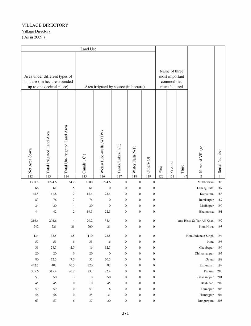
VILLAGE DIRECTORY
Village Directory
( As in 2009 )
Net
Are
a S
ow
n
Tota
l Ir
rigat
ed L
and A
rea
Tota
l U
n-i
rrig
ated
Lan
d A
rea
Can
als
( C
)
Wel
ls/T
ube-
wel
ls(W
/TW
)
Tan
ks/
Lak
es(T
/L)
Wat
er F
alls
(WF
)
Oth
ers(
O)
Fir
st
Sec
ond
Thir
d
112 113 114 115 116 117 118 119 120 121 122 2 1
Ser
ial
Num
ber
Name of three
most important
commodities
manufacturedArea irrigated by source (in hectare).
Nam
e of
Vil
lage
Area under different types of
land use ( in hectares rounded
up to one decimal place)
Land Use
1338.8 1274.6 64.2 1000 274.6 0 0 0 Mukhrawan 186
66 61 5 61 0 0 0 0 Lahang Patti 187
48.8 41.8 7 18.4 23.4 0 0 0 Kathaunra 188
83 76 7 76 0 0 0 0 Ramkarpur 189
24 20 4 20 0 0 0 0 Madhopur 190
44 42 2 19.5 22.5 0 0 0 Bhatpurwa 191
216.6 202.6 14 170.2 32.4 0 0 0 kota Hissa Safdar Ali Khan 192
242 221 21 200 21 0 0 0 Kota Hissa 193
134 132.5 1.5 110 22.5 0 0 0 Kota Jadunath Singh 194
57 51 6 35 16 0 0 0 Kota 195
31 28.5 2.5 16 12.5 0 0 0 Chaubepur 196
20 20 0 20 0 0 0 0 Chintamanpur 197
80 72.5 7.5 52 20.5 0 0 0 Gaura 198
442.5 402 40.5 320 82 0 0 0 Karamhari 199
335.6 315.4 20.2 233 82.4 0 0 0 Parasia 200
53 50 3 0 50 0 0 0 Rasanandpur 201
45 45 0 0 45 0 0 0 Bhaluhari 202
59 59 0 53 6 0 0 0 Darabpur 203
56 56 0 25 31 0 0 0 Hemrajpur 204
63 57 6 37 20 0 0 0 Dungurpura 205
��

DISTRICT CENSUS HANDBOOK : KAIMUR (BHABUA)
Census of India 2011-
Amenities and Land use
Pre
-Pri
mar
y s
chool
(PP
)
Pri
mar
y s
chool
(P)
Mid
dle
sch
ool
(M)
Sec
ondar
y S
chool
(S)
Sen
ior
Sec
ondar
y s
chool
(SS
)
Deg
ree
coll
ege
of
arts
sc
ience
& c
om
mer
ce
(AS
C)
Engin
eeri
ng c
oll
ege(
EC
)
Med
ical
coll
ege
(MC
)
Man
agem
ent
inst
itute
(M
I)
Poly
tech
nic
(P
t)
Voca
tional
tra
inin
g s
chool
/IT
I
Non-f
orm
al t
rain
ing c
entr
e (N
FT
C)
Spec
ial
school
for
dis
able
d (
SS
D)
Oth
ers
(spec
ify)
1 2 3 4 5 6 7 8 9 10 11 12 13 14 15 16 17 18 19 20
Loca
tion c
ode
no.
Nam
e vil
lage
Ser
ial
Num
ber
Tota
l popula
tion (
2011 c
ensu
s )
Tota
l ar
ea o
f th
e vil
lage
( in
hec
tare
s ro
unded
up t
o
one
dec
imal
pla
ce)
Number of educational amenities available. (If not available
within the village , the distance range code viz; a for < 5
Kms, b for 5-10 Kms and c for 10+ kms of nearest place
where facility is available is given).
Num
ber
of
house
hold
s (2
011 c
ensu
s)
206 Sarbasipur 249129 43 142 17 b b b c b c c c c c c c c
207 Kanhua 249130 205 740 93 a 1 b c b c c c c c c c c
208 Rashidpur 249131 18 0 0
209 Ruhiya 249132 57 470 77 b 1 b c b c c c c c c c c
210 Darauli 249133 237 1975 265 a 1 b c b c c c c c c c c
211 Shahpur 249134 34 0 0
212 Musia 249135 45 913 116 b b b c b c c c c c c c c b
213 Parsotimpur 249136 80 731 88 b 1 b c b c c c c c c c c
214 Belarhi 249137 138 1355 191 a 1 b c b c c c c c c c c
215 Chandraui 249138 102 460 54 b b b c b c c c c c c c c
216 Gai Chakl 249139 72 80 12 b a a c b c c c c c c c c
217 Baruna 249140 62 1782 262 a a b c a c c c c c c c c
Block T O T A L : 15880 106530 15263 4 59 34 5 2 0 0 0 0 0 0 0 0 0
�
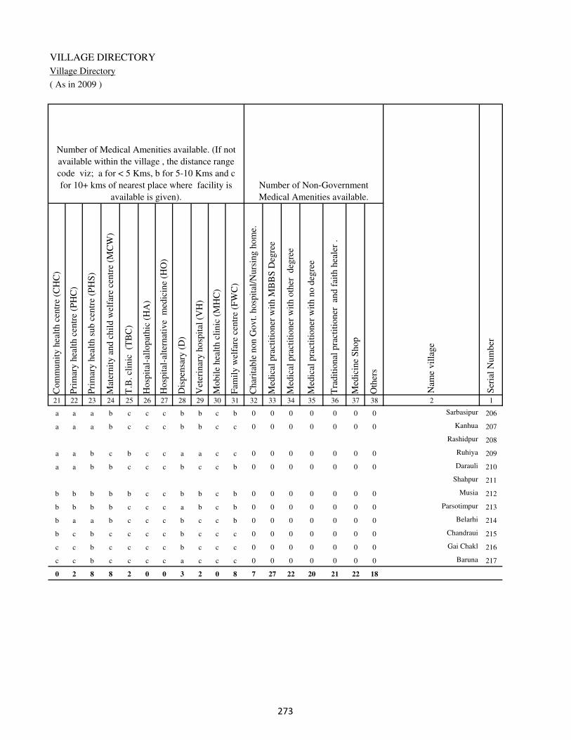
VILLAGE DIRECTORY
Village Directory
( As in 2009 )
Com
munit
y h
ealt
h c
entr
e (C
HC
)
Pri
mar
y h
ealt
h c
entr
e (P
HC
)
Pri
mar
y h
ealt
h s
ub c
entr
e (P
HS
)
Mat
ernit
y a
nd c
hil
d w
elfa
re c
entr
e (M
CW
)
T.B
. cl
inic
(T
BC
)
Hosp
ital
-all
opat
hic
(H
A)
Hosp
ital
-alt
ernat
ive
med
icin
e (H
O)
Dis
pen
sary
(D
)
Vet
erin
ary h
osp
ital
(V
H)
Mobil
e hea
lth c
linic
(M
HC
)
Fam
ily w
elfa
re c
entr
e (F
WC
)
Char
itab
le n
on G
ovt.
hosp
ital
/Nurs
ing h
om
e.
Med
ical
pra
ctit
ioner
wit
h M
BB
S D
egre
e
Med
ical
pra
ctit
ioner
wit
h o
ther
deg
ree
Med
ical
pra
ctit
ioner
wit
h n
o d
egre
e
Tra
dit
ional
pra
ctit
ioner
an
d f
aith
hea
ler
.
Med
icin
e S
hop
Oth
ers
21 22 23 24 25 26 27 28 29 30 31 32 33 34 35 36 37 38 2 1
Number of Non-Government
Medical Amenities available.
Number of Medical Amenities available. (If not
available within the village , the distance range
code viz; a for < 5 Kms, b for 5-10 Kms and c
for 10+ kms of nearest place where facility is
available is given).
Nam
e vil
lage
Ser
ial
Num
ber
a a a b c c c b b c b 0 0 0 0 0 0 0 Sarbasipur 206
a a a b c c c b b c c 0 0 0 0 0 0 0 Kanhua 207
Rashidpur 208
a a b c b c c a a c c 0 0 0 0 0 0 0 Ruhiya 209
a a b b c c c b c c b 0 0 0 0 0 0 0 Darauli 210
Shahpur 211
b b b b b c c b b c b 0 0 0 0 0 0 0 Musia 212
b b b b c c c a b c b 0 0 0 0 0 0 0 Parsotimpur 213
b a a b c c c b c c b 0 0 0 0 0 0 0 Belarhi 214
b c b c c c c b c c c 0 0 0 0 0 0 0 Chandraui 215
c c b c c c c b c c c 0 0 0 0 0 0 0 Gai Chakl 216
c c b c c c c a c c c 0 0 0 0 0 0 0 Baruna 217
0 2 8 8 2 0 0 3 2 0 8 7 27 22 20 21 22 18
�
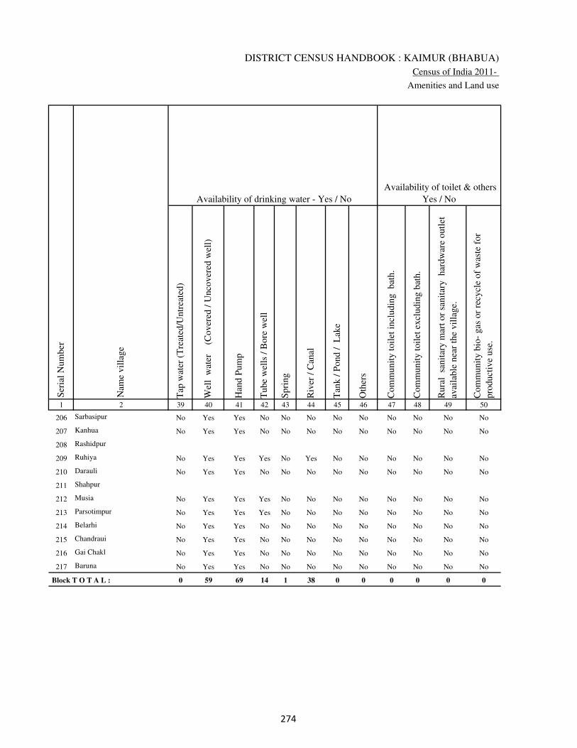
DISTRICT CENSUS HANDBOOK : KAIMUR (BHABUA)
Census of India 2011-
Amenities and Land use
Tap
wat
er (
Tre
ated
/Untr
eate
d)
Wel
l w
ater
(Cover
ed /
Unco
ver
ed w
ell)
Han
d P
um
p
Tube
wel
ls /
Bore
wel
l
Spri
ng
Riv
er /
Can
al
Tan
k /
Pond /
L
ake
Oth
ers
Com
munit
y t
oil
et i
ncl
udin
g
bat
h.
Com
munit
y t
oil
et e
xcl
udin
g b
ath.
Rura
l s
anit
ary m
art
or
sanit
ary
har
dw
are
outl
et
avai
lable
nea
r th
e vil
lage.
Com
munit
y b
io-
gas
or
recy
cle
of
was
te f
or
pro
duct
ive
use
.
1 2 39 40 41 42 43 44 45 46 47 48 49 50
Availability of toilet & others
Yes / No Availability of drinking water - Yes / No
Nam
e vil
lage
Ser
ial
Num
ber
206 Sarbasipur No Yes Yes No No No No No No No No No
207 Kanhua No Yes Yes No No No No No No No No No
208 Rashidpur
209 Ruhiya No Yes Yes Yes No Yes No No No No No No
210 Darauli No Yes Yes No No No No No No No No No
211 Shahpur
212 Musia No Yes Yes Yes No No No No No No No No
213 Parsotimpur No Yes Yes Yes No No No No No No No No
214 Belarhi No Yes Yes No No No No No No No No No
215 Chandraui No Yes Yes No No No No No No No No No
216 Gai Chakl No Yes Yes No No No No No No No No No
217 Baruna No Yes Yes No No No No No No No No No
Block T O T A L : 0 59 69 14 1 38 0 0 0 0 0 0
��
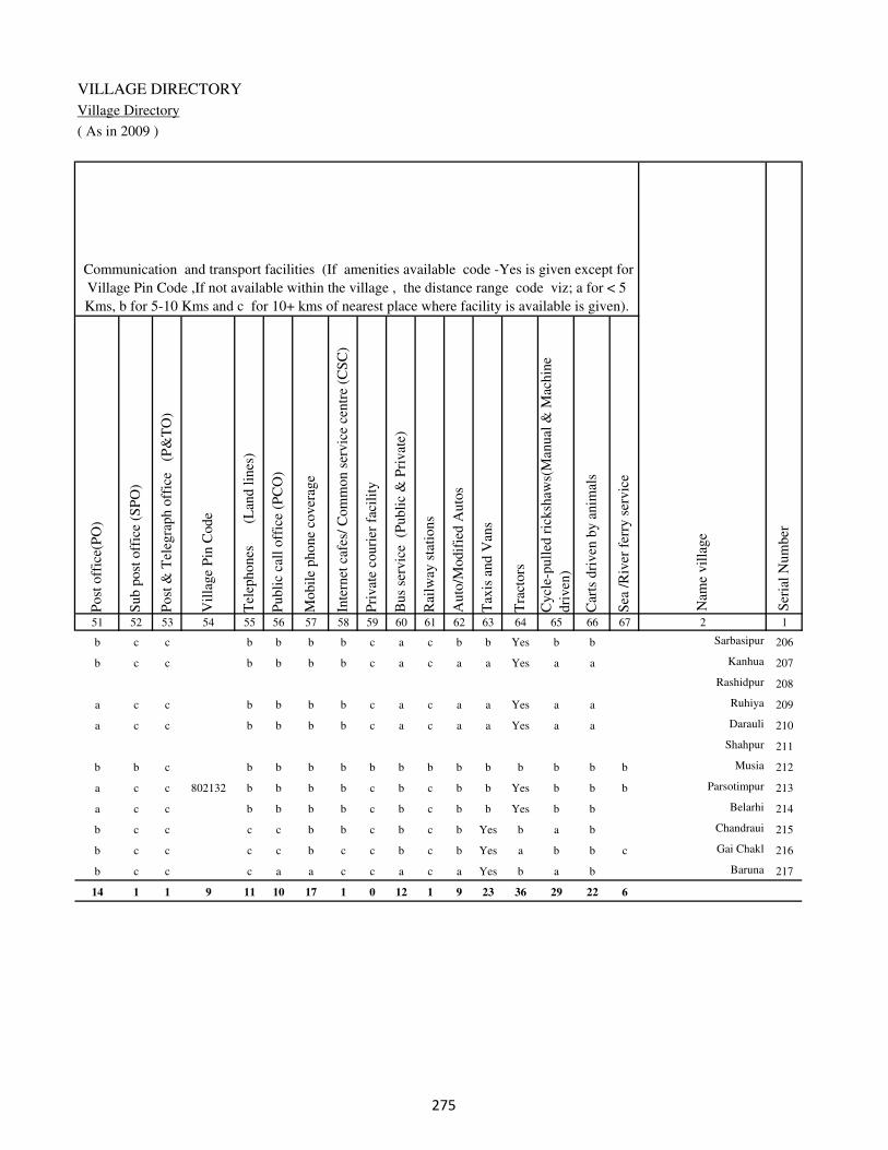
VILLAGE DIRECTORY
Village Directory
( As in 2009 )
Post
off
ice(
PO
)
Sub p
ost
off
ice
(SP
O)
Post
& T
eleg
raph o
ffic
e
(P&
TO
)
Vil
lage
Pin
Code
Tel
ephones
(L
and l
ines
)
Publi
c ca
ll o
ffic
e (P
CO
)
Mobil
e phone
cover
age
Inte
rnet
caf
es/
Com
mon s
ervic
e ce
ntr
e (C
SC
)
Pri
vat
e co
uri
er f
acil
ity
Bus
serv
ice
(P
ubli
c &
Pri
vat
e)
Rai
lway
sta
tions
Auto
/Modif
ied A
uto
s
Tax
is a
nd V
ans
Tra
ctors
Cycl
e-pull
ed r
icksh
aws(
Man
ual
& M
achin
e
dri
ven
)
Car
ts d
riven
by a
nim
als
Sea
/R
iver
fer
ry s
ervic
e51 52 53 54 55 56 57 58 59 60 61 62 63 64 65 66 67 2 1
Communication and transport facilities (If amenities available code -Yes is given except for
Village Pin Code ,If not available within the village , the distance range code viz; a for < 5
Kms, b for 5-10 Kms and c for 10+ kms of nearest place where facility is available is given).
Ser
ial
Num
ber
Nam
e vil
lage
b c c b b b b c a c b b Yes b b Sarbasipur 206
b c c b b b b c a c a a Yes a a Kanhua 207
Rashidpur 208
a c c b b b b c a c a a Yes a a Ruhiya 209
a c c b b b b c a c a a Yes a a Darauli 210
Shahpur 211
b b c b b b b b b b b b b b b b Musia 212
a c c 802132 b b b b c b c b b Yes b b b Parsotimpur 213
a c c b b b b c b c b b Yes b b Belarhi 214
b c c c c b b c b c b Yes b a b Chandraui 215
b c c c c b c c b c b Yes a b b c Gai Chakl 216
b c c c a a c c a c a Yes b a b Baruna 217
14 1 1 9 11 10 17 1 0 12 1 9 23 36 29 22 6
��
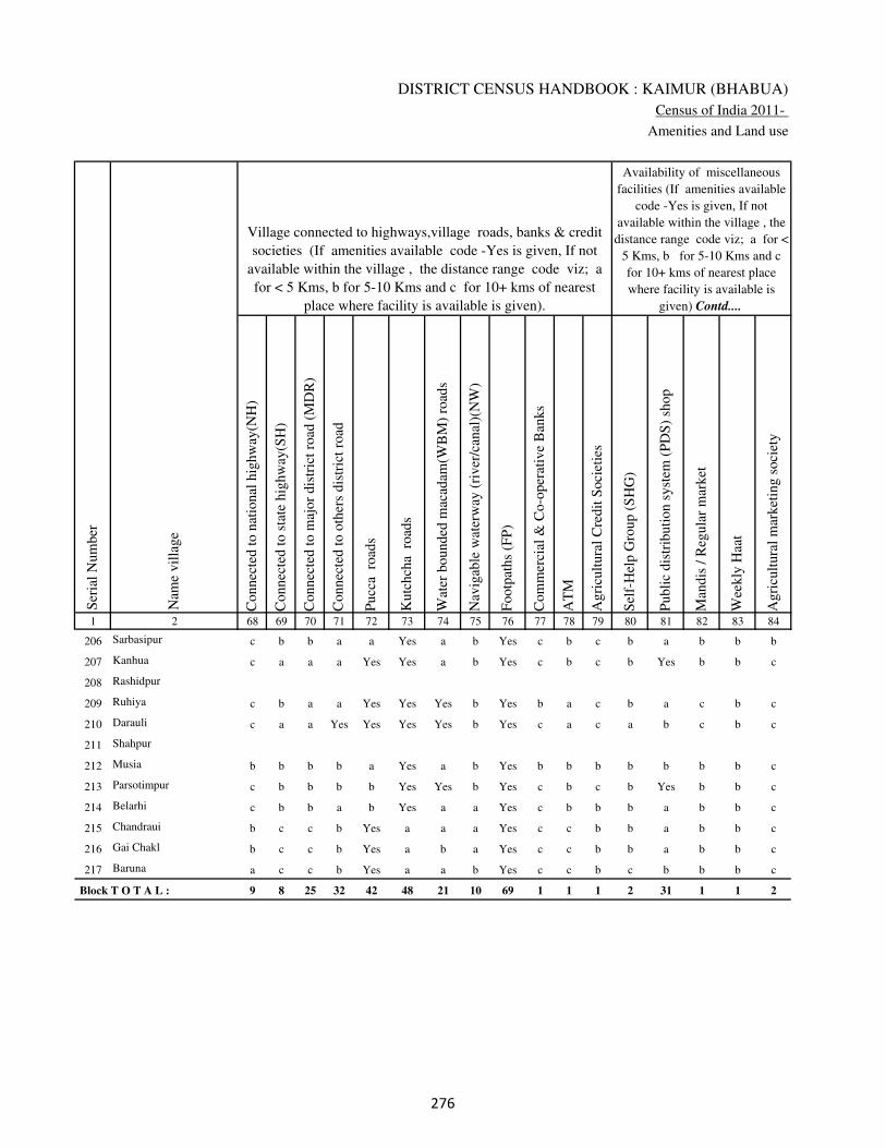
DISTRICT CENSUS HANDBOOK : KAIMUR (BHABUA)
Census of India 2011-
Amenities and Land use
Connec
ted t
o n
atio
nal
hig
hw
ay(N
H)
Connec
ted t
o s
tate
hig
hw
ay(S
H)
Connec
ted t
o m
ajor
dis
tric
t ro
ad (
MD
R)
Connec
ted t
o o
ther
s dis
tric
t ro
ad
Pucc
a r
oad
s
Kutc
hch
a r
oad
s
Wat
er b
ounded
mac
adam
(WB
M)
road
s
Nav
igab
le w
ater
way
(ri
ver
/can
al)(
NW
)
Footp
aths
(FP
)
Com
mer
cial
& C
o-o
per
ativ
e B
anks
AT
M
Agri
cult
ura
l C
redit
Soci
etie
s
Sel
f-H
elp G
roup (
SH
G)
Publi
c dis
trib
uti
on s
yst
em (
PD
S)
shop
Man
dis
/ R
egula
r m
arket
Wee
kly
Haa
t
Agri
cult
ura
l m
arket
ing s
oci
ety
1 2 68 69 70 71 72 73 74 75 76 77 78 79 80 81 82 83 84
Village connected to highways,village roads, banks & credit
societies (If amenities available code -Yes is given, If not
available within the village , the distance range code viz; a
for < 5 Kms, b for 5-10 Kms and c for 10+ kms of nearest
place where facility is available is given).
Ser
ial
Num
ber
Nam
e vil
lage
Availability of miscellaneous
facilities (If amenities available
code -Yes is given, If not
available within the village , the
distance range code viz; a for <
5 Kms, b for 5-10 Kms and c
for 10+ kms of nearest place
where facility is available is
given) Contd....
206 Sarbasipur c b b a a Yes a b Yes c b c b a b b b
207 Kanhua c a a a Yes Yes a b Yes c b c b Yes b b c
208 Rashidpur
209 Ruhiya c b a a Yes Yes Yes b Yes b a c b a c b c
210 Darauli c a a Yes Yes Yes Yes b Yes c a c a b c b c
211 Shahpur
212 Musia b b b b a Yes a b Yes b b b b b b b c
213 Parsotimpur c b b b b Yes Yes b Yes c b c b Yes b b c
214 Belarhi c b b a b Yes a a Yes c b b b a b b c
215 Chandraui b c c b Yes a a a Yes c c b b a b b c
216 Gai Chakl b c c b Yes a b a Yes c c b b a b b c
217 Baruna a c c b Yes a a b Yes c c b c b b b c
Block T O T A L : 9 8 25 32 42 48 21 10 69 1 1 1 2 31 1 1 2
��
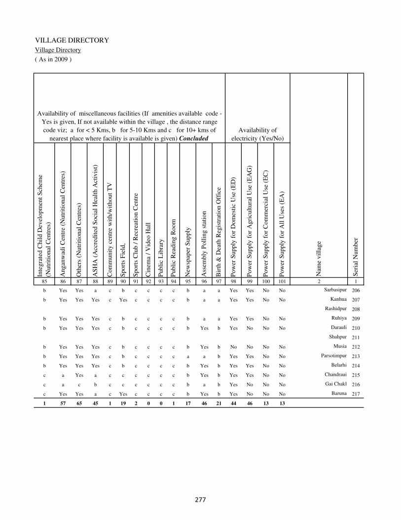
VILLAGE DIRECTORY
Village Directory
( As in 2009 )
Inte
gra
ted C
hil
d D
evel
opm
ent
Sch
eme
(Nutr
itio
nal
Cen
tres
)
Angan
wad
i C
entr
e (N
utr
itio
nal
Cen
tres
)
Oth
ers
(Nutr
itio
nal
Cen
tres
)
AS
HA
(A
ccre
dit
ed S
oci
al H
ealt
h A
ctiv
ist)
Com
munit
y c
entr
e w
ith/w
ithout
TV
Sport
s F
ield
,
Sport
s C
lub /
Rec
reat
ion C
entr
e
Cin
ema
/ V
ideo
Hal
l
Publi
c L
ibra
ry
Publi
c R
eadin
g R
oom
New
spap
er S
upply
Ass
embly
Poll
ing s
tati
on
Bir
th &
Dea
th R
egis
trat
ion O
ffic
e
Pow
er S
upply
for
Dom
esti
c U
se (
ED
)
Pow
er S
upply
for
Agri
cult
ura
l U
se (
EA
G)
Pow
er S
upply
for
Com
mer
cial
Use
(E
C)
Pow
er S
upply
for
All
Use
s (E
A)
85 86 87 88 89 90 91 92 93 94 95 96 97 98 99 100 101 2 1
Availability of
electricity (Yes/No)
Availability of miscellaneous facilities (If amenities available code -
Yes is given, If not available within the village , the distance range
code viz; a for < 5 Kms, b for 5-10 Kms and c for 10+ kms of
nearest place where facility is available is given) Concluded
Nam
e vil
lage
Ser
ial
Num
ber
b Yes Yes a c b c c c c b a a Yes Yes No No Sarbasipur 206
b Yes Yes Yes c Yes c c c c b a a Yes Yes No No Kanhua 207
Rashidpur 208
b Yes Yes Yes c b c c c c b a a Yes Yes No No Ruhiya 209
b Yes Yes Yes c b c c c c b Yes b Yes No No No Darauli 210
Shahpur 211
b Yes Yes Yes c b c c c c b Yes b No No No No Musia 212
b Yes Yes Yes c b c c c c a a b Yes Yes No No Parsotimpur 213
b Yes Yes Yes c b c c c c b Yes b Yes Yes No No Belarhi 214
c a Yes a c c c c c c b Yes b Yes Yes No No Chandraui 215
c a c b c c c c c c b a b Yes No No No Gai Chakl 216
c Yes Yes a c Yes c c c c b Yes b Yes No No No Baruna 217
1 57 65 45 1 19 2 0 0 1 17 46 21 44 46 13 13
��
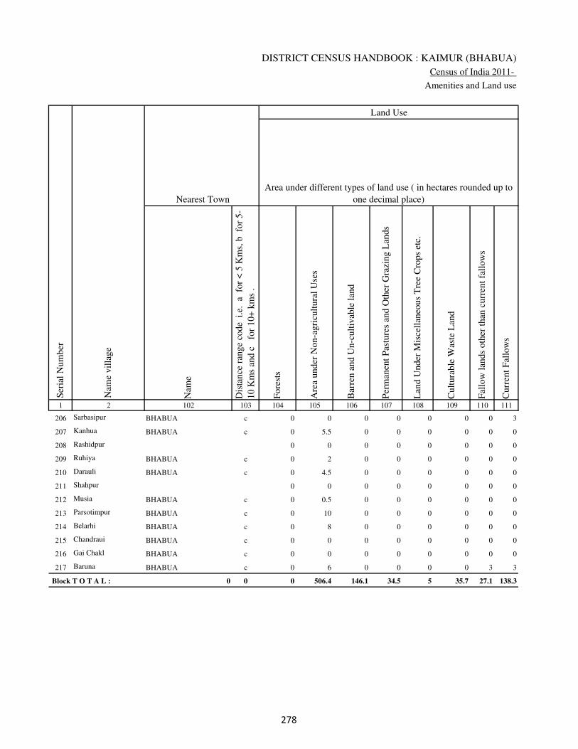
DISTRICT CENSUS HANDBOOK : KAIMUR (BHABUA)
Census of India 2011-
Amenities and Land use
Nam
e
Dis
tance
ran
ge
code
i.e
. a
fo
r <
5 K
ms,
b
for
5-
10 K
ms
and c
f
or
10+
km
s .
Fore
sts
Are
a under
Non-a
gri
cult
ura
l U
ses
Bar
ren a
nd U
n-c
ult
ivab
le l
and
Per
man
ent
Pas
ture
s an
d O
ther
Gra
zing L
ands
Lan
d U
nder
Mis
cell
aneo
us
Tre
e C
rops
etc.
Cult
ura
ble
Was
te L
and
Fal
low
lan
ds
oth
er t
han
curr
ent
fall
ow
s
Curr
ent
Fal
low
s
1 2 102 103 104 105 106 107 108 109 110 111
Ser
ial
Num
ber
Nam
e vil
lage
Area under different types of land use ( in hectares rounded up to
one decimal place)
Land Use
Nearest Town
206 Sarbasipur BHABUA c 0 0 0 0 0 0 0 3
207 Kanhua BHABUA c 0 5.5 0 0 0 0 0 0
208 Rashidpur 0 0 0 0 0 0 0 0
209 Ruhiya BHABUA c 0 2 0 0 0 0 0 0
210 Darauli BHABUA c 0 4.5 0 0 0 0 0 0
211 Shahpur 0 0 0 0 0 0 0 0
212 Musia BHABUA c 0 0.5 0 0 0 0 0 0
213 Parsotimpur BHABUA c 0 10 0 0 0 0 0 0
214 Belarhi BHABUA c 0 8 0 0 0 0 0 0
215 Chandraui BHABUA c 0 0 0 0 0 0 0 0
216 Gai Chakl BHABUA c 0 0 0 0 0 0 0 0
217 Baruna BHABUA c 0 6 0 0 0 0 3 3
Block T O T A L : 0 0 0 506.4 146.1 34.5 5 35.7 27.1 138.3
��
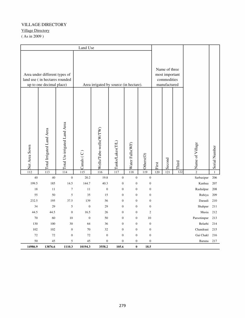
VILLAGE DIRECTORY
Village Directory
( As in 2009 )
Net
Are
a S
ow
n
Tota
l Ir
rigat
ed L
and A
rea
Tota
l U
n-i
rrig
ated
Lan
d A
rea
Can
als
( C
)
Wel
ls/T
ube-
wel
ls(W
/TW
)
Tan
ks/
Lak
es(T
/L)
Wat
er F
alls
(WF
)
Oth
ers(
O)
Fir
st
Sec
ond
Thir
d
112 113 114 115 116 117 118 119 120 121 122 2 1
Ser
ial
Num
ber
Name of three
most important
commodities
manufacturedArea irrigated by source (in hectare).
Nam
e of
Vil
lage
Area under different types of
land use ( in hectares rounded
up to one decimal place)
Land Use
40 40 0 20.2 19.8 0 0 0 Sarbasipur 206
199.5 185 14.5 144.7 40.3 0 0 0 Kanhua 207
18 11 7 11 0 0 0 0 Rashidpur 208
55 50 5 35 15 0 0 0 Ruhiya 209
232.5 195 37.5 139 56 0 0 0 Darauli 210
34 29 5 0 29 0 0 0 Shahpur 211
44.5 44.5 0 16.5 26 0 0 2 Musia 212
70 60 10 0 50 0 0 10 Parsotimpur 213
130 100 30 64 36 0 0 0 Belarhi 214
102 102 0 70 32 0 0 0 Chandraui 215
72 72 0 72 0 0 0 0 Gai Chakl 216
50 45 5 45 0 0 0 0 Baruna 217
14986.9 13876.6 1110.3 10194.3 3558.2 105.6 0 18.5
��

DISTRICT CENSUS HANDBOOK : KAIMUR (BHABUA)
Census of India 2011-
Amenities and Land use
Pre
-Pri
mar
y s
chool
(PP
)
Pri
mar
y s
chool
(P)
Mid
dle
sch
ool
(M)
Sec
ondar
y S
chool
(S)
Sen
ior
Sec
ondar
y s
chool
(SS
)
Deg
ree
coll
ege
of
arts
sc
ience
& c
om
mer
ce
(AS
C)
Engin
eeri
ng c
oll
ege(
EC
)
Med
ical
coll
ege
(MC
)
Man
agem
ent
inst
itute
(M
I)
Poly
tech
nic
(P
t)
Voca
tional
tra
inin
g s
chool
/IT
I
Non-f
orm
al t
rain
ing c
entr
e (N
FT
C)
Spec
ial
school
for
dis
able
d (
SS
D)
Oth
ers
(spec
ify)
1 2 3 4 5 6 7 8 9 10 11 12 13 14 15 16 17 18 19 20
Loca
tion c
ode
no.
Nam
e vil
lage
Ser
ial
Num
ber
Tota
l popula
tion (
2011 c
ensu
s )
Tota
l ar
ea o
f th
e vil
lage
( in
hec
tare
s ro
unded
up t
o
one
dec
imal
pla
ce)
Number of educational amenities available. (If not available
within the village , the distance range code viz; a for < 5
Kms, b for 5-10 Kms and c for 10+ kms of nearest place
where facility is available is given).
Num
ber
of
house
hold
s (2
011 c
ensu
s)
Name of District:-Kaimur (Bhabua) Location CodeNo:-233
Name of CD Block:-Kudra Location CodeNo:-0436
218 Mohanpur 249141 349 2115 315 b 2 2 c b b c c c c c c c
219 Salthua 249142 894 3540 540 b 3 1 2 a b c c c c c c c
220 Sabdalpur 249143 91 630 73 b 2 a c b b c c c c c c c
221 Salthua Bahuara 249144 103 579 105 a a a c a b c c c c c c c
222 Bajarha 249145 166 941 129 a 1 a c a b c c c c c c c
223 Sarmanpur 249146 57 235 26 b a 1 c b c c c c c c c c
224 Ratti Chak 249147 29 486 74 b a a c b c c c c c c c c
225 Harpur 249148 87 0 0
226 Silaundha 249149 151 1093 143 b 2 b c b c c c c c c c c
227 Bishunpura 249150 103 1026 129 b 2 a c a c c c c c c c c
228 Dangri 249151 93 1063 144 a 2 2 c a c c c c c c c c
229 Danrori 249152 106 738 107 b b a c b c c c c c c c c
230 Sasna 249153 261 2373 388 b 2 a c b c c c c c c c c
231 Jagdishpur 249154 122 1480 230 b 1 b b b c c c c c c c c
232 Bamhanganwan 249155 99 796 127 b 2 b c c c c c c c c c c
233 Kaithia 249156 124 507 74 a 2 a c a c c c c c c c c
234 Jagatpura 249157 37 0 0
235 Ghateyan 249158 161 763 111 b b b c b c c c c c b c c
236 Bhelma 249159 139 1474 203 a b a c b c c c c c c c c b
��

VILLAGE DIRECTORY
Village Directory
( As in 2009 )
Com
munit
y h
ealt
h c
entr
e (C
HC
)
Pri
mar
y h
ealt
h c
entr
e (P
HC
)
Pri
mar
y h
ealt
h s
ub c
entr
e (P
HS
)
Mat
ernit
y a
nd c
hil
d w
elfa
re c
entr
e (M
CW
)
T.B
. cl
inic
(T
BC
)
Hosp
ital
-all
opat
hic
(H
A)
Hosp
ital
-alt
ernat
ive
med
icin
e (H
O)
Dis
pen
sary
(D
)
Vet
erin
ary h
osp
ital
(V
H)
Mobil
e hea
lth c
linic
(M
HC
)
Fam
ily w
elfa
re c
entr
e (F
WC
)
Char
itab
le n
on G
ovt.
hosp
ital
/Nurs
ing h
om
e.
Med
ical
pra
ctit
ioner
wit
h M
BB
S D
egre
e
Med
ical
pra
ctit
ioner
wit
h o
ther
deg
ree
Med
ical
pra
ctit
ioner
wit
h n
o d
egre
e
Tra
dit
ional
pra
ctit
ioner
an
d f
aith
hea
ler
.
Med
icin
e S
hop
Oth
ers
21 22 23 24 25 26 27 28 29 30 31 32 33 34 35 36 37 38 2 1
Number of Non-Government
Medical Amenities available.
Number of Medical Amenities available. (If not
available within the village , the distance range
code viz; a for < 5 Kms, b for 5-10 Kms and c
for 10+ kms of nearest place where facility is
available is given).
Nam
e vil
lage
Ser
ial
Num
ber
c c b c c c c c c c c 0 0 0 0 0 0 0 Mohanpur 218
c c b c c c c c c c b 0 2 2 2 0 0 0 Salthua 219
c c b c c c c c c c c 0 0 0 0 0 0 0 Sabdalpur 220
c c b c c c c c c c c 0 0 0 0 0 0 0 Salthua Bahuara 221
c c b c c c c c c c c 0 0 0 0 0 0 0 Bajarha 222
c c b c c c c c c c c 0 0 0 0 0 0 0 Sarmanpur 223
c c b c c c c c c c c 0 0 0 0 1 0 0 Ratti Chak 224
Harpur 225
c c b c c c c c c c c 0 0 0 0 0 0 0 Silaundha 226
c c b c c c c c c c b 0 0 0 0 0 0 0 Bishunpura 227
c c b c c c c c c c b 0 0 0 0 0 0 0 Dangri 228
c c b c c c c c c c b 0 0 0 0 0 0 0 Danrori 229
c c b c c c c c c c c 0 0 0 0 0 0 0 Sasna 230
c c c c c c c c c c c 0 0 0 0 0 0 0 Jagdishpur 231
c c c c c c c c c c c 0 0 0 0 0 0 0 Bamhanganwan 232
c c b c c c c c c c c 0 0 0 0 0 0 0 Kaithia 233
Jagatpura 234
b c c c c c c c c c b 0 0 0 0 0 0 0 Ghateyan 235
b b b b b c c b b c c 0 0 0 0 0 0 0 Bhelma 236
��

DISTRICT CENSUS HANDBOOK : KAIMUR (BHABUA)
Census of India 2011-
Amenities and Land use
Tap
wat
er (
Tre
ated
/Untr
eate
d)
Wel
l w
ater
(Cover
ed /
Unco
ver
ed w
ell)
Han
d P
um
p
Tube
wel
ls /
Bore
wel
l
Spri
ng
Riv
er /
Can
al
Tan
k /
Pond /
L
ake
Oth
ers
Com
munit
y t
oil
et i
ncl
udin
g
bat
h.
Com
munit
y t
oil
et e
xcl
udin
g b
ath.
Rura
l s
anit
ary m
art
or
sanit
ary
har
dw
are
outl
et
avai
lable
nea
r th
e vil
lage.
Com
munit
y b
io-
gas
or
recy
cle
of
was
te f
or
pro
duct
ive
use
.
1 2 39 40 41 42 43 44 45 46 47 48 49 50
Availability of toilet & others
Yes / No Availability of drinking water - Yes / No
Nam
e vil
lage
Ser
ial
Num
ber
218 Mohanpur No Yes Yes Yes No Yes No No No No No No
219 Salthua No Yes Yes No No Yes No No No No No No
220 Sabdalpur No Yes Yes No No No No No No No No No
221 Salthua Bahuara No Yes Yes No No Yes No No No No No No
222 Bajarha No No Yes Yes No No No No No No No No
223 Sarmanpur No Yes Yes No No Yes No No No No No No
224 Ratti Chak No Yes Yes Yes No No No No No No No No
225 Harpur
226 Silaundha No No Yes Yes No No No No No No No No
227 Bishunpura No Yes Yes Yes No Yes No No No No No No
228 Dangri No No Yes Yes No No No No No No No No
229 Danrori No Yes Yes Yes No No No No No No No No
230 Sasna No No Yes No No Yes No No No No No No
231 Jagdishpur No Yes Yes No No Yes No No No No No No
232 Bamhanganwan No No Yes No No Yes No No No No No No
233 Kaithia No Yes Yes Yes No Yes No No No No No No
234 Jagatpura
235 Ghateyan No Yes Yes No No No No No No No No No
236 Bhelma No Yes Yes No No No No No No No No No
�

VILLAGE DIRECTORY
Village Directory
( As in 2009 )
Post
off
ice(
PO
)
Sub p
ost
off
ice
(SP
O)
Post
& T
eleg
raph o
ffic
e
(P&
TO
)
Vil
lage
Pin
Code
Tel
ephones
(L
and l
ines
)
Publi
c ca
ll o
ffic
e (P
CO
)
Mobil
e phone
cover
age
Inte
rnet
caf
es/
Com
mon s
ervic
e ce
ntr
e (C
SC
)
Pri
vat
e co
uri
er f
acil
ity
Bus
serv
ice
(P
ubli
c &
Pri
vat
e)
Rai
lway
sta
tions
Auto
/Modif
ied A
uto
s
Tax
is a
nd V
ans
Tra
ctors
Cycl
e-pull
ed r
icksh
aws(
Man
ual
& M
achin
e
dri
ven
)
Car
ts d
riven
by a
nim
als
Sea
/R
iver
fer
ry s
ervic
e51 52 53 54 55 56 57 58 59 60 61 62 63 64 65 66 67 2 1
Communication and transport facilities (If amenities available code -Yes is given except for
Village Pin Code ,If not available within the village , the distance range code viz; a for < 5
Kms, b for 5-10 Kms and c for 10+ kms of nearest place where facility is available is given).
Ser
ial
Num
ber
Nam
e vil
lage
b a c b b Yes c c b c b b a Yes Yes Mohanpur 218
Yes a c 821109 a a Yes c c a c a a Yes Yes Yes c Salthua 219
b a c b b Yes c c b c b b a Yes b Sabdalpur 220
b a c a a Yes c c a a a a b Yes b c Salthua Bahuara 221
b a c c a Yes c c a c a b b Yes a c Bajarha 222
b a c c b Yes c c b c b b b Yes a c Sarmanpur 223
a a c a a Yes c c b c a c b Yes b Ratti Chak 224
Harpur 225
b a c c a Yes c c a c a a b Yes b c Silaundha 226
Yes c c 821109 c b b c c b c c b Yes b a a Bishunpura 227
Yes c c c Yes b c c b c a a b Yes b Dangri 228
b c c c b b c c b c b b a b b Danrori 229
Yes c c c c a c c a c a a a a Yes Sasna 230
Yes c c c c a c c a c a a a a a Jagdishpur 231
b c c c c b c c b c b b a a a Bamhanganwan 232
Yes c c c a Yes a a b c b Yes Yes b a a Kaithia 233
Jagatpura 234
a a c 821108 a a a a a a a a a a a a a Ghateyan 235
b b c b b b b b b b b b b b b b Bhelma 236
�
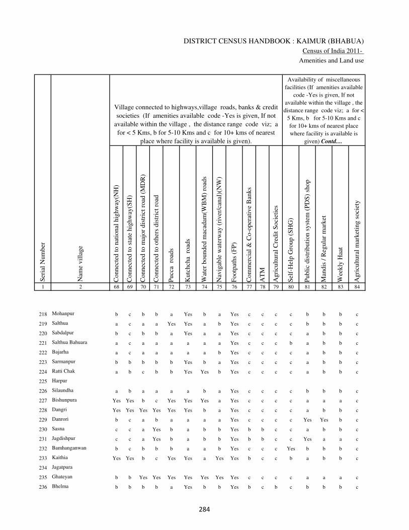
DISTRICT CENSUS HANDBOOK : KAIMUR (BHABUA)
Census of India 2011-
Amenities and Land use
Connec
ted t
o n
atio
nal
hig
hw
ay(N
H)
Connec
ted t
o s
tate
hig
hw
ay(S
H)
Connec
ted t
o m
ajor
dis
tric
t ro
ad (
MD
R)
Connec
ted t
o o
ther
s dis
tric
t ro
ad
Pucc
a r
oad
s
Kutc
hch
a r
oad
s
Wat
er b
ounded
mac
adam
(WB
M)
road
s
Nav
igab
le w
ater
way
(ri
ver
/can
al)(
NW
)
Footp
aths
(FP
)
Com
mer
cial
& C
o-o
per
ativ
e B
anks
AT
M
Agri
cult
ura
l C
redit
Soci
etie
s
Sel
f-H
elp G
roup (
SH
G)
Publi
c dis
trib
uti
on s
yst
em (
PD
S)
shop
Man
dis
/ R
egula
r m
arket
Wee
kly
Haa
t
Agri
cult
ura
l m
arket
ing s
oci
ety
1 2 68 69 70 71 72 73 74 75 76 77 78 79 80 81 82 83 84
Village connected to highways,village roads, banks & credit
societies (If amenities available code -Yes is given, If not
available within the village , the distance range code viz; a
for < 5 Kms, b for 5-10 Kms and c for 10+ kms of nearest
place where facility is available is given).
Ser
ial
Num
ber
Nam
e vil
lage
Availability of miscellaneous
facilities (If amenities available
code -Yes is given, If not
available within the village , the
distance range code viz; a for <
5 Kms, b for 5-10 Kms and c
for 10+ kms of nearest place
where facility is available is
given) Contd....
218 Mohanpur b c b b a Yes b a Yes c c c c b b b c
219 Salthua a c a a Yes Yes a b Yes c c c c b b b c
220 Sabdalpur b c b b a Yes a a Yes c c c c a b b c
221 Salthua Bahuara a c a a a a a a Yes c c c b a b b c
222 Bajarha a c a a a a a b Yes c c c c a b b c
223 Sarmanpur b b b b b Yes b a Yes c c c c a b b c
224 Ratti Chak a b c b b Yes Yes b Yes c c c c a b b c
225 Harpur
226 Silaundha a b a a a a b a Yes c c c c b b b c
227 Bishunpura Yes Yes b c Yes Yes Yes a Yes c c c c a a a c
228 Dangri Yes Yes Yes Yes Yes Yes b a Yes c c c c a b b c
229 Danrori b c a b a a a a Yes c c c c Yes Yes b c
230 Sasna c c a Yes b a b b Yes b b c c a b b c
231 Jagdishpur c c a Yes b a b b Yes b b c c Yes a a c
232 Bamhanganwan b c b b b a a b Yes c c c Yes b b b c
233 Kaithia Yes Yes b c Yes Yes a Yes Yes b c c b a b b c
234 Jagatpura
235 Ghateyan b b Yes Yes Yes Yes Yes Yes Yes c c c c a a a c
236 Bhelma b b b b a Yes b b Yes b c b c b b b c
��

VILLAGE DIRECTORY
Village Directory
( As in 2009 )
Inte
gra
ted C
hil
d D
evel
opm
ent
Sch
eme
(Nutr
itio
nal
Cen
tres
)
Angan
wad
i C
entr
e (N
utr
itio
nal
Cen
tres
)
Oth
ers
(Nutr
itio
nal
Cen
tres
)
AS
HA
(A
ccre
dit
ed S
oci
al H
ealt
h A
ctiv
ist)
Com
munit
y c
entr
e w
ith/w
ithout
TV
Sport
s F
ield
,
Sport
s C
lub /
Rec
reat
ion C
entr
e
Cin
ema
/ V
ideo
Hal
l
Publi
c L
ibra
ry
Publi
c R
eadin
g R
oom
New
spap
er S
upply
Ass
embly
Poll
ing s
tati
on
Bir
th &
Dea
th R
egis
trat
ion O
ffic
e
Pow
er S
upply
for
Dom
esti
c U
se (
ED
)
Pow
er S
upply
for
Agri
cult
ura
l U
se (
EA
G)
Pow
er S
upply
for
Com
mer
cial
Use
(E
C)
Pow
er S
upply
for
All
Use
s (E
A)
85 86 87 88 89 90 91 92 93 94 95 96 97 98 99 100 101 2 1
Availability of
electricity (Yes/No)
Availability of miscellaneous facilities (If amenities available code -
Yes is given, If not available within the village , the distance range
code viz; a for < 5 Kms, b for 5-10 Kms and c for 10+ kms of
nearest place where facility is available is given) Concluded
Nam
e vil
lage
Ser
ial
Num
ber
c Yes Yes Yes c b c c c c b Yes Yes Yes No No No Mohanpur 218
c Yes Yes Yes c b c c c c c Yes a No No No No Salthua 219
c Yes Yes Yes c b c c c a a a a Yes No No No Sabdalpur 220
c b Yes b c c c c c c b a a No No No No Salthua Bahuara 221
c Yes Yes Yes c c c c c c b Yes b No No No No Bajarha 222
c a a a c c c c c c b a b No No No No Sarmanpur 223
c b Yes a c c c c c c c a b Yes No No No Ratti Chak 224
Harpur 225
c Yes Yes Yes c c c c c c b Yes b No No No No Silaundha 226
c a Yes a c c c c c c b a a Yes No No No Bishunpura 227
c a a a c c c c c c c a b Yes No No No Dangri 228
c b Yes b c c c c c c b a a No No No No Danrori 229
c Yes Yes Yes c c b c c b b Yes Yes Yes No No No Sasna 230
c Yes Yes Yes c c c c c c b Yes b Yes No No No Jagdishpur 231
c b Yes b c c c c c c b Yes b Yes No No No Bamhanganwan 232
c a Yes a c b c c c c b a a Yes No No No Kaithia 233
Jagatpura 234
c Yes Yes a c a a c c c b Yes b Yes Yes No No Ghateyan 235
c Yes Yes Yes c c b c c c b a a No No No No Bhelma 236
��

DISTRICT CENSUS HANDBOOK : KAIMUR (BHABUA)
Census of India 2011-
Amenities and Land use
Nam
e
Dis
tance
ran
ge
code
i.e
. a
fo
r <
5 K
ms,
b
for
5-
10 K
ms
and c
f
or
10+
km
s .
Fore
sts
Are
a under
Non-a
gri
cult
ura
l U
ses
Bar
ren a
nd U
n-c
ult
ivab
le l
and
Per
man
ent
Pas
ture
s an
d O
ther
Gra
zing L
ands
Lan
d U
nder
Mis
cell
aneo
us
Tre
e C
rops
etc.
Cult
ura
ble
Was
te L
and
Fal
low
lan
ds
oth
er t
han
curr
ent
fall
ow
s
Curr
ent
Fal
low
s
1 2 102 103 104 105 106 107 108 109 110 111
Ser
ial
Num
ber
Nam
e vil
lage
Area under different types of land use ( in hectares rounded up to
one decimal place)
Land Use
Nearest Town
218 Mohanpur BHABUA c 0 70.6 0 0 0 0 0 0
219 Salthua BHABUA c 0 104.9 0 0 0 0 0 0
220 Sabdalpur BHABUA c 13 9 0 0 0 0 0 0
221 Salthua Bahuara BHABUA c 13.1 15.6 0 0 0 0 0 0
222 Bajarha BHABUA c 0 26 0 0 0 0 0 0
223 Sarmanpur BHABUA c 0 4.6 0 0 0 0 0 0
224 Ratti Chak BHABUA c 4.9 3.4 0 0 0 0 0 0
225 Harpur 0 0 12.1 0 0 0 0 0
226 Silaundha BHABUA c 0 27 0 0 0 0 0 0
227 Bishunpura BHABUA c 40.9 23 0 0 0 0 0 0
228 Dangri BHABUA c 0 28 0 0 0 0 0 0
229 Danrori BHABUA c 61.5 14 0 0 0 0 0 0
230 Sasna BHABUA c 148.7 19.5 0 0 0 0 0 0
231 Jagdishpur BHABUA c 18.4 60 0 0 0 0 0 0
232 Bamhanganwan BHABUA c 15.8 50 0 0 0 0 0 0
233 Kaithia BHABUA c 0 25.3 0 0 0 0 0 0
234 Jagatpura 12.8 3.4 0 0 0 0 0 0
235 Ghateyan BHABUA c 0 13.2 0 0 0 0 0 0
236 Bhelma BHABUA c 30.9 59 0 0 0 0 0 0
��

VILLAGE DIRECTORY
Village Directory
( As in 2009 )
Net
Are
a S
ow
n
Tota
l Ir
rigat
ed L
and A
rea
Tota
l U
n-i
rrig
ated
Lan
d A
rea
Can
als
( C
)
Wel
ls/T
ube-
wel
ls(W
/TW
)
Tan
ks/
Lak
es(T
/L)
Wat
er F
alls
(WF
)
Oth
ers(
O)
Fir
st
Sec
ond
Thir
d
112 113 114 115 116 117 118 119 120 121 122 2 1
Ser
ial
Num
ber
Name of three
most important
commodities
manufacturedArea irrigated by source (in hectare).
Nam
e of
Vil
lage
Area under different types of
land use ( in hectares rounded
up to one decimal place)
Land Use
278.4 138.4 140 100.3 38.1 0 0 0 Mohanpur 218
789.1 612.4 176.7 517.6 94.8 0 0 0 Salthua 219
69 52.7 16.3 52.7 0 0 0 0 Sabdalpur 220
74.3 51.4 22.9 51.4 0 0 0 0 Salthua Bahuara 221
140 120 20 0 100 0 0 20 Bajarha 222
52.4 30.4 22 20.1 10.2 0 0 0 Sarmanpur 223
20.7 9.6 11.1 9.6 0 0 0 0 Ratti Chak 224
74.9 61.7 13.2 39.4 22.2 0 0 0 Harpur 225
124 99 25 79 20 0 0 0 Silaundha 226
39.1 27.1 12 7.1 20 0 0 0 Bishunpura 227
65 34.4 30.6 20.4 14 0 0 0 Dangri 228
30.5 24.6 5.9 0 24.6 0 0 0 Danrori 229
92.8 81.7 11.1 0 81.7 0 0 0 Sasna 230
43.6 40.6 3 40.6 0 0 0 0 Jagdishpur 231
33.2 26.4 6.8 0 26.4 0 0 0 Bamhanganwan 232
98.7 79.2 19.4 58.2 21.1 0 0 0 Kaithia 233
20.8 12.8 8 0 12.8 0 0 0 Jagatpura 234
147.8 64.5 83.3 0 64.5 0 0 0 Ghateyan 235
49.1 34.6 14.5 0 34.6 0 0 0 Bhelma 236
��

DISTRICT CENSUS HANDBOOK : KAIMUR (BHABUA)
Census of India 2011-
Amenities and Land use
Pre
-Pri
mar
y s
chool
(PP
)
Pri
mar
y s
chool
(P)
Mid
dle
sch
ool
(M)
Sec
ondar
y S
chool
(S)
Sen
ior
Sec
ondar
y s
chool
(SS
)
Deg
ree
coll
ege
of
arts
sc
ience
& c
om
mer
ce
(AS
C)
Engin
eeri
ng c
oll
ege(
EC
)
Med
ical
coll
ege
(MC
)
Man
agem
ent
inst
itute
(M
I)
Poly
tech
nic
(P
t)
Voca
tional
tra
inin
g s
chool
/IT
I
Non-f
orm
al t
rain
ing c
entr
e (N
FT
C)
Spec
ial
school
for
dis
able
d (
SS
D)
Oth
ers
(spec
ify)
1 2 3 4 5 6 7 8 9 10 11 12 13 14 15 16 17 18 19 20
Loca
tion c
ode
no.
Nam
e vil
lage
Ser
ial
Num
ber
Tota
l popula
tion (
2011 c
ensu
s )
Tota
l ar
ea o
f th
e vil
lage
( in
hec
tare
s ro
unded
up t
o
one
dec
imal
pla
ce)
Number of educational amenities available. (If not available
within the village , the distance range code viz; a for < 5
Kms, b for 5-10 Kms and c for 10+ kms of nearest place
where facility is available is given).
Num
ber
of
house
hold
s (2
011 c
ensu
s)
237 Patakpura 249160 66 0 0
238 Jalkhoria 249161 87 730 93 b 1 b c c c c c c c c c c
239 Kharahna 249162 364 2385 352 b 1 1 c b c c c c c c c c
240 Manpur 249163 31 0 0
241 Bhataulia 249164 77 918 122 b 1 b c b c c c c c c c c
242 Banrughat 249165 138 396 50 b 1 b c b c c c c c c c c
243 Gayghat 249166 110 550 77 b 1 b c b c c c c c c c c
244 Sarodih 249167 74 176 27 b a b c b c c c c c c c c
245 Dewasdehra 249168 107 791 95 b a b c b c c c c c c c c
246 Chhatauna 249169 88 431 54 b 1 b c b c c c c c c c c
247 Pachara 249170 59 553 88 b a a c b c c c c c c c c
248 Laravandehra 249171 59 0 0
249 Basantpur 249172 45 313 33 b 1 b c b c c c c c c c c
250 Ojhaulia 249173 110 1054 138 b 1 1 c b c c c c c c c c
251 Taruhan 249174 61.1 143 13 b a 1 1 b c c c c c c c c
252 Hasanpura 249175 91 350 47 b 2 a c a c c c c c c c c
253 Burahar 249176 150 149 22 a b b c b c c c c c c c c b
254 Turki 249177 257 2515 321 b 1 2 c b c c c c c c c c
255 Dumri 249178 185 967 157 a 1 b c b c c c c c c c c
256 Bastalwa 249179 128 627 81 a 1 b c b c c c c c c c c
257 Pipra 249180 191 1022 138 b 1 1 c b c c c c c c c c
��

VILLAGE DIRECTORY
Village Directory
( As in 2009 )
Com
munit
y h
ealt
h c
entr
e (C
HC
)
Pri
mar
y h
ealt
h c
entr
e (P
HC
)
Pri
mar
y h
ealt
h s
ub c
entr
e (P
HS
)
Mat
ernit
y a
nd c
hil
d w
elfa
re c
entr
e (M
CW
)
T.B
. cl
inic
(T
BC
)
Hosp
ital
-all
opat
hic
(H
A)
Hosp
ital
-alt
ernat
ive
med
icin
e (H
O)
Dis
pen
sary
(D
)
Vet
erin
ary h
osp
ital
(V
H)
Mobil
e hea
lth c
linic
(M
HC
)
Fam
ily w
elfa
re c
entr
e (F
WC
)
Char
itab
le n
on G
ovt.
hosp
ital
/Nurs
ing h
om
e.
Med
ical
pra
ctit
ioner
wit
h M
BB
S D
egre
e
Med
ical
pra
ctit
ioner
wit
h o
ther
deg
ree
Med
ical
pra
ctit
ioner
wit
h n
o d
egre
e
Tra
dit
ional
pra
ctit
ioner
an
d f
aith
hea
ler
.
Med
icin
e S
hop
Oth
ers
21 22 23 24 25 26 27 28 29 30 31 32 33 34 35 36 37 38 2 1
Number of Non-Government
Medical Amenities available.
Number of Medical Amenities available. (If not
available within the village , the distance range
code viz; a for < 5 Kms, b for 5-10 Kms and c
for 10+ kms of nearest place where facility is
available is given).
Nam
e vil
lage
Ser
ial
Num
ber
Patakpura 237
b c c c c c c c c c c 0 0 0 0 0 0 0 Jalkhoria 238
b c c c c c c c c c b 0 0 0 0 0 0 0 Kharahna 239
Manpur 240
b c c c c c c c c c c 0 0 0 0 0 0 0 Bhataulia 241
b c c c c c c c c c c 0 0 0 0 0 0 0 Banrughat 242
b c c c c c c c c c c 0 0 0 0 0 0 0 Gayghat 243
b c c c c c c c c c c 0 0 0 0 0 0 0 Sarodih 244
b c c c c c c c c c c 0 0 0 0 0 0 0 Dewasdehra 245
b c c c c c c c c c c 0 0 0 0 0 0 0 Chhatauna 246
c c b c c c c c c c c 0 0 0 0 0 0 0 Pachara 247
Laravandehra 248
c c c c c c c c c c c 0 0 0 0 0 0 0 Basantpur 249
c c c c c c c c c c c 0 0 0 0 0 0 0 Ojhaulia 250
c c c c c c c c c c c 0 0 0 0 0 0 0 Taruhan 251
c c c c c c c c c c c 0 0 0 0 0 0 0 Hasanpura 252
b b b b b c c b b c b 0 0 0 0 0 0 0 Burahar 253
c c c c c c c c c c c 0 0 0 0 0 0 0 Turki 254
c b c c c c c b c c c 0 0 0 0 0 0 0 Dumri 255
c b c c c c c c c c c 0 0 0 0 0 0 0 Bastalwa 256
c b c c c c c b b c c 0 0 0 0 0 0 0 Pipra 257
��
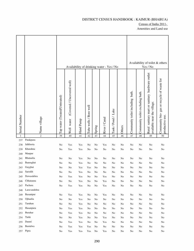
DISTRICT CENSUS HANDBOOK : KAIMUR (BHABUA)
Census of India 2011-
Amenities and Land use
Tap
wat
er (
Tre
ated
/Untr
eate
d)
Wel
l w
ater
(Cover
ed /
Unco
ver
ed w
ell)
Han
d P
um
p
Tube
wel
ls /
Bore
wel
l
Spri
ng
Riv
er /
Can
al
Tan
k /
Pond /
L
ake
Oth
ers
Com
munit
y t
oil
et i
ncl
udin
g
bat
h.
Com
munit
y t
oil
et e
xcl
udin
g b
ath.
Rura
l s
anit
ary m
art
or
sanit
ary
har
dw
are
outl
et
avai
lable
nea
r th
e vil
lage.
Com
munit
y b
io-
gas
or
recy
cle
of
was
te f
or
pro
duct
ive
use
.
1 2 39 40 41 42 43 44 45 46 47 48 49 50
Availability of toilet & others
Yes / No Availability of drinking water - Yes / No
Nam
e vil
lage
Ser
ial
Num
ber
237 Patakpura
238 Jalkhoria No Yes Yes No No Yes No No No No No No
239 Kharahna No Yes Yes No No No No No No No No No
240 Manpur
241 Bhataulia No No Yes No No No No No No No No No
242 Banrughat No No Yes No No No No No No No No No
243 Gayghat No No Yes Yes No No No No No No No No
244 Sarodih No No Yes No No No No No No No No No
245 Dewasdehra No Yes Yes No No Yes No No No No No No
246 Chhatauna No No Yes No No Yes No No No No No No
247 Pachara No Yes Yes No No Yes No No No No No No
248 Laravandehra
249 Basantpur No Yes Yes No No Yes No No No No No No
250 Ojhaulia No No Yes No No No No No No No No No
251 Taruhan No No Yes No No No No No No No No No
252 Hasanpura No Yes Yes No No No No No No No No No
253 Burahar No Yes Yes No No No No No No No No No
254 Turki No No Yes No No Yes No No No No No No
255 Dumri No Yes Yes No No Yes No No No No No No
256 Bastalwa No Yes Yes Yes No No No No No No No No
257 Pipra No Yes Yes Yes No Yes No No No No No No
��
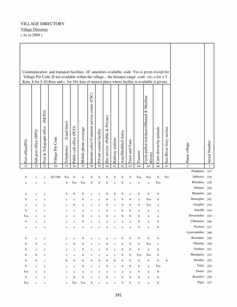
VILLAGE DIRECTORY
Village Directory
( As in 2009 )
Post
off
ice(
PO
)
Sub p
ost
off
ice
(SP
O)
Post
& T
eleg
raph o
ffic
e
(P&
TO
)
Vil
lage
Pin
Code
Tel
ephones
(L
and l
ines
)
Publi
c ca
ll o
ffic
e (P
CO
)
Mobil
e phone
cover
age
Inte
rnet
caf
es/
Com
mon s
ervic
e ce
ntr
e (C
SC
)
Pri
vat
e co
uri
er f
acil
ity
Bus
serv
ice
(P
ubli
c &
Pri
vat
e)
Rai
lway
sta
tions
Auto
/Modif
ied A
uto
s
Tax
is a
nd V
ans
Tra
ctors
Cycl
e-pull
ed r
icksh
aws(
Man
ual
& M
achin
e
dri
ven
)
Car
ts d
riven
by a
nim
als
Sea
/R
iver
fer
ry s
ervic
e51 52 53 54 55 56 57 58 59 60 61 62 63 64 65 66 67 2 1
Communication and transport facilities (If amenities available code -Yes is given except for
Village Pin Code ,If not available within the village , the distance range code viz; a for < 5
Kms, b for 5-10 Kms and c for 10+ kms of nearest place where facility is available is given).
Ser
ial
Num
ber
Nam
e vil
lage
Patakpura 237
b c c 821108 Yes b a b b b b b b Yes Yes b Yes Jalkhoria 238
a c c b Yes Yes b b b c b c a a Yes Kharahna 239
Manpur 240
a c c b b b c c b b b c b b b Bhataulia 241
b c c c c b c c b c b b a Yes b Banrughat 242
a c c c b a c c b c b b b Yes a Gayghat 243
b c c c c a c c b c b b a a a Sarodih 244
Yes c c c c b c c b c b b b a a Dewasdehra 245
b c c c c b c c a c a a b a b Chhatauna 246
a c c c c a c c a c a a b a b Pachara 247
Laravandehra 248
b c c c c b c c a c b b b b b Basantpur 249
b b c c b b c c b c a b b Yes a Ojhaulia 250
b c c c c b c c b c b b b a b Taruhan 251
b b c c c b c c a c b b Yes Yes b Hasanpura 252
b b c b b b b b b b b b b b b b Burahar 253
b c c c c b c c b c b b b a Yes Turki 254
Yes c c c c a c c a c a a b a b Dumri 255
b c c c b b c c b c b b b a b Bastalwa 256
Yes c c c Yes Yes b c a c b b b a b Pipra 257
��

DISTRICT CENSUS HANDBOOK : KAIMUR (BHABUA)
Census of India 2011-
Amenities and Land use
Connec
ted t
o n
atio
nal
hig
hw
ay(N
H)
Connec
ted t
o s
tate
hig
hw
ay(S
H)
Connec
ted t
o m
ajor
dis
tric
t ro
ad (
MD
R)
Connec
ted t
o o
ther
s dis
tric
t ro
ad
Pucc
a r
oad
s
Kutc
hch
a r
oad
s
Wat
er b
ounded
mac
adam
(WB
M)
road
s
Nav
igab
le w
ater
way
(ri
ver
/can
al)(
NW
)
Footp
aths
(FP
)
Com
mer
cial
& C
o-o
per
ativ
e B
anks
AT
M
Agri
cult
ura
l C
redit
Soci
etie
s
Sel
f-H
elp G
roup (
SH
G)
Publi
c dis
trib
uti
on s
yst
em (
PD
S)
shop
Man
dis
/ R
egula
r m
arket
Wee
kly
Haa
t
Agri
cult
ura
l m
arket
ing s
oci
ety
1 2 68 69 70 71 72 73 74 75 76 77 78 79 80 81 82 83 84
Village connected to highways,village roads, banks & credit
societies (If amenities available code -Yes is given, If not
available within the village , the distance range code viz; a
for < 5 Kms, b for 5-10 Kms and c for 10+ kms of nearest
place where facility is available is given).
Ser
ial
Num
ber
Nam
e vil
lage
Availability of miscellaneous
facilities (If amenities available
code -Yes is given, If not
available within the village , the
distance range code viz; a for <
5 Kms, b for 5-10 Kms and c
for 10+ kms of nearest place
where facility is available is
given) Contd....
237 Patakpura
238 Jalkhoria a c b Yes a Yes Yes Yes Yes c c b c Yes b b b
239 Kharahna b c b b b Yes a b Yes c c c c Yes b b b
240 Manpur
241 Bhataulia a c c b b Yes b b Yes c c c c a a a b
242 Banrughat a c Yes b b Yes b a Yes c c c c a a b b
243 Gayghat a c Yes b b Yes a b Yes c c c b a b b b
244 Sarodih b c b b b Yes b b Yes c c c c b b b c
245 Dewasdehra b c b b b Yes b b Yes b c c c a b b b
246 Chhatauna b c b b b a a b Yes b c c b a a a a
247 Pachara c c a a b Yes a a Yes c c c c a b b b
248 Laravandehra
249 Basantpur c c b Yes b a b b Yes b b c c b b b b
250 Ojhaulia b b b b c a b b Yes c c c b Yes a b b
251 Taruhan b c b b b a a b Yes c c c b b b b b
252 Hasanpura c b b a b Yes a b Yes c c c c b b b c
253 Burahar b b b b b Yes b b Yes b b b b b b b b
254 Turki c c b b b a b b Yes c c c b Yes b b b
255 Dumri c c a Yes b a a b Yes c c c b b b b b
256 Bastalwa c b b b b a a b Yes c c c b a b b b
257 Pipra c b Yes Yes b Yes Yes b Yes c c c c a c b c
�

VILLAGE DIRECTORY
Village Directory
( As in 2009 )
Inte
gra
ted C
hil
d D
evel
opm
ent
Sch
eme
(Nutr
itio
nal
Cen
tres
)
Angan
wad
i C
entr
e (N
utr
itio
nal
Cen
tres
)
Oth
ers
(Nutr
itio
nal
Cen
tres
)
AS
HA
(A
ccre
dit
ed S
oci
al H
ealt
h A
ctiv
ist)
Com
munit
y c
entr
e w
ith/w
ithout
TV
Sport
s F
ield
,
Sport
s C
lub /
Rec
reat
ion C
entr
e
Cin
ema
/ V
ideo
Hal
l
Publi
c L
ibra
ry
Publi
c R
eadin
g R
oom
New
spap
er S
upply
Ass
embly
Poll
ing s
tati
on
Bir
th &
Dea
th R
egis
trat
ion O
ffic
e
Pow
er S
upply
for
Dom
esti
c U
se (
ED
)
Pow
er S
upply
for
Agri
cult
ura
l U
se (
EA
G)
Pow
er S
upply
for
Com
mer
cial
Use
(E
C)
Pow
er S
upply
for
All
Use
s (E
A)
85 86 87 88 89 90 91 92 93 94 95 96 97 98 99 100 101 2 1
Availability of
electricity (Yes/No)
Availability of miscellaneous facilities (If amenities available code -
Yes is given, If not available within the village , the distance range
code viz; a for < 5 Kms, b for 5-10 Kms and c for 10+ kms of
nearest place where facility is available is given) Concluded
Nam
e vil
lage
Ser
ial
Num
ber
Patakpura 237
c b Yes Yes c c b c c c b Yes b Yes Yes No No Jalkhoria 238
c Yes Yes Yes c b c c c c b Yes Yes Yes No No No Kharahna 239
Manpur 240
c Yes Yes Yes c c c c c c b Yes b Yes No No No Bhataulia 241
c b Yes b c c c c c c b a b Yes No No No Banrughat 242
c Yes Yes Yes c c c c c c b Yes b Yes No No No Gayghat 243
c b Yes b c c c c c c b a b No No No No Sarodih 244
c Yes Yes Yes c c b c c b b Yes b Yes No No No Dewasdehra 245
c Yes Yes Yes c c b b c b b Yes b Yes No No No Chhatauna 246
c Yes Yes Yes c c c c c c c a b Yes No No No Pachara 247
Laravandehra 248
c b Yes Yes b b b b b b b a b No No No No Basantpur 249
c Yes Yes Yes c c c c c c b Yes b Yes No No No Ojhaulia 250
c Yes Yes Yes b b b b b b b Yes b Yes No No No Taruhan 251
c Yes Yes Yes c c c c c c b a b No No No No Hasanpura 252
c Yes Yes Yes c b c c c c a a b No No No No Burahar 253
c Yes Yes Yes c c c c c c b Yes b Yes No No No Turki 254
c Yes Yes Yes c b c c c b b Yes b Yes No No No Dumri 255
c b Yes b c c c c c c b a a Yes Yes No No Bastalwa 256
c Yes Yes Yes c c c c c c c a Yes Yes No No No Pipra 257
�

DISTRICT CENSUS HANDBOOK : KAIMUR (BHABUA)
Census of India 2011-
Amenities and Land use
Nam
e
Dis
tance
ran
ge
code
i.e
. a
fo
r <
5 K
ms,
b
for
5-
10 K
ms
and c
f
or
10+
km
s .
Fore
sts
Are
a under
Non-a
gri
cult
ura
l U
ses
Bar
ren a
nd U
n-c
ult
ivab
le l
and
Per
man
ent
Pas
ture
s an
d O
ther
Gra
zing L
ands
Lan
d U
nder
Mis
cell
aneo
us
Tre
e C
rops
etc.
Cult
ura
ble
Was
te L
and
Fal
low
lan
ds
oth
er t
han
curr
ent
fall
ow
s
Curr
ent
Fal
low
s
1 2 102 103 104 105 106 107 108 109 110 111
Ser
ial
Num
ber
Nam
e vil
lage
Area under different types of land use ( in hectares rounded up to
one decimal place)
Land Use
Nearest Town
237 Patakpura 0 4.7 0 0 0 0 0 0
238 Jalkhoria BHABUA c 0 9.8 0 0 0 0 0 0
239 Kharahna BHABUA c 4.4 3.6 0 0 0 0 0 0
240 Manpur 5.4 3 0 0 0 0 0 0
241 Bhataulia BHABUA c 17.5 7.4 0 0 0 0 0 0
242 Banrughat BHABUA c 13 12.5 0 0 0 0 0 0
243 Gayghat BHABUA c 0 14.1 0 0 0 0 0 0
244 Sarodih BHABUA c 14 3.2 0 0 0 0 0 0
245 Dewasdehra BHABUA c 23.5 53.5 0 0 0 0 0 0
246 Chhatauna BHABUA c 6.2 14 0 0 0 0 0 0
247 Pachara BHABUA c 8.6 23.6 0 0 0 0 0 0
248 Laravandehra 15.5 14 0 0 0 0 0 0
249 Basantpur BHABUA c 0.6 10.6 0 0 0 0 0 0
250 Ojhaulia BHABUA c 22.9 40.9 0 0 0 0 0 0
251 Taruhan BHABUA c 0 16.6 0 0 0 0 0 0
252 Hasanpura BHABUA c 0 9.2 0 0 0 0 0 0
253 Burahar BHABUA c 85.4 7.7 0 0 0 0 0 0
254 Turki BHABUA c 113.2 17.5 0 0 0 0 0 0
255 Dumri BHABUA c 0 0 0 0 0 0.8 0 6.7
256 Bastalwa BHABUA c 9.7 19.9 0 0 0 0 0 0
257 Pipra BHABUA c 0 12.6 0 0 0 0 0 0
��
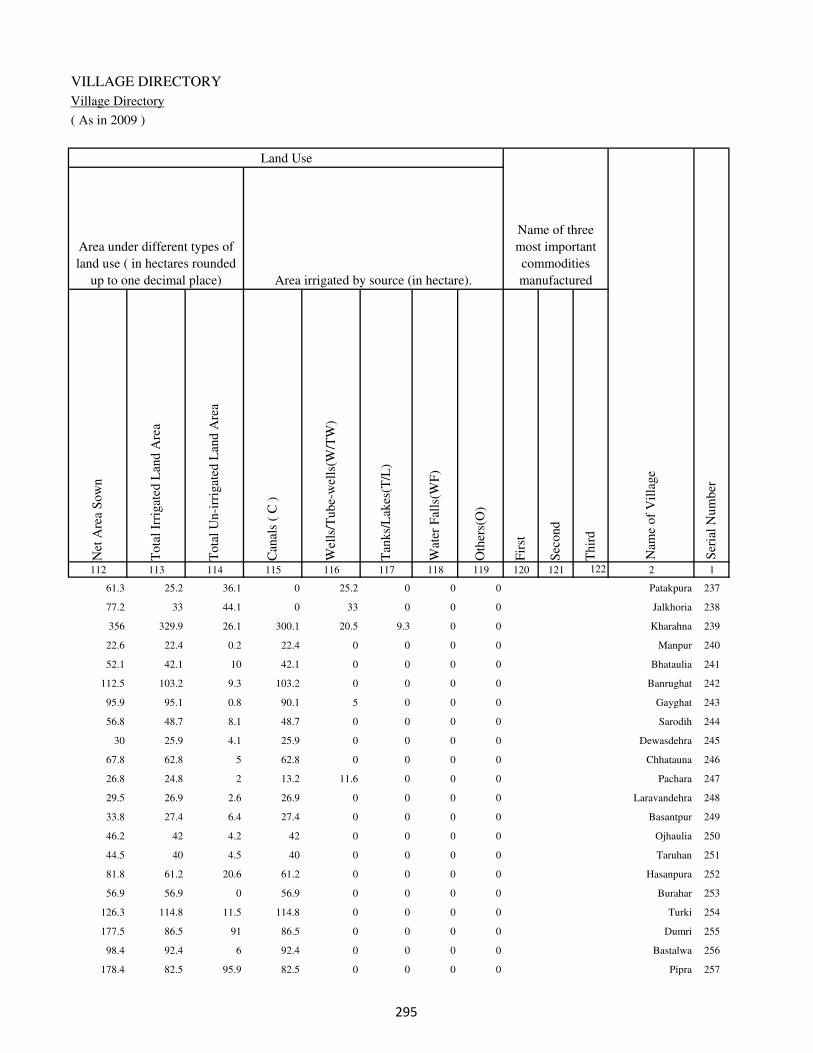
VILLAGE DIRECTORY
Village Directory
( As in 2009 )
Net
Are
a S
ow
n
Tota
l Ir
rigat
ed L
and A
rea
Tota
l U
n-i
rrig
ated
Lan
d A
rea
Can
als
( C
)
Wel
ls/T
ube-
wel
ls(W
/TW
)
Tan
ks/
Lak
es(T
/L)
Wat
er F
alls
(WF
)
Oth
ers(
O)
Fir
st
Sec
ond
Thir
d
112 113 114 115 116 117 118 119 120 121 122 2 1
Ser
ial
Num
ber
Name of three
most important
commodities
manufacturedArea irrigated by source (in hectare).
Nam
e of
Vil
lage
Area under different types of
land use ( in hectares rounded
up to one decimal place)
Land Use
61.3 25.2 36.1 0 25.2 0 0 0 Patakpura 237
77.2 33 44.1 0 33 0 0 0 Jalkhoria 238
356 329.9 26.1 300.1 20.5 9.3 0 0 Kharahna 239
22.6 22.4 0.2 22.4 0 0 0 0 Manpur 240
52.1 42.1 10 42.1 0 0 0 0 Bhataulia 241
112.5 103.2 9.3 103.2 0 0 0 0 Banrughat 242
95.9 95.1 0.8 90.1 5 0 0 0 Gayghat 243
56.8 48.7 8.1 48.7 0 0 0 0 Sarodih 244
30 25.9 4.1 25.9 0 0 0 0 Dewasdehra 245
67.8 62.8 5 62.8 0 0 0 0 Chhatauna 246
26.8 24.8 2 13.2 11.6 0 0 0 Pachara 247
29.5 26.9 2.6 26.9 0 0 0 0 Laravandehra 248
33.8 27.4 6.4 27.4 0 0 0 0 Basantpur 249
46.2 42 4.2 42 0 0 0 0 Ojhaulia 250
44.5 40 4.5 40 0 0 0 0 Taruhan 251
81.8 61.2 20.6 61.2 0 0 0 0 Hasanpura 252
56.9 56.9 0 56.9 0 0 0 0 Burahar 253
126.3 114.8 11.5 114.8 0 0 0 0 Turki 254
177.5 86.5 91 86.5 0 0 0 0 Dumri 255
98.4 92.4 6 92.4 0 0 0 0 Bastalwa 256
178.4 82.5 95.9 82.5 0 0 0 0 Pipra 257
��

DISTRICT CENSUS HANDBOOK : KAIMUR (BHABUA)
Census of India 2011-
Amenities and Land use
Pre
-Pri
mar
y s
chool
(PP
)
Pri
mar
y s
chool
(P)
Mid
dle
sch
ool
(M)
Sec
ondar
y S
chool
(S)
Sen
ior
Sec
ondar
y s
chool
(SS
)
Deg
ree
coll
ege
of
arts
sc
ience
& c
om
mer
ce
(AS
C)
Engin
eeri
ng c
oll
ege(
EC
)
Med
ical
coll
ege
(MC
)
Man
agem
ent
inst
itute
(M
I)
Poly
tech
nic
(P
t)
Voca
tional
tra
inin
g s
chool
/IT
I
Non-f
orm
al t
rain
ing c
entr
e (N
FT
C)
Spec
ial
school
for
dis
able
d (
SS
D)
Oth
ers
(spec
ify)
1 2 3 4 5 6 7 8 9 10 11 12 13 14 15 16 17 18 19 20
Loca
tion c
ode
no.
Nam
e vil
lage
Ser
ial
Num
ber
Tota
l popula
tion (
2011 c
ensu
s )
Tota
l ar
ea o
f th
e vil
lage
( in
hec
tare
s ro
unded
up t
o
one
dec
imal
pla
ce)
Number of educational amenities available. (If not available
within the village , the distance range code viz; a for < 5
Kms, b for 5-10 Kms and c for 10+ kms of nearest place
where facility is available is given).
Num
ber
of
house
hold
s (2
011 c
ensu
s)
258 Kandehra 249181 191 1436 187 b 1 1 c b c c c c c c c c
259 Phulli 249182 263 2152 317 b 2 a c b c c c c c c c c
260 Basahi 249183 457 1990 285 1 1 1 1 1 c c c c c c c c
261 Saraya 249184 129 650 96 b 1 b c a c c c c c c c c
262 Barheta 249185 115 0 0
263 Chanda 249186 46.5 21 2 b b b c b c c c c c c c c
264 Siswar 249187 181 1771 230 b b b 1 1 c c c c c c c c
265 Bhairwa 249188 76 524 72 b 1 b c a c c c c c c c c
266 Semaria 249189 68 0 0
267 Puraini 249190 180 897 129 b 1 b b a c c c c c c c c
268 Amiaura 249191 96 581 66 b 1 a c b c c c c c c c c
269 Chaubepur 249192 153 0 0
270 Ghari 249193 107 1082 140 1 1 a c a c c c c c c c c
271 Mohammadpur 249194 116 0 0
272 Bhainslot 249195 30 0 0
273 Rampur 249196 54 0 0
274 Sariawan 249197 102 1235 146 b 1 1 c c c c c c c c c c
275 Sahpur 249198 92 0 0
276 Sonbarsa 249199 132 961 152 b 1 b c a c c c c c c c c
277 Shekhapur 249200 41 0 0
278 Dhaturha 249201 38 87 16 b a a c b c c c c c c c c
��

VILLAGE DIRECTORY
Village Directory
( As in 2009 )
Com
munit
y h
ealt
h c
entr
e (C
HC
)
Pri
mar
y h
ealt
h c
entr
e (P
HC
)
Pri
mar
y h
ealt
h s
ub c
entr
e (P
HS
)
Mat
ernit
y a
nd c
hil
d w
elfa
re c
entr
e (M
CW
)
T.B
. cl
inic
(T
BC
)
Hosp
ital
-all
opat
hic
(H
A)
Hosp
ital
-alt
ernat
ive
med
icin
e (H
O)
Dis
pen
sary
(D
)
Vet
erin
ary h
osp
ital
(V
H)
Mobil
e hea
lth c
linic
(M
HC
)
Fam
ily w
elfa
re c
entr
e (F
WC
)
Char
itab
le n
on G
ovt.
hosp
ital
/Nurs
ing h
om
e.
Med
ical
pra
ctit
ioner
wit
h M
BB
S D
egre
e
Med
ical
pra
ctit
ioner
wit
h o
ther
deg
ree
Med
ical
pra
ctit
ioner
wit
h n
o d
egre
e
Tra
dit
ional
pra
ctit
ioner
an
d f
aith
hea
ler
.
Med
icin
e S
hop
Oth
ers
21 22 23 24 25 26 27 28 29 30 31 32 33 34 35 36 37 38 2 1
Number of Non-Government
Medical Amenities available.
Number of Medical Amenities available. (If not
available within the village , the distance range
code viz; a for < 5 Kms, b for 5-10 Kms and c
for 10+ kms of nearest place where facility is
available is given).
Nam
e vil
lage
Ser
ial
Num
ber
c c c c c c c b c c b 0 0 0 0 0 0 0 Kandehra 258
c c a c c c c c a c c 0 0 0 0 0 0 0 Phulli 259
b b b c c c c b c c c 0 0 0 0 0 0 0 Basahi 260
c b b c c c c c c c c 0 0 0 0 0 0 0 Saraya 261
Barheta 262
c c b c c c c c c c c 0 0 0 0 0 0 0 Chanda 263
b c c c c c c c c c b 0 0 0 0 0 0 0 Siswar 264
c c c c c c c b a c a 0 0 0 0 0 0 0 Bhairwa 265
Semaria 266
c a c c c c c c a c b 0 0 0 0 0 0 0 Puraini 267
c b c c c c c c c c b 0 0 0 0 0 0 0 Amiaura 268
Chaubepur 269
c b c c c c c c c c b 0 0 0 0 0 0 0 Ghari 270
Mohammadpur 271
Bhainslot 272
Rampur 273
c c c c c c c c c c c 0 0 0 0 0 0 0 Sariawan 274
Sahpur 275
c c c c c c c c c c b 0 0 0 0 0 0 0 Sonbarsa 276
Shekhapur 277
c c c c c c c b c c b 0 0 0 0 0 0 0 Dhaturha 278
��

DISTRICT CENSUS HANDBOOK : KAIMUR (BHABUA)
Census of India 2011-
Amenities and Land use
Tap
wat
er (
Tre
ated
/Untr
eate
d)
Wel
l w
ater
(Cover
ed /
Unco
ver
ed w
ell)
Han
d P
um
p
Tube
wel
ls /
Bore
wel
l
Spri
ng
Riv
er /
Can
al
Tan
k /
Pond /
L
ake
Oth
ers
Com
munit
y t
oil
et i
ncl
udin
g
bat
h.
Com
munit
y t
oil
et e
xcl
udin
g b
ath.
Rura
l s
anit
ary m
art
or
sanit
ary
har
dw
are
outl
et
avai
lable
nea
r th
e vil
lage.
Com
munit
y b
io-
gas
or
recy
cle
of
was
te f
or
pro
duct
ive
use
.
1 2 39 40 41 42 43 44 45 46 47 48 49 50
Availability of toilet & others
Yes / No Availability of drinking water - Yes / No
Nam
e vil
lage
Ser
ial
Num
ber
258 Kandehra No Yes Yes No No Yes Yes No No No No No
259 Phulli No Yes Yes No No No No No No No No No
260 Basahi No Yes Yes No No Yes No No No No No No
261 Saraya No Yes Yes No Yes No No No No No No No
262 Barheta
263 Chanda No No Yes No No No No No No No No No
264 Siswar No Yes Yes Yes No No Yes No No No No No
265 Bhairwa No No Yes No No No No No No No No No
266 Semaria
267 Puraini No Yes Yes Yes No Yes No No No No No No
268 Amiaura No No Yes No No No No No No No No No
269 Chaubepur
270 Ghari No No Yes Yes No Yes No No No No No No
271 Mohammadpur
272 Bhainslot
273 Rampur
274 Sariawan No No Yes No No No No No No No No No
275 Sahpur
276 Sonbarsa No No Yes No No No No No No No No No
277 Shekhapur
278 Dhaturha No No Yes No No No No No No No No No
��
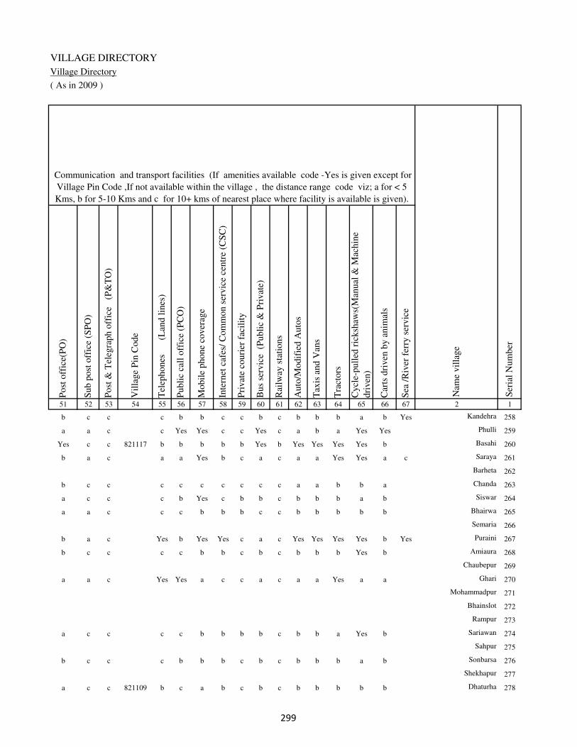
VILLAGE DIRECTORY
Village Directory
( As in 2009 )
Post
off
ice(
PO
)
Sub p
ost
off
ice
(SP
O)
Post
& T
eleg
raph o
ffic
e
(P&
TO
)
Vil
lage
Pin
Code
Tel
ephones
(L
and l
ines
)
Publi
c ca
ll o
ffic
e (P
CO
)
Mobil
e phone
cover
age
Inte
rnet
caf
es/
Com
mon s
ervic
e ce
ntr
e (C
SC
)
Pri
vat
e co
uri
er f
acil
ity
Bus
serv
ice
(P
ubli
c &
Pri
vat
e)
Rai
lway
sta
tions
Auto
/Modif
ied A
uto
s
Tax
is a
nd V
ans
Tra
ctors
Cycl
e-pull
ed r
icksh
aws(
Man
ual
& M
achin
e
dri
ven
)
Car
ts d
riven
by a
nim
als
Sea
/R
iver
fer
ry s
ervic
e51 52 53 54 55 56 57 58 59 60 61 62 63 64 65 66 67 2 1
Communication and transport facilities (If amenities available code -Yes is given except for
Village Pin Code ,If not available within the village , the distance range code viz; a for < 5
Kms, b for 5-10 Kms and c for 10+ kms of nearest place where facility is available is given).
Ser
ial
Num
ber
Nam
e vil
lage
b c c c b b c c b c b b b a b Yes Kandehra 258
a a c c Yes Yes c c Yes c a b a Yes Yes Phulli 259
Yes c c 821117 b b b b b Yes b Yes Yes Yes Yes b Basahi 260
b a c a a Yes b c a c a a Yes Yes a c Saraya 261
Barheta 262
b c c c c c c c c c a a b b a Chanda 263
a c c c b Yes c b b c b b b a b Siswar 264
a a c c c b b b c c b b b b b Bhairwa 265
Semaria 266
b a c Yes b Yes Yes c a c Yes Yes Yes Yes b Yes Puraini 267
b c c c c b b c b c b b b Yes b Amiaura 268
Chaubepur 269
a a c Yes Yes a c c a c a a Yes a a Ghari 270
Mohammadpur 271
Bhainslot 272
Rampur 273
a c c c c b b b b c b b a Yes b Sariawan 274
Sahpur 275
b c c c b b b c b c b b b a b Sonbarsa 276
Shekhapur 277
a c c 821109 b c a b c b c b b b b b Dhaturha 278
��

DISTRICT CENSUS HANDBOOK : KAIMUR (BHABUA)
Census of India 2011-
Amenities and Land use
Connec
ted t
o n
atio
nal
hig
hw
ay(N
H)
Connec
ted t
o s
tate
hig
hw
ay(S
H)
Connec
ted t
o m
ajor
dis
tric
t ro
ad (
MD
R)
Connec
ted t
o o
ther
s dis
tric
t ro
ad
Pucc
a r
oad
s
Kutc
hch
a r
oad
s
Wat
er b
ounded
mac
adam
(WB
M)
road
s
Nav
igab
le w
ater
way
(ri
ver
/can
al)(
NW
)
Footp
aths
(FP
)
Com
mer
cial
& C
o-o
per
ativ
e B
anks
AT
M
Agri
cult
ura
l C
redit
Soci
etie
s
Sel
f-H
elp G
roup (
SH
G)
Publi
c dis
trib
uti
on s
yst
em (
PD
S)
shop
Man
dis
/ R
egula
r m
arket
Wee
kly
Haa
t
Agri
cult
ura
l m
arket
ing s
oci
ety
1 2 68 69 70 71 72 73 74 75 76 77 78 79 80 81 82 83 84
Village connected to highways,village roads, banks & credit
societies (If amenities available code -Yes is given, If not
available within the village , the distance range code viz; a
for < 5 Kms, b for 5-10 Kms and c for 10+ kms of nearest
place where facility is available is given).
Ser
ial
Num
ber
Nam
e vil
lage
Availability of miscellaneous
facilities (If amenities available
code -Yes is given, If not
available within the village , the
distance range code viz; a for <
5 Kms, b for 5-10 Kms and c
for 10+ kms of nearest place
where facility is available is
given) Contd....
258 Kandehra Yes Yes Yes Yes Yes Yes Yes Yes Yes c c c b a c b b
259 Phulli b b c a Yes Yes Yes a Yes c c c b Yes b b b
260 Basahi Yes Yes Yes Yes Yes Yes a b Yes b b b b a b b b
261 Saraya c a a Yes b Yes a Yes Yes c c c Yes b c c c
262 Barheta
263 Chanda b b b Yes a Yes b a Yes c c c b b b b c
264 Siswar c b b b b a Yes b Yes c c c b b b c b
265 Bhairwa c b c b b Yes b b Yes c c c a a b c c
266 Semaria
267 Puraini c c a Yes b b Yes Yes Yes c c c b b b b c
268 Amiaura b c Yes b b Yes a a Yes c c c b a a b c
269 Chaubepur
270 Ghari Yes Yes Yes Yes Yes a Yes b Yes c c c b a b b c
271 Mohammadpur
272 Bhainslot
273 Rampur
274 Sariawan b b Yes b a Yes b b Yes c c c b b c c c
275 Sahpur
276 Sonbarsa b b b b b Yes b b Yes b c b c Yes b b c
277 Shekhapur
278 Dhaturha b b b Yes a Yes a a Yes b c b c b b b c
��

VILLAGE DIRECTORY
Village Directory
( As in 2009 )
Inte
gra
ted C
hil
d D
evel
opm
ent
Sch
eme
(Nutr
itio
nal
Cen
tres
)
Angan
wad
i C
entr
e (N
utr
itio
nal
Cen
tres
)
Oth
ers
(Nutr
itio
nal
Cen
tres
)
AS
HA
(A
ccre
dit
ed S
oci
al H
ealt
h A
ctiv
ist)
Com
munit
y c
entr
e w
ith/w
ithout
TV
Sport
s F
ield
,
Sport
s C
lub /
Rec
reat
ion C
entr
e
Cin
ema
/ V
ideo
Hal
l
Publi
c L
ibra
ry
Publi
c R
eadin
g R
oom
New
spap
er S
upply
Ass
embly
Poll
ing s
tati
on
Bir
th &
Dea
th R
egis
trat
ion O
ffic
e
Pow
er S
upply
for
Dom
esti
c U
se (
ED
)
Pow
er S
upply
for
Agri
cult
ura
l U
se (
EA
G)
Pow
er S
upply
for
Com
mer
cial
Use
(E
C)
Pow
er S
upply
for
All
Use
s (E
A)
85 86 87 88 89 90 91 92 93 94 95 96 97 98 99 100 101 2 1
Availability of
electricity (Yes/No)
Availability of miscellaneous facilities (If amenities available code -
Yes is given, If not available within the village , the distance range
code viz; a for < 5 Kms, b for 5-10 Kms and c for 10+ kms of
nearest place where facility is available is given) Concluded
Nam
e vil
lage
Ser
ial
Num
ber
c Yes Yes Yes c c b b c c c Yes b Yes No No No Kandehra 258
c Yes Yes Yes c b c b c c b Yes b Yes No No No Phulli 259
b Yes Yes Yes b b b c c b b a a Yes No No No Basahi 260
c Yes Yes Yes c Yes c c c c c Yes b No No No No Saraya 261
Barheta 262
c b Yes b c a c c c c c a a No No No No Chanda 263
c Yes Yes Yes c Yes c c c c b Yes Yes Yes No No No Siswar 264
c Yes Yes Yes c Yes c c c c c Yes Yes Yes Yes Yes Yes Bhairwa 265
Semaria 266
c Yes Yes Yes c b c c c c Yes Yes b No No No No Puraini 267
c Yes Yes Yes c Yes c b c b b a b No No No No Amiaura 268
Chaubepur 269
c Yes Yes Yes c Yes b c c c b Yes Yes Yes Yes Yes Yes Ghari 270
Mohammadpur 271
Bhainslot 272
Rampur 273
c Yes Yes Yes Yes Yes c c c c b Yes b Yes No No No Sariawan 274
Sahpur 275
c Yes Yes Yes c b c c c c b Yes b Yes No No No Sonbarsa 276
Shekhapur 277
c b Yes b c a c c c c b a a No No No No Dhaturha 278
��
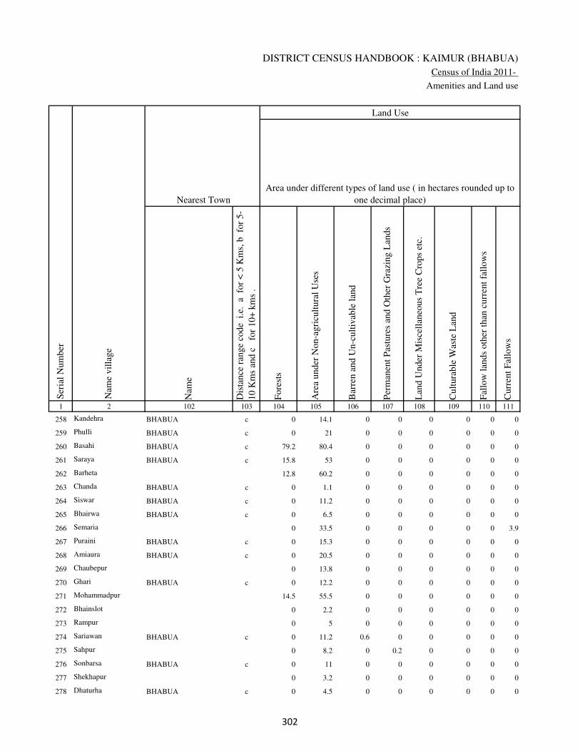
DISTRICT CENSUS HANDBOOK : KAIMUR (BHABUA)
Census of India 2011-
Amenities and Land use
Nam
e
Dis
tance
ran
ge
code
i.e
. a
fo
r <
5 K
ms,
b
for
5-
10 K
ms
and c
f
or
10+
km
s .
Fore
sts
Are
a under
Non-a
gri
cult
ura
l U
ses
Bar
ren a
nd U
n-c
ult
ivab
le l
and
Per
man
ent
Pas
ture
s an
d O
ther
Gra
zing L
ands
Lan
d U
nder
Mis
cell
aneo
us
Tre
e C
rops
etc.
Cult
ura
ble
Was
te L
and
Fal
low
lan
ds
oth
er t
han
curr
ent
fall
ow
s
Curr
ent
Fal
low
s
1 2 102 103 104 105 106 107 108 109 110 111
Ser
ial
Num
ber
Nam
e vil
lage
Area under different types of land use ( in hectares rounded up to
one decimal place)
Land Use
Nearest Town
258 Kandehra BHABUA c 0 14.1 0 0 0 0 0 0
259 Phulli BHABUA c 0 21 0 0 0 0 0 0
260 Basahi BHABUA c 79.2 80.4 0 0 0 0 0 0
261 Saraya BHABUA c 15.8 53 0 0 0 0 0 0
262 Barheta 12.8 60.2 0 0 0 0 0 0
263 Chanda BHABUA c 0 1.1 0 0 0 0 0 0
264 Siswar BHABUA c 0 11.2 0 0 0 0 0 0
265 Bhairwa BHABUA c 0 6.5 0 0 0 0 0 0
266 Semaria 0 33.5 0 0 0 0 0 3.9
267 Puraini BHABUA c 0 15.3 0 0 0 0 0 0
268 Amiaura BHABUA c 0 20.5 0 0 0 0 0 0
269 Chaubepur 0 13.8 0 0 0 0 0 0
270 Ghari BHABUA c 0 12.2 0 0 0 0 0 0
271 Mohammadpur 14.5 55.5 0 0 0 0 0 0
272 Bhainslot 0 2.2 0 0 0 0 0 0
273 Rampur 0 5 0 0 0 0 0 0
274 Sariawan BHABUA c 0 11.2 0.6 0 0 0 0 0
275 Sahpur 0 8.2 0 0.2 0 0 0 0
276 Sonbarsa BHABUA c 0 11 0 0 0 0 0 0
277 Shekhapur 0 3.2 0 0 0 0 0 0
278 Dhaturha BHABUA c 0 4.5 0 0 0 0 0 0
�
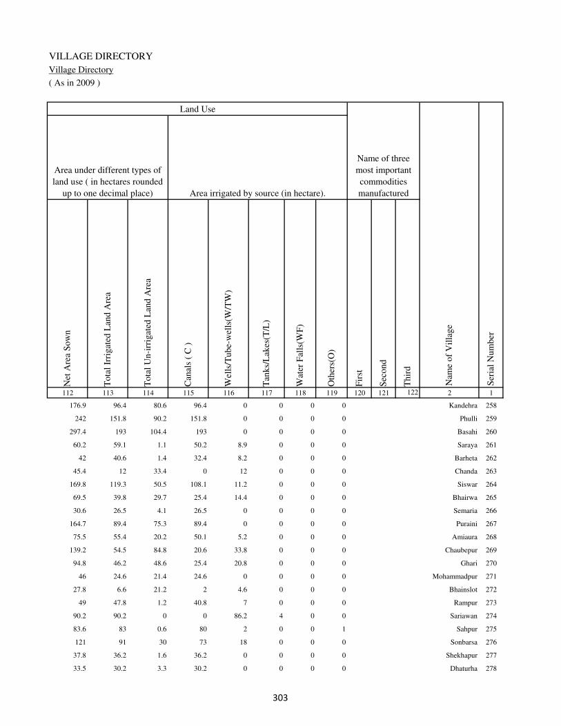
VILLAGE DIRECTORY
Village Directory
( As in 2009 )
Net
Are
a S
ow
n
Tota
l Ir
rigat
ed L
and A
rea
Tota
l U
n-i
rrig
ated
Lan
d A
rea
Can
als
( C
)
Wel
ls/T
ube-
wel
ls(W
/TW
)
Tan
ks/
Lak
es(T
/L)
Wat
er F
alls
(WF
)
Oth
ers(
O)
Fir
st
Sec
ond
Thir
d
112 113 114 115 116 117 118 119 120 121 122 2 1
Ser
ial
Num
ber
Name of three
most important
commodities
manufacturedArea irrigated by source (in hectare).
Nam
e of
Vil
lage
Area under different types of
land use ( in hectares rounded
up to one decimal place)
Land Use
176.9 96.4 80.6 96.4 0 0 0 0 Kandehra 258
242 151.8 90.2 151.8 0 0 0 0 Phulli 259
297.4 193 104.4 193 0 0 0 0 Basahi 260
60.2 59.1 1.1 50.2 8.9 0 0 0 Saraya 261
42 40.6 1.4 32.4 8.2 0 0 0 Barheta 262
45.4 12 33.4 0 12 0 0 0 Chanda 263
169.8 119.3 50.5 108.1 11.2 0 0 0 Siswar 264
69.5 39.8 29.7 25.4 14.4 0 0 0 Bhairwa 265
30.6 26.5 4.1 26.5 0 0 0 0 Semaria 266
164.7 89.4 75.3 89.4 0 0 0 0 Puraini 267
75.5 55.4 20.2 50.1 5.2 0 0 0 Amiaura 268
139.2 54.5 84.8 20.6 33.8 0 0 0 Chaubepur 269
94.8 46.2 48.6 25.4 20.8 0 0 0 Ghari 270
46 24.6 21.4 24.6 0 0 0 0 Mohammadpur 271
27.8 6.6 21.2 2 4.6 0 0 0 Bhainslot 272
49 47.8 1.2 40.8 7 0 0 0 Rampur 273
90.2 90.2 0 0 86.2 4 0 0 Sariawan 274
83.6 83 0.6 80 2 0 0 1 Sahpur 275
121 91 30 73 18 0 0 0 Sonbarsa 276
37.8 36.2 1.6 36.2 0 0 0 0 Shekhapur 277
33.5 30.2 3.3 30.2 0 0 0 0 Dhaturha 278
�

DISTRICT CENSUS HANDBOOK : KAIMUR (BHABUA)
Census of India 2011-
Amenities and Land use
Pre
-Pri
mar
y s
chool
(PP
)
Pri
mar
y s
chool
(P)
Mid
dle
sch
ool
(M)
Sec
ondar
y S
chool
(S)
Sen
ior
Sec
ondar
y s
chool
(SS
)
Deg
ree
coll
ege
of
arts
sc
ience
& c
om
mer
ce
(AS
C)
Engin
eeri
ng c
oll
ege(
EC
)
Med
ical
coll
ege
(MC
)
Man
agem
ent
inst
itute
(M
I)
Poly
tech
nic
(P
t)
Voca
tional
tra
inin
g s
chool
/IT
I
Non-f
orm
al t
rain
ing c
entr
e (N
FT
C)
Spec
ial
school
for
dis
able
d (
SS
D)
Oth
ers
(spec
ify)
1 2 3 4 5 6 7 8 9 10 11 12 13 14 15 16 17 18 19 20
Loca
tion c
ode
no.
Nam
e vil
lage
Ser
ial
Num
ber
Tota
l popula
tion (
2011 c
ensu
s )
Tota
l ar
ea o
f th
e vil
lage
( in
hec
tare
s ro
unded
up t
o
one
dec
imal
pla
ce)
Number of educational amenities available. (If not available
within the village , the distance range code viz; a for < 5
Kms, b for 5-10 Kms and c for 10+ kms of nearest place
where facility is available is given).
Num
ber
of
house
hold
s (2
011 c
ensu
s)
279 Bahuara 249202 62 1750 256 a 1 a c b c c c c c c c c
280 Maudehra 249203 35 0 0
281 Nataya 249204 425 2236 376 c 1 1 c b c c c c c c c c
282 Kakrahi 249205 101 830 131 b a a c b c c c c c c c c
283 Ajgara 249206 157 1739 239 b 1 a c b c c c c c c c c
284 Bhaisadih 249207 64 0 0
285 Khalsapur 249208 120 0 0
286 Ajgari 249209 76 208 28 b a b c a b c c c c c c c
287 Auraiya 249210 167 1075 147 b 1 1 c a b c c c c c c c
288 Nado Khar 249211 129 510 53 b 1 a c c b c c c c c c b
289 Sonawan 249212 150 1232 170 b 1 1 c c b c c c c c c c
290 Barna 249213 119 583 74 a 1 a c a b c c c c c c c
291 Ghatawan 249214 433 9997 1551 b 1 1 1 1 c c c c c c c c
292 Bahera 249215 314 3050 443 b b a c b b c c c c c c c b
293 Bhadaula 249216 184 2908 412 1 1 1 c b b c c c c c c c
294 Khanethi 249217 304 1086 152 1 1 a c a b c c c c c c c
295 Dubaulia 249218 108 0 0
296 Gangvalia 249219 202 2769 387 1 1 a c b b c c c c b c c
297 Itahi 249220 137.2 533 77 b 1 a c a b c c c c c c c
298 Baina 249221 248 1772 279 b 1 1 c b b c c c c c c c
299 Kewrhi 249222 367 3092 468 a 1 1 c a b c c c c c c c
��

VILLAGE DIRECTORY
Village Directory
( As in 2009 )
Com
munit
y h
ealt
h c
entr
e (C
HC
)
Pri
mar
y h
ealt
h c
entr
e (P
HC
)
Pri
mar
y h
ealt
h s
ub c
entr
e (P
HS
)
Mat
ernit
y a
nd c
hil
d w
elfa
re c
entr
e (M
CW
)
T.B
. cl
inic
(T
BC
)
Hosp
ital
-all
opat
hic
(H
A)
Hosp
ital
-alt
ernat
ive
med
icin
e (H
O)
Dis
pen
sary
(D
)
Vet
erin
ary h
osp
ital
(V
H)
Mobil
e hea
lth c
linic
(M
HC
)
Fam
ily w
elfa
re c
entr
e (F
WC
)
Char
itab
le n
on G
ovt.
hosp
ital
/Nurs
ing h
om
e.
Med
ical
pra
ctit
ioner
wit
h M
BB
S D
egre
e
Med
ical
pra
ctit
ioner
wit
h o
ther
deg
ree
Med
ical
pra
ctit
ioner
wit
h n
o d
egre
e
Tra
dit
ional
pra
ctit
ioner
an
d f
aith
hea
ler
.
Med
icin
e S
hop
Oth
ers
21 22 23 24 25 26 27 28 29 30 31 32 33 34 35 36 37 38 2 1
Number of Non-Government
Medical Amenities available.
Number of Medical Amenities available. (If not
available within the village , the distance range
code viz; a for < 5 Kms, b for 5-10 Kms and c
for 10+ kms of nearest place where facility is
available is given).
Nam
e vil
lage
Ser
ial
Num
ber
c c c c c c c c c c b 0 0 0 0 0 0 0 Bahuara 279
Maudehra 280
c c c c c c c c c c b 0 0 0 0 0 0 0 Nataya 281
c c b c c c c c c c b 0 0 0 0 0 0 0 Kakrahi 282
c c b c c c c c c c c 0 0 0 0 0 0 0 Ajgara 283
Bhaisadih 284
Khalsapur 285
c b b c b c c b c c c 0 0 0 0 0 0 0 Ajgari 286
c b b c b c c b c c c 0 0 0 1 1 1 0 Auraiya 287
a a a b b c c b b c b 0 0 2 2 2 2 0 Nado Khar 288
a a c c c c c a a c c 0 0 0 0 1 0 0 Sonawan 289
a a c a c c c c c c c 0 0 0 0 0 0 0 Barna 290
c b c b c c c b c c b 0 0 0 1 1 1 0 Ghatawan 291
b b b b b c c b b c b 0 0 0 0 0 0 0 Bahera 292
c b 1 1 c c c c c c 1 0 0 1 0 0 1 0 Bhadaula 293
c b b b c c c b c c b 0 0 0 0 0 0 0 Khanethi 294
Dubaulia 295
c b 1 1 c c c b c c 1 0 0 1 0 0 1 0 Gangvalia 296
c b b b c c c c b c b 0 0 0 0 0 0 0 Itahi 297
c b b b c c c c b c b 0 0 0 0 0 0 0 Baina 298
c a a a c c c c a c a 0 0 0 0 0 0 0 Kewrhi 299
��

DISTRICT CENSUS HANDBOOK : KAIMUR (BHABUA)
Census of India 2011-
Amenities and Land use
Tap
wat
er (
Tre
ated
/Untr
eate
d)
Wel
l w
ater
(Cover
ed /
Unco
ver
ed w
ell)
Han
d P
um
p
Tube
wel
ls /
Bore
wel
l
Spri
ng
Riv
er /
Can
al
Tan
k /
Pond /
L
ake
Oth
ers
Com
munit
y t
oil
et i
ncl
udin
g
bat
h.
Com
munit
y t
oil
et e
xcl
udin
g b
ath.
Rura
l s
anit
ary m
art
or
sanit
ary
har
dw
are
outl
et
avai
lable
nea
r th
e vil
lage.
Com
munit
y b
io-
gas
or
recy
cle
of
was
te f
or
pro
duct
ive
use
.
1 2 39 40 41 42 43 44 45 46 47 48 49 50
Availability of toilet & others
Yes / No Availability of drinking water - Yes / No
Nam
e vil
lage
Ser
ial
Num
ber
279 Bahuara No No Yes No No No No No No No No No
280 Maudehra
281 Nataya No No Yes No No No No No No No No No
282 Kakrahi No No Yes No No No No No No No No No
283 Ajgara No Yes Yes No No Yes No No No No No No
284 Bhaisadih
285 Khalsapur
286 Ajgari No Yes Yes Yes No Yes No No No No No No
287 Auraiya No Yes Yes No No Yes No No No No No No
288 Nado Khar No Yes Yes No No No No No No No No No
289 Sonawan No Yes Yes Yes No Yes No No No No No No
290 Barna No Yes Yes No No Yes No No No No No No
291 Ghatawan No Yes Yes No No No No No No No No No
292 Bahera No Yes Yes No No No No No No No No No
293 Bhadaula No No Yes Yes No Yes No No No No No No
294 Khanethi No No Yes Yes No No No No No No No No
295 Dubaulia
296 Gangvalia No No Yes Yes No Yes No No No No No No
297 Itahi No Yes Yes No No Yes No No No No No No
298 Baina No Yes Yes Yes No Yes No No No No No No
299 Kewrhi No Yes Yes Yes No Yes No No No No No No
��
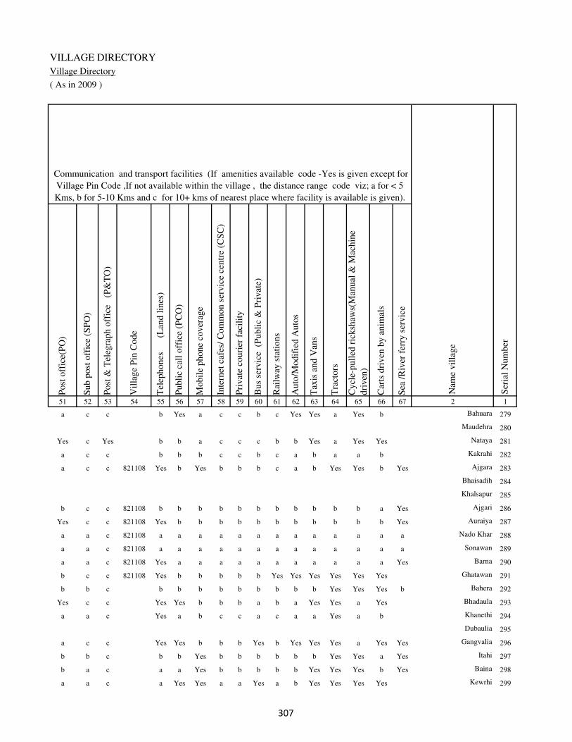
VILLAGE DIRECTORY
Village Directory
( As in 2009 )
Post
off
ice(
PO
)
Sub p
ost
off
ice
(SP
O)
Post
& T
eleg
raph o
ffic
e
(P&
TO
)
Vil
lage
Pin
Code
Tel
ephones
(L
and l
ines
)
Publi
c ca
ll o
ffic
e (P
CO
)
Mobil
e phone
cover
age
Inte
rnet
caf
es/
Com
mon s
ervic
e ce
ntr
e (C
SC
)
Pri
vat
e co
uri
er f
acil
ity
Bus
serv
ice
(P
ubli
c &
Pri
vat
e)
Rai
lway
sta
tions
Auto
/Modif
ied A
uto
s
Tax
is a
nd V
ans
Tra
ctors
Cycl
e-pull
ed r
icksh
aws(
Man
ual
& M
achin
e
dri
ven
)
Car
ts d
riven
by a
nim
als
Sea
/R
iver
fer
ry s
ervic
e51 52 53 54 55 56 57 58 59 60 61 62 63 64 65 66 67 2 1
Communication and transport facilities (If amenities available code -Yes is given except for
Village Pin Code ,If not available within the village , the distance range code viz; a for < 5
Kms, b for 5-10 Kms and c for 10+ kms of nearest place where facility is available is given).
Ser
ial
Num
ber
Nam
e vil
lage
a c c b Yes a c c b c Yes Yes a Yes b Bahuara 279
Maudehra 280
Yes c Yes b b a c c c b b Yes a Yes Yes Nataya 281
a c c b b b c c b c a b a a b Kakrahi 282
a c c 821108 Yes b Yes b b b c a b Yes Yes b Yes Ajgara 283
Bhaisadih 284
Khalsapur 285
b c c 821108 b b b b b b b b b b b a Yes Ajgari 286
Yes c c 821108 Yes b b b b b b b b b b b Yes Auraiya 287
a a c 821108 a a a a a a a a a a a a a Nado Khar 288
a a c 821108 a a a a a a a a a a a a a Sonawan 289
a a c 821108 Yes a a a a a a a a a a a Yes Barna 290
b c c 821108 Yes b b b b b Yes Yes Yes Yes Yes Yes Ghatawan 291
b b c b b b b b b b b b Yes Yes Yes b Bahera 292
Yes c c Yes Yes b b b a b a Yes Yes a Yes Bhadaula 293
a a c Yes a b c c a c a a Yes a b Khanethi 294
Dubaulia 295
a c c Yes Yes b b b Yes b Yes Yes Yes a Yes Yes Gangvalia 296
b b c b b Yes b b b b b b Yes Yes a Yes Itahi 297
b a c a a Yes b b b b b Yes Yes Yes b Yes Baina 298
a a c a Yes Yes a a Yes a b Yes Yes Yes Yes Kewrhi 299
��

DISTRICT CENSUS HANDBOOK : KAIMUR (BHABUA)
Census of India 2011-
Amenities and Land use
Connec
ted t
o n
atio
nal
hig
hw
ay(N
H)
Connec
ted t
o s
tate
hig
hw
ay(S
H)
Connec
ted t
o m
ajor
dis
tric
t ro
ad (
MD
R)
Connec
ted t
o o
ther
s dis
tric
t ro
ad
Pucc
a r
oad
s
Kutc
hch
a r
oad
s
Wat
er b
ounded
mac
adam
(WB
M)
road
s
Nav
igab
le w
ater
way
(ri
ver
/can
al)(
NW
)
Footp
aths
(FP
)
Com
mer
cial
& C
o-o
per
ativ
e B
anks
AT
M
Agri
cult
ura
l C
redit
Soci
etie
s
Sel
f-H
elp G
roup (
SH
G)
Publi
c dis
trib
uti
on s
yst
em (
PD
S)
shop
Man
dis
/ R
egula
r m
arket
Wee
kly
Haa
t
Agri
cult
ura
l m
arket
ing s
oci
ety
1 2 68 69 70 71 72 73 74 75 76 77 78 79 80 81 82 83 84
Village connected to highways,village roads, banks & credit
societies (If amenities available code -Yes is given, If not
available within the village , the distance range code viz; a
for < 5 Kms, b for 5-10 Kms and c for 10+ kms of nearest
place where facility is available is given).
Ser
ial
Num
ber
Nam
e vil
lage
Availability of miscellaneous
facilities (If amenities available
code -Yes is given, If not
available within the village , the
distance range code viz; a for <
5 Kms, b for 5-10 Kms and c
for 10+ kms of nearest place
where facility is available is
given) Contd....
279 Bahuara b c Yes b Yes a a a Yes b c b b a b c c
280 Maudehra
281 Nataya b c Yes Yes Yes a Yes b Yes b c c b Yes b b c
282 Kakrahi b c Yes b b Yes Yes b Yes b c c b b b b c
283 Ajgara c c c Yes b Yes Yes Yes Yes c c c b Yes b c c
284 Bhaisadih
285 Khalsapur
286 Ajgari c c Yes Yes b Yes Yes Yes Yes c c c c a b b c
287 Auraiya b c Yes Yes b Yes Yes Yes Yes c c c b b b b b
288 Nado Khar a b a Yes a Yes Yes a Yes b b b a a a a c
289 Sonawan a b Yes Yes a Yes Yes b Yes c c c a Yes b a c
290 Barna a c c Yes a Yes Yes Yes Yes c c c c a b b c
291 Ghatawan a b b b Yes Yes Yes a Yes b b b b Yes Yes b c
292 Bahera b b b b a Yes b b Yes b b b b a b b c
293 Bhadaula Yes Yes Yes Yes Yes Yes Yes b Yes b b b b b b b c
294 Khanethi Yes Yes Yes b Yes a b a Yes c c c Yes b b b c
295 Dubaulia
296 Gangvalia Yes Yes Yes Yes Yes Yes Yes Yes Yes b b b b Yes b b c
297 Itahi b b b b b Yes Yes Yes Yes b b a b a b b c
298 Baina b b b Yes a a Yes Yes Yes b b a b Yes b b b
299 Kewrhi a a a Yes a a b a Yes a a a b Yes Yes b c
��

VILLAGE DIRECTORY
Village Directory
( As in 2009 )
Inte
gra
ted C
hil
d D
evel
opm
ent
Sch
eme
(Nutr
itio
nal
Cen
tres
)
Angan
wad
i C
entr
e (N
utr
itio
nal
Cen
tres
)
Oth
ers
(Nutr
itio
nal
Cen
tres
)
AS
HA
(A
ccre
dit
ed S
oci
al H
ealt
h A
ctiv
ist)
Com
munit
y c
entr
e w
ith/w
ithout
TV
Sport
s F
ield
,
Sport
s C
lub /
Rec
reat
ion C
entr
e
Cin
ema
/ V
ideo
Hal
l
Publi
c L
ibra
ry
Publi
c R
eadin
g R
oom
New
spap
er S
upply
Ass
embly
Poll
ing s
tati
on
Bir
th &
Dea
th R
egis
trat
ion O
ffic
e
Pow
er S
upply
for
Dom
esti
c U
se (
ED
)
Pow
er S
upply
for
Agri
cult
ura
l U
se (
EA
G)
Pow
er S
upply
for
Com
mer
cial
Use
(E
C)
Pow
er S
upply
for
All
Use
s (E
A)
85 86 87 88 89 90 91 92 93 94 95 96 97 98 99 100 101 2 1
Availability of
electricity (Yes/No)
Availability of miscellaneous facilities (If amenities available code -
Yes is given, If not available within the village , the distance range
code viz; a for < 5 Kms, b for 5-10 Kms and c for 10+ kms of
nearest place where facility is available is given) Concluded
Nam
e vil
lage
Ser
ial
Num
ber
c Yes Yes Yes c Yes c c c c b Yes b Yes No No No Bahuara 279
Maudehra 280
c Yes Yes Yes c Yes Yes c c c b Yes b Yes Yes No No Nataya 281
c Yes Yes a c b c c c c b Yes b Yes No No No Kakrahi 282
c Yes Yes Yes c c c c c c b a b Yes Yes No No Ajgara 283
Bhaisadih 284
Khalsapur 285
c Yes Yes a c c b c c c b a b Yes Yes No No Ajgari 286
c Yes Yes Yes c b c c c c b Yes b Yes Yes No No Auraiya 287
b a Yes a b a c c b b b Yes b Yes Yes No No Nado Khar 288
c Yes Yes Yes c a b c c c c Yes b Yes Yes No No Sonawan 289
c b Yes a c c c c c c b Yes Yes Yes Yes No No Barna 290
b Yes Yes Yes Yes Yes Yes b Yes b Yes Yes Yes Yes Yes Yes Yes Ghatawan 291
b Yes Yes Yes c b c c b c b Yes a No No No No Bahera 292
b Yes Yes a b b c c b c b Yes b Yes Yes Yes Yes Bhadaula 293
b Yes Yes b b b c c b c b Yes Yes No No No No Khanethi 294
Dubaulia 295
b Yes Yes Yes b Yes b c b b b Yes b No Yes No No Gangvalia 296
b Yes Yes Yes a b b b b b b a a No No No No Itahi 297
b Yes Yes Yes b b b b b b b Yes b No No No No Baina 298
b Yes Yes Yes b a a a a a a Yes a Yes Yes No No Kewrhi 299
��

DISTRICT CENSUS HANDBOOK : KAIMUR (BHABUA)
Census of India 2011-
Amenities and Land use
Nam
e
Dis
tance
ran
ge
code
i.e
. a
fo
r <
5 K
ms,
b
for
5-
10 K
ms
and c
f
or
10+
km
s .
Fore
sts
Are
a under
Non-a
gri
cult
ura
l U
ses
Bar
ren a
nd U
n-c
ult
ivab
le l
and
Per
man
ent
Pas
ture
s an
d O
ther
Gra
zing L
ands
Lan
d U
nder
Mis
cell
aneo
us
Tre
e C
rops
etc.
Cult
ura
ble
Was
te L
and
Fal
low
lan
ds
oth
er t
han
curr
ent
fall
ow
s
Curr
ent
Fal
low
s
1 2 102 103 104 105 106 107 108 109 110 111
Ser
ial
Num
ber
Nam
e vil
lage
Area under different types of land use ( in hectares rounded up to
one decimal place)
Land Use
Nearest Town
279 Bahuara BHABUA c 0 8.2 0 0 0 0 0 0
280 Maudehra 7.2 5 0 0 0 0 0 0
281 Nataya BHABUA c 117.5 43 0 0 0 0 0 0
282 Kakrahi BHABUA c 32.3 8.4 0 0 0 0 0 0
283 Ajgara BHABUA c 0 16.1 0 0 0 0 0 6
284 Bhaisadih 0 16.5 0 0 0 0 0 1.8
285 Khalsapur 0 12.2 0 0 0 0 0 0
286 Ajgari BHABUA c 22.5 7.8 0 0 0 0 0 0
287 Auraiya BHABUA c 0 73.7 0 0 0 0 0 0
288 Nado Khar BHABUA c 0 12.3 0 0 0 0 0 0
289 Sonawan BHABUA c 84 19.2 0 0 0 0 0 0
290 Barna BHABUA c 25.8 32.2 0 0 0 0 0 0
291 Ghatawan BHABUA c 315.8 11.4 0 0 0 0 0 0
292 Bahera BHABUA c 12.5 171 0 0 0 0 0 0
293 Bhadaula BHABUA c 12.9 5.6 0 0 0 0 0 0
294 Khanethi BHABUA c 0 42.1 0 0 0 0 0 0
295 Dubaulia 75.4 25.3 0 0 0 0 0 0
296 Gangvalia BHABUA c 44.8 36.1 0 0 0 0 0 0
297 Itahi BHABUA c 0 24.2 0 0 0 0 0 0
298 Baina BHABUA c 91 87 0 0 0 0 0 0
299 Kewrhi BHABUA c 164 40.4 0 0 0 0 0 0
��

VILLAGE DIRECTORY
Village Directory
( As in 2009 )
Net
Are
a S
ow
n
Tota
l Ir
rigat
ed L
and A
rea
Tota
l U
n-i
rrig
ated
Lan
d A
rea
Can
als
( C
)
Wel
ls/T
ube-
wel
ls(W
/TW
)
Tan
ks/
Lak
es(T
/L)
Wat
er F
alls
(WF
)
Oth
ers(
O)
Fir
st
Sec
ond
Thir
d
112 113 114 115 116 117 118 119 120 121 122 2 1
Ser
ial
Num
ber
Name of three
most important
commodities
manufacturedArea irrigated by source (in hectare).
Nam
e of
Vil
lage
Area under different types of
land use ( in hectares rounded
up to one decimal place)
Land Use
53.8 45.2 8.6 45.2 0 0 0 0 Bahuara 279
22.8 22.8 0 20.8 2 0 0 0 Maudehra 280
264.5 243.5 21 243.5 0 0 0 0 Nataya 281
60.3 58.9 1.4 58.9 0 0 0 0 Kakrahi 282
134.9 64.9 70 0 64.9 0 0 0 Ajgara 283
45.7 15 30.7 15 0 0 0 0 Bhaisadih 284
107.8 45.7 62.2 0 19.3 26.4 0 0 Khalsapur 285
45.7 43 2.7 0 43 0 0 0 Ajgari 286
93.3 75.3 18 0 31.9 43.4 0 0 Auraiya 287
116.7 56.4 60.2 0 30.3 26.2 0 0 Nado Khar 288
46.8 40.4 6.4 0 0 40.4 0 0 Sonawan 289
61 40.6 20.4 0 40.6 0 0 0 Barna 290
105.8 30.6 75.2 0 30.6 0 0 0 Ghatawan 291
130.5 87 43.5 0 87 0 0 0 Bahera 292
165.4 125.4 40.1 78.2 47.1 0 0 0 Bhadaula 293
261.9 86.5 175.4 50.6 35.9 0 0 0 Khanethi 294
7.3 6 1.3 0 6 0 0 0 Dubaulia 295
121.1 111.7 9.4 101.2 10.5 0 0 0 Gangvalia 296
113 8 105 0 8 0 0 0 Itahi 297
70 19.5 50.5 0 19.5 0 0 0 Baina 298
162.6 140.5 22.1 0 140.5 0 0 0 Kewrhi 299
��

DISTRICT CENSUS HANDBOOK : KAIMUR (BHABUA)
Census of India 2011-
Amenities and Land use
Pre
-Pri
mar
y s
chool
(PP
)
Pri
mar
y s
chool
(P)
Mid
dle
sch
ool
(M)
Sec
ondar
y S
chool
(S)
Sen
ior
Sec
ondar
y s
chool
(SS
)
Deg
ree
coll
ege
of
arts
sc
ience
& c
om
mer
ce
(AS
C)
Engin
eeri
ng c
oll
ege(
EC
)
Med
ical
coll
ege
(MC
)
Man
agem
ent
inst
itute
(M
I)
Poly
tech
nic
(P
t)
Voca
tional
tra
inin
g s
chool
/IT
I
Non-f
orm
al t
rain
ing c
entr
e (N
FT
C)
Spec
ial
school
for
dis
able
d (
SS
D)
Oth
ers
(spec
ify)
1 2 3 4 5 6 7 8 9 10 11 12 13 14 15 16 17 18 19 20
Loca
tion c
ode
no.
Nam
e vil
lage
Ser
ial
Num
ber
Tota
l popula
tion (
2011 c
ensu
s )
Tota
l ar
ea o
f th
e vil
lage
( in
hec
tare
s ro
unded
up t
o
one
dec
imal
pla
ce)
Number of educational amenities available. (If not available
within the village , the distance range code viz; a for < 5
Kms, b for 5-10 Kms and c for 10+ kms of nearest place
where facility is available is given).
Num
ber
of
house
hold
s (2
011 c
ensu
s)
300 Kahua 249223 43 92 15 a a a c a b c c c c c c c
301 Basawanpur 249224 35 59 8 b a a c a b c c c c c c c
302 Bhunrwa 249225 42 1059 129 b 1 a c a b c c c c c c c
303 Masudnapur 249226 42 0 0
304 Jaruha 249227 81 761 104 a 2 b c b b c c c c c c c
305 Nimia 249228 118 670 91 b b b c b b c c c c c c c b
306 Likhiya 249229 77 0 0
307 Gajirhan 249230 111 363 50 b 1 b c a b c c c c c c c
308 Kishunpura 249231 87 0 0
309 Asraulia 249232 97 466 60 b 1 a c a b c c c c c c c
310 Deorarh 249233 308 3963 566 b 1 1 c c b c c c c c c c
311 Nasej 249234 176 2928 498 b 1 1 c a b c c c c c c c
312 Patti 249235 100 390 89 b b b c b c c c c c c c c c
313 Babhanganwan 249236 28 955 169 b b b c b c c c c c c c c c
314 Ahraulia 249237 78 284 43 b b b c a b c c c c c c c
315 Patkhaulia 249238 92 764 132 b a a b b b c c c c c c c
316 Amirtha 249239 199 2030 355 b 1 1 1 b b c c c c b c c
317 Nathopur 249240 169 936 151 b 1 a c b b c c c c b c c
318 Bhargawan 249241 112 1388 237 b 1 1 c b b c c c c b c c
319 Chibili 249242 350 2427 428 a 1 b c a b c c c c a c c
320 Karman 249243 266 2975 482 a 1 1 c a b c c c c c c c
�

VILLAGE DIRECTORY
Village Directory
( As in 2009 )
Com
munit
y h
ealt
h c
entr
e (C
HC
)
Pri
mar
y h
ealt
h c
entr
e (P
HC
)
Pri
mar
y h
ealt
h s
ub c
entr
e (P
HS
)
Mat
ernit
y a
nd c
hil
d w
elfa
re c
entr
e (M
CW
)
T.B
. cl
inic
(T
BC
)
Hosp
ital
-all
opat
hic
(H
A)
Hosp
ital
-alt
ernat
ive
med
icin
e (H
O)
Dis
pen
sary
(D
)
Vet
erin
ary h
osp
ital
(V
H)
Mobil
e hea
lth c
linic
(M
HC
)
Fam
ily w
elfa
re c
entr
e (F
WC
)
Char
itab
le n
on G
ovt.
hosp
ital
/Nurs
ing h
om
e.
Med
ical
pra
ctit
ioner
wit
h M
BB
S D
egre
e
Med
ical
pra
ctit
ioner
wit
h o
ther
deg
ree
Med
ical
pra
ctit
ioner
wit
h n
o d
egre
e
Tra
dit
ional
pra
ctit
ioner
an
d f
aith
hea
ler
.
Med
icin
e S
hop
Oth
ers
21 22 23 24 25 26 27 28 29 30 31 32 33 34 35 36 37 38 2 1
Number of Non-Government
Medical Amenities available.
Number of Medical Amenities available. (If not
available within the village , the distance range
code viz; a for < 5 Kms, b for 5-10 Kms and c
for 10+ kms of nearest place where facility is
available is given).
Nam
e vil
lage
Ser
ial
Num
ber
c b b b c c c c b c b 0 0 0 0 0 0 0 Kahua 300
c b b b c c c c c c b 0 0 0 0 0 0 0 Basawanpur 301
c c b b c c c c c c 1 0 0 0 0 0 0 0 Bhunrwa 302
Masudnapur 303
c c b b c c c c c c b 0 0 0 0 0 0 0 Jaruha 304
b b b b b c c b b c b 0 0 0 0 0 0 0 Nimia 305
Likhiya 306
c c c b c c c c c c b 0 0 0 0 0 0 0 Gajirhan 307
Kishunpura 308
b b b b b c c b b c b 0 0 0 0 0 0 0 Asraulia 309
c b b b c c c b c c b 0 0 0 0 0 0 0 Deorarh 310
c b b b c c c b c c b 0 0 0 0 0 0 0 Nasej 311
c b b b c c c b c c b 0 0 0 1 1 1 0 Patti 312
c b b b c c c c c c b 0 0 0 0 1 1 0 Babhanganwan 313
b b b b b c c b b c b 0 0 0 0 0 0 0 Ahraulia 314
b b b b b c c b b c b 0 0 0 0 0 0 0 Patkhaulia 315
b b b b b c c b b c b 0 0 0 0 0 0 0 Amirtha 316
b b b b b c c b b c b 0 0 0 0 0 0 0 Nathopur 317
b b b b b c c b b c b 0 0 0 0 0 0 0 Bhargawan 318
b a a a a c c a a c a 0 0 0 0 0 0 0 Chibili 319
b b b b b c c b b c b 0 0 0 0 0 0 0 Karman 320
�

DISTRICT CENSUS HANDBOOK : KAIMUR (BHABUA)
Census of India 2011-
Amenities and Land use
Tap
wat
er (
Tre
ated
/Untr
eate
d)
Wel
l w
ater
(Cover
ed /
Unco
ver
ed w
ell)
Han
d P
um
p
Tube
wel
ls /
Bore
wel
l
Spri
ng
Riv
er /
Can
al
Tan
k /
Pond /
L
ake
Oth
ers
Com
munit
y t
oil
et i
ncl
udin
g
bat
h.
Com
munit
y t
oil
et e
xcl
udin
g b
ath.
Rura
l s
anit
ary m
art
or
sanit
ary
har
dw
are
outl
et
avai
lable
nea
r th
e vil
lage.
Com
munit
y b
io-
gas
or
recy
cle
of
was
te f
or
pro
duct
ive
use
.
1 2 39 40 41 42 43 44 45 46 47 48 49 50
Availability of toilet & others
Yes / No Availability of drinking water - Yes / No
Nam
e vil
lage
Ser
ial
Num
ber
300 Kahua No Yes Yes Yes No No No No No No No No
301 Basawanpur No No Yes No No No No No No No No No
302 Bhunrwa No Yes Yes No No No No No No No No No
303 Masudnapur
304 Jaruha No No Yes Yes No No No No No No No No
305 Nimia No Yes Yes No No No No No No No No No
306 Likhiya
307 Gajirhan No Yes Yes No No No No No No No No No
308 Kishunpura
309 Asraulia No Yes Yes No No No No No No No No No
310 Deorarh No Yes Yes Yes No No No No No No No No
311 Nasej No Yes Yes No No No No No No No No No
312 Patti No Yes Yes No No No No No No No No No
313 Babhanganwan No Yes Yes No No No No No No No No No
314 Ahraulia No Yes Yes No No No No No No No No No
315 Patkhaulia No No Yes Yes No Yes No No No No No No
316 Amirtha No No Yes Yes No Yes No No No No No No
317 Nathopur No No Yes Yes No Yes No No No No No No
318 Bhargawan No No Yes Yes No Yes No No No No No No
319 Chibili No No Yes Yes No Yes No No No No No No
320 Karman No Yes Yes No No No No No No No No No
��

VILLAGE DIRECTORY
Village Directory
( As in 2009 )
Post
off
ice(
PO
)
Sub p
ost
off
ice
(SP
O)
Post
& T
eleg
raph o
ffic
e
(P&
TO
)
Vil
lage
Pin
Code
Tel
ephones
(L
and l
ines
)
Publi
c ca
ll o
ffic
e (P
CO
)
Mobil
e phone
cover
age
Inte
rnet
caf
es/
Com
mon s
ervic
e ce
ntr
e (C
SC
)
Pri
vat
e co
uri
er f
acil
ity
Bus
serv
ice
(P
ubli
c &
Pri
vat
e)
Rai
lway
sta
tions
Auto
/Modif
ied A
uto
s
Tax
is a
nd V
ans
Tra
ctors
Cycl
e-pull
ed r
icksh
aws(
Man
ual
& M
achin
e
dri
ven
)
Car
ts d
riven
by a
nim
als
Sea
/R
iver
fer
ry s
ervic
e51 52 53 54 55 56 57 58 59 60 61 62 63 64 65 66 67 2 1
Communication and transport facilities (If amenities available code -Yes is given except for
Village Pin Code ,If not available within the village , the distance range code viz; a for < 5
Kms, b for 5-10 Kms and c for 10+ kms of nearest place where facility is available is given).
Ser
ial
Num
ber
Nam
e vil
lage
b a c a a Yes b b b b b b Yes a a Kahua 300
b c c b b a b b b b b b a a b Basawanpur 301
Yes c c b b b b c b Yes c b b b b Bhunrwa 302
Masudnapur 303
a a c a a Yes b b a b a a Yes b Yes Yes Jaruha 304
b b c b b b b b b b b b b b b b Nimia 305
Likhiya 306
b c c 821108 b a a b b b b b a a a b Gajirhan 307
Kishunpura 308
b b c 821108 b b b b b b b b b b a b Asraulia 309
b b c b b b b b b b b Yes Yes Yes Yes Deorarh 310
Yes c c b b b b b b b c b Yes b Yes Nasej 311
b c c 821108 Yes b b b Yes b Yes c b Yes Yes b Patti 312
b c c 821108 Yes b b b Yes b Yes b b Yes Yes b Babhanganwan 313
b c c 821108 b a a b b b Yes b b a a b Ahraulia 314
b b c b b b b b b b b b b b b c Patkhaulia 315
b a c Yes a Yes b b Yes a a Yes Yes b Yes Amirtha 316
b a c b b Yes b b b b Yes Yes Yes b Yes Nathopur 317
b a c b b Yes b b Yes b b Yes Yes Yes Yes c Bhargawan 318
a a c Yes Yes Yes a a a a Yes Yes Yes Yes Yes a Chibili 319
b c c b a a b b b b b b Yes b Yes Karman 320
��

DISTRICT CENSUS HANDBOOK : KAIMUR (BHABUA)
Census of India 2011-
Amenities and Land use
Connec
ted t
o n
atio
nal
hig
hw
ay(N
H)
Connec
ted t
o s
tate
hig
hw
ay(S
H)
Connec
ted t
o m
ajor
dis
tric
t ro
ad (
MD
R)
Connec
ted t
o o
ther
s dis
tric
t ro
ad
Pucc
a r
oad
s
Kutc
hch
a r
oad
s
Wat
er b
ounded
mac
adam
(WB
M)
road
s
Nav
igab
le w
ater
way
(ri
ver
/can
al)(
NW
)
Footp
aths
(FP
)
Com
mer
cial
& C
o-o
per
ativ
e B
anks
AT
M
Agri
cult
ura
l C
redit
Soci
etie
s
Sel
f-H
elp G
roup (
SH
G)
Publi
c dis
trib
uti
on s
yst
em (
PD
S)
shop
Man
dis
/ R
egula
r m
arket
Wee
kly
Haa
t
Agri
cult
ura
l m
arket
ing s
oci
ety
1 2 68 69 70 71 72 73 74 75 76 77 78 79 80 81 82 83 84
Village connected to highways,village roads, banks & credit
societies (If amenities available code -Yes is given, If not
available within the village , the distance range code viz; a
for < 5 Kms, b for 5-10 Kms and c for 10+ kms of nearest
place where facility is available is given).
Ser
ial
Num
ber
Nam
e vil
lage
Availability of miscellaneous
facilities (If amenities available
code -Yes is given, If not
available within the village , the
distance range code viz; a for <
5 Kms, b for 5-10 Kms and c
for 10+ kms of nearest place
where facility is available is
given) Contd....
300 Kahua b b b Yes Yes Yes Yes b Yes b b b a a b b c
301 Basawanpur b b b b b b b b Yes b b b b a b b b
302 Bhunrwa b c Yes Yes b b a b Yes c c b b b b b c
303 Masudnapur
304 Jaruha Yes Yes Yes Yes Yes Yes Yes Yes Yes b b b b Yes b b c
305 Nimia b b b b b Yes b Yes b b b b b b b b
306 Likhiya
307 Gajirhan b b b b Yes Yes a a Yes b b c b a b b c
308 Kishunpura
309 Asraulia Yes b b Yes Yes Yes b b Yes b b c b b b b c
310 Deorarh Yes Yes Yes Yes Yes Yes Yes b Yes Yes Yes Yes b a Yes c c
311 Nasej b b b b Yes Yes b b Yes b b b a a b c c
312 Patti b b b Yes Yes Yes Yes b Yes b b a b a a c c
313 Babhanganwan b c b Yes Yes Yes Yes b Yes b b b b b b b c
314 Ahraulia a c b b a a b b Yes a c b b b b c c
315 Patkhaulia a c Yes Yes b Yes Yes b Yes b b b b a b b c
316 Amirtha Yes Yes Yes Yes Yes a a b Yes b b b Yes Yes a a c
317 Nathopur a b Yes Yes Yes a Yes a Yes b b b b a b b b
318 Bhargawan a b Yes Yes a Yes Yes b Yes b b b Yes Yes b b b
319 Chibili Yes Yes Yes Yes Yes Yes Yes b Yes a a a b Yes a a a
320 Karman Yes c b b Yes a b b Yes b b b b b b b b
��
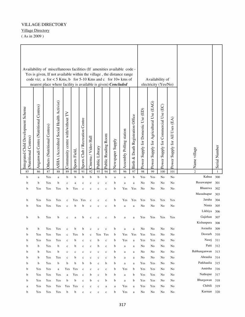
VILLAGE DIRECTORY
Village Directory
( As in 2009 )
Inte
gra
ted C
hil
d D
evel
opm
ent
Sch
eme
(Nutr
itio
nal
Cen
tres
)
Angan
wad
i C
entr
e (N
utr
itio
nal
Cen
tres
)
Oth
ers
(Nutr
itio
nal
Cen
tres
)
AS
HA
(A
ccre
dit
ed S
oci
al H
ealt
h A
ctiv
ist)
Com
munit
y c
entr
e w
ith/w
ithout
TV
Sport
s F
ield
,
Sport
s C
lub /
Rec
reat
ion C
entr
e
Cin
ema
/ V
ideo
Hal
l
Publi
c L
ibra
ry
Publi
c R
eadin
g R
oom
New
spap
er S
upply
Ass
embly
Poll
ing s
tati
on
Bir
th &
Dea
th R
egis
trat
ion O
ffic
e
Pow
er S
upply
for
Dom
esti
c U
se (
ED
)
Pow
er S
upply
for
Agri
cult
ura
l U
se (
EA
G)
Pow
er S
upply
for
Com
mer
cial
Use
(E
C)
Pow
er S
upply
for
All
Use
s (E
A)
85 86 87 88 89 90 91 92 93 94 95 96 97 98 99 100 101 2 1
Availability of
electricity (Yes/No)
Availability of miscellaneous facilities (If amenities available code -
Yes is given, If not available within the village , the distance range
code viz; a for < 5 Kms, b for 5-10 Kms and c for 10+ kms of
nearest place where facility is available is given) Concluded
Nam
e vil
lage
Ser
ial
Num
ber
b a Yes a b b b b b b a a b Yes Yes No No Kahua 300
b b Yes b c a c c c c b a a No No No No Basawanpur 301
b Yes Yes Yes b Yes c c c c b Yes Yes No No No No Bhunrwa 302
Masudnapur 303
b Yes Yes Yes c Yes Yes c c c b Yes Yes Yes Yes Yes Yes Jaruha 304
b Yes Yes Yes c b b c c c b a a No No No No Nimia 305
Likhiya 306
b b Yes b c a b c c c b a a Yes Yes Yes Yes Gajirhan 307
Kishunpura 308
b b Yes Yes c b b c c c b a a No No No No Asraulia 309
b Yes Yes Yes c Yes b c Yes Yes b Yes Yes Yes Yes No No Deorarh 310
b Yes Yes Yes c b c c b c b Yes a Yes Yes No No Nasej 311
b b Yes b c b c c b c b a a No No No No Patti 312
b b Yes b c c c c c c b a a No No No No Babhanganwan 313
b b Yes Yes c b c c c c b a a No No No No Ahraulia 314
b b Yes b b b b b c b b a a Yes Yes No No Patkhaulia 315
b Yes Yes a Yes Yes c c c c b Yes b Yes Yes No No Amirtha 316
b Yes Yes Yes a Yes c b c b b a b Yes Yes No No Nathopur 317
b Yes Yes Yes b b c b c b b a b Yes Yes No No Bhargawan 318
a Yes Yes Yes Yes Yes c c c a a Yes a Yes Yes No No Chibili 319
b Yes Yes Yes b b c c c c b Yes a No No No No Karman 320
��
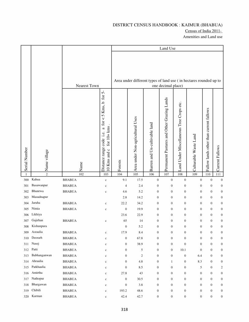
DISTRICT CENSUS HANDBOOK : KAIMUR (BHABUA)
Census of India 2011-
Amenities and Land use
Nam
e
Dis
tance
ran
ge
code
i.e
. a
fo
r <
5 K
ms,
b
for
5-
10 K
ms
and c
f
or
10+
km
s .
Fore
sts
Are
a under
Non-a
gri
cult
ura
l U
ses
Bar
ren a
nd U
n-c
ult
ivab
le l
and
Per
man
ent
Pas
ture
s an
d O
ther
Gra
zing L
ands
Lan
d U
nder
Mis
cell
aneo
us
Tre
e C
rops
etc.
Cult
ura
ble
Was
te L
and
Fal
low
lan
ds
oth
er t
han
curr
ent
fall
ow
s
Curr
ent
Fal
low
s
1 2 102 103 104 105 106 107 108 109 110 111
Ser
ial
Num
ber
Nam
e vil
lage
Area under different types of land use ( in hectares rounded up to
one decimal place)
Land Use
Nearest Town
300 Kahua BHABUA c 9.1 17.5 0 0 0 0 0 0
301 Basawanpur BHABUA c 4 2.4 0 0 0 0 0 0
302 Bhunrwa BHABUA c 4.6 5.2 0 0 0 0 0 0
303 Masudnapur 2.8 14.2 0 0 0 0 0 0
304 Jaruha BHABUA c 22.2 34.2 0 0 0 0 0 0
305 Nimia BHABUA c 0 19.9 0 0 0 0 0 0
306 Likhiya 23.6 22.9 0 0 0 0 0 0
307 Gajirhan BHABUA c 65 14 0 0 0 0 0 0
308 Kishunpura 0 5.2 0 0 0 0 0 0
309 Asraulia BHABUA c 17.9 8.4 0 0 0 0 0 0
310 Deorarh BHABUA c 0 67.8 0 0 0 0 0 0
311 Nasej BHABUA c 0 38.9 0 0 0 0 0 0
312 Patti BHABUA c 0 5 0 0 10.1 0 0 0
313 Babhanganwan BHABUA c 0 2 0 0 0 6.4 0 0
314 Ahraulia BHABUA c 0 4.8 0 1 0 8.3 0 0
315 Patkhaulia BHABUA c 0 8.5 0 0 0 5 0 2
316 Amirtha BHABUA c 27.8 43 0 0 0 0 0 0
317 Nathopur BHABUA c 0 30.5 0 0 0 0 0 0
318 Bhargawan BHABUA c 0 3.8 0 0 0 0 0 0
319 Chibili BHABUA c 193.2 48.6 0 0 0 0 0 0
320 Karman BHABUA c 42.4 42.7 0 0 0 0 0 0
��

VILLAGE DIRECTORY
Village Directory
( As in 2009 )
Net
Are
a S
ow
n
Tota
l Ir
rigat
ed L
and A
rea
Tota
l U
n-i
rrig
ated
Lan
d A
rea
Can
als
( C
)
Wel
ls/T
ube-
wel
ls(W
/TW
)
Tan
ks/
Lak
es(T
/L)
Wat
er F
alls
(WF
)
Oth
ers(
O)
Fir
st
Sec
ond
Thir
d
112 113 114 115 116 117 118 119 120 121 122 2 1
Ser
ial
Num
ber
Name of three
most important
commodities
manufacturedArea irrigated by source (in hectare).
Nam
e of
Vil
lage
Area under different types of
land use ( in hectares rounded
up to one decimal place)
Land Use
16.4 10.5 5.9 0 10.5 0 0 0 Kahua 300
28.6 12.4 16.2 0 12.4 0 0 0 Basawanpur 301
32.2 28.4 3.8 28.4 0 0 0 0 Bhunrwa 302
25 18.4 6.6 18.4 0 0 0 0 Masudnapur 303
24.6 14.5 10.1 0 14.5 0 0 0 Jaruha 304
98.1 62.4 35.7 0 62.4 0 0 0 Nimia 305
30.5 18.3 12.2 0 18.3 0 0 0 Likhiya 306
32 30 2 0 30 0 0 0 Gajirhan 307
81.8 13.1 68.7 0 13.1 0 0 0 Kishunpura 308
70.7 65.5 5.2 0 65.5 0 0 0 Asraulia 309
240.1 119.7 120.4 0 86.6 33.1 0 0 Deorarh 310
137.1 63.9 73.2 0 0 63.9 0 0 Nasej 311
84.9 80.2 4.7 0 80.2 0 0 0 Patti 312
19.6 17 2.6 17 0 0 0 0 Babhanganwan 313
63.9 23.6 40.3 0 23.6 0 0 0 Ahraulia 314
76.5 56 20.5 56 0 0 0 0 Patkhaulia 315
128.2 116.8 11.4 116.8 0 0 0 0 Amirtha 316
138.5 55.4 83.1 0 55.4 0 0 0 Nathopur 317
108.2 32.1 76.1 0 32.1 0 0 0 Bhargawan 318
108.2 92.5 15.7 92.5 0 0 0 0 Chibili 319
180.9 162.9 18 0 162.9 0 0 0 Karman 320
��

DISTRICT CENSUS HANDBOOK : KAIMUR (BHABUA)
Census of India 2011-
Amenities and Land use
Pre
-Pri
mar
y s
chool
(PP
)
Pri
mar
y s
chool
(P)
Mid
dle
sch
ool
(M)
Sec
ondar
y S
chool
(S)
Sen
ior
Sec
ondar
y s
chool
(SS
)
Deg
ree
coll
ege
of
arts
sc
ience
& c
om
mer
ce
(AS
C)
Engin
eeri
ng c
oll
ege(
EC
)
Med
ical
coll
ege
(MC
)
Man
agem
ent
inst
itute
(M
I)
Poly
tech
nic
(P
t)
Voca
tional
tra
inin
g s
chool
/IT
I
Non-f
orm
al t
rain
ing c
entr
e (N
FT
C)
Spec
ial
school
for
dis
able
d (
SS
D)
Oth
ers
(spec
ify)
1 2 3 4 5 6 7 8 9 10 11 12 13 14 15 16 17 18 19 20
Loca
tion c
ode
no.
Nam
e vil
lage
Ser
ial
Num
ber
Tota
l popula
tion (
2011 c
ensu
s )
Tota
l ar
ea o
f th
e vil
lage
( in
hec
tare
s ro
unded
up t
o
one
dec
imal
pla
ce)
Number of educational amenities available. (If not available
within the village , the distance range code viz; a for < 5
Kms, b for 5-10 Kms and c for 10+ kms of nearest place
where facility is available is given).
Num
ber
of
house
hold
s (2
011 c
ensu
s)
321 Bajarkona 249244 109 505 64 a 1 b c a b c c c c c c c
322 Pathkhaulia 249245 38 0 0
323 Gajrarhi 249246 140 605 112 b 1 b c a b c c c c c c c
324 Jahanabad 249247 550 17076 2705 2 9 6 2 1 1 c c c c 1 c c
325 Chakia 249248 27 2446 427 1 5 4 2 3 3 c c c c a 1 c
326 Sakri 249249 257.8 6442 1043 2 1 1 1 1 1 c c c b a c c
327 Bhainsaula 249250 228 2286 354 b 1 a c a b c c c c a c c
328 Neoras 249251 349 4440 694 a 1 1 c a b c c c 1 c c c
329 Khaira 249252 121 79 15 b a a c b b c c c c c c c
330 Dihra 249253 301 2208 296 a 1 1 c a b c c c c a c c
331 Golaudih 249254 217 1122 180 a 1 a c a b c c c c a c c
332 Dusadhi Chak 249255 48 56 15 b a a b a b c c c c b c c
333 Daindih 249256 161 0 0
334 Tarhani 249257 46.5 409 59 a 1 a c a b c c c c b c c
335 Hardaspur 249258 61 526 83 b 2 2 c a b c c c c b c c
336 Bagra 249259 89 134 20 a a a c a b c c c c b c c
337 Pachpokhri 249260 291 1872 269 1 2 2 c a c c c c c a c c
338 Chanwakh 249261 145 702 125 a 2 a b a c c c c c b c c
339 Gurra 249262 129.9 716 134 a 1 a c a c c c c c b c c
340 Belbhadra 249263 77 110 19 b a a c b b c c c c b c c
341 Mokaram 249264 87 1202 198 b 2 a c a b c c c c c c c
�

VILLAGE DIRECTORY
Village Directory
( As in 2009 )
Com
munit
y h
ealt
h c
entr
e (C
HC
)
Pri
mar
y h
ealt
h c
entr
e (P
HC
)
Pri
mar
y h
ealt
h s
ub c
entr
e (P
HS
)
Mat
ernit
y a
nd c
hil
d w
elfa
re c
entr
e (M
CW
)
T.B
. cl
inic
(T
BC
)
Hosp
ital
-all
opat
hic
(H
A)
Hosp
ital
-alt
ernat
ive
med
icin
e (H
O)
Dis
pen
sary
(D
)
Vet
erin
ary h
osp
ital
(V
H)
Mobil
e hea
lth c
linic
(M
HC
)
Fam
ily w
elfa
re c
entr
e (F
WC
)
Char
itab
le n
on G
ovt.
hosp
ital
/Nurs
ing h
om
e.
Med
ical
pra
ctit
ioner
wit
h M
BB
S D
egre
e
Med
ical
pra
ctit
ioner
wit
h o
ther
deg
ree
Med
ical
pra
ctit
ioner
wit
h n
o d
egre
e
Tra
dit
ional
pra
ctit
ioner
an
d f
aith
hea
ler
.
Med
icin
e S
hop
Oth
ers
21 22 23 24 25 26 27 28 29 30 31 32 33 34 35 36 37 38 2 1
Number of Non-Government
Medical Amenities available.
Number of Medical Amenities available. (If not
available within the village , the distance range
code viz; a for < 5 Kms, b for 5-10 Kms and c
for 10+ kms of nearest place where facility is
available is given).
Nam
e vil
lage
Ser
ial
Num
ber
c a a a a c c a a c a 0 0 0 0 0 0 0 Bajarkona 321
Pathkhaulia 322
c a a a a c c a a c a 0 0 0 0 0 0 0 Gajrarhi 323
c 1 1 1 1 c c 1 1 c 1 2 2 6 8 12 8 0 Jahanabad 324
c a b b c c c c b c c 0 0 0 0 0 0 0 Chakia 325
c a 1 1 c c c 1 a c 1 2 2 5 6 1 5 0 Sakri 326
a a a a b c c a a c a 0 0 0 0 0 0 0 Bhainsaula 327
a a a a a c c a a c a 0 0 0 0 0 0 0 Neoras 328
c b b b b c c c b c b 0 0 0 0 0 0 0 Khaira 329
c a a a a c c c a c a 0 0 0 0 0 0 0 Dihra 330
c a a a a c c a a c a 0 0 0 0 0 0 0 Golaudih 331
c a b b b c c b c c b 0 0 0 0 0 0 0 Dusadhi Chak 332
Daindih 333
c b 1 1 b c c b b c 1 0 0 0 0 0 0 0 Tarhani 334
a a 1 1 a c c a a c 1 0 0 0 0 0 0 0 Hardaspur 335
a a 1 1 a c c a a c 1 0 0 0 0 0 0 0 Bagra 336
a a 1 1 a c c a a c 1 0 0 0 0 0 0 0 Pachpokhri 337
a a 1 1 a c c a a c 1 0 0 0 0 0 0 0 Chanwakh 338
b b b b b c c b b c b 0 0 0 0 0 0 0 Gurra 339
b b 1 1 b c c b b c 1 0 0 0 0 0 0 0 Belbhadra 340
b b 1 1 b c c b b c 1 0 0 0 0 0 0 0 Mokaram 341
�

DISTRICT CENSUS HANDBOOK : KAIMUR (BHABUA)
Census of India 2011-
Amenities and Land use
Tap
wat
er (
Tre
ated
/Untr
eate
d)
Wel
l w
ater
(Cover
ed /
Unco
ver
ed w
ell)
Han
d P
um
p
Tube
wel
ls /
Bore
wel
l
Spri
ng
Riv
er /
Can
al
Tan
k /
Pond /
L
ake
Oth
ers
Com
munit
y t
oil
et i
ncl
udin
g
bat
h.
Com
munit
y t
oil
et e
xcl
udin
g b
ath.
Rura
l s
anit
ary m
art
or
sanit
ary
har
dw
are
outl
et
avai
lable
nea
r th
e vil
lage.
Com
munit
y b
io-
gas
or
recy
cle
of
was
te f
or
pro
duct
ive
use
.
1 2 39 40 41 42 43 44 45 46 47 48 49 50
Availability of toilet & others
Yes / No Availability of drinking water - Yes / No
Nam
e vil
lage
Ser
ial
Num
ber
321 Bajarkona No Yes Yes Yes No No No No No No No No
322 Pathkhaulia
323 Gajrarhi No No Yes No No No No No No No No No
324 Jahanabad No Yes Yes Yes No Yes No No No No No No
325 Chakia Yes Yes Yes Yes No No No No No No No No
326 Sakri Yes Yes Yes Yes No Yes No No No No No No
327 Bhainsaula No No Yes Yes No Yes No No No No No No
328 Neoras No Yes Yes No No Yes No No No No No No
329 Khaira No No Yes No No Yes No No No No No No
330 Dihra No No Yes Yes No Yes No No No No No No
331 Golaudih No No Yes Yes No Yes No No No No No No
332 Dusadhi Chak No No Yes No No No No No No No No No
333 Daindih
334 Tarhani No No Yes Yes No Yes No No No No No No
335 Hardaspur No No Yes Yes No Yes No No No No No No
336 Bagra No Yes Yes Yes No Yes No No No No No No
337 Pachpokhri No Yes Yes No No Yes No No No No No No
338 Chanwakh No No Yes Yes No Yes No No No No No No
339 Gurra No No Yes Yes No Yes No No No No No No
340 Belbhadra No Yes Yes Yes No Yes No No No No No No
341 Mokaram No No Yes Yes No Yes No No No No No No
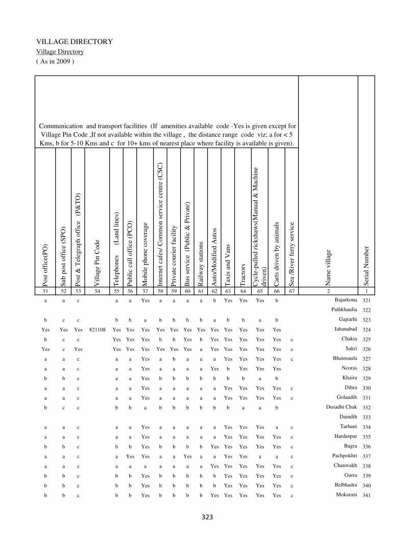
VILLAGE DIRECTORY
Village Directory
( As in 2009 )
Post
off
ice(
PO
)
Sub p
ost
off
ice
(SP
O)
Post
& T
eleg
raph o
ffic
e
(P&
TO
)
Vil
lage
Pin
Code
Tel
ephones
(L
and l
ines
)
Publi
c ca
ll o
ffic
e (P
CO
)
Mobil
e phone
cover
age
Inte
rnet
caf
es/
Com
mon s
ervic
e ce
ntr
e (C
SC
)
Pri
vat
e co
uri
er f
acil
ity
Bus
serv
ice
(P
ubli
c &
Pri
vat
e)
Rai
lway
sta
tions
Auto
/Modif
ied A
uto
s
Tax
is a
nd V
ans
Tra
ctors
Cycl
e-pull
ed r
icksh
aws(
Man
ual
& M
achin
e
dri
ven
)
Car
ts d
riven
by a
nim
als
Sea
/R
iver
fer
ry s
ervic
e51 52 53 54 55 56 57 58 59 60 61 62 63 64 65 66 67 2 1
Communication and transport facilities (If amenities available code -Yes is given except for
Village Pin Code ,If not available within the village , the distance range code viz; a for < 5
Kms, b for 5-10 Kms and c for 10+ kms of nearest place where facility is available is given).
Ser
ial
Num
ber
Nam
e vil
lage
a a c a a Yes a a a a b Yes Yes Yes b Bajarkona 321
Pathkhaulia 322
b c c b b a b b b b a b b a b Gajrarhi 323
Yes Yes Yes 821108 Yes Yes Yes Yes Yes Yes Yes Yes Yes Yes Yes Yes Jahanabad 324
b c c Yes Yes Yes b b Yes b Yes Yes Yes Yes Yes c Chakia 325
Yes c Yes Yes Yes Yes Yes Yes Yes a Yes Yes Yes Yes Yes c Sakri 326
a a c a a Yes a b a a a Yes Yes Yes Yes c Bhainsaula 327
a a c a a Yes a a a a Yes b Yes Yes Yes Neoras 328
b b c a a Yes b b b b b b b a b Khaira 329
a a c a a Yes a a a a a Yes Yes Yes Yes c Dihra 330
a a c a a Yes a a a a a Yes Yes Yes Yes c Golaudih 331
b c c b b a b b b b b b a a b Dusadhi Chak 332
Daindih 333
a a c a a Yes a a a a a Yes Yes Yes a c Tarhani 334
a a c a a Yes a a a a a Yes Yes Yes Yes c Hardaspur 335
b b c b b Yes b b b b Yes Yes Yes Yes Yes c Bagra 336
a a c a Yes Yes a a Yes a a Yes Yes a a c Pachpokhri 337
a a c a a a a a a a Yes Yes Yes Yes Yes c Chanwakh 338
b b c b b Yes b b b b b Yes Yes Yes Yes c Gurra 339
b b c b b Yes b b b b b Yes Yes Yes Yes c Belbhadra 340
b b c b b Yes b b b b Yes Yes Yes Yes Yes c Mokaram 341
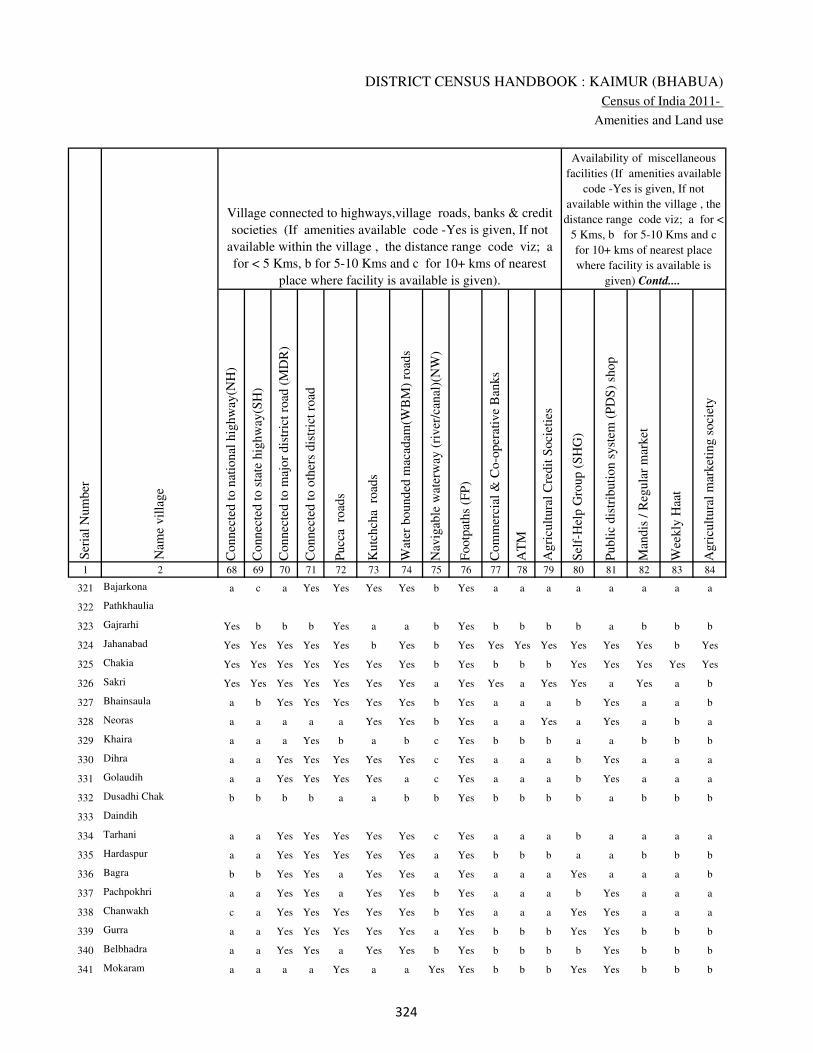
DISTRICT CENSUS HANDBOOK : KAIMUR (BHABUA)
Census of India 2011-
Amenities and Land use
Connec
ted t
o n
atio
nal
hig
hw
ay(N
H)
Connec
ted t
o s
tate
hig
hw
ay(S
H)
Connec
ted t
o m
ajor
dis
tric
t ro
ad (
MD
R)
Connec
ted t
o o
ther
s dis
tric
t ro
ad
Pucc
a r
oad
s
Kutc
hch
a r
oad
s
Wat
er b
ounded
mac
adam
(WB
M)
road
s
Nav
igab
le w
ater
way
(ri
ver
/can
al)(
NW
)
Footp
aths
(FP
)
Com
mer
cial
& C
o-o
per
ativ
e B
anks
AT
M
Agri
cult
ura
l C
redit
Soci
etie
s
Sel
f-H
elp G
roup (
SH
G)
Publi
c dis
trib
uti
on s
yst
em (
PD
S)
shop
Man
dis
/ R
egula
r m
arket
Wee
kly
Haa
t
Agri
cult
ura
l m
arket
ing s
oci
ety
1 2 68 69 70 71 72 73 74 75 76 77 78 79 80 81 82 83 84
Village connected to highways,village roads, banks & credit
societies (If amenities available code -Yes is given, If not
available within the village , the distance range code viz; a
for < 5 Kms, b for 5-10 Kms and c for 10+ kms of nearest
place where facility is available is given).
Ser
ial
Num
ber
Nam
e vil
lage
Availability of miscellaneous
facilities (If amenities available
code -Yes is given, If not
available within the village , the
distance range code viz; a for <
5 Kms, b for 5-10 Kms and c
for 10+ kms of nearest place
where facility is available is
given) Contd....
321 Bajarkona a c a Yes Yes Yes Yes b Yes a a a a a a a a
322 Pathkhaulia
323 Gajrarhi Yes b b b Yes a a b Yes b b b b a b b b
324 Jahanabad Yes Yes Yes Yes Yes b Yes b Yes Yes Yes Yes Yes Yes Yes b Yes
325 Chakia Yes Yes Yes Yes Yes Yes Yes b Yes b b b Yes Yes Yes Yes Yes
326 Sakri Yes Yes Yes Yes Yes Yes Yes a Yes Yes a Yes Yes a Yes a b
327 Bhainsaula a b Yes Yes Yes Yes Yes b Yes a a a b Yes a a b
328 Neoras a a a a a Yes Yes b Yes a a Yes a Yes a b a
329 Khaira a a a Yes b a b c Yes b b b a a b b b
330 Dihra a a Yes Yes Yes Yes Yes c Yes a a a b Yes a a a
331 Golaudih a a Yes Yes Yes Yes a c Yes a a a b Yes a a a
332 Dusadhi Chak b b b b a a b b Yes b b b b a b b b
333 Daindih
334 Tarhani a a Yes Yes Yes Yes Yes c Yes a a a b a a a a
335 Hardaspur a a Yes Yes Yes Yes Yes a Yes b b b a a b b b
336 Bagra b b Yes Yes a Yes Yes a Yes a a a Yes a a a b
337 Pachpokhri a a Yes Yes a Yes Yes b Yes a a a b Yes a a a
338 Chanwakh c a Yes Yes Yes Yes Yes b Yes a a a Yes Yes a a a
339 Gurra a a Yes Yes Yes Yes Yes a Yes b b b Yes Yes b b b
340 Belbhadra a a Yes Yes a Yes Yes b Yes b b b b Yes b b b
341 Mokaram a a a a Yes a a Yes Yes b b b Yes Yes b b b
�

VILLAGE DIRECTORY
Village Directory
( As in 2009 )
Inte
gra
ted C
hil
d D
evel
opm
ent
Sch
eme
(Nutr
itio
nal
Cen
tres
)
Angan
wad
i C
entr
e (N
utr
itio
nal
Cen
tres
)
Oth
ers
(Nutr
itio
nal
Cen
tres
)
AS
HA
(A
ccre
dit
ed S
oci
al H
ealt
h A
ctiv
ist)
Com
munit
y c
entr
e w
ith/w
ithout
TV
Sport
s F
ield
,
Sport
s C
lub /
Rec
reat
ion C
entr
e
Cin
ema
/ V
ideo
Hal
l
Publi
c L
ibra
ry
Publi
c R
eadin
g R
oom
New
spap
er S
upply
Ass
embly
Poll
ing s
tati
on
Bir
th &
Dea
th R
egis
trat
ion O
ffic
e
Pow
er S
upply
for
Dom
esti
c U
se (
ED
)
Pow
er S
upply
for
Agri
cult
ura
l U
se (
EA
G)
Pow
er S
upply
for
Com
mer
cial
Use
(E
C)
Pow
er S
upply
for
All
Use
s (E
A)
85 86 87 88 89 90 91 92 93 94 95 96 97 98 99 100 101 2 1
Availability of
electricity (Yes/No)
Availability of miscellaneous facilities (If amenities available code -
Yes is given, If not available within the village , the distance range
code viz; a for < 5 Kms, b for 5-10 Kms and c for 10+ kms of
nearest place where facility is available is given) Concluded
Nam
e vil
lage
Ser
ial
Num
ber
b Yes Yes Yes a a b c c a b a a Yes Yes No No Bajarkona 321
Pathkhaulia 322
b b Yes b b a c c c c b a a Yes Yes Yes Yes Gajrarhi 323
Yes Yes Yes Yes Yes Yes c c Yes Yes Yes Yes Yes Yes Yes Yes Yes Jahanabad 324
b Yes Yes Yes Yes Yes Yes c b Yes Yes Yes Yes Yes Yes No No Chakia 325
a Yes Yes Yes a a c c Yes c Yes Yes Yes Yes Yes Yes Yes Sakri 326
a Yes Yes Yes a Yes c c b a a Yes a Yes Yes No No Bhainsaula 327
a Yes Yes Yes a a a c a a Yes Yes a Yes Yes No No Neoras 328
a b Yes a b b b c b b a a a No No No No Khaira 329
a Yes Yes a a a a a a a a Yes a Yes Yes No No Dihra 330
a Yes Yes Yes a Yes a c a a a Yes a Yes Yes No No Golaudih 331
a b Yes b b a c c b c b a a No No No No Dusadhi Chak 332
Daindih 333
a Yes Yes a a b a c a a a a a Yes Yes No No Tarhani 334
a Yes Yes a Yes a a c a a a a a Yes Yes No No Hardaspur 335
a a a a a a a c a a a a a Yes Yes No No Bagra 336
a Yes Yes a b Yes a c b a a Yes Yes Yes Yes No No Pachpokhri 337
a Yes Yes Yes a Yes a c a a a Yes a Yes Yes No No Chanwakh 338
a Yes Yes Yes b Yes b c b b b Yes b Yes Yes No No Gurra 339
b Yes Yes Yes b b b c c c b Yes b Yes Yes No No Belbhadra 340
b Yes Yes Yes c b b c c c b Yes Yes Yes Yes No No Mokaram 341
�
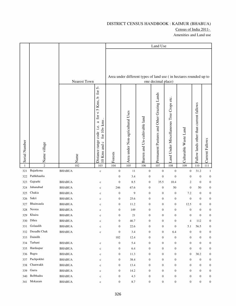
DISTRICT CENSUS HANDBOOK : KAIMUR (BHABUA)
Census of India 2011-
Amenities and Land use
Nam
e
Dis
tance
ran
ge
code
i.e
. a
fo
r <
5 K
ms,
b
for
5-
10 K
ms
and c
f
or
10+
km
s .
Fore
sts
Are
a under
Non-a
gri
cult
ura
l U
ses
Bar
ren a
nd U
n-c
ult
ivab
le l
and
Per
man
ent
Pas
ture
s an
d O
ther
Gra
zing L
ands
Lan
d U
nder
Mis
cell
aneo
us
Tre
e C
rops
etc.
Cult
ura
ble
Was
te L
and
Fal
low
lan
ds
oth
er t
han
curr
ent
fall
ow
s
Curr
ent
Fal
low
s
1 2 102 103 104 105 106 107 108 109 110 111
Ser
ial
Num
ber
Nam
e vil
lage
Area under different types of land use ( in hectares rounded up to
one decimal place)
Land Use
Nearest Town
321 Bajarkona BHABUA c 0 11 0 0 0 0 31.2 1
322 Pathkhaulia 0 3.4 0 0 0 0 0 0
323 Gajrarhi BHABUA c 0 8.5 0 35.5 10.4 2 0 0
324 Jahanabad BHABUA c 246 67.6 0 0 50 0 50 0
325 Chakia BHABUA c 0 9 0 0 0 7.2 0 0
326 Sakri BHABUA c 0 25.6 0 0 0 0 0 0
327 Bhainsaula BHABUA c 0 11.2 0 0 0 12.5 0 0
328 Neoras BHABUA c 0 149 0 0 0 0 0 0
329 Khaira BHABUA c 0 21 0 0 0 0 0 0
330 Dihra BHABUA c 0 46.7 0 0 0 4 112 0
331 Golaudih BHABUA c 0 22.6 0 0 0 5.1 56.5 0
332 Dusadhi Chak BHABUA c 0 3.4 0 0 6.4 0 0 0
333 Daindih 102 12.4 0 0 0 0 0 0
334 Tarhani BHABUA c 0 5.4 0 0 0 0 0 0
335 Hardaspur BHABUA c 0 6.4 0 0 0 0 0 0
336 Bagra BHABUA c 0 11.3 0 0 0 0 30.2 0
337 Pachpokhri BHABUA c 0 38.4 0 0 0 0 0 0
338 Chanwakh BHABUA c 0 13.4 0 0 0 0 0 0
339 Gurra BHABUA c 0 14.2 0 0 0 0 0 0
340 Belbhadra BHABUA c 0 4.3 0 0 0 0 0 0
341 Mokaram BHABUA c 0 8.7 0 0 0 0 0 0
�
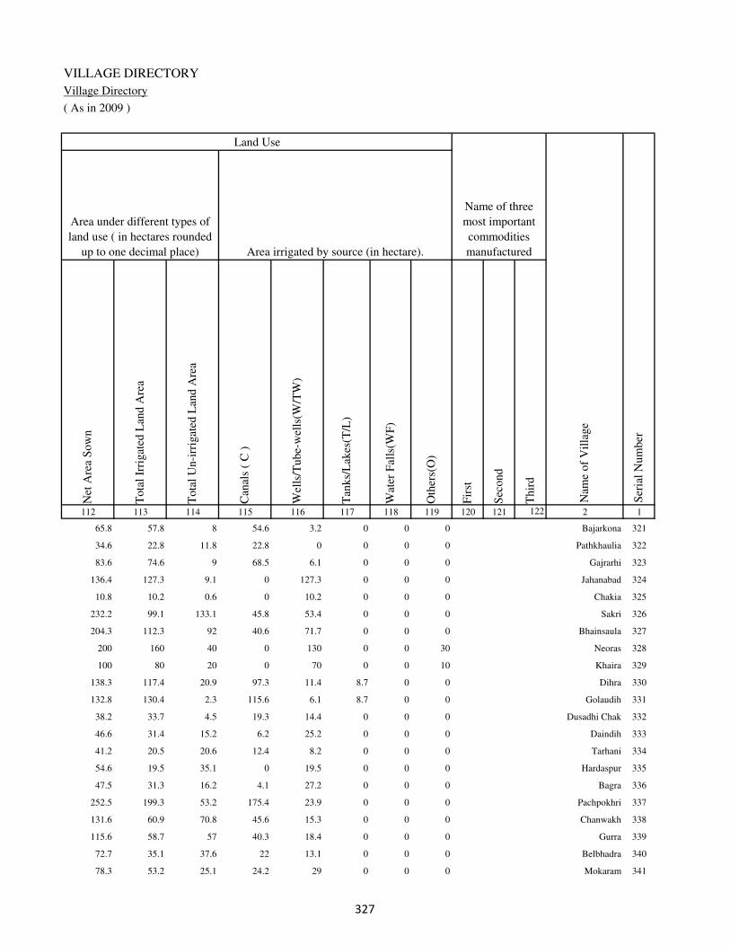
VILLAGE DIRECTORY
Village Directory
( As in 2009 )
Net
Are
a S
ow
n
Tota
l Ir
rigat
ed L
and A
rea
Tota
l U
n-i
rrig
ated
Lan
d A
rea
Can
als
( C
)
Wel
ls/T
ube-
wel
ls(W
/TW
)
Tan
ks/
Lak
es(T
/L)
Wat
er F
alls
(WF
)
Oth
ers(
O)
Fir
st
Sec
ond
Thir
d
112 113 114 115 116 117 118 119 120 121 122 2 1
Ser
ial
Num
ber
Name of three
most important
commodities
manufacturedArea irrigated by source (in hectare).
Nam
e of
Vil
lage
Area under different types of
land use ( in hectares rounded
up to one decimal place)
Land Use
65.8 57.8 8 54.6 3.2 0 0 0 Bajarkona 321
34.6 22.8 11.8 22.8 0 0 0 0 Pathkhaulia 322
83.6 74.6 9 68.5 6.1 0 0 0 Gajrarhi 323
136.4 127.3 9.1 0 127.3 0 0 0 Jahanabad 324
10.8 10.2 0.6 0 10.2 0 0 0 Chakia 325
232.2 99.1 133.1 45.8 53.4 0 0 0 Sakri 326
204.3 112.3 92 40.6 71.7 0 0 0 Bhainsaula 327
200 160 40 0 130 0 0 30 Neoras 328
100 80 20 0 70 0 0 10 Khaira 329
138.3 117.4 20.9 97.3 11.4 8.7 0 0 Dihra 330
132.8 130.4 2.3 115.6 6.1 8.7 0 0 Golaudih 331
38.2 33.7 4.5 19.3 14.4 0 0 0 Dusadhi Chak 332
46.6 31.4 15.2 6.2 25.2 0 0 0 Daindih 333
41.2 20.5 20.6 12.4 8.2 0 0 0 Tarhani 334
54.6 19.5 35.1 0 19.5 0 0 0 Hardaspur 335
47.5 31.3 16.2 4.1 27.2 0 0 0 Bagra 336
252.5 199.3 53.2 175.4 23.9 0 0 0 Pachpokhri 337
131.6 60.9 70.8 45.6 15.3 0 0 0 Chanwakh 338
115.6 58.7 57 40.3 18.4 0 0 0 Gurra 339
72.7 35.1 37.6 22 13.1 0 0 0 Belbhadra 340
78.3 53.2 25.1 24.2 29 0 0 0 Mokaram 341
�

DISTRICT CENSUS HANDBOOK : KAIMUR (BHABUA)
Census of India 2011-
Amenities and Land use
Pre
-Pri
mar
y s
chool
(PP
)
Pri
mar
y s
chool
(P)
Mid
dle
sch
ool
(M)
Sec
ondar
y S
chool
(S)
Sen
ior
Sec
ondar
y s
chool
(SS
)
Deg
ree
coll
ege
of
arts
sc
ience
& c
om
mer
ce
(AS
C)
Engin
eeri
ng c
oll
ege(
EC
)
Med
ical
coll
ege
(MC
)
Man
agem
ent
inst
itute
(M
I)
Poly
tech
nic
(P
t)
Voca
tional
tra
inin
g s
chool
/IT
I
Non-f
orm
al t
rain
ing c
entr
e (N
FT
C)
Spec
ial
school
for
dis
able
d (
SS
D)
Oth
ers
(spec
ify)
1 2 3 4 5 6 7 8 9 10 11 12 13 14 15 16 17 18 19 20
Loca
tion c
ode
no.
Nam
e vil
lage
Ser
ial
Num
ber
Tota
l popula
tion (
2011 c
ensu
s )
Tota
l ar
ea o
f th
e vil
lage
( in
hec
tare
s ro
unded
up t
o
one
dec
imal
pla
ce)
Number of educational amenities available. (If not available
within the village , the distance range code viz; a for < 5
Kms, b for 5-10 Kms and c for 10+ kms of nearest place
where facility is available is given).
Num
ber
of
house
hold
s (2
011 c
ensu
s)
342 Munjia 249265 140 1390 215 1 2 2 c b c c c c c c c c
343 Chanrui 249266 220 1110 157 b 1 b c b c c c c c b c c
344 Dhanta 249267 57 1 1 b a b c b b c c c c c c c
345 Bishunathpur 249268 52 120 14 b a b c b b c c c c b c c
346 Biro 249269 62 438 70 b 1 b c b b c c c c c c c
347 Chhotka Kajhar 249270 123 315 57 b a a c b b c c c c a c c
348 Shahpur 249271 72 444 68 b 1 1 c b b c c c c b c c
349 Kadai 249272 117.4 268 44 a 1 1 c b b c c c c b c c
350 Rampur 249273 163 2207 329 2 1 a c a b c c c c a c c
351 Meura 249274 259 2154 308 2 1 1 c a b c c c c a c c
352 Abdalpur 249275 22 0 0
353 Chhotka Nimdihra 249276 112 532 61 b a a c b b c c c c b c c
354 Paunra 249277 93 386 65 b 2 a c c b c c c c c c c
355 Derwan 249278 161.9 1482 265 1 1 2 c c b c c c c b c c
356 Deokali 249279 82 603 119 b 2 a c c b c c c c c c c
357 Deoraha 249280 85 74 12 b a a c c b c c c c c c c
358 Inaulia 249281 52.6 0 0
359 Gokhulpur 249282 51 291 49 b 2 a c c b c c c c b c c
360 Dhanarhi 249283 105 1006 195 1 2 b c c b c c c c c c c
361 Barka Nimdihra 249284 37.6 1238 201 1 2 2 c b b c c c c b c c
362 Gora 249285 106 341 57 b a b c b b c c c c b c c
�

VILLAGE DIRECTORY
Village Directory
( As in 2009 )
Com
munit
y h
ealt
h c
entr
e (C
HC
)
Pri
mar
y h
ealt
h c
entr
e (P
HC
)
Pri
mar
y h
ealt
h s
ub c
entr
e (P
HS
)
Mat
ernit
y a
nd c
hil
d w
elfa
re c
entr
e (M
CW
)
T.B
. cl
inic
(T
BC
)
Hosp
ital
-all
opat
hic
(H
A)
Hosp
ital
-alt
ernat
ive
med
icin
e (H
O)
Dis
pen
sary
(D
)
Vet
erin
ary h
osp
ital
(V
H)
Mobil
e hea
lth c
linic
(M
HC
)
Fam
ily w
elfa
re c
entr
e (F
WC
)
Char
itab
le n
on G
ovt.
hosp
ital
/Nurs
ing h
om
e.
Med
ical
pra
ctit
ioner
wit
h M
BB
S D
egre
e
Med
ical
pra
ctit
ioner
wit
h o
ther
deg
ree
Med
ical
pra
ctit
ioner
wit
h n
o d
egre
e
Tra
dit
ional
pra
ctit
ioner
an
d f
aith
hea
ler
.
Med
icin
e S
hop
Oth
ers
21 22 23 24 25 26 27 28 29 30 31 32 33 34 35 36 37 38 2 1
Number of Non-Government
Medical Amenities available.
Number of Medical Amenities available. (If not
available within the village , the distance range
code viz; a for < 5 Kms, b for 5-10 Kms and c
for 10+ kms of nearest place where facility is
available is given).
Nam
e vil
lage
Ser
ial
Num
ber
b b 1 1 b c c b b c 1 0 0 0 0 0 0 0 Munjia 342
b b 1 1 b c c b b c 1 0 0 0 0 0 0 0 Chanrui 343
b b b b c c c b c c b 0 0 0 0 0 0 0 Dhanta 344
b b b b b c c b b c b 0 0 0 0 0 0 0 Bishunathpur 345
b b b b b c c b b c b 0 0 0 0 0 0 0 Biro 346
a a a a a c c a a c a 0 0 0 0 0 0 0 Chhotka Kajhar 347
a a 1 1 a c c a a c 1 0 0 0 0 0 0 0 Shahpur 348
a a 1 1 a c c a a c 1 0 0 0 0 0 0 0 Kadai 349
a a a a a c c a a c a 0 0 0 0 0 0 0 Rampur 350
a b 1 1 a c c a a c 1 0 0 0 0 0 0 0 Meura 351
Abdalpur 352
b b b b b c c b c c b 0 0 0 0 0 0 0 Chhotka Nimdihra 353
a b 1 1 b c c b c c 1 0 0 0 0 0 0 0 Paunra 354
b b 1 1 b c c b c c 1 0 0 0 0 0 0 0 Derwan 355
b b 1 1 b c c c c c 1 0 0 0 0 0 0 0 Deokali 356
b a 1 1 c c c c c c 1 0 0 0 0 0 0 0 Deoraha 357
Inaulia 358
b b 1 1 c c c b c c 1 0 0 0 0 0 0 0 Gokhulpur 359
b b 1 1 c c c b c c 1 0 0 0 0 0 0 0 Dhanarhi 360
b b a b b c c b b c b 0 0 0 0 0 0 0 Barka Nimdihra 361
a a 1 1 a c c a a c 1 0 0 0 0 0 0 0 Gora 362
�

DISTRICT CENSUS HANDBOOK : KAIMUR (BHABUA)
Census of India 2011-
Amenities and Land use
Tap
wat
er (
Tre
ated
/Untr
eate
d)
Wel
l w
ater
(Cover
ed /
Unco
ver
ed w
ell)
Han
d P
um
p
Tube
wel
ls /
Bore
wel
l
Spri
ng
Riv
er /
Can
al
Tan
k /
Pond /
L
ake
Oth
ers
Com
munit
y t
oil
et i
ncl
udin
g
bat
h.
Com
munit
y t
oil
et e
xcl
udin
g b
ath.
Rura
l s
anit
ary m
art
or
sanit
ary
har
dw
are
outl
et
avai
lable
nea
r th
e vil
lage.
Com
munit
y b
io-
gas
or
recy
cle
of
was
te f
or
pro
duct
ive
use
.
1 2 39 40 41 42 43 44 45 46 47 48 49 50
Availability of toilet & others
Yes / No Availability of drinking water - Yes / No
Nam
e vil
lage
Ser
ial
Num
ber
342 Munjia No Yes Yes Yes No Yes No No No No No No
343 Chanrui No Yes Yes Yes No Yes No No No No No No
344 Dhanta No No Yes No No No No No No No No No
345 Bishunathpur No Yes Yes No No No No No No No No No
346 Biro No Yes Yes No No No No No No No No No
347 Chhotka Kajhar No Yes Yes No No No No No No No No No
348 Shahpur No Yes Yes No No No No No No No No No
349 Kadai No Yes Yes Yes No No No No No No No No
350 Rampur No Yes Yes No No Yes No No No No No No
351 Meura No Yes Yes No No No No No No No No No
352 Abdalpur
353 Chhotka Nimdihra No Yes Yes Yes No No No No No No No No
354 Paunra No Yes Yes Yes No No No No No No No No
355 Derwan No Yes Yes Yes No Yes No No No No No No
356 Deokali No Yes Yes Yes No Yes No No No No No No
357 Deoraha No Yes Yes Yes No No No No No No No No
358 Inaulia
359 Gokhulpur No Yes Yes Yes No No No No No No No No
360 Dhanarhi No Yes Yes Yes No No No No No No No No
361 Barka Nimdihra No Yes Yes No No No No No No No No No
362 Gora No Yes Yes Yes No No No No No No No No
�

VILLAGE DIRECTORY
Village Directory
( As in 2009 )
Post
off
ice(
PO
)
Sub p
ost
off
ice
(SP
O)
Post
& T
eleg
raph o
ffic
e
(P&
TO
)
Vil
lage
Pin
Code
Tel
ephones
(L
and l
ines
)
Publi
c ca
ll o
ffic
e (P
CO
)
Mobil
e phone
cover
age
Inte
rnet
caf
es/
Com
mon s
ervic
e ce
ntr
e (C
SC
)
Pri
vat
e co
uri
er f
acil
ity
Bus
serv
ice
(P
ubli
c &
Pri
vat
e)
Rai
lway
sta
tions
Auto
/Modif
ied A
uto
s
Tax
is a
nd V
ans
Tra
ctors
Cycl
e-pull
ed r
icksh
aws(
Man
ual
& M
achin
e
dri
ven
)
Car
ts d
riven
by a
nim
als
Sea
/R
iver
fer
ry s
ervic
e51 52 53 54 55 56 57 58 59 60 61 62 63 64 65 66 67 2 1
Communication and transport facilities (If amenities available code -Yes is given except for
Village Pin Code ,If not available within the village , the distance range code viz; a for < 5
Kms, b for 5-10 Kms and c for 10+ kms of nearest place where facility is available is given).
Ser
ial
Num
ber
Nam
e vil
lage
b b c b b b b b Yes b Yes Yes Yes Yes Yes c Munjia 342
b b c b b Yes b b b b b Yes Yes Yes Yes c Chanrui 343
b c c b b b b b b b b b b b b Dhanta 344
b a c b b Yes b b b b b b Yes b b b Bishunathpur 345
b a c b b Yes b b b b b b Yes b b b Biro 346
a a c a a Yes a a a a a a Yes a a a Chhotka Kajhar 347
a a c a a Yes a a a a a a a a a a Shahpur 348
a a c a a a a a a a a a a a a a Kadai 349
a a c a a Yes a a a a a a Yes a Yes a Rampur 350
a a c a a Yes a a a a a a a a Yes a Meura 351
Abdalpur 352
b b c b b Yes b b Yes b Yes Yes Yes Yes b b Chhotka Nimdihra 353
b a c b b Yes b b Yes b b Yes Yes Yes b b Paunra 354
Yes c c b c Yes b b Yes b b Yes Yes Yes b b Derwan 355
b a c c c Yes c c b c c b Yes Yes b Deokali 356
b a c b b Yes b b Yes b b Yes Yes Yes b b Deoraha 357
Inaulia 358
b a c b b Yes b b Yes b Yes Yes Yes Yes b b Gokhulpur 359
b a c b b Yes b b Yes b b Yes Yes Yes b b Dhanarhi 360
b a c a a Yes a a a a a a Yes Yes a a Barka Nimdihra 361
b b c b b Yes b b b Yes b Yes Yes Yes b b Gora 362
�

DISTRICT CENSUS HANDBOOK : KAIMUR (BHABUA)
Census of India 2011-
Amenities and Land use
Connec
ted t
o n
atio
nal
hig
hw
ay(N
H)
Connec
ted t
o s
tate
hig
hw
ay(S
H)
Connec
ted t
o m
ajor
dis
tric
t ro
ad (
MD
R)
Connec
ted t
o o
ther
s dis
tric
t ro
ad
Pucc
a r
oad
s
Kutc
hch
a r
oad
s
Wat
er b
ounded
mac
adam
(WB
M)
road
s
Nav
igab
le w
ater
way
(ri
ver
/can
al)(
NW
)
Footp
aths
(FP
)
Com
mer
cial
& C
o-o
per
ativ
e B
anks
AT
M
Agri
cult
ura
l C
redit
Soci
etie
s
Sel
f-H
elp G
roup (
SH
G)
Publi
c dis
trib
uti
on s
yst
em (
PD
S)
shop
Man
dis
/ R
egula
r m
arket
Wee
kly
Haa
t
Agri
cult
ura
l m
arket
ing s
oci
ety
1 2 68 69 70 71 72 73 74 75 76 77 78 79 80 81 82 83 84
Village connected to highways,village roads, banks & credit
societies (If amenities available code -Yes is given, If not
available within the village , the distance range code viz; a
for < 5 Kms, b for 5-10 Kms and c for 10+ kms of nearest
place where facility is available is given).
Ser
ial
Num
ber
Nam
e vil
lage
Availability of miscellaneous
facilities (If amenities available
code -Yes is given, If not
available within the village , the
distance range code viz; a for <
5 Kms, b for 5-10 Kms and c
for 10+ kms of nearest place
where facility is available is
given) Contd....
342 Munjia b b Yes Yes Yes Yes Yes a Yes b b b a a a a a
343 Chanrui b b Yes Yes Yes Yes Yes b Yes b b b b Yes b b b
344 Dhanta b b b b b a b b Yes b b b b a b b b
345 Bishunathpur b b b Yes a Yes b a Yes b b b b b b b b
346 Biro b b b a a Yes b a Yes b b b Yes b b b b
347 Chhotka Kajhar a a a a a Yes Yes a Yes a a a Yes a a a a
348 Shahpur a a a a Yes Yes a a Yes a a a Yes a a a a
349 Kadai a a a a Yes Yes a a Yes a a a Yes a a a a
350 Rampur a a a a a Yes a a Yes a a a Yes a a a c
351 Meura a a a a Yes Yes a a Yes a a a Yes Yes a a c
352 Abdalpur
353 Chhotka Nimdihra b b b Yes Yes a a a Yes b b b b Yes b b b
354 Paunra b b b Yes Yes Yes Yes a Yes b b b Yes Yes b b b
355 Derwan b b b Yes a b Yes a Yes b c b Yes Yes b b b
356 Deokali c c c Yes b Yes Yes b Yes c c c b Yes b c c
357 Deoraha b b b Yes a Yes a b Yes b b b a Yes b b b
358 Inaulia
359 Gokhulpur b b b Yes a Yes a a Yes b b b b Yes b b b
360 Dhanarhi b b b Yes Yes b Yes a Yes b b b b Yes b b b
361 Barka Nimdihra b b b b Yes Yes b a Yes b b b Yes a a b b
362 Gora b b b Yes Yes a a b Yes b b b b Yes a a b

VILLAGE DIRECTORY
Village Directory
( As in 2009 )
Inte
gra
ted C
hil
d D
evel
opm
ent
Sch
eme
(Nutr
itio
nal
Cen
tres
)
Angan
wad
i C
entr
e (N
utr
itio
nal
Cen
tres
)
Oth
ers
(Nutr
itio
nal
Cen
tres
)
AS
HA
(A
ccre
dit
ed S
oci
al H
ealt
h A
ctiv
ist)
Com
munit
y c
entr
e w
ith/w
ithout
TV
Sport
s F
ield
,
Sport
s C
lub /
Rec
reat
ion C
entr
e
Cin
ema
/ V
ideo
Hal
l
Publi
c L
ibra
ry
Publi
c R
eadin
g R
oom
New
spap
er S
upply
Ass
embly
Poll
ing s
tati
on
Bir
th &
Dea
th R
egis
trat
ion O
ffic
e
Pow
er S
upply
for
Dom
esti
c U
se (
ED
)
Pow
er S
upply
for
Agri
cult
ura
l U
se (
EA
G)
Pow
er S
upply
for
Com
mer
cial
Use
(E
C)
Pow
er S
upply
for
All
Use
s (E
A)
85 86 87 88 89 90 91 92 93 94 95 96 97 98 99 100 101 2 1
Availability of
electricity (Yes/No)
Availability of miscellaneous facilities (If amenities available code -
Yes is given, If not available within the village , the distance range
code viz; a for < 5 Kms, b for 5-10 Kms and c for 10+ kms of
nearest place where facility is available is given) Concluded
Nam
e vil
lage
Ser
ial
Num
ber
b Yes Yes Yes b Yes a c a b b Yes Yes Yes No No No Munjia 342
b Yes Yes Yes b Yes b b b b b Yes b Yes No No No Chanrui 343
b b Yes b c a c c c c b a a No No No No Dhanta 344
b Yes Yes a b b b b b b b Yes b Yes Yes No No Bishunathpur 345
b Yes Yes a b b b b b b b Yes b Yes Yes No No Biro 346
a Yes Yes a a a a a a a a Yes Yes Yes Yes No No Chhotka Kajhar 347
a Yes Yes Yes a a a a a a a Yes Yes Yes Yes No No Shahpur 348
a Yes Yes Yes a a a a a a a Yes Yes No No No No Kadai 349
a Yes Yes Yes b a b c b a a Yes b Yes Yes No No Rampur 350
a Yes Yes Yes b a a c a a a Yes Yes Yes Yes No No Meura 351
Abdalpur 352
b Yes Yes Yes b b b b b b b a a Yes Yes No No Chhotka Nimdihra 353
b b a b b b b b b b b a a Yes Yes No No Paunra 354
b Yes a Yes b b b b c b b Yes Yes Yes Yes No No Derwan 355
c b Yes Yes c c c c c a a a a Yes Yes No No Deokali 356
c a Yes Yes a b b b b b b a a Yes Yes No No Deoraha 357
Inaulia 358
b b Yes Yes b b b b b b b a a Yes Yes No No Gokhulpur 359
b Yes Yes Yes b b b c b b b a b Yes Yes No No Dhanarhi 360
a Yes Yes Yes c b b c b b b Yes b Yes Yes No No Barka Nimdihra 361
b Yes Yes Yes b Yes b b b b b Yes Yes Yes Yes No No Gora 362
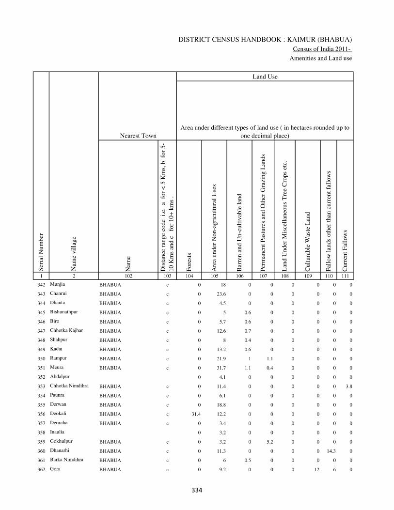
DISTRICT CENSUS HANDBOOK : KAIMUR (BHABUA)
Census of India 2011-
Amenities and Land use
Nam
e
Dis
tance
ran
ge
code
i.e
. a
fo
r <
5 K
ms,
b
for
5-
10 K
ms
and c
f
or
10+
km
s .
Fore
sts
Are
a under
Non-a
gri
cult
ura
l U
ses
Bar
ren a
nd U
n-c
ult
ivab
le l
and
Per
man
ent
Pas
ture
s an
d O
ther
Gra
zing L
ands
Lan
d U
nder
Mis
cell
aneo
us
Tre
e C
rops
etc.
Cult
ura
ble
Was
te L
and
Fal
low
lan
ds
oth
er t
han
curr
ent
fall
ow
s
Curr
ent
Fal
low
s
1 2 102 103 104 105 106 107 108 109 110 111
Ser
ial
Num
ber
Nam
e vil
lage
Area under different types of land use ( in hectares rounded up to
one decimal place)
Land Use
Nearest Town
342 Munjia BHABUA c 0 18 0 0 0 0 0 0
343 Chanrui BHABUA c 0 23.6 0 0 0 0 0 0
344 Dhanta BHABUA c 0 4.5 0 0 0 0 0 0
345 Bishunathpur BHABUA c 0 5 0.6 0 0 0 0 0
346 Biro BHABUA c 0 5.7 0.6 0 0 0 0 0
347 Chhotka Kajhar BHABUA c 0 12.6 0.7 0 0 0 0 0
348 Shahpur BHABUA c 0 8 0.4 0 0 0 0 0
349 Kadai BHABUA c 0 13.2 0.6 0 0 0 0 0
350 Rampur BHABUA c 0 21.9 1 1.1 0 0 0 0
351 Meura BHABUA c 0 31.7 1.1 0.4 0 0 0 0
352 Abdalpur 0 4.1 0 0 0 0 0 0
353 Chhotka Nimdihra BHABUA c 0 11.4 0 0 0 0 0 3.8
354 Paunra BHABUA c 0 6.1 0 0 0 0 0 0
355 Derwan BHABUA c 0 18.8 0 0 0 0 0 0
356 Deokali BHABUA c 31.4 12.2 0 0 0 0 0 0
357 Deoraha BHABUA c 0 3.4 0 0 0 0 0 0
358 Inaulia 0 3.2 0 0 0 0 0 0
359 Gokhulpur BHABUA c 0 3.2 0 5.2 0 0 0 0
360 Dhanarhi BHABUA c 0 11.3 0 0 0 0 14.3 0
361 Barka Nimdihra BHABUA c 0 6 0.5 0 0 0 0 0
362 Gora BHABUA c 0 9.2 0 0 0 12 6 0
�
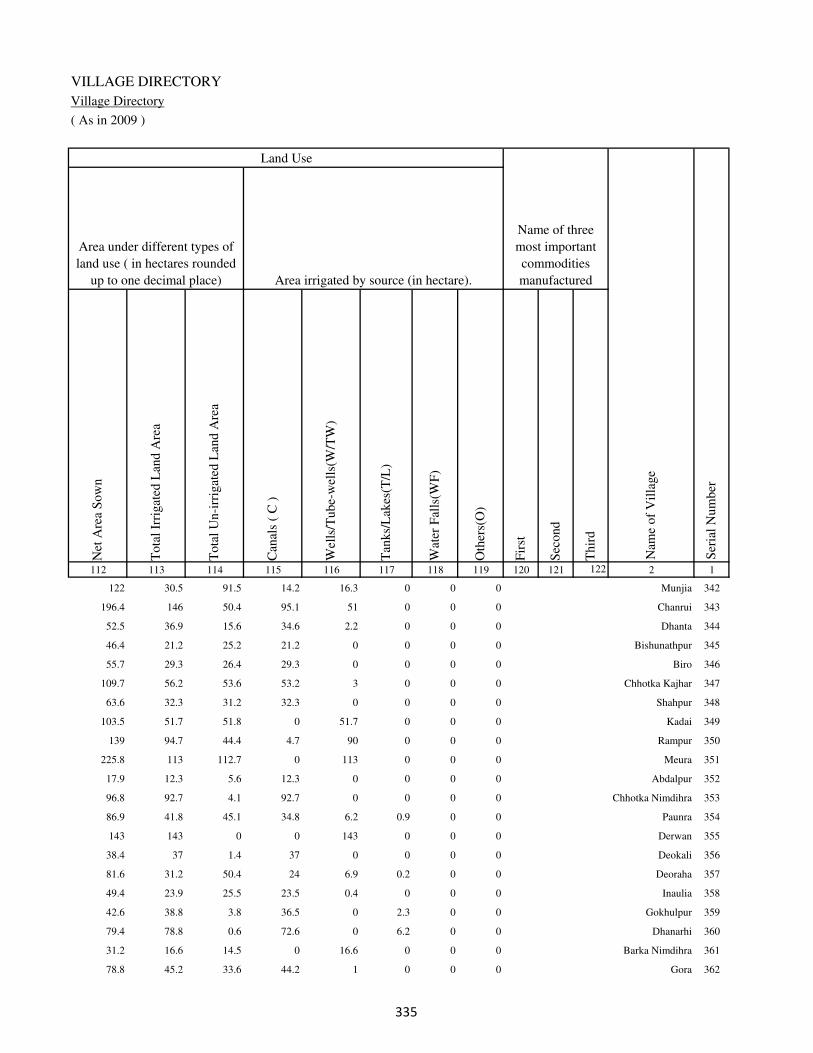
VILLAGE DIRECTORY
Village Directory
( As in 2009 )
Net
Are
a S
ow
n
Tota
l Ir
rigat
ed L
and A
rea
Tota
l U
n-i
rrig
ated
Lan
d A
rea
Can
als
( C
)
Wel
ls/T
ube-
wel
ls(W
/TW
)
Tan
ks/
Lak
es(T
/L)
Wat
er F
alls
(WF
)
Oth
ers(
O)
Fir
st
Sec
ond
Thir
d
112 113 114 115 116 117 118 119 120 121 122 2 1
Ser
ial
Num
ber
Name of three
most important
commodities
manufacturedArea irrigated by source (in hectare).
Nam
e of
Vil
lage
Area under different types of
land use ( in hectares rounded
up to one decimal place)
Land Use
122 30.5 91.5 14.2 16.3 0 0 0 Munjia 342
196.4 146 50.4 95.1 51 0 0 0 Chanrui 343
52.5 36.9 15.6 34.6 2.2 0 0 0 Dhanta 344
46.4 21.2 25.2 21.2 0 0 0 0 Bishunathpur 345
55.7 29.3 26.4 29.3 0 0 0 0 Biro 346
109.7 56.2 53.6 53.2 3 0 0 0 Chhotka Kajhar 347
63.6 32.3 31.2 32.3 0 0 0 0 Shahpur 348
103.5 51.7 51.8 0 51.7 0 0 0 Kadai 349
139 94.7 44.4 4.7 90 0 0 0 Rampur 350
225.8 113 112.7 0 113 0 0 0 Meura 351
17.9 12.3 5.6 12.3 0 0 0 0 Abdalpur 352
96.8 92.7 4.1 92.7 0 0 0 0 Chhotka Nimdihra 353
86.9 41.8 45.1 34.8 6.2 0.9 0 0 Paunra 354
143 143 0 0 143 0 0 0 Derwan 355
38.4 37 1.4 37 0 0 0 0 Deokali 356
81.6 31.2 50.4 24 6.9 0.2 0 0 Deoraha 357
49.4 23.9 25.5 23.5 0.4 0 0 0 Inaulia 358
42.6 38.8 3.8 36.5 0 2.3 0 0 Gokhulpur 359
79.4 78.8 0.6 72.6 0 6.2 0 0 Dhanarhi 360
31.2 16.6 14.5 0 16.6 0 0 0 Barka Nimdihra 361
78.8 45.2 33.6 44.2 1 0 0 0 Gora 362
�

DISTRICT CENSUS HANDBOOK : KAIMUR (BHABUA)
Census of India 2011-
Amenities and Land use
Pre
-Pri
mar
y s
chool
(PP
)
Pri
mar
y s
chool
(P)
Mid
dle
sch
ool
(M)
Sec
ondar
y S
chool
(S)
Sen
ior
Sec
ondar
y s
chool
(SS
)
Deg
ree
coll
ege
of
arts
sc
ience
& c
om
mer
ce
(AS
C)
Engin
eeri
ng c
oll
ege(
EC
)
Med
ical
coll
ege
(MC
)
Man
agem
ent
inst
itute
(M
I)
Poly
tech
nic
(P
t)
Voca
tional
tra
inin
g s
chool
/IT
I
Non-f
orm
al t
rain
ing c
entr
e (N
FT
C)
Spec
ial
school
for
dis
able
d (
SS
D)
Oth
ers
(spec
ify)
1 2 3 4 5 6 7 8 9 10 11 12 13 14 15 16 17 18 19 20
Loca
tion c
ode
no.
Nam
e vil
lage
Ser
ial
Num
ber
Tota
l popula
tion (
2011 c
ensu
s )
Tota
l ar
ea o
f th
e vil
lage
( in
hec
tare
s ro
unded
up t
o
one
dec
imal
pla
ce)
Number of educational amenities available. (If not available
within the village , the distance range code viz; a for < 5
Kms, b for 5-10 Kms and c for 10+ kms of nearest place
where facility is available is given).
Num
ber
of
house
hold
s (2
011 c
ensu
s)
363 Jamunipur 249286 63 280 44 b a b c b b c c c c b c c
364 Karanpura 249287 26 201 38 b a b b b b c c c c b c c
365 Sarmanpur 249288 38 0 0
366 Sahajpura 249289 34 398 76 b a b c b b c c c c b c c
367 Jajara 249290 46 0 0
368 Chaukhara 249291 32 442 55 b 2 a c c b c c c c c c c
369 Orgain 249292 63 0 0
370 Bhatauli 249293 40 541 86 b 1 b c b b c c c c b c c
371 Saidpur 249294 25 60 12 b a b c c b c c c c c c c
372 Khalopur 249295 36 0 0
373 Parsotimpur 249296 26 64 10 b 2 b c c b c c c c c c c
374 Singhsaira 249297 42 106 10 b b b c b b c c c c c c c
375 Khalopur 249298 43 35 3 b a a c c c c c c c c c c
376 Baruar 249299 60 506 58 b 2 a c b b c c c c b c c
Block T O T A L : 21051.5 165145 25005 19 129 53 12 8 5 0 0 0 1 1 1 0 0
�

VILLAGE DIRECTORY
Village Directory
( As in 2009 )
Com
munit
y h
ealt
h c
entr
e (C
HC
)
Pri
mar
y h
ealt
h c
entr
e (P
HC
)
Pri
mar
y h
ealt
h s
ub c
entr
e (P
HS
)
Mat
ernit
y a
nd c
hil
d w
elfa
re c
entr
e (M
CW
)
T.B
. cl
inic
(T
BC
)
Hosp
ital
-all
opat
hic
(H
A)
Hosp
ital
-alt
ernat
ive
med
icin
e (H
O)
Dis
pen
sary
(D
)
Vet
erin
ary h
osp
ital
(V
H)
Mobil
e hea
lth c
linic
(M
HC
)
Fam
ily w
elfa
re c
entr
e (F
WC
)
Char
itab
le n
on G
ovt.
hosp
ital
/Nurs
ing h
om
e.
Med
ical
pra
ctit
ioner
wit
h M
BB
S D
egre
e
Med
ical
pra
ctit
ioner
wit
h o
ther
deg
ree
Med
ical
pra
ctit
ioner
wit
h n
o d
egre
e
Tra
dit
ional
pra
ctit
ioner
an
d f
aith
hea
ler
.
Med
icin
e S
hop
Oth
ers
21 22 23 24 25 26 27 28 29 30 31 32 33 34 35 36 37 38 2 1
Number of Non-Government
Medical Amenities available.
Number of Medical Amenities available. (If not
available within the village , the distance range
code viz; a for < 5 Kms, b for 5-10 Kms and c
for 10+ kms of nearest place where facility is
available is given).
Nam
e vil
lage
Ser
ial
Num
ber
b b b b b c c b b c b 0 0 0 0 0 0 0 Jamunipur 363
b b b b b c c b b c b 0 0 0 0 0 0 0 Karanpura 364
Sarmanpur 365
b b 1 1 b c c b c c 1 0 0 0 0 0 0 0 Sahajpura 366
Jajara 367
b b 1 1 b c c c c c 1 0 0 0 0 0 0 0 Chaukhara 368
Orgain 369
b c b b b c c c c c c 0 0 0 0 0 0 0 Bhatauli 370
b b 1 1 b c c b c c 1 0 0 0 0 0 0 0 Saidpur 371
Khalopur 372
c c 1 1 b c c b c c 1 0 0 0 0 0 0 0 Parsotimpur 373
b c b b b c c b c c b 0 0 0 0 0 0 0 Singhsaira 374
b c 1 1 b c c b b c 1 0 0 0 0 0 0 0 Khalopur 375
b c 1 1 b c c b b c 1 0 0 0 0 0 0 0 Baruar 376
0 1 29 29 1 0 0 2 1 0 30 4 6 17 21 21 21 0
�

DISTRICT CENSUS HANDBOOK : KAIMUR (BHABUA)
Census of India 2011-
Amenities and Land use
Tap
wat
er (
Tre
ated
/Untr
eate
d)
Wel
l w
ater
(Cover
ed /
Unco
ver
ed w
ell)
Han
d P
um
p
Tube
wel
ls /
Bore
wel
l
Spri
ng
Riv
er /
Can
al
Tan
k /
Pond /
L
ake
Oth
ers
Com
munit
y t
oil
et i
ncl
udin
g
bat
h.
Com
munit
y t
oil
et e
xcl
udin
g b
ath.
Rura
l s
anit
ary m
art
or
sanit
ary
har
dw
are
outl
et
avai
lable
nea
r th
e vil
lage.
Com
munit
y b
io-
gas
or
recy
cle
of
was
te f
or
pro
duct
ive
use
.
1 2 39 40 41 42 43 44 45 46 47 48 49 50
Availability of toilet & others
Yes / No Availability of drinking water - Yes / No
Nam
e vil
lage
Ser
ial
Num
ber
363 Jamunipur No Yes Yes No No No No No No No No No
364 Karanpura No Yes Yes No No No No No No No No No
365 Sarmanpur
366 Sahajpura No Yes Yes No No Yes No No No No No No
367 Jajara
368 Chaukhara No Yes Yes Yes No No No No No No No No
369 Orgain
370 Bhatauli No Yes Yes Yes No No No No No No No No
371 Saidpur No Yes Yes Yes No No No No No No No No
372 Khalopur
373 Parsotimpur No Yes Yes Yes No No No No No No No No
374 Singhsaira No No Yes No No No No No No No No No
375 Khalopur No Yes Yes Yes No No No No No No No No
376 Baruar No Yes Yes Yes No No No No No No No No
Block T O T A L : 2 85 131 60 1 57 2 0 0 0 0 0
�
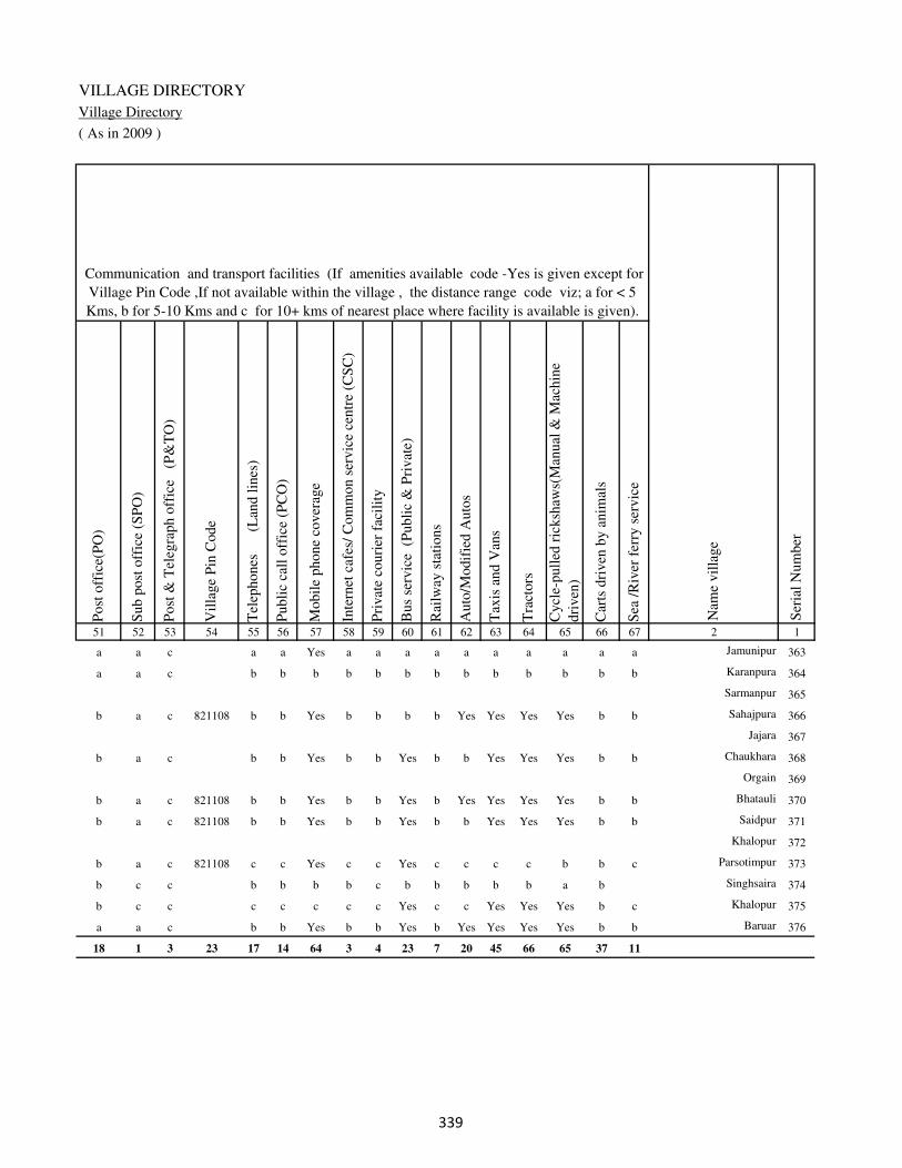
VILLAGE DIRECTORY
Village Directory
( As in 2009 )
Post
off
ice(
PO
)
Sub p
ost
off
ice
(SP
O)
Post
& T
eleg
raph o
ffic
e
(P&
TO
)
Vil
lage
Pin
Code
Tel
ephones
(L
and l
ines
)
Publi
c ca
ll o
ffic
e (P
CO
)
Mobil
e phone
cover
age
Inte
rnet
caf
es/
Com
mon s
ervic
e ce
ntr
e (C
SC
)
Pri
vat
e co
uri
er f
acil
ity
Bus
serv
ice
(P
ubli
c &
Pri
vat
e)
Rai
lway
sta
tions
Auto
/Modif
ied A
uto
s
Tax
is a
nd V
ans
Tra
ctors
Cycl
e-pull
ed r
icksh
aws(
Man
ual
& M
achin
e
dri
ven
)
Car
ts d
riven
by a
nim
als
Sea
/R
iver
fer
ry s
ervic
e51 52 53 54 55 56 57 58 59 60 61 62 63 64 65 66 67 2 1
Communication and transport facilities (If amenities available code -Yes is given except for
Village Pin Code ,If not available within the village , the distance range code viz; a for < 5
Kms, b for 5-10 Kms and c for 10+ kms of nearest place where facility is available is given).
Ser
ial
Num
ber
Nam
e vil
lage
a a c a a Yes a a a a a a a a a a Jamunipur 363
a a c b b b b b b b b b b b b b Karanpura 364
Sarmanpur 365
b a c 821108 b b Yes b b b b Yes Yes Yes Yes b b Sahajpura 366
Jajara 367
b a c b b Yes b b Yes b b Yes Yes Yes b b Chaukhara 368
Orgain 369
b a c 821108 b b Yes b b Yes b Yes Yes Yes Yes b b Bhatauli 370
b a c 821108 b b Yes b b Yes b b Yes Yes Yes b b Saidpur 371
Khalopur 372
b a c 821108 c c Yes c c Yes c c c c b b c Parsotimpur 373
b c c b b b b c b b b b b a b Singhsaira 374
b c c c c c c c Yes c c Yes Yes Yes b c Khalopur 375
a a c b b Yes b b Yes b Yes Yes Yes Yes b b Baruar 376
18 1 3 23 17 14 64 3 4 23 7 20 45 66 65 37 11
�
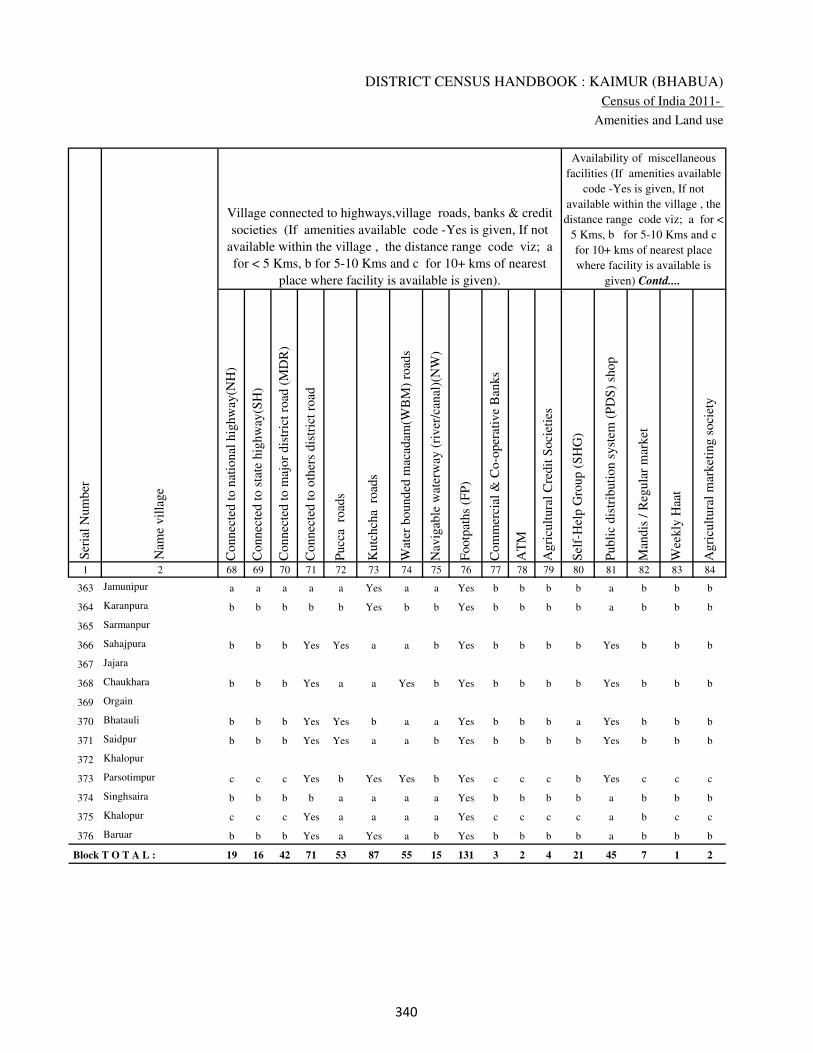
DISTRICT CENSUS HANDBOOK : KAIMUR (BHABUA)
Census of India 2011-
Amenities and Land use
Connec
ted t
o n
atio
nal
hig
hw
ay(N
H)
Connec
ted t
o s
tate
hig
hw
ay(S
H)
Connec
ted t
o m
ajor
dis
tric
t ro
ad (
MD
R)
Connec
ted t
o o
ther
s dis
tric
t ro
ad
Pucc
a r
oad
s
Kutc
hch
a r
oad
s
Wat
er b
ounded
mac
adam
(WB
M)
road
s
Nav
igab
le w
ater
way
(ri
ver
/can
al)(
NW
)
Footp
aths
(FP
)
Com
mer
cial
& C
o-o
per
ativ
e B
anks
AT
M
Agri
cult
ura
l C
redit
Soci
etie
s
Sel
f-H
elp G
roup (
SH
G)
Publi
c dis
trib
uti
on s
yst
em (
PD
S)
shop
Man
dis
/ R
egula
r m
arket
Wee
kly
Haa
t
Agri
cult
ura
l m
arket
ing s
oci
ety
1 2 68 69 70 71 72 73 74 75 76 77 78 79 80 81 82 83 84
Village connected to highways,village roads, banks & credit
societies (If amenities available code -Yes is given, If not
available within the village , the distance range code viz; a
for < 5 Kms, b for 5-10 Kms and c for 10+ kms of nearest
place where facility is available is given).
Ser
ial
Num
ber
Nam
e vil
lage
Availability of miscellaneous
facilities (If amenities available
code -Yes is given, If not
available within the village , the
distance range code viz; a for <
5 Kms, b for 5-10 Kms and c
for 10+ kms of nearest place
where facility is available is
given) Contd....
363 Jamunipur a a a a a Yes a a Yes b b b b a b b b
364 Karanpura b b b b b Yes b b Yes b b b b a b b b
365 Sarmanpur
366 Sahajpura b b b Yes Yes a a b Yes b b b b Yes b b b
367 Jajara
368 Chaukhara b b b Yes a a Yes b Yes b b b b Yes b b b
369 Orgain
370 Bhatauli b b b Yes Yes b a a Yes b b b a Yes b b b
371 Saidpur b b b Yes Yes a a b Yes b b b b Yes b b b
372 Khalopur
373 Parsotimpur c c c Yes b Yes Yes b Yes c c c b Yes c c c
374 Singhsaira b b b b a a a a Yes b b b b a b b b
375 Khalopur c c c Yes a a a a Yes c c c c a b c c
376 Baruar b b b Yes a Yes a b Yes b b b b a b b b
Block T O T A L : 19 16 42 71 53 87 55 15 131 3 2 4 21 45 7 1 2
��
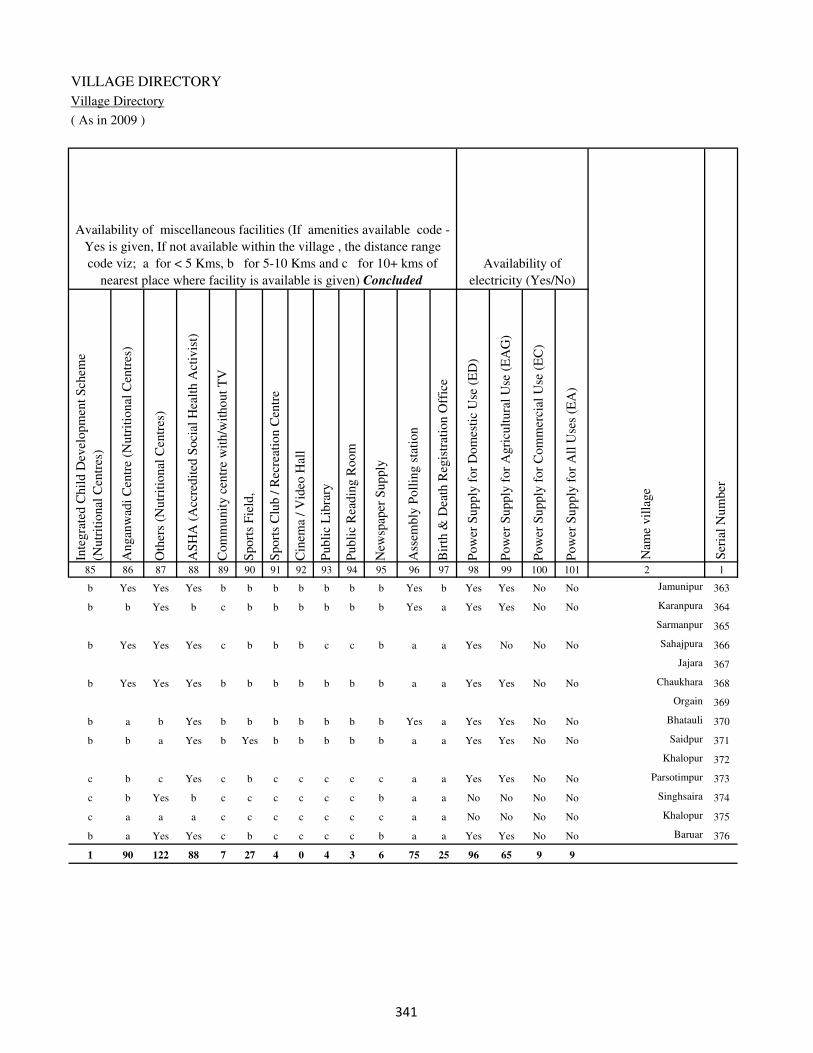
VILLAGE DIRECTORY
Village Directory
( As in 2009 )
Inte
gra
ted C
hil
d D
evel
opm
ent
Sch
eme
(Nutr
itio
nal
Cen
tres
)
Angan
wad
i C
entr
e (N
utr
itio
nal
Cen
tres
)
Oth
ers
(Nutr
itio
nal
Cen
tres
)
AS
HA
(A
ccre
dit
ed S
oci
al H
ealt
h A
ctiv
ist)
Com
munit
y c
entr
e w
ith/w
ithout
TV
Sport
s F
ield
,
Sport
s C
lub /
Rec
reat
ion C
entr
e
Cin
ema
/ V
ideo
Hal
l
Publi
c L
ibra
ry
Publi
c R
eadin
g R
oom
New
spap
er S
upply
Ass
embly
Poll
ing s
tati
on
Bir
th &
Dea
th R
egis
trat
ion O
ffic
e
Pow
er S
upply
for
Dom
esti
c U
se (
ED
)
Pow
er S
upply
for
Agri
cult
ura
l U
se (
EA
G)
Pow
er S
upply
for
Com
mer
cial
Use
(E
C)
Pow
er S
upply
for
All
Use
s (E
A)
85 86 87 88 89 90 91 92 93 94 95 96 97 98 99 100 101 2 1
Availability of
electricity (Yes/No)
Availability of miscellaneous facilities (If amenities available code -
Yes is given, If not available within the village , the distance range
code viz; a for < 5 Kms, b for 5-10 Kms and c for 10+ kms of
nearest place where facility is available is given) Concluded
Nam
e vil
lage
Ser
ial
Num
ber
b Yes Yes Yes b b b b b b b Yes b Yes Yes No No Jamunipur 363
b b Yes b c b b b b b b Yes a Yes Yes No No Karanpura 364
Sarmanpur 365
b Yes Yes Yes c b b b c c b a a Yes No No No Sahajpura 366
Jajara 367
b Yes Yes Yes b b b b b b b a a Yes Yes No No Chaukhara 368
Orgain 369
b a b Yes b b b b b b b Yes a Yes Yes No No Bhatauli 370
b b a Yes b Yes b b b b b a a Yes Yes No No Saidpur 371
Khalopur 372
c b c Yes c b c c c c c a a Yes Yes No No Parsotimpur 373
c b Yes b c c c c c c b a a No No No No Singhsaira 374
c a a a c c c c c c c a a No No No No Khalopur 375
b a Yes Yes c b c c c c b a a Yes Yes No No Baruar 376
1 90 122 88 7 27 4 0 4 3 6 75 25 96 65 9 9
��
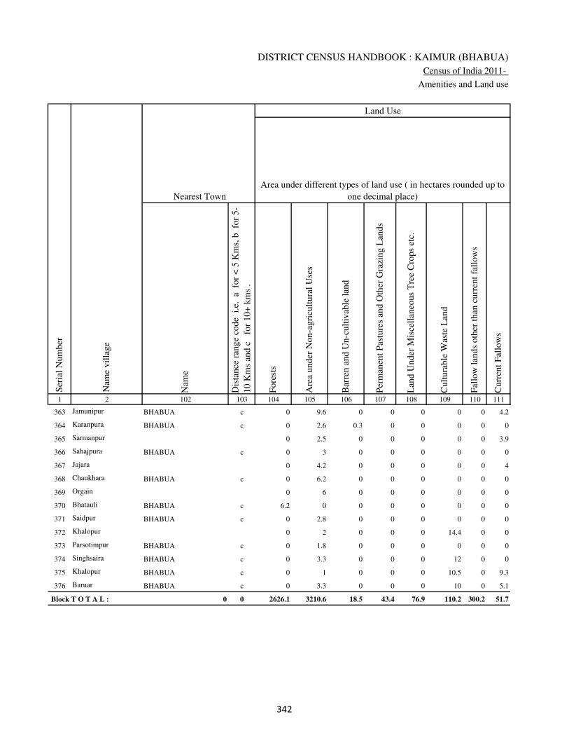
DISTRICT CENSUS HANDBOOK : KAIMUR (BHABUA)
Census of India 2011-
Amenities and Land use
Nam
e
Dis
tance
ran
ge
code
i.e
. a
fo
r <
5 K
ms,
b
for
5-
10 K
ms
and c
f
or
10+
km
s .
Fore
sts
Are
a under
Non-a
gri
cult
ura
l U
ses
Bar
ren a
nd U
n-c
ult
ivab
le l
and
Per
man
ent
Pas
ture
s an
d O
ther
Gra
zing L
ands
Lan
d U
nder
Mis
cell
aneo
us
Tre
e C
rops
etc.
Cult
ura
ble
Was
te L
and
Fal
low
lan
ds
oth
er t
han
curr
ent
fall
ow
s
Curr
ent
Fal
low
s
1 2 102 103 104 105 106 107 108 109 110 111
Ser
ial
Num
ber
Nam
e vil
lage
Area under different types of land use ( in hectares rounded up to
one decimal place)
Land Use
Nearest Town
363 Jamunipur BHABUA c 0 9.6 0 0 0 0 0 4.2
364 Karanpura BHABUA c 0 2.6 0.3 0 0 0 0 0
365 Sarmanpur 0 2.5 0 0 0 0 0 3.9
366 Sahajpura BHABUA c 0 3 0 0 0 0 0 0
367 Jajara 0 4.2 0 0 0 0 0 4
368 Chaukhara BHABUA c 0 6.2 0 0 0 0 0 0
369 Orgain 0 6 0 0 0 0 0 0
370 Bhatauli BHABUA c 6.2 0 0 0 0 0 0 0
371 Saidpur BHABUA c 0 2.8 0 0 0 0 0 0
372 Khalopur 0 2 0 0 0 14.4 0 0
373 Parsotimpur BHABUA c 0 1.8 0 0 0 0 0 0
374 Singhsaira BHABUA c 0 3.3 0 0 0 12 0 0
375 Khalopur BHABUA c 0 1 0 0 0 10.5 0 9.3
376 Baruar BHABUA c 0 3.3 0 0 0 10 0 5.1
Block T O T A L : 0 0 2626.1 3210.6 18.5 43.4 76.9 110.2 300.2 51.7
�
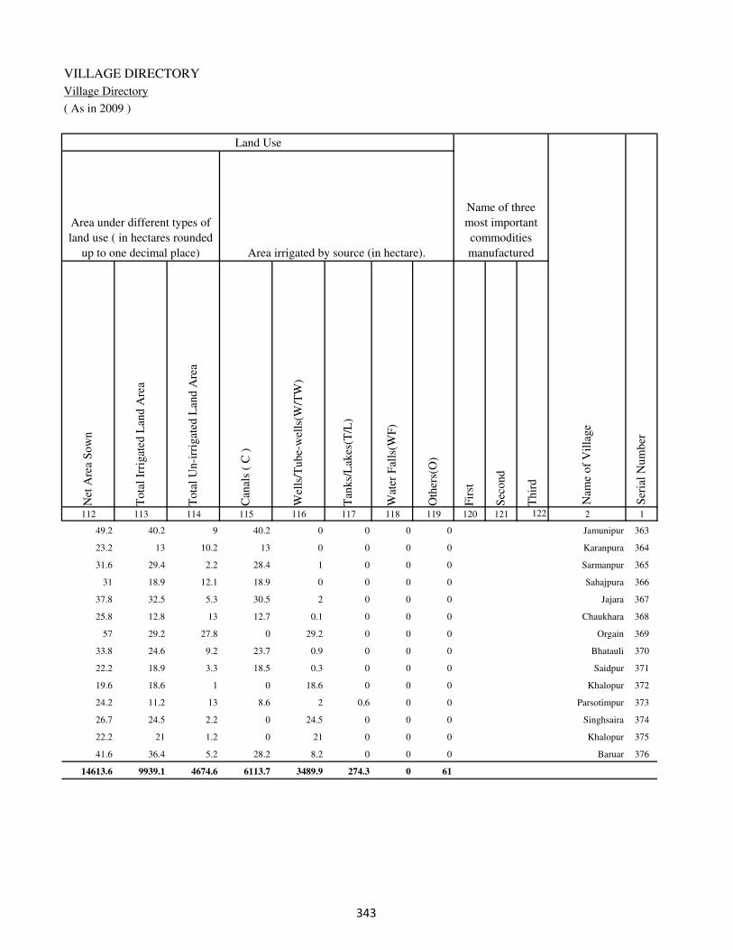
VILLAGE DIRECTORY
Village Directory
( As in 2009 )
Net
Are
a S
ow
n
Tota
l Ir
rigat
ed L
and A
rea
Tota
l U
n-i
rrig
ated
Lan
d A
rea
Can
als
( C
)
Wel
ls/T
ube-
wel
ls(W
/TW
)
Tan
ks/
Lak
es(T
/L)
Wat
er F
alls
(WF
)
Oth
ers(
O)
Fir
st
Sec
ond
Thir
d
112 113 114 115 116 117 118 119 120 121 122 2 1
Ser
ial
Num
ber
Name of three
most important
commodities
manufacturedArea irrigated by source (in hectare).
Nam
e of
Vil
lage
Area under different types of
land use ( in hectares rounded
up to one decimal place)
Land Use
49.2 40.2 9 40.2 0 0 0 0 Jamunipur 363
23.2 13 10.2 13 0 0 0 0 Karanpura 364
31.6 29.4 2.2 28.4 1 0 0 0 Sarmanpur 365
31 18.9 12.1 18.9 0 0 0 0 Sahajpura 366
37.8 32.5 5.3 30.5 2 0 0 0 Jajara 367
25.8 12.8 13 12.7 0.1 0 0 0 Chaukhara 368
57 29.2 27.8 0 29.2 0 0 0 Orgain 369
33.8 24.6 9.2 23.7 0.9 0 0 0 Bhatauli 370
22.2 18.9 3.3 18.5 0.3 0 0 0 Saidpur 371
19.6 18.6 1 0 18.6 0 0 0 Khalopur 372
24.2 11.2 13 8.6 2 0.6 0 0 Parsotimpur 373
26.7 24.5 2.2 0 24.5 0 0 0 Singhsaira 374
22.2 21 1.2 0 21 0 0 0 Khalopur 375
41.6 36.4 5.2 28.2 8.2 0 0 0 Baruar 376
14613.6 9939.1 4674.6 6113.7 3489.9 274.3 0 61
�

DISTRICT CENSUS HANDBOOK : KAIMUR (BHABUA)
Census of India 2011-
Amenities and Land use
Pre
-Pri
mar
y s
chool
(PP
)
Pri
mar
y s
chool
(P)
Mid
dle
sch
ool
(M)
Sec
ondar
y S
chool
(S)
Sen
ior
Sec
ondar
y s
chool
(SS
)
Deg
ree
coll
ege
of
arts
sc
ience
& c
om
mer
ce
(AS
C)
Engin
eeri
ng c
oll
ege(
EC
)
Med
ical
coll
ege
(MC
)
Man
agem
ent
inst
itute
(M
I)
Poly
tech
nic
(P
t)
Voca
tional
tra
inin
g s
chool
/IT
I
Non-f
orm
al t
rain
ing c
entr
e (N
FT
C)
Spec
ial
school
for
dis
able
d (
SS
D)
Oth
ers
(spec
ify)
1 2 3 4 5 6 7 8 9 10 11 12 13 14 15 16 17 18 19 20
Loca
tion c
ode
no.
Nam
e vil
lage
Ser
ial
Num
ber
Tota
l popula
tion (
2011 c
ensu
s )
Tota
l ar
ea o
f th
e vil
lage
( in
hec
tare
s ro
unded
up t
o
one
dec
imal
pla
ce)
Number of educational amenities available. (If not available
within the village , the distance range code viz; a for < 5
Kms, b for 5-10 Kms and c for 10+ kms of nearest place
where facility is available is given).
Num
ber
of
house
hold
s (2
011 c
ensu
s)
Name of District:-Kaimur (Bhabua) Location CodeNo:-233
Name of CD Block:-Mohania Location CodeNo:-0437
377 Piparia 249300 265 2530 392 b 1 1 c b c c c c c c c c
378 Mehro 249301 130 2420 388 b 1 1 c b c c c c c c c c
379 Bhadaulia 249302 39 792 117 b 1 a c b c c c c c c c c
380 Mobarakpur 249303 87 2132 315 b 1 a c b c c c c c c c c
381 Kanauli 249304 46 0 0
382 Akorhi 249305 157 2047 323 b 1 1 c b c c c c c c c c
383 Usari 249306 331 2931 405 b 1 1 c b c c c c c c c c
384 Anantpur 249307 51 360 58 b 1 a c a c c c c c c c c
385 Sadatpur 249308 53 530 92 a a a c a c c c c c c c c
386 Kekrha 249309 98 1263 208 b 1 a c b c c c c c c c c
387 Dewkali 249310 147 2568 435 b 1 1 c b c c c c c c c c
388 Mohania 249311 520 13910 2249 4 9 6 2 1 1 c c c c c c c
389 Baspurwa 249312 24 0 0
390 Danialpur kurai 249313 177 1466 210 a 1 a c a c c c c c c c c
391 Rasulpur Karmahri 249314 137 2567 432 a 1 a c c c c c c c c c c
392 Bharkhar 249315 575 5764 869 b 1 1 c a c c c c c c c c
393 Bhankhanpur 249316 91 304 46 b 1 b c a c c c c c c c c
394 Raipuria 249317 47 0 0
395 Kurra 249318 257 2072 297 b 1 b c a c c c c c c c c
��

VILLAGE DIRECTORY
Village Directory
( As in 2009 )
Com
munit
y h
ealt
h c
entr
e (C
HC
)
Pri
mar
y h
ealt
h c
entr
e (P
HC
)
Pri
mar
y h
ealt
h s
ub c
entr
e (P
HS
)
Mat
ernit
y a
nd c
hil
d w
elfa
re c
entr
e (M
CW
)
T.B
. cl
inic
(T
BC
)
Hosp
ital
-all
opat
hic
(H
A)
Hosp
ital
-alt
ernat
ive
med
icin
e (H
O)
Dis
pen
sary
(D
)
Vet
erin
ary h
osp
ital
(V
H)
Mobil
e hea
lth c
linic
(M
HC
)
Fam
ily w
elfa
re c
entr
e (F
WC
)
Char
itab
le n
on G
ovt.
hosp
ital
/Nurs
ing h
om
e.
Med
ical
pra
ctit
ioner
wit
h M
BB
S D
egre
e
Med
ical
pra
ctit
ioner
wit
h o
ther
deg
ree
Med
ical
pra
ctit
ioner
wit
h n
o d
egre
e
Tra
dit
ional
pra
ctit
ioner
an
d f
aith
hea
ler
.
Med
icin
e S
hop
Oth
ers
21 22 23 24 25 26 27 28 29 30 31 32 33 34 35 36 37 38 2 1
Number of Non-Government
Medical Amenities available.
Number of Medical Amenities available. (If not
available within the village , the distance range
code viz; a for < 5 Kms, b for 5-10 Kms and c
for 10+ kms of nearest place where facility is
available is given).
Nam
e vil
lage
Ser
ial
Num
ber
b b a b b c c b b c b 0 0 0 0 0 0 0 Piparia 377
b b a b b c c b b c b 0 0 0 0 0 0 0 Mehro 378
b b a b b c c b b c b 0 0 0 0 0 0 0 Bhadaulia 379
b b a b b c c b b c b 0 0 0 0 0 0 0 Mobarakpur 380
Kanauli 381
b b b b b c c b b c b 0 0 0 0 0 0 0 Akorhi 382
b b a b b c c b b c b 0 0 0 0 0 0 0 Usari 383
b b b b b c c b c c b 0 0 0 0 0 0 0 Anantpur 384
a a a a a c c a a c a 0 0 0 0 0 0 0 Sadatpur 385
b b a b b c c b b c b 0 0 0 0 0 0 0 Kekrha 386
b b a b b c c b b c b 0 0 0 0 0 0 0 Dewkali 387
b 1 1 1 1 c c 1 1 c 1 0 5 8 4 0 6 0 Mohania 388
Baspurwa 389
b a a a a c c a a c a 0 2 0 0 0 0 0 Danialpur kurai 390
a b a a a c c a a c a 0 0 0 0 0 0 0 Rasulpur Karmahri 391
a a a a a c c a a c a 0 0 0 0 0 0 0 Bharkhar 392
b b b b c c c a c c b 0 0 0 0 0 0 0 Bhankhanpur 393
Raipuria 394
a a a a a c c b a c a 0 0 0 0 0 0 0 Kurra 395
��
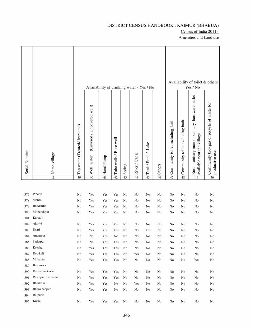
DISTRICT CENSUS HANDBOOK : KAIMUR (BHABUA)
Census of India 2011-
Amenities and Land use
Tap
wat
er (
Tre
ated
/Untr
eate
d)
Wel
l w
ater
(Cover
ed /
Unco
ver
ed w
ell)
Han
d P
um
p
Tube
wel
ls /
Bore
wel
l
Spri
ng
Riv
er /
Can
al
Tan
k /
Pond /
L
ake
Oth
ers
Com
munit
y t
oil
et i
ncl
udin
g
bat
h.
Com
munit
y t
oil
et e
xcl
udin
g b
ath.
Rura
l s
anit
ary m
art
or
sanit
ary
har
dw
are
outl
et
avai
lable
nea
r th
e vil
lage.
Com
munit
y b
io-
gas
or
recy
cle
of
was
te f
or
pro
duct
ive
use
.
1 2 39 40 41 42 43 44 45 46 47 48 49 50
Availability of toilet & others
Yes / No Availability of drinking water - Yes / No
Nam
e vil
lage
Ser
ial
Num
ber
377 Piparia No Yes Yes Yes No No No No No No No No
378 Mehro No Yes Yes Yes No No No No No No No No
379 Bhadaulia No Yes Yes Yes No No No No No No No No
380 Mobarakpur No Yes Yes Yes No No No No No No No No
381 Kanauli
382 Akorhi No Yes Yes Yes No No No No No No No No
383 Usari No Yes Yes Yes No No Yes No No No No No
384 Anantpur No No Yes No No No No No No No No No
385 Sadatpur No No Yes Yes No No No No No No No No
386 Kekrha No Yes Yes Yes No No No No No No No No
387 Dewkali No Yes Yes Yes No Yes No No No No No No
388 Mohania No Yes Yes Yes No No No No No No Yes No
389 Baspurwa
390 Danialpur kurai No Yes Yes Yes No No No No No No No No
391 Rasulpur Karmahri No Yes Yes Yes No No No No No No No No
392 Bharkhar No Yes Yes No No Yes No No No No No No
393 Bhankhanpur No Yes Yes No No No No No No No No No
394 Raipuria
395 Kurra No Yes Yes Yes No No No No No No No No
��
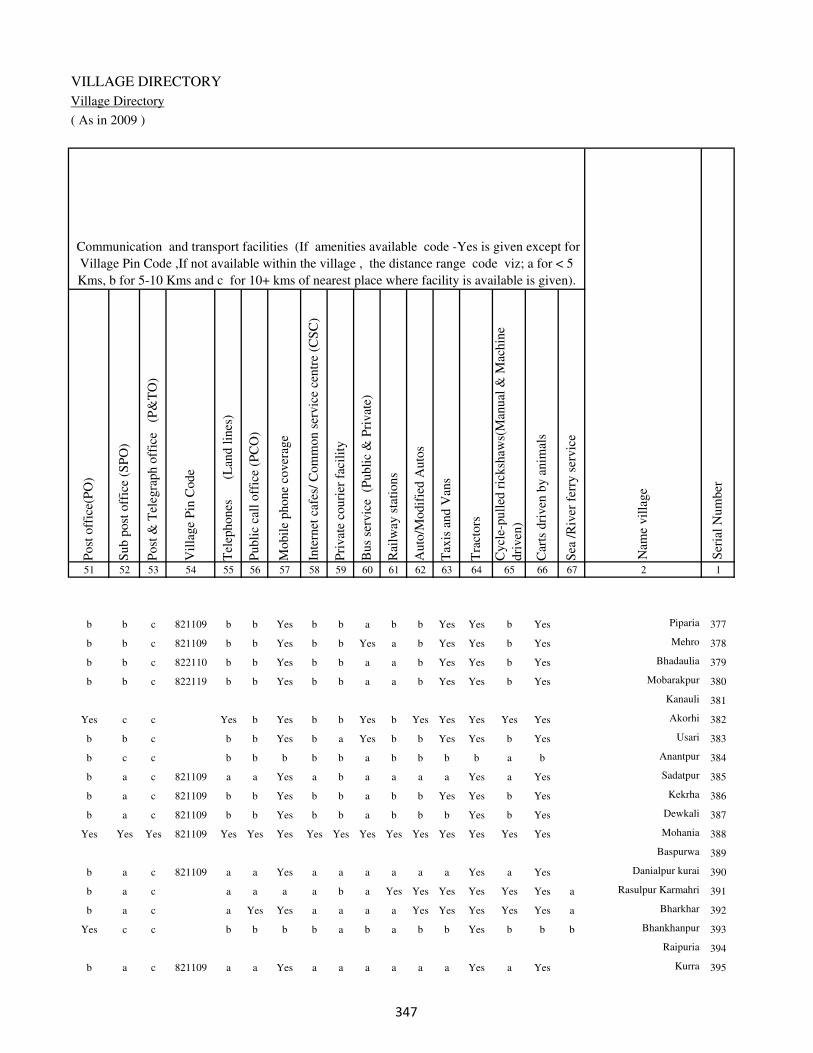
VILLAGE DIRECTORY
Village Directory
( As in 2009 )
Post
off
ice(
PO
)
Sub p
ost
off
ice
(SP
O)
Post
& T
eleg
raph o
ffic
e
(P&
TO
)
Vil
lage
Pin
Code
Tel
ephones
(L
and l
ines
)
Publi
c ca
ll o
ffic
e (P
CO
)
Mobil
e phone
cover
age
Inte
rnet
caf
es/
Com
mon s
ervic
e ce
ntr
e (C
SC
)
Pri
vat
e co
uri
er f
acil
ity
Bus
serv
ice
(P
ubli
c &
Pri
vat
e)
Rai
lway
sta
tions
Auto
/Modif
ied A
uto
s
Tax
is a
nd V
ans
Tra
ctors
Cycl
e-pull
ed r
icksh
aws(
Man
ual
& M
achin
e
dri
ven
)
Car
ts d
riven
by a
nim
als
Sea
/R
iver
fer
ry s
ervic
e51 52 53 54 55 56 57 58 59 60 61 62 63 64 65 66 67 2 1
Communication and transport facilities (If amenities available code -Yes is given except for
Village Pin Code ,If not available within the village , the distance range code viz; a for < 5
Kms, b for 5-10 Kms and c for 10+ kms of nearest place where facility is available is given).
Ser
ial
Num
ber
Nam
e vil
lage
b b c 821109 b b Yes b b a b b Yes Yes b Yes Piparia 377
b b c 821109 b b Yes b b Yes a b Yes Yes b Yes Mehro 378
b b c 822110 b b Yes b b a a b Yes Yes b Yes Bhadaulia 379
b b c 822119 b b Yes b b a a b Yes Yes b Yes Mobarakpur 380
Kanauli 381
Yes c c Yes b Yes b b Yes b Yes Yes Yes Yes Yes Akorhi 382
b b c b b Yes b a Yes b b Yes Yes b Yes Usari 383
b c c b b b b b a b b b b a b Anantpur 384
b a c 821109 a a Yes a b a a a a Yes a Yes Sadatpur 385
b a c 821109 b b Yes b b a b b Yes Yes b Yes Kekrha 386
b a c 821109 b b Yes b b a b b b Yes b Yes Dewkali 387
Yes Yes Yes 821109 Yes Yes Yes Yes Yes Yes Yes Yes Yes Yes Yes Yes Mohania 388
Baspurwa 389
b a c 821109 a a Yes a a a a a a Yes a Yes Danialpur kurai 390
b a c a a a a b a Yes Yes Yes Yes Yes Yes a Rasulpur Karmahri 391
b a c a Yes Yes a a a a Yes Yes Yes Yes Yes a Bharkhar 392
Yes c c b b b b a b a b b Yes b b b Bhankhanpur 393
Raipuria 394
b a c 821109 a a Yes a a a a a a Yes a Yes Kurra 395
��
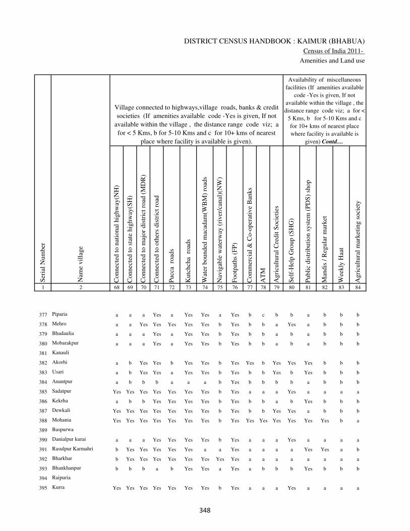
DISTRICT CENSUS HANDBOOK : KAIMUR (BHABUA)
Census of India 2011-
Amenities and Land use
Connec
ted t
o n
atio
nal
hig
hw
ay(N
H)
Connec
ted t
o s
tate
hig
hw
ay(S
H)
Connec
ted t
o m
ajor
dis
tric
t ro
ad (
MD
R)
Connec
ted t
o o
ther
s dis
tric
t ro
ad
Pucc
a r
oad
s
Kutc
hch
a r
oad
s
Wat
er b
ounded
mac
adam
(WB
M)
road
s
Nav
igab
le w
ater
way
(ri
ver
/can
al)(
NW
)
Footp
aths
(FP
)
Com
mer
cial
& C
o-o
per
ativ
e B
anks
AT
M
Agri
cult
ura
l C
redit
Soci
etie
s
Sel
f-H
elp G
roup (
SH
G)
Publi
c dis
trib
uti
on s
yst
em (
PD
S)
shop
Man
dis
/ R
egula
r m
arket
Wee
kly
Haa
t
Agri
cult
ura
l m
arket
ing s
oci
ety
1 2 68 69 70 71 72 73 74 75 76 77 78 79 80 81 82 83 84
Village connected to highways,village roads, banks & credit
societies (If amenities available code -Yes is given, If not
available within the village , the distance range code viz; a
for < 5 Kms, b for 5-10 Kms and c for 10+ kms of nearest
place where facility is available is given).
Ser
ial
Num
ber
Nam
e vil
lage
Availability of miscellaneous
facilities (If amenities available
code -Yes is given, If not
available within the village , the
distance range code viz; a for <
5 Kms, b for 5-10 Kms and c
for 10+ kms of nearest place
where facility is available is
given) Contd....
377 Piparia a a a Yes a Yes Yes a Yes b c b b a b b b
378 Mehro a a Yes Yes Yes Yes Yes b Yes b b a Yes a b b b
379 Bhadaulia a a a Yes a Yes Yes b Yes b b a b a b b b
380 Mobarakpur a a a Yes a Yes Yes b Yes b b a b a b b b
381 Kanauli
382 Akorhi a b Yes Yes b Yes Yes b Yes Yes b Yes Yes Yes b b b
383 Usari a b Yes Yes a Yes Yes b Yes b b Yes b Yes b b b
384 Anantpur a b b b a a a b Yes b b b b a b b b
385 Sadatpur Yes Yes Yes Yes Yes Yes Yes b Yes a a a Yes a a a a
386 Kekrha a b b Yes Yes Yes Yes b Yes b b a b Yes b b b
387 Dewkali Yes Yes Yes Yes Yes Yes Yes b Yes b b Yes Yes a b b b
388 Mohania Yes Yes Yes Yes Yes Yes Yes b Yes Yes Yes Yes Yes Yes Yes b a
389 Baspurwa
390 Danialpur kurai a a a Yes Yes Yes Yes b Yes a a a Yes a a a a
391 Rasulpur Karmahri b Yes Yes Yes Yes Yes a a Yes a a a a Yes Yes a b
392 Bharkhar b Yes Yes Yes Yes Yes Yes Yes Yes a a a a a a a a
393 Bhankhanpur b b b a b Yes Yes a Yes a b b b Yes b b b
394 Raipuria
395 Kurra Yes Yes Yes Yes Yes Yes Yes b Yes a a a Yes a a a a
��

VILLAGE DIRECTORY
Village Directory
( As in 2009 )
Inte
gra
ted C
hil
d D
evel
opm
ent
Sch
eme
(Nutr
itio
nal
Cen
tres
)
Angan
wad
i C
entr
e (N
utr
itio
nal
Cen
tres
)
Oth
ers
(Nutr
itio
nal
Cen
tres
)
AS
HA
(A
ccre
dit
ed S
oci
al H
ealt
h A
ctiv
ist)
Com
munit
y c
entr
e w
ith/w
ithout
TV
Sport
s F
ield
,
Sport
s C
lub /
Rec
reat
ion C
entr
e
Cin
ema
/ V
ideo
Hal
l
Publi
c L
ibra
ry
Publi
c R
eadin
g R
oom
New
spap
er S
upply
Ass
embly
Poll
ing s
tati
on
Bir
th &
Dea
th R
egis
trat
ion O
ffic
e
Pow
er S
upply
for
Dom
esti
c U
se (
ED
)
Pow
er S
upply
for
Agri
cult
ura
l U
se (
EA
G)
Pow
er S
upply
for
Com
mer
cial
Use
(E
C)
Pow
er S
upply
for
All
Use
s (E
A)
85 86 87 88 89 90 91 92 93 94 95 96 97 98 99 100 101 2 1
Availability of
electricity (Yes/No)
Availability of miscellaneous facilities (If amenities available code -
Yes is given, If not available within the village , the distance range
code viz; a for < 5 Kms, b for 5-10 Kms and c for 10+ kms of
nearest place where facility is available is given) Concluded
Nam
e vil
lage
Ser
ial
Num
ber
b Yes Yes a c b b c c b a Yes a Yes Yes Yes Yes Piparia 377
b Yes Yes Yes b b c c c c b Yes a Yes Yes Yes Yes Mehro 378
b b Yes a c b c c c c b a a Yes Yes Yes Yes Bhadaulia 379
b Yes Yes a c b c c c b a Yes a Yes Yes Yes Yes Mobarakpur 380
Kanauli 381
b Yes Yes Yes Yes c c c c c Yes Yes Yes Yes Yes No No Akorhi 382
b Yes Yes a c Yes c c c c b Yes Yes Yes Yes Yes Yes Usari 383
b b Yes b c a c c c c b a a No No No No Anantpur 384
a Yes Yes a c b c c c c a a a Yes Yes Yes Yes Sadatpur 385
b Yes Yes Yes c b c c c c b Yes Yes Yes Yes Yes Yes Kekrha 386
b Yes Yes Yes c b c c c c b Yes a Yes Yes Yes Yes Dewkali 387
Yes Yes Yes Yes c Yes Yes c c c Yes Yes Yes Yes Yes Yes Yes Mohania 388
Baspurwa 389
a Yes Yes a c b b c c c a Yes a Yes Yes Yes Yes Danialpur kurai 390
Yes Yes Yes Yes c a b c c a a Yes Yes Yes Yes Yes Yes Rasulpur Karmahri 391
a Yes Yes Yes c a b c c a Yes Yes Yes Yes No No No Bharkhar 392
b Yes Yes Yes c a c c c c b a b Yes Yes No No Bhankhanpur 393
Raipuria 394
a Yes Yes Yes c a b c c c a Yes a Yes Yes Yes Yes Kurra 395
��
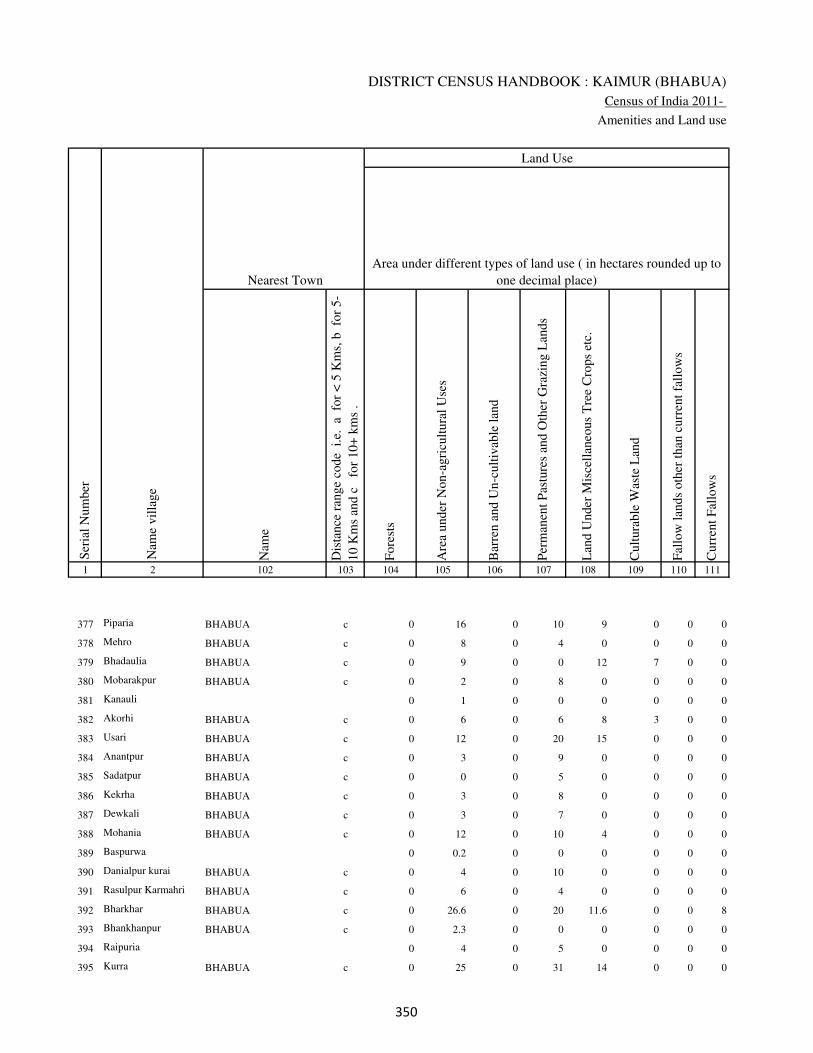
DISTRICT CENSUS HANDBOOK : KAIMUR (BHABUA)
Census of India 2011-
Amenities and Land use
Nam
e
Dis
tance
ran
ge
code
i.e
. a
fo
r <
5 K
ms,
b
for
5-
10 K
ms
and c
f
or
10+
km
s .
Fore
sts
Are
a under
Non-a
gri
cult
ura
l U
ses
Bar
ren a
nd U
n-c
ult
ivab
le l
and
Per
man
ent
Pas
ture
s an
d O
ther
Gra
zing L
ands
Lan
d U
nder
Mis
cell
aneo
us
Tre
e C
rops
etc.
Cult
ura
ble
Was
te L
and
Fal
low
lan
ds
oth
er t
han
curr
ent
fall
ow
s
Curr
ent
Fal
low
s
1 2 102 103 104 105 106 107 108 109 110 111
Ser
ial
Num
ber
Nam
e vil
lage
Area under different types of land use ( in hectares rounded up to
one decimal place)
Land Use
Nearest Town
377 Piparia BHABUA c 0 16 0 10 9 0 0 0
378 Mehro BHABUA c 0 8 0 4 0 0 0 0
379 Bhadaulia BHABUA c 0 9 0 0 12 7 0 0
380 Mobarakpur BHABUA c 0 2 0 8 0 0 0 0
381 Kanauli 0 1 0 0 0 0 0 0
382 Akorhi BHABUA c 0 6 0 6 8 3 0 0
383 Usari BHABUA c 0 12 0 20 15 0 0 0
384 Anantpur BHABUA c 0 3 0 9 0 0 0 0
385 Sadatpur BHABUA c 0 0 0 5 0 0 0 0
386 Kekrha BHABUA c 0 3 0 8 0 0 0 0
387 Dewkali BHABUA c 0 3 0 7 0 0 0 0
388 Mohania BHABUA c 0 12 0 10 4 0 0 0
389 Baspurwa 0 0.2 0 0 0 0 0 0
390 Danialpur kurai BHABUA c 0 4 0 10 0 0 0 0
391 Rasulpur Karmahri BHABUA c 0 6 0 4 0 0 0 0
392 Bharkhar BHABUA c 0 26.6 0 20 11.6 0 0 8
393 Bhankhanpur BHABUA c 0 2.3 0 0 0 0 0 0
394 Raipuria 0 4 0 5 0 0 0 0
395 Kurra BHABUA c 0 25 0 31 14 0 0 0
��
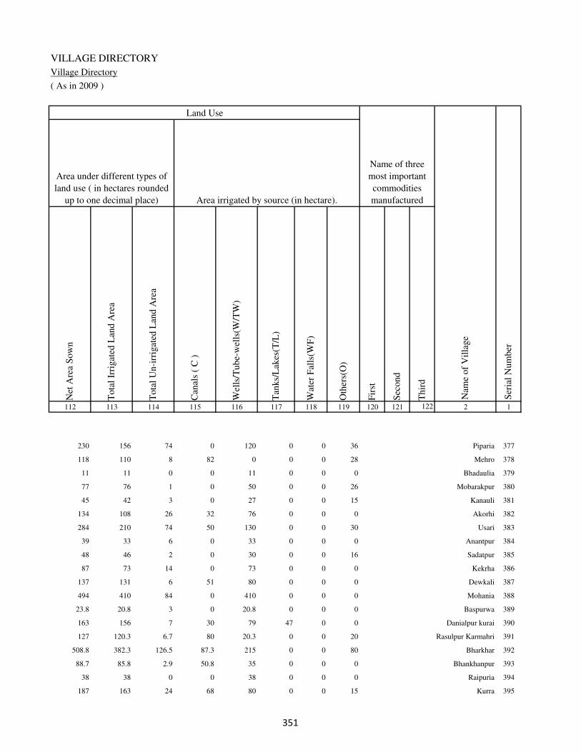
VILLAGE DIRECTORY
Village Directory
( As in 2009 )
Net
Are
a S
ow
n
Tota
l Ir
rigat
ed L
and A
rea
Tota
l U
n-i
rrig
ated
Lan
d A
rea
Can
als
( C
)
Wel
ls/T
ube-
wel
ls(W
/TW
)
Tan
ks/
Lak
es(T
/L)
Wat
er F
alls
(WF
)
Oth
ers(
O)
Fir
st
Sec
ond
Thir
d
112 113 114 115 116 117 118 119 120 121 122 2 1
Ser
ial
Num
ber
Name of three
most important
commodities
manufacturedArea irrigated by source (in hectare).
Nam
e of
Vil
lage
Area under different types of
land use ( in hectares rounded
up to one decimal place)
Land Use
230 156 74 0 120 0 0 36 Piparia 377
118 110 8 82 0 0 0 28 Mehro 378
11 11 0 0 11 0 0 0 Bhadaulia 379
77 76 1 0 50 0 0 26 Mobarakpur 380
45 42 3 0 27 0 0 15 Kanauli 381
134 108 26 32 76 0 0 0 Akorhi 382
284 210 74 50 130 0 0 30 Usari 383
39 33 6 0 33 0 0 0 Anantpur 384
48 46 2 0 30 0 0 16 Sadatpur 385
87 73 14 0 73 0 0 0 Kekrha 386
137 131 6 51 80 0 0 0 Dewkali 387
494 410 84 0 410 0 0 0 Mohania 388
23.8 20.8 3 0 20.8 0 0 0 Baspurwa 389
163 156 7 30 79 47 0 0 Danialpur kurai 390
127 120.3 6.7 80 20.3 0 0 20 Rasulpur Karmahri 391
508.8 382.3 126.5 87.3 215 0 0 80 Bharkhar 392
88.7 85.8 2.9 50.8 35 0 0 0 Bhankhanpur 393
38 38 0 0 38 0 0 0 Raipuria 394
187 163 24 68 80 0 0 15 Kurra 395
��

DISTRICT CENSUS HANDBOOK : KAIMUR (BHABUA)
Census of India 2011-
Amenities and Land use
Pre
-Pri
mar
y s
chool
(PP
)
Pri
mar
y s
chool
(P)
Mid
dle
sch
ool
(M)
Sec
ondar
y S
chool
(S)
Sen
ior
Sec
ondar
y s
chool
(SS
)
Deg
ree
coll
ege
of
arts
sc
ience
& c
om
mer
ce
(AS
C)
Engin
eeri
ng c
oll
ege(
EC
)
Med
ical
coll
ege
(MC
)
Man
agem
ent
inst
itute
(M
I)
Poly
tech
nic
(P
t)
Voca
tional
tra
inin
g s
chool
/IT
I
Non-f
orm
al t
rain
ing c
entr
e (N
FT
C)
Spec
ial
school
for
dis
able
d (
SS
D)
Oth
ers
(spec
ify)
1 2 3 4 5 6 7 8 9 10 11 12 13 14 15 16 17 18 19 20
Loca
tion c
ode
no.
Nam
e vil
lage
Ser
ial
Num
ber
Tota
l popula
tion (
2011 c
ensu
s )
Tota
l ar
ea o
f th
e vil
lage
( in
hec
tare
s ro
unded
up t
o
one
dec
imal
pla
ce)
Number of educational amenities available. (If not available
within the village , the distance range code viz; a for < 5
Kms, b for 5-10 Kms and c for 10+ kms of nearest place
where facility is available is given).
Num
ber
of
house
hold
s (2
011 c
ensu
s)
396 Lodia 249319 32 0 0
397 Doghara 249320 142 989 121 b 1 b c b c c c c c c c c
398 Patti 249321 54 398 54 b 1 a c b c c c c c c c c
399 Narwat 249322 48 0 0
400 Dewkharia 249323 38 0 0
401 Karanpura 249324 49 0 0
402 Aladahi 249325 112 738 98 c 1 b c c c c c c c c c c
403 Hasanpura 249326 26 317 36 c 1 a c b c c c c c c c c
404 Bhawanipur 249327 18 0 0
405 Jigina 249328 139 1324 193 c 1 1 c b b c c c c c c c
406 Lurpurwa 249329 155 1036 166 c 3 a c b c c c c c c c c
407 Edilpur 249330 46 364 44 b 1 a c b c c c c c c c c
408 Berra 249331 189 915 165 c 1 a c b c c c c c c c c
409 Jatalia 249332 16 0 0
410 Chhata 249333 139 0 0
411 Akorhi 249334 70 1588 227 c 1 1 c c c c c c c c c c
412 Maniarpur 249335 73 0 0
413 Dumarpokhar 249336 346 1300 192 c 1 1 c b c c c c c c c c
414 Siapokhar 249337 342 1487 225 c 1 1 c c c c c c c c c c
415 Rajiabandh 249338 121 738 114 c 1 b c c c c c c c c c c
416 Jagarnathpur 249339 41 0 0
�

VILLAGE DIRECTORY
Village Directory
( As in 2009 )
Com
munit
y h
ealt
h c
entr
e (C
HC
)
Pri
mar
y h
ealt
h c
entr
e (P
HC
)
Pri
mar
y h
ealt
h s
ub c
entr
e (P
HS
)
Mat
ernit
y a
nd c
hil
d w
elfa
re c
entr
e (M
CW
)
T.B
. cl
inic
(T
BC
)
Hosp
ital
-all
opat
hic
(H
A)
Hosp
ital
-alt
ernat
ive
med
icin
e (H
O)
Dis
pen
sary
(D
)
Vet
erin
ary h
osp
ital
(V
H)
Mobil
e hea
lth c
linic
(M
HC
)
Fam
ily w
elfa
re c
entr
e (F
WC
)
Char
itab
le n
on G
ovt.
hosp
ital
/Nurs
ing h
om
e.
Med
ical
pra
ctit
ioner
wit
h M
BB
S D
egre
e
Med
ical
pra
ctit
ioner
wit
h o
ther
deg
ree
Med
ical
pra
ctit
ioner
wit
h n
o d
egre
e
Tra
dit
ional
pra
ctit
ioner
an
d f
aith
hea
ler
.
Med
icin
e S
hop
Oth
ers
21 22 23 24 25 26 27 28 29 30 31 32 33 34 35 36 37 38 2 1
Number of Non-Government
Medical Amenities available.
Number of Medical Amenities available. (If not
available within the village , the distance range
code viz; a for < 5 Kms, b for 5-10 Kms and c
for 10+ kms of nearest place where facility is
available is given).
Nam
e vil
lage
Ser
ial
Num
ber
Lodia 396
b b b b b c c b c c b 0 0 0 0 0 0 0 Doghara 397
c c c c b c c c c c c 0 0 0 0 0 0 0 Patti 398
Narwat 399
Dewkharia 400
Karanpura 401
b c b b b c c c c c b 0 0 0 0 0 0 0 Aladahi 402
b b b b b c c b b c b 0 0 0 0 0 0 0 Hasanpura 403
Bhawanipur 404
c c c c c c c c c c c 0 0 0 0 0 0 0 Jigina 405
b b b b b c c b b c b 0 0 0 0 0 0 0 Lurpurwa 406
c c c c c c c c c c c 0 0 0 0 0 0 0 Edilpur 407
c c b c c c c c c c c 0 0 0 0 0 0 0 Berra 408
Jatalia 409
Chhata 410
c c c c c c c c c c c 0 0 0 0 0 0 0 Akorhi 411
Maniarpur 412
c c c c c c c c b c c 0 0 0 0 0 0 0 Dumarpokhar 413
c c c c c c c c c c c 0 0 0 0 0 0 0 Siapokhar 414
c c c c c c c c c c c 0 0 0 0 0 0 0 Rajiabandh 415
Jagarnathpur 416
�

DISTRICT CENSUS HANDBOOK : KAIMUR (BHABUA)
Census of India 2011-
Amenities and Land use
Tap
wat
er (
Tre
ated
/Untr
eate
d)
Wel
l w
ater
(Cover
ed /
Unco
ver
ed w
ell)
Han
d P
um
p
Tube
wel
ls /
Bore
wel
l
Spri
ng
Riv
er /
Can
al
Tan
k /
Pond /
L
ake
Oth
ers
Com
munit
y t
oil
et i
ncl
udin
g
bat
h.
Com
munit
y t
oil
et e
xcl
udin
g b
ath.
Rura
l s
anit
ary m
art
or
sanit
ary
har
dw
are
outl
et
avai
lable
nea
r th
e vil
lage.
Com
munit
y b
io-
gas
or
recy
cle
of
was
te f
or
pro
duct
ive
use
.
1 2 39 40 41 42 43 44 45 46 47 48 49 50
Availability of toilet & others
Yes / No Availability of drinking water - Yes / No
Nam
e vil
lage
Ser
ial
Num
ber
396 Lodia
397 Doghara No Yes Yes No No Yes No No No No No No
398 Patti No No Yes No No No No No No No No No
399 Narwat
400 Dewkharia
401 Karanpura
402 Aladahi No No Yes No No No No No No No No No
403 Hasanpura No Yes Yes No No No No No No No No No
404 Bhawanipur
405 Jigina No Yes Yes No No Yes No No No No No No
406 Lurpurwa No Yes Yes No No Yes No No No No No No
407 Edilpur No Yes Yes No No No No No No No No No
408 Berra No Yes Yes No No No No No No No No No
409 Jatalia
410 Chhata
411 Akorhi No No Yes No No No No No No No No No
412 Maniarpur
413 Dumarpokhar No No Yes No No No No No No No No No
414 Siapokhar No Yes Yes No No Yes No No No No No No
415 Rajiabandh No No Yes No No No No No No No No No
416 Jagarnathpur
��
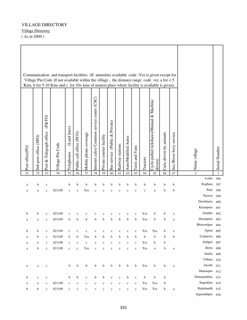
VILLAGE DIRECTORY
Village Directory
( As in 2009 )
Post
off
ice(
PO
)
Sub p
ost
off
ice
(SP
O)
Post
& T
eleg
raph o
ffic
e
(P&
TO
)
Vil
lage
Pin
Code
Tel
ephones
(L
and l
ines
)
Publi
c ca
ll o
ffic
e (P
CO
)
Mobil
e phone
cover
age
Inte
rnet
caf
es/
Com
mon s
ervic
e ce
ntr
e (C
SC
)
Pri
vat
e co
uri
er f
acil
ity
Bus
serv
ice
(P
ubli
c &
Pri
vat
e)
Rai
lway
sta
tions
Auto
/Modif
ied A
uto
s
Tax
is a
nd V
ans
Tra
ctors
Cycl
e-pull
ed r
icksh
aws(
Man
ual
& M
achin
e
dri
ven
)
Car
ts d
riven
by a
nim
als
Sea
/R
iver
fer
ry s
ervic
e51 52 53 54 55 56 57 58 59 60 61 62 63 64 65 66 67 2 1
Communication and transport facilities (If amenities available code -Yes is given except for
Village Pin Code ,If not available within the village , the distance range code viz; a for < 5
Kms, b for 5-10 Kms and c for 10+ kms of nearest place where facility is available is given).
Ser
ial
Num
ber
Nam
e vil
lage
Lodia 396
a b c b b b b b b b b b b b b b Doghara 397
a a c 821109 c c Yes c c c c c c c a b b Patti 398
Narwat 399
Dewkharia 400
Karanpura 401
b b c 821109 c c c c c c c c c Yes b b a Aladahi 402
a a c 821109 b b b b b b b b b Yes b b a Hasanpura 403
Bhawanipur 404
b b c 821109 c c c c c c c c c Yes Yes b a Jigina 405
a b c 821109 b b Yes b b b b b b b b b b Lurpurwa 406
a a c 821109 c c c c c c c c c Yes b b Edilpur 407
a b c 821109 c c Yes c c c c c c Yes a b a Berra 408
Jatalia 409
Chhata 410
a a c b b b b b b b b b Yes b b a Akorhi 411
Maniarpur 412
b c c b b c b b c c b c b b b Dumarpokhar 413
a a c 821109 c c c c c c c c c Yes Yes b Siapokhar 414
b b c 821109 c c c c c c c c c Yes Yes b a Rajiabandh 415
Jagarnathpur 416
��
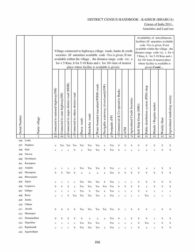
DISTRICT CENSUS HANDBOOK : KAIMUR (BHABUA)
Census of India 2011-
Amenities and Land use
Connec
ted t
o n
atio
nal
hig
hw
ay(N
H)
Connec
ted t
o s
tate
hig
hw
ay(S
H)
Connec
ted t
o m
ajor
dis
tric
t ro
ad (
MD
R)
Connec
ted t
o o
ther
s dis
tric
t ro
ad
Pucc
a r
oad
s
Kutc
hch
a r
oad
s
Wat
er b
ounded
mac
adam
(WB
M)
road
s
Nav
igab
le w
ater
way
(ri
ver
/can
al)(
NW
)
Footp
aths
(FP
)
Com
mer
cial
& C
o-o
per
ativ
e B
anks
AT
M
Agri
cult
ura
l C
redit
Soci
etie
s
Sel
f-H
elp G
roup (
SH
G)
Publi
c dis
trib
uti
on s
yst
em (
PD
S)
shop
Man
dis
/ R
egula
r m
arket
Wee
kly
Haa
t
Agri
cult
ura
l m
arket
ing s
oci
ety
1 2 68 69 70 71 72 73 74 75 76 77 78 79 80 81 82 83 84
Village connected to highways,village roads, banks & credit
societies (If amenities available code -Yes is given, If not
available within the village , the distance range code viz; a
for < 5 Kms, b for 5-10 Kms and c for 10+ kms of nearest
place where facility is available is given).
Ser
ial
Num
ber
Nam
e vil
lage
Availability of miscellaneous
facilities (If amenities available
code -Yes is given, If not
available within the village , the
distance range code viz; a for <
5 Kms, b for 5-10 Kms and c
for 10+ kms of nearest place
where facility is available is
given) Contd....
396 Lodia
397 Doghara a Yes Yes Yes Yes Yes Yes a Yes b b b b b b b b
398 Patti c c c b a Yes Yes b Yes b c c a a c b b
399 Narwat
400 Dewkharia
401 Karanpura
402 Aladahi c c c c Yes Yes Yes b Yes c c c b a c b b
403 Hasanpura b b Yes b a a a a Yes b b b b b b b b
404 Bhawanipur
405 Jigina c c c c Yes Yes Yes b Yes c c c b b b b b
406 Lurpurwa b b b a Yes Yes Yes Yes Yes b b b b a b b b
407 Edilpur c c c c Yes b Yes a Yes c c c b a c c c
408 Berra c c b Yes Yes Yes Yes a Yes c c c c Yes c c c
409 Jatalia
410 Chhata
411 Akorhi b b b b Yes Yes Yes Yes Yes b c b b b c b b
412 Maniarpur
413 Dumarpokhar b b b b b a a a Yes b c b b b c b b
414 Siapokhar c c c c Yes Yes Yes Yes c c c b Yes c b b
415 Rajiabandh c c c b Yes Yes Yes a Yes c c c b a c b b
416 Jagarnathpur
��

VILLAGE DIRECTORY
Village Directory
( As in 2009 )
Inte
gra
ted C
hil
d D
evel
opm
ent
Sch
eme
(Nutr
itio
nal
Cen
tres
)
Angan
wad
i C
entr
e (N
utr
itio
nal
Cen
tres
)
Oth
ers
(Nutr
itio
nal
Cen
tres
)
AS
HA
(A
ccre
dit
ed S
oci
al H
ealt
h A
ctiv
ist)
Com
munit
y c
entr
e w
ith/w
ithout
TV
Sport
s F
ield
,
Sport
s C
lub /
Rec
reat
ion C
entr
e
Cin
ema
/ V
ideo
Hal
l
Publi
c L
ibra
ry
Publi
c R
eadin
g R
oom
New
spap
er S
upply
Ass
embly
Poll
ing s
tati
on
Bir
th &
Dea
th R
egis
trat
ion O
ffic
e
Pow
er S
upply
for
Dom
esti
c U
se (
ED
)
Pow
er S
upply
for
Agri
cult
ura
l U
se (
EA
G)
Pow
er S
upply
for
Com
mer
cial
Use
(E
C)
Pow
er S
upply
for
All
Use
s (E
A)
85 86 87 88 89 90 91 92 93 94 95 96 97 98 99 100 101 2 1
Availability of
electricity (Yes/No)
Availability of miscellaneous facilities (If amenities available code -
Yes is given, If not available within the village , the distance range
code viz; a for < 5 Kms, b for 5-10 Kms and c for 10+ kms of
nearest place where facility is available is given) Concluded
Nam
e vil
lage
Ser
ial
Num
ber
Lodia 396
b Yes Yes Yes c a a c c a a Yes Yes Yes No No No Doghara 397
b a Yes a c c c c c c b a Yes Yes Yes Yes Yes Patti 398
Narwat 399
Dewkharia 400
Karanpura 401
b b Yes b c c c c c c b Yes Yes Yes Yes Yes Yes Aladahi 402
c a Yes a b b b b b b b Yes Yes Yes Yes No No Hasanpura 403
Bhawanipur 404
b Yes Yes Yes c c c c c c c Yes Yes Yes Yes Yes Yes Jigina 405
b b Yes Yes b b b b b b b Yes Yes No No No No Lurpurwa 406
c b Yes b c c c c c c c a a Yes Yes No No Edilpur 407
c b Yes a c c c c c c b Yes Yes Yes Yes Yes Yes Berra 408
Jatalia 409
Chhata 410
c Yes Yes Yes b b b c c b b Yes Yes No No No No Akorhi 411
Maniarpur 412
c b Yes b c c c c c c b a a No No No No Dumarpokhar 413
c Yes Yes Yes c c c c c c c Yes Yes Yes Yes Yes Yes Siapokhar 414
c a Yes a c c c c c c b Yes Yes Yes Yes Yes Yes Rajiabandh 415
Jagarnathpur 416
��

DISTRICT CENSUS HANDBOOK : KAIMUR (BHABUA)
Census of India 2011-
Amenities and Land use
Nam
e
Dis
tance
ran
ge
code
i.e
. a
fo
r <
5 K
ms,
b
for
5-
10 K
ms
and c
f
or
10+
km
s .
Fore
sts
Are
a under
Non-a
gri
cult
ura
l U
ses
Bar
ren a
nd U
n-c
ult
ivab
le l
and
Per
man
ent
Pas
ture
s an
d O
ther
Gra
zing L
ands
Lan
d U
nder
Mis
cell
aneo
us
Tre
e C
rops
etc.
Cult
ura
ble
Was
te L
and
Fal
low
lan
ds
oth
er t
han
curr
ent
fall
ow
s
Curr
ent
Fal
low
s
1 2 102 103 104 105 106 107 108 109 110 111
Ser
ial
Num
ber
Nam
e vil
lage
Area under different types of land use ( in hectares rounded up to
one decimal place)
Land Use
Nearest Town
396 Lodia 0 8.3 0 5 3 0 0 0
397 Doghara BHABUA c 0 16.5 0 15.5 0 5 0 0
398 Patti BHABUA c 0 0 0 0 2 0 0 0
399 Narwat 0 3 0 0 2 0 0 0
400 Dewkharia 0 2 0 0 2 0 0 0
401 Karanpura 0 0 0 0 0 0 0 0
402 Aladahi BHABUA c 0 0 0 1 0 0 0 0
403 Hasanpura BHABUA c 0 2 0 0 0 0 0 1
404 Bhawanipur 0 2 0 0 0 0 0 0
405 Jigina BHABUA c 0 6 0 0 10 0 0 0
406 Lurpurwa BHABUA c 0 8 0 0 5 0 0 0
407 Edilpur BHABUA c 0 5 0 0 0 0 0 0
408 Berra BHABUA c 0 7 0 0 14 0 0 0
409 Jatalia 0 2 0 0 0 0 0 0
410 Chhata 0 16 0 0 10 7 0 0
411 Akorhi BHABUA c 0 0 0 0 0 0 0 0
412 Maniarpur 0 3 0 0 6 0 0 0
413 Dumarpokhar BHABUA c 0 30 0 22 26 8 0 0
414 Siapokhar BHABUA c 0 17 0 0 16 5 0 0
415 Rajiabandh BHABUA c 0 9 0 0 16 0 0 0
416 Jagarnathpur 0 2.1 0 0 0 0 0 0
��
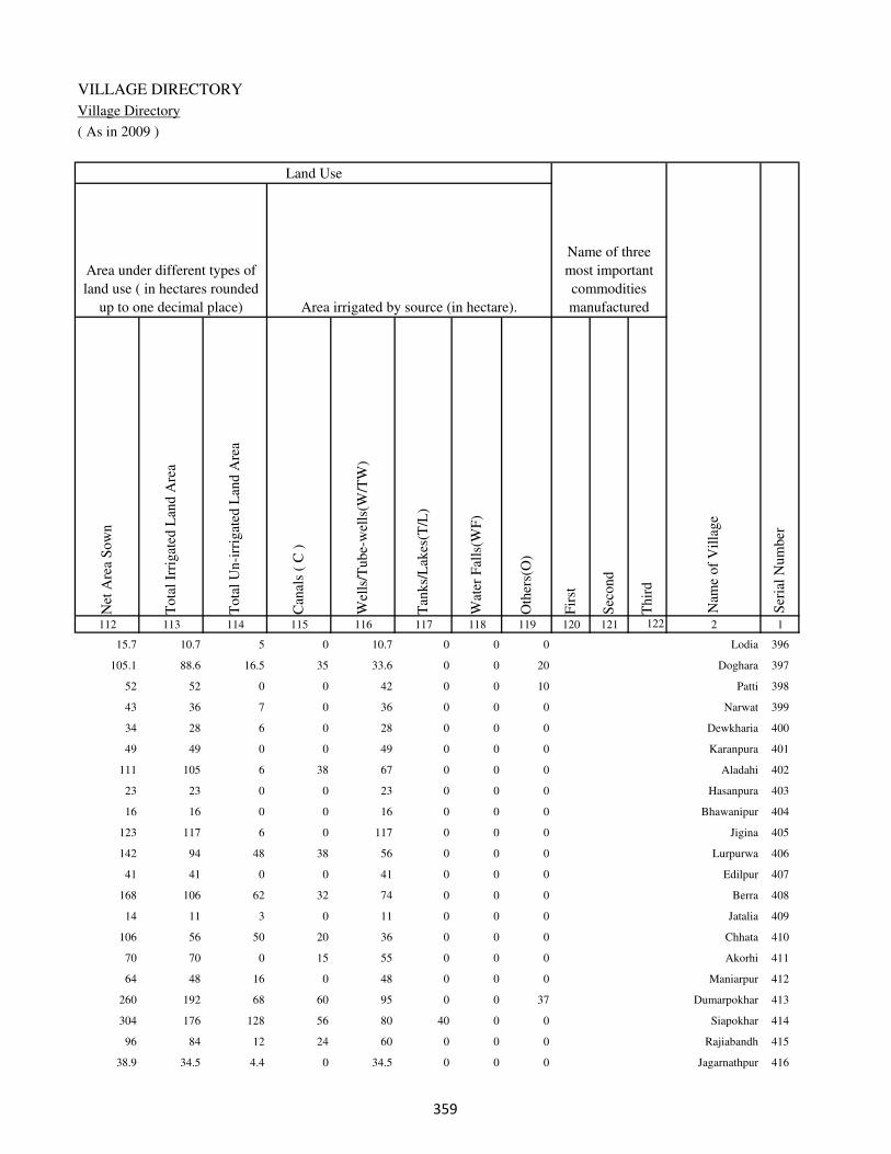
VILLAGE DIRECTORY
Village Directory
( As in 2009 )
Net
Are
a S
ow
n
Tota
l Ir
rigat
ed L
and A
rea
Tota
l U
n-i
rrig
ated
Lan
d A
rea
Can
als
( C
)
Wel
ls/T
ube-
wel
ls(W
/TW
)
Tan
ks/
Lak
es(T
/L)
Wat
er F
alls
(WF
)
Oth
ers(
O)
Fir
st
Sec
ond
Thir
d
112 113 114 115 116 117 118 119 120 121 122 2 1
Ser
ial
Num
ber
Name of three
most important
commodities
manufacturedArea irrigated by source (in hectare).
Nam
e of
Vil
lage
Area under different types of
land use ( in hectares rounded
up to one decimal place)
Land Use
15.7 10.7 5 0 10.7 0 0 0 Lodia 396
105.1 88.6 16.5 35 33.6 0 0 20 Doghara 397
52 52 0 0 42 0 0 10 Patti 398
43 36 7 0 36 0 0 0 Narwat 399
34 28 6 0 28 0 0 0 Dewkharia 400
49 49 0 0 49 0 0 0 Karanpura 401
111 105 6 38 67 0 0 0 Aladahi 402
23 23 0 0 23 0 0 0 Hasanpura 403
16 16 0 0 16 0 0 0 Bhawanipur 404
123 117 6 0 117 0 0 0 Jigina 405
142 94 48 38 56 0 0 0 Lurpurwa 406
41 41 0 0 41 0 0 0 Edilpur 407
168 106 62 32 74 0 0 0 Berra 408
14 11 3 0 11 0 0 0 Jatalia 409
106 56 50 20 36 0 0 0 Chhata 410
70 70 0 15 55 0 0 0 Akorhi 411
64 48 16 0 48 0 0 0 Maniarpur 412
260 192 68 60 95 0 0 37 Dumarpokhar 413
304 176 128 56 80 40 0 0 Siapokhar 414
96 84 12 24 60 0 0 0 Rajiabandh 415
38.9 34.5 4.4 0 34.5 0 0 0 Jagarnathpur 416
��

DISTRICT CENSUS HANDBOOK : KAIMUR (BHABUA)
Census of India 2011-
Amenities and Land use
Pre
-Pri
mar
y s
chool
(PP
)
Pri
mar
y s
chool
(P)
Mid
dle
sch
ool
(M)
Sec
ondar
y S
chool
(S)
Sen
ior
Sec
ondar
y s
chool
(SS
)
Deg
ree
coll
ege
of
arts
sc
ience
& c
om
mer
ce
(AS
C)
Engin
eeri
ng c
oll
ege(
EC
)
Med
ical
coll
ege
(MC
)
Man
agem
ent
inst
itute
(M
I)
Poly
tech
nic
(P
t)
Voca
tional
tra
inin
g s
chool
/IT
I
Non-f
orm
al t
rain
ing c
entr
e (N
FT
C)
Spec
ial
school
for
dis
able
d (
SS
D)
Oth
ers
(spec
ify)
1 2 3 4 5 6 7 8 9 10 11 12 13 14 15 16 17 18 19 20
Loca
tion c
ode
no.
Nam
e vil
lage
Ser
ial
Num
ber
Tota
l popula
tion (
2011 c
ensu
s )
Tota
l ar
ea o
f th
e vil
lage
( in
hec
tare
s ro
unded
up t
o
one
dec
imal
pla
ce)
Number of educational amenities available. (If not available
within the village , the distance range code viz; a for < 5
Kms, b for 5-10 Kms and c for 10+ kms of nearest place
where facility is available is given).
Num
ber
of
house
hold
s (2
011 c
ensu
s)
417 Tulshipur 249340 55 561 101 c 1 b c c c c c c c c c c
418 Harakhpura 249341 30 0 0
419 Gangdaspur 249342 28 0 0
420 Bamhaurkhas 249343 438 3249 478 c 1 1 c c c c c c c c c c
421 Bamhaur Panre 249344 234 1407 208 b 1 1 c c c c c c c c c c
422 Barahiya 249345 257 118 11 a a b c c c c c c c c c c
423 Naseja 249346 109 0 0
424 Sareya 249347 141 615 94 b a b c b b c c c c c c c
425 Barhupar 249348 1211 6461 955 1 3 2 1 1 c c c c c c c c
426 Sahijana 249349 86 314 41 a 1 a c a c c c c c c c c
427 Dhanattarpur 249350 47.2 0 0
428 Lakhanpatti 249351 210 109 16 a a b c b c c c c c c c c c
429 Barkakatra 249352 208 5615 783 b 1 1 c b c c c c c c c c
430 Katra Bahuara 249353 137 868 120 b 1 a c b c c c c c c c c c
431 Bardehri 249354 50 0 0
432 Kormahri 249355 294 1751 230 b 1 1 c b c c c c c c c c
433 Baghni 249356 448 2809 411 b 1 1 c b c c c c c c c c c
434 Narsinghpur 249357 115 11 2 a a a c b c c c c c c c c
435 Ismailpur 249358 24 305 31 a 1 a c b c c c c c c c c
436 Sakrauli 249359 252 1814 285 a 1 1 c a c c c c c c c c
437 Telanga 249360 216 597 83 b 1 b c b c c c c c c c c
��

VILLAGE DIRECTORY
Village Directory
( As in 2009 )
Com
munit
y h
ealt
h c
entr
e (C
HC
)
Pri
mar
y h
ealt
h c
entr
e (P
HC
)
Pri
mar
y h
ealt
h s
ub c
entr
e (P
HS
)
Mat
ernit
y a
nd c
hil
d w
elfa
re c
entr
e (M
CW
)
T.B
. cl
inic
(T
BC
)
Hosp
ital
-all
opat
hic
(H
A)
Hosp
ital
-alt
ernat
ive
med
icin
e (H
O)
Dis
pen
sary
(D
)
Vet
erin
ary h
osp
ital
(V
H)
Mobil
e hea
lth c
linic
(M
HC
)
Fam
ily w
elfa
re c
entr
e (F
WC
)
Char
itab
le n
on G
ovt.
hosp
ital
/Nurs
ing h
om
e.
Med
ical
pra
ctit
ioner
wit
h M
BB
S D
egre
e
Med
ical
pra
ctit
ioner
wit
h o
ther
deg
ree
Med
ical
pra
ctit
ioner
wit
h n
o d
egre
e
Tra
dit
ional
pra
ctit
ioner
an
d f
aith
hea
ler
.
Med
icin
e S
hop
Oth
ers
21 22 23 24 25 26 27 28 29 30 31 32 33 34 35 36 37 38 2 1
Number of Non-Government
Medical Amenities available.
Number of Medical Amenities available. (If not
available within the village , the distance range
code viz; a for < 5 Kms, b for 5-10 Kms and c
for 10+ kms of nearest place where facility is
available is given).
Nam
e vil
lage
Ser
ial
Num
ber
c c c c c c c c c c c 0 0 0 0 0 0 0 Tulshipur 417
Harakhpura 418
Gangdaspur 419
c c 1 1 c c c c c c 1 0 2 2 2 2 2 2 Bamhaurkhas 420
c c 1 1 c c c c c c 1 0 2 2 2 2 2 2 Bamhaur Panre 421
c c 1 1 c c c c c c 1 0 2 2 2 2 2 2 Barahiya 422
Naseja 423
c c c c c c c c c c c 0 0 0 0 0 0 0 Sareya 424
c c b c c c c c c c c 0 0 0 0 0 0 0 Barhupar 425
c c b c c c c c c c c 0 0 0 0 0 0 0 Sahijana 426
Dhanattarpur 427
a a a a a c c a a c a 0 0 0 0 0 0 0 Lakhanpatti 428
c c c c c c c c c c c 0 0 0 0 0 0 0 Barkakatra 429
c c c c c c c c c c c 0 0 0 0 0 0 0 Katra Bahuara 430
Bardehri 431
c c c c c c c c c c b 0 0 0 0 0 0 0 Kormahri 432
c c c c c c c c c c c 0 0 0 0 0 0 0 Baghni 433
c b b c c c c c c c c 0 0 0 0 0 0 0 Narsinghpur 434
c b b c c c c c c c c 0 0 0 0 0 0 0 Ismailpur 435
c b c c c c c c c c c 0 0 0 0 0 0 0 Sakrauli 436
c c b c c c c c c c c 0 0 0 0 0 0 0 Telanga 437
��

DISTRICT CENSUS HANDBOOK : KAIMUR (BHABUA)
Census of India 2011-
Amenities and Land use
Tap
wat
er (
Tre
ated
/Untr
eate
d)
Wel
l w
ater
(Cover
ed /
Unco
ver
ed w
ell)
Han
d P
um
p
Tube
wel
ls /
Bore
wel
l
Spri
ng
Riv
er /
Can
al
Tan
k /
Pond /
L
ake
Oth
ers
Com
munit
y t
oil
et i
ncl
udin
g
bat
h.
Com
munit
y t
oil
et e
xcl
udin
g b
ath.
Rura
l s
anit
ary m
art
or
sanit
ary
har
dw
are
outl
et
avai
lable
nea
r th
e vil
lage.
Com
munit
y b
io-
gas
or
recy
cle
of
was
te f
or
pro
duct
ive
use
.
1 2 39 40 41 42 43 44 45 46 47 48 49 50
Availability of toilet & others
Yes / No Availability of drinking water - Yes / No
Nam
e vil
lage
Ser
ial
Num
ber
417 Tulshipur No No Yes No No Yes No No No No No No
418 Harakhpura
419 Gangdaspur
420 Bamhaurkhas No Yes Yes No No No No No No No No No
421 Bamhaur Panre No Yes Yes No No No No No No No No No
422 Barahiya No Yes Yes No No Yes No No No No No No
423 Naseja
424 Sareya No Yes Yes No No No No No No No No No
425 Barhupar No No Yes No No Yes No No No No No No
426 Sahijana No No Yes No No No No No No No No No
427 Dhanattarpur
428 Lakhanpatti No Yes Yes Yes No Yes No No No No No No
429 Barkakatra No Yes Yes No No Yes No No No No No No
430 Katra Bahuara No Yes Yes No No Yes No No No No No No
431 Bardehri
432 Kormahri No Yes Yes No No Yes No No No No No No
433 Baghni No Yes Yes No No Yes No No No No No No
434 Narsinghpur No No Yes No No Yes No No No No No No
435 Ismailpur No No Yes No No Yes No No No No No No
436 Sakrauli No No Yes No No Yes No No No No No No
437 Telanga No No Yes No No Yes No No No No No No
�
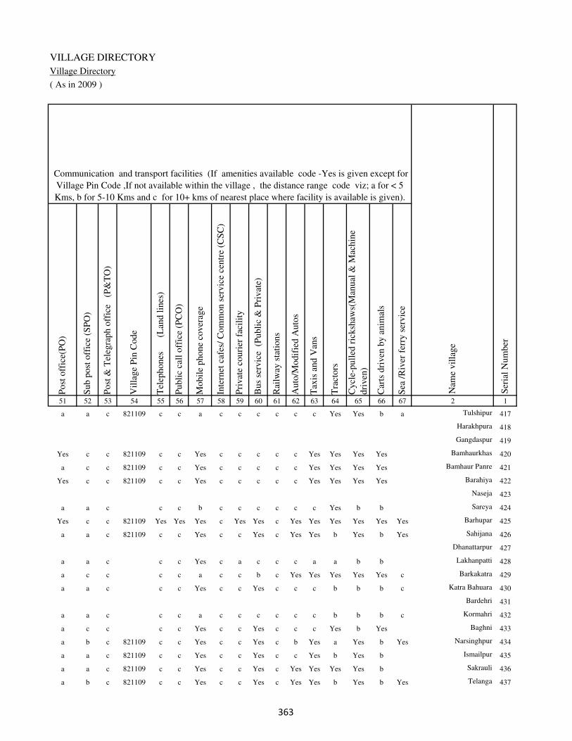
VILLAGE DIRECTORY
Village Directory
( As in 2009 )
Post
off
ice(
PO
)
Sub p
ost
off
ice
(SP
O)
Post
& T
eleg
raph o
ffic
e
(P&
TO
)
Vil
lage
Pin
Code
Tel
ephones
(L
and l
ines
)
Publi
c ca
ll o
ffic
e (P
CO
)
Mobil
e phone
cover
age
Inte
rnet
caf
es/
Com
mon s
ervic
e ce
ntr
e (C
SC
)
Pri
vat
e co
uri
er f
acil
ity
Bus
serv
ice
(P
ubli
c &
Pri
vat
e)
Rai
lway
sta
tions
Auto
/Modif
ied A
uto
s
Tax
is a
nd V
ans
Tra
ctors
Cycl
e-pull
ed r
icksh
aws(
Man
ual
& M
achin
e
dri
ven
)
Car
ts d
riven
by a
nim
als
Sea
/R
iver
fer
ry s
ervic
e51 52 53 54 55 56 57 58 59 60 61 62 63 64 65 66 67 2 1
Communication and transport facilities (If amenities available code -Yes is given except for
Village Pin Code ,If not available within the village , the distance range code viz; a for < 5
Kms, b for 5-10 Kms and c for 10+ kms of nearest place where facility is available is given).
Ser
ial
Num
ber
Nam
e vil
lage
a a c 821109 c c a c c c c c c Yes Yes b a Tulshipur 417
Harakhpura 418
Gangdaspur 419
Yes c c 821109 c c Yes c c c c c Yes Yes Yes Yes Bamhaurkhas 420
a c c 821109 c c Yes c c c c c Yes Yes Yes Yes Bamhaur Panre 421
Yes c c 821109 c c Yes c c c c c Yes Yes Yes Yes Barahiya 422
Naseja 423
a a c c c b c c c c c c Yes b b Sareya 424
Yes c c 821109 Yes Yes Yes c Yes Yes c Yes Yes Yes Yes Yes Yes Barhupar 425
a a c 821109 c c Yes c c Yes c Yes Yes b Yes b Yes Sahijana 426
Dhanattarpur 427
a a c c c Yes c a c c c a a b b Lakhanpatti 428
a c c c c a c c b c Yes Yes Yes Yes Yes c Barkakatra 429
a a c c c Yes c c Yes c c c b b b c Katra Bahuara 430
Bardehri 431
a a c c c a c c c c c c b b b c Kormahri 432
a c c c c Yes c c Yes c c c Yes b Yes Baghni 433
a b c 821109 c c Yes c c Yes c b Yes a Yes b Yes Narsinghpur 434
a a c 821109 c c Yes c c Yes c c Yes b Yes b Ismailpur 435
a a c 821109 c c Yes c c Yes c Yes Yes Yes Yes b Sakrauli 436
a b c 821109 c c Yes c c Yes c Yes Yes b Yes b Yes Telanga 437
�

DISTRICT CENSUS HANDBOOK : KAIMUR (BHABUA)
Census of India 2011-
Amenities and Land use
Connec
ted t
o n
atio
nal
hig
hw
ay(N
H)
Connec
ted t
o s
tate
hig
hw
ay(S
H)
Connec
ted t
o m
ajor
dis
tric
t ro
ad (
MD
R)
Connec
ted t
o o
ther
s dis
tric
t ro
ad
Pucc
a r
oad
s
Kutc
hch
a r
oad
s
Wat
er b
ounded
mac
adam
(WB
M)
road
s
Nav
igab
le w
ater
way
(ri
ver
/can
al)(
NW
)
Footp
aths
(FP
)
Com
mer
cial
& C
o-o
per
ativ
e B
anks
AT
M
Agri
cult
ura
l C
redit
Soci
etie
s
Sel
f-H
elp G
roup (
SH
G)
Publi
c dis
trib
uti
on s
yst
em (
PD
S)
shop
Man
dis
/ R
egula
r m
arket
Wee
kly
Haa
t
Agri
cult
ura
l m
arket
ing s
oci
ety
1 2 68 69 70 71 72 73 74 75 76 77 78 79 80 81 82 83 84
Village connected to highways,village roads, banks & credit
societies (If amenities available code -Yes is given, If not
available within the village , the distance range code viz; a
for < 5 Kms, b for 5-10 Kms and c for 10+ kms of nearest
place where facility is available is given).
Ser
ial
Num
ber
Nam
e vil
lage
Availability of miscellaneous
facilities (If amenities available
code -Yes is given, If not
available within the village , the
distance range code viz; a for <
5 Kms, b for 5-10 Kms and c
for 10+ kms of nearest place
where facility is available is
given) Contd....
417 Tulshipur c b c c Yes Yes Yes a Yes c c c b Yes c b b
418 Harakhpura
419 Gangdaspur
420 Bamhaurkhas c c b Yes Yes Yes Yes b Yes c c c Yes Yes c c c
421 Bamhaur Panre c c b Yes Yes Yes Yes b Yes c c c Yes Yes c c b
422 Barahiya c c a Yes Yes Yes Yes b Yes c c c b Yes c c c
423 Naseja
424 Sareya c c Yes Yes Yes Yes Yes b Yes c c c b a c b c
425 Barhupar b b c Yes Yes Yes Yes Yes Yes c c c b Yes c b c
426 Sahijana a a c Yes Yes Yes Yes Yes Yes c c c b a c b c
427 Dhanattarpur
428 Lakhanpatti a a Yes Yes Yes Yes Yes a Yes c c c c b c c c
429 Barkakatra Yes Yes Yes Yes Yes Yes Yes a Yes c c c c b c c c
430 Katra Bahuara Yes c Yes Yes Yes a Yes a Yes b c c c c c c c
431 Bardehri
432 Kormahri Yes Yes Yes Yes Yes Yes Yes a Yes b c c c c c c c
433 Baghni a c Yes Yes a Yes Yes a Yes b c c b b c c c
434 Narsinghpur b b b Yes a Yes Yes Yes Yes c c c b b c b c
435 Ismailpur b b b Yes Yes Yes Yes b Yes c c c a a c c c
436 Sakrauli b b b b Yes Yes Yes a Yes c c c Yes Yes c b c
437 Telanga b b b Yes Yes Yes a Yes Yes c c c b a c c c
��

VILLAGE DIRECTORY
Village Directory
( As in 2009 )
Inte
gra
ted C
hil
d D
evel
opm
ent
Sch
eme
(Nutr
itio
nal
Cen
tres
)
Angan
wad
i C
entr
e (N
utr
itio
nal
Cen
tres
)
Oth
ers
(Nutr
itio
nal
Cen
tres
)
AS
HA
(A
ccre
dit
ed S
oci
al H
ealt
h A
ctiv
ist)
Com
munit
y c
entr
e w
ith/w
ithout
TV
Sport
s F
ield
,
Sport
s C
lub /
Rec
reat
ion C
entr
e
Cin
ema
/ V
ideo
Hal
l
Publi
c L
ibra
ry
Publi
c R
eadin
g R
oom
New
spap
er S
upply
Ass
embly
Poll
ing s
tati
on
Bir
th &
Dea
th R
egis
trat
ion O
ffic
e
Pow
er S
upply
for
Dom
esti
c U
se (
ED
)
Pow
er S
upply
for
Agri
cult
ura
l U
se (
EA
G)
Pow
er S
upply
for
Com
mer
cial
Use
(E
C)
Pow
er S
upply
for
All
Use
s (E
A)
85 86 87 88 89 90 91 92 93 94 95 96 97 98 99 100 101 2 1
Availability of
electricity (Yes/No)
Availability of miscellaneous facilities (If amenities available code -
Yes is given, If not available within the village , the distance range
code viz; a for < 5 Kms, b for 5-10 Kms and c for 10+ kms of
nearest place where facility is available is given) Concluded
Nam
e vil
lage
Ser
ial
Num
ber
c Yes Yes Yes c c c c c c b Yes Yes No No No No Tulshipur 417
Harakhpura 418
Gangdaspur 419
c Yes Yes Yes c c c c c c b Yes Yes Yes Yes No No Bamhaurkhas 420
c Yes Yes Yes c c c c c c c Yes Yes No Yes No No Bamhaur Panre 421
c Yes Yes Yes c b c c c c c Yes b Yes Yes No No Barahiya 422
Naseja 423
c b Yes b c a c c c c c a a Yes Yes No No Sareya 424
c Yes Yes Yes c Yes Yes c c c Yes Yes Yes Yes Yes Yes Yes Barhupar 425
c b Yes a c a c c c c b a b Yes No No No Sahijana 426
Dhanattarpur 427
c a Yes b c c c c c c Yes a a No No No No Lakhanpatti 428
c Yes Yes Yes c c c c c c Yes Yes Yes Yes Yes No No Barkakatra 429
c Yes c Yes c c c c c c b a b Yes Yes Yes Yes Katra Bahuara 430
Bardehri 431
c Yes Yes Yes c c c c c c c a b Yes Yes No No Kormahri 432
c Yes Yes Yes c b c c c c b Yes a Yes Yes Yes Yes Baghni 433
c a Yes a c b c c c c b a b No No No No Narsinghpur 434
c Yes Yes Yes c b c c c c b a b Yes Yes Yes Yes Ismailpur 435
c Yes Yes Yes c Yes c c c c b Yes b No No No No Sakrauli 436
c Yes Yes Yes c b c c c c b a b Yes No No No Telanga 437
��
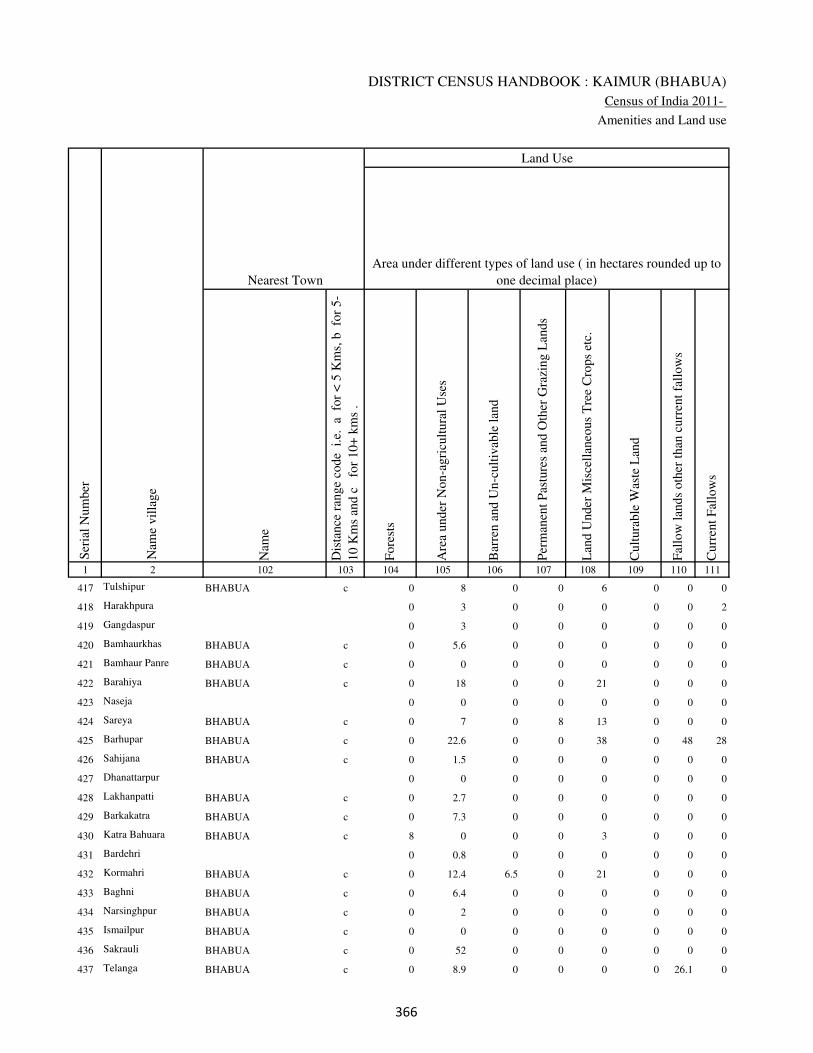
DISTRICT CENSUS HANDBOOK : KAIMUR (BHABUA)
Census of India 2011-
Amenities and Land use
Nam
e
Dis
tance
ran
ge
code
i.e
. a
fo
r <
5 K
ms,
b
for
5-
10 K
ms
and c
f
or
10+
km
s .
Fore
sts
Are
a under
Non-a
gri
cult
ura
l U
ses
Bar
ren a
nd U
n-c
ult
ivab
le l
and
Per
man
ent
Pas
ture
s an
d O
ther
Gra
zing L
ands
Lan
d U
nder
Mis
cell
aneo
us
Tre
e C
rops
etc.
Cult
ura
ble
Was
te L
and
Fal
low
lan
ds
oth
er t
han
curr
ent
fall
ow
s
Curr
ent
Fal
low
s
1 2 102 103 104 105 106 107 108 109 110 111
Ser
ial
Num
ber
Nam
e vil
lage
Area under different types of land use ( in hectares rounded up to
one decimal place)
Land Use
Nearest Town
417 Tulshipur BHABUA c 0 8 0 0 6 0 0 0
418 Harakhpura 0 3 0 0 0 0 0 2
419 Gangdaspur 0 3 0 0 0 0 0 0
420 Bamhaurkhas BHABUA c 0 5.6 0 0 0 0 0 0
421 Bamhaur Panre BHABUA c 0 0 0 0 0 0 0 0
422 Barahiya BHABUA c 0 18 0 0 21 0 0 0
423 Naseja 0 0 0 0 0 0 0 0
424 Sareya BHABUA c 0 7 0 8 13 0 0 0
425 Barhupar BHABUA c 0 22.6 0 0 38 0 48 28
426 Sahijana BHABUA c 0 1.5 0 0 0 0 0 0
427 Dhanattarpur 0 0 0 0 0 0 0 0
428 Lakhanpatti BHABUA c 0 2.7 0 0 0 0 0 0
429 Barkakatra BHABUA c 0 7.3 0 0 0 0 0 0
430 Katra Bahuara BHABUA c 8 0 0 0 3 0 0 0
431 Bardehri 0 0.8 0 0 0 0 0 0
432 Kormahri BHABUA c 0 12.4 6.5 0 21 0 0 0
433 Baghni BHABUA c 0 6.4 0 0 0 0 0 0
434 Narsinghpur BHABUA c 0 2 0 0 0 0 0 0
435 Ismailpur BHABUA c 0 0 0 0 0 0 0 0
436 Sakrauli BHABUA c 0 52 0 0 0 0 0 0
437 Telanga BHABUA c 0 8.9 0 0 0 0 26.1 0
��

VILLAGE DIRECTORY
Village Directory
( As in 2009 )
Net
Are
a S
ow
n
Tota
l Ir
rigat
ed L
and A
rea
Tota
l U
n-i
rrig
ated
Lan
d A
rea
Can
als
( C
)
Wel
ls/T
ube-
wel
ls(W
/TW
)
Tan
ks/
Lak
es(T
/L)
Wat
er F
alls
(WF
)
Oth
ers(
O)
Fir
st
Sec
ond
Thir
d
112 113 114 115 116 117 118 119 120 121 122 2 1
Ser
ial
Num
ber
Name of three
most important
commodities
manufacturedArea irrigated by source (in hectare).
Nam
e of
Vil
lage
Area under different types of
land use ( in hectares rounded
up to one decimal place)
Land Use
41 37.5 3.5 0 37.5 0 0 0 Tulshipur 417
25 25 0 0 25 0 0 0 Harakhpura 418
25 25 0 0 25 0 0 0 Gangdaspur 419
432.4 389 43.4 70 280 0 0 39 Bamhaurkhas 420
234 234 0 116 98 0 0 20 Bamhaur Panre 421
218 162 56 52 80 0 0 30 Barahiya 422
109 109 0 45 64 0 0 0 Naseja 423
113 78 35 28 50 0 0 0 Sareya 424
1074.4 974 100.4 87.4 716.6 120 0 50 Barhupar 425
84.5 78.6 5.9 48.6 30 0 0 0 Sahijana 426
47.2 43.5 3.7 28.5 15 0 0 0 Dhanattarpur 427
207.3 184.7 22.6 180 4.7 0 0 0 Lakhanpatti 428
200.7 198 2.7 95 73 0 0 30 Barkakatra 429
126 126 0 26 85 0 0 15 Katra Bahuara 430
49.2 42.7 6.6 40 2.7 0 0 0 Bardehri 431
254.1 202.6 51.5 155.6 47 0 0 0 Kormahri 432
441.6 403.1 38.5 303.1 100 0 0 0 Baghni 433
113 109.7 3.2 109.7 0 0 0 0 Narsinghpur 434
24 22.6 1.5 22.6 0 0 0 0 Ismailpur 435
200 160 40 0 140 0 0 20 Sakrauli 436
181 177.3 3.8 177.3 0 0 0 0 Telanga 437
��

DISTRICT CENSUS HANDBOOK : KAIMUR (BHABUA)
Census of India 2011-
Amenities and Land use
Pre
-Pri
mar
y s
chool
(PP
)
Pri
mar
y s
chool
(P)
Mid
dle
sch
ool
(M)
Sec
ondar
y S
chool
(S)
Sen
ior
Sec
ondar
y s
chool
(SS
)
Deg
ree
coll
ege
of
arts
sc
ience
& c
om
mer
ce
(AS
C)
Engin
eeri
ng c
oll
ege(
EC
)
Med
ical
coll
ege
(MC
)
Man
agem
ent
inst
itute
(M
I)
Poly
tech
nic
(P
t)
Voca
tional
tra
inin
g s
chool
/IT
I
Non-f
orm
al t
rain
ing c
entr
e (N
FT
C)
Spec
ial
school
for
dis
able
d (
SS
D)
Oth
ers
(spec
ify)
1 2 3 4 5 6 7 8 9 10 11 12 13 14 15 16 17 18 19 20
Loca
tion c
ode
no.
Nam
e vil
lage
Ser
ial
Num
ber
Tota
l popula
tion (
2011 c
ensu
s )
Tota
l ar
ea o
f th
e vil
lage
( in
hec
tare
s ro
unded
up t
o
one
dec
imal
pla
ce)
Number of educational amenities available. (If not available
within the village , the distance range code viz; a for < 5
Kms, b for 5-10 Kms and c for 10+ kms of nearest place
where facility is available is given).
Num
ber
of
house
hold
s (2
011 c
ensu
s)
438 Karsaria 249361 101 410 53 a 1 a c a c c c c c c c c
439 Kaithiya 249362 100 738 151 a 1 a c b c c c c c c c c
440 Chotka Katra 249363 97 984 142 1 1 1 c c c c c c c c c c
441 Binodpur 249364 125 272 45 a 1 a c b c c c c c c c c
442 Naraura 249365 195 990 130 1 1 a c c c c c c c c c c
443 Semaria 249366 154 409 51 a 1 a c b c c c c c c c c
444 Lahuribari 249367 106 1297 184 b 1 1 b a c c c c c c c c
445 Mujan 249368 444 4333 662 1 1 1 1 a c c c c c c c c
446 Dharampura 249369 27.1 0 0
447 Dandwas 249370 359 2870 409 1 1 1 c c c c c c c c c c
448 Ganr Sarai 249371 62.2 0 0
449 Semaria 249372 141 0 0
450 Chhotki Kulharia 249373 234 1655 229 b 1 1 c c c c c c c c c c
451 Barki Kulharia 249374 172 543 74 a 1 a c c c c c c c c c c
452 Khajhra 249375 137 1171 172 1 1 1 c c c c c c c c c c
453 Keshopur 249376 130 1149 175 a 1 a c c c c c c c c c c
454 Chhapri 249377 84 111 25 a a a c a a c c c c c c c
455 Dia 249378 179 1403 200 b 1 a c a a c c c c c c c
456 Arazi Bhokhari 249379 48 0 0
457 Sarai 249380 190 1004 126 b b b c b c c c c c c c c
458 Bahdura 249381 134 48 16 b 1 a 1 c c c c c c c c c
��

VILLAGE DIRECTORY
Village Directory
( As in 2009 )
Com
munit
y h
ealt
h c
entr
e (C
HC
)
Pri
mar
y h
ealt
h c
entr
e (P
HC
)
Pri
mar
y h
ealt
h s
ub c
entr
e (P
HS
)
Mat
ernit
y a
nd c
hil
d w
elfa
re c
entr
e (M
CW
)
T.B
. cl
inic
(T
BC
)
Hosp
ital
-all
opat
hic
(H
A)
Hosp
ital
-alt
ernat
ive
med
icin
e (H
O)
Dis
pen
sary
(D
)
Vet
erin
ary h
osp
ital
(V
H)
Mobil
e hea
lth c
linic
(M
HC
)
Fam
ily w
elfa
re c
entr
e (F
WC
)
Char
itab
le n
on G
ovt.
hosp
ital
/Nurs
ing h
om
e.
Med
ical
pra
ctit
ioner
wit
h M
BB
S D
egre
e
Med
ical
pra
ctit
ioner
wit
h o
ther
deg
ree
Med
ical
pra
ctit
ioner
wit
h n
o d
egre
e
Tra
dit
ional
pra
ctit
ioner
an
d f
aith
hea
ler
.
Med
icin
e S
hop
Oth
ers
21 22 23 24 25 26 27 28 29 30 31 32 33 34 35 36 37 38 2 1
Number of Non-Government
Medical Amenities available.
Number of Medical Amenities available. (If not
available within the village , the distance range
code viz; a for < 5 Kms, b for 5-10 Kms and c
for 10+ kms of nearest place where facility is
available is given).
Nam
e vil
lage
Ser
ial
Num
ber
c c b c c c c c c c c 0 0 0 0 0 0 0 Karsaria 438
c c b c c c c c c c c 0 0 0 0 0 0 0 Kaithiya 439
c c b c c c c c c c c 0 0 0 0 0 0 0 Chotka Katra 440
c c b c c c c c c c c 0 0 0 0 0 0 0 Binodpur 441
c b c c c c c c c c c 0 0 0 0 0 0 0 Naraura 442
c c c c c c c c c c c 0 0 0 0 0 0 0 Semaria 443
c c c c c c c c c c c 0 0 0 0 0 0 0 Lahuribari 444
c c c c c c c c c c c 0 0 0 0 0 0 0 Mujan 445
Dharampura 446
c c b c c c c c c c c 0 0 0 0 0 0 0 Dandwas 447
Ganr Sarai 448
Semaria 449
c c b c c c c a c c c 0 0 0 0 0 0 0 Chhotki Kulharia 450
c c c c c c c c c c c 0 0 0 0 0 0 0 Barki Kulharia 451
c c b c c c c c c c c 0 0 0 0 0 0 0 Khajhra 452
c c b c c c c c c c c 0 0 0 0 0 0 0 Keshopur 453
c c b c c c c c c c c 0 0 0 0 0 0 0 Chhapri 454
c c c c c c c c c c c 0 0 0 0 0 0 0 Dia 455
Arazi Bhokhari 456
c c b c c c c c c c c 0 0 0 0 0 0 0 Sarai 457
c c b c c c c c c c c 0 0 0 0 0 0 0 Bahdura 458
��
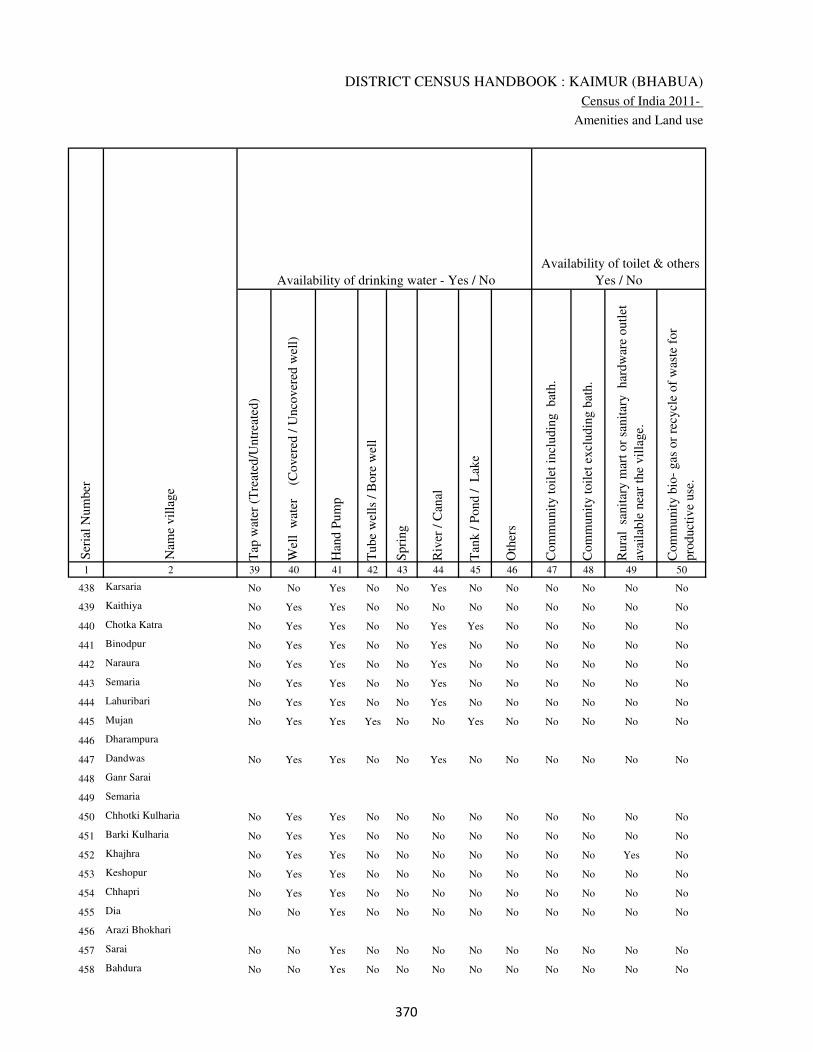
DISTRICT CENSUS HANDBOOK : KAIMUR (BHABUA)
Census of India 2011-
Amenities and Land use
Tap
wat
er (
Tre
ated
/Untr
eate
d)
Wel
l w
ater
(Cover
ed /
Unco
ver
ed w
ell)
Han
d P
um
p
Tube
wel
ls /
Bore
wel
l
Spri
ng
Riv
er /
Can
al
Tan
k /
Pond /
L
ake
Oth
ers
Com
munit
y t
oil
et i
ncl
udin
g
bat
h.
Com
munit
y t
oil
et e
xcl
udin
g b
ath.
Rura
l s
anit
ary m
art
or
sanit
ary
har
dw
are
outl
et
avai
lable
nea
r th
e vil
lage.
Com
munit
y b
io-
gas
or
recy
cle
of
was
te f
or
pro
duct
ive
use
.
1 2 39 40 41 42 43 44 45 46 47 48 49 50
Availability of toilet & others
Yes / No Availability of drinking water - Yes / No
Nam
e vil
lage
Ser
ial
Num
ber
438 Karsaria No No Yes No No Yes No No No No No No
439 Kaithiya No Yes Yes No No No No No No No No No
440 Chotka Katra No Yes Yes No No Yes Yes No No No No No
441 Binodpur No Yes Yes No No Yes No No No No No No
442 Naraura No Yes Yes No No Yes No No No No No No
443 Semaria No Yes Yes No No Yes No No No No No No
444 Lahuribari No Yes Yes No No Yes No No No No No No
445 Mujan No Yes Yes Yes No No Yes No No No No No
446 Dharampura
447 Dandwas No Yes Yes No No Yes No No No No No No
448 Ganr Sarai
449 Semaria
450 Chhotki Kulharia No Yes Yes No No No No No No No No No
451 Barki Kulharia No Yes Yes No No No No No No No No No
452 Khajhra No Yes Yes No No No No No No No Yes No
453 Keshopur No Yes Yes No No No No No No No No No
454 Chhapri No Yes Yes No No No No No No No No No
455 Dia No No Yes No No No No No No No No No
456 Arazi Bhokhari
457 Sarai No No Yes No No No No No No No No No
458 Bahdura No No Yes No No No No No No No No No
��
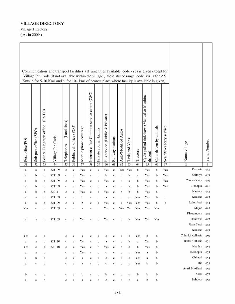
VILLAGE DIRECTORY
Village Directory
( As in 2009 )
Post
off
ice(
PO
)
Sub p
ost
off
ice
(SP
O)
Post
& T
eleg
raph o
ffic
e
(P&
TO
)
Vil
lage
Pin
Code
Tel
ephones
(L
and l
ines
)
Publi
c ca
ll o
ffic
e (P
CO
)
Mobil
e phone
cover
age
Inte
rnet
caf
es/
Com
mon s
ervic
e ce
ntr
e (C
SC
)
Pri
vat
e co
uri
er f
acil
ity
Bus
serv
ice
(P
ubli
c &
Pri
vat
e)
Rai
lway
sta
tions
Auto
/Modif
ied A
uto
s
Tax
is a
nd V
ans
Tra
ctors
Cycl
e-pull
ed r
icksh
aws(
Man
ual
& M
achin
e
dri
ven
)
Car
ts d
riven
by a
nim
als
Sea
/R
iver
fer
ry s
ervic
e51 52 53 54 55 56 57 58 59 60 61 62 63 64 65 66 67 2 1
Communication and transport facilities (If amenities available code -Yes is given except for
Village Pin Code ,If not available within the village , the distance range code viz; a for < 5
Kms, b for 5-10 Kms and c for 10+ kms of nearest place where facility is available is given).
Ser
ial
Num
ber
Nam
e vil
lage
a a c 821109 c c Yes c c Yes c Yes Yes b Yes b Yes Karsaria 438
a b c 821109 c c Yes c c b c b b c Yes b Yes Kaithiya 439
a b c 821109 c c Yes c c Yes c a a b Yes b Yes Chotka Katra 440
a b c 821109 c c Yes c c a c a a b Yes b Yes Binodpur 441
a b c 820111 c c Yes c c Yes c b b b Yes b Naraura 442
a a c 821109 c c b c c a c c c Yes Yes b c Semaria 443
a a c 821109 c c b c c Yes c c Yes Yes Yes b c Lahuribari 444
Yes c c 821109 c c a c c Yes c Yes Yes Yes Yes Yes c Mujan 445
Dharampura 446
a a c 821109 c c Yes c b Yes c b b Yes Yes Yes Dandwas 447
Ganr Sarai 448
Semaria 449
Yes c c c c a c c c c c b Yes b b Chhotki Kulharia 450
a a c 821110 c c Yes c c a c c b a Yes b Barki Kulharia 451
Yes c c 820110 c c Yes c b Yes c b b b Yes b Khajhra 452
a a c c c Yes c c c c c c Yes a b Keshopur 453
a b c c c a c c c c c c Yes a b Chhapri 454
a c c c c a c c c c c c Yes b b Dia 455
Arazi Bhokhari 456
b c c c c b c c b c c c b b b Sarai 457
a a c c c a c c c c c c a b b Bahdura 458
��

DISTRICT CENSUS HANDBOOK : KAIMUR (BHABUA)
Census of India 2011-
Amenities and Land use
Connec
ted t
o n
atio
nal
hig
hw
ay(N
H)
Connec
ted t
o s
tate
hig
hw
ay(S
H)
Connec
ted t
o m
ajor
dis
tric
t ro
ad (
MD
R)
Connec
ted t
o o
ther
s dis
tric
t ro
ad
Pucc
a r
oad
s
Kutc
hch
a r
oad
s
Wat
er b
ounded
mac
adam
(WB
M)
road
s
Nav
igab
le w
ater
way
(ri
ver
/can
al)(
NW
)
Footp
aths
(FP
)
Com
mer
cial
& C
o-o
per
ativ
e B
anks
AT
M
Agri
cult
ura
l C
redit
Soci
etie
s
Sel
f-H
elp G
roup (
SH
G)
Publi
c dis
trib
uti
on s
yst
em (
PD
S)
shop
Man
dis
/ R
egula
r m
arket
Wee
kly
Haa
t
Agri
cult
ura
l m
arket
ing s
oci
ety
1 2 68 69 70 71 72 73 74 75 76 77 78 79 80 81 82 83 84
Village connected to highways,village roads, banks & credit
societies (If amenities available code -Yes is given, If not
available within the village , the distance range code viz; a
for < 5 Kms, b for 5-10 Kms and c for 10+ kms of nearest
place where facility is available is given).
Ser
ial
Num
ber
Nam
e vil
lage
Availability of miscellaneous
facilities (If amenities available
code -Yes is given, If not
available within the village , the
distance range code viz; a for <
5 Kms, b for 5-10 Kms and c
for 10+ kms of nearest place
where facility is available is
given) Contd....
438 Karsaria b b c Yes Yes Yes Yes Yes Yes c c c b a c b c
439 Kaithiya c b c Yes b Yes Yes Yes Yes c c b b b c b c
440 Chotka Katra c b c Yes Yes Yes Yes Yes Yes c c b b Yes c b c
441 Binodpur c c c Yes b Yes b Yes Yes c c b b b c b c
442 Naraura c c Yes Yes b Yes b a Yes c c c b a c c c
443 Semaria a a b Yes Yes Yes Yes a Yes c c c b b c b c
444 Lahuribari Yes Yes Yes Yes Yes a Yes Yes Yes c c c b b c c c
445 Mujan a a Yes Yes Yes Yes Yes a Yes c c c Yes Yes c c c
446 Dharampura
447 Dandwas c c c b b Yes Yes a Yes c c Yes Yes Yes c b c
448 Ganr Sarai
449 Semaria
450 Chhotki Kulharia c c c Yes b Yes a a Yes c c c b Yes c b c
451 Barki Kulharia c c c Yes b Yes a b Yes c c c b a c b c
452 Khajhra c c c b Yes Yes Yes a Yes c c b b Yes c c c
453 Keshopur c c Yes Yes a Yes b a Yes c c b c a c b c
454 Chhapri c c Yes Yes b Yes a b Yes c c b b a c c c
455 Dia c c c c Yes a b b Yes c c c b Yes c c c
456 Arazi Bhokhari
457 Sarai c c b b b a a b Yes c c c c b c c c
458 Bahdura c c Yes Yes a b a b Yes c c c c a c c c
�

VILLAGE DIRECTORY
Village Directory
( As in 2009 )
Inte
gra
ted C
hil
d D
evel
opm
ent
Sch
eme
(Nutr
itio
nal
Cen
tres
)
Angan
wad
i C
entr
e (N
utr
itio
nal
Cen
tres
)
Oth
ers
(Nutr
itio
nal
Cen
tres
)
AS
HA
(A
ccre
dit
ed S
oci
al H
ealt
h A
ctiv
ist)
Com
munit
y c
entr
e w
ith/w
ithout
TV
Sport
s F
ield
,
Sport
s C
lub /
Rec
reat
ion C
entr
e
Cin
ema
/ V
ideo
Hal
l
Publi
c L
ibra
ry
Publi
c R
eadin
g R
oom
New
spap
er S
upply
Ass
embly
Poll
ing s
tati
on
Bir
th &
Dea
th R
egis
trat
ion O
ffic
e
Pow
er S
upply
for
Dom
esti
c U
se (
ED
)
Pow
er S
upply
for
Agri
cult
ura
l U
se (
EA
G)
Pow
er S
upply
for
Com
mer
cial
Use
(E
C)
Pow
er S
upply
for
All
Use
s (E
A)
85 86 87 88 89 90 91 92 93 94 95 96 97 98 99 100 101 2 1
Availability of
electricity (Yes/No)
Availability of miscellaneous facilities (If amenities available code -
Yes is given, If not available within the village , the distance range
code viz; a for < 5 Kms, b for 5-10 Kms and c for 10+ kms of
nearest place where facility is available is given) Concluded
Nam
e vil
lage
Ser
ial
Num
ber
c a Yes a c a c c c c b a a Yes No No No Karsaria 438
c a Yes a c a c c c c b a b Yes No No No Kaithiya 439
c Yes Yes Yes c Yes Yes c c c b Yes b Yes Yes No No Chotka Katra 440
c a Yes b c a c c c c c a b Yes No No No Binodpur 441
c Yes Yes Yes c a c c c c c Yes b Yes No No No Naraura 442
c Yes Yes Yes c c c c c c b Yes a No No No No Semaria 443
c Yes Yes Yes c c c c c c c Yes a No Yes No No Lahuribari 444
c Yes Yes Yes c b c c c c Yes Yes Yes No Yes No No Mujan 445
Dharampura 446
c Yes Yes Yes c a c c c c c Yes Yes Yes No No No Dandwas 447
Ganr Sarai 448
Semaria 449
c Yes Yes Yes c Yes c c c c b a a Yes Yes No No Chhotki Kulharia 450
c a Yes a c a c c c c c a b No No No No Barki Kulharia 451
c Yes Yes Yes c a c c c c b Yes a No No No No Khajhra 452
c b Yes Yes c a c c c c c a a Yes Yes No No Keshopur 453
c b Yes b c a c c c c b a a No No No No Chhapri 454
c Yes Yes Yes c b c c c c b Yes Yes Yes Yes Yes Yes Dia 455
Arazi Bhokhari 456
c b Yes b c b c c c c b a a No No No No Sarai 457
c b Yes b c Yes c c c c b a a No No No No Bahdura 458
�

DISTRICT CENSUS HANDBOOK : KAIMUR (BHABUA)
Census of India 2011-
Amenities and Land use
Nam
e
Dis
tance
ran
ge
code
i.e
. a
fo
r <
5 K
ms,
b
for
5-
10 K
ms
and c
f
or
10+
km
s .
Fore
sts
Are
a under
Non-a
gri
cult
ura
l U
ses
Bar
ren a
nd U
n-c
ult
ivab
le l
and
Per
man
ent
Pas
ture
s an
d O
ther
Gra
zing L
ands
Lan
d U
nder
Mis
cell
aneo
us
Tre
e C
rops
etc.
Cult
ura
ble
Was
te L
and
Fal
low
lan
ds
oth
er t
han
curr
ent
fall
ow
s
Curr
ent
Fal
low
s
1 2 102 103 104 105 106 107 108 109 110 111
Ser
ial
Num
ber
Nam
e vil
lage
Area under different types of land use ( in hectares rounded up to
one decimal place)
Land Use
Nearest Town
438 Karsaria BHABUA c 0 6 0 3.3 0 0 17.2 0
439 Kaithiya BHABUA c 0 0 16 0 18.3 0 4.8 0
440 Chotka Katra BHABUA c 0 2 0 4 0 0 0 0
441 Binodpur BHABUA c 0 5 0 9 6 0 0 0
442 Naraura BHABUA c 0 6.3 0 8 0 0 0 0
443 Semaria BHABUA c 0 7.2 0 0 16 0 0 0
444 Lahuribari BHABUA c 0 19.3 0 0 1 0 0 0
445 Mujan BHABUA c 0 82.9 0 0 34 0 0 0
446 Dharampura 0 7 0 0 0 0 0 0
447 Dandwas BHABUA c 0 32.2 0 36 49 14.2 0 0
448 Ganr Sarai 0 4.1 0 0 0 0 0 0
449 Semaria 0 11.2 0 0 0 10.8 0 0
450 Chhotki Kulharia BHABUA c 0 3 0 0 10 0 0 0
451 Barki Kulharia BHABUA c 0 1.8 0 0 0 3.2 0 0
452 Khajhra BHABUA c 0 4.4 0 0 15 0 7.4 0
453 Keshopur BHABUA c 0 3.2 0 0 9.6 0 0 0
454 Chhapri BHABUA c 0 1.2 0 0 0 0 0 0
455 Dia BHABUA c 0 8 0 0 10 2 0 0
456 Arazi Bhokhari 0 0 0 0 0 0 0 0
457 Sarai BHABUA c 0 4 0 0 2 0 0 0
458 Bahdura BHABUA c 0 6 0 0 9 2 0 0
��

VILLAGE DIRECTORY
Village Directory
( As in 2009 )
Net
Are
a S
ow
n
Tota
l Ir
rigat
ed L
and A
rea
Tota
l U
n-i
rrig
ated
Lan
d A
rea
Can
als
( C
)
Wel
ls/T
ube-
wel
ls(W
/TW
)
Tan
ks/
Lak
es(T
/L)
Wat
er F
alls
(WF
)
Oth
ers(
O)
Fir
st
Sec
ond
Thir
d
112 113 114 115 116 117 118 119 120 121 122 2 1
Ser
ial
Num
ber
Name of three
most important
commodities
manufacturedArea irrigated by source (in hectare).
Nam
e of
Vil
lage
Area under different types of
land use ( in hectares rounded
up to one decimal place)
Land Use
74.5 71.4 3.1 71.4 0 0 0 0 Karsaria 438
60.9 50.9 10 0 50.9 0 0 0 Kaithiya 439
91 64 27 20 44 0 0 0 Chotka Katra 440
105 57 48 17 40 0 0 0 Binodpur 441
180.7 115 65.7 20 80 0 0 15 Naraura 442
130.8 108.9 21.9 86.7 22.2 0 0 0 Semaria 443
85.6 75 10.7 70.1 4.8 0 0 0 Lahuribari 444
327.1 260.9 66.2 211 49.9 0 0 0 Mujan 445
20.1 20.1 0 15 5 0 0 0 Dharampura 446
227.6 175.5 52.2 75.5 100 0 0 0 Dandwas 447
58.1 39.5 18.6 0 38.6 0 0 0.9 Ganr Sarai 448
119 32.2 86.8 0 32.2 0 0 0 Semaria 449
221 73.4 147.6 23.4 50 0 0 0 Chhotki Kulharia 450
167 105 62 45 60 0 0 0 Barki Kulharia 451
110.4 90.2 20.1 50.2 40 0 0 0 Khajhra 452
117.2 108 9.1 32 76 0 0 0 Keshopur 453
82.8 78 4.8 28 50 0 0 0 Chhapri 454
159 128 31 68 50 0 0 10 Dia 455
48 48 0 10 38 0 0 0 Arazi Bhokhari 456
184 178 6 65 93 0 0 20 Sarai 457
117 105 12 35 70 0 0 0 Bahdura 458
��

DISTRICT CENSUS HANDBOOK : KAIMUR (BHABUA)
Census of India 2011-
Amenities and Land use
Pre
-Pri
mar
y s
chool
(PP
)
Pri
mar
y s
chool
(P)
Mid
dle
sch
ool
(M)
Sec
ondar
y S
chool
(S)
Sen
ior
Sec
ondar
y s
chool
(SS
)
Deg
ree
coll
ege
of
arts
sc
ience
& c
om
mer
ce
(AS
C)
Engin
eeri
ng c
oll
ege(
EC
)
Med
ical
coll
ege
(MC
)
Man
agem
ent
inst
itute
(M
I)
Poly
tech
nic
(P
t)
Voca
tional
tra
inin
g s
chool
/IT
I
Non-f
orm
al t
rain
ing c
entr
e (N
FT
C)
Spec
ial
school
for
dis
able
d (
SS
D)
Oth
ers
(spec
ify)
1 2 3 4 5 6 7 8 9 10 11 12 13 14 15 16 17 18 19 20
Loca
tion c
ode
no.
Nam
e vil
lage
Ser
ial
Num
ber
Tota
l popula
tion (
2011 c
ensu
s )
Tota
l ar
ea o
f th
e vil
lage
( in
hec
tare
s ro
unded
up t
o
one
dec
imal
pla
ce)
Number of educational amenities available. (If not available
within the village , the distance range code viz; a for < 5
Kms, b for 5-10 Kms and c for 10+ kms of nearest place
where facility is available is given).
Num
ber
of
house
hold
s (2
011 c
ensu
s)
459 Mankawatia 249382 108 550 89 a 1 a c c c c c c c c c c
460 Bhokhari 249383 252 1558 214 b 1 1 c b b c c c c c c c
461 Khudar Gaura 249384 52 549 75 b a a c b b c c c c c c c
462 Gaura 249385 165 919 149 b 1 1 c b b c c c c c c c
463 Bhatauli 249386 116 1164 137 b 1 a c b b c c c c c c c
464 Karta 249387 19 0 0
465 Panserwa 249388 98 1352 221 b 1 1 c b b c c c c c c c
466 Bhirkhira 249389 143 965 139 a a b c b c c c c c c c c
467 Hardeiya 249390 128 0 0
468 Baraitha 249391 148 1538 207 a 1 1 b c c c c c c c c c
469 Belahri 249392 96 906 130 a b b c c c c c c c c c c
470 Laria 249393 89 877 113 a 1 a c c c c c c c c c c
471 Hardaspur 249394 32 156 20 a a a c c c c c c c c c c
472 Lorpurwa 249395 29 249 31 a b b c c c c c c c c c c
473 Sarai 249396 110 544 90 b b b c c c c c c c c c c
474 Baishpurwa 249397 17 0 0
475 Tekari 249398 180 1420 195 b 1 1 c c c c c c c c c c
476 Bhoganda 249399 28 0 0
477 Jonhiya 249400 148 0 0
478 Bhagirathpur 249401 68 445 74 b 1 1 c c c c c c c c c c
479 Nawada 249402 47 0 0
��

VILLAGE DIRECTORY
Village Directory
( As in 2009 )
Com
munit
y h
ealt
h c
entr
e (C
HC
)
Pri
mar
y h
ealt
h c
entr
e (P
HC
)
Pri
mar
y h
ealt
h s
ub c
entr
e (P
HS
)
Mat
ernit
y a
nd c
hil
d w
elfa
re c
entr
e (M
CW
)
T.B
. cl
inic
(T
BC
)
Hosp
ital
-all
opat
hic
(H
A)
Hosp
ital
-alt
ernat
ive
med
icin
e (H
O)
Dis
pen
sary
(D
)
Vet
erin
ary h
osp
ital
(V
H)
Mobil
e hea
lth c
linic
(M
HC
)
Fam
ily w
elfa
re c
entr
e (F
WC
)
Char
itab
le n
on G
ovt.
hosp
ital
/Nurs
ing h
om
e.
Med
ical
pra
ctit
ioner
wit
h M
BB
S D
egre
e
Med
ical
pra
ctit
ioner
wit
h o
ther
deg
ree
Med
ical
pra
ctit
ioner
wit
h n
o d
egre
e
Tra
dit
ional
pra
ctit
ioner
an
d f
aith
hea
ler
.
Med
icin
e S
hop
Oth
ers
21 22 23 24 25 26 27 28 29 30 31 32 33 34 35 36 37 38 2 1
Number of Non-Government
Medical Amenities available.
Number of Medical Amenities available. (If not
available within the village , the distance range
code viz; a for < 5 Kms, b for 5-10 Kms and c
for 10+ kms of nearest place where facility is
available is given).
Nam
e vil
lage
Ser
ial
Num
ber
c c b c c c c c c c c 0 0 0 0 0 0 0 Mankawatia 459
c c a c c c c c c c c 0 0 0 0 0 0 0 Bhokhari 460
c c c c c c c c c c c 0 0 0 0 0 0 0 Khudar Gaura 461
c c c c c c c c c c c 0 0 0 0 0 0 0 Gaura 462
c c a c c c c c c c c 0 0 0 0 0 0 0 Bhatauli 463
Karta 464
c c a c c c c c c c c 0 0 0 0 0 0 0 Panserwa 465
c c 1 1 c c c c c c 1 0 2 2 2 2 2 2 Bhirkhira 466
Hardeiya 467
c c 1 1 c c c c c c 1 0 2 2 2 2 2 2 Baraitha 468
c c a c c c c c c c c 0 2 2 2 2 2 2 Belahri 469
c c 1 1 c c c c c c 1 0 2 2 2 2 2 2 Laria 470
c c 1 1 c c c c c c 1 0 2 2 2 2 2 2 Hardaspur 471
c c 1 1 c c c c c c 1 0 2 2 2 2 2 2 Lorpurwa 472
c c b c c c c c c c c 0 2 2 2 2 2 2 Sarai 473
Baishpurwa 474
b b b b c c c b b c b 0 0 0 0 0 0 0 Tekari 475
Bhoganda 476
Jonhiya 477
c c b c c c c c c c c 0 2 2 2 2 2 2 Bhagirathpur 478
Nawada 479
��

DISTRICT CENSUS HANDBOOK : KAIMUR (BHABUA)
Census of India 2011-
Amenities and Land use
Tap
wat
er (
Tre
ated
/Untr
eate
d)
Wel
l w
ater
(Cover
ed /
Unco
ver
ed w
ell)
Han
d P
um
p
Tube
wel
ls /
Bore
wel
l
Spri
ng
Riv
er /
Can
al
Tan
k /
Pond /
L
ake
Oth
ers
Com
munit
y t
oil
et i
ncl
udin
g
bat
h.
Com
munit
y t
oil
et e
xcl
udin
g b
ath.
Rura
l s
anit
ary m
art
or
sanit
ary
har
dw
are
outl
et
avai
lable
nea
r th
e vil
lage.
Com
munit
y b
io-
gas
or
recy
cle
of
was
te f
or
pro
duct
ive
use
.
1 2 39 40 41 42 43 44 45 46 47 48 49 50
Availability of toilet & others
Yes / No Availability of drinking water - Yes / No
Nam
e vil
lage
Ser
ial
Num
ber
459 Mankawatia No Yes Yes No No Yes No No No No No No
460 Bhokhari No Yes Yes No No No No No No No No No
461 Khudar Gaura No Yes Yes No No No No No No No No No
462 Gaura No Yes Yes No No No No No No No No No
463 Bhatauli No Yes Yes No No No No No No No No No
464 Karta
465 Panserwa No Yes Yes No No No No No No No No No
466 Bhirkhira No Yes Yes No No No No No No No No No
467 Hardeiya
468 Baraitha No Yes Yes No No Yes No No No No No No
469 Belahri No Yes Yes No No No No No No No No No
470 Laria No Yes Yes No No No No No No No No No
471 Hardaspur No Yes Yes No No No No No No No No No
472 Lorpurwa No Yes Yes No No Yes No No No No No No
473 Sarai No Yes Yes No No Yes No No No No No No
474 Baishpurwa
475 Tekari No Yes Yes No No No Yes No No No No No
476 Bhoganda
477 Jonhiya
478 Bhagirathpur No Yes Yes No No Yes No No No No No No
479 Nawada
��

VILLAGE DIRECTORY
Village Directory
( As in 2009 )
Post
off
ice(
PO
)
Sub p
ost
off
ice
(SP
O)
Post
& T
eleg
raph o
ffic
e
(P&
TO
)
Vil
lage
Pin
Code
Tel
ephones
(L
and l
ines
)
Publi
c ca
ll o
ffic
e (P
CO
)
Mobil
e phone
cover
age
Inte
rnet
caf
es/
Com
mon s
ervic
e ce
ntr
e (C
SC
)
Pri
vat
e co
uri
er f
acil
ity
Bus
serv
ice
(P
ubli
c &
Pri
vat
e)
Rai
lway
sta
tions
Auto
/Modif
ied A
uto
s
Tax
is a
nd V
ans
Tra
ctors
Cycl
e-pull
ed r
icksh
aws(
Man
ual
& M
achin
e
dri
ven
)
Car
ts d
riven
by a
nim
als
Sea
/R
iver
fer
ry s
ervic
e51 52 53 54 55 56 57 58 59 60 61 62 63 64 65 66 67 2 1
Communication and transport facilities (If amenities available code -Yes is given except for
Village Pin Code ,If not available within the village , the distance range code viz; a for < 5
Kms, b for 5-10 Kms and c for 10+ kms of nearest place where facility is available is given).
Ser
ial
Num
ber
Nam
e vil
lage
a a c 820111 c c Yes c b Yes c c b b Yes b Mankawatia 459
a b c 821110 c c a c c c c c c Yes c b Bhokhari 460
b b c 821109 c c b c c c c c c Yes c b c Khudar Gaura 461
b b c 821109 c c a c c c c c c Yes c b Gaura 462
b b c c c b c c c c c c Yes c b Bhatauli 463
Karta 464
b b c 821109 c c b c c c c c c Yes c b Panserwa 465
b b c 821109 c c Yes c c c c c Yes Yes Yes Yes Bhirkhira 466
Hardeiya 467
b b c 821109 c c Yes c c c c c Yes Yes Yes Yes Baraitha 468
Yes c c 821109 c c a c c c c c Yes Yes Yes Yes Belahri 469
b a c 821109 c c Yes c c c c c Yes Yes Yes Yes Laria 470
b a c 821109 c c a c c c c c Yes Yes Yes Yes Hardaspur 471
b a c 821109 c a a c c c c c Yes Yes Yes Yes Yes Lorpurwa 472
Yes c c c c a c c c c c Yes Yes Yes Yes Sarai 473
Baishpurwa 474
a a c c a b a a a a c a Yes Yes a Yes Tekari 475
Bhoganda 476
Jonhiya 477
Yes c c c c a c c c c c Yes Yes Yes Yes Bhagirathpur 478
Nawada 479
��

DISTRICT CENSUS HANDBOOK : KAIMUR (BHABUA)
Census of India 2011-
Amenities and Land use
Connec
ted t
o n
atio
nal
hig
hw
ay(N
H)
Connec
ted t
o s
tate
hig
hw
ay(S
H)
Connec
ted t
o m
ajor
dis
tric
t ro
ad (
MD
R)
Connec
ted t
o o
ther
s dis
tric
t ro
ad
Pucc
a r
oad
s
Kutc
hch
a r
oad
s
Wat
er b
ounded
mac
adam
(WB
M)
road
s
Nav
igab
le w
ater
way
(ri
ver
/can
al)(
NW
)
Footp
aths
(FP
)
Com
mer
cial
& C
o-o
per
ativ
e B
anks
AT
M
Agri
cult
ura
l C
redit
Soci
etie
s
Sel
f-H
elp G
roup (
SH
G)
Publi
c dis
trib
uti
on s
yst
em (
PD
S)
shop
Man
dis
/ R
egula
r m
arket
Wee
kly
Haa
t
Agri
cult
ura
l m
arket
ing s
oci
ety
1 2 68 69 70 71 72 73 74 75 76 77 78 79 80 81 82 83 84
Village connected to highways,village roads, banks & credit
societies (If amenities available code -Yes is given, If not
available within the village , the distance range code viz; a
for < 5 Kms, b for 5-10 Kms and c for 10+ kms of nearest
place where facility is available is given).
Ser
ial
Num
ber
Nam
e vil
lage
Availability of miscellaneous
facilities (If amenities available
code -Yes is given, If not
available within the village , the
distance range code viz; a for <
5 Kms, b for 5-10 Kms and c
for 10+ kms of nearest place
where facility is available is
given) Contd....
459 Mankawatia c c c a a Yes a a Yes c c b b a c c c
460 Bhokhari c c Yes Yes a Yes a a Yes c c c b Yes c c c
461 Khudar Gaura c c b b Yes Yes b b Yes c c c b a c b c
462 Gaura c c Yes Yes b Yes b a Yes c c c c a c b c
463 Bhatauli c c Yes Yes b Yes b b Yes c c c c a c b c
464 Karta
465 Panserwa c c Yes Yes b Yes b b Yes c c b c a c c c
466 Bhirkhira c c a Yes Yes Yes Yes a Yes c c c c Yes c c c
467 Hardeiya
468 Baraitha c c b Yes Yes Yes Yes b Yes c c c Yes Yes c c c
469 Belahri c c b Yes Yes Yes Yes a Yes c c c b Yes c c c
470 Laria c c a Yes Yes Yes Yes a Yes c c c c Yes c c c
471 Hardaspur c c b Yes Yes Yes Yes b Yes c c c c Yes c c c
472 Lorpurwa c c b Yes Yes Yes Yes Yes Yes c c c c a c c c
473 Sarai c c b Yes Yes Yes Yes b Yes c c c c Yes c b c
474 Baishpurwa
475 Tekari a c Yes Yes Yes Yes a Yes Yes c c c c Yes c c c
476 Bhoganda
477 Jonhiya
478 Bhagirathpur c c a Yes Yes Yes Yes c Yes c c c c Yes c c c
479 Nawada
��

VILLAGE DIRECTORY
Village Directory
( As in 2009 )
Inte
gra
ted C
hil
d D
evel
opm
ent
Sch
eme
(Nutr
itio
nal
Cen
tres
)
Angan
wad
i C
entr
e (N
utr
itio
nal
Cen
tres
)
Oth
ers
(Nutr
itio
nal
Cen
tres
)
AS
HA
(A
ccre
dit
ed S
oci
al H
ealt
h A
ctiv
ist)
Com
munit
y c
entr
e w
ith/w
ithout
TV
Sport
s F
ield
,
Sport
s C
lub /
Rec
reat
ion C
entr
e
Cin
ema
/ V
ideo
Hal
l
Publi
c L
ibra
ry
Publi
c R
eadin
g R
oom
New
spap
er S
upply
Ass
embly
Poll
ing s
tati
on
Bir
th &
Dea
th R
egis
trat
ion O
ffic
e
Pow
er S
upply
for
Dom
esti
c U
se (
ED
)
Pow
er S
upply
for
Agri
cult
ura
l U
se (
EA
G)
Pow
er S
upply
for
Com
mer
cial
Use
(E
C)
Pow
er S
upply
for
All
Use
s (E
A)
85 86 87 88 89 90 91 92 93 94 95 96 97 98 99 100 101 2 1
Availability of
electricity (Yes/No)
Availability of miscellaneous facilities (If amenities available code -
Yes is given, If not available within the village , the distance range
code viz; a for < 5 Kms, b for 5-10 Kms and c for 10+ kms of
nearest place where facility is available is given) Concluded
Nam
e vil
lage
Ser
ial
Num
ber
c a Yes a c a c c c c c a b No No No No Mankawatia 459
c Yes Yes Yes c b c c c c c Yes Yes Yes Yes Yes Yes Bhokhari 460
c Yes Yes Yes c b c c c c c a Yes Yes Yes No No Khudar Gaura 461
c Yes Yes Yes c a c c c c c a a Yes Yes No No Gaura 462
c Yes Yes Yes c a c c c c c a a Yes Yes No No Bhatauli 463
Karta 464
c Yes Yes Yes c a c c c c c a a Yes Yes No No Panserwa 465
c Yes Yes Yes c b c c c c c Yes Yes No Yes No No Bhirkhira 466
Hardeiya 467
c Yes Yes Yes c Yes c c c c c Yes Yes Yes Yes No No Baraitha 468
c Yes Yes Yes c a c c c c c Yes a Yes Yes No No Belahri 469
c Yes Yes Yes c b c c c c c a a Yes Yes No No Laria 470
c b Yes Yes c b c c c c c a a No Yes No No Hardaspur 471
c Yes Yes Yes c a c c c c c Yes a No Yes No No Lorpurwa 472
c Yes Yes Yes c Yes c c c c c a b No Yes No No Sarai 473
Baishpurwa 474
c Yes Yes Yes b a a c c a c Yes Yes Yes No No No Tekari 475
Bhoganda 476
Jonhiya 477
c Yes Yes Yes c b c c c c c Yes a No Yes No No Bhagirathpur 478
Nawada 479
��

DISTRICT CENSUS HANDBOOK : KAIMUR (BHABUA)
Census of India 2011-
Amenities and Land use
Nam
e
Dis
tance
ran
ge
code
i.e
. a
fo
r <
5 K
ms,
b
for
5-
10 K
ms
and c
f
or
10+
km
s .
Fore
sts
Are
a under
Non-a
gri
cult
ura
l U
ses
Bar
ren a
nd U
n-c
ult
ivab
le l
and
Per
man
ent
Pas
ture
s an
d O
ther
Gra
zing L
ands
Lan
d U
nder
Mis
cell
aneo
us
Tre
e C
rops
etc.
Cult
ura
ble
Was
te L
and
Fal
low
lan
ds
oth
er t
han
curr
ent
fall
ow
s
Curr
ent
Fal
low
s
1 2 102 103 104 105 106 107 108 109 110 111
Ser
ial
Num
ber
Nam
e vil
lage
Area under different types of land use ( in hectares rounded up to
one decimal place)
Land Use
Nearest Town
459 Mankawatia BHABUA c 0 0 0 0 0 0 0 0
460 Bhokhari BHABUA c 0 12 0 5 7 0 0 0
461 Khudar Gaura BHABUA c 0 1 0 0 0 0 0 0
462 Gaura BHABUA c 0 8 0 10 15 4 0 0
463 Bhatauli BHABUA c 0 6 0 0 5 3 0 0
464 Karta 0 1 0 0 0 0 0 0
465 Panserwa BHABUA c 0 10 0 0 7 2 0 0
466 Bhirkhira BHABUA c 0 8.2 0 0 13.2 0 0 0
467 Hardeiya 0 2.9 0 0 4.8 0 7.4 0
468 Baraitha BHABUA c 0 6 0 0 0 0 4 0
469 Belahri BHABUA c 0 3 0 0 5 0 0 0
470 Laria BHABUA c 0 4.9 0 0 0 0 3.6 0
471 Hardaspur BHABUA c 0 0 0 0 0 0 0 0
472 Lorpurwa BHABUA c 0 2 0 0 0 0 1 0
473 Sarai BHABUA c 0 2 0 0 0 0 4.5 0
474 Baishpurwa 0 0.5 0 0 0 0 0 0
475 Tekari BHABUA c 0 8 0 0 7.2 0 6 0
476 Bhoganda 0 2 0 0 5 0 0 0
477 Jonhiya 0 10.6 0 0 10.3 0 11.2 0
478 Bhagirathpur BHABUA c 0 0.9 0 0 0 0 0 0
479 Nawada 0 2.6 0 0 0 0 0 0
�

VILLAGE DIRECTORY
Village Directory
( As in 2009 )
Net
Are
a S
ow
n
Tota
l Ir
rigat
ed L
and A
rea
Tota
l U
n-i
rrig
ated
Lan
d A
rea
Can
als
( C
)
Wel
ls/T
ube-
wel
ls(W
/TW
)
Tan
ks/
Lak
es(T
/L)
Wat
er F
alls
(WF
)
Oth
ers(
O)
Fir
st
Sec
ond
Thir
d
112 113 114 115 116 117 118 119 120 121 122 2 1
Ser
ial
Num
ber
Name of three
most important
commodities
manufacturedArea irrigated by source (in hectare).
Nam
e of
Vil
lage
Area under different types of
land use ( in hectares rounded
up to one decimal place)
Land Use
108 108 0 13 95 0 0 0 Mankawatia 459
228 187 41 80 87 0 0 20 Bhokhari 460
51 48 3 15 33 0 0 0 Khudar Gaura 461
128 92 36 34 58 0 0 0 Gaura 462
102 84 18 34 50 0 0 0 Bhatauli 463
18 18 0 18 0 0 0 0 Karta 464
79 71 8 20 41 0 0 10 Panserwa 465
121.6 113.4 8.2 33 80.5 0 0 0 Bhirkhira 466
112.9 105.5 7.4 40.5 65 0 0 0 Hardeiya 467
138 131 7 33 98 0 0 0 Baraitha 468
88 88 0 36 52 0 0 0 Belahri 469
80.5 74.5 6 54.5 0 0 0 20 Laria 470
32 32 0 0 32 0 0 0 Hardaspur 471
26 25.4 0.6 0 25.4 0 0 0 Lorpurwa 472
103.5 99.8 3.6 89.8 0 0 0 10 Sarai 473
16.5 10.3 6.2 10.3 0 0 0 0 Baishpurwa 474
158.8 134.2 24.7 0 134.2 0 0 0 Tekari 475
21 18.6 2.3 18.6 0 0 0 0 Bhoganda 476
115.9 104.6 11.2 0 85 0 0 19.6 Jonhiya 477
67.1 58.7 8.5 50.7 0 0 0 8 Bhagirathpur 478
44.4 44.4 0 30 14.4 0 0 0 Nawada 479
�

DISTRICT CENSUS HANDBOOK : KAIMUR (BHABUA)
Census of India 2011-
Amenities and Land use
Pre
-Pri
mar
y s
chool
(PP
)
Pri
mar
y s
chool
(P)
Mid
dle
sch
ool
(M)
Sec
ondar
y S
chool
(S)
Sen
ior
Sec
ondar
y s
chool
(SS
)
Deg
ree
coll
ege
of
arts
sc
ience
& c
om
mer
ce
(AS
C)
Engin
eeri
ng c
oll
ege(
EC
)
Med
ical
coll
ege
(MC
)
Man
agem
ent
inst
itute
(M
I)
Poly
tech
nic
(P
t)
Voca
tional
tra
inin
g s
chool
/IT
I
Non-f
orm
al t
rain
ing c
entr
e (N
FT
C)
Spec
ial
school
for
dis
able
d (
SS
D)
Oth
ers
(spec
ify)
1 2 3 4 5 6 7 8 9 10 11 12 13 14 15 16 17 18 19 20
Loca
tion c
ode
no.
Nam
e vil
lage
Ser
ial
Num
ber
Tota
l popula
tion (
2011 c
ensu
s )
Tota
l ar
ea o
f th
e vil
lage
( in
hec
tare
s ro
unded
up t
o
one
dec
imal
pla
ce)
Number of educational amenities available. (If not available
within the village , the distance range code viz; a for < 5
Kms, b for 5-10 Kms and c for 10+ kms of nearest place
where facility is available is given).
Num
ber
of
house
hold
s (2
011 c
ensu
s)
480 Shondhi 249403 149 1466 180 a 1 1 c b c c c c c c c c
481 Torwa 249404 49 341 44 a a b c c c c c c c c c c
482 Mohammadpur 249405 123 796 112 b a b c c c c c c c a c c c
483 Atraulia 249406 30 0 0
484 Arra 249407 183 860 117 a 1 1 c c c c c c c c c c
485 Panapur 249408 208 2080 274 a 1 1 c b c c c c c c c c
486 Arazi Arra 249409 22 0 0
487 Dasoti 249410 289 2033 253 b 1 b c b c c c c c c c c
488 Patilwa 249411 146 541 68 b a b c b c c c c c c c c
489 Bahdura 249412 100 470 69 b 2 b c b c c c c c c c c
490 Kishunipur 249413 83 0 0
491 Mallupur 249414 42 0 0
492 Baghni 249415 515 4189 602 b 1 1 c b c c c c c c c c
493 Ahinaura 249416 372 2497 366 1 1 1 c c c c c c c c c c
494 Turkaulia 249417 62.7 774 109 a 1 2 c c c c c c c c c c
495 Lakhmipur 249418 62 583 81 a 1 1 b c c c c c c c c c
496 Patserwa 249419 42.7 698 113 a a b c c c c c c c c c c
497 Kutbanpur 249420 53 0 0
498 Atia 249421 21.7 0 0
499 Bairi 249422 88 0 0
500 Chheria 249423 94 0 0
��

VILLAGE DIRECTORY
Village Directory
( As in 2009 )
Com
munit
y h
ealt
h c
entr
e (C
HC
)
Pri
mar
y h
ealt
h c
entr
e (P
HC
)
Pri
mar
y h
ealt
h s
ub c
entr
e (P
HS
)
Mat
ernit
y a
nd c
hil
d w
elfa
re c
entr
e (M
CW
)
T.B
. cl
inic
(T
BC
)
Hosp
ital
-all
opat
hic
(H
A)
Hosp
ital
-alt
ernat
ive
med
icin
e (H
O)
Dis
pen
sary
(D
)
Vet
erin
ary h
osp
ital
(V
H)
Mobil
e hea
lth c
linic
(M
HC
)
Fam
ily w
elfa
re c
entr
e (F
WC
)
Char
itab
le n
on G
ovt.
hosp
ital
/Nurs
ing h
om
e.
Med
ical
pra
ctit
ioner
wit
h M
BB
S D
egre
e
Med
ical
pra
ctit
ioner
wit
h o
ther
deg
ree
Med
ical
pra
ctit
ioner
wit
h n
o d
egre
e
Tra
dit
ional
pra
ctit
ioner
an
d f
aith
hea
ler
.
Med
icin
e S
hop
Oth
ers
21 22 23 24 25 26 27 28 29 30 31 32 33 34 35 36 37 38 2 1
Number of Non-Government
Medical Amenities available.
Number of Medical Amenities available. (If not
available within the village , the distance range
code viz; a for < 5 Kms, b for 5-10 Kms and c
for 10+ kms of nearest place where facility is
available is given).
Nam
e vil
lage
Ser
ial
Num
ber
b b 1 1 c c c c b c 1 0 2 2 2 2 2 2 Shondhi 480
c c 1 1 c c c c c c 1 0 2 2 2 2 2 2 Torwa 481
c c c c c c c c c c c 0 2 2 2 2 2 2 Mohammadpur 482
Atraulia 483
c c a c c c c c c c c 0 2 2 2 2 2 2 Arra 484
b b 1 1 c c c c b c 1 0 2 2 2 2 2 2 Panapur 485
Arazi Arra 486
b b b b b c c b b c b 0 0 0 0 0 0 0 Dasoti 487
b b 1 1 c c c c b c 1 0 2 2 2 2 2 2 Patilwa 488
b b b b b c c b b c b 0 0 0 0 0 0 0 Bahdura 489
Kishunipur 490
Mallupur 491
b b 1 1 b c c b b c 1 0 0 0 0 0 0 0 Baghni 492
c c 1 1 c c c c c c 1 0 2 2 2 2 2 2 Ahinaura 493
c c a c c c c c c c c 0 2 2 2 2 2 2 Turkaulia 494
c c a c c c c c c c c 0 2 2 2 2 2 2 Lakhmipur 495
b b 1 1 c c c b b c 1 0 2 2 2 2 2 2 Patserwa 496
Kutbanpur 497
Atia 498
Bairi 499
Chheria 500
��

DISTRICT CENSUS HANDBOOK : KAIMUR (BHABUA)
Census of India 2011-
Amenities and Land use
Tap
wat
er (
Tre
ated
/Untr
eate
d)
Wel
l w
ater
(Cover
ed /
Unco
ver
ed w
ell)
Han
d P
um
p
Tube
wel
ls /
Bore
wel
l
Spri
ng
Riv
er /
Can
al
Tan
k /
Pond /
L
ake
Oth
ers
Com
munit
y t
oil
et i
ncl
udin
g
bat
h.
Com
munit
y t
oil
et e
xcl
udin
g b
ath.
Rura
l s
anit
ary m
art
or
sanit
ary
har
dw
are
outl
et
avai
lable
nea
r th
e vil
lage.
Com
munit
y b
io-
gas
or
recy
cle
of
was
te f
or
pro
duct
ive
use
.
1 2 39 40 41 42 43 44 45 46 47 48 49 50
Availability of toilet & others
Yes / No Availability of drinking water - Yes / No
Nam
e vil
lage
Ser
ial
Num
ber
480 Shondhi No Yes Yes No No Yes No No No No No No
481 Torwa No Yes Yes No No No No No No No No No
482 Mohammadpur No Yes Yes No No No No No No No No No
483 Atraulia
484 Arra No Yes Yes No No Yes No No No No No No
485 Panapur No Yes Yes No No Yes No No No No No No
486 Arazi Arra
487 Dasoti No Yes Yes Yes No No No No No No No No
488 Patilwa No Yes Yes No No Yes No No No No No No
489 Bahdura No Yes Yes Yes No Yes No No No No No No
490 Kishunipur
491 Mallupur
492 Baghni No Yes Yes Yes No Yes No No No No No No
493 Ahinaura No Yes Yes No No Yes No No No No No No
494 Turkaulia No Yes Yes No No Yes No No No No No No
495 Lakhmipur No Yes Yes No No Yes No No No No No No
496 Patserwa No Yes Yes No No Yes No No No No No No
497 Kutbanpur
498 Atia
499 Bairi
500 Chheria
��
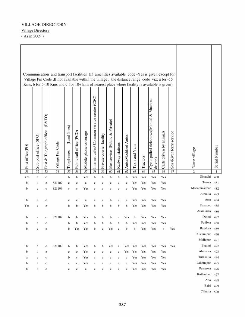
VILLAGE DIRECTORY
Village Directory
( As in 2009 )
Post
off
ice(
PO
)
Sub p
ost
off
ice
(SP
O)
Post
& T
eleg
raph o
ffic
e
(P&
TO
)
Vil
lage
Pin
Code
Tel
ephones
(L
and l
ines
)
Publi
c ca
ll o
ffic
e (P
CO
)
Mobil
e phone
cover
age
Inte
rnet
caf
es/
Com
mon s
ervic
e ce
ntr
e (C
SC
)
Pri
vat
e co
uri
er f
acil
ity
Bus
serv
ice
(P
ubli
c &
Pri
vat
e)
Rai
lway
sta
tions
Auto
/Modif
ied A
uto
s
Tax
is a
nd V
ans
Tra
ctors
Cycl
e-pull
ed r
icksh
aws(
Man
ual
& M
achin
e
dri
ven
)
Car
ts d
riven
by a
nim
als
Sea
/R
iver
fer
ry s
ervic
e51 52 53 54 55 56 57 58 59 60 61 62 63 64 65 66 67 2 1
Communication and transport facilities (If amenities available code -Yes is given except for
Village Pin Code ,If not available within the village , the distance range code viz; a for < 5
Kms, b for 5-10 Kms and c for 10+ kms of nearest place where facility is available is given).
Ser
ial
Num
ber
Nam
e vil
lage
Yes c c b b Yes b b b b b Yes Yes Yes Yes Shondhi 480
b a c 821109 c c a c c c c c Yes Yes Yes Yes Torwa 481
b a c 821109 c c Yes c c c c c Yes Yes Yes Yes Mohammadpur 482
Atraulia 483
b a c c c a c c b c c Yes Yes Yes Yes Arra 484
Yes c c b b Yes b b b b b Yes Yes Yes Yes Panapur 485
Arazi Arra 486
b a c 821109 b b Yes b b b c Yes b Yes Yes Yes Dasoti 487
b b c b b Yes b b b b b Yes Yes Yes Yes Patilwa 488
b c c b Yes Yes b c Yes c b b Yes Yes b Yes Bahdura 489
Kishunipur 490
Mallupur 491
b b c 821109 b b Yes b b Yes c Yes Yes Yes Yes Yes Yes Baghni 492
b a c c c Yes c c c c Yes Yes Yes Yes Yes Ahinaura 493
a a c b c Yes c c c c c Yes Yes Yes Yes Turkaulia 494
b a c c c Yes c c c c c Yes Yes Yes Yes Lakhmipur 495
b a c c c a c c c c c Yes Yes Yes Yes Patserwa 496
Kutbanpur 497
Atia 498
Bairi 499
Chheria 500
��

DISTRICT CENSUS HANDBOOK : KAIMUR (BHABUA)
Census of India 2011-
Amenities and Land use
Connec
ted t
o n
atio
nal
hig
hw
ay(N
H)
Connec
ted t
o s
tate
hig
hw
ay(S
H)
Connec
ted t
o m
ajor
dis
tric
t ro
ad (
MD
R)
Connec
ted t
o o
ther
s dis
tric
t ro
ad
Pucc
a r
oad
s
Kutc
hch
a r
oad
s
Wat
er b
ounded
mac
adam
(WB
M)
road
s
Nav
igab
le w
ater
way
(ri
ver
/can
al)(
NW
)
Footp
aths
(FP
)
Com
mer
cial
& C
o-o
per
ativ
e B
anks
AT
M
Agri
cult
ura
l C
redit
Soci
etie
s
Sel
f-H
elp G
roup (
SH
G)
Publi
c dis
trib
uti
on s
yst
em (
PD
S)
shop
Man
dis
/ R
egula
r m
arket
Wee
kly
Haa
t
Agri
cult
ura
l m
arket
ing s
oci
ety
1 2 68 69 70 71 72 73 74 75 76 77 78 79 80 81 82 83 84
Village connected to highways,village roads, banks & credit
societies (If amenities available code -Yes is given, If not
available within the village , the distance range code viz; a
for < 5 Kms, b for 5-10 Kms and c for 10+ kms of nearest
place where facility is available is given).
Ser
ial
Num
ber
Nam
e vil
lage
Availability of miscellaneous
facilities (If amenities available
code -Yes is given, If not
available within the village , the
distance range code viz; a for <
5 Kms, b for 5-10 Kms and c
for 10+ kms of nearest place
where facility is available is
given) Contd....
480 Shondhi b b a Yes Yes Yes Yes b Yes b b b Yes Yes b b b
481 Torwa c c b Yes Yes Yes Yes c Yes c c c b a c c c
482 Mohammadpur c c a Yes Yes Yes Yes c Yes c c c Yes Yes c c c
483 Atraulia
484 Arra c c b Yes Yes Yes Yes c Yes c c c b Yes c c c
485 Panapur b b a Yes Yes Yes Yes b Yes Yes b b Yes Yes b b b
486 Arazi Arra
487 Dasoti b b b b b Yes a b Yes b b b b a b b b
488 Patilwa b b a Yes Yes Yes Yes b Yes b b b b Yes b b b
489 Bahdura b b b b Yes Yes a Yes Yes b b b b b b b b
490 Kishunipur
491 Mallupur
492 Baghni b b b b Yes Yes b Yes Yes b b b b b b b b
493 Ahinaura c c a Yes Yes Yes Yes c Yes c c c Yes Yes c c c
494 Turkaulia c c b Yes Yes Yes Yes c Yes c c c b Yes c c c
495 Lakhmipur c c a Yes Yes Yes Yes c Yes c c c b Yes c c c
496 Patserwa c c a Yes Yes Yes Yes c Yes c c c c Yes c c c
497 Kutbanpur
498 Atia
499 Bairi
500 Chheria
��

VILLAGE DIRECTORY
Village Directory
( As in 2009 )
Inte
gra
ted C
hil
d D
evel
opm
ent
Sch
eme
(Nutr
itio
nal
Cen
tres
)
Angan
wad
i C
entr
e (N
utr
itio
nal
Cen
tres
)
Oth
ers
(Nutr
itio
nal
Cen
tres
)
AS
HA
(A
ccre
dit
ed S
oci
al H
ealt
h A
ctiv
ist)
Com
munit
y c
entr
e w
ith/w
ithout
TV
Sport
s F
ield
,
Sport
s C
lub /
Rec
reat
ion C
entr
e
Cin
ema
/ V
ideo
Hal
l
Publi
c L
ibra
ry
Publi
c R
eadin
g R
oom
New
spap
er S
upply
Ass
embly
Poll
ing s
tati
on
Bir
th &
Dea
th R
egis
trat
ion O
ffic
e
Pow
er S
upply
for
Dom
esti
c U
se (
ED
)
Pow
er S
upply
for
Agri
cult
ura
l U
se (
EA
G)
Pow
er S
upply
for
Com
mer
cial
Use
(E
C)
Pow
er S
upply
for
All
Use
s (E
A)
85 86 87 88 89 90 91 92 93 94 95 96 97 98 99 100 101 2 1
Availability of
electricity (Yes/No)
Availability of miscellaneous facilities (If amenities available code -
Yes is given, If not available within the village , the distance range
code viz; a for < 5 Kms, b for 5-10 Kms and c for 10+ kms of
nearest place where facility is available is given) Concluded
Nam
e vil
lage
Ser
ial
Num
ber
b Yes Yes Yes b Yes b b b b b Yes a No Yes No No Shondhi 480
c Yes Yes Yes c b c c c c c a a No Yes No No Torwa 481
c Yes Yes Yes c b c c c c c Yes Yes No Yes No No Mohammadpur 482
Atraulia 483
c Yes Yes Yes c Yes c c c c c Yes a No Yes No No Arra 484
b Yes Yes Yes b Yes b c c c b Yes Yes No Yes No No Panapur 485
Arazi Arra 486
b Yes Yes Yes b b b b b b b Yes a Yes Yes Yes Yes Dasoti 487
b Yes Yes Yes c Yes b b b b b a Yes No Yes No No Patilwa 488
b Yes Yes b c a c c c c b a a Yes Yes Yes Yes Bahdura 489
Kishunipur 490
Mallupur 491
b Yes Yes Yes b Yes b b b b Yes Yes Yes Yes Yes Yes Yes Baghni 492
c Yes Yes Yes c Yes c c c c c Yes a No Yes No No Ahinaura 493
c Yes c Yes c a c c c c c Yes a Yes Yes No No Turkaulia 494
c Yes Yes Yes c Yes c c c c c Yes b Yes Yes No No Lakhmipur 495
c Yes a Yes c Yes c c c c c Yes b Yes Yes No No Patserwa 496
Kutbanpur 497
Atia 498
Bairi 499
Chheria 500
��

DISTRICT CENSUS HANDBOOK : KAIMUR (BHABUA)
Census of India 2011-
Amenities and Land use
Nam
e
Dis
tance
ran
ge
code
i.e
. a
fo
r <
5 K
ms,
b
for
5-
10 K
ms
and c
f
or
10+
km
s .
Fore
sts
Are
a under
Non-a
gri
cult
ura
l U
ses
Bar
ren a
nd U
n-c
ult
ivab
le l
and
Per
man
ent
Pas
ture
s an
d O
ther
Gra
zing L
ands
Lan
d U
nder
Mis
cell
aneo
us
Tre
e C
rops
etc.
Cult
ura
ble
Was
te L
and
Fal
low
lan
ds
oth
er t
han
curr
ent
fall
ow
s
Curr
ent
Fal
low
s
1 2 102 103 104 105 106 107 108 109 110 111
Ser
ial
Num
ber
Nam
e vil
lage
Area under different types of land use ( in hectares rounded up to
one decimal place)
Land Use
Nearest Town
480 Shondhi BHABUA c 0 13 0 6 11 0 0 0
481 Torwa BHABUA c 0 3 0 0 0 0 1 0
482 Mohammadpur BHABUA c 0 8.2 0 0 0 0 0 0
483 Atraulia 0 0 0 0 0 0 0 0
484 Arra BHABUA c 0 4 0 0 0 0 4.5 0
485 Panapur BHABUA c 0 28 0 0 0 0 0 0
486 Arazi Arra 0 1 0 0 0 0 0 0
487 Dasoti BHABUA c 0 13 0 0 14 8 0 0
488 Patilwa BHABUA c 0 3 0 0 5 0 0 0
489 Bahdura BHABUA c 0 4 0 0 8 5 0 0
490 Kishunipur 0 3 0 0 0 0 0 0
491 Mallupur 0 2 0 0 0 0 0 0
492 Baghni BHABUA c 0 35 0 28 42 15 0 0
493 Ahinaura BHABUA c 0 12 0 9 7 0 0 0
494 Turkaulia BHABUA c 0 5 0 0 8 0 0 0
495 Lakhmipur BHABUA c 0 3 0 0 0 0 0 0
496 Patserwa BHABUA c 0 3.7 0 0 0 0 0 0
497 Kutbanpur 0 2 0 0 0 0 0 0
498 Atia 0 2.8 0 0 0 0 0 0
499 Bairi 0 4 0 0 3 0 0 0
500 Chheria 0 11 0 0 8 0 0 0
��

VILLAGE DIRECTORY
Village Directory
( As in 2009 )
Net
Are
a S
ow
n
Tota
l Ir
rigat
ed L
and A
rea
Tota
l U
n-i
rrig
ated
Lan
d A
rea
Can
als
( C
)
Wel
ls/T
ube-
wel
ls(W
/TW
)
Tan
ks/
Lak
es(T
/L)
Wat
er F
alls
(WF
)
Oth
ers(
O)
Fir
st
Sec
ond
Thir
d
112 113 114 115 116 117 118 119 120 121 122 2 1
Ser
ial
Num
ber
Name of three
most important
commodities
manufacturedArea irrigated by source (in hectare).
Nam
e of
Vil
lage
Area under different types of
land use ( in hectares rounded
up to one decimal place)
Land Use
119 98 21 30 68 0 0 0 Shondhi 480
45 45 0 5 40 0 0 0 Torwa 481
114.8 106 8.8 26 80 0 0 0 Mohammadpur 482
30 27.6 2.4 7.6 20 0 0 0 Atraulia 483
174.5 171.6 3 60.3 98.7 0 0 12.6 Arra 484
180 160 20 0 140 0 0 20 Panapur 485
21 21 0 21 0 0 0 0 Arazi Arra 486
254 237 17 57 180 0 0 0 Dasoti 487
138 138 0 48 90 0 0 0 Patilwa 488
83 72 11 22 50 0 0 0 Bahdura 489
80 80 0 30 50 0 0 0 Kishunipur 490
40 40 0 10 30 0 0 0 Mallupur 491
395 282 113 57 180 0 0 45 Baghni 492
344 297 47 85 170 0 0 42 Ahinaura 493
49.7 49.7 0 49.7 0 0 0 0 Turkaulia 494
59 54 5 18 36 0 0 0 Lakhmipur 495
39 39 0 39 0 0 0 0 Patserwa 496
51 48 3 10 38 0 0 0 Kutbanpur 497
18.8 18.8 0 18.8 0 0 0 0 Atia 498
81 64 17 11 50 0 0 3 Bairi 499
75 56 19 15 41 0 0 0 Chheria 500
��

DISTRICT CENSUS HANDBOOK : KAIMUR (BHABUA)
Census of India 2011-
Amenities and Land use
Pre
-Pri
mar
y s
chool
(PP
)
Pri
mar
y s
chool
(P)
Mid
dle
sch
ool
(M)
Sec
ondar
y S
chool
(S)
Sen
ior
Sec
ondar
y s
chool
(SS
)
Deg
ree
coll
ege
of
arts
sc
ience
& c
om
mer
ce
(AS
C)
Engin
eeri
ng c
oll
ege(
EC
)
Med
ical
coll
ege
(MC
)
Man
agem
ent
inst
itute
(M
I)
Poly
tech
nic
(P
t)
Voca
tional
tra
inin
g s
chool
/IT
I
Non-f
orm
al t
rain
ing c
entr
e (N
FT
C)
Spec
ial
school
for
dis
able
d (
SS
D)
Oth
ers
(spec
ify)
1 2 3 4 5 6 7 8 9 10 11 12 13 14 15 16 17 18 19 20
Loca
tion c
ode
no.
Nam
e vil
lage
Ser
ial
Num
ber
Tota
l popula
tion (
2011 c
ensu
s )
Tota
l ar
ea o
f th
e vil
lage
( in
hec
tare
s ro
unded
up t
o
one
dec
imal
pla
ce)
Number of educational amenities available. (If not available
within the village , the distance range code viz; a for < 5
Kms, b for 5-10 Kms and c for 10+ kms of nearest place
where facility is available is given).
Num
ber
of
house
hold
s (2
011 c
ensu
s)
501 Chordehra 249424 78 384 50 c 1 b c c c c c c c c c c
502 Tikaitpur 249425 53 55 7 a a b c c c c c c c c c c
503 Dubaulia 249426 36 0 0
504 Harnathpur 249427 112 698 114 1 1 a c c c c c c c c c c
505 Bahera 249428 16 0 0
506 Jirhulia 249429 57 0 0
507 Kankaulia 249430 18.5 0 0
508 Adhwar 249431 203 1534 224 b 1 1 c b c c c c c c c c
509 Sarahula 249432 158 886 119 c 1 a c c c c c c c c c c
510 Suara 249433 38.9 0 0
511 Khairi 249434 74.8 0 0
512 Bishunpura 249435 45 722 105 c a b c c c c c c c c c c
513 Dalopur 249436 33.8 271 39 b 1 b c b c c c c c c c c
514 Dulahpur 249437 56 569 78 c b b c b c c c c c c c c
515 Bahera 249438 15 155 25 a a b c b c c c c c c c c
516 Bhaluhi 249439 119 521 72 1 1 a c c c c c c c c c c
517 Marha 249440 52 0 0
518 Maricha 249441 204 980 149 1 1 a c c c c c c c c c c
519 Gaharpura 249442 29.4 0 0
520 Siriari 249443 52.8 0 0
521 Parashurampur 249444 94 1221 159 b 1 a c a c c c c c c c c
�

VILLAGE DIRECTORY
Village Directory
( As in 2009 )
Com
munit
y h
ealt
h c
entr
e (C
HC
)
Pri
mar
y h
ealt
h c
entr
e (P
HC
)
Pri
mar
y h
ealt
h s
ub c
entr
e (P
HS
)
Mat
ernit
y a
nd c
hil
d w
elfa
re c
entr
e (M
CW
)
T.B
. cl
inic
(T
BC
)
Hosp
ital
-all
opat
hic
(H
A)
Hosp
ital
-alt
ernat
ive
med
icin
e (H
O)
Dis
pen
sary
(D
)
Vet
erin
ary h
osp
ital
(V
H)
Mobil
e hea
lth c
linic
(M
HC
)
Fam
ily w
elfa
re c
entr
e (F
WC
)
Char
itab
le n
on G
ovt.
hosp
ital
/Nurs
ing h
om
e.
Med
ical
pra
ctit
ioner
wit
h M
BB
S D
egre
e
Med
ical
pra
ctit
ioner
wit
h o
ther
deg
ree
Med
ical
pra
ctit
ioner
wit
h n
o d
egre
e
Tra
dit
ional
pra
ctit
ioner
an
d f
aith
hea
ler
.
Med
icin
e S
hop
Oth
ers
21 22 23 24 25 26 27 28 29 30 31 32 33 34 35 36 37 38 2 1
Number of Non-Government
Medical Amenities available.
Number of Medical Amenities available. (If not
available within the village , the distance range
code viz; a for < 5 Kms, b for 5-10 Kms and c
for 10+ kms of nearest place where facility is
available is given).
Nam
e vil
lage
Ser
ial
Num
ber
c c c c c c c c c c c 0 0 0 0 0 0 0 Chordehra 501
b c 1 1 b c c b b c 1 0 0 0 0 0 0 0 Tikaitpur 502
Dubaulia 503
c c b c c c c c c c c 0 0 0 0 0 0 0 Harnathpur 504
Bahera 505
Jirhulia 506
Kankaulia 507
b b b b b c c b b c b 0 0 0 0 0 0 0 Adhwar 508
c c c c c c c c c c c 0 0 0 0 0 0 0 Sarahula 509
Suara 510
Khairi 511
c c c c c c c c c c c 0 0 0 0 0 0 0 Bishunpura 512
c c c c c c c c c c c 0 0 0 0 0 0 0 Dalopur 513
c c c c c c c c c c c 0 0 0 0 0 0 0 Dulahpur 514
c c c c c c c c c c c 0 0 0 0 0 0 0 Bahera 515
c c b c c c c c c c c 0 0 0 0 0 0 0 Bhaluhi 516
Marha 517
c c b c c c c c c c c 0 0 0 0 0 0 0 Maricha 518
Gaharpura 519
Siriari 520
c c c c c c c c c c c 0 0 0 0 0 0 0 Parashurampur 521
�

DISTRICT CENSUS HANDBOOK : KAIMUR (BHABUA)
Census of India 2011-
Amenities and Land use
Tap
wat
er (
Tre
ated
/Untr
eate
d)
Wel
l w
ater
(Cover
ed /
Unco
ver
ed w
ell)
Han
d P
um
p
Tube
wel
ls /
Bore
wel
l
Spri
ng
Riv
er /
Can
al
Tan
k /
Pond /
L
ake
Oth
ers
Com
munit
y t
oil
et i
ncl
udin
g
bat
h.
Com
munit
y t
oil
et e
xcl
udin
g b
ath.
Rura
l s
anit
ary m
art
or
sanit
ary
har
dw
are
outl
et
avai
lable
nea
r th
e vil
lage.
Com
munit
y b
io-
gas
or
recy
cle
of
was
te f
or
pro
duct
ive
use
.
1 2 39 40 41 42 43 44 45 46 47 48 49 50
Availability of toilet & others
Yes / No Availability of drinking water - Yes / No
Nam
e vil
lage
Ser
ial
Num
ber
501 Chordehra No Yes Yes Yes No Yes No Yes No No No No
502 Tikaitpur No Yes Yes No No Yes No No No No No No
503 Dubaulia
504 Harnathpur No Yes Yes No No Yes No No No No Yes No
505 Bahera
506 Jirhulia
507 Kankaulia
508 Adhwar No No Yes Yes Yes No No No No No No No
509 Sarahula No Yes Yes Yes No Yes No No No No No No
510 Suara
511 Khairi
512 Bishunpura No Yes Yes Yes No Yes No No No No No No
513 Dalopur No Yes Yes No No No No No No No No No
514 Dulahpur No Yes Yes No No No No No No No No No
515 Bahera No Yes Yes No No No No No No No No No
516 Bhaluhi No Yes Yes No No Yes No No No No No No
517 Marha
518 Maricha No Yes Yes No No Yes No No No No No No
519 Gaharpura
520 Siriari
521 Parashurampur No Yes Yes No No No No No No No No No
��

VILLAGE DIRECTORY
Village Directory
( As in 2009 )
Post
off
ice(
PO
)
Sub p
ost
off
ice
(SP
O)
Post
& T
eleg
raph o
ffic
e
(P&
TO
)
Vil
lage
Pin
Code
Tel
ephones
(L
and l
ines
)
Publi
c ca
ll o
ffic
e (P
CO
)
Mobil
e phone
cover
age
Inte
rnet
caf
es/
Com
mon s
ervic
e ce
ntr
e (C
SC
)
Pri
vat
e co
uri
er f
acil
ity
Bus
serv
ice
(P
ubli
c &
Pri
vat
e)
Rai
lway
sta
tions
Auto
/Modif
ied A
uto
s
Tax
is a
nd V
ans
Tra
ctors
Cycl
e-pull
ed r
icksh
aws(
Man
ual
& M
achin
e
dri
ven
)
Car
ts d
riven
by a
nim
als
Sea
/R
iver
fer
ry s
ervic
e51 52 53 54 55 56 57 58 59 60 61 62 63 64 65 66 67 2 1
Communication and transport facilities (If amenities available code -Yes is given except for
Village Pin Code ,If not available within the village , the distance range code viz; a for < 5
Kms, b for 5-10 Kms and c for 10+ kms of nearest place where facility is available is given).
Ser
ial
Num
ber
Nam
e vil
lage
b b c 821109 c c Yes c c b c c b b Yes b Yes Chordehra 501
b b c c c a c c c c c Yes Yes Yes Yes Tikaitpur 502
Dubaulia 503
Yes c c 821109 c c b c Yes b c c Yes b Yes a Yes Harnathpur 504
Bahera 505
Jirhulia 506
Kankaulia 507
b b c 821109 b b Yes b b Yes c b Yes Yes Yes b Adhwar 508
b b c 821109 c Yes Yes c c Yes c c Yes Yes Yes b Yes Sarahula 509
Suara 510
Khairi 511
b c c c c Yes c c Yes c c b Yes Yes b Yes Bishunpura 512
b b c 821109 c c a c c c c c c Yes Yes b c Dalopur 513
b a c 821109 c c a c c c c c c Yes Yes b c Dulahpur 514
b b c 821109 c c b c c c c a a Yes Yes b c Bahera 515
b a c 821109 c c Yes c c b c b b b Yes b Bhaluhi 516
Marha 517
b b c 821109 c c Yes c c Yes c c b b Yes b Yes Maricha 518
Gaharpura 519
Siriari 520
b a c 821109 c c a c c c c c c Yes Yes b c Parashurampur 521
��

DISTRICT CENSUS HANDBOOK : KAIMUR (BHABUA)
Census of India 2011-
Amenities and Land use
Connec
ted t
o n
atio
nal
hig
hw
ay(N
H)
Connec
ted t
o s
tate
hig
hw
ay(S
H)
Connec
ted t
o m
ajor
dis
tric
t ro
ad (
MD
R)
Connec
ted t
o o
ther
s dis
tric
t ro
ad
Pucc
a r
oad
s
Kutc
hch
a r
oad
s
Wat
er b
ounded
mac
adam
(WB
M)
road
s
Nav
igab
le w
ater
way
(ri
ver
/can
al)(
NW
)
Footp
aths
(FP
)
Com
mer
cial
& C
o-o
per
ativ
e B
anks
AT
M
Agri
cult
ura
l C
redit
Soci
etie
s
Sel
f-H
elp G
roup (
SH
G)
Publi
c dis
trib
uti
on s
yst
em (
PD
S)
shop
Man
dis
/ R
egula
r m
arket
Wee
kly
Haa
t
Agri
cult
ura
l m
arket
ing s
oci
ety
1 2 68 69 70 71 72 73 74 75 76 77 78 79 80 81 82 83 84
Village connected to highways,village roads, banks & credit
societies (If amenities available code -Yes is given, If not
available within the village , the distance range code viz; a
for < 5 Kms, b for 5-10 Kms and c for 10+ kms of nearest
place where facility is available is given).
Ser
ial
Num
ber
Nam
e vil
lage
Availability of miscellaneous
facilities (If amenities available
code -Yes is given, If not
available within the village , the
distance range code viz; a for <
5 Kms, b for 5-10 Kms and c
for 10+ kms of nearest place
where facility is available is
given) Contd....
501 Chordehra c c c Yes b Yes a Yes Yes c c c c b c c c
502 Tikaitpur c c b Yes Yes Yes Yes c Yes c c c c Yes c b c
503 Dubaulia
504 Harnathpur c b c b b Yes Yes Yes Yes c c b a a c c c
505 Bahera
506 Jirhulia
507 Kankaulia
508 Adhwar b b b b b Yes a b Yes b b b b b b b b
509 Sarahula b b b Yes b a Yes Yes Yes c c c c Yes c c c
510 Suara
511 Khairi
512 Bishunpura b b b b Yes Yes a Yes Yes c c c c b c c c
513 Dalopur a a Yes Yes Yes Yes Yes a Yes c c c a a c c c
514 Dulahpur a a Yes Yes Yes Yes Yes a Yes c c c a Yes c c c
515 Bahera a a Yes Yes Yes Yes Yes a Yes c c c b a c c c
516 Bhaluhi c c c c Yes Yes Yes a Yes c c c b a c b b
517 Marha
518 Maricha c c c Yes b Yes Yes Yes Yes c c b Yes a c c b
519 Gaharpura
520 Siriari
521 Parashurampur a a Yes Yes a Yes Yes a Yes c c c b a c c c
��

VILLAGE DIRECTORY
Village Directory
( As in 2009 )
Inte
gra
ted C
hil
d D
evel
opm
ent
Sch
eme
(Nutr
itio
nal
Cen
tres
)
Angan
wad
i C
entr
e (N
utr
itio
nal
Cen
tres
)
Oth
ers
(Nutr
itio
nal
Cen
tres
)
AS
HA
(A
ccre
dit
ed S
oci
al H
ealt
h A
ctiv
ist)
Com
munit
y c
entr
e w
ith/w
ithout
TV
Sport
s F
ield
,
Sport
s C
lub /
Rec
reat
ion C
entr
e
Cin
ema
/ V
ideo
Hal
l
Publi
c L
ibra
ry
Publi
c R
eadin
g R
oom
New
spap
er S
upply
Ass
embly
Poll
ing s
tati
on
Bir
th &
Dea
th R
egis
trat
ion O
ffic
e
Pow
er S
upply
for
Dom
esti
c U
se (
ED
)
Pow
er S
upply
for
Agri
cult
ura
l U
se (
EA
G)
Pow
er S
upply
for
Com
mer
cial
Use
(E
C)
Pow
er S
upply
for
All
Use
s (E
A)
85 86 87 88 89 90 91 92 93 94 95 96 97 98 99 100 101 2 1
Availability of
electricity (Yes/No)
Availability of miscellaneous facilities (If amenities available code -
Yes is given, If not available within the village , the distance range
code viz; a for < 5 Kms, b for 5-10 Kms and c for 10+ kms of
nearest place where facility is available is given) Concluded
Nam
e vil
lage
Ser
ial
Num
ber
c b c b c b c c c c c a b Yes Yes Yes Yes Chordehra 501
c Yes Yes a c b c c c c c Yes b No Yes No No Tikaitpur 502
Dubaulia 503
c Yes Yes Yes c Yes c c c c c Yes b Yes No No No Harnathpur 504
Bahera 505
Jirhulia 506
Kankaulia 507
b Yes Yes Yes c b c c c c c Yes Yes Yes Yes Yes Yes Adhwar 508
c Yes Yes a c a c c c c b Yes b Yes Yes Yes Yes Sarahula 509
Suara 510
Khairi 511
c Yes Yes Yes c b c c c c c Yes b Yes Yes Yes Yes Bishunpura 512
c a Yes a c b c c c c c a a No Yes No No Dalopur 513
c b Yes Yes c b c c c c c a a No No No No Dulahpur 514
c a Yes a c b c c c c c a a No Yes No No Bahera 515
c Yes Yes a c a c c c c c a b No No No No Bhaluhi 516
Marha 517
c a Yes a c b c c c c c Yes a Yes No No No Maricha 518
Gaharpura 519
Siriari 520
c Yes Yes Yes Yes a c c c c c Yes a No Yes No No Parashurampur 521
��
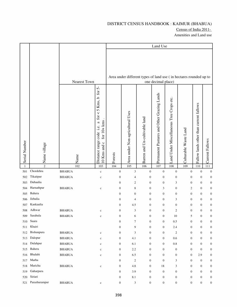
DISTRICT CENSUS HANDBOOK : KAIMUR (BHABUA)
Census of India 2011-
Amenities and Land use
Nam
e
Dis
tance
ran
ge
code
i.e
. a
fo
r <
5 K
ms,
b
for
5-
10 K
ms
and c
f
or
10+
km
s .
Fore
sts
Are
a under
Non-a
gri
cult
ura
l U
ses
Bar
ren a
nd U
n-c
ult
ivab
le l
and
Per
man
ent
Pas
ture
s an
d O
ther
Gra
zing L
ands
Lan
d U
nder
Mis
cell
aneo
us
Tre
e C
rops
etc.
Cult
ura
ble
Was
te L
and
Fal
low
lan
ds
oth
er t
han
curr
ent
fall
ow
s
Curr
ent
Fal
low
s
1 2 102 103 104 105 106 107 108 109 110 111
Ser
ial
Num
ber
Nam
e vil
lage
Area under different types of land use ( in hectares rounded up to
one decimal place)
Land Use
Nearest Town
501 Chordehra BHABUA c 0 3 0 0 0 0 0 0
502 Tikaitpur BHABUA c 0 4 0 0 0 0 0 0
503 Dubaulia 0 2 0 0 3 0 0 0
504 Harnathpur BHABUA c 0 8 0 3 0 2 0 0
505 Bahera 0 0 0 0 0 0 0 0
506 Jirhulia 0 4 0 0 3 0 0 0
507 Kankaulia 0 4.5 0 0 0 0 0 0
508 Adhwar BHABUA c 0 3 0 0 2 0 0 0
509 Sarahula BHABUA c 0 6 0 0 10 5 0 0
510 Suara 0 7 0 0 0.5 0 0 0
511 Khairi 0 9 0 0 2.4 0 0 0
512 Bishunpura BHABUA c 0 3 0 0 2 0 0 0
513 Dalopur BHABUA c 0 4.1 0 0 0.6 0 0 0
514 Dulahpur BHABUA c 0 6.1 0 0 0.8 0 0 0
515 Bahera BHABUA c 0 2.2 0 0 0 0 0 0
516 Bhaluhi BHABUA c 0 6.5 0 0 0 0 2.9 0
517 Marha 0 2 0 0 3 0 0 0
518 Maricha BHABUA c 0 4.8 0 18 3 0 0 0
519 Gaharpura 0 3.9 0 0 0 0 0 0
520 Siriari 0 8.1 0 0 0 0 0 0
521 Parashurampur BHABUA c 0 3 0 0 0 0 0 0
��
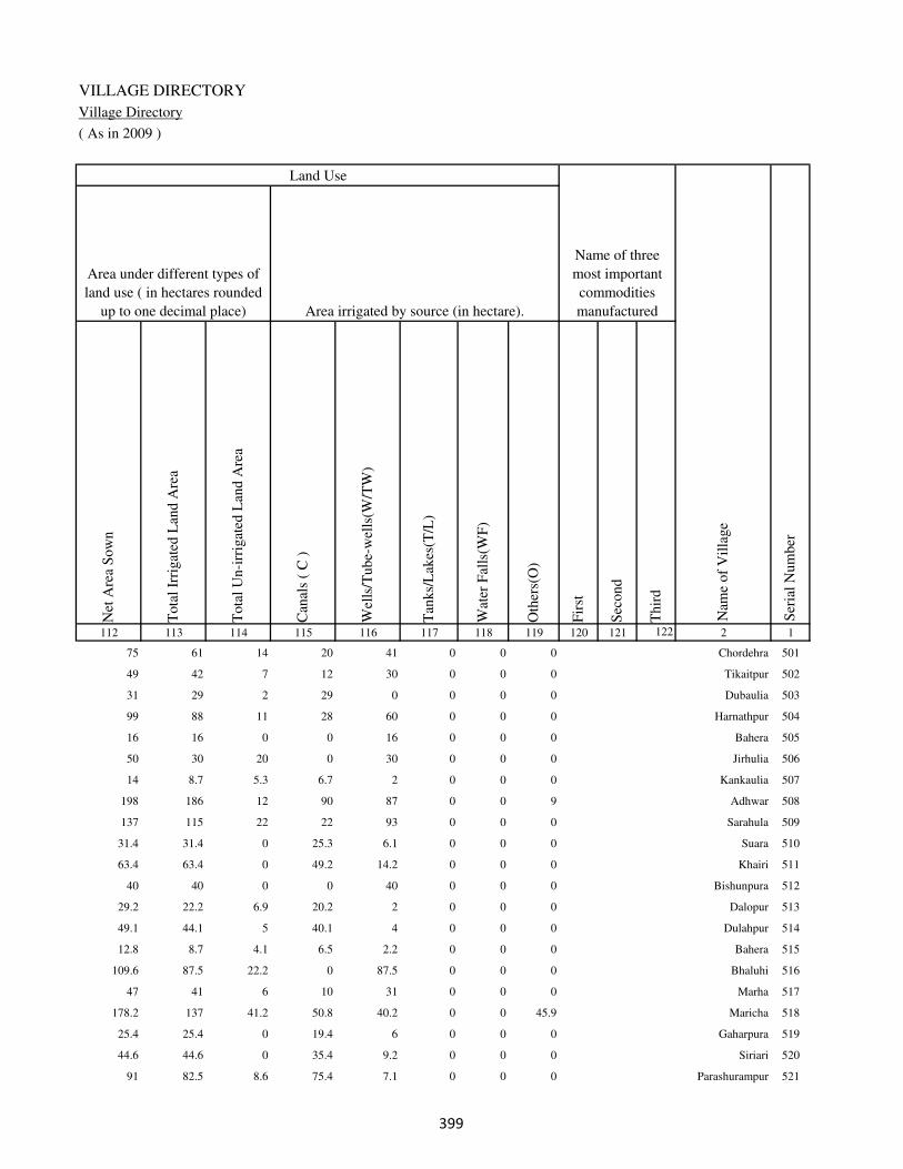
VILLAGE DIRECTORY
Village Directory
( As in 2009 )
Net
Are
a S
ow
n
Tota
l Ir
rigat
ed L
and A
rea
Tota
l U
n-i
rrig
ated
Lan
d A
rea
Can
als
( C
)
Wel
ls/T
ube-
wel
ls(W
/TW
)
Tan
ks/
Lak
es(T
/L)
Wat
er F
alls
(WF
)
Oth
ers(
O)
Fir
st
Sec
ond
Thir
d
112 113 114 115 116 117 118 119 120 121 122 2 1
Ser
ial
Num
ber
Name of three
most important
commodities
manufacturedArea irrigated by source (in hectare).
Nam
e of
Vil
lage
Area under different types of
land use ( in hectares rounded
up to one decimal place)
Land Use
75 61 14 20 41 0 0 0 Chordehra 501
49 42 7 12 30 0 0 0 Tikaitpur 502
31 29 2 29 0 0 0 0 Dubaulia 503
99 88 11 28 60 0 0 0 Harnathpur 504
16 16 0 0 16 0 0 0 Bahera 505
50 30 20 0 30 0 0 0 Jirhulia 506
14 8.7 5.3 6.7 2 0 0 0 Kankaulia 507
198 186 12 90 87 0 0 9 Adhwar 508
137 115 22 22 93 0 0 0 Sarahula 509
31.4 31.4 0 25.3 6.1 0 0 0 Suara 510
63.4 63.4 0 49.2 14.2 0 0 0 Khairi 511
40 40 0 0 40 0 0 0 Bishunpura 512
29.2 22.2 6.9 20.2 2 0 0 0 Dalopur 513
49.1 44.1 5 40.1 4 0 0 0 Dulahpur 514
12.8 8.7 4.1 6.5 2.2 0 0 0 Bahera 515
109.6 87.5 22.2 0 87.5 0 0 0 Bhaluhi 516
47 41 6 10 31 0 0 0 Marha 517
178.2 137 41.2 50.8 40.2 0 0 45.9 Maricha 518
25.4 25.4 0 19.4 6 0 0 0 Gaharpura 519
44.6 44.6 0 35.4 9.2 0 0 0 Siriari 520
91 82.5 8.6 75.4 7.1 0 0 0 Parashurampur 521
��

DISTRICT CENSUS HANDBOOK : KAIMUR (BHABUA)
Census of India 2011-
Amenities and Land use
Pre
-Pri
mar
y s
chool
(PP
)
Pri
mar
y s
chool
(P)
Mid
dle
sch
ool
(M)
Sec
ondar
y S
chool
(S)
Sen
ior
Sec
ondar
y s
chool
(SS
)
Deg
ree
coll
ege
of
arts
sc
ience
& c
om
mer
ce
(AS
C)
Engin
eeri
ng c
oll
ege(
EC
)
Med
ical
coll
ege
(MC
)
Man
agem
ent
inst
itute
(M
I)
Poly
tech
nic
(P
t)
Voca
tional
tra
inin
g s
chool
/IT
I
Non-f
orm
al t
rain
ing c
entr
e (N
FT
C)
Spec
ial
school
for
dis
able
d (
SS
D)
Oth
ers
(spec
ify)
1 2 3 4 5 6 7 8 9 10 11 12 13 14 15 16 17 18 19 20
Loca
tion c
ode
no.
Nam
e vil
lage
Ser
ial
Num
ber
Tota
l popula
tion (
2011 c
ensu
s )
Tota
l ar
ea o
f th
e vil
lage
( in
hec
tare
s ro
unded
up t
o
one
dec
imal
pla
ce)
Number of educational amenities available. (If not available
within the village , the distance range code viz; a for < 5
Kms, b for 5-10 Kms and c for 10+ kms of nearest place
where facility is available is given).
Num
ber
of
house
hold
s (2
011 c
ensu
s)
522 Chandwa 249445 102.9 292 38 c 1 b c b c c c c c c c c
523 Panre Pipra 249446 59 486 66 b 1 a c a c c c c c c c c
524 Kabirajpur 249447 63.8 289 38 b a a c a c c c c c c c c
525 Nawagawan 249448 63.9 253 37 b 1 a c a b c c c c c c c
526 Chaube Deharia 249449 51.9 0 0
527 Dube Deharia 249450 42 104 19 b a a c a b c c c c c c c
528 Chittbisawan 249451 72.8 0 0
529 Tiwari Deharia 249452 41.9 247 34 b a a c a b c c c c c c c
530 Panre Deharia 249453 99.1 714 100 b 1 a c a b c c c c c c c
531 Rampur 249454 91.3 740 113 b 1 1 1 a b c c c c c c c
532 Samahuta 249455 215.2 2207 340 1 1 1 c a c c c c c c c c
533 Khudra 249456 47.1 77 9 c a a c a c c c c c c c c
534 Jitapur 249457 86 1259 187 b 1 1 c b b c c c c c c c
535 Horilpur 249458 35 150 20 c a b c c c c c c c c c c
536 Khajepur 249459 44 0 0
537 Narayanpur 249460 63.1 0 0
538 Shukul Pipra 249461 68 157 24 b 1 a c a b c c c c c c c
539 Rajpur 249462 44 730 104 b 1 a c a b c c c c c c c
540 Adhvania 249463 109.2 826 110 1 1 b c b b c c c c c c c
541 Misraulia 249464 89 223 37 1 a a c b b c c c c c c c
542 Bairi 249465 96 966 139 1 1 a c b b c c c c c c c
���

VILLAGE DIRECTORY
Village Directory
( As in 2009 )
Com
munit
y h
ealt
h c
entr
e (C
HC
)
Pri
mar
y h
ealt
h c
entr
e (P
HC
)
Pri
mar
y h
ealt
h s
ub c
entr
e (P
HS
)
Mat
ernit
y a
nd c
hil
d w
elfa
re c
entr
e (M
CW
)
T.B
. cl
inic
(T
BC
)
Hosp
ital
-all
opat
hic
(H
A)
Hosp
ital
-alt
ernat
ive
med
icin
e (H
O)
Dis
pen
sary
(D
)
Vet
erin
ary h
osp
ital
(V
H)
Mobil
e hea
lth c
linic
(M
HC
)
Fam
ily w
elfa
re c
entr
e (F
WC
)
Char
itab
le n
on G
ovt.
hosp
ital
/Nurs
ing h
om
e.
Med
ical
pra
ctit
ioner
wit
h M
BB
S D
egre
e
Med
ical
pra
ctit
ioner
wit
h o
ther
deg
ree
Med
ical
pra
ctit
ioner
wit
h n
o d
egre
e
Tra
dit
ional
pra
ctit
ioner
an
d f
aith
hea
ler
.
Med
icin
e S
hop
Oth
ers
21 22 23 24 25 26 27 28 29 30 31 32 33 34 35 36 37 38 2 1
Number of Non-Government
Medical Amenities available.
Number of Medical Amenities available. (If not
available within the village , the distance range
code viz; a for < 5 Kms, b for 5-10 Kms and c
for 10+ kms of nearest place where facility is
available is given).
Nam
e vil
lage
Ser
ial
Num
ber
c c c c c c c c c c c 0 0 0 0 0 0 0 Chandwa 522
c c c c c c c c c c c 0 0 0 0 0 0 0 Panre Pipra 523
c c c c c c c c c c c 0 0 0 0 0 0 0 Kabirajpur 524
b b b b b c c b b c b 0 0 0 0 0 0 0 Nawagawan 525
Chaube Deharia 526
b b b b b c c b b c b 0 0 0 0 0 0 0 Dube Deharia 527
Chittbisawan 528
b b b b b c c b b c b 0 0 0 0 0 0 0 Tiwari Deharia 529
b b b b b c c b b c b 0 0 0 0 0 0 0 Panre Deharia 530
b b b b b c c b b c b 0 0 0 0 0 0 0 Rampur 531
c c c c c c c c c c c 0 0 0 0 0 0 0 Samahuta 532
c c c c c c c c c c c 0 0 0 0 0 0 0 Khudra 533
b b b b b c c b b c b 0 0 0 0 0 0 0 Jitapur 534
c c c c c c c c c c c 0 0 0 0 0 0 0 Horilpur 535
Khajepur 536
Narayanpur 537
b b b b b c c b b c b 0 0 0 0 0 0 0 Shukul Pipra 538
b b b b b c c b b c b 0 0 0 0 0 0 0 Rajpur 539
b b b b b c c b b c b 0 0 0 0 0 0 0 Adhvania 540
b b a b b c c b b c b 0 0 0 0 0 0 0 Misraulia 541
b b a b b c c b b c a 0 0 0 0 0 0 0 Bairi 542
���

DISTRICT CENSUS HANDBOOK : KAIMUR (BHABUA)
Census of India 2011-
Amenities and Land use
Tap
wat
er (
Tre
ated
/Untr
eate
d)
Wel
l w
ater
(Cover
ed /
Unco
ver
ed w
ell)
Han
d P
um
p
Tube
wel
ls /
Bore
wel
l
Spri
ng
Riv
er /
Can
al
Tan
k /
Pond /
L
ake
Oth
ers
Com
munit
y t
oil
et i
ncl
udin
g
bat
h.
Com
munit
y t
oil
et e
xcl
udin
g b
ath.
Rura
l s
anit
ary m
art
or
sanit
ary
har
dw
are
outl
et
avai
lable
nea
r th
e vil
lage.
Com
munit
y b
io-
gas
or
recy
cle
of
was
te f
or
pro
duct
ive
use
.
1 2 39 40 41 42 43 44 45 46 47 48 49 50
Availability of toilet & others
Yes / No Availability of drinking water - Yes / No
Nam
e vil
lage
Ser
ial
Num
ber
522 Chandwa No Yes Yes No No No No No No No No No
523 Panre Pipra No Yes Yes No No Yes No No No No No No
524 Kabirajpur No Yes Yes No No No No No No No No No
525 Nawagawan No Yes Yes No No No No No No No No No
526 Chaube Deharia
527 Dube Deharia No Yes Yes No No No No No No No No No
528 Chittbisawan
529 Tiwari Deharia No Yes Yes No No No No No No No No No
530 Panre Deharia No Yes Yes No No No No No No No No No
531 Rampur No Yes Yes No No No No No No No No No
532 Samahuta No Yes Yes No No No No No No No No No
533 Khudra No Yes Yes No No No No No No No No No
534 Jitapur No Yes Yes No No No No No No No No No
535 Horilpur No Yes Yes No No Yes No No No No No No
536 Khajepur
537 Narayanpur
538 Shukul Pipra No Yes Yes No No No No Yes No No No No
539 Rajpur No Yes Yes No No No No No No No No No
540 Adhvania No Yes Yes No No No No No No No No No
541 Misraulia No Yes Yes No No Yes No No No No No No
542 Bairi No No Yes No No Yes No No No No No No
��

VILLAGE DIRECTORY
Village Directory
( As in 2009 )
Post
off
ice(
PO
)
Sub p
ost
off
ice
(SP
O)
Post
& T
eleg
raph o
ffic
e
(P&
TO
)
Vil
lage
Pin
Code
Tel
ephones
(L
and l
ines
)
Publi
c ca
ll o
ffic
e (P
CO
)
Mobil
e phone
cover
age
Inte
rnet
caf
es/
Com
mon s
ervic
e ce
ntr
e (C
SC
)
Pri
vat
e co
uri
er f
acil
ity
Bus
serv
ice
(P
ubli
c &
Pri
vat
e)
Rai
lway
sta
tions
Auto
/Modif
ied A
uto
s
Tax
is a
nd V
ans
Tra
ctors
Cycl
e-pull
ed r
icksh
aws(
Man
ual
& M
achin
e
dri
ven
)
Car
ts d
riven
by a
nim
als
Sea
/R
iver
fer
ry s
ervic
e51 52 53 54 55 56 57 58 59 60 61 62 63 64 65 66 67 2 1
Communication and transport facilities (If amenities available code -Yes is given except for
Village Pin Code ,If not available within the village , the distance range code viz; a for < 5
Kms, b for 5-10 Kms and c for 10+ kms of nearest place where facility is available is given).
Ser
ial
Num
ber
Nam
e vil
lage
b a c 821109 c c a c c c c c c Yes Yes b c Chandwa 522
b a c 821109 c c a c c c c c c Yes Yes b c Panre Pipra 523
b a c 821109 c c a c c c c c c Yes Yes b c Kabirajpur 524
b a c 821109 b b a b b b b b b Yes Yes b c Nawagawan 525
Chaube Deharia 526
b a c 821109 b b a b b b b b b Yes Yes b c Dube Deharia 527
Chittbisawan 528
b a c 821109 b b b b b Yes b b b Yes Yes b c Tiwari Deharia 529
b a c 821109 b b b b b a b b b Yes Yes b c Panre Deharia 530
b a c b b b b b Yes b b a Yes Yes b c Rampur 531
b a c 821109 c c c c c a c c c c Yes Yes c Samahuta 532
b a c 821109 c c c c c c c c c Yes Yes b c Khudra 533
b a c 821109 b b b b b b b b b Yes Yes b c Jitapur 534
b b c b b Yes c c b b b b Yes Yes b Horilpur 535
Khajepur 536
Narayanpur 537
Yes c c 821109 b b b b b Yes b b Yes Yes Yes b c Shukul Pipra 538
Yes c c 821109 a b b b b Yes b b b Yes Yes b c Rajpur 539
b a c 821109 b b b b b b b a Yes Yes Yes b c Adhvania 540
b c c 821109 a a Yes b b Yes b b b Yes b b Misraulia 541
b b c 821109 a a Yes b b Yes b b b Yes b b Bairi 542
��
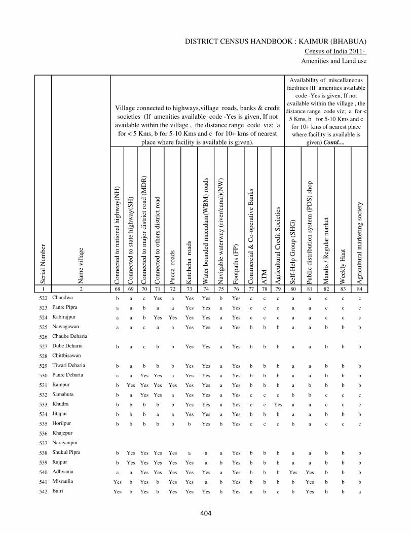
DISTRICT CENSUS HANDBOOK : KAIMUR (BHABUA)
Census of India 2011-
Amenities and Land use
Connec
ted t
o n
atio
nal
hig
hw
ay(N
H)
Connec
ted t
o s
tate
hig
hw
ay(S
H)
Connec
ted t
o m
ajor
dis
tric
t ro
ad (
MD
R)
Connec
ted t
o o
ther
s dis
tric
t ro
ad
Pucc
a r
oad
s
Kutc
hch
a r
oad
s
Wat
er b
ounded
mac
adam
(WB
M)
road
s
Nav
igab
le w
ater
way
(ri
ver
/can
al)(
NW
)
Footp
aths
(FP
)
Com
mer
cial
& C
o-o
per
ativ
e B
anks
AT
M
Agri
cult
ura
l C
redit
Soci
etie
s
Sel
f-H
elp G
roup (
SH
G)
Publi
c dis
trib
uti
on s
yst
em (
PD
S)
shop
Man
dis
/ R
egula
r m
arket
Wee
kly
Haa
t
Agri
cult
ura
l m
arket
ing s
oci
ety
1 2 68 69 70 71 72 73 74 75 76 77 78 79 80 81 82 83 84
Village connected to highways,village roads, banks & credit
societies (If amenities available code -Yes is given, If not
available within the village , the distance range code viz; a
for < 5 Kms, b for 5-10 Kms and c for 10+ kms of nearest
place where facility is available is given).
Ser
ial
Num
ber
Nam
e vil
lage
Availability of miscellaneous
facilities (If amenities available
code -Yes is given, If not
available within the village , the
distance range code viz; a for <
5 Kms, b for 5-10 Kms and c
for 10+ kms of nearest place
where facility is available is
given) Contd....
522 Chandwa b a c Yes a Yes Yes b Yes c c c a a c c c
523 Panre Pipra a a b a a Yes Yes a Yes c c c a a c c c
524 Kabirajpur a a b Yes Yes Yes Yes a Yes c c c a a c c c
525 Nawagawan a a c a a Yes Yes a Yes b b b a a b b b
526 Chaube Deharia
527 Dube Deharia b a c b b Yes Yes a Yes b b b a a b b b
528 Chittbisawan
529 Tiwari Deharia b a b b b Yes Yes a Yes b b b a a b b b
530 Panre Deharia a a Yes Yes a Yes Yes a Yes b b b a a b b b
531 Rampur b Yes Yes Yes Yes Yes Yes a Yes b b b a b b b b
532 Samahuta b a Yes Yes a Yes Yes a Yes c c c b b c c c
533 Khudra b b b b b Yes Yes a Yes c c Yes a a c c c
534 Jitapur b b b a a Yes Yes a Yes b b b a a b b b
535 Horilpur b b b b b b Yes b Yes c c c b a c c c
536 Khajepur
537 Narayanpur
538 Shukul Pipra b Yes Yes Yes Yes a a a Yes b b b a a b b b
539 Rajpur b Yes Yes Yes Yes Yes a b Yes b b b a a b b b
540 Adhvania a a Yes Yes Yes Yes Yes a Yes b b b Yes Yes b b b
541 Misraulia Yes b Yes b Yes Yes a b Yes b b b b Yes b b b
542 Bairi Yes b Yes b Yes Yes Yes b Yes a b c b Yes b b a
���

VILLAGE DIRECTORY
Village Directory
( As in 2009 )
Inte
gra
ted C
hil
d D
evel
opm
ent
Sch
eme
(Nutr
itio
nal
Cen
tres
)
Angan
wad
i C
entr
e (N
utr
itio
nal
Cen
tres
)
Oth
ers
(Nutr
itio
nal
Cen
tres
)
AS
HA
(A
ccre
dit
ed S
oci
al H
ealt
h A
ctiv
ist)
Com
munit
y c
entr
e w
ith/w
ithout
TV
Sport
s F
ield
,
Sport
s C
lub /
Rec
reat
ion C
entr
e
Cin
ema
/ V
ideo
Hal
l
Publi
c L
ibra
ry
Publi
c R
eadin
g R
oom
New
spap
er S
upply
Ass
embly
Poll
ing s
tati
on
Bir
th &
Dea
th R
egis
trat
ion O
ffic
e
Pow
er S
upply
for
Dom
esti
c U
se (
ED
)
Pow
er S
upply
for
Agri
cult
ura
l U
se (
EA
G)
Pow
er S
upply
for
Com
mer
cial
Use
(E
C)
Pow
er S
upply
for
All
Use
s (E
A)
85 86 87 88 89 90 91 92 93 94 95 96 97 98 99 100 101 2 1
Availability of
electricity (Yes/No)
Availability of miscellaneous facilities (If amenities available code -
Yes is given, If not available within the village , the distance range
code viz; a for < 5 Kms, b for 5-10 Kms and c for 10+ kms of
nearest place where facility is available is given) Concluded
Nam
e vil
lage
Ser
ial
Num
ber
c a Yes a c b c c c c c a a No Yes No No Chandwa 522
c a Yes a c b c c c c c Yes a No Yes No No Panre Pipra 523
c a Yes Yes c c c c c c c a a No Yes No No Kabirajpur 524
b a Yes a c b b b b c b a a No Yes No No Nawagawan 525
Chaube Deharia 526
b a Yes a b b b b b c b a a No Yes No No Dube Deharia 527
Chittbisawan 528
b a Yes a c b b b b b b a a No Yes No No Tiwari Deharia 529
b Yes Yes Yes Yes b b b b c b a a No Yes No No Panre Deharia 530
b Yes Yes Yes c b b b b c b Yes a No Yes No No Rampur 531
c Yes Yes a Yes a c c c c c Yes a No Yes No No Samahuta 532
c a Yes a c b c c c c c a a No Yes No No Khudra 533
b Yes Yes Yes Yes a b b b c b Yes a No Yes No No Jitapur 534
c a Yes Yes c b c c c c b a b No No No No Horilpur 535
Khajepur 536
Narayanpur 537
b Yes Yes Yes c b c b c c b Yes b No Yes No No Shukul Pipra 538
b Yes Yes Yes b a b c c c b a a No Yes No No Rajpur 539
b Yes Yes Yes b b b c c c b Yes a No Yes No No Adhvania 540
b Yes Yes Yes c a b c c c b Yes a Yes No No No Misraulia 541
b Yes Yes Yes c a b c b c b Yes a Yes No No No Bairi 542
���
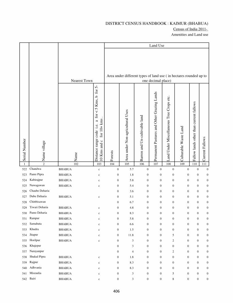
DISTRICT CENSUS HANDBOOK : KAIMUR (BHABUA)
Census of India 2011-
Amenities and Land use
Nam
e
Dis
tance
ran
ge
code
i.e
. a
fo
r <
5 K
ms,
b
for
5-
10 K
ms
and c
f
or
10+
km
s .
Fore
sts
Are
a under
Non-a
gri
cult
ura
l U
ses
Bar
ren a
nd U
n-c
ult
ivab
le l
and
Per
man
ent
Pas
ture
s an
d O
ther
Gra
zing L
ands
Lan
d U
nder
Mis
cell
aneo
us
Tre
e C
rops
etc.
Cult
ura
ble
Was
te L
and
Fal
low
lan
ds
oth
er t
han
curr
ent
fall
ow
s
Curr
ent
Fal
low
s
1 2 102 103 104 105 106 107 108 109 110 111
Ser
ial
Num
ber
Nam
e vil
lage
Area under different types of land use ( in hectares rounded up to
one decimal place)
Land Use
Nearest Town
522 Chandwa BHABUA c 0 5.7 0 0 0 0 0 0
523 Panre Pipra BHABUA c 0 1.8 0 0 0 0 0 0
524 Kabirajpur BHABUA c 0 5.8 0 0 0 0 0 0
525 Nawagawan BHABUA c 0 5.4 0 0 0 0 0 0
526 Chaube Deharia 0 3.6 0 0 0 0 0 0
527 Dube Deharia BHABUA c 0 5.1 0 0 0 0 0 0
528 Chittbisawan 0 6.7 0 0 0 0 0 0
529 Tiwari Deharia BHABUA c 0 4.8 0 0 0 0 0 0
530 Panre Deharia BHABUA c 0 8.3 0 0 0 0 0 0
531 Rampur BHABUA c 0 5.8 0 0 0 0 0 0
532 Samahuta BHABUA c 0 6.6 0 0 0 0 0 0
533 Khudra BHABUA c 0 1.5 0 0 0 0 0 0
534 Jitapur BHABUA c 0 11.8 0 0 5 0 0 0
535 Horilpur BHABUA c 0 3 0 0 2 0 0 0
536 Khajepur 0 3 0 0 0 0 0 0
537 Narayanpur 0 4 0 0 2 0 0 0
538 Shukul Pipra BHABUA c 0 1.8 0 0 0 0 0 0
539 Rajpur BHABUA c 0 8.3 0 0 0 0 0 0
540 Adhvania BHABUA c 0 8.3 0 0 0 0 0 0
541 Misraulia BHABUA c 0 3 0 0 5 0 0 0
542 Bairi BHABUA c 0 3 0 0 8 0 0 0
���

VILLAGE DIRECTORY
Village Directory
( As in 2009 )
Net
Are
a S
ow
n
Tota
l Ir
rigat
ed L
and A
rea
Tota
l U
n-i
rrig
ated
Lan
d A
rea
Can
als
( C
)
Wel
ls/T
ube-
wel
ls(W
/TW
)
Tan
ks/
Lak
es(T
/L)
Wat
er F
alls
(WF
)
Oth
ers(
O)
Fir
st
Sec
ond
Thir
d
112 113 114 115 116 117 118 119 120 121 122 2 1
Ser
ial
Num
ber
Name of three
most important
commodities
manufacturedArea irrigated by source (in hectare).
Nam
e of
Vil
lage
Area under different types of
land use ( in hectares rounded
up to one decimal place)
Land Use
97.2 97.2 0 70.1 27.1 0 0 0 Chandwa 522
57.2 57.2 0 41.2 16.1 0 0 0 Panre Pipra 523
58.1 58.1 0 42.9 15.2 0 0 0 Kabirajpur 524
58.6 58.6 0 42.3 16.3 0 0 0 Nawagawan 525
48.2 48.2 0 39.2 9 0 0 0 Chaube Deharia 526
36.9 36.9 0 29.7 7.2 0 0 0 Dube Deharia 527
66.1 66.1 0 56.1 10 0 0 0 Chittbisawan 528
37.1 37.1 0 29.1 8 0 0 0 Tiwari Deharia 529
90.9 90.9 0 85.1 5.8 0 0 0 Panre Deharia 530
85.5 85.5 0 80.1 5.4 0 0 0 Rampur 531
208.6 208.6 0 195.5 13.1 0 0 0 Samahuta 532
45.6 45.6 0 40.6 5 0 0 0 Khudra 533
69.2 69.2 0 42.2 27 0 0 0 Jitapur 534
30 30 0 0 30 0 0 0 Horilpur 535
41 41 0 15 26 0 0 0 Khajepur 536
57.1 57.1 0 49 8 0 0 0 Narayanpur 537
66.3 66.3 0 55.2 11.1 0 0 0 Shukul Pipra 538
35.7 35.7 0 29.6 6.1 0 0 0 Rajpur 539
100.9 100.9 0 90 10.8 0 0 0 Adhvania 540
81 77 4 27 50 0 0 0 Misraulia 541
85 82 3 30 52 0 0 0 Bairi 542
���
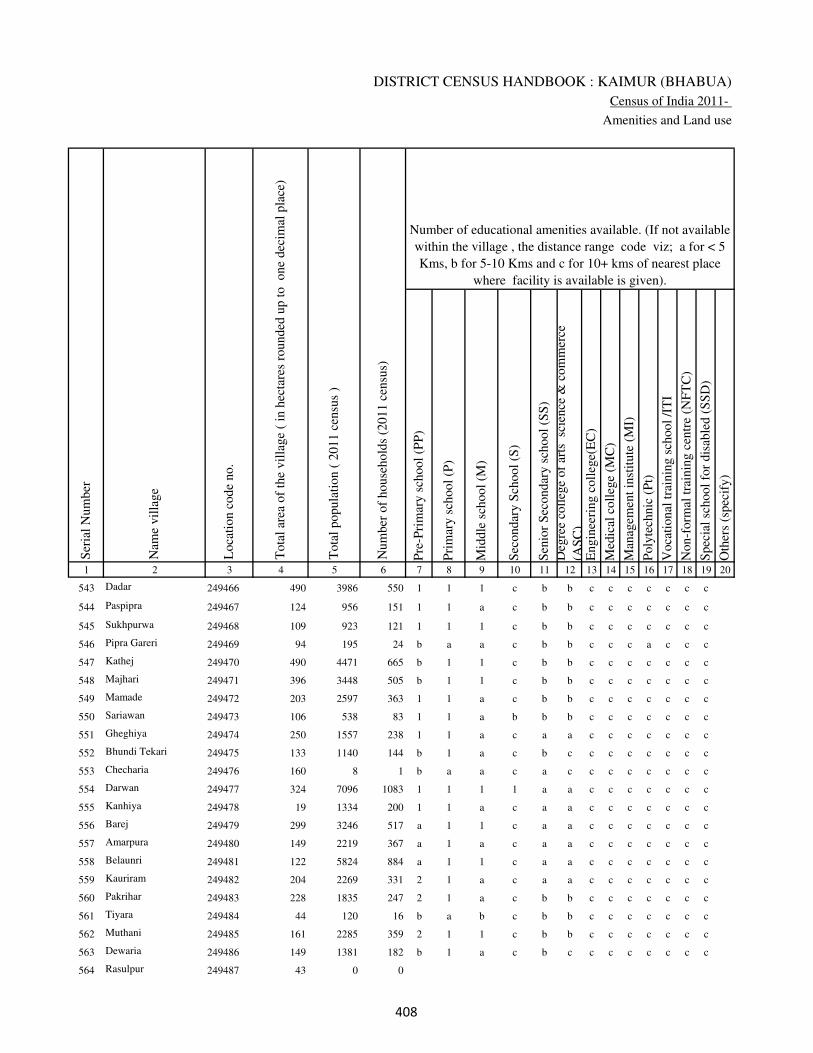
DISTRICT CENSUS HANDBOOK : KAIMUR (BHABUA)
Census of India 2011-
Amenities and Land use
Pre
-Pri
mar
y s
chool
(PP
)
Pri
mar
y s
chool
(P)
Mid
dle
sch
ool
(M)
Sec
ondar
y S
chool
(S)
Sen
ior
Sec
ondar
y s
chool
(SS
)
Deg
ree
coll
ege
of
arts
sc
ience
& c
om
mer
ce
(AS
C)
Engin
eeri
ng c
oll
ege(
EC
)
Med
ical
coll
ege
(MC
)
Man
agem
ent
inst
itute
(M
I)
Poly
tech
nic
(P
t)
Voca
tional
tra
inin
g s
chool
/IT
I
Non-f
orm
al t
rain
ing c
entr
e (N
FT
C)
Spec
ial
school
for
dis
able
d (
SS
D)
Oth
ers
(spec
ify)
1 2 3 4 5 6 7 8 9 10 11 12 13 14 15 16 17 18 19 20
Loca
tion c
ode
no.
Nam
e vil
lage
Ser
ial
Num
ber
Tota
l popula
tion (
2011 c
ensu
s )
Tota
l ar
ea o
f th
e vil
lage
( in
hec
tare
s ro
unded
up t
o
one
dec
imal
pla
ce)
Number of educational amenities available. (If not available
within the village , the distance range code viz; a for < 5
Kms, b for 5-10 Kms and c for 10+ kms of nearest place
where facility is available is given).
Num
ber
of
house
hold
s (2
011 c
ensu
s)
543 Dadar 249466 490 3986 550 1 1 1 c b b c c c c c c c
544 Paspipra 249467 124 956 151 1 1 a c b b c c c c c c c
545 Sukhpurwa 249468 109 923 121 1 1 1 c b b c c c c c c c
546 Pipra Gareri 249469 94 195 24 b a a c b b c c c a c c c
547 Kathej 249470 490 4471 665 b 1 1 c b b c c c c c c c
548 Majhari 249471 396 3448 505 b 1 1 c b b c c c c c c c
549 Mamade 249472 203 2597 363 1 1 a c b b c c c c c c c
550 Sariawan 249473 106 538 83 1 1 a b b b c c c c c c c
551 Gheghiya 249474 250 1557 238 1 1 a c a a c c c c c c c
552 Bhundi Tekari 249475 133 1140 144 b 1 a c b c c c c c c c c
553 Checharia 249476 160 8 1 b a a c a c c c c c c c c
554 Darwan 249477 324 7096 1083 1 1 1 1 a a c c c c c c c
555 Kanhiya 249478 19 1334 200 1 1 a c a a c c c c c c c
556 Barej 249479 299 3246 517 a 1 1 c a a c c c c c c c
557 Amarpura 249480 149 2219 367 a 1 a c a a c c c c c c c
558 Belaunri 249481 122 5824 884 a 1 1 c a a c c c c c c c
559 Kauriram 249482 204 2269 331 2 1 a c a a c c c c c c c
560 Pakrihar 249483 228 1835 247 2 1 a c b b c c c c c c c
561 Tiyara 249484 44 120 16 b a b c b b c c c c c c c
562 Muthani 249485 161 2285 359 2 1 1 c b b c c c c c c c
563 Dewaria 249486 149 1381 182 b 1 a c b c c c c c c c c
564 Rasulpur 249487 43 0 0
���

VILLAGE DIRECTORY
Village Directory
( As in 2009 )
Com
munit
y h
ealt
h c
entr
e (C
HC
)
Pri
mar
y h
ealt
h c
entr
e (P
HC
)
Pri
mar
y h
ealt
h s
ub c
entr
e (P
HS
)
Mat
ernit
y a
nd c
hil
d w
elfa
re c
entr
e (M
CW
)
T.B
. cl
inic
(T
BC
)
Hosp
ital
-all
opat
hic
(H
A)
Hosp
ital
-alt
ernat
ive
med
icin
e (H
O)
Dis
pen
sary
(D
)
Vet
erin
ary h
osp
ital
(V
H)
Mobil
e hea
lth c
linic
(M
HC
)
Fam
ily w
elfa
re c
entr
e (F
WC
)
Char
itab
le n
on G
ovt.
hosp
ital
/Nurs
ing h
om
e.
Med
ical
pra
ctit
ioner
wit
h M
BB
S D
egre
e
Med
ical
pra
ctit
ioner
wit
h o
ther
deg
ree
Med
ical
pra
ctit
ioner
wit
h n
o d
egre
e
Tra
dit
ional
pra
ctit
ioner
an
d f
aith
hea
ler
.
Med
icin
e S
hop
Oth
ers
21 22 23 24 25 26 27 28 29 30 31 32 33 34 35 36 37 38 2 1
Number of Non-Government
Medical Amenities available.
Number of Medical Amenities available. (If not
available within the village , the distance range
code viz; a for < 5 Kms, b for 5-10 Kms and c
for 10+ kms of nearest place where facility is
available is given).
Nam
e vil
lage
Ser
ial
Num
ber
b b 1 1 b c c b b c 1 0 0 0 0 0 0 0 Dadar 543
b b a b b c c b b c a 0 0 0 0 0 0 0 Paspipra 544
b b a b b c c b b c a 0 0 0 0 0 0 0 Sukhpurwa 545
b b b b c c c b b c b 0 0 0 0 0 0 0 Pipra Gareri 546
b b b b c c c b b c b 0 0 0 0 0 0 0 Kathej 547
b b b b c c c b b c b 0 0 0 0 0 0 0 Majhari 548
b b b b b c c b b c b 0 0 0 0 0 0 0 Mamade 549
b b a b b c c b b c a 0 0 0 0 0 0 0 Sariawan 550
a a a a a c c a a c a 0 0 0 0 0 0 0 Gheghiya 551
b b b b b c c b b c b 0 0 0 0 0 0 0 Bhundi Tekari 552
c c b c c c c b c c b 0 0 0 0 0 0 0 Checharia 553
b c b a c c c a a c a 0 0 0 0 0 0 0 Darwan 554
b c a a b c c b b c a 0 0 0 0 0 0 0 Kanhiya 555
a a a a a c c a a c a 0 0 0 0 0 0 0 Barej 556
a a a a a c c a a c a 0 0 0 0 0 0 0 Amarpura 557
a a a a a c c a a c a 0 0 0 0 0 0 0 Belaunri 558
a a a a a c c a a c a 0 0 0 0 0 0 0 Kauriram 559
b b b b b c c b b c b 0 0 0 0 0 0 0 Pakrihar 560
b b b b b c c b b c b 0 0 0 0 0 0 0 Tiyara 561
b b b b b c c b b c b 0 0 0 0 0 0 0 Muthani 562
b b b b b c c b b c b 0 0 0 0 0 0 0 Dewaria 563
Rasulpur 564
���
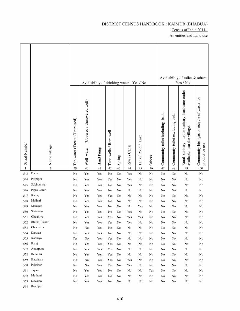
DISTRICT CENSUS HANDBOOK : KAIMUR (BHABUA)
Census of India 2011-
Amenities and Land use
Tap
wat
er (
Tre
ated
/Untr
eate
d)
Wel
l w
ater
(Cover
ed /
Unco
ver
ed w
ell)
Han
d P
um
p
Tube
wel
ls /
Bore
wel
l
Spri
ng
Riv
er /
Can
al
Tan
k /
Pond /
L
ake
Oth
ers
Com
munit
y t
oil
et i
ncl
udin
g
bat
h.
Com
munit
y t
oil
et e
xcl
udin
g b
ath.
Rura
l s
anit
ary m
art
or
sanit
ary
har
dw
are
outl
et
avai
lable
nea
r th
e vil
lage.
Com
munit
y b
io-
gas
or
recy
cle
of
was
te f
or
pro
duct
ive
use
.
1 2 39 40 41 42 43 44 45 46 47 48 49 50
Availability of toilet & others
Yes / No Availability of drinking water - Yes / No
Nam
e vil
lage
Ser
ial
Num
ber
543 Dadar No Yes Yes No No Yes No No No No No No
544 Paspipra No Yes Yes Yes No Yes No No No No No No
545 Sukhpurwa No Yes Yes No No Yes No No No No No No
546 Pipra Gareri No Yes Yes No No No No No No No No No
547 Kathej No Yes Yes Yes No No No No No No No No
548 Majhari No Yes Yes No No No No No No No No No
549 Mamade No Yes Yes No No No Yes No No No No No
550 Sariawan No Yes Yes No No Yes No No No No No No
551 Gheghiya No Yes Yes Yes No Yes Yes No No No No No
552 Bhundi Tekari No Yes Yes Yes No Yes No No No No No No
553 Checharia No No Yes No No No No No No No No No
554 Darwan No Yes Yes No No No No No No No No No
555 Kanhiya Yes No Yes Yes No No No No No No No No
556 Barej No Yes Yes Yes No No No No No No No No
557 Amarpura No Yes Yes Yes No No No No No No No No
558 Belaunri No Yes Yes Yes No No No No No No No No
559 Kauriram No No Yes Yes No Yes No No No No No No
560 Pakrihar No No Yes Yes No Yes No No No No No No
561 Tiyara No Yes Yes No No No No Yes No No No No
562 Muthani No Yes Yes No No No No No No No No No
563 Dewaria No Yes Yes No No No No No No No No No
564 Rasulpur
���
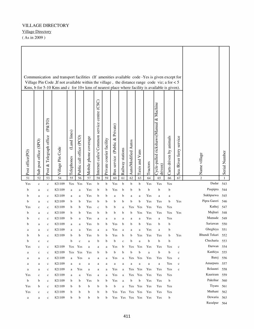
VILLAGE DIRECTORY
Village Directory
( As in 2009 )
Post
off
ice(
PO
)
Sub p
ost
off
ice
(SP
O)
Post
& T
eleg
raph o
ffic
e
(P&
TO
)
Vil
lage
Pin
Code
Tel
ephones
(L
and l
ines
)
Publi
c ca
ll o
ffic
e (P
CO
)
Mobil
e phone
cover
age
Inte
rnet
caf
es/
Com
mon s
ervic
e ce
ntr
e (C
SC
)
Pri
vat
e co
uri
er f
acil
ity
Bus
serv
ice
(P
ubli
c &
Pri
vat
e)
Rai
lway
sta
tions
Auto
/Modif
ied A
uto
s
Tax
is a
nd V
ans
Tra
ctors
Cycl
e-pull
ed r
icksh
aws(
Man
ual
& M
achin
e
dri
ven
)
Car
ts d
riven
by a
nim
als
Sea
/R
iver
fer
ry s
ervic
e51 52 53 54 55 56 57 58 59 60 61 62 63 64 65 66 67 2 1
Communication and transport facilities (If amenities available code -Yes is given except for
Village Pin Code ,If not available within the village , the distance range code viz; a for < 5
Kms, b for 5-10 Kms and c for 10+ kms of nearest place where facility is available is given).
Ser
ial
Num
ber
Nam
e vil
lage
Yes c c 821109 Yes Yes Yes b b Yes b b b Yes Yes Yes Dadar 543
b a c 821109 a a Yes b b Yes b b b b b b Paspipra 544
b a c 821109 a a Yes b b a b a a Yes a a Sukhpurwa 545
b a c 821109 b b Yes b b b b b b Yes Yes b Yes Pipra Gareri 546
Yes c c 821109 b b Yes c b b a Yes Yes Yes Yes Yes Kathej 547
b a c 821109 b b Yes b b b b b Yes Yes Yes Yes Yes Majhari 548
b c c 821109 b a Yes a a a a a a Yes a Yes Mamade 549
b a c 821109 a a Yes b b Yes b b b Yes b b Sariawan 550
a a c 821109 a a Yes a a Yes a a a Yes a b Gheghiya 551
b b c 821109 b b Yes b b Yes b b Yes Yes Yes b Yes Bhundi Tekari 552
b c c b c a b b b c b a b b b Checharia 553
Yes c c 821109 Yes Yes a a a Yes b Yes Yes Yes Yes Yes c Darwan 554
a c c 821109 Yes Yes Yes b b b b b b a b b c Kanhiya 555
a a c 821109 a Yes a a a Yes a Yes Yes Yes Yes Yes c Barej 556
a a c 821109 a a a a a a a a a a a Yes c Amarpura 557
a a c 821109 a Yes a a a Yes a Yes Yes Yes Yes Yes c Belaunri 558
Yes c c 821109 a a Yes a a Yes a Yes Yes Yes Yes Yes Kauriram 559
b b c 821109 b b Yes b b Yes a b b Yes Yes b Pakrihar 560
Yes b c 821109 b b b b b b a Yes Yes Yes Yes Yes Tiyara 561
Yes c c 821109 b b b b b Yes Yes Yes Yes Yes Yes Yes Muthani 562
a a c 821109 b b b b b Yes Yes Yes Yes Yes Yes b Dewaria 563
Rasulpur 564
���
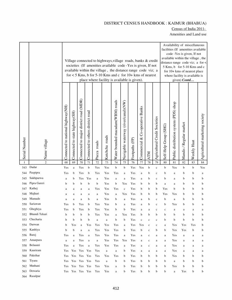
DISTRICT CENSUS HANDBOOK : KAIMUR (BHABUA)
Census of India 2011-
Amenities and Land use
Connec
ted t
o n
atio
nal
hig
hw
ay(N
H)
Connec
ted t
o s
tate
hig
hw
ay(S
H)
Connec
ted t
o m
ajor
dis
tric
t ro
ad (
MD
R)
Connec
ted t
o o
ther
s dis
tric
t ro
ad
Pucc
a r
oad
s
Kutc
hch
a r
oad
s
Wat
er b
ounded
mac
adam
(WB
M)
road
s
Nav
igab
le w
ater
way
(ri
ver
/can
al)(
NW
)
Footp
aths
(FP
)
Com
mer
cial
& C
o-o
per
ativ
e B
anks
AT
M
Agri
cult
ura
l C
redit
Soci
etie
s
Sel
f-H
elp G
roup (
SH
G)
Publi
c dis
trib
uti
on s
yst
em (
PD
S)
shop
Man
dis
/ R
egula
r m
arket
Wee
kly
Haa
t
Agri
cult
ura
l m
arket
ing s
oci
ety
1 2 68 69 70 71 72 73 74 75 76 77 78 79 80 81 82 83 84
Village connected to highways,village roads, banks & credit
societies (If amenities available code -Yes is given, If not
available within the village , the distance range code viz; a
for < 5 Kms, b for 5-10 Kms and c for 10+ kms of nearest
place where facility is available is given).
Ser
ial
Num
ber
Nam
e vil
lage
Availability of miscellaneous
facilities (If amenities available
code -Yes is given, If not
available within the village , the
distance range code viz; a for <
5 Kms, b for 5-10 Kms and c
for 10+ kms of nearest place
where facility is available is
given) Contd....
543 Dadar Yes a Yes b Yes Yes b b Yes Yes b c b Yes b b Yes
544 Paspipra Yes b Yes b Yes Yes Yes a Yes a b c b a b b a
545 Sukhpurwa a b Yes Yes a Yes a a Yes a b c b a b b b
546 Pipra Gareri b b b b b Yes b Yes Yes b b b a a b b b
547 Kathej a a a a Yes Yes Yes c Yes b b b Yes b b b b
548 Majhari a a a a a Yes a Yes Yes b b b Yes Yes b b b
549 Mamade a a a b a Yes b a Yes a b c b a b b b
550 Sariawan Yes b Yes b Yes Yes b a Yes a b c b Yes b b a
551 Gheghiya Yes b Yes b Yes Yes b b Yes a a c c a a a a
552 Bhundi Tekari b b b b Yes Yes a Yes Yes b b b b b b b b
553 Checharia b b b b a a b b Yes c c c b b b b b
554 Darwan b Yes a Yes Yes Yes Yes a Yes Yes c c a Yes Yes Yes b
555 Kanhiya b b a a Yes Yes Yes b Yes b c b b Yes Yes b b
556 Barej Yes a Yes a Yes Yes Yes a Yes a c a a Yes a a a
557 Amarpura a a Yes a a Yes Yes Yes Yes a c a a Yes a a a
558 Belaunri Yes a Yes a Yes Yes Yes a Yes a c a a Yes a a a
559 Kauriram Yes Yes Yes Yes Yes a a b Yes a a a a Yes a a a
560 Pakrihar Yes Yes Yes Yes Yes Yes Yes b Yes b b b b Yes b b b
561 Tiyara Yes Yes Yes Yes Yes a b b Yes b b b b a b b b
562 Muthani Yes Yes Yes Yes Yes Yes a b Yes b b b b Yes b b b
563 Dewaria Yes Yes Yes Yes Yes Yes a b Yes b b b b a Yes b b
564 Rasulpur
��

VILLAGE DIRECTORY
Village Directory
( As in 2009 )
Inte
gra
ted C
hil
d D
evel
opm
ent
Sch
eme
(Nutr
itio
nal
Cen
tres
)
Angan
wad
i C
entr
e (N
utr
itio
nal
Cen
tres
)
Oth
ers
(Nutr
itio
nal
Cen
tres
)
AS
HA
(A
ccre
dit
ed S
oci
al H
ealt
h A
ctiv
ist)
Com
munit
y c
entr
e w
ith/w
ithout
TV
Sport
s F
ield
,
Sport
s C
lub /
Rec
reat
ion C
entr
e
Cin
ema
/ V
ideo
Hal
l
Publi
c L
ibra
ry
Publi
c R
eadin
g R
oom
New
spap
er S
upply
Ass
embly
Poll
ing s
tati
on
Bir
th &
Dea
th R
egis
trat
ion O
ffic
e
Pow
er S
upply
for
Dom
esti
c U
se (
ED
)
Pow
er S
upply
for
Agri
cult
ura
l U
se (
EA
G)
Pow
er S
upply
for
Com
mer
cial
Use
(E
C)
Pow
er S
upply
for
All
Use
s (E
A)
85 86 87 88 89 90 91 92 93 94 95 96 97 98 99 100 101 2 1
Availability of
electricity (Yes/No)
Availability of miscellaneous facilities (If amenities available code -
Yes is given, If not available within the village , the distance range
code viz; a for < 5 Kms, b for 5-10 Kms and c for 10+ kms of
nearest place where facility is available is given) Concluded
Nam
e vil
lage
Ser
ial
Num
ber
b Yes Yes Yes Yes Yes Yes c c c b Yes Yes Yes No No No Dadar 543
b Yes Yes Yes b a a c c c b Yes a Yes No No No Paspipra 544
b Yes Yes Yes Yes a a c b c b Yes a Yes No No No Sukhpurwa 545
b a Yes b a b b b b b b a a Yes No No No Pipra Gareri 546
b Yes Yes Yes b b b c c c Yes Yes Yes Yes No No No Kathej 547
b Yes Yes Yes b b b c c c b Yes a Yes No No No Majhari 548
b Yes Yes Yes c b b c b c b Yes b Yes Yes No No Mamade 549
b Yes Yes Yes c a a c c c b Yes a Yes No No No Sariawan 550
a Yes Yes Yes c a a c c c a Yes a Yes No No No Gheghiya 551
a Yes Yes a b b b b b b b Yes b Yes Yes Yes Yes Bhundi Tekari 552
a b Yes b c b c c c c b a a No No No No Checharia 553
a Yes Yes Yes c b b c b c Yes Yes Yes Yes Yes Yes Yes Darwan 554
a Yes Yes Yes c b b c c b b a a Yes Yes Yes Yes Kanhiya 555
a Yes Yes Yes b a a a c a a Yes a Yes Yes Yes Yes Barej 556
a Yes Yes Yes c a a a c a a Yes a Yes Yes No No Amarpura 557
a Yes Yes Yes a a a a c a Yes Yes Yes Yes Yes Yes Yes Belaunri 558
a Yes a Yes c a a c c c a Yes a Yes Yes Yes Yes Kauriram 559
b Yes Yes Yes c b b c c b b Yes Yes Yes Yes Yes Yes Pakrihar 560
b a Yes Yes b b b c c b b a a Yes Yes Yes Yes Tiyara 561
b Yes Yes Yes c b a c c b b Yes b Yes Yes No No Muthani 562
b Yes b Yes Yes b b b c b b a b Yes Yes No No Dewaria 563
Rasulpur 564
��
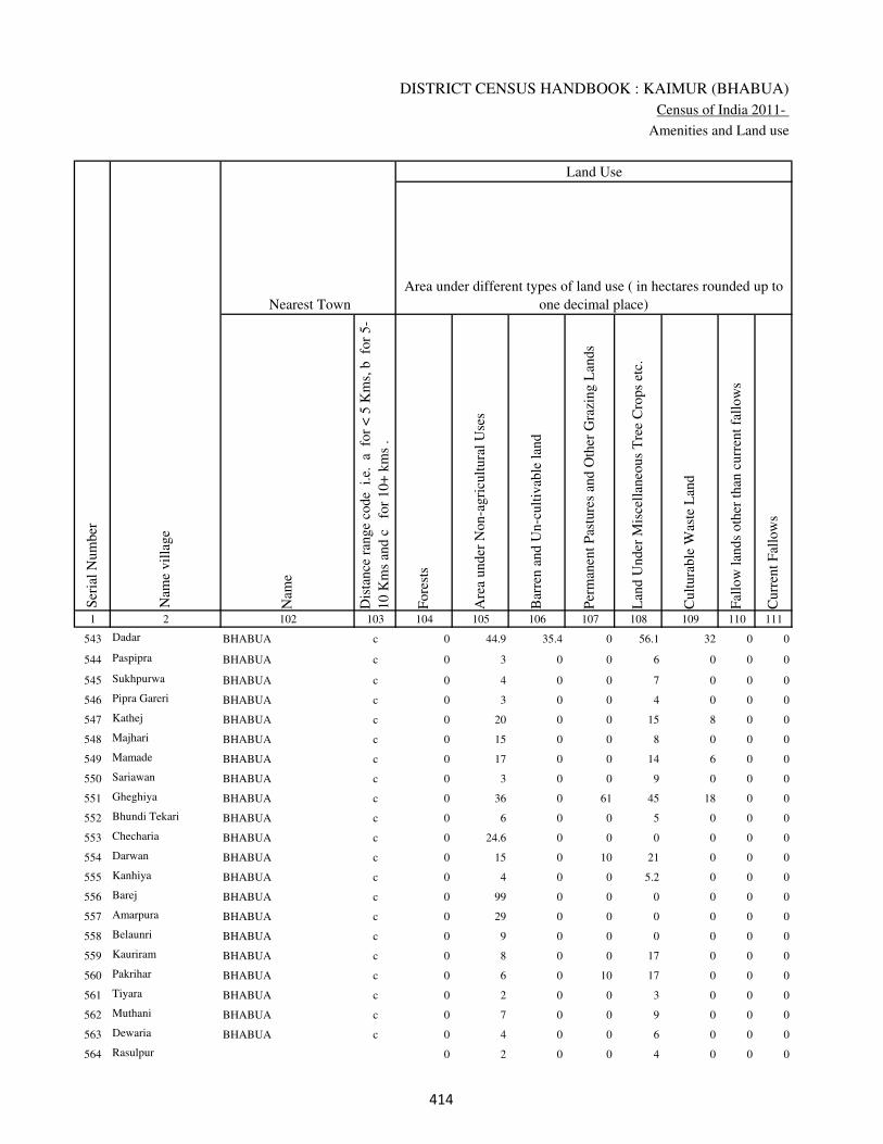
DISTRICT CENSUS HANDBOOK : KAIMUR (BHABUA)
Census of India 2011-
Amenities and Land use
Nam
e
Dis
tance
ran
ge
code
i.e
. a
fo
r <
5 K
ms,
b
for
5-
10 K
ms
and c
f
or
10+
km
s .
Fore
sts
Are
a under
Non-a
gri
cult
ura
l U
ses
Bar
ren a
nd U
n-c
ult
ivab
le l
and
Per
man
ent
Pas
ture
s an
d O
ther
Gra
zing L
ands
Lan
d U
nder
Mis
cell
aneo
us
Tre
e C
rops
etc.
Cult
ura
ble
Was
te L
and
Fal
low
lan
ds
oth
er t
han
curr
ent
fall
ow
s
Curr
ent
Fal
low
s
1 2 102 103 104 105 106 107 108 109 110 111
Ser
ial
Num
ber
Nam
e vil
lage
Area under different types of land use ( in hectares rounded up to
one decimal place)
Land Use
Nearest Town
543 Dadar BHABUA c 0 44.9 35.4 0 56.1 32 0 0
544 Paspipra BHABUA c 0 3 0 0 6 0 0 0
545 Sukhpurwa BHABUA c 0 4 0 0 7 0 0 0
546 Pipra Gareri BHABUA c 0 3 0 0 4 0 0 0
547 Kathej BHABUA c 0 20 0 0 15 8 0 0
548 Majhari BHABUA c 0 15 0 0 8 0 0 0
549 Mamade BHABUA c 0 17 0 0 14 6 0 0
550 Sariawan BHABUA c 0 3 0 0 9 0 0 0
551 Gheghiya BHABUA c 0 36 0 61 45 18 0 0
552 Bhundi Tekari BHABUA c 0 6 0 0 5 0 0 0
553 Checharia BHABUA c 0 24.6 0 0 0 0 0 0
554 Darwan BHABUA c 0 15 0 10 21 0 0 0
555 Kanhiya BHABUA c 0 4 0 0 5.2 0 0 0
556 Barej BHABUA c 0 99 0 0 0 0 0 0
557 Amarpura BHABUA c 0 29 0 0 0 0 0 0
558 Belaunri BHABUA c 0 9 0 0 0 0 0 0
559 Kauriram BHABUA c 0 8 0 0 17 0 0 0
560 Pakrihar BHABUA c 0 6 0 10 17 0 0 0
561 Tiyara BHABUA c 0 2 0 0 3 0 0 0
562 Muthani BHABUA c 0 7 0 0 9 0 0 0
563 Dewaria BHABUA c 0 4 0 0 6 0 0 0
564 Rasulpur 0 2 0 0 4 0 0 0
���

VILLAGE DIRECTORY
Village Directory
( As in 2009 )
Net
Are
a S
ow
n
Tota
l Ir
rigat
ed L
and A
rea
Tota
l U
n-i
rrig
ated
Lan
d A
rea
Can
als
( C
)
Wel
ls/T
ube-
wel
ls(W
/TW
)
Tan
ks/
Lak
es(T
/L)
Wat
er F
alls
(WF
)
Oth
ers(
O)
Fir
st
Sec
ond
Thir
d
112 113 114 115 116 117 118 119 120 121 122 2 1
Ser
ial
Num
ber
Name of three
most important
commodities
manufacturedArea irrigated by source (in hectare).
Nam
e of
Vil
lage
Area under different types of
land use ( in hectares rounded
up to one decimal place)
Land Use
321.6 321.6 0 92 186 0 0 43.6 Dadar 543
115 109 6 22 87 0 0 0 Paspipra 544
98 89 9 39 50 0 0 0 Sukhpurwa 545
87 78 9 22 56 0 0 0 Pipra Gareri 546
447 413 34 120 210 0 0 83 Kathej 547
373 336 37 71 235 0 0 30 Majhari 548
166 139 27 0 104 25 0 10 Mamade 549
94 89 5 19 70 0 0 0 Sariawan 550
90 56 34 6 50 0 0 0 Gheghiya 551
122 98 24 35 35 20 0 8 Bhundi Tekari 552
135.4 78 57.4 28 50 0 0 0 Checharia 553
278 206 72 185 0 0 0 21 Darwan 554
9.8 9.8 0 0 9.8 0 0 0 Kanhiya 555
200 160 40 0 140 0 0 20 Barej 556
120 100 20 0 80 0 0 20 Amarpura 557
113 93 20 0 90 0 0 3 Belaunri 558
179 156 23 56 100 0 0 0 Kauriram 559
195 158 37 58 80 0 0 20 Pakrihar 560
39 39 0 39 0 0 0 0 Tiyara 561
145 59 86 0 59 0 0 0 Muthani 562
139 139 0 89 50 0 0 0 Dewaria 563
37 37 0 37 0 0 0 0 Rasulpur 564
���

DISTRICT CENSUS HANDBOOK : KAIMUR (BHABUA)
Census of India 2011-
Amenities and Land use
Pre
-Pri
mar
y s
chool
(PP
)
Pri
mar
y s
chool
(P)
Mid
dle
sch
ool
(M)
Sec
ondar
y S
chool
(S)
Sen
ior
Sec
ondar
y s
chool
(SS
)
Deg
ree
coll
ege
of
arts
sc
ience
& c
om
mer
ce
(AS
C)
Engin
eeri
ng c
oll
ege(
EC
)
Med
ical
coll
ege
(MC
)
Man
agem
ent
inst
itute
(M
I)
Poly
tech
nic
(P
t)
Voca
tional
tra
inin
g s
chool
/IT
I
Non-f
orm
al t
rain
ing c
entr
e (N
FT
C)
Spec
ial
school
for
dis
able
d (
SS
D)
Oth
ers
(spec
ify)
1 2 3 4 5 6 7 8 9 10 11 12 13 14 15 16 17 18 19 20
Loca
tion c
ode
no.
Nam
e vil
lage
Ser
ial
Num
ber
Tota
l popula
tion (
2011 c
ensu
s )
Tota
l ar
ea o
f th
e vil
lage
( in
hec
tare
s ro
unded
up t
o
one
dec
imal
pla
ce)
Number of educational amenities available. (If not available
within the village , the distance range code viz; a for < 5
Kms, b for 5-10 Kms and c for 10+ kms of nearest place
where facility is available is given).
Num
ber
of
house
hold
s (2
011 c
ensu
s)
565 Ameth 249488 254 3234 440 2 1 1 c b c c c c c c c c
566 Sarayan 249489 40 520 58 1 1 a c b b c c c c c c c
567 Barka Sagra 249490 179 974 126 c 1 a c c c c c c c c c c
568 Murharia 249491 98 1003 139 b 1 a c b b c c c c c c c
569 Patelwa 249492 56.2 1346 186 b 1 1 c a b c c c c c c c
570 Atraulia 249493 179 1376 219 b 1 a c b c c c c c c c c
571 Kewrhi 249494 93 128 18 b a a c b b c c c c c c c
572 Mamrezpur 249495 83 483 91 a a a c b b c c c c c c c
573 Bhitti 249496 143 3704 531 1 1 1 c b b c c c c c c c
574 Pandepur 249497 82 7 1 b a b c b c c c c c c c c
575 Barhuli 249498 149 1314 197 b 2 1 c a b c c c c c c c
576 Karigawan 249499 95 1082 151 1 2 a c b b c c c c c c c
577 Bhopatpur 249500 56 897 117 1 1 a c b b c c c c c c c
578 Bhopatpur 249501 69 0 0
579 Pusauli 249502 197 1910 324 1 1 1 c a c c c c c c c c
580 Shahbazpur 249503 306.4 2452 361 c 1 1 c a c c c c c c c c
581 Machhanhat 249504 145 439 56 b 1 a c a b c c c c c c c
582 Katra Arazi English 249505 408 764 116 a 1 a c b c c c c c c c c
583 Barhaulia 249506 208 0 0
584 Sagarpur 249507 112 341 44 b a a c b b c c c c c c c
Block T O T A L : 28426.6 218479 32198 39 138 62 7 2 1 0 0 0 0 0 0 0 0
���

VILLAGE DIRECTORY
Village Directory
( As in 2009 )
Com
munit
y h
ealt
h c
entr
e (C
HC
)
Pri
mar
y h
ealt
h c
entr
e (P
HC
)
Pri
mar
y h
ealt
h s
ub c
entr
e (P
HS
)
Mat
ernit
y a
nd c
hil
d w
elfa
re c
entr
e (M
CW
)
T.B
. cl
inic
(T
BC
)
Hosp
ital
-all
opat
hic
(H
A)
Hosp
ital
-alt
ernat
ive
med
icin
e (H
O)
Dis
pen
sary
(D
)
Vet
erin
ary h
osp
ital
(V
H)
Mobil
e hea
lth c
linic
(M
HC
)
Fam
ily w
elfa
re c
entr
e (F
WC
)
Char
itab
le n
on G
ovt.
hosp
ital
/Nurs
ing h
om
e.
Med
ical
pra
ctit
ioner
wit
h M
BB
S D
egre
e
Med
ical
pra
ctit
ioner
wit
h o
ther
deg
ree
Med
ical
pra
ctit
ioner
wit
h n
o d
egre
e
Tra
dit
ional
pra
ctit
ioner
an
d f
aith
hea
ler
.
Med
icin
e S
hop
Oth
ers
21 22 23 24 25 26 27 28 29 30 31 32 33 34 35 36 37 38 2 1
Number of Non-Government
Medical Amenities available.
Number of Medical Amenities available. (If not
available within the village , the distance range
code viz; a for < 5 Kms, b for 5-10 Kms and c
for 10+ kms of nearest place where facility is
available is given).
Nam
e vil
lage
Ser
ial
Num
ber
b b b b b c c b b c b 0 0 0 0 0 0 0 Ameth 565
b b b b b c c b b c b 0 0 0 0 0 0 0 Sarayan 566
c c c c c c c c c c c 0 0 0 0 0 0 0 Barka Sagra 567
b b b b c c c b b c b 0 0 0 0 0 0 0 Murharia 568
b b b b b c c b b c b 0 0 0 0 0 0 0 Patelwa 569
c c c c c c c c c c c 0 0 0 0 0 0 0 Atraulia 570
b b b b b c c b b c 1 0 0 0 0 0 0 0 Kewrhi 571
b b b b b c c b b c 1 0 0 0 0 0 0 0 Mamrezpur 572
b b 1 1 b c c b b c 1 0 0 0 0 0 1 0 Bhitti 573
c c b b c c c b c c b 0 0 0 0 0 0 0 Pandepur 574
b b a b b c c b b c a 0 0 0 0 0 0 0 Barhuli 575
b 1 1 1 1 c c 1 1 c 1 0 0 1 0 0 0 0 Karigawan 576
b b a b b c c b b c b 0 0 0 0 0 0 0 Bhopatpur 577
Bhopatpur 578
b b 1 1 b c c b b c 1 0 0 0 0 0 1 0 Pusauli 579
c c c c c c c c c c c 0 0 0 0 0 0 0 Shahbazpur 580
b b b b b c c b b c b 0 0 0 0 0 0 0 Machhanhat 581
c c c c c c c c c c c 0 0 0 0 0 0 0 Katra Arazi English 582
Barhaulia 583
c a a c c c c c c c c 0 1 0 0 0 0 0 Sagarpur 584
0 2 21 21 2 0 0 2 2 0 23 0 50 51 46 42 50 42
���
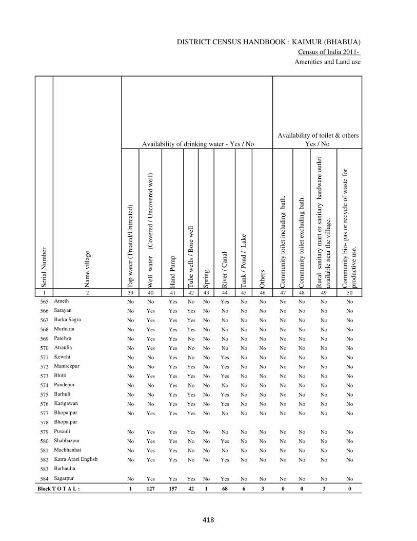
DISTRICT CENSUS HANDBOOK : KAIMUR (BHABUA)
Census of India 2011-
Amenities and Land use
Tap
wat
er (
Tre
ated
/Untr
eate
d)
Wel
l w
ater
(Cover
ed /
Unco
ver
ed w
ell)
Han
d P
um
p
Tube
wel
ls /
Bore
wel
l
Spri
ng
Riv
er /
Can
al
Tan
k /
Pond /
L
ake
Oth
ers
Com
munit
y t
oil
et i
ncl
udin
g
bat
h.
Com
munit
y t
oil
et e
xcl
udin
g b
ath.
Rura
l s
anit
ary m
art
or
sanit
ary
har
dw
are
outl
et
avai
lable
nea
r th
e vil
lage.
Com
munit
y b
io-
gas
or
recy
cle
of
was
te f
or
pro
duct
ive
use
.
1 2 39 40 41 42 43 44 45 46 47 48 49 50
Availability of toilet & others
Yes / No Availability of drinking water - Yes / No
Nam
e vil
lage
Ser
ial
Num
ber
565 Ameth No No Yes No No Yes No No No No No No
566 Sarayan No Yes Yes Yes No No No No No No No No
567 Barka Sagra No Yes Yes Yes No No No No No No No No
568 Murharia No Yes Yes Yes No No No No No No No No
569 Patelwa No Yes Yes No No No No No No No No No
570 Atraulia No Yes Yes No No No No No No No No No
571 Kewrhi No No Yes No No Yes No No No No No No
572 Mamrezpur No No Yes Yes No Yes No No No No No No
573 Bhitti No Yes Yes Yes No Yes No No No No No No
574 Pandepur No No Yes No No No No No No No No No
575 Barhuli No No Yes Yes No Yes No No No No No No
576 Karigawan No No Yes Yes No Yes No No No No No No
577 Bhopatpur No Yes Yes Yes No No No No No No No No
578 Bhopatpur
579 Pusauli No Yes Yes Yes No No No No No No No No
580 Shahbazpur No Yes Yes No No Yes No No No No No No
581 Machhanhat No Yes Yes No No No No No No No No No
582 Katra Arazi English No Yes Yes No No Yes No No No No No No
583 Barhaulia
584 Sagarpur No Yes Yes Yes No Yes No No No No No No
Block T O T A L : 1 127 157 42 1 68 6 3 0 0 3 0
���
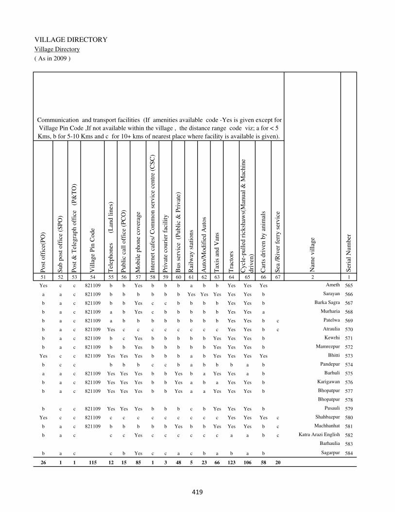
VILLAGE DIRECTORY
Village Directory
( As in 2009 )
Post
off
ice(
PO
)
Sub p
ost
off
ice
(SP
O)
Post
& T
eleg
raph o
ffic
e
(P&
TO
)
Vil
lage
Pin
Code
Tel
ephones
(L
and l
ines
)
Publi
c ca
ll o
ffic
e (P
CO
)
Mobil
e phone
cover
age
Inte
rnet
caf
es/
Com
mon s
ervic
e ce
ntr
e (C
SC
)
Pri
vat
e co
uri
er f
acil
ity
Bus
serv
ice
(P
ubli
c &
Pri
vat
e)
Rai
lway
sta
tions
Auto
/Modif
ied A
uto
s
Tax
is a
nd V
ans
Tra
ctors
Cycl
e-pull
ed r
icksh
aws(
Man
ual
& M
achin
e
dri
ven
)
Car
ts d
riven
by a
nim
als
Sea
/R
iver
fer
ry s
ervic
e51 52 53 54 55 56 57 58 59 60 61 62 63 64 65 66 67 2 1
Communication and transport facilities (If amenities available code -Yes is given except for
Village Pin Code ,If not available within the village , the distance range code viz; a for < 5
Kms, b for 5-10 Kms and c for 10+ kms of nearest place where facility is available is given).
Ser
ial
Num
ber
Nam
e vil
lage
Yes c c 821109 b b Yes b b b a b b Yes Yes Yes Ameth 565
a a c 821109 b b b b b b Yes Yes Yes Yes Yes b Sarayan 566
b a c 821109 b b Yes c c b b b b Yes Yes b Barka Sagra 567
b a c 821109 a b Yes c b b b b b Yes Yes a Murharia 568
b a c 821109 a b b b b b b b b Yes Yes b c Patelwa 569
b a c 821109 Yes c c c c c c c c Yes Yes b c Atraulia 570
b a c 821109 b c Yes b b b b b Yes Yes Yes b Kewrhi 571
b a c 821109 b b Yes b b b b b Yes Yes Yes b Mamrezpur 572
Yes c c 821109 Yes Yes Yes b b b a b Yes Yes Yes Yes Bhitti 573
b c c b b b c c b a b b b a b Pandepur 574
a a c 821109 Yes Yes Yes b b Yes b a Yes Yes a b Barhuli 575
b a c 821109 Yes Yes Yes b b Yes a b a Yes Yes b Karigawan 576
b a c 821109 Yes Yes Yes b b Yes a a Yes Yes Yes b Bhopatpur 577
Bhopatpur 578
b c c 821109 Yes Yes Yes b b b c b Yes Yes Yes b Pusauli 579
Yes c c 821109 c c c c c c c c c Yes Yes Yes c Shahbazpur 580
b a c 821109 b b b b b Yes b b Yes Yes Yes b c Machhanhat 581
b a c c c Yes c c c c c c a a b c Katra Arazi English 582
Barhaulia 583
b a c c b Yes c c a c b a b a b Sagarpur 584
26 1 1 115 12 15 85 1 3 48 5 23 66 123 106 58 20
���

DISTRICT CENSUS HANDBOOK : KAIMUR (BHABUA)
Census of India 2011-
Amenities and Land use
Connec
ted t
o n
atio
nal
hig
hw
ay(N
H)
Connec
ted t
o s
tate
hig
hw
ay(S
H)
Connec
ted t
o m
ajor
dis
tric
t ro
ad (
MD
R)
Connec
ted t
o o
ther
s dis
tric
t ro
ad
Pucc
a r
oad
s
Kutc
hch
a r
oad
s
Wat
er b
ounded
mac
adam
(WB
M)
road
s
Nav
igab
le w
ater
way
(ri
ver
/can
al)(
NW
)
Footp
aths
(FP
)
Com
mer
cial
& C
o-o
per
ativ
e B
anks
AT
M
Agri
cult
ura
l C
redit
Soci
etie
s
Sel
f-H
elp G
roup (
SH
G)
Publi
c dis
trib
uti
on s
yst
em (
PD
S)
shop
Man
dis
/ R
egula
r m
arket
Wee
kly
Haa
t
Agri
cult
ura
l m
arket
ing s
oci
ety
1 2 68 69 70 71 72 73 74 75 76 77 78 79 80 81 82 83 84
Village connected to highways,village roads, banks & credit
societies (If amenities available code -Yes is given, If not
available within the village , the distance range code viz; a
for < 5 Kms, b for 5-10 Kms and c for 10+ kms of nearest
place where facility is available is given).
Ser
ial
Num
ber
Nam
e vil
lage
Availability of miscellaneous
facilities (If amenities available
code -Yes is given, If not
available within the village , the
distance range code viz; a for <
5 Kms, b for 5-10 Kms and c
for 10+ kms of nearest place
where facility is available is
given) Contd....
565 Ameth a a b Yes Yes b a b Yes b b b Yes Yes b b b
566 Sarayan a a a a a Yes a b Yes b b b b a b a a
567 Barka Sagra b b b b Yes Yes b b Yes c c c c a c b c
568 Murharia a a a a a Yes a b Yes b b b c Yes b b b
569 Patelwa a a a c a Yes Yes a Yes b b b b a b b b
570 Atraulia a b b a a Yes Yes a Yes c c c a a c c c
571 Kewrhi b b Yes Yes Yes Yes b a Yes a b b b Yes b b b
572 Mamrezpur b b Yes Yes Yes b Yes b Yes c c c b a b b b
573 Bhitti a b Yes Yes Yes Yes a b Yes a b b c Yes b b b
574 Pandepur a b b b a a a b Yes b b b b a b b b
575 Barhuli Yes Yes Yes b Yes Yes Yes b Yes Yes b b b a a a b
576 Karigawan a a Yes Yes Yes Yes Yes b Yes a b Yes Yes Yes a a b
577 Bhopatpur a Yes Yes Yes Yes Yes Yes b Yes a b Yes Yes Yes a a b
578 Bhopatpur
579 Pusauli a a Yes Yes Yes a a a Yes a b b Yes Yes b b b
580 Shahbazpur b a a a a Yes Yes Yes c c b Yes Yes b b b
581 Machhanhat b Yes Yes Yes Yes Yes Yes a Yes b b b b a b b b
582 Katra Arazi English Yes Yes Yes Yes Yes Yes Yes a Yes c c c c b c c c
583 Barhaulia
584 Sagarpur a a Yes Yes Yes Yes Yes b Yes c c c b b c a c
Block T O T A L : 23 23 63 99 101 138 106 25 157 6 1 8 26 63 5 1 1
��
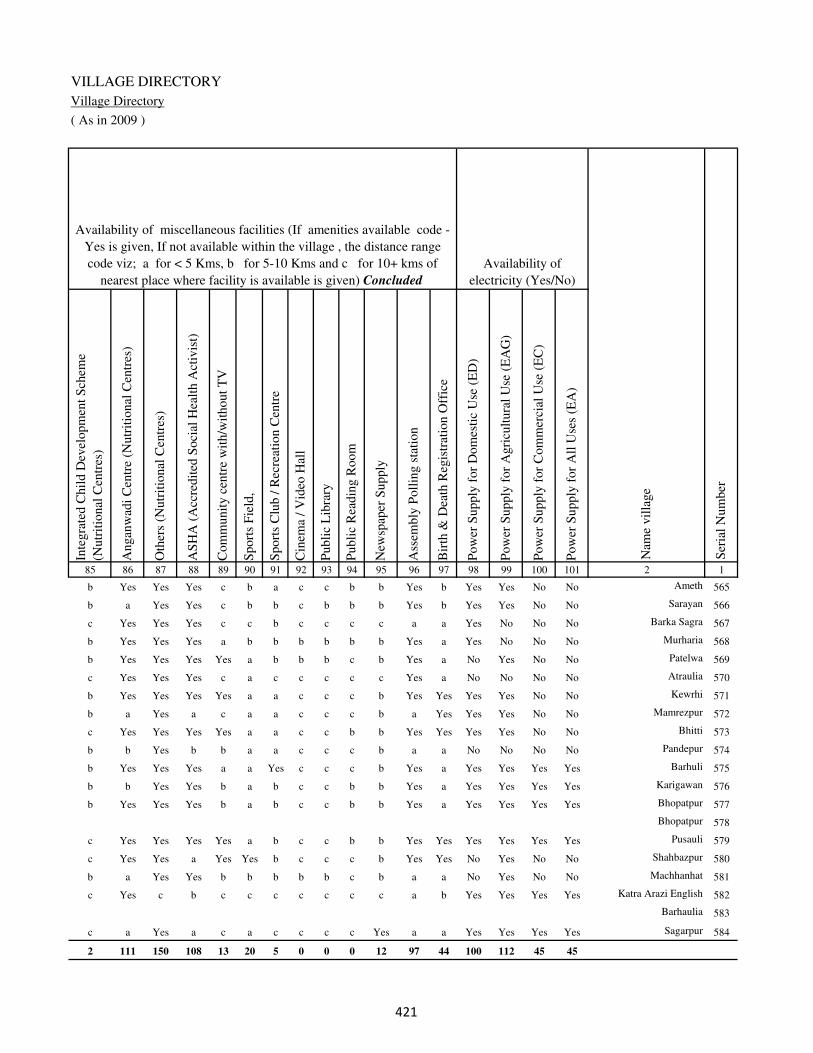
VILLAGE DIRECTORY
Village Directory
( As in 2009 )
Inte
gra
ted C
hil
d D
evel
opm
ent
Sch
eme
(Nutr
itio
nal
Cen
tres
)
Angan
wad
i C
entr
e (N
utr
itio
nal
Cen
tres
)
Oth
ers
(Nutr
itio
nal
Cen
tres
)
AS
HA
(A
ccre
dit
ed S
oci
al H
ealt
h A
ctiv
ist)
Com
munit
y c
entr
e w
ith/w
ithout
TV
Sport
s F
ield
,
Sport
s C
lub /
Rec
reat
ion C
entr
e
Cin
ema
/ V
ideo
Hal
l
Publi
c L
ibra
ry
Publi
c R
eadin
g R
oom
New
spap
er S
upply
Ass
embly
Poll
ing s
tati
on
Bir
th &
Dea
th R
egis
trat
ion O
ffic
e
Pow
er S
upply
for
Dom
esti
c U
se (
ED
)
Pow
er S
upply
for
Agri
cult
ura
l U
se (
EA
G)
Pow
er S
upply
for
Com
mer
cial
Use
(E
C)
Pow
er S
upply
for
All
Use
s (E
A)
85 86 87 88 89 90 91 92 93 94 95 96 97 98 99 100 101 2 1
Availability of
electricity (Yes/No)
Availability of miscellaneous facilities (If amenities available code -
Yes is given, If not available within the village , the distance range
code viz; a for < 5 Kms, b for 5-10 Kms and c for 10+ kms of
nearest place where facility is available is given) Concluded
Nam
e vil
lage
Ser
ial
Num
ber
b Yes Yes Yes c b a c c b b Yes b Yes Yes No No Ameth 565
b a Yes Yes c b b c b b b Yes b Yes Yes No No Sarayan 566
c Yes Yes Yes c c b c c c c a a Yes No No No Barka Sagra 567
b Yes Yes Yes a b b b b b b Yes a Yes No No No Murharia 568
b Yes Yes Yes Yes a b b b c b Yes a No Yes No No Patelwa 569
c Yes Yes Yes c a c c c c c Yes a No No No No Atraulia 570
b Yes Yes Yes Yes a a c c c b Yes Yes Yes Yes No No Kewrhi 571
b a Yes a c a a c c c b a Yes Yes Yes No No Mamrezpur 572
c Yes Yes Yes Yes a a c c b b Yes Yes Yes Yes No No Bhitti 573
b b Yes b b a a c c c b a a No No No No Pandepur 574
b Yes Yes Yes a a Yes c c c b Yes a Yes Yes Yes Yes Barhuli 575
b b Yes Yes b a b c c b b Yes a Yes Yes Yes Yes Karigawan 576
b Yes Yes Yes b a b c c b b Yes a Yes Yes Yes Yes Bhopatpur 577
Bhopatpur 578
c Yes Yes Yes Yes a b c c b b Yes Yes Yes Yes Yes Yes Pusauli 579
c Yes Yes a Yes Yes b c c c b Yes Yes No Yes No No Shahbazpur 580
b a Yes Yes b b b b b c b a a No Yes No No Machhanhat 581
c Yes c b c c c c c c c a b Yes Yes Yes Yes Katra Arazi English 582
Barhaulia 583
c a Yes a c a c c c c Yes a a Yes Yes Yes Yes Sagarpur 584
2 111 150 108 13 20 5 0 0 0 12 97 44 100 112 45 45
��

DISTRICT CENSUS HANDBOOK : KAIMUR (BHABUA)
Census of India 2011-
Amenities and Land use
Nam
e
Dis
tance
ran
ge
code
i.e
. a
fo
r <
5 K
ms,
b
for
5-
10 K
ms
and c
f
or
10+
km
s .
Fore
sts
Are
a under
Non-a
gri
cult
ura
l U
ses
Bar
ren a
nd U
n-c
ult
ivab
le l
and
Per
man
ent
Pas
ture
s an
d O
ther
Gra
zing L
ands
Lan
d U
nder
Mis
cell
aneo
us
Tre
e C
rops
etc.
Cult
ura
ble
Was
te L
and
Fal
low
lan
ds
oth
er t
han
curr
ent
fall
ow
s
Curr
ent
Fal
low
s
1 2 102 103 104 105 106 107 108 109 110 111
Ser
ial
Num
ber
Nam
e vil
lage
Area under different types of land use ( in hectares rounded up to
one decimal place)
Land Use
Nearest Town
565 Ameth BHABUA c 0 26 0 15.2 46 17 0 0
566 Sarayan BHABUA c 0 3 0 0 5 0 0 0
567 Barka Sagra BHABUA c 0 9 0 7 21 0 0 0
568 Murharia BHABUA c 0 0 0 0 2 0 0 0
569 Patelwa BHABUA c 0 6.6 0 0 0 0 0 0
570 Atraulia BHABUA c 0 8 0 6 19 0 0 0
571 Kewrhi BHABUA c 0 3 0 0 5 0 0 0
572 Mamrezpur BHABUA c 0 6 0 0 8 0 0 0
573 Bhitti BHABUA c 0 10 0 8 15 0 0 0
574 Pandepur BHABUA c 0 7 0 5 13 0 0 0
575 Barhuli BHABUA c 0 7 0 6 18 0 0 0
576 Karigawan BHABUA c 0 12 0 10 8 0 0 0
577 Bhopatpur BHABUA c 0 0 0 0 5 0 0 0
578 Bhopatpur 0 9 0 0 0 0 0 0
579 Pusauli BHABUA c 0 20 0 27 16 0 0 0
580 Shahbazpur BHABUA c 0 43.1 0 20 30 0 0 0
581 Machhanhat BHABUA c 0 8.3 0 17.1 28 0 0 0
582 Katra Arazi English BHABUA c 0 0 0 0 7.7 0 0 0
583 Barhaulia 0 4.3 0 0 7.9 0 0 0
584 Sagarpur BHABUA c 0 8 0 11 16 0 0 0
Block T O T A L : 0 0 8 1663.6 57.9 561.1 1227.2 192.2 149.6 39
�
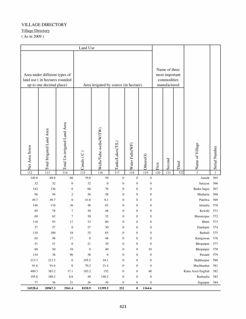
VILLAGE DIRECTORY
Village Directory
( As in 2009 )
Net
Are
a S
ow
n
Tota
l Ir
rigat
ed L
and A
rea
Tota
l U
n-i
rrig
ated
Lan
d A
rea
Can
als
( C
)
Wel
ls/T
ube-
wel
ls(W
/TW
)
Tan
ks/
Lak
es(T
/L)
Wat
er F
alls
(WF
)
Oth
ers(
O)
Fir
st
Sec
ond
Thir
d
112 113 114 115 116 117 118 119 120 121 122 2 1
Ser
ial
Num
ber
Name of three
most important
commodities
manufacturedArea irrigated by source (in hectare).
Nam
e of
Vil
lage
Area under different types of
land use ( in hectares rounded
up to one decimal place)
Land Use
149.8 89.8 60 39.8 50 0 0 0 Ameth 565
32 32 0 32 0 0 0 0 Sarayan 566
142 136 6 60 76 0 0 0 Barka Sagra 567
96 94 2 36 58 0 0 0 Murharia 568
49.7 49.7 0 41.6 8.1 0 0 0 Patelwa 569
146 110 36 48 62 0 0 0 Atraulia 570
85 78 7 30 48 0 0 0 Kewrhi 571
69 62 7 30 32 0 0 0 Mamrezpur 572
110 93 17 33 60 0 0 0 Bhitti 573
57 57 0 27 30 0 0 0 Pandepur 574
118 100 18 35 65 0 0 0 Barhuli 575
65 48 17 0 48 0 0 0 Karigawan 576
51 51 0 21 30 0 0 0 Bhopatpur 577
60 50 10 0 40 0 0 10 Bhopatpur 578
134 38 96 38 0 0 0 0 Pusauli 579
213.3 213.3 0 195.2 18.1 0 0 0 Shahbazpur 580
91.6 91.6 0 70.2 21.4 0 0 0 Machhanhat 581
400.3 383.2 17.1 183.2 152 0 0 48 Katra Arazi English 582
195.8 189.2 6.6 49 140.2 0 0 0 Barhaulia 583
77 56 21 26 30 0 0 0 Sagarpur 584
24528.4 20967.3 3561.4 8150.9 11399.5 252 0 1164.6
�

DISTRICT CENSUS HANDBOOK : KAIMUR (BHABUA)
Census of India 2011-
Amenities and Land use
Pre
-Pri
mar
y s
chool
(PP
)
Pri
mar
y s
chool
(P)
Mid
dle
sch
ool
(M)
Sec
ondar
y S
chool
(S)
Sen
ior
Sec
ondar
y s
chool
(SS
)
Deg
ree
coll
ege
of
arts
sc
ience
& c
om
mer
ce
(AS
C)
Engin
eeri
ng c
oll
ege(
EC
)
Med
ical
coll
ege
(MC
)
Man
agem
ent
inst
itute
(M
I)
Poly
tech
nic
(P
t)
Voca
tional
tra
inin
g s
chool
/IT
I
Non-f
orm
al t
rain
ing c
entr
e (N
FT
C)
Spec
ial
school
for
dis
able
d (
SS
D)
Oth
ers
(spec
ify)
1 2 3 4 5 6 7 8 9 10 11 12 13 14 15 16 17 18 19 20
Loca
tion c
ode
no.
Nam
e vil
lage
Ser
ial
Num
ber
Tota
l popula
tion (
2011 c
ensu
s )
Tota
l ar
ea o
f th
e vil
lage
( in
hec
tare
s ro
unded
up t
o
one
dec
imal
pla
ce)
Number of educational amenities available. (If not available
within the village , the distance range code viz; a for < 5
Kms, b for 5-10 Kms and c for 10+ kms of nearest place
where facility is available is given).
Num
ber
of
house
hold
s (2
011 c
ensu
s)
Name of District:-Kaimur (Bhabua) Location CodeNo:-233
Name of CD Block:-Durgawati Location CodeNo:-0438
585 Jamurni 249509 194 1439 176 b 1 a c b c c c c c c c c
586 Kulharia 249510 424 2367 368 b 1 1 c a c c c c c c c c
587 Larma 249511 201 938 130 b 1 a c b c c c c c c c c
588 Chhajupur 249512 79 200 24 b a a c a c c c c c c c c
589 Chipali 249513 70 401 59 b 1 a c b c c c c c c c c
590 Keshopur 249514 82 255 47 b a a c b c c c c c c c c
591 Khajura 249515 376 6061 926 1 3 3 c b c c c c c c c c
592 Basawanpur 249516 35 19 4 a a a c b c c c c c c c c
593 Niazpur 249517 87 377 62 a a a c b c c c c c c c c
594 Khajura Arazi 249518 29 0 0
595 Bhagwanpur 249519 147 66 6 b a a c b c c c c c c c c
596 Sakhelipur 249520 58 467 65 b a a c b c c c c c c c c
597 Dhan Saray 249521 108 905 110 b 1 a c a c c c c c c c c
598 Pipari 249522 121 540 63 a 1 a c b c c c c c c c c
599 Dharhar 249523 344 1535 231 1 1 1 c b c c c c c c c c
600 Kanhpur 249524 75 904 144 b 1 a c b c c c c c c c c
601 Bilkhori 249525 100 433 66 b 1 a b a c c c c c c c c
602 Harpur Pokhar 249526 66 0 0
603 Baruri 249527 360 1681 253 1 1 1 c a c c c c c c c c
��
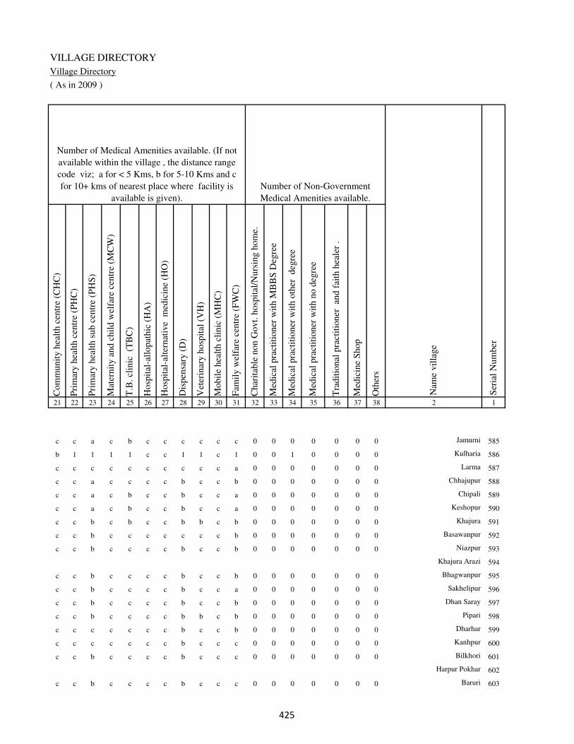
VILLAGE DIRECTORY
Village Directory
( As in 2009 )
Com
munit
y h
ealt
h c
entr
e (C
HC
)
Pri
mar
y h
ealt
h c
entr
e (P
HC
)
Pri
mar
y h
ealt
h s
ub c
entr
e (P
HS
)
Mat
ernit
y a
nd c
hil
d w
elfa
re c
entr
e (M
CW
)
T.B
. cl
inic
(T
BC
)
Hosp
ital
-all
opat
hic
(H
A)
Hosp
ital
-alt
ernat
ive
med
icin
e (H
O)
Dis
pen
sary
(D
)
Vet
erin
ary h
osp
ital
(V
H)
Mobil
e hea
lth c
linic
(M
HC
)
Fam
ily w
elfa
re c
entr
e (F
WC
)
Char
itab
le n
on G
ovt.
hosp
ital
/Nurs
ing h
om
e.
Med
ical
pra
ctit
ioner
wit
h M
BB
S D
egre
e
Med
ical
pra
ctit
ioner
wit
h o
ther
deg
ree
Med
ical
pra
ctit
ioner
wit
h n
o d
egre
e
Tra
dit
ional
pra
ctit
ioner
an
d f
aith
hea
ler
.
Med
icin
e S
hop
Oth
ers
21 22 23 24 25 26 27 28 29 30 31 32 33 34 35 36 37 38 2 1
Number of Non-Government
Medical Amenities available.
Number of Medical Amenities available. (If not
available within the village , the distance range
code viz; a for < 5 Kms, b for 5-10 Kms and c
for 10+ kms of nearest place where facility is
available is given).
Nam
e vil
lage
Ser
ial
Num
ber
c c a c b c c c c c c 0 0 0 0 0 0 0 Jamurni 585
b 1 1 1 1 c c 1 1 c 1 0 0 1 0 0 0 0 Kulharia 586
c c c c c c c c c c a 0 0 0 0 0 0 0 Larma 587
c c a c c c c b c c b 0 0 0 0 0 0 0 Chhajupur 588
c c a c b c c b c c a 0 0 0 0 0 0 0 Chipali 589
c c a c b c c b c c a 0 0 0 0 0 0 0 Keshopur 590
c c b c b c c b b c b 0 0 0 0 0 0 0 Khajura 591
c c b c c c c c c c b 0 0 0 0 0 0 0 Basawanpur 592
c c b c c c c b c c b 0 0 0 0 0 0 0 Niazpur 593
Khajura Arazi 594
c c b c c c c b c c b 0 0 0 0 0 0 0 Bhagwanpur 595
c c b c c c c b c c a 0 0 0 0 0 0 0 Sakhelipur 596
c c b c c c c b c c b 0 0 0 0 0 0 0 Dhan Saray 597
c c b c c c c b b c b 0 0 0 0 0 0 0 Pipari 598
c c c c c c c b c c b 0 0 0 0 0 0 0 Dharhar 599
c c c c c c c b c c c 0 0 0 0 0 0 0 Kanhpur 600
c c b c c c c b c c c 0 0 0 0 0 0 0 Bilkhori 601
Harpur Pokhar 602
c c b c c c c b c c c 0 0 0 0 0 0 0 Baruri 603
��

DISTRICT CENSUS HANDBOOK : KAIMUR (BHABUA)
Census of India 2011-
Amenities and Land use
Tap
wat
er (
Tre
ated
/Untr
eate
d)
Wel
l w
ater
(Cover
ed /
Unco
ver
ed w
ell)
Han
d P
um
p
Tube
wel
ls /
Bore
wel
l
Spri
ng
Riv
er /
Can
al
Tan
k /
Pond /
L
ake
Oth
ers
Com
munit
y t
oil
et i
ncl
udin
g
bat
h.
Com
munit
y t
oil
et e
xcl
udin
g b
ath.
Rura
l s
anit
ary m
art
or
sanit
ary
har
dw
are
outl
et
avai
lable
nea
r th
e vil
lage.
Com
munit
y b
io-
gas
or
recy
cle
of
was
te f
or
pro
duct
ive
use
.
1 2 39 40 41 42 43 44 45 46 47 48 49 50
Availability of toilet & others
Yes / No Availability of drinking water - Yes / No
Nam
e vil
lage
Ser
ial
Num
ber
585 Jamurni No Yes Yes No No No No No No No No No
586 Kulharia No Yes Yes No No No No No No No No No
587 Larma No Yes Yes No No Yes No No No No No No
588 Chhajupur No Yes Yes No No No No No No No No No
589 Chipali No Yes Yes No No No No No No No No No
590 Keshopur No Yes Yes No No No No No No No No No
591 Khajura No Yes Yes No No Yes No No No No No No
592 Basawanpur No Yes Yes No No Yes No No No No No No
593 Niazpur No Yes Yes No No Yes No No No No No No
594 Khajura Arazi
595 Bhagwanpur No Yes Yes No No Yes No No No No No No
596 Sakhelipur No Yes Yes No No Yes No No No No No No
597 Dhan Saray No Yes Yes No No No No No No No No No
598 Pipari No Yes Yes No No No No No Yes No No No
599 Dharhar No Yes Yes No No No Yes No No No No No
600 Kanhpur No Yes Yes No No Yes No No No No No No
601 Bilkhori No Yes Yes No No Yes No No No No No No
602 Harpur Pokhar
603 Baruri No Yes Yes No No Yes No No No No No No
��
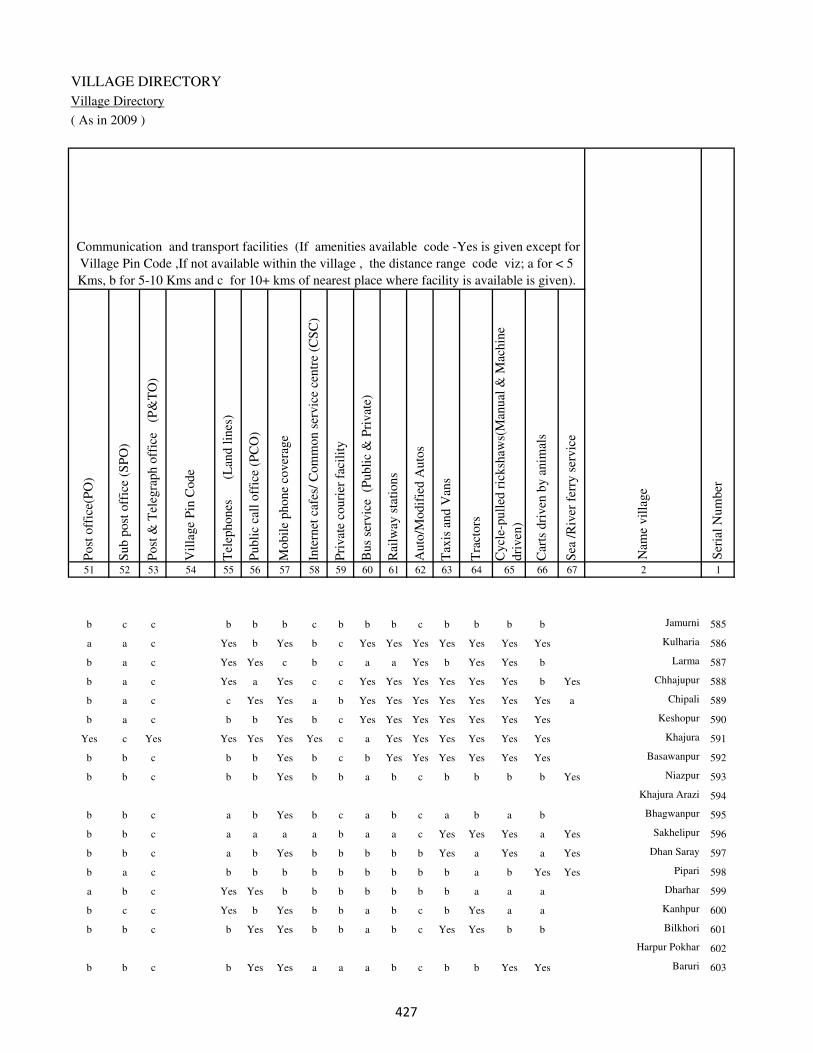
VILLAGE DIRECTORY
Village Directory
( As in 2009 )
Post
off
ice(
PO
)
Sub p
ost
off
ice
(SP
O)
Post
& T
eleg
raph o
ffic
e
(P&
TO
)
Vil
lage
Pin
Code
Tel
ephones
(L
and l
ines
)
Publi
c ca
ll o
ffic
e (P
CO
)
Mobil
e phone
cover
age
Inte
rnet
caf
es/
Com
mon s
ervic
e ce
ntr
e (C
SC
)
Pri
vat
e co
uri
er f
acil
ity
Bus
serv
ice
(P
ubli
c &
Pri
vat
e)
Rai
lway
sta
tions
Auto
/Modif
ied A
uto
s
Tax
is a
nd V
ans
Tra
ctors
Cycl
e-pull
ed r
icksh
aws(
Man
ual
& M
achin
e
dri
ven
)
Car
ts d
riven
by a
nim
als
Sea
/R
iver
fer
ry s
ervic
e51 52 53 54 55 56 57 58 59 60 61 62 63 64 65 66 67 2 1
Communication and transport facilities (If amenities available code -Yes is given except for
Village Pin Code ,If not available within the village , the distance range code viz; a for < 5
Kms, b for 5-10 Kms and c for 10+ kms of nearest place where facility is available is given).
Ser
ial
Num
ber
Nam
e vil
lage
b c c b b b c b b b c b b b b Jamurni 585
a a c Yes b Yes b c Yes Yes Yes Yes Yes Yes Yes Kulharia 586
b a c Yes Yes c b c a a Yes b Yes Yes b Larma 587
b a c Yes a Yes c c Yes Yes Yes Yes Yes Yes b Yes Chhajupur 588
b a c c Yes Yes a b Yes Yes Yes Yes Yes Yes Yes a Chipali 589
b a c b b Yes b c Yes Yes Yes Yes Yes Yes Yes Keshopur 590
Yes c Yes Yes Yes Yes Yes c a Yes Yes Yes Yes Yes Yes Khajura 591
b b c b b Yes b c b Yes Yes Yes Yes Yes Yes Basawanpur 592
b b c b b Yes b b a b c b b b b Yes Niazpur 593
Khajura Arazi 594
b b c a b Yes b c a b c a b a b Bhagwanpur 595
b b c a a a a b a a c Yes Yes Yes a Yes Sakhelipur 596
b b c a b Yes b b b b b Yes a Yes a Yes Dhan Saray 597
b a c b b b b b b b b b a b Yes Yes Pipari 598
a b c Yes Yes b b b b b b b a a a Dharhar 599
b c c Yes b Yes b b a b c b Yes a a Kanhpur 600
b b c b Yes Yes b b a b c Yes Yes b b Bilkhori 601
Harpur Pokhar 602
b b c b Yes Yes a a a b c b b Yes Yes Baruri 603
��

DISTRICT CENSUS HANDBOOK : KAIMUR (BHABUA)
Census of India 2011-
Amenities and Land use
Connec
ted t
o n
atio
nal
hig
hw
ay(N
H)
Connec
ted t
o s
tate
hig
hw
ay(S
H)
Connec
ted t
o m
ajor
dis
tric
t ro
ad (
MD
R)
Connec
ted t
o o
ther
s dis
tric
t ro
ad
Pucc
a r
oad
s
Kutc
hch
a r
oad
s
Wat
er b
ounded
mac
adam
(WB
M)
road
s
Nav
igab
le w
ater
way
(ri
ver
/can
al)(
NW
)
Footp
aths
(FP
)
Com
mer
cial
& C
o-o
per
ativ
e B
anks
AT
M
Agri
cult
ura
l C
redit
Soci
etie
s
Sel
f-H
elp G
roup (
SH
G)
Publi
c dis
trib
uti
on s
yst
em (
PD
S)
shop
Man
dis
/ R
egula
r m
arket
Wee
kly
Haa
t
Agri
cult
ura
l m
arket
ing s
oci
ety
1 2 68 69 70 71 72 73 74 75 76 77 78 79 80 81 82 83 84
Village connected to highways,village roads, banks & credit
societies (If amenities available code -Yes is given, If not
available within the village , the distance range code viz; a
for < 5 Kms, b for 5-10 Kms and c for 10+ kms of nearest
place where facility is available is given).
Ser
ial
Num
ber
Nam
e vil
lage
Availability of miscellaneous
facilities (If amenities available
code -Yes is given, If not
available within the village , the
distance range code viz; a for <
5 Kms, b for 5-10 Kms and c
for 10+ kms of nearest place
where facility is available is
given) Contd....
585 Jamurni b b a b a a a b Yes a c b b b c b c
586 Kulharia Yes a a a Yes a a a Yes a c b b b b b c
587 Larma a a Yes Yes b Yes a a Yes a c b b a b b b
588 Chhajupur Yes b Yes b Yes Yes Yes Yes Yes a c c b b b b b
589 Chipali Yes Yes Yes Yes Yes Yes Yes a Yes a c c b b b c b
590 Keshopur Yes a Yes b Yes Yes a a Yes a c c b a b c b
591 Khajura Yes a a a Yes a a a Yes Yes c c Yes Yes b b b
592 Basawanpur b a Yes b b a Yes b Yes b c c b b b b b
593 Niazpur b b Yes b a Yes a Yes Yes b c c b a c b c
594 Khajura Arazi
595 Bhagwanpur b b Yes b b Yes a a Yes b c c b a c b c
596 Sakhelipur b b Yes b b Yes a Yes Yes a c b b a b b c
597 Dhan Saray b a b Yes b Yes Yes Yes Yes b c b b b b c c
598 Pipari a a Yes a Yes a Yes Yes Yes a c b b b b c c
599 Dharhar b b a Yes a Yes Yes b Yes b c b Yes Yes b b c
600 Kanhpur b a b b b a Yes a Yes b c b b b b b c
601 Bilkhori b b Yes b b Yes Yes b Yes b c b b b c b c
602 Harpur Pokhar
603 Baruri b b Yes b b Yes a b Yes b c b Yes b b b c
��
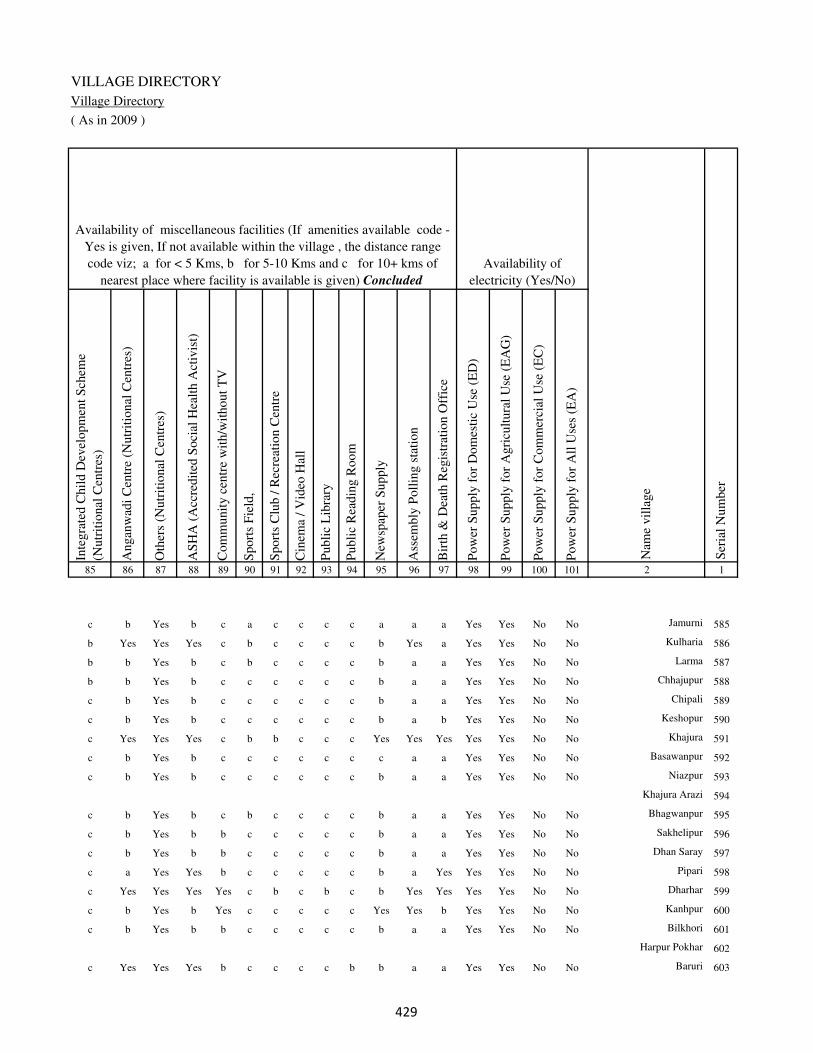
VILLAGE DIRECTORY
Village Directory
( As in 2009 )
Inte
gra
ted C
hil
d D
evel
opm
ent
Sch
eme
(Nutr
itio
nal
Cen
tres
)
Angan
wad
i C
entr
e (N
utr
itio
nal
Cen
tres
)
Oth
ers
(Nutr
itio
nal
Cen
tres
)
AS
HA
(A
ccre
dit
ed S
oci
al H
ealt
h A
ctiv
ist)
Com
munit
y c
entr
e w
ith/w
ithout
TV
Sport
s F
ield
,
Sport
s C
lub /
Rec
reat
ion C
entr
e
Cin
ema
/ V
ideo
Hal
l
Publi
c L
ibra
ry
Publi
c R
eadin
g R
oom
New
spap
er S
upply
Ass
embly
Poll
ing s
tati
on
Bir
th &
Dea
th R
egis
trat
ion O
ffic
e
Pow
er S
upply
for
Dom
esti
c U
se (
ED
)
Pow
er S
upply
for
Agri
cult
ura
l U
se (
EA
G)
Pow
er S
upply
for
Com
mer
cial
Use
(E
C)
Pow
er S
upply
for
All
Use
s (E
A)
85 86 87 88 89 90 91 92 93 94 95 96 97 98 99 100 101 2 1
Availability of
electricity (Yes/No)
Availability of miscellaneous facilities (If amenities available code -
Yes is given, If not available within the village , the distance range
code viz; a for < 5 Kms, b for 5-10 Kms and c for 10+ kms of
nearest place where facility is available is given) Concluded
Nam
e vil
lage
Ser
ial
Num
ber
c b Yes b c a c c c c a a a Yes Yes No No Jamurni 585
b Yes Yes Yes c b c c c c b Yes a Yes Yes No No Kulharia 586
b b Yes b c b c c c c b a a Yes Yes No No Larma 587
b b Yes b c c c c c c b a a Yes Yes No No Chhajupur 588
c b Yes b c c c c c c b a a Yes Yes No No Chipali 589
c b Yes b c c c c c c b a b Yes Yes No No Keshopur 590
c Yes Yes Yes c b b c c c Yes Yes Yes Yes Yes No No Khajura 591
c b Yes b c c c c c c c a a Yes Yes No No Basawanpur 592
c b Yes b c c c c c c b a a Yes Yes No No Niazpur 593
Khajura Arazi 594
c b Yes b c b c c c c b a a Yes Yes No No Bhagwanpur 595
c b Yes b b c c c c c b a a Yes Yes No No Sakhelipur 596
c b Yes b b c c c c c b a a Yes Yes No No Dhan Saray 597
c a Yes Yes b c c c c c b a Yes Yes Yes No No Pipari 598
c Yes Yes Yes Yes c b c b c b Yes Yes Yes Yes No No Dharhar 599
c b Yes b Yes c c c c c Yes Yes b Yes Yes No No Kanhpur 600
c b Yes b b c c c c c b a a Yes Yes No No Bilkhori 601
Harpur Pokhar 602
c Yes Yes Yes b c c c c b b a a Yes Yes No No Baruri 603
��

DISTRICT CENSUS HANDBOOK : KAIMUR (BHABUA)
Census of India 2011-
Amenities and Land use
Nam
e
Dis
tance
ran
ge
code
i.e
. a
fo
r <
5 K
ms,
b
for
5-
10 K
ms
and c
f
or
10+
km
s .
Fore
sts
Are
a under
Non-a
gri
cult
ura
l U
ses
Bar
ren a
nd U
n-c
ult
ivab
le l
and
Per
man
ent
Pas
ture
s an
d O
ther
Gra
zing L
ands
Lan
d U
nder
Mis
cell
aneo
us
Tre
e C
rops
etc.
Cult
ura
ble
Was
te L
and
Fal
low
lan
ds
oth
er t
han
curr
ent
fall
ow
s
Curr
ent
Fal
low
s
1 2 102 103 104 105 106 107 108 109 110 111
Ser
ial
Num
ber
Nam
e vil
lage
Area under different types of land use ( in hectares rounded up to
one decimal place)
Land Use
Nearest Town
585 Jamurni BHABUA c 0 17.3 0 0 8.5 0 0 6.2
586 Kulharia BHABUA c 0 74.6 0 0 17.4 0 0 7.5
587 Larma BHABUA c 0 15.2 0 0 7.6 0 0 3.8
588 Chhajupur BHABUA c 0 9 0 0 0 0 0 0
589 Chipali BHABUA c 0 8.8 0 0 0 0 1.1 0
590 Keshopur BHABUA c 0 6.5 0 0 0.6 0 1 0
591 Khajura BHABUA c 0 71.3 0 0 11.9 0 0 0
592 Basawanpur BHABUA c 0 0.5 0 0 0 0 0 0
593 Niazpur BHABUA c 0 6.5 0 0 2.2 0 1.9 0
594 Khajura Arazi 0 1 0 0 0 0 0.8 0
595 Bhagwanpur BHABUA c 0 11 0 0 2.5 0 0 0
596 Sakhelipur BHABUA c 0 7.5 0 0 2.4 0 0.8 0
597 Dhan Saray BHABUA c 0 12 0 0.8 1.2 0 0 0
598 Pipari BHABUA c 0 25.5 0 0 0 0 1 0
599 Dharhar BHABUA c 0 41.5 0 0 0.8 0 1.2 0
600 Kanhpur BHABUA c 0 9.2 0 2 3 0 0 1.5
601 Bilkhori BHABUA c 0 12.5 0 0 1.5 0 0.8 0
602 Harpur Pokhar 0 1.1 0 0 0 0 0.9 0
603 Baruri BHABUA c 0 22.6 0 0 0 0 0 0
��

VILLAGE DIRECTORY
Village Directory
( As in 2009 )
Net
Are
a S
ow
n
Tota
l Ir
rigat
ed L
and A
rea
Tota
l U
n-i
rrig
ated
Lan
d A
rea
Can
als
( C
)
Wel
ls/T
ube-
wel
ls(W
/TW
)
Tan
ks/
Lak
es(T
/L)
Wat
er F
alls
(WF
)
Oth
ers(
O)
Fir
st
Sec
ond
Thir
d
112 113 114 115 116 117 118 119 120 121 122 2 1
Ser
ial
Num
ber
Name of three
most important
commodities
manufacturedArea irrigated by source (in hectare).
Nam
e of
Vil
lage
Area under different types of
land use ( in hectares rounded
up to one decimal place)
Land Use
162 162 0 162 0 0 0 0 Jamurni 585
324.5 320 4.5 281.2 38.8 0 0 0 Kulharia 586
174.4 174.4 0 164.9 0 9.5 0 0 Larma 587
70 60 10 0 50 0 0 10 Chhajupur 588
60.1 41.1 19 0 41.1 0 0 0 Chipali 589
73.9 45.6 28.3 0 45.6 0 0 0 Keshopur 590
292.8 288.5 4.3 240 48.5 0 0 0 Khajura 591
34.5 34.5 0 6.2 28.3 0 0 0 Basawanpur 592
76.4 39.6 36.8 0 39.6 0 0 0 Niazpur 593
27.2 26.8 0.4 26.8 0 0 0 0 Khajura Arazi 594
133.5 132.3 1.2 93.1 39.2 0 0 0 Bhagwanpur 595
47.3 45.4 1.9 25.2 20.2 0 0 0 Sakhelipur 596
94 79.5 14.5 35.5 44 0 0 0 Dhan Saray 597
94.5 86.5 8 56 30.5 0 0 0 Pipari 598
300.5 300.5 0 180 120.5 0 0 0 Dharhar 599
59.3 32.5 26.8 0 32.5 0 0 0 Kanhpur 600
85.2 85.2 0 0 85.2 0 0 0 Bilkhori 601
64 40.8 23.2 0 40.8 0 0 0 Harpur Pokhar 602
337.4 217.4 120 0 190.5 0 26.9 0 Baruri 603
��

DISTRICT CENSUS HANDBOOK : KAIMUR (BHABUA)
Census of India 2011-
Amenities and Land use
Pre
-Pri
mar
y s
chool
(PP
)
Pri
mar
y s
chool
(P)
Mid
dle
sch
ool
(M)
Sec
ondar
y S
chool
(S)
Sen
ior
Sec
ondar
y s
chool
(SS
)
Deg
ree
coll
ege
of
arts
sc
ience
& c
om
mer
ce
(AS
C)
Engin
eeri
ng c
oll
ege(
EC
)
Med
ical
coll
ege
(MC
)
Man
agem
ent
inst
itute
(M
I)
Poly
tech
nic
(P
t)
Voca
tional
tra
inin
g s
chool
/IT
I
Non-f
orm
al t
rain
ing c
entr
e (N
FT
C)
Spec
ial
school
for
dis
able
d (
SS
D)
Oth
ers
(spec
ify)
1 2 3 4 5 6 7 8 9 10 11 12 13 14 15 16 17 18 19 20
Loca
tion c
ode
no.
Nam
e vil
lage
Ser
ial
Num
ber
Tota
l popula
tion (
2011 c
ensu
s )
Tota
l ar
ea o
f th
e vil
lage
( in
hec
tare
s ro
unded
up t
o
one
dec
imal
pla
ce)
Number of educational amenities available. (If not available
within the village , the distance range code viz; a for < 5
Kms, b for 5-10 Kms and c for 10+ kms of nearest place
where facility is available is given).
Num
ber
of
house
hold
s (2
011 c
ensu
s)
604 Harballabhpur 249528 91 655 109 1 1 a c b c c c c c c c c
605 Chhawan 249529 280 2105 327 a 1 1 1 1 c c c c c c c c
606 Dharahra 249530 57 0 0
607 Pokhra 249531 57 0 0
608 Kurari 249532 504 1907 285 a 1 a c b c c c c c c c c
609 Bhanpur 249533 127 1094 135 b 1 a c a c c c c c c c c
610 Bheria 249534 477 1974 286 b 1 1 c b c c c c c c c c
611 Raghunathpur 249535 50 204 20 b b b c b c c c c c c c c b
612 Madhura 249536 65 740 111 1 1 a a a c c c c c c c c
613 Shohpur 249537 128 764 111 1 1 a a b c c c c c c c c
614 Shudhia 249538 142 488 68 a 1 a a b c c c c c c c c
615 Manipur 249539 30 236 42 b a a a b c c c c c c c c
616 Ruia 249540 195 600 94 b 1 a a a c c c c c c c c
617 Ishipur 249541 137 673 114 1 1 a a a c c c c c c c c
618 Gorar 249542 199 1515 207 1 a a b a c c c c c c c c
619 Machhanhata 249543 180 613 88 a 1 a b b c c c c c c c c
620 Gosaisipur 249544 74 523 64 a 1 a a b c c c c c c c c
621 Kusharia 249545 182 772 102 b b b b b c c c c c c c c b
622 Isari 249546 297 1257 201 b 1 a a b c c c c c c c c
623 Ashoga 249547 170 1301 185 b 1 a a b c c c c c c c c
624 Manikpur Doghara 249548 38 485 87 b 1 a a b c c c c c c c c
�

VILLAGE DIRECTORY
Village Directory
( As in 2009 )
Com
munit
y h
ealt
h c
entr
e (C
HC
)
Pri
mar
y h
ealt
h c
entr
e (P
HC
)
Pri
mar
y h
ealt
h s
ub c
entr
e (P
HS
)
Mat
ernit
y a
nd c
hil
d w
elfa
re c
entr
e (M
CW
)
T.B
. cl
inic
(T
BC
)
Hosp
ital
-all
opat
hic
(H
A)
Hosp
ital
-alt
ernat
ive
med
icin
e (H
O)
Dis
pen
sary
(D
)
Vet
erin
ary h
osp
ital
(V
H)
Mobil
e hea
lth c
linic
(M
HC
)
Fam
ily w
elfa
re c
entr
e (F
WC
)
Char
itab
le n
on G
ovt.
hosp
ital
/Nurs
ing h
om
e.
Med
ical
pra
ctit
ioner
wit
h M
BB
S D
egre
e
Med
ical
pra
ctit
ioner
wit
h o
ther
deg
ree
Med
ical
pra
ctit
ioner
wit
h n
o d
egre
e
Tra
dit
ional
pra
ctit
ioner
an
d f
aith
hea
ler
.
Med
icin
e S
hop
Oth
ers
21 22 23 24 25 26 27 28 29 30 31 32 33 34 35 36 37 38 2 1
Number of Non-Government
Medical Amenities available.
Number of Medical Amenities available. (If not
available within the village , the distance range
code viz; a for < 5 Kms, b for 5-10 Kms and c
for 10+ kms of nearest place where facility is
available is given).
Nam
e vil
lage
Ser
ial
Num
ber
c c b c c c c b c c b 0 0 0 0 0 0 0 Harballabhpur 604
c c b c c c c b b c b 0 0 0 0 0 0 0 Chhawan 605
Dharahra 606
Pokhra 607
c c c c c c c b c c b 0 0 0 0 0 0 0 Kurari 608
c c b c c c c b c c a 0 0 0 0 0 0 0 Bhanpur 609
c c a c b c c b c c b 0 0 0 0 0 0 0 Bheria 610
b b b b b c c b b c b 0 0 0 0 0 0 0 Raghunathpur 611
c c b c c c c b c c b 0 0 0 0 0 0 0 Madhura 612
c c b c c c c b c c b 0 0 0 0 0 0 0 Shohpur 613
c c b c c c c b b c b 0 0 0 0 0 0 0 Shudhia 614
c c a c c c c b c c b 0 0 0 0 0 0 0 Manipur 615
a a a a a c c b c c b 0 0 0 0 0 0 0 Ruia 616
b b b b b c c b c c b 0 0 0 0 0 0 0 Ishipur 617
b b b b b c c b b c b 0 0 0 0 0 0 0 Gorar 618
c b b b b c c b b c b 0 0 0 0 0 0 0 Machhanhata 619
c b b b b c c c b c b 0 0 0 0 0 0 0 Gosaisipur 620
b b b b b c c b b c b 0 0 0 0 0 0 0 Kusharia 621
b b b b b c c b b c b 0 0 0 0 0 0 0 Isari 622
b b b b b c c b b c b 0 0 0 0 0 0 0 Ashoga 623
b a b a a c c b a c a 0 0 0 0 0 0 0 Manikpur Doghara 624
�
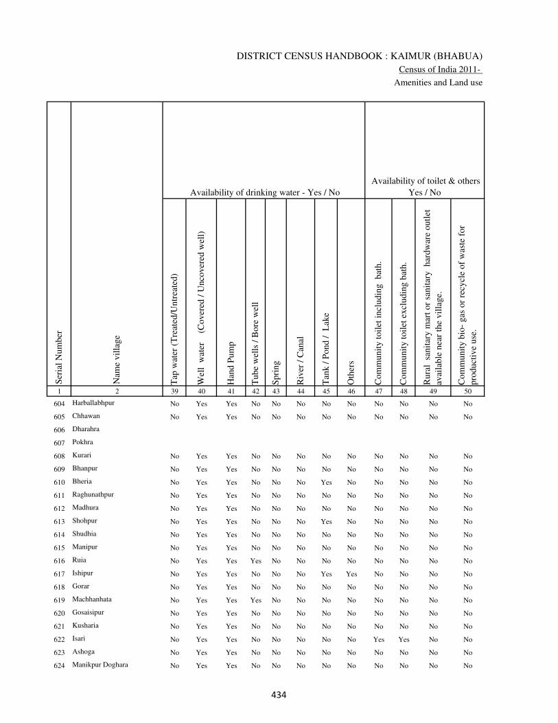
DISTRICT CENSUS HANDBOOK : KAIMUR (BHABUA)
Census of India 2011-
Amenities and Land use
Tap
wat
er (
Tre
ated
/Untr
eate
d)
Wel
l w
ater
(Cover
ed /
Unco
ver
ed w
ell)
Han
d P
um
p
Tube
wel
ls /
Bore
wel
l
Spri
ng
Riv
er /
Can
al
Tan
k /
Pond /
L
ake
Oth
ers
Com
munit
y t
oil
et i
ncl
udin
g
bat
h.
Com
munit
y t
oil
et e
xcl
udin
g b
ath.
Rura
l s
anit
ary m
art
or
sanit
ary
har
dw
are
outl
et
avai
lable
nea
r th
e vil
lage.
Com
munit
y b
io-
gas
or
recy
cle
of
was
te f
or
pro
duct
ive
use
.
1 2 39 40 41 42 43 44 45 46 47 48 49 50
Availability of toilet & others
Yes / No Availability of drinking water - Yes / No
Nam
e vil
lage
Ser
ial
Num
ber
604 Harballabhpur No Yes Yes No No No No No No No No No
605 Chhawan No Yes Yes No No No No No No No No No
606 Dharahra
607 Pokhra
608 Kurari No Yes Yes No No No No No No No No No
609 Bhanpur No Yes Yes No No No No No No No No No
610 Bheria No Yes Yes No No No Yes No No No No No
611 Raghunathpur No Yes Yes No No No No No No No No No
612 Madhura No Yes Yes No No No No No No No No No
613 Shohpur No Yes Yes No No No Yes No No No No No
614 Shudhia No Yes Yes No No No No No No No No No
615 Manipur No Yes Yes No No No No No No No No No
616 Ruia No Yes Yes Yes No No No No No No No No
617 Ishipur No Yes Yes No No No Yes Yes No No No No
618 Gorar No Yes Yes No No No No No No No No No
619 Machhanhata No Yes Yes Yes No No No No No No No No
620 Gosaisipur No Yes Yes No No No No No No No No No
621 Kusharia No Yes Yes No No No No No No No No No
622 Isari No Yes Yes No No No No No Yes Yes No No
623 Ashoga No Yes Yes No No No No No No No No No
624 Manikpur Doghara No Yes Yes No No No No No No No No No
��
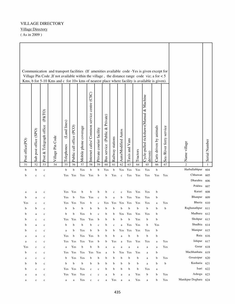
VILLAGE DIRECTORY
Village Directory
( As in 2009 )
Post
off
ice(
PO
)
Sub p
ost
off
ice
(SP
O)
Post
& T
eleg
raph o
ffic
e
(P&
TO
)
Vil
lage
Pin
Code
Tel
ephones
(L
and l
ines
)
Publi
c ca
ll o
ffic
e (P
CO
)
Mobil
e phone
cover
age
Inte
rnet
caf
es/
Com
mon s
ervic
e ce
ntr
e (C
SC
)
Pri
vat
e co
uri
er f
acil
ity
Bus
serv
ice
(P
ubli
c &
Pri
vat
e)
Rai
lway
sta
tions
Auto
/Modif
ied A
uto
s
Tax
is a
nd V
ans
Tra
ctors
Cycl
e-pull
ed r
icksh
aws(
Man
ual
& M
achin
e
dri
ven
)
Car
ts d
riven
by a
nim
als
Sea
/R
iver
fer
ry s
ervic
e51 52 53 54 55 56 57 58 59 60 61 62 63 64 65 66 67 2 1
Communication and transport facilities (If amenities available code -Yes is given except for
Village Pin Code ,If not available within the village , the distance range code viz; a for < 5
Kms, b for 5-10 Kms and c for 10+ kms of nearest place where facility is available is given).
Ser
ial
Num
ber
Nam
e vil
lage
b b c b b Yes b b Yes b Yes Yes Yes Yes b Harballabhpur 604
b c c Yes Yes Yes Yes b b Yes c Yes Yes Yes Yes Yes Chhawan 605
Dharahra 606
Pokhra 607
a a c Yes Yes b b b b c c Yes Yes Yes b Kurari 608
b a c Yes b Yes Yes c b a b Yes Yes Yes b Bhanpur 609
Yes c c Yes Yes Yes b c Yes Yes Yes Yes Yes Yes a Yes Bheria 610
b b c b b b b b b b b b b b b b Raghunathpur 611
b a c b b Yes b c b b Yes Yes Yes Yes b Madhura 612
b c c Yes Yes Yes Yes b b b b b Yes b b Shohpur 613
b a c b b b b c b c a Yes Yes b Yes Shudhia 614
b c c a b Yes b b b b Yes Yes Yes Yes b Manipur 615
a a c Yes b Yes Yes b b b a b b b b Ruia 616
a c c Yes Yes Yes Yes b b Yes a Yes Yes Yes a Yes Ishipur 617
Yes c c a Yes b b b a a a a a a a Yes Gorar 618
b c c Yes Yes Yes Yes Yes a b Yes Yes Yes a b Machhanhata 619
a c c b Yes Yes b b b b b b b a b Yes Gosaisipur 620
b b c b b b b b b b b b b a b b Kusharia 621
b c c Yes Yes Yes c c b b b b b Yes a Isari 622
a a c Yes Yes Yes c c a b a a Yes b b Yes Ashoga 623
a c c a a Yes c c a Yes a a Yes a b Yes Manikpur Doghara 624
��

DISTRICT CENSUS HANDBOOK : KAIMUR (BHABUA)
Census of India 2011-
Amenities and Land use
Connec
ted t
o n
atio
nal
hig
hw
ay(N
H)
Connec
ted t
o s
tate
hig
hw
ay(S
H)
Connec
ted t
o m
ajor
dis
tric
t ro
ad (
MD
R)
Connec
ted t
o o
ther
s dis
tric
t ro
ad
Pucc
a r
oad
s
Kutc
hch
a r
oad
s
Wat
er b
ounded
mac
adam
(WB
M)
road
s
Nav
igab
le w
ater
way
(ri
ver
/can
al)(
NW
)
Footp
aths
(FP
)
Com
mer
cial
& C
o-o
per
ativ
e B
anks
AT
M
Agri
cult
ura
l C
redit
Soci
etie
s
Sel
f-H
elp G
roup (
SH
G)
Publi
c dis
trib
uti
on s
yst
em (
PD
S)
shop
Man
dis
/ R
egula
r m
arket
Wee
kly
Haa
t
Agri
cult
ura
l m
arket
ing s
oci
ety
1 2 68 69 70 71 72 73 74 75 76 77 78 79 80 81 82 83 84
Village connected to highways,village roads, banks & credit
societies (If amenities available code -Yes is given, If not
available within the village , the distance range code viz; a
for < 5 Kms, b for 5-10 Kms and c for 10+ kms of nearest
place where facility is available is given).
Ser
ial
Num
ber
Nam
e vil
lage
Availability of miscellaneous
facilities (If amenities available
code -Yes is given, If not
available within the village , the
distance range code viz; a for <
5 Kms, b for 5-10 Kms and c
for 10+ kms of nearest place
where facility is available is
given) Contd....
604 Harballabhpur b Yes Yes b Yes Yes b b Yes b c c b a b c c
605 Chhawan Yes Yes a a Yes a Yes Yes Yes b c c Yes b b c c
606 Dharahra
607 Pokhra
608 Kurari a b Yes Yes Yes Yes a a Yes a c c Yes b c c c
609 Bhanpur a b Yes Yes Yes a a a Yes a c c b b c c c
610 Bheria a b a b Yes Yes Yes Yes Yes b c b b b b b c
611 Raghunathpur b b b b a Yes a b Yes b b b b b b b c
612 Madhura a c Yes b Yes a a b Yes b c c c b b c c
613 Shohpur b b Yes b a a a b Yes b c c b b b c b
614 Shudhia b b Yes b b Yes b b Yes b c b c b c c b
615 Manipur b b Yes b b Yes b b Yes b c b b b c b c
616 Ruia a b Yes b b Yes a a Yes b c b Yes c b b b
617 Ishipur Yes a b b Yes Yes Yes Yes Yes b c b b b b b c
618 Gorar a Yes Yes Yes Yes Yes Yes Yes Yes a c b Yes c b b c
619 Machhanhata b b b b Yes Yes Yes b Yes b c b b b b c c
620 Gosaisipur a a a a a Yes Yes Yes Yes a c a Yes Yes b c c
621 Kusharia b a a b a Yes a b Yes b c b b b b c b
622 Isari b b b b b Yes Yes b Yes b c b Yes a b c b
623 Ashoga a b b b b Yes Yes Yes Yes a c b b b b c b
624 Manikpur Doghara a b b b b Yes Yes Yes Yes b c c b b b b c
��

VILLAGE DIRECTORY
Village Directory
( As in 2009 )
Inte
gra
ted C
hil
d D
evel
opm
ent
Sch
eme
(Nutr
itio
nal
Cen
tres
)
Angan
wad
i C
entr
e (N
utr
itio
nal
Cen
tres
)
Oth
ers
(Nutr
itio
nal
Cen
tres
)
AS
HA
(A
ccre
dit
ed S
oci
al H
ealt
h A
ctiv
ist)
Com
munit
y c
entr
e w
ith/w
ithout
TV
Sport
s F
ield
,
Sport
s C
lub /
Rec
reat
ion C
entr
e
Cin
ema
/ V
ideo
Hal
l
Publi
c L
ibra
ry
Publi
c R
eadin
g R
oom
New
spap
er S
upply
Ass
embly
Poll
ing s
tati
on
Bir
th &
Dea
th R
egis
trat
ion O
ffic
e
Pow
er S
upply
for
Dom
esti
c U
se (
ED
)
Pow
er S
upply
for
Agri
cult
ura
l U
se (
EA
G)
Pow
er S
upply
for
Com
mer
cial
Use
(E
C)
Pow
er S
upply
for
All
Use
s (E
A)
85 86 87 88 89 90 91 92 93 94 95 96 97 98 99 100 101 2 1
Availability of
electricity (Yes/No)
Availability of miscellaneous facilities (If amenities available code -
Yes is given, If not available within the village , the distance range
code viz; a for < 5 Kms, b for 5-10 Kms and c for 10+ kms of
nearest place where facility is available is given) Concluded
Nam
e vil
lage
Ser
ial
Num
ber
c b Yes Yes b b c c c c b Yes a Yes Yes No No Harballabhpur 604
c Yes Yes Yes b c c c c c b Yes Yes Yes Yes No No Chhawan 605
Dharahra 606
Pokhra 607
c Yes Yes a b c c c c c b Yes Yes Yes Yes No No Kurari 608
c b Yes b c c c c c c b a a Yes Yes Yes Yes Bhanpur 609
c Yes Yes Yes c c c c c c b a b Yes Yes No No Bheria 610
c Yes Yes Yes c b c c c c b a b No No No No Raghunathpur 611
c b Yes a b Yes c c c b b Yes b Yes Yes No No Madhura 612
c b Yes b c b c c b b a a a Yes Yes No No Shohpur 613
b b Yes b c a c c c c b a a Yes Yes No No Shudhia 614
c b Yes b c b c c c c b a a Yes Yes No No Manipur 615
a b Yes b c Yes c c c c a a a Yes Yes No No Ruia 616
b b Yes Yes c b b c c b b a Yes Yes Yes No No Ishipur 617
b Yes Yes a b b c c c c b a Yes Yes Yes No No Gorar 618
b b Yes b c c c c c c b a a Yes Yes No No Machhanhata 619
b b Yes Yes c b c c c c b a Yes Yes Yes No No Gosaisipur 620
b Yes Yes Yes b c c c c c b a a No No No No Kusharia 621
b b Yes Yes Yes c c c c c b Yes b Yes Yes No No Isari 622
b Yes Yes a b c c c c c Yes a b Yes Yes No No Ashoga 623
a b Yes b b c c c c c a a b Yes Yes No No Manikpur Doghara 624
��
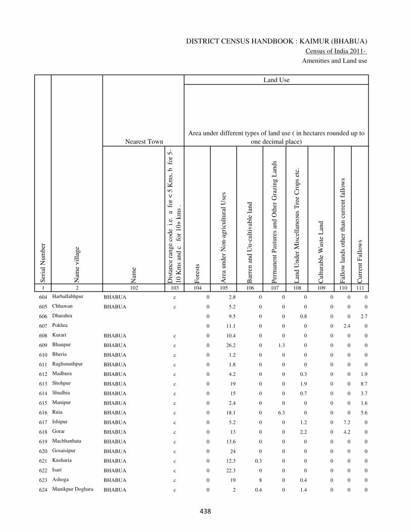
DISTRICT CENSUS HANDBOOK : KAIMUR (BHABUA)
Census of India 2011-
Amenities and Land use
Nam
e
Dis
tance
ran
ge
code
i.e
. a
fo
r <
5 K
ms,
b
for
5-
10 K
ms
and c
f
or
10+
km
s .
Fore
sts
Are
a under
Non-a
gri
cult
ura
l U
ses
Bar
ren a
nd U
n-c
ult
ivab
le l
and
Per
man
ent
Pas
ture
s an
d O
ther
Gra
zing L
ands
Lan
d U
nder
Mis
cell
aneo
us
Tre
e C
rops
etc.
Cult
ura
ble
Was
te L
and
Fal
low
lan
ds
oth
er t
han
curr
ent
fall
ow
s
Curr
ent
Fal
low
s
1 2 102 103 104 105 106 107 108 109 110 111
Ser
ial
Num
ber
Nam
e vil
lage
Area under different types of land use ( in hectares rounded up to
one decimal place)
Land Use
Nearest Town
604 Harballabhpur BHABUA c 0 2.8 0 0 0 0 0 0
605 Chhawan BHABUA c 0 5.2 0 0 0 0 0 0
606 Dharahra 0 9.5 0 0 0.8 0 0 2.7
607 Pokhra 0 11.1 0 0 0 0 2.4 0
608 Kurari BHABUA c 0 10.4 0 0 0 0 0 0
609 Bhanpur BHABUA c 0 26.2 0 1.3 0 0 0 0
610 Bheria BHABUA c 0 1.2 0 0 0 0 0 0
611 Raghunathpur BHABUA c 0 1.8 0 0 0 0 0 0
612 Madhura BHABUA c 0 4.2 0 0 0.3 0 0 1.9
613 Shohpur BHABUA c 0 19 0 0 1.9 0 0 8.7
614 Shudhia BHABUA c 0 15 0 0 0.7 0 0 3.7
615 Manipur BHABUA c 0 2.4 0 0 0 0 0 1.6
616 Ruia BHABUA c 0 18.1 0 6.3 0 0 0 5.6
617 Ishipur BHABUA c 0 5.2 0 0 1.2 0 7.2 0
618 Gorar BHABUA c 0 13 0 0 2.2 0 4.2 0
619 Machhanhata BHABUA c 0 13.6 0 0 0 0 0 0
620 Gosaisipur BHABUA c 0 24 0 0 0 0 0 0
621 Kusharia BHABUA c 0 12.3 0.3 0 0 0 0 0
622 Isari BHABUA c 0 22.3 0 0 0 0 0 0
623 Ashoga BHABUA c 0 19 8 0 0.4 0 0 0
624 Manikpur Doghara BHABUA c 0 2 0.4 0 1.4 0 0 0
��
VILLAGE DIRECTORY
Village Directory
( As in 2009 )
Net
Are
a S
ow
n
Tota
l Ir
rigat
ed L
and A
rea
Tota
l U
n-i
rrig
ated
Lan
d A
rea
Can
als
( C
)
Wel
ls/T
ube-
wel
ls(W
/TW
)
Tan
ks/
Lak
es(T
/L)
Wat
er F
alls
(WF
)
Oth
ers(
O)
Fir
st
Sec
ond
Thir
d
112 113 114 115 116 117 118 119 120 121 122 2 1
Ser
ial
Num
ber
Name of three
most important
commodities
manufacturedArea irrigated by source (in hectare).
Nam
e of
Vil
lage
Area under different types of
land use ( in hectares rounded
up to one decimal place)
Land Use
88.2 88.2 0 80.4 7.8 0 0 0 Harballabhpur 604
274.8 240.6 34.2 138.2 102.4 0 0 0 Chhawan 605
44 34.9 9.1 0 34.9 0 0 0 Dharahra 606
43.5 38 5.5 0 38 0 0 0 Pokhra 607
493.6 400.4 93.2 358.6 41.8 0 0 0 Kurari 608
99.5 93 6.5 38.6 54.4 0 0 0 Bhanpur 609
475.8 448.8 27 360.4 80.2 8.2 0 0 Bheria 610
48.2 34.9 13.3 20 14.9 0 0 0 Raghunathpur 611
58.6 50.3 8.3 20.2 30.1 0 0 0 Madhura 612
98.4 90.4 8 0 90.4 0 0 0 Shohpur 613
122.6 117.4 5.2 48.5 68.9 0 0 0 Shudhia 614
26 26 0 0 26 0 0 0 Manipur 615
165 124.5 40.5 50 74.5 0 0 0 Ruia 616
123.4 84.1 39.3 0 84.1 0 0 0 Ishipur 617
179.6 91.2 88.4 0 91.2 0 0 0 Gorar 618
166.4 125.5 40.9 116.8 8.7 0 0 0 Machhanhata 619
50 40 10 0 30 0 0 10 Gosaisipur 620
169.4 148.7 20.7 0 148.7 0 0 0 Kusharia 621
274.7 162.3 112.4 0 0 162.3 0 0 Isari 622
142.6 142.6 0 82.2 60.4 0 0 0 Ashoga 623
34.2 34.2 0 0 34.2 0 0 0 Manikpur Doghara 624
��

DISTRICT CENSUS HANDBOOK : KAIMUR (BHABUA)
Census of India 2011-
Amenities and Land use
Pre
-Pri
mar
y s
chool
(PP
)
Pri
mar
y s
chool
(P)
Mid
dle
sch
ool
(M)
Sec
ondar
y S
chool
(S)
Sen
ior
Sec
ondar
y s
chool
(SS
)
Deg
ree
coll
ege
of
arts
sc
ience
& c
om
mer
ce
(AS
C)
Engin
eeri
ng c
oll
ege(
EC
)
Med
ical
coll
ege
(MC
)
Man
agem
ent
inst
itute
(M
I)
Poly
tech
nic
(P
t)
Voca
tional
tra
inin
g s
chool
/IT
I
Non-f
orm
al t
rain
ing c
entr
e (N
FT
C)
Spec
ial
school
for
dis
able
d (
SS
D)
Oth
ers
(spec
ify)
1 2 3 4 5 6 7 8 9 10 11 12 13 14 15 16 17 18 19 20
Loca
tion c
ode
no.
Nam
e vil
lage
Ser
ial
Num
ber
Tota
l popula
tion (
2011 c
ensu
s )
Tota
l ar
ea o
f th
e vil
lage
( in
hec
tare
s ro
unded
up t
o
one
dec
imal
pla
ce)
Number of educational amenities available. (If not available
within the village , the distance range code viz; a for < 5
Kms, b for 5-10 Kms and c for 10+ kms of nearest place
where facility is available is given).
Num
ber
of
house
hold
s (2
011 c
ensu
s)
625 Machkhia 249549 146 1377 200 1 1 1 1 1 c c c c c c c c
626 Madhopur 249550 88 1007 185 b 1 a a c c c c c c c c c
627 Dhanipur 249551 69 389 47 1 1 a a a c c c c c c c c
628 Sariawan 249552 89 2046 287 a 1 a b b c c c c c c c c
629 Khamdaura 249553 369 3320 468 a 1 1 a a c c c c c c c c
630 kharkholi 249554 139 947 152 b 1 a a a c c c c c c c c
631 Bhadaini 249555 39 437 73 b a a a c c c c c c c c c
632 Anantpur 249556 49 0 0
633 Amirti 249557 105 39 7 b a a a a c c c c c c c c
634 Kharsara 249558 193 3332 467 b 1 1 a a c c c c c c c c
635 Dhanichha 249559 230 3052 510 b 1 a 1 1 c c c c c c c c
636 Dharhara 249560 164 1058 206 b 2 a a a c c c c c c c c
637 Rohua 249561 89 1270 208 c a a a a c c c c c c c c
638 Manoharpur 249562 359 522 80 c 1 c a a c c c c c c c c
639 Chahria 249563 0 5211 878 b 2 1 a a c c c c c c c c
640 Itahi 249564 96 1018 148 b 1 a b a c c c c c c c c
641 Kotsa 249565 348 2767 439 b 1 1 b a c c c c c c c c
642 Dusaunti 249566 43 926 138 b 1 a a a c c c c c c c c
643 Chhata 249567 371 3373 495 b 1 1 b b c c c c c c c c
644 Madanpura 249568 54 0 0
645 Madanpura 249569 37 774 101 b 1 a a a c c c c c c c c
���

VILLAGE DIRECTORY
Village Directory
( As in 2009 )
Com
munit
y h
ealt
h c
entr
e (C
HC
)
Pri
mar
y h
ealt
h c
entr
e (P
HC
)
Pri
mar
y h
ealt
h s
ub c
entr
e (P
HS
)
Mat
ernit
y a
nd c
hil
d w
elfa
re c
entr
e (M
CW
)
T.B
. cl
inic
(T
BC
)
Hosp
ital
-all
opat
hic
(H
A)
Hosp
ital
-alt
ernat
ive
med
icin
e (H
O)
Dis
pen
sary
(D
)
Vet
erin
ary h
osp
ital
(V
H)
Mobil
e hea
lth c
linic
(M
HC
)
Fam
ily w
elfa
re c
entr
e (F
WC
)
Char
itab
le n
on G
ovt.
hosp
ital
/Nurs
ing h
om
e.
Med
ical
pra
ctit
ioner
wit
h M
BB
S D
egre
e
Med
ical
pra
ctit
ioner
wit
h o
ther
deg
ree
Med
ical
pra
ctit
ioner
wit
h n
o d
egre
e
Tra
dit
ional
pra
ctit
ioner
an
d f
aith
hea
ler
.
Med
icin
e S
hop
Oth
ers
21 22 23 24 25 26 27 28 29 30 31 32 33 34 35 36 37 38 2 1
Number of Non-Government
Medical Amenities available.
Number of Medical Amenities available. (If not
available within the village , the distance range
code viz; a for < 5 Kms, b for 5-10 Kms and c
for 10+ kms of nearest place where facility is
available is given).
Nam
e vil
lage
Ser
ial
Num
ber
c a c b a c c b c c a 0 0 0 0 0 0 0 Machkhia 625
c b b b b c c b b c b 0 0 0 0 0 0 0 Madhopur 626
c b b b b c c a c c b 0 0 0 0 0 0 0 Dhanipur 627
c b b b b c c b b c b 0 0 0 0 0 0 0 Sariawan 628
c b a b b c c b b c a 0 0 0 0 0 0 0 Khamdaura 629
c c b b c c c b c c b 0 0 0 0 0 0 0 kharkholi 630
b c b b b c c b c c b 0 0 0 0 0 0 0 Bhadaini 631
Anantpur 632
b b b b b c c b c c b 0 0 0 0 0 0 0 Amirti 633
b b b b b c c b b c b 0 0 0 0 0 0 0 Kharsara 634
b 1 1 1 1 c c 1 1 c 1 0 0 1 0 0 0 0 Dhanichha 635
c a b a a c c b a c a 0 0 0 0 0 0 0 Dharhara 636
c c a c c c c b c c b 0 0 0 0 0 0 0 Rohua 637
c b a b b c c b b c c 0 0 0 0 0 0 0 Manoharpur 638
a b b b b c c b b c b 0 0 0 0 0 0 0 Chahria 639
b b b b b c c b b c a 0 0 0 0 0 0 0 Itahi 640
b b b b b c c b b c b 0 0 0 0 0 0 0 Kotsa 641
b b b b a c c b b c b 0 0 0 0 0 0 0 Dusaunti 642
c c c c b c c b c c a 0 0 0 0 0 0 0 Chhata 643
Madanpura 644
b b b b b c c b b c b 0 0 0 0 0 0 0 Madanpura 645
���

DISTRICT CENSUS HANDBOOK : KAIMUR (BHABUA)
Census of India 2011-
Amenities and Land use
Tap
wat
er (
Tre
ated
/Untr
eate
d)
Wel
l w
ater
(Cover
ed /
Unco
ver
ed w
ell)
Han
d P
um
p
Tube
wel
ls /
Bore
wel
l
Spri
ng
Riv
er /
Can
al
Tan
k /
Pond /
L
ake
Oth
ers
Com
munit
y t
oil
et i
ncl
udin
g
bat
h.
Com
munit
y t
oil
et e
xcl
udin
g b
ath.
Rura
l s
anit
ary m
art
or
sanit
ary
har
dw
are
outl
et
avai
lable
nea
r th
e vil
lage.
Com
munit
y b
io-
gas
or
recy
cle
of
was
te f
or
pro
duct
ive
use
.
1 2 39 40 41 42 43 44 45 46 47 48 49 50
Availability of toilet & others
Yes / No Availability of drinking water - Yes / No
Nam
e vil
lage
Ser
ial
Num
ber
625 Machkhia No Yes Yes No No No No No No No No No
626 Madhopur No Yes Yes No No No No No No No No No
627 Dhanipur No Yes Yes No No No No No No No No No
628 Sariawan No Yes Yes No No Yes No No No No No No
629 Khamdaura No Yes Yes No No No No No No No No No
630 kharkholi No Yes Yes Yes No No No No No No No No
631 Bhadaini No Yes Yes No No No No No No No No No
632 Anantpur
633 Amirti No Yes Yes No No No No No No No No No
634 Kharsara No Yes Yes No No No No Yes No No No No
635 Dhanichha No Yes Yes No No No No No No No No No
636 Dharhara No Yes Yes No No Yes No No No No No No
637 Rohua No Yes Yes No No No No No No No No No
638 Manoharpur No Yes Yes No No No No No No No No No
639 Chahria No Yes Yes Yes No No No No No No No No
640 Itahi No Yes Yes No No No No No No No No No
641 Kotsa No Yes Yes No No No No Yes No No No No
642 Dusaunti No Yes Yes No No No No No No No No No
643 Chhata No Yes Yes No No Yes No No No No No No
644 Madanpura
645 Madanpura No Yes Yes No No No No No No No No No
��
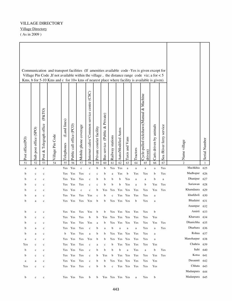
VILLAGE DIRECTORY
Village Directory
( As in 2009 )
Post
off
ice(
PO
)
Sub p
ost
off
ice
(SP
O)
Post
& T
eleg
raph o
ffic
e
(P&
TO
)
Vil
lage
Pin
Code
Tel
ephones
(L
and l
ines
)
Publi
c ca
ll o
ffic
e (P
CO
)
Mobil
e phone
cover
age
Inte
rnet
caf
es/
Com
mon s
ervic
e ce
ntr
e (C
SC
)
Pri
vat
e co
uri
er f
acil
ity
Bus
serv
ice
(P
ubli
c &
Pri
vat
e)
Rai
lway
sta
tions
Auto
/Modif
ied A
uto
s
Tax
is a
nd V
ans
Tra
ctors
Cycl
e-pull
ed r
icksh
aws(
Man
ual
& M
achin
e
dri
ven
)
Car
ts d
riven
by a
nim
als
Sea
/R
iver
fer
ry s
ervic
e51 52 53 54 55 56 57 58 59 60 61 62 63 64 65 66 67 2 1
Communication and transport facilities (If amenities available code -Yes is given except for
Village Pin Code ,If not available within the village , the distance range code viz; a for < 5
Kms, b for 5-10 Kms and c for 10+ kms of nearest place where facility is available is given).
Ser
ial
Num
ber
Nam
e vil
lage
a a c Yes Yes c c b b Yes Yes a a a a Yes Machkhia 625
b c c Yes Yes Yes c c b a Yes b Yes Yes b Yes Madhopur 626
b c c Yes Yes Yes c b b b b Yes a a b a Dhanipur 627
b c c Yes Yes Yes c c b b b Yes a b Yes Yes Sariawan 628
b c c Yes Yes c c b Yes Yes Yes Yes Yes Yes Yes Yes Khamdaura 629
b a c Yes Yes Yes Yes c b c Yes Yes Yes Yes a kharkholi 630
b a c Yes Yes Yes Yes b b Yes Yes Yes b Yes a Bhadaini 631
Anantpur 632
b c c Yes Yes Yes Yes b b Yes Yes Yes Yes Yes b Amirti 633
b c c Yes Yes Yes b b Yes Yes Yes Yes Yes Yes Yes Kharsara 634
b c c Yes Yes Yes Yes a b Yes Yes Yes Yes Yes Yes Yes Dhanichha 635
b a c Yes Yes Yes c b a b a a a Yes a Yes Dharhara 636
b a c b Yes Yes a b b Yes Yes Yes Yes Yes a Rohua 637
a c c Yes Yes Yes Yes b b Yes Yes Yes Yes Yes a Manoharpur 638
Yes c c Yes Yes Yes c a c b Yes Yes Yes Yes Yes Chahria 639
b c c Yes Yes Yes c b b b b a Yes a b Yes Itahi 640
b c c Yes Yes Yes c b Yes b Yes Yes Yes Yes Yes Yes Kotsa 641
a a c Yes Yes Yes c b b Yes Yes Yes Yes Yes Yes Dusaunti 642
Yes c c Yes Yes Yes c b b c Yes Yes Yes Yes Yes Chhata 643
Madanpura 644
b c c Yes Yes Yes b b Yes Yes Yes Yes a Yes b Madanpura 645
��
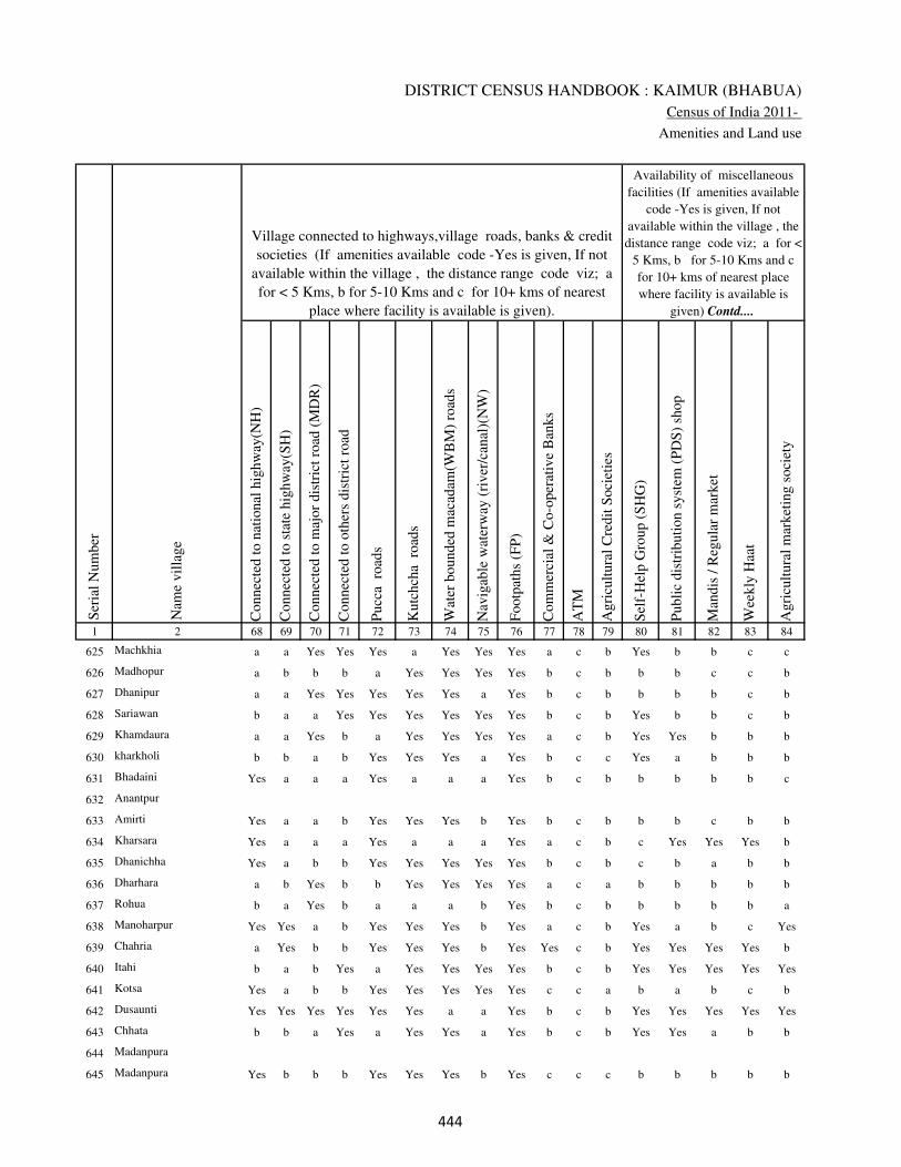
DISTRICT CENSUS HANDBOOK : KAIMUR (BHABUA)
Census of India 2011-
Amenities and Land use
Connec
ted t
o n
atio
nal
hig
hw
ay(N
H)
Connec
ted t
o s
tate
hig
hw
ay(S
H)
Connec
ted t
o m
ajor
dis
tric
t ro
ad (
MD
R)
Connec
ted t
o o
ther
s dis
tric
t ro
ad
Pucc
a r
oad
s
Kutc
hch
a r
oad
s
Wat
er b
ounded
mac
adam
(WB
M)
road
s
Nav
igab
le w
ater
way
(ri
ver
/can
al)(
NW
)
Footp
aths
(FP
)
Com
mer
cial
& C
o-o
per
ativ
e B
anks
AT
M
Agri
cult
ura
l C
redit
Soci
etie
s
Sel
f-H
elp G
roup (
SH
G)
Publi
c dis
trib
uti
on s
yst
em (
PD
S)
shop
Man
dis
/ R
egula
r m
arket
Wee
kly
Haa
t
Agri
cult
ura
l m
arket
ing s
oci
ety
1 2 68 69 70 71 72 73 74 75 76 77 78 79 80 81 82 83 84
Village connected to highways,village roads, banks & credit
societies (If amenities available code -Yes is given, If not
available within the village , the distance range code viz; a
for < 5 Kms, b for 5-10 Kms and c for 10+ kms of nearest
place where facility is available is given).
Ser
ial
Num
ber
Nam
e vil
lage
Availability of miscellaneous
facilities (If amenities available
code -Yes is given, If not
available within the village , the
distance range code viz; a for <
5 Kms, b for 5-10 Kms and c
for 10+ kms of nearest place
where facility is available is
given) Contd....
625 Machkhia a a Yes Yes Yes a Yes Yes Yes a c b Yes b b c c
626 Madhopur a b b b a Yes Yes Yes Yes b c b b b c c b
627 Dhanipur a a Yes Yes Yes Yes Yes a Yes b c b b b b c b
628 Sariawan b a a Yes Yes Yes Yes Yes Yes b c b Yes b b c b
629 Khamdaura a a Yes b a Yes Yes Yes Yes a c b Yes Yes b b b
630 kharkholi b b a b Yes Yes Yes a Yes b c c Yes a b b b
631 Bhadaini Yes a a a Yes a a a Yes b c b b b b b c
632 Anantpur
633 Amirti Yes a a b Yes Yes Yes b Yes b c b b b c b b
634 Kharsara Yes a a a Yes a a a Yes a c b c Yes Yes Yes b
635 Dhanichha Yes a b b Yes Yes Yes Yes Yes b c b c b a b b
636 Dharhara a b Yes b b Yes Yes Yes Yes a c a b b b b b
637 Rohua b a Yes b a a a b Yes b c b b b b b a
638 Manoharpur Yes Yes a b Yes Yes Yes b Yes a c b Yes a b c Yes
639 Chahria a Yes b b Yes Yes Yes b Yes Yes c b Yes Yes Yes Yes b
640 Itahi b a b Yes a Yes Yes Yes Yes b c b Yes Yes Yes Yes Yes
641 Kotsa Yes a b b Yes Yes Yes Yes Yes c c a b a b c b
642 Dusaunti Yes Yes Yes Yes Yes Yes a a Yes b c b Yes Yes Yes Yes Yes
643 Chhata b b a Yes a Yes Yes a Yes b c b Yes Yes a b b
644 Madanpura
645 Madanpura Yes b b b Yes Yes Yes b Yes c c c b b b b b
���

VILLAGE DIRECTORY
Village Directory
( As in 2009 )
Inte
gra
ted C
hil
d D
evel
opm
ent
Sch
eme
(Nutr
itio
nal
Cen
tres
)
Angan
wad
i C
entr
e (N
utr
itio
nal
Cen
tres
)
Oth
ers
(Nutr
itio
nal
Cen
tres
)
AS
HA
(A
ccre
dit
ed S
oci
al H
ealt
h A
ctiv
ist)
Com
munit
y c
entr
e w
ith/w
ithout
TV
Sport
s F
ield
,
Sport
s C
lub /
Rec
reat
ion C
entr
e
Cin
ema
/ V
ideo
Hal
l
Publi
c L
ibra
ry
Publi
c R
eadin
g R
oom
New
spap
er S
upply
Ass
embly
Poll
ing s
tati
on
Bir
th &
Dea
th R
egis
trat
ion O
ffic
e
Pow
er S
upply
for
Dom
esti
c U
se (
ED
)
Pow
er S
upply
for
Agri
cult
ura
l U
se (
EA
G)
Pow
er S
upply
for
Com
mer
cial
Use
(E
C)
Pow
er S
upply
for
All
Use
s (E
A)
85 86 87 88 89 90 91 92 93 94 95 96 97 98 99 100 101 2 1
Availability of
electricity (Yes/No)
Availability of miscellaneous facilities (If amenities available code -
Yes is given, If not available within the village , the distance range
code viz; a for < 5 Kms, b for 5-10 Kms and c for 10+ kms of
nearest place where facility is available is given) Concluded
Nam
e vil
lage
Ser
ial
Num
ber
a b Yes Yes Yes c b c c b b Yes b Yes Yes No No Machkhia 625
b b Yes b b c c c c c b a b Yes Yes No No Madhopur 626
b b Yes a b c c c c b b a b Yes Yes No No Dhanipur 627
b Yes Yes Yes b c c c c c b Yes b Yes Yes No No Sariawan 628
b Yes Yes Yes Yes b c c c c b Yes Yes Yes Yes No No Khamdaura 629
b Yes Yes a Yes Yes c c c c b Yes b Yes Yes No No kharkholi 630
b Yes Yes a Yes Yes c c c c b a b Yes Yes No No Bhadaini 631
Anantpur 632
b b Yes b b a c c c c b a b Yes Yes No No Amirti 633
b Yes Yes Yes Yes Yes Yes c Yes Yes b Yes b Yes Yes No No Kharsara 634
b Yes Yes Yes Yes Yes b c c c b Yes b Yes Yes No No Dhanichha 635
a Yes Yes Yes b b b c c c c a b Yes Yes No No Dharhara 636
a b Yes b b a b c c c c a b Yes Yes No No Rohua 637
b Yes Yes Yes c b c c c c b a b Yes Yes No No Manoharpur 638
a Yes Yes Yes c b c c c c Yes Yes Yes Yes Yes No No Chahria 639
b Yes Yes a c b c c c c b a b Yes Yes No No Itahi 640
b Yes Yes Yes c b c c c c b Yes b Yes Yes No No Kotsa 641
b Yes Yes a c b c c c c b a b Yes Yes No No Dusaunti 642
c Yes Yes Yes Yes Yes b c c c b Yes b Yes Yes No No Chhata 643
Madanpura 644
b b Yes b c a c c c c b a a Yes Yes No No Madanpura 645
���

DISTRICT CENSUS HANDBOOK : KAIMUR (BHABUA)
Census of India 2011-
Amenities and Land use
Nam
e
Dis
tance
ran
ge
code
i.e
. a
fo
r <
5 K
ms,
b
for
5-
10 K
ms
and c
f
or
10+
km
s .
Fore
sts
Are
a under
Non-a
gri
cult
ura
l U
ses
Bar
ren a
nd U
n-c
ult
ivab
le l
and
Per
man
ent
Pas
ture
s an
d O
ther
Gra
zing L
ands
Lan
d U
nder
Mis
cell
aneo
us
Tre
e C
rops
etc.
Cult
ura
ble
Was
te L
and
Fal
low
lan
ds
oth
er t
han
curr
ent
fall
ow
s
Curr
ent
Fal
low
s
1 2 102 103 104 105 106 107 108 109 110 111
Ser
ial
Num
ber
Nam
e vil
lage
Area under different types of land use ( in hectares rounded up to
one decimal place)
Land Use
Nearest Town
625 Machkhia BHABUA c 0 16.5 0 0 0 0 0 0
626 Madhopur BHABUA c 0 6 0 0 0.2 0 4 0
627 Dhanipur BHABUA c 0 4.4 2.3 0 0.5 0 0 0
628 Sariawan BHABUA c 0 10.1 0 0 0.9 0 3 0
629 Khamdaura BHABUA c 0 27 0 0 1.4 0 10.1 0
630 kharkholi BHABUA c 0 9 0 0 1.2 0 0 0
631 Bhadaini BHABUA c 0 3 0 0 0.4 0 3.3 0
632 Anantpur 0 2.2 0 0 0 0 0 0
633 Amirti BHABUA c 0 2.3 0 0 5 0 0 0
634 Kharsara BHABUA c 0 30.3 0 0 0 0 0 0
635 Dhanichha BHABUA c 0 20.3 0 0 8.2 0 0 0
636 Dharhara BHABUA c 0 34 0 0 0 0 0 0
637 Rohua BHABUA c 0 26.1 0 0 0 0 4.8 0
638 Manoharpur BHABUA c 0 56.2 0 0 50.5 0 8.7 0
639 Chahria BHABUA c 0 0 0 0 0 0 0 0
640 Itahi BHABUA c 0 25.5 0 0 0 0 0 6.2
641 Kotsa BHABUA c 0 27 0 0 0 0 0 0
642 Dusaunti BHABUA c 0 1 0 0 0 0 0 0
643 Chhata BHABUA c 0 28.2 0 0 0 0 0 0
644 Madanpura 0 3.2 0 0 0 0 0 0
645 Madanpura BHABUA c 0 8.7 0 0 0 0 0 0
���
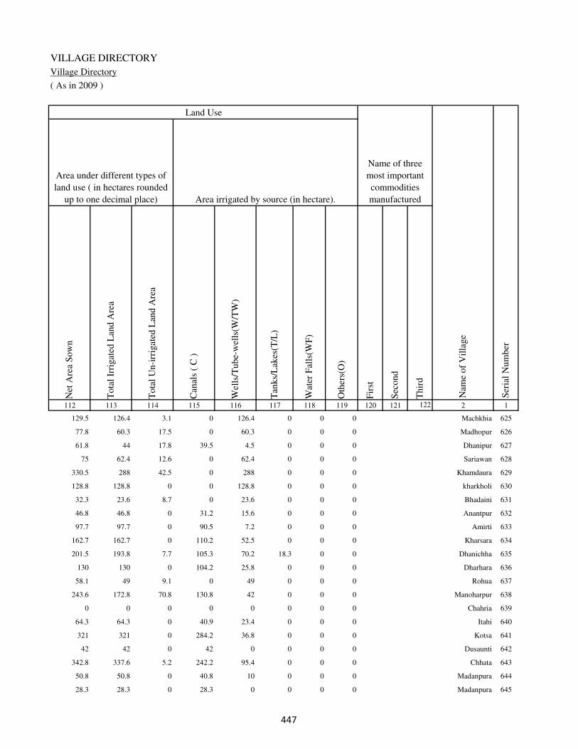
VILLAGE DIRECTORY
Village Directory
( As in 2009 )
Net
Are
a S
ow
n
Tota
l Ir
rigat
ed L
and A
rea
Tota
l U
n-i
rrig
ated
Lan
d A
rea
Can
als
( C
)
Wel
ls/T
ube-
wel
ls(W
/TW
)
Tan
ks/
Lak
es(T
/L)
Wat
er F
alls
(WF
)
Oth
ers(
O)
Fir
st
Sec
ond
Thir
d
112 113 114 115 116 117 118 119 120 121 122 2 1
Ser
ial
Num
ber
Name of three
most important
commodities
manufacturedArea irrigated by source (in hectare).
Nam
e of
Vil
lage
Area under different types of
land use ( in hectares rounded
up to one decimal place)
Land Use
129.5 126.4 3.1 0 126.4 0 0 0 Machkhia 625
77.8 60.3 17.5 0 60.3 0 0 0 Madhopur 626
61.8 44 17.8 39.5 4.5 0 0 0 Dhanipur 627
75 62.4 12.6 0 62.4 0 0 0 Sariawan 628
330.5 288 42.5 0 288 0 0 0 Khamdaura 629
128.8 128.8 0 0 128.8 0 0 0 kharkholi 630
32.3 23.6 8.7 0 23.6 0 0 0 Bhadaini 631
46.8 46.8 0 31.2 15.6 0 0 0 Anantpur 632
97.7 97.7 0 90.5 7.2 0 0 0 Amirti 633
162.7 162.7 0 110.2 52.5 0 0 0 Kharsara 634
201.5 193.8 7.7 105.3 70.2 18.3 0 0 Dhanichha 635
130 130 0 104.2 25.8 0 0 0 Dharhara 636
58.1 49 9.1 0 49 0 0 0 Rohua 637
243.6 172.8 70.8 130.8 42 0 0 0 Manoharpur 638
0 0 0 0 0 0 0 0 Chahria 639
64.3 64.3 0 40.9 23.4 0 0 0 Itahi 640
321 321 0 284.2 36.8 0 0 0 Kotsa 641
42 42 0 42 0 0 0 0 Dusaunti 642
342.8 337.6 5.2 242.2 95.4 0 0 0 Chhata 643
50.8 50.8 0 40.8 10 0 0 0 Madanpura 644
28.3 28.3 0 28.3 0 0 0 0 Madanpura 645
���

DISTRICT CENSUS HANDBOOK : KAIMUR (BHABUA)
Census of India 2011-
Amenities and Land use
Pre
-Pri
mar
y s
chool
(PP
)
Pri
mar
y s
chool
(P)
Mid
dle
sch
ool
(M)
Sec
ondar
y S
chool
(S)
Sen
ior
Sec
ondar
y s
chool
(SS
)
Deg
ree
coll
ege
of
arts
sc
ience
& c
om
mer
ce
(AS
C)
Engin
eeri
ng c
oll
ege(
EC
)
Med
ical
coll
ege
(MC
)
Man
agem
ent
inst
itute
(M
I)
Poly
tech
nic
(P
t)
Voca
tional
tra
inin
g s
chool
/IT
I
Non-f
orm
al t
rain
ing c
entr
e (N
FT
C)
Spec
ial
school
for
dis
able
d (
SS
D)
Oth
ers
(spec
ify)
1 2 3 4 5 6 7 8 9 10 11 12 13 14 15 16 17 18 19 20
Loca
tion c
ode
no.
Nam
e vil
lage
Ser
ial
Num
ber
Tota
l popula
tion (
2011 c
ensu
s )
Tota
l ar
ea o
f th
e vil
lage
( in
hec
tare
s ro
unded
up t
o
one
dec
imal
pla
ce)
Number of educational amenities available. (If not available
within the village , the distance range code viz; a for < 5
Kms, b for 5-10 Kms and c for 10+ kms of nearest place
where facility is available is given).
Num
ber
of
house
hold
s (2
011 c
ensu
s)
646 Karari 249570 505 3645 564 1 2 1 b b c c c c c c c c
647 Belhari 249571 73 0 0
648 Panrepur 249572 33 0 0
649 Jevari 249573 223 2608 394 b 1 1 a a b c c c c c c c
650 Pachilakhi 249574 295 1664 236 b 1 a a b a c c c c c c c
651 Bichhiya 249575 119 2111 320 b 1 a a b c c c c c c c c
652 Asurha 249576 30 423 66 b 1 a a b c c c c c c c c
653 Tola Gopinathpur 249577 47 270 44 b a a a b b c c c c c c c
654 Ataria 249578 96 966 150 c 1 a a a b c c c c c c c
655 Arazi Kalyanpur 249579 62 0 0
656 Misirpura 249580 30 1012 150 c 1 a a a b c c c c c c c
657 Kalhnuan 249581 241 1217 221 c 1 a a a c c c c c c c c
658 Kalyanpur 249582 180 3709 579 c 1 1 1 1 a c c c c c c c
659 Tiari 249583 38 7 2 c b a b b c c c c c c c c
660 Serwan 249584 57 0 0
661 Mansurpur 249585 128 2231 339 c 1 1 c a c c c c c c c c
662 Kasthar 249586 76 126 18 c a a c a b c c c c c c c
663 Kirpalpur 249587 66 834 97 c a a c b b c c c c c c c
664 Dumri 249588 260 4158 578 c 1 1 c b a c c c c c c c
665 Ghinhu Patti 249589 106 1440 233 b a a c b a c c c c c c c
666 Nuawan 249590 394 3216 471 b 1 1 c b a c c c c c c c
���

VILLAGE DIRECTORY
Village Directory
( As in 2009 )
Com
munit
y h
ealt
h c
entr
e (C
HC
)
Pri
mar
y h
ealt
h c
entr
e (P
HC
)
Pri
mar
y h
ealt
h s
ub c
entr
e (P
HS
)
Mat
ernit
y a
nd c
hil
d w
elfa
re c
entr
e (M
CW
)
T.B
. cl
inic
(T
BC
)
Hosp
ital
-all
opat
hic
(H
A)
Hosp
ital
-alt
ernat
ive
med
icin
e (H
O)
Dis
pen
sary
(D
)
Vet
erin
ary h
osp
ital
(V
H)
Mobil
e hea
lth c
linic
(M
HC
)
Fam
ily w
elfa
re c
entr
e (F
WC
)
Char
itab
le n
on G
ovt.
hosp
ital
/Nurs
ing h
om
e.
Med
ical
pra
ctit
ioner
wit
h M
BB
S D
egre
e
Med
ical
pra
ctit
ioner
wit
h o
ther
deg
ree
Med
ical
pra
ctit
ioner
wit
h n
o d
egre
e
Tra
dit
ional
pra
ctit
ioner
an
d f
aith
hea
ler
.
Med
icin
e S
hop
Oth
ers
21 22 23 24 25 26 27 28 29 30 31 32 33 34 35 36 37 38 2 1
Number of Non-Government
Medical Amenities available.
Number of Medical Amenities available. (If not
available within the village , the distance range
code viz; a for < 5 Kms, b for 5-10 Kms and c
for 10+ kms of nearest place where facility is
available is given).
Nam
e vil
lage
Ser
ial
Num
ber
b c b c c c c b c c b 0 0 0 0 0 0 0 Karari 646
Belhari 647
Panrepur 648
b b a b b c c b b c a 0 0 0 0 0 0 0 Jevari 649
c b b b b c c b b c a 0 0 0 0 0 0 0 Pachilakhi 650
c b b b b c c b c c a 0 0 0 0 0 0 0 Bichhiya 651
c b a b a c c b c c a 0 0 0 0 0 0 0 Asurha 652
c b a b a c c c b c a 0 0 0 0 0 0 0 Tola Gopinathpur 653
c c a b b c c c b c a 0 0 0 0 0 0 0 Ataria 654
Arazi Kalyanpur 655
c b a b b c c c b c a 0 0 0 0 0 0 0 Misirpura 656
c b b b b c c c b c b 0 0 0 0 0 0 0 Kalhnuan 657
c b b b b c c c b c 1 0 0 0 0 0 0 0 Kalyanpur 658
c b b b b c c c c c b 0 0 0 0 0 0 0 Tiari 659
Serwan 660
c b b b b c c c b c b 0 0 0 0 0 0 0 Mansurpur 661
c b b b b c c c b c b 0 0 0 0 0 0 0 Kasthar 662
c a a a a c c c a c a 0 0 0 0 0 0 0 Kirpalpur 663
c b b b b c c c b c b 0 0 0 0 0 0 0 Dumri 664
c c a c c c c c c c b 0 0 0 0 0 0 0 Ghinhu Patti 665
c c b c b c c c c c b 0 0 0 0 0 0 0 Nuawan 666
���

DISTRICT CENSUS HANDBOOK : KAIMUR (BHABUA)
Census of India 2011-
Amenities and Land use
Tap
wat
er (
Tre
ated
/Untr
eate
d)
Wel
l w
ater
(Cover
ed /
Unco
ver
ed w
ell)
Han
d P
um
p
Tube
wel
ls /
Bore
wel
l
Spri
ng
Riv
er /
Can
al
Tan
k /
Pond /
L
ake
Oth
ers
Com
munit
y t
oil
et i
ncl
udin
g
bat
h.
Com
munit
y t
oil
et e
xcl
udin
g b
ath.
Rura
l s
anit
ary m
art
or
sanit
ary
har
dw
are
outl
et
avai
lable
nea
r th
e vil
lage.
Com
munit
y b
io-
gas
or
recy
cle
of
was
te f
or
pro
duct
ive
use
.
1 2 39 40 41 42 43 44 45 46 47 48 49 50
Availability of toilet & others
Yes / No Availability of drinking water - Yes / No
Nam
e vil
lage
Ser
ial
Num
ber
646 Karari No Yes Yes No No Yes No No No No No No
647 Belhari
648 Panrepur
649 Jevari No Yes Yes No No Yes No No No No No No
650 Pachilakhi No Yes Yes No No No No No No No No No
651 Bichhiya No Yes Yes No No No No No No No No No
652 Asurha No Yes Yes No No No No No No No No No
653 Tola Gopinathpur No Yes Yes No No No No No No No No No
654 Ataria No Yes Yes No No Yes No No No No No No
655 Arazi Kalyanpur
656 Misirpura No Yes Yes No No No No No No No No No
657 Kalhnuan No Yes Yes No No No No No No No No No
658 Kalyanpur No Yes Yes No No Yes No No No No No No
659 Tiari No No Yes No No No No No No No No No
660 Serwan
661 Mansurpur No Yes Yes No No Yes No No No No No No
662 Kasthar No Yes Yes No No No No No No No No No
663 Kirpalpur No Yes Yes No No Yes No No No No No No
664 Dumri No Yes Yes No No No No No No No No No
665 Ghinhu Patti No Yes Yes Yes No No No No No No No No
666 Nuawan No Yes Yes No No No No No No No No No
���

VILLAGE DIRECTORY
Village Directory
( As in 2009 )
Post
off
ice(
PO
)
Sub p
ost
off
ice
(SP
O)
Post
& T
eleg
raph o
ffic
e
(P&
TO
)
Vil
lage
Pin
Code
Tel
ephones
(L
and l
ines
)
Publi
c ca
ll o
ffic
e (P
CO
)
Mobil
e phone
cover
age
Inte
rnet
caf
es/
Com
mon s
ervic
e ce
ntr
e (C
SC
)
Pri
vat
e co
uri
er f
acil
ity
Bus
serv
ice
(P
ubli
c &
Pri
vat
e)
Rai
lway
sta
tions
Auto
/Modif
ied A
uto
s
Tax
is a
nd V
ans
Tra
ctors
Cycl
e-pull
ed r
icksh
aws(
Man
ual
& M
achin
e
dri
ven
)
Car
ts d
riven
by a
nim
als
Sea
/R
iver
fer
ry s
ervic
e51 52 53 54 55 56 57 58 59 60 61 62 63 64 65 66 67 2 1
Communication and transport facilities (If amenities available code -Yes is given except for
Village Pin Code ,If not available within the village , the distance range code viz; a for < 5
Kms, b for 5-10 Kms and c for 10+ kms of nearest place where facility is available is given).
Ser
ial
Num
ber
Nam
e vil
lage
b a c Yes Yes b c b b b b Yes Yes Yes Yes Karari 646
Belhari 647
Panrepur 648
b a c Yes Yes b b b Yes Yes Yes Yes Yes Yes Yes Yes Jevari 649
Yes c c Yes Yes Yes c c Yes b Yes Yes Yes Yes a Yes Pachilakhi 650
b a c Yes Yes Yes c b Yes b Yes Yes Yes Yes Yes Bichhiya 651
b c c Yes Yes c c b Yes Yes Yes b Yes Yes a Asurha 652
b c c Yes Yes Yes c a b Yes Yes Yes Yes Yes a Yes Tola Gopinathpur 653
b a c Yes Yes Yes Yes Yes Yes Yes Yes Yes Yes a b Ataria 654
Arazi Kalyanpur 655
b c c Yes Yes Yes Yes c b b b Yes b Yes Yes a Misirpura 656
b c c Yes Yes Yes Yes c b b b b b Yes a a Kalhnuan 657
Yes c c Yes Yes Yes c c b Yes Yes Yes Yes Yes Yes Kalyanpur 658
b c c b b b c c c b b b b a a Tiari 659
Serwan 660
b c c Yes Yes Yes c c b b b Yes b Yes Yes Mansurpur 661
b b c b Yes Yes c b b b Yes Yes Yes Yes a Yes Kasthar 662
a c c c Yes Yes c c Yes a Yes Yes Yes Yes a Kirpalpur 663
b a c Yes Yes b c b Yes Yes Yes Yes Yes Yes Yes Dumri 664
b a c b Yes Yes b b b b c Yes a Yes b Yes Ghinhu Patti 665
b a c Yes Yes Yes b b b c Yes Yes Yes Yes Yes Nuawan 666
���

DISTRICT CENSUS HANDBOOK : KAIMUR (BHABUA)
Census of India 2011-
Amenities and Land use
Connec
ted t
o n
atio
nal
hig
hw
ay(N
H)
Connec
ted t
o s
tate
hig
hw
ay(S
H)
Connec
ted t
o m
ajor
dis
tric
t ro
ad (
MD
R)
Connec
ted t
o o
ther
s dis
tric
t ro
ad
Pucc
a r
oad
s
Kutc
hch
a r
oad
s
Wat
er b
ounded
mac
adam
(WB
M)
road
s
Nav
igab
le w
ater
way
(ri
ver
/can
al)(
NW
)
Footp
aths
(FP
)
Com
mer
cial
& C
o-o
per
ativ
e B
anks
AT
M
Agri
cult
ura
l C
redit
Soci
etie
s
Sel
f-H
elp G
roup (
SH
G)
Publi
c dis
trib
uti
on s
yst
em (
PD
S)
shop
Man
dis
/ R
egula
r m
arket
Wee
kly
Haa
t
Agri
cult
ura
l m
arket
ing s
oci
ety
1 2 68 69 70 71 72 73 74 75 76 77 78 79 80 81 82 83 84
Village connected to highways,village roads, banks & credit
societies (If amenities available code -Yes is given, If not
available within the village , the distance range code viz; a
for < 5 Kms, b for 5-10 Kms and c for 10+ kms of nearest
place where facility is available is given).
Ser
ial
Num
ber
Nam
e vil
lage
Availability of miscellaneous
facilities (If amenities available
code -Yes is given, If not
available within the village , the
distance range code viz; a for <
5 Kms, b for 5-10 Kms and c
for 10+ kms of nearest place
where facility is available is
given) Contd....
646 Karari b b Yes b Yes Yes Yes b Yes c c c Yes b b b c
647 Belhari
648 Panrepur
649 Jevari b b Yes Yes a a Yes Yes Yes b c b Yes b b c b
650 Pachilakhi b a a b Yes Yes Yes Yes Yes Yes c b b b b c c
651 Bichhiya b Yes a a Yes a a a Yes a c b Yes b b c c
652 Asurha b a a Yes b Yes Yes a Yes b c b b b b b b
653 Tola Gopinathpur b a b Yes Yes Yes Yes Yes Yes b c c b b b b c
654 Ataria b b b b b a b b Yes b c c b b c b c
655 Arazi Kalyanpur
656 Misirpura b a a Yes a Yes Yes Yes Yes b c c Yes b c b b
657 Kalhnuan b Yes a b Yes Yes Yes b Yes a c b b b b b c
658 Kalyanpur b Yes b b Yes Yes a b Yes b c c Yes Yes b b c
659 Tiari b b b b b b b b Yes b c c b a b b c
660 Serwan
661 Mansurpur b a b Yes a Yes Yes b Yes b c Yes Yes b b b c
662 Kasthar b b a Yes a Yes Yes Yes Yes b c c b b c c c
663 Kirpalpur a a a Yes a a Yes b Yes a c c b b c c c
664 Dumri b b b b Yes Yes Yes a Yes b c b Yes b c c b
665 Ghinhu Patti c b b Yes Yes Yes a Yes Yes a c c a b b c c
666 Nuawan b Yes b b Yes Yes Yes a Yes b c c Yes b b c c
��

VILLAGE DIRECTORY
Village Directory
( As in 2009 )
Inte
gra
ted C
hil
d D
evel
opm
ent
Sch
eme
(Nutr
itio
nal
Cen
tres
)
Angan
wad
i C
entr
e (N
utr
itio
nal
Cen
tres
)
Oth
ers
(Nutr
itio
nal
Cen
tres
)
AS
HA
(A
ccre
dit
ed S
oci
al H
ealt
h A
ctiv
ist)
Com
munit
y c
entr
e w
ith/w
ithout
TV
Sport
s F
ield
,
Sport
s C
lub /
Rec
reat
ion C
entr
e
Cin
ema
/ V
ideo
Hal
l
Publi
c L
ibra
ry
Publi
c R
eadin
g R
oom
New
spap
er S
upply
Ass
embly
Poll
ing s
tati
on
Bir
th &
Dea
th R
egis
trat
ion O
ffic
e
Pow
er S
upply
for
Dom
esti
c U
se (
ED
)
Pow
er S
upply
for
Agri
cult
ura
l U
se (
EA
G)
Pow
er S
upply
for
Com
mer
cial
Use
(E
C)
Pow
er S
upply
for
All
Use
s (E
A)
85 86 87 88 89 90 91 92 93 94 95 96 97 98 99 100 101 2 1
Availability of
electricity (Yes/No)
Availability of miscellaneous facilities (If amenities available code -
Yes is given, If not available within the village , the distance range
code viz; a for < 5 Kms, b for 5-10 Kms and c for 10+ kms of
nearest place where facility is available is given) Concluded
Nam
e vil
lage
Ser
ial
Num
ber
b Yes Yes Yes b b c c c b b Yes a No No No No Karari 646
Belhari 647
Panrepur 648
b Yes Yes a b b c c c c b Yes Yes Yes Yes No No Jevari 649
b Yes Yes b c b b c c b b a a Yes Yes No No Pachilakhi 650
b Yes Yes Yes c b c c c c b Yes a Yes Yes No No Bichhiya 651
b b Yes b c b c c c c b a a Yes Yes No No Asurha 652
b b Yes b c c c c c c b a a Yes Yes No No Tola Gopinathpur 653
b b Yes b c c c c c c b a a No No No No Ataria 654
Arazi Kalyanpur 655
b Yes Yes Yes Yes b c c c c c a a Yes Yes No No Misirpura 656
b b Yes b c b c c c c b a a Yes Yes No No Kalhnuan 657
b Yes Yes Yes c Yes Yes c c c b Yes Yes Yes Yes No No Kalyanpur 658
b b Yes b c a b c c c b a a No No No No Tiari 659
Serwan 660
b Yes Yes Yes Yes Yes b c c c b Yes b Yes Yes No No Mansurpur 661
b b Yes b c a c c c c b a a Yes Yes No No Kasthar 662
a b Yes b b b c c c c b a a Yes Yes No No Kirpalpur 663
b Yes Yes Yes b b c c c c Yes Yes b Yes Yes No No Dumri 664
c b Yes b b b c c c c b a b Yes Yes No No Ghinhu Patti 665
c Yes Yes Yes b b c c c c b Yes b Yes Yes No No Nuawan 666
��

DISTRICT CENSUS HANDBOOK : KAIMUR (BHABUA)
Census of India 2011-
Amenities and Land use
Nam
e
Dis
tance
ran
ge
code
i.e
. a
fo
r <
5 K
ms,
b
for
5-
10 K
ms
and c
f
or
10+
km
s .
Fore
sts
Are
a under
Non-a
gri
cult
ura
l U
ses
Bar
ren a
nd U
n-c
ult
ivab
le l
and
Per
man
ent
Pas
ture
s an
d O
ther
Gra
zing L
ands
Lan
d U
nder
Mis
cell
aneo
us
Tre
e C
rops
etc.
Cult
ura
ble
Was
te L
and
Fal
low
lan
ds
oth
er t
han
curr
ent
fall
ow
s
Curr
ent
Fal
low
s
1 2 102 103 104 105 106 107 108 109 110 111
Ser
ial
Num
ber
Nam
e vil
lage
Area under different types of land use ( in hectares rounded up to
one decimal place)
Land Use
Nearest Town
646 Karari BHABUA c 0 82.7 0 0 22.6 5.2 0 0
647 Belhari 0 4.2 0 0 0 0 0 0
648 Panrepur 0 8.8 0 0 0 0 0 0
649 Jevari BHABUA c 0 35.2 0 0 0 0 0 0
650 Pachilakhi BHABUA c 0 2.2 0 0 0 0 0 0
651 Bichhiya BHABUA c 0 0 0 0 0 0 0 0
652 Asurha BHABUA c 0 5.6 0 0 0 0 0 0
653 Tola Gopinathpur BHABUA c 0 6 0 0 1.2 0 0 0
654 Ataria BHABUA c 0 16.4 0 0 0.8 0 0 0
655 Arazi Kalyanpur 0 8 0 0 0 1 0 0
656 Misirpura BHABUA c 0 12 0 0 0.6 0 0 0
657 Kalhnuan BHABUA c 0 45.9 0 0 16.5 0 0 23.4
658 Kalyanpur BHABUA c 0 50.6 2 0 4.3 0 0 0
659 Tiari BHABUA c 0 5.4 0 0 1.4 0 0 0
660 Serwan 0 3.6 0 0 1.4 0 0 0
661 Mansurpur BHABUA c 0 6.2 0 0 3 0 0 0
662 Kasthar BHABUA c 0 1.8 0 0 0 0 0 0
663 Kirpalpur BHABUA c 0 5.6 0 0 0.8 0 0 0
664 Dumri BHABUA c 0 27.2 1.2 0 4.8 0 0 0
665 Ghinhu Patti BHABUA c 0 3.6 0 0 0 0 0 0
666 Nuawan BHABUA c 0 54.2 2 0 4.2 0 0 18.4
���

VILLAGE DIRECTORY
Village Directory
( As in 2009 )
Net
Are
a S
ow
n
Tota
l Ir
rigat
ed L
and A
rea
Tota
l U
n-i
rrig
ated
Lan
d A
rea
Can
als
( C
)
Wel
ls/T
ube-
wel
ls(W
/TW
)
Tan
ks/
Lak
es(T
/L)
Wat
er F
alls
(WF
)
Oth
ers(
O)
Fir
st
Sec
ond
Thir
d
112 113 114 115 116 117 118 119 120 121 122 2 1
Ser
ial
Num
ber
Name of three
most important
commodities
manufacturedArea irrigated by source (in hectare).
Nam
e of
Vil
lage
Area under different types of
land use ( in hectares rounded
up to one decimal place)
Land Use
394.5 284.2 110.3 242.2 42 0 0 0 Karari 646
68.8 68.8 0 68.8 0 0 0 0 Belhari 647
24.2 24.2 0 0 24.2 0 0 0 Panrepur 648
187.8 176 11.8 132.4 43.6 0 0 0 Jevari 649
292.8 268.6 24.2 140.2 128.4 0 0 0 Pachilakhi 650
119 107.6 11.4 102.5 5.1 0 0 0 Bichhiya 651
24.4 21.6 2.8 16.4 5.2 0 0 0 Asurha 652
39.8 37.8 2 28.2 9.6 0 0 0 Tola Gopinathpur 653
78.8 66.8 12 60.4 6.4 0 0 0 Ataria 654
53 50.4 2.6 30.2 20.2 0 0 0 Arazi Kalyanpur 655
17.4 17.4 0 9.3 8.1 0 0 0 Misirpura 656
155.2 137.7 17.5 124.9 12.8 0 0 0 Kalhnuan 657
123.1 115.3 7.8 72.1 43.2 0 0 0 Kalyanpur 658
31.2 31.2 0 28.2 3 0 0 0 Tiari 659
52 43.8 8.2 40.6 3.2 0 0 0 Serwan 660
118.8 94.8 24 64 30.8 0 0 0 Mansurpur 661
74.2 74.2 0 44.2 30 0 0 0 Kasthar 662
59.6 51.4 8.2 29.2 22.2 0 0 0 Kirpalpur 663
226.8 193.4 33.4 124 69.4 0 0 0 Dumri 664
102.4 102.4 0 20.2 82.2 0 0 0 Ghinhu Patti 665
315.2 155.2 160 0 155.2 0 0 0 Nuawan 666
���

DISTRICT CENSUS HANDBOOK : KAIMUR (BHABUA)
Census of India 2011-
Amenities and Land use
Pre
-Pri
mar
y s
chool
(PP
)
Pri
mar
y s
chool
(P)
Mid
dle
sch
ool
(M)
Sec
ondar
y S
chool
(S)
Sen
ior
Sec
ondar
y s
chool
(SS
)
Deg
ree
coll
ege
of
arts
sc
ience
& c
om
mer
ce
(AS
C)
Engin
eeri
ng c
oll
ege(
EC
)
Med
ical
coll
ege
(MC
)
Man
agem
ent
inst
itute
(M
I)
Poly
tech
nic
(P
t)
Voca
tional
tra
inin
g s
chool
/IT
I
Non-f
orm
al t
rain
ing c
entr
e (N
FT
C)
Spec
ial
school
for
dis
able
d (
SS
D)
Oth
ers
(spec
ify)
1 2 3 4 5 6 7 8 9 10 11 12 13 14 15 16 17 18 19 20
Loca
tion c
ode
no.
Nam
e vil
lage
Ser
ial
Num
ber
Tota
l popula
tion (
2011 c
ensu
s )
Tota
l ar
ea o
f th
e vil
lage
( in
hec
tare
s ro
unded
up t
o
one
dec
imal
pla
ce)
Number of educational amenities available. (If not available
within the village , the distance range code viz; a for < 5
Kms, b for 5-10 Kms and c for 10+ kms of nearest place
where facility is available is given).
Num
ber
of
house
hold
s (2
011 c
ensu
s)
667 Garhwa 249591 51 375 51 b 1 a c c c c c c c c c c
668 Masaurha 249592 712 5720 845 b 3 1 c b b c c c c c c c
669 Kabilaspur 249593 197 1835 250 b 1 1 c c c c c c c c c c
670 Firozpur 249594 96 1336 181 c 1 a c b b c c c c c c c
671 Gimhiyan 249595 85 310 38 c 1 a c a b c c c c c c c
672 Dakaha 249596 28 0 0
673 Kasthari 249597 134 2297 336 b 1 1 c a c c c c c c c c
674 Karmi 249598 58 0 0
675 Udhpura 249599 124 466 66 b 1 a c a c c c c c c c c
676 Narsingha 249600 58 0 0
677 Garhwa 249601 38 0 0
678 Sawath 249602 470 5164 775 b 4 4 c a c c c c c c c c
679 Dahiyawan 249603 160 1258 223 b 1 a c a c c c c c c c c
680 Darauli 249604 113 1232 185 b 1 a c a c c c c c c c c
681 Dahla 249605 93 3816 534 b 2 1 c a c c c c c c c c
682 Chogara 249606 127 1172 164 1 1 a c a c c c c c c c c
683 Janarjanpur 249607 36 1795 260 1 1 1 c a c c c c c c c c
684 Panrepur 249608 29 174 24 a a a c a c c c c c c c c
685 Anwarhiya 249609 484 2874 422 1 2 1 c a c c c c c c c c
686 Sonawan 249610 91 721 101 a 1 a c a c c c c c c c c
687 Sarangpur 249611 115 1294 204 1 2 1 c a c c c c c c c c
���

VILLAGE DIRECTORY
Village Directory
( As in 2009 )
Com
munit
y h
ealt
h c
entr
e (C
HC
)
Pri
mar
y h
ealt
h c
entr
e (P
HC
)
Pri
mar
y h
ealt
h s
ub c
entr
e (P
HS
)
Mat
ernit
y a
nd c
hil
d w
elfa
re c
entr
e (M
CW
)
T.B
. cl
inic
(T
BC
)
Hosp
ital
-all
opat
hic
(H
A)
Hosp
ital
-alt
ernat
ive
med
icin
e (H
O)
Dis
pen
sary
(D
)
Vet
erin
ary h
osp
ital
(V
H)
Mobil
e hea
lth c
linic
(M
HC
)
Fam
ily w
elfa
re c
entr
e (F
WC
)
Char
itab
le n
on G
ovt.
hosp
ital
/Nurs
ing h
om
e.
Med
ical
pra
ctit
ioner
wit
h M
BB
S D
egre
e
Med
ical
pra
ctit
ioner
wit
h o
ther
deg
ree
Med
ical
pra
ctit
ioner
wit
h n
o d
egre
e
Tra
dit
ional
pra
ctit
ioner
an
d f
aith
hea
ler
.
Med
icin
e S
hop
Oth
ers
21 22 23 24 25 26 27 28 29 30 31 32 33 34 35 36 37 38 2 1
Number of Non-Government
Medical Amenities available.
Number of Medical Amenities available. (If not
available within the village , the distance range
code viz; a for < 5 Kms, b for 5-10 Kms and c
for 10+ kms of nearest place where facility is
available is given).
Nam
e vil
lage
Ser
ial
Num
ber
c c a c c c c c c c a 0 0 0 0 0 0 0 Garhwa 667
c c a c b c c c c c a 0 0 0 0 0 0 0 Masaurha 668
c c b c c c c c c c b 0 0 0 0 0 0 0 Kabilaspur 669
c b a b a c c c b c a 0 0 0 0 0 0 0 Firozpur 670
c b b b b c c c b c b 0 0 0 0 0 0 0 Gimhiyan 671
Dakaha 672
c b b b a c c c b c b 0 0 0 0 0 0 0 Kasthari 673
Karmi 674
c a b a a c c c a c a 0 0 0 0 0 0 0 Udhpura 675
Narsingha 676
Garhwa 677
c a a a a c c c a c a 0 0 0 0 0 0 0 Sawath 678
c a a a a c c c c c b 0 0 0 0 0 0 0 Dahiyawan 679
c a a a a c c c a c a 0 0 0 0 0 0 0 Darauli 680
c 1 1 1 1 c c 1 1 c 1 0 0 0 0 0 0 0 Dahla 681
c a a a a c c c a c a 0 0 0 0 0 0 0 Chogara 682
c a a a a c c b b c a 0 0 0 0 0 0 0 Janarjanpur 683
c a b a a c c b a c a 0 0 0 0 0 0 0 Panrepur 684
c a b a a c c b a c a 0 0 0 0 0 0 0 Anwarhiya 685
c a b a a c c b a c a 0 0 0 0 0 0 0 Sonawan 686
c 1 1 1 1 c c 1 1 c 1 0 0 1 0 0 0 0 Sarangpur 687
���

DISTRICT CENSUS HANDBOOK : KAIMUR (BHABUA)
Census of India 2011-
Amenities and Land use
Tap
wat
er (
Tre
ated
/Untr
eate
d)
Wel
l w
ater
(Cover
ed /
Unco
ver
ed w
ell)
Han
d P
um
p
Tube
wel
ls /
Bore
wel
l
Spri
ng
Riv
er /
Can
al
Tan
k /
Pond /
L
ake
Oth
ers
Com
munit
y t
oil
et i
ncl
udin
g
bat
h.
Com
munit
y t
oil
et e
xcl
udin
g b
ath.
Rura
l s
anit
ary m
art
or
sanit
ary
har
dw
are
outl
et
avai
lable
nea
r th
e vil
lage.
Com
munit
y b
io-
gas
or
recy
cle
of
was
te f
or
pro
duct
ive
use
.
1 2 39 40 41 42 43 44 45 46 47 48 49 50
Availability of toilet & others
Yes / No Availability of drinking water - Yes / No
Nam
e vil
lage
Ser
ial
Num
ber
667 Garhwa No Yes Yes No No No No No No No No No
668 Masaurha No Yes Yes No No No No No No No No No
669 Kabilaspur No Yes Yes No No No No Yes No No No No
670 Firozpur No Yes Yes No No No No No No No No No
671 Gimhiyan No Yes Yes No No No No No No No No No
672 Dakaha
673 Kasthari No Yes Yes No No No No No No No No No
674 Karmi
675 Udhpura No Yes Yes No No No No No No No No No
676 Narsingha
677 Garhwa
678 Sawath No Yes Yes No No Yes No No No No No No
679 Dahiyawan No Yes Yes No No No No No No No No No
680 Darauli No Yes Yes No No No No No No No No No
681 Dahla No Yes Yes No No No No No No No No No
682 Chogara No Yes Yes No No Yes No No No No No No
683 Janarjanpur No Yes Yes No No No No No No No No No
684 Panrepur No Yes Yes No No No No No No No No No
685 Anwarhiya No Yes Yes No No No No No No No No No
686 Sonawan No Yes Yes No No No No No No No No No
687 Sarangpur No Yes Yes No No No No No No No No No
���
VILLAGE DIRECTORY
Village Directory
( As in 2009 )
Post
off
ice(
PO
)
Sub p
ost
off
ice
(SP
O)
Post
& T
eleg
raph o
ffic
e
(P&
TO
)
Vil
lage
Pin
Code
Tel
ephones
(L
and l
ines
)
Publi
c ca
ll o
ffic
e (P
CO
)
Mobil
e phone
cover
age
Inte
rnet
caf
es/
Com
mon s
ervic
e ce
ntr
e (C
SC
)
Pri
vat
e co
uri
er f
acil
ity
Bus
serv
ice
(P
ubli
c &
Pri
vat
e)
Rai
lway
sta
tions
Auto
/Modif
ied A
uto
s
Tax
is a
nd V
ans
Tra
ctors
Cycl
e-pull
ed r
icksh
aws(
Man
ual
& M
achin
e
dri
ven
)
Car
ts d
riven
by a
nim
als
Sea
/R
iver
fer
ry s
ervic
e51 52 53 54 55 56 57 58 59 60 61 62 63 64 65 66 67 2 1
Communication and transport facilities (If amenities available code -Yes is given except for
Village Pin Code ,If not available within the village , the distance range code viz; a for < 5
Kms, b for 5-10 Kms and c for 10+ kms of nearest place where facility is available is given).
Ser
ial
Num
ber
Nam
e vil
lage
b a c c Yes Yes b c b b c Yes a Yes a Yes Garhwa 667
a a Yes Yes Yes Yes Yes Yes a b Yes Yes Yes Yes Yes Masaurha 668
Yes c c Yes Yes Yes Yes a a Yes Yes Yes Yes Yes Yes Yes Kabilaspur 669
b c c Yes Yes b b a b b b Yes Yes a a Firozpur 670
b b c Yes Yes Yes Yes b a b b Yes Yes Yes a Yes Gimhiyan 671
Dakaha 672
b c c Yes Yes Yes Yes c a b b b a a Yes Yes Kasthari 673
Karmi 674
a c c Yes Yes Yes Yes c a a a a Yes Yes a Udhpura 675
Narsingha 676
Garhwa 677
a a c Yes Yes a b b Yes Yes Yes Yes Yes Yes Yes Sawath 678
a c c Yes Yes Yes Yes c b Yes b Yes Yes Yes Yes a Dahiyawan 679
a a c Yes Yes Yes Yes c b Yes a Yes Yes Yes a Yes Darauli 680
Yes Yes Yes Yes Yes Yes Yes c Yes Yes Yes Yes Yes Yes Yes Dahla 681
a c c Yes Yes Yes c b a a a Yes b b a Chogara 682
a c c Yes Yes Yes b c b b Yes Yes Yes Yes Yes a Janarjanpur 683
a c c a a Yes c c a a a Yes b a a Panrepur 684
b b c Yes Yes Yes c c b a a a Yes a Yes Yes Anwarhiya 685
a a c Yes Yes a b c a a a Yes Yes Yes a Sonawan 686
a a c Yes Yes Yes Yes b Yes Yes Yes Yes a a a Yes Sarangpur 687
���

DISTRICT CENSUS HANDBOOK : KAIMUR (BHABUA)
Census of India 2011-
Amenities and Land use
Connec
ted t
o n
atio
nal
hig
hw
ay(N
H)
Connec
ted t
o s
tate
hig
hw
ay(S
H)
Connec
ted t
o m
ajor
dis
tric
t ro
ad (
MD
R)
Connec
ted t
o o
ther
s dis
tric
t ro
ad
Pucc
a r
oad
s
Kutc
hch
a r
oad
s
Wat
er b
ounded
mac
adam
(WB
M)
road
s
Nav
igab
le w
ater
way
(ri
ver
/can
al)(
NW
)
Footp
aths
(FP
)
Com
mer
cial
& C
o-o
per
ativ
e B
anks
AT
M
Agri
cult
ura
l C
redit
Soci
etie
s
Sel
f-H
elp G
roup (
SH
G)
Publi
c dis
trib
uti
on s
yst
em (
PD
S)
shop
Man
dis
/ R
egula
r m
arket
Wee
kly
Haa
t
Agri
cult
ura
l m
arket
ing s
oci
ety
1 2 68 69 70 71 72 73 74 75 76 77 78 79 80 81 82 83 84
Village connected to highways,village roads, banks & credit
societies (If amenities available code -Yes is given, If not
available within the village , the distance range code viz; a
for < 5 Kms, b for 5-10 Kms and c for 10+ kms of nearest
place where facility is available is given).
Ser
ial
Num
ber
Nam
e vil
lage
Availability of miscellaneous
facilities (If amenities available
code -Yes is given, If not
available within the village , the
distance range code viz; a for <
5 Kms, b for 5-10 Kms and c
for 10+ kms of nearest place
where facility is available is
given) Contd....
667 Garhwa c b a b a Yes Yes Yes Yes a c c Yes b b b c
668 Masaurha c b Yes b Yes Yes Yes b Yes a c c a Yes b b b
669 Kabilaspur Yes Yes a Yes Yes Yes Yes Yes Yes Yes c c Yes Yes b c c
670 Firozpur b a a Yes a a a a Yes b c b Yes b b c b
671 Gimhiyan b a b b a Yes Yes Yes Yes b c b Yes b b c b
672 Dakaha
673 Kasthari b a b Yes b Yes Yes Yes Yes b c b Yes b b c b
674 Karmi
675 Udhpura a b b Yes Yes Yes a b Yes a c c b a b c b
676 Narsingha
677 Garhwa
678 Sawath Yes b b b Yes Yes b b Yes a c c b Yes b b a
679 Dahiyawan Yes a b b Yes Yes Yes b Yes a c b Yes Yes Yes Yes Yes
680 Darauli Yes a b b Yes Yes Yes Yes Yes a c b Yes b a b b
681 Dahla Yes a a b Yes Yes Yes a Yes Yes c b Yes Yes Yes Yes Yes
682 Chogara a b Yes Yes Yes a a a Yes a c c b a a b a
683 Janarjanpur a b a b b Yes Yes b Yes a c c b b b b b
684 Panrepur a b a b b Yes Yes b Yes a c b b b b b b
685 Anwarhiya a a Yes b b Yes Yes Yes Yes a c b Yes b b b b
686 Sonawan a a a a a a a b Yes a c b c b b b c
687 Sarangpur Yes a b b Yes Yes Yes Yes Yes a c c c b b c b
���
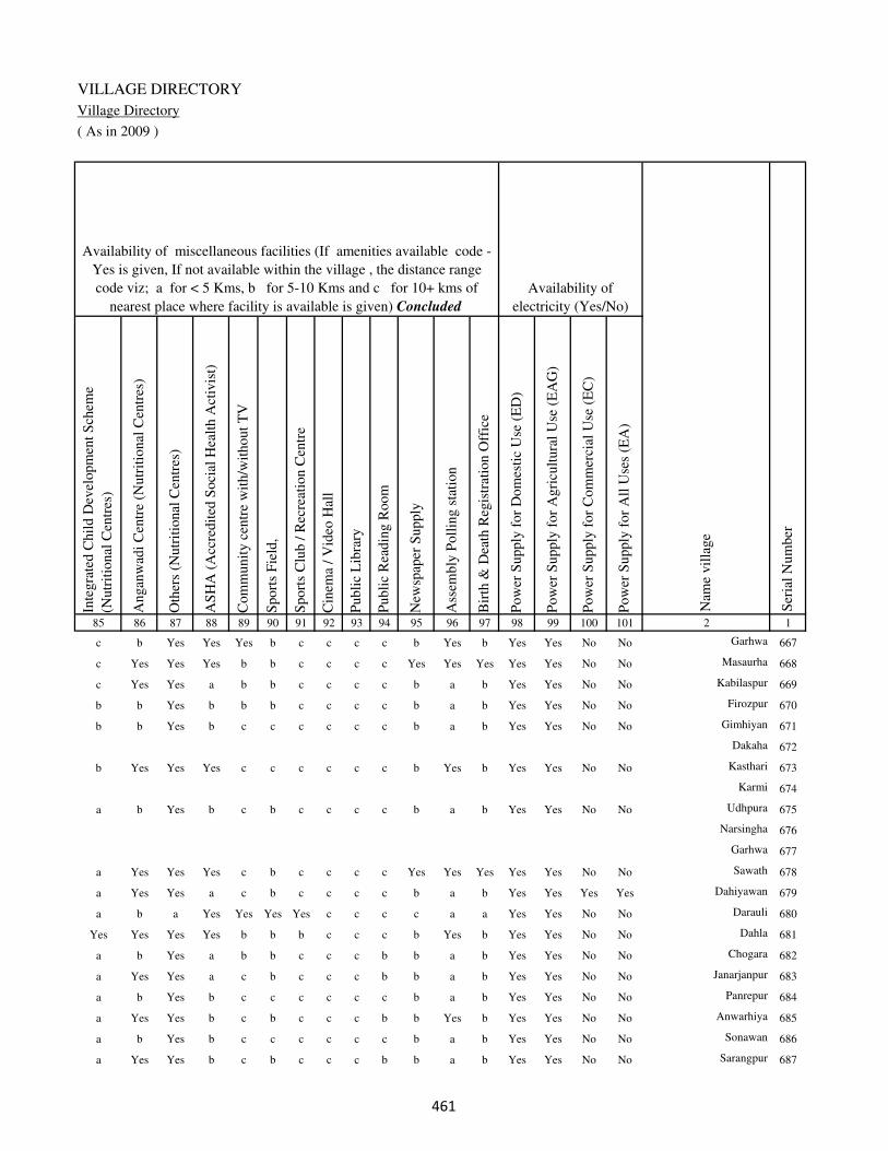
VILLAGE DIRECTORY
Village Directory
( As in 2009 )
Inte
gra
ted C
hil
d D
evel
opm
ent
Sch
eme
(Nutr
itio
nal
Cen
tres
)
Angan
wad
i C
entr
e (N
utr
itio
nal
Cen
tres
)
Oth
ers
(Nutr
itio
nal
Cen
tres
)
AS
HA
(A
ccre
dit
ed S
oci
al H
ealt
h A
ctiv
ist)
Com
munit
y c
entr
e w
ith/w
ithout
TV
Sport
s F
ield
,
Sport
s C
lub /
Rec
reat
ion C
entr
e
Cin
ema
/ V
ideo
Hal
l
Publi
c L
ibra
ry
Publi
c R
eadin
g R
oom
New
spap
er S
upply
Ass
embly
Poll
ing s
tati
on
Bir
th &
Dea
th R
egis
trat
ion O
ffic
e
Pow
er S
upply
for
Dom
esti
c U
se (
ED
)
Pow
er S
upply
for
Agri
cult
ura
l U
se (
EA
G)
Pow
er S
upply
for
Com
mer
cial
Use
(E
C)
Pow
er S
upply
for
All
Use
s (E
A)
85 86 87 88 89 90 91 92 93 94 95 96 97 98 99 100 101 2 1
Availability of
electricity (Yes/No)
Availability of miscellaneous facilities (If amenities available code -
Yes is given, If not available within the village , the distance range
code viz; a for < 5 Kms, b for 5-10 Kms and c for 10+ kms of
nearest place where facility is available is given) Concluded
Nam
e vil
lage
Ser
ial
Num
ber
c b Yes Yes Yes b c c c c b Yes b Yes Yes No No Garhwa 667
c Yes Yes Yes b b c c c c Yes Yes Yes Yes Yes No No Masaurha 668
c Yes Yes a b b c c c c b a b Yes Yes No No Kabilaspur 669
b b Yes b b b c c c c b a b Yes Yes No No Firozpur 670
b b Yes b c c c c c c b a b Yes Yes No No Gimhiyan 671
Dakaha 672
b Yes Yes Yes c c c c c c b Yes b Yes Yes No No Kasthari 673
Karmi 674
a b Yes b c b c c c c b a b Yes Yes No No Udhpura 675
Narsingha 676
Garhwa 677
a Yes Yes Yes c b c c c c Yes Yes Yes Yes Yes No No Sawath 678
a Yes Yes a c b c c c c b a b Yes Yes Yes Yes Dahiyawan 679
a b a Yes Yes Yes Yes c c c c a a Yes Yes No No Darauli 680
Yes Yes Yes Yes b b b c c c b Yes b Yes Yes No No Dahla 681
a b Yes a b b c c c b b a b Yes Yes No No Chogara 682
a Yes Yes a c b c c c b b a b Yes Yes No No Janarjanpur 683
a b Yes b c c c c c c b a b Yes Yes No No Panrepur 684
a Yes Yes b c b c c c b b Yes b Yes Yes No No Anwarhiya 685
a b Yes b c c c c c c b a b Yes Yes No No Sonawan 686
a Yes Yes b c b c c c b b a b Yes Yes No No Sarangpur 687
���
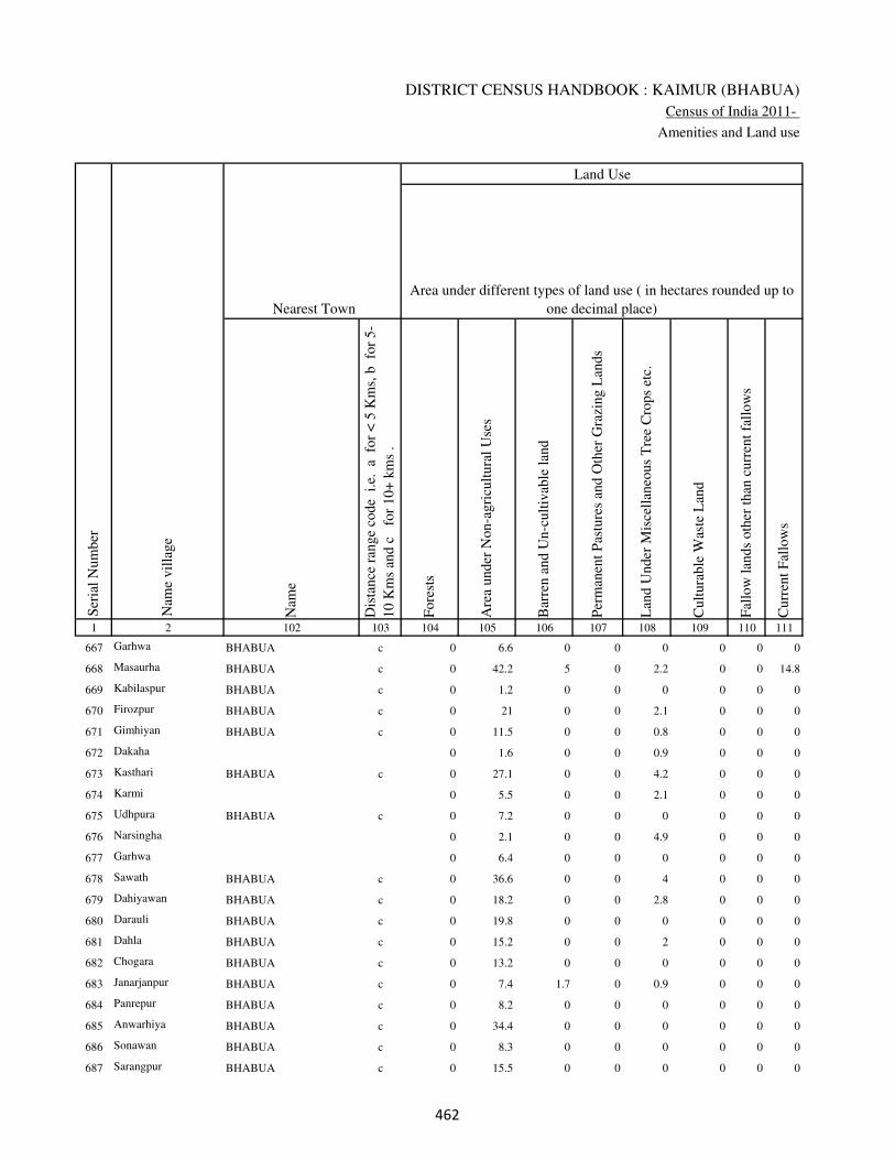
DISTRICT CENSUS HANDBOOK : KAIMUR (BHABUA)
Census of India 2011-
Amenities and Land use
Nam
e
Dis
tance
ran
ge
code
i.e
. a
fo
r <
5 K
ms,
b
for
5-
10 K
ms
and c
f
or
10+
km
s .
Fore
sts
Are
a under
Non-a
gri
cult
ura
l U
ses
Bar
ren a
nd U
n-c
ult
ivab
le l
and
Per
man
ent
Pas
ture
s an
d O
ther
Gra
zing L
ands
Lan
d U
nder
Mis
cell
aneo
us
Tre
e C
rops
etc.
Cult
ura
ble
Was
te L
and
Fal
low
lan
ds
oth
er t
han
curr
ent
fall
ow
s
Curr
ent
Fal
low
s
1 2 102 103 104 105 106 107 108 109 110 111
Ser
ial
Num
ber
Nam
e vil
lage
Area under different types of land use ( in hectares rounded up to
one decimal place)
Land Use
Nearest Town
667 Garhwa BHABUA c 0 6.6 0 0 0 0 0 0
668 Masaurha BHABUA c 0 42.2 5 0 2.2 0 0 14.8
669 Kabilaspur BHABUA c 0 1.2 0 0 0 0 0 0
670 Firozpur BHABUA c 0 21 0 0 2.1 0 0 0
671 Gimhiyan BHABUA c 0 11.5 0 0 0.8 0 0 0
672 Dakaha 0 1.6 0 0 0.9 0 0 0
673 Kasthari BHABUA c 0 27.1 0 0 4.2 0 0 0
674 Karmi 0 5.5 0 0 2.1 0 0 0
675 Udhpura BHABUA c 0 7.2 0 0 0 0 0 0
676 Narsingha 0 2.1 0 0 4.9 0 0 0
677 Garhwa 0 6.4 0 0 0 0 0 0
678 Sawath BHABUA c 0 36.6 0 0 4 0 0 0
679 Dahiyawan BHABUA c 0 18.2 0 0 2.8 0 0 0
680 Darauli BHABUA c 0 19.8 0 0 0 0 0 0
681 Dahla BHABUA c 0 15.2 0 0 2 0 0 0
682 Chogara BHABUA c 0 13.2 0 0 0 0 0 0
683 Janarjanpur BHABUA c 0 7.4 1.7 0 0.9 0 0 0
684 Panrepur BHABUA c 0 8.2 0 0 0 0 0 0
685 Anwarhiya BHABUA c 0 34.4 0 0 0 0 0 0
686 Sonawan BHABUA c 0 8.3 0 0 0 0 0 0
687 Sarangpur BHABUA c 0 15.5 0 0 0 0 0 0
��
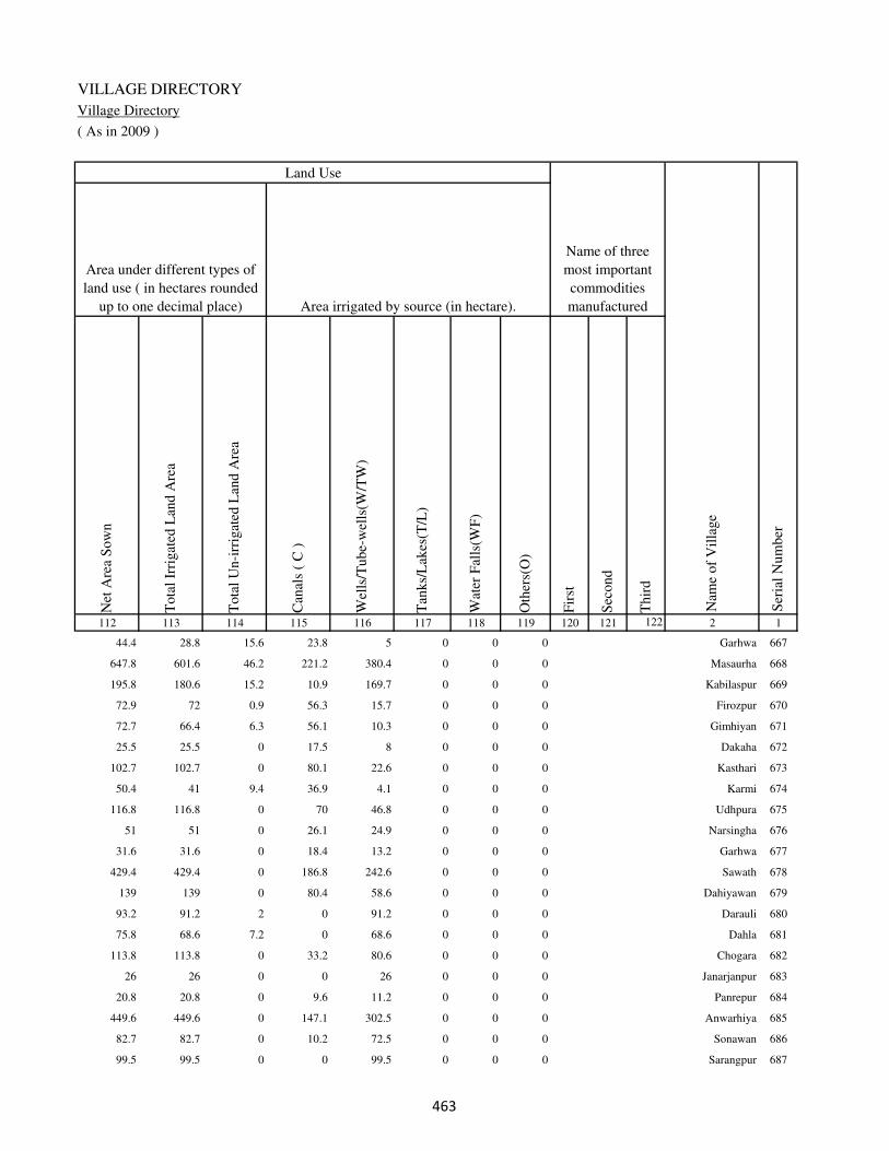
VILLAGE DIRECTORY
Village Directory
( As in 2009 )
Net
Are
a S
ow
n
Tota
l Ir
rigat
ed L
and A
rea
Tota
l U
n-i
rrig
ated
Lan
d A
rea
Can
als
( C
)
Wel
ls/T
ube-
wel
ls(W
/TW
)
Tan
ks/
Lak
es(T
/L)
Wat
er F
alls
(WF
)
Oth
ers(
O)
Fir
st
Sec
ond
Thir
d
112 113 114 115 116 117 118 119 120 121 122 2 1
Ser
ial
Num
ber
Name of three
most important
commodities
manufacturedArea irrigated by source (in hectare).
Nam
e of
Vil
lage
Area under different types of
land use ( in hectares rounded
up to one decimal place)
Land Use
44.4 28.8 15.6 23.8 5 0 0 0 Garhwa 667
647.8 601.6 46.2 221.2 380.4 0 0 0 Masaurha 668
195.8 180.6 15.2 10.9 169.7 0 0 0 Kabilaspur 669
72.9 72 0.9 56.3 15.7 0 0 0 Firozpur 670
72.7 66.4 6.3 56.1 10.3 0 0 0 Gimhiyan 671
25.5 25.5 0 17.5 8 0 0 0 Dakaha 672
102.7 102.7 0 80.1 22.6 0 0 0 Kasthari 673
50.4 41 9.4 36.9 4.1 0 0 0 Karmi 674
116.8 116.8 0 70 46.8 0 0 0 Udhpura 675
51 51 0 26.1 24.9 0 0 0 Narsingha 676
31.6 31.6 0 18.4 13.2 0 0 0 Garhwa 677
429.4 429.4 0 186.8 242.6 0 0 0 Sawath 678
139 139 0 80.4 58.6 0 0 0 Dahiyawan 679
93.2 91.2 2 0 91.2 0 0 0 Darauli 680
75.8 68.6 7.2 0 68.6 0 0 0 Dahla 681
113.8 113.8 0 33.2 80.6 0 0 0 Chogara 682
26 26 0 0 26 0 0 0 Janarjanpur 683
20.8 20.8 0 9.6 11.2 0 0 0 Panrepur 684
449.6 449.6 0 147.1 302.5 0 0 0 Anwarhiya 685
82.7 82.7 0 10.2 72.5 0 0 0 Sonawan 686
99.5 99.5 0 0 99.5 0 0 0 Sarangpur 687
��
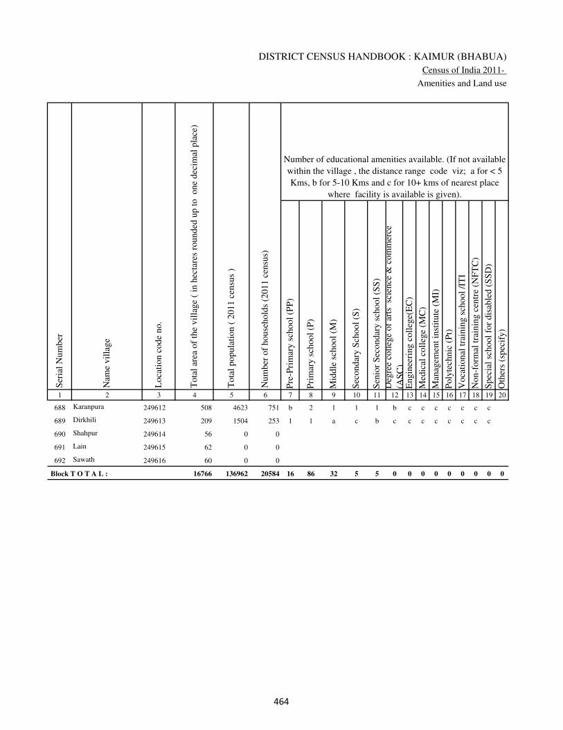
DISTRICT CENSUS HANDBOOK : KAIMUR (BHABUA)
Census of India 2011-
Amenities and Land use
Pre
-Pri
mar
y s
chool
(PP
)
Pri
mar
y s
chool
(P)
Mid
dle
sch
ool
(M)
Sec
ondar
y S
chool
(S)
Sen
ior
Sec
ondar
y s
chool
(SS
)
Deg
ree
coll
ege
of
arts
sc
ience
& c
om
mer
ce
(AS
C)
Engin
eeri
ng c
oll
ege(
EC
)
Med
ical
coll
ege
(MC
)
Man
agem
ent
inst
itute
(M
I)
Poly
tech
nic
(P
t)
Voca
tional
tra
inin
g s
chool
/IT
I
Non-f
orm
al t
rain
ing c
entr
e (N
FT
C)
Spec
ial
school
for
dis
able
d (
SS
D)
Oth
ers
(spec
ify)
1 2 3 4 5 6 7 8 9 10 11 12 13 14 15 16 17 18 19 20
Loca
tion c
ode
no.
Nam
e vil
lage
Ser
ial
Num
ber
Tota
l popula
tion (
2011 c
ensu
s )
Tota
l ar
ea o
f th
e vil
lage
( in
hec
tare
s ro
unded
up t
o
one
dec
imal
pla
ce)
Number of educational amenities available. (If not available
within the village , the distance range code viz; a for < 5
Kms, b for 5-10 Kms and c for 10+ kms of nearest place
where facility is available is given).
Num
ber
of
house
hold
s (2
011 c
ensu
s)
688 Karanpura 249612 508 4623 751 b 2 1 1 1 b c c c c c c c
689 Dirkhili 249613 209 1504 253 1 1 a c b c c c c c c c c
690 Shahpur 249614 56 0 0
691 Lain 249615 62 0 0
692 Sawath 249616 60 0 0
Block T O T A L : 16766 136962 20584 16 86 32 5 5 0 0 0 0 0 0 0 0 0
���
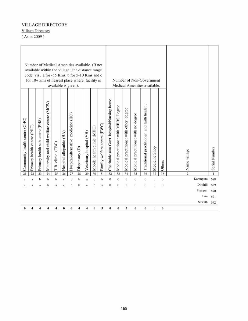
VILLAGE DIRECTORY
Village Directory
( As in 2009 )
Com
munit
y h
ealt
h c
entr
e (C
HC
)
Pri
mar
y h
ealt
h c
entr
e (P
HC
)
Pri
mar
y h
ealt
h s
ub c
entr
e (P
HS
)
Mat
ernit
y a
nd c
hil
d w
elfa
re c
entr
e (M
CW
)
T.B
. cl
inic
(T
BC
)
Hosp
ital
-all
opat
hic
(H
A)
Hosp
ital
-alt
ernat
ive
med
icin
e (H
O)
Dis
pen
sary
(D
)
Vet
erin
ary h
osp
ital
(V
H)
Mobil
e hea
lth c
linic
(M
HC
)
Fam
ily w
elfa
re c
entr
e (F
WC
)
Char
itab
le n
on G
ovt.
hosp
ital
/Nurs
ing h
om
e.
Med
ical
pra
ctit
ioner
wit
h M
BB
S D
egre
e
Med
ical
pra
ctit
ioner
wit
h o
ther
deg
ree
Med
ical
pra
ctit
ioner
wit
h n
o d
egre
e
Tra
dit
ional
pra
ctit
ioner
an
d f
aith
hea
ler
.
Med
icin
e S
hop
Oth
ers
21 22 23 24 25 26 27 28 29 30 31 32 33 34 35 36 37 38 2 1
Number of Non-Government
Medical Amenities available.
Number of Medical Amenities available. (If not
available within the village , the distance range
code viz; a for < 5 Kms, b for 5-10 Kms and c
for 10+ kms of nearest place where facility is
available is given).
Nam
e vil
lage
Ser
ial
Num
ber
c a b b b c c b a c b 0 0 0 0 0 0 0 Karanpura 688
c a a b a c c b a c a 0 0 0 0 0 0 0 Dirkhili 689
Shahpur 690
Lain 691
Sawath 692
0 4 4 4 4 0 0 4 4 0 5 0 0 3 0 0 0 0
���
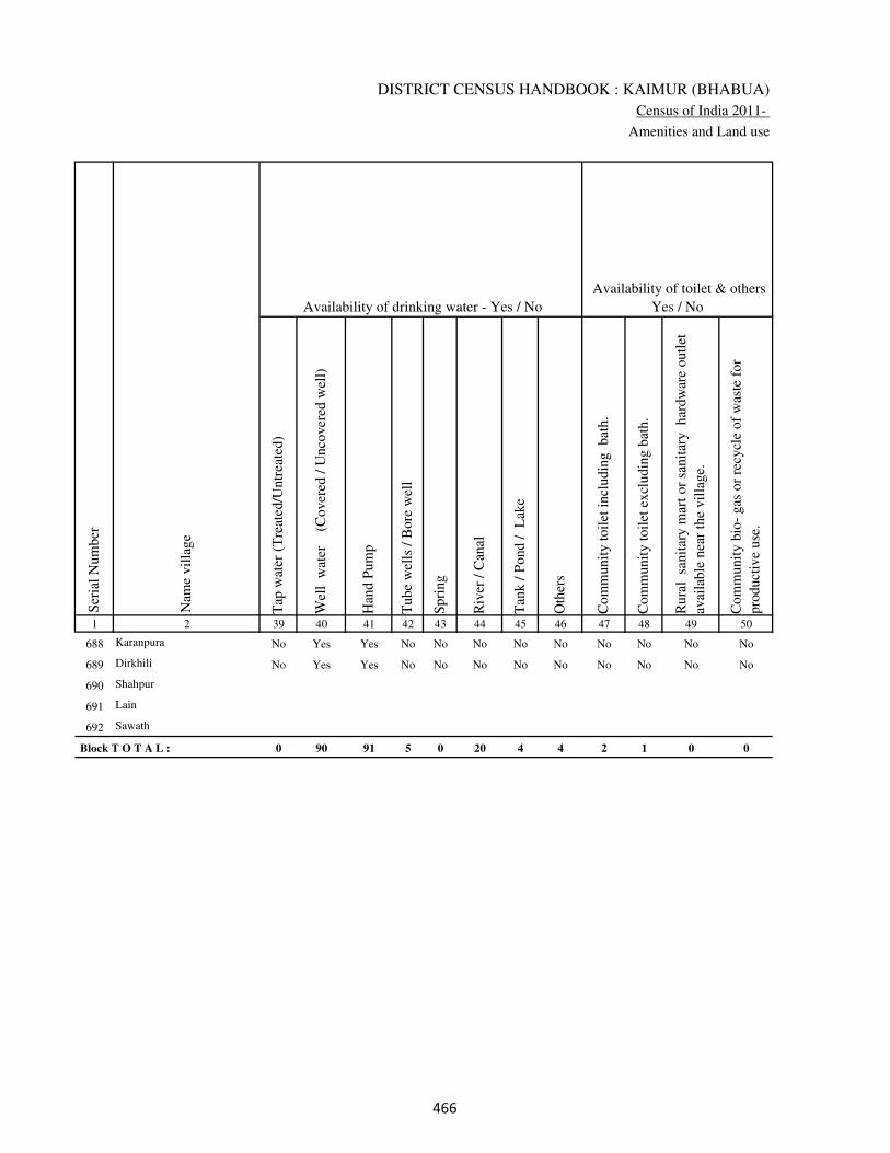
DISTRICT CENSUS HANDBOOK : KAIMUR (BHABUA)
Census of India 2011-
Amenities and Land use
Tap
wat
er (
Tre
ated
/Untr
eate
d)
Wel
l w
ater
(Cover
ed /
Unco
ver
ed w
ell)
Han
d P
um
p
Tube
wel
ls /
Bore
wel
l
Spri
ng
Riv
er /
Can
al
Tan
k /
Pond /
L
ake
Oth
ers
Com
munit
y t
oil
et i
ncl
udin
g
bat
h.
Com
munit
y t
oil
et e
xcl
udin
g b
ath.
Rura
l s
anit
ary m
art
or
sanit
ary
har
dw
are
outl
et
avai
lable
nea
r th
e vil
lage.
Com
munit
y b
io-
gas
or
recy
cle
of
was
te f
or
pro
duct
ive
use
.
1 2 39 40 41 42 43 44 45 46 47 48 49 50
Availability of toilet & others
Yes / No Availability of drinking water - Yes / No
Nam
e vil
lage
Ser
ial
Num
ber
688 Karanpura No Yes Yes No No No No No No No No No
689 Dirkhili No Yes Yes No No No No No No No No No
690 Shahpur
691 Lain
692 Sawath
Block T O T A L : 0 90 91 5 0 20 4 4 2 1 0 0
���

VILLAGE DIRECTORY
Village Directory
( As in 2009 )
Post
off
ice(
PO
)
Sub p
ost
off
ice
(SP
O)
Post
& T
eleg
raph o
ffic
e
(P&
TO
)
Vil
lage
Pin
Code
Tel
ephones
(L
and l
ines
)
Publi
c ca
ll o
ffic
e (P
CO
)
Mobil
e phone
cover
age
Inte
rnet
caf
es/
Com
mon s
ervic
e ce
ntr
e (C
SC
)
Pri
vat
e co
uri
er f
acil
ity
Bus
serv
ice
(P
ubli
c &
Pri
vat
e)
Rai
lway
sta
tions
Auto
/Modif
ied A
uto
s
Tax
is a
nd V
ans
Tra
ctors
Cycl
e-pull
ed r
icksh
aws(
Man
ual
& M
achin
e
dri
ven
)
Car
ts d
riven
by a
nim
als
Sea
/R
iver
fer
ry s
ervic
e51 52 53 54 55 56 57 58 59 60 61 62 63 64 65 66 67 2 1
Communication and transport facilities (If amenities available code -Yes is given except for
Village Pin Code ,If not available within the village , the distance range code viz; a for < 5
Kms, b for 5-10 Kms and c for 10+ kms of nearest place where facility is available is given).
Ser
ial
Num
ber
Nam
e vil
lage
a c c 821105 Yes Yes Yes a a a b Yes Yes Yes Yes Yes Karanpura 688
a a c Yes Yes a b b Yes Yes b Yes Yes Yes a Dirkhili 689
Shahpur 690
Lain 691
Sawath 692
9 1 3 1 64 69 70 24 3 21 33 45 64 62 62 34 32
���
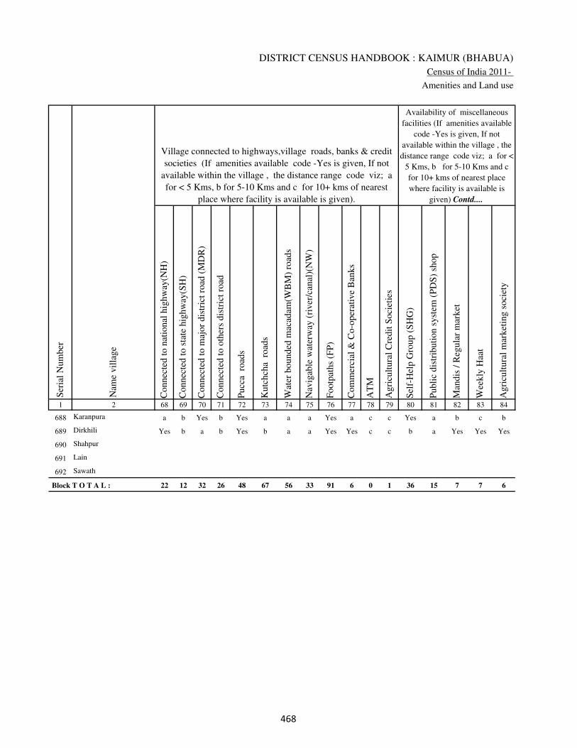
DISTRICT CENSUS HANDBOOK : KAIMUR (BHABUA)
Census of India 2011-
Amenities and Land use
Connec
ted t
o n
atio
nal
hig
hw
ay(N
H)
Connec
ted t
o s
tate
hig
hw
ay(S
H)
Connec
ted t
o m
ajor
dis
tric
t ro
ad (
MD
R)
Connec
ted t
o o
ther
s dis
tric
t ro
ad
Pucc
a r
oad
s
Kutc
hch
a r
oad
s
Wat
er b
ounded
mac
adam
(WB
M)
road
s
Nav
igab
le w
ater
way
(ri
ver
/can
al)(
NW
)
Footp
aths
(FP
)
Com
mer
cial
& C
o-o
per
ativ
e B
anks
AT
M
Agri
cult
ura
l C
redit
Soci
etie
s
Sel
f-H
elp G
roup (
SH
G)
Publi
c dis
trib
uti
on s
yst
em (
PD
S)
shop
Man
dis
/ R
egula
r m
arket
Wee
kly
Haa
t
Agri
cult
ura
l m
arket
ing s
oci
ety
1 2 68 69 70 71 72 73 74 75 76 77 78 79 80 81 82 83 84
Village connected to highways,village roads, banks & credit
societies (If amenities available code -Yes is given, If not
available within the village , the distance range code viz; a
for < 5 Kms, b for 5-10 Kms and c for 10+ kms of nearest
place where facility is available is given).
Ser
ial
Num
ber
Nam
e vil
lage
Availability of miscellaneous
facilities (If amenities available
code -Yes is given, If not
available within the village , the
distance range code viz; a for <
5 Kms, b for 5-10 Kms and c
for 10+ kms of nearest place
where facility is available is
given) Contd....
688 Karanpura a b Yes b Yes a a a Yes a c c Yes a b c b
689 Dirkhili Yes b a b Yes b a a Yes Yes c c b a Yes Yes Yes
690 Shahpur
691 Lain
692 Sawath
Block T O T A L : 22 12 32 26 48 67 56 33 91 6 0 1 36 15 7 7 6
���

VILLAGE DIRECTORY
Village Directory
( As in 2009 )
Inte
gra
ted C
hil
d D
evel
opm
ent
Sch
eme
(Nutr
itio
nal
Cen
tres
)
Angan
wad
i C
entr
e (N
utr
itio
nal
Cen
tres
)
Oth
ers
(Nutr
itio
nal
Cen
tres
)
AS
HA
(A
ccre
dit
ed S
oci
al H
ealt
h A
ctiv
ist)
Com
munit
y c
entr
e w
ith/w
ithout
TV
Sport
s F
ield
,
Sport
s C
lub /
Rec
reat
ion C
entr
e
Cin
ema
/ V
ideo
Hal
l
Publi
c L
ibra
ry
Publi
c R
eadin
g R
oom
New
spap
er S
upply
Ass
embly
Poll
ing s
tati
on
Bir
th &
Dea
th R
egis
trat
ion O
ffic
e
Pow
er S
upply
for
Dom
esti
c U
se (
ED
)
Pow
er S
upply
for
Agri
cult
ura
l U
se (
EA
G)
Pow
er S
upply
for
Com
mer
cial
Use
(E
C)
Pow
er S
upply
for
All
Use
s (E
A)
85 86 87 88 89 90 91 92 93 94 95 96 97 98 99 100 101 2 1
Availability of
electricity (Yes/No)
Availability of miscellaneous facilities (If amenities available code -
Yes is given, If not available within the village , the distance range
code viz; a for < 5 Kms, b for 5-10 Kms and c for 10+ kms of
nearest place where facility is available is given) Concluded
Nam
e vil
lage
Ser
ial
Num
ber
a Yes Yes Yes c c c c c c Yes Yes a Yes Yes No No Karanpura 688
a Yes Yes b c b c c c b b a a Yes Yes No No Dirkhili 689
Shahpur 690
Lain 691
Sawath 692
1 44 90 37 14 10 3 0 1 1 8 32 14 86 86 2 2
���

DISTRICT CENSUS HANDBOOK : KAIMUR (BHABUA)
Census of India 2011-
Amenities and Land use
Nam
e
Dis
tance
ran
ge
code
i.e
. a
fo
r <
5 K
ms,
b
for
5-
10 K
ms
and c
f
or
10+
km
s .
Fore
sts
Are
a under
Non-a
gri
cult
ura
l U
ses
Bar
ren a
nd U
n-c
ult
ivab
le l
and
Per
man
ent
Pas
ture
s an
d O
ther
Gra
zing L
ands
Lan
d U
nder
Mis
cell
aneo
us
Tre
e C
rops
etc.
Cult
ura
ble
Was
te L
and
Fal
low
lan
ds
oth
er t
han
curr
ent
fall
ow
s
Curr
ent
Fal
low
s
1 2 102 103 104 105 106 107 108 109 110 111
Ser
ial
Num
ber
Nam
e vil
lage
Area under different types of land use ( in hectares rounded up to
one decimal place)
Land Use
Nearest Town
688 Karanpura BHABUA c 0 32 13 0 0 0 0 0
689 Dirkhili BHABUA c 0 29 0 0 0 0 0 0
690 Shahpur 0 4 0 0 0 0 0 0
691 Lain 0 4.2 0 0 0 0 0 0
692 Sawath 0 3.2 0 0 0 0 0 0
Block T O T A L : 0 0 0 1699.7 35.9 10.4 225.3 6.2 57.2 106
���
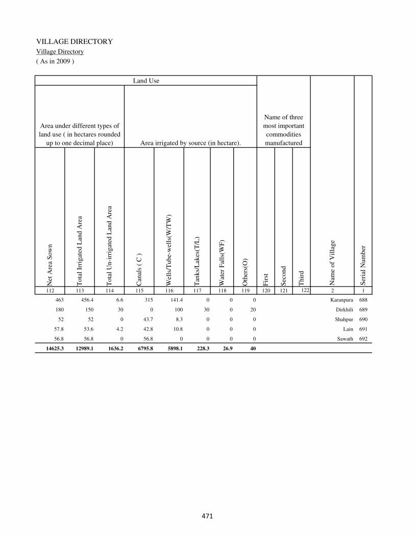
VILLAGE DIRECTORY
Village Directory
( As in 2009 )
Net
Are
a S
ow
n
Tota
l Ir
rigat
ed L
and A
rea
Tota
l U
n-i
rrig
ated
Lan
d A
rea
Can
als
( C
)
Wel
ls/T
ube-
wel
ls(W
/TW
)
Tan
ks/
Lak
es(T
/L)
Wat
er F
alls
(WF
)
Oth
ers(
O)
Fir
st
Sec
ond
Thir
d
112 113 114 115 116 117 118 119 120 121 122 2 1
Ser
ial
Num
ber
Name of three
most important
commodities
manufacturedArea irrigated by source (in hectare).
Nam
e of
Vil
lage
Area under different types of
land use ( in hectares rounded
up to one decimal place)
Land Use
463 456.4 6.6 315 141.4 0 0 0 Karanpura 688
180 150 30 0 100 30 0 20 Dirkhili 689
52 52 0 43.7 8.3 0 0 0 Shahpur 690
57.8 53.6 4.2 42.8 10.8 0 0 0 Lain 691
56.8 56.8 0 56.8 0 0 0 0 Sawath 692
14625.3 12989.1 1636.2 6795.8 5898.1 228.3 26.9 40
���
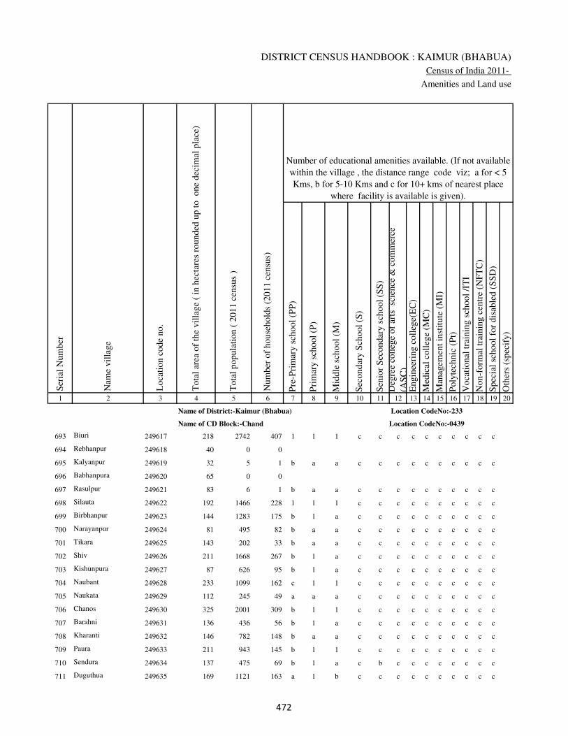
DISTRICT CENSUS HANDBOOK : KAIMUR (BHABUA)
Census of India 2011-
Amenities and Land use
Pre
-Pri
mar
y s
chool
(PP
)
Pri
mar
y s
chool
(P)
Mid
dle
sch
ool
(M)
Sec
ondar
y S
chool
(S)
Sen
ior
Sec
ondar
y s
chool
(SS
)
Deg
ree
coll
ege
of
arts
sc
ience
& c
om
mer
ce
(AS
C)
Engin
eeri
ng c
oll
ege(
EC
)
Med
ical
coll
ege
(MC
)
Man
agem
ent
inst
itute
(M
I)
Poly
tech
nic
(P
t)
Voca
tional
tra
inin
g s
chool
/IT
I
Non-f
orm
al t
rain
ing c
entr
e (N
FT
C)
Spec
ial
school
for
dis
able
d (
SS
D)
Oth
ers
(spec
ify)
1 2 3 4 5 6 7 8 9 10 11 12 13 14 15 16 17 18 19 20
Loca
tion c
ode
no.
Nam
e vil
lage
Ser
ial
Num
ber
Tota
l popula
tion (
2011 c
ensu
s )
Tota
l ar
ea o
f th
e vil
lage
( in
hec
tare
s ro
unded
up t
o
one
dec
imal
pla
ce)
Number of educational amenities available. (If not available
within the village , the distance range code viz; a for < 5
Kms, b for 5-10 Kms and c for 10+ kms of nearest place
where facility is available is given).
Num
ber
of
house
hold
s (2
011 c
ensu
s)
Name of District:-Kaimur (Bhabua) Location CodeNo:-233
Name of CD Block:-Chand Location CodeNo:-0439
693 Biuri 249617 218 2742 407 1 1 1 c c c c c c c c c c
694 Rebhanpur 249618 40 0 0
695 Kalyanpur 249619 32 5 1 b a a c c c c c c c c c c
696 Babhanpura 249620 65 0 0
697 Rasulpur 249621 83 6 1 b a a c c c c c c c c c c
698 Silauta 249622 192 1466 228 1 1 1 c c c c c c c c c c
699 Birbhanpur 249623 144 1283 175 b 1 a c c c c c c c c c c
700 Narayanpur 249624 81 495 82 b a a c c c c c c c c c c
701 Tikara 249625 143 202 33 b a a c c c c c c c c c c
702 Shiv 249626 211 1668 267 b 1 a c c c c c c c c c c
703 Kishunpura 249627 87 626 95 b 1 a c c c c c c c c c c
704 Naubant 249628 233 1099 162 c 1 1 c c c c c c c c c c
705 Naukata 249629 112 245 49 a a a c c c c c c c c c c
706 Chanos 249630 325 2001 309 b 1 1 c c c c c c c c c c
707 Barahni 249631 136 436 56 b 1 a c c c c c c c c c c
708 Kharanti 249632 146 782 148 b a a c c c c c c c c c c
709 Paura 249633 211 943 145 b 1 1 c c c c c c c c c c
710 Sendura 249634 137 475 69 b 1 a c b c c c c c c c c
711 Duguthua 249635 169 1121 163 a 1 b c c c c c c c c c c
��
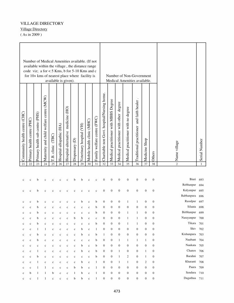
VILLAGE DIRECTORY
Village Directory
( As in 2009 )
Com
munit
y h
ealt
h c
entr
e (C
HC
)
Pri
mar
y h
ealt
h c
entr
e (P
HC
)
Pri
mar
y h
ealt
h s
ub c
entr
e (P
HS
)
Mat
ernit
y a
nd c
hil
d w
elfa
re c
entr
e (M
CW
)
T.B
. cl
inic
(T
BC
)
Hosp
ital
-all
opat
hic
(H
A)
Hosp
ital
-alt
ernat
ive
med
icin
e (H
O)
Dis
pen
sary
(D
)
Vet
erin
ary h
osp
ital
(V
H)
Mobil
e hea
lth c
linic
(M
HC
)
Fam
ily w
elfa
re c
entr
e (F
WC
)
Char
itab
le n
on G
ovt.
hosp
ital
/Nurs
ing h
om
e.
Med
ical
pra
ctit
ioner
wit
h M
BB
S D
egre
e
Med
ical
pra
ctit
ioner
wit
h o
ther
deg
ree
Med
ical
pra
ctit
ioner
wit
h n
o d
egre
e
Tra
dit
ional
pra
ctit
ioner
an
d f
aith
hea
ler
.
Med
icin
e S
hop
Oth
ers
21 22 23 24 25 26 27 28 29 30 31 32 33 34 35 36 37 38 2 1
Number of Non-Government
Medical Amenities available.
Number of Medical Amenities available. (If not
available within the village , the distance range
code viz; a for < 5 Kms, b for 5-10 Kms and c
for 10+ kms of nearest place where facility is
available is given).
Nam
e vil
lage
Ser
ial
Num
ber
c c b c c c c b b c c 0 0 0 0 0 0 0 Biuri 693
Rebhanpur 694
c c b c c c c c c c c 0 0 0 0 0 0 0 Kalyanpur 695
Babhanpura 696
c c b c c c c c b c b 0 0 0 1 1 0 0 Rasulpur 697
c c b c c c c c c c b 0 0 0 0 0 0 0 Silauta 698
c c b c c c c c c c b 0 0 0 1 1 0 0 Birbhanpur 699
c c b c c c c b b c c 0 0 0 1 1 0 0 Narayanpur 700
c c b c c c c c c c b 0 0 0 1 1 0 0 Tikara 701
c c 1 1 c c c c b c 1 0 0 0 0 0 0 0 Shiv 702
c c b c c c c c b c b 1 0 0 0 0 0 0 Kishunpura 703
c c b c c c c c c c b 0 0 1 1 1 1 0 Naubant 704
c c c c c c c c b c b 0 0 0 0 0 0 0 Naukata 705
c c 1 c c c c c b c b 0 0 1 0 0 1 0 Chanos 706
c c b c c c c c c c b 0 0 1 2 0 1 0 Barahni 707
c c 1 c c c c c b c 1 0 0 1 1 0 2 0 Kharanti 708
c c 1 1 c c c b b c 1 0 0 0 0 0 0 0 Paura 709
c b 1 1 b c c 1 b c 1 0 0 0 0 0 0 0 Sendura 710
c c 1 1 c c c b b c 1 0 0 0 0 0 0 0 Duguthua 711
��

DISTRICT CENSUS HANDBOOK : KAIMUR (BHABUA)
Census of India 2011-
Amenities and Land use
Tap
wat
er (
Tre
ated
/Untr
eate
d)
Wel
l w
ater
(Cover
ed /
Unco
ver
ed w
ell)
Han
d P
um
p
Tube
wel
ls /
Bore
wel
l
Spri
ng
Riv
er /
Can
al
Tan
k /
Pond /
L
ake
Oth
ers
Com
munit
y t
oil
et i
ncl
udin
g
bat
h.
Com
munit
y t
oil
et e
xcl
udin
g b
ath.
Rura
l s
anit
ary m
art
or
sanit
ary
har
dw
are
outl
et
avai
lable
nea
r th
e vil
lage.
Com
munit
y b
io-
gas
or
recy
cle
of
was
te f
or
pro
duct
ive
use
.
1 2 39 40 41 42 43 44 45 46 47 48 49 50
Availability of toilet & others
Yes / No Availability of drinking water - Yes / No
Nam
e vil
lage
Ser
ial
Num
ber
693 Biuri No No Yes Yes No No No No No No No No
694 Rebhanpur
695 Kalyanpur No No Yes Yes No No No No No No No No
696 Babhanpura
697 Rasulpur No Yes Yes No No No No No No No No No
698 Silauta No No Yes No No No No No No No No No
699 Birbhanpur No No Yes Yes No No No No No No No No
700 Narayanpur No Yes Yes No No No No No No No No No
701 Tikara No No Yes No No No Yes No No No No No
702 Shiv No No Yes Yes No Yes No No No No No No
703 Kishunpura No Yes Yes No No Yes No No No No No No
704 Naubant No No Yes Yes No Yes No No No No No No
705 Naukata No No Yes Yes No No No No No No No No
706 Chanos No No Yes Yes No No No No No No No No
707 Barahni No No Yes Yes No No No No No No No No
708 Kharanti No No Yes Yes No No No No No No No No
709 Paura No No Yes Yes No No No No No No No No
710 Sendura No No Yes Yes No No No No No No No No
711 Duguthua No No Yes Yes No No No No No No No No
���
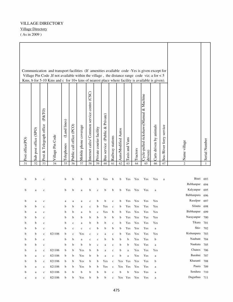
VILLAGE DIRECTORY
Village Directory
( As in 2009 )
Post
off
ice(
PO
)
Sub p
ost
off
ice
(SP
O)
Post
& T
eleg
raph o
ffic
e
(P&
TO
)
Vil
lage
Pin
Code
Tel
ephones
(L
and l
ines
)
Publi
c ca
ll o
ffic
e (P
CO
)
Mobil
e phone
cover
age
Inte
rnet
caf
es/
Com
mon s
ervic
e ce
ntr
e (C
SC
)
Pri
vat
e co
uri
er f
acil
ity
Bus
serv
ice
(P
ubli
c &
Pri
vat
e)
Rai
lway
sta
tions
Auto
/Modif
ied A
uto
s
Tax
is a
nd V
ans
Tra
ctors
Cycl
e-pull
ed r
icksh
aws(
Man
ual
& M
achin
e
dri
ven
)
Car
ts d
riven
by a
nim
als
Sea
/R
iver
fer
ry s
ervic
e51 52 53 54 55 56 57 58 59 60 61 62 63 64 65 66 67 2 1
Communication and transport facilities (If amenities available code -Yes is given except for
Village Pin Code ,If not available within the village , the distance range code viz; a for < 5
Kms, b for 5-10 Kms and c for 10+ kms of nearest place where facility is available is given).
Ser
ial
Num
ber
Nam
e vil
lage
b b c b b b b b Yes b b Yes Yes Yes Yes a Biuri 693
Rebhanpur 694
b a c b b a b c b b b Yes Yes Yes a Kalyanpur 695
Babhanpura 696
b a c a a a c b b c b Yes Yes Yes Yes Rasulpur 697
b b c b b a c b Yes c b Yes Yes Yes Yes Silauta 698
b a c b b a b c Yes b b Yes Yes Yes Yes Birbhanpur 699
b b c b b b b b b b b Yes Yes Yes Yes Narayanpur 700
b b c b c a b b b c b Yes Yes Yes Yes Tikara 701
b b c b c c c b b b b Yes Yes Yes a Shiv 702
b b c 821106 b c Yes c c a c b Yes Yes Yes Yes Kishunpura 703
b b c b b a c c b b b b Yes Yes b Naubant 704
b b c b b b b c a c b b Yes Yes a Naukata 705
b a c 821106 b b Yes b b a c b a Yes Yes Yes Chanos 706
b a c 821106 b b Yes b b a c b a Yes Yes a Barahni 707
b b c 821106 b b Yes b b Yes c Yes Yes Yes Yes b Kharanti 708
b a c 821106 b b Yes b b Yes c Yes Yes Yes Yes a Paura 709
b a c 821106 b b b b b b c b b Yes Yes a Sendura 710
a a c 821106 b b Yes b b b c Yes Yes Yes Yes a Duguthua 711
���
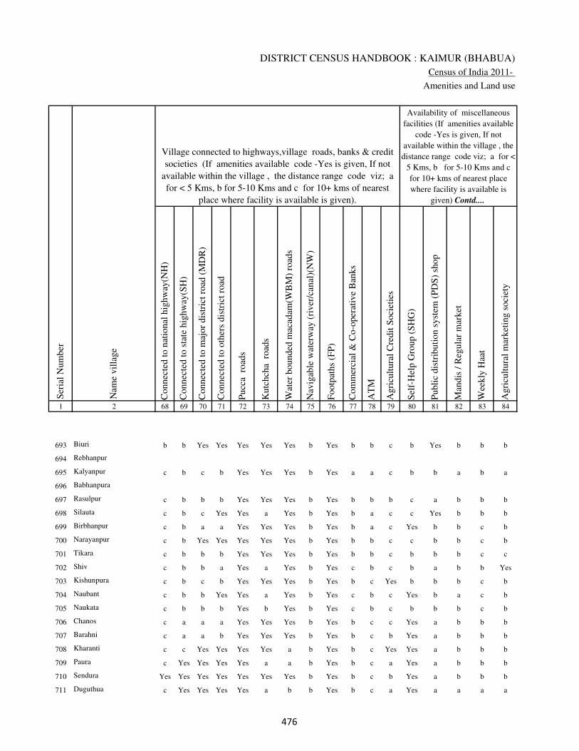
DISTRICT CENSUS HANDBOOK : KAIMUR (BHABUA)
Census of India 2011-
Amenities and Land use
Connec
ted t
o n
atio
nal
hig
hw
ay(N
H)
Connec
ted t
o s
tate
hig
hw
ay(S
H)
Connec
ted t
o m
ajor
dis
tric
t ro
ad (
MD
R)
Connec
ted t
o o
ther
s dis
tric
t ro
ad
Pucc
a r
oad
s
Kutc
hch
a r
oad
s
Wat
er b
ounded
mac
adam
(WB
M)
road
s
Nav
igab
le w
ater
way
(ri
ver
/can
al)(
NW
)
Footp
aths
(FP
)
Com
mer
cial
& C
o-o
per
ativ
e B
anks
AT
M
Agri
cult
ura
l C
redit
Soci
etie
s
Sel
f-H
elp G
roup (
SH
G)
Publi
c dis
trib
uti
on s
yst
em (
PD
S)
shop
Man
dis
/ R
egula
r m
arket
Wee
kly
Haa
t
Agri
cult
ura
l m
arket
ing s
oci
ety
1 2 68 69 70 71 72 73 74 75 76 77 78 79 80 81 82 83 84
Village connected to highways,village roads, banks & credit
societies (If amenities available code -Yes is given, If not
available within the village , the distance range code viz; a
for < 5 Kms, b for 5-10 Kms and c for 10+ kms of nearest
place where facility is available is given).
Ser
ial
Num
ber
Nam
e vil
lage
Availability of miscellaneous
facilities (If amenities available
code -Yes is given, If not
available within the village , the
distance range code viz; a for <
5 Kms, b for 5-10 Kms and c
for 10+ kms of nearest place
where facility is available is
given) Contd....
693 Biuri b b Yes Yes Yes Yes Yes b Yes b b c b Yes b b b
694 Rebhanpur
695 Kalyanpur c b c b Yes Yes Yes b Yes a a c b b a b a
696 Babhanpura
697 Rasulpur c b b b Yes Yes Yes b Yes b b b c a b b b
698 Silauta c b c Yes Yes a Yes b Yes b a c c Yes b b b
699 Birbhanpur c b a a Yes Yes Yes b Yes b a c Yes b b c b
700 Narayanpur c b Yes Yes Yes Yes Yes b Yes b b c c b b c b
701 Tikara c b b b Yes Yes Yes b Yes b b c b b b c c
702 Shiv c b b a Yes a Yes b Yes c b c b a b b Yes
703 Kishunpura c b c b Yes Yes Yes b Yes b c Yes b b b c b
704 Naubant c b b Yes Yes a Yes b Yes c b c Yes b a c b
705 Naukata c b b b Yes b Yes b Yes c b c b b b c b
706 Chanos c a a a Yes Yes Yes b Yes b c c Yes a b b b
707 Barahni c a a b Yes Yes Yes b Yes b c b Yes a b b b
708 Kharanti c c Yes Yes Yes Yes a b Yes b c Yes Yes a b b b
709 Paura c Yes Yes Yes Yes a a b Yes b c a Yes a b b b
710 Sendura Yes Yes Yes Yes Yes Yes Yes b Yes b c b Yes a b b b
711 Duguthua c Yes Yes Yes Yes a b b Yes b c a Yes a a a a
���

VILLAGE DIRECTORY
Village Directory
( As in 2009 )
Inte
gra
ted C
hil
d D
evel
opm
ent
Sch
eme
(Nutr
itio
nal
Cen
tres
)
Angan
wad
i C
entr
e (N
utr
itio
nal
Cen
tres
)
Oth
ers
(Nutr
itio
nal
Cen
tres
)
AS
HA
(A
ccre
dit
ed S
oci
al H
ealt
h A
ctiv
ist)
Com
munit
y c
entr
e w
ith/w
ithout
TV
Sport
s F
ield
,
Sport
s C
lub /
Rec
reat
ion C
entr
e
Cin
ema
/ V
ideo
Hal
l
Publi
c L
ibra
ry
Publi
c R
eadin
g R
oom
New
spap
er S
upply
Ass
embly
Poll
ing s
tati
on
Bir
th &
Dea
th R
egis
trat
ion O
ffic
e
Pow
er S
upply
for
Dom
esti
c U
se (
ED
)
Pow
er S
upply
for
Agri
cult
ura
l U
se (
EA
G)
Pow
er S
upply
for
Com
mer
cial
Use
(E
C)
Pow
er S
upply
for
All
Use
s (E
A)
85 86 87 88 89 90 91 92 93 94 95 96 97 98 99 100 101 2 1
Availability of
electricity (Yes/No)
Availability of miscellaneous facilities (If amenities available code -
Yes is given, If not available within the village , the distance range
code viz; a for < 5 Kms, b for 5-10 Kms and c for 10+ kms of
nearest place where facility is available is given) Concluded
Nam
e vil
lage
Ser
ial
Num
ber
b Yes Yes Yes c b c c c b b Yes Yes Yes Yes Yes Yes Biuri 693
Rebhanpur 694
b b Yes a c c c c c c a a a Yes Yes Yes Yes Kalyanpur 695
Babhanpura 696
b b Yes a c c c c c c a a a Yes Yes Yes Yes Rasulpur 697
c Yes Yes Yes c b c c b c b Yes a Yes Yes Yes Yes Silauta 698
b b Yes Yes c c c c c c b Yes b Yes Yes Yes Yes Birbhanpur 699
b Yes Yes Yes c b c c c c b Yes Yes Yes Yes Yes Yes Narayanpur 700
c b Yes b c c c c c c b a a Yes Yes Yes Yes Tikara 701
c Yes Yes Yes c c c c c c b Yes b Yes No No No Shiv 702
c Yes Yes Yes c c c c c c c a a Yes Yes Yes Yes Kishunpura 703
c Yes Yes Yes c c c c c c c Yes a Yes Yes Yes Yes Naubant 704
c b Yes b c c c c c c b a a Yes Yes Yes Yes Naukata 705
b Yes Yes Yes c c c b b b b Yes a Yes Yes No No Chanos 706
b Yes Yes Yes b c b b b b b a a Yes Yes No No Barahni 707
b Yes Yes a c b c b b b b Yes a Yes Yes No No Kharanti 708
b Yes Yes Yes c b b c b b b Yes a Yes Yes No No Paura 709
b b Yes Yes c b b c b b b a a Yes Yes No No Sendura 710
b Yes Yes Yes c a a c a a a Yes a Yes Yes No No Duguthua 711
���

DISTRICT CENSUS HANDBOOK : KAIMUR (BHABUA)
Census of India 2011-
Amenities and Land use
Nam
e
Dis
tance
ran
ge
code
i.e
. a
fo
r <
5 K
ms,
b
for
5-
10 K
ms
and c
f
or
10+
km
s .
Fore
sts
Are
a under
Non-a
gri
cult
ura
l U
ses
Bar
ren a
nd U
n-c
ult
ivab
le l
and
Per
man
ent
Pas
ture
s an
d O
ther
Gra
zing L
ands
Lan
d U
nder
Mis
cell
aneo
us
Tre
e C
rops
etc.
Cult
ura
ble
Was
te L
and
Fal
low
lan
ds
oth
er t
han
curr
ent
fall
ow
s
Curr
ent
Fal
low
s
1 2 102 103 104 105 106 107 108 109 110 111
Ser
ial
Num
ber
Nam
e vil
lage
Area under different types of land use ( in hectares rounded up to
one decimal place)
Land Use
Nearest Town
693 Biuri BHABUA c 0 22.2 0 1 1.2 0 0 0
694 Rebhanpur 0 0.4 0 0 0 11 0 0
695 Kalyanpur BHABUA c 0 1.4 0 3.3 3.4 11.3 0.2 0
696 Babhanpura 0 2.6 0 0.2 0.3 30.2 0 0
697 Rasulpur BHABUA c 0 2.9 0 0 0 8.4 0 0
698 Silauta BHABUA c 0 12.6 0 0 0 49.9 0 0
699 Birbhanpur BHABUA c 0 7.4 0 0.5 0.5 35.1 0.3 0.2
700 Narayanpur BHABUA c 0 4.4 0 0 0 5.7 0 2
701 Tikara BHABUA c 0 1.9 0 0 0 0 0 0
702 Shiv BHABUA c 0 15.3 0 10 10 56.4 0 0
703 Kishunpura BHABUA c 0 5.9 0 0 0.4 6.3 0 0
704 Naubant BHABUA c 0 15.1 0 1 1 16.9 2.5 2.5
705 Naukata BHABUA c 0 6.4 0 1 1 0.2 15 8.4
706 Chanos BHABUA c 0 24 0 1.2 1.1 4.2 4.1 0
707 Barahni BHABUA c 0 10 0 0.7 0.6 6.8 10 15
708 Kharanti BHABUA c 0 13.7 0 6.2 7.2 6.7 0 0
709 Paura BHABUA c 0 10.1 0 2 2 0 0 10
710 Sendura BHABUA c 0 6.5 0 3 2 31.9 4 6
711 Duguthua BHABUA c 0 2.8 0 5 5 6.8 10 10
���

VILLAGE DIRECTORY
Village Directory
( As in 2009 )
Net
Are
a S
ow
n
Tota
l Ir
rigat
ed L
and A
rea
Tota
l U
n-i
rrig
ated
Lan
d A
rea
Can
als
( C
)
Wel
ls/T
ube-
wel
ls(W
/TW
)
Tan
ks/
Lak
es(T
/L)
Wat
er F
alls
(WF
)
Oth
ers(
O)
Fir
st
Sec
ond
Thir
d
112 113 114 115 116 117 118 119 120 121 122 2 1
Ser
ial
Num
ber
Name of three
most important
commodities
manufacturedArea irrigated by source (in hectare).
Nam
e of
Vil
lage
Area under different types of
land use ( in hectares rounded
up to one decimal place)
Land Use
193.6 98.3 95.2 0 58.9 0 0 39.5 Biuri 693
28.6 19.6 9 0 13 0 0 6.6 Rebhanpur 694
12.4 10.1 2.3 0 9.1 0 0 1 Kalyanpur 695
31.8 26.8 5 0 26.8 0 0 0 Babhanpura 696
71.7 65 6.7 0 60 5 0 0 Rasulpur 697
129.5 65.8 63.8 45.8 10 0 0 10 Silauta 698
100 56.1 43.8 26 10.1 0 0 20 Birbhanpur 699
68.9 55.7 13.2 0 35.7 20 0 0 Narayanpur 700
141.1 130.9 10.2 0 130.9 0 0 0 Tikara 701
119.3 59.8 59.5 0 50.8 0 0 9 Shiv 702
74.4 39.9 34.5 12.8 27 0 0 0 Kishunpura 703
194 140 54 120 18 0 0 2 Naubant 704
80 70 10 60 10 0 0 0 Naukata 705
290.5 184.3 106.2 0 92.3 72 20 0 Chanos 706
92.9 70.3 22.6 42.3 28 0 0 0 Barahni 707
112 111 1 30.6 80.5 0 0 0 Kharanti 708
186.9 150 36.9 100 50 0 0 0 Paura 709
83.6 79 4.6 0 50.6 20 8.4 0 Sendura 710
129.4 100 29.4 50 50 0 0 0 Duguthua 711
���

DISTRICT CENSUS HANDBOOK : KAIMUR (BHABUA)
Census of India 2011-
Amenities and Land use
Pre
-Pri
mar
y s
chool
(PP
)
Pri
mar
y s
chool
(P)
Mid
dle
sch
ool
(M)
Sec
ondar
y S
chool
(S)
Sen
ior
Sec
ondar
y s
chool
(SS
)
Deg
ree
coll
ege
of
arts
sc
ience
& c
om
mer
ce
(AS
C)
Engin
eeri
ng c
oll
ege(
EC
)
Med
ical
coll
ege
(MC
)
Man
agem
ent
inst
itute
(M
I)
Poly
tech
nic
(P
t)
Voca
tional
tra
inin
g s
chool
/IT
I
Non-f
orm
al t
rain
ing c
entr
e (N
FT
C)
Spec
ial
school
for
dis
able
d (
SS
D)
Oth
ers
(spec
ify)
1 2 3 4 5 6 7 8 9 10 11 12 13 14 15 16 17 18 19 20
Loca
tion c
ode
no.
Nam
e vil
lage
Ser
ial
Num
ber
Tota
l popula
tion (
2011 c
ensu
s )
Tota
l ar
ea o
f th
e vil
lage
( in
hec
tare
s ro
unded
up t
o
one
dec
imal
pla
ce)
Number of educational amenities available. (If not available
within the village , the distance range code viz; a for < 5
Kms, b for 5-10 Kms and c for 10+ kms of nearest place
where facility is available is given).
Num
ber
of
house
hold
s (2
011 c
ensu
s)
712 Salaunja 249636 66 477 75 a 1 b c c c c c c c c c c
713 Darabchak 249637 27 0 0
714 Mohammadpur 249638 41 0 0
715 Lasanri 249639 101 677 76 a 1 b c c c c c c c c c c
716 Bhaluhari 249640 107 1245 176 1 1 a c c c c c c c c c c
717 Kuddi 249641 452 3232 526 1 1 a c c c c c c c c c c
718 Bhatani 249642 171 1118 164 1 1 a c c c c c c c c c c
719 Kuwadda 249643 240 621 82 b 1 a c c c c c c c c c c
720 Khainti 249644 112 633 72 b 1 a c c c c c c c c c c
721 Lanka 249645 65 0 0
722 Goin 249646 420 3445 433 b 1 1 c c c c c c c c c c
723 Jigana 249647 219 1291 174 1 1 a c c c c c c c c c c
724 Sihoria 249648 191 1743 250 a 1 a c c c c c c c c c c
725 kariara 249649 96 65 9 a a a c c c c c c c c c c
726 Barawan 249650 186 643 63 a 1 b c c c c c c c c c c
727 Bheri 249651 113 771 124 a 1 a c c c c c c c c c c
728 Auraiya 249652 85 70 7 a a a c c c c c c c c c c
729 Majhgain 249653 82 243 38 a a a c c c c c c c c c c
730 Majhgawan 249654 46 0 0
731 Bhewar 249655 178 1592 247 a 1 a c c c c c c c c c c
���
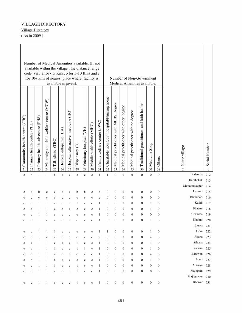
VILLAGE DIRECTORY
Village Directory
( As in 2009 )
Com
munit
y h
ealt
h c
entr
e (C
HC
)
Pri
mar
y h
ealt
h c
entr
e (P
HC
)
Pri
mar
y h
ealt
h s
ub c
entr
e (P
HS
)
Mat
ernit
y a
nd c
hil
d w
elfa
re c
entr
e (M
CW
)
T.B
. cl
inic
(T
BC
)
Hosp
ital
-all
opat
hic
(H
A)
Hosp
ital
-alt
ernat
ive
med
icin
e (H
O)
Dis
pen
sary
(D
)
Vet
erin
ary h
osp
ital
(V
H)
Mobil
e hea
lth c
linic
(M
HC
)
Fam
ily w
elfa
re c
entr
e (F
WC
)
Char
itab
le n
on G
ovt.
hosp
ital
/Nurs
ing h
om
e.
Med
ical
pra
ctit
ioner
wit
h M
BB
S D
egre
e
Med
ical
pra
ctit
ioner
wit
h o
ther
deg
ree
Med
ical
pra
ctit
ioner
wit
h n
o d
egre
e
Tra
dit
ional
pra
ctit
ioner
an
d f
aith
hea
ler
.
Med
icin
e S
hop
Oth
ers
21 22 23 24 25 26 27 28 29 30 31 32 33 34 35 36 37 38 2 1
Number of Non-Government
Medical Amenities available.
Number of Medical Amenities available. (If not
available within the village , the distance range
code viz; a for < 5 Kms, b for 5-10 Kms and c
for 10+ kms of nearest place where facility is
available is given).
Nam
e vil
lage
Ser
ial
Num
ber
c b 1 1 b c c c c c 1 1 0 0 0 0 0 0 Salaunja 712
Darabchak 713
Mohammadpur 714
c c b c c c c b b c b 0 0 0 0 0 0 0 Lasanri 715
c c c c c c c c c c c 0 0 0 0 0 0 0 Bhaluhari 716
c c 1 1 c c c 1 c c 1 0 0 0 0 0 1 0 Kuddi 717
c c 1 1 c c c c c c 1 0 0 0 0 0 1 0 Bhatani 718
c c 1 1 c c c c c c 1 0 0 0 0 0 0 0 Kuwadda 719
c c 1 c c c c c c c 1 0 0 0 0 0 1 0 Khainti 720
Lanka 721
c c 1 1 1 c c c c c 1 1 0 0 0 0 1 0 Goin 722
c c 1 c c c c c c c c 0 0 0 0 0 4 0 Jigana 723
c c 1 1 c c c 1 c c 1 0 0 0 0 0 1 0 Sihoria 724
c b 1 1 1 c c 1 1 c 1 0 0 0 0 0 1 0 kariara 725
c c 1 1 c c c c c c 1 0 0 0 0 0 4 0 Barawan 726
c b 1 1 b c c c c c 1 0 0 0 0 0 1 0 Bheri 727
c c 1 1 1 c c 1 c c 1 0 0 0 0 0 0 0 Auraiya 728
c c 1 1 c c c 1 c c 1 0 0 0 0 0 0 0 Majhgain 729
Majhgawan 730
c c 1 1 c c c 1 c c 1 0 0 0 0 0 0 0 Bhewar 731
���

DISTRICT CENSUS HANDBOOK : KAIMUR (BHABUA)
Census of India 2011-
Amenities and Land use
Tap
wat
er (
Tre
ated
/Untr
eate
d)
Wel
l w
ater
(Cover
ed /
Unco
ver
ed w
ell)
Han
d P
um
p
Tube
wel
ls /
Bore
wel
l
Spri
ng
Riv
er /
Can
al
Tan
k /
Pond /
L
ake
Oth
ers
Com
munit
y t
oil
et i
ncl
udin
g
bat
h.
Com
munit
y t
oil
et e
xcl
udin
g b
ath.
Rura
l s
anit
ary m
art
or
sanit
ary
har
dw
are
outl
et
avai
lable
nea
r th
e vil
lage.
Com
munit
y b
io-
gas
or
recy
cle
of
was
te f
or
pro
duct
ive
use
.
1 2 39 40 41 42 43 44 45 46 47 48 49 50
Availability of toilet & others
Yes / No Availability of drinking water - Yes / No
Nam
e vil
lage
Ser
ial
Num
ber
712 Salaunja No No Yes Yes No No Yes No No No No No
713 Darabchak
714 Mohammadpur
715 Lasanri No No Yes Yes No Yes No No No No No No
716 Bhaluhari No No Yes Yes No No No No No No No No
717 Kuddi No No Yes Yes No Yes No No No No No No
718 Bhatani No Yes Yes Yes No Yes No No No No No No
719 Kuwadda No Yes Yes Yes No Yes No No No No No No
720 Khainti No Yes Yes Yes No Yes Yes No No No No No
721 Lanka
722 Goin No Yes Yes Yes No No No No No No No No
723 Jigana No Yes Yes Yes No Yes No No No No No No
724 Sihoria No Yes Yes Yes No No Yes No No No No No
725 kariara No Yes Yes Yes No No No No No No No No
726 Barawan No No Yes Yes No No No No No No No No
727 Bheri No Yes Yes No No Yes No No No No No No
728 Auraiya No Yes Yes Yes No No Yes No No No No No
729 Majhgain No Yes Yes Yes No No No No No No No No
730 Majhgawan
731 Bhewar No Yes Yes Yes No No No No No No No No
��

VILLAGE DIRECTORY
Village Directory
( As in 2009 )
Post
off
ice(
PO
)
Sub p
ost
off
ice
(SP
O)
Post
& T
eleg
raph o
ffic
e
(P&
TO
)
Vil
lage
Pin
Code
Tel
ephones
(L
and l
ines
)
Publi
c ca
ll o
ffic
e (P
CO
)
Mobil
e phone
cover
age
Inte
rnet
caf
es/
Com
mon s
ervic
e ce
ntr
e (C
SC
)
Pri
vat
e co
uri
er f
acil
ity
Bus
serv
ice
(P
ubli
c &
Pri
vat
e)
Rai
lway
sta
tions
Auto
/Modif
ied A
uto
s
Tax
is a
nd V
ans
Tra
ctors
Cycl
e-pull
ed r
icksh
aws(
Man
ual
& M
achin
e
dri
ven
)
Car
ts d
riven
by a
nim
als
Sea
/R
iver
fer
ry s
ervic
e51 52 53 54 55 56 57 58 59 60 61 62 63 64 65 66 67 2 1
Communication and transport facilities (If amenities available code -Yes is given except for
Village Pin Code ,If not available within the village , the distance range code viz; a for < 5
Kms, b for 5-10 Kms and c for 10+ kms of nearest place where facility is available is given).
Ser
ial
Num
ber
Nam
e vil
lage
Yes a c 821106 a a Yes a c Yes c Yes Yes Yes Yes a Salaunja 712
Darabchak 713
Mohammadpur 714
b b c 821100 b b b b b Yes c Yes Yes Yes Yes a Lasanri 715
b a c 821106 b b Yes b b a c b b Yes Yes b Bhaluhari 716
Yes c Yes 821106 b Yes b b b b c Yes Yes Yes Yes Yes Kuddi 717
Yes a c 821106 a a b c c a c b b Yes Yes a b Bhatani 718
a a c 821106 a a b c c a c b b Yes Yes a b Kuwadda 719
Yes a c 821106 a a b c a Yes c a a Yes Yes a c Khainti 720
Lanka 721
Yes c c 821106 b b b c a Yes c b b Yes Yes Yes b Goin 722
a a c 821106 a a a c a Yes c a a Yes Yes a a Jigana 723
a a c 821106 a a a c a Yes c a a Yes Yes a b Sihoria 724
Yes a Yes 821106 Yes a a c b Yes c b a Yes Yes a c kariara 725
b a c 821106 a a a c a Yes c a a Yes Yes b Barawan 726
Yes c c 821106 Yes b Yes c c a c b b Yes b a Bheri 727
a a c 821106 a a a c c Yes c b a Yes Yes a c Auraiya 728
a a c a a b a c Yes c a a a a a c Majhgain 729
Majhgawan 730
a a c 821106 a a a a a Yes c a a Yes Yes a a Bhewar 731
��

DISTRICT CENSUS HANDBOOK : KAIMUR (BHABUA)
Census of India 2011-
Amenities and Land use
Connec
ted t
o n
atio
nal
hig
hw
ay(N
H)
Connec
ted t
o s
tate
hig
hw
ay(S
H)
Connec
ted t
o m
ajor
dis
tric
t ro
ad (
MD
R)
Connec
ted t
o o
ther
s dis
tric
t ro
ad
Pucc
a r
oad
s
Kutc
hch
a r
oad
s
Wat
er b
ounded
mac
adam
(WB
M)
road
s
Nav
igab
le w
ater
way
(ri
ver
/can
al)(
NW
)
Footp
aths
(FP
)
Com
mer
cial
& C
o-o
per
ativ
e B
anks
AT
M
Agri
cult
ura
l C
redit
Soci
etie
s
Sel
f-H
elp G
roup (
SH
G)
Publi
c dis
trib
uti
on s
yst
em (
PD
S)
shop
Man
dis
/ R
egula
r m
arket
Wee
kly
Haa
t
Agri
cult
ura
l m
arket
ing s
oci
ety
1 2 68 69 70 71 72 73 74 75 76 77 78 79 80 81 82 83 84
Village connected to highways,village roads, banks & credit
societies (If amenities available code -Yes is given, If not
available within the village , the distance range code viz; a
for < 5 Kms, b for 5-10 Kms and c for 10+ kms of nearest
place where facility is available is given).
Ser
ial
Num
ber
Nam
e vil
lage
Availability of miscellaneous
facilities (If amenities available
code -Yes is given, If not
available within the village , the
distance range code viz; a for <
5 Kms, b for 5-10 Kms and c
for 10+ kms of nearest place
where facility is available is
given) Contd....
712 Salaunja c Yes Yes Yes Yes b a b Yes Yes c Yes Yes a b b b
713 Darabchak
714 Mohammadpur
715 Lasanri c b Yes Yes Yes Yes Yes b Yes b c b Yes a b b b
716 Bhaluhari Yes Yes Yes Yes Yes Yes Yes b Yes c c c Yes b b b b
717 Kuddi c Yes Yes Yes Yes Yes Yes a Yes b c c Yes Yes b b b
718 Bhatani c a a b Yes Yes Yes Yes Yes c a c b Yes a c b
719 Kuwadda c a a b Yes Yes Yes Yes Yes c a b b Yes b c c
720 Khainti c a a Yes Yes Yes a Yes Yes Yes a b b a c c c
721 Lanka
722 Goin c b b b Yes Yes Yes b Yes c b b c Yes c c c
723 Jigana c a b b Yes Yes Yes Yes Yes c a b c Yes c b c
724 Sihoria c a c Yes Yes Yes Yes b Yes c a b c Yes c c c
725 kariara c a a Yes Yes Yes a c Yes Yes a Yes c a c c c
726 Barawan c b a Yes Yes Yes a c Yes Yes c Yes Yes a c b c
727 Bheri c Yes Yes Yes Yes Yes b c Yes a c b Yes a c a c
728 Auraiya c a a b Yes Yes Yes c Yes Yes a Yes c a c c c
729 Majhgain c a Yes Yes Yes Yes Yes Yes Yes Yes a Yes c a c c c
730 Majhgawan
731 Bhewar c a c b Yes Yes Yes a Yes c a b c a c c c
���
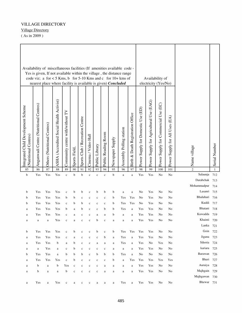
VILLAGE DIRECTORY
Village Directory
( As in 2009 )
Inte
gra
ted C
hil
d D
evel
opm
ent
Sch
eme
(Nutr
itio
nal
Cen
tres
)
Angan
wad
i C
entr
e (N
utr
itio
nal
Cen
tres
)
Oth
ers
(Nutr
itio
nal
Cen
tres
)
AS
HA
(A
ccre
dit
ed S
oci
al H
ealt
h A
ctiv
ist)
Com
munit
y c
entr
e w
ith/w
ithout
TV
Sport
s F
ield
,
Sport
s C
lub /
Rec
reat
ion C
entr
e
Cin
ema
/ V
ideo
Hal
l
Publi
c L
ibra
ry
Publi
c R
eadin
g R
oom
New
spap
er S
upply
Ass
embly
Poll
ing s
tati
on
Bir
th &
Dea
th R
egis
trat
ion O
ffic
e
Pow
er S
upply
for
Dom
esti
c U
se (
ED
)
Pow
er S
upply
for
Agri
cult
ura
l U
se (
EA
G)
Pow
er S
upply
for
Com
mer
cial
Use
(E
C)
Pow
er S
upply
for
All
Use
s (E
A)
85 86 87 88 89 90 91 92 93 94 95 96 97 98 99 100 101 2 1
Availability of
electricity (Yes/No)
Availability of miscellaneous facilities (If amenities available code -
Yes is given, If not available within the village , the distance range
code viz; a for < 5 Kms, b for 5-10 Kms and c for 10+ kms of
nearest place where facility is available is given) Concluded
Nam
e vil
lage
Ser
ial
Num
ber
b Yes Yes Yes c b b c c c b a a Yes Yes No No Salaunja 712
Darabchak 713
Mohammadpur 714
b Yes Yes Yes c b b c b b b a a No Yes No No Lasanri 715
b Yes Yes Yes b b c c c c b Yes Yes No Yes No No Bhaluhari 716
b Yes Yes Yes c b b c c c b Yes Yes No Yes No No Kuddi 717
a Yes Yes Yes b a b c c b b Yes a Yes Yes No No Bhatani 718
a Yes Yes Yes c a c c a a b a a Yes Yes No No Kuwadda 719
a a a Yes c a c c b c a a a Yes Yes No No Khainti 720
Lanka 721
b Yes Yes Yes c b c c b c b Yes Yes Yes Yes No No Goin 722
a Yes Yes Yes c a c c c b a Yes a Yes Yes No No Jigana 723
a Yes Yes b a b c c a a a Yes a Yes No Yes No Sihoria 724
a a Yes a c b c c c c a a a Yes Yes No No kariara 725
b Yes Yes a b b b c b b b Yes a No No No No Barawan 726
a Yes Yes Yes c b c c c c b a Yes Yes Yes Yes Yes Bheri 727
a b a b Yes c c c c a a a a Yes Yes No No Auraiya 728
a b a a b c c c c a a a a Yes Yes No No Majhgain 729
Majhgawan 730
a Yes a Yes c a c c a a a Yes a Yes Yes No No Bhewar 731
���
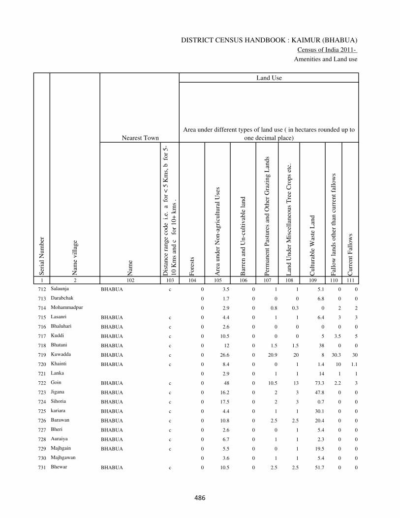
DISTRICT CENSUS HANDBOOK : KAIMUR (BHABUA)
Census of India 2011-
Amenities and Land use
Nam
e
Dis
tance
ran
ge
code
i.e
. a
fo
r <
5 K
ms,
b
for
5-
10 K
ms
and c
f
or
10+
km
s .
Fore
sts
Are
a under
Non-a
gri
cult
ura
l U
ses
Bar
ren a
nd U
n-c
ult
ivab
le l
and
Per
man
ent
Pas
ture
s an
d O
ther
Gra
zing L
ands
Lan
d U
nder
Mis
cell
aneo
us
Tre
e C
rops
etc.
Cult
ura
ble
Was
te L
and
Fal
low
lan
ds
oth
er t
han
curr
ent
fall
ow
s
Curr
ent
Fal
low
s
1 2 102 103 104 105 106 107 108 109 110 111
Ser
ial
Num
ber
Nam
e vil
lage
Area under different types of land use ( in hectares rounded up to
one decimal place)
Land Use
Nearest Town
712 Salaunja BHABUA c 0 3.5 0 1 1 5.1 0 0
713 Darabchak 0 1.7 0 0 0 6.8 0 0
714 Mohammadpur 0 2.9 0 0.8 0.3 0 2 2
715 Lasanri BHABUA c 0 4.4 0 1 1 6.4 3 3
716 Bhaluhari BHABUA c 0 2.6 0 0 0 0 0 0
717 Kuddi BHABUA c 0 10.5 0 0 0 5 3.5 5
718 Bhatani BHABUA c 0 12 0 1.5 1.5 38 0 0
719 Kuwadda BHABUA c 0 26.6 0 20.9 20 8 30.3 30
720 Khainti BHABUA c 0 8.4 0 0 1 1.4 10 1.1
721 Lanka 0 2.9 0 1 1 14 1 1
722 Goin BHABUA c 0 48 0 10.5 13 73.3 2.2 3
723 Jigana BHABUA c 0 16.2 0 2 3 47.8 0 0
724 Sihoria BHABUA c 0 17.5 0 2 3 0.7 0 0
725 kariara BHABUA c 0 4.4 0 1 1 30.1 0 0
726 Barawan BHABUA c 0 10.8 0 2.5 2.5 20.4 0 0
727 Bheri BHABUA c 0 2.6 0 0 1 5.4 0 0
728 Auraiya BHABUA c 0 6.7 0 1 1 2.3 0 0
729 Majhgain BHABUA c 0 5.5 0 0 1 19.5 0 0
730 Majhgawan 0 3.6 0 1 1 5.4 0 0
731 Bhewar BHABUA c 0 10.5 0 2.5 2.5 51.7 0 0
���
VILLAGE DIRECTORY
Village Directory
( As in 2009 )
Net
Are
a S
ow
n
Tota
l Ir
rigat
ed L
and A
rea
Tota
l U
n-i
rrig
ated
Lan
d A
rea
Can
als
( C
)
Wel
ls/T
ube-
wel
ls(W
/TW
)
Tan
ks/
Lak
es(T
/L)
Wat
er F
alls
(WF
)
Oth
ers(
O)
Fir
st
Sec
ond
Thir
d
112 113 114 115 116 117 118 119 120 121 122 2 1
Ser
ial
Num
ber
Name of three
most important
commodities
manufacturedArea irrigated by source (in hectare).
Nam
e of
Vil
lage
Area under different types of
land use ( in hectares rounded
up to one decimal place)
Land Use
55.4 42.9 12.5 0 42.9 0 0 0 Salaunja 712
18.4 14.6 3.8 0 14.6 0 0 0 Darabchak 713
33 30 3 15 15 0 0 0 Mohammadpur 714
82.2 65 17.2 55 10 0 0 0 Lasanri 715
104.4 90.4 14 38.4 0 14.6 0 37.4 Bhaluhari 716
428 378 50 240 100 0 0 38 Kuddi 717
118 100 18 50 40 0 0 10 Bhatani 718
104.3 99 5.3 89 10 0 0 0 Kuwadda 719
90 70 20 20 30 0 0 20 Khainti 720
44.1 43 1.1 18 20 0 0 5 Lanka 721
270 250 20 100 30 120 0 0 Goin 722
150 100 50 75 25 0 0 0 Jigana 723
167.8 125.8 42 85 40 0.8 0 0 Sihoria 724
59.4 30 29.4 10 20 0 0 0 kariara 725
149.8 106 43.8 40 66 0 0 0 Barawan 726
104 102.7 1.3 87.6 15.1 0 0 0 Bheri 727
74 60 14 10 40 0 0 10 Auraiya 728
56 51 5 20 31 0 0 0 Majhgain 729
35 30 5 10 10 0 0 10 Majhgawan 730
110.8 100 10.8 20 80 0 0 0 Bhewar 731
���

DISTRICT CENSUS HANDBOOK : KAIMUR (BHABUA)
Census of India 2011-
Amenities and Land use
Pre
-Pri
mar
y s
chool
(PP
)
Pri
mar
y s
chool
(P)
Mid
dle
sch
ool
(M)
Sec
ondar
y S
chool
(S)
Sen
ior
Sec
ondar
y s
chool
(SS
)
Deg
ree
coll
ege
of
arts
sc
ience
& c
om
mer
ce
(AS
C)
Engin
eeri
ng c
oll
ege(
EC
)
Med
ical
coll
ege
(MC
)
Man
agem
ent
inst
itute
(M
I)
Poly
tech
nic
(P
t)
Voca
tional
tra
inin
g s
chool
/IT
I
Non-f
orm
al t
rain
ing c
entr
e (N
FT
C)
Spec
ial
school
for
dis
able
d (
SS
D)
Oth
ers
(spec
ify)
1 2 3 4 5 6 7 8 9 10 11 12 13 14 15 16 17 18 19 20
Loca
tion c
ode
no.
Nam
e vil
lage
Ser
ial
Num
ber
Tota
l popula
tion (
2011 c
ensu
s )
Tota
l ar
ea o
f th
e vil
lage
( in
hec
tare
s ro
unded
up t
o
one
dec
imal
pla
ce)
Number of educational amenities available. (If not available
within the village , the distance range code viz; a for < 5
Kms, b for 5-10 Kms and c for 10+ kms of nearest place
where facility is available is given).
Num
ber
of
house
hold
s (2
011 c
ensu
s)
732
Dhobaha Pachhim
Patti 249656 54 462 60 a 1 b c c c c c c c c c c
733 Dhobaha Purab Patti 249657 53 646 88 a 1 a c a c c c c c c c c
734 PanrePur 249658 80 0 0
735 Parei 249659 91 0 0
736 Akauni 249660 173 1239 195 b 1 a b c c c c c c c c c
737 Karmapur 249661 58 459 97 a 1 a c b c c c c c c c c
738 Babhniawan 249662 263 1576 326 1 1 1 c c c c c c c c c c
739 Parhi 249663 412 2673 421 a 1 1 c a c c c c c c c c
740 Chand 249664 450 4432 700 2 1 2 1 c c c c c c c c c
741 Jhajhani 249665 270 676 117 a b a 1 c c c c c c c c c
742 Konahra 249666 157 806 135 a 1 a c c c c c c c c c c
743 Chakia 249667 64 0 0
744 Kurhnu 249668 171 966 159 b 1 a c c c c c c c c c c
745 Ichawan 249669 277 2109 276 1 1 1 c b c c c c c c c c
746 Diwane 249670 158 924 149 a 1 a c c c c c c c c c c
747 Pahraicha 249671 110 847 131 a 1 1 c c c c c c c c c c
748 Milki 249672 46 0 0
749 Mohammadpur 249673 23 111 26 b a b c c c c c c c c c c
750 Rajpur 249674 32 53 13 b a a c c c c c c c c c c
751 Bharuhiya 249675 102 1213 179 b 1 a c c c c c c c c c c
���

VILLAGE DIRECTORY
Village Directory
( As in 2009 )
Com
munit
y h
ealt
h c
entr
e (C
HC
)
Pri
mar
y h
ealt
h c
entr
e (P
HC
)
Pri
mar
y h
ealt
h s
ub c
entr
e (P
HS
)
Mat
ernit
y a
nd c
hil
d w
elfa
re c
entr
e (M
CW
)
T.B
. cl
inic
(T
BC
)
Hosp
ital
-all
opat
hic
(H
A)
Hosp
ital
-alt
ernat
ive
med
icin
e (H
O)
Dis
pen
sary
(D
)
Vet
erin
ary h
osp
ital
(V
H)
Mobil
e hea
lth c
linic
(M
HC
)
Fam
ily w
elfa
re c
entr
e (F
WC
)
Char
itab
le n
on G
ovt.
hosp
ital
/Nurs
ing h
om
e.
Med
ical
pra
ctit
ioner
wit
h M
BB
S D
egre
e
Med
ical
pra
ctit
ioner
wit
h o
ther
deg
ree
Med
ical
pra
ctit
ioner
wit
h n
o d
egre
e
Tra
dit
ional
pra
ctit
ioner
an
d f
aith
hea
ler
.
Med
icin
e S
hop
Oth
ers
21 22 23 24 25 26 27 28 29 30 31 32 33 34 35 36 37 38 2 1
Number of Non-Government
Medical Amenities available.
Number of Medical Amenities available. (If not
available within the village , the distance range
code viz; a for < 5 Kms, b for 5-10 Kms and c
for 10+ kms of nearest place where facility is
available is given).
Nam
e vil
lage
Ser
ial
Num
ber
c c 1 1 c c c c c c 1 0 0 0 0 0 1 0 Dhobaha Pachhim Patti 732
c c 1 1 c c c 1 c c 1 0 0 0 0 0 0 0 Dhobaha Purab Patti 733
PanrePur 734
Parei 735
c c 1 1 c c c c c c 1 0 0 0 0 0 1 0 Akauni 736
c c c c c c c c b c b 0 0 0 0 0 0 0 Karmapur 737
c b 1 1 c c c b c c 1 0 0 0 0 0 1 0 Babhniawan 738
c c 1 1 1 c c 1 c c 1 0 1 0 0 0 0 0 Parhi 739
c 1 1 1 1 c c 1 1 c 1 0 0 1 4 0 7 0 Chand 740
c c 1 1 c c c c c c c 0 0 0 0 0 0 0 Jhajhani 741
c b 1 1 b c c 1 b c 1 0 0 1 1 0 3 0 Konahra 742
Chakia 743
c c 1 1 c c c b c c 1 0 0 0 0 0 1 0 Kurhnu 744
c c 1 1 c c c c c c 1 0 0 0 0 0 1 0 Ichawan 745
b b a b c c c b b c b 0 0 0 0 0 1 0 Diwane 746
c c b c c c c c c c c 0 0 0 0 0 1 0 Pahraicha 747
Milki 748
c c 1 1 b c c 1 c c 1 0 0 0 0 0 0 0 Mohammadpur 749
c c 1 1 c c c 1 c c 1 0 0 0 0 0 1 0 Rajpur 750
c c 1 1 1 c c 1 c c 1 0 0 0 0 0 1 0 Bharuhiya 751
���

DISTRICT CENSUS HANDBOOK : KAIMUR (BHABUA)
Census of India 2011-
Amenities and Land use
Tap
wat
er (
Tre
ated
/Untr
eate
d)
Wel
l w
ater
(Cover
ed /
Unco
ver
ed w
ell)
Han
d P
um
p
Tube
wel
ls /
Bore
wel
l
Spri
ng
Riv
er /
Can
al
Tan
k /
Pond /
L
ake
Oth
ers
Com
munit
y t
oil
et i
ncl
udin
g
bat
h.
Com
munit
y t
oil
et e
xcl
udin
g b
ath.
Rura
l s
anit
ary m
art
or
sanit
ary
har
dw
are
outl
et
avai
lable
nea
r th
e vil
lage.
Com
munit
y b
io-
gas
or
recy
cle
of
was
te f
or
pro
duct
ive
use
.
1 2 39 40 41 42 43 44 45 46 47 48 49 50
Availability of toilet & others
Yes / No Availability of drinking water - Yes / No
Nam
e vil
lage
Ser
ial
Num
ber
732 Dhobaha Pachhim Patti No Yes Yes Yes No No No No No No No No
733 Dhobaha Purab Patti No Yes Yes Yes No Yes Yes No No No No No
734 PanrePur
735 Parei
736 Akauni No Yes Yes Yes No Yes No No No No No No
737 Karmapur No No Yes No No No No No No No No No
738 Babhniawan No Yes Yes Yes No Yes No No No No No No
739 Parhi No Yes Yes No No No No No No No No No
740 Chand No Yes Yes No No Yes Yes No No No No No
741 Jhajhani No Yes Yes No No Yes No No No No No No
742 Konahra No Yes Yes No No Yes No No No No No No
743 Chakia
744 Kurhnu No Yes Yes No No No No No No No No No
745 Ichawan No Yes Yes Yes No Yes No No No No No No
746 Diwane No Yes Yes Yes No Yes Yes No No No No No
747 Pahraicha No Yes Yes Yes No No No No No No No No
748 Milki
749 Mohammadpur No Yes Yes No No Yes No No No No No No
750 Rajpur No Yes Yes No No No No No No No No No
751 Bharuhiya No Yes Yes No No No No No No No No No
���
VILLAGE DIRECTORY
Village Directory
( As in 2009 )
Post
off
ice(
PO
)
Sub p
ost
off
ice
(SP
O)
Post
& T
eleg
raph o
ffic
e
(P&
TO
)
Vil
lage
Pin
Code
Tel
ephones
(L
and l
ines
)
Publi
c ca
ll o
ffic
e (P
CO
)
Mobil
e phone
cover
age
Inte
rnet
caf
es/
Com
mon s
ervic
e ce
ntr
e (C
SC
)
Pri
vat
e co
uri
er f
acil
ity
Bus
serv
ice
(P
ubli
c &
Pri
vat
e)
Rai
lway
sta
tions
Auto
/Modif
ied A
uto
s
Tax
is a
nd V
ans
Tra
ctors
Cycl
e-pull
ed r
icksh
aws(
Man
ual
& M
achin
e
dri
ven
)
Car
ts d
riven
by a
nim
als
Sea
/R
iver
fer
ry s
ervic
e51 52 53 54 55 56 57 58 59 60 61 62 63 64 65 66 67 2 1
Communication and transport facilities (If amenities available code -Yes is given except for
Village Pin Code ,If not available within the village , the distance range code viz; a for < 5
Kms, b for 5-10 Kms and c for 10+ kms of nearest place where facility is available is given).
Ser
ial
Num
ber
Nam
e vil
lage
a a c 821106 a a a a c Yes c a a Yes Yes a c Dhobaha Pachhim Patti 732
a a c 821106 a a a a b Yes c a a Yes Yes a a Dhobaha Purab Patti 733
PanrePur 734
Parei 735
b c c 821106 Yes Yes a b b Yes c b Yes Yes Yes a Akauni 736
a c c a a b b b a c b b a a a Karmapur 737
b c c 821106 Yes Yes a c c a c a Yes Yes Yes a Babhniawan 738
b c c 821106 Yes Yes b c c Yes c a Yes Yes Yes Yes Parhi 739
Yes c Yes 821106 Yes Yes b c c Yes c Yes c Yes Yes Yes Chand 740
b c c 821106 b b b c c Yes c b c Yes b a Jhajhani 741
b a c 821106 a a a c c a c b c Yes b b Yes Konahra 742
Chakia 743
Yes c c 821106 b Yes a c Yes a c Yes Yes Yes Yes a Kurhnu 744
b c c 821106 b b b b b b c Yes Yes Yes Yes a Ichawan 745
b b c 821106 b b b b b Yes c Yes Yes Yes Yes Yes Diwane 746
b c c 821106 b b b b b a c Yes Yes Yes Yes b Pahraicha 747
Milki 748
b b c 821106 b b b b b b c b b Yes Yes Yes Mohammadpur 749
b a c 821106 b b b c c Yes c a a Yes a a Rajpur 750
Yes c c 821106 b Yes b c c b c b Yes Yes Yes b Yes Bharuhiya 751
���

DISTRICT CENSUS HANDBOOK : KAIMUR (BHABUA)
Census of India 2011-
Amenities and Land use
Connec
ted t
o n
atio
nal
hig
hw
ay(N
H)
Connec
ted t
o s
tate
hig
hw
ay(S
H)
Connec
ted t
o m
ajor
dis
tric
t ro
ad (
MD
R)
Connec
ted t
o o
ther
s dis
tric
t ro
ad
Pucc
a r
oad
s
Kutc
hch
a r
oad
s
Wat
er b
ounded
mac
adam
(WB
M)
road
s
Nav
igab
le w
ater
way
(ri
ver
/can
al)(
NW
)
Footp
aths
(FP
)
Com
mer
cial
& C
o-o
per
ativ
e B
anks
AT
M
Agri
cult
ura
l C
redit
Soci
etie
s
Sel
f-H
elp G
roup (
SH
G)
Publi
c dis
trib
uti
on s
yst
em (
PD
S)
shop
Man
dis
/ R
egula
r m
arket
Wee
kly
Haa
t
Agri
cult
ura
l m
arket
ing s
oci
ety
1 2 68 69 70 71 72 73 74 75 76 77 78 79 80 81 82 83 84
Village connected to highways,village roads, banks & credit
societies (If amenities available code -Yes is given, If not
available within the village , the distance range code viz; a
for < 5 Kms, b for 5-10 Kms and c for 10+ kms of nearest
place where facility is available is given).
Ser
ial
Num
ber
Nam
e vil
lage
Availability of miscellaneous
facilities (If amenities available
code -Yes is given, If not
available within the village , the
distance range code viz; a for <
5 Kms, b for 5-10 Kms and c
for 10+ kms of nearest place
where facility is available is
given) Contd....
732 Dhobaha Pachhim Patti c a b b Yes Yes Yes b Yes c a b c a c c c
733 Dhobaha Purab Patti c a b b Yes Yes Yes b Yes Yes a Yes c a c c c
734 PanrePur
735 Parei
736 Akauni c b Yes Yes Yes Yes Yes b Yes a b c Yes Yes c c c
737 Karmapur c b b b Yes Yes a b Yes b b c c Yes b b c
738 Babhniawan c a Yes Yes Yes Yes Yes a Yes b b c Yes Yes c c c
739 Parhi c b Yes Yes Yes Yes Yes a Yes a a c Yes Yes c c c
740 Chand c Yes Yes Yes Yes a a a Yes Yes b Yes c Yes Yes c c
741 Jhajhani c Yes Yes Yes Yes Yes b Yes a b c c a b b c
742 Konahra c a a b Yes Yes Yes Yes Yes b b c c a a a c
743 Chakia
744 Kurhnu c a Yes Yes Yes Yes Yes b Yes b b c Yes Yes b b c
745 Ichawan c b Yes Yes Yes Yes Yes b Yes b c c Yes a b b b
746 Diwane c Yes Yes Yes Yes a a b Yes b c b Yes a b b b
747 Pahraicha c a a a Yes b Yes b Yes b c b Yes Yes b b b
748 Milki
749 Mohammadpur c b b b Yes Yes Yes c Yes c c c b a b b c
750 Rajpur c c Yes Yes Yes Yes a c Yes c c c a a b b c
751 Bharuhiya c c Yes Yes Yes Yes Yes Yes Yes c c b Yes Yes c c c
��

VILLAGE DIRECTORY
Village Directory
( As in 2009 )
Inte
gra
ted C
hil
d D
evel
opm
ent
Sch
eme
(Nutr
itio
nal
Cen
tres
)
Angan
wad
i C
entr
e (N
utr
itio
nal
Cen
tres
)
Oth
ers
(Nutr
itio
nal
Cen
tres
)
AS
HA
(A
ccre
dit
ed S
oci
al H
ealt
h A
ctiv
ist)
Com
munit
y c
entr
e w
ith/w
ithout
TV
Sport
s F
ield
,
Sport
s C
lub /
Rec
reat
ion C
entr
e
Cin
ema
/ V
ideo
Hal
l
Publi
c L
ibra
ry
Publi
c R
eadin
g R
oom
New
spap
er S
upply
Ass
embly
Poll
ing s
tati
on
Bir
th &
Dea
th R
egis
trat
ion O
ffic
e
Pow
er S
upply
for
Dom
esti
c U
se (
ED
)
Pow
er S
upply
for
Agri
cult
ura
l U
se (
EA
G)
Pow
er S
upply
for
Com
mer
cial
Use
(E
C)
Pow
er S
upply
for
All
Use
s (E
A)
85 86 87 88 89 90 91 92 93 94 95 96 97 98 99 100 101 2 1
Availability of
electricity (Yes/No)
Availability of miscellaneous facilities (If amenities available code -
Yes is given, If not available within the village , the distance range
code viz; a for < 5 Kms, b for 5-10 Kms and c for 10+ kms of
nearest place where facility is available is given) Concluded
Nam
e vil
lage
Ser
ial
Num
ber
a Yes Yes Yes c b c c a a a Yes b Yes Yes No No Dhobaha Pachhim Patti 732
a Yes Yes Yes c b c c a a a a a Yes Yes No No Dhobaha Purab Patti 733
PanrePur 734
Parei 735
b Yes Yes Yes Yes Yes c c c c a Yes a Yes Yes No No Akauni 736
b b Yes Yes b b c c c c b a b Yes Yes Yes Yes Karmapur 737
b Yes Yes Yes Yes Yes c c c c b Yes a Yes Yes No No Babhniawan 738
b Yes Yes Yes Yes Yes c c c c b Yes a Yes Yes No No Parhi 739
Yes Yes Yes Yes b Yes c c c c Yes Yes b Yes Yes Yes Yes Chand 740
a b Yes b b a c c c c Yes Yes a Yes Yes Yes Yes Jhajhani 741
a Yes Yes a b b c c c c a a a No No No No Konahra 742
Chakia 743
b a Yes a b a c c c c b Yes a Yes Yes No No Kurhnu 744
b Yes Yes Yes b b c c c c b Yes a Yes Yes No No Ichawan 745
b Yes Yes Yes c b c c b b b Yes b Yes Yes No No Diwane 746
c Yes Yes Yes c b c c b b b Yes a Yes Yes No No Pahraicha 747
Milki 748
b b Yes a c a c c b b b a a No Yes No No Mohammadpur 749
b b a a c b c c c c b a a Yes Yes No No Rajpur 750
a Yes Yes Yes c Yes c c c c b Yes Yes Yes Yes Yes Yes Bharuhiya 751
��
DISTRICT CENSUS HANDBOOK : KAIMUR (BHABUA)
Census of India 2011-
Amenities and Land use
Nam
e
Dis
tance
ran
ge
code
i.e
. a
fo
r <
5 K
ms,
b
for
5-
10 K
ms
and c
f
or
10+
km
s .
Fore
sts
Are
a under
Non-a
gri
cult
ura
l U
ses
Bar
ren a
nd U
n-c
ult
ivab
le l
and
Per
man
ent
Pas
ture
s an
d O
ther
Gra
zing L
ands
Lan
d U
nder
Mis
cell
aneo
us
Tre
e C
rops
etc.
Cult
ura
ble
Was
te L
and
Fal
low
lan
ds
oth
er t
han
curr
ent
fall
ow
s
Curr
ent
Fal
low
s
1 2 102 103 104 105 106 107 108 109 110 111
Ser
ial
Num
ber
Nam
e vil
lage
Area under different types of land use ( in hectares rounded up to
one decimal place)
Land Use
Nearest Town
732
Dhobaha Pachhim
Patti BHABUA c 0 5.2 0 0 0 0 0 0
733 Dhobaha Purab Patti BHABUA c 0 1 0 0 0 0 0 0
734 PanrePur 0 0.2 0 1 1 0 4.8 5
735 Parei 0 2.2 0 1 2 2.7 4.2 4
736 Akauni BHABUA c 0 41.1 0 10 10 39.1 0 0
737 Karmapur BHABUA c 0 4 0 0 0 5.3 1.7 0
738 Babhniawan BHABUA c 0 18 0 10 10 2.6 4.5 4
739 Parhi BHABUA c 0 32.2 0 20 30 0 0 0
740 Chand BHABUA c 0 34.8 0 10 10 84.8 0 0
741 Jhajhani BHABUA c 0 4.8 0 0 0 0 0 0
742 Konahra BHABUA c 0 7.3 0 2 2 0 0 0
743 Chakia 0 12.8 0 2.5 2.5 3 0 2
744 Kurhnu BHABUA c 0 1.1 0 0 0 0 0 0
745 Ichawan BHABUA c 0 0 0 0 0 11.2 0 0
746 Diwane BHABUA c 0 9.6 0 4.1 5 14.4 0 0
747 Pahraicha BHABUA c 0 12 0 1 3.4 5.7 2.6 1.6
748 Milki 0 6 0 0 0 0 0 0
749 Mohammadpur BHABUA c 0 0 0 0 0 0 0 0
750 Rajpur BHABUA c 0 2.1 0 0 0 0.9 0 0
751 Bharuhiya BHABUA c 0 0.9 0 0 0 0 0 0
���
VILLAGE DIRECTORY
Village Directory
( As in 2009 )
Net
Are
a S
ow
n
Tota
l Ir
rigat
ed L
and A
rea
Tota
l U
n-i
rrig
ated
Lan
d A
rea
Can
als
( C
)
Wel
ls/T
ube-
wel
ls(W
/TW
)
Tan
ks/
Lak
es(T
/L)
Wat
er F
alls
(WF
)
Oth
ers(
O)
Fir
st
Sec
ond
Thir
d
112 113 114 115 116 117 118 119 120 121 122 2 1
Ser
ial
Num
ber
Name of three
most important
commodities
manufacturedArea irrigated by source (in hectare).
Nam
e of
Vil
lage
Area under different types of
land use ( in hectares rounded
up to one decimal place)
Land Use
48.8 43.6 5.2 39.5 0 0 0 4.1 Dhobaha Pachhim Patti 732
52 44 8 24 20 0 0 0 Dhobaha Purab Patti 733
68 50 18 40 10 0 0 0 PanrePur 734
75 60 15 50 10 0 0 0 Parei 735
72.8 67.8 5 0 50 2.8 15 0 Akauni 736
47 40 7 20 10 10 0 0 Karmapur 737
213.9 206 7.9 150 40 0 0 16 Babhniawan 738
329.8 279.8 50 190 59.8 30 0 0 Parhi 739
310.4 290 20.4 200 60 30 0 0 Chand 740
265.2 234.9 30.4 175.4 32.8 26.7 0 0 Jhajhani 741
145.7 122.4 23.3 93 10.7 18.7 0 0 Konahra 742
41.2 41.2 0 30.8 0 10.4 0 0 Chakia 743
169.9 150.3 19.6 117 13 20.3 0 0 Kurhnu 744
265.8 220.8 45 151 63 6.8 0 0 Ichawan 745
124.9 111.4 13.5 81.3 30.1 0 0 0 Diwane 746
83.6 78.8 4.8 0 78.8 0 0 0 Pahraicha 747
40 19.2 20.8 0 10.1 9.1 0 0 Milki 748
23 10.2 12.7 0 6.4 3.8 0 0 Mohammadpur 749
29 24.3 4.7 0 0 24.3 0 0 Rajpur 750
101.1 84.9 16.2 63.1 0 21.8 0 0 Bharuhiya 751
���

DISTRICT CENSUS HANDBOOK : KAIMUR (BHABUA)
Census of India 2011-
Amenities and Land use
Pre
-Pri
mar
y s
chool
(PP
)
Pri
mar
y s
chool
(P)
Mid
dle
sch
ool
(M)
Sec
ondar
y S
chool
(S)
Sen
ior
Sec
ondar
y s
chool
(SS
)
Deg
ree
coll
ege
of
arts
sc
ience
& c
om
mer
ce
(AS
C)
Engin
eeri
ng c
oll
ege(
EC
)
Med
ical
coll
ege
(MC
)
Man
agem
ent
inst
itute
(M
I)
Poly
tech
nic
(P
t)
Voca
tional
tra
inin
g s
chool
/IT
I
Non-f
orm
al t
rain
ing c
entr
e (N
FT
C)
Spec
ial
school
for
dis
able
d (
SS
D)
Oth
ers
(spec
ify)
1 2 3 4 5 6 7 8 9 10 11 12 13 14 15 16 17 18 19 20
Loca
tion c
ode
no.
Nam
e vil
lage
Ser
ial
Num
ber
Tota
l popula
tion (
2011 c
ensu
s )
Tota
l ar
ea o
f th
e vil
lage
( in
hec
tare
s ro
unded
up t
o
one
dec
imal
pla
ce)
Number of educational amenities available. (If not available
within the village , the distance range code viz; a for < 5
Kms, b for 5-10 Kms and c for 10+ kms of nearest place
where facility is available is given).
Num
ber
of
house
hold
s (2
011 c
ensu
s)
752 Sirihra 249676 550 4971 760 b 1 1 c c c c c c c c c c
753 Alipur 249677 36 400 45 b 1 a c c c c c c c c c c
754 Ailae Khurd 249678 106 0 0
755 Ailae Patna 249679 407 3274 522 c a a c c c c c c c c c c
756 Bahadura 249680 134 965 155 c 1 a c c c c c c c c c c
757 Baghi 249681 47 106 15 c 1 1 c c c c c c c c c c
758 Ghatmapur 249682 49 0 0
759 Parasia 249683 42 246 42 c 1 a c c c c c c c c c c
760 Bagchhara 249684 85 604 101 1 1 1 c c c c c c c c c c
761 Digghi 249685 58 655 105 c 1 b c c c c c c c c c c
762 LahoPakar 249686 49 222 30 b a a c c c c c c c c c c
763 Seha 249687 44 255 39 c 1 b c b c c c c c c c c
764 Rampur Pathra 249688 109 591 112 1 a a c c c c c c c c c c
765 Bamhani 249689 93 63 7 b 1 1 c c c c c c c c c c
766 Karaundia 249690 113 2374 359 1 1 1 c c c c c c c c c c
767 Chanda 249691 44 1752 294 1 1 1 c c c c c c c c c c
768 Pateri 249692 146 2337 361 b 1 1 c c c c c c c c c c
769 Jamalpur 249693 151 1651 260 c 1 a c c c c c c c c c c
770 Dugauli 249694 64 777 129 b 1 b c c c c c c c c c c
771 Shiwrampur 249695 88 1665 259 c 1 1 c b c c c c c c c c
772 Nindaur 249696 47 219 37 b a a c c c c c c c c c c
���

VILLAGE DIRECTORY
Village Directory
( As in 2009 )
Com
munit
y h
ealt
h c
entr
e (C
HC
)
Pri
mar
y h
ealt
h c
entr
e (P
HC
)
Pri
mar
y h
ealt
h s
ub c
entr
e (P
HS
)
Mat
ernit
y a
nd c
hil
d w
elfa
re c
entr
e (M
CW
)
T.B
. cl
inic
(T
BC
)
Hosp
ital
-all
opat
hic
(H
A)
Hosp
ital
-alt
ernat
ive
med
icin
e (H
O)
Dis
pen
sary
(D
)
Vet
erin
ary h
osp
ital
(V
H)
Mobil
e hea
lth c
linic
(M
HC
)
Fam
ily w
elfa
re c
entr
e (F
WC
)
Char
itab
le n
on G
ovt.
hosp
ital
/Nurs
ing h
om
e.
Med
ical
pra
ctit
ioner
wit
h M
BB
S D
egre
e
Med
ical
pra
ctit
ioner
wit
h o
ther
deg
ree
Med
ical
pra
ctit
ioner
wit
h n
o d
egre
e
Tra
dit
ional
pra
ctit
ioner
an
d f
aith
hea
ler
.
Med
icin
e S
hop
Oth
ers
21 22 23 24 25 26 27 28 29 30 31 32 33 34 35 36 37 38 2 1
Number of Non-Government
Medical Amenities available.
Number of Medical Amenities available. (If not
available within the village , the distance range
code viz; a for < 5 Kms, b for 5-10 Kms and c
for 10+ kms of nearest place where facility is
available is given).
Nam
e vil
lage
Ser
ial
Num
ber
c b 1 1 1 c c 1 c c 1 0 0 0 0 0 1 0 Sirihra 752
c b 1 1 1 c c 1 b c 1 0 0 0 0 0 1 0 Alipur 753
Ailae Khurd 754
c b 1 1 1 c c 1 c c 1 0 0 0 0 0 0 0 Ailae Patna 755
c b 1 1 1 c c 1 c c 1 0 0 0 0 0 1 0 Bahadura 756
c c 1 1 1 c c 1 c c 1 0 0 0 0 0 1 0 Baghi 757
Ghatmapur 758
c b 1 1 b c c 1 c c 1 0 0 0 0 0 1 0 Parasia 759
c b 1 1 b c c 1 c c 1 0 0 0 0 0 1 0 Bagchhara 760
c c b b c c c c b c c 0 0 0 0 0 0 0 Digghi 761
b b a b c c c b b c b 0 0 0 0 0 0 0 LahoPakar 762
c c b b c c c c c c c 0 0 0 0 0 0 0 Seha 763
c b 1 1 1 c c 1 c c 1 0 0 0 0 0 1 0 Rampur Pathra 764
c c 1 1 c c c 1 c c 1 0 0 0 0 0 1 0 Bamhani 765
c b 1 1 1 c c 1 c c 1 0 0 0 0 0 1 0 Karaundia 766
c b 1 1 b c c 1 c c 1 0 0 0 0 0 1 0 Chanda 767
c c a c c c c c c c c 0 0 0 0 0 1 0 Pateri 768
c c b b c c c c b c c 0 0 0 0 0 1 0 Jamalpur 769
c c a c c c c c c c c 0 0 0 0 0 0 0 Dugauli 770
c c 1 1 c c c b b c 1 0 0 0 0 0 1 0 Shiwrampur 771
c c 1 1 c c c c b c 1 0 0 0 0 0 0 0 Nindaur 772
���
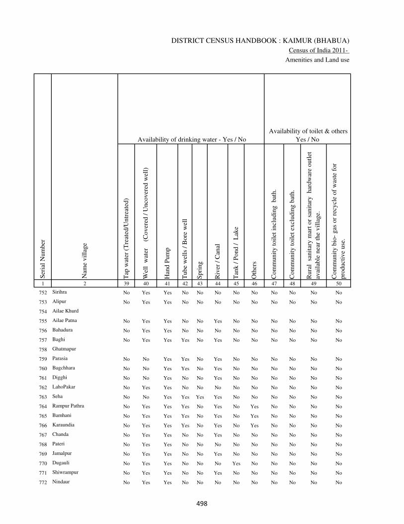
DISTRICT CENSUS HANDBOOK : KAIMUR (BHABUA)
Census of India 2011-
Amenities and Land use
Tap
wat
er (
Tre
ated
/Untr
eate
d)
Wel
l w
ater
(Cover
ed /
Unco
ver
ed w
ell)
Han
d P
um
p
Tube
wel
ls /
Bore
wel
l
Spri
ng
Riv
er /
Can
al
Tan
k /
Pond /
L
ake
Oth
ers
Com
munit
y t
oil
et i
ncl
udin
g
bat
h.
Com
munit
y t
oil
et e
xcl
udin
g b
ath.
Rura
l s
anit
ary m
art
or
sanit
ary
har
dw
are
outl
et
avai
lable
nea
r th
e vil
lage.
Com
munit
y b
io-
gas
or
recy
cle
of
was
te f
or
pro
duct
ive
use
.
1 2 39 40 41 42 43 44 45 46 47 48 49 50
Availability of toilet & others
Yes / No Availability of drinking water - Yes / No
Nam
e vil
lage
Ser
ial
Num
ber
752 Sirihra No Yes Yes No No No No No No No No No
753 Alipur No Yes Yes No No No No No No No No No
754 Ailae Khurd
755 Ailae Patna No Yes Yes No No Yes No No No No No No
756 Bahadura No Yes Yes No No No No No No No No No
757 Baghi No Yes Yes Yes No Yes No No No No No No
758 Ghatmapur
759 Parasia No No Yes Yes No Yes No No No No No No
760 Bagchhara No No Yes Yes No Yes No No No No No No
761 Digghi No No Yes No No Yes No No No No No No
762 LahoPakar No Yes Yes No No No No No No No No No
763 Seha No No Yes Yes Yes Yes No No No No No No
764 Rampur Pathra No Yes Yes Yes No Yes No Yes No No No No
765 Bamhani No Yes Yes Yes No Yes No Yes No No No No
766 Karaundia No Yes Yes Yes No Yes No Yes No No No No
767 Chanda No Yes Yes No No Yes No No No No No No
768 Pateri No Yes Yes No No No No No No No No No
769 Jamalpur No Yes Yes No No Yes No No No No No No
770 Dugauli No Yes Yes No No No Yes No No No No No
771 Shiwrampur No Yes Yes No No Yes No No No No No No
772 Nindaur No Yes Yes No No No No No No No No No
���
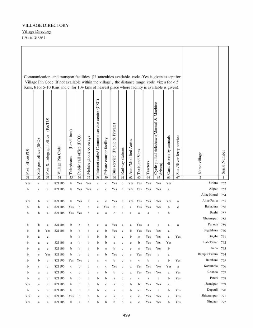
VILLAGE DIRECTORY
Village Directory
( As in 2009 )
Post
off
ice(
PO
)
Sub p
ost
off
ice
(SP
O)
Post
& T
eleg
raph o
ffic
e
(P&
TO
)
Vil
lage
Pin
Code
Tel
ephones
(L
and l
ines
)
Publi
c ca
ll o
ffic
e (P
CO
)
Mobil
e phone
cover
age
Inte
rnet
caf
es/
Com
mon s
ervic
e ce
ntr
e (C
SC
)
Pri
vat
e co
uri
er f
acil
ity
Bus
serv
ice
(P
ubli
c &
Pri
vat
e)
Rai
lway
sta
tions
Auto
/Modif
ied A
uto
s
Tax
is a
nd V
ans
Tra
ctors
Cycl
e-pull
ed r
icksh
aws(
Man
ual
& M
achin
e
dri
ven
)
Car
ts d
riven
by a
nim
als
Sea
/R
iver
fer
ry s
ervic
e51 52 53 54 55 56 57 58 59 60 61 62 63 64 65 66 67 2 1
Communication and transport facilities (If amenities available code -Yes is given except for
Village Pin Code ,If not available within the village , the distance range code viz; a for < 5
Kms, b for 5-10 Kms and c for 10+ kms of nearest place where facility is available is given).
Ser
ial
Num
ber
Nam
e vil
lage
Yes c c 821106 b Yes Yes c c Yes c Yes Yes Yes Yes Yes Sirihra 752
b c c 821106 b Yes Yes c c Yes c Yes Yes Yes Yes a Alipur 753
Ailae Khurd 754
Yes b c 821106 b Yes a c c Yes c Yes Yes Yes Yes Yes a Ailae Patna 755
b b c 821106 Yes b b c Yes b c a Yes Yes Yes b c Bahadura 756
b b c 821106 Yes Yes b c a c c a a a a b Baghi 757
Ghatmapur 758
b b c 821106 b b b c a Yes c a Yes a a a a Parasia 759
b b Yes 821106 b b b c b Yes c b Yes Yes Yes a Bagchhara 760
b a c b b b b b c c b c Yes Yes a Yes Digghi 761
b a c 821106 a b b b b a c c b Yes Yes Yes LahoPakar 762
b a c 821106 b b b b c b c c c Yes Yes b Seha 763
b c Yes 821106 b b b c b Yes c c Yes Yes a a Rampur Pathra 764
b b c 821106 Yes Yes b c c b c c c b a b Yes Bamhani 765
b c c 821106 c b b c c Yes c a Yes Yes Yes Yes a Karaundia 766
b a c 821106 c c b c b b c a Yes Yes Yes a Yes Chanda 767
b a c 821106 b b b b b a c c c a a b Yes Pateri 768
Yes a c 821106 b b b b c a c b b Yes Yes a Jamalpur 769
b c c 821106 b b b b c a c b c Yes a b Yes Dugauli 770
Yes c c 821106 Yes b b b c a c c c Yes Yes a Yes Shiwrampur 771
Yes a c 821106 b a b b b b b c c Yes Yes b Yes Nindaur 772
���
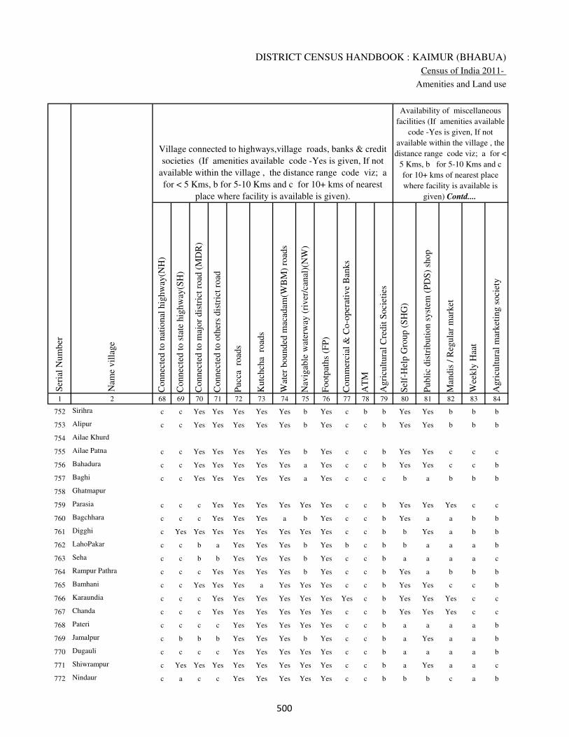
DISTRICT CENSUS HANDBOOK : KAIMUR (BHABUA)
Census of India 2011-
Amenities and Land use
Connec
ted t
o n
atio
nal
hig
hw
ay(N
H)
Connec
ted t
o s
tate
hig
hw
ay(S
H)
Connec
ted t
o m
ajor
dis
tric
t ro
ad (
MD
R)
Connec
ted t
o o
ther
s dis
tric
t ro
ad
Pucc
a r
oad
s
Kutc
hch
a r
oad
s
Wat
er b
ounded
mac
adam
(WB
M)
road
s
Nav
igab
le w
ater
way
(ri
ver
/can
al)(
NW
)
Footp
aths
(FP
)
Com
mer
cial
& C
o-o
per
ativ
e B
anks
AT
M
Agri
cult
ura
l C
redit
Soci
etie
s
Sel
f-H
elp G
roup (
SH
G)
Publi
c dis
trib
uti
on s
yst
em (
PD
S)
shop
Man
dis
/ R
egula
r m
arket
Wee
kly
Haa
t
Agri
cult
ura
l m
arket
ing s
oci
ety
1 2 68 69 70 71 72 73 74 75 76 77 78 79 80 81 82 83 84
Village connected to highways,village roads, banks & credit
societies (If amenities available code -Yes is given, If not
available within the village , the distance range code viz; a
for < 5 Kms, b for 5-10 Kms and c for 10+ kms of nearest
place where facility is available is given).
Ser
ial
Num
ber
Nam
e vil
lage
Availability of miscellaneous
facilities (If amenities available
code -Yes is given, If not
available within the village , the
distance range code viz; a for <
5 Kms, b for 5-10 Kms and c
for 10+ kms of nearest place
where facility is available is
given) Contd....
752 Sirihra c c Yes Yes Yes Yes Yes b Yes c b b Yes Yes b b b
753 Alipur c c Yes Yes Yes Yes Yes b Yes c c b Yes Yes b b b
754 Ailae Khurd
755 Ailae Patna c c Yes Yes Yes Yes Yes b Yes c c b Yes Yes c c c
756 Bahadura c c Yes Yes Yes Yes Yes a Yes c c b Yes Yes c c b
757 Baghi c c Yes Yes Yes Yes Yes a Yes c c c b a b b b
758 Ghatmapur
759 Parasia c c c Yes Yes Yes Yes Yes Yes c c b Yes Yes Yes c c
760 Bagchhara c c c Yes Yes Yes a b Yes c c b Yes a a b b
761 Digghi c Yes Yes Yes Yes Yes Yes Yes Yes c c b b Yes a b b
762 LahoPakar c c b a Yes Yes Yes b Yes b c b b a a a b
763 Seha c c b b Yes Yes Yes b Yes c c b a a a a c
764 Rampur Pathra c c c Yes Yes Yes Yes b Yes c c b Yes a b b b
765 Bamhani c c Yes Yes Yes a Yes Yes Yes c c b Yes Yes c c b
766 Karaundia c c c Yes Yes Yes Yes Yes Yes Yes c b Yes Yes Yes c c
767 Chanda c c c Yes Yes Yes Yes Yes Yes c c b Yes Yes Yes c c
768 Pateri c c c c Yes Yes Yes Yes Yes c c b a a a a b
769 Jamalpur c b b b Yes Yes Yes b Yes c c b a Yes a a b
770 Dugauli c c c c Yes Yes Yes Yes Yes c c b a a a a b
771 Shiwrampur c Yes Yes Yes Yes Yes Yes Yes Yes c c b a Yes a a c
772 Nindaur c a c c Yes Yes Yes Yes Yes c c b b b c a b
���

VILLAGE DIRECTORY
Village Directory
( As in 2009 )
Inte
gra
ted C
hil
d D
evel
opm
ent
Sch
eme
(Nutr
itio
nal
Cen
tres
)
Angan
wad
i C
entr
e (N
utr
itio
nal
Cen
tres
)
Oth
ers
(Nutr
itio
nal
Cen
tres
)
AS
HA
(A
ccre
dit
ed S
oci
al H
ealt
h A
ctiv
ist)
Com
munit
y c
entr
e w
ith/w
ithout
TV
Sport
s F
ield
,
Sport
s C
lub /
Rec
reat
ion C
entr
e
Cin
ema
/ V
ideo
Hal
l
Publi
c L
ibra
ry
Publi
c R
eadin
g R
oom
New
spap
er S
upply
Ass
embly
Poll
ing s
tati
on
Bir
th &
Dea
th R
egis
trat
ion O
ffic
e
Pow
er S
upply
for
Dom
esti
c U
se (
ED
)
Pow
er S
upply
for
Agri
cult
ura
l U
se (
EA
G)
Pow
er S
upply
for
Com
mer
cial
Use
(E
C)
Pow
er S
upply
for
All
Use
s (E
A)
85 86 87 88 89 90 91 92 93 94 95 96 97 98 99 100 101 2 1
Availability of
electricity (Yes/No)
Availability of miscellaneous facilities (If amenities available code -
Yes is given, If not available within the village , the distance range
code viz; a for < 5 Kms, b for 5-10 Kms and c for 10+ kms of
nearest place where facility is available is given) Concluded
Nam
e vil
lage
Ser
ial
Num
ber
b Yes Yes Yes c a c c c c Yes Yes Yes Yes Yes No No Sirihra 752
b Yes Yes Yes c a c c c c a a a Yes Yes No No Alipur 753
Ailae Khurd 754
b Yes Yes Yes c Yes c c c c a Yes Yes No No No No Ailae Patna 755
a Yes Yes Yes Yes Yes c c c c b Yes a Yes Yes No No Bahadura 756
b Yes Yes Yes b b c c c c b Yes a Yes Yes No No Baghi 757
Ghatmapur 758
b Yes Yes Yes Yes Yes Yes c c c b a b Yes Yes No No Parasia 759
b Yes Yes Yes b b b c c c a a a Yes Yes No No Bagchhara 760
b Yes Yes a b b c c c c Yes Yes a Yes Yes No No Digghi 761
b a Yes a b b b c c c b a a Yes Yes Yes Yes LahoPakar 762
b a Yes a c b b c c c a Yes Yes Yes Yes No No Seha 763
b Yes Yes a c c c c c c b a a Yes Yes No No Rampur Pathra 764
b Yes Yes Yes c c c c c c a a a Yes Yes No No Bamhani 765
b Yes Yes Yes Yes Yes Yes c c c b Yes b Yes Yes No No Karaundia 766
b Yes Yes Yes Yes Yes Yes c c c b a b Yes Yes No No Chanda 767
c Yes Yes Yes c b c c c c b Yes a Yes Yes Yes Yes Pateri 768
b Yes Yes a b b c c c c a Yes Yes Yes Yes No No Jamalpur 769
b b Yes a b c c c c c b a a Yes Yes Yes Yes Dugauli 770
b Yes Yes Yes b b c c c c a Yes Yes Yes Yes No No Shiwrampur 771
b a Yes a c b c c c c b a a No No No No Nindaur 772
���
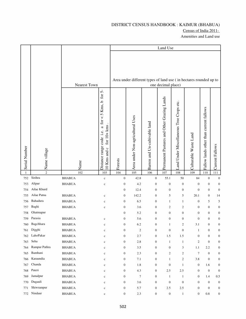
DISTRICT CENSUS HANDBOOK : KAIMUR (BHABUA)
Census of India 2011-
Amenities and Land use
Nam
e
Dis
tance
ran
ge
code
i.e
. a
fo
r <
5 K
ms,
b
for
5-
10 K
ms
and c
f
or
10+
km
s .
Fore
sts
Are
a under
Non-a
gri
cult
ura
l U
ses
Bar
ren a
nd U
n-c
ult
ivab
le l
and
Per
man
ent
Pas
ture
s an
d O
ther
Gra
zing L
ands
Lan
d U
nder
Mis
cell
aneo
us
Tre
e C
rops
etc.
Cult
ura
ble
Was
te L
and
Fal
low
lan
ds
oth
er t
han
curr
ent
fall
ow
s
Curr
ent
Fal
low
s
1 2 102 103 104 105 106 107 108 109 110 111
Ser
ial
Num
ber
Nam
e vil
lage
Area under different types of land use ( in hectares rounded up to
one decimal place)
Land Use
Nearest Town
752 Sirihra BHABUA c 0 42.8 0 55.1 50 84 0 0
753 Alipur BHABUA c 0 4.2 0 0 0 0 0 0
754 Ailae Khurd 0 12.4 0 0 0 0 0 0
755 Ailae Patna BHABUA c 0 142.2 0 5 5 20.1 0 14
756 Bahadura BHABUA c 0 6.5 0 1 1 0 5 5
757 Baghi BHABUA c 0 3.6 0 2 2 0 0 0
758 Ghatmapur 0 5.2 0 0 0 0 0 0
759 Parasia BHABUA c 0 5.6 0 0 0 0 0 0
760 Bagchhara BHABUA c 0 6.2 0 1 2 3.1 0 0
761 Digghi BHABUA c 0 2 0 0 0 1 0 0
762 LahoPakar BHABUA c 0 2.7 0 1.5 1.5 0 0 0
763 Seha BHABUA c 0 2.8 0 1 1 2 0 0
764 Rampur Pathra BHABUA c 0 3.5 0 0 3 1.1 2.2 0
765 Bamhani BHABUA c 0 2.3 0 2 2 7 0 0
766 Karaundia BHABUA c 0 7.1 0 1 2 3.8 0 0
767 Chanda BHABUA c 0 1.8 0 0 1 0 1.6 0
768 Pateri BHABUA c 0 4.3 0 2.5 2.5 0 0 0
769 Jamalpur BHABUA c 0 7 0 1 1 0 1.4 0.5
770 Dugauli BHABUA c 0 3.6 0 0 0 0 0 0
771 Shiwrampur BHABUA c 0 5.7 0 2.5 2.5 0 0 0
772 Nindaur BHABUA c 0 2.3 0 0 1 0 0.8 0
��

VILLAGE DIRECTORY
Village Directory
( As in 2009 )
Net
Are
a S
ow
n
Tota
l Ir
rigat
ed L
and A
rea
Tota
l U
n-i
rrig
ated
Lan
d A
rea
Can
als
( C
)
Wel
ls/T
ube-
wel
ls(W
/TW
)
Tan
ks/
Lak
es(T
/L)
Wat
er F
alls
(WF
)
Oth
ers(
O)
Fir
st
Sec
ond
Thir
d
112 113 114 115 116 117 118 119 120 121 122 2 1
Ser
ial
Num
ber
Name of three
most important
commodities
manufacturedArea irrigated by source (in hectare).
Nam
e of
Vil
lage
Area under different types of
land use ( in hectares rounded
up to one decimal place)
Land Use
318.1 276 42.1 0 176 50 0 50 Sirihra 752
31.8 24.8 7 18.2 6.6 0 0 0 Alipur 753
93.6 78.4 15.3 49 13.2 0 0 16.2 Ailae Khurd 754
220.7 180.4 40.3 150 30.4 0 0 0 Ailae Patna 755
115.5 96.3 19.2 78.9 6.2 0 0 11.2 Bahadura 756
39.4 36.6 2.8 34.4 0 2.2 0 0 Baghi 757
43.8 35.8 8 25.6 0 10.2 0 0 Ghatmapur 758
36.4 29.1 7.3 19.4 3.8 5.8 0 0 Parasia 759
72.7 60.3 12.4 0 60.3 0 0 0 Bagchhara 760
55 44.1 10.9 28.7 8.6 6.8 0 0 Digghi 761
43.3 38.4 4.9 36.4 2 0 0 0 LahoPakar 762
37.2 29.2 8 25.1 4 0 0 0 Seha 763
99.2 92.1 7.1 51.1 3 38 0 0 Rampur Pathra 764
79.7 61.3 18.4 50 1.1 10.2 0 0 Bamhani 765
99.1 84.2 14.9 72 2.1 10.1 0 0 Karaundia 766
39.6 37.2 2.4 32 2.1 3.1 0 0 Chanda 767
136.7 117 19.7 70 20 27 0 0 Pateri 768
140.1 119.4 20.7 105 6.7 5.6 0 2.1 Jamalpur 769
60.4 44.3 16.1 27.4 7.2 9.7 0 0 Dugauli 770
77.3 71.3 6 50.6 10.2 5.2 0 5.3 Shiwrampur 771
42.9 26 16.9 5 20.9 0 0 0 Nindaur 772
��

DISTRICT CENSUS HANDBOOK : KAIMUR (BHABUA)
Census of India 2011-
Amenities and Land use
Pre
-Pri
mar
y s
chool
(PP
)
Pri
mar
y s
chool
(P)
Mid
dle
sch
ool
(M)
Sec
ondar
y S
chool
(S)
Sen
ior
Sec
ondar
y s
chool
(SS
)
Deg
ree
coll
ege
of
arts
sc
ience
& c
om
mer
ce
(AS
C)
Engin
eeri
ng c
oll
ege(
EC
)
Med
ical
coll
ege
(MC
)
Man
agem
ent
inst
itute
(M
I)
Poly
tech
nic
(P
t)
Voca
tional
tra
inin
g s
chool
/IT
I
Non-f
orm
al t
rain
ing c
entr
e (N
FT
C)
Spec
ial
school
for
dis
able
d (
SS
D)
Oth
ers
(spec
ify)
1 2 3 4 5 6 7 8 9 10 11 12 13 14 15 16 17 18 19 20
Loca
tion c
ode
no.
Nam
e vil
lage
Ser
ial
Num
ber
Tota
l popula
tion (
2011 c
ensu
s )
Tota
l ar
ea o
f th
e vil
lage
( in
hec
tare
s ro
unded
up t
o
one
dec
imal
pla
ce)
Number of educational amenities available. (If not available
within the village , the distance range code viz; a for < 5
Kms, b for 5-10 Kms and c for 10+ kms of nearest place
where facility is available is given).
Num
ber
of
house
hold
s (2
011 c
ensu
s)
773 Rampur 249697 72 366 65 b 1 a c c c c c c c c c c
774 Nandiha Bhzrug 249698 56 302 52 c a a c c c c c c c c c c
775 Jagdishpur 249699 11 339 51 c a a c c c c c c c c c c
776 Mahdaich 249700 83 552 98 c 1 a c b c c c c c c c c
777 Naudiha Khurd 249701 46 24 2 c a a c c c c c c c c c c
778 Kota 249702 112 345 60 c 1 b c c c c c c c c c c
779 Kharanti Khurd 249703 80 794 120 c 1 b c c c c c c c c c c
780 Baruna 249704 49 72 11 c a b c c c c c c c c c c
781 Mararia 249705 75 324 61 c 1 a c c c c c c c c c c
782 RatanPurwa 249706 34 192 27 c a a c c c c c c c c c c
783 Kharauli 249707 323 1654 217 c 1 1 c c c c c c c c c c
784 Mutmuria 249708 156 220 37 c a a c c c c c c c c c c
785 Basaha 249709 91 1323 204 c 1 1 c c c c c c c c c c
786 Pasoiya 249710 68 263 46 c a a c c c c c c c c c c
787 Dharhua 249711 184 1727 250 c 1 1 c c c c c c c c c c
788 Chhotki Bharari 249712 242 2117 355 c 1 1 c c c c c c c c c c
789 Harpokhar 249713 75 0 0
790 Patesar 249714 357 2242 356 b 1 1 c c c c c c c c c c
791 Saukhara 249715 441 2508 396 b 2 1 c c c c c c c c c c
792 Bheladih 249716 152 954 126 b 1 a c c c c c c c c c c
793 Surha 249717 142 1408 202 b 1 a c c c c c c c c c c
���

VILLAGE DIRECTORY
Village Directory
( As in 2009 )
Com
munit
y h
ealt
h c
entr
e (C
HC
)
Pri
mar
y h
ealt
h c
entr
e (P
HC
)
Pri
mar
y h
ealt
h s
ub c
entr
e (P
HS
)
Mat
ernit
y a
nd c
hil
d w
elfa
re c
entr
e (M
CW
)
T.B
. cl
inic
(T
BC
)
Hosp
ital
-all
opat
hic
(H
A)
Hosp
ital
-alt
ernat
ive
med
icin
e (H
O)
Dis
pen
sary
(D
)
Vet
erin
ary h
osp
ital
(V
H)
Mobil
e hea
lth c
linic
(M
HC
)
Fam
ily w
elfa
re c
entr
e (F
WC
)
Char
itab
le n
on G
ovt.
hosp
ital
/Nurs
ing h
om
e.
Med
ical
pra
ctit
ioner
wit
h M
BB
S D
egre
e
Med
ical
pra
ctit
ioner
wit
h o
ther
deg
ree
Med
ical
pra
ctit
ioner
wit
h n
o d
egre
e
Tra
dit
ional
pra
ctit
ioner
an
d f
aith
hea
ler
.
Med
icin
e S
hop
Oth
ers
21 22 23 24 25 26 27 28 29 30 31 32 33 34 35 36 37 38 2 1
Number of Non-Government
Medical Amenities available.
Number of Medical Amenities available. (If not
available within the village , the distance range
code viz; a for < 5 Kms, b for 5-10 Kms and c
for 10+ kms of nearest place where facility is
available is given).
Nam
e vil
lage
Ser
ial
Num
ber
a a a c c c c c c c c 0 0 0 0 0 0 0 Rampur 773
c b b b c c c b b c b 0 0 0 0 0 0 0 Nandiha Bhzrug 774
b b a b c c c b b c b 0 0 0 0 0 0 0 Jagdishpur 775
c b b b c c c c b c b 0 0 0 0 0 0 0 Mahdaich 776
b a a b c c c b b c b 0 0 0 0 0 0 0 Naudiha Khurd 777
c c a c c c c c c c c 0 0 0 0 0 0 0 Kota 778
c c a c c c c c c c c 0 0 0 0 0 0 0 Kharanti Khurd 779
c c a c c c c c c c c 0 0 0 0 0 0 0 Baruna 780
c b b b c c c c b c b 0 0 0 0 0 0 0 Mararia 781
c b 1 1 1 c c 1 c c 1 0 0 0 0 0 1 0 RatanPurwa 782
c b 1 1 b c c 1 b c 1 0 0 0 0 0 1 0 Kharauli 783
c c 1 1 b c c 1 c c 1 0 0 0 0 0 0 0 Mutmuria 784
c c 1 1 1 c c 1 c c 1 0 0 0 0 0 1 0 Basaha 785
c c 1 1 1 c c 1 c c 1 0 0 0 0 0 1 0 Pasoiya 786
c c 1 1 b c c 1 c c 1 0 0 0 0 1 1 0 Dharhua 787
c b 1 1 1 c c 1 c c 1 0 0 0 0 0 0 0 Chhotki Bharari 788
Harpokhar 789
c c 1 1 c c c 1 c c 1 0 0 0 0 0 1 0 Patesar 790
c c 1 1 1 c c 1 c c 1 0 0 0 0 0 1 0 Saukhara 791
c c b b c c c b b c b 0 0 0 0 0 0 0 Bheladih 792
c c 1 1 1 c c 1 c c 1 0 0 0 0 0 0 0 Surha 793
���

DISTRICT CENSUS HANDBOOK : KAIMUR (BHABUA)
Census of India 2011-
Amenities and Land use
Tap
wat
er (
Tre
ated
/Untr
eate
d)
Wel
l w
ater
(Cover
ed /
Unco
ver
ed w
ell)
Han
d P
um
p
Tube
wel
ls /
Bore
wel
l
Spri
ng
Riv
er /
Can
al
Tan
k /
Pond /
L
ake
Oth
ers
Com
munit
y t
oil
et i
ncl
udin
g
bat
h.
Com
munit
y t
oil
et e
xcl
udin
g b
ath.
Rura
l s
anit
ary m
art
or
sanit
ary
har
dw
are
outl
et
avai
lable
nea
r th
e vil
lage.
Com
munit
y b
io-
gas
or
recy
cle
of
was
te f
or
pro
duct
ive
use
.
1 2 39 40 41 42 43 44 45 46 47 48 49 50
Availability of toilet & others
Yes / No Availability of drinking water - Yes / No
Nam
e vil
lage
Ser
ial
Num
ber
773 Rampur No Yes Yes No No No No No No No No No
774 Nandiha Bhzrug No Yes Yes No No No No No No No No No
775 Jagdishpur No Yes Yes No No No No No No No No No
776 Mahdaich No Yes Yes No No Yes No No No No No No
777 Naudiha Khurd No Yes Yes No No No No No No No No No
778 Kota No Yes Yes No No No No No No No No No
779 Kharanti Khurd No Yes Yes No No No No No No No No No
780 Baruna No Yes Yes No No No No No No No No No
781 Mararia No Yes Yes No No No No No No No No No
782 RatanPurwa No Yes Yes No No No No No No No No No
783 Kharauli No Yes Yes No No No No Yes No No No No
784 Mutmuria No Yes Yes No No No No No No No No No
785 Basaha No Yes Yes No No No No No No No No No
786 Pasoiya No Yes Yes No No No No No No No No No
787 Dharhua No Yes Yes No No No No Yes No No No No
788 Chhotki Bharari No Yes Yes No No No No No No No No No
789 Harpokhar
790 Patesar No Yes Yes Yes No No No No No No No No
791 Saukhara No Yes Yes Yes No No No No No No No No
792 Bheladih No Yes Yes Yes No Yes No No No No No No
793 Surha No Yes Yes Yes No No No No No No No No
���
VILLAGE DIRECTORY
Village Directory
( As in 2009 )
Post
off
ice(
PO
)
Sub p
ost
off
ice
(SP
O)
Post
& T
eleg
raph o
ffic
e
(P&
TO
)
Vil
lage
Pin
Code
Tel
ephones
(L
and l
ines
)
Publi
c ca
ll o
ffic
e (P
CO
)
Mobil
e phone
cover
age
Inte
rnet
caf
es/
Com
mon s
ervic
e ce
ntr
e (C
SC
)
Pri
vat
e co
uri
er f
acil
ity
Bus
serv
ice
(P
ubli
c &
Pri
vat
e)
Rai
lway
sta
tions
Auto
/Modif
ied A
uto
s
Tax
is a
nd V
ans
Tra
ctors
Cycl
e-pull
ed r
icksh
aws(
Man
ual
& M
achin
e
dri
ven
)
Car
ts d
riven
by a
nim
als
Sea
/R
iver
fer
ry s
ervic
e51 52 53 54 55 56 57 58 59 60 61 62 63 64 65 66 67 2 1
Communication and transport facilities (If amenities available code -Yes is given except for
Village Pin Code ,If not available within the village , the distance range code viz; a for < 5
Kms, b for 5-10 Kms and c for 10+ kms of nearest place where facility is available is given).
Ser
ial
Num
ber
Nam
e vil
lage
b a c 821106 b b c c c a c c c Yes Yes Yes Rampur 773
b a c 821106 b b b b b a c c c Yes Yes a Yes Nandiha Bhzrug 774
b a c 821106 b b b b b a c c c Yes Yes Yes Jagdishpur 775
b a Yes 821106 Yes b b b c a c c c Yes Yes a Mahdaich 776
b a c 821106 c Yes a c c a c c c Yes Yes Yes Naudiha Khurd 777
b c c 821106 c b b c c a c c c Yes b b Kota 778
b a c 821106 Yes b b c c a c c c b a a Kharanti Khurd 779
b a c 821106 Yes b b b c a c c c a a a c Baruna 780
Yes c c 821106 b a b b c b c c c Yes Yes b Yes Mararia 781
b b c 821106 b b b c a a c c a a a a c RatanPurwa 782
b b c 821106 b b b c a a c c a Yes Yes Yes c Kharauli 783
b c c 821106 b b b c a a c c a a a a c Mutmuria 784
b b c 821106 b b b c b Yes c Yes Yes Yes Yes Yes b Basaha 785
b b c 821106 a a a c a a c a a Yes a a b Pasoiya 786
b a c 821106 b b b c b a c a a Yes Yes a c Dharhua 787
b c c 821106 b b b c b Yes c Yes Yes Yes Yes Yes Chhotki Bharari 788
Harpokhar 789
b c c 821106 c c c c c c c c c Yes Yes Yes b Patesar 790
Yes b c 821106 b b b b b b c b b Yes Yes Yes b Saukhara 791
b b c 821106 c c c c c Yes c Yes Yes Yes Yes Yes Bheladih 792
b b c 821106 b b b b b b c b b Yes Yes b b Surha 793
���

DISTRICT CENSUS HANDBOOK : KAIMUR (BHABUA)
Census of India 2011-
Amenities and Land use
Connec
ted t
o n
atio
nal
hig
hw
ay(N
H)
Connec
ted t
o s
tate
hig
hw
ay(S
H)
Connec
ted t
o m
ajor
dis
tric
t ro
ad (
MD
R)
Connec
ted t
o o
ther
s dis
tric
t ro
ad
Pucc
a r
oad
s
Kutc
hch
a r
oad
s
Wat
er b
ounded
mac
adam
(WB
M)
road
s
Nav
igab
le w
ater
way
(ri
ver
/can
al)(
NW
)
Footp
aths
(FP
)
Com
mer
cial
& C
o-o
per
ativ
e B
anks
AT
M
Agri
cult
ura
l C
redit
Soci
etie
s
Sel
f-H
elp G
roup (
SH
G)
Publi
c dis
trib
uti
on s
yst
em (
PD
S)
shop
Man
dis
/ R
egula
r m
arket
Wee
kly
Haa
t
Agri
cult
ura
l m
arket
ing s
oci
ety
1 2 68 69 70 71 72 73 74 75 76 77 78 79 80 81 82 83 84
Village connected to highways,village roads, banks & credit
societies (If amenities available code -Yes is given, If not
available within the village , the distance range code viz; a
for < 5 Kms, b for 5-10 Kms and c for 10+ kms of nearest
place where facility is available is given).
Ser
ial
Num
ber
Nam
e vil
lage
Availability of miscellaneous
facilities (If amenities available
code -Yes is given, If not
available within the village , the
distance range code viz; a for <
5 Kms, b for 5-10 Kms and c
for 10+ kms of nearest place
where facility is available is
given) Contd....
773 Rampur c c c a Yes Yes Yes b Yes c c c c a a a c
774 Nandiha Bhzrug c b Yes Yes Yes Yes Yes Yes Yes c c b c a a b c
775 Jagdishpur c b b a Yes Yes Yes a Yes c c c b a a a b
776 Mahdaich c Yes Yes Yes Yes Yes Yes b Yes c c c c a a b c
777 Naudiha Khurd c b b a a Yes Yes b Yes c c c c a a a c
778 Kota c c c c Yes a Yes b Yes c c b a a a a b
779 Kharanti Khurd c c c c Yes Yes Yes b Yes c c b a a a a c
780 Baruna c c c c Yes Yes Yes b Yes c c b a a b a b
781 Mararia c Yes Yes Yes Yes Yes Yes Yes Yes c c b a a a a b
782 RatanPurwa c c c c Yes a a a Yes b c b b b b b b
783 Kharauli a a a a Yes Yes Yes b Yes c c c Yes Yes b c c
784 Mutmuria c b b b Yes a a a Yes c c c b b b b b
785 Basaha c c c c Yes Yes Yes b Yes c c c Yes a b b b
786 Pasoiya c c c b Yes Yes Yes c Yes b c b b Yes b b b
787 Dharhua c c b a Yes Yes Yes c Yes b c c Yes Yes b b b
788 Chhotki Bharari c c c b Yes Yes Yes b Yes c c c b Yes b b b
789 Harpokhar
790 Patesar c c c b Yes Yes Yes c Yes c c b b Yes c c c
791 Saukhara c b b b Yes Yes Yes b Yes b b b c Yes c c c
792 Bheladih c Yes Yes Yes Yes Yes Yes b Yes b c b Yes b b b b
793 Surha c b b b Yes Yes Yes c Yes b b b b Yes c b c
���

VILLAGE DIRECTORY
Village Directory
( As in 2009 )
Inte
gra
ted C
hil
d D
evel
opm
ent
Sch
eme
(Nutr
itio
nal
Cen
tres
)
Angan
wad
i C
entr
e (N
utr
itio
nal
Cen
tres
)
Oth
ers
(Nutr
itio
nal
Cen
tres
)
AS
HA
(A
ccre
dit
ed S
oci
al H
ealt
h A
ctiv
ist)
Com
munit
y c
entr
e w
ith/w
ithout
TV
Sport
s F
ield
,
Sport
s C
lub /
Rec
reat
ion C
entr
e
Cin
ema
/ V
ideo
Hal
l
Publi
c L
ibra
ry
Publi
c R
eadin
g R
oom
New
spap
er S
upply
Ass
embly
Poll
ing s
tati
on
Bir
th &
Dea
th R
egis
trat
ion O
ffic
e
Pow
er S
upply
for
Dom
esti
c U
se (
ED
)
Pow
er S
upply
for
Agri
cult
ura
l U
se (
EA
G)
Pow
er S
upply
for
Com
mer
cial
Use
(E
C)
Pow
er S
upply
for
All
Use
s (E
A)
85 86 87 88 89 90 91 92 93 94 95 96 97 98 99 100 101 2 1
Availability of
electricity (Yes/No)
Availability of miscellaneous facilities (If amenities available code -
Yes is given, If not available within the village , the distance range
code viz; a for < 5 Kms, b for 5-10 Kms and c for 10+ kms of
nearest place where facility is available is given) Concluded
Nam
e vil
lage
Ser
ial
Num
ber
c a Yes Yes c a c c c c b a a Yes Yes Yes Yes Rampur 773
b Yes Yes Yes c c c c c c b a Yes Yes Yes No No Nandiha Bhzrug 774
b a Yes a b b b c c c b a a Yes Yes Yes Yes Jagdishpur 775
b Yes Yes Yes c b c c c c a Yes Yes Yes Yes No No Mahdaich 776
b a Yes a c c c c c c b a a Yes Yes Yes Yes Naudiha Khurd 777
c a Yes a c c c c c c b a a Yes Yes Yes Yes Kota 778
c a Yes a c c c c c c b a a Yes Yes Yes Yes Kharanti Khurd 779
c a Yes a c c c c c c b a a Yes Yes Yes Yes Baruna 780
b Yes Yes Yes c b c c c c b a Yes Yes Yes No No Mararia 781
c b a a a a a c b b b a b No No No No RatanPurwa 782
c Yes Yes Yes b Yes b c b b b a a No No No No Kharauli 783
c b b a b a a c b c b a a No No No No Mutmuria 784
b Yes Yes Yes c Yes b c b b b Yes a No No No No Basaha 785
b a Yes a c a b c c b b a a No No No No Pasoiya 786
c Yes Yes Yes b Yes b c b b b Yes a No No No No Dharhua 787
c Yes Yes Yes b Yes a c b c b Yes a No No No No Chhotki Bharari 788
Harpokhar 789
c Yes Yes Yes c a c c c c b Yes a Yes Yes No No Patesar 790
b Yes Yes Yes c a c c c c b Yes Yes Yes Yes No No Saukhara 791
b Yes Yes Yes b b b c b b b Yes Yes Yes Yes No No Bheladih 792
b Yes Yes Yes c a c c b b b Yes a Yes Yes No No Surha 793
���
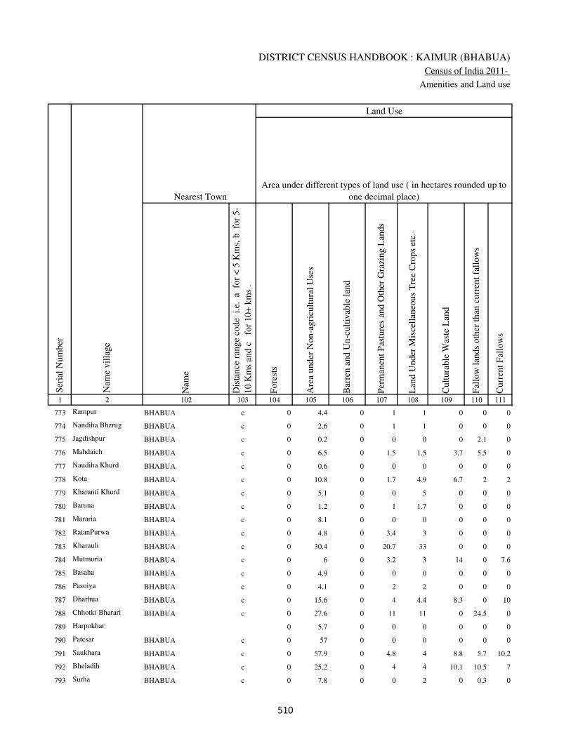
DISTRICT CENSUS HANDBOOK : KAIMUR (BHABUA)
Census of India 2011-
Amenities and Land use
Nam
e
Dis
tance
ran
ge
code
i.e
. a
fo
r <
5 K
ms,
b
for
5-
10 K
ms
and c
f
or
10+
km
s .
Fore
sts
Are
a under
Non-a
gri
cult
ura
l U
ses
Bar
ren a
nd U
n-c
ult
ivab
le l
and
Per
man
ent
Pas
ture
s an
d O
ther
Gra
zing L
ands
Lan
d U
nder
Mis
cell
aneo
us
Tre
e C
rops
etc.
Cult
ura
ble
Was
te L
and
Fal
low
lan
ds
oth
er t
han
curr
ent
fall
ow
s
Curr
ent
Fal
low
s
1 2 102 103 104 105 106 107 108 109 110 111
Ser
ial
Num
ber
Nam
e vil
lage
Area under different types of land use ( in hectares rounded up to
one decimal place)
Land Use
Nearest Town
773 Rampur BHABUA c 0 4.4 0 1 1 0 0 0
774 Nandiha Bhzrug BHABUA c 0 2.6 0 1 1 0 0 0
775 Jagdishpur BHABUA c 0 0.2 0 0 0 0 2.1 0
776 Mahdaich BHABUA c 0 6.5 0 1.5 1.5 3.7 5.5 0
777 Naudiha Khurd BHABUA c 0 0.6 0 0 0 0 0 0
778 Kota BHABUA c 0 10.8 0 1.7 4.9 6.7 2 2
779 Kharanti Khurd BHABUA c 0 5.1 0 0 5 0 0 0
780 Baruna BHABUA c 0 1.2 0 1 1.7 0 0 0
781 Mararia BHABUA c 0 8.1 0 0 0 0 0 0
782 RatanPurwa BHABUA c 0 4.8 0 3.4 3 0 0 0
783 Kharauli BHABUA c 0 30.4 0 20.7 33 0 0 0
784 Mutmuria BHABUA c 0 6 0 3.2 3 14 0 7.6
785 Basaha BHABUA c 0 4.9 0 0 0 0 0 0
786 Pasoiya BHABUA c 0 4.1 0 2 2 0 0 0
787 Dharhua BHABUA c 0 15.6 0 4 4.4 8.3 0 10
788 Chhotki Bharari BHABUA c 0 27.6 0 11 11 0 24.5 0
789 Harpokhar 0 5.7 0 0 0 0 0 0
790 Patesar BHABUA c 0 57 0 0 0 0 0 0
791 Saukhara BHABUA c 0 57.9 0 4.8 4 8.8 5.7 10.2
792 Bheladih BHABUA c 0 25.2 0 4 4 10.1 10.5 7
793 Surha BHABUA c 0 7.8 0 0 2 0 0.3 0
���
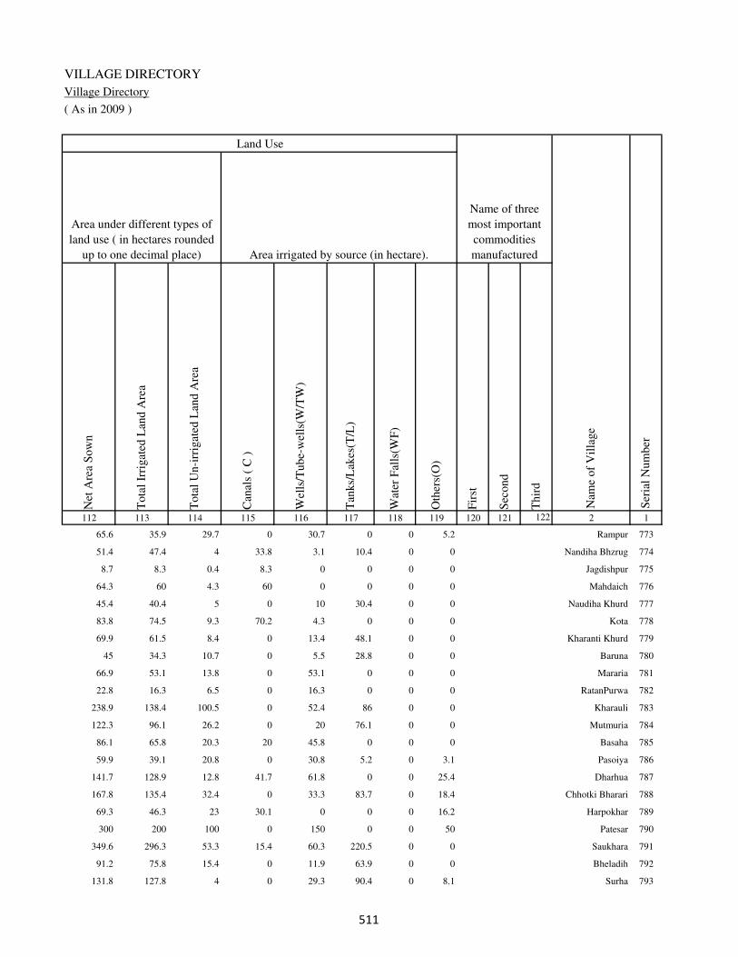
VILLAGE DIRECTORY
Village Directory
( As in 2009 )
Net
Are
a S
ow
n
Tota
l Ir
rigat
ed L
and A
rea
Tota
l U
n-i
rrig
ated
Lan
d A
rea
Can
als
( C
)
Wel
ls/T
ube-
wel
ls(W
/TW
)
Tan
ks/
Lak
es(T
/L)
Wat
er F
alls
(WF
)
Oth
ers(
O)
Fir
st
Sec
ond
Thir
d
112 113 114 115 116 117 118 119 120 121 122 2 1
Ser
ial
Num
ber
Name of three
most important
commodities
manufacturedArea irrigated by source (in hectare).
Nam
e of
Vil
lage
Area under different types of
land use ( in hectares rounded
up to one decimal place)
Land Use
65.6 35.9 29.7 0 30.7 0 0 5.2 Rampur 773
51.4 47.4 4 33.8 3.1 10.4 0 0 Nandiha Bhzrug 774
8.7 8.3 0.4 8.3 0 0 0 0 Jagdishpur 775
64.3 60 4.3 60 0 0 0 0 Mahdaich 776
45.4 40.4 5 0 10 30.4 0 0 Naudiha Khurd 777
83.8 74.5 9.3 70.2 4.3 0 0 0 Kota 778
69.9 61.5 8.4 0 13.4 48.1 0 0 Kharanti Khurd 779
45 34.3 10.7 0 5.5 28.8 0 0 Baruna 780
66.9 53.1 13.8 0 53.1 0 0 0 Mararia 781
22.8 16.3 6.5 0 16.3 0 0 0 RatanPurwa 782
238.9 138.4 100.5 0 52.4 86 0 0 Kharauli 783
122.3 96.1 26.2 0 20 76.1 0 0 Mutmuria 784
86.1 65.8 20.3 20 45.8 0 0 0 Basaha 785
59.9 39.1 20.8 0 30.8 5.2 0 3.1 Pasoiya 786
141.7 128.9 12.8 41.7 61.8 0 0 25.4 Dharhua 787
167.8 135.4 32.4 0 33.3 83.7 0 18.4 Chhotki Bharari 788
69.3 46.3 23 30.1 0 0 0 16.2 Harpokhar 789
300 200 100 0 150 0 0 50 Patesar 790
349.6 296.3 53.3 15.4 60.3 220.5 0 0 Saukhara 791
91.2 75.8 15.4 0 11.9 63.9 0 0 Bheladih 792
131.8 127.8 4 0 29.3 90.4 0 8.1 Surha 793
���

DISTRICT CENSUS HANDBOOK : KAIMUR (BHABUA)
Census of India 2011-
Amenities and Land use
Pre
-Pri
mar
y s
chool
(PP
)
Pri
mar
y s
chool
(P)
Mid
dle
sch
ool
(M)
Sec
ondar
y S
chool
(S)
Sen
ior
Sec
ondar
y s
chool
(SS
)
Deg
ree
coll
ege
of
arts
sc
ience
& c
om
mer
ce
(AS
C)
Engin
eeri
ng c
oll
ege(
EC
)
Med
ical
coll
ege
(MC
)
Man
agem
ent
inst
itute
(M
I)
Poly
tech
nic
(P
t)
Voca
tional
tra
inin
g s
chool
/IT
I
Non-f
orm
al t
rain
ing c
entr
e (N
FT
C)
Spec
ial
school
for
dis
able
d (
SS
D)
Oth
ers
(spec
ify)
1 2 3 4 5 6 7 8 9 10 11 12 13 14 15 16 17 18 19 20
Loca
tion c
ode
no.
Nam
e vil
lage
Ser
ial
Num
ber
Tota
l popula
tion (
2011 c
ensu
s )
Tota
l ar
ea o
f th
e vil
lage
( in
hec
tare
s ro
unded
up t
o
one
dec
imal
pla
ce)
Number of educational amenities available. (If not available
within the village , the distance range code viz; a for < 5
Kms, b for 5-10 Kms and c for 10+ kms of nearest place
where facility is available is given).
Num
ber
of
house
hold
s (2
011 c
ensu
s)
794 Ramtali 249718 45 0 0
795 Hamirpur 249719 120 665 78 b 1 1 1 c c c c c c c c c
796 Songar 249720 180 1486 247 b 1 b c c c c c c c c c c
797 Bharari Kalan 249721 344 2430 418 a 1 1 c c c c c c c c c c
798 Lohdan 249722 452 3837 578 1 1 1 c c c c c c c c c c
799 Hansrew 249723 204 1783 287 1 1 a c c c c c c c c c c
800 Nauan 249724 114 329 42 a 1 a c c c c c c c c c c
801 Kekrha 249725 166 467 64 b 1 b c c c c c c c c c c
802 Harkatha 249726 51 0 0
803 Kilni 249727 468 2391 359 1 1 a c c c c c c c c c c
804 Piparia 249728 134 701 102 a 1 a c c c c c c c c c c
805 Saraila 249729 104 422 54 a 1 a c c c c c c c c c c
806 Lahuri Bairi 249730 46 0 0
807 Baghaila 249731 245 1484 213 a 1 1 c c c c c c c c c c
808 Bairi 249732 575 1923 279 b 1 a c c c c c c c c c c
809 Asthanpur 249733 35 0 0
810 Maheshpur 249734 25 0 0
811 Dewaitpur 249735 49 0 0
812 Chauri 249736 326 1951 278 b 1 1 c c c c c c c c c c
813 Safi 249737 128 0 0
814 Gohuwan 249738 244 1632 229 b 1 1 c c c c c c c c c c
��

VILLAGE DIRECTORY
Village Directory
( As in 2009 )
Com
munit
y h
ealt
h c
entr
e (C
HC
)
Pri
mar
y h
ealt
h c
entr
e (P
HC
)
Pri
mar
y h
ealt
h s
ub c
entr
e (P
HS
)
Mat
ernit
y a
nd c
hil
d w
elfa
re c
entr
e (M
CW
)
T.B
. cl
inic
(T
BC
)
Hosp
ital
-all
opat
hic
(H
A)
Hosp
ital
-alt
ernat
ive
med
icin
e (H
O)
Dis
pen
sary
(D
)
Vet
erin
ary h
osp
ital
(V
H)
Mobil
e hea
lth c
linic
(M
HC
)
Fam
ily w
elfa
re c
entr
e (F
WC
)
Char
itab
le n
on G
ovt.
hosp
ital
/Nurs
ing h
om
e.
Med
ical
pra
ctit
ioner
wit
h M
BB
S D
egre
e
Med
ical
pra
ctit
ioner
wit
h o
ther
deg
ree
Med
ical
pra
ctit
ioner
wit
h n
o d
egre
e
Tra
dit
ional
pra
ctit
ioner
an
d f
aith
hea
ler
.
Med
icin
e S
hop
Oth
ers
21 22 23 24 25 26 27 28 29 30 31 32 33 34 35 36 37 38 2 1
Number of Non-Government
Medical Amenities available.
Number of Medical Amenities available. (If not
available within the village , the distance range
code viz; a for < 5 Kms, b for 5-10 Kms and c
for 10+ kms of nearest place where facility is
available is given).
Nam
e vil
lage
Ser
ial
Num
ber
Ramtali 794
c c 1 1 1 c c 1 c c 1 0 0 0 0 0 0 0 Hamirpur 795
c c 1 1 1 c c 1 c c 1 0 0 0 0 0 0 0 Songar 796
c c 1 1 c c c 1 c c 1 0 0 0 0 1 0 0 Bharari Kalan 797
c b a b c c c b b c b 0 0 0 0 0 1 0 Lohdan 798
c b a b c c c b b c b 0 0 0 0 0 0 0 Hansrew 799
c c 1 1 1 c c 1 c c 1 0 0 0 0 1 0 0 Nauan 800
c c 1 1 1 c c c c c 1 0 0 1 0 0 1 0 Kekrha 801
Harkatha 802
c b 1 1 b c c 1 c c 1 0 0 1 0 0 1 0 Kilni 803
c c 1 1 1 c c c c c 1 0 0 0 0 0 0 0 Piparia 804
c b 1 1 b c c 1 c c 1 0 0 1 1 0 1 0 Saraila 805
Lahuri Bairi 806
c b 1 1 c c c c b c 1 0 0 1 1 0 3 0 Baghaila 807
c c 1 1 1 c c c c c 1 0 0 1 0 1 0 0 Bairi 808
Asthanpur 809
Maheshpur 810
Dewaitpur 811
c c 1 1 1 c c 1 c c 1 0 1 0 0 1 1 0 Chauri 812
Safi 813
c c 1 1 c c c 1 c c 1 0 1 1 0 0 1 0 Gohuwan 814
��

DISTRICT CENSUS HANDBOOK : KAIMUR (BHABUA)
Census of India 2011-
Amenities and Land use
Tap
wat
er (
Tre
ated
/Untr
eate
d)
Wel
l w
ater
(Cover
ed /
Unco
ver
ed w
ell)
Han
d P
um
p
Tube
wel
ls /
Bore
wel
l
Spri
ng
Riv
er /
Can
al
Tan
k /
Pond /
L
ake
Oth
ers
Com
munit
y t
oil
et i
ncl
udin
g
bat
h.
Com
munit
y t
oil
et e
xcl
udin
g b
ath.
Rura
l s
anit
ary m
art
or
sanit
ary
har
dw
are
outl
et
avai
lable
nea
r th
e vil
lage.
Com
munit
y b
io-
gas
or
recy
cle
of
was
te f
or
pro
duct
ive
use
.
1 2 39 40 41 42 43 44 45 46 47 48 49 50
Availability of toilet & others
Yes / No Availability of drinking water - Yes / No
Nam
e vil
lage
Ser
ial
Num
ber
794 Ramtali
795 Hamirpur No Yes Yes Yes No No No No No No No No
796 Songar No Yes Yes Yes No No No No No No No No
797 Bharari Kalan No Yes Yes No No No No No No No No No
798 Lohdan No No Yes Yes No Yes Yes No No No No No
799 Hansrew No Yes Yes Yes No Yes Yes No No No No No
800 Nauan No Yes Yes Yes No Yes No No No No No No
801 Kekrha No Yes Yes Yes No Yes No No No No No No
802 Harkatha
803 Kilni No Yes Yes No No Yes No No No No No No
804 Piparia No Yes Yes No No Yes No No No No No No
805 Saraila No Yes Yes No No Yes No No No No No No
806 Lahuri Bairi
807 Baghaila No Yes Yes No No Yes No No No No No No
808 Bairi No Yes Yes No No No No No No No No No
809 Asthanpur
810 Maheshpur
811 Dewaitpur
812 Chauri No No Yes Yes No Yes No Yes No No No No
813 Safi
814 Gohuwan No Yes Yes No No Yes No No No No No No
���
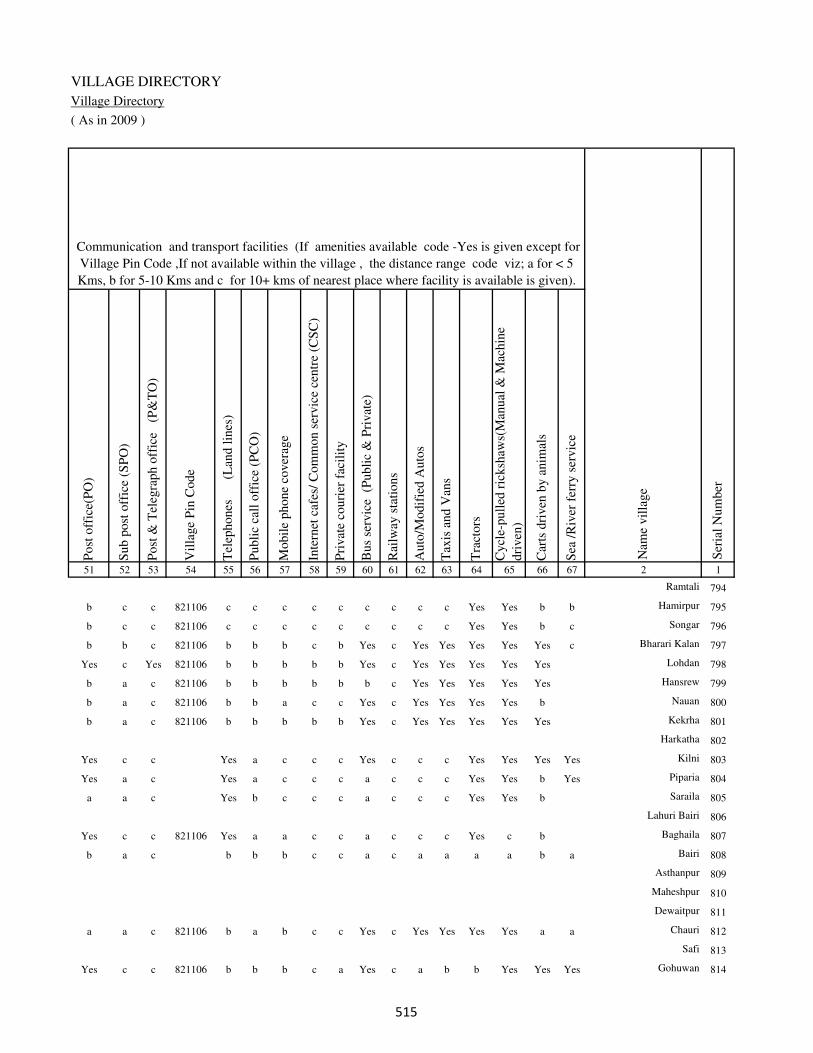
VILLAGE DIRECTORY
Village Directory
( As in 2009 )
Post
off
ice(
PO
)
Sub p
ost
off
ice
(SP
O)
Post
& T
eleg
raph o
ffic
e
(P&
TO
)
Vil
lage
Pin
Code
Tel
ephones
(L
and l
ines
)
Publi
c ca
ll o
ffic
e (P
CO
)
Mobil
e phone
cover
age
Inte
rnet
caf
es/
Com
mon s
ervic
e ce
ntr
e (C
SC
)
Pri
vat
e co
uri
er f
acil
ity
Bus
serv
ice
(P
ubli
c &
Pri
vat
e)
Rai
lway
sta
tions
Auto
/Modif
ied A
uto
s
Tax
is a
nd V
ans
Tra
ctors
Cycl
e-pull
ed r
icksh
aws(
Man
ual
& M
achin
e
dri
ven
)
Car
ts d
riven
by a
nim
als
Sea
/R
iver
fer
ry s
ervic
e51 52 53 54 55 56 57 58 59 60 61 62 63 64 65 66 67 2 1
Communication and transport facilities (If amenities available code -Yes is given except for
Village Pin Code ,If not available within the village , the distance range code viz; a for < 5
Kms, b for 5-10 Kms and c for 10+ kms of nearest place where facility is available is given).
Ser
ial
Num
ber
Nam
e vil
lage
Ramtali 794
b c c 821106 c c c c c c c c c Yes Yes b b Hamirpur 795
b c c 821106 c c c c c c c c c Yes Yes b c Songar 796
b b c 821106 b b b c b Yes c Yes Yes Yes Yes Yes c Bharari Kalan 797
Yes c Yes 821106 b b b b b Yes c Yes Yes Yes Yes Yes Lohdan 798
b a c 821106 b b b b b b c Yes Yes Yes Yes Yes Hansrew 799
b a c 821106 b b a c c Yes c Yes Yes Yes Yes b Nauan 800
b a c 821106 b b b b b Yes c Yes Yes Yes Yes Yes Kekrha 801
Harkatha 802
Yes c c Yes a c c c Yes c c c Yes Yes Yes Yes Kilni 803
Yes a c Yes a c c c a c c c Yes Yes b Yes Piparia 804
a a c Yes b c c c a c c c Yes Yes b Saraila 805
Lahuri Bairi 806
Yes c c 821106 Yes a a c c a c c c Yes c b Baghaila 807
b a c b b b c c a c a a a a b a Bairi 808
Asthanpur 809
Maheshpur 810
Dewaitpur 811
a a c 821106 b a b c c Yes c Yes Yes Yes Yes a a Chauri 812
Safi 813
Yes c c 821106 b b b c a Yes c a b b Yes Yes Yes Gohuwan 814
���
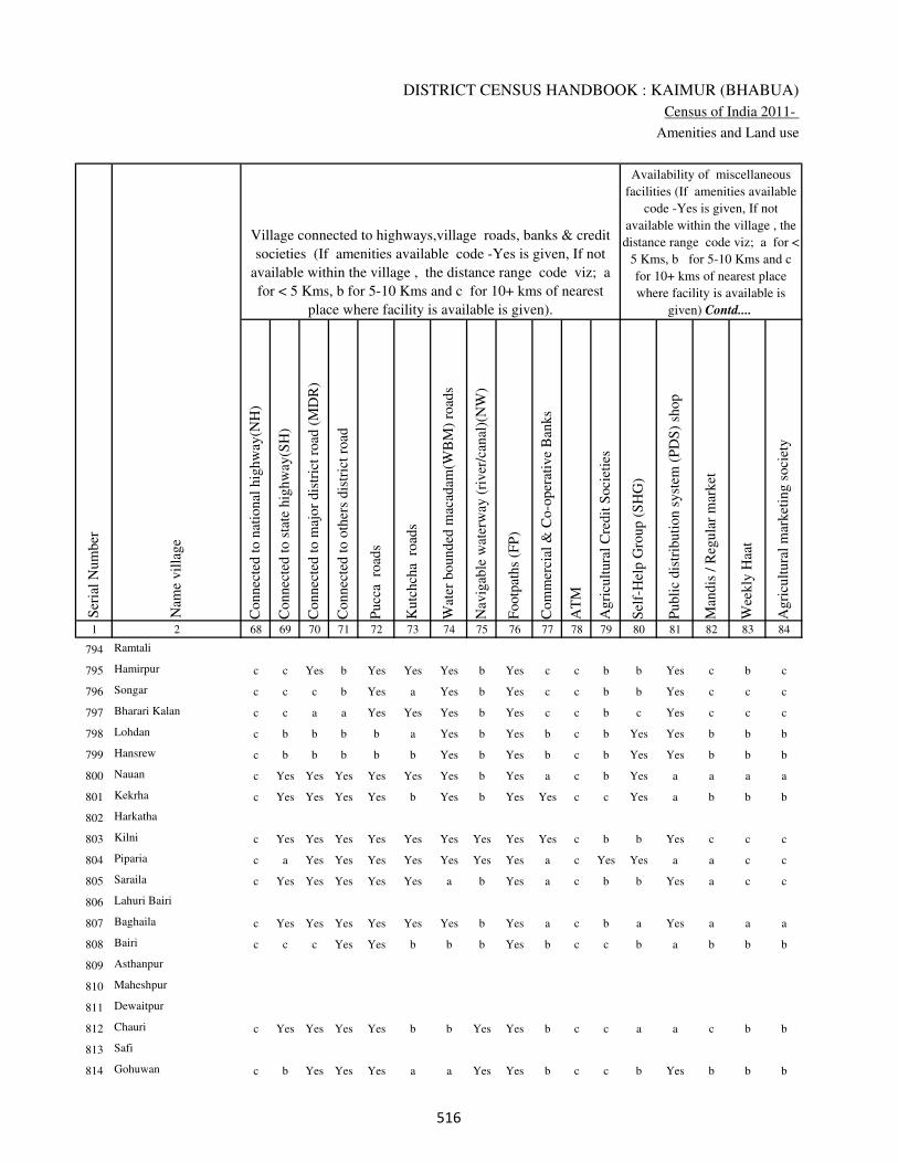
DISTRICT CENSUS HANDBOOK : KAIMUR (BHABUA)
Census of India 2011-
Amenities and Land use
Connec
ted t
o n
atio
nal
hig
hw
ay(N
H)
Connec
ted t
o s
tate
hig
hw
ay(S
H)
Connec
ted t
o m
ajor
dis
tric
t ro
ad (
MD
R)
Connec
ted t
o o
ther
s dis
tric
t ro
ad
Pucc
a r
oad
s
Kutc
hch
a r
oad
s
Wat
er b
ounded
mac
adam
(WB
M)
road
s
Nav
igab
le w
ater
way
(ri
ver
/can
al)(
NW
)
Footp
aths
(FP
)
Com
mer
cial
& C
o-o
per
ativ
e B
anks
AT
M
Agri
cult
ura
l C
redit
Soci
etie
s
Sel
f-H
elp G
roup (
SH
G)
Publi
c dis
trib
uti
on s
yst
em (
PD
S)
shop
Man
dis
/ R
egula
r m
arket
Wee
kly
Haa
t
Agri
cult
ura
l m
arket
ing s
oci
ety
1 2 68 69 70 71 72 73 74 75 76 77 78 79 80 81 82 83 84
Village connected to highways,village roads, banks & credit
societies (If amenities available code -Yes is given, If not
available within the village , the distance range code viz; a
for < 5 Kms, b for 5-10 Kms and c for 10+ kms of nearest
place where facility is available is given).
Ser
ial
Num
ber
Nam
e vil
lage
Availability of miscellaneous
facilities (If amenities available
code -Yes is given, If not
available within the village , the
distance range code viz; a for <
5 Kms, b for 5-10 Kms and c
for 10+ kms of nearest place
where facility is available is
given) Contd....
794 Ramtali
795 Hamirpur c c Yes b Yes Yes Yes b Yes c c b b Yes c b c
796 Songar c c c b Yes a Yes b Yes c c b b Yes c c c
797 Bharari Kalan c c a a Yes Yes Yes b Yes c c b c Yes c c c
798 Lohdan c b b b b a Yes b Yes b c b Yes Yes b b b
799 Hansrew c b b b b b Yes b Yes b c b Yes Yes b b b
800 Nauan c Yes Yes Yes Yes Yes Yes b Yes a c b Yes a a a a
801 Kekrha c Yes Yes Yes Yes b Yes b Yes Yes c c Yes a b b b
802 Harkatha
803 Kilni c Yes Yes Yes Yes Yes Yes Yes Yes Yes c b b Yes c c c
804 Piparia c a Yes Yes Yes Yes Yes Yes Yes a c Yes Yes a a c c
805 Saraila c Yes Yes Yes Yes Yes a b Yes a c b b Yes a c c
806 Lahuri Bairi
807 Baghaila c Yes Yes Yes Yes Yes Yes b Yes a c b a Yes a a a
808 Bairi c c c Yes Yes b b b Yes b c c b a b b b
809 Asthanpur
810 Maheshpur
811 Dewaitpur
812 Chauri c Yes Yes Yes Yes b b Yes Yes b c c a a c b b
813 Safi
814 Gohuwan c b Yes Yes Yes a a Yes Yes b c c b Yes b b b
���
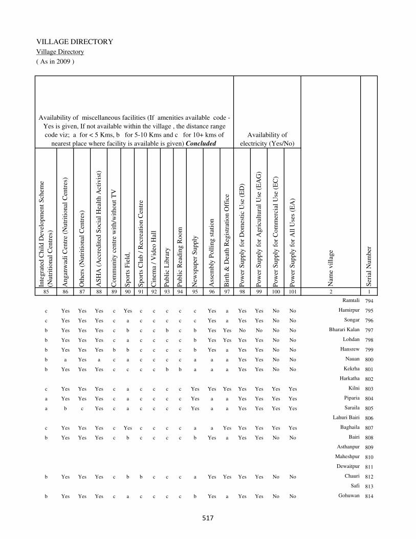
VILLAGE DIRECTORY
Village Directory
( As in 2009 )
Inte
gra
ted C
hil
d D
evel
opm
ent
Sch
eme
(Nutr
itio
nal
Cen
tres
)
Angan
wad
i C
entr
e (N
utr
itio
nal
Cen
tres
)
Oth
ers
(Nutr
itio
nal
Cen
tres
)
AS
HA
(A
ccre
dit
ed S
oci
al H
ealt
h A
ctiv
ist)
Com
munit
y c
entr
e w
ith/w
ithout
TV
Sport
s F
ield
,
Sport
s C
lub /
Rec
reat
ion C
entr
e
Cin
ema
/ V
ideo
Hal
l
Publi
c L
ibra
ry
Publi
c R
eadin
g R
oom
New
spap
er S
upply
Ass
embly
Poll
ing s
tati
on
Bir
th &
Dea
th R
egis
trat
ion O
ffic
e
Pow
er S
upply
for
Dom
esti
c U
se (
ED
)
Pow
er S
upply
for
Agri
cult
ura
l U
se (
EA
G)
Pow
er S
upply
for
Com
mer
cial
Use
(E
C)
Pow
er S
upply
for
All
Use
s (E
A)
85 86 87 88 89 90 91 92 93 94 95 96 97 98 99 100 101 2 1
Availability of
electricity (Yes/No)
Availability of miscellaneous facilities (If amenities available code -
Yes is given, If not available within the village , the distance range
code viz; a for < 5 Kms, b for 5-10 Kms and c for 10+ kms of
nearest place where facility is available is given) Concluded
Nam
e vil
lage
Ser
ial
Num
ber
Ramtali 794
c Yes Yes Yes c Yes c c c c c Yes a Yes Yes No No Hamirpur 795
c Yes Yes Yes c a c c c c c Yes a Yes Yes No No Songar 796
b Yes Yes Yes c b c c b c b Yes Yes No No No No Bharari Kalan 797
b Yes Yes Yes c a c c c c b Yes Yes Yes Yes No No Lohdan 798
b Yes Yes Yes b b c c c c b Yes a Yes Yes No No Hansrew 799
b a Yes a c a c c c c a a a Yes Yes No No Nauan 800
b Yes Yes Yes c c c c b b a a a Yes Yes No No Kekrha 801
Harkatha 802
c Yes Yes Yes c a c c c c Yes Yes Yes Yes Yes Yes Yes Kilni 803
a Yes Yes Yes c a c c c c Yes a a Yes Yes Yes Yes Piparia 804
a b c Yes c a c c c c Yes a a Yes Yes Yes Yes Saraila 805
Lahuri Bairi 806
c Yes Yes Yes c Yes c c c c a a Yes Yes Yes Yes Yes Baghaila 807
b Yes Yes Yes c b c c c c b Yes a Yes Yes No No Bairi 808
Asthanpur 809
Maheshpur 810
Dewaitpur 811
b Yes Yes Yes c b b c c c a Yes Yes Yes Yes No No Chauri 812
Safi 813
b Yes Yes Yes c a c c c c b Yes a Yes Yes No No Gohuwan 814
���
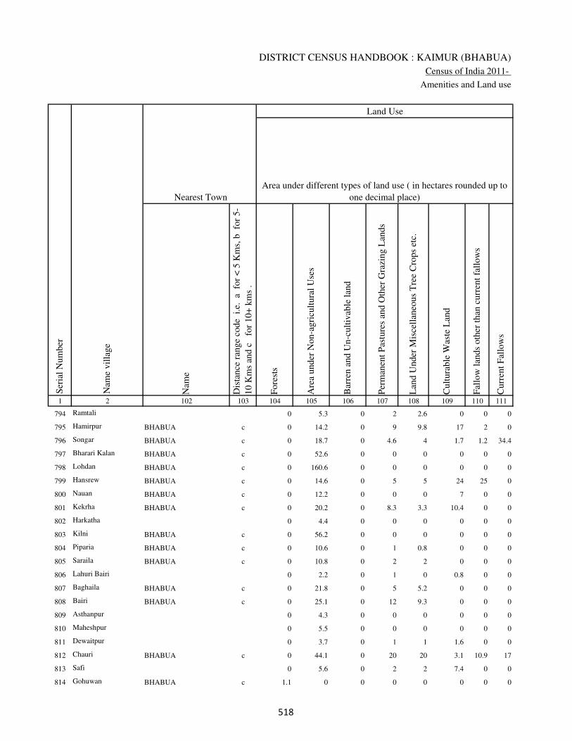
DISTRICT CENSUS HANDBOOK : KAIMUR (BHABUA)
Census of India 2011-
Amenities and Land use
Nam
e
Dis
tance
ran
ge
code
i.e
. a
fo
r <
5 K
ms,
b
for
5-
10 K
ms
and c
f
or
10+
km
s .
Fore
sts
Are
a under
Non-a
gri
cult
ura
l U
ses
Bar
ren a
nd U
n-c
ult
ivab
le l
and
Per
man
ent
Pas
ture
s an
d O
ther
Gra
zing L
ands
Lan
d U
nder
Mis
cell
aneo
us
Tre
e C
rops
etc.
Cult
ura
ble
Was
te L
and
Fal
low
lan
ds
oth
er t
han
curr
ent
fall
ow
s
Curr
ent
Fal
low
s
1 2 102 103 104 105 106 107 108 109 110 111
Ser
ial
Num
ber
Nam
e vil
lage
Area under different types of land use ( in hectares rounded up to
one decimal place)
Land Use
Nearest Town
794 Ramtali 0 5.3 0 2 2.6 0 0 0
795 Hamirpur BHABUA c 0 14.2 0 9 9.8 17 2 0
796 Songar BHABUA c 0 18.7 0 4.6 4 1.7 1.2 34.4
797 Bharari Kalan BHABUA c 0 52.6 0 0 0 0 0 0
798 Lohdan BHABUA c 0 160.6 0 0 0 0 0 0
799 Hansrew BHABUA c 0 14.6 0 5 5 24 25 0
800 Nauan BHABUA c 0 12.2 0 0 0 7 0 0
801 Kekrha BHABUA c 0 20.2 0 8.3 3.3 10.4 0 0
802 Harkatha 0 4.4 0 0 0 0 0 0
803 Kilni BHABUA c 0 56.2 0 0 0 0 0 0
804 Piparia BHABUA c 0 10.6 0 1 0.8 0 0 0
805 Saraila BHABUA c 0 10.8 0 2 2 0 0 0
806 Lahuri Bairi 0 2.2 0 1 0 0.8 0 0
807 Baghaila BHABUA c 0 21.8 0 5 5.2 0 0 0
808 Bairi BHABUA c 0 25.1 0 12 9.3 0 0 0
809 Asthanpur 0 4.3 0 0 0 0 0 0
810 Maheshpur 0 5.5 0 0 0 0 0 0
811 Dewaitpur 0 3.7 0 1 1 1.6 0 0
812 Chauri BHABUA c 0 44.1 0 20 20 3.1 10.9 17
813 Safi 0 5.6 0 2 2 7.4 0 0
814 Gohuwan BHABUA c 1.1 0 0 0 0 0 0 0
���
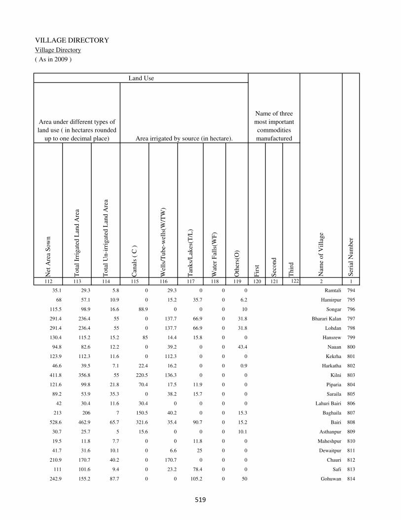
VILLAGE DIRECTORY
Village Directory
( As in 2009 )
Net
Are
a S
ow
n
Tota
l Ir
rigat
ed L
and A
rea
Tota
l U
n-i
rrig
ated
Lan
d A
rea
Can
als
( C
)
Wel
ls/T
ube-
wel
ls(W
/TW
)
Tan
ks/
Lak
es(T
/L)
Wat
er F
alls
(WF
)
Oth
ers(
O)
Fir
st
Sec
ond
Thir
d
112 113 114 115 116 117 118 119 120 121 122 2 1
Ser
ial
Num
ber
Name of three
most important
commodities
manufacturedArea irrigated by source (in hectare).
Nam
e of
Vil
lage
Area under different types of
land use ( in hectares rounded
up to one decimal place)
Land Use
35.1 29.3 5.8 0 29.3 0 0 0 Ramtali 794
68 57.1 10.9 0 15.2 35.7 0 6.2 Hamirpur 795
115.5 98.9 16.6 88.9 0 0 0 10 Songar 796
291.4 236.4 55 0 137.7 66.9 0 31.8 Bharari Kalan 797
291.4 236.4 55 0 137.7 66.9 0 31.8 Lohdan 798
130.4 115.2 15.2 85 14.4 15.8 0 0 Hansrew 799
94.8 82.6 12.2 0 39.2 0 0 43.4 Nauan 800
123.9 112.3 11.6 0 112.3 0 0 0 Kekrha 801
46.6 39.5 7.1 22.4 16.2 0 0 0.9 Harkatha 802
411.8 356.8 55 220.5 136.3 0 0 0 Kilni 803
121.6 99.8 21.8 70.4 17.5 11.9 0 0 Piparia 804
89.2 53.9 35.3 0 38.2 15.7 0 0 Saraila 805
42 30.4 11.6 30.4 0 0 0 0 Lahuri Bairi 806
213 206 7 150.5 40.2 0 0 15.3 Baghaila 807
528.6 462.9 65.7 321.6 35.4 90.7 0 15.2 Bairi 808
30.7 25.7 5 15.6 0 0 0 10.1 Asthanpur 809
19.5 11.8 7.7 0 0 11.8 0 0 Maheshpur 810
41.7 31.6 10.1 0 6.6 25 0 0 Dewaitpur 811
210.9 170.7 40.2 0 170.7 0 0 0 Chauri 812
111 101.6 9.4 0 23.2 78.4 0 0 Safi 813
242.9 155.2 87.7 0 0 105.2 0 50 Gohuwan 814
���

DISTRICT CENSUS HANDBOOK : KAIMUR (BHABUA)
Census of India 2011-
Amenities and Land use
Pre
-Pri
mar
y s
chool
(PP
)
Pri
mar
y s
chool
(P)
Mid
dle
sch
ool
(M)
Sec
ondar
y S
chool
(S)
Sen
ior
Sec
ondar
y s
chool
(SS
)
Deg
ree
coll
ege
of
arts
sc
ience
& c
om
mer
ce
(AS
C)
Engin
eeri
ng c
oll
ege(
EC
)
Med
ical
coll
ege
(MC
)
Man
agem
ent
inst
itute
(M
I)
Poly
tech
nic
(P
t)
Voca
tional
tra
inin
g s
chool
/IT
I
Non-f
orm
al t
rain
ing c
entr
e (N
FT
C)
Spec
ial
school
for
dis
able
d (
SS
D)
Oth
ers
(spec
ify)
1 2 3 4 5 6 7 8 9 10 11 12 13 14 15 16 17 18 19 20
Loca
tion c
ode
no.
Nam
e vil
lage
Ser
ial
Num
ber
Tota
l popula
tion (
2011 c
ensu
s )
Tota
l ar
ea o
f th
e vil
lage
( in
hec
tare
s ro
unded
up t
o
one
dec
imal
pla
ce)
Number of educational amenities available. (If not available
within the village , the distance range code viz; a for < 5
Kms, b for 5-10 Kms and c for 10+ kms of nearest place
where facility is available is given).
Num
ber
of
house
hold
s (2
011 c
ensu
s)
815 Morawa 249739 46 368 51 b 1 b c c c c c c c c c c
816 Kutbanpur 249740 98 269 33 b a a c c c c c c c c c c
817 Dulahi 249741 331 4437 664 b 2 a c c c c c c c c c c
818 Amawan 249742 439 2860 373 1 1 a c c c c c c c c c c
819 Barharia 249743 121 581 97 b 1 1 c c c c c c c b c c
820 Kesari 249744 324 1794 284 b 1 1 c c c c c c c c c c
821 Kalaura 249745 79 866 94 b b a c c c c c c c c c c
822 Bararhi 249746 246 930 71 b 1 a c c c c c c c c c c
823 Ledari 249747 203 2616 309 1 1 a c c c c c c c c c c
824 Parasrampur 249748 36 0 0
825 Fakirana 249749 26 0 0
826 Bahuara 249750 201 1201 156 b a a c c c c c c c c c c
827 Darunpur 249751 100 954 157 b 1 b c c c c c c c c c c
828 Sonao 249752 222 1799 280 b 1 a c c c c c c c c c c
829 Mohammadpur 249753 25 0 0
Block T O T A L : 20670 133682 20143 19 90 34 3 0 0 0 0 0 0 0 0 0 0
��

VILLAGE DIRECTORY
Village Directory
( As in 2009 )
Com
munit
y h
ealt
h c
entr
e (C
HC
)
Pri
mar
y h
ealt
h c
entr
e (P
HC
)
Pri
mar
y h
ealt
h s
ub c
entr
e (P
HS
)
Mat
ernit
y a
nd c
hil
d w
elfa
re c
entr
e (M
CW
)
T.B
. cl
inic
(T
BC
)
Hosp
ital
-all
opat
hic
(H
A)
Hosp
ital
-alt
ernat
ive
med
icin
e (H
O)
Dis
pen
sary
(D
)
Vet
erin
ary h
osp
ital
(V
H)
Mobil
e hea
lth c
linic
(M
HC
)
Fam
ily w
elfa
re c
entr
e (F
WC
)
Char
itab
le n
on G
ovt.
hosp
ital
/Nurs
ing h
om
e.
Med
ical
pra
ctit
ioner
wit
h M
BB
S D
egre
e
Med
ical
pra
ctit
ioner
wit
h o
ther
deg
ree
Med
ical
pra
ctit
ioner
wit
h n
o d
egre
e
Tra
dit
ional
pra
ctit
ioner
an
d f
aith
hea
ler
.
Med
icin
e S
hop
Oth
ers
21 22 23 24 25 26 27 28 29 30 31 32 33 34 35 36 37 38 2 1
Number of Non-Government
Medical Amenities available.
Number of Medical Amenities available. (If not
available within the village , the distance range
code viz; a for < 5 Kms, b for 5-10 Kms and c
for 10+ kms of nearest place where facility is
available is given).
Nam
e vil
lage
Ser
ial
Num
ber
c c 1 1 c c c c c c 1 0 1 1 0 0 1 0 Morawa 815
c c 1 1 1 c c c b c 1 0 1 1 0 0 1 0 Kutbanpur 816
c b 1 1 b c c 1 b c 1 0 0 0 0 0 1 0 Dulahi 817
c b 1 1 c c c 1 c c 1 0 0 1 1 0 0 0 Amawan 818
c c 1 1 c c c 1 c c 1 0 1 0 0 1 1 0 Barharia 819
c c 1 1 c c c b c c 1 0 0 0 0 2 1 0 Kesari 820
c c 1 1 c c c c c c 1 0 0 0 0 1 1 0 Kalaura 821
c c 1 1 c c c 1 c c 1 0 0 1 0 0 1 0 Bararhi 822
c c b c c c c c c c c 0 0 0 0 0 0 0 Ledari 823
Parasrampur 824
Fakirana 825
c b 1 1 c c c 1 c c 1 0 0 1 0 0 1 0 Bahuara 826
c c 1 1 c c c b c c 1 0 0 1 0 0 1 0 Darunpur 827
c b 1 1 c c c 1 c c 1 0 0 0 0 0 1 0 Sonao 828
Mohammadpur 829
0 1 79 75 27 0 0 49 2 0 76 3 6 18 16 14 78 0
��
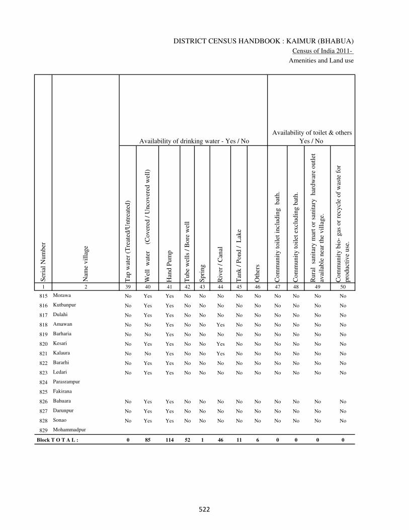
DISTRICT CENSUS HANDBOOK : KAIMUR (BHABUA)
Census of India 2011-
Amenities and Land use
Tap
wat
er (
Tre
ated
/Untr
eate
d)
Wel
l w
ater
(Cover
ed /
Unco
ver
ed w
ell)
Han
d P
um
p
Tube
wel
ls /
Bore
wel
l
Spri
ng
Riv
er /
Can
al
Tan
k /
Pond /
L
ake
Oth
ers
Com
munit
y t
oil
et i
ncl
udin
g
bat
h.
Com
munit
y t
oil
et e
xcl
udin
g b
ath.
Rura
l s
anit
ary m
art
or
sanit
ary
har
dw
are
outl
et
avai
lable
nea
r th
e vil
lage.
Com
munit
y b
io-
gas
or
recy
cle
of
was
te f
or
pro
duct
ive
use
.
1 2 39 40 41 42 43 44 45 46 47 48 49 50
Availability of toilet & others
Yes / No Availability of drinking water - Yes / No
Nam
e vil
lage
Ser
ial
Num
ber
815 Morawa No Yes Yes No No No No No No No No No
816 Kutbanpur No Yes Yes No No No No No No No No No
817 Dulahi No Yes Yes No No No No No No No No No
818 Amawan No No Yes No No Yes No No No No No No
819 Barharia No No Yes No No No No No No No No No
820 Kesari No Yes Yes No No Yes No No No No No No
821 Kalaura No No Yes No No Yes No No No No No No
822 Bararhi No Yes Yes No No No No No No No No No
823 Ledari No Yes Yes No No No No No No No No No
824 Parasrampur
825 Fakirana
826 Bahuara No Yes Yes No No No No No No No No No
827 Darunpur No Yes Yes No No No No No No No No No
828 Sonao No Yes Yes No No No No No No No No No
829 Mohammadpur
Block T O T A L : 0 85 114 52 1 46 11 6 0 0 0 0
�
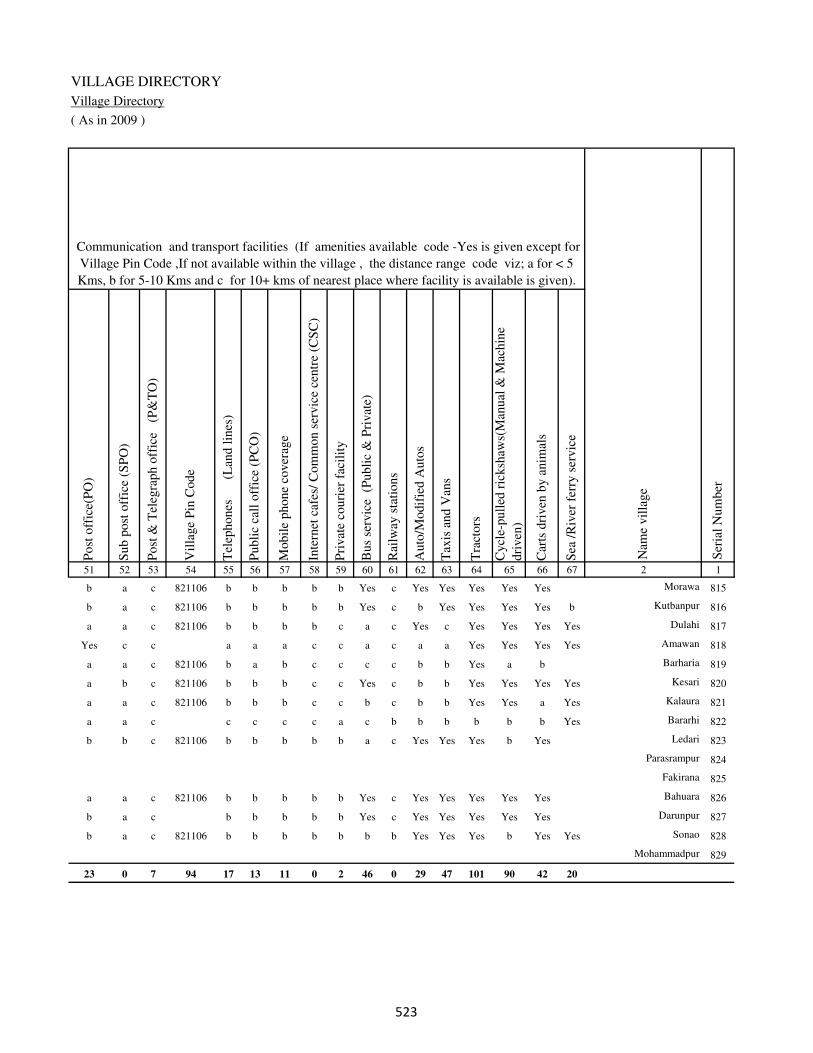
VILLAGE DIRECTORY
Village Directory
( As in 2009 )
Post
off
ice(
PO
)
Sub p
ost
off
ice
(SP
O)
Post
& T
eleg
raph o
ffic
e
(P&
TO
)
Vil
lage
Pin
Code
Tel
ephones
(L
and l
ines
)
Publi
c ca
ll o
ffic
e (P
CO
)
Mobil
e phone
cover
age
Inte
rnet
caf
es/
Com
mon s
ervic
e ce
ntr
e (C
SC
)
Pri
vat
e co
uri
er f
acil
ity
Bus
serv
ice
(P
ubli
c &
Pri
vat
e)
Rai
lway
sta
tions
Auto
/Modif
ied A
uto
s
Tax
is a
nd V
ans
Tra
ctors
Cycl
e-pull
ed r
icksh
aws(
Man
ual
& M
achin
e
dri
ven
)
Car
ts d
riven
by a
nim
als
Sea
/R
iver
fer
ry s
ervic
e51 52 53 54 55 56 57 58 59 60 61 62 63 64 65 66 67 2 1
Communication and transport facilities (If amenities available code -Yes is given except for
Village Pin Code ,If not available within the village , the distance range code viz; a for < 5
Kms, b for 5-10 Kms and c for 10+ kms of nearest place where facility is available is given).
Ser
ial
Num
ber
Nam
e vil
lage
b a c 821106 b b b b b Yes c Yes Yes Yes Yes Yes Morawa 815
b a c 821106 b b b b b Yes c b Yes Yes Yes Yes b Kutbanpur 816
a a c 821106 b b b b c a c Yes c Yes Yes Yes Yes Dulahi 817
Yes c c a a a c c a c a a Yes Yes Yes Yes Amawan 818
a a c 821106 b a b c c c c b b Yes a b Barharia 819
a b c 821106 b b b c c Yes c b b Yes Yes Yes Yes Kesari 820
a a c 821106 b b b c c b c b b Yes Yes a Yes Kalaura 821
a a c c c c c a c b b b b b b Yes Bararhi 822
b b c 821106 b b b b b a c Yes Yes Yes b Yes Ledari 823
Parasrampur 824
Fakirana 825
a a c 821106 b b b b b Yes c Yes Yes Yes Yes Yes Bahuara 826
b a c b b b b b Yes c Yes Yes Yes Yes Yes Darunpur 827
b a c 821106 b b b b b b b Yes Yes Yes b Yes Yes Sonao 828
Mohammadpur 829
23 0 7 94 17 13 11 0 2 46 0 29 47 101 90 42 20
�
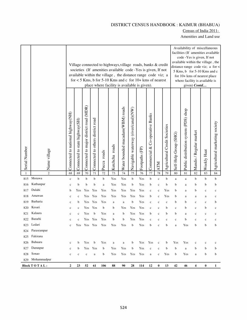
DISTRICT CENSUS HANDBOOK : KAIMUR (BHABUA)
Census of India 2011-
Amenities and Land use
Connec
ted t
o n
atio
nal
hig
hw
ay(N
H)
Connec
ted t
o s
tate
hig
hw
ay(S
H)
Connec
ted t
o m
ajor
dis
tric
t ro
ad (
MD
R)
Connec
ted t
o o
ther
s dis
tric
t ro
ad
Pucc
a r
oad
s
Kutc
hch
a r
oad
s
Wat
er b
ounded
mac
adam
(WB
M)
road
s
Nav
igab
le w
ater
way
(ri
ver
/can
al)(
NW
)
Footp
aths
(FP
)
Com
mer
cial
& C
o-o
per
ativ
e B
anks
AT
M
Agri
cult
ura
l C
redit
Soci
etie
s
Sel
f-H
elp G
roup (
SH
G)
Publi
c dis
trib
uti
on s
yst
em (
PD
S)
shop
Man
dis
/ R
egula
r m
arket
Wee
kly
Haa
t
Agri
cult
ura
l m
arket
ing s
oci
ety
1 2 68 69 70 71 72 73 74 75 76 77 78 79 80 81 82 83 84
Village connected to highways,village roads, banks & credit
societies (If amenities available code -Yes is given, If not
available within the village , the distance range code viz; a
for < 5 Kms, b for 5-10 Kms and c for 10+ kms of nearest
place where facility is available is given).
Ser
ial
Num
ber
Nam
e vil
lage
Availability of miscellaneous
facilities (If amenities available
code -Yes is given, If not
available within the village , the
distance range code viz; a for <
5 Kms, b for 5-10 Kms and c
for 10+ kms of nearest place
where facility is available is
given) Contd....
815 Morawa c b b b b Yes Yes b Yes b c b a a b b b
816 Kutbanpur c b b b a Yes Yes b Yes b c b b a b b b
817 Dulahi b Yes Yes Yes Yes Yes Yes Yes Yes c c Yes b a b c c
818 Amawan c c Yes Yes Yes Yes Yes Yes Yes b c Yes b a a a c
819 Barharia c b Yes Yes Yes a a b Yes c c c b b c c b
820 Kesari c c Yes Yes b b Yes Yes Yes c c b c b c b c
821 Kalaura c c Yes b Yes a b Yes Yes b c b b a c c c
822 Bararhi c c Yes Yes Yes b b Yes Yes c c c c b c c c
823 Ledari c Yes Yes Yes Yes Yes Yes b Yes b c b a Yes b b b
824 Parasrampur
825 Fakirana
826 Bahuara c b Yes b Yes a a b Yes Yes c b Yes Yes c c c
827 Darunpur c b Yes Yes b Yes Yes b Yes c c b b a b b b
828 Sonao c c c a b Yes Yes Yes Yes a c Yes b Yes a b b
829 Mohammadpur
Block T O T A L : 2 23 52 61 106 88 90 28 114 12 0 13 42 46 4 0 1
��

VILLAGE DIRECTORY
Village Directory
( As in 2009 )
Inte
gra
ted C
hil
d D
evel
opm
ent
Sch
eme
(Nutr
itio
nal
Cen
tres
)
Angan
wad
i C
entr
e (N
utr
itio
nal
Cen
tres
)
Oth
ers
(Nutr
itio
nal
Cen
tres
)
AS
HA
(A
ccre
dit
ed S
oci
al H
ealt
h A
ctiv
ist)
Com
munit
y c
entr
e w
ith/w
ithout
TV
Sport
s F
ield
,
Sport
s C
lub /
Rec
reat
ion C
entr
e
Cin
ema
/ V
ideo
Hal
l
Publi
c L
ibra
ry
Publi
c R
eadin
g R
oom
New
spap
er S
upply
Ass
embly
Poll
ing s
tati
on
Bir
th &
Dea
th R
egis
trat
ion O
ffic
e
Pow
er S
upply
for
Dom
esti
c U
se (
ED
)
Pow
er S
upply
for
Agri
cult
ura
l U
se (
EA
G)
Pow
er S
upply
for
Com
mer
cial
Use
(E
C)
Pow
er S
upply
for
All
Use
s (E
A)
85 86 87 88 89 90 91 92 93 94 95 96 97 98 99 100 101 2 1
Availability of
electricity (Yes/No)
Availability of miscellaneous facilities (If amenities available code -
Yes is given, If not available within the village , the distance range
code viz; a for < 5 Kms, b for 5-10 Kms and c for 10+ kms of
nearest place where facility is available is given) Concluded
Nam
e vil
lage
Ser
ial
Num
ber
c Yes Yes Yes c b c c b b b a a Yes Yes No No Morawa 815
c a Yes Yes c b c c b b b a b Yes Yes No No Kutbanpur 816
c Yes Yes Yes b b b c c c Yes Yes Yes Yes Yes Yes Yes Dulahi 817
b Yes Yes Yes c b c c c c b Yes a Yes Yes No No Amawan 818
b a Yes Yes c c c c c c a Yes a Yes Yes No No Barharia 819
b Yes Yes Yes c c c c c c b Yes a Yes Yes No No Kesari 820
b a Yes b c b b c c c b a b Yes Yes No No Kalaura 821
c Yes Yes Yes c c c c b b b Yes b Yes Yes No No Bararhi 822
c Yes Yes Yes c b c c c b b Yes a Yes Yes Yes Yes Ledari 823
Parasrampur 824
Fakirana 825
c b Yes Yes c b c c b b Yes Yes a Yes Yes Yes Yes Bahuara 826
c Yes Yes Yes c b c c a a b Yes b Yes Yes No No Darunpur 827
c Yes Yes Yes c b b c b b b a a Yes Yes Yes Yes Sonao 828
Mohammadpur 829
1 80 106 82 8 16 3 0 0 0 9 64 23 98 100 33 32
��

DISTRICT CENSUS HANDBOOK : KAIMUR (BHABUA)
Census of India 2011-
Amenities and Land use
Nam
e
Dis
tance
ran
ge
code
i.e
. a
fo
r <
5 K
ms,
b
for
5-
10 K
ms
and c
f
or
10+
km
s .
Fore
sts
Are
a under
Non-a
gri
cult
ura
l U
ses
Bar
ren a
nd U
n-c
ult
ivab
le l
and
Per
man
ent
Pas
ture
s an
d O
ther
Gra
zing L
ands
Lan
d U
nder
Mis
cell
aneo
us
Tre
e C
rops
etc.
Cult
ura
ble
Was
te L
and
Fal
low
lan
ds
oth
er t
han
curr
ent
fall
ow
s
Curr
ent
Fal
low
s
1 2 102 103 104 105 106 107 108 109 110 111
Ser
ial
Num
ber
Nam
e vil
lage
Area under different types of land use ( in hectares rounded up to
one decimal place)
Land Use
Nearest Town
815 Morawa BHABUA c 0 0.2 0 0 0 0 0 0
816 Kutbanpur BHABUA c 0 5.6 0 1.5 1.5 0 0 0
817 Dulahi BHABUA c 0 34.5 0 0 0 0 0 0
818 Amawan BHABUA c 0 38.2 0 0 0 0 0 0
819 Barharia BHABUA c 0 4.3 0 0 0 0 0 0
820 Kesari BHABUA c 0 74 0 0 0 0 0 0
821 Kalaura BHABUA c 0 3.8 0 0 0 0 0 0
822 Bararhi BHABUA c 0 16.7 0 2 7.9 0 0 0
823 Ledari BHABUA c 0 3.6 0 0 0 0 0 0
824 Parasrampur 0 0.1 0 0 0 1 0 0
825 Fakirana 0 2 0 0 0 5.7 1.8 2.8
826 Bahuara BHABUA c 0 2.4 0 0 0 8 0 0
827 Darunpur BHABUA c 0 15.1 0 0 0 0 0 0
828 Sonao BHABUA c 0 5.1 0 0 0 14 0 0
829 Mohammadpur 0 1.6 0 0 0 0 0 0
Block T O T A L : 0 0 1.1 1822.4 0 356.7 399.8 1074.2 218.4 226.3
��
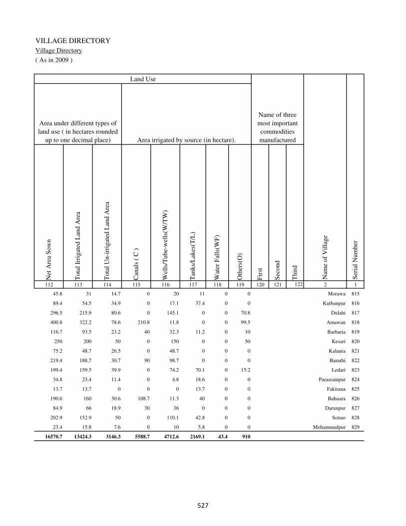
VILLAGE DIRECTORY
Village Directory
( As in 2009 )
Net
Are
a S
ow
n
Tota
l Ir
rigat
ed L
and A
rea
Tota
l U
n-i
rrig
ated
Lan
d A
rea
Can
als
( C
)
Wel
ls/T
ube-
wel
ls(W
/TW
)
Tan
ks/
Lak
es(T
/L)
Wat
er F
alls
(WF
)
Oth
ers(
O)
Fir
st
Sec
ond
Thir
d
112 113 114 115 116 117 118 119 120 121 122 2 1
Ser
ial
Num
ber
Name of three
most important
commodities
manufacturedArea irrigated by source (in hectare).
Nam
e of
Vil
lage
Area under different types of
land use ( in hectares rounded
up to one decimal place)
Land Use
45.8 31 14.7 0 20 11 0 0 Morawa 815
89.4 54.5 34.9 0 17.1 37.4 0 0 Kutbanpur 816
296.5 215.9 80.6 0 145.1 0 0 70.8 Dulahi 817
400.8 322.2 78.6 210.8 11.8 0 0 99.5 Amawan 818
116.7 93.5 23.2 40 32.3 11.2 0 10 Barharia 819
250 200 50 0 150 0 0 50 Kesari 820
75.2 48.7 26.5 0 48.7 0 0 0 Kalaura 821
219.4 188.7 30.7 90 98.7 0 0 0 Bararhi 822
199.4 159.5 39.9 0 74.2 70.1 0 15.2 Ledari 823
34.8 23.4 11.4 0 4.8 18.6 0 0 Parasrampur 824
13.7 13.7 0 0 0 13.7 0 0 Fakirana 825
190.6 160 30.6 108.7 11.3 40 0 0 Bahuara 826
84.9 66 18.9 30 36 0 0 0 Darunpur 827
202.9 152.9 50 0 110.1 42.8 0 0 Sonao 828
23.4 15.8 7.6 0 10 5.8 0 0 Mohammadpur 829
16570.7 13424.3 3146.3 5588.7 4712.6 2169.1 43.4 910
��

DISTRICT CENSUS HANDBOOK : KAIMUR (BHABUA)
Census of India 2011-
Amenities and Land use
Pre
-Pri
mar
y s
chool
(PP
)
Pri
mar
y s
chool
(P)
Mid
dle
sch
ool
(M)
Sec
ondar
y S
chool
(S)
Sen
ior
Sec
ondar
y s
chool
(SS
)
Deg
ree
coll
ege
of
arts
sc
ience
& c
om
mer
ce
(AS
C)
Engin
eeri
ng c
oll
ege(
EC
)
Med
ical
coll
ege
(MC
)
Man
agem
ent
inst
itute
(M
I)
Poly
tech
nic
(P
t)
Voca
tional
tra
inin
g s
chool
/IT
I
Non-f
orm
al t
rain
ing c
entr
e (N
FT
C)
Spec
ial
school
for
dis
able
d (
SS
D)
Oth
ers
(spec
ify)
1 2 3 4 5 6 7 8 9 10 11 12 13 14 15 16 17 18 19 20
Loca
tion c
ode
no.
Nam
e vil
lage
Ser
ial
Num
ber
Tota
l popula
tion (
2011 c
ensu
s )
Tota
l ar
ea o
f th
e vil
lage
( in
hec
tare
s ro
unded
up t
o
one
dec
imal
pla
ce)
Number of educational amenities available. (If not available
within the village , the distance range code viz; a for < 5
Kms, b for 5-10 Kms and c for 10+ kms of nearest place
where facility is available is given).
Num
ber
of
house
hold
s (2
011 c
ensu
s)
Name of District:-Kaimur (Bhabua) Location CodeNo:-233
Name of CD Block:-Chainpur Location CodeNo:-0440
830 Semaria 249754 154 1297 197 c 2 a c b c c c c c c c c
831 Sadauli 249755 39.2 0 0
832 Koindi 249756 231.9 1995 274 c 1 2 c c c c c c c c c c
833 Khajopur 249757 44.9 0 0
834 Ghanti 249758 162.3 1125 188 c 1 a c c c c c c c c c c
835 Ramgarh 249759 333 1844 305 c 1 1 c c c c c c c c c c
836 Bhaganda 249760 154 1332 198 c 1 1 c c c c c c c c c c
837 Ismailpur 249761 121.8 703 108 c 2 c c c c c c c c c c c
838 Hargawan 249762 121.4 696 105 c 2 a c b c c c c c c c c
839 Ismailpur Arazi 249763 330.2 378 67 c b b c b c c c c c c c c
840 Ramauli 249764 90.6 813 117 c 1 b c c c c c c c c c c
841 Narsinghpur 249765 23.5 0 0
842 Neura 249766 25.5 278 51 c 1 a c c c c c c c c c c
843 Barhauna 249767 164.7 2257 378 c 1 1 c b c c c c c c c c
844 Kharanti 249768 87.8 246 42 b a b c b b c c c c c c c
845 Dih Bhujaina 249769 247.7 2450 375 b 2 2 c b c c c c c c c c
846 Siur 249770 52.6 0 0
847 Raghubir Garh 249771 124.6 1587 290 b 1 1 c b c c c c c c c c
848 Dubepur 249772 18.6 154 38 b b a c b b c c c c c c c
��
VILLAGE DIRECTORY
Village Directory
( As in 2009 )
Com
munit
y h
ealt
h c
entr
e (C
HC
)
Pri
mar
y h
ealt
h c
entr
e (P
HC
)
Pri
mar
y h
ealt
h s
ub c
entr
e (P
HS
)
Mat
ernit
y a
nd c
hil
d w
elfa
re c
entr
e (M
CW
)
T.B
. cl
inic
(T
BC
)
Hosp
ital
-all
opat
hic
(H
A)
Hosp
ital
-alt
ernat
ive
med
icin
e (H
O)
Dis
pen
sary
(D
)
Vet
erin
ary h
osp
ital
(V
H)
Mobil
e hea
lth c
linic
(M
HC
)
Fam
ily w
elfa
re c
entr
e (F
WC
)
Char
itab
le n
on G
ovt.
hosp
ital
/Nurs
ing h
om
e.
Med
ical
pra
ctit
ioner
wit
h M
BB
S D
egre
e
Med
ical
pra
ctit
ioner
wit
h o
ther
deg
ree
Med
ical
pra
ctit
ioner
wit
h n
o d
egre
e
Tra
dit
ional
pra
ctit
ioner
an
d f
aith
hea
ler
.
Med
icin
e S
hop
Oth
ers
21 22 23 24 25 26 27 28 29 30 31 32 33 34 35 36 37 38 2 1
Number of Non-Government
Medical Amenities available.
Number of Medical Amenities available. (If not
available within the village , the distance range
code viz; a for < 5 Kms, b for 5-10 Kms and c
for 10+ kms of nearest place where facility is
available is given).
Nam
e vil
lage
Ser
ial
Num
ber
c c a c c c c b b c c 0 0 0 0 0 0 0 Semaria 830
Sadauli 831
c c a c c c c a c c c 0 0 0 0 0 0 0 Koindi 832
Khajopur 833
c b 1 1 c c c b b c 1 0 0 0 0 0 0 0 Ghanti 834
c c c c c c c c c c c 0 0 1 0 0 0 1 Ramgarh 835
c c c c c c c c c c c 0 0 0 0 0 0 0 Bhaganda 836
c c c c c c c c c c c 0 0 0 0 0 0 0 Ismailpur 837
c c c c c c c c c c c 0 0 0 0 0 0 0 Hargawan 838
c c c c c c c c c c c 0 0 0 0 0 0 0 Ismailpur Arazi 839
c c c c c c c c c c c 0 0 0 0 0 0 0 Ramauli 840
Narsinghpur 841
c b a c c c c c c c c 0 0 0 0 0 0 0 Neura 842
c b b c c c c c c c b 0 0 0 0 0 0 0 Barhauna 843
c c 1 1 c c c c c c 1 0 0 0 0 0 0 0 Kharanti 844
c c a c c c c c c c c 0 0 0 0 0 0 0 Dih Bhujaina 845
Siur 846
c c 1 1 c c c b c c 1 0 0 0 0 0 0 0 Raghubir Garh 847
c c b c c c c c c c c 0 0 0 0 0 0 0 Dubepur 848
��
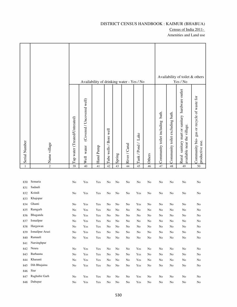
DISTRICT CENSUS HANDBOOK : KAIMUR (BHABUA)
Census of India 2011-
Amenities and Land use
Tap
wat
er (
Tre
ated
/Untr
eate
d)
Wel
l w
ater
(Cover
ed /
Unco
ver
ed w
ell)
Han
d P
um
p
Tube
wel
ls /
Bore
wel
l
Spri
ng
Riv
er /
Can
al
Tan
k /
Pond /
L
ake
Oth
ers
Com
munit
y t
oil
et i
ncl
udin
g
bat
h.
Com
munit
y t
oil
et e
xcl
udin
g b
ath.
Rura
l s
anit
ary m
art
or
sanit
ary
har
dw
are
outl
et
avai
lable
nea
r th
e vil
lage.
Com
munit
y b
io-
gas
or
recy
cle
of
was
te f
or
pro
duct
ive
use
.
1 2 39 40 41 42 43 44 45 46 47 48 49 50
Availability of toilet & others
Yes / No Availability of drinking water - Yes / No
Nam
e vil
lage
Ser
ial
Num
ber
830 Semaria No Yes Yes No No No No No No No No No
831 Sadauli
832 Koindi No Yes Yes No No No Yes No No No No No
833 Khajopur
834 Ghanti No Yes Yes No No No Yes No No No No No
835 Ramgarh No Yes Yes No No No No No No No No No
836 Bhaganda No Yes Yes No No No No No No No No No
837 Ismailpur No Yes Yes No No No No No No No No No
838 Hargawan No Yes Yes No No No No No No No No No
839 Ismailpur Arazi No Yes Yes No No No No No No No No No
840 Ramauli No Yes Yes No No No No No No No No No
841 Narsinghpur
842 Neura No Yes Yes No No No Yes No No No No No
843 Barhauna No Yes Yes No No No Yes No No No No No
844 Kharanti No Yes Yes No No No Yes No No No No No
845 Dih Bhujaina No Yes Yes No No No Yes No No No No No
846 Siur
847 Raghubir Garh No Yes Yes No No No Yes No No No No No
848 Dubepur No Yes Yes No No No Yes No No No No No
��
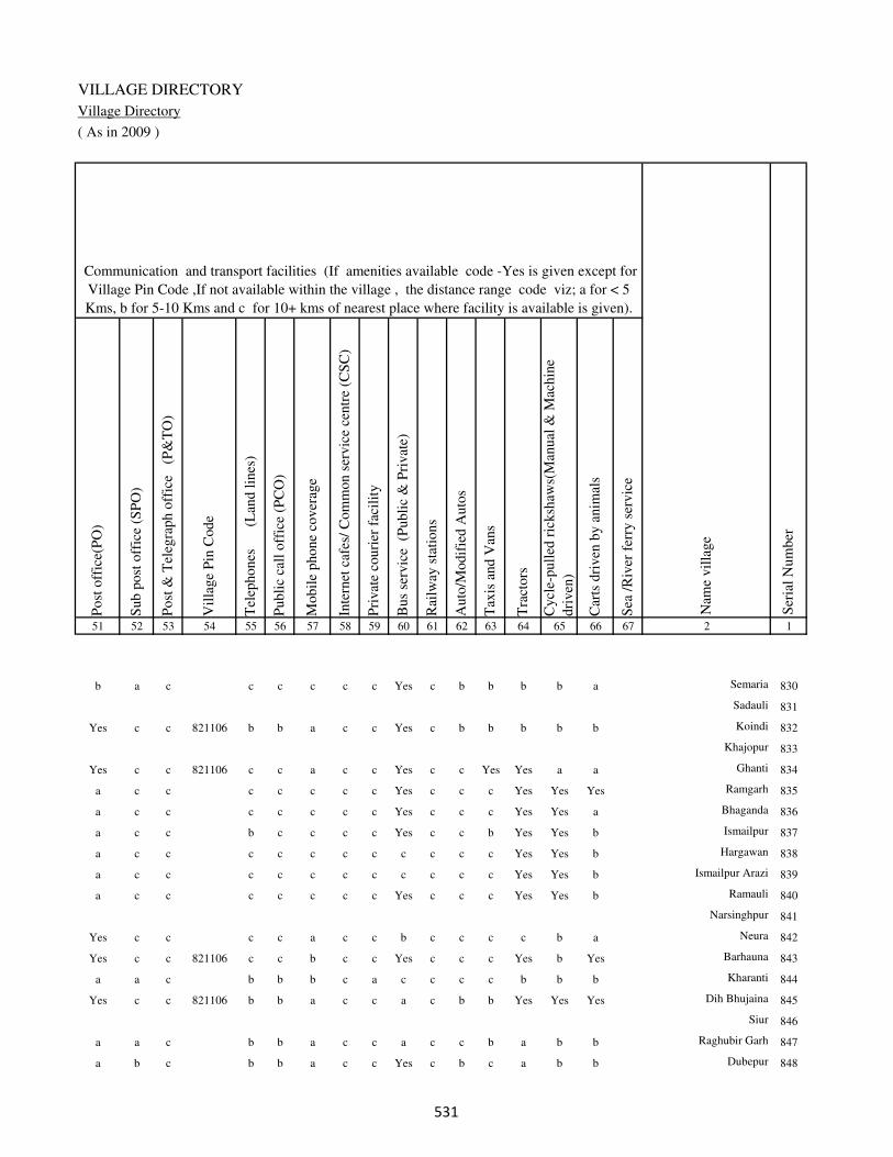
VILLAGE DIRECTORY
Village Directory
( As in 2009 )
Post
off
ice(
PO
)
Sub p
ost
off
ice
(SP
O)
Post
& T
eleg
raph o
ffic
e
(P&
TO
)
Vil
lage
Pin
Code
Tel
ephones
(L
and l
ines
)
Publi
c ca
ll o
ffic
e (P
CO
)
Mobil
e phone
cover
age
Inte
rnet
caf
es/
Com
mon s
ervic
e ce
ntr
e (C
SC
)
Pri
vat
e co
uri
er f
acil
ity
Bus
serv
ice
(P
ubli
c &
Pri
vat
e)
Rai
lway
sta
tions
Auto
/Modif
ied A
uto
s
Tax
is a
nd V
ans
Tra
ctors
Cycl
e-pull
ed r
icksh
aws(
Man
ual
& M
achin
e
dri
ven
)
Car
ts d
riven
by a
nim
als
Sea
/R
iver
fer
ry s
ervic
e51 52 53 54 55 56 57 58 59 60 61 62 63 64 65 66 67 2 1
Communication and transport facilities (If amenities available code -Yes is given except for
Village Pin Code ,If not available within the village , the distance range code viz; a for < 5
Kms, b for 5-10 Kms and c for 10+ kms of nearest place where facility is available is given).
Ser
ial
Num
ber
Nam
e vil
lage
b a c c c c c c Yes c b b b b a Semaria 830
Sadauli 831
Yes c c 821106 b b a c c Yes c b b b b b Koindi 832
Khajopur 833
Yes c c 821106 c c a c c Yes c c Yes Yes a a Ghanti 834
a c c c c c c c Yes c c c Yes Yes Yes Ramgarh 835
a c c c c c c c Yes c c c Yes Yes a Bhaganda 836
a c c b c c c c Yes c c b Yes Yes b Ismailpur 837
a c c c c c c c c c c c Yes Yes b Hargawan 838
a c c c c c c c c c c c Yes Yes b Ismailpur Arazi 839
a c c c c c c c Yes c c c Yes Yes b Ramauli 840
Narsinghpur 841
Yes c c c c a c c b c c c c b a Neura 842
Yes c c 821106 c c b c c Yes c c c Yes b Yes Barhauna 843
a a c b b b c a c c c c b b b Kharanti 844
Yes c c 821106 b b a c c a c b b Yes Yes Yes Dih Bhujaina 845
Siur 846
a a c b b a c c a c c b a b b Raghubir Garh 847
a b c b b a c c Yes c b c a b b Dubepur 848
��

DISTRICT CENSUS HANDBOOK : KAIMUR (BHABUA)
Census of India 2011-
Amenities and Land use
Connec
ted t
o n
atio
nal
hig
hw
ay(N
H)
Connec
ted t
o s
tate
hig
hw
ay(S
H)
Connec
ted t
o m
ajor
dis
tric
t ro
ad (
MD
R)
Connec
ted t
o o
ther
s dis
tric
t ro
ad
Pucc
a r
oad
s
Kutc
hch
a r
oad
s
Wat
er b
ounded
mac
adam
(WB
M)
road
s
Nav
igab
le w
ater
way
(ri
ver
/can
al)(
NW
)
Footp
aths
(FP
)
Com
mer
cial
& C
o-o
per
ativ
e B
anks
AT
M
Agri
cult
ura
l C
redit
Soci
etie
s
Sel
f-H
elp G
roup (
SH
G)
Publi
c dis
trib
uti
on s
yst
em (
PD
S)
shop
Man
dis
/ R
egula
r m
arket
Wee
kly
Haa
t
Agri
cult
ura
l m
arket
ing s
oci
ety
1 2 68 69 70 71 72 73 74 75 76 77 78 79 80 81 82 83 84
Village connected to highways,village roads, banks & credit
societies (If amenities available code -Yes is given, If not
available within the village , the distance range code viz; a
for < 5 Kms, b for 5-10 Kms and c for 10+ kms of nearest
place where facility is available is given).
Ser
ial
Num
ber
Nam
e vil
lage
Availability of miscellaneous
facilities (If amenities available
code -Yes is given, If not
available within the village , the
distance range code viz; a for <
5 Kms, b for 5-10 Kms and c
for 10+ kms of nearest place
where facility is available is
given) Contd....
830 Semaria c b Yes b Yes b a Yes b b c a b b b c
831 Sadauli
832 Koindi c b b a a Yes Yes b Yes b c Yes a a b b b
833 Khajopur
834 Ghanti c c c Yes Yes Yes Yes b Yes c c Yes b Yes c c c
835 Ramgarh c c c a a Yes Yes b Yes c c Yes b Yes c c c
836 Bhaganda c c c b b a b b Yes c c c c c b c b
837 Ismailpur c c b b b b b b Yes c c c Yes b b c b
838 Hargawan c c b b a a b b Yes c c c b b b b c
839 Ismailpur Arazi c c b b b a b b Yes c c c b b b c c
840 Ramauli c c b b b a b c Yes c c Yes b b c c c
841 Narsinghpur
842 Neura c c b Yes a Yes a c Yes c c c b a c c c
843 Barhauna c c c Yes Yes Yes b b Yes c c c b a b b b
844 Kharanti c Yes b Yes Yes b b Yes c c b b a b c c
845 Dih Bhujaina c b b a a Yes Yes b Yes b c Yes c Yes b b b
846 Siur
847 Raghubir Garh c b Yes Yes a Yes b b Yes b c Yes c a b c b
848 Dubepur c c Yes b b Yes a b Yes c c b b a c b b
�

VILLAGE DIRECTORY
Village Directory
( As in 2009 )
Inte
gra
ted C
hil
d D
evel
opm
ent
Sch
eme
(Nutr
itio
nal
Cen
tres
)
Angan
wad
i C
entr
e (N
utr
itio
nal
Cen
tres
)
Oth
ers
(Nutr
itio
nal
Cen
tres
)
AS
HA
(A
ccre
dit
ed S
oci
al H
ealt
h A
ctiv
ist)
Com
munit
y c
entr
e w
ith/w
ithout
TV
Sport
s F
ield
,
Sport
s C
lub /
Rec
reat
ion C
entr
e
Cin
ema
/ V
ideo
Hal
l
Publi
c L
ibra
ry
Publi
c R
eadin
g R
oom
New
spap
er S
upply
Ass
embly
Poll
ing s
tati
on
Bir
th &
Dea
th R
egis
trat
ion O
ffic
e
Pow
er S
upply
for
Dom
esti
c U
se (
ED
)
Pow
er S
upply
for
Agri
cult
ura
l U
se (
EA
G)
Pow
er S
upply
for
Com
mer
cial
Use
(E
C)
Pow
er S
upply
for
All
Use
s (E
A)
85 86 87 88 89 90 91 92 93 94 95 96 97 98 99 100 101 2 1
Availability of
electricity (Yes/No)
Availability of miscellaneous facilities (If amenities available code -
Yes is given, If not available within the village , the distance range
code viz; a for < 5 Kms, b for 5-10 Kms and c for 10+ kms of
nearest place where facility is available is given) Concluded
Nam
e vil
lage
Ser
ial
Num
ber
c b Yes a c c c c c c b Yes a Yes No No No Semaria 830
Sadauli 831
b Yes Yes Yes c b c c c c b Yes a Yes No No No Koindi 832
Khajopur 833
c Yes Yes a c a c c b c b Yes a Yes No No No Ghanti 834
c Yes Yes Yes c b c c c c b Yes Yes Yes No No No Ramgarh 835
c b Yes a c a c c c c b a a Yes No No No Bhaganda 836
c b Yes a c a c c c c b a a Yes No No No Ismailpur 837
c b Yes a c a c c c c b a a No No No No Hargawan 838
c b Yes a c a c c c c b a a No No No No Ismailpur Arazi 839
c b Yes a c a c c c c b a a Yes No No No Ramauli 840
Narsinghpur 841
c a Yes Yes c Yes b c b c b a a Yes No No No Neura 842
c Yes Yes b c Yes c c c c b Yes Yes Yes No No No Barhauna 843
c Yes Yes Yes c c b c c c b a a Yes No No No Kharanti 844
c Yes Yes a c a c c c c b Yes a Yes No No No Dih Bhujaina 845
Siur 846
c Yes Yes a c a c c c c b Yes a Yes No No No Raghubir Garh 847
c Yes Yes a c Yes c c c c b a a Yes No No No Dubepur 848
�

DISTRICT CENSUS HANDBOOK : KAIMUR (BHABUA)
Census of India 2011-
Amenities and Land use
Nam
e
Dis
tance
ran
ge
code
i.e
. a
fo
r <
5 K
ms,
b
for
5-
10 K
ms
and c
f
or
10+
km
s .
Fore
sts
Are
a under
Non-a
gri
cult
ura
l U
ses
Bar
ren a
nd U
n-c
ult
ivab
le l
and
Per
man
ent
Pas
ture
s an
d O
ther
Gra
zing L
ands
Lan
d U
nder
Mis
cell
aneo
us
Tre
e C
rops
etc.
Cult
ura
ble
Was
te L
and
Fal
low
lan
ds
oth
er t
han
curr
ent
fall
ow
s
Curr
ent
Fal
low
s
1 2 102 103 104 105 106 107 108 109 110 111
Ser
ial
Num
ber
Nam
e vil
lage
Area under different types of land use ( in hectares rounded up to
one decimal place)
Land Use
Nearest Town
830 Semaria BHABUA c 0 2.2 0 19.8 1 0 4 4
831 Sadauli 0 0.2 0 0 0 0 4 4
832 Koindi BHABUA c 0 2.9 0 0 1 0 2 2
833 Khajopur 0 0.9 0 0 0 0 4 4
834 Ghanti BHABUA c 0 3.3 0 0 0 0 2 2
835 Ramgarh BHABUA c 0 7 5 0 0 10 6 18
836 Bhaganda BHABUA c 0 6.8 0 13.1 10 9.1 7 8
837 Ismailpur BHABUA c 0 20 0 0 10 20 0 10
838 Hargawan BHABUA c 0 2.4 0 0 0 0 4 6
839 Ismailpur Arazi BHABUA c 50.2 8 5 2 4 1 5 7
840 Ramauli BHABUA c 10 5.6 10 5 5 10 0 15
841 Narsinghpur 8.5 2 1 1 1 2 0 0
842 Neura BHABUA c 0 1.5 0 0 0 0 4 4
843 Barhauna BHABUA c 1 2.7 0 0 2 0 4 3
844 Kharanti BHABUA c 0 1.8 0 0 0 0 2 2
845 Dih Bhujaina BHABUA c 0 2.7 0 0 1 0 14 5
846 Siur 0 0.6 0 0 1 0 3 2
847 Raghubir Garh BHABUA c 0 2.6 0 0 1 0 2 2
848 Dubepur BHABUA c 0 0.6 0 0 0 0 0 0
��

VILLAGE DIRECTORY
Village Directory
( As in 2009 )
Net
Are
a S
ow
n
Tota
l Ir
rigat
ed L
and A
rea
Tota
l U
n-i
rrig
ated
Lan
d A
rea
Can
als
( C
)
Wel
ls/T
ube-
wel
ls(W
/TW
)
Tan
ks/
Lak
es(T
/L)
Wat
er F
alls
(WF
)
Oth
ers(
O)
Fir
st
Sec
ond
Thir
d
112 113 114 115 116 117 118 119 120 121 122 2 1
Ser
ial
Num
ber
Name of three
most important
commodities
manufacturedArea irrigated by source (in hectare).
Nam
e of
Vil
lage
Area under different types of
land use ( in hectares rounded
up to one decimal place)
Land Use
123 70 53 0 50 20 0 0 Semaria 830
31 15 16 0 15 0 0 0 Sadauli 831
224 200 24 0 195 5 0 0 Koindi 832
36 15 21 0 15 0 0 0 Khajopur 833
155 100 55 0 80 20 0 0 Ghanti 834
287 100 187 0 50 50 0 0 Ramgarh 835
100 45 55 40 5 0 0 0 Bhaganda 836
61.8 35 26.8 0 10 25 0 0 Ismailpur 837
109 93 16 0 80 13 0 0 Hargawan 838
248 128 120 0 100 28 0 0 Ismailpur Arazi 839
30 0 30 0 0 0 0 0 Ramauli 840
8 6 2 0 6 0 0 0 Narsinghpur 841
16 6 10 0 6 0 0 0 Neura 842
152 90 62 10 50 30 0 0 Barhauna 843
82 50 32 0 50 0 0 0 Kharanti 844
225 125 100 0 100 25 0 0 Dih Bhujaina 845
46 20 26 10 10 0 0 0 Siur 846
117 105 12 100 5 0 0 0 Raghubir Garh 847
18 18 0 16 2 0 0 0 Dubepur 848
��

DISTRICT CENSUS HANDBOOK : KAIMUR (BHABUA)
Census of India 2011-
Amenities and Land use
Pre
-Pri
mar
y s
chool
(PP
)
Pri
mar
y s
chool
(P)
Mid
dle
sch
ool
(M)
Sec
ondar
y S
chool
(S)
Sen
ior
Sec
ondar
y s
chool
(SS
)
Deg
ree
coll
ege
of
arts
sc
ience
& c
om
mer
ce
(AS
C)
Engin
eeri
ng c
oll
ege(
EC
)
Med
ical
coll
ege
(MC
)
Man
agem
ent
inst
itute
(M
I)
Poly
tech
nic
(P
t)
Voca
tional
tra
inin
g s
chool
/IT
I
Non-f
orm
al t
rain
ing c
entr
e (N
FT
C)
Spec
ial
school
for
dis
able
d (
SS
D)
Oth
ers
(spec
ify)
1 2 3 4 5 6 7 8 9 10 11 12 13 14 15 16 17 18 19 20
Loca
tion c
ode
no.
Nam
e vil
lage
Ser
ial
Num
ber
Tota
l popula
tion (
2011 c
ensu
s )
Tota
l ar
ea o
f th
e vil
lage
( in
hec
tare
s ro
unded
up t
o
one
dec
imal
pla
ce)
Number of educational amenities available. (If not available
within the village , the distance range code viz; a for < 5
Kms, b for 5-10 Kms and c for 10+ kms of nearest place
where facility is available is given).
Num
ber
of
house
hold
s (2
011 c
ensu
s)
849 Kakrikundi 249773 107 431 71 b 2 a c c c c c c c c c c
850 Bardiha 249774 41.7 821 120 b 1 1 c c c c c c c c c c
851 Anapur 249775 338.7 498 88 a a a c c c c c c c c c c
852 Nonian 249776 34.8 39 6 a a a c c c c c c c c c c
853 Malawan 249777 82 21 3 a a a c c c c c c c c c c
854 Banpur 249778 66.8 0 0
855 Baburtara 249779 24.3 0 0
856 Chalania 249780 51.8 0 0
857 Dharahra 249781 55 712 131 a 1 a c b c c c c c c c c
858 Diha 249782 143.3 2369 375 1 1 a c c c c c c c c c c
859 Dumaria 249783 195.1 520 98 a 1 a c c c c c c c c c c
860 Kunda 249784 176.4 0 0
861 Lakhmanpur 249785 59 1837 306 1 1 b c c c c c c c c c c
862 Nandih 249786 64 495 86 b b a c b b c c c c c c c
863 Udaipur 249787 32.8 18 3 a a c c c c c c c c c c c
864 Shukulpur 249788 28.7 582 87 a 1 a c c c c c c c c c c
865 Nandna 249789 153.4 1835 281 b 1 1 c b c c c c c c c c
866 Halka 249790 40.1 0 0
867 Niranjanpur 249791 40.1 703 88 b a a c a c c c c c c c c
868 Tenaura 249792 33.6 690 105 a 1 b c a c c c c c c c c
869 Merh 249793 88.2 2153 335 1 1 1 c c c c c c c c c c
��
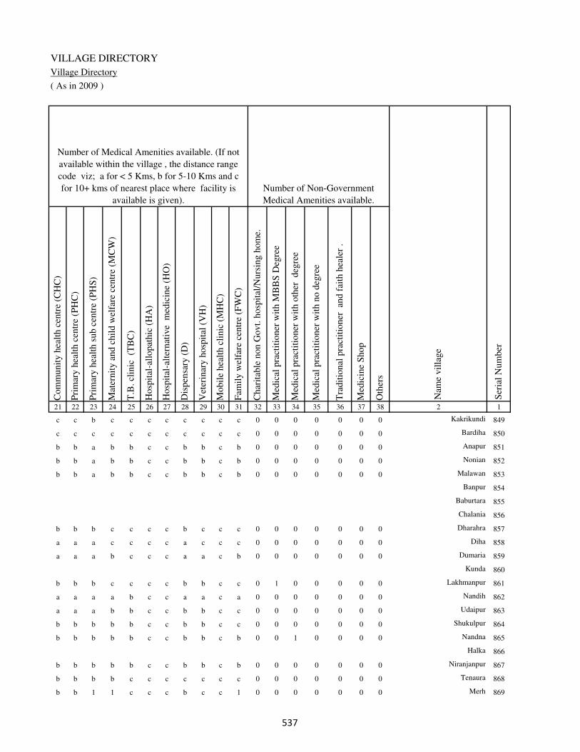
VILLAGE DIRECTORY
Village Directory
( As in 2009 )
Com
munit
y h
ealt
h c
entr
e (C
HC
)
Pri
mar
y h
ealt
h c
entr
e (P
HC
)
Pri
mar
y h
ealt
h s
ub c
entr
e (P
HS
)
Mat
ernit
y a
nd c
hil
d w
elfa
re c
entr
e (M
CW
)
T.B
. cl
inic
(T
BC
)
Hosp
ital
-all
opat
hic
(H
A)
Hosp
ital
-alt
ernat
ive
med
icin
e (H
O)
Dis
pen
sary
(D
)
Vet
erin
ary h
osp
ital
(V
H)
Mobil
e hea
lth c
linic
(M
HC
)
Fam
ily w
elfa
re c
entr
e (F
WC
)
Char
itab
le n
on G
ovt.
hosp
ital
/Nurs
ing h
om
e.
Med
ical
pra
ctit
ioner
wit
h M
BB
S D
egre
e
Med
ical
pra
ctit
ioner
wit
h o
ther
deg
ree
Med
ical
pra
ctit
ioner
wit
h n
o d
egre
e
Tra
dit
ional
pra
ctit
ioner
an
d f
aith
hea
ler
.
Med
icin
e S
hop
Oth
ers
21 22 23 24 25 26 27 28 29 30 31 32 33 34 35 36 37 38 2 1
Number of Non-Government
Medical Amenities available.
Number of Medical Amenities available. (If not
available within the village , the distance range
code viz; a for < 5 Kms, b for 5-10 Kms and c
for 10+ kms of nearest place where facility is
available is given).
Nam
e vil
lage
Ser
ial
Num
ber
c c b c c c c c c c c 0 0 0 0 0 0 0 Kakrikundi 849
c c c c c c c c c c c 0 0 0 0 0 0 0 Bardiha 850
b b a b b c c b b c b 0 0 0 0 0 0 0 Anapur 851
b b a b b c c b b c b 0 0 0 0 0 0 0 Nonian 852
b b a b b c c b b c b 0 0 0 0 0 0 0 Malawan 853
Banpur 854
Baburtara 855
Chalania 856
b b b c c c c b c c c 0 0 0 0 0 0 0 Dharahra 857
a a a c c c c a c c c 0 0 0 0 0 0 0 Diha 858
a a a b c c c a a c b 0 0 0 0 0 0 0 Dumaria 859
Kunda 860
b b b c c c c b b c c 0 1 0 0 0 0 0 Lakhmanpur 861
a a a a b c c a a c a 0 0 0 0 0 0 0 Nandih 862
a a a b b c c b b c c 0 0 0 0 0 0 0 Udaipur 863
b b b b b c c b b c c 0 0 0 0 0 0 0 Shukulpur 864
b b b b b c c b b c b 0 0 1 0 0 0 0 Nandna 865
Halka 866
b b b b b c c b b c b 0 0 0 0 0 0 0 Niranjanpur 867
b b b b c c c c c c c 0 0 0 0 0 0 0 Tenaura 868
b b 1 1 c c c b c c 1 0 0 0 0 0 0 0 Merh 869
��

DISTRICT CENSUS HANDBOOK : KAIMUR (BHABUA)
Census of India 2011-
Amenities and Land use
Tap
wat
er (
Tre
ated
/Untr
eate
d)
Wel
l w
ater
(Cover
ed /
Unco
ver
ed w
ell)
Han
d P
um
p
Tube
wel
ls /
Bore
wel
l
Spri
ng
Riv
er /
Can
al
Tan
k /
Pond /
L
ake
Oth
ers
Com
munit
y t
oil
et i
ncl
udin
g
bat
h.
Com
munit
y t
oil
et e
xcl
udin
g b
ath.
Rura
l s
anit
ary m
art
or
sanit
ary
har
dw
are
outl
et
avai
lable
nea
r th
e vil
lage.
Com
munit
y b
io-
gas
or
recy
cle
of
was
te f
or
pro
duct
ive
use
.
1 2 39 40 41 42 43 44 45 46 47 48 49 50
Availability of toilet & others
Yes / No Availability of drinking water - Yes / No
Nam
e vil
lage
Ser
ial
Num
ber
849 Kakrikundi No Yes Yes No No No No No No No No No
850 Bardiha No Yes Yes No No No Yes No No No No No
851 Anapur No Yes Yes No No No No No No No No No
852 Nonian No No Yes No No No No No No No No No
853 Malawan No Yes Yes No No No No No No No No No
854 Banpur
855 Baburtara
856 Chalania
857 Dharahra No Yes Yes No No Yes No No No No No No
858 Diha No Yes Yes No No No No No No No No No
859 Dumaria No Yes Yes No No No No No No No No No
860 Kunda
861 Lakhmanpur No Yes Yes No No No No No No No No No
862 Nandih No Yes Yes No No No No No No No No No
863 Udaipur No No Yes No No No No No No No No No
864 Shukulpur No Yes Yes No No No No No No No No No
865 Nandna No Yes Yes No No Yes No No No No No No
866 Halka
867 Niranjanpur No Yes Yes No No Yes No No No No No No
868 Tenaura No Yes Yes No No No No No No No No No
869 Merh No Yes Yes No No No No No No No No No
��

VILLAGE DIRECTORY
Village Directory
( As in 2009 )
Post
off
ice(
PO
)
Sub p
ost
off
ice
(SP
O)
Post
& T
eleg
raph o
ffic
e
(P&
TO
)
Vil
lage
Pin
Code
Tel
ephones
(L
and l
ines
)
Publi
c ca
ll o
ffic
e (P
CO
)
Mobil
e phone
cover
age
Inte
rnet
caf
es/
Com
mon s
ervic
e ce
ntr
e (C
SC
)
Pri
vat
e co
uri
er f
acil
ity
Bus
serv
ice
(P
ubli
c &
Pri
vat
e)
Rai
lway
sta
tions
Auto
/Modif
ied A
uto
s
Tax
is a
nd V
ans
Tra
ctors
Cycl
e-pull
ed r
icksh
aws(
Man
ual
& M
achin
e
dri
ven
)
Car
ts d
riven
by a
nim
als
Sea
/R
iver
fer
ry s
ervic
e51 52 53 54 55 56 57 58 59 60 61 62 63 64 65 66 67 2 1
Communication and transport facilities (If amenities available code -Yes is given except for
Village Pin Code ,If not available within the village , the distance range code viz; a for < 5
Kms, b for 5-10 Kms and c for 10+ kms of nearest place where facility is available is given).
Ser
ial
Num
ber
Nam
e vil
lage
b a c b b a b c Yes c c b b Yes a Kakrikundi 849
a b c b b a c c b c c b b Yes a Yes Bardiha 850
b c c b b a c c b c c b b Yes a Anapur 851
b c c b b a c c b c b b b Yes a Nonian 852
b c c b b a c c a c c b b b b Malawan 853
Banpur 854
Baburtara 855
Chalania 856
a b c b b a b c a c c b a Yes a Dharahra 857
b a c b b Yes b c a c c a a Yes Yes Diha 858
a a c a a a a a a c c a a Yes a Dumaria 859
Kunda 860
b b c b b b b b Yes c b b b Yes a Lakhmanpur 861
b b c b b b b b Yes c b b b b b b Nandih 862
a a c a a a a a a c a a a a a Udaipur 863
a a c a a a a b a c a a a Yes a a Shukulpur 864
a b c b b b c b a c c c Yes Yes Yes Nandna 865
Halka 866
b a c b b a c c Yes c b b b Yes b Niranjanpur 867
b a c b a a b c Yes c a b b Yes a Tenaura 868
b b c b b Yes b b Yes c b b b Yes Yes Merh 869
��
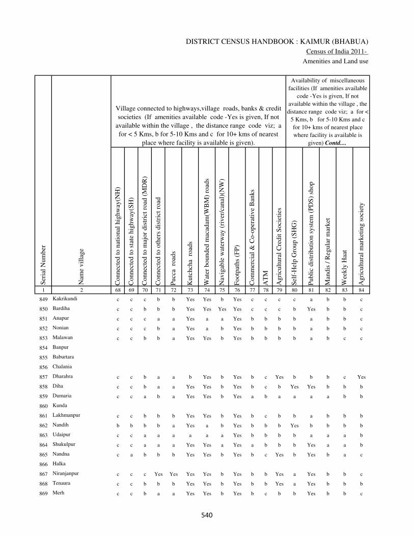
DISTRICT CENSUS HANDBOOK : KAIMUR (BHABUA)
Census of India 2011-
Amenities and Land use
Connec
ted t
o n
atio
nal
hig
hw
ay(N
H)
Connec
ted t
o s
tate
hig
hw
ay(S
H)
Connec
ted t
o m
ajor
dis
tric
t ro
ad (
MD
R)
Connec
ted t
o o
ther
s dis
tric
t ro
ad
Pucc
a r
oad
s
Kutc
hch
a r
oad
s
Wat
er b
ounded
mac
adam
(WB
M)
road
s
Nav
igab
le w
ater
way
(ri
ver
/can
al)(
NW
)
Footp
aths
(FP
)
Com
mer
cial
& C
o-o
per
ativ
e B
anks
AT
M
Agri
cult
ura
l C
redit
Soci
etie
s
Sel
f-H
elp G
roup (
SH
G)
Publi
c dis
trib
uti
on s
yst
em (
PD
S)
shop
Man
dis
/ R
egula
r m
arket
Wee
kly
Haa
t
Agri
cult
ura
l m
arket
ing s
oci
ety
1 2 68 69 70 71 72 73 74 75 76 77 78 79 80 81 82 83 84
Village connected to highways,village roads, banks & credit
societies (If amenities available code -Yes is given, If not
available within the village , the distance range code viz; a
for < 5 Kms, b for 5-10 Kms and c for 10+ kms of nearest
place where facility is available is given).
Ser
ial
Num
ber
Nam
e vil
lage
Availability of miscellaneous
facilities (If amenities available
code -Yes is given, If not
available within the village , the
distance range code viz; a for <
5 Kms, b for 5-10 Kms and c
for 10+ kms of nearest place
where facility is available is
given) Contd....
849 Kakrikundi c c c b b Yes Yes b Yes c c c c a b b c
850 Bardiha c c b b b Yes Yes Yes Yes c c c b Yes b b c
851 Anapur c c c a a Yes a a Yes b b b b a b b c
852 Nonian c c c b a Yes a b Yes b b b b a b b c
853 Malawan c c b b a Yes Yes b Yes b b b b a b c c
854 Banpur
855 Baburtara
856 Chalania
857 Dharahra c c b a a b Yes b Yes b c Yes b b b c Yes
858 Diha c c b a a Yes Yes b Yes b c b Yes Yes b b b
859 Dumaria c c a b a Yes Yes b Yes a b a a a a b b
860 Kunda
861 Lakhmanpur c c b b b Yes Yes b Yes b c b b a b b b
862 Nandih b b b b a Yes a b Yes b b b Yes b b b b
863 Udaipur c c a a a a a a Yes b b b b a a a b
864 Shukulpur c c a a a Yes Yes a Yes a b b b Yes a a b
865 Nandna c a b b b Yes Yes b Yes b c Yes b Yes b a c
866 Halka
867 Niranjanpur c c c Yes Yes Yes Yes b Yes b b Yes a Yes b b c
868 Tenaura c c b b b Yes Yes b Yes b b Yes a Yes b b b
869 Merh c c b a a Yes Yes b Yes b c b b Yes b b c
���
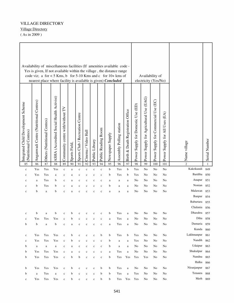
VILLAGE DIRECTORY
Village Directory
( As in 2009 )
Inte
gra
ted C
hil
d D
evel
opm
ent
Sch
eme
(Nutr
itio
nal
Cen
tres
)
Angan
wad
i C
entr
e (N
utr
itio
nal
Cen
tres
)
Oth
ers
(Nutr
itio
nal
Cen
tres
)
AS
HA
(A
ccre
dit
ed S
oci
al H
ealt
h A
ctiv
ist)
Com
munit
y c
entr
e w
ith/w
ithout
TV
Sport
s F
ield
,
Sport
s C
lub /
Rec
reat
ion C
entr
e
Cin
ema
/ V
ideo
Hal
l
Publi
c L
ibra
ry
Publi
c R
eadin
g R
oom
New
spap
er S
upply
Ass
embly
Poll
ing s
tati
on
Bir
th &
Dea
th R
egis
trat
ion O
ffic
e
Pow
er S
upply
for
Dom
esti
c U
se (
ED
)
Pow
er S
upply
for
Agri
cult
ura
l U
se (
EA
G)
Pow
er S
upply
for
Com
mer
cial
Use
(E
C)
Pow
er S
upply
for
All
Use
s (E
A)
85 86 87 88 89 90 91 92 93 94 95 96 97 98 99 100 101 2 1
Availability of
electricity (Yes/No)
Availability of miscellaneous facilities (If amenities available code -
Yes is given, If not available within the village , the distance range
code viz; a for < 5 Kms, b for 5-10 Kms and c for 10+ kms of
nearest place where facility is available is given) Concluded
Nam
e vil
lage
Ser
ial
Num
ber
c Yes Yes Yes c a c c c c b Yes b Yes No No No Kakrikundi 849
c Yes Yes a c a c c c c b Yes b Yes No No No Bardiha 850
c a Yes b c a c c c c a a a No No No No Anapur 851
c b Yes b c a c c c c b a a No No No No Nonian 852
c b a b c a c c c c a a a No No No No Malawan 853
Banpur 854
Baburtara 855
Chalania 856
c b a b c b c c c c b Yes a No No No No Dharahra 857
c Yes Yes Yes c b c c c c a Yes a No No No No Diha 858
b b a b c a c c c c a Yes a No No No No Dumaria 859
Kunda 860
c Yes Yes Yes c b c c c b b Yes b Yes No No No Lakhmanpur 861
c Yes Yes Yes c b c c c c b a a Yes No No No Nandih 862
b a a a c a c c c c b a a No No No No Udaipur 863
b Yes Yes Yes c a c c c c a Yes a No No No No Shukulpur 864
b Yes Yes Yes c b b c c c b Yes Yes Yes Yes No No Nandna 865
Halka 866
b Yes Yes Yes c b c c c b b Yes a No No No No Niranjanpur 867
b a Yes a c b c c c b b Yes a Yes No No No Tenaura 868
c Yes Yes Yes c b c c c b b Yes Yes Yes No No No Merh 869
���
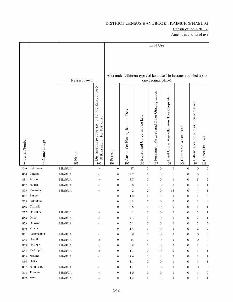
DISTRICT CENSUS HANDBOOK : KAIMUR (BHABUA)
Census of India 2011-
Amenities and Land use
Nam
e
Dis
tance
ran
ge
code
i.e
. a
fo
r <
5 K
ms,
b
for
5-
10 K
ms
and c
f
or
10+
km
s .
Fore
sts
Are
a under
Non-a
gri
cult
ura
l U
ses
Bar
ren a
nd U
n-c
ult
ivab
le l
and
Per
man
ent
Pas
ture
s an
d O
ther
Gra
zing L
ands
Lan
d U
nder
Mis
cell
aneo
us
Tre
e C
rops
etc.
Cult
ura
ble
Was
te L
and
Fal
low
lan
ds
oth
er t
han
curr
ent
fall
ow
s
Curr
ent
Fal
low
s
1 2 102 103 104 105 106 107 108 109 110 111
Ser
ial
Num
ber
Nam
e vil
lage
Area under different types of land use ( in hectares rounded up to
one decimal place)
Land Use
Nearest Town
849 Kakrikundi BHABUA c 0 17 0 0 0 0 0 0
850 Bardiha BHABUA c 0 2.7 0 0 1 0 0 0
851 Anapur BHABUA c 0 3.7 0 0 0 0 5 2
852 Nonian BHABUA c 0 0.8 0 0 0 0 2 1
853 Malawan BHABUA c 0 2 2 0 14 0 4 1
854 Banpur 0 1.8 0 0 0 0 1 2
855 Baburtara 0 0.3 0 0 0 0 1 0
856 Chalania 0 0.8 0 0 0 0 1 1
857 Dharahra BHABUA c 0 1 0 0 0 0 2 1
858 Diha BHABUA c 0 4.3 0 0 0 0 2 1
859 Dumaria BHABUA c 0 5.1 0 0 0 0 2 3
860 Kunda 0 1.4 0 0 0 0 2 2
861 Lakhmanpur BHABUA c 0 9 0 0 0 0 0 0
862 Nandih BHABUA c 0 14 0 0 0 0 0 0
863 Udaipur BHABUA c 0 0.8 0 0 0 0 1 0
864 Shukulpur BHABUA c 0 1.7 0 0 0 0 1 1
865 Nandna BHABUA c 0 4.4 1 0 0 0 2 1
866 Halka 0 1.1 0 0 0 0 1 1
867 Niranjanpur BHABUA c 0 1.1 0 0 0 0 0 0
868 Tenaura BHABUA c 0 1.6 0 0 0 0 1 0
869 Merh BHABUA c 0 1.2 0 0 0 0 1 1
��

VILLAGE DIRECTORY
Village Directory
( As in 2009 )
Net
Are
a S
ow
n
Tota
l Ir
rigat
ed L
and A
rea
Tota
l U
n-i
rrig
ated
Lan
d A
rea
Can
als
( C
)
Wel
ls/T
ube-
wel
ls(W
/TW
)
Tan
ks/
Lak
es(T
/L)
Wat
er F
alls
(WF
)
Oth
ers(
O)
Fir
st
Sec
ond
Thir
d
112 113 114 115 116 117 118 119 120 121 122 2 1
Ser
ial
Num
ber
Name of three
most important
commodities
manufacturedArea irrigated by source (in hectare).
Nam
e of
Vil
lage
Area under different types of
land use ( in hectares rounded
up to one decimal place)
Land Use
90 80 10 0 70 0 0 10 Kakrikundi 849
38 17 21 0 7 0 0 10 Bardiha 850
328 301 27 0 250 51 0 0 Anapur 851
31 27 4 25 2 0 0 0 Nonian 852
59 20 39 20 0 0 0 0 Malawan 853
62 58 4 0 50 8 0 0 Banpur 854
23 21 2 0 21 0 0 0 Baburtara 855
49 45 4 0 42 3 0 0 Chalania 856
51 45 6 0 40 5 0 0 Dharahra 857
136 120 16 0 120 0 0 0 Diha 858
185 175 10 0 160 15 0 0 Dumaria 859
171 160 11 100 60 0 0 0 Kunda 860
50 40 10 0 30 0 0 10 Lakhmanpur 861
50 30 20 20 0 0 0 10 Nandih 862
31 30 1 0 28 2 0 0 Udaipur 863
25 22 3 0 21 1 0 0 Shukulpur 864
145 140 5 130 10 0 0 0 Nandna 865
37 35 2 30 5 0 0 0 Halka 866
39 39 0 37 2 0 0 0 Niranjanpur 867
31 29 2 0 28 1 0 0 Tenaura 868
85 80 5 75 5 0 0 0 Merh 869
��

DISTRICT CENSUS HANDBOOK : KAIMUR (BHABUA)
Census of India 2011-
Amenities and Land use
Pre
-Pri
mar
y s
chool
(PP
)
Pri
mar
y s
chool
(P)
Mid
dle
sch
ool
(M)
Sec
ondar
y S
chool
(S)
Sen
ior
Sec
ondar
y s
chool
(SS
)
Deg
ree
coll
ege
of
arts
sc
ience
& c
om
mer
ce
(AS
C)
Engin
eeri
ng c
oll
ege(
EC
)
Med
ical
coll
ege
(MC
)
Man
agem
ent
inst
itute
(M
I)
Poly
tech
nic
(P
t)
Voca
tional
tra
inin
g s
chool
/IT
I
Non-f
orm
al t
rain
ing c
entr
e (N
FT
C)
Spec
ial
school
for
dis
able
d (
SS
D)
Oth
ers
(spec
ify)
1 2 3 4 5 6 7 8 9 10 11 12 13 14 15 16 17 18 19 20
Loca
tion c
ode
no.
Nam
e vil
lage
Ser
ial
Num
ber
Tota
l popula
tion (
2011 c
ensu
s )
Tota
l ar
ea o
f th
e vil
lage
( in
hec
tare
s ro
unded
up t
o
one
dec
imal
pla
ce)
Number of educational amenities available. (If not available
within the village , the distance range code viz; a for < 5
Kms, b for 5-10 Kms and c for 10+ kms of nearest place
where facility is available is given).
Num
ber
of
house
hold
s (2
011 c
ensu
s)
870 Mohammadpur 249794 103.2 460 74 b 1 b c c c c c c c c c c
871 Chitarhi 249795 101.6 811 128 b 1 1 1 c c c c c c c c c
872 Mahua Pokhar 249796 25.1 0 0
873 Parbatpur 249797 225 1990 312 b 1 a b c c c c c c c c c
874 Chauth Parbatpur 249798 33.6 52 9 b a a c c c c c c c c c c
875 Sanabo 249799 94 445 79 b 1 a c c c c c c c c c c
876 Rahjitpur 249800 24.3 0 0
877 Shiwapur 249801 142 924 145 c 1 a c c c c c c c c c c
878 Kalyanipur 249802 46 1449 244 c 1 1 c a c c c c c c c c
879 Lohra 249803 85.8 1384 178 c 1 a c c c c c c c c c c
880 Shukul Purwa 249804 20.2 0 0
881 Majhui 249805 159.8 3246 460 c 1 1 c a c c c c c c c c
882 Udai Rampur 249806 374 3248 510 c 1 1 c a c c c c c c c c
883 Jigina 249807 116.6 828 115 b 1 a c a c c c c c c c c
884 Rajpur 249808 36.8 29 3 b a a c a b c c c c c c c
885 Madurni 249809 139 221 34 b 1 1 1 a c c c c c c c c
886 Naudiha 249810 94.3 194 34 b 1 a c a c c c c c c c c
887 Kauria Chak 249811 42.5 245 41 b 1 1 c b c c c c c c c c
888 Shahpur 249812 40.1 653 90 b 1 b c a c c c c c c c c
889 Sirsi 249813 123.8 1512 235 b 1 1 c b c c c c c c c c
890 Meunra 249814 266 63 16 b 1 1 b b c c c c c c c c
���

VILLAGE DIRECTORY
Village Directory
( As in 2009 )
Com
munit
y h
ealt
h c
entr
e (C
HC
)
Pri
mar
y h
ealt
h c
entr
e (P
HC
)
Pri
mar
y h
ealt
h s
ub c
entr
e (P
HS
)
Mat
ernit
y a
nd c
hil
d w
elfa
re c
entr
e (M
CW
)
T.B
. cl
inic
(T
BC
)
Hosp
ital
-all
opat
hic
(H
A)
Hosp
ital
-alt
ernat
ive
med
icin
e (H
O)
Dis
pen
sary
(D
)
Vet
erin
ary h
osp
ital
(V
H)
Mobil
e hea
lth c
linic
(M
HC
)
Fam
ily w
elfa
re c
entr
e (F
WC
)
Char
itab
le n
on G
ovt.
hosp
ital
/Nurs
ing h
om
e.
Med
ical
pra
ctit
ioner
wit
h M
BB
S D
egre
e
Med
ical
pra
ctit
ioner
wit
h o
ther
deg
ree
Med
ical
pra
ctit
ioner
wit
h n
o d
egre
e
Tra
dit
ional
pra
ctit
ioner
an
d f
aith
hea
ler
.
Med
icin
e S
hop
Oth
ers
21 22 23 24 25 26 27 28 29 30 31 32 33 34 35 36 37 38 2 1
Number of Non-Government
Medical Amenities available.
Number of Medical Amenities available. (If not
available within the village , the distance range
code viz; a for < 5 Kms, b for 5-10 Kms and c
for 10+ kms of nearest place where facility is
available is given).
Nam
e vil
lage
Ser
ial
Num
ber
c c a c c c c c c c c 0 0 0 0 0 0 0 Mohammadpur 870
b b a b b c c b b c b 0 0 0 0 0 0 0 Chitarhi 871
Mahua Pokhar 872
b b 1 1 b c c b b c 1 0 0 0 0 0 0 0 Parbatpur 873
b b b b b c c b b c b 0 0 0 0 0 0 0 Chauth Parbatpur 874
b b a b b c c b b c b 0 0 0 0 0 0 0 Sanabo 875
Rahjitpur 876
b b a b b c c c b c b 0 0 0 0 0 0 0 Shiwapur 877
b c 1 1 c c c c c c 1 0 0 0 0 0 0 0 Kalyanipur 878
b b b b b c c b b c b 0 0 0 0 0 0 0 Lohra 879
Shukul Purwa 880
b b a b b c c b b c b 0 0 0 0 0 0 0 Majhui 881
b b b b c c c c b c b 0 0 0 0 0 0 0 Udai Rampur 882
b b b b b c c b b c b 0 0 0 0 0 0 0 Jigina 883
b b b b b c c b b c b 0 0 0 0 0 0 0 Rajpur 884
b b b b b c c b b c b 0 0 1 0 0 0 0 Madurni 885
b b b b b c c b b c b 0 0 0 0 0 0 0 Naudiha 886
b b b b b c c b b c b 0 0 1 0 0 0 0 Kauria Chak 887
b b b b b c c b b c b 0 0 1 0 0 0 0 Shahpur 888
b b b b b c c b b c b 0 0 0 0 0 0 0 Sirsi 889
b b b b b c c b b c b 0 0 1 0 0 0 0 Meunra 890
���

DISTRICT CENSUS HANDBOOK : KAIMUR (BHABUA)
Census of India 2011-
Amenities and Land use
Tap
wat
er (
Tre
ated
/Untr
eate
d)
Wel
l w
ater
(Cover
ed /
Unco
ver
ed w
ell)
Han
d P
um
p
Tube
wel
ls /
Bore
wel
l
Spri
ng
Riv
er /
Can
al
Tan
k /
Pond /
L
ake
Oth
ers
Com
munit
y t
oil
et i
ncl
udin
g
bat
h.
Com
munit
y t
oil
et e
xcl
udin
g b
ath.
Rura
l s
anit
ary m
art
or
sanit
ary
har
dw
are
outl
et
avai
lable
nea
r th
e vil
lage.
Com
munit
y b
io-
gas
or
recy
cle
of
was
te f
or
pro
duct
ive
use
.
1 2 39 40 41 42 43 44 45 46 47 48 49 50
Availability of toilet & others
Yes / No Availability of drinking water - Yes / No
Nam
e vil
lage
Ser
ial
Num
ber
870 Mohammadpur No Yes Yes No No No No No No No No No
871 Chitarhi No Yes Yes Yes No No Yes No No No No No
872 Mahua Pokhar
873 Parbatpur No Yes Yes No No No No No No No No No
874 Chauth Parbatpur No Yes Yes No No No No No No No No No
875 Sanabo No Yes Yes No No Yes No No No No No No
876 Rahjitpur
877 Shiwapur No Yes Yes No No Yes No No No No No No
878 Kalyanipur No Yes Yes No No Yes No No No No No No
879 Lohra No Yes Yes No No Yes No No No No No No
880 Shukul Purwa
881 Majhui No Yes Yes No No No No No No No No No
882 Udai Rampur No Yes Yes No No Yes No No No No No No
883 Jigina No Yes Yes No No Yes No No No No No No
884 Rajpur No No Yes No No No No No No No No No
885 Madurni No Yes Yes No No Yes No No No No No No
886 Naudiha No Yes Yes No No Yes Yes No No No No No
887 Kauria Chak No Yes Yes No No Yes No No No No No No
888 Shahpur No Yes Yes No No Yes No No No No No No
889 Sirsi No Yes Yes No No Yes No No No No No No
890 Meunra No Yes Yes No No Yes No No No No No No
���
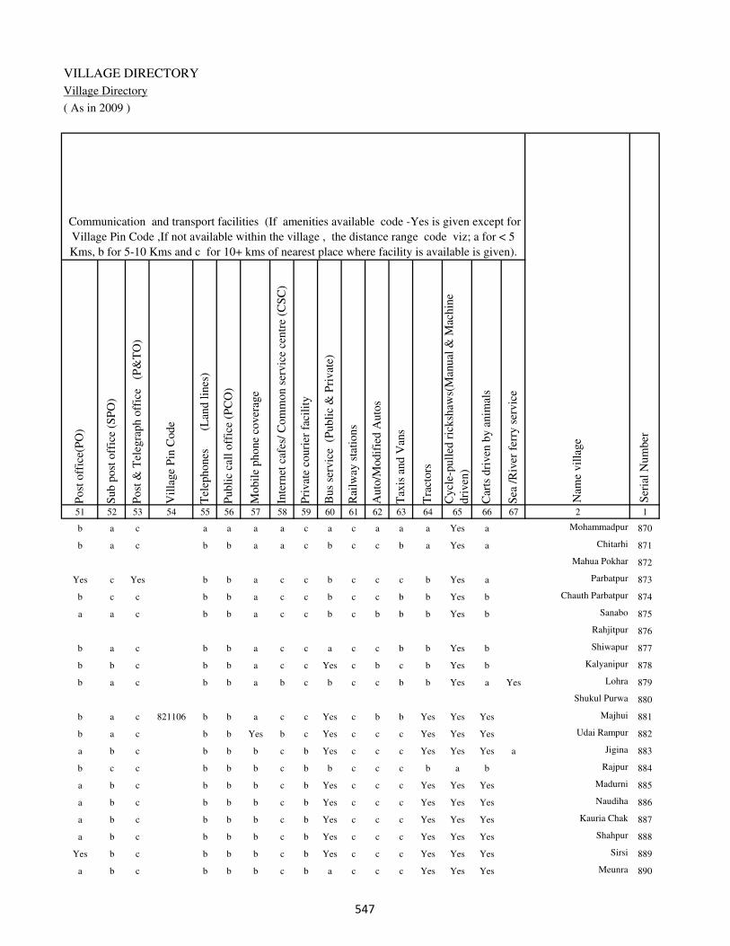
VILLAGE DIRECTORY
Village Directory
( As in 2009 )
Post
off
ice(
PO
)
Sub p
ost
off
ice
(SP
O)
Post
& T
eleg
raph o
ffic
e
(P&
TO
)
Vil
lage
Pin
Code
Tel
ephones
(L
and l
ines
)
Publi
c ca
ll o
ffic
e (P
CO
)
Mobil
e phone
cover
age
Inte
rnet
caf
es/
Com
mon s
ervic
e ce
ntr
e (C
SC
)
Pri
vat
e co
uri
er f
acil
ity
Bus
serv
ice
(P
ubli
c &
Pri
vat
e)
Rai
lway
sta
tions
Auto
/Modif
ied A
uto
s
Tax
is a
nd V
ans
Tra
ctors
Cycl
e-pull
ed r
icksh
aws(
Man
ual
& M
achin
e
dri
ven
)
Car
ts d
riven
by a
nim
als
Sea
/R
iver
fer
ry s
ervic
e51 52 53 54 55 56 57 58 59 60 61 62 63 64 65 66 67 2 1
Communication and transport facilities (If amenities available code -Yes is given except for
Village Pin Code ,If not available within the village , the distance range code viz; a for < 5
Kms, b for 5-10 Kms and c for 10+ kms of nearest place where facility is available is given).
Ser
ial
Num
ber
Nam
e vil
lage
b a c a a a a c a c a a a Yes a Mohammadpur 870
b a c b b a a c b c c b a Yes a Chitarhi 871
Mahua Pokhar 872
Yes c Yes b b a c c b c c c b Yes a Parbatpur 873
b c c b b a c c b c c b b Yes b Chauth Parbatpur 874
a a c b b a c c b c b b b Yes b Sanabo 875
Rahjitpur 876
b a c b b a c c a c c b b Yes b Shiwapur 877
b b c b b a c c Yes c b c b Yes b Kalyanipur 878
b a c b b a b c b c c b b Yes a Yes Lohra 879
Shukul Purwa 880
b a c 821106 b b a c c Yes c b b Yes Yes Yes Majhui 881
b a c b b Yes b c Yes c c c Yes Yes Yes Udai Rampur 882
a b c b b b c b Yes c c c Yes Yes Yes a Jigina 883
b c c b b b c b b c c c b a b Rajpur 884
a b c b b b c b Yes c c c Yes Yes Yes Madurni 885
a b c b b b c b Yes c c c Yes Yes Yes Naudiha 886
a b c b b b c b Yes c c c Yes Yes Yes Kauria Chak 887
a b c b b b c b Yes c c c Yes Yes Yes Shahpur 888
Yes b c b b b c b Yes c c c Yes Yes Yes Sirsi 889
a b c b b b c b a c c c Yes Yes Yes Meunra 890
���

DISTRICT CENSUS HANDBOOK : KAIMUR (BHABUA)
Census of India 2011-
Amenities and Land use
Connec
ted t
o n
atio
nal
hig
hw
ay(N
H)
Connec
ted t
o s
tate
hig
hw
ay(S
H)
Connec
ted t
o m
ajor
dis
tric
t ro
ad (
MD
R)
Connec
ted t
o o
ther
s dis
tric
t ro
ad
Pucc
a r
oad
s
Kutc
hch
a r
oad
s
Wat
er b
ounded
mac
adam
(WB
M)
road
s
Nav
igab
le w
ater
way
(ri
ver
/can
al)(
NW
)
Footp
aths
(FP
)
Com
mer
cial
& C
o-o
per
ativ
e B
anks
AT
M
Agri
cult
ura
l C
redit
Soci
etie
s
Sel
f-H
elp G
roup (
SH
G)
Publi
c dis
trib
uti
on s
yst
em (
PD
S)
shop
Man
dis
/ R
egula
r m
arket
Wee
kly
Haa
t
Agri
cult
ura
l m
arket
ing s
oci
ety
1 2 68 69 70 71 72 73 74 75 76 77 78 79 80 81 82 83 84
Village connected to highways,village roads, banks & credit
societies (If amenities available code -Yes is given, If not
available within the village , the distance range code viz; a
for < 5 Kms, b for 5-10 Kms and c for 10+ kms of nearest
place where facility is available is given).
Ser
ial
Num
ber
Nam
e vil
lage
Availability of miscellaneous
facilities (If amenities available
code -Yes is given, If not
available within the village , the
distance range code viz; a for <
5 Kms, b for 5-10 Kms and c
for 10+ kms of nearest place
where facility is available is
given) Contd....
870 Mohammadpur c c b Yes a Yes Yes c Yes c c Yes a a a a c
871 Chitarhi c c c b Yes Yes a c Yes b b Yes b b b b b
872 Mahua Pokhar
873 Parbatpur c c c b Yes Yes a b Yes b b Yes b Yes b b b
874 Chauth Parbatpur c c b b a Yes Yes b Yes b b b b a b b b
875 Sanabo c c b b a Yes Yes b Yes b b b b a b b c
876 Rahjitpur
877 Shiwapur a c c b Yes Yes Yes b Yes b c b b a b c b
878 Kalyanipur c c c b Yes Yes a b Yes b c a b Yes c c Yes
879 Lohra c c b a a Yes Yes Yes Yes b b b b a b b a
880 Shukul Purwa
881 Majhui c c c b Yes Yes Yes a Yes b b Yes c Yes b b b
882 Udai Rampur c b c b Yes b b b Yes b b b Yes Yes b b b
883 Jigina c c c b a Yes Yes b Yes b c b b Yes b a b
884 Rajpur c b b b a a a b Yes b c b b b b b c
885 Madurni c a a a a Yes Yes b Yes b c b b Yes c a c
886 Naudiha c a b b a Yes Yes b Yes b c b b Yes c a c
887 Kauria Chak c b b b b Yes Yes c Yes b c b b b c b c
888 Shahpur c a a a a Yes Yes b Yes b c b c Yes b a c
889 Sirsi c a a b b Yes Yes c Yes b c b b b b b c
890 Meunra c a a b b Yes Yes b Yes b c b b Yes b a c
���
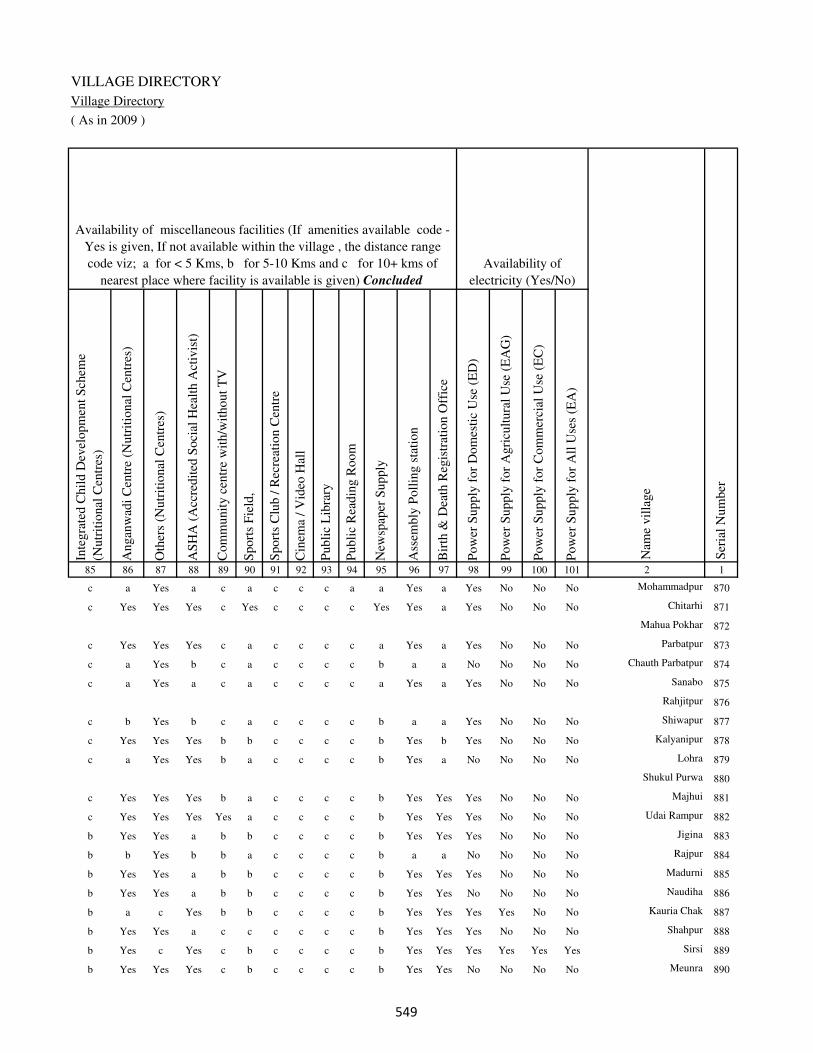
VILLAGE DIRECTORY
Village Directory
( As in 2009 )
Inte
gra
ted C
hil
d D
evel
opm
ent
Sch
eme
(Nutr
itio
nal
Cen
tres
)
Angan
wad
i C
entr
e (N
utr
itio
nal
Cen
tres
)
Oth
ers
(Nutr
itio
nal
Cen
tres
)
AS
HA
(A
ccre
dit
ed S
oci
al H
ealt
h A
ctiv
ist)
Com
munit
y c
entr
e w
ith/w
ithout
TV
Sport
s F
ield
,
Sport
s C
lub /
Rec
reat
ion C
entr
e
Cin
ema
/ V
ideo
Hal
l
Publi
c L
ibra
ry
Publi
c R
eadin
g R
oom
New
spap
er S
upply
Ass
embly
Poll
ing s
tati
on
Bir
th &
Dea
th R
egis
trat
ion O
ffic
e
Pow
er S
upply
for
Dom
esti
c U
se (
ED
)
Pow
er S
upply
for
Agri
cult
ura
l U
se (
EA
G)
Pow
er S
upply
for
Com
mer
cial
Use
(E
C)
Pow
er S
upply
for
All
Use
s (E
A)
85 86 87 88 89 90 91 92 93 94 95 96 97 98 99 100 101 2 1
Availability of
electricity (Yes/No)
Availability of miscellaneous facilities (If amenities available code -
Yes is given, If not available within the village , the distance range
code viz; a for < 5 Kms, b for 5-10 Kms and c for 10+ kms of
nearest place where facility is available is given) Concluded
Nam
e vil
lage
Ser
ial
Num
ber
c a Yes a c a c c c a a Yes a Yes No No No Mohammadpur 870
c Yes Yes Yes c Yes c c c c Yes Yes a Yes No No No Chitarhi 871
Mahua Pokhar 872
c Yes Yes Yes c a c c c c a Yes a Yes No No No Parbatpur 873
c a Yes b c a c c c c b a a No No No No Chauth Parbatpur 874
c a Yes a c a c c c c a Yes a Yes No No No Sanabo 875
Rahjitpur 876
c b Yes b c a c c c c b a a Yes No No No Shiwapur 877
c Yes Yes Yes b b c c c c b Yes b Yes No No No Kalyanipur 878
c a Yes Yes b a c c c c b Yes a No No No No Lohra 879
Shukul Purwa 880
c Yes Yes Yes b a c c c c b Yes Yes Yes No No No Majhui 881
c Yes Yes Yes Yes a c c c c b Yes Yes Yes No No No Udai Rampur 882
b Yes Yes a b b c c c c b Yes Yes Yes No No No Jigina 883
b b Yes b b a c c c c b a a No No No No Rajpur 884
b Yes Yes a b b c c c c b Yes Yes Yes No No No Madurni 885
b Yes Yes a b b c c c c b Yes Yes No No No No Naudiha 886
b a c Yes b b c c c c b Yes Yes Yes Yes No No Kauria Chak 887
b Yes Yes a c c c c c c b Yes Yes Yes No No No Shahpur 888
b Yes c Yes c b c c c c b Yes Yes Yes Yes Yes Yes Sirsi 889
b Yes Yes Yes c b c c c c b Yes Yes No No No No Meunra 890
���
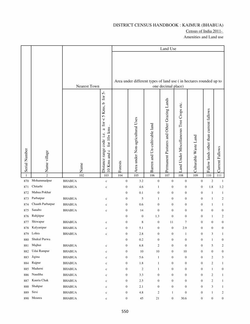
DISTRICT CENSUS HANDBOOK : KAIMUR (BHABUA)
Census of India 2011-
Amenities and Land use
Nam
e
Dis
tance
ran
ge
code
i.e
. a
fo
r <
5 K
ms,
b
for
5-
10 K
ms
and c
f
or
10+
km
s .
Fore
sts
Are
a under
Non-a
gri
cult
ura
l U
ses
Bar
ren a
nd U
n-c
ult
ivab
le l
and
Per
man
ent
Pas
ture
s an
d O
ther
Gra
zing L
ands
Lan
d U
nder
Mis
cell
aneo
us
Tre
e C
rops
etc.
Cult
ura
ble
Was
te L
and
Fal
low
lan
ds
oth
er t
han
curr
ent
fall
ow
s
Curr
ent
Fal
low
s
1 2 102 103 104 105 106 107 108 109 110 111
Ser
ial
Num
ber
Nam
e vil
lage
Area under different types of land use ( in hectares rounded up to
one decimal place)
Land Use
Nearest Town
870 Mohammadpur BHABUA c 0 3.2 0 0 0 0 2 1
871 Chitarhi BHABUA c 0 4.6 1 0 0 0 1.8 1.2
872 Mahua Pokhar 0 0.1 0 0 0 0 1 1
873 Parbatpur BHABUA c 0 5 1 0 0 0 1 2
874 Chauth Parbatpur BHABUA c 0 0.6 0 0 0 0 1 1
875 Sanabo BHABUA c 0 14 0 0 0 0 0 0
876 Rahjitpur 0 0 1.3 0 0 0 1 2
877 Shiwapur BHABUA c 0 8 0 11 7 0 0 0
878 Kalyanipur BHABUA c 0 5.1 0 0 2.9 0 0 0
879 Lohra BHABUA c 0 2.8 0 0 1 0 3 1
880 Shukul Purwa 0 0.2 0 0 0 0 1 0
881 Majhui BHABUA c 0 6.8 2 0 0 0 5 2
882 Udai Rampur BHABUA c 0 10 10 0 10 0 0 0
883 Jigina BHABUA c 0 5.6 1 0 0 0 2 3
884 Rajpur BHABUA c 0 1.8 1 0 0 0 2 1
885 Madurni BHABUA c 0 2 1 0 0 0 1 0
886 Naudiha BHABUA c 0 3.3 0 0 0 0 2 1
887 Kauria Chak BHABUA c 0 2.5 0 0 0 0 2 1
888 Shahpur BHABUA c 0 2.1 0 0 0 0 3 1
889 Sirsi BHABUA c 0 4.8 2 1 0 0 1 2
890 Meunra BHABUA c 0 45 21 0 30.6 0 0 0
���
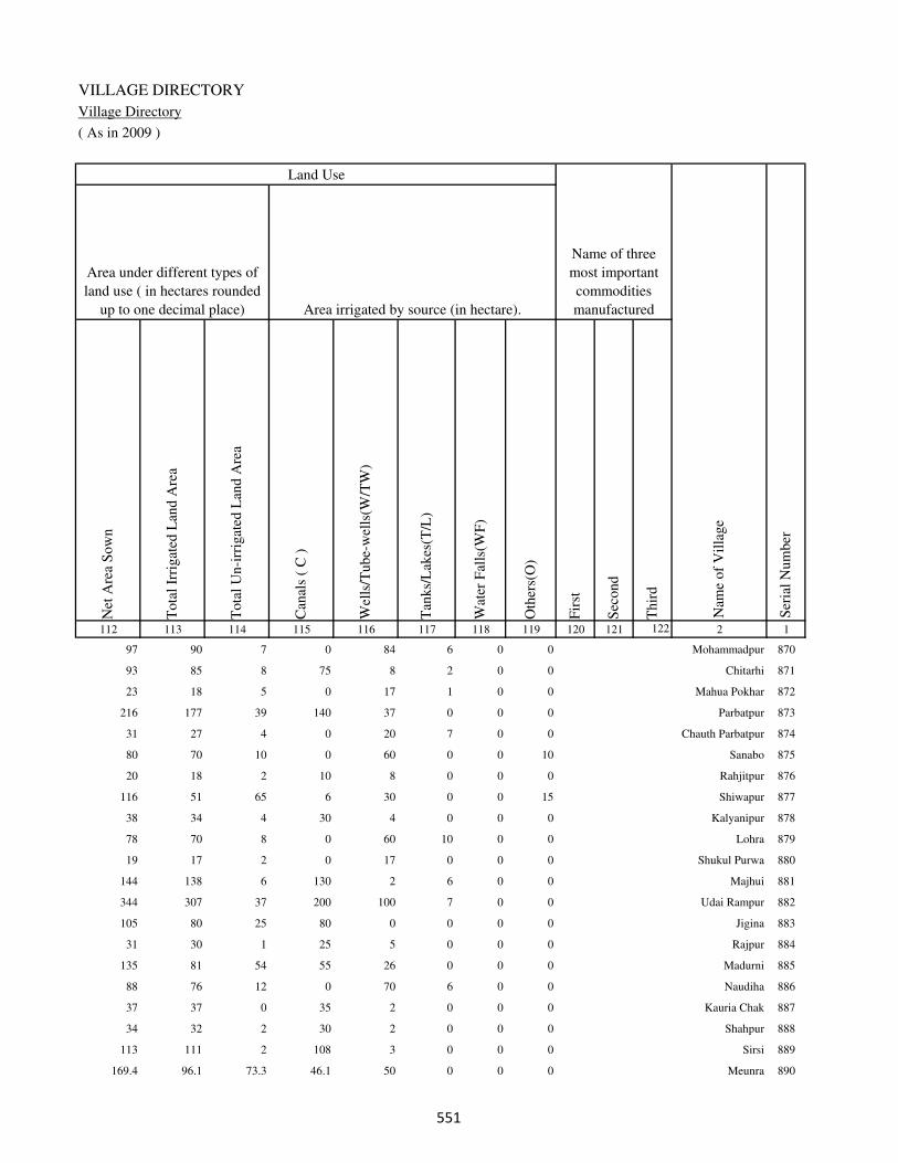
VILLAGE DIRECTORY
Village Directory
( As in 2009 )
Net
Are
a S
ow
n
Tota
l Ir
rigat
ed L
and A
rea
Tota
l U
n-i
rrig
ated
Lan
d A
rea
Can
als
( C
)
Wel
ls/T
ube-
wel
ls(W
/TW
)
Tan
ks/
Lak
es(T
/L)
Wat
er F
alls
(WF
)
Oth
ers(
O)
Fir
st
Sec
ond
Thir
d
112 113 114 115 116 117 118 119 120 121 122 2 1
Ser
ial
Num
ber
Name of three
most important
commodities
manufacturedArea irrigated by source (in hectare).
Nam
e of
Vil
lage
Area under different types of
land use ( in hectares rounded
up to one decimal place)
Land Use
97 90 7 0 84 6 0 0 Mohammadpur 870
93 85 8 75 8 2 0 0 Chitarhi 871
23 18 5 0 17 1 0 0 Mahua Pokhar 872
216 177 39 140 37 0 0 0 Parbatpur 873
31 27 4 0 20 7 0 0 Chauth Parbatpur 874
80 70 10 0 60 0 0 10 Sanabo 875
20 18 2 10 8 0 0 0 Rahjitpur 876
116 51 65 6 30 0 0 15 Shiwapur 877
38 34 4 30 4 0 0 0 Kalyanipur 878
78 70 8 0 60 10 0 0 Lohra 879
19 17 2 0 17 0 0 0 Shukul Purwa 880
144 138 6 130 2 6 0 0 Majhui 881
344 307 37 200 100 7 0 0 Udai Rampur 882
105 80 25 80 0 0 0 0 Jigina 883
31 30 1 25 5 0 0 0 Rajpur 884
135 81 54 55 26 0 0 0 Madurni 885
88 76 12 0 70 6 0 0 Naudiha 886
37 37 0 35 2 0 0 0 Kauria Chak 887
34 32 2 30 2 0 0 0 Shahpur 888
113 111 2 108 3 0 0 0 Sirsi 889
169.4 96.1 73.3 46.1 50 0 0 0 Meunra 890
���

DISTRICT CENSUS HANDBOOK : KAIMUR (BHABUA)
Census of India 2011-
Amenities and Land use
Pre
-Pri
mar
y s
chool
(PP
)
Pri
mar
y s
chool
(P)
Mid
dle
sch
ool
(M)
Sec
ondar
y S
chool
(S)
Sen
ior
Sec
ondar
y s
chool
(SS
)
Deg
ree
coll
ege
of
arts
sc
ience
& c
om
mer
ce
(AS
C)
Engin
eeri
ng c
oll
ege(
EC
)
Med
ical
coll
ege
(MC
)
Man
agem
ent
inst
itute
(M
I)
Poly
tech
nic
(P
t)
Voca
tional
tra
inin
g s
chool
/IT
I
Non-f
orm
al t
rain
ing c
entr
e (N
FT
C)
Spec
ial
school
for
dis
able
d (
SS
D)
Oth
ers
(spec
ify)
1 2 3 4 5 6 7 8 9 10 11 12 13 14 15 16 17 18 19 20
Loca
tion c
ode
no.
Nam
e vil
lage
Ser
ial
Num
ber
Tota
l popula
tion (
2011 c
ensu
s )
Tota
l ar
ea o
f th
e vil
lage
( in
hec
tare
s ro
unded
up t
o
one
dec
imal
pla
ce)
Number of educational amenities available. (If not available
within the village , the distance range code viz; a for < 5
Kms, b for 5-10 Kms and c for 10+ kms of nearest place
where facility is available is given).
Num
ber
of
house
hold
s (2
011 c
ensu
s)
891 Madurna 249815 416.8 4714 781 b 1 1 c a c c c c c c c c
892 Sarpani 249816 47.4 266 52 b a a c a c c c c c c c c
893 Hata 249817 254.8 9257 1412 a 7 4 3 1 c c c c c c c c
894 Saraiya 249818 198.7 2242 301 a 1 a c a c c c c c c c c
895 Humaun Mardan 249819 69.2 0 0
896 Tiwai 249820 187.4 2465 413 1 1 a b a c c c c c c c c
897 Lodipur 249821 179.3 2050 348 b 1 1 c c c c c c c c c c
898 Karaundia 249822 47 577 66 b a a c a b c c c c c c c
899 Kharigawan 249823 176.4 2280 389 b 1 a c a b c c c c c c c
900 Awnkhara 249824 285.7 2573 462 b 1 1 c a b c c c c c c c
901 Sikandarpur 249825 295.4 4566 705 b 2 2 c a c c c c c c c c
902 Masoi Khurd 249826 316.5 3395 627 b 2 a c a c c c c c c c c
903 Gangapur 249827 55 582 99 b 1 a c a c c c c c c c c
904 Harbanspur 249828 28.7 30 5 b a a c a c c c c c c c c
905 Bhagwatipur 249829 104.4 482 86 b 1 1 c b c c c c c c c c
906 Sahebahe 249830 96 655 121 b b b c a c c c c c c c c
907 Amawan 249831 297.8 4621 867 1 2 2 c a c c c c c c c c
908 Sirbit 249832 521.2 5018 767 1 2 1 c c c c c c c c c c
909 Rupin 249833 102 1039 168 b 2 a c c c c c c c c c c
910 Masoin 249834 332.6 3108 480 b 2 2 c c c c c c c c b c
911 Khakhra 249835 43.3 0 0
��

VILLAGE DIRECTORY
Village Directory
( As in 2009 )
Com
munit
y h
ealt
h c
entr
e (C
HC
)
Pri
mar
y h
ealt
h c
entr
e (P
HC
)
Pri
mar
y h
ealt
h s
ub c
entr
e (P
HS
)
Mat
ernit
y a
nd c
hil
d w
elfa
re c
entr
e (M
CW
)
T.B
. cl
inic
(T
BC
)
Hosp
ital
-all
opat
hic
(H
A)
Hosp
ital
-alt
ernat
ive
med
icin
e (H
O)
Dis
pen
sary
(D
)
Vet
erin
ary h
osp
ital
(V
H)
Mobil
e hea
lth c
linic
(M
HC
)
Fam
ily w
elfa
re c
entr
e (F
WC
)
Char
itab
le n
on G
ovt.
hosp
ital
/Nurs
ing h
om
e.
Med
ical
pra
ctit
ioner
wit
h M
BB
S D
egre
e
Med
ical
pra
ctit
ioner
wit
h o
ther
deg
ree
Med
ical
pra
ctit
ioner
wit
h n
o d
egre
e
Tra
dit
ional
pra
ctit
ioner
an
d f
aith
hea
ler
.
Med
icin
e S
hop
Oth
ers
21 22 23 24 25 26 27 28 29 30 31 32 33 34 35 36 37 38 2 1
Number of Non-Government
Medical Amenities available.
Number of Medical Amenities available. (If not
available within the village , the distance range
code viz; a for < 5 Kms, b for 5-10 Kms and c
for 10+ kms of nearest place where facility is
available is given).
Nam
e vil
lage
Ser
ial
Num
ber
b b b b b c c b b c b 0 0 1 0 0 0 0 Madurna 891
a a a a a c c a a c a 0 0 0 0 0 0 0 Sarpani 892
b b b b b c c c b c b 0 0 0 0 0 0 0 Hata 893
b b b b b c c b b c b 0 0 0 0 0 0 0 Saraiya 894
Humaun Mardan 895
a a a b c c c a c c b 0 0 0 0 0 0 0 Tiwai 896
a a a b c c c a c c b 0 0 0 0 0 0 0 Lodipur 897
a a a a c c c c b c b 0 0 0 0 0 0 0 Karaundia 898
b b 1 1 c c c c c c 1 0 0 0 0 0 0 0 Kharigawan 899
a a a a c c c b a c a 0 0 0 0 0 0 0 Awnkhara 900
b b 1 1 b c c b b c 1 0 0 1 0 0 0 0 Sikandarpur 901
b b b b b c c b b c b 0 0 0 0 0 0 0 Masoi Khurd 902
b b b b b c c b b c b 0 0 0 0 0 0 0 Gangapur 903
b b b b b c c b b c b 0 0 0 0 0 0 0 Harbanspur 904
b b b b b c c b b c b 0 0 0 0 0 0 0 Bhagwatipur 905
b b b b b c c b b c b 0 0 0 0 0 0 0 Sahebahe 906
a b a b a c c a c c b 0 0 0 0 0 0 0 Amawan 907
b b 1 1 b c c b b c 1 0 0 0 0 0 0 0 Sirbit 908
b b c b a c c c b c c 0 0 0 0 0 0 0 Rupin 909
b b b c b c c b b c c 0 0 0 0 0 0 0 Masoin 910
Khakhra 911
��

DISTRICT CENSUS HANDBOOK : KAIMUR (BHABUA)
Census of India 2011-
Amenities and Land use
Tap
wat
er (
Tre
ated
/Untr
eate
d)
Wel
l w
ater
(Cover
ed /
Unco
ver
ed w
ell)
Han
d P
um
p
Tube
wel
ls /
Bore
wel
l
Spri
ng
Riv
er /
Can
al
Tan
k /
Pond /
L
ake
Oth
ers
Com
munit
y t
oil
et i
ncl
udin
g
bat
h.
Com
munit
y t
oil
et e
xcl
udin
g b
ath.
Rura
l s
anit
ary m
art
or
sanit
ary
har
dw
are
outl
et
avai
lable
nea
r th
e vil
lage.
Com
munit
y b
io-
gas
or
recy
cle
of
was
te f
or
pro
duct
ive
use
.
1 2 39 40 41 42 43 44 45 46 47 48 49 50
Availability of toilet & others
Yes / No Availability of drinking water - Yes / No
Nam
e vil
lage
Ser
ial
Num
ber
891 Madurna No Yes Yes No Yes Yes No No No No No No
892 Sarpani No Yes Yes Yes No Yes No No No No No No
893 Hata Yes Yes Yes Yes No Yes No No No Yes No No
894 Saraiya No Yes Yes Yes No Yes No No No No No No
895 Humaun Mardan
896 Tiwai No Yes Yes No No Yes No No No No No No
897 Lodipur No Yes Yes No No Yes No No No No No No
898 Karaundia No Yes Yes Yes No No No No No No No No
899 Kharigawan No Yes Yes Yes No Yes No No No No No No
900 Awnkhara No Yes Yes Yes No Yes Yes No No No No No
901 Sikandarpur No Yes Yes No No Yes No No No No No No
902 Masoi Khurd No Yes Yes No No Yes Yes No No No No No
903 Gangapur No Yes Yes No No Yes Yes No No No No No
904 Harbanspur No No Yes No No No No No No No No No
905 Bhagwatipur No Yes Yes No No Yes Yes No No No No No
906 Sahebahe No Yes Yes No No No Yes No No No No No
907 Amawan No Yes Yes Yes No Yes Yes No No No No No
908 Sirbit No No Yes Yes No Yes Yes No No No No No
909 Rupin Yes Yes Yes No No No No No No No No No
910 Masoin Yes Yes Yes No Yes Yes Yes Yes No No No No
911 Khakhra
���
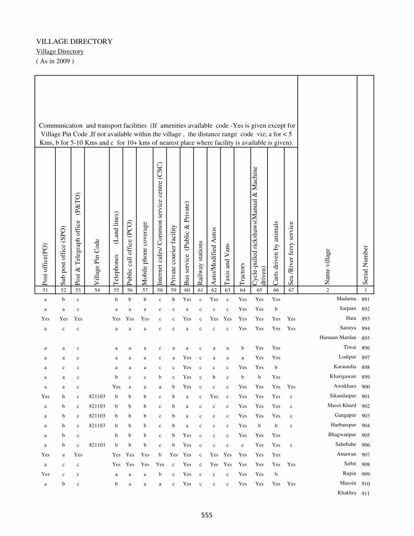
VILLAGE DIRECTORY
Village Directory
( As in 2009 )
Post
off
ice(
PO
)
Sub p
ost
off
ice
(SP
O)
Post
& T
eleg
raph o
ffic
e
(P&
TO
)
Vil
lage
Pin
Code
Tel
ephones
(L
and l
ines
)
Publi
c ca
ll o
ffic
e (P
CO
)
Mobil
e phone
cover
age
Inte
rnet
caf
es/
Com
mon s
ervic
e ce
ntr
e (C
SC
)
Pri
vat
e co
uri
er f
acil
ity
Bus
serv
ice
(P
ubli
c &
Pri
vat
e)
Rai
lway
sta
tions
Auto
/Modif
ied A
uto
s
Tax
is a
nd V
ans
Tra
ctors
Cycl
e-pull
ed r
icksh
aws(
Man
ual
& M
achin
e
dri
ven
)
Car
ts d
riven
by a
nim
als
Sea
/R
iver
fer
ry s
ervic
e51 52 53 54 55 56 57 58 59 60 61 62 63 64 65 66 67 2 1
Communication and transport facilities (If amenities available code -Yes is given except for
Village Pin Code ,If not available within the village , the distance range code viz; a for < 5
Kms, b for 5-10 Kms and c for 10+ kms of nearest place where facility is available is given).
Ser
ial
Num
ber
Nam
e vil
lage
a b c b b b c b Yes c Yes c Yes Yes Yes Madurna 891
a a c a a a c c a c c c Yes Yes b Sarpani 892
Yes Yes Yes Yes Yes Yes c c Yes c Yes Yes Yes Yes Yes Yes Hata 893
a c c a a a c c a c c c Yes Yes Yes Yes Saraiya 894
Humaun Mardan 895
a a c a a a c a a c a a b Yes Yes Tiwai 896
a a c a a a c a Yes c a a a Yes Yes Lodipur 897
a c c a a a c c Yes c c c Yes Yes b Karaundia 898
a a c b c c b c Yes c b c b b Yes Kharigawan 899
a a c Yes a a a b Yes c c c Yes Yes Yes Yes Awnkhara 900
Yes b c 821103 b b b c b a c Yes c Yes Yes Yes c Sikandarpur 901
a b c 821103 b b b c b a c c c Yes Yes Yes c Masoi Khurd 902
a b c 821103 b b b c b a c c c Yes Yes Yes c Gangapur 903
a b c 821103 b b b c b a c c c Yes b b c Harbanspur 904
a b c b b b c b Yes c c c Yes Yes Yes Bhagwatipur 905
a b c 821103 b b b c b Yes c c c c Yes Yes c Sahebahe 906
Yes a Yes Yes Yes Yes b Yes Yes c Yes Yes Yes Yes Yes Amawan 907
a c c Yes Yes Yes Yes c Yes c Yes Yes Yes Yes Yes Yes Sirbit 908
Yes c c a a a b c Yes c c c Yes Yes b Rupin 909
a b c b a a a c Yes c c c Yes Yes Yes Yes Masoin 910
Khakhra 911
���
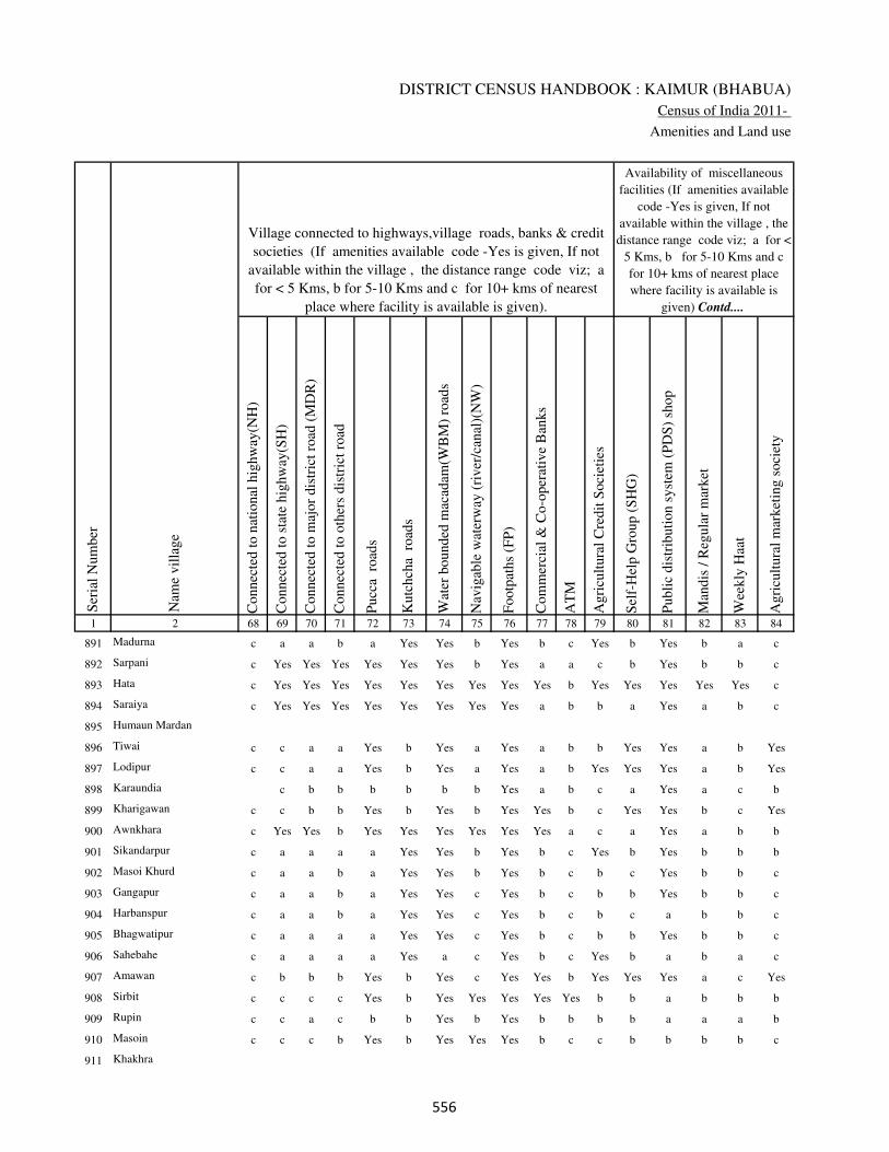
DISTRICT CENSUS HANDBOOK : KAIMUR (BHABUA)
Census of India 2011-
Amenities and Land use
Connec
ted t
o n
atio
nal
hig
hw
ay(N
H)
Connec
ted t
o s
tate
hig
hw
ay(S
H)
Connec
ted t
o m
ajor
dis
tric
t ro
ad (
MD
R)
Connec
ted t
o o
ther
s dis
tric
t ro
ad
Pucc
a r
oad
s
Kutc
hch
a r
oad
s
Wat
er b
ounded
mac
adam
(WB
M)
road
s
Nav
igab
le w
ater
way
(ri
ver
/can
al)(
NW
)
Footp
aths
(FP
)
Com
mer
cial
& C
o-o
per
ativ
e B
anks
AT
M
Agri
cult
ura
l C
redit
Soci
etie
s
Sel
f-H
elp G
roup (
SH
G)
Publi
c dis
trib
uti
on s
yst
em (
PD
S)
shop
Man
dis
/ R
egula
r m
arket
Wee
kly
Haa
t
Agri
cult
ura
l m
arket
ing s
oci
ety
1 2 68 69 70 71 72 73 74 75 76 77 78 79 80 81 82 83 84
Village connected to highways,village roads, banks & credit
societies (If amenities available code -Yes is given, If not
available within the village , the distance range code viz; a
for < 5 Kms, b for 5-10 Kms and c for 10+ kms of nearest
place where facility is available is given).
Ser
ial
Num
ber
Nam
e vil
lage
Availability of miscellaneous
facilities (If amenities available
code -Yes is given, If not
available within the village , the
distance range code viz; a for <
5 Kms, b for 5-10 Kms and c
for 10+ kms of nearest place
where facility is available is
given) Contd....
891 Madurna c a a b a Yes Yes b Yes b c Yes b Yes b a c
892 Sarpani c Yes Yes Yes Yes Yes Yes b Yes a a c b Yes b b c
893 Hata c Yes Yes Yes Yes Yes Yes Yes Yes Yes b Yes Yes Yes Yes Yes c
894 Saraiya c Yes Yes Yes Yes Yes Yes Yes Yes a b b a Yes a b c
895 Humaun Mardan
896 Tiwai c c a a Yes b Yes a Yes a b b Yes Yes a b Yes
897 Lodipur c c a a Yes b Yes a Yes a b Yes Yes Yes a b Yes
898 Karaundia c b b b b b b Yes a b c a Yes a c b
899 Kharigawan c c b b Yes b Yes b Yes Yes b c Yes Yes b c Yes
900 Awnkhara c Yes Yes b Yes Yes Yes Yes Yes Yes a c a Yes a b b
901 Sikandarpur c a a a a Yes Yes b Yes b c Yes b Yes b b b
902 Masoi Khurd c a a b a Yes Yes b Yes b c b c Yes b b c
903 Gangapur c a a b a Yes Yes c Yes b c b b Yes b b c
904 Harbanspur c a a b a Yes Yes c Yes b c b c a b b c
905 Bhagwatipur c a a a a Yes Yes c Yes b c b b Yes b b c
906 Sahebahe c a a a a Yes a c Yes b c Yes b a b a c
907 Amawan c b b b Yes b Yes c Yes Yes b Yes Yes Yes a c Yes
908 Sirbit c c c c Yes b Yes Yes Yes Yes Yes b b a b b b
909 Rupin c c a c b b Yes b Yes b b b b a a a b
910 Masoin c c c b Yes b Yes Yes Yes b c c b b b b c
911 Khakhra
���

VILLAGE DIRECTORY
Village Directory
( As in 2009 )
Inte
gra
ted C
hil
d D
evel
opm
ent
Sch
eme
(Nutr
itio
nal
Cen
tres
)
Angan
wad
i C
entr
e (N
utr
itio
nal
Cen
tres
)
Oth
ers
(Nutr
itio
nal
Cen
tres
)
AS
HA
(A
ccre
dit
ed S
oci
al H
ealt
h A
ctiv
ist)
Com
munit
y c
entr
e w
ith/w
ithout
TV
Sport
s F
ield
,
Sport
s C
lub /
Rec
reat
ion C
entr
e
Cin
ema
/ V
ideo
Hal
l
Publi
c L
ibra
ry
Publi
c R
eadin
g R
oom
New
spap
er S
upply
Ass
embly
Poll
ing s
tati
on
Bir
th &
Dea
th R
egis
trat
ion O
ffic
e
Pow
er S
upply
for
Dom
esti
c U
se (
ED
)
Pow
er S
upply
for
Agri
cult
ura
l U
se (
EA
G)
Pow
er S
upply
for
Com
mer
cial
Use
(E
C)
Pow
er S
upply
for
All
Use
s (E
A)
85 86 87 88 89 90 91 92 93 94 95 96 97 98 99 100 101 2 1
Availability of
electricity (Yes/No)
Availability of miscellaneous facilities (If amenities available code -
Yes is given, If not available within the village , the distance range
code viz; a for < 5 Kms, b for 5-10 Kms and c for 10+ kms of
nearest place where facility is available is given) Concluded
Nam
e vil
lage
Ser
ial
Num
ber
b Yes Yes Yes c b c c c c Yes Yes Yes Yes Yes Yes Yes Madurna 891
b a Yes a c a c c c c Yes a a Yes No No No Sarpani 892
b Yes Yes Yes c Yes c c c c Yes Yes Yes Yes No No No Hata 893
b Yes Yes a c Yes c c c c Yes Yes a Yes Yes Yes Yes Saraiya 894
Humaun Mardan 895
b Yes a Yes c b c c c c b Yes a Yes No No No Tiwai 896
b Yes a Yes c a c c a c b Yes a Yes No No No Lodipur 897
b a Yes a c Yes c c c c b Yes a Yes Yes No No Karaundia 898
b Yes Yes Yes c b c c c c Yes Yes a Yes No No No Kharigawan 899
b Yes Yes a c Yes c c c c b Yes a Yes Yes No No Awnkhara 900
b Yes Yes Yes c Yes c c c c Yes Yes Yes Yes Yes Yes Yes Sikandarpur 901
b Yes Yes Yes c Yes c c c c b Yes a Yes Yes Yes Yes Masoi Khurd 902
b Yes Yes Yes c a c c c c b a a Yes Yes Yes Yes Gangapur 903
b Yes a Yes c a b c c c b a a Yes Yes No No Harbanspur 904
b Yes Yes Yes c Yes b c c c b a a Yes Yes Yes Yes Bhagwatipur 905
b Yes Yes Yes c a b c c c b a a Yes Yes Yes Yes Sahebahe 906
b Yes Yes Yes c b c c c c Yes Yes Yes Yes No No No Amawan 907
b Yes Yes Yes c b c c c b Yes Yes Yes Yes Yes Yes Yes Sirbit 908
b Yes Yes Yes c b c c c c b Yes a Yes Yes Yes Yes Rupin 909
b Yes Yes Yes c b c c c c b Yes a Yes Yes Yes Yes Masoin 910
Khakhra 911
���
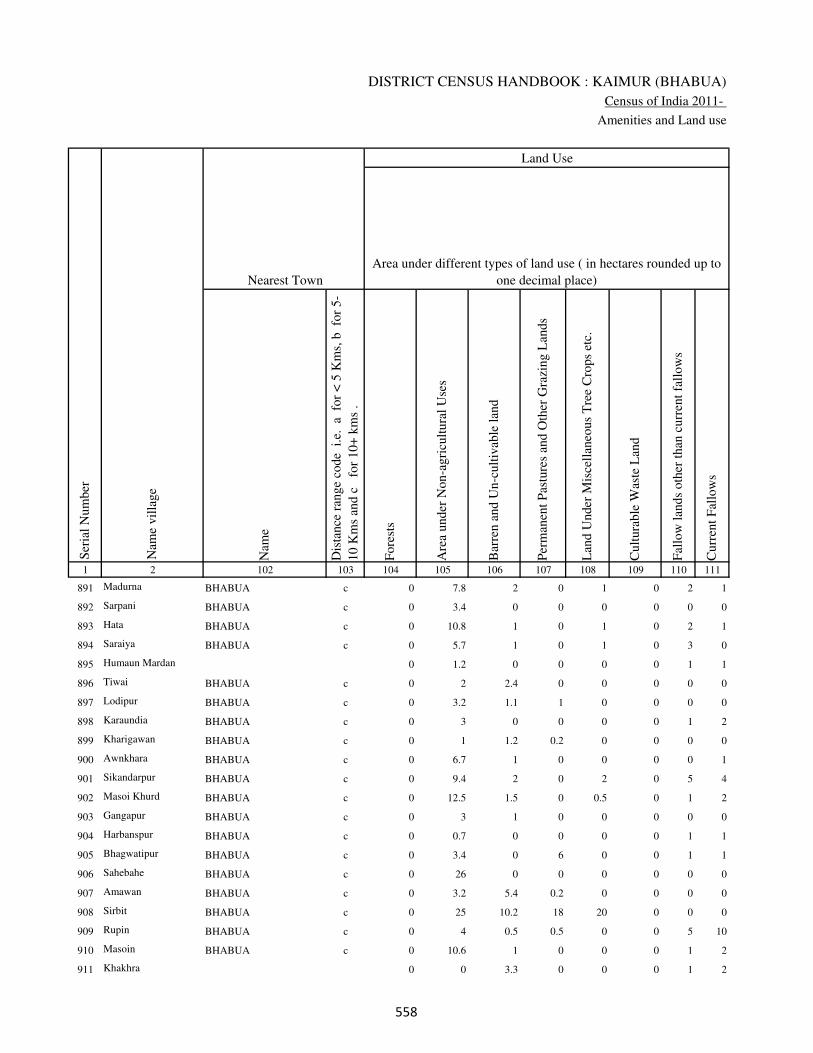
DISTRICT CENSUS HANDBOOK : KAIMUR (BHABUA)
Census of India 2011-
Amenities and Land use
Nam
e
Dis
tance
ran
ge
code
i.e
. a
fo
r <
5 K
ms,
b
for
5-
10 K
ms
and c
f
or
10+
km
s .
Fore
sts
Are
a under
Non-a
gri
cult
ura
l U
ses
Bar
ren a
nd U
n-c
ult
ivab
le l
and
Per
man
ent
Pas
ture
s an
d O
ther
Gra
zing L
ands
Lan
d U
nder
Mis
cell
aneo
us
Tre
e C
rops
etc.
Cult
ura
ble
Was
te L
and
Fal
low
lan
ds
oth
er t
han
curr
ent
fall
ow
s
Curr
ent
Fal
low
s
1 2 102 103 104 105 106 107 108 109 110 111
Ser
ial
Num
ber
Nam
e vil
lage
Area under different types of land use ( in hectares rounded up to
one decimal place)
Land Use
Nearest Town
891 Madurna BHABUA c 0 7.8 2 0 1 0 2 1
892 Sarpani BHABUA c 0 3.4 0 0 0 0 0 0
893 Hata BHABUA c 0 10.8 1 0 1 0 2 1
894 Saraiya BHABUA c 0 5.7 1 0 1 0 3 0
895 Humaun Mardan 0 1.2 0 0 0 0 1 1
896 Tiwai BHABUA c 0 2 2.4 0 0 0 0 0
897 Lodipur BHABUA c 0 3.2 1.1 1 0 0 0 0
898 Karaundia BHABUA c 0 3 0 0 0 0 1 2
899 Kharigawan BHABUA c 0 1 1.2 0.2 0 0 0 0
900 Awnkhara BHABUA c 0 6.7 1 0 0 0 0 1
901 Sikandarpur BHABUA c 0 9.4 2 0 2 0 5 4
902 Masoi Khurd BHABUA c 0 12.5 1.5 0 0.5 0 1 2
903 Gangapur BHABUA c 0 3 1 0 0 0 0 0
904 Harbanspur BHABUA c 0 0.7 0 0 0 0 1 1
905 Bhagwatipur BHABUA c 0 3.4 0 6 0 0 1 1
906 Sahebahe BHABUA c 0 26 0 0 0 0 0 0
907 Amawan BHABUA c 0 3.2 5.4 0.2 0 0 0 0
908 Sirbit BHABUA c 0 25 10.2 18 20 0 0 0
909 Rupin BHABUA c 0 4 0.5 0.5 0 0 5 10
910 Masoin BHABUA c 0 10.6 1 0 0 0 1 2
911 Khakhra 0 0 3.3 0 0 0 1 2
���
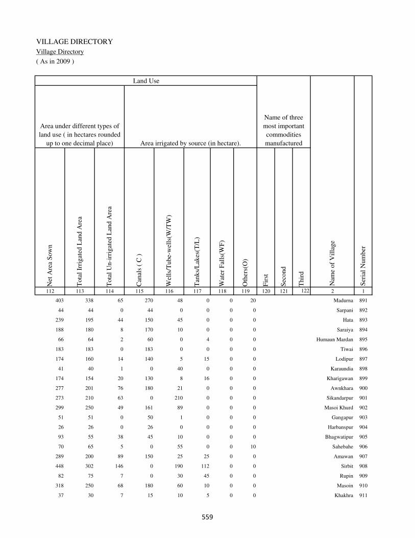
VILLAGE DIRECTORY
Village Directory
( As in 2009 )
Net
Are
a S
ow
n
Tota
l Ir
rigat
ed L
and A
rea
Tota
l U
n-i
rrig
ated
Lan
d A
rea
Can
als
( C
)
Wel
ls/T
ube-
wel
ls(W
/TW
)
Tan
ks/
Lak
es(T
/L)
Wat
er F
alls
(WF
)
Oth
ers(
O)
Fir
st
Sec
ond
Thir
d
112 113 114 115 116 117 118 119 120 121 122 2 1
Ser
ial
Num
ber
Name of three
most important
commodities
manufacturedArea irrigated by source (in hectare).
Nam
e of
Vil
lage
Area under different types of
land use ( in hectares rounded
up to one decimal place)
Land Use
403 338 65 270 48 0 0 20 Madurna 891
44 44 0 44 0 0 0 0 Sarpani 892
239 195 44 150 45 0 0 0 Hata 893
188 180 8 170 10 0 0 0 Saraiya 894
66 64 2 60 0 4 0 0 Humaun Mardan 895
183 183 0 183 0 0 0 0 Tiwai 896
174 160 14 140 5 15 0 0 Lodipur 897
41 40 1 0 40 0 0 0 Karaundia 898
174 154 20 130 8 16 0 0 Kharigawan 899
277 201 76 180 21 0 0 0 Awnkhara 900
273 210 63 0 210 0 0 0 Sikandarpur 901
299 250 49 161 89 0 0 0 Masoi Khurd 902
51 51 0 50 1 0 0 0 Gangapur 903
26 26 0 26 0 0 0 0 Harbanspur 904
93 55 38 45 10 0 0 0 Bhagwatipur 905
70 65 5 0 55 0 0 10 Sahebahe 906
289 200 89 150 25 25 0 0 Amawan 907
448 302 146 0 190 112 0 0 Sirbit 908
82 75 7 0 30 45 0 0 Rupin 909
318 250 68 180 60 10 0 0 Masoin 910
37 30 7 15 10 5 0 0 Khakhra 911
���

DISTRICT CENSUS HANDBOOK : KAIMUR (BHABUA)
Census of India 2011-
Amenities and Land use
Pre
-Pri
mar
y s
chool
(PP
)
Pri
mar
y s
chool
(P)
Mid
dle
sch
ool
(M)
Sec
ondar
y S
chool
(S)
Sen
ior
Sec
ondar
y s
chool
(SS
)
Deg
ree
coll
ege
of
arts
sc
ience
& c
om
mer
ce
(AS
C)
Engin
eeri
ng c
oll
ege(
EC
)
Med
ical
coll
ege
(MC
)
Man
agem
ent
inst
itute
(M
I)
Poly
tech
nic
(P
t)
Voca
tional
tra
inin
g s
chool
/IT
I
Non-f
orm
al t
rain
ing c
entr
e (N
FT
C)
Spec
ial
school
for
dis
able
d (
SS
D)
Oth
ers
(spec
ify)
1 2 3 4 5 6 7 8 9 10 11 12 13 14 15 16 17 18 19 20
Loca
tion c
ode
no.
Nam
e vil
lage
Ser
ial
Num
ber
Tota
l popula
tion (
2011 c
ensu
s )
Tota
l ar
ea o
f th
e vil
lage
( in
hec
tare
s ro
unded
up t
o
one
dec
imal
pla
ce)
Number of educational amenities available. (If not available
within the village , the distance range code viz; a for < 5
Kms, b for 5-10 Kms and c for 10+ kms of nearest place
where facility is available is given).
Num
ber
of
house
hold
s (2
011 c
ensu
s)
912 Kurain 249836 278 1303 182 b 2 a c c c c c c c c c c
913 Karjav 249837 305.1 2943 536 b 2 a c c c c c c c c c c
914 Karji 249838 369.5 2877 509 1 2 2 c c c c c c c c c c
915 Balubheria 249839 146.1 107 11 a b b c b c c c c c c c c
916 Sherpur 249840 78.5 15 4 b b a c a b c c c c c c c
917 Dobhri 249841 133.5 1370 211 1 2 a c c c c c c c c c c
918 Phulkara 249842 96 0 0
919 Neura 249843 98.7 350 58 b a a c c c c c c c c c c
920 Harnampur 249844 22.7 194 24 b a a c b c c c c c c c c
921 Rajpur 249845 36.4 0 0
922 Babhaniawan 249846 63.9 742 113 b 2 a b c c c c c c c c c
923 Madra 249847 154 797 142 b a b c a b c c c c c c c
924 Khargipur 249848 27.9 326 52 b 2 a c c c c c c c c c c
925 Deua 249849 70.4 715 111 1 2 a c c c c c c c c c c
926 Nainpura 249850 51.8 486 76 b 2 b c c c c c c c c c c
927 Hukkasarai 249851 66.8 0 0
928 Sonbarsa 249852 94.3 1134 168 b 2 a c c c c c c c c c c
929 Arail 249853 145.7 1058 147 c 2 a c b c c c c c c c c
930 Chauthi 249854 56.7 245 22 c 1 1 c b c c c c c c c c
931 Isia 249855 108 2826 463 1 2 1 c c c c c c c c c c
932 Sakhelipur 249856 37.2 0 0
���

VILLAGE DIRECTORY
Village Directory
( As in 2009 )
Com
munit
y h
ealt
h c
entr
e (C
HC
)
Pri
mar
y h
ealt
h c
entr
e (P
HC
)
Pri
mar
y h
ealt
h s
ub c
entr
e (P
HS
)
Mat
ernit
y a
nd c
hil
d w
elfa
re c
entr
e (M
CW
)
T.B
. cl
inic
(T
BC
)
Hosp
ital
-all
opat
hic
(H
A)
Hosp
ital
-alt
ernat
ive
med
icin
e (H
O)
Dis
pen
sary
(D
)
Vet
erin
ary h
osp
ital
(V
H)
Mobil
e hea
lth c
linic
(M
HC
)
Fam
ily w
elfa
re c
entr
e (F
WC
)
Char
itab
le n
on G
ovt.
hosp
ital
/Nurs
ing h
om
e.
Med
ical
pra
ctit
ioner
wit
h M
BB
S D
egre
e
Med
ical
pra
ctit
ioner
wit
h o
ther
deg
ree
Med
ical
pra
ctit
ioner
wit
h n
o d
egre
e
Tra
dit
ional
pra
ctit
ioner
an
d f
aith
hea
ler
.
Med
icin
e S
hop
Oth
ers
21 22 23 24 25 26 27 28 29 30 31 32 33 34 35 36 37 38 2 1
Number of Non-Government
Medical Amenities available.
Number of Medical Amenities available. (If not
available within the village , the distance range
code viz; a for < 5 Kms, b for 5-10 Kms and c
for 10+ kms of nearest place where facility is
available is given).
Nam
e vil
lage
Ser
ial
Num
ber
c b a b b c c a b c b 0 0 0 0 0 0 0 Kurain 912
c c 1 1 c c c c c c 1 0 0 0 0 0 0 0 Karjav 913
c b 1 1 b c c c c c 1 0 0 2 0 0 2 0 Karji 914
c c b b c c c c c c c 0 0 0 0 0 0 0 Balubheria 915
c c c c c c c c b c c 0 0 0 0 0 0 0 Sherpur 916
c c 1 1 c c c c c c 1 0 0 0 0 0 0 0 Dobhri 917
Phulkara 918
c c b c c c c b c c c 0 0 0 0 0 0 0 Neura 919
c c a c c c c c c c c 0 0 0 0 0 0 0 Harnampur 920
Rajpur 921
c c a c c c c b c c c 0 0 0 0 0 0 0 Babhaniawan 922
c c b b c c c b b c c 0 0 0 0 0 0 0 Madra 923
c c a c c c c a c c c 0 0 0 0 0 0 0 Khargipur 924
c c a c c c c a c c c 0 0 0 0 0 0 0 Deua 925
b b a b c c c b b c b 0 0 0 0 0 0 0 Nainpura 926
Hukkasarai 927
b b b b b c c b b c b 0 0 0 0 0 0 0 Sonbarsa 928
b b a b c c c b b c b 0 0 0 0 0 0 0 Arail 929
b b a b c c c b b c b 0 0 0 0 0 0 0 Chauthi 930
c c 1 1 c c c a c c 1 0 0 0 0 0 0 0 Isia 931
Sakhelipur 932
���
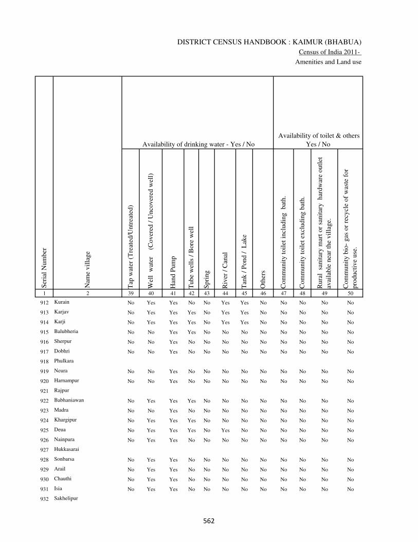
DISTRICT CENSUS HANDBOOK : KAIMUR (BHABUA)
Census of India 2011-
Amenities and Land use
Tap
wat
er (
Tre
ated
/Untr
eate
d)
Wel
l w
ater
(Cover
ed /
Unco
ver
ed w
ell)
Han
d P
um
p
Tube
wel
ls /
Bore
wel
l
Spri
ng
Riv
er /
Can
al
Tan
k /
Pond /
L
ake
Oth
ers
Com
munit
y t
oil
et i
ncl
udin
g
bat
h.
Com
munit
y t
oil
et e
xcl
udin
g b
ath.
Rura
l s
anit
ary m
art
or
sanit
ary
har
dw
are
outl
et
avai
lable
nea
r th
e vil
lage.
Com
munit
y b
io-
gas
or
recy
cle
of
was
te f
or
pro
duct
ive
use
.
1 2 39 40 41 42 43 44 45 46 47 48 49 50
Availability of toilet & others
Yes / No Availability of drinking water - Yes / No
Nam
e vil
lage
Ser
ial
Num
ber
912 Kurain No Yes Yes No No Yes Yes No No No No No
913 Karjav No Yes Yes Yes No Yes Yes No No No No No
914 Karji No Yes Yes Yes No Yes Yes No No No No No
915 Balubheria No No Yes Yes No No No No No No No No
916 Sherpur No No Yes No No No No No No No No No
917 Dobhri No No Yes No No No No No No No No No
918 Phulkara
919 Neura No No Yes No No No No No No No No No
920 Harnampur No No Yes No No No No No No No No No
921 Rajpur
922 Babhaniawan No Yes Yes Yes No No No No No No No No
923 Madra No No Yes No No No No No No No No No
924 Khargipur No Yes Yes Yes No No No No No No No No
925 Deua No Yes Yes Yes No Yes No No No No No No
926 Nainpura No Yes Yes No No No No No No No No No
927 Hukkasarai
928 Sonbarsa No Yes Yes No No No No No No No No No
929 Arail No Yes Yes No No No No No No No No No
930 Chauthi No Yes Yes No No No No No No No No No
931 Isia No Yes Yes No No No No No No No No No
932 Sakhelipur
��
VILLAGE DIRECTORY
Village Directory
( As in 2009 )
Post
off
ice(
PO
)
Sub p
ost
off
ice
(SP
O)
Post
& T
eleg
raph o
ffic
e
(P&
TO
)
Vil
lage
Pin
Code
Tel
ephones
(L
and l
ines
)
Publi
c ca
ll o
ffic
e (P
CO
)
Mobil
e phone
cover
age
Inte
rnet
caf
es/
Com
mon s
ervic
e ce
ntr
e (C
SC
)
Pri
vat
e co
uri
er f
acil
ity
Bus
serv
ice
(P
ubli
c &
Pri
vat
e)
Rai
lway
sta
tions
Auto
/Modif
ied A
uto
s
Tax
is a
nd V
ans
Tra
ctors
Cycl
e-pull
ed r
icksh
aws(
Man
ual
& M
achin
e
dri
ven
)
Car
ts d
riven
by a
nim
als
Sea
/R
iver
fer
ry s
ervic
e51 52 53 54 55 56 57 58 59 60 61 62 63 64 65 66 67 2 1
Communication and transport facilities (If amenities available code -Yes is given except for
Village Pin Code ,If not available within the village , the distance range code viz; a for < 5
Kms, b for 5-10 Kms and c for 10+ kms of nearest place where facility is available is given).
Ser
ial
Num
ber
Nam
e vil
lage
a b c b a a a c Yes c c c Yes Yes a c Kurain 912
a a c a c Yes c Yes Yes c c c Yes Yes Yes Karjav 913
Yes c c Yes Yes Yes c c Yes c c Yes Yes Yes Yes Karji 914
b c c b b Yes c c a b c a b Yes b Balubheria 915
b c c b b b c c b c c b a a b Sherpur 916
Yes c Yes 821105 b a Yes c c a c c a b Yes a Dobhri 917
Phulkara 918
a b c b b Yes c c a c c a b Yes b Neura 919
b b c c a Yes c c a c c a b Yes b Harnampur 920
Rajpur 921
b a c a a Yes c c a c c a b Yes b Babhaniawan 922
a c c b b a c c b c c b b a b Madra 923
a c c b b b c c b c c b b a b Khargipur 924
a a c 821103 b b a b c a b c a Yes b b Deua 925
b a c b b Yes c c c c b a a Yes b Nainpura 926
Hukkasarai 927
a a c b b Yes c c a c c a b Yes b Sonbarsa 928
a a c a a Yes c c a c c a b Yes a Arail 929
a a c b b Yes b c a c c a b Yes a Chauthi 930
b a c 821103 b c a c c Yes c c Yes Yes b Yes Isia 931
Sakhelipur 932
��

DISTRICT CENSUS HANDBOOK : KAIMUR (BHABUA)
Census of India 2011-
Amenities and Land use
Connec
ted t
o n
atio
nal
hig
hw
ay(N
H)
Connec
ted t
o s
tate
hig
hw
ay(S
H)
Connec
ted t
o m
ajor
dis
tric
t ro
ad (
MD
R)
Connec
ted t
o o
ther
s dis
tric
t ro
ad
Pucc
a r
oad
s
Kutc
hch
a r
oad
s
Wat
er b
ounded
mac
adam
(WB
M)
road
s
Nav
igab
le w
ater
way
(ri
ver
/can
al)(
NW
)
Footp
aths
(FP
)
Com
mer
cial
& C
o-o
per
ativ
e B
anks
AT
M
Agri
cult
ura
l C
redit
Soci
etie
s
Sel
f-H
elp G
roup (
SH
G)
Publi
c dis
trib
uti
on s
yst
em (
PD
S)
shop
Man
dis
/ R
egula
r m
arket
Wee
kly
Haa
t
Agri
cult
ura
l m
arket
ing s
oci
ety
1 2 68 69 70 71 72 73 74 75 76 77 78 79 80 81 82 83 84
Village connected to highways,village roads, banks & credit
societies (If amenities available code -Yes is given, If not
available within the village , the distance range code viz; a
for < 5 Kms, b for 5-10 Kms and c for 10+ kms of nearest
place where facility is available is given).
Ser
ial
Num
ber
Nam
e vil
lage
Availability of miscellaneous
facilities (If amenities available
code -Yes is given, If not
available within the village , the
distance range code viz; a for <
5 Kms, b for 5-10 Kms and c
for 10+ kms of nearest place
where facility is available is
given) Contd....
912 Kurain c c c b Yes b Yes Yes Yes b b a b b b b c
913 Karjav c Yes b Yes Yes Yes b b Yes c c c b a a c c
914 Karji c Yes b Yes Yes Yes b b Yes c c c b b b c c
915 Balubheria b a a a b Yes b b Yes c c b b b b b c
916 Sherpur c b b b a a a b Yes c c c b b c b c
917 Dobhri b Yes c a Yes b Yes b Yes c c b b b c b c
918 Phulkara
919 Neura c a a c b Yes a b Yes c c c b b c c c
920 Harnampur c a b a a Yes b b Yes c c c b a c b c
921 Rajpur
922 Babhaniawan c a a b b Yes a c Yes c c c b a b b c
923 Madra c b b b a a a b Yes c c c b a c b c
924 Khargipur c b b b b b b b Yes c c Yes b b b b c
925 Deua b b c b a Yes Yes b Yes c c c b a b b c
926 Nainpura b b b a a Yes b b Yes b b b b b c b c
927 Hukkasarai
928 Sonbarsa c b a a a Yes Yes b Yes b b b a a b c c
929 Arail b a b a a b b c Yes b b b b a b b c
930 Chauthi c a b a a Yes Yes c Yes c b c b b c b c
931 Isia c c c Yes Yes b b b Yes c c Yes Yes b c c c
932 Sakhelipur
���

VILLAGE DIRECTORY
Village Directory
( As in 2009 )
Inte
gra
ted C
hil
d D
evel
opm
ent
Sch
eme
(Nutr
itio
nal
Cen
tres
)
Angan
wad
i C
entr
e (N
utr
itio
nal
Cen
tres
)
Oth
ers
(Nutr
itio
nal
Cen
tres
)
AS
HA
(A
ccre
dit
ed S
oci
al H
ealt
h A
ctiv
ist)
Com
munit
y c
entr
e w
ith/w
ithout
TV
Sport
s F
ield
,
Sport
s C
lub /
Rec
reat
ion C
entr
e
Cin
ema
/ V
ideo
Hal
l
Publi
c L
ibra
ry
Publi
c R
eadin
g R
oom
New
spap
er S
upply
Ass
embly
Poll
ing s
tati
on
Bir
th &
Dea
th R
egis
trat
ion O
ffic
e
Pow
er S
upply
for
Dom
esti
c U
se (
ED
)
Pow
er S
upply
for
Agri
cult
ura
l U
se (
EA
G)
Pow
er S
upply
for
Com
mer
cial
Use
(E
C)
Pow
er S
upply
for
All
Use
s (E
A)
85 86 87 88 89 90 91 92 93 94 95 96 97 98 99 100 101 2 1
Availability of
electricity (Yes/No)
Availability of miscellaneous facilities (If amenities available code -
Yes is given, If not available within the village , the distance range
code viz; a for < 5 Kms, b for 5-10 Kms and c for 10+ kms of
nearest place where facility is available is given) Concluded
Nam
e vil
lage
Ser
ial
Num
ber
b Yes Yes Yes c b c c c c b Yes a Yes Yes Yes Yes Kurain 912
c Yes Yes Yes c Yes c c c c b Yes a Yes Yes No No Karjav 913
c Yes Yes Yes c Yes c c c c Yes Yes Yes Yes Yes No No Karji 914
c a Yes a c a c c c c b a a Yes Yes No No Balubheria 915
b b Yes b c a c c c c b a a No No No No Sherpur 916
c Yes Yes Yes c b c c c c b Yes b Yes Yes No No Dobhri 917
Phulkara 918
c b b b c b c c c c c a b Yes Yes No No Neura 919
c a Yes a c a c c c c c a a Yes Yes No No Harnampur 920
Rajpur 921
c a Yes a c a c c c c b a a Yes Yes No No Babhaniawan 922
c b Yes b c b c c c c c a a Yes No No No Madra 923
c b Yes b c b c c c c c a a Yes No No No Khargipur 924
c a Yes a c b c c c c c Yes a Yes No No No Deua 925
c a Yes a c b c c c c b a a Yes Yes No No Nainpura 926
Hukkasarai 927
b Yes Yes Yes c Yes c c c c c Yes a Yes Yes No No Sonbarsa 928
b a Yes a c Yes c c c c c Yes a Yes Yes No No Arail 929
b b b a c b Yes c c c c a b Yes Yes No No Chauthi 930
c Yes Yes Yes c Yes c c c c Yes Yes b Yes Yes Yes Yes Isia 931
Sakhelipur 932
���
DISTRICT CENSUS HANDBOOK : KAIMUR (BHABUA)
Census of India 2011-
Amenities and Land use
Nam
e
Dis
tance
ran
ge
code
i.e
. a
fo
r <
5 K
ms,
b
for
5-
10 K
ms
and c
f
or
10+
km
s .
Fore
sts
Are
a under
Non-a
gri
cult
ura
l U
ses
Bar
ren a
nd U
n-c
ult
ivab
le l
and
Per
man
ent
Pas
ture
s an
d O
ther
Gra
zing L
ands
Lan
d U
nder
Mis
cell
aneo
us
Tre
e C
rops
etc.
Cult
ura
ble
Was
te L
and
Fal
low
lan
ds
oth
er t
han
curr
ent
fall
ow
s
Curr
ent
Fal
low
s
1 2 102 103 104 105 106 107 108 109 110 111
Ser
ial
Num
ber
Nam
e vil
lage
Area under different types of land use ( in hectares rounded up to
one decimal place)
Land Use
Nearest Town
912 Kurain BHABUA c 0 5.6 6 15.4 0 20 3 1
913 Karjav BHABUA c 0 5.1 0 0 0 0 3 2
914 Karji BHABUA c 0 9.5 0 0 20 0 0 0
915 Balubheria BHABUA c 0 4.1 0 0 0 0 2 1
916 Sherpur BHABUA c 0 0.5 0 0 1 1 0 0
917 Dobhri BHABUA c 0 2.5 0 0 0 0 1 1
918 Phulkara 0.5 0.5 0 0 0 0 0 0
919 Neura BHABUA c 0 1.7 0 0 0 0 1 2
920 Harnampur BHABUA c 0 1.7 0 0 0 0 0 0
921 Rajpur 0 0.4 0 0 0 0 0 0
922 Babhaniawan BHABUA c 0 0.9 0 0 0 0 1 1
923 Madra BHABUA c 0 1 0 0 0 0 0 5
924 Khargipur BHABUA c 0 0.9 0 0 0 0 4 4
925 Deua BHABUA c 0 1.4 0 0 0 0 20 10
926 Nainpura BHABUA c 0 0.8 0 0 0 0 1 1
927 Hukkasarai 0 0.8 0 0 0 0 0 0
928 Sonbarsa BHABUA c 0 1.3 0 0 0 0 1 1
929 Arail BHABUA c 0 1.7 0 0 0 0 2 1
930 Chauthi BHABUA c 6.7 0 0 0 0 0 0 0
931 Isia BHABUA c 0 2 0 0 0 0 8 1
932 Sakhelipur 0 0.2 0 0 0 0 1 1
���

VILLAGE DIRECTORY
Village Directory
( As in 2009 )
Net
Are
a S
ow
n
Tota
l Ir
rigat
ed L
and A
rea
Tota
l U
n-i
rrig
ated
Lan
d A
rea
Can
als
( C
)
Wel
ls/T
ube-
wel
ls(W
/TW
)
Tan
ks/
Lak
es(T
/L)
Wat
er F
alls
(WF
)
Oth
ers(
O)
Fir
st
Sec
ond
Thir
d
112 113 114 115 116 117 118 119 120 121 122 2 1
Ser
ial
Num
ber
Name of three
most important
commodities
manufacturedArea irrigated by source (in hectare).
Nam
e of
Vil
lage
Area under different types of
land use ( in hectares rounded
up to one decimal place)
Land Use
227 190 37 150 30 10 0 0 Kurain 912
295 225 70 200 25 0 0 0 Karjav 913
340 260 80 160 50 50 0 0 Karji 914
139 100 39 80 20 0 0 0 Balubheria 915
76 56 20 0 50 6 0 0 Sherpur 916
129 94 35 70 24 0 0 0 Dobhri 917
95 65 30 50 10 5 0 0 Phulkara 918
94 60 34 50 10 0 0 0 Neura 919
21 21 0 0 15 6 0 0 Harnampur 920
36 36 0 15 15 6 0 0 Rajpur 921
61 56 5 0 50 6 0 0 Babhaniawan 922
148 120 28 60 60 0 0 0 Madra 923
19 19 0 10 9 0 0 0 Khargipur 924
39 30 9 10 20 0 0 0 Deua 925
49 46 3 40 6 0 0 0 Nainpura 926
66 46 20 0 40 6 0 0 Hukkasarai 927
91 65 26 0 60 5 0 0 Sonbarsa 928
141 107 34 0 101 6 0 0 Arail 929
50 40 10 0 40 0 0 0 Chauthi 930
97 85 12 20 65 0 0 0 Isia 931
35 30 5 0 25 5 0 0 Sakhelipur 932
���

DISTRICT CENSUS HANDBOOK : KAIMUR (BHABUA)
Census of India 2011-
Amenities and Land use
Pre
-Pri
mar
y s
chool
(PP
)
Pri
mar
y s
chool
(P)
Mid
dle
sch
ool
(M)
Sec
ondar
y S
chool
(S)
Sen
ior
Sec
ondar
y s
chool
(SS
)
Deg
ree
coll
ege
of
arts
sc
ience
& c
om
mer
ce
(AS
C)
Engin
eeri
ng c
oll
ege(
EC
)
Med
ical
coll
ege
(MC
)
Man
agem
ent
inst
itute
(M
I)
Poly
tech
nic
(P
t)
Voca
tional
tra
inin
g s
chool
/IT
I
Non-f
orm
al t
rain
ing c
entr
e (N
FT
C)
Spec
ial
school
for
dis
able
d (
SS
D)
Oth
ers
(spec
ify)
1 2 3 4 5 6 7 8 9 10 11 12 13 14 15 16 17 18 19 20
Loca
tion c
ode
no.
Nam
e vil
lage
Ser
ial
Num
ber
Tota
l popula
tion (
2011 c
ensu
s )
Tota
l ar
ea o
f th
e vil
lage
( in
hec
tare
s ro
unded
up t
o
one
dec
imal
pla
ce)
Number of educational amenities available. (If not available
within the village , the distance range code viz; a for < 5
Kms, b for 5-10 Kms and c for 10+ kms of nearest place
where facility is available is given).
Num
ber
of
house
hold
s (2
011 c
ensu
s)
933 Bararhi 249857 173.6 1177 181 1 2 1 c c c c c c c c c c
934 Danrwa 249858 104 607 100 1 1 a c c c c c c c c b c
935 Teli Pokhar 249859 37.2 55 8 a 1 a c c c c c c c c c c
936 Danrwa 249860 57 769 115 1 1 a c c c c c c c c b c
937 Bhadaura 249861 32 1754 294 a 1 a c c c c c c c c c c
938 Fakhrabad 249862 380 2222 338 1 1 1 c c c c c c c c b c
939 Manpur 249863 321 3627 549 b 1 a c a c c c c c c c c
940 Muri 249864 318.5 3377 580 b 1 a c b c c c c c c c c
941 Harnathpur 249865 36 0 0
942 Biur 249866 206 2605 388 2 2 1 1 a c c c c c c c c
943 Gazipur 249867 79.3 1034 171 a 1 a c a c c c c c c c c
944 Biddi 249868 74 1377 240 b 1 1 1 a c c c c c c c c
945 Gonai 249869 38 462 80 b 1 a c b c c c c c c c c
946 Parsotimpur 249870 59.9 563 86 a 1 a c c c c c c c c c c
947 Bhualpur 249871 60 700 119 b 1 a c a c c c c c c c c
948 Bari Takia 249872 55 671 109 a 1 b c a c c c c c c c c
949 Maliksaray 249873 195 1152 164 a 1 1 c 1 c c c c c c c c
950 Chainpur 249874 112.9 11306 1653 4 1 2 c a a c c c c c b b
951 Naughara 249875 328.6 2346 348 a 1 1 c b c c c c c c c c
952 Kharaura 249876 280 1257 203 a 1 a c b c c c c c c c c
953 Salempur 249877 80.1 588 75 b 1 a c c c c c c c c c c
���

VILLAGE DIRECTORY
Village Directory
( As in 2009 )
Com
munit
y h
ealt
h c
entr
e (C
HC
)
Pri
mar
y h
ealt
h c
entr
e (P
HC
)
Pri
mar
y h
ealt
h s
ub c
entr
e (P
HS
)
Mat
ernit
y a
nd c
hil
d w
elfa
re c
entr
e (M
CW
)
T.B
. cl
inic
(T
BC
)
Hosp
ital
-all
opat
hic
(H
A)
Hosp
ital
-alt
ernat
ive
med
icin
e (H
O)
Dis
pen
sary
(D
)
Vet
erin
ary h
osp
ital
(V
H)
Mobil
e hea
lth c
linic
(M
HC
)
Fam
ily w
elfa
re c
entr
e (F
WC
)
Char
itab
le n
on G
ovt.
hosp
ital
/Nurs
ing h
om
e.
Med
ical
pra
ctit
ioner
wit
h M
BB
S D
egre
e
Med
ical
pra
ctit
ioner
wit
h o
ther
deg
ree
Med
ical
pra
ctit
ioner
wit
h n
o d
egre
e
Tra
dit
ional
pra
ctit
ioner
an
d f
aith
hea
ler
.
Med
icin
e S
hop
Oth
ers
21 22 23 24 25 26 27 28 29 30 31 32 33 34 35 36 37 38 2 1
Number of Non-Government
Medical Amenities available.
Number of Medical Amenities available. (If not
available within the village , the distance range
code viz; a for < 5 Kms, b for 5-10 Kms and c
for 10+ kms of nearest place where facility is
available is given).
Nam
e vil
lage
Ser
ial
Num
ber
c c a c c c c a b c b 0 0 0 0 0 0 0 Bararhi 933
b b b b b c c b b c b 0 0 0 0 0 0 0 Danrwa 934
b b b b b c c b b c b 0 0 0 0 0 0 0 Teli Pokhar 935
b b a b b c c b b c b 0 0 0 0 0 0 0 Danrwa 936
b b 1 1 c c c b b c 1 0 0 0 0 0 0 0 Bhadaura 937
b b a b b c c b b c b 0 0 0 0 0 0 0 Fakhrabad 938
a a a a a c c a a c a 0 0 0 0 0 0 0 Manpur 939
b b 1 1 b c c b b c 1 0 0 0 0 0 0 0 Muri 940
Harnathpur 941
a a a a a c c a a c a 0 0 0 0 0 0 0 Biur 942
b b a b b c c b b c b 0 0 0 0 0 0 0 Gazipur 943
b b b b b c c b b c b 0 0 0 0 0 0 0 Biddi 944
b b b b b c c b b c b 0 0 0 0 0 0 0 Gonai 945
a a a a a c c a a c a 0 0 0 0 0 0 0 Parsotimpur 946
b b c c c c c a a c c 0 0 0 0 0 0 0 Bhualpur 947
b a a a a c c a a c a 0 0 0 0 0 0 0 Bari Takia 948
b c a c c c c c a c c 0 0 0 0 0 0 0 Maliksaray 949
c 1 1 1 1 b b 1 1 b 1 0 0 0 0 0 0 0 Chainpur 950
a a a a c c c c a c a 0 0 0 0 0 0 0 Naughara 951
a b b b c c c c b c b 0 0 0 0 0 0 0 Kharaura 952
a b b b b c c b b c b 0 0 0 0 0 0 0 Salempur 953
���
DISTRICT CENSUS HANDBOOK : KAIMUR (BHABUA)
Census of India 2011-
Amenities and Land use
Tap
wat
er (
Tre
ated
/Untr
eate
d)
Wel
l w
ater
(Cover
ed /
Unco
ver
ed w
ell)
Han
d P
um
p
Tube
wel
ls /
Bore
wel
l
Spri
ng
Riv
er /
Can
al
Tan
k /
Pond /
L
ake
Oth
ers
Com
munit
y t
oil
et i
ncl
udin
g
bat
h.
Com
munit
y t
oil
et e
xcl
udin
g b
ath.
Rura
l s
anit
ary m
art
or
sanit
ary
har
dw
are
outl
et
avai
lable
nea
r th
e vil
lage.
Com
munit
y b
io-
gas
or
recy
cle
of
was
te f
or
pro
duct
ive
use
.
1 2 39 40 41 42 43 44 45 46 47 48 49 50
Availability of toilet & others
Yes / No Availability of drinking water - Yes / No
Nam
e vil
lage
Ser
ial
Num
ber
933 Bararhi No Yes Yes Yes No No No No No No No No
934 Danrwa No Yes Yes No No Yes No Yes No No No No
935 Teli Pokhar No Yes Yes Yes No No No No No No No No
936 Danrwa No Yes Yes No No Yes No No No No No No
937 Bhadaura No Yes Yes Yes No No No No No No No No
938 Fakhrabad No Yes Yes No Yes No No No No No No No
939 Manpur No Yes Yes Yes No Yes No No No No No No
940 Muri No Yes Yes Yes No No No No No No No No
941 Harnathpur
942 Biur No Yes Yes Yes No Yes No No No No No No
943 Gazipur No Yes Yes Yes No Yes No No No No No No
944 Biddi No Yes Yes No No No No No No No No No
945 Gonai No Yes Yes No No No No No No No No No
946 Parsotimpur No Yes Yes No No Yes No No No No No No
947 Bhualpur No No Yes No No No Yes No No No No No
948 Bari Takia No Yes Yes No No Yes No No No No No No
949 Maliksaray No Yes Yes No No Yes No No No No No No
950 Chainpur No Yes Yes No No No No No No No No No
951 Naughara No Yes Yes No No Yes No No No No No No
952 Kharaura No Yes Yes No No Yes No No No No No No
953 Salempur No Yes Yes No No Yes No No No No No No
���
VILLAGE DIRECTORY
Village Directory
( As in 2009 )
Post
off
ice(
PO
)
Sub p
ost
off
ice
(SP
O)
Post
& T
eleg
raph o
ffic
e
(P&
TO
)
Vil
lage
Pin
Code
Tel
ephones
(L
and l
ines
)
Publi
c ca
ll o
ffic
e (P
CO
)
Mobil
e phone
cover
age
Inte
rnet
caf
es/
Com
mon s
ervic
e ce
ntr
e (C
SC
)
Pri
vat
e co
uri
er f
acil
ity
Bus
serv
ice
(P
ubli
c &
Pri
vat
e)
Rai
lway
sta
tions
Auto
/Modif
ied A
uto
s
Tax
is a
nd V
ans
Tra
ctors
Cycl
e-pull
ed r
icksh
aws(
Man
ual
& M
achin
e
dri
ven
)
Car
ts d
riven
by a
nim
als
Sea
/R
iver
fer
ry s
ervic
e51 52 53 54 55 56 57 58 59 60 61 62 63 64 65 66 67 2 1
Communication and transport facilities (If amenities available code -Yes is given except for
Village Pin Code ,If not available within the village , the distance range code viz; a for < 5
Kms, b for 5-10 Kms and c for 10+ kms of nearest place where facility is available is given).
Ser
ial
Num
ber
Nam
e vil
lage
Yes c c 821103 b b b b c Yes c c b Yes b a Bararhi 933
a a c b b a b c b c c c Yes b b Danrwa 934
a a c 821103 b b b b c b c b c Yes b b Yes Teli Pokhar 935
a a c 821103 c b b b c b c c c Yes c b Danrwa 936
a a c 821103 b b a b c b c b c Yes b b Bhadaura 937
b a c 821103 b b b b c b c c c Yes c Yes Fakhrabad 938
a c c 821103 c Yes a c c Yes c a Yes Yes Yes Yes Manpur 939
Yes c c 821103 b a Yes c c Yes c c Yes Yes Yes Yes Muri 940
Harnathpur 941
Yes c c 821103 c Yes a c c Yes c a Yes Yes a Yes Biur 942
b a c 821103 c a a c c b c a Yes a b a Gazipur 943
a a c Yes Yes Yes a c a c b Yes Yes Yes b Biddi 944
a c c Yes a Yes a c a c b b b Yes b Gonai 945
b a c 821103 a a a c a a c c c Yes Yes a a Parsotimpur 946
a a c Yes a Yes c c Yes c c Yes Yes Yes a Bhualpur 947
a a c a a a c a a c c c Yes Yes Yes Bari Takia 948
a b c 821103 Yes a a c c a c a Yes Yes Yes Yes Yes Maliksaray 949
Yes Yes Yes 821103 Yes Yes Yes b b Yes c Yes Yes Yes Yes Yes a Chainpur 950
a a c b a Yes a c a c a c Yes a Yes a Naughara 951
a c c b b b b b b c b b b b a Yes Kharaura 952
a b c a b Yes b c b c b b b b a Salempur 953
���
DISTRICT CENSUS HANDBOOK : KAIMUR (BHABUA)
Census of India 2011-
Amenities and Land use
Connec
ted t
o n
atio
nal
hig
hw
ay(N
H)
Connec
ted t
o s
tate
hig
hw
ay(S
H)
Connec
ted t
o m
ajor
dis
tric
t ro
ad (
MD
R)
Connec
ted t
o o
ther
s dis
tric
t ro
ad
Pucc
a r
oad
s
Kutc
hch
a r
oad
s
Wat
er b
ounded
mac
adam
(WB
M)
road
s
Nav
igab
le w
ater
way
(ri
ver
/can
al)(
NW
)
Footp
aths
(FP
)
Com
mer
cial
& C
o-o
per
ativ
e B
anks
AT
M
Agri
cult
ura
l C
redit
Soci
etie
s
Sel
f-H
elp G
roup (
SH
G)
Publi
c dis
trib
uti
on s
yst
em (
PD
S)
shop
Man
dis
/ R
egula
r m
arket
Wee
kly
Haa
t
Agri
cult
ura
l m
arket
ing s
oci
ety
1 2 68 69 70 71 72 73 74 75 76 77 78 79 80 81 82 83 84
Village connected to highways,village roads, banks & credit
societies (If amenities available code -Yes is given, If not
available within the village , the distance range code viz; a
for < 5 Kms, b for 5-10 Kms and c for 10+ kms of nearest
place where facility is available is given).
Ser
ial
Num
ber
Nam
e vil
lage
Availability of miscellaneous
facilities (If amenities available
code -Yes is given, If not
available within the village , the
distance range code viz; a for <
5 Kms, b for 5-10 Kms and c
for 10+ kms of nearest place
where facility is available is
given) Contd....
933 Bararhi c b b b a Yes Yes b Yes c c c b a b c c
934 Danrwa c b b b b Yes Yes c Yes b b b b b b b c
935 Teli Pokhar c b b Yes b Yes Yes Yes Yes b b b b a b b c
936 Danrwa c b b b b Yes Yes a Yes c c c b a b b c
937 Bhadaura c b b b Yes Yes Yes b Yes b b b b a b c c
938 Fakhrabad c b b b b Yes Yes b Yes b b b b Yes b b c
939 Manpur c a Yes Yes Yes a b b Yes a a a Yes Yes a a c
940 Muri c Yes Yes Yes Yes b b c Yes b b b Yes Yes b b c
941 Harnathpur
942 Biur c a Yes Yes Yes b b c Yes a a a Yes Yes a a a
943 Gazipur c c b a a Yes Yes b Yes b b b a a b b b
944 Biddi c c Yes b b b Yes b Yes a a b Yes a a b c
945 Gonai c b Yes b b b Yes b Yes a a b Yes a a b b
946 Parsotimpur c a a a a Yes Yes c Yes c c c b b b a a
947 Bhualpur c c Yes a Yes a a c Yes a a a Yes a a c a
948 Bari Takia c b b b a Yes Yes b Yes a c a b Yes b a c
949 Maliksaray c Yes Yes Yes Yes Yes Yes Yes Yes a a Yes b a a b c
950 Chainpur c a a Yes Yes Yes Yes Yes Yes a a b Yes Yes Yes b b
951 Naughara c Yes Yes a Yes Yes Yes a Yes a a Yes b Yes a a a
952 Kharaura c b b Yes a Yes Yes Yes Yes b b Yes Yes Yes b b b
953 Salempur c b b Yes b Yes Yes a Yes b b b a a b b b
��

VILLAGE DIRECTORY
Village Directory
( As in 2009 )
Inte
gra
ted C
hil
d D
evel
opm
ent
Sch
eme
(Nutr
itio
nal
Cen
tres
)
Angan
wad
i C
entr
e (N
utr
itio
nal
Cen
tres
)
Oth
ers
(Nutr
itio
nal
Cen
tres
)
AS
HA
(A
ccre
dit
ed S
oci
al H
ealt
h A
ctiv
ist)
Com
munit
y c
entr
e w
ith/w
ithout
TV
Sport
s F
ield
,
Sport
s C
lub /
Rec
reat
ion C
entr
e
Cin
ema
/ V
ideo
Hal
l
Publi
c L
ibra
ry
Publi
c R
eadin
g R
oom
New
spap
er S
upply
Ass
embly
Poll
ing s
tati
on
Bir
th &
Dea
th R
egis
trat
ion O
ffic
e
Pow
er S
upply
for
Dom
esti
c U
se (
ED
)
Pow
er S
upply
for
Agri
cult
ura
l U
se (
EA
G)
Pow
er S
upply
for
Com
mer
cial
Use
(E
C)
Pow
er S
upply
for
All
Use
s (E
A)
85 86 87 88 89 90 91 92 93 94 95 96 97 98 99 100 101 2 1
Availability of
electricity (Yes/No)
Availability of miscellaneous facilities (If amenities available code -
Yes is given, If not available within the village , the distance range
code viz; a for < 5 Kms, b for 5-10 Kms and c for 10+ kms of
nearest place where facility is available is given) Concluded
Nam
e vil
lage
Ser
ial
Num
ber
b Yes Yes Yes c b c c c c b Yes Yes Yes Yes No No Bararhi 933
b Yes Yes Yes b b c c c c b Yes b Yes Yes No No Danrwa 934
b Yes Yes Yes b b c c c c b Yes Yes Yes No No No Teli Pokhar 935
b Yes Yes a Yes b c c c c c a a Yes Yes Yes Yes Danrwa 936
b Yes Yes Yes b b c c c c c Yes b Yes No No No Bhadaura 937
b Yes Yes Yes b b c c c c b Yes a Yes No No No Fakhrabad 938
b Yes Yes Yes a Yes c c c c c Yes b Yes No No No Manpur 939
b Yes Yes Yes c a c c c c Yes Yes a Yes Yes No No Muri 940
Harnathpur 941
b Yes Yes Yes b b c c c c a Yes Yes Yes No No No Biur 942
b Yes Yes Yes c b c c c c b Yes a Yes No No No Gazipur 943
b Yes Yes Yes c Yes c c c c Yes Yes a Yes Yes No No Biddi 944
b Yes Yes Yes c b c c c c b Yes a No No No No Gonai 945
a Yes Yes Yes c a c c c c b a a Yes Yes Yes Yes Parsotimpur 946
a Yes Yes Yes c Yes c c a c Yes Yes a Yes Yes No No Bhualpur 947
a Yes Yes Yes c a c c c c b Yes Yes Yes No No No Bari Takia 948
a Yes Yes a c a c c c c Yes a a Yes Yes Yes Yes Maliksaray 949
Yes Yes Yes Yes Yes b b c b c Yes Yes Yes Yes Yes Yes Yes Chainpur 950
b Yes Yes b c Yes c c c c Yes Yes b Yes No No No Naughara 951
b Yes Yes Yes c a c c c c b Yes Yes Yes No No No Kharaura 952
b Yes Yes a c b c c c c b a a Yes No No No Salempur 953
��

DISTRICT CENSUS HANDBOOK : KAIMUR (BHABUA)
Census of India 2011-
Amenities and Land use
Nam
e
Dis
tance
ran
ge
code
i.e
. a
fo
r <
5 K
ms,
b
for
5-
10 K
ms
and c
f
or
10+
km
s .
Fore
sts
Are
a under
Non-a
gri
cult
ura
l U
ses
Bar
ren a
nd U
n-c
ult
ivab
le l
and
Per
man
ent
Pas
ture
s an
d O
ther
Gra
zing L
ands
Lan
d U
nder
Mis
cell
aneo
us
Tre
e C
rops
etc.
Cult
ura
ble
Was
te L
and
Fal
low
lan
ds
oth
er t
han
curr
ent
fall
ow
s
Curr
ent
Fal
low
s
1 2 102 103 104 105 106 107 108 109 110 111
Ser
ial
Num
ber
Nam
e vil
lage
Area under different types of land use ( in hectares rounded up to
one decimal place)
Land Use
Nearest Town
933 Bararhi BHABUA c 0 2.6 0 0 1 0 5 3
934 Danrwa BHABUA c 0 4.5 0 0 13.5 0 0 0
935 Teli Pokhar BHABUA c 0 0.2 0 0 0 0 1 1
936 Danrwa BHABUA c 0 1.4 0 0 0 0 4 0
937 Bhadaura BHABUA c 0 7 0 0 0 0 0 0
938 Fakhrabad BHABUA c 0 43.4 0 0 10.6 29.4 10.6 25
939 Manpur BHABUA c 0 16 0 0 20 0 8 2
940 Muri BHABUA c 0 6.5 1 0 1 0 0 0
941 Harnathpur 0 1 0 0 0 0 1 1
942 Biur BHABUA c 0 10.4 2.6 0 1 0 5 6
943 Gazipur BHABUA c 0 3.8 0 0 0 0 2.5 3
944 Biddi BHABUA c 0 7 0 8 14 0 0 0
945 Gonai BHABUA c 0 1 0 0 0 0 2 0
946 Parsotimpur BHABUA c 0 2.9 0 0 0 0 1 2
947 Bhualpur BHABUA c 0 2 0 0 0 0 0 0
948 Bari Takia BHABUA c 0 3 2 0 2 0 1 1
949 Maliksaray BHABUA c 2 6.2 0 16.2 18 2.5 0 0
950 Chainpur BHABUA b 0 5 6.2 0 0 0 0 0
951 Naughara BHABUA c 0 8.6 0 10 0 10 0 0
952 Kharaura BHABUA c 0 11.6 0 11 20 0 0 2.4
953 Salempur BHABUA c 0 10.1 0 0 5 5 0 0
���

VILLAGE DIRECTORY
Village Directory
( As in 2009 )
Net
Are
a S
ow
n
Tota
l Ir
rigat
ed L
and A
rea
Tota
l U
n-i
rrig
ated
Lan
d A
rea
Can
als
( C
)
Wel
ls/T
ube-
wel
ls(W
/TW
)
Tan
ks/
Lak
es(T
/L)
Wat
er F
alls
(WF
)
Oth
ers(
O)
Fir
st
Sec
ond
Thir
d
112 113 114 115 116 117 118 119 120 121 122 2 1
Ser
ial
Num
ber
Name of three
most important
commodities
manufacturedArea irrigated by source (in hectare).
Nam
e of
Vil
lage
Area under different types of
land use ( in hectares rounded
up to one decimal place)
Land Use
162 120 42 100 20 0 0 0 Bararhi 933
86 56 30 30 26 0 0 0 Danrwa 934
35 35 0 20 15 0 0 0 Teli Pokhar 935
51.6 46 5.6 20 26 0 0 0 Danrwa 936
25 25 0 0 5 0 0 20 Bhadaura 937
261 160 101 60 100 0 0 0 Fakhrabad 938
275 230 45 50 100 0 0 80 Manpur 939
310 249 61 0 125 75 0 49 Muri 940
33 33 0 0 30 3 0 0 Harnathpur 941
181 140 41 50 50 0 0 40 Biur 942
70 65 5 50 5 10 0 0 Gazipur 943
45 32 13 28 0 0 0 4 Biddi 944
35 30 5 0 28 2 0 0 Gonai 945
54 50 4 30 20 0 0 0 Parsotimpur 946
58 50 8 0 50 0 0 0 Bhualpur 947
46 44 2 20 24 0 0 0 Bari Takia 948
150.1 110 40.1 10 100 0 0 0 Maliksaray 949
101.7 77.7 24 35 22.7 0 0 20 Chainpur 950
300 254 46 104 150 0 0 0 Naughara 951
235 160 75 60 88 0 0 12 Kharaura 952
60 60 0 30 20 10 0 0 Salempur 953
���

DISTRICT CENSUS HANDBOOK : KAIMUR (BHABUA)
Census of India 2011-
Amenities and Land use
Pre
-Pri
mar
y s
chool
(PP
)
Pri
mar
y s
chool
(P)
Mid
dle
sch
ool
(M)
Sec
ondar
y S
chool
(S)
Sen
ior
Sec
ondar
y s
chool
(SS
)
Deg
ree
coll
ege
of
arts
sc
ience
& c
om
mer
ce
(AS
C)
Engin
eeri
ng c
oll
ege(
EC
)
Med
ical
coll
ege
(MC
)
Man
agem
ent
inst
itute
(M
I)
Poly
tech
nic
(P
t)
Voca
tional
tra
inin
g s
chool
/IT
I
Non-f
orm
al t
rain
ing c
entr
e (N
FT
C)
Spec
ial
school
for
dis
able
d (
SS
D)
Oth
ers
(spec
ify)
1 2 3 4 5 6 7 8 9 10 11 12 13 14 15 16 17 18 19 20
Loca
tion c
ode
no.
Nam
e vil
lage
Ser
ial
Num
ber
Tota
l popula
tion (
2011 c
ensu
s )
Tota
l ar
ea o
f th
e vil
lage
( in
hec
tare
s ro
unded
up t
o
one
dec
imal
pla
ce)
Number of educational amenities available. (If not available
within the village , the distance range code viz; a for < 5
Kms, b for 5-10 Kms and c for 10+ kms of nearest place
where facility is available is given).
Num
ber
of
house
hold
s (2
011 c
ensu
s)
954 Isapur 249878 151.4 1076 189 a 2 2 c c c c c c c c c c
955 Gobindpur 249879 21 310 54 a a a c b c c c c c c c c
956 Sherpur 249880 260.2 1931 349 a 1 a c b c c c c c c c c
957 Lohra 249881 211.6 1719 300 b 1 a c b c c c c c c c c
958 Jairampur 249882 146.9 1142 205 a 1 a c b c c c c c c c c
959 Nandgawan 249883 134.4 1835 311 b 1 1 c c c c c c c c c c
960 Sohawal 249884 68.8 745 137 b 1 1 c b c c c c c c c c
961 Rupa Patti 249885 142.9 1255 207 b 1 a c c c c c c c c c c
962 Nati 249886 46.5 198 38 b a a c c c c c c c c c c
963 Damodarpur 249887 99.6 505 82 b 1 a c a c c c c c c c c
964 Pahladpur 249888 103 337 38 a 1 a c a c c c c c c c c
965 Bhagwanpur 249889 74.9 1134 165 a 1 a c a c c c c c c c c
966 Jagaria 249890 99.8 1464 243 a 1 a 1 a c c c c c c c c
967 Sherpur 249891 95.9 1165 216 a a a c a c c c c c c c c
968 Dulahra 249892 117 1104 183 b 1 1 c b c c c c c c c c
969 Narainpur 249893 32.8 0 0
970 Raghaisagar 249894 41.7 0 0
971 Jagdishpur 249895 43.3 0 0
972 Narsinghpur 249896 142.4 907 149 c 1 a c a c c c c c c c c
973 Kewa 249897 157.8 1647 285 a 1 1 1 b b c c c c b c c
974 Mahula 249898 200.3 1188 200 a 1 a c c c c c c c c c c
���

VILLAGE DIRECTORY
Village Directory
( As in 2009 )
Com
munit
y h
ealt
h c
entr
e (C
HC
)
Pri
mar
y h
ealt
h c
entr
e (P
HC
)
Pri
mar
y h
ealt
h s
ub c
entr
e (P
HS
)
Mat
ernit
y a
nd c
hil
d w
elfa
re c
entr
e (M
CW
)
T.B
. cl
inic
(T
BC
)
Hosp
ital
-all
opat
hic
(H
A)
Hosp
ital
-alt
ernat
ive
med
icin
e (H
O)
Dis
pen
sary
(D
)
Vet
erin
ary h
osp
ital
(V
H)
Mobil
e hea
lth c
linic
(M
HC
)
Fam
ily w
elfa
re c
entr
e (F
WC
)
Char
itab
le n
on G
ovt.
hosp
ital
/Nurs
ing h
om
e.
Med
ical
pra
ctit
ioner
wit
h M
BB
S D
egre
e
Med
ical
pra
ctit
ioner
wit
h o
ther
deg
ree
Med
ical
pra
ctit
ioner
wit
h n
o d
egre
e
Tra
dit
ional
pra
ctit
ioner
an
d f
aith
hea
ler
.
Med
icin
e S
hop
Oth
ers
21 22 23 24 25 26 27 28 29 30 31 32 33 34 35 36 37 38 2 1
Number of Non-Government
Medical Amenities available.
Number of Medical Amenities available. (If not
available within the village , the distance range
code viz; a for < 5 Kms, b for 5-10 Kms and c
for 10+ kms of nearest place where facility is
available is given).
Nam
e vil
lage
Ser
ial
Num
ber
b b a a b c c b a c a 0 0 0 0 0 0 0 Isapur 954
a 1 1 1 1 c c 1 1 c 1 0 0 1 0 0 0 0 Gobindpur 955
a a a a c c c c a c a 0 0 0 0 0 0 0 Sherpur 956
b b b b c c c c b c b 0 0 0 0 0 0 0 Lohra 957
a a a a c c c c a c a 0 0 0 0 0 0 0 Jairampur 958
b b 1 1 b c c b b c 1 2 0 1 0 0 0 0 Nandgawan 959
b b 1 1 b c c b b c 1 0 0 0 1 0 0 0 Sohawal 960
b b a b b c c b c c b 0 0 1 1 0 0 0 Rupa Patti 961
b b a b b c c b b c b 0 0 0 0 0 0 0 Nati 962
a a a a a c c a c c a 0 0 1 0 0 0 0 Damodarpur 963
b c a c c c c c a c c 0 0 0 0 0 0 0 Pahladpur 964
c b 1 1 c c c c c c 1 0 0 0 0 0 0 0 Bhagwanpur 965
c b b c c c c b b c c 0 0 0 0 0 0 0 Jagaria 966
b b b c c c c b c c c 0 0 0 0 0 0 0 Sherpur 967
b b b b c c c b b c b 0 0 0 0 0 0 0 Dulahra 968
Narainpur 969
Raghaisagar 970
Jagdishpur 971
a a a a a c c a c c a 0 0 0 0 0 0 0 Narsinghpur 972
b b b b b c c b b c b 0 0 0 0 0 0 0 Kewa 973
a a a a a c c a c c a 0 0 0 0 0 0 0 Mahula 974
���

DISTRICT CENSUS HANDBOOK : KAIMUR (BHABUA)
Census of India 2011-
Amenities and Land use
Tap
wat
er (
Tre
ated
/Untr
eate
d)
Wel
l w
ater
(Cover
ed /
Unco
ver
ed w
ell)
Han
d P
um
p
Tube
wel
ls /
Bore
wel
l
Spri
ng
Riv
er /
Can
al
Tan
k /
Pond /
L
ake
Oth
ers
Com
munit
y t
oil
et i
ncl
udin
g
bat
h.
Com
munit
y t
oil
et e
xcl
udin
g b
ath.
Rura
l s
anit
ary m
art
or
sanit
ary
har
dw
are
outl
et
avai
lable
nea
r th
e vil
lage.
Com
munit
y b
io-
gas
or
recy
cle
of
was
te f
or
pro
duct
ive
use
.
1 2 39 40 41 42 43 44 45 46 47 48 49 50
Availability of toilet & others
Yes / No Availability of drinking water - Yes / No
Nam
e vil
lage
Ser
ial
Num
ber
954 Isapur No Yes Yes No No Yes No No No No No No
955 Gobindpur No Yes Yes No No No No No No No No No
956 Sherpur No Yes Yes No No Yes No No No No No No
957 Lohra No No Yes No No Yes No No No No No No
958 Jairampur No Yes Yes No No No No No No No No No
959 Nandgawan No Yes Yes No No Yes No No No No No No
960 Sohawal No Yes Yes No No Yes No No No No No No
961 Rupa Patti No Yes Yes No No Yes No No No No No No
962 Nati No Yes Yes No No No No No No No No No
963 Damodarpur No Yes Yes No No Yes No No No No No No
964 Pahladpur No Yes Yes No No Yes No No No No No No
965 Bhagwanpur No No Yes No No No Yes No No No No No
966 Jagaria No No Yes Yes No No No No No No Yes No
967 Sherpur No No Yes Yes No No No No No No Yes No
968 Dulahra No Yes Yes Yes No No No No No No No No
969 Narainpur
970 Raghaisagar
971 Jagdishpur
972 Narsinghpur No Yes Yes No No Yes No No No No No No
973 Kewa No Yes Yes No No No Yes No No No No No
974 Mahula No Yes Yes No No No No No No No No No
���
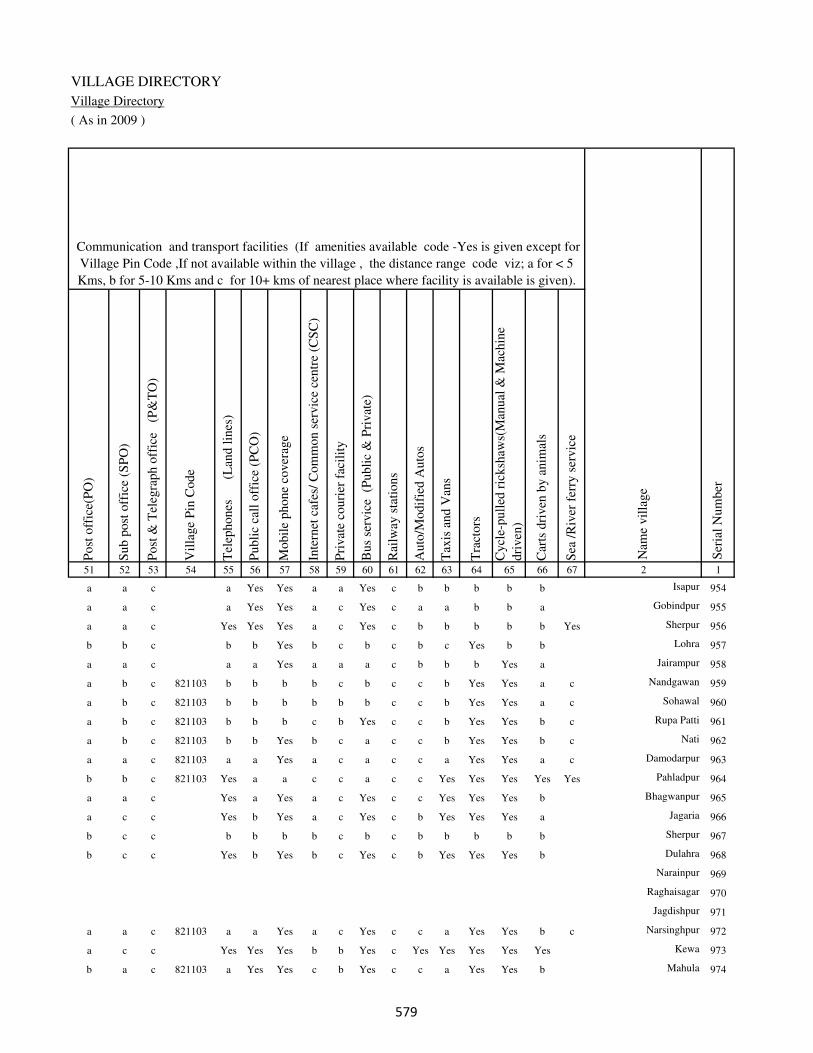
VILLAGE DIRECTORY
Village Directory
( As in 2009 )
Post
off
ice(
PO
)
Sub p
ost
off
ice
(SP
O)
Post
& T
eleg
raph o
ffic
e
(P&
TO
)
Vil
lage
Pin
Code
Tel
ephones
(L
and l
ines
)
Publi
c ca
ll o
ffic
e (P
CO
)
Mobil
e phone
cover
age
Inte
rnet
caf
es/
Com
mon s
ervic
e ce
ntr
e (C
SC
)
Pri
vat
e co
uri
er f
acil
ity
Bus
serv
ice
(P
ubli
c &
Pri
vat
e)
Rai
lway
sta
tions
Auto
/Modif
ied A
uto
s
Tax
is a
nd V
ans
Tra
ctors
Cycl
e-pull
ed r
icksh
aws(
Man
ual
& M
achin
e
dri
ven
)
Car
ts d
riven
by a
nim
als
Sea
/R
iver
fer
ry s
ervic
e51 52 53 54 55 56 57 58 59 60 61 62 63 64 65 66 67 2 1
Communication and transport facilities (If amenities available code -Yes is given except for
Village Pin Code ,If not available within the village , the distance range code viz; a for < 5
Kms, b for 5-10 Kms and c for 10+ kms of nearest place where facility is available is given).
Ser
ial
Num
ber
Nam
e vil
lage
a a c a Yes Yes a a Yes c b b b b b Isapur 954
a a c a Yes Yes a c Yes c a a b b a Gobindpur 955
a a c Yes Yes Yes a c Yes c b b b b b Yes Sherpur 956
b b c b b Yes b c b c b c Yes b b Lohra 957
a a c a a Yes a a a c b b b Yes a Jairampur 958
a b c 821103 b b b b c b c c b Yes Yes a c Nandgawan 959
a b c 821103 b b b b b b c c b Yes Yes a c Sohawal 960
a b c 821103 b b b c b Yes c c b Yes Yes b c Rupa Patti 961
a b c 821103 b b Yes b c a c c b Yes Yes b c Nati 962
a a c 821103 a a Yes a c a c c a Yes Yes a c Damodarpur 963
b b c 821103 Yes a a c c a c c Yes Yes Yes Yes Yes Pahladpur 964
a a c Yes a Yes a c Yes c c Yes Yes Yes b Bhagwanpur 965
a c c Yes b Yes a c Yes c b Yes Yes Yes a Jagaria 966
b c c b b b b c b c b b b b b Sherpur 967
b c c Yes b Yes b c Yes c b Yes Yes Yes b Dulahra 968
Narainpur 969
Raghaisagar 970
Jagdishpur 971
a a c 821103 a a Yes a c Yes c c a Yes Yes b c Narsinghpur 972
a c c Yes Yes Yes b b Yes c Yes Yes Yes Yes Yes Kewa 973
b a c 821103 a Yes Yes c b Yes c c a Yes Yes b Mahula 974
���
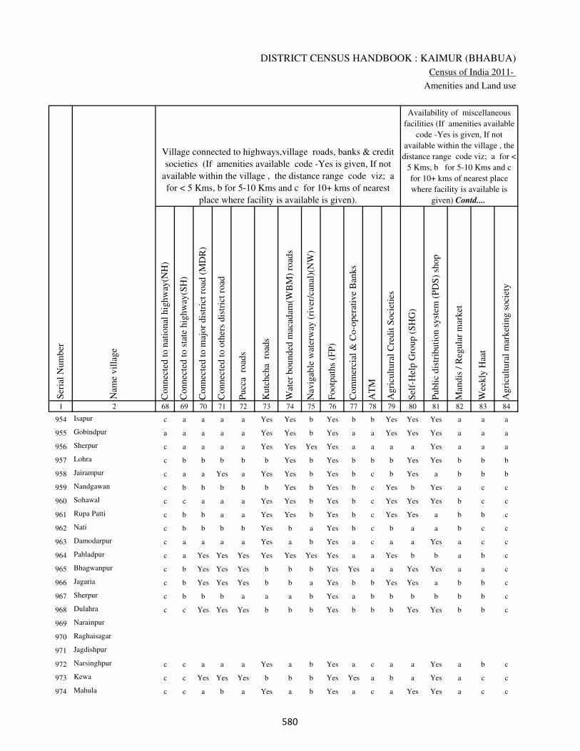
DISTRICT CENSUS HANDBOOK : KAIMUR (BHABUA)
Census of India 2011-
Amenities and Land use
Connec
ted t
o n
atio
nal
hig
hw
ay(N
H)
Connec
ted t
o s
tate
hig
hw
ay(S
H)
Connec
ted t
o m
ajor
dis
tric
t ro
ad (
MD
R)
Connec
ted t
o o
ther
s dis
tric
t ro
ad
Pucc
a r
oad
s
Kutc
hch
a r
oad
s
Wat
er b
ounded
mac
adam
(WB
M)
road
s
Nav
igab
le w
ater
way
(ri
ver
/can
al)(
NW
)
Footp
aths
(FP
)
Com
mer
cial
& C
o-o
per
ativ
e B
anks
AT
M
Agri
cult
ura
l C
redit
Soci
etie
s
Sel
f-H
elp G
roup (
SH
G)
Publi
c dis
trib
uti
on s
yst
em (
PD
S)
shop
Man
dis
/ R
egula
r m
arket
Wee
kly
Haa
t
Agri
cult
ura
l m
arket
ing s
oci
ety
1 2 68 69 70 71 72 73 74 75 76 77 78 79 80 81 82 83 84
Village connected to highways,village roads, banks & credit
societies (If amenities available code -Yes is given, If not
available within the village , the distance range code viz; a
for < 5 Kms, b for 5-10 Kms and c for 10+ kms of nearest
place where facility is available is given).
Ser
ial
Num
ber
Nam
e vil
lage
Availability of miscellaneous
facilities (If amenities available
code -Yes is given, If not
available within the village , the
distance range code viz; a for <
5 Kms, b for 5-10 Kms and c
for 10+ kms of nearest place
where facility is available is
given) Contd....
954 Isapur c a a a a Yes Yes b Yes b b Yes Yes Yes a a a
955 Gobindpur a a a a a Yes Yes b Yes a a Yes Yes Yes a a a
956 Sherpur c a a a a Yes Yes Yes Yes a a a a Yes a a a
957 Lohra c b b b b b Yes b Yes b b b Yes Yes b b b
958 Jairampur c a a Yes a Yes Yes b Yes b c b Yes a b b b
959 Nandgawan c b b b b b Yes b Yes b c Yes b Yes a c c
960 Sohawal c c a a a Yes Yes b Yes b c Yes Yes Yes b c c
961 Rupa Patti c b b a a Yes Yes b Yes b c Yes Yes a b b c
962 Nati c b b b b Yes b a Yes b c b a a b c c
963 Damodarpur c a a a a Yes a b Yes a c a a Yes a c c
964 Pahladpur c a Yes Yes Yes Yes Yes Yes Yes a a Yes b b a b c
965 Bhagwanpur c b Yes Yes Yes b b b Yes Yes a a Yes Yes a a c
966 Jagaria c b Yes Yes Yes b b a Yes b b Yes Yes a b b c
967 Sherpur c b b b a a a b Yes a b b b b b b c
968 Dulahra c c Yes Yes Yes b b b Yes b b b Yes Yes b b c
969 Narainpur
970 Raghaisagar
971 Jagdishpur
972 Narsinghpur c c a a a Yes a b Yes a c a a Yes a b c
973 Kewa c c Yes Yes Yes b b b Yes Yes a b a Yes a c c
974 Mahula c c a b a Yes a b Yes a c a Yes Yes a c c
���
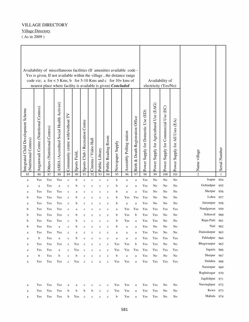
VILLAGE DIRECTORY
Village Directory
( As in 2009 )
Inte
gra
ted C
hil
d D
evel
opm
ent
Sch
eme
(Nutr
itio
nal
Cen
tres
)
Angan
wad
i C
entr
e (N
utr
itio
nal
Cen
tres
)
Oth
ers
(Nutr
itio
nal
Cen
tres
)
AS
HA
(A
ccre
dit
ed S
oci
al H
ealt
h A
ctiv
ist)
Com
munit
y c
entr
e w
ith/w
ithout
TV
Sport
s F
ield
,
Sport
s C
lub /
Rec
reat
ion C
entr
e
Cin
ema
/ V
ideo
Hal
l
Publi
c L
ibra
ry
Publi
c R
eadin
g R
oom
New
spap
er S
upply
Ass
embly
Poll
ing s
tati
on
Bir
th &
Dea
th R
egis
trat
ion O
ffic
e
Pow
er S
upply
for
Dom
esti
c U
se (
ED
)
Pow
er S
upply
for
Agri
cult
ura
l U
se (
EA
G)
Pow
er S
upply
for
Com
mer
cial
Use
(E
C)
Pow
er S
upply
for
All
Use
s (E
A)
85 86 87 88 89 90 91 92 93 94 95 96 97 98 99 100 101 2 1
Availability of
electricity (Yes/No)
Availability of miscellaneous facilities (If amenities available code -
Yes is given, If not available within the village , the distance range
code viz; a for < 5 Kms, b for 5-10 Kms and c for 10+ kms of
nearest place where facility is available is given) Concluded
Nam
e vil
lage
Ser
ial
Num
ber
a Yes Yes Yes c b c c c c b a a Yes No No No Isapur 954
a a Yes a c b c c c c b a a Yes No No No Gobindpur 955
a Yes Yes Yes c a c c c c b a a Yes No No No Sherpur 956
b Yes Yes Yes c b c c c c b Yes Yes Yes No No No Lohra 957
a Yes Yes Yes c b c c c c b a a Yes No No No Jairampur 958
b Yes Yes Yes c a c c c c a Yes Yes Yes Yes Yes Yes Nandgawan 959
b Yes Yes Yes c b c c c c b Yes b Yes Yes No No Sohawal 960
b Yes Yes Yes c b c c c c b Yes a Yes Yes No No Rupa Patti 961
b Yes Yes a c b c c c c b a a Yes No No No Nati 962
a Yes Yes Yes c a c c c c a a a Yes Yes No No Damodarpur 963
a b Yes a c b c c c c a a a Yes Yes Yes Yes Pahladpur 964
a Yes Yes Yes c Yes c c c c Yes Yes b Yes Yes No No Bhagwanpur 965
a Yes Yes a c Yes c c c c Yes Yes Yes Yes Yes Yes Yes Jagaria 966
a b Yes b c b c c c c b a a Yes No No No Sherpur 967
a Yes Yes Yes c Yes c c a c Yes Yes a Yes Yes Yes Yes Dulahra 968
Narainpur 969
Raghaisagar 970
Jagdishpur 971
a Yes Yes Yes a a c c c c Yes Yes a Yes Yes No No Narsinghpur 972
a Yes Yes Yes b b b b c c Yes Yes a Yes Yes No No Kewa 973
a Yes Yes Yes b Yes c c c c b Yes a Yes Yes No No Mahula 974
���

DISTRICT CENSUS HANDBOOK : KAIMUR (BHABUA)
Census of India 2011-
Amenities and Land use
Nam
e
Dis
tance
ran
ge
code
i.e
. a
fo
r <
5 K
ms,
b
for
5-
10 K
ms
and c
f
or
10+
km
s .
Fore
sts
Are
a under
Non-a
gri
cult
ura
l U
ses
Bar
ren a
nd U
n-c
ult
ivab
le l
and
Per
man
ent
Pas
ture
s an
d O
ther
Gra
zing L
ands
Lan
d U
nder
Mis
cell
aneo
us
Tre
e C
rops
etc.
Cult
ura
ble
Was
te L
and
Fal
low
lan
ds
oth
er t
han
curr
ent
fall
ow
s
Curr
ent
Fal
low
s
1 2 102 103 104 105 106 107 108 109 110 111
Ser
ial
Num
ber
Nam
e vil
lage
Area under different types of land use ( in hectares rounded up to
one decimal place)
Land Use
Nearest Town
954 Isapur BHABUA c 0 2.4 0 0 0 0 3 2
955 Gobindpur BHABUA c 0 1 0 0 0 0 0 0
956 Sherpur BHABUA c 0 10.2 0 0 10 0 0 0
957 Lohra BHABUA c 0 11.6 0 0 0 10 0 0
958 Jairampur BHABUA c 0 1.9 0 0 0 0 1 1
959 Nandgawan BHABUA c 0 5.4 0 0 0 0 2 0
960 Sohawal BHABUA c 0 1.8 0 0 0 0 1 1
961 Rupa Patti BHABUA c 0 4.9 0 0 0 0 0 0
962 Nati BHABUA c 0 2.5 0 0 0 0 1 1
963 Damodarpur BHABUA c 0 2.6 0 0 0 0 2 2
964 Pahladpur BHABUA c 1 3 0 2.4 0 0 0 0
965 Bhagwanpur BHABUA c 0 2 0 0 0 0 4.9 0
966 Jagaria BHABUA c 0 2.8 0 0 0 0 1 0
967 Sherpur BHABUA c 0 2.9 0 0 0 0 1 0
968 Dulahra BHABUA c 0 7 0 0 0 0 2 0
969 Narainpur 0 0.8 0 0 0 0 1 0
970 Raghaisagar 0 1 0 0 0.7 0 2 0
971 Jagdishpur 0 0.3 0 0 0 0 2 1
972 Narsinghpur BHABUA c 0 5.4 0 0 0 0 2 1
973 Kewa BHABUA c 0 4.8 0 0 0 0 2 0
974 Mahula BHABUA c 0 10 8 0 0 10 10 10
��

VILLAGE DIRECTORY
Village Directory
( As in 2009 )
Net
Are
a S
ow
n
Tota
l Ir
rigat
ed L
and A
rea
Tota
l U
n-i
rrig
ated
Lan
d A
rea
Can
als
( C
)
Wel
ls/T
ube-
wel
ls(W
/TW
)
Tan
ks/
Lak
es(T
/L)
Wat
er F
alls
(WF
)
Oth
ers(
O)
Fir
st
Sec
ond
Thir
d
112 113 114 115 116 117 118 119 120 121 122 2 1
Ser
ial
Num
ber
Name of three
most important
commodities
manufacturedArea irrigated by source (in hectare).
Nam
e of
Vil
lage
Area under different types of
land use ( in hectares rounded
up to one decimal place)
Land Use
144 140 4 136 4 0 0 0 Isapur 954
20 18 2 0 16 2 0 0 Gobindpur 955
240 202 38 140 42 20 0 0 Sherpur 956
190 190 0 100 60 30 0 0 Lohra 957
143 128 15 120 8 0 0 0 Jairampur 958
127 127 0 40 60 27 0 0 Nandgawan 959
65 65 0 65 0 0 0 0 Sohawal 960
138 126 12 120 6 0 0 0 Rupa Patti 961
42 42 0 35 7 0 0 0 Nati 962
93 80 13 50 30 0 0 0 Damodarpur 963
96.6 76 20.6 30 46 0 0 0 Pahladpur 964
68 60 8 0 58 2 0 0 Bhagwanpur 965
96 86 10 0 80 6 0 0 Jagaria 966
92 81 11 0 60 21 0 0 Sherpur 967
108 88 20 0 80 8 0 0 Dulahra 968
31 27 4 0 25 2 0 0 Narainpur 969
38 30 8 0 26 4 0 0 Raghaisagar 970
40 39 1 0 37 2 0 0 Jagdishpur 971
134 124 10 24 100 0 0 0 Narsinghpur 972
151 138 13 50 88 0 0 0 Kewa 973
152.3 147 5.3 0 140 7 0 0 Mahula 974
��

DISTRICT CENSUS HANDBOOK : KAIMUR (BHABUA)
Census of India 2011-
Amenities and Land use
Pre
-Pri
mar
y s
chool
(PP
)
Pri
mar
y s
chool
(P)
Mid
dle
sch
ool
(M)
Sec
ondar
y S
chool
(S)
Sen
ior
Sec
ondar
y s
chool
(SS
)
Deg
ree
coll
ege
of
arts
sc
ience
& c
om
mer
ce
(AS
C)
Engin
eeri
ng c
oll
ege(
EC
)
Med
ical
coll
ege
(MC
)
Man
agem
ent
inst
itute
(M
I)
Poly
tech
nic
(P
t)
Voca
tional
tra
inin
g s
chool
/IT
I
Non-f
orm
al t
rain
ing c
entr
e (N
FT
C)
Spec
ial
school
for
dis
able
d (
SS
D)
Oth
ers
(spec
ify)
1 2 3 4 5 6 7 8 9 10 11 12 13 14 15 16 17 18 19 20
Loca
tion c
ode
no.
Nam
e vil
lage
Ser
ial
Num
ber
Tota
l popula
tion (
2011 c
ensu
s )
Tota
l ar
ea o
f th
e vil
lage
( in
hec
tare
s ro
unded
up t
o
one
dec
imal
pla
ce)
Number of educational amenities available. (If not available
within the village , the distance range code viz; a for < 5
Kms, b for 5-10 Kms and c for 10+ kms of nearest place
where facility is available is given).
Num
ber
of
house
hold
s (2
011 c
ensu
s)
975 Bukna Mahula 249899 26.7 0 0
976 Baurai 249900 163.9 1545 294 b 1 1 c b c c c c c c c c
977 Gangudih 249901 81.8 643 118 c 1 a c c c c c c c c c c
978 Saraiya 249902 47.8 409 77 b 1 b c b c c c c c c c c
979 Khoradih 249903 153.4 638 106 b 1 a c b c c c c c c c c
980 Nimiatanr 249904 67.2 970 160 c 1 a c c c c c c c c c c
981 Basra 249905 56.7 0 0
982 Babhan Parsia 249906 62.3 0 0
983 Parsia 249907 90.6 963 158 a 1 a c a b c c c c b c c
984 Danrwa 249908 34.8 0 0
985 Israrhi 249909 53.4 430 91 b 1 a c b b c c c c b c c
986 Basawanpur 249910 52.2 483 81 a 1 a c a b c c c c b c c
987 Chanda 249911 118.9 469 78 b 2 a c b b c c c c b c c
988 Sihora 249912 74.1 140 20 b a a c b b c c c c b c c
989 Birna 249913 75.7 424 59 b 1 a c b b c c c c b c c
990 Karaundia 249914 150.1 880 144 b 1 a c b b c c c c b c c
991 Majhganwan 249915 9778 435 72 c b b c c c c c c c c c c
992 Bhaluburan 249916 1839.7 520 62 c b 1 c c c c c c c c c c
993 Karkatgarh 249917 1690.4 294 44 c b b c c c c c c c c c c
994 Gosara 249918 875 196 26 c b b c c c c c c c c c c
995 Kamharia 249919 1465.4 284 40 1 1 b c c c c c c c c c c
���
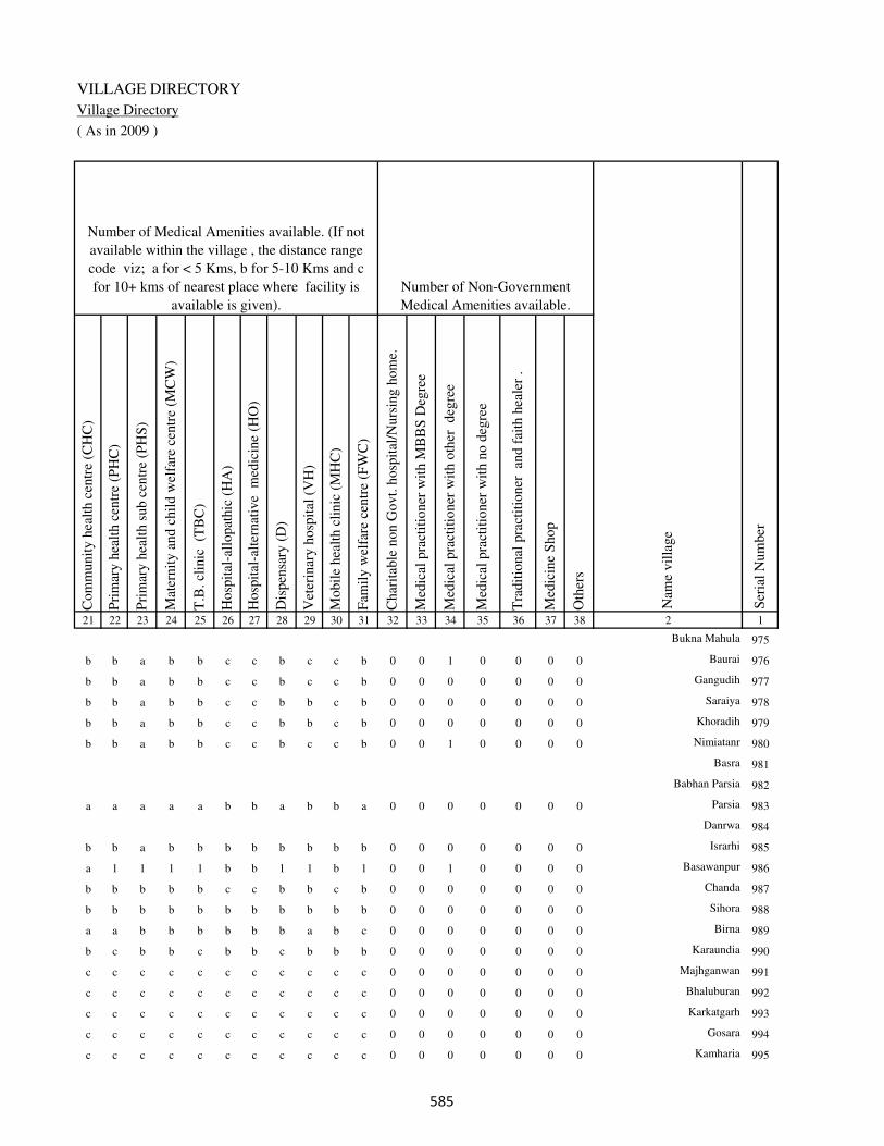
VILLAGE DIRECTORY
Village Directory
( As in 2009 )
Com
munit
y h
ealt
h c
entr
e (C
HC
)
Pri
mar
y h
ealt
h c
entr
e (P
HC
)
Pri
mar
y h
ealt
h s
ub c
entr
e (P
HS
)
Mat
ernit
y a
nd c
hil
d w
elfa
re c
entr
e (M
CW
)
T.B
. cl
inic
(T
BC
)
Hosp
ital
-all
opat
hic
(H
A)
Hosp
ital
-alt
ernat
ive
med
icin
e (H
O)
Dis
pen
sary
(D
)
Vet
erin
ary h
osp
ital
(V
H)
Mobil
e hea
lth c
linic
(M
HC
)
Fam
ily w
elfa
re c
entr
e (F
WC
)
Char
itab
le n
on G
ovt.
hosp
ital
/Nurs
ing h
om
e.
Med
ical
pra
ctit
ioner
wit
h M
BB
S D
egre
e
Med
ical
pra
ctit
ioner
wit
h o
ther
deg
ree
Med
ical
pra
ctit
ioner
wit
h n
o d
egre
e
Tra
dit
ional
pra
ctit
ioner
an
d f
aith
hea
ler
.
Med
icin
e S
hop
Oth
ers
21 22 23 24 25 26 27 28 29 30 31 32 33 34 35 36 37 38 2 1
Number of Non-Government
Medical Amenities available.
Number of Medical Amenities available. (If not
available within the village , the distance range
code viz; a for < 5 Kms, b for 5-10 Kms and c
for 10+ kms of nearest place where facility is
available is given).
Nam
e vil
lage
Ser
ial
Num
ber
Bukna Mahula 975
b b a b b c c b c c b 0 0 1 0 0 0 0 Baurai 976
b b a b b c c b c c b 0 0 0 0 0 0 0 Gangudih 977
b b a b b c c b b c b 0 0 0 0 0 0 0 Saraiya 978
b b a b b c c b b c b 0 0 0 0 0 0 0 Khoradih 979
b b a b b c c b c c b 0 0 1 0 0 0 0 Nimiatanr 980
Basra 981
Babhan Parsia 982
a a a a a b b a b b a 0 0 0 0 0 0 0 Parsia 983
Danrwa 984
b b a b b b b b b b b 0 0 0 0 0 0 0 Israrhi 985
a 1 1 1 1 b b 1 1 b 1 0 0 1 0 0 0 0 Basawanpur 986
b b b b b c c b b c b 0 0 0 0 0 0 0 Chanda 987
b b b b b b b b b b b 0 0 0 0 0 0 0 Sihora 988
a a b b b b b b a b c 0 0 0 0 0 0 0 Birna 989
b c b b c b b c b b b 0 0 0 0 0 0 0 Karaundia 990
c c c c c c c c c c c 0 0 0 0 0 0 0 Majhganwan 991
c c c c c c c c c c c 0 0 0 0 0 0 0 Bhaluburan 992
c c c c c c c c c c c 0 0 0 0 0 0 0 Karkatgarh 993
c c c c c c c c c c c 0 0 0 0 0 0 0 Gosara 994
c c c c c c c c c c c 0 0 0 0 0 0 0 Kamharia 995
���

DISTRICT CENSUS HANDBOOK : KAIMUR (BHABUA)
Census of India 2011-
Amenities and Land use
Tap
wat
er (
Tre
ated
/Untr
eate
d)
Wel
l w
ater
(Cover
ed /
Unco
ver
ed w
ell)
Han
d P
um
p
Tube
wel
ls /
Bore
wel
l
Spri
ng
Riv
er /
Can
al
Tan
k /
Pond /
L
ake
Oth
ers
Com
munit
y t
oil
et i
ncl
udin
g
bat
h.
Com
munit
y t
oil
et e
xcl
udin
g b
ath.
Rura
l s
anit
ary m
art
or
sanit
ary
har
dw
are
outl
et
avai
lable
nea
r th
e vil
lage.
Com
munit
y b
io-
gas
or
recy
cle
of
was
te f
or
pro
duct
ive
use
.
1 2 39 40 41 42 43 44 45 46 47 48 49 50
Availability of toilet & others
Yes / No Availability of drinking water - Yes / No
Nam
e vil
lage
Ser
ial
Num
ber
975 Bukna Mahula
976 Baurai No Yes Yes No No Yes No No No No No No
977 Gangudih No Yes Yes No No Yes No No No No No No
978 Saraiya No Yes Yes No No Yes No No No No No No
979 Khoradih No Yes Yes Yes No Yes No No No No No No
980 Nimiatanr No Yes Yes No No Yes No No No No No No
981 Basra
982 Babhan Parsia
983 Parsia No Yes Yes Yes No No No No No No No No
984 Danrwa
985 Israrhi No Yes Yes Yes No No No No No No No No
986 Basawanpur No Yes Yes Yes No No No No No No No No
987 Chanda No No Yes Yes No No No No No No No No
988 Sihora No No Yes Yes No No Yes No No No No No
989 Birna No No Yes Yes No Yes No No No No No No
990 Karaundia No No Yes Yes No No No No No No Yes No
991 Majhganwan No Yes Yes No Yes No No No No No No No
992 Bhaluburan No Yes Yes No Yes No No No No No No No
993 Karkatgarh No Yes Yes No No No No No No No No No
994 Gosara No Yes Yes No Yes No No No No No No No
995 Kamharia No No Yes No Yes No No No No No No No
���
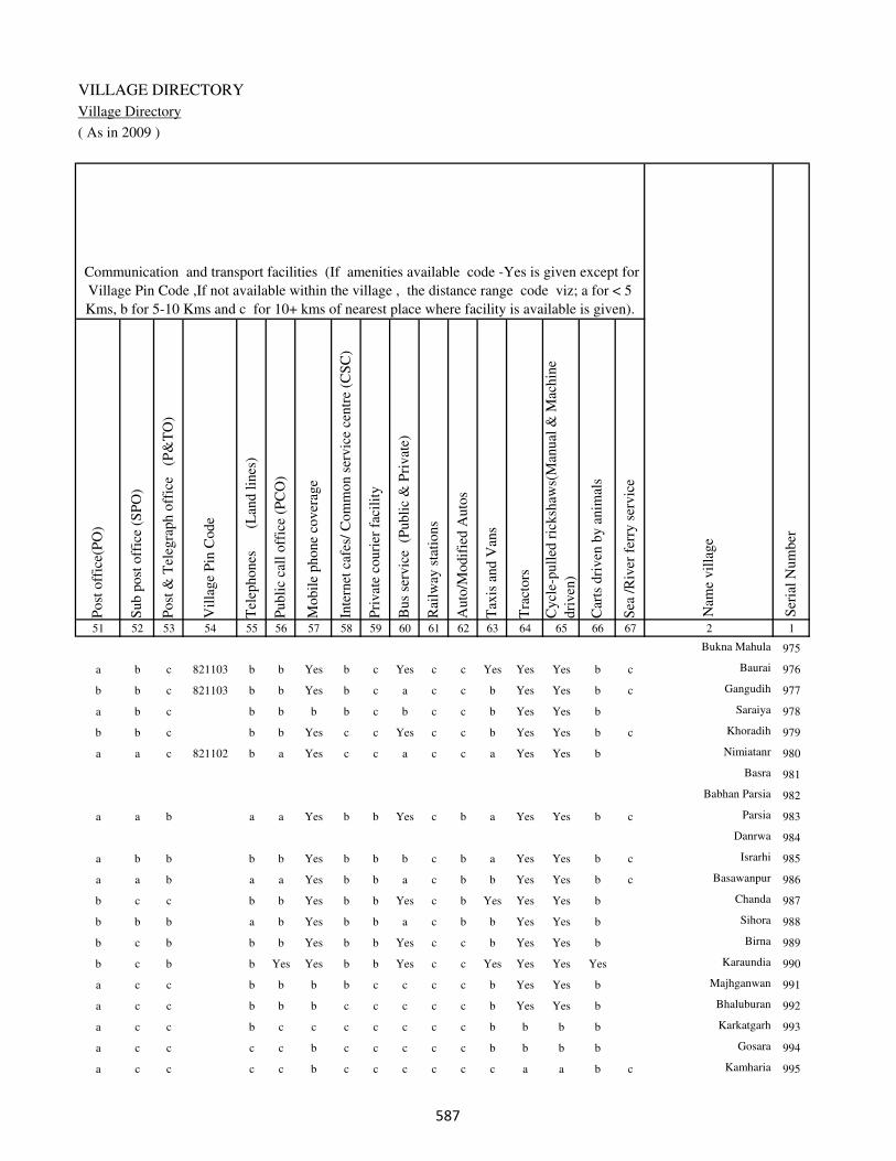
VILLAGE DIRECTORY
Village Directory
( As in 2009 )
Post
off
ice(
PO
)
Sub p
ost
off
ice
(SP
O)
Post
& T
eleg
raph o
ffic
e
(P&
TO
)
Vil
lage
Pin
Code
Tel
ephones
(L
and l
ines
)
Publi
c ca
ll o
ffic
e (P
CO
)
Mobil
e phone
cover
age
Inte
rnet
caf
es/
Com
mon s
ervic
e ce
ntr
e (C
SC
)
Pri
vat
e co
uri
er f
acil
ity
Bus
serv
ice
(P
ubli
c &
Pri
vat
e)
Rai
lway
sta
tions
Auto
/Modif
ied A
uto
s
Tax
is a
nd V
ans
Tra
ctors
Cycl
e-pull
ed r
icksh
aws(
Man
ual
& M
achin
e
dri
ven
)
Car
ts d
riven
by a
nim
als
Sea
/R
iver
fer
ry s
ervic
e51 52 53 54 55 56 57 58 59 60 61 62 63 64 65 66 67 2 1
Communication and transport facilities (If amenities available code -Yes is given except for
Village Pin Code ,If not available within the village , the distance range code viz; a for < 5
Kms, b for 5-10 Kms and c for 10+ kms of nearest place where facility is available is given).
Ser
ial
Num
ber
Nam
e vil
lage
Bukna Mahula 975
a b c 821103 b b Yes b c Yes c c Yes Yes Yes b c Baurai 976
b b c 821103 b b Yes b c a c c b Yes Yes b c Gangudih 977
a b c b b b b c b c c b Yes Yes b Saraiya 978
b b c b b Yes c c Yes c c b Yes Yes b c Khoradih 979
a a c 821102 b a Yes c c a c c a Yes Yes b Nimiatanr 980
Basra 981
Babhan Parsia 982
a a b a a Yes b b Yes c b a Yes Yes b c Parsia 983
Danrwa 984
a b b b b Yes b b b c b a Yes Yes b c Israrhi 985
a a b a a Yes b b a c b b Yes Yes b c Basawanpur 986
b c c b b Yes b b Yes c b Yes Yes Yes b Chanda 987
b b b a b Yes b b a c b b Yes Yes b Sihora 988
b c b b b Yes b b Yes c c b Yes Yes b Birna 989
b c b b Yes Yes b b Yes c c Yes Yes Yes Yes Karaundia 990
a c c b b b b c c c c b Yes Yes b Majhganwan 991
a c c b b b c c c c c b Yes Yes b Bhaluburan 992
a c c b c c c c c c c b b b b Karkatgarh 993
a c c c c b c c c c c b b b b Gosara 994
a c c c c b c c c c c c a a b c Kamharia 995
���

DISTRICT CENSUS HANDBOOK : KAIMUR (BHABUA)
Census of India 2011-
Amenities and Land use
Connec
ted t
o n
atio
nal
hig
hw
ay(N
H)
Connec
ted t
o s
tate
hig
hw
ay(S
H)
Connec
ted t
o m
ajor
dis
tric
t ro
ad (
MD
R)
Connec
ted t
o o
ther
s dis
tric
t ro
ad
Pucc
a r
oad
s
Kutc
hch
a r
oad
s
Wat
er b
ounded
mac
adam
(WB
M)
road
s
Nav
igab
le w
ater
way
(ri
ver
/can
al)(
NW
)
Footp
aths
(FP
)
Com
mer
cial
& C
o-o
per
ativ
e B
anks
AT
M
Agri
cult
ura
l C
redit
Soci
etie
s
Sel
f-H
elp G
roup (
SH
G)
Publi
c dis
trib
uti
on s
yst
em (
PD
S)
shop
Man
dis
/ R
egula
r m
arket
Wee
kly
Haa
t
Agri
cult
ura
l m
arket
ing s
oci
ety
1 2 68 69 70 71 72 73 74 75 76 77 78 79 80 81 82 83 84
Village connected to highways,village roads, banks & credit
societies (If amenities available code -Yes is given, If not
available within the village , the distance range code viz; a
for < 5 Kms, b for 5-10 Kms and c for 10+ kms of nearest
place where facility is available is given).
Ser
ial
Num
ber
Nam
e vil
lage
Availability of miscellaneous
facilities (If amenities available
code -Yes is given, If not
available within the village , the
distance range code viz; a for <
5 Kms, b for 5-10 Kms and c
for 10+ kms of nearest place
where facility is available is
given) Contd....
975 Bukna Mahula
976 Baurai c b b Yes a Yes Yes b Yes b c Yes Yes Yes b b c
977 Gangudih c b b Yes b Yes a b Yes b c b Yes a b b c
978 Saraiya c c b Yes b Yes a b Yes b c b a a b b c
979 Khoradih c c a a a Yes Yes b Yes b c b a a b c c
980 Nimiatanr c b b a a Yes a b Yes b c b b a b c c
981 Basra
982 Babhan Parsia
983 Parsia c b a a a Yes Yes c Yes a b a Yes a a b c
984 Danrwa
985 Israrhi c c a Yes a Yes a c Yes b b b b a b b c
986 Basawanpur c b a c a Yes a c Yes a b a a a b c Yes
987 Chanda c c Yes Yes Yes b b c Yes a b b Yes Yes b b b
988 Sihora c c a a a Yes a c Yes a b b b a b b b
989 Birna c c Yes Yes a b Yes c Yes a b b Yes a b b b
990 Karaundia c c Yes Yes b b Yes c Yes a b c Yes a b b c
991 Majhganwan c c b b b b b b Yes a b c a a b c c
992 Bhaluburan c c b c b b b b Yes a b b a b c c c
993 Karkatgarh c c c b b b b b Yes b b c a b c b c
994 Gosara c c c b b b b c Yes a b c b b c c c
995 Kamharia c c c b c b Yes b Yes b b c Yes a c b c
���

VILLAGE DIRECTORY
Village Directory
( As in 2009 )
Inte
gra
ted C
hil
d D
evel
opm
ent
Sch
eme
(Nutr
itio
nal
Cen
tres
)
Angan
wad
i C
entr
e (N
utr
itio
nal
Cen
tres
)
Oth
ers
(Nutr
itio
nal
Cen
tres
)
AS
HA
(A
ccre
dit
ed S
oci
al H
ealt
h A
ctiv
ist)
Com
munit
y c
entr
e w
ith/w
ithout
TV
Sport
s F
ield
,
Sport
s C
lub /
Rec
reat
ion C
entr
e
Cin
ema
/ V
ideo
Hal
l
Publi
c L
ibra
ry
Publi
c R
eadin
g R
oom
New
spap
er S
upply
Ass
embly
Poll
ing s
tati
on
Bir
th &
Dea
th R
egis
trat
ion O
ffic
e
Pow
er S
upply
for
Dom
esti
c U
se (
ED
)
Pow
er S
upply
for
Agri
cult
ura
l U
se (
EA
G)
Pow
er S
upply
for
Com
mer
cial
Use
(E
C)
Pow
er S
upply
for
All
Use
s (E
A)
85 86 87 88 89 90 91 92 93 94 95 96 97 98 99 100 101 2 1
Availability of
electricity (Yes/No)
Availability of miscellaneous facilities (If amenities available code -
Yes is given, If not available within the village , the distance range
code viz; a for < 5 Kms, b for 5-10 Kms and c for 10+ kms of
nearest place where facility is available is given) Concluded
Nam
e vil
lage
Ser
ial
Num
ber
Bukna Mahula 975
b Yes Yes Yes b Yes c c c c b Yes a Yes Yes No No Baurai 976
b Yes Yes a a b c c c c a a a Yes No No No Gangudih 977
b a a b a b c c c c b a a No No No No Saraiya 978
b a Yes a a b c c c c b a a Yes Yes Yes Yes Khoradih 979
b Yes Yes Yes a a c c c c a Yes a Yes No No No Nimiatanr 980
Basra 981
Babhan Parsia 982
a Yes Yes Yes a a b b b b a a a Yes Yes Yes Yes Parsia 983
Danrwa 984
b a Yes a b b b b b b b a a Yes No No No Israrhi 985
a a Yes a b b c b b c b a a Yes No No No Basawanpur 986
a b Yes Yes b Yes b b b c Yes Yes b Yes Yes No No Chanda 987
b a Yes Yes b Yes b b b b b a b Yes No No No Sihora 988
a b Yes Yes b Yes b b b b Yes Yes b Yes Yes No No Birna 989
a b Yes a b a b b c c Yes Yes b Yes Yes No No Karaundia 990
c b Yes b c a c c c c b a a No No No No Majhganwan 991
c b Yes a c b c c c c b a a No No No No Bhaluburan 992
c b Yes a c b c c c c b a a No No No No Karkatgarh 993
c b Yes a c b c c c c b a a No No No No Gosara 994
c a Yes Yes b b c c c c c a a No No No No Kamharia 995
���

DISTRICT CENSUS HANDBOOK : KAIMUR (BHABUA)
Census of India 2011-
Amenities and Land use
Nam
e
Dis
tance
ran
ge
code
i.e
. a
fo
r <
5 K
ms,
b
for
5-
10 K
ms
and c
f
or
10+
km
s .
Fore
sts
Are
a under
Non-a
gri
cult
ura
l U
ses
Bar
ren a
nd U
n-c
ult
ivab
le l
and
Per
man
ent
Pas
ture
s an
d O
ther
Gra
zing L
ands
Lan
d U
nder
Mis
cell
aneo
us
Tre
e C
rops
etc.
Cult
ura
ble
Was
te L
and
Fal
low
lan
ds
oth
er t
han
curr
ent
fall
ow
s
Curr
ent
Fal
low
s
1 2 102 103 104 105 106 107 108 109 110 111
Ser
ial
Num
ber
Nam
e vil
lage
Area under different types of land use ( in hectares rounded up to
one decimal place)
Land Use
Nearest Town
975 Bukna Mahula 0 0 0 0 0 0 0 0
976 Baurai BHABUA c 0 4.9 0 0 0 0 2 2
977 Gangudih BHABUA c 0 1.8 2 0 0 2 2 2
978 Saraiya BHABUA c 7.8 2 0 0 2 0 3 0
979 Khoradih BHABUA c 0 8.4 0 0 0 0 2 3
980 Nimiatanr BHABUA c 0 2.2 0 0 1 1 2 2
981 Basra 0 0.7 0 0 0 0 2 1
982 Babhan Parsia 0 2 0 0 0.3 0 0 0
983 Parsia BHABUA b 0 10.6 0 0 0 20 0 0
984 Danrwa 0 0.8 0 0 0 0 1 0
985 Israrhi BHABUA b 0 1.4 0 0 0 0 1 1
986 Basawanpur BHABUA b 0 1.2 0 0 0 0 1 1
987 Chanda BHABUA c 0 3.9 0 0 0 0 2 1
988 Sihora BHABUA b 0 2.1 0 0 0 0 1 1
989 Birna BHABUA b 0 2.7 0 0 0 0 1 0
990 Karaundia BHABUA b 0 4 0 0 0 0 1.1 1
991 Majhganwan BHABUA c 4061 350 300 950 3310 500 0 0
992 Bhaluburan BHABUA c 680.7 132 0 115 260 150 0 0
993 Karkatgarh BHABUA c 690.4 24 100 250 310 96 0 0
994 Gosara BHABUA c 0 175 0 0 0 0 0 0
995 Kamharia BHABUA c 607 89.4 80 0 320 282 0 0
���
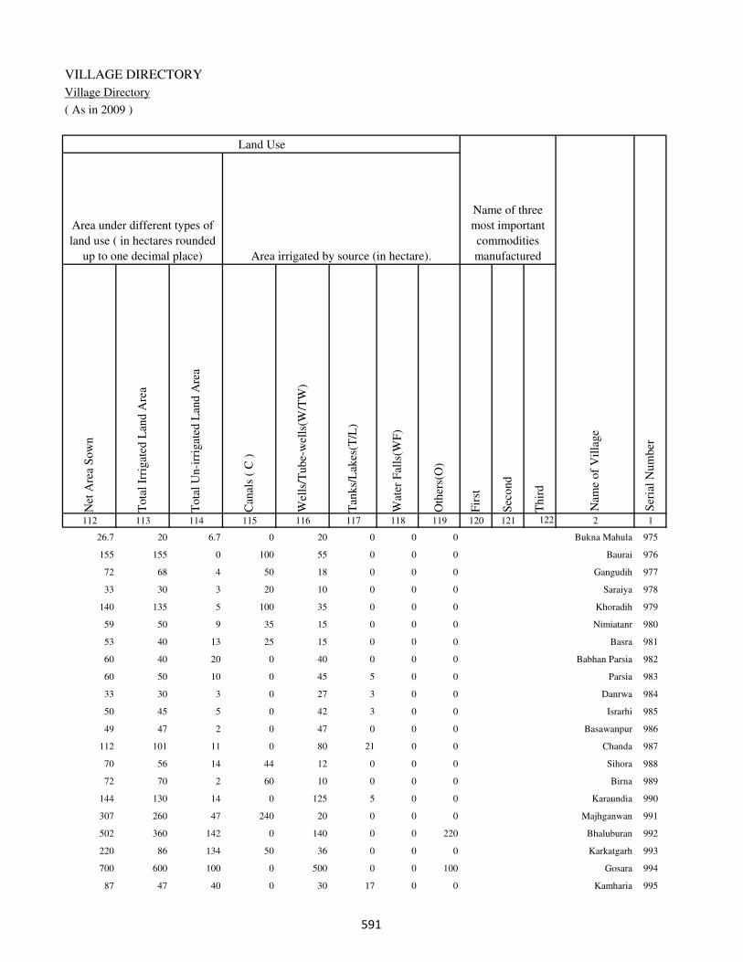
VILLAGE DIRECTORY
Village Directory
( As in 2009 )
Net
Are
a S
ow
n
Tota
l Ir
rigat
ed L
and A
rea
Tota
l U
n-i
rrig
ated
Lan
d A
rea
Can
als
( C
)
Wel
ls/T
ube-
wel
ls(W
/TW
)
Tan
ks/
Lak
es(T
/L)
Wat
er F
alls
(WF
)
Oth
ers(
O)
Fir
st
Sec
ond
Thir
d
112 113 114 115 116 117 118 119 120 121 122 2 1
Ser
ial
Num
ber
Name of three
most important
commodities
manufacturedArea irrigated by source (in hectare).
Nam
e of
Vil
lage
Area under different types of
land use ( in hectares rounded
up to one decimal place)
Land Use
26.7 20 6.7 0 20 0 0 0 Bukna Mahula 975
155 155 0 100 55 0 0 0 Baurai 976
72 68 4 50 18 0 0 0 Gangudih 977
33 30 3 20 10 0 0 0 Saraiya 978
140 135 5 100 35 0 0 0 Khoradih 979
59 50 9 35 15 0 0 0 Nimiatanr 980
53 40 13 25 15 0 0 0 Basra 981
60 40 20 0 40 0 0 0 Babhan Parsia 982
60 50 10 0 45 5 0 0 Parsia 983
33 30 3 0 27 3 0 0 Danrwa 984
50 45 5 0 42 3 0 0 Israrhi 985
49 47 2 0 47 0 0 0 Basawanpur 986
112 101 11 0 80 21 0 0 Chanda 987
70 56 14 44 12 0 0 0 Sihora 988
72 70 2 60 10 0 0 0 Birna 989
144 130 14 0 125 5 0 0 Karaundia 990
307 260 47 240 20 0 0 0 Majhganwan 991
502 360 142 0 140 0 0 220 Bhaluburan 992
220 86 134 50 36 0 0 0 Karkatgarh 993
700 600 100 0 500 0 0 100 Gosara 994
87 47 40 0 30 17 0 0 Kamharia 995
���
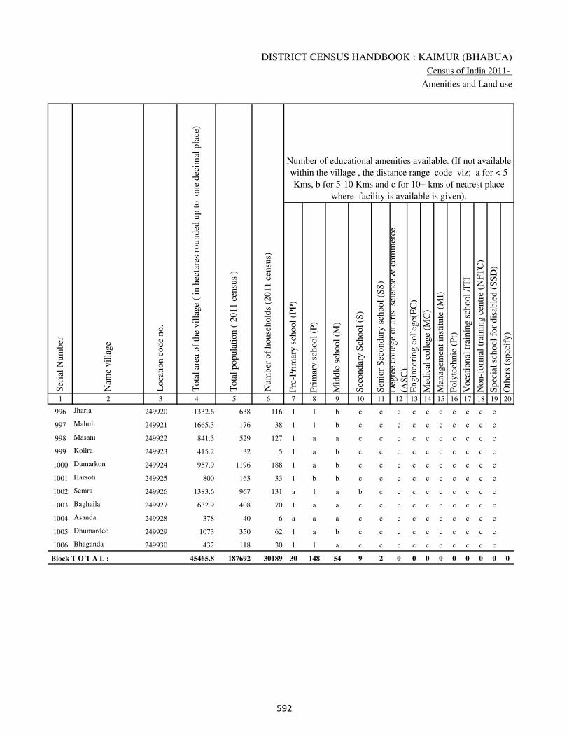
DISTRICT CENSUS HANDBOOK : KAIMUR (BHABUA)
Census of India 2011-
Amenities and Land use
Pre
-Pri
mar
y s
chool
(PP
)
Pri
mar
y s
chool
(P)
Mid
dle
sch
ool
(M)
Sec
ondar
y S
chool
(S)
Sen
ior
Sec
ondar
y s
chool
(SS
)
Deg
ree
coll
ege
of
arts
sc
ience
& c
om
mer
ce
(AS
C)
Engin
eeri
ng c
oll
ege(
EC
)
Med
ical
coll
ege
(MC
)
Man
agem
ent
inst
itute
(M
I)
Poly
tech
nic
(P
t)
Voca
tional
tra
inin
g s
chool
/IT
I
Non-f
orm
al t
rain
ing c
entr
e (N
FT
C)
Spec
ial
school
for
dis
able
d (
SS
D)
Oth
ers
(spec
ify)
1 2 3 4 5 6 7 8 9 10 11 12 13 14 15 16 17 18 19 20
Loca
tion c
ode
no.
Nam
e vil
lage
Ser
ial
Num
ber
Tota
l popula
tion (
2011 c
ensu
s )
Tota
l ar
ea o
f th
e vil
lage
( in
hec
tare
s ro
unded
up t
o
one
dec
imal
pla
ce)
Number of educational amenities available. (If not available
within the village , the distance range code viz; a for < 5
Kms, b for 5-10 Kms and c for 10+ kms of nearest place
where facility is available is given).
Num
ber
of
house
hold
s (2
011 c
ensu
s)
996 Jharia 249920 1332.6 638 116 1 1 b c c c c c c c c c c
997 Mahuli 249921 1665.3 176 38 1 1 b c c c c c c c c c c
998 Masani 249922 841.3 529 127 1 a a c c c c c c c c c c
999 Koilra 249923 415.2 32 5 1 a b c c c c c c c c c c
1000 Dumarkon 249924 957.9 1196 188 1 a b c c c c c c c c c c
1001 Harsoti 249925 800 163 33 1 b b c c c c c c c c c c
1002 Semra 249926 1383.6 967 131 a 1 a b c c c c c c c c c
1003 Baghaila 249927 632.9 408 70 1 a a c c c c c c c c c c
1004 Asanda 249928 378 40 6 a a a c c c c c c c c c c
1005 Dhumardeo 249929 1073 350 62 1 a b c c c c c c c c c c
1006 Bhaganda 249930 432 118 30 1 1 a c c c c c c c c c c
Block T O T A L : 45465.8 187692 30189 30 148 54 9 2 0 0 0 0 0 0 0 0 0
��
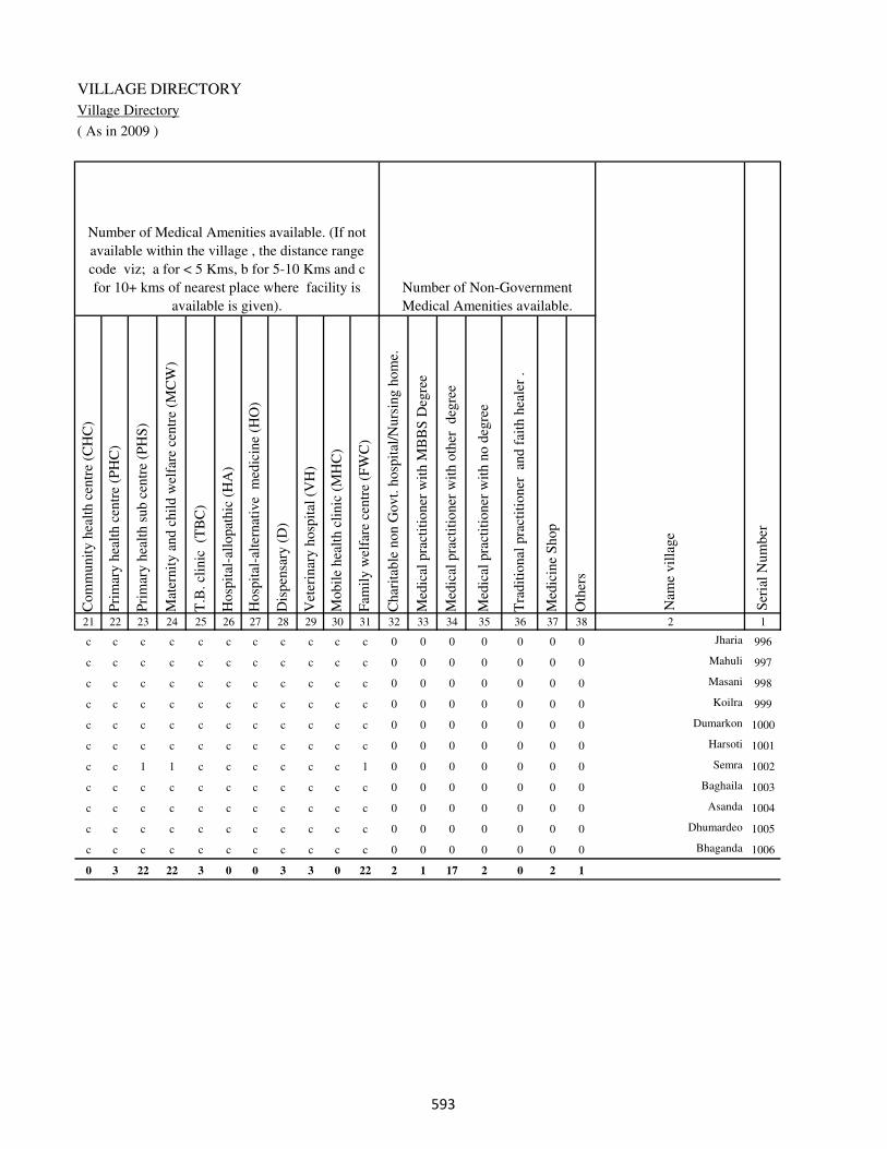
VILLAGE DIRECTORY
Village Directory
( As in 2009 )
Com
munit
y h
ealt
h c
entr
e (C
HC
)
Pri
mar
y h
ealt
h c
entr
e (P
HC
)
Pri
mar
y h
ealt
h s
ub c
entr
e (P
HS
)
Mat
ernit
y a
nd c
hil
d w
elfa
re c
entr
e (M
CW
)
T.B
. cl
inic
(T
BC
)
Hosp
ital
-all
opat
hic
(H
A)
Hosp
ital
-alt
ernat
ive
med
icin
e (H
O)
Dis
pen
sary
(D
)
Vet
erin
ary h
osp
ital
(V
H)
Mobil
e hea
lth c
linic
(M
HC
)
Fam
ily w
elfa
re c
entr
e (F
WC
)
Char
itab
le n
on G
ovt.
hosp
ital
/Nurs
ing h
om
e.
Med
ical
pra
ctit
ioner
wit
h M
BB
S D
egre
e
Med
ical
pra
ctit
ioner
wit
h o
ther
deg
ree
Med
ical
pra
ctit
ioner
wit
h n
o d
egre
e
Tra
dit
ional
pra
ctit
ioner
an
d f
aith
hea
ler
.
Med
icin
e S
hop
Oth
ers
21 22 23 24 25 26 27 28 29 30 31 32 33 34 35 36 37 38 2 1
Number of Non-Government
Medical Amenities available.
Number of Medical Amenities available. (If not
available within the village , the distance range
code viz; a for < 5 Kms, b for 5-10 Kms and c
for 10+ kms of nearest place where facility is
available is given).
Nam
e vil
lage
Ser
ial
Num
ber
c c c c c c c c c c c 0 0 0 0 0 0 0 Jharia 996
c c c c c c c c c c c 0 0 0 0 0 0 0 Mahuli 997
c c c c c c c c c c c 0 0 0 0 0 0 0 Masani 998
c c c c c c c c c c c 0 0 0 0 0 0 0 Koilra 999
c c c c c c c c c c c 0 0 0 0 0 0 0 Dumarkon 1000
c c c c c c c c c c c 0 0 0 0 0 0 0 Harsoti 1001
c c 1 1 c c c c c c 1 0 0 0 0 0 0 0 Semra 1002
c c c c c c c c c c c 0 0 0 0 0 0 0 Baghaila 1003
c c c c c c c c c c c 0 0 0 0 0 0 0 Asanda 1004
c c c c c c c c c c c 0 0 0 0 0 0 0 Dhumardeo 1005
c c c c c c c c c c c 0 0 0 0 0 0 0 Bhaganda 1006
0 3 22 22 3 0 0 3 3 0 22 2 1 17 2 0 2 1
��
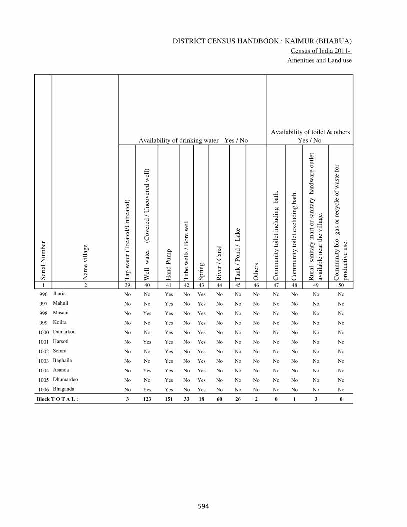
DISTRICT CENSUS HANDBOOK : KAIMUR (BHABUA)
Census of India 2011-
Amenities and Land use
Tap
wat
er (
Tre
ated
/Untr
eate
d)
Wel
l w
ater
(Cover
ed /
Unco
ver
ed w
ell)
Han
d P
um
p
Tube
wel
ls /
Bore
wel
l
Spri
ng
Riv
er /
Can
al
Tan
k /
Pond /
L
ake
Oth
ers
Com
munit
y t
oil
et i
ncl
udin
g
bat
h.
Com
munit
y t
oil
et e
xcl
udin
g b
ath.
Rura
l s
anit
ary m
art
or
sanit
ary
har
dw
are
outl
et
avai
lable
nea
r th
e vil
lage.
Com
munit
y b
io-
gas
or
recy
cle
of
was
te f
or
pro
duct
ive
use
.
1 2 39 40 41 42 43 44 45 46 47 48 49 50
Availability of toilet & others
Yes / No Availability of drinking water - Yes / No
Nam
e vil
lage
Ser
ial
Num
ber
996 Jharia No No Yes No Yes No No No No No No No
997 Mahuli No No Yes No Yes No No No No No No No
998 Masani No Yes Yes No Yes No No No No No No No
999 Koilra No No Yes No Yes No No No No No No No
1000 Dumarkon No No Yes No Yes No No No No No No No
1001 Harsoti No Yes Yes No Yes No No No No No No No
1002 Semra No No Yes No Yes No No No No No No No
1003 Baghaila No No Yes No Yes No No No No No No No
1004 Asanda No Yes Yes No Yes No No No No No No No
1005 Dhumardeo No No Yes No Yes No No No No No No No
1006 Bhaganda No Yes Yes No Yes No No No No No No No
Block T O T A L : 3 123 151 33 18 60 26 2 0 1 3 0
���
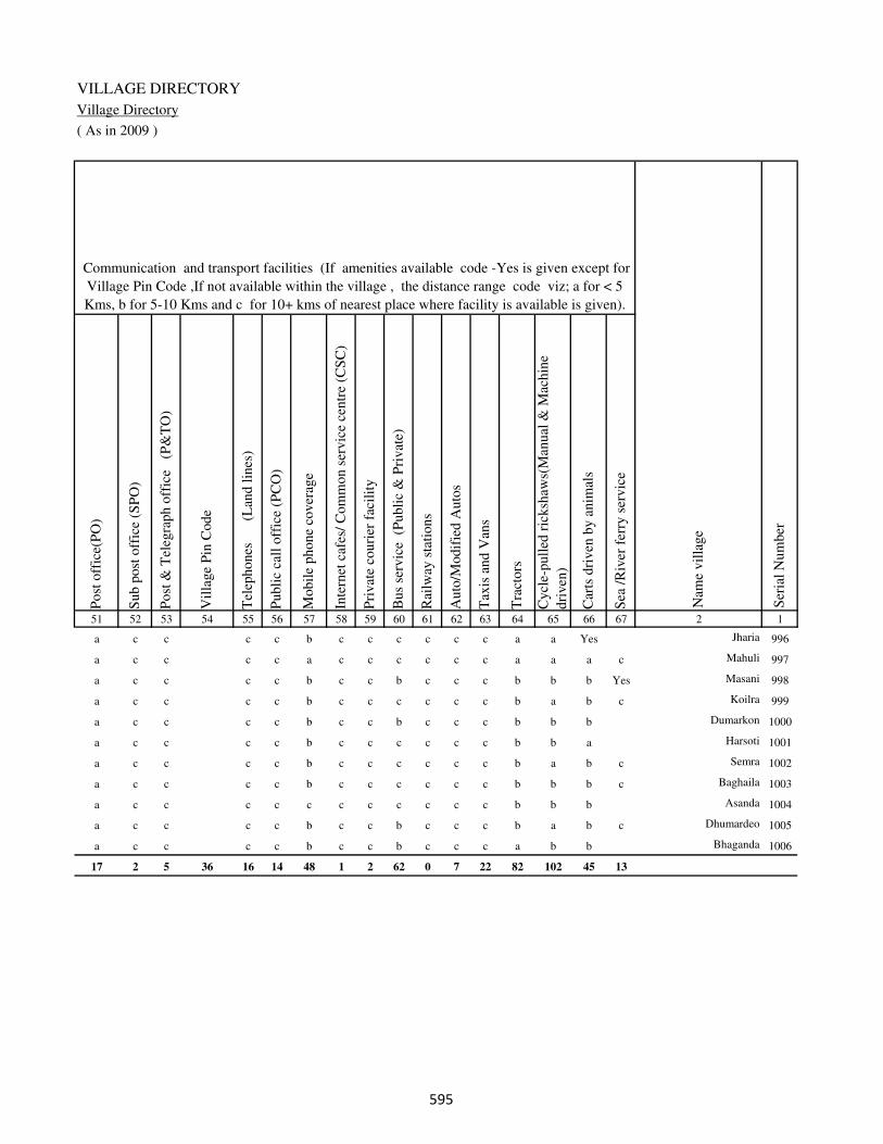
VILLAGE DIRECTORY
Village Directory
( As in 2009 )
Post
off
ice(
PO
)
Sub p
ost
off
ice
(SP
O)
Post
& T
eleg
raph o
ffic
e
(P&
TO
)
Vil
lage
Pin
Code
Tel
ephones
(L
and l
ines
)
Publi
c ca
ll o
ffic
e (P
CO
)
Mobil
e phone
cover
age
Inte
rnet
caf
es/
Com
mon s
ervic
e ce
ntr
e (C
SC
)
Pri
vat
e co
uri
er f
acil
ity
Bus
serv
ice
(P
ubli
c &
Pri
vat
e)
Rai
lway
sta
tions
Auto
/Modif
ied A
uto
s
Tax
is a
nd V
ans
Tra
ctors
Cycl
e-pull
ed r
icksh
aws(
Man
ual
& M
achin
e
dri
ven
)
Car
ts d
riven
by a
nim
als
Sea
/R
iver
fer
ry s
ervic
e51 52 53 54 55 56 57 58 59 60 61 62 63 64 65 66 67 2 1
Communication and transport facilities (If amenities available code -Yes is given except for
Village Pin Code ,If not available within the village , the distance range code viz; a for < 5
Kms, b for 5-10 Kms and c for 10+ kms of nearest place where facility is available is given).
Ser
ial
Num
ber
Nam
e vil
lage
a c c c c b c c c c c c a a Yes Jharia 996
a c c c c a c c c c c c a a a c Mahuli 997
a c c c c b c c b c c c b b b Yes Masani 998
a c c c c b c c c c c c b a b c Koilra 999
a c c c c b c c b c c c b b b Dumarkon 1000
a c c c c b c c c c c c b b a Harsoti 1001
a c c c c b c c c c c c b a b c Semra 1002
a c c c c b c c c c c c b b b c Baghaila 1003
a c c c c c c c c c c c b b b Asanda 1004
a c c c c b c c b c c c b a b c Dhumardeo 1005
a c c c c b c c b c c c a b b Bhaganda 1006
17 2 5 36 16 14 48 1 2 62 0 7 22 82 102 45 13
���

DISTRICT CENSUS HANDBOOK : KAIMUR (BHABUA)
Census of India 2011-
Amenities and Land use
Connec
ted t
o n
atio
nal
hig
hw
ay(N
H)
Connec
ted t
o s
tate
hig
hw
ay(S
H)
Connec
ted t
o m
ajor
dis
tric
t ro
ad (
MD
R)
Connec
ted t
o o
ther
s dis
tric
t ro
ad
Pucc
a r
oad
s
Kutc
hch
a r
oad
s
Wat
er b
ounded
mac
adam
(WB
M)
road
s
Nav
igab
le w
ater
way
(ri
ver
/can
al)(
NW
)
Footp
aths
(FP
)
Com
mer
cial
& C
o-o
per
ativ
e B
anks
AT
M
Agri
cult
ura
l C
redit
Soci
etie
s
Sel
f-H
elp G
roup (
SH
G)
Publi
c dis
trib
uti
on s
yst
em (
PD
S)
shop
Man
dis
/ R
egula
r m
arket
Wee
kly
Haa
t
Agri
cult
ura
l m
arket
ing s
oci
ety
1 2 68 69 70 71 72 73 74 75 76 77 78 79 80 81 82 83 84
Village connected to highways,village roads, banks & credit
societies (If amenities available code -Yes is given, If not
available within the village , the distance range code viz; a
for < 5 Kms, b for 5-10 Kms and c for 10+ kms of nearest
place where facility is available is given).
Ser
ial
Num
ber
Nam
e vil
lage
Availability of miscellaneous
facilities (If amenities available
code -Yes is given, If not
available within the village , the
distance range code viz; a for <
5 Kms, b for 5-10 Kms and c
for 10+ kms of nearest place
where facility is available is
given) Contd....
996 Jharia c c a b b b b b Yes b b c b a c b c
997 Mahuli c c c c c b b b Yes a a b b a c b c
998 Masani c c c c b b b Yes Yes Yes b Yes c b c b c
999 Koilra c c c b b b Yes b Yes b b c Yes a c b c
1000 Dumarkon c c c b b b b b Yes b c c b Yes c b c
1001 Harsoti c c c c b b b b Yes b c c b b c b c
1002 Semra c c c b b b b b Yes b c c b b c b c
1003 Baghaila c c c c b b b Yes b c c b a c b c
1004 Asanda c c c c b b b b Yes b c c Yes b c b c
1005 Dhumardeo c c c b b b b b Yes b c c b a c b c
1006 Bhaganda c c c c b b b b Yes c c c b a c b c
Block T O T A L : 0 10 23 34 39 95 83 15 151 8 1 34 37 56 2 1 7
���

VILLAGE DIRECTORY
Village Directory
( As in 2009 )
Inte
gra
ted C
hil
d D
evel
opm
ent
Sch
eme
(Nutr
itio
nal
Cen
tres
)
Angan
wad
i C
entr
e (N
utr
itio
nal
Cen
tres
)
Oth
ers
(Nutr
itio
nal
Cen
tres
)
AS
HA
(A
ccre
dit
ed S
oci
al H
ealt
h A
ctiv
ist)
Com
munit
y c
entr
e w
ith/w
ithout
TV
Sport
s F
ield
,
Sport
s C
lub /
Rec
reat
ion C
entr
e
Cin
ema
/ V
ideo
Hal
l
Publi
c L
ibra
ry
Publi
c R
eadin
g R
oom
New
spap
er S
upply
Ass
embly
Poll
ing s
tati
on
Bir
th &
Dea
th R
egis
trat
ion O
ffic
e
Pow
er S
upply
for
Dom
esti
c U
se (
ED
)
Pow
er S
upply
for
Agri
cult
ura
l U
se (
EA
G)
Pow
er S
upply
for
Com
mer
cial
Use
(E
C)
Pow
er S
upply
for
All
Use
s (E
A)
85 86 87 88 89 90 91 92 93 94 95 96 97 98 99 100 101 2 1
Availability of
electricity (Yes/No)
Availability of miscellaneous facilities (If amenities available code -
Yes is given, If not available within the village , the distance range
code viz; a for < 5 Kms, b for 5-10 Kms and c for 10+ kms of
nearest place where facility is available is given) Concluded
Nam
e vil
lage
Ser
ial
Num
ber
c a Yes a b c c c c c c a Yes No No No No Jharia 996
c a Yes a c b c c c c c a a No No No No Mahuli 997
c a Yes b c a c c c c c a a No No No No Masani 998
c a Yes Yes c c c c c c c a a No No No No Koilra 999
c Yes Yes Yes c c c c c c c a Yes No No No No Dumarkon 1000
c b a a c c c c c c c a b No No No No Harsoti 1001
c a a a c c c c c c c a b No No No No Semra 1002
c a Yes a a c c c c c c a a No No No No Baghaila 1003
c b Yes a Yes b c c c c b Yes Yes No No No No Asanda 1004
c a Yes b b c c c c c c a a No No No No Dhumardeo 1005
c a Yes Yes c b c c c c b a a No No No No Bhaganda 1006
1 91 137 81 4 28 1 0 0 0 25 87 31 116 55 23 23
���

DISTRICT CENSUS HANDBOOK : KAIMUR (BHABUA)
Census of India 2011-
Amenities and Land use
Nam
e
Dis
tance
ran
ge
code
i.e
. a
fo
r <
5 K
ms,
b
for
5-
10 K
ms
and c
f
or
10+
km
s .
Fore
sts
Are
a under
Non-a
gri
cult
ura
l U
ses
Bar
ren a
nd U
n-c
ult
ivab
le l
and
Per
man
ent
Pas
ture
s an
d O
ther
Gra
zing L
ands
Lan
d U
nder
Mis
cell
aneo
us
Tre
e C
rops
etc.
Cult
ura
ble
Was
te L
and
Fal
low
lan
ds
oth
er t
han
curr
ent
fall
ow
s
Curr
ent
Fal
low
s
1 2 102 103 104 105 106 107 108 109 110 111
Ser
ial
Num
ber
Nam
e vil
lage
Area under different types of land use ( in hectares rounded up to
one decimal place)
Land Use
Nearest Town
996 Jharia BHABUA c 445 32.6 0 129 420 180 0 0
997 Mahuli BHABUA c 540 61.3 0 180 250 450 0 0
998 Masani BHABUA c 184 61.3 0 120 168 162 0 0
999 Koilra BHABUA c 88 41.2 0 70 50 83 0 0
1000 Dumarkon BHABUA c 104 31.9 0 188 260 184 0 0
1001 Harsoti BHABUA c 140 31 0 130 198 214 0 0
1002 Semra BHABUA c 483 51.6 0 190 170 309 0 0
1003 Baghaila BHABUA c 200 31.9 0 40 180 95 0 0
1004 Asanda BHABUA c 101 21 0 50 80 43 0 0
1005 Dhumardeo BHABUA c 180 41 0 190 280 299 0 0
1006 Bhaganda BHABUA c 98.9 0.6 27 0 0 0 0 0
Block T O T A L : 0 0 8690.7 1925.3 634.7 2743.8 6526.1 3210 297.9 276.6
���
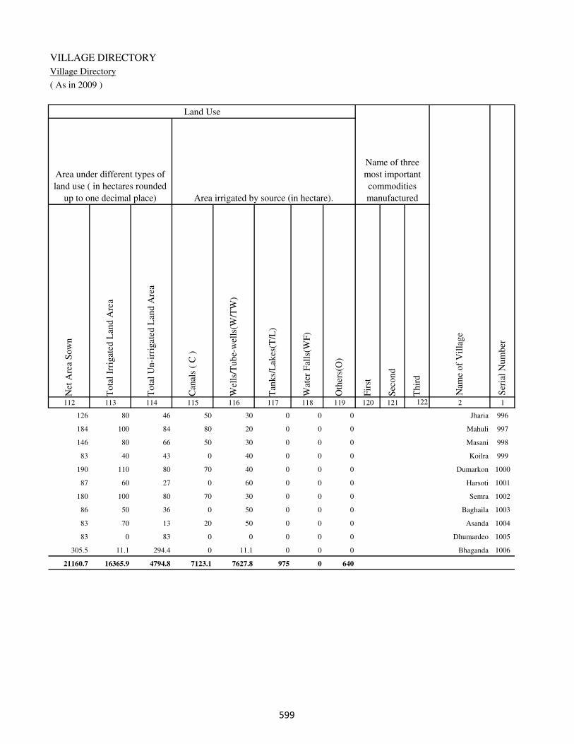
VILLAGE DIRECTORY
Village Directory
( As in 2009 )
Net
Are
a S
ow
n
Tota
l Ir
rigat
ed L
and A
rea
Tota
l U
n-i
rrig
ated
Lan
d A
rea
Can
als
( C
)
Wel
ls/T
ube-
wel
ls(W
/TW
)
Tan
ks/
Lak
es(T
/L)
Wat
er F
alls
(WF
)
Oth
ers(
O)
Fir
st
Sec
ond
Thir
d
112 113 114 115 116 117 118 119 120 121 122 2 1
Ser
ial
Num
ber
Name of three
most important
commodities
manufacturedArea irrigated by source (in hectare).
Nam
e of
Vil
lage
Area under different types of
land use ( in hectares rounded
up to one decimal place)
Land Use
126 80 46 50 30 0 0 0 Jharia 996
184 100 84 80 20 0 0 0 Mahuli 997
146 80 66 50 30 0 0 0 Masani 998
83 40 43 0 40 0 0 0 Koilra 999
190 110 80 70 40 0 0 0 Dumarkon 1000
87 60 27 0 60 0 0 0 Harsoti 1001
180 100 80 70 30 0 0 0 Semra 1002
86 50 36 0 50 0 0 0 Baghaila 1003
83 70 13 20 50 0 0 0 Asanda 1004
83 0 83 0 0 0 0 0 Dhumardeo 1005
305.5 11.1 294.4 0 11.1 0 0 0 Bhaganda 1006
21160.7 16365.9 4794.8 7123.1 7627.8 975 0 640
���

DISTRICT CENSUS HANDBOOK : KAIMUR (BHABUA)
Census of India 2011-
Amenities and Land use
Pre
-Pri
mar
y s
chool
(PP
)
Pri
mar
y s
chool
(P)
Mid
dle
sch
ool
(M)
Sec
ondar
y S
chool
(S)
Sen
ior
Sec
ondar
y s
chool
(SS
)
Deg
ree
coll
ege
of
arts
sc
ience
& c
om
mer
ce
(AS
C)
Engin
eeri
ng c
oll
ege(
EC
)
Med
ical
coll
ege
(MC
)
Man
agem
ent
inst
itute
(M
I)
Poly
tech
nic
(P
t)
Voca
tional
tra
inin
g s
chool
/IT
I
Non-f
orm
al t
rain
ing c
entr
e (N
FT
C)
Spec
ial
school
for
dis
able
d (
SS
D)
Oth
ers
(spec
ify)
1 2 3 4 5 6 7 8 9 10 11 12 13 14 15 16 17 18 19 20
Loca
tion c
ode
no.
Nam
e vil
lage
Ser
ial
Num
ber
Tota
l popula
tion (
2011 c
ensu
s )
Tota
l ar
ea o
f th
e vil
lage
( in
hec
tare
s ro
unded
up t
o
one
dec
imal
pla
ce)
Number of educational amenities available. (If not available
within the village , the distance range code viz; a for < 5
Kms, b for 5-10 Kms and c for 10+ kms of nearest place
where facility is available is given).
Num
ber
of
house
hold
s (2
011 c
ensu
s)
Name of District:-Kaimur (Bhabua) Location CodeNo:-233
Name of CD Block:-Bhabua Location CodeNo:-0441
1007 Baruna 249931 143 1047 164 b 1 b c a b c c c c c c c
1008 Nibi 249932 60 270 37 b 1 a c c c c c c c c c c
1009 Harkeshpur 249933 43 0 0
1010 Narotapur 249934 46 1087 165 b 1 1 c b c c c c c c c c
1011 Amraha 249935 71 398 77 b 1 a c a a c c c c c a c
1012 Bithwar 249936 53 503 83 a 1 1 c a a c c c a a a c a
1013 Khanawan 249937 287 2325 368 a 1 1 c c c c c c c c c c
1014 Katra 249938 120 1283 195 b 1 a c c c c c c c c c c
1015 Umarpur 249939 57 759 107 a a a c c c c c c c c c c
1016 Burhwalia 249940 97 1244 198 b 1 b c a b c c c c c c c b
1017 Manihari 249941 335 2923 417 2 1 1 c c c c c c c c c c
1018 Goraipur 249942 148 3073 529 b 1 1 c a b c c c c c c c b
1019 Hariharpur 249943 106 1506 231 a a b c b b c c c c c c c
1020 Ruppur 249944 146 2953 466 a 3 1 1 b b c c c c c c c
1021 Shahpur 249945 60 387 58 b b b c b b c c c c c c c
1022 Rampur 249946 150 1528 248 a 1 a c b b c c c c c c c
1023 Bagahi 249947 77 120 17 c a a c c c c c c c c c c
1024 Sonhauli 249948 96 0 0
1025 Mirchawan 249949 207 1636 234 c 1 1 c c c c c c c c c c
���

VILLAGE DIRECTORY
Village Directory
( As in 2009 )
Com
munit
y h
ealt
h c
entr
e (C
HC
)
Pri
mar
y h
ealt
h c
entr
e (P
HC
)
Pri
mar
y h
ealt
h s
ub c
entr
e (P
HS
)
Mat
ernit
y a
nd c
hil
d w
elfa
re c
entr
e (M
CW
)
T.B
. cl
inic
(T
BC
)
Hosp
ital
-all
opat
hic
(H
A)
Hosp
ital
-alt
ernat
ive
med
icin
e (H
O)
Dis
pen
sary
(D
)
Vet
erin
ary h
osp
ital
(V
H)
Mobil
e hea
lth c
linic
(M
HC
)
Fam
ily w
elfa
re c
entr
e (F
WC
)
Char
itab
le n
on G
ovt.
hosp
ital
/Nurs
ing h
om
e.
Med
ical
pra
ctit
ioner
wit
h M
BB
S D
egre
e
Med
ical
pra
ctit
ioner
wit
h o
ther
deg
ree
Med
ical
pra
ctit
ioner
wit
h n
o d
egre
e
Tra
dit
ional
pra
ctit
ioner
an
d f
aith
hea
ler
.
Med
icin
e S
hop
Oth
ers
21 22 23 24 25 26 27 28 29 30 31 32 33 34 35 36 37 38 2 1
Number of Non-Government
Medical Amenities available.
Number of Medical Amenities available. (If not
available within the village , the distance range
code viz; a for < 5 Kms, b for 5-10 Kms and c
for 10+ kms of nearest place where facility is
available is given).
Nam
e vil
lage
Ser
ial
Num
ber
c c c c c c c c b c c 0 0 0 0 0 0 0 Baruna 1007
c c c c c c c c c c c 0 0 0 0 0 0 0 Nibi 1008
Harkeshpur 1009
b b b c b c c b b c b 0 0 0 0 0 0 0 Narotapur 1010
a a a c a c c a a c a 0 0 0 0 0 0 0 Amraha 1011
b b 1 1 c c c c c c 1 0 0 0 0 0 0 0 Bithwar 1012
b c b c c c c c b c c 0 0 0 0 0 0 0 Khanawan 1013
c c a c c c c c c c c 0 0 0 0 0 0 0 Katra 1014
c c b c c c c c b c c 0 0 0 0 0 0 0 Umarpur 1015
b b b b b c c b b c b 0 0 0 0 0 0 0 Burhwalia 1016
c c c c c c c b c c c 0 0 0 0 0 0 0 Manihari 1017
b b b b b c c b b c c 0 0 0 0 0 0 0 Goraipur 1018
b b 1 1 c c c c c c 1 0 0 0 0 0 0 0 Hariharpur 1019
b b 1 1 b c c b a c 1 0 1 5 0 0 3 0 Ruppur 1020
b b 1 1 b c c c c c 1 0 0 0 0 0 0 0 Shahpur 1021
b b 1 1 c c c c c c 1 0 0 0 0 0 0 0 Rampur 1022
b b c c c c c c c c c 0 0 0 0 0 0 0 Bagahi 1023
Sonhauli 1024
b b 1 1 c c c c c c 1 0 0 0 0 0 0 0 Mirchawan 1025
���

DISTRICT CENSUS HANDBOOK : KAIMUR (BHABUA)
Census of India 2011-
Amenities and Land use
Tap
wat
er (
Tre
ated
/Untr
eate
d)
Wel
l w
ater
(Cover
ed /
Unco
ver
ed w
ell)
Han
d P
um
p
Tube
wel
ls /
Bore
wel
l
Spri
ng
Riv
er /
Can
al
Tan
k /
Pond /
L
ake
Oth
ers
Com
munit
y t
oil
et i
ncl
udin
g
bat
h.
Com
munit
y t
oil
et e
xcl
udin
g b
ath.
Rura
l s
anit
ary m
art
or
sanit
ary
har
dw
are
outl
et
avai
lable
nea
r th
e vil
lage.
Com
munit
y b
io-
gas
or
recy
cle
of
was
te f
or
pro
duct
ive
use
.
1 2 39 40 41 42 43 44 45 46 47 48 49 50
Availability of toilet & others
Yes / No Availability of drinking water - Yes / No
Nam
e vil
lage
Ser
ial
Num
ber
1007 Baruna No Yes Yes No No No Yes Yes No No No No
1008 Nibi No Yes Yes No No No No No No No No No
1009 Harkeshpur
1010 Narotapur No Yes Yes No No No No No No No No No
1011 Amraha No Yes Yes No No No Yes No No No No No
1012 Bithwar No Yes Yes No No No Yes Yes No No No No
1013 Khanawan No Yes Yes Yes No No No No No No No No
1014 Katra No Yes Yes No No No Yes No No No No No
1015 Umarpur No Yes Yes No No No No No No No No No
1016 Burhwalia No Yes Yes Yes No No No No No No No No
1017 Manihari No Yes Yes Yes No No Yes No No No No No
1018 Goraipur No Yes Yes Yes No No Yes No No No No No
1019 Hariharpur No Yes Yes No No Yes No No No No No No
1020 Ruppur No Yes Yes Yes No Yes Yes No No No No No
1021 Shahpur No Yes Yes Yes No Yes No No No No No No
1022 Rampur No Yes Yes No No Yes Yes No No No No No
1023 Bagahi No Yes Yes No No No No No No No No No
1024 Sonhauli
1025 Mirchawan No Yes Yes Yes No Yes Yes No No No No No
��
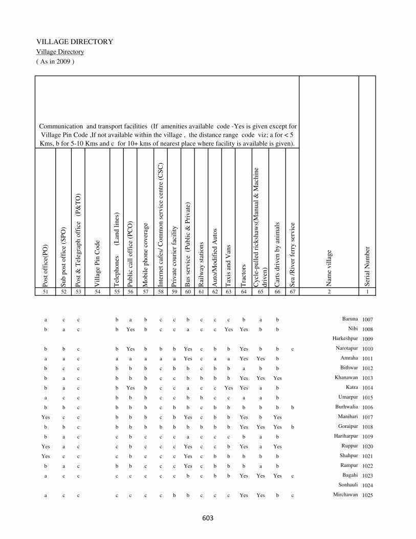
VILLAGE DIRECTORY
Village Directory
( As in 2009 )
Post
off
ice(
PO
)
Sub p
ost
off
ice
(SP
O)
Post
& T
eleg
raph o
ffic
e
(P&
TO
)
Vil
lage
Pin
Code
Tel
ephones
(L
and l
ines
)
Publi
c ca
ll o
ffic
e (P
CO
)
Mobil
e phone
cover
age
Inte
rnet
caf
es/
Com
mon s
ervic
e ce
ntr
e (C
SC
)
Pri
vat
e co
uri
er f
acil
ity
Bus
serv
ice
(P
ubli
c &
Pri
vat
e)
Rai
lway
sta
tions
Auto
/Modif
ied A
uto
s
Tax
is a
nd V
ans
Tra
ctors
Cycl
e-pull
ed r
icksh
aws(
Man
ual
& M
achin
e
dri
ven
)
Car
ts d
riven
by a
nim
als
Sea
/R
iver
fer
ry s
ervic
e51 52 53 54 55 56 57 58 59 60 61 62 63 64 65 66 67 2 1
Communication and transport facilities (If amenities available code -Yes is given except for
Village Pin Code ,If not available within the village , the distance range code viz; a for < 5
Kms, b for 5-10 Kms and c for 10+ kms of nearest place where facility is available is given).
Ser
ial
Num
ber
Nam
e vil
lage
a c c b a b c c b c c c b a b Baruna 1007
b a c b Yes b c c a c c Yes Yes b b Nibi 1008
Harkeshpur 1009
b b c b Yes b b b Yes c b b Yes b b c Narotapur 1010
a a c a a a a a Yes c a a Yes Yes b Amraha 1011
b c c b b b c b b c b b a b b Bithwar 1012
b a c b b b c c b b b b Yes Yes Yes Khanawan 1013
b a c b Yes b c c a c c Yes Yes a b Katra 1014
a c c b b b c c b b c c a a b Umarpur 1015
b b c b b b c b b c b b b b b b Burhwalia 1016
Yes c c b b b c b Yes c b b Yes b Yes Manihari 1017
b b c b b b b b b b b b Yes Yes Yes b Goraipur 1018
b a c c b c c c a c c c b a b Hariharpur 1019
Yes a c c b c c c Yes c c b Yes a Yes Ruppur 1020
Yes c c c b c c c Yes c b b b b b Shahpur 1021
b a c b b c c c Yes c b b b a b Rampur 1022
a c c c c c c c b c b b Yes Yes Yes c Bagahi 1023
Sonhauli 1024
a c c c c c c b b c c c Yes Yes b c Mirchawan 1025
��

DISTRICT CENSUS HANDBOOK : KAIMUR (BHABUA)
Census of India 2011-
Amenities and Land use
Connec
ted t
o n
atio
nal
hig
hw
ay(N
H)
Connec
ted t
o s
tate
hig
hw
ay(S
H)
Connec
ted t
o m
ajor
dis
tric
t ro
ad (
MD
R)
Connec
ted t
o o
ther
s dis
tric
t ro
ad
Pucc
a r
oad
s
Kutc
hch
a r
oad
s
Wat
er b
ounded
mac
adam
(WB
M)
road
s
Nav
igab
le w
ater
way
(ri
ver
/can
al)(
NW
)
Footp
aths
(FP
)
Com
mer
cial
& C
o-o
per
ativ
e B
anks
AT
M
Agri
cult
ura
l C
redit
Soci
etie
s
Sel
f-H
elp G
roup (
SH
G)
Publi
c dis
trib
uti
on s
yst
em (
PD
S)
shop
Man
dis
/ R
egula
r m
arket
Wee
kly
Haa
t
Agri
cult
ura
l m
arket
ing s
oci
ety
1 2 68 69 70 71 72 73 74 75 76 77 78 79 80 81 82 83 84
Village connected to highways,village roads, banks & credit
societies (If amenities available code -Yes is given, If not
available within the village , the distance range code viz; a
for < 5 Kms, b for 5-10 Kms and c for 10+ kms of nearest
place where facility is available is given).
Ser
ial
Num
ber
Nam
e vil
lage
Availability of miscellaneous
facilities (If amenities available
code -Yes is given, If not
available within the village , the
distance range code viz; a for <
5 Kms, b for 5-10 Kms and c
for 10+ kms of nearest place
where facility is available is
given) Contd....
1007 Baruna c c b b b Yes b c Yes b c b b a a c c
1008 Nibi c c a a a Yes Yes b Yes c c a b a a c c
1009 Harkeshpur
1010 Narotapur c Yes Yes Yes Yes Yes Yes b Yes b c b a a b b c
1011 Amraha c b Yes Yes Yes Yes Yes c Yes a c a a Yes a c c
1012 Bithwar c b b b b Yes a b Yes b c b a Yes a c c
1013 Khanawan b b a a Yes a a b Yes c Yes b Yes b b c c
1014 Katra b c a a Yes Yes Yes b Yes c c c b a a c c
1015 Umarpur b c a a Yes Yes Yes b Yes c c c b a a b c
1016 Burhwalia b c b b Yes Yes b b Yes b c b b a a b c
1017 Manihari b c a a Yes Yes Yes b Yes c c c a Yes a b c
1018 Goraipur b b b b Yes Yes b b Yes b c b a a a a c
1019 Hariharpur b b b a a Yes Yes b Yes b b c b a a a c
1020 Ruppur b b a a Yes a Yes b Yes b Yes b Yes Yes b a c
1021 Shahpur b b b a a Yes Yes b Yes b b c b a a a c
1022 Rampur b b b a a Yes Yes b Yes b b b b Yes b a c
1023 Bagahi c c Yes Yes a Yes Yes b Yes c c c a a a a c
1024 Sonhauli
1025 Mirchawan b b Yes a Yes Yes Yes Yes Yes c c c a a b a c
���

VILLAGE DIRECTORY
Village Directory
( As in 2009 )
Inte
gra
ted C
hil
d D
evel
opm
ent
Sch
eme
(Nutr
itio
nal
Cen
tres
)
Angan
wad
i C
entr
e (N
utr
itio
nal
Cen
tres
)
Oth
ers
(Nutr
itio
nal
Cen
tres
)
AS
HA
(A
ccre
dit
ed S
oci
al H
ealt
h A
ctiv
ist)
Com
munit
y c
entr
e w
ith/w
ithout
TV
Sport
s F
ield
,
Sport
s C
lub /
Rec
reat
ion C
entr
e
Cin
ema
/ V
ideo
Hal
l
Publi
c L
ibra
ry
Publi
c R
eadin
g R
oom
New
spap
er S
upply
Ass
embly
Poll
ing s
tati
on
Bir
th &
Dea
th R
egis
trat
ion O
ffic
e
Pow
er S
upply
for
Dom
esti
c U
se (
ED
)
Pow
er S
upply
for
Agri
cult
ura
l U
se (
EA
G)
Pow
er S
upply
for
Com
mer
cial
Use
(E
C)
Pow
er S
upply
for
All
Use
s (E
A)
85 86 87 88 89 90 91 92 93 94 95 96 97 98 99 100 101 2 1
Availability of
electricity (Yes/No)
Availability of miscellaneous facilities (If amenities available code -
Yes is given, If not available within the village , the distance range
code viz; a for < 5 Kms, b for 5-10 Kms and c for 10+ kms of
nearest place where facility is available is given) Concluded
Nam
e vil
lage
Ser
ial
Num
ber
c Yes a Yes c c c c c c b Yes Yes Yes Yes No No Baruna 1007
c Yes Yes Yes c Yes c c c c b a a Yes Yes No No Nibi 1008
Harkeshpur 1009
c Yes Yes Yes c b c c b b b Yes Yes Yes Yes No No Narotapur 1010
c Yes Yes Yes c a c c a a b a a Yes Yes No No Amraha 1011
c Yes b Yes c b c c c c b Yes Yes Yes Yes No No Bithwar 1012
c Yes Yes Yes c b c c c c Yes Yes Yes No No No No Khanawan 1013
c Yes Yes Yes c c c c c c Yes Yes Yes No No No No Katra 1014
c a a a c c c c c c b a a No No No No Umarpur 1015
c a Yes Yes c b c b c c Yes Yes a Yes No No No Burhwalia 1016
c Yes b Yes c b c c c c Yes Yes Yes Yes Yes No No Manihari 1017
c Yes Yes Yes b b b b b b Yes Yes Yes Yes Yes No No Goraipur 1018
c Yes b Yes c b c b c b Yes Yes Yes No No No No Hariharpur 1019
c Yes b Yes b b b c c b Yes Yes Yes No No No No Ruppur 1020
c a a Yes c c b c b c Yes a a Yes Yes No No Shahpur 1021
c Yes a Yes c c c c b b b Yes Yes No No No No Rampur 1022
c a c a c c c c c c Yes a a Yes No No No Bagahi 1023
Sonhauli 1024
c Yes a Yes c c c c c c c Yes b Yes Yes No No Mirchawan 1025
���
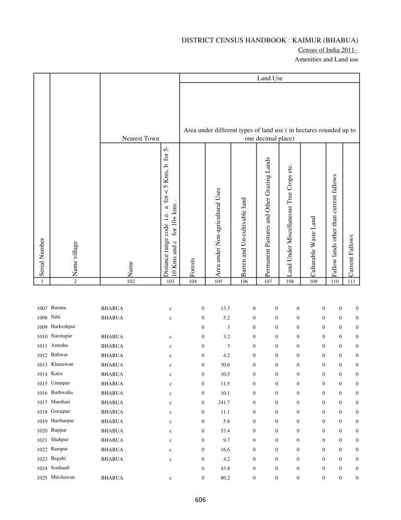
DISTRICT CENSUS HANDBOOK : KAIMUR (BHABUA)
Census of India 2011-
Amenities and Land use
Nam
e
Dis
tance
ran
ge
code
i.e
. a
fo
r <
5 K
ms,
b
for
5-
10 K
ms
and c
f
or
10+
km
s .
Fore
sts
Are
a under
Non-a
gri
cult
ura
l U
ses
Bar
ren a
nd U
n-c
ult
ivab
le l
and
Per
man
ent
Pas
ture
s an
d O
ther
Gra
zing L
ands
Lan
d U
nder
Mis
cell
aneo
us
Tre
e C
rops
etc.
Cult
ura
ble
Was
te L
and
Fal
low
lan
ds
oth
er t
han
curr
ent
fall
ow
s
Curr
ent
Fal
low
s
1 2 102 103 104 105 106 107 108 109 110 111
Ser
ial
Num
ber
Nam
e vil
lage
Area under different types of land use ( in hectares rounded up to
one decimal place)
Land Use
Nearest Town
1007 Baruna BHABUA c 0 13.3 0 0 0 0 0 0
1008 Nibi BHABUA c 0 5.2 0 0 0 0 0 0
1009 Harkeshpur 0 3 0 0 0 0 0 0
1010 Narotapur BHABUA c 0 3.2 0 0 0 0 0 0
1011 Amraha BHABUA c 0 3 0 0 0 0 0 0
1012 Bithwar BHABUA c 0 4.2 0 0 0 0 0 0
1013 Khanawan BHABUA c 0 30.6 0 0 0 0 0 0
1014 Katra BHABUA c 0 10.5 0 0 0 0 0 0
1015 Umarpur BHABUA c 0 11.5 0 0 0 0 0 0
1016 Burhwalia BHABUA c 0 10.1 0 0 0 0 0 0
1017 Manihari BHABUA c 0 241.7 0 0 0 0 0 0
1018 Goraipur BHABUA c 0 11.1 0 0 0 0 0 0
1019 Hariharpur BHABUA c 0 5.8 0 0 0 0 0 0
1020 Ruppur BHABUA c 0 53.4 0 0 0 0 0 0
1021 Shahpur BHABUA c 0 9.7 0 0 0 0 0 0
1022 Rampur BHABUA c 0 16.6 0 0 0 0 0 0
1023 Bagahi BHABUA c 0 4.2 0 0 0 0 0 0
1024 Sonhauli 0 43.8 0 0 0 0 0 0
1025 Mirchawan BHABUA c 0 80.2 0 0 0 0 0 0
���

VILLAGE DIRECTORY
Village Directory
( As in 2009 )
Net
Are
a S
ow
n
Tota
l Ir
rigat
ed L
and A
rea
Tota
l U
n-i
rrig
ated
Lan
d A
rea
Can
als
( C
)
Wel
ls/T
ube-
wel
ls(W
/TW
)
Tan
ks/
Lak
es(T
/L)
Wat
er F
alls
(WF
)
Oth
ers(
O)
Fir
st
Sec
ond
Thir
d
112 113 114 115 116 117 118 119 120 121 122 2 1
Ser
ial
Num
ber
Name of three
most important
commodities
manufacturedArea irrigated by source (in hectare).
Nam
e of
Vil
lage
Area under different types of
land use ( in hectares rounded
up to one decimal place)
Land Use
129.7 82.2 47.5 0 82.2 0 0 0 Baruna 1007
54.8 24.1 30.7 0 24.1 0 0 0 Nibi 1008
40 12.6 27.4 0 12.6 0 0 0 Harkeshpur 1009
42.8 24 18.8 0 24 0 0 0 Narotapur 1010
68 49.8 18.2 0 49.8 0 0 0 Amraha 1011
48.8 48.8 0 0 48.8 0 0 0 Bithwar 1012
256.4 155.6 100.8 0 144.6 11 0 0 Khanawan 1013
109.5 57.6 51.9 0 47.6 10 0 0 Katra 1014
45.5 8.5 37 0 8.5 0 0 0 Umarpur 1015
86.9 49.9 37 0 35.5 14.4 0 0 Burhwalia 1016
93.3 81.2 12.1 0 81.2 0 0 0 Manihari 1017
136.9 68 68.9 0 41.7 26.3 0 0 Goraipur 1018
100.2 35.8 64.4 0 27.2 0 0 8.6 Hariharpur 1019
92.6 66.6 26 0 33.6 0 0 33 Ruppur 1020
50.3 16.3 34 0 11.1 5.2 0 0 Shahpur 1021
133.4 63.4 70 0 54.2 0 0 9.2 Rampur 1022
72.8 30.6 42.2 20.4 10.2 0 0 0 Bagahi 1023
52.2 32 20.2 32 0 0 0 0 Sonhauli 1024
126.8 75.1 51.7 0 75.1 0 0 0 Mirchawan 1025
���

DISTRICT CENSUS HANDBOOK : KAIMUR (BHABUA)
Census of India 2011-
Amenities and Land use
Pre
-Pri
mar
y s
chool
(PP
)
Pri
mar
y s
chool
(P)
Mid
dle
sch
ool
(M)
Sec
ondar
y S
chool
(S)
Sen
ior
Sec
ondar
y s
chool
(SS
)
Deg
ree
coll
ege
of
arts
sc
ience
& c
om
mer
ce
(AS
C)
Engin
eeri
ng c
oll
ege(
EC
)
Med
ical
coll
ege
(MC
)
Man
agem
ent
inst
itute
(M
I)
Poly
tech
nic
(P
t)
Voca
tional
tra
inin
g s
chool
/IT
I
Non-f
orm
al t
rain
ing c
entr
e (N
FT
C)
Spec
ial
school
for
dis
able
d (
SS
D)
Oth
ers
(spec
ify)
1 2 3 4 5 6 7 8 9 10 11 12 13 14 15 16 17 18 19 20
Loca
tion c
ode
no.
Nam
e vil
lage
Ser
ial
Num
ber
Tota
l popula
tion (
2011 c
ensu
s )
Tota
l ar
ea o
f th
e vil
lage
( in
hec
tare
s ro
unded
up t
o
one
dec
imal
pla
ce)
Number of educational amenities available. (If not available
within the village , the distance range code viz; a for < 5
Kms, b for 5-10 Kms and c for 10+ kms of nearest place
where facility is available is given).
Num
ber
of
house
hold
s (2
011 c
ensu
s)
1026 Darauli 249950 122 1575 332 c 1 1 b c c c c c c c c c
1027 Karmi Chak 249951 44 1354 214 c 1 c c c c c c c c c c c
1028 Kohari 249952 150 2385 303 c 2 1 c c c c c c c c c c
1029 Khaira Khurd 249953 31 299 40 b a a c c c c c c c c c c
1030 Khaira 249954 39 644 86 b 1 a c c c c c c c c c c
1031 Fatehpur 249955 60 0 0
1032 Ghurdewa 249956 66 0 0
1033 Mithapur 249957 42 538 74 c 1 1 c c c b c c c c c c
1034 Basantpur 249958 15 0 0
1035 Denawan 249959 109 1305 169 b 1 1 c c c c c c c c c c
1036 Jigni 249960 416 2747 425 b 1 1 c b b c c c c c c c
1037 Damodarpur 249961 136 1087 150 a 1 a c c c c c c c c c c
1038 Dumraith 249962 232 3397 544 a 1 1 c c c c c c c c c c
1039 Doghra 249963 63 275 44 a a a c c c c c c c c c c
1040 Naktaul 249964 163 1702 268 a 1 a c c c c c c c c c c
1041 Maital 249965 90 0 0
1042 Bhadari 249966 182 2131 376 c 1 1 c c c c c c c c c c
1043 Narawan 249967 438 1998 330 c 1 1 c c c c c c c c c c
1044 Mamhan 249968 54 282 44 a 1 a c c c c c c c c c c
1045 Sedra 249969 43 0 0
1046 Sedra Nisf 249970 62 591 74 a a a c c c c c c c c c c
���

VILLAGE DIRECTORY
Village Directory
( As in 2009 )
Com
munit
y h
ealt
h c
entr
e (C
HC
)
Pri
mar
y h
ealt
h c
entr
e (P
HC
)
Pri
mar
y h
ealt
h s
ub c
entr
e (P
HS
)
Mat
ernit
y a
nd c
hil
d w
elfa
re c
entr
e (M
CW
)
T.B
. cl
inic
(T
BC
)
Hosp
ital
-all
opat
hic
(H
A)
Hosp
ital
-alt
ernat
ive
med
icin
e (H
O)
Dis
pen
sary
(D
)
Vet
erin
ary h
osp
ital
(V
H)
Mobil
e hea
lth c
linic
(M
HC
)
Fam
ily w
elfa
re c
entr
e (F
WC
)
Char
itab
le n
on G
ovt.
hosp
ital
/Nurs
ing h
om
e.
Med
ical
pra
ctit
ioner
wit
h M
BB
S D
egre
e
Med
ical
pra
ctit
ioner
wit
h o
ther
deg
ree
Med
ical
pra
ctit
ioner
wit
h n
o d
egre
e
Tra
dit
ional
pra
ctit
ioner
an
d f
aith
hea
ler
.
Med
icin
e S
hop
Oth
ers
21 22 23 24 25 26 27 28 29 30 31 32 33 34 35 36 37 38 2 1
Number of Non-Government
Medical Amenities available.
Number of Medical Amenities available. (If not
available within the village , the distance range
code viz; a for < 5 Kms, b for 5-10 Kms and c
for 10+ kms of nearest place where facility is
available is given).
Nam
e vil
lage
Ser
ial
Num
ber
c b 1 1 c c c c c c 1 0 0 0 0 0 0 0 Darauli 1026
c c c c c c c c c c c 0 0 0 0 0 0 0 Karmi Chak 1027
c c b c c c c c c c c 0 0 0 3 0 0 0 Kohari 1028
c c b c c c c c c c c 0 0 0 0 0 0 0 Khaira Khurd 1029
c c a a c c c c c c c 0 0 0 0 0 0 0 Khaira 1030
Fatehpur 1031
Ghurdewa 1032
c c b c c b b b b b c 0 0 0 0 0 0 0 Mithapur 1033
Basantpur 1034
c c a c c c c c c c c 0 0 0 0 0 0 0 Denawan 1035
b b b b c c c c c c b 0 0 0 0 0 0 0 Jigni 1036
c c a c c c c c c c c 0 0 0 0 0 0 0 Damodarpur 1037
c c a c c c c c c c c 0 0 0 0 0 0 0 Dumraith 1038
c c a c c c c c c c c 0 0 0 0 0 0 0 Doghra 1039
c c a c c c c c c c c 0 0 0 0 0 0 0 Naktaul 1040
Maital 1041
c c b c c c c c c c c 0 0 0 0 0 0 0 Bhadari 1042
c c a c c c c b c c c 0 0 0 2 0 0 0 Narawan 1043
b a b c c c c c c c c 0 0 0 0 0 0 0 Mamhan 1044
Sedra 1045
c c a c c c c c c c c 0 0 0 0 0 0 0 Sedra Nisf 1046
���

DISTRICT CENSUS HANDBOOK : KAIMUR (BHABUA)
Census of India 2011-
Amenities and Land use
Tap
wat
er (
Tre
ated
/Untr
eate
d)
Wel
l w
ater
(Cover
ed /
Unco
ver
ed w
ell)
Han
d P
um
p
Tube
wel
ls /
Bore
wel
l
Spri
ng
Riv
er /
Can
al
Tan
k /
Pond /
L
ake
Oth
ers
Com
munit
y t
oil
et i
ncl
udin
g
bat
h.
Com
munit
y t
oil
et e
xcl
udin
g b
ath.
Rura
l s
anit
ary m
art
or
sanit
ary
har
dw
are
outl
et
avai
lable
nea
r th
e vil
lage.
Com
munit
y b
io-
gas
or
recy
cle
of
was
te f
or
pro
duct
ive
use
.
1 2 39 40 41 42 43 44 45 46 47 48 49 50
Availability of toilet & others
Yes / No Availability of drinking water - Yes / No
Nam
e vil
lage
Ser
ial
Num
ber
1026 Darauli No Yes Yes Yes No No Yes No No No No No
1027 Karmi Chak No Yes Yes No No Yes No No No No No No
1028 Kohari No Yes Yes No No Yes Yes No No No No No
1029 Khaira Khurd No Yes Yes Yes No Yes No No No No No No
1030 Khaira No Yes Yes Yes No Yes No No No No No No
1031 Fatehpur
1032 Ghurdewa
1033 Mithapur No Yes Yes No No Yes No No No No No No
1034 Basantpur
1035 Denawan No Yes Yes Yes No Yes No No No No No No
1036 Jigni No Yes Yes No No Yes Yes No No No No No
1037 Damodarpur No Yes Yes Yes No Yes No No No No No No
1038 Dumraith No Yes Yes Yes No No No No No No No No
1039 Doghra No Yes Yes Yes No Yes No No No No No No
1040 Naktaul No Yes Yes Yes No Yes Yes No No No No No
1041 Maital
1042 Bhadari No Yes Yes No No Yes No No No No No No
1043 Narawan No Yes Yes No No Yes Yes No No No No No
1044 Mamhan No Yes Yes Yes No No No No No No No No
1045 Sedra
1046 Sedra Nisf No Yes Yes Yes No Yes No No No No No No
���

VILLAGE DIRECTORY
Village Directory
( As in 2009 )
Post
off
ice(
PO
)
Sub p
ost
off
ice
(SP
O)
Post
& T
eleg
raph o
ffic
e
(P&
TO
)
Vil
lage
Pin
Code
Tel
ephones
(L
and l
ines
)
Publi
c ca
ll o
ffic
e (P
CO
)
Mobil
e phone
cover
age
Inte
rnet
caf
es/
Com
mon s
ervic
e ce
ntr
e (C
SC
)
Pri
vat
e co
uri
er f
acil
ity
Bus
serv
ice
(P
ubli
c &
Pri
vat
e)
Rai
lway
sta
tions
Auto
/Modif
ied A
uto
s
Tax
is a
nd V
ans
Tra
ctors
Cycl
e-pull
ed r
icksh
aws(
Man
ual
& M
achin
e
dri
ven
)
Car
ts d
riven
by a
nim
als
Sea
/R
iver
fer
ry s
ervic
e51 52 53 54 55 56 57 58 59 60 61 62 63 64 65 66 67 2 1
Communication and transport facilities (If amenities available code -Yes is given except for
Village Pin Code ,If not available within the village , the distance range code viz; a for < 5
Kms, b for 5-10 Kms and c for 10+ kms of nearest place where facility is available is given).
Ser
ial
Num
ber
Nam
e vil
lage
Yes c c c c c c c Yes c c c Yes Yes b Darauli 1026
Yes c c c c c c c c c c c Yes a b Karmi Chak 1027
a a c c Yes a c c Yes b c c Yes Yes Yes Kohari 1028
a a c 821101 c c Yes c c Yes c Yes Yes Yes Yes b Khaira Khurd 1029
a a c c Yes Yes c c Yes c Yes Yes Yes Yes Yes Yes Khaira 1030
Fatehpur 1031
Ghurdewa 1032
b c b b b c c c c c c c a Yes a c Mithapur 1033
Basantpur 1034
a a c 821101 c Yes Yes c c Yes c Yes Yes Yes Yes b Denawan 1035
a a c c b c c c Yes b b b Yes a Yes Jigni 1036
a a c c a Yes c c c c Yes Yes Yes Yes Yes Damodarpur 1037
Yes c c c Yes Yes c c Yes c Yes Yes Yes Yes Yes a Dumraith 1038
a a c 821103 Yes Yes a c c c c c a a Yes b Doghra 1039
a c c 821103 c Yes Yes c c Yes c Yes Yes Yes Yes b Naktaul 1040
Maital 1041
a a c b b b c c Yes c c c c Yes Yes Bhadari 1042
a a c c b b b b b c c b c Yes b Yes Narawan 1043
a a c 821103 c Yes a c c c c c a a Yes b Mamhan 1044
Sedra 1045
a a c b Yes a c c a c a a a Yes a Sedra Nisf 1046
���

DISTRICT CENSUS HANDBOOK : KAIMUR (BHABUA)
Census of India 2011-
Amenities and Land use
Connec
ted t
o n
atio
nal
hig
hw
ay(N
H)
Connec
ted t
o s
tate
hig
hw
ay(S
H)
Connec
ted t
o m
ajor
dis
tric
t ro
ad (
MD
R)
Connec
ted t
o o
ther
s dis
tric
t ro
ad
Pucc
a r
oad
s
Kutc
hch
a r
oad
s
Wat
er b
ounded
mac
adam
(WB
M)
road
s
Nav
igab
le w
ater
way
(ri
ver
/can
al)(
NW
)
Footp
aths
(FP
)
Com
mer
cial
& C
o-o
per
ativ
e B
anks
AT
M
Agri
cult
ura
l C
redit
Soci
etie
s
Sel
f-H
elp G
roup (
SH
G)
Publi
c dis
trib
uti
on s
yst
em (
PD
S)
shop
Man
dis
/ R
egula
r m
arket
Wee
kly
Haa
t
Agri
cult
ura
l m
arket
ing s
oci
ety
1 2 68 69 70 71 72 73 74 75 76 77 78 79 80 81 82 83 84
Village connected to highways,village roads, banks & credit
societies (If amenities available code -Yes is given, If not
available within the village , the distance range code viz; a
for < 5 Kms, b for 5-10 Kms and c for 10+ kms of nearest
place where facility is available is given).
Ser
ial
Num
ber
Nam
e vil
lage
Availability of miscellaneous
facilities (If amenities available
code -Yes is given, If not
available within the village , the
distance range code viz; a for <
5 Kms, b for 5-10 Kms and c
for 10+ kms of nearest place
where facility is available is
given) Contd....
1026 Darauli c c b Yes Yes Yes Yes b Yes c c c Yes Yes a a c
1027 Karmi Chak c c b Yes a Yes Yes b Yes c c c b a c c c
1028 Kohari b c c Yes Yes Yes a b Yes b b c a Yes c a c
1029 Khaira Khurd c c Yes Yes Yes Yes Yes c Yes c c c a a c c c
1030 Khaira c c Yes Yes Yes Yes Yes Yes Yes c c c a a c c c
1031 Fatehpur
1032 Ghurdewa
1033 Mithapur c c c c b b a Yes Yes c c c a a c c c
1034 Basantpur
1035 Denawan c c Yes Yes a Yes Yes c Yes c c c a Yes c c c
1036 Jigni c b b a Yes Yes Yes c Yes b b b a Yes c a c
1037 Damodarpur c c Yes Yes a Yes Yes c Yes c c c b Yes c b c
1038 Dumraith c Yes Yes b Yes Yes Yes c Yes c c c Yes Yes b c c
1039 Doghra c a b b a Yes a c Yes c c c a a c c c
1040 Naktaul c c Yes Yes Yes Yes Yes b Yes c c c a a c c c
1041 Maital
1042 Bhadari c c c b Yes Yes a c Yes c c b b Yes b a c
1043 Narawan c c b Yes Yes Yes a Yes Yes a b c b a b b c
1044 Mamhan c c c a a Yes a b Yes c c c a a c c c
1045 Sedra
1046 Sedra Nisf c c c b a Yes a b Yes c c c a a c c c
��

VILLAGE DIRECTORY
Village Directory
( As in 2009 )
Inte
gra
ted C
hil
d D
evel
opm
ent
Sch
eme
(Nutr
itio
nal
Cen
tres
)
Angan
wad
i C
entr
e (N
utr
itio
nal
Cen
tres
)
Oth
ers
(Nutr
itio
nal
Cen
tres
)
AS
HA
(A
ccre
dit
ed S
oci
al H
ealt
h A
ctiv
ist)
Com
munit
y c
entr
e w
ith/w
ithout
TV
Sport
s F
ield
,
Sport
s C
lub /
Rec
reat
ion C
entr
e
Cin
ema
/ V
ideo
Hal
l
Publi
c L
ibra
ry
Publi
c R
eadin
g R
oom
New
spap
er S
upply
Ass
embly
Poll
ing s
tati
on
Bir
th &
Dea
th R
egis
trat
ion O
ffic
e
Pow
er S
upply
for
Dom
esti
c U
se (
ED
)
Pow
er S
upply
for
Agri
cult
ura
l U
se (
EA
G)
Pow
er S
upply
for
Com
mer
cial
Use
(E
C)
Pow
er S
upply
for
All
Use
s (E
A)
85 86 87 88 89 90 91 92 93 94 95 96 97 98 99 100 101 2 1
Availability of
electricity (Yes/No)
Availability of miscellaneous facilities (If amenities available code -
Yes is given, If not available within the village , the distance range
code viz; a for < 5 Kms, b for 5-10 Kms and c for 10+ kms of
nearest place where facility is available is given) Concluded
Nam
e vil
lage
Ser
ial
Num
ber
c Yes a Yes c c c c c c b Yes b Yes Yes No No Darauli 1026
c Yes a Yes c c c c c c c Yes Yes Yes Yes No No Karmi Chak 1027
c Yes b a Yes b c c c c c Yes Yes Yes Yes No No Kohari 1028
c a Yes a c Yes c c c c c a a Yes No No No Khaira Khurd 1029
c b Yes a c a c c a a c Yes a Yes Yes No No Khaira 1030
Fatehpur 1031
Ghurdewa 1032
b a b Yes c b c c c c c Yes a Yes No No No Mithapur 1033
Basantpur 1034
c Yes Yes a c Yes c c c c c Yes Yes Yes Yes No No Denawan 1035
c Yes Yes Yes c a c c c c Yes Yes Yes Yes Yes No No Jigni 1036
c Yes b a c Yes c c c c c Yes Yes Yes Yes No No Damodarpur 1037
c Yes a Yes c Yes c c c c c Yes Yes Yes Yes No No Dumraith 1038
c a Yes a b a c c c c c a a Yes Yes No No Doghra 1039
c Yes Yes Yes Yes b c c c c c Yes Yes Yes Yes No No Naktaul 1040
Maital 1041
c Yes a Yes b Yes c c c c c Yes Yes Yes No No No Bhadari 1042
c Yes a Yes b b c c c c Yes Yes Yes Yes No No No Narawan 1043
c a a a b Yes c c c c c a a Yes No No No Mamhan 1044
Sedra 1045
c Yes Yes a c a c c c c c Yes Yes Yes No No No Sedra Nisf 1046
��

DISTRICT CENSUS HANDBOOK : KAIMUR (BHABUA)
Census of India 2011-
Amenities and Land use
Nam
e
Dis
tance
ran
ge
code
i.e
. a
fo
r <
5 K
ms,
b
for
5-
10 K
ms
and c
f
or
10+
km
s .
Fore
sts
Are
a under
Non-a
gri
cult
ura
l U
ses
Bar
ren a
nd U
n-c
ult
ivab
le l
and
Per
man
ent
Pas
ture
s an
d O
ther
Gra
zing L
ands
Lan
d U
nder
Mis
cell
aneo
us
Tre
e C
rops
etc.
Cult
ura
ble
Was
te L
and
Fal
low
lan
ds
oth
er t
han
curr
ent
fall
ow
s
Curr
ent
Fal
low
s
1 2 102 103 104 105 106 107 108 109 110 111
Ser
ial
Num
ber
Nam
e vil
lage
Area under different types of land use ( in hectares rounded up to
one decimal place)
Land Use
Nearest Town
1026 Darauli BHABUA c 0 20 0 0 0 0 0 0
1027 Karmi Chak BHABUA c 0 3 0 0 0 0 0 0
1028 Kohari BHABUA c 0 14.7 0 0 0 0 0 0
1029 Khaira Khurd BHABUA c 0 3.3 0 0 0 0 0 0
1030 Khaira BHABUA c 0 17.7 0 0 0 0 0 0
1031 Fatehpur 0 6.2 0 0 0 0 0 0
1032 Ghurdewa 0 4.2 0 0 0 0 0 0
1033 Mithapur BHABUA b 0 6 0 0 0 0 0 0
1034 Basantpur 0 1.5 0 0 0 0 0 0
1035 Denawan BHABUA c 0 11.8 0 0 0 0 0 0
1036 Jigni BHABUA c 0 41 0 0 0 0 0 0
1037 Damodarpur BHABUA c 0 10.1 0 0 0 0 0 0
1038 Dumraith BHABUA c 0 32.4 0 0 0 0 0 0
1039 Doghra BHABUA c 0 4.2 0 0 0 0 0 0
1040 Naktaul BHABUA c 0 12.2 0 0 0 0 0 0
1041 Maital 0 4.2 0 0 0 0 0 0
1042 Bhadari BHABUA c 0 7.2 0 0 0 0 0 0
1043 Narawan BHABUA c 0 24 0 0 0 0 0 0
1044 Mamhan BHABUA c 0 10.4 0 0 0 0 0 0
1045 Sedra 0 9.5 0 0 0 0 0 0
1046 Sedra Nisf BHABUA c 0 19.5 0 0 0 0 0 0
���

VILLAGE DIRECTORY
Village Directory
( As in 2009 )
Net
Are
a S
ow
n
Tota
l Ir
rigat
ed L
and A
rea
Tota
l U
n-i
rrig
ated
Lan
d A
rea
Can
als
( C
)
Wel
ls/T
ube-
wel
ls(W
/TW
)
Tan
ks/
Lak
es(T
/L)
Wat
er F
alls
(WF
)
Oth
ers(
O)
Fir
st
Sec
ond
Thir
d
112 113 114 115 116 117 118 119 120 121 122 2 1
Ser
ial
Num
ber
Name of three
most important
commodities
manufacturedArea irrigated by source (in hectare).
Nam
e of
Vil
lage
Area under different types of
land use ( in hectares rounded
up to one decimal place)
Land Use
102 58.8 43.2 0 46 12.8 0 0 Darauli 1026
41 7.2 33.8 0 3.2 4 0 0 Karmi Chak 1027
135.3 64.7 70.6 0 24.2 40.5 0 0 Kohari 1028
27.7 17.4 10.3 0 10.2 7.2 0 0 Khaira Khurd 1029
21.3 10.3 11 0 4.2 0 0 6.1 Khaira 1030
53.8 24 29.8 0 4.1 0 0 19.9 Fatehpur 1031
61.8 20.4 41.4 0 9.4 0 0 11 Ghurdewa 1032
36 21.7 14.3 0 9.2 0 0 12.5 Mithapur 1033
13.5 6.5 7 0 6.5 0 0 0 Basantpur 1034
97.2 63.4 33.8 0 63.4 0 0 0 Denawan 1035
375 301.9 73.1 0 232.1 0 0 69.8 Jigni 1036
125.9 46 79.9 0 46 0 0 0 Damodarpur 1037
199.6 130.6 69 0 130.6 0 0 0 Dumraith 1038
58.8 13.6 45.2 0 13.6 0 0 0 Doghra 1039
150.8 81.2 69.6 0 72.6 0 0 8.6 Naktaul 1040
85.8 31 54.8 0 31 0 0 0 Maital 1041
174.8 74.5 100.3 0 60.5 14 0 0 Bhadari 1042
414 112 302 43 69 0 0 0 Narawan 1043
43.6 8.4 35.2 0 8.4 0 0 0 Mamhan 1044
33.5 8.5 25 0 8.5 0 0 0 Sedra 1045
42.5 12.5 30 0 2 0 0 10.5 Sedra Nisf 1046
���

DISTRICT CENSUS HANDBOOK : KAIMUR (BHABUA)
Census of India 2011-
Amenities and Land use
Pre
-Pri
mar
y s
chool
(PP
)
Pri
mar
y s
chool
(P)
Mid
dle
sch
ool
(M)
Sec
ondar
y S
chool
(S)
Sen
ior
Sec
ondar
y s
chool
(SS
)
Deg
ree
coll
ege
of
arts
sc
ience
& c
om
mer
ce
(AS
C)
Engin
eeri
ng c
oll
ege(
EC
)
Med
ical
coll
ege
(MC
)
Man
agem
ent
inst
itute
(M
I)
Poly
tech
nic
(P
t)
Voca
tional
tra
inin
g s
chool
/IT
I
Non-f
orm
al t
rain
ing c
entr
e (N
FT
C)
Spec
ial
school
for
dis
able
d (
SS
D)
Oth
ers
(spec
ify)
1 2 3 4 5 6 7 8 9 10 11 12 13 14 15 16 17 18 19 20
Loca
tion c
ode
no.
Nam
e vil
lage
Ser
ial
Num
ber
Tota
l popula
tion (
2011 c
ensu
s )
Tota
l ar
ea o
f th
e vil
lage
( in
hec
tare
s ro
unded
up t
o
one
dec
imal
pla
ce)
Number of educational amenities available. (If not available
within the village , the distance range code viz; a for < 5
Kms, b for 5-10 Kms and c for 10+ kms of nearest place
where facility is available is given).
Num
ber
of
house
hold
s (2
011 c
ensu
s)
1047 Sedra 249971 29 556 93 a a a c c c c c c c c c c
1048 Auraiya Dei 249972 122 647 91 a a a c c c c c c c c c c
1049 Auraiya Dewa 249973 67 485 73 a 2 a c c c c c c c c c c
1050 Dabrahiya 249974 263 1382 193 b 1 1 c c c c c c c c c c
1051 Dehra 249975 46 0 0
1052 Mahsua 249976 99 0 0
1053 Jamuawan 249977 394 2025 322 b 1 1 b c c c c c c c c c
1054 Mahsua 249978 151 1210 227 b 1 1 c c c c c c c c c c
1055 Sarewa 249979 152 1661 275 1 1 a c c c c c c c c c c
1056 Bithalpur 249980 47 271 45 b a a c c b c c c c c c c
1057 Dewarji Khurd 249981 27 674 108 a a a c c c c c c c c c c
1058 Gopalpur 249982 26 0 0
1059 Daridih 249983 14 0 0
1060 Manikpur 249984 156 716 109 b a a c b c b c c c b b c
1061 Gopalpur 249985 57 79 12 b a a c c b c c c c c c c
1062 Dewarji Kalan 249986 132 965 166 b 1 1 c b c b c c c b b c
1063 Nonra 249987 71 544 76 a 1 a c b c b c c c b b c
1064 Kurasan 249988 376 3609 606 c 1 1 c a c a c c c b b c
1065 Uphraurlia 249989 89 344 52 a a a c b c b c c c c b c
1066 Betri 249990 408 4377 811 b 1 1 c b b b c c c c b c b
1067 Ghujua 249991 34 0 0
���

VILLAGE DIRECTORY
Village Directory
( As in 2009 )
Com
munit
y h
ealt
h c
entr
e (C
HC
)
Pri
mar
y h
ealt
h c
entr
e (P
HC
)
Pri
mar
y h
ealt
h s
ub c
entr
e (P
HS
)
Mat
ernit
y a
nd c
hil
d w
elfa
re c
entr
e (M
CW
)
T.B
. cl
inic
(T
BC
)
Hosp
ital
-all
opat
hic
(H
A)
Hosp
ital
-alt
ernat
ive
med
icin
e (H
O)
Dis
pen
sary
(D
)
Vet
erin
ary h
osp
ital
(V
H)
Mobil
e hea
lth c
linic
(M
HC
)
Fam
ily w
elfa
re c
entr
e (F
WC
)
Char
itab
le n
on G
ovt.
hosp
ital
/Nurs
ing h
om
e.
Med
ical
pra
ctit
ioner
wit
h M
BB
S D
egre
e
Med
ical
pra
ctit
ioner
wit
h o
ther
deg
ree
Med
ical
pra
ctit
ioner
wit
h n
o d
egre
e
Tra
dit
ional
pra
ctit
ioner
an
d f
aith
hea
ler
.
Med
icin
e S
hop
Oth
ers
21 22 23 24 25 26 27 28 29 30 31 32 33 34 35 36 37 38 2 1
Number of Non-Government
Medical Amenities available.
Number of Medical Amenities available. (If not
available within the village , the distance range
code viz; a for < 5 Kms, b for 5-10 Kms and c
for 10+ kms of nearest place where facility is
available is given).
Nam
e vil
lage
Ser
ial
Num
ber
c c a c c c c c c c c 0 0 0 0 0 0 0 Sedra 1047
c c a c c c c c c c c 0 0 0 0 0 0 0 Auraiya Dei 1048
c c a c c c c c c c c 0 0 0 0 0 0 0 Auraiya Dewa 1049
c c a c c c c c c c c 0 0 0 3 0 0 0 Dabrahiya 1050
Dehra 1051
Mahsua 1052
c c 1 1 c c c c c c 1 0 0 0 0 0 0 0 Jamuawan 1053
c c a c c c c c c c c 0 0 0 0 0 0 0 Mahsua 1054
b b a b b b b b b b b 0 0 0 0 0 0 0 Sarewa 1055
b b b b b c c c b c c 0 0 0 0 0 0 0 Bithalpur 1056
c c a c c c c c c c c 0 0 0 0 0 0 0 Dewarji Khurd 1057
Gopalpur 1058
Daridih 1059
b b a b b b b b b b b 0 0 0 0 0 0 0 Manikpur 1060
b c b c c c c c b c c 0 0 0 0 0 0 0 Gopalpur 1061
b b a b b b b b b b b 0 0 0 0 0 0 0 Dewarji Kalan 1062
b b a b b b b b b b b 0 0 0 0 0 0 0 Nonra 1063
a a 1 1 b a a b a a 1 0 0 0 0 0 0 0 Kurasan 1064
b b a b b b b b b b b 0 0 0 0 0 0 0 Uphraurlia 1065
b b b b b b b b b b b 0 0 0 0 0 0 0 Betri 1066
Ghujua 1067
���

DISTRICT CENSUS HANDBOOK : KAIMUR (BHABUA)
Census of India 2011-
Amenities and Land use
Tap
wat
er (
Tre
ated
/Untr
eate
d)
Wel
l w
ater
(Cover
ed /
Unco
ver
ed w
ell)
Han
d P
um
p
Tube
wel
ls /
Bore
wel
l
Spri
ng
Riv
er /
Can
al
Tan
k /
Pond /
L
ake
Oth
ers
Com
munit
y t
oil
et i
ncl
udin
g
bat
h.
Com
munit
y t
oil
et e
xcl
udin
g b
ath.
Rura
l s
anit
ary m
art
or
sanit
ary
har
dw
are
outl
et
avai
lable
nea
r th
e vil
lage.
Com
munit
y b
io-
gas
or
recy
cle
of
was
te f
or
pro
duct
ive
use
.
1 2 39 40 41 42 43 44 45 46 47 48 49 50
Availability of toilet & others
Yes / No Availability of drinking water - Yes / No
Nam
e vil
lage
Ser
ial
Num
ber
1047 Sedra No Yes Yes Yes No Yes No No No No No No
1048 Auraiya Dei No Yes Yes Yes No No No No No No No No
1049 Auraiya Dewa No Yes Yes Yes No No No No No No No No
1050 Dabrahiya No Yes Yes No No Yes Yes No No No No No
1051 Dehra
1052 Mahsua
1053 Jamuawan No Yes Yes No No No No No No No No No
1054 Mahsua No Yes Yes No No No No No No No No No
1055 Sarewa No Yes Yes No No No No No No No No No
1056 Bithalpur No Yes Yes No No No No No No No No No
1057 Dewarji Khurd No Yes Yes No No No No No No No No No
1058 Gopalpur
1059 Daridih
1060 Manikpur No Yes Yes No No No No No No No No No
1061 Gopalpur No Yes Yes No No No No No No No No No
1062 Dewarji Kalan No Yes Yes No No No No No No No No No
1063 Nonra No Yes Yes No No No No No No No No No
1064 Kurasan No Yes Yes Yes No No Yes No No No No No
1065 Uphraurlia No Yes Yes No No No No No No No No No
1066 Betri Yes Yes Yes Yes No No Yes No No No No No
1067 Ghujua
���
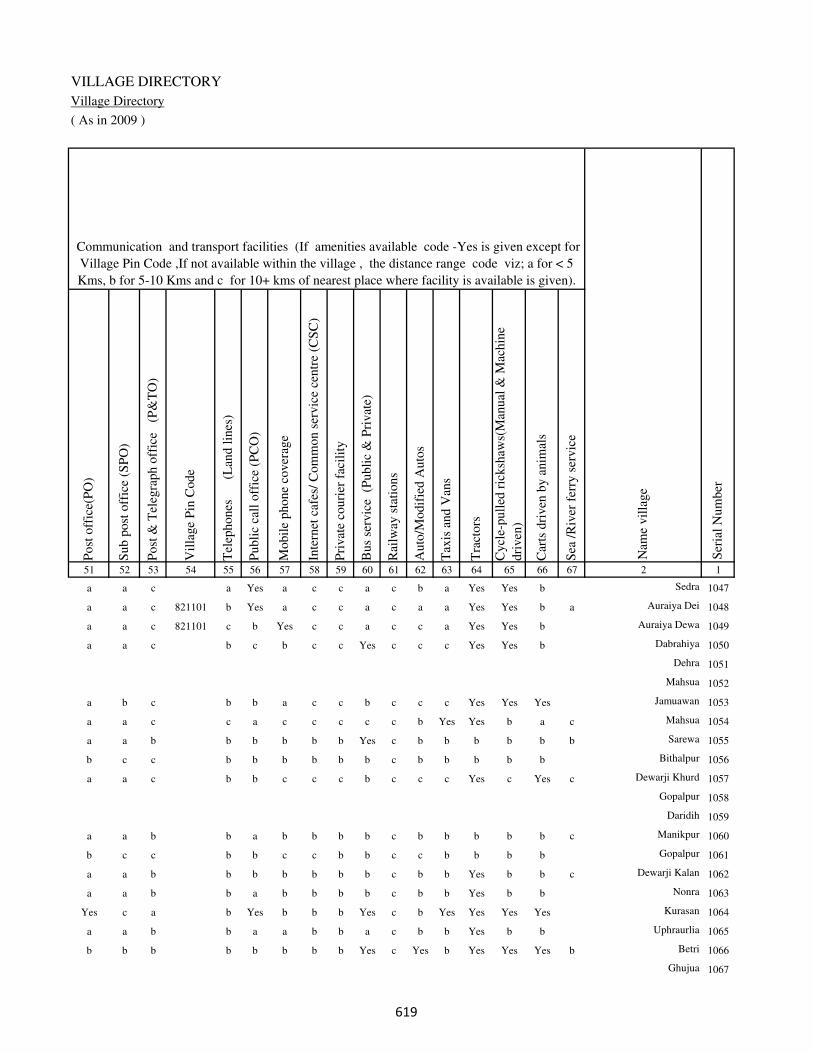
VILLAGE DIRECTORY
Village Directory
( As in 2009 )
Post
off
ice(
PO
)
Sub p
ost
off
ice
(SP
O)
Post
& T
eleg
raph o
ffic
e
(P&
TO
)
Vil
lage
Pin
Code
Tel
ephones
(L
and l
ines
)
Publi
c ca
ll o
ffic
e (P
CO
)
Mobil
e phone
cover
age
Inte
rnet
caf
es/
Com
mon s
ervic
e ce
ntr
e (C
SC
)
Pri
vat
e co
uri
er f
acil
ity
Bus
serv
ice
(P
ubli
c &
Pri
vat
e)
Rai
lway
sta
tions
Auto
/Modif
ied A
uto
s
Tax
is a
nd V
ans
Tra
ctors
Cycl
e-pull
ed r
icksh
aws(
Man
ual
& M
achin
e
dri
ven
)
Car
ts d
riven
by a
nim
als
Sea
/R
iver
fer
ry s
ervic
e51 52 53 54 55 56 57 58 59 60 61 62 63 64 65 66 67 2 1
Communication and transport facilities (If amenities available code -Yes is given except for
Village Pin Code ,If not available within the village , the distance range code viz; a for < 5
Kms, b for 5-10 Kms and c for 10+ kms of nearest place where facility is available is given).
Ser
ial
Num
ber
Nam
e vil
lage
a a c a Yes a c c a c b a Yes Yes b Sedra 1047
a a c 821101 b Yes a c c a c a a Yes Yes b a Auraiya Dei 1048
a a c 821101 c b Yes c c a c c a Yes Yes b Auraiya Dewa 1049
a a c b c b c c Yes c c c Yes Yes b Dabrahiya 1050
Dehra 1051
Mahsua 1052
a b c b b a c c b c c c Yes Yes Yes Jamuawan 1053
a a c c a c c c c c b Yes Yes b a c Mahsua 1054
a a b b b b b b Yes c b b b b b b Sarewa 1055
b c c b b b b b b c b b b b b Bithalpur 1056
a a c b b c c c b c c c Yes c Yes c Dewarji Khurd 1057
Gopalpur 1058
Daridih 1059
a a b b a b b b b c b b b b b c Manikpur 1060
b c c b b c c b b c c b b b b Gopalpur 1061
a a b b b b b b b c b b Yes b b c Dewarji Kalan 1062
a a b b a b b b b c b b Yes b b Nonra 1063
Yes c a b Yes b b b Yes c b Yes Yes Yes Yes Kurasan 1064
a a b b a a b b a c b b Yes b b Uphraurlia 1065
b b b b b b b b Yes c Yes b Yes Yes Yes b Betri 1066
Ghujua 1067
���
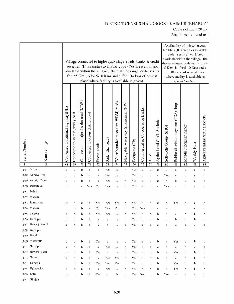
DISTRICT CENSUS HANDBOOK : KAIMUR (BHABUA)
Census of India 2011-
Amenities and Land use
Connec
ted t
o n
atio
nal
hig
hw
ay(N
H)
Connec
ted t
o s
tate
hig
hw
ay(S
H)
Connec
ted t
o m
ajor
dis
tric
t ro
ad (
MD
R)
Connec
ted t
o o
ther
s dis
tric
t ro
ad
Pucc
a r
oad
s
Kutc
hch
a r
oad
s
Wat
er b
ounded
mac
adam
(WB
M)
road
s
Nav
igab
le w
ater
way
(ri
ver
/can
al)(
NW
)
Footp
aths
(FP
)
Com
mer
cial
& C
o-o
per
ativ
e B
anks
AT
M
Agri
cult
ura
l C
redit
Soci
etie
s
Sel
f-H
elp G
roup (
SH
G)
Publi
c dis
trib
uti
on s
yst
em (
PD
S)
shop
Man
dis
/ R
egula
r m
arket
Wee
kly
Haa
t
Agri
cult
ura
l m
arket
ing s
oci
ety
1 2 68 69 70 71 72 73 74 75 76 77 78 79 80 81 82 83 84
Village connected to highways,village roads, banks & credit
societies (If amenities available code -Yes is given, If not
available within the village , the distance range code viz; a
for < 5 Kms, b for 5-10 Kms and c for 10+ kms of nearest
place where facility is available is given).
Ser
ial
Num
ber
Nam
e vil
lage
Availability of miscellaneous
facilities (If amenities available
code -Yes is given, If not
available within the village , the
distance range code viz; a for <
5 Kms, b for 5-10 Kms and c
for 10+ kms of nearest place
where facility is available is
given) Contd....
1047 Sedra c c b a a Yes a b Yes c c c a a c c c
1048 Auraiya Dei c c b a a Yes a b Yes c c c Yes c c c c
1049 Auraiya Dewa c c b a a Yes a b Yes c c c b b c c c
1050 Dabrahiya b c c Yes Yes Yes a b Yes a c c Yes a c a c
1051 Dehra
1052 Mahsua
1053 Jamuawan c c c b Yes Yes Yes b Yes a c c b Yes c a c
1054 Mahsua c b b a Yes Yes Yes b Yes Yes c c a a c c c
1055 Sarewa c b b b Yes Yes a b Yes a b b a a b b b
1056 Bithalpur c b b b a a a b Yes b c b b b b b c
1057 Dewarji Khurd c b b b a b a c Yes c c c a a c c c
1058 Gopalpur
1059 Daridih
1060 Manikpur c b b b Yes a a c Yes a b b a Yes b b b
1061 Gopalpur c b b b b Yes a b Yes b c c b a b c c
1062 Dewarji Kalan c b b b Yes a a b Yes a b b a Yes b b b
1063 Nonra c b b b b Yes Yes b Yes b b b a a b b b
1064 Kurasan c b b b Yes Yes Yes b Yes b b b b Yes b b b
1065 Uphraurlia c a a a a Yes a b Yes b b b a Yes b b b
1066 Betri b b b b Yes a b b Yes Yes b b Yes a a a b
1067 Ghujua
��

VILLAGE DIRECTORY
Village Directory
( As in 2009 )
Inte
gra
ted C
hil
d D
evel
opm
ent
Sch
eme
(Nutr
itio
nal
Cen
tres
)
Angan
wad
i C
entr
e (N
utr
itio
nal
Cen
tres
)
Oth
ers
(Nutr
itio
nal
Cen
tres
)
AS
HA
(A
ccre
dit
ed S
oci
al H
ealt
h A
ctiv
ist)
Com
munit
y c
entr
e w
ith/w
ithout
TV
Sport
s F
ield
,
Sport
s C
lub /
Rec
reat
ion C
entr
e
Cin
ema
/ V
ideo
Hal
l
Publi
c L
ibra
ry
Publi
c R
eadin
g R
oom
New
spap
er S
upply
Ass
embly
Poll
ing s
tati
on
Bir
th &
Dea
th R
egis
trat
ion O
ffic
e
Pow
er S
upply
for
Dom
esti
c U
se (
ED
)
Pow
er S
upply
for
Agri
cult
ura
l U
se (
EA
G)
Pow
er S
upply
for
Com
mer
cial
Use
(E
C)
Pow
er S
upply
for
All
Use
s (E
A)
85 86 87 88 89 90 91 92 93 94 95 96 97 98 99 100 101 2 1
Availability of
electricity (Yes/No)
Availability of miscellaneous facilities (If amenities available code -
Yes is given, If not available within the village , the distance range
code viz; a for < 5 Kms, b for 5-10 Kms and c for 10+ kms of
nearest place where facility is available is given) Concluded
Nam
e vil
lage
Ser
ial
Num
ber
c a a a c c c c c c Yes a a Yes No No No Sedra 1047
c Yes b a c b b c c c c a Yes Yes Yes No No Auraiya Dei 1048
c a a a c b c c c c c a a Yes Yes No No Auraiya Dewa 1049
c Yes b Yes b a c c c c c Yes Yes Yes Yes No No Dabrahiya 1050
Dehra 1051
Mahsua 1052
c Yes a Yes Yes c c b c b Yes Yes Yes Yes No No No Jamuawan 1053
c Yes b Yes b c c c c c c Yes Yes Yes Yes No No Mahsua 1054
b Yes b a b b b b b b b Yes Yes Yes No No No Sarewa 1055
c b Yes b c b c c c c b a a No No No No Bithalpur 1056
c Yes c Yes b c c c c c c a Yes Yes No No No Dewarji Khurd 1057
Gopalpur 1058
Daridih 1059
b Yes a a c b b b b b b a Yes No No No No Manikpur 1060
c b Yes b c c c c c c c a a No No No No Gopalpur 1061
b Yes b Yes b b b b b b b Yes Yes Yes No No No Dewarji Kalan 1062
b a b Yes b b c b b b b a a Yes Yes No No Nonra 1063
a Yes a Yes b Yes c c c c Yes Yes Yes Yes Yes No No Kurasan 1064
b a b b b b b b b b b a a Yes No No No Uphraurlia 1065
b Yes a Yes b c b c b c Yes Yes Yes Yes Yes No No Betri 1066
Ghujua 1067
��
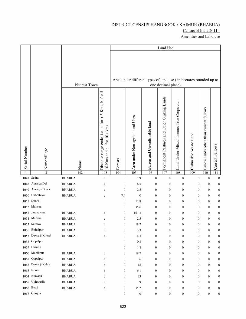
DISTRICT CENSUS HANDBOOK : KAIMUR (BHABUA)
Census of India 2011-
Amenities and Land use
Nam
e
Dis
tance
ran
ge
code
i.e
. a
fo
r <
5 K
ms,
b
for
5-
10 K
ms
and c
f
or
10+
km
s .
Fore
sts
Are
a under
Non-a
gri
cult
ura
l U
ses
Bar
ren a
nd U
n-c
ult
ivab
le l
and
Per
man
ent
Pas
ture
s an
d O
ther
Gra
zing L
ands
Lan
d U
nder
Mis
cell
aneo
us
Tre
e C
rops
etc.
Cult
ura
ble
Was
te L
and
Fal
low
lan
ds
oth
er t
han
curr
ent
fall
ow
s
Curr
ent
Fal
low
s
1 2 102 103 104 105 106 107 108 109 110 111
Ser
ial
Num
ber
Nam
e vil
lage
Area under different types of land use ( in hectares rounded up to
one decimal place)
Land Use
Nearest Town
1047 Sedra BHABUA c 0 1.9 0 0 0 0 0 0
1048 Auraiya Dei BHABUA c 0 8.5 0 0 0 0 0 0
1049 Auraiya Dewa BHABUA c 0 2.5 0 0 0 0 0 0
1050 Dabrahiya BHABUA c 7.4 0 0 0 0 0 0 0
1051 Dehra 0 11.8 0 0 0 0 0 0
1052 Mahsua 0 35.6 0 0 0 0 0 0
1053 Jamuawan BHABUA c 0 161.3 0 0 0 0 0 0
1054 Mahsua BHABUA c 0 2.5 0 0 0 0 0 0
1055 Sarewa BHABUA b 0 18.7 0 0 0 0 0 0
1056 Bithalpur BHABUA c 0 3.3 0 0 0 0 0 0
1057 Dewarji Khurd BHABUA c 0 4.3 0 0 0 0 0 0
1058 Gopalpur 0 0.8 0 0 0 0 0 0
1059 Daridih 0 1.8 0 0 0 0 0 0
1060 Manikpur BHABUA b 0 18.7 0 0 0 0 0 0
1061 Gopalpur BHABUA c 0 6 0 0 0 0 0 0
1062 Dewarji Kalan BHABUA b 0 18 0 0 0 0 0 0
1063 Nonra BHABUA b 0 6.1 0 0 0 0 0 0
1064 Kurasan BHABUA a 0 33 0 0 0 0 0 0
1065 Uphraurlia BHABUA b 0 9 0 0 0 0 0 0
1066 Betri BHABUA b 0 35.2 0 0 0 0 0 0
1067 Ghujua 0 0 0 0 0 0 0 0
�

VILLAGE DIRECTORY
Village Directory
( As in 2009 )
Net
Are
a S
ow
n
Tota
l Ir
rigat
ed L
and A
rea
Tota
l U
n-i
rrig
ated
Lan
d A
rea
Can
als
( C
)
Wel
ls/T
ube-
wel
ls(W
/TW
)
Tan
ks/
Lak
es(T
/L)
Wat
er F
alls
(WF
)
Oth
ers(
O)
Fir
st
Sec
ond
Thir
d
112 113 114 115 116 117 118 119 120 121 122 2 1
Ser
ial
Num
ber
Name of three
most important
commodities
manufacturedArea irrigated by source (in hectare).
Nam
e of
Vil
lage
Area under different types of
land use ( in hectares rounded
up to one decimal place)
Land Use
27.1 22 5.1 0 22 0 0 0 Sedra 1047
113.5 40.3 73.2 0 40.3 0 0 0 Auraiya Dei 1048
64.5 35.7 28.8 0 27.7 8 0 0 Auraiya Dewa 1049
255.6 83.8 171.8 26.4 57.4 0 0 0 Dabrahiya 1050
34.2 4 30.2 0 4 0 0 0 Dehra 1051
63.4 8.5 54.9 0 8.5 0 0 0 Mahsua 1052
232.7 91.8 140.9 0 50 41.8 0 0 Jamuawan 1053
148.5 148.5 0 140.5 8 0 0 0 Mahsua 1054
133.3 132.5 0.8 130.6 1.9 0 0 0 Sarewa 1055
43.7 42.8 0.9 42.8 0 0 0 0 Bithalpur 1056
22.7 21.3 1.4 21.3 0 0 0 0 Dewarji Khurd 1057
25.2 16.3 8.9 16.3 0 0 0 0 Gopalpur 1058
12.2 11.1 1.1 11.1 0 0 0 0 Daridih 1059
137.3 133.8 3.5 133.8 0 0 0 0 Manikpur 1060
51 48.8 2.2 48.8 0 0 0 0 Gopalpur 1061
114 112.3 1.7 112.3 0 0 0 0 Dewarji Kalan 1062
64.9 62.4 2.5 62.4 0 0 0 0 Nonra 1063
343 310 33 310 0 0 0 0 Kurasan 1064
80 77 3 77 0 0 0 0 Uphraurlia 1065
372.8 312.2 60.6 306.3 5.9 0 0 0 Betri 1066
34 24 10 0 20 0 0 4 Ghujua 1067
�

DISTRICT CENSUS HANDBOOK : KAIMUR (BHABUA)
Census of India 2011-
Amenities and Land use
Pre
-Pri
mar
y s
chool
(PP
)
Pri
mar
y s
chool
(P)
Mid
dle
sch
ool
(M)
Sec
ondar
y S
chool
(S)
Sen
ior
Sec
ondar
y s
chool
(SS
)
Deg
ree
coll
ege
of
arts
sc
ience
& c
om
mer
ce
(AS
C)
Engin
eeri
ng c
oll
ege(
EC
)
Med
ical
coll
ege
(MC
)
Man
agem
ent
inst
itute
(M
I)
Poly
tech
nic
(P
t)
Voca
tional
tra
inin
g s
chool
/IT
I
Non-f
orm
al t
rain
ing c
entr
e (N
FT
C)
Spec
ial
school
for
dis
able
d (
SS
D)
Oth
ers
(spec
ify)
1 2 3 4 5 6 7 8 9 10 11 12 13 14 15 16 17 18 19 20
Loca
tion c
ode
no.
Nam
e vil
lage
Ser
ial
Num
ber
Tota
l popula
tion (
2011 c
ensu
s )
Tota
l ar
ea o
f th
e vil
lage
( in
hec
tare
s ro
unded
up t
o
one
dec
imal
pla
ce)
Number of educational amenities available. (If not available
within the village , the distance range code viz; a for < 5
Kms, b for 5-10 Kms and c for 10+ kms of nearest place
where facility is available is given).
Num
ber
of
house
hold
s (2
011 c
ensu
s)
1068 Rehari 249992 74 0 0
1069 Mokri 249993 410 8398 1458 b 4 2 c b c c c c c c c c
1070 Palka 249994 194 1870 343 b 1 1 c b c c c c c b b c
1071 Mehiyan 249995 66 0 0
1072 Gorhan 249996 186 1348 230 b 1 b c b c c c c c b b c
1073 Dharhanian 249997 46 729 104 a 1 a c a c c c c c a c c
1074 Sarangpur 249998 181 1641 269 a 1 1 c a c c c c c b c c
1075 Dumdum 249999 271 2281 368 b 1 1 c b c c c c c b c c
1076 Siu 250000 225 4736 815 1 2 2 c a c c c c c c a c
1077 Shiw Patti 250001 78 522 78 b 1 b c b c c c c c c b c
1078 Danrwa 250002 71 479 68 a 1 a c a c c c c c c a c
1079 Khadaura 250003 112 414 59 a a a c a c c c c c c a c
1080 Sudarsanpur 250004 25 10 2 b a a c a c c c c c c a c
1081 Saitha 250005 326 2451 401 b 1 1 c b c c c c c c b c
1082 Semaria 250006 57 303 51 b 1 a c b c c c c c c c c
1083 Dharampura 250007 32 553 77 a 1 a c b c b c c c b b c
1084 Shiwpur 250008 33 900 144 1 1 1 b b c b c c c b b c
1085 Tirtha 250009 27 0 0
1086 Itwa 250010 21 0 0
1087 Bhokhri 250011 64 437 54 b 1 a c b c b c c c b b c
1088 Shah Patti 250012 32 0 0
��

VILLAGE DIRECTORY
Village Directory
( As in 2009 )
Com
munit
y h
ealt
h c
entr
e (C
HC
)
Pri
mar
y h
ealt
h c
entr
e (P
HC
)
Pri
mar
y h
ealt
h s
ub c
entr
e (P
HS
)
Mat
ernit
y a
nd c
hil
d w
elfa
re c
entr
e (M
CW
)
T.B
. cl
inic
(T
BC
)
Hosp
ital
-all
opat
hic
(H
A)
Hosp
ital
-alt
ernat
ive
med
icin
e (H
O)
Dis
pen
sary
(D
)
Vet
erin
ary h
osp
ital
(V
H)
Mobil
e hea
lth c
linic
(M
HC
)
Fam
ily w
elfa
re c
entr
e (F
WC
)
Char
itab
le n
on G
ovt.
hosp
ital
/Nurs
ing h
om
e.
Med
ical
pra
ctit
ioner
wit
h M
BB
S D
egre
e
Med
ical
pra
ctit
ioner
wit
h o
ther
deg
ree
Med
ical
pra
ctit
ioner
wit
h n
o d
egre
e
Tra
dit
ional
pra
ctit
ioner
an
d f
aith
hea
ler
.
Med
icin
e S
hop
Oth
ers
21 22 23 24 25 26 27 28 29 30 31 32 33 34 35 36 37 38 2 1
Number of Non-Government
Medical Amenities available.
Number of Medical Amenities available. (If not
available within the village , the distance range
code viz; a for < 5 Kms, b for 5-10 Kms and c
for 10+ kms of nearest place where facility is
available is given).
Nam
e vil
lage
Ser
ial
Num
ber
Rehari 1068
b b 1 1 b b b b b b 1 0 0 0 0 0 0 0 Mokri 1069
b b b b b b b b b b b 0 0 0 0 0 0 0 Palka 1070
Mehiyan 1071
b b b b b b b b b b b 0 0 0 0 0 0 0 Gorhan 1072
a a a a a a a a a a a 0 0 0 0 0 0 0 Dharhanian 1073
a a a a a b b a a b a 0 0 0 0 0 0 0 Sarangpur 1074
b b 1 1 b b b b b b 1 0 0 0 0 0 0 0 Dumdum 1075
a a 1 1 a a a a a a 1 0 0 0 0 0 0 0 Siu 1076
b b b b b b b b b b b 0 0 0 0 0 0 0 Shiw Patti 1077
a a a a a b b a a b a 0 0 0 0 0 0 0 Danrwa 1078
a a a a a a a a a a a 0 0 0 0 0 0 0 Khadaura 1079
a a a a a a a a a a a 0 0 0 0 0 0 0 Sudarsanpur 1080
b b b b b b b b b b b 0 0 0 0 0 0 0 Saitha 1081
b b b b b b b b b b b 0 0 0 0 0 0 0 Semaria 1082
b b b b b b b b b b b 0 0 0 0 0 0 0 Dharampura 1083
b b a b b b b b b b b 0 0 0 0 0 0 0 Shiwpur 1084
Tirtha 1085
Itwa 1086
b b b b b b b b b b b 0 0 0 0 0 0 0 Bhokhri 1087
Shah Patti 1088
��

DISTRICT CENSUS HANDBOOK : KAIMUR (BHABUA)
Census of India 2011-
Amenities and Land use
Tap
wat
er (
Tre
ated
/Untr
eate
d)
Wel
l w
ater
(Cover
ed /
Unco
ver
ed w
ell)
Han
d P
um
p
Tube
wel
ls /
Bore
wel
l
Spri
ng
Riv
er /
Can
al
Tan
k /
Pond /
L
ake
Oth
ers
Com
munit
y t
oil
et i
ncl
udin
g
bat
h.
Com
munit
y t
oil
et e
xcl
udin
g b
ath.
Rura
l s
anit
ary m
art
or
sanit
ary
har
dw
are
outl
et
avai
lable
nea
r th
e vil
lage.
Com
munit
y b
io-
gas
or
recy
cle
of
was
te f
or
pro
duct
ive
use
.
1 2 39 40 41 42 43 44 45 46 47 48 49 50
Availability of toilet & others
Yes / No Availability of drinking water - Yes / No
Nam
e vil
lage
Ser
ial
Num
ber
1068 Rehari
1069 Mokri No Yes Yes Yes No No Yes No No No No No
1070 Palka No Yes Yes Yes No Yes Yes No No No No No
1071 Mehiyan
1072 Gorhan No Yes Yes No No No No No No No No No
1073 Dharhanian No Yes Yes No No No No No No No No No
1074 Sarangpur No Yes Yes Yes No Yes Yes No No No No No
1075 Dumdum No Yes Yes Yes No Yes Yes No No No No No
1076 Siu No Yes Yes Yes No Yes Yes No No No No No
1077 Shiw Patti No Yes Yes No No No No No No No No No
1078 Danrwa No Yes Yes No No Yes No Yes No No No No
1079 Khadaura No Yes Yes No No Yes No No No No No No
1080 Sudarsanpur No No Yes No No Yes No No No No No No
1081 Saitha No Yes Yes Yes No Yes No No No No No No
1082 Semaria No Yes Yes No No Yes No No No No No No
1083 Dharampura No Yes Yes No No No No No No No No No
1084 Shiwpur No Yes Yes No No No Yes No No No No No
1085 Tirtha
1086 Itwa
1087 Bhokhri No Yes Yes No No No No No No No No No
1088 Shah Patti
��
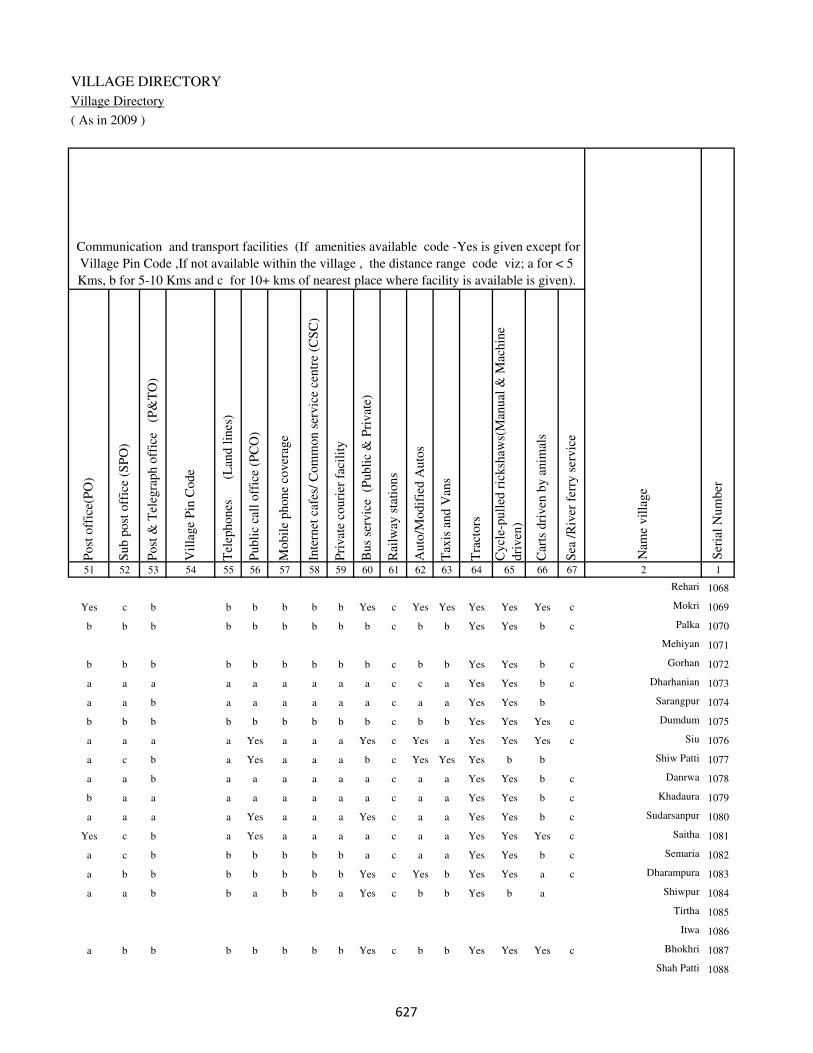
VILLAGE DIRECTORY
Village Directory
( As in 2009 )
Post
off
ice(
PO
)
Sub p
ost
off
ice
(SP
O)
Post
& T
eleg
raph o
ffic
e
(P&
TO
)
Vil
lage
Pin
Code
Tel
ephones
(L
and l
ines
)
Publi
c ca
ll o
ffic
e (P
CO
)
Mobil
e phone
cover
age
Inte
rnet
caf
es/
Com
mon s
ervic
e ce
ntr
e (C
SC
)
Pri
vat
e co
uri
er f
acil
ity
Bus
serv
ice
(P
ubli
c &
Pri
vat
e)
Rai
lway
sta
tions
Auto
/Modif
ied A
uto
s
Tax
is a
nd V
ans
Tra
ctors
Cycl
e-pull
ed r
icksh
aws(
Man
ual
& M
achin
e
dri
ven
)
Car
ts d
riven
by a
nim
als
Sea
/R
iver
fer
ry s
ervic
e51 52 53 54 55 56 57 58 59 60 61 62 63 64 65 66 67 2 1
Communication and transport facilities (If amenities available code -Yes is given except for
Village Pin Code ,If not available within the village , the distance range code viz; a for < 5
Kms, b for 5-10 Kms and c for 10+ kms of nearest place where facility is available is given).
Ser
ial
Num
ber
Nam
e vil
lage
Rehari 1068
Yes c b b b b b b Yes c Yes Yes Yes Yes Yes c Mokri 1069
b b b b b b b b b c b b Yes Yes b c Palka 1070
Mehiyan 1071
b b b b b b b b b c b b Yes Yes b c Gorhan 1072
a a a a a a a a a c c a Yes Yes b c Dharhanian 1073
a a b a a a a a a c a a Yes Yes b Sarangpur 1074
b b b b b b b b b c b b Yes Yes Yes c Dumdum 1075
a a a a Yes a a a Yes c Yes a Yes Yes Yes c Siu 1076
a c b a Yes a a a b c Yes Yes Yes b b Shiw Patti 1077
a a b a a a a a a c a a Yes Yes b c Danrwa 1078
b a a a a a a a a c a a Yes Yes b c Khadaura 1079
a a a a Yes a a a Yes c a a Yes Yes b c Sudarsanpur 1080
Yes c b a Yes a a a a c a a Yes Yes Yes c Saitha 1081
a c b b b b b b a c a a Yes Yes b c Semaria 1082
a b b b b b b b Yes c Yes b Yes Yes a c Dharampura 1083
a a b b a b b a Yes c b b Yes b a Shiwpur 1084
Tirtha 1085
Itwa 1086
a b b b b b b b Yes c b b Yes Yes Yes c Bhokhri 1087
Shah Patti 1088
��
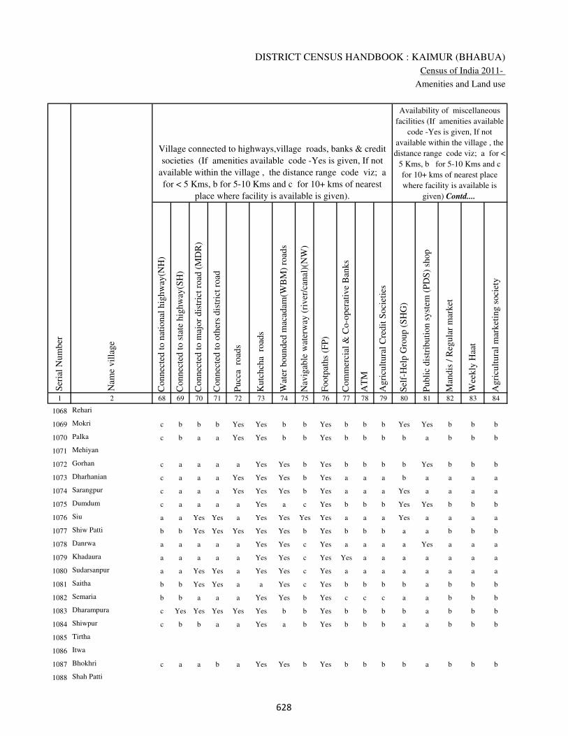
DISTRICT CENSUS HANDBOOK : KAIMUR (BHABUA)
Census of India 2011-
Amenities and Land use
Connec
ted t
o n
atio
nal
hig
hw
ay(N
H)
Connec
ted t
o s
tate
hig
hw
ay(S
H)
Connec
ted t
o m
ajor
dis
tric
t ro
ad (
MD
R)
Connec
ted t
o o
ther
s dis
tric
t ro
ad
Pucc
a r
oad
s
Kutc
hch
a r
oad
s
Wat
er b
ounded
mac
adam
(WB
M)
road
s
Nav
igab
le w
ater
way
(ri
ver
/can
al)(
NW
)
Footp
aths
(FP
)
Com
mer
cial
& C
o-o
per
ativ
e B
anks
AT
M
Agri
cult
ura
l C
redit
Soci
etie
s
Sel
f-H
elp G
roup (
SH
G)
Publi
c dis
trib
uti
on s
yst
em (
PD
S)
shop
Man
dis
/ R
egula
r m
arket
Wee
kly
Haa
t
Agri
cult
ura
l m
arket
ing s
oci
ety
1 2 68 69 70 71 72 73 74 75 76 77 78 79 80 81 82 83 84
Village connected to highways,village roads, banks & credit
societies (If amenities available code -Yes is given, If not
available within the village , the distance range code viz; a
for < 5 Kms, b for 5-10 Kms and c for 10+ kms of nearest
place where facility is available is given).
Ser
ial
Num
ber
Nam
e vil
lage
Availability of miscellaneous
facilities (If amenities available
code -Yes is given, If not
available within the village , the
distance range code viz; a for <
5 Kms, b for 5-10 Kms and c
for 10+ kms of nearest place
where facility is available is
given) Contd....
1068 Rehari
1069 Mokri c b b b Yes Yes b b Yes b b b Yes Yes b b b
1070 Palka c b a a Yes Yes b b Yes b b b b a b b b
1071 Mehiyan
1072 Gorhan c a a a a Yes Yes b Yes b b b b Yes b b b
1073 Dharhanian c a a a Yes Yes Yes b Yes a a a b a a a a
1074 Sarangpur c a a a Yes Yes Yes b Yes a a a Yes a a a a
1075 Dumdum c a a a a Yes a c Yes b b b Yes Yes b b b
1076 Siu a a Yes Yes a Yes Yes Yes Yes a a a Yes a a a a
1077 Shiw Patti b b Yes Yes Yes Yes Yes b Yes b b b a a b b b
1078 Danrwa a a a a a Yes Yes c Yes a a a a Yes a a a
1079 Khadaura a a a a a Yes Yes c Yes Yes a a a a a a a
1080 Sudarsanpur a a Yes Yes a Yes Yes c Yes a a a a a a a a
1081 Saitha b b Yes Yes a a Yes c Yes b b b b a b b b
1082 Semaria b b a a a Yes Yes b Yes c c c a a b b b
1083 Dharampura c Yes Yes Yes Yes Yes b b Yes b b b b a b b b
1084 Shiwpur c b b a a Yes a b Yes b b b a a b b b
1085 Tirtha
1086 Itwa
1087 Bhokhri c a a b a Yes Yes b Yes b b b b a b b b
1088 Shah Patti
��

VILLAGE DIRECTORY
Village Directory
( As in 2009 )
Inte
gra
ted C
hil
d D
evel
opm
ent
Sch
eme
(Nutr
itio
nal
Cen
tres
)
Angan
wad
i C
entr
e (N
utr
itio
nal
Cen
tres
)
Oth
ers
(Nutr
itio
nal
Cen
tres
)
AS
HA
(A
ccre
dit
ed S
oci
al H
ealt
h A
ctiv
ist)
Com
munit
y c
entr
e w
ith/w
ithout
TV
Sport
s F
ield
,
Sport
s C
lub /
Rec
reat
ion C
entr
e
Cin
ema
/ V
ideo
Hal
l
Publi
c L
ibra
ry
Publi
c R
eadin
g R
oom
New
spap
er S
upply
Ass
embly
Poll
ing s
tati
on
Bir
th &
Dea
th R
egis
trat
ion O
ffic
e
Pow
er S
upply
for
Dom
esti
c U
se (
ED
)
Pow
er S
upply
for
Agri
cult
ura
l U
se (
EA
G)
Pow
er S
upply
for
Com
mer
cial
Use
(E
C)
Pow
er S
upply
for
All
Use
s (E
A)
85 86 87 88 89 90 91 92 93 94 95 96 97 98 99 100 101 2 1
Availability of
electricity (Yes/No)
Availability of miscellaneous facilities (If amenities available code -
Yes is given, If not available within the village , the distance range
code viz; a for < 5 Kms, b for 5-10 Kms and c for 10+ kms of
nearest place where facility is available is given) Concluded
Nam
e vil
lage
Ser
ial
Num
ber
Rehari 1068
b Yes a Yes b b b b b b Yes Yes Yes Yes Yes No No Mokri 1069
b Yes b Yes b b b b b b b Yes Yes Yes Yes No No Palka 1070
Mehiyan 1071
b Yes a Yes b b b b b b b Yes Yes Yes Yes No No Gorhan 1072
a Yes a Yes a a a a a a a Yes Yes Yes Yes No No Dharhanian 1073
b Yes a Yes a a a a a a a Yes Yes Yes Yes No No Sarangpur 1074
b Yes Yes a b b b b b b b Yes Yes Yes Yes No No Dumdum 1075
a Yes a Yes b b a c c a Yes Yes Yes Yes Yes No No Siu 1076
b a a a b Yes b b b b b Yes b Yes Yes No No Shiw Patti 1077
b a b a a a a a a a a a a Yes Yes No No Danrwa 1078
a a a a a a a a a a a a a No No No No Khadaura 1079
a a a a a a a a a a a Yes Yes Yes Yes No No Sudarsanpur 1080
b Yes a Yes b b c c c c b Yes b Yes Yes No No Saitha 1081
b Yes Yes Yes b b b b b b b a Yes Yes Yes No No Semaria 1082
b a Yes a b b b b b b b a Yes Yes No No No Dharampura 1083
b Yes a Yes b b b b b b b Yes Yes No No No No Shiwpur 1084
Tirtha 1085
Itwa 1086
b a a Yes b b b b b b b a a No No No No Bhokhri 1087
Shah Patti 1088
��

DISTRICT CENSUS HANDBOOK : KAIMUR (BHABUA)
Census of India 2011-
Amenities and Land use
Nam
e
Dis
tance
ran
ge
code
i.e
. a
fo
r <
5 K
ms,
b
for
5-
10 K
ms
and c
f
or
10+
km
s .
Fore
sts
Are
a under
Non-a
gri
cult
ura
l U
ses
Bar
ren a
nd U
n-c
ult
ivab
le l
and
Per
man
ent
Pas
ture
s an
d O
ther
Gra
zing L
ands
Lan
d U
nder
Mis
cell
aneo
us
Tre
e C
rops
etc.
Cult
ura
ble
Was
te L
and
Fal
low
lan
ds
oth
er t
han
curr
ent
fall
ow
s
Curr
ent
Fal
low
s
1 2 102 103 104 105 106 107 108 109 110 111
Ser
ial
Num
ber
Nam
e vil
lage
Area under different types of land use ( in hectares rounded up to
one decimal place)
Land Use
Nearest Town
1068 Rehari 0 2 0 0 0 0 0 0
1069 Mokri BHABUA b 0 54 0 0 0 0 0 0
1070 Palka BHABUA b 0 44 0 0 0 0 0 0
1071 Mehiyan 0 3 0 0 0 0 0 0
1072 Gorhan BHABUA b 0 17 0 0 0 0 0 0
1073 Dharhanian BHABUA a 0 7 0 0 0 0 0 0
1074 Sarangpur BHABUA b 0 51 0 0 0 0 0 0
1075 Dumdum BHABUA b 0 36.3 0 0 0 0 0 0
1076 Siu BHABUA a 0 19.4 0 0 0 0 0 0
1077 Shiw Patti BHABUA b 0 17.2 0 0 0 0 0 0
1078 Danrwa BHABUA b 0 10.6 0 0 0 0 0 0
1079 Khadaura BHABUA a 0 13.3 0 0 0 0 0 0
1080 Sudarsanpur BHABUA a 0 6 0 0 0 0 0 0
1081 Saitha BHABUA b 0 72.3 0 0 0 0 0 0
1082 Semaria BHABUA b 0 5.1 0 0 0 0 0 0
1083 Dharampura BHABUA b 0 1.5 0 0 0 0 0 0
1084 Shiwpur BHABUA b 0 2.2 0 0 0 0 0 0
1085 Tirtha 0 0.3 0 0 0 0 0 0
1086 Itwa 0 4.2 0 0 0 0 0 0
1087 Bhokhri BHABUA b 0 6.7 0 0 0 0 0 0
1088 Shah Patti 0 2 0 0 0 0 0 0
��

VILLAGE DIRECTORY
Village Directory
( As in 2009 )
Net
Are
a S
ow
n
Tota
l Ir
rigat
ed L
and A
rea
Tota
l U
n-i
rrig
ated
Lan
d A
rea
Can
als
( C
)
Wel
ls/T
ube-
wel
ls(W
/TW
)
Tan
ks/
Lak
es(T
/L)
Wat
er F
alls
(WF
)
Oth
ers(
O)
Fir
st
Sec
ond
Thir
d
112 113 114 115 116 117 118 119 120 121 122 2 1
Ser
ial
Num
ber
Name of three
most important
commodities
manufacturedArea irrigated by source (in hectare).
Nam
e of
Vil
lage
Area under different types of
land use ( in hectares rounded
up to one decimal place)
Land Use
72 63 9 63 0 0 0 0 Rehari 1068
356 105.2 250.8 55.2 50 0 0 0 Mokri 1069
150 120 30 0 100 0 0 20 Palka 1070
63 60.5 2.5 0 1.4 59.1 0 0 Mehiyan 1071
169 133 36 0 33 100 0 0 Gorhan 1072
39 34 5 2.1 0 31.9 0 0 Dharhanian 1073
130 121 9 101.5 19.5 0 0 0 Sarangpur 1074
234.7 215 19.7 186.7 28.3 0 0 0 Dumdum 1075
205.6 193.7 11.9 175.3 18.4 0 0 0 Siu 1076
60.8 55.5 5.3 51.8 3.7 0 0 0 Shiw Patti 1077
60.4 57.8 2.6 52.9 4.9 0 0 0 Danrwa 1078
98.7 92.7 6 90.6 2.1 0 0 0 Khadaura 1079
19 15 4 0 13.2 0 0 1.8 Sudarsanpur 1080
253.7 146.6 107.1 0 58.6 88 0 0 Saitha 1081
51.9 32.7 19.2 0 18.3 14.4 0 0 Semaria 1082
30.5 13 17.5 8.8 0 0 0 4.2 Dharampura 1083
30.8 20.5 10.3 12.3 0 0 0 8.2 Shiwpur 1084
26.7 19.7 7 16.2 0 0 0 3.5 Tirtha 1085
16.8 14 2.8 10 0 0 0 4 Itwa 1086
57.3 25.8 31.5 16.3 0 0 0 9.5 Bhokhri 1087
30 11.5 18.5 8 0 0 0 3.5 Shah Patti 1088
��

DISTRICT CENSUS HANDBOOK : KAIMUR (BHABUA)
Census of India 2011-
Amenities and Land use
Pre
-Pri
mar
y s
chool
(PP
)
Pri
mar
y s
chool
(P)
Mid
dle
sch
ool
(M)
Sec
ondar
y S
chool
(S)
Sen
ior
Sec
ondar
y s
chool
(SS
)
Deg
ree
coll
ege
of
arts
sc
ience
& c
om
mer
ce
(AS
C)
Engin
eeri
ng c
oll
ege(
EC
)
Med
ical
coll
ege
(MC
)
Man
agem
ent
inst
itute
(M
I)
Poly
tech
nic
(P
t)
Voca
tional
tra
inin
g s
chool
/IT
I
Non-f
orm
al t
rain
ing c
entr
e (N
FT
C)
Spec
ial
school
for
dis
able
d (
SS
D)
Oth
ers
(spec
ify)
1 2 3 4 5 6 7 8 9 10 11 12 13 14 15 16 17 18 19 20
Loca
tion c
ode
no.
Nam
e vil
lage
Ser
ial
Num
ber
Tota
l popula
tion (
2011 c
ensu
s )
Tota
l ar
ea o
f th
e vil
lage
( in
hec
tare
s ro
unded
up t
o
one
dec
imal
pla
ce)
Number of educational amenities available. (If not available
within the village , the distance range code viz; a for < 5
Kms, b for 5-10 Kms and c for 10+ kms of nearest place
where facility is available is given).
Num
ber
of
house
hold
s (2
011 c
ensu
s)
1089 Sijhwa 250013 88 806 152 b 1 a c c c c c c c c c c
1090 Chakia 250014 26 0 0
1091 Ghuran Chak 250015 32 0 0
1092 Bhokhra 250016 25 620 120 b b b c a b c c c c b b c b
1093 Sapnautia 250017 138 619 89 b 1 a c c c b c c c b b c
1094 Karman 250018 74 1100 168 c 1 1 c a b c c c c b c c
1095 Jamunapur 250019 70 0 0
1096 Ghurde Dehra 250020 83 238 43 c 1 b c a b c c c c b b c b
1097 Harnatanr 250021 83 582 83 c 1 b c a b c c c c b b c b
1098 Akhtiarpur 250022 15 0 0
1099 Malahpurwa 250023 75 0 0
1100 Amarhi 250024 87 1339 172 c 1 1 c c c b c c c c c c
1101 Jadupur 250025 39 403 67 c 1 b c a b c c c c c c c b
1102 Sikra 250026 158 782 123 a 1 a c a c c c c c c a c
1103 Marha 250027 80 0 0
1104 Rattichak 250028 33 0 0
1105 Kukrarh 250029 162 1404 205 a 1 a c a c c c c c c a c
1106 Sekhwa 250030 54 267 54 c b b c a b c c c c b b c b
1107 Pachgawan 250031 144 1591 242 c 1 b c b b c c c c b b c
1108 Jasa 250032 113 0 0
1109 Pangaiyan 250033 46 469 74 c a b c a b c c c c b c c b
�

VILLAGE DIRECTORY
Village Directory
( As in 2009 )
Com
munit
y h
ealt
h c
entr
e (C
HC
)
Pri
mar
y h
ealt
h c
entr
e (P
HC
)
Pri
mar
y h
ealt
h s
ub c
entr
e (P
HS
)
Mat
ernit
y a
nd c
hil
d w
elfa
re c
entr
e (M
CW
)
T.B
. cl
inic
(T
BC
)
Hosp
ital
-all
opat
hic
(H
A)
Hosp
ital
-alt
ernat
ive
med
icin
e (H
O)
Dis
pen
sary
(D
)
Vet
erin
ary h
osp
ital
(V
H)
Mobil
e hea
lth c
linic
(M
HC
)
Fam
ily w
elfa
re c
entr
e (F
WC
)
Char
itab
le n
on G
ovt.
hosp
ital
/Nurs
ing h
om
e.
Med
ical
pra
ctit
ioner
wit
h M
BB
S D
egre
e
Med
ical
pra
ctit
ioner
wit
h o
ther
deg
ree
Med
ical
pra
ctit
ioner
wit
h n
o d
egre
e
Tra
dit
ional
pra
ctit
ioner
an
d f
aith
hea
ler
.
Med
icin
e S
hop
Oth
ers
21 22 23 24 25 26 27 28 29 30 31 32 33 34 35 36 37 38 2 1
Number of Non-Government
Medical Amenities available.
Number of Medical Amenities available. (If not
available within the village , the distance range
code viz; a for < 5 Kms, b for 5-10 Kms and c
for 10+ kms of nearest place where facility is
available is given).
Nam
e vil
lage
Ser
ial
Num
ber
c c b c c c c c c c c 0 0 0 0 0 0 0 Sijhwa 1089
Chakia 1090
Ghuran Chak 1091
b b b b b c c b b c b 0 0 0 0 0 0 0 Bhokhra 1092
b b b b b b b b b b b 0 0 0 0 0 0 0 Sapnautia 1093
c c c c c c c c c c c 0 3 4 4 0 4 0 Karman 1094
Jamunapur 1095
b b b b b c c b b c b 0 0 0 0 0 0 0 Ghurde Dehra 1096
b b b b b c c b b c b 0 0 0 0 0 0 0 Harnatanr 1097
Akhtiarpur 1098
Malahpurwa 1099
b b b b b b b b b b b 0 0 0 0 0 0 0 Amarhi 1100
b b b b b b b b b b b 0 0 0 0 0 0 0 Jadupur 1101
a a a a a a a a a a a 0 0 0 0 0 0 0 Sikra 1102
Marha 1103
Rattichak 1104
a a a a a a a a a a a 0 0 0 0 0 0 0 Kukrarh 1105
b b b b b a a b b a b 0 0 0 0 0 0 0 Sekhwa 1106
b b b b b b b b b b b 0 0 0 0 0 0 0 Pachgawan 1107
Jasa 1108
b b b b b b b b b b b 0 0 0 0 0 0 0 Pangaiyan 1109
�

DISTRICT CENSUS HANDBOOK : KAIMUR (BHABUA)
Census of India 2011-
Amenities and Land use
Tap
wat
er (
Tre
ated
/Untr
eate
d)
Wel
l w
ater
(Cover
ed /
Unco
ver
ed w
ell)
Han
d P
um
p
Tube
wel
ls /
Bore
wel
l
Spri
ng
Riv
er /
Can
al
Tan
k /
Pond /
L
ake
Oth
ers
Com
munit
y t
oil
et i
ncl
udin
g
bat
h.
Com
munit
y t
oil
et e
xcl
udin
g b
ath.
Rura
l s
anit
ary m
art
or
sanit
ary
har
dw
are
outl
et
avai
lable
nea
r th
e vil
lage.
Com
munit
y b
io-
gas
or
recy
cle
of
was
te f
or
pro
duct
ive
use
.
1 2 39 40 41 42 43 44 45 46 47 48 49 50
Availability of toilet & others
Yes / No Availability of drinking water - Yes / No
Nam
e vil
lage
Ser
ial
Num
ber
1089 Sijhwa No Yes Yes No No No No No No No No No
1090 Chakia
1091 Ghuran Chak
1092 Bhokhra No Yes Yes Yes No No No No No No No No
1093 Sapnautia No Yes Yes Yes No No No No No No No No
1094 Karman No Yes Yes Yes No No No No No No No No
1095 Jamunapur
1096 Ghurde Dehra No Yes Yes Yes No No No No No No No No
1097 Harnatanr No Yes Yes Yes No No No No No No No No
1098 Akhtiarpur
1099 Malahpurwa
1100 Amarhi No Yes Yes No No No Yes No No No No No
1101 Jadupur No Yes Yes No No No Yes No No No No No
1102 Sikra No Yes Yes No No No No No No No No No
1103 Marha
1104 Rattichak
1105 Kukrarh No Yes Yes No No No No No No No No No
1106 Sekhwa Yes Yes Yes Yes No No Yes No No No No No
1107 Pachgawan No Yes Yes Yes No Yes No No No No No No
1108 Jasa
1109 Pangaiyan No Yes Yes Yes No No No No No No No No
��

VILLAGE DIRECTORY
Village Directory
( As in 2009 )
Post
off
ice(
PO
)
Sub p
ost
off
ice
(SP
O)
Post
& T
eleg
raph o
ffic
e
(P&
TO
)
Vil
lage
Pin
Code
Tel
ephones
(L
and l
ines
)
Publi
c ca
ll o
ffic
e (P
CO
)
Mobil
e phone
cover
age
Inte
rnet
caf
es/
Com
mon s
ervic
e ce
ntr
e (C
SC
)
Pri
vat
e co
uri
er f
acil
ity
Bus
serv
ice
(P
ubli
c &
Pri
vat
e)
Rai
lway
sta
tions
Auto
/Modif
ied A
uto
s
Tax
is a
nd V
ans
Tra
ctors
Cycl
e-pull
ed r
icksh
aws(
Man
ual
& M
achin
e
dri
ven
)
Car
ts d
riven
by a
nim
als
Sea
/R
iver
fer
ry s
ervic
e51 52 53 54 55 56 57 58 59 60 61 62 63 64 65 66 67 2 1
Communication and transport facilities (If amenities available code -Yes is given except for
Village Pin Code ,If not available within the village , the distance range code viz; a for < 5
Kms, b for 5-10 Kms and c for 10+ kms of nearest place where facility is available is given).
Ser
ial
Num
ber
Nam
e vil
lage
b c c c c c c c a c c c Yes a b c Sijhwa 1089
Chakia 1090
Ghuran Chak 1091
b b c b b b b b b b b b b b b b Bhokhra 1092
a b b b b b b b b c b b Yes Yes b c Sapnautia 1093
a c c c c c c c b c c c c a b c Karman 1094
Jamunapur 1095
b b c b b b b b b b b b b b b b Ghurde Dehra 1096
b b c b b b b b b b b b b b b b Harnatanr 1097
Akhtiarpur 1098
Malahpurwa 1099
b c b b b b b b b b b b b b b Amarhi 1100
b b b b b b b b b b b b b b b b Jadupur 1101
a a a a a a a a a c a a Yes Yes b c Sikra 1102
Marha 1103
Rattichak 1104
a a a a Yes Yes a a Yes c a Yes Yes Yes b c Kukrarh 1105
b b a b b b b b b b b b b b b b Sekhwa 1106
a a b b Yes b b b b c b b a a b Pachgawan 1107
Jasa 1108
a b b b b b b b b b b b b b b b Pangaiyan 1109
��

DISTRICT CENSUS HANDBOOK : KAIMUR (BHABUA)
Census of India 2011-
Amenities and Land use
Connec
ted t
o n
atio
nal
hig
hw
ay(N
H)
Connec
ted t
o s
tate
hig
hw
ay(S
H)
Connec
ted t
o m
ajor
dis
tric
t ro
ad (
MD
R)
Connec
ted t
o o
ther
s dis
tric
t ro
ad
Pucc
a r
oad
s
Kutc
hch
a r
oad
s
Wat
er b
ounded
mac
adam
(WB
M)
road
s
Nav
igab
le w
ater
way
(ri
ver
/can
al)(
NW
)
Footp
aths
(FP
)
Com
mer
cial
& C
o-o
per
ativ
e B
anks
AT
M
Agri
cult
ura
l C
redit
Soci
etie
s
Sel
f-H
elp G
roup (
SH
G)
Publi
c dis
trib
uti
on s
yst
em (
PD
S)
shop
Man
dis
/ R
egula
r m
arket
Wee
kly
Haa
t
Agri
cult
ura
l m
arket
ing s
oci
ety
1 2 68 69 70 71 72 73 74 75 76 77 78 79 80 81 82 83 84
Village connected to highways,village roads, banks & credit
societies (If amenities available code -Yes is given, If not
available within the village , the distance range code viz; a
for < 5 Kms, b for 5-10 Kms and c for 10+ kms of nearest
place where facility is available is given).
Ser
ial
Num
ber
Nam
e vil
lage
Availability of miscellaneous
facilities (If amenities available
code -Yes is given, If not
available within the village , the
distance range code viz; a for <
5 Kms, b for 5-10 Kms and c
for 10+ kms of nearest place
where facility is available is
given) Contd....
1089 Sijhwa c a c c b Yes c b Yes c c c Yes a c c c
1090 Chakia
1091 Ghuran Chak
1092 Bhokhra b b b b b Yes b b Yes b b b a a a a b
1093 Sapnautia c c b a a Yes Yes b Yes b b b b a b b b
1094 Karman c c c c b Yes Yes b Yes c c c Yes Yes c c c
1095 Jamunapur
1096 Ghurde Dehra b b b b b Yes b b Yes b b b Yes a a a c
1097 Harnatanr b b b b b Yes b b Yes b b b b a a a c
1098 Akhtiarpur
1099 Malahpurwa
1100 Amarhi b a a a Yes Yes Yes b Yes c c b Yes Yes a a b
1101 Jadupur b b b b b Yes b b Yes Yes b b a Yes a a b
1102 Sikra a a Yes Yes a Yes a b Yes a a a a a a a a
1103 Marha
1104 Rattichak
1105 Kukrarh c c Yes Yes Yes Yes Yes b Yes a a a a Yes a a a
1106 Sekhwa b b b b b Yes b b Yes b b b Yes a a a b
1107 Pachgawan c b b Yes Yes Yes Yes b Yes b b b Yes Yes b b b
1108 Jasa
1109 Pangaiyan b b b b b Yes b b Yes b b b a a a a b
��

VILLAGE DIRECTORY
Village Directory
( As in 2009 )
Inte
gra
ted C
hil
d D
evel
opm
ent
Sch
eme
(Nutr
itio
nal
Cen
tres
)
Angan
wad
i C
entr
e (N
utr
itio
nal
Cen
tres
)
Oth
ers
(Nutr
itio
nal
Cen
tres
)
AS
HA
(A
ccre
dit
ed S
oci
al H
ealt
h A
ctiv
ist)
Com
munit
y c
entr
e w
ith/w
ithout
TV
Sport
s F
ield
,
Sport
s C
lub /
Rec
reat
ion C
entr
e
Cin
ema
/ V
ideo
Hal
l
Publi
c L
ibra
ry
Publi
c R
eadin
g R
oom
New
spap
er S
upply
Ass
embly
Poll
ing s
tati
on
Bir
th &
Dea
th R
egis
trat
ion O
ffic
e
Pow
er S
upply
for
Dom
esti
c U
se (
ED
)
Pow
er S
upply
for
Agri
cult
ura
l U
se (
EA
G)
Pow
er S
upply
for
Com
mer
cial
Use
(E
C)
Pow
er S
upply
for
All
Use
s (E
A)
85 86 87 88 89 90 91 92 93 94 95 96 97 98 99 100 101 2 1
Availability of
electricity (Yes/No)
Availability of miscellaneous facilities (If amenities available code -
Yes is given, If not available within the village , the distance range
code viz; a for < 5 Kms, b for 5-10 Kms and c for 10+ kms of
nearest place where facility is available is given) Concluded
Nam
e vil
lage
Ser
ial
Num
ber
c a a b c c c c c c c Yes a Yes No No No Sijhwa 1089
Chakia 1090
Ghuran Chak 1091
c Yes Yes Yes c c b b b c Yes a Yes No No No No Bhokhra 1092
b a Yes Yes b a b b b b b Yes a Yes Yes No No Sapnautia 1093
c Yes c Yes c c c c c c c Yes Yes Yes Yes No No Karman 1094
Jamunapur 1095
c a a Yes c b b c b b Yes a a Yes Yes No No Ghurde Dehra 1096
c a a Yes b c b c c c Yes a a Yes Yes No No Harnatanr 1097
Akhtiarpur 1098
Malahpurwa 1099
b Yes a Yes b c c c c c Yes Yes Yes Yes Yes No No Amarhi 1100
b a a Yes b b b b b b Yes a a Yes Yes No No Jadupur 1101
a a a Yes a a a a a a a a a Yes Yes No No Sikra 1102
Marha 1103
Rattichak 1104
a Yes a Yes a a a a a a a Yes Yes Yes Yes No No Kukrarh 1105
a a a Yes c c b c b c Yes a a No No No No Sekhwa 1106
b Yes a a b b b b b b b Yes Yes Yes Yes Yes Yes Pachgawan 1107
Jasa 1108
b a Yes a b b b b b b Yes a a Yes No No No Pangaiyan 1109
��
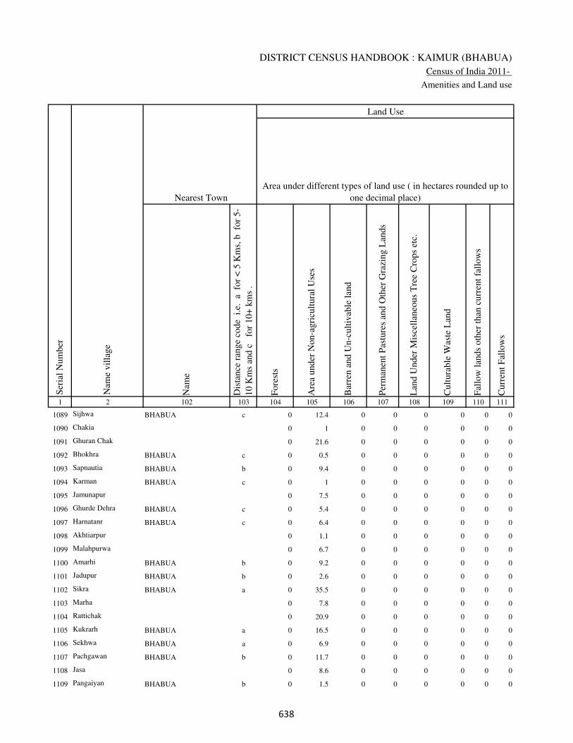
DISTRICT CENSUS HANDBOOK : KAIMUR (BHABUA)
Census of India 2011-
Amenities and Land use
Nam
e
Dis
tance
ran
ge
code
i.e
. a
fo
r <
5 K
ms,
b
for
5-
10 K
ms
and c
f
or
10+
km
s .
Fore
sts
Are
a under
Non-a
gri
cult
ura
l U
ses
Bar
ren a
nd U
n-c
ult
ivab
le l
and
Per
man
ent
Pas
ture
s an
d O
ther
Gra
zing L
ands
Lan
d U
nder
Mis
cell
aneo
us
Tre
e C
rops
etc.
Cult
ura
ble
Was
te L
and
Fal
low
lan
ds
oth
er t
han
curr
ent
fall
ow
s
Curr
ent
Fal
low
s
1 2 102 103 104 105 106 107 108 109 110 111
Ser
ial
Num
ber
Nam
e vil
lage
Area under different types of land use ( in hectares rounded up to
one decimal place)
Land Use
Nearest Town
1089 Sijhwa BHABUA c 0 12.4 0 0 0 0 0 0
1090 Chakia 0 1 0 0 0 0 0 0
1091 Ghuran Chak 0 21.6 0 0 0 0 0 0
1092 Bhokhra BHABUA c 0 0.5 0 0 0 0 0 0
1093 Sapnautia BHABUA b 0 9.4 0 0 0 0 0 0
1094 Karman BHABUA c 0 1 0 0 0 0 0 0
1095 Jamunapur 0 7.5 0 0 0 0 0 0
1096 Ghurde Dehra BHABUA c 0 5.4 0 0 0 0 0 0
1097 Harnatanr BHABUA c 0 6.4 0 0 0 0 0 0
1098 Akhtiarpur 0 1.1 0 0 0 0 0 0
1099 Malahpurwa 0 6.7 0 0 0 0 0 0
1100 Amarhi BHABUA b 0 9.2 0 0 0 0 0 0
1101 Jadupur BHABUA b 0 2.6 0 0 0 0 0 0
1102 Sikra BHABUA a 0 35.5 0 0 0 0 0 0
1103 Marha 0 7.8 0 0 0 0 0 0
1104 Rattichak 0 20.9 0 0 0 0 0 0
1105 Kukrarh BHABUA a 0 16.5 0 0 0 0 0 0
1106 Sekhwa BHABUA a 0 6.9 0 0 0 0 0 0
1107 Pachgawan BHABUA b 0 11.7 0 0 0 0 0 0
1108 Jasa 0 8.6 0 0 0 0 0 0
1109 Pangaiyan BHABUA b 0 1.5 0 0 0 0 0 0
��
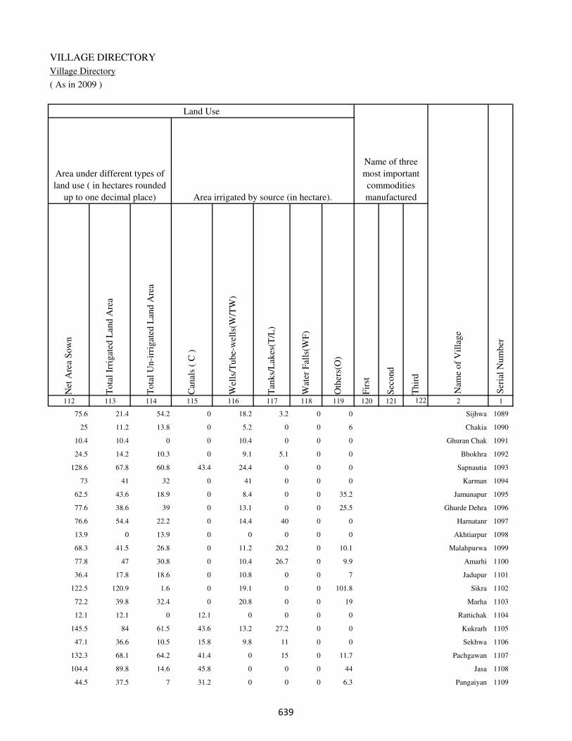
VILLAGE DIRECTORY
Village Directory
( As in 2009 )
Net
Are
a S
ow
n
Tota
l Ir
rigat
ed L
and A
rea
Tota
l U
n-i
rrig
ated
Lan
d A
rea
Can
als
( C
)
Wel
ls/T
ube-
wel
ls(W
/TW
)
Tan
ks/
Lak
es(T
/L)
Wat
er F
alls
(WF
)
Oth
ers(
O)
Fir
st
Sec
ond
Thir
d
112 113 114 115 116 117 118 119 120 121 122 2 1
Ser
ial
Num
ber
Name of three
most important
commodities
manufacturedArea irrigated by source (in hectare).
Nam
e of
Vil
lage
Area under different types of
land use ( in hectares rounded
up to one decimal place)
Land Use
75.6 21.4 54.2 0 18.2 3.2 0 0 Sijhwa 1089
25 11.2 13.8 0 5.2 0 0 6 Chakia 1090
10.4 10.4 0 0 10.4 0 0 0 Ghuran Chak 1091
24.5 14.2 10.3 0 9.1 5.1 0 0 Bhokhra 1092
128.6 67.8 60.8 43.4 24.4 0 0 0 Sapnautia 1093
73 41 32 0 41 0 0 0 Karman 1094
62.5 43.6 18.9 0 8.4 0 0 35.2 Jamunapur 1095
77.6 38.6 39 0 13.1 0 0 25.5 Ghurde Dehra 1096
76.6 54.4 22.2 0 14.4 40 0 0 Harnatanr 1097
13.9 0 13.9 0 0 0 0 0 Akhtiarpur 1098
68.3 41.5 26.8 0 11.2 20.2 0 10.1 Malahpurwa 1099
77.8 47 30.8 0 10.4 26.7 0 9.9 Amarhi 1100
36.4 17.8 18.6 0 10.8 0 0 7 Jadupur 1101
122.5 120.9 1.6 0 19.1 0 0 101.8 Sikra 1102
72.2 39.8 32.4 0 20.8 0 0 19 Marha 1103
12.1 12.1 0 12.1 0 0 0 0 Rattichak 1104
145.5 84 61.5 43.6 13.2 27.2 0 0 Kukrarh 1105
47.1 36.6 10.5 15.8 9.8 11 0 0 Sekhwa 1106
132.3 68.1 64.2 41.4 0 15 0 11.7 Pachgawan 1107
104.4 89.8 14.6 45.8 0 0 0 44 Jasa 1108
44.5 37.5 7 31.2 0 0 0 6.3 Pangaiyan 1109
��

DISTRICT CENSUS HANDBOOK : KAIMUR (BHABUA)
Census of India 2011-
Amenities and Land use
Pre
-Pri
mar
y s
chool
(PP
)
Pri
mar
y s
chool
(P)
Mid
dle
sch
ool
(M)
Sec
ondar
y S
chool
(S)
Sen
ior
Sec
ondar
y s
chool
(SS
)
Deg
ree
coll
ege
of
arts
sc
ience
& c
om
mer
ce
(AS
C)
Engin
eeri
ng c
oll
ege(
EC
)
Med
ical
coll
ege
(MC
)
Man
agem
ent
inst
itute
(M
I)
Poly
tech
nic
(P
t)
Voca
tional
tra
inin
g s
chool
/IT
I
Non-f
orm
al t
rain
ing c
entr
e (N
FT
C)
Spec
ial
school
for
dis
able
d (
SS
D)
Oth
ers
(spec
ify)
1 2 3 4 5 6 7 8 9 10 11 12 13 14 15 16 17 18 19 20
Loca
tion c
ode
no.
Nam
e vil
lage
Ser
ial
Num
ber
Tota
l popula
tion (
2011 c
ensu
s )
Tota
l ar
ea o
f th
e vil
lage
( in
hec
tare
s ro
unded
up t
o
one
dec
imal
pla
ce)
Number of educational amenities available. (If not available
within the village , the distance range code viz; a for < 5
Kms, b for 5-10 Kms and c for 10+ kms of nearest place
where facility is available is given).
Num
ber
of
house
hold
s (2
011 c
ensu
s)
1110 Ahopur 250034 61 0 0
1111 Baghraulia 250035 34 0 0
1112 Khaira 250036 197 1247 170 c 1 b c b b c c c c b b c
1113 Akhtiarpur 250037 36 0 0
1114 Silauta 250038 211 999 162 a 1 1 c b c c c c c c b c
1115 Chakia 250039 28 0 0
1116 Hasanpura 250040 74 362 49 a 1 a c a c c c c c c a c
1117 Kori 250041 283 1109 157 c 1 1 c b b c c c c b b c
1118 Madhupur 250042 113 515 79 c 1 a c b b c c c c b b c
1119 Babura 250043 57 1896 276 c 1 1 c b b c c c c b b c
1120 Ikhlaspur 250044 439 11820 2042 c 3 1 1 1 1 a c c c a a c
1121 Sikthi 250045 356 3985 659 a 2 a c a c c c c c b a c
1122 Mohammadpur 250046 25 305 62 b a a c b c c c c c b b c
1123 Bhekas 250047 237 2122 356 c 1 1 c b c c c c c b b c
1124 Isarpura 250048 25 0 0
1125 Semaria 250049 67 694 135 c 1 a c a c a c c c a a c
1126 Datiawan 250050 252 2702 485 c 2 1 c b c c c c c c c c
1127 Kawar 250051 265 2958 549 c 2 a c b c c c c c c c c
1128 Akri 250052 90 741 110 b 1 a c b c c c c c b b c
1129 Bhathani 250053 79 0 0
1130 Shiwpura 250054 54 485 71 a 1 b c b c c c c b b b c
���

VILLAGE DIRECTORY
Village Directory
( As in 2009 )
Com
munit
y h
ealt
h c
entr
e (C
HC
)
Pri
mar
y h
ealt
h c
entr
e (P
HC
)
Pri
mar
y h
ealt
h s
ub c
entr
e (P
HS
)
Mat
ernit
y a
nd c
hil
d w
elfa
re c
entr
e (M
CW
)
T.B
. cl
inic
(T
BC
)
Hosp
ital
-all
opat
hic
(H
A)
Hosp
ital
-alt
ernat
ive
med
icin
e (H
O)
Dis
pen
sary
(D
)
Vet
erin
ary h
osp
ital
(V
H)
Mobil
e hea
lth c
linic
(M
HC
)
Fam
ily w
elfa
re c
entr
e (F
WC
)
Char
itab
le n
on G
ovt.
hosp
ital
/Nurs
ing h
om
e.
Med
ical
pra
ctit
ioner
wit
h M
BB
S D
egre
e
Med
ical
pra
ctit
ioner
wit
h o
ther
deg
ree
Med
ical
pra
ctit
ioner
wit
h n
o d
egre
e
Tra
dit
ional
pra
ctit
ioner
an
d f
aith
hea
ler
.
Med
icin
e S
hop
Oth
ers
21 22 23 24 25 26 27 28 29 30 31 32 33 34 35 36 37 38 2 1
Number of Non-Government
Medical Amenities available.
Number of Medical Amenities available. (If not
available within the village , the distance range
code viz; a for < 5 Kms, b for 5-10 Kms and c
for 10+ kms of nearest place where facility is
available is given).
Nam
e vil
lage
Ser
ial
Num
ber
Ahopur 1110
Baghraulia 1111
b b b b b b b b b b b 0 0 0 0 0 0 0 Khaira 1112
Akhtiarpur 1113
b b 1 1 b a a b b a 1 0 0 0 0 0 0 0 Silauta 1114
Chakia 1115
a a a a a a a a a a a 0 0 0 0 0 0 0 Hasanpura 1116
b a b b b b b b b b b 0 0 0 0 0 0 0 Kori 1117
b a b b b b b b b b b 0 0 0 0 0 0 0 Madhupur 1118
b a b b b a a b b a b 0 0 0 0 0 0 0 Babura 1119
a a 1 1 a a a a a a 1 0 0 0 0 0 0 0 Ikhlaspur 1120
a a 1 1 a a a a a a 1 0 0 0 0 0 0 0 Sikthi 1121
b b b b b b b b b b b 0 0 0 0 0 0 0 Mohammadpur 1122
b b b b b b b b b b b 0 0 0 0 0 0 0 Bhekas 1123
Isarpura 1124
a a a a a a a a a a a 0 0 0 0 0 0 0 Semaria 1125
b b b b b b b b b b b 0 0 0 0 0 0 0 Datiawan 1126
b b 1 1 b b b b b b 1 0 0 0 0 0 0 0 Kawar 1127
b b b b b b b b b b b 0 0 0 0 0 0 0 Akri 1128
Bhathani 1129
b b b b b b b b b b b 0 0 0 0 0 0 0 Shiwpura 1130
���

DISTRICT CENSUS HANDBOOK : KAIMUR (BHABUA)
Census of India 2011-
Amenities and Land use
Tap
wat
er (
Tre
ated
/Untr
eate
d)
Wel
l w
ater
(Cover
ed /
Unco
ver
ed w
ell)
Han
d P
um
p
Tube
wel
ls /
Bore
wel
l
Spri
ng
Riv
er /
Can
al
Tan
k /
Pond /
L
ake
Oth
ers
Com
munit
y t
oil
et i
ncl
udin
g
bat
h.
Com
munit
y t
oil
et e
xcl
udin
g b
ath.
Rura
l s
anit
ary m
art
or
sanit
ary
har
dw
are
outl
et
avai
lable
nea
r th
e vil
lage.
Com
munit
y b
io-
gas
or
recy
cle
of
was
te f
or
pro
duct
ive
use
.
1 2 39 40 41 42 43 44 45 46 47 48 49 50
Availability of toilet & others
Yes / No Availability of drinking water - Yes / No
Nam
e vil
lage
Ser
ial
Num
ber
1110 Ahopur
1111 Baghraulia
1112 Khaira No Yes Yes Yes No Yes No No No No No No
1113 Akhtiarpur
1114 Silauta No Yes Yes Yes No No No No No No No No
1115 Chakia
1116 Hasanpura No Yes Yes Yes No No Yes No No No No No
1117 Kori No Yes Yes Yes No Yes Yes No No No No No
1118 Madhupur No Yes Yes Yes No Yes Yes No No No No No
1119 Babura No Yes Yes Yes No Yes No No No No No No
1120 Ikhlaspur Yes Yes Yes Yes No No Yes No No No No No
1121 Sikthi No Yes Yes Yes No No Yes No No No No No
1122 Mohammadpur No Yes Yes No No No No No No No No No
1123 Bhekas No Yes Yes Yes No No Yes No No No No No
1124 Isarpura
1125 Semaria No Yes Yes No No No No No No No No No
1126 Datiawan No Yes Yes No No Yes Yes No No No No No
1127 Kawar No Yes Yes Yes No Yes Yes No No No No No
1128 Akri No Yes Yes No No No No No No No No No
1129 Bhathani
1130 Shiwpura No Yes Yes No No Yes No No No No No No
��
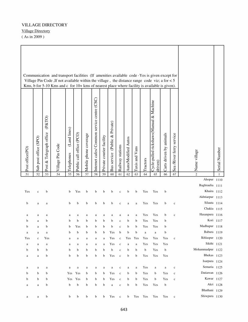
VILLAGE DIRECTORY
Village Directory
( As in 2009 )
Post
off
ice(
PO
)
Sub p
ost
off
ice
(SP
O)
Post
& T
eleg
raph o
ffic
e
(P&
TO
)
Vil
lage
Pin
Code
Tel
ephones
(L
and l
ines
)
Publi
c ca
ll o
ffic
e (P
CO
)
Mobil
e phone
cover
age
Inte
rnet
caf
es/
Com
mon s
ervic
e ce
ntr
e (C
SC
)
Pri
vat
e co
uri
er f
acil
ity
Bus
serv
ice
(P
ubli
c &
Pri
vat
e)
Rai
lway
sta
tions
Auto
/Modif
ied A
uto
s
Tax
is a
nd V
ans
Tra
ctors
Cycl
e-pull
ed r
icksh
aws(
Man
ual
& M
achin
e
dri
ven
)
Car
ts d
riven
by a
nim
als
Sea
/R
iver
fer
ry s
ervic
e51 52 53 54 55 56 57 58 59 60 61 62 63 64 65 66 67 2 1
Communication and transport facilities (If amenities available code -Yes is given except for
Village Pin Code ,If not available within the village , the distance range code viz; a for < 5
Kms, b for 5-10 Kms and c for 10+ kms of nearest place where facility is available is given).
Ser
ial
Num
ber
Nam
e vil
lage
Ahopur 1110
Baghraulia 1111
Yes c b b Yes b b b b c b b Yes Yes b Khaira 1112
Akhtiarpur 1113
b a a b b b b b b c a a Yes Yes b c Silauta 1114
Chakia 1115
a a a a a a a a a a a a Yes Yes b c Hasanpura 1116
b a b b b b b b b c b b Yes Yes b Kori 1117
b a b b Yes b b b b c b b Yes Yes b Madhupur 1118
a a a b b b b b Yes b b b a a b Babura 1119
Yes c Yes a a a a a Yes c Yes Yes Yes Yes Yes c Ikhlaspur 1120
a a a a a a a a Yes c a a Yes Yes Yes Sikthi 1121
b b b b b b b b b c b b b Yes b Mohammadpur 1122
a a b b b b b b Yes c b b Yes Yes Yes Bhekas 1123
Isarpura 1124
a a a a a a a a a c a a Yes a a c Semaria 1125
b b b Yes Yes b b b Yes c b b Yes b Yes c Datiawan 1126
b b b Yes Yes b b b Yes c b b Yes b Yes c Kawar 1127
a a b b b b b b a c b b Yes Yes b Akri 1128
Bhathani 1129
a a b b b b b b Yes c b Yes Yes Yes Yes c Shiwpura 1130
��
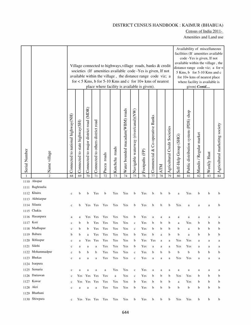
DISTRICT CENSUS HANDBOOK : KAIMUR (BHABUA)
Census of India 2011-
Amenities and Land use
Connec
ted t
o n
atio
nal
hig
hw
ay(N
H)
Connec
ted t
o s
tate
hig
hw
ay(S
H)
Connec
ted t
o m
ajor
dis
tric
t ro
ad (
MD
R)
Connec
ted t
o o
ther
s dis
tric
t ro
ad
Pucc
a r
oad
s
Kutc
hch
a r
oad
s
Wat
er b
ounded
mac
adam
(WB
M)
road
s
Nav
igab
le w
ater
way
(ri
ver
/can
al)(
NW
)
Footp
aths
(FP
)
Com
mer
cial
& C
o-o
per
ativ
e B
anks
AT
M
Agri
cult
ura
l C
redit
Soci
etie
s
Sel
f-H
elp G
roup (
SH
G)
Publi
c dis
trib
uti
on s
yst
em (
PD
S)
shop
Man
dis
/ R
egula
r m
arket
Wee
kly
Haa
t
Agri
cult
ura
l m
arket
ing s
oci
ety
1 2 68 69 70 71 72 73 74 75 76 77 78 79 80 81 82 83 84
Village connected to highways,village roads, banks & credit
societies (If amenities available code -Yes is given, If not
available within the village , the distance range code viz; a
for < 5 Kms, b for 5-10 Kms and c for 10+ kms of nearest
place where facility is available is given).
Ser
ial
Num
ber
Nam
e vil
lage
Availability of miscellaneous
facilities (If amenities available
code -Yes is given, If not
available within the village , the
distance range code viz; a for <
5 Kms, b for 5-10 Kms and c
for 10+ kms of nearest place
where facility is available is
given) Contd....
1110 Ahopur
1111 Baghraulia
1112 Khaira c b b Yes b Yes Yes b Yes b b b a Yes b b b
1113 Akhtiarpur
1114 Silauta c b Yes Yes Yes Yes Yes b Yes b b b Yes a a a b
1115 Chakia
1116 Hasanpura a a Yes Yes Yes Yes Yes b Yes a a a a a a a a
1117 Kori c b b Yes Yes Yes Yes c Yes b b b a Yes b b b
1118 Madhupur c b b Yes Yes Yes Yes c Yes b b b b a b b b
1119 Babura b b a Yes Yes Yes Yes b Yes b a b b a b b b
1120 Ikhlaspur c a Yes Yes Yes Yes Yes b Yes Yes a a Yes Yes a a a
1121 Sikthi c a a a Yes Yes Yes b Yes a a a Yes Yes a a a
1122 Mohammadpur c b b b Yes Yes Yes c Yes b b b b b b b b
1123 Bhekas c a a a Yes Yes Yes c Yes a a a Yes Yes a a a
1124 Isarpura
1125 Semaria c a a a a Yes Yes c Yes a a a a a a a a
1126 Datiawan c Yes Yes Yes Yes a Yes c Yes b b b Yes Yes b b b
1127 Kawar c Yes Yes Yes Yes Yes Yes b Yes b b b a Yes b b b
1128 Akri c a a a Yes Yes Yes b Yes b b b b b b b b
1129 Bhathani
1130 Shiwpura c Yes Yes Yes Yes Yes Yes b Yes b b b Yes Yes b b b
���

VILLAGE DIRECTORY
Village Directory
( As in 2009 )
Inte
gra
ted C
hil
d D
evel
opm
ent
Sch
eme
(Nutr
itio
nal
Cen
tres
)
Angan
wad
i C
entr
e (N
utr
itio
nal
Cen
tres
)
Oth
ers
(Nutr
itio
nal
Cen
tres
)
AS
HA
(A
ccre
dit
ed S
oci
al H
ealt
h A
ctiv
ist)
Com
munit
y c
entr
e w
ith/w
ithout
TV
Sport
s F
ield
,
Sport
s C
lub /
Rec
reat
ion C
entr
e
Cin
ema
/ V
ideo
Hal
l
Publi
c L
ibra
ry
Publi
c R
eadin
g R
oom
New
spap
er S
upply
Ass
embly
Poll
ing s
tati
on
Bir
th &
Dea
th R
egis
trat
ion O
ffic
e
Pow
er S
upply
for
Dom
esti
c U
se (
ED
)
Pow
er S
upply
for
Agri
cult
ura
l U
se (
EA
G)
Pow
er S
upply
for
Com
mer
cial
Use
(E
C)
Pow
er S
upply
for
All
Use
s (E
A)
85 86 87 88 89 90 91 92 93 94 95 96 97 98 99 100 101 2 1
Availability of
electricity (Yes/No)
Availability of miscellaneous facilities (If amenities available code -
Yes is given, If not available within the village , the distance range
code viz; a for < 5 Kms, b for 5-10 Kms and c for 10+ kms of
nearest place where facility is available is given) Concluded
Nam
e vil
lage
Ser
ial
Num
ber
Ahopur 1110
Baghraulia 1111
b Yes a Yes c b c b c c b Yes a Yes Yes Yes Yes Khaira 1112
Akhtiarpur 1113
a a a Yes b b b b b b Yes Yes Yes Yes Yes No No Silauta 1114
Chakia 1115
a a a a a a a a a a a a a Yes Yes No No Hasanpura 1116
b Yes b Yes b b b b b b b Yes Yes Yes Yes Yes Yes Kori 1117
b a a a b b b b b b b a a Yes Yes Yes Yes Madhupur 1118
a Yes b Yes b a b b b b b Yes Yes Yes Yes Yes Yes Babura 1119
a Yes b Yes c a c c c c Yes Yes Yes Yes Yes No No Ikhlaspur 1120
a Yes b Yes a a a a a a a Yes Yes Yes Yes No No Sikthi 1121
b Yes a a b b b b b b b a Yes Yes Yes No No Mohammadpur 1122
b Yes a Yes a a a a a a a Yes Yes Yes Yes No No Bhekas 1123
Isarpura 1124
a Yes b Yes a a a a a a a Yes Yes No No No No Semaria 1125
b Yes Yes Yes b b b b b b b Yes Yes Yes Yes No No Datiawan 1126
b Yes a Yes b b b b b b b Yes Yes Yes Yes No No Kawar 1127
b Yes Yes Yes b b b b b b b a Yes Yes Yes No No Akri 1128
Bhathani 1129
b Yes b Yes b b b b b b b Yes Yes Yes Yes No No Shiwpura 1130
���

DISTRICT CENSUS HANDBOOK : KAIMUR (BHABUA)
Census of India 2011-
Amenities and Land use
Nam
e
Dis
tance
ran
ge
code
i.e
. a
fo
r <
5 K
ms,
b
for
5-
10 K
ms
and c
f
or
10+
km
s .
Fore
sts
Are
a under
Non-a
gri
cult
ura
l U
ses
Bar
ren a
nd U
n-c
ult
ivab
le l
and
Per
man
ent
Pas
ture
s an
d O
ther
Gra
zing L
ands
Lan
d U
nder
Mis
cell
aneo
us
Tre
e C
rops
etc.
Cult
ura
ble
Was
te L
and
Fal
low
lan
ds
oth
er t
han
curr
ent
fall
ow
s
Curr
ent
Fal
low
s
1 2 102 103 104 105 106 107 108 109 110 111
Ser
ial
Num
ber
Nam
e vil
lage
Area under different types of land use ( in hectares rounded up to
one decimal place)
Land Use
Nearest Town
1110 Ahopur 0 2.2 0 0 0 0 0 0
1111 Baghraulia 0 2.8 0 0 0 0 0 0
1112 Khaira BHABUA b 0 19.8 0 0 0 0 0 0
1113 Akhtiarpur 0 1 0 0 0 0 0 0
1114 Silauta BHABUA a 0 10.2 0 0 0 0 0 0
1115 Chakia 0 1 0 0 0 0 0 0
1116 Hasanpura BHABUA a 0 7.3 0 0 0 0 0 0
1117 Kori BHABUA b 0 24.6 0 0 0 0 0 0
1118 Madhupur BHABUA b 0 4.5 0 0 0 0 0 0
1119 Babura BHABUA a 0 7.4 0 0.2 0 0 0 0
1120 Ikhlaspur BHABUA a 0 36.7 0 0.6 0 0 0 0
1121 Sikthi BHABUA a 0 34.4 0 0.6 0 0 0 0
1122 Mohammadpur BHABUA b 0 4.5 0 0 0 0 0 0
1123 Bhekas BHABUA b 0 24 0 0.7 0 0 0 0
1124 Isarpura 0 1.7 0 0 0 0 0 0
1125 Semaria BHABUA a 0 8.4 0 0 0 0 0 0
1126 Datiawan BHABUA b 0 27.2 0 0 0 0 0 0
1127 Kawar BHABUA b 0 35 0 0.3 0 0 0 0
1128 Akri BHABUA b 0 10.8 0 0 0 0 0 0
1129 Bhathani 0 8 0 0 0 0 0 0
1130 Shiwpura BHABUA b 0 6.8 0 0 0 0 0 0
���
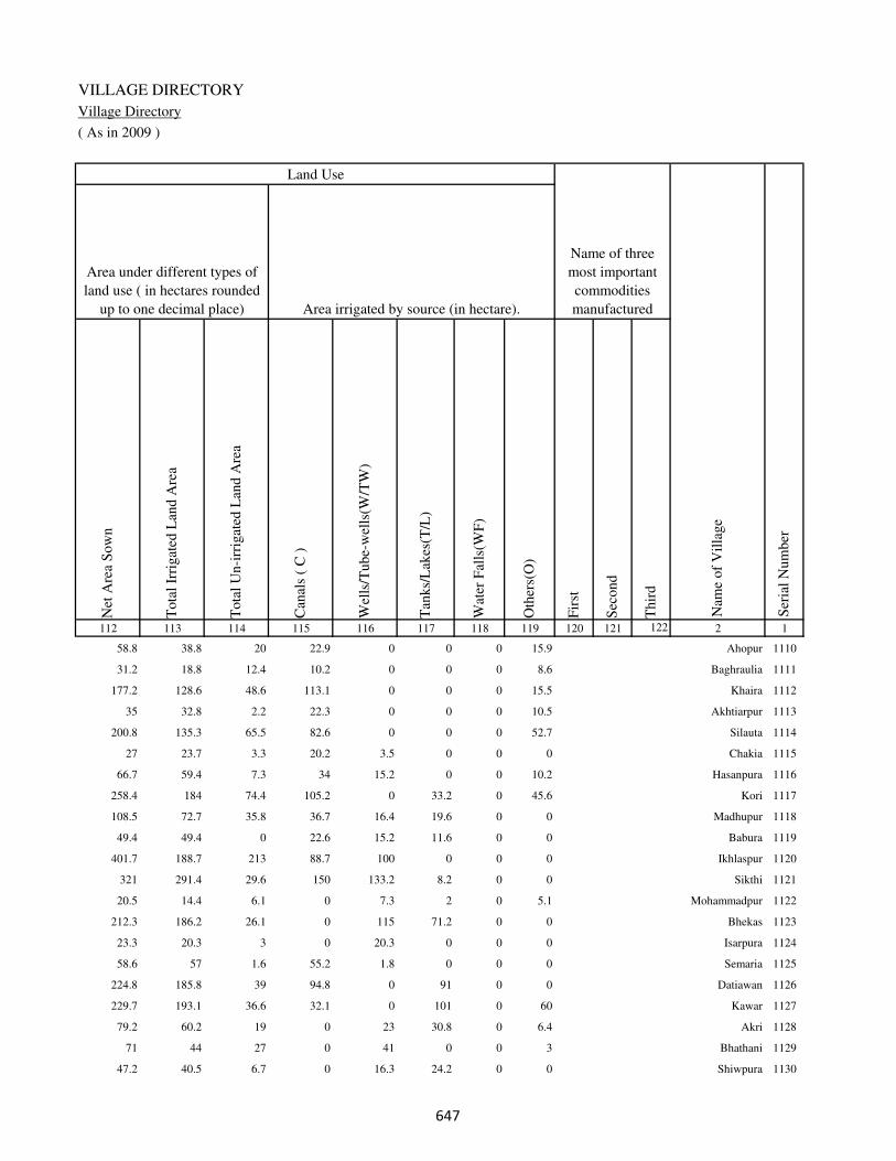
VILLAGE DIRECTORY
Village Directory
( As in 2009 )
Net
Are
a S
ow
n
Tota
l Ir
rigat
ed L
and A
rea
Tota
l U
n-i
rrig
ated
Lan
d A
rea
Can
als
( C
)
Wel
ls/T
ube-
wel
ls(W
/TW
)
Tan
ks/
Lak
es(T
/L)
Wat
er F
alls
(WF
)
Oth
ers(
O)
Fir
st
Sec
ond
Thir
d
112 113 114 115 116 117 118 119 120 121 122 2 1
Ser
ial
Num
ber
Name of three
most important
commodities
manufacturedArea irrigated by source (in hectare).
Nam
e of
Vil
lage
Area under different types of
land use ( in hectares rounded
up to one decimal place)
Land Use
58.8 38.8 20 22.9 0 0 0 15.9 Ahopur 1110
31.2 18.8 12.4 10.2 0 0 0 8.6 Baghraulia 1111
177.2 128.6 48.6 113.1 0 0 0 15.5 Khaira 1112
35 32.8 2.2 22.3 0 0 0 10.5 Akhtiarpur 1113
200.8 135.3 65.5 82.6 0 0 0 52.7 Silauta 1114
27 23.7 3.3 20.2 3.5 0 0 0 Chakia 1115
66.7 59.4 7.3 34 15.2 0 0 10.2 Hasanpura 1116
258.4 184 74.4 105.2 0 33.2 0 45.6 Kori 1117
108.5 72.7 35.8 36.7 16.4 19.6 0 0 Madhupur 1118
49.4 49.4 0 22.6 15.2 11.6 0 0 Babura 1119
401.7 188.7 213 88.7 100 0 0 0 Ikhlaspur 1120
321 291.4 29.6 150 133.2 8.2 0 0 Sikthi 1121
20.5 14.4 6.1 0 7.3 2 0 5.1 Mohammadpur 1122
212.3 186.2 26.1 0 115 71.2 0 0 Bhekas 1123
23.3 20.3 3 0 20.3 0 0 0 Isarpura 1124
58.6 57 1.6 55.2 1.8 0 0 0 Semaria 1125
224.8 185.8 39 94.8 0 91 0 0 Datiawan 1126
229.7 193.1 36.6 32.1 0 101 0 60 Kawar 1127
79.2 60.2 19 0 23 30.8 0 6.4 Akri 1128
71 44 27 0 41 0 0 3 Bhathani 1129
47.2 40.5 6.7 0 16.3 24.2 0 0 Shiwpura 1130
���

DISTRICT CENSUS HANDBOOK : KAIMUR (BHABUA)
Census of India 2011-
Amenities and Land use
Pre
-Pri
mar
y s
chool
(PP
)
Pri
mar
y s
chool
(P)
Mid
dle
sch
ool
(M)
Sec
ondar
y S
chool
(S)
Sen
ior
Sec
ondar
y s
chool
(SS
)
Deg
ree
coll
ege
of
arts
sc
ience
& c
om
mer
ce
(AS
C)
Engin
eeri
ng c
oll
ege(
EC
)
Med
ical
coll
ege
(MC
)
Man
agem
ent
inst
itute
(M
I)
Poly
tech
nic
(P
t)
Voca
tional
tra
inin
g s
chool
/IT
I
Non-f
orm
al t
rain
ing c
entr
e (N
FT
C)
Spec
ial
school
for
dis
able
d (
SS
D)
Oth
ers
(spec
ify)
1 2 3 4 5 6 7 8 9 10 11 12 13 14 15 16 17 18 19 20
Loca
tion c
ode
no.
Nam
e vil
lage
Ser
ial
Num
ber
Tota
l popula
tion (
2011 c
ensu
s )
Tota
l ar
ea o
f th
e vil
lage
( in
hec
tare
s ro
unded
up t
o
one
dec
imal
pla
ce)
Number of educational amenities available. (If not available
within the village , the distance range code viz; a for < 5
Kms, b for 5-10 Kms and c for 10+ kms of nearest place
where facility is available is given).
Num
ber
of
house
hold
s (2
011 c
ensu
s)
1131 Naua Shahmal 250055 125 0 0
1132 Naua Jhoti 250056 171 1803 272 a 1 1 c c c c c c c c c c
1133 Khajurahia 250057 40 0 0
1134 Daridih 250058 74 1385 215 b 1 1 c c c c c c c c c c
1135 Ruiya 250059 263 2604 396 b 1 1 c b c c c c c b b c
1136 Dumri 250060 77 1189 165 b 1 a c b c c c c c b b c
1137 Kunj 250061 259 2555 405 b 1 1 c b c c c c c b b c
1138 Chandoraiya 250062 60 1368 247 b 1 a c b c c c c c b b c
1139 Kolaunj 250063 109 759 149 b 1 a c b c c c c c b b c
1140 Baheri 250064 160 890 182 b 1 a c b c b c c c c c c
1141 Hahapur 250065 57 0 0
1142 Checharia 250066 45 8 1 a a a c b b c c c c c b c
1143 Semaria 250067 71 1024 135 a 1 a c b c b c c c b b c
1144 Gopalpur 250068 55 0 0
1145 Silri 250069 106 769 122 b 1 a c b c c c c c b b c
1146 Barigawan 250070 78 388 63 c 1 b c c c c c c c c c c
1147 Birbhanpur 250071 46 357 59 c a a c c c c c c c c c c
1148 Bharigawan 250072 151 1476 265 b 1 1 c b c c c c c c c b
1149 Kusdihra 250073 102 526 110 c 1 a c c c c c c c c c b
1150 Dalippur 250074 104 352 63 c 1 a c c c c c c c c c b
1151 Lakkudih 250075 62 0 0
���

VILLAGE DIRECTORY
Village Directory
( As in 2009 )
Com
munit
y h
ealt
h c
entr
e (C
HC
)
Pri
mar
y h
ealt
h c
entr
e (P
HC
)
Pri
mar
y h
ealt
h s
ub c
entr
e (P
HS
)
Mat
ernit
y a
nd c
hil
d w
elfa
re c
entr
e (M
CW
)
T.B
. cl
inic
(T
BC
)
Hosp
ital
-all
opat
hic
(H
A)
Hosp
ital
-alt
ernat
ive
med
icin
e (H
O)
Dis
pen
sary
(D
)
Vet
erin
ary h
osp
ital
(V
H)
Mobil
e hea
lth c
linic
(M
HC
)
Fam
ily w
elfa
re c
entr
e (F
WC
)
Char
itab
le n
on G
ovt.
hosp
ital
/Nurs
ing h
om
e.
Med
ical
pra
ctit
ioner
wit
h M
BB
S D
egre
e
Med
ical
pra
ctit
ioner
wit
h o
ther
deg
ree
Med
ical
pra
ctit
ioner
wit
h n
o d
egre
e
Tra
dit
ional
pra
ctit
ioner
an
d f
aith
hea
ler
.
Med
icin
e S
hop
Oth
ers
21 22 23 24 25 26 27 28 29 30 31 32 33 34 35 36 37 38 2 1
Number of Non-Government
Medical Amenities available.
Number of Medical Amenities available. (If not
available within the village , the distance range
code viz; a for < 5 Kms, b for 5-10 Kms and c
for 10+ kms of nearest place where facility is
available is given).
Nam
e vil
lage
Ser
ial
Num
ber
Naua Shahmal 1131
c c c c c c c c c c c 0 0 0 0 0 0 0 Naua Jhoti 1132
Khajurahia 1133
c c c c c c c c c c c 0 0 0 2 0 0 0 Daridih 1134
b a b b b b b b b b b 0 0 0 0 0 0 0 Ruiya 1135
b a b b b b b b b b b 0 0 0 0 0 0 0 Dumri 1136
c b 1 1 c b b c b b 1 0 0 0 0 0 0 0 Kunj 1137
b b b b b b b b b b b 0 0 0 0 0 0 0 Chandoraiya 1138
b b b b b b b b b b b 0 0 0 0 0 0 0 Kolaunj 1139
b b b b b b b b b b b 0 0 0 0 0 0 0 Baheri 1140
Hahapur 1141
b b b b b b b b b b b 0 0 3 4 0 3 0 Checharia 1142
b b b b b b b b b b b 0 0 0 0 0 0 0 Semaria 1143
Gopalpur 1144
b a b b b b b b b b b 0 0 0 0 0 0 0 Silri 1145
c b b b b c c b b c b 0 0 0 0 0 0 0 Barigawan 1146
c b b c c c c b c c b 0 0 0 0 0 0 0 Birbhanpur 1147
c b c c c b b b c b b 0 0 0 0 0 0 0 Bharigawan 1148
c c c b c b b b b b b 0 0 0 0 0 0 0 Kusdihra 1149
c b b b c b b b b b b 0 0 0 0 0 0 0 Dalippur 1150
Lakkudih 1151
���

DISTRICT CENSUS HANDBOOK : KAIMUR (BHABUA)
Census of India 2011-
Amenities and Land use
Tap
wat
er (
Tre
ated
/Untr
eate
d)
Wel
l w
ater
(Cover
ed /
Unco
ver
ed w
ell)
Han
d P
um
p
Tube
wel
ls /
Bore
wel
l
Spri
ng
Riv
er /
Can
al
Tan
k /
Pond /
L
ake
Oth
ers
Com
munit
y t
oil
et i
ncl
udin
g
bat
h.
Com
munit
y t
oil
et e
xcl
udin
g b
ath.
Rura
l s
anit
ary m
art
or
sanit
ary
har
dw
are
outl
et
avai
lable
nea
r th
e vil
lage.
Com
munit
y b
io-
gas
or
recy
cle
of
was
te f
or
pro
duct
ive
use
.
1 2 39 40 41 42 43 44 45 46 47 48 49 50
Availability of toilet & others
Yes / No Availability of drinking water - Yes / No
Nam
e vil
lage
Ser
ial
Num
ber
1131 Naua Shahmal
1132 Naua Jhoti No Yes Yes No No No Yes No No No No No
1133 Khajurahia
1134 Daridih No Yes Yes No No Yes Yes No No No No No
1135 Ruiya No Yes Yes No No No No No No No No No
1136 Dumri No Yes Yes No No No No No No No No No
1137 Kunj No Yes Yes Yes No No Yes No No No No No
1138 Chandoraiya No Yes Yes No No No No No No No No No
1139 Kolaunj No Yes Yes No No No Yes No No No No No
1140 Baheri No Yes Yes No No No No No No No No No
1141 Hahapur
1142 Checharia No Yes Yes No No No No No No No No No
1143 Semaria No Yes Yes No No No No No No No No No
1144 Gopalpur
1145 Silri Yes Yes Yes No No No No No No No No No
1146 Barigawan No Yes Yes No No Yes Yes No No No No Yes
1147 Birbhanpur No Yes Yes No No Yes No No No No No No
1148 Bharigawan Yes Yes Yes No No Yes Yes No No No No No
1149 Kusdihra No Yes Yes No No Yes Yes No No No No No
1150 Dalippur No Yes Yes No No Yes No No No No No No
1151 Lakkudih
���
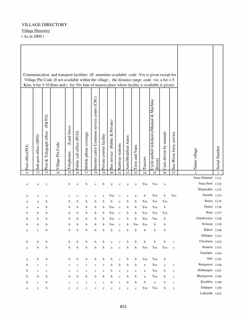
VILLAGE DIRECTORY
Village Directory
( As in 2009 )
Post
off
ice(
PO
)
Sub p
ost
off
ice
(SP
O)
Post
& T
eleg
raph o
ffic
e
(P&
TO
)
Vil
lage
Pin
Code
Tel
ephones
(L
and l
ines
)
Publi
c ca
ll o
ffic
e (P
CO
)
Mobil
e phone
cover
age
Inte
rnet
caf
es/
Com
mon s
ervic
e ce
ntr
e (C
SC
)
Pri
vat
e co
uri
er f
acil
ity
Bus
serv
ice
(P
ubli
c &
Pri
vat
e)
Rai
lway
sta
tions
Auto
/Modif
ied A
uto
s
Tax
is a
nd V
ans
Tra
ctors
Cycl
e-pull
ed r
icksh
aws(
Man
ual
& M
achin
e
dri
ven
)
Car
ts d
riven
by a
nim
als
Sea
/R
iver
fer
ry s
ervic
e51 52 53 54 55 56 57 58 59 60 61 62 63 64 65 66 67 2 1
Communication and transport facilities (If amenities available code -Yes is given except for
Village Pin Code ,If not available within the village , the distance range code viz; a for < 5
Kms, b for 5-10 Kms and c for 10+ kms of nearest place where facility is available is given).
Ser
ial
Num
ber
Nam
e vil
lage
Naua Shahmal 1131
a a c b a b c b a c a a Yes Yes a Naua Jhoti 1132
Khajurahia 1133
a c c c c c c c Yes c c a b Yes b Yes Daridih 1134
a a b b b b b b b c b b Yes Yes Yes Ruiya 1135
a a b b b b b b Yes c b b Yes Yes b Dumri 1136
b b b b b b b b Yes c b b Yes Yes Yes Kunj 1137
b b b b b b b b Yes c b b Yes Yes b Chandoraiya 1138
b b b b b b b b Yes c b Yes Yes b b Kolaunj 1139
a c b b b b b b b c b b b b b Baheri 1140
Hahapur 1141
b b b b b b b b a c b b b b b c Checharia 1142
a b b b b b b b a c b b Yes Yes Yes c Semaria 1143
Gopalpur 1144
a b b b b b b b b c b b Yes Yes b Silri 1145
b c c c c c c c b b b b a Yes a c Barigawan 1146
b c c c c c c c b c c c a Yes b c Birbhanpur 1147
b b b b b b b b b c b b a Yes b c Bharigawan 1148
b c b c c c c c b c b b b a b c Kusdihra 1149
a c b c c c c c c c c c Yes Yes b c Dalippur 1150
Lakkudih 1151
���

DISTRICT CENSUS HANDBOOK : KAIMUR (BHABUA)
Census of India 2011-
Amenities and Land use
Connec
ted t
o n
atio
nal
hig
hw
ay(N
H)
Connec
ted t
o s
tate
hig
hw
ay(S
H)
Connec
ted t
o m
ajor
dis
tric
t ro
ad (
MD
R)
Connec
ted t
o o
ther
s dis
tric
t ro
ad
Pucc
a r
oad
s
Kutc
hch
a r
oad
s
Wat
er b
ounded
mac
adam
(WB
M)
road
s
Nav
igab
le w
ater
way
(ri
ver
/can
al)(
NW
)
Footp
aths
(FP
)
Com
mer
cial
& C
o-o
per
ativ
e B
anks
AT
M
Agri
cult
ura
l C
redit
Soci
etie
s
Sel
f-H
elp G
roup (
SH
G)
Publi
c dis
trib
uti
on s
yst
em (
PD
S)
shop
Man
dis
/ R
egula
r m
arket
Wee
kly
Haa
t
Agri
cult
ura
l m
arket
ing s
oci
ety
1 2 68 69 70 71 72 73 74 75 76 77 78 79 80 81 82 83 84
Village connected to highways,village roads, banks & credit
societies (If amenities available code -Yes is given, If not
available within the village , the distance range code viz; a
for < 5 Kms, b for 5-10 Kms and c for 10+ kms of nearest
place where facility is available is given).
Ser
ial
Num
ber
Nam
e vil
lage
Availability of miscellaneous
facilities (If amenities available
code -Yes is given, If not
available within the village , the
distance range code viz; a for <
5 Kms, b for 5-10 Kms and c
for 10+ kms of nearest place
where facility is available is
given) Contd....
1131 Naua Shahmal
1132 Naua Jhoti c c c a b Yes a b Yes b c c b Yes c c c
1133 Khajurahia
1134 Daridih c c c Yes Yes Yes b Yes Yes a c c a a c c b
1135 Ruiya c b b Yes Yes Yes Yes c Yes b b b Yes b b b b
1136 Dumri c b b Yes a Yes Yes b Yes b b b b a b b b
1137 Kunj c b b Yes b Yes Yes b Yes b b b Yes Yes b b b
1138 Chandoraiya c b b b b Yes Yes b Yes b b b Yes a b b b
1139 Kolaunj c b b Yes b Yes Yes b Yes b b b Yes a b b b
1140 Baheri c a a a b Yes Yes b Yes c c b b a b a b
1141 Hahapur
1142 Checharia c b b c b Yes a b Yes b b b b a b b b
1143 Semaria c b a b a Yes Yes b Yes b b b Yes a b b b
1144 Gopalpur
1145 Silri c b b a Yes Yes Yes b Yes b b b Yes a b b b
1146 Barigawan c c Yes b b Yes Yes Yes Yes c c c c b c c c
1147 Birbhanpur c c Yes c a Yes Yes Yes Yes c c c a Yes c c c
1148 Bharigawan b b Yes a Yes Yes Yes Yes Yes b b b b Yes b b b
1149 Kusdihra c c Yes b a Yes Yes Yes Yes c c c Yes a c b c
1150 Dalippur c c a c b Yes Yes Yes Yes c c b a a a a c
1151 Lakkudih
��

VILLAGE DIRECTORY
Village Directory
( As in 2009 )
Inte
gra
ted C
hil
d D
evel
opm
ent
Sch
eme
(Nutr
itio
nal
Cen
tres
)
Angan
wad
i C
entr
e (N
utr
itio
nal
Cen
tres
)
Oth
ers
(Nutr
itio
nal
Cen
tres
)
AS
HA
(A
ccre
dit
ed S
oci
al H
ealt
h A
ctiv
ist)
Com
munit
y c
entr
e w
ith/w
ithout
TV
Sport
s F
ield
,
Sport
s C
lub /
Rec
reat
ion C
entr
e
Cin
ema
/ V
ideo
Hal
l
Publi
c L
ibra
ry
Publi
c R
eadin
g R
oom
New
spap
er S
upply
Ass
embly
Poll
ing s
tati
on
Bir
th &
Dea
th R
egis
trat
ion O
ffic
e
Pow
er S
upply
for
Dom
esti
c U
se (
ED
)
Pow
er S
upply
for
Agri
cult
ura
l U
se (
EA
G)
Pow
er S
upply
for
Com
mer
cial
Use
(E
C)
Pow
er S
upply
for
All
Use
s (E
A)
85 86 87 88 89 90 91 92 93 94 95 96 97 98 99 100 101 2 1
Availability of
electricity (Yes/No)
Availability of miscellaneous facilities (If amenities available code -
Yes is given, If not available within the village , the distance range
code viz; a for < 5 Kms, b for 5-10 Kms and c for 10+ kms of
nearest place where facility is available is given) Concluded
Nam
e vil
lage
Ser
ial
Num
ber
Naua Shahmal 1131
c Yes Yes b c c c c c c b Yes a Yes Yes No No Naua Jhoti 1132
Khajurahia 1133
c Yes b Yes Yes b b c c c c Yes Yes Yes Yes No No Daridih 1134
b Yes Yes Yes Yes b b b b b b Yes Yes Yes Yes No No Ruiya 1135
b Yes b Yes b b b b b b b Yes Yes Yes Yes No No Dumri 1136
b Yes a Yes b b b b b b b Yes Yes Yes Yes No No Kunj 1137
b Yes b Yes b b b b b b b Yes Yes Yes No No No Chandoraiya 1138
b Yes a Yes b b b b b b b a Yes Yes Yes No No Kolaunj 1139
b a b b c c c c c c Yes a a Yes Yes No No Baheri 1140
Hahapur 1141
b a a a b b b b b b b a b No No No No Checharia 1142
b Yes a Yes b Yes b b b b b Yes b Yes Yes No No Semaria 1143
Gopalpur 1144
b Yes a Yes b b b b b b b Yes a Yes Yes No No Silri 1145
c Yes Yes Yes b c c c c c b Yes a Yes Yes No No Barigawan 1146
c a b Yes c c c c c c c a Yes Yes Yes No No Birbhanpur 1147
b a a Yes b c c b b b b a a Yes Yes No No Bharigawan 1148
b a a Yes c c c c c c Yes Yes a Yes Yes No No Kusdihra 1149
b a a Yes c c c c c c c a a Yes No No No Dalippur 1150
Lakkudih 1151
��
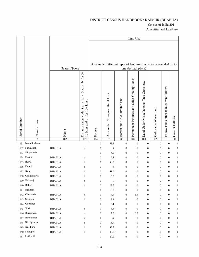
DISTRICT CENSUS HANDBOOK : KAIMUR (BHABUA)
Census of India 2011-
Amenities and Land use
Nam
e
Dis
tance
ran
ge
code
i.e
. a
fo
r <
5 K
ms,
b
for
5-
10 K
ms
and c
f
or
10+
km
s .
Fore
sts
Are
a under
Non-a
gri
cult
ura
l U
ses
Bar
ren a
nd U
n-c
ult
ivab
le l
and
Per
man
ent
Pas
ture
s an
d O
ther
Gra
zing L
ands
Lan
d U
nder
Mis
cell
aneo
us
Tre
e C
rops
etc.
Cult
ura
ble
Was
te L
and
Fal
low
lan
ds
oth
er t
han
curr
ent
fall
ow
s
Curr
ent
Fal
low
s
1 2 102 103 104 105 106 107 108 109 110 111
Ser
ial
Num
ber
Nam
e vil
lage
Area under different types of land use ( in hectares rounded up to
one decimal place)
Land Use
Nearest Town
1131 Naua Shahmal 0 53.3 0 0 0 0 0 0
1132 Naua Jhoti BHABUA c 0 17 0 0 0 0 0 0
1133 Khajurahia 0 5.2 0 0 0 0 0 0
1134 Daridih BHABUA c 0 5.8 0 0 0 0 0 0
1135 Ruiya BHABUA b 0 58.3 0 0 0 0 0 0
1136 Dumri BHABUA b 0 8 0 0 0 0 0 0
1137 Kunj BHABUA b 0 68.5 0 0 0 0 0 0
1138 Chandoraiya BHABUA b 0 6.3 0 0 0 0 0 0
1139 Kolaunj BHABUA b 0 10 0 0 0 0 0 0
1140 Baheri BHABUA b 0 22.5 0 0 0 0 0 0
1141 Hahapur 0 8.2 0 0 0 0 0 0
1142 Checharia BHABUA b 0 6.6 0 1.6 0 0 0 0
1143 Semaria BHABUA b 0 8.8 0 0 0 0 0 0
1144 Gopalpur 0 5.1 0 0 0 0 0 0
1145 Silri BHABUA b 0 6.6 0 0 0 0 0 0
1146 Barigawan BHABUA c 0 12.5 0 0.5 0 0 0 0
1147 Birbhanpur BHABUA c 0 8.7 0 0 0 0 0 0
1148 Bharigawan BHABUA b 0 16.4 0 0 0 0 0 0
1149 Kusdihra BHABUA b 0 33.2 0 0 0 0 0 0
1150 Dalippur BHABUA b 0 36.5 0 0 0 0 0 0
1151 Lakkudih 0 20.2 0 0 0 0 0 0
���
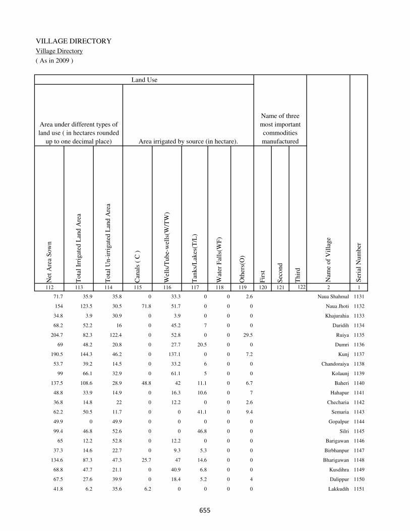
VILLAGE DIRECTORY
Village Directory
( As in 2009 )
Net
Are
a S
ow
n
Tota
l Ir
rigat
ed L
and A
rea
Tota
l U
n-i
rrig
ated
Lan
d A
rea
Can
als
( C
)
Wel
ls/T
ube-
wel
ls(W
/TW
)
Tan
ks/
Lak
es(T
/L)
Wat
er F
alls
(WF
)
Oth
ers(
O)
Fir
st
Sec
ond
Thir
d
112 113 114 115 116 117 118 119 120 121 122 2 1
Ser
ial
Num
ber
Name of three
most important
commodities
manufacturedArea irrigated by source (in hectare).
Nam
e of
Vil
lage
Area under different types of
land use ( in hectares rounded
up to one decimal place)
Land Use
71.7 35.9 35.8 0 33.3 0 0 2.6 Naua Shahmal 1131
154 123.5 30.5 71.8 51.7 0 0 0 Naua Jhoti 1132
34.8 3.9 30.9 0 3.9 0 0 0 Khajurahia 1133
68.2 52.2 16 0 45.2 7 0 0 Daridih 1134
204.7 82.3 122.4 0 52.8 0 0 29.5 Ruiya 1135
69 48.2 20.8 0 27.7 20.5 0 0 Dumri 1136
190.5 144.3 46.2 0 137.1 0 0 7.2 Kunj 1137
53.7 39.2 14.5 0 33.2 6 0 0 Chandoraiya 1138
99 66.1 32.9 0 61.1 5 0 0 Kolaunj 1139
137.5 108.6 28.9 48.8 42 11.1 0 6.7 Baheri 1140
48.8 33.9 14.9 0 16.3 10.6 0 7 Hahapur 1141
36.8 14.8 22 0 12.2 0 0 2.6 Checharia 1142
62.2 50.5 11.7 0 0 41.1 0 9.4 Semaria 1143
49.9 0 49.9 0 0 0 0 0 Gopalpur 1144
99.4 46.8 52.6 0 0 46.8 0 0 Silri 1145
65 12.2 52.8 0 12.2 0 0 0 Barigawan 1146
37.3 14.6 22.7 0 9.3 5.3 0 0 Birbhanpur 1147
134.6 87.3 47.3 25.7 47 14.6 0 0 Bharigawan 1148
68.8 47.7 21.1 0 40.9 6.8 0 0 Kusdihra 1149
67.5 27.6 39.9 0 18.4 5.2 0 4 Dalippur 1150
41.8 6.2 35.6 6.2 0 0 0 0 Lakkudih 1151
���

DISTRICT CENSUS HANDBOOK : KAIMUR (BHABUA)
Census of India 2011-
Amenities and Land use
Pre
-Pri
mar
y s
chool
(PP
)
Pri
mar
y s
chool
(P)
Mid
dle
sch
ool
(M)
Sec
ondar
y S
chool
(S)
Sen
ior
Sec
ondar
y s
chool
(SS
)
Deg
ree
coll
ege
of
arts
sc
ience
& c
om
mer
ce
(AS
C)
Engin
eeri
ng c
oll
ege(
EC
)
Med
ical
coll
ege
(MC
)
Man
agem
ent
inst
itute
(M
I)
Poly
tech
nic
(P
t)
Voca
tional
tra
inin
g s
chool
/IT
I
Non-f
orm
al t
rain
ing c
entr
e (N
FT
C)
Spec
ial
school
for
dis
able
d (
SS
D)
Oth
ers
(spec
ify)
1 2 3 4 5 6 7 8 9 10 11 12 13 14 15 16 17 18 19 20
Loca
tion c
ode
no.
Nam
e vil
lage
Ser
ial
Num
ber
Tota
l popula
tion (
2011 c
ensu
s )
Tota
l ar
ea o
f th
e vil
lage
( in
hec
tare
s ro
unded
up t
o
one
dec
imal
pla
ce)
Number of educational amenities available. (If not available
within the village , the distance range code viz; a for < 5
Kms, b for 5-10 Kms and c for 10+ kms of nearest place
where facility is available is given).
Num
ber
of
house
hold
s (2
011 c
ensu
s)
1152 Shiwpur 250076 334 3062 445 c 1 1 c c c c c c c c c c
1153 Nibi Khurd 250077 99 485 74 c 1 1 c c c c c c c c c c
1154 Nibi Kalan 250078 64 367 67 c a a c c c c c c c c c c
1155 Mohammadpur 250079 156 0 0
1156 Gobardhan Chak 250080 45 0 0
1157 Manpur 250081 87 0 0
1158 Ratwar 250082 292 2784 458 c 1 1 c c c c c c c c c c
1159 Kishunpura 250083 119 399 56 c 1 a b c c c c c c c c c
1160 Sondihra 250084 350 2646 421 c 1 1 c c c c c c c c c c
1161 Bhagwat Chak 250085 25 0 0
1162 Bare 250086 512 2495 386 1 1 1 1 b c c c c c c c c
1163 Sherpur 250087 29 0 0
1164 Bariarchak 250088 37 0 0
1165 Dihra 250089 231 908 134 b 1 a b b c b c c c c c c
1166 Banjaria 250090 70 75 13 b a a c b b c c c c b b c
1167 Parasia 250091 270 979 177 b 1 a c a a c c c c a a c
1168 Kamti 250092 57 251 46 b 1 a c b b c c c c b b c
1169 Patrihan 250093 89 0 0
1170 Maldah 250094 21 39 9 b a a b b b c c c c b b c
1171 Jalalpur 250095 90 421 62 b 1 a b b b c c c c b b c
1172 Jhigridehra 250096 117 917 136 c 1 a b b b c c c c b b c
���

VILLAGE DIRECTORY
Village Directory
( As in 2009 )
Com
munit
y h
ealt
h c
entr
e (C
HC
)
Pri
mar
y h
ealt
h c
entr
e (P
HC
)
Pri
mar
y h
ealt
h s
ub c
entr
e (P
HS
)
Mat
ernit
y a
nd c
hil
d w
elfa
re c
entr
e (M
CW
)
T.B
. cl
inic
(T
BC
)
Hosp
ital
-all
opat
hic
(H
A)
Hosp
ital
-alt
ernat
ive
med
icin
e (H
O)
Dis
pen
sary
(D
)
Vet
erin
ary h
osp
ital
(V
H)
Mobil
e hea
lth c
linic
(M
HC
)
Fam
ily w
elfa
re c
entr
e (F
WC
)
Char
itab
le n
on G
ovt.
hosp
ital
/Nurs
ing h
om
e.
Med
ical
pra
ctit
ioner
wit
h M
BB
S D
egre
e
Med
ical
pra
ctit
ioner
wit
h o
ther
deg
ree
Med
ical
pra
ctit
ioner
wit
h n
o d
egre
e
Tra
dit
ional
pra
ctit
ioner
an
d f
aith
hea
ler
.
Med
icin
e S
hop
Oth
ers
21 22 23 24 25 26 27 28 29 30 31 32 33 34 35 36 37 38 2 1
Number of Non-Government
Medical Amenities available.
Number of Medical Amenities available. (If not
available within the village , the distance range
code viz; a for < 5 Kms, b for 5-10 Kms and c
for 10+ kms of nearest place where facility is
available is given).
Nam
e vil
lage
Ser
ial
Num
ber
c b b b c c c b b c b 0 0 0 0 0 0 0 Shiwpur 1152
c b b c c c c b b c b 0 0 0 0 0 0 0 Nibi Khurd 1153
c c b c c c c b b c c 0 0 0 0 0 0 0 Nibi Kalan 1154
Mohammadpur 1155
Gobardhan Chak 1156
Manpur 1157
c b b b c c c b c c c 0 0 0 0 0 0 0 Ratwar 1158
b b b b b c c b b c c 0 0 0 0 0 0 0 Kishunpura 1159
c b b b c c c c b c b 0 0 0 0 0 0 0 Sondihra 1160
Bhagwat Chak 1161
c c b b c b b c c b b 0 0 0 0 0 0 0 Bare 1162
Sherpur 1163
Bariarchak 1164
b b b b b b b b b b b 0 0 0 0 0 0 0 Dihra 1165
b a b b b b b b b b b 0 0 0 0 0 0 0 Banjaria 1166
a a a a a a a a a a a 0 0 0 0 0 0 0 Parasia 1167
b b b b b b b b b b b 0 0 0 0 0 0 0 Kamti 1168
Patrihan 1169
b a b b b b b b b b b 0 0 0 0 0 0 0 Maldah 1170
b a b b b b b b b b b 0 0 0 0 0 0 0 Jalalpur 1171
b b b b b b b b b b b 0 0 0 0 0 0 0 Jhigridehra 1172
���

DISTRICT CENSUS HANDBOOK : KAIMUR (BHABUA)
Census of India 2011-
Amenities and Land use
Tap
wat
er (
Tre
ated
/Untr
eate
d)
Wel
l w
ater
(Cover
ed /
Unco
ver
ed w
ell)
Han
d P
um
p
Tube
wel
ls /
Bore
wel
l
Spri
ng
Riv
er /
Can
al
Tan
k /
Pond /
L
ake
Oth
ers
Com
munit
y t
oil
et i
ncl
udin
g
bat
h.
Com
munit
y t
oil
et e
xcl
udin
g b
ath.
Rura
l s
anit
ary m
art
or
sanit
ary
har
dw
are
outl
et
avai
lable
nea
r th
e vil
lage.
Com
munit
y b
io-
gas
or
recy
cle
of
was
te f
or
pro
duct
ive
use
.
1 2 39 40 41 42 43 44 45 46 47 48 49 50
Availability of toilet & others
Yes / No Availability of drinking water - Yes / No
Nam
e vil
lage
Ser
ial
Num
ber
1152 Shiwpur No Yes Yes No No Yes No No No No No No
1153 Nibi Khurd No Yes Yes Yes No Yes No No No No No No
1154 Nibi Kalan No Yes Yes No No Yes No No No No No No
1155 Mohammadpur
1156 Gobardhan Chak
1157 Manpur
1158 Ratwar No Yes Yes Yes No Yes Yes No No No No No
1159 Kishunpura No Yes Yes No No Yes No No No No No No
1160 Sondihra No Yes Yes No No Yes No No No No No No
1161 Bhagwat Chak
1162 Bare Yes Yes Yes Yes No Yes Yes No No No No Yes
1163 Sherpur
1164 Bariarchak
1165 Dihra No Yes Yes No No No No No No No No No
1166 Banjaria No Yes Yes Yes No Yes No No No No No No
1167 Parasia No Yes Yes Yes No Yes No No No No No No
1168 Kamti No Yes Yes Yes No Yes No No No No No No
1169 Patrihan
1170 Maldah No Yes Yes No No Yes No No No No No No
1171 Jalalpur Yes Yes Yes Yes No Yes No No No No No No
1172 Jhigridehra No Yes Yes Yes No Yes No No No No No No
���
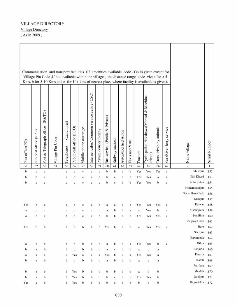
VILLAGE DIRECTORY
Village Directory
( As in 2009 )
Post
off
ice(
PO
)
Sub p
ost
off
ice
(SP
O)
Post
& T
eleg
raph o
ffic
e
(P&
TO
)
Vil
lage
Pin
Code
Tel
ephones
(L
and l
ines
)
Publi
c ca
ll o
ffic
e (P
CO
)
Mobil
e phone
cover
age
Inte
rnet
caf
es/
Com
mon s
ervic
e ce
ntr
e (C
SC
)
Pri
vat
e co
uri
er f
acil
ity
Bus
serv
ice
(P
ubli
c &
Pri
vat
e)
Rai
lway
sta
tions
Auto
/Modif
ied A
uto
s
Tax
is a
nd V
ans
Tra
ctors
Cycl
e-pull
ed r
icksh
aws(
Man
ual
& M
achin
e
dri
ven
)
Car
ts d
riven
by a
nim
als
Sea
/R
iver
fer
ry s
ervic
e51 52 53 54 55 56 57 58 59 60 61 62 63 64 65 66 67 2 1
Communication and transport facilities (If amenities available code -Yes is given except for
Village Pin Code ,If not available within the village , the distance range code viz; a for < 5
Kms, b for 5-10 Kms and c for 10+ kms of nearest place where facility is available is given).
Ser
ial
Num
ber
Nam
e vil
lage
b c c c c c c c b b b b Yes Yes Yes c Shiwpur 1152
b c c c c c c c b c c b Yes Yes a c Nibi Khurd 1153
b c c c c c c c b c b b Yes Yes b c Nibi Kalan 1154
Mohammadpur 1155
Gobardhan Chak 1156
Manpur 1157
Yes c c c c c c c a a c a Yes Yes Yes c Ratwar 1158
a c c c c c c c a b b a a Yes b c Kishunpura 1159
a c c b c c c c b b c c Yes Yes Yes c Sondihra 1160
Bhagwat Chak 1161
Yes b b b b b b b Yes b b b a Yes Yes c Bare 1162
Sherpur 1163
Bariarchak 1164
a b b b b b b b a b b a Yes Yes b c Dihra 1165
b a b b c b b b a c b b a b a Banjaria 1166
a a a a Yes a a a Yes b a a Yes Yes a Parasia 1167
b a b b b b b b a b b b a a a Kamti 1168
Patrihan 1169
b a b b Yes b b b b b b b a b b Maldah 1170
b a b b Yes b b b b c b b Yes Yes b Jalalpur 1171
Yes c b b Yes b b b b c b b b b b Jhigridehra 1172
���
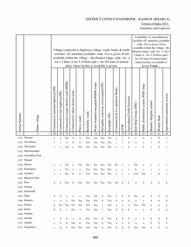
DISTRICT CENSUS HANDBOOK : KAIMUR (BHABUA)
Census of India 2011-
Amenities and Land use
Connec
ted t
o n
atio
nal
hig
hw
ay(N
H)
Connec
ted t
o s
tate
hig
hw
ay(S
H)
Connec
ted t
o m
ajor
dis
tric
t ro
ad (
MD
R)
Connec
ted t
o o
ther
s dis
tric
t ro
ad
Pucc
a r
oad
s
Kutc
hch
a r
oad
s
Wat
er b
ounded
mac
adam
(WB
M)
road
s
Nav
igab
le w
ater
way
(ri
ver
/can
al)(
NW
)
Footp
aths
(FP
)
Com
mer
cial
& C
o-o
per
ativ
e B
anks
AT
M
Agri
cult
ura
l C
redit
Soci
etie
s
Sel
f-H
elp G
roup (
SH
G)
Publi
c dis
trib
uti
on s
yst
em (
PD
S)
shop
Man
dis
/ R
egula
r m
arket
Wee
kly
Haa
t
Agri
cult
ura
l m
arket
ing s
oci
ety
1 2 68 69 70 71 72 73 74 75 76 77 78 79 80 81 82 83 84
Village connected to highways,village roads, banks & credit
societies (If amenities available code -Yes is given, If not
available within the village , the distance range code viz; a
for < 5 Kms, b for 5-10 Kms and c for 10+ kms of nearest
place where facility is available is given).
Ser
ial
Num
ber
Nam
e vil
lage
Availability of miscellaneous
facilities (If amenities available
code -Yes is given, If not
available within the village , the
distance range code viz; a for <
5 Kms, b for 5-10 Kms and c
for 10+ kms of nearest place
where facility is available is
given) Contd....
1152 Shiwpur c c Yes b a Yes Yes Yes Yes c c b c b c b c
1153 Nibi Khurd c c b b b Yes Yes Yes Yes c c b a a c b c
1154 Nibi Kalan c c Yes a Yes Yes Yes Yes Yes c c b c b c b c
1155 Mohammadpur
1156 Gobardhan Chak
1157 Manpur
1158 Ratwar c c Yes a Yes Yes Yes Yes Yes Yes c c Yes c c c c
1159 Kishunpura c c Yes a a Yes Yes Yes Yes c c c b a c c c
1160 Sondihra c c Yes b b Yes Yes Yes Yes c c c Yes Yes c b c
1161 Bhagwat Chak
1162 Bare b b Yes b Yes Yes Yes Yes Yes Yes b b a b b b b
1163 Sherpur
1164 Bariarchak
1165 Dihra b b a a a Yes Yes b Yes a b b Yes a b b b
1166 Banjaria c b a Yes Yes Yes Yes b Yes b b b a a b b b
1167 Parasia b Yes Yes Yes Yes Yes Yes c Yes a a a Yes Yes a a a
1168 Kamti b b a Yes a Yes Yes c Yes b b b a a b b b
1169 Patrihan
1170 Maldah c b b a b Yes Yes b Yes b b b a a b b b
1171 Jalalpur c b b Yes b Yes Yes b Yes b b b a a b b b
1172 Jhigridehra c b b Yes Yes Yes Yes b Yes b b b Yes Yes b b b
���
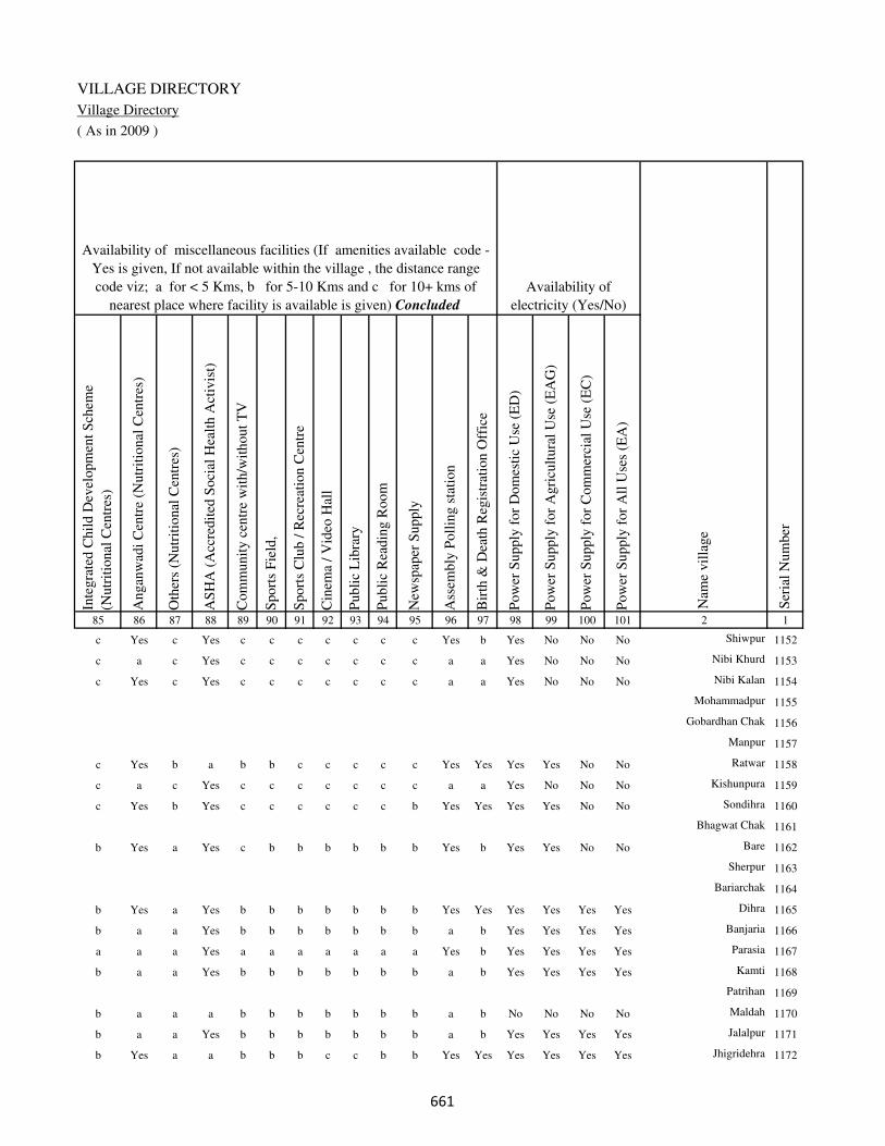
VILLAGE DIRECTORY
Village Directory
( As in 2009 )
Inte
gra
ted C
hil
d D
evel
opm
ent
Sch
eme
(Nutr
itio
nal
Cen
tres
)
Angan
wad
i C
entr
e (N
utr
itio
nal
Cen
tres
)
Oth
ers
(Nutr
itio
nal
Cen
tres
)
AS
HA
(A
ccre
dit
ed S
oci
al H
ealt
h A
ctiv
ist)
Com
munit
y c
entr
e w
ith/w
ithout
TV
Sport
s F
ield
,
Sport
s C
lub /
Rec
reat
ion C
entr
e
Cin
ema
/ V
ideo
Hal
l
Publi
c L
ibra
ry
Publi
c R
eadin
g R
oom
New
spap
er S
upply
Ass
embly
Poll
ing s
tati
on
Bir
th &
Dea
th R
egis
trat
ion O
ffic
e
Pow
er S
upply
for
Dom
esti
c U
se (
ED
)
Pow
er S
upply
for
Agri
cult
ura
l U
se (
EA
G)
Pow
er S
upply
for
Com
mer
cial
Use
(E
C)
Pow
er S
upply
for
All
Use
s (E
A)
85 86 87 88 89 90 91 92 93 94 95 96 97 98 99 100 101 2 1
Availability of
electricity (Yes/No)
Availability of miscellaneous facilities (If amenities available code -
Yes is given, If not available within the village , the distance range
code viz; a for < 5 Kms, b for 5-10 Kms and c for 10+ kms of
nearest place where facility is available is given) Concluded
Nam
e vil
lage
Ser
ial
Num
ber
c Yes c Yes c c c c c c c Yes b Yes No No No Shiwpur 1152
c a c Yes c c c c c c c a a Yes No No No Nibi Khurd 1153
c Yes c Yes c c c c c c c a a Yes No No No Nibi Kalan 1154
Mohammadpur 1155
Gobardhan Chak 1156
Manpur 1157
c Yes b a b b c c c c c Yes Yes Yes Yes No No Ratwar 1158
c a c Yes c c c c c c c a a Yes No No No Kishunpura 1159
c Yes b Yes c c c c c c b Yes Yes Yes Yes No No Sondihra 1160
Bhagwat Chak 1161
b Yes a Yes c b b b b b b Yes b Yes Yes No No Bare 1162
Sherpur 1163
Bariarchak 1164
b Yes a Yes b b b b b b b Yes Yes Yes Yes Yes Yes Dihra 1165
b a a Yes b b b b b b b a b Yes Yes Yes Yes Banjaria 1166
a a a Yes a a a a a a a Yes b Yes Yes Yes Yes Parasia 1167
b a a Yes b b b b b b b a b Yes Yes Yes Yes Kamti 1168
Patrihan 1169
b a a a b b b b b b b a b No No No No Maldah 1170
b a a Yes b b b b b b b a b Yes Yes Yes Yes Jalalpur 1171
b Yes a a b b b c c b b Yes Yes Yes Yes Yes Yes Jhigridehra 1172
���

DISTRICT CENSUS HANDBOOK : KAIMUR (BHABUA)
Census of India 2011-
Amenities and Land use
Nam
e
Dis
tance
ran
ge
code
i.e
. a
fo
r <
5 K
ms,
b
for
5-
10 K
ms
and c
f
or
10+
km
s .
Fore
sts
Are
a under
Non-a
gri
cult
ura
l U
ses
Bar
ren a
nd U
n-c
ult
ivab
le l
and
Per
man
ent
Pas
ture
s an
d O
ther
Gra
zing L
ands
Lan
d U
nder
Mis
cell
aneo
us
Tre
e C
rops
etc.
Cult
ura
ble
Was
te L
and
Fal
low
lan
ds
oth
er t
han
curr
ent
fall
ow
s
Curr
ent
Fal
low
s
1 2 102 103 104 105 106 107 108 109 110 111
Ser
ial
Num
ber
Nam
e vil
lage
Area under different types of land use ( in hectares rounded up to
one decimal place)
Land Use
Nearest Town
1152 Shiwpur BHABUA c 0 1.4 0 0 0 0 0 0
1153 Nibi Khurd BHABUA c 0 2.8 0 0 0 0 0 0
1154 Nibi Kalan BHABUA c 0 2.5 0 0 0 0 0 0
1155 Mohammadpur 0 3 0 0 0 0 0 0
1156 Gobardhan Chak 0 7 0 0 0 0 0 0
1157 Manpur 0 67 0 0 0 0 0 0
1158 Ratwar BHABUA c 0 22.4 0 0 0 0 0 0
1159 Kishunpura BHABUA c 0 13.5 0 0 0 0 0 0
1160 Sondihra BHABUA c 0 29.3 0 0 0 0 0 0
1161 Bhagwat Chak 0 1 0 0 0 0 0 0
1162 Bare BHABUA b 0 39.8 0 0 0 0 0 0
1163 Sherpur 0 0.6 0 0 0 0 0 0
1164 Bariarchak 0 1.4 0 0 0 0 0 0
1165 Dihra BHABUA b 0 9.4 0 0 0 0 0 0
1166 Banjaria BHABUA b 0 4 0 0 0 0 0 0
1167 Parasia BHABUA a 0 32 0 0 0 0 0 0
1168 Kamti BHABUA b 0 2.4 0 0 0 0 0 0
1169 Patrihan 0 1.6 0 0 0 0 0 0
1170 Maldah BHABUA b 0 1 0 0 0 0 0 0
1171 Jalalpur BHABUA b 0 7.3 0 0 0 0 0 0
1172 Jhigridehra BHABUA b 0 7.7 0 0 0 0 0 0
��
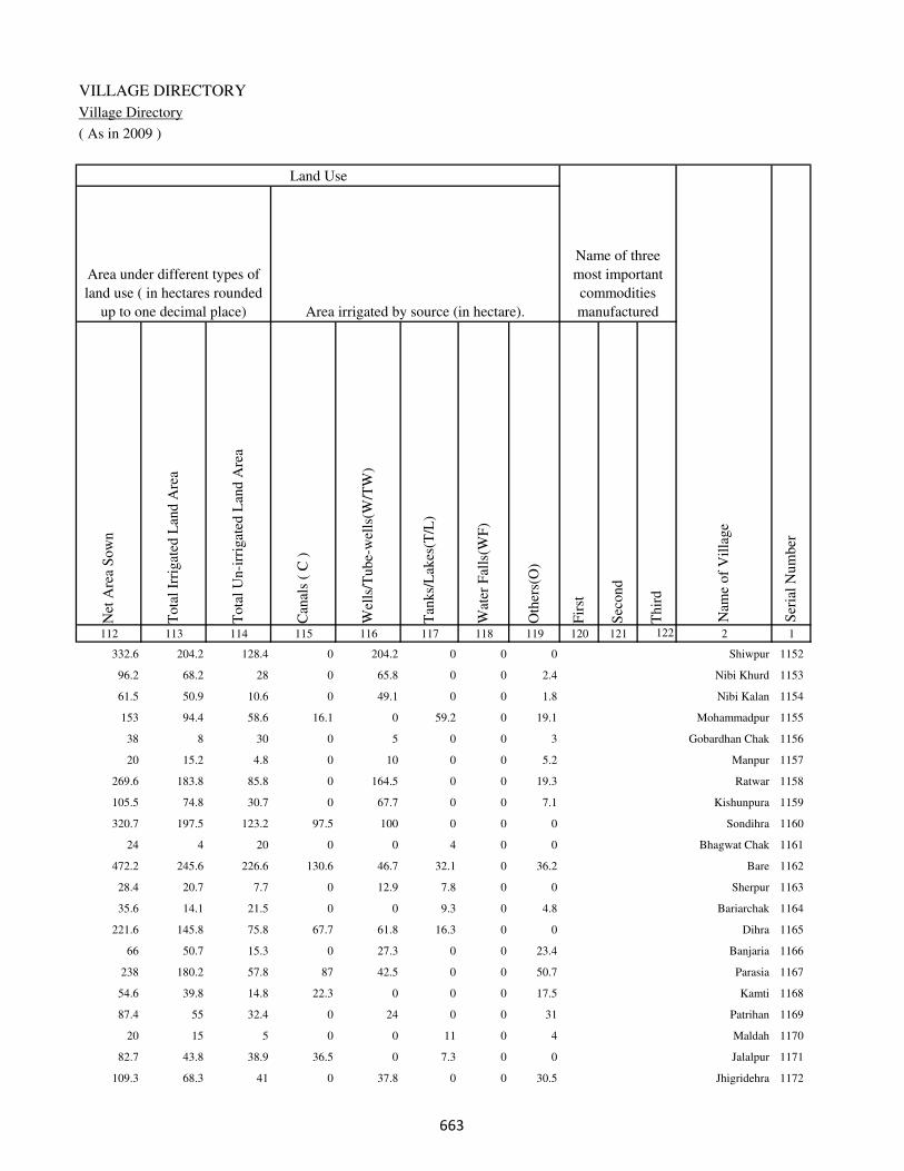
VILLAGE DIRECTORY
Village Directory
( As in 2009 )
Net
Are
a S
ow
n
Tota
l Ir
rigat
ed L
and A
rea
Tota
l U
n-i
rrig
ated
Lan
d A
rea
Can
als
( C
)
Wel
ls/T
ube-
wel
ls(W
/TW
)
Tan
ks/
Lak
es(T
/L)
Wat
er F
alls
(WF
)
Oth
ers(
O)
Fir
st
Sec
ond
Thir
d
112 113 114 115 116 117 118 119 120 121 122 2 1
Ser
ial
Num
ber
Name of three
most important
commodities
manufacturedArea irrigated by source (in hectare).
Nam
e of
Vil
lage
Area under different types of
land use ( in hectares rounded
up to one decimal place)
Land Use
332.6 204.2 128.4 0 204.2 0 0 0 Shiwpur 1152
96.2 68.2 28 0 65.8 0 0 2.4 Nibi Khurd 1153
61.5 50.9 10.6 0 49.1 0 0 1.8 Nibi Kalan 1154
153 94.4 58.6 16.1 0 59.2 0 19.1 Mohammadpur 1155
38 8 30 0 5 0 0 3 Gobardhan Chak 1156
20 15.2 4.8 0 10 0 0 5.2 Manpur 1157
269.6 183.8 85.8 0 164.5 0 0 19.3 Ratwar 1158
105.5 74.8 30.7 0 67.7 0 0 7.1 Kishunpura 1159
320.7 197.5 123.2 97.5 100 0 0 0 Sondihra 1160
24 4 20 0 0 4 0 0 Bhagwat Chak 1161
472.2 245.6 226.6 130.6 46.7 32.1 0 36.2 Bare 1162
28.4 20.7 7.7 0 12.9 7.8 0 0 Sherpur 1163
35.6 14.1 21.5 0 0 9.3 0 4.8 Bariarchak 1164
221.6 145.8 75.8 67.7 61.8 16.3 0 0 Dihra 1165
66 50.7 15.3 0 27.3 0 0 23.4 Banjaria 1166
238 180.2 57.8 87 42.5 0 0 50.7 Parasia 1167
54.6 39.8 14.8 22.3 0 0 0 17.5 Kamti 1168
87.4 55 32.4 0 24 0 0 31 Patrihan 1169
20 15 5 0 0 11 0 4 Maldah 1170
82.7 43.8 38.9 36.5 0 7.3 0 0 Jalalpur 1171
109.3 68.3 41 0 37.8 0 0 30.5 Jhigridehra 1172
��

DISTRICT CENSUS HANDBOOK : KAIMUR (BHABUA)
Census of India 2011-
Amenities and Land use
Pre
-Pri
mar
y s
chool
(PP
)
Pri
mar
y s
chool
(P)
Mid
dle
sch
ool
(M)
Sec
ondar
y S
chool
(S)
Sen
ior
Sec
ondar
y s
chool
(SS
)
Deg
ree
coll
ege
of
arts
sc
ience
& c
om
mer
ce
(AS
C)
Engin
eeri
ng c
oll
ege(
EC
)
Med
ical
coll
ege
(MC
)
Man
agem
ent
inst
itute
(M
I)
Poly
tech
nic
(P
t)
Voca
tional
tra
inin
g s
chool
/IT
I
Non-f
orm
al t
rain
ing c
entr
e (N
FT
C)
Spec
ial
school
for
dis
able
d (
SS
D)
Oth
ers
(spec
ify)
1 2 3 4 5 6 7 8 9 10 11 12 13 14 15 16 17 18 19 20
Loca
tion c
ode
no.
Nam
e vil
lage
Ser
ial
Num
ber
Tota
l popula
tion (
2011 c
ensu
s )
Tota
l ar
ea o
f th
e vil
lage
( in
hec
tare
s ro
unded
up t
o
one
dec
imal
pla
ce)
Number of educational amenities available. (If not available
within the village , the distance range code viz; a for < 5
Kms, b for 5-10 Kms and c for 10+ kms of nearest place
where facility is available is given).
Num
ber
of
house
hold
s (2
011 c
ensu
s)
1173 Sikthiujari 250097 182 1072 164 c 1 1 b b b c c c c b c c
1174 Basgitia 250098 48 0 0
1175 Kamta 250099 148 1026 190 c 1 1 b b b c c c c b b c
1176 Itarhi 250100 335 2257 352 c 1 1 b c c c c c c c c c
1177 Machiawan 250101 361 2168 351 c 1 1 c c c b c c c c c c
1178 English Tiara 250102 20 0 0
1179 Tiaraghat 250103 139 309 37 c a a c c c c c c c c c c
1180 Manpur 250104 54 110 21 c a a c c c c c c c c c c
1181 Asrarhi 250105 177 890 156 c 1 a b c b c c c c c c c
1182 Rampur 250106 109 621 74 c 1 1 a c b c c c c c c c
1183 Panchi 250107 151 786 104 c 1 a b c b c c c c c c c
1184 Dharhanian 250108 17 0 0
1185 Dharhanian 250109 88 0 0
1186 Kaithi 250110 303 3524 574 b 1 b b c b c c c c c c c
1187 Patti 250111 74 594 65 b 1 b a c b c c c c c c c
1188 Nati 250112 239 583 88 b 1 b b c b c c c c c c c
1189 Doghra 250113 96 814 118 b 1 b b c b c c c c c c c
1190 Khanethi 250114 208 1401 196 b 1 1 b c b c c c c c b c
1191 Hathiabandh 250115 93 444 52 a 1 a b c b c c c c c b c
1192 Bisunpura 250116 47 273 37 a a a b c b c c c c c c c
1193 Bhainslot 250117 56 399 66 1 1 b c c c c c c c c c c
���

VILLAGE DIRECTORY
Village Directory
( As in 2009 )
Com
munit
y h
ealt
h c
entr
e (C
HC
)
Pri
mar
y h
ealt
h c
entr
e (P
HC
)
Pri
mar
y h
ealt
h s
ub c
entr
e (P
HS
)
Mat
ernit
y a
nd c
hil
d w
elfa
re c
entr
e (M
CW
)
T.B
. cl
inic
(T
BC
)
Hosp
ital
-all
opat
hic
(H
A)
Hosp
ital
-alt
ernat
ive
med
icin
e (H
O)
Dis
pen
sary
(D
)
Vet
erin
ary h
osp
ital
(V
H)
Mobil
e hea
lth c
linic
(M
HC
)
Fam
ily w
elfa
re c
entr
e (F
WC
)
Char
itab
le n
on G
ovt.
hosp
ital
/Nurs
ing h
om
e.
Med
ical
pra
ctit
ioner
wit
h M
BB
S D
egre
e
Med
ical
pra
ctit
ioner
wit
h o
ther
deg
ree
Med
ical
pra
ctit
ioner
wit
h n
o d
egre
e
Tra
dit
ional
pra
ctit
ioner
an
d f
aith
hea
ler
.
Med
icin
e S
hop
Oth
ers
21 22 23 24 25 26 27 28 29 30 31 32 33 34 35 36 37 38 2 1
Number of Non-Government
Medical Amenities available.
Number of Medical Amenities available. (If not
available within the village , the distance range
code viz; a for < 5 Kms, b for 5-10 Kms and c
for 10+ kms of nearest place where facility is
available is given).
Nam
e vil
lage
Ser
ial
Num
ber
b b 1 1 b b b b b b 1 0 0 0 0 0 0 0 Sikthiujari 1173
Basgitia 1174
b a 1 1 b b b b b b 1 0 0 0 0 0 0 0 Kamta 1175
b b 1 1 c b b c c b 1 0 0 0 0 0 0 0 Itarhi 1176
b b b b b b b b c b c 0 0 0 0 0 0 0 Machiawan 1177
English Tiara 1178
b b b b c b b b c b c 0 0 0 0 0 0 0 Tiaraghat 1179
b b b c c b b b c b c 0 0 0 0 0 0 0 Manpur 1180
b b b c c b b b b b c 0 0 0 0 0 0 0 Asrarhi 1181
a b 1 1 b c c b b c 1 0 0 0 0 0 0 0 Rampur 1182
b b b c c c c c b c c 0 0 0 0 0 0 0 Panchi 1183
Dharhanian 1184
Dharhanian 1185
a b 1 1 b c c c b c 1 0 0 0 0 0 0 0 Kaithi 1186
a b 1 1 b c c c b c 1 0 0 0 0 0 0 0 Patti 1187
a b 1 1 b c c c b c 1 0 0 0 0 0 0 0 Nati 1188
a b c c b c c c b c c 0 0 0 0 0 0 0 Doghra 1189
b b c b b c c c b c c 0 0 0 0 0 0 0 Khanethi 1190
b b c b b c c c c c c 0 0 0 0 0 0 0 Hathiabandh 1191
b b 1 1 b c c b b c 1 0 0 0 0 0 0 0 Bisunpura 1192
c b c c c c c c c c c 0 0 0 0 0 0 0 Bhainslot 1193
���

DISTRICT CENSUS HANDBOOK : KAIMUR (BHABUA)
Census of India 2011-
Amenities and Land use
Tap
wat
er (
Tre
ated
/Untr
eate
d)
Wel
l w
ater
(Cover
ed /
Unco
ver
ed w
ell)
Han
d P
um
p
Tube
wel
ls /
Bore
wel
l
Spri
ng
Riv
er /
Can
al
Tan
k /
Pond /
L
ake
Oth
ers
Com
munit
y t
oil
et i
ncl
udin
g
bat
h.
Com
munit
y t
oil
et e
xcl
udin
g b
ath.
Rura
l s
anit
ary m
art
or
sanit
ary
har
dw
are
outl
et
avai
lable
nea
r th
e vil
lage.
Com
munit
y b
io-
gas
or
recy
cle
of
was
te f
or
pro
duct
ive
use
.
1 2 39 40 41 42 43 44 45 46 47 48 49 50
Availability of toilet & others
Yes / No Availability of drinking water - Yes / No
Nam
e vil
lage
Ser
ial
Num
ber
1173 Sikthiujari Yes Yes Yes Yes No Yes No No No No No No
1174 Basgitia
1175 Kamta Yes Yes Yes Yes No Yes No No No No No No
1176 Itarhi No Yes Yes No No Yes Yes No No No No No
1177 Machiawan No Yes Yes No No Yes No No No No No No
1178 English Tiara
1179 Tiaraghat No Yes Yes Yes No No No No No No No No
1180 Manpur No Yes Yes No No Yes No No No No No No
1181 Asrarhi No Yes Yes No No Yes No No No No No No
1182 Rampur No Yes Yes No No No No No No No No No
1183 Panchi No Yes Yes No No No No No No No No No
1184 Dharhanian
1185 Dharhanian
1186 Kaithi Yes No Yes No No Yes Yes No No No No No
1187 Patti No Yes Yes No No Yes No No No No No No
1188 Nati No Yes Yes No No Yes No No No No No No
1189 Doghra No Yes Yes No No Yes No No No No No No
1190 Khanethi No Yes Yes No No Yes No No No No No No
1191 Hathiabandh No Yes Yes No No No No No No No No No
1192 Bisunpura No Yes Yes No No No No No No No No No
1193 Bhainslot No Yes Yes Yes No Yes Yes No No No No No
���

VILLAGE DIRECTORY
Village Directory
( As in 2009 )
Post
off
ice(
PO
)
Sub p
ost
off
ice
(SP
O)
Post
& T
eleg
raph o
ffic
e
(P&
TO
)
Vil
lage
Pin
Code
Tel
ephones
(L
and l
ines
)
Publi
c ca
ll o
ffic
e (P
CO
)
Mobil
e phone
cover
age
Inte
rnet
caf
es/
Com
mon s
ervic
e ce
ntr
e (C
SC
)
Pri
vat
e co
uri
er f
acil
ity
Bus
serv
ice
(P
ubli
c &
Pri
vat
e)
Rai
lway
sta
tions
Auto
/Modif
ied A
uto
s
Tax
is a
nd V
ans
Tra
ctors
Cycl
e-pull
ed r
icksh
aws(
Man
ual
& M
achin
e
dri
ven
)
Car
ts d
riven
by a
nim
als
Sea
/R
iver
fer
ry s
ervic
e51 52 53 54 55 56 57 58 59 60 61 62 63 64 65 66 67 2 1
Communication and transport facilities (If amenities available code -Yes is given except for
Village Pin Code ,If not available within the village , the distance range code viz; a for < 5
Kms, b for 5-10 Kms and c for 10+ kms of nearest place where facility is available is given).
Ser
ial
Num
ber
Nam
e vil
lage
Yes c b b Yes b b b b c b b b b b b Sikthiujari 1173
Basgitia 1174
b a b b Yes b b b a c b b Yes Yes b Kamta 1175
a c b c c c c c c c c c a Yes Yes c Itarhi 1176
a c b c c c c c b c b b b Yes Yes c Machiawan 1177
English Tiara 1178
a c b c c c c c c b b b a Yes b c Tiaraghat 1179
a c b c c c c c c b b b a Yes a c Manpur 1180
a c b c c c c c b c b b Yes Yes a c Asrarhi 1181
b b c 821109 c Yes Yes b a a b a a b a a Rampur 1182
a c c c c a c c b c b b a a b Panchi 1183
Dharhanian 1184
Dharhanian 1185
Yes b c 821109 b c Yes b c b c b b Yes Yes Yes Yes Kaithi 1186
b b c 821109 c Yes Yes b c b b b b a b b Yes Patti 1187
b c c 821109 Yes c Yes Yes c b b b b a b b Nati 1188
Yes c c 821109 b b b b c b c a b b a b Doghra 1189
Yes c c 821109 c c b b c b c b b b a b Khanethi 1190
Yes c c 821109 c b a b b b b b b b a b Hathiabandh 1191
b b c 821109 b Yes Yes a a a b a a a a b Bisunpura 1192
a b c c Yes c c c c c c c Yes Yes b Bhainslot 1193
���
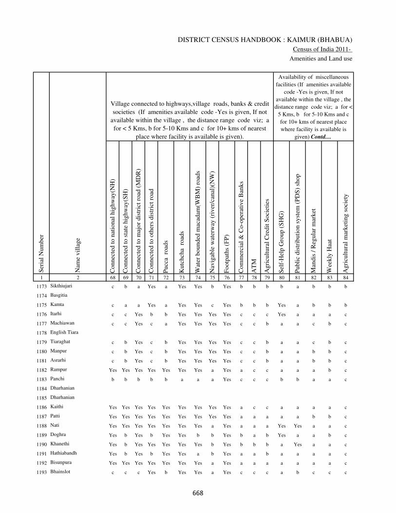
DISTRICT CENSUS HANDBOOK : KAIMUR (BHABUA)
Census of India 2011-
Amenities and Land use
Connec
ted t
o n
atio
nal
hig
hw
ay(N
H)
Connec
ted t
o s
tate
hig
hw
ay(S
H)
Connec
ted t
o m
ajor
dis
tric
t ro
ad (
MD
R)
Connec
ted t
o o
ther
s dis
tric
t ro
ad
Pucc
a r
oad
s
Kutc
hch
a r
oad
s
Wat
er b
ounded
mac
adam
(WB
M)
road
s
Nav
igab
le w
ater
way
(ri
ver
/can
al)(
NW
)
Footp
aths
(FP
)
Com
mer
cial
& C
o-o
per
ativ
e B
anks
AT
M
Agri
cult
ura
l C
redit
Soci
etie
s
Sel
f-H
elp G
roup (
SH
G)
Publi
c dis
trib
uti
on s
yst
em (
PD
S)
shop
Man
dis
/ R
egula
r m
arket
Wee
kly
Haa
t
Agri
cult
ura
l m
arket
ing s
oci
ety
1 2 68 69 70 71 72 73 74 75 76 77 78 79 80 81 82 83 84
Village connected to highways,village roads, banks & credit
societies (If amenities available code -Yes is given, If not
available within the village , the distance range code viz; a
for < 5 Kms, b for 5-10 Kms and c for 10+ kms of nearest
place where facility is available is given).
Ser
ial
Num
ber
Nam
e vil
lage
Availability of miscellaneous
facilities (If amenities available
code -Yes is given, If not
available within the village , the
distance range code viz; a for <
5 Kms, b for 5-10 Kms and c
for 10+ kms of nearest place
where facility is available is
given) Contd....
1173 Sikthiujari c b a Yes a Yes Yes b Yes b b b b a b b b
1174 Basgitia
1175 Kamta c a a Yes a Yes Yes c Yes b b b Yes a b b b
1176 Itarhi c c Yes b b Yes Yes Yes Yes c c c Yes a a a c
1177 Machiawan c c Yes c a Yes Yes Yes Yes c c b a a c b c
1178 English Tiara
1179 Tiaraghat c b Yes c b Yes Yes Yes Yes c c b a a c b c
1180 Manpur c b Yes c b Yes Yes Yes Yes c c b a a b b c
1181 Asrarhi c b Yes c b Yes Yes Yes Yes c c b a a b b c
1182 Rampur Yes Yes Yes Yes Yes Yes Yes a Yes a c c a a a b c
1183 Panchi b b b b b a a a Yes c c c b b a a c
1184 Dharhanian
1185 Dharhanian
1186 Kaithi Yes Yes Yes Yes Yes Yes Yes Yes Yes a c c a a a a c
1187 Patti Yes Yes Yes Yes Yes Yes Yes Yes Yes a a a a a b b c
1188 Nati Yes Yes Yes Yes Yes Yes Yes a Yes a a a Yes Yes a a c
1189 Doghra Yes b Yes b Yes Yes b b Yes b a b Yes a a b c
1190 Khanethi Yes b Yes Yes Yes Yes Yes b Yes b b b a Yes a a c
1191 Hathiabandh Yes b Yes b Yes Yes a b Yes a a b a a a a c
1192 Bisunpura Yes Yes Yes Yes Yes Yes Yes a Yes a a a a a a a c
1193 Bhainslot c c c Yes b Yes Yes a Yes c c c a b c c c
���
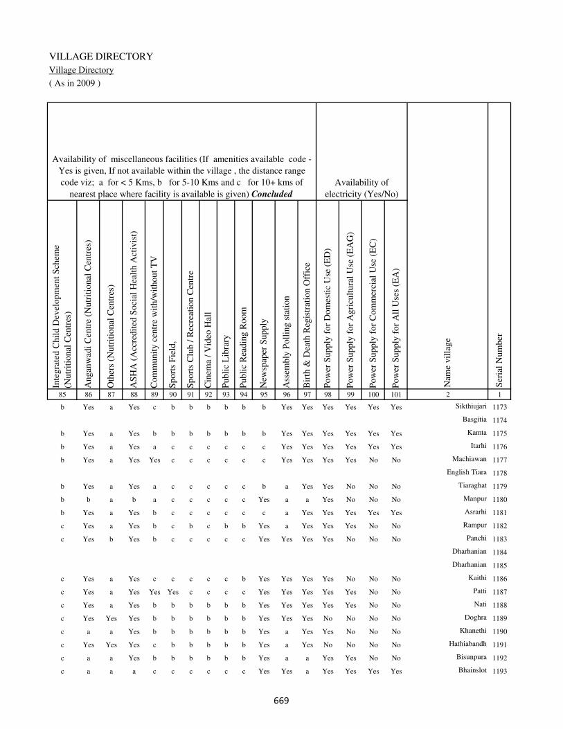
VILLAGE DIRECTORY
Village Directory
( As in 2009 )
Inte
gra
ted C
hil
d D
evel
opm
ent
Sch
eme
(Nutr
itio
nal
Cen
tres
)
Angan
wad
i C
entr
e (N
utr
itio
nal
Cen
tres
)
Oth
ers
(Nutr
itio
nal
Cen
tres
)
AS
HA
(A
ccre
dit
ed S
oci
al H
ealt
h A
ctiv
ist)
Com
munit
y c
entr
e w
ith/w
ithout
TV
Sport
s F
ield
,
Sport
s C
lub /
Rec
reat
ion C
entr
e
Cin
ema
/ V
ideo
Hal
l
Publi
c L
ibra
ry
Publi
c R
eadin
g R
oom
New
spap
er S
upply
Ass
embly
Poll
ing s
tati
on
Bir
th &
Dea
th R
egis
trat
ion O
ffic
e
Pow
er S
upply
for
Dom
esti
c U
se (
ED
)
Pow
er S
upply
for
Agri
cult
ura
l U
se (
EA
G)
Pow
er S
upply
for
Com
mer
cial
Use
(E
C)
Pow
er S
upply
for
All
Use
s (E
A)
85 86 87 88 89 90 91 92 93 94 95 96 97 98 99 100 101 2 1
Availability of
electricity (Yes/No)
Availability of miscellaneous facilities (If amenities available code -
Yes is given, If not available within the village , the distance range
code viz; a for < 5 Kms, b for 5-10 Kms and c for 10+ kms of
nearest place where facility is available is given) Concluded
Nam
e vil
lage
Ser
ial
Num
ber
b Yes a Yes c b b b b b b Yes Yes Yes Yes Yes Yes Sikthiujari 1173
Basgitia 1174
b Yes a Yes b b b b b b b Yes Yes Yes Yes Yes Yes Kamta 1175
b Yes a Yes a c c c c c c Yes Yes Yes Yes Yes Yes Itarhi 1176
b Yes a Yes Yes c c c c c c Yes Yes Yes Yes No No Machiawan 1177
English Tiara 1178
b Yes a Yes a c c c c c b a Yes Yes No No No Tiaraghat 1179
b b a b a c c c c c Yes a a Yes No No No Manpur 1180
b Yes a Yes b c c c c c c a Yes Yes Yes Yes Yes Asrarhi 1181
c Yes a Yes b c b c b b Yes a Yes Yes Yes No No Rampur 1182
c Yes b Yes b c c c c c Yes Yes Yes Yes No No No Panchi 1183
Dharhanian 1184
Dharhanian 1185
c Yes a Yes c c c c c b Yes Yes Yes Yes No No No Kaithi 1186
c Yes a Yes Yes Yes c c c c Yes Yes Yes Yes Yes No No Patti 1187
c Yes a Yes b b b b b b Yes Yes Yes Yes Yes No No Nati 1188
c Yes Yes Yes b b b b b b Yes Yes Yes No No No No Doghra 1189
c a a Yes b b b b b b Yes a Yes Yes No No No Khanethi 1190
c Yes Yes Yes c b b b b b Yes a Yes No No No No Hathiabandh 1191
c a a Yes b b b b b b Yes a a Yes Yes No No Bisunpura 1192
c a a a c c c c c c Yes Yes a Yes Yes Yes Yes Bhainslot 1193
���

DISTRICT CENSUS HANDBOOK : KAIMUR (BHABUA)
Census of India 2011-
Amenities and Land use
Nam
e
Dis
tance
ran
ge
code
i.e
. a
fo
r <
5 K
ms,
b
for
5-
10 K
ms
and c
f
or
10+
km
s .
Fore
sts
Are
a under
Non-a
gri
cult
ura
l U
ses
Bar
ren a
nd U
n-c
ult
ivab
le l
and
Per
man
ent
Pas
ture
s an
d O
ther
Gra
zing L
ands
Lan
d U
nder
Mis
cell
aneo
us
Tre
e C
rops
etc.
Cult
ura
ble
Was
te L
and
Fal
low
lan
ds
oth
er t
han
curr
ent
fall
ow
s
Curr
ent
Fal
low
s
1 2 102 103 104 105 106 107 108 109 110 111
Ser
ial
Num
ber
Nam
e vil
lage
Area under different types of land use ( in hectares rounded up to
one decimal place)
Land Use
Nearest Town
1173 Sikthiujari BHABUA b 0 15.5 0 0 0 0 0 0
1174 Basgitia 0 2.3 0 0 0 0 0 0
1175 Kamta BHABUA b 0 10.6 0 0 0 0 0 0
1176 Itarhi BHABUA b 0 85 0 0 0 0 0 0
1177 Machiawan BHABUA b 0 6.6 0 0 0 0 0 0
1178 English Tiara 0 0.4 0 0 0 0 0 0
1179 Tiaraghat BHABUA b 0 9.8 0 0 0 0 0 0
1180 Manpur BHABUA b 0 4.4 0 0 0 0 0 0
1181 Asrarhi BHABUA b 0 3.2 0 0 0 0 0 0
1182 Rampur BHABUA c 0 8 0 0 0 0 0 0
1183 Panchi BHABUA c 0 9.3 0 0 0 0 0 0
1184 Dharhanian 0 9.3 0 0 0 0 0 0
1185 Dharhanian 0 35 0 0 0 0 0 0
1186 Kaithi BHABUA c 0 6 0 0 0 0 0 0
1187 Patti BHABUA c 0 4.2 0 0 0 0 0 0
1188 Nati BHABUA c 0 57.6 0 0 0 0 0 0
1189 Doghra BHABUA c 0 13 0 0 0 0 0 3
1190 Khanethi BHABUA c 0 17.2 0 0 0 0 0 0
1191 Hathiabandh BHABUA c 0 9.1 0 0 0 0 0 0
1192 Bisunpura BHABUA c 0 4.3 0 0 0 0 0 0
1193 Bhainslot BHABUA c 0 6 0 0 0 0 0 0
���

VILLAGE DIRECTORY
Village Directory
( As in 2009 )
Net
Are
a S
ow
n
Tota
l Ir
rigat
ed L
and A
rea
Tota
l U
n-i
rrig
ated
Lan
d A
rea
Can
als
( C
)
Wel
ls/T
ube-
wel
ls(W
/TW
)
Tan
ks/
Lak
es(T
/L)
Wat
er F
alls
(WF
)
Oth
ers(
O)
Fir
st
Sec
ond
Thir
d
112 113 114 115 116 117 118 119 120 121 122 2 1
Ser
ial
Num
ber
Name of three
most important
commodities
manufacturedArea irrigated by source (in hectare).
Nam
e of
Vil
lage
Area under different types of
land use ( in hectares rounded
up to one decimal place)
Land Use
166.5 134.5 32 0 29.2 58.8 0 46.5 Sikthiujari 1173
45.7 12.8 32.9 0 0 0 0 12.8 Basgitia 1174
137.4 98.7 38.7 0 89.7 0 0 9 Kamta 1175
250 197.2 52.8 86.9 88.5 0 0 21.8 Itarhi 1176
354.4 146.8 207.6 32.2 85.9 25.3 0 3.4 Machiawan 1177
19.6 11 8.6 0 6.2 4.8 0 0 English Tiara 1178
129.2 55.3 73.9 0 42 0 0 13.3 Tiaraghat 1179
49.6 23.9 25.7 0 18 0 0 5.9 Manpur 1180
173.8 142.8 31 86.8 44.1 11.9 0 0 Asrarhi 1181
101 70.9 30.1 0 12.2 58.7 0 0 Rampur 1182
141.7 126.7 15 0 17.4 59.3 0 50 Panchi 1183
7.7 3.9 3.8 0 0 3.9 0 0 Dharhanian 1184
53 41.5 11.5 41.5 0 0 0 0 Dharhanian 1185
297 157.8 139.2 46.5 73.9 37.4 0 0 Kaithi 1186
69.8 55 14.8 0 45.6 0 0 9.4 Patti 1187
181.4 95.2 86.2 0 45.2 50 0 0 Nati 1188
80 55.1 24.9 0 32.3 22.8 0 0 Doghra 1189
190.8 137.9 52.9 67.5 27.9 0 0 42.5 Khanethi 1190
83.9 75.1 8.8 0 68 7.1 0 0 Hathiabandh 1191
42.7 27.8 14.9 17.4 10.4 0 0 0 Bisunpura 1192
50 29.4 20.6 0 29.4 0 0 0 Bhainslot 1193
���

DISTRICT CENSUS HANDBOOK : KAIMUR (BHABUA)
Census of India 2011-
Amenities and Land use
Pre
-Pri
mar
y s
chool
(PP
)
Pri
mar
y s
chool
(P)
Mid
dle
sch
ool
(M)
Sec
ondar
y S
chool
(S)
Sen
ior
Sec
ondar
y s
chool
(SS
)
Deg
ree
coll
ege
of
arts
sc
ience
& c
om
mer
ce
(AS
C)
Engin
eeri
ng c
oll
ege(
EC
)
Med
ical
coll
ege
(MC
)
Man
agem
ent
inst
itute
(M
I)
Poly
tech
nic
(P
t)
Voca
tional
tra
inin
g s
chool
/IT
I
Non-f
orm
al t
rain
ing c
entr
e (N
FT
C)
Spec
ial
school
for
dis
able
d (
SS
D)
Oth
ers
(spec
ify)
1 2 3 4 5 6 7 8 9 10 11 12 13 14 15 16 17 18 19 20
Loca
tion c
ode
no.
Nam
e vil
lage
Ser
ial
Num
ber
Tota
l popula
tion (
2011 c
ensu
s )
Tota
l ar
ea o
f th
e vil
lage
( in
hec
tare
s ro
unded
up t
o
one
dec
imal
pla
ce)
Number of educational amenities available. (If not available
within the village , the distance range code viz; a for < 5
Kms, b for 5-10 Kms and c for 10+ kms of nearest place
where facility is available is given).
Num
ber
of
house
hold
s (2
011 c
ensu
s)
1194 Bahuwan 250118 293 2558 373 a 1 1 c c c c c c c c c c
1195 Chhotki Pangaiya 250119 34 0 0
1196 Madarpur 250120 53 0 0
1197 Nazrabad 250121 51 0 0
1198 Bahera 250122 109 913 138 a 1 1 a a c c c c c c c c
1199 Kathaura 250123 59 487 63 b 1 b a b b c c c c b b c b
1200 Bahuwara 250124 63 555 116 b 1 1 a b b c c c c b b c b
1201 Kariganwan 250125 64 0 0
1202 Narayanpur 250126 56 266 48 b 1 a a c c c c c c c c c c
1203 Basgitia 250127 33 204 30 b 1 a a c c c c c c c c c
1204 Khanethi Gurdas 250128 150 854 124 b b a a c b c c c c c b c
1205 Parmalpur 250129 178 1264 199 c 1 1 a c b c c c c c b c
1206 Rampur 250130 45 797 119 c 1 a b b b c c c c c b c
1207 Saunrudih 250131 78 683 77 c 1 a b c c c c c c c c c
1208 Kanpara Ujari 250132 78 0 0
1209 Kanpara 250133 80 294 39 c 1 b a c c c c c c c c c c
1210 Miria 250134 323 3361 483 b 1 1 a a c c c c c c c c c
1211 Saraiya 250135 62 297 39 b 1 a a c c c c c c c c c
1212 Chhotkakir 250136 165 514 86 b 1 1 a c c c c c c c c c
1213 Barkakir 250137 213 2097 318 b 1 1 b c c c c c c c b c
1214 Tamarh 250138 270 1515 224 a b a c c c c c c c c c c
��

VILLAGE DIRECTORY
Village Directory
( As in 2009 )
Com
munit
y h
ealt
h c
entr
e (C
HC
)
Pri
mar
y h
ealt
h c
entr
e (P
HC
)
Pri
mar
y h
ealt
h s
ub c
entr
e (P
HS
)
Mat
ernit
y a
nd c
hil
d w
elfa
re c
entr
e (M
CW
)
T.B
. cl
inic
(T
BC
)
Hosp
ital
-all
opat
hic
(H
A)
Hosp
ital
-alt
ernat
ive
med
icin
e (H
O)
Dis
pen
sary
(D
)
Vet
erin
ary h
osp
ital
(V
H)
Mobil
e hea
lth c
linic
(M
HC
)
Fam
ily w
elfa
re c
entr
e (F
WC
)
Char
itab
le n
on G
ovt.
hosp
ital
/Nurs
ing h
om
e.
Med
ical
pra
ctit
ioner
wit
h M
BB
S D
egre
e
Med
ical
pra
ctit
ioner
wit
h o
ther
deg
ree
Med
ical
pra
ctit
ioner
wit
h n
o d
egre
e
Tra
dit
ional
pra
ctit
ioner
an
d f
aith
hea
ler
.
Med
icin
e S
hop
Oth
ers
21 22 23 24 25 26 27 28 29 30 31 32 33 34 35 36 37 38 2 1
Number of Non-Government
Medical Amenities available.
Number of Medical Amenities available. (If not
available within the village , the distance range
code viz; a for < 5 Kms, b for 5-10 Kms and c
for 10+ kms of nearest place where facility is
available is given).
Nam
e vil
lage
Ser
ial
Num
ber
c b c c c c c c c c c 0 0 0 0 0 0 0 Bahuwan 1194
Chhotki Pangaiya 1195
Madarpur 1196
Nazrabad 1197
c c c c c c c c c c c 0 0 0 0 0 0 0 Bahera 1198
b b b b b c c b b c b 0 0 0 0 0 0 0 Kathaura 1199
b b b b b c c b b c b 0 0 0 0 0 0 0 Bahuwara 1200
Kariganwan 1201
c b c c c c c c c c c 0 0 0 0 0 0 0 Narayanpur 1202
c a c c c c c c c c c 0 0 0 0 0 0 0 Basgitia 1203
c b b b c c c c c c c 0 0 0 0 0 0 0 Khanethi Gurdas 1204
b b b c c c c c c c b 0 0 0 0 0 0 0 Parmalpur 1205
c c b c b c c c b c c 0 0 0 0 0 0 0 Rampur 1206
c c c c c c c c c c c 0 0 0 0 0 0 0 Saunrudih 1207
Kanpara Ujari 1208
c c 1 1 c c c c c c 1 0 0 0 0 0 0 0 Kanpara 1209
c c c c c c c c c c c 0 0 0 0 0 0 0 Miria 1210
c a c c c c c c c c c 0 0 0 0 0 0 0 Saraiya 1211
c c c c c c c c c c c 0 0 0 0 0 0 0 Chhotkakir 1212
c c a c c c c c c c c 0 0 0 0 0 0 0 Barkakir 1213
c b b c c c c c c c c 0 0 0 0 0 0 0 Tamarh 1214
��
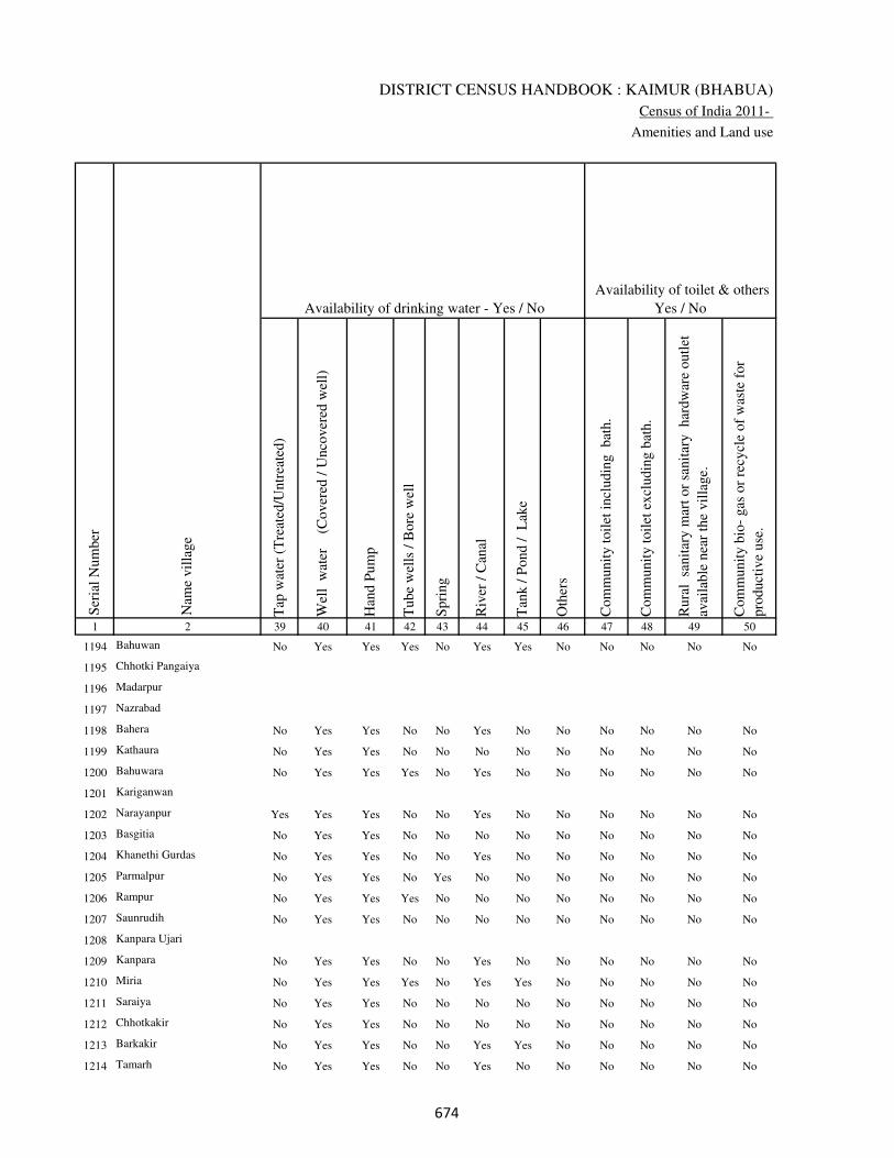
DISTRICT CENSUS HANDBOOK : KAIMUR (BHABUA)
Census of India 2011-
Amenities and Land use
Tap
wat
er (
Tre
ated
/Untr
eate
d)
Wel
l w
ater
(Cover
ed /
Unco
ver
ed w
ell)
Han
d P
um
p
Tube
wel
ls /
Bore
wel
l
Spri
ng
Riv
er /
Can
al
Tan
k /
Pond /
L
ake
Oth
ers
Com
munit
y t
oil
et i
ncl
udin
g
bat
h.
Com
munit
y t
oil
et e
xcl
udin
g b
ath.
Rura
l s
anit
ary m
art
or
sanit
ary
har
dw
are
outl
et
avai
lable
nea
r th
e vil
lage.
Com
munit
y b
io-
gas
or
recy
cle
of
was
te f
or
pro
duct
ive
use
.
1 2 39 40 41 42 43 44 45 46 47 48 49 50
Availability of toilet & others
Yes / No Availability of drinking water - Yes / No
Nam
e vil
lage
Ser
ial
Num
ber
1194 Bahuwan No Yes Yes Yes No Yes Yes No No No No No
1195 Chhotki Pangaiya
1196 Madarpur
1197 Nazrabad
1198 Bahera No Yes Yes No No Yes No No No No No No
1199 Kathaura No Yes Yes No No No No No No No No No
1200 Bahuwara No Yes Yes Yes No Yes No No No No No No
1201 Kariganwan
1202 Narayanpur Yes Yes Yes No No Yes No No No No No No
1203 Basgitia No Yes Yes No No No No No No No No No
1204 Khanethi Gurdas No Yes Yes No No Yes No No No No No No
1205 Parmalpur No Yes Yes No Yes No No No No No No No
1206 Rampur No Yes Yes Yes No No No No No No No No
1207 Saunrudih No Yes Yes No No No No No No No No No
1208 Kanpara Ujari
1209 Kanpara No Yes Yes No No Yes No No No No No No
1210 Miria No Yes Yes Yes No Yes Yes No No No No No
1211 Saraiya No Yes Yes No No No No No No No No No
1212 Chhotkakir No Yes Yes No No No No No No No No No
1213 Barkakir No Yes Yes No No Yes Yes No No No No No
1214 Tamarh No Yes Yes No No Yes No No No No No No
���

VILLAGE DIRECTORY
Village Directory
( As in 2009 )
Post
off
ice(
PO
)
Sub p
ost
off
ice
(SP
O)
Post
& T
eleg
raph o
ffic
e
(P&
TO
)
Vil
lage
Pin
Code
Tel
ephones
(L
and l
ines
)
Publi
c ca
ll o
ffic
e (P
CO
)
Mobil
e phone
cover
age
Inte
rnet
caf
es/
Com
mon s
ervic
e ce
ntr
e (C
SC
)
Pri
vat
e co
uri
er f
acil
ity
Bus
serv
ice
(P
ubli
c &
Pri
vat
e)
Rai
lway
sta
tions
Auto
/Modif
ied A
uto
s
Tax
is a
nd V
ans
Tra
ctors
Cycl
e-pull
ed r
icksh
aws(
Man
ual
& M
achin
e
dri
ven
)
Car
ts d
riven
by a
nim
als
Sea
/R
iver
fer
ry s
ervic
e51 52 53 54 55 56 57 58 59 60 61 62 63 64 65 66 67 2 1
Communication and transport facilities (If amenities available code -Yes is given except for
Village Pin Code ,If not available within the village , the distance range code viz; a for < 5
Kms, b for 5-10 Kms and c for 10+ kms of nearest place where facility is available is given).
Ser
ial
Num
ber
Nam
e vil
lage
a b c c Yes c c c c c c c Yes Yes Yes Bahuwan 1194
Chhotki Pangaiya 1195
Madarpur 1196
Nazrabad 1197
a c c c c c c c b a c c b b b c Bahera 1198
a b c b b b b b b b b b a b b b Kathaura 1199
a b c b b b b b b b b b b b b b Bahuwara 1200
Kariganwan 1201
a c c c c c c c c b c c b b b Narayanpur 1202
a c c c c c c c c b c c b b b c Basgitia 1203
Yes c c 821109 c b c b c b b b b b b b Khanethi Gurdas 1204
b c c 821109 b b b c c b b b b b b b Parmalpur 1205
a c c b b c b b b b b c b a b Rampur 1206
a c c c c c c c a b c c b b b c Saunrudih 1207
Kanpara Ujari 1208
a c c c c c c c c b a b b b b c Kanpara 1209
a c c c c c c c Yes b c c Yes Yes Yes c Miria 1210
a c c c c c c c c a c c c b b c Saraiya 1211
a c c c c c c c a b c c c a b c Chhotkakir 1212
Yes c c c c c c c a b c c c b Yes Barkakir 1213
a c c c c c c c c b c c c b a c Tamarh 1214
���

DISTRICT CENSUS HANDBOOK : KAIMUR (BHABUA)
Census of India 2011-
Amenities and Land use
Connec
ted t
o n
atio
nal
hig
hw
ay(N
H)
Connec
ted t
o s
tate
hig
hw
ay(S
H)
Connec
ted t
o m
ajor
dis
tric
t ro
ad (
MD
R)
Connec
ted t
o o
ther
s dis
tric
t ro
ad
Pucc
a r
oad
s
Kutc
hch
a r
oad
s
Wat
er b
ounded
mac
adam
(WB
M)
road
s
Nav
igab
le w
ater
way
(ri
ver
/can
al)(
NW
)
Footp
aths
(FP
)
Com
mer
cial
& C
o-o
per
ativ
e B
anks
AT
M
Agri
cult
ura
l C
redit
Soci
etie
s
Sel
f-H
elp G
roup (
SH
G)
Publi
c dis
trib
uti
on s
yst
em (
PD
S)
shop
Man
dis
/ R
egula
r m
arket
Wee
kly
Haa
t
Agri
cult
ura
l m
arket
ing s
oci
ety
1 2 68 69 70 71 72 73 74 75 76 77 78 79 80 81 82 83 84
Village connected to highways,village roads, banks & credit
societies (If amenities available code -Yes is given, If not
available within the village , the distance range code viz; a
for < 5 Kms, b for 5-10 Kms and c for 10+ kms of nearest
place where facility is available is given).
Ser
ial
Num
ber
Nam
e vil
lage
Availability of miscellaneous
facilities (If amenities available
code -Yes is given, If not
available within the village , the
distance range code viz; a for <
5 Kms, b for 5-10 Kms and c
for 10+ kms of nearest place
where facility is available is
given) Contd....
1194 Bahuwan c c c Yes b Yes Yes b Yes c c c Yes Yes c c c
1195 Chhotki Pangaiya
1196 Madarpur
1197 Nazrabad
1198 Bahera c a b b b a a b Yes c c c a a a a c
1199 Kathaura b b b b b Yes b b Yes b b b a a a a c
1200 Bahuwara b b b b b Yes b b Yes b b b a a a a c
1201 Kariganwan
1202 Narayanpur b b b b b Yes Yes b Yes c c c a a a a c
1203 Basgitia Yes b a a Yes Yes a b Yes c c c a a a a c
1204 Khanethi Gurdas Yes b Yes b Yes Yes b c Yes b c b a a a a c
1205 Parmalpur Yes b b Yes Yes Yes a b Yes c c b a a a a c
1206 Rampur b b b b b a b c Yes c c b a Yes a a c
1207 Saunrudih Yes a a a Yes Yes Yes b Yes c c c a a a b c
1208 Kanpara Ujari
1209 Kanpara Yes b b b Yes a a c Yes c c c a a a a c
1210 Miria Yes a a a Yes Yes Yes c Yes c c c a Yes a a c
1211 Saraiya Yes a a a Yes a a b Yes c c c a a a a c
1212 Chhotkakir Yes a a a Yes Yes Yes b Yes c c c Yes a a a c
1213 Barkakir Yes Yes Yes Yes Yes Yes Yes c Yes c c c a a c a c
1214 Tamarh Yes a a a Yes Yes Yes b Yes c c c Yes Yes a a c
���
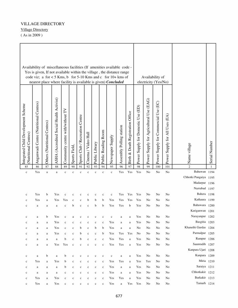
VILLAGE DIRECTORY
Village Directory
( As in 2009 )
Inte
gra
ted C
hil
d D
evel
opm
ent
Sch
eme
(Nutr
itio
nal
Cen
tres
)
Angan
wad
i C
entr
e (N
utr
itio
nal
Cen
tres
)
Oth
ers
(Nutr
itio
nal
Cen
tres
)
AS
HA
(A
ccre
dit
ed S
oci
al H
ealt
h A
ctiv
ist)
Com
munit
y c
entr
e w
ith/w
ithout
TV
Sport
s F
ield
,
Sport
s C
lub /
Rec
reat
ion C
entr
e
Cin
ema
/ V
ideo
Hal
l
Publi
c L
ibra
ry
Publi
c R
eadin
g R
oom
New
spap
er S
upply
Ass
embly
Poll
ing s
tati
on
Bir
th &
Dea
th R
egis
trat
ion O
ffic
e
Pow
er S
upply
for
Dom
esti
c U
se (
ED
)
Pow
er S
upply
for
Agri
cult
ura
l U
se (
EA
G)
Pow
er S
upply
for
Com
mer
cial
Use
(E
C)
Pow
er S
upply
for
All
Use
s (E
A)
85 86 87 88 89 90 91 92 93 94 95 96 97 98 99 100 101 2 1
Availability of
electricity (Yes/No)
Availability of miscellaneous facilities (If amenities available code -
Yes is given, If not available within the village , the distance range
code viz; a for < 5 Kms, b for 5-10 Kms and c for 10+ kms of
nearest place where facility is available is given) Concluded
Nam
e vil
lage
Ser
ial
Num
ber
c Yes a a c c c c c c c Yes Yes Yes No No No Bahuwan 1194
Chhotki Pangaiya 1195
Madarpur 1196
Nazrabad 1197
c Yes b Yes c c c c c c c Yes Yes Yes No No No Bahera 1198
c Yes a Yes Yes c c b b b Yes Yes Yes Yes No No No Kathaura 1199
c a a a c b c c b b Yes Yes b Yes No No No Bahuwara 1200
Kariganwan 1201
c a b Yes c a c c c c c a a Yes No No No Narayanpur 1202
c a a Yes c c c c c c Yes a a Yes No No No Basgitia 1203
c a a Yes c c b c b b Yes a a No No No No Khanethi Gurdas 1204
c a a Yes c c b c c b Yes Yes Yes No No No No Parmalpur 1205
c a a a b c b c c c Yes Yes a Yes No No No Rampur 1206
c a a Yes Yes c c c c c Yes Yes a Yes No No No Saunrudih 1207
Kanpara Ujari 1208
c a b a b c c c c c c a a Yes No No No Kanpara 1209
c Yes a Yes b c c c c c Yes Yes a Yes Yes No No Miria 1210
c a a a b c c c c c Yes a a Yes No No No Saraiya 1211
c a a a c c c c c c Yes a a Yes No No No Chhotkakir 1212
c Yes a Yes c c c c c c Yes Yes a Yes No No No Barkakir 1213
c Yes a Yes c c c c c c Yes a Yes Yes No No No Tamarh 1214
���
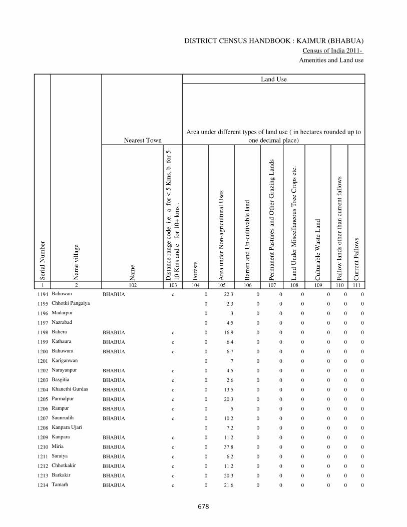
DISTRICT CENSUS HANDBOOK : KAIMUR (BHABUA)
Census of India 2011-
Amenities and Land use
Nam
e
Dis
tance
ran
ge
code
i.e
. a
fo
r <
5 K
ms,
b
for
5-
10 K
ms
and c
f
or
10+
km
s .
Fore
sts
Are
a under
Non-a
gri
cult
ura
l U
ses
Bar
ren a
nd U
n-c
ult
ivab
le l
and
Per
man
ent
Pas
ture
s an
d O
ther
Gra
zing L
ands
Lan
d U
nder
Mis
cell
aneo
us
Tre
e C
rops
etc.
Cult
ura
ble
Was
te L
and
Fal
low
lan
ds
oth
er t
han
curr
ent
fall
ow
s
Curr
ent
Fal
low
s
1 2 102 103 104 105 106 107 108 109 110 111
Ser
ial
Num
ber
Nam
e vil
lage
Area under different types of land use ( in hectares rounded up to
one decimal place)
Land Use
Nearest Town
1194 Bahuwan BHABUA c 0 22.3 0 0 0 0 0 0
1195 Chhotki Pangaiya 0 2.3 0 0 0 0 0 0
1196 Madarpur 0 3 0 0 0 0 0 0
1197 Nazrabad 0 4.5 0 0 0 0 0 0
1198 Bahera BHABUA c 0 16.9 0 0 0 0 0 0
1199 Kathaura BHABUA c 0 6.4 0 0 0 0 0 0
1200 Bahuwara BHABUA c 0 6.7 0 0 0 0 0 0
1201 Kariganwan 0 7 0 0 0 0 0 0
1202 Narayanpur BHABUA c 0 4.5 0 0 0 0 0 0
1203 Basgitia BHABUA c 0 2.6 0 0 0 0 0 0
1204 Khanethi Gurdas BHABUA c 0 13.5 0 0 0 0 0 0
1205 Parmalpur BHABUA c 0 20.3 0 0 0 0 0 0
1206 Rampur BHABUA c 0 5 0 0 0 0 0 0
1207 Saunrudih BHABUA c 0 10.2 0 0 0 0 0 0
1208 Kanpara Ujari 0 7.2 0 0 0 0 0 0
1209 Kanpara BHABUA c 0 11.2 0 0 0 0 0 0
1210 Miria BHABUA c 0 37.8 0 0 0 0 0 0
1211 Saraiya BHABUA c 0 6.2 0 0 0 0 0 0
1212 Chhotkakir BHABUA c 0 11.2 0 0 0 0 0 0
1213 Barkakir BHABUA c 0 20.3 0 0 0 0 0 0
1214 Tamarh BHABUA c 0 21.6 0 0 0 0 0 0
���

VILLAGE DIRECTORY
Village Directory
( As in 2009 )
Net
Are
a S
ow
n
Tota
l Ir
rigat
ed L
and A
rea
Tota
l U
n-i
rrig
ated
Lan
d A
rea
Can
als
( C
)
Wel
ls/T
ube-
wel
ls(W
/TW
)
Tan
ks/
Lak
es(T
/L)
Wat
er F
alls
(WF
)
Oth
ers(
O)
Fir
st
Sec
ond
Thir
d
112 113 114 115 116 117 118 119 120 121 122 2 1
Ser
ial
Num
ber
Name of three
most important
commodities
manufacturedArea irrigated by source (in hectare).
Nam
e of
Vil
lage
Area under different types of
land use ( in hectares rounded
up to one decimal place)
Land Use
270.7 188 82.7 138.7 0 18.6 0 30.7 Bahuwan 1194
31.7 18 13.7 11.2 0 0 0 6.8 Chhotki Pangaiya 1195
50 21.4 28.6 5.2 16.2 0 0 0 Madarpur 1196
46.5 17.8 28.7 0 0 17.8 0 0 Nazrabad 1197
92.1 80.7 11.4 36 0 0 0 44.7 Bahera 1198
52.6 41 11.6 28 0 0 0 13 Kathaura 1199
56.3 44 12.3 27.7 0 0 0 16.3 Bahuwara 1200
57 32.3 24.7 32.3 0 0 0 0 Kariganwan 1201
51.5 29.5 22 20.6 0 0 0 8.9 Narayanpur 1202
30.4 17.8 12.6 0 9.8 0 0 8 Basgitia 1203
136.5 93.8 42.7 40.1 45 0 0 8.7 Khanethi Gurdas 1204
157.7 153.1 4.6 20.7 87.1 0 0 45.3 Parmalpur 1205
40 31 9 0 29.8 0 0 1.2 Rampur 1206
67.8 37.3 30.5 26.9 10.4 0 0 0 Saunrudih 1207
70.8 42.5 28.3 28.7 13.8 0 0 0 Kanpara Ujari 1208
68.8 44.9 23.9 0 20.1 0 0 24.8 Kanpara 1209
285.2 158.7 126.5 0 141.2 0 0 17.5 Miria 1210
55.8 29.6 26.2 18.2 8.9 0 0 2.5 Saraiya 1211
153.8 140 13.8 0 100 0 0 40 Chhotkakir 1212
192.7 137.4 55.3 80 20 0 0 37.4 Barkakir 1213
248.4 198.1 50.3 129.8 47 0 0 21.3 Tamarh 1214
���

DISTRICT CENSUS HANDBOOK : KAIMUR (BHABUA)
Census of India 2011-
Amenities and Land use
Pre
-Pri
mar
y s
chool
(PP
)
Pri
mar
y s
chool
(P)
Mid
dle
sch
ool
(M)
Sec
ondar
y S
chool
(S)
Sen
ior
Sec
ondar
y s
chool
(SS
)
Deg
ree
coll
ege
of
arts
sc
ience
& c
om
mer
ce
(AS
C)
Engin
eeri
ng c
oll
ege(
EC
)
Med
ical
coll
ege
(MC
)
Man
agem
ent
inst
itute
(M
I)
Poly
tech
nic
(P
t)
Voca
tional
tra
inin
g s
chool
/IT
I
Non-f
orm
al t
rain
ing c
entr
e (N
FT
C)
Spec
ial
school
for
dis
able
d (
SS
D)
Oth
ers
(spec
ify)
1 2 3 4 5 6 7 8 9 10 11 12 13 14 15 16 17 18 19 20
Loca
tion c
ode
no.
Nam
e vil
lage
Ser
ial
Num
ber
Tota
l popula
tion (
2011 c
ensu
s )
Tota
l ar
ea o
f th
e vil
lage
( in
hec
tare
s ro
unded
up t
o
one
dec
imal
pla
ce)
Number of educational amenities available. (If not available
within the village , the distance range code viz; a for < 5
Kms, b for 5-10 Kms and c for 10+ kms of nearest place
where facility is available is given).
Num
ber
of
house
hold
s (2
011 c
ensu
s)
1215 Rampur 250139 32 220 22 a b a b c c c c c c c c c
1216 Sirmaura 250140 110 0 0
1217 Tamarhi 250141 125 1110 172 1 1 1 a c c c c c c c c c
1218 Kamalpur 250142 49 1 1 a b b a c b c c c c c b c
1219 Sonhan 250143 337 2800 446 b 1 1 1 b b c c c c b b c
1220 Sarai Manrup 250144 51 0 0
1221 Shukulpura 250145 45 0 0
1222 Ganwan 250146 46 654 113 b 1 a a b b c c c c b b c
1223 Khajuria Kalan 250147 47 0 0
1224 Khajuria Khurd 250148 30 225 44 b a a a b b c c c c b b c
1225 Khajuria 250149 41 0 0
1226 Barahuli 250150 77 998 160 b 1 1 a c c b c c c c c c
1227 Paranpur 250151 64 58 11 b b b b b b c c c c c b c
1228 Dhonrhi 250152 93 434 75 1 1 1 a b b c c c c c b c
1229 Manchahalpur 250153 99 491 77 b 1 a b b b c c c c c c c c
1230 Beguda 250154 30 75 13 a a b c c c c c c c c c c c
1231 Mahuwari 250155 221 2112 335 1 1 1 c c c c c c c c c c
1232 Harnathpur 250156 86 451 92 b a a a c c c c c c c c c
1233 Nimi 250157 136 621 92 b 1 1 1 c c c c c c c c c
1234 Jagdishpur 250158 41 171 27 c b c c c c c c c c c c c c
1235 Sagar 250159 155 105 14 a a a c c c c c c c c c c c
���

VILLAGE DIRECTORY
Village Directory
( As in 2009 )
Com
munit
y h
ealt
h c
entr
e (C
HC
)
Pri
mar
y h
ealt
h c
entr
e (P
HC
)
Pri
mar
y h
ealt
h s
ub c
entr
e (P
HS
)
Mat
ernit
y a
nd c
hil
d w
elfa
re c
entr
e (M
CW
)
T.B
. cl
inic
(T
BC
)
Hosp
ital
-all
opat
hic
(H
A)
Hosp
ital
-alt
ernat
ive
med
icin
e (H
O)
Dis
pen
sary
(D
)
Vet
erin
ary h
osp
ital
(V
H)
Mobil
e hea
lth c
linic
(M
HC
)
Fam
ily w
elfa
re c
entr
e (F
WC
)
Char
itab
le n
on G
ovt.
hosp
ital
/Nurs
ing h
om
e.
Med
ical
pra
ctit
ioner
wit
h M
BB
S D
egre
e
Med
ical
pra
ctit
ioner
wit
h o
ther
deg
ree
Med
ical
pra
ctit
ioner
wit
h n
o d
egre
e
Tra
dit
ional
pra
ctit
ioner
an
d f
aith
hea
ler
.
Med
icin
e S
hop
Oth
ers
21 22 23 24 25 26 27 28 29 30 31 32 33 34 35 36 37 38 2 1
Number of Non-Government
Medical Amenities available.
Number of Medical Amenities available. (If not
available within the village , the distance range
code viz; a for < 5 Kms, b for 5-10 Kms and c
for 10+ kms of nearest place where facility is
available is given).
Nam
e vil
lage
Ser
ial
Num
ber
a c c c c c c c c c c 0 0 0 0 0 0 0 Rampur 1215
Sirmaura 1216
c c c c c c c c c c c 0 0 0 0 0 0 0 Tamarhi 1217
b b 1 b b c c b b c 1 0 0 0 0 0 0 0 Kamalpur 1218
b b 1 1 b b b b b b 1 0 0 0 0 0 0 0 Sonhan 1219
Sarai Manrup 1220
Shukulpura 1221
b a b b b b b b b b b 0 0 0 0 0 0 0 Ganwan 1222
Khajuria Kalan 1223
b a c b b b b b b b b 0 0 0 0 0 0 0 Khajuria Khurd 1224
Khajuria 1225
c b c b c b b b b b b 0 0 0 0 0 0 0 Barahuli 1226
b b b b b b b b b b b 0 0 3 4 0 4 0 Paranpur 1227
b b 1 1 b b b b c b 1 0 0 3 4 4 3 0 Dhonrhi 1228
b b b b b c c b b c b 0 0 3 4 3 3 0 Manchahalpur 1229
c c 1 b c c c c c c 1 0 0 0 0 0 0 0 Beguda 1230
c c c c c c c c c c c 0 0 3 4 0 4 0 Mahuwari 1231
c c b c c c c c c c c 0 0 0 0 0 0 0 Harnathpur 1232
c c c c c c c c c c c 0 0 0 0 0 0 0 Nimi 1233
c c c c c c c c c c c 0 0 3 4 3 3 0 Jagdishpur 1234
a a a a a c c a a c c 0 0 0 0 0 0 0 Sagar 1235
���

DISTRICT CENSUS HANDBOOK : KAIMUR (BHABUA)
Census of India 2011-
Amenities and Land use
Tap
wat
er (
Tre
ated
/Untr
eate
d)
Wel
l w
ater
(Cover
ed /
Unco
ver
ed w
ell)
Han
d P
um
p
Tube
wel
ls /
Bore
wel
l
Spri
ng
Riv
er /
Can
al
Tan
k /
Pond /
L
ake
Oth
ers
Com
munit
y t
oil
et i
ncl
udin
g
bat
h.
Com
munit
y t
oil
et e
xcl
udin
g b
ath.
Rura
l s
anit
ary m
art
or
sanit
ary
har
dw
are
outl
et
avai
lable
nea
r th
e vil
lage.
Com
munit
y b
io-
gas
or
recy
cle
of
was
te f
or
pro
duct
ive
use
.
1 2 39 40 41 42 43 44 45 46 47 48 49 50
Availability of toilet & others
Yes / No Availability of drinking water - Yes / No
Nam
e vil
lage
Ser
ial
Num
ber
1215 Rampur No Yes Yes No No Yes Yes No No No No No
1216 Sirmaura
1217 Tamarhi No Yes Yes No No No No No No No No No
1218 Kamalpur No Yes Yes No No No No No No No No No
1219 Sonhan Yes Yes Yes Yes No Yes Yes No No No No No
1220 Sarai Manrup
1221 Shukulpura
1222 Ganwan Yes Yes Yes Yes No Yes No No No No No No
1223 Khajuria Kalan
1224 Khajuria Khurd No Yes Yes Yes No Yes No No No No No No
1225 Khajuria
1226 Barahuli No Yes Yes No No Yes No No No No No No
1227 Paranpur No Yes Yes No No Yes Yes No No No No No
1228 Dhonrhi No Yes Yes Yes No Yes No No No No No No
1229 Manchahalpur No Yes Yes No No Yes No No No No No No
1230 Beguda No Yes Yes No No Yes No No No No No No
1231 Mahuwari No Yes Yes No No Yes No No No No No No
1232 Harnathpur No Yes Yes No No Yes No No No No No No
1233 Nimi No Yes Yes Yes No Yes No No No No No No
1234 Jagdishpur No Yes Yes No No Yes No No No No No No
1235 Sagar No Yes Yes No No No No No No No No No
��

VILLAGE DIRECTORY
Village Directory
( As in 2009 )
Post
off
ice(
PO
)
Sub p
ost
off
ice
(SP
O)
Post
& T
eleg
raph o
ffic
e
(P&
TO
)
Vil
lage
Pin
Code
Tel
ephones
(L
and l
ines
)
Publi
c ca
ll o
ffic
e (P
CO
)
Mobil
e phone
cover
age
Inte
rnet
caf
es/
Com
mon s
ervic
e ce
ntr
e (C
SC
)
Pri
vat
e co
uri
er f
acil
ity
Bus
serv
ice
(P
ubli
c &
Pri
vat
e)
Rai
lway
sta
tions
Auto
/Modif
ied A
uto
s
Tax
is a
nd V
ans
Tra
ctors
Cycl
e-pull
ed r
icksh
aws(
Man
ual
& M
achin
e
dri
ven
)
Car
ts d
riven
by a
nim
als
Sea
/R
iver
fer
ry s
ervic
e51 52 53 54 55 56 57 58 59 60 61 62 63 64 65 66 67 2 1
Communication and transport facilities (If amenities available code -Yes is given except for
Village Pin Code ,If not available within the village , the distance range code viz; a for < 5
Kms, b for 5-10 Kms and c for 10+ kms of nearest place where facility is available is given).
Ser
ial
Num
ber
Nam
e vil
lage
a c c c c c c c c c c c c b b c Rampur 1215
Sirmaura 1216
a c c c c c c b a c c c c b b c Tamarhi 1217
a c c c c b c b b b c c c b b Kamalpur 1218
Yes c b b Yes b b b Yes b b b Yes Yes Yes Sonhan 1219
Sarai Manrup 1220
Shukulpura 1221
a a b b Yes b b b b b b b b b b Ganwan 1222
Khajuria Kalan 1223
a a b b Yes a b b a b b b Yes Yes b Khajuria Khurd 1224
Khajuria 1225
a c b b b b b b Yes c c b b b b Barahuli 1226
b b b b b b b b b c c b b b b c Paranpur 1227
Yes c b b b b b b b c b b b b b c Dhonrhi 1228
b b c b b b b b a c b b b b b c Manchahalpur 1229
b c c c c c c c c c c c c a b Beguda 1230
Yes c c b c c c c b c c c c b Yes c Mahuwari 1231
b c c c c c c c a c c c Yes a b c Harnathpur 1232
a c c c c c c c a c c c Yes b b c Nimi 1233
b c c c c c c c b c c c c b b c Jagdishpur 1234
b c c c c c c c c c c c c a b c Sagar 1235
��

DISTRICT CENSUS HANDBOOK : KAIMUR (BHABUA)
Census of India 2011-
Amenities and Land use
Connec
ted t
o n
atio
nal
hig
hw
ay(N
H)
Connec
ted t
o s
tate
hig
hw
ay(S
H)
Connec
ted t
o m
ajor
dis
tric
t ro
ad (
MD
R)
Connec
ted t
o o
ther
s dis
tric
t ro
ad
Pucc
a r
oad
s
Kutc
hch
a r
oad
s
Wat
er b
ounded
mac
adam
(WB
M)
road
s
Nav
igab
le w
ater
way
(ri
ver
/can
al)(
NW
)
Footp
aths
(FP
)
Com
mer
cial
& C
o-o
per
ativ
e B
anks
AT
M
Agri
cult
ura
l C
redit
Soci
etie
s
Sel
f-H
elp G
roup (
SH
G)
Publi
c dis
trib
uti
on s
yst
em (
PD
S)
shop
Man
dis
/ R
egula
r m
arket
Wee
kly
Haa
t
Agri
cult
ura
l m
arket
ing s
oci
ety
1 2 68 69 70 71 72 73 74 75 76 77 78 79 80 81 82 83 84
Village connected to highways,village roads, banks & credit
societies (If amenities available code -Yes is given, If not
available within the village , the distance range code viz; a
for < 5 Kms, b for 5-10 Kms and c for 10+ kms of nearest
place where facility is available is given).
Ser
ial
Num
ber
Nam
e vil
lage
Availability of miscellaneous
facilities (If amenities available
code -Yes is given, If not
available within the village , the
distance range code viz; a for <
5 Kms, b for 5-10 Kms and c
for 10+ kms of nearest place
where facility is available is
given) Contd....
1215 Rampur Yes a a a Yes Yes Yes c Yes c c c a a a a c
1216 Sirmaura
1217 Tamarhi a a b b a Yes a c Yes c c c Yes a a a c
1218 Kamalpur b b b b b a b b Yes b c c b b b b c
1219 Sonhan b Yes Yes Yes Yes Yes Yes b Yes Yes Yes b b Yes b b b
1220 Sarai Manrup
1221 Shukulpura
1222 Ganwan b b a Yes a Yes Yes b Yes b a b a a b b b
1223 Khajuria Kalan
1224 Khajuria Khurd b b a Yes a Yes Yes c Yes b a b a a b b b
1225 Khajuria
1226 Barahuli b b a a a Yes a b Yes c a b Yes a a a b
1227 Paranpur c a b b Yes Yes Yes Yes Yes b b b a b b b b
1228 Dhonrhi c b Yes c b b Yes Yes Yes b b b a Yes b b b
1229 Manchahalpur c b b b b Yes a Yes Yes b b b b b b b b
1230 Beguda c c c c b Yes b b Yes c c c b b c c c
1231 Mahuwari c c c c Yes Yes a Yes Yes c c c b a c b c
1232 Harnathpur c c c c b Yes c b Yes c c c c a c c c
1233 Nimi c c a a b Yes Yes b Yes c c c Yes a c c c
1234 Jagdishpur c c b c b Yes b b Yes c c c b b c c c
1235 Sagar c b b c b Yes b b Yes c c c b b c c c
���

VILLAGE DIRECTORY
Village Directory
( As in 2009 )
Inte
gra
ted C
hil
d D
evel
opm
ent
Sch
eme
(Nutr
itio
nal
Cen
tres
)
Angan
wad
i C
entr
e (N
utr
itio
nal
Cen
tres
)
Oth
ers
(Nutr
itio
nal
Cen
tres
)
AS
HA
(A
ccre
dit
ed S
oci
al H
ealt
h A
ctiv
ist)
Com
munit
y c
entr
e w
ith/w
ithout
TV
Sport
s F
ield
,
Sport
s C
lub /
Rec
reat
ion C
entr
e
Cin
ema
/ V
ideo
Hal
l
Publi
c L
ibra
ry
Publi
c R
eadin
g R
oom
New
spap
er S
upply
Ass
embly
Poll
ing s
tati
on
Bir
th &
Dea
th R
egis
trat
ion O
ffic
e
Pow
er S
upply
for
Dom
esti
c U
se (
ED
)
Pow
er S
upply
for
Agri
cult
ura
l U
se (
EA
G)
Pow
er S
upply
for
Com
mer
cial
Use
(E
C)
Pow
er S
upply
for
All
Use
s (E
A)
85 86 87 88 89 90 91 92 93 94 95 96 97 98 99 100 101 2 1
Availability of
electricity (Yes/No)
Availability of miscellaneous facilities (If amenities available code -
Yes is given, If not available within the village , the distance range
code viz; a for < 5 Kms, b for 5-10 Kms and c for 10+ kms of
nearest place where facility is available is given) Concluded
Nam
e vil
lage
Ser
ial
Num
ber
c Yes a Yes c c c c c c Yes a Yes Yes No No No Rampur 1215
Sirmaura 1216
c b a Yes b c c c c c Yes Yes Yes Yes No No No Tamarhi 1217
c b Yes b c c c c c c b a a No No No No Kamalpur 1218
b Yes a Yes b b b b b b b Yes Yes Yes Yes Yes Yes Sonhan 1219
Sarai Manrup 1220
Shukulpura 1221
b Yes a a b b b b b b b a Yes Yes Yes Yes Yes Ganwan 1222
Khajuria Kalan 1223
b a a a b b b b b b Yes a a Yes Yes Yes Yes Khajuria Khurd 1224
Khajuria 1225
b Yes a Yes c c c c c c Yes Yes Yes Yes Yes Yes Yes Barahuli 1226
b a b a b b b b b b b a b Yes No No No Paranpur 1227
b b b b b b b b b b Yes Yes b Yes Yes No No Dhonrhi 1228
c Yes a Yes b b b b b b Yes a Yes No No No No Manchahalpur 1229
c a c Yes c c c c c c c a b No No No No Beguda 1230
c Yes c Yes b c c c b c b Yes Yes Yes Yes No No Mahuwari 1231
c a a a c c c c c c Yes a a No No No No Harnathpur 1232
c Yes Yes Yes c c c c c c Yes Yes Yes Yes No No No Nimi 1233
c a a a c c c c c c Yes a b Yes No No No Jagdishpur 1234
c b b Yes c c c c c c b a b Yes No No No Sagar 1235
���
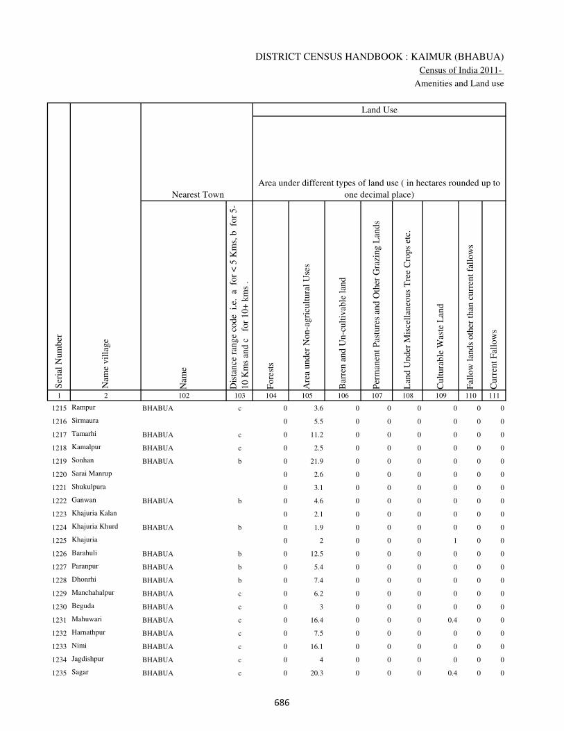
DISTRICT CENSUS HANDBOOK : KAIMUR (BHABUA)
Census of India 2011-
Amenities and Land use
Nam
e
Dis
tance
ran
ge
code
i.e
. a
fo
r <
5 K
ms,
b
for
5-
10 K
ms
and c
f
or
10+
km
s .
Fore
sts
Are
a under
Non-a
gri
cult
ura
l U
ses
Bar
ren a
nd U
n-c
ult
ivab
le l
and
Per
man
ent
Pas
ture
s an
d O
ther
Gra
zing L
ands
Lan
d U
nder
Mis
cell
aneo
us
Tre
e C
rops
etc.
Cult
ura
ble
Was
te L
and
Fal
low
lan
ds
oth
er t
han
curr
ent
fall
ow
s
Curr
ent
Fal
low
s
1 2 102 103 104 105 106 107 108 109 110 111
Ser
ial
Num
ber
Nam
e vil
lage
Area under different types of land use ( in hectares rounded up to
one decimal place)
Land Use
Nearest Town
1215 Rampur BHABUA c 0 3.6 0 0 0 0 0 0
1216 Sirmaura 0 5.5 0 0 0 0 0 0
1217 Tamarhi BHABUA c 0 11.2 0 0 0 0 0 0
1218 Kamalpur BHABUA c 0 2.5 0 0 0 0 0 0
1219 Sonhan BHABUA b 0 21.9 0 0 0 0 0 0
1220 Sarai Manrup 0 2.6 0 0 0 0 0 0
1221 Shukulpura 0 3.1 0 0 0 0 0 0
1222 Ganwan BHABUA b 0 4.6 0 0 0 0 0 0
1223 Khajuria Kalan 0 2.1 0 0 0 0 0 0
1224 Khajuria Khurd BHABUA b 0 1.9 0 0 0 0 0 0
1225 Khajuria 0 2 0 0 0 1 0 0
1226 Barahuli BHABUA b 0 12.5 0 0 0 0 0 0
1227 Paranpur BHABUA b 0 5.4 0 0 0 0 0 0
1228 Dhonrhi BHABUA b 0 7.4 0 0 0 0 0 0
1229 Manchahalpur BHABUA c 0 6.2 0 0 0 0 0 0
1230 Beguda BHABUA c 0 3 0 0 0 0 0 0
1231 Mahuwari BHABUA c 0 16.4 0 0 0 0.4 0 0
1232 Harnathpur BHABUA c 0 7.5 0 0 0 0 0 0
1233 Nimi BHABUA c 0 16.1 0 0 0 0 0 0
1234 Jagdishpur BHABUA c 0 4 0 0 0 0 0 0
1235 Sagar BHABUA c 0 20.3 0 0 0 0.4 0 0
���
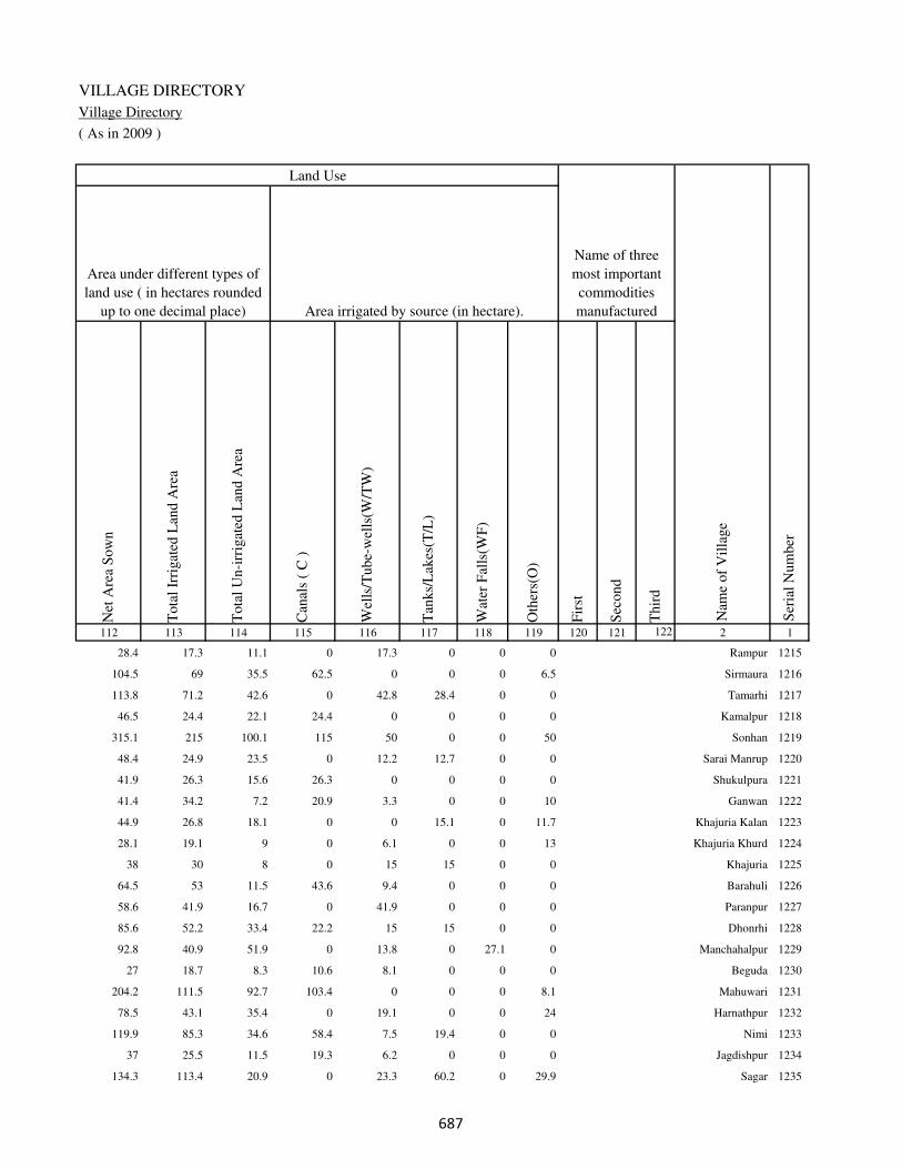
VILLAGE DIRECTORY
Village Directory
( As in 2009 )
Net
Are
a S
ow
n
Tota
l Ir
rigat
ed L
and A
rea
Tota
l U
n-i
rrig
ated
Lan
d A
rea
Can
als
( C
)
Wel
ls/T
ube-
wel
ls(W
/TW
)
Tan
ks/
Lak
es(T
/L)
Wat
er F
alls
(WF
)
Oth
ers(
O)
Fir
st
Sec
ond
Thir
d
112 113 114 115 116 117 118 119 120 121 122 2 1
Ser
ial
Num
ber
Name of three
most important
commodities
manufacturedArea irrigated by source (in hectare).
Nam
e of
Vil
lage
Area under different types of
land use ( in hectares rounded
up to one decimal place)
Land Use
28.4 17.3 11.1 0 17.3 0 0 0 Rampur 1215
104.5 69 35.5 62.5 0 0 0 6.5 Sirmaura 1216
113.8 71.2 42.6 0 42.8 28.4 0 0 Tamarhi 1217
46.5 24.4 22.1 24.4 0 0 0 0 Kamalpur 1218
315.1 215 100.1 115 50 0 0 50 Sonhan 1219
48.4 24.9 23.5 0 12.2 12.7 0 0 Sarai Manrup 1220
41.9 26.3 15.6 26.3 0 0 0 0 Shukulpura 1221
41.4 34.2 7.2 20.9 3.3 0 0 10 Ganwan 1222
44.9 26.8 18.1 0 0 15.1 0 11.7 Khajuria Kalan 1223
28.1 19.1 9 0 6.1 0 0 13 Khajuria Khurd 1224
38 30 8 0 15 15 0 0 Khajuria 1225
64.5 53 11.5 43.6 9.4 0 0 0 Barahuli 1226
58.6 41.9 16.7 0 41.9 0 0 0 Paranpur 1227
85.6 52.2 33.4 22.2 15 15 0 0 Dhonrhi 1228
92.8 40.9 51.9 0 13.8 0 27.1 0 Manchahalpur 1229
27 18.7 8.3 10.6 8.1 0 0 0 Beguda 1230
204.2 111.5 92.7 103.4 0 0 0 8.1 Mahuwari 1231
78.5 43.1 35.4 0 19.1 0 0 24 Harnathpur 1232
119.9 85.3 34.6 58.4 7.5 19.4 0 0 Nimi 1233
37 25.5 11.5 19.3 6.2 0 0 0 Jagdishpur 1234
134.3 113.4 20.9 0 23.3 60.2 0 29.9 Sagar 1235
���
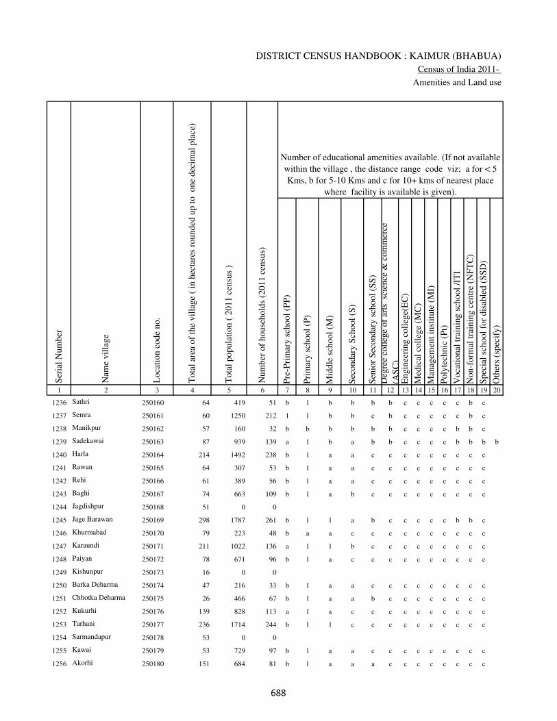
DISTRICT CENSUS HANDBOOK : KAIMUR (BHABUA)
Census of India 2011-
Amenities and Land use
Pre
-Pri
mar
y s
chool
(PP
)
Pri
mar
y s
chool
(P)
Mid
dle
sch
ool
(M)
Sec
ondar
y S
chool
(S)
Sen
ior
Sec
ondar
y s
chool
(SS
)
Deg
ree
coll
ege
of
arts
sc
ience
& c
om
mer
ce
(AS
C)
Engin
eeri
ng c
oll
ege(
EC
)
Med
ical
coll
ege
(MC
)
Man
agem
ent
inst
itute
(M
I)
Poly
tech
nic
(P
t)
Voca
tional
tra
inin
g s
chool
/IT
I
Non-f
orm
al t
rain
ing c
entr
e (N
FT
C)
Spec
ial
school
for
dis
able
d (
SS
D)
Oth
ers
(spec
ify)
1 2 3 4 5 6 7 8 9 10 11 12 13 14 15 16 17 18 19 20
Loca
tion c
ode
no.
Nam
e vil
lage
Ser
ial
Num
ber
Tota
l popula
tion (
2011 c
ensu
s )
Tota
l ar
ea o
f th
e vil
lage
( in
hec
tare
s ro
unded
up t
o
one
dec
imal
pla
ce)
Number of educational amenities available. (If not available
within the village , the distance range code viz; a for < 5
Kms, b for 5-10 Kms and c for 10+ kms of nearest place
where facility is available is given).
Num
ber
of
house
hold
s (2
011 c
ensu
s)
1236 Sathri 250160 64 419 51 b 1 b b b b c c c c c b c
1237 Semra 250161 60 1250 212 1 1 b b c b c c c c c b c
1238 Manikpur 250162 57 160 32 b b b b b b c c c c b b c
1239 Sadekawai 250163 87 939 139 a 1 b a b b c c c c b b b b
1240 Harla 250164 214 1492 238 b 1 a a c c c c c c c c c
1241 Rawan 250165 64 307 53 b 1 a a c c c c c c c c c
1242 Rehi 250166 61 389 56 b 1 a a c c c c c c c c c
1243 Baghi 250167 74 663 109 b 1 a b c c c c c c c c c
1244 Jagdishpur 250168 51 0 0
1245 Jage Barawan 250169 298 1787 261 b 1 1 a b c c c c c b b c
1246 Khurmabad 250170 79 223 48 b a a c c c c c c c c c c
1247 Karaundi 250171 211 1022 136 a 1 1 b c c c c c c c c c
1248 Paiyan 250172 78 671 96 b 1 a c c c c c c c c c c
1249 Kishunpur 250173 16 0 0
1250 Barka Deharma 250174 47 216 33 b 1 a a c c c c c c c c c
1251 Chhotka Deharma 250175 26 466 67 b 1 a a b c c c c c c c c
1252 Kukurhi 250176 139 828 113 a 1 a c c c c c c c c c c
1253 Tarhani 250177 236 1714 244 b 1 1 c c c c c c c c c c
1254 Sarmandapur 250178 53 0 0
1255 Kawai 250179 53 729 97 b 1 a a c c c c c c c c c
1256 Akorhi 250180 151 684 81 b 1 a a a c c c c c c c c
���
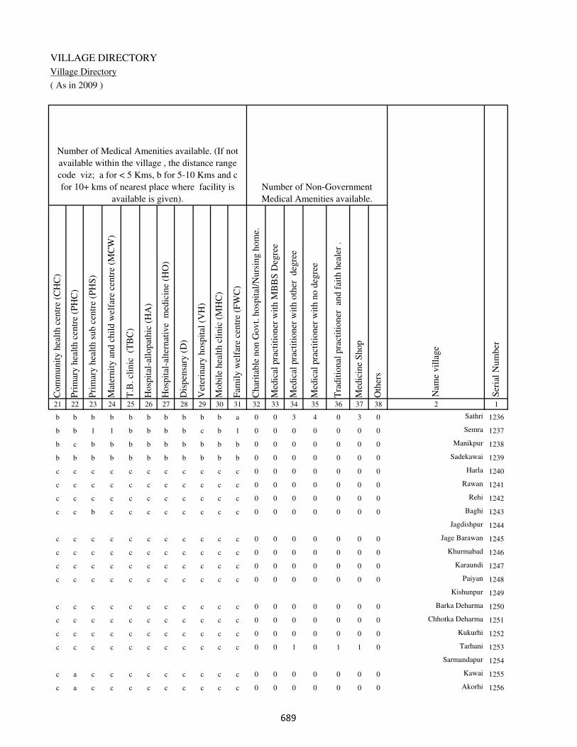
VILLAGE DIRECTORY
Village Directory
( As in 2009 )
Com
munit
y h
ealt
h c
entr
e (C
HC
)
Pri
mar
y h
ealt
h c
entr
e (P
HC
)
Pri
mar
y h
ealt
h s
ub c
entr
e (P
HS
)
Mat
ernit
y a
nd c
hil
d w
elfa
re c
entr
e (M
CW
)
T.B
. cl
inic
(T
BC
)
Hosp
ital
-all
opat
hic
(H
A)
Hosp
ital
-alt
ernat
ive
med
icin
e (H
O)
Dis
pen
sary
(D
)
Vet
erin
ary h
osp
ital
(V
H)
Mobil
e hea
lth c
linic
(M
HC
)
Fam
ily w
elfa
re c
entr
e (F
WC
)
Char
itab
le n
on G
ovt.
hosp
ital
/Nurs
ing h
om
e.
Med
ical
pra
ctit
ioner
wit
h M
BB
S D
egre
e
Med
ical
pra
ctit
ioner
wit
h o
ther
deg
ree
Med
ical
pra
ctit
ioner
wit
h n
o d
egre
e
Tra
dit
ional
pra
ctit
ioner
an
d f
aith
hea
ler
.
Med
icin
e S
hop
Oth
ers
21 22 23 24 25 26 27 28 29 30 31 32 33 34 35 36 37 38 2 1
Number of Non-Government
Medical Amenities available.
Number of Medical Amenities available. (If not
available within the village , the distance range
code viz; a for < 5 Kms, b for 5-10 Kms and c
for 10+ kms of nearest place where facility is
available is given).
Nam
e vil
lage
Ser
ial
Num
ber
b b b b b b b b b b a 0 0 3 4 0 3 0 Sathri 1236
b b 1 1 b b b b c b 1 0 0 0 0 0 0 0 Semra 1237
b c b b b b b b b b b 0 0 0 0 0 0 0 Manikpur 1238
b b b b b b b b b b b 0 0 0 0 0 0 0 Sadekawai 1239
c c c c c c c c c c c 0 0 0 0 0 0 0 Harla 1240
c c c c c c c c c c c 0 0 0 0 0 0 0 Rawan 1241
c c c c c c c c c c c 0 0 0 0 0 0 0 Rehi 1242
c c b c c c c c c c c 0 0 0 0 0 0 0 Baghi 1243
Jagdishpur 1244
c c c c c c c c c c c 0 0 0 0 0 0 0 Jage Barawan 1245
c c c c c c c c c c c 0 0 0 0 0 0 0 Khurmabad 1246
c c c c c c c c c c c 0 0 0 0 0 0 0 Karaundi 1247
c c c c c c c c c c c 0 0 0 0 0 0 0 Paiyan 1248
Kishunpur 1249
c c c c c c c c c c c 0 0 0 0 0 0 0 Barka Deharma 1250
c c c c c c c c c c c 0 0 0 0 0 0 0 Chhotka Deharma 1251
c c c c c c c c c c c 0 0 0 0 0 0 0 Kukurhi 1252
c c c c c c c c c c c 0 0 1 0 1 1 0 Tarhani 1253
Sarmandapur 1254
c a c c c c c c c c c 0 0 0 0 0 0 0 Kawai 1255
c a c c c c c c c c c 0 0 0 0 0 0 0 Akorhi 1256
���

DISTRICT CENSUS HANDBOOK : KAIMUR (BHABUA)
Census of India 2011-
Amenities and Land use
Tap
wat
er (
Tre
ated
/Untr
eate
d)
Wel
l w
ater
(Cover
ed /
Unco
ver
ed w
ell)
Han
d P
um
p
Tube
wel
ls /
Bore
wel
l
Spri
ng
Riv
er /
Can
al
Tan
k /
Pond /
L
ake
Oth
ers
Com
munit
y t
oil
et i
ncl
udin
g
bat
h.
Com
munit
y t
oil
et e
xcl
udin
g b
ath.
Rura
l s
anit
ary m
art
or
sanit
ary
har
dw
are
outl
et
avai
lable
nea
r th
e vil
lage.
Com
munit
y b
io-
gas
or
recy
cle
of
was
te f
or
pro
duct
ive
use
.
1 2 39 40 41 42 43 44 45 46 47 48 49 50
Availability of toilet & others
Yes / No Availability of drinking water - Yes / No
Nam
e vil
lage
Ser
ial
Num
ber
1236 Sathri No Yes Yes No No No No No No No No No
1237 Semra No Yes Yes Yes No Yes Yes No No No No No
1238 Manikpur No Yes Yes Yes No Yes No No No No No No
1239 Sadekawai No Yes Yes Yes No No No No No No No No
1240 Harla Yes Yes Yes No No Yes No No No No No No
1241 Rawan No Yes Yes No No Yes No No No No No No
1242 Rehi No Yes Yes No No Yes No No No No No No
1243 Baghi No Yes Yes No No Yes No No No No No No
1244 Jagdishpur
1245 Jage Barawan No Yes Yes No No Yes No No No No No No
1246 Khurmabad No Yes Yes No No Yes No No No No No No
1247 Karaundi No Yes Yes No No Yes No No No No No No
1248 Paiyan No Yes Yes No No Yes Yes No No No No No
1249 Kishunpur
1250 Barka Deharma No Yes Yes No No Yes No No No No No No
1251 Chhotka Deharma No Yes Yes No No Yes No No No No No No
1252 Kukurhi No Yes Yes No No Yes No No No No No No
1253 Tarhani No Yes Yes No No Yes No No No No No No
1254 Sarmandapur
1255 Kawai No Yes Yes Yes No Yes Yes No No No No No
1256 Akorhi No Yes Yes Yes No Yes Yes No No No No No
���
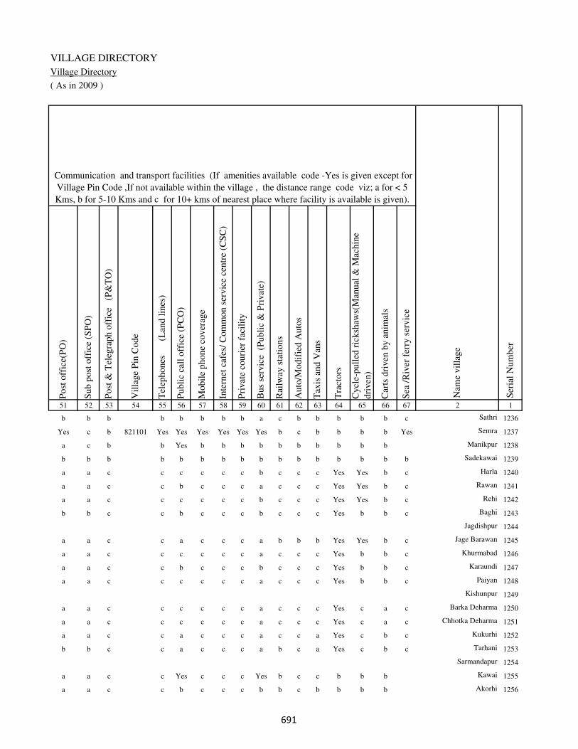
VILLAGE DIRECTORY
Village Directory
( As in 2009 )
Post
off
ice(
PO
)
Sub p
ost
off
ice
(SP
O)
Post
& T
eleg
raph o
ffic
e
(P&
TO
)
Vil
lage
Pin
Code
Tel
ephones
(L
and l
ines
)
Publi
c ca
ll o
ffic
e (P
CO
)
Mobil
e phone
cover
age
Inte
rnet
caf
es/
Com
mon s
ervic
e ce
ntr
e (C
SC
)
Pri
vat
e co
uri
er f
acil
ity
Bus
serv
ice
(P
ubli
c &
Pri
vat
e)
Rai
lway
sta
tions
Auto
/Modif
ied A
uto
s
Tax
is a
nd V
ans
Tra
ctors
Cycl
e-pull
ed r
icksh
aws(
Man
ual
& M
achin
e
dri
ven
)
Car
ts d
riven
by a
nim
als
Sea
/R
iver
fer
ry s
ervic
e51 52 53 54 55 56 57 58 59 60 61 62 63 64 65 66 67 2 1
Communication and transport facilities (If amenities available code -Yes is given except for
Village Pin Code ,If not available within the village , the distance range code viz; a for < 5
Kms, b for 5-10 Kms and c for 10+ kms of nearest place where facility is available is given).
Ser
ial
Num
ber
Nam
e vil
lage
b b b b b b b b a c b b b b b c Sathri 1236
Yes c b 821101 Yes Yes Yes Yes Yes Yes b c b b b b Yes Semra 1237
a c b b Yes b b b b b b b b b b Manikpur 1238
b b b b b b b b b b b b b b b b Sadekawai 1239
a a c c c c c c b c c c Yes Yes b c Harla 1240
a a c c b c c c a c c c Yes Yes b c Rawan 1241
a a c c c c c c b c c c Yes Yes b c Rehi 1242
b b c c b c c c b c c c Yes b b c Baghi 1243
Jagdishpur 1244
a a c c a c c c a b b b Yes Yes b c Jage Barawan 1245
a a c c c c c c a c c c Yes b b c Khurmabad 1246
a a c c b c c c b c c c Yes b b c Karaundi 1247
a a c c c c c c a c c c Yes b b c Paiyan 1248
Kishunpur 1249
a a c c c c c c a c c c Yes c a c Barka Deharma 1250
a a c c c c c c a c c c Yes c a c Chhotka Deharma 1251
a a c c a c c c a c c a Yes c b c Kukurhi 1252
b b c c a c c c a b c a Yes c b c Tarhani 1253
Sarmandapur 1254
a a c c Yes c c c Yes b c c b b b Kawai 1255
a a c c b c c c b b c b b b b Akorhi 1256
���
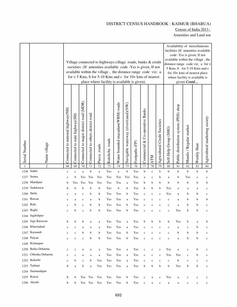
DISTRICT CENSUS HANDBOOK : KAIMUR (BHABUA)
Census of India 2011-
Amenities and Land use
Connec
ted t
o n
atio
nal
hig
hw
ay(N
H)
Connec
ted t
o s
tate
hig
hw
ay(S
H)
Connec
ted t
o m
ajor
dis
tric
t ro
ad (
MD
R)
Connec
ted t
o o
ther
s dis
tric
t ro
ad
Pucc
a r
oad
s
Kutc
hch
a r
oad
s
Wat
er b
ounded
mac
adam
(WB
M)
road
s
Nav
igab
le w
ater
way
(ri
ver
/can
al)(
NW
)
Footp
aths
(FP
)
Com
mer
cial
& C
o-o
per
ativ
e B
anks
AT
M
Agri
cult
ura
l C
redit
Soci
etie
s
Sel
f-H
elp G
roup (
SH
G)
Publi
c dis
trib
uti
on s
yst
em (
PD
S)
shop
Man
dis
/ R
egula
r m
arket
Wee
kly
Haa
t
Agri
cult
ura
l m
arket
ing s
oci
ety
1 2 68 69 70 71 72 73 74 75 76 77 78 79 80 81 82 83 84
Village connected to highways,village roads, banks & credit
societies (If amenities available code -Yes is given, If not
available within the village , the distance range code viz; a
for < 5 Kms, b for 5-10 Kms and c for 10+ kms of nearest
place where facility is available is given).
Ser
ial
Num
ber
Nam
e vil
lage
Availability of miscellaneous
facilities (If amenities available
code -Yes is given, If not
available within the village , the
distance range code viz; a for <
5 Kms, b for 5-10 Kms and c
for 10+ kms of nearest place
where facility is available is
given) Contd....
1236 Sathri c c a b a Yes a b Yes b c b b b b b b
1237 Semra c b Yes Yes Yes Yes Yes Yes Yes a c b a b Yes c c
1238 Manikpur b Yes Yes Yes Yes Yes Yes a Yes b b b b b b b b
1239 Sadekawai b b b b b Yes b b Yes b b b Yes a a a c
1240 Harla c a c b b Yes Yes b Yes c c c Yes a b b c
1241 Rawan c a c a b Yes Yes a Yes c c c c a b b b
1242 Rehi c b c b b Yes Yes b Yes c c c c a b b c
1243 Baghi c b c b b Yes Yes b Yes c c c c Yes b b c
1244 Jagdishpur
1245 Jage Barawan b b b a a Yes Yes a Yes b b b b Yes b a b
1246 Khurmabad c c a a a Yes Yes a Yes c c c c a c b c
1247 Karaundi c c b b b Yes Yes b Yes c c c c b b b c
1248 Paiyan c c c b b Yes Yes b Yes c c c c a b b c
1249 Kishunpur
1250 Barka Deharma c c a a a Yes Yes a Yes c c c Yes a c b c
1251 Chhotka Deharma c c a a a Yes Yes a Yes c c c Yes Yes c b c
1252 Kukurhi c b c b Yes Yes Yes a Yes c c c c b c c c
1253 Tarhani b a b a Yes Yes Yes a Yes b b b b Yes b b c
1254 Sarmandapur
1255 Kawai b b Yes Yes Yes Yes Yes b Yes c a c Yes a c c c
1256 Akorhi b b Yes Yes Yes Yes Yes b Yes c a c a a c c c
��
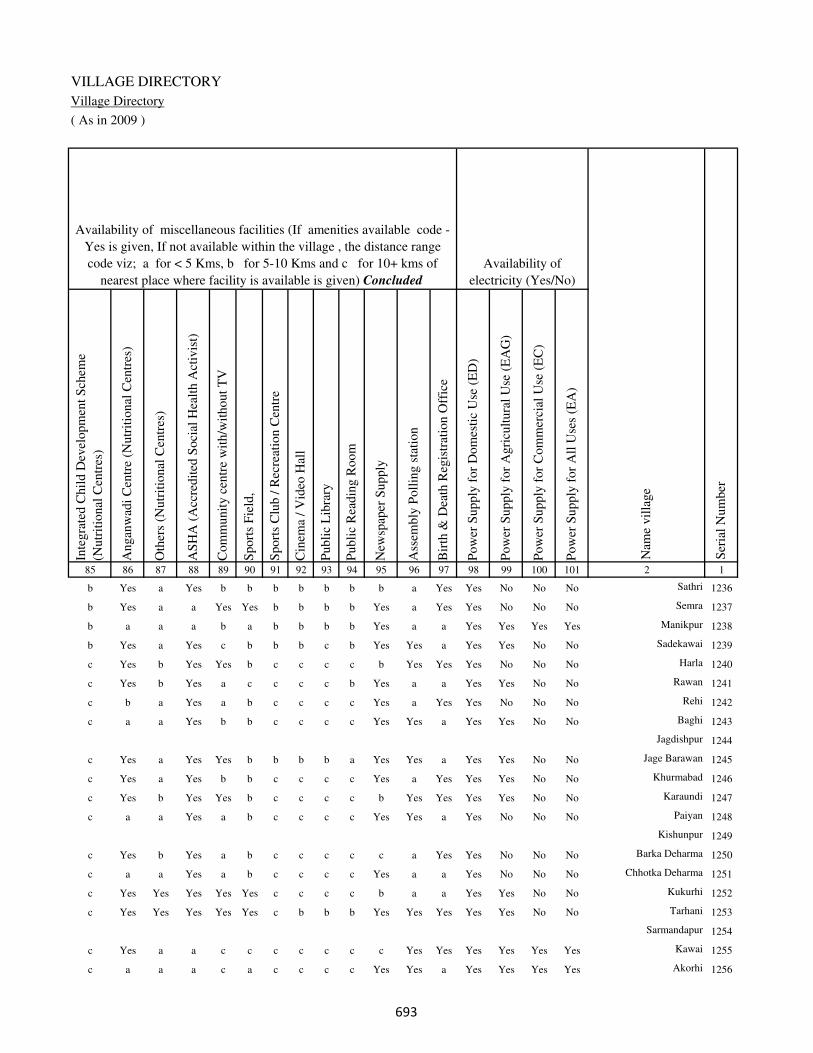
VILLAGE DIRECTORY
Village Directory
( As in 2009 )
Inte
gra
ted C
hil
d D
evel
opm
ent
Sch
eme
(Nutr
itio
nal
Cen
tres
)
Angan
wad
i C
entr
e (N
utr
itio
nal
Cen
tres
)
Oth
ers
(Nutr
itio
nal
Cen
tres
)
AS
HA
(A
ccre
dit
ed S
oci
al H
ealt
h A
ctiv
ist)
Com
munit
y c
entr
e w
ith/w
ithout
TV
Sport
s F
ield
,
Sport
s C
lub /
Rec
reat
ion C
entr
e
Cin
ema
/ V
ideo
Hal
l
Publi
c L
ibra
ry
Publi
c R
eadin
g R
oom
New
spap
er S
upply
Ass
embly
Poll
ing s
tati
on
Bir
th &
Dea
th R
egis
trat
ion O
ffic
e
Pow
er S
upply
for
Dom
esti
c U
se (
ED
)
Pow
er S
upply
for
Agri
cult
ura
l U
se (
EA
G)
Pow
er S
upply
for
Com
mer
cial
Use
(E
C)
Pow
er S
upply
for
All
Use
s (E
A)
85 86 87 88 89 90 91 92 93 94 95 96 97 98 99 100 101 2 1
Availability of
electricity (Yes/No)
Availability of miscellaneous facilities (If amenities available code -
Yes is given, If not available within the village , the distance range
code viz; a for < 5 Kms, b for 5-10 Kms and c for 10+ kms of
nearest place where facility is available is given) Concluded
Nam
e vil
lage
Ser
ial
Num
ber
b Yes a Yes b b b b b b b a Yes Yes No No No Sathri 1236
b Yes a a Yes Yes b b b b Yes a Yes Yes No No No Semra 1237
b a a a b a b b b b Yes a a Yes Yes Yes Yes Manikpur 1238
b Yes a Yes c b b b c b Yes Yes a Yes Yes No No Sadekawai 1239
c Yes b Yes Yes b c c c c b Yes Yes Yes No No No Harla 1240
c Yes b Yes a c c c c b Yes a a Yes Yes No No Rawan 1241
c b a Yes a b c c c c Yes a Yes Yes No No No Rehi 1242
c a a Yes b b c c c c Yes Yes a Yes Yes No No Baghi 1243
Jagdishpur 1244
c Yes a Yes Yes b b b b a Yes Yes a Yes Yes No No Jage Barawan 1245
c Yes a Yes b b c c c c Yes a Yes Yes Yes No No Khurmabad 1246
c Yes b Yes Yes b c c c c b Yes Yes Yes Yes No No Karaundi 1247
c a a Yes a b c c c c Yes Yes a Yes No No No Paiyan 1248
Kishunpur 1249
c Yes b Yes a b c c c c c a Yes Yes No No No Barka Deharma 1250
c a a Yes a b c c c c Yes a a Yes No No No Chhotka Deharma 1251
c Yes Yes Yes Yes Yes c c c c b a a Yes Yes No No Kukurhi 1252
c Yes Yes Yes Yes Yes c b b b Yes Yes Yes Yes Yes No No Tarhani 1253
Sarmandapur 1254
c Yes a a c c c c c c c Yes Yes Yes Yes Yes Yes Kawai 1255
c a a a c a c c c c Yes Yes a Yes Yes Yes Yes Akorhi 1256
��

DISTRICT CENSUS HANDBOOK : KAIMUR (BHABUA)
Census of India 2011-
Amenities and Land use
Nam
e
Dis
tance
ran
ge
code
i.e
. a
fo
r <
5 K
ms,
b
for
5-
10 K
ms
and c
f
or
10+
km
s .
Fore
sts
Are
a under
Non-a
gri
cult
ura
l U
ses
Bar
ren a
nd U
n-c
ult
ivab
le l
and
Per
man
ent
Pas
ture
s an
d O
ther
Gra
zing L
ands
Lan
d U
nder
Mis
cell
aneo
us
Tre
e C
rops
etc.
Cult
ura
ble
Was
te L
and
Fal
low
lan
ds
oth
er t
han
curr
ent
fall
ow
s
Curr
ent
Fal
low
s
1 2 102 103 104 105 106 107 108 109 110 111
Ser
ial
Num
ber
Nam
e vil
lage
Area under different types of land use ( in hectares rounded up to
one decimal place)
Land Use
Nearest Town
1236 Sathri BHABUA b 0 6.3 0 0 0 0 0 0
1237 Semra BHABUA b 0 4.2 0 0 0 0 0 0
1238 Manikpur BHABUA b 0 4.5 0 0 0 0 0 0
1239 Sadekawai BHABUA b 0 9 0 0 0 0 0 0
1240 Harla BHABUA c 0 67 0 0 0 0 0 0
1241 Rawan BHABUA c 0 8.9 0 0 0 0.2 0 0
1242 Rehi BHABUA c 0 8.3 0 0 0 0 0 0
1243 Baghi BHABUA c 0 8 0 0 0 0 0 0
1244 Jagdishpur 0 6.5 0 0 0 0.4 0 0
1245 Jage Barawan BHABUA c 0 31.4 0 0 0 0 0 0
1246 Khurmabad BHABUA c 0 7.1 0 0 0 0 0 0
1247 Karaundi BHABUA c 0 14.4 0 0 0 0 0 0
1248 Paiyan BHABUA c 0 7.8 0 0 0 0 0 0
1249 Kishunpur 0 2.2 0 0 0 0 0 0
1250 Barka Deharma BHABUA c 0 2.7 0 0 0 0 0 0
1251 Chhotka Deharma BHABUA c 0 2.3 0 0 0 0 0 0
1252 Kukurhi BHABUA c 0 7.2 0 0 0 0 0 0
1253 Tarhani BHABUA c 0 32.9 0 0 0 0 0 0
1254 Sarmandapur 0 7.1 0 0 0 0 0 0
1255 Kawai BHABUA c 0 7.2 0 0 0 0 0 0
1256 Akorhi BHABUA c 0 38 0 0 0 0 0 0
���

VILLAGE DIRECTORY
Village Directory
( As in 2009 )
Net
Are
a S
ow
n
Tota
l Ir
rigat
ed L
and A
rea
Tota
l U
n-i
rrig
ated
Lan
d A
rea
Can
als
( C
)
Wel
ls/T
ube-
wel
ls(W
/TW
)
Tan
ks/
Lak
es(T
/L)
Wat
er F
alls
(WF
)
Oth
ers(
O)
Fir
st
Sec
ond
Thir
d
112 113 114 115 116 117 118 119 120 121 122 2 1
Ser
ial
Num
ber
Name of three
most important
commodities
manufacturedArea irrigated by source (in hectare).
Nam
e of
Vil
lage
Area under different types of
land use ( in hectares rounded
up to one decimal place)
Land Use
57.7 34.4 23.3 14.4 10 10 0 0 Sathri 1236
55.8 35.1 20.7 11.2 4.6 19.3 0 0 Semra 1237
52.5 25.3 27.2 0 23.3 0 0 2 Manikpur 1238
78 58.7 19.3 46.5 11.2 1 0 0 Sadekawai 1239
147 104.5 42.5 42.5 24.4 37.6 0 0 Harla 1240
54.9 38.9 16 0 23.1 14.3 0 1.5 Rawan 1241
52.7 27.6 25.1 0 19.2 8.4 0 0 Rehi 1242
66 45.2 20.8 0 0 39.7 0 5.5 Baghi 1243
44.1 28.5 15.6 0 9.2 0 0 19.3 Jagdishpur 1244
266.6 167.8 98.8 103.6 47.2 17 0 0 Jage Barawan 1245
71.9 55.7 16.2 53.7 0 0 0 2 Khurmabad 1246
196.6 169.2 27.4 167.2 1 0 0 1 Karaundi 1247
70.2 70.2 0 70.2 0 0 0 0 Paiyan 1248
13.8 13.8 0 11.8 0 0 0 2 Kishunpur 1249
44.3 37.3 7 0 6.2 0 0 31.1 Barka Deharma 1250
23.7 17.5 6.2 0 12.2 2.2 0 3.1 Chhotka Deharma 1251
131.8 77.5 54.3 41.6 20.8 0 0 15.1 Kukurhi 1252
203.1 162.6 40.5 82.6 58.9 16 0 5.1 Tarhani 1253
45.9 41.1 4.8 25.5 1.4 0 0 14.2 Sarmandapur 1254
45.8 40.2 5.6 25 1 0 0 14.2 Kawai 1255
113 96.9 16.1 86.9 10 0 0 0 Akorhi 1256
���

DISTRICT CENSUS HANDBOOK : KAIMUR (BHABUA)
Census of India 2011-
Amenities and Land use
Pre
-Pri
mar
y s
chool
(PP
)
Pri
mar
y s
chool
(P)
Mid
dle
sch
ool
(M)
Sec
ondar
y S
chool
(S)
Sen
ior
Sec
ondar
y s
chool
(SS
)
Deg
ree
coll
ege
of
arts
sc
ience
& c
om
mer
ce
(AS
C)
Engin
eeri
ng c
oll
ege(
EC
)
Med
ical
coll
ege
(MC
)
Man
agem
ent
inst
itute
(M
I)
Poly
tech
nic
(P
t)
Voca
tional
tra
inin
g s
chool
/IT
I
Non-f
orm
al t
rain
ing c
entr
e (N
FT
C)
Spec
ial
school
for
dis
able
d (
SS
D)
Oth
ers
(spec
ify)
1 2 3 4 5 6 7 8 9 10 11 12 13 14 15 16 17 18 19 20
Loca
tion c
ode
no.
Nam
e vil
lage
Ser
ial
Num
ber
Tota
l popula
tion (
2011 c
ensu
s )
Tota
l ar
ea o
f th
e vil
lage
( in
hec
tare
s ro
unded
up t
o
one
dec
imal
pla
ce)
Number of educational amenities available. (If not available
within the village , the distance range code viz; a for < 5
Kms, b for 5-10 Kms and c for 10+ kms of nearest place
where facility is available is given).
Num
ber
of
house
hold
s (2
011 c
ensu
s)
1257 Wadar 250181 502 3807 568 b 1 1 b b b c c c c c b c
1258 Belarhi 250182 96 760 114 b 1 a c c c c c c c c c c
1259 Mahuat 250183 256 1761 271 b 1 1 c c c c c c c c c c
1260 Madanpura 250184 45 519 68 b 1 a b b c c c c c c c c
1261 Ekauni 250185 121 1437 197 b 1 a b b c c c c c c c c
1262 Ghurhu Chak 250186 62 0 0
1263 Khaira 250187 54 256 43 b a a a c c c c c c c c c
1264 Barka Kajhar 250188 116 1211 151 b 1 1 b b b c c c c b b c b
1265 Pian 250189 151 2110 294 b 1 1 b c c c c c c c c c
1266 Balua 250190 108 449 64 b 1 a b b c c c c c c c c
1267 Alipur 250191 107 695 113 b 1 a a b c c c c c c c c
1268 Sandalpur 250192 15 194 38 b 1 a a c c c c c c c c c
1269 Amrha 250193 77 832 113 a 1 1 a b c c c c c c c c
1270 Semaria 250194 49 401 50 b 1 a b c c c c c c c c c
1271 Pokhara 250195 53 889 151 b 1 a b c c c c c c c c c
1272 Ghurhu Chak 250196 42 0 0
1273 Rampur 250197 44 0 0
1274 Shukulpurwa 250198 37 538 64 b 1 a a c c c c c c c c c
1275 Chitarhi 250199 40 220 42 b 1 a a c c c c c c c c c
1276 Ujari Chitarhi 250200 38 0 0
1277 Charki English 250201 13 243 24 b b a b c c c c c c c a c
���
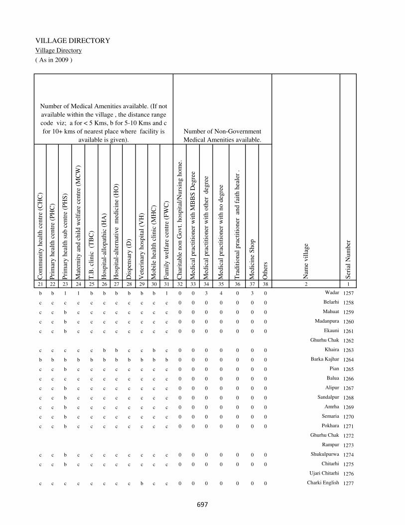
VILLAGE DIRECTORY
Village Directory
( As in 2009 )
Com
munit
y h
ealt
h c
entr
e (C
HC
)
Pri
mar
y h
ealt
h c
entr
e (P
HC
)
Pri
mar
y h
ealt
h s
ub c
entr
e (P
HS
)
Mat
ernit
y a
nd c
hil
d w
elfa
re c
entr
e (M
CW
)
T.B
. cl
inic
(T
BC
)
Hosp
ital
-all
opat
hic
(H
A)
Hosp
ital
-alt
ernat
ive
med
icin
e (H
O)
Dis
pen
sary
(D
)
Vet
erin
ary h
osp
ital
(V
H)
Mobil
e hea
lth c
linic
(M
HC
)
Fam
ily w
elfa
re c
entr
e (F
WC
)
Char
itab
le n
on G
ovt.
hosp
ital
/Nurs
ing h
om
e.
Med
ical
pra
ctit
ioner
wit
h M
BB
S D
egre
e
Med
ical
pra
ctit
ioner
wit
h o
ther
deg
ree
Med
ical
pra
ctit
ioner
wit
h n
o d
egre
e
Tra
dit
ional
pra
ctit
ioner
an
d f
aith
hea
ler
.
Med
icin
e S
hop
Oth
ers
21 22 23 24 25 26 27 28 29 30 31 32 33 34 35 36 37 38 2 1
Number of Non-Government
Medical Amenities available.
Number of Medical Amenities available. (If not
available within the village , the distance range
code viz; a for < 5 Kms, b for 5-10 Kms and c
for 10+ kms of nearest place where facility is
available is given).
Nam
e vil
lage
Ser
ial
Num
ber
b b 1 1 b b b b b b 1 0 0 3 4 0 3 0 Wadar 1257
c c c c c c c c c c c 0 0 0 0 0 0 0 Belarhi 1258
c c b c c c c c c c c 0 0 0 0 0 0 0 Mahuat 1259
c c b c c c c c c c c 0 0 0 0 0 0 0 Madanpura 1260
c c b c c c c c c c c 0 0 0 0 0 0 0 Ekauni 1261
Ghurhu Chak 1262
c c c c c b b c c b c 0 0 0 0 0 0 0 Khaira 1263
b b b b b b b b b b b 0 0 0 0 0 0 0 Barka Kajhar 1264
c c b c c c c c c c c 0 0 0 0 0 0 0 Pian 1265
c c c c c c c c c c c 0 0 0 0 0 0 0 Balua 1266
c c b c c c c c c c c 0 0 0 0 0 0 0 Alipur 1267
c c b c c c c c c c c 0 0 0 0 0 0 0 Sandalpur 1268
c c b c c c c c c c c 0 0 0 0 0 0 0 Amrha 1269
c c b c c c c c c c c 0 0 0 0 0 0 0 Semaria 1270
c c b c c c c c c c c 0 0 0 0 0 0 0 Pokhara 1271
Ghurhu Chak 1272
Rampur 1273
c c b c c c c c c c c 0 0 0 0 0 0 0 Shukulpurwa 1274
c c b c c c c c c c c 0 0 0 0 0 0 0 Chitarhi 1275
Ujari Chitarhi 1276
c c c c c c c c b c c 0 0 0 0 0 0 0 Charki English 1277
���

DISTRICT CENSUS HANDBOOK : KAIMUR (BHABUA)
Census of India 2011-
Amenities and Land use
Tap
wat
er (
Tre
ated
/Untr
eate
d)
Wel
l w
ater
(Cover
ed /
Unco
ver
ed w
ell)
Han
d P
um
p
Tube
wel
ls /
Bore
wel
l
Spri
ng
Riv
er /
Can
al
Tan
k /
Pond /
L
ake
Oth
ers
Com
munit
y t
oil
et i
ncl
udin
g
bat
h.
Com
munit
y t
oil
et e
xcl
udin
g b
ath.
Rura
l s
anit
ary m
art
or
sanit
ary
har
dw
are
outl
et
avai
lable
nea
r th
e vil
lage.
Com
munit
y b
io-
gas
or
recy
cle
of
was
te f
or
pro
duct
ive
use
.
1 2 39 40 41 42 43 44 45 46 47 48 49 50
Availability of toilet & others
Yes / No Availability of drinking water - Yes / No
Nam
e vil
lage
Ser
ial
Num
ber
1257 Wadar No Yes Yes Yes No No No No No No No No
1258 Belarhi No Yes Yes No No Yes No No No No No No
1259 Mahuat No Yes Yes No No Yes Yes No No No No No
1260 Madanpura No Yes Yes No No Yes No No No No No No
1261 Ekauni No Yes Yes No No Yes No No No No No No
1262 Ghurhu Chak
1263 Khaira No Yes Yes Yes No Yes No No No No No No
1264 Barka Kajhar No Yes Yes Yes No Yes No No No No No No
1265 Pian No Yes Yes No No Yes No No No No No No
1266 Balua No Yes Yes No No Yes No No No No No No
1267 Alipur No Yes Yes No No Yes Yes No No No No No
1268 Sandalpur No Yes Yes No No Yes No No No No No No
1269 Amrha No Yes Yes No No Yes Yes No No No No No
1270 Semaria No Yes Yes No No Yes No No No No No No
1271 Pokhara No Yes Yes No No Yes Yes No No No No No
1272 Ghurhu Chak
1273 Rampur
1274 Shukulpurwa No Yes Yes No No Yes No No No No No No
1275 Chitarhi No Yes Yes No No Yes No No No No No No
1276 Ujari Chitarhi
1277 Charki English No No Yes No No No No No No No No No
���
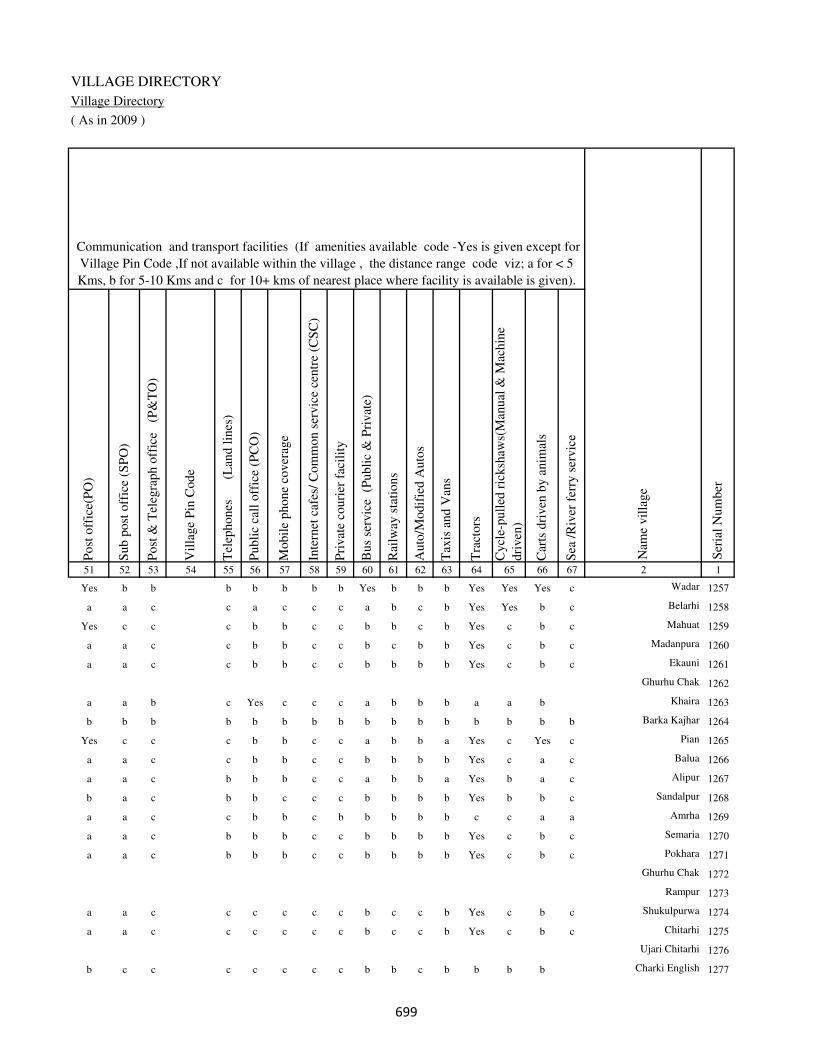
VILLAGE DIRECTORY
Village Directory
( As in 2009 )
Post
off
ice(
PO
)
Sub p
ost
off
ice
(SP
O)
Post
& T
eleg
raph o
ffic
e
(P&
TO
)
Vil
lage
Pin
Code
Tel
ephones
(L
and l
ines
)
Publi
c ca
ll o
ffic
e (P
CO
)
Mobil
e phone
cover
age
Inte
rnet
caf
es/
Com
mon s
ervic
e ce
ntr
e (C
SC
)
Pri
vat
e co
uri
er f
acil
ity
Bus
serv
ice
(P
ubli
c &
Pri
vat
e)
Rai
lway
sta
tions
Auto
/Modif
ied A
uto
s
Tax
is a
nd V
ans
Tra
ctors
Cycl
e-pull
ed r
icksh
aws(
Man
ual
& M
achin
e
dri
ven
)
Car
ts d
riven
by a
nim
als
Sea
/R
iver
fer
ry s
ervic
e51 52 53 54 55 56 57 58 59 60 61 62 63 64 65 66 67 2 1
Communication and transport facilities (If amenities available code -Yes is given except for
Village Pin Code ,If not available within the village , the distance range code viz; a for < 5
Kms, b for 5-10 Kms and c for 10+ kms of nearest place where facility is available is given).
Ser
ial
Num
ber
Nam
e vil
lage
Yes b b b b b b b Yes b b b Yes Yes Yes c Wadar 1257
a a c c a c c c a b c b Yes Yes b c Belarhi 1258
Yes c c c b b c c b b c b Yes c b c Mahuat 1259
a a c c b b c c b c b b Yes c b c Madanpura 1260
a a c c b b c c b b b b Yes c b c Ekauni 1261
Ghurhu Chak 1262
a a b c Yes c c c a b b b a a b Khaira 1263
b b b b b b b b b b b b b b b b Barka Kajhar 1264
Yes c c c b b c c a b b a Yes c Yes c Pian 1265
a a c c b b c c b b b b Yes c a c Balua 1266
a a c b b b c c a b b a Yes b a c Alipur 1267
b a c b b c c c b b b b Yes b b c Sandalpur 1268
a a c c b b c b b b b b c c a a Amrha 1269
a a c b b b c c b b b b Yes c b c Semaria 1270
a a c b b b c c b b b b Yes c b c Pokhara 1271
Ghurhu Chak 1272
Rampur 1273
a a c c c c c c b c c b Yes c b c Shukulpurwa 1274
a a c c c c c c b c c b Yes c b c Chitarhi 1275
Ujari Chitarhi 1276
b c c c c c c c b b c b b b b Charki English 1277
���

DISTRICT CENSUS HANDBOOK : KAIMUR (BHABUA)
Census of India 2011-
Amenities and Land use
Connec
ted t
o n
atio
nal
hig
hw
ay(N
H)
Connec
ted t
o s
tate
hig
hw
ay(S
H)
Connec
ted t
o m
ajor
dis
tric
t ro
ad (
MD
R)
Connec
ted t
o o
ther
s dis
tric
t ro
ad
Pucc
a r
oad
s
Kutc
hch
a r
oad
s
Wat
er b
ounded
mac
adam
(WB
M)
road
s
Nav
igab
le w
ater
way
(ri
ver
/can
al)(
NW
)
Footp
aths
(FP
)
Com
mer
cial
& C
o-o
per
ativ
e B
anks
AT
M
Agri
cult
ura
l C
redit
Soci
etie
s
Sel
f-H
elp G
roup (
SH
G)
Publi
c dis
trib
uti
on s
yst
em (
PD
S)
shop
Man
dis
/ R
egula
r m
arket
Wee
kly
Haa
t
Agri
cult
ura
l m
arket
ing s
oci
ety
1 2 68 69 70 71 72 73 74 75 76 77 78 79 80 81 82 83 84
Village connected to highways,village roads, banks & credit
societies (If amenities available code -Yes is given, If not
available within the village , the distance range code viz; a
for < 5 Kms, b for 5-10 Kms and c for 10+ kms of nearest
place where facility is available is given).
Ser
ial
Num
ber
Nam
e vil
lage
Availability of miscellaneous
facilities (If amenities available
code -Yes is given, If not
available within the village , the
distance range code viz; a for <
5 Kms, b for 5-10 Kms and c
for 10+ kms of nearest place
where facility is available is
given) Contd....
1257 Wadar c c b b Yes Yes a b Yes Yes b b Yes b b b b
1258 Belarhi b a a a a Yes Yes a Yes b b c Yes a b b b
1259 Mahuat b b b b Yes Yes Yes b Yes b b c a Yes b b c
1260 Madanpura b b b b b Yes Yes b Yes b b c a a b b c
1261 Ekauni b b b b b Yes Yes b Yes b b c Yes a b b c
1262 Ghurhu Chak
1263 Khaira b b b Yes a Yes Yes c Yes c b c a a c c c
1264 Barka Kajhar b b b b b Yes b b Yes b b c Yes a b b c
1265 Pian b a b a a Yes Yes c Yes b b c a a b b c
1266 Balua b b b b b Yes Yes c Yes b b c a a b b c
1267 Alipur b b b a Yes Yes Yes c Yes b b b a a b a c
1268 Sandalpur b b b b b Yes Yes c Yes b b b a a b b c
1269 Amrha b b b b Yes Yes Yes c Yes b b b a a b b c
1270 Semaria b b b b b Yes Yes c Yes b b b Yes a b b c
1271 Pokhara b b b b Yes Yes Yes c Yes b b b Yes a b b c
1272 Ghurhu Chak
1273 Rampur
1274 Shukulpurwa c c b b b Yes Yes c Yes c c c a a b b c
1275 Chitarhi c c c b b Yes Yes c Yes c c c a a b b c
1276 Ujari Chitarhi
1277 Charki English c b b b b Yes a c Yes b c c b b b c c
���

VILLAGE DIRECTORY
Village Directory
( As in 2009 )
Inte
gra
ted C
hil
d D
evel
opm
ent
Sch
eme
(Nutr
itio
nal
Cen
tres
)
Angan
wad
i C
entr
e (N
utr
itio
nal
Cen
tres
)
Oth
ers
(Nutr
itio
nal
Cen
tres
)
AS
HA
(A
ccre
dit
ed S
oci
al H
ealt
h A
ctiv
ist)
Com
munit
y c
entr
e w
ith/w
ithout
TV
Sport
s F
ield
,
Sport
s C
lub /
Rec
reat
ion C
entr
e
Cin
ema
/ V
ideo
Hal
l
Publi
c L
ibra
ry
Publi
c R
eadin
g R
oom
New
spap
er S
upply
Ass
embly
Poll
ing s
tati
on
Bir
th &
Dea
th R
egis
trat
ion O
ffic
e
Pow
er S
upply
for
Dom
esti
c U
se (
ED
)
Pow
er S
upply
for
Agri
cult
ura
l U
se (
EA
G)
Pow
er S
upply
for
Com
mer
cial
Use
(E
C)
Pow
er S
upply
for
All
Use
s (E
A)
85 86 87 88 89 90 91 92 93 94 95 96 97 98 99 100 101 2 1
Availability of
electricity (Yes/No)
Availability of miscellaneous facilities (If amenities available code -
Yes is given, If not available within the village , the distance range
code viz; a for < 5 Kms, b for 5-10 Kms and c for 10+ kms of
nearest place where facility is available is given) Concluded
Nam
e vil
lage
Ser
ial
Num
ber
b Yes a Yes b b b b b b b Yes Yes Yes Yes Yes Yes Wadar 1257
c Yes b Yes Yes a c b c c a Yes Yes Yes No No No Belarhi 1258
c Yes a Yes Yes Yes b b c c b a Yes Yes No No No Mahuat 1259
c Yes b Yes Yes Yes b b c c b a Yes Yes No No No Madanpura 1260
c a a Yes Yes Yes b b c c b Yes a Yes No No No Ekauni 1261
Ghurhu Chak 1262
b a a a b a c c c c Yes a a Yes Yes Yes Yes Khaira 1263
b Yes b Yes b b c c c c a Yes Yes Yes No No No Barka Kajhar 1264
c Yes b Yes Yes Yes b b c c b Yes Yes Yes Yes No No Pian 1265
c Yes a Yes a Yes b b c c Yes a a Yes Yes No No Balua 1266
c Yes a Yes a Yes b b c c Yes Yes Yes No No No No Alipur 1267
c a a Yes a Yes b b c c Yes a a Yes Yes No No Sandalpur 1268
c b a Yes a b b b c c Yes Yes Yes Yes Yes No No Amrha 1269
c Yes a Yes a Yes b b c c Yes a Yes Yes Yes No No Semaria 1270
c Yes a Yes a Yes b b c c Yes Yes Yes Yes Yes No No Pokhara 1271
Ghurhu Chak 1272
Rampur 1273
c a b Yes a Yes c c c c b a a Yes No No No Shukulpurwa 1274
c a a Yes a Yes c c c c Yes a a Yes Yes No No Chitarhi 1275
Ujari Chitarhi 1276
c b Yes b b a c c c c b a a No No No No Charki English 1277
���
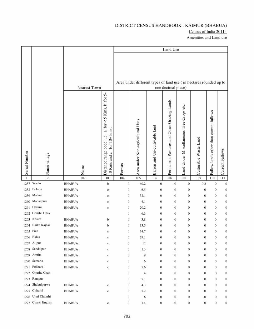
DISTRICT CENSUS HANDBOOK : KAIMUR (BHABUA)
Census of India 2011-
Amenities and Land use
Nam
e
Dis
tance
ran
ge
code
i.e
. a
fo
r <
5 K
ms,
b
for
5-
10 K
ms
and c
f
or
10+
km
s .
Fore
sts
Are
a under
Non-a
gri
cult
ura
l U
ses
Bar
ren a
nd U
n-c
ult
ivab
le l
and
Per
man
ent
Pas
ture
s an
d O
ther
Gra
zing L
ands
Lan
d U
nder
Mis
cell
aneo
us
Tre
e C
rops
etc.
Cult
ura
ble
Was
te L
and
Fal
low
lan
ds
oth
er t
han
curr
ent
fall
ow
s
Curr
ent
Fal
low
s
1 2 102 103 104 105 106 107 108 109 110 111
Ser
ial
Num
ber
Nam
e vil
lage
Area under different types of land use ( in hectares rounded up to
one decimal place)
Land Use
Nearest Town
1257 Wadar BHABUA b 0 60.2 0 0 0 0.2 0 0
1258 Belarhi BHABUA c 0 6.5 0 0 0 0 0 0
1259 Mahuat BHABUA c 0 32.1 0 0 0 0 0 0
1260 Madanpura BHABUA c 0 4.1 0 0 0 0 0 0
1261 Ekauni BHABUA c 0 20.2 0 0 0 0 0 0
1262 Ghurhu Chak 0 6.3 0 0 0 0 0 0
1263 Khaira BHABUA b 0 3.8 0 0 0 0 0 0
1264 Barka Kajhar BHABUA b 0 13.5 0 0 0 0 0 0
1265 Pian BHABUA c 0 34.7 0 0 0 0 0 0
1266 Balua BHABUA c 0 29.1 0 0 0 0 0 0
1267 Alipur BHABUA c 0 12 0 0 0 0 0 0
1268 Sandalpur BHABUA c 0 1.3 0 0 0 0 0 0
1269 Amrha BHABUA c 0 9 0 0 0 0 0 0
1270 Semaria BHABUA c 0 6 0 0 0 0 0 0
1271 Pokhara BHABUA c 0 5.6 0 0 0 0 0 0
1272 Ghurhu Chak 0 4 0 0 0 0 0 0
1273 Rampur 0 5.1 0 0 0 0 0 0
1274 Shukulpurwa BHABUA c 0 4.3 0 0 0 0 0 0
1275 Chitarhi BHABUA c 0 5.2 0 0 0 0 0 0
1276 Ujari Chitarhi 0 6 0 0 0 0 0 0
1277 Charki English BHABUA c 0 1.4 0 0 0 0 0 0
��

VILLAGE DIRECTORY
Village Directory
( As in 2009 )
Net
Are
a S
ow
n
Tota
l Ir
rigat
ed L
and A
rea
Tota
l U
n-i
rrig
ated
Lan
d A
rea
Can
als
( C
)
Wel
ls/T
ube-
wel
ls(W
/TW
)
Tan
ks/
Lak
es(T
/L)
Wat
er F
alls
(WF
)
Oth
ers(
O)
Fir
st
Sec
ond
Thir
d
112 113 114 115 116 117 118 119 120 121 122 2 1
Ser
ial
Num
ber
Name of three
most important
commodities
manufacturedArea irrigated by source (in hectare).
Nam
e of
Vil
lage
Area under different types of
land use ( in hectares rounded
up to one decimal place)
Land Use
441.6 355.9 85.7 200 100 0 0 55.9 Wadar 1257
89.5 82.5 7 80.5 2 0 0 0 Belarhi 1258
223.9 97.4 126.5 80.4 17 0 0 0 Mahuat 1259
40.9 37.5 3.4 10.6 0 0 0 26.9 Madanpura 1260
100.8 29.2 71.6 19.2 10 0 0 0 Ekauni 1261
55.7 27.1 28.6 0 27.1 0 0 0 Ghurhu Chak 1262
50.2 17.5 32.7 0 17.5 0 0 0 Khaira 1263
102.5 35.1 67.4 0 14 0 0 21.1 Barka Kajhar 1264
116.3 116.3 0 0 80 20 0 16.3 Pian 1265
78.9 70.4 8.5 0 70.4 0 0 0 Balua 1266
95 71.5 23.5 27.3 3.1 0 0 41.1 Alipur 1267
13.7 10.1 3.6 5 5.1 0 0 0 Sandalpur 1268
68 57.4 10.6 0 5.1 0 0 52.3 Amrha 1269
43 43 0 0 40 3 0 0 Semaria 1270
47.4 15.2 32.2 6.8 8.4 0 0 0 Pokhara 1271
38 38 0 29.5 8.5 0 0 0 Ghurhu Chak 1272
38.9 30.4 8.5 27.4 3 0 0 0 Rampur 1273
32.7 28.7 4 13.6 4.7 0 0 10.4 Shukulpurwa 1274
34.8 31.1 3.7 11.9 3.1 3.3 0 12.8 Chitarhi 1275
32 23.5 8.5 9.6 4.8 0 0 9.1 Ujari Chitarhi 1276
11.6 7.4 4.2 3.4 2.2 0 0 1.8 Charki English 1277
��

DISTRICT CENSUS HANDBOOK : KAIMUR (BHABUA)
Census of India 2011-
Amenities and Land use
Pre
-Pri
mar
y s
chool
(PP
)
Pri
mar
y s
chool
(P)
Mid
dle
sch
ool
(M)
Sec
ondar
y S
chool
(S)
Sen
ior
Sec
ondar
y s
chool
(SS
)
Deg
ree
coll
ege
of
arts
sc
ience
& c
om
mer
ce
(AS
C)
Engin
eeri
ng c
oll
ege(
EC
)
Med
ical
coll
ege
(MC
)
Man
agem
ent
inst
itute
(M
I)
Poly
tech
nic
(P
t)
Voca
tional
tra
inin
g s
chool
/IT
I
Non-f
orm
al t
rain
ing c
entr
e (N
FT
C)
Spec
ial
school
for
dis
able
d (
SS
D)
Oth
ers
(spec
ify)
1 2 3 4 5 6 7 8 9 10 11 12 13 14 15 16 17 18 19 20
Loca
tion c
ode
no.
Nam
e vil
lage
Ser
ial
Num
ber
Tota
l popula
tion (
2011 c
ensu
s )
Tota
l ar
ea o
f th
e vil
lage
( in
hec
tare
s ro
unded
up t
o
one
dec
imal
pla
ce)
Number of educational amenities available. (If not available
within the village , the distance range code viz; a for < 5
Kms, b for 5-10 Kms and c for 10+ kms of nearest place
where facility is available is given).
Num
ber
of
house
hold
s (2
011 c
ensu
s)
1278 Chhotka Darwan 250202 57 0 0
1279 Barka Danrowan 250203 41 1078 176 a 1 a b b c c c c c c c c
1280 Dubauli 250204 35 421 63 b 1 a c c c c c c c c c c
1281 Arazi English 250205 18 0 0
1282 Chacharia 250206 47 0 0
1283 Parasrampur 250207 39 324 44 b 1 a a c c c c c c c c c
1284 Belkatra 250208 39 90 14 b b b b c c c c c c c b c
1285 Lilapur 250209 50 343 49 b 1 a a b c c c c c c c c
1286 Miun Sukharipur 250210 307 3269 473 b 1 1 a c c c c c c c c c
1287 Rudarwar Kalan 250211 219 2124 406 a 1 1 b b c b c c c b b c
1288 Nawagawan 250212 92 555 82 b 1 a a b c b c c c b b c
1289 Ujaria 250213 30 0 0
1290 Semra 250214 140 498 73 b 1 a a b c c c c c b b c
1291 Dharwar 250215 47 412 66 a 1 a b b c b c c c b b c
1292 Madhopur 250216 37 0 0
Block T O T A L : 32727 251261 39826 11 187 77 5 1 1 0 0 0 0 0 0 0 0
���
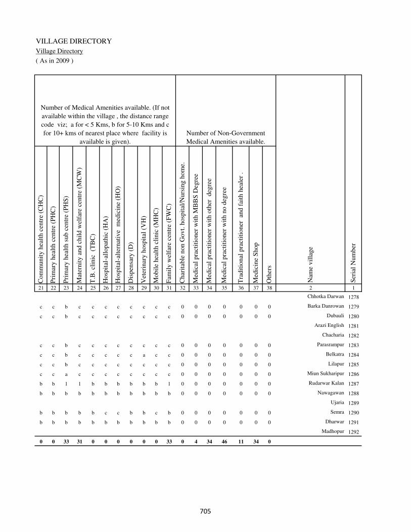
VILLAGE DIRECTORY
Village Directory
( As in 2009 )
Com
munit
y h
ealt
h c
entr
e (C
HC
)
Pri
mar
y h
ealt
h c
entr
e (P
HC
)
Pri
mar
y h
ealt
h s
ub c
entr
e (P
HS
)
Mat
ernit
y a
nd c
hil
d w
elfa
re c
entr
e (M
CW
)
T.B
. cl
inic
(T
BC
)
Hosp
ital
-all
opat
hic
(H
A)
Hosp
ital
-alt
ernat
ive
med
icin
e (H
O)
Dis
pen
sary
(D
)
Vet
erin
ary h
osp
ital
(V
H)
Mobil
e hea
lth c
linic
(M
HC
)
Fam
ily w
elfa
re c
entr
e (F
WC
)
Char
itab
le n
on G
ovt.
hosp
ital
/Nurs
ing h
om
e.
Med
ical
pra
ctit
ioner
wit
h M
BB
S D
egre
e
Med
ical
pra
ctit
ioner
wit
h o
ther
deg
ree
Med
ical
pra
ctit
ioner
wit
h n
o d
egre
e
Tra
dit
ional
pra
ctit
ioner
an
d f
aith
hea
ler
.
Med
icin
e S
hop
Oth
ers
21 22 23 24 25 26 27 28 29 30 31 32 33 34 35 36 37 38 2 1
Number of Non-Government
Medical Amenities available.
Number of Medical Amenities available. (If not
available within the village , the distance range
code viz; a for < 5 Kms, b for 5-10 Kms and c
for 10+ kms of nearest place where facility is
available is given).
Nam
e vil
lage
Ser
ial
Num
ber
Chhotka Darwan 1278
c c b c c c c c c c c 0 0 0 0 0 0 0 Barka Danrowan 1279
c c b c c c c c c c c 0 0 0 0 0 0 0 Dubauli 1280
Arazi English 1281
Chacharia 1282
c c b c c c c c c c c 0 0 0 0 0 0 0 Parasrampur 1283
c c b c c c c c a c c 0 0 0 0 0 0 0 Belkatra 1284
c c b c c c c c c c c 0 0 0 0 0 0 0 Lilapur 1285
c c a c c c c c c c c 0 0 0 0 0 0 0 Miun Sukharipur 1286
b b 1 1 b b b b b b 1 0 0 0 0 0 0 0 Rudarwar Kalan 1287
b b b b b b b b b b b 0 0 0 0 0 0 0 Nawagawan 1288
Ujaria 1289
b b b b b c c b b c b 0 0 0 0 0 0 0 Semra 1290
b b b b b b b b b b b 0 0 0 0 0 0 0 Dharwar 1291
Madhopur 1292
0 0 33 31 0 0 0 0 0 0 33 0 4 34 46 11 34 0
���
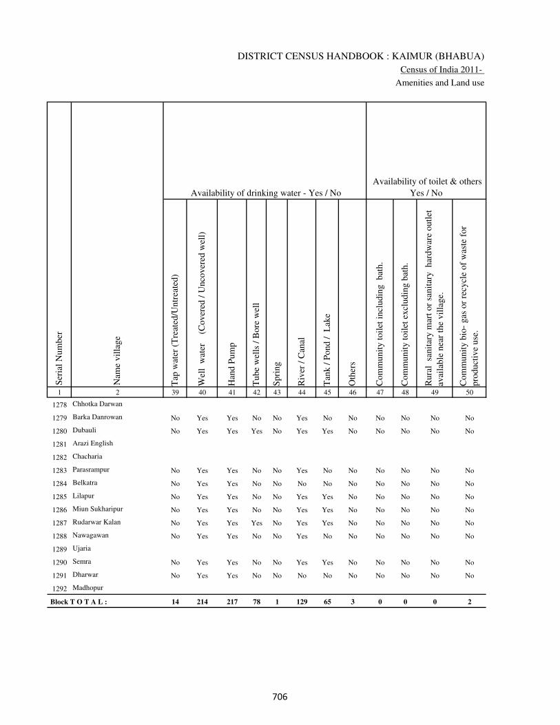
DISTRICT CENSUS HANDBOOK : KAIMUR (BHABUA)
Census of India 2011-
Amenities and Land use
Tap
wat
er (
Tre
ated
/Untr
eate
d)
Wel
l w
ater
(Cover
ed /
Unco
ver
ed w
ell)
Han
d P
um
p
Tube
wel
ls /
Bore
wel
l
Spri
ng
Riv
er /
Can
al
Tan
k /
Pond /
L
ake
Oth
ers
Com
munit
y t
oil
et i
ncl
udin
g
bat
h.
Com
munit
y t
oil
et e
xcl
udin
g b
ath.
Rura
l s
anit
ary m
art
or
sanit
ary
har
dw
are
outl
et
avai
lable
nea
r th
e vil
lage.
Com
munit
y b
io-
gas
or
recy
cle
of
was
te f
or
pro
duct
ive
use
.
1 2 39 40 41 42 43 44 45 46 47 48 49 50
Availability of toilet & others
Yes / No Availability of drinking water - Yes / No
Nam
e vil
lage
Ser
ial
Num
ber
1278 Chhotka Darwan
1279 Barka Danrowan No Yes Yes No No Yes No No No No No No
1280 Dubauli No Yes Yes Yes No Yes Yes No No No No No
1281 Arazi English
1282 Chacharia
1283 Parasrampur No Yes Yes No No Yes No No No No No No
1284 Belkatra No Yes Yes No No No No No No No No No
1285 Lilapur No Yes Yes No No Yes Yes No No No No No
1286 Miun Sukharipur No Yes Yes No No Yes Yes No No No No No
1287 Rudarwar Kalan No Yes Yes Yes No Yes Yes No No No No No
1288 Nawagawan No Yes Yes No No Yes No No No No No No
1289 Ujaria
1290 Semra No Yes Yes No No Yes Yes No No No No No
1291 Dharwar No Yes Yes No No No No No No No No No
1292 Madhopur
Block T O T A L : 14 214 217 78 1 129 65 3 0 0 0 2
���
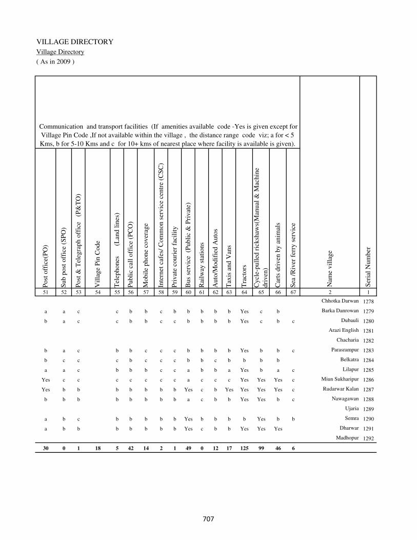
VILLAGE DIRECTORY
Village Directory
( As in 2009 )
Post
off
ice(
PO
)
Sub p
ost
off
ice
(SP
O)
Post
& T
eleg
raph o
ffic
e
(P&
TO
)
Vil
lage
Pin
Code
Tel
ephones
(L
and l
ines
)
Publi
c ca
ll o
ffic
e (P
CO
)
Mobil
e phone
cover
age
Inte
rnet
caf
es/
Com
mon s
ervic
e ce
ntr
e (C
SC
)
Pri
vat
e co
uri
er f
acil
ity
Bus
serv
ice
(P
ubli
c &
Pri
vat
e)
Rai
lway
sta
tions
Auto
/Modif
ied A
uto
s
Tax
is a
nd V
ans
Tra
ctors
Cycl
e-pull
ed r
icksh
aws(
Man
ual
& M
achin
e
dri
ven
)
Car
ts d
riven
by a
nim
als
Sea
/R
iver
fer
ry s
ervic
e51 52 53 54 55 56 57 58 59 60 61 62 63 64 65 66 67 2 1
Communication and transport facilities (If amenities available code -Yes is given except for
Village Pin Code ,If not available within the village , the distance range code viz; a for < 5
Kms, b for 5-10 Kms and c for 10+ kms of nearest place where facility is available is given).
Ser
ial
Num
ber
Nam
e vil
lage
Chhotka Darwan 1278
a a c c b b c b b b b b Yes c b Barka Danrowan 1279
b a c c b b c c b b b b Yes c b c Dubauli 1280
Arazi English 1281
Chacharia 1282
b a c b b c c c b b b b Yes b b c Parasrampur 1283
b c c c b c c c b b c b b b b Belkatra 1284
a a c b b b c c a b b a Yes b a c Lilapur 1285
Yes c c c c c c c a c c c Yes Yes Yes c Miun Sukharipur 1286
Yes b b b b b b b Yes c b Yes Yes Yes Yes c Rudarwar Kalan 1287
b b b b b b b b a c b b Yes Yes b c Nawagawan 1288
Ujaria 1289
a b c b b b b b Yes b b b b Yes b b Semra 1290
a b b b b b b b Yes c b b Yes Yes Yes Dharwar 1291
Madhopur 1292
30 0 1 18 5 42 14 2 1 49 0 12 17 125 99 46 6
���
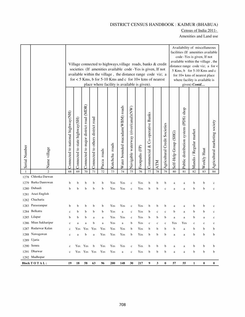
DISTRICT CENSUS HANDBOOK : KAIMUR (BHABUA)
Census of India 2011-
Amenities and Land use
Connec
ted t
o n
atio
nal
hig
hw
ay(N
H)
Connec
ted t
o s
tate
hig
hw
ay(S
H)
Connec
ted t
o m
ajor
dis
tric
t ro
ad (
MD
R)
Connec
ted t
o o
ther
s dis
tric
t ro
ad
Pucc
a r
oad
s
Kutc
hch
a r
oad
s
Wat
er b
ounded
mac
adam
(WB
M)
road
s
Nav
igab
le w
ater
way
(ri
ver
/can
al)(
NW
)
Footp
aths
(FP
)
Com
mer
cial
& C
o-o
per
ativ
e B
anks
AT
M
Agri
cult
ura
l C
redit
Soci
etie
s
Sel
f-H
elp G
roup (
SH
G)
Publi
c dis
trib
uti
on s
yst
em (
PD
S)
shop
Man
dis
/ R
egula
r m
arket
Wee
kly
Haa
t
Agri
cult
ura
l m
arket
ing s
oci
ety
1 2 68 69 70 71 72 73 74 75 76 77 78 79 80 81 82 83 84
Village connected to highways,village roads, banks & credit
societies (If amenities available code -Yes is given, If not
available within the village , the distance range code viz; a
for < 5 Kms, b for 5-10 Kms and c for 10+ kms of nearest
place where facility is available is given).
Ser
ial
Num
ber
Nam
e vil
lage
Availability of miscellaneous
facilities (If amenities available
code -Yes is given, If not
available within the village , the
distance range code viz; a for <
5 Kms, b for 5-10 Kms and c
for 10+ kms of nearest place
where facility is available is
given) Contd....
1278 Chhotka Darwan
1279 Barka Danrowan b b b b b Yes Yes c Yes b b b a a b b c
1280 Dubauli b b b b b Yes Yes c Yes b b c a a b b c
1281 Arazi English
1282 Chacharia
1283 Parasrampur b b b b b Yes Yes c Yes b b b a a b b c
1284 Belkatra c b b b b Yes a c Yes b c c b a b b c
1285 Lilapur b b b a a Yes Yes c Yes b b b a a b a c
1286 Miun Sukharipur c a a b a Yes a b Yes c c c Yes Yes c c c
1287 Rudarwar Kalan c Yes Yes Yes Yes Yes Yes b Yes b b b b a b b b
1288 Nawagawan c a b a Yes Yes Yes b Yes b b b a a b b b
1289 Ujaria
1290 Semra c Yes Yes b Yes Yes Yes c Yes b b b a a b b b
1291 Dharwar c Yes Yes Yes Yes Yes a c Yes b b b a a b b b
1292 Madhopur
Block T O T A L : 19 18 58 63 96 200 148 30 217 9 3 0 57 55 1 0 0
���
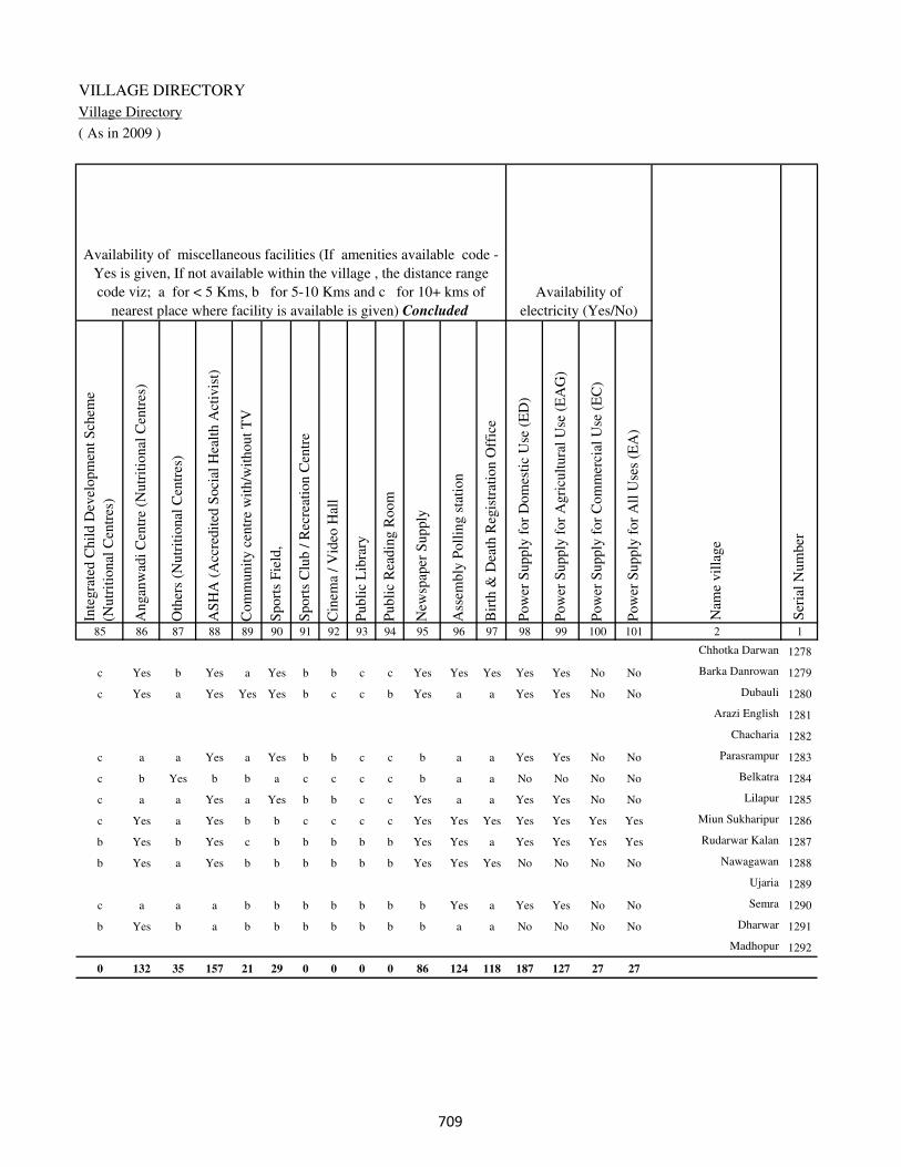
VILLAGE DIRECTORY
Village Directory
( As in 2009 )
Inte
gra
ted C
hil
d D
evel
opm
ent
Sch
eme
(Nutr
itio
nal
Cen
tres
)
Angan
wad
i C
entr
e (N
utr
itio
nal
Cen
tres
)
Oth
ers
(Nutr
itio
nal
Cen
tres
)
AS
HA
(A
ccre
dit
ed S
oci
al H
ealt
h A
ctiv
ist)
Com
munit
y c
entr
e w
ith/w
ithout
TV
Sport
s F
ield
,
Sport
s C
lub /
Rec
reat
ion C
entr
e
Cin
ema
/ V
ideo
Hal
l
Publi
c L
ibra
ry
Publi
c R
eadin
g R
oom
New
spap
er S
upply
Ass
embly
Poll
ing s
tati
on
Bir
th &
Dea
th R
egis
trat
ion O
ffic
e
Pow
er S
upply
for
Dom
esti
c U
se (
ED
)
Pow
er S
upply
for
Agri
cult
ura
l U
se (
EA
G)
Pow
er S
upply
for
Com
mer
cial
Use
(E
C)
Pow
er S
upply
for
All
Use
s (E
A)
85 86 87 88 89 90 91 92 93 94 95 96 97 98 99 100 101 2 1
Availability of
electricity (Yes/No)
Availability of miscellaneous facilities (If amenities available code -
Yes is given, If not available within the village , the distance range
code viz; a for < 5 Kms, b for 5-10 Kms and c for 10+ kms of
nearest place where facility is available is given) Concluded
Nam
e vil
lage
Ser
ial
Num
ber
Chhotka Darwan 1278
c Yes b Yes a Yes b b c c Yes Yes Yes Yes Yes No No Barka Danrowan 1279
c Yes a Yes Yes Yes b c c b Yes a a Yes Yes No No Dubauli 1280
Arazi English 1281
Chacharia 1282
c a a Yes a Yes b b c c b a a Yes Yes No No Parasrampur 1283
c b Yes b b a c c c c b a a No No No No Belkatra 1284
c a a Yes a Yes b b c c Yes a a Yes Yes No No Lilapur 1285
c Yes a Yes b b c c c c Yes Yes Yes Yes Yes Yes Yes Miun Sukharipur 1286
b Yes b Yes c b b b b b Yes Yes a Yes Yes Yes Yes Rudarwar Kalan 1287
b Yes a Yes b b b b b b Yes Yes Yes No No No No Nawagawan 1288
Ujaria 1289
c a a a b b b b b b b Yes a Yes Yes No No Semra 1290
b Yes b a b b b b b b b a a No No No No Dharwar 1291
Madhopur 1292
0 132 35 157 21 29 0 0 0 0 86 124 118 187 127 27 27
���

DISTRICT CENSUS HANDBOOK : KAIMUR (BHABUA)
Census of India 2011-
Amenities and Land use
Nam
e
Dis
tance
ran
ge
code
i.e
. a
fo
r <
5 K
ms,
b
for
5-
10 K
ms
and c
f
or
10+
km
s .
Fore
sts
Are
a under
Non-a
gri
cult
ura
l U
ses
Bar
ren a
nd U
n-c
ult
ivab
le l
and
Per
man
ent
Pas
ture
s an
d O
ther
Gra
zing L
ands
Lan
d U
nder
Mis
cell
aneo
us
Tre
e C
rops
etc.
Cult
ura
ble
Was
te L
and
Fal
low
lan
ds
oth
er t
han
curr
ent
fall
ow
s
Curr
ent
Fal
low
s
1 2 102 103 104 105 106 107 108 109 110 111
Ser
ial
Num
ber
Nam
e vil
lage
Area under different types of land use ( in hectares rounded up to
one decimal place)
Land Use
Nearest Town
1278 Chhotka Darwan 0 1.8 0 0 0 0 0 0
1279 Barka Danrowan BHABUA c 0 2.5 0 0 0 0 0 0
1280 Dubauli BHABUA c 0 3 0 0 0 0 0 0
1281 Arazi English 0 2.5 0 0 0 0 0 0
1282 Chacharia 0 7.7 0 0 0 0 0 0
1283 Parasrampur BHABUA c 0 6.5 0 0 0 0.2 0 0
1284 Belkatra BHABUA c 0 3.9 0 0 0 0 0 0
1285 Lilapur BHABUA c 0 4.9 0 0 0 0.2 0 0
1286 Miun Sukharipur BHABUA c 0 45.8 0 0 0 0.2 0 0
1287 Rudarwar Kalan BHABUA b 0 24.6 0 0 0 0 0 0
1288 Nawagawan BHABUA b 0 59.4 0 0 0 0 0 0
1289 Ujaria 0 2.7 0 0 0 0 0 0
1290 Semra BHABUA c 0 19.7 0 0 0 0.3 0 0
1291 Dharwar BHABUA b 0 4.2 0 0 0 0 0 0
1292 Madhopur 0 3.8 0 0 0 0 0 0
Block T O T A L : 0 0 7.4 4189.3 0 4.5 0 3.5 0 3
���
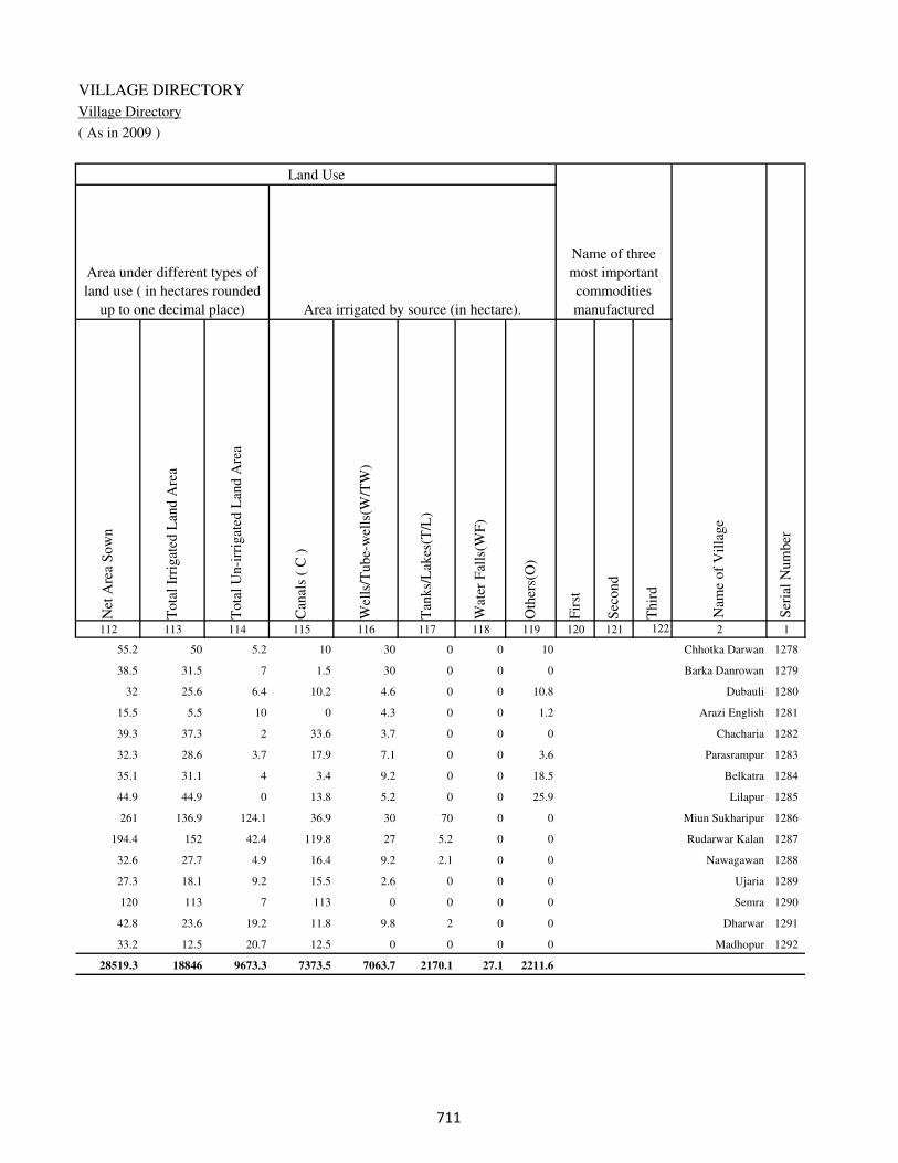
VILLAGE DIRECTORY
Village Directory
( As in 2009 )
Net
Are
a S
ow
n
Tota
l Ir
rigat
ed L
and A
rea
Tota
l U
n-i
rrig
ated
Lan
d A
rea
Can
als
( C
)
Wel
ls/T
ube-
wel
ls(W
/TW
)
Tan
ks/
Lak
es(T
/L)
Wat
er F
alls
(WF
)
Oth
ers(
O)
Fir
st
Sec
ond
Thir
d
112 113 114 115 116 117 118 119 120 121 122 2 1
Ser
ial
Num
ber
Name of three
most important
commodities
manufacturedArea irrigated by source (in hectare).
Nam
e of
Vil
lage
Area under different types of
land use ( in hectares rounded
up to one decimal place)
Land Use
55.2 50 5.2 10 30 0 0 10 Chhotka Darwan 1278
38.5 31.5 7 1.5 30 0 0 0 Barka Danrowan 1279
32 25.6 6.4 10.2 4.6 0 0 10.8 Dubauli 1280
15.5 5.5 10 0 4.3 0 0 1.2 Arazi English 1281
39.3 37.3 2 33.6 3.7 0 0 0 Chacharia 1282
32.3 28.6 3.7 17.9 7.1 0 0 3.6 Parasrampur 1283
35.1 31.1 4 3.4 9.2 0 0 18.5 Belkatra 1284
44.9 44.9 0 13.8 5.2 0 0 25.9 Lilapur 1285
261 136.9 124.1 36.9 30 70 0 0 Miun Sukharipur 1286
194.4 152 42.4 119.8 27 5.2 0 0 Rudarwar Kalan 1287
32.6 27.7 4.9 16.4 9.2 2.1 0 0 Nawagawan 1288
27.3 18.1 9.2 15.5 2.6 0 0 0 Ujaria 1289
120 113 7 113 0 0 0 0 Semra 1290
42.8 23.6 19.2 11.8 9.8 2 0 0 Dharwar 1291
33.2 12.5 20.7 12.5 0 0 0 0 Madhopur 1292
28519.3 18846 9673.3 7373.5 7063.7 2170.1 27.1 2211.6
���

DISTRICT CENSUS HANDBOOK : KAIMUR (BHABUA)
Census of India 2011-
Amenities and Land use
Pre
-Pri
mar
y s
chool
(PP
)
Pri
mar
y s
chool
(P)
Mid
dle
sch
ool
(M)
Sec
ondar
y S
chool
(S)
Sen
ior
Sec
ondar
y s
chool
(SS
)
Deg
ree
coll
ege
of
arts
sc
ience
& c
om
mer
ce
(AS
C)
Engin
eeri
ng c
oll
ege(
EC
)
Med
ical
coll
ege
(MC
)
Man
agem
ent
inst
itute
(M
I)
Poly
tech
nic
(P
t)
Voca
tional
tra
inin
g s
chool
/IT
I
Non-f
orm
al t
rain
ing c
entr
e (N
FT
C)
Spec
ial
school
for
dis
able
d (
SS
D)
Oth
ers
(spec
ify)
1 2 3 4 5 6 7 8 9 10 11 12 13 14 15 16 17 18 19 20
Loca
tion c
ode
no.
Nam
e vil
lage
Ser
ial
Num
ber
Tota
l popula
tion (
2011 c
ensu
s )
Tota
l ar
ea o
f th
e vil
lage
( in
hec
tare
s ro
unded
up t
o
one
dec
imal
pla
ce)
Number of educational amenities available. (If not available
within the village , the distance range code viz; a for < 5
Kms, b for 5-10 Kms and c for 10+ kms of nearest place
where facility is available is given).
Num
ber
of
house
hold
s (2
011 c
ensu
s)
Name of District:-Kaimur (Bhabua) Location CodeNo:-233
Name of CD Block:-Rampur Location CodeNo:-0442
1293 Kharsota 250217 93 0 0
1294 Gamharia 250218 50 833 104 1 2 1 b c c c c c c c b c
1295 Sonbarsa 250219 51 452 39 1 2 a b c c c c c c c c c
1296 Patna 250220 27 991 152 b b b b c c c c c c c c c
1297 Panail English 250221 98 195 21 b 1 b a c c c c c c c c c
1298 Narjo 250222 118 0 0
1299 Kargain 250223 342 1194 173 b 1 2 b c c c c c c c c c
1300 Barkagawan 250224 26 2672 384 1 1 2 b c c c c c c c c c
1301 Sihora 250225 25 0 0
1302 Ujari Danrivan 250226 25 0 0
1303 Nawadih 250227 111 771 107 1 2 b a c c c c c c c c c
1304 Kukurha English 250228 61 0 0
1305 Kukurha 250229 35 975 180 a 2 1 a b c c c c c c b c
1306 Thiloin 250230 244 1359 227 1 1 1 b b c c c c c c c c
1307 Dubauli 250231 62 218 46 1 1 a a c c c c c c c c c
1308 Siswar 250232 208 1399 181 b 1 1 c c c c c c c c c c
1309 Shivpur 250233 155 1221 173 1 1 1 a c c c c c c a c c
1310 Tenua 250234 195 2533 407 1 1 2 b c c c c c c c c c
1311 Dhaupokhar 250235 85 1102 167 b 1 1 c c c c c c c c c c
��

VILLAGE DIRECTORY
Village Directory
( As in 2009 )
Com
munit
y h
ealt
h c
entr
e (C
HC
)
Pri
mar
y h
ealt
h c
entr
e (P
HC
)
Pri
mar
y h
ealt
h s
ub c
entr
e (P
HS
)
Mat
ernit
y a
nd c
hil
d w
elfa
re c
entr
e (M
CW
)
T.B
. cl
inic
(T
BC
)
Hosp
ital
-all
opat
hic
(H
A)
Hosp
ital
-alt
ernat
ive
med
icin
e (H
O)
Dis
pen
sary
(D
)
Vet
erin
ary h
osp
ital
(V
H)
Mobil
e hea
lth c
linic
(M
HC
)
Fam
ily w
elfa
re c
entr
e (F
WC
)
Char
itab
le n
on G
ovt.
hosp
ital
/Nurs
ing h
om
e.
Med
ical
pra
ctit
ioner
wit
h M
BB
S D
egre
e
Med
ical
pra
ctit
ioner
wit
h o
ther
deg
ree
Med
ical
pra
ctit
ioner
wit
h n
o d
egre
e
Tra
dit
ional
pra
ctit
ioner
an
d f
aith
hea
ler
.
Med
icin
e S
hop
Oth
ers
21 22 23 24 25 26 27 28 29 30 31 32 33 34 35 36 37 38 2 1
Number of Non-Government
Medical Amenities available.
Number of Medical Amenities available. (If not
available within the village , the distance range
code viz; a for < 5 Kms, b for 5-10 Kms and c
for 10+ kms of nearest place where facility is
available is given).
Nam
e vil
lage
Ser
ial
Num
ber
Kharsota 1293
c c b c b c c c b c c 0 0 0 0 0 0 0 Gamharia 1294
c b b b b c c b c c c 0 0 0 0 0 0 0 Sonbarsa 1295
c b b b b c c b c c b 0 0 0 0 0 0 0 Patna 1296
c b b b b c c b c c b 0 2 2 2 2 2 2 Panail English 1297
Narjo 1298
c b c c c b b c c b b 0 0 2 2 2 2 2 Kargain 1299
c b b b b c c c c c c 0 0 2 2 2 2 2 Barkagawan 1300
Sihora 1301
Ujari Danrivan 1302
c b b b c c c b b c c 0 2 2 2 2 2 2 Nawadih 1303
Kukurha English 1304
c c b b b c c c c c b 0 0 0 0 0 0 0 Kukurha 1305
b b b b b c c b b c b 0 0 0 0 0 0 0 Thiloin 1306
b b b b b c c b b c b 0 0 0 0 0 0 0 Dubauli 1307
b b b b b c c b b c c 0 0 0 0 0 0 0 Siswar 1308
c c c c c c c c c c c 0 0 0 0 0 0 0 Shivpur 1309
c c a c c c c c c c c 0 0 0 0 0 0 0 Tenua 1310
b b b b b c c b b c b 0 0 0 0 0 0 0 Dhaupokhar 1311
��
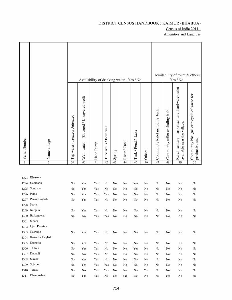
DISTRICT CENSUS HANDBOOK : KAIMUR (BHABUA)
Census of India 2011-
Amenities and Land use
Tap
wat
er (
Tre
ated
/Untr
eate
d)
Wel
l w
ater
(Cover
ed /
Unco
ver
ed w
ell)
Han
d P
um
p
Tube
wel
ls /
Bore
wel
l
Spri
ng
Riv
er /
Can
al
Tan
k /
Pond /
L
ake
Oth
ers
Com
munit
y t
oil
et i
ncl
udin
g
bat
h.
Com
munit
y t
oil
et e
xcl
udin
g b
ath.
Rura
l s
anit
ary m
art
or
sanit
ary
har
dw
are
outl
et
avai
lable
nea
r th
e vil
lage.
Com
munit
y b
io-
gas
or
recy
cle
of
was
te f
or
pro
duct
ive
use
.
1 2 39 40 41 42 43 44 45 46 47 48 49 50
Availability of toilet & others
Yes / No Availability of drinking water - Yes / No
Nam
e vil
lage
Ser
ial
Num
ber
1293 Kharsota
1294 Gamharia No Yes Yes No No No Yes No No No No No
1295 Sonbarsa No Yes Yes No No No No No No No No No
1296 Patna No Yes Yes Yes No No No No No No No No
1297 Panail English No Yes Yes No No No No No No No No No
1298 Narjo
1299 Kargain No Yes Yes No No No No No No No No No
1300 Barkagawan No No Yes Yes No No No No No No No No
1301 Sihora
1302 Ujari Danrivan
1303 Nawadih No Yes Yes No No No No No No No No No
1304 Kukurha English
1305 Kukurha No Yes Yes No No No No No No No No No
1306 Thiloin No Yes Yes No No No Yes No No No No No
1307 Dubauli No No Yes No No No No No No No No No
1308 Siswar No Yes Yes No No No No No No No No No
1309 Shivpur No Yes Yes Yes No No No No No No No No
1310 Tenua No No Yes Yes No No No Yes No No No No
1311 Dhaupokhar No Yes Yes No No Yes No No No No No No
���
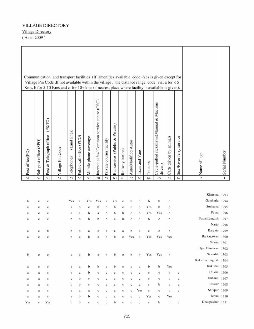
VILLAGE DIRECTORY
Village Directory
( As in 2009 )
Post
off
ice(
PO
)
Sub p
ost
off
ice
(SP
O)
Post
& T
eleg
raph o
ffic
e
(P&
TO
)
Vil
lage
Pin
Code
Tel
ephones
(L
and l
ines
)
Publi
c ca
ll o
ffic
e (P
CO
)
Mobil
e phone
cover
age
Inte
rnet
caf
es/
Com
mon s
ervic
e ce
ntr
e (C
SC
)
Pri
vat
e co
uri
er f
acil
ity
Bus
serv
ice
(P
ubli
c &
Pri
vat
e)
Rai
lway
sta
tions
Auto
/Modif
ied A
uto
s
Tax
is a
nd V
ans
Tra
ctors
Cycl
e-pull
ed r
icksh
aws(
Man
ual
& M
achin
e
dri
ven
)
Car
ts d
riven
by a
nim
als
Sea
/R
iver
fer
ry s
ervic
e51 52 53 54 55 56 57 58 59 60 61 62 63 64 65 66 67 2 1
Communication and transport facilities (If amenities available code -Yes is given except for
Village Pin Code ,If not available within the village , the distance range code viz; a for < 5
Kms, b for 5-10 Kms and c for 10+ kms of nearest place where facility is available is given).
Ser
ial
Num
ber
Nam
e vil
lage
Kharsota 1293
b c c Yes a Yes Yes a Yes c b b b b b Gamharia 1294
a c c a b c b b b c c b Yes b b Sonbarsa 1295
a c c a a b a b b b c b Yes Yes b Patna 1296
a c c b b b b b c b c a b c b Panail English 1297
Narjo 1298
a c b b b a c a a a b a c c b Kargain 1299
a c c b a b c b b c Yes b Yes Yes Yes Barkagawan 1300
Sihora 1301
Ujari Danrivan 1302
b c c a a b c b b c b b Yes Yes b Nawadih 1303
Kukurha English 1304
a c c a a b b a b c c a b b Yes Kukurha 1305
a a c b a b c c c c c c c c b c Thiloin 1306
a a c c b c c c c c c c c c b a Dubauli 1307
a a c b b c c a c c c a c b a a Siswar 1308
a a c a a a c c a c c Yes c c a c Shivpur 1309
a a c a b b c c a c c c Yes c Yes Tenua 1310
Yes c Yes b b c c c b c c c c b b c Dhaupokhar 1311
���
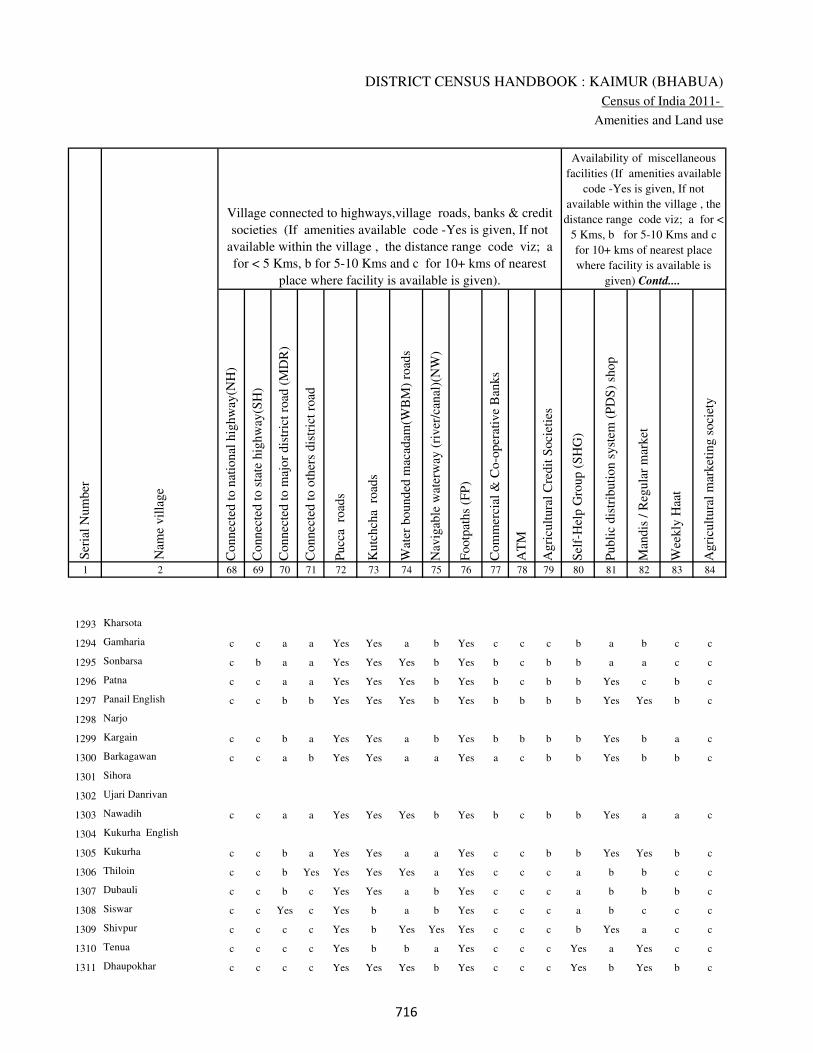
DISTRICT CENSUS HANDBOOK : KAIMUR (BHABUA)
Census of India 2011-
Amenities and Land use
Connec
ted t
o n
atio
nal
hig
hw
ay(N
H)
Connec
ted t
o s
tate
hig
hw
ay(S
H)
Connec
ted t
o m
ajor
dis
tric
t ro
ad (
MD
R)
Connec
ted t
o o
ther
s dis
tric
t ro
ad
Pucc
a r
oad
s
Kutc
hch
a r
oad
s
Wat
er b
ounded
mac
adam
(WB
M)
road
s
Nav
igab
le w
ater
way
(ri
ver
/can
al)(
NW
)
Footp
aths
(FP
)
Com
mer
cial
& C
o-o
per
ativ
e B
anks
AT
M
Agri
cult
ura
l C
redit
Soci
etie
s
Sel
f-H
elp G
roup (
SH
G)
Publi
c dis
trib
uti
on s
yst
em (
PD
S)
shop
Man
dis
/ R
egula
r m
arket
Wee
kly
Haa
t
Agri
cult
ura
l m
arket
ing s
oci
ety
1 2 68 69 70 71 72 73 74 75 76 77 78 79 80 81 82 83 84
Village connected to highways,village roads, banks & credit
societies (If amenities available code -Yes is given, If not
available within the village , the distance range code viz; a
for < 5 Kms, b for 5-10 Kms and c for 10+ kms of nearest
place where facility is available is given).
Ser
ial
Num
ber
Nam
e vil
lage
Availability of miscellaneous
facilities (If amenities available
code -Yes is given, If not
available within the village , the
distance range code viz; a for <
5 Kms, b for 5-10 Kms and c
for 10+ kms of nearest place
where facility is available is
given) Contd....
1293 Kharsota
1294 Gamharia c c a a Yes Yes a b Yes c c c b a b c c
1295 Sonbarsa c b a a Yes Yes Yes b Yes b c b b a a c c
1296 Patna c c a a Yes Yes Yes b Yes b c b b Yes c b c
1297 Panail English c c b b Yes Yes Yes b Yes b b b b Yes Yes b c
1298 Narjo
1299 Kargain c c b a Yes Yes a b Yes b b b b Yes b a c
1300 Barkagawan c c a b Yes Yes a a Yes a c b b Yes b b c
1301 Sihora
1302 Ujari Danrivan
1303 Nawadih c c a a Yes Yes Yes b Yes b c b b Yes a a c
1304 Kukurha English
1305 Kukurha c c b a Yes Yes a a Yes c c b b Yes Yes b c
1306 Thiloin c c b Yes Yes Yes Yes a Yes c c c a b b c c
1307 Dubauli c c b c Yes Yes a b Yes c c c a b b b c
1308 Siswar c c Yes c Yes b a b Yes c c c a b c c c
1309 Shivpur c c c c Yes b Yes Yes Yes c c c b Yes a c c
1310 Tenua c c c c Yes b b a Yes c c c Yes a Yes c c
1311 Dhaupokhar c c c c Yes Yes Yes b Yes c c c Yes b Yes b c
���

VILLAGE DIRECTORY
Village Directory
( As in 2009 )
Inte
gra
ted C
hil
d D
evel
opm
ent
Sch
eme
(Nutr
itio
nal
Cen
tres
)
Angan
wad
i C
entr
e (N
utr
itio
nal
Cen
tres
)
Oth
ers
(Nutr
itio
nal
Cen
tres
)
AS
HA
(A
ccre
dit
ed S
oci
al H
ealt
h A
ctiv
ist)
Com
munit
y c
entr
e w
ith/w
ithout
TV
Sport
s F
ield
,
Sport
s C
lub /
Rec
reat
ion C
entr
e
Cin
ema
/ V
ideo
Hal
l
Publi
c L
ibra
ry
Publi
c R
eadin
g R
oom
New
spap
er S
upply
Ass
embly
Poll
ing s
tati
on
Bir
th &
Dea
th R
egis
trat
ion O
ffic
e
Pow
er S
upply
for
Dom
esti
c U
se (
ED
)
Pow
er S
upply
for
Agri
cult
ura
l U
se (
EA
G)
Pow
er S
upply
for
Com
mer
cial
Use
(E
C)
Pow
er S
upply
for
All
Use
s (E
A)
85 86 87 88 89 90 91 92 93 94 95 96 97 98 99 100 101 2 1
Availability of
electricity (Yes/No)
Availability of miscellaneous facilities (If amenities available code -
Yes is given, If not available within the village , the distance range
code viz; a for < 5 Kms, b for 5-10 Kms and c for 10+ kms of
nearest place where facility is available is given) Concluded
Nam
e vil
lage
Ser
ial
Num
ber
Kharsota 1293
b Yes a Yes Yes Yes c b Yes Yes Yes Yes Yes Yes Yes No No Gamharia 1294
b Yes Yes a a b c c a b b a b No No No No Sonbarsa 1295
b a a a a a c c c c b a a No No No No Patna 1296
b b Yes a b b a c Yes Yes b a a No No No No Panail English 1297
Narjo 1298
b a a b b a c c a c b a a No No No No Kargain 1299
b Yes a a b a c c Yes Yes b Yes Yes No No No No Barkagawan 1300
Sihora 1301
Ujari Danrivan 1302
c b Yes Yes a b c c a c a a a No No No No Nawadih 1303
Kukurha English 1304
c a a a b Yes c c Yes Yes b a a No No No No Kukurha 1305
b b Yes b b b c c b c a a a No No No No Thiloin 1306
b b Yes b b b c c b c b a a No No No No Dubauli 1307
b b Yes b c a c c c c b a a No No No No Siswar 1308
c b c b c c c c a c b a b No No No No Shivpur 1309
c Yes Yes b c b c c b c b Yes a No No No No Tenua 1310
b Yes c a c b a c b c c a a No No No No Dhaupokhar 1311
���

DISTRICT CENSUS HANDBOOK : KAIMUR (BHABUA)
Census of India 2011-
Amenities and Land use
Nam
e
Dis
tance
ran
ge
code
i.e
. a
fo
r <
5 K
ms,
b
for
5-
10 K
ms
and c
f
or
10+
km
s .
Fore
sts
Are
a under
Non-a
gri
cult
ura
l U
ses
Bar
ren a
nd U
n-c
ult
ivab
le l
and
Per
man
ent
Pas
ture
s an
d O
ther
Gra
zing L
ands
Lan
d U
nder
Mis
cell
aneo
us
Tre
e C
rops
etc.
Cult
ura
ble
Was
te L
and
Fal
low
lan
ds
oth
er t
han
curr
ent
fall
ow
s
Curr
ent
Fal
low
s
1 2 102 103 104 105 106 107 108 109 110 111
Ser
ial
Num
ber
Nam
e vil
lage
Area under different types of land use ( in hectares rounded up to
one decimal place)
Land Use
Nearest Town
1293 Kharsota 0 7.3 3 0 0 0 0 0
1294 Gamharia BHABUA c 0 10.4 0 0 0 0 0 0
1295 Sonbarsa BHABUA c 0 12.4 0 0 0 0 0 1
1296 Patna BHABUA c 0 0 0 0 0 0 0 0
1297 Panail English BHABUA c 0 5.6 0 0 0 0 0 0
1298 Narjo 0 28 0 0 0 1 0 0.8
1299 Kargain BHABUA b 0 0 0 0 0 0 0 0
1300 Barkagawan BHABUA c 0 1 0 0 0 0 0 0
1301 Sihora 0 2.5 0 0 0 0 0 0
1302 Ujari Danrivan 0 3.2 0 0 0 0 0 0
1303 Nawadih BHABUA c 0 0.8 0 0 0 0 0 0
1304 Kukurha English 0 3.2 0 0 0 0 0 0
1305 Kukurha BHABUA c 0 0.8 0 0 0 0 0 0
1306 Thiloin BHABUA c 0 3.5 0 0 0 0 0 0
1307 Dubauli BHABUA c 0 2 0 0 0 0 0 0
1308 Siswar BHABUA c 0 5.8 0 0 0 0 0 0
1309 Shivpur BHABUA c 0 0 0 0 0 3.8 0 0
1310 Tenua BHABUA c 0 22.3 0 0 0 0 0 0
1311 Dhaupokhar BHABUA c 0 9.6 0 0 0 0 0 0
���

VILLAGE DIRECTORY
Village Directory
( As in 2009 )
Net
Are
a S
ow
n
Tota
l Ir
rigat
ed L
and A
rea
Tota
l U
n-i
rrig
ated
Lan
d A
rea
Can
als
( C
)
Wel
ls/T
ube-
wel
ls(W
/TW
)
Tan
ks/
Lak
es(T
/L)
Wat
er F
alls
(WF
)
Oth
ers(
O)
Fir
st
Sec
ond
Thir
d
112 113 114 115 116 117 118 119 120 121 122 2 1
Ser
ial
Num
ber
Name of three
most important
commodities
manufacturedArea irrigated by source (in hectare).
Nam
e of
Vil
lage
Area under different types of
land use ( in hectares rounded
up to one decimal place)
Land Use
82.7 62.7 20 55.5 0 7.2 0 0 Kharsota 1293
39.6 38.2 1.4 29.2 9 0 0 0 Gamharia 1294
37.6 21 16.6 21 0 0 0 0 Sonbarsa 1295
27 25.1 1.9 25.1 0 0 0 0 Patna 1296
92.4 88.2 4.2 88.2 0 0 0 0 Panail English 1297
88.2 88.2 0 88.2 0 0 0 0 Narjo 1298
342 325.4 16.6 320 5.4 0 0 0 Kargain 1299
25 15.2 9.8 0 15.2 0 0 0 Barkagawan 1300
22.5 22.5 0 18 4.5 0 0 0 Sihora 1301
21.8 21.8 0 15.5 6.3 0 0 0 Ujari Danrivan 1302
110.2 110.2 0 60 50.2 0 0 0 Nawadih 1303
57.8 52.6 5.2 30.4 22.2 0 0 0 Kukurha English 1304
34.2 34.2 0 22 0 0 0 12.2 Kukurha 1305
240.5 240.5 0 219.2 21.3 0 0 0 Thiloin 1306
60 58.4 1.6 52.2 6.2 0 0 0 Dubauli 1307
202.2 202.2 0 112 90.2 0 0 0 Siswar 1308
151.2 151.2 0 148 3.2 0 0 0 Shivpur 1309
172.7 79.3 93.4 52.2 10.8 0 0 16.3 Tenua 1310
75.4 72.6 2.8 42.4 30.2 0 0 0 Dhaupokhar 1311
���

DISTRICT CENSUS HANDBOOK : KAIMUR (BHABUA)
Census of India 2011-
Amenities and Land use
Pre
-Pri
mar
y s
chool
(PP
)
Pri
mar
y s
chool
(P)
Mid
dle
sch
ool
(M)
Sec
ondar
y S
chool
(S)
Sen
ior
Sec
ondar
y s
chool
(SS
)
Deg
ree
coll
ege
of
arts
sc
ience
& c
om
mer
ce
(AS
C)
Engin
eeri
ng c
oll
ege(
EC
)
Med
ical
coll
ege
(MC
)
Man
agem
ent
inst
itute
(M
I)
Poly
tech
nic
(P
t)
Voca
tional
tra
inin
g s
chool
/IT
I
Non-f
orm
al t
rain
ing c
entr
e (N
FT
C)
Spec
ial
school
for
dis
able
d (
SS
D)
Oth
ers
(spec
ify)
1 2 3 4 5 6 7 8 9 10 11 12 13 14 15 16 17 18 19 20
Loca
tion c
ode
no.
Nam
e vil
lage
Ser
ial
Num
ber
Tota
l popula
tion (
2011 c
ensu
s )
Tota
l ar
ea o
f th
e vil
lage
( in
hec
tare
s ro
unded
up t
o
one
dec
imal
pla
ce)
Number of educational amenities available. (If not available
within the village , the distance range code viz; a for < 5
Kms, b for 5-10 Kms and c for 10+ kms of nearest place
where facility is available is given).
Num
ber
of
house
hold
s (2
011 c
ensu
s)
1312 Kurari 250236 260 2522 444 1 1 1 b a a c c c c c c c c
1313 Kataya 250237 83 0 0
1314 Sisarma 250238 49 0 0
1315 Nisja 250239 98 950 131 1 2 2 a b b c c c c c c c c
1316 Pali 250240 132 921 123 1 2 2 a a b c c c c c c c c
1317 Majhaganwan 250241 43 251 35 a b c a a c c c c c c c c c
1318 Jalalpur 250242 110 1227 231 2 3 3 1 b c c c c c c c c c
1319 Bhaluhan 250243 47 847 120 1 1 1 a b b c c c c c c c c
1320 Basantpur 250244 48 0 0
1321 Lilli 250245 75 607 97 1 1 a b b b c c c c c c c
1322 Maheshpur 250246 79 212 31 a a b a b c c c c c c c c
1323 Kakarhi 250247 33 0 0
1324 Patila 250248 51 0 0
1325 Damodarpur 250249 49 579 74 b 1 a a b c c c c c c c c
1326 Dubauli 250250 45 20 3 1 a a a c c c c c c c c c c
1327 Banauli 250251 68 733 116 b 1 a b c c c c c c c c c
1328 Basni 250252 80 820 124 1 2 2 a a c c c c c c c c c
1329 Gangapur 250253 40 568 113 1 2 a a 1 b c c c c c c c
1330 Chanrudean 250254 39 156 22 c b a b c c c c c c c c c
1331 Digha 250255 23 0 0
1332 Tetihan 250256 37 159 20 c b 1 b c c c c c c c c c
��

VILLAGE DIRECTORY
Village Directory
( As in 2009 )
Com
munit
y h
ealt
h c
entr
e (C
HC
)
Pri
mar
y h
ealt
h c
entr
e (P
HC
)
Pri
mar
y h
ealt
h s
ub c
entr
e (P
HS
)
Mat
ernit
y a
nd c
hil
d w
elfa
re c
entr
e (M
CW
)
T.B
. cl
inic
(T
BC
)
Hosp
ital
-all
opat
hic
(H
A)
Hosp
ital
-alt
ernat
ive
med
icin
e (H
O)
Dis
pen
sary
(D
)
Vet
erin
ary h
osp
ital
(V
H)
Mobil
e hea
lth c
linic
(M
HC
)
Fam
ily w
elfa
re c
entr
e (F
WC
)
Char
itab
le n
on G
ovt.
hosp
ital
/Nurs
ing h
om
e.
Med
ical
pra
ctit
ioner
wit
h M
BB
S D
egre
e
Med
ical
pra
ctit
ioner
wit
h o
ther
deg
ree
Med
ical
pra
ctit
ioner
wit
h n
o d
egre
e
Tra
dit
ional
pra
ctit
ioner
an
d f
aith
hea
ler
.
Med
icin
e S
hop
Oth
ers
21 22 23 24 25 26 27 28 29 30 31 32 33 34 35 36 37 38 2 1
Number of Non-Government
Medical Amenities available.
Number of Medical Amenities available. (If not
available within the village , the distance range
code viz; a for < 5 Kms, b for 5-10 Kms and c
for 10+ kms of nearest place where facility is
available is given).
Nam
e vil
lage
Ser
ial
Num
ber
b b b b b c c b b c b 0 0 0 0 0 0 0 Kurari 1312
Kataya 1313
Sisarma 1314
b b b b c c c c c c c 0 0 0 0 0 0 0 Nisja 1315
b b a b b c c c c c c 0 0 0 0 0 0 0 Pali 1316
b b a b c c c c c c c 0 0 0 0 0 0 0 Majhaganwan 1317
b a a a c c c a c c c 0 0 0 0 0 0 0 Jalalpur 1318
b b a b c c c c c c c 0 0 0 0 0 0 0 Bhaluhan 1319
Basantpur 1320
b b b b c c c b b c b 0 0 0 0 0 0 0 Lilli 1321
c b b b c c c c b c c 0 0 0 0 0 0 0 Maheshpur 1322
Kakarhi 1323
Patila 1324
b b b b b c c c c c c 0 0 0 0 0 0 2 Damodarpur 1325
b b b b b c c b b c b 0 0 0 0 0 0 0 Dubauli 1326
c b b b b c c c c c c 0 0 2 2 2 2 2 Banauli 1327
b b b b b c c a c c c 0 0 0 0 0 0 0 Basni 1328
b b b b b c c c c c c 0 0 0 0 0 0 0 Gangapur 1329
c b b b b c c c c c b 0 0 2 2 2 2 2 Chanrudean 1330
Digha 1331
b b b b b c c c c c c 0 0 2 2 2 2 2 Tetihan 1332
��

DISTRICT CENSUS HANDBOOK : KAIMUR (BHABUA)
Census of India 2011-
Amenities and Land use
Tap
wat
er (
Tre
ated
/Untr
eate
d)
Wel
l w
ater
(Cover
ed /
Unco
ver
ed w
ell)
Han
d P
um
p
Tube
wel
ls /
Bore
wel
l
Spri
ng
Riv
er /
Can
al
Tan
k /
Pond /
L
ake
Oth
ers
Com
munit
y t
oil
et i
ncl
udin
g
bat
h.
Com
munit
y t
oil
et e
xcl
udin
g b
ath.
Rura
l s
anit
ary m
art
or
sanit
ary
har
dw
are
outl
et
avai
lable
nea
r th
e vil
lage.
Com
munit
y b
io-
gas
or
recy
cle
of
was
te f
or
pro
duct
ive
use
.
1 2 39 40 41 42 43 44 45 46 47 48 49 50
Availability of toilet & others
Yes / No Availability of drinking water - Yes / No
Nam
e vil
lage
Ser
ial
Num
ber
1312 Kurari No Yes Yes No No No Yes Yes Yes Yes No No
1313 Kataya
1314 Sisarma
1315 Nisja No Yes Yes Yes No Yes No No Yes No No No
1316 Pali No Yes Yes No No No No No Yes No No No
1317 Majhaganwan No Yes Yes No No Yes No No No No No No
1318 Jalalpur No Yes Yes No No No Yes No Yes No No No
1319 Bhaluhan No Yes Yes No No No No No No No No No
1320 Basantpur
1321 Lilli No Yes Yes Yes No No No No Yes No No No
1322 Maheshpur No Yes Yes No No No No No No No No No
1323 Kakarhi
1324 Patila
1325 Damodarpur No Yes Yes No No No No No Yes No No No
1326 Dubauli No Yes Yes No No No No No No No No No
1327 Banauli No Yes Yes No No No No No No No No No
1328 Basni No Yes Yes Yes No Yes No No Yes No No No
1329 Gangapur Yes Yes Yes No Yes No Yes Yes No No No No
1330 Chanrudean No Yes Yes No No No No No Yes No No No
1331 Digha
1332 Tetihan No Yes Yes No No No No No Yes No No No
�

VILLAGE DIRECTORY
Village Directory
( As in 2009 )
Post
off
ice(
PO
)
Sub p
ost
off
ice
(SP
O)
Post
& T
eleg
raph o
ffic
e
(P&
TO
)
Vil
lage
Pin
Code
Tel
ephones
(L
and l
ines
)
Publi
c ca
ll o
ffic
e (P
CO
)
Mobil
e phone
cover
age
Inte
rnet
caf
es/
Com
mon s
ervic
e ce
ntr
e (C
SC
)
Pri
vat
e co
uri
er f
acil
ity
Bus
serv
ice
(P
ubli
c &
Pri
vat
e)
Rai
lway
sta
tions
Auto
/Modif
ied A
uto
s
Tax
is a
nd V
ans
Tra
ctors
Cycl
e-pull
ed r
icksh
aws(
Man
ual
& M
achin
e
dri
ven
)
Car
ts d
riven
by a
nim
als
Sea
/R
iver
fer
ry s
ervic
e51 52 53 54 55 56 57 58 59 60 61 62 63 64 65 66 67 2 1
Communication and transport facilities (If amenities available code -Yes is given except for
Village Pin Code ,If not available within the village , the distance range code viz; a for < 5
Kms, b for 5-10 Kms and c for 10+ kms of nearest place where facility is available is given).
Ser
ial
Num
ber
Nam
e vil
lage
a a c b b b c a a c c Yes Yes c Yes Yes Kurari 1312
Kataya 1313
Sisarma 1314
a a c b Yes Yes b c Yes c Yes Yes Yes Yes Yes Nisja 1315
a a c Yes Yes Yes Yes b Yes c c Yes Yes Yes Yes c Pali 1316
b a c Yes Yes Yes b b Yes c Yes Yes Yes Yes Yes c Majhaganwan 1317
b b c b c Yes c c Yes c c Yes Yes Yes b b Jalalpur 1318
a a c b Yes Yes c c Yes a c Yes Yes Yes b c Bhaluhan 1319
Basantpur 1320
b b c b b a c c Yes Yes Yes Yes a c b a Lilli 1321
b c c a b a c c b c b c b c b Maheshpur 1322
Kakarhi 1323
Patila 1324
a c c a a a c c b c a c b c a c Damodarpur 1325
a a c a b c c c c c c c c c b c Dubauli 1326
a c c a b c b a c c c c b c b Banauli 1327
b b c b Yes c b b Yes c Yes Yes Yes Yes a Basni 1328
b a c a Yes a b c c c c Yes Yes Yes Yes c Gangapur 1329
a b c a b b c c b b c a b c Yes Chanrudean 1330
Digha 1331
b b c a b a a a a c c b b b b c Tetihan 1332
�

DISTRICT CENSUS HANDBOOK : KAIMUR (BHABUA)
Census of India 2011-
Amenities and Land use
Connec
ted t
o n
atio
nal
hig
hw
ay(N
H)
Connec
ted t
o s
tate
hig
hw
ay(S
H)
Connec
ted t
o m
ajor
dis
tric
t ro
ad (
MD
R)
Connec
ted t
o o
ther
s dis
tric
t ro
ad
Pucc
a r
oad
s
Kutc
hch
a r
oad
s
Wat
er b
ounded
mac
adam
(WB
M)
road
s
Nav
igab
le w
ater
way
(ri
ver
/can
al)(
NW
)
Footp
aths
(FP
)
Com
mer
cial
& C
o-o
per
ativ
e B
anks
AT
M
Agri
cult
ura
l C
redit
Soci
etie
s
Sel
f-H
elp G
roup (
SH
G)
Publi
c dis
trib
uti
on s
yst
em (
PD
S)
shop
Man
dis
/ R
egula
r m
arket
Wee
kly
Haa
t
Agri
cult
ura
l m
arket
ing s
oci
ety
1 2 68 69 70 71 72 73 74 75 76 77 78 79 80 81 82 83 84
Village connected to highways,village roads, banks & credit
societies (If amenities available code -Yes is given, If not
available within the village , the distance range code viz; a
for < 5 Kms, b for 5-10 Kms and c for 10+ kms of nearest
place where facility is available is given).
Ser
ial
Num
ber
Nam
e vil
lage
Availability of miscellaneous
facilities (If amenities available
code -Yes is given, If not
available within the village , the
distance range code viz; a for <
5 Kms, b for 5-10 Kms and c
for 10+ kms of nearest place
where facility is available is
given) Contd....
1312 Kurari c c Yes Yes Yes Yes Yes Yes Yes c c c b a a a c
1313 Kataya
1314 Sisarma
1315 Nisja Yes Yes Yes Yes Yes Yes Yes b Yes c c c Yes Yes b b c
1316 Pali Yes Yes Yes Yes Yes Yes Yes b Yes c c b Yes Yes b b c
1317 Majhaganwan Yes Yes Yes Yes Yes Yes a b Yes c c c Yes Yes b b c
1318 Jalalpur Yes Yes Yes Yes Yes Yes Yes b Yes c c c Yes Yes Yes b c
1319 Bhaluhan Yes Yes Yes Yes Yes Yes Yes c Yes c c b Yes Yes b a c
1320 Basantpur
1321 Lilli b b Yes Yes Yes Yes a b Yes b b b b b b b c
1322 Maheshpur c c b b Yes b a b Yes b b c b b b b b
1323 Kakarhi
1324 Patila
1325 Damodarpur c c a a Yes Yes Yes b Yes c c c a a b b b
1326 Dubauli c c b c Yes Yes a c Yes a c c b Yes c c b
1327 Banauli c c a b Yes Yes a c Yes c c c b a c c Yes
1328 Basni Yes Yes Yes Yes Yes b b b Yes c c b b b b b b
1329 Gangapur Yes Yes Yes Yes Yes Yes Yes b Yes c c c Yes Yes Yes Yes b
1330 Chanrudean c c a a Yes Yes Yes b Yes b b c b Yes b b b
1331 Digha
1332 Tetihan c c Yes Yes Yes Yes Yes c Yes b b c b Yes b a b
��

VILLAGE DIRECTORY
Village Directory
( As in 2009 )
Inte
gra
ted C
hil
d D
evel
opm
ent
Sch
eme
(Nutr
itio
nal
Cen
tres
)
Angan
wad
i C
entr
e (N
utr
itio
nal
Cen
tres
)
Oth
ers
(Nutr
itio
nal
Cen
tres
)
AS
HA
(A
ccre
dit
ed S
oci
al H
ealt
h A
ctiv
ist)
Com
munit
y c
entr
e w
ith/w
ithout
TV
Sport
s F
ield
,
Sport
s C
lub /
Rec
reat
ion C
entr
e
Cin
ema
/ V
ideo
Hal
l
Publi
c L
ibra
ry
Publi
c R
eadin
g R
oom
New
spap
er S
upply
Ass
embly
Poll
ing s
tati
on
Bir
th &
Dea
th R
egis
trat
ion O
ffic
e
Pow
er S
upply
for
Dom
esti
c U
se (
ED
)
Pow
er S
upply
for
Agri
cult
ura
l U
se (
EA
G)
Pow
er S
upply
for
Com
mer
cial
Use
(E
C)
Pow
er S
upply
for
All
Use
s (E
A)
85 86 87 88 89 90 91 92 93 94 95 96 97 98 99 100 101 2 1
Availability of
electricity (Yes/No)
Availability of miscellaneous facilities (If amenities available code -
Yes is given, If not available within the village , the distance range
code viz; a for < 5 Kms, b for 5-10 Kms and c for 10+ kms of
nearest place where facility is available is given) Concluded
Nam
e vil
lage
Ser
ial
Num
ber
b Yes Yes a c b c c b c b Yes Yes No No No No Kurari 1312
Kataya 1313
Sisarma 1314
b b c b c b c c b c b a b Yes Yes No No Nisja 1315
b b Yes b c c c c c c b a a No No No No Pali 1316
b b a b c Yes c c c c b a a No No No No Majhaganwan 1317
b b a b c b c c c c b a b No No No No Jalalpur 1318
b a c b c b c c c c b a b No No No No Bhaluhan 1319
Basantpur 1320
b a Yes b c b c c b c c a a No No No No Lilli 1321
b b Yes b c a c c c c c a a No No No No Maheshpur 1322
Kakarhi 1323
Patila 1324
b a a a c Yes c c a c c a a No No No No Damodarpur 1325
b b Yes b c b c c c c c a b No No No No Dubauli 1326
b b Yes a c Yes a a a c Yes a b Yes No No No Banauli 1327
b b Yes b c b c c c c c a b No No No No Basni 1328
b b Yes b b b c c c c c a a No No No No Gangapur 1329
c b Yes a b b c c a c c a a No No No No Chanrudean 1330
Digha 1331
c b Yes a Yes b c c c c b a b No No No No Tetihan 1332
��

DISTRICT CENSUS HANDBOOK : KAIMUR (BHABUA)
Census of India 2011-
Amenities and Land use
Nam
e
Dis
tance
ran
ge
code
i.e
. a
fo
r <
5 K
ms,
b
for
5-
10 K
ms
and c
f
or
10+
km
s .
Fore
sts
Are
a under
Non-a
gri
cult
ura
l U
ses
Bar
ren a
nd U
n-c
ult
ivab
le l
and
Per
man
ent
Pas
ture
s an
d O
ther
Gra
zing L
ands
Lan
d U
nder
Mis
cell
aneo
us
Tre
e C
rops
etc.
Cult
ura
ble
Was
te L
and
Fal
low
lan
ds
oth
er t
han
curr
ent
fall
ow
s
Curr
ent
Fal
low
s
1 2 102 103 104 105 106 107 108 109 110 111
Ser
ial
Num
ber
Nam
e vil
lage
Area under different types of land use ( in hectares rounded up to
one decimal place)
Land Use
Nearest Town
1312 Kurari BHABUA c 0 25.2 0 0 0 0 0 0
1313 Kataya 0 8.6 0 0 0 0 0 0
1314 Sisarma 0 3.2 0 0 0 0 0 0
1315 Nisja BHABUA c 0 6.5 4 0 0 0 0 0
1316 Pali BHABUA c 0 10.8 7 0 0 0 0 0
1317 Majhaganwan BHABUA c 0 6.5 0 0 0 0 0 0
1318 Jalalpur BHABUA c 0 7.4 0 0 0 0 0 0
1319 Bhaluhan BHABUA c 0 2.8 0 0 0 0 0 0
1320 Basantpur 0 13.9 0 0 0 0 0 0
1321 Lilli BHABUA c 0 0 0 0 0 0 0 0
1322 Maheshpur BHABUA c 0 9.2 8.6 10.4 5 0 0 0
1323 Kakarhi 0 4.6 0 0 0 0 0 0
1324 Patila 0 9.4 0 0 0 0 0 0
1325 Damodarpur BHABUA c 0 8.4 0 0 0 0 0 0
1326 Dubauli BHABUA c 0 2.2 0 0 0 0 0 0
1327 Banauli BHABUA c 0 5 0 0 0 0 0 0.4
1328 Basni BHABUA c 0 10.5 0 0 0 0 0 0.6
1329 Gangapur BHABUA c 0 1.2 0 0 0 0 0 0
1330 Chanrudean BHABUA c 0 0.8 0 0 0 0 0 0
1331 Digha 0 0.8 0 0 0 0 0 0
1332 Tetihan BHABUA c 0 8.8 0 0 0 0 0 0
��

VILLAGE DIRECTORY
Village Directory
( As in 2009 )
Net
Are
a S
ow
n
Tota
l Ir
rigat
ed L
and A
rea
Tota
l U
n-i
rrig
ated
Lan
d A
rea
Can
als
( C
)
Wel
ls/T
ube-
wel
ls(W
/TW
)
Tan
ks/
Lak
es(T
/L)
Wat
er F
alls
(WF
)
Oth
ers(
O)
Fir
st
Sec
ond
Thir
d
112 113 114 115 116 117 118 119 120 121 122 2 1
Ser
ial
Num
ber
Name of three
most important
commodities
manufacturedArea irrigated by source (in hectare).
Nam
e of
Vil
lage
Area under different types of
land use ( in hectares rounded
up to one decimal place)
Land Use
234.8 103.9 130.9 45.2 38.4 0 0 20.3 Kurari 1312
74.4 24.3 50.1 16.2 4.1 2 0 2 Kataya 1313
45.8 22.2 23.6 11.4 3 7.8 0 0 Sisarma 1314
87.5 51 36.5 40.2 8.1 2.7 0 0 Nisja 1315
114.2 72.8 41.4 40.3 20.2 12.3 0 0 Pali 1316
36.5 35.5 1 27.3 3 5.2 0 0 Majhaganwan 1317
102.6 88.6 14 62.4 20.2 6 0 0 Jalalpur 1318
44.2 44.2 0 40.2 4 0 0 0 Bhaluhan 1319
34.1 32.9 1.2 30 0 0 0 2.9 Basantpur 1320
75 50.8 24.2 30.4 10.2 10.2 0 0 Lilli 1321
45.8 33.6 12.2 25.4 8.2 0 0 0 Maheshpur 1322
28.4 20.2 8.2 2 16.2 0 0 2 Kakarhi 1323
41.6 31.4 10.2 17.2 8 6.2 0 0 Patila 1324
40.6 40.6 0 32.6 0 0 0 8 Damodarpur 1325
42.8 38.5 4.3 28.1 10.4 0 0 0 Dubauli 1326
62.6 49.4 13.2 49.4 0 0 0 0 Banauli 1327
68.9 64.1 4.8 40.1 12 12 0 0 Basni 1328
38.8 35.8 3 8.2 25.4 2.2 0 0 Gangapur 1329
38.2 37.2 1 32.2 0 0 0 5 Chanrudean 1330
22.2 22.2 0 8.2 14 0 0 0 Digha 1331
28.2 20.4 7.8 20.4 0 0 0 0 Tetihan 1332
��

DISTRICT CENSUS HANDBOOK : KAIMUR (BHABUA)
Census of India 2011-
Amenities and Land use
Pre
-Pri
mar
y s
chool
(PP
)
Pri
mar
y s
chool
(P)
Mid
dle
sch
ool
(M)
Sec
ondar
y S
chool
(S)
Sen
ior
Sec
ondar
y s
chool
(SS
)
Deg
ree
coll
ege
of
arts
sc
ience
& c
om
mer
ce
(AS
C)
Engin
eeri
ng c
oll
ege(
EC
)
Med
ical
coll
ege
(MC
)
Man
agem
ent
inst
itute
(M
I)
Poly
tech
nic
(P
t)
Voca
tional
tra
inin
g s
chool
/IT
I
Non-f
orm
al t
rain
ing c
entr
e (N
FT
C)
Spec
ial
school
for
dis
able
d (
SS
D)
Oth
ers
(spec
ify)
1 2 3 4 5 6 7 8 9 10 11 12 13 14 15 16 17 18 19 20
Loca
tion c
ode
no.
Nam
e vil
lage
Ser
ial
Num
ber
Tota
l popula
tion (
2011 c
ensu
s )
Tota
l ar
ea o
f th
e vil
lage
( in
hec
tare
s ro
unded
up t
o
one
dec
imal
pla
ce)
Number of educational amenities available. (If not available
within the village , the distance range code viz; a for < 5
Kms, b for 5-10 Kms and c for 10+ kms of nearest place
where facility is available is given).
Num
ber
of
house
hold
s (2
011 c
ensu
s)
1333 Akorhi 250257 262 2236 400 a 1 1 a c c c c c c c c c a
1334 Itawan 250258 62 444 59 a 2 a a c c c c c c c c c a
1335 Sonara 250259 40 624 103 a 1 a a c c c c c c c c c
1336 Karaunda 250260 85 415 56 a b a 2 a a c c c c c c c a
1337 Belawan 250261 290 2839 482 3 1 1 a c c c c c c c c c
1338 Rampur 250262 58 262 31 a a a c c c c c c c c a c
1339 Basuhari 250263 175 640 106 a 1 a a c c c c c c c c c
1340 Chamariawan 250264 91 609 96 1 2 b b c c c c c c c c c
1341 Baramhtali 250265 27 0 0
1342 Ekauni 250266 126 1050 172 b 3 a b c c c c c c b c c
1343 Gonupur 250267 25 186 26 1 b b b c c c c c c c c c
1344 Bahera 250268 53 342 54 1 1 c c c c c c c c c c c 2
1345 Madhopur 250269 41 583 90 b 2 1 b b a c c c c c c c
1346 Kuran 250270 19 0 0
1347 Karaundi Khurd 250271 30 0 0
1348 Maidanr Khurd 250272 38 500 81 1 a b c c c c c c c c c c
1349 Maidanr Kalan 250273 80 380 62 a 1 c a c b c c c c c c c
1350 Kudarwar Khurd 250274 46 222 37 a a b c c c c c c c c c c
1351 Pasain 250275 219 1373 226 a 1 1 b c c c c c c c c c
1352 Nirbispur 250276 69 400 66 a 1 b a c c c c c c c c c
1353 Khajura 250277 481 1339 234 a 1 1 a c c c c c c c c c
��
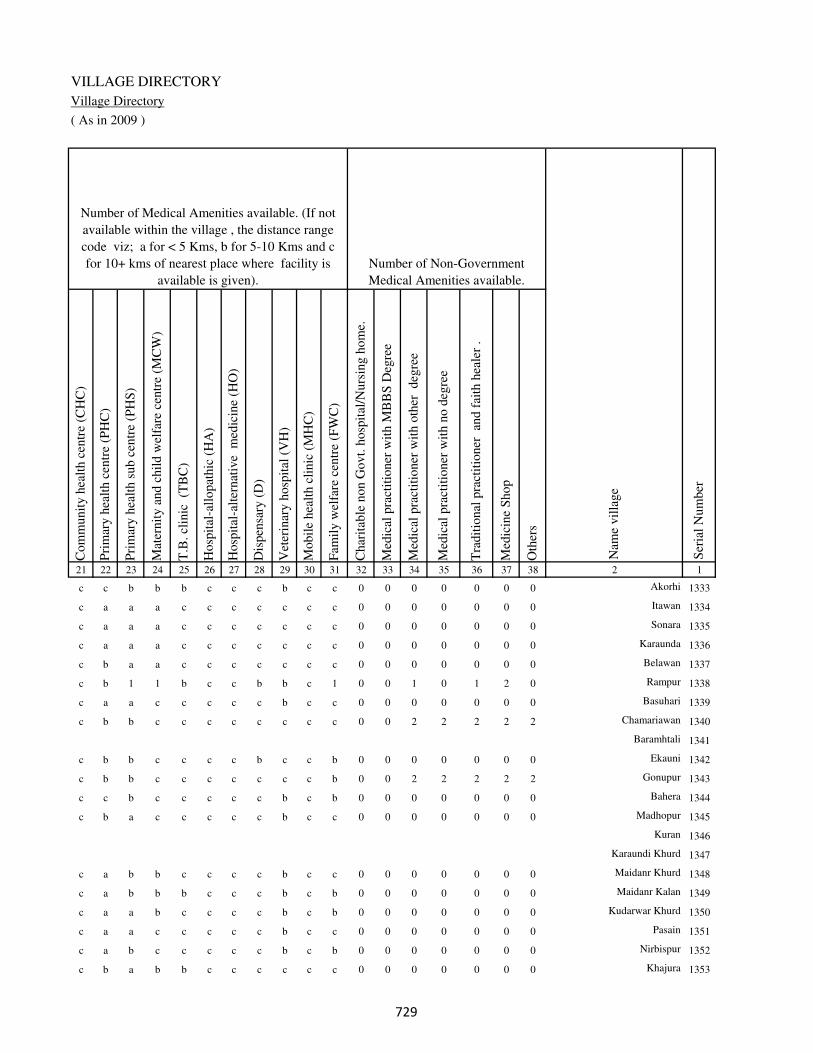
VILLAGE DIRECTORY
Village Directory
( As in 2009 )
Com
munit
y h
ealt
h c
entr
e (C
HC
)
Pri
mar
y h
ealt
h c
entr
e (P
HC
)
Pri
mar
y h
ealt
h s
ub c
entr
e (P
HS
)
Mat
ernit
y a
nd c
hil
d w
elfa
re c
entr
e (M
CW
)
T.B
. cl
inic
(T
BC
)
Hosp
ital
-all
opat
hic
(H
A)
Hosp
ital
-alt
ernat
ive
med
icin
e (H
O)
Dis
pen
sary
(D
)
Vet
erin
ary h
osp
ital
(V
H)
Mobil
e hea
lth c
linic
(M
HC
)
Fam
ily w
elfa
re c
entr
e (F
WC
)
Char
itab
le n
on G
ovt.
hosp
ital
/Nurs
ing h
om
e.
Med
ical
pra
ctit
ioner
wit
h M
BB
S D
egre
e
Med
ical
pra
ctit
ioner
wit
h o
ther
deg
ree
Med
ical
pra
ctit
ioner
wit
h n
o d
egre
e
Tra
dit
ional
pra
ctit
ioner
an
d f
aith
hea
ler
.
Med
icin
e S
hop
Oth
ers
21 22 23 24 25 26 27 28 29 30 31 32 33 34 35 36 37 38 2 1
Number of Non-Government
Medical Amenities available.
Number of Medical Amenities available. (If not
available within the village , the distance range
code viz; a for < 5 Kms, b for 5-10 Kms and c
for 10+ kms of nearest place where facility is
available is given).
Nam
e vil
lage
Ser
ial
Num
ber
c c b b b c c c b c c 0 0 0 0 0 0 0 Akorhi 1333
c a a a c c c c c c c 0 0 0 0 0 0 0 Itawan 1334
c a a a c c c c c c c 0 0 0 0 0 0 0 Sonara 1335
c a a a c c c c c c c 0 0 0 0 0 0 0 Karaunda 1336
c b a a c c c c c c c 0 0 0 0 0 0 0 Belawan 1337
c b 1 1 b c c b b c 1 0 0 1 0 1 2 0 Rampur 1338
c a a c c c c c b c c 0 0 0 0 0 0 0 Basuhari 1339
c b b c c c c c c c c 0 0 2 2 2 2 2 Chamariawan 1340
Baramhtali 1341
c b b c c c c b c c b 0 0 0 0 0 0 0 Ekauni 1342
c b b c c c c c c c b 0 0 2 2 2 2 2 Gonupur 1343
c c b c c c c c b c b 0 0 0 0 0 0 0 Bahera 1344
c b a c c c c c b c c 0 0 0 0 0 0 0 Madhopur 1345
Kuran 1346
Karaundi Khurd 1347
c a b b c c c c b c c 0 0 0 0 0 0 0 Maidanr Khurd 1348
c a b b b c c c b c b 0 0 0 0 0 0 0 Maidanr Kalan 1349
c a a b c c c c b c b 0 0 0 0 0 0 0 Kudarwar Khurd 1350
c a a c c c c c b c c 0 0 0 0 0 0 0 Pasain 1351
c a b c c c c c b c b 0 0 0 0 0 0 0 Nirbispur 1352
c b a b b c c c c c c 0 0 0 0 0 0 0 Khajura 1353
��

DISTRICT CENSUS HANDBOOK : KAIMUR (BHABUA)
Census of India 2011-
Amenities and Land use
Tap
wat
er (
Tre
ated
/Untr
eate
d)
Wel
l w
ater
(Cover
ed /
Unco
ver
ed w
ell)
Han
d P
um
p
Tube
wel
ls /
Bore
wel
l
Spri
ng
Riv
er /
Can
al
Tan
k /
Pond /
L
ake
Oth
ers
Com
munit
y t
oil
et i
ncl
udin
g
bat
h.
Com
munit
y t
oil
et e
xcl
udin
g b
ath.
Rura
l s
anit
ary m
art
or
sanit
ary
har
dw
are
outl
et
avai
lable
nea
r th
e vil
lage.
Com
munit
y b
io-
gas
or
recy
cle
of
was
te f
or
pro
duct
ive
use
.
1 2 39 40 41 42 43 44 45 46 47 48 49 50
Availability of toilet & others
Yes / No Availability of drinking water - Yes / No
Nam
e vil
lage
Ser
ial
Num
ber
1333 Akorhi No Yes Yes No No Yes Yes No No No No No
1334 Itawan No Yes Yes No No Yes No No No Yes No No
1335 Sonara No Yes Yes No No No No No Yes Yes No No
1336 Karaunda No Yes Yes No No No No No Yes Yes No No
1337 Belawan Yes Yes Yes No No No No No Yes Yes No No
1338 Rampur Yes No Yes No No Yes No No Yes Yes No No
1339 Basuhari No Yes Yes No No No No No Yes Yes No No
1340 Chamariawan No Yes Yes No No No No No No No No No
1341 Baramhtali
1342 Ekauni No Yes Yes No No No No Yes No No No No
1343 Gonupur No Yes Yes No No No No Yes No No Yes No
1344 Bahera No Yes Yes No No No No Yes No Yes No No
1345 Madhopur No Yes Yes No No No No No No Yes No No
1346 Kuran
1347 Karaundi Khurd
1348 Maidanr Khurd No Yes Yes No No No No Yes Yes Yes No No
1349 Maidanr Kalan No Yes Yes No No No No No Yes No No No
1350 Kudarwar Khurd No Yes Yes Yes No Yes No No No No No No
1351 Pasain No Yes Yes No Yes No No No No No No No
1352 Nirbispur No Yes Yes No No No No Yes No No No No
1353 Khajura No Yes Yes No No No No No No Yes No No
��
VILLAGE DIRECTORY
Village Directory
( As in 2009 )
Post
off
ice(
PO
)
Sub p
ost
off
ice
(SP
O)
Post
& T
eleg
raph o
ffic
e
(P&
TO
)
Vil
lage
Pin
Code
Tel
ephones
(L
and l
ines
)
Publi
c ca
ll o
ffic
e (P
CO
)
Mobil
e phone
cover
age
Inte
rnet
caf
es/
Com
mon s
ervic
e ce
ntr
e (C
SC
)
Pri
vat
e co
uri
er f
acil
ity
Bus
serv
ice
(P
ubli
c &
Pri
vat
e)
Rai
lway
sta
tions
Auto
/Modif
ied A
uto
s
Tax
is a
nd V
ans
Tra
ctors
Cycl
e-pull
ed r
icksh
aws(
Man
ual
& M
achin
e
dri
ven
)
Car
ts d
riven
by a
nim
als
Sea
/R
iver
fer
ry s
ervic
e51 52 53 54 55 56 57 58 59 60 61 62 63 64 65 66 67 2 1
Communication and transport facilities (If amenities available code -Yes is given except for
Village Pin Code ,If not available within the village , the distance range code viz; a for < 5
Kms, b for 5-10 Kms and c for 10+ kms of nearest place where facility is available is given).
Ser
ial
Num
ber
Nam
e vil
lage
a a c Yes Yes Yes Yes c c c c a b a Yes c Akorhi 1333
a a c Yes Yes Yes Yes c c c b c b Yes b c Itawan 1334
a a c a a Yes c c a c c c b Yes b c Sonara 1335
a a c Yes Yes Yes Yes a a c c c c Yes b a Karaunda 1336
Yes c c Yes Yes Yes Yes c Yes b c c Yes Yes Yes c Belawan 1337
a a c b a Yes Yes c c c c c b Yes b a Rampur 1338
Yes c c Yes a Yes Yes a Yes c c c b c Yes Basuhari 1339
a c c a a a a c b c c c a c b c Chamariawan 1340
Baramhtali 1341
a b c b b b c c c c c c Yes Yes Yes a Ekauni 1342
a a c Yes a Yes Yes c b c c c b a b Gonupur 1343
a a c b Yes Yes c c a c c c b b b Bahera 1344
a b c Yes b Yes Yes c c c c c b c Yes Madhopur 1345
Kuran 1346
Karaundi Khurd 1347
a a c c a a c c c c a c b Yes Yes Maidanr Khurd 1348
a c c c a a a c a c b c c c Yes Maidanr Kalan 1349
a a c a a a a c c c c c c c a Kudarwar Khurd 1350
a a c a a c c c c c c c c a a a Pasain 1351
a a c a a a a c c c c c c c b Nirbispur 1352
Yes c c b Yes c c c c c c c c c b c Khajura 1353
��

DISTRICT CENSUS HANDBOOK : KAIMUR (BHABUA)
Census of India 2011-
Amenities and Land use
Connec
ted t
o n
atio
nal
hig
hw
ay(N
H)
Connec
ted t
o s
tate
hig
hw
ay(S
H)
Connec
ted t
o m
ajor
dis
tric
t ro
ad (
MD
R)
Connec
ted t
o o
ther
s dis
tric
t ro
ad
Pucc
a r
oad
s
Kutc
hch
a r
oad
s
Wat
er b
ounded
mac
adam
(WB
M)
road
s
Nav
igab
le w
ater
way
(ri
ver
/can
al)(
NW
)
Footp
aths
(FP
)
Com
mer
cial
& C
o-o
per
ativ
e B
anks
AT
M
Agri
cult
ura
l C
redit
Soci
etie
s
Sel
f-H
elp G
roup (
SH
G)
Publi
c dis
trib
uti
on s
yst
em (
PD
S)
shop
Man
dis
/ R
egula
r m
arket
Wee
kly
Haa
t
Agri
cult
ura
l m
arket
ing s
oci
ety
1 2 68 69 70 71 72 73 74 75 76 77 78 79 80 81 82 83 84
Village connected to highways,village roads, banks & credit
societies (If amenities available code -Yes is given, If not
available within the village , the distance range code viz; a
for < 5 Kms, b for 5-10 Kms and c for 10+ kms of nearest
place where facility is available is given).
Ser
ial
Num
ber
Nam
e vil
lage
Availability of miscellaneous
facilities (If amenities available
code -Yes is given, If not
available within the village , the
distance range code viz; a for <
5 Kms, b for 5-10 Kms and c
for 10+ kms of nearest place
where facility is available is
given) Contd....
1333 Akorhi c c b c Yes Yes Yes b Yes a c c Yes Yes b b c
1334 Itawan a c b c Yes a Yes a Yes a c c b a b a c
1335 Sonara c c c c Yes Yes a b Yes a c c Yes a b a b
1336 Karaunda c c c c Yes Yes Yes b Yes a c c b a b b b
1337 Belawan c c c c Yes Yes Yes b Yes b Yes b b Yes c b b
1338 Rampur c c c c Yes Yes Yes b Yes Yes c c b a c b b
1339 Basuhari Yes c b c Yes a Yes b Yes a a c b a b c c
1340 Chamariawan c c c a Yes Yes a a Yes a c c b Yes b b b
1341 Baramhtali
1342 Ekauni c c c c a Yes Yes b Yes b b c b Yes b b b
1343 Gonupur c c Yes Yes Yes a a a Yes b b b b a Yes a b
1344 Bahera c c c c Yes Yes Yes a Yes b b c a b b b b
1345 Madhopur c c c c Yes Yes Yes a Yes b b c b Yes b b c
1346 Kuran
1347 Karaundi Khurd
1348 Maidanr Khurd c c c c Yes Yes Yes a Yes a a c b a c b c
1349 Maidanr Kalan Yes c c c Yes Yes Yes b Yes a a c b b Yes b c
1350 Kudarwar Khurd c c c c Yes Yes Yes a Yes c c c b a b b c
1351 Pasain c c c c a Yes Yes Yes Yes b b Yes b Yes b Yes b
1352 Nirbispur c c c c a Yes Yes a Yes a a a b a b b c
1353 Khajura c c c c Yes Yes Yes a Yes a a a b a Yes Yes Yes
�

VILLAGE DIRECTORY
Village Directory
( As in 2009 )
Inte
gra
ted C
hil
d D
evel
opm
ent
Sch
eme
(Nutr
itio
nal
Cen
tres
)
Angan
wad
i C
entr
e (N
utr
itio
nal
Cen
tres
)
Oth
ers
(Nutr
itio
nal
Cen
tres
)
AS
HA
(A
ccre
dit
ed S
oci
al H
ealt
h A
ctiv
ist)
Com
munit
y c
entr
e w
ith/w
ithout
TV
Sport
s F
ield
,
Sport
s C
lub /
Rec
reat
ion C
entr
e
Cin
ema
/ V
ideo
Hal
l
Publi
c L
ibra
ry
Publi
c R
eadin
g R
oom
New
spap
er S
upply
Ass
embly
Poll
ing s
tati
on
Bir
th &
Dea
th R
egis
trat
ion O
ffic
e
Pow
er S
upply
for
Dom
esti
c U
se (
ED
)
Pow
er S
upply
for
Agri
cult
ura
l U
se (
EA
G)
Pow
er S
upply
for
Com
mer
cial
Use
(E
C)
Pow
er S
upply
for
All
Use
s (E
A)
85 86 87 88 89 90 91 92 93 94 95 96 97 98 99 100 101 2 1
Availability of
electricity (Yes/No)
Availability of miscellaneous facilities (If amenities available code -
Yes is given, If not available within the village , the distance range
code viz; a for < 5 Kms, b for 5-10 Kms and c for 10+ kms of
nearest place where facility is available is given) Concluded
Nam
e vil
lage
Ser
ial
Num
ber
c Yes Yes a b c c a a c c Yes a No No No No Akorhi 1333
a a Yes a c c c c a c b a b No No No No Itawan 1334
a b Yes a c c c c a c b a b Yes No No No Sonara 1335
a b Yes a c c c c c c b a b No No No No Karaunda 1336
a Yes Yes Yes b b c c c c b Yes Yes Yes No No No Belawan 1337
a b Yes b Yes Yes c c c c c a b No No No No Rampur 1338
a b Yes Yes Yes b c c Yes c c a a No No No No Basuhari 1339
b a a a c b c c c a b a a No No No No Chamariawan 1340
Baramhtali 1341
b Yes Yes a c b c c c c b a a No No No No Ekauni 1342
b b a b c c c c c c b a a No No No No Gonupur 1343
b b Yes b b c c c c b b a a No No No No Bahera 1344
b a a a Yes b c c Yes c b a a No No No No Madhopur 1345
Kuran 1346
Karaundi Khurd 1347
b b Yes a c c c c c c b a b No No No No Maidanr Khurd 1348
b b Yes a b c c c c Yes a a b No No No No Maidanr Kalan 1349
b b Yes a c c c c c c a a b No No No No Kudarwar Khurd 1350
b a a a c a c c c c b a b No No No No Pasain 1351
b b Yes Yes c b c c c c b a b No No No No Nirbispur 1352
b a Yes a b b c c b c b a a Yes Yes Yes Yes Khajura 1353
�

DISTRICT CENSUS HANDBOOK : KAIMUR (BHABUA)
Census of India 2011-
Amenities and Land use
Nam
e
Dis
tance
ran
ge
code
i.e
. a
fo
r <
5 K
ms,
b
for
5-
10 K
ms
and c
f
or
10+
km
s .
Fore
sts
Are
a under
Non-a
gri
cult
ura
l U
ses
Bar
ren a
nd U
n-c
ult
ivab
le l
and
Per
man
ent
Pas
ture
s an
d O
ther
Gra
zing L
ands
Lan
d U
nder
Mis
cell
aneo
us
Tre
e C
rops
etc.
Cult
ura
ble
Was
te L
and
Fal
low
lan
ds
oth
er t
han
curr
ent
fall
ow
s
Curr
ent
Fal
low
s
1 2 102 103 104 105 106 107 108 109 110 111
Ser
ial
Num
ber
Nam
e vil
lage
Area under different types of land use ( in hectares rounded up to
one decimal place)
Land Use
Nearest Town
1333 Akorhi BHABUA c 0 31.8 0 0 15.8 0 0 0
1334 Itawan BHABUA c 0 3.2 0 0 1 0 0 0
1335 Sonara BHABUA c 0 1.2 0 0 2.1 0 0 0
1336 Karaunda BHABUA c 0 2.5 0 0 0 0 0 0
1337 Belawan BHABUA c 0 26.4 0 0 2.4 0 0 0
1338 Rampur BHABUA c 0 7.5 4 0 0 0 0 0
1339 Basuhari BHABUA c 0 25.2 0 0 0 0 0 0
1340 Chamariawan BHABUA c 0 4.4 0 0 0 0 0 0
1341 Baramhtali 0 1.8 0 0 0 0 0 0
1342 Ekauni BHABUA c 0 15.8 12 0 0 0 0 0
1343 Gonupur BHABUA c 0 2.5 0 0 0 0 0 0
1344 Bahera BHABUA c 0 5 0 0 0 0 0 0
1345 Madhopur BHABUA c 0 5 0 0 0 0 0 0
1346 Kuran 0 1.8 0 0 0 0 0 0
1347 Karaundi Khurd 0 2.4 0 0 0 0 0 0
1348 Maidanr Khurd BHABUA c 0 3.5 0 0 0 2 0 0
1349 Maidanr Kalan BHABUA c 0 14.6 0 0 0 0 0 0
1350 Kudarwar Khurd BHABUA c 0 5.2 0 0 0 0 0 0
1351 Pasain BHABUA c 0 13.5 0 0 0 0 0 0
1352 Nirbispur BHABUA c 58.5 10.5 0 0 0 0 0 0
1353 Khajura BHABUA c 0 20 0 0 29.2 0 0 0
��
VILLAGE DIRECTORY
Village Directory
( As in 2009 )
Net
Are
a S
ow
n
Tota
l Ir
rigat
ed L
and A
rea
Tota
l U
n-i
rrig
ated
Lan
d A
rea
Can
als
( C
)
Wel
ls/T
ube-
wel
ls(W
/TW
)
Tan
ks/
Lak
es(T
/L)
Wat
er F
alls
(WF
)
Oth
ers(
O)
Fir
st
Sec
ond
Thir
d
112 113 114 115 116 117 118 119 120 121 122 2 1
Ser
ial
Num
ber
Name of three
most important
commodities
manufacturedArea irrigated by source (in hectare).
Nam
e of
Vil
lage
Area under different types of
land use ( in hectares rounded
up to one decimal place)
Land Use
214.4 191.5 22.9 191.5 0 0 0 0 Akorhi 1333
57.8 57.8 0 52.6 0 0 0 5.2 Itawan 1334
36.7 29.2 7.5 29.2 0 0 0 0 Sonara 1335
82.5 82.5 0 82.5 0 0 0 0 Karaunda 1336
261.2 261.2 0 260.4 0.8 0 0 0 Belawan 1337
46.5 46.5 0 0 46.5 0 0 0 Rampur 1338
149.8 140 9.8 120.2 0 8.6 0 11.2 Basuhari 1339
86.6 76.4 10.2 76.4 0 0 0 0 Chamariawan 1340
25.2 25.2 0 25.2 0 0 0 0 Baramhtali 1341
98.2 98.2 0 98.2 0 0 0 0 Ekauni 1342
22.5 22.5 0 16.2 0 6.3 0 0 Gonupur 1343
48 48 0 48 0 0 0 0 Bahera 1344
36 36 0 36 0 0 0 0 Madhopur 1345
17.2 17.2 0 17.2 0 0 0 0 Kuran 1346
27.6 27.6 0 27.6 0 0 0 0 Karaundi Khurd 1347
32.5 32.5 0 32.5 0 0 0 0 Maidanr Khurd 1348
65.4 65.4 0 65.4 0 0 0 0 Maidanr Kalan 1349
40.8 40.8 0 40.8 0 0 0 0 Kudarwar Khurd 1350
205.5 204.5 1 204.5 0 0 0 0 Pasain 1351
0 0 0 0 0 0 0 0 Nirbispur 1352
431.8 374.6 57.2 285.4 89.2 0 0 0 Khajura 1353
��

DISTRICT CENSUS HANDBOOK : KAIMUR (BHABUA)
Census of India 2011-
Amenities and Land use
Pre
-Pri
mar
y s
chool
(PP
)
Pri
mar
y s
chool
(P)
Mid
dle
sch
ool
(M)
Sec
ondar
y S
chool
(S)
Sen
ior
Sec
ondar
y s
chool
(SS
)
Deg
ree
coll
ege
of
arts
sc
ience
& c
om
mer
ce
(AS
C)
Engin
eeri
ng c
oll
ege(
EC
)
Med
ical
coll
ege
(MC
)
Man
agem
ent
inst
itute
(M
I)
Poly
tech
nic
(P
t)
Voca
tional
tra
inin
g s
chool
/IT
I
Non-f
orm
al t
rain
ing c
entr
e (N
FT
C)
Spec
ial
school
for
dis
able
d (
SS
D)
Oth
ers
(spec
ify)
1 2 3 4 5 6 7 8 9 10 11 12 13 14 15 16 17 18 19 20
Loca
tion c
ode
no.
Nam
e vil
lage
Ser
ial
Num
ber
Tota
l popula
tion (
2011 c
ensu
s )
Tota
l ar
ea o
f th
e vil
lage
( in
hec
tare
s ro
unded
up t
o
one
dec
imal
pla
ce)
Number of educational amenities available. (If not available
within the village , the distance range code viz; a for < 5
Kms, b for 5-10 Kms and c for 10+ kms of nearest place
where facility is available is given).
Num
ber
of
house
hold
s (2
011 c
ensu
s)
1354 Sonbarsa 250278 57 496 72 a 1 b a b c c c c c c c c c
1355 Bichhiya 250279 59 911 137 b 1 1 b c c c c c c c c c
1356 Kurtha 250280 41 397 64 b 1 a b c c c c c c c c c
1357 Majhiyawan 250281 157 1176 162 a 1 a b c c c c c c c c c
1358 Tarawan 250282 203 1252 222 b 5 a a a c c c c c c c c
1359 Kharenda 250283 209 1544 261 2 1 1 a c c c c c c c c c
1360 Bhorean 250284 116 1431 250 b 1 1 a c c c c c c c c c
1361 Lewa 250285 34 0 0
1362 Punawan 250286 91 914 185 1 b a c c c c c c c c c c c
1363 Sonawan Purab Patti 250287 43 462 87 b b a a a c c c c c c c c c
1364
Sonawan Pachhim
Patti 250288 42 434 93 b 1 a a c c c c c c c c c
1365 Harjipur 250289 44 109 23 b 1 a a c c c c c c c c c c
1366 Chanela 250290 173 0 0
1367 Hunadari 250291 161 948 160 1 1 a c c c c c c c c c c
1368 Uchanar 250292 121 840 166 1 1 b c c c c c c c c c c
1369 Panapur 250293 110 854 152 a a b b c c c c c c c c c a
1370 Nauhatta 250294 175 2308 373 a 1 1 1 c a c c c c c c c
1371 Ahirawan 250295 99 1132 196 3 1 1 a c c c c c c c c c
1372 Hundara 250296 72 256 53 b 1 a c c c c c c c c c c
1373 Hundara 250297 40 273 38 b a a a c c c c c c c c c
��

VILLAGE DIRECTORY
Village Directory
( As in 2009 )
Com
munit
y h
ealt
h c
entr
e (C
HC
)
Pri
mar
y h
ealt
h c
entr
e (P
HC
)
Pri
mar
y h
ealt
h s
ub c
entr
e (P
HS
)
Mat
ernit
y a
nd c
hil
d w
elfa
re c
entr
e (M
CW
)
T.B
. cl
inic
(T
BC
)
Hosp
ital
-all
opat
hic
(H
A)
Hosp
ital
-alt
ernat
ive
med
icin
e (H
O)
Dis
pen
sary
(D
)
Vet
erin
ary h
osp
ital
(V
H)
Mobil
e hea
lth c
linic
(M
HC
)
Fam
ily w
elfa
re c
entr
e (F
WC
)
Char
itab
le n
on G
ovt.
hosp
ital
/Nurs
ing h
om
e.
Med
ical
pra
ctit
ioner
wit
h M
BB
S D
egre
e
Med
ical
pra
ctit
ioner
wit
h o
ther
deg
ree
Med
ical
pra
ctit
ioner
wit
h n
o d
egre
e
Tra
dit
ional
pra
ctit
ioner
an
d f
aith
hea
ler
.
Med
icin
e S
hop
Oth
ers
21 22 23 24 25 26 27 28 29 30 31 32 33 34 35 36 37 38 2 1
Number of Non-Government
Medical Amenities available.
Number of Medical Amenities available. (If not
available within the village , the distance range
code viz; a for < 5 Kms, b for 5-10 Kms and c
for 10+ kms of nearest place where facility is
available is given).
Nam
e vil
lage
Ser
ial
Num
ber
c b b b c c c b b c c 0 0 0 0 0 0 0 Sonbarsa 1354
c a b b b c c c b c c 0 0 0 0 0 0 0 Bichhiya 1355
c a b b b c c c b c c 0 0 0 0 0 0 0 Kurtha 1356
c a b c b c c c b c c 0 0 0 0 0 0 0 Majhiyawan 1357
a a a a c c c c c c c 0 0 0 0 0 0 0 Tarawan 1358
b b b b a c c c b c c 0 0 0 0 0 0 0 Kharenda 1359
a a a a a c c c a c a 0 0 0 0 0 0 0 Bhorean 1360
Lewa 1361
a a a a c c c c c c c 0 0 0 0 0 0 0 Punawan 1362
a a a a c c c b c c c 0 0 0 0 0 0 0 Sonawan Purab Patti 1363
b b a a a c c a a c c 0 0 0 0 0 0 0 Sonawan Pachhim Patti 1364
a a b a c c c a b c c 0 0 0 0 0 0 0 Harjipur 1365
Chanela 1366
c b b c c c c b b c c 0 0 0 0 0 0 0 Hunadari 1367
a a b a c c c a c c c 0 0 0 0 0 0 0 Uchanar 1368
c c b a a c c c c c c 0 0 0 0 0 0 0 Panapur 1369
c a 1 1 c c c c c c 1 0 0 0 0 0 0 0 Nauhatta 1370
b b b b c c c b c c c 0 0 0 0 0 0 0 Ahirawan 1371
b a a b a c c a b c b 0 0 0 0 0 0 0 Hundara 1372
b b b b b c c b b c b 0 0 0 0 0 0 0 Hundara 1373
��

DISTRICT CENSUS HANDBOOK : KAIMUR (BHABUA)
Census of India 2011-
Amenities and Land use
Tap
wat
er (
Tre
ated
/Untr
eate
d)
Wel
l w
ater
(Cover
ed /
Unco
ver
ed w
ell)
Han
d P
um
p
Tube
wel
ls /
Bore
wel
l
Spri
ng
Riv
er /
Can
al
Tan
k /
Pond /
L
ake
Oth
ers
Com
munit
y t
oil
et i
ncl
udin
g
bat
h.
Com
munit
y t
oil
et e
xcl
udin
g b
ath.
Rura
l s
anit
ary m
art
or
sanit
ary
har
dw
are
outl
et
avai
lable
nea
r th
e vil
lage.
Com
munit
y b
io-
gas
or
recy
cle
of
was
te f
or
pro
duct
ive
use
.
1 2 39 40 41 42 43 44 45 46 47 48 49 50
Availability of toilet & others
Yes / No Availability of drinking water - Yes / No
Nam
e vil
lage
Ser
ial
Num
ber
1354 Sonbarsa No Yes Yes No No No No No No No No No
1355 Bichhiya No Yes Yes No No No No No No No No No
1356 Kurtha No Yes Yes No No No No No No No No No
1357 Majhiyawan No Yes Yes No No Yes No No No No No No
1358 Tarawan No Yes Yes No No No No No No No No No
1359 Kharenda No Yes Yes No No No No No No No No No
1360 Bhorean No Yes Yes No No No No No No No No No
1361 Lewa
1362 Punawan No Yes Yes No No No No No No No No No
1363 Sonawan Purab Patti No Yes Yes No No No No No No No No No
1364 Sonawan Pachhim Patti No Yes Yes No No No No No No No No No
1365 Harjipur No Yes Yes No No No No No No No No No
1366 Chanela
1367 Hunadari No Yes Yes No No No No No No No No No
1368 Uchanar No Yes Yes No No No No No No No No No
1369 Panapur No Yes Yes No No No No No No Yes No No
1370 Nauhatta No Yes Yes No No No No Yes No Yes No No
1371 Ahirawan No Yes Yes No No No No No No No No No
1372 Hundara No Yes Yes No No No No No No No No No
1373 Hundara No Yes Yes No No No No No No No No No
��
VILLAGE DIRECTORY
Village Directory
( As in 2009 )
Post
off
ice(
PO
)
Sub p
ost
off
ice
(SP
O)
Post
& T
eleg
raph o
ffic
e
(P&
TO
)
Vil
lage
Pin
Code
Tel
ephones
(L
and l
ines
)
Publi
c ca
ll o
ffic
e (P
CO
)
Mobil
e phone
cover
age
Inte
rnet
caf
es/
Com
mon s
ervic
e ce
ntr
e (C
SC
)
Pri
vat
e co
uri
er f
acil
ity
Bus
serv
ice
(P
ubli
c &
Pri
vat
e)
Rai
lway
sta
tions
Auto
/Modif
ied A
uto
s
Tax
is a
nd V
ans
Tra
ctors
Cycl
e-pull
ed r
icksh
aws(
Man
ual
& M
achin
e
dri
ven
)
Car
ts d
riven
by a
nim
als
Sea
/R
iver
fer
ry s
ervic
e51 52 53 54 55 56 57 58 59 60 61 62 63 64 65 66 67 2 1
Communication and transport facilities (If amenities available code -Yes is given except for
Village Pin Code ,If not available within the village , the distance range code viz; a for < 5
Kms, b for 5-10 Kms and c for 10+ kms of nearest place where facility is available is given).
Ser
ial
Num
ber
Nam
e vil
lage
a a c a a a c c a c c c Yes Yes b Sonbarsa 1354
a a c b b b c c b c c c Yes Yes b Bichhiya 1355
a a c a a a c c a c c Yes b Yes b Kurtha 1356
a a c a a b c c c c c Yes Yes b b Majhiyawan 1357
a a c a a a a c a c c Yes c b b b Tarawan 1358
Yes a c Yes a a a c a c c b c Yes b b Kharenda 1359
a a c a a a b a c c a Yes Yes c b Bhorean 1360
Lewa 1361
a a c a a a a c a c a a a a b c Punawan 1362
a a c a a a a c Yes c Yes a a a b b Sonawan Purab Patti 1363
a a c a a a b c a c a a Yes c b c Sonawan Pachhim Patti 1364
a a c a a a a a c c a a b b b c Harjipur 1365
Chanela 1366
a a c a a a a a c c a a a b a a Hunadari 1367
a a c a a a a a c c c a a b a b Uchanar 1368
a a c a a a a c a c c c b Yes Yes c Panapur 1369
Yes c c Yes Yes Yes a c Yes c c c b Yes Yes Nauhatta 1370
b b c b b b b c c c c b b Yes a b Ahirawan 1371
a a c a a a a c a c c a Yes b a a Hundara 1372
a a c a a a a a a c c c b b b c Hundara 1373
��

DISTRICT CENSUS HANDBOOK : KAIMUR (BHABUA)
Census of India 2011-
Amenities and Land use
Connec
ted t
o n
atio
nal
hig
hw
ay(N
H)
Connec
ted t
o s
tate
hig
hw
ay(S
H)
Connec
ted t
o m
ajor
dis
tric
t ro
ad (
MD
R)
Connec
ted t
o o
ther
s dis
tric
t ro
ad
Pucc
a r
oad
s
Kutc
hch
a r
oad
s
Wat
er b
ounded
mac
adam
(WB
M)
road
s
Nav
igab
le w
ater
way
(ri
ver
/can
al)(
NW
)
Footp
aths
(FP
)
Com
mer
cial
& C
o-o
per
ativ
e B
anks
AT
M
Agri
cult
ura
l C
redit
Soci
etie
s
Sel
f-H
elp G
roup (
SH
G)
Publi
c dis
trib
uti
on s
yst
em (
PD
S)
shop
Man
dis
/ R
egula
r m
arket
Wee
kly
Haa
t
Agri
cult
ura
l m
arket
ing s
oci
ety
1 2 68 69 70 71 72 73 74 75 76 77 78 79 80 81 82 83 84
Village connected to highways,village roads, banks & credit
societies (If amenities available code -Yes is given, If not
available within the village , the distance range code viz; a
for < 5 Kms, b for 5-10 Kms and c for 10+ kms of nearest
place where facility is available is given).
Ser
ial
Num
ber
Nam
e vil
lage
Availability of miscellaneous
facilities (If amenities available
code -Yes is given, If not
available within the village , the
distance range code viz; a for <
5 Kms, b for 5-10 Kms and c
for 10+ kms of nearest place
where facility is available is
given) Contd....
1354 Sonbarsa c c c c Yes Yes Yes b Yes a a a b a a b b
1355 Bichhiya c c c c Yes Yes Yes a Yes b b b a b b b b
1356 Kurtha c c c c Yes Yes Yes a Yes a a a b a a a b
1357 Majhiyawan c c c c Yes Yes Yes b Yes a a a a a a b b
1358 Tarawan c c c c Yes Yes a a Yes c a c Yes Yes a b a
1359 Kharenda c c c c Yes Yes Yes Yes Yes a a Yes Yes Yes a b a
1360 Bhorean c c c c Yes Yes Yes a Yes c a b Yes a a a b
1361 Lewa
1362 Punawan c c c c Yes Yes Yes Yes Yes a a b Yes Yes b a b
1363 Sonawan Purab Patti c c c c Yes a a b Yes a a b Yes b Yes a a
1364 Sonawan Pachhim Patti c c c c Yes a a a Yes a a c Yes Yes Yes Yes Yes
1365 Harjipur c c c c Yes a b a Yes a a c Yes Yes b b b
1366 Chanela
1367 Hunadari c c c c Yes Yes Yes a Yes a a b Yes Yes b b Yes
1368 Uchanar c c c a Yes a Yes a Yes a a c Yes Yes a b a
1369 Panapur c c c c Yes a Yes b Yes a a b b a b b b
1370 Nauhatta c c c c Yes a Yes a Yes a a b b Yes b b b
1371 Ahirawan c c c c Yes Yes a a Yes b b c Yes Yes c b b
1372 Hundara c c c c Yes Yes a b Yes a a c Yes b a b a
1373 Hundara c c c c Yes a a a Yes b b c Yes Yes Yes Yes c
���
VILLAGE DIRECTORY
Village Directory
( As in 2009 )
Inte
gra
ted C
hil
d D
evel
opm
ent
Sch
eme
(Nutr
itio
nal
Cen
tres
)
Angan
wad
i C
entr
e (N
utr
itio
nal
Cen
tres
)
Oth
ers
(Nutr
itio
nal
Cen
tres
)
AS
HA
(A
ccre
dit
ed S
oci
al H
ealt
h A
ctiv
ist)
Com
munit
y c
entr
e w
ith/w
ithout
TV
Sport
s F
ield
,
Sport
s C
lub /
Rec
reat
ion C
entr
e
Cin
ema
/ V
ideo
Hal
l
Publi
c L
ibra
ry
Publi
c R
eadin
g R
oom
New
spap
er S
upply
Ass
embly
Poll
ing s
tati
on
Bir
th &
Dea
th R
egis
trat
ion O
ffic
e
Pow
er S
upply
for
Dom
esti
c U
se (
ED
)
Pow
er S
upply
for
Agri
cult
ura
l U
se (
EA
G)
Pow
er S
upply
for
Com
mer
cial
Use
(E
C)
Pow
er S
upply
for
All
Use
s (E
A)
85 86 87 88 89 90 91 92 93 94 95 96 97 98 99 100 101 2 1
Availability of
electricity (Yes/No)
Availability of miscellaneous facilities (If amenities available code -
Yes is given, If not available within the village , the distance range
code viz; a for < 5 Kms, b for 5-10 Kms and c for 10+ kms of
nearest place where facility is available is given) Concluded
Nam
e vil
lage
Ser
ial
Num
ber
b Yes Yes a Yes b c c a a a Yes Yes No No No No Sonbarsa 1354
b Yes Yes a b Yes c c b b b Yes a No No No No Bichhiya 1355
b Yes Yes Yes b Yes c c a c b Yes b No No No No Kurtha 1356
b Yes Yes Yes b b c c a a b a a No No No No Majhiyawan 1357
a Yes Yes Yes b a c c c c b a a Yes No No No Tarawan 1358
a Yes Yes Yes b b c c c c b Yes a Yes Yes Yes Yes Kharenda 1359
a Yes Yes a b a c c c c b a a Yes Yes Yes Yes Bhorean 1360
Lewa 1361
a b Yes a c c c c c c b a b No No No No Punawan 1362
a b Yes a c a c c c c b a b Yes Yes No No Sonawan Purab Patti 1363
a Yes Yes a c b c c Yes c b a b No No No No Sonawan Pachhim Patti 1364
a a Yes b c c c c c c c a b No No No No Harjipur 1365
Chanela 1366
a Yes Yes b c c c c b b b a a No No No No Hunadari 1367
a a c b c c c c b b Yes a a No No No No Uchanar 1368
a b Yes a c c c a c c Yes a b Yes Yes No No Panapur 1369
a Yes Yes a c c c c c c Yes Yes b No No No No Nauhatta 1370
b b Yes a c c c c c c Yes a b Yes Yes No No Ahirawan 1371
b b Yes b c c c c c c Yes a b Yes Yes No No Hundara 1372
b b Yes a c c c c c c Yes a b Yes Yes No No Hundara 1373
���
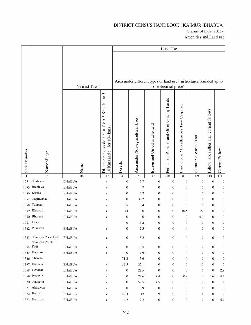
DISTRICT CENSUS HANDBOOK : KAIMUR (BHABUA)
Census of India 2011-
Amenities and Land use
Nam
e
Dis
tance
ran
ge
code
i.e
. a
fo
r <
5 K
ms,
b
for
5-
10 K
ms
and c
f
or
10+
km
s .
Fore
sts
Are
a under
Non-a
gri
cult
ura
l U
ses
Bar
ren a
nd U
n-c
ult
ivab
le l
and
Per
man
ent
Pas
ture
s an
d O
ther
Gra
zing L
ands
Lan
d U
nder
Mis
cell
aneo
us
Tre
e C
rops
etc.
Cult
ura
ble
Was
te L
and
Fal
low
lan
ds
oth
er t
han
curr
ent
fall
ow
s
Curr
ent
Fal
low
s
1 2 102 103 104 105 106 107 108 109 110 111
Ser
ial
Num
ber
Nam
e vil
lage
Area under different types of land use ( in hectares rounded up to
one decimal place)
Land Use
Nearest Town
1354 Sonbarsa BHABUA c 0 3.7 0 0 0 0 0 0
1355 Bichhiya BHABUA c 0 7 0 0 0 0 0 0
1356 Kurtha BHABUA c 0 4.2 0 0 0 0 0 0
1357 Majhiyawan BHABUA c 0 39.2 0 0 0 0 0 0
1358 Tarawan BHABUA c 85 8.4 0 0 0 0 0 0
1359 Kharenda BHABUA c 74 0 0 0 10.5 20 0 0
1360 Bhorean BHABUA c 0 0 0 0 0 5.3 0 0
1361 Lewa 0 13.2 0 0 0 0 0 0
1362 Punawan BHABUA c 0 12.3 0 0 0 0 0 0
1363 Sonawan Purab Patti BHABUA c 0 5.2 0 0 0 0 0 0
1364
Sonawan Pachhim
Patti BHABUA c 0 10.5 0 0 0 0 0 0
1365 Harjipur BHABUA c 0 7.6 0 0 0 0 0 0
1366 Chanela 71.2 5.6 0 0 0 0 0 0
1367 Hunadari BHABUA c 56.5 22.1 0 0 0 0 0 0
1368 Uchanar BHABUA c 0 22.5 0 0 0 0 0 2.9
1369 Panapur BHABUA c 0 27.6 9.4 0 0.8 2 0.6 4.1
1370 Nauhatta BHABUA c 0 52.5 4.5 0 0 0 0 1
1371 Ahirawan BHABUA c 0 29 0 0 0 0 0 0
1372 Hundara BHABUA c 20.4 12 9 0 0 0 0 0
1373 Hundara BHABUA c 4.2 9.2 0 0 0 0 0 5.1
��
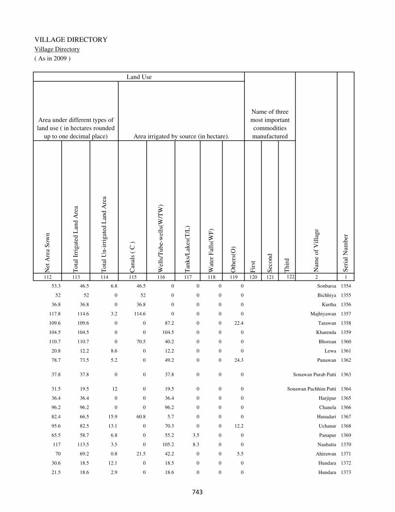
VILLAGE DIRECTORY
Village Directory
( As in 2009 )
Net
Are
a S
ow
n
Tota
l Ir
rigat
ed L
and A
rea
Tota
l U
n-i
rrig
ated
Lan
d A
rea
Can
als
( C
)
Wel
ls/T
ube-
wel
ls(W
/TW
)
Tan
ks/
Lak
es(T
/L)
Wat
er F
alls
(WF
)
Oth
ers(
O)
Fir
st
Sec
ond
Thir
d
112 113 114 115 116 117 118 119 120 121 122 2 1
Ser
ial
Num
ber
Name of three
most important
commodities
manufacturedArea irrigated by source (in hectare).
Nam
e of
Vil
lage
Area under different types of
land use ( in hectares rounded
up to one decimal place)
Land Use
53.3 46.5 6.8 46.5 0 0 0 0 Sonbarsa 1354
52 52 0 52 0 0 0 0 Bichhiya 1355
36.8 36.8 0 36.8 0 0 0 0 Kurtha 1356
117.8 114.6 3.2 114.6 0 0 0 0 Majhiyawan 1357
109.6 109.6 0 0 87.2 0 0 22.4 Tarawan 1358
104.5 104.5 0 0 104.5 0 0 0 Kharenda 1359
110.7 110.7 0 70.5 40.2 0 0 0 Bhorean 1360
20.8 12.2 8.6 0 12.2 0 0 0 Lewa 1361
78.7 73.5 5.2 0 49.2 0 0 24.3 Punawan 1362
37.8 37.8 0 0 37.8 0 0 0 Sonawan Purab Patti 1363
31.5 19.5 12 0 19.5 0 0 0 Sonawan Pachhim Patti 1364
36.4 36.4 0 0 36.4 0 0 0 Harjipur 1365
96.2 96.2 0 0 96.2 0 0 0 Chanela 1366
82.4 66.5 15.9 60.8 5.7 0 0 0 Hunadari 1367
95.6 82.5 13.1 0 70.3 0 0 12.2 Uchanar 1368
65.5 58.7 6.8 0 55.2 3.5 0 0 Panapur 1369
117 113.5 3.5 0 105.2 8.3 0 0 Nauhatta 1370
70 69.2 0.8 21.5 42.2 0 0 5.5 Ahirawan 1371
30.6 18.5 12.1 0 18.5 0 0 0 Hundara 1372
21.5 18.6 2.9 0 18.6 0 0 0 Hundara 1373
��

DISTRICT CENSUS HANDBOOK : KAIMUR (BHABUA)
Census of India 2011-
Amenities and Land use
Pre
-Pri
mar
y s
chool
(PP
)
Pri
mar
y s
chool
(P)
Mid
dle
sch
ool
(M)
Sec
ondar
y S
chool
(S)
Sen
ior
Sec
ondar
y s
chool
(SS
)
Deg
ree
coll
ege
of
arts
sc
ience
& c
om
mer
ce
(AS
C)
Engin
eeri
ng c
oll
ege(
EC
)
Med
ical
coll
ege
(MC
)
Man
agem
ent
inst
itute
(M
I)
Poly
tech
nic
(P
t)
Voca
tional
tra
inin
g s
chool
/IT
I
Non-f
orm
al t
rain
ing c
entr
e (N
FT
C)
Spec
ial
school
for
dis
able
d (
SS
D)
Oth
ers
(spec
ify)
1 2 3 4 5 6 7 8 9 10 11 12 13 14 15 16 17 18 19 20
Loca
tion c
ode
no.
Nam
e vil
lage
Ser
ial
Num
ber
Tota
l popula
tion (
2011 c
ensu
s )
Tota
l ar
ea o
f th
e vil
lage
( in
hec
tare
s ro
unded
up t
o
one
dec
imal
pla
ce)
Number of educational amenities available. (If not available
within the village , the distance range code viz; a for < 5
Kms, b for 5-10 Kms and c for 10+ kms of nearest place
where facility is available is given).
Num
ber
of
house
hold
s (2
011 c
ensu
s)
1374 Hundara 250298 47 0 0
1375 Jagmohna 250299 54 113 21 a a 1 c c c c c c c c c c
1376 Chanki 250300 31 548 89 1 1 a a c c c c c c c c c c
1377 Baheri 250301 163 2533 353 b 1 1 b b c c c c c c c c c
1378 Pachhehra 250302 74 718 115 a 1 a a c c c c c c c c c
1379 Atrauli 250303 36 0 0
1380 Uphrauli 250304 76 245 38 a a a a b b c c c c c c c c
1381 Tulshipur 250305 16 0 0
1382 Lohandi 250306 49 682 92 1 a b a b c c c c c c c c c
1383 Thakurhat 250307 40 692 119 a a a a a a c c c a c c c
1384 Parmalpur 250308 32 0 0
1385 Bijra 250309 124 604 72 a a a b b b c c c c c b c
1386 Jhalkhora 250310 38 454 37 1 2 a a a a c c c c c c c c
1387 Rampur 250311 123 575 94 1 2 1 a a c c c c c c c c c
1388 Sawar 250312 455 4162 682 a 1 1 c b c c c c c c c c c
1389 Arazi Baghi 250313 18 0 0
1390 Bazidpur 250314 17 272 50 a a a a a a c c c c c c c
1391 Baghi 250315 64 658 72 a a a a a a c c c c c c c
1392 Jhali 250316 151 2329 360 1 1 1 a c c c c c c c c c c
1393 Panrepur 250317 44 882 167 1 a a b c c c c c c c c c c
1394 Majhiawan 250318 125 1265 190 1 1 a b b c c c c c c c c c
���

VILLAGE DIRECTORY
Village Directory
( As in 2009 )
Com
munit
y h
ealt
h c
entr
e (C
HC
)
Pri
mar
y h
ealt
h c
entr
e (P
HC
)
Pri
mar
y h
ealt
h s
ub c
entr
e (P
HS
)
Mat
ernit
y a
nd c
hil
d w
elfa
re c
entr
e (M
CW
)
T.B
. cl
inic
(T
BC
)
Hosp
ital
-all
opat
hic
(H
A)
Hosp
ital
-alt
ernat
ive
med
icin
e (H
O)
Dis
pen
sary
(D
)
Vet
erin
ary h
osp
ital
(V
H)
Mobil
e hea
lth c
linic
(M
HC
)
Fam
ily w
elfa
re c
entr
e (F
WC
)
Char
itab
le n
on G
ovt.
hosp
ital
/Nurs
ing h
om
e.
Med
ical
pra
ctit
ioner
wit
h M
BB
S D
egre
e
Med
ical
pra
ctit
ioner
wit
h o
ther
deg
ree
Med
ical
pra
ctit
ioner
wit
h n
o d
egre
e
Tra
dit
ional
pra
ctit
ioner
an
d f
aith
hea
ler
.
Med
icin
e S
hop
Oth
ers
21 22 23 24 25 26 27 28 29 30 31 32 33 34 35 36 37 38 2 1
Number of Non-Government
Medical Amenities available.
Number of Medical Amenities available. (If not
available within the village , the distance range
code viz; a for < 5 Kms, b for 5-10 Kms and c
for 10+ kms of nearest place where facility is
available is given).
Nam
e vil
lage
Ser
ial
Num
ber
Hundara 1374
b b b b a c c b b c c 0 0 0 0 0 0 0 Jagmohna 1375
b b b b b c c a a c a 0 0 0 0 0 0 0 Chanki 1376
c b b b c c c b b c b 2 2 2 2 2 2 2 Baheri 1377
c b b a c c c c c c c 0 0 0 0 0 0 0 Pachhehra 1378
Atrauli 1379
b b a b b c c c c c c 0 0 0 0 0 0 0 Uphrauli 1380
Tulshipur 1381
c b a c c c c c c c c 0 0 0 0 0 0 0 Lohandi 1382
b 1 1 1 1 c c 1 1 c 1 0 0 1 0 0 0 0 Thakurhat 1383
Parmalpur 1384
a b a b b c c a c c c 0 0 0 0 0 0 0 Bijra 1385
b b b b b c c c c c c 0 0 0 0 0 0 0 Jhalkhora 1386
b 1 1 1 1 c c 1 1 c 1 0 0 0 0 0 0 0 Rampur 1387
c c 1 1 b c c b b c 1 0 0 0 0 0 0 0 Sawar 1388
Arazi Baghi 1389
b a a b b c c c c c c 0 0 0 0 0 0 0 Bazidpur 1390
b a b b b c c c c c c 0 0 0 0 0 0 0 Baghi 1391
c c b b b c c b b c a 2 2 2 2 2 2 0 Jhali 1392
c b a c c c c b b c b 2 2 2 2 2 2 2 Panrepur 1393
c b a c c c c b b c b 0 0 2 2 2 2 2 Majhiawan 1394
���

DISTRICT CENSUS HANDBOOK : KAIMUR (BHABUA)
Census of India 2011-
Amenities and Land use
Tap
wat
er (
Tre
ated
/Untr
eate
d)
Wel
l w
ater
(Cover
ed /
Unco
ver
ed w
ell)
Han
d P
um
p
Tube
wel
ls /
Bore
wel
l
Spri
ng
Riv
er /
Can
al
Tan
k /
Pond /
L
ake
Oth
ers
Com
munit
y t
oil
et i
ncl
udin
g
bat
h.
Com
munit
y t
oil
et e
xcl
udin
g b
ath.
Rura
l s
anit
ary m
art
or
sanit
ary
har
dw
are
outl
et
avai
lable
nea
r th
e vil
lage.
Com
munit
y b
io-
gas
or
recy
cle
of
was
te f
or
pro
duct
ive
use
.
1 2 39 40 41 42 43 44 45 46 47 48 49 50
Availability of toilet & others
Yes / No Availability of drinking water - Yes / No
Nam
e vil
lage
Ser
ial
Num
ber
1374 Hundara
1375 Jagmohna No Yes Yes No No No No No No No No No
1376 Chanki No Yes Yes No Yes No No No No No No No
1377 Baheri No Yes Yes No No No No No Yes No No No
1378 Pachhehra No Yes Yes No No No Yes Yes No No No No
1379 Atrauli
1380 Uphrauli No Yes Yes No No No Yes No Yes No No No
1381 Tulshipur
1382 Lohandi No Yes Yes No No No No No Yes No No No
1383 Thakurhat No Yes Yes No No Yes No No No No No No
1384 Parmalpur
1385 Bijra No No Yes No No Yes No Yes Yes Yes No No
1386 Jhalkhora No No Yes No No Yes No Yes Yes No No No
1387 Rampur No No Yes Yes No No No Yes Yes No No No
1388 Sawar No Yes Yes No No Yes No No No No No No
1389 Arazi Baghi
1390 Bazidpur No Yes Yes No No No No Yes Yes No No No
1391 Baghi No No Yes Yes No No No Yes No No No No
1392 Jhali No Yes Yes No No No No No Yes No No No
1393 Panrepur No Yes Yes No No No No No No No No No
1394 Majhiawan No Yes Yes No No No No No No No No No
���
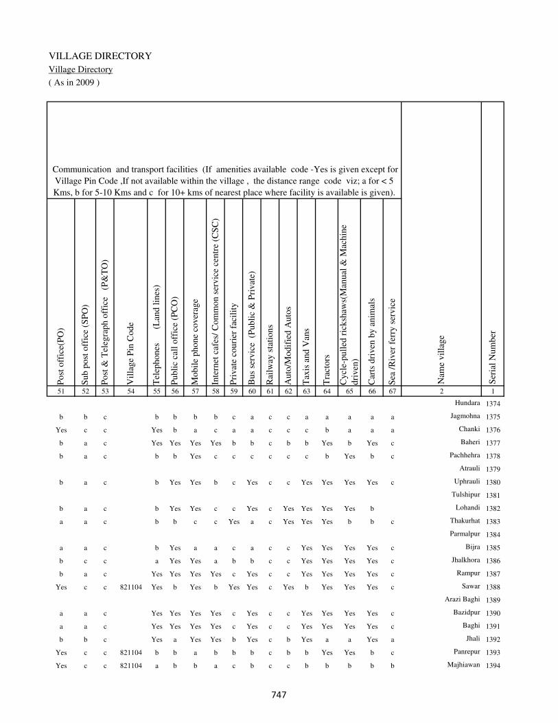
VILLAGE DIRECTORY
Village Directory
( As in 2009 )
Post
off
ice(
PO
)
Sub p
ost
off
ice
(SP
O)
Post
& T
eleg
raph o
ffic
e
(P&
TO
)
Vil
lage
Pin
Code
Tel
ephones
(L
and l
ines
)
Publi
c ca
ll o
ffic
e (P
CO
)
Mobil
e phone
cover
age
Inte
rnet
caf
es/
Com
mon s
ervic
e ce
ntr
e (C
SC
)
Pri
vat
e co
uri
er f
acil
ity
Bus
serv
ice
(P
ubli
c &
Pri
vat
e)
Rai
lway
sta
tions
Auto
/Modif
ied A
uto
s
Tax
is a
nd V
ans
Tra
ctors
Cycl
e-pull
ed r
icksh
aws(
Man
ual
& M
achin
e
dri
ven
)
Car
ts d
riven
by a
nim
als
Sea
/R
iver
fer
ry s
ervic
e51 52 53 54 55 56 57 58 59 60 61 62 63 64 65 66 67 2 1
Communication and transport facilities (If amenities available code -Yes is given except for
Village Pin Code ,If not available within the village , the distance range code viz; a for < 5
Kms, b for 5-10 Kms and c for 10+ kms of nearest place where facility is available is given).
Ser
ial
Num
ber
Nam
e vil
lage
Hundara 1374
b b c b b b b c a c c a a a a a Jagmohna 1375
Yes c c Yes b a c a a c c c b a a a Chanki 1376
b a c Yes Yes Yes Yes b b c b b Yes b Yes c Baheri 1377
b a c b b Yes c c c c c c b Yes b c Pachhehra 1378
Atrauli 1379
b a c b Yes Yes b c Yes c c Yes Yes Yes Yes c Uphrauli 1380
Tulshipur 1381
b a c b Yes Yes c c Yes c Yes Yes Yes Yes b Lohandi 1382
a a c b b c c Yes a c Yes Yes Yes b b c Thakurhat 1383
Parmalpur 1384
a a c b Yes a a c a c c Yes Yes Yes Yes c Bijra 1385
b c c a Yes Yes a b b c c Yes Yes Yes Yes c Jhalkhora 1386
b a c Yes Yes Yes Yes c Yes c c Yes Yes Yes Yes c Rampur 1387
Yes c c 821104 Yes b Yes b Yes Yes c Yes b Yes Yes Yes c Sawar 1388
Arazi Baghi 1389
a a c Yes Yes Yes Yes c Yes c c Yes Yes Yes Yes c Bazidpur 1390
a a c Yes Yes Yes Yes c Yes c c Yes Yes Yes Yes c Baghi 1391
b b c Yes a Yes Yes b Yes c b Yes a a Yes a Jhali 1392
Yes c c 821104 b b a b b b c b b Yes Yes b c Panrepur 1393
Yes c c 821104 a b b a c b c c b b b b b Majhiawan 1394
���

DISTRICT CENSUS HANDBOOK : KAIMUR (BHABUA)
Census of India 2011-
Amenities and Land use
Connec
ted t
o n
atio
nal
hig
hw
ay(N
H)
Connec
ted t
o s
tate
hig
hw
ay(S
H)
Connec
ted t
o m
ajor
dis
tric
t ro
ad (
MD
R)
Connec
ted t
o o
ther
s dis
tric
t ro
ad
Pucc
a r
oad
s
Kutc
hch
a r
oad
s
Wat
er b
ounded
mac
adam
(WB
M)
road
s
Nav
igab
le w
ater
way
(ri
ver
/can
al)(
NW
)
Footp
aths
(FP
)
Com
mer
cial
& C
o-o
per
ativ
e B
anks
AT
M
Agri
cult
ura
l C
redit
Soci
etie
s
Sel
f-H
elp G
roup (
SH
G)
Publi
c dis
trib
uti
on s
yst
em (
PD
S)
shop
Man
dis
/ R
egula
r m
arket
Wee
kly
Haa
t
Agri
cult
ura
l m
arket
ing s
oci
ety
1 2 68 69 70 71 72 73 74 75 76 77 78 79 80 81 82 83 84
Village connected to highways,village roads, banks & credit
societies (If amenities available code -Yes is given, If not
available within the village , the distance range code viz; a
for < 5 Kms, b for 5-10 Kms and c for 10+ kms of nearest
place where facility is available is given).
Ser
ial
Num
ber
Nam
e vil
lage
Availability of miscellaneous
facilities (If amenities available
code -Yes is given, If not
available within the village , the
distance range code viz; a for <
5 Kms, b for 5-10 Kms and c
for 10+ kms of nearest place
where facility is available is
given) Contd....
1374 Hundara
1375 Jagmohna c c c c Yes a a a Yes a a c b Yes Yes Yes c
1376 Chanki c b c c Yes Yes a a Yes b b b Yes a Yes b b
1377 Baheri c Yes Yes Yes Yes Yes Yes a Yes b b c Yes Yes Yes c b
1378 Pachhehra c c c c Yes Yes a b Yes a a c b b Yes b b
1379 Atrauli
1380 Uphrauli c c Yes Yes a Yes Yes b Yes b b c Yes c b Yes c
1381 Tulshipur
1382 Lohandi c Yes Yes Yes Yes Yes Yes b Yes c c b Yes Yes b b c
1383 Thakurhat Yes Yes Yes Yes Yes Yes Yes Yes Yes Yes c c Yes Yes b b c
1384 Parmalpur
1385 Bijra c c Yes Yes Yes Yes a b Yes c c c Yes a Yes b c
1386 Jhalkhora c c Yes Yes Yes Yes Yes a Yes b c c a b b b c
1387 Rampur c c Yes Yes Yes Yes Yes b Yes c c b b Yes b b b
1388 Sawar c Yes Yes Yes Yes Yes Yes Yes Yes Yes b Yes b a Yes b b
1389 Arazi Baghi
1390 Bazidpur Yes Yes Yes Yes Yes Yes Yes b Yes c Yes Yes b a a a c
1391 Baghi c c Yes Yes Yes Yes Yes a Yes a a b Yes a a a a
1392 Jhali c Yes Yes Yes Yes Yes Yes b Yes a b c Yes a b b c
1393 Panrepur c b Yes Yes Yes Yes a b Yes a b c Yes Yes b b c
1394 Majhiawan c b b a Yes Yes Yes Yes Yes a c c b Yes Yes Yes b
���

VILLAGE DIRECTORY
Village Directory
( As in 2009 )
Inte
gra
ted C
hil
d D
evel
opm
ent
Sch
eme
(Nutr
itio
nal
Cen
tres
)
Angan
wad
i C
entr
e (N
utr
itio
nal
Cen
tres
)
Oth
ers
(Nutr
itio
nal
Cen
tres
)
AS
HA
(A
ccre
dit
ed S
oci
al H
ealt
h A
ctiv
ist)
Com
munit
y c
entr
e w
ith/w
ithout
TV
Sport
s F
ield
,
Sport
s C
lub /
Rec
reat
ion C
entr
e
Cin
ema
/ V
ideo
Hal
l
Publi
c L
ibra
ry
Publi
c R
eadin
g R
oom
New
spap
er S
upply
Ass
embly
Poll
ing s
tati
on
Bir
th &
Dea
th R
egis
trat
ion O
ffic
e
Pow
er S
upply
for
Dom
esti
c U
se (
ED
)
Pow
er S
upply
for
Agri
cult
ura
l U
se (
EA
G)
Pow
er S
upply
for
Com
mer
cial
Use
(E
C)
Pow
er S
upply
for
All
Use
s (E
A)
85 86 87 88 89 90 91 92 93 94 95 96 97 98 99 100 101 2 1
Availability of
electricity (Yes/No)
Availability of miscellaneous facilities (If amenities available code -
Yes is given, If not available within the village , the distance range
code viz; a for < 5 Kms, b for 5-10 Kms and c for 10+ kms of
nearest place where facility is available is given) Concluded
Nam
e vil
lage
Ser
ial
Num
ber
Hundara 1374
b b Yes b c c c c c c a a b No No No No Jagmohna 1375
b Yes Yes b c Yes c c c c b a b No No No No Chanki 1376
a Yes b b b c a c c b b Yes b No No No No Baheri 1377
b b Yes b c c c c a a a a b Yes No No No Pachhehra 1378
Atrauli 1379
b b c b c c c c a c a a a No No No No Uphrauli 1380
Tulshipur 1381
b b Yes a c c c c c c a a b No No No No Lohandi 1382
b Yes c a c c c c c c b a b No No No No Thakurhat 1383
Parmalpur 1384
b b c Yes Yes c b c c c b a b No No No No Bijra 1385
b Yes a b c c c c c c b a a No No No No Jhalkhora 1386
Yes Yes Yes b c c c c c c a a a No No No No Rampur 1387
a Yes a Yes Yes c c c b c Yes Yes b No No No No Sawar 1388
Arazi Baghi 1389
b b b b c c c c a c b a a No No No No Bazidpur 1390
b a a Yes Yes c c c c c a a a No No No No Baghi 1391
b Yes a b b c c c c b b Yes a Yes No No No Jhali 1392
b b a b b c c c c b a a b No No No No Panrepur 1393
b a a b c b c c c c b a b No No No No Majhiawan 1394
���

DISTRICT CENSUS HANDBOOK : KAIMUR (BHABUA)
Census of India 2011-
Amenities and Land use
Nam
e
Dis
tance
ran
ge
code
i.e
. a
fo
r <
5 K
ms,
b
for
5-
10 K
ms
and c
f
or
10+
km
s .
Fore
sts
Are
a under
Non-a
gri
cult
ura
l U
ses
Bar
ren a
nd U
n-c
ult
ivab
le l
and
Per
man
ent
Pas
ture
s an
d O
ther
Gra
zing L
ands
Lan
d U
nder
Mis
cell
aneo
us
Tre
e C
rops
etc.
Cult
ura
ble
Was
te L
and
Fal
low
lan
ds
oth
er t
han
curr
ent
fall
ow
s
Curr
ent
Fal
low
s
1 2 102 103 104 105 106 107 108 109 110 111
Ser
ial
Num
ber
Nam
e vil
lage
Area under different types of land use ( in hectares rounded up to
one decimal place)
Land Use
Nearest Town
1374 Hundara 3 10.2 0 0 0 0 0 0
1375 Jagmohna BHABUA c 0 8 0 0 0 0 0 0
1376 Chanki BHABUA c 0 5.5 0 0 0 0 0 0
1377 Baheri BHABUA c 0 32.3 8 0 0 0 0 0
1378 Pachhehra BHABUA c 9 34.2 0 0 0 0 0 0.8
1379 Atrauli 0 4.4 0 0 0 0 0 0
1380 Uphrauli BHABUA c 0 18.5 4.5 4.5 0 0 0 4.5
1381 Tulshipur 0 0.8 0 0 0 0 0 0.3
1382 Lohandi BHABUA c 0 6.4 5.6 0 0 0 0 1.2
1383 Thakurhat BHABUA c 0 9 0 3.5 0 0 0 0
1384 Parmalpur 0 4.9 0 0 0 0 0 0
1385 Bijra BHABUA c 0 31.2 0 0 0 0 2 2
1386 Jhalkhora BHABUA c 0 5.2 0 0 0 0 0 1.2
1387 Rampur BHABUA c 0 13 0 0 0 0 0 0.5
1388 Sawar BHABUA c 0 30.2 10.2 0 0 0 0 0
1389 Arazi Baghi 0 0 0 0 0 0 0 0
1390 Bazidpur BHABUA c 0 0 0 0 0.3 1.5 1.5 1.5
1391 Baghi BHABUA c 0 20.5 2 0 0 0 0 0
1392 Jhali BHABUA c 0 4.2 6.2 6 0 0 0 0
1393 Panrepur BHABUA c 0 0.8 1.6 2 0 0 0 0
1394 Majhiawan BHABUA c 0 2.4 0 0 0 0 0 0
���

VILLAGE DIRECTORY
Village Directory
( As in 2009 )
Net
Are
a S
ow
n
Tota
l Ir
rigat
ed L
and A
rea
Tota
l U
n-i
rrig
ated
Lan
d A
rea
Can
als
( C
)
Wel
ls/T
ube-
wel
ls(W
/TW
)
Tan
ks/
Lak
es(T
/L)
Wat
er F
alls
(WF
)
Oth
ers(
O)
Fir
st
Sec
ond
Thir
d
112 113 114 115 116 117 118 119 120 121 122 2 1
Ser
ial
Num
ber
Name of three
most important
commodities
manufacturedArea irrigated by source (in hectare).
Nam
e of
Vil
lage
Area under different types of
land use ( in hectares rounded
up to one decimal place)
Land Use
33.8 29.6 4.2 0 26.8 0 0 2.8 Hundara 1374
46 45.3 0.7 0 45.3 0 0 0 Jagmohna 1375
25.5 17.2 8.3 0 17.2 0 0 0 Chanki 1376
122.7 42.5 80.2 0 42.5 0 0 0 Baheri 1377
30 29.8 0.2 20.2 9.6 0 0 0 Pachhehra 1378
31.6 20.2 11.4 20.2 0 0 0 0 Atrauli 1379
44 42.8 1.2 0 42.8 0 0 0 Uphrauli 1380
14.9 14.1 0.8 14.1 0 0 0 0 Tulshipur 1381
35.8 25.8 10 0 25.8 0 0 0 Lohandi 1382
27.5 27 0.5 27 0 0 0 0 Thakurhat 1383
27.1 26.8 0.3 22.3 4.5 0 0 0 Parmalpur 1384
88.8 50.3 38.5 43.5 6.8 0 0 0 Bijra 1385
31.6 30.6 1 30.6 0 0 0 0 Jhalkhora 1386
109.5 107.5 2 95.2 12.3 0 0 0 Rampur 1387
414.6 129.4 285.2 40.2 42.4 0 0 46.8 Sawar 1388
18 17.8 0.2 12.3 5.5 0 0 0 Arazi Baghi 1389
12.2 11.2 1 0 8.7 2.5 0 0 Bazidpur 1390
41.5 39.8 1.7 0 36.2 3.6 0 0 Baghi 1391
134.6 80.4 54.2 0 40.2 0 0 40.2 Jhali 1392
39.6 20.4 19.2 0 10.2 0 0 10.2 Panrepur 1393
122.6 70.5 52.1 0 58.2 0 0 12.3 Majhiawan 1394
���
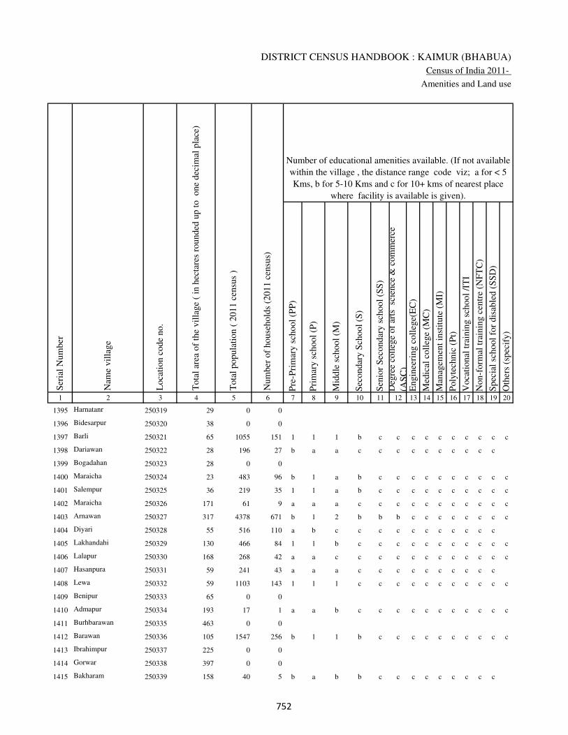
DISTRICT CENSUS HANDBOOK : KAIMUR (BHABUA)
Census of India 2011-
Amenities and Land use
Pre
-Pri
mar
y s
chool
(PP
)
Pri
mar
y s
chool
(P)
Mid
dle
sch
ool
(M)
Sec
ondar
y S
chool
(S)
Sen
ior
Sec
ondar
y s
chool
(SS
)
Deg
ree
coll
ege
of
arts
sc
ience
& c
om
mer
ce
(AS
C)
Engin
eeri
ng c
oll
ege(
EC
)
Med
ical
coll
ege
(MC
)
Man
agem
ent
inst
itute
(M
I)
Poly
tech
nic
(P
t)
Voca
tional
tra
inin
g s
chool
/IT
I
Non-f
orm
al t
rain
ing c
entr
e (N
FT
C)
Spec
ial
school
for
dis
able
d (
SS
D)
Oth
ers
(spec
ify)
1 2 3 4 5 6 7 8 9 10 11 12 13 14 15 16 17 18 19 20
Loca
tion c
ode
no.
Nam
e vil
lage
Ser
ial
Num
ber
Tota
l popula
tion (
2011 c
ensu
s )
Tota
l ar
ea o
f th
e vil
lage
( in
hec
tare
s ro
unded
up t
o
one
dec
imal
pla
ce)
Number of educational amenities available. (If not available
within the village , the distance range code viz; a for < 5
Kms, b for 5-10 Kms and c for 10+ kms of nearest place
where facility is available is given).
Num
ber
of
house
hold
s (2
011 c
ensu
s)
1395 Harnatanr 250319 29 0 0
1396 Bidesarpur 250320 38 0 0
1397 Barli 250321 65 1055 151 1 1 1 b c c c c c c c c c c
1398 Dariawan 250322 28 196 27 b a a c c c c c c c c c c
1399 Bogadahan 250323 28 0 0
1400 Maraicha 250324 23 483 96 b 1 a b c c c c c c c c c c
1401 Salempur 250325 36 219 35 1 1 a b c c c c c c c c c c
1402 Maraicha 250326 171 61 9 a a a c c c c c c c c c c c
1403 Arnawan 250327 317 4378 671 b 1 2 b b b c c c c c c c c
1404 Diyari 250328 55 516 110 a b c c c c c c c c c c c
1405 Lakhandahi 250329 130 466 84 1 1 b c c c c c c c c c c c
1406 Lalapur 250330 168 268 42 a a c c c c c c c c c c c c
1407 Hasanpura 250331 59 241 43 a a a c c c c c c c c c c
1408 Lewa 250332 59 1103 143 1 1 1 c c c c c c c c c c c
1409 Benipur 250333 65 0 0
1410 Admapur 250334 193 17 1 a a b c c c c c c c c c c c
1411 Burhbarawan 250335 463 0 0
1412 Barawan 250336 105 1547 256 b 1 1 b c c c c c c c c c c
1413 Ibrahimpur 250337 225 0 0
1414 Gorwar 250338 397 0 0
1415 Bakharam 250339 158 40 5 b a b b c c c c c c c c c
��
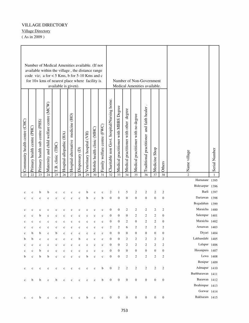
VILLAGE DIRECTORY
Village Directory
( As in 2009 )
Com
munit
y h
ealt
h c
entr
e (C
HC
)
Pri
mar
y h
ealt
h c
entr
e (P
HC
)
Pri
mar
y h
ealt
h s
ub c
entr
e (P
HS
)
Mat
ernit
y a
nd c
hil
d w
elfa
re c
entr
e (M
CW
)
T.B
. cl
inic
(T
BC
)
Hosp
ital
-all
opat
hic
(H
A)
Hosp
ital
-alt
ernat
ive
med
icin
e (H
O)
Dis
pen
sary
(D
)
Vet
erin
ary h
osp
ital
(V
H)
Mobil
e hea
lth c
linic
(M
HC
)
Fam
ily w
elfa
re c
entr
e (F
WC
)
Char
itab
le n
on G
ovt.
hosp
ital
/Nurs
ing h
om
e.
Med
ical
pra
ctit
ioner
wit
h M
BB
S D
egre
e
Med
ical
pra
ctit
ioner
wit
h o
ther
deg
ree
Med
ical
pra
ctit
ioner
wit
h n
o d
egre
e
Tra
dit
ional
pra
ctit
ioner
an
d f
aith
hea
ler
.
Med
icin
e S
hop
Oth
ers
21 22 23 24 25 26 27 28 29 30 31 32 33 34 35 36 37 38 2 1
Number of Non-Government
Medical Amenities available.
Number of Medical Amenities available. (If not
available within the village , the distance range
code viz; a for < 5 Kms, b for 5-10 Kms and c
for 10+ kms of nearest place where facility is
available is given).
Nam
e vil
lage
Ser
ial
Num
ber
Harnatanr 1395
Bidesarpur 1396
c c b b c c c c b c c 2 1 5 2 2 2 2 Barli 1397
c c c c c c c c b c b 0 0 0 0 0 0 0 Dariawan 1398
Bogadahan 1399
c c c c c c c c c c c 0 0 2 2 2 2 2 Maraicha 1400
c c b c c c c c c c c 0 0 0 2 2 2 0 Salempur 1401
c c c c c c c c c c c 0 0 2 0 2 2 0 Maraicha 1402
c c c c c c c c c c c 2 2 6 2 2 2 2 Arnawan 1403
c b b c b c c c c c c 0 0 0 0 0 0 0 Diyari 1404
b b c c c c c b c c c 0 0 2 2 2 2 2 Lakhandahi 1405
c c c c c c c c c c c 0 0 2 2 2 2 2 Lalapur 1406
c c b c c c c c c c c 0 0 0 0 0 0 0 Hasanpura 1407
b c b b c c c c b c c 0 0 2 2 2 2 2 Lewa 1408
Benipur 1409
c c c c c c c c c c b 0 2 2 2 2 2 2 Admapur 1410
Burhbarawan 1411
c b b c b c c c c c b 0 0 0 0 0 0 0 Barawan 1412
Ibrahimpur 1413
Gorwar 1414
c c b c c c c c b c c 0 0 0 0 0 0 0 Bakharam 1415
��
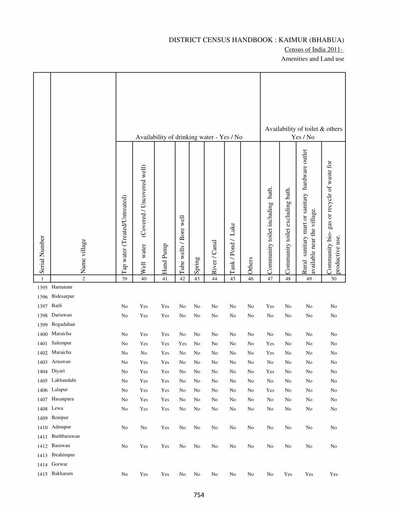
DISTRICT CENSUS HANDBOOK : KAIMUR (BHABUA)
Census of India 2011-
Amenities and Land use
Tap
wat
er (
Tre
ated
/Untr
eate
d)
Wel
l w
ater
(Cover
ed /
Unco
ver
ed w
ell)
Han
d P
um
p
Tube
wel
ls /
Bore
wel
l
Spri
ng
Riv
er /
Can
al
Tan
k /
Pond /
L
ake
Oth
ers
Com
munit
y t
oil
et i
ncl
udin
g
bat
h.
Com
munit
y t
oil
et e
xcl
udin
g b
ath.
Rura
l s
anit
ary m
art
or
sanit
ary
har
dw
are
outl
et
avai
lable
nea
r th
e vil
lage.
Com
munit
y b
io-
gas
or
recy
cle
of
was
te f
or
pro
duct
ive
use
.
1 2 39 40 41 42 43 44 45 46 47 48 49 50
Availability of toilet & others
Yes / No Availability of drinking water - Yes / No
Nam
e vil
lage
Ser
ial
Num
ber
1395 Harnatanr
1396 Bidesarpur
1397 Barli No Yes Yes No No No No No Yes No No No
1398 Dariawan No Yes Yes No No No No No No No No No
1399 Bogadahan
1400 Maraicha No Yes Yes No No No No No No No No No
1401 Salempur No Yes Yes Yes No No No No Yes No No No
1402 Maraicha No No Yes No No No No No Yes No No No
1403 Arnawan No Yes Yes No No No No No No No No No
1404 Diyari No Yes Yes No No No No No Yes No No No
1405 Lakhandahi No Yes Yes No No No No No No No No No
1406 Lalapur No Yes Yes No No No No No Yes No No No
1407 Hasanpura No Yes Yes No No No No No No No No No
1408 Lewa No Yes Yes No No No No No No No No No
1409 Benipur
1410 Admapur No No Yes No No No No No No No No No
1411 Burhbarawan
1412 Barawan No Yes Yes No No No No No No No No No
1413 Ibrahimpur
1414 Gorwar
1415 Bakharam No Yes Yes No No No No No No Yes Yes Yes
���
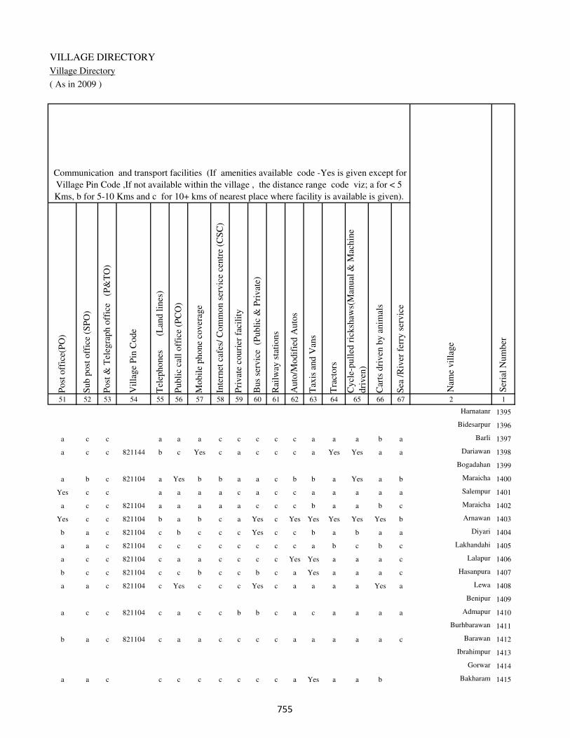
VILLAGE DIRECTORY
Village Directory
( As in 2009 )
Post
off
ice(
PO
)
Sub p
ost
off
ice
(SP
O)
Post
& T
eleg
raph o
ffic
e
(P&
TO
)
Vil
lage
Pin
Code
Tel
ephones
(L
and l
ines
)
Publi
c ca
ll o
ffic
e (P
CO
)
Mobil
e phone
cover
age
Inte
rnet
caf
es/
Com
mon s
ervic
e ce
ntr
e (C
SC
)
Pri
vat
e co
uri
er f
acil
ity
Bus
serv
ice
(P
ubli
c &
Pri
vat
e)
Rai
lway
sta
tions
Auto
/Modif
ied A
uto
s
Tax
is a
nd V
ans
Tra
ctors
Cycl
e-pull
ed r
icksh
aws(
Man
ual
& M
achin
e
dri
ven
)
Car
ts d
riven
by a
nim
als
Sea
/R
iver
fer
ry s
ervic
e51 52 53 54 55 56 57 58 59 60 61 62 63 64 65 66 67 2 1
Communication and transport facilities (If amenities available code -Yes is given except for
Village Pin Code ,If not available within the village , the distance range code viz; a for < 5
Kms, b for 5-10 Kms and c for 10+ kms of nearest place where facility is available is given).
Ser
ial
Num
ber
Nam
e vil
lage
Harnatanr 1395
Bidesarpur 1396
a c c a a a c c c c c a a a b a Barli 1397
a c c 821144 b c Yes c a c c c a Yes Yes a a Dariawan 1398
Bogadahan 1399
a b c 821104 a Yes b b a a c b b a Yes a b Maraicha 1400
Yes c c a a a a c a c c a a a a a Salempur 1401
a c c 821104 a a a a a c c c b a a b c Maraicha 1402
Yes c c 821104 b a b c a Yes c Yes Yes Yes Yes Yes b Arnawan 1403
b a c 821104 c b c c c Yes c c b a b a a Diyari 1404
a a c 821104 c c c c c c c c a b c b c Lakhandahi 1405
a c c 821104 c a a c c c c Yes Yes a a a c Lalapur 1406
b c c 821104 c c b c c b c a Yes a a a c Hasanpura 1407
a a c 821104 c Yes c c c Yes c a a a a Yes a Lewa 1408
Benipur 1409
a c c 821104 c a c c b b c a c a a a a Admapur 1410
Burhbarawan 1411
b a c 821104 c a a c c c c a a a a a c Barawan 1412
Ibrahimpur 1413
Gorwar 1414
a a c c c c c c c c a Yes a a b Bakharam 1415
���

DISTRICT CENSUS HANDBOOK : KAIMUR (BHABUA)
Census of India 2011-
Amenities and Land use
Connec
ted t
o n
atio
nal
hig
hw
ay(N
H)
Connec
ted t
o s
tate
hig
hw
ay(S
H)
Connec
ted t
o m
ajor
dis
tric
t ro
ad (
MD
R)
Connec
ted t
o o
ther
s dis
tric
t ro
ad
Pucc
a r
oad
s
Kutc
hch
a r
oad
s
Wat
er b
ounded
mac
adam
(WB
M)
road
s
Nav
igab
le w
ater
way
(ri
ver
/can
al)(
NW
)
Footp
aths
(FP
)
Com
mer
cial
& C
o-o
per
ativ
e B
anks
AT
M
Agri
cult
ura
l C
redit
Soci
etie
s
Sel
f-H
elp G
roup (
SH
G)
Publi
c dis
trib
uti
on s
yst
em (
PD
S)
shop
Man
dis
/ R
egula
r m
arket
Wee
kly
Haa
t
Agri
cult
ura
l m
arket
ing s
oci
ety
1 2 68 69 70 71 72 73 74 75 76 77 78 79 80 81 82 83 84
Village connected to highways,village roads, banks & credit
societies (If amenities available code -Yes is given, If not
available within the village , the distance range code viz; a
for < 5 Kms, b for 5-10 Kms and c for 10+ kms of nearest
place where facility is available is given).
Ser
ial
Num
ber
Nam
e vil
lage
Availability of miscellaneous
facilities (If amenities available
code -Yes is given, If not
available within the village , the
distance range code viz; a for <
5 Kms, b for 5-10 Kms and c
for 10+ kms of nearest place
where facility is available is
given) Contd....
1395 Harnatanr
1396 Bidesarpur
1397 Barli c c c a Yes Yes a a Yes a c a b Yes b a a
1398 Dariawan c c c c Yes Yes a a Yes a c a b a b b b
1399 Bogadahan
1400 Maraicha c c c b Yes Yes a b Yes b b Yes b b c b b
1401 Salempur c c b c Yes Yes a a Yes b b a Yes Yes c b c
1402 Maraicha c c b a a a a a Yes a a a b b b a b
1403 Arnawan c c c a Yes Yes Yes a Yes Yes Yes b Yes Yes b c a
1404 Diyari c c c b Yes Yes a a Yes c b c b Yes b b a
1405 Lakhandahi c c c b Yes Yes Yes b Yes c c c b b c a c
1406 Lalapur c c c c Yes Yes Yes b Yes a c c a b b b b
1407 Hasanpura c c c a Yes Yes a a Yes a Yes c b Yes b a b
1408 Lewa c c c c Yes Yes a a Yes b a b b Yes c a c
1409 Benipur
1410 Admapur c c c c a a a b Yes a a c b a c a c
1411 Burhbarawan
1412 Barawan c c c c Yes Yes Yes a Yes b Yes b b Yes b b c
1413 Ibrahimpur
1414 Gorwar
1415 Bakharam c c c c Yes Yes a b Yes a a c b Yes c b c
���

VILLAGE DIRECTORY
Village Directory
( As in 2009 )
Inte
gra
ted C
hil
d D
evel
opm
ent
Sch
eme
(Nutr
itio
nal
Cen
tres
)
Angan
wad
i C
entr
e (N
utr
itio
nal
Cen
tres
)
Oth
ers
(Nutr
itio
nal
Cen
tres
)
AS
HA
(A
ccre
dit
ed S
oci
al H
ealt
h A
ctiv
ist)
Com
munit
y c
entr
e w
ith/w
ithout
TV
Sport
s F
ield
,
Sport
s C
lub /
Rec
reat
ion C
entr
e
Cin
ema
/ V
ideo
Hal
l
Publi
c L
ibra
ry
Publi
c R
eadin
g R
oom
New
spap
er S
upply
Ass
embly
Poll
ing s
tati
on
Bir
th &
Dea
th R
egis
trat
ion O
ffic
e
Pow
er S
upply
for
Dom
esti
c U
se (
ED
)
Pow
er S
upply
for
Agri
cult
ura
l U
se (
EA
G)
Pow
er S
upply
for
Com
mer
cial
Use
(E
C)
Pow
er S
upply
for
All
Use
s (E
A)
85 86 87 88 89 90 91 92 93 94 95 96 97 98 99 100 101 2 1
Availability of
electricity (Yes/No)
Availability of miscellaneous facilities (If amenities available code -
Yes is given, If not available within the village , the distance range
code viz; a for < 5 Kms, b for 5-10 Kms and c for 10+ kms of
nearest place where facility is available is given) Concluded
Nam
e vil
lage
Ser
ial
Num
ber
Harnatanr 1395
Bidesarpur 1396
b b c b b Yes c c c c b a a No No No No Barli 1397
c a b b b c c c c b b a b No No No No Dariawan 1398
Bogadahan 1399
c b Yes a b c c c a c b a b No No No No Maraicha 1400
c a c b c c c c b c c a b No No No No Salempur 1401
b b a b b c c c c c c a a No No No No Maraicha 1402
b Yes Yes Yes c c c c c c Yes Yes a No No No No Arnawan 1403
b b Yes b c b c c c c c a b No Yes No No Diyari 1404
b b c b c c c c c c c a a No No No No Lakhandahi 1405
c b a a c c c c c c c a b No No No No Lalapur 1406
c b c a c c b c c c c a b No No No No Hasanpura 1407
b b a a Yes c c c c c c a b No No No No Lewa 1408
Benipur 1409
c b a a b c c c c c c a b No No No No Admapur 1410
Burhbarawan 1411
b Yes Yes b a c c c c a c a b No No No No Barawan 1412
Ibrahimpur 1413
Gorwar 1414
c b c b b c c c a c c a b No No No No Bakharam 1415
���

DISTRICT CENSUS HANDBOOK : KAIMUR (BHABUA)
Census of India 2011-
Amenities and Land use
Nam
e
Dis
tance
ran
ge
code
i.e
. a
fo
r <
5 K
ms,
b
for
5-
10 K
ms
and c
f
or
10+
km
s .
Fore
sts
Are
a under
Non-a
gri
cult
ura
l U
ses
Bar
ren a
nd U
n-c
ult
ivab
le l
and
Per
man
ent
Pas
ture
s an
d O
ther
Gra
zing L
ands
Lan
d U
nder
Mis
cell
aneo
us
Tre
e C
rops
etc.
Cult
ura
ble
Was
te L
and
Fal
low
lan
ds
oth
er t
han
curr
ent
fall
ow
s
Curr
ent
Fal
low
s
1 2 102 103 104 105 106 107 108 109 110 111
Ser
ial
Num
ber
Nam
e vil
lage
Area under different types of land use ( in hectares rounded up to
one decimal place)
Land Use
Nearest Town
1395 Harnatanr 0 5.3 0 0 0 0 0 0
1396 Bidesarpur 0 2.5 0 0 0 0 0 0
1397 Barli BHABUA c 0 4.2 2 0 0 0 0 0
1398 Dariawan BHABUA c 0 0 0 0 0 1.2 1.3 0
1399 Bogadahan 0 1.5 0 1 0 0 0 0
1400 Maraicha BHABUA c 0 0 0 0 0 0 0 0
1401 Salempur BHABUA c 0 0 0 0 0 0 0 0
1402 Maraicha BHABUA c 0 43.2 0 0 0 0 0 0
1403 Arnawan BHABUA c 0 0 0 0 0 0 7.5 16.8
1404 Diyari BHABUA c 0 3.5 0 0 0 0 3.2 2.3
1405 Lakhandahi BHABUA c 0 0 0 0 17 16.2 4 8
1406 Lalapur BHABUA c 0 10.3 13 0 0 0 0 8.2
1407 Hasanpura BHABUA c 0 0 0 0 0 0 0 8.6
1408 Lewa BHABUA c 0 0 0 0 0 0 0 0
1409 Benipur 0 1.7 0 0 0 0 0 0
1410 Admapur BHABUA c 0 0 0 0 0 0 0 0.6
1411 Burhbarawan 380.5 14 0 0 0 0 0 6.2
1412 Barawan BHABUA c 0 12.6 8 0 0 0 0 0
1413 Ibrahimpur 198 0 0 0 0 0 4.5 0
1414 Gorwar 375 0 0 0 0 0 0 0
1415 Bakharam BHABUA c 0 0 0 0 0 0 0 0
���

VILLAGE DIRECTORY
Village Directory
( As in 2009 )
Net
Are
a S
ow
n
Tota
l Ir
rigat
ed L
and A
rea
Tota
l U
n-i
rrig
ated
Lan
d A
rea
Can
als
( C
)
Wel
ls/T
ube-
wel
ls(W
/TW
)
Tan
ks/
Lak
es(T
/L)
Wat
er F
alls
(WF
)
Oth
ers(
O)
Fir
st
Sec
ond
Thir
d
112 113 114 115 116 117 118 119 120 121 122 2 1
Ser
ial
Num
ber
Name of three
most important
commodities
manufacturedArea irrigated by source (in hectare).
Nam
e of
Vil
lage
Area under different types of
land use ( in hectares rounded
up to one decimal place)
Land Use
23.7 21.8 1.9 0 9.6 12.2 0 0 Harnatanr 1395
35.5 9.3 26.2 0 9.3 0 0 0 Bidesarpur 1396
58.8 15.6 43.2 0 15.6 0 0 0 Barli 1397
25.5 22.3 3.2 0 22.3 0 0 0 Dariawan 1398
25.5 12.4 13.1 0 12.4 0 0 0 Bogadahan 1399
23 18.6 4.4 0 18.6 0 0 0 Maraicha 1400
36 20.7 15.3 0 20.7 0 0 0 Salempur 1401
127.8 12.3 115.5 0 12.3 0 0 0 Maraicha 1402
292.7 202.4 90.3 0 0 202.4 0 0 Arnawan 1403
46 22.5 23.5 0 12.2 10.3 0 0 Diyari 1404
84.8 62.3 22.5 0 62.3 0 0 0 Lakhandahi 1405
136.5 64.2 72.3 0 64.2 0 0 0 Lalapur 1406
50.4 24.6 25.8 0 24.6 0 0 0 Hasanpura 1407
59 6.2 52.8 0 6.2 0 0 0 Lewa 1408
63.3 44.3 19 35.8 8.5 0 0 0 Benipur 1409
192.4 42.5 149.9 10.2 32.3 0 0 0 Admapur 1410
62.3 22.5 39.8 0 22.5 0 0 0 Burhbarawan 1411
84.4 46.8 37.6 0 46.8 0 0 0 Barawan 1412
22.5 8.2 14.3 0 8.2 0 0 0 Ibrahimpur 1413
22 12.6 9.4 0 12.6 0 0 0 Gorwar 1414
158 80.8 77.2 0 80.8 0 0 0 Bakharam 1415
���
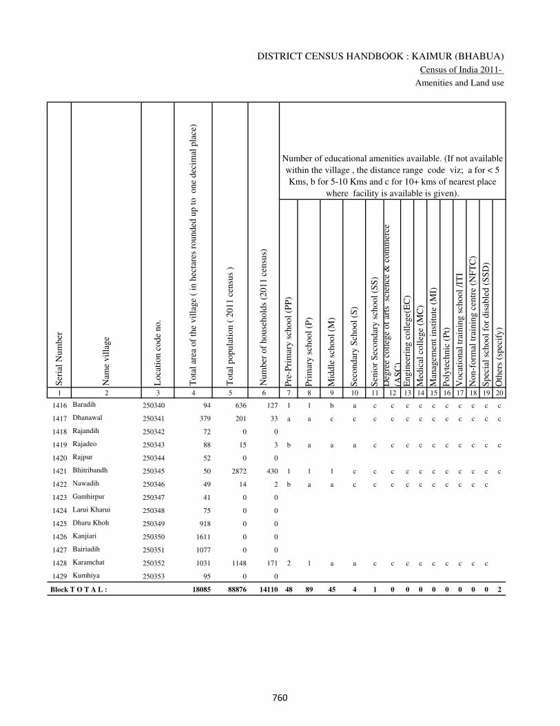
DISTRICT CENSUS HANDBOOK : KAIMUR (BHABUA)
Census of India 2011-
Amenities and Land use
Pre
-Pri
mar
y s
chool
(PP
)
Pri
mar
y s
chool
(P)
Mid
dle
sch
ool
(M)
Sec
ondar
y S
chool
(S)
Sen
ior
Sec
ondar
y s
chool
(SS
)
Deg
ree
coll
ege
of
arts
sc
ience
& c
om
mer
ce
(AS
C)
Engin
eeri
ng c
oll
ege(
EC
)
Med
ical
coll
ege
(MC
)
Man
agem
ent
inst
itute
(M
I)
Poly
tech
nic
(P
t)
Voca
tional
tra
inin
g s
chool
/IT
I
Non-f
orm
al t
rain
ing c
entr
e (N
FT
C)
Spec
ial
school
for
dis
able
d (
SS
D)
Oth
ers
(spec
ify)
1 2 3 4 5 6 7 8 9 10 11 12 13 14 15 16 17 18 19 20
Loca
tion c
ode
no.
Nam
e vil
lage
Ser
ial
Num
ber
Tota
l popula
tion (
2011 c
ensu
s )
Tota
l ar
ea o
f th
e vil
lage
( in
hec
tare
s ro
unded
up t
o
one
dec
imal
pla
ce)
Number of educational amenities available. (If not available
within the village , the distance range code viz; a for < 5
Kms, b for 5-10 Kms and c for 10+ kms of nearest place
where facility is available is given).
Num
ber
of
house
hold
s (2
011 c
ensu
s)
1416 Baradih 250340 94 636 127 1 1 b a c c c c c c c c c c
1417 Dhanawal 250341 379 201 33 a a c c c c c c c c c c c c
1418 Rajandih 250342 72 0 0
1419 Rajadeo 250343 88 15 3 b a a a c c c c c c c c c c
1420 Rajpur 250344 52 0 0
1421 Bhitribandh 250345 50 2872 430 1 1 1 c c c c c c c c c c c
1422 Nawadih 250346 49 14 2 b a a c c c c c c c c c c
1423 Gamhirpur 250347 41 0 0
1424 Larui Kharui 250348 75 0 0
1425 Dharu Khoh 250349 918 0 0
1426 Kanjiari 250350 1611 0 0
1427 Bairiadih 250351 1077 0 0
1428 Karamchat 250352 1031 1148 171 2 1 a a c c c c c c c c c
1429 Kumhiya 250353 95 0 0
Block T O T A L : 18085 88876 14110 48 89 45 4 1 0 0 0 0 0 0 0 0 2
���
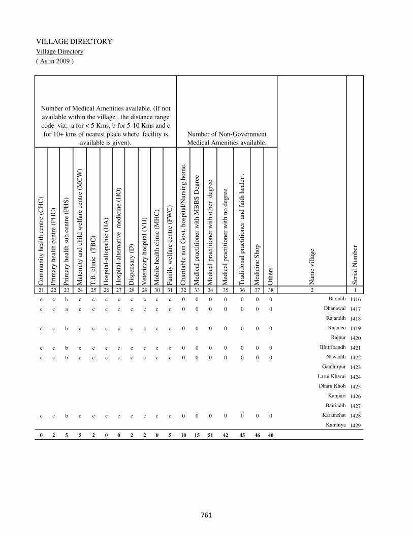
VILLAGE DIRECTORY
Village Directory
( As in 2009 )
Com
munit
y h
ealt
h c
entr
e (C
HC
)
Pri
mar
y h
ealt
h c
entr
e (P
HC
)
Pri
mar
y h
ealt
h s
ub c
entr
e (P
HS
)
Mat
ernit
y a
nd c
hil
d w
elfa
re c
entr
e (M
CW
)
T.B
. cl
inic
(T
BC
)
Hosp
ital
-all
opat
hic
(H
A)
Hosp
ital
-alt
ernat
ive
med
icin
e (H
O)
Dis
pen
sary
(D
)
Vet
erin
ary h
osp
ital
(V
H)
Mobil
e hea
lth c
linic
(M
HC
)
Fam
ily w
elfa
re c
entr
e (F
WC
)
Char
itab
le n
on G
ovt.
hosp
ital
/Nurs
ing h
om
e.
Med
ical
pra
ctit
ioner
wit
h M
BB
S D
egre
e
Med
ical
pra
ctit
ioner
wit
h o
ther
deg
ree
Med
ical
pra
ctit
ioner
wit
h n
o d
egre
e
Tra
dit
ional
pra
ctit
ioner
an
d f
aith
hea
ler
.
Med
icin
e S
hop
Oth
ers
21 22 23 24 25 26 27 28 29 30 31 32 33 34 35 36 37 38 2 1
Number of Non-Government
Medical Amenities available.
Number of Medical Amenities available. (If not
available within the village , the distance range
code viz; a for < 5 Kms, b for 5-10 Kms and c
for 10+ kms of nearest place where facility is
available is given).
Nam
e vil
lage
Ser
ial
Num
ber
c c b c c c c c c c c 0 0 0 0 0 0 0 Baradih 1416
c c a c c c c c c c c 0 0 0 0 0 0 0 Dhanawal 1417
Rajandih 1418
c c b c c c c c c c c 0 0 0 0 0 0 0 Rajadeo 1419
Rajpur 1420
c c b c c c c c c c c 0 0 0 0 0 0 0 Bhitribandh 1421
c c b c c c c c c c c 0 0 0 0 0 0 0 Nawadih 1422
Gamhirpur 1423
Larui Kharui 1424
Dharu Khoh 1425
Kanjiari 1426
Bairiadih 1427
c c b c c c c c c c c 0 0 0 0 0 0 0 Karamchat 1428
Kumhiya 1429
0 2 5 5 2 0 0 2 2 0 5 10 15 51 42 45 46 40
���
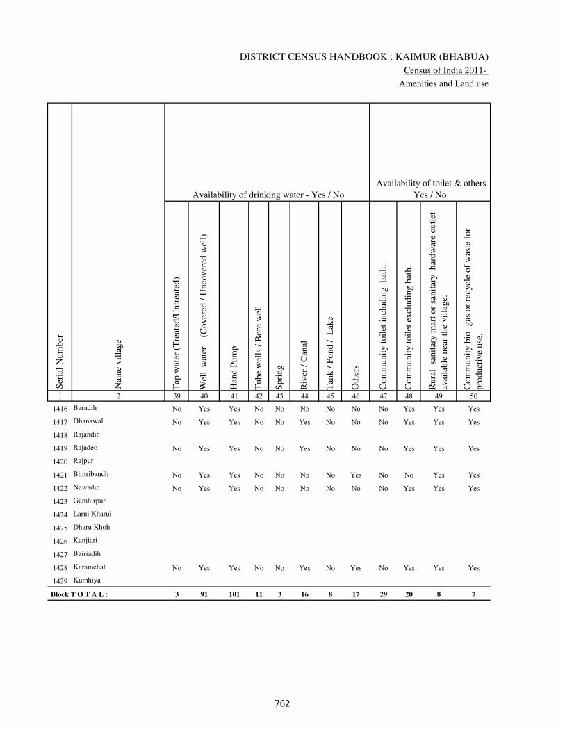
DISTRICT CENSUS HANDBOOK : KAIMUR (BHABUA)
Census of India 2011-
Amenities and Land use
Tap
wat
er (
Tre
ated
/Untr
eate
d)
Wel
l w
ater
(Cover
ed /
Unco
ver
ed w
ell)
Han
d P
um
p
Tube
wel
ls /
Bore
wel
l
Spri
ng
Riv
er /
Can
al
Tan
k /
Pond /
L
ake
Oth
ers
Com
munit
y t
oil
et i
ncl
udin
g
bat
h.
Com
munit
y t
oil
et e
xcl
udin
g b
ath.
Rura
l s
anit
ary m
art
or
sanit
ary
har
dw
are
outl
et
avai
lable
nea
r th
e vil
lage.
Com
munit
y b
io-
gas
or
recy
cle
of
was
te f
or
pro
duct
ive
use
.
1 2 39 40 41 42 43 44 45 46 47 48 49 50
Availability of toilet & others
Yes / No Availability of drinking water - Yes / No
Nam
e vil
lage
Ser
ial
Num
ber
1416 Baradih No Yes Yes No No No No No No Yes Yes Yes
1417 Dhanawal No Yes Yes No No Yes No No No Yes Yes Yes
1418 Rajandih
1419 Rajadeo No Yes Yes No No Yes No No No Yes Yes Yes
1420 Rajpur
1421 Bhitribandh No Yes Yes No No No No Yes No No Yes Yes
1422 Nawadih No Yes Yes No No No No No No Yes Yes Yes
1423 Gamhirpur
1424 Larui Kharui
1425 Dharu Khoh
1426 Kanjiari
1427 Bairiadih
1428 Karamchat No Yes Yes No No Yes No Yes No Yes Yes Yes
1429 Kumhiya
Block T O T A L : 3 91 101 11 3 16 8 17 29 20 8 7
��
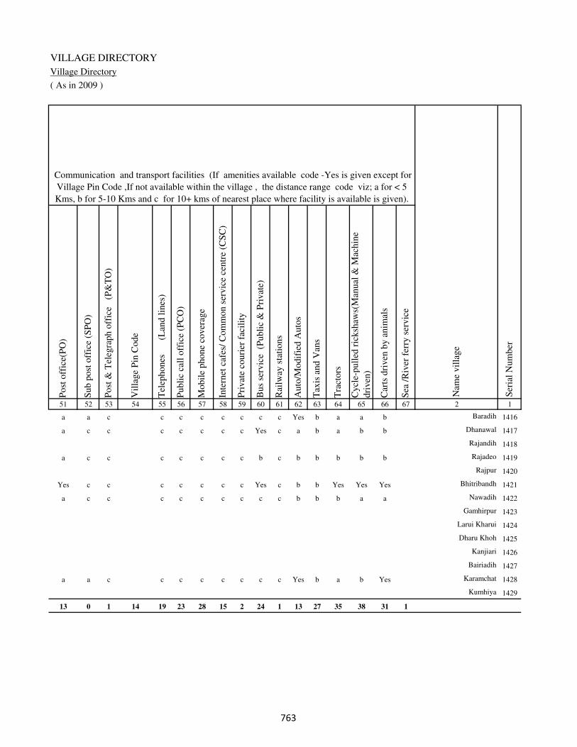
VILLAGE DIRECTORY
Village Directory
( As in 2009 )
Post
off
ice(
PO
)
Sub p
ost
off
ice
(SP
O)
Post
& T
eleg
raph o
ffic
e
(P&
TO
)
Vil
lage
Pin
Code
Tel
ephones
(L
and l
ines
)
Publi
c ca
ll o
ffic
e (P
CO
)
Mobil
e phone
cover
age
Inte
rnet
caf
es/
Com
mon s
ervic
e ce
ntr
e (C
SC
)
Pri
vat
e co
uri
er f
acil
ity
Bus
serv
ice
(P
ubli
c &
Pri
vat
e)
Rai
lway
sta
tions
Auto
/Modif
ied A
uto
s
Tax
is a
nd V
ans
Tra
ctors
Cycl
e-pull
ed r
icksh
aws(
Man
ual
& M
achin
e
dri
ven
)
Car
ts d
riven
by a
nim
als
Sea
/R
iver
fer
ry s
ervic
e51 52 53 54 55 56 57 58 59 60 61 62 63 64 65 66 67 2 1
Communication and transport facilities (If amenities available code -Yes is given except for
Village Pin Code ,If not available within the village , the distance range code viz; a for < 5
Kms, b for 5-10 Kms and c for 10+ kms of nearest place where facility is available is given).
Ser
ial
Num
ber
Nam
e vil
lage
a a c c c c c c c c Yes b a a b Baradih 1416
a c c c c c c c Yes c a b a b b Dhanawal 1417
Rajandih 1418
a c c c c c c c b c b b b b b Rajadeo 1419
Rajpur 1420
Yes c c c c c c c Yes c b b Yes Yes Yes Bhitribandh 1421
a c c c c c c c c c b b b a a Nawadih 1422
Gamhirpur 1423
Larui Kharui 1424
Dharu Khoh 1425
Kanjiari 1426
Bairiadih 1427
a a c c c c c c c c Yes b a b Yes Karamchat 1428
Kumhiya 1429
13 0 1 14 19 23 28 15 2 24 1 13 27 35 38 31 1
��
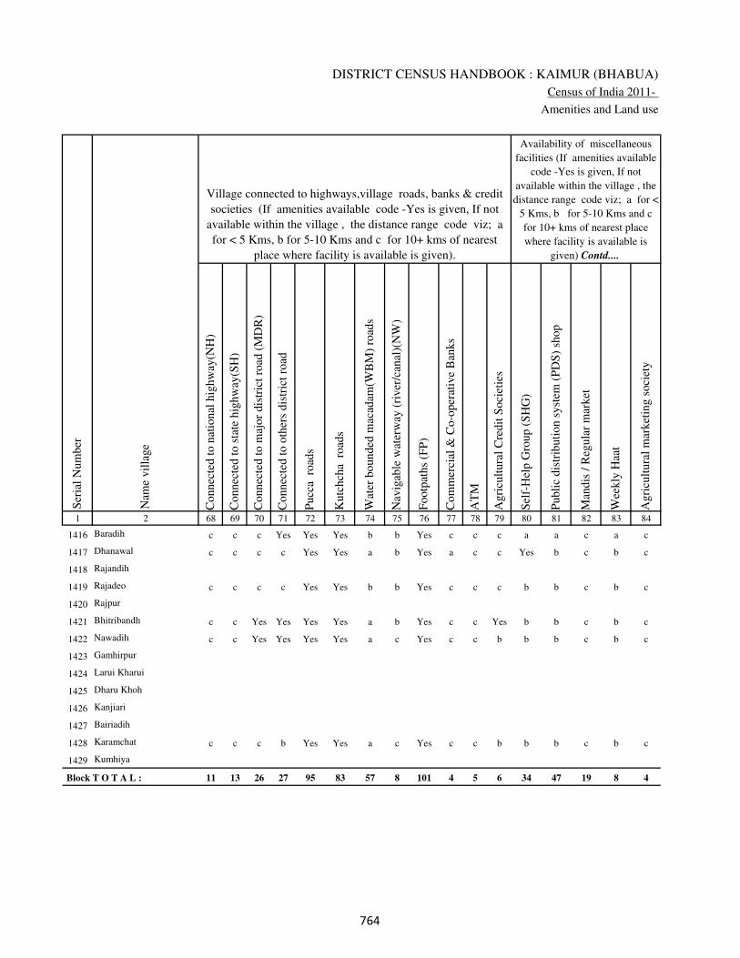
DISTRICT CENSUS HANDBOOK : KAIMUR (BHABUA)
Census of India 2011-
Amenities and Land use
Connec
ted t
o n
atio
nal
hig
hw
ay(N
H)
Connec
ted t
o s
tate
hig
hw
ay(S
H)
Connec
ted t
o m
ajor
dis
tric
t ro
ad (
MD
R)
Connec
ted t
o o
ther
s dis
tric
t ro
ad
Pucc
a r
oad
s
Kutc
hch
a r
oad
s
Wat
er b
ounded
mac
adam
(WB
M)
road
s
Nav
igab
le w
ater
way
(ri
ver
/can
al)(
NW
)
Footp
aths
(FP
)
Com
mer
cial
& C
o-o
per
ativ
e B
anks
AT
M
Agri
cult
ura
l C
redit
Soci
etie
s
Sel
f-H
elp G
roup (
SH
G)
Publi
c dis
trib
uti
on s
yst
em (
PD
S)
shop
Man
dis
/ R
egula
r m
arket
Wee
kly
Haa
t
Agri
cult
ura
l m
arket
ing s
oci
ety
1 2 68 69 70 71 72 73 74 75 76 77 78 79 80 81 82 83 84
Village connected to highways,village roads, banks & credit
societies (If amenities available code -Yes is given, If not
available within the village , the distance range code viz; a
for < 5 Kms, b for 5-10 Kms and c for 10+ kms of nearest
place where facility is available is given).
Ser
ial
Num
ber
Nam
e vil
lage
Availability of miscellaneous
facilities (If amenities available
code -Yes is given, If not
available within the village , the
distance range code viz; a for <
5 Kms, b for 5-10 Kms and c
for 10+ kms of nearest place
where facility is available is
given) Contd....
1416 Baradih c c c Yes Yes Yes b b Yes c c c a a c a c
1417 Dhanawal c c c c Yes Yes a b Yes a c c Yes b c b c
1418 Rajandih
1419 Rajadeo c c c c Yes Yes b b Yes c c c b b c b c
1420 Rajpur
1421 Bhitribandh c c Yes Yes Yes Yes a b Yes c c Yes b b c b c
1422 Nawadih c c Yes Yes Yes Yes a c Yes c c b b b c b c
1423 Gamhirpur
1424 Larui Kharui
1425 Dharu Khoh
1426 Kanjiari
1427 Bairiadih
1428 Karamchat c c c b Yes Yes a c Yes c c b b b c b c
1429 Kumhiya
Block T O T A L : 11 13 26 27 95 83 57 8 101 4 5 6 34 47 19 8 4
���
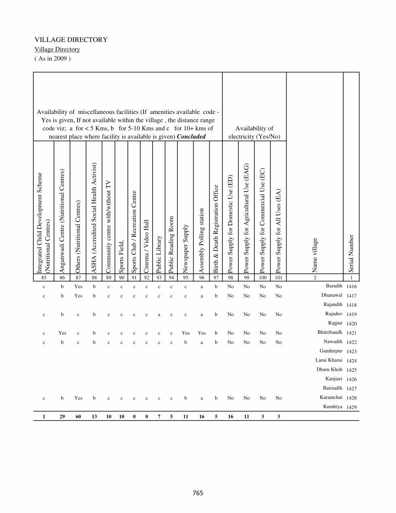
VILLAGE DIRECTORY
Village Directory
( As in 2009 )
Inte
gra
ted C
hil
d D
evel
opm
ent
Sch
eme
(Nutr
itio
nal
Cen
tres
)
Angan
wad
i C
entr
e (N
utr
itio
nal
Cen
tres
)
Oth
ers
(Nutr
itio
nal
Cen
tres
)
AS
HA
(A
ccre
dit
ed S
oci
al H
ealt
h A
ctiv
ist)
Com
munit
y c
entr
e w
ith/w
ithout
TV
Sport
s F
ield
,
Sport
s C
lub /
Rec
reat
ion C
entr
e
Cin
ema
/ V
ideo
Hal
l
Publi
c L
ibra
ry
Publi
c R
eadin
g R
oom
New
spap
er S
upply
Ass
embly
Poll
ing s
tati
on
Bir
th &
Dea
th R
egis
trat
ion O
ffic
e
Pow
er S
upply
for
Dom
esti
c U
se (
ED
)
Pow
er S
upply
for
Agri
cult
ura
l U
se (
EA
G)
Pow
er S
upply
for
Com
mer
cial
Use
(E
C)
Pow
er S
upply
for
All
Use
s (E
A)
85 86 87 88 89 90 91 92 93 94 95 96 97 98 99 100 101 2 1
Availability of
electricity (Yes/No)
Availability of miscellaneous facilities (If amenities available code -
Yes is given, If not available within the village , the distance range
code viz; a for < 5 Kms, b for 5-10 Kms and c for 10+ kms of
nearest place where facility is available is given) Concluded
Nam
e vil
lage
Ser
ial
Num
ber
c b Yes b c c c c c c c a b No No No No Baradih 1416
c b Yes b c c c c c c c a b No No No No Dhanawal 1417
Rajandih 1418
c b c b c c c c a c c a b No No No No Rajadeo 1419
Rajpur 1420
c Yes c b c c c c c c Yes Yes b No No No No Bhitribandh 1421
c b c b c c c c c c b a b No No No No Nawadih 1422
Gamhirpur 1423
Larui Kharui 1424
Dharu Khoh 1425
Kanjiari 1426
Bairiadih 1427
c b Yes b c c c c c c b a b No No No No Karamchat 1428
Kumhiya 1429
1 29 60 13 10 10 0 0 7 5 11 16 5 16 11 3 3
���
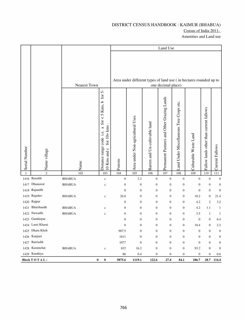
DISTRICT CENSUS HANDBOOK : KAIMUR (BHABUA)
Census of India 2011-
Amenities and Land use
Nam
e
Dis
tance
ran
ge
code
i.e
. a
fo
r <
5 K
ms,
b
for
5-
10 K
ms
and c
f
or
10+
km
s .
Fore
sts
Are
a under
Non-a
gri
cult
ura
l U
ses
Bar
ren a
nd U
n-c
ult
ivab
le l
and
Per
man
ent
Pas
ture
s an
d O
ther
Gra
zing L
ands
Lan
d U
nder
Mis
cell
aneo
us
Tre
e C
rops
etc.
Cult
ura
ble
Was
te L
and
Fal
low
lan
ds
oth
er t
han
curr
ent
fall
ow
s
Curr
ent
Fal
low
s
1 2 102 103 104 105 106 107 108 109 110 111
Ser
ial
Num
ber
Nam
e vil
lage
Area under different types of land use ( in hectares rounded up to
one decimal place)
Land Use
Nearest Town
1416 Baradih BHABUA c 0 2.2 0 0 0 0 0 0
1417 Dhanawal BHABUA c 0 0 0 0 0 0 0 0
1418 Rajandih 0 0 0 0 0 0 0 0
1419 Rajadeo BHABUA c 26.8 0 0 0 0 18.2 0 21.4
1420 Rajpur 0 0 0 0 0 4.2 2 3.2
1421 Bhitribandh BHABUA c 0 0 0 0 0 4.2 1.1 1
1422 Nawadih BHABUA c 0 0 0 0 0 3.5 1 1
1423 Gamhirpur 0 0 0 0 0 0 0 6.4
1424 Larui Kharui 0 0 0 0 0 10.4 0 2.2
1425 Dharu Khoh 907.5 0 0 0 0 0 0 0
1426 Kanjiari 1611 0 0 0 0 0 0 0
1427 Bairiadih 1077 0 0 0 0 0 0 0
1428 Karamchat BHABUA c 832 16.2 0 0 0 93.2 0 0
1429 Kumhiya 86 0.4 0 0 0 0 0 0.6
Block T O T A L : 0 0 5875.6 1119.1 122.6 27.4 84.1 186.7 28.7 114.4
���
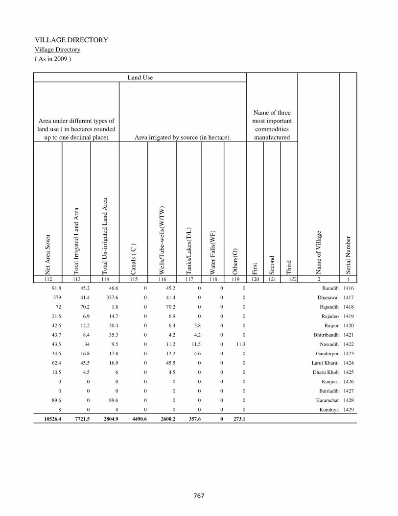
VILLAGE DIRECTORY
Village Directory
( As in 2009 )
Net
Are
a S
ow
n
Tota
l Ir
rigat
ed L
and A
rea
Tota
l U
n-i
rrig
ated
Lan
d A
rea
Can
als
( C
)
Wel
ls/T
ube-
wel
ls(W
/TW
)
Tan
ks/
Lak
es(T
/L)
Wat
er F
alls
(WF
)
Oth
ers(
O)
Fir
st
Sec
ond
Thir
d
112 113 114 115 116 117 118 119 120 121 122 2 1
Ser
ial
Num
ber
Name of three
most important
commodities
manufacturedArea irrigated by source (in hectare).
Nam
e of
Vil
lage
Area under different types of
land use ( in hectares rounded
up to one decimal place)
Land Use
91.8 45.2 46.6 0 45.2 0 0 0 Baradih 1416
379 41.4 337.6 0 41.4 0 0 0 Dhanawal 1417
72 70.2 1.8 0 70.2 0 0 0 Rajandih 1418
21.6 6.9 14.7 0 6.9 0 0 0 Rajadeo 1419
42.6 12.2 30.4 0 6.4 5.8 0 0 Rajpur 1420
43.7 8.4 35.3 0 4.2 4.2 0 0 Bhitribandh 1421
43.5 34 9.5 0 11.2 11.5 0 11.3 Nawadih 1422
34.6 16.8 17.8 0 12.2 4.6 0 0 Gamhirpur 1423
62.4 45.5 16.9 0 45.5 0 0 0 Larui Kharui 1424
10.5 4.5 6 0 4.5 0 0 0 Dharu Khoh 1425
0 0 0 0 0 0 0 0 Kanjiari 1426
0 0 0 0 0 0 0 0 Bairiadih 1427
89.6 0 89.6 0 0 0 0 0 Karamchat 1428
8 0 8 0 0 0 0 0 Kumhiya 1429
10526.4 7721.5 2804.9 4490.6 2600.2 357.6 0 273.1
���

DISTRICT CENSUS HANDBOOK : KAIMUR (BHABUA)
Census of India 2011-
Amenities and Land use
Pre
-Pri
mar
y s
chool
(PP
)
Pri
mar
y s
chool
(P)
Mid
dle
sch
ool
(M)
Sec
ondar
y S
chool
(S)
Sen
ior
Sec
ondar
y s
chool
(SS
)
Deg
ree
coll
ege
of
arts
sc
ience
& c
om
mer
ce
(AS
C)
Engin
eeri
ng c
oll
ege(
EC
)
Med
ical
coll
ege
(MC
)
Man
agem
ent
inst
itute
(M
I)
Poly
tech
nic
(P
t)
Voca
tional
tra
inin
g s
chool
/IT
I
Non-f
orm
al t
rain
ing c
entr
e (N
FT
C)
Spec
ial
school
for
dis
able
d (
SS
D)
Oth
ers
(spec
ify)
1 2 3 4 5 6 7 8 9 10 11 12 13 14 15 16 17 18 19 20
Loca
tion c
ode
no.
Nam
e vil
lage
Ser
ial
Num
ber
Tota
l popula
tion (
2011 c
ensu
s )
Tota
l ar
ea o
f th
e vil
lage
( in
hec
tare
s ro
unded
up t
o
one
dec
imal
pla
ce)
Number of educational amenities available. (If not available
within the village , the distance range code viz; a for < 5
Kms, b for 5-10 Kms and c for 10+ kms of nearest place
where facility is available is given).
Num
ber
of
house
hold
s (2
011 c
ensu
s)
Name of District:-Kaimur (Bhabua) Location CodeNo:-233
Name of CD Block:-Bhagwanpur Location CodeNo:-0443
1430 Shivpur Padmadehri 250354 70 491 117 b a a b b c c c c c c c c
1431 Ora 250355 164 1209 188 1 1 1 c c c c c c c c c c
1432 Katkara 250356 110 795 148 b 1 1 b b c c c c c c c c
1433 Sundri 250357 19 0 0
1434 Kunrwa 250358 41 291 45 b a a b b b c c c c c c c
1435 Chakedehra 250359 99 351 47 b 1 1 b b b c c c c b c c
1436 Ghosa 250360 91 861 143 b 1 1 b b b c c c c c c c
1437 Kasturi Sarai 250361 16 59 11 c b a b a b c c c c c c c
1438 Sisaundha 250362 51 0 0
1439 Lahra 250363 42 212 30 b a a b a b c c c c c c c
1440 Dubauli 250364 94 849 136 b 1 a b b b c c c c b c c
1441 Khaira 250365 50 205 35 b b b a b a c c c c b b c
1442 Singhi 250366 84 481 79 b 1 1 b b b c c c c c c c
1443 Chorghatia 250367 49 336 63 c 1 a c c c c c c c c c c
1444 Matar 250368 157 803 139 b 1 1 c c c c c c c c c c
1445 Nawadih 250369 30 0 0
1446 Umapur 250370 231 2144 347 1 1 a b c b c c c c c c c
1447 Dhangarha 250371 186 284 66 b 1 a b c c c c c c c c c
���
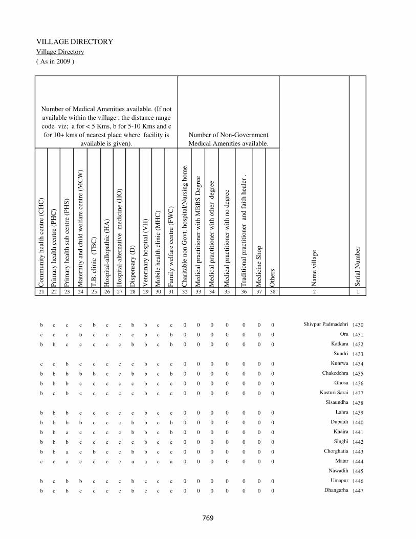
VILLAGE DIRECTORY
Village Directory
( As in 2009 )
Com
munit
y h
ealt
h c
entr
e (C
HC
)
Pri
mar
y h
ealt
h c
entr
e (P
HC
)
Pri
mar
y h
ealt
h s
ub c
entr
e (P
HS
)
Mat
ernit
y a
nd c
hil
d w
elfa
re c
entr
e (M
CW
)
T.B
. cl
inic
(T
BC
)
Hosp
ital
-all
opat
hic
(H
A)
Hosp
ital
-alt
ernat
ive
med
icin
e (H
O)
Dis
pen
sary
(D
)
Vet
erin
ary h
osp
ital
(V
H)
Mobil
e hea
lth c
linic
(M
HC
)
Fam
ily w
elfa
re c
entr
e (F
WC
)
Char
itab
le n
on G
ovt.
hosp
ital
/Nurs
ing h
om
e.
Med
ical
pra
ctit
ioner
wit
h M
BB
S D
egre
e
Med
ical
pra
ctit
ioner
wit
h o
ther
deg
ree
Med
ical
pra
ctit
ioner
wit
h n
o d
egre
e
Tra
dit
ional
pra
ctit
ioner
an
d f
aith
hea
ler
.
Med
icin
e S
hop
Oth
ers
21 22 23 24 25 26 27 28 29 30 31 32 33 34 35 36 37 38 2 1
Number of Non-Government
Medical Amenities available.
Number of Medical Amenities available. (If not
available within the village , the distance range
code viz; a for < 5 Kms, b for 5-10 Kms and c
for 10+ kms of nearest place where facility is
available is given).
Nam
e vil
lage
Ser
ial
Num
ber
b c c c b c c b b c c 0 0 0 0 0 0 0 Shivpur Padmadehri 1430
c c c b c c c c b c b 0 0 0 0 0 0 0 Ora 1431
b b c c c c c b b c b 0 0 0 0 0 0 0 Katkara 1432
Sundri 1433
c c b c c c c c b c c 0 0 0 0 0 0 0 Kunrwa 1434
b b b b b c c b b c b 0 0 0 0 0 0 0 Chakedehra 1435
b b b c c c c c b c c 0 0 0 0 0 0 0 Ghosa 1436
b c b c c c c c b c c 0 0 0 0 0 0 0 Kasturi Sarai 1437
Sisaundha 1438
b b b c c c c c b c c 0 0 0 0 0 0 0 Lahra 1439
b b b b c c c b b c b 0 0 0 0 0 0 0 Dubauli 1440
b b a c c c c b b c b 0 0 0 0 0 0 0 Khaira 1441
b b b c c c c c b c c 0 0 0 0 0 0 0 Singhi 1442
b b a c b c c b b c c 0 0 0 0 0 0 0 Chorghatia 1443
c c a c c c c a a c a 0 0 0 0 0 0 0 Matar 1444
Nawadih 1445
b c b b c c c b c c c 0 0 0 0 0 0 0 Umapur 1446
b c b c c c c b c c c 0 0 0 0 0 0 0 Dhangarha 1447
���

DISTRICT CENSUS HANDBOOK : KAIMUR (BHABUA)
Census of India 2011-
Amenities and Land use
Tap
wat
er (
Tre
ated
/Untr
eate
d)
Wel
l w
ater
(Cover
ed /
Unco
ver
ed w
ell)
Han
d P
um
p
Tube
wel
ls /
Bore
wel
l
Spri
ng
Riv
er /
Can
al
Tan
k /
Pond /
L
ake
Oth
ers
Com
munit
y t
oil
et i
ncl
udin
g
bat
h.
Com
munit
y t
oil
et e
xcl
udin
g b
ath.
Rura
l s
anit
ary m
art
or
sanit
ary
har
dw
are
outl
et
avai
lable
nea
r th
e vil
lage.
Com
munit
y b
io-
gas
or
recy
cle
of
was
te f
or
pro
duct
ive
use
.
1 2 39 40 41 42 43 44 45 46 47 48 49 50
Availability of toilet & others
Yes / No Availability of drinking water - Yes / No
Nam
e vil
lage
Ser
ial
Num
ber
1430 Shivpur Padmadehri No Yes Yes No No No No No No No No No
1431 Ora No Yes Yes No No Yes No No No No No No
1432 Katkara No Yes Yes No No No No No No No No No
1433 Sundri
1434 Kunrwa No Yes Yes No No No No No No No No No
1435 Chakedehra No Yes Yes No No No No No No No No No
1436 Ghosa No Yes Yes No No No No No No No No No
1437 Kasturi Sarai No No Yes No No No No No No No No No
1438 Sisaundha
1439 Lahra No Yes Yes No No No No No No No No No
1440 Dubauli No Yes Yes No No No No No No No No No
1441 Khaira No Yes Yes No No Yes No No No No No No
1442 Singhi No Yes Yes No No Yes No No No No No No
1443 Chorghatia No Yes Yes No No Yes No No No No No No
1444 Matar No Yes Yes No No Yes No No No No No No
1445 Nawadih
1446 Umapur No Yes Yes No No Yes No No No No No No
1447 Dhangarha No Yes Yes No No Yes No No No No No No
���
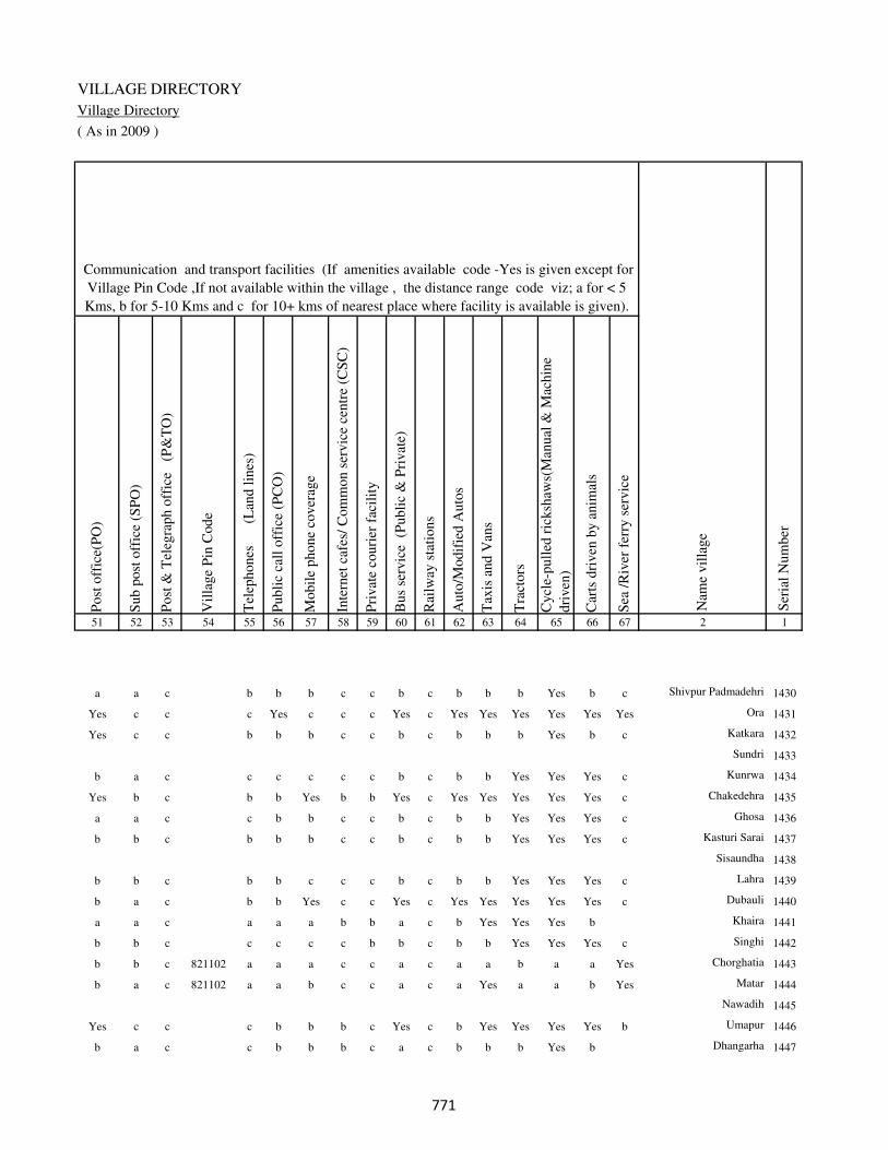
VILLAGE DIRECTORY
Village Directory
( As in 2009 )
Post
off
ice(
PO
)
Sub p
ost
off
ice
(SP
O)
Post
& T
eleg
raph o
ffic
e
(P&
TO
)
Vil
lage
Pin
Code
Tel
ephones
(L
and l
ines
)
Publi
c ca
ll o
ffic
e (P
CO
)
Mobil
e phone
cover
age
Inte
rnet
caf
es/
Com
mon s
ervic
e ce
ntr
e (C
SC
)
Pri
vat
e co
uri
er f
acil
ity
Bus
serv
ice
(P
ubli
c &
Pri
vat
e)
Rai
lway
sta
tions
Auto
/Modif
ied A
uto
s
Tax
is a
nd V
ans
Tra
ctors
Cycl
e-pull
ed r
icksh
aws(
Man
ual
& M
achin
e
dri
ven
)
Car
ts d
riven
by a
nim
als
Sea
/R
iver
fer
ry s
ervic
e51 52 53 54 55 56 57 58 59 60 61 62 63 64 65 66 67 2 1
Communication and transport facilities (If amenities available code -Yes is given except for
Village Pin Code ,If not available within the village , the distance range code viz; a for < 5
Kms, b for 5-10 Kms and c for 10+ kms of nearest place where facility is available is given).
Ser
ial
Num
ber
Nam
e vil
lage
a a c b b b c c b c b b b Yes b c Shivpur Padmadehri 1430
Yes c c c Yes c c c Yes c Yes Yes Yes Yes Yes Yes Ora 1431
Yes c c b b b c c b c b b b Yes b c Katkara 1432
Sundri 1433
b a c c c c c c b c b b Yes Yes Yes c Kunrwa 1434
Yes b c b b Yes b b Yes c Yes Yes Yes Yes Yes c Chakedehra 1435
a a c c b b c c b c b b Yes Yes Yes c Ghosa 1436
b b c b b b c c b c b b Yes Yes Yes c Kasturi Sarai 1437
Sisaundha 1438
b b c b b c c c b c b b Yes Yes Yes c Lahra 1439
b a c b b Yes c c Yes c Yes Yes Yes Yes Yes c Dubauli 1440
a a c a a a b b a c b Yes Yes Yes b Khaira 1441
b b c c c c c b b c b b Yes Yes Yes c Singhi 1442
b b c 821102 a a a c c a c a a b a a Yes Chorghatia 1443
b a c 821102 a a b c c a c a Yes a a b Yes Matar 1444
Nawadih 1445
Yes c c c b b b c Yes c b Yes Yes Yes Yes b Umapur 1446
b a c c b b b c a c b b b Yes b Dhangarha 1447
���

DISTRICT CENSUS HANDBOOK : KAIMUR (BHABUA)
Census of India 2011-
Amenities and Land use
Connec
ted t
o n
atio
nal
hig
hw
ay(N
H)
Connec
ted t
o s
tate
hig
hw
ay(S
H)
Connec
ted t
o m
ajor
dis
tric
t ro
ad (
MD
R)
Connec
ted t
o o
ther
s dis
tric
t ro
ad
Pucc
a r
oad
s
Kutc
hch
a r
oad
s
Wat
er b
ounded
mac
adam
(WB
M)
road
s
Nav
igab
le w
ater
way
(ri
ver
/can
al)(
NW
)
Footp
aths
(FP
)
Com
mer
cial
& C
o-o
per
ativ
e B
anks
AT
M
Agri
cult
ura
l C
redit
Soci
etie
s
Sel
f-H
elp G
roup (
SH
G)
Publi
c dis
trib
uti
on s
yst
em (
PD
S)
shop
Man
dis
/ R
egula
r m
arket
Wee
kly
Haa
t
Agri
cult
ura
l m
arket
ing s
oci
ety
1 2 68 69 70 71 72 73 74 75 76 77 78 79 80 81 82 83 84
Village connected to highways,village roads, banks & credit
societies (If amenities available code -Yes is given, If not
available within the village , the distance range code viz; a
for < 5 Kms, b for 5-10 Kms and c for 10+ kms of nearest
place where facility is available is given).
Ser
ial
Num
ber
Nam
e vil
lage
Availability of miscellaneous
facilities (If amenities available
code -Yes is given, If not
available within the village , the
distance range code viz; a for <
5 Kms, b for 5-10 Kms and c
for 10+ kms of nearest place
where facility is available is
given) Contd....
1430 Shivpur Padmadehri c c c b Yes Yes Yes c Yes b c c b b c b c
1431 Ora c c Yes Yes Yes Yes Yes Yes Yes c c c c b c b c
1432 Katkara c c c b a Yes Yes b Yes b c c c b c b c
1433 Sundri
1434 Kunrwa c c c b Yes Yes Yes b Yes c c b b b c c c
1435 Chakedehra c c Yes Yes Yes Yes Yes c Yes c c c b Yes c c c
1436 Ghosa c c b Yes Yes Yes Yes c Yes c c c b b c c c
1437 Kasturi Sarai c c b b Yes Yes Yes Yes Yes c c c b a c c c
1438 Sisaundha
1439 Lahra c c b Yes Yes Yes Yes Yes Yes c c c c b c c c
1440 Dubauli c a Yes Yes b Yes Yes Yes Yes c c Yes Yes b c b c
1441 Khaira c b Yes Yes Yes Yes Yes b Yes b b Yes Yes b c b c
1442 Singhi c c c b Yes Yes Yes Yes Yes c c c b b c b c
1443 Chorghatia c b b b Yes Yes Yes Yes Yes b c Yes a b c c c
1444 Matar c b b Yes Yes Yes Yes Yes Yes b c a Yes b c c c
1445 Nawadih
1446 Umapur c c c Yes Yes Yes Yes b Yes Yes c b Yes Yes c b c
1447 Dhangarha c c a a a Yes a b Yes a c a b b c b c
��

VILLAGE DIRECTORY
Village Directory
( As in 2009 )
Inte
gra
ted C
hil
d D
evel
opm
ent
Sch
eme
(Nutr
itio
nal
Cen
tres
)
Angan
wad
i C
entr
e (N
utr
itio
nal
Cen
tres
)
Oth
ers
(Nutr
itio
nal
Cen
tres
)
AS
HA
(A
ccre
dit
ed S
oci
al H
ealt
h A
ctiv
ist)
Com
munit
y c
entr
e w
ith/w
ithout
TV
Sport
s F
ield
,
Sport
s C
lub /
Rec
reat
ion C
entr
e
Cin
ema
/ V
ideo
Hal
l
Publi
c L
ibra
ry
Publi
c R
eadin
g R
oom
New
spap
er S
upply
Ass
embly
Poll
ing s
tati
on
Bir
th &
Dea
th R
egis
trat
ion O
ffic
e
Pow
er S
upply
for
Dom
esti
c U
se (
ED
)
Pow
er S
upply
for
Agri
cult
ura
l U
se (
EA
G)
Pow
er S
upply
for
Com
mer
cial
Use
(E
C)
Pow
er S
upply
for
All
Use
s (E
A)
85 86 87 88 89 90 91 92 93 94 95 96 97 98 99 100 101 2 1
Availability of
electricity (Yes/No)
Availability of miscellaneous facilities (If amenities available code -
Yes is given, If not available within the village , the distance range
code viz; a for < 5 Kms, b for 5-10 Kms and c for 10+ kms of
nearest place where facility is available is given) Concluded
Nam
e vil
lage
Ser
ial
Num
ber
b b Yes b c c c c c c b a a Yes Yes No No Shivpur Padmadehri 1430
b a Yes b c c c c c c b Yes Yes Yes No No No Ora 1431
b a Yes b c b c c c c b a a No No No No Katkara 1432
Sundri 1433
b b Yes b c c c c c c c a a No No No No Kunrwa 1434
b Yes Yes a c Yes c c c c c Yes Yes No No No No Chakedehra 1435
b Yes Yes a c b c c c c c Yes Yes No No No No Ghosa 1436
b b Yes b c b c c c c c a a No No No No Kasturi Sarai 1437
Sisaundha 1438
b b Yes a c b c c c c c a a No No No No Lahra 1439
b Yes Yes Yes c c c c c c Yes Yes Yes Yes No No No Dubauli 1440
b b Yes b c c c c c c a a a No No No No Khaira 1441
b b Yes Yes c c c c c c b Yes Yes No No No No Singhi 1442
b b Yes b c c c c c c b a a No No No No Chorghatia 1443
a Yes Yes Yes c c c c c c b Yes a Yes Yes No No Matar 1444
Nawadih 1445
b Yes Yes Yes c c c c c b c Yes a Yes Yes No No Umapur 1446
a b Yes Yes c c c c c c c a a Yes Yes No No Dhangarha 1447
��
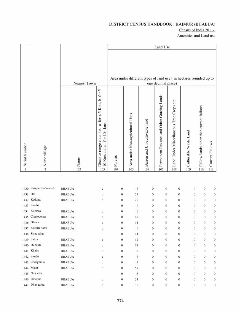
DISTRICT CENSUS HANDBOOK : KAIMUR (BHABUA)
Census of India 2011-
Amenities and Land use
Nam
e
Dis
tance
ran
ge
code
i.e
. a
fo
r <
5 K
ms,
b
for
5-
10 K
ms
and c
f
or
10+
km
s .
Fore
sts
Are
a under
Non-a
gri
cult
ura
l U
ses
Bar
ren a
nd U
n-c
ult
ivab
le l
and
Per
man
ent
Pas
ture
s an
d O
ther
Gra
zing L
ands
Lan
d U
nder
Mis
cell
aneo
us
Tre
e C
rops
etc.
Cult
ura
ble
Was
te L
and
Fal
low
lan
ds
oth
er t
han
curr
ent
fall
ow
s
Curr
ent
Fal
low
s
1 2 102 103 104 105 106 107 108 109 110 111
Ser
ial
Num
ber
Nam
e vil
lage
Area under different types of land use ( in hectares rounded up to
one decimal place)
Land Use
Nearest Town
1430 Shivpur Padmadehri BHABUA c 0 7 0 0 0 0 0 0
1431 Ora BHABUA c 0 24 0 0 0 0 0 0
1432 Katkara BHABUA c 0 20 0 0 0 0 0 0
1433 Sundri 0 0 0 0 0 0 0 0
1434 Kunrwa BHABUA c 0 6 0 0 0 0 0 0
1435 Chakedehra BHABUA c 0 19 0 0 0 0 0 0
1436 Ghosa BHABUA c 0 11 0 0 0 0 0 0
1437 Kasturi Sarai BHABUA c 0 0 0 0 0 0 0 0
1438 Sisaundha 0 11 0 0 0 0 0 0
1439 Lahra BHABUA c 0 12 0 0 0 0 0 0
1440 Dubauli BHABUA c 0 14 0 0 0 0 0 0
1441 Khaira BHABUA c 0 5 0 0 0 0 0 0
1442 Singhi BHABUA c 0 4 0 0 0 0 0 0
1443 Chorghatia BHABUA c 0 9 0 0 0 0 0 0
1444 Matar BHABUA c 0 57 0 0 0 0 0 0
1445 Nawadih 0 5 0 0 0 0 0 0
1446 Umapur BHABUA c 0 31 0 0 0 0 0 0
1447 Dhangarha BHABUA c 0 36 0 0 0 0 0 0
���
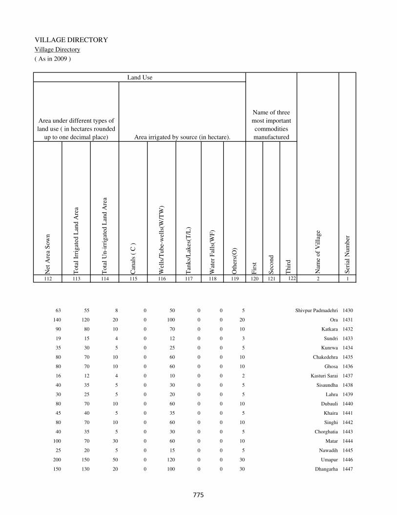
VILLAGE DIRECTORY
Village Directory
( As in 2009 )
Net
Are
a S
ow
n
Tota
l Ir
rigat
ed L
and A
rea
Tota
l U
n-i
rrig
ated
Lan
d A
rea
Can
als
( C
)
Wel
ls/T
ube-
wel
ls(W
/TW
)
Tan
ks/
Lak
es(T
/L)
Wat
er F
alls
(WF
)
Oth
ers(
O)
Fir
st
Sec
ond
Thir
d
112 113 114 115 116 117 118 119 120 121 122 2 1
Ser
ial
Num
ber
Name of three
most important
commodities
manufacturedArea irrigated by source (in hectare).
Nam
e of
Vil
lage
Area under different types of
land use ( in hectares rounded
up to one decimal place)
Land Use
63 55 8 0 50 0 0 5 Shivpur Padmadehri 1430
140 120 20 0 100 0 0 20 Ora 1431
90 80 10 0 70 0 0 10 Katkara 1432
19 15 4 0 12 0 0 3 Sundri 1433
35 30 5 0 25 0 0 5 Kunrwa 1434
80 70 10 0 60 0 0 10 Chakedehra 1435
80 70 10 0 60 0 0 10 Ghosa 1436
16 12 4 0 10 0 0 2 Kasturi Sarai 1437
40 35 5 0 30 0 0 5 Sisaundha 1438
30 25 5 0 20 0 0 5 Lahra 1439
80 70 10 0 60 0 0 10 Dubauli 1440
45 40 5 0 35 0 0 5 Khaira 1441
80 70 10 0 60 0 0 10 Singhi 1442
40 35 5 0 30 0 0 5 Chorghatia 1443
100 70 30 0 60 0 0 10 Matar 1444
25 20 5 0 15 0 0 5 Nawadih 1445
200 150 50 0 120 0 0 30 Umapur 1446
150 130 20 0 100 0 0 30 Dhangarha 1447
���

DISTRICT CENSUS HANDBOOK : KAIMUR (BHABUA)
Census of India 2011-
Amenities and Land use
Pre
-Pri
mar
y s
chool
(PP
)
Pri
mar
y s
chool
(P)
Mid
dle
sch
ool
(M)
Sec
ondar
y S
chool
(S)
Sen
ior
Sec
ondar
y s
chool
(SS
)
Deg
ree
coll
ege
of
arts
sc
ience
& c
om
mer
ce
(AS
C)
Engin
eeri
ng c
oll
ege(
EC
)
Med
ical
coll
ege
(MC
)
Man
agem
ent
inst
itute
(M
I)
Poly
tech
nic
(P
t)
Voca
tional
tra
inin
g s
chool
/IT
I
Non-f
orm
al t
rain
ing c
entr
e (N
FT
C)
Spec
ial
school
for
dis
able
d (
SS
D)
Oth
ers
(spec
ify)
1 2 3 4 5 6 7 8 9 10 11 12 13 14 15 16 17 18 19 20
Loca
tion c
ode
no.
Nam
e vil
lage
Ser
ial
Num
ber
Tota
l popula
tion (
2011 c
ensu
s )
Tota
l ar
ea o
f th
e vil
lage
( in
hec
tare
s ro
unded
up t
o
one
dec
imal
pla
ce)
Number of educational amenities available. (If not available
within the village , the distance range code viz; a for < 5
Kms, b for 5-10 Kms and c for 10+ kms of nearest place
where facility is available is given).
Num
ber
of
house
hold
s (2
011 c
ensu
s)
1448 Tori 250372 882 6404 1121 c 1 2 a a a c c c c c c c
1449 Marari 250373 38 188 27 b a a a b a c c c c c c c
1450 Pathraur 250374 13 0 0
1451 Desarna 250375 117 358 84 b a a b b b c c c c c c c
1452 Kishunapur 250376 25 384 80 b 1 a b b b c c c c c c c
1453 Haripur 250377 67 0 0
1454 Athbanhi 250378 65 0 0
1455 Semra 250379 51 0 0
1456 Radha khanr 250380 48 992 136 b 1 1 b b b c c c c c c c
1457 Basantpur 250381 82 844 118 b 1 1 a a a c c c c c c c
1458 Reghiya 250382 30 137 21 b a a b b b c c c c c c c
1459 Nadula 250383 23 655 118 b 1 a b b b c c c c c c c
1460 Urgawan 250384 90 1617 279 b 1 1 b b b c c c c c c c
1461 Bhataulia 250385 32 500 89 b 1 a a a a c c c c c c c
1462 Nimian 250386 22 387 60 c 1 a a a a c c c c c c c
1463 Tendua 250387 53 346 60 b 1 a a a a c c c c c c c
1464 Kathaura Khamari 250388 35 304 42 b 1 a a a c c c c c c c c
1465 Dullahpur 250389 30 607 103 c b b a a a c c c c c c c
1466 Bhaupur 250390 18 0 0
1467 Jaitpurpai 250391 34 0 0
1468 Jaitpur Kohna 250392 34 806 127 c b a b b a c c c c c c c
���

VILLAGE DIRECTORY
Village Directory
( As in 2009 )
Com
munit
y h
ealt
h c
entr
e (C
HC
)
Pri
mar
y h
ealt
h c
entr
e (P
HC
)
Pri
mar
y h
ealt
h s
ub c
entr
e (P
HS
)
Mat
ernit
y a
nd c
hil
d w
elfa
re c
entr
e (M
CW
)
T.B
. cl
inic
(T
BC
)
Hosp
ital
-all
opat
hic
(H
A)
Hosp
ital
-alt
ernat
ive
med
icin
e (H
O)
Dis
pen
sary
(D
)
Vet
erin
ary h
osp
ital
(V
H)
Mobil
e hea
lth c
linic
(M
HC
)
Fam
ily w
elfa
re c
entr
e (F
WC
)
Char
itab
le n
on G
ovt.
hosp
ital
/Nurs
ing h
om
e.
Med
ical
pra
ctit
ioner
wit
h M
BB
S D
egre
e
Med
ical
pra
ctit
ioner
wit
h o
ther
deg
ree
Med
ical
pra
ctit
ioner
wit
h n
o d
egre
e
Tra
dit
ional
pra
ctit
ioner
an
d f
aith
hea
ler
.
Med
icin
e S
hop
Oth
ers
21 22 23 24 25 26 27 28 29 30 31 32 33 34 35 36 37 38 2 1
Number of Non-Government
Medical Amenities available.
Number of Medical Amenities available. (If not
available within the village , the distance range
code viz; a for < 5 Kms, b for 5-10 Kms and c
for 10+ kms of nearest place where facility is
available is given).
Nam
e vil
lage
Ser
ial
Num
ber
c c a c c c c c a c c 0 0 0 0 0 0 0 Tori 1448
c c b c c c c b c c c 0 0 0 0 0 0 0 Marari 1449
Pathraur 1450
c c b c c c c c b c c 0 0 0 0 0 0 0 Desarna 1451
c c b c c c c c b c c 0 0 0 0 0 0 0 Kishunapur 1452
Haripur 1453
Athbanhi 1454
Semra 1455
c c b c c c c c b c c 0 0 0 0 0 0 0 Radha khanr 1456
c c a c c c c c a c c 0 0 0 0 0 0 0 Basantpur 1457
c c b c c c c c b c c 0 0 0 0 0 0 0 Reghiya 1458
c c b c c c c c b c c 0 0 0 0 0 0 0 Nadula 1459
c c b c c c c c b c c 0 0 0 0 0 0 0 Urgawan 1460
a a a a c c c a a c a 0 0 0 0 0 0 0 Bhataulia 1461
c a a c c c c a a c c 0 0 0 0 0 0 0 Nimian 1462
b b b c c c c c c c c 0 0 0 0 0 0 0 Tendua 1463
a c a c c c c a a c a 0 0 0 0 0 0 0 Kathaura Khamari 1464
a c a c c c c a a c a 0 0 0 0 0 0 0 Dullahpur 1465
Bhaupur 1466
Jaitpurpai 1467
b c b c c c c b b c b 0 0 0 0 0 0 0 Jaitpur Kohna 1468
���

DISTRICT CENSUS HANDBOOK : KAIMUR (BHABUA)
Census of India 2011-
Amenities and Land use
Tap
wat
er (
Tre
ated
/Untr
eate
d)
Wel
l w
ater
(Cover
ed /
Unco
ver
ed w
ell)
Han
d P
um
p
Tube
wel
ls /
Bore
wel
l
Spri
ng
Riv
er /
Can
al
Tan
k /
Pond /
L
ake
Oth
ers
Com
munit
y t
oil
et i
ncl
udin
g
bat
h.
Com
munit
y t
oil
et e
xcl
udin
g b
ath.
Rura
l s
anit
ary m
art
or
sanit
ary
har
dw
are
outl
et
avai
lable
nea
r th
e vil
lage.
Com
munit
y b
io-
gas
or
recy
cle
of
was
te f
or
pro
duct
ive
use
.
1 2 39 40 41 42 43 44 45 46 47 48 49 50
Availability of toilet & others
Yes / No Availability of drinking water - Yes / No
Nam
e vil
lage
Ser
ial
Num
ber
1448 Tori No Yes Yes No No Yes No No No No No No
1449 Marari No No Yes No No No No No No No No No
1450 Pathraur
1451 Desarna No Yes Yes No No No No No No No No No
1452 Kishunapur No Yes Yes No No No No No No No No No
1453 Haripur
1454 Athbanhi
1455 Semra
1456 Radha khanr No Yes Yes No No No No No No No No No
1457 Basantpur No Yes Yes No No Yes No No No No No No
1458 Reghiya No No Yes No No No No No No No No No
1459 Nadula No Yes Yes No No Yes No No No No No No
1460 Urgawan No Yes Yes No No Yes No No No No No No
1461 Bhataulia No Yes Yes No No No No No No No No No
1462 Nimian No Yes Yes No No No No No No No No No
1463 Tendua No Yes Yes No No No No No No No No No
1464 Kathaura Khamari No Yes Yes No No No No No No No No No
1465 Dullahpur No Yes Yes No No No No No No No No No
1466 Bhaupur
1467 Jaitpurpai
1468 Jaitpur Kohna No No Yes No No No No No No No No No
���
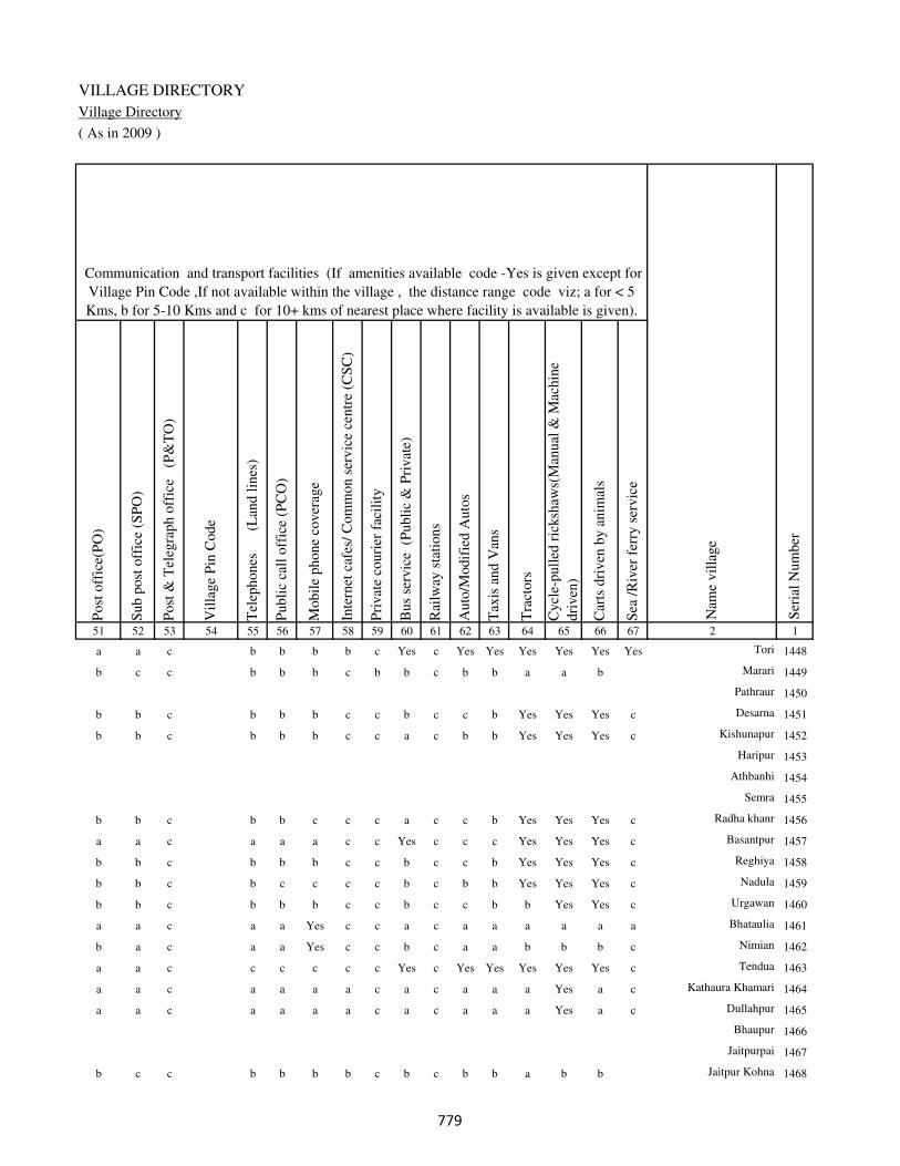
VILLAGE DIRECTORY
Village Directory
( As in 2009 )
Post
off
ice(
PO
)
Sub p
ost
off
ice
(SP
O)
Post
& T
eleg
raph o
ffic
e
(P&
TO
)
Vil
lage
Pin
Code
Tel
ephones
(L
and l
ines
)
Publi
c ca
ll o
ffic
e (P
CO
)
Mobil
e phone
cover
age
Inte
rnet
caf
es/
Com
mon s
ervic
e ce
ntr
e (C
SC
)
Pri
vat
e co
uri
er f
acil
ity
Bus
serv
ice
(P
ubli
c &
Pri
vat
e)
Rai
lway
sta
tions
Auto
/Modif
ied A
uto
s
Tax
is a
nd V
ans
Tra
ctors
Cycl
e-pull
ed r
icksh
aws(
Man
ual
& M
achin
e
dri
ven
)
Car
ts d
riven
by a
nim
als
Sea
/R
iver
fer
ry s
ervic
e51 52 53 54 55 56 57 58 59 60 61 62 63 64 65 66 67 2 1
Communication and transport facilities (If amenities available code -Yes is given except for
Village Pin Code ,If not available within the village , the distance range code viz; a for < 5
Kms, b for 5-10 Kms and c for 10+ kms of nearest place where facility is available is given).
Ser
ial
Num
ber
Nam
e vil
lage
a a c b b b b c Yes c Yes Yes Yes Yes Yes Yes Tori 1448
b c c b b b c b b c b b a a b Marari 1449
Pathraur 1450
b b c b b b c c b c c b Yes Yes Yes c Desarna 1451
b b c b b b c c a c b b Yes Yes Yes c Kishunapur 1452
Haripur 1453
Athbanhi 1454
Semra 1455
b b c b b c c c a c c b Yes Yes Yes c Radha khanr 1456
a a c a a a c c Yes c c c Yes Yes Yes c Basantpur 1457
b b c b b b c c b c c b Yes Yes Yes c Reghiya 1458
b b c b c c c c b c b b Yes Yes Yes c Nadula 1459
b b c b b b c c b c c b b Yes Yes c Urgawan 1460
a a c a a Yes c c a c a a a a a a Bhataulia 1461
b a c a a Yes c c b c a a b b b c Nimian 1462
a a c c c c c c Yes c Yes Yes Yes Yes Yes c Tendua 1463
a a c a a a a c a c a a a Yes a c Kathaura Khamari 1464
a a c a a a a c a c a a a Yes a c Dullahpur 1465
Bhaupur 1466
Jaitpurpai 1467
b c c b b b b c b c b b a b b Jaitpur Kohna 1468
���

DISTRICT CENSUS HANDBOOK : KAIMUR (BHABUA)
Census of India 2011-
Amenities and Land use
Connec
ted t
o n
atio
nal
hig
hw
ay(N
H)
Connec
ted t
o s
tate
hig
hw
ay(S
H)
Connec
ted t
o m
ajor
dis
tric
t ro
ad (
MD
R)
Connec
ted t
o o
ther
s dis
tric
t ro
ad
Pucc
a r
oad
s
Kutc
hch
a r
oad
s
Wat
er b
ounded
mac
adam
(WB
M)
road
s
Nav
igab
le w
ater
way
(ri
ver
/can
al)(
NW
)
Footp
aths
(FP
)
Com
mer
cial
& C
o-o
per
ativ
e B
anks
AT
M
Agri
cult
ura
l C
redit
Soci
etie
s
Sel
f-H
elp G
roup (
SH
G)
Publi
c dis
trib
uti
on s
yst
em (
PD
S)
shop
Man
dis
/ R
egula
r m
arket
Wee
kly
Haa
t
Agri
cult
ura
l m
arket
ing s
oci
ety
1 2 68 69 70 71 72 73 74 75 76 77 78 79 80 81 82 83 84
Village connected to highways,village roads, banks & credit
societies (If amenities available code -Yes is given, If not
available within the village , the distance range code viz; a
for < 5 Kms, b for 5-10 Kms and c for 10+ kms of nearest
place where facility is available is given).
Ser
ial
Num
ber
Nam
e vil
lage
Availability of miscellaneous
facilities (If amenities available
code -Yes is given, If not
available within the village , the
distance range code viz; a for <
5 Kms, b for 5-10 Kms and c
for 10+ kms of nearest place
where facility is available is
given) Contd....
1448 Tori c c Yes Yes Yes Yes Yes Yes Yes c c b Yes Yes c b c
1449 Marari c c b b b Yes a b Yes c c b a a c b c
1450 Pathraur
1451 Desarna c c a a Yes Yes Yes b Yes c c b b b c b c
1452 Kishunapur c c b a Yes Yes Yes Yes c c c a b c b c
1453 Haripur
1454 Athbanhi
1455 Semra
1456 Radha khanr c c a a a Yes Yes b Yes c c c b Yes c b c
1457 Basantpur c c a Yes Yes Yes Yes Yes Yes Yes c c b b c b c
1458 Reghiya c c b b Yes Yes Yes Yes c c c a b c b c
1459 Nadula c c b b Yes Yes Yes Yes Yes c c c b Yes c b c
1460 Urgawan c c b a Yes Yes Yes Yes c c c b a c b c
1461 Bhataulia c c a a Yes Yes Yes Yes a c c a a c b c
1462 Nimian c c b a Yes Yes b b Yes a c c b b c b c
1463 Tendua c c Yes Yes Yes Yes Yes b Yes a c b Yes b c b c
1464 Kathaura Khamari c c b a Yes Yes Yes b Yes a c c Yes b c c c
1465 Dullahpur c c b a a Yes Yes c Yes a c c b b c c c
1466 Bhaupur
1467 Jaitpurpai
1468 Jaitpur Kohna c b b b a b a c Yes c c c b b c c c
���

VILLAGE DIRECTORY
Village Directory
( As in 2009 )
Inte
gra
ted C
hil
d D
evel
opm
ent
Sch
eme
(Nutr
itio
nal
Cen
tres
)
Angan
wad
i C
entr
e (N
utr
itio
nal
Cen
tres
)
Oth
ers
(Nutr
itio
nal
Cen
tres
)
AS
HA
(A
ccre
dit
ed S
oci
al H
ealt
h A
ctiv
ist)
Com
munit
y c
entr
e w
ith/w
ithout
TV
Sport
s F
ield
,
Sport
s C
lub /
Rec
reat
ion C
entr
e
Cin
ema
/ V
ideo
Hal
l
Publi
c L
ibra
ry
Publi
c R
eadin
g R
oom
New
spap
er S
upply
Ass
embly
Poll
ing s
tati
on
Bir
th &
Dea
th R
egis
trat
ion O
ffic
e
Pow
er S
upply
for
Dom
esti
c U
se (
ED
)
Pow
er S
upply
for
Agri
cult
ura
l U
se (
EA
G)
Pow
er S
upply
for
Com
mer
cial
Use
(E
C)
Pow
er S
upply
for
All
Use
s (E
A)
85 86 87 88 89 90 91 92 93 94 95 96 97 98 99 100 101 2 1
Availability of
electricity (Yes/No)
Availability of miscellaneous facilities (If amenities available code -
Yes is given, If not available within the village , the distance range
code viz; a for < 5 Kms, b for 5-10 Kms and c for 10+ kms of
nearest place where facility is available is given) Concluded
Nam
e vil
lage
Ser
ial
Num
ber
a Yes Yes Yes c c c c c c Yes Yes Yes Yes No No No Tori 1448
b b Yes b c c c c c c b a a No No No No Marari 1449
Pathraur 1450
b b Yes b c c c c c c b a a No No No No Desarna 1451
b b Yes b c c c c c c b a b No No No No Kishunapur 1452
Haripur 1453
Athbanhi 1454
Semra 1455
b Yes Yes Yes c c c c c c b Yes b Yes No No No Radha khanr 1456
a Yes Yes Yes c c c c c c a Yes b Yes No No No Basantpur 1457
b b Yes b c c c c c c b a b No No No No Reghiya 1458
b Yes Yes Yes c c c c c c b Yes b No No No No Nadula 1459
b Yes Yes Yes c c c c c c b Yes b No No No No Urgawan 1460
a Yes Yes Yes c c c c c c b a a Yes Yes No No Bhataulia 1461
a b Yes b c c c c c c b a a Yes No No No Nimian 1462
a b Yes b c c c c c c b Yes Yes Yes Yes No No Tendua 1463
a b Yes Yes c c c c c c b a a Yes Yes No No Kathaura Khamari 1464
a b Yes b c c c c c c b a a Yes Yes No No Dullahpur 1465
Bhaupur 1466
Jaitpurpai 1467
b b Yes b c b c c c c b a a No No No No Jaitpur Kohna 1468
���

DISTRICT CENSUS HANDBOOK : KAIMUR (BHABUA)
Census of India 2011-
Amenities and Land use
Nam
e
Dis
tance
ran
ge
code
i.e
. a
fo
r <
5 K
ms,
b
for
5-
10 K
ms
and c
f
or
10+
km
s .
Fore
sts
Are
a under
Non-a
gri
cult
ura
l U
ses
Bar
ren a
nd U
n-c
ult
ivab
le l
and
Per
man
ent
Pas
ture
s an
d O
ther
Gra
zing L
ands
Lan
d U
nder
Mis
cell
aneo
us
Tre
e C
rops
etc.
Cult
ura
ble
Was
te L
and
Fal
low
lan
ds
oth
er t
han
curr
ent
fall
ow
s
Curr
ent
Fal
low
s
1 2 102 103 104 105 106 107 108 109 110 111
Ser
ial
Num
ber
Nam
e vil
lage
Area under different types of land use ( in hectares rounded up to
one decimal place)
Land Use
Nearest Town
1448 Tori BHABUA c 0 182 0 0 0 0 0 0
1449 Marari BHABUA c 0 5 0 0 0 0 0 0
1450 Pathraur 0 0 0 0 0 0 0 0
1451 Desarna BHABUA c 0 17 0 0 0 0 0 0
1452 Kishunapur BHABUA c 0 5 0 0 0 0 0 0
1453 Haripur 0 7 0 0 0 0 0 0
1454 Athbanhi 0 5 0 0 0 0 0 0
1455 Semra 0 6 0 0 0 0 0 0
1456 Radha khanr BHABUA c 0 8 0 0 0 0 0 0
1457 Basantpur BHABUA c 0 12 0 0 0 0 0 0
1458 Reghiya BHABUA c 0 3 0 0 0 0 0 0
1459 Nadula BHABUA c 0 0 0 0 0 0 0 0
1460 Urgawan BHABUA c 0 9 0 0 0 0 0 0
1461 Bhataulia BHABUA c 0 8 0 0 0 0 0 0
1462 Nimian BHABUA c 0 2 0 0 0 0 0 0
1463 Tendua BHABUA c 0 3 0 0 0 0 0 0
1464 Kathaura Khamari BHABUA c 0 5 0 0 0 0 0 0
1465 Dullahpur BHABUA c 0 0 0 0 0 0 0 0
1466 Bhaupur 0 0 0 0 0 0 0 0
1467 Jaitpurpai 0 4 0 0 0 0 0 0
1468 Jaitpur Kohna BHABUA c 0 4 0 0 0 0 0 0
��
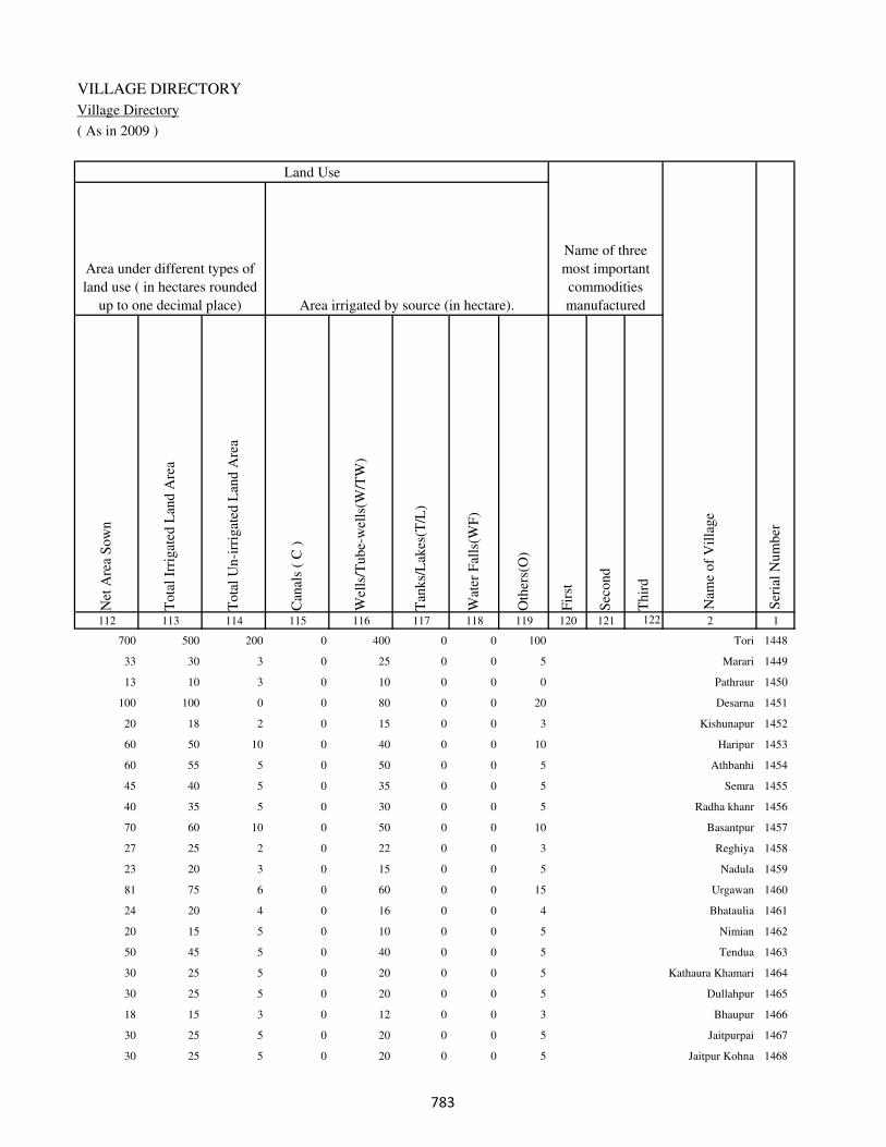
VILLAGE DIRECTORY
Village Directory
( As in 2009 )
Net
Are
a S
ow
n
Tota
l Ir
rigat
ed L
and A
rea
Tota
l U
n-i
rrig
ated
Lan
d A
rea
Can
als
( C
)
Wel
ls/T
ube-
wel
ls(W
/TW
)
Tan
ks/
Lak
es(T
/L)
Wat
er F
alls
(WF
)
Oth
ers(
O)
Fir
st
Sec
ond
Thir
d
112 113 114 115 116 117 118 119 120 121 122 2 1
Ser
ial
Num
ber
Name of three
most important
commodities
manufacturedArea irrigated by source (in hectare).
Nam
e of
Vil
lage
Area under different types of
land use ( in hectares rounded
up to one decimal place)
Land Use
700 500 200 0 400 0 0 100 Tori 1448
33 30 3 0 25 0 0 5 Marari 1449
13 10 3 0 10 0 0 0 Pathraur 1450
100 100 0 0 80 0 0 20 Desarna 1451
20 18 2 0 15 0 0 3 Kishunapur 1452
60 50 10 0 40 0 0 10 Haripur 1453
60 55 5 0 50 0 0 5 Athbanhi 1454
45 40 5 0 35 0 0 5 Semra 1455
40 35 5 0 30 0 0 5 Radha khanr 1456
70 60 10 0 50 0 0 10 Basantpur 1457
27 25 2 0 22 0 0 3 Reghiya 1458
23 20 3 0 15 0 0 5 Nadula 1459
81 75 6 0 60 0 0 15 Urgawan 1460
24 20 4 0 16 0 0 4 Bhataulia 1461
20 15 5 0 10 0 0 5 Nimian 1462
50 45 5 0 40 0 0 5 Tendua 1463
30 25 5 0 20 0 0 5 Kathaura Khamari 1464
30 25 5 0 20 0 0 5 Dullahpur 1465
18 15 3 0 12 0 0 3 Bhaupur 1466
30 25 5 0 20 0 0 5 Jaitpurpai 1467
30 25 5 0 20 0 0 5 Jaitpur Kohna 1468
��

DISTRICT CENSUS HANDBOOK : KAIMUR (BHABUA)
Census of India 2011-
Amenities and Land use
Pre
-Pri
mar
y s
chool
(PP
)
Pri
mar
y s
chool
(P)
Mid
dle
sch
ool
(M)
Sec
ondar
y S
chool
(S)
Sen
ior
Sec
ondar
y s
chool
(SS
)
Deg
ree
coll
ege
of
arts
sc
ience
& c
om
mer
ce
(AS
C)
Engin
eeri
ng c
oll
ege(
EC
)
Med
ical
coll
ege
(MC
)
Man
agem
ent
inst
itute
(M
I)
Poly
tech
nic
(P
t)
Voca
tional
tra
inin
g s
chool
/IT
I
Non-f
orm
al t
rain
ing c
entr
e (N
FT
C)
Spec
ial
school
for
dis
able
d (
SS
D)
Oth
ers
(spec
ify)
1 2 3 4 5 6 7 8 9 10 11 12 13 14 15 16 17 18 19 20
Loca
tion c
ode
no.
Nam
e vil
lage
Ser
ial
Num
ber
Tota
l popula
tion (
2011 c
ensu
s )
Tota
l ar
ea o
f th
e vil
lage
( in
hec
tare
s ro
unded
up t
o
one
dec
imal
pla
ce)
Number of educational amenities available. (If not available
within the village , the distance range code viz; a for < 5
Kms, b for 5-10 Kms and c for 10+ kms of nearest place
where facility is available is given).
Num
ber
of
house
hold
s (2
011 c
ensu
s)
1469 Jaitpur Khurd 250393 49 33 4 b 1 1 a a a c c c c c c c
1470 Sabai Kundi 250394 43 401 60 c 2 a a c a c c c c c c c
1471 Arari 250395 48 528 93 b 1 1 b b b c c c c c c c
1472 Debra 250396 31 351 59 b 1 a b b b c c c c c c c
1473 Chaukhara 250397 14 0 0
1474 Nawagawan 250398 74 64 11 c 1 a a b c c c c c c c c
1475 Darra 250399 23 13 1 c a a a a c c c c c c c c
1476 Bahuri 250400 47 434 66 b 1 a b b a c c c c c c c
1477 Parari 250401 74 459 79 b 1 a b b b c c c c c c c
1478 Tekra 250402 81 807 137 c 1 b b b b c c c c c c c
1479 Babura 250403 79 0 0
1480 Dhekahri 250404 63 372 75 c 1 a b b b c c c c b c c
1481 Urgain 250405 54 905 155 c 1 1 b b b c c c c b c c
1482 Pihra 250406 81 1140 180 1 1 1 b b b c c c c c c c
1483 Mirchi 250407 66 677 111 b 1 c c c b c c c c c c c
1484 Dhurekhar 250408 70 0 0
1485 Kaser 250409 123 3836 610 1 1 1 a c a c c c c c c c
1486 Dhekahri 250410 26 45 5 b 1 a a a c c c c c c c c
1487 Jalaibar 250411 31 550 92 b 1 a a a c c c c c c c c
1488 Mahran 250412 17 0 0
1489 Rajpur 250413 82 775 123 b 1 a a a a c c c c b c c
���

VILLAGE DIRECTORY
Village Directory
( As in 2009 )
Com
munit
y h
ealt
h c
entr
e (C
HC
)
Pri
mar
y h
ealt
h c
entr
e (P
HC
)
Pri
mar
y h
ealt
h s
ub c
entr
e (P
HS
)
Mat
ernit
y a
nd c
hil
d w
elfa
re c
entr
e (M
CW
)
T.B
. cl
inic
(T
BC
)
Hosp
ital
-all
opat
hic
(H
A)
Hosp
ital
-alt
ernat
ive
med
icin
e (H
O)
Dis
pen
sary
(D
)
Vet
erin
ary h
osp
ital
(V
H)
Mobil
e hea
lth c
linic
(M
HC
)
Fam
ily w
elfa
re c
entr
e (F
WC
)
Char
itab
le n
on G
ovt.
hosp
ital
/Nurs
ing h
om
e.
Med
ical
pra
ctit
ioner
wit
h M
BB
S D
egre
e
Med
ical
pra
ctit
ioner
wit
h o
ther
deg
ree
Med
ical
pra
ctit
ioner
wit
h n
o d
egre
e
Tra
dit
ional
pra
ctit
ioner
an
d f
aith
hea
ler
.
Med
icin
e S
hop
Oth
ers
21 22 23 24 25 26 27 28 29 30 31 32 33 34 35 36 37 38 2 1
Number of Non-Government
Medical Amenities available.
Number of Medical Amenities available. (If not
available within the village , the distance range
code viz; a for < 5 Kms, b for 5-10 Kms and c
for 10+ kms of nearest place where facility is
available is given).
Nam
e vil
lage
Ser
ial
Num
ber
c c b a c c c c a c a 0 0 0 0 0 0 0 Jaitpur Khurd 1469
b b a c c c c c b c c 0 0 0 0 0 0 0 Sabai Kundi 1470
b b b c c c c c b c c 0 0 0 0 0 0 0 Arari 1471
c c b b c c c b b c a 0 0 0 0 0 0 0 Debra 1472
Chaukhara 1473
b c b c c c c b b c a 0 0 0 0 0 0 0 Nawagawan 1474
a a a c c c c a a c c 0 0 0 0 0 0 0 Darra 1475
b c c c b c c b b c b 0 0 0 0 0 0 0 Bahuri 1476
b c b c c c c b b c b 0 0 0 0 0 0 0 Parari 1477
b c b c c c c b b c b 0 0 0 0 0 0 0 Tekra 1478
Babura 1479
b b b b b b b b b b b 0 0 0 0 0 0 0 Dhekahri 1480
b b a b b c c b b c b 0 0 0 0 0 0 0 Urgain 1481
b b c c c c c b b c b 0 0 0 0 0 0 0 Pihra 1482
a a c c c c c c a c c 0 0 0 0 0 0 0 Mirchi 1483
Dhurekhar 1484
a a b c c c c a a c c 0 0 0 0 0 0 0 Kaser 1485
a a a c c c c a a c c 0 0 0 0 0 0 0 Dhekahri 1486
b a c c c c c a a c a 0 0 0 0 0 0 0 Jalaibar 1487
Mahran 1488
a a a b b b b a a b b 0 0 0 0 0 0 0 Rajpur 1489
���

DISTRICT CENSUS HANDBOOK : KAIMUR (BHABUA)
Census of India 2011-
Amenities and Land use
Tap
wat
er (
Tre
ated
/Untr
eate
d)
Wel
l w
ater
(Cover
ed /
Unco
ver
ed w
ell)
Han
d P
um
p
Tube
wel
ls /
Bore
wel
l
Spri
ng
Riv
er /
Can
al
Tan
k /
Pond /
L
ake
Oth
ers
Com
munit
y t
oil
et i
ncl
udin
g
bat
h.
Com
munit
y t
oil
et e
xcl
udin
g b
ath.
Rura
l s
anit
ary m
art
or
sanit
ary
har
dw
are
outl
et
avai
lable
nea
r th
e vil
lage.
Com
munit
y b
io-
gas
or
recy
cle
of
was
te f
or
pro
duct
ive
use
.
1 2 39 40 41 42 43 44 45 46 47 48 49 50
Availability of toilet & others
Yes / No Availability of drinking water - Yes / No
Nam
e vil
lage
Ser
ial
Num
ber
1469 Jaitpur Khurd No Yes Yes No No Yes No No No No No No
1470 Sabai Kundi No Yes Yes No No No No No No No No No
1471 Arari No Yes Yes No No Yes No No No No No No
1472 Debra No Yes Yes No No Yes No No No No No No
1473 Chaukhara
1474 Nawagawan No Yes Yes No No No No No No No No No
1475 Darra No Yes Yes No No No No No No No No No
1476 Bahuri No Yes Yes No No No No No No No No No
1477 Parari No Yes Yes No No No No No No No No No
1478 Tekra No Yes Yes No No No No No No No No No
1479 Babura
1480 Dhekahri No Yes Yes No No No No No No No No No
1481 Urgain No Yes Yes No No No No No No No No No
1482 Pihra No Yes Yes No No No No No No No No No
1483 Mirchi No Yes Yes No No No No No No No No No
1484 Dhurekhar
1485 Kaser No Yes Yes No No No No No No No No No
1486 Dhekahri No Yes Yes No No No No No No No No No
1487 Jalaibar No Yes Yes No No No No No No No No No
1488 Mahran
1489 Rajpur No Yes Yes No No No No No No No No No
���
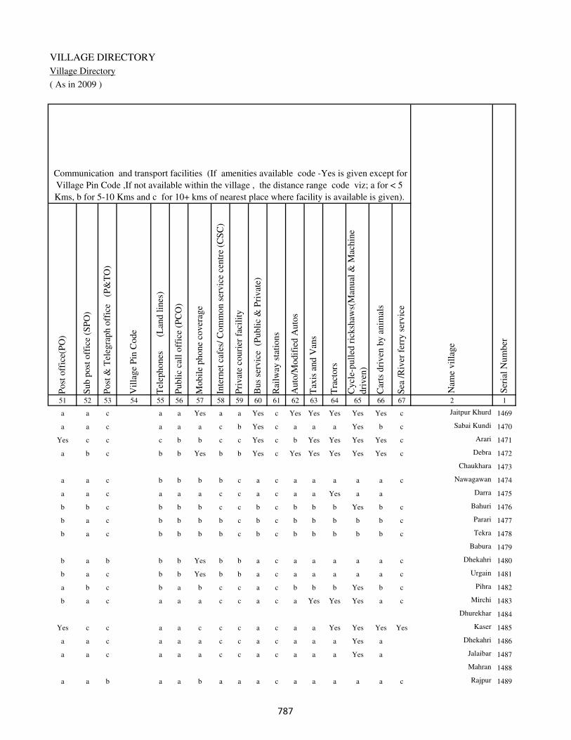
VILLAGE DIRECTORY
Village Directory
( As in 2009 )
Post
off
ice(
PO
)
Sub p
ost
off
ice
(SP
O)
Post
& T
eleg
raph o
ffic
e
(P&
TO
)
Vil
lage
Pin
Code
Tel
ephones
(L
and l
ines
)
Publi
c ca
ll o
ffic
e (P
CO
)
Mobil
e phone
cover
age
Inte
rnet
caf
es/
Com
mon s
ervic
e ce
ntr
e (C
SC
)
Pri
vat
e co
uri
er f
acil
ity
Bus
serv
ice
(P
ubli
c &
Pri
vat
e)
Rai
lway
sta
tions
Auto
/Modif
ied A
uto
s
Tax
is a
nd V
ans
Tra
ctors
Cycl
e-pull
ed r
icksh
aws(
Man
ual
& M
achin
e
dri
ven
)
Car
ts d
riven
by a
nim
als
Sea
/R
iver
fer
ry s
ervic
e51 52 53 54 55 56 57 58 59 60 61 62 63 64 65 66 67 2 1
Communication and transport facilities (If amenities available code -Yes is given except for
Village Pin Code ,If not available within the village , the distance range code viz; a for < 5
Kms, b for 5-10 Kms and c for 10+ kms of nearest place where facility is available is given).
Ser
ial
Num
ber
Nam
e vil
lage
a a c a a Yes a a Yes c Yes Yes Yes Yes Yes c Jaitpur Khurd 1469
a a c a a a c b Yes c a a a Yes b c Sabai Kundi 1470
Yes c c c b b c c Yes c b Yes Yes Yes Yes c Arari 1471
a b c b b Yes b b Yes c Yes Yes Yes Yes Yes c Debra 1472
Chaukhara 1473
a a c b b b b c a c a a a a a c Nawagawan 1474
a a c a a a c c a c a a Yes a a Darra 1475
b b c b b b c c b c b b b Yes b c Bahuri 1476
b a c b b b b c b c b b b b b c Parari 1477
b a c b b b b c b c b b b b b c Tekra 1478
Babura 1479
b a b b b Yes b b a c a a a a a c Dhekahri 1480
b a c b b Yes b b a c a a a a a c Urgain 1481
a b c b a b c c a c b b b Yes b c Pihra 1482
b a c a a a c c a c a Yes Yes Yes a c Mirchi 1483
Dhurekhar 1484
Yes c c a a c c c a c a a Yes Yes Yes Yes Kaser 1485
a a c a a a c c a c a a a Yes a Dhekahri 1486
a a c a a a c c a c a a a Yes a Jalaibar 1487
Mahran 1488
a a b a a b a a a c a a a a a c Rajpur 1489
���
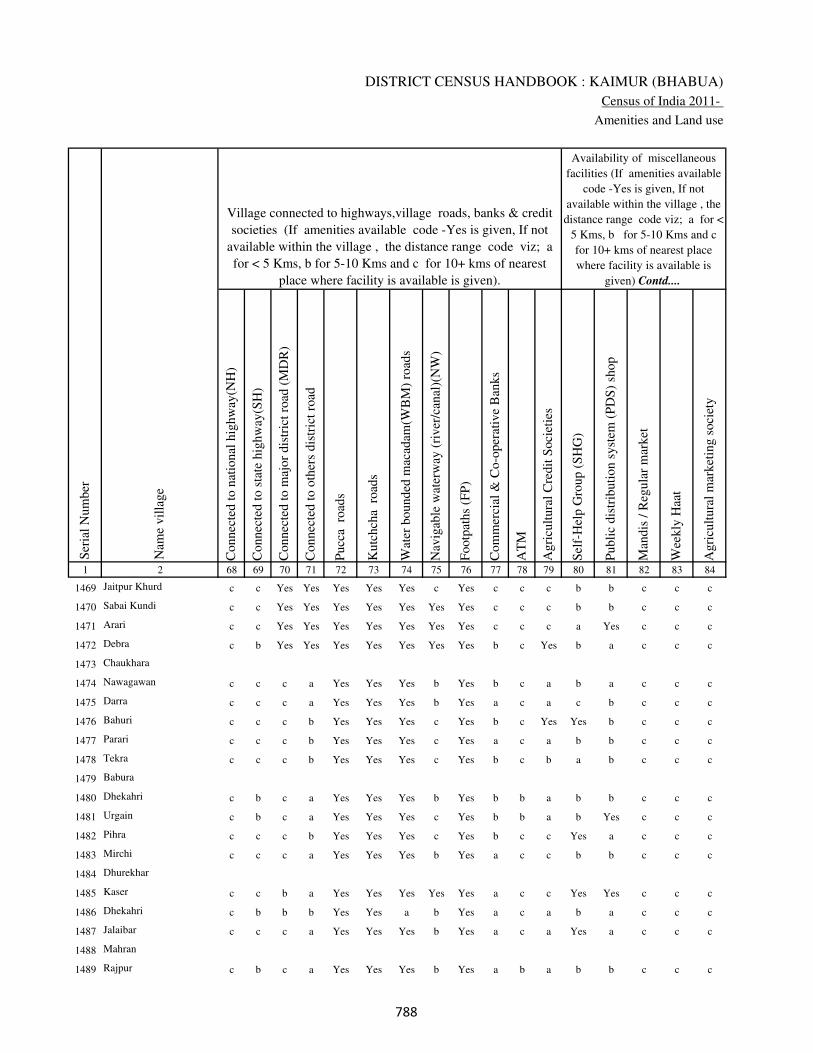
DISTRICT CENSUS HANDBOOK : KAIMUR (BHABUA)
Census of India 2011-
Amenities and Land use
Connec
ted t
o n
atio
nal
hig
hw
ay(N
H)
Connec
ted t
o s
tate
hig
hw
ay(S
H)
Connec
ted t
o m
ajor
dis
tric
t ro
ad (
MD
R)
Connec
ted t
o o
ther
s dis
tric
t ro
ad
Pucc
a r
oad
s
Kutc
hch
a r
oad
s
Wat
er b
ounded
mac
adam
(WB
M)
road
s
Nav
igab
le w
ater
way
(ri
ver
/can
al)(
NW
)
Footp
aths
(FP
)
Com
mer
cial
& C
o-o
per
ativ
e B
anks
AT
M
Agri
cult
ura
l C
redit
Soci
etie
s
Sel
f-H
elp G
roup (
SH
G)
Publi
c dis
trib
uti
on s
yst
em (
PD
S)
shop
Man
dis
/ R
egula
r m
arket
Wee
kly
Haa
t
Agri
cult
ura
l m
arket
ing s
oci
ety
1 2 68 69 70 71 72 73 74 75 76 77 78 79 80 81 82 83 84
Village connected to highways,village roads, banks & credit
societies (If amenities available code -Yes is given, If not
available within the village , the distance range code viz; a
for < 5 Kms, b for 5-10 Kms and c for 10+ kms of nearest
place where facility is available is given).
Ser
ial
Num
ber
Nam
e vil
lage
Availability of miscellaneous
facilities (If amenities available
code -Yes is given, If not
available within the village , the
distance range code viz; a for <
5 Kms, b for 5-10 Kms and c
for 10+ kms of nearest place
where facility is available is
given) Contd....
1469 Jaitpur Khurd c c Yes Yes Yes Yes Yes c Yes c c c b b c c c
1470 Sabai Kundi c c Yes Yes Yes Yes Yes Yes Yes c c c b b c c c
1471 Arari c c Yes Yes Yes Yes Yes Yes Yes c c c a Yes c c c
1472 Debra c b Yes Yes Yes Yes Yes Yes Yes b c Yes b a c c c
1473 Chaukhara
1474 Nawagawan c c c a Yes Yes Yes b Yes b c a b a c c c
1475 Darra c c c a Yes Yes Yes b Yes a c a c b c c c
1476 Bahuri c c c b Yes Yes Yes c Yes b c Yes Yes b c c c
1477 Parari c c c b Yes Yes Yes c Yes a c a b b c c c
1478 Tekra c c c b Yes Yes Yes c Yes b c b a b c c c
1479 Babura
1480 Dhekahri c b c a Yes Yes Yes b Yes b b a b b c c c
1481 Urgain c b c a Yes Yes Yes c Yes b b a b Yes c c c
1482 Pihra c c c b Yes Yes Yes c Yes b c c Yes a c c c
1483 Mirchi c c c a Yes Yes Yes b Yes a c c b b c c c
1484 Dhurekhar
1485 Kaser c c b a Yes Yes Yes Yes Yes a c c Yes Yes c c c
1486 Dhekahri c b b b Yes Yes a b Yes a c a b a c c c
1487 Jalaibar c c c a Yes Yes Yes b Yes a c a Yes a c c c
1488 Mahran
1489 Rajpur c b c a Yes Yes Yes b Yes a b a b b c c c
���

VILLAGE DIRECTORY
Village Directory
( As in 2009 )
Inte
gra
ted C
hil
d D
evel
opm
ent
Sch
eme
(Nutr
itio
nal
Cen
tres
)
Angan
wad
i C
entr
e (N
utr
itio
nal
Cen
tres
)
Oth
ers
(Nutr
itio
nal
Cen
tres
)
AS
HA
(A
ccre
dit
ed S
oci
al H
ealt
h A
ctiv
ist)
Com
munit
y c
entr
e w
ith/w
ithout
TV
Sport
s F
ield
,
Sport
s C
lub /
Rec
reat
ion C
entr
e
Cin
ema
/ V
ideo
Hal
l
Publi
c L
ibra
ry
Publi
c R
eadin
g R
oom
New
spap
er S
upply
Ass
embly
Poll
ing s
tati
on
Bir
th &
Dea
th R
egis
trat
ion O
ffic
e
Pow
er S
upply
for
Dom
esti
c U
se (
ED
)
Pow
er S
upply
for
Agri
cult
ura
l U
se (
EA
G)
Pow
er S
upply
for
Com
mer
cial
Use
(E
C)
Pow
er S
upply
for
All
Use
s (E
A)
85 86 87 88 89 90 91 92 93 94 95 96 97 98 99 100 101 2 1
Availability of
electricity (Yes/No)
Availability of miscellaneous facilities (If amenities available code -
Yes is given, If not available within the village , the distance range
code viz; a for < 5 Kms, b for 5-10 Kms and c for 10+ kms of
nearest place where facility is available is given) Concluded
Nam
e vil
lage
Ser
ial
Num
ber
a b Yes b c b c c c c b Yes Yes Yes Yes No No Jaitpur Khurd 1469
a b Yes b c c c c c c b a a Yes No No No Sabai Kundi 1470
b Yes Yes b c c c c c c b Yes b Yes No No No Arari 1471
a b Yes b c c c c c c b Yes Yes Yes Yes No No Debra 1472
Chaukhara 1473
a b Yes Yes c c c c c c b a b Yes Yes No No Nawagawan 1474
a b Yes b c c c c c c b a b Yes Yes No No Darra 1475
b Yes Yes a c c c c c c b Yes b Yes Yes No No Bahuri 1476
b b Yes Yes c c c c c c b a b Yes Yes No No Parari 1477
b b Yes Yes c c c c c c b Yes b Yes Yes No No Tekra 1478
Babura 1479
b b Yes b c c c c c c b a a Yes Yes No No Dhekahri 1480
b Yes Yes a c c c c c c b Yes Yes Yes Yes No No Urgain 1481
b Yes Yes Yes c c c c c c b Yes b Yes Yes No No Pihra 1482
b b Yes b c c c c c c b Yes a Yes Yes No No Mirchi 1483
Dhurekhar 1484
a Yes Yes Yes c c c c c c b Yes Yes Yes Yes No No Kaser 1485
a b Yes b c c c c c c b a a Yes Yes No No Dhekahri 1486
a b Yes b b c c c c c b a a Yes Yes Yes Yes Jalaibar 1487
Mahran 1488
a b Yes b b c c c c c b a a No No No No Rajpur 1489
���

DISTRICT CENSUS HANDBOOK : KAIMUR (BHABUA)
Census of India 2011-
Amenities and Land use
Nam
e
Dis
tance
ran
ge
code
i.e
. a
fo
r <
5 K
ms,
b
for
5-
10 K
ms
and c
f
or
10+
km
s .
Fore
sts
Are
a under
Non-a
gri
cult
ura
l U
ses
Bar
ren a
nd U
n-c
ult
ivab
le l
and
Per
man
ent
Pas
ture
s an
d O
ther
Gra
zing L
ands
Lan
d U
nder
Mis
cell
aneo
us
Tre
e C
rops
etc.
Cult
ura
ble
Was
te L
and
Fal
low
lan
ds
oth
er t
han
curr
ent
fall
ow
s
Curr
ent
Fal
low
s
1 2 102 103 104 105 106 107 108 109 110 111
Ser
ial
Num
ber
Nam
e vil
lage
Area under different types of land use ( in hectares rounded up to
one decimal place)
Land Use
Nearest Town
1469 Jaitpur Khurd BHABUA c 0 4 0 0 0 5 0 0
1470 Sabai Kundi BHABUA c 0 3 0 0 0 0 0 0
1471 Arari BHABUA c 0 8 0 0 0 0 0 0
1472 Debra BHABUA c 0 6 0 0 0 0 0 0
1473 Chaukhara 0 0 0 0 0 0 0 0
1474 Nawagawan BHABUA c 0 24 0 0 0 0 0 0
1475 Darra BHABUA c 0 3 0 0 0 0 0 0
1476 Bahuri BHABUA c 0 7 0 0 0 0 0 0
1477 Parari BHABUA c 0 14 0 0 0 0 0 0
1478 Tekra BHABUA c 0 11 0 0 0 0 0 0
1479 Babura 0 9 0 0 0 0 0 0
1480 Dhekahri BHABUA b 0 8 0 0 0 0 0 0
1481 Urgain BHABUA c 0 14 0 0 0 0 0 0
1482 Pihra BHABUA c 0 6 0 0 0 0 0 0
1483 Mirchi BHABUA c 0 6 0 0 0 0 0 0
1484 Dhurekhar 0 5 0 0 0 0 0 0
1485 Kaser BHABUA c 0 23 0 0 0 0 0 0
1486 Dhekahri BHABUA c 0 4 0 0 0 0 0 0
1487 Jalaibar BHABUA c 0 6 0 0 0 0 0 0
1488 Mahran 0 2 0 0 0 0 0 0
1489 Rajpur BHABUA b 0 7 0 0 0 0 0 0
���
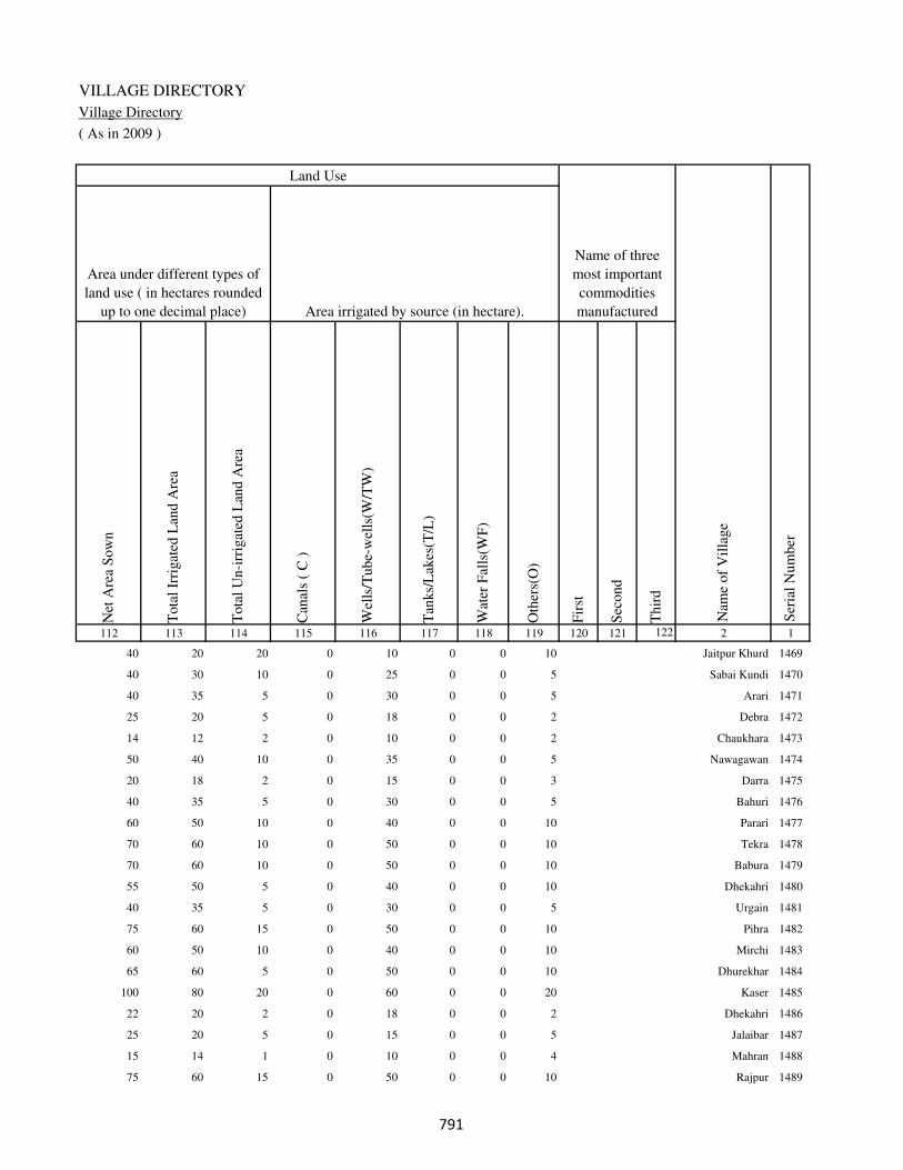
VILLAGE DIRECTORY
Village Directory
( As in 2009 )
Net
Are
a S
ow
n
Tota
l Ir
rigat
ed L
and A
rea
Tota
l U
n-i
rrig
ated
Lan
d A
rea
Can
als
( C
)
Wel
ls/T
ube-
wel
ls(W
/TW
)
Tan
ks/
Lak
es(T
/L)
Wat
er F
alls
(WF
)
Oth
ers(
O)
Fir
st
Sec
ond
Thir
d
112 113 114 115 116 117 118 119 120 121 122 2 1
Ser
ial
Num
ber
Name of three
most important
commodities
manufacturedArea irrigated by source (in hectare).
Nam
e of
Vil
lage
Area under different types of
land use ( in hectares rounded
up to one decimal place)
Land Use
40 20 20 0 10 0 0 10 Jaitpur Khurd 1469
40 30 10 0 25 0 0 5 Sabai Kundi 1470
40 35 5 0 30 0 0 5 Arari 1471
25 20 5 0 18 0 0 2 Debra 1472
14 12 2 0 10 0 0 2 Chaukhara 1473
50 40 10 0 35 0 0 5 Nawagawan 1474
20 18 2 0 15 0 0 3 Darra 1475
40 35 5 0 30 0 0 5 Bahuri 1476
60 50 10 0 40 0 0 10 Parari 1477
70 60 10 0 50 0 0 10 Tekra 1478
70 60 10 0 50 0 0 10 Babura 1479
55 50 5 0 40 0 0 10 Dhekahri 1480
40 35 5 0 30 0 0 5 Urgain 1481
75 60 15 0 50 0 0 10 Pihra 1482
60 50 10 0 40 0 0 10 Mirchi 1483
65 60 5 0 50 0 0 10 Dhurekhar 1484
100 80 20 0 60 0 0 20 Kaser 1485
22 20 2 0 18 0 0 2 Dhekahri 1486
25 20 5 0 15 0 0 5 Jalaibar 1487
15 14 1 0 10 0 0 4 Mahran 1488
75 60 15 0 50 0 0 10 Rajpur 1489
���

DISTRICT CENSUS HANDBOOK : KAIMUR (BHABUA)
Census of India 2011-
Amenities and Land use
Pre
-Pri
mar
y s
chool
(PP
)
Pri
mar
y s
chool
(P)
Mid
dle
sch
ool
(M)
Sec
ondar
y S
chool
(S)
Sen
ior
Sec
ondar
y s
chool
(SS
)
Deg
ree
coll
ege
of
arts
sc
ience
& c
om
mer
ce
(AS
C)
Engin
eeri
ng c
oll
ege(
EC
)
Med
ical
coll
ege
(MC
)
Man
agem
ent
inst
itute
(M
I)
Poly
tech
nic
(P
t)
Voca
tional
tra
inin
g s
chool
/IT
I
Non-f
orm
al t
rain
ing c
entr
e (N
FT
C)
Spec
ial
school
for
dis
able
d (
SS
D)
Oth
ers
(spec
ify)
1 2 3 4 5 6 7 8 9 10 11 12 13 14 15 16 17 18 19 20
Loca
tion c
ode
no.
Nam
e vil
lage
Ser
ial
Num
ber
Tota
l popula
tion (
2011 c
ensu
s )
Tota
l ar
ea o
f th
e vil
lage
( in
hec
tare
s ro
unded
up t
o
one
dec
imal
pla
ce)
Number of educational amenities available. (If not available
within the village , the distance range code viz; a for < 5
Kms, b for 5-10 Kms and c for 10+ kms of nearest place
where facility is available is given).
Num
ber
of
house
hold
s (2
011 c
ensu
s)
1490 Bhaluhi 250414 38 9 2 c a a b b b c c c c b c c
1491 Urgain 250415 94 673 108 b 1 b b b b c c c c c c c
1492 Mehandwar 250416 117 575 84 c 1 1 a a a c c c c a c c
1493 Sangrampur 250417 25 0 0
1494 Gobrachh 250418 93 1340 203 1 1 a b b b c c c c b c c
1495 Parhauti 250419 207 2214 334 c 1 1 a a a c c c c b c c
1496 Parmalpur 250420 51 1821 283 1 1 1 a a a c c c c b c c
1497 Manikpur 250421 72 745 112 c a a a a a c c c c b c c
1498 Khiri 250422 117 1106 213 b 1 1 a a a c c c c c c b
1499 Nokhilla 250423 39 0 0
1500 Bhagwanpur 250424 98 6213 1081 1 1 1 1 b a c c c c a c c
1501 Keshriganj 250425 69 73 19 1 1 1 1 1 b b c c c b b c
1502 Bhaisahi 250426 52 245 44 b 1 a a a a c c c c b c c
1503 Masahi 250427 285 1565 268 1 1 1 a c a c c c c c c c
1504 Papahra 250428 254 0 0
1505 Saraiya 250429 205 2720 442 1 1 1 a c c c c c c c c c
1506 Gaura 250430 30 413 59 c 1 1 b b b c c c c b c c
1507 Chholhat Sajanwa 250431 51 136 18 c b a a b a c c c c c c c
1508 Paharia 250432 217 2702 413 b 1 1 b b b c c c c b c c
1509 Shahpur 250433 59 1650 276 b 1 a b b b c c c c b b c
1510 Balbhaddarpur 250434 75 0 0
��
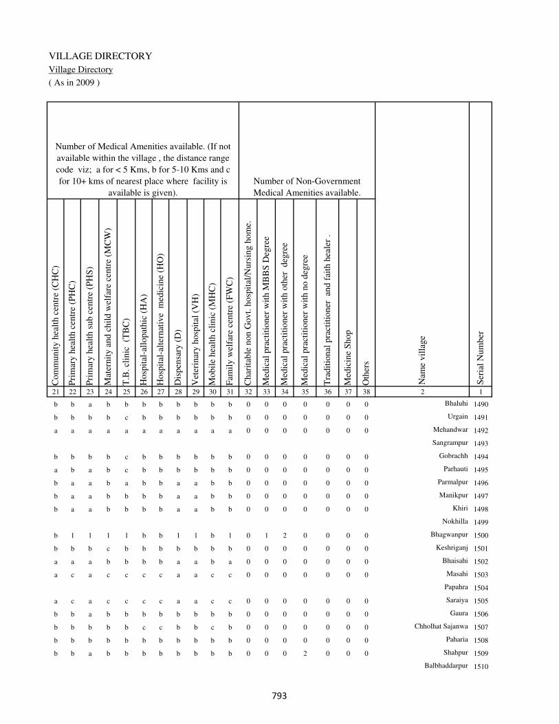
VILLAGE DIRECTORY
Village Directory
( As in 2009 )
Com
munit
y h
ealt
h c
entr
e (C
HC
)
Pri
mar
y h
ealt
h c
entr
e (P
HC
)
Pri
mar
y h
ealt
h s
ub c
entr
e (P
HS
)
Mat
ernit
y a
nd c
hil
d w
elfa
re c
entr
e (M
CW
)
T.B
. cl
inic
(T
BC
)
Hosp
ital
-all
opat
hic
(H
A)
Hosp
ital
-alt
ernat
ive
med
icin
e (H
O)
Dis
pen
sary
(D
)
Vet
erin
ary h
osp
ital
(V
H)
Mobil
e hea
lth c
linic
(M
HC
)
Fam
ily w
elfa
re c
entr
e (F
WC
)
Char
itab
le n
on G
ovt.
hosp
ital
/Nurs
ing h
om
e.
Med
ical
pra
ctit
ioner
wit
h M
BB
S D
egre
e
Med
ical
pra
ctit
ioner
wit
h o
ther
deg
ree
Med
ical
pra
ctit
ioner
wit
h n
o d
egre
e
Tra
dit
ional
pra
ctit
ioner
an
d f
aith
hea
ler
.
Med
icin
e S
hop
Oth
ers
21 22 23 24 25 26 27 28 29 30 31 32 33 34 35 36 37 38 2 1
Number of Non-Government
Medical Amenities available.
Number of Medical Amenities available. (If not
available within the village , the distance range
code viz; a for < 5 Kms, b for 5-10 Kms and c
for 10+ kms of nearest place where facility is
available is given).
Nam
e vil
lage
Ser
ial
Num
ber
b b a b b b b b b b b 0 0 0 0 0 0 0 Bhaluhi 1490
b b b b c b b b b b b 0 0 0 0 0 0 0 Urgain 1491
a a a a a a a a a a a 0 0 0 0 0 0 0 Mehandwar 1492
Sangrampur 1493
b b b b c b b b b b b 0 0 0 0 0 0 0 Gobrachh 1494
a b a b c b b b b b b 0 0 0 0 0 0 0 Parhauti 1495
b a a b a b b a a b b 0 0 0 0 0 0 0 Parmalpur 1496
b a a b b b b a a b b 0 0 0 0 0 0 0 Manikpur 1497
b a a b b b b a a b b 0 0 0 0 0 0 0 Khiri 1498
Nokhilla 1499
b 1 1 1 1 b b 1 1 b 1 0 1 2 0 0 0 0 Bhagwanpur 1500
b b b c b b b b b b b 0 0 0 0 0 0 0 Keshriganj 1501
a a a b b b b a a b a 0 0 0 0 0 0 0 Bhaisahi 1502
a c a c c c c a a c c 0 0 0 0 0 0 0 Masahi 1503
Papahra 1504
a c a c c c c a a c c 0 0 0 0 0 0 0 Saraiya 1505
b b a b b b b b b b b 0 0 0 0 0 0 0 Gaura 1506
b b b b b c c b b c b 0 0 0 0 0 0 0 Chholhat Sajanwa 1507
b b b b b b b b b b b 0 0 0 0 0 0 0 Paharia 1508
b b a b b b b b b b b 0 0 0 2 0 0 0 Shahpur 1509
Balbhaddarpur 1510
��

DISTRICT CENSUS HANDBOOK : KAIMUR (BHABUA)
Census of India 2011-
Amenities and Land use
Tap
wat
er (
Tre
ated
/Untr
eate
d)
Wel
l w
ater
(Cover
ed /
Unco
ver
ed w
ell)
Han
d P
um
p
Tube
wel
ls /
Bore
wel
l
Spri
ng
Riv
er /
Can
al
Tan
k /
Pond /
L
ake
Oth
ers
Com
munit
y t
oil
et i
ncl
udin
g
bat
h.
Com
munit
y t
oil
et e
xcl
udin
g b
ath.
Rura
l s
anit
ary m
art
or
sanit
ary
har
dw
are
outl
et
avai
lable
nea
r th
e vil
lage.
Com
munit
y b
io-
gas
or
recy
cle
of
was
te f
or
pro
duct
ive
use
.
1 2 39 40 41 42 43 44 45 46 47 48 49 50
Availability of toilet & others
Yes / No Availability of drinking water - Yes / No
Nam
e vil
lage
Ser
ial
Num
ber
1490 Bhaluhi No Yes Yes No No No No No No No No No
1491 Urgain No Yes Yes Yes No No No No No No No No
1492 Mehandwar No Yes Yes No No No No No No No No No
1493 Sangrampur
1494 Gobrachh No Yes Yes No No No No No No No No No
1495 Parhauti No Yes Yes Yes No Yes No No No No No No
1496 Parmalpur No Yes Yes No No No No No No No No No
1497 Manikpur No Yes Yes No No No No No No No No No
1498 Khiri No Yes Yes No No No No No No No No No
1499 Nokhilla
1500 Bhagwanpur No Yes Yes No No No No No No No No No
1501 Keshriganj No No Yes No No No No No No No No No
1502 Bhaisahi No Yes Yes No No No No No No No No No
1503 Masahi No Yes Yes No No Yes No No No No No No
1504 Papahra
1505 Saraiya No Yes Yes No No Yes No No No No No No
1506 Gaura No Yes Yes Yes No Yes No No No No No No
1507 Chholhat Sajanwa No No Yes No No No No No No No No No
1508 Paharia No Yes Yes No No Yes No No No No No No
1509 Shahpur No Yes Yes No No Yes No No No No No No
1510 Balbhaddarpur
���
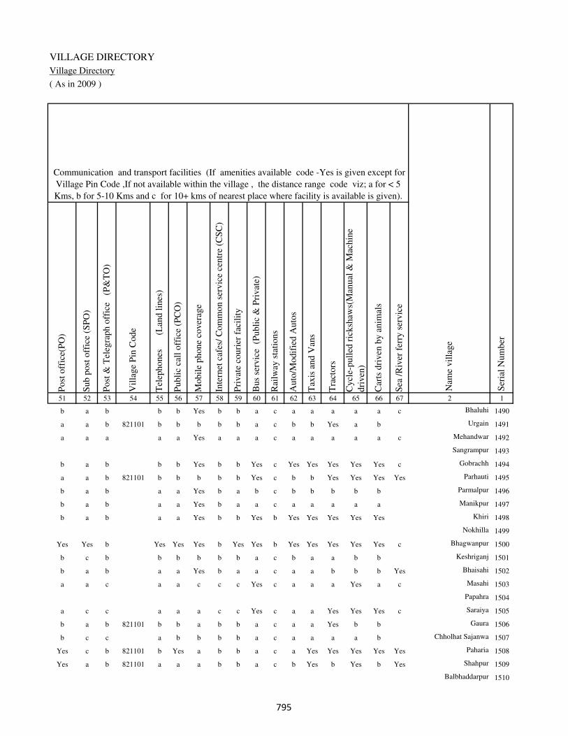
VILLAGE DIRECTORY
Village Directory
( As in 2009 )
Post
off
ice(
PO
)
Sub p
ost
off
ice
(SP
O)
Post
& T
eleg
raph o
ffic
e
(P&
TO
)
Vil
lage
Pin
Code
Tel
ephones
(L
and l
ines
)
Publi
c ca
ll o
ffic
e (P
CO
)
Mobil
e phone
cover
age
Inte
rnet
caf
es/
Com
mon s
ervic
e ce
ntr
e (C
SC
)
Pri
vat
e co
uri
er f
acil
ity
Bus
serv
ice
(P
ubli
c &
Pri
vat
e)
Rai
lway
sta
tions
Auto
/Modif
ied A
uto
s
Tax
is a
nd V
ans
Tra
ctors
Cycl
e-pull
ed r
icksh
aws(
Man
ual
& M
achin
e
dri
ven
)
Car
ts d
riven
by a
nim
als
Sea
/R
iver
fer
ry s
ervic
e51 52 53 54 55 56 57 58 59 60 61 62 63 64 65 66 67 2 1
Communication and transport facilities (If amenities available code -Yes is given except for
Village Pin Code ,If not available within the village , the distance range code viz; a for < 5
Kms, b for 5-10 Kms and c for 10+ kms of nearest place where facility is available is given).
Ser
ial
Num
ber
Nam
e vil
lage
b a b b b Yes b b a c a a a a a c Bhaluhi 1490
a a b 821101 b b b b b a c b b Yes a b Urgain 1491
a a a a a Yes a a a c a a a a a c Mehandwar 1492
Sangrampur 1493
b a b b b Yes b b Yes c Yes Yes Yes Yes Yes c Gobrachh 1494
a a b 821101 b b b b b Yes c b b Yes Yes Yes Yes Parhauti 1495
b a b a a Yes b a b c b b b b b Parmalpur 1496
b a b a a Yes b a a c a a a a a Manikpur 1497
b a b a a Yes b b Yes b Yes Yes Yes Yes Yes Khiri 1498
Nokhilla 1499
Yes Yes b Yes Yes Yes b Yes Yes b Yes Yes Yes Yes Yes c Bhagwanpur 1500
b c b b b b b b a c b a a b b Keshriganj 1501
b a b a a Yes b a a c a a b b b Yes Bhaisahi 1502
a a c a a c c c Yes c a a a Yes a c Masahi 1503
Papahra 1504
a c c a a a c c Yes c a a Yes Yes Yes c Saraiya 1505
b a b 821101 b b a b b a c a a Yes b b Gaura 1506
b c c a b b b b a c a a a a b Chholhat Sajanwa 1507
Yes c b 821101 b Yes a b b a c a Yes Yes Yes Yes Yes Paharia 1508
Yes a b 821101 a a a b b a c b Yes b Yes b Yes Shahpur 1509
Balbhaddarpur 1510
���

DISTRICT CENSUS HANDBOOK : KAIMUR (BHABUA)
Census of India 2011-
Amenities and Land use
Connec
ted t
o n
atio
nal
hig
hw
ay(N
H)
Connec
ted t
o s
tate
hig
hw
ay(S
H)
Connec
ted t
o m
ajor
dis
tric
t ro
ad (
MD
R)
Connec
ted t
o o
ther
s dis
tric
t ro
ad
Pucc
a r
oad
s
Kutc
hch
a r
oad
s
Wat
er b
ounded
mac
adam
(WB
M)
road
s
Nav
igab
le w
ater
way
(ri
ver
/can
al)(
NW
)
Footp
aths
(FP
)
Com
mer
cial
& C
o-o
per
ativ
e B
anks
AT
M
Agri
cult
ura
l C
redit
Soci
etie
s
Sel
f-H
elp G
roup (
SH
G)
Publi
c dis
trib
uti
on s
yst
em (
PD
S)
shop
Man
dis
/ R
egula
r m
arket
Wee
kly
Haa
t
Agri
cult
ura
l m
arket
ing s
oci
ety
1 2 68 69 70 71 72 73 74 75 76 77 78 79 80 81 82 83 84
Village connected to highways,village roads, banks & credit
societies (If amenities available code -Yes is given, If not
available within the village , the distance range code viz; a
for < 5 Kms, b for 5-10 Kms and c for 10+ kms of nearest
place where facility is available is given).
Ser
ial
Num
ber
Nam
e vil
lage
Availability of miscellaneous
facilities (If amenities available
code -Yes is given, If not
available within the village , the
distance range code viz; a for <
5 Kms, b for 5-10 Kms and c
for 10+ kms of nearest place
where facility is available is
given) Contd....
1490 Bhaluhi c b Yes Yes Yes Yes a b Yes b b a b b c c c
1491 Urgain c Yes Yes b Yes Yes b c Yes b b b b Yes c c c
1492 Mehandwar c a a a Yes Yes Yes c Yes a a a c a c c c
1493 Sangrampur
1494 Gobrachh c b Yes Yes Yes Yes a Yes Yes Yes b b b Yes c c c
1495 Parhauti c b Yes Yes Yes Yes Yes Yes Yes b b b b Yes c c c
1496 Parmalpur c b b a Yes Yes Yes b Yes a b a b b c c c
1497 Manikpur c b a a Yes Yes Yes a Yes a b a b a c c c
1498 Khiri c b Yes Yes Yes Yes Yes a Yes a b a b b c c c
1499 Nokhilla
1500 Bhagwanpur c b Yes Yes Yes Yes a Yes Yes Yes b b Yes b c c c
1501 Keshriganj c c b b Yes Yes b a Yes b c b b b c c c
1502 Bhaisahi c b b a b Yes Yes Yes Yes a b a a Yes c c c
1503 Masahi c c b Yes Yes Yes Yes a Yes c c c Yes Yes c c c
1504 Papahra
1505 Saraiya c c c Yes Yes Yes Yes a Yes Yes c c Yes Yes c c c
1506 Gaura c b c a a Yes Yes b Yes b b Yes Yes a c c c
1507 Chholhat Sajanwa c b b b a Yes a a Yes b b c b b c c c
1508 Paharia c b b a Yes Yes Yes Yes Yes a b Yes b Yes c c c
1509 Shahpur c a a a Yes Yes Yes Yes Yes b b a b Yes c c c
1510 Balbhaddarpur
���

VILLAGE DIRECTORY
Village Directory
( As in 2009 )
Inte
gra
ted C
hil
d D
evel
opm
ent
Sch
eme
(Nutr
itio
nal
Cen
tres
)
Angan
wad
i C
entr
e (N
utr
itio
nal
Cen
tres
)
Oth
ers
(Nutr
itio
nal
Cen
tres
)
AS
HA
(A
ccre
dit
ed S
oci
al H
ealt
h A
ctiv
ist)
Com
munit
y c
entr
e w
ith/w
ithout
TV
Sport
s F
ield
,
Sport
s C
lub /
Rec
reat
ion C
entr
e
Cin
ema
/ V
ideo
Hal
l
Publi
c L
ibra
ry
Publi
c R
eadin
g R
oom
New
spap
er S
upply
Ass
embly
Poll
ing s
tati
on
Bir
th &
Dea
th R
egis
trat
ion O
ffic
e
Pow
er S
upply
for
Dom
esti
c U
se (
ED
)
Pow
er S
upply
for
Agri
cult
ura
l U
se (
EA
G)
Pow
er S
upply
for
Com
mer
cial
Use
(E
C)
Pow
er S
upply
for
All
Use
s (E
A)
85 86 87 88 89 90 91 92 93 94 95 96 97 98 99 100 101 2 1
Availability of
electricity (Yes/No)
Availability of miscellaneous facilities (If amenities available code -
Yes is given, If not available within the village , the distance range
code viz; a for < 5 Kms, b for 5-10 Kms and c for 10+ kms of
nearest place where facility is available is given) Concluded
Nam
e vil
lage
Ser
ial
Num
ber
b b Yes b b c c c c c b a a Yes Yes No No Bhaluhi 1490
b Yes Yes Yes Yes c a c c c c a a Yes No Yes No Urgain 1491
b b Yes b b c c c c c c Yes b Yes Yes No No Mehandwar 1492
Sangrampur 1493
b Yes Yes a b c c c c b b Yes b Yes No Yes No Gobrachh 1494
a Yes Yes Yes b c c c c c b Yes b Yes No Yes No Parhauti 1495
a Yes Yes a c c c c c b b Yes b Yes Yes No No Parmalpur 1496
a Yes Yes a c c c c c c b Yes b Yes No Yes No Manikpur 1497
a b Yes b c c c c c c b a b Yes No Yes No Khiri 1498
Nokhilla 1499
Yes Yes Yes Yes c c c c c b Yes Yes Yes Yes No Yes No Bhagwanpur 1500
Yes b Yes a c c c c c b b a b Yes No No No Keshriganj 1501
a Yes Yes a c c c c c c b Yes b Yes No No No Bhaisahi 1502
a Yes Yes b c c c c b c b Yes Yes Yes Yes No No Masahi 1503
Papahra 1504
a Yes Yes Yes c c c c c b b Yes Yes Yes Yes No No Saraiya 1505
b b Yes a c c c c c c b a a Yes Yes No No Gaura 1506
a b Yes b c c c c c c b a a Yes No No No Chholhat Sajanwa 1507
b Yes Yes Yes c c c c c c Yes Yes Yes Yes Yes No No Paharia 1508
b Yes Yes a c c c c c c a Yes b Yes Yes No No Shahpur 1509
Balbhaddarpur 1510
���

DISTRICT CENSUS HANDBOOK : KAIMUR (BHABUA)
Census of India 2011-
Amenities and Land use
Nam
e
Dis
tance
ran
ge
code
i.e
. a
fo
r <
5 K
ms,
b
for
5-
10 K
ms
and c
f
or
10+
km
s .
Fore
sts
Are
a under
Non-a
gri
cult
ura
l U
ses
Bar
ren a
nd U
n-c
ult
ivab
le l
and
Per
man
ent
Pas
ture
s an
d O
ther
Gra
zing L
ands
Lan
d U
nder
Mis
cell
aneo
us
Tre
e C
rops
etc.
Cult
ura
ble
Was
te L
and
Fal
low
lan
ds
oth
er t
han
curr
ent
fall
ow
s
Curr
ent
Fal
low
s
1 2 102 103 104 105 106 107 108 109 110 111
Ser
ial
Num
ber
Nam
e vil
lage
Area under different types of land use ( in hectares rounded up to
one decimal place)
Land Use
Nearest Town
1490 Bhaluhi BHABUA b 0 5 0 0 0 0 0 0
1491 Urgain BHABUA b 0 14 0 0 0 0 0 0
1492 Mehandwar BHABUA a 0 17 0 0 0 0 0 0
1493 Sangrampur 0 3 0 0 0 0 0 0
1494 Gobrachh BHABUA b 0 13 0 0 0 0 0 0
1495 Parhauti BHABUA b 0 17 0 0 0 0 0 0
1496 Parmalpur BHABUA b 0 11 0 0 0 0 0 0
1497 Manikpur BHABUA b 0 12 0 0 0 0 0 0
1498 Khiri BHABUA b 0 17 0 0 0 0 0 0
1499 Nokhilla 0 4 0 0 0 0 0 0
1500 Bhagwanpur BHABUA b 0 8 0 0 0 0 0 0
1501 Keshriganj BHABUA b 0 4 0 0 0 0 0 0
1502 Bhaisahi BHABUA b 0 7 0 0 0 0 0 0
1503 Masahi BHABUA c 0 35 0 0 0 0 0 0
1504 Papahra 0 14 0 0 0 0 0 0
1505 Saraiya BHABUA c 0 55 0 0 0 0 0 0
1506 Gaura BHABUA b 0 10 0 0 0 10 0 0
1507 Chholhat Sajanwa BHABUA c 0 11 0 0 0 0 0 0
1508 Paharia BHABUA b 0 27 0 0 0 0 0 0
1509 Shahpur BHABUA b 0 19 0 0 0 0 0 0
1510 Balbhaddarpur 0 5 0 0 0 0 0 0
���

VILLAGE DIRECTORY
Village Directory
( As in 2009 )
Net
Are
a S
ow
n
Tota
l Ir
rigat
ed L
and A
rea
Tota
l U
n-i
rrig
ated
Lan
d A
rea
Can
als
( C
)
Wel
ls/T
ube-
wel
ls(W
/TW
)
Tan
ks/
Lak
es(T
/L)
Wat
er F
alls
(WF
)
Oth
ers(
O)
Fir
st
Sec
ond
Thir
d
112 113 114 115 116 117 118 119 120 121 122 2 1
Ser
ial
Num
ber
Name of three
most important
commodities
manufacturedArea irrigated by source (in hectare).
Nam
e of
Vil
lage
Area under different types of
land use ( in hectares rounded
up to one decimal place)
Land Use
33 25 8 0 20 0 0 5 Bhaluhi 1490
80 70 10 0 60 0 0 10 Urgain 1491
100 80 20 0 60 0 0 20 Mehandwar 1492
22 17 5 0 15 0 0 2 Sangrampur 1493
80 70 10 0 50 0 0 20 Gobrachh 1494
190 150 40 0 120 0 0 30 Parhauti 1495
40 30 10 0 25 0 0 5 Parmalpur 1496
60 50 10 0 40 0 0 10 Manikpur 1497
100 80 20 0 60 0 0 20 Khiri 1498
35 30 5 0 25 0 0 5 Nokhilla 1499
90 80 10 0 70 0 0 10 Bhagwanpur 1500
65 60 5 0 50 0 0 10 Keshriganj 1501
45 40 5 0 30 0 0 10 Bhaisahi 1502
250 200 50 0 150 0 0 50 Masahi 1503
240 200 40 0 160 0 0 40 Papahra 1504
150 125 25 0 100 0 0 25 Saraiya 1505
10 10 0 0 10 0 0 0 Gaura 1506
40 30 10 0 25 0 0 5 Chholhat Sajanwa 1507
190 150 40 0 100 0 0 50 Paharia 1508
40 35 5 0 30 0 0 5 Shahpur 1509
70 65 5 0 60 0 0 5 Balbhaddarpur 1510
���
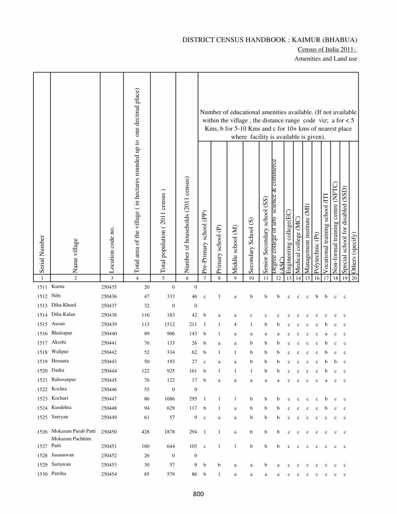
DISTRICT CENSUS HANDBOOK : KAIMUR (BHABUA)
Census of India 2011-
Amenities and Land use
Pre
-Pri
mar
y s
chool
(PP
)
Pri
mar
y s
chool
(P)
Mid
dle
sch
ool
(M)
Sec
ondar
y S
chool
(S)
Sen
ior
Sec
ondar
y s
chool
(SS
)
Deg
ree
coll
ege
of
arts
sc
ience
& c
om
mer
ce
(AS
C)
Engin
eeri
ng c
oll
ege(
EC
)
Med
ical
coll
ege
(MC
)
Man
agem
ent
inst
itute
(M
I)
Poly
tech
nic
(P
t)
Voca
tional
tra
inin
g s
chool
/IT
I
Non-f
orm
al t
rain
ing c
entr
e (N
FT
C)
Spec
ial
school
for
dis
able
d (
SS
D)
Oth
ers
(spec
ify)
1 2 3 4 5 6 7 8 9 10 11 12 13 14 15 16 17 18 19 20
Loca
tion c
ode
no.
Nam
e vil
lage
Ser
ial
Num
ber
Tota
l popula
tion (
2011 c
ensu
s )
Tota
l ar
ea o
f th
e vil
lage
( in
hec
tare
s ro
unded
up t
o
one
dec
imal
pla
ce)
Number of educational amenities available. (If not available
within the village , the distance range code viz; a for < 5
Kms, b for 5-10 Kms and c for 10+ kms of nearest place
where facility is available is given).
Num
ber
of
house
hold
s (2
011 c
ensu
s)
1511 Kurna 250435 20 0 0
1512 Nibi 250436 47 333 46 c 1 a b b b c c c b b c c
1513 Diha Khurd 250437 32 0 0
1514 Diha Kalan 250438 116 183 42 b a a c c c c c c c c c c
1515 Ausan 250439 113 1512 211 1 1 4 1 b b c c c c b c c
1516 Bhairapur 250440 89 906 143 b 1 a a a a c c c c a c c
1517 Akorhi 250441 76 133 26 b a a b b b c c c c b c c
1518 Walipur 250442 52 334 62 b 1 1 b b b c c c c b c c
1519 Henauta 250443 50 193 27 c a a b b b c c c c b b c
1520 Dadra 250444 122 925 161 b 1 1 1 b b c c c c b c c
1521 Bahoranpur 250445 76 122 17 b a a a a a c c c c a c c
1522 Kochra 250446 55 0 0
1523 Kochari 250447 86 1686 295 1 1 1 b b b c c c c b c c
1524 Kusdehra 250448 94 629 117 b 1 a b b b c c c c b c c
1525 Sareyan 250449 61 57 9 c a a b b b c c c c c c c
1526 Mokaram Purab Patti 250450 428 1878 294 1 1 a b b b c c c c c c c
1527
Mokaram Pachhim
Patti 250451 160 644 103 c 1 1 b b b c c c c c c c
1528 Jasaunwan 250452 26 0 0
1529 Sariawan 250453 30 57 9 b b a a b a c c c c c c c
1530 Patriha 250454 85 579 86 b 1 a a a a c c c c c c c
���

VILLAGE DIRECTORY
Village Directory
( As in 2009 )
Com
munit
y h
ealt
h c
entr
e (C
HC
)
Pri
mar
y h
ealt
h c
entr
e (P
HC
)
Pri
mar
y h
ealt
h s
ub c
entr
e (P
HS
)
Mat
ernit
y a
nd c
hil
d w
elfa
re c
entr
e (M
CW
)
T.B
. cl
inic
(T
BC
)
Hosp
ital
-all
opat
hic
(H
A)
Hosp
ital
-alt
ernat
ive
med
icin
e (H
O)
Dis
pen
sary
(D
)
Vet
erin
ary h
osp
ital
(V
H)
Mobil
e hea
lth c
linic
(M
HC
)
Fam
ily w
elfa
re c
entr
e (F
WC
)
Char
itab
le n
on G
ovt.
hosp
ital
/Nurs
ing h
om
e.
Med
ical
pra
ctit
ioner
wit
h M
BB
S D
egre
e
Med
ical
pra
ctit
ioner
wit
h o
ther
deg
ree
Med
ical
pra
ctit
ioner
wit
h n
o d
egre
e
Tra
dit
ional
pra
ctit
ioner
an
d f
aith
hea
ler
.
Med
icin
e S
hop
Oth
ers
21 22 23 24 25 26 27 28 29 30 31 32 33 34 35 36 37 38 2 1
Number of Non-Government
Medical Amenities available.
Number of Medical Amenities available. (If not
available within the village , the distance range
code viz; a for < 5 Kms, b for 5-10 Kms and c
for 10+ kms of nearest place where facility is
available is given).
Nam
e vil
lage
Ser
ial
Num
ber
Kurna 1511
b b a b b b b b b b b 0 0 0 0 0 0 0 Nibi 1512
Diha Khurd 1513
b b a c b c c b b c b 0 0 0 0 0 0 0 Diha Kalan 1514
b b a b b a a b b a b 0 0 0 0 0 0 0 Ausan 1515
a a a a a a a a a a a 0 0 0 0 0 0 0 Bhairapur 1516
b b a b b b b b b b b 0 0 0 0 0 0 0 Akorhi 1517
b b a b b b b b b b b 0 0 0 0 0 0 0 Walipur 1518
b b a b b b b b b b b 0 0 0 0 0 0 0 Henauta 1519
b b a b b b b b b b b 0 0 0 0 0 0 0 Dadra 1520
a a a a a a a a a a a 0 0 0 0 0 0 0 Bahoranpur 1521
Kochra 1522
b b a b b b b b b b b 0 0 0 0 0 0 0 Kochari 1523
b b a b b b b b b b b 0 0 0 0 0 0 0 Kusdehra 1524
c c b c c c c c b c c 0 0 0 0 0 0 0 Sareyan 1525
c c b c c c c c b c c 0 0 0 0 0 0 0 Mokaram Purab Patti 1526
c c a c c c c c b c c 0 0 0 0 0 0 0 Mokaram Pachhim Patti 1527
Jasaunwan 1528
c c b c c c c c b c c 0 0 0 0 0 0 0 Sariawan 1529
b b b c c c c c a c c 0 0 0 0 0 0 0 Patriha 1530
���

DISTRICT CENSUS HANDBOOK : KAIMUR (BHABUA)
Census of India 2011-
Amenities and Land use
Tap
wat
er (
Tre
ated
/Untr
eate
d)
Wel
l w
ater
(Cover
ed /
Unco
ver
ed w
ell)
Han
d P
um
p
Tube
wel
ls /
Bore
wel
l
Spri
ng
Riv
er /
Can
al
Tan
k /
Pond /
L
ake
Oth
ers
Com
munit
y t
oil
et i
ncl
udin
g
bat
h.
Com
munit
y t
oil
et e
xcl
udin
g b
ath.
Rura
l s
anit
ary m
art
or
sanit
ary
har
dw
are
outl
et
avai
lable
nea
r th
e vil
lage.
Com
munit
y b
io-
gas
or
recy
cle
of
was
te f
or
pro
duct
ive
use
.
1 2 39 40 41 42 43 44 45 46 47 48 49 50
Availability of toilet & others
Yes / No Availability of drinking water - Yes / No
Nam
e vil
lage
Ser
ial
Num
ber
1511 Kurna
1512 Nibi No Yes Yes No No Yes No No No No No No
1513 Diha Khurd
1514 Diha Kalan No Yes Yes No No Yes No No No No No No
1515 Ausan No Yes Yes No No No No No No No No No
1516 Bhairapur No Yes Yes No No No No No No No No No
1517 Akorhi No Yes Yes No No No No No No No No No
1518 Walipur No Yes Yes No No No No No No No No No
1519 Henauta No Yes Yes No No No No No No No No No
1520 Dadra No Yes Yes No No No No No No No No No
1521 Bahoranpur No Yes Yes No No No No No No No No No
1522 Kochra
1523 Kochari No Yes Yes No No No No No No No No No
1524 Kusdehra No Yes Yes No No No No No No No No No
1525 Sareyan No Yes Yes No No Yes No No No No No No
1526 Mokaram Purab Patti No Yes Yes No No No No No No No No No
1527 Mokaram Pachhim Patti No Yes Yes No No Yes No No No No No No
1528 Jasaunwan
1529 Sariawan No No Yes No No No No No No No No No
1530 Patriha No Yes Yes No No Yes No No No No No No
��
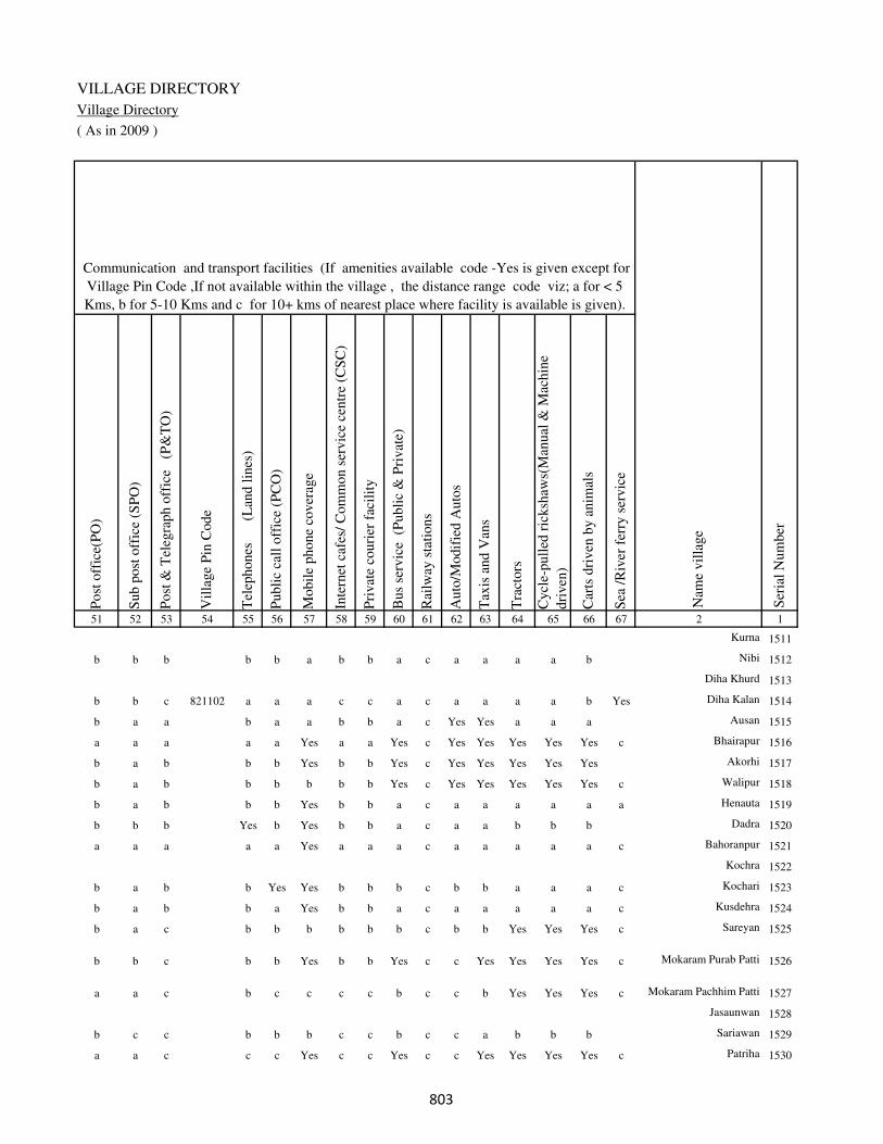
VILLAGE DIRECTORY
Village Directory
( As in 2009 )
Post
off
ice(
PO
)
Sub p
ost
off
ice
(SP
O)
Post
& T
eleg
raph o
ffic
e
(P&
TO
)
Vil
lage
Pin
Code
Tel
ephones
(L
and l
ines
)
Publi
c ca
ll o
ffic
e (P
CO
)
Mobil
e phone
cover
age
Inte
rnet
caf
es/
Com
mon s
ervic
e ce
ntr
e (C
SC
)
Pri
vat
e co
uri
er f
acil
ity
Bus
serv
ice
(P
ubli
c &
Pri
vat
e)
Rai
lway
sta
tions
Auto
/Modif
ied A
uto
s
Tax
is a
nd V
ans
Tra
ctors
Cycl
e-pull
ed r
icksh
aws(
Man
ual
& M
achin
e
dri
ven
)
Car
ts d
riven
by a
nim
als
Sea
/R
iver
fer
ry s
ervic
e51 52 53 54 55 56 57 58 59 60 61 62 63 64 65 66 67 2 1
Communication and transport facilities (If amenities available code -Yes is given except for
Village Pin Code ,If not available within the village , the distance range code viz; a for < 5
Kms, b for 5-10 Kms and c for 10+ kms of nearest place where facility is available is given).
Ser
ial
Num
ber
Nam
e vil
lage
Kurna 1511
b b b b b a b b a c a a a a b Nibi 1512
Diha Khurd 1513
b b c 821102 a a a c c a c a a a a b Yes Diha Kalan 1514
b a a b a a b b a c Yes Yes a a a Ausan 1515
a a a a a Yes a a Yes c Yes Yes Yes Yes Yes c Bhairapur 1516
b a b b b Yes b b Yes c Yes Yes Yes Yes Yes Akorhi 1517
b a b b b b b b Yes c Yes Yes Yes Yes Yes c Walipur 1518
b a b b b Yes b b a c a a a a a a Henauta 1519
b b b Yes b Yes b b a c a a b b b Dadra 1520
a a a a a Yes a a a c a a a a a c Bahoranpur 1521
Kochra 1522
b a b b Yes Yes b b b c b b a a a c Kochari 1523
b a b b a Yes b b a c a a a a a c Kusdehra 1524
b a c b b b b b b c b b Yes Yes Yes c Sareyan 1525
b b c b b Yes b b Yes c c Yes Yes Yes Yes c Mokaram Purab Patti 1526
a a c b c c c c b c c b Yes Yes Yes c Mokaram Pachhim Patti 1527
Jasaunwan 1528
b c c b b b c c b c c a b b b Sariawan 1529
a a c c c Yes c c Yes c c Yes Yes Yes Yes c Patriha 1530
��
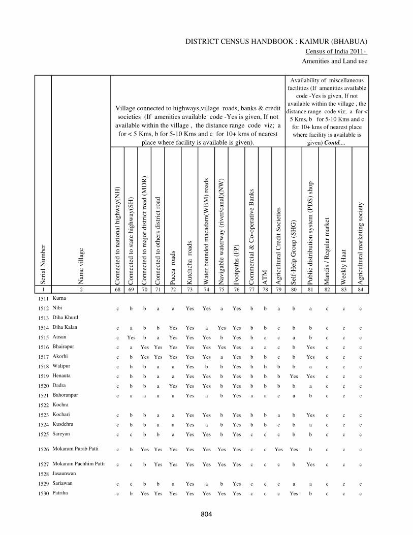
DISTRICT CENSUS HANDBOOK : KAIMUR (BHABUA)
Census of India 2011-
Amenities and Land use
Connec
ted t
o n
atio
nal
hig
hw
ay(N
H)
Connec
ted t
o s
tate
hig
hw
ay(S
H)
Connec
ted t
o m
ajor
dis
tric
t ro
ad (
MD
R)
Connec
ted t
o o
ther
s dis
tric
t ro
ad
Pucc
a r
oad
s
Kutc
hch
a r
oad
s
Wat
er b
ounded
mac
adam
(WB
M)
road
s
Nav
igab
le w
ater
way
(ri
ver
/can
al)(
NW
)
Footp
aths
(FP
)
Com
mer
cial
& C
o-o
per
ativ
e B
anks
AT
M
Agri
cult
ura
l C
redit
Soci
etie
s
Sel
f-H
elp G
roup (
SH
G)
Publi
c dis
trib
uti
on s
yst
em (
PD
S)
shop
Man
dis
/ R
egula
r m
arket
Wee
kly
Haa
t
Agri
cult
ura
l m
arket
ing s
oci
ety
1 2 68 69 70 71 72 73 74 75 76 77 78 79 80 81 82 83 84
Village connected to highways,village roads, banks & credit
societies (If amenities available code -Yes is given, If not
available within the village , the distance range code viz; a
for < 5 Kms, b for 5-10 Kms and c for 10+ kms of nearest
place where facility is available is given).
Ser
ial
Num
ber
Nam
e vil
lage
Availability of miscellaneous
facilities (If amenities available
code -Yes is given, If not
available within the village , the
distance range code viz; a for <
5 Kms, b for 5-10 Kms and c
for 10+ kms of nearest place
where facility is available is
given) Contd....
1511 Kurna
1512 Nibi c b b a a Yes Yes a Yes b b a b a c c c
1513 Diha Khurd
1514 Diha Kalan c a b b Yes Yes a Yes Yes b b c b b c c c
1515 Ausan c Yes b a Yes Yes Yes b Yes b a c a b c c c
1516 Bhairapur c a Yes Yes Yes Yes Yes Yes Yes a a c b Yes c c c
1517 Akorhi c b Yes Yes Yes Yes Yes a Yes b b c b Yes c c c
1518 Walipur c b b a a Yes b b Yes b b b b a c c c
1519 Henauta c b b a a Yes Yes b Yes b b b Yes Yes c c c
1520 Dadra c b b a Yes Yes Yes b Yes b b b b a c c c
1521 Bahoranpur c a a a a Yes a b Yes a a c a b c c c
1522 Kochra
1523 Kochari c b b a a Yes Yes b Yes b b a b Yes c c c
1524 Kusdehra c b b a a Yes a b Yes b b c b a c c c
1525 Sareyan c c b b a Yes Yes b Yes c c c b b c c c
1526 Mokaram Purab Patti c b Yes Yes Yes Yes Yes Yes Yes c c Yes Yes b c c c
1527 Mokaram Pachhim Patti c c b Yes Yes Yes Yes Yes Yes c c c b Yes c c c
1528 Jasaunwan
1529 Sariawan c c b b a Yes a b Yes c c c a a c c c
1530 Patriha c b Yes Yes Yes Yes Yes Yes Yes c c c Yes b c c c
���
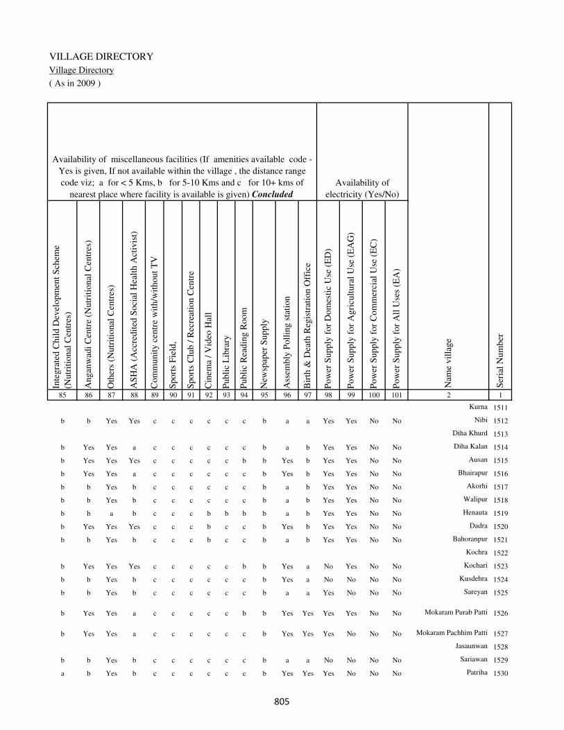
VILLAGE DIRECTORY
Village Directory
( As in 2009 )
Inte
gra
ted C
hil
d D
evel
opm
ent
Sch
eme
(Nutr
itio
nal
Cen
tres
)
Angan
wad
i C
entr
e (N
utr
itio
nal
Cen
tres
)
Oth
ers
(Nutr
itio
nal
Cen
tres
)
AS
HA
(A
ccre
dit
ed S
oci
al H
ealt
h A
ctiv
ist)
Com
munit
y c
entr
e w
ith/w
ithout
TV
Sport
s F
ield
,
Sport
s C
lub /
Rec
reat
ion C
entr
e
Cin
ema
/ V
ideo
Hal
l
Publi
c L
ibra
ry
Publi
c R
eadin
g R
oom
New
spap
er S
upply
Ass
embly
Poll
ing s
tati
on
Bir
th &
Dea
th R
egis
trat
ion O
ffic
e
Pow
er S
upply
for
Dom
esti
c U
se (
ED
)
Pow
er S
upply
for
Agri
cult
ura
l U
se (
EA
G)
Pow
er S
upply
for
Com
mer
cial
Use
(E
C)
Pow
er S
upply
for
All
Use
s (E
A)
85 86 87 88 89 90 91 92 93 94 95 96 97 98 99 100 101 2 1
Availability of
electricity (Yes/No)
Availability of miscellaneous facilities (If amenities available code -
Yes is given, If not available within the village , the distance range
code viz; a for < 5 Kms, b for 5-10 Kms and c for 10+ kms of
nearest place where facility is available is given) Concluded
Nam
e vil
lage
Ser
ial
Num
ber
Kurna 1511
b b Yes Yes c c c c c c b a a Yes Yes No No Nibi 1512
Diha Khurd 1513
b Yes Yes a c c c c c c b a b Yes Yes No No Diha Kalan 1514
b Yes Yes Yes c c c c c b b Yes b Yes Yes No No Ausan 1515
b Yes Yes a c c c c c c b Yes b Yes Yes No No Bhairapur 1516
b b Yes b c c c c c c b a b Yes Yes No No Akorhi 1517
b b Yes b c c c c c c b a b Yes Yes No No Walipur 1518
b b a b c c c b b b b a b Yes Yes No No Henauta 1519
b Yes Yes Yes c c c b c c b Yes b Yes Yes No No Dadra 1520
b b Yes b c c c b c c b a b Yes Yes No No Bahoranpur 1521
Kochra 1522
b Yes Yes Yes c c c c c b b Yes a No Yes No No Kochari 1523
b b Yes b c c c c c c b Yes a No No No No Kusdehra 1524
b b Yes b c c c c c c b a a Yes No No No Sareyan 1525
b Yes Yes a c c c c c b b Yes Yes Yes Yes No No Mokaram Purab Patti 1526
b Yes Yes a c c c c c c b Yes Yes Yes No No No Mokaram Pachhim Patti 1527
Jasaunwan 1528
b b Yes b c c c c c c b a a No No No No Sariawan 1529
a b Yes b c c c c c c b Yes Yes Yes No No No Patriha 1530
���
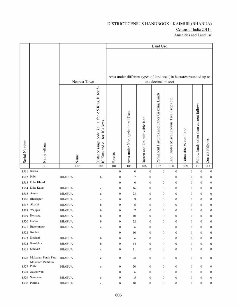
DISTRICT CENSUS HANDBOOK : KAIMUR (BHABUA)
Census of India 2011-
Amenities and Land use
Nam
e
Dis
tance
ran
ge
code
i.e
. a
fo
r <
5 K
ms,
b
for
5-
10 K
ms
and c
f
or
10+
km
s .
Fore
sts
Are
a under
Non-a
gri
cult
ura
l U
ses
Bar
ren a
nd U
n-c
ult
ivab
le l
and
Per
man
ent
Pas
ture
s an
d O
ther
Gra
zing L
ands
Lan
d U
nder
Mis
cell
aneo
us
Tre
e C
rops
etc.
Cult
ura
ble
Was
te L
and
Fal
low
lan
ds
oth
er t
han
curr
ent
fall
ow
s
Curr
ent
Fal
low
s
1 2 102 103 104 105 106 107 108 109 110 111
Ser
ial
Num
ber
Nam
e vil
lage
Area under different types of land use ( in hectares rounded up to
one decimal place)
Land Use
Nearest Town
1511 Kurna 0 0 0 0 0 0 0 0
1512 Nibi BHABUA b 0 7 0 0 0 0 0 0
1513 Diha Khurd 0 0 0 0 0 0 0 0
1514 Diha Kalan BHABUA c 0 16 0 0 0 0 0 0
1515 Ausan BHABUA a 0 23 0 0 0 0 0 0
1516 Bhairapur BHABUA a 0 9 0 0 0 0 0 0
1517 Akorhi BHABUA b 0 6 0 0 0 0 0 0
1518 Walipur BHABUA b 0 7 0 0 0 0 0 0
1519 Henauta BHABUA b 0 10 0 0 0 0 0 0
1520 Dadra BHABUA b 0 22 0 0 0 0 0 0
1521 Bahoranpur BHABUA a 0 6 0 0 0 0 0 0
1522 Kochra 0 10 0 0 0 0 0 0
1523 Kochari BHABUA b 0 6 0 0 0 0 0 0
1524 Kusdehra BHABUA b 0 14 0 0 0 0 0 0
1525 Sareyan BHABUA c 0 11 0 0 0 0 0 0
1526 Mokaram Purab Patti BHABUA c 0 128 0 0 0 0 0 0
1527
Mokaram Pachhim
Patti BHABUA c 0 20 0 0 0 0 0 0
1528 Jasaunwan 0 6 0 0 0 0 0 0
1529 Sariawan BHABUA c 0 5 0 0 0 0 0 0
1530 Patriha BHABUA c 0 10 0 0 0 0 0 0
���

VILLAGE DIRECTORY
Village Directory
( As in 2009 )
Net
Are
a S
ow
n
Tota
l Ir
rigat
ed L
and A
rea
Tota
l U
n-i
rrig
ated
Lan
d A
rea
Can
als
( C
)
Wel
ls/T
ube-
wel
ls(W
/TW
)
Tan
ks/
Lak
es(T
/L)
Wat
er F
alls
(WF
)
Oth
ers(
O)
Fir
st
Sec
ond
Thir
d
112 113 114 115 116 117 118 119 120 121 122 2 1
Ser
ial
Num
ber
Name of three
most important
commodities
manufacturedArea irrigated by source (in hectare).
Nam
e of
Vil
lage
Area under different types of
land use ( in hectares rounded
up to one decimal place)
Land Use
20 15 5 0 10 0 0 5 Kurna 1511
40 35 5 0 30 0 0 5 Nibi 1512
32 25 7 0 20 0 0 5 Diha Khurd 1513
100 80 20 0 60 0 0 20 Diha Kalan 1514
90 80 10 0 70 0 0 10 Ausan 1515
80 70 10 0 60 0 0 10 Bhairapur 1516
70 60 10 0 50 0 0 10 Akorhi 1517
45 40 5 0 35 0 0 5 Walipur 1518
40 30 10 0 25 0 0 5 Henauta 1519
100 80 20 0 70 0 0 10 Dadra 1520
70 50 20 0 35 0 0 15 Bahoranpur 1521
45 35 10 0 30 0 0 5 Kochra 1522
80 70 10 0 60 0 0 10 Kochari 1523
80 70 10 0 60 0 0 10 Kusdehra 1524
50 40 10 0 30 0 0 10 Sareyan 1525
300 250 50 0 200 0 0 50 Mokaram Purab Patti 1526
140 100 40 0 80 0 0 20 Mokaram Pachhim Patti 1527
20 18 2 0 15 0 0 3 Jasaunwan 1528
25 20 5 0 15 0 0 5 Sariawan 1529
75 60 15 0 50 0 0 10 Patriha 1530
���
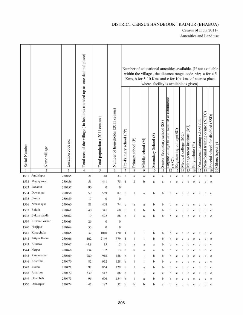
DISTRICT CENSUS HANDBOOK : KAIMUR (BHABUA)
Census of India 2011-
Amenities and Land use
Pre
-Pri
mar
y s
chool
(PP
)
Pri
mar
y s
chool
(P)
Mid
dle
sch
ool
(M)
Sec
ondar
y S
chool
(S)
Sen
ior
Sec
ondar
y s
chool
(SS
)
Deg
ree
coll
ege
of
arts
sc
ience
& c
om
mer
ce
(AS
C)
Engin
eeri
ng c
oll
ege(
EC
)
Med
ical
coll
ege
(MC
)
Man
agem
ent
inst
itute
(M
I)
Poly
tech
nic
(P
t)
Voca
tional
tra
inin
g s
chool
/IT
I
Non-f
orm
al t
rain
ing c
entr
e (N
FT
C)
Spec
ial
school
for
dis
able
d (
SS
D)
Oth
ers
(spec
ify)
1 2 3 4 5 6 7 8 9 10 11 12 13 14 15 16 17 18 19 20
Loca
tion c
ode
no.
Nam
e vil
lage
Ser
ial
Num
ber
Tota
l popula
tion (
2011 c
ensu
s )
Tota
l ar
ea o
f th
e vil
lage
( in
hec
tare
s ro
unded
up t
o
one
dec
imal
pla
ce)
Number of educational amenities available. (If not available
within the village , the distance range code viz; a for < 5
Kms, b for 5-10 Kms and c for 10+ kms of nearest place
where facility is available is given).
Num
ber
of
house
hold
s (2
011 c
ensu
s)
1531 Jagdishpur 250455 21 148 33 c a a a a a c c c c c c b
1532 Majhiyawan 250456 51 441 75 1 2 b a a a c c c c c c c
1533 Sonadih 250457 90 0 0
1534 Dawanpur 250458 59 569 87 c 1 a b b b c c c c c c c
1535 Baulia 250459 17 0 0
1536 Nawanagar 250460 81 408 74 c a a b b b c c c c c c c
1537 Beldih 250461 40 341 60 c 1 b b b b c c c c c c c
1538 Bakharhandh 250462 19 522 88 c 1 a b b b c c c c c c c
1539 Kuwan Pokhar 250463 26 0 0
1540 Harjipur 250464 53 0 0
1541 Kinarchola 250465 32 1040 170 1 1 1 b b b c c c c c c c
1542 Jaitpur Kalan 250466 102 2149 379 1 1 1 b b b c c c c c c c
1543 Kunrwa 250467 44.8 15 2 b a a a b b c c c c c c c
1544 Netpur 250468 234 102 13 b b a a b b c c c c c c c
1545 Ramawatpur 250469 280 918 158 b 1 1 b b b c c c c c c c
1546 Khardiha 250470 82 952 128 b 1 1 b b c c c c c c c c
1547 Bucha 250471 97 854 129 b 1 a b b b c c c c c c c
1548 Amarpur 250472 539 517 86 b 1 1 c c b c c c c c c c
1549 Dharchali 250473 96 606 134 b 1 a b b b c c c c c c c
1550 Damarpur 250474 42 197 52 b b b b c b c c c c c c c
���

VILLAGE DIRECTORY
Village Directory
( As in 2009 )
Com
munit
y h
ealt
h c
entr
e (C
HC
)
Pri
mar
y h
ealt
h c
entr
e (P
HC
)
Pri
mar
y h
ealt
h s
ub c
entr
e (P
HS
)
Mat
ernit
y a
nd c
hil
d w
elfa
re c
entr
e (M
CW
)
T.B
. cl
inic
(T
BC
)
Hosp
ital
-all
opat
hic
(H
A)
Hosp
ital
-alt
ernat
ive
med
icin
e (H
O)
Dis
pen
sary
(D
)
Vet
erin
ary h
osp
ital
(V
H)
Mobil
e hea
lth c
linic
(M
HC
)
Fam
ily w
elfa
re c
entr
e (F
WC
)
Char
itab
le n
on G
ovt.
hosp
ital
/Nurs
ing h
om
e.
Med
ical
pra
ctit
ioner
wit
h M
BB
S D
egre
e
Med
ical
pra
ctit
ioner
wit
h o
ther
deg
ree
Med
ical
pra
ctit
ioner
wit
h n
o d
egre
e
Tra
dit
ional
pra
ctit
ioner
an
d f
aith
hea
ler
.
Med
icin
e S
hop
Oth
ers
21 22 23 24 25 26 27 28 29 30 31 32 33 34 35 36 37 38 2 1
Number of Non-Government
Medical Amenities available.
Number of Medical Amenities available. (If not
available within the village , the distance range
code viz; a for < 5 Kms, b for 5-10 Kms and c
for 10+ kms of nearest place where facility is
available is given).
Nam
e vil
lage
Ser
ial
Num
ber
b b a c c c c a a c c 0 0 0 0 0 0 0 Jagdishpur 1531
b b b c c c c a a c c 0 0 0 0 0 0 0 Majhiyawan 1532
Sonadih 1533
c c b c c c c c b c c 0 0 0 0 0 0 0 Dawanpur 1534
Baulia 1535
c b a c c c c b b c c 0 0 0 0 0 0 0 Nawanagar 1536
c b b c b c c b b c c 0 0 0 0 0 0 0 Beldih 1537
c b a c b c c b b c c 0 0 0 0 0 0 0 Bakharhandh 1538
Kuwan Pokhar 1539
Harjipur 1540
c b b c c c c b b c c 0 0 0 0 0 0 0 Kinarchola 1541
c 1 1 1 1 c c 1 1 c 1 0 0 1 0 0 0 0 Jaitpur Kalan 1542
c b c c c c c c c c c 0 0 0 0 0 0 0 Kunrwa 1543
c c b c c c c b b c c 0 0 0 0 0 0 0 Netpur 1544
c b b c c c c b b c c 0 0 0 0 0 0 0 Ramawatpur 1545
c b c c c c c b b c c 0 0 0 0 0 0 0 Khardiha 1546
c b c c c c c b b c c 0 0 0 0 0 0 0 Bucha 1547
c c b c c c c c c c c 0 0 0 0 0 0 0 Amarpur 1548
c b a c c c c b b c c 0 0 0 0 0 0 0 Dharchali 1549
c c b c c c c c c c c 0 0 0 0 0 0 0 Damarpur 1550
���

DISTRICT CENSUS HANDBOOK : KAIMUR (BHABUA)
Census of India 2011-
Amenities and Land use
Tap
wat
er (
Tre
ated
/Untr
eate
d)
Wel
l w
ater
(Cover
ed /
Unco
ver
ed w
ell)
Han
d P
um
p
Tube
wel
ls /
Bore
wel
l
Spri
ng
Riv
er /
Can
al
Tan
k /
Pond /
L
ake
Oth
ers
Com
munit
y t
oil
et i
ncl
udin
g
bat
h.
Com
munit
y t
oil
et e
xcl
udin
g b
ath.
Rura
l s
anit
ary m
art
or
sanit
ary
har
dw
are
outl
et
avai
lable
nea
r th
e vil
lage.
Com
munit
y b
io-
gas
or
recy
cle
of
was
te f
or
pro
duct
ive
use
.
1 2 39 40 41 42 43 44 45 46 47 48 49 50
Availability of toilet & others
Yes / No Availability of drinking water - Yes / No
Nam
e vil
lage
Ser
ial
Num
ber
1531 Jagdishpur No Yes Yes No No Yes No No No No No No
1532 Majhiyawan No Yes Yes No No Yes No No No No No No
1533 Sonadih
1534 Dawanpur No Yes Yes No No Yes No No No No No No
1535 Baulia
1536 Nawanagar No Yes Yes No No No No No No No No No
1537 Beldih No Yes Yes No No No No No No No No No
1538 Bakharhandh No Yes Yes No No No No No No No No No
1539 Kuwan Pokhar
1540 Harjipur
1541 Kinarchola No Yes Yes No No No No No No No No No
1542 Jaitpur Kalan No Yes Yes No No No No No No No No No
1543 Kunrwa No No Yes No No No No No No No No No
1544 Netpur No No Yes No No No No No No No No No
1545 Ramawatpur No Yes Yes No No No No No No No No No
1546 Khardiha No Yes Yes No No No No No No No No No
1547 Bucha No Yes Yes No No No No No No No No No
1548 Amarpur No Yes Yes No No No No No No No No No
1549 Dharchali No Yes Yes No No No No No No No No No
1550 Damarpur No No Yes No No No No No No No No No
���

VILLAGE DIRECTORY
Village Directory
( As in 2009 )
Post
off
ice(
PO
)
Sub p
ost
off
ice
(SP
O)
Post
& T
eleg
raph o
ffic
e
(P&
TO
)
Vil
lage
Pin
Code
Tel
ephones
(L
and l
ines
)
Publi
c ca
ll o
ffic
e (P
CO
)
Mobil
e phone
cover
age
Inte
rnet
caf
es/
Com
mon s
ervic
e ce
ntr
e (C
SC
)
Pri
vat
e co
uri
er f
acil
ity
Bus
serv
ice
(P
ubli
c &
Pri
vat
e)
Rai
lway
sta
tions
Auto
/Modif
ied A
uto
s
Tax
is a
nd V
ans
Tra
ctors
Cycl
e-pull
ed r
icksh
aws(
Man
ual
& M
achin
e
dri
ven
)
Car
ts d
riven
by a
nim
als
Sea
/R
iver
fer
ry s
ervic
e51 52 53 54 55 56 57 58 59 60 61 62 63 64 65 66 67 2 1
Communication and transport facilities (If amenities available code -Yes is given except for
Village Pin Code ,If not available within the village , the distance range code viz; a for < 5
Kms, b for 5-10 Kms and c for 10+ kms of nearest place where facility is available is given).
Ser
ial
Num
ber
Nam
e vil
lage
a a c a a a c c Yes c a a Yes Yes Yes c Jagdishpur 1531
b c c a a Yes a a Yes c Yes Yes Yes Yes Yes c Majhiyawan 1532
Sonadih 1533
b b c b b c c b b c b b Yes Yes Yes c Dawanpur 1534
Baulia 1535
b a c b b b c b a c b b b b b c Nawanagar 1536
b a c b b b b b a c b b a a b c Beldih 1537
b a c b b b b b a c b b a b b c Bakharhandh 1538
Kuwan Pokhar 1539
Harjipur 1540
b a c c c c c c Yes c c b b b b c Kinarchola 1541
Yes c c c b b b c Yes c b Yes Yes Yes Yes Jaitpur Kalan 1542
b c c b b b b c b c b b b b b Kunrwa 1543
b c c c b b b c a c b b b b b Netpur 1544
b a c c c c c c Yes c b b a b b c Ramawatpur 1545
a a c b b b b b a c c a a Yes a Khardiha 1546
b c c c c c c a a c c c a c b c Bucha 1547
b c c c c c c c Yes c c c c c b c Amarpur 1548
b a c b b b b b a c b b b b a c Dharchali 1549
b c c b b b c b b c b b b b b Damarpur 1550
���

DISTRICT CENSUS HANDBOOK : KAIMUR (BHABUA)
Census of India 2011-
Amenities and Land use
Connec
ted t
o n
atio
nal
hig
hw
ay(N
H)
Connec
ted t
o s
tate
hig
hw
ay(S
H)
Connec
ted t
o m
ajor
dis
tric
t ro
ad (
MD
R)
Connec
ted t
o o
ther
s dis
tric
t ro
ad
Pucc
a r
oad
s
Kutc
hch
a r
oad
s
Wat
er b
ounded
mac
adam
(WB
M)
road
s
Nav
igab
le w
ater
way
(ri
ver
/can
al)(
NW
)
Footp
aths
(FP
)
Com
mer
cial
& C
o-o
per
ativ
e B
anks
AT
M
Agri
cult
ura
l C
redit
Soci
etie
s
Sel
f-H
elp G
roup (
SH
G)
Publi
c dis
trib
uti
on s
yst
em (
PD
S)
shop
Man
dis
/ R
egula
r m
arket
Wee
kly
Haa
t
Agri
cult
ura
l m
arket
ing s
oci
ety
1 2 68 69 70 71 72 73 74 75 76 77 78 79 80 81 82 83 84
Village connected to highways,village roads, banks & credit
societies (If amenities available code -Yes is given, If not
available within the village , the distance range code viz; a
for < 5 Kms, b for 5-10 Kms and c for 10+ kms of nearest
place where facility is available is given).
Ser
ial
Num
ber
Nam
e vil
lage
Availability of miscellaneous
facilities (If amenities available
code -Yes is given, If not
available within the village , the
distance range code viz; a for <
5 Kms, b for 5-10 Kms and c
for 10+ kms of nearest place
where facility is available is
given) Contd....
1531 Jagdishpur c c Yes Yes Yes Yes Yes Yes Yes c c c b b c c c
1532 Majhiyawan c b Yes Yes Yes Yes Yes b Yes b b Yes b Yes c c c
1533 Sonadih
1534 Dawanpur c c b c b Yes Yes Yes Yes c c c b a c c c
1535 Baulia
1536 Nawanagar c c a a a Yes a a Yes c c a b b c c c
1537 Beldih c c a a Yes Yes a b Yes b c a b b c c c
1538 Bakharhandh c c a a Yes Yes Yes b Yes b c a c b c c c
1539 Kuwan Pokhar
1540 Harjipur
1541 Kinarchola c c Yes Yes Yes Yes Yes b Yes b c b b b c c c
1542 Jaitpur Kalan c c b b Yes Yes Yes c Yes Yes c Yes b Yes c c c
1543 Kunrwa c c b b b Yes a c Yes b c b b a c c c
1544 Netpur c c b b b Yes a b Yes b c c b b c c c
1545 Ramawatpur c c Yes Yes Yes Yes Yes b Yes b c b b b c c c
1546 Khardiha c c b b Yes Yes Yes b Yes b c a b Yes c c c
1547 Bucha c c c c a Yes Yes c Yes c c a b Yes c c c
1548 Amarpur c c Yes Yes Yes Yes Yes c Yes c c b Yes Yes c c c
1549 Dharchali c c b a Yes Yes Yes b Yes b c a Yes b b c c
1550 Damarpur c c c b b Yes a c Yes b c b b b b c c
��

VILLAGE DIRECTORY
Village Directory
( As in 2009 )
Inte
gra
ted C
hil
d D
evel
opm
ent
Sch
eme
(Nutr
itio
nal
Cen
tres
)
Angan
wad
i C
entr
e (N
utr
itio
nal
Cen
tres
)
Oth
ers
(Nutr
itio
nal
Cen
tres
)
AS
HA
(A
ccre
dit
ed S
oci
al H
ealt
h A
ctiv
ist)
Com
munit
y c
entr
e w
ith/w
ithout
TV
Sport
s F
ield
,
Sport
s C
lub /
Rec
reat
ion C
entr
e
Cin
ema
/ V
ideo
Hal
l
Publi
c L
ibra
ry
Publi
c R
eadin
g R
oom
New
spap
er S
upply
Ass
embly
Poll
ing s
tati
on
Bir
th &
Dea
th R
egis
trat
ion O
ffic
e
Pow
er S
upply
for
Dom
esti
c U
se (
ED
)
Pow
er S
upply
for
Agri
cult
ura
l U
se (
EA
G)
Pow
er S
upply
for
Com
mer
cial
Use
(E
C)
Pow
er S
upply
for
All
Use
s (E
A)
85 86 87 88 89 90 91 92 93 94 95 96 97 98 99 100 101 2 1
Availability of
electricity (Yes/No)
Availability of miscellaneous facilities (If amenities available code -
Yes is given, If not available within the village , the distance range
code viz; a for < 5 Kms, b for 5-10 Kms and c for 10+ kms of
nearest place where facility is available is given) Concluded
Nam
e vil
lage
Ser
ial
Num
ber
a Yes Yes a c c c c c c b a a Yes No No No Jagdishpur 1531
a Yes Yes b c c c c c c b Yes Yes Yes Yes No No Majhiyawan 1532
Sonadih 1533
b b Yes Yes c c c c c c b a a No No No No Dawanpur 1534
Baulia 1535
b b Yes b c c c c c c b a b No No No No Nawanagar 1536
b b Yes b c c c c c c b a b Yes No No No Beldih 1537
b b Yes b c c c c c c b Yes b Yes Yes No No Bakharhandh 1538
Kuwan Pokhar 1539
Harjipur 1540
b Yes Yes Yes c c c c c c b Yes b Yes Yes No No Kinarchola 1541
b Yes Yes Yes c c c c c b b Yes Yes Yes Yes No No Jaitpur Kalan 1542
b b Yes b c c c c c c b a a No No No No Kunrwa 1543
b b Yes b c c c c c c b a b No No No No Netpur 1544
b Yes Yes Yes c c c c c c b Yes b Yes Yes No No Ramawatpur 1545
b Yes Yes a c c c c c c b Yes b Yes Yes No No Khardiha 1546
b Yes Yes Yes c c c c c c b Yes b Yes Yes No No Bucha 1547
c Yes Yes Yes c c c c c c b Yes b Yes Yes No No Amarpur 1548
b b Yes b c c c c c c b Yes b Yes No No No Dharchali 1549
b b Yes b c c c c c c b a b No No No No Damarpur 1550
��

DISTRICT CENSUS HANDBOOK : KAIMUR (BHABUA)
Census of India 2011-
Amenities and Land use
Nam
e
Dis
tance
ran
ge
code
i.e
. a
fo
r <
5 K
ms,
b
for
5-
10 K
ms
and c
f
or
10+
km
s .
Fore
sts
Are
a under
Non-a
gri
cult
ura
l U
ses
Bar
ren a
nd U
n-c
ult
ivab
le l
and
Per
man
ent
Pas
ture
s an
d O
ther
Gra
zing L
ands
Lan
d U
nder
Mis
cell
aneo
us
Tre
e C
rops
etc.
Cult
ura
ble
Was
te L
and
Fal
low
lan
ds
oth
er t
han
curr
ent
fall
ow
s
Curr
ent
Fal
low
s
1 2 102 103 104 105 106 107 108 109 110 111
Ser
ial
Num
ber
Nam
e vil
lage
Area under different types of land use ( in hectares rounded up to
one decimal place)
Land Use
Nearest Town
1531 Jagdishpur BHABUA c 0 0 0 0 0 0 0 0
1532 Majhiyawan BHABUA c 0 11 0 0 0 0 0 0
1533 Sonadih 0 10 0 0 0 0 0 0
1534 Dawanpur BHABUA c 0 9 0 0 0 0 0 0
1535 Baulia 0 0 0 0 0 0 0 0
1536 Nawanagar BHABUA c 0 11 0 0 0 0 0 0
1537 Beldih BHABUA c 0 5 0 0 0 0 0 0
1538 Bakharhandh BHABUA c 0 0 0 0 0 0 0 0
1539 Kuwan Pokhar 0 0 0 0 0 0 0 0
1540 Harjipur 0 8 0 0 0 0 0 0
1541 Kinarchola BHABUA c 0 4 0 0 0 0 0 0
1542 Jaitpur Kalan BHABUA c 0 12 0 0 0 0 0 0
1543 Kunrwa BHABUA c 23.1 2.3 0.6 0.1 0 0 0.2 0
1544 Netpur BHABUA c 0 34 0 0 0 0 0 0
1545 Ramawatpur BHABUA c 0 50 0 0 0 0 0 0
1546 Khardiha BHABUA c 0 32 0 0 0 0 0 0
1547 Bucha BHABUA c 0 17 0 0 0 0 0 0
1548 Amarpur BHABUA c 0 139 0 0 0 0 0 0
1549 Dharchali BHABUA c 0 16 0 0 0 0 0 0
1550 Damarpur BHABUA c 0 7 0 0 0 0 0 0
���
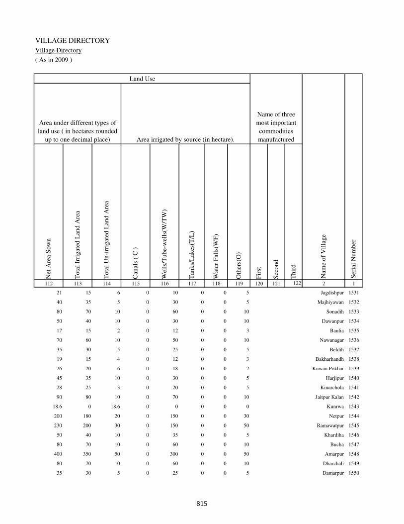
VILLAGE DIRECTORY
Village Directory
( As in 2009 )
Net
Are
a S
ow
n
Tota
l Ir
rigat
ed L
and A
rea
Tota
l U
n-i
rrig
ated
Lan
d A
rea
Can
als
( C
)
Wel
ls/T
ube-
wel
ls(W
/TW
)
Tan
ks/
Lak
es(T
/L)
Wat
er F
alls
(WF
)
Oth
ers(
O)
Fir
st
Sec
ond
Thir
d
112 113 114 115 116 117 118 119 120 121 122 2 1
Ser
ial
Num
ber
Name of three
most important
commodities
manufacturedArea irrigated by source (in hectare).
Nam
e of
Vil
lage
Area under different types of
land use ( in hectares rounded
up to one decimal place)
Land Use
21 15 6 0 10 0 0 5 Jagdishpur 1531
40 35 5 0 30 0 0 5 Majhiyawan 1532
80 70 10 0 60 0 0 10 Sonadih 1533
50 40 10 0 30 0 0 10 Dawanpur 1534
17 15 2 0 12 0 0 3 Baulia 1535
70 60 10 0 50 0 0 10 Nawanagar 1536
35 30 5 0 25 0 0 5 Beldih 1537
19 15 4 0 12 0 0 3 Bakharhandh 1538
26 20 6 0 18 0 0 2 Kuwan Pokhar 1539
45 35 10 0 30 0 0 5 Harjipur 1540
28 25 3 0 20 0 0 5 Kinarchola 1541
90 80 10 0 70 0 0 10 Jaitpur Kalan 1542
18.6 0 18.6 0 0 0 0 0 Kunrwa 1543
200 180 20 0 150 0 0 30 Netpur 1544
230 200 30 0 150 0 0 50 Ramawatpur 1545
50 40 10 0 35 0 0 5 Khardiha 1546
80 70 10 0 60 0 0 10 Bucha 1547
400 350 50 0 300 0 0 50 Amarpur 1548
80 70 10 0 60 0 0 10 Dharchali 1549
35 30 5 0 25 0 0 5 Damarpur 1550
���
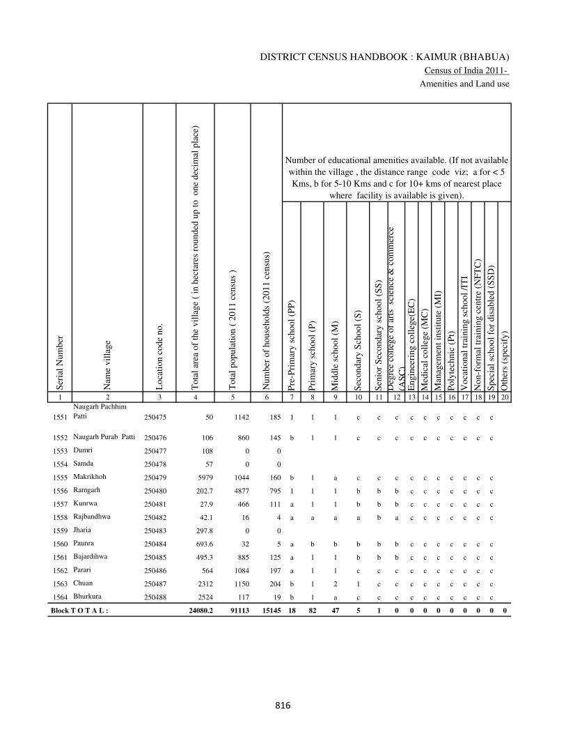
DISTRICT CENSUS HANDBOOK : KAIMUR (BHABUA)
Census of India 2011-
Amenities and Land use
Pre
-Pri
mar
y s
chool
(PP
)
Pri
mar
y s
chool
(P)
Mid
dle
sch
ool
(M)
Sec
ondar
y S
chool
(S)
Sen
ior
Sec
ondar
y s
chool
(SS
)
Deg
ree
coll
ege
of
arts
sc
ience
& c
om
mer
ce
(AS
C)
Engin
eeri
ng c
oll
ege(
EC
)
Med
ical
coll
ege
(MC
)
Man
agem
ent
inst
itute
(M
I)
Poly
tech
nic
(P
t)
Voca
tional
tra
inin
g s
chool
/IT
I
Non-f
orm
al t
rain
ing c
entr
e (N
FT
C)
Spec
ial
school
for
dis
able
d (
SS
D)
Oth
ers
(spec
ify)
1 2 3 4 5 6 7 8 9 10 11 12 13 14 15 16 17 18 19 20
Loca
tion c
ode
no.
Nam
e vil
lage
Ser
ial
Num
ber
Tota
l popula
tion (
2011 c
ensu
s )
Tota
l ar
ea o
f th
e vil
lage
( in
hec
tare
s ro
unded
up t
o
one
dec
imal
pla
ce)
Number of educational amenities available. (If not available
within the village , the distance range code viz; a for < 5
Kms, b for 5-10 Kms and c for 10+ kms of nearest place
where facility is available is given).
Num
ber
of
house
hold
s (2
011 c
ensu
s)
1551
Naugarh Pachhim
Patti 250475 50 1142 185 1 1 1 c c c c c c c c c c
1552 Naugarh Purab Patti 250476 106 860 145 b 1 1 c c c c c c c c c c
1553 Dumri 250477 108 0 0
1554 Samda 250478 57 0 0
1555 Makrikhoh 250479 5979 1044 160 b 1 a c c c c c c c c c c
1556 Ramgarh 250480 202.7 4877 795 1 1 1 b b b c c c c c c c
1557 Kunrwa 250481 27.9 466 111 a 1 1 b b b c c c c c c c
1558 Rajbandhwa 250482 42.1 16 4 a a a a b a c c c c c c c
1559 Jharia 250483 297.8 0 0
1560 Paunra 250484 693.6 32 5 a b b b b b c c c c c c c
1561 Bajardihwa 250485 495.3 885 125 a 1 1 b b b c c c c c c c
1562 Parari 250486 564 1084 197 a 1 1 c c c c c c c c c c
1563 Chuan 250487 2312 1150 204 b 1 2 1 c c c c c c c c c
1564 Bhurkura 250488 2524 117 19 b 1 a c c c c c c c c c c
Block T O T A L : 24080.2 91113 15145 18 82 47 5 1 0 0 0 0 0 0 0 0 0
���
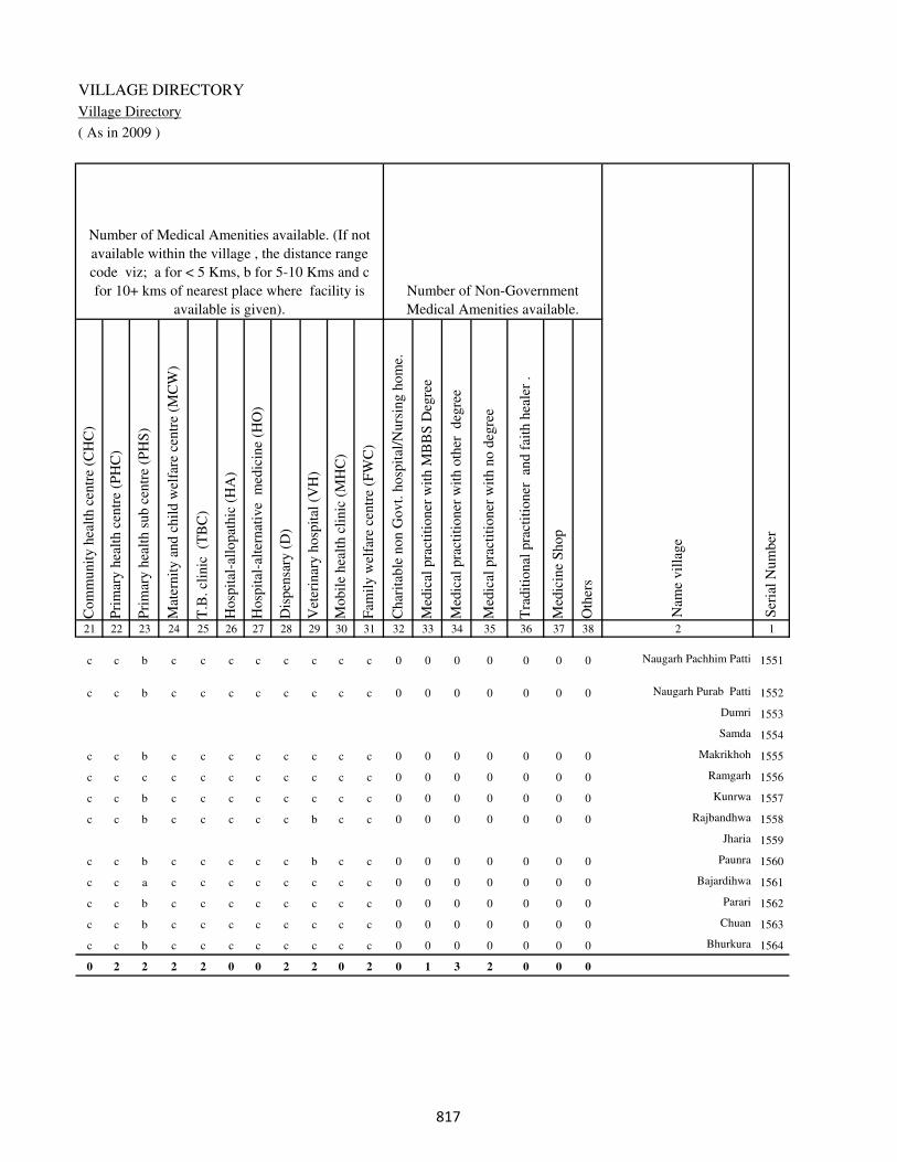
VILLAGE DIRECTORY
Village Directory
( As in 2009 )
Com
munit
y h
ealt
h c
entr
e (C
HC
)
Pri
mar
y h
ealt
h c
entr
e (P
HC
)
Pri
mar
y h
ealt
h s
ub c
entr
e (P
HS
)
Mat
ernit
y a
nd c
hil
d w
elfa
re c
entr
e (M
CW
)
T.B
. cl
inic
(T
BC
)
Hosp
ital
-all
opat
hic
(H
A)
Hosp
ital
-alt
ernat
ive
med
icin
e (H
O)
Dis
pen
sary
(D
)
Vet
erin
ary h
osp
ital
(V
H)
Mobil
e hea
lth c
linic
(M
HC
)
Fam
ily w
elfa
re c
entr
e (F
WC
)
Char
itab
le n
on G
ovt.
hosp
ital
/Nurs
ing h
om
e.
Med
ical
pra
ctit
ioner
wit
h M
BB
S D
egre
e
Med
ical
pra
ctit
ioner
wit
h o
ther
deg
ree
Med
ical
pra
ctit
ioner
wit
h n
o d
egre
e
Tra
dit
ional
pra
ctit
ioner
an
d f
aith
hea
ler
.
Med
icin
e S
hop
Oth
ers
21 22 23 24 25 26 27 28 29 30 31 32 33 34 35 36 37 38 2 1
Number of Non-Government
Medical Amenities available.
Number of Medical Amenities available. (If not
available within the village , the distance range
code viz; a for < 5 Kms, b for 5-10 Kms and c
for 10+ kms of nearest place where facility is
available is given).
Nam
e vil
lage
Ser
ial
Num
ber
c c b c c c c c c c c 0 0 0 0 0 0 0 Naugarh Pachhim Patti 1551
c c b c c c c c c c c 0 0 0 0 0 0 0 Naugarh Purab Patti 1552
Dumri 1553
Samda 1554
c c b c c c c c c c c 0 0 0 0 0 0 0 Makrikhoh 1555
c c c c c c c c c c c 0 0 0 0 0 0 0 Ramgarh 1556
c c b c c c c c c c c 0 0 0 0 0 0 0 Kunrwa 1557
c c b c c c c c b c c 0 0 0 0 0 0 0 Rajbandhwa 1558
Jharia 1559
c c b c c c c c b c c 0 0 0 0 0 0 0 Paunra 1560
c c a c c c c c c c c 0 0 0 0 0 0 0 Bajardihwa 1561
c c b c c c c c c c c 0 0 0 0 0 0 0 Parari 1562
c c b c c c c c c c c 0 0 0 0 0 0 0 Chuan 1563
c c b c c c c c c c c 0 0 0 0 0 0 0 Bhurkura 1564
0 2 2 2 2 0 0 2 2 0 2 0 1 3 2 0 0 0
���

DISTRICT CENSUS HANDBOOK : KAIMUR (BHABUA)
Census of India 2011-
Amenities and Land use
Tap
wat
er (
Tre
ated
/Untr
eate
d)
Wel
l w
ater
(Cover
ed /
Unco
ver
ed w
ell)
Han
d P
um
p
Tube
wel
ls /
Bore
wel
l
Spri
ng
Riv
er /
Can
al
Tan
k /
Pond /
L
ake
Oth
ers
Com
munit
y t
oil
et i
ncl
udin
g
bat
h.
Com
munit
y t
oil
et e
xcl
udin
g b
ath.
Rura
l s
anit
ary m
art
or
sanit
ary
har
dw
are
outl
et
avai
lable
nea
r th
e vil
lage.
Com
munit
y b
io-
gas
or
recy
cle
of
was
te f
or
pro
duct
ive
use
.
1 2 39 40 41 42 43 44 45 46 47 48 49 50
Availability of toilet & others
Yes / No Availability of drinking water - Yes / No
Nam
e vil
lage
Ser
ial
Num
ber
1551 Naugarh Pachhim Patti No Yes Yes No No No No No No No No No
1552 Naugarh Purab Patti No Yes Yes No No No No No No No No No
1553 Dumri
1554 Samda
1555 Makrikhoh No Yes Yes No No Yes No No No No No No
1556 Ramgarh No No Yes Yes No No No Yes No No No No
1557 Kunrwa No Yes Yes No No No No No No No No No
1558 Rajbandhwa No No Yes No No No No No No No No No
1559 Jharia
1560 Paunra No No Yes No No No No No No No No No
1561 Bajardihwa No Yes Yes No No No No No No No No No
1562 Parari No Yes Yes No Yes No No No No No No No
1563 Chuan No Yes Yes No No No No No No No No No
1564 Bhurkura No Yes Yes No Yes No No No No No No No
Block T O T A L : 0 94 107 4 2 29 0 1 0 0 0 0
���

VILLAGE DIRECTORY
Village Directory
( As in 2009 )
Post
off
ice(
PO
)
Sub p
ost
off
ice
(SP
O)
Post
& T
eleg
raph o
ffic
e
(P&
TO
)
Vil
lage
Pin
Code
Tel
ephones
(L
and l
ines
)
Publi
c ca
ll o
ffic
e (P
CO
)
Mobil
e phone
cover
age
Inte
rnet
caf
es/
Com
mon s
ervic
e ce
ntr
e (C
SC
)
Pri
vat
e co
uri
er f
acil
ity
Bus
serv
ice
(P
ubli
c &
Pri
vat
e)
Rai
lway
sta
tions
Auto
/Modif
ied A
uto
s
Tax
is a
nd V
ans
Tra
ctors
Cycl
e-pull
ed r
icksh
aws(
Man
ual
& M
achin
e
dri
ven
)
Car
ts d
riven
by a
nim
als
Sea
/R
iver
fer
ry s
ervic
e51 52 53 54 55 56 57 58 59 60 61 62 63 64 65 66 67 2 1
Communication and transport facilities (If amenities available code -Yes is given except for
Village Pin Code ,If not available within the village , the distance range code viz; a for < 5
Kms, b for 5-10 Kms and c for 10+ kms of nearest place where facility is available is given).
Ser
ial
Num
ber
Nam
e vil
lage
b b c c c c c c Yes c b b b b b c Naugarh Pachhim Patti 1551
b c c c c c c c Yes c c c c c b c Naugarh Purab Patti 1552
Dumri 1553
Samda 1554
b b c c b b a c b c c Yes Yes b b c Makrikhoh 1555
b c c c Yes Yes c c a c Yes a Yes Yes Yes c Ramgarh 1556
b c c c a Yes c c Yes c Yes Yes a Yes b c Kunrwa 1557
b c c c b b b c b c b b b b a Rajbandhwa 1558
Jharia 1559
b c c c a b c c b c b b b a b Paunra 1560
b c c c a a c c a c a Yes a Yes b c Bajardihwa 1561
b c c c b b c c a c Yes Yes Yes Yes b c Parari 1562
b b c c b b c c b c a Yes Yes Yes a c Chuan 1563
b c c c c c c c c c a a b a a c Bhurkura 1564
10 1 0 8 2 5 28 0 1 31 0 18 30 47 59 40 10
���

DISTRICT CENSUS HANDBOOK : KAIMUR (BHABUA)
Census of India 2011-
Amenities and Land use
Connec
ted t
o n
atio
nal
hig
hw
ay(N
H)
Connec
ted t
o s
tate
hig
hw
ay(S
H)
Connec
ted t
o m
ajor
dis
tric
t ro
ad (
MD
R)
Connec
ted t
o o
ther
s dis
tric
t ro
ad
Pucc
a r
oad
s
Kutc
hch
a r
oad
s
Wat
er b
ounded
mac
adam
(WB
M)
road
s
Nav
igab
le w
ater
way
(ri
ver
/can
al)(
NW
)
Footp
aths
(FP
)
Com
mer
cial
& C
o-o
per
ativ
e B
anks
AT
M
Agri
cult
ura
l C
redit
Soci
etie
s
Sel
f-H
elp G
roup (
SH
G)
Publi
c dis
trib
uti
on s
yst
em (
PD
S)
shop
Man
dis
/ R
egula
r m
arket
Wee
kly
Haa
t
Agri
cult
ura
l m
arket
ing s
oci
ety
1 2 68 69 70 71 72 73 74 75 76 77 78 79 80 81 82 83 84
Village connected to highways,village roads, banks & credit
societies (If amenities available code -Yes is given, If not
available within the village , the distance range code viz; a
for < 5 Kms, b for 5-10 Kms and c for 10+ kms of nearest
place where facility is available is given).
Ser
ial
Num
ber
Nam
e vil
lage
Availability of miscellaneous
facilities (If amenities available
code -Yes is given, If not
available within the village , the
distance range code viz; a for <
5 Kms, b for 5-10 Kms and c
for 10+ kms of nearest place
where facility is available is
given) Contd....
1551 Naugarh Pachhim Patti c c Yes Yes Yes Yes Yes c Yes c c b a Yes b c c
1552 Naugarh Purab Patti c c Yes Yes Yes Yes Yes b Yes c c b Yes Yes c c c
1553 Dumri
1554 Samda
1555 Makrikhoh c c c Yes b Yes a a Yes c c c a a c c c
1556 Ramgarh c c b a a Yes Yes b Yes c c c Yes b c c c
1557 Kunrwa c c b a a Yes Yes a Yes c c c a Yes c c c
1558 Rajbandhwa c c b b a Yes a b Yes c c b b b c c c
1559 Jharia
1560 Paunra c c b b b Yes b b Yes c c c b b c c c
1561 Bajardihwa c c b Yes a Yes Yes b Yes c c b Yes b c c c
1562 Parari c c c Yes b Yes Yes a Yes c c c b b c c c
1563 Chuan c c c Yes b Yes Yes b Yes c c c a Yes c c c
1564 Bhurkura c c c b b Yes a a Yes c c c b b c c c
Block T O T A L : 0 2 27 38 74 106 82 27 107 6 0 10 23 30 0 0 0
��
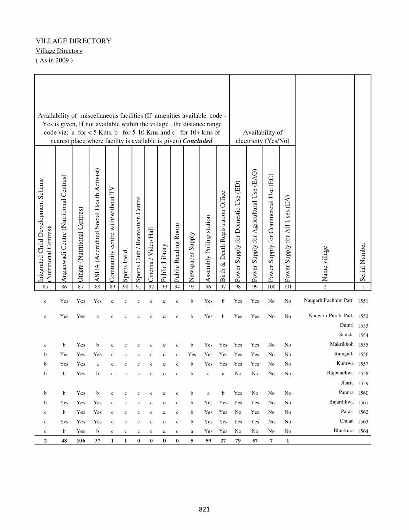
VILLAGE DIRECTORY
Village Directory
( As in 2009 )
Inte
gra
ted C
hil
d D
evel
opm
ent
Sch
eme
(Nutr
itio
nal
Cen
tres
)
Angan
wad
i C
entr
e (N
utr
itio
nal
Cen
tres
)
Oth
ers
(Nutr
itio
nal
Cen
tres
)
AS
HA
(A
ccre
dit
ed S
oci
al H
ealt
h A
ctiv
ist)
Com
munit
y c
entr
e w
ith/w
ithout
TV
Sport
s F
ield
,
Sport
s C
lub /
Rec
reat
ion C
entr
e
Cin
ema
/ V
ideo
Hal
l
Publi
c L
ibra
ry
Publi
c R
eadin
g R
oom
New
spap
er S
upply
Ass
embly
Poll
ing s
tati
on
Bir
th &
Dea
th R
egis
trat
ion O
ffic
e
Pow
er S
upply
for
Dom
esti
c U
se (
ED
)
Pow
er S
upply
for
Agri
cult
ura
l U
se (
EA
G)
Pow
er S
upply
for
Com
mer
cial
Use
(E
C)
Pow
er S
upply
for
All
Use
s (E
A)
85 86 87 88 89 90 91 92 93 94 95 96 97 98 99 100 101 2 1
Availability of
electricity (Yes/No)
Availability of miscellaneous facilities (If amenities available code -
Yes is given, If not available within the village , the distance range
code viz; a for < 5 Kms, b for 5-10 Kms and c for 10+ kms of
nearest place where facility is available is given) Concluded
Nam
e vil
lage
Ser
ial
Num
ber
c Yes Yes Yes c c c c c c b Yes b Yes Yes No No Naugarh Pachhim Patti 1551
c Yes Yes a c c c c c c b Yes b Yes Yes No No Naugarh Purab Patti 1552
Dumri 1553
Samda 1554
c b Yes b c c c c c c b Yes Yes Yes Yes No No Makrikhoh 1555
b Yes Yes Yes c c c c c c Yes Yes Yes Yes Yes No No Ramgarh 1556
b Yes Yes a c c c c c c b Yes Yes Yes Yes No No Kunrwa 1557
b b Yes b c c c c c c b a a No No No No Rajbandhwa 1558
Jharia 1559
b b Yes b c c c c c c b a b Yes No No No Paunra 1560
b Yes Yes Yes c c c c c c b Yes Yes Yes Yes No No Bajardihwa 1561
c b Yes Yes c c c c c c b Yes Yes No Yes No No Parari 1562
c Yes Yes Yes c c c c c c b Yes Yes Yes Yes No No Chuan 1563
c b Yes b c c c c c c a Yes Yes No No No No Bhurkura 1564
2 48 106 37 1 1 0 0 0 0 5 59 27 79 57 7 1
��
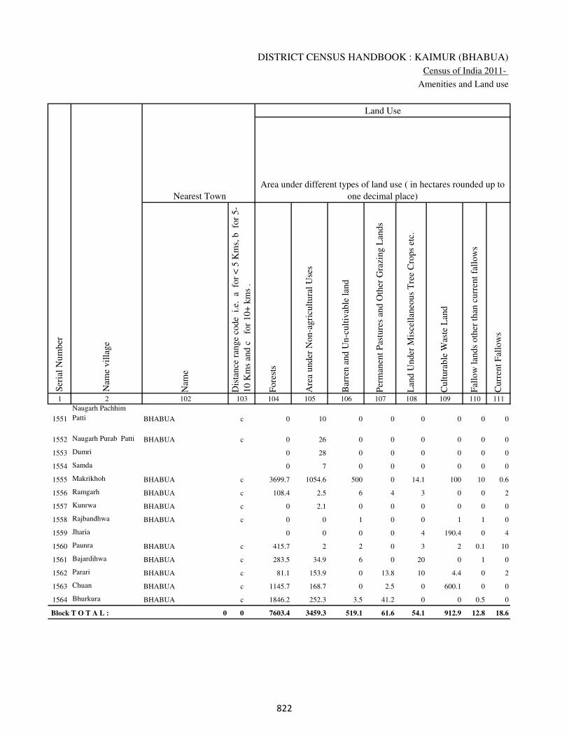
DISTRICT CENSUS HANDBOOK : KAIMUR (BHABUA)
Census of India 2011-
Amenities and Land use
Nam
e
Dis
tance
ran
ge
code
i.e
. a
fo
r <
5 K
ms,
b
for
5-
10 K
ms
and c
f
or
10+
km
s .
Fore
sts
Are
a under
Non-a
gri
cult
ura
l U
ses
Bar
ren a
nd U
n-c
ult
ivab
le l
and
Per
man
ent
Pas
ture
s an
d O
ther
Gra
zing L
ands
Lan
d U
nder
Mis
cell
aneo
us
Tre
e C
rops
etc.
Cult
ura
ble
Was
te L
and
Fal
low
lan
ds
oth
er t
han
curr
ent
fall
ow
s
Curr
ent
Fal
low
s
1 2 102 103 104 105 106 107 108 109 110 111
Ser
ial
Num
ber
Nam
e vil
lage
Area under different types of land use ( in hectares rounded up to
one decimal place)
Land Use
Nearest Town
1551
Naugarh Pachhim
Patti BHABUA c 0 10 0 0 0 0 0 0
1552 Naugarh Purab Patti BHABUA c 0 26 0 0 0 0 0 0
1553 Dumri 0 28 0 0 0 0 0 0
1554 Samda 0 7 0 0 0 0 0 0
1555 Makrikhoh BHABUA c 3699.7 1054.6 500 0 14.1 100 10 0.6
1556 Ramgarh BHABUA c 108.4 2.5 6 4 3 0 0 2
1557 Kunrwa BHABUA c 0 2.1 0 0 0 0 0 0
1558 Rajbandhwa BHABUA c 0 0 1 0 0 1 1 0
1559 Jharia 0 0 0 0 4 190.4 0 4
1560 Paunra BHABUA c 415.7 2 2 0 3 2 0.1 10
1561 Bajardihwa BHABUA c 283.5 34.9 6 0 20 0 1 0
1562 Parari BHABUA c 81.1 153.9 0 13.8 10 4.4 0 2
1563 Chuan BHABUA c 1145.7 168.7 0 2.5 0 600.1 0 0
1564 Bhurkura BHABUA c 1846.2 252.3 3.5 41.2 0 0 0.5 0
Block T O T A L : 0 0 7603.4 3459.3 519.1 61.6 54.1 912.9 12.8 18.6
�
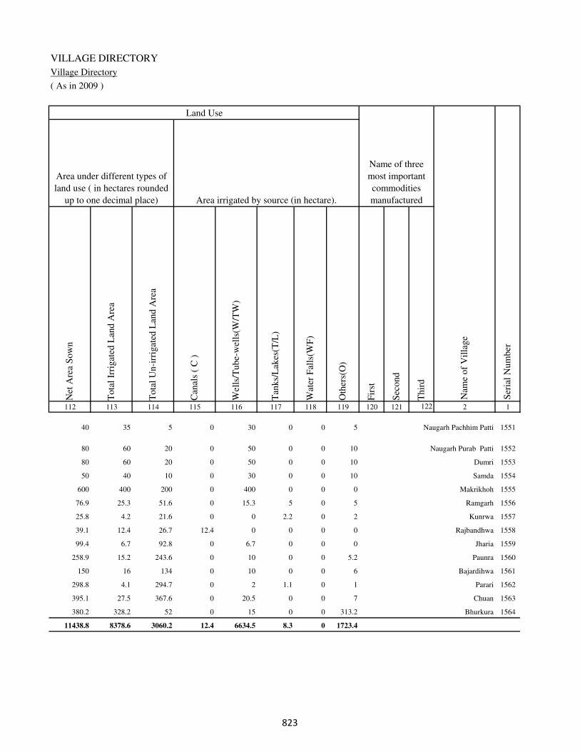
VILLAGE DIRECTORY
Village Directory
( As in 2009 )
Net
Are
a S
ow
n
Tota
l Ir
rigat
ed L
and A
rea
Tota
l U
n-i
rrig
ated
Lan
d A
rea
Can
als
( C
)
Wel
ls/T
ube-
wel
ls(W
/TW
)
Tan
ks/
Lak
es(T
/L)
Wat
er F
alls
(WF
)
Oth
ers(
O)
Fir
st
Sec
ond
Thir
d
112 113 114 115 116 117 118 119 120 121 122 2 1
Ser
ial
Num
ber
Name of three
most important
commodities
manufacturedArea irrigated by source (in hectare).
Nam
e of
Vil
lage
Area under different types of
land use ( in hectares rounded
up to one decimal place)
Land Use
40 35 5 0 30 0 0 5 Naugarh Pachhim Patti 1551
80 60 20 0 50 0 0 10 Naugarh Purab Patti 1552
80 60 20 0 50 0 0 10 Dumri 1553
50 40 10 0 30 0 0 10 Samda 1554
600 400 200 0 400 0 0 0 Makrikhoh 1555
76.9 25.3 51.6 0 15.3 5 0 5 Ramgarh 1556
25.8 4.2 21.6 0 0 2.2 0 2 Kunrwa 1557
39.1 12.4 26.7 12.4 0 0 0 0 Rajbandhwa 1558
99.4 6.7 92.8 0 6.7 0 0 0 Jharia 1559
258.9 15.2 243.6 0 10 0 0 5.2 Paunra 1560
150 16 134 0 10 0 0 6 Bajardihwa 1561
298.8 4.1 294.7 0 2 1.1 0 1 Parari 1562
395.1 27.5 367.6 0 20.5 0 0 7 Chuan 1563
380.2 328.2 52 0 15 0 0 313.2 Bhurkura 1564
11438.8 8378.6 3060.2 12.4 6634.5 8.3 0 1723.4
�

DISTRICT CENSUS HANDBOOK : KAIMUR (BHABUA)
Census of India 2011-
Amenities and Land use
Pre
-Pri
mar
y s
chool
(PP
)
Pri
mar
y s
chool
(P)
Mid
dle
sch
ool
(M)
Sec
ondar
y S
chool
(S)
Sen
ior
Sec
ondar
y s
chool
(SS
)
Deg
ree
coll
ege
of
arts
sc
ience
& c
om
mer
ce
(AS
C)
Engin
eeri
ng c
oll
ege(
EC
)
Med
ical
coll
ege
(MC
)
Man
agem
ent
inst
itute
(M
I)
Poly
tech
nic
(P
t)
Voca
tional
tra
inin
g s
chool
/IT
I
Non-f
orm
al t
rain
ing c
entr
e (N
FT
C)
Spec
ial
school
for
dis
able
d (
SS
D)
Oth
ers
(spec
ify)
1 2 3 4 5 6 7 8 9 10 11 12 13 14 15 16 17 18 19 20
Loca
tion c
ode
no.
Nam
e vil
lage
Ser
ial
Num
ber
Tota
l popula
tion (
2011 c
ensu
s )
Tota
l ar
ea o
f th
e vil
lage
( in
hec
tare
s ro
unded
up t
o
one
dec
imal
pla
ce)
Number of educational amenities available. (If not available
within the village , the distance range code viz; a for < 5
Kms, b for 5-10 Kms and c for 10+ kms of nearest place
where facility is available is given).
Num
ber
of
house
hold
s (2
011 c
ensu
s)
Name of District:-Kaimur (Bhabua) Location CodeNo:-233
Name of CD Block:-Adhaura Location CodeNo:-0444
1565 Barwan Kalan 250489 3091 1387 244 c 1 1 c c c c c c c c c c
1566 Barwan Khurd 250490 1196 705 112 c 1 a c c c c c c c c c c
1567 Manradag 250491 830 0 0
1568 Chargori 250492 226 0 0
1569 Bhuruli 250493 485 380 61 c 1 a b b b c c c c c c c
1570 Basnara 250494 686 0 0
1571 Sarwandag 250495 481 358 59 c 2 b b b b c c c c c c c
1572 Surkur Khurd 250496 620 18 3 c a b b b b c c c c c c c
1573 Baghmanian 250497 630 0 0
1574 Ujari Chargori 250498 297 0 0
1575 Kharki Khurd 250499 471 118 21 c a a a b b c c c c c c c
1576 Kharkiujar 250500 348 0 0
1577 Tala 250501 637 513 83 c 1 b c c b c c c c c c c
1578 Bhanrehra 250502 790 432 90 c 1 b b c b c c c c c c c
1579 Atara 250503 416 18 3 c b b c c b c c c c c c c
1580 Bala Khoh 250504 521 58 14 c a b b c b c c c c c c c
1581 Garhwa 250505 546 0 0
1582 Dahar 250506 1063 1256 231 c 1 1 a c b c c c c c c c 1
1583 Salea 250507 1970 453 85 c 1 1 1 1 1 c c c c c c c
��

VILLAGE DIRECTORY
Village Directory
( As in 2009 )
Com
munit
y h
ealt
h c
entr
e (C
HC
)
Pri
mar
y h
ealt
h c
entr
e (P
HC
)
Pri
mar
y h
ealt
h s
ub c
entr
e (P
HS
)
Mat
ernit
y a
nd c
hil
d w
elfa
re c
entr
e (M
CW
)
T.B
. cl
inic
(T
BC
)
Hosp
ital
-all
opat
hic
(H
A)
Hosp
ital
-alt
ernat
ive
med
icin
e (H
O)
Dis
pen
sary
(D
)
Vet
erin
ary h
osp
ital
(V
H)
Mobil
e hea
lth c
linic
(M
HC
)
Fam
ily w
elfa
re c
entr
e (F
WC
)
Char
itab
le n
on G
ovt.
hosp
ital
/Nurs
ing h
om
e.
Med
ical
pra
ctit
ioner
wit
h M
BB
S D
egre
e
Med
ical
pra
ctit
ioner
wit
h o
ther
deg
ree
Med
ical
pra
ctit
ioner
wit
h n
o d
egre
e
Tra
dit
ional
pra
ctit
ioner
an
d f
aith
hea
ler
.
Med
icin
e S
hop
Oth
ers
21 22 23 24 25 26 27 28 29 30 31 32 33 34 35 36 37 38 2 1
Number of Non-Government
Medical Amenities available.
Number of Medical Amenities available. (If not
available within the village , the distance range
code viz; a for < 5 Kms, b for 5-10 Kms and c
for 10+ kms of nearest place where facility is
available is given).
Nam
e vil
lage
Ser
ial
Num
ber
c c b c c c c c c c c 0 0 0 0 0 0 0 Barwan Kalan 1565
c c b c c c c c c c c 0 0 0 0 0 0 0 Barwan Khurd 1566
Manradag 1567
Chargori 1568
c c c c c c c c c c c 0 0 0 0 0 0 0 Bhuruli 1569
Basnara 1570
b b a b b c c b b c b 0 0 0 0 0 0 0 Sarwandag 1571
c c b c c c c c b c c 0 0 0 0 0 0 0 Surkur Khurd 1572
Baghmanian 1573
Ujari Chargori 1574
c c b c c c c b c c c 0 0 0 0 0 0 0 Kharki Khurd 1575
Kharkiujar 1576
c c b c c c c c b c c 0 0 0 0 0 0 0 Tala 1577
c c b c c c c c b c c 0 0 0 0 0 0 0 Bhanrehra 1578
c c b c c c c c b c c 0 0 0 0 0 0 0 Atara 1579
b b a b b c c b b c b 0 0 0 0 0 0 0 Bala Khoh 1580
Garhwa 1581
c c b c c c c c b c c 0 0 0 0 0 0 0 Dahar 1582
c c b c c c c c b c c 0 0 0 0 0 0 0 Salea 1583
��
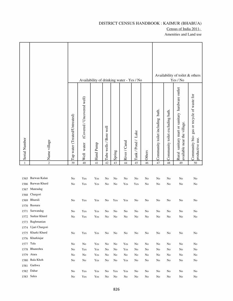
DISTRICT CENSUS HANDBOOK : KAIMUR (BHABUA)
Census of India 2011-
Amenities and Land use
Tap
wat
er (
Tre
ated
/Untr
eate
d)
Wel
l w
ater
(Cover
ed /
Unco
ver
ed w
ell)
Han
d P
um
p
Tube
wel
ls /
Bore
wel
l
Spri
ng
Riv
er /
Can
al
Tan
k /
Pond /
L
ake
Oth
ers
Com
munit
y t
oil
et i
ncl
udin
g
bat
h.
Com
munit
y t
oil
et e
xcl
udin
g b
ath.
Rura
l s
anit
ary m
art
or
sanit
ary
har
dw
are
outl
et
avai
lable
nea
r th
e vil
lage.
Com
munit
y b
io-
gas
or
recy
cle
of
was
te f
or
pro
duct
ive
use
.
1 2 39 40 41 42 43 44 45 46 47 48 49 50
Availability of toilet & others
Yes / No Availability of drinking water - Yes / No
Nam
e vil
lage
Ser
ial
Num
ber
1565 Barwan Kalan No Yes Yes No No No No No No No No No
1566 Barwan Khurd No Yes Yes No No Yes Yes No No No No No
1567 Manradag
1568 Chargori
1569 Bhuruli No Yes Yes No Yes Yes No No No No No No
1570 Basnara
1571 Sarwandag No Yes Yes No No No No No No No No No
1572 Surkur Khurd No Yes Yes No No No No No No No No No
1573 Baghmanian
1574 Ujari Chargori
1575 Kharki Khurd No Yes Yes No No No No No No No No No
1576 Kharkiujar
1577 Tala No No Yes No No Yes No No No No No No
1578 Bhanrehra No Yes Yes No No Yes No No No No No No
1579 Atara No No Yes No No No No No No No No No
1580 Bala Khoh No No Yes No No Yes No No No No No No
1581 Garhwa
1582 Dahar No Yes Yes No Yes Yes No No No No No No
1583 Salea No Yes Yes No No No No No No No No No
��

VILLAGE DIRECTORY
Village Directory
( As in 2009 )
Post
off
ice(
PO
)
Sub p
ost
off
ice
(SP
O)
Post
& T
eleg
raph o
ffic
e
(P&
TO
)
Vil
lage
Pin
Code
Tel
ephones
(L
and l
ines
)
Publi
c ca
ll o
ffic
e (P
CO
)
Mobil
e phone
cover
age
Inte
rnet
caf
es/
Com
mon s
ervic
e ce
ntr
e (C
SC
)
Pri
vat
e co
uri
er f
acil
ity
Bus
serv
ice
(P
ubli
c &
Pri
vat
e)
Rai
lway
sta
tions
Auto
/Modif
ied A
uto
s
Tax
is a
nd V
ans
Tra
ctors
Cycl
e-pull
ed r
icksh
aws(
Man
ual
& M
achin
e
dri
ven
)
Car
ts d
riven
by a
nim
als
Sea
/R
iver
fer
ry s
ervic
e51 52 53 54 55 56 57 58 59 60 61 62 63 64 65 66 67 2 1
Communication and transport facilities (If amenities available code -Yes is given except for
Village Pin Code ,If not available within the village , the distance range code viz; a for < 5
Kms, b for 5-10 Kms and c for 10+ kms of nearest place where facility is available is given).
Ser
ial
Num
ber
Nam
e vil
lage
b c c c c b c c c c c c b b b Barwan Kalan 1565
b c c c c Yes c c c c c c Yes a Yes Barwan Khurd 1566
Manradag 1567
Chargori 1568
b c c c c Yes c c b c c c b Yes b Bhuruli 1569
Basnara 1570
Yes c c c c Yes c c b c c c Yes Yes b Sarwandag 1571
Yes c c c c Yes c c b c c b a b a Surkur Khurd 1572
Baghmanian 1573
Ujari Chargori 1574
Yes c c c c Yes c c b c c c a Yes b Kharki Khurd 1575
Kharkiujar 1576
b b c c b b c c b c c c b b b c Tala 1577
b c c c c b c c b c c c a Yes a c Bhanrehra 1578
b c c c c a c c b c c c b b b Atara 1579
b c c c c b c c a c c c a Yes b Bala Khoh 1580
Garhwa 1581
b a c c c Yes c c a c c Yes Yes a a Dahar 1582
b c c c c b c c b c c b b a b Salea 1583
��
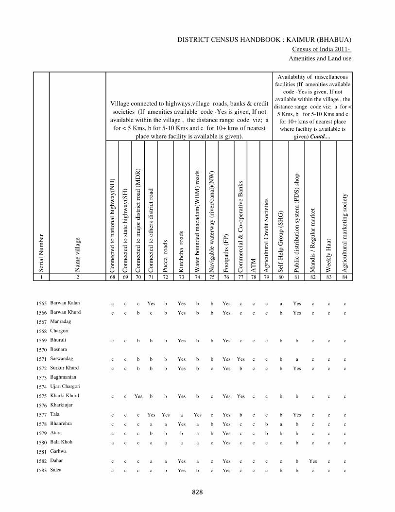
DISTRICT CENSUS HANDBOOK : KAIMUR (BHABUA)
Census of India 2011-
Amenities and Land use
Connec
ted t
o n
atio
nal
hig
hw
ay(N
H)
Connec
ted t
o s
tate
hig
hw
ay(S
H)
Connec
ted t
o m
ajor
dis
tric
t ro
ad (
MD
R)
Connec
ted t
o o
ther
s dis
tric
t ro
ad
Pucc
a r
oad
s
Kutc
hch
a r
oad
s
Wat
er b
ounded
mac
adam
(WB
M)
road
s
Nav
igab
le w
ater
way
(ri
ver
/can
al)(
NW
)
Footp
aths
(FP
)
Com
mer
cial
& C
o-o
per
ativ
e B
anks
AT
M
Agri
cult
ura
l C
redit
Soci
etie
s
Sel
f-H
elp G
roup (
SH
G)
Publi
c dis
trib
uti
on s
yst
em (
PD
S)
shop
Man
dis
/ R
egula
r m
arket
Wee
kly
Haa
t
Agri
cult
ura
l m
arket
ing s
oci
ety
1 2 68 69 70 71 72 73 74 75 76 77 78 79 80 81 82 83 84
Village connected to highways,village roads, banks & credit
societies (If amenities available code -Yes is given, If not
available within the village , the distance range code viz; a
for < 5 Kms, b for 5-10 Kms and c for 10+ kms of nearest
place where facility is available is given).
Ser
ial
Num
ber
Nam
e vil
lage
Availability of miscellaneous
facilities (If amenities available
code -Yes is given, If not
available within the village , the
distance range code viz; a for <
5 Kms, b for 5-10 Kms and c
for 10+ kms of nearest place
where facility is available is
given) Contd....
1565 Barwan Kalan c c c Yes b Yes b b Yes c c c a Yes c c c
1566 Barwan Khurd c c b c b Yes b b Yes c c c b Yes c c c
1567 Manradag
1568 Chargori
1569 Bhuruli c c b b b Yes b b Yes c c c b b c c c
1570 Basnara
1571 Sarwandag c c b b b Yes b b Yes Yes c c b a c c c
1572 Surkur Khurd c c b b b Yes b c Yes b c c b Yes c c c
1573 Baghmanian
1574 Ujari Chargori
1575 Kharki Khurd c c Yes b b Yes b c Yes Yes c c b b c c c
1576 Kharkiujar
1577 Tala c c c Yes Yes a Yes c Yes b c c b Yes c c c
1578 Bhanrehra c c c a a Yes a b Yes c c b a b c c c
1579 Atara c c c b b b a b Yes c c b b b c c c
1580 Bala Khoh a c c a a a a c Yes c c c c b c c c
1581 Garhwa
1582 Dahar c c c a a Yes a c Yes c c c c b Yes c c
1583 Salea c c c a b Yes b c Yes c c c b b c c c
��

VILLAGE DIRECTORY
Village Directory
( As in 2009 )
Inte
gra
ted C
hil
d D
evel
opm
ent
Sch
eme
(Nutr
itio
nal
Cen
tres
)
Angan
wad
i C
entr
e (N
utr
itio
nal
Cen
tres
)
Oth
ers
(Nutr
itio
nal
Cen
tres
)
AS
HA
(A
ccre
dit
ed S
oci
al H
ealt
h A
ctiv
ist)
Com
munit
y c
entr
e w
ith/w
ithout
TV
Sport
s F
ield
,
Sport
s C
lub /
Rec
reat
ion C
entr
e
Cin
ema
/ V
ideo
Hal
l
Publi
c L
ibra
ry
Publi
c R
eadin
g R
oom
New
spap
er S
upply
Ass
embly
Poll
ing s
tati
on
Bir
th &
Dea
th R
egis
trat
ion O
ffic
e
Pow
er S
upply
for
Dom
esti
c U
se (
ED
)
Pow
er S
upply
for
Agri
cult
ura
l U
se (
EA
G)
Pow
er S
upply
for
Com
mer
cial
Use
(E
C)
Pow
er S
upply
for
All
Use
s (E
A)
85 86 87 88 89 90 91 92 93 94 95 96 97 98 99 100 101 2 1
Availability of
electricity (Yes/No)
Availability of miscellaneous facilities (If amenities available code -
Yes is given, If not available within the village , the distance range
code viz; a for < 5 Kms, b for 5-10 Kms and c for 10+ kms of
nearest place where facility is available is given) Concluded
Nam
e vil
lage
Ser
ial
Num
ber
c Yes Yes Yes c Yes c c c c b Yes Yes No No No No Barwan Kalan 1565
c Yes Yes Yes c c c c c c b Yes Yes No No No No Barwan Khurd 1566
Manradag 1567
Chargori 1568
c b Yes b c c c c c c b a b No No No No Bhuruli 1569
Basnara 1570
c a Yes a c c c c c c b a b No No No No Sarwandag 1571
c b Yes b c b c c c c b a b No No No No Surkur Khurd 1572
Baghmanian 1573
Ujari Chargori 1574
c b Yes b c b c c c c Yes a b No No No No Kharki Khurd 1575
Kharkiujar 1576
c Yes Yes a c b c c c c b Yes b No No No No Tala 1577
c b Yes b c Yes c c c c b a b No No No No Bhanrehra 1578
c b Yes b c a c c c c b a b No No No No Atara 1579
c b Yes b c b c c c c b a Yes No No No No Bala Khoh 1580
Garhwa 1581
c Yes Yes Yes c c c c c c b Yes Yes No No No No Dahar 1582
c Yes Yes Yes c c c c c c b Yes Yes No No No No Salea 1583
��
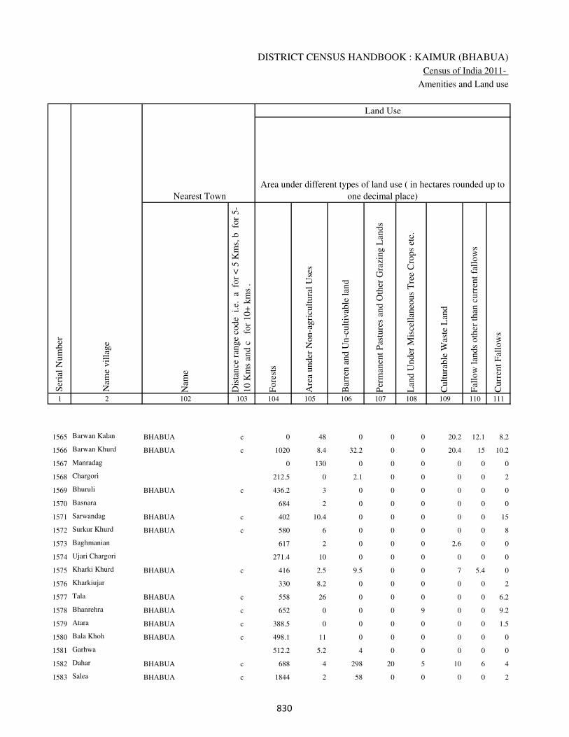
DISTRICT CENSUS HANDBOOK : KAIMUR (BHABUA)
Census of India 2011-
Amenities and Land use
Nam
e
Dis
tance
ran
ge
code
i.e
. a
fo
r <
5 K
ms,
b
for
5-
10 K
ms
and c
f
or
10+
km
s .
Fore
sts
Are
a under
Non-a
gri
cult
ura
l U
ses
Bar
ren a
nd U
n-c
ult
ivab
le l
and
Per
man
ent
Pas
ture
s an
d O
ther
Gra
zing L
ands
Lan
d U
nder
Mis
cell
aneo
us
Tre
e C
rops
etc.
Cult
ura
ble
Was
te L
and
Fal
low
lan
ds
oth
er t
han
curr
ent
fall
ow
s
Curr
ent
Fal
low
s
1 2 102 103 104 105 106 107 108 109 110 111
Ser
ial
Num
ber
Nam
e vil
lage
Area under different types of land use ( in hectares rounded up to
one decimal place)
Land Use
Nearest Town
1565 Barwan Kalan BHABUA c 0 48 0 0 0 20.2 12.1 8.2
1566 Barwan Khurd BHABUA c 1020 8.4 32.2 0 0 20.4 15 10.2
1567 Manradag 0 130 0 0 0 0 0 0
1568 Chargori 212.5 0 2.1 0 0 0 0 2
1569 Bhuruli BHABUA c 436.2 3 0 0 0 0 0 0
1570 Basnara 684 2 0 0 0 0 0 0
1571 Sarwandag BHABUA c 402 10.4 0 0 0 0 0 15
1572 Surkur Khurd BHABUA c 580 6 0 0 0 0 0 8
1573 Baghmanian 617 2 0 0 0 2.6 0 0
1574 Ujari Chargori 271.4 10 0 0 0 0 0 0
1575 Kharki Khurd BHABUA c 416 2.5 9.5 0 0 7 5.4 0
1576 Kharkiujar 330 8.2 0 0 0 0 0 2
1577 Tala BHABUA c 558 26 0 0 0 0 0 6.2
1578 Bhanrehra BHABUA c 652 0 0 0 9 0 0 9.2
1579 Atara BHABUA c 388.5 0 0 0 0 0 0 1.5
1580 Bala Khoh BHABUA c 498.1 11 0 0 0 0 0 0
1581 Garhwa 512.2 5.2 4 0 0 0 0 0
1582 Dahar BHABUA c 688 4 298 20 5 10 6 4
1583 Salea BHABUA c 1844 2 58 0 0 0 0 2
��
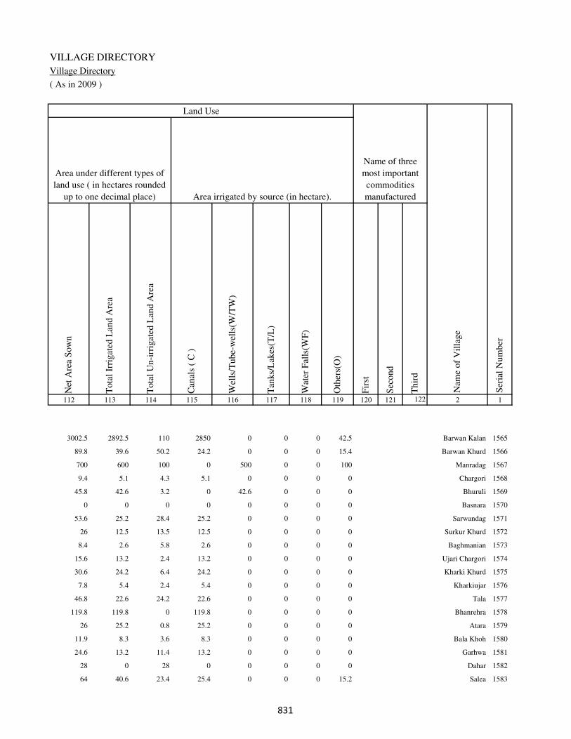
VILLAGE DIRECTORY
Village Directory
( As in 2009 )
Net
Are
a S
ow
n
Tota
l Ir
rigat
ed L
and A
rea
Tota
l U
n-i
rrig
ated
Lan
d A
rea
Can
als
( C
)
Wel
ls/T
ube-
wel
ls(W
/TW
)
Tan
ks/
Lak
es(T
/L)
Wat
er F
alls
(WF
)
Oth
ers(
O)
Fir
st
Sec
ond
Thir
d
112 113 114 115 116 117 118 119 120 121 122 2 1
Ser
ial
Num
ber
Name of three
most important
commodities
manufacturedArea irrigated by source (in hectare).
Nam
e of
Vil
lage
Area under different types of
land use ( in hectares rounded
up to one decimal place)
Land Use
3002.5 2892.5 110 2850 0 0 0 42.5 Barwan Kalan 1565
89.8 39.6 50.2 24.2 0 0 0 15.4 Barwan Khurd 1566
700 600 100 0 500 0 0 100 Manradag 1567
9.4 5.1 4.3 5.1 0 0 0 0 Chargori 1568
45.8 42.6 3.2 0 42.6 0 0 0 Bhuruli 1569
0 0 0 0 0 0 0 0 Basnara 1570
53.6 25.2 28.4 25.2 0 0 0 0 Sarwandag 1571
26 12.5 13.5 12.5 0 0 0 0 Surkur Khurd 1572
8.4 2.6 5.8 2.6 0 0 0 0 Baghmanian 1573
15.6 13.2 2.4 13.2 0 0 0 0 Ujari Chargori 1574
30.6 24.2 6.4 24.2 0 0 0 0 Kharki Khurd 1575
7.8 5.4 2.4 5.4 0 0 0 0 Kharkiujar 1576
46.8 22.6 24.2 22.6 0 0 0 0 Tala 1577
119.8 119.8 0 119.8 0 0 0 0 Bhanrehra 1578
26 25.2 0.8 25.2 0 0 0 0 Atara 1579
11.9 8.3 3.6 8.3 0 0 0 0 Bala Khoh 1580
24.6 13.2 11.4 13.2 0 0 0 0 Garhwa 1581
28 0 28 0 0 0 0 0 Dahar 1582
64 40.6 23.4 25.4 0 0 0 15.2 Salea 1583
��

DISTRICT CENSUS HANDBOOK : KAIMUR (BHABUA)
Census of India 2011-
Amenities and Land use
Pre
-Pri
mar
y s
chool
(PP
)
Pri
mar
y s
chool
(P)
Mid
dle
sch
ool
(M)
Sec
ondar
y S
chool
(S)
Sen
ior
Sec
ondar
y s
chool
(SS
)
Deg
ree
coll
ege
of
arts
sc
ience
& c
om
mer
ce
(AS
C)
Engin
eeri
ng c
oll
ege(
EC
)
Med
ical
coll
ege
(MC
)
Man
agem
ent
inst
itute
(M
I)
Poly
tech
nic
(P
t)
Voca
tional
tra
inin
g s
chool
/IT
I
Non-f
orm
al t
rain
ing c
entr
e (N
FT
C)
Spec
ial
school
for
dis
able
d (
SS
D)
Oth
ers
(spec
ify)
1 2 3 4 5 6 7 8 9 10 11 12 13 14 15 16 17 18 19 20
Loca
tion c
ode
no.
Nam
e vil
lage
Ser
ial
Num
ber
Tota
l popula
tion (
2011 c
ensu
s )
Tota
l ar
ea o
f th
e vil
lage
( in
hec
tare
s ro
unded
up t
o
one
dec
imal
pla
ce)
Number of educational amenities available. (If not available
within the village , the distance range code viz; a for < 5
Kms, b for 5-10 Kms and c for 10+ kms of nearest place
where facility is available is given).
Num
ber
of
house
hold
s (2
011 c
ensu
s)
1584 Karar 250508 1739 349 54 c a b c c b c c c c c c c
1585 Munrehra 250509 474 164 31 c 1 a c c b c c c c c c c
1586 Katraur 250510 1103 167 32 c b a c c b c c c c c c c
1587 Lohandi 250511 2696 0 0
1588 Jamuninar 250512 1878 1627 279 b 1 1 c c b c c c c c c c
1589 Kanhanar 250513 799 708 111 b b b c c b c c c c c c c
1590 Amahra 250514 846 417 71 a 1 a c c b c c c c c c c
1591 Chaudharna 250515 509 1066 166 c 1 1 b c b c c c b c c c
1592 Khatkhari 250516 499 692 119 b 1 a b c b c c c c c c c
1593 Kuruwasot 250517 587 458 85 c 1 a c c c c c c c c c c
1594 Baghauta 250518 338 314 59 c 1 a c c c c c c c c c c
1595 Dumarkon 250519 368 525 81 b 1 b c c c c c c c c c c
1596 Dighar 250520 1201 1495 237 c a b a c b c c c c c c c
1597 Kham Khurd 250521 344 192 28 c 1 1 a b c c c c c c c c
1598 Kham Kalan 250522 847 743 133 c 1 1 b c b c c c c c c c
1599 Pipari 250523 688 139 21 c 1 a a c c c c c c c c c
1600 Pipara 250524 456 391 76 c 1 a a c c c c c b c c c
1601 Gamharia 250525 433 296 42 c 1 a b c c c c c c c c c
1602 Bargaon Kalan 250526 497 619 108 c b b a c b c c c c c c c
1603 Garake 250527 609 909 156 c b b a c c c c c c c b c
1604 Dhobahi 250528 287 0 0
�
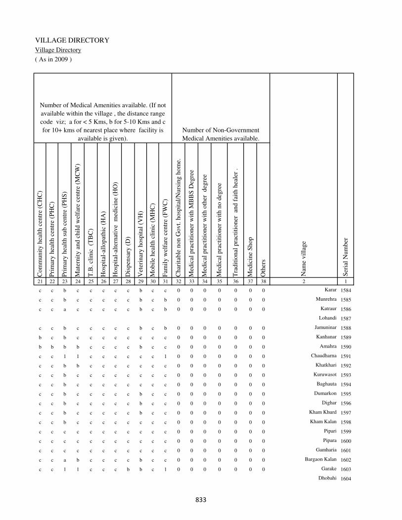
VILLAGE DIRECTORY
Village Directory
( As in 2009 )
Com
munit
y h
ealt
h c
entr
e (C
HC
)
Pri
mar
y h
ealt
h c
entr
e (P
HC
)
Pri
mar
y h
ealt
h s
ub c
entr
e (P
HS
)
Mat
ernit
y a
nd c
hil
d w
elfa
re c
entr
e (M
CW
)
T.B
. cl
inic
(T
BC
)
Hosp
ital
-all
opat
hic
(H
A)
Hosp
ital
-alt
ernat
ive
med
icin
e (H
O)
Dis
pen
sary
(D
)
Vet
erin
ary h
osp
ital
(V
H)
Mobil
e hea
lth c
linic
(M
HC
)
Fam
ily w
elfa
re c
entr
e (F
WC
)
Char
itab
le n
on G
ovt.
hosp
ital
/Nurs
ing h
om
e.
Med
ical
pra
ctit
ioner
wit
h M
BB
S D
egre
e
Med
ical
pra
ctit
ioner
wit
h o
ther
deg
ree
Med
ical
pra
ctit
ioner
wit
h n
o d
egre
e
Tra
dit
ional
pra
ctit
ioner
an
d f
aith
hea
ler
.
Med
icin
e S
hop
Oth
ers
21 22 23 24 25 26 27 28 29 30 31 32 33 34 35 36 37 38 2 1
Number of Non-Government
Medical Amenities available.
Number of Medical Amenities available. (If not
available within the village , the distance range
code viz; a for < 5 Kms, b for 5-10 Kms and c
for 10+ kms of nearest place where facility is
available is given).
Nam
e vil
lage
Ser
ial
Num
ber
c c b c c c c c b c c 0 0 0 0 0 0 0 Karar 1584
c c b c c c c c b c b 0 0 0 0 0 0 0 Munrehra 1585
c c a c c c c c b c b 0 0 0 0 0 0 0 Katraur 1586
Lohandi 1587
c c b c c c c c b c b 0 0 0 0 0 0 0 Jamuninar 1588
b c b c c c c c c c c 0 0 0 0 0 0 0 Kanhanar 1589
b b b b c c c c b c c 0 0 0 0 0 0 0 Amahra 1590
c c 1 1 c c c c c c 1 0 0 0 0 0 0 0 Chaudharna 1591
c c b b c c c c c c c 0 0 0 0 0 0 0 Khatkhari 1592
c c b c c c c c c c c 0 0 0 0 0 0 0 Kuruwasot 1593
c c b c c c c c c c c 0 0 0 0 0 0 0 Baghauta 1594
c c b c c c c c b c c 0 0 0 0 0 0 0 Dumarkon 1595
c c b c c c c c b c c 0 0 0 0 0 0 0 Dighar 1596
c c b c c c c c b c c 0 0 0 0 0 0 0 Kham Khurd 1597
c c b c c c c c c c c 0 0 0 0 0 0 0 Kham Kalan 1598
c c c c c c c c c c c 0 0 0 0 0 0 0 Pipari 1599
c c c c c c c c c c c 0 0 0 0 0 0 0 Pipara 1600
c c c c c c c c c c c 0 0 0 0 0 0 0 Gamharia 1601
c c a b c c c c b c c 0 0 0 0 0 0 0 Bargaon Kalan 1602
c c 1 1 c c c b b c 1 0 0 0 0 0 0 0 Garake 1603
Dhobahi 1604
�

DISTRICT CENSUS HANDBOOK : KAIMUR (BHABUA)
Census of India 2011-
Amenities and Land use
Tap
wat
er (
Tre
ated
/Untr
eate
d)
Wel
l w
ater
(Cover
ed /
Unco
ver
ed w
ell)
Han
d P
um
p
Tube
wel
ls /
Bore
wel
l
Spri
ng
Riv
er /
Can
al
Tan
k /
Pond /
L
ake
Oth
ers
Com
munit
y t
oil
et i
ncl
udin
g
bat
h.
Com
munit
y t
oil
et e
xcl
udin
g b
ath.
Rura
l s
anit
ary m
art
or
sanit
ary
har
dw
are
outl
et
avai
lable
nea
r th
e vil
lage.
Com
munit
y b
io-
gas
or
recy
cle
of
was
te f
or
pro
duct
ive
use
.
1 2 39 40 41 42 43 44 45 46 47 48 49 50
Availability of toilet & others
Yes / No Availability of drinking water - Yes / No
Nam
e vil
lage
Ser
ial
Num
ber
1584 Karar No Yes Yes No No No No No No No No No
1585 Munrehra No Yes Yes No No No No No No No No No
1586 Katraur No Yes Yes No No No No No No No No No
1587 Lohandi
1588 Jamuninar No Yes Yes No Yes Yes No No No No No No
1589 Kanhanar No Yes Yes No Yes No No No No No No No
1590 Amahra No No Yes No No No No No No No No No
1591 Chaudharna No Yes Yes No No No No No No No No No
1592 Khatkhari No Yes Yes No No Yes No No No No No No
1593 Kuruwasot No No Yes No No Yes No No No No No No
1594 Baghauta No Yes Yes No No No No No No No No No
1595 Dumarkon No Yes Yes No No Yes No No No No No No
1596 Dighar No No Yes No No No No No No No No No
1597 Kham Khurd No Yes Yes No No Yes No No No No No No
1598 Kham Kalan No Yes Yes No No No No No No No No No
1599 Pipari No Yes Yes No No No No No No No No No
1600 Pipara No Yes Yes No No No Yes No No No No No
1601 Gamharia No No Yes No No No No No No No No No
1602 Bargaon Kalan No Yes Yes No No Yes Yes No No No No No
1603 Garake No Yes Yes No No No No No No No No No
1604 Dhobahi
��
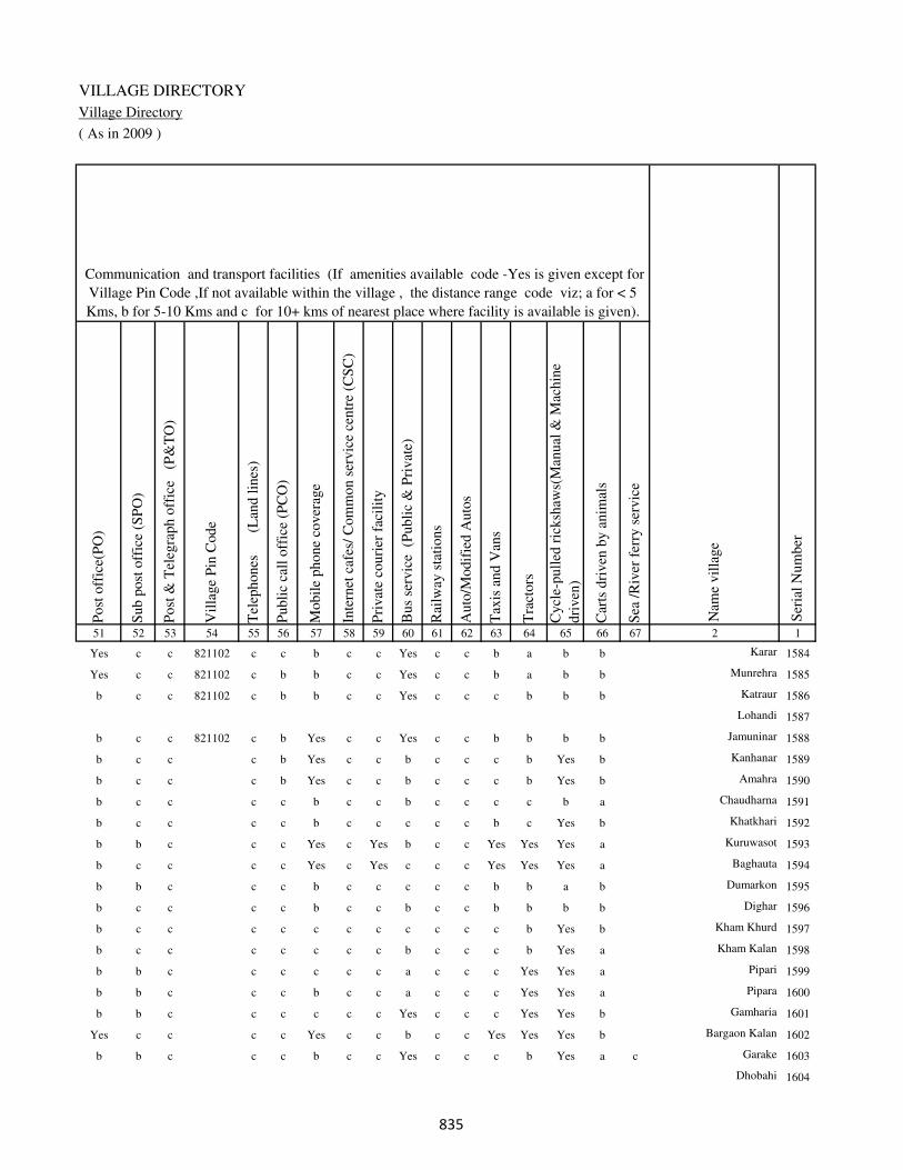
VILLAGE DIRECTORY
Village Directory
( As in 2009 )
Post
off
ice(
PO
)
Sub p
ost
off
ice
(SP
O)
Post
& T
eleg
raph o
ffic
e
(P&
TO
)
Vil
lage
Pin
Code
Tel
ephones
(L
and l
ines
)
Publi
c ca
ll o
ffic
e (P
CO
)
Mobil
e phone
cover
age
Inte
rnet
caf
es/
Com
mon s
ervic
e ce
ntr
e (C
SC
)
Pri
vat
e co
uri
er f
acil
ity
Bus
serv
ice
(P
ubli
c &
Pri
vat
e)
Rai
lway
sta
tions
Auto
/Modif
ied A
uto
s
Tax
is a
nd V
ans
Tra
ctors
Cycl
e-pull
ed r
icksh
aws(
Man
ual
& M
achin
e
dri
ven
)
Car
ts d
riven
by a
nim
als
Sea
/R
iver
fer
ry s
ervic
e51 52 53 54 55 56 57 58 59 60 61 62 63 64 65 66 67 2 1
Communication and transport facilities (If amenities available code -Yes is given except for
Village Pin Code ,If not available within the village , the distance range code viz; a for < 5
Kms, b for 5-10 Kms and c for 10+ kms of nearest place where facility is available is given).
Ser
ial
Num
ber
Nam
e vil
lage
Yes c c 821102 c c b c c Yes c c b a b b Karar 1584
Yes c c 821102 c b b c c Yes c c b a b b Munrehra 1585
b c c 821102 c b b c c Yes c c c b b b Katraur 1586
Lohandi 1587
b c c 821102 c b Yes c c Yes c c b b b b Jamuninar 1588
b c c c b Yes c c b c c c b Yes b Kanhanar 1589
b c c c b Yes c c b c c c b Yes b Amahra 1590
b c c c c b c c b c c c c b a Chaudharna 1591
b c c c c b c c c c c b c Yes b Khatkhari 1592
b b c c c Yes c Yes b c c Yes Yes Yes a Kuruwasot 1593
b c c c c Yes c Yes c c c Yes Yes Yes a Baghauta 1594
b b c c c b c c c c c b b a b Dumarkon 1595
b c c c c b c c b c c b b b b Dighar 1596
b c c c c c c c c c c c b Yes b Kham Khurd 1597
b c c c c c c c b c c c b Yes a Kham Kalan 1598
b b c c c c c c a c c c Yes Yes a Pipari 1599
b b c c c b c c a c c c Yes Yes a Pipara 1600
b b c c c c c c Yes c c c Yes Yes b Gamharia 1601
Yes c c c c Yes c c b c c Yes Yes Yes b Bargaon Kalan 1602
b b c c c b c c Yes c c c b Yes a c Garake 1603
Dhobahi 1604
��
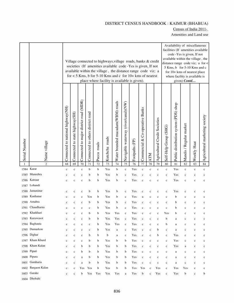
DISTRICT CENSUS HANDBOOK : KAIMUR (BHABUA)
Census of India 2011-
Amenities and Land use
Connec
ted t
o n
atio
nal
hig
hw
ay(N
H)
Connec
ted t
o s
tate
hig
hw
ay(S
H)
Connec
ted t
o m
ajor
dis
tric
t ro
ad (
MD
R)
Connec
ted t
o o
ther
s dis
tric
t ro
ad
Pucc
a r
oad
s
Kutc
hch
a r
oad
s
Wat
er b
ounded
mac
adam
(WB
M)
road
s
Nav
igab
le w
ater
way
(ri
ver
/can
al)(
NW
)
Footp
aths
(FP
)
Com
mer
cial
& C
o-o
per
ativ
e B
anks
AT
M
Agri
cult
ura
l C
redit
Soci
etie
s
Sel
f-H
elp G
roup (
SH
G)
Publi
c dis
trib
uti
on s
yst
em (
PD
S)
shop
Man
dis
/ R
egula
r m
arket
Wee
kly
Haa
t
Agri
cult
ura
l m
arket
ing s
oci
ety
1 2 68 69 70 71 72 73 74 75 76 77 78 79 80 81 82 83 84
Village connected to highways,village roads, banks & credit
societies (If amenities available code -Yes is given, If not
available within the village , the distance range code viz; a
for < 5 Kms, b for 5-10 Kms and c for 10+ kms of nearest
place where facility is available is given).
Ser
ial
Num
ber
Nam
e vil
lage
Availability of miscellaneous
facilities (If amenities available
code -Yes is given, If not
available within the village , the
distance range code viz; a for <
5 Kms, b for 5-10 Kms and c
for 10+ kms of nearest place
where facility is available is
given) Contd....
1584 Karar c c c b b Yes b c Yes c c c c Yes c c c
1585 Munrehra c c c b b Yes b c Yes c c c c Yes c c c
1586 Katraur c c c b b Yes b c Yes c c c c Yes c c c
1587 Lohandi
1588 Jamuninar c c c b b Yes b c Yes c c c c Yes c c c
1589 Kanhanar c c c Yes b Yes b c Yes a c c c b c c c
1590 Amahra c c c b b Yes b c Yes c c c c b c c c
1591 Chaudharna c c c c b Yes b c Yes c c c c b c c c
1592 Khatkhari c c c b b Yes Yes c Yes c c c Yes b c c c
1593 Kuruwasot c c c b b Yes Yes c Yes c c c b a c c c
1594 Baghauta c c c c b Yes Yes c Yes c c c b a c c c
1595 Dumarkon c c c c b Yes a c Yes c c b c a c c c
1596 Dighar c c c b b b a c Yes c c b c Yes c c c
1597 Kham Khurd c c c b b Yes b b Yes c c c c Yes c c c
1598 Kham Kalan c c b b b Yes b b Yes c c c c Yes a c c
1599 Pipari c c b b b Yes b b Yes c c c c a c c c
1600 Pipara c c a b b Yes b b Yes c c c c a c c c
1601 Gamharia c c a b b Yes b b Yes c c c c a c c c
1602 Bargaon Kalan c c Yes Yes b Yes b b Yes Yes c Yes c Yes Yes c c
1603 Garake c c b Yes Yes Yes Yes a Yes b c Yes c Yes b c b
1604 Dhobahi
��
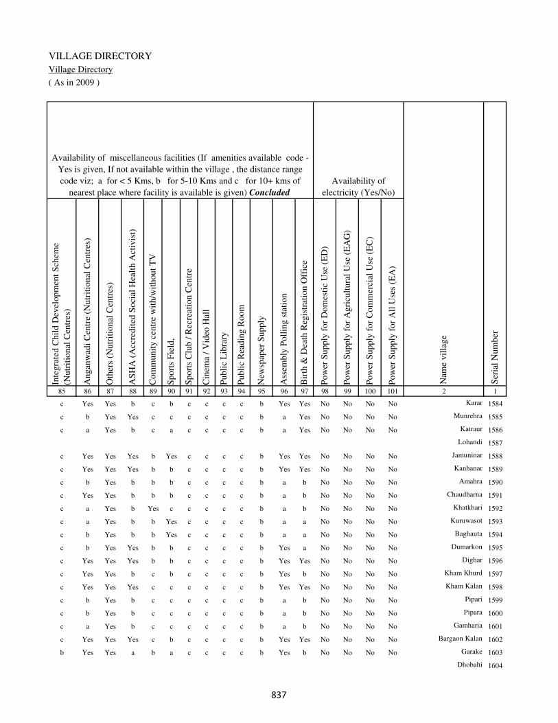
VILLAGE DIRECTORY
Village Directory
( As in 2009 )
Inte
gra
ted C
hil
d D
evel
opm
ent
Sch
eme
(Nutr
itio
nal
Cen
tres
)
Angan
wad
i C
entr
e (N
utr
itio
nal
Cen
tres
)
Oth
ers
(Nutr
itio
nal
Cen
tres
)
AS
HA
(A
ccre
dit
ed S
oci
al H
ealt
h A
ctiv
ist)
Com
munit
y c
entr
e w
ith/w
ithout
TV
Sport
s F
ield
,
Sport
s C
lub /
Rec
reat
ion C
entr
e
Cin
ema
/ V
ideo
Hal
l
Publi
c L
ibra
ry
Publi
c R
eadin
g R
oom
New
spap
er S
upply
Ass
embly
Poll
ing s
tati
on
Bir
th &
Dea
th R
egis
trat
ion O
ffic
e
Pow
er S
upply
for
Dom
esti
c U
se (
ED
)
Pow
er S
upply
for
Agri
cult
ura
l U
se (
EA
G)
Pow
er S
upply
for
Com
mer
cial
Use
(E
C)
Pow
er S
upply
for
All
Use
s (E
A)
85 86 87 88 89 90 91 92 93 94 95 96 97 98 99 100 101 2 1
Availability of
electricity (Yes/No)
Availability of miscellaneous facilities (If amenities available code -
Yes is given, If not available within the village , the distance range
code viz; a for < 5 Kms, b for 5-10 Kms and c for 10+ kms of
nearest place where facility is available is given) Concluded
Nam
e vil
lage
Ser
ial
Num
ber
c Yes Yes b c b c c c c b Yes Yes No No No No Karar 1584
c b Yes Yes c c c c c c b a Yes No No No No Munrehra 1585
c a Yes b c a c c c c b a Yes No No No No Katraur 1586
Lohandi 1587
c Yes Yes Yes b Yes c c c c b Yes Yes No No No No Jamuninar 1588
c Yes Yes Yes b b c c c c b Yes Yes No No No No Kanhanar 1589
c b Yes b b b c c c c b a b No No No No Amahra 1590
c Yes Yes b b b c c c c b a b No No No No Chaudharna 1591
c a Yes b Yes c c c c c b a b No No No No Khatkhari 1592
c a Yes b b Yes c c c c b a a No No No No Kuruwasot 1593
c b Yes b b Yes c c c c b a a No No No No Baghauta 1594
c b Yes Yes b b c c c c b Yes a No No No No Dumarkon 1595
c Yes Yes Yes b b c c c c b Yes Yes No No No No Dighar 1596
c Yes Yes b c b c c c c b Yes b No No No No Kham Khurd 1597
c Yes Yes Yes c c c c c c b Yes Yes No No No No Kham Kalan 1598
c b Yes b c c c c c c b a b No No No No Pipari 1599
c b Yes b c c c c c c b a b No No No No Pipara 1600
c a Yes b c c c c c c b a b No No No No Gamharia 1601
c Yes Yes Yes c b c c c c b Yes Yes No No No No Bargaon Kalan 1602
b Yes Yes a b a c c c c b Yes b No No No No Garake 1603
Dhobahi 1604
��
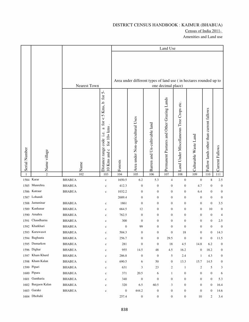
DISTRICT CENSUS HANDBOOK : KAIMUR (BHABUA)
Census of India 2011-
Amenities and Land use
Nam
e
Dis
tance
ran
ge
code
i.e
. a
fo
r <
5 K
ms,
b
for
5-
10 K
ms
and c
f
or
10+
km
s .
Fore
sts
Are
a under
Non-a
gri
cult
ura
l U
ses
Bar
ren a
nd U
n-c
ult
ivab
le l
and
Per
man
ent
Pas
ture
s an
d O
ther
Gra
zing L
ands
Lan
d U
nder
Mis
cell
aneo
us
Tre
e C
rops
etc.
Cult
ura
ble
Was
te L
and
Fal
low
lan
ds
oth
er t
han
curr
ent
fall
ow
s
Curr
ent
Fal
low
s
1 2 102 103 104 105 106 107 108 109 110 111
Ser
ial
Num
ber
Nam
e vil
lage
Area under different types of land use ( in hectares rounded up to
one decimal place)
Land Use
Nearest Town
1584 Karar BHABUA c 1650.5 6.2 5.3 4 0 0 8 2.5
1585 Munrehra BHABUA c 412.3 0 0 0 0 4.7 0 0
1586 Katraur BHABUA c 1032.2 0 0 0 0 6.4 0 0
1587 Lohandi 2689.4 0 0 0 0 0 0 0
1588 Jamuninar BHABUA c 1861 0 0 0 0 0 0 3.5
1589 Kanhanar BHABUA c 664.5 12 0 0 0 0 10 0
1590 Amahra BHABUA c 762.5 0 0 0 0 0 0 4
1591 Chaudharna BHABUA c 300 0 0 0 0 0 0 2.5
1592 Khatkhari BHABUA c 0 99 0 0 0 0 0 0
1593 Kuruwasot BHABUA c 504.3 0 0 0 18 0 0 14.3
1594 Baghauta BHABUA c 256.7 0 0 29.5 0 0 0 11.5
1595 Dumarkon BHABUA c 281 0 0 18 4.5 14.8 6.2 0
1596 Dighar BHABUA c 955 14.5 48 4.5 16.2 0 18.2 0
1597 Kham Khurd BHABUA c 286.8 0 0 5 2.4 1 4.3 0
1598 Kham Kalan BHABUA c 690.5 6 50 0 13.3 15.7 14.5 0
1599 Pipari BHABUA c 631 3 23 2 1 2 5 3
1600 Pipara BHABUA c 371 20.5 6 1 0 0 0 6
1601 Gamharia BHABUA c 340 0 0 0 0 0 0 5.3
1602 Bargaon Kalan BHABUA c 320 6.5 60.5 3 0 0 0 16.4
1603 Garake BHABUA c 0 444.2 0 0 0 0 0 14.6
1604 Dhobahi 257.4 0 0 0 0 10 2 3.4
��

VILLAGE DIRECTORY
Village Directory
( As in 2009 )
Net
Are
a S
ow
n
Tota
l Ir
rigat
ed L
and A
rea
Tota
l U
n-i
rrig
ated
Lan
d A
rea
Can
als
( C
)
Wel
ls/T
ube-
wel
ls(W
/TW
)
Tan
ks/
Lak
es(T
/L)
Wat
er F
alls
(WF
)
Oth
ers(
O)
Fir
st
Sec
ond
Thir
d
112 113 114 115 116 117 118 119 120 121 122 2 1
Ser
ial
Num
ber
Name of three
most important
commodities
manufacturedArea irrigated by source (in hectare).
Nam
e of
Vil
lage
Area under different types of
land use ( in hectares rounded
up to one decimal place)
Land Use
62.5 58 4.5 58 0 0 0 0 Karar 1584
57 56.5 0.5 50.2 0 0 0 6.3 Munrehra 1585
64.4 64.4 0 64.4 0 0 0 0 Katraur 1586
6.6 6.6 0 6.6 0 0 0 0 Lohandi 1587
13.5 13.5 0 13.5 0 0 0 0 Jamuninar 1588
112.5 76.5 36 76.5 0 0 0 0 Kanhanar 1589
79.5 36.3 43.2 36.3 0 0 0 0 Amahra 1590
206.5 206.5 0 206.5 0 0 0 0 Chaudharna 1591
400 350 50 0 300 0 0 50 Khatkhari 1592
50.4 40.2 10.2 40.2 0 0 0 0 Kuruwasot 1593
40.3 38 2.3 38 0 0 0 0 Baghauta 1594
43.5 42 1.5 42 0 0 0 0 Dumarkon 1595
144.6 63.5 81.1 55.2 0 0 0 8.3 Dighar 1596
44.5 32.4 12.1 32.4 0 0 0 0 Kham Khurd 1597
57 54.5 2.5 54.5 0 0 0 0 Kham Kalan 1598
18 0 18 0 0 0 0 0 Pipari 1599
51.5 35 16.5 35 0 0 0 0 Pipara 1600
87.7 76.2 11.5 76.2 0 0 0 0 Gamharia 1601
90.6 57.8 32.8 57.8 0 0 0 0 Bargaon Kalan 1602
150.2 150.2 0 150.2 0 0 0 0 Garake 1603
14.2 0 14.2 0 0 0 0 0 Dhobahi 1604
��

DISTRICT CENSUS HANDBOOK : KAIMUR (BHABUA)
Census of India 2011-
Amenities and Land use
Pre
-Pri
mar
y s
chool
(PP
)
Pri
mar
y s
chool
(P)
Mid
dle
sch
ool
(M)
Sec
ondar
y S
chool
(S)
Sen
ior
Sec
ondar
y s
chool
(SS
)
Deg
ree
coll
ege
of
arts
sc
ience
& c
om
mer
ce
(AS
C)
Engin
eeri
ng c
oll
ege(
EC
)
Med
ical
coll
ege
(MC
)
Man
agem
ent
inst
itute
(M
I)
Poly
tech
nic
(P
t)
Voca
tional
tra
inin
g s
chool
/IT
I
Non-f
orm
al t
rain
ing c
entr
e (N
FT
C)
Spec
ial
school
for
dis
able
d (
SS
D)
Oth
ers
(spec
ify)
1 2 3 4 5 6 7 8 9 10 11 12 13 14 15 16 17 18 19 20
Loca
tion c
ode
no.
Nam
e vil
lage
Ser
ial
Num
ber
Tota
l popula
tion (
2011 c
ensu
s )
Tota
l ar
ea o
f th
e vil
lage
( in
hec
tare
s ro
unded
up t
o
one
dec
imal
pla
ce)
Number of educational amenities available. (If not available
within the village , the distance range code viz; a for < 5
Kms, b for 5-10 Kms and c for 10+ kms of nearest place
where facility is available is given).
Num
ber
of
house
hold
s (2
011 c
ensu
s)
1605 Dewri 250529 1345 653 120 c 2 1 1 c c c c c c c c c
1606 Sikarwar 250530 632 611 101 c a b a b b c c c c c c c b
1607 Sikari 250531 495 1293 221 c 1 1 a c b c c c c c c c
1608 Kolhuwa 250532 293 1464 249 c 2 a b c b c c c b c c c
1609 Gamharia Khurd 250533 228 0 0
1610 Darihara 250534 441.2 187 33 c 1 b a c b c c c b c c c
1611 Mahkol 250535 559 0 0
1612 Raipurwa 250536 241 0 0
1613 Harbhog 250537 553 554 106 c 1 b a c b c c c b c c c
1614 Lewa 250538 541 903 155 c b b a c b c c c b c c c
1615 Marapa 250539 619 1007 173 c 1 1 b c b c c c c c c c
1616 Kon Babhani 250540 240 206 34 c 1 b b c b c c c c c c c
1617 Babhani Kalan 250541 697 1256 218 c 2 2 b c b c c c c c c c
1618 Rauta 250542 542 1016 179 c 1 a b c b c c c b c c c
1619 Chikta 250543 367 0 0
1620 Patpar 250544 334 210 44 b a a a c a c c c c c c c
1621 Garha 250545 406 0 0
1622 Patai 250546 745 0 0
1623 Beno 250547 244 0 0
1624 Chanpura 250548 686 2319 421 c 1 1 b c a c c c c c c c
1625 Kundadih 250549 226 0 0
���
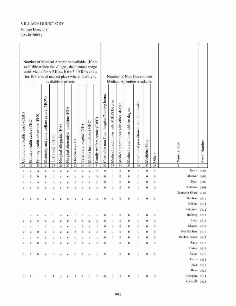
VILLAGE DIRECTORY
Village Directory
( As in 2009 )
Com
munit
y h
ealt
h c
entr
e (C
HC
)
Pri
mar
y h
ealt
h c
entr
e (P
HC
)
Pri
mar
y h
ealt
h s
ub c
entr
e (P
HS
)
Mat
ernit
y a
nd c
hil
d w
elfa
re c
entr
e (M
CW
)
T.B
. cl
inic
(T
BC
)
Hosp
ital
-all
opat
hic
(H
A)
Hosp
ital
-alt
ernat
ive
med
icin
e (H
O)
Dis
pen
sary
(D
)
Vet
erin
ary h
osp
ital
(V
H)
Mobil
e hea
lth c
linic
(M
HC
)
Fam
ily w
elfa
re c
entr
e (F
WC
)
Char
itab
le n
on G
ovt.
hosp
ital
/Nurs
ing h
om
e.
Med
ical
pra
ctit
ioner
wit
h M
BB
S D
egre
e
Med
ical
pra
ctit
ioner
wit
h o
ther
deg
ree
Med
ical
pra
ctit
ioner
wit
h n
o d
egre
e
Tra
dit
ional
pra
ctit
ioner
an
d f
aith
hea
ler
.
Med
icin
e S
hop
Oth
ers
21 22 23 24 25 26 27 28 29 30 31 32 33 34 35 36 37 38 2 1
Number of Non-Government
Medical Amenities available.
Number of Medical Amenities available. (If not
available within the village , the distance range
code viz; a for < 5 Kms, b for 5-10 Kms and c
for 10+ kms of nearest place where facility is
available is given).
Nam
e vil
lage
Ser
ial
Num
ber
c c a c c c c c c c c 0 0 0 0 0 0 0 Dewri 1605
b b b b b c c b b c b 0 0 0 0 0 0 0 Sikarwar 1606
c c a c c c c c c c c 0 0 0 0 0 0 0 Sikari 1607
c c c c c c c c c c c 0 0 0 0 0 0 0 Kolhuwa 1608
Gamharia Khurd 1609
b b c c c c c c c c c 0 0 0 0 0 0 0 Darihara 1610
Mahkol 1611
Raipurwa 1612
c c c c c c c c c c c 0 0 0 0 0 0 0 Harbhog 1613
c c c c c c c c b c c 0 0 0 0 0 0 0 Lewa 1614
c c 1 1 c c c c b c 1 0 0 0 0 0 0 0 Marapa 1615
c c b c c c c b b c c 0 0 0 0 0 0 0 Kon Babhani 1616
c c c c c c c c c c c 0 0 0 0 0 0 0 Babhani Kalan 1617
c b b c c c c c b c c 0 0 0 0 0 0 0 Rauta 1618
Chikta 1619
b b b c c c c c b c c 0 0 0 0 0 0 0 Patpar 1620
Garha 1621
Patai 1622
Beno 1623
b 1 1 1 1 c c 1 1 c 1 0 0 1 0 0 0 0 Chanpura 1624
Kundadih 1625
���

DISTRICT CENSUS HANDBOOK : KAIMUR (BHABUA)
Census of India 2011-
Amenities and Land use
Tap
wat
er (
Tre
ated
/Untr
eate
d)
Wel
l w
ater
(Cover
ed /
Unco
ver
ed w
ell)
Han
d P
um
p
Tube
wel
ls /
Bore
wel
l
Spri
ng
Riv
er /
Can
al
Tan
k /
Pond /
L
ake
Oth
ers
Com
munit
y t
oil
et i
ncl
udin
g
bat
h.
Com
munit
y t
oil
et e
xcl
udin
g b
ath.
Rura
l s
anit
ary m
art
or
sanit
ary
har
dw
are
outl
et
avai
lable
nea
r th
e vil
lage.
Com
munit
y b
io-
gas
or
recy
cle
of
was
te f
or
pro
duct
ive
use
.
1 2 39 40 41 42 43 44 45 46 47 48 49 50
Availability of toilet & others
Yes / No Availability of drinking water - Yes / No
Nam
e vil
lage
Ser
ial
Num
ber
1605 Dewri No Yes Yes Yes No No No No No No No No
1606 Sikarwar No Yes Yes Yes No Yes Yes No No No No No
1607 Sikari No Yes Yes No No Yes No No No No No No
1608 Kolhuwa No Yes Yes No No Yes No No No No No No
1609 Gamharia Khurd
1610 Darihara No Yes Yes No Yes Yes No No No No No No
1611 Mahkol
1612 Raipurwa
1613 Harbhog No Yes Yes No No Yes No No No No No No
1614 Lewa No Yes Yes Yes No Yes No No No No No No
1615 Marapa No Yes Yes No No Yes Yes No No No No No
1616 Kon Babhani No Yes Yes No No No No No No No No No
1617 Babhani Kalan No Yes Yes No No No No No No No No No
1618 Rauta No Yes Yes No No No No No No No No No
1619 Chikta
1620 Patpar No No Yes No No Yes No No No No No No
1621 Garha
1622 Patai
1623 Beno
1624 Chanpura No Yes Yes No Yes Yes No No No No No No
1625 Kundadih
��
VILLAGE DIRECTORY
Village Directory
( As in 2009 )
Post
off
ice(
PO
)
Sub p
ost
off
ice
(SP
O)
Post
& T
eleg
raph o
ffic
e
(P&
TO
)
Vil
lage
Pin
Code
Tel
ephones
(L
and l
ines
)
Publi
c ca
ll o
ffic
e (P
CO
)
Mobil
e phone
cover
age
Inte
rnet
caf
es/
Com
mon s
ervic
e ce
ntr
e (C
SC
)
Pri
vat
e co
uri
er f
acil
ity
Bus
serv
ice
(P
ubli
c &
Pri
vat
e)
Rai
lway
sta
tions
Auto
/Modif
ied A
uto
s
Tax
is a
nd V
ans
Tra
ctors
Cycl
e-pull
ed r
icksh
aws(
Man
ual
& M
achin
e
dri
ven
)
Car
ts d
riven
by a
nim
als
Sea
/R
iver
fer
ry s
ervic
e51 52 53 54 55 56 57 58 59 60 61 62 63 64 65 66 67 2 1
Communication and transport facilities (If amenities available code -Yes is given except for
Village Pin Code ,If not available within the village , the distance range code viz; a for < 5
Kms, b for 5-10 Kms and c for 10+ kms of nearest place where facility is available is given).
Ser
ial
Num
ber
Nam
e vil
lage
b b c c Yes Yes c c a c c c Yes b b Yes Dewri 1605
b b Yes b b b c b b c b b b b b b Sikarwar 1606
b a c Yes Yes Yes c c Yes c c c Yes Yes b Sikari 1607
Yes a c c c c c c Yes c c Yes b b b Kolhuwa 1608
Gamharia Khurd 1609
a c c c a c c c a c c c a c b Yes Darihara 1610
Mahkol 1611
Raipurwa 1612
b c c c c c c c c c c b b Yes b Harbhog 1613
b c c 821116 c c c c c c c c c Yes b b c Lewa 1614
b c c 821116 c c Yes c c c c c c Yes b Yes Marapa 1615
b c c b b c c c c c c c b Yes b Kon Babhani 1616
b b c b b b c c b c c c Yes Yes b Babhani Kalan 1617
b b c b b b c c b c c c Yes Yes b Rauta 1618
Chikta 1619
Yes c c b Yes b c Yes b c c c Yes Yes b Patpar 1620
Garha 1621
Patai 1622
Beno 1623
b c c b b Yes c c b c c c Yes b Yes Chanpura 1624
Kundadih 1625
��
DISTRICT CENSUS HANDBOOK : KAIMUR (BHABUA)
Census of India 2011-
Amenities and Land use
Connec
ted t
o n
atio
nal
hig
hw
ay(N
H)
Connec
ted t
o s
tate
hig
hw
ay(S
H)
Connec
ted t
o m
ajor
dis
tric
t ro
ad (
MD
R)
Connec
ted t
o o
ther
s dis
tric
t ro
ad
Pucc
a r
oad
s
Kutc
hch
a r
oad
s
Wat
er b
ounded
mac
adam
(WB
M)
road
s
Nav
igab
le w
ater
way
(ri
ver
/can
al)(
NW
)
Footp
aths
(FP
)
Com
mer
cial
& C
o-o
per
ativ
e B
anks
AT
M
Agri
cult
ura
l C
redit
Soci
etie
s
Sel
f-H
elp G
roup (
SH
G)
Publi
c dis
trib
uti
on s
yst
em (
PD
S)
shop
Man
dis
/ R
egula
r m
arket
Wee
kly
Haa
t
Agri
cult
ura
l m
arket
ing s
oci
ety
1 2 68 69 70 71 72 73 74 75 76 77 78 79 80 81 82 83 84
Village connected to highways,village roads, banks & credit
societies (If amenities available code -Yes is given, If not
available within the village , the distance range code viz; a
for < 5 Kms, b for 5-10 Kms and c for 10+ kms of nearest
place where facility is available is given).
Ser
ial
Num
ber
Nam
e vil
lage
Availability of miscellaneous
facilities (If amenities available
code -Yes is given, If not
available within the village , the
distance range code viz; a for <
5 Kms, b for 5-10 Kms and c
for 10+ kms of nearest place
where facility is available is
given) Contd....
1605 Dewri Yes Yes Yes Yes Yes Yes Yes Yes Yes c c c c b b c c
1606 Sikarwar b c b b b Yes a a Yes b b b c a b c b
1607 Sikari c c b Yes b Yes Yes b Yes c c c c Yes Yes c c
1608 Kolhuwa c c b b b Yes a b Yes c c c c a b c c
1609 Gamharia Khurd
1610 Darihara c c b Yes b Yes b Yes Yes c c c Yes a b c c
1611 Mahkol
1612 Raipurwa
1613 Harbhog c c c Yes b Yes b a Yes c c c c a c b c
1614 Lewa c c c b b Yes c Yes Yes c c c c Yes c b c
1615 Marapa c c c b a Yes Yes b Yes c c c c Yes Yes Yes Yes
1616 Kon Babhani c c c b b a b a Yes c c b c b b b c
1617 Babhani Kalan c c b b b Yes b a Yes b b b c Yes b b b
1618 Rauta c c Yes c b Yes a b Yes b b b c Yes b b c
1619 Chikta
1620 Patpar c c c b b b b b Yes Yes b c c Yes c b c
1621 Garha
1622 Patai
1623 Beno
1624 Chanpura c c c b b Yes b b Yes b c c Yes Yes c c c
1625 Kundadih
���

VILLAGE DIRECTORY
Village Directory
( As in 2009 )
Inte
gra
ted C
hil
d D
evel
opm
ent
Sch
eme
(Nutr
itio
nal
Cen
tres
)
Angan
wad
i C
entr
e (N
utr
itio
nal
Cen
tres
)
Oth
ers
(Nutr
itio
nal
Cen
tres
)
AS
HA
(A
ccre
dit
ed S
oci
al H
ealt
h A
ctiv
ist)
Com
munit
y c
entr
e w
ith/w
ithout
TV
Sport
s F
ield
,
Sport
s C
lub /
Rec
reat
ion C
entr
e
Cin
ema
/ V
ideo
Hal
l
Publi
c L
ibra
ry
Publi
c R
eadin
g R
oom
New
spap
er S
upply
Ass
embly
Poll
ing s
tati
on
Bir
th &
Dea
th R
egis
trat
ion O
ffic
e
Pow
er S
upply
for
Dom
esti
c U
se (
ED
)
Pow
er S
upply
for
Agri
cult
ura
l U
se (
EA
G)
Pow
er S
upply
for
Com
mer
cial
Use
(E
C)
Pow
er S
upply
for
All
Use
s (E
A)
85 86 87 88 89 90 91 92 93 94 95 96 97 98 99 100 101 2 1
Availability of
electricity (Yes/No)
Availability of miscellaneous facilities (If amenities available code -
Yes is given, If not available within the village , the distance range
code viz; a for < 5 Kms, b for 5-10 Kms and c for 10+ kms of
nearest place where facility is available is given) Concluded
Nam
e vil
lage
Ser
ial
Num
ber
c Yes Yes a Yes Yes c c c c b Yes b No No No No Dewri 1605
c Yes Yes Yes b b c c c c b Yes b No No No No Sikarwar 1606
c Yes Yes Yes Yes a c c c c b a Yes No No No No Sikari 1607
c Yes Yes Yes a b c c c c c Yes Yes No No No No Kolhuwa 1608
Gamharia Khurd 1609
c Yes Yes a b a c c c c b a b No No No No Darihara 1610
Mahkol 1611
Raipurwa 1612
c Yes Yes b b c c c c c b a b No No No No Harbhog 1613
c Yes Yes Yes b Yes c c c c b Yes b No No No No Lewa 1614
c Yes Yes Yes c Yes c c c c b Yes b No No No No Marapa 1615
c a Yes Yes c b c c c c b Yes b No No No No Kon Babhani 1616
b Yes Yes Yes c Yes c c c c b Yes b No No No No Babhani Kalan 1617
b Yes Yes Yes c Yes c c c c b Yes Yes No No No No Rauta 1618
Chikta 1619
b a Yes b c Yes c c c c b a b No No No No Patpar 1620
Garha 1621
Patai 1622
Beno 1623
b Yes Yes Yes c b c c c c b Yes Yes No No No No Chanpura 1624
Kundadih 1625
���

DISTRICT CENSUS HANDBOOK : KAIMUR (BHABUA)
Census of India 2011-
Amenities and Land use
Nam
e
Dis
tance
ran
ge
code
i.e
. a
fo
r <
5 K
ms,
b
for
5-
10 K
ms
and c
f
or
10+
km
s .
Fore
sts
Are
a under
Non-a
gri
cult
ura
l U
ses
Bar
ren a
nd U
n-c
ult
ivab
le l
and
Per
man
ent
Pas
ture
s an
d O
ther
Gra
zing L
ands
Lan
d U
nder
Mis
cell
aneo
us
Tre
e C
rops
etc.
Cult
ura
ble
Was
te L
and
Fal
low
lan
ds
oth
er t
han
curr
ent
fall
ow
s
Curr
ent
Fal
low
s
1 2 102 103 104 105 106 107 108 109 110 111
Ser
ial
Num
ber
Nam
e vil
lage
Area under different types of land use ( in hectares rounded up to
one decimal place)
Land Use
Nearest Town
1605 Dewri BHABUA c 0 345 0 0 0 0 0 0
1606 Sikarwar BHABUA c 477.7 27.1 0 0 0 0 0 0
1607 Sikari BHABUA c 304.2 0 0 0 10 0 0 7
1608 Kolhuwa BHABUA c 150.5 0 0 0 0 12 4 0
1609 Gamharia Khurd 201.9 0 0 0 3 5.5 3 0.5
1610 Darihara BHABUA c 132.8 24.2 84.3 11.8 17.2 18 29.8 19.2
1611 Mahkol 204.1 24.1 86.2 70 45.1 18.1 15.6 10.8
1612 Raipurwa 215.4 0 0 0 10 0 0 15
1613 Harbhog BHABUA c 321.6 117.1 3.5 2.4 20.4 10.5 54.2 3.1
1614 Lewa BHABUA c 350.2 52.2 4 0 0 0 7.5 2.5
1615 Marapa BHABUA c 500.2 0 0 0 0 0 0 10.2
1616 Kon Babhani BHABUA c 190.5 0 0 0 0 0 0 5
1617 Babhani Kalan BHABUA c 520.5 0 0 0 0 0 9.6 20.4
1618 Rauta BHABUA c 401.5 0 0 0 0 0 15.2 0
1619 Chikta 303.5 0 0 0 0 0 0 3
1620 Patpar BHABUA c 310.6 0 0 0 0 0 0 4.1
1621 Garha 0 0 0 0 0 0 0 0
1622 Patai 665.5 0 0 0 0 0 0 10.6
1623 Beno 234 0 0 0 0 0 0 0
1624 Chanpura BHABUA c 405.4 0 20 0 0 13 12.5 18.5
1625 Kundadih 205.6 0 0 0 0 0 0 0
���

VILLAGE DIRECTORY
Village Directory
( As in 2009 )
Net
Are
a S
ow
n
Tota
l Ir
rigat
ed L
and A
rea
Tota
l U
n-i
rrig
ated
Lan
d A
rea
Can
als
( C
)
Wel
ls/T
ube-
wel
ls(W
/TW
)
Tan
ks/
Lak
es(T
/L)
Wat
er F
alls
(WF
)
Oth
ers(
O)
Fir
st
Sec
ond
Thir
d
112 113 114 115 116 117 118 119 120 121 122 2 1
Ser
ial
Num
ber
Name of three
most important
commodities
manufacturedArea irrigated by source (in hectare).
Nam
e of
Vil
lage
Area under different types of
land use ( in hectares rounded
up to one decimal place)
Land Use
1000 800 200 0 700 0 0 100 Dewri 1605
127.2 105.2 22 0 105.2 0 0 0 Sikarwar 1606
173.8 171.8 2 160.2 0 0 0 11.6 Sikari 1607
126.5 97.2 29.3 97.2 0 0 0 0 Kolhuwa 1608
14.1 0 14.1 0 0 0 0 0 Gamharia Khurd 1609
103.8 0 103.8 0 0 0 0 0 Darihara 1610
85 0 85 0 0 0 0 0 Mahkol 1611
0.6 0 0.6 0 0 0 0 0 Raipurwa 1612
20.2 0 20.2 0 0 0 0 0 Harbhog 1613
124.6 70.3 54.3 70.3 0 0 0 0 Lewa 1614
108.6 108.6 0 108.6 0 0 0 0 Marapa 1615
44.5 44.5 0 44.5 0 0 0 0 Kon Babhani 1616
146.5 145.5 1 145.5 0 0 0 0 Babhani Kalan 1617
125.3 125.3 0 125.3 0 0 0 0 Rauta 1618
60.5 60.5 0 60.5 0 0 0 0 Chikta 1619
19.3 19.3 0 19.3 0 0 0 0 Patpar 1620
406 406 0 406 0 0 0 0 Garha 1621
68.9 68.9 0 68.9 0 0 0 0 Patai 1622
10 10 0 10 0 0 0 0 Beno 1623
216.6 216.6 0 196.4 0 0 0 20.2 Chanpura 1624
20.4 20.4 0 20.4 0 0 0 0 Kundadih 1625
���

DISTRICT CENSUS HANDBOOK : KAIMUR (BHABUA)
Census of India 2011-
Amenities and Land use
Pre
-Pri
mar
y s
chool
(PP
)
Pri
mar
y s
chool
(P)
Mid
dle
sch
ool
(M)
Sec
ondar
y S
chool
(S)
Sen
ior
Sec
ondar
y s
chool
(SS
)
Deg
ree
coll
ege
of
arts
sc
ience
& c
om
mer
ce
(AS
C)
Engin
eeri
ng c
oll
ege(
EC
)
Med
ical
coll
ege
(MC
)
Man
agem
ent
inst
itute
(M
I)
Poly
tech
nic
(P
t)
Voca
tional
tra
inin
g s
chool
/IT
I
Non-f
orm
al t
rain
ing c
entr
e (N
FT
C)
Spec
ial
school
for
dis
able
d (
SS
D)
Oth
ers
(spec
ify)
1 2 3 4 5 6 7 8 9 10 11 12 13 14 15 16 17 18 19 20
Loca
tion c
ode
no.
Nam
e vil
lage
Ser
ial
Num
ber
Tota
l popula
tion (
2011 c
ensu
s )
Tota
l ar
ea o
f th
e vil
lage
( in
hec
tare
s ro
unded
up t
o
one
dec
imal
pla
ce)
Number of educational amenities available. (If not available
within the village , the distance range code viz; a for < 5
Kms, b for 5-10 Kms and c for 10+ kms of nearest place
where facility is available is given).
Num
ber
of
house
hold
s (2
011 c
ensu
s)
1626 Turidag 250550 504 65 8 c a a b c a c c c c c c c
1627 Kedala 250551 386 0 0
1628 Keswa 250552 249 0 0
1629 Adhaura 250553 957 2961 550 c 3 1 1 c a c c c c c c c
1630 Jharpa 250554 458 283 51 c 1 a 1 1 1 c c c c c c c
1631 Bardiha 250555 813 438 72 c 1 a b c b c c c c c c c
1632 Biduri 250556 333 493 93 b a b b c c c c c c c c c
1633 Ukhargara 250557 332 36 7 b a a a c a c c c c c c c
1634 Baragaon Khurd 250558 872 522 85 b 1 1 a c b c c c c c c c
1635 Chorpanian 250559 741 222 42 b 1 a a c b c c c c c c c
1636 Dhenuan 250560 454 43 9 b a b a c a c c c c c c c
1637 Bandha 250561 911 256 61 1 1 a a c b c c c c c c c
1638 Tekanian 250562 605 215 43 1 1 a a c a c c c c c c c
1639 Kharaura 250563 170 25 5 a a a a c a c c c c c c c
1640 Sarainar 250564 601 376 54 a 1 a a c a c c c c c a c
1641 Bhuiphor 250565 272 847 152 a 1 b b c c c c c c c c c
1642 Bahabar 250566 385 67 14 b a b b c c c c c c c b c
1643 Khondhar 250567 1210.3 306 56 a 1 a b c c c c c c c b c
1644 Goiyan 250568 564 422 77 a 1 b b c b c c c c c c c
1645 Dumrawan 250569 853 974 150 1 1 1 b c c c c c c c c c
1646 Pipra 250570 1344 334 46 a 2 b c c b c c c c c c c
���

VILLAGE DIRECTORY
Village Directory
( As in 2009 )
Com
munit
y h
ealt
h c
entr
e (C
HC
)
Pri
mar
y h
ealt
h c
entr
e (P
HC
)
Pri
mar
y h
ealt
h s
ub c
entr
e (P
HS
)
Mat
ernit
y a
nd c
hil
d w
elfa
re c
entr
e (M
CW
)
T.B
. cl
inic
(T
BC
)
Hosp
ital
-all
opat
hic
(H
A)
Hosp
ital
-alt
ernat
ive
med
icin
e (H
O)
Dis
pen
sary
(D
)
Vet
erin
ary h
osp
ital
(V
H)
Mobil
e hea
lth c
linic
(M
HC
)
Fam
ily w
elfa
re c
entr
e (F
WC
)
Char
itab
le n
on G
ovt.
hosp
ital
/Nurs
ing h
om
e.
Med
ical
pra
ctit
ioner
wit
h M
BB
S D
egre
e
Med
ical
pra
ctit
ioner
wit
h o
ther
deg
ree
Med
ical
pra
ctit
ioner
wit
h n
o d
egre
e
Tra
dit
ional
pra
ctit
ioner
an
d f
aith
hea
ler
.
Med
icin
e S
hop
Oth
ers
21 22 23 24 25 26 27 28 29 30 31 32 33 34 35 36 37 38 2 1
Number of Non-Government
Medical Amenities available.
Number of Medical Amenities available. (If not
available within the village , the distance range
code viz; a for < 5 Kms, b for 5-10 Kms and c
for 10+ kms of nearest place where facility is
available is given).
Nam
e vil
lage
Ser
ial
Num
ber
c c b c c c c c b c a 0 0 0 0 0 0 0 Turidag 1626
Kedala 1627
Keswa 1628
c 1 1 1 1 c c 1 1 c 1 0 0 2 1 0 1 0 Adhaura 1629
c b 1 1 c c c c c c 1 0 0 0 0 0 0 0 Jharpa 1630
c b b b c c c b b c c 0 0 0 0 0 0 0 Bardiha 1631
c b b b b c c b b c c 0 0 0 0 0 0 0 Biduri 1632
c b b b b c c c c c c 0 0 0 0 0 0 0 Ukhargara 1633
c b 1 1 b c c c c c 1 0 0 0 0 0 0 0 Baragaon Khurd 1634
c c b c c c c c b c c 0 0 0 0 0 0 0 Chorpanian 1635
c c b b c c c c b c c 0 0 0 0 0 0 0 Dhenuan 1636
c c b b c c c b b c c 0 0 0 0 0 0 0 Bandha 1637
c c b c c c c b b c c 0 0 0 0 0 0 0 Tekanian 1638
c c b b c c c b c c c 0 0 0 0 0 0 0 Kharaura 1639
a a a a a c c a a c a 0 0 0 0 0 0 0 Sarainar 1640
b b b b b c c b b c b 0 0 0 0 0 0 0 Bhuiphor 1641
b b b b b c c b b c b 0 0 0 0 0 0 0 Bahabar 1642
a a a a a c c a a c a 0 0 0 0 0 0 0 Khondhar 1643
b b b c b c c c b c b 0 0 0 0 0 0 0 Goiyan 1644
b b a b b c c b b c b 0 0 0 0 0 0 0 Dumrawan 1645
b c b c b c c b c c b 0 0 0 0 0 0 0 Pipra 1646
���
DISTRICT CENSUS HANDBOOK : KAIMUR (BHABUA)
Census of India 2011-
Amenities and Land use
Tap
wat
er (
Tre
ated
/Untr
eate
d)
Wel
l w
ater
(Cover
ed /
Unco
ver
ed w
ell)
Han
d P
um
p
Tube
wel
ls /
Bore
wel
l
Spri
ng
Riv
er /
Can
al
Tan
k /
Pond /
L
ake
Oth
ers
Com
munit
y t
oil
et i
ncl
udin
g
bat
h.
Com
munit
y t
oil
et e
xcl
udin
g b
ath.
Rura
l s
anit
ary m
art
or
sanit
ary
har
dw
are
outl
et
avai
lable
nea
r th
e vil
lage.
Com
munit
y b
io-
gas
or
recy
cle
of
was
te f
or
pro
duct
ive
use
.
1 2 39 40 41 42 43 44 45 46 47 48 49 50
Availability of toilet & others
Yes / No Availability of drinking water - Yes / No
Nam
e vil
lage
Ser
ial
Num
ber
1626 Turidag No Yes Yes No No No No No No No No No
1627 Kedala
1628 Keswa
1629 Adhaura No Yes Yes No No No No No No No No No
1630 Jharpa No Yes Yes No No No No No No No No No
1631 Bardiha No Yes Yes No No No No No No No No No
1632 Biduri No Yes Yes No No Yes No No No No No No
1633 Ukhargara No Yes Yes No No Yes No No No No No No
1634 Baragaon Khurd No Yes Yes No No No Yes No No No No No
1635 Chorpanian No Yes Yes No No Yes No No No No No No
1636 Dhenuan No Yes Yes No No Yes No No No No No No
1637 Bandha No Yes Yes No No Yes No No No No No No
1638 Tekanian No No Yes No No Yes No No No No No No
1639 Kharaura No No Yes No No Yes No No No No No No
1640 Sarainar No No Yes Yes No No No No No No Yes No
1641 Bhuiphor No Yes Yes No No No No No No No No No
1642 Bahabar No Yes Yes No No No No No No No No No
1643 Khondhar No Yes Yes No No No No No No No Yes No
1644 Goiyan No Yes Yes No Yes Yes No No No No No No
1645 Dumrawan No Yes Yes No No No No No No No No No
1646 Pipra No Yes Yes No No No No No No No No No
���

VILLAGE DIRECTORY
Village Directory
( As in 2009 )
Post
off
ice(
PO
)
Sub p
ost
off
ice
(SP
O)
Post
& T
eleg
raph o
ffic
e
(P&
TO
)
Vil
lage
Pin
Code
Tel
ephones
(L
and l
ines
)
Publi
c ca
ll o
ffic
e (P
CO
)
Mobil
e phone
cover
age
Inte
rnet
caf
es/
Com
mon s
ervic
e ce
ntr
e (C
SC
)
Pri
vat
e co
uri
er f
acil
ity
Bus
serv
ice
(P
ubli
c &
Pri
vat
e)
Rai
lway
sta
tions
Auto
/Modif
ied A
uto
s
Tax
is a
nd V
ans
Tra
ctors
Cycl
e-pull
ed r
icksh
aws(
Man
ual
& M
achin
e
dri
ven
)
Car
ts d
riven
by a
nim
als
Sea
/R
iver
fer
ry s
ervic
e51 52 53 54 55 56 57 58 59 60 61 62 63 64 65 66 67 2 1
Communication and transport facilities (If amenities available code -Yes is given except for
Village Pin Code ,If not available within the village , the distance range code viz; a for < 5
Kms, b for 5-10 Kms and c for 10+ kms of nearest place where facility is available is given).
Ser
ial
Num
ber
Nam
e vil
lage
b c c b b b c c b c c c b b a Turidag 1626
Kedala 1627
Keswa 1628
Yes c c 821116 Yes Yes Yes c c Yes c c c Yes Yes Yes Adhaura 1629
a a c a Yes Yes c c Yes c c c a a b c Jharpa 1630
b c c b b Yes c c Yes c c c Yes Yes b Bardiha 1631
b c c b b Yes c c Yes c c c Yes b b Biduri 1632
Yes c c b b b c c Yes c c Yes Yes Yes b Ukhargara 1633
Yes c c a b Yes c c b c c b Yes Yes b Baragaon Khurd 1634
b b c 821116 b b b c c b c c b Yes Yes Yes Chorpanian 1635
b b c 821116 b b b c c b c c b Yes Yes Yes Dhenuan 1636
a c c 821116 a a Yes c c a c c b b b b Bandha 1637
a a c 821116 a a Yes c c a c c b b b b Tekanian 1638
a a c 821116 a a a c c a c c c b b a Kharaura 1639
a a c a a a c c a c c a Yes Yes a Sarainar 1640
Yes c c 821116 b b Yes b c b c c c Yes b b Bhuiphor 1641
b b c b b b b c b c c b b Yes b Bahabar 1642
b b c b b b b b b c c b Yes Yes Yes Khondhar 1643
b c c 821116 b b Yes c c b c c c Yes a b Goiyan 1644
b b c 821116 b b Yes c c b c c c b Yes b Dumrawan 1645
b c c 821116 b b b c c b c c c b b b Pipra 1646
���
DISTRICT CENSUS HANDBOOK : KAIMUR (BHABUA)
Census of India 2011-
Amenities and Land use
Connec
ted t
o n
atio
nal
hig
hw
ay(N
H)
Connec
ted t
o s
tate
hig
hw
ay(S
H)
Connec
ted t
o m
ajor
dis
tric
t ro
ad (
MD
R)
Connec
ted t
o o
ther
s dis
tric
t ro
ad
Pucc
a r
oad
s
Kutc
hch
a r
oad
s
Wat
er b
ounded
mac
adam
(WB
M)
road
s
Nav
igab
le w
ater
way
(ri
ver
/can
al)(
NW
)
Footp
aths
(FP
)
Com
mer
cial
& C
o-o
per
ativ
e B
anks
AT
M
Agri
cult
ura
l C
redit
Soci
etie
s
Sel
f-H
elp G
roup (
SH
G)
Publi
c dis
trib
uti
on s
yst
em (
PD
S)
shop
Man
dis
/ R
egula
r m
arket
Wee
kly
Haa
t
Agri
cult
ura
l m
arket
ing s
oci
ety
1 2 68 69 70 71 72 73 74 75 76 77 78 79 80 81 82 83 84
Village connected to highways,village roads, banks & credit
societies (If amenities available code -Yes is given, If not
available within the village , the distance range code viz; a
for < 5 Kms, b for 5-10 Kms and c for 10+ kms of nearest
place where facility is available is given).
Ser
ial
Num
ber
Nam
e vil
lage
Availability of miscellaneous
facilities (If amenities available
code -Yes is given, If not
available within the village , the
distance range code viz; a for <
5 Kms, b for 5-10 Kms and c
for 10+ kms of nearest place
where facility is available is
given) Contd....
1626 Turidag c c c b b b b b Yes b c c c b c c c
1627 Kedala
1628 Keswa
1629 Adhaura c Yes Yes Yes Yes Yes a b Yes Yes b b Yes Yes c c c
1630 Jharpa c Yes Yes b Yes Yes b b Yes a a a c b c b c
1631 Bardiha c c Yes Yes b Yes b c Yes b a b c b c b c
1632 Biduri c c Yes Yes b Yes a c Yes b b b c b c c c
1633 Ukhargara c c b Yes b Yes a c Yes b b b c Yes c b c
1634 Baragaon Khurd c c b Yes b Yes b c Yes Yes b b c Yes c c c
1635 Chorpanian c c b c b Yes Yes b Yes b c b b b b b c
1636 Dhenuan c c c c b Yes Yes b Yes b c b b b b b c
1637 Bandha c c a a a Yes a b Yes b c a c a b c c
1638 Tekanian c c c a b Yes b b Yes a a a c Yes c c c
1639 Kharaura c c c a b Yes b b Yes a a a c a c b c
1640 Sarainar c c b Yes a Yes b b Yes Yes a Yes c a a c c
1641 Bhuiphor c c b b b Yes a b Yes b b b c b b c c
1642 Bahabar c c b Yes b Yes b b Yes b c b c a b b c
1643 Khondhar c c Yes Yes b Yes a b Yes b c b b b b b c
1644 Goiyan c c c b b Yes b b Yes b c c c a b b c
1645 Dumrawan c c c c Yes Yes b b Yes Yes c Yes b b b b c
1646 Pipra c c c b b Yes a b Yes b c b c a b c c
��

VILLAGE DIRECTORY
Village Directory
( As in 2009 )
Inte
gra
ted C
hil
d D
evel
opm
ent
Sch
eme
(Nutr
itio
nal
Cen
tres
)
Angan
wad
i C
entr
e (N
utr
itio
nal
Cen
tres
)
Oth
ers
(Nutr
itio
nal
Cen
tres
)
AS
HA
(A
ccre
dit
ed S
oci
al H
ealt
h A
ctiv
ist)
Com
munit
y c
entr
e w
ith/w
ithout
TV
Sport
s F
ield
,
Sport
s C
lub /
Rec
reat
ion C
entr
e
Cin
ema
/ V
ideo
Hal
l
Publi
c L
ibra
ry
Publi
c R
eadin
g R
oom
New
spap
er S
upply
Ass
embly
Poll
ing s
tati
on
Bir
th &
Dea
th R
egis
trat
ion O
ffic
e
Pow
er S
upply
for
Dom
esti
c U
se (
ED
)
Pow
er S
upply
for
Agri
cult
ura
l U
se (
EA
G)
Pow
er S
upply
for
Com
mer
cial
Use
(E
C)
Pow
er S
upply
for
All
Use
s (E
A)
85 86 87 88 89 90 91 92 93 94 95 96 97 98 99 100 101 2 1
Availability of
electricity (Yes/No)
Availability of miscellaneous facilities (If amenities available code -
Yes is given, If not available within the village , the distance range
code viz; a for < 5 Kms, b for 5-10 Kms and c for 10+ kms of
nearest place where facility is available is given) Concluded
Nam
e vil
lage
Ser
ial
Num
ber
b b Yes a c a c c c c b a b No No No No Turidag 1626
Kedala 1627
Keswa 1628
Yes Yes Yes Yes c Yes c c c c b Yes Yes Yes No No No Adhaura 1629
a a Yes Yes a a c c c c a Yes Yes No No No No Jharpa 1630
b a Yes a c a c c c c b a b No No No No Bardiha 1631
b Yes Yes a c b b c c c b a b No No No No Biduri 1632
c Yes Yes a c b c c c c b Yes Yes No No No No Ukhargara 1633
c Yes Yes Yes b Yes c c c c b Yes b No No No No Baragaon Khurd 1634
b a Yes b b Yes Yes c c c b a b No No No No Chorpanian 1635
b a Yes b b Yes Yes c c c b a b No No No No Dhenuan 1636
a a Yes b a a c c c c b a a No No No No Bandha 1637
a a Yes a Yes b c c c b b a a No No No No Tekanian 1638
a b Yes b a a c c c c b a a No No No No Kharaura 1639
a a Yes a a a c c c c a a a No No No No Sarainar 1640
b Yes Yes Yes b b c c c c b a b No No No No Bhuiphor 1641
b b Yes b b b c c c c b a b No No No No Bahabar 1642
b b Yes b c b b c c c b a a No No No No Khondhar 1643
b a Yes b c b c c c c b a b No No No No Goiyan 1644
b Yes Yes b c c c c c b b Yes b No No No No Dumrawan 1645
c b Yes b c b c c c c b Yes b No No No No Pipra 1646
��

DISTRICT CENSUS HANDBOOK : KAIMUR (BHABUA)
Census of India 2011-
Amenities and Land use
Nam
e
Dis
tance
ran
ge
code
i.e
. a
fo
r <
5 K
ms,
b
for
5-
10 K
ms
and c
f
or
10+
km
s .
Fore
sts
Are
a under
Non-a
gri
cult
ura
l U
ses
Bar
ren a
nd U
n-c
ult
ivab
le l
and
Per
man
ent
Pas
ture
s an
d O
ther
Gra
zing L
ands
Lan
d U
nder
Mis
cell
aneo
us
Tre
e C
rops
etc.
Cult
ura
ble
Was
te L
and
Fal
low
lan
ds
oth
er t
han
curr
ent
fall
ow
s
Curr
ent
Fal
low
s
1 2 102 103 104 105 106 107 108 109 110 111
Ser
ial
Num
ber
Nam
e vil
lage
Area under different types of land use ( in hectares rounded up to
one decimal place)
Land Use
Nearest Town
1626 Turidag BHABUA c 462.3 0 0 0 0 0 0 3.5
1627 Kedala 229 0 0 0 0 0 0 16.4
1628 Keswa 192.2 0 0 0 0 0 0 7.4
1629 Adhaura BHABUA c 648.6 0 0 0 0 30 0 2.2
1630 Jharpa BHABUA c 341 0 0 0 0 20 0 30.2
1631 Bardiha BHABUA c 698.5 0 0 0 0 0 0 9
1632 Biduri BHABUA c 241.5 0 0 0 0 0 0 10
1633 Ukhargara BHABUA c 262.3 0 0 0 0 0 0 4
1634 Baragaon Khurd BHABUA c 0 0 0 0 0 0 0 0
1635 Chorpanian BHABUA c 642 0 0 0 0 0 0 6.2
1636 Dhenuan BHABUA c 405.6 0 0 0 0 0 1 4
1637 Bandha BHABUA c 829.6 0 0 0 0 0 5.5 4.5
1638 Tekanian BHABUA c 521.5 0 0 0 0 0 0 6.2
1639 Kharaura BHABUA c 150.8 0 0 0 0 0 0 3
1640 Sarainar BHABUA c 480.4 0 0 0 0 0 0 4
1641 Bhuiphor BHABUA c 165.4 0 0 0 0 0 10 3
1642 Bahabar BHABUA c 327.5 5.1 2.8 4 9.4 2.1 5.4 3
1643 Khondhar BHABUA c 970.6 12.7 143.7 16.1 12.2 3.9 8.1 7.3
1644 Goiyan BHABUA c 88.5 0 0 0 0 0 0 7
1645 Dumrawan BHABUA c 541.4 0 0 0 0 9.6 0 12
1646 Pipra BHABUA c 1266 0 0 0 0 0 0 4.5
���
VILLAGE DIRECTORY
Village Directory
( As in 2009 )
Net
Are
a S
ow
n
Tota
l Ir
rigat
ed L
and A
rea
Tota
l U
n-i
rrig
ated
Lan
d A
rea
Can
als
( C
)
Wel
ls/T
ube-
wel
ls(W
/TW
)
Tan
ks/
Lak
es(T
/L)
Wat
er F
alls
(WF
)
Oth
ers(
O)
Fir
st
Sec
ond
Thir
d
112 113 114 115 116 117 118 119 120 121 122 2 1
Ser
ial
Num
ber
Name of three
most important
commodities
manufacturedArea irrigated by source (in hectare).
Nam
e of
Vil
lage
Area under different types of
land use ( in hectares rounded
up to one decimal place)
Land Use
38.2 38.2 0 38.2 0 0 0 0 Turidag 1626
140.6 140.6 0 140.6 0 0 0 0 Kedala 1627
49.4 49.4 0 49.4 0 0 0 0 Keswa 1628
276.2 276.2 0 225.4 0 0 0 50.8 Adhaura 1629
66.8 66.8 0 66.8 0 0 0 0 Jharpa 1630
105.5 105.5 0 105.5 0 0 0 0 Bardiha 1631
81.5 81.5 0 81.5 0 0 0 0 Biduri 1632
65.7 64.5 1.2 64.5 0 0 0 0 Ukhargara 1633
872 872 0 872 0 0 0 0 Baragaon Khurd 1634
92.8 92.8 0 92.8 0 0 0 0 Chorpanian 1635
43.4 42.2 1.2 0 42.2 0 0 0 Dhenuan 1636
71.4 71.4 0 71.4 0 0 0 0 Bandha 1637
77.3 77.3 0 77.3 0 0 0 0 Tekanian 1638
16.2 16.2 0 16.2 0 0 0 0 Kharaura 1639
116.6 116.6 0 116.6 0 0 0 0 Sarainar 1640
93.6 93.6 0 93.6 0 0 0 0 Bhuiphor 1641
25.7 0 25.7 0 0 0 0 0 Bahabar 1642
35.7 0 35.7 0 0 0 0 0 Khondhar 1643
468.5 468.5 0 468.5 0 0 0 0 Goiyan 1644
290 290 0 290 0 0 0 0 Dumrawan 1645
73.5 73.5 0 73.5 0 0 0 0 Pipra 1646
���

DISTRICT CENSUS HANDBOOK : KAIMUR (BHABUA)
Census of India 2011-
Amenities and Land use
Pre
-Pri
mar
y s
chool
(PP
)
Pri
mar
y s
chool
(P)
Mid
dle
sch
ool
(M)
Sec
ondar
y S
chool
(S)
Sen
ior
Sec
ondar
y s
chool
(SS
)
Deg
ree
coll
ege
of
arts
sc
ience
& c
om
mer
ce
(AS
C)
Engin
eeri
ng c
oll
ege(
EC
)
Med
ical
coll
ege
(MC
)
Man
agem
ent
inst
itute
(M
I)
Poly
tech
nic
(P
t)
Voca
tional
tra
inin
g s
chool
/IT
I
Non-f
orm
al t
rain
ing c
entr
e (N
FT
C)
Spec
ial
school
for
dis
able
d (
SS
D)
Oth
ers
(spec
ify)
1 2 3 4 5 6 7 8 9 10 11 12 13 14 15 16 17 18 19 20
Loca
tion c
ode
no.
Nam
e vil
lage
Ser
ial
Num
ber
Tota
l popula
tion (
2011 c
ensu
s )
Tota
l ar
ea o
f th
e vil
lage
( in
hec
tare
s ro
unded
up t
o
one
dec
imal
pla
ce)
Number of educational amenities available. (If not available
within the village , the distance range code viz; a for < 5
Kms, b for 5-10 Kms and c for 10+ kms of nearest place
where facility is available is given).
Num
ber
of
house
hold
s (2
011 c
ensu
s)
1647 Kothilabar 250571 637 66 10 a a b b c b c c c c c c c
1648 Holadih 250572 327 0 0
1649 Tori 250573 723 523 77 b b b b c b c c c c c c c
1650 Banodag 250574 742 193 24 b a a c c b c c c c c c c
1651 Dumri 250575 337 0 0
1652 Bahadag 250576 1554 523 83 b a b c c b c c c c c c c
1653 Barap 250577 1557 599 96 c 1 1 c c c c c c c c c c
1654 Kadhar Khurd 250578 456 182 27 b b b b c b c c c c c c c
1655 Kadhar Kalan 250579 2421 585 80 b a b c c b c c c c c c c
1656 Londa 250580 2513 825 149 b 1 1 c c c c c c c c c c
1657 Pachmahut 250581 643 285 58 b 1 c b c b c c c b c c c
1658 Gulu 250582 214 286 64 a 1 b b c b c c c b c c c
1659 Lohra 250583 978 1151 199 b 1 1 b c b c c c c c b c
1660 Har 250584 676 349 62 1 1 a c c c c c c c c c c 1
1661 Dugha 250585 1065 1323 224 c 2 1 c c c c c c c c c c
1662 Sahijan 250586 233 71 12 c a a c c c c c c c c c c
1663 Athan 250587 673 1301 224 c 1 c c c c c c c c c c c
1664 Oldag 250588 539 232 48 c a a c c c c c c c c c c
1665 Neurus 250589 679 231 36 c a b c c b c c c c c c c
1666 Chathans 250590 675 267 42 c 1 a b c c c c c b c c c
1667 Kotamdag 250591 690 283 45 c 1 a c c c c c c c c c c
���

VILLAGE DIRECTORY
Village Directory
( As in 2009 )
Com
munit
y h
ealt
h c
entr
e (C
HC
)
Pri
mar
y h
ealt
h c
entr
e (P
HC
)
Pri
mar
y h
ealt
h s
ub c
entr
e (P
HS
)
Mat
ernit
y a
nd c
hil
d w
elfa
re c
entr
e (M
CW
)
T.B
. cl
inic
(T
BC
)
Hosp
ital
-all
opat
hic
(H
A)
Hosp
ital
-alt
ernat
ive
med
icin
e (H
O)
Dis
pen
sary
(D
)
Vet
erin
ary h
osp
ital
(V
H)
Mobil
e hea
lth c
linic
(M
HC
)
Fam
ily w
elfa
re c
entr
e (F
WC
)
Char
itab
le n
on G
ovt.
hosp
ital
/Nurs
ing h
om
e.
Med
ical
pra
ctit
ioner
wit
h M
BB
S D
egre
e
Med
ical
pra
ctit
ioner
wit
h o
ther
deg
ree
Med
ical
pra
ctit
ioner
wit
h n
o d
egre
e
Tra
dit
ional
pra
ctit
ioner
an
d f
aith
hea
ler
.
Med
icin
e S
hop
Oth
ers
21 22 23 24 25 26 27 28 29 30 31 32 33 34 35 36 37 38 2 1
Number of Non-Government
Medical Amenities available.
Number of Medical Amenities available. (If not
available within the village , the distance range
code viz; a for < 5 Kms, b for 5-10 Kms and c
for 10+ kms of nearest place where facility is
available is given).
Nam
e vil
lage
Ser
ial
Num
ber
c c a b c c c b b c c 0 0 0 0 0 0 0 Kothilabar 1647
Holadih 1648
b b b c c c c c b c c 0 0 0 0 0 0 0 Tori 1649
b c b c b c c b c c c 0 0 0 0 0 0 0 Banodag 1650
Dumri 1651
b c b c b c c c b c c 0 0 0 0 0 0 0 Bahadag 1652
c c c c c c c c c c c 0 0 0 0 0 0 0 Barap 1653
c c c c c c c c b c c 0 0 0 0 0 0 0 Kadhar Khurd 1654
c c b c c c c c b c c 0 0 0 0 0 0 0 Kadhar Kalan 1655
c c b c c c c c c c c 0 0 0 0 0 0 0 Londa 1656
c c c c c c c c c c c 0 0 0 0 0 0 0 Pachmahut 1657
b b b b c c c b b c b 0 0 0 0 0 0 0 Gulu 1658
b c 1 1 b c c b b c 1 0 0 0 0 0 0 0 Lohra 1659
c c c c c c c c c c c 0 0 0 0 0 0 0 Har 1660
c c b c c c c c c c c 0 0 0 0 0 0 0 Dugha 1661
c c b c c c c c c c c 0 0 0 0 0 0 0 Sahijan 1662
c c c c c c c c c c c 0 0 0 0 0 0 0 Athan 1663
c c c c c c c c c c c 0 0 0 0 0 0 0 Oldag 1664
c b 1 1 c c c c c c 1 0 0 0 0 0 0 0 Neurus 1665
c c a c c c c c c c c 0 0 0 0 0 0 0 Chathans 1666
c c b c c c c c b c c 0 0 0 0 0 0 0 Kotamdag 1667
���

DISTRICT CENSUS HANDBOOK : KAIMUR (BHABUA)
Census of India 2011-
Amenities and Land use
Tap
wat
er (
Tre
ated
/Untr
eate
d)
Wel
l w
ater
(Cover
ed /
Unco
ver
ed w
ell)
Han
d P
um
p
Tube
wel
ls /
Bore
wel
l
Spri
ng
Riv
er /
Can
al
Tan
k /
Pond /
L
ake
Oth
ers
Com
munit
y t
oil
et i
ncl
udin
g
bat
h.
Com
munit
y t
oil
et e
xcl
udin
g b
ath.
Rura
l s
anit
ary m
art
or
sanit
ary
har
dw
are
outl
et
avai
lable
nea
r th
e vil
lage.
Com
munit
y b
io-
gas
or
recy
cle
of
was
te f
or
pro
duct
ive
use
.
1 2 39 40 41 42 43 44 45 46 47 48 49 50
Availability of toilet & others
Yes / No Availability of drinking water - Yes / No
Nam
e vil
lage
Ser
ial
Num
ber
1647 Kothilabar No No Yes No No Yes No No No No No No
1648 Holadih
1649 Tori No Yes Yes No No No No No No No No No
1650 Banodag No Yes Yes No No Yes No No No No No No
1651 Dumri
1652 Bahadag No No Yes No No No No No No No No No
1653 Barap No Yes Yes No No No No No No No No No
1654 Kadhar Khurd No Yes Yes No No Yes No No No No No No
1655 Kadhar Kalan No Yes Yes No No Yes No No No No No No
1656 Londa No Yes Yes No No No No No No No No No
1657 Pachmahut No Yes Yes No Yes No Yes No No No No No
1658 Gulu No Yes Yes No No Yes No No No No No No
1659 Lohra No No Yes No No No No No No No No No
1660 Har No No Yes No No Yes No No No No Yes No
1661 Dugha No Yes Yes No No No No No No No No No
1662 Sahijan No No Yes No No Yes No No No No Yes No
1663 Athan No No Yes Yes No No No No No No Yes No
1664 Oldag No No Yes Yes No Yes No No No No Yes No
1665 Neurus No Yes Yes No Yes Yes No No No No No No
1666 Chathans No Yes Yes No Yes Yes No No No No No No
1667 Kotamdag No No Yes No Yes No No No No No No No
���
VILLAGE DIRECTORY
Village Directory
( As in 2009 )
Post
off
ice(
PO
)
Sub p
ost
off
ice
(SP
O)
Post
& T
eleg
raph o
ffic
e
(P&
TO
)
Vil
lage
Pin
Code
Tel
ephones
(L
and l
ines
)
Publi
c ca
ll o
ffic
e (P
CO
)
Mobil
e phone
cover
age
Inte
rnet
caf
es/
Com
mon s
ervic
e ce
ntr
e (C
SC
)
Pri
vat
e co
uri
er f
acil
ity
Bus
serv
ice
(P
ubli
c &
Pri
vat
e)
Rai
lway
sta
tions
Auto
/Modif
ied A
uto
s
Tax
is a
nd V
ans
Tra
ctors
Cycl
e-pull
ed r
icksh
aws(
Man
ual
& M
achin
e
dri
ven
)
Car
ts d
riven
by a
nim
als
Sea
/R
iver
fer
ry s
ervic
e51 52 53 54 55 56 57 58 59 60 61 62 63 64 65 66 67 2 1
Communication and transport facilities (If amenities available code -Yes is given except for
Village Pin Code ,If not available within the village , the distance range code viz; a for < 5
Kms, b for 5-10 Kms and c for 10+ kms of nearest place where facility is available is given).
Ser
ial
Num
ber
Nam
e vil
lage
b c c 821116 b b b c c b c c c b b b Kothilabar 1647
Holadih 1648
b c c b b b c c c c c c Yes Yes b Tori 1649
b c c b b b c c c c c c a b a Banodag 1650
Dumri 1651
b c c c b b c c b c c c b b b Bahadag 1652
b c c 821116 c c Yes c c c c c c Yes Yes b Barap 1653
b c c c b b c c c c c c b b a Kadhar Khurd 1654
b c c c c b c c c c c c b a b Kadhar Kalan 1655
b c c c c c c c c c c c Yes b b c Londa 1656
b c c 821116 c c c c c b c c c c Yes Yes Pachmahut 1657
b c c 821116 b b b c c b c c c b Yes Yes Gulu 1658
b b c b b b b b b c c c b Yes Yes Lohra 1659
b a c c c c c c c c c c c b Yes Har 1660
b c c c c c c c c c c c c a a Dugha 1661
b c c c c c c c c c c c c Yes Yes Yes Sahijan 1662
b c c c c c c c c c c c Yes Yes a Athan 1663
b c c c c c c c c c c c Yes Yes Yes c Oldag 1664
b c c c c Yes c c c c c c Yes Yes b Neurus 1665
b c c c c Yes c c c c c c Yes Yes b Chathans 1666
b c c c c c c c c c c c c b a c Kotamdag 1667
���

DISTRICT CENSUS HANDBOOK : KAIMUR (BHABUA)
Census of India 2011-
Amenities and Land use
Connec
ted t
o n
atio
nal
hig
hw
ay(N
H)
Connec
ted t
o s
tate
hig
hw
ay(S
H)
Connec
ted t
o m
ajor
dis
tric
t ro
ad (
MD
R)
Connec
ted t
o o
ther
s dis
tric
t ro
ad
Pucc
a r
oad
s
Kutc
hch
a r
oad
s
Wat
er b
ounded
mac
adam
(WB
M)
road
s
Nav
igab
le w
ater
way
(ri
ver
/can
al)(
NW
)
Footp
aths
(FP
)
Com
mer
cial
& C
o-o
per
ativ
e B
anks
AT
M
Agri
cult
ura
l C
redit
Soci
etie
s
Sel
f-H
elp G
roup (
SH
G)
Publi
c dis
trib
uti
on s
yst
em (
PD
S)
shop
Man
dis
/ R
egula
r m
arket
Wee
kly
Haa
t
Agri
cult
ura
l m
arket
ing s
oci
ety
1 2 68 69 70 71 72 73 74 75 76 77 78 79 80 81 82 83 84
Village connected to highways,village roads, banks & credit
societies (If amenities available code -Yes is given, If not
available within the village , the distance range code viz; a
for < 5 Kms, b for 5-10 Kms and c for 10+ kms of nearest
place where facility is available is given).
Ser
ial
Num
ber
Nam
e vil
lage
Availability of miscellaneous
facilities (If amenities available
code -Yes is given, If not
available within the village , the
distance range code viz; a for <
5 Kms, b for 5-10 Kms and c
for 10+ kms of nearest place
where facility is available is
given) Contd....
1647 Kothilabar c c c b b a a c Yes b c b c b b c c
1648 Holadih
1649 Tori c c c b b Yes b c Yes b c c c Yes c c c
1650 Banodag c c c Yes b Yes b b Yes c c b c a a c c
1651 Dumri
1652 Bahadag c c c b b b b c Yes c c b c Yes c c c
1653 Barap c c c c b Yes b b Yes c c b c b c c c
1654 Kadhar Khurd c c c b b a b b Yes b c b c b c c c
1655 Kadhar Kalan c c c b b b b b Yes b c b c b b c c
1656 Londa c c c c b Yes b b Yes b c Yes c a c c c
1657 Pachmahut c c c Yes a Yes Yes b Yes c c c c Yes c c c
1658 Gulu c c b b b Yes Yes b Yes b c b b Yes b b c
1659 Lohra c c Yes b b Yes b b Yes b c b b Yes b b c
1660 Har c c Yes b b Yes b c Yes c c c c b c c c
1661 Dugha c c b Yes b Yes b b Yes Yes c Yes c b c c c
1662 Sahijan c c c b b Yes c Yes Yes b c c c b c c c
1663 Athan c c c Yes b Yes c b Yes Yes c Yes c Yes c c c
1664 Oldag c c c b b b c b Yes b c c c b c c c
1665 Neurus c c c a b Yes c b Yes c c c b b c c c
1666 Chathans c c c a b Yes b b Yes c c c Yes a c c c
1667 Kotamdag c c Yes c c Yes c c Yes b c c c Yes c c c
���

VILLAGE DIRECTORY
Village Directory
( As in 2009 )
Inte
gra
ted C
hil
d D
evel
opm
ent
Sch
eme
(Nutr
itio
nal
Cen
tres
)
Angan
wad
i C
entr
e (N
utr
itio
nal
Cen
tres
)
Oth
ers
(Nutr
itio
nal
Cen
tres
)
AS
HA
(A
ccre
dit
ed S
oci
al H
ealt
h A
ctiv
ist)
Com
munit
y c
entr
e w
ith/w
ithout
TV
Sport
s F
ield
,
Sport
s C
lub /
Rec
reat
ion C
entr
e
Cin
ema
/ V
ideo
Hal
l
Publi
c L
ibra
ry
Publi
c R
eadin
g R
oom
New
spap
er S
upply
Ass
embly
Poll
ing s
tati
on
Bir
th &
Dea
th R
egis
trat
ion O
ffic
e
Pow
er S
upply
for
Dom
esti
c U
se (
ED
)
Pow
er S
upply
for
Agri
cult
ura
l U
se (
EA
G)
Pow
er S
upply
for
Com
mer
cial
Use
(E
C)
Pow
er S
upply
for
All
Use
s (E
A)
85 86 87 88 89 90 91 92 93 94 95 96 97 98 99 100 101 2 1
Availability of
electricity (Yes/No)
Availability of miscellaneous facilities (If amenities available code -
Yes is given, If not available within the village , the distance range
code viz; a for < 5 Kms, b for 5-10 Kms and c for 10+ kms of
nearest place where facility is available is given) Concluded
Nam
e vil
lage
Ser
ial
Num
ber
c a Yes a c a c c c c b a b No No No No Kothilabar 1647
Holadih 1648
c Yes Yes a c b c c c c b Yes b No No No No Tori 1649
c a Yes b c a c c c c b a b No No No No Banodag 1650
Dumri 1651
c a Yes b c b c c c c b a b No No No No Bahadag 1652
c Yes Yes Yes c b c c c c b a b No No No No Barap 1653
c Yes Yes Yes b Yes c c c c b a b No No No No Kadhar Khurd 1654
c Yes Yes Yes c Yes c c c c b a b No No No No Kadhar Kalan 1655
c Yes Yes b c b c c c c b a b No No No No Londa 1656
c b c Yes c Yes Yes c c c b a Yes No No No No Pachmahut 1657
b b a Yes b Yes Yes c c c b a Yes No No No No Gulu 1658
b Yes Yes a b b b c c b b a b No No No No Lohra 1659
c b Yes b b b c c c c c a b No No No No Har 1660
c Yes Yes a c c c c c c c Yes b No No No No Dugha 1661
c b Yes b c c c c c c c a b No No No No Sahijan 1662
c Yes Yes b c c c c c c c Yes Yes No No No No Athan 1663
c b b b c b c c c c c a b No No No No Oldag 1664
c a Yes b c c c c c c c a b No No No No Neurus 1665
c b Yes b c c c c c c c a b No No No No Chathans 1666
c b c b c b c c c c c a b No No No No Kotamdag 1667
���

DISTRICT CENSUS HANDBOOK : KAIMUR (BHABUA)
Census of India 2011-
Amenities and Land use
Nam
e
Dis
tance
ran
ge
code
i.e
. a
fo
r <
5 K
ms,
b
for
5-
10 K
ms
and c
f
or
10+
km
s .
Fore
sts
Are
a under
Non-a
gri
cult
ura
l U
ses
Bar
ren a
nd U
n-c
ult
ivab
le l
and
Per
man
ent
Pas
ture
s an
d O
ther
Gra
zing L
ands
Lan
d U
nder
Mis
cell
aneo
us
Tre
e C
rops
etc.
Cult
ura
ble
Was
te L
and
Fal
low
lan
ds
oth
er t
han
curr
ent
fall
ow
s
Curr
ent
Fal
low
s
1 2 102 103 104 105 106 107 108 109 110 111
Ser
ial
Num
ber
Nam
e vil
lage
Area under different types of land use ( in hectares rounded up to
one decimal place)
Land Use
Nearest Town
1647 Kothilabar BHABUA c 633.2 0 0 0 0 0 0 0.8
1648 Holadih 280 0 0 0 0 0 0 1.5
1649 Tori BHABUA c 580.5 0 0 0 0 6 0 0
1650 Banodag BHABUA c 700.2 0 0 0 0 0 0 1.3
1651 Dumri 337 0 0 0 0 0 0 0
1652 Bahadag BHABUA c 1439 0 0 0 0 0 0 8.6
1653 Barap BHABUA c 1416.5 0 0 0 0 7 0 0
1654 Kadhar Khurd BHABUA c 0 0 0 0 0 0 0 0.6
1655 Kadhar Kalan BHABUA c 2292.8 0 0 0 0 0 0 10
1656 Londa BHABUA c 2326.5 0 0 0 0 20 0 8.5
1657 Pachmahut BHABUA c 590.5 0 0 0 0 10 0 4.3
1658 Gulu BHABUA c 188.5 0 0 0 0 19.5 0 4.5
1659 Lohra BHABUA c 501.5 20 0 0 0 21 0 0
1660 Har BHABUA c 454.5 0 0 0 0 35 15 7
1661 Dugha BHABUA c 764.5 0 0 0 0 50 0 0
1662 Sahijan BHABUA c 180.4 0 0 0 0 5 0 5.2
1663 Athan BHABUA c 390 0 0 0 0 0 0 0.6
1664 Oldag BHABUA c 427 0 0 0 0 0 0 5.5
1665 Neurus BHABUA c 528 0 0 0 0 20 0 4.2
1666 Chathans BHABUA c 529.6 0 0 0 0 15 0 45.8
1667 Kotamdag BHABUA c 570 0 0 0 0 0 10 4.6
��

VILLAGE DIRECTORY
Village Directory
( As in 2009 )
Net
Are
a S
ow
n
Tota
l Ir
rigat
ed L
and A
rea
Tota
l U
n-i
rrig
ated
Lan
d A
rea
Can
als
( C
)
Wel
ls/T
ube-
wel
ls(W
/TW
)
Tan
ks/
Lak
es(T
/L)
Wat
er F
alls
(WF
)
Oth
ers(
O)
Fir
st
Sec
ond
Thir
d
112 113 114 115 116 117 118 119 120 121 122 2 1
Ser
ial
Num
ber
Name of three
most important
commodities
manufacturedArea irrigated by source (in hectare).
Nam
e of
Vil
lage
Area under different types of
land use ( in hectares rounded
up to one decimal place)
Land Use
3 3 0 3 0 0 0 0 Kothilabar 1647
45.5 45 0.5 40 5 0 0 0 Holadih 1648
136.5 136.5 0 136.5 0 0 0 0 Tori 1649
40.5 40.5 0 40.5 0 0 0 0 Banodag 1650
0 0 0 0 0 0 0 0 Dumri 1651
106.4 106.4 0 106.4 0 0 0 0 Bahadag 1652
133.5 133.5 0 133.5 0 0 0 0 Barap 1653
455.4 455.4 0 455.4 0 0 0 0 Kadhar Khurd 1654
118.2 117 1.2 117 0 0 0 0 Kadhar Kalan 1655
158 158 0 158 0 0 0 0 Londa 1656
38.2 38.2 0 38.2 0 0 0 0 Pachmahut 1657
1.5 0 1.5 0 0 0 0 0 Gulu 1658
435.5 199.9 235.6 199.9 0 0 0 0 Lohra 1659
164.5 164.5 0 164.5 0 0 0 0 Har 1660
250.5 250.5 0 250.5 0 0 0 0 Dugha 1661
42.4 42.4 0 0 42.4 0 0 0 Sahijan 1662
282.4 282.4 0 282.4 0 0 0 0 Athan 1663
106.5 106.5 0 106.5 0 0 0 0 Oldag 1664
126.8 126.8 0 126.8 0 0 0 0 Neurus 1665
84.6 84.6 0 84.6 0 0 0 0 Chathans 1666
105.4 105.4 0 105.4 0 0 0 0 Kotamdag 1667
��

DISTRICT CENSUS HANDBOOK : KAIMUR (BHABUA)
Census of India 2011-
Amenities and Land use
Pre
-Pri
mar
y s
chool
(PP
)
Pri
mar
y s
chool
(P)
Mid
dle
sch
ool
(M)
Sec
ondar
y S
chool
(S)
Sen
ior
Sec
ondar
y s
chool
(SS
)
Deg
ree
coll
ege
of
arts
sc
ience
& c
om
mer
ce
(AS
C)
Engin
eeri
ng c
oll
ege(
EC
)
Med
ical
coll
ege
(MC
)
Man
agem
ent
inst
itute
(M
I)
Poly
tech
nic
(P
t)
Voca
tional
tra
inin
g s
chool
/IT
I
Non-f
orm
al t
rain
ing c
entr
e (N
FT
C)
Spec
ial
school
for
dis
able
d (
SS
D)
Oth
ers
(spec
ify)
1 2 3 4 5 6 7 8 9 10 11 12 13 14 15 16 17 18 19 20
Loca
tion c
ode
no.
Nam
e vil
lage
Ser
ial
Num
ber
Tota
l popula
tion (
2011 c
ensu
s )
Tota
l ar
ea o
f th
e vil
lage
( in
hec
tare
s ro
unded
up t
o
one
dec
imal
pla
ce)
Number of educational amenities available. (If not available
within the village , the distance range code viz; a for < 5
Kms, b for 5-10 Kms and c for 10+ kms of nearest place
where facility is available is given).
Num
ber
of
house
hold
s (2
011 c
ensu
s)
1668 Chaya 250592 968 371 65 b 1 a b c c c c c b c c c
1669 Chaphana 250593 1056 822 117 b 1 1 c c c c c c b c c c
1670 Chikta 250594 882 236 48 1 1 b c c c c c c b c c c
1671 Parari 250595 676 127 27 1 a b c c c c c c b c c c
1672 Chumurka 250596 522 196 39 1 1 b c c c c c c c c c c
1673 Dumurka 250597 637 502 87 b a b c c c c c c c c c c
1674 Karma 250598 720 326 55 b a b c c c c c c c c c c
1675 Kurmura 250599 166 110 19 b a b b c c c c c c c c c
1676 Sanraki 250600 1732 1311 216 b 1 2 c c b c c c c c c c
1677 Jharia 250601 607 38 7 b 1 b c c b c c c c c c c
1678 Dholdag 250602 769 0 0
1679 Parwania 250603 370 240 46 b 2 b b c b c c c c c c c
1680 Sorha 250604 393 532 93 c 2 b b c b c c c c c c c
1681 Garle 250605 448 146 24 c a a c c b c c c b c c c
1682 Sarodag 250606 1380 1048 219 c 1 1 c c c c c c c c c c
1683 Sari 250607 226 258 36 c 2 a b c b c c c b c c c
1684 Kolhua 250608 389 312 54 c a b b c b c c c b c c c
1685 Kuturkha 250609 137 0 0
1686 Bahera 250610 454 566 94 c a b c c b c c c b c c c
1687 Pokhra 250611 370 67 12 c a a c c c c c c c c c c
1688 Kesraura Khurd 250612 365 277 46 c 1 a c c c c c c c c c c
���
VILLAGE DIRECTORY
Village Directory
( As in 2009 )
Com
munit
y h
ealt
h c
entr
e (C
HC
)
Pri
mar
y h
ealt
h c
entr
e (P
HC
)
Pri
mar
y h
ealt
h s
ub c
entr
e (P
HS
)
Mat
ernit
y a
nd c
hil
d w
elfa
re c
entr
e (M
CW
)
T.B
. cl
inic
(T
BC
)
Hosp
ital
-all
opat
hic
(H
A)
Hosp
ital
-alt
ernat
ive
med
icin
e (H
O)
Dis
pen
sary
(D
)
Vet
erin
ary h
osp
ital
(V
H)
Mobil
e hea
lth c
linic
(M
HC
)
Fam
ily w
elfa
re c
entr
e (F
WC
)
Char
itab
le n
on G
ovt.
hosp
ital
/Nurs
ing h
om
e.
Med
ical
pra
ctit
ioner
wit
h M
BB
S D
egre
e
Med
ical
pra
ctit
ioner
wit
h o
ther
deg
ree
Med
ical
pra
ctit
ioner
wit
h n
o d
egre
e
Tra
dit
ional
pra
ctit
ioner
an
d f
aith
hea
ler
.
Med
icin
e S
hop
Oth
ers
21 22 23 24 25 26 27 28 29 30 31 32 33 34 35 36 37 38 2 1
Number of Non-Government
Medical Amenities available.
Number of Medical Amenities available. (If not
available within the village , the distance range
code viz; a for < 5 Kms, b for 5-10 Kms and c
for 10+ kms of nearest place where facility is
available is given).
Nam
e vil
lage
Ser
ial
Num
ber
c c a c c c c c c c c 0 0 0 0 0 0 0 Chaya 1668
b b b b b c c c b c b 0 0 0 0 0 0 0 Chaphana 1669
b c b c b c c c b c b 0 0 0 0 0 0 0 Chikta 1670
c c b c b c c c b c b 0 0 0 0 0 0 0 Parari 1671
c c b b c c c b b c c 0 0 0 0 0 0 0 Chumurka 1672
c c b c c c c c b c c 0 0 0 0 0 0 0 Dumurka 1673
c c a c c c c c c c c 0 0 0 0 0 0 0 Karma 1674
c c b c c c c c c c c 0 0 0 0 0 0 0 Kurmura 1675
c c b c c c c c b c c 0 0 0 0 0 0 0 Sanraki 1676
b b a b b c c b b c b 0 0 0 0 0 0 0 Jharia 1677
Dholdag 1678
c b a c c c c c c c c 0 0 0 0 0 0 0 Parwania 1679
c c b c c c c c b c c 0 0 0 0 0 0 0 Sorha 1680
c c b c c c c c c c c 0 0 0 0 0 0 0 Garle 1681
c c 1 1 c c c c c c 1 1 4 3 6 8 2 0 Sarodag 1682
c c b c c c c c b c c 0 0 0 0 0 0 0 Sari 1683
c c b c c c c c b c c 0 0 0 0 0 0 0 Kolhua 1684
Kuturkha 1685
c c c c c c c c c c c 0 0 0 0 0 0 0 Bahera 1686
c c b c c c c c c c c 0 0 0 0 0 0 0 Pokhra 1687
c c b c c c c c c c c 0 0 0 0 0 0 0 Kesraura Khurd 1688
���

DISTRICT CENSUS HANDBOOK : KAIMUR (BHABUA)
Census of India 2011-
Amenities and Land use
Tap
wat
er (
Tre
ated
/Untr
eate
d)
Wel
l w
ater
(Cover
ed /
Unco
ver
ed w
ell)
Han
d P
um
p
Tube
wel
ls /
Bore
wel
l
Spri
ng
Riv
er /
Can
al
Tan
k /
Pond /
L
ake
Oth
ers
Com
munit
y t
oil
et i
ncl
udin
g
bat
h.
Com
munit
y t
oil
et e
xcl
udin
g b
ath.
Rura
l s
anit
ary m
art
or
sanit
ary
har
dw
are
outl
et
avai
lable
nea
r th
e vil
lage.
Com
munit
y b
io-
gas
or
recy
cle
of
was
te f
or
pro
duct
ive
use
.
1 2 39 40 41 42 43 44 45 46 47 48 49 50
Availability of toilet & others
Yes / No Availability of drinking water - Yes / No
Nam
e vil
lage
Ser
ial
Num
ber
1668 Chaya No Yes Yes No No Yes No No No No No No
1669 Chaphana No Yes Yes No No Yes No No No No No No
1670 Chikta No Yes Yes No No Yes No No No No No No
1671 Parari No Yes Yes No No Yes No No No No No No
1672 Chumurka No Yes Yes No No Yes No No No No No No
1673 Dumurka No No Yes No No No No No No No No No
1674 Karma No No Yes No No No No No No No No No
1675 Kurmura No No Yes No No No No No No No No No
1676 Sanraki No Yes Yes No No No No No No No No No
1677 Jharia Yes No Yes No No No No No No No No No
1678 Dholdag
1679 Parwania Yes No Yes No Yes Yes No No No No No No
1680 Sorha No No Yes No Yes Yes No No No No No No
1681 Garle No No Yes No Yes Yes No No No No No No
1682 Sarodag No Yes Yes No No Yes No No No No No No
1683 Sari No No Yes No Yes No No No No No No No
1684 Kolhua No No Yes No No No No No No No No No
1685 Kuturkha
1686 Bahera No No Yes No No No No No No No No No
1687 Pokhra No Yes Yes No Yes Yes No No No No No No
1688 Kesraura Khurd No Yes Yes No Yes Yes No No No No No No
���
VILLAGE DIRECTORY
Village Directory
( As in 2009 )
Post
off
ice(
PO
)
Sub p
ost
off
ice
(SP
O)
Post
& T
eleg
raph o
ffic
e
(P&
TO
)
Vil
lage
Pin
Code
Tel
ephones
(L
and l
ines
)
Publi
c ca
ll o
ffic
e (P
CO
)
Mobil
e phone
cover
age
Inte
rnet
caf
es/
Com
mon s
ervic
e ce
ntr
e (C
SC
)
Pri
vat
e co
uri
er f
acil
ity
Bus
serv
ice
(P
ubli
c &
Pri
vat
e)
Rai
lway
sta
tions
Auto
/Modif
ied A
uto
s
Tax
is a
nd V
ans
Tra
ctors
Cycl
e-pull
ed r
icksh
aws(
Man
ual
& M
achin
e
dri
ven
)
Car
ts d
riven
by a
nim
als
Sea
/R
iver
fer
ry s
ervic
e51 52 53 54 55 56 57 58 59 60 61 62 63 64 65 66 67 2 1
Communication and transport facilities (If amenities available code -Yes is given except for
Village Pin Code ,If not available within the village , the distance range code viz; a for < 5
Kms, b for 5-10 Kms and c for 10+ kms of nearest place where facility is available is given).
Ser
ial
Num
ber
Nam
e vil
lage
b c c c c Yes c c c c c c Yes Yes a Chaya 1668
b c c c c c c c c c c c b Yes b Chaphana 1669
b c c c c Yes c c c c c c Yes Yes b Chikta 1670
b c c c b b c c c c c c b Yes b Parari 1671
b c c c c Yes c c b c c c b Yes b Chumurka 1672
b c c c c b c c c c c c b b b Dumurka 1673
b c c c c b c c c c c c b b b Karma 1674
b c c c b b c c c c c c b b b Kurmura 1675
b c c c c b c c c c c c b Yes b Sanraki 1676
Yes c c c c Yes c c Yes c c c b Yes a Jharia 1677
Dholdag 1678
b c c c c Yes c c Yes c c c c Yes a Parwania 1679
Yes c c c c Yes c c Yes c c c b Yes b Sorha 1680
b c c c c Yes c c b c c c Yes Yes b Garle 1681
b c c c c b c c Yes c Yes c Yes Yes b Sarodag 1682
b c c c c b c c b c b c b a Yes Sari 1683
b c c c c b c c b c c c b b b Kolhua 1684
Kuturkha 1685
b c c c c b c c Yes c c c b b b Bahera 1686
b c c c c a c c c c c c Yes Yes a Pokhra 1687
b c c c c Yes c c c c c c Yes Yes a Kesraura Khurd 1688
���
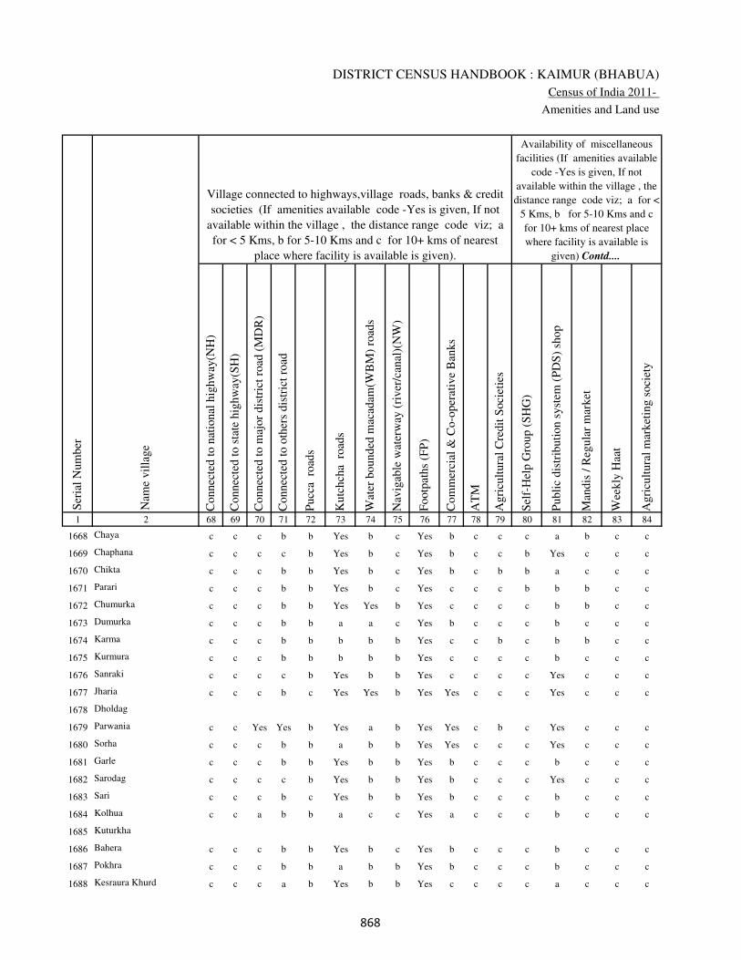
DISTRICT CENSUS HANDBOOK : KAIMUR (BHABUA)
Census of India 2011-
Amenities and Land use
Connec
ted t
o n
atio
nal
hig
hw
ay(N
H)
Connec
ted t
o s
tate
hig
hw
ay(S
H)
Connec
ted t
o m
ajor
dis
tric
t ro
ad (
MD
R)
Connec
ted t
o o
ther
s dis
tric
t ro
ad
Pucc
a r
oad
s
Kutc
hch
a r
oad
s
Wat
er b
ounded
mac
adam
(WB
M)
road
s
Nav
igab
le w
ater
way
(ri
ver
/can
al)(
NW
)
Footp
aths
(FP
)
Com
mer
cial
& C
o-o
per
ativ
e B
anks
AT
M
Agri
cult
ura
l C
redit
Soci
etie
s
Sel
f-H
elp G
roup (
SH
G)
Publi
c dis
trib
uti
on s
yst
em (
PD
S)
shop
Man
dis
/ R
egula
r m
arket
Wee
kly
Haa
t
Agri
cult
ura
l m
arket
ing s
oci
ety
1 2 68 69 70 71 72 73 74 75 76 77 78 79 80 81 82 83 84
Village connected to highways,village roads, banks & credit
societies (If amenities available code -Yes is given, If not
available within the village , the distance range code viz; a
for < 5 Kms, b for 5-10 Kms and c for 10+ kms of nearest
place where facility is available is given).
Ser
ial
Num
ber
Nam
e vil
lage
Availability of miscellaneous
facilities (If amenities available
code -Yes is given, If not
available within the village , the
distance range code viz; a for <
5 Kms, b for 5-10 Kms and c
for 10+ kms of nearest place
where facility is available is
given) Contd....
1668 Chaya c c c b b Yes b c Yes b c c c a b c c
1669 Chaphana c c c c b Yes b c Yes b c c b Yes c c c
1670 Chikta c c c b b Yes b c Yes b c b b a c c c
1671 Parari c c c b b Yes b c Yes c c c b b b c c
1672 Chumurka c c c b b Yes Yes b Yes c c c c b b c c
1673 Dumurka c c c b b a a c Yes b c c c b c c c
1674 Karma c c c b b b b b Yes c c b c b b c c
1675 Kurmura c c c b b b b b Yes c c c c b c c c
1676 Sanraki c c c c b Yes b b Yes c c c c Yes c c c
1677 Jharia c c c b c Yes Yes b Yes Yes c c c Yes c c c
1678 Dholdag
1679 Parwania c c Yes Yes b Yes a b Yes Yes c b c Yes c c c
1680 Sorha c c c b b a b b Yes Yes c c c Yes c c c
1681 Garle c c c b b Yes b b Yes b c c c b c c c
1682 Sarodag c c c c b Yes b b Yes b c c c Yes c c c
1683 Sari c c c b c Yes b b Yes b c c c b c c c
1684 Kolhua c c a b b a c c Yes a c c c b c c c
1685 Kuturkha
1686 Bahera c c c b b Yes b c Yes b c c c b c c c
1687 Pokhra c c c b b a b b Yes b c c c b c c c
1688 Kesraura Khurd c c c a b Yes b b Yes c c c c a c c c
���
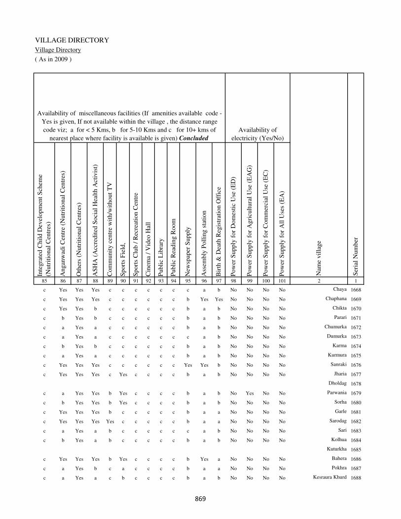
VILLAGE DIRECTORY
Village Directory
( As in 2009 )
Inte
gra
ted C
hil
d D
evel
opm
ent
Sch
eme
(Nutr
itio
nal
Cen
tres
)
Angan
wad
i C
entr
e (N
utr
itio
nal
Cen
tres
)
Oth
ers
(Nutr
itio
nal
Cen
tres
)
AS
HA
(A
ccre
dit
ed S
oci
al H
ealt
h A
ctiv
ist)
Com
munit
y c
entr
e w
ith/w
ithout
TV
Sport
s F
ield
,
Sport
s C
lub /
Rec
reat
ion C
entr
e
Cin
ema
/ V
ideo
Hal
l
Publi
c L
ibra
ry
Publi
c R
eadin
g R
oom
New
spap
er S
upply
Ass
embly
Poll
ing s
tati
on
Bir
th &
Dea
th R
egis
trat
ion O
ffic
e
Pow
er S
upply
for
Dom
esti
c U
se (
ED
)
Pow
er S
upply
for
Agri
cult
ura
l U
se (
EA
G)
Pow
er S
upply
for
Com
mer
cial
Use
(E
C)
Pow
er S
upply
for
All
Use
s (E
A)
85 86 87 88 89 90 91 92 93 94 95 96 97 98 99 100 101 2 1
Availability of
electricity (Yes/No)
Availability of miscellaneous facilities (If amenities available code -
Yes is given, If not available within the village , the distance range
code viz; a for < 5 Kms, b for 5-10 Kms and c for 10+ kms of
nearest place where facility is available is given) Concluded
Nam
e vil
lage
Ser
ial
Num
ber
c Yes Yes Yes c c c c c c c a b No No No No Chaya 1668
c Yes Yes Yes c c c c c c b Yes Yes No No No No Chaphana 1669
c Yes Yes b c c c c c c b a b No No No No Chikta 1670
c b Yes b c c c c c c b a b No No No No Parari 1671
c a Yes a c c c c c c b a b No No No No Chumurka 1672
c a Yes a c c c c c c c a b No No No No Dumurka 1673
c b Yes b c c c c c c b a b No No No No Karma 1674
c a Yes a c c c c c c b a b No No No No Kurmura 1675
c Yes Yes Yes c c c c c c Yes Yes b No No No No Sanraki 1676
c Yes Yes Yes c Yes c c c c b a b No No No No Jharia 1677
Dholdag 1678
c a Yes Yes b Yes c c c c b a b No Yes No No Parwania 1679
c b Yes Yes b Yes c c c c b a b No No No No Sorha 1680
c Yes Yes Yes b c c c c c b a a No No No No Garle 1681
c Yes Yes Yes Yes c c c c c b a a No No No No Sarodag 1682
c a Yes a b c c c c c c a b No No No No Sari 1683
c b Yes a b c c c c c b a b No No No No Kolhua 1684
Kuturkha 1685
c Yes Yes Yes b Yes c c c c b Yes a No No No No Bahera 1686
c a Yes b c a c c c c b a a No No No No Pokhra 1687
c a Yes a c b c c c c b a b No No No No Kesraura Khurd 1688
���
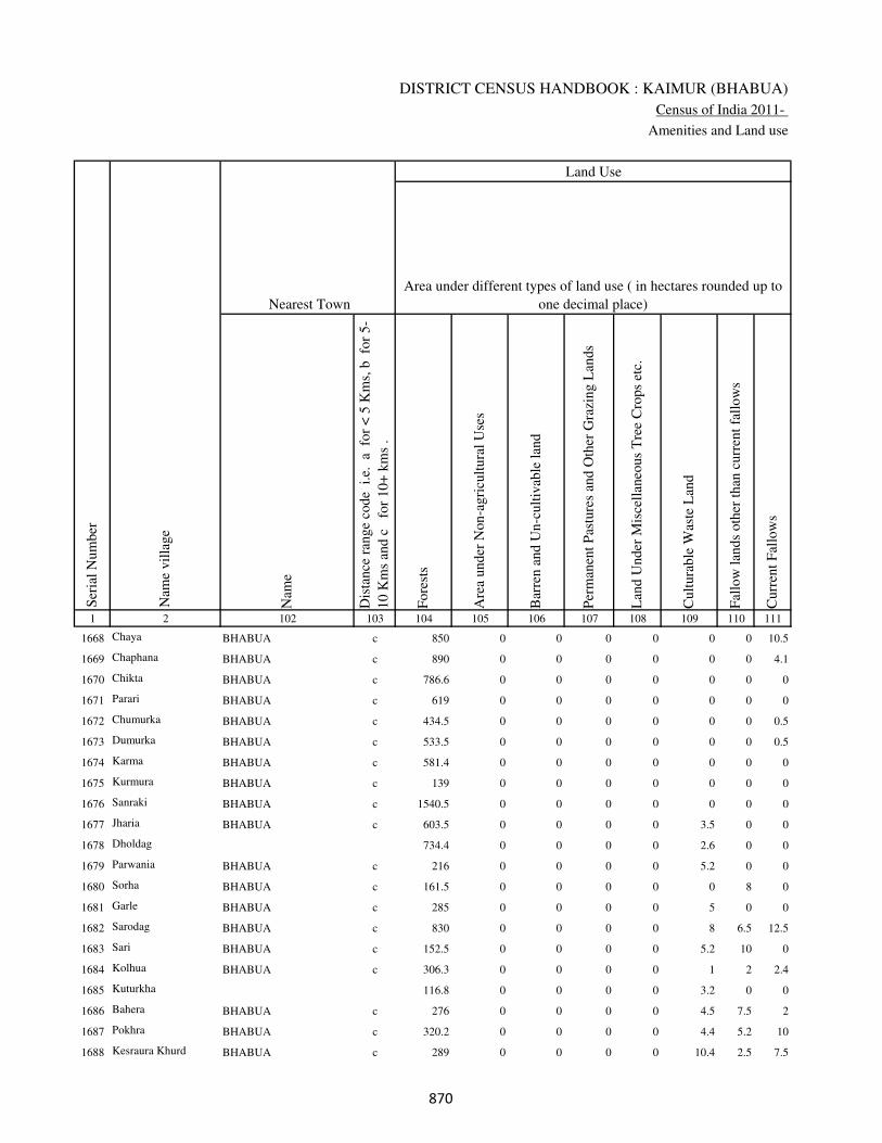
DISTRICT CENSUS HANDBOOK : KAIMUR (BHABUA)
Census of India 2011-
Amenities and Land use
Nam
e
Dis
tance
ran
ge
code
i.e
. a
fo
r <
5 K
ms,
b
for
5-
10 K
ms
and c
f
or
10+
km
s .
Fore
sts
Are
a under
Non-a
gri
cult
ura
l U
ses
Bar
ren a
nd U
n-c
ult
ivab
le l
and
Per
man
ent
Pas
ture
s an
d O
ther
Gra
zing L
ands
Lan
d U
nder
Mis
cell
aneo
us
Tre
e C
rops
etc.
Cult
ura
ble
Was
te L
and
Fal
low
lan
ds
oth
er t
han
curr
ent
fall
ow
s
Curr
ent
Fal
low
s
1 2 102 103 104 105 106 107 108 109 110 111
Ser
ial
Num
ber
Nam
e vil
lage
Area under different types of land use ( in hectares rounded up to
one decimal place)
Land Use
Nearest Town
1668 Chaya BHABUA c 850 0 0 0 0 0 0 10.5
1669 Chaphana BHABUA c 890 0 0 0 0 0 0 4.1
1670 Chikta BHABUA c 786.6 0 0 0 0 0 0 0
1671 Parari BHABUA c 619 0 0 0 0 0 0 0
1672 Chumurka BHABUA c 434.5 0 0 0 0 0 0 0.5
1673 Dumurka BHABUA c 533.5 0 0 0 0 0 0 0.5
1674 Karma BHABUA c 581.4 0 0 0 0 0 0 0
1675 Kurmura BHABUA c 139 0 0 0 0 0 0 0
1676 Sanraki BHABUA c 1540.5 0 0 0 0 0 0 0
1677 Jharia BHABUA c 603.5 0 0 0 0 3.5 0 0
1678 Dholdag 734.4 0 0 0 0 2.6 0 0
1679 Parwania BHABUA c 216 0 0 0 0 5.2 0 0
1680 Sorha BHABUA c 161.5 0 0 0 0 0 8 0
1681 Garle BHABUA c 285 0 0 0 0 5 0 0
1682 Sarodag BHABUA c 830 0 0 0 0 8 6.5 12.5
1683 Sari BHABUA c 152.5 0 0 0 0 5.2 10 0
1684 Kolhua BHABUA c 306.3 0 0 0 0 1 2 2.4
1685 Kuturkha 116.8 0 0 0 0 3.2 0 0
1686 Bahera BHABUA c 276 0 0 0 0 4.5 7.5 2
1687 Pokhra BHABUA c 320.2 0 0 0 0 4.4 5.2 10
1688 Kesraura Khurd BHABUA c 289 0 0 0 0 10.4 2.5 7.5
���
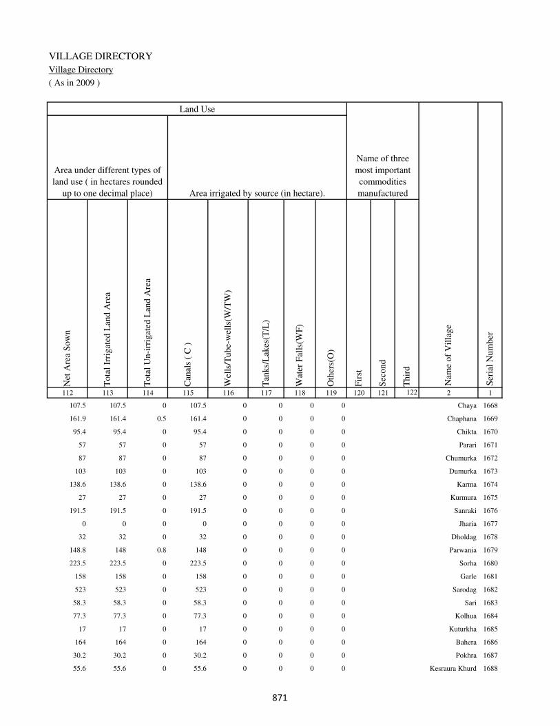
VILLAGE DIRECTORY
Village Directory
( As in 2009 )
Net
Are
a S
ow
n
Tota
l Ir
rigat
ed L
and A
rea
Tota
l U
n-i
rrig
ated
Lan
d A
rea
Can
als
( C
)
Wel
ls/T
ube-
wel
ls(W
/TW
)
Tan
ks/
Lak
es(T
/L)
Wat
er F
alls
(WF
)
Oth
ers(
O)
Fir
st
Sec
ond
Thir
d
112 113 114 115 116 117 118 119 120 121 122 2 1
Ser
ial
Num
ber
Name of three
most important
commodities
manufacturedArea irrigated by source (in hectare).
Nam
e of
Vil
lage
Area under different types of
land use ( in hectares rounded
up to one decimal place)
Land Use
107.5 107.5 0 107.5 0 0 0 0 Chaya 1668
161.9 161.4 0.5 161.4 0 0 0 0 Chaphana 1669
95.4 95.4 0 95.4 0 0 0 0 Chikta 1670
57 57 0 57 0 0 0 0 Parari 1671
87 87 0 87 0 0 0 0 Chumurka 1672
103 103 0 103 0 0 0 0 Dumurka 1673
138.6 138.6 0 138.6 0 0 0 0 Karma 1674
27 27 0 27 0 0 0 0 Kurmura 1675
191.5 191.5 0 191.5 0 0 0 0 Sanraki 1676
0 0 0 0 0 0 0 0 Jharia 1677
32 32 0 32 0 0 0 0 Dholdag 1678
148.8 148 0.8 148 0 0 0 0 Parwania 1679
223.5 223.5 0 223.5 0 0 0 0 Sorha 1680
158 158 0 158 0 0 0 0 Garle 1681
523 523 0 523 0 0 0 0 Sarodag 1682
58.3 58.3 0 58.3 0 0 0 0 Sari 1683
77.3 77.3 0 77.3 0 0 0 0 Kolhua 1684
17 17 0 17 0 0 0 0 Kuturkha 1685
164 164 0 164 0 0 0 0 Bahera 1686
30.2 30.2 0 30.2 0 0 0 0 Pokhra 1687
55.6 55.6 0 55.6 0 0 0 0 Kesraura Khurd 1688
���
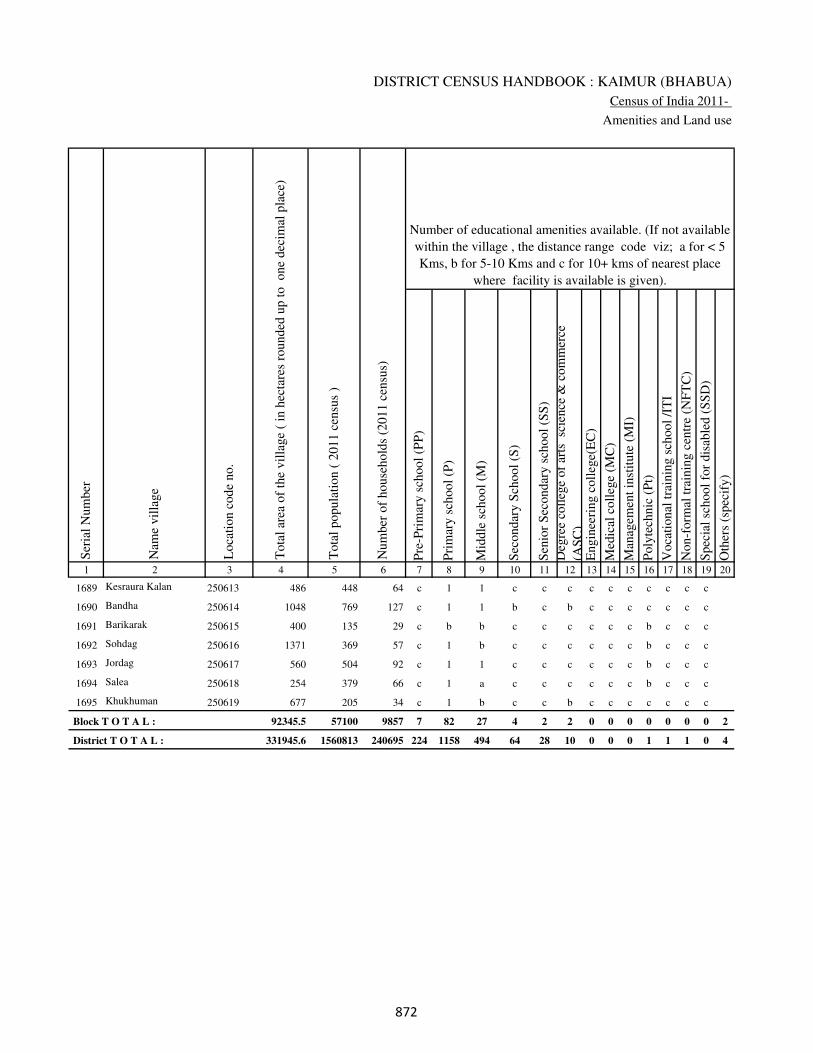
DISTRICT CENSUS HANDBOOK : KAIMUR (BHABUA)
Census of India 2011-
Amenities and Land use
Pre
-Pri
mar
y s
chool
(PP
)
Pri
mar
y s
chool
(P)
Mid
dle
sch
ool
(M)
Sec
ondar
y S
chool
(S)
Sen
ior
Sec
ondar
y s
chool
(SS
)
Deg
ree
coll
ege
of
arts
sc
ience
& c
om
mer
ce
(AS
C)
Engin
eeri
ng c
oll
ege(
EC
)
Med
ical
coll
ege
(MC
)
Man
agem
ent
inst
itute
(M
I)
Poly
tech
nic
(P
t)
Voca
tional
tra
inin
g s
chool
/IT
I
Non-f
orm
al t
rain
ing c
entr
e (N
FT
C)
Spec
ial
school
for
dis
able
d (
SS
D)
Oth
ers
(spec
ify)
1 2 3 4 5 6 7 8 9 10 11 12 13 14 15 16 17 18 19 20
Loca
tion c
ode
no.
Nam
e vil
lage
Ser
ial
Num
ber
Tota
l popula
tion (
2011 c
ensu
s )
Tota
l ar
ea o
f th
e vil
lage
( in
hec
tare
s ro
unded
up t
o
one
dec
imal
pla
ce)
Number of educational amenities available. (If not available
within the village , the distance range code viz; a for < 5
Kms, b for 5-10 Kms and c for 10+ kms of nearest place
where facility is available is given).
Num
ber
of
house
hold
s (2
011 c
ensu
s)
1689 Kesraura Kalan 250613 486 448 64 c 1 1 c c c c c c c c c c
1690 Bandha 250614 1048 769 127 c 1 1 b c b c c c c c c c
1691 Barikarak 250615 400 135 29 c b b c c c c c c b c c c
1692 Sohdag 250616 1371 369 57 c 1 b c c c c c c b c c c
1693 Jordag 250617 560 504 92 c 1 1 c c c c c c b c c c
1694 Salea 250618 254 379 66 c 1 a c c c c c c b c c c
1695 Khukhuman 250619 677 205 34 c 1 b c c b c c c c c c c
Block T O T A L : 92345.5 57100 9857 7 82 27 4 2 2 0 0 0 0 0 0 0 2
District T O T A L : 331945.6 1560813 240695 224 1158 494 64 28 10 0 0 0 1 1 1 0 4
��

VILLAGE DIRECTORY
Village Directory
( As in 2009 )
Com
munit
y h
ealt
h c
entr
e (C
HC
)
Pri
mar
y h
ealt
h c
entr
e (P
HC
)
Pri
mar
y h
ealt
h s
ub c
entr
e (P
HS
)
Mat
ernit
y a
nd c
hil
d w
elfa
re c
entr
e (M
CW
)
T.B
. cl
inic
(T
BC
)
Hosp
ital
-all
opat
hic
(H
A)
Hosp
ital
-alt
ernat
ive
med
icin
e (H
O)
Dis
pen
sary
(D
)
Vet
erin
ary h
osp
ital
(V
H)
Mobil
e hea
lth c
linic
(M
HC
)
Fam
ily w
elfa
re c
entr
e (F
WC
)
Char
itab
le n
on G
ovt.
hosp
ital
/Nurs
ing h
om
e.
Med
ical
pra
ctit
ioner
wit
h M
BB
S D
egre
e
Med
ical
pra
ctit
ioner
wit
h o
ther
deg
ree
Med
ical
pra
ctit
ioner
wit
h n
o d
egre
e
Tra
dit
ional
pra
ctit
ioner
an
d f
aith
hea
ler
.
Med
icin
e S
hop
Oth
ers
21 22 23 24 25 26 27 28 29 30 31 32 33 34 35 36 37 38 2 1
Number of Non-Government
Medical Amenities available.
Number of Medical Amenities available. (If not
available within the village , the distance range
code viz; a for < 5 Kms, b for 5-10 Kms and c
for 10+ kms of nearest place where facility is
available is given).
Nam
e vil
lage
Ser
ial
Num
ber
c c c c c c c c c c c 0 0 0 0 0 0 0 Kesraura Kalan 1689
c c b c c c c c c c c 0 0 0 0 0 0 0 Bandha 1690
c c c c c c c c c c c 0 0 0 0 0 0 0 Barikarak 1691
c c c c c c c c c c c 0 0 0 0 0 0 0 Sohdag 1692
c c 1 1 c c c c c c 1 0 0 0 0 0 0 0 Jordag 1693
c c c c c c c c b c c 0 0 0 0 0 0 0 Salea 1694
c c c c c c c c c c c 0 0 0 0 0 0 0 Khukhuman 1695
0 2 11 11 2 0 0 2 2 0 11 1 4 6 7 8 3 0
0 19 217 211 45 0 0 71 20 0 218 27 117 226 203 166 267 101
��
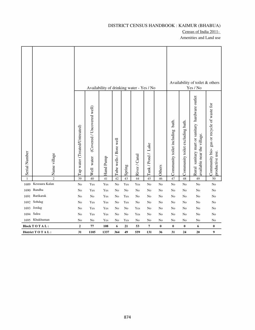
DISTRICT CENSUS HANDBOOK : KAIMUR (BHABUA)
Census of India 2011-
Amenities and Land use
Tap
wat
er (
Tre
ated
/Untr
eate
d)
Wel
l w
ater
(Cover
ed /
Unco
ver
ed w
ell)
Han
d P
um
p
Tube
wel
ls /
Bore
wel
l
Spri
ng
Riv
er /
Can
al
Tan
k /
Pond /
L
ake
Oth
ers
Com
munit
y t
oil
et i
ncl
udin
g
bat
h.
Com
munit
y t
oil
et e
xcl
udin
g b
ath.
Rura
l s
anit
ary m
art
or
sanit
ary
har
dw
are
outl
et
avai
lable
nea
r th
e vil
lage.
Com
munit
y b
io-
gas
or
recy
cle
of
was
te f
or
pro
duct
ive
use
.
1 2 39 40 41 42 43 44 45 46 47 48 49 50
Availability of toilet & others
Yes / No Availability of drinking water - Yes / No
Nam
e vil
lage
Ser
ial
Num
ber
1689 Kesraura Kalan No Yes Yes No Yes Yes No No No No No No
1690 Bandha No Yes Yes No No No No No No No No No
1691 Barikarak No No Yes No Yes No No No No No No No
1692 Sohdag No Yes Yes No Yes No No No No No No No
1693 Jordag No Yes Yes No No Yes No No No No No No
1694 Salea No Yes Yes No No Yes No No No No No No
1695 Khukhuman No No Yes No Yes No No No No No No No
Block T O T A L : 2 77 108 6 21 53 7 0 0 0 6 0
District T O T A L : 31 1105 1337 364 49 559 131 36 31 24 20 9
���

VILLAGE DIRECTORY
Village Directory
( As in 2009 )
Post
off
ice(
PO
)
Sub p
ost
off
ice
(SP
O)
Post
& T
eleg
raph o
ffic
e
(P&
TO
)
Vil
lage
Pin
Code
Tel
ephones
(L
and l
ines
)
Publi
c ca
ll o
ffic
e (P
CO
)
Mobil
e phone
cover
age
Inte
rnet
caf
es/
Com
mon s
ervic
e ce
ntr
e (C
SC
)
Pri
vat
e co
uri
er f
acil
ity
Bus
serv
ice
(P
ubli
c &
Pri
vat
e)
Rai
lway
sta
tions
Auto
/Modif
ied A
uto
s
Tax
is a
nd V
ans
Tra
ctors
Cycl
e-pull
ed r
icksh
aws(
Man
ual
& M
achin
e
dri
ven
)
Car
ts d
riven
by a
nim
als
Sea
/R
iver
fer
ry s
ervic
e51 52 53 54 55 56 57 58 59 60 61 62 63 64 65 66 67 2 1
Communication and transport facilities (If amenities available code -Yes is given except for
Village Pin Code ,If not available within the village , the distance range code viz; a for < 5
Kms, b for 5-10 Kms and c for 10+ kms of nearest place where facility is available is given).
Ser
ial
Num
ber
Nam
e vil
lage
b c c c c Yes c c c c c c Yes Yes b Kesraura Kalan 1689
b c c c c b c c c c c c c a a c Bandha 1690
b c c c c b c c c c c c b Yes b Barikarak 1691
b c c c c a c c a c c c c a a Sohdag 1692
b c c c c b c c c c c c Yes Yes b c Jordag 1693
b c c c c c c c c c c c Yes Yes b c Salea 1694
b c c c c b c c c c c c b Yes b Khukhuman 1695
14 0 1 20 2 5 38 0 3 18 0 1 6 44 61 14 3
184 7 27 359 197 243 439 51 22 341 51 196 373 781 771 393 124
���
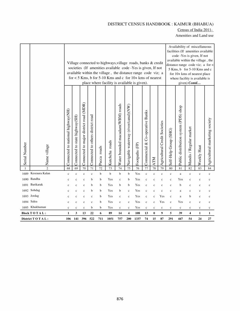
DISTRICT CENSUS HANDBOOK : KAIMUR (BHABUA)
Census of India 2011-
Amenities and Land use
Connec
ted t
o n
atio
nal
hig
hw
ay(N
H)
Connec
ted t
o s
tate
hig
hw
ay(S
H)
Connec
ted t
o m
ajor
dis
tric
t ro
ad (
MD
R)
Connec
ted t
o o
ther
s dis
tric
t ro
ad
Pucc
a r
oad
s
Kutc
hch
a r
oad
s
Wat
er b
ounded
mac
adam
(WB
M)
road
s
Nav
igab
le w
ater
way
(ri
ver
/can
al)(
NW
)
Footp
aths
(FP
)
Com
mer
cial
& C
o-o
per
ativ
e B
anks
AT
M
Agri
cult
ura
l C
redit
Soci
etie
s
Sel
f-H
elp G
roup (
SH
G)
Publi
c dis
trib
uti
on s
yst
em (
PD
S)
shop
Man
dis
/ R
egula
r m
arket
Wee
kly
Haa
t
Agri
cult
ura
l m
arket
ing s
oci
ety
1 2 68 69 70 71 72 73 74 75 76 77 78 79 80 81 82 83 84
Village connected to highways,village roads, banks & credit
societies (If amenities available code -Yes is given, If not
available within the village , the distance range code viz; a
for < 5 Kms, b for 5-10 Kms and c for 10+ kms of nearest
place where facility is available is given).
Ser
ial
Num
ber
Nam
e vil
lage
Availability of miscellaneous
facilities (If amenities available
code -Yes is given, If not
available within the village , the
distance range code viz; a for <
5 Kms, b for 5-10 Kms and c
for 10+ kms of nearest place
where facility is available is
given) Contd....
1689 Kesraura Kalan c c c c b b b b Yes c c c c a c c c
1690 Bandha c c c b b Yes c b Yes c c c c Yes c c c
1691 Barikarak c c c b b Yes b b Yes c c c c b c c c
1692 Sohdag c c c b b Yes b c Yes c c c c a c c c
1693 Jordag c c c c b Yes c c Yes c c Yes c a b c c
1694 Salea c c c c b Yes c c Yes c c Yes c Yes c c c
1695 Khukhuman c c c b b Yes c c Yes c c c c c c c c
Block T O T A L : 1 3 13 22 6 89 14 4 108 13 0 9 5 39 4 1 1
District T O T A L : 106 141 396 522 711 1051 757 200 1337 74 15 87 291 447 54 24 27
���

VILLAGE DIRECTORY
Village Directory
( As in 2009 )
Inte
gra
ted C
hil
d D
evel
opm
ent
Sch
eme
(Nutr
itio
nal
Cen
tres
)
Angan
wad
i C
entr
e (N
utr
itio
nal
Cen
tres
)
Oth
ers
(Nutr
itio
nal
Cen
tres
)
AS
HA
(A
ccre
dit
ed S
oci
al H
ealt
h A
ctiv
ist)
Com
munit
y c
entr
e w
ith/w
ithout
TV
Sport
s F
ield
,
Sport
s C
lub /
Rec
reat
ion C
entr
e
Cin
ema
/ V
ideo
Hal
l
Publi
c L
ibra
ry
Publi
c R
eadin
g R
oom
New
spap
er S
upply
Ass
embly
Poll
ing s
tati
on
Bir
th &
Dea
th R
egis
trat
ion O
ffic
e
Pow
er S
upply
for
Dom
esti
c U
se (
ED
)
Pow
er S
upply
for
Agri
cult
ura
l U
se (
EA
G)
Pow
er S
upply
for
Com
mer
cial
Use
(E
C)
Pow
er S
upply
for
All
Use
s (E
A)
85 86 87 88 89 90 91 92 93 94 95 96 97 98 99 100 101 2 1
Availability of
electricity (Yes/No)
Availability of miscellaneous facilities (If amenities available code -
Yes is given, If not available within the village , the distance range
code viz; a for < 5 Kms, b for 5-10 Kms and c for 10+ kms of
nearest place where facility is available is given) Concluded
Nam
e vil
lage
Ser
ial
Num
ber
c a Yes a c b c c c c b Yes b No No No No Kesraura Kalan 1689
c Yes Yes b c b c c c c c Yes a No No No No Bandha 1690
c a Yes b c b c c c c b a b No No No No Barikarak 1691
c a Yes Yes c c c c c c c a b No No No No Sohdag 1692
c Yes Yes a c b c c c c c a b No No No No Jordag 1693
c Yes Yes b c b c c c c c a b No No No No Salea 1694
c b Yes b c c c c c c b a b No No No No Khukhuman 1695
1 50 104 39 5 23 4 0 0 0 2 37 24 1 1 0 0
11 786 1064 737 91 195 26 0 14 12 196 684 345 873 713 187 178
���

DISTRICT CENSUS HANDBOOK : KAIMUR (BHABUA)
Census of India 2011-
Amenities and Land use
Nam
e
Dis
tance
ran
ge
code
i.e
. a
fo
r <
5 K
ms,
b
for
5-
10 K
ms
and c
f
or
10+
km
s .
Fore
sts
Are
a under
Non-a
gri
cult
ura
l U
ses
Bar
ren a
nd U
n-c
ult
ivab
le l
and
Per
man
ent
Pas
ture
s an
d O
ther
Gra
zing L
ands
Lan
d U
nder
Mis
cell
aneo
us
Tre
e C
rops
etc.
Cult
ura
ble
Was
te L
and
Fal
low
lan
ds
oth
er t
han
curr
ent
fall
ow
s
Curr
ent
Fal
low
s
1 2 102 103 104 105 106 107 108 109 110 111
Ser
ial
Num
ber
Nam
e vil
lage
Area under different types of land use ( in hectares rounded up to
one decimal place)
Land Use
Nearest Town
1689 Kesraura Kalan BHABUA c 370.5 0 0 0 0 6 5 5
1690 Bandha BHABUA c 939.6 0 0 0 0 9.6 0 0
1691 Barikarak BHABUA c 340 0 0 0 0 3.4 0 1
1692 Sohdag BHABUA c 1280.5 0 0 0 0 4.2 0 4
1693 Jordag BHABUA c 471 0 0 0 0 17 0 0
1694 Salea BHABUA c 150 0 0 0 0 8.5 1 4
1695 Khukhuman BHABUA c 610.5 0 0 0 0 4.5 3 4
Block T O T A L : 0 0 69894.4 1518.1 941.1 191.3 196.7 572.2 363.8 613.6
District T O T A L : 0 0 94709.9 22839.9 2518.1 4131.1 9080 6769 1684 1939
���

VILLAGE DIRECTORY
Village Directory
( As in 2009 )
Net
Are
a S
ow
n
Tota
l Ir
rigat
ed L
and A
rea
Tota
l U
n-i
rrig
ated
Lan
d A
rea
Can
als
( C
)
Wel
ls/T
ube-
wel
ls(W
/TW
)
Tan
ks/
Lak
es(T
/L)
Wat
er F
alls
(WF
)
Oth
ers(
O)
Fir
st
Sec
ond
Thir
d
112 113 114 115 116 117 118 119 120 121 122 2 1
Ser
ial
Num
ber
Name of three
most important
commodities
manufacturedArea irrigated by source (in hectare).
Nam
e of
Vil
lage
Area under different types of
land use ( in hectares rounded
up to one decimal place)
Land Use
99.5 99.5 0 99.5 0 0 0 0 Kesraura Kalan 1689
98.8 98.8 0 98.8 0 0 0 0 Bandha 1690
55.6 55.6 0 55.6 0 0 0 0 Barikarak 1691
82.3 82.3 0 82.3 0 0 0 0 Sohdag 1692
72 71.7 0.3 0 71.7 0 0 0 Jordag 1693
90.5 90.5 0 90.5 0 0 0 0 Salea 1694
55 54.2 0.8 54.2 0 0 0 0 Khukhuman 1695
18054.2 16462 1592.2 14232.6 1809.1 0 0 420.3
188274 148607.4 39667.2 73586.3 60069.9 6649.1 97.4 8203.8
���

�����
�
�
�
�
�
�
�
�
�
�
�
�
�
�
�
�
�
�
�
�
�
�
�
�
�
�
�

�����
�����������������������
APPENDICES TO VILLAGE
DIRECTORY
�
�
�
�
�
�
�
�
�
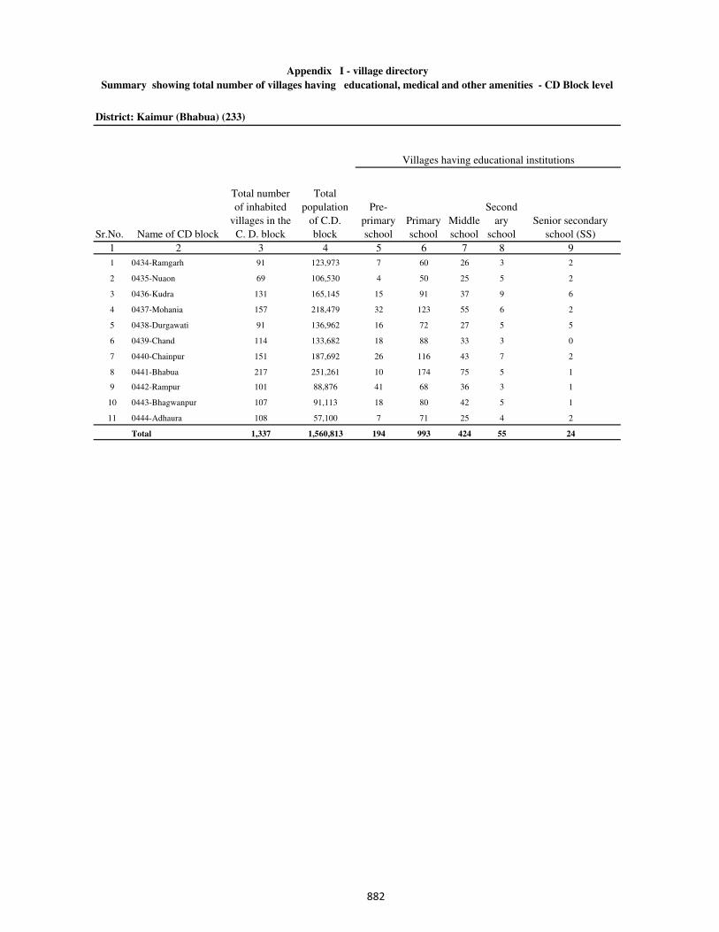
District: Kaimur (Bhabua) (233)
1 2 3 4 5 6 7 8 9
1 0434-Ramgarh 91 123,973 7 60 26 3 2
2 0435-Nuaon 69 106,530 4 50 25 5 2
3 0436-Kudra 131 165,145 15 91 37 9 6
4 0437-Mohania 157 218,479 32 123 55 6 2
5 0438-Durgawati 91 136,962 16 72 27 5 5
6 0439-Chand 114 133,682 18 88 33 3 0
7 0440-Chainpur 151 187,692 26 116 43 7 2
8 0441-Bhabua 217 251,261 10 174 75 5 1
9 0442-Rampur 101 88,876 41 68 36 3 1
10 0443-Bhagwanpur 107 91,113 18 80 42 5 1
11 0444-Adhaura 108 57,100 7 71 25 4 2
Total 1,337 1,560,813 194 993 424 55 24
Sr.No. Name of CD block
Pre-
primary
school
Primary
school
Second
ary
school
Senior secondary
school (SS)
Total number
of inhabited
villages in the
C. D. block
Total
population
of C.D.
block
Appendix I - village directory
Summary showing total number of villages having educational, medical and other amenities - CD Block level
Middle
school
Villages having educational institutions
���
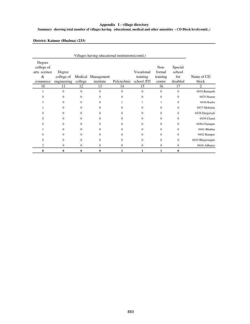
District: Kaimur (Bhabua) (233)
10 11 12 13 14 15 16 17 2
1 0 0 0 0 0 0 0 0434-Ramgarh
0 0 0 0 0 0 0 0 0435-Nuaon
3 0 0 0 1 1 1 0 0436-Kudra
1 0 0 0 0 0 0 0 0437-Mohania
0 0 0 0 0 0 0 0 0438-Durgawati
0 0 0 0 0 0 0 0 0439-Chand
0 0 0 0 0 0 0 0 0440-Chainpur
1 0 0 0 0 0 0 0 0441-Bhabua
0 0 0 0 0 0 0 0 0442-Rampur
0 0 0 0 0 0 0 0 0443-Bhagwanpur
2 0 0 0 0 0 0 0 0444-Adhaura
8 0 0 0 1 1 1 0
Villages having educational institutions(contd.)
Appendix I - village directory
Summary showing total number of villages having educational, medical and other amenities - CD Block level(contd..)
Degree
college of
arts sceince
&
commerce
Degree
college of
engineering
Medical
college
Name of CD
block
Management
institute Polytechnic
Vocational
training
school /ITI
Non-
formal
training
centre
Special
school
for
disabled
���
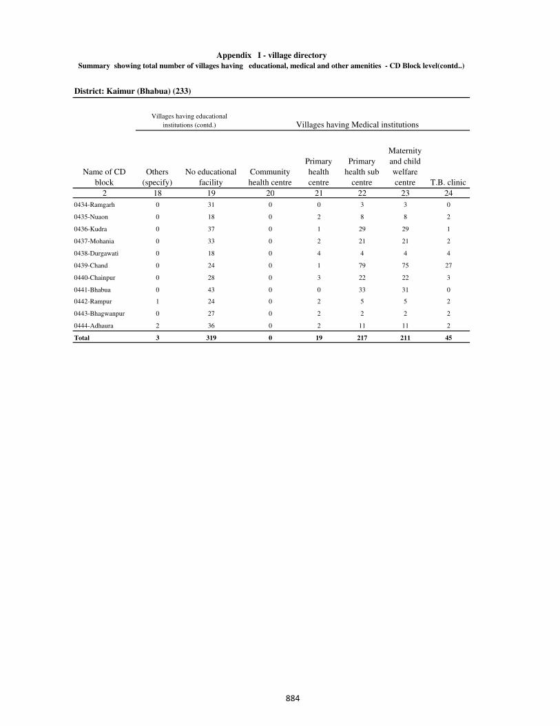
District: Kaimur (Bhabua) (233)
2 18 19 20 21 22 23 24
0434-Ramgarh 0 31 0 0 3 3 0
0435-Nuaon 0 18 0 2 8 8 2
0436-Kudra 0 37 0 1 29 29 1
0437-Mohania 0 33 0 2 21 21 2
0438-Durgawati 0 18 0 4 4 4 4
0439-Chand 0 24 0 1 79 75 27
0440-Chainpur 0 28 0 3 22 22 3
0441-Bhabua 0 43 0 0 33 31 0
0442-Rampur 1 24 0 2 5 5 2
0443-Bhagwanpur 0 27 0 2 2 2 2
0444-Adhaura 2 36 0 2 11 11 2
Total 3 319 0 19 217 211 45
Summary showing total number of villages having educational, medical and other amenities - CD Block level(contd..)
Appendix I - village directory
Others
(specify)
Name of CD
block
Villages having educational
institutions (contd.) Villages having Medical institutions
Community
health centre
No educational
facility
Primary
health
centre
Primary
health sub
centre
Maternity
and child
welfare
centre T.B. clinic
���

District: Kaimur (Bhabua) (233)
25 26 27 28 29 30 31 2
0 0 2 0 0 3 1 0434-Ramgarh
0 0 3 2 0 8 13 0435-Nuaon
0 0 2 1 0 30 3 0436-Kudra
0 0 2 2 0 23 24 0437-Mohania
0 0 4 4 0 5 0 0438-Durgawati
0 0 49 2 0 76 6 0439-Chand
0 0 3 3 0 22 1 0440-Chainpur
0 0 0 0 0 33 2 0441-Bhabua
0 0 2 2 0 5 8 0442-Rampur
0 0 2 2 0 2 1 0443-Bhagwanpur
0 0 2 2 0 11 1 0444-Adhaura
0 0 71 20 0 218 60
Appendix I - village directory
Summary showing total number of villages having educational, medical and other amenities - CD Block level(contd..)
Dispensary Name of CD block
Hospital-
allopathic
Hospital-
alternative
medicine
Veterinary
hospital
Villages having Medical institutions (contd.) …
Medical
practioner
(with MBBS
Degree)
Family
welfare
centre
Mobile
health
clinic
���
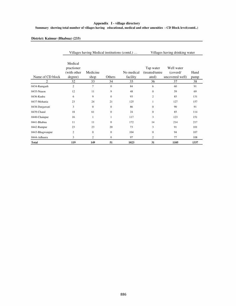
District: Kaimur (Bhabua) (233)
2 32 33 34 35 36 37 38
0434-Ramgarh 2 7 0 84 6 60 91
0435-Nuaon 12 11 9 48 0 59 69
0436-Kudra 6 9 0 93 2 85 131
0437-Mohania 23 24 21 125 1 127 157
0438-Durgawati 3 0 0 86 0 90 91
0439-Chand 18 61 0 24 0 85 114
0440-Chainpur 16 1 1 117 3 123 151
0441-Bhabua 11 11 0 172 14 214 217
0442-Rampur 23 23 20 73 3 91 101
0443-Bhagwanpur 2 0 0 104 0 94 107
0444-Adhaura 3 2 0 97 2 77 108
Total 119 149 51 1023 31 1105 1337
Appendix I - village directory
Summary showing total number of villages having educational, medical and other amenities - CD Block level(contd..)
Villages having drinking water
Well water
(coverd/
uncovered well)Name of CD block
Villages having Medical institutions (contd.) …
Hand
pump
Medicine
shop Others
No medical
facility
Tap water
(treated/untre
ated)
Medical
practioner
(with other
degree)
���

District: Kaimur (Bhabua) (233)
39 40 41 42 43 44 45 46 2
59 0 43 2 0 0 10 0 0434-Ramgarh
14 1 38 0 0 0 14 1 0435-Nuaon
60 1 57 2 0 0 18 1 0436-Kudra
42 1 68 6 3 0 26 1 0437-Mohania
5 0 20 4 4 0 9 1 0438-Durgawati
52 1 46 11 6 0 23 0 0439-Chand
33 18 60 26 2 0 17 2 0440-Chainpur
78 1 129 65 3 0 30 0 0441-Bhabua
11 3 16 8 17 0 13 0 0442-Rampur
4 2 29 0 1 0 10 1 0443-Bhagwanpur
6 21 53 7 0 0 14 0 0444-Adhaura
364 49 559 131 36 0 184 7
Appendix I - village directory
Villages having
Post & Telegraph
Name of CD block
Villages having drinking water
Tank/ pond/
lake
Sub
post
officeOthers
No
drinking
water
facility
Tubewell/
borewell Spring River/ canal
Post
office
Summary showing total number of villages having educational, medical and other amenities - CD Block
level(contd.)
���

District: Kaimur (Bhabua) (233)
2 47 48 49 50 51
0434-Ramgarh 4 32 33 36 4
0435-Nuaon 1 11 10 17 1
0436-Kudra 3 17 14 64 3
0437-Mohania 1 12 15 85 1
0438-Durgawati 3 64 69 70 24
0439-Chand 7 17 13 11 0
0440-Chainpur 5 16 14 48 1
0441-Bhabua 1 5 42 14 2
0442-Rampur 1 19 23 28 15
0443-Bhagwanpur 0 2 5 28 0
0444-Adhaura 1 2 5 38 0
Total 27 197 243 439 51
Phone
(land lines)
Public call
office Name of CD block
Villages having Post & Telegraph
Mobile phone
coverage
Internet cafes/
Common service
centre
Post &
telegraph
office
Summary showing total number of villages having educational, medical and other amenities-CD Block
level(contd.)
Appendix I - village directory
���
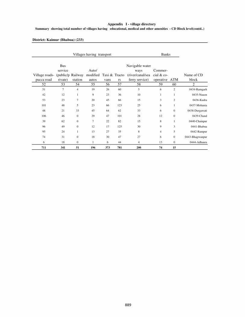
District: Kaimur (Bhabua) (233)
52 53 54 55 56 57 58 59 60 2
51 7 4 19 26 60 5 6 2 0434-Ramgarh
42 12 1 9 23 36 10 1 1 0435-Nuaon
53 23 7 20 45 66 15 3 2 0436-Kudra
101 48 5 23 66 123 25 6 1 0437-Mohania
48 21 33 45 64 62 33 6 0 0438-Durgawati
106 46 0 29 47 101 28 12 0 0439-Chand
39 62 0 7 22 82 15 8 1 0440-Chainpur
96 49 0 12 17 125 30 9 3 0441-Bhabua
95 24 1 13 27 35 8 4 5 0442-Rampur
74 31 0 18 30 47 27 6 0 0443-Bhagwanpur
6 18 0 1 6 44 4 13 0 0444-Adhaura
711 341 51 196 373 781 200 74 15
Summary showing total number of villages having educational, medical and other amenities - CD Block level(contd..)
Village roads-
pucca road
Bus
service
(public/p
rivate)
Name of CD
blockATM
Auto/
modified
autos
Taxi &
vans
Tracto
rs
Navigable water
ways
(river/canal/sea
ferry service)
Railway
station
Commer-
cial & co-
operative
Villages having transport Banks
Appendix I - village directory
���
District: Kaimur (Bhabua) (233)
Credit societies Miscellaneous
2 61 62 63 64 65 66
0434-Ramgarh 1 0 2 2 15 20
0435-Nuaon 1 0 0 1 17 31
0436-Kudra 4 0 4 3 6 45
0437-Mohania 8 0 0 0 12 63
0438-Durgawati 1 0 1 1 8 15
0439-Chand 13 0 0 0 9 46
0440-Chainpur 34 0 0 0 25 56
0441-Bhabua 0 0 0 0 86 55
0442-Rampur 6 0 7 5 11 47
0443-Bhagwanpur 10 0 0 0 5 30
0444-Adhaura 9 0 0 0 2 39
Total 87 0 14 12 196 447
Name of CD block
Agricultural
credit societies
Villages having recreation facility
Public
distribution
system (PDS)
shop
Availability of
news paper
Cinema /
video halls Public library
Public
reading
rooms
Appendix I - village directory
Summary showing total number of villages having educational, medical and other amenities - CD Block level(contd..)
��

District: Kaimur (Bhabua) (233)
67 68 69 70 71 2
4 47 13 58 33 0434-Ramgarh
1 46 21 49 20 0435-Nuaon
1 75 25 97 34 0436-Kudra
1 97 44 136 21 0437-Mohania
7 32 14 86 5 0438-Durgawati
0 64 23 102 12 0439-Chand
1 87 31 116 35 0440-Chainpur
0 124 118 187 30 0441-Bhabua
8 16 5 17 84 0442-Rampur
0 59 27 81 26 0443-Bhagwanpur
1 37 24 2 106 0444-Adhaura
24 684 345 931 406
Summary showing total number of villages having educational, medical and other amenities - CD Block
level(concld.)
Villages having power
supply
Asembly
polling
station
Birth & death
registration
office Available Not available
Appendix I - village directory
Miscellaneous
Name of CD blockWeekly haat
��
District: Kaimur (Bhabua) (233)
None One Two Three Four +
1 2 3 4 5 6 7 8
1 0434-Ramgarh 91 31 53 6 1 0
2 0435-Nuaon 69 19 41 9 0 0
3 0436-Kudra 131 40 64 24 1 2
4 0437-Mohania 157 34 117 3 2 1
5 0438-Durgawati 91 19 62 7 2 1
6 0439-Chand 114 26 86 2 0 0
7 0440-Chainpur 151 35 89 26 0 1
8 0441-Bhabua 217 43 165 6 2 1
9 0442-Rampur 101 33 52 13 2 1
10 0443-Bhagwanpur 107 27 78 2 0 0
11 0444-Adhaura 108 37 61 9 1 0
Total 1,337 344 868 107 11 7
Appendix IA - village directory
Villages by number of primary schools
Sr.No. Name of C.D.Block
Total number
of inhabited
villages
Number of primary schools
���
District: Kaimur (Bhabua) (233)
No school
At least one
primary school
and no middle
school
At least one
primary school
and one
middle school
At least one
middle school
and one
secondary
school
1 2 3 4 5 6 7
1 0434-Ramgarh 91 31 34 26 2
2 0435-Nuaon 69 18 26 24 5
3 0436-Kudra 131 37 56 35 8
4 0437-Mohania 157 34 68 55 5
5 0438-Durgawati 91 19 45 27 4
6 0439-Chand 114 25 55 33 2
7 0440-Chainpur 151 34 74 42 6
8 0441-Bhabua 217 43 99 75 5
9 0442-Rampur 101 30 34 34 2
10 0443-Bhagwanpur 107 27 38 42 5
11 0444-Adhaura 108 37 46 25 3
Total 1,337 335 575 418 47
Appendix IB - village directory
Villages by primary, middle and secondary schools
Sr.No. Name of CD Block
Total number
of inhabited
villages
Type of educational institutions available
���
District: Kaimur (Bhabua) (233)
Only tap
(treated/
untreated)
Only well
(covered /
uncovered)
Only
tubewell
/borewell
Only
handpump
More than one source
only from tap, well,
tubewell,hand pump
1 2 3 4 5 6 7
1 0434-Ramgarh 0 0 0 13 78
2 0435-Nuaon 0 0 0 9 60
3 0436-Kudra 0 0 0 24 107
4 0437-Mohania 0 0 0 22 135
5 0438-Durgawati 0 0 0 1 90
6 0439-Chand 0 0 0 7 107
7 0440-Chainpur 0 0 0 20 131
8 0441-Bhabua 0 0 0 2 215
9 0442-Rampur 0 0 0 5 96
10 0443-Bhagwanpur 0 0 0 12 95
11 0444-Adhaura 0 0 0 26 82
Total 0 0 0 141 1,196
Appendix IC - Village Directory
Villages with different sources of drinking water facilities available
Sr.No. Name of C.D.Block
Number of villages with different sources of drinking water facilities
available
���
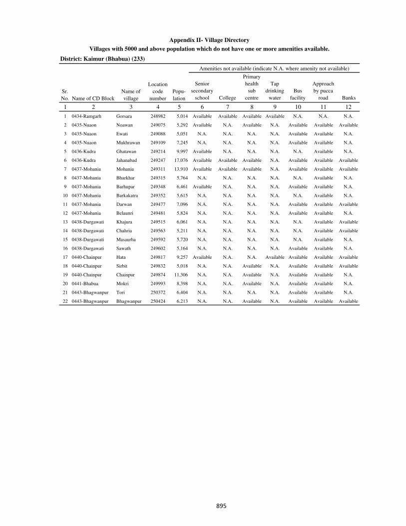
District: Kaimur (Bhabua) (233)
Senior
secondary
school College
Primary
health
sub
centre
Tap
drinking
water
Bus
facility
Approach
by pucca
road Banks
1 2 3 4 5 6 7 8 9 10 11 12
1 0434-Ramgarh Gorsara 248982 5,014 Available Available Available Available N.A. N.A. N.A.
2 0435-Nuaon Noawan 249075 5,292 Available N.A. Available N.A. Available Available Available
3 0435-Nuaon Ewati 249088 5,051 N.A. N.A. N.A. N.A. Available Available N.A.
4 0435-Nuaon Mukhrawan 249109 7,245 N.A. N.A. N.A. N.A. Available Available N.A.
5 0436-Kudra Ghatawan 249214 9,997 Available N.A. N.A. N.A. N.A. Available N.A.
6 0436-Kudra Jahanabad 249247 17,076 Available Available Available N.A. Available Available Available
7 0437-Mohania Mohania 249311 13,910 Available Available Available N.A. Available Available Available
8 0437-Mohania Bharkhar 249315 5,764 N.A. N.A. N.A. N.A. N.A. Available N.A.
9 0437-Mohania Barhupar 249348 6,461 Available N.A. N.A. N.A. Available Available N.A.
10 0437-Mohania Barkakatra 249352 5,615 N.A. N.A. N.A. N.A. N.A. Available N.A.
11 0437-Mohania Darwan 249477 7,096 N.A. N.A. N.A. N.A. Available Available Available
12 0437-Mohania Belaunri 249481 5,824 N.A. N.A. N.A. N.A. Available Available N.A.
13 0438-Durgawati Khajura 249515 6,061 N.A. N.A. N.A. N.A. N.A. Available Available
14 0438-Durgawati Chahria 249563 5,211 N.A. N.A. N.A. N.A. N.A. Available Available
15 0438-Durgawati Masaurha 249592 5,720 N.A. N.A. N.A. N.A. N.A. Available N.A.
16 0438-Durgawati Sawath 249602 5,164 N.A. N.A. N.A. N.A. Available Available N.A.
17 0440-Chainpur Hata 249817 9,257 Available N.A. N.A. Available Available Available Available
18 0440-Chainpur Sirbit 249832 5,018 N.A. N.A. Available N.A. Available Available Available
19 0440-Chainpur Chainpur 249874 11,306 N.A. N.A. Available N.A. Available Available N.A.
20 0441-Bhabua Mokri 249993 8,398 N.A. N.A. Available N.A. Available Available N.A.
21 0443-Bhagwanpur Tori 250372 6,404 N.A. N.A. N.A. N.A. Available Available N.A.
22 0443-Bhagwanpur Bhagwanpur 250424 6,213 N.A. N.A. Available N.A. Available Available Available
Sr.
No.
Name of
village
Location
code
numberName of CD Block
Amenities not available (indicate N.A. where amenity not available)
Appendix II- Village Directory
Popu-
lation
Villages with 5000 and above population which do not have one or more amenities available.
���
1 2 3 4 5 6 7 8 9 10 11 12 13 14
Data not collected
Total
Irrigated
Land Area
Total Un-
irrigated
Land Area
Land
Under
Miscellane
ous Tree
Crops etc.
Cultura
ble
Waste
Land
Fallow
Lands other
than
Current
Fallows
Current
Fallows
Net
Area
Sown
Sl.
No
Name of
Census
Towns and
C.D.Block
within
Bracket
Total
Area Forests
Area
under Non-
agricultura
l Uses
Barren
and Un-
cultivable
land
Perma-nent
Pastures and
Other
Grazing
Lands
Appendix III - Village Directory
Land utilisation data in respect of Census Towns.
District: Kaimur (Bhabua)(233)
���

District: Kaimur (Bhabua)(233)
Serial number Location code number Name of village
1 2 3
Appendix IV - Village Directory
C.D. block wise list of inhabited villages where no amenity other than drinking water facility is
available.
There is no such village in this district
���
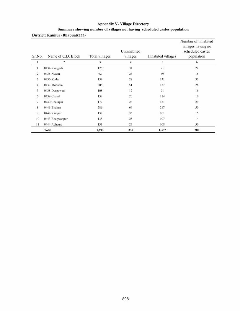
District: Kaimur (Bhabua)(233)
Sr.No. Name of C.D. Block Total villages
Uninhabited
villages Inhabited villages
Number of inhabited
villages having no
scheduled castes
population
1 2 3 4 5 6
1 0434-Ramgarh 125 34 91 24
2 0435-Nuaon 92 23 69 15
3 0436-Kudra 159 28 131 33
4 0437-Mohania 208 51 157 26
5 0438-Durgawati 108 17 91 16
6 0439-Chand 137 23 114 10
7 0440-Chainpur 177 26 151 29
8 0441-Bhabua 286 69 217 50
9 0442-Rampur 137 36 101 15
10 0443-Bhagwanpur 135 28 107 14
11 0444-Adhaura 131 23 108 50
Total 1,695 358 1,337 282
Appendix V- Village Directory
Summary showing number of villages not having scheduled castes population
���
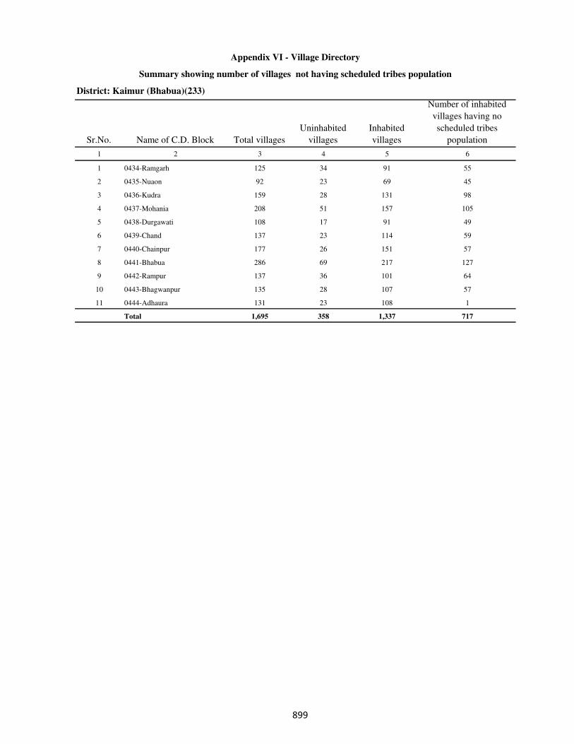
District: Kaimur (Bhabua)(233)
Sr.No. Name of C.D. Block Total villages
Uninhabited
villages
Inhabited
villages
Number of inhabited
villages having no
scheduled tribes
population
1 2 3 4 5 6
1 0434-Ramgarh 125 34 91 55
2 0435-Nuaon 92 23 69 45
3 0436-Kudra 159 28 131 98
4 0437-Mohania 208 51 157 105
5 0438-Durgawati 108 17 91 49
6 0439-Chand 137 23 114 59
7 0440-Chainpur 177 26 151 57
8 0441-Bhabua 286 69 217 127
9 0442-Rampur 137 36 101 64
10 0443-Bhagwanpur 135 28 107 57
11 0444-Adhaura 131 23 108 1
Total 1,695 358 1,337 717
Appendix VI - Village Directory
Summary showing number of villages not having scheduled tribes population
���
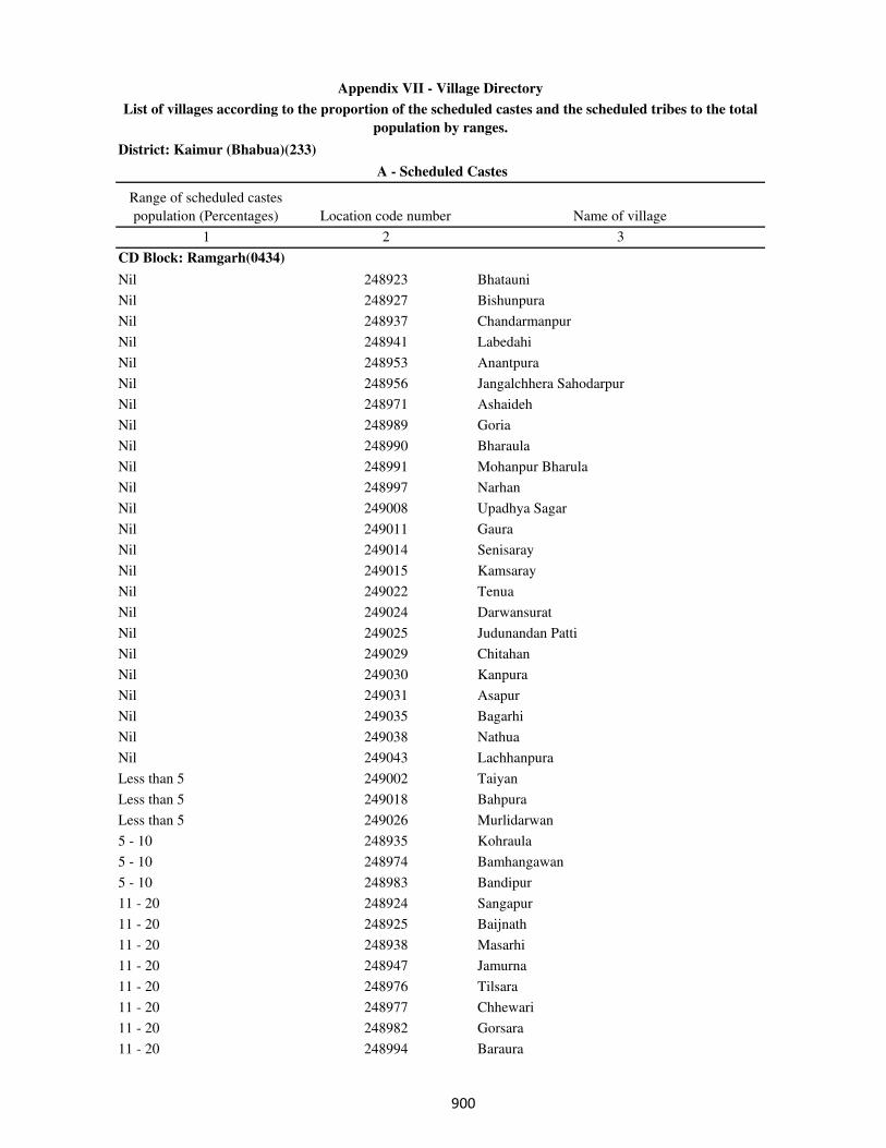
District: Kaimur (Bhabua)(233)
Range of scheduled castes
population (Percentages) Location code number Name of village
1 2 3
CD Block: Ramgarh(0434)
Nil 248923 Bhatauni
Nil 248927 Bishunpura
Nil 248937 Chandarmanpur
Nil 248941 Labedahi
Nil 248953 Anantpura
Nil 248956 Jangalchhera Sahodarpur
Nil 248971 Ashaideh
Nil 248989 Goria
Nil 248990 Bharaula
Nil 248991 Mohanpur Bharula
Nil 248997 Narhan
Nil 249008 Upadhya Sagar
Nil 249011 Gaura
Nil 249014 Senisaray
Nil 249015 Kamsaray
Nil 249022 Tenua
Nil 249024 Darwansurat
Nil 249025 Judunandan Patti
Nil 249029 Chitahan
Nil 249030 Kanpura
Nil 249031 Asapur
Nil 249035 Bagarhi
Nil 249038 Nathua
Nil 249043 Lachhanpura
Less than 5 249002 Taiyan
Less than 5 249018 Bahpura
Less than 5 249026 Murlidarwan
5 - 10 248935 Kohraula
5 - 10 248974 Bamhangawan
5 - 10 248983 Bandipur
11 - 20 248924 Sangapur
11 - 20 248925 Baijnath
11 - 20 248938 Masarhi
11 - 20 248947 Jamurna
11 - 20 248976 Tilsara
11 - 20 248977 Chhewari
11 - 20 248982 Gorsara
11 - 20 248994 Baraura
A - Scheduled Castes
Appendix VII - Village Directory
List of villages according to the proportion of the scheduled castes and the scheduled tribes to the total
population by ranges.
���
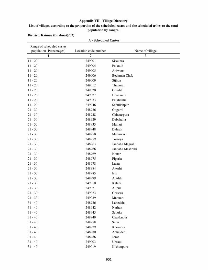
District: Kaimur (Bhabua)(233)
Range of scheduled castes
population (Percentages) Location code number Name of village
1 2 3
A - Scheduled Castes
Appendix VII - Village Directory
List of villages according to the proportion of the scheduled castes and the scheduled tribes to the total
population by ranges.
11 - 20 249001 Sisaunra
11 - 20 249004 Paikauli
11 - 20 249005 Ahiwans
11 - 20 249006 Bedaman Chak
11 - 20 249009 Sijhua
11 - 20 249012 Thakura
11 - 20 249020 Oriadih
11 - 20 249027 Dhanautia
11 - 20 249033 Patkhaulia
11 - 20 249046 Sadullahpur
21 - 30 248926 Gogarhi
21 - 30 248928 Chhatarpura
21 - 30 248929 Debahalia
21 - 30 248933 Matiari
21 - 30 248948 Dahrak
21 - 30 248950 Mahuwar
21 - 30 248959 Toroiya
21 - 30 248963 Jandaha Magrahi
21 - 30 248966 Jandaha Mashraki
21 - 30 248969 Nonar
21 - 30 248975 Piparia
21 - 30 248978 Lasra
21 - 30 248984 Akorhi
21 - 30 248985 Isri
21 - 30 248999 Antdih
21 - 30 249010 Kalani
21 - 30 249021 Alipur
21 - 30 249023 Gorsara
21 - 30 249039 Mahuari
31 - 40 248936 Labedaha
31 - 40 248942 Narhan
31 - 40 248945 Sehuka
31 - 40 248949 Chakkupur
31 - 40 248958 Sarai
31 - 40 248979 Khorahra
31 - 40 248980 Abhaideh
31 - 40 248986 Jorar
31 - 40 249003 Uprauli
31 - 40 249019 Kishunpura
���

District: Kaimur (Bhabua)(233)
Range of scheduled castes
population (Percentages) Location code number Name of village
1 2 3
A - Scheduled Castes
Appendix VII - Village Directory
List of villages according to the proportion of the scheduled castes and the scheduled tribes to the total
population by ranges.
31 - 40 249028 Asaura
31 - 40 249041 Upari
41 - 50 248934 Bharheria
41 - 50 248952 Pachgain
41 - 50 248962 Imlia
41 - 50 248973 Bhargawan
41 - 50 248987 Khanethi
51 - 75 248940 Mera
51 - 75 248954 Rupanandpur
51 - 75 248992 Balpur
51 - 75 249044 Sultanpur
76 and above 248981 Bishunpura
76 and above 248993 Natwa
76 and above 249042 Baluwa
CD Block: Nuaon(0435)
Nil 249052 Mahro
Nil 249055 Pira Ghat
Nil 249059 Basanpur
Nil 249061 Bhoganpur
Nil 249063 Gaira
Nil 249082 Bhatwalia
Nil 249086 Ewati Bhopatpur
Nil 249091 Sonbarsa
Nil 249096 Konahra
Nil 249097 Rampur
Nil 249110 Lahang Patti
Nil 249114 Bhatpurwa
Nil 249129 Sarbasipur
Nil 249138 Chandraui
Nil 249139 Gai Chakl
Less than 5 249051 Jujharpur
Less than 5 249067 Kariram
Less than 5 249069 Bararhi
Less than 5 249087 Goriari
Less than 5 249106 Dumduma
Less than 5 249116 Kota Hissa
5 - 10 249064 Mahartha
5 - 10 249104 Banbahuara
5 - 10 249115 kota Hissa Safdar Ali Khan
���

District: Kaimur (Bhabua)(233)
Range of scheduled castes
population (Percentages) Location code number Name of village
1 2 3
A - Scheduled Castes
Appendix VII - Village Directory
List of villages according to the proportion of the scheduled castes and the scheduled tribes to the total
population by ranges.
5 - 10 249121 Gaura
5 - 10 249123 Parasia
11 - 20 249054 Taraitha
11 - 20 249062 Garra
11 - 20 249066 Akolhi
11 - 20 249070 Chhata Bararhi
11 - 20 249071 Pajrawan
11 - 20 249079 Chaprang
11 - 20 249083 Deuria
11 - 20 249088 Ewati
11 - 20 249093 Morath
11 - 20 249101 Chandes
11 - 20 249122 Karamhari
11 - 20 249130 Kanhua
11 - 20 249132 Ruhiya
11 - 20 249133 Darauli
11 - 20 249136 Parsotimpur
21 - 30 249049 Tira
21 - 30 249053 Chintamanpur
21 - 30 249057 Surajpura
21 - 30 249073 Baddha
21 - 30 249075 Noawan
21 - 30 249076 Khudra
21 - 30 249077 Gorsara
21 - 30 249102 Kamhari
21 - 30 249108 Guria
21 - 30 249109 Mukhrawan
21 - 30 249111 Kathaunra
21 - 30 249128 Dungurpura
21 - 30 249140 Baruna
31 - 40 249050 Akhani
31 - 40 249092 Sotwa
31 - 40 249094 Mahila
31 - 40 249095 Pariari
31 - 40 249137 Belarhi
41 - 50 249060 Mapatpur
41 - 50 249068 Jaitpura
41 - 50 249074 Partabpur
41 - 50 249107 kurhani
���
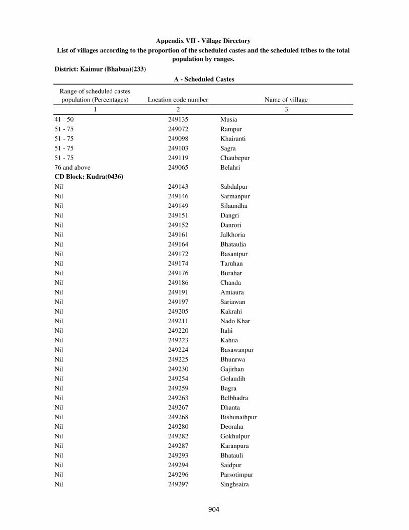
District: Kaimur (Bhabua)(233)
Range of scheduled castes
population (Percentages) Location code number Name of village
1 2 3
A - Scheduled Castes
Appendix VII - Village Directory
List of villages according to the proportion of the scheduled castes and the scheduled tribes to the total
population by ranges.
41 - 50 249135 Musia
51 - 75 249072 Rampur
51 - 75 249098 Khairanti
51 - 75 249103 Sagra
51 - 75 249119 Chaubepur
76 and above 249065 Belahri
CD Block: Kudra(0436)
Nil 249143 Sabdalpur
Nil 249146 Sarmanpur
Nil 249149 Silaundha
Nil 249151 Dangri
Nil 249152 Danrori
Nil 249161 Jalkhoria
Nil 249164 Bhataulia
Nil 249172 Basantpur
Nil 249174 Taruhan
Nil 249176 Burahar
Nil 249186 Chanda
Nil 249191 Amiaura
Nil 249197 Sariawan
Nil 249205 Kakrahi
Nil 249211 Nado Khar
Nil 249220 Itahi
Nil 249223 Kahua
Nil 249224 Basawanpur
Nil 249225 Bhunrwa
Nil 249230 Gajirhan
Nil 249254 Golaudih
Nil 249259 Bagra
Nil 249263 Belbhadra
Nil 249267 Dhanta
Nil 249268 Bishunathpur
Nil 249280 Deoraha
Nil 249282 Gokhulpur
Nil 249287 Karanpura
Nil 249293 Bhatauli
Nil 249294 Saidpur
Nil 249296 Parsotimpur
Nil 249297 Singhsaira
���
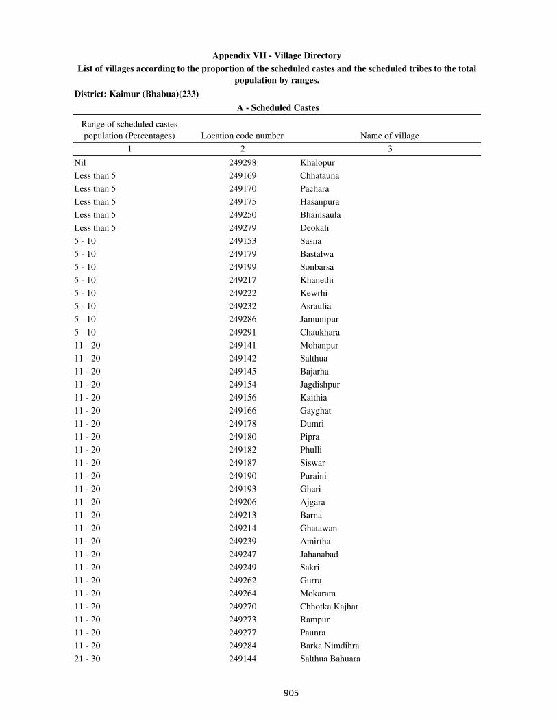
District: Kaimur (Bhabua)(233)
Range of scheduled castes
population (Percentages) Location code number Name of village
1 2 3
A - Scheduled Castes
Appendix VII - Village Directory
List of villages according to the proportion of the scheduled castes and the scheduled tribes to the total
population by ranges.
Nil 249298 Khalopur
Less than 5 249169 Chhatauna
Less than 5 249170 Pachara
Less than 5 249175 Hasanpura
Less than 5 249250 Bhainsaula
Less than 5 249279 Deokali
5 - 10 249153 Sasna
5 - 10 249179 Bastalwa
5 - 10 249199 Sonbarsa
5 - 10 249217 Khanethi
5 - 10 249222 Kewrhi
5 - 10 249232 Asraulia
5 - 10 249286 Jamunipur
5 - 10 249291 Chaukhara
11 - 20 249141 Mohanpur
11 - 20 249142 Salthua
11 - 20 249145 Bajarha
11 - 20 249154 Jagdishpur
11 - 20 249156 Kaithia
11 - 20 249166 Gayghat
11 - 20 249178 Dumri
11 - 20 249180 Pipra
11 - 20 249182 Phulli
11 - 20 249187 Siswar
11 - 20 249190 Puraini
11 - 20 249193 Ghari
11 - 20 249206 Ajgara
11 - 20 249213 Barna
11 - 20 249214 Ghatawan
11 - 20 249239 Amirtha
11 - 20 249247 Jahanabad
11 - 20 249249 Sakri
11 - 20 249262 Gurra
11 - 20 249264 Mokaram
11 - 20 249270 Chhotka Kajhar
11 - 20 249273 Rampur
11 - 20 249277 Paunra
11 - 20 249284 Barka Nimdihra
21 - 30 249144 Salthua Bahuara
���
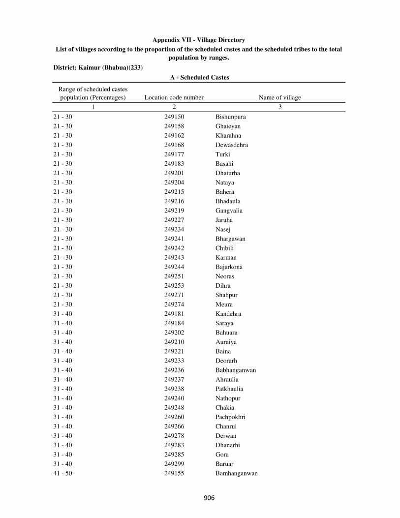
District: Kaimur (Bhabua)(233)
Range of scheduled castes
population (Percentages) Location code number Name of village
1 2 3
A - Scheduled Castes
Appendix VII - Village Directory
List of villages according to the proportion of the scheduled castes and the scheduled tribes to the total
population by ranges.
21 - 30 249150 Bishunpura
21 - 30 249158 Ghateyan
21 - 30 249162 Kharahna
21 - 30 249168 Dewasdehra
21 - 30 249177 Turki
21 - 30 249183 Basahi
21 - 30 249201 Dhaturha
21 - 30 249204 Nataya
21 - 30 249215 Bahera
21 - 30 249216 Bhadaula
21 - 30 249219 Gangvalia
21 - 30 249227 Jaruha
21 - 30 249234 Nasej
21 - 30 249241 Bhargawan
21 - 30 249242 Chibili
21 - 30 249243 Karman
21 - 30 249244 Bajarkona
21 - 30 249251 Neoras
21 - 30 249253 Dihra
21 - 30 249271 Shahpur
21 - 30 249274 Meura
31 - 40 249181 Kandehra
31 - 40 249184 Saraya
31 - 40 249202 Bahuara
31 - 40 249210 Auraiya
31 - 40 249221 Baina
31 - 40 249233 Deorarh
31 - 40 249236 Babhanganwan
31 - 40 249237 Ahraulia
31 - 40 249238 Patkhaulia
31 - 40 249240 Nathopur
31 - 40 249248 Chakia
31 - 40 249260 Pachpokhri
31 - 40 249266 Chanrui
31 - 40 249278 Derwan
31 - 40 249283 Dhanarhi
31 - 40 249285 Gora
31 - 40 249299 Baruar
41 - 50 249155 Bamhanganwan
���
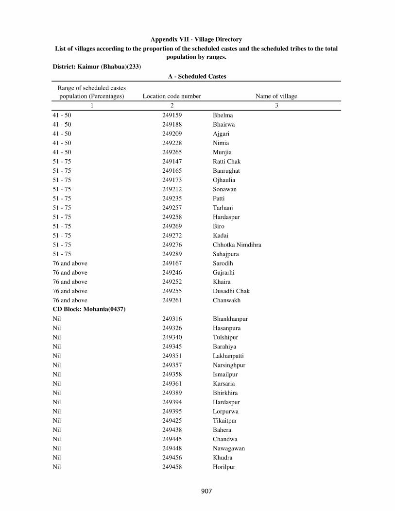
District: Kaimur (Bhabua)(233)
Range of scheduled castes
population (Percentages) Location code number Name of village
1 2 3
A - Scheduled Castes
Appendix VII - Village Directory
List of villages according to the proportion of the scheduled castes and the scheduled tribes to the total
population by ranges.
41 - 50 249159 Bhelma
41 - 50 249188 Bhairwa
41 - 50 249209 Ajgari
41 - 50 249228 Nimia
41 - 50 249265 Munjia
51 - 75 249147 Ratti Chak
51 - 75 249165 Banrughat
51 - 75 249173 Ojhaulia
51 - 75 249212 Sonawan
51 - 75 249235 Patti
51 - 75 249257 Tarhani
51 - 75 249258 Hardaspur
51 - 75 249269 Biro
51 - 75 249272 Kadai
51 - 75 249276 Chhotka Nimdihra
51 - 75 249289 Sahajpura
76 and above 249167 Sarodih
76 and above 249246 Gajrarhi
76 and above 249252 Khaira
76 and above 249255 Dusadhi Chak
76 and above 249261 Chanwakh
CD Block: Mohania(0437)
Nil 249316 Bhankhanpur
Nil 249326 Hasanpura
Nil 249340 Tulshipur
Nil 249345 Barahiya
Nil 249351 Lakhanpatti
Nil 249357 Narsinghpur
Nil 249358 Ismailpur
Nil 249361 Karsaria
Nil 249389 Bhirkhira
Nil 249394 Hardaspur
Nil 249395 Lorpurwa
Nil 249425 Tikaitpur
Nil 249438 Bahera
Nil 249445 Chandwa
Nil 249448 Nawagawan
Nil 249456 Khudra
Nil 249458 Horilpur
��
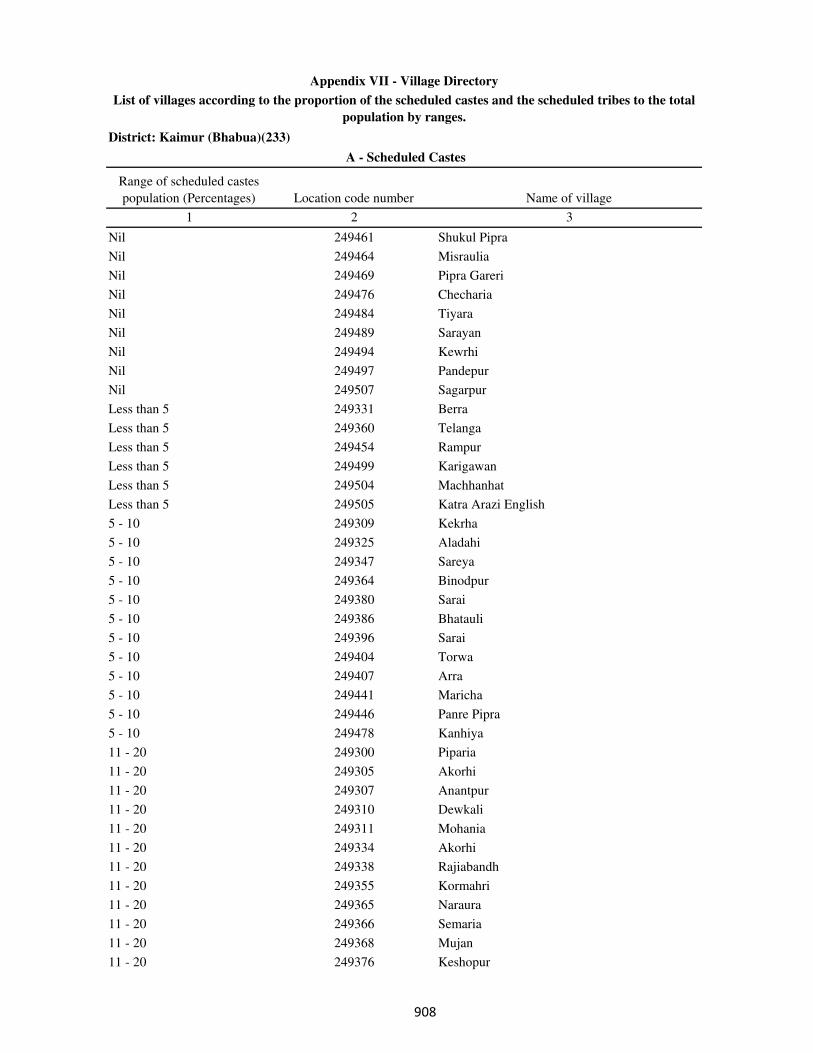
District: Kaimur (Bhabua)(233)
Range of scheduled castes
population (Percentages) Location code number Name of village
1 2 3
A - Scheduled Castes
Appendix VII - Village Directory
List of villages according to the proportion of the scheduled castes and the scheduled tribes to the total
population by ranges.
Nil 249461 Shukul Pipra
Nil 249464 Misraulia
Nil 249469 Pipra Gareri
Nil 249476 Checharia
Nil 249484 Tiyara
Nil 249489 Sarayan
Nil 249494 Kewrhi
Nil 249497 Pandepur
Nil 249507 Sagarpur
Less than 5 249331 Berra
Less than 5 249360 Telanga
Less than 5 249454 Rampur
Less than 5 249499 Karigawan
Less than 5 249504 Machhanhat
Less than 5 249505 Katra Arazi English
5 - 10 249309 Kekrha
5 - 10 249325 Aladahi
5 - 10 249347 Sareya
5 - 10 249364 Binodpur
5 - 10 249380 Sarai
5 - 10 249386 Bhatauli
5 - 10 249396 Sarai
5 - 10 249404 Torwa
5 - 10 249407 Arra
5 - 10 249441 Maricha
5 - 10 249446 Panre Pipra
5 - 10 249478 Kanhiya
11 - 20 249300 Piparia
11 - 20 249305 Akorhi
11 - 20 249307 Anantpur
11 - 20 249310 Dewkali
11 - 20 249311 Mohania
11 - 20 249334 Akorhi
11 - 20 249338 Rajiabandh
11 - 20 249355 Kormahri
11 - 20 249365 Naraura
11 - 20 249366 Semaria
11 - 20 249368 Mujan
11 - 20 249376 Keshopur
��
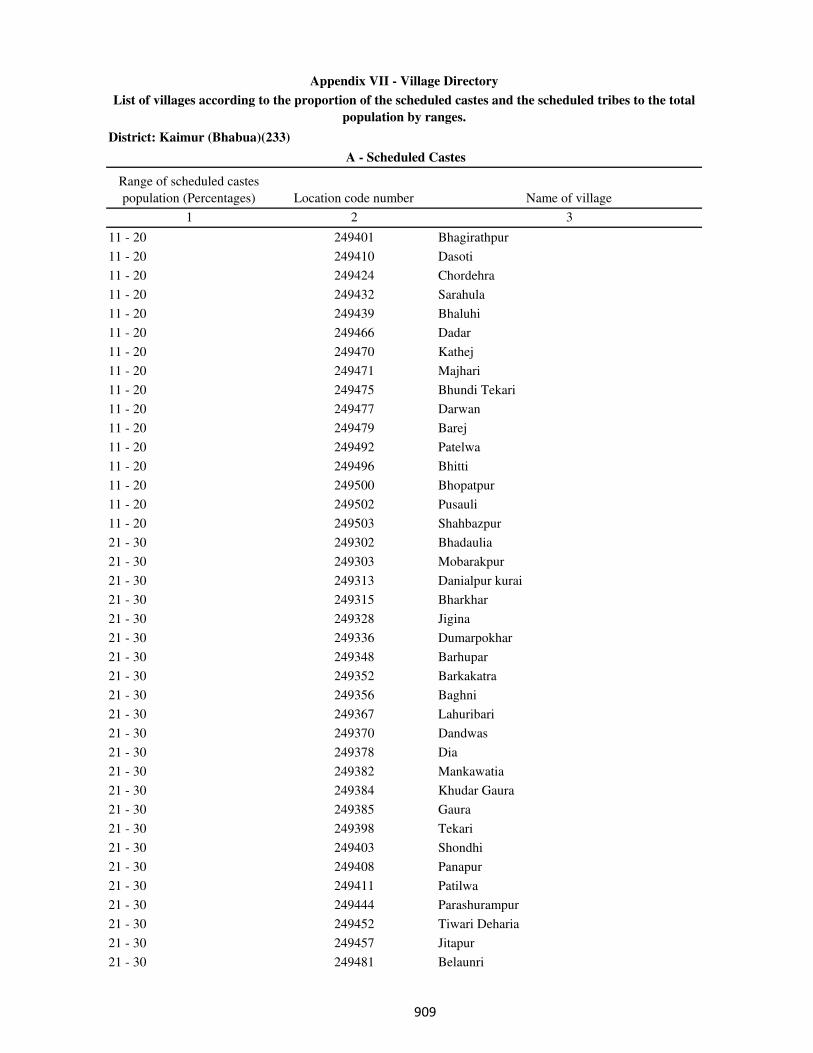
District: Kaimur (Bhabua)(233)
Range of scheduled castes
population (Percentages) Location code number Name of village
1 2 3
A - Scheduled Castes
Appendix VII - Village Directory
List of villages according to the proportion of the scheduled castes and the scheduled tribes to the total
population by ranges.
11 - 20 249401 Bhagirathpur
11 - 20 249410 Dasoti
11 - 20 249424 Chordehra
11 - 20 249432 Sarahula
11 - 20 249439 Bhaluhi
11 - 20 249466 Dadar
11 - 20 249470 Kathej
11 - 20 249471 Majhari
11 - 20 249475 Bhundi Tekari
11 - 20 249477 Darwan
11 - 20 249479 Barej
11 - 20 249492 Patelwa
11 - 20 249496 Bhitti
11 - 20 249500 Bhopatpur
11 - 20 249502 Pusauli
11 - 20 249503 Shahbazpur
21 - 30 249302 Bhadaulia
21 - 30 249303 Mobarakpur
21 - 30 249313 Danialpur kurai
21 - 30 249315 Bharkhar
21 - 30 249328 Jigina
21 - 30 249336 Dumarpokhar
21 - 30 249348 Barhupar
21 - 30 249352 Barkakatra
21 - 30 249356 Baghni
21 - 30 249367 Lahuribari
21 - 30 249370 Dandwas
21 - 30 249378 Dia
21 - 30 249382 Mankawatia
21 - 30 249384 Khudar Gaura
21 - 30 249385 Gaura
21 - 30 249398 Tekari
21 - 30 249403 Shondhi
21 - 30 249408 Panapur
21 - 30 249411 Patilwa
21 - 30 249444 Parashurampur
21 - 30 249452 Tiwari Deharia
21 - 30 249457 Jitapur
21 - 30 249481 Belaunri
���
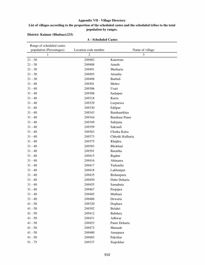
District: Kaimur (Bhabua)(233)
Range of scheduled castes
population (Percentages) Location code number Name of village
1 2 3
A - Scheduled Castes
Appendix VII - Village Directory
List of villages according to the proportion of the scheduled castes and the scheduled tribes to the total
population by ranges.
21 - 30 249482 Kauriram
21 - 30 249488 Ameth
21 - 30 249491 Murharia
21 - 30 249493 Atraulia
21 - 30 249498 Barhuli
31 - 40 249301 Mehro
31 - 40 249306 Usari
31 - 40 249308 Sadatpur
31 - 40 249318 Kurra
31 - 40 249329 Lurpurwa
31 - 40 249330 Edilpur
31 - 40 249343 Bamhaurkhas
31 - 40 249344 Bamhaur Panre
31 - 40 249349 Sahijana
31 - 40 249359 Sakrauli
31 - 40 249363 Chotka Katra
31 - 40 249373 Chhotki Kulharia
31 - 40 249375 Khajhra
31 - 40 249383 Bhokhari
31 - 40 249391 Baraitha
31 - 40 249415 Baghni
31 - 40 249416 Ahinaura
31 - 40 249417 Turkaulia
31 - 40 249418 Lakhmipur
31 - 40 249435 Bishunpura
31 - 40 249450 Dube Deharia
31 - 40 249455 Samahuta
31 - 40 249467 Paspipra
31 - 40 249485 Muthani
31 - 40 249486 Dewaria
41 - 50 249320 Doghara
41 - 50 249392 Belahri
41 - 50 249412 Bahdura
41 - 50 249431 Adhwar
41 - 50 249453 Panre Deharia
41 - 50 249472 Mamade
41 - 50 249480 Amarpura
41 - 50 249483 Pakrihar
51 - 75 249337 Siapokhar
���

District: Kaimur (Bhabua)(233)
Range of scheduled castes
population (Percentages) Location code number Name of village
1 2 3
A - Scheduled Castes
Appendix VII - Village Directory
List of villages according to the proportion of the scheduled castes and the scheduled tribes to the total
population by ranges.
51 - 75 249362 Kaithiya
51 - 75 249374 Barki Kulharia
51 - 75 249388 Panserwa
51 - 75 249393 Laria
51 - 75 249405 Mohammadpur
51 - 75 249427 Harnathpur
51 - 75 249437 Dulahpur
51 - 75 249447 Kabirajpur
51 - 75 249463 Adhvania
51 - 75 249465 Bairi
51 - 75 249474 Gheghiya
51 - 75 249495 Mamrezpur
76 and above 249314 Rasulpur Karmahri
76 and above 249321 Patti
76 and above 249353 Katra Bahuara
76 and above 249377 Chhapri
76 and above 249381 Bahdura
76 and above 249419 Patserwa
76 and above 249436 Dalopur
76 and above 249462 Rajpur
76 and above 249468 Sukhpurwa
76 and above 249473 Sariawan
76 and above 249490 Barka Sagra
CD Block: Durgawati(0438)
Nil 249512 Chhajupur
Nil 249516 Basawanpur
Nil 249519 Bhagwanpur
Nil 249520 Sakhelipur
Nil 249522 Pipari
Nil 249535 Raghunathpur
Nil 249539 Manipur
Nil 249548 Manikpur Doghara
Nil 249557 Amirti
Nil 249569 Madanpura
Nil 249576 Asurha
Nil 249578 Ataria
Nil 249583 Tiari
Nil 249586 Kasthar
Nil 249591 Garhwa
���
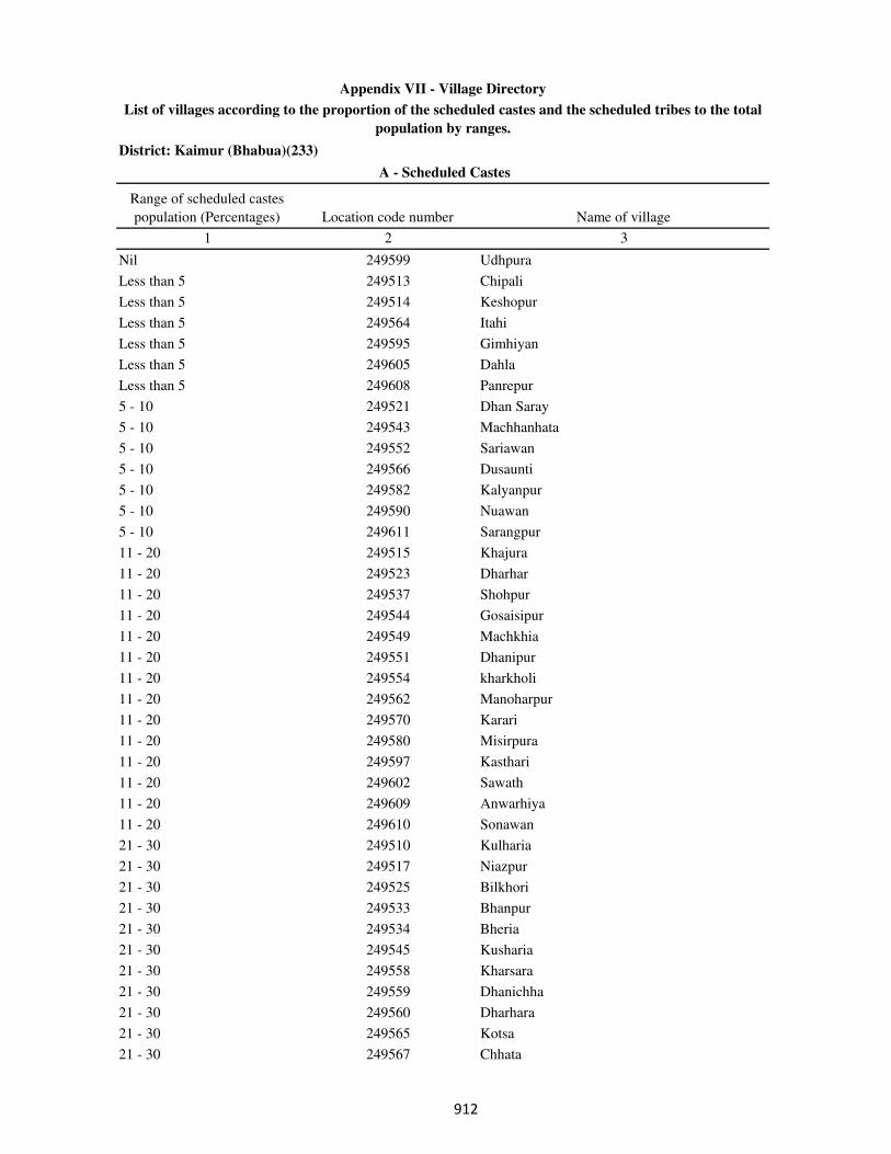
District: Kaimur (Bhabua)(233)
Range of scheduled castes
population (Percentages) Location code number Name of village
1 2 3
A - Scheduled Castes
Appendix VII - Village Directory
List of villages according to the proportion of the scheduled castes and the scheduled tribes to the total
population by ranges.
Nil 249599 Udhpura
Less than 5 249513 Chipali
Less than 5 249514 Keshopur
Less than 5 249564 Itahi
Less than 5 249595 Gimhiyan
Less than 5 249605 Dahla
Less than 5 249608 Panrepur
5 - 10 249521 Dhan Saray
5 - 10 249543 Machhanhata
5 - 10 249552 Sariawan
5 - 10 249566 Dusaunti
5 - 10 249582 Kalyanpur
5 - 10 249590 Nuawan
5 - 10 249611 Sarangpur
11 - 20 249515 Khajura
11 - 20 249523 Dharhar
11 - 20 249537 Shohpur
11 - 20 249544 Gosaisipur
11 - 20 249549 Machkhia
11 - 20 249551 Dhanipur
11 - 20 249554 kharkholi
11 - 20 249562 Manoharpur
11 - 20 249570 Karari
11 - 20 249580 Misirpura
11 - 20 249597 Kasthari
11 - 20 249602 Sawath
11 - 20 249609 Anwarhiya
11 - 20 249610 Sonawan
21 - 30 249510 Kulharia
21 - 30 249517 Niazpur
21 - 30 249525 Bilkhori
21 - 30 249533 Bhanpur
21 - 30 249534 Bheria
21 - 30 249545 Kusharia
21 - 30 249558 Kharsara
21 - 30 249559 Dhanichha
21 - 30 249560 Dharhara
21 - 30 249565 Kotsa
21 - 30 249567 Chhata
���
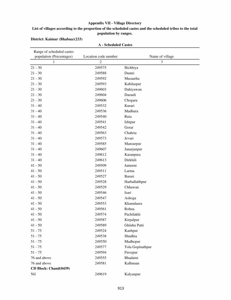
District: Kaimur (Bhabua)(233)
Range of scheduled castes
population (Percentages) Location code number Name of village
1 2 3
A - Scheduled Castes
Appendix VII - Village Directory
List of villages according to the proportion of the scheduled castes and the scheduled tribes to the total
population by ranges.
21 - 30 249575 Bichhiya
21 - 30 249588 Dumri
21 - 30 249592 Masaurha
21 - 30 249593 Kabilaspur
21 - 30 249603 Dahiyawan
21 - 30 249604 Darauli
21 - 30 249606 Chogara
31 - 40 249532 Kurari
31 - 40 249536 Madhura
31 - 40 249540 Ruia
31 - 40 249541 Ishipur
31 - 40 249542 Gorar
31 - 40 249563 Chahria
31 - 40 249573 Jevari
31 - 40 249585 Mansurpur
31 - 40 249607 Janarjanpur
31 - 40 249612 Karanpura
31 - 40 249613 Dirkhili
41 - 50 249509 Jamurni
41 - 50 249511 Larma
41 - 50 249527 Baruri
41 - 50 249528 Harballabhpur
41 - 50 249529 Chhawan
41 - 50 249546 Isari
41 - 50 249547 Ashoga
41 - 50 249553 Khamdaura
41 - 50 249561 Rohua
41 - 50 249574 Pachilakhi
41 - 50 249587 Kirpalpur
41 - 50 249589 Ghinhu Patti
51 - 75 249524 Kanhpur
51 - 75 249538 Shudhia
51 - 75 249550 Madhopur
51 - 75 249577 Tola Gopinathpur
51 - 75 249594 Firozpur
76 and above 249555 Bhadaini
76 and above 249581 Kalhnuan
CD Block: Chand(0439)
Nil 249619 Kalyanpur
���
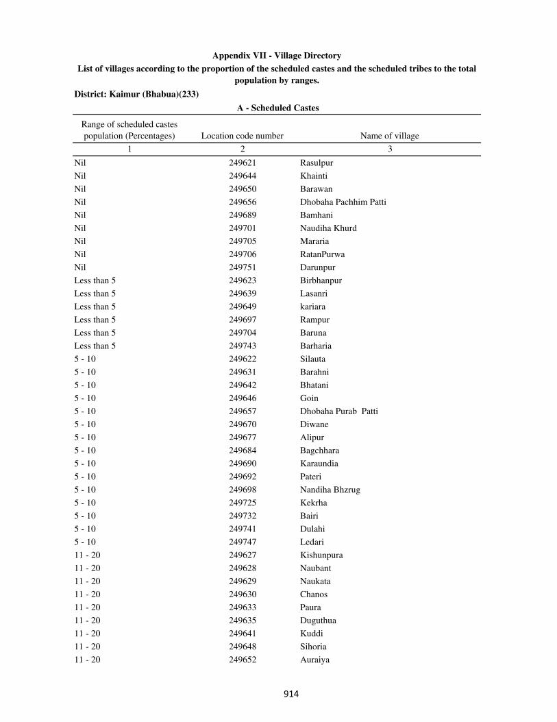
District: Kaimur (Bhabua)(233)
Range of scheduled castes
population (Percentages) Location code number Name of village
1 2 3
A - Scheduled Castes
Appendix VII - Village Directory
List of villages according to the proportion of the scheduled castes and the scheduled tribes to the total
population by ranges.
Nil 249621 Rasulpur
Nil 249644 Khainti
Nil 249650 Barawan
Nil 249656 Dhobaha Pachhim Patti
Nil 249689 Bamhani
Nil 249701 Naudiha Khurd
Nil 249705 Mararia
Nil 249706 RatanPurwa
Nil 249751 Darunpur
Less than 5 249623 Birbhanpur
Less than 5 249639 Lasanri
Less than 5 249649 kariara
Less than 5 249697 Rampur
Less than 5 249704 Baruna
Less than 5 249743 Barharia
5 - 10 249622 Silauta
5 - 10 249631 Barahni
5 - 10 249642 Bhatani
5 - 10 249646 Goin
5 - 10 249657 Dhobaha Purab Patti
5 - 10 249670 Diwane
5 - 10 249677 Alipur
5 - 10 249684 Bagchhara
5 - 10 249690 Karaundia
5 - 10 249692 Pateri
5 - 10 249698 Nandiha Bhzrug
5 - 10 249725 Kekrha
5 - 10 249732 Bairi
5 - 10 249741 Dulahi
5 - 10 249747 Ledari
11 - 20 249627 Kishunpura
11 - 20 249628 Naubant
11 - 20 249629 Naukata
11 - 20 249630 Chanos
11 - 20 249633 Paura
11 - 20 249635 Duguthua
11 - 20 249641 Kuddi
11 - 20 249648 Sihoria
11 - 20 249652 Auraiya
���
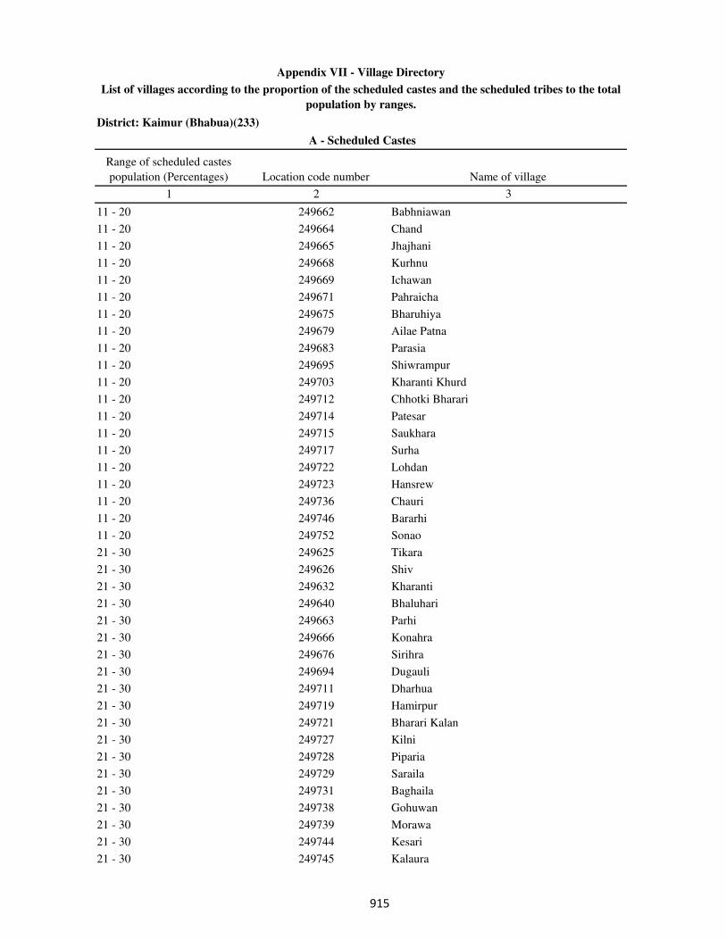
District: Kaimur (Bhabua)(233)
Range of scheduled castes
population (Percentages) Location code number Name of village
1 2 3
A - Scheduled Castes
Appendix VII - Village Directory
List of villages according to the proportion of the scheduled castes and the scheduled tribes to the total
population by ranges.
11 - 20 249662 Babhniawan
11 - 20 249664 Chand
11 - 20 249665 Jhajhani
11 - 20 249668 Kurhnu
11 - 20 249669 Ichawan
11 - 20 249671 Pahraicha
11 - 20 249675 Bharuhiya
11 - 20 249679 Ailae Patna
11 - 20 249683 Parasia
11 - 20 249695 Shiwrampur
11 - 20 249703 Kharanti Khurd
11 - 20 249712 Chhotki Bharari
11 - 20 249714 Patesar
11 - 20 249715 Saukhara
11 - 20 249717 Surha
11 - 20 249722 Lohdan
11 - 20 249723 Hansrew
11 - 20 249736 Chauri
11 - 20 249746 Bararhi
11 - 20 249752 Sonao
21 - 30 249625 Tikara
21 - 30 249626 Shiv
21 - 30 249632 Kharanti
21 - 30 249640 Bhaluhari
21 - 30 249663 Parhi
21 - 30 249666 Konahra
21 - 30 249676 Sirihra
21 - 30 249694 Dugauli
21 - 30 249711 Dharhua
21 - 30 249719 Hamirpur
21 - 30 249721 Bharari Kalan
21 - 30 249727 Kilni
21 - 30 249728 Piparia
21 - 30 249729 Saraila
21 - 30 249731 Baghaila
21 - 30 249738 Gohuwan
21 - 30 249739 Morawa
21 - 30 249744 Kesari
21 - 30 249745 Kalaura
���
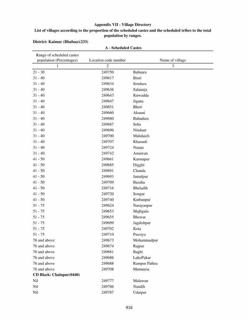
District: Kaimur (Bhabua)(233)
Range of scheduled castes
population (Percentages) Location code number Name of village
1 2 3
A - Scheduled Castes
Appendix VII - Village Directory
List of villages according to the proportion of the scheduled castes and the scheduled tribes to the total
population by ranges.
21 - 30 249750 Bahuara
31 - 40 249617 Biuri
31 - 40 249634 Sendura
31 - 40 249636 Salaunja
31 - 40 249643 Kuwadda
31 - 40 249647 Jigana
31 - 40 249651 Bheri
31 - 40 249660 Akauni
31 - 40 249680 Bahadura
31 - 40 249687 Seha
31 - 40 249696 Nindaur
31 - 40 249700 Mahdaich
31 - 40 249707 Kharauli
31 - 40 249724 Nauan
31 - 40 249742 Amawan
41 - 50 249661 Karmapur
41 - 50 249685 Digghi
41 - 50 249691 Chanda
41 - 50 249693 Jamalpur
41 - 50 249709 Basaha
41 - 50 249716 Bheladih
41 - 50 249720 Songar
41 - 50 249740 Kutbanpur
51 - 75 249624 Narayanpur
51 - 75 249653 Majhgain
51 - 75 249655 Bhewar
51 - 75 249699 Jagdishpur
51 - 75 249702 Kota
51 - 75 249710 Pasoiya
76 and above 249673 Mohammadpur
76 and above 249674 Rajpur
76 and above 249681 Baghi
76 and above 249686 LahoPakar
76 and above 249688 Rampur Pathra
76 and above 249708 Mutmuria
CD Block: Chainpur(0440)
Nil 249777 Malawan
Nil 249786 Nandih
Nil 249787 Udaipur
���
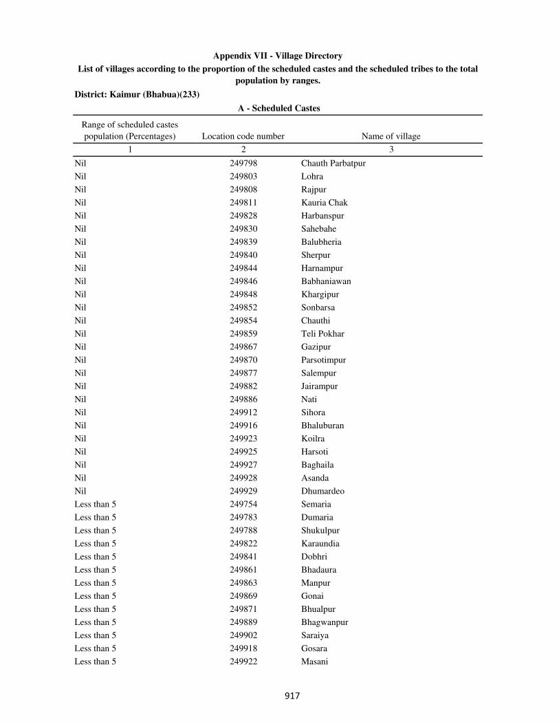
District: Kaimur (Bhabua)(233)
Range of scheduled castes
population (Percentages) Location code number Name of village
1 2 3
A - Scheduled Castes
Appendix VII - Village Directory
List of villages according to the proportion of the scheduled castes and the scheduled tribes to the total
population by ranges.
Nil 249798 Chauth Parbatpur
Nil 249803 Lohra
Nil 249808 Rajpur
Nil 249811 Kauria Chak
Nil 249828 Harbanspur
Nil 249830 Sahebahe
Nil 249839 Balubheria
Nil 249840 Sherpur
Nil 249844 Harnampur
Nil 249846 Babhaniawan
Nil 249848 Khargipur
Nil 249852 Sonbarsa
Nil 249854 Chauthi
Nil 249859 Teli Pokhar
Nil 249867 Gazipur
Nil 249870 Parsotimpur
Nil 249877 Salempur
Nil 249882 Jairampur
Nil 249886 Nati
Nil 249912 Sihora
Nil 249916 Bhaluburan
Nil 249923 Koilra
Nil 249925 Harsoti
Nil 249927 Baghaila
Nil 249928 Asanda
Nil 249929 Dhumardeo
Less than 5 249754 Semaria
Less than 5 249783 Dumaria
Less than 5 249788 Shukulpur
Less than 5 249822 Karaundia
Less than 5 249841 Dobhri
Less than 5 249861 Bhadaura
Less than 5 249863 Manpur
Less than 5 249869 Gonai
Less than 5 249871 Bhualpur
Less than 5 249889 Bhagwanpur
Less than 5 249902 Saraiya
Less than 5 249918 Gosara
Less than 5 249922 Masani
��

District: Kaimur (Bhabua)(233)
Range of scheduled castes
population (Percentages) Location code number Name of village
1 2 3
A - Scheduled Castes
Appendix VII - Village Directory
List of villages according to the proportion of the scheduled castes and the scheduled tribes to the total
population by ranges.
Less than 5 249924 Dumarkon
5 - 10 249761 Ismailpur
5 - 10 249762 Hargawan
5 - 10 249791 Niranjanpur
5 - 10 249818 Saraiya
5 - 10 249843 Neura
5 - 10 249853 Arail
5 - 10 249857 Bararhi
5 - 10 249874 Chainpur
5 - 10 249875 Naughara
5 - 10 249884 Sohawal
5 - 10 249888 Pahladpur
5 - 10 249910 Basawanpur
11 - 20 249758 Ghanti
11 - 20 249759 Ramgarh
11 - 20 249782 Diha
11 - 20 249793 Merh
11 - 20 249795 Chitarhi
11 - 20 249802 Kalyanipur
11 - 20 249806 Udai Rampur
11 - 20 249807 Jigina
11 - 20 249812 Shahpur
11 - 20 249817 Hata
11 - 20 249825 Sikandarpur
11 - 20 249826 Masoi Khurd
11 - 20 249827 Gangapur
11 - 20 249836 Kurain
11 - 20 249837 Karjav
11 - 20 249855 Isia
11 - 20 249858 Danrwa
11 - 20 249860 Danrwa
11 - 20 249866 Biur
11 - 20 249868 Biddi
11 - 20 249872 Bari Takia
11 - 20 249873 Maliksaray
11 - 20 249879 Gobindpur
11 - 20 249881 Lohra
11 - 20 249885 Rupa Patti
11 - 20 249887 Damodarpur
��
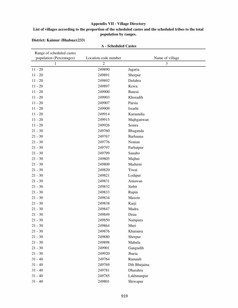
District: Kaimur (Bhabua)(233)
Range of scheduled castes
population (Percentages) Location code number Name of village
1 2 3
A - Scheduled Castes
Appendix VII - Village Directory
List of villages according to the proportion of the scheduled castes and the scheduled tribes to the total
population by ranges.
11 - 20 249890 Jagaria
11 - 20 249891 Sherpur
11 - 20 249892 Dulahra
11 - 20 249897 Kewa
11 - 20 249900 Baurai
11 - 20 249903 Khoradih
11 - 20 249907 Parsia
11 - 20 249909 Israrhi
11 - 20 249914 Karaundia
11 - 20 249915 Majhganwan
11 - 20 249926 Semra
21 - 30 249760 Bhaganda
21 - 30 249767 Barhauna
21 - 30 249776 Nonian
21 - 30 249797 Parbatpur
21 - 30 249799 Sanabo
21 - 30 249805 Majhui
21 - 30 249809 Madurni
21 - 30 249820 Tiwai
21 - 30 249821 Lodipur
21 - 30 249831 Amawan
21 - 30 249832 Sirbit
21 - 30 249833 Rupin
21 - 30 249834 Masoin
21 - 30 249838 Karji
21 - 30 249847 Madra
21 - 30 249849 Deua
21 - 30 249850 Nainpura
21 - 30 249864 Muri
21 - 30 249876 Kharaura
21 - 30 249880 Sherpur
21 - 30 249898 Mahula
21 - 30 249901 Gangudih
21 - 30 249920 Jharia
31 - 40 249764 Ramauli
31 - 40 249769 Dih Bhujaina
31 - 40 249781 Dharahra
31 - 40 249785 Lakhmanpur
31 - 40 249801 Shiwapur
���
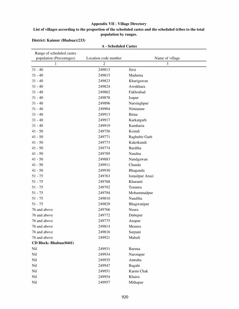
District: Kaimur (Bhabua)(233)
Range of scheduled castes
population (Percentages) Location code number Name of village
1 2 3
A - Scheduled Castes
Appendix VII - Village Directory
List of villages according to the proportion of the scheduled castes and the scheduled tribes to the total
population by ranges.
31 - 40 249813 Sirsi
31 - 40 249815 Madurna
31 - 40 249823 Kharigawan
31 - 40 249824 Awnkhara
31 - 40 249862 Fakhrabad
31 - 40 249878 Isapur
31 - 40 249896 Narsinghpur
31 - 40 249904 Nimiatanr
31 - 40 249913 Birna
31 - 40 249917 Karkatgarh
31 - 40 249919 Kamharia
41 - 50 249756 Koindi
41 - 50 249771 Raghubir Garh
41 - 50 249773 Kakrikundi
41 - 50 249774 Bardiha
41 - 50 249789 Nandna
41 - 50 249883 Nandgawan
41 - 50 249911 Chanda
41 - 50 249930 Bhaganda
51 - 75 249763 Ismailpur Arazi
51 - 75 249768 Kharanti
51 - 75 249792 Tenaura
51 - 75 249794 Mohammadpur
51 - 75 249810 Naudiha
51 - 75 249829 Bhagwatipur
76 and above 249766 Neura
76 and above 249772 Dubepur
76 and above 249775 Anapur
76 and above 249814 Meunra
76 and above 249816 Sarpani
76 and above 249921 Mahuli
CD Block: Bhabua(0441)
Nil 249931 Baruna
Nil 249934 Narotapur
Nil 249935 Amraha
Nil 249947 Bagahi
Nil 249951 Karmi Chak
Nil 249954 Khaira
Nil 249957 Mithapur
���

District: Kaimur (Bhabua)(233)
Range of scheduled castes
population (Percentages) Location code number Name of village
1 2 3
A - Scheduled Castes
Appendix VII - Village Directory
List of villages according to the proportion of the scheduled castes and the scheduled tribes to the total
population by ranges.
Nil 249963 Doghra
Nil 249970 Sedra Nisf
Nil 249971 Sedra
Nil 249973 Auraiya Dewa
Nil 249985 Gopalpur
Nil 250002 Danrwa
Nil 250003 Khadaura
Nil 250004 Sudarsanpur
Nil 250007 Dharampura
Nil 250026 Sikra
Nil 250033 Pangaiyan
Nil 250040 Hasanpura
Nil 250066 Checharia
Nil 250077 Nibi Khurd
Nil 250078 Nibi Kalan
Nil 250090 Banjaria
Nil 250092 Kamti
Nil 250094 Maldah
Nil 250095 Jalalpur
Nil 250103 Tiaraghat
Nil 250104 Manpur
Nil 250106 Rampur
Nil 250111 Patti
Nil 250116 Bisunpura
Nil 250123 Kathaura
Nil 250124 Bahuwara
Nil 250127 Basgitia
Nil 250131 Saunrudih
Nil 250133 Kanpara
Nil 250139 Rampur
Nil 250142 Kamalpur
Nil 250148 Khajuria Khurd
Nil 250151 Paranpur
Nil 250154 Beguda
Nil 250159 Sagar
Nil 250160 Sathri
Nil 250163 Sadekawai
Nil 250165 Rawan
Nil 250180 Akorhi
���
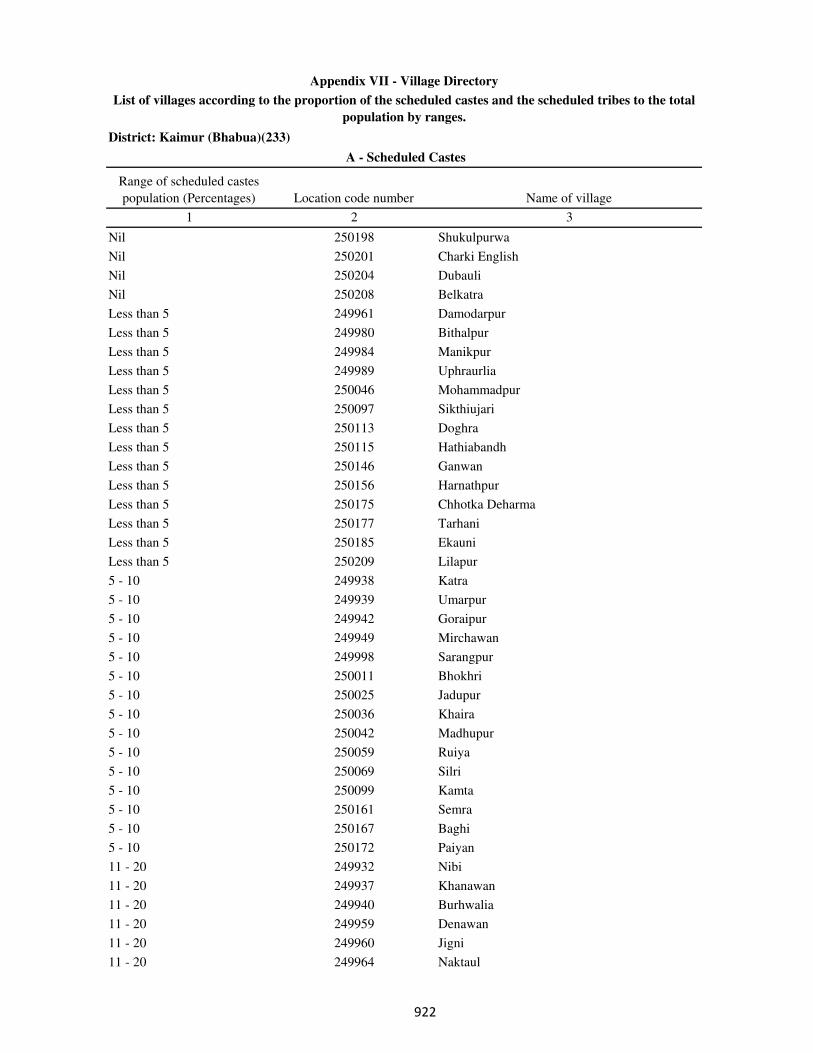
District: Kaimur (Bhabua)(233)
Range of scheduled castes
population (Percentages) Location code number Name of village
1 2 3
A - Scheduled Castes
Appendix VII - Village Directory
List of villages according to the proportion of the scheduled castes and the scheduled tribes to the total
population by ranges.
Nil 250198 Shukulpurwa
Nil 250201 Charki English
Nil 250204 Dubauli
Nil 250208 Belkatra
Less than 5 249961 Damodarpur
Less than 5 249980 Bithalpur
Less than 5 249984 Manikpur
Less than 5 249989 Uphraurlia
Less than 5 250046 Mohammadpur
Less than 5 250097 Sikthiujari
Less than 5 250113 Doghra
Less than 5 250115 Hathiabandh
Less than 5 250146 Ganwan
Less than 5 250156 Harnathpur
Less than 5 250175 Chhotka Deharma
Less than 5 250177 Tarhani
Less than 5 250185 Ekauni
Less than 5 250209 Lilapur
5 - 10 249938 Katra
5 - 10 249939 Umarpur
5 - 10 249942 Goraipur
5 - 10 249949 Mirchawan
5 - 10 249998 Sarangpur
5 - 10 250011 Bhokhri
5 - 10 250025 Jadupur
5 - 10 250036 Khaira
5 - 10 250042 Madhupur
5 - 10 250059 Ruiya
5 - 10 250069 Silri
5 - 10 250099 Kamta
5 - 10 250161 Semra
5 - 10 250167 Baghi
5 - 10 250172 Paiyan
11 - 20 249932 Nibi
11 - 20 249937 Khanawan
11 - 20 249940 Burhwalia
11 - 20 249959 Denawan
11 - 20 249960 Jigni
11 - 20 249964 Naktaul
���
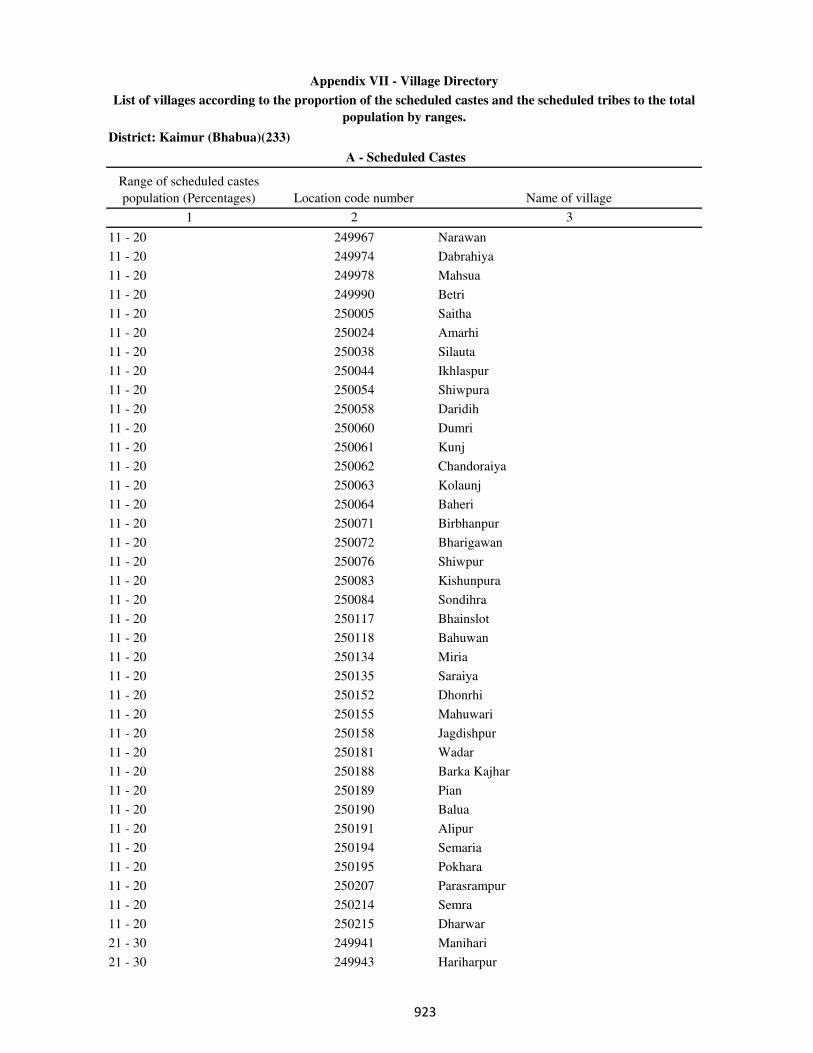
District: Kaimur (Bhabua)(233)
Range of scheduled castes
population (Percentages) Location code number Name of village
1 2 3
A - Scheduled Castes
Appendix VII - Village Directory
List of villages according to the proportion of the scheduled castes and the scheduled tribes to the total
population by ranges.
11 - 20 249967 Narawan
11 - 20 249974 Dabrahiya
11 - 20 249978 Mahsua
11 - 20 249990 Betri
11 - 20 250005 Saitha
11 - 20 250024 Amarhi
11 - 20 250038 Silauta
11 - 20 250044 Ikhlaspur
11 - 20 250054 Shiwpura
11 - 20 250058 Daridih
11 - 20 250060 Dumri
11 - 20 250061 Kunj
11 - 20 250062 Chandoraiya
11 - 20 250063 Kolaunj
11 - 20 250064 Baheri
11 - 20 250071 Birbhanpur
11 - 20 250072 Bharigawan
11 - 20 250076 Shiwpur
11 - 20 250083 Kishunpura
11 - 20 250084 Sondihra
11 - 20 250117 Bhainslot
11 - 20 250118 Bahuwan
11 - 20 250134 Miria
11 - 20 250135 Saraiya
11 - 20 250152 Dhonrhi
11 - 20 250155 Mahuwari
11 - 20 250158 Jagdishpur
11 - 20 250181 Wadar
11 - 20 250188 Barka Kajhar
11 - 20 250189 Pian
11 - 20 250190 Balua
11 - 20 250191 Alipur
11 - 20 250194 Semaria
11 - 20 250195 Pokhara
11 - 20 250207 Parasrampur
11 - 20 250214 Semra
11 - 20 250215 Dharwar
21 - 30 249941 Manihari
21 - 30 249943 Hariharpur
���
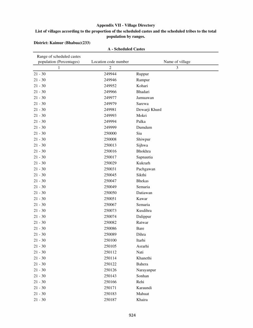
District: Kaimur (Bhabua)(233)
Range of scheduled castes
population (Percentages) Location code number Name of village
1 2 3
A - Scheduled Castes
Appendix VII - Village Directory
List of villages according to the proportion of the scheduled castes and the scheduled tribes to the total
population by ranges.
21 - 30 249944 Ruppur
21 - 30 249946 Rampur
21 - 30 249952 Kohari
21 - 30 249966 Bhadari
21 - 30 249977 Jamuawan
21 - 30 249979 Sarewa
21 - 30 249981 Dewarji Khurd
21 - 30 249993 Mokri
21 - 30 249994 Palka
21 - 30 249999 Dumdum
21 - 30 250000 Siu
21 - 30 250008 Shiwpur
21 - 30 250013 Sijhwa
21 - 30 250016 Bhokhra
21 - 30 250017 Sapnautia
21 - 30 250029 Kukrarh
21 - 30 250031 Pachgawan
21 - 30 250045 Sikthi
21 - 30 250047 Bhekas
21 - 30 250049 Semaria
21 - 30 250050 Datiawan
21 - 30 250051 Kawar
21 - 30 250067 Semaria
21 - 30 250073 Kusdihra
21 - 30 250074 Dalippur
21 - 30 250082 Ratwar
21 - 30 250086 Bare
21 - 30 250089 Dihra
21 - 30 250100 Itarhi
21 - 30 250105 Asrarhi
21 - 30 250112 Nati
21 - 30 250114 Khanethi
21 - 30 250122 Bahera
21 - 30 250126 Narayanpur
21 - 30 250143 Sonhan
21 - 30 250166 Rehi
21 - 30 250171 Karaundi
21 - 30 250183 Mahuat
21 - 30 250187 Khaira
���
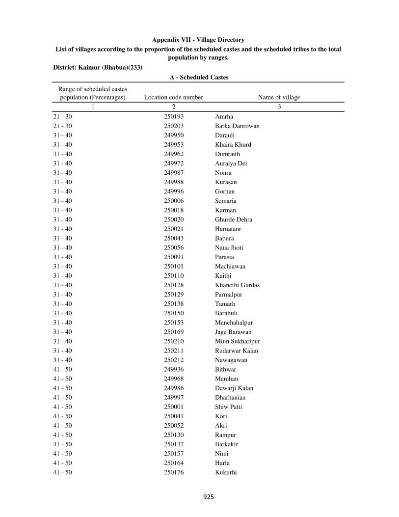
District: Kaimur (Bhabua)(233)
Range of scheduled castes
population (Percentages) Location code number Name of village
1 2 3
A - Scheduled Castes
Appendix VII - Village Directory
List of villages according to the proportion of the scheduled castes and the scheduled tribes to the total
population by ranges.
21 - 30 250193 Amrha
21 - 30 250203 Barka Danrowan
31 - 40 249950 Darauli
31 - 40 249953 Khaira Khurd
31 - 40 249962 Dumraith
31 - 40 249972 Auraiya Dei
31 - 40 249987 Nonra
31 - 40 249988 Kurasan
31 - 40 249996 Gorhan
31 - 40 250006 Semaria
31 - 40 250018 Karman
31 - 40 250020 Ghurde Dehra
31 - 40 250021 Harnatanr
31 - 40 250043 Babura
31 - 40 250056 Naua Jhoti
31 - 40 250091 Parasia
31 - 40 250101 Machiawan
31 - 40 250110 Kaithi
31 - 40 250128 Khanethi Gurdas
31 - 40 250129 Parmalpur
31 - 40 250138 Tamarh
31 - 40 250150 Barahuli
31 - 40 250153 Manchahalpur
31 - 40 250169 Jage Barawan
31 - 40 250210 Miun Sukharipur
31 - 40 250211 Rudarwar Kalan
31 - 40 250212 Nawagawan
41 - 50 249936 Bithwar
41 - 50 249968 Mamhan
41 - 50 249986 Dewarji Kalan
41 - 50 249997 Dharhanian
41 - 50 250001 Shiw Patti
41 - 50 250041 Kori
41 - 50 250052 Akri
41 - 50 250130 Rampur
41 - 50 250137 Barkakir
41 - 50 250157 Nimi
41 - 50 250164 Harla
41 - 50 250176 Kukurhi
���
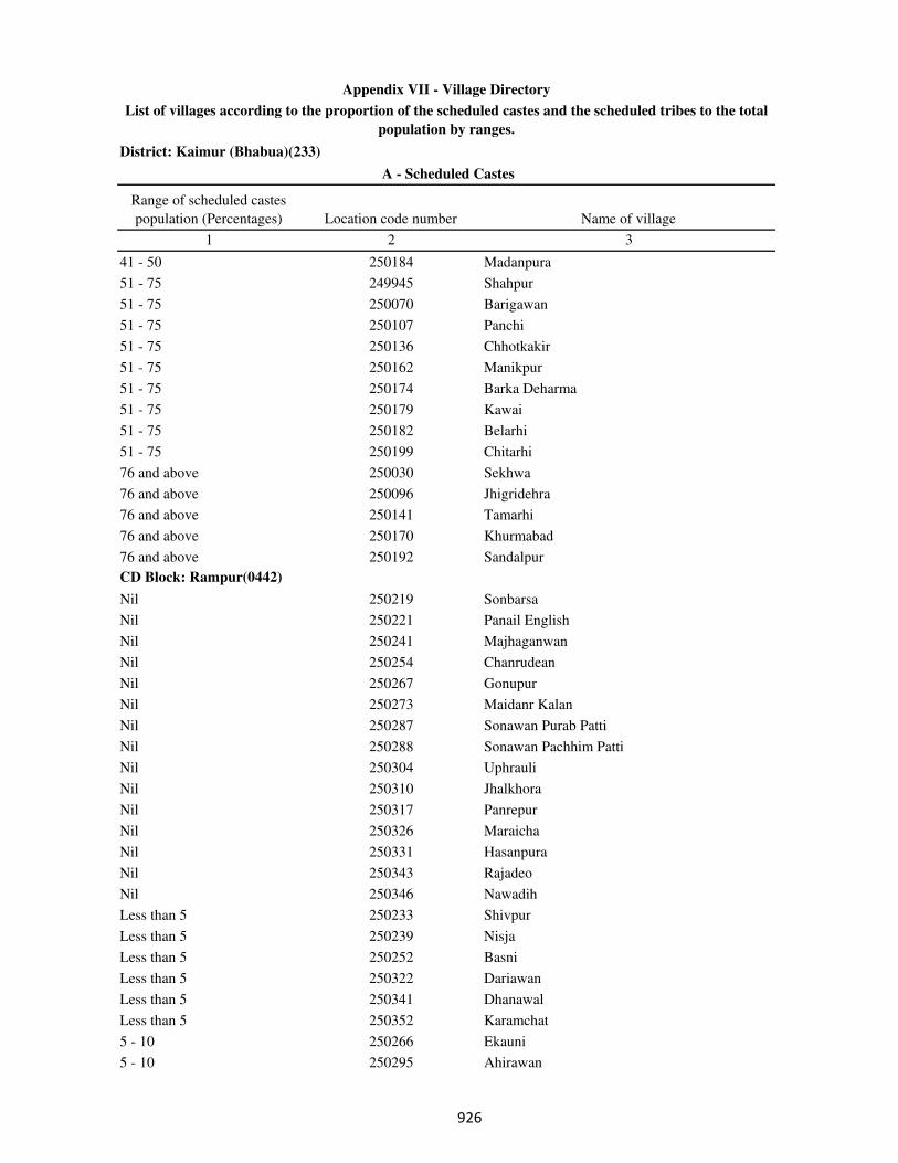
District: Kaimur (Bhabua)(233)
Range of scheduled castes
population (Percentages) Location code number Name of village
1 2 3
A - Scheduled Castes
Appendix VII - Village Directory
List of villages according to the proportion of the scheduled castes and the scheduled tribes to the total
population by ranges.
41 - 50 250184 Madanpura
51 - 75 249945 Shahpur
51 - 75 250070 Barigawan
51 - 75 250107 Panchi
51 - 75 250136 Chhotkakir
51 - 75 250162 Manikpur
51 - 75 250174 Barka Deharma
51 - 75 250179 Kawai
51 - 75 250182 Belarhi
51 - 75 250199 Chitarhi
76 and above 250030 Sekhwa
76 and above 250096 Jhigridehra
76 and above 250141 Tamarhi
76 and above 250170 Khurmabad
76 and above 250192 Sandalpur
CD Block: Rampur(0442)
Nil 250219 Sonbarsa
Nil 250221 Panail English
Nil 250241 Majhaganwan
Nil 250254 Chanrudean
Nil 250267 Gonupur
Nil 250273 Maidanr Kalan
Nil 250287 Sonawan Purab Patti
Nil 250288 Sonawan Pachhim Patti
Nil 250304 Uphrauli
Nil 250310 Jhalkhora
Nil 250317 Panrepur
Nil 250326 Maraicha
Nil 250331 Hasanpura
Nil 250343 Rajadeo
Nil 250346 Nawadih
Less than 5 250233 Shivpur
Less than 5 250239 Nisja
Less than 5 250252 Basni
Less than 5 250322 Dariawan
Less than 5 250341 Dhanawal
Less than 5 250352 Karamchat
5 - 10 250266 Ekauni
5 - 10 250295 Ahirawan
���
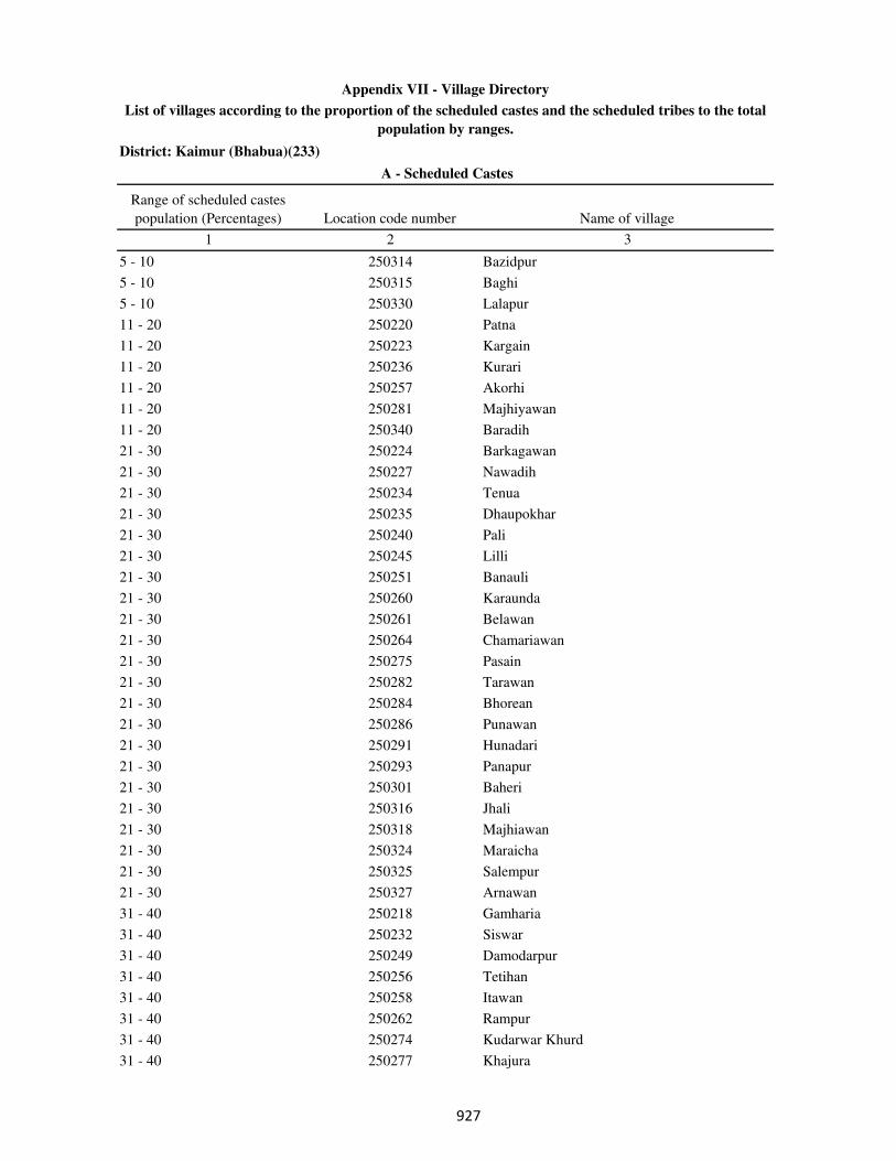
District: Kaimur (Bhabua)(233)
Range of scheduled castes
population (Percentages) Location code number Name of village
1 2 3
A - Scheduled Castes
Appendix VII - Village Directory
List of villages according to the proportion of the scheduled castes and the scheduled tribes to the total
population by ranges.
5 - 10 250314 Bazidpur
5 - 10 250315 Baghi
5 - 10 250330 Lalapur
11 - 20 250220 Patna
11 - 20 250223 Kargain
11 - 20 250236 Kurari
11 - 20 250257 Akorhi
11 - 20 250281 Majhiyawan
11 - 20 250340 Baradih
21 - 30 250224 Barkagawan
21 - 30 250227 Nawadih
21 - 30 250234 Tenua
21 - 30 250235 Dhaupokhar
21 - 30 250240 Pali
21 - 30 250245 Lilli
21 - 30 250251 Banauli
21 - 30 250260 Karaunda
21 - 30 250261 Belawan
21 - 30 250264 Chamariawan
21 - 30 250275 Pasain
21 - 30 250282 Tarawan
21 - 30 250284 Bhorean
21 - 30 250286 Punawan
21 - 30 250291 Hunadari
21 - 30 250293 Panapur
21 - 30 250301 Baheri
21 - 30 250316 Jhali
21 - 30 250318 Majhiawan
21 - 30 250324 Maraicha
21 - 30 250325 Salempur
21 - 30 250327 Arnawan
31 - 40 250218 Gamharia
31 - 40 250232 Siswar
31 - 40 250249 Damodarpur
31 - 40 250256 Tetihan
31 - 40 250258 Itawan
31 - 40 250262 Rampur
31 - 40 250274 Kudarwar Khurd
31 - 40 250277 Khajura
��
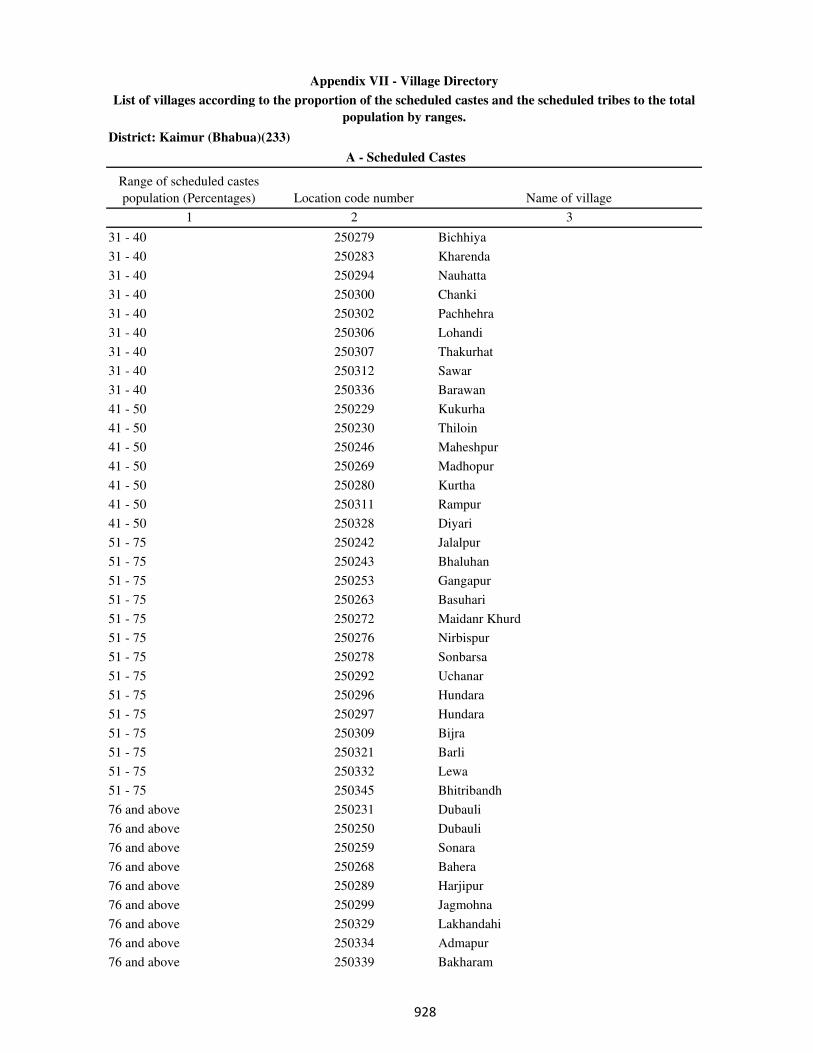
District: Kaimur (Bhabua)(233)
Range of scheduled castes
population (Percentages) Location code number Name of village
1 2 3
A - Scheduled Castes
Appendix VII - Village Directory
List of villages according to the proportion of the scheduled castes and the scheduled tribes to the total
population by ranges.
31 - 40 250279 Bichhiya
31 - 40 250283 Kharenda
31 - 40 250294 Nauhatta
31 - 40 250300 Chanki
31 - 40 250302 Pachhehra
31 - 40 250306 Lohandi
31 - 40 250307 Thakurhat
31 - 40 250312 Sawar
31 - 40 250336 Barawan
41 - 50 250229 Kukurha
41 - 50 250230 Thiloin
41 - 50 250246 Maheshpur
41 - 50 250269 Madhopur
41 - 50 250280 Kurtha
41 - 50 250311 Rampur
41 - 50 250328 Diyari
51 - 75 250242 Jalalpur
51 - 75 250243 Bhaluhan
51 - 75 250253 Gangapur
51 - 75 250263 Basuhari
51 - 75 250272 Maidanr Khurd
51 - 75 250276 Nirbispur
51 - 75 250278 Sonbarsa
51 - 75 250292 Uchanar
51 - 75 250296 Hundara
51 - 75 250297 Hundara
51 - 75 250309 Bijra
51 - 75 250321 Barli
51 - 75 250332 Lewa
51 - 75 250345 Bhitribandh
76 and above 250231 Dubauli
76 and above 250250 Dubauli
76 and above 250259 Sonara
76 and above 250268 Bahera
76 and above 250289 Harjipur
76 and above 250299 Jagmohna
76 and above 250329 Lakhandahi
76 and above 250334 Admapur
76 and above 250339 Bakharam
��

District: Kaimur (Bhabua)(233)
Range of scheduled castes
population (Percentages) Location code number Name of village
1 2 3
A - Scheduled Castes
Appendix VII - Village Directory
List of villages according to the proportion of the scheduled castes and the scheduled tribes to the total
population by ranges.
CD Block: Bhagwanpur(0443)
Nil 250358 Kunrwa
Nil 250363 Lahra
Nil 250368 Matar
Nil 250393 Jaitpur Khurd
Nil 250398 Nawagawan
Nil 250399 Darra
Nil 250410 Dhekahri
Nil 250414 Bhaluhi
Nil 250426 Bhaisahi
Nil 250445 Bahoranpur
Nil 250449 Sareyan
Nil 250453 Sariawan
Nil 250467 Kunrwa
Nil 250482 Rajbandhwa
Less than 5 250373 Marari
Less than 5 250392 Jaitpur Kohna
Less than 5 250404 Dhekahri
Less than 5 250439 Ausan
5 - 10 250395 Arari
5 - 10 250421 Manikpur
5 - 10 250430 Gaura
5 - 10 250433 Shahpur
5 - 10 250443 Henauta
5 - 10 250454 Patriha
5 - 10 250461 Beldih
5 - 10 250488 Bhurkura
11 - 20 250359 Chakedehra
11 - 20 250364 Dubauli
11 - 20 250371 Dhangarha
11 - 20 250381 Basantpur
11 - 20 250382 Reghiya
11 - 20 250405 Urgain
11 - 20 250409 Kaser
11 - 20 250419 Parhauti
11 - 20 250420 Parmalpur
11 - 20 250422 Khiri
11 - 20 250431 Chholhat Sajanwa
11 - 20 250432 Paharia
���

District: Kaimur (Bhabua)(233)
Range of scheduled castes
population (Percentages) Location code number Name of village
1 2 3
A - Scheduled Castes
Appendix VII - Village Directory
List of villages according to the proportion of the scheduled castes and the scheduled tribes to the total
population by ranges.
11 - 20 250436 Nibi
11 - 20 250447 Kochari
11 - 20 250462 Bakharhandh
11 - 20 250471 Bucha
11 - 20 250473 Dharchali
11 - 20 250484 Paunra
11 - 20 250485 Bajardihwa
21 - 30 250355 Ora
21 - 30 250370 Umapur
21 - 30 250388 Kathaura Khamari
21 - 30 250402 Tekra
21 - 30 250424 Bhagwanpur
21 - 30 250427 Masahi
21 - 30 250429 Saraiya
21 - 30 250440 Bhairapur
21 - 30 250448 Kusdehra
21 - 30 250450 Mokaram Purab Patti
21 - 30 250458 Dawanpur
21 - 30 250460 Nawanagar
21 - 30 250466 Jaitpur Kalan
21 - 30 250469 Ramawatpur
21 - 30 250470 Khardiha
21 - 30 250476 Naugarh Purab Patti
21 - 30 250479 Makrikhoh
21 - 30 250480 Ramgarh
21 - 30 250487 Chuan
31 - 40 250356 Katkara
31 - 40 250372 Tori
31 - 40 250376 Kishunapur
31 - 40 250380 Radha khanr
31 - 40 250384 Urgawan
31 - 40 250386 Nimian
31 - 40 250394 Sabai Kundi
31 - 40 250396 Debra
31 - 40 250400 Bahuri
31 - 40 250407 Mirchi
31 - 40 250415 Urgain
31 - 40 250418 Gobrachh
31 - 40 250474 Damarpur
���
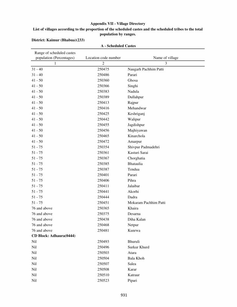
District: Kaimur (Bhabua)(233)
Range of scheduled castes
population (Percentages) Location code number Name of village
1 2 3
A - Scheduled Castes
Appendix VII - Village Directory
List of villages according to the proportion of the scheduled castes and the scheduled tribes to the total
population by ranges.
31 - 40 250475 Naugarh Pachhim Patti
31 - 40 250486 Parari
41 - 50 250360 Ghosa
41 - 50 250366 Singhi
41 - 50 250383 Nadula
41 - 50 250389 Dullahpur
41 - 50 250413 Rajpur
41 - 50 250416 Mehandwar
41 - 50 250425 Keshriganj
41 - 50 250442 Walipur
41 - 50 250455 Jagdishpur
41 - 50 250456 Majhiyawan
41 - 50 250465 Kinarchola
41 - 50 250472 Amarpur
51 - 75 250354 Shivpur Padmadehri
51 - 75 250361 Kasturi Sarai
51 - 75 250367 Chorghatia
51 - 75 250385 Bhataulia
51 - 75 250387 Tendua
51 - 75 250401 Parari
51 - 75 250406 Pihra
51 - 75 250411 Jalaibar
51 - 75 250441 Akorhi
51 - 75 250444 Dadra
51 - 75 250451 Mokaram Pachhim Patti
76 and above 250365 Khaira
76 and above 250375 Desarna
76 and above 250438 Diha Kalan
76 and above 250468 Netpur
76 and above 250481 Kunrwa
CD Block: Adhaura(0444)
Nil 250493 Bhuruli
Nil 250496 Surkur Khurd
Nil 250503 Atara
Nil 250504 Bala Khoh
Nil 250507 Salea
Nil 250508 Karar
Nil 250510 Katraur
Nil 250523 Pipari
���
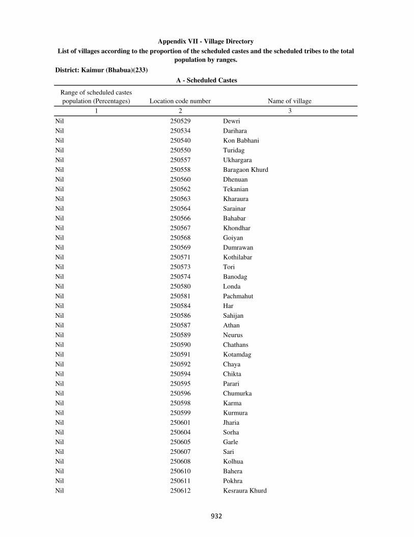
District: Kaimur (Bhabua)(233)
Range of scheduled castes
population (Percentages) Location code number Name of village
1 2 3
A - Scheduled Castes
Appendix VII - Village Directory
List of villages according to the proportion of the scheduled castes and the scheduled tribes to the total
population by ranges.
Nil 250529 Dewri
Nil 250534 Darihara
Nil 250540 Kon Babhani
Nil 250550 Turidag
Nil 250557 Ukhargara
Nil 250558 Baragaon Khurd
Nil 250560 Dhenuan
Nil 250562 Tekanian
Nil 250563 Kharaura
Nil 250564 Sarainar
Nil 250566 Bahabar
Nil 250567 Khondhar
Nil 250568 Goiyan
Nil 250569 Dumrawan
Nil 250571 Kothilabar
Nil 250573 Tori
Nil 250574 Banodag
Nil 250580 Londa
Nil 250581 Pachmahut
Nil 250584 Har
Nil 250586 Sahijan
Nil 250587 Athan
Nil 250589 Neurus
Nil 250590 Chathans
Nil 250591 Kotamdag
Nil 250592 Chaya
Nil 250594 Chikta
Nil 250595 Parari
Nil 250596 Chumurka
Nil 250598 Karma
Nil 250599 Kurmura
Nil 250601 Jharia
Nil 250604 Sorha
Nil 250605 Garle
Nil 250607 Sari
Nil 250608 Kolhua
Nil 250610 Bahera
Nil 250611 Pokhra
Nil 250612 Kesraura Khurd
���

District: Kaimur (Bhabua)(233)
Range of scheduled castes
population (Percentages) Location code number Name of village
1 2 3
A - Scheduled Castes
Appendix VII - Village Directory
List of villages according to the proportion of the scheduled castes and the scheduled tribes to the total
population by ranges.
Nil 250613 Kesraura Kalan
Nil 250615 Barikarak
Nil 250618 Salea
Less than 5 250502 Bhanrehra
Less than 5 250513 Kanhanar
Less than 5 250522 Kham Kalan
Less than 5 250526 Bargaon Kalan
Less than 5 250539 Marapa
Less than 5 250553 Adhaura
Less than 5 250556 Biduri
Less than 5 250561 Bandha
Less than 5 250576 Bahadag
Less than 5 250579 Kadhar Kalan
Less than 5 250582 Gulu
Less than 5 250585 Dugha
Less than 5 250593 Chaphana
Less than 5 250616 Sohdag
Less than 5 250617 Jordag
5 - 10 250515 Chaudharna
5 - 10 250517 Kuruwasot
5 - 10 250518 Baghauta
5 - 10 250538 Lewa
5 - 10 250541 Babhani Kalan
5 - 10 250544 Patpar
5 - 10 250555 Bardiha
5 - 10 250570 Pipra
11 - 20 250495 Sarwandag
11 - 20 250499 Kharki Khurd
11 - 20 250509 Munrehra
11 - 20 250512 Jamuninar
11 - 20 250514 Amahra
11 - 20 250520 Dighar
11 - 20 250521 Kham Khurd
11 - 20 250525 Gamharia
11 - 20 250527 Garake
11 - 20 250531 Sikari
11 - 20 250542 Rauta
11 - 20 250559 Chorpanian
11 - 20 250578 Kadhar Khurd
���
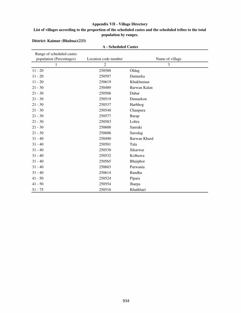
District: Kaimur (Bhabua)(233)
Range of scheduled castes
population (Percentages) Location code number Name of village
1 2 3
A - Scheduled Castes
Appendix VII - Village Directory
List of villages according to the proportion of the scheduled castes and the scheduled tribes to the total
population by ranges.
11 - 20 250588 Oldag
11 - 20 250597 Dumurka
11 - 20 250619 Khukhuman
21 - 30 250489 Barwan Kalan
21 - 30 250506 Dahar
21 - 30 250519 Dumarkon
21 - 30 250537 Harbhog
21 - 30 250548 Chanpura
21 - 30 250577 Barap
21 - 30 250583 Lohra
21 - 30 250600 Sanraki
21 - 30 250606 Sarodag
31 - 40 250490 Barwan Khurd
31 - 40 250501 Tala
31 - 40 250530 Sikarwar
31 - 40 250532 Kolhuwa
31 - 40 250565 Bhuiphor
31 - 40 250603 Parwania
31 - 40 250614 Bandha
41 - 50 250524 Pipara
41 - 50 250554 Jharpa
51 - 75 250516 Khatkhari
���
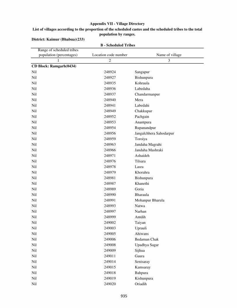
District: Kaimur (Bhabua)(233)
Range of scheduled tribes
population (percentages) Location code number Name of village
1 2 3
CD Block: Ramgarh(0434)
Nil 248924 Sangapur
Nil 248927 Bishunpura
Nil 248935 Kohraula
Nil 248936 Labedaha
Nil 248937 Chandarmanpur
Nil 248940 Mera
Nil 248941 Labedahi
Nil 248949 Chakkupur
Nil 248952 Pachgain
Nil 248953 Anantpura
Nil 248954 Rupanandpur
Nil 248956 Jangalchhera Sahodarpur
Nil 248959 Toroiya
Nil 248963 Jandaha Magrahi
Nil 248966 Jandaha Mashraki
Nil 248971 Ashaideh
Nil 248976 Tilsara
Nil 248978 Lasra
Nil 248979 Khorahra
Nil 248981 Bishunpura
Nil 248987 Khanethi
Nil 248989 Goria
Nil 248990 Bharaula
Nil 248991 Mohanpur Bharula
Nil 248993 Natwa
Nil 248997 Narhan
Nil 248999 Antdih
Nil 249002 Taiyan
Nil 249003 Uprauli
Nil 249005 Ahiwans
Nil 249006 Bedaman Chak
Nil 249008 Upadhya Sagar
Nil 249009 Sijhua
Nil 249011 Gaura
Nil 249014 Senisaray
Nil 249015 Kamsaray
Nil 249018 Bahpura
Nil 249019 Kishunpura
Nil 249020 Oriadih
B - Scheduled Tribes
Appendix VII - Village Directory
List of villages according to the proportion of the scheduled castes and the scheduled tribes to the total
population by ranges.
���
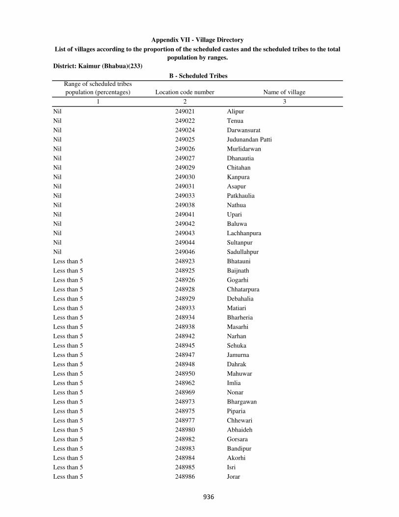
District: Kaimur (Bhabua)(233)
Range of scheduled tribes
population (percentages) Location code number Name of village
1 2 3
B - Scheduled Tribes
Appendix VII - Village Directory
List of villages according to the proportion of the scheduled castes and the scheduled tribes to the total
population by ranges.
Nil 249021 Alipur
Nil 249022 Tenua
Nil 249024 Darwansurat
Nil 249025 Judunandan Patti
Nil 249026 Murlidarwan
Nil 249027 Dhanautia
Nil 249029 Chitahan
Nil 249030 Kanpura
Nil 249031 Asapur
Nil 249033 Patkhaulia
Nil 249038 Nathua
Nil 249041 Upari
Nil 249042 Baluwa
Nil 249043 Lachhanpura
Nil 249044 Sultanpur
Nil 249046 Sadullahpur
Less than 5 248923 Bhatauni
Less than 5 248925 Baijnath
Less than 5 248926 Gogarhi
Less than 5 248928 Chhatarpura
Less than 5 248929 Debahalia
Less than 5 248933 Matiari
Less than 5 248934 Bharheria
Less than 5 248938 Masarhi
Less than 5 248942 Narhan
Less than 5 248945 Sehuka
Less than 5 248947 Jamurna
Less than 5 248948 Dahrak
Less than 5 248950 Mahuwar
Less than 5 248962 Imlia
Less than 5 248969 Nonar
Less than 5 248973 Bhargawan
Less than 5 248975 Piparia
Less than 5 248977 Chhewari
Less than 5 248980 Abhaideh
Less than 5 248982 Gorsara
Less than 5 248983 Bandipur
Less than 5 248984 Akorhi
Less than 5 248985 Isri
Less than 5 248986 Jorar
���
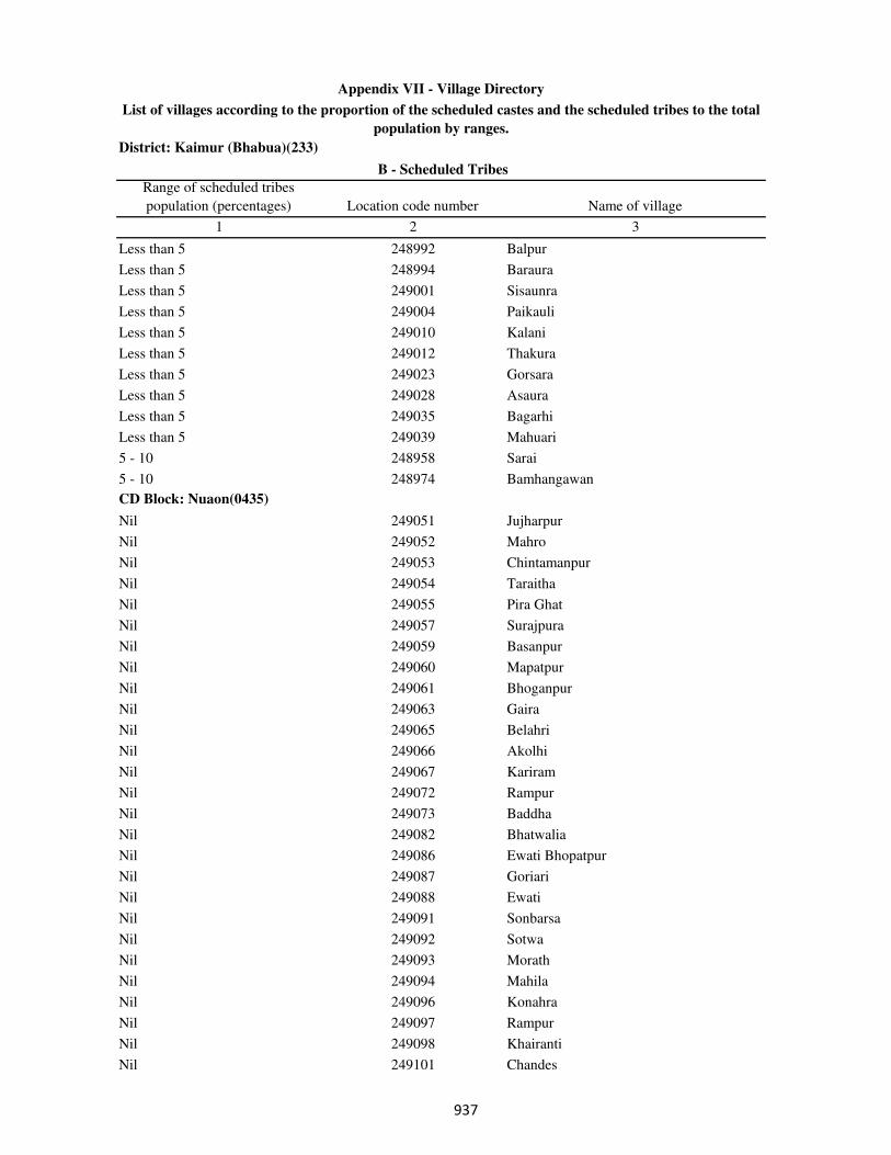
District: Kaimur (Bhabua)(233)
Range of scheduled tribes
population (percentages) Location code number Name of village
1 2 3
B - Scheduled Tribes
Appendix VII - Village Directory
List of villages according to the proportion of the scheduled castes and the scheduled tribes to the total
population by ranges.
Less than 5 248992 Balpur
Less than 5 248994 Baraura
Less than 5 249001 Sisaunra
Less than 5 249004 Paikauli
Less than 5 249010 Kalani
Less than 5 249012 Thakura
Less than 5 249023 Gorsara
Less than 5 249028 Asaura
Less than 5 249035 Bagarhi
Less than 5 249039 Mahuari
5 - 10 248958 Sarai
5 - 10 248974 Bamhangawan
CD Block: Nuaon(0435)
Nil 249051 Jujharpur
Nil 249052 Mahro
Nil 249053 Chintamanpur
Nil 249054 Taraitha
Nil 249055 Pira Ghat
Nil 249057 Surajpura
Nil 249059 Basanpur
Nil 249060 Mapatpur
Nil 249061 Bhoganpur
Nil 249063 Gaira
Nil 249065 Belahri
Nil 249066 Akolhi
Nil 249067 Kariram
Nil 249072 Rampur
Nil 249073 Baddha
Nil 249082 Bhatwalia
Nil 249086 Ewati Bhopatpur
Nil 249087 Goriari
Nil 249088 Ewati
Nil 249091 Sonbarsa
Nil 249092 Sotwa
Nil 249093 Morath
Nil 249094 Mahila
Nil 249096 Konahra
Nil 249097 Rampur
Nil 249098 Khairanti
Nil 249101 Chandes
���

District: Kaimur (Bhabua)(233)
Range of scheduled tribes
population (percentages) Location code number Name of village
1 2 3
B - Scheduled Tribes
Appendix VII - Village Directory
List of villages according to the proportion of the scheduled castes and the scheduled tribes to the total
population by ranges.
Nil 249102 Kamhari
Nil 249103 Sagra
Nil 249108 Guria
Nil 249110 Lahang Patti
Nil 249111 Kathaunra
Nil 249114 Bhatpurwa
Nil 249116 Kota Hissa
Nil 249119 Chaubepur
Nil 249122 Karamhari
Nil 249123 Parasia
Nil 249128 Dungurpura
Nil 249129 Sarbasipur
Nil 249130 Kanhua
Nil 249133 Darauli
Nil 249137 Belarhi
Nil 249138 Chandraui
Nil 249139 Gai Chakl
Nil 249140 Baruna
Less than 5 249049 Tira
Less than 5 249050 Akhani
Less than 5 249064 Mahartha
Less than 5 249068 Jaitpura
Less than 5 249070 Chhata Bararhi
Less than 5 249071 Pajrawan
Less than 5 249074 Partabpur
Less than 5 249075 Noawan
Less than 5 249076 Khudra
Less than 5 249077 Gorsara
Less than 5 249079 Chaprang
Less than 5 249083 Deuria
Less than 5 249095 Pariari
Less than 5 249104 Banbahuara
Less than 5 249106 Dumduma
Less than 5 249107 kurhani
Less than 5 249109 Mukhrawan
Less than 5 249115 kota Hissa Safdar Ali Khan
Less than 5 249121 Gaura
Less than 5 249132 Ruhiya
Less than 5 249135 Musia
Less than 5 249136 Parsotimpur
���

District: Kaimur (Bhabua)(233)
Range of scheduled tribes
population (percentages) Location code number Name of village
1 2 3
B - Scheduled Tribes
Appendix VII - Village Directory
List of villages according to the proportion of the scheduled castes and the scheduled tribes to the total
population by ranges.
5 - 10 249062 Garra
11 - 20 249069 Bararhi
CD Block: Kudra(0436)
Nil 249142 Salthua
Nil 249143 Sabdalpur
Nil 249145 Bajarha
Nil 249146 Sarmanpur
Nil 249147 Ratti Chak
Nil 249149 Silaundha
Nil 249150 Bishunpura
Nil 249151 Dangri
Nil 249152 Danrori
Nil 249153 Sasna
Nil 249154 Jagdishpur
Nil 249155 Bamhanganwan
Nil 249156 Kaithia
Nil 249161 Jalkhoria
Nil 249162 Kharahna
Nil 249164 Bhataulia
Nil 249165 Banrughat
Nil 249166 Gayghat
Nil 249167 Sarodih
Nil 249168 Dewasdehra
Nil 249169 Chhatauna
Nil 249170 Pachara
Nil 249172 Basantpur
Nil 249173 Ojhaulia
Nil 249174 Taruhan
Nil 249175 Hasanpura
Nil 249176 Burahar
Nil 249177 Turki
Nil 249178 Dumri
Nil 249181 Kandehra
Nil 249182 Phulli
Nil 249184 Saraya
Nil 249186 Chanda
Nil 249187 Siswar
Nil 249188 Bhairwa
Nil 249190 Puraini
Nil 249191 Amiaura
���

District: Kaimur (Bhabua)(233)
Range of scheduled tribes
population (percentages) Location code number Name of village
1 2 3
B - Scheduled Tribes
Appendix VII - Village Directory
List of villages according to the proportion of the scheduled castes and the scheduled tribes to the total
population by ranges.
Nil 249193 Ghari
Nil 249197 Sariawan
Nil 249199 Sonbarsa
Nil 249201 Dhaturha
Nil 249202 Bahuara
Nil 249204 Nataya
Nil 249205 Kakrahi
Nil 249206 Ajgara
Nil 249209 Ajgari
Nil 249210 Auraiya
Nil 249211 Nado Khar
Nil 249212 Sonawan
Nil 249213 Barna
Nil 249216 Bhadaula
Nil 249217 Khanethi
Nil 249219 Gangvalia
Nil 249220 Itahi
Nil 249221 Baina
Nil 249222 Kewrhi
Nil 249223 Kahua
Nil 249224 Basawanpur
Nil 249225 Bhunrwa
Nil 249227 Jaruha
Nil 249230 Gajirhan
Nil 249236 Babhanganwan
Nil 249238 Patkhaulia
Nil 249240 Nathopur
Nil 249241 Bhargawan
Nil 249244 Bajarkona
Nil 249250 Bhainsaula
Nil 249253 Dihra
Nil 249254 Golaudih
Nil 249255 Dusadhi Chak
Nil 249257 Tarhani
Nil 249259 Bagra
Nil 249262 Gurra
Nil 249263 Belbhadra
Nil 249264 Mokaram
Nil 249267 Dhanta
Nil 249268 Bishunathpur
���
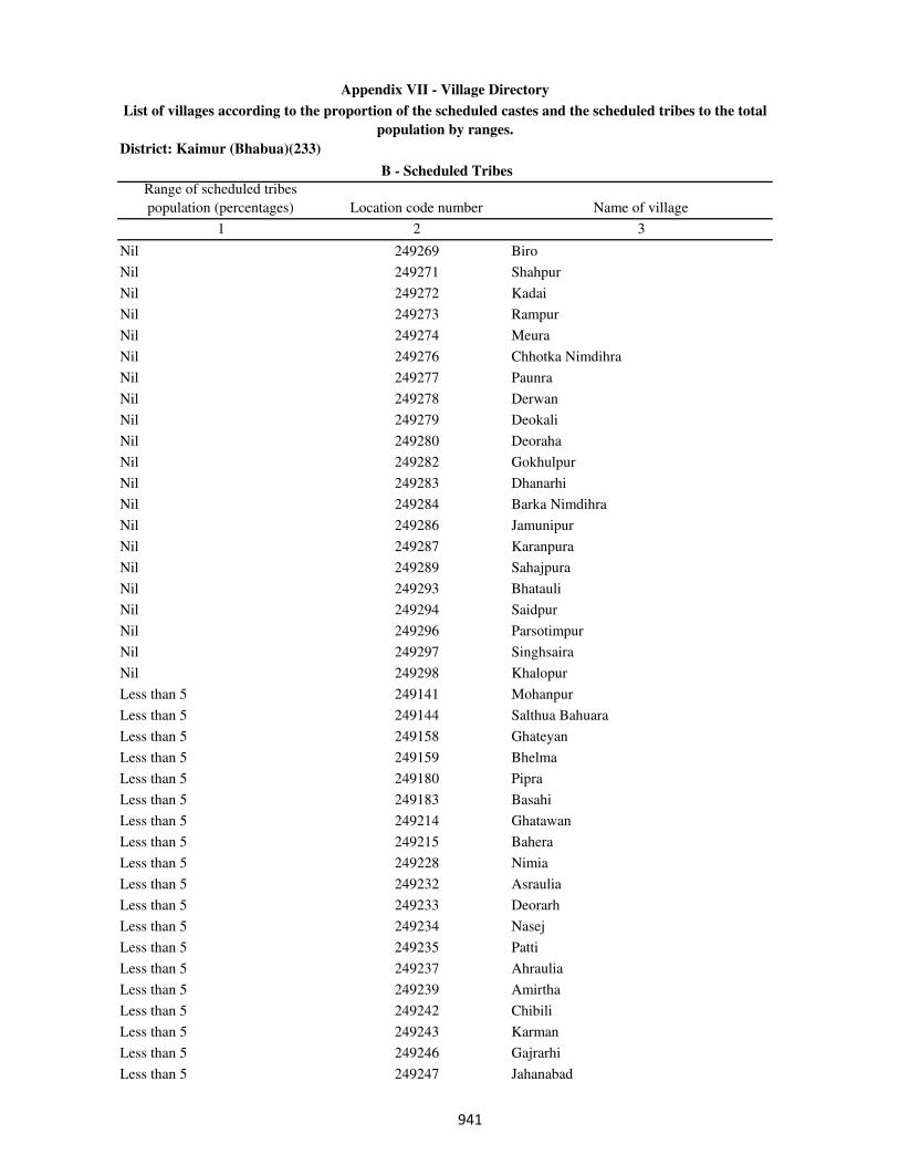
District: Kaimur (Bhabua)(233)
Range of scheduled tribes
population (percentages) Location code number Name of village
1 2 3
B - Scheduled Tribes
Appendix VII - Village Directory
List of villages according to the proportion of the scheduled castes and the scheduled tribes to the total
population by ranges.
Nil 249269 Biro
Nil 249271 Shahpur
Nil 249272 Kadai
Nil 249273 Rampur
Nil 249274 Meura
Nil 249276 Chhotka Nimdihra
Nil 249277 Paunra
Nil 249278 Derwan
Nil 249279 Deokali
Nil 249280 Deoraha
Nil 249282 Gokhulpur
Nil 249283 Dhanarhi
Nil 249284 Barka Nimdihra
Nil 249286 Jamunipur
Nil 249287 Karanpura
Nil 249289 Sahajpura
Nil 249293 Bhatauli
Nil 249294 Saidpur
Nil 249296 Parsotimpur
Nil 249297 Singhsaira
Nil 249298 Khalopur
Less than 5 249141 Mohanpur
Less than 5 249144 Salthua Bahuara
Less than 5 249158 Ghateyan
Less than 5 249159 Bhelma
Less than 5 249180 Pipra
Less than 5 249183 Basahi
Less than 5 249214 Ghatawan
Less than 5 249215 Bahera
Less than 5 249228 Nimia
Less than 5 249232 Asraulia
Less than 5 249233 Deorarh
Less than 5 249234 Nasej
Less than 5 249235 Patti
Less than 5 249237 Ahraulia
Less than 5 249239 Amirtha
Less than 5 249242 Chibili
Less than 5 249243 Karman
Less than 5 249246 Gajrarhi
Less than 5 249247 Jahanabad
��
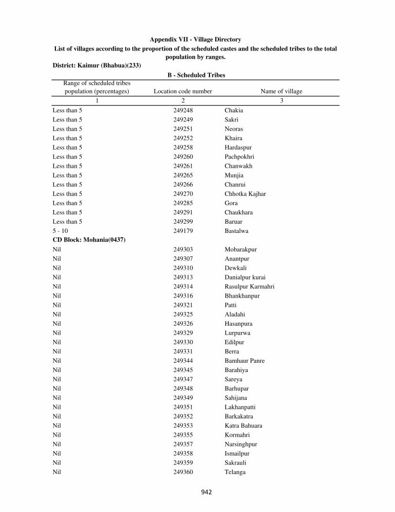
District: Kaimur (Bhabua)(233)
Range of scheduled tribes
population (percentages) Location code number Name of village
1 2 3
B - Scheduled Tribes
Appendix VII - Village Directory
List of villages according to the proportion of the scheduled castes and the scheduled tribes to the total
population by ranges.
Less than 5 249248 Chakia
Less than 5 249249 Sakri
Less than 5 249251 Neoras
Less than 5 249252 Khaira
Less than 5 249258 Hardaspur
Less than 5 249260 Pachpokhri
Less than 5 249261 Chanwakh
Less than 5 249265 Munjia
Less than 5 249266 Chanrui
Less than 5 249270 Chhotka Kajhar
Less than 5 249285 Gora
Less than 5 249291 Chaukhara
Less than 5 249299 Baruar
5 - 10 249179 Bastalwa
CD Block: Mohania(0437)
Nil 249303 Mobarakpur
Nil 249307 Anantpur
Nil 249310 Dewkali
Nil 249313 Danialpur kurai
Nil 249314 Rasulpur Karmahri
Nil 249316 Bhankhanpur
Nil 249321 Patti
Nil 249325 Aladahi
Nil 249326 Hasanpura
Nil 249329 Lurpurwa
Nil 249330 Edilpur
Nil 249331 Berra
Nil 249344 Bamhaur Panre
Nil 249345 Barahiya
Nil 249347 Sareya
Nil 249348 Barhupar
Nil 249349 Sahijana
Nil 249351 Lakhanpatti
Nil 249352 Barkakatra
Nil 249353 Katra Bahuara
Nil 249355 Kormahri
Nil 249357 Narsinghpur
Nil 249358 Ismailpur
Nil 249359 Sakrauli
Nil 249360 Telanga
��
District: Kaimur (Bhabua)(233)
Range of scheduled tribes
population (percentages) Location code number Name of village
1 2 3
B - Scheduled Tribes
Appendix VII - Village Directory
List of villages according to the proportion of the scheduled castes and the scheduled tribes to the total
population by ranges.
Nil 249361 Karsaria
Nil 249362 Kaithiya
Nil 249364 Binodpur
Nil 249365 Naraura
Nil 249366 Semaria
Nil 249367 Lahuribari
Nil 249370 Dandwas
Nil 249375 Khajhra
Nil 249376 Keshopur
Nil 249377 Chhapri
Nil 249381 Bahdura
Nil 249382 Mankawatia
Nil 249383 Bhokhari
Nil 249384 Khudar Gaura
Nil 249389 Bhirkhira
Nil 249391 Baraitha
Nil 249392 Belahri
Nil 249393 Laria
Nil 249394 Hardaspur
Nil 249395 Lorpurwa
Nil 249401 Bhagirathpur
Nil 249404 Torwa
Nil 249405 Mohammadpur
Nil 249407 Arra
Nil 249408 Panapur
Nil 249411 Patilwa
Nil 249412 Bahdura
Nil 249415 Baghni
Nil 249416 Ahinaura
Nil 249417 Turkaulia
Nil 249418 Lakhmipur
Nil 249419 Patserwa
Nil 249424 Chordehra
Nil 249425 Tikaitpur
Nil 249435 Bishunpura
Nil 249436 Dalopur
Nil 249437 Dulahpur
Nil 249438 Bahera
Nil 249439 Bhaluhi
Nil 249444 Parashurampur
���

District: Kaimur (Bhabua)(233)
Range of scheduled tribes
population (percentages) Location code number Name of village
1 2 3
B - Scheduled Tribes
Appendix VII - Village Directory
List of villages according to the proportion of the scheduled castes and the scheduled tribes to the total
population by ranges.
Nil 249445 Chandwa
Nil 249446 Panre Pipra
Nil 249447 Kabirajpur
Nil 249448 Nawagawan
Nil 249450 Dube Deharia
Nil 249452 Tiwari Deharia
Nil 249453 Panre Deharia
Nil 249454 Rampur
Nil 249455 Samahuta
Nil 249456 Khudra
Nil 249457 Jitapur
Nil 249458 Horilpur
Nil 249461 Shukul Pipra
Nil 249462 Rajpur
Nil 249463 Adhvania
Nil 249464 Misraulia
Nil 249467 Paspipra
Nil 249468 Sukhpurwa
Nil 249469 Pipra Gareri
Nil 249473 Sariawan
Nil 249474 Gheghiya
Nil 249475 Bhundi Tekari
Nil 249476 Checharia
Nil 249478 Kanhiya
Nil 249479 Barej
Nil 249481 Belaunri
Nil 249484 Tiyara
Nil 249489 Sarayan
Nil 249490 Barka Sagra
Nil 249491 Murharia
Nil 249492 Patelwa
Nil 249493 Atraulia
Nil 249494 Kewrhi
Nil 249497 Pandepur
Nil 249498 Barhuli
Nil 249499 Karigawan
Nil 249503 Shahbazpur
Nil 249504 Machhanhat
Nil 249505 Katra Arazi English
Nil 249507 Sagarpur
���

District: Kaimur (Bhabua)(233)
Range of scheduled tribes
population (percentages) Location code number Name of village
1 2 3
B - Scheduled Tribes
Appendix VII - Village Directory
List of villages according to the proportion of the scheduled castes and the scheduled tribes to the total
population by ranges.
Less than 5 249300 Piparia
Less than 5 249305 Akorhi
Less than 5 249308 Sadatpur
Less than 5 249309 Kekrha
Less than 5 249311 Mohania
Less than 5 249315 Bharkhar
Less than 5 249318 Kurra
Less than 5 249320 Doghara
Less than 5 249328 Jigina
Less than 5 249334 Akorhi
Less than 5 249340 Tulshipur
Less than 5 249343 Bamhaurkhas
Less than 5 249356 Baghni
Less than 5 249363 Chotka Katra
Less than 5 249368 Mujan
Less than 5 249373 Chhotki Kulharia
Less than 5 249374 Barki Kulharia
Less than 5 249378 Dia
Less than 5 249380 Sarai
Less than 5 249385 Gaura
Less than 5 249386 Bhatauli
Less than 5 249388 Panserwa
Less than 5 249396 Sarai
Less than 5 249398 Tekari
Less than 5 249427 Harnathpur
Less than 5 249431 Adhwar
Less than 5 249432 Sarahula
Less than 5 249441 Maricha
Less than 5 249465 Bairi
Less than 5 249466 Dadar
Less than 5 249470 Kathej
Less than 5 249472 Mamade
Less than 5 249477 Darwan
Less than 5 249480 Amarpura
Less than 5 249482 Kauriram
Less than 5 249483 Pakrihar
Less than 5 249485 Muthani
Less than 5 249486 Dewaria
Less than 5 249488 Ameth
Less than 5 249495 Mamrezpur
���
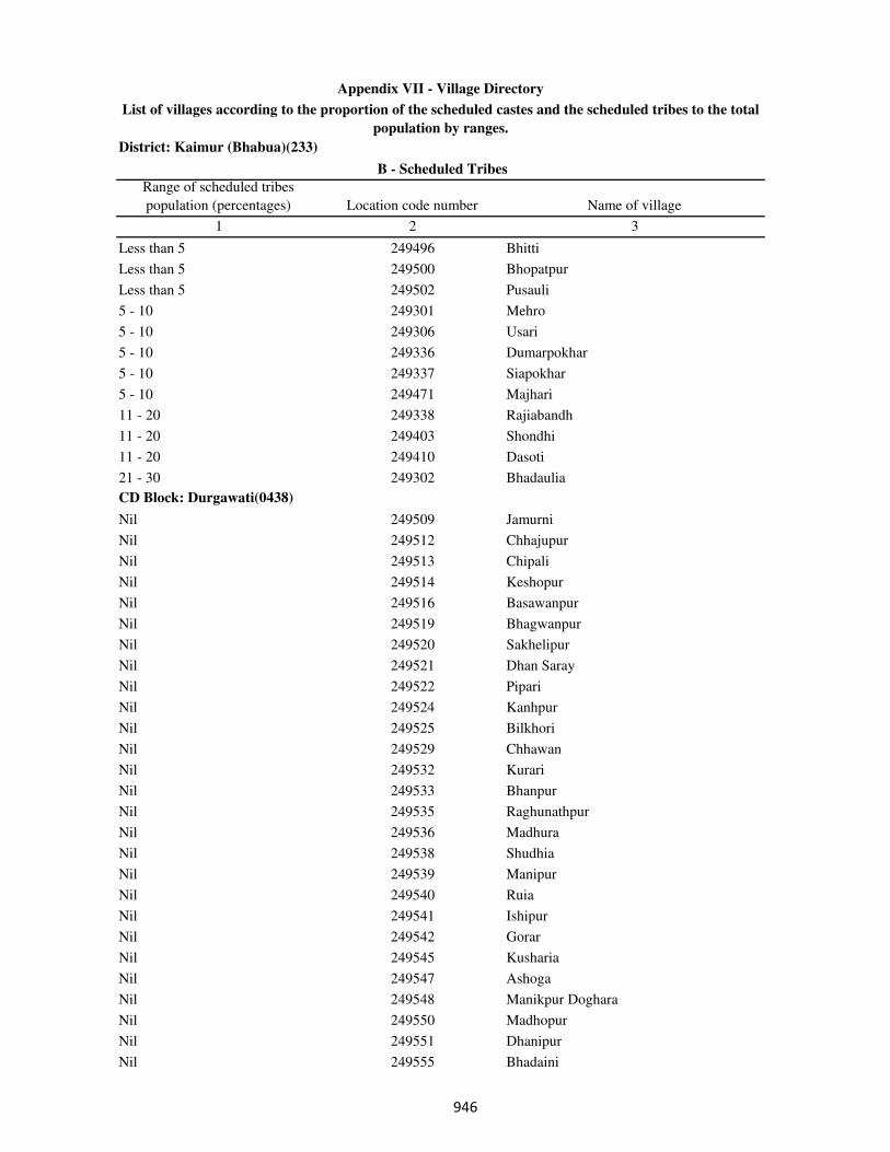
District: Kaimur (Bhabua)(233)
Range of scheduled tribes
population (percentages) Location code number Name of village
1 2 3
B - Scheduled Tribes
Appendix VII - Village Directory
List of villages according to the proportion of the scheduled castes and the scheduled tribes to the total
population by ranges.
Less than 5 249496 Bhitti
Less than 5 249500 Bhopatpur
Less than 5 249502 Pusauli
5 - 10 249301 Mehro
5 - 10 249306 Usari
5 - 10 249336 Dumarpokhar
5 - 10 249337 Siapokhar
5 - 10 249471 Majhari
11 - 20 249338 Rajiabandh
11 - 20 249403 Shondhi
11 - 20 249410 Dasoti
21 - 30 249302 Bhadaulia
CD Block: Durgawati(0438)
Nil 249509 Jamurni
Nil 249512 Chhajupur
Nil 249513 Chipali
Nil 249514 Keshopur
Nil 249516 Basawanpur
Nil 249519 Bhagwanpur
Nil 249520 Sakhelipur
Nil 249521 Dhan Saray
Nil 249522 Pipari
Nil 249524 Kanhpur
Nil 249525 Bilkhori
Nil 249529 Chhawan
Nil 249532 Kurari
Nil 249533 Bhanpur
Nil 249535 Raghunathpur
Nil 249536 Madhura
Nil 249538 Shudhia
Nil 249539 Manipur
Nil 249540 Ruia
Nil 249541 Ishipur
Nil 249542 Gorar
Nil 249545 Kusharia
Nil 249547 Ashoga
Nil 249548 Manikpur Doghara
Nil 249550 Madhopur
Nil 249551 Dhanipur
Nil 249555 Bhadaini
���

District: Kaimur (Bhabua)(233)
Range of scheduled tribes
population (percentages) Location code number Name of village
1 2 3
B - Scheduled Tribes
Appendix VII - Village Directory
List of villages according to the proportion of the scheduled castes and the scheduled tribes to the total
population by ranges.
Nil 249557 Amirti
Nil 249562 Manoharpur
Nil 249564 Itahi
Nil 249566 Dusaunti
Nil 249567 Chhata
Nil 249569 Madanpura
Nil 249570 Karari
Nil 249575 Bichhiya
Nil 249576 Asurha
Nil 249577 Tola Gopinathpur
Nil 249580 Misirpura
Nil 249581 Kalhnuan
Nil 249583 Tiari
Nil 249585 Mansurpur
Nil 249586 Kasthar
Nil 249591 Garhwa
Nil 249595 Gimhiyan
Nil 249599 Udhpura
Nil 249603 Dahiyawan
Nil 249604 Darauli
Nil 249605 Dahla
Nil 249611 Sarangpur
Less than 5 249510 Kulharia
Less than 5 249511 Larma
Less than 5 249515 Khajura
Less than 5 249517 Niazpur
Less than 5 249523 Dharhar
Less than 5 249527 Baruri
Less than 5 249537 Shohpur
Less than 5 249543 Machhanhata
Less than 5 249544 Gosaisipur
Less than 5 249546 Isari
Less than 5 249552 Sariawan
Less than 5 249553 Khamdaura
Less than 5 249554 kharkholi
Less than 5 249558 Kharsara
Less than 5 249559 Dhanichha
Less than 5 249560 Dharhara
Less than 5 249561 Rohua
Less than 5 249563 Chahria
���
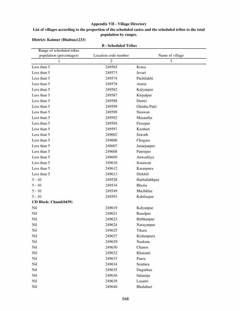
District: Kaimur (Bhabua)(233)
Range of scheduled tribes
population (percentages) Location code number Name of village
1 2 3
B - Scheduled Tribes
Appendix VII - Village Directory
List of villages according to the proportion of the scheduled castes and the scheduled tribes to the total
population by ranges.
Less than 5 249565 Kotsa
Less than 5 249573 Jevari
Less than 5 249574 Pachilakhi
Less than 5 249578 Ataria
Less than 5 249582 Kalyanpur
Less than 5 249587 Kirpalpur
Less than 5 249588 Dumri
Less than 5 249589 Ghinhu Patti
Less than 5 249590 Nuawan
Less than 5 249592 Masaurha
Less than 5 249594 Firozpur
Less than 5 249597 Kasthari
Less than 5 249602 Sawath
Less than 5 249606 Chogara
Less than 5 249607 Janarjanpur
Less than 5 249608 Panrepur
Less than 5 249609 Anwarhiya
Less than 5 249610 Sonawan
Less than 5 249612 Karanpura
Less than 5 249613 Dirkhili
5 - 10 249528 Harballabhpur
5 - 10 249534 Bheria
5 - 10 249549 Machkhia
5 - 10 249593 Kabilaspur
CD Block: Chand(0439)
Nil 249619 Kalyanpur
Nil 249621 Rasulpur
Nil 249623 Birbhanpur
Nil 249624 Narayanpur
Nil 249625 Tikara
Nil 249627 Kishunpura
Nil 249629 Naukata
Nil 249630 Chanos
Nil 249632 Kharanti
Nil 249633 Paura
Nil 249634 Sendura
Nil 249635 Duguthua
Nil 249636 Salaunja
Nil 249639 Lasanri
Nil 249640 Bhaluhari
���
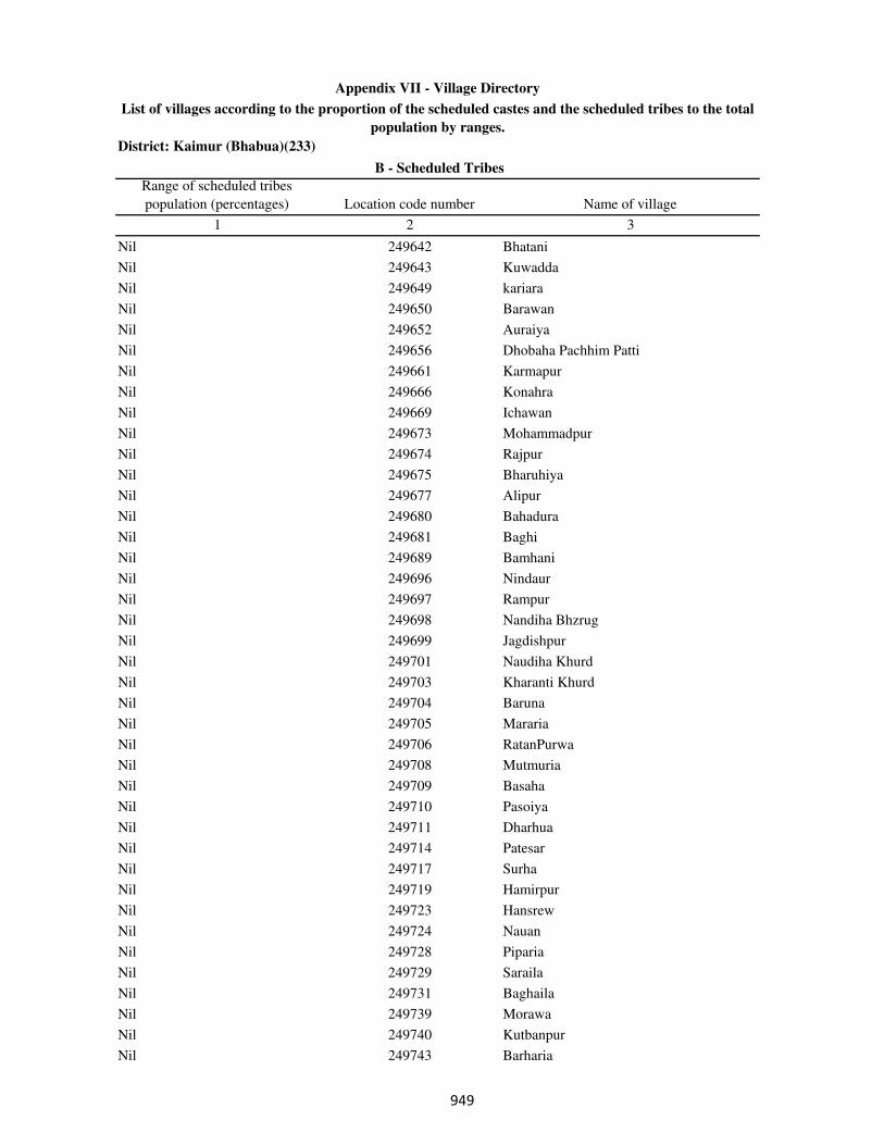
District: Kaimur (Bhabua)(233)
Range of scheduled tribes
population (percentages) Location code number Name of village
1 2 3
B - Scheduled Tribes
Appendix VII - Village Directory
List of villages according to the proportion of the scheduled castes and the scheduled tribes to the total
population by ranges.
Nil 249642 Bhatani
Nil 249643 Kuwadda
Nil 249649 kariara
Nil 249650 Barawan
Nil 249652 Auraiya
Nil 249656 Dhobaha Pachhim Patti
Nil 249661 Karmapur
Nil 249666 Konahra
Nil 249669 Ichawan
Nil 249673 Mohammadpur
Nil 249674 Rajpur
Nil 249675 Bharuhiya
Nil 249677 Alipur
Nil 249680 Bahadura
Nil 249681 Baghi
Nil 249689 Bamhani
Nil 249696 Nindaur
Nil 249697 Rampur
Nil 249698 Nandiha Bhzrug
Nil 249699 Jagdishpur
Nil 249701 Naudiha Khurd
Nil 249703 Kharanti Khurd
Nil 249704 Baruna
Nil 249705 Mararia
Nil 249706 RatanPurwa
Nil 249708 Mutmuria
Nil 249709 Basaha
Nil 249710 Pasoiya
Nil 249711 Dharhua
Nil 249714 Patesar
Nil 249717 Surha
Nil 249719 Hamirpur
Nil 249723 Hansrew
Nil 249724 Nauan
Nil 249728 Piparia
Nil 249729 Saraila
Nil 249731 Baghaila
Nil 249739 Morawa
Nil 249740 Kutbanpur
Nil 249743 Barharia
���
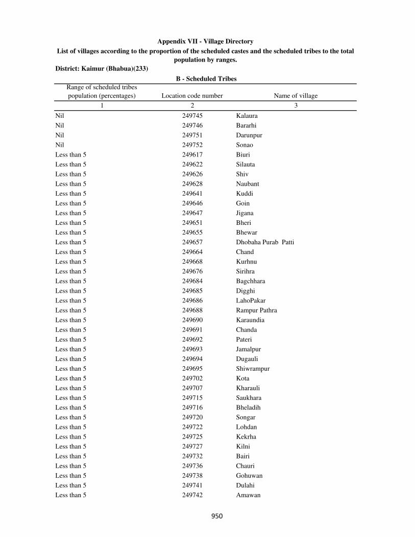
District: Kaimur (Bhabua)(233)
Range of scheduled tribes
population (percentages) Location code number Name of village
1 2 3
B - Scheduled Tribes
Appendix VII - Village Directory
List of villages according to the proportion of the scheduled castes and the scheduled tribes to the total
population by ranges.
Nil 249745 Kalaura
Nil 249746 Bararhi
Nil 249751 Darunpur
Nil 249752 Sonao
Less than 5 249617 Biuri
Less than 5 249622 Silauta
Less than 5 249626 Shiv
Less than 5 249628 Naubant
Less than 5 249641 Kuddi
Less than 5 249646 Goin
Less than 5 249647 Jigana
Less than 5 249651 Bheri
Less than 5 249655 Bhewar
Less than 5 249657 Dhobaha Purab Patti
Less than 5 249664 Chand
Less than 5 249668 Kurhnu
Less than 5 249676 Sirihra
Less than 5 249684 Bagchhara
Less than 5 249685 Digghi
Less than 5 249686 LahoPakar
Less than 5 249688 Rampur Pathra
Less than 5 249690 Karaundia
Less than 5 249691 Chanda
Less than 5 249692 Pateri
Less than 5 249693 Jamalpur
Less than 5 249694 Dugauli
Less than 5 249695 Shiwrampur
Less than 5 249702 Kota
Less than 5 249707 Kharauli
Less than 5 249715 Saukhara
Less than 5 249716 Bheladih
Less than 5 249720 Songar
Less than 5 249722 Lohdan
Less than 5 249725 Kekrha
Less than 5 249727 Kilni
Less than 5 249732 Bairi
Less than 5 249736 Chauri
Less than 5 249738 Gohuwan
Less than 5 249741 Dulahi
Less than 5 249742 Amawan
���
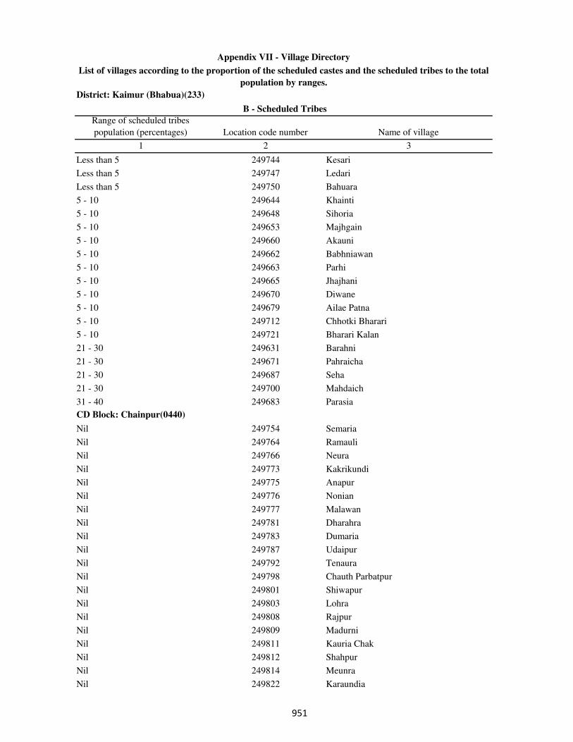
District: Kaimur (Bhabua)(233)
Range of scheduled tribes
population (percentages) Location code number Name of village
1 2 3
B - Scheduled Tribes
Appendix VII - Village Directory
List of villages according to the proportion of the scheduled castes and the scheduled tribes to the total
population by ranges.
Less than 5 249744 Kesari
Less than 5 249747 Ledari
Less than 5 249750 Bahuara
5 - 10 249644 Khainti
5 - 10 249648 Sihoria
5 - 10 249653 Majhgain
5 - 10 249660 Akauni
5 - 10 249662 Babhniawan
5 - 10 249663 Parhi
5 - 10 249665 Jhajhani
5 - 10 249670 Diwane
5 - 10 249679 Ailae Patna
5 - 10 249712 Chhotki Bharari
5 - 10 249721 Bharari Kalan
21 - 30 249631 Barahni
21 - 30 249671 Pahraicha
21 - 30 249687 Seha
21 - 30 249700 Mahdaich
31 - 40 249683 Parasia
CD Block: Chainpur(0440)
Nil 249754 Semaria
Nil 249764 Ramauli
Nil 249766 Neura
Nil 249773 Kakrikundi
Nil 249775 Anapur
Nil 249776 Nonian
Nil 249777 Malawan
Nil 249781 Dharahra
Nil 249783 Dumaria
Nil 249787 Udaipur
Nil 249792 Tenaura
Nil 249798 Chauth Parbatpur
Nil 249801 Shiwapur
Nil 249803 Lohra
Nil 249808 Rajpur
Nil 249809 Madurni
Nil 249811 Kauria Chak
Nil 249812 Shahpur
Nil 249814 Meunra
Nil 249822 Karaundia
��
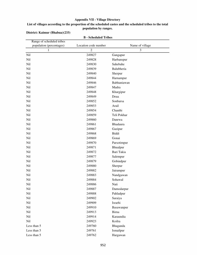
District: Kaimur (Bhabua)(233)
Range of scheduled tribes
population (percentages) Location code number Name of village
1 2 3
B - Scheduled Tribes
Appendix VII - Village Directory
List of villages according to the proportion of the scheduled castes and the scheduled tribes to the total
population by ranges.
Nil 249827 Gangapur
Nil 249828 Harbanspur
Nil 249830 Sahebahe
Nil 249839 Balubheria
Nil 249840 Sherpur
Nil 249844 Harnampur
Nil 249846 Babhaniawan
Nil 249847 Madra
Nil 249848 Khargipur
Nil 249849 Deua
Nil 249852 Sonbarsa
Nil 249853 Arail
Nil 249854 Chauthi
Nil 249859 Teli Pokhar
Nil 249860 Danrwa
Nil 249861 Bhadaura
Nil 249867 Gazipur
Nil 249868 Biddi
Nil 249869 Gonai
Nil 249870 Parsotimpur
Nil 249871 Bhualpur
Nil 249872 Bari Takia
Nil 249877 Salempur
Nil 249879 Gobindpur
Nil 249880 Sherpur
Nil 249882 Jairampur
Nil 249883 Nandgawan
Nil 249884 Sohawal
Nil 249886 Nati
Nil 249887 Damodarpur
Nil 249888 Pahladpur
Nil 249902 Saraiya
Nil 249909 Israrhi
Nil 249910 Basawanpur
Nil 249913 Birna
Nil 249914 Karaundia
Nil 249923 Koilra
Less than 5 249760 Bhaganda
Less than 5 249761 Ismailpur
Less than 5 249762 Hargawan
��
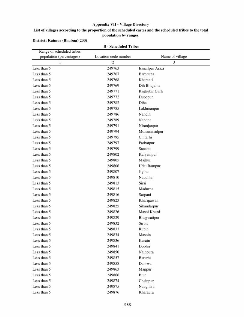
District: Kaimur (Bhabua)(233)
Range of scheduled tribes
population (percentages) Location code number Name of village
1 2 3
B - Scheduled Tribes
Appendix VII - Village Directory
List of villages according to the proportion of the scheduled castes and the scheduled tribes to the total
population by ranges.
Less than 5 249763 Ismailpur Arazi
Less than 5 249767 Barhauna
Less than 5 249768 Kharanti
Less than 5 249769 Dih Bhujaina
Less than 5 249771 Raghubir Garh
Less than 5 249772 Dubepur
Less than 5 249782 Diha
Less than 5 249785 Lakhmanpur
Less than 5 249786 Nandih
Less than 5 249789 Nandna
Less than 5 249791 Niranjanpur
Less than 5 249794 Mohammadpur
Less than 5 249795 Chitarhi
Less than 5 249797 Parbatpur
Less than 5 249799 Sanabo
Less than 5 249802 Kalyanipur
Less than 5 249805 Majhui
Less than 5 249806 Udai Rampur
Less than 5 249807 Jigina
Less than 5 249810 Naudiha
Less than 5 249813 Sirsi
Less than 5 249815 Madurna
Less than 5 249816 Sarpani
Less than 5 249823 Kharigawan
Less than 5 249825 Sikandarpur
Less than 5 249826 Masoi Khurd
Less than 5 249829 Bhagwatipur
Less than 5 249832 Sirbit
Less than 5 249833 Rupin
Less than 5 249834 Masoin
Less than 5 249836 Kurain
Less than 5 249841 Dobhri
Less than 5 249850 Nainpura
Less than 5 249857 Bararhi
Less than 5 249858 Danrwa
Less than 5 249863 Manpur
Less than 5 249866 Biur
Less than 5 249874 Chainpur
Less than 5 249875 Naughara
Less than 5 249876 Kharaura
���

District: Kaimur (Bhabua)(233)
Range of scheduled tribes
population (percentages) Location code number Name of village
1 2 3
B - Scheduled Tribes
Appendix VII - Village Directory
List of villages according to the proportion of the scheduled castes and the scheduled tribes to the total
population by ranges.
Less than 5 249878 Isapur
Less than 5 249881 Lohra
Less than 5 249890 Jagaria
Less than 5 249891 Sherpur
Less than 5 249897 Kewa
Less than 5 249900 Baurai
Less than 5 249901 Gangudih
Less than 5 249903 Khoradih
Less than 5 249904 Nimiatanr
Less than 5 249907 Parsia
Less than 5 249911 Chanda
Less than 5 249916 Bhaluburan
5 - 10 249756 Koindi
5 - 10 249758 Ghanti
5 - 10 249774 Bardiha
5 - 10 249788 Shukulpur
5 - 10 249817 Hata
5 - 10 249820 Tiwai
5 - 10 249821 Lodipur
5 - 10 249824 Awnkhara
5 - 10 249831 Amawan
5 - 10 249837 Karjav
5 - 10 249838 Karji
5 - 10 249855 Isia
5 - 10 249862 Fakhrabad
5 - 10 249864 Muri
5 - 10 249873 Maliksaray
5 - 10 249885 Rupa Patti
5 - 10 249889 Bhagwanpur
5 - 10 249892 Dulahra
5 - 10 249898 Mahula
11 - 20 249759 Ramgarh
11 - 20 249793 Merh
11 - 20 249896 Narsinghpur
11 - 20 249912 Sihora
21 - 30 249818 Saraiya
21 - 30 249917 Karkatgarh
21 - 30 249919 Kamharia
21 - 30 249921 Mahuli
31 - 40 249920 Jharia
���

District: Kaimur (Bhabua)(233)
Range of scheduled tribes
population (percentages) Location code number Name of village
1 2 3
B - Scheduled Tribes
Appendix VII - Village Directory
List of villages according to the proportion of the scheduled castes and the scheduled tribes to the total
population by ranges.
31 - 40 249924 Dumarkon
31 - 40 249926 Semra
41 - 50 249915 Majhganwan
51 - 75 249843 Neura
51 - 75 249918 Gosara
51 - 75 249922 Masani
51 - 75 249929 Dhumardeo
51 - 75 249930 Bhaganda
76 and above 249925 Harsoti
76 and above 249927 Baghaila
76 and above 249928 Asanda
CD Block: Bhabua(0441)
Nil 249932 Nibi
Nil 249934 Narotapur
Nil 249935 Amraha
Nil 249938 Katra
Nil 249940 Burhwalia
Nil 249941 Manihari
Nil 249947 Bagahi
Nil 249951 Karmi Chak
Nil 249953 Khaira Khurd
Nil 249954 Khaira
Nil 249957 Mithapur
Nil 249961 Damodarpur
Nil 249963 Doghra
Nil 249968 Mamhan
Nil 249970 Sedra Nisf
Nil 249971 Sedra
Nil 249972 Auraiya Dei
Nil 249973 Auraiya Dewa
Nil 249980 Bithalpur
Nil 249981 Dewarji Khurd
Nil 249984 Manikpur
Nil 249985 Gopalpur
Nil 249987 Nonra
Nil 249989 Uphraurlia
Nil 249997 Dharhanian
Nil 250001 Shiw Patti
Nil 250002 Danrwa
Nil 250004 Sudarsanpur
���
District: Kaimur (Bhabua)(233)
Range of scheduled tribes
population (percentages) Location code number Name of village
1 2 3
B - Scheduled Tribes
Appendix VII - Village Directory
List of villages according to the proportion of the scheduled castes and the scheduled tribes to the total
population by ranges.
Nil 250006 Semaria
Nil 250007 Dharampura
Nil 250008 Shiwpur
Nil 250018 Karman
Nil 250020 Ghurde Dehra
Nil 250021 Harnatanr
Nil 250024 Amarhi
Nil 250025 Jadupur
Nil 250026 Sikra
Nil 250033 Pangaiyan
Nil 250036 Khaira
Nil 250038 Silauta
Nil 250040 Hasanpura
Nil 250041 Kori
Nil 250046 Mohammadpur
Nil 250063 Kolaunj
Nil 250066 Checharia
Nil 250067 Semaria
Nil 250069 Silri
Nil 250070 Barigawan
Nil 250071 Birbhanpur
Nil 250073 Kusdihra
Nil 250074 Dalippur
Nil 250077 Nibi Khurd
Nil 250078 Nibi Kalan
Nil 250083 Kishunpura
Nil 250090 Banjaria
Nil 250092 Kamti
Nil 250094 Maldah
Nil 250095 Jalalpur
Nil 250096 Jhigridehra
Nil 250103 Tiaraghat
Nil 250104 Manpur
Nil 250106 Rampur
Nil 250107 Panchi
Nil 250111 Patti
Nil 250113 Doghra
Nil 250114 Khanethi
Nil 250115 Hathiabandh
Nil 250116 Bisunpura
���
District: Kaimur (Bhabua)(233)
Range of scheduled tribes
population (percentages) Location code number Name of village
1 2 3
B - Scheduled Tribes
Appendix VII - Village Directory
List of villages according to the proportion of the scheduled castes and the scheduled tribes to the total
population by ranges.
Nil 250117 Bhainslot
Nil 250123 Kathaura
Nil 250124 Bahuwara
Nil 250126 Narayanpur
Nil 250127 Basgitia
Nil 250128 Khanethi Gurdas
Nil 250129 Parmalpur
Nil 250130 Rampur
Nil 250131 Saunrudih
Nil 250133 Kanpara
Nil 250134 Miria
Nil 250136 Chhotkakir
Nil 250137 Barkakir
Nil 250138 Tamarh
Nil 250139 Rampur
Nil 250141 Tamarhi
Nil 250142 Kamalpur
Nil 250146 Ganwan
Nil 250148 Khajuria Khurd
Nil 250150 Barahuli
Nil 250151 Paranpur
Nil 250152 Dhonrhi
Nil 250154 Beguda
Nil 250155 Mahuwari
Nil 250156 Harnathpur
Nil 250157 Nimi
Nil 250158 Jagdishpur
Nil 250159 Sagar
Nil 250160 Sathri
Nil 250161 Semra
Nil 250162 Manikpur
Nil 250163 Sadekawai
Nil 250164 Harla
Nil 250165 Rawan
Nil 250166 Rehi
Nil 250167 Baghi
Nil 250169 Jage Barawan
Nil 250171 Karaundi
Nil 250172 Paiyan
Nil 250175 Chhotka Deharma
���
District: Kaimur (Bhabua)(233)
Range of scheduled tribes
population (percentages) Location code number Name of village
1 2 3
B - Scheduled Tribes
Appendix VII - Village Directory
List of villages according to the proportion of the scheduled castes and the scheduled tribes to the total
population by ranges.
Nil 250177 Tarhani
Nil 250179 Kawai
Nil 250180 Akorhi
Nil 250185 Ekauni
Nil 250187 Khaira
Nil 250190 Balua
Nil 250191 Alipur
Nil 250192 Sandalpur
Nil 250194 Semaria
Nil 250198 Shukulpurwa
Nil 250201 Charki English
Nil 250203 Barka Danrowan
Nil 250204 Dubauli
Nil 250207 Parasrampur
Nil 250208 Belkatra
Nil 250209 Lilapur
Nil 250212 Nawagawan
Nil 250214 Semra
Nil 250215 Dharwar
Less than 5 249931 Baruna
Less than 5 249937 Khanawan
Less than 5 249942 Goraipur
Less than 5 249943 Hariharpur
Less than 5 249945 Shahpur
Less than 5 249946 Rampur
Less than 5 249949 Mirchawan
Less than 5 249950 Darauli
Less than 5 249952 Kohari
Less than 5 249959 Denawan
Less than 5 249960 Jigni
Less than 5 249962 Dumraith
Less than 5 249964 Naktaul
Less than 5 249966 Bhadari
Less than 5 249967 Narawan
Less than 5 249974 Dabrahiya
Less than 5 249977 Jamuawan
Less than 5 249978 Mahsua
Less than 5 249979 Sarewa
Less than 5 249988 Kurasan
Less than 5 249990 Betri
���

District: Kaimur (Bhabua)(233)
Range of scheduled tribes
population (percentages) Location code number Name of village
1 2 3
B - Scheduled Tribes
Appendix VII - Village Directory
List of villages according to the proportion of the scheduled castes and the scheduled tribes to the total
population by ranges.
Less than 5 249994 Palka
Less than 5 249996 Gorhan
Less than 5 250000 Siu
Less than 5 250005 Saitha
Less than 5 250011 Bhokhri
Less than 5 250013 Sijhwa
Less than 5 250016 Bhokhra
Less than 5 250017 Sapnautia
Less than 5 250029 Kukrarh
Less than 5 250030 Sekhwa
Less than 5 250031 Pachgawan
Less than 5 250043 Babura
Less than 5 250044 Ikhlaspur
Less than 5 250045 Sikthi
Less than 5 250047 Bhekas
Less than 5 250050 Datiawan
Less than 5 250051 Kawar
Less than 5 250056 Naua Jhoti
Less than 5 250060 Dumri
Less than 5 250062 Chandoraiya
Less than 5 250072 Bharigawan
Less than 5 250076 Shiwpur
Less than 5 250082 Ratwar
Less than 5 250084 Sondihra
Less than 5 250091 Parasia
Less than 5 250097 Sikthiujari
Less than 5 250099 Kamta
Less than 5 250101 Machiawan
Less than 5 250105 Asrarhi
Less than 5 250110 Kaithi
Less than 5 250112 Nati
Less than 5 250118 Bahuwan
Less than 5 250122 Bahera
Less than 5 250135 Saraiya
Less than 5 250153 Manchahalpur
Less than 5 250170 Khurmabad
Less than 5 250174 Barka Deharma
Less than 5 250176 Kukurhi
Less than 5 250181 Wadar
Less than 5 250182 Belarhi
���
District: Kaimur (Bhabua)(233)
Range of scheduled tribes
population (percentages) Location code number Name of village
1 2 3
B - Scheduled Tribes
Appendix VII - Village Directory
List of villages according to the proportion of the scheduled castes and the scheduled tribes to the total
population by ranges.
Less than 5 250183 Mahuat
Less than 5 250184 Madanpura
Less than 5 250188 Barka Kajhar
Less than 5 250189 Pian
Less than 5 250193 Amrha
Less than 5 250195 Pokhara
Less than 5 250199 Chitarhi
Less than 5 250210 Miun Sukharipur
Less than 5 250211 Rudarwar Kalan
5 - 10 249939 Umarpur
5 - 10 249944 Ruppur
5 - 10 249993 Mokri
5 - 10 249998 Sarangpur
5 - 10 249999 Dumdum
5 - 10 250003 Khadaura
5 - 10 250042 Madhupur
5 - 10 250052 Akri
5 - 10 250058 Daridih
5 - 10 250059 Ruiya
5 - 10 250061 Kunj
5 - 10 250064 Baheri
5 - 10 250086 Bare
5 - 10 250089 Dihra
5 - 10 250143 Sonhan
11 - 20 249936 Bithwar
11 - 20 249986 Dewarji Kalan
11 - 20 250049 Semaria
11 - 20 250054 Shiwpura
11 - 20 250100 Itarhi
CD Block: Rampur(0442)
Nil 250218 Gamharia
Nil 250219 Sonbarsa
Nil 250220 Patna
Nil 250221 Panail English
Nil 250223 Kargain
Nil 250229 Kukurha
Nil 250231 Dubauli
Nil 250233 Shivpur
Nil 250234 Tenua
Nil 250239 Nisja
���
District: Kaimur (Bhabua)(233)
Range of scheduled tribes
population (percentages) Location code number Name of village
1 2 3
B - Scheduled Tribes
Appendix VII - Village Directory
List of villages according to the proportion of the scheduled castes and the scheduled tribes to the total
population by ranges.
Nil 250240 Pali
Nil 250241 Majhaganwan
Nil 250246 Maheshpur
Nil 250250 Dubauli
Nil 250252 Basni
Nil 250253 Gangapur
Nil 250254 Chanrudean
Nil 250256 Tetihan
Nil 250258 Itawan
Nil 250259 Sonara
Nil 250260 Karaunda
Nil 250262 Rampur
Nil 250263 Basuhari
Nil 250264 Chamariawan
Nil 250266 Ekauni
Nil 250267 Gonupur
Nil 250268 Bahera
Nil 250272 Maidanr Khurd
Nil 250273 Maidanr Kalan
Nil 250274 Kudarwar Khurd
Nil 250275 Pasain
Nil 250276 Nirbispur
Nil 250279 Bichhiya
Nil 250281 Majhiyawan
Nil 250282 Tarawan
Nil 250283 Kharenda
Nil 250286 Punawan
Nil 250287 Sonawan Purab Patti
Nil 250288 Sonawan Pachhim Patti
Nil 250291 Hunadari
Nil 250294 Nauhatta
Nil 250295 Ahirawan
Nil 250297 Hundara
Nil 250299 Jagmohna
Nil 250301 Baheri
Nil 250304 Uphrauli
Nil 250306 Lohandi
Nil 250310 Jhalkhora
Nil 250311 Rampur
Nil 250315 Baghi
��
District: Kaimur (Bhabua)(233)
Range of scheduled tribes
population (percentages) Location code number Name of village
1 2 3
B - Scheduled Tribes
Appendix VII - Village Directory
List of villages according to the proportion of the scheduled castes and the scheduled tribes to the total
population by ranges.
Nil 250317 Panrepur
Nil 250318 Majhiawan
Nil 250322 Dariawan
Nil 250324 Maraicha
Nil 250325 Salempur
Nil 250326 Maraicha
Nil 250328 Diyari
Nil 250331 Hasanpura
Nil 250332 Lewa
Nil 250334 Admapur
Nil 250341 Dhanawal
Nil 250343 Rajadeo
Nil 250345 Bhitribandh
Nil 250346 Nawadih
Less than 5 250224 Barkagawan
Less than 5 250227 Nawadih
Less than 5 250230 Thiloin
Less than 5 250232 Siswar
Less than 5 250235 Dhaupokhar
Less than 5 250236 Kurari
Less than 5 250242 Jalalpur
Less than 5 250243 Bhaluhan
Less than 5 250245 Lilli
Less than 5 250249 Damodarpur
Less than 5 250257 Akorhi
Less than 5 250261 Belawan
Less than 5 250269 Madhopur
Less than 5 250277 Khajura
Less than 5 250278 Sonbarsa
Less than 5 250284 Bhorean
Less than 5 250289 Harjipur
Less than 5 250292 Uchanar
Less than 5 250296 Hundara
Less than 5 250300 Chanki
Less than 5 250302 Pachhehra
Less than 5 250307 Thakurhat
Less than 5 250309 Bijra
Less than 5 250312 Sawar
Less than 5 250314 Bazidpur
Less than 5 250316 Jhali
��

District: Kaimur (Bhabua)(233)
Range of scheduled tribes
population (percentages) Location code number Name of village
1 2 3
B - Scheduled Tribes
Appendix VII - Village Directory
List of villages according to the proportion of the scheduled castes and the scheduled tribes to the total
population by ranges.
Less than 5 250321 Barli
Less than 5 250327 Arnawan
Less than 5 250329 Lakhandahi
Less than 5 250336 Barawan
5 - 10 250330 Lalapur
5 - 10 250339 Bakharam
11 - 20 250251 Banauli
11 - 20 250280 Kurtha
11 - 20 250293 Panapur
21 - 30 250340 Baradih
51 - 75 250352 Karamchat
CD Block: Bhagwanpur(0443)
Nil 250358 Kunrwa
Nil 250360 Ghosa
Nil 250361 Kasturi Sarai
Nil 250363 Lahra
Nil 250365 Khaira
Nil 250366 Singhi
Nil 250368 Matar
Nil 250371 Dhangarha
Nil 250373 Marari
Nil 250376 Kishunapur
Nil 250380 Radha khanr
Nil 250381 Basantpur
Nil 250382 Reghiya
Nil 250383 Nadula
Nil 250385 Bhataulia
Nil 250386 Nimian
Nil 250387 Tendua
Nil 250388 Kathaura Khamari
Nil 250389 Dullahpur
Nil 250392 Jaitpur Kohna
Nil 250393 Jaitpur Khurd
Nil 250394 Sabai Kundi
Nil 250396 Debra
Nil 250398 Nawagawan
Nil 250399 Darra
Nil 250400 Bahuri
Nil 250402 Tekra
Nil 250404 Dhekahri
���
District: Kaimur (Bhabua)(233)
Range of scheduled tribes
population (percentages) Location code number Name of village
1 2 3
B - Scheduled Tribes
Appendix VII - Village Directory
List of villages according to the proportion of the scheduled castes and the scheduled tribes to the total
population by ranges.
Nil 250406 Pihra
Nil 250410 Dhekahri
Nil 250411 Jalaibar
Nil 250414 Bhaluhi
Nil 250421 Manikpur
Nil 250422 Khiri
Nil 250426 Bhaisahi
Nil 250430 Gaura
Nil 250431 Chholhat Sajanwa
Nil 250438 Diha Kalan
Nil 250439 Ausan
Nil 250441 Akorhi
Nil 250442 Walipur
Nil 250443 Henauta
Nil 250445 Bahoranpur
Nil 250449 Sareyan
Nil 250453 Sariawan
Nil 250454 Patriha
Nil 250455 Jagdishpur
Nil 250465 Kinarchola
Nil 250467 Kunrwa
Nil 250468 Netpur
Nil 250469 Ramawatpur
Nil 250470 Khardiha
Nil 250471 Bucha
Nil 250473 Dharchali
Nil 250481 Kunrwa
Nil 250482 Rajbandhwa
Nil 250484 Paunra
Less than 5 250354 Shivpur Padmadehri
Less than 5 250355 Ora
Less than 5 250356 Katkara
Less than 5 250359 Chakedehra
Less than 5 250364 Dubauli
Less than 5 250367 Chorghatia
Less than 5 250370 Umapur
Less than 5 250372 Tori
Less than 5 250375 Desarna
Less than 5 250384 Urgawan
Less than 5 250395 Arari
���
District: Kaimur (Bhabua)(233)
Range of scheduled tribes
population (percentages) Location code number Name of village
1 2 3
B - Scheduled Tribes
Appendix VII - Village Directory
List of villages according to the proportion of the scheduled castes and the scheduled tribes to the total
population by ranges.
Less than 5 250401 Parari
Less than 5 250405 Urgain
Less than 5 250407 Mirchi
Less than 5 250409 Kaser
Less than 5 250413 Rajpur
Less than 5 250416 Mehandwar
Less than 5 250418 Gobrachh
Less than 5 250419 Parhauti
Less than 5 250420 Parmalpur
Less than 5 250424 Bhagwanpur
Less than 5 250429 Saraiya
Less than 5 250432 Paharia
Less than 5 250433 Shahpur
Less than 5 250440 Bhairapur
Less than 5 250444 Dadra
Less than 5 250447 Kochari
Less than 5 250448 Kusdehra
Less than 5 250450 Mokaram Purab Patti
Less than 5 250451 Mokaram Pachhim Patti
Less than 5 250460 Nawanagar
Less than 5 250466 Jaitpur Kalan
Less than 5 250472 Amarpur
Less than 5 250474 Damarpur
Less than 5 250475 Naugarh Pachhim Patti
Less than 5 250476 Naugarh Purab Patti
Less than 5 250480 Ramgarh
Less than 5 250487 Chuan
5 - 10 250425 Keshriganj
5 - 10 250436 Nibi
5 - 10 250456 Majhiyawan
5 - 10 250461 Beldih
11 - 20 250415 Urgain
11 - 20 250427 Masahi
11 - 20 250458 Dawanpur
11 - 20 250462 Bakharhandh
11 - 20 250485 Bajardihwa
21 - 30 250486 Parari
31 - 40 250479 Makrikhoh
76 and above 250488 Bhurkura
CD Block: Adhaura(0444)
���
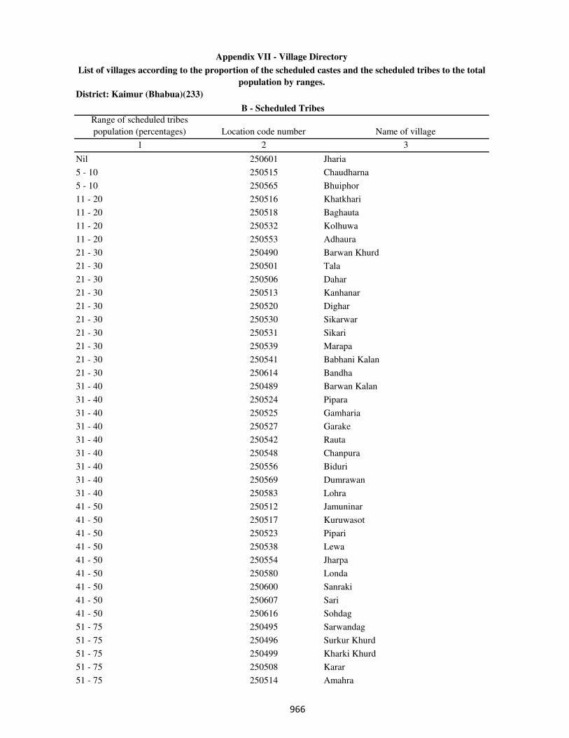
District: Kaimur (Bhabua)(233)
Range of scheduled tribes
population (percentages) Location code number Name of village
1 2 3
B - Scheduled Tribes
Appendix VII - Village Directory
List of villages according to the proportion of the scheduled castes and the scheduled tribes to the total
population by ranges.
Nil 250601 Jharia
5 - 10 250515 Chaudharna
5 - 10 250565 Bhuiphor
11 - 20 250516 Khatkhari
11 - 20 250518 Baghauta
11 - 20 250532 Kolhuwa
11 - 20 250553 Adhaura
21 - 30 250490 Barwan Khurd
21 - 30 250501 Tala
21 - 30 250506 Dahar
21 - 30 250513 Kanhanar
21 - 30 250520 Dighar
21 - 30 250530 Sikarwar
21 - 30 250531 Sikari
21 - 30 250539 Marapa
21 - 30 250541 Babhani Kalan
21 - 30 250614 Bandha
31 - 40 250489 Barwan Kalan
31 - 40 250524 Pipara
31 - 40 250525 Gamharia
31 - 40 250527 Garake
31 - 40 250542 Rauta
31 - 40 250548 Chanpura
31 - 40 250556 Biduri
31 - 40 250569 Dumrawan
31 - 40 250583 Lohra
41 - 50 250512 Jamuninar
41 - 50 250517 Kuruwasot
41 - 50 250523 Pipari
41 - 50 250538 Lewa
41 - 50 250554 Jharpa
41 - 50 250580 Londa
41 - 50 250600 Sanraki
41 - 50 250607 Sari
41 - 50 250616 Sohdag
51 - 75 250495 Sarwandag
51 - 75 250496 Surkur Khurd
51 - 75 250499 Kharki Khurd
51 - 75 250508 Karar
51 - 75 250514 Amahra
���
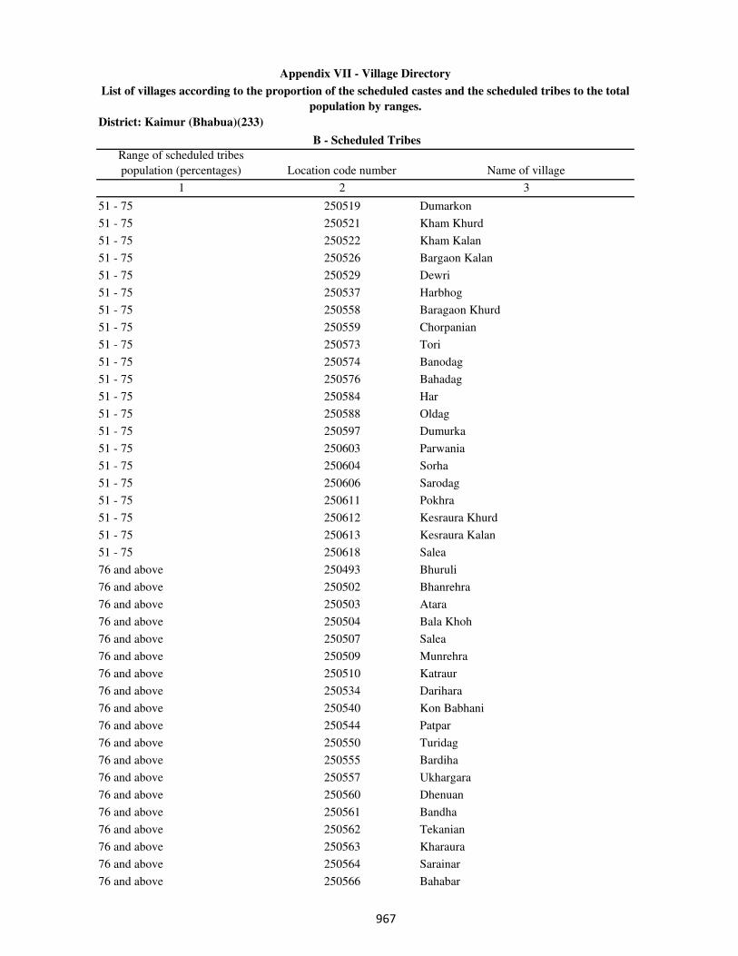
District: Kaimur (Bhabua)(233)
Range of scheduled tribes
population (percentages) Location code number Name of village
1 2 3
B - Scheduled Tribes
Appendix VII - Village Directory
List of villages according to the proportion of the scheduled castes and the scheduled tribes to the total
population by ranges.
51 - 75 250519 Dumarkon
51 - 75 250521 Kham Khurd
51 - 75 250522 Kham Kalan
51 - 75 250526 Bargaon Kalan
51 - 75 250529 Dewri
51 - 75 250537 Harbhog
51 - 75 250558 Baragaon Khurd
51 - 75 250559 Chorpanian
51 - 75 250573 Tori
51 - 75 250574 Banodag
51 - 75 250576 Bahadag
51 - 75 250584 Har
51 - 75 250588 Oldag
51 - 75 250597 Dumurka
51 - 75 250603 Parwania
51 - 75 250604 Sorha
51 - 75 250606 Sarodag
51 - 75 250611 Pokhra
51 - 75 250612 Kesraura Khurd
51 - 75 250613 Kesraura Kalan
51 - 75 250618 Salea
76 and above 250493 Bhuruli
76 and above 250502 Bhanrehra
76 and above 250503 Atara
76 and above 250504 Bala Khoh
76 and above 250507 Salea
76 and above 250509 Munrehra
76 and above 250510 Katraur
76 and above 250534 Darihara
76 and above 250540 Kon Babhani
76 and above 250544 Patpar
76 and above 250550 Turidag
76 and above 250555 Bardiha
76 and above 250557 Ukhargara
76 and above 250560 Dhenuan
76 and above 250561 Bandha
76 and above 250562 Tekanian
76 and above 250563 Kharaura
76 and above 250564 Sarainar
76 and above 250566 Bahabar
���
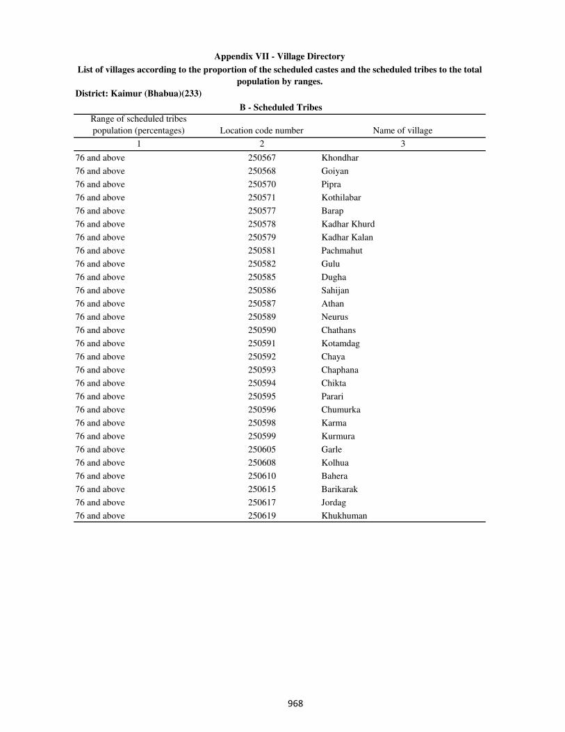
District: Kaimur (Bhabua)(233)
Range of scheduled tribes
population (percentages) Location code number Name of village
1 2 3
B - Scheduled Tribes
Appendix VII - Village Directory
List of villages according to the proportion of the scheduled castes and the scheduled tribes to the total
population by ranges.
76 and above 250567 Khondhar
76 and above 250568 Goiyan
76 and above 250570 Pipra
76 and above 250571 Kothilabar
76 and above 250577 Barap
76 and above 250578 Kadhar Khurd
76 and above 250579 Kadhar Kalan
76 and above 250581 Pachmahut
76 and above 250582 Gulu
76 and above 250585 Dugha
76 and above 250586 Sahijan
76 and above 250587 Athan
76 and above 250589 Neurus
76 and above 250590 Chathans
76 and above 250591 Kotamdag
76 and above 250592 Chaya
76 and above 250593 Chaphana
76 and above 250594 Chikta
76 and above 250595 Parari
76 and above 250596 Chumurka
76 and above 250598 Karma
76 and above 250599 Kurmura
76 and above 250605 Garle
76 and above 250608 Kolhua
76 and above 250610 Bahera
76 and above 250615 Barikarak
76 and above 250617 Jordag
76 and above 250619 Khukhuman
���
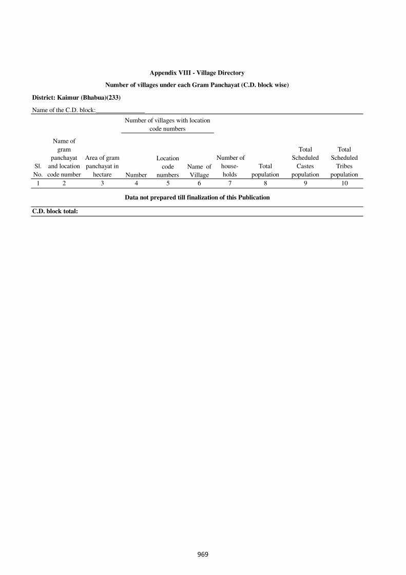
Number
Location
code
numbers
Name of
Village
1 2 3 4 5 6 7 8 9 10
C.D. block total:
Data not prepared till finalization of this Publication
Total
Scheduled
Castes
population
Total
Scheduled
Tribes
population
Appendix VIII - Village Directory
Number of villages under each Gram Panchayat (C.D. block wise)
Sl.
No.
Name of
gram
panchayat
and location
code number
Area of gram
panchayat in
hectare
Number of
house-
holds
Total
population
Number of villages with location
code numbers
District: Kaimur (Bhabua)(233)
Name of the C.D. block:_______________
969

�����
�����
SECTION II-Town Directory
�
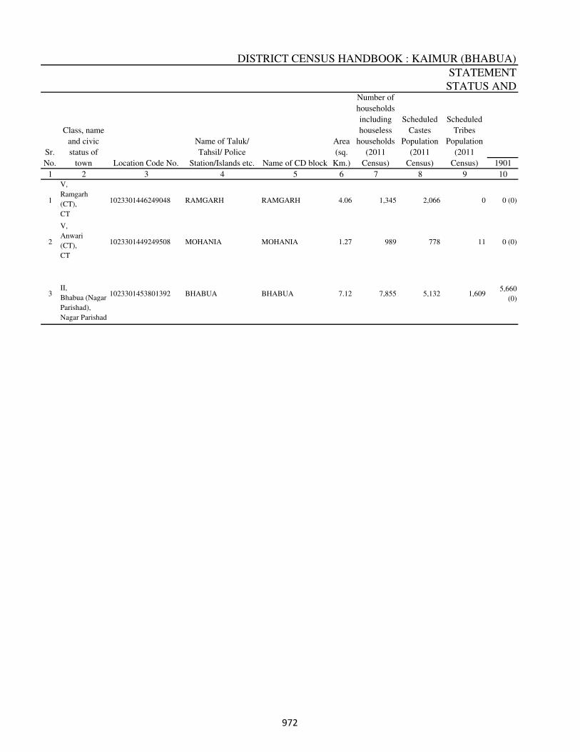
DISTRICT CENSUS HANDBOOK : KAIMUR (BHABUA)
1901
1 2 3 4 5 6 7 8 9 10
1
V,
Ramgarh
(CT),
CT
1023301446249048 RAMGARH RAMGARH 4.06 1,345 2,066 0 0 (0)
2
V,
Anwari
(CT),
CT
1023301449249508 MOHANIA MOHANIA 1.27 989 778 11 0 (0)
3 II,
Bhabua (Nagar
Parishad),
Nagar Parishad
1023301453801392 BHABUA BHABUA 7.12 7,855 5,132 1,6095,660
(0)
Scheduled
Castes
Population
(2011
Census)
Scheduled
Tribes
Population
(2011
Census)
STATEMENT
STATUS ANDNumber of
households
including
houseless
households
(2011
Census)
Sr.
No.
Class, name
and civic
status of
town Location Code No.
Name of Taluk/
Tahsil/ Police
Station/Islands etc. Name of CD block
Area
(sq.
Km.)
���
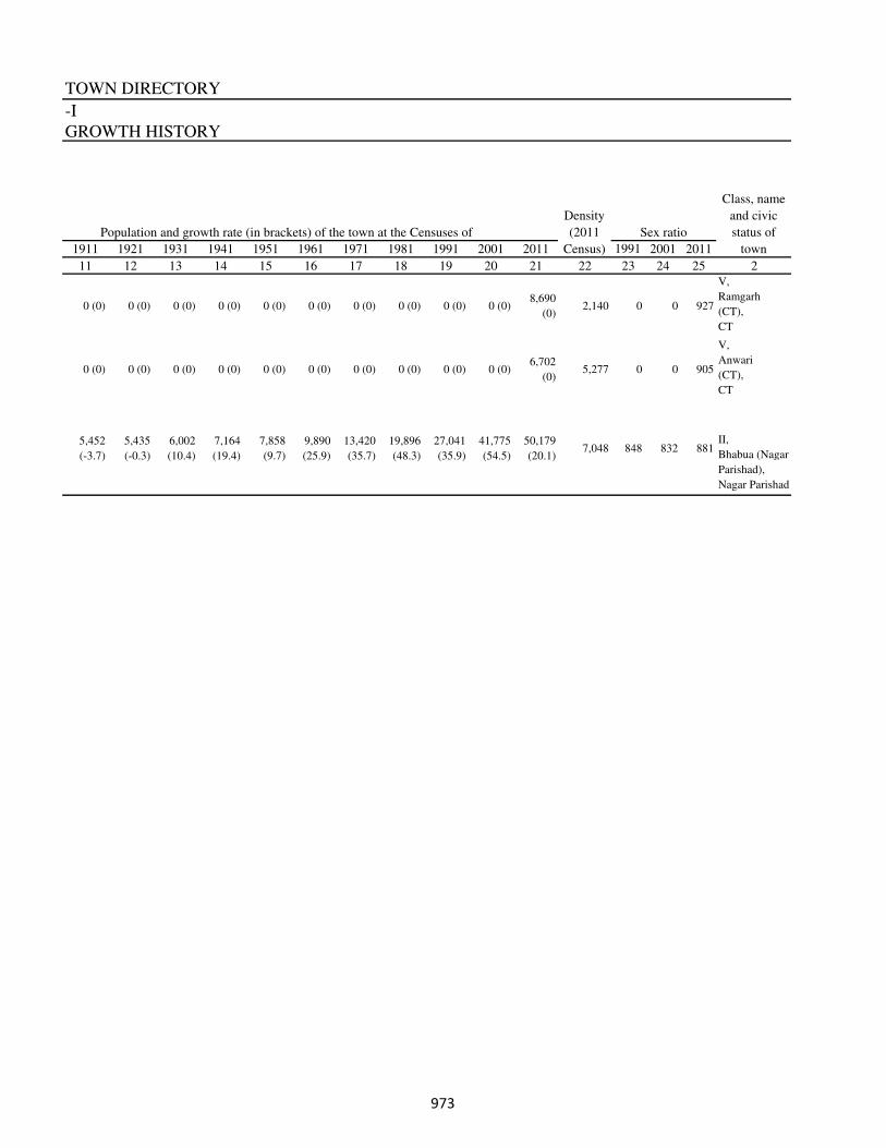
TOWN DIRECTORY
1911 1921 1931 1941 1951 1961 1971 1981 1991 2001 2011 1991 2001 2011
11 12 13 14 15 16 17 18 19 20 21 22 23 24 25 2
0 (0) 0 (0) 0 (0) 0 (0) 0 (0) 0 (0) 0 (0) 0 (0) 0 (0) 0 (0)8,690
(0)2,140 0 0 927
V,
Ramgarh
(CT),
CT
0 (0) 0 (0) 0 (0) 0 (0) 0 (0) 0 (0) 0 (0) 0 (0) 0 (0) 0 (0)6,702
(0)5,277 0 0 905
V,
Anwari
(CT),
CT
5,452
(-3.7)
5,435
(-0.3)
6,002
(10.4)
7,164
(19.4)
7,858
(9.7)
9,890
(25.9)
13,420
(35.7)
19,896
(48.3)
27,041
(35.9)
41,775
(54.5)
50,179
(20.1)7,048 848 832 881
II,
Bhabua (Nagar
Parishad),
Nagar Parishad
Density
(2011
Census)
Population and growth rate (in brackets) of the town at the Censuses of
Class, name
and civic
status of
town
-I
Sex ratio
GROWTH HISTORY
���
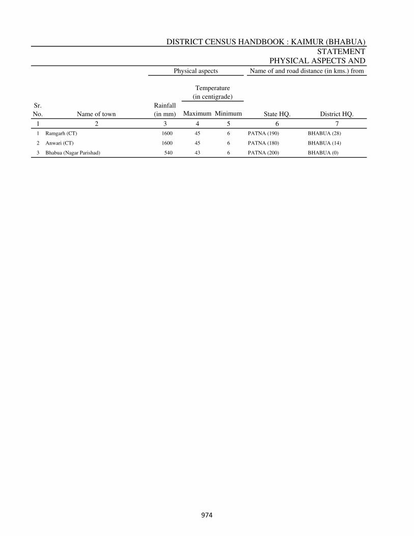
DISTRICT CENSUS HANDBOOK : KAIMUR (BHABUA)
STATEMENT
PHYSICAL ASPECTS AND
Maximum Minimum
1 2 4 5 6 7
1 Ramgarh (CT) 1600 45 6 PATNA (190) BHABUA (28)
2 Anwari (CT) 1600 45 6 PATNA (180) BHABUA (14)
3 Bhabua (Nagar Parishad) 540 43 6 PATNA (200) BHABUA (0)
State HQ. District HQ.
3
Sr.
No. Name of town
Temperature
(in centigrade)
Rainfall
(in mm)
Physical aspects Name of and road distance (in kms.) from
���
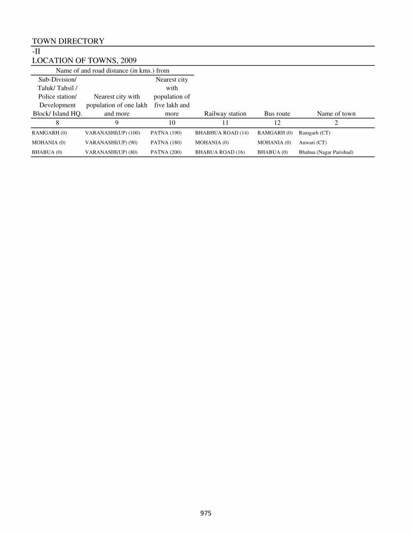
TOWN DIRECTORY
-II
LOCATION OF TOWNS, 2009
8 9 10 11 12 2
RAMGARH (0) VARANASHI(UP) (100) PATNA (190) BHABHUA ROAD (14) RAMGARH (0) Ramgarh (CT)
MOHANIA (0) VARANASHI(UP) (90) PATNA (180) MOHANIA (0) MOHANIA (0) Anwari (CT)
BHABUA (0) VARANASHI(UP) (80) PATNA (200) BHABUA ROAD (16) BHABUA (0) Bhabua (Nagar Parishad)
Name of and road distance (in kms.) from
Sub-Division/
Taluk/ Tahsil /
Police station/
Development
Block/ Island HQ.
Nearest city with
population of one lakh
and more
Nearest city
with
population of
five lakh and
more Name of townRailway station Bus route
���
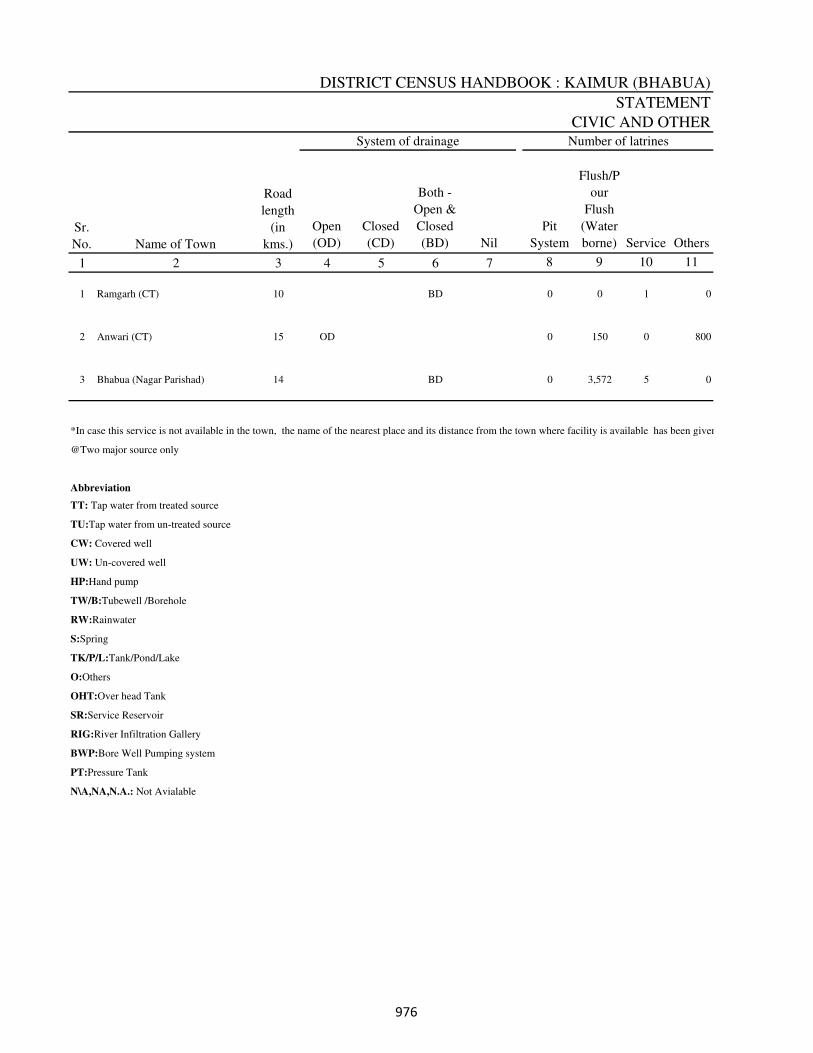
DISTRICT CENSUS HANDBOOK : KAIMUR (BHABUA)
STATEMENT
CIVIC AND OTHER
Open
(OD)
Closed
(CD)
Both -
Open &
Closed
(BD) Nil
Pit
System
Flush/P
our
Flush
(Water
borne) Service Others
1 2 3 4 5 6 7 8 9 10 11
1 Ramgarh (CT) 10 BD 0 0 1 0
2 Anwari (CT) 15 OD 0 150 0 800
3 Bhabua (Nagar Parishad) 14 BD 0 3,572 5 0
*In case this service is not available in the town, the name of the nearest place and its distance from the town where facility is available has been given
@Two major source only
Abbreviation
TT: Tap water from treated source
TU:Tap water from un-treated source
CW: Covered well
UW: Un-covered well
HP:Hand pump
TW/B:Tubewell /Borehole
RW:Rainwater
S:Spring
TK/P/L:Tank/Pond/Lake
O:Others
OHT:Over head Tank
SR:Service Reservoir
RIG:River Infiltration Gallery
BWP:Bore Well Pumping system
PT:Pressure Tank
N\A,NA,N.A.: Not Avialable
Sr.
No. Name of Town
Road
length
(in
kms.)
System of drainage Number of latrines
���

TOWN DIRECTORY
-III
AMENITIES, 2009
Source of
supply
(Codes) @
System of
storage with
capacity in
kilo litres
(along with
Codes) @ Domestic Industrial Commercial
Road
lighting
(points) Others
12 13 14 15 16 17 18 19 2
TW/B,UW OHT(50)
No,
BHABUA
(24)
495 0 0 0 0 Ramgarh (CT)
TU,TW/B
No,
BHABUA
(28)
800 20 5 50 50 Anwari (CT)
TW/B,UW Yes 5,320 298 1,179 2 106 Bhabua (Nagar Parishad)
en
Name of Town
Electrification (Number of connections)Protected water supply
Fire
fighting
service*
���
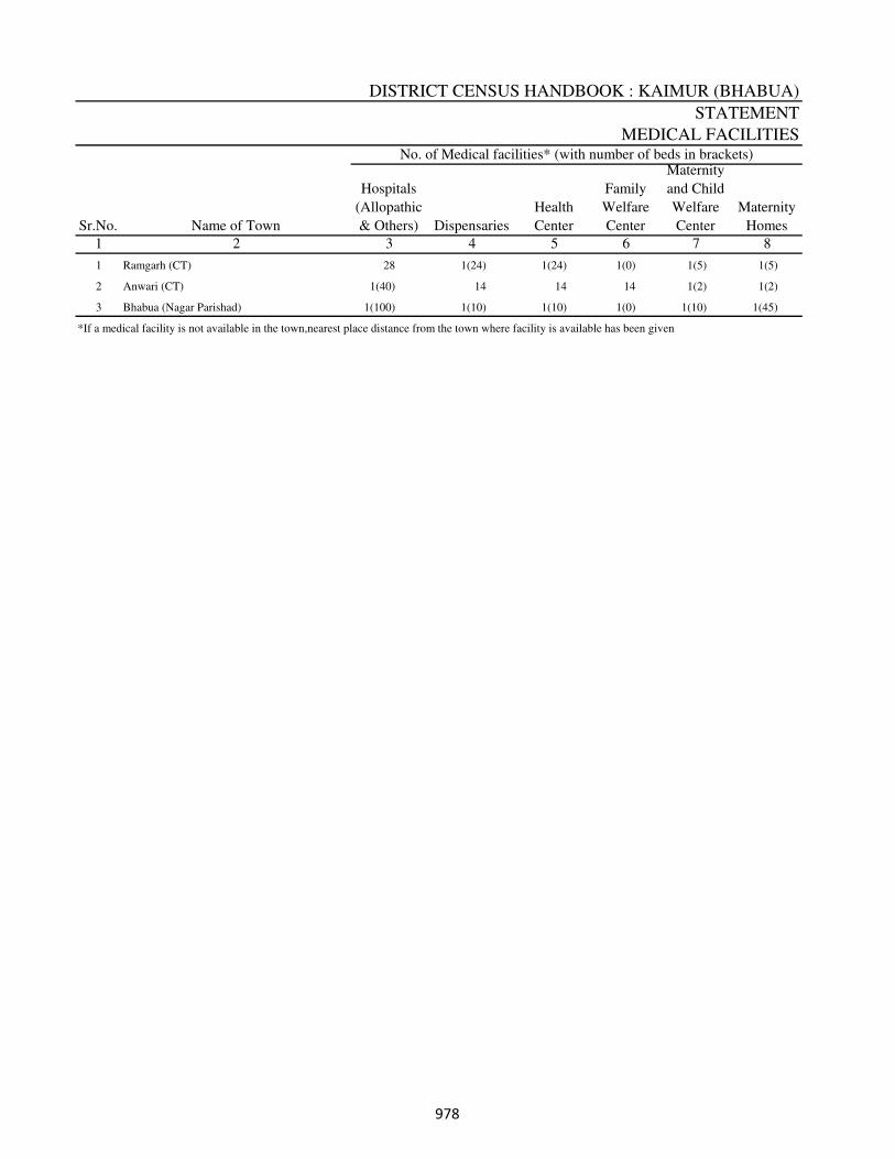
DISTRICT CENSUS HANDBOOK : KAIMUR (BHABUA)
STATEMENT
MEDICAL FACILITIES
1 2
1 Ramgarh (CT) 28 1(24) 1(24) 1(0) 1(5) 1(5)
2 Anwari (CT) 1(40) 14 14 14 1(2) 1(2)
3 Bhabua (Nagar Parishad) 1(100) 1(10) 1(10) 1(0) 1(10) 1(45)
*If a medical facility is not available in the town,nearest place distance from the town where facility is available has been given
Sr.No. Name of Town
Hospitals
(Allopathic
& Others)
Maternity
and Child
Welfare
Center
3
Dispensaries
4
Health
Center
5
Family
Welfare
Center
6 7
Maternity
Homes
8
No. of Medical facilities* (with number of beds in brackets)
���
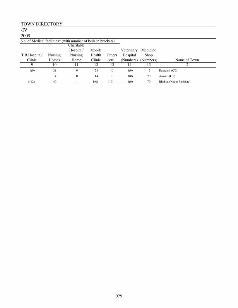
TOWN DIRECTORY
-IV
2009
2
1(0) 28 0 28 0 1(0) 2 Ramgarh (CT)
1 14 0 14 0 1(0) 20 Anwari (CT)
1(12) 40 1 1(0) 1(0) 1(0) 70 Bhabua (Nagar Parishad)
Name of Town
Charitable
Hospital/
Nursing
Home
Medicine
Shop
(Numbers)
T.B.Hospital/
Clinic
9
Nursing
Homes
10 15
No. of Medical facilities* (with number of beds in brackets)
11
Mobile
Health
Clinic
12
Others
etc.
13
Veterinary
Hospital
(Numbers)
14
���
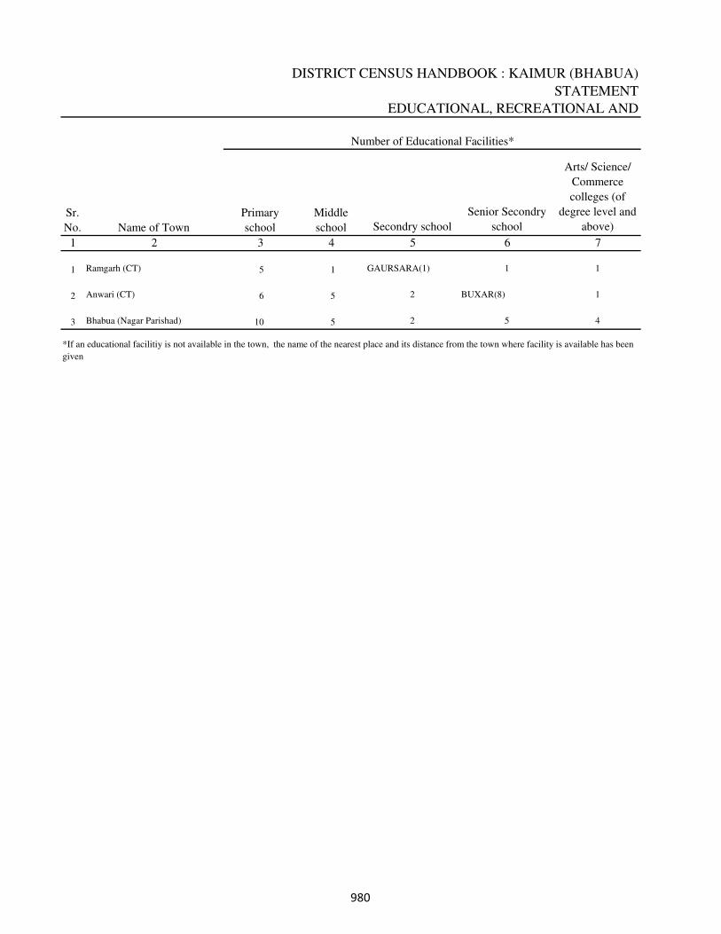
DISTRICT CENSUS HANDBOOK : KAIMUR (BHABUA)
STATEMENT
EDUCATIONAL, RECREATIONAL AND
Secondry school
Senior Secondry
school
Arts/ Science/
Commerce
colleges (of
degree level and
above)
1 2 5 6 7
1 Ramgarh (CT) 5 1 GAURSARA(1) 1 1
2 Anwari (CT) 6 5 2 BUXAR(8) 1
3 Bhabua (Nagar Parishad) 10 5 2 5 4
Sr.
No. Name of Town
Primary
school
Middle
school
Number of Educational Facilities*
*If an educational facilitiy is not available in the town, the name of the nearest place and its distance from the town where facility is available has been
given
3 4
���
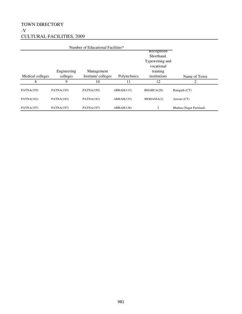
TOWN DIRECTORY
-V
CULTURAL FACILITIES, 2009
Medical colleges
Engineering
colleges
Management
Institute/ colleges Polytechnics
Recognised
Shorthand,
Typewriting and
vocational
training
institutions
8 9 10 11 12 2
PATNA(195) PATNA(195) PATNA(195) ARRAH(115) BHABUA(28) Ramgarh (CT)
PATNA(182) PATNA(182) PATNA(182) ARRAH(125) MOHANIA(2) Anwari (CT)
PATNA(197) PATNA(197) PATNA(197) ARRAH(136) 2 Bhabua (Nagar Parishad)
Name of Town
Number of Educational Facilities*
���
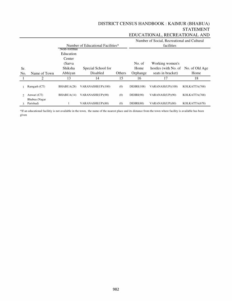
DISTRICT CENSUS HANDBOOK : KAIMUR (BHABUA)
STATEMENT
EDUCATIONAL, RECREATIONAL AND
Non-formal
Education
Center
(Sarva
Shiksha
Abhiyan
Special School for
Disabled Others
No. of
Home
Orphange
Working women's
hostles (with No. of
seats in bracket)
No. of Old Age
Home
1 2 13 14 15 16 17 18
1 Ramgarh (CT) BHABUA(28) VARANASHI(UP)(100) (0) DEHRI(108) VARANASI(UP)(100) KOLKATTA(768)
2 Anwari (CT) BHABUA(14) VARANASHI(UP)(90) (0) DEHRI(90) VARANASI(UP)(90) KOLKATTA(768)
3
Bhabua (Nagar
Parishad) 1 VARANASHI(UP)(80) (0) DEHRI(80) VARANASI(UP)(80) KOLKATTA(678)
Number of Social, Recreational and Cultural
facilities
*If an educational facilitiy is not available in the town, the name of the nearest place and its distance from the town where facility is available has been
given
Number of Educational Facilities*
Sr.
No. Name of Town
���
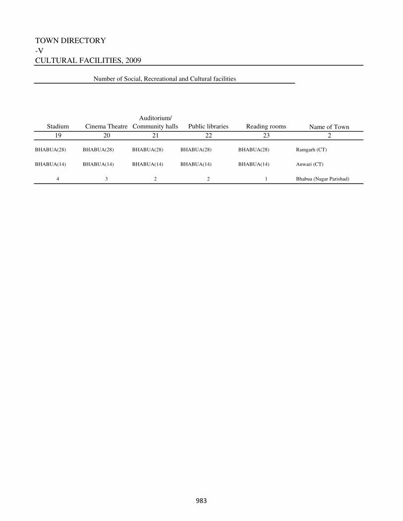
TOWN DIRECTORY
-V
CULTURAL FACILITIES, 2009
Stadium Cinema Theatre
Auditorium/
Community halls Public libraries Reading rooms
19 20 21 22 23 2
BHABUA(28) BHABUA(28) BHABUA(28) BHABUA(28) BHABUA(28) Ramgarh (CT)
BHABUA(14) BHABUA(14) BHABUA(14) BHABUA(14) BHABUA(14) Anwari (CT)
4 3 2 2 1 Bhabua (Nagar Parishad)
Name of Town
Number of Social, Recreational and Cultural facilities
���
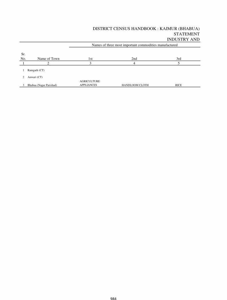
DISTRICT CENSUS HANDBOOK : KAIMUR (BHABUA)
STATEMENT
INDUSTRY AND
1 2
1 Ramgarh (CT)
2 Anwari (CT)
3 Bhabua (Nagar Parishad)
AGRICULTURE
APPLIANCES HANDLOOM CLOTH RICE
Sr.
No. Name of Town 1st
3
2nd
4
3rd
5
Names of three most important commodities manufactured
984
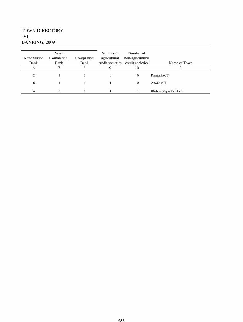
TOWN DIRECTORY
-VI
BANKING, 2009
2
2 1 1 0 0 Ramgarh (CT)
6 1 1 1 0 Anwari (CT)
6 0 1 1 1 Bhabua (Nagar Parishad)
Private
Commercial
Bank
Number of
non-agricultural
credit societies Name of Town
Nationalised
Bank
6 107
Co-oprative
Bank
8
Number of
agricultural
credit societies
9
985
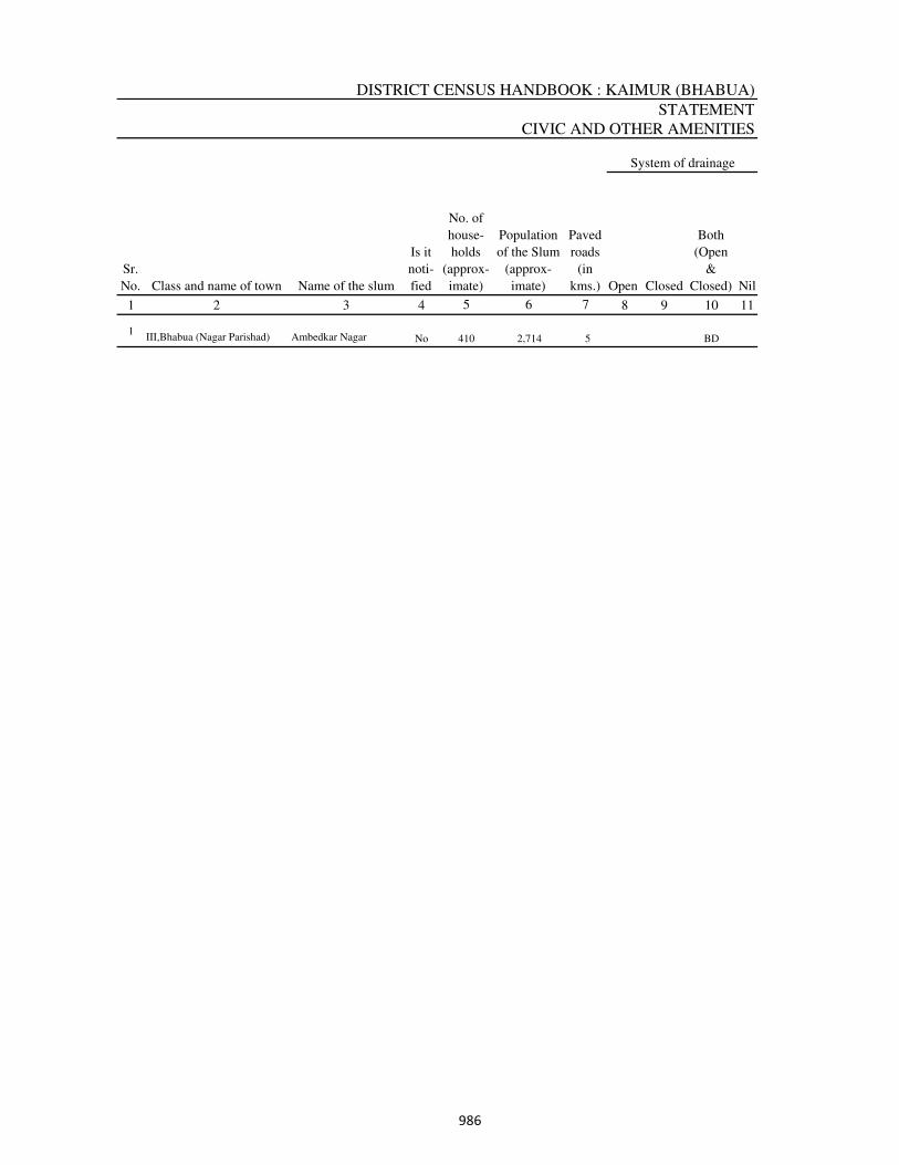
DISTRICT CENSUS HANDBOOK : KAIMUR (BHABUA)
STATEMENT
CIVIC AND OTHER AMENITIES
1 2 3 4 8 9 10 11
1III,Bhabua (Nagar Parishad) Ambedkar Nagar No 410 2,714 5 BD
Open Closed
System of drainage
No. of
house-
holds
(approx-
imate)
Sr.
No. Class and name of town Name of the slum
Is it
noti-
fied Nil
Both
(Open
&
Closed)
5
Population
of the Slum
(approx-
imate)
6
Paved
roads
(in
kms.)
7
���
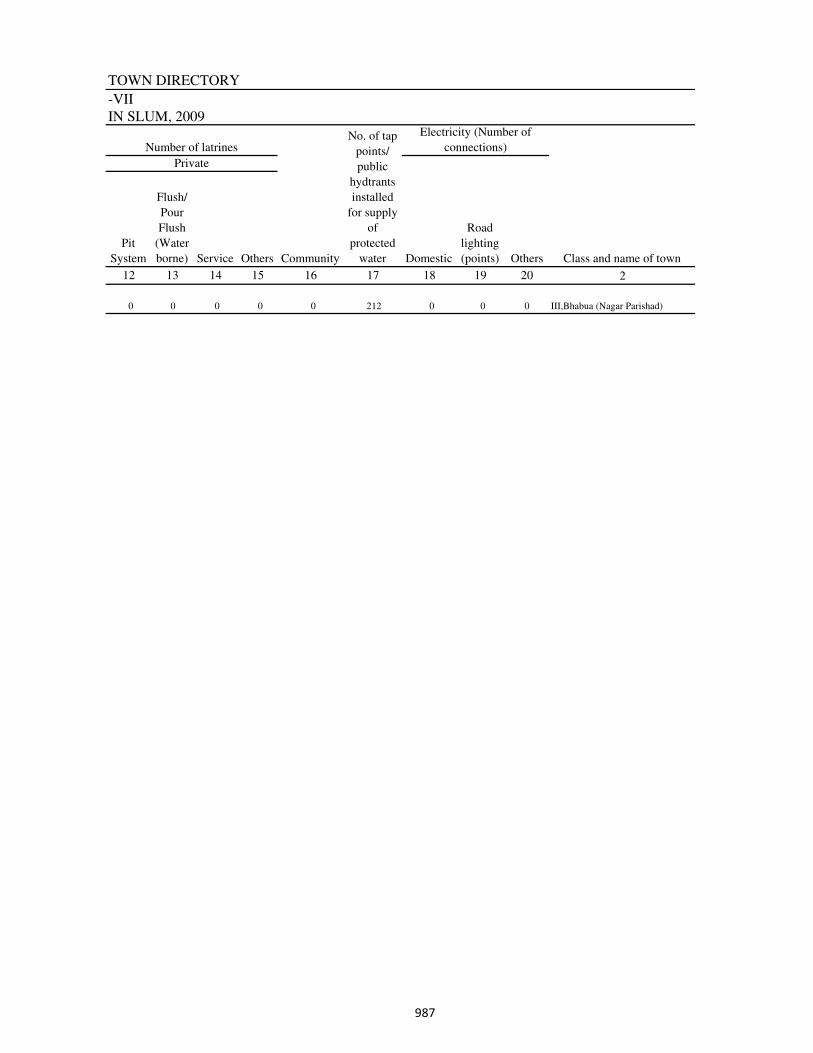
TOWN DIRECTORY
-VII
IN SLUM, 2009
2
0 0 0 0 0 212 0 0 0 III,Bhabua (Nagar Parishad)
Class and name of town
Pit
System
Flush/
Pour
Flush
(Water
borne)
Electricity (Number of
connections)
Private
12
Number of latrines
Community Others
2016
No. of tap
points/
public
hydtrants
installed
for supply
of
protected
water
17
Domestic
18
Road
lighting
(points)
1913
Service
14
Others
15
���
District: Kaimur (Bhabua)(233)
1 2 3 4 5
No such towns in this district
Appendix to Town Directory
Towns showing their Outgrowth with population
Sl. No. Name of Town with Location Code
Population of
Core Town Name of Outgrowth
Population of
Outgrowth
988

�
th ud x .r kj ukk kH
C E
A
N
I
S
D
U N
S
I O F
Directorate of Census Operations, BiharMinistry of Home Affairs, Government of India
Co-operative Bank Building,Ashok Rajpath, Patna-800004 http://www.censusindia.gov.in
ORGI-BIHAR
ENGLISH (2011)