district census handbook, mysore, part xii-a, series-11
TRANSCRIPT
CENSUS OF INDIA 1991
Series -11 KARNATAKA
DISTRICT CENSUS HANDBOOK MYSORE DISTRICT
PART XII·A VILLAGE AND TOWN DIRECTORY
SOBHA NAMBISAN Director of Census Operations, Karnataka

FOREWORD
PREFACE
IMPORTANT STATISTICS
ANALYTICAL NOTE
Section-I - Village Directory
Explanatory Note
Alphabetical List of Villages
Village Directory Statement
Alphabetical List of Villages
Village Directory Statement
Alphabetical List of Villages
Village Directory Statement
Alphabetical List of Villages
Village Directory Statement
Alphabetical List of Villages
Village Directory Statement
Alphabetical List of Villages
Village Directory Statement
Alphabetical List of Villages
Village Directory Stal~ment
Alphabetical List of Vilbges
Village Directory Statement
Alphabetical List of Villages
Viilage Directory Statement
Alphabetical List of Villages
Village Directory Statement
Alph.:1hctical List of Villages
Village Directory Statement
CONTENTS
- Chamrajnagar C.D.Block
- Chanuajnagar C.D.Block
- Gundlupel C.D.Block
- Gundlupet C.D.Block
- Heggadadevankolc C.D.Block
- Heggadadcvankote C.D.Block
- Hunsur C.D.Block
- Hunsur C.D.Block
- Kollcgal C.D.Block
- Kollcgal C.O.Block
- Krishnarajanagara C.D.Block
- Krishnarajanagara CD.Block
- Mysore CD. Block
- l\1ysore CD.Block
- Nanjangud C.O.RInck
- Nanjangud C.O.Block
- Piriyapatna CD.Block
- Piriyapatna CD.Block
- Tirumakudal Narsipur C.O.Block .
- Tirumakudal Narsipur C.D.Block
- Yclandur C.D.Block
- Yelandur C.O.Block
(iii)
Page No.
V-Vl
vii-viii
1-30
33-41
45-49
50-79
83-86
88-109
113-119
120-157
161-165
166-193
197-200
202-219
223-227
228-255
259-262
264-285
289-293
294-321
325-329
330-359
363-366
368-385
389
390-395
AppenOIX I-IV
I Community Development Blockwise Abstract of Educational, Medical and Other Amenities
II Land Utilisation data in respect of Non-Municipal Census Towns
III
IV-A
List of Villages where no amenities except Drinking Water arc available
List of villages according to the proportion of Scheduled Castes to Total Population by ranges
IV-B List of villages according to the proportion of Scheduled Tribes to Total Population by ranges
Section-II - Town Directory
Explanatory Note
Statement-I - Status and Grov.1h History
Statement-II - Physical Aspects and Location of Towns, 1989
Statement-III - Municipal Finance, 1989
Statement-IV - Civic and Other Amenities, 1989
Statement-IV-A - Civic and Other Amenities in Notified Slums, 1989
Statement-V - Medical, Educational, Recreational and Cultural Facilities, 1989
Statement-VI - Trade, Commerce, Industry and Banking
Appendix to Town Directory - Population of Towns and their associated Outgrowths
List of Scheduled Castes and Scheduled Tribes
Publication Plan
Illustrations
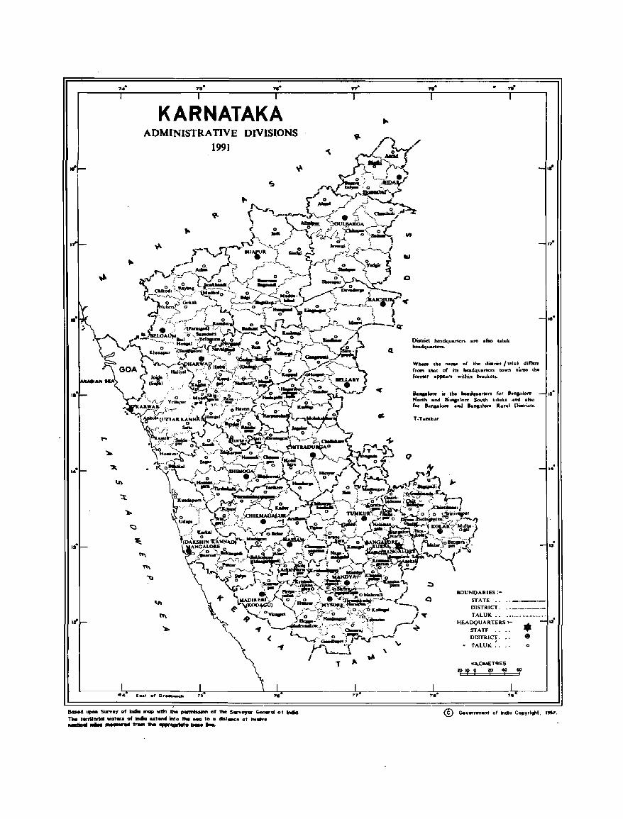
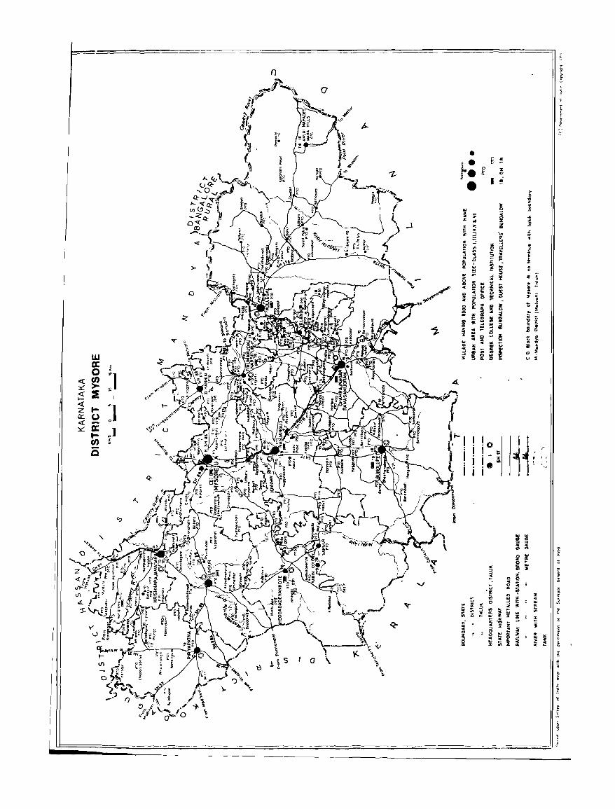
Map of Karnataka Showing the Administrative Divisions
Map of Mysore District
Map of Chamrajnagar Taluk
Map of Gundlupct Taluk
Map of Heggadadevankote Taluk
Map of H un sur Taluk
Map of Kollegal Taluk
Map of Krishnarajanagara Taluk
Map of Mysore Taluk
Map of Nanjangud Taluk
Map of Piriyapatna Taluk
Map of Tirumakudal Narsipur Taluk
Map of Yclandur Taluk
(iv)
Page No.
398-403
402-403
404-405
406-417
418-423
427-437
440-443
4.t-1-447
448-449
450-453
454-455
456-459
460-463
464
465-466
467-469
(ix)
(x)
44
82
112
160
196
222
258
2.-S8
324
362
388
FOREWORD
Publication of the District Census Handbooks (DCHs) was initiated after the 1951 Census and is continuing since then with some innovations/ modifications after each decennial Census. This is the most valuable district level publication brought out by the Census Organisation on behalf of each State Govt./Union Territory administration. It inter-aUa provides data/information on some of the basic demographic and socio-economic characteristics and on the availability of certain important civic amenities/facilities in each village and town of the respective districts. This publication has thus proved to be of immense utility to the planners, administrators, academicians and researchers.
The scope of the DCH was initially confined to certain important census tables on popUlation, economic and socio-cultural aspects as also the Primary Census Abstract (PCA) of each village and town (ward-wise) of the district. The DCHs published after the 1961 Census contained a descriptive account of the district, administrative statistics, census tables and Village and Town Directories including PCA. After the 1971 Census, two parts of the District Census Handbooks (Part-A comprising Village and Town Directories and Part-B comprising Village and Town PCA) were released in all the States and Union Territories. The third part, Part C of the District Census Handbooks comprising administrative statistics and district census tables, which was also to be brought out, could not be published in many States/UTs due to considerable delay in compilation of relevant material. In 1981, some new features alongwith the restructuring of the formats of Village and Town Directory were introduced in the DCHs. These were published in two parts for each district after the 1981 Census. While Part-A comprised Village and Town Directories, the PCA of villages and towns (ward-wise) including Scheduled Caste and Scheduled Tribe PCA upto tehsiVtown level were provided in Part-B. To illustrate, all the amenities except electricity, were brought together in the Village Directory and if an amenity was not available in the referent village, the distance in broad ranges from the nearest place having such amenity was given. Information on some new items such as adult literacy centres, primary heaILh sub-centres and community health workers in the village were provided so as to meet some of the requirements of the Revised Minimum Needs Programme. Similarly, information on approach to the village was also provided for the first time in the Village
Directory so as to give an idea about the number of inaccessible villages in each district. In case of Town Directories also, keeping in view the requirements of the Minimum Needs Programme, a Statem~nt
IV -A on slums was provided so as to enable the planners to chalk out the programmes for providing better civic and other amenities in the slums. In this Statement details on civic and other amenities were reported for the slums of Class I and Class II towns. Apart from this, one column on the Scheduled Castes and Scheduled Tribes popUlation and another on adult literacy classes/centres were added in Statements IV and V respectively.
The manner of presentation of the DCHs for the 1991 Census is by and large the same as followed 10 1981. However, the format of PCA has been restructured slightly in the 1991 Census for the benefit of data users. Nine-fold industrial classification of main workers has been given as against four-fold industrial classification presented in the 1981 Census: In addition to this, the sex-wise population in the 0-6 age-group has also been included in PCA for the first time with a view to enabling data users to compute more realistic literacy rates as all children below 7 years of age have been treated as illiterate at the time of the 1991 Census. It is expected that the above mentioned modifications will help the planners in chalking out more effective developmental programmes.
(v)
One of the most important innovations in the 1991 Census is the Community Development Block-level presentation of data in the Village Directory and PCA instead of the traditional TahsilffalukIPS level
presentation. It is expected that the presentation of Village Directory and peA data at C.D.Block level
will help the planners in formulation of micro-level developmental plans, as the C.D.Block is the lowest administrative unit for developmental planning.
In order to facilitate the task of administrators, planners and researchers intending to use Village
Directory/PCA data, either from the magnetic tapes!t1oppies or from the published records, both the
computer and manual codes for each village have been' provided for the 1991 Census along with the corresponding codes of 1981.
This publication is a joint venture of the State Govt./UT administration and the Census Organisation.
The 4ata have been collected and compiled under the direction of Ms. Sobha Nambisan, Director of Census Operations, Karnataka on behalf of the State Govt. administration which has borne the cost of printing. The task of planning, designing and coordination of the publication was initiated by Dr.K.P.1Uaman,
for.tner Deputy Registrar General (Social Studies) and Shri M.M.Dua, Joint Director. For the sake of
uniformity in presentation of information/data and for preparation of analytical note depicting the salient features emerging from a micro-level analysis of Census/non-Census data, a model District Census Handbook
from each State and Union Territory was thoroughly scrutinised in the Social Studies Division under the guidance of Shri M.K.Jain, the present Deputy Registrar General (S.S.). This task was carried out by
Shri AK.Singh, Deputy Director who was assisted by S/Shri V.K.Jain and Hariram, Investigators and staff. Technical guidance in the preparation of the maps was initially provided by Dr.B.K.Roy, former Deputy
Registrar General (Map) and later by Mrs. Minati Ghosh, the present Deputy Registrar General (Map).
I am thankful to all those who have contributed to this project.
New Delhi
June H, 1992.
(vi)
A.R.Nanda
Registrar General, India
PREFACE
In the foreword to the 1991 series of the District Census Handbooks, Sri A.R.Nanda, LA.S., the Registrar General and Census Commissioner, India, has traced the history of the District Census Handbooks. He has also succinctly explained the scope and coverage of the District Census Handbooks. These volumes
contain the salient data on the population for every village and town as revealed by the 1991 Census. They also contain a wealth of information regarding these villages and towns which, although not part of the population census, throw some light on the circumstances in which people live and is therefore relevant to the data on the population. This information has also considerable importance in the context of planned development.
The District Census Handbook is therefore divided into two parts: Part A containing information regarding each village and town (Village Directory and Town Directory) which is not census data and part B which contains the data on the population collected during the 1991 Census - the Primary Census Abstract. The data published in Part B was collected in February 1991 at the time of the population census. This data was then manually tabulated in the Regional Tabulation Offices set up for the purpose. Subsequently, as a part of the countrywide project taken up in collaboration with the National Informatics Centre, the Primary Census Abstract data was computerised. The data for Part B of the District Census Handbook was therefore available on tape for the entire country by November 1992. Since the Primary Census Abstract data was available first on the computer, it was decided to publish the District Census Handbooks in two separate volumes, with Part B appearing in print first.
The process of data collection for the Village Directory and the Town Directory (Part A) commenced in early 1990 and continued till the middle of 1992. For operational convenience, the Village Directory format was divided into two portions, one relating to the area and land use particulars and the other relating to the amenities available in each village. The relevant formats were mailed to the Deputy Commissioners of Districts and Chief Secretaries of Zilla Parish ads for obtaining the village wise particulars. Similarly the Town Directory formats were mailed to the Deputy Commissioners and Commissioners of Corporations. The villagewise and town wise data furnished by these officers were then examined
exhaustively for consistency in reporting and comparability with the information published in the 1981 District Census Handbooks. The villagewise information, thus finalised was also computerised during 1992-93 at the National Informatics Centre, Bangalore as in the case of Primary Census Abstract. _.
The National Informatics Centre, Bangalore has undertaken to supply the camera ready copies for
the District Census Handbooks and this may enable us to bring out the District Census Handbooks fairly early.
In the preparation of the District Census Handbooks the role of the Census Directorate is that of data collector. For accomplishing this task we have had the ready co-operation of the staff of different departments of the State Government. The cost of printing of the District Census Handbooks is borne by the Government of Karnataka.
(vii)
I take this opportunity to offer my grateful thanks to all the officers and officials who have been
actively involved in the compilation of this volume.
I am thankful to Shri A.Venkateshan, the State Informatics Officer, National Informatics Centre,
Bangalore for all the assistance 4e and his staff members have rendered for computerisation of the data and for preparation of the camera ready copy of the manuscripts of all the Districts.
I am deeply grateful to Shri A.R.Nanda, LA.S., the Registrar General, India for the benefit I have
derived by way of guidance and advice. I express my thanks to Shri M.K.Jain, the present Deputy
Registrar General (S5) as well as to Mrs. Minati Ghosh, Deputy Registrar General (Map).
Lastly, I am thankful to the Government of Karnataka for having readily agreed to bear the cost of
printing these District Census Handbook volumes and to the Director of Printing, Stationery and Publications for the keen interest he has evinced in bringing out these publications.
Bangalore,
Date: 16·11·1992
(viii)
Sobha Nambisan
Director of Census Operations, Karnataka.
II·
,..
.,..
KARNATAKA ADMINISTRA TIVE DIVISIONS
1991
.... Eoat .fG~ 75 .,.
8aMd _ Surv.y of _ ...... '""" the ___ of the Surv..,. ... ~GI of -.
The 1.-rII ... IoI _t •• of ...... 10&1_ into the _ 10 0 "'I~ af ........ . ............ _ ........ _-... --n·
....
Whore the name of the- d_~ Italuk difFen from thAt 0( iU beadquartcn town naRIC the former IIppewn within bracketl.
.. _~ io .he he ... i'!uooW" for " ••• ,1_ North and 8i,nan1nre South llIliu'" lind .Iso roi Innplore .nd Lnptorc Run.1 Di .. rll..1:I.
T~Tum.u.,.
BOUNDARIES :-
STATE •. DISTRler.
TAlUK •. HEADQUARTERS .,...
STATE •. DiSTIller .
• TAlUK ..
KlLOMETQE 5
Zf?Y f 1fl
,,,.
• (i
o
I~
I.·
~ .
I.·
. 13
. 12
® Gov ... _ of lncIo Copy,lqhl, ."".
« ~ <:: I« z 0:: « ~
w a: o e/) >:! to a: te/)
is
y <.)
o
J
o
"'1 $0
,
CJ
i J
• • B ~ t 0 x
C> re ~ • I ~
... ~ ;: z ..
l
~I =:li.l-! j
. j
I ,
//. \ ( ~ \..
j,~,
\
,: a: .. o z
~
r
===:::.1
£ •
j
IMPORTANT STATISTICS
KARNATAKA l\IYSORE
STATE . DISTRICT
1. POPULATION
TOTAL PERSONS 44,977,201 3,165,018
MALES 22,951,917 1,620,61-1
FEMALES 22,025,284 1,54-1,39'"
RURAL PERSONS 31,069,413 2,22..t724
MALES 15,744,942 1,136,626
FEMALES 15,324,471 1.088,098
URBAN PERSONS 13,907,788 9-10,29'"
MALES 7,206,975 483,993
FEMALES 6,700,813 456,296
2. DECENNIAL POPULATION GROWTH 21.12 21.92 RATE 1981 - 91
3. AREA (Sq. Kms) 191,791.0 11954.00
4. DENSITY OF POPULATION (per Sq.Km) 235 265
5. SEX RATIO (Number of females per 1000 males) 960 953
6. LITERACY RATE (excluding children 1Il PER~ONS 56.04 47.32 the age group of 0 - 6)
MALES 67.26 56.23
FEMALES 44.34 37.95
7. PERCENTAGE OF URBAN 30.92 29.71 POPULATION TO TOTAL POPULATION
8. PERCENT AGE TO TOTAL POPULA nON
I. MAIN WORKERS PERSONS 3,s,45 37.39
MALES 53.53 56.56
FEMALES 22.73 17.26
II. MARGINAL WORKERS PERSONS 3.54 2.S1
MALES 0.56 (lAO
FEMALES 6.66 5.35
III. NON-WO'RKERS PERSONS 58.01 59.80
MALES 45.91 43.0'"
FEMALES 70.61 77.39
9. BREAK-UP OF MAIN WORKERS
Percentage Among Main \Vorkcrs
'I. CULTIVATORS PERSONS 3.f.21 37.S0
MALES 37.67 4.2.48
FEMALES 25.72 21.72
(xi)
II. AGRICULTURAL LABOURERS PERSONS 28.92 28.19
MALES 20.45 21.39
FEMALES 49.69 51.57
III. LIVESTOCK, FORESTRY, FISHING, PERSONS 3.57 3.16 HUNTING AND PLANTATIONS,
MALES 3.80 3.27 ORCHARDS AND ALLIED ACTIVITIES FEMALES 2.99 2.77
IV. MINING AND QUARRYING PERSONS 0.67 0.50
MALES 0.76 0.53
FEMALES 0.47 0.42
V(a) HOUSEHOLD INDUSTRY PERSONS 1.86 1.6-t
MALES 1.77 1.1&
FEMALES 2.09 3.21
V(b) MANUFACTURING, PROCESSING, PERSONS 8.84 7.47 SERVICING AND REPAIRS IN
MALES OTHER THAN HOUSEHOLD 9.22 7.80
INDUSTRY FEMALES 7.91 6.35
VI. CONSTRUCTION PERSONS 2.48 2.56
MALES 3.17 3.05
FEMALES 0.77 0.87
VII. TRADE AND COMMERCE PERSONS 7.98 7.97
MALES 10.03 9.20 , FEMALES 2.94 3.72
VIII. TRANSPORT, STORAGE AND PERSONS 2.63 2.46 COMMUNICATION
MALES 3.56 3.07
FEMALES 0.35 0.36"
IX. OTHER SERVICES PERSONS 8.84 8.25
MALES 9.57 8.03
FEMALES 7.07 9.01
10. PERCENTAGE OF SCHEDULED PERSONS 16.38 18.89 CASTES POPULA nON TO TOTAL
MALES 16.36 18.92 POPULATION FEMALES 16.40 18.87
11. PERCENTAGE OF SCHEDULED PERSONS 4.26 3.23 TRIBES POPULATION TO TOTAL
MALES POPULATION 4.26 3.20
FEMALES 4.26 3.25
12. NUMBER OF OCCUPIED RESIDENTIAL HOUSES --- 7,963,054 579.861
13. NUMBER OF VILLAGES TOTAL 29,193 18·U
Il\;l-:AP1TED 27,066 "1649
UN fNHi'RLTED . 2,127 195 14. NUMBER OF TOWNS 306 18
(xji)
51. Slatel District
No.
2
KARNATAKA
01 BANGALORE
02 BAN GALORE RURAL
03 BELGAUM
04 BELLARY
05 BIDAR
06 BIJAPUR
07 CHIKMAGALUR
08 CHITRADURGA
09 DAKSHIN KANNAD
10 DHARIJAD
TolaJl
Rurall
Urban
3
Area in
5q.Kms.
4
STATE AND DISTRICTS
Total
Popula
tion
Total Lih:rates
Population (Excluding
age group age group
0-6 0 to 6)
6 7
S.:hedul.:d 5..:h..:duled
Castes Trihes
8 • 9
Total
Main
Work.:rs
10
Marginal Non
Workers Worl..ers
II 12
T 191791.00 44977201 7477611 21013193 7369279 1915691 17292117 1594681 26090403 R 187520.80 31069413 5378741 12250620 5645186 1629496 12919726 1511858 16637829 U 4270.20 13907788 2098870 8762573 1724093 28619~ 4372391 82823 9452574
T
R
U
T
R
U
T
R
U
T
R
U
T
R
U
T
R
U
T R
U
T
R
U
T
R
2190.00 4839162 693623 3161701 711775 1732.90 669909 109203 317831 178494 457.10 4169253 584420 2843870 533281
53631 1635987 14569 261186 39062 1374801
5815.00 1673194 260977 708577 326599 49305 623043 5758.90 1369908
56.10 303286
13415.00 3583606 13118.00 2741820
297.00 841786
9885.00 1890092 9479.30 1325692
213142 47835
619475 491892 127583
367604 273150
405.70 564400 94454
5448.00 1255799 255989 5370.70
77.30
17069.00 16759.10
309.90
1010096 245703
2927990 2239244
209042 46947
556196 439383
688746 116813
7201.00 1017283 147192 7125.60 845422 122866
75.40 171861 24326
536439 286780 172138 39819
1571044 406955 1045451 325338 525593 81617
693790 365154 407453 281525
44594 4711
83076 65247 17829
166693 129460
286337 83629 37233
451061 260033 104215 315874 135187
1307674 916365 391309
228197 31836
509862 421185 88677
531164 195852 415210 175176 115954 20676
98442 5773
39535 34068 5467
26534 24553
1981
523233 99810
1340802 1083491 257311
809989 621800 188189
466611 404246 62365
1110288 918462 191826
412276 357076 55200
10852.00 2180443 362537 1008542 432668 318381 10754.20 1591765 270697 643282 358069 275326
843861 668696 175165 97.80 588678 91840
8441.00 2694264 379453 7967.60 1931670 283299
365260 74599 43055
1756119 175548 106159 1112449 1192888 140296 94285 816616
22311 3180864 12860 395863 9451 2785001
96513 953638 93755
2758
176924 i69C81
43044 40668 2376
8S}
108867 102131
6736
45182 43768
1414
752920 200718
2065880 1489248 576632
1037059 663224 373835
755155 572700
1708835 1218631 49013 ..
559825 444578 115247
94617 1241965" 90919 832150 3698 409815
50465 1531350 43924 1071130
U 473.40 762594 96154 563231 35252 11874 295833 6541 4602;0
T 13738.00 3503150 607530 1699031 410499 105099 1349942 126121 2027087 R
U
12999.50 2279259 410750 738.50 1223891 196780
978002 290616 721029 119883
(xi i i)
84138 20961
975260 113982 1190017 374682 12139 837070
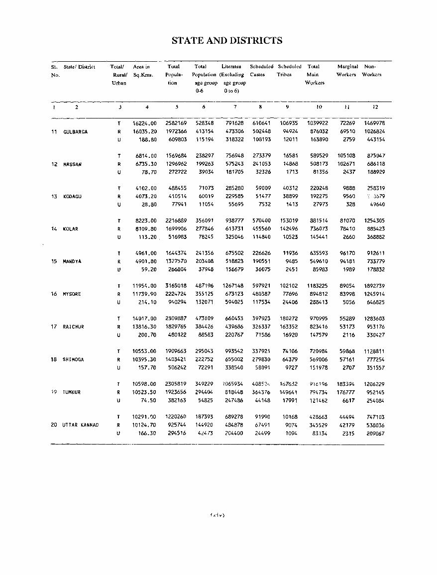
SI. Stater District
No.
2
11 GULBARGA
12 HASSAN
13 KODAGU
14 KOLAR
15 MANDYA
16 MYSORE
17 RAICHUR
18 SIIIMOGA
W TUMKUR
20 UTTAR KANNAD
STATE AND DISTRICTS
Total! Area in Total Total Literates Scheduled S~hedull!d Total Marginal Non
Workers Workers Rurall Sq.Kms.
Urban
3 4
Popula- Population (Excluding Castes
tion age group age group
0-6 0 to 6)
5 6 7 8
Trihes
9
Main
Workers
10 II 12
T
R
U
16224.00 2582169 528348 16035.20 1972366 413154
791628 610641 106935 1039922 72269 1469978 69510 1026824
T
R
U
T
R
U
T
R
U
T R
U
T
R
U
T
R
U
T
R
U
T
R
U
T
R
U
188.80 609803 115194
6814.00 1569684 238297 6735.30 1296962 199263
78.70 272722 39034
4102.00 4073.20
28.80
488455 410514 77941
71073 60019 11054
8223.00 2216889 356091 6109.80
113.20 . 1699906 516983
277846 78245
4961.00 1644374 241356 4901.80
59.20 1377570 266804
203408 37948
473306 502448 318322 108193
756948 273379 575243 241053 181705 32326
285280 229585 55695
59009 51477 7532
94924 12011
16581 14868 1713
40312 38899
1413
938777 570400 153019 613731 325046
455560 114840
675502 226626 518823 156679
190551 36075
142496 10523
11936 9485 2451
876032 163890 2759 443154
589529 105108 508173 102671 81356 2437
220248 192275 27973
9888 9560 328
875047 686118 188929
258319 " %79
49640
881514 736073 145441
81070 1254305
635593 549610 85983
78410 2660
96170 94181
1989
885423 368882
912611 733779 178832
11954.00 3165018 487196 1267148 597921 102102 1183225 89054 1892739 11739.90
214.10
14017.00 13816.30
200.70
10553.00 10395.30
157.70
10598.00 10523.50
74.50
10291.1)0 10124.70
166.30
2224724 9',0294
2309887 1829765 480122
1909663 1403421 506242
2305819 1923656 382163
1220260 925744 294516
355125 132071
473009 384426 88583
295043 222752 72291
349229 294404 54825
187393 144920 424('3
673123 594025
660453 439686 220767
993542 655002 338540
1065934 818448
247486
689278 484878 204400
f~i,,)
480387 117534
397923 326337
71586
337921 279830 58091
40852", 364376 44148
91990 67491 24499
77696 24406
180272 163352 16920
74106 64379 9727
167632 149641 17991
10168 9074 1094
894812 288413
970995 823416 147579
720984 569006 151978
9\6196
794734 121462
428663 345529 83134
83998 5056
55289 53173 2116
59868 57161 2707
183394 176777
6617
44494 42179
2315
1245914 646825
1283603 953176 330427
1128811 777254 351557
1206229 952145 254084
747103 538036 209067
ANALYTICAL NOTE
Brief History of the District Census Handbook :-
The District Census Handbook series was, for
the first time, included in the census publication
programme at the 1951 census in order to satisfy
the growing demand for micro-level data by the
administrators, the planners and the other census
data users. The District Census Handbooks sought
to replace 'Part IV - Taluk Tables' and 'Part V -
Village Tables' of the earlier censuses and to present
the basic demographic and economic data in the
form of 'Primary Census Abstract' in respect of
each and every village and town within the jurisdiction
of the district concerned. In addition, these volumes
were to contain a set of statistical tables based on
the census data in respect of the district and its
constituent taluks and towns.
At the 1961 census, the scope of the District
Census Handbook was greatly enlarged by
incorporating in it - (i) a descriptive account of the
district, (ii) a set of non-census tables dealing with
the administrative statistics of the district for a
decade, (iii) taluk and town level census tables on
economic and socio-cultural aspects and (iv) the
village and urban (census enumeration block level)
Primary Census Abstract containing the ninefold
industrial classification of workers. In a somewhat
general way, information on the availability of certain
basic amenities in villages and towns, such as the
sources of drinking water and educational institutions,
was also presented in these volumes. These general
guidelines were, by and large, followed in Karnataka
too. However, the scope of the District Census
Handbooks of 3 out of the then existing 19 districts,
namely Bangalore, Dharwar and Mysore, was
confined to the publication of the village-wise and
urban (census enumeration block wise) Primary
Census Abstract only.
The 1971 census witnessed an overall
improvement in the matter of compilation as we11
as presentation of the data. A country-wide
t;niformity in approach and a comprehensive coverage
are the hall marks of this series of publications. In
1971, the District Census Handhook was split up
into three portions . (i) Part A - consisting of land
use data on villages and also the data on the nature
1
and extent of amenities and services available in
the villages and towns of the district - presented in
the form of Village Directory and Town Directory
respectively, (ii) Part B - consisting of the Primary
Census Abstract (including the nine-fold industrial
classification of workers) for the district, the taluks,
the towns, the villages and the census enumera.tion
blocks in case of towns; and (iii) Part C - consisting
of an analytical note based on an analysis of the
census data as well as the non-census data included
in the volume, a set of tables depicting the
administrative statistics in minute detail, a set of
statistical tables based on the census data in respect
of the district and the constituent taluks and towns
thereof besides a set of tables generated on the
basis of the villagewise census data in association
with the villagewise data on the availability of
amenities. The main objective was to present a
comprehensive and intelligible portrait of the district
and an overview of the developmental progr:3_r::mes
implemented in the district during the pn:\'l' jing
decade. Publication of the District Census
Handbooks was planned in such a way as to minimise
the delay inherent in the compilation of a voluminous
mass of data gathered from different sour res.
Accordingly, 'Part A', comprising the V'l::>ge
Directory and the Town Directory for the finalis;· :,:~;}
of which there was no apparent need to wail ti!!
the completion of the tabulation of the data gathered
at the census, was to be published first and 'Part
B', consisting of the Village/Urban Primary Census
Abstract was to be released next. A lower priority
was assigned to 'Part C' for the obvious reason that
besides administrative statistics it was to include a
set of socio - demographic and economic tables
generated on the basis of the data gathered at the
census and' an analytical note prepared thereof. 1n
Karnataka, however, 'Part A' and 'Part B' portions
of the District Census Handbooks were combined
together and published in a single volume for each
district except Bangalore. In the case of Bangalore
District, since it was felt that the size of such a
combined volume would be unweildy, Part A and
Part B were published separately. As regards
'Part C', compilation of data took more time than
anticipated and, in addition, there was an inordinate
delay in executing the printing job at the State
Directorate of Printing. AS;J result, only a portion
of Part C (depicting some of the census tables)
relating to Bangalore District was published
somewhat belatedly and the proposal to publi~h the
remaining portion of Part C for Bangalore District
as well as the entire portion of Part C for the other
districts was finally abandoned.
Instead of witnessing an expansion as In the
past two censuses the scope of the 1981 series of
the District Census Handbooks was curtailed to a
considerable extent in that it was confined to the
publication of Village Directory, Town Directory
and the VillageIU rban Primary Census Abstract.
Thus, at the initial stage itself there was no proposal
to compile and publish the administrative statistics
and the various socio-demographic and economic
tables based on the census data, that is, the portion
which constituted 'Part C' of the 1971 series. But
for this change, the approach in 1981 regarding
uniformity and comprehensiveness were very much
the same as in 1971. In order to nvoid delay in
publication, as in the past, th~ D;~trict Census
Handbook was proposed to be published in two
parts, namely, 'Part A' consisting of the Village
Directory and Town Directory and 'Part B' consisting
of the VillagelUrban Primary Census Abstract
besides the Special Primary Censm A bstracts at
taluk/town level in respect of the Scheduled Castes
and Scheduled Tribes popUlation of the district.
At the 1981 census, the contents of the Village
Directory and the Town Directory were slightly
enlarged and the formats were restructured. In the
Village Directory all the amenities except power
supply were brought together under a broad heading
with the provision that 'in case an amenity is not
available in the referent village, the distance to the
nearest place where that particular amenity 1S
available ma} be indicated in broad ranges'. A
new item 'approach to the village' was incluoed. In
the remarks column, (l provi~ion was made to report
the number of copies of newspapers in circulation
in the village as .. Iso the number Df motor cars,
the number of motor "ycles and the number of
tractors available in th,- vIl.age. l~urther, III order
to examine whether lh.;re;" .n:' en., larlon between
the availability of arnl.:nities and !le t ~iJ.'.JtluII ~izt:
of a village, an additional column was IJ[UVI'jL,J In
the Village Dil eclOr) to inJical~ the popula! iull anu
2
number of households. Thc contents of Part A
were further enlarged by including two appendices,
namely, a list of viliages not having any amenities
and a distribution of villages according to the
proportions of Scheduled Castes and Scheduled
Tribes in the total population of the village. The
Town Directory formats were also modified by the
addition of a few items such as class of town,
population, Scheduled C..lstes and Scheduled Tribe~
population, dccadal growth rate of population,
working women's hostel, adult literacy classes/centres,
storage system regarding drinking water supply etc.,
and also by providing for recording the information
about the nearest place (and distance) having
educational, medical and fire-fighting facilities in
case such a facility is not available in I f., ;- .:fncnt
town. As compared to 1971, while on:: statement
indicating religion-wise population of tht: town w..J~
dropped, another statement to provide information
about the amenities available in notified slums in
Class I and Class II towns was added. As regards
the Primary Census Abstract of towns, the urban
block-wise presentation of data was given up and
details were presented only upto the level of
Wards/Divisions. However, information on the
number of persons belonging to Scheduled Castes
and Scheduled Tribes was furnished for each census
enumeration block within the lown in the form of
an appendix and an annexure thereto provided the
description of the boundaries of each census
enumeration block. Further, instead of the nine-fold
cbssification of worker.'. adopted at the 1971 census,
on this occasion the classification was restricted to
4 categories. In Karnataka, in 1981 also, both Part
A and P3rt B portion'> of the District Census
Handb"l)h were published together in a single
volume for each district. However, because of certain
technical compulsion'l, all the information relating
tc Scheduled Castes and Scheduled Tribes was
excluded from the main formats and was presented
separately at the end in the form of a Supplement
(separate booklets were brought out in the case of
Bidar and Mandya Districts).
2. Scope of the 1991 Dish'ict Census Handbooks:
A~ in 1981, in 1~1f_.·1 too, the District Census
Handbooh are propo<;ed to be hrought Ollt in two
pur ,:,)Os, namely Part A ,-,on~is .. ing of lIle V;l:uge
Directory an,] the Town Directory and Part B
consisting of the Village/Urban ward-wise Primary
Census Abstract in addition to the District Primary
Census. Abstract and the Special Primary Census
Abstract in respect of the Scheduled Castes and
Scheduled Tribes. Though, the scope of the 1991
series of the District Census Handbooks has, by
and large, remained the same as 10 1981, a
few significant changes have been made 10
the Village Directory format as well as the
Primary Census Abstract format. In Karnataka,
unlike at the previous censuses, on this
occasion, the 'Part A' and 'Part B' portions
of the District Census Handbooks of each
district are being brought out in separate volumes.
The manner of presentation of data has also
undergone a significant change in that the Village
Directory and the Primary Census Abstract data
are presented according to the location of villages
and towns within the jurisdiction of a Community
Development Block rather than their location within
a taluk*. In other words, the traditional practice
of tal uk-level presentation of data has now been
givenup in preference to the Community
Development Block level presentation of data which
is considered as more meaningful in the present
day context. Since C.D.Block is the lowest
administrative unit for developmental planning, the
choice of the C.D. Block as the unit for data
presentation is expected to help the planners in
formulating micro-level developmental plans.
Another innovation at the 1991 census is the
arrangements made for the dissemination of the
data in collaboration with the National Informatics
Centre through its country-wide computer network.
In the published volumes of the District Census
Handbooks, Jherefore, the computer codes assigned
to the villages in the 1991 census and the
corresponding codes in 1981 are presented so as
to facilitate the data users who may prefer to use
the data either from magnetic tapes or floppies.
(i) Village Directory :
The Village Directory format adopted for the
1991 series has 18 columns. When examined with
reference to the 1981 format it will be noticed that
two columns have now been left out - while one
of these columns refers to the 'staple food' the
other refers to the 'remarks' under which, information
about the places of religious, historical or
archaeological interest in the village as also
information about the number of copies of
newspapers in circulation, the number of motor cars,
motor-bicycles and tractors available in villages was
published in 1981. As compared to 1981, there is
no change in the scope and coverage of the
information presented in the 18 columns of which
8 are devoted for amenities and 6 are meant for
indicating the area of the village and the land use
pattern. The remaining four columns are meant
for indicating the location code and name of the
village, total population and the number of
households enumerated in the village and the name
of the nearest town as also the distanc" to that
town. The aspects covered under the amenities are:
educational, medical, sources of drinking water
supply, postal and telegraph, weekly market, commu
nication, nature ",f approach road and power supply.
Further, if a village did not have any educational
facility at all, instead of merely reporting the fact
and stopping at that, an indication of the distance
(in ranges) that the villagers have to traverse to
reach a place with educational facilities (at the basic
level) is reported. The same procedure of reporting
is adopted regarding medical facilities, drinking water
supply, postal and communication as well as weekly
market facilities. The distance ranges adopted for
reporting are the same as in 1981, namely -5 km,
5 - 10 km and 10 + km. In an explanatory note,
which precedes the presentation of the Village
Directory Statements, details about the abbreviations
used under various columns are furnished.
* In Kamataka, the "Taluk Panchayat Samiti" corresponds to the Community Development Block, and for the sake of maintaining unifon71ity with the all-India pattern, the tenn CD.Block has been used throughout in the District Census Handbooks. 77le jurisdiction of a Taluk Panchayat Samiti is cotenninus with that of the corresponding Ta/uk but excludes the statutory towns.
3
The main agency which has furnished the
villagewise information on amenities is the Zilla
Parishad which in turn has collected the relevant
particulars through its field formations, namely the
Chief Executive Officers (i.e., the Block Development
Officers) of the various Taluk Panchayat Santi/is. These details were examined for consistency as wcll
as with reference to the particulars reported in 1981
and cases of deterioration or of abnormal
uevelopments were referred back for reverification
and rectification. For instance, as compared to 1981,
for several villages, Wells and Tanks did not find
a mention as a source of drinking water supply.
When referred back, the concerned Chief Executive
Officers clarified that in most of these c;ases, the
drinking water wells of yester years have either
dried up or fallen into disuse on account of the
increasing number of borewells drilled in such villages
and also because of the implementation of the
National Rural Water Supply Scheme, the
Mini-Water Supply Scheme and Accelerated Water
Supply Scheme etc. So also regarding the availability
of pucca approach road facility several instances of
deterioration were noticed. Such cases too were
referred back so that the factual data may be verified
again and rcported for publication. Information
about the number of educational institutions, nature
of government run medical institutions and postal,
phonocom and telegraph facilities as furnished by
these officers have been cross-checked with the data
obtained from the concerned Departments as well
to ensure a higher level of reliability.
In case of uninhabited villages, i.e., villages
which returned 'nil' popUlation at the 1991 census
count, except the name and the total area no other
information is furnished. Instead of putting Ii dash
under each column to indicate this fact, the word
'uninhabited' is printed along the line.
In order to facilitate easy reference, an
alphabetical list of villages is given at the begining
in respect of each CD.Block. This list indicates
the code numbers assigned to the villages for
purposes of census enumeration as well as the
computer codes assigned (at the stage of
computerisation) as also the corresponding codes
according to the 1981 census. At the end of the
Village Directory the following appendicl's arc given:
CD. Block-wise abstract of amenities; (l~t of vilbges
4
not having any amemtles except Drinking Water,
land utilisation data in respect of non-municipal
towns and distribution of villages according to the
proportion of Scheduled Castes population and
Scheduled Tribes population.
(ii) Town Directory :
As in 1981, in 1991 too, there are seven
statements which furnish information on the following
aspects - growth history; physical aspects and
locational particulars; municipal finance; civic and
other amenities; civic amenities available in the
notified slums of Class I and Class II towns; medical,
educational, recreational and cultural facilities; and
trade, commerce, industry and banking. The scope
of the various colu;"n headings adopted in 1981 has
remained unchanged 10 1991. However, in
Statement-I, slight modifications have been made to
accomodate the 1991 census data - an additional
column is provided for indicating the 1991 population
and the growth rate registered by the town during
the decade 1981-91. In Statement-I an additional
column has been provided for indicating the name
of the CD.Block within the jurisdiction of which
the referent town is located. It may be incidentally
mentioned that, in Karnataka, the civic bodies
functioning in the Statutory Towns do not fall within
the administrative jurisdiction of the CO.Blocks (i.e.,
Taluk Panchayat Samitis).
In the Town Directory statements, the towns
are arranged in an alphabetical order of their names
and the aggregate particttiars about urban
agglomerations if any in the district have also been
furnished in the same order. Where an urban
agglomeration includes two or more independent
towns, the names of these constituent towns are
shown in the correct sequence as per the alphabetical
arrangement of their names. But, the details w,hich
ought to have been furnished in the subsequent
columns have been skipped with a view to avoiding
repetItIOn. Instead, immediately after the name of
the town, a cross reference is given by printing the
message "sec ..... urban agglomeration". The name
of the core town of the urban agglomeration too
appcar~, 3t its correct "cqllcnce with the legend
prinlt:o 't'crcaftcr and immediately below that, i.e.,
in the next r .: .. :fd with the suffIx urban
. ~;1'n without bearin~ any
serial number. Against this name the cumulative
totals for the urban agglomeration as a statistical
unit are presented wherever such a procedure is
relevant and meaningful. This line is then followed
by those relating to the constituent towns of the
urban agglomeration starting with the name of the
core town and followed by the others arranged in
an alphabetical order of their names. This
procedure, it may be recalled, is the same as that adopted in 1971 as well as in 1981 and this enables
one to have a fairly good assessment of the data
relating to the smaller civic administrative units that
form part of the larger unit and also of the aggregate
data relating to the larger unit itself. In case there
are 'outgrowths' which are not 'urban areas' in their
own right, the particulars relating to such areas arc
merged with the data relating to the concerned core
town. Such towns which have 'outgrowths' arc
marked out by an asterisk mark and for all purposes, the term 'town' would cover the core town as well
as its outgrowths. In an appendix the names of
the revenue villages or areas which have been
identified as outgrowths and the population thereof
are indicated separately. In the case of villages
certain parts of which are regarded as outgrowths
while the other parts are considered as 'rural', the
data relating to the outgrowths (i.e., the urban
component) is included in the Town Directory
statements and the data pertaining to the rest of
the portion retained in the rural frame appears in
the Village Directory. In Statements II, III and VI
where it is not relevant to combine the data for
the urban agglomeration as a whole, the legend 'see
the constituent towns' is printed against the name
of the urban agglomeration instead of allowing the
entire line to remain blank.
The particulars furnished In Statement I which
deals with the growth history are entirely based on
the current as well as the previous censuses. As
such, this has been compiled in the Census
Directorate without seeking information from the
concerned civic bodies. The details presented in
the remaining statements have been furnished mainly
by the concerned civic authorities such as the
Municipal Commissioners, Chief Officers of towns,
Secretaries of MandaI Panchayats, Administrative
Officers etc. Except for the information regarding
municipal finance, most of the information on othcr
5
apsects had to be gathered by the civic authorities
from several offices and institutions located in the
town through correspondence and or by deputing
officials for the purpose. The particulars so
furnished were scrutinised in the first stage and
cases of abnormal variations as compared to the
situation in 1980 and also inconsistencies were
referred back to the reporting agency for
reverification and rectification so as to ensure that the details now given in the Town Directory represent
the factual position.
The scope of the information presented under
various columns and the abbreviations used are
explained in a note which precedes the presentation
of the Town Directory statements.
(iii) Primary Census Abstract :
The Primary Census Abstract IS presented
village-wise in the case of 'rural' areas and town-wise
(upto ward or division level) in the case of urban
areas. The outgrowths of a town are treated at
par with a ward or division of the core town
irrespective of the number of census enumeration
blocks into which it is constituted. Within the
district, the Community Development Blocks are arranged in the alphabetical order of their names
in English and covered one after the other in that
order. For each C.D.Block, the total figures with
the rural-urban break-up is given first and this is
followed by the village-wise data and then by the
ward-wise data for the towns if any, within the
jurisdiction of the CD.Block. In the case of a village
of which only a portion has been incorporated in
a town or has been recognised as an outgrowth of
a town, the details relating to only that portion
which is not so incorporated or so recognised but
has been retained in the rural frame is presented
under various columns. The names of villages (and
their respective areas) which are fully included in
urban areas or have been recognised as outgrowths
of towns for purposes of the 1991 Census (but are
retained in the jurisdictional lists of the Survey and
Settlement authorities) if any within the boundaries
of the C.D.Block are indicated in the flyleaf which
precedes the PCA statement for the CD.Block
After presenting the PCA data for all the villages
and towns covered by the C.D.Blocks in the district,
the PCA data relating to all the urban areas of the
district (i.e., statutory as well as non-statutory towns)
are furnished. For this purpose, the towns/urban
agglomerations are arranged in an ascending order
of their location code numbers. And, for each to~ the ward ()r division-wise details are presented here.
In Karnataka, as already mentioned, the
jurisdiction of a C.D.Block is coterminus with that
of the Taluk of the same name, but excludes the
areas incorporated in statutory towns and cities. By
and large, a C.D.Block corresponds to the rural
areas of the taluk. However, if there are any
non-municipal census towns and areas which have
been identified as outgrowths of statutory towns
within the jurisdiction of the tal uk, then such towns
and outgrowths are also regarded as lying within
the jurisdiction of the concerned C.D.Block. The
PCA particulars relating to such units are presented
under the concerned C.D.Blocks against the urban
category and are repeated again at the end under
the caption 'District Urban'.
In the case of an urban agglomeration, the
aggregate figures obtained by the addition of the
data relating to the constituent towns and outgrowths
thereof i~ any are presented against its name.
Thereafter, the data for the constituent towns starting
from the core town including the location code, are
presented in a continuous sequence. In case a town
has outgrowths (which are not towns in their own
right) in the first line the aggregates relating to the
core town as well as its outgrowths are given and
this is then followed by the details relating to the
core town and the outgrowths separately. Each
outgrowth is treated at par with a municipal ward
or division while presenting the ward-wise PCA for
towns.
3. Brief note on Census concepts :
Census taking is a massive operation carried
out in a short span of time with the active
participation of a very large number of census
enumerators. The refttrence moment for the 1991
census count is the sunrise of March 1, 1991.
However, the enumeration of the population was
spread over a period of 20 days from 9-2-1991 to
28-2-1991 followed by a revisional round from
1-3-1991 to 5-3-1991 for updating th!" popubtion
6
count with reference to the sunnse on March 1,
1991. The questionnaires canvassed by the
enumerators, namely the Household Schedule and
the Individual Slip are brief in their wordings and
the concepts used for purposes of the 1991 Census
Operations and the manner in which the schedules
are to be filled in have been explained in a booklet
entitled Instructions to Enumerators for filling up
the Household Schedule and the Individual Slip.
Some of the important concepts and the relevant
explanations are indicated 10 the following
paragraphs.
(i) Urban areas :- The definition adopted in 1961
and adhered to in 1971 as well as in 1981 (though
with a slight modification regarding the classification
of fishing and forestry) has been retained for the
1991 census also. According to this definition the
urban areas include :
i) all places with a Municipality, Corporation,
Cantonment Board or Notified Town Area
Committees, etc.
ii) all other places which satisfy the following
criteria :
a) a mlmmum population of 5,000
b) atleast 75 per cent of the male working
population engaged 10 non-agricultural
pursuits and
c) a density of population of at least 400 per
square kilometre (1000 per square mile)
d) all places which, though not satisfying the
above criteria, had pronounced urban
characteristics.
(ii) Urban Agglomeration: This concept, which
replaced the concept of 'town-group' in 1971, has
been retained for the 1991 census. It has been
observed that very often railway colonies, university
campuses, port areas, military camps and large
residential colonies etc., come up quite adjacent to,
but situated outside the statutory limits of cities and
towns. Such areas may not by themselves qualify
to be treated as towns. But if they form a continuous
spread Wil h the town they are outgrowths of the
town and de<;~; ve t~" ~'" tr~ oiled as urban. Such
towns togef ,("f {"' L
treated as oJl\e tL 1 d
Ht£fowths have been
unit called "urban
agglomeration". An urban agglomeration may consist
of :
a) A city with continuous outgrowth (the part
of outgrowth being outside the statutory limits but falling within the boundaries of
the adjoining village or villages);
b) One town with similar outgrowths or two or
more adjoining tawns with their outgrowths
as in (a) ; or
c) A city and one or more adjoining towns with
their outgrowths all of which form a
continuous spread.
Geographical contiguity with the statutory limits
of the core town is the main factor in determining
whether or not a nearby satellite town or an
outgrowth is to be included 10 the urban
agglomeration. This is purely a statistical concept
and for carrying out the actual census, the
administrative jurisdictions of the city or the towns
concerned as well as of the outgrowths have been
kept quite intact. The data. are presented for the
urban agglomeration as a whole and also severally
for each of the constituent units.
(iii) Rural areas - i.e., villages: Areas which are
not classified as 'urban' according to the definition
given above constitute the rural areas. The basic
unit for rural areas is the revenue village which has
definite surveyed boundaries. In the case of
unsurveyed villages, the boundaries as determined
by the local usage have been adopted. The revenue
village may consist of a single nucleated settlement
or comprise of several settlements or clusters of
houses located at several places within the territorial
limits of the village or the village may not be having
any human settlements at all (i.e., it may be totally
uninhabited). The census village and the revenue
village are identical in the matter of jurisdiction.
However, there are a few exceptions to this general
rule:
1) When the malO settlement 'of the village with
or without the surrounding open lands is
constituted into an urban area, the remaining
tracts of the revenue village are together treated
as a separate unit for purposes of census i.e.,
7
the truncated portion itself is considered as an
independent revenue village.
2) When outlying portions of certain revehu·c villages
are incorporated into the limits of urban areas
by a Government Notification such areas,
whether populated or not, are excluded from
the revenue village concerned and the village
boundaries are redefined for census purposes.
3) Revenue villages which are completely
incorporated in the limits of urban areas or
else, are submerged completely under reservoir
projects but are still retained in the jurisdictional
lists of the Survey and Settlement authorities
pending a resurvey and such other procedures,
are taken note of as revenue villages but are
omitted for census purposes i.e., these are not
treated as census village~. Similarly, entire
revenue villages, which have been identified as
outgrowt~s of urban areas for purposes of 1991
census are treated not as census villages but as
urban areas. The names of such villages, if any,
in a TaluklC.D.Block are indicated in a fly leaf.
4) If there are forest areas that do not form part
of any of the revenue villages then such areas
are identified clearly and the smallest
administrative unit into which such forest areas
are divided (eg.Forest Beat) is reckoned as the
census village. A Forest Range may consist of
several such census villages. (In Karnataka this
phenomenon is noticeable only in Kollegal Taluk
of Mysore District).
(iv) Census Enumeration Block: The smallest unit
adopted for census taking is the Census Enumeration
Block. Generally, the towns and cities are divided
into wards or divisions and, wherever such units
exist, their distinctive identities have been maintained.
The geographical area comprised in each such ward
or division or, the town in its entirety, is constituted
into several blocks in such a way that every bit of
land specifically stands included in one or the other
enumeration block and also that there is no
over-lapping of areas. In the urban areas, the
Census Enumeration Blocks are constituted in such
a way that each such Block contains about 120
households covering a population of about 600
persons. However, in view of the condition that
each block should have c1ear~cut boundaries eaS'ily
recognisable on the field, blocks which are either
larger or smaller than the norm have also been
constituted. In the case of non-municipal towns,
if the town boundaries are not specifically notified,
the jurisdiction of the entire revenue village
concerned is regarded as the jurisdiction of the
town as well. In the case of towns which are under
the administration of Mandai Panchayats, the
Panchayat jurisdiction need not necessarily be
identical with the jurisdiction of the non~municipal
census town.
In the 'case of villages, depending upon the
population data based on the Houselisting Operations
carried out during 1990, each village has been
constituted into one or more number of Census
Enumeration Blocks. The work-load notm for the
rural areas is 150 households covering an approximate
population of 750 persons. However, numerous
Census Enumeration Blocks with below-norm
population have been constituted and a single
enumerator has quite often been entrusted with the
enumeration work in 2 or more contiguous blocks
so as to ensure that the aggregate population is
quite close to the norm. Further, in each village
care has been taken to ensure that no bit of land
belonging to that village is left out of consideration
while constituting the Blocks. Each hamlet or island,
if any, found within the jurisdiction of the village ~
irrespective of its population size - has been
constituted into a separate Block in order to maintain
its geographical identity. Further, even the villages
known to be uninhabited at the time of housclisting
operations have been constituted into separate blocks.
In other words, a complete coverage of the territorial
jurisdiction of each and every village has been
ensured.
(v) Location Code Number : Every State in the
Country, every District in the State, every Taluk or
Town in the District, every CD. Block (or its
equivalent) in the District, every village in the taluk
and every ward or division in the city or town and
every enumeration block in the village or town is
assigned a number in a particular order for carrying
out the census enumeration. When these numbers
are written side by side in the same order, starting
from the State and separated by an oblique mark,
8
the identity of any particular census enumeration
block can be known quite easily. The numbers
assigned are in Arabic numerals, except in the case
of towns in which case Roman numerals have been
adopted. For assigning the location code numbers
the States in the Country, the Districts in the State,
the Towns in the District and the Taluks/C.D.Blocks
in the District are arranged in the alphabetical order
of their names. The villages in a taluk are organised
into revenue circles or hob lis for administrative
purposes and each such unit will have a headquarter
town or village. The identity of such units' is
maintained while' assigning the location code
numbers. Starting from the circle of which the
Taluk Headquarters happens to be the Circle
headquarters as well, the villages in its jurisdiction
are serially numbered by proceeding in a clockwise
direction or in a serpentine manner starting from
the north-west corner. After exhausting all the
villages in that circle, the villages of the adjacent
circle are assigned numbers in the same manner.
The numbering of villages run continuously for the
Taluk through the different Circles or Hoblis.
The entire set of the 1991 census data relating
to the village directory and the village/urban
ward~wise PCA has been computerised. For this
purpose a separate code structure has been
developed. The computer codes assigned to the
villages in each Taluk or C.D.Block are indicated
in the alphabetical list of villages along with the
corresponding location code numbers assigned for
enumeration purposes. So also particulars about
the codes assigned to towns are indicated in the
alphabetical list of towns which precedes the
presentation of the PCA statements in respect of
the urban areas of the district.
(vi) Building : A building is generally a single
structure on the ground. Sometimes it is made up
of more than one component unit which are used
or likely to be uscd as dwellings (residences) or
establi~hments such as shops, business houses, offices,
factories, worksheds, schools, places of entertainment,
places of worship, godowns, stores, etc. It is also
possible that buildings which have component units
may be used for a combination of purposes such
as shop-cum-residence, workshop-cu11l-residence,
office-cllnt-residence, etc.
(vii) Census House: A 'census house' is a building
or part of a building having a separate main entrance
from the road or common courtyard or staircase,
etc., used or recognised as a separate unit. It may
be occupied or vacant. It may be used for a
residential or non-residential purpose or both.
(viii) Household : A 'household' is a group of
persons who commonly live together and take their
meals from a common kitchen unless the exigencies
of work prevented any of them from doing so.
There may be a household of persons related by
blood or a household of unrelated persons or having
a mix of both. Examples of households having
unrelated members are boarding houses, messes,
hostels, residential hotels, rescue homes, jails,
ashram as etc. These are called 'Institutional
Households'. There may be one member households,
2 member households or multi-member households.
For census purposes, each one of these types is
regarded as a 'household'. If a group of persons
who are unrelated to each other live in a census
house but do not have their meals from the common
kitchen, they would not con."titute an institutional
household. Each such person would be treated as
a separate household. The important link in finding
out whether there is a household or not is a common
kitchen. There may be a household which docs not
have a house to live in and may temporarily dwell . on the roadside pavement, in hume pipes, temples,
malltaps, platforms etc., or move about from place
to place resting underneath shade-bearing trees,
pavements and verandahs of public or private
buildings. Such households, referred to as 'Houseless
Households' for census purposes, were enumerated
on the night of February 28, 1991.
ix) Criteria for enumeration of a person in a
particular household :
1) All those who normally stay and are present in
that household during the entire period of
enumeration i.e., from February 9 to February
28, 1991 (both days inclusive);
2) All those who are known to be normally residing
and had actually stayed during a part of the
enumeration period (February 9 - 28, 1991) but
are not present at the time of the enumerator's
visit ;
9
3) Also those who are known to be normally
residing and are not present at the time of the
enumerator's visit but are expected to return
before February 28, 1991 and
4) Visitors who are present in the household
censused and are away from the place(s) of
their usual residence during the entire
enumeration period. For the purpose of enumeration such visitors will be treated as
normal residents of the household in which they
are actually found during the enumeration period
provided they have not been enumerated
elsewhere.
(x) Literate : A person who can both read and
write with understanding in any liUlguage is 'literate'.
A person who can merely read but cannot write,
is not 'literate'. It is not necessary that a person
who is literate should have received any formal
education or should have passed any minimum
educational standard. All children of the age of 6
years or less are treated as illiterate.
(xi) Workers and Non-workers: For census purposes
'work' is defined as 'participation in any economically
productive activity'. Such participation may be
physical or mental in nature and would involve nOl
only actual work but also effective supervision and
direction of work. It also includes unpaid work on
farm or in family enterprise. The reference period
for determining whether a person is a worker or a
non-worker is the year i.e., the 365 days, preceding
the date of enumeration. The criterion is liberal
and, even a person who has participated in the
production of goods and services for a very brief
period is entitled to be categorised as a worker.
Depending upon the nature of his or her activity
during the reference period, every person enumerated
at the census is classified as either a worker or a
non-worker.
Among 'workers' however there are two
categories:
Main Workers : Those who have worked for a
major part of the year i.e., for 183 days or more
(6 months or more) during the reference period
even though this may be in broken spells and in
different occupations.
Marginal Workers: Those who have not worked
for a major part of the year under reference i.e.,
those who have worked for less than six months
(i.e., for less than 183 days) during the entire
reference period.
In view of the past experience that women are
often classified as non-workers because of
non-reporting of their work or as those who have
not worked for a major part of the year, special
efforts have been made at the 1991 census for
eliciting accurate information by asking probing
questions.
In respect of main workers as also marginal
workers, further details on the sector of economy
in which they worked, the actual nature of work
done by them, their employment status (i.e.,
employer, employee, unpaid family worker or own
account single worker) have been gathered at the
census.
Important terms such as cultivators, agricultural
labourers and household industry are explained
below.
a) Cultivators: For purposes of census, a person is
working as a cultivator if he or she is engaged
either as employer, single worker or family worker
in cultivation of land owned or held from Government
or held from private persons or ifistitutions for
payment in money, kind or share. Cultivation includes
supervision or direction of cultivation as well. A
person who has given out his or her land to another
person or persons for cultivation for money, kind
or share of crop and who does not even supervise
or direct the cultivation of land, will not be treated
as 'cultivator'. Similarly, a person working in another
person's land for wages in cash. or kind or a
combination of both will not be treated as ' cultivator'.
Cultivation involves ploughing, sowing and
harvesting. For· certain reasons, the growing of
certain crops is not considered as cultivation and
a person engaged in growing of such crops is not
regarded as a cultivator. A person can be classified
as cultivator or not, only Oil the basis of the
crops grown. The growing of the following crops
is considered as cultivation.
10
1. Cereal and Millet crops : Paddy, wheat,
jowar, bajra, maize, ragi, barley, etc.
2. Pulses: Arhar, gram, kesari, moong, masur,
urd, etc.
3. Fibre crops : Raw cotton, jute, mesta,
sunhemp and kindred crops.
4. Oil Seeds : Sesamum, ground-nut, rape
seed, mustard, linseed, sunflower, castor,
etc.
5. Cash crop : Sugarcane
The growing of the following crops is not
considered as cultivation :
1. Plantation crops : Tea, coffee, rubber,
tobacco, pepper, cardamom, etc.
2. Edible nuts (other than groundnut) ; Walnut,
almond, cashewnut, etc.
3. Fruits: Bananas, apples, grapes, mangoes,
oranges etc.
4. Coconut
5. Ganja, cinchona, opium and medicinal plants.
6. Betel nuts (areca)
7. Flowers
8. Roots and tubers, chillies and spices
9. Vegetables
10. Other crops not specifically included under
cultivation.
b) Agricultural Labourer: A person who works in
another person's land for wages in money, kind or
share is regarded as an agricultural labourer. He
or she has no risk in the cultivation. The agricultural
labourer has no right of lease or contract on the
land on which he or she works.
c) Household Industry : Household Industry is
defined as an industry conducted by the head of
the household himself or herself and or by the
members of the household at home or within the
village in rural areas and only within the precincts
of the house where the household lives in the case
of urban areas. The larger proportion of workers
in a household industry would consist of members
of the household including the head. The industry
should not be run on the scale of a registered
factory which would qualify to be registered under
the Indian Factories Act. Household Industry should
relate to production, processing, servicing, repairing
or making and selling (but not merely selling) of
goods. The goods produced should not be
exclusively for consumption by the household itself
but should be wholly or partly for sale.
d) Other Workers : All workers, i.e., those who
have been engaged in some economic activity during
the reference period of last one year, wh() are not
Cultivators or Agricultural Labourers or workers in
Household Industry were categorised as 'Other Workers' (OW) at the time of census enumeration
and further details about the nature of industry,
trade or service in which they were engaged were
gathered by the enumerators. On the basis of this
descriptive information, at the tabulation stage, each
such worker has been further categorised as
belonging to one or the other of the following
Industrial Categories based on Revised National
Industrial Classification - 1987.
III Workers in livestock, forestry, fishing, hunting,
plantations, orchards and allied activities;
IV Workers in mining and quarrying activities;
V(b) Workers in manufacturing, processing, servicing
and repairs which are carried on as other
than household industry;
VI Workers in construction;
VII Workers in trade and commerce;
VIII Workers in transport, storage and commu
nications, and
IX Workers in other servIces.
(xii) Non-workers : All those who have not at all
participated in any economic activity during the
reference period of one year preceding the date of
enumeration are classified as non-workers.
Depending upon the manner 'in which such
non-workers engaged themselves for most of the
time during the reference period of one year they
are classified into one or the other of the following
six categories at the time of census enumeration
itself. However, the Primary Census Abstract
presented in this volume does not furnish details
11
according to the categories of non-workers but
indicates the total number of non-workers by sex.
a) Household duties : This covers all persons who
are engaged in unpaid home duties and who do no
other work or have net done any work at aU during
the last one year.
b) Students: This will cover all full-time students
including children attending school.
c) Dependents: This category includes all dependents
such as infants, children not attending school and
permanently disabled from work because of illness
or old age. Dependents will include even able
bodied persons who cannot be categorised in any
other category of non-workers but are dependent
on others.
d) Retired Pers()n~ or Rentiers : A person who
has retired from service and is doing no other work
i.e., not employed again in some full time work or
not engaged in some other work such as cultivation,
business, trade, etc., or a person who is a rentier
or living on agricultural or non-agricultural royalty,
rent or dividend, or any other person of independent
means for securing which he or she does not have
to work, will come under this category.
e) Beggars : This will cover beggars, vagrants or cases such as persons without indication or source
of income and those with unspecified sources of
subsistence who are not engaged in any economically
productive work.
t) Inmates of Institutions : This will cover convicts
in jails or inmates of a penal, mental or charitable
institution even if such persons are compelled to
do some work such as carpentry, carpet weaving,
vegetable growing, etc., in such institutions. But an
undertrial prisoner enumerated in a jail would be
recorded for the work he or she was doing before
he or she was apprehended. Similarly, a person
temporarily in a hospital or similar institutions would
be recorded for the kind of work he or she was
doing before he or she was admitted into the hospital
or institution. But, for a long-term undertrial
prisoner or convict in a prison or for long-term
inmates of penal or charitable or mental institutions,
the person's previous work would not be taken into
consideration. A person will be considered as
'Long-term' inmate if he or she is in such an
institution for 6 months or more.
4. Brief History of the District'"
Mysore district is rich in antiquarian remaInS and enjoys the distinction of yielding the largest number of inscriptions among the districts of the State. Activity of the pre-historic man is noticeable particularly in the alluvial plains of the river valleys like those of the Cauvery and her tributaries. Artefacts belonging to the palaeolithic, neolithic and megalithic phases have been unearthed at several sites located in the taluks of Mysore, Yelandur, Chamarajanagar, Kollegal, T.Narsipur and Nanjangud. Recent excavations at a megalithic sit~
in Koppa village of Mysore taluk yielded iron implements such as huge axes, arrow-heads and knives as well as beads, paddy husk and a three-legged jar.
According to some of the historians, the earliest mention of Mysore in recorded history may be traced to 245 B.C. i.e., to the period of Asoka, when, on conclusion of the third Buddhist convention,
a thero was despatched to Mahisha-malldala for propagating Buddhism. An old Jaina work o( the 10th century mentions that when Bhadrabahu came to the south with Chandragupta Maurya in the 3rd Century B.C., he was on his way to the Punnata Country. This 'Punnata' corresponds to Puonnata mentioned by Ptolemy and the 'Punnadu Ten Thousand' which the Gangas were ruling during the 5th century.
Ganga dynasty, which appears to have been established in the second century AD., ruled over the greater part of Mysore district till 1004 A.D., and, the tract under their reign was known as 'Gangavadi-Ninety-Six-Thousand'. According to a tradition, the Gangas initially had their capital at Skandapura - a place which is supposed to have been located at Gajalahatti on the banks of Moyar beyond the south of the Chamarajanagar tal uk. However, during the third century, the Gangas established their capital at Talakad on the banks of the river Cauvery in Tirumakudalu Narsipur tal uk. During this period, the south of the M ysore District formed part of the 'Punnadu Ten Thousand' kingdom with its capital at Kittipura - identified with Kittur-on
the banks of the river Kahini in Heggadadevankote taluk. In the 5th century, Ganga king Avinita married the daughter of Skandavarma the Pun~adu King and later, his son Durvinita absorbed Punnadu Ten Thousand into the Ganga dominions.
Early in the 9th century, the Rashtrakutas of Manyakheta seized and imprisoned the reigning Ganga king and appointed their own viceroy to administer the erstwhile Ganga territories. Subsequently, however, the Ganga king was restored to power. In the 10th century there were matrimonial alliances between the Gangas and the Rashtrakutas and the two powers became close allies.
In about 1004 AD., Rajcndra Chola invaded the Ganga kingdom, captured Talakad and renamed the place as Rajarajapura. The Cholas conquered all the tracts south of the Cauvery, together with the areas. east of Shrirangapattana along with the Bangalore and Kolar districts. They held sway over these territories for about a century and imposed their own names on the conquered provinces. Thus, the south of the Mysore district became the 'Mudikonda Cholamand~la'. and the part in which Talakad was situated came to be known as the 'Rajendra Chola Valanad'. Towards the West, the Cholas subdued the Changalva Kings of Nanjarajapattana and Piriyapatna,
received the consequence 'Kulottunga-Chola-Changalva' .
who m name
Meanwhile the Hoysalas of Dorasamudra rose
to power in the South. In 1104 AD., the Hoysala King Bittideva, who later assumed the name Vishnuvardhana, captured Talakad, conquered the formcr Ganga dominions and drove the Cholas out of Mysore. He earned the title 'Vira Ganga'. The Hoysalas were in control of the Ganga territory till the 14th century whereafter the Vijayanagar sovereigns gradually established their supremacy throughout thc S0uLh. In 14Q5 AD., Shrirangapattana was captured by Narasanayaka and latcr on, Sri Ranga Raya was appointed as the viceroy and he J:uled over these territories with Shrirangapattana as the scat of his gm',:rnment. During the 1t;ith century, Jagadeva Raya of Channapatna held sway over the
"'Source : Gazetteer of Illdia, Kamataka State, fl,fysore District, Bangalore, 1988 Alysore Gazetteer, Volume
V, Banga/ore, 1930 and CenSllS of India 1981, District Censlls Handbook, Mysore.
12
eastern parts of the Mysore district. At this time a line of kings was ruling padind and there were also chiefs at Ummathur, Mugur and other places
excercising control over small territories under the suzerainty of the Vijayanagara Kings. During the latter part of Vijayanagara feudatories, the W odeyars prominence.
rule, among such of Mysore gained
The subsequent history of Mysore is closely associated with the rise of the Wodeyars of Mysore. The origin of this family is traced to two brothers - Yaduraya and Krishnaraya of Yadava dynasty (Yadu Vamsha), who, induced by circumstances had moved south from Dwaraka in Gujarat to carve out
their careers and happened to encamp at Hadinadu on the outskirts of Mysore in about 1399 AD. Their help was sought for by the ruling family of Hadinadu to vanquish a tormenter. Subsequently, the heiress of Hadinadu was offered in marriage to Yaduraya. Thenceforth, he became the chief of Hadinadu and the founder of the Wodeyar family. His successors established themselves firmly as feudatory chiefs under the suzerainty of the Vijayanagara empire. During the reign of Chamaraja Wodeyar III (1513-53
A.D.), a fort is said to have been built at Mysore and the place named as Mysore Nagara. With the decline of Vijayanagara power, the Wodeyars of Mysore gradually rose to a position of independence. In 1610 AD., Raja Wodeyar (1578-1617 AD.) gained possession of Shrirangapattana when Tirumala Raya the viceroy of Vijayanagara retired to Talakad. He shifted the seat of his government from M ysore to Shrirangapattana from where he and his descendants continued to rule the country without practically any interruption till 1761 AD.
Kanthirava Narasa Raja (1638-62) and Chikka Deva Raya (1672-1704) are amongst the most illustrious rulers of this dynasty. By 1704 AD., the kingdom had been extended from the mountain ranges of Chikmagalur and Tumkur . districts in the north to the Annamalai and Pal ani hills in the south; from Salem in the east to Belur and Kodagu in the west. After the demise of Chikka Deva Raya, the royal power began to decline and the administration of the State fell into the hands of the dalavayis. Ultimately, in 1761 AD., Haider Ali usurped power and became the de facto ruler of the kingdom for the next 20 years during which the territories of the kingdom were greatly expanded. In 1780, Haider
13
Ali joined the confederacy formed against the English by the Marathas and the Nizam. However, when the Second Anglo-Mysore War was in progress, Haider Ali died of sickness in December 1782. He was succeeded by his son Tipu Sultan who continued the war and defeated the British at Wandiwash in 1783. Tipu Sultan suffered defeat and humiliation at the Third Anglo-Mysore War in 1792 and ultimately during the Fourth Anglo-Mysore War when Shrirangapattana was besieged in 1799 Tipu Sultan fought heroically and was slain in the battlefield.
After 1799, with the fall of T~pu Sultan, the kingdom was restored to the Wodeyars of Mysore
by the British. In 1800, the seat of the government was shifted to Mysore and with this, Mysore began to flourish. Under the suzerainty of the British empire, the Wodeyars of Mysore ruled over Mysore kingdom until the country attained independence in 1947. However, for a period of 50 years from 1831 to 1881, the Britishers ruled the State directly through their Commissioners and reinstated the Wodeyar dynasty on the throne in March 1881. After Rendition, when Chamaraja Wodeyar I was crowned as the King, many administrative changes were introduced. The post of the Commissioner was abolished. A British Resident was appointed at the Mysore Court and to head the administration of the State the post of Dewall, along with that of two Advisors, was created. A Representative Assembly consisting of 144 members was constituted and this institution was the first of its kind in the entire country under the British rule. The subsequent rulers of the State like Krishnaraja Wodeyar IV and Jayachamaraja Wodcyar endeared themselves to the
common man by their exemplary actions. The administration of the State was manned by a galaxy of able and illustrious dewans and Mysore gradually deVeloped into a Model State in the country. The city of Mysore and its surrounding areas enjoyed an aura of royal splendour and had their share of development. In September 1947, Mysore became a part of the Union of India and the erstwhile Maharaja of Mysore was appointed as the Rajapramukh of the State.
During the reign of Krishnaraja Wodeyar III (1811-31) the Mysorc Kingdom had been divided into six Foujdaris and the present Mysore district formed part of the Ashtagrama Foujdari. When the
British Commissioners took over the administration in 1831, the six Foujdaris were reconstituted into four Divisions, named after Bangalore, Nagara,
Chitradurga and Ashtagrama, and were placed under the charge of a Superintendent. In 1862, the kingdom was divided into three divisions which, in turn, comprised of 8 districts. The Ashtagram Division included the areas now covered by the districts of Mysore, Mandya and Hassan. In about 1869, when the State was reorganised by the British into districts, Mysore district came into existence as a separate unit of administration. At that time it consisted of 14 taluks. Several administrative changes took place in the year 1882. As a consequence of the abolition
of Hassan district, the taluks of Arkalgud, Channarayapatna, Nagamangala and Attikuppe (Krishnarajapet) were added on to Mysore district. However, in 1886, when Hassan district was restored, whereas the taluks of Arkalgud and Channarayapatna were transferred to Hassan the other two taluks of Nagamangala and Krishnarajpet were retained in Mysore district. This position remained unchanged till 1939 when Mandya district was carved out of Mysore district by transferring the taluks of
Shrirangapattana, Mandya, Pandavapura, Ma,s:Jdur, Nagamangala, Krishnarajpet and Malavalli to the newly created Mandya district. As a result of the Reorganisation of States in 1956, the taluk of Kollcgal belonging to the erstwhile Coimbatore district of Madras province (i.e. Tamil Nadu) was included In
the limits of the present Mysore district.
5. Location and Physical Aspects *
Mysore district is situated in the southern part of the Deccan penninsula and forms the southern
most part of Karnataka State. Physiographically, the
region in which the district is situated may be classified as partly maidan (i.e. plains) and partly semi-malnad. The district covering an area of 11,954 sq.km. lies between 11 minutes 30 degrees and 12 minutes 50 degrees North Latitude and 75 minutes 45 degrees and 77 minutes 45 degrees East Longitude.
It is bounded on the north by the districts of Hassan, Mandya and Bangalore; on the south by Cannanore
district of Kerala State and U dhagamandalam
(Nilgiri) district of Tamil Nadu; on the east the districts of Salem and Coimbatore of Tamil Nadu State and on the West by Kodagu district.
The lands of the district form an undulating table-land with granite rocks protruding here and there. The principal range of hills are the Biligiriranganabetta in Yelandur taluk and the Mahadeshwarabetta in Kollegal taluk - the former
rising to a height of 5090 feet (1637 metres) above the Mean Sea Level. These two apart, there are several isolated hills such as the Gopalaswamy hills in the south near Gundlupet town, Bettadapura hills in the north-west near Piriyapatna town and Chamundi hills near Mysore City.
The extreme south of the district forms a terrain of dense forests and a major portion of the land here is uniformly covered by red loamy soil. The western taluks are bounded by the lofty mountain ranges of the Western Ghats. The main forest areas
are located in the southern and south-western taluks of Kollegal, Yelandur, Chamarajanagar, Gundlupet and Heggadadevankote.
The drainage of the district is towards east and comprises mainly of the Cauvery river basin besides
the basins of the rivers Kabini, Lakshmanathirtha and Suvarnavathi which are the tributarie~ of the Cauvery.
The Cauvery, which IS the life-blood of the
district has its source In Western Ghats at
Talacauvery of Kodagu district. In the north-west
for a distance of about 36 km., the cauvery forms
the natural boundary that separates Somvarpet taluk
of Kodagu district from Piriyapatna taluk of Mysore
district. Thereafter, the river enters Arkalgud taluk
of Hassan district and flowing in an easterly direction,
enters Mysore district near Abbur in the north-west
of Krishnaraja>1. Jyar tal uk. The river flows from west
to east across the taluk upto Yedatore near ,
Krishnarajanagara town, where it turns north till it
reaches the bour.Jary of the taluk in Adagune village
*Source : Gazetteer of India, Kamataka State, Mysore District, Banga/ore, 198b Mysore Gazetteer, Volume
V. Ballga/ore, 1930 alld Census of Illdia 1981, District Censlls Handbook, Mysore.
14
and then takes a U turn and flows in the south-eastern
direction forming the natural boundary that separates
Krishnarajanagar taluk of Mysore district from
Krishnarajpet taluk of Mandya district. At its
confluence with the Hemavathi from Hassan and·
Lakshmanathirtha from M ysore a dam - known as
Kannambady Katte as well as Krishnarajasagara
Dam - has been built and the water stored therein
provides assured irrigation facility to vast extents of
lands located in the districts of Mandya and Mysore.
The world famous Brindavan Gardens are located
here. After flowing for some distance in Mandya
district, the Cauvery re-enters Mysore in the
north-western portion of Tirumakudalu Narsipur
taluk, takes a south-eastern course upto T.Narsipur
- where it receives the Kabini - and then runs in
the eastern direction across the tal uk upto Madavadi
in the north-east of the taluk whereafter it forms
the natural boundary of the adjoining Kollegal taluk
in the north as well as in the east. Altogether, the
Cauvery traverses a distance of about 250 km in
Mysore district.
The Kabini, also known as Kapila, rises in North
Wynad of Kerala State and enters Mysore district
near Bavali at its south-western angle 10
Heggadadevankote taluk, and takes a north-eastern
course cutting across the taluks of
Heggadadevanakote and Nanjangud till it joins the
Cauvery near T.Narsipur town. It IS a perennial
river and a dam has been built across the river
near Bidarahalli in Heggadadevanakote taluk with
a view to providing irrigation facilities. Nugu river
is an important tributary of the Kabini and across
this river too a dam and an anecut (barrage) have
been built at Birwal and Lakshmanapura III
Heggadadevanakote taluk. Lakshmanathirtha river
rises in the Western Ghats in Kodagu dislrict and,
taking a north-eastern course, enters Mysore district
near Chikka Heliur in Hunsur taluk. Pick-ups have
been built across this river at several places in the
district such as Hanagodu, Ramenahalli,
Kattemalalavady, Hangarahalli, Marehalli etc., before
15
its confluence with the Cauvery on the right side
at Sagarakatte in Krishnarajanagara taluk.
Suvarnavati or Honnuhole rises in the mountains in
the south-eastern portion of the district near
Gajalahatti Valley and flows northwards through the
taluks of Chamrajanagar and Yelandur. A dam has
been built across this flver at Attagulipura in
Chamrajanagar taluk. A dam has also been built
across Chikkahole, a tributary of Suvarnavati, near
Chamrajnagar. Suvarnavati finally joins the Cauvery
near Talkad. In the south-eastern corner of the
district, for about 45 km, the river Palar forms a
natural boundary that separates Kollegal taluk of
Mysore district from Periyar district of Tamil Nadu.
The soils of the district are predominantly red
sandy loams derived from granite and gneiss, and
vary from pure sandy soils to typical black cotton
soils. The taluks of Piriyapatna, Heggadadc\',:1 nakote
and H unsur are hilly in terrain and conta;n red
shallow soils. The other taluks contain deep red
loamy soils occasionally interspersed with black soils.
The red soils are generally shallow and the colour
varies from deep-red to pale brown. These are well
drained and do not shallow from 4 to 5 te:t in
depth and contain lime modules with water holding
capacity. Assured irrigation through, cane Is and major
tanks is an important feature of the economy of
the district.
The climate of the district is moderate. The
year may be divided into four seasons. The summer
season (March to May) is followed by the south-west
monsoon or rainy season (June to September), the
post-monsoon or retreating monsoon season
(October-November) and the dry or winter season
(December-February). April is usually the hottest
month and December the coldest month of the year.
The district receives the major portion of its rainfall
during the south-west monsoon period. The normal
annual rainfall is 961.9 mm. The western taluks of . Piriyapatna and Heggadadevankote as well as the
eastern taluk of Kollegal receive larger amount of
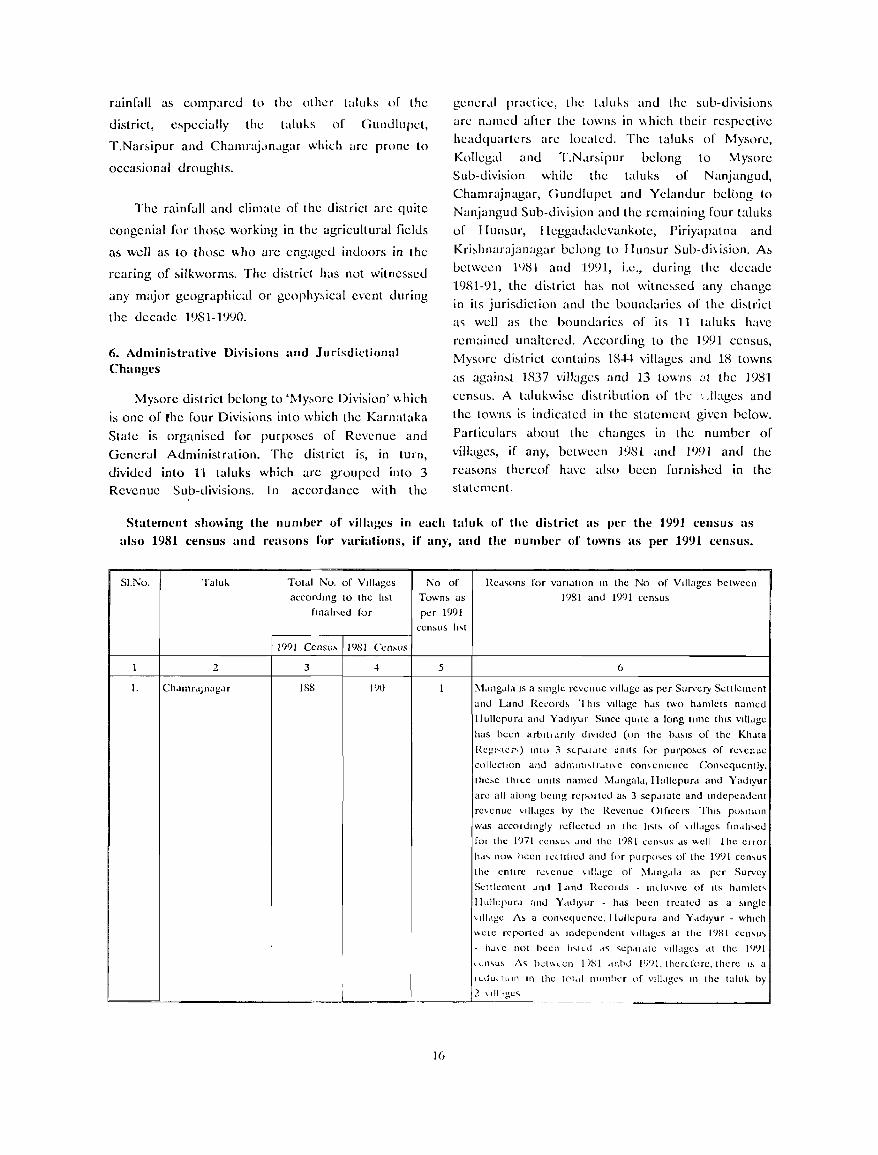
rainfall as companxl to the other taluks of the
district, especially the taluks of (Jundlupet,
T.Nar~ipur and Chamraj,m,lgar which arc prone to
occasional droughts.
The rainfall and climate of the district arc quite
congenial for those working in the agricultural fidds
as well as to those \\-ho arc engaged indoors in the
rearmg of ~ilkworms. The district has not witnessed
any major geographical or geophy~ical event during
the decade 1981-1990.
6. Adminbtrative Divbions and Jurisdictional Changes
My~ore district belong to 'My~ore Oivi;,ion' ",hich
is one of rhe four Oivi;,ions into which the Karnataka
State is organised for purpo~es of Revenue and
General Administration. The district is, in turn,
divided into 11 taluks which arc grouped into 3 Revenue Sub-divisions. In accordance with the
gener.tl pract icc, the LII ub and the sub-divisions
arc n,lI11l.:d after the towns in '" hich their respective headquarters arc located. The taluks of Mysore,
Kollegal and T.N.lr;,ipur belong to Mysore Sub-division while the taluks of Nanjangud,
Chamrajnagar, (;undlupet and Yclandur bclcll1g to
Nanjangud Sub-di"i~ion and the remaining four taluks
of II un;,ur, Heggadadevankote, Piriyapatna and
Kri;,hnarajanagar belong to H un,<,ur Sub-di\ i.sion. A;,
between 1')8} and 1991, i.e., during the decade
1981-91, the di::-.trict ha~ not witne~sed any change
in its jurisdiction and the boundaries of the di,<,trict a<; well as the boundaries of its 11 taluks have
remained unaltered. According to the 1991 census,
Mysore di;,trict contains 18-l-l villages and 18 towns
as agaimt ]837 villages and 13 towns at the ]98]
census. A talukwi,<,e di;,tribution of tbe " .lbges and
the towns is indicated in the statement given below.
Particulars about the changes in the number of
villages, if any, betwecn 1981 and 1991 and the rca,<,ons thcreof have also becn furni,<,hcd in the statement.
Statement sluming the numlJer of Yillages in each taluk of the dbtrict as per the 1991 census as
also 1981 census and reasons for variations, if any, and the number of towns as per 1991 census.
SI.No. 'falul-.
2
1.
Tot.)1 No, of Villdges
accordlllg to the 11M
flna1J\ed for
No of
Towns as
per 1 <)')j
cen~us lI\t
Red~ons for vandtlon III the No of Villages hetween
1()81 and 1<)91 cen~us
r--------,------~ 19')1 CCl1su,", 19o5i CCl1~lIS
3
188 I()O
5
:'-1.lngdld IS a slnglc revcnuc villdgc as per Survery Settlemcnt
~ll1d Land Rel'ord~ 'I hiS villagc hdS two hdmlets named
!IullepUl'd and Yadlyur Since qUIte a long time thiS villdge
has been arbltldnly diVided (on the bd~IS of the KI1.Ita
Rcg,<;[cI"') LnLl) 3 S<"pdldle units for purpo~es of rC'Cl1ue
colkctlon and aun'dnl,trdLI\C con\cnlcncc Con,cqllcntly.
the~e thlLe units named :vtdngald,lIullcpurd and Yadlyur
are all along being rcpOLtcd a~ 3 sep.llatc and Indepcndcnt
re\enuc ,,1I1.lgcs by the Rcvenue Olflcers Thl~ P'''lllon
WdS accollJlngly rdlc('led III the 11~1~ of \J1ldges fllldll,ed
fOl the I(nl ccn~u, dnd the 1()81 <:<.:n,,'5 dS ",cli Ihe CliOI'
h.J ... nO\, heen Iclltfled and f"f pUI'P0 ... es of the I()')l CCI""U~
the cntlfe re\cnuc '1lldge of :'-1.lI1g.Jl.J a~ per Survcy
SeLLkmcnt dnd Land Rccolds Il1ciU'IVe of Its IMlllicL'
Illdkpurd and Yddlyur - hds been treated as a ~ll1glc
'IILlge A~ a COJ1,cquence. Ilullepu I'd and Y ddlyur . which
"cle reported a, Il1dcpcndent ,dlages at the 1981 cel1,U\
. h.J\e not becn IlqlU d~ ~cp.lldte vilidge> .It thc 1')')1
I lcll'U, A~ bCLVolcn I )SI dllbd I(NI. thcf{.forc, there I~ a
, I IILdUcLIU!l In thc L('[,11 !lumher of vJ1l .. gc~ Il1 the talu" by
i ___l_ ~II Igc~ ~~~~~-=~---=~~~~==-=~~~-·~-=~~ __ ~~~~~~-=====-=-===-=~~~~~~~~~d
1(,
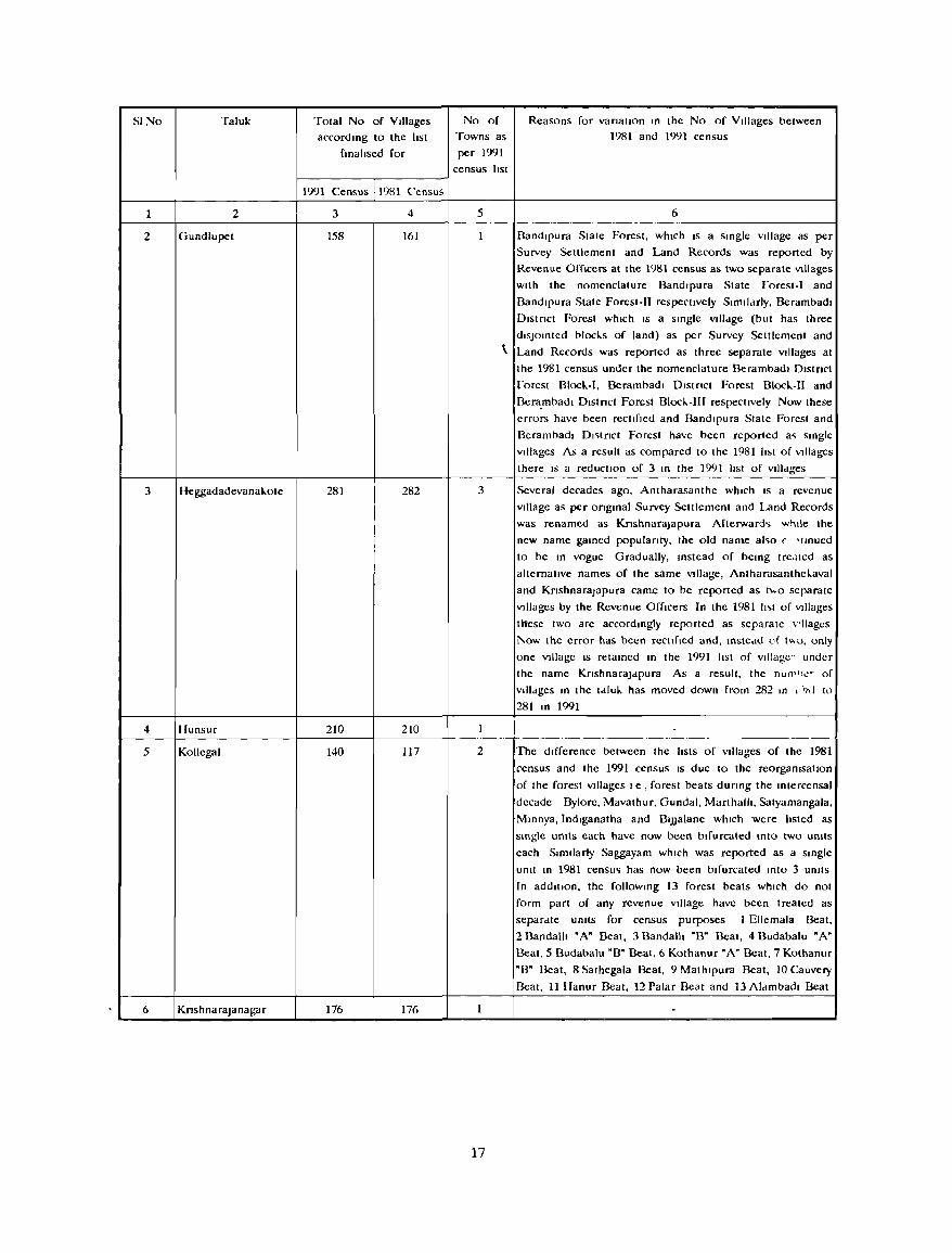
SINo Taluk
1 2
2 Gundlupet
3 Heggadadevana!..ote
4 Ilunsur
5 Kollegal
6 KnshnaraJanagar
Total No of Villages
accord 109 to the Itst
fmalised for
1991 Census 1981 C'ensus
3 4
158 161
281 282
210 210
140 117
176 176
No of
Towns as
per 1991
census Itst
Reasons for vanatJOn In the No of Villages between
1981 and 1991 census
5
3
2
17
6
Bandlpura State Forest, whICh IS a single VIllage as per
Survey Settlement and Land Records was reported by
Revenue Officers at the 1981 census as two separate Vlllages
With the nomenclature Bandlpura State forest-I and
Bandlpura State Forest-II respectively Simlldrly, Berambadl
Dlstnct Forest which IS a slOgle Vllldge (but has three
diSJointed blocks of land) as per Survey Settlement and
\. Land Records was reported as three separate VIllages at
the 1981 census under the nomenclature Berambadl Dlstnct
to rest B1od.-I, Berambadl Dlstnct Forest mocl-I1 and
Bera.mhadl Dlstnct Forest Blocl..-III respecllvely Now these
errors have been rectified and Bandlpura State Forest and
Oerambadl DI~tnct Forest have been reported a~ smgle
Vlllages As a result as compared to the 1981 Itst of Villages
there IS a reduction of 3 m the 1991 Itst of villdges
Several decades ago, Antharasanthe which IS a revenue
Vlllage as per ongmal Survey Settlement and Land Records
was renamed as KnshnaraJapura Afterwardo; whtle the
new name gamed populanty, the old name al~o ( ·tmued
to be 10 vogue Gradually, mstead of bemg trcdted as
alternative names of the same VIllage, AntharasantheJ..aval
and KnshnaraJapura came to be reported as t",o separate
Vlllages by the Revenue Officers In the 1981 Ito;t of Villages
t!lese two are accordmgly reported as separate \rllages
l\.ow the error has been recllfled and, IOstcdd of t"o, only
onc VIllage IS retamed 10 the 1991 Itst of VIllage" under
the name KnshnaraJdpura As a result, the nun"''':- of
Vllldges m the tdlu!.. has moved down from 282 m l )I>! to
281 m 1991
The difference between the Itsts of VIllages of the 1981
census and the 1991 census IS due to the reorganlsallon
of the forest Vlllages Ie, forest beats durmg the mtercensal
decade Bylore, Mavathur, Gundal, Marthallt, Satyamangala,
Mmnya,lndlganatha and OIJJalane which were listed as
smgle untts each have now been bifurcated Into two umts
each Similarly Saggayam which was reported as a smgle
umt m 1981 census has now been bifurcated mto 3 unlls
In addition, the followmg 13 forest beats which do not
form part of any revenue VIllage have been treated as
separdte units for census purposes 1 Ellemala Beat,
2 Bandalh " A" Beat, 3 Bandalli "0" Beat, 4 Budabalu "A"
Beat, 5 Oudabalu "0" Beat, 6 Kothanur "A" Beat, 7 Kothanur
"0" Deat, 8 Sathegala Beat, 9 Mathlpura Beat, 10 Cauvery
Beat, 11 Ilanur Beat, 12 Palar Beat and 13 Alambadl Beat
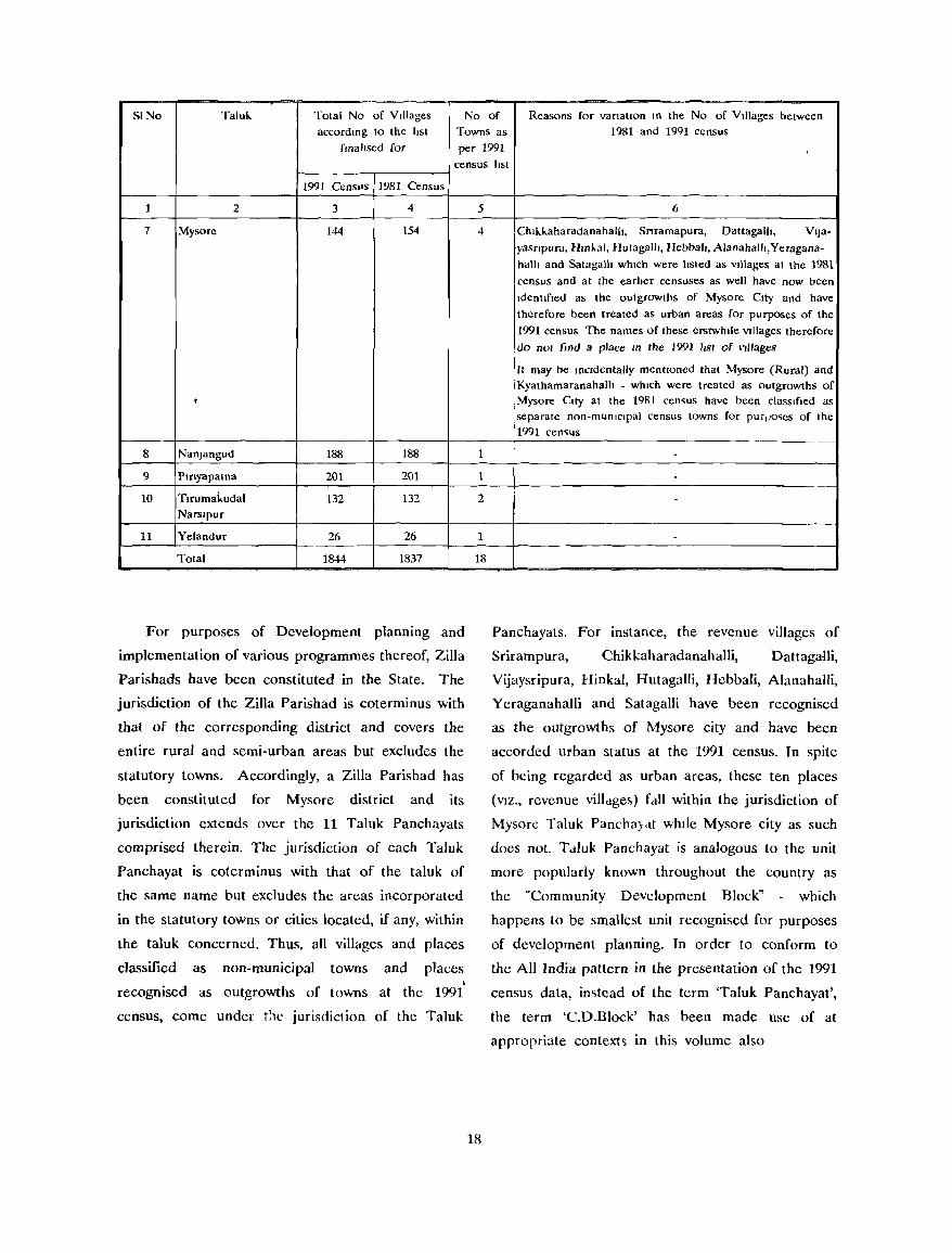
SINo Taluh. Total No of Villages No of Reasons for variation In the No of Villages between accordmg to the list Towns as 1981 and 1991 census
fmallsed for per 1991 census list
1991 Censlls 1981 Census
1 2 3 4
7 Mysore 144 154
,
8 NanJangud 188 188
9 Plnyapama 201 201
10 Tlrumakudal 132 132 Narslpur
11 Yelandur 26 26
Total 1844 1837
For purposes of Development planning and
implementation of various programmes thereof, Zilla
Parishads have been constituted in the State. The
jurisdiction of the Zilla Parishad is coterminus with
that of the corresponding district and covers the
entire rural and semi-urban areas but excludes the
statutory towns. Accordingly, a Zilla Parish ad has
been constituted for Mysore district and its
jurisdiction extends over the 11 Taluk Panchayals
comprised therein. The jurisdiction of each Taluk
Panchayat is coterminus with that of the taluk of
the same name but excludes the areas incorporated
in the statutory towns or cities located, if any, within
the taluk concerned. Thus, all villages and places
classified as non-municipal towns and places , recognised as outgrowths of towns at the 1991
census, come under t!1C jurisdiction of the Taluk
5
4
1
1
2
1
18
18
6
Chlh.h.aharadanahalIl, Snramapura, Dattagalh, VIJa-yasnpura, HlI1l..al, Hutagalh, Hcbbah, Alanahalh,Yeragana-
halh and Satagalh which were hsted as Villages at the 1981
census and at the earher censuses as well have now been
Idenllfled as the outgrowths of Mysore City and have
therefore been treated as urban areas for purposes of the
1991 census The names of these erstwhile Villages therefore
do not find a place In the 1991 list of Villages
It may be mCldentally mentIoned that Mysore (Rural) and Kyathamaranahalh - which were treated as outgrowths of Mysore City at the 1981 cen~us have been classified as separate non-municipal census towns for PU'I)o~es of the 1991 cen~us
---
-
Panchayats. For instance, the revenue villages of
Srirampura, Chikkaharadanahalli, DattagaUi,
Vijaysripura, Hinkal, Hutagalli, Hcbbali, Alanahalli,
Yeraganahalli and Satagalli have been recognised
as the outgrowths of Mysore city and have been
accorded urban status at the 1991 census. In spite
of being regarded as urban areas, these ten places
(VIZ., revenue villdge&) rdll within the jurisdiction of
Mysorc Taluk Pancha)dt while Mysore city as such
does not. T dluk Panchayat is analogous to the unit
more popularly known throughout the country as
the "Community Development Block" which
happens to be smallest unit recognised for purposes
of development planning. In order to conform to
the All India pattern in the presentation of the 1991
census data, imtead of the term 'Taluk Panchayat',
the term 'CD.Block' has been made use of at
appropriate context'.> in this volume also
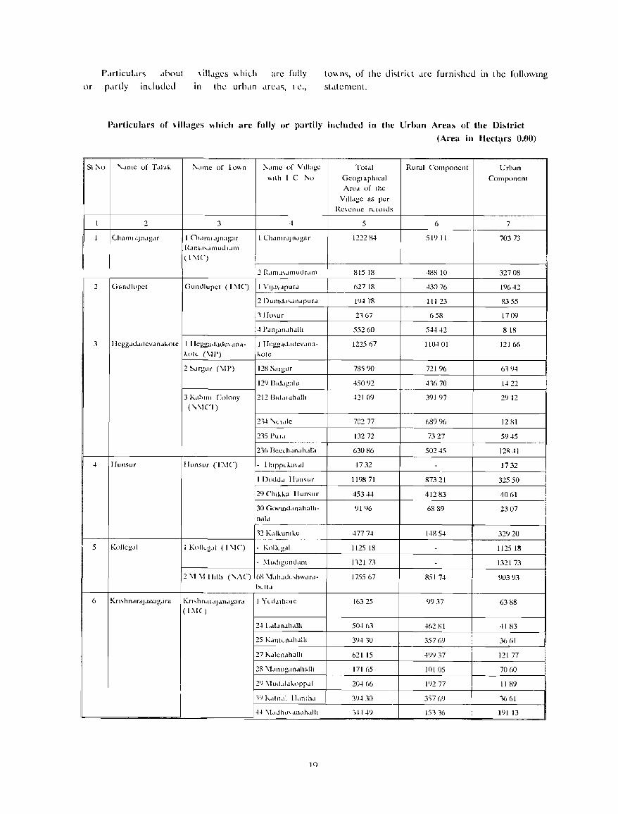
P c1fticuI.H'i dbout
or p.trlly incluueu
\ illdges \\ hich are fully
In the urb.m drCd", I C.,
to\\n", of the ui"triLt ..Ire furni'ihcd In the follOWIng
st,ltement.
Purticulurs of \illages \\hich are fully or pal-tily included in the Urban Area!> of the Dbtrict
(Area in lIect:,trs O'()O)
51 ;\0 '\..lllle of T.lluk !'\.lI11C of 10"n 1\,1Il1e of V I1I;Jge Tol.ll Rural Componcnt Urb.ln
"llh I C 1\0 Gcogl a ph Ical Componcnt Arcd of thc
Vlil.lgc as per
Rc\cnuc rLtolos
1 2 3 ~ 5 6 7
1 ('hallll.lJndgar I ChdlllldJnagar I Clldll1 r,IJ Ildgar 12::!2 8-t 51911 70373 Ram,I".lJ11UOldm ( I \IC)
2 RdI11-41~Jll111drc.llll 81518 ~88 10 32708
2 GUllolupct Gunulupcl (L\lC) I V1J,I\,lpUrd 62718 ~30 76 196 ~2
2 [)umdd"llldpurd l')~ 78 11123 8355
11 Io~ur 2167 658 1709
~ 1\IIlJdIlJh..Jlh 552 (,Q 5~~2 818
3 Ilcggdodocvdn..!kolc t lIcggaddoc\ .111.1- I llcggdoducv.lna- 122567 11~01 12166 kol{. (\11') J..OIC
2 ~drgur (\11') 128 S,lIgur 78') 90 72196 619-1
12') Blodgalu -15092 -11670 1-122
3 K.lllllll Colony 212 Blodldl1.l1l1 -12109 391 en 2912 ("\1,1)
2~ '\udlc 70277 689')(, 1281
::!15 PUld 13272 7327 59~5
21(, Bcc(hdl1..!hdlll 63086 502-15 128 ~1
~ Ilul1sur IIunsllT (Ti\IC) - 1 blPpd,3\.J1 1732 - 1732
I Dooo..! Ilul1~ur 119871 87321 32550
29 Cllll-.1-.a lIun~ur 453~ 41283 4061
30 GovlIlddl1ahalh- 9196 6889 2307 ndld
12 KdlJ..ul1lJ..e 4777-1 1485-1 32920
5 Kollcg,,1 I Kollcg,lI (I \IC) KoIILg,,1 112518 - 1125 1~
- i\1 uOlguno,1Il1 1121 73 - 132173
2 \1 \1 1IlIIs ("1\(') (,8 \t,lhdoL,bwdrd- 1755 (,7 851 7-1 90393 hLltd
6 Kn,hnJrdJdnagdra Kn"hl1dldJ..!l1..!gard I ):\.u.llhOlc 16325 ')937 6388 ( 1 11.1 ( )
24 I..JI,Il1,lh.l1l1 5~ (,3 4(,2 HI 4183
25 Kdl1tLl1dh .. I1h 39410 357m 3661
27 l\.dlcl1Jhalh 62115 -t')') 37 121 77
28 \1,lIlugdlldhalh 171 ()5 10105 7060
2') \luo"I.lkorr,lI 2~ ()6 19277 1189
If) I\.dlll,d I I. III I h.l 3')430 3')7 (,') 1661
.j.j \L,uhlJ\ dlldhdlh 14.j -1f) 151,(, 191 13
1()
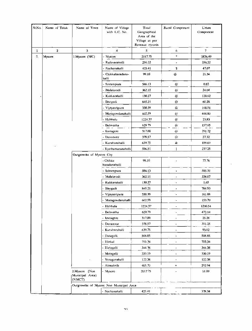
SI.No. Name of Taluk Name of Town Name of Village Tolal Rural Componenl Urban with L.c. :"0. Geographical Component
Area of the Village as per
Revenue records
1 2 3 4 5 6 7
7. Mysore I.Mysore (MC) - \1ysore 2017.75 . 1836.49
- Paduvarahalli 256.22 - 256.22
- Nachanahalli 425.41 S 47.07
- Chikkaharadana- 99.10 @ 21.34 halli
- Srirampura 586.13 @ 0.82
- Malalavadi 362.11 @ 24.04
. - Kukkarahalli 130.27 @ 128.62
- Dhogadi 845.21 @ 60.28
- Vipyasripura 330.39 @ 168.51
- Mar~gowdanahalli 602.59 @ 448.80
- lIehbalu 1224.37 @ 23.83
- Delavatha 629.79 @ 157.65
- Iranagere 317.00 €I' 29].72
- Devanoor 378.57 @ 27.32
- Kuruharahalli 639.75 & 109.69
- Kyalhamaranahalli 506.51 I 237.25
Outgrowths of Mysore City
- Chikka 99.10 - 77.76 haradanahalli
- Srirampura 586.13 - 585.31
- Malalavadi 362.11 - 338.07
- Kukkarahalli 130.27 - 1.65
- Bhogadi 845.21 - 784.93
- Vijayasripura 330.39 - 161.88
- Maragowdanahalli 602.59 - 153.79
- IIchbalu 1224.37 - 1200.54
- Delavatha 629.79 - 472.14
- Iranagere 317.00 - 25.28
- Devanoor 378.57 - 35].25
- Kuruharahalli 639.75 - 93.02
- Dalagalli 508.85 - 508.85
- lIinkal 755.34 - 755.34
- lIulagalli 344.38 - 344.38
- MClagalJi 330.19 - 330.19
- Ycraganahalli 122.38 - 122.38
- Alanahalh 405.70 + 292.94
2.Mysore (Non - \1ysorc 201775 - 11.09 Municipal Area) (NMCT)
---,-- . ~--- -
Outgrowths of Mysore Non Municipal Area - . -''_T-' --
- Nachanahalli 425.41 - 378.34 .~
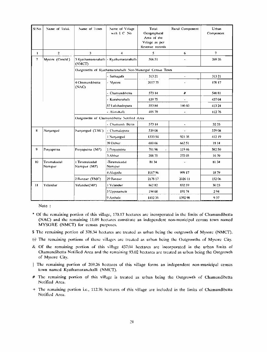
SI No Name of Taluk !'.ame of 10wn i\ame of Village Total Rural Component Urban \.\1(h l C No Geographical Component
Area of the
Village as per Revenue records
1 2 3 4 5 6 7
7 Mysore (Concld) 3 Kyathamaranahalh - K)dthdmaranahalh 50651 - 26926
(NMCr)
Outgrowths of Kjathamaranahdlh Non-MuOlclpal Census Town
- Sathagalh 31321 - 31321
4 Chamundlbetta - 'vfysore 201775 - 17017
(NAC)
- Chamundlbctta 57314 # 5-1081
- Kurubarahalh 63975 - 43704
57 Lahthadnpura 55384 14060 41324
- AI.IOJhdlh 40570 - 11276
Outgrowths of Chamundlbettd !'.otlfled Area
- Chdmundl Betta 57314 - 3233
8 NanJangud !'.dnJ3ngud (1 MC) - Chdmdldpurd 53908 - 53908
1 NdnJdngud 13335-1 92135 41219
39 Debur 68066 66251 1814
9 Pmyapatna Plrlyapatna (MP) 1 Plrlyapatna 70196 11946 58250
3 Abbur 288 75 272 05 1670
10 Tlrumakudal 1 Tlrumaludal -Tlrumaluddl 8134 - 8134 Narslpur Narslpur (MP) Narslpur
4Aldgodu 101796 99917 1879
2 Bdnnur (TMC) 29 Bdnnur 217817 202611 15206
11 Yelandur Yeldndur(MP) I Ydandur 86282 83259 3023
3 UpplOamole 19468 19174 294
9 Ambale 140235 1392 98 937
Note:
* Of the remaining portion of this village, 170.17 hectares are incorporated in the limits of Chamundibetta (NAC) and the remaining 11.09 hectdfes con<;titute an independent non-municipal census town named MYSORE (NMCT) for census purposes.
$ The remaining portion of 378.34 hect.ues are treated as urban being the outgrowth of Mysore (NMCT).
@ The remaining portions of these villJ.gc<; are tredted as urban being the Outgrowths of Mysore City.
& Of the remaining portion of this village 437.04 hectares are incorporated in the urban limits of Chamundibetta Notified Area and the remaining 93.02 hectares are treated as urban being the Outgrowth of Mysore City.
The remaining portion of 269.26 hectares of this village forms an independent non-municipal census town named Kyalhamarandhalli (NMCT).
# The remaining portion of this village is treated as urban being the Outgrowth of Chamundibetta Notified Area.
+ The remaining portion I.e., 112.76 hectares of this village are included 10 the limits of Chamundibetta Notified Area.
21
7. Brief Analysis of Data
A. Village Directory
Villagewise information regarding the availability
of certain basic amenities within the village as also
that on the manner of utilisation of the land in the
concerned village are furnished in the Village Directory. The items covered inckde the minimum
needs such as the source of drinking water supply and the educational, medical, public transport and
communication as well as the weekly market facility.
If anyone or more of these basic amenities were
to be 'not available' within the village, then instead
of merely stating that fact, the distance (in ranges)
to the nearest place having that particular facility in which the village is lacking, is indicated. Thc other items covercd in the Village Directory are
the nature of approach road to the village,
electrification and the proximity of the village to an
urban area. Since the availability or otherwise of a facility depends to a considcrable extent on the
popUlation size of a village, information on population and the number of households as per 1991 Census
is also furnished in the Village Directory. Under the land use pattern, besides indicating the tOlal area of the village, the Village Directory gives a
breakup of this area by the broad categories of Landuse such as forests, cultivated lands ~ith irrigation facility (by sources of irrigation), cultivated
lands without irrigation facility, culturable waste and the barren and uncultivable lands including the lands
put to non-agricultural use.
In essence, the Village Directory provides
micro-level data which will help the planners in
formulation of micro-level developmental plans, as
the C.D.Block is the lowest administrative unit for
developmental planning. Regarding the basic
facilities, the villagewise data are consolidated for
each C.D.Block (i.e., Taluk Panchayat) and the
distI;ict thereof and are presented in Appendix-I to
the Village Directory. This would in a general way
enable the reader to have a broad idea regarding
the level of development achieved by the di,.,trict as
a whole and also by the different allministrative
units constituting the district (vi7., the C.D.Bloch).
With the same end in view, six tables, which have
been generated on the computer, on the ha~is of
the village wise information contained in the Village
Directory format, are presented in T Jole,., 1 to 6.
Of these tables, while Tables 1, :: and 6 provide .,;ata f/)f each CD.Block and are indicative .f the
22
levels of development, Table 3 deals with villages
not having the facilities and classifies these villages
by di,.,tancc ranges with reference to the nearest
place having such a facility, Tables 4 and 5 deal in a general way about the correlation between the
proximity of a town and the availability of a facility
on the one hand and the population size of the village and availability of a facility on the other
hand.
B. Town Directory
Certain salient details pertaining to each town
within the district arc presented in the Town
Directory Statements. The various aspects covered
in these simple statements include the growth history
of the town; its location with reference to centres
of administration and transport; income and
expenditure of the local body looking after the civic
administration of the town; nature and extent of
ba,.,ic amenities existing in the town such as roads,
drainage and sewerage, toilet facilities, drinking water
supply, fire lighting services and electrification; nature
and extent of the availability of medical, educational
and recreational facilities in the town and a broad
indication about the trading, commercial and
manufacturing activitics within the town. In the case
of towns with a population of 50,000 and upwards,
particulars about the civic amenities existing in the
notilied slums, if any, in the town have also been
provided.
Unlike villages, the number of towns within a
district are quite small. A mere inspection of the
data presented in the Town Directory Statements
would provide the reader with a broad idea about
the conditions prevailing in the towns of the district
as also an insight into the inler-town differences.
Population of a lown is one of the most important
factors which i~ closely related to the extent of
availahility of various amenities in the town. Tables
7 to 10 hased on the data presented in the Town
Directory Statements indicate the percapita income
and expenditure of the civic body governing the
town, the average number of heds available in
hospitab (per lhousanll population), the average numher of educational institutions (per 10,000
porul,,~")fl) and the ;_;llnes of the most important c()m[Tll)dilic~ IT',.ln1·fa,J'IP',1 In the towns, exported
from the :" ". . ", i,' 1 i,) the towns. The~c tables :lr t ':,p',o: ":-\ :lnd do not need further
elucid,,' \
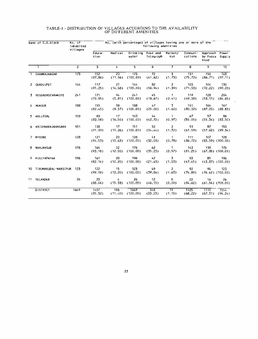
T ABLE- t - DISTRIBUTION OF VILLAGES ACCORDING TO THE A VAILABIUTY OF DIFFERENT AMENITIES
Name of C.D.Block No. of No. (with percentage) of vilLages having one or more of the inhabi ted following amenities viLLages
Educa- Medical Drinking Post and Market/ Corrmuni- Approach Power ti on water Telegra'ph Hat cations by Pucca Supply
Road
2 3 4 5 6 7 8 9 10
CHAMRAJNAGAR 173 152 20 173 72 3 131 150 168 (87.86) (11.56) (100.00) (41.62) (1.73) (75.72) (86.71) (97.11 )
2 GUNDlUPET 144 117 21 144 82 2 103 104 130 (81.25) (14.58) (100.00) (56.94) (1.39) (71.53) (72.22) (90.28)
3 HEGGADADEVANKOTE 241 171 14 241 45 1 119 128 204 (70.95) (5.81) (100.00) (18.67) (0.41) (49.38) (53.11) (84.65)
4 HUN SUR 188 155 18 188 47 3 151 164 167 (82.45) (9.57) (100.00) (25.00) (1.60) (80.32) (87.23) (88.83)
5 KOLlEGAl 103 83 17 103 44 1 67 57 86 (80.58) (16.50) (100.00) (42.72) (0.97) (OS.05) (55.34) (83.50)
6 KRISHNARAJANAGARA 151 138 17 151 52 2 93 87 150 (91.39) (11.26) (100.00) (34.44) (1.32) (61.59) (57.62) (99.34)
7 MYSORE 128 121 20 128 41 1 111 107 128 (94.53) (15.63) (100.00) (32.03) (0.78) (86.72) (83.59) (100.00)
8 NANJANGUD 176 164 22 176 62 1 143 118 176 (93.18) (12.50) (100.00) (35.23) (0.57) (81.25) (67.05) (100.00)
9 PIRIYAPATNA 196 161 20 196 42 3 93 85 196 (82.14) (10.20) (100.00) (21.43) (1.53) (47.45) (43.37) (100.00)
10 TIRUMAKUDAL-NARSIPUR 123 122 15 123 49 2 92 94 123 (99.19) (12.20) (100.00) (39.84) ( 1.63) (74.80) (76.42) (100.00)
11 YELANDUR 26 23 4 26 12 0 22 16 26 (88.46) (15.38) ( 100.00) (46.15 ) (0.00) (84.62) (61.54) ( 100.00)
DISTRICT 1649 1407 188 1649 548 19 1125 1110 1554 (85.32) (11.40) (100.00) (33.23) (1.15) (68.22) (67.31) (94.24)
23
TABLE-2 - PROPORTION OF RURAL POPULATION SERVED BY DIFFERENT AMENITIES
Name of C.D.Block Total popu· Proportion of Rural Population served by the amenity of . lation of inhabi ted Educa· Medical Drinking Post & Market/ COl1l11uni· Approach Power villages tion water Telegraph Hat cations by Pucca Supply
Road
2 3 4 5 6 7 8 9 10
CHAM RAJ NAGAR 266845 263099 70454 266845 187125 7194 243386 254531 266589 (98.60) (26.40) (100.00) (70.12) (2.70) (91.21) (95.39) (99.90)
2 GUNDLUPET 171772 169753 56299 171772 141379 10664 158871 160344 168056 (98.82) (32.78) (100.00) (82.31> (6.21) (92.49) (93.35) (97.84)
3 HEGGADADEVANKOTE 196288 185177 30741 196288 82585 1444 133396 141887 191208 (94.34) (15.66) (100.00) (42.07) (0.74) (67.96) (72.29) (97.41)
4 HUN SUR 187420 182557 48521 187420 89822 12735 170268 176730 183888 (97.41) (25.89) (100.00) (47.93) (6.79) (90.85) (94.30) (98.12 )
5 KOlLEGAL 257036 255440 105835 257036 195549 3112 225029 204895 255735 (99.38) (41.18) (100.00) (76.08) (1. 21) (B7.55) (79.71) (99.49)
6 KRISHNARAJANAGARA 191286 189789 59982 191286 124450 12697 153351 134031 191260 (99.22) (31.36) (100.00) (65.06) (6.64) (80.17) (70.07) (99.99)
7 MYSORE 201154 200002 60435 201154 116138 4394 190669 177653 201154 (99.43) (30.04) (100.00) (57.74) (2.18) (94.79) (88.32) (100.00)
8 NANJANGUD 281600 281103 77701 281600 172390 3244 258353 231894 2B1600 (99.82) (27.59) <100.00) (61.22) < 1. 15) (91. 74) (82.35) (100.00 )
9 PIRIYAPATNA 176894 170444 40251 176894 74291 13624 112997 91904 176894 (96.35) (22.75) (100.00) (42.00) (7.70) (63.88) (51.95) (100.00)
10 TIRUMAKUDAl· 230;392 230073 58758 230392 150900 3651 198126 196646 230392 NARSIPUR (99.86) (25.50) (100.00) (65.50) (1.58) (86.00) (85.35) (100.00)
" YELANDUR 64(J37 62242 19873 64037 49348 0 60729 45773 64037 (97.20) (31.03) (100.00) (77.06) (0.00) (94.83) (71.48) (100.00)
DISTRICT 2224724 2189679 628850 2224724 1383977 72759 1905175 1816288 2210813 (98.42) (28.27) (100.00) (62.21) (3.27) (85.64) (81.64) (99.37)
24

TABLE-3 - DISTRIBUTION OF VILLAGES NOT HAVING CERTAIN AMENITIES, ARRANGED BY DISTANCE RANGES FROM
THE PLACES WHERE THESE ARE AVAILABLE
Village not having the Number of villages where the amenity is not amenity of available and available at a distance of
-5 Km. 5-10 Km. 10+ Km. Total
2 3 4 5
EDUCATION 237 5 0 242
MEDICAL 1078 284 99 1461
DRINKING WATER 0 0 0 0
POST & TELEGRAPH 985 101 15 1101
MARKET/HAT 540 525 565 1630
COMMUNICATION 473 41 10 524
TABLE-4 - DISTRIBUTION OF VILLAGES ACCORDING TO THE DISTANCE FROM THE NEAREST TOWN AND AVAILABILITY OF DIFFERENT AMENITIES
Distance No. of No. (with percentage) of villages having the amenity of -Range from inhabited the nearest villages Educa- Medical Drinking Post & Market/ Communi- Approach Power town (in in each tion water Telegraph Hat cations by Pucca Supply Kms. ) range Road
1 2 3 4 5 6 7 8 9 10
0 - 5 240 214 14 240 84 3 158 178 239 (89.17) (5.83) (100.00) (35.00) (1.25 ) (65.83) (74.17) (99.58)
6 - 15 754 653 100 754 257 7 530 529 722 (86.60) (13.26) (100.00) (34.08) (0.93) (70.29) (70.16) (95.76)
16 - 50 645 533 72 645 204 9 432 401 586 (82.76) (11.18) (100.00) (31.68) (1.40) (67.08) (62.27) (90.99)
51 + 10 7 2 10 3 0 5 2 7 (70.00) (20.00) (100.00) (30.00) (0.00) (50.00) (20.00) (70.00)
ALL RANGES 1649 1407 188 1649 548 19 1125 1110 1554 (85.38) (11.41) (100.00) (33.25) (1.15) (68.26) (67.35) (94.30)
25
TABLE-5 - DISTRIBUTION OF VILLAGES ACCORDING TO POPULATION RANGE AND AMENITIES AVAILABLE
PopulatIon No. of Number (wlth percentage) of vIllages havlng the amenl ty of range lnhabl ted
vIllages Educa- MedIcal Drlnk lng Posts & Market/ Communl- Approch Power In each tlon water Telegraph Hat catIons by Pucca Supply range Road
2 3 4 5 6 7 8 9 10
499 444 214 1 444 18 0 165 198 355 (48.20) (0.23) (100.00) (4.05) (0.00) (37.16) (44.59) (79.95)
500 - 1999 851 840 50 851 224 4 629 601 845 (98.71) (5.88) (100.00) (26.32) (0.47) (73.91 ) (70.62) (99.29)
2000 - 4999 304 303 103 304 258 12 283 263 304 (99.67) (33.88) (100.00) (84.87) (3.95) (93.09) (86.51) ( 100.00)
5000 + 50 50 34 50 48 3 48 48 50 (100.00) (68.00) (100.00) (96.00) (6.00) (96.00) (96.00) (100.00)
ALL RANGES 1649 1407 188 1649 548 19 1125 1110 1554 (85.32) ( 11.(0) (100.00) (33.23) (1.15) (68.22) (67.31) (94.24)
TABLE-6 - DISTRIBUTION OF VILLAGES ACCORDING TO LAND USE
Name of C.D.Block No.of lnhabl ted Total area Percentage of Percentage of vlllages cultIvable area IrrIgated area
to total area to total culti-vable area
2 3 4 5
CHAMRAJNAGAR 173 1179.89 54.66 15.32
2 GUNDlUPET 144 1252.03 45.52 7.25
3 HEGGADADEVANKOTE 241 1482.44 39.52 10.24
4 HUN SUR 188 813.03 56.97 12.92
5 KOLlEGAl 103 1616.48 40.11 16.23
6 KRtSHNARAJANAGARA 151 543.66 74.82 31.38
7 MYSORE 128 650.18 74.09 7.25
8 NANJANGUD 176 939.64 73.84 25.98
9 PIRIYAPATNA 196 785.22 62.42 13.51
10 TIRUMAKUDAL-NARSIPUR 123 586.07 79.48 50.58
" YElANDUR 26 264.38 40.37 44.79
DISTRICT 1649 10113.02 54.95 19.03
26
T ABLE-7 - PER CAPITA RECEIPT AND EXPENDITURE IN TOWNS
Class, Name and C1V 1 C Per CapIta status of the Town
ReceIpt (Rs.) Expend,ture (Rs.)
Total ReceIpt ReceIpt Total General Expendl- PublIC Expendl- Other through from all expen- aeJ/1l1 n1 - ture on works ture on aspects taxes other dlture stratlon publIc publIc
sources health & Instltu-conve- tl0ns n1 ences
2 3 4 S 6 7 8 9 10
IV BANNUR (TMC) 50.51 20.37 30.14 49.36 8.46 19.16 1.85 0.84 19.05
III CHAMRAJNAGAR 61.40 24.95 36.45 65.00 17.58 26.45 10.93 0.01 10.03 RAMASAMUDRAM (TMC)
VI CHAMUNO I BETTA 88.03 4.68 83.35 63.22 46.87 8.06 0.46 7.83 NOTIFIED AREA (NAC)
III GUNDLUPET (TMC) 70.83 8.36 62.47 67.86 31.96 13.19 5.74 16.97
V HEGGADADEVANKOTE (MP) 170.33 95.77 74.S6 159.71 13.38 63.96 44.87 0.96 36.54
II I HUt-ISUR (THC) 48.56 6.16 42.40 S1.37 9.48 28.92 0.38 12.59
VI KABINI COLONY (NMCT)
III KOLLEGAL (TMC) 107.10 20.58 86.52 89.55 36.80 4.78 19.58 28.39
III KRISHNARAJANAGARA (THC) 71.05 34.70 36.35 64.84 6.24 19.59 24.29 1.69 13.03
III KYATHAMARAt-IAHALlI (NMCT)
V MALA! MAHADESH~ARA 28.16 3.00 25.16 50.13 10.99 3.S4 3.83 31.77 HILLS (NAC)
MYSORE (MC) 182.37 132.31 SO.06 163.85 13.43 68.65 41.52 16.15 24.10
IV MYSORE (NON-MUNICIPAL AREA)
I II NANJANGUD (TMC) 83.96 17.78 66.18 60.87 8.17 41.54 0.29 10.87
IV PIRIYAPATNA (MP) 74.29 54.05 20.24 66.36 20.65 16.99 9.16 2.00 17.56
V SARGUR (MP) 307.08 41.03 266.05 237.40 48.56 120.61 1.83 1.98 64.42
V TI RUMAKUDAL- 224.27 21.92 202.35 223.36 25.32 8.12 189.92 NARSIPUR (MP)
V YELANOUR (HP) 41.53 19.23 22.30 40.49 26.88 3.90 1.20 0.81 7.70
ALL TOWNS 142.05 92.13 49.92 127.93 14.23 51.14 29.66 10.53 22.37
27
TABLE-8 - NUMBER OF BEDS IN MEDICAL INSTITUTIONS IN TOWNS
Class, Name and Ciyic status of the Town
IV BANNUR (TMC)
III CHAMRAJNAGAR RAMASAMUORAM (TMC)
VI CHAMUNOIBETTA NOTIFIED AREA (NAC)
III GUNDlUPET (TMC)
V HEGGADADEVANKOTE (MP)
III HUNSUR (TMC)
VI KABINI COLONY (NMCT)
III KOlLEGAL (TMC)
III KRISHNARAJANAGARA (TMC)
III KYATHAMARANAHALLI (NMCT)
V MALAI MAHADESHWARA HILLS (~AC)
MYSORE (MC)
IV MYSORE (NON-MUNICIPAL AREA)
III NANJANGUO (TMC)
IV PIRIYAPATNA (MP)
V SARGUR (MP)
V TIRUMAKUDALNARSIPUR (MP)
V YELANDUR (MP)
ALL TOWNS
No. of Beds in medical institutions per 1000 population
2
1.68
1.12
2.09
5.98
0.86
2.52
1.92
3.85
5.57
0.70
2.50
0.67
3.03
Q.78
4.11
2
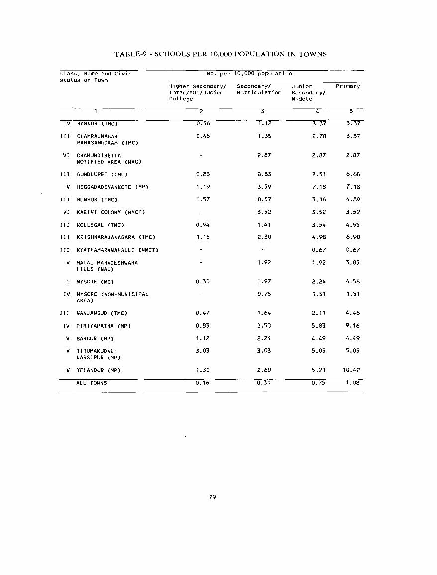
TABLE-9 - SCHOOLS PER 10,000 POPULATION IN TOWNS
Class, Name and Civic No. per 10,000 population status of Town
Higher Secondary/ Secondary/ Junior Primary Inter/PUC/Junior Matriculation Secondary/ College Middle
2 3 4 5
IV BANNUR (TMC) 0.56 1.12 3.37 3.37
III CHAMRAJNAGAR 0.45 1.35 2.70 3.37 RAMASAMUDRAM (TMC)
VI CHAMUND I BETT A 2.87 2.87 2.87 NOTIFIED AREA (NAC)
111 GUNDLUPET (TMC) 0.83 0.83 2.S1 6.68
V HEGGADADEVANKOTE (MP) 1.19 3.59 7.18 7.18
I I I HUN SUR {TMC) 0.57 0.57 3.16 4.89
VI KABINI COLONY (NMCT) 3.52 3.52 3.52
III KOLlEGAL (TMe) 0.94 1.41 3.54 4.95
I I I KRISHNARAJANAGARA (TMC) 1 .15 2.30 4.98 6.90
J J I KYATHAMARANAHALLJ (NMCT) 0.67 0.67
V MALAI MAHADESHWARA 1.92 1.92 3.85 HIllS (NAC)
MYSORE (Me) 0.30 0.97 2.24 4.58
IV MYSORE (NON-MUNICIPAL 0.75 1.51 1 .51 AREA)
I 1 I NANJANGUD (TMC) 0.47 1.64 2.11 4.46
IV PIRIYAPATNA (MP) 0.83 2.50 5.83 9.16
V SARGUR (MP) 1.12 2.24 4.49 4.49
V TIRUMAKUDAl- 3.03 3.03 5.05 5.05 NARSIPUR (MP)
V YElANDUR (MP) 1.30 2.60 5.21 10.42
ALL TOWNS 0.16 0.31 0.75 1.08
29
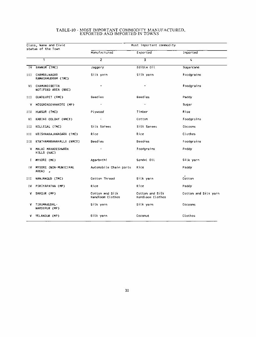
TABLE-IO - MOST IMPORTANT COMMODITY MANUFACTURED, EXPORTED AND IMPORTED IN TOWNS
CLass, Name and Civic status of the Town
IV BANNUR (TMC)
III CHAMRAJNAGAR RAMASAMUDRAM (TMC)
VI CHAMUNDIBETTA NOTIFIED AREA (NAC)
III GUNDLUPET (TMC)
V HEGGADADEVANKOTE (MP)
III HUN SUR (TMC)
VI KABINI COLONY (NMCT)
III KOLLEGAL (TMC)
III KRISHNARAJANAGARA (TMC)
III KYATHAMARANAHALLI (NMCT)
V MALAI MAHADESH~ARA
HILLS (NAC)
MYSORE (MC)
IV MYSORE (NON-MUNICIPAL AREA)
III NANJANGUD (TMC)
IV PIRIYAPATNA (MP)
V SARGUR (MP)
V TIRUMAKUDALNARSIPUR (MP)
V YELANDUR (MP)
Most important commodity
Manufactured Exported
2 3
Jaggery EdibLe Oi L
SiLk. yarn Silk yarn
Beedies Beedies
PLywood Timber
Cotton
Si Lk. Sarees SiLk. Sarees
Rice Rice
Beedies Beedies
Foodgrains
Agarbathi SandaL OiL
AutomobiLe Chain parts Rice
Cotton Thread
Rice
Cotton and Silk Handloom Clothes
Si lk yarn
Silk yarn
30
SiLk yarn
Rice
Cotton and Silk HandLoom Clothes
Silk yarn
Coconut
Imported
4
Sugarcane
Foodgrains
Foodgrains
Paddy
Sugar
Rice
Foodgrains
Cocoons
CLothes
Foodgrains
Paddy
SiLk. yarn
Paddy
, Cotton
Paddy
Cotton and Silk yarn
Cocoons
Clothes
SECTION-I VILLAGE DIRECTORY

VILLAGE DIRECTORY
Explanatory Note
Village Directory, as the title signifies provides
certain basic particulars about each and every village
1D the district. The Village Directory 1S
supplemented by four appendices. There are, in all, 18 columns in the Village Directory format and of these, the first two relate to the location code and name of the village while the next two provide information about the geographical area and population as per 1991 census. Of the remaining, 6 columns deal with the availability or otherwise of the basic amenities such as educational, medical, drinking water, postal, communication and marketing
facilities, in the referent village. Separate columns
have been provided to indicate the nature of the approach road to the village, whether the village has been electrified and the proximity of the village to an urban area. The manner in which the land constituting the village is being utilised is indicated
under five columns with suitable headings. The column headings and the scope of the data presented
under each column are explained below.
Column 1 : Location Code Number
The concept of location code number has already been explained in the Analytical Note. The location
code number thus assigned to the village is entered in this column. This number, in so far as it relates to the village within the C.D.Block, runs serially
starting from 1 for every C.D.Block and the data are presented for villages arranged in an ascending
order of their location code numbers.
Column 2 : Name or Village
The name of the village corresponding to the
location code number given in column 1 is given
in this column. By and large the spcllings adopted
at the previous i.e., 1981 Census, have been retained.
However, changes in village names duly effected by
the concerned authorities with the sanction of the
Government have been taken into consideration
while finalising the spellings of village names for
1991 census purposes.
A lillIe more explanation appears to he necessary ahout the places which appear in the list of towns
33
as well as in the list of villages. This phenomenon
occurs particularly in the case of Taluk and District
Headquarter towns which, as revenue entities are geographically large villages. The main village site
area including the peripheral developed areas would have for long been incorporated into the urban limits without any change whatsoever in Survey and Settlement Records. In the original survey records and also the Resurvey, the entire village inclusive of all the lands that are incorporated into the urban limits continues to be shown as a regular revenue village. In other words, the portion constituted into
a town is not taken out from the parent village and formed into a separate and independent unit in the jurisdictional lists (exception Dakshin Kannad district). Every civic body, be it a municipal corporation or a town municipality or a notified area or a sanitary board, defines its own jurisdiction
confining itself mostly to the built up area and the fringe areas for enforcing municipal rules and regulations. With the administrative and legal sanction of the Government, which lssues a
notification in this behalf, the civic body secures statutory rights for administering the local arc;} so
defined with effect from a specified date. The incorporated areas may at times cut across village boundaries and may comprise portions belonging to the revenue jurisdiction of two or more villages. In
some instances entire revenue lands of a village or
of several villages lose their independent identity and arc omitted in the list of villages of the tal uk
(C.D.Block). But it is only in the case of villages
of which only certain portions arc included in the town, especially those that contribute their names
to the towns concerned, that this apparent duplication of names occurs. In such cases, the jurisdiction of the town is very clear and it covers only a portion
of the village which is constituted into an independent entity as 'urban' for census enumeration purposes.
The remaining area too is constituted as an
independent unit under the 'rural' category i.e., as
a village. In order to distinguish this unique situation, the name of the village bears the suffix Rural within brackets in the lists of villages finalised for census
purposes (perhaps the term non-municipal would he more appropriate). Division of the village into
urban and rural components and the suffixing of the names is a special procedure adopted for census purposes only. That is to say, if one were to ask
the Officers of the Survey, Settlement and Land
Records whether in their lists there arc villages such
as say Bellary (Rural), Belgaum (Rural), Bijapur
(Rural), Chamarajnagar (Rural), Magadi (Rural),
Mandya (Rural), Mysore (Rural), Raichur (Rural)
etc., the answer would be a definite 'no' and then
they would say that thcre are villages of the same name but without the sumx Rural. Similarly, in
the village maps and other records pertaining to
the above named places, the lands that are incorporated into urban areas are also shown as
part and parcel of the concerned village.
Column 3 hectares)
Total area of the village (in
The total geographical area of the village as
per revenue records is furnished in hectares upto
two decimal places. In Karnataka, the hasie records
are still maintained in acres and guntas or acres
and cents, that is, in the units of measurement which
were adopted at the time of the first cadastral
survey. After the introduction of the decimal system
however the equivalents of these figures are also
indicated in addition to the already existing entries
in registers such as Akarband and Records of Rights.
The area of each survey number or part thereof is
converted into hectares, ares and square metre.
Thus, if these converted figures for each such small
unit are added together for the village, the resultant
total area would normally be either less or more
than the corresponding figures that one would derive
by the addition of figures in acres-guntas/acres and
cents and conversion of that total into hectares and
ares. For purposes of presentation in this statement
the village level area and land use figures which
were furnished in acres-guntas or acres-cents by the
Revenue Officers have been converted into hectares
and ares and these figures may not therefore be
identical With the tola} area as may be found entered
in hectares and aru, in the records of some of the
villages. The marglP' 1 dlfru 'I'L·"."~ would be due to
the factors explained above t-'>, 'ICC, in the case of
villages of which certain portion~ 31 c inc.)rpnrated
into an urban area the extent thus catcl!.orised as
urban has been d·;ducted from the total gC01;raphical
34
area of the revenue village and for this reason the
particulars presented here would not be in full
correspondence with the total area of that revenue
administrative unit as mentioned in the village
records. If area ligures arc not available for any
village, the abbreviation 'N.A.' is entered in this
column and a note at the bottom of the page
explains the reason thereof.
Column 4 : Total Population and Number of Households
The total population of the village (inclusive of
the hamlets if any) according to 1991 census and
the number of households therein are indicated one
below the other, in this column. In the case of
villages with no inhabitants i.e., 'nil' population, the
word un-inhabited is written across the line.
Columns 5 to 10: Amenities available (if not available within the vilhlge, a dash (-) is shown in the column and next to it, in brackets, the distance in broad ranges, viz., -5 km, 5-10 km and 10 + Ion of the nearest place where the facility is available is given)
As the main heading for these columns suggests,
if the basic amenity covered under any of these
columns were to be not available within the village
limits (i.e., its entire geographical area) then, instead
of simply stating that fact, an attempt is made here
to indicate the range of the minimum distance (in
km) that one has to cover to reach a place having
that specific facility. The abbreviations made use of
in these columns are explained below column by
column.
Colullln 5 : Education
All types of educational institutions functioning
in the village - irrespective of the levels of education
offered, the medium of cducation and the status of
the managing body - are considered under this
column. The abbreviations used to denote institutions
with different levels of education arc :
i) P : Primary Of Elementary School : Schools
providing education from I standard and upwards
uplO and inclusiv..: of TV standard arc classified as
Primary Schools. This would also include junior
basic sch, ,(lIs if any.
For purposes of reporting, schools which provide
education not merely from I to IV but also for
higher standards, called composite schools for easy
reference, are split up into different levels of
education and counted as independent units under
each such level.
ii) M: Middle or Junior Secondary School:
Schools providing education from V standard and
upwards upto and inclusive of VII standard are
classified as middle schools. In Karnataka, as a
maHer of fact, the term middle school is no longer
in vogue. Primary education itself consists of seven
years of schooling and the first four years duration
of this course is called Lower Primary and the next
3 year period is termed as Higher Primary. As
mentioned above for accounting purposes, a Higher
Primary School with I-VII standard is treated as
two units i.e., one Primary School and one Middle
School.
iii) H : Matriculation or Secondary School :
Schools providing education from VIII standard and
upwards upto and inclusive of X standard are
classified as High Schools. A composite school with
I-X standard is treated as three separate units and
counted separately under the categories of Primary
Schools, Middle Schools and High Schools.
iv) PUC: Higher Secondary/Intermediate! Pre
University/Junior College: Schools and colleges that
provide education for the XI and XII standards or,
as is more common in Karnataka, for the I and II
year of the Pre-University Course, fall under this
category. There are Higher Secondary Schools with
VIII standard and upwards covering the XII standard
and, on the other hand, there are also degree
colleges which provide education for PUC I year
and PUC II year. These composite units are, as
explained earlier, split up into different levels for
reporting purposes.
v) C : College This would cover all
educational institutions that provide post-PUC level
education leading to University degree in any subject
or combination of subjects and also post-graduate
levels of education.
vi) I : Industrial School : Industrial Schools if
any in the village are indicated by the abbreviation
'I' .
vii) Tr : Training School: All types of Institutions that provide vocational and professional training are covered by this abbreviation.
viii) AC : Adult Literacy Class/Centre : This abbreviation is recorded in this column only if adult literacy classes were being conducted regularly in the village during the reference year.
ix) 0 : Olhers : All other types of educational institutions such as Sanskrit Pathasala, Urdu Madarasa, Makhtab etc., are included in this residuary category.
• It is important to note that in this column
whenever the number of institutions of a particular
level or class exceeds one, only then the actual
number is also reported immediately after the
relevant abbreviation within brackets. That is to
say, the mere presence of an abbreviation without
any numerical attribute signifies the existence of the
facility, in at least one institution for which that
abbreviation stands. The numerals indicate the
number of institutions or units of that level or type.
Such a procedure has not becn adopted in respect
of Adult Literacy Class/Centre ID VICW of
inconsistencies noticed in the data furnished.
If a village does not have any educational
institution whatsoever then a dash (-) is entered in
this column and thereafter, within brackets, the
range of the distance (in km) from the referent
village to the nearest place having at least a primary
school is indicated. The emphasis here is on the
most basic need i.e., the minimum level.' In other
words, if the village has primary school, but not
middle school or high school then no further
information is furnished in respect of the proximity
of a middle school or a high school or a college.
Similarly, for a village with primary and middle
schools but no high school or a college, no further
information is furnished in respect of the proximity
of places having high school and college level
facilities.
It may again be recalled that the concept of a village covers the entire revenue jurisdiction of that unit and includes all the hamlets and clusters of houses as well as isolated homesteads if any i.e .• all human settlements as also all the non-residential buildings located within the limits of the village concerned.
Columa 6 : Medical :
The abbreviations used to denote the existence of medical institutions of different types in the village are
H MCW MH ewe HC PHC
D FPC
·TB NH RP SMP CHW o
Hospital Maternity and Child Welfare Centre Maternity Home Chid Welfare Centre Health Centre Primary Health Centre/Primary Health
Unit Dispensary Family Planning Centre
: T.B.Clinic Nursing Home
: Registered Private Medical Practitioner : Subsidised Medical Practitioner : Community Health Worker : Others
If the number of institutions of a particular type happens to be more than one. then that number is also indicated immediately after the relevant abbreviation.
If medical facilities of any of the types mentioned above are not available in the village then a dash is entered in this column and thereafter. within brackets. the range of the distance (in km) from the referent village to the nearest place having a
• medical institution which provides at least the minimum level of medical facilities is indicated.
The status of a Primary Health Unit in Karnataka is much lower than that of a Primary Health Centre. However for purposes of reporting under this column. the abbreviation PHC has been made usc of in respect of PHU as well. The abbreviation H which stands for hospitals implies the availability of facilities for the treatment of in-patients also. In several Primary Health Centres also such facilities do exist. Likewise Maternity Homes also entertain in-patients bu' then the~ are confined only to maternity cases.
This apart. in all other cases except in private nursing homes. arrangements exist for the treatment of out-patients only. In local parlance in certain areas however even a dispensary is referred to as a hospital and the clinic run by a private medical practitioner as a dispensary and a private nursing home as a hospital. This indiscriminate usage at times leads to confusion.
All types of medical institutions. irrespective of the system of medicine practiced therein. are covered under this column without any attempt to provide a further break up by the systems of medicine practiced.
About the Community Health Worker it may
incidentally be mentioned that it docs not refer to workers in extension programmes like the Malaria Surveillance Worker. the Basic Health Worker, the Auxiliary Nurse Midwife ctc .• but refers only to the paramedical personnel who have been specially trained for dispensing medicines for minor ailments at the doorsteps of the patients.
Column 7 : Drinking Water
Following are the abbreviations used to indicate the different sources of drinking water that are available in the village. These sources of drinking water supply may be public properly or may be owned by private persons and institutions. If there are two or more sources of drinking water in a_ village then all these sources are mentioned one after the other but separated by commas.
T Tap C Canal W Well L Lake Tk Tank S Spring TW Tube WeU N N allah/Stream HP Hand Pump R River F Fountain a Others NA Information not available
A village is rzganl·.j qS !1~ving 'tap water' facility only if the village is pro"i,kd with proper storage facility and an ariangcmcn; for supply of water to the consumers thiOo.:gh ;) r· ... twork of pipes. Most
of the villages where NRWS schemes have been implemented fall under this category. On the other hand, under the Mini Water Supply Scheme or
Accelerated Rural Water Supply Scheme etc., if arrangements have been made in the village to pump water from a primary source such as a borewell, store that water in RCC or masonary tanks erected at one or more centrally located places and to provide such storage tanks with a few taps for public use, the source of water supply in the village has been regarded as 'Tube Well' and not as 'Tap'.
During the last decade, borewells have been drilled under one scheme or the other in most of the villages of Karnataka. As a result, open draw wells which formerly constituted the main source of drinking water in several of these villages have ceased to enjoy such a status. Such wells are reported to have either dried up or the water therein has been rendered unfit for human consumption
due to contamination on account of negligencc, as well as disuse and stagnation of watcr. Thus, for numerous villages 'hand pump' has now been reported as the main source of drinking water.
If the village does not have any source of drinking water supply at all then, after a dash 10
this column, the distance range that one has to traverse to reach the nearest place with drinking water facility is indicated.
Column 8 : Post and Telegraph
In this column, information on the availability of postal, telegraph and telephone facilities in the village is furnished using the following abbreviations.
PO Post Office TO PTO Phone
Telegraph Office Post and Telegraph Office Telephone connection
Villages with Extra Departmental Post Offices
are regarded as having the post office facility.
Similarly, villages having phonocom facility (but not
having a regular Telegraph Office equipped with
Morse Code transmitters) are regarded as having
Telegraph facilities.
Telephone connection need not necessarily indicate the availability of a public call office in the village, for even priyate telephone connections to
37
subscribers have been taken into consideration while filling up this column. If a village has postal as well as telephone facilities then both these amenities are
mentioned. Likewise if there is a PTO and telephone connections, then both the abbreviations are entered in this column. On the other hand if the xillage is not having any of these facilities then a dash is noted and next to it the distance to the nearest place having the minimum facility of a post office is indicated in ranges.
Column 9 : Day or Days or the Market/Hat
The column refers to the weekly, or bi-weekly markets i.e., the weekly shandy, held in villages with a view to cater to the needs of that village and more so to the needs of the inhabitants of several surrounding villages. In local terminology such a weekly market is called SOllllre and is quite popular in Karnataka. In the case of villages which host such shandies the actual day on which the shandy takes place is mentioned and in all other cases a dash is entered and thereafter the distance to the nearest place with a weekly matket is indicated in ranges as specified in the column heading. The place where such weekly market gathers may be located in the limits of an adjoining taluk or district.
The important matter for consideration here is the geographical proximity. In some cases where the nearest town or a large sized village with a permanent market would serve the needs of the villagers, the distance ranges refer to such places with permanent markets only. In such cases obviously the nearest
place where a weekly market is held would be very
far away and will not be a maller of much significance. For instance shandy is not being held in any of the villages of Ramanagaram taluk of Bangalore Rural
District.
Column 10 : Communication
For purposes of this column, only the means
of public transport namely bus, railway and water transport system if any are considered. If the village is served by any mode of such public lransport the fact IS indicated using the undermentioned abbreviations :
BS RS NW
Bus Stop Railway Station Navigable Waterway (including river, canal, back-waters, etc.)
If a bus stop or a railway station is located within the territorial jurisdiction of a village then
that village is considered as being served by that
facility even if that bus stop or railway station is
in a somewhat solitary place and is located at some
distance from the village-site. If more than one
type of communication facility is available, then all the relevant abbreviations are mentioned in this
column. If no such facility is available at all then
a dash is entered and thereafter the distance to the
nearest place with a communication facility is
indicated in ranges.
Column 11 : Approach to village
By approach to village is meant the type of
road that leads to the village and this would indicate
whether the village is accessible throughout the year
or only during the fair season. The abbreviations
used lD this column are
PR Pucca Road KR Kachcha Road NR Navigable River NC Navigable Canal NW : Navigable Waterway (other than river and
canal) FP : Foot path/Bridle path
If a village has a foot path or bridle path and
also both pucca road and kachcha road then, only
PR is recorded in this column as it would denote
a higher level of facility of the same type. Similarly
if the village has a bridle path, a foot path and a
Kachcha Road, then only KR is reported in this
column. While kachcha road refers only to the
unsurfaced mud road, the term pucca road covers
tar roads, cement roads, water bound mecadum
roads and metalled roads. But, if in addition to
either PR or KR the village has a waterway then
information on the availability of a water way is
also indicated.
Column 12 : Nearest town and distance
The name of the nearest town, that is, any
urban area as defined for purposes of the 19Q1
Census, and the distance thereto from the vilbgc
are indicated in this column. The town mcntioned
here need not be located within that very taluk or
the district or even the State for that mallei. The
main point for consideration here is tht' gcograiJlIlcai ~l·(,}.jmity. The distnnce howevcr is r .. 'cKoJJC'd !1(\t
38
as a 'crow flies' but by some land route or water
way. Further, when there is a cross country footpath
or a cart-track and a little more circuitous road
from the village or its proximity to the town then
the distance by road is reported here in preference
to the distance by foot path or cart-track. Similarly, when there are natural hurdles like unbridged rivers
or streams the distance is furnished by the more
circuitous route that the villagers would usually
prefer. The information on distance is based on
local enquiry by the reporting agency and is very approximate. If the town mentioned in this column
belongs to another State then the name of that
State is also indicated along with the name of the
town and the distance thereto.
Column 13 : Power Supply
If the village is electrified, that is, if power is actually available, whatever may be the form of its
use, then the village is regarded as enjoying this
amenity of power supply. If the supply is expressly
restricted for, say agricultural or any other specific
purpose then this point is clearly stated by using a
specific abbreviation. On the other hand, if
electricity is being supplied for all purposes without
any reservations, then information on vanous
purposes IS not separately mentioned. The
abbreviations used in this column are :
ED Electricity for domestic purpose only EAG Electricity for agricultural purposes only EO Electricity for other purposes like
industrial
EA ElectricilY ror all purposes stated above
Column 14 to 18 : L"nd Use {1,~. area under dilJt'I'ent types of land use In l;t,,:t~· ~·.'S upto two places of dt·cimal)
The land u:; .. : p ... :i..:rn adopted for the Village
Directory conf,mnc, I,; I h" das.'.ificalion of land use
as fi..:commuldcd Ly dK Ministry of Agriculture,
GOWl nmenl of Ind;",. "he Mini~try of Agriculture
has recommended ! he maintenance of records on
land use um!.. I I he fdi bwing five categories :
1. rorest-.
a) L
3. Other uncultivated lands excluding fallow
lands:
a) Permanent pastures and other grazing lands,
b) Lands under miscellaneous tree-crops and groves not included in the net area sown,
c) Culturable wastes
4. Fallow lands :
a) Fallow lands-other than current fallows,
b) Current fallows
5. Net area sown
Column 14 of the Village Directory corresponds
to category 1 i.e. forest, while columns 15 and 16
put together represent the cultivated lands and
correspond to the combination of categories 4 and
5 above. Similarly, columns 17 and 18 respectively
correspond to catcgories 3 and 2 of the above
classification. The data furnished here are based
on the village records and pertain generally to the
year 1989. The total of the area figures reported
under these columns generally tallies with the total
geographical area of the village noted in column 3.
However, in the case of villages which are partly
included in towns the total area reported in column
3 will be less than the total arrived at by adding
the figures rcported under these columns (i.e.
Columns 14 to 18).
Column 14: Forest
This includes all lands classified as forests under
any legal enactment dealing with forests or
administered as forests whether State-owned or
private and whether wooded or simply maintained
as potential forcst land. Lands transferred to forest
department for afforestation as also the class C and
D lands transferred thus by the revenue department
are also classified as forests. Within the forest area
itself there may occasionally be cuitivated patches
or else there may be grazing lands. But such areas
too are shown under column 14 only as forests. If
within an area classified as forest some specific
extents 0f lands have been expressly assigned for
3Y
regular cultivation and the records have not been
set right pending formalisation of grants and related
proccs~es of survey and settlement then such cropped
areas arc shown under column 15 or 16 as the case
may be and the remainder alone is shown as forest
under column 14. The processes of regularisation
of land grants and effecting relevant changes in the
basic records of survey and settlement are somewhat
protracted and time consuming. Therefore, the
information merely based on records is, in some
cases at least, likely to be different when compared
with that ba~cd on actual field inspection.
Column IS and 16 : Irrigated (by source) and Un-irrigated
These two columns cover all the agricultural lands and when added togeth~ would correspond to the net area sown plus the current and other fallows. The latter would imply all lands which were taken up for culti~ation, but are temporarily out of cultivation for a period of not less than one year and not more than five years. All lands that are lying uncultivated as fallows for more than 5 years
in succession are regarded as permanent fallows i.e., culturable waste, and are covered under column 17. Area sown more than once during the same year, if any in the village, is counted only once under these columns. In column 15, a sourcewise break up of the irrigated area is furnished using
the following abbreviations :
GC Government Canal PC Private Canal W Well (without Electricity) We Well (with Electricity) TW Tubewell (without Electricity) TWe Tubewell (with Electricity) Tk Tank R River L Lake Wf Waterfall 0 Others T Total
The concept of irrigation implies the existence
of a source of water supply within a reasonable
distance and an arrangement to regulate the supply
of water according to the day-to-day needs of the
crops raised in these fields. Naturally therefore all
areas that arc cultivated under purely rainfed
conditions are treated as un irrigated. Though paddy
is generally regarded as a wet crop, if it is raised
purely as a rainfed crop, as it very ofttn is the
case in heavy to very heavy rainfall regions, such
areas are regarded as unirrigated for purposes of
this column and shown under column 16. Similarly,
about garden crops, the area is considered for
column 15 only if there is an element of irrigation.
Sometimes it happens that the lands shown as dry
and rainfed in the settlement records are in actual
fact having irrigation facilities due to recent changes
such as sinking of wells, introduction of lift irrigation
or canal irrigation or commissioning of a project
etc. In such a case the actual situation is taken note of and despite its classification as rainfed in
the records, the area concerned is treated as irrigated.
Though rare, the opposite situation (where a plot
of land originally shown as irrigated has ceased to
enjoy that facility and is now yielding purely rainfed
crops) is also met with and such a situation arises
due to reasons such as breaching of tanks, drying
up of irrigation wells and small tanks, defunct canal
system and so on. The reporting agency has generally
assessed the actual situation prevailing during the
reference year i.e., 1989, while furnishing the data
on irrigated lands. Regarding canal irrigation too
it is the actual irrigated area and not the command
area that has been reported here.
In column 16 the total extent of unirrigatcd
lands, that is, dry lands cultivated as rainfcd fields
and the current fallow lands put together is reportcd.
As explained above, lands yielding rainfed paddy
crop are considered as unirrigated.
Column 17 : Culturable Waste (including gauchar and groves)
This category includes all lands available for
cultivation whether not taken up for cultivation at
all or taken up for cultivation once but not cultivated
during the past five years or more in succession.
Such lands may be either fallow or covered with
shrubs and jungles which are not put to any use.
These may be assessed or unassessed and may be in isolated blocks or within cultivated holdings.
Lands under thatching grass, bamboo bushes and
other groves which are not included under orchards
40
or forests arc also included undcr this category.
Further, this includes all grazing lands irrespective
of whether these are permanent pastures and
meadows or not. In several instances, lands that
were at one time reserved for use as grazing fields
and pastures and declared as assessed or unassessed
wastes have, over a period of time, been brought
under cultivation either fully or in parts as a result
of gradual encroachments and also because of the
policy decisions of the Government regarding land grants. Thus, though the particular plot of land
continues to be shown as a pasture in the village
records the actual field situation would reveal that
most of that land is actually under cultivation. In all such cases, to the extent possible, thc actual
field situation has been taken into consideration by
the reporting agency.
Column 18 : Area not available for cultivation
In this column, the total extent of land which IS not available for cultivation in view of its being barren and unculturable as also that which is put to non-agricultural uses is reported. Mountains, deserts, rocky hills, quarries, ravines and the like as well as the lands that cannot be brought under cultivation except at a very high cost are included in the category of barren and uncuhivable lands. The category of lands put to non-agricultural uses covers all lands occupied by buildings, roads, railways, parks and play grounds, area under water viz., rivers, streams, canals, reservoirs, lanks, ponds etc., and land put to any other use which is apparently non-agricult ural.
There arc four appendices to the Village
Directory. Appendix-I is based on the Village
Directory itself and presents abstract figures for the
C.D.Blocks and the district in respect of various
amenities for which information is presented in the
Village Directory. At the end of the Village Directory
of each C.D.Block, against "Total (Sum)", the total
number of various types of educational and medi~1
institutions represented by various abbreviations
under columns 5 and 6 respectivcIy are given. In
Appendix-I, besides incorporating this information,
the total number of villages in which these institutions
are situated is also given for comparison. Further,
10 respect of amenities viz., drinking water supply,
post and telegraph, communication and power supply
for which the types of amenities available are indicated by abbreviations under columns 7, 8, 10
and 13 respectively for each village but totals are
not presented for the C.D.Block as a whole in the
Village Directory, the total number of villages in
the CO.Block and, in the district as well, having
the above mentioned amenities is also presented
under separate captions in Appendix-I.
Appendix-II presents the land utilisation data
in respect of non-municipal census towns. The
different types of land use for which information is
presented here is same as that in the Village
Directory. Owing to constraints in the compilation
of land use data, information in respect of towns
comprising portion/s of one or more villages could
not be procured and compiled. Thus information in
respect of non-municipal census towns (NMCTs)
which comprise of a whole revenue village only is
presented in this appendix wherever applicable.
41
Appendix-III gives the list of villages which arc lacking in all amenities covered in the Village Directory except the drinking
water.
Appendices-IV(A) and IV(B) are compiled from
the Primary Census Abstract. The proportion of
Scheduled Castes population to the total population
of the village, as per 1991 census, has been worked
out for each village in a C.D.Block and a list of
villages grouped into 6 ranges of percentage points
is given in Appendix-IV(A). Appendix-IV(B) is similar to Appcndix-IV(A) but deals with the proportion of Scheduled Tribes to
the tolal population of the village concerned.
However in view of tbe vast difference in the
relative strengths of these two communities as
well as the pattern of distribution, the percentage
points included in the 6 ri'nges adopted for the
Scheduled Castes and the Scheduled Tribes are
slightly different.

CHAMRAjNAGAR C.D.BLOCK
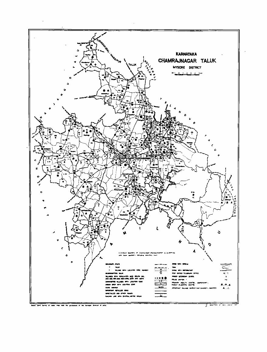
()
')
o
11
.,
kARNATAKA
CHAMRAJNAGAR TALUK M~E DISTRICT
.. =-.. == .. -=~ .. '"
(
/)
(
c ., lloe' IJevI'>OO', .. CI\O_o,.....,· -Ao_ollllUCfo_ .. co-w ... , .... ..... • '''' ........... , .HI ....... ,hlt"'"" , ....
........ It,ft ,_ tU.MI WIT" LOt."_ COlI( ........ --'II.LMIS __ ._ II¥ II ........
.... _ ................. tCJOOMCt..:M
~ WI.UIh .., .. LOCA~ tool: _ MIA wnM LOC"ftON CODE
, .. ,.--- ........ -..... ,M.LID .., DfMP -.oaos .... _ &oM wmt "loTION ..... .,. IoIIf,JG(
:.-:_-_-_i_C::.:: . \0
0 ••••
r---iT-----' j:----;,-----j _I!!l!L_
.....,.,. ... ." ,_ CAlIIL .... 1II! ---.,. ...
'01' o.a: I fI\.EIIUIIW CJII'ht[ -.-lIQ"a "...,.. •
......... ~ ,.. aNT,.. DfP'tfr! ..... ' .... L" ""' ... ,., tUIT"
~&tf9 ... u....c ... _r" .. "fJ,oU...,.' ...... ",
..... __ ...................... l1li ......... ., ...... ..,., .... , .... _it
..
·s
".+ ... A..L

ALPI-IABETICAL LIST OF VILLAGES
TALUK: CHAMRAJNAGAR-OOIO C. D.BLOCK:CHAMRAJNAGAR-OOIO
·SL NAME OF THE VILLAGE 1991 CENSUS 1981 CENSUS NO
LOCATION CODE LOCATION CODE LOCATION CODE LOCAl ION CODE (Manual) (C~ter) (Manual) (C~ter)
2 3 4 5 6
1 Achattipura 11/16/1/65 11/16/0010/0065 9/15/1/67 09/15/0010/0067 2 Aldur 11/16/1/148 11/16/0010/0148 9/15/11150 09/15/0010/0150 3 Alur 11116/11160 11116/0010/0160 9/15/11162 09/15/0010/0162 4 Amachavady 11/16/1/73 11/16/0010/0073 9/15/1175 09/15/0010/0075 5 Arnnanapura 11/16/1/165 11/16/0010/0165 9/15/11167 09/15/0010/0167 6 Ankanasettypura 11/16/1/42 11/16/0010/0042 9/15/1144 09/15/0010/0044 7 Araltalavady 11/16/1/56 11/16/0010/0056 9/15/1/58 09/15/0010/0058 8 Aralikatte 11/16/1/105 11/16/0010/0105 9/15/1/107 09/15/0010/0107 9 Attugul ipura 11/16/1/181 11/16/0010/0181 9/15/11183 09/15/0010/0183
10 Badagalapura 11/16/1/83 11/16/0010/0083 9/15/1185 09/15/0010/0085 11 Badanaguppe 11/16/1/21 11/16/0010/0021 9115/1/21 09/15/0010/0021 12 Bagal i 11/1611/149 11/16/0010/0149 9/15/1/151 09/15/0010/0151 13 Bananall i 11/16/1/152 11/16/0010/0152 9/15/1/154 09/15/0010/0154 14 Bandigere 11/16/1/39 11/16/0010/0039 9/15/1/41 09/15/0010/0041 15 Bandigowdanahall i 11/16/1/49 11/16/0010/0049 9/15/1/51 09/15/001010051 16 Basavanapura 11/16/1/3 11/16/0010/0003 9/15/1/3 09/15/0010/0003 17 Basavapura 11/16/1141 11/16/0010/0041 9/15/1/43 09/15/0010/0043 18 Basavatti 11/16/1/155 11/16/0010/0155 9/15111157 09/15/0010/0157 19 Basthipura 11/16/1/47 11/16/0010/0047 9/15/1149 09/15/0010/0049 20 Bedagul i 11/16/11175 11/16/0010/0175 9/15/1/1n 09/15/oo10/01n 21 Bedarapura 11/16/1/23 11/16/0010/0023 9/15/1123 09/15/0010/0023 22 Bendaravady 11/16/1120 11116/0010/0020 9/15/1120 09/15/0010/0020 23 Bettadapura 11/16/1196 11/16/0010/0096 9/15/1198 09/15/001010098 24 Bettahall i 11/16/11125 11116/0010/0125 9/15/1/127 09/15/0010/0127 25 Bevinathalapura 11/16/1145 11/16/0010/0045 9/15/1147 09/15/0010/0047 26 Bhagapur. 11/16/1129 11/16/0010/0029 9/15/1/29 09/15/0010/0029 27 Bhujaganapura 11/16/1/108 ',/16/0010/0108 9/15/11110 09/15/0010/0110 28 Bisalavady 11/1611/50 11/16/0010/0050 9/15/1/52 09/15/0010/0052 29 Bokkepura 11/16/1/70 11/16/0010/0070 9/15/1/72 09/15/0010/0072 30 BOIIIII8naha II i 11/16/1/48 11/16/0010/0048 9/15/1150 09/15/0010/0050 31 Boodamba II i 11/16/1/117 11/16/0010/0117 9/15/1/119 09/15/001010119 32 Boodithhtu 11/16/1/37 11/1610010/0037 9/15/1/39 09/15/0010/0039 33 Byadanu:talu 11/16/1/40 11/16/0010/0040 9/15/1/42 09/15/0010/0042
34 Chamrajnagar (R] 11/16/111 11/16/0010/0001 9/15/1/1 09/15/0010/0001 35 Chandakavady 11/16/1/156 11/16/0010/0156 9/15/11158 09/15/0010/0158 36 CharYlappanapura 11/16/1/51 11/16/0010/0051 9/15/1/53 09/15/0010/0053 37 Chatipura 11/16/1/120 11/16/0010/0120 9/15/1/122 09/15/0010/0122 38 eM kkabegur 11/16/)/103 11/16/0010/0103 9/15/1/105 09/15/001010105 39 Chowdahalli 11/16/1/54 11/16/0010/0054 9/15/1/56 09/15/0010/0056
40 Oemahall i 11/16/1/150 11/16/0010/0150 9/15/11152 09/15/0010/0152 41 Oeshavall i 11/16/11137 11/16/0010/0137 9/1511/139 09/15/0010/0139
45
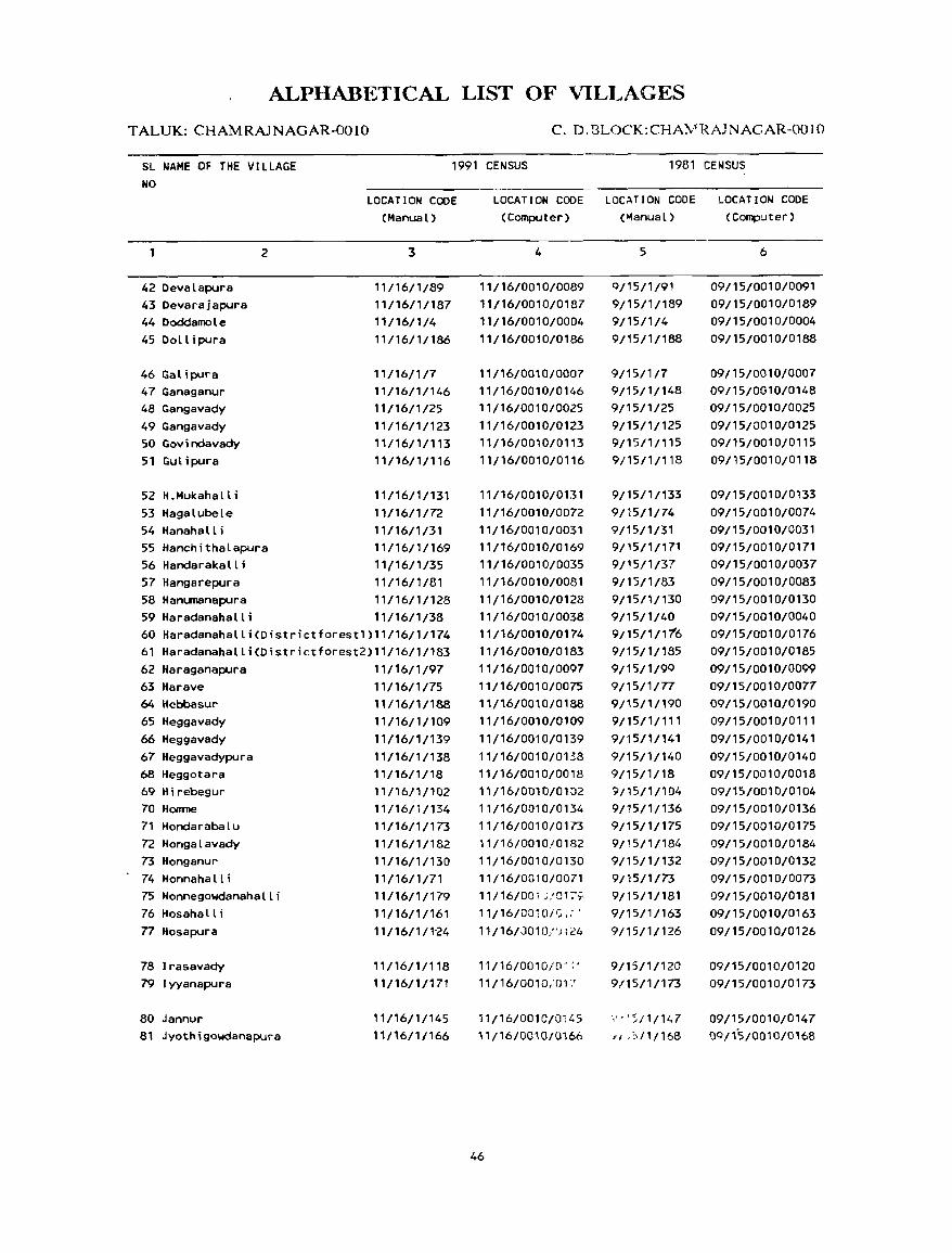
ALPHABETICAL LIST OF VILLAGES
TALUK: CHAMRAJNAGAR-OOlO C. D. BLOCK: CHA!v'RAJNAGAR-OO I 0
SL NAME OF THE VILLAGE NO
1991 CENSUS 1981 CENSUS
42 Devalapura 43 Devarajapura 44 Doddamole 45Dollipura
46 Galipura 47 Ganaganur 48 Gangavady 49 Gangavady 50 Govindavady 51 Gutipura
52 H.Mukahalli 53 Hagalubele 54 Hanahalli
2
55 Hanchithalapura 56 Handarakalli 57 Hangarepura
LOCA TI ON COOE (Manual)
3
11/16/1/89 11/16/1/187 11/16/1/4 11/16/1/186
11/16/1/7 11/16/1/146 11/16/1/25 11/16/1/123 11/16/1/113 11/16/1 /116
11/1611/131 11/16/1/72 11/16/1/31 11/16/1/169 11/16/1/35 11/16/1/81
58 Hanumanapura 11/16/1/128 59 Haradanahalli 11/16/1/38 60 Haradanahalli(Oistrictforestl)11/16/1/174 61 Haradanahalli(Districtforest2)11/16/1/183 62 Haraganapura 11/16/1/97 63 Harave 64 Hebbasur 65 Heggavady 66 Heggavady 67 Heggavadypura 68 Heggotara 69 Mirebegur 70 Honroe 71 Hondarabalu 72 Hongalavady 73 Honganur 74 Honnahalli 75 Honnegowdanahalli 76 Hosahall i n Hosapura
78 Irasavady 79 I yyanapura
80 Jannur 81 Jyothigowdanapura
11/16/1/75 11/16/1/188 11/16/1/109 11/16/1/139 11/16/1/138 11/16/1/18 11 I 1 611 /1 02 11/16/1/134 11/16/1/173 11/16/1/182 11/16/1/130 11/16/1/71 11/16/1/179 11/16/1/161 11/16/1/1"24
11/16/1/118
11/16/1/171
11/16/1/145 11/16/1/166
LOCATION CODE LOCATION CODE LOCATION CODE (Computer) (~anual) (Computer)
4
11/16/0010/0089 11/16/0010/0187 "/16/0010/0004 11/16/0010/0186
11/16/0010/0007 11/16/0010/0146 1 1/16/0010/0025 11/16/0010/0123 11/16/0010/0113 11/16/0010/0116
11/16/0010/0131 11/16/0010/0072 11/16/0010/0031 11/16/0010/0169 11/16/0010/0035 11/16/0010/0081 11/16/0010/0128 11/16/0010/0038 11/16/0010/0174 11/16/0010/0183 11/16/0010/0097 11/16/0010/0075 11/16/0010/0188 11/16/0010/0109 11/16/0010/0139 11/16/0010/0138 11/16/0010/0018
" /16/001 0/01 02 11/16/0010/0134 11/16/0010/0173 11/16/0010/0182 11/16/0010/0130 11/16/0010/0071 11/16/00', ;,'01;-;:-
11/16/0010/':;.: ' 11/16/J010/') 124
11/16/0010/[l~ ;.
11/16/0010/01 ;"
11/16/0010/0i45 11/16/0010/0166
46
5
Q/15/1/91 9/15/1/189 9/15/1/4 9/15/1/188
9{15/1/7 9/15/1/148 9/15/1/25 9/15/1/125 9/15/1/115 9/15/1/118
9/15/1/133 9/15/1/74 9/15/1/31 9/15/1/171 9/15/1/37 9/15/1/83 9/15/1/130 9/15/1/40 9/15/1/116 9/15/1/185 9/15/1/9Q 9/15/1/77 9/15/1/190 9/15/1/111 9/15/1/141 9/15/1/140 9/15/1/18 9/15/1/104 9/15/1/136 9/15/1/175 9/15/1/184 9/15/1/132 9/15/1/73 9/15/1/181 9/15/1/163 9/15/1/126
9/15/1/120 9/15/1/173
\' • < ;; /1/147 if ,,,/1/168
6
09/15/0010/0091 09/15/0010/0189 09/15/0010/0004 09/15/0010/0188
09/15/0010/0007 09/15/0010/0148 09/15/0010/0025 09/15/0010/0125 09/15/0010/0115 09/15/0010/0118
09/15/0010/0133 09/15/0010/0074 09/15/0010/0031 09/15/0010/0171 09/15/0010/0037 09/15/0010/0083 09/15/0010/0130 09/15/0010/0040 09/15/0010/0176 09/15/0010/0185 09/15/0010/0099 09/15/0010/0077 09/15/0010/0190 09/15/0010/0111 09/15/0010/0141 09/15/0010/0140 09/15/0010/0018 09115/0010/0104 09/15/0010/0136 09/15/0010/0175 09/15/0010/0184 09/15/0010/0132 09/15/0010/0073 09/15/0010/0181 09/15/0010/0163 09/15/0010/0126
09/15/0010/0120 09/15/0010/0173
09/15/0010/0147 09/15/0010/0168
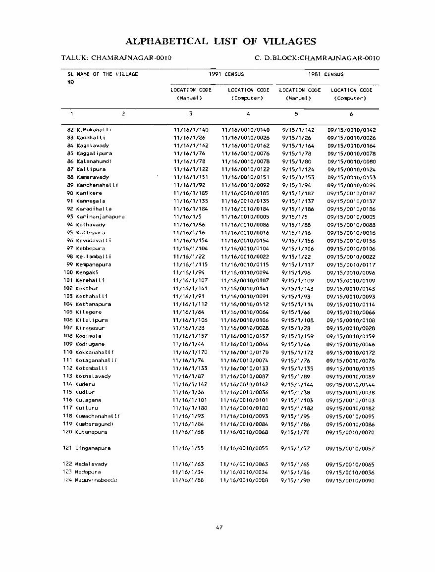
ALPIIADETICAL LIST OF VILLAGES
TALUK: CHAMRAJNAGAR-OOIO C. D.BLOCK:CHAMRAJNAGAR-OOIO
SL NAME OF THE VILLAGE NO
82 K.Mukahall i 83 Kadahalli 84 Kagalavady 85 Kaggalipura 86 Kalanahundi 87 Kallipura 88 Kamaravady 89 Kanchanahalli 90 Kanikere 91 Kannegala 92 Karadihalla
2
93 Karinanjanapura 94 Kathavady 95 Kattepura 96 Kavudavalli 97 Kebbepura 98 Kellamba II i 99 Kempanapura
lOa Kengaki 101 Kerehalli 102 Kesthur 103 Kethaha II i 104 Kethanapura 105 Kilagere 106 Ki lal ipura 107 Kiragasur 108 Kodimole 109 Kodiugane 110 Kokkanahalli 111 Kotaganahalli 112 Kotamballi 113 Kothalavady 114 Kuderu 115 Kudlur 116 Kulagana 117 Kulluru 118 Kumachanahalli ',9 Kumbaragundi 120 Kutanapura
121 Linganapura
122 Madalavady i23 Madapura ;24 M~duv'nabeedu
1991 CENSUS 1981 CENSUS
LOCATION CODE (Manual)
3
11/16/1/140 11/16/1/26 11/16/1/162 11/16/1/76 11/16/1/78 11/16/1/122 11/16/1/151 11/16/1 /92 11/16/1/185 11/16/1/135 11/16/1/184 11/16/1/5 11/16/1/86
11/16/1/16
11/16/1/154 11/16/1/104
11/16/1/22 11/16/1/115 11 /16/ 1 /94 11/16/1/107
11/16/1/141
11/16/1/91 11/16/1/112 11/16/1/64 11/16/1/106
11/16/1/2B 11/16/1/157
"/16/1/44 11/16/1/170 11/16;1/74 11/16/1/133 11/16/1/87
" 116/11142 11/16/1/36 11/16/1/101 11 /16/ 1 / 180 11/16/1/93 11/16/1/84 11/16/1/68
11/16/1/55
11/16/1/63 11/16/1/34 11/16/1/88
LOCATION CODE LOCATION CODE LOCATION CODE (Computer) (Manual) (Computer)
4
11/16/0010/0140 11/16/0010/0026 11/16/0010/0162 11/16/0010/0076 11/16/0010/0078 11/16/0010/0122 11/16/0010/0151 11/16/0010/0092 11/16/0010/0185 11/16/0010/0135 11/16/0010/0184 11/16/0010/0005 11/16/0010/0086 11/16/0010/0016
11/16/0010/0154 11/16/0010/0104
11/16/0010/0022 11/16/0010/0115 11/16/0010/0094 11/16/0010/0107
11/16/0010/0141
11/16/0010/0091 11/16/0010/0112 11/16/0010/0064 11/16/0010/0106 11/16/0010/0028 11/16/0010/0157 11/16/0010/0044
11/16/0010/0170 11/16/0010/0074 11/16/0010/0133 11/16/0010/0087 11/16/0010/0142 11/16/0010/0036 "/16/0010/0101 11/16/0010/0180 11/16/0010/0093 11/16/0010/0084 11/16/0010/0068
11/16/0010/0055
11/16/0010/0063 11/16/0010/0034 11/16/0010/0088
47
5
9/15/1/142 9/15/1/26 9/15/1/164 9/15/1178 9/15/1/80 9/15/1/124 9/15/1/153 9/15/1/94 9/15/1/187 9/15/1/137 9/15/1/186 9/15/1/5 9/15/1/88
9/1511/16
9/15/1/156 9/15/1/106 9/15/1/22 9/15/1/117 9/15/1/96 9/15/1/109 9/15/1/143 9/15/1/93 9/15/1/114 9/15/1/66 9/15/1/108 9/15/1/28 9/15/1/159
9/15/1/46
9/15/1/172 9/15/1/76 9/15/1/135 9/15/1/89
9/15/1/144
9/15/1/38 9/15/1/103 9/15/1/182 9/15/1/95 9/15/1/86 9/15/1/70
9/15/1/57
9/15/1/65 9/15/1/36 9/15/1/90
6
09/15/0010/0142 09/15/0010/0026 09/15/0010/0164 09/15/0010/0078 09/15/0010/0080 09/15/0010/0124 09/15/0010/0153 09/15/0010/0094 09/15/0010/0187 09/15/0010/0137 09/15/0010/0186 09/15/0010/0005 09/15/0010/0088 09/15/001010016
09/15/0010/0156 09/15/0010/0106
09/15/0010/0022 09/15/0010/011'7 09/15/0010/0096 09/15/001W0109 09/15/0010/0143 09/15/0010/0093 09/15/0010/0114 09/15/0010/0066 09/15/0010/0108 09/15/0010/0028 09/15/0010/0159 09/15/0010/0046
09/15/0010/0172 09/15/0010/0076 09/15/0010/0135 09/15/0010/0089 09/15/0010/0144 09/15/0010/0038 09/15/0010/0103 09/15/0010/0182 09/15/0010/0095 09/15/0010/0086 09/15/0010/0070
09/15/0010/0057
09/15/0010/0065 09/15/0010/0036
09/'5/0010/0090
ALPHABETICAL LIST OF VILLAGES
TALUK: CHAMRAJNAGAR-OOIO c. D.BLOCK:CHAMRAJNAGAR-OOIO
SL NAME OF THE VILLAGE 1991 CENSUS 1981 CENSUS NO
LOCA rr ON COOE LOCATION COOE LOCATION COOE LOCATION COOE (Manual) (Coq)Uter) (Manual) (Coq)Uter)
1 2 '3 4 5 6
125 Mal eyur 11/16/1/100 11/16/0010/0100 9/15/1/102 09/15/0010/0102 126 Mallainapura "/16/1/9 11116/0010/0009 9/15/1/9 09/15/0010/0009 127 Malledevanahalli 11/16/1/1n 11116/0010/01n 9/15/1/174 09/15/0010/0174 128 Mallupura 11/16/11159 11/16/0010/0159 9/15/1/161 09115/0010/0161 12«1 MaI_Ia ' 11/16/11127 11/16/0010/0127 9/15/1/129 09/15/0010/0129 130 Managanahalli 11/16/1114 11/16/0010/0014 9/15/1/14 09/15/0010/0014 131 Manchagundipura 11/16/1/57 ',/16/0010/0057 9/1~/1/59 09/15/0010/0059 132 Mangala 11/16/1/33 11116/0010/0033 9/15/1/35 09/15/0010/0035 133 Marjyala 11/16/1/24 11/16/0010/0024 9/15/1/24 09/15/0010/0024 134 Masagapur. 11/16/1/27 11/16/0010/0027 9/15/1n7 09/15/0010/0027 135 Masanapur. 11/16/1/121 11116/0010/0121 9/15/1/123 09/15/0010/0123 136 Melur 11116/1/67 11/16/0010/0067 9/15/1/69 09/15/0010/0069 137 Nudal. Agrah .... 11/16/1/143 11/16/0010/0143 9/15/11145 09/15/0010/0145 138 MUdalu Hosah.tti 11116/t/58 11/16/0010/0058 9/15/1160 09/15/001010060 139 Muc:llapur. 11/16/1/8 11/16/0010/0008 9/15/1/8 09/15/0010/0008 140 Mudnakodu 11/16/1/99 11/16/0010/0099 9/1511/101 09/15/0010/0101 141 Muk.napaly. 11/16ltl1n 11/16/0010/01n 9/15/1/179 09/15/0010/0179 142 Mukkadah.ll i 11/16/1/111 11/16/0010/01 " 9/15/1/113 09/15/0010/0113 143 Munachanahalli 11/16/1/15 11/16/0010/0015 9/15/1/15 09/15/0010/0015 144 Muthige 11/1611/19 11/16/0010/0019 9/15/1/19 09/15/oo1OJ0019
145 Nagav.ll, 11/16/1/164 11/16/0010/0164 9/1511/166 09/15/0010/0166 146 NaHUI" 11/16/1/167 11/16/0010/0167 9/15/1/169 09/15/0010/0169 147 Nanjahall i 11/16/1/110 11/16/0010/0110 9/15/1/112 09/15/0010/0112 148 Manjar.japura 11/16/1/129 11/16/0010/0129 9/15/1/131 09/15/001010131 149 Nanjedevanapu". 11/16/1/17 11/16/0010/00n 9/15/1179 09/15/0010/0079 150 Narasamangala 11/16/1/69 11/16/0010/0069 9/15/1/71 09/15/0010/0071 151 ".vi lur 11/16/1/147 11/16/0010/0147 9/15/1/149 09/15/0010/0149
152 Padnekoduhosahall i 11/1611/98 11116/0010/0098 9/15/1/100 09/15/0010/0100 153 Punajanur 11/16/1/176 11/16/0010/0176 9/15/1/178 09/15/0010/0178 154 Punajur St.te Forest 11/16/11178 11/16/0010/0178 9/15/1/180 09/15/0010/0180 155 Puttanapura 11/1611/168 11/16/0010/0168 9/15/1/170 09/15/0010/0170
156 Ramasanu:ira 11/16/1/2 11/16/0010/0002 9/15/1/2 09/15/0010/0002 157 Rechambalt i 11/16/1/132 11/16/0010/0132 9/15/1/134 09/15/0010/0134
158 Sagadi 11/16/1/95 11/16/0010/0095 9/15/1/97 09/15/0010/0097 159 Sanegala "/16/1/11 11{16/0010/0011 9115/1/11 09/15/0010/0011 160 Santhemarahalli 11/16/1/114 11/16/0010/0',4 9/15/1/116 09/15/0010/0116 161 Sappaiahnapura 11/16/1/30 11/16/0010/0030 9/15/1/30 09/15/0010/0030 162 Saragur 11/16/1/158 11/16/0010/0158 9/15/1/160 09/15/0010/0160 163 Shlndayyanapura 11/16/1/61 11116/0010/0061 9/15/1/63 09/15/0010/0063 164 Shivapur. 11/1611/12 11/16/0010/0012 9/15/1/12 09/15/0010/0012 165 Singanapura 11/16/1/136 11/16/0010/0136 9/15/1/138 09/15/0010/0138
48
VILLAGE
AMENITIES Name of C.D.Block : CHAMRAJNAGAR; Code No. :0010
L.C Name of Village Total area of Total Amenities available (if not availabl.: within th.:: villag.::, a da.h (-) is shown in th.:: No. the village Popu- column and next to it in brackets, the di.tance in broad ranges viz. -5 kms. 5-10 kms.
(In hectares) lation and 10+ kms of the neare~t [!Iace where the facility is available is given}. and Educa- Medical Drinkinu , e Po.t Day or Communication
No.of tional Water and Days of [Bus Stop, House- Tde- market! Railway Station. holds graph hat if any WaterwayJ
( 1) (2) (3) (4) (5) (6) (7) (8) (9) ( 1 0)
CHAMRAJNAGAR CRJ 519.11 3545 P(4) PHC, FPC T, !.I, HP -(0-5) -(0-5) BS (668)
2 RAMASAMUDRA 488.10 30 -(0-5) -(0-5) T, HP PO -(0-5) -(0-5) (6)
3 BASAVANAPURA 372.15 766 P -(0-5) T, w, HP -(0-5) -(5-10) -(0-5) (128)
4 DODDAMOLE 200.24 2466 P -(0-5) w, HP PO • (0-5) -(0-5) (391)
5 KARINANJANAPURA 370.42 1190 P, H -(0-5) T, HP PO, -(0-5) - (0-5) (250) Phone
6 SOMAVARPET 24.42 2337 P, H, AC -(0-5) T, HP PO -(0-5) BS (452)
7 GALIPURA 360.67 5841 P, AC -(0-5) T, HP -(0-5) -(0-5) -(0-5) (1098)
13 ~L'DLI\PURA 68.17 475 P, AC -(0-5) w, HP - (f) - 5) -(0-5) BS (101)
9 '!itt: I\PoIAPURA 467.63 1274 P -(0-5) w, HP -(0-5) - (0- 5) BS (232)
10 UTHAVALI,l 593.87 2048 P, H, AC -(0-5) T, HP PO -(0-5) BS (408)
11 SANE GALA 215.99 139 P -(0-5) w, HP -(0-5) -(10+) -(0-5) (28)
12 Shlv/.PURA 2S1.63 2478 P(2), AC -(0-5) T, W, HP -(0-5) -(0-5) BS (444)
13 YEDM'URA 844 52 .._,.j p. AC -(0-5) w, HP -(0-5) -(0-5) BS l;Jj
50
DIRECTORY
AND LAND USE Name of C.D.Block : CHAMRAJNAGAR; Code No.: 0010
Approach Nearest Town, Class of Town Power Land uS\! (area under different types of land use in hectares rounded to two decimal places) L.C. to village and distance (in Km.) Supply No
Forest Irrigated Un-irrigated Culturable Ari'A OWl
(by SOur~" of irrigation) wa~le available (including for cultivation gauchar and groves)
(11) (12) (13) ( 14) (15) ( 16) (17) ( 18) (1)
PR CHAMRAJNAGAR-RAMASAMUDRAM- EA Total 292.88 453.93 Br.85 338.16 111- 2 Tk 104.82
We 188.06
PR CHAMRAJNAGAR-RAMASAMUDRAM- EA Total 284.81 402.39 127.73 2 111- 2 Tk 222.55
We 62.26
PR CHAMRAJNAGAR-RAMASAMUDRAM- EA Total 269.15 .. 74.47 3.24 25.29 3 111- 6 Tk 243.84
We 25.31
KR CHAMRAJNAGAR-RAMASAMUDRAM- EA Total 12.48 25.43 162.33 4 111- 5 Tk 5.98
We 6.50
PR CHAMRAJNAGAR-RAMASAMUDRAM- EA Total 31.32 283.76 55.34 5 111- 2 Tk 2.65
We 28.67
PR CHAMRAJNAGAR-RAMASAMUDRAM- EA Total 0.26 10.90 13.26 6 111- 2 We 0.26
PR CHAMRAJNAGAR-RAMASAMUDRAM- EA Total 9.42 192.19 159.06 7 111- 2 We 9.42
PR CHAMRAJNAGAR-RAMASAMUDRAM- EA Total 5.lij 50.68 0.66 11.02 8 II I - 2 We 5.81
• PR CHAMRAJNAGAR-RAMASAMUDRAM- EA Total 11.85 157.61 21.58 276.59 9
111- 2 We 11.85
PR CHAMRAJNAGAR-RAMASAMUDRAM- EA Total 14.10 305.99 273.78 10 111- 3 We 14.10
KR CHAMRAJNAGAR-RAMASAMUDRAM- 140.82 3.03 72.14 11
111- 16
PR CHAMRAJNAGAR-RAMASAMUDRAM- EA Total 9.23 424.56 417.84 12 111- 5 We 9.23
PR CHAMRAJNAGAR-RAMASAMUDRAM- EA Total 10.31 535.72 12.92 285.37 13 I I I - 4 We 10.31
51
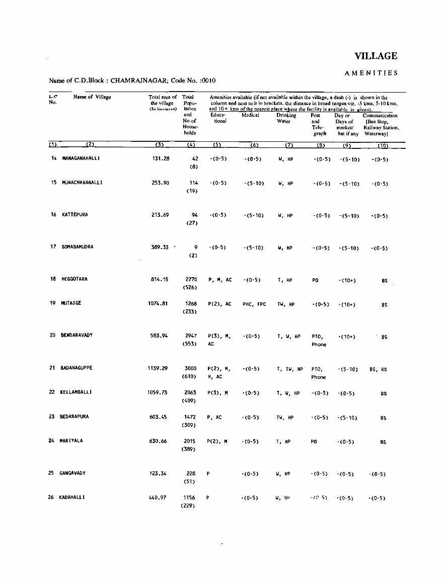
VILLAGE
AMENITIES Name of C.D.Block : CHAMRAJNAGAR; Code No. :0010
L.C Name of Village Total area of Total Am.:nities available (if not available within the village, a dash (-) is shown in the No. the village Popu- column and next to it in brackets. the distance in broad ranges viz. -5 kms, 5-10 kms,
(I .. lu;,,",'41~~) taUon and 10+ kms of the nearest (!Iace where the facility is availahle i. given). and Eduea- Medical Drinking Post Day or Communication No.of tional Water and Days of [Bus Stop, House- Telc- marketl Railway Station, holds graph hat ifany Waterway]
(1) (2) (3) (4) (5) (6) (7) (8) (9) PO)
14 MANAGANAHALLI 131.28 42 -(0-5) -(0-5) 101, HP - (0-5) -(5-10) -(0-5)
(8)
15 HUNACHANAHALLI 253.90 114 -(0-5) -(5-10) 101, HP -(0-5) -(5-10) -(0-5)
( 19)
16 KATTEPURA 213.69 94 -(0-5) -(5-10) 101, HP -(0-5) -(5-10) -(0-5)
(27)
17 SOMASAHUDRA 389.33 9 -(0-5) -(5-10) 101, HP -(0-5) -(5-10) -(0-5)
(2)
18 HEGGOTARA 814.15 2770 P, H, AC -(0-5) T, HP PO -(10+) BS (526)
19 HUTHIGE 1074.81 1268 P(2), AC PHC, FPC TW, HP -(0-5) -(10+) BS (233)
20 8ENDARAVADY 583.94 2947 P(3), H, -(0-5) T, \.I, HP PTO, -(10+) BS (553) AC Phone
21 8ADANAGUPPE 1139.29 3000 P(2), H, -(0-5) T, TW, HP PTO, -(5-10) BS, RS (610) H, AC Phone
22 KELLAHBALLI 1059.73 2063 P(3), M -(0-5) T, 101, HP - (0-5) -(0-5) BS (409)
23 8EDARAPURA 603.45 1472 p. AC -(0-5) TW. HP -(0-5) -(5-10) BS (309)
24 MARIYALA 630.66 2015 P(2), H -(0-5) T, HP PO -(0-5) BS (389)
25 GANGAVADY 123.34 228 P -(0-5) 1.1, HP -(0-5) - (0- 5) -(0-5)
(51)
26 KADAHALLI 440.97 1156 P -(0-5) 101, HP .. (('. r;) -(0-5) -(0-5)
(229)
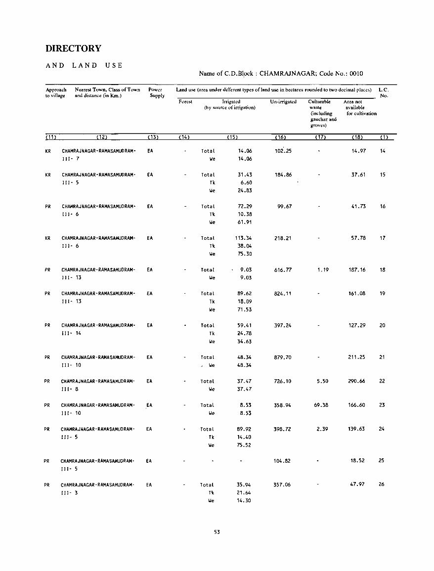
DIRECTORY
AND LAND USE Name ofC.D.B1~k: CHAMRAJNAGAR; Code No.: 0010
Approach Nearest Town, Class of Town Power Land use (area under diflerent types of land use in hectares rounded to two decimal place~) L.C. to village and distance (in Km.) Supply No.
Forc~t Irrigah:d Un-irrigated Culturable Area not (hy soun;e of irrigation) waste available
(including for cultivation gauchar and groves)
(11) (12) (13) ( 14) (15) (16) ( 17) ( 18) (1)
KR CHAMRAJNAGAR-RAMASAMUDRAM- EA Total 14.06 102.25 14.97 14
111- 7 lie 14.06
KR CHAMRAJNAGAR-RAMASAMUDRAM- EA Total 31.43 184.86 37.61 15
111- 5 Tk 6.60
lie 24.83
PR CHAMRAJNAGAR-RAMASAMUDRAM- EA Total 72.29 99.67 41.73 16 II 1- 6 Tk 10.38
lie 61.91
KR CHAMRAJNAGAR-RAMASAMUDRAM- EA Total 113.34 218.21 57.78 17
II I - 6 Tk 38.04
lie 75.30
PR CHAMRAJNAGAR-RAMASAMUDRAM- EA Total 9.03 616.77 1. 19 187.16 18 111- 13 lie 9.03
PR CHAMRAJNAGAR-RAMASAMUDRAM- EA Total 89.62 824.11 161.08 19
111- 13 Tk 18.09
lie 71.53
PR CHAMRAJNAGAR-RAMASAMUDRAM- EA Total 59.41 397.24 127.29 20
I I I - 14 Tk 24.78
lie 34.63
PR CHAMRAJNAGAR-RAMASAMUDRAM- EA Total 48.34 879.70 211.25 21
111- 10 , lie 48.34
PR CHAMRAJNAGAR-RAMASAMUDRAM- EA Total 37.47 726.10 5.50 290.66 22
I I I - 8 lie 37.47
PR CHAMRAJNAGAR-RAMASAMUDRAM- EA Total 8.53 358.94 69.38 166.60 23
II 1- 10 lie 8.53
PR CHAMRAJNAGAR-RAMASAMUDRAM- EA Total 89.92 398.72 2.39 139.63 24
I" - 5 Tk 14.40
lie 75.52
PR CHAMRAJNAGAR-RAMASAMUDRAM- EA 104.82 18.52 25
I I I - 5
PR CHAMRAJNAGAR-RAMASAMUDRAM- EA Total 35.94 357.06 47.97 26
111- 3 Tk 21.64
lie 14.30
53
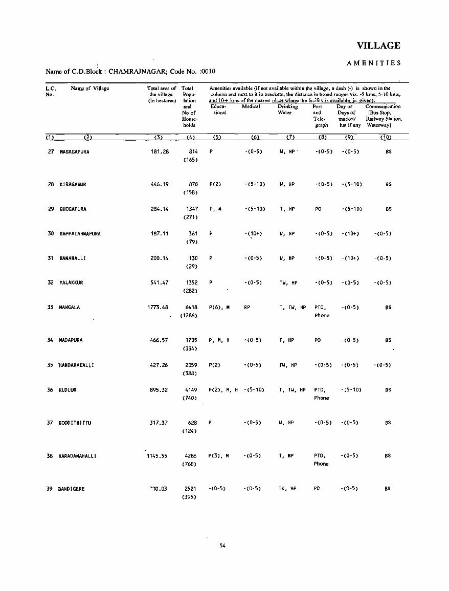
VILLAGE
AMENITIES Name of C.D.Block : CHAMRAlNAGAR; Code No. :0010
L.C. Name of Village Total area of Total Amenities available (if not available within the village, a dash C-) is shown in the No. the village Popu- .;olumn and next to it in brackets, the distance in broad ranges viz. -S kms, ,-10 kms,
(In hectares) lation and 10+ kms of the nearest I!lace where the facility is availahle is given}. and Educa- Medical Drinking Post Day or Communication
No.of tional Water and Days of [Bus Stop, House- Tele- market! Railway Stalion, holds graph hat ifany Waterway]
(1) (2) (3) (4) (5) (6) (7) (8) (9) (10)
27 MASAGAPURA 181.28 814 P -(0-5) W, HP' -(0-5) -(0-5) BS
(165)
28 KIRAGASUR 446.19 878 P(2) -(5-10) W, HP -(0-5) -(5-10) BS
(158)
29 BHOGAPURA 284.14 1347 P, H -(5-10) T, HP PO -(5-10) BS
(271)
30 SAPPAIAHNAPURA 187.11 361 P -(10+) W, HP -(0-5) -(10+) -(0-5)
(79)
31 HANAHALLI 200.14 130 P -(0-5) W, HP -(0-5) -(10+) -(0-5)
(29)
32 YALAKKUR 541.47 1352 P -(0-5) TW, HP -(0-5) -(0-5) -(0-5)
(282)
33 MANGALA 1773.48 6418 P(6), M RP T, TW, HP PTO, -(0-5) BS
( 1286) Phone
34 MADAPURA 466.57 1705 P, H, H -(0-5) T, HP PO -(0-5) BS
(334)
35 'HANDARAKAlL I 427.26 2059 P(2) -(0-5) TW, HP -(0-5) -(0-5) -(0-5)
(388)
36 KUDLUR 895.32 4149 P(2), H, H -(5-10) T, TW. HP PTO, -,5-10) BS
(740) Phone
37 BOOOITHITTU 317.37 628 P -(0-5) W, HP -(0-5) -(0-5) BS
(124)
38 HARADANAHAlLi 1145.55 4286 P(3), M -(0-5) T, HP PTO, -(0-5) BS
(768) Phone
39 BANDIGERE ~""0.03 2521 -(0-5) -(0-5) TK, HP PC -(0-5) BS
(395)
54
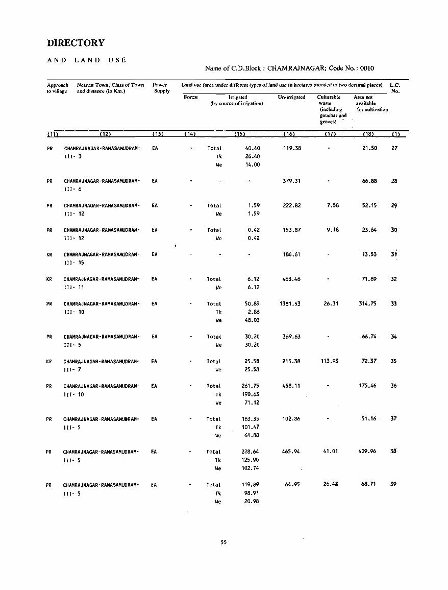
DIRECTORY
AND LAND USE Name of C.D.Block : CHAMRAJNAGAR; Code No.: 0010
Approach Nearesl Town. Class of Town Power Land use (area under differenllypes of land use in hectares rounded 10 two decimal places) L.C. to village and distance (in Km.) Supply No.
Forest Irrigated Un-irrigated Culturable Area not (by source of irrigation) waste available
(including for cultivation gauchar and groves)
(11 ) (12) (13) (14) ( 15) (16) (17) (18) (1)
PR CHAMRAJNAGAR-RAMASAMUDRAM- EA Total 40.40 119.38 21.50 27 It 1- 3 Tic 26.40
\ole 14.00
PR CHAMRAJNAGAR-RAMASAMUDRAM- EA 379.31 66.88 28 111- 6
PR CHAMRAJNAGAR-RAMASAMUDRAM- EA Total 1.59 222.82 7.58 52.15 ~ IlI- 12 \ole 1.59
PR CHAMRAJNAGAR-RAMASAMUDRAM- EA Total 0.42 153.87 9.18 23.64 3Q 111- 12 \ole 0.42
, KR CHAMRAJNAGAR-RAMASAMUDRAM- EA 186.61 13.53 3~
I11- 15
KR CHAMRAJNAGAR-RAMASAMUDRAM- EA Total 6.12 463.46 71.89 32 111- 11 \ole 6.12
PR CHAMRAJNAGAR-RAMASAMUDRAM- EA Total 50.89 1381.53 26.31 314.75 33 111- 10 Tic 2.86
\ole 48.03
PR CHAMRAJNAGAR-RAMASAMUDRAM- EA Total 30.20 369.63 66.74 34
111- 5 \ole 30.20
KR CHAMRAJNAGAR-RAMASAMUORAM- EA Total 25.58 215.38 113.93 72.37 3S 111- 7 \ole 25.58
PR CHAMRAJNAGAR-RAMASAMUDRAM- EA Total 261.75 458.11 175.46 36 Ill- 10 Tic 190.63
\ole 71.12
PR CHAMRAJNAGAR-RAMASAMUtRAM- EA Total 163.35 102.86 51. 16 - 37 111- S Tic 101.47
l,Je 61.88
PR CHAMRAJNAGAR-RAMASAMUDRAM- EA Total 228.64 465.94 41.01 409.96 38
III- 5 TIc 125.90 \ole 102.74
PR CHAMRAJNAGAR-RAMASAMUDRAM- EA Total 119.89 64.95 26.48 68.71 39
111- 5 Tic 98.91 \ole 20.98
55
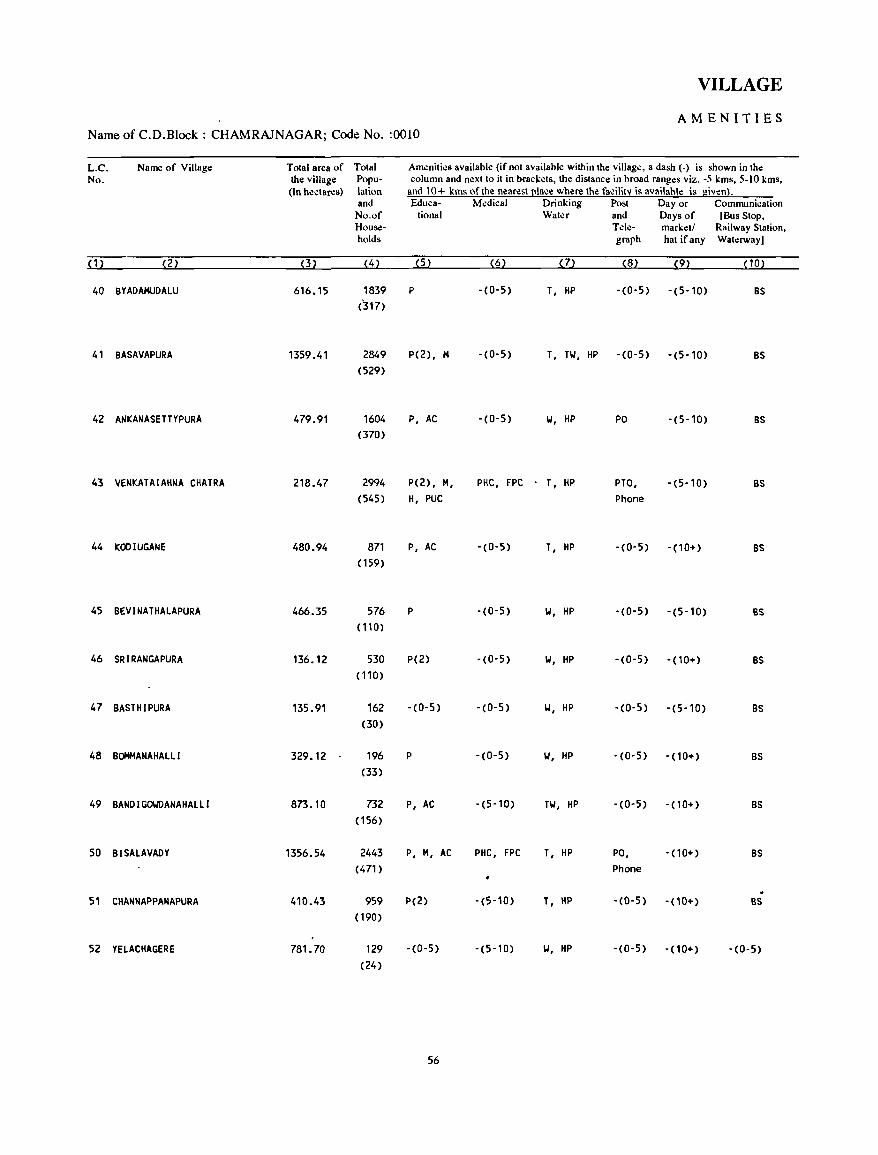
VILLAGE
AMENITIES Name of C.D.Block : CHAMRAJNAGAR; Code No. :0010
L.C. Name of Village Total area of Total Amenities available (if not available within the village, a dash (-) is shown in the No. the village Popu- column and next to it in brackets, the distance in broad ranges viz. -5 kms, 5-10 kms,
(In hectares) lation and 10+ kms of the nearestl!lace where the facilit:i is availahle is given}. and Educa- Medical Drinking Post Day or Communication
No.of tiona I Water and Days of [Bus Stop, House- Tele- marketl Railway Station, holds graph hat ifany Waterway)
(1) (2) (3) (4) (5) (6) (7) (8) (9) ( 10)
40 BYADAMUDALU 616.15 1839 P -(0-5) T, liP -(0-5) -(5-10) BS (317)
41 BASAVAPURA 1359.41 2849 P(2), M - (0- 5) T, TW, HP -(0-5) -(5-10) BS (529)
42 ANKANASETTYPURA 479.91 1604 P, AC -(0-5) 101, liP PO -(5-10) BS (370)
43 VENKATAIAHNA CHATRA 218.47 2994 P(2), H, PHC, FPC T, HP PTO, -(5-10) BS (545) H, PUC Phone
44 KOOlUGANE 480.94 871 P, AC -(0-5) T, HP -(0-5) -(10+) BS (159)
45 BEVINATHALAPURA 466.35 576 P -(0-5) 101, HP -(0-5) -(5-10) BS (110)
46 SRIRANGAPURA 136.12 530 P(2) -(0-5) 101, HP -(0-5) -(10+) BS (110)
47 BASTHIPURA 135.91 162 -(0-5) -(0-5) 101, HP -(0-5) -(5-10) BS (30)
48 BOMMANAHALLl 329.12 . 196 P -(0-5) 101, HP -(0-5) -(10+) BS (33)
49 BAND I GOIJDANAHALL I 873.10 732 P, AC -(5-10) TW, HP -(0-5) - (10+) BS (156)
50 BISALAVADY 1356.54 2443 P, H, AC PHC, FPC T, HP PO, -(10+) BS (471 ) Phone
51 CHANNAPPANAPURA 410.43 959 P(2) -(5-10) T, HP -(0-5) - (10+) BS (190)
52 YELACHAGERE 781.70 129 -(0-5) -(5-10) 101, HP -(0-5) -(10+) -(0-5) (24)
56
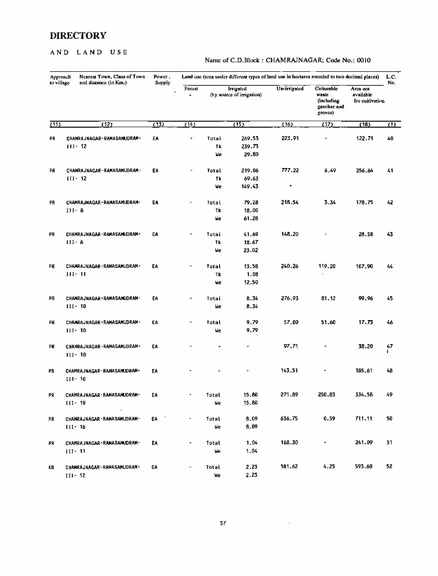
DIRECTORY
AND LAND USE Name of C.D.Block : CHAMRAJNAGAR; Code No.: OOlO
Approach Nearest Town, Class of Town Power. Land use (area under different types of land use in hectares rounded to two decimal places) L.C. to village and distance (in Km.) Supply No.
Forest Irrigated Un-irrigated Culturable Area not (by source of irrigation) waste available
(including for cultivation gaucharand groves)
( 11> ( 12) (13) {14} ( 15) (16) (17) (18) {1}
PR CHAMRAJNAGAR-RAMASAMUDRAM- EA Total 269.53 223.91 122.71 40
111- 12 Tk 239.73
We 29.80
PR CHAMRAJNAGAR-RAMASAMUDRAM- EA Total 219.06 n7.22 6.49 356.64 41 111- 12 Tk 69.63
We 149.43
PR CHAMRAJNAGAR-RAMASAMUDRAM- EA Total 79.28 218.54 3.34 178.75 42
111- 8 Tk 18.00
We 61.28
PR CHAMRAJNAGAR-RAMASAMUDRAM- EA Total 41.69 148.20 28.58 43 111- 6 Tk 18.67
We 23.02
PR CHAMRAJNAGAR-RAMASAMUDRAM- EA Total 13.58 240.26 119.20 107.90 44 111- 11 Tk 1.08
We 12.50
PR CHAMRAJNAGAR-RAMASAMUDRAM- EA Total 8.34 276.93 81.12 99.96 45 III- 10 We 8.34
PR CHAMRAJNAGAR-RAMASAMUDRAM- EA Total 9.79 57.00 51.60 17.73 46
111- 10 We 9.79
PR CHAMRAJNAGAR-RAMASAMUDRAM- EA 97.71 38.20 47
111- 10 I
PR CHAMRAJNAGAR-RAMASAMUDRAM- EA 143.51 185.61 48
111- 10
PR CHAMRAJNAGAR-RAMASAMUDRAM- EA Total 15.80 271.89 250.83 334.58 49
111- 19 We 15.80
PR CHAMRAJNAGAR-RAMASAMUDRAM- EA Total 8.09 636.75 0.59 711. 11 50
111- 16 We 8.09
PR CHAMRAJNAGAR-RAMASAMUDRAM- EA Total 1.04 168.30 241.09 51
III- 11 We 1.04
KR CHAMRAJNAGAR-RAMASAMUDRAM- EA Total 2.23 181.62 4.25 593.60 52
111- 12 We 2.23
57
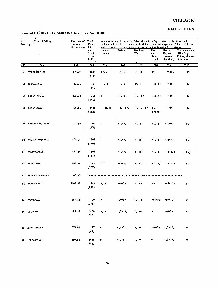
VILLAGE
AMENITIES Name of C.,D.Block : CHAMRAJNAGAR; Code No. :0010
.. L.C. arne of Village Total area of Total Am~nities available (if not available within tho: village, a dash (-) is shown in the No . • the village Popu- column and next to it in brack~ts, the distance in broad ranges viz. -5 kms, 5-10 kms,
(In hectares) lation and 10+ kms of the n~arest (!Iace where the facilit:r: is available is given}. and Educa- Medical Drinking Post Day or Communication No.of tiona I Water and Days of [Bus Stop, House- Tele- marketl Railway Station, holds graph hat ifany Waterway]
(1) (2) (3) (4) (5) (6) (7) (8) (9) PO}
53 VOODAGAlPURA 825.28 1615 P(2) -(0-5) T. HP PO -(10+) BS (333)
54 CHOIolDAHALLl 453.25 61 -(0-5) -(0-5) w. HP -(0-5) -(10+) BS (9)
55 llNGANAPURA 208.32 746 P -(0-5") TW. HP -(0-5) - (10+) BS (146)
56 ARAKALAVADY 649.64 2428 p. M. H PHC. FPC T. TW. HP PO, -(10+) BS (532) Phone
57 MANCHAGUNDI PURA 107.65 405 P -(0-5) W. HP -(0-5) - (10+) BS (93)
58 MUDALU HOSAHALLI 474.08 506 P -(0-5) T. HP -CO-5) - (10+) BS (120)
59 VOODARAHAlLl 551.54 605 P -CO-5} T. HP -CO-5) - (5-10) BS (137)
60 YENAGUMBA 891.65 961 P -(0-5) T. HP -(0-5) -(5-10) BS (207)
61 SH I NDA YY ANAPURA 185_40 ------------------------ UN - INHABITED -------------------------
62 YERAGANHALLI 1098.18 1361 p. M -(0-5) w. HP PO -(5-10) BS (298)
63 MADALAVADY 587_33 1100 P -(0-5) TW. HP -(0-5) -(5-10) BS (233)
64 KILAGERE 688.29 1459 p. M -(5-10) T. HP PO -(0-5) BS (325)
65 ACHATTI PURA 305.'64 217 P -CO-5) W. HP -(0-5) -(5-10) BS (44)
66 YANAGAHALLI 369.56 2423 P -(0-5) T. HP PO -(5-10) BS (508)
58
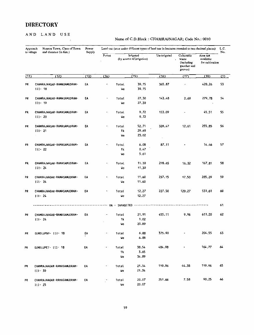
DIRECTORY
AND LAND USE Name of C.D.Block :'CHAMRAJNAGAR; Code No.: 0010
Approach Nearest Town, Class of Town Power Land use (area under din:':rent types of land use in hectares rounded to two decimal places) L.C. to village and distance (in Km.) Supply No.
For.:st Irrigated Un-irrigated Culturable Area not (by source of irrigation) waste available
(including for cultivation gauchar and grows)
(11) ( 12) (13) ( 14) (15) ( 16) ( 17) ( 18) ( 1 )
PR CHAMRAJNAGAR-RAMASAMUDRAM- EA Total 39.15 365.87 420.26 53 111- 18 \.Ie 39.15
PR CHAMRAJNAGAR-RAMASAMUDRAM- EA Total 27.30 143.48 2.69 279.78 54 111- 19 \.Ie 27.30
PR CHAMRAJNAGAR-RAMASAMUDRAM- EA Total 9.72 153.09 45.51 55 111- 20 \.Ie 9.72
PR CHAMRAJNAGAR-RAMASAMUDRAM- EA Total 52.71 328.47 12.61 255.85 56 Ill- 21 Tk 29.69
\.Ie 23.02
PR CHAMRAJNAGAR-RAMASAMUDRAM- EA Total 6.08 87.11 14.46 57 III - 22 Tk 0.47
\.Ie 5.61
PR CHAMRAJNAGAR-RAMASAMUDRAM- EA Total 11.30 278.65 16.32 167.81 58 111- 24 We 11.30
PR CHAMRAJNAGAR-RAMASAMUDRAM- EA Total 11.60 237.15 17.50 285.29 59 111- 24 \.Ie 11.60
PR CHAMRAJNAGAR-RAMASAMUDRAM- EA Total 12.27 227.50 120.27 531.61 60 111- 24 \.Ie 12.27
--------------------------------------------- UN - INIIABtTED --------------------------------------------- 61
PR CHAMRAJNAGAR-RAMASAMUDRAM- EA Total 21.91 455.11 9.96 611.20 62 111- 24 Tk 1.02
\.Ie 20.89
PR GUNDLUPlioT- II I - 18 EA Total 6.88 375.90 204.55 63
We 6.88
PR GUNDLUPET- 111- 18 EA Total 38.54 484.98 164.n 64
Tk 3.65 We 34.89
PR CHAMRAJNAGAR-RAMASAMUDRAM- EA Total 21.34 119.96 44.38 119.96 65
111- 30 We 21.34
PR CHAMRAJNAGAR-RAMASAMUDRAM- EA Total 20.07 251.66 7.58 90.25 66
111- 25 \.Ie 20.07
59
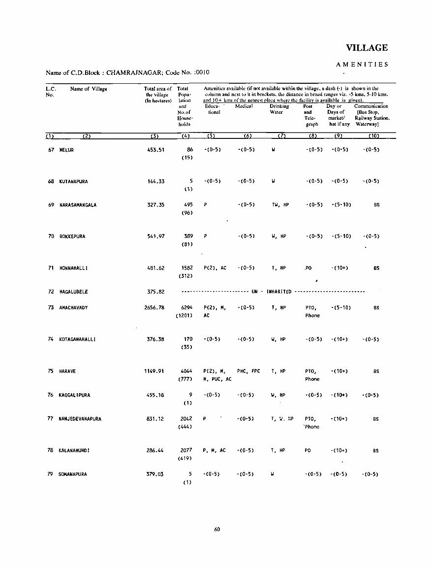
VILLAGE
AMENITIES Name of C.D.Block : CHAMRAJNAGAR; Code No. :0010
L.C. Name of Villag( Total area of Total Am.:niti.:s availabk (if not availabk within the villag.:. a dash (-) is shown in tho: No. the village Popu- column and n.:xtto it in brad:ets. the distanc.: in broad ranges viz. -5 kms, 5-10 kms.
(In h.:ctares) lation and 10+ kms of thl! n.:ar.:st cl:tce wh.:r.: the facility is available is given). and Educa- M.:dk'1ll Drinking Post Day or Communication
No.of tional Wat.:r and Days of [Bus Stop. House- Tele- market! Railway Station. holds graph hat ifany Waterway)
(1) (2) (3) (4) (5) (6) (7) (8) (9) (10)
67 MELUR 453.51 86 ,(0·5) -(0-5) \l - (0-5) -(0-5) -(0-5)
(15)
68 KUTANAPURA 144.33 5 -(0-5) -(0-5) -(0-5) -(0-5) -(0-5)
(H
69 NARASAHANGALA 327.35 495 P -(0-5) TW, HP -(0-5) -(5-10) BS
(96)
70 BOKKEPURA 541.97 389 P -(0-5) W, HP -(0-5) -(5-10) -(0-5)
(81)
71 HONNAHALLI 481.62 1582 P(2) , AC - (0-5) T, HP .PO -(10+) BS
(312)
72 HAGALUBElE 375.82 -------.---------------- UN - INHABITED -----------------------~-
73 AHACHAVADY 2656.78 6294 P(2), H, -(0-5) T, HP PTO, - (5-10) BS
(1201) AC Phone
74 KOTAGANAHAllI 376.38 170 -(0-5) -(0-5) W, HP -(0-5) -(10+) -(0-5)
(35)
75 HARAVE 1149.91 4044 P(2), H, PHC, FPC T, HP PTO, -(10+) BS
(777) H, PUC, AC Phone
76 KAGGAlI PURA 455.18 9 -(0-5) -(0-5) W, HP -(0-5) -(10+) -(0-5)
(1)
77 NANJEDEVANAPURA 831.12 2042 P -(0-5) T, '..I. BP PiO, - (10+) BS
(444) 'Phone
78 KALANAHUNDI 286.44 2077 P, H, AC -(0-5) T, HP PO - (10+) BS
(419)
79 SOMANAPURA 379.03 5 -(0-5) - (0- 5) W -(0-5) -(0-5) -(0-5)
(1)
60
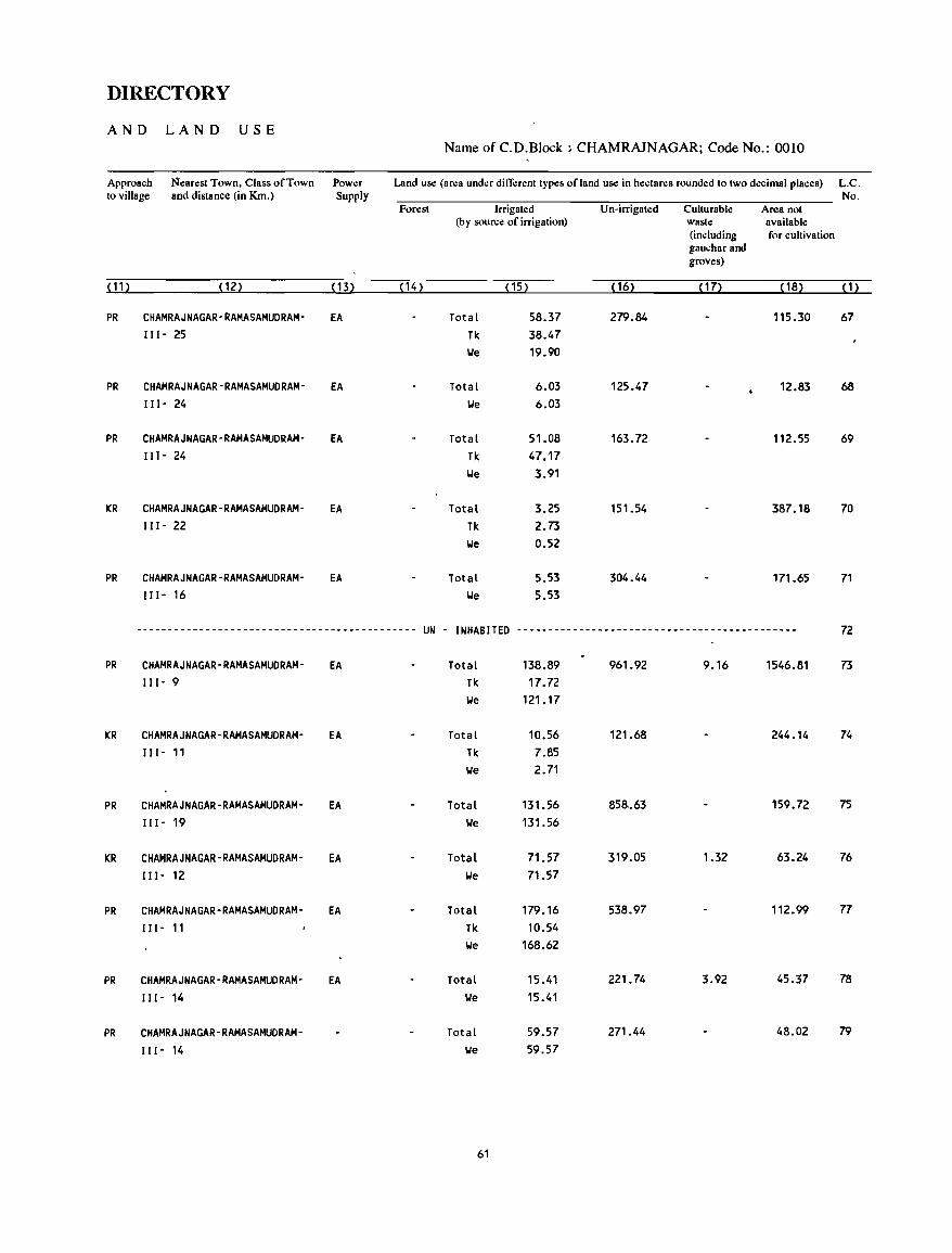
DIRECTORY
AND LAND USE Name of C.D.Block ; CHAMRAJNAGAR; Code No.: 0010
Approach Nearest Town, Class of Town Power Land use (area under ditTerent types of land use in hectares rounded to two decimal places) L.C. to village and distance (in Km.) Supply No.
Forest Irrigated Un-irrigated Culturable Area not (by source of irrigation) waste available
(including for cultivation gauchar and groves)
(11) (12) (13) ( 14) (15) ( 16) (17) ( 18) (1)
PR CHAMRAJNAGAR-RAMASAMUDRAM- EA Total 58.37 279.84 115.30 67 111- 25 Tic 38.47
We 19.90
PR CHAMRAJNAGAR-RAMASAMUDRAM- EA Total 6.03 125.47 12.83 68 111- 24 We 6.03
PR CHAMRAJNAGAR-RAMASAMUDRAM- EA Total 51.08 163.72 112.55 69 111- 24 Tic 47.17
We 3.91
KR CHAMRAJNAGAR-RAMASAMUDRAM- EA Total 3.25 151.54 387.18 70 111- 22 TIc 2.73
We 0.52
PR CHAMRAJNAGAR-RAMASAMUDRAM- EA Total 5.53 304.44 171.65 71 111- 16 We 5.53
.-----------~-------------------------------- UN - INHABITED --------------------------------------------- 72
PR CHAMRAJNAGAR-RAMASAMUDRAM- EA Total 138.89 961.92 9.16 1546.81 73 111- 9 Tic 17.72
We 121.17
KR CHAMRAJNAGAR-RAMASAMUDRAM- EA Total 10.56 121.68 244.14 74 111- 11 TIc 7.85
We 2.71
PR CHAMRAJNAGAR-RAMASAMUDRAM- EA Total 131.56 858.63 159.72 75 111- 19 We 131.56
KR CHAMRAJNAGAR-RAMASAMUDRAM- EA Total 71.57 319.05 1.32 63.24 76 111- 12 We 71.57
PR CHAMRAJNAGAR-RAMASAMUDRAM- EA Total 179.16 538.97 112.99 77
111- 11 Tic 10.54 We 168.62
PR CHAMRAJNAGAR-RAMASAMUDRAM- EA Total 15.41 221.74 3.92 45.37 78
111- 14 We 15.41
PR CHAMRAJNAGAR-RAMASAMUDRAM- Total 59.57 271.44 48.02 79
111- 14 We 59.57
61

VILLAGE
AM EN'! TIE S Name of C.D.Block : CHAMRAJNAGAR; Code No. :0010
L.C. Name of Village TOlal area of Tolal Ameniti.:s availabl.: (if nol availabl.: within th.: village, a dash (-) is shown in the No. the village Popu- column and n.:Xllo il in bracl.:ts. tb.: dislance in broad ranges viz. -5 kms. 5-10 kms,
(In hectares) 1alion and 10+ kms of Ihe nearest (!Iace where the facilitl: is available is given}. and Educa- M.:dical Drinking Post Day or Communication No.of lional Water and Days of (Bus Stop, House- Tele- market! Railway Station, holds graph hat ifany Waterway)
(1) (2) (3) (4) (5) (6) (7) (8) (9) (10?
80 VEERANAPURA 735.37 664 P -(0-5) w, HP -(0-5) -(10+) BS ( 134)
81 HANGAREPURA 108.01 ------------------------ UN - INHABITED -------------------------
82 UDIGALA 1554.48 4193 P, M, H, PHC, FPC T, HP PO, -(0-5) BS (820) AC Phone
83 BADAGAlAPURA 532.83 848 P, AC -(0-5) W, HP -(0-5) -(0-5) BS (173)
84 KUMBARAGUNDI 206.73 ------------------------ UN - INHABITED -------------------------
85 UGANEDAHUNDI 775.58 1239 P -(0-5) T, HP -'(0-5) -(5-10) BS (258)
86 KATHAVADY 859.41 1257 P, AC -(0-5) T, HP -(0-5) -(5-10) BS (245)
87 KOTHAlAVADY 1398.35 3803 P, M, AC PHC, D, T, HP PTO, -(5-10) BS (726) FPC Phone
88 MADUVINABEEDU 277.12 ---.-------------------- UN - INHABITED -------------------------
89 DEVAlAPURA 269.75 387 P, AC -(0-5) W, HP -(0-5) -(0-5) BS aO}
90 THAMMADAHAlll 1197.29 2629 P, M -(0-5) T, HP PO -(5-10) BS (521)
, 91 KETHAHAlLI 521.23 662 P(2) , AC -(0-5) TK, HP -(0-5) -(10+) -(0-5)
(121)
92 KANCHANAHAlll 622.52 -- ---------------------- UN - INHABITED -------------------------
93 KUMACHANAHALlI 301.97 757 P - (0-5) TW, HP -(0-5) -(10+) as (132)
94 KENGAKI 741. 91 1618 P(2) -(0-5) T, HP -(0-5) -(5-10) 8S
(327)
62
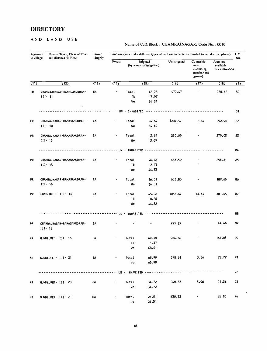
DIRECTORY
AND LAND USE Name of C.D.Block : CHAMRAlNAGAR; Code No.: 0010
Approach to village
Nearest Town, Class of Town and distance (in Km.)
Power Supply
Land use (area under different types of land use in hectares rounded to two decimal places) L.C.
Forest
(11) (12) (13) (14)
PR CHAMRAJNAGAR-RAMASAMUDRAM- EA I1I- 11
Irrigated (by source of irrigation)
Total Tk
(15)
42.28 7.97
We 34.31
Un-irrigated
( 16)
No. Culturable Area not waste available (including for cultivation gauchar and groves)
(17) ( 18) (1)
220.62 80
--------------------------------------------- UN - INHABITED --------------------------------------------- 81
PR
PR
PR
PR
PR
PR
PR
KR
PR
PR
CHAMRAJNAGAR-RAMASAMUDRAM-111- 10
CHAMRAJNAGAR-RAMASAMUDRAMI I 1- 10
EA
EA
---------------------------------------------
CHAMRAJNAGAR-RAMASAMUDRAM- EA I 11- 13
CHAMRAJNAGAR-RAMASAMUDRAM- EA II 1- 16
GUNDLUPET- 111- 13 EA
---------------------------------------------
CHAMRAJNAGAR-RAMASAMUDRAM- EA II 1- 14
GUNDLUPET- I I I - 16 EA
GUNDLUPET- I 11- 21 EA
---------------------------------------------
GUNDLUPET- 111- 20 EA
GUNDLUPET- II 1- 20 EA
UN -
UN -
UN -
Total We
Total We
INHABITED
Total Tk We
Total We
Total Tk We
INHABITED
Total Tk We
Total We
INHABITED
Total We
Total W~
63
54.64 54.64
3.69 3.69
1204.57
250.09
2.37 292.90
279.05
-----------------------------------~---------
46.78 433.59 295.21 2.45
44.33
36.01 633.80 189.60 36.01
45.08 1038.67 13.54 301.06 0.26
44.82
---------------------------------------------
225.27 44.48
69.38 966.86 161.05
1.37 68.01
65.99 378.61 3.86 72.77
65.99
---------------------------------------------
34.72 240.83 5.06 21.36
34.72
25.51 630.52 85.88
25.51
82
83
84
85
86
87
88
89
90
91
92
93
94
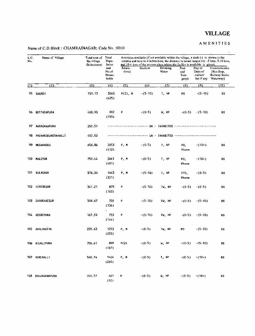
VILLAGE
AMENITIES Name of C.D.Block : CHAMRAJNAGAR; Code No. :0010
L.C. Name of Village Total area of Total Amenities available (if not available within the village, a dash (-) is shown in the No. the village Popu- column and next to it in brackets, the distance in broad ranges viz. -5 kms, 5-10 kms,
(In hectares) lation and 10+ kms of the nearest (!Iace where the facility is available is given}. and Educa- M~dical Drinking Post Day or Communicatiol
No.of tional Water and Days of [Bus Stop, House- Tde- marketl Railway Statiol holds graph hat ifany Waterway]
( 1 ) (2) (3) (4) (5) (6) (7) (8) (9) (10)
95 SAGADI 731.13 3060 P(2) • M -(5-10) T, HP PO -(5-10) BS (625)
96 BETTADAPURA 408.93 992 P -(0-5) II, HP -(0-5) -(5-10) BS ( 193)
97 HARAGANAPURA 250.51 ------------~----------- UN - INHABITED -------------------------
98 PADNAKODUHOSAHALLI 452.02 ------------~----------- UN - INHABITED -------------------------
99 MUDNAKOOU 656.86 2053 p. M -(0-5) T, HP PO, -(10+) BS (412) Phone
100 MALEYUR 759.44 2641 P, M - (0-5) T, HP PO, -(10+) BS (481) Phone
101 KULAGANA 876.30 1643 P, M - (5-10) T, HP PTO, -(0-5) 8S (321) Phone
102 HIREBEGUR 341.21 879 P -(5-10) Til, HP -(0-5) -(0-5) BS ( 163)
103 CHIKKABEGUR 309.67 720 P -(5-10) TI.', HP -(0-5) -(5-10) as (136)
104 KEBB"EPURA 167.59 753 P -(5-10) TIJ, HP -(0-5) -(5-10) BS ( 144)
105 ARALIKATTE 235.63 1253 P, M - (0- 5) Til, HP PO -(5-10) BS (233)
106 KILALIPURA 706.61 899 P(2) -(0-5) II, HP -(0-5) -(5-10) as (167)
107 KEREHALLI 560.14 1404 P, M -(0-5) T, HP -(0-5) -(10+) BS (265)
108 BHUJAGANAPURA 200.57 461 P -(0-5) 1.', HP - (0- 5) -(10+) BS (92)
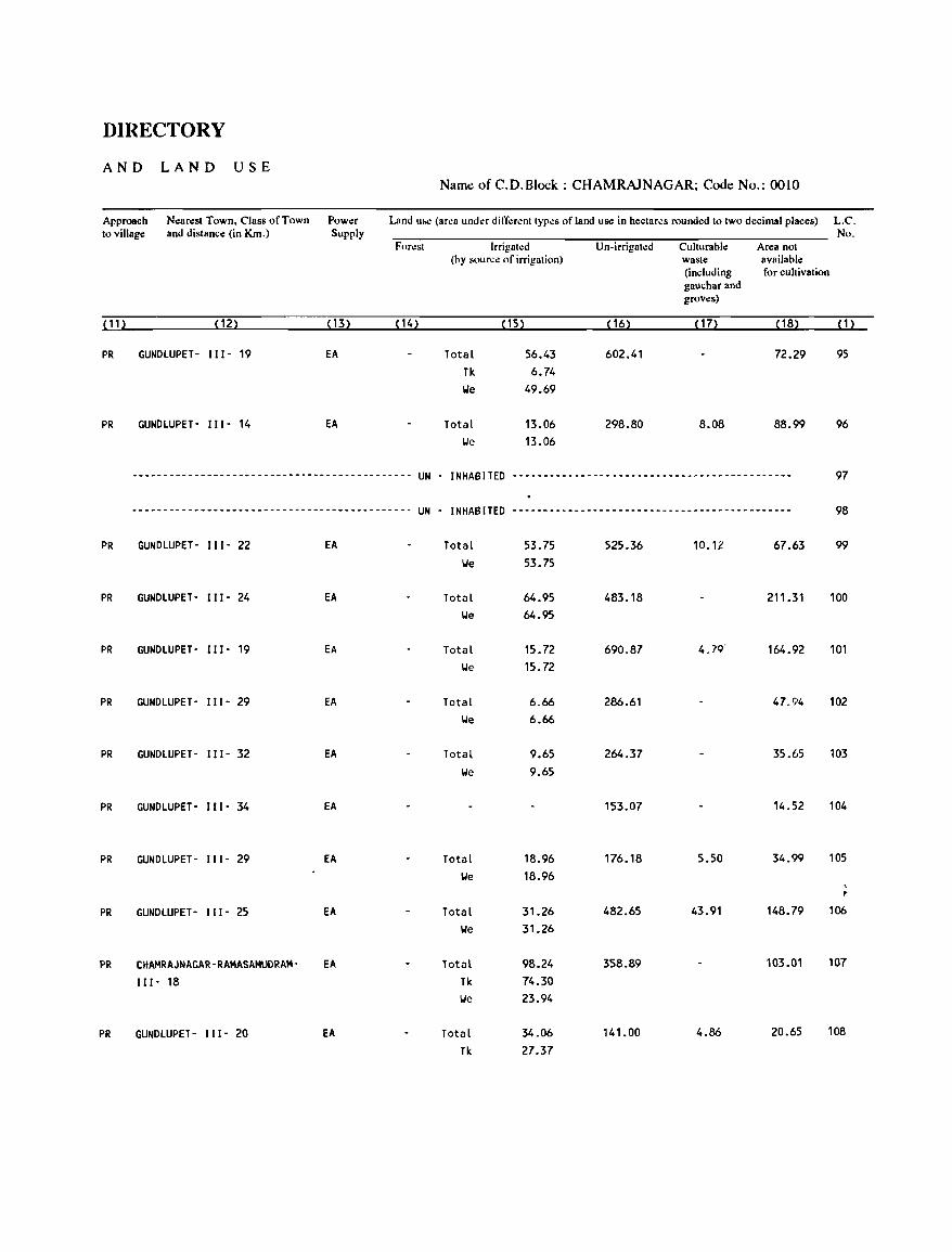
DIRECTORY
AND LAND USE Naml! ofC.D.Block: CHAMRAJNAGAR; Code No.: 0010
Approach Nearest Town, Class of Town Power Land UM: (area under dift".:renttypes of land use in hectares rounded to two decimal places) L.C. to village and distance (in Km.) Supply No.
Forest Irrigated Un-irrigated Culturable Area not (by source of irrigation) wasle available
(including for cultivation gauchar and groves)
(11) (12) ( 13) (14) ( 15) (16) (17) ( 18) (1)
PR GUNDLUPET- 111- 19 EA Total 56.43 602.41 72.29 95 Tk 6.74 IJe 49.69
PR GUNDLUPET- 111- 14 EA Total 13.06 298.80 8.08 88.99 96 IJe 13.06
--------------------------------------------- UN - INHABITED --------------------------------------------- 97
--------------------------------------------- UN - INHABITED --------------------------------------------- 98
PR GUNDLUPET- 111- 22 EA Total 53.75 525.36 10.12 67.63 99 IJe 53.75
PR GUNDLUPET- 111- 24 EA Total 64.95 483.18 211.31 100 IJe 64.95
PR GUNDLUPET- 111- 19 EA Total 15.72 690.87 4.79' 164.92 101 We 15.72
PR GUNDLUPET- 111- 29 EA Total 6.66 286.61 47.94 102 IJe 6.66
PR GUNDLUPET- 111- 32 EA Total 9.65 264.37 35.65 103
IJe 9.65
PR GUNDLUPET- 111- 34 EA 153.07 14.52 104
PR GUNDLUPET- 111- 29 EA Total 18.96 176.18 5.50 34.99 105
IJe 18.96
PR GUNDLUPET- 111- 25 EA Total 31.26 482.65 43.91 148.79 106
IJe 31.26
PR CHAMRAJNAGAR-RAMASAMUDRAM- EA Total 98.24 358.89 103.01 107
111- 18 Tk 74.30 IJe 23.94
PR GUNDLUPET- 111- 20 EA Total 34.06 141.00 4.86 20.65 108
Tk 27.37
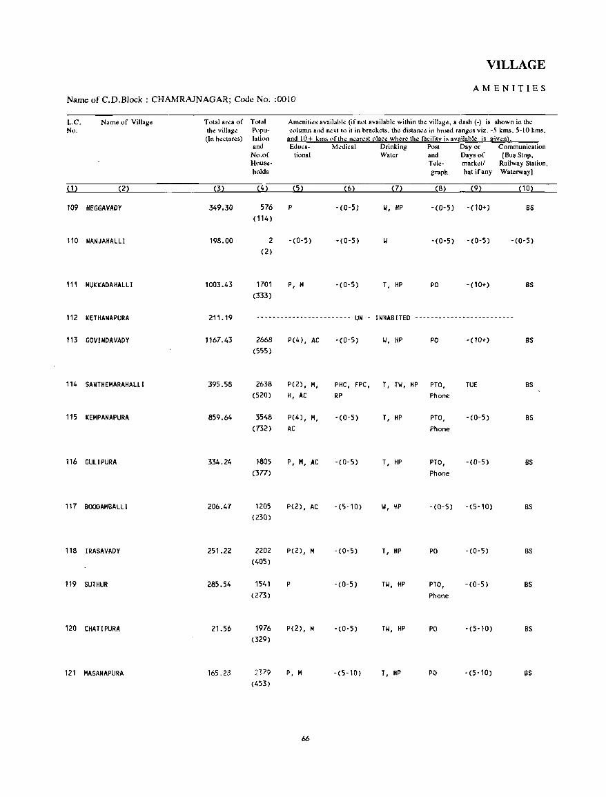
VILLAGE
AMENITIES NameofC.D.Block; CHAMRAJNAGAR; Code No. ;0010
L.C. Name of Village Total area of Total Am~niti~s available (if not available within th~ villag~, a dash (-) is shown in the No. the village Popu- column and n.:xtto it in brackds. the distance in broad ranges viz. -5 kms, 5-10 kms,
(In hectares) latinn and 10+ kms nfthe n~arest [!lacc whae the facility is available is given}. and Educa- Medical Drinking Post Day or Communication
No.of tiona I Water and Days of [Bu~ Stop, House- Tele- market! Railway Station, holds graph hat ifany Waterway]
(1) (2) (3) (4) (5) (6) (7) (8) (9) (10)
109 HEGGAVADY 349.30 576 P -(0-5) W, HP -(0-5) - (10+) BS (114)
110 NANJAHALLI 198.00 2 -(0-5) -(0-5) II -(0-5) -(0-5) - (0-5) (2)
111 HUKKADAHALLI 1003.43 1701 P, H -(0-5) T, HP PO -(10+) BS (333)
112 KETHANAPURA 211.19 ------------------------ UN - INHABITED -------------------------
113 GOVINDAVADY 1167.43 2668 P(4), AC -(0-5) II, HP PO -(10+) BS (555)
114 SANTHEHARAHALLI 395.58 2638 P(2), H, PHC, FPC, T, Til, HP PTO, TUE BS (520) H, AC RP Phone
115 KEHPANAPURA 859.64 3548 P(4) , H, -(0-5) T, HP PTO, -(0-5) BS (732) AC Phone
116 GULIPURA 334.24 1805 P, H, AC -(0-5) T, HP PTO, - (0- 5) BS (377) Phone
117 BOOOAHBALLI 206.47 1205 P(2), AC -(5-10) 1,1, HP -(0-5) -(5-10) BS (230)
118 IRASAVADY 251.22 2202 P(2), H - (0- 5) T, HP PO -(0-5) BS (405)
119 SUTHUR 285.54 1541 P -(0-5) TY, HP PTO, -(0-5) BS (273) Phone
120 CHATIPURA 21.56 1976 P(2), H -(0-5) HI, HP PO -(5-10) BS (329)
121 MASANAPURA 165.23 2179 P, H -(5-10) T. HP PO -(5-10) BS (453)
66
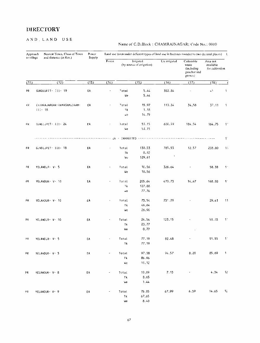
DIRECTORY
AND LAND USE Nal1l~ of C.D.Block : CHAMRAJNAGAR; CoJ~ No.: 0010
Approa..:h N~art!st Town. Cla~s of Town PnWl.!f Land u,,; (ar,;a und~r d,n;;r..:nt typ~~ of land u'c in h.:.:tar..:> round.:d to two d":<:lInal plac,,) L to villag..: and di,tanct! (in Km.) Supply
For~~t lrrigall!o Un-irrigatl!d Culturabl..: Ar~a not (hy soun;..: of IIT:galion) wa~tl! availahl~
(induding fi.>r cultivation gau.:har and grov,;,!
( 11) (12) ( 13) (14) ( 15) ( 16) ( 17) (18)
PR GUNDLUPET . III· 19 EA Total 5.44 302.84 ,.1 We 5.44
KR ChAMRAJNAGAR-RAMASAMUDRAM- EA Total 15.97 110.34 34.58 37.11 111- 18 Tk 1.18
";e 14.79
PR GUNDLUPET· 111- 24 EA Total 53.15 600.99 184.54 164.75 1-
We 53.15
-~------------------------------------------- UN - INHABITED ----------------_------_ .. ------_------------- 1-
PR GUNDLUPtT - I II - 18 EA Total 130.53 785.53 12.57 238.80 ,', Ti< 0.92
We 129.61
PR YELANDUR- v- 5 EA Total 10.56 326.64 58.38 1-
We 10.56
PR YELANDUR- v- 10 EA Tot(ll 205.64 470.73 14.47 168.80 ,. Tk 127.88 we 77.76
PR YELANDUR- v- 10 EA Total 73.54 231.29 29.41 11
Tk 46.64
We 26.90
PR YELANDUR- v- 10 EA Total 24.54 123.15 58.78 1-
Tk 23.77 we 0.77
PR YELANDUR- v- 5 EA Total 77.19 82.48 91.55 1-
Tk 77.19
PR YELANDUR- v- 5 EA Total 97.08 94.57 8.20 85.69
Tk 86.96
we 10.12
PR YELANOUR- v- 8 EA Total 10.09 7.13 4.34 12
Tk 8.65
We 1.44
PR YELANDUR- v- 9 EA Total 76.05 67.99 6.59 14.65 1~
Tk 67.65
We 8.40
67
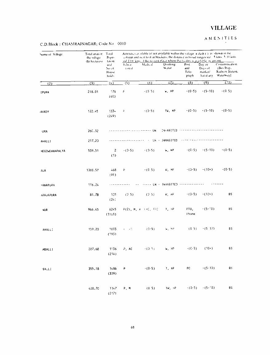
VILLAGE
AMEr-.ITlES
CD. Block : CHAMRAJNAGAR; Code No 0010
'<.In': 01 VIII'lge Tot,t1 dfca 01 T"lal AlllI:IHth.. ... ,1\ 1I1.lhl.: (II nnl dvad.lhll! \,\ llhlll thl.! \ dl,I~1! a d~,h ( ) " ,ho" n III Ih~ thl.! \-Ill.!g\.! POP"- I..-nilimn <1111..1 Ih. \1 to It III hr,l ... l.d ..... lhl.! dl .... t,Ul ... !.! III hllhld r,lngl.!loo VII ~ 1.111' ~ III 1.111'
(In h~ddl~') tltl!)!) 111.1 11)+ kill' Ilhl! nl,.'lt..: ... t CI,ll"l.!' \\h..:r..: Ihl.! III..tll\\ I' ,1\,I11.lhl.: I'" gl\ .:n~
alld E:.lhrh.d ~kdl"d DIIflk.lng Ptht D'I) or Ct.'lnl1lUllll..-dtHHl
}'.tl ()t tli}1l II \\.II~r dnd Dol)' "I IB", St"p. HtHI'1.! Td.:- m.lrl.~11 R,III" d\ SI,lllon. hold, gr.lph h.1111 dll~ Wdl~"'d) I
(2) (3) (4 ) (5) (6) (7) (8) (9) (10)
IPURA 218.01 176 P -(0 5 ) II, HP - (0-5) -(5-10) -(0 5)
(40)
,AVADY 122.45 133 .. p - (0- 5) Til, HP -(0-5) - (5- 10) - (0-5)
(249)
)URA 260.32 ~ . - - - - - - - - - - - - - - - - --- - - - UN INrlABITED -------------------------
AHAL Ll 217.20 ................ -.. _ .... - -........ - UN INHABITED .......... - -.. - .. - - - - - - .. - - .. _ .... -
MEGOIIDANAPALYA 539.51 2 -(0-5) - (0-5) II, HP -(0-5) - (5-10) -(0-5)
(1)
ALA 1088.57 468 P -(0 5) II, HP -(0-5) -(10+) -(0-5)
(91 )
'1ANAPURA 116.24 ------------ ----- UN I NHAB [TED --------------
4RAJAPURA 81.78 128 (0 5) (0 5) II, HP - (0- 5) -(10+) BS
(24)
NUR 966.45 6245 P(2) , M, H ~t1CI F~C T, HP PTO, - (5-10) 8S
( 1168) Phone
AHALLI 159.20 1003 (0, 5) 1,./, "p (0 5 ) -(5 10) 6S
(193 )
,MBALL I 287.68 1136 P, AC -(0 s) II, HP -(0-5) (10+) 5S
(216)
'BALLI 355.18 1486 P - (0-5) T, HP PO - (5-10) BS
(309)
428.70 1147 P, M (0 5) Til, HP - (0-5) -(5-10) BS
(212)
68
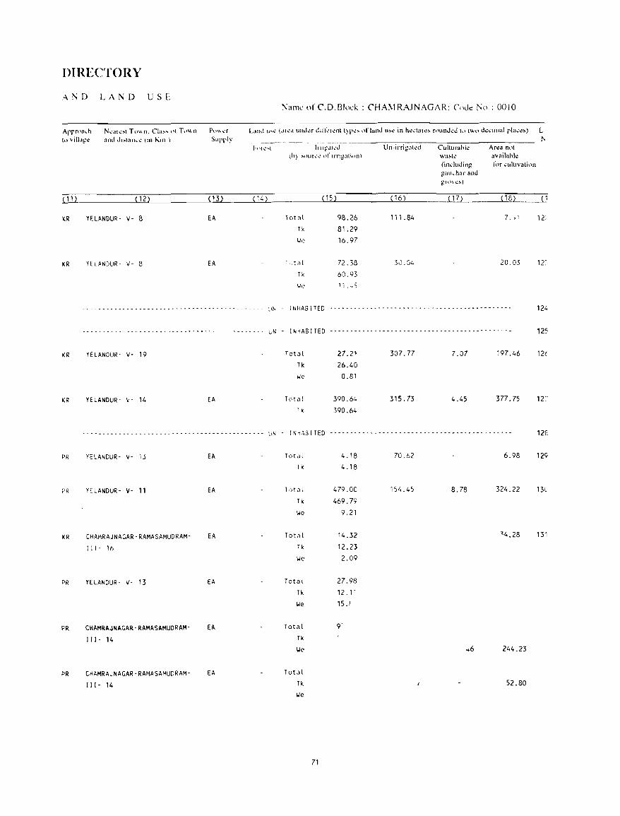
DIRECTORY
:'\l"D LAND USE
Arrn'a.h to 'illa!!~
N,,-,al~:-.t Tu"n. Cla:-- ... "t T,'",n and I.h:oolaul"..l.! (1f1 Kill )
p,)\\ I.!'r Supply
l":lI11'; of C.D.BlocK : CHAMRAJNAGAR: (,odc No.: 0010
hllg~lk'd U n-irrigalt.:d ,h\ ~nuh.:1.! \)1' lITI~atinn) . -
Culturahk waJooh: (induding !_.!aul..har and ~H)\I.!~)
Ar~a not avail"hl~ for cultivation
LUl __________ ~(~12~)~ ________ ~(1~3L) ____ _i~ ________ ~~ __________ ~(1~6~) __ __ ( 14) (15)
KR YElANDUR· v- 8 EA 10tal 98.26 111.84 7. ,~
Tk 81.29
\.Ie 16.97
KR YELANDUR- v- 8 EA ["tiJl 72.38 3J.G4 20.03
Tk 60.93
\.Ie 1 i ." S
- - - - - - - - - - - - - - - - - - - - - - - - - - - - - - - - - - - - - - - - - - - - - :.IN I NHAS I TED • - - - - -. - -. -.' - - - - - - - - -. - - - - -. - - -. - - - - - •• - - -"
12:
124
.--.-.- ... ---------- .. - ........ - ............. uN . INHABITED .......... - .. ----- .......... - ..... - ... - ... -.. 125
KR
KR
PR
?R
KR
PR
PR
PR
YELANDUR' V· 19 27.21 307.77 7.07 197.46 12t
Tk 26.40
\.Ie 0.81
YE LANDUR' 'v' 14 EA 390.64 315.73 4.45 377.75 12~
1 k 390.64
.• - - -. - - -. -. - • - - •• - .• -., - -' - -. - ••• - -. - - •••• -. LIN - I N1AB I TED - - - - -. _ .......... - -" -. - - - ... -. - -. - .. , - ... -" 12E
YELANDUR- V- 13
YELANDUR- V· 11
CHAMRAJNAGAR-RAMASAMUDRAM'
I I I· 16
YELANDUR- V- 13
CHAMRAJNAGAR-RAMASAMUQRAM
J J J. 14
CHAMRAJNAGAR-RAMASAMUDRAM
J J I· 14
EA
EA
EA
EA
EA
EA
Total
Tk
Tot~l
Tk
\.Ie
Total
Tk
\.Ie
Tota(
Tk
lJe
Total
Tk
\.Ie
Total
Tk
lJe
71
4.18 70.62 6.98 129
4.18
479.00 154.45 8.78 324.22 13l
469.79
9.21
14.32 "4.28 131
12.23
2.09
27.98
12.1'
1SJ
Q'
.. 6 244.23
52.80
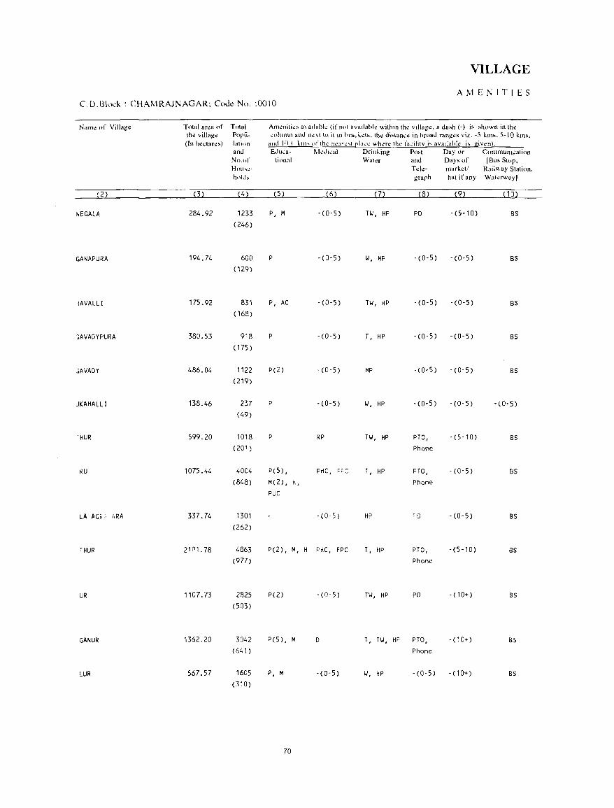
VILLAGE
AMENITIES C.D.Bh:k: CHAMRAJNAGAR; Code No. :0010
N"m~ of Villag~ Total area of Total Amenitie, a""lable (if not availahle withlll the vIllage. a da,h (-) i, ,hown in the th~ village Popu- ~olllmn and next to it In hra-l .. d,. the di,tanee in hroad ranges viz. -S km,. S-IO kms. (In he.;tare,) I"tion and 10+ ~III' of the ncarc,t Cl,":c where the facility i, availabk i, givl!n!.
and Edllc"- l\kdlcal Drin~ing Po,t Day or C()fnmunl~ati(>n
No.of tiollal Wah!r and Days of [Bu, Stop. Hou ... \!- Telc- market/ Railway Station. hoi,!, graph hat if any Wilterw"y]
(2) (3) (4) (5) (6) (7) (8) (9) (10)
NEGALA 284.92 1233 P, M -(0-5) TW, HP PO -(5-10) BS (246)
GANAPURA 194.74 600 P - (0- 5) 1./, HP -(0-5) -(0-5) BS (129)
~AVALLI 175.92 831 P, AC -(0-5) TI./, HP -(0-5) -(0-5) BS ( 168)
~AVADYPURA 380.53 918 P - (0-5) T, HP -(0-5) -(0-5) BS (175 )
~AVADY 486.04 1122 P(2) -(0-5) HP -(0-5) -(0-5) BS (219)
JKAHALLi 138.46 237 P -(0-5) 1./, HP -(0-5) -(0'5) -(0-5) (49)
'HUR 599.20 1018 P RP TW, HP PTO, - (5-10) BS (201) Phone
RU 1075.44 4004 P(5) , PHC, F, C T, HP PTO, - (0-5) BS (848) M(2), H, Phone
PUC
LA AG~ ,. ~RA 337.74 1301 - (0- 5) HP CCJ -(0-5) as (262)
~HUR 2101.78 4863 P(2), M, H PHC, FPC T, HP PTO, -(5-10) as (977) Phone
UR 1107.73 2825 P(2) -(0-5) TW, HP PO -(10+) BS (503)
GANUR 1362.20 3042 P(S) , M 0 T, TW, HP PTO, -(10+) BS (641 ) Phone
LUR 567.57 1605 P, M -(0-5) 1./, HP -(0-5) -(10+) Bs (310)
70
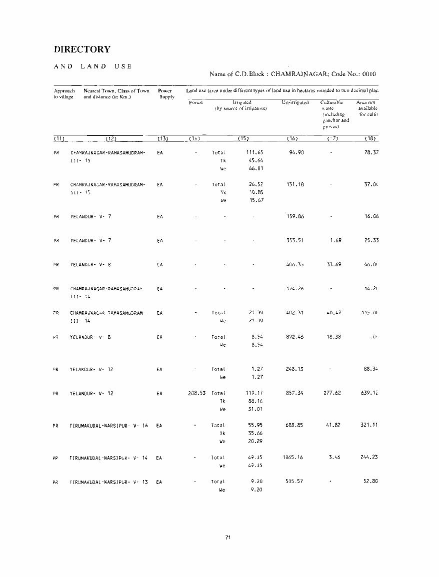
DIRECTORY
AND LAND USE Name of C.D.Block : CHAMRAJNAGAR; Coue No.: 0010
Approa~h N~ar~sl Town. Class of Town Pow~r Land u'~ (ar~a umkr diIT~r~nllyp~~ of land u,~ in h~.;(ares rnund~d to t\!oo d~~imal plac. 10 village and di,lance (in Km.) Supply
Fl)r~:-.l lrTlgal~d Un-irrigal..:J Culturabk An:a nl)t (hy sour~1! of irrig31HHl) "a~tl! availabk
(In .. luJlng for ,lilli, galll.'har and grnvt.:!>t)
(11) (12) (13) (14) (15) (16) ( 17) (18)
PR CHAMRAJNAGAR-RAMASAMUDRAM- EA Total 111. 65 94.90 78.37 II [- 15 Tk 45.64
We 66.01
PR CHAMRAJNAGAR-RAMASAMUDRAM- EA Total 26.52 131.18 37.04 111- is 'ile. ilJ.l'>5
We 15.67
PR YELANDUR- v- 7 EA 159.86 16.06
PR YELANDUR- v- 7 EA 353.51 1.69 25.33
PR YELANDUR- V- 8 EA 406.35 33.69 46.0(
PR CHAMRAJNAGAR-RAMASAMUDR~' EA 124.26 14.2C 111- 14
PR CHAMRAJNAL4~-RAMASAMUDRAM- EA Total 21.39 402.31 40.42 1"\:,, Of
111- 14 We 21.39
I-'R YELANJUR- V- 8 EA Total 8.54 892.46 18.38 .O!
We 8.54
PR YELANDUR- V- 12 EA Total 1.27 248.13 88.34
We 1. 27
PR YELANDUR- V- 12 EA 208.53 Total 119.1 i 857.34 277.62 639.12
Tk 88.16
We 31.01
PR TIRUMAKUDAL-NARSIPUR- V- 16 EA Total 55.95 688.85 41.82 321. 11
Tk 35.66
We 20.29
PR TIRUMAKUDAL-NARSIPUR- V- 14 EA Total 49.35 1065.16 3.46 244.23
We 49.35
PR TIRUMA~UDAL-NARSIPUR- V- 13 EA Total 9.20 505.57 52.80
lJe 9.20
71
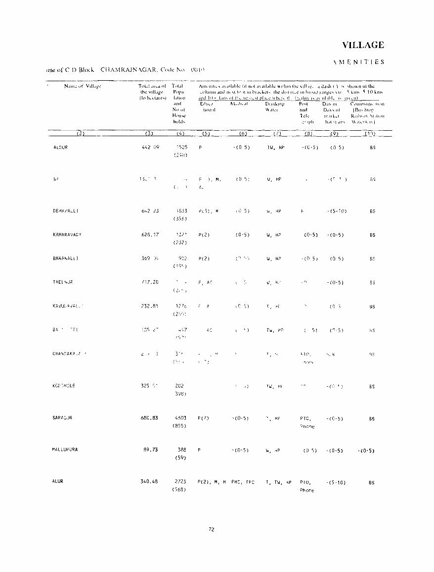
VILLAGE
\ 1\1 E NIT I E S ,me of C 0 BhKk CIIAMRAJN "GAR. Code ]\\\ UUII)
N,lIn.: (If Vtll"c:~ Tl)l~d ... l{l..d o( Tuul Anh 'HI", ,1\ "d"bk (t! ." ,I ,1\ d,[,.hl" \I 'Ihlll Ih" \ tll'ec ,I <I,,,h ( ) '''' 'I"\t.l\\ [\ In lhl.!
Ih" VIII.'1i" PI 'I''' .. l)1(l11111 ,tnd 11,-\1 h) It III hl.I ...... ~h th\! d,,,,ll1h.": III hlO,ld r.1I1!!\!' \ 1/ <; '!lI' ~ 10 km' (I" h,dd'''') 1,,1'011 dpd 1 () ... ~11l"" ,q till.. 1)1.."1 ... ,1 pi h.": \\!1,,!1.. 11 I h.llit\ , .... d\ llllhk
" t!1\ ... I1)
,lOti [d\lc,' 1'.1,-1" "I D\\I\\..U1g P\l"\ Dd\ 01 ('\}l\llllUnh. \\\\\1\
N~) 01 tlPI1 II \\ dk, and 0,"" 01 IBlI' ~h'l' H\'lh~ l"k Illukd R.llh".I\ \11[\1)11
hul,l, e l 'l'h holt It .IP\ \\.Ilc'\\ I\}
2 (3) (4) (5 ) (6) (7) (8) ...I2l. __ ______(_~_
ALClUR 442 09 1525 P - (0 5) Til, HP - (0-5) (0 5) BS (2',1) )
br lkl "\ P ), M, (0 S) \.I, HP -(' '1 ) 5S ( . I..
DEMAJIALL I 6 ... 2 2.5 1833 ,od) , M \ IJ 5 ) \.I, HP - (5-10) 8S
(356)
KAMARAVADY 628.17 132' P(2) (0-5 ) II, HP (0-5) -(0-5) BS (232)
BANAI-,ALL! 369 )4 gez P(Z) (" I" IJ, HP -(0 5) (0 5) 85
(19< )
THEI"JR 717_20 P, 1;: w, H,' f" -(0-5) 85
(2 .... I.. J
KAvUC,AI/ALI I 232_81 121c A ,e: :; ) T, ~,' (0 S BS (2~r, )
G6. -T1 l~c v' c~ .... '.7 f.r , - " ) TIJ, ~P 5 ) ("-5) "s (C;-'>\
CHA~DAO::f.,f , c: . 3' , H "1 C', ~, N SS
(t)" hr)"(
(G[, 11~OLE 325 , 202 ,) T IJ, Hf -(0 ' ) BS 398)
SARAGJR 680.83 4603 P(7) - (0- 5) T, HP PTO, - (0-5) BS (855) "none
MALLUPURA 89.73 388 P - (0- 5) W, hP (0 5) -(0-5) -(0-5) (59)
ALUR 340.48 2723 P(2) , M, H PHC, FPC T, TIJ, HP PTO, - (5 -10) BS (568) Phone
72
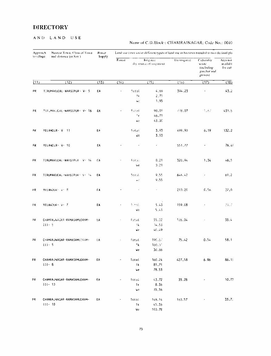
DIRECTORY
AND LAND USE Name ofC.D.Block·: CHAI\1RAJNAGAR; CoJe No.: 0010
Approa..:h Nl.!an.:~t Town. Cla!-o!-. of Tn", n PO\\t.:f Land u~\.! (ar~a 1Ilh.lL!f dirf~I'.!nt t)r~S ofl;IJH.ll1~1.! In hl.!' .. :tan:s round~d tn tU() tk...:imal pl:1 \n \ iHage and di;...\am.:1.! (In Km ) Supply
Forl.!~l Irri:!~Ih:d U n~irn~all.!d LlIlillrahk An.:a not (hy ~Our\.1..' t\fllllgatldll) wa~h= 3\ ailahl
(In..:\uding ftlr ..:uli gath.'har and g-rt)\'I.!!-t)
( 1 1) (12) ( 13) (14) ( 15) (16) (17) ( 18)
PR TIRUMAKUDAL-NARSIPUR- v- 5 EA To tell 4_66 394_23 43.2 Tk 2.71
'we 1.95
PR TIRUMAKUCAL-NARSIPUR- v- 16 EA TGtCll 90.01 778.07 1.6." 431_5 TK 46.71 ~'C' 43.30
PR YELANDUR- v- 11 EA Totill 3.93 499.90 6.19 132.2 We 3.93
PR YELANDUR- v- 10 EA 551. 77 76.4(
PR TIRUMAKUDAL-NARSIPUR- v- 14 EA To c:ll 0.21 320.94 1.34 46.5 We 0.21
PR TIRUMAKUDAL-~ARSIPUR- v- 14 EA Tot"l 9.55 646.42 61.2 10-.'.' 9.55
PR YELANDUR - y - 8 EA 210.20 O.Sb 22.0
PR YELANJUR- \/- 7 EA T, It ,1: 5.43 159.08 .~O. 7
We 5.43
PR CHAMRA"~ACAR-RAMASAMUDRAM- EA Total SS.C2 126.04 38_4
Ill- S Tk 14.53
We 40.49
PR CHAMRAJNAGAR-RAMASAMUCRAM- EA TotQl 190.3/ 75.42 0.54 58.1
Ill- S Tk 160. ·J1
\.Ie 30.86
PR CHAMRAJNAGAR-RAMASAMUDRAM- EA Total 160.24 427.58 6.86 86.1: 111- 8 Tk 81. 71
We 78.53
PR CHAMRAJNAGAR-RAMASAMUDRAM- EA TotQl 43.72 35.28 10.73 111- 10 Tk 8.36
\.Ie 35.36
PR CHAMRAJNAGAR-RAMASAMUDRAM- EA Totill 146.14 160.57 33. 7~
111- 10 Tk 45.36
We 100.78
73
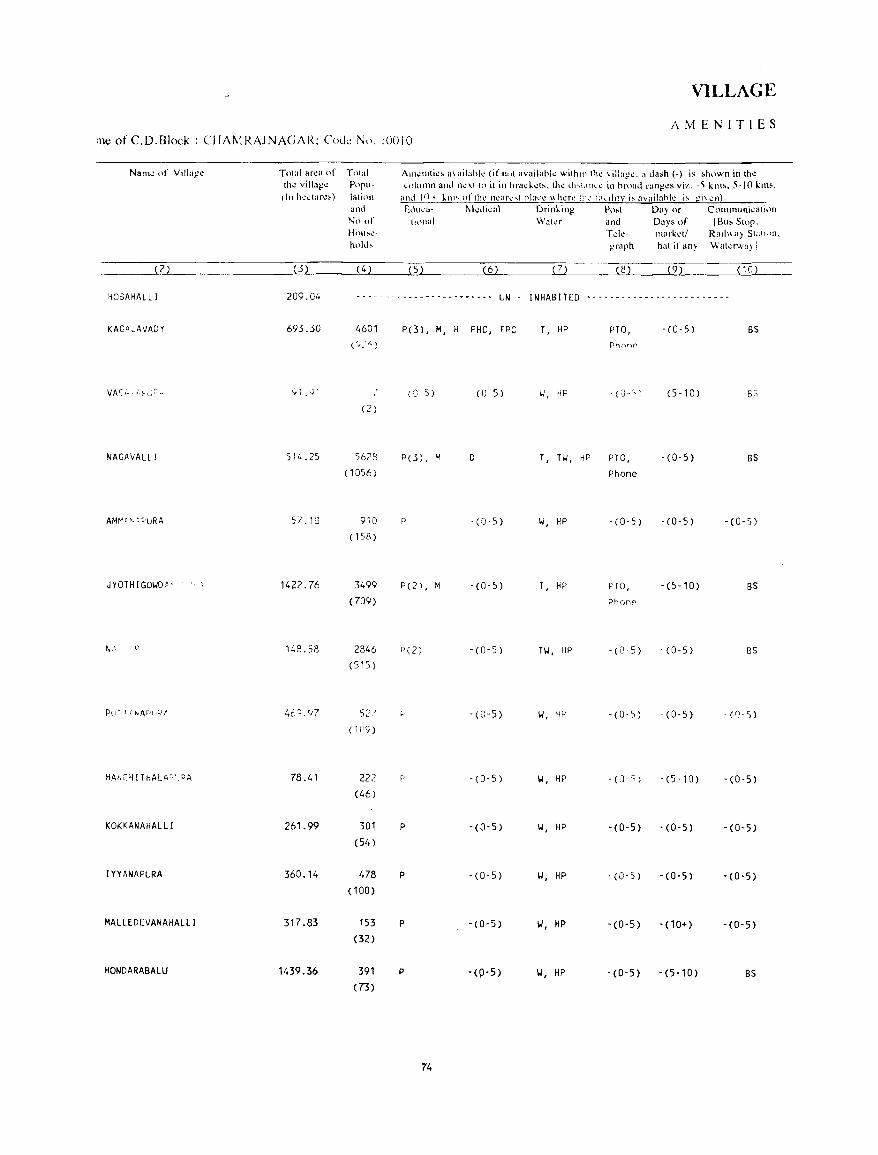
VILLAGE
AMENITIES ine of C.D.B1ock : CHA['.lRAJNAGAR: COlle N\). :0010
Naill\! of Villagl.!
(2)
~OSAHALLI
KAGft L A VA,O Y
NAGAVALL!
JYOTHIGOWDt' ,','
HANC~I THAU\C'_RA
KOKKANAHALLI
IYYANAPURA
MALLEDEVANAHALLI
HONDARABALU
Total ar~a of thl! villag!! (Ill hcctar~')
(3)
209.04
693.30
[';'1.91
514.25
57.18
1422.76
148.58
4(;0;,97
78.41
261.99
360.14
317.83
1439.36
Tntal Populati"11 and
Nn of How",l.!-
ho"" (4)
AIll~lllli~, a\ailahk (if ,,,.t available within thc 'villa)2c. a ,Ia.h (-) is ,htlwn in lh~ ~l)IUllln and UI.!\t to il in hra~kd:-.. lhl! dl',LIlh.1.! in broad rangl!s viz. -5 klll~. 5-10 killS,
and I()+ kill .... n(lh~ Ih.'ar\! ... t ria .. :\! \\h .... r..: ill>..' l':h .. dllY i~ avail::lhl~ i~ gi\'I!!l).
Elill~~- t\\",:di"':H\ Drinking Po:-.t Day Of COllllnuni..:alil)n ti,"JaI Water and Days or IBu, SIOr.
Tdc- Illark~ll Rail",,} Statl,'n. ~raph h~lt if any \\'at.:lwa) I
( 5) (6) 7 (8) (9) (10)
- - - - - - - - - - - - - - - - - - - - - - - - UN I NHAB ITED - - - - - - - - - - - - - - - - - - - - - - - --
4601 P(3) , M, H PHC, fPC T, HP PTO, -(0-5) BS C:;. ~i,\ Phone
_ (G- 5) -(0-5) W, HP 'n-~i - (5-10) 5S
(2 )
5623 P(3) , M D T, TW, riP PTO, -(0-5) BS ( 1056) Phone
910 P -(0-5) W, HP - (0-5) -(0-5) -(0-5) (158)
3499 P(2) , i~ - (0-5) T, HP no, -(5-10) BS (709) Phone
2846 P(2) -(0-5) TW, HP - (0-5) -(0-5) 85
(515)
5"7 ~ -(C-5) W, Hf" -(0-5) -(0-5) _ (n_ 5)
(1(19)
222 p -(0-5) W, HP -(0 " ) -(5-10) -(0-5) (46)
301 P -(0-5) W, HP -(0-5) -(0-5) -(0-5) (54 )
478 P -(0-5) W, HP - (0- 5) -(0-5) -(0-5) (100)
153 P -(0-5) w, HP -(0-5) -(10+) -(0-5) (32)
391 P -(P-5) w, HP -(0-5) -(5-10) BS (73)
74
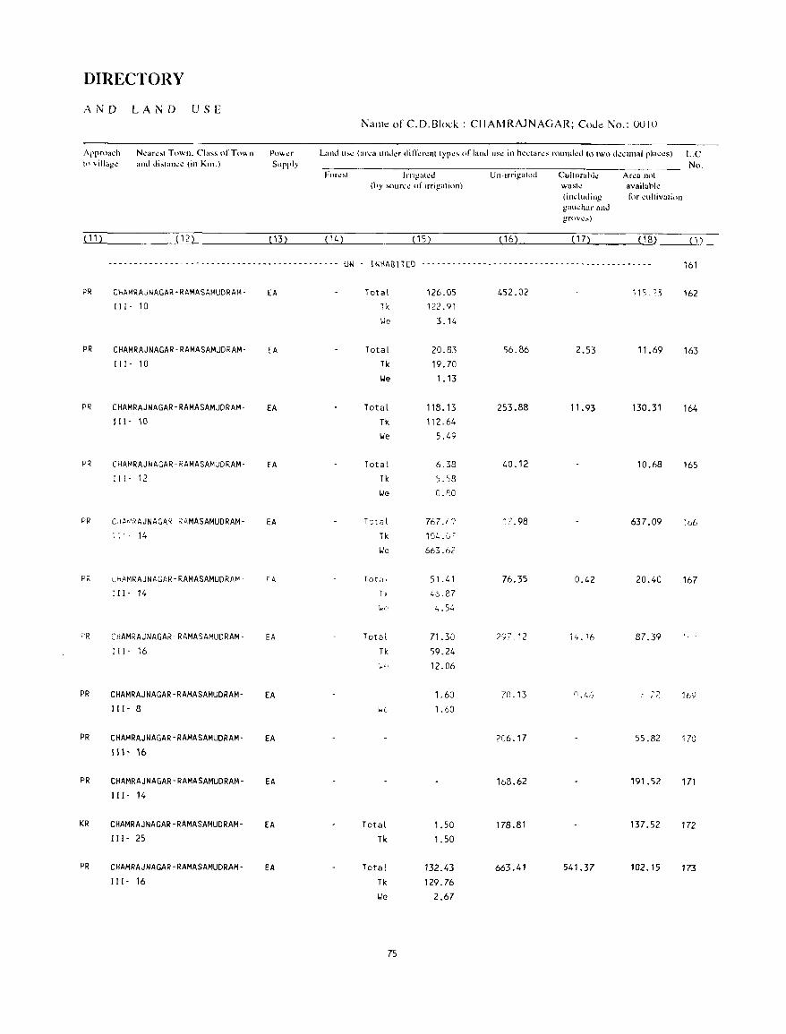
DIRECTORY
AND LA N D USE NaJ11e of C. D. Block: CHAM RAJNAGAR; CoJe No.: 0010
Approach Nl.!ar\!~t Town. Class ofTo\\ n PO\\t!f Land u!--\.! (al'\!a lHh.il!f din~rl!nt tYpl!S orland US\! in hl.!ctarl!s round\.!d to two (k~in1aJ plat.:\!~) L.C. tn \ill'lg~ and di,tanc~ (in Kill.) Supply No.
Forl!~t JrrigaLI!J Un-irrigakd Culturahk Ar~a not (hy sour~1! of irrigation) wastl! availahl~
(including for "ultivation !_.!au(har and grov\!:..)
( 11 ) (12) ( 13) (14) (15) ( 16) ( 17) (18) (1) _
------------------~------------- ... ------------ UN t NHAB !TED ............................................................ -- ................................. - , - ........................... 161
PR CHAMRAJNAGAR-RAMASAMUDRAM- EA Total 126.05 452.02 115. '3 162 111- 10 Tk 122.91
We 3.14
PR CHAMRAJNAGAR-RAMASAMUDRAM- EA Total 20.83 56.86 2.53 11.69 163 111- 10 Tk 19.70
lie 1.13
PR CHAMRAJNAGAR-RAMASAMUDRAM- EA Total 118.13 253.88 11.93 130.31 164 I I 1- 10 Tk 112.64
lie 5.49
PR CHAMRAJNAGAR-RAMASAMUDRAM- EA Total 6.38 40.12 10.68 165 111- 12 Tk ~.58
lie O.IlO
PR CHA~RAJNAGA~'~AMASAMUDRAM- EA Tst<Jl 767.f '? 17.98 637.09 :b6
14 Tk 104. (_', ~
lie 663.62
PR L~AMRAJNAGAR-RAMASAMUDRA~' rA Toti, ' 51.41 76.35 0.42 20.40 167 111- 14 T. 4:0.87
'we 4.54
F'R CHAMRAJNAGAR-RAMASAMUDRAM- EA Total 71.30 zq7,12 14.16 87.39 111- 16 Tk 59.24
:,.. .. 12.06
PR CHAMRAJNAGAR-RAMASAMUDRAM- EA 1.60 7n.13 (14L..() . ,-:_ 16') 111- 8 \.it: 1.60
PR CHAMRAJNAGAR-RAMASAMUDRAM- EA 206.17 55.82 170 1 \ I- '6
PR CHAMRAJNAGAR-RAMASAMUDRAM- EA lb8.62 191.52 171 111- 14
KR CHAMRAJNAGAR-RAMASAMUDRAM- EA Total 1.50 178.81 137.52 172 111- 25 Tk 1.50
PR CHAMRAJNAGAR-RAMASAMUDRAM- EA Total 132.43 663.41 541.37 102.15 173 II I - 16 Tk 129.76
lie 2.67
75
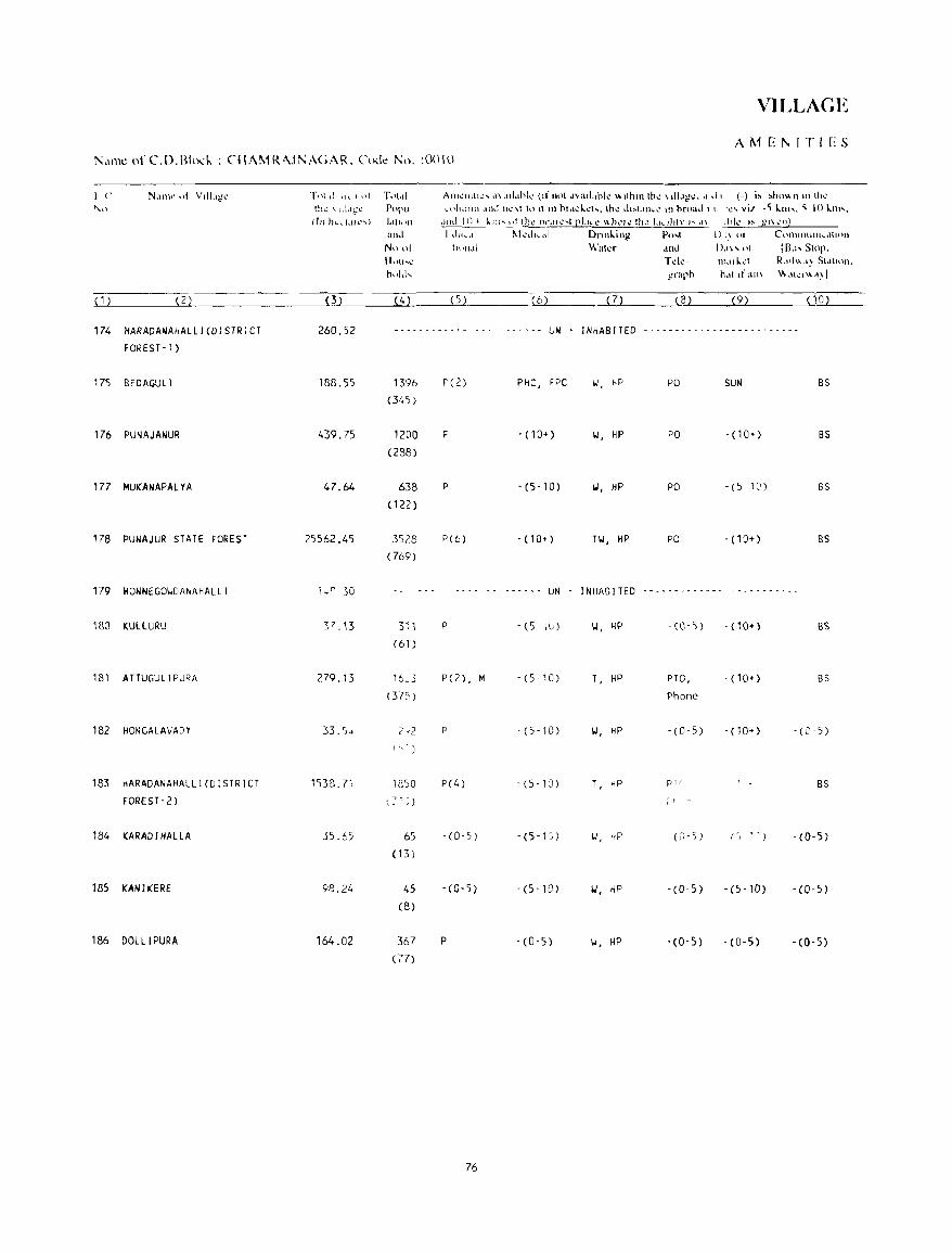
VILLAGE
AMEt\IT1ES KII1lt: ofC'.D.BhKI..: CtlAMR'\Jt-.::\GAR. Cnd.: I\:n. :0010
1(" ,,-,)
( 1 )
174 HARADANAHALLI(DI5TRICT
FOREST-1)
175 BEDAGULl
176 PUNAJANUR
177 MUKANAPALYA
178 PUNAJUR STATE FOREST
179 HONNEGOWDANAHALLI
180 KULLURU
181 ATTUGULIPURA
182 HONCALAVADY
183 HARADANAHALLI(DISTRICT
FOREST-2)
184 KARADI HALLA
185 KANIKERE
186 DOLLIPURA
Tt\t II ",- I ,)1 Ti.ll~tl
th~ .. d L\g~ PUi'u ~ III hL .. I,lh.· ... ) 1.III1)n
and
N" "I Hull ... ...:
hold ....
.4.11h. .. ·I\lll.: ... <1\.ul.lhl...: (Iflh)l d"~llLlhk \\tlhlll th...: \11I.lt_!t.! •• I d I (-) i~ !or.ho"n In th..: I,.phllllil .lthf 11...:\1 10 It III hl.l..:l..:l ... , Ih\!" dl~t.llh.."': III hnl;:h.t I \ 'I.!' vi.! _, kill ..... , 10 klll,-,
,)ltd J () 10 k m ... j II lh~ rll',ll l· ... ' PJ.IL~ \\ hl,."': Ih~ Lk "ltv,,,, ,1\ IhJ~ 1:-. ;;1\ l'n)
I ~lu ..... 1 f\l":l.iJlwdl Dnnling Po ... t U I)' 01 COlllllllll1l1.,.ttlilJl
tl,,",11 Wata ,Illd [),I\' 1)1 (flu, S(np. Td~- m.II~.;l R,"l\\,,~ 51,1(11)11.
graph
(5) (6) (7) (3) (9) (10)
260.52 - -- - - - - -- - - - - .... - -". - UN INHABITED .... ---------------.-- ...
188.55
439.75
47_64
25562_45
37 .13
279.13
33.')"
1538.71
5:;'.65
98.24
164.02
1396 (345)
1200 (288)
638 (122)
3523 (769)
311
(61)
1350
65 (13 )
45 (8)
367 (77)
F (2) PHC, FPC
P -(10+)
P - (5-10)
P(6) - (10+)
...... UN
p -(5 1Ll)
P( 2), M - (5"0)
p '(5-10)
P(4) - (5 -, 0)
,(0,5) . (5-1 ~)
- (0,5) . (5 -1 0)
p ,(0,5)
76
W, hP PO SUN BS
II, HP PO -(10+) BS
II, HP PO -(5 10) BS
TW, HP PO -(10+) BS
INHABITED .. -----.-.---.-- .. ----.--
W, HP
T, HP
W, HP
T, HP
1,1, nP
II, HP
II, HP
'(0-5)
PTO,
Phone
-(0'5)
- (0- 5)
-(0-5)
·(10+) BS
·(10+) BS
·(10+) -(0-5)
, , BS
-(0-5)
-(5-10) -(0-5)
'(0-5) -(0-5)
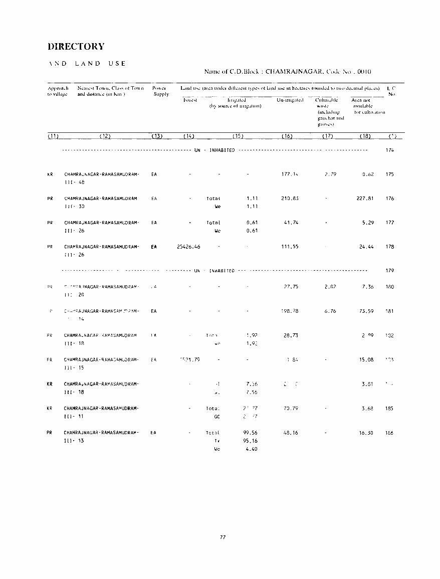
DIRECTORY
\:\D LAND USE
f\ppr03\,.h NI.!(IIt.: ... t -r 0"'11. el.i'1." o. Tn\\ n h} vllI.;l!!': and dl:..lan\,.\! (Ill J\.1Il )
(11) (12)
Po\\ I,..'r
Supply
(13) (14)
- - - - - - - - - - - - - - - - - - - - - - - - - - - - - - - - - - - - - - - - - - - - - UN
I<..R CHAMRAJNAGAR-RAMASAMUDRAM- EA
Ill- 48
PR CHAMRAJNAGAR-RAMASAMUORAM EA 111- 30
PR CHAMRAJNAGAR-RAMASAMUDRAM- EA
III- 26
PR CHAMRAJNAGAR-RAMASAMUDRAM- EA 25426.46 Ill- 26
- - - - - - - - - - - - - - - - - - ---------_-- - --- ----- UN
PQ r ·M~~JNAGAR-RAMASAMUDRAM- ,A
i I I 20
~>-··RAJNAGAR-RAMASAI-' J~.'AM- EA
14
PR CHAMRAJNAGAP ~AMASAMUDRAM fA
II (- 18
PR CHAMRAJNAGAR-RAMA~AMUDRAM- E<\ 'C,?1 .79
(il- lS
KR CHAMRAJNAGAR-RAMASAMUDRAM-
I I I - 18
KR CHAMRAJNAGAR-RAMASAMUDRAM-
I ( I- II
PR CHAMRAJNAGAR-RAMASAMUDRAM- EA
III- 13
Nallle ofC.D.l3Iod .. : CIIAt-.1RAJNAGAR. (,,,,k:\(). 0010
No 1111~,lt\!d Un-Irng,ttl.!d Cuitul.,hk A,ca n(\1
(h) ~(.\url,..~ 01 1I11g.ltlon) ~a,(\! avall.lhl~
(lIldlldlll~ tnr I..Uit(\,tlhHl
gau\..h.\r and l!U)\C' .... )
( 15) ( 16) ( 17) (18) (1)
I N HAS I TED - - - - - - - - - - - - - - - - - - - - - - - - - - - - - - - - - - - - - - - - - - - - 174
177.1<. 2.79 8.62 175
Total 1.11 210.83 227.81 176 \.Ie 1.11
Total 0.61 41.74 5.29 177 \.Ie 0.61
111.55 24.44 178
INHABITED - - - ---- - ---- -- -- -_--- -- - - --- -- -- - ----------- 179
27.75 2.02 7.36 180
198.78 6.76 73.59 181
Tnt -, ~ .92 28.73 2 '19 132 "p 1.92
fl4 15.08 ' 0,3
d 7. ')6 3.81 w, 7.56
Total r 77 70.79 3.68 185
GC 2 '7
Total 99.56 48.16 16.30 186 Tk 95.16 I./e 4.40
77

VILLAGE
AME]\;ITIES ~all1e of CD. Block : CHAMRAJNAGAR; Code No. :0010
L C Naill!.! of Villagl! TtllaJ a!~;1 \)1' Tn", I Amlo!i1itil.!!,> u\uilabl¢ (if not availabll! within thl! villagl.!. a I.bJ ) " ~hnwn i'n lhl.!
NIl lhl! \ \,1 !~~ p"pu- "':OIUlllll and Jll!\t to it in hru,,:k.l.!lS. thl.! Ji~lan\.:l.! IU hnmJ r:1l .. II. -) "lib. 5-1f) kill'. (Ill he"iare') latioll and j()+ knh nflh\! no:ar~ .... t r[:!\.'1.! \\'h~I\! th~ r.I,:!lil\ j ... :1\:1 IS gtv..:nl
and Edth.'a- IIkd",,1 Driulin!_! PO~1 J _I \)r C(lll1illlIIlI._.ali{)[1
No.of tional Waler and Da), of I Bu, SlOp. Hnu:-.I.!- Td~- Ilwrll..':tI Railu.ay Slalilln. h"ld, ~raph hal if all) Waierwayl
( 1 ) (2) (3) (4) (5 ) (6) (7) (8) (9) ( 10)
187 DEVARAJAPURA 125.23 60 -(0-5) -(0-5) 1.1, HP -(0-5) -(0-5) -(0-5) (16)
188 HEBBASUR 1350.04 4504 P(!.), M -(0-5) T, HI, HP PTO, -(0-5) BS
(825) Phone
Total (Sum) 121889.48 266845 P(239), PHC(16), (51961) M(55), 0(3),
H( 15), FPC(15),
PUC(3), RP(3) AC(37)
7R
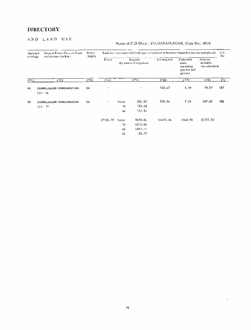
DIRECTORY
AND LAND USE
Approach to village
N\!df\!"t Town. CI" ...... 01 Town and d"tanc\! (11\ Kill )
( 11 ) ( 12)
PR CHAMRAJNAGAR-RAMASAMUDRAM-
111- 14
PR CHAMRAJNAGAR-RAMASAMUDRAM-
111- 11
P{lWl!f
Supply
( 13)
EA
EA
(14)
27156.78
N,lmtO ot C.D.Bh.I- : CIIA~IRAJNAGAR, CoJe No.: 0010
No hltgdtl.!d Culturahle Area not
(hy ~our\.t,,! of In Igallon) Wd:_..l\! avallahle (.ndudmg t,'f cultivatIOn gduchdf and grow,)
(15) ( 16) ( 17) (18) (1)
102.47 3.19 19.57 187
Total 235.37 709.34 7.50 397.83 188
Tk 123.03
lie 112.34
Total 9878.84 54615.06 2662.90 24705.50
Tk 4893.96
lie 4961.11
GC 23.77
79

GUNDLUPET C.D.BL()CK
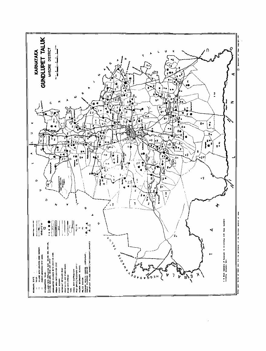
:at
... ~ "\.'" '''0
;:,
..J -<I(
...J
to"
~
tv \t 1-
• ... I
I :!1~ ·"11 1M .01:'" .11 ; I~~© ::~ i
E? ~<l 1-
I I"" • , I -.. i:' +.
i 1 :; • ~ :
0 ~ 8. 041
LJ 0 ~J " I
/ i .. r
<l
~
J • f l
! ~ ~ \ e i
i l- i I.
I, £ , f i
If i I • r :1 r
,j
i , !
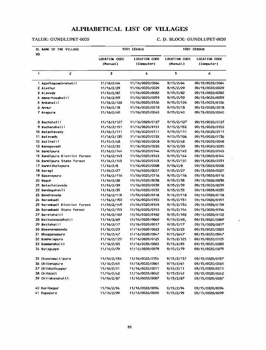
ALPHABETICAL LIST OF VILLAGES
TALUK: GUNDLUPET-0020
SL NAME OF THE VILLAGE NO
2
Agathagowdanahalli 2 Alathur 3 Alavady 4 Ameerhosahalli 5 Ankahall i 6 Annur 7 Arepura
8 Bachaha II i 9 Bachanaha II i
10 Balachavady 11 Balavady 12 Balihalli 13 Banagavadi 14 Bandipura 15 Bandipura District Forest 16 Bandipura State Forest 17 Bannithalapura 18 Baragi 19 Basavapura 20 Begur 21 Belachalavady 22 Bendagahall i 23 Bendravady 24 Berambadi 25 Berambadi District Forest 26 Berambadi State Forest 27 Beratahalli 28 Bettadamadahalli 29 Bettahall i 30 Bheemanabeedu 31 Bhogganapura 32 Bonrnalapura 33 80nrnanaha II i 34 Bylaguppe
35 Channamallipura 36 Chikanapura 37 Chikkathuppur 38 Chikkati 39 Chirakanahalli
40 Daribegur 41 Depapura
C.D.BLOCK:GUNDLUPET~20
1991 CENSUS 1981 CENSUS
LOCATION CODE (Manual)
3
11/16/2/64 11/16/2/29 11/16/2/82 11/16/2159 11/16/2/126 11/16/2/18 11/16/2140
11/16/2/127 11/16/2/151 11/16/2/111 11/16/2/135 11/16/2/48 11/16/2130 11/16/2/144 11/16/2/143 11/16/2/145 11/16/2/8 11/16/2127 11/1612/116 11/16/2/38 11/16/2/39 11/16/2/35 11/16/2/118 11/16/2/150 11/16/21149 11/16/21153 11/16/2/102 11/16/2/69 11/16/2/17 11/16/2/23 11/16/2/47 11/16/2/125 11/16/2/83 11/16/2/79
11/16/2/154
11/16/2161 11/16/2/11 11/16/2/42 11/16/2/87
11/16/2/94 11/16/2/99
LOCATION CODE LOCATION CODE LOCATION CODE (Computer) (Manual) (Computer)
4
11/16/0020/0064 11/16/0020/0029 11/16/0020/0082 11/16/0020/0059 11/16/0020/0126 11/16/0020/0018 11/16/0020/0040
11/16/0020/0127 11/16/0020/0151 11/16/0020/0111 11/16/0020/0135 11/16/0020/0048 11/16/0020/0030 11/16/0020/0144 11/16/0020/0143 11/16/0020/0145 11/16/0020/0008 11/16/0020/0027 11/16/0020/0116 11/16/0020/0038 11/16/0020/0039 11/16/0020/0035 11/16/0020/0118 11/16/0020/0150 11/16/0020/0149 11/16/0020/0153 11/16/0020/0102 11/16/0020/0069 11/16/0020/0017 11/16/0020/0023 11/16/0020/0047 11/16/0020/0125 11/16/0020/0083 11/16/0020/0079
11/16/0020/0154 11/16/0020/0061 11/16/0020/0011 11/16/0020/0042 11/16/0020/0087
11/16/0020/0094 11/16/0020/0099
83
5
9/15/2/64 9/1512129 9/15/2/82 9/15/2159 9/1512/126 9/15/2/18 9/15/2/40
9/15/2/127 9/15/2/152 9/15/2/111 9/15/2/136 9/15/2/48 9/15/2/30 9/15/2/145 9/15/2/144 9/15/2/131 9/15/2/8 9/15/2/27 9/15/2/116 9/15/2/38 9/15/2/39 9/15/2/35 9/15/2/118 9/15/2/151 9/15/21150 9/15/2/154 9/15/2/102
91.'5 /2/69. 9/15/2/17 9/15/2/23 9/15/2/.47-9/15/2/125 9/15/2/83 9/15/2/79
9/15/2/157 9/15/2/61 9/15/2/11 9/15/2/42 9/15/2/87
9/15/2/94 9/15/2/99
6
09/15/0020/0064 09/15/0020/0029 09/15/0020/0082 09/15/0020/0059 09/15/0020/0126 09/15/0020/0018 09/15/0020/0040
09/15/0020/0127 09/15/0020/0152 09/15/0020/0111 09/15/0020/0136 09/15/0020/0048 09/15/0020/0030 09/15/0020/0145 09/15/0020/0144 09/15/0020/0131 09/15/0020/0008 09/15/0020/0027 09/15/0020/0116 09/15/0020/0038 09/15/0020/0039 09/15/0020/0035 09/15/0020/0118 09/15/0020/0151 09/15/0020/0150 09/15/0020/0154 09/15/0020/0102 09/15/0020/0069 09/15/0020/0017 09/15/0020/0023 09/15/0020/0047 09/15/0020/0125 09/15/0020/0083 09/15/0020/0079
09/15/0020/0157 09/15/0020/0061 09/15/0020/0011 09/15/0020/0042 09/15/0020/0087
09/15/0020/0094 09/15/0020/0099
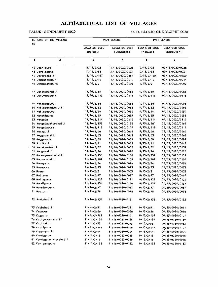
ALPHABETICAL LIST OF VILLAGES
T ALUK: GUNDLUPET -0020
SL NAME OF THE VILLAGE NO
1
42 Deshipura 43 Devalapura 44Devarahalli 45 Dodclathuppur 46 Dumdasanapura
47 Garaganahall i 48 Guruvinapura
49 Hakkalapura
2
50 Halladamadahalli 51 Halladapura 52 Hanchipura 53 Hangala 54 Hangaladahosahalli 55 Hangalapura 56 Hasagul i 57 Heggadahalli 58 Heggavady 59 Hirikati 60 Honakanahall i 61 Hongahalli 62 Honnegowdanahalli 63 Hooradahall i 64 Horeyala 65 Hosapura 66 Hosur 67 Hullana 68 Hullepura 69 Hundipura 70 HUnsinapura 71 Huttur
72 Jakkahalli
73 Kabbaha II i 74 Kadabur 75 Kaggala 76 Kaligowdanahalli 77 Ital ihal U
78 Kall ipura 79 Kamarahall i 80 Kandegala 81 Kandegaladahosahalli 82 Kani yanapura
C. D. BLOCK: GUNDLUPET-0020
1991 CENSUS 1981 CENSUS
LOCATION CODE (Manual)
3
11/16/2/28 11/16/2/31 11/16/2/157 11/16/2/14 11/16/2/2
11/16/2/65 11/16/2/113
11/16/2/56 11/16/2/62 11/16/2/54 11/16/2/55 11/16/2/114 11/16/2/158 11/16/2/119 11/16/2/66 11/16/2/63 11/16/2/89 11/16/2/41 11/16/2/32 11/16/2/26 11/16/2/156 11/16/2/109 11/16/2/74 11/16/2/73 11/16/2/3 11/16/2/97 11/16/2/121 11/16/2/136 11116/2/57 11/16/2/78
11/16/2/131
11/16/2/51 11/16/2/86 11/16/2/101 11/16/2/138 11/16/2/53 11/16/2/146 11/16/2/44 11/1612/15
11/16/2/16 11/16/2/132
LOCATION CODE LOCATION CODE LOCATION CODE (Computer) (Manual) (Computer)
4
11/16/0020/0028 11/16/0020/0031 11/16/0020/0157 11/16/0020/0014 11/16/0020/0002
11/16/0020/0065 11/16/0020/0113
11/16/0020/0056 11/16/0020/0062 11/16/0020/0054 11/16/0020/0055 11/16/0020/0114 11/16/0020/0158 11/16/0020/0119 11/16/0020/0066 11/16/0020/0063 11/16/0020/0089 11/16/0020/0041 11/16/0020/0032 11/16/0020/0026 11/16/0020/0156 11/16/0020/0109 11/16/0020/0074 11/16/0020/0073 11/16/0020/0003 11/16/0020/0097 11/16/0020/0121 ,'/16/0020/0136 11/16/0020/0057 11/16/0020/0078
11/16/0020/0131
11/16/0020/0051 11/16/0020/0086 11/16/0020/0101 11/16/0020/0138 11/16/0020/0053 11/16/0020/0146 11/16/0020/0044 11/16/0020/0015 11/16/0020/0016 11/16/0020/0132
84
5
9/15/2/28 9/15/2/31 9/15/2/160 9/15/2/14 9/15/2/2
9/15/2/65 9/15/2/113
9/15/2/56 9/15/2/62 9/15/2/54 9/15/2/55 9/15/2/114 9/15/2/161 9/15/2/119 9/15/2/66 9/1512/63
9/15/2/89 9/15/2/41 9/15/2/32 9/15/2/26 9/15/2/159 9/15/2/109 9/15/2/74 9/15/2/73 9/15/2/3 9/15/2/97 9/1512/121 9/1512/137 9/15/2/57 9/15/2/78
9/15/2/132
9/15/2/51 9/15/2/86 9/15/2/101 9/15/2/139 9/15/2/53 9/15/2/147 9/15/2/44 9/15/2/15 9/15/2/16 9/15/2/133
6
09/15/0020/0028 09/15/0020/0031 09/15/0020/0160 09/15/0020/0014 09/15/0020/0002
09/15/0020/0065 09/15/0020/0113
09/15/0020/0056 09/15/0020/0062 09/15/0020/0054 09/15/0020/0055 09/15/0020/0114 09/15/0020/0161 09/15/0020/0119 09/15/0020/0066 09/15/0020/0063 09/15/0020/0089 09/15/0020/0041 ' 09/15/0020/0032 09/15/0020/0026 09115/0020/0159 09/15/0020/0109 09/15/0020/0074 09115/002D/0073 09/15/0020/0003 09/15/0020/0097 09/15/0020/0121 09/15/0020/0137 09/15/0020/0057 09/15/0020/0078
09/15/0020/0132
09/15/0020/0051 09/15/0020/0086 09/15/0020/0101 09/15/0020/0139 09/15/0020/0053 0~J15/0020/0147
09/15/0020/0044 09/15/0020/0015 09/15/0020/0016 09/15/0020/0133
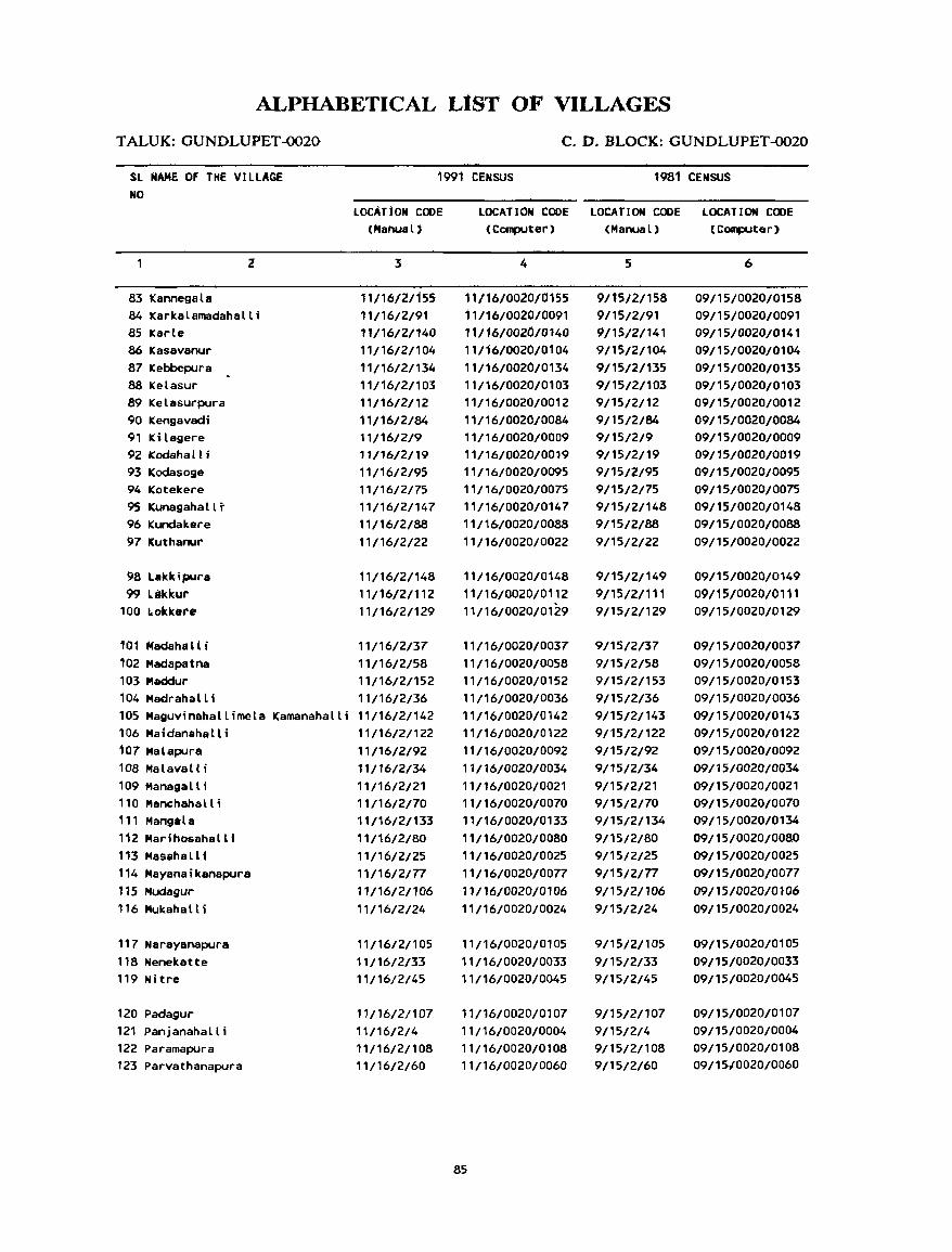
ALPHABETICAL LIST OF VILLAGES
TALUK:GUNDLUPET~20 C.D.nLOCK:GUNDLUPET~O
SL NAME OF THE VILLAGE 1991 CENSUS 1981 CENSUS NO
LOCAl f ON CODE LOCATION CODE LOCATION CODe LOCATION CODE (Manual) (Computer) (Manual) (COIlpJter)
2 :5 4 5 6
83 Kannegala 11/16/21155 11/16/0020/0155 9/15/2/158 09/15/0020/0158 84 Karkalamadahalli 11/16/2/91 11/16/0020/0091 9/15/2/91 09/15/0020/0091 85 Karle 11/16/2/140 11/16/0020/0140 9/15/21141 09/15/0020/0141 86 Kasavanur 11/16/2/104 11/16/0020/0104 9/15/2/104 09/15/0020/0104 87 Kebbepura 11/16/2/134 11/16/0020/0134 9/15/2/135 09/15/0020/0135 88 Ketasur 11/16/2/103 11/16/0020/0103 9115/2/103 09/15/0020/0103 89 Kelasurpura 11/16/2/12 11/16/0020/0012 9/15/2/12 09/15/0020/0012 90 Kengavadi 11/16/2/84 11/16/0020/0084 9/15/2/84 09/15/0020/0084 91 Kilagere 11/16/2/9 11/16/0020/0009 9/15/2/9 09/15/0020/0009 92 Kodaha L 1 i 11/16/2/19 11/16/0020/0019 9/15/2/19 09/15/0020/0019 93 Kodasoge 11/16/2/95 11/16/0020/0095 9/15/2/95 09/15/0020/0095 94 Kotekere 11/16/2175 11/16/0020/0075 9/15/2/75 09/15/0020/0075 95 Kunagahallt 11/16/2/147 11/16/0020/0147 9/15/2/148 09/15/0020/0148 96 Kundakere 11/16/2/88 11/16/0020/0088 9/15/2/88 09/15/0020/0088 97 Kuthanur 11/16/2/22 11/16/0020/0022 9/15/2/22 09/15/0020/0022
98 Lakldpura 11/16/2/148 11/16/0020/0148 9/15/2/149 09/15/0020/0149 99 lakKur 11/16/2/112 11/16/0020/0112 9/15/2/111 09/1510020/0111
100 bokkere 11/16/2/129 11/16/0020/0129 9/15/2/129 09/15/0020/0129
101 HadahaH i 11/16/2/37 11/16/0020/0037 9/15/2/37 09/15/0020/0037 102 Madapatna 11/16/2/58 11/16/0020/0058 9/15/2/58 09/15/0020/0058
103 "'addur 11/16/2/152 11/16/0020/0152 9/15/2/153 09/15/0020/0153 104 Madrahal t; 11/16/2/36 11/16/0020/0036 9/15/2/36 09/15/0020/0036 105 Maguv;nahallimela Kamanahalli 11/16/2/142 11/16/0020/0142 9/15/2/143 09/15/0020/0143 106 Maidanahall i 11/16/2/122 11/16/0020/0122 9/15/2/122 09/15/0020/0122 107 Malapura 11/16/2/92 11/16/0020/0092 9/15/2/92 09/15/0020/0092 108 Malavalli 11/16/2/34 11/16/0020/0034 9/15/2/34 09/15/0020/0034 109 Managell; 11/16/2/21 11/16/0020/0021 9/15/2/21 09/15/0020/0021 110 Manchahall; 11/16/2/70 11/16/0020/0070 9/15/2/70 09/15/0020/0070 111 Mangela 11/16/2/133 11/16/0020/0133 9/15/2/134 09/15/0020/0134 112 Marihosahalli 11/16/2/80 11/16/0020/0080 9/15/2/80 09/15/0020/0080 113 Masahallf 11/16/2/25 11/16/0020/0025 9/15/2/25 09/15/0020/0025 114 Mayanaikanapura 11/16/2/77 11/16/0020/0077 9/1512/77 09/15/0020/0077 115 Mudagur 11/16/2/106 11/16/0020/0106 9/15/21106 09/15/0020/0106 116 Mukahalli 11/16/2124 11/16/0020/0024 9/15/2124 09/15/0020/0024
117 Narayanapura 11/16/2/105 11/16/0020/0105 9/15/2/105 09/15/0020/0105 118 Nenekatte 11/16/2/33 11/16/0020/0033 9/1512/33 09/15/0020/0033 119 Nitre 11/16/2/45 11/16/0020/0045 9/15/2/45 09/15/0020/0045
120 Padagur 11/16/2/107 11/16/0020/0107 9/15/21107 09/15/0020/0107 121 Panjanahalli 11/16/2/4 11/16/0020/0004 9/15/2/4 09/15/0020/0004 122 Pararnapura 11/16/2/108 11/16/0020/0108 9/15/2/108 09/15/0020/0108 123 Parvathanapura 11/16/2/60 11/16/0020/0060 9/15/2/60 09/15/0020/0060
85
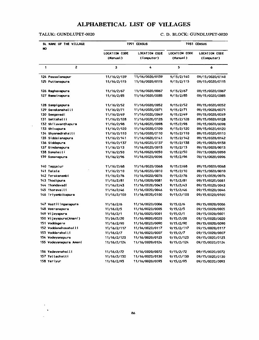
86
GUNDLUPET C.D.BLOCK
VILLAGE
AMENITIES Name of C.D.Block : GUNDLUPET; Code No. :0020
L.C. Name of Village Total area of Total Amenities availabl.: (if nol available within th.: village, a dlliob (-) is shown in the No. the vjJ)age Popu- column and next to it in hrack.:t&, the distance in broad ranB':s viz. -5 kms, 5-10 kms,
(1"~>fIINS) lalion amI 10+ I.ms oflhe near..,sl [!Iac.: where Ihe facilil~ is 8vllilllhl.: i! iiwn}. IIIl4 Eduea- Medical Drinking Post Day or Commllnication HQ.Q( tional Wat.:r and Days of (Bus Stop, Hou~- Tel.:- markell Railway Sill lion. holdll graph hal ifany Watllcway)
(1) (2) (3) (4) (5) -~~L (7) (8) (9) (10)
EO
VIJAYAPURA 436.7} 70 -CO-5) -(0-5) T, HP -,(0-5) -(0-5) BS (11)
2 OUMOASANAPURA 111.23 38 P '(Q-St T, ~~ =~~-5) -(0-5) - (0-5) (9)
3 HOSUR 6.59 ···----·-···~··~~-.-r~-- UN - JHHAlHTED --------------------------- .
4 PANJANAHAlLI 544.42 267 P -(0-5) W, HP -(Q.§) - (O-!H -(0-5) (59)
5 VEERANAPURA 731.28 IAlJP P -(0-5) TW, HP PO -(0-5) !;I$
( 16'1,
6 VASTILINGANAPURA 43.46 ---------.-------------- UN : I~HABITED -------------------------
7 VOOOARAHALLI 305.14 _.-.---------------.---- UN - INHABJTED -------------------------
8 BANNITHALAPURA 411.71 3470 P(2) P#C, FPC T I ~! HP. PT9, -(5-10) BS (683) Phone
9 KILAGERE 226.59 709 P(Z) -(S-10) T\i, IlP -(P-5) -(5-10) BS (127)
10 TALALE 129.39 25 - ,0-$) -(0-5) W -(D-~} -e~-1p.) -CO-~~ (5)
11 CHIKKATHUPPUR 395.40 2158 peZ), H -(Q-~' 1101, liP PO -(0-5) ~s (434)
12 KELASURPURA 360.29 638 P -(S'H) TW, liP p.o -~~-lP) - (0-5) (126)
13 SINDANAPURA 147.24 1134 P, M -(5-10) TW, HP -(0-5) -(5-10) BS (227)
14 DOODATHUPPUR 319,B/t 980 p -(0-5) TW, HP - (0-5) -(5·10) -(0-5) (192)
15 KANDEGALA 1351.S1 1060 P -(5-10) TW, HP -(0-5) -(5-10) -(0-5) (184)
88
DIRECTORY
AND LAND USE Name of C.D.Block : GUNDLUPET; Code No.: OO~O
Approach Nearest Town. Class of Town Power to village and distance (in Km.) Supply
Land u!o: (area under different types of land use in hectares rounded to two decimal places) L.C No.
For.:~t Irrigated Un-irrigated Culturable Area not (by sour.:e of irrigation) waste available
(including for cultivation gauchar and groves)
(11) (12) (13) (14) (15) (16) (17) (t8) (1)
PR GUNDLUPET- II I - 2 EA Total 18.63 424.62 3.14 180.79 We 18.63
PR GUNDLUPET- I II - 4 EA 145.82 0.17 48.79 2
--------------------------------------------- UN - INHABITED --------------------------------------------- 3
PR GUNDLUPET- II 1- 2 EA Total 86.91 395.56' 70.12 4 Twe 52.1'
We 34.80
PR GUNDLUPET- I 11- 5 EA Total 55.94 530.26 145.08 5 Twe 43.82
We 12.12
--------------------------------------------- UN - INHABITED --------------------------------------------- 6
--------------------------------------------- UN - INHABITED --------------------------------------------- 7
PR GUNDLUPET- I I 1- 6 EA Total 25.82 327.81 1.32 56.76 8 We 25.82
PR GUNDLUPET- I I 1- 6 EA Total 40.29 148.33 37.97 9 Twe 40.29
KR GUNDLUPET- II 1- 3 EA Total 20.67 89.05 19.67 10 We 20.67
PR GUNDLUPET- II 1- 5 EA Total 47.63 239.38 108.39 11 We 47.63
PR GUNDLUPET- II 1- 8 EA Total 33.33 293.35 33.61 12 We 33.33
PR GUNDLUPET- I I 1- 6 EA Total 4.34 120.23 22.67 13
Twe 4.34
PR GUNDLUPET- 111- 5 EA Total 68.88 277.76 33.20 14 We 68.88
PR GUNDLUPET- II I - 9 EA Total 77.68 729.16 48.55 496.12 15 Twe 77.68
89
VILLAGE
AMENITIES Name of C.D.Block : GUNDLUPET; Code No. :0020
L.C. Naqre of Village Total area of Total Amenities available (if not available within the village, a dash (-) is shown in the No. the village Popu- column and next to it in brackets, the distance in broad ranges viz. -5 kms, 5-10 kms,
(In hectares) lation and 10+ kms of the nearest l!lace where the facility is availahle is given). and Eduea- Medical Drinking Post Day or Communication No.of tional Water and Days of (Bus Stop, House- Tele- market' Railway Station, holds graph hat ifany Wah:rway]
(1) (2) (3) (4) (5) (6) (7) (8) (9) (10)
16 KANDEGALADAHOSAHALLI 247.42 268 P -(0-5) W, HP -(0-5) -(10+) BS
(47)
17 BETTAHALLI 598.35 1288 P -(0-5) TW, HP PO, -(0-5) BS
(248) Phone
18 ANNUR 463.35 4019 P(2) -(0-5) T, HP PO, -(0-5) BS
(741 ) Phone
19 KOOAHALLI 923.11 1758 P -(0-5) T, HP -(0-5) -(0-5) BS
(331)
20 VIJAYAPURA(AMANI) 308.02 60 -(0-5) -(0-5) W, HP -(0-5) -(0-5) -(0-5)
(10)
21 MANAGALLI 158.06 119 -(0-5) -(0-5) w -(0-5) -(5-10) - (0-5)
(22)
22 KUTHANUR 1398.95 3743 P(2) -(0-5) TW, HP Phone -(0-5) BS
(669)
23 BHEEMANABEEDU 1196.95 3598 P(2), M PHC, FPC T, HP PTO, -(5-10) BS
(707) Phone
24 MUKAHALLI 1057.44 2599 P(4) -(0-5) W, HP Phone -(5-10) BS
(516)
25 MASAHAlll 559.78 -----------------------. UN - I I+HABITED .~-----~----------~------
26 HONGAHALLI 789.40 1562 P, M -(0-5) W, HP PO, -(10+) BS (322) Phone
27 BARAGI 2794.96 2462 P(3), M PHC, FPC T, HP PTa, -(10+) BS (487) Phone
28 DESHIPURA 1073.87 968 P -(00-5) W, HP Phone -(10+) BS (170)
29 ALATHUR 1633.63 2000 P, M 0 T, HP PO -(10+) BS (363)
90
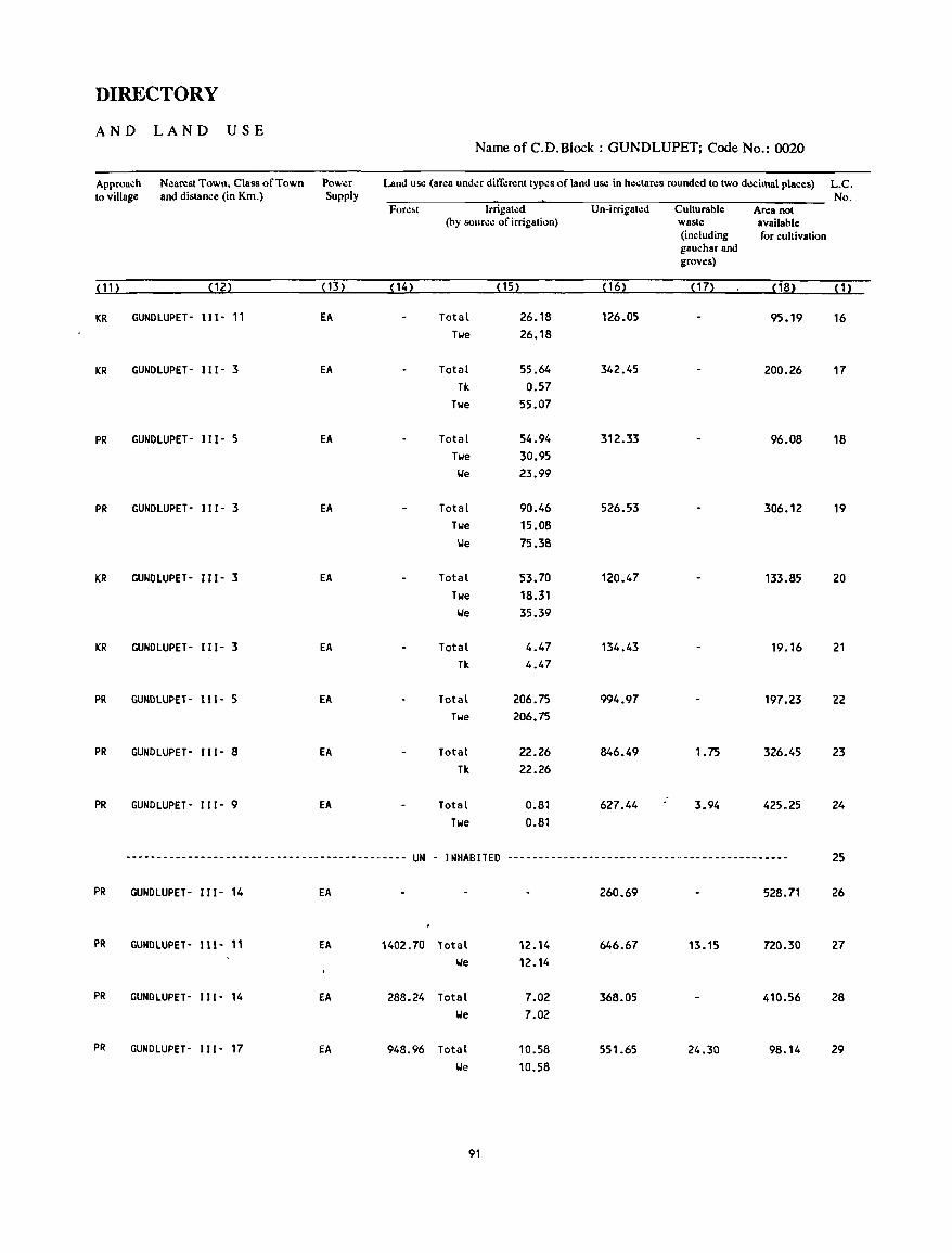
DIRECTORY
AND LAND USE Name of C.D.Block : GUNDLUPET; Code No.: 0020
Approach Nearest Town, Class of Town Power Land use (area under different types of land use in hectares rounded to two decimal places) L.C. (0 village and distance (in Km.) Supply No.
Fore~( Irrigated Un-irrigated Culturable Area not (by source of irrigation) waste available
(including for cultivation gaucharand groves)
(11) (12) (13) ( 14) (15) ( 16) (17) (18) (1)
KR GUNOlUPET- 111- 11 EA Total 26.18 126.05 95.19 16 Twe 26.18
KR GUNOlUPET- 111- 3 EA Total 55.64 342.45 200.26 17 Tk 0.57
Twe 55.07
PR GUNOlUPET- 111- 5 EA Total 54.94 312.33 96.08 18 Twe 30.95
\.Ie 23.99
PR GUNOlUPET- 111- 3 EA Total 90.46 526.53 306.12 19 Twe 15.08
l.Ie 75.38
KR GUNOlUPET- 111- 3 EA Total 53.70 120.47 133.85 20 Twe 18.31
l.Ie 35.39
KR GUNOlUPET- 111- 3 EA Total 4.47 134.43 19.16 21 Tk 4.47
PR GUNDlUPET- 11 I - 5 EA Total 206.75 994.97 197.23 22 Twe 206.75
PR GUNOlUPET- 111- 8 EA Total 22.26 846.49 1.75 326.45 23 Tk 22.26
PR GUNOlUPET- 111- 9 EA Total 0.81 627.44 3.94 425.25 24 Twe 0.81
.--.~-----------------------------------.---- UN - INHABITED ---------~----------------------------------- 25
PR GUNOlUPET- 111- 14 EA 260.69 528.71 26
PR GUNOLUPET- 111- 11 EA 1402.70 Total 12.14 646.67 13.15 720.30 27 \.Ie 12.14
PR GUNOlUPET- 111- 14 EA 288.24 Total 7.02 368.05 410.56 28 l.Ie 7.02
PR GUNDLUPET- 111- 17 EA 948.96 Total 10.58 551.65 24.30 98.14 29 We 10.58
91
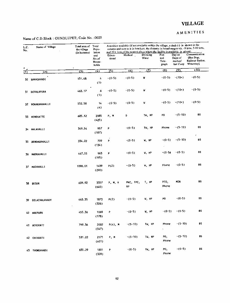
VILLAGE
AMENITIES
Name of C.O.Block : GUNOLUPET; Code No. :0020
L.C. Name of Village Total area of Total Amenities available (if not available within the village, a dash (-) is ~own in the
No. the village Popu- column and n.:xtto it in brackets, the distance in broad ranges viz. -5 kms, 5-10 kms,
(In hectares) lation and 10+ I:I11S (lflhe neare;t {!Iace where the facilitr is availabllO is given}.
and &luea- Medical Drinking Post Day or Communication
No.of tional Water and Days of (Bus Stop,
House- Tele- market/ Railway Station.
holds graph hat ifaRY Waterway)
,J
(1) (2) (3) (4) (5) (62 (7) (8) (9) ( 10)
30 BANAGAVADI 131.48 4 '(0-5) - (0-5) 1,1 -(0-5) -(10+) -(0-5)
(1)
31 DEVALAPURA 463.11' 6 -(0-5) -(0-5) -(0-5) -(10+) -(0-5)
(1)
32 HONAKANAHAllI 552.58 14 -(0-5) -(0-5) -(0-5) - (10+) -(0-5)
(4)
33 NENEKATTE 685.12 2085 P, M 0 HI, HP PO -(5-10) BS
(425)
34 MAlAVAlLI 349.54 907 P -(0-5) TW, HP Phone -(5-10) BS
( 187)
35 8ENDAGAHALLI 334.22 709 P -(0-5) 1,1, HP -(0-5) -(5-10) BS
(134)
36 MADRAHALLI 447.55 963 P -(0-5) 1,1, HP -(0-5~ -(0-5) BS
(195)
37 MADAHALLI 1090.01 1409 P(2) -(0-5) 1,1, HP Phone -(0-5) 8S
(290)
38 BEGUR 639.92 3357 P, M, H PHC, FPC, T, HP PTO, MON BS
(640) RP Phone
39 BELACHAlAVADY 463.35 1873 p(2) -(0-5) 1,1, HP PO - (0-5) BS
(326)
40 AREPURA 455.36 1069 P -(0-5) 1,1, HP -(0-5) -(0-5) BS
(178)
41 HIRIKATI 799.36 2082 P(4), " -(5-10) TW, HP Phone -(5-10) BS
(347)
42 CHIKKATI 531.22 2171 P, M -(5·10) TW, HP PO, -(5-10) BS
(401) Phone
43 THONDAVADI 835.29 1801 P -(0-5) nl, HP PO, -(0-5) BS
(328) Phone
92
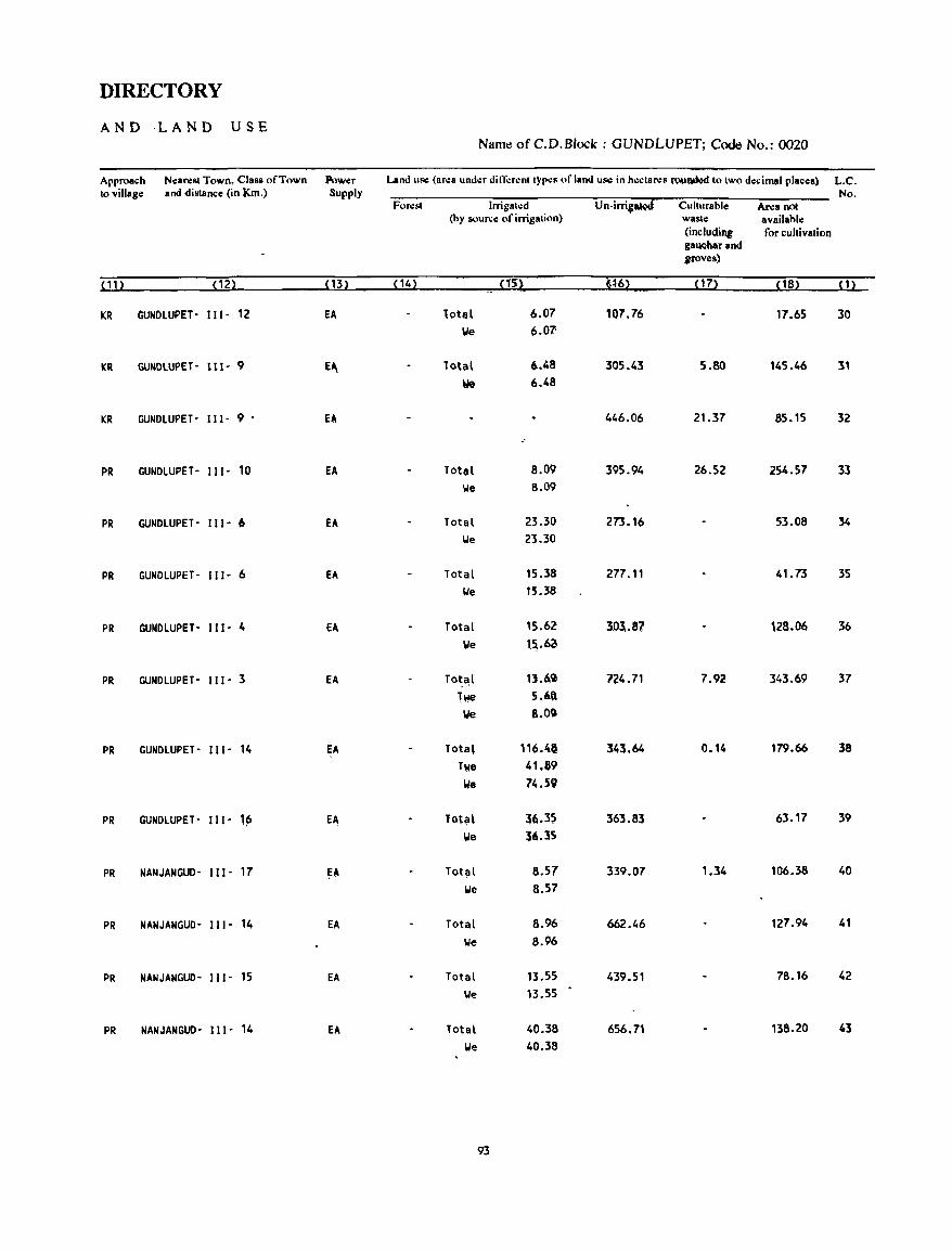
DIRECTORY
AND ,LAND USE Name ofC.D.Block : GUNDLUPET; Code No.: 0020
Approach N.:arest Town. Class of Town Power Land us.: (ar.:a und.:r dini:r.:ntt~p.:s of land us.: in h.:ctares ~ftIi,.'CIto two decimal placetl) L.C. to village and distance (in Km.) Supply No.
Fllr.:st Irrigat.:d U n-irri;;t;J Culturable Area not (by SllUrc.: of irrigation) waste available
(including for cultivation ga~arand groves)
(11) (12) (13) (14) nil' '~6) (17) (18) (1)
KR GUNDlUPET- 111- 12 EA total 6.07 107.76 17.65 30 We 6.07'
KR GUNDlUPET- 111- 9 E~ To'aL 6.48 305.43 5.80 145.46 31
We 6.48
KR GUNDLUPET- 111- 9 • El 446.06 21.37 85.15 32
PR GUNDlUPET- 111- 10 EA Totel 8.09 395.94 26.52 254.57 33 We 8.09
PR GUNDlUPET- 111- 6 EA Total 23.30 273.16 53.08 34 We 23.30
PR GUNDLUPET- 111- 6 EA Total 15.38 277.11 41.73 35 lie 15.38
PR GUNDLUPET- 111- 4 EA Total 15.62 3.0l.S1 128.06 36 We '~.6a
PR GUNDLUPET- 111- 3 EA Tot~l 13.~c,) n4.71 7.92 343.69 37 Twe 5.'tl
~ 8.00
PR GUNDLUPET- 111- 14 EA Total 116.4' 343.64 0.14 179.66 38 Twe 41,&9
lie 74.59
PR GUNDLUPET- 111- ,~ E~ Tot~l :$6.35 363.83 63.17 39
we :56.35
PR NANJANGUD- 111- 17 EA Totill 8.57 339.07 1.34 106.38 40 We 8.57
PR NANJANGUD- 111- 14 EA Total 8.96 662.46 127.94 41
We 8.96
PR NANJANGUD- III- 15 EA Total 13.55 439.51 78.16 42 We 13.55
PR NANJANGUD- 111- 14 EA Total 40.38 656.71 138.20 41 We 40.38
93
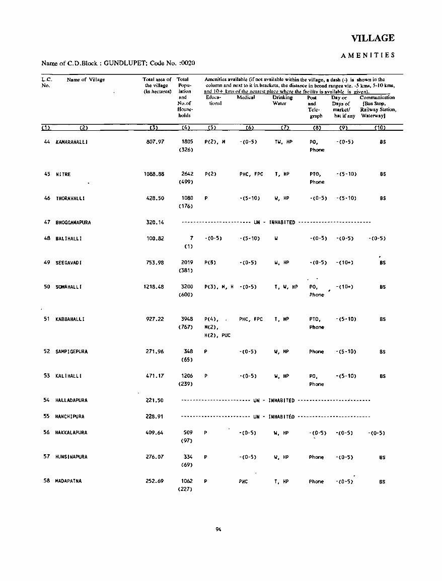
VILLAGE
AMENITIES Name of C.D.Block : GUNDLUPET; Code No. :0020
L.C. Name of Village Total area of Total Am.:niti.:s availabl.: (if not available within the village, a dash (-) is shown in the No. the village Popu· column and n.:xt to it in brack.:ts, the distance in broad ranges viz. -5 kms, 5-10 kms,
(In hectares) lation and 10+ !;ms of tho: n.:ar~st [!Iace wh~re the facifitl': is availahle is giv!tn}. and Educa· M.:dical Drinking Post Day or Communication No.of tional Wat.:r and Days of [Bus Stop, Hous,:· Tele- mark.:tf Railway Station, holds graph hat ifany Waterway)
(1) (2) (3) (4) (5) (6) (7) (8) (9) (10)
44 KAHARAHAlll 807.97 1805 P(2), H -(0'5) TIJ, HP PO, -(0-5) BS (326) Phone
45 NITRE 1088.88 2642 P(2) PHC, FPC T, HP PTO; -(5-10) BS (499) Phone
46 THORAVALLI 428.50 1080 P -(5-10) IJ, HP -(0-5) -(5-10) BS (176)
47 BHOGGANAPURA 320.14 ~----------------------- UN - INHABITED ---------_.--------------
48 BAll HALLl 100.82 7 -(0-5) -(5-10) IJ -(0-5) -(0-5) -(0-5) (1)
49 SEEGAVADI 753.98 2019 P(3) -(0-5) IJ, HP -(0-5) -(10+) BS (381)
50 SOHAHALLI 1218.48 3200 P(3), H, H -(0-5) T, IJ, HP PO, -(10+) BS (bOO) Phone
51 KABBAHALLI 927.22 3948 P(4) , PHC, FPC T, HP PTO, -(5-10) BS (767) M(2), Phone
H(2), PUC
52 SAHPIGEPURA 271.96 348 P -(0-5) IJ, HP Phone -(5-10) BS (65)
53 KALIHALLl 471.17 1206 P -(0'5) IJ, HP PO, -(5·10) BS (239) Phone
54 HALlADAPURA 221.50 ------------------------ UN INHABITED -----------------~-------
55 HANCHIPURA 228.91 ------------- •.... -- ••.. UN • INHABITED -------------------------
56 HAKI(ALAPURA 409.64 509 P '(0-5) W, HP '(0-'5) -.(0'5) '(0,5) (97)
57 HUNSINAPURA 276.07 334 P '(0-5) W, HP Phone -(0'5) BS (69)
58 MADAPATNA 252.69 1062 P PHC T, HP Phone -(0'5) BS (227)
94
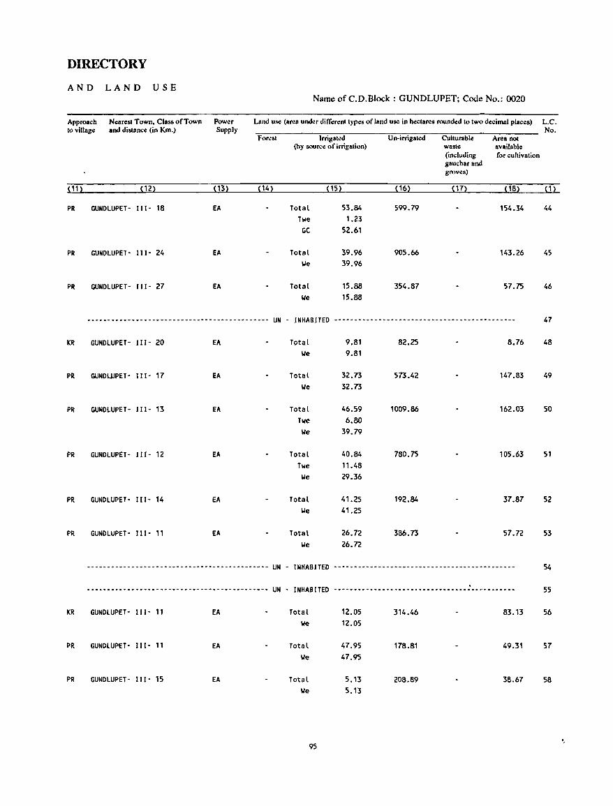
DIRECTORY
AND LAND USE Name of C.D.Block : GUNDLUPET; Code No.: 0020
Approach Nearest Town, Class of Town Power Land use (area under dilTerenttypes of land use in hectares rounded to two decimal places) L.C. to vlllage and distance (in Km.) Supply No.
Forest Irrigated Un-irrigated Cullurable Area not (hy SOIlrce of irrigation) wasle available
(including for cultivation gauchar and groves)
(1n (12) (13) ( 14) (15) (16) (17) (18) ( 1 )
PR GUNDLUPET- 111- 18 EA Total 53.84 599.79 154.34 44 Twe 1.23
CC 52.61
PR GUNDLUPET- 111- 24 EA Total 39.96 905.66 143.26 45 lie 39.96
PR GUNDLUPET- 111- 27 EA Total 15.88 354.87 57.75 46 lJe 15.88
--~------------------------------------------ UN - INHABITED ----------.---------------------------------- 47
KR GUNDlUPET- 111- 20 EA Total 9.81 82.25 8.76 48 lie 9.81
PR GUNDUJPET- Ill- 17 EA Total 32.73 573.42 147.83 49 We 32.73
PR GUNDlUPET- IlI- 13 EA Total 46.59 1009.86 162.03 50 Twe 6.80
We 39.79
PR GUNDlUPET- 111- 12 EA Total 40.84 780.75 105.63 51 Twe 11.48
We 29.36
PR GUNDlUPET- 111- 14 EA Total 41.25 192.84 37.87 52 We 41.25
PR GUNDlUPET- 111- 11 EA Total 26.72 386.73 57.72 53 We 26.72
--------------------------------------------- UN - INHABITED ----.---------.------------------------------ 54
UN - INHABITED .
55 --------------------------------------------- ------------------------------------------._-
KR GUNDlUPET- 111- 11 EA Total 12.05 314.46 83.13 56 We 12.05
PR GUNDlUPET- 111- 11 EA Total 47.95 178.81 49.31 57 We 47.95
PR GUNDlUPET- 11 1- 15 EA Total 5.13 208.89 38.67 58 We 5.13
95
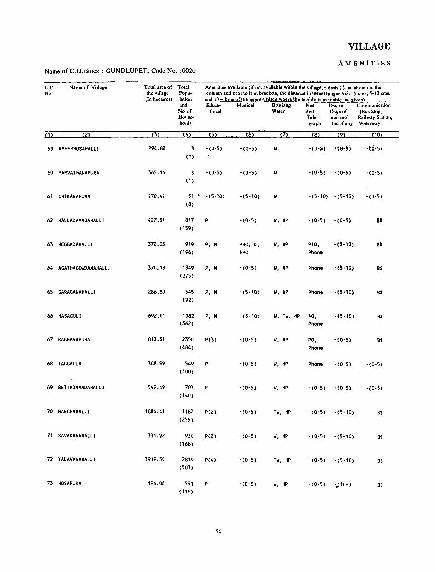
VILLAGE
AMENITiES Name of C.D.Block : GUNDlUPET; Code No. :0020
L.C. Name of Village Total area of Total Amllnities available (if not available withhl the \till~t, 8 dash (-) Is shown in the No. the village Popu- I;olumn and n.:"t to it in bra~ketl, the dlstanct In bNad hinges vii. -5 kms, 5-10 kml,
(In hectares) lation and 10+ kms ofthl! neorest I2IDSS lY~re ~ fncilnXis..8Y.ailotlle Is- given). and &luca- Mo:dkal Drinling Post Day or Communication No.of tional Water and i:>a~s of (Bus Stop, House- tele- marketl Railway Statitln, holds ghlp" hat ifany Waterway)
(1) (2) (3) (4) (5) t6> (7) (8) (9) (10)
59 AMEERHOSAHAlll 294.82 3 -(0-5) -(0-5) 101 -(0-5~ 'HI-5~ -(€l-5)
(1)
60 PARVATHANAPURA 365.16 3 -(0-5) -(0-5) -tll-5~ -(0-5) - (0-5)
(1)
61 CHrKANAPURA 170.41 51 . -(5-10) -(5-10) 101 -(5-10) -(5-l0) -(0-5)
(8)
62 HALlADAMADAHAL.L I 427.51 817 P -(0-5) 101, HP - (0-5) -(0-5) IS (159)
63 HEGGADAHAlLI 372.03 919 P, M PHe, 0, 101, HP PTO, -(5-10) B! (196) FPC Phone
h4 AGAJHAG~ANAHAllJ 370.18 1349 P, M -(0-5) 101, HP Phone - (5"0) I'Is (275)
65 GARAGANAHAlll 286.80 545 P, M -(5-10) 101, HP Phone -(S-10) as (92)
66 HASAGULl 692.01 1982 P, M -(5-10) 101, TIoI, liP PO, -(5-10) lis (362) Phone
67 RAGHAVAPURA 813.51 2350 P(3) ,(0,5) 101, HP PO, -(0-5) as (484) Phone
68 TAGGAlUR 368.99 549 P -(0-5) 101, HP Phone -(0-5) -(0-5)
( 100)
69 BETTADAMADAHAlll 542.49 703 P -(0-5) 101, HP -(0-5) - (0-5) -(O·S) (140)
70 MANCHAHALll 1884.41 1187 P(2) -(0-5) TW, HP -(0-5) -(5-10) as (255)
71 SAVAKANAHAlll 331.92 93(1 p(2) -(0-5) 101, HP -(0-5) -(5-10) 8S (168)
72 YADAVANAHAlll 3919.50 2819 P(4) -(0-5) TW, HP -(0-5) -(5-10) BS (503)
73 HOSAPURA 196.08 591 p -(0-5) 101, HP -(0-5) -.. (10+) BS (116)
96
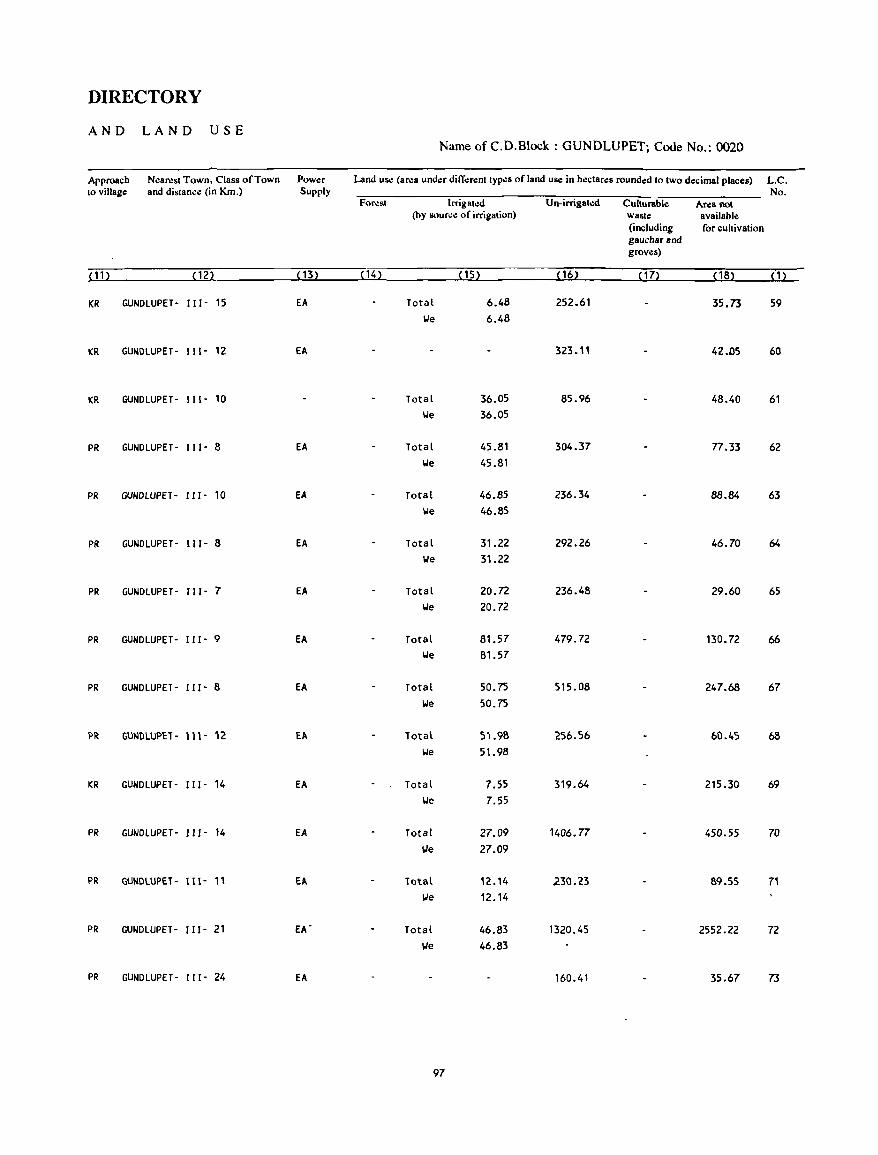
DIRECTORY
AND LAND USE Name of C.D.Block : GUNDLUPET; Code No.: 0020
Approach Near.:st Town, Class of Town Power Land use (area under different types of land use in hectares rounded to two decimal places) L.C. to village and distance (in Km.) Supply No.
Forest Irrigated Un-irrigated Culturable Area not (by source of irrigation) waste available
(including for cultivation gaucharand groves)
<11 ) (12) ( 13) (14) (15) (16) ( 17> (18) (1)
KR GUNDLUPET- 111- 15 EA Total 6.48 252.61 35.73 59 We 6.48
KR GUNDLUPET- 111- 12 EA 323.11 42.D5 60
KR GUNDLUPET- 111- 10 Total 36.05 85.96 48.40 61 We 36.05
PR GUNDLUPET- 111- 8 EA Total 45.81 304.37 77.33 62 We 45.81
PR GUNDLUPET- 111- 10 EA Total 46.85 236.34 88.84 63 We 46.85
PR GUNDLUPET- 111- 8 EA Total 31.22 292.26 46.70 64 We 31.22
PR GUNDLUPET- 111- 7 EA Total 20.72 236.48 29.60 65 We 20.72
PR GUNDLUPET- 111- 9 EA Total 81.57 479.72 130.72 66 We 81.57
PR GUNDlUPET- 111- 8 EA Total 50.75 515.08 247.68 67 We 50.75
PR GU~DlUPET- 111- 12 EA Total 51.98 256.56 60.45 68 We 51.98
KR GUNDLUPET- 111- 14 EA Total 7.55 319.64 215.30 69 We 7.55
PR GUNDLUPET- 111- 14 EA Total 27.09 1406.77 450.55 70 \,Ie 27.09
PR GUNDlUPET- 111- " Ell. Total 12.14 230.23 89.55 71 lJe 12.14
PR GUNDlUPET- 111- 21 EA' Total 46.83 1320.45 2552.22 72 lJe 46.83
PR GUNDlUPET- 111- 24 EA 160.41 35.67 73
97
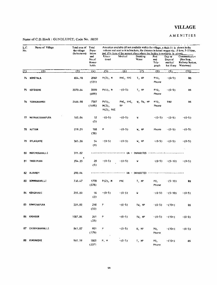
VILLAGE
AMENITIES Name of C.D.Block : GlJNDLUPET; Code No. :0020
L.C. Name of Village Total area of Total Am~niti~s available {if not available within the village, a dash (.) is shown in the No. the village Popu- column and n.:xtto it in brack.:ts, the distance in broad ranges viz. -5 kms, 5·10 kms,
(In hectares) lation and 10+ kms of the nearest l!lace where the facilitx is availahle is given}. and £duea- M.:dical Drinking Post Day or Communicatio'l No.of lional Water and Days of IBusStop, H\)II~e- T.:le- marketl Railway Station, holds graph hat ifany Waterway]
(1) (2) (3) (4) (5) (6) (7) (8) (9) (10)
74 HOREYALA 654.18 2969 1'(2), M PIIC, FPC T, HI' PTO, - (0-5) 85 (531) Phone
75 KOTEKERE 2070.64 3590 P(4), M -(0-5) T, HP PTO, -(0-5) BS
(699) Phone
76 TERAKANAMBI 2466.98 7307 P(5) • PHC, FPC, 101, TIoI, HP PTa, THU BS
(1495) M(3), RP Phone H(2) , PUC
77 MAYANAJKANAPURA 183.04 12 - (0- 5) -(0-5) -(0-5) -(0-5) -(0-5) (3)
78 HunUR 219.21 188 P -(0-5) 101, HP Phone -(0-5) - (0-5') (38)
79 BYLAGUPPE 365.36 54 -(0-5) -(0-5) 101, HP -(0-5) -(0-5) -(0-5) (9)
80 MAR I HOSAHALll 31'.82 .-.-.-.--~-------------- UN - INHABITED ----~--------------------
81 THODIPURA 354.35 29 -(0-5) -(0-5) IJ -(0-5) -(5'10) -(0-5) (5)
82 ALAVADY 290.04 --------------~---~----- UN - INHABITED ------------------~------
83 BOMMANAHALLI 7JO.47 1778 P(2), M PHC T, HP PO, -(5-10) BS (378) Phone
84 KENGAVADI 235.00 16 -(0-5) -(0-5) -(0-5) -(5-10) -(0-5) (2)
85 RAMAINAPURA 339.00 218 P -(0-5) Til, HP -(0-5) -(10+) as (50)
86 KADABUR 1087.84 241 P -(0-5) Til, HP -(0-5) -(10+) -(0-5) l59)
87 CHIRAI(ANAHALll 841.87 951 p -(0-5) 101, HP PO, -(10+) - (0-5) (179) Phone
88 KUNDAKERE 960019 1803 P, M -(0-5) T, HP PO, -(10+) BS (337) Phone
08
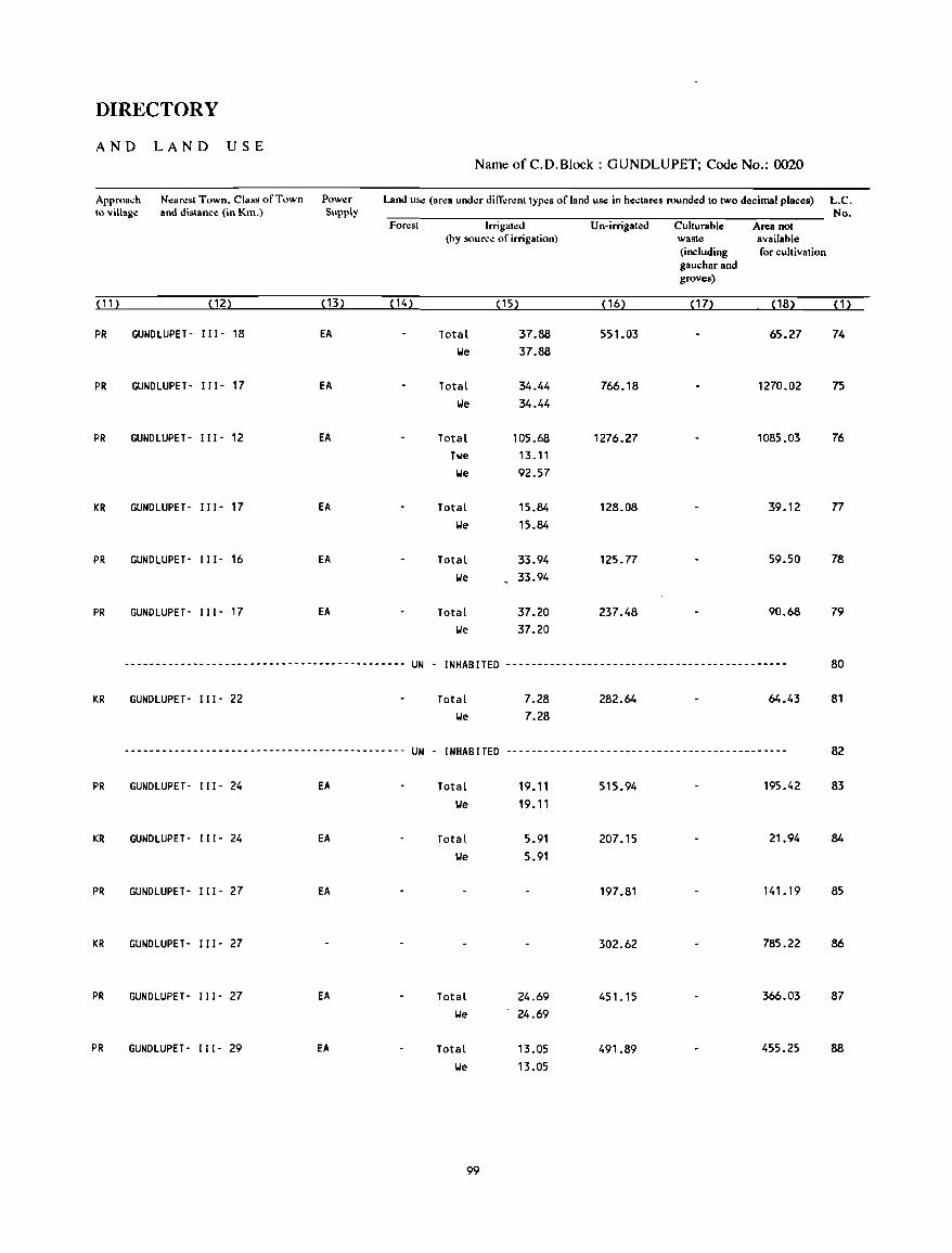
DIRECTORY
AND LAND USE Name ofC.D.Block: GUNDLUPET; Code No.: 0020
Approach N.:arest Town. Class of Town Pow.:r Land us.: (area under ditierent types of land us.: in hectares rounded to two decimal places) LC. to village and distance (in Km.) Supply No.
Forest Irrigated Un-irrigated Culturable Area not (hy source of irrigation) waste available
(including for cultivation gauchar and groves)
(11 ) (12) (13) (14) (15) ( 16) (17) (18) (1)
PR GUNDlUPET- I I I - 18 EA Total 37.88 551.03 65.27 74 lie 37.88
PR GUNDLUPET· I JI- 17 EA Total 34.44 766.18 1270.02 75
lie 34.44
PR GUNDLUPET- I I I - 12 EA Total 105.68 1276.27 1085.03 76 Twe 13.11 lie 92.57
KR GUNDLUPET- JI 1- 17 EA Total 15.84 128.08 39.12 77 We 15.84
PR GUNDLUPET' 111- 16 EA Total 33.94 125.77 59.50 78 lie 33.94
PR GUNDLUPET- IJI- 17 EA Total 37.20 237.48 90.68 79 lie 37.20
--------------------------------------------- UN - I NHAB ITED --------------------------------------------- 80
KR GUNDLUPET- 111- 22 Total 7.28 282.64 64.43 81 lie 7.28
--------------------------------------------- UN - INHABITED --------------------------------------------- 82
PR GUNDLUPET- I II - 24 EA Total 19.11 515.94 195.42 83 lie 19.11
KR GUNDLUPET- 111- 24 EA Total 5.91 207.15 21.94 84
lie 5.91
PR GUNDLUPET- 111- 27 EA 197.81 141.19 85
KR GUNDLUPET- I I I - 27 302.62 785.22 86
PR GUNDLUPET· I I I - 27 EA Total 24.69 451.15 366.03 87 lie 24.69
PR GUNDLUPET- I I I - 29 EA Total 13.05 491.89 455.25 88 lie 13.05
99
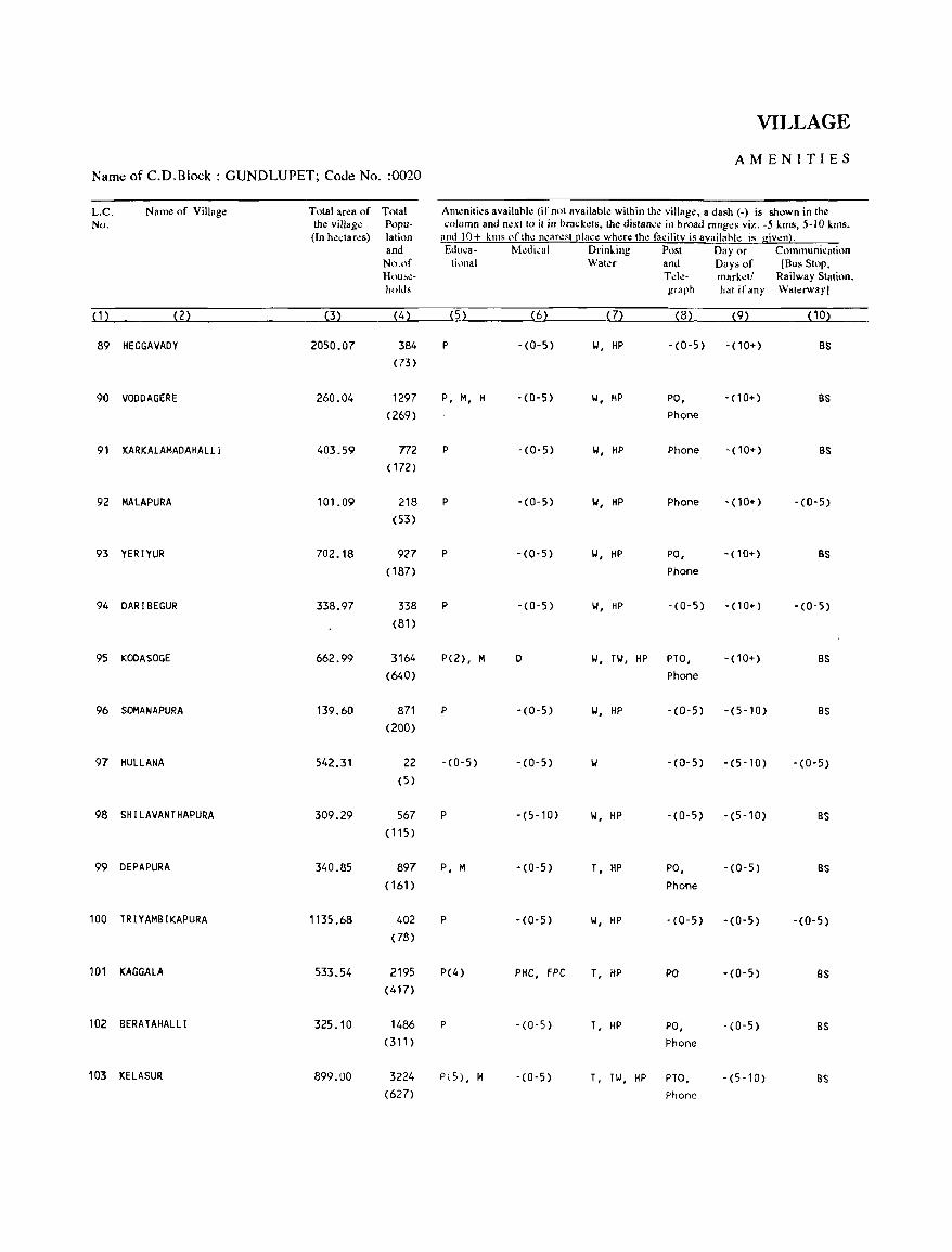
VILLAGE
AMENITIES Name of C.D.Block: GUNDLUPET; Code No. :0020
L.C. Name of Village Total area of Total Am~niti~s availahle (ifnnt availahle within the village, a dash (-) is shown in the No. the village Popu- column and next to it in hrackets, the distan".: in broad ranges viz. -5 kms, 5-10 kms.
(In hectares) lation and 10+ killS of the nearest [!Iace where the facility is availahle is given). and EduC3- Medi,al Drinking Post Day or Communication
No.of tiona I Water and Days of [Bus Stop, Hou~l!- Tele- market! Railway Station. holds graph h~1 if any Wat.:rwayl
( 1 ) (2) (3) (4) (5) (6) (7) (8) (9) ( 10)
89 HEGGAVADY 2050.07 384 P -(0-5) II, HP -(0-5) - (10+) BS (73)
90 VODDAGERE 260.04 1297 P, M, H -(0-5) II, HP PO, - (10+) BS (269) Phone
91 KARKALAMADAHALLJ 403.59 772 P -(0-5) II, HP Phone - (10+) BS ( 172)
92 MALAPURA 101.09 218 P -(0-5) IJ, HP Phone -(10+) -(0-5) (53)
93 YERIYUR 702.18 927 P - (0- 5) IJ, HP PO, -(10+) BS ( 187) Phone
94 DARIBEGUR 338.97 338 P - (0-5) II, HP -(0-5) -(10+) -(0-5) (81)
95 KODASOGE 662.99 3164 P(2), M D II, TIJ, HP PTO, - (10+) BS (640) Phone
96 SOMANAPURA 139.60 871 P -(0-5) W, HP -(0-5) -(5-10) BS (200)
97 HULLANA 542.31 22 -(0-5) -(0-5) w -(0-5) -(5-10) -(0-5) (5)
98 SHILAVANTHAPURA 309.29 567 P -(5-10) II, HP -(0-5) -(5-10) BS (115)
99 DEPAPURA 340.85 897 P, M -(0-5) T, HP PO, -(0-5) as (161) Phone
100 TRIYAMBIKAPURA , 135 .68 402 P -(0-5) IJ, HP - (0- 5) -(0-5) -(0-5) (78)
101 KAGGALA 533.54 2195 P(4) PHC, FPC T, HP PO -(0-5) as (417)
102 BERATAHALLI 325.10 1486 P -(0-5) T, HP PO, -(0-5) BS (311) Phone
103 KELASUR 899.00 3224 P(5) , M -(0-5) T, HI, HP PTO, -(5,10) BS (627) Phone
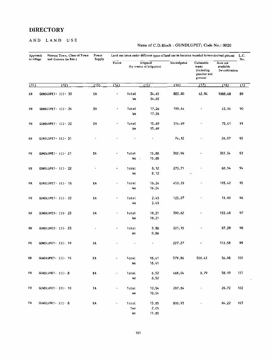
DIRECTORY
AND LAND USE Name of C.D.Block : GUNDLUPET; Code No.: 0020
Approach Nearest Town. Class of Town Power Land us.: (ar.:a under different types ofland us.: in hectares rounded to two decimal places) L.C. to village and distance (in Km.) Supply No.
Forest Irrigated Un-irrigated Culturable Area not (hy soure.: of irrigation) waste available
(including for cultivation gaucharand groves)
( 11) (12) (13) ( 14) (15) ( 16) (17) ( 18) (, )
KR GUNDWPET- 111- 30 EA TotaL 34.65 883.80 42.94 1088.68 89 \.Ie 34.65
PR GUNDLUPET- 111- 24 EA Total 17.26 199.44 43.34 90 lJe 17.26
PR GUNDLUPET- 111- 22 EA Total 15.69 314.49 73.41 91 \.Ie 15.69
KR GUNDLUPET- 111- 31 74.12 26.97 92
PR GUNDLUPET- 111- 21 EA Total 15.88 382.96 303.34 93 \.Ie 15.88
KR GUNDLUPET- 111- 22 Total 8.12 270.71 60.14 94 \.Ie B.12
PR GUNDLUPET- 111- 16 EA Total 16.24 453.33 193.42 95 \.Ie 16.24
PR GUNDLUPET- 111- 22 EA Total 2.43 123.27 13.90 96 \.Ie 2.43
KR GUNDLUPET- 111- 23 EA Total 18.21 390.62 133.48 97 \.Ie 18.21
KR GUNDLUPET- 111- 23 Total 0.86 221.1S 87.28 98 \.Ie 0.86
PR GUNDLUPET- 111- 19 EA 227.27 113.58 99
KR GUNDLUPET- 111- 10 EA Total lB.41 579.86 500.43 36.98 100
We 18.41
PR GUNDLUPET- 111- 8 EA Total 6.52 468.04 0.79 58.19 101
We 6.52
PR GUNDLUPET- 111- 10 EA Total 10.54 287.84 26.72 102
We 10.54
PR GUNDLUPET- 111- 8 EA Total 13.B5 800.93 84.22 103 Twe 2.05
We l'.BO
101
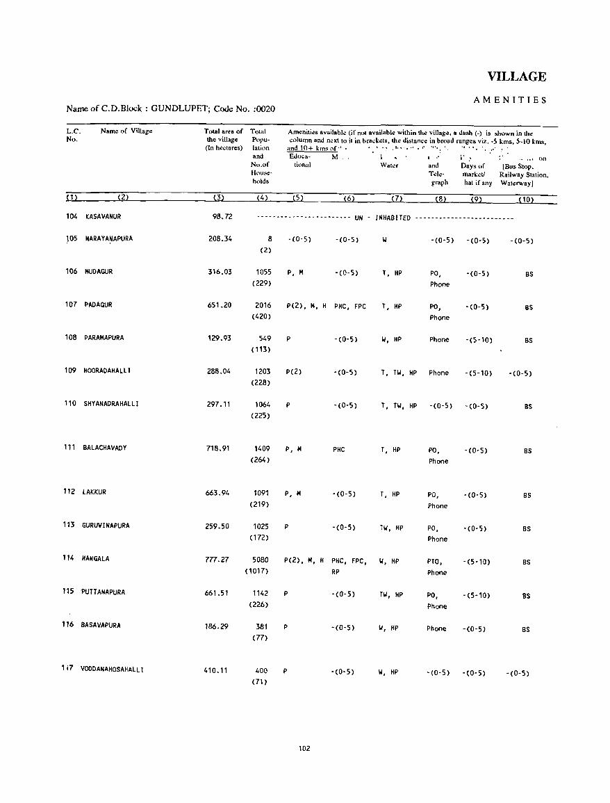
VILLAGE
AMENITIES Name of C.D.Block : GUNDLUPET; Code No. :0020
L.e. Name of Village Total area of Total Amo:niti". available (ifnnl available wilhin the village, a dash (-) is shown in the No. the village Popu- column and next 10 il in brack~ts, the distance in broad ranges viz. -5 kms, 5-10 kms,
(In h"ctar.:s) lalion and 10+ kms nf" . I _ " • 1 ••.•••• r "', , " :
and £.duea- M" , I " j' .' " ",j nn No.of tional Waler and Days of [Bus Stop, Hous.:- Tel.:- mark"t/ Railway Station. holds graph hal if any Wat.:rwayl
(1) (2) (3) (4) (52 (6) (7) (8) (9) (10)
104 KASAVANUR 98.72 ------------------------ UN - INHABITED -.~----------------------
J05 NARAYAt,lAPURA 208.34 8 -(0-5) - (0-5) W - (0-5) -(0-5) -(0-5) (2)
106 MUDAGUR 316.03 lOSS P, M -(0-5) T, HP PO, -(0-5) BS (229) Phone
107 PADAGUR 651.20 2016 P(2), M, H PIIC, FPC T, liP PO, -(0-5) BS (420) Phone
108 PARAMAPURA 129.93 549 P -(0-5) W, HP Phone -(5-10) BS (113)
109 HOORADAHALlI 288_04 1203 P(2) -(0-5) T, TW, HP Phone -(5-10) -(0-5) (228)
110 SHYANADRAHALLI 297.11 1064 P -(0-5) T, TW, HP -(0-5) -(0-5) BS (225)
111 BALACHAVADY 718.91 1409 P, M PHC T, HP PO, -(0-5) BS (264) Phone
112 lAKKUR 663.94 1091 P, M -(0-5) T, HP PO, -(0-5) BS (219) Phone
113 GURUVINAPURA 259.50 1025 P -(0-5) TW, HP PO, -(0-5) BS (172) Phone
114 HANGAlA 777.27 SaBa P(2), M, H PHC, FPC, W, liP PTO, -(5-10) BS (1017) RP Phone
115 'PUTTANAPURA 661.51 1142 P -(0-5) TW, HP PO, -(5-10) BS (226) Phone
116 BASAVAPURA 186.29 381 P -(0-5) w, HP Phone -(0-5) BS (77)
1 i7 VOODANAHOSAHAlLI 410.11 400 P -(0-5) W, HP -(0-5) -(0-5) -(0-5) (71 )
102
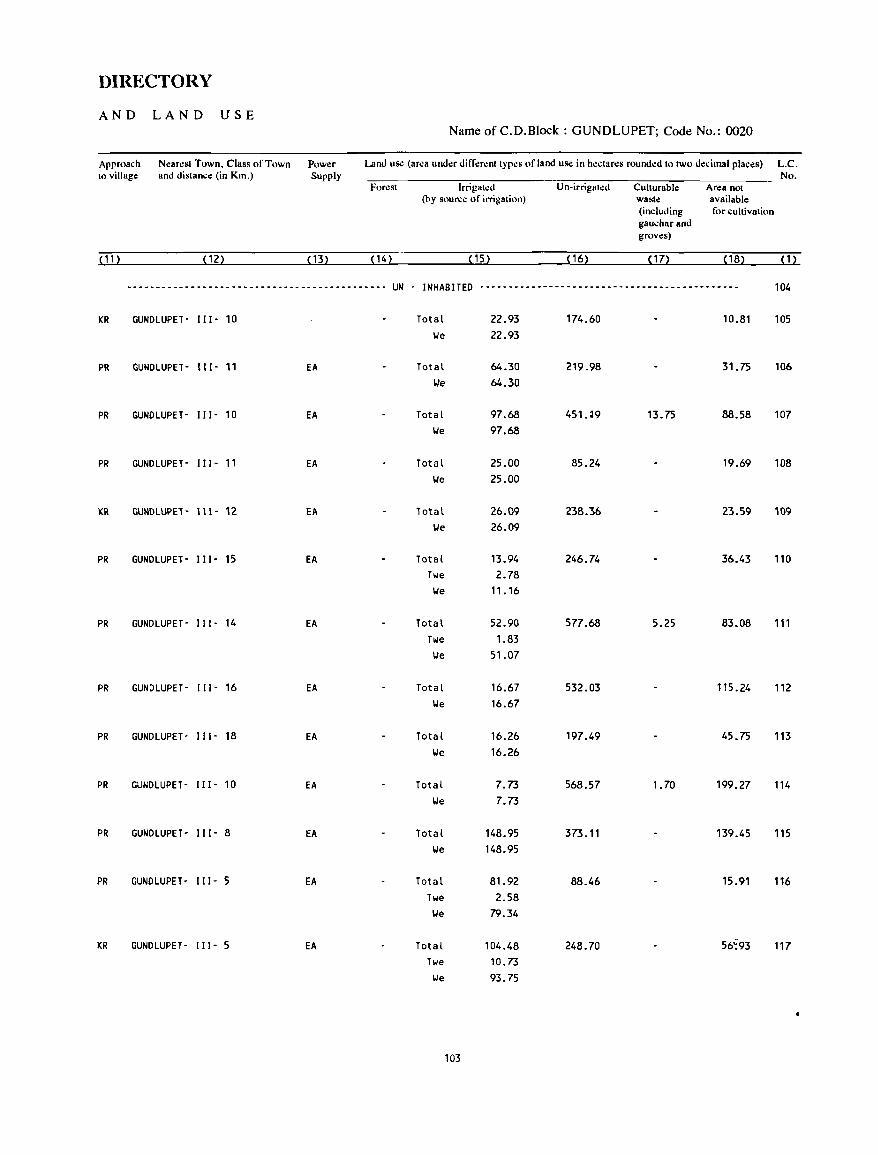
DIRECTORY
AND LAND USE Name of C.D.Block : GUNDLUPET; Code No.: 0020
Approach N.:arest Town, Class of Town Power Land uS<! (area und.:r diff.:r.:nt types of land uS<! in hectares round.:d to two decimal plac.:s) L.C. 10 village and dislance (in Km.) Supply No.
FONst Irrigal.:d U n-irrigaled Cullurable Area nol (by source of irrigation) waste available
(including for cultivation gau.;harand groves)
(11) (12) ( 13) (14) (15) (16) ( 17) ( 18) ( 1 )
--------------------------------------------- UN - INHABITED --------------------------------------------- 104
KR GUNDLUPET- I I I - 10 Total 22.93 174.60 10.81 105 lie 22.93
PR GUNDLUPET- 111- 11 EA Total 64.30 219.98 31.75 106 We 64.30
PR GUNDLUPET- 111- 10 EA Total 97.68 451.~9 13.75 88.58 107 lie 97.68
PR GUNDLUPET- 111- 11 EA Total 25.00 85.24 19.69 108 lie 25.00
KR GUNDlUPE1- 111- 12 EA Total 26.09 238.36 23.59 109 lie 26.09
PR GUNDLUPET- 111- 15 EA Total 13.94 246.74 36.43 110 Twe 2.78 lie 11.16
PR GUNDLUPET- 111- 14 EA Total 52.90 577.68 5.25 83.08 111 TOle 1.83 lie 51.07
PR GUNDLUPET- 111- 16 EA Total 16.67 532.03 115.24 112 lie 16.67
PR GUNDLUPET- 111- 18 EA Total 16.26 197.49 45.75 113 lie 16.26
PR GUNDLUPET- I I I - 10 EA Total 7.73 568.57 1. 70 199.27 114 lie 7.73
PR GUNDLUPET- 111- 8 EA Total 148.95 373.11 139.45 115 lie 148.95
PR GUNDLUPET· II I· 5 EA Total 81.92 88.46 15.91 116 Twe 2.58 lie 79.34
KR GUNDLUPET- I I 1- 5 EA Total 104.48 248.70 56';93 117 Twe 10.73 lie 93.75
103
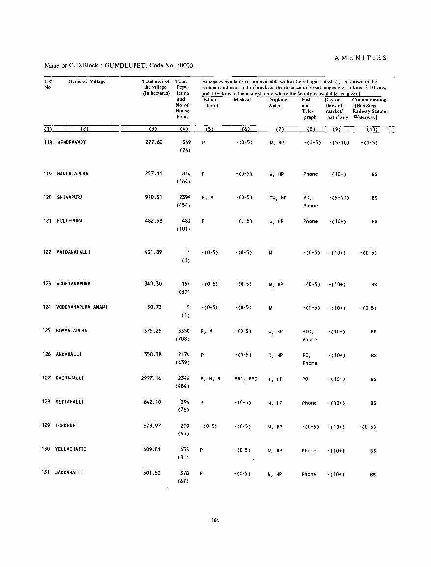
AMENITIES Name of C.D.Block : GUNDLUPET; Code No. :0020
LC Name of VIllage Total area of Total Am~nlll~' avallabl~ (If not avaIlable wIthin the VIllage, a da",h (-) IS shown In the No the VIllage Popu- .. olumn and n~xtto It In brad,.:ts, the dl"'tan ... ~ In broad ranges VIZ -5 Lms, 5-10 Lms,
(In hectares) latlnn and 10+ 1-.111' ot the near.!,t [!Ia ... e where the faCIlity I' avaIlable" gIven} and Edu .. a- M~dl ... al DnnLlOg Po",t Day or CommunicatIOn
No of Ilonal Water and Days of [Bus Stop, Hou'e- Td~- marL~tl RaIlway Stallon. holds graph hat Ifany Waterway)
{1~ (2) (3) (4) (5) (6) (7) (B) (9) (10)
118 BENDRAVADY 277.62 349 P -(0-5) II, HP -(0-5) -(5-10) -(0-5) (74)
119 HANGALAPURA 257.11 814 P -(0-5) II, HP Phone - (10+) BS (164)
120 SHIVAPURA 910.51 2399 P, M -(0-5) HI, HP PO, -(5-10) as (454) Phone
121 HUUEPURA 482.58 483 P -(0-5) II, HP Phone -(10+) as (101 )
122 MAIDANAHAlLi 431.89 -(0-5) -(0-5) -(0-5) - (10+) -(0-5) (1 )
123 VOOEYANAPURA 349.30 154 -(0-5) -(0-5) Y, HP -(0-5) -(10+) BS (30)
124 VOOEYANAPURA AMANI 50.73 5 -(0-5) -(0-5) -(0-5) -(10+) -(0-5) (1 )
125 BOMMAlAPURA 375.26 3350 P, M -(0-5) Y, HP PTO, - (10+) BS (708) Phone
126 ANKAHALLI 35B.38 2179 P -(0-5) T, HP PO, - (10+) BS (439) Phone
127 BACHAHAlll 2997.16 2342 P, M, H PHC, FPC T, HP PO -(10+) BS (484)
128 SETTAHAlll 642.10 '394 P -(0-5) "', HP Phone - (10+) BS (78)
129 lOKKERE 673.97 209 -(0-5) -(0-5) "', HP -(0-5) -(10+) -(0-5) (43)
130 YElLACHATT I 409.81 435 P -(0-5) "', HP Phone - (10+) BS (81)
131 JAKKAHAlLI 501.50 378 P - (0-5) II, HP Phone -(10+) BS (67)
104
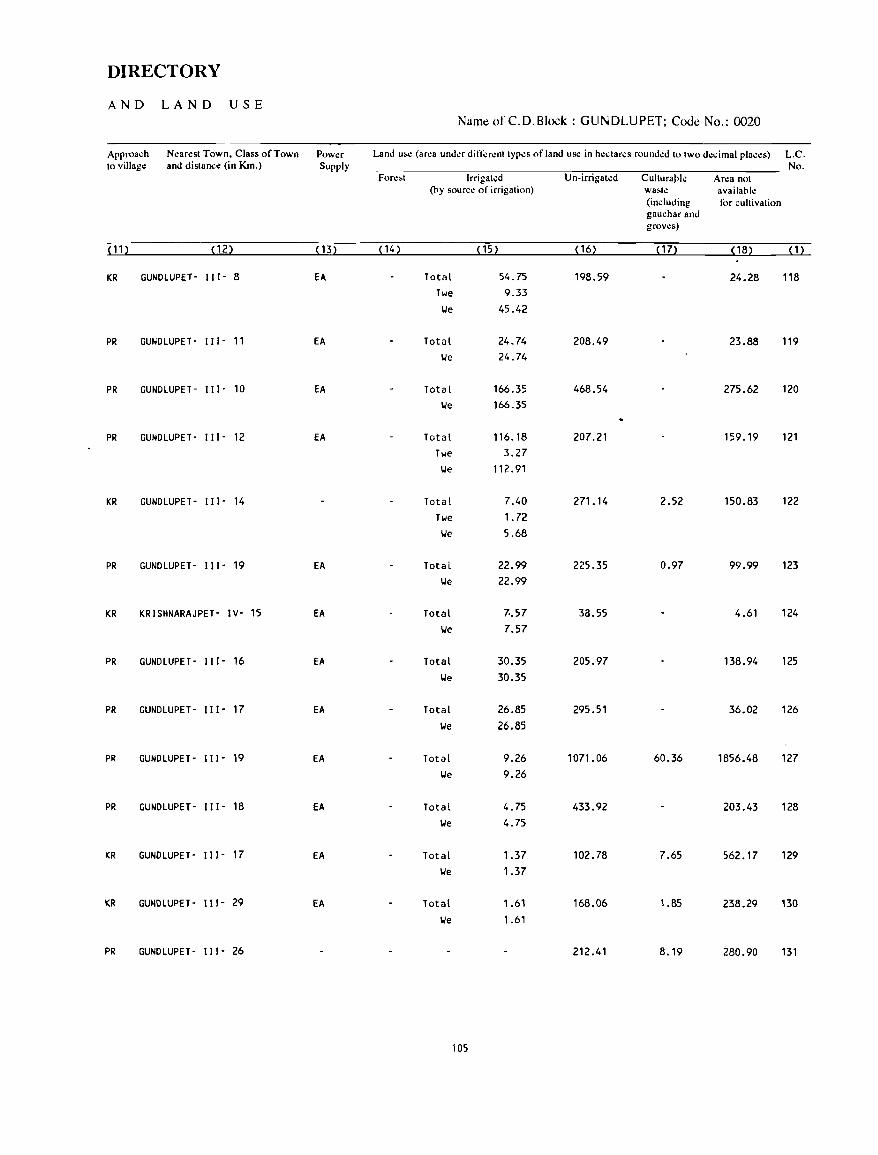
DIRECTORY
AND LAND USE Name of C. D. Block : GUNDLUPET; Code No.: 0020
Approach Nearest Town. Class of Town Power Land u~e (area under different types of land use in hedares rounded to two decimal places) L.C. to village and distance (in Km.) Supply No.
Fore,t Irrigated Un-irrigated Culturark Area not (by source of irrigation) wa,te availabI.:
(including for cultivation gauchar and grows)
(11) (12) ( 13) ( 14) (15) ( 16) ( 17) ( 18) (1)
KR GUNDLUPET- 111- 8 EA Total 54.75 198.59 24.28 118 Tile 9.33
lie 45.42
PR GUNDLUPET- 111- 11 EA Total 24.74 208.49 23.88 119 lie 24.74
PR GUNDLUPET- 111- 10 EA Total 166.35 468.54 275.62 120 lie 166.35
PR GUNDLUPET- 111- 12 EA Total 116.18 207.21 159.19 121 Tile 3.27 lie 112.91
KR GUNDLUPET- 111- 14 Total 7.40 271. 14 2.52 150.83 122 Tile 1. 72 lie 5.68
PR GUNDLUPET- 111- 19 EA Total 22.99 225.35 0.97 99.99 123 lie 22.99
KR KRISHNARAJPET- IV- 15 EA Total 70.57 33.55 4.61 124 lie 7.57
PR GUNDLUPET- 111- 16 EA Total 30.35 205.97 138.94 125 we 30.35
PR GUNDLUPET· 111- 17 EA Total 26.85 295.51 36.02 126
we 26.85
PR GUNDLUPET- 111- 19 EA Total 9.26 1071. 06 60.36 1856.48 127 we 9.26
PR GUNDLUPET- 111- 18 EA Total 4.75 433.92 203.43 128 lie 4.75
KR GUNDLUPET- 111- 17 EA Total 1.37 102.78 7.65 562.17 129 lie 1.37
KR GUNDLUPET- 111- 29 EA Total 1.61 168.06 1.85 238.29 130 lie 1.61
PR GUNDLUPET- 111- 26 212.41 8.19 280.90 131
105
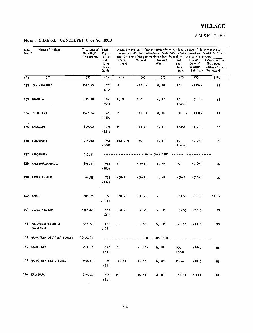
VILLAGE
AMENITIES Name of C.D.Block : GUNDLUPET; Code No. :0020
L.C. Name of Village Total area of Total Aml!nitil!s availabll! (if not availabk within thl! villagl!. a dash (-) is shown in the No. , the village Popu- column and nl!xt to it in brackl!ts, the di.tance in hroad rang.:s viz. -5 kms, 5-10 kms,
(In hectares) lation and 10+ kms of the nearl!st [!Iace where the facilit:r: is available is given). and Educa- Medical Drinking Post Day or Communication No.of tional Water and Days of [Bus Stop, House- Tdl!- markl!tl Railway Station, holds graph hat if any Waterway)
(1) (2) (3) (4) (5) (6) (7) (8) (9) (10)
132 KAN IV ANAPURA 1547.75 375 P -(0,5) 101, HP PO - (10+) BS (63)
133 MAN GALA 955.98 765 P, M PHC 101, HP PO, - (10+) BS (151) Phone
134 KEBBEPURA 1392.14 925 P -(0-5) 101, HP -(0-5) - (10+) BS (169)
135 BALAVADY 559.92 1293 P ,(0,5) T, HP Phone -(10+) BS (254)
136 HUNDI PURA 1015.50 1731 P(2), M PHC T, HP PO, -(10+) BS (309) Phone
137 SIDDAPURA 412.41 ------------------------ UN - INHABITED ------------------------~
138 KALI GO\IOANAHALLI 298.14 934 P -(0-5) T, HP PO - (10+) BS ( 186)
139 PASSAIANAPUR 94.88 723 -(0-5) '(0-5) 101, HP -(0-5) -(10+) BS ( 132)
140 KARLE 208.76 66 -(0-5) -(0-5) 101 -(0-5) -(10+) -(0-5) (15)
141 SIDDAIANAPURA 1201.66 138 '(0-5) - (0-5) \,j, HP -(0-5) -(10+) 8S (24)
142 MAGUVINAHALLIMELA 595.32 487 P -(0-5) 101, HP -(0-5) -(10+) 8S KAMANAHALLI (108)
143 BANDIPURA DISTRICT FOREST 10470.71 ------------------------ UN - INHABITED -------------------------
144 BANDIPURA 291.02 397 P -(5-10) 101, HP PO, -(10+) BS (85) Phone
145 BANDIPURA STATE FOREST 9018.31 25 -(0-5) -(0-5) \,j, HP Phone - (10+) BS (10)
1~6 KAJ..LIPURA 729.03 243 P -(0-5) \,j, HP -(0-5) - (10+) BS (32)
106
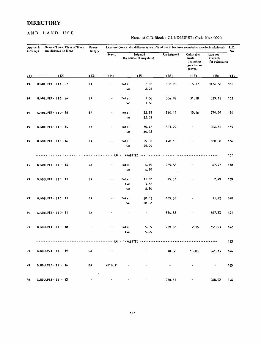
DIRECTORY
AND LAND USE Nam~ of C.D.Block : GUNDLUPET; Code No.: 0020
Approach Nearest Town. Class of Town Powllr Land us.: (area under di Il\:renl types of land us.: in hectares rounded to two decimal places) L.C. to village and distance (in Km.) Supply No.
Fore,t Irrigated Un·irrigated Culturable Area not (by source of irrigation) waste available
(including for cultivation gauchar and groves)
( 11 ) (12) ( 13) (14) (15) ( 16) ( 17) (18) (1)
PR GUNDLUPET- 111- 27 EA Total 2.02 102.90 6.17 1436.66 132 lie 2.02
PR GUNDLUPET- 111- 24 EA Total 1.66 384.02 31.18 539.12 133 lie 1.66
PR GUNDLUPET- 111- 16 EA Total 32.85 560.14 19.16 779.99 134 We 32.85
PR GUNDLUPET- 111- 14 EA Total 30.42 323.20 206.30 135 lie 30.42
PR GUNDLUPET- 111- 16 EA Total 25.00 490.50 500.00 136 ~e 25.00
--------------------------------------------- UN - INHABITED -----------~--------------------------------- 137
KR GUNDLUPET- 111- 13 fA Total 4.79 225.88 67.47 138 We 4.79
KR GUNOLUPET- 111- 13 fA Total 11.82 75.57 7.49 139 Twe 3.32 lie 8.50
KR GUNDLUPET- 111- 13 fA Total 28.02 169.32 11.42 140 lie 28.02
PR GUNDLUPET- III- 11 EA 534.33 667.33 141
PR GUNDLUPET- 111- 18 Total 5.05 229.58 9.16 351.53 142 Twe 5.05
---------------.----------------------------- UN - INHABITED ---.----------------------------------------- 143
PR GUNDLUPET- 111- 19 EA 18.86 10.83 261.33 144
KR GUNDLUPET- 111- 16 EA 9018.31 145
PR GUNDLUPET- 111- 13 260.11 468.92 146
107
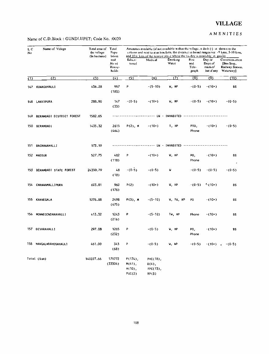
VILLAGE
AMENITIES Name of C.D.Block : GUNDLUPET; Code No. :0020
L C Name of Village Total area of No the Village
(In hectare~)
( 1 ) (2) (3)
147 KUNAGAHAlli 436.28
148 lAKKIPURA 288.90
149 BERAMBADI DISTRICT FOREST 1582.65
150 BERAMBADI 1435.32
151 BACHANAHAlll 173.19
152 MADDUR 527.75
153 BERAMBADI STATE FOREST 24330.79
154 CHANNAMAlli PURA 603.81
155 KANNE GALA 1276.88
156 HONNEGOIIDANAHAllI 413.32
157 OEVARAHAlll 297.08
158 HANGAlADAHOSAHAllI 461.00
Total (Sum) 140227.66
Total Am~mll~~ available (If not available within the Village, a da,h (-) IS shown to the Popu ~olumn and next to It to bra~L.ets, the dl,tan~e 10 broad ranges VIL -~ L.ms. 5-10 L.ms, latllln and 10+ L.tm (lfth.: neace,t ~Iac~ wh.:ce the t,t"ht:l: "avatl,lble " gtve'nj and Educa- M~dl~al DnnL.lOg Po,t Day or Commum~ahon
No 01 hondl Water and Days of [Bus Stop, Hou'-o\!- Tele- marletl Railway Stall on. hold. graph hat If any WatelWay]
(4) (5) (6) (7) (8) (9) (10)
997 P -(5-10) II, HP -(0-5) -(10+) BS (183)
147 -(0-5) -(10+) II, HP -(0-5) -(10+) -(0-5) (33)
------------------------ UN - INHABITED -------------------------
2615 (464)
P(2), M -(10+)
-----------.-------- .. -- UN -
482 P -(10+)
(118)
48 - (0- 5) -(0-5) (18)
960 P(2) -(10+)
(176)
2498 P(3), M -(5,10)
(475)
1243 p -(5-10) (216)
1265 p -(0-5)
(232)
343 P -(0-5) (68)
171772 P(174), PHC(18), (33304) M(41), 0(4),
H(10), FPC(13), PUC(2) RP(3)
108
T, HP PTO, Phone
-(10+) -(0-5)
INHABITED -------------------------
II, HP PO, -(10+) BS Phone
II -(0-5) -(0-5) '(0-5)
II, HP -(0-5) '- (10+) BS
II, Til, HP PO -(10+) BS
Til, HP Phone -(10+) BS
II, HP PO, -(lOT) 8S Phone
II, HP -(0-5) -(10+) . -(0-5)
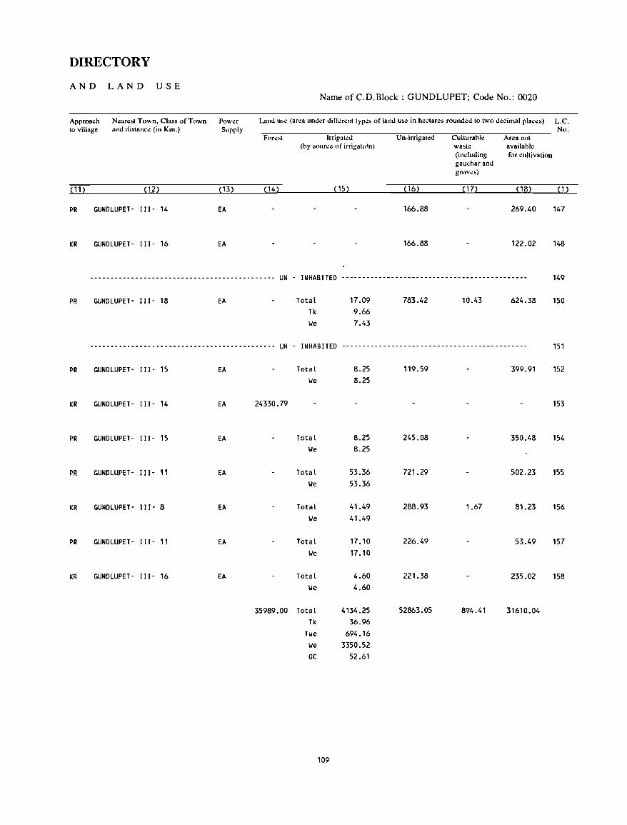
DIRECTORY
AND LAND USE Name of C.D.Block : GUNDLUPET; Code No.: 0020
Approach Neare&t Town, Class of Town Power Supply
Land u,e (area under dilTercnt type> of land u&e in hectare, rounded to two decimal place~) L.C. to village and distance (in Krn.) No.
Fore>t Irrigated Un-irrigated Culturahle Area not (by M>urce of irrigah<1n) wa~te available
(induding for cultivation gaucharand grove»
( 11 ) (12) (13) ( 14) (15) ( 16) ( 17) (18) (1)
PR GUNDlUPET- 111- 14 EA 166.88 269.40 147
KR GUNDlUPET- 111- 16 EA 166.88 122.02 148
--------------------------------------------- UN - INHABITED --------------------------------------------- 149
PR GUNDlUPET- 111- 18 EA
--.------------------------------------------ UN -
PR GUNDlUPET- 111- 15 EA
KR GUNDlUPET- 111- 14 EA 24330.79
PR GUNDlUPET- 111- 15 EA
PR GUNDlUPET- 111- 11 EA
KR GUNDlUPET- IlI- 8 EA
PR GUNDlUPET- 111- 11 EA
KR GUNDlUPET- 111- 16 EA
35989.00
Total Tk
17.09 9.66
\.Ie 7.43
783.42 10.43 624.38
INHABITED ---------------------------------------------
Total 8.25 119.59 399.91 \.Ie 8.25
Total 8.25 245.08 350.48 \.Ie 8.25
Total 53.36 721. 29 502.23 \.Ie 53.36
Total 41.49 288.93 1.67 81.23 \.Ie 41.49
Total 17.10 226.49 53.49 \.Ie 17.10
Total 4.60 221.38 235.02 We 4.60
Total 4134.25 52863.05 894.41 31610.04 Tk 36.96
Twe 694.16 \.Ie 3350.52 GC 52.61
109
150
151
152
153
154
155
156
157
158

HEGGADADEVANKOTE C.D.BLOCK
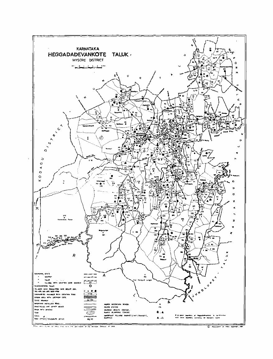
KARNATAKA
HEGGADADEVANKOTE TALUK, MYSORE DISTRICT
It ... , 0 , 2 ] " !!111", .......... ....,
\
\ .. '.
I ( ~r ./ /""-__ l .I' (J - \_: ll/,
I """'-I ./"",",.,,1 ..
o o
, : \' / \ .... " "I : .. ...... _.
l
BOUNOARY, STATt
DfSTRIr;T
TAL~
R
\tILLAGE: WlTM LOCATION COot NUMB!:'''
IotEADQUARUR, TAW"
Ylll"On WITH ~ATJON SIZE BELOW 1001
200·"', !OO-tH, moo .. 4,"
ONINHABllED WILLAGEI "'TN LOCAl"'N COO£
usn"." 10M" -"M "ot"'1()H roD[
SUff HIGHWAY
t.cPOATANl METALlfa IIIOlD.
UH""ETAll[O ,,~ OTH(A AOAOS
RfYrp WIlt-! SiREolW
fA ..
C"~"L .:-l ~T O","I(( / f£"lmltI.P"" (Wncr
E:::~~~:5 ©
o • • • [::::i_-!!:::J ~ --I!!J.!2_
." _0
HtQt«:1I SlCOHOA", stHOOl
fIO'-ltt ,TATION
.. ",MA"y HEALTH CENTRE, , .... uu PUNNINQ ttNT'U;
I~ANT VILLAGe .... 'UtU I HAT (SHAN"'). MAfiII01ES
~ .... c: D lI.d "_"'r, .. "",.-..l'IIIot. '- t.-t.",,,nul -111'1 .. ,..... """"IHy .. chldl.... on .. tlftory t_nl
o
" m
0
;:,
I!>
%
4:
-,
;z
~
z
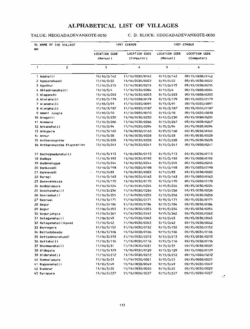
ALPHABETICAL LIST OF VILLAGES
T ALUK: HEGGADADEV ANKOTE-0030 C. D. BLOCK: HEGGADADEV ANKOTE-0030
SL NAME OF THE VILLAGE NO
1 Adahall i 2 Agasanahundi 3 Agathur
2
4 Akkadevanahalli 5 Alaganchi 6 Alalahall i 7 Alanahalli 8 Alanahalli 9 Aman; Jungle
10 Anagatti 11 Anemala 12 Ankanahall i 13 Ankupura 14 Annur 15 Antharasanthe 16 Antharasanthe Plantation
17 Bachegowdanahalli 18 Badaga 19 Badanakuppe 20 Bankavadi 21 Bannavadi 22 Baragi 23 Basavanakote 24 Seddalapura 25 Beechanahalli 26 Beeramballi 27 Beerwal 28 Segur 29 Segur 30 Begurjungle 31 Belaganahalli 32 Belaganahallikaval 33 Sennegere 34 Bettadabeedu 35 Settadavarehundi 36 Bettahalli 37 Bheemanahalli 38 Bidagalu 39 Bidarahall i 40 Sorrrnalapura 41 Boppanaha II i 42 Budanur 43 Byrapura
1991 CENSUS 1981 CENSUS
LOCATION CODE (Manual)
3
11/16/3/142 11/16/3/22 11/16/3/215 11/16/3/4 11/16/3/203 11/16/3/179 11/16/3/91 11/16/3/187 11/16/3110 11/16/3/230 11/16/3/266 11/16/3/94 11/16/3/160 11/16/3/28 11/16/3/228 11/16/3/241
11/16/3/113 11/16/3/192 11/16/3/244 11/16/3/198 11/16/3/83 11/16/3/163 11/16/3/170 11/16/3/224 11/16/3/236 11/16/3/255 11/16/3/171 11/16/3/184 11/16/3/253 11/16/3/261 11/16/3/45 11/16/3/42 11/16/3/152 11/16/3/1 06 11/16/3/213 11/16/3/116 U{16{3{31 11/16/3/129 11/16/3/212 11/16/3/21 11/16/3/49 11/16/3/20 11/16/3/227
LOCATION CODE LOCATION CODE LOCATION CODE (Computer) (Manual) (Computer)
4
11/16/0030/0142 11/16/0030/0022 11/16/0030/0215 11/16/0030/0004 11/16/0030/0203 11/16/0030/0179 11/16/0030/0091 11/16/0030/0187 11/16/0030/0010 11/16/0030/0230 11/16/0030/0266 11/16/0030/0094 11/16/0030/0160 11/16/0030/0028 11/16/0030/0228 11/16/0030/0241
11/16/0030/0113 11/16/0030/0192 11/16/0030/0244 11/16/0030/0198 11/16/0030/0083 11/16/0030/0163 11/16/0030/0170 11/16/0030/0224 11/16/0030/0236 11/16/0030/0255 11/16/0030/0171 11/16/0030/0184 11/16/0030/0253 "/16/0030/0261 11/16/0030/0045 11/16/0030/0042 11/16/0030/0152 11/16/0030/0106 11/16/0030/0213 11/16/0030/0116 11 {16{0030{0031 11/16/0030/0129 11/16/0030/0212 11/16/0030/0021 11/16/00_3.0/0049 11/16/0030/0020 11/16/0030/0227
113
5
9/15/3/142 9/15/3/22 9/15/3/215 9/15/3/4 9/15/3/203 9/15/3/179 9/15/3/91 9/15/3/187 9/15/3/10 9/15/3/230 9/15/3/267 9/15/3/94 9/15/3/160
9/15/3/28 9/15/3/228 9/15/3/241
9/15/3/113 9/15/3/192 9/15/3/245 9/15/3/198 9/15/3/83 9/15/3/163 9/15/3/170
9/15/3/224 9/15/3/236 9/15/3/256 9/15/3/171 9/15/3/184 9/15/3/254 9/15/3/262 9/15/3/45 9/15/3/42 9/15/3/152 9/15/3/106 9/15/3/213 9/15/3/116 9/15/3{31 9/15/3/129 9/15/3/212 9/15/3/21 9/15/3/49 9/15/3/20 9/15/3/227
6
09/15/0030/0142 09/15/0030/0022 09/15/0030/0215 09/15/0030/0004 09/15/0030/0203 09/15/0030/0179 09/15/0030/0091 09/15/0030/0187 09/15/0030/0010 09/15/0030/0230 09/15/0030/0267 09/15/0030/0094 09/15/0030/0160 09/15/0030/0028 09/15/0030/0228 09/15/0030/0241
09/15/0030/0113 09/15/0030/0192 09/15/0030/0245 09/15/0030/0198 09/15/0030/0083 09/15/0030/0163 09/15/0030/0170 09/15/0030/0224 09/15/0030/0236 09/15/0030/0256 09/15/0030/0171 09/15/0030/0184 09/15/0030/0254 09/15/0030/0262 09/15/0030/0045 09/15/0030/0042 09/15/0030/0152 09/15/0030/0106 09/15/0030/0213 09/15/0030/0116 09/15/0030{0031 09/15/0030/0129 09/15/0030/0212 09/15/0030/0021 09/15/0030/0049 09/15/0030/0020 09/15/003010227
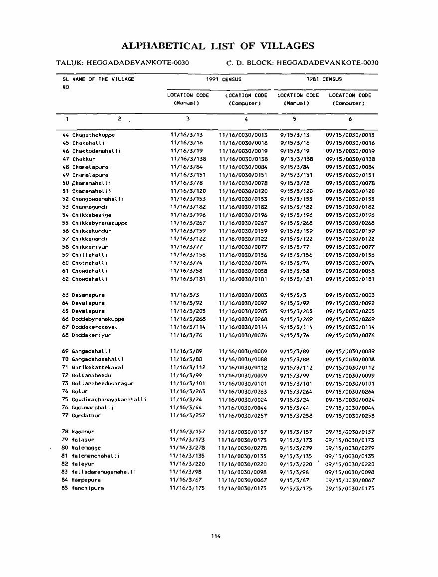
ALPIIABETICAL LIST OF VILLAGES
T ALUK: HEGGADADEV ANKOTE-0030 C. D. BLOCK: HEGGADADEV ANKOTE-0030
SL NAME OF THE VILLAGE NO
1991 CENSUS 1981 CENSUS
44 Chagathekuppe 45 Chakahalli
2
46 Chakkodanahalli 47 Chakkur 48 Chamal apura 49 ChamaLapura 50 ,chamanahall i 51 Chamanahalll 52 Changowdanahalli 53 Channagundi 54 Chikkabesige 55 Chikkabyranakuppe 56 Chikkakundur 57.Chikkanandi 58 Chikkeriyur 59 Chi llahall i 60 Chotnahall i 61 Chowdaha II i 62 Chowdahalli
63 Dasanapura 64 Devalapura 65 Devalapura 66 Doddabyranakuppe 67 Doddakerekaval 68 Doddakeriyur
69 Gangadahalli 70 Gangadahosahalli 71 Garikekattekaval 72 Gollanabeedu 73 Gollanabeedusaragur 74 Golur 75 Gowdimachanayakanahalli 76 Gudumanaha II i 77 Gundathur
78 Hadanur 79 Halasur 80 Halemagge 81 Halemanchahalli 82 Haleyur 83 Halladamanuganahalli 84 Hampapura 85 Hanchipura
LOCATION CODE (Manual)
3
11/16/3/13 11/16/3/16 11/16/3/19 11/16/3/138 11/16/3/84 11/16/3/151 11/16/3/78 11/16/3/120 11/16/3/153 11/16/3/182
11/16/3/196 11116/3/267
11/16/3/159 11/16/3/122 11/16/3/77 11/16/3/156 11/16/3/74
11/16/3/58 11/16/3/181
11/16/3/3 11/16/3/92
11/16/3/205
11/16/3/268 11/16/3/114
11/16/3/76
11/16/3/89
11/16/3/88
11/16/3/112 11116/3/99
11/16/3/101 11/16/3/263 11/16/3/24 11/16/3/44
11/16/3/257
11/1613/157
11/16/3/173 11/16/3/278 11/16/3/135 11/16/3/220 11/16/3/98 11/1613167
11/16/3/175
LOCATION CODE LOCATION CODE LOCATION CODE (Computer) (Manual) (Computer)
4
11/16/0030/0013 11/16/0030/0016 11/16/0030/0019 11/16/0030/0138 11/16/0030/0084 11/16/0030/0151 11/16/0030/0078 11/16/0030/0120 11/16/0030/0153 11/16/0030/0182 11/16/0030/0196 11/16/0030/0267 11/16/0030/0159 11/16/0030/0122 11/16/0030/0077 11/16/0030/0156 11/16/0030/0074 11/16/0030/0058 11/16/0030/0181
11/16/0030/0003 11/16/0030/0092 11/16/0030/0205 11/16/0030/0268 11/16/0030/0114 11/16/0030/0076
11/16/0030/0089
11/16/0030/0088 11/16/0030/0112 11/16/0030/0099 11/16/0030/0101
11/16/0030/0263 11/16/0030/0024 11/16/0030/0044 11/16/0030/0257
11/16/0030/0157
11/16/0030/0173
11/16/0030/0278 11/16/0030/0135 11/16/0030/0220 11/16/0030/0098 11/16/0030/0067 11/16/0030/0175
114
5
9/15/3/13 9/15/3/16 9/15/3/19 9/15/3/138 9/15/3/84 9/15/3/151 9/15/3/78 9/15/3/120 9/15/3/153 9/15/3/182 9/15/3/196 9/15/3/268 9/15/3/159 9/15/3/122 9/15/3/77 9/15/3/156 9/15/3/74 9/15/3/58 9/15/3/181
9/15/3/3 9/15/3/92 9/15/3/205 9/15/3/269 9/15/3/114 9/15/3/76
9/15/3/89 9/15/3/88 9/15/3/112 9/15/3/99 9/15/3/101 9/15/3/264 9/15/3/24 9/15/3/44 9/15/3/258
9/15/3/157 9/15/3/173 9/15/3/279 9/15/3/135 9/15/3/220 9/15/3/98 9/15/3/67 9/15/3/175
6
09/15/0030/0013 09/15/0030/0016 09/15/0030/0019 09/15/0030/0138 09/15/0030/0084 09/15/0030/0151 09/15/0030/0078 09/15/0030/0120 09/15/0030/0153 09/15/0030/0182 09/15/0030/0196 09/15/0030/0268 09/15/0030/0159 09/15/0030/0122 09/15/0030/0077 09/15/0030/0156 09/15/0030/0074 09/15/0030/0058 09/15/0030/0181
09/15/0030/0003 09/15/0030/0092 09/15/0030/0205 09/15/0030/0269 09/15/0030/0114 09/15/0030/0076
09/15/0030/0089 09/15/0030/0088 09/15/0030/0112 09/15/0030/0099 09/15/0030/0101 09/15/0030/0264 09/15/0030/0024 09/15/0030/0044 09/15/0030/0258
09/15/0030/0157 09/15/0030/0173 09/15/0030/0279 09/15/0030/0135 09/15/0030/0220 09/15/0030/0098 09/15/0030/0067 09/15/0030/0175
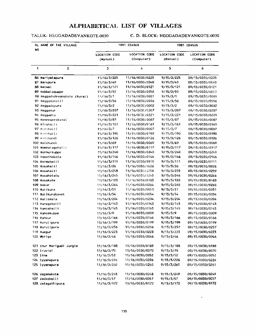
ALPIIABETICAL LIST OF VILLAGES
TALUK: HEGGADADEVANKOTE-0030 C. D. BLOCK: HEGGADADEV ANKOTE-()()30
SL NAME OF THE VILLAGE NO
86 Hariyalapura 87 Itarupura 88 Hatwal 89 H ebba I a guppe
2
90 Heggadadevanakote (Rural) 91 Heggadahalli 92 He99adapura 93 Hegganur 94 Heggudlu 95 Hennegerekaval 96 Hirahalll 97 Hl rlhall i 98 Hlr1halll 99 Hlrlnandl
100 Holehundl 101 Hommaragahalll 102 Honnurkuppe 103 Hoovinakola 104 Hormahall i 105 Hosahalli 106 Hosahalli 107 Hosaholalu 108 Hosakote 109 Hosur 110 Hulikura 111 Hulikurakaval 112 Hu II ema l a 113 Hunagahalli 114 Hunsahalli 115 Hunsekuppe 116 Hunsur 117 Hurullpura 118 Hurulipura 119 Husgur 120 tf'yrige
121 Inur Marigudi Jungle 122 Iruvidi 123 ltna 124 Iyyanapura 125 Iyyanapura
126 Jaganakote \27 Jakl<ahalli 128 Jatagathipura
1991 CENSUS 1981 CENSUS
LOCATION CODE (Manual)
3
11/16/3/225 11/16/3/40 11/16/3/121 11/16/3/50 11/16/3/1 11/16/3/56
11/16/3/2 11/16/3/207 11/16/3/221 11/16/3/87 11/16/3/161 11/16/3/7 11/16/3/190 11/16/3/126 11/16/3/69 11/16/3/117 11/16/3/240 11/16/3/146 11/16/3/111 11/16/3/26 11/16/3/258 11/16/3/245 11/16/3/183 11/16/3/264 11/16/3/51 11/16/3/54
11/16/3/204 11/16/3/143 11/16/3/145 11/16/3/9 11/16/3/166 11/16/3/199 11/16/3/256
11/16/3/223 11/16/3/46
11/16/3/188 11/16/3/70 11/16/3/52 11/16/3/226 11/16/3/260
11/16/3/248 \1/1.613/57
"/16/3/172
LOCATION COOE LOCATION CODE LOCATION CODE (Computer) (Manual) (Computer)
4
11/16/0030/0225 ',/16/0030/0040 11/16/D030/01Z1 11/16/0030/0050 11/16/0030/0001 11/16/0030/0056 11/16/0030/0002 11/16/0030/0207 11/16/0030/0221 11/16/0030/0087
11/16/0030/0161 11/16/0030/0007 11/16/0030/0190 11/16/0030/0126 11/16/0030/0069 11/16/0030/0117 11/16/0030/0240 11/16/0030/0146
11/16/0030/0111 11/16/0030/0026 11/16/0030/0258
11/16/0030/0245
11/16/0039/01133 11/16/0030/0264 11/16/0030/0051 11/16/0030/0054
11/16/0030/0204 11/16/0030/0143 11/16/0030/0145 11/16/0030/0009 11/16/0030/0166 11/16/0030/0199 11/16/0030/0256
11/16/0030/0223 11/16/0030/0046
11/16/0030/0188
11/16/0030/0070 11/16/0030/0052 11/16/0030/0226
11/16/0030/0260
11/16/0030/0248 11/16/0030/0057
11/16/0030/0172
115
5
9/15/3/225 9/15/3/40 9/15/3/121 9/15/3/50 9/15/3/1 9/15/3/56 9/15/3/2 9/15/3/207 9/15/3/221 9/15/3/87 9/15/3/161 9/15/3/7 9/15/3/190 9/15/3/126 9/15/3/69 9/15/3/117 9/15/3/240 9/15/3/146
9/15/3/111
9/15/3/26 9/15/3/259 9/15131246
9/15/3/183 9/15/3/265 9/15/3/51
9/15/3/54 9/15/3/204 9/15/3/143 9/15/3/145 9/15/3/9 9/15/3/166 9/15/3/199 9/15/3/257 9/15/3/223 9/15/3/46
9/15/3/188
9/15/3/70 9/15/3/52 9/15/3/226
9/15/3/261
9/15/3/249 9/15/3/57
9/15/3/172
6
09/15/0030/0225 09/15/0030/0040 09/15/0030/0121 09/15/0030/005:) 09/15/0030/0001 09/15/0030/0056 09/15/0030/0002 09/15/0030/.0207 09/15/0030/0221 09 /15/0030100~7
09/15/0030/0161 09/15/0030/0007 09/15/0030/0190 09/15/0030/0126 09/15/0030/0069 09/15/0030/0117 09/15/0030/0240
09/15/0030/0146
09/15/0030/0111 09/15/0030/0026 09/15/0030/025,9 09/15/003W0246 09/15/0030/0183 09/15/0030/0265 09/15/0030/0051
09/15/0030/0054 09/15/0030/0204 09/15/0030/0143 09/15/0030/0145 09/15/0030/0009 09/l5/0030/0166 09/15/0030/0199 09/15/0030/0257 09/15/0030/0223 09/15/0030/0046
09/15/0030/0188
09/15/0030/0070 09/15/0030/0052 09/15/0030/0226 09/15/0030/0261
09/15/0030/0249 09/15/0030/0057 09/15/0030/0172
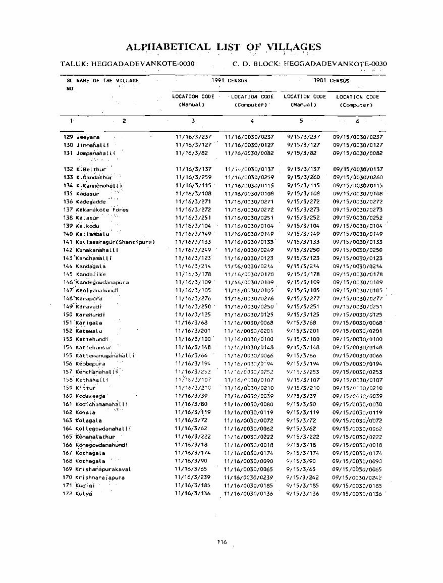
ALPIIABETICAL LIST OF VILLAGES ~ f; ',.' 3 )' 1, ' } :~, • I'~ •
TALUK: HEGGADADEVANKOTE-0030 C. D. BLOCK: HEGGADADEV AN KOTE-0030
SL NAME OF THE VILLAGE NO
1
129 Jeeyar·a 130 Ji'nnahalli 131 JomPaMaha[t i
~. '. ' ' "
I : ~
2
132 K·.Bel thur' I
133 K.'Ganda:thur' 134 K.Kannenah.H 1 i 135 Kadasur 136 Kadeg'adde 137 Ka1c'anakote "dreS 138 ICalasur -139 Kalkodu 140 Ka 1t arilba 1 u 141 Kallasa'rag~r(Shantipura) 142 -'K'anakanaha 1 i i 143 ;'KanchamIH 1 i
144 KaNiagala 145 K'anda t i k'e 146'1candegowdanapura 147'Kaniyanahundi' 148"'1Carapllra . 149"1caravadi 150 lCareliundi 151 'KarigcHa 152 Katawatu 153 Ka'ttehundi 154 Kattehunsur 155 Kattema~ug~~a'hi:lll i 156 Keibbepl~ka 15 7 1(el'lcli~r\'ahal i {' 158 Kethahalli 159 ICittut 160 K'odas~ege' 161 Kodichainanaha'r t i 162 KOha 1 a '. (-, '
163 1(otagala 164 Kollegowdanahalli 165' '1c6nanal athur .
166 Kone9owdari~tiundi 167 j(oth~9ala 168 Kothega(a 169 KrishanapurakavaL 170 Krishnaraj~pura 171 .Kudigi .
172 Kulya
1991 CENSUS 1981 CENSUs
LOCATION CODE (Manual)
3
11/16/3/237 11/16/3/127 11/16/3/82
11/16/3/137 11/16/3/259 11/16/3/115 . 11/16/3/108 11/16/3/271 11/16/3/272 11/16/3/251 11/16/3/104 11/16/3/149 . 11/16/3/133 11/16/3/249
'1/16/3/123 11/16/3/214
'1i16/3/178 11/16/3/109 11/16/31'105
11/16/3/276 11/16/3/250 11/16/3/125 11/16/3/68 11/16/3{201 11/16/3/100 ' 11/16/3/148 11/16/3{66 11/16/3/194 11/16/3/252 11/1(--/3/10'1 11/16/3/210 11/16/3/39 11/16/3/80 11/16/3/119 11/16/3/72 11/16/3/62 11/16/3/222 11/16/3/18 11/16/3/174 11/16/3/90 11/16/3/65 11/16/3/239 11/16/3/185 11/16/3/136
LOCATION CODE LOCATION CODE LOCATION CODE (Computer) - (Manual) (Computer)
4
11/16/0030/0237 11/16/0630/0127 , 11/16/0030/0082
11/~U0030/0137 11/16/0030/0259 11/16/0030j0115" 11/16/0030/0108 11/16/0030/0271 11/16/0030/0272 11/16/0030/0251 11/16/0030/0104 ',/16/0030/0149 11/16/0030/0133 ' 11/16/003010249 11/16/0030/0123 l' /16{0030/02 i4
11/16/0030/0178 11/16/0030/0109 11/16/0030/0105' 11/16/0030/0276 11/16/0030/0250 . 11/16/0030/ofz5 11/16/0030/0068 11/16/0030/0201 11/16/0030,0100 11/16/0030{0148 11/16/0030j0066
11/16/0030/01·94 11/16/0030/02'52
1 "/16/CJ30iOl07
11/16/0D30/0210 11/16/0030/0039
1'1/16/0030io080
11/16/0030/0119 11/16/0030/0072 11/16/0030/0062 11/16/0030/0222 11/16/0030/0018 11/16/0030/0174 11/16/0030/0090 11/16/0030/0065 11/16/0030/0239 11/16/0030/0185 11/16/0030/0136
116
5
9/l5/3/237 9/15/3/127 9/15/3/82
9/15/3/137 9/15/3/2'60 9/15/3/115 9/15/3/108 9/15/3/272 9/15/3/273 9/15/3/252 9/15/3/104 9/15/3/149 9/15/3/133 9/15/3/250 9/15/3/123 9/1513/214
9/15/3/178 9/15/3/109 9/15/3/105 9/15/3/277 9/15/3/251 9/15/3/125 9/15/3/68 9115/3{201 9/15/3/100 9/15/3/148 9/15/3/66 9/15/3/194 9/15/3/253 9/15/3/107 9/15/3/210 9/15/3/39 9/15/3/30 9/15/3/119 9/15/3/72 9/15/3/62 9/15/3/222 9/15/3/18 9/15/3/174 9/15/3/90 9/15/3/65 9/15/3/242 9/15/3/185 9/15/3/136
6
09/15/0030/0237 09/15/0030/0127 09/15/0030/0082
09/15/0030/0137 09/15/0030'10260 09/1510030'/0115 09/15/0030/0108 09/15/0030/0272 09{15/003"O10273 09/15/0030/0252 09/15i0030/0104 .
09/15/0030/0149 09/15/0030/0133 09/15/0030/0250 09/15/003'0/0123 09115/0030/0214
09/15/0030/0178 09/15/0030/0109 09/15/0(T30/0105 .
09/15/0030/0277 09/15/003'0/0251 09/15/0030i0125 09/15/0036/0068' 09/15/0030/0201 09/15/0030/0100 09/15/0030/0148 09/1510030/0066 09/ l'S/0030jO 194 09/15/0030/0253 09/15/0030/0107 09/ 15/lV:)0/021 0
09/15/0030/0039
09/15/0030/0030 09/15/0030/0119 09/15/0030/0072 09/15/0030/0062 09/15/0030/0222 09/15/0030/0018 09/15/0030/0174 09/15/0030/0090 09/15/0030/0065 09/15/0030/0242 09/15/0030/0185 09/15/0030/01~6 '
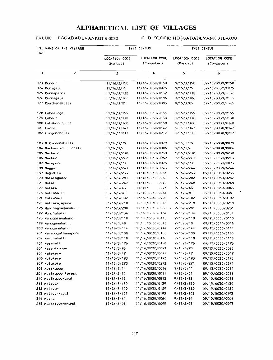
ALPIIABETIC.I\L LIS1; QF VILLAGES
TALUK: Hf.:..GGADADEVANKOTE-0030 C. D. BLOCK: HEGGADADEVANKOTE-0030
SL NAME OF THE VILLAGE NO
173 Kundur 174 Kunigalu 175 Kunnapatna 176 Kurnagala 177 Kyathanahalll
178 lakkaO>.oge 179 Lakkur 180 lakshm<lrnpura 181 Lanke 182 L lngenaha III
183 M.Kannenahalll
2
184 Machanayak3nahalli 185 Machalc 186 Machur 187 MadLlpura 188 Hagge 189 Magudllu 190 Malalagadde 191 Mala! i 192 Malara 193 Mallahalll 194 Mallahalll 195 Mallarajapura 196 Manchagowdanahdll 197 Manchahall i 198 Manegaranahundi 199 Manuganahalli 200 Manuganahalli 201 Marabugathanapura 202 Marchahalli
203 Masahalll 204 Masanikuppe 205 Matakere 206 Matakere
207 Melukote 208 Metlkuppe 209 Metikuppe Forest 210 Hetikuppekava~ 211 Moleyur 212 Moleyur 213 Moleyurkaval 214 Motha 215 Muddalyyanahundi
1991 CENSUS 1981 CENSUS
L.OCATION COD~
(Manual)
3
11/16/3/150 11/16/3/75 11/16/3/132 l' /16/3/186 ,,/16/3/8':
11/16/3/155 11/16/3/130
11/16/3/168 11/16/3/147 11/16/3/217
11/16/3/79 11/16/3/6 11/16/3/238 11/16/3/262
11/16/3/73 11/16/3/243 11/16/3/233 11/16/3/281
11/16/3/247 11/16/3/43 11/16/3/81 11/16/3/102
11/16/3/218
11/16/3/280
11/16/3/134 11/16/3/110
11/16/3/48 11/16/3/144
11/16/3/180 11/16/3/118
11/16/3/176 11/16/3/93
11/16/3/47 11/16/3/193
11/16/3/273 11/16/3/14 11/16/3/11
11/16/3/12 11/16/31139
11/1613/189 11/16/3/195
11/16/3/64 11/16/3/95
LOCATION COOE LOCATION COOE (Computer) (Manual)
4
11/16/0030/0150
11/16/0030/0075 11/16/0030/0132 11/16/0030/0186
11, '6/0030/0085
11/16/Jv30/0155
11/16/GJ30/0130 11/16/0:.)0/0168 11/16/(::: 50/0147
11/16/0030/0217
11/16/0030/0079 11/16/0030/0006 11/16/0030/0238 11/16/0030/0262
11/16/0030/0073 11/16/0030/02,,3 11/16/0030/0235 11/16/u:}:>.:]/0281
11/16/C /'J247 11/16/ .043 11/16/~~3,_ U081
11/1,<,/003(./0102
11/16/0030/0218 11/1 D/0IJ30/0280 11/10 'OCijO/013L.
11 / 1",/0030/0110
11/1c'Ol3,J/0048 11/16/0030/0144
11/16/0030/0130 11/16/003,0;0118
11/16/0030/0176 11/16/0030/0093
11/16/0030/0047 11/16/0030/0193
11/16/0030/0273 11/16/0030/0014
11/16/0030/0011
11/16/003010012 11/16/0030/0139 11/16/0030/0189 11/16/0030/0195
11/16/0030/0064 11/16/0030/0095
117
5
9/15/3/150 9/15/3/75 9/15/3/132 9/15/3/186
9/15/3/85
9/15/3/155 9/15/3/130
9/15/3/168 9/ ))/3/147
9/15/3/217
9/15{3;79 9/15/3/6 9/15/3/238 9/15/3/263 9/15/3/73 9/15/3/244 9/15/3/233 9/15/3/282
9/15/3/248 9/15/3/43 9/15/3/81
9/15/3/102
9/15/3/218
9/15/3/281
9/15/3/134 9/15/3/110
9/15;3/48
9/15/3/144 9/15/3/180 9/15/3/118
9/15/3/176 9/15/3/93
9/15/3/47 9/15/3/193
9/15/3/274
9/15/3/14 9/15/3/11
9/15/3/12 9/15/3/139 9/15/3/189 9/15/3/195
9/15/3/64
9/15/3/95
LOCATIOW CODE (Computer)
6
09/15/0030/0150 09/15/Cv':;O/C075
09/15/0030/v' ~2 09;15/0030/0 1 6 09/15/0030juJu)
09/15/0030/0155 [,9 /15/0030-/0130
09/15/0030/0168 09/15/U0.50/0147 09/15/0030/0217
09/15/0030/0079 09/1~/0030/0006
09/15/0030/0238 09/15/CnO/0263
09/b/l-C30/0073 09/15/0030/(,,244 09/15/0030/02J3 09/15/0030/0282 09/15/0030/0248 09/15/0030/0043 09/15/0030/0081
09/15/0030/0102
09/15/0030/0218
09/15/0030/0281
09/1"/0030/0134 09/15/0030/0110
09/15/0030/0048 09/15/0030/0144 09/15/0030/0180
09/15/0030/0118
09/15/0030/0176
09/15/0030/0093 09/15/0030/0047
09/15/0030/0193
09/15/0030/0274
09/15/0030/0014 09/15/0030/0011
09/15/0030/0012 09/1,5/0030/0139 09/15/0030/0189 09/15/0030/0195
09/15/0030/0064 09/15/0030/0095
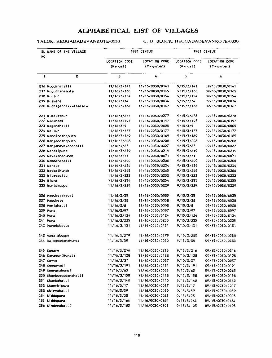
ALPIIABETICAL LIST OF VILLAGES
TALUK:HEGGADADEVANKOTE~30 C. D. BLOCK: HEGGADADEVANKOTE-0030
SL NAME Of THE VILLAGE NO
1991 CENSUS 1981 CENSUS
216 Muddanahalli 217 Muguthanamule 218 MUllur 219 Muskere
2
220 Muthigechikkathalalu
221 N.Belathur 222 Nadahadi 223 Naganahalli 224 Nallur 225 Nandinathapura 226 Nanjanathapura 227 Nanjanayakanahalli 228 Narasipura 229 Nayakanahundl 230 Nenmanaha II ; 231 NeraLe 232 Netkalhundl 233 Ni Lavagi lu 234 Hisna 235 Nurlakuppe
236 Padukotakaval 237 Padukote 238 Penj aha II i 239 Pura 240 Pura 241 Pura 242 Puradakatte
243 Ragalakuppe 244 RaJegowdanahundl
245 Sagare 246 Saragur(Rural) 247 Savve 248 Seegavadi 249 Seeranahundi 250 ShambugowdanahalLi 251 Shankahalli 252 Shanthipura 253 Shirmahalli 254 Siddapura 255 Siddapura 256 Sindenahalli
LOCATtON CODE (Manual)
3
11/16/3/141 11/16/3/165 11/16/3/154 11/16/3/34 ',/16/3/167
11/16/3/277 11/16/3/197 11/16/3/5 11/16/3/177 11/16/3/169 11/16/3/208 11/16/3/27 11/16/3/219 11/16/3/71 11/16/3/200 1 '/16/3/234 11/16/3/265 11/16/3/232 "/16/3/254 11/16/3/229
,'/16/3/35 11/16/3/38 11/16/3/8 11/16/3/97 11/16/3/124 '1/16/3/235 11/16/3/131
11/16/3/279 11/16/3/30
11/16/3/216 11/16/3/128 11/16/3/37 11/16/3/191 11/16/3/63 11/16/3/158 11/16/3/140 11/16/3/17 11/1613/59 11/16/3123 11/16/3/164 11/16/3/103
LOCATION CODE LOCATION CODE LOCATION CODE (Computer) (Manual) (Computer)
4
11/16/0030/0141 11/16/0030/0165 11/16/0030/0154 11/16/0030/0034 11/16/0030/0167
11/16/0030/0277 11/16/0030/0197 11/16/0030/0005 11/16/0030/0177 11/16/0030/0169 11/16/0030/0208 11/16/0030/0027 11/16/0030/0219 11/16/0030/0071 11/16/0030/0200 11/16/0030/0234 11/16/0030/0265 ',/16/0030/02.l2 11/16/0030/0254 11/16/0030/0229
11/16/0030/0035 11/16/0030/0038 11/16/0030/0008 , i /16/0030/0097 11/16/0030/0124 11/16/0030/0235 11/16/0030/0131
11/16/0030/0279 '1/16/003,0/0030
11/16/0030/0216 11/16/0030/0128 11/16/0030/0037 11/16/0030/0191 11/16/0030/0063 11/16/0030/0158 11/16/0030/0140 11/16/0030/0017 11/16/0030/0059 11/16/0030/0023 11/16/0030/0164 11/16/0030/0103
118
5
9/15/3/141 9/15/3/165 9/15/3/154 9/15/3/34 9/15/3/167
9/15/3/278 9/15/3/197 9/15/3/5 9/15/3/177 9/15/3/169 9/15/3/208 9/15/3/27 9/15/3/219 9/15/3/71 9/15/3/200 9/15/3/234 9/15/3/266 9/15/3/232 9/15/3/255 9/15/3/229
9/15/3/35 9/15/3/38 9/15/3/8 9115/3/97
9/15/3/124 9/1513/235 9/15/3/131
9/15/3/280
9/15/3/30
9/15/3/216 9/15/3/128 9/15/3/37 9/15/3/191 9/15/3/63 9/15/3/158 9/15/3/140 9/15/3/17 9/15/3/59 9/15/3/23 9/15/3/164 9/15/3/103
6
09/15/0030/0141 09/15/0030/0165 09/15/0030/0154 09/15/0030/0034 09/15/0030/0167
09/15/0030/0278 09/15/0030/0197 09/15/0030/0005 09/15/0030/0177 09/15/0030/0169 09/15/0030/0208 09/15/0030/0027 09/15/0030/0219 09/15/0030/0071 09/15/0030/0200 09/15/0030/0234 09/15/0030/0266 09/15/0030/0232 09/15/0030/0255 09/15/0030/0229
09/15/0030/0035 09/15/0030/0038 09/15/0030/0008 09/15/0030/0097 09/15/0030/0124 09/15/0030/0235 09115/0030/0B1
09/15/0030;0280 09/15/0030/0030
09/15/0030/0216 09/15/0030/0128 09/15/0030/0037 09/15/0030/0191 09/15/0030/0063 09/15/0030/0158 09/15/0030/0140 09/15/0030/0017 09/15/0030/0059 09/15/0030/0023 09/15/0030/0164 09/15/0030/0103
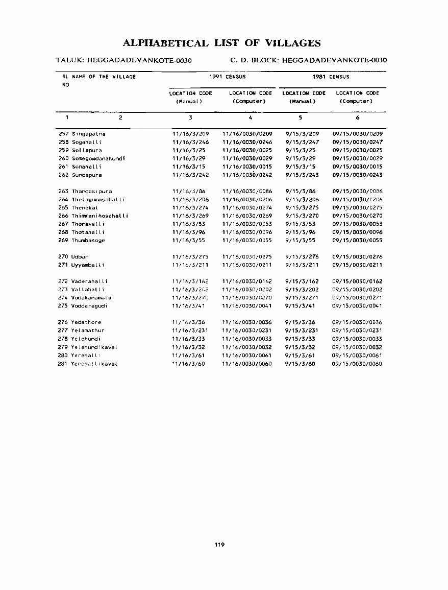
ALPIIABETICAL LIST OF VILLAGES
TALUK: HEGGADADEVANKOTE-0030 C. D. BLOCK: HEGGADADEV AN KOTE-0030
SL NAME OF THE VILLAGE
NO
1991 CENSUS 1981 CENSUS
257 Singapatna 258 Sogaha II i 259 Sollapura
2
260 Sornegowdanahundi 261 Sonahalli 262 Sundapura
263 Thandaslpura 264 Thelagumasahalli 265 Thenekal 266 Thimmanihosahalli 267 Thoravalli 268 Thotahalli 269 Thunbasoge
270 Udbur 271 Uyyamba II i
272 Vaderahall i 273 Vallahalli 274 Vodakanamala 275 Voddaragudi
276 Yedathore 277 Yelamathur
278 Yelehundi 279 Y~lehundikaval 280 Yerehalll
281 Yerc~Jlllka"al
LOC"T I ON CODE
(Manual)
3
11/16/3/209 11/16/3/246 11/16/3/25 11/16/3/29
11/16/3/15 11/16/3/242
11/16/3/86
11/16/3/206 11/16/3/274 11/16/3/269 11/16/3/53 11/16/3/96 11/16/3/55
11/16/3/275 11 !1b/3/211
11/16/3/162 11/16/3/2C2 11/16/3/270 11/16/3/41
11/16/3/36 11/16/3/231
11/16/3/33
11/16/3/32 11/16/3/61 11/16/3/60
LOCAT 10l0I CODE LOCAIIOIoI COOE LOCATION CODE
(Computer) (Manual) (Computer)
4
11/16/0030/0209 11/16/0030/0246 11/16/0030/0025 11/16/0030/0029 11/16/0030/0015 11/16/0030/0242
11/16/0030/0086
11/16/0030/0206 11/16/0030/0274 11/16/0030/0269
11/16/0030/0053 11/16/0030/0096 11/16/0030/0055
11/16/0030/0275
11/16/0030/0211
11/16/0030/0162 11/16/0030/0202
11/16/0030/0270 11/16/0030/0041
11/16/0030/0036 11/16/0030/0231
11/16/0030/0033 11/16/0030/0032 11/16/0030/0061 11/16/0030/0060
119
5
9/15/3/209 9/15/3/247 9/15/3/25 9/15/3/29 9/15/3/15 9/15/3/243
9/15/3/86 9/15/3/206 9/15/3/275 9/15/3/270 9/15/3/53 9/15/3/96 9/15/3/55
9/15/3/276 9/15/3/211
9/15/3/162 9/15/3/202 9/15/3/271 9/15/3/41
9/15/3/36 9/15/3/231
9/15/3/33 9/15/3/32 9/15/3/61
9/15/3/60
6
09/15/0030/0209 09/15/0030/0247 09/15/0030/0025 09/15/0030/0029 09/15/0030/0015 09/15/0030/0243
09/15/0030/0086 09/15/0030/0206 09/1.5/0030/0275 09/15/0030/0270 09/15/0030/0053 09/15/0030/0096 09/15/0030/0055
09/15/0030/0276 09/15/0030/0211
09/15/0030/0162 09/15/0030/0202 09/15/0030/0271 09/15/0030/0041
09/15/0030/0036 09/15/0030/0231
09/1510030/0033 09/15/0030/0032 09/15/0030/0061
09/15/0030/0060
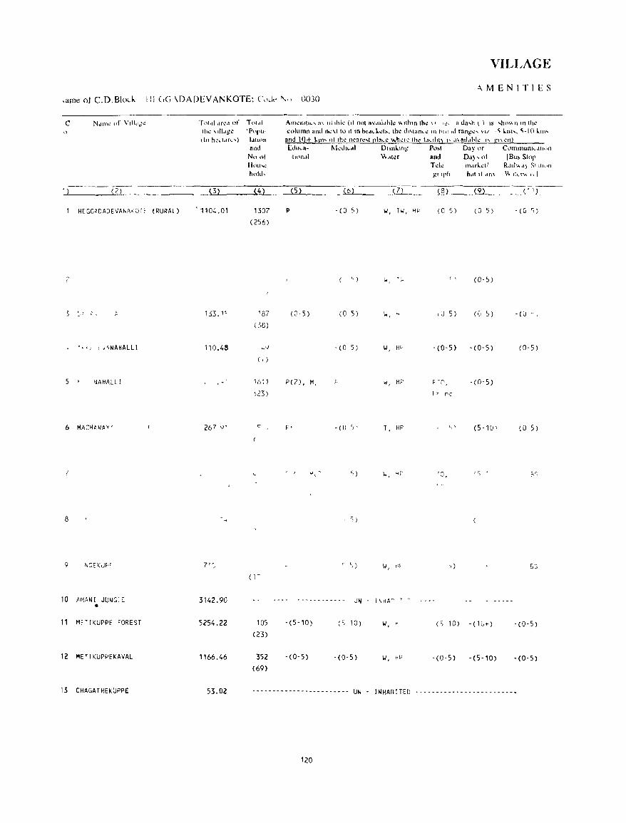
c N..ln1~ of Vdl..l~t.! ,)
--~---- ---- -----l 2
HEGG~DADEVA~A'QTf (RURAL)
;'
~I t,
,. ~ ~ J [ ,~NAHALLI
5 NAHALLI
6 MACHANAY'
8
9 ~~EI(JP(
10 M1ANI JUNGI[ •
11 Ml'T II(UPPE FOREST
12 METIKUPPEKAVAL
13 CHAGATHEKUPPE
Tnt<tl,tr":d of
Ih~ \Il1"g~ dn h~d<lr\""'}
(3)
'1104.01
153. 1~
110.48
267 Q'
7"_
3142.90
5254.22
1166.46
53.02
Tnt ,II 'P"pU_
ldllon 811,1 NIl .. 1 1I<ll"~ hillel,
(4)
1307
(256)
'87 (58)
4<;
( , )
1611
,23)
"
( i ~
105
(23)
352 (69)
VILLAGE
·\MENITIES
Am~IlIII<' n\ 1I1,hl~ (II Ihll aVdli.,hk "llhm Ih~ \, I~' a da,h ( ) IS ,hll\\ n 'II Ih~ column and n~~llo 11111 bld,l.cl!.. Ih~ ,1t'lan,c III bpl,d rang~' v,/ -~ kill'. ~-I() kill'
and l()+ I.Pl' "llh~ IIcar"" pia,,, ",h".c Ih" 1."li'l) .' .1\311.lh'" " gl\cn) [d't-3- I\.k,h,dl Dllnl.lIl1' Po,. Day or C,llllll1Ullh .• II'.HI
11<11\.\1 \\ ,ll"r and D'I) , l,l (Bu!. 5101' Td~ m,lrkdi R,IlI",,) SI 111"n
,!!1 lph hdt It ,In\ \\- Ikt~ I ~ I
(5) 6 _ill- (8) (9) ___ <1':C=
I' - (0 5) 1.1, TI.I, HF' (0 5) (0 S) • (0 ~)
') t. 't.. ' \ (0- 5)
(J-s) (0 5) '.I, " l,J 5) (u 5) . «(J . ,
-(0 5) 1.1, He -(0-5) '(0-5) (0-5)
PC 2), M. w, HP pen , , - (0-5) f.h f'le
,. - (U '" T , HP '" (5-1U' (0 5)
'0,
I 5)
r '.) 1.1, Hf ,) 5~
~ - - - - - - - - - - - UN JNHA~ T 0
-(5-10) (S 10) 1.1, H (S 10) -(lG+) - (0-5)
-(0-5) -(0-5) 1.1, HD . (0-5) -(5-10) -(0-5)
- .. ----- ..... --- .... ----- ... ---- UN - I NHAB !TED --------- .. ~ ... --.--------- ..
120
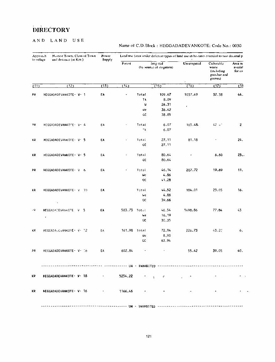
\
DIRECTORY
AND LAND USE Name ot C.D.Block: HEGGADADEVANKOTE; Code No.: 0030
Appr"a~h N~"r.:'1 Town, Cld's oj To,,"n Powt!r Lallllu...: (dr.:a und.:r dllkr.:nt typlo)~ of land ll~ 11'1 h.:dar.:, rnuno.:d to two d':,,"nal p to village and d"t,IO"~ (Ill Km ) Supply
For.:" Img II.:d Un-trngat.:d Culturdhl.: Ar.:am (h) !oOur",; 01 lrngatton) wast.: avallal
(tndlldlng for ell gau"har and groV':h)
~ 11 2 ~ 122 , 13 2 {14 ~ ~152 ~ 162 P 72 ~18
PR HEGGADADEVANKOTE- il- l EA Total 109.67 1037.49 32.38 44. Tk 8.09
W 26.31 we 36.42 GC 38.85
PR HEGGADADEVANKOTE- V- 4 EA Total 6.07 165.48- 42 .. 1 2 Tk 6.07
KR HEGGADADEVANKOTE- V- S EA Total 27.11 81.18 24. GC 27. "
KR HEGGADADEVANKOTE- 11- 5 EA Total 80.64 6.60 23., GC 80.64
PR HEGGADADEVANKOTE- V 6 EA Total 46.14 207_72 19.69 11-!.Ie 4.86 GC 41.28
KR HEGGADADEVANKOTE- v 10 EA Total 44.52 184.01 23.05 16. lJe 4.86 GC 39.66
,0" HEGGADM'EVANKOTE V 5 EA 583.73 Total 46.54 1498.86 77.84 43 lJe 16.19 GC 30.35
KR HEGGADA~EvANKOTE' V- 12 EA 161.98 Total 72.84 226.73 43.22 6. lJe 8.90 GC 63.94
PR HEGGADADEVANKOTE- V- 16 EA 602.84 55.42 39.05 40.
-------------------------------- ------------ UN - INHABITED _ ... _- .................... ------ ... ----- ... - ... _-- ..... ------------ .. -
KR HEGGADADEIIANKOTE- )1- 18 5254.22 :; ,-
KR HEGGADADEVANKOTE- 11- 16 1166.46
--------------------------------------------- UN - INHABITED ---------------------------------------------
121
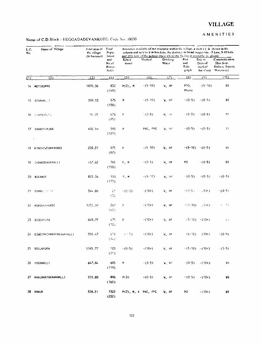
VILLAGE
AMENITIES Name of C.D.Block : HEGGADADEVANKOTE: Cod.: :\0. :0030
L.C. Name of Village Tot,,1 area of Total At1l~IlI(I~' ,I\aalahk (If not avuilahl.: within th~ "lIal!~. a d~"h (-) is hhown in the
No. the village Popu- column ano next to it in hrack~l!o. the dl,tarh.~ an oroao ranl!~s viJ'.. -5 I..ms. 5-10 I..ms. (In hllctares) lalinn amI 10+ 1..111' "f th~ ncnrcht ~Iaee \\'h~r~ the 1:1, alll\ is n\'~"lahle i, given).
a Ill! E<lu,'a- I\tedleal Drinkillt! P",t Day 01 Communication No.or tinnal Wala and DaYh of [Bus Stop. HOll~l.!~ Tek- t1lJlketl Rail" ay Sialum. h,.I.I, graph hat If any Waler",,,) I
{1) (2) (3) (4) (5) (6) (7) (8) (9) ( 10)
14 MET I KUPPE 1870.36 832 P(2) , M - (5-10) w, HP PTO, -(5-10) BS
(149) Phone
15 SONAHAI I I 389.33 575 P -(5-10) w, HP -(0-5) -(0-5) BS
(108)
16 '_..;l\(AHAl L i 9(J.25 473 p - (8-5) "', rP -(0-5) -(0-5) BS
\ 95)
17 SHANTHIPURA 402.9<) 585 P PHC, FPC W, Yf' -(0-5) -(0-5) 8S
( 127)
18 KONEGOI.'DANAHUIJDI 220.27 375 p -(5 10) "', HP -(5-10) -(0-5) S5
(87)
19 ::HAKKOOANAHAll I 437.62 760 P, M -(0-5) 1.1, HP PO -(0-5) BS
(158)
20 BUDANUP 823.34 900 P, M - (5 -10) \.I, flP -(0-5) -(0-5) - (0-5)
( 170)
21 BOMM,\, . ,. t ~ 344.80 2' - (C- 5) -(10+) W, HP - (') -5 , \ 10+) -{O-S)
(»
2" (. AGASft ~ 4 ,·!_;ND I 1032.39 267 P -(10+) '.J, HP -,. '0-10) -\ ;0+) '. ,
(42)
23 S I DDAPl)~A 649.77 47') p -(10+) W, HP (5-10) - (10+) 0'
(7e)
24 GO'.JD I MACHANA)' AKA~AHAL L I 350.47 4!'9 I I S) -(10+) W, HP (5-10) - (10+) -(0-5)
C.,)'i)
25 SOLLAPURA 1145_77 120 -(0-5) -(10+) 1./, HP - (5-10) -(10+) -(0-5)
(21 )
26 H05AHALLI 647.94 685 P - (0-5) 1.1, HP -(0-5) -(10+) as (119)
27 NANJAIJAYAKANAHALLI 555.80 896 P(3) -(0-5) Y, HP -(0-5) -(10+) as ( 160)
28 ANNUR 526.51 1322 P(2) , H, H PHC, FPC W, HP PO - (10+) as (232)
122
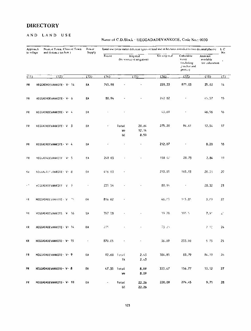
DIRECTORY
AND LAND USE Ndnle ot C.D.Blo\.-k . HEGGADADEVANKOTE. CoJ~ No.: 0030
Approa .. h N':dr .. ,1 Town. Cla~, of Town PO"er Land lI-..: (ar~a under dolkrcnl I>p~' 01 land 11-": m hectdrc' rOlllllkd III Iwo dccllnal place') LC 10 YIllage and ""I.once (111 }...m ) Supply No
FOI.:'I Irn1,!,Iled Un ling Ih..d Culturahle Arca not (1n "'t.Hlh.": ot lrng.ttuul) \\ tl ... h: avaIlable
(Illdlldlllg for cUlllvdlton :J. Hh .. hdf dnd grovl. .... )
( 11 ) ( 12) ( 13) (14) (15) ( 16) ( 17) (18) ( 1 )
PR HEGGADADEVANKOTE- V- 14 EA 745.98 228.33 871.03 25.02 14
PR HEGGADADEVANKOTE- V- 6 EA 80.94 242 82 C).57 15
PR HEGGADADEVANKOTE- V- 4 EA 43.69 46.56 16
PR HEGGADADEVANKOTE- V 3 fA Total 20.64 275.20 94.61 12.54 17 lie 12.14 GC 8.50
PR HEGGADADEVANKOTE· V- 4 EA 212.07 8.20 18
PR HEGLADADEVANKCH V- 5 EA 248 03 158 G? 28.73 2.84 19
Kr! hELLAuAQFJANKOTE- V- 8 EA 416 83 213.05 165.13 28.3~ 20
HEGGADADEVANKOTE V 9 235 54 80.9/, 28.32 21
~R HEGGADADEVANKOTE- V ' ~ EA 816 62 46.(') 115 .8~ 3.1'9 22
PR HEGGADADEVANK01E 'oJ 16 EA )57 08 '19 28 we; ) 7.9' ,:.'
KR HEGGADADEVANKOTE- V- 14 EA 27~ 73 2~J 2 n: 24
KR HEGGADADEVANKOTE- v- 15 870.05 36.09 233.90 5 73 25
PR HEGGADADEVANKOTE- v- 9 EA 92.68 Total 2.43 384.85 83.79 84.19 26
Tk 2.43
PR HEGGAOADEVANKOTE- v- 8 EA 47.35 Total 8.09 333.47 156.n 10.12 27
lie 8.09
PR HEGGADADEVANKOTE- V- 10 EA Total 22.26 220.09 274.45 9.71 28 GC 22.26
123
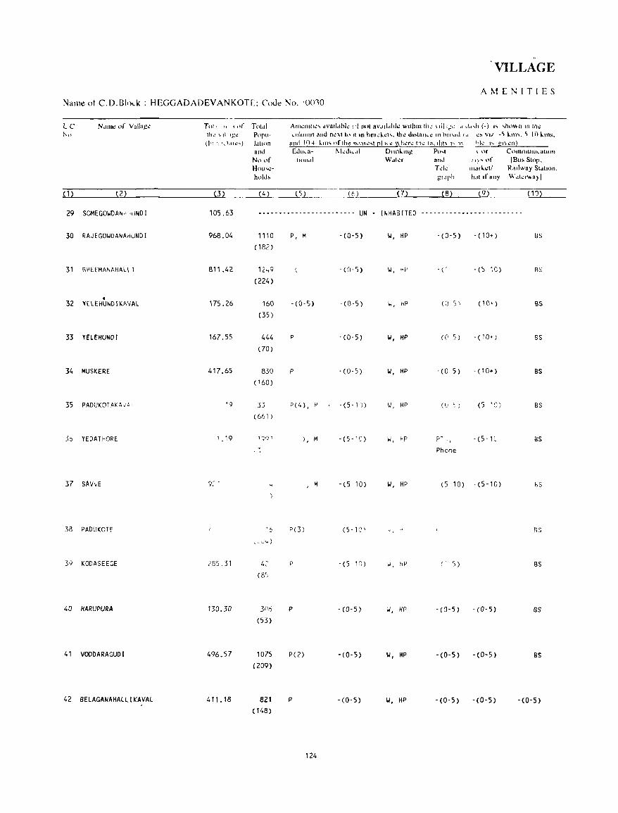
. . VILLAGE
AMENITIES Name ot C.D.B1ol..k : HEGGADADEVANKOTE; C'oJe No. '0010
N,1I111! of Vdlagl!
( 1 ) (2)
29 SOMEGO~DAN" 'uNDI
30 RAJEGO~DANAHUNDI
31 BHEEMANAHAlll
• 32 ~ElEHUNDIKAVAl
33 YElEHUNDI
34 MUSKERE
35 PADUKOTAKAy~1
So YEDATflORE
37 SAVvE
38 PADUKOTE
3;; KODASEEGE
40 HARUPURA
41 VOODARAGUDI
42 BElAGANAHALLIKAVAL
Tot, (, (,,( Tol,r1 lh~ "d Igl.! Popu-(In 11 '\.tdll.! .... ) 1,ttH)n
(3)
and No of Hnu,o:hl>ld,
(4)
Arno:nllll!' dvu,l"hk (II [101 8Vdil"hl..: wllhlllli1~ ,ill,,:-: "-/,,,11 (.) " ,hoI' II In Iho: ,olumn al1(l n.:'\1 to II In hra,\..:h. tho: d"lan,.: In 11((\,1<1", .:, VII -~ \.111'. ~ 10 \.ms.
and 10+ 1.111' (\f,h.: n""~'1 rll'': \\h~r.: Ih.: 1",rllI\ 1'1\ "k" gf\.:n) Edl .... a- ~kl..h"',11 Dllnlmg- Po ... t \ Of COIl1111Ullh"allon
'1("',11 Wdkr and ":'<11' IBu!oSlop. T d.: I11MI..:11 R,"lway Sldlion.
);1.'1'" h"'lfany W"kN-a)I
(5 ) (6) ( 7) (8) (9) (10)
105.63 -- .•.............. -- .... UN - INHABITED .- ...... - ............... .
968.04
811.42
175.26
167.55
417.65
'9
1.19
285.31
130.30
496.57
411.18
1110
(182)
12 .. 9
(224)
160
(35)
444
(70)
830 (160 )
33 (6f, 1 )
'6
,,-I.)"')
4: (8')
3n6
(53)
1075
(209)
821 (148)
P, M - (0-5)
- (0- 5)
-(0-5) -(0-5)
P - (0- 5)
P -(0-5)
P(4), I-' - (5-1)
), M -(5-'0)
, M -(5 10)
P(3) (5-10'
P -(5-10)
P - (0- 5)
P(2) '(0-5)
p -(0,5)
124
~, HP - ( 0 - 5 ) - ( 1 0+ ) BS
-(' -(5 10) as
\.J, HP (0-5\ (10+ ) BS
101, HP (0 5) - (10+) BS
101, HP - (0 5) - (10+) BS
\.J, HP (LJ ~) (5 1:) BS
II, HP P"'- J, - (5 -1 C as Phone
101, HP (5-10) -(5-10) bS
" ~ 5S
w, HP (' 5) BS
1,1, HP -(0-5) -(0-5) BS
101, HP '(0-5) . (0- 5) BS
101, HP -(0'5) -(0-5) -(0-5)
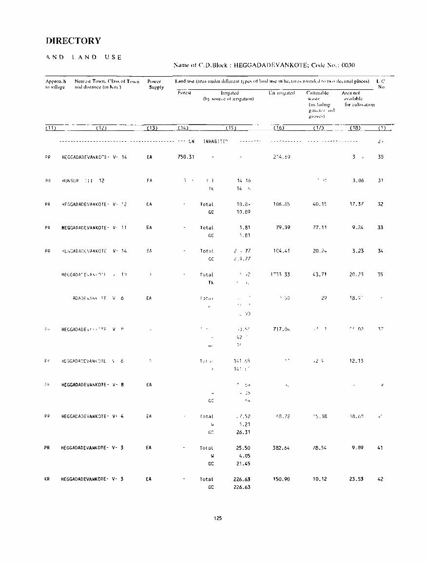
OIRECTORY
"ND LAND USE
Approach 10 vllI,,!,!c
Ncalc,l Town. Cia" 01 To" n and d"lan.:c (Ill "111 )
Power Supply
N,II11t' ot CD.Blol:k : HEGGADADEVANKOTE; CoJt' No.: 0030
Ilngtlh.!d Un 1I11i!dh:d
(h) 'OUlcC 01 II ng,IIl<'ll) CUllllldhk wd ... k
(11l ... ludlllg g .. \u .... h \1 \nd gJovl.! .... )
Area nol dV"llahlc for cult" dllon
No
(11) -__ -______ i(~12~)~ ________ ~(~13~)L_ ____ ~(1~4~) __________ ~(~15~)L_ ________ ~(~1~6L) ________ (Ll~7L) ______ _i(~18~)~ __ ~(1~)~
- - - - - - - - - - - - - - - - - - . - - - - - - - - - - - - - - - - - - - - - - - - UN
PR HEGGADADEVANKOTE- V- 14 EA 750.31
PR ~UNSUR III 12 FA
PR HFGGADADEVANKOTE- V- 12 EA
PR HEGGADADEVANKOTE- V- 11 EA
PR ~EGGADADEVANKOTE V- 14 EA
ADADEvA~' TE V 6 EA
HEGGADADEvi> , ~TF V P
HEGGADAJ[VANKJT[: 6
HEGGADADEVANKOTE- Y- 8 EA
PR HEGGADADEYANKOTE- Y- 4 EA
PR HEGGADADEYANKOTE- v- 3 EA
KR HEGGADADEVANKOTE- v- 3 EA
INHABlTE~
t l
Tk
Total
GC
Total
GC
Totol
14 16 14 ')
10.8,
10.89
1.81
1.81
2 ' 77 GC ,},9.77
Total
Tk
GC
Total
)3.C,c.
42 -
141
':;)
J)
,1.52
\.J 1.21
GC 26.31
Total 25.50 101 4.05
GC 21.45
Total 226.63 GC 226.63
125
214.69 3 30
11 3_06 31
106.8) 40.15 17.37 32
79.39 77 _ 11 9.24 33
104.41 3_23 34
43.71 20.('3 35
29 18.9-
717.04
12.13
AS.72 1).38 lB_6'1
382.64 78.54 9.89 41
150.90 10.12 23.53 42
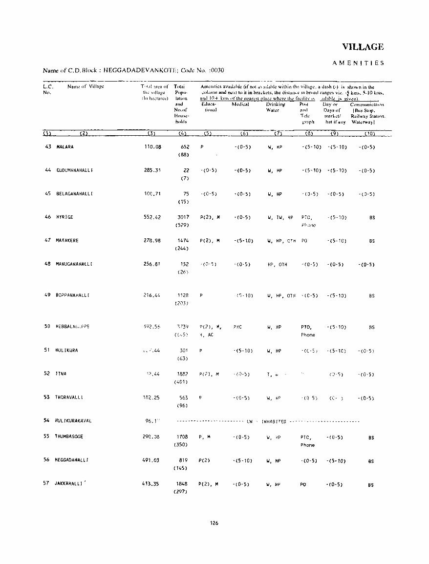
VILLAGE
AMENITIES Name ofC.D.Bh:k : HEGGADADEVANKOTE; CoJe No. :0030
L.e. Nam~ of Villa)!~ TI Icd ar~a of Total Aln~lHti~~ 3Vllll,lhk (ifn,)t .\:,d"hk within (h~ villag~. a da~h (-) is shu", n in th~ No. (h~ ,"lag.: Porll - ""llImn and n.:x( ttl it in ora.k.:ts, tho! di>lan .. .: III oroad r"ng.:~ vi.(.. -} kill,. 5-10 km.,
(In h",;(a .. ".) lalion an,1 10+ kill, oflh.: n""r.;sl cia.:" wh"r.: (h.; lil,ililV I' "dahl.: is giv"n). an,1 Edu,a- II.kdi.al D .. illkin~ p",( Day or C(HlUHuoi,,:C:Ultlfl
No.or liolla) Wal.:r and Days "I' IBlis Slor, Hou!-tl.!- Td.: mar!'.:t! Railway Slalloll, holds I;raph hal if any Wal.:rwa)I
(1) (2) (3) (4) (5) (6) (7) (B) (9) (10)
43 MALARA "0.08 652 P - (O- 5) 1.1, HP -(5-l0) - (5-lO) -(0-5) (88)
44 GUDUMANAHAlll 285.31 22 -(0-5) -(0-5) 1.1, HP -(5-10) -(5-10) -(0-5) (7)
45 8ELAGANAHALLI 100.71 75 -(0-5) - {0-5} '.I, HP -(0-5) - (0-5) -(0-5) (1S)
46 HYRIGE 552.42 3017 P(2), M -(0-5) 1.1, TI.I, HP PTO, - (5-10) 8S (529) P~'onc
47 MATAKERE 278.98 1474 P(2), M -(5-10) 1.1, HP, OTH PO -(5-10) BS (244)
48 MANUGANAHALLI 256.81 152 -(0-5) -(0-5) HP, OTH -(0-5) -(0-5) - (0- 5) (26)
49 BOPPANAHALLI 216.44 1128 P - ()-10) 1.1, HP, OTH - (0-5) -(5-10) BS (203 )
50 HEBBALAr"JPPE ')92.56 ) 739 P(2) , M, PHC II, HP PTO, -(5-10) BS
([..,.5) 4, AC Phone
51 HULIKURA ,. " .44 301 P -(5-10) '.I, HP -(0-5) -(5-10) -(0-5) (63)
52 lTNA '';) .44 1882 p«,), M -(0-5) T, W (J- 5) -(0-5)
(401)
53 lHORAVALLI 18('.25 563 P -(0-5) I,l, KD -(0-5) (0- ) -(0-5) (96)
54 HUL IKURAKAVAL 96.1" .~.- ... ------------------ UN fNHABfTED - ...... - - .. - - - .. -............ - ...... -- ..
55 THUMBASOGE 290.08 1708 P, M - (0-5) 1.1, HP PTa, - (0-5) BS (350) Phone
56 HEGGADAHALlI 491.03 819 p(2) -(5-10) 1.1, HP - (0- 5) -(5-10) BS (145 )
57 JAKKAHAlll 413.35 1848 P(2), M - (0-5) 1.1, HP PO - (0- 5) BS (297)
126
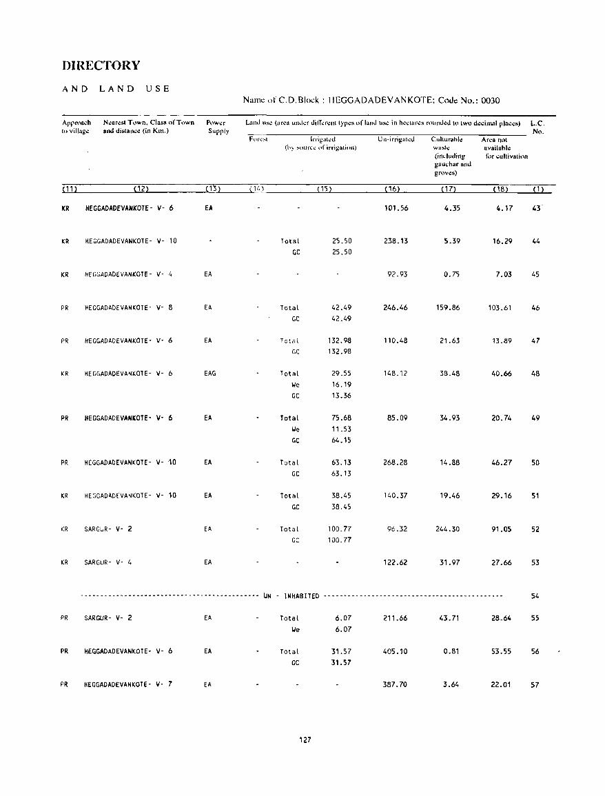
DIRECTORY
AND LAN D USE Name of C. D.Block : HEGGADADEVANKOTE; Cnc.lc No.: 0030
Approa~h N.:ar.:st T\)wn. Class "fTown P\)w.:r L<llld us.: (<lr':<1 ulllkr diIT.:r.:nt typ.:s or land us.: in h.:,tar.:" round.:d to two d.:~imal rla~"s) L.C. to villag.: and distan.:.: (in Kill.) Supply No.
For~~' Inigah.:d Un-irrigakd Cuhurahl.: Ar.:a not (hy ~oun.:~ of lrrigalion) wast.: availahl.:
(induding for ~uJlivalion gau.:har and grov.:s)
(11) (12) (B) (14} (15) ( 16) ( 17) (18) (1)
ICR HEGGADAOEVANKOTE- V- 6 EA 101. 56 4.35 4.17 43
KR HEGGADADEVANKOTE- V- 10 Total 25.50 238.13 5.39 16.29 44 GC 25.50
KR HEGGADADEVANKOTE- V· 4 EA 92.93 0.75 7.03 45
PR HEGGADADEVANKOTE- V- 8 EA Total 42.49 246.46 159.86 103.61 46 GC 42.49
PR HEGGADADEVANKOTE- V- 6 EA Tarat 132.98 110.48 21.63 13.89 47 GC 132.98
KR HEGGADADEVANKOTE- v- 6 EAG Total 29.55 148.12 38.48 40.66 48 We 16.19 GC 13.36
PR HEGGADADEVANKOTE- v- 6 fA Total 75.68 85.09 34.93 20.74 49 lie 11.53 GC 64.15
PR HEGGADADEVANKOTE- V- 10 EA Total 63.13 268.28 14.88 46.27 50 GC 63.13
KR HEGGADADEVANKOTE- v- 10 EA Total 38.45 140.37 19.46 29.16 51 GC 38.45
KR SARGUR- V- 2 EA Total 100.77 96.32 244.30 91.05 52 GC 100.77
KR SARGUR- V- 4 EA 122.62 31.97 27.66 53
~-------------------------------------------- UN - INHABITED --------------------------------------------- 54
PR SARGUR- V- 2 EA Total 6.07 211.66 43.71 28.64 55 lie 6.07
PR HEGGADADEVANKOTE- V- 6 EA Total 31.57 405.10 0.81 53.55 56 GC 31.57
PR HEGGADADEVANKOTE- v- 7 EA 387.70 3.64 22.01 57
127
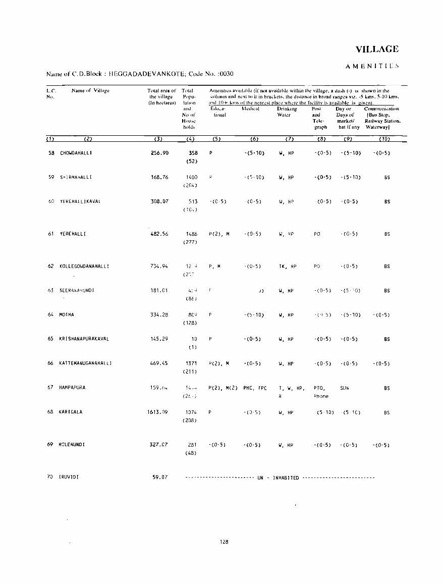
VILLAGE
AMENITIL~
Nalllt! of C.D.Block : HEGGADADEVANKOTE; CoJt! No. :0030
L.C. Nanl\! of VilJag~ Tnlal 8n:a of Tolal Alll~lIlll~. ava.J"hl~ (ifnol availahl~ wilhinlh~ villag~. 8 da,,}) (-) IS shown illlh~ No. Ih.: village P(IPlI- C(\llIllllI and n~xllo il in hra,I.~ls. Ihl! d,.lall.;e in hroad rang~s vu .. -5 I.ms. 5-10 I.ms.
(In h~"'ares) 1atmn and I 0+ k(n~ of th\! n~arl.!!'oot [!Iaclo! whl!rl! (hI! fato:ilit~ i!-o availahh: is givl!n). and Edll ... a- t-kdi,al Drinllng Po~t Day or COlnlnuni~ali()n
No 0'- liollal Waler and Days of IBlls Slnp, Hllll~~ Td~- marl.;~t/ Railway Station. hoilb graph hat if any Wal~rwayl
(1) (2) (3) (4 ) (5) (6) (7) (8) (9) (10)
58 CHOI.JDAHALLI 256.90 358 P -(5-10) W, HP -(0-5) -(5-10) -(0-5)
(52)
59 SHIRMAHALLI 168.76 1400 P - (5 -1 0) W, HP -(0-5) -(5-10) BS (204 )
60 YEREHALLlKAVAL 308.07 513 - (0-5) - (0-5) II, HP -(0-5) -(0-5) BS (104 )
61 YEREHAlll 482.56 1486 P(2) , M -(0-5) II, HP PO -(0-5) BS
(277)
62 KOLlEGOI.IDANAHALLI 734.94 12 .; P, M -(0-5) TK, HP PO - (0-5) BS (21:'
63 SEERANAfiUNDI 181.01 41 o.i J) 1.1, HP -(0-5) - (5 -1 0) BS (86)
64 MOTHA 334.28 80Q p - (5-10) 101, HP - ( 'J 5) -(5-10) -(0-5)
(128)
65 KRISHANAPURAKAVAL 145.29 10 p -(0-5) W, HP -(0-5) -(0-5) as (1)
66 KATTEMANUGANAHALLI 469.45 1371 P(2) I M -(0-5) II, HP -(0-5) - (0- 5) -(0-5) (211 )
67 HAMPAPURA 159.b .. 14~ .. P(2), M(2) PHC, FPC T, 1.1, HP, PTO, SUN as (2t· ; R Phone
68 KARIGALA 1613.09 1074 P -(0-5) 1.1, HP -(5-10) -(5-10) BS (208)
69 HOlEHUNDI 327.07 281 -(0-5) -(0-5) II, HP -(0-5) -(0-5) -(0-5) (48)
70 IRUVIDI 59.07 ------------------------ UN - INHABITED -------------------------
128
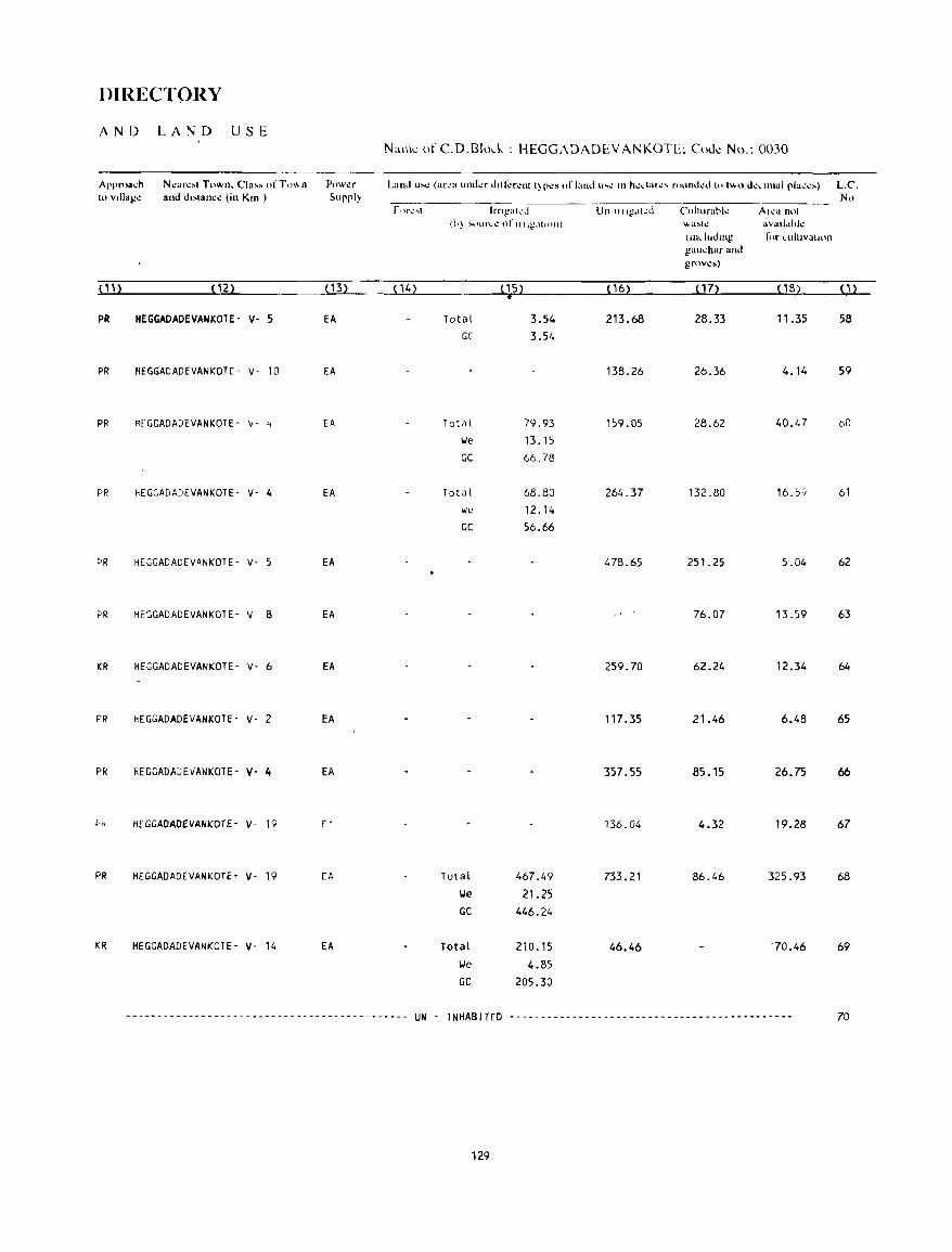
DIRECTORY
AND LAND USE Naill': of C.O.Blnd, : HEGGAOAOEVA('.;KOTE; CoJc No.: 0030
Approa.;h N~ar~'1 Town. Cia" ofT", .. n Pl)W\!r Land u~t.! (ar\!(l 1IIh.lt.!f dlll~rl!nt t}P\!S of iand u ... \! III ht.!dall.! .... founJI.!..i (t) 1"'0 dl!dtnal pla~t.!~) L.C'. 1" v,llag~ and d"lanc~ (in Kill ) Supply N"
rllrl."" Irnl!:lkd Un-II Ilg~tt~d Culturahk AI!!a nul (11) !\')lIr ... 1! of IIllg.ltIOIl) "a~tl! aVllll"hk
(1II,)UJ'llg for cUlt'Vatllln gau~har and grov.:.)
( 11) (2) ( 13) (14) ( 15) • ( 16) (17) (18) (1)
PR HEGGADADEVANKOTE- V- 5 EA Total 3.54 213.68 28.33 11.35 58 GC' 3.54
PR HEGGADADEVANKOTE- V- 10 EA 138.26 26.36 4.14 59
PR HEGGADADEVANKOTE- v- ~ EA T ota l 79.93 159.05 28.62 40.47 DO lie 13.15 GC 66.78
PR HEGGADAJEVANKOTE- V- 4 EA Total 68.80 264.37 132.80 16Sf 61 lie 12.14 GC 56.66
PR HEGGADADEVANKOTE- V- 5 EA 478.65 251.25 5.04 62
PR HEGGADADEVANKOTE- v- B EA 76.07 13.59 63
KR HEGGADADEVANKOTE- V- 6 EA 259.70 62.24 12.34 64
PR HEGGADADEVANKOTE- V- 2 EA 117.35 21.46 6.48 65
PR HEGGADAGEVANKOTE- V- 4 EA 357.55 85.15 26.75 66
1-" HEGGADADEVANKOTE- v- 19 [ . 136.04 4.32 19.28 67
PR HEGGADADEVANKOTE· V- 19 EA Total 467.49 733.21 86.46 325.93 68 lJe 21.25 GC 446.24
KR HEGGADADEVANKOTE- V- 14 EA Total 210.15 46.46 "70.46 69 \ole 4.85 GC 205.30
--- _ .. - - - ------ - - - - - - - --- - - - - - -- - ---- - - - --- --- UN - I NHAB ITED ---_-----------------_ ............ _---------------- 70
129
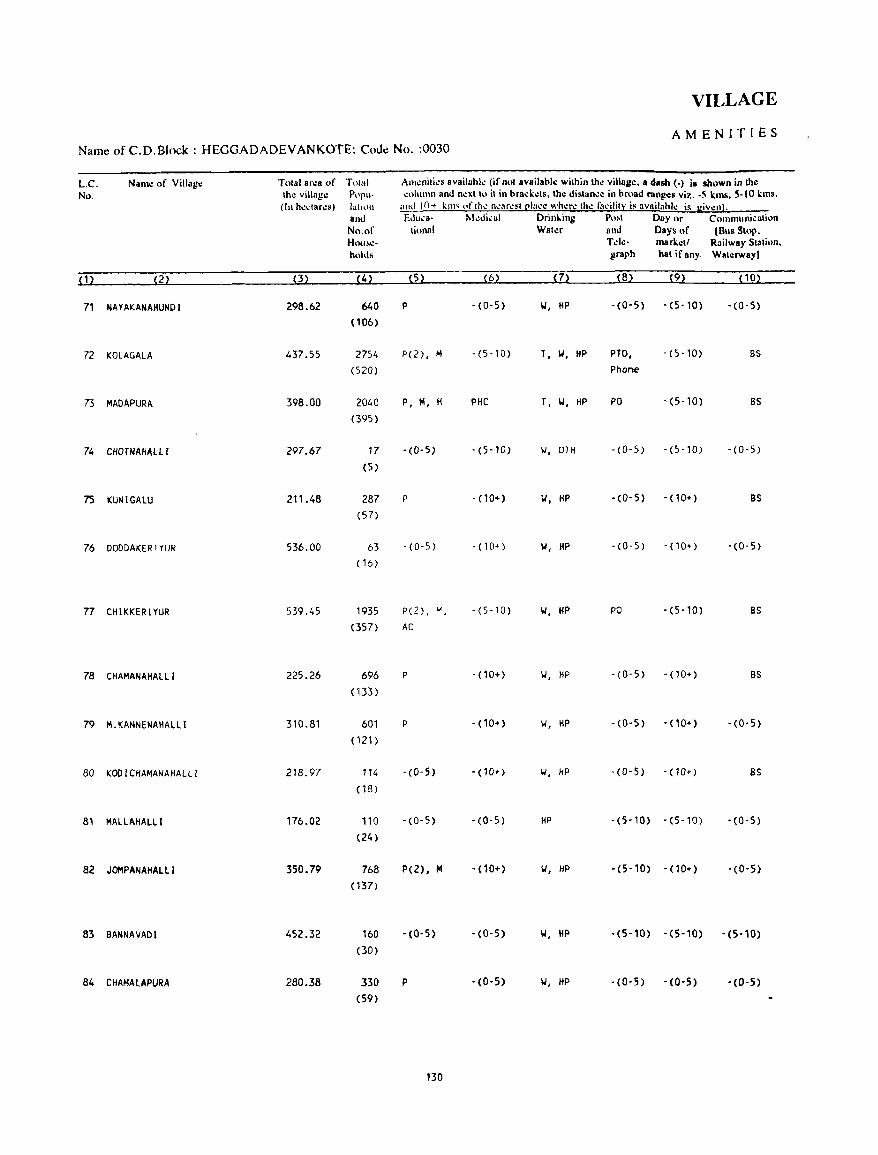
VILLAGE
AMENITIES Name of C.D.Block : HEGGADADEVANKOTE; Coue No. :0030
L.C. Nam.: of Villagc Total ar.:a of T()t,,1 Amenities availahle (if not availahl.: within thc villag.:. a dash (-) is shown in tho: No. tho: villag.: P"P"- ~llilltl\n amlncxtlll it in brad.:els. the dislance in hr\lad ranges viz. ·S kms. 5-10 kms.
(In he,lares) Jllhun alld 10+ kill' "flh.: ne~r.:"tl!l:lce whcre th.: 1:1cilit~ is aVRilahl.: is given). ano Ellu_a- !\.I.:Ji,;al Drinl.ing Po!>t Day or COInmuni,;ation No.of lional WaleI' and Days of (Bus Stop. HOIl8':- Tde- markell Railway Stalinn. hllilis graph hat if any. Waterway)
(1) (2) (3) (4) (5) (6) (7) (8) (9) (10)
71 NAYAKANAHUNDI 298.62 640 P -(0-5) W, HP -(0-5) -(5-10) -(0-5)
(106)
72 KOlAGAlA 437.55 2754 P(2), M - (5-10) T, W, liP PTO, -(5-10) BS
(520) Phone
73 MADAPURA 398.00 2040 P, M, H PHC T, W, HP PO -(5-10) BS (395)
74 CIIOTNAIIAlLl 297.67 17 -(0-5) -(5-10) 101, OTII - (0- 5) -(5-10) -(0-5)
(5)
7S KUNIGAlU 211.48 287 P -(10+) 1.1, liP -(0-5) -(10+) BS (57)
76 DODDAKER!YUR 536.00 63 - (0-5) - (10") W, HP - (0- 5) -(10+) -(0-5)
(16)
77 CHIKKERIYUR 539.45 1935 P(2) • ... -(5-10) 1.1, liP PO -(5-10) BS
(357) Ae
78 CHAMANAIIALll 225.26 696 P -(10+) IJ, HP -(0-5) - (10+) BS
(133)
79 M_KANNENAHAlLl 310.81 601 P -(10+) IJ, HP -(0-5) - (10+) -(0-5)
(121 )
80 KOO1CIIAMANAHALLl 218.97 114 -(0-5) - (10+) 101, HP -(0-5) -(10+) as (18)
81 MALLAHALLI 176.02 110 -(0-5) -(0-5) HP -(5-10) -(5-10) -(0-5)
(24)
82 JOMPANAIIAlLl 350.79 768 p(2), M -(10+) 1.1, HP -(5-10) -(10+) -(0-5)
( 137)
83 BANNAVADI 452.32 160 -(0-5) -(0-5) 1.1, HP -(5-10) -(5-10) -(5-10)
(30)
84 CHAMAlAPURA 280.38 330 P -(0-5) 1,1, HP -(0-5) -(0-5) -(0-5) (59)
130
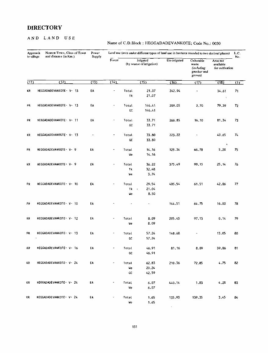
DIRECTORY
AND LAND USE Name ofC.D.Block: HEGGADADEVANKOTE; Code No.: 0030
Approach N~ar~sl Town, Class of Town Power Land us.: (ar~a undl!r ditTl!renl lypl!S of land us.: in hectares rounded 10 Iwo decimal places) L.C. 10 village and dislance (in Km.) Supply No.
For~sl Irrigar.:d Un-irrigated CuJturabJe Area not (by source of irrigation) waste available
(including for cultivation gauchar and groves)
(11) (12) (13) (14) ( 15) ( 16) ( 17) ( 18) (1)
KR HEGGADADEVANKOTE- V- 13 EA Total 21.07 242.94 34.61 71 Tk 21.07
PR HEGGADADEVANKOTE- V- 13 EA Total 146.41 209.05 2.70 79.39 72 GC 146.41
PR HEGGADADEVANKOTE- V- 11 EA Total 33.71 266.85 16.10 81.34 73 GC 33.71
KR HEGGADADEVANKOTE- V· 13 Total 33.80 223.22 40.65 74 GC 33.80
PR HEGGADADEVANKOTE' v- 9 EA Total 14.16 125.34 66.78 5.20 75 We 14.16
KR HEGGADADEVANKOTE- V- 9 EA Total 36.22 375.49 99.15 25.14 76 Tk 32.48 We 3.74
PR HEGGADADEVANKOTE' V- 10 EA Total 29.54 405.54 61.51 42.86 77 Tk 21.04 We 8.50
PR HEGGADADEVANKOTE- V- 10 EA 144.51 64.75 16.00 78
KR HEGGADADEVANKOTE- V- 12 EA Total 8.09 205.45 97.13 0.14 79 We 8.09
PR HEGGADADEVANKOTE- V- 13 EA Total 57.24 148.68 13.05 80 GC 57.24
KR HEGGADADEVANKOTE- V- 16 EA Total 46.91 81.16 8.09 39.86 81 GC 46.91
KR HEGGADADEVANKOTE- V- 24 EA Total 62.83 210.36 72.85 4.75 82 We 20.24 GC 42.59
KR HEGGADADEVANKOTE- V- 24 EA Total 6.07 440.14 1.83 4.28 83 We 6.07
KR HEGGADADEVANKOTE- V- 24 EA Total 1.65 135.93 139.35 3.45 84 We 1.65
131

VILLAGE
AMENITIES Name of C.D.Block : HEGGADADEV ANKOTE; Code No. :0030
L.C. Name of Village Total area of Total Amenities available {if not available within the village, a dasb (-) is sbown in the No. the village Popu- column and next to it in brackets, the distance in broad ranges viz. -5 kms, 5-10 kms,
(In hectares) lation and 10+ kms of the nearesll!laee where the faeilill: is availahle is given}. and Eduea- M<!dical Drinking Post Day or Communication No.of tiona I Water and Days of [Bus Stop, House- Tele- marketl Railway Station, holds graph hat ifany Waterway)
(1) (2) (3) (4) (5) (6) (7) (8) (9) (10)
85 KYATHANAHALll 854.31 2668 P, H, H PHC, FPC \I, HP PTO, -(0-5) BS (482) Phone
86 THANDASJPURA 318.58 12 -(0-5) -(0-5) 101, HP -(0-5) -(0-5) -(0-5)
(2)
87 HENNEGEREKAVAL 82.08 74 .(6:5) -( 10+) 101, HP -(0-5) -(10+) -(0-5) (15)
88 GA~GADAHOSAHALLI 321.25 1289 P, H - (10+) 101, HP -(0-5) - (10+) BS (238)
89 GANGADAHAlll 86.08 239 -(0-5) -(10+) \I, HP -(0-5) -(10+) BS (43)
90 KOTHEGALA 360.62 404 P -(10+) 101, HP -(0-5) -(10+) BS (70)
91 ALANAHALLI 379.94 2423 P(2), H -(10+) 101, HP PO -(10+) BS (447)
92 DEVALAPURA 172.98 3 -(0-5) -(10+) W, HP -(0-5) -(10+) -(0-5) (2)
93 HASANIKUPPE 161.23 33 -(0-5) - (10+) W, HP -(0-5) -(10+) -(0-5) (7)
" 94 ANKANAHALLI 221.82 16 -(0-5) -(10+) 101 -(0-5) -(10+) -(0-5)
(1)
.. 95 HUDDAIYYANAHUNDI 28.45 96 - (0-5) - (10+) 101, HP -(0-5) -(10+) -(0-5)
(16)
96 THOTAHALLI 127.55 -(0-5) - (10+) -(0-5) -(10+) -(0-5) (1)
97 PURA 165.75 .----------.------------ UN - INHABITED -------------------------
98 HALLADAHANUGANAHALLI 890.86 1251 P, H -(10+) W, HP -(0-5) -(10+) BS (194)
99 GOLLANABEEDU 387.69 292 P -(10+) \I, HP -(0-5) -(10+) BS (55)
132
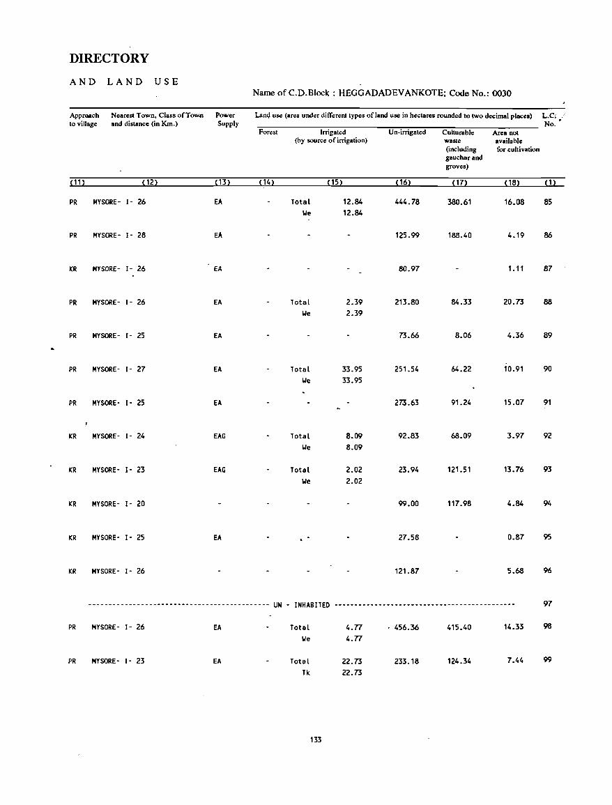
DIRECTORY
AND LAND USE Name of C.D.Block : HEGGADADEVANKOTE; Code No.: 0030
Approach Nearest Town, Class ofTow.n Power Lan4 use (area under di fferent types ofland use in hectares rounded to two decimal places) L.Ci :' to village and distance (in Km.) Supply No. •
Forest Irrigat.:d Un-irrigated Cuhurable Area not (by source of irrigation) waste available
(including for cultivation gaucharand groves)
( 11 ) ( 12) (13) ( 14) (15) ( 16) (17) ( 18) (1)
PR MYSORE- 1- 26 EA Total 12.84 444.78 380.61 16.08 85 We 12.84
PR MYSORE- 1- 28 EA 125.99 188.40 4.19 86
KR MYSORE- 1- 26 EA 80.97 1. 11 87
PR MYSORE- 1- 26 EA Total 2.39 213.80 84.33 20.73 88
We 2.39
PR MYSORE- 1- 25 EA 73.66 8.06 4.36 89
PR MYSORE- 1- 27 EA Total 33.95 251.54 64.22 10.91 90 We 33.95
PR MYSORE- 1- 25 EA 273.63 91.24 15.07 91
KR MYSORE- 1- 24 EAG Total 8.09 92.83 68.09 3.97 92 We 8.09
KR MYSORE- 1- 23 EAG Total 2.02 23.94 121.51 13.76 93 We 2.02
KR MYSORE- 1- 20 99.00 117.98 4.84 94
KR MYSORE- 1- 25 EA 27.58 0.87 95
KR MYSORE- 1- 26 121.87 5.68 96
--------------------------------------------- UN - INHABITED --------------------------------------------- 97
PR MYSORE- 1- 26 EA Total 4.n . 456.36 415.40 14.33 98
lie 4.n
PR MYSORE- 1- 23 EA Total 22.73 233.18 124.34 7.44 99
Tk 22.73
133
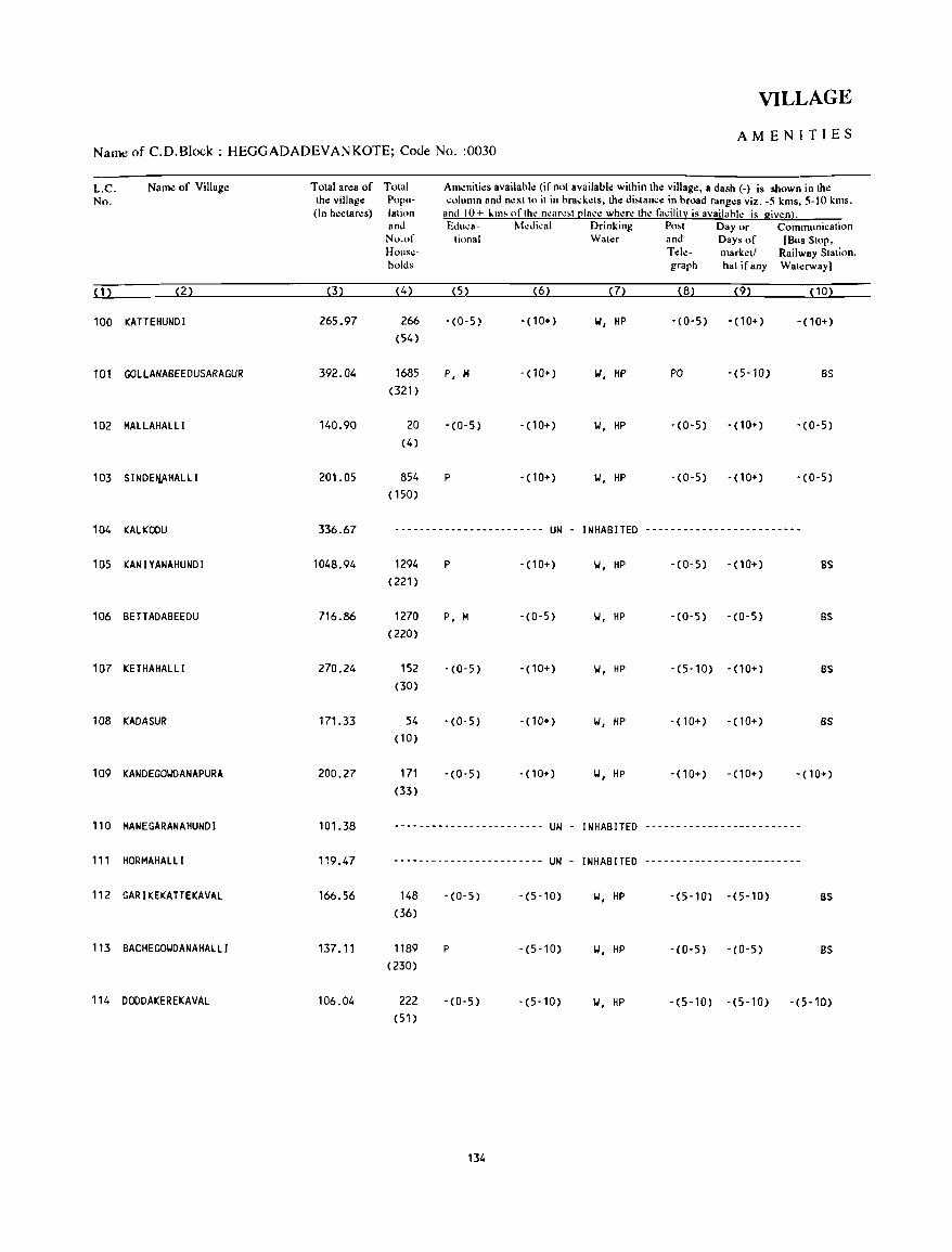
VILLAGE
AMENITIES Name of C.D.Block : HEGGADADEVANKOTE; Code No. :0030
L.C. Name of Village Total area of Total Am~niti~s availahl~ (if not available within the village, a dash (-) is shown in the No. the village Popu- column and n~xt to it in brack~ts, the di!otance in broad ranges viz. -5 kms, 5-10 kms.
(In hectares) lation and 10+ l.m, ofth~ n~are!ot ~Iace wh~r~ th~ facilit:y is availahle is given). and Educa- Medical Drinking Po,t Day or Communication No.of tional Wat.:r and Days of [Bus Stop, House- Tele- market/ Railway Station. holds graph hat ifany Waterway)
(1) (2) (3) (4) (5) (6) (7) (8) (9) (10)
100 KATTEHUNDI 265.97 266 -(0-5) - (10+) II, HP . (0- 5) - (10+) -(10+) (54)
101 GOLLANABEEOUSARAGUR 392.04 1685 P, M -(10+) W, HP PO -(5-10) BS
(321)
102 MALLAHALLI 140.90 20 -(0-5) -(10+) 101, HP -(0-5) - (10+) -(0-5) (4)
103 SINDEtU\HALLI 201.05 854 P -(10+) 101, HP - (0- 5) -(10+) -(0-5) (150)
104 KALKOOU 336.67 ------------------------ UN - INHABITED -------------------------
105 KANIYANAHUNDI 1048.94 1294 P - (10+) 101, HP - (0- 5) - (10+) BS
(221)
106 BETTADABEEOU 716.86 1270 P, M -(0-5) 101, HP -(0-5) - (0- 5) BS
(220)
107 KETHAHALLI 270.24 152 -(0-5) -(10+) 101, HP -(5-10) -(10+) BS
(30)
108 KADASUR 171.33 54 -(0-5) - (10+) 101, HP -(10+) - (10+) as (10)
109 KANDEGOIolDANAPURA 200.27 171 - (0-5) - (10+) 101, HP -(10+) - (10+) -(10+) (33)
110 MANEGARANAHUNDI 101.38 ------------------------ UN - INHABITED -------------------------
111 HORMAHALLI 119.47 ------------- ------ .. ---- UN - INHABITED -------------------------
112 GARIKEKATTEKAVAL 166.56 148 -(0-5) -(5-10) 101, HP -(5-10) -(5-10) BS
(36)
113 BACHEGOIoiDANAHAlLI 137.11 1189 P -(5-10) 101, HP -(0-5) -(0-5) BS
(230)
114 DOODAKEREKAVAl 106.04 222 -(0-5) -(5-10) 101, HP -(5-10) -(5-10) -(5-10) (51 )
134
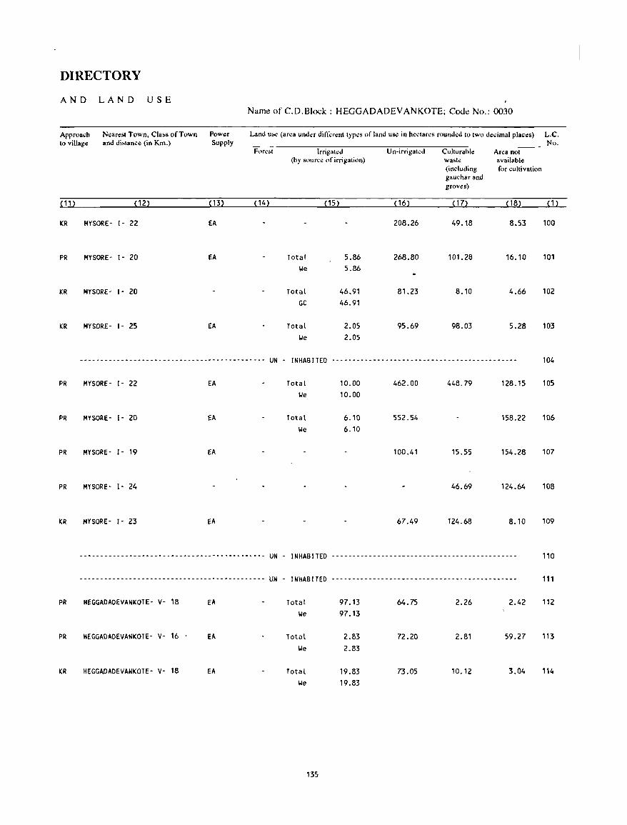
DIRECTORY
AND LAND USE Name of C.D.Block : HEGGADADEVANKOTE; Code No.: 0030
Approach Nearest Town, Cla~s of Town Power Land UM! (area under difrerenttypes of land use in hectares rounded 10 two decimal places) L.C. to village and di~tance (in Km.) Supply No.
Fore~t Irrigated Un-irrigated Culturahle Area not (hy source of irrigati,)n) wa~te available
(including for cultivation gauchar and groves)
(11) (12) (13) (14) (15) ( 16) (17) (18) (1)
KR MYSORE- 1- 22 EA 208.26 49.18 8.53 100
PR MYSORE- 1- 20 EA Total 5.86 268.80 101.28 16.10 101 We 5.86
KR MYSORE- 1- 20 Total 46.91 81.23 8.10 4.66 102 GC 46.91
KR MYSORE- 1- 25 EA Total 2.05 95.69 98.03 5.28 103 We 2.05
_-----------------------------_ .. -_ .. ---------- UN - INHABITED --------------------------------------------- 104
PR MYSORE- 1- 22 EA Total 10.00 462.00 448.79 128.15 105 We 10.00
PR MYSORE- 1- 20 EA Total 6.10 552.54 158.22 106 \ole 6.10
PR MYSORE- 1- 19 EA 100.41 15.55 154.28 107
PR MYSORE- 1- 24 46.69 124.64 108
KR MYSORE- 1- 23 EA 67.49 T24.68 8.10 109
--------------------------------------------- UN - INHABITED --------------------------------------------- 110
--------------------------------------------- UN - INHABITED --------------------------------------------- 111
PR HEGGADADEVANKOTE- V- 18 EA Total 97.13 64.75 2.26 2.42 112 We 97.13
PR HEGGADADEVANKOTE- V- 16 EA Total 2.83 72.20 2.81 59.27 113
We 2.83
KR HEGGADADEVANKOTE- V- 18 EA Total 19.83 73.05 10.12 3.04 114 We 19.83
135

VILLAGE
AMENITIES Name of C.D.Block : HEGGADADEVANKOTE; Code No. :0030
L.C. No.
Name of Village
(1) (2)
115 K_KANNENAHALLI
116 BETTAHALLI
117 HOHMARAGAHALLI
118 MARCHAHALLI
119 KOHALA
120 CHAMANAHALLI
121 HATWAL
122 CH I KKANAND I
123 KANCHAMALLI
124 PURA
125 KAREHUNDI
126 HIRINANDI
127 J I NNAHALLI .
128 SARAGUR(RURAL)
Total area of the village (In hectares)
(3)
100.71
193.51
514.28
159 •. 24
870.89
543.20
421.06
283.19
206.00
243.53
26.81
336.41
360.74
721.95
Total Population and
No.of Households
(4)
287 (56)
7 (2)
3130 (609)
543 (93)
744 (126)
501 (83)
1302 (248)
864
(172)
1119 (212)
929 (180)
284 (50)
460 (91)
1952 (339)
306 (63)
Amenities available (if not available within the village, a dash (-) is shown in the column and next to it in brackets, the distance in broad ranges viz. -5 kms, 5-10 kms,
and 10+ kms of the nearest place where the facility is available is given). Educa- Medical Drinking Post Day or Communication
tional Water and Days of (Bus Stop,
(5) (6) (7)
-(0-5) -(5-10) W, HP
-(0-5) -(5-10) HP
P(2), M, H -(0-5) T, W, HP
P(2) -(0-5) II, HP
P(3) -(0-5) II, HP
P -(5-10) II, HP
P, M -(5-10) T, II, HP
P -(5-10) W, HP
P, M -(5-10) W, HP
P -(0-5) W, HP
P -(0-5) W, HP
P -(0-5) II, HP
P(2) -(0-5) II, HP, R
-(0-5) -(0-5) W, HP
136
Tele- market! Railway Station, graph hat ifany Waterway)
(8) (9) (10)
-(5-10) -(5-10) BS
-(5-10) -(5-10) -(5-10)
PTO, Phone
-(0-5)
-(0-5) -(0-5)
-(0-5) -(0-5)
-(0-5) -(5-10)
-(5-10) -(0-5)
-(0-5) -(5-10)
PO . -(5-10)
-(0-5) -(0-5)
-(0-5) -(0-5)
-(0-5) -(0-5)
-(0-5) -(0-5)
-(0-5) -(0-5)
BS
BS
-(0-5)
-(0-5)
BS
BS
BS
BS
BS
BS
BS
BS
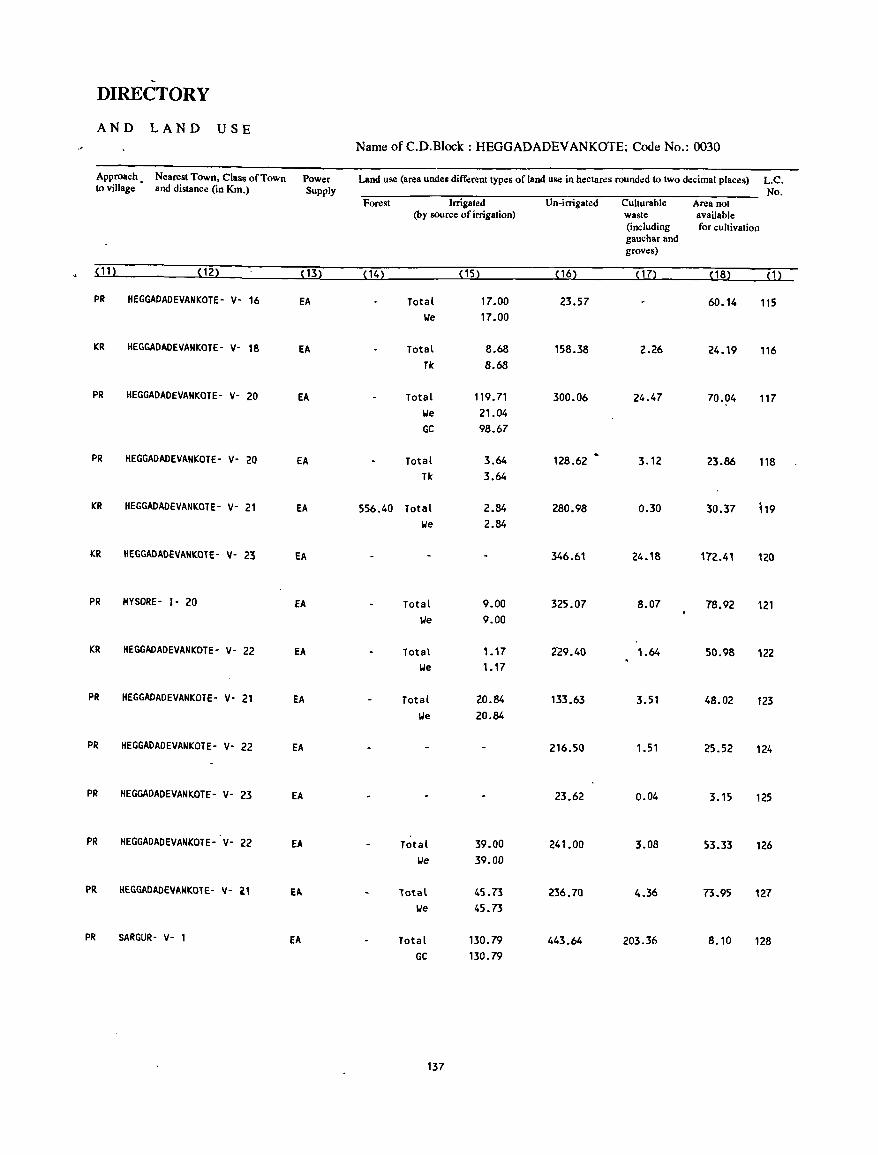
DIRECTORY
AND LAND USE Name of C.D.Block : HEGGADADEV ANKOTE; Code No.: 0030
Approach. Nearest Town, Class of Town Power Land use (area undes different types of land use in hectar.:s round.:d to two decimal places) L.C. to village and distance (in Km.) Supply No.
Forest Irrigated Un-irrigated Culturable Area not (by source of irrigation) waste available
(including for cultivation gauchar and groves)
(11) (12) ( 13) (14) (15) (16) ( 17) (18) ( 1)
PR HEGGAOADEVANKOTE- V- 16 EA Total 17.00 23.57 60.14 115 We 17.00
KR HEGGAOADEVANKOTE- V- 18 EA Total 8.68 158.38 2.26 24.19 116 Tk 8.68
PR HEGGADADEVANKOTE- V- 20 EA Total 119.71 300.06 24.47 70.04 117 We 21.04 GC 98.67
PR HEGGADADEVANKOTE- V- 20 EA Total 3.64 128.62 3.12 23.86 118 Tk 3.64
KR HEGGADADEVANKOTE- V- 21 EA 556.40 Total 2.84 280.98 0.30 30.37 119 We 2.84
KR HEGGADADEVANKOTE- v- 23 EA 346.61 24.18 172.41 120
PR MYSORE - 1- 20 EA Total 9.00 325.07 8.07 78.92 121 We 9.00
KR HEGGADADEVANKOTE- V- 22 EA Total 1.17 2"29.40 1.64 50.98 122 We 1.17
PR HEGGAOADEVANKOTE- V- 21 EA Total 20.84 133.63 3.51 48.02 123 We 20.84
PR HEGGADAOEVANKOTE- V- 22 EA 216.50 1.51 25.52 124
PR HEGGAOADEVANKOTE- V- 23 EA 23.62 0.04 3.15 125
PR HEGGADADEVANKOTE- V- 22 EA Total 39.00 241.00 3.08 53.33 126 lJe 39.00
PR HEGGAOAOEVANKOTE- V- 21 EA Total 4S.73 236.70 4.36 73.95 127 We 45.73
PR SARGUR- V- 1 EA Total 130.79 443.64 203.36 8.10 128 GC 130.79
137
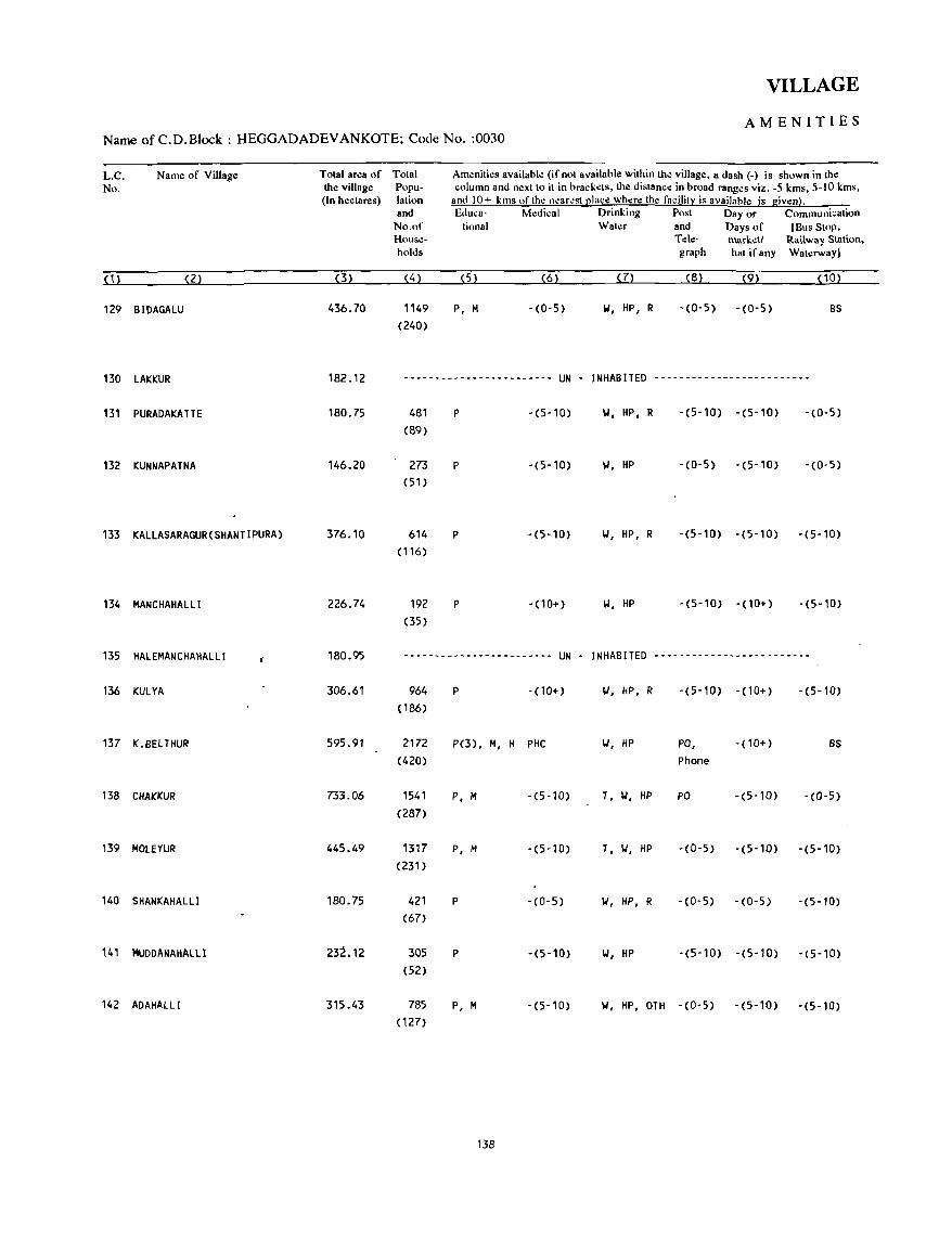
VILLAGE
AMENITIES Name of C.D.Block : HEGGADADEV ANKOTE; Code No. :0030
L.C. No.
Name of Village
(1) (2)
129 BIDAGALU
130 LAKKUR
131 PURADAKATTE
132 KUNNAPATNA
133 KALLASARAGUR(SHANTIPURA)
134 MANCHAHALLI
135 HALEMANCHAHALLI
136 KUL YA
137 K.BELTHUR
138 CHAKKUR
139 MOlEYUR
140 SHANKAHALLI
141 MUDDANAHAlLI
142 ADAHALLI
Total area of Total the village Popu(In hectares) lation
and No.of Households
(3)
436.70
(4)
1149 (240)
Amenities available (if not aVllilable within the village, a dash (-) is shown in the column and next to it in brackets, the distance in broad ranges viz. -5 kms, 5-l0 kms,
and 10+ kms "fthe nearest place where the facility is availahle is given). Educa- Medical Drinking Post Day or Communication
tional Water and Days of [Bus Stop, Tde- mark.:tl Railway Station, graph hat if any Waterway)
(5) (6) (7) (8) (9) (10)
P, M -(0-5) W, HP, R -(0-5) -(0-5) BS
182.12 ------------------------ UN - INHABITED -------------------------
180.75
146.20
376.10
226.74
180.95
306.61
595.91
733.06
445.49
180.75
232.12
315.43
481 (89)
273 (51)
614 (116)
192 (35)
P -(5-10)
P -(5-10)
P -(5-10)
P - (10+)
-----~------------------ UN -
964 P - (10+) ( 186)
2172 P(3), /<I, H PHC (420)
1541 P, M -(5-10) (287)
1317 P, M -(5-10) (231)
421 P - (0- 5) (67)
305 P -(5-10) (52)
785 P, M -(5-10) (127)
138
W, HP, R -(5-10) -(5-10) -(0-5)
II, HP -(0-5) -(5-10) -(0-5)
II, HP, R -(5-10) -(5-10) -(5-10)
W, HP -(5-10) - (10+) -(5-10)
INHABITED -------------------------
'.I, HP, R -(5-10) - (10+) -(5-10)
'.I, HP PO, - (10+) BS Phone
T, W, HP PO -(5-10) -(0-5)
T, II, HP -(0-5) -(5-10) -(5-10)
II, HP, R - (0- 5) -(0-5) -(5-10)
II, HP -(5-10) -(5-10) -(5-10)
II, HP, OlH -(0-5) -(5-10) -(5-10)
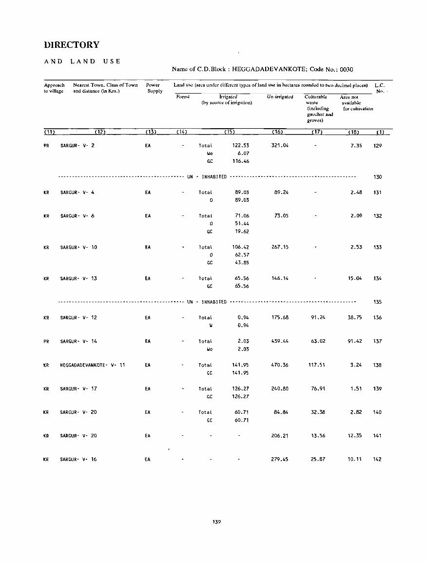
DIRECTORY
AND LAND USE Name of C. D. Block: HEGGADADEV ANKOTE; Code No.: 0030
Approach N~arest Town, Class of Town Power Land usc (area under different types of land use in hectares rounded to two decimal places) L.C. to village and distance (in Km.) Supply No ..
Forest Irrigated Un-irrigated Culturaole Ar<la not (oy source of irrigation) wast<l available
(including for cultivation gauchar and groves)
(11) (12) (13) (14) (15) (16) (17) (18) (1)
PR SARGUR- v- 2 EA Total 122.53 321.04 7.35 129 We 6.07 GC 116.46
--------------------------------------------- UN - INHABITEO -----------------------------------------~--- 130
KR SARGUR- v- 4 EA Total 89.03 89.24 2.48 131 0 89.03
KR SARGUR' v- 6 EA Total 71.06 73.05 2.09 132 0 51.44
GC 19.62
KR SARGUR- v- 10 EA Total 106.42 267.15 2.53 133 0 62.57
GC 43.85
KR SARGUR- v- B EA Total 65.56 146.14 15.04 134 GC 65.56
--------------------------------------------- UN - INHABITED --------------------------------------------- 135
KR SARGUR- v- 12 EA Total 0.94 175.68 91.24 38.75 136 W 0.94
PR SARGUR- v- 14 EA Total 2.03 439.44 63.02 91.42 137 We 2.03
KR HEGGADADEVANKOTE- V- 11 EA Total 141.95 470.36 117.51 3.24 138 GC 141.95
KR SARGUR- V- 17 EA Total 126.27 240.80 76.91 1.51 139 GC 126.27
KR SARGUR- V- 20 EA Total 60.71 84.84 32.38 2.82 140 GC 60.71
KR SARGUR- V- 20 EA 206.21 13.56 12.35 141
KR SARGUR- V- 16 EA 279.45 25.87 10.11 142
139

VILLAGE
AMENITIES Name of C.D.Block : HEGGADADEV ANKOTE; Code No. :OO3C
L.C. Name of Village Total area of Total Amenities available (if not available within the village, a dash (-) is shown in the
No. the village Popu- column and n~xt to it in brackd&, the distance in broad ranges viz. -S kms, S-IO kms, (In hectares) lation and 10+ kms nfth~ nearest ~Iace where the facilit~ is availahle is giwn}.
and Educa- Mcdical Drinking Post Day or Communication No.of tional Water and Days of [Bus Slop, House- Tele- market! Railway Station, holds graph hat ifany Waterway}
(1) (2) (3) (4) (5) (6) (7) (8) (9) (10)
143 HUNAGAHAlll 294.68 607 P -(5-10) 101, HP -(5-10) -(5-10) -(5-10)
(112)
144 MANUGANAHALll 509.83 770 P, M -(10+) 101, HP -(5-10) -(10+) -(5-10)
( 135)
145 HUNSAHAlLI 332.93 516 P -(5-10) 101, HP -(5-10) -(10+) -(5-10)
(88)
146 HOOV I NAKOlA 516.07 409 p -(10+) 101, HP -(5-10) -(10+) -(5-10)
(82)
147 lANKE 657.71 1369 P -(10+) 101, HP -(5-10) -(10+) -(5-10)
(Z50)
148 KATTE HUN SUR 463.45 776 P -(5-10) 101, HP -(0-5) -(5-10) -(0-5) ( 138)
149 KAllAMBAW 440.41 2083 P(3), M(2) -(5-10) 101, HP, R PO -(5-10) -(0-5)
(381)
150 KUNOUR 756.01 360 P - (5-10) 101, HP, OTH -(0-5) -(5-10) -(0-5)
(66)
151 CHAMALAPURA 565.02 878 P -(5-10) T, 101, OTH -(0-5) -(5-10) -(0-5)
(168)
152 BENNEGERE 382.50 262 - (0-5) - (10+) 101, HP -(0-5) - (10+) BS (48)
153 CHANGOIoIDANAHALLI 432.75 365 P - (10+) 101, HP -(0-5) -(10+) -(0-5)
(66)
154 MULlUR 1166.77 3202 P(4), PHC, FPC T,IoI, HP ~TO, -(10+) BS (644) M(2), H , Phone
155 LAKKASOGE 603.17 8 -(0-5) - (10+) R -(10+) -(10+) - (5-10) (4)
156 CHILLAHALLI 235.70 66 -(0-5) - (10+) 101, R - (10+) - ~10+) - (5-10) ( 16)
140
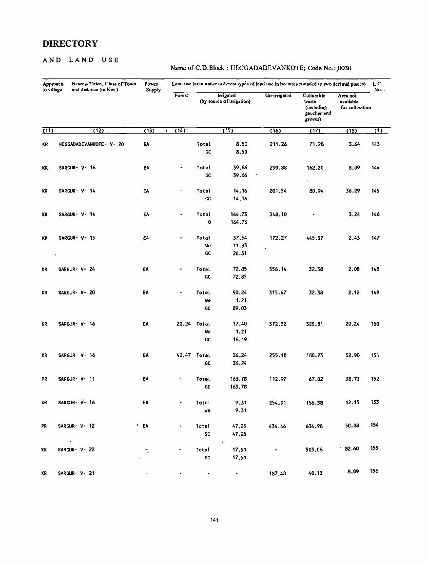
DIRECTORY
AND LAND USE Name of C.D.Block : HEGGADADEVANKOTE; Code No.:..(X)30
Approach Nearest To~n, Class of Town Power Land use (area und.:r different ty~s of land use in h.:c\ares rounded to two decimal places) L.C. to village and distance (in Km.) Supply No .•
Forest Irrigated Un-irrigated Culturable Area not (by source of irrigation) waste available
(including for cultivation gaucharand groves)
(11) (12) (13) (14) (15) (16) (17) (18) (1)
KR HEGGAOAOEVANKOTE- v- 20 EA Total 8.50 211.26 71.28 3.64 143 GC 8.50
KR SARGUR- v- 16 EA Total 39.66 299.88 162.20 8.09 144 GC 39.66
KR SARGUR- v- 14 EA Total 14.16 201.54 80.94 36.29 145 GC 14.16
KR SARGUR- v- 14 EA Total 164.73 348.10 3.24 146 0 164.73
KR SARGUR- v- 15 EA Total 37.64 172.27 445.37 2.43 147 lie 11.33 GC 26.31
KR SARGUR- v- 24 EA Total 72.85 356.14 32.38 2.08 148 GC 72.85
KR SARGUR- y- 20 EA Total 90.24 315.67 32.38 2.12 149 lie 1.21 GC 89.03
KR SARGUR- v- 16 EA 20.24 Total 17.40 372.32 325.81 20.24 150 lie 1.21 GC 16.19
KR SARGUR- Y- 16 EA 40.47 Total 36.24 255.18 180.23 52.90 151 GC 36.24
PR SARGUR- v- 11 EA Total 163.78 112.97 67.02 38.73 152 GC 163.78
KR SARGUR- 1/- 16 EA Total 9.31 254.91 156.38 12_15 153 lie 9.31
PR SARGUR- v- 12 . EA Total 47.25 434.46 634.98 50.08 154
GC 47.25
KR SARGUR- v- 22 Total 17.51 503.06 . 82.60 155
GC 17.51
KR SARGUR- v- 21 187.48 40.13 8.09 156
141
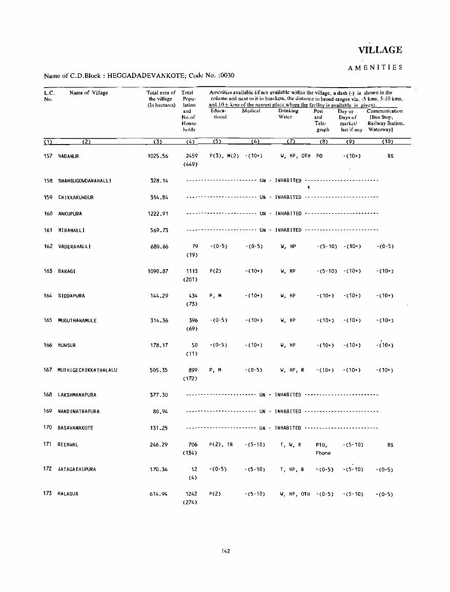
VILLAGE
AMENITIES Name of C.D.Block : HEGGADADEVANKOTE; Code No. :0030
L.C. No.
Name of Village
( 1 ) (2)
157 HADANUR
158 SHAMBUGOIolDANAHALLI
160 ANKUPURA
161 HIRAHALLI
162 VADERAHALLI
163 BARAGI
164 SIDDAPURA
165 MUGUTHANAMULE
166 HUN SUR
167 MUTHIGECHIKKATHALALU
168 LAKSHMANAPURA
169 NANDINATHAPURA
170 BASAVANAKOTE
171 BEERWAL
172 JATAGATHIPURA
173 HALASUR
Total area of the village
(In hectares)
(3)
1025.56
328.14
314.84
1222.91
569.73
680.66
1090.87
144.29
314.36
178.17
505.35
377.30
80.94
131.25
246.29
170.36
614.94
Total Popu-lation
Ameniti.:s available (if not available within the village, a dash (-) is shown in the column and next to it in bra.:kets, the distance in broad ranges viz. -5 kms, 5-10 kms,
and 10+ kms of the nearest place where the facility is availahle is giwn). and Educa- Medical Drinking Post Day or Communication
No.of tiona I Water and Days of [Bus Stop, House- Tek- marketl Railway Station, holds graph hat if any Waterway)
(4) (5) (6) (7) (8) (9) (10)
2459 P(3), M(2) -(10+) 101, HP, OTH PO - (10+) BS (449)
--------------.--------- UN - I NHAB IlED -------------------------t
------------------------ UN - INIIIIBllED -------------------------
--------------_--------- UN - I NHAB IlED -------------------------
------------------------ UN - I NHAB IlED -------------------------
79 -(0-5) - (0- 5) 101, HP -(5-10) - (10+) -(0-5) (19)
1113 P(2) - (10+) 101, HP -(5-10) - (10+) - (10+) (201)
434 P, M - (10+) 101, HP - (10+) -(10+) -(10+) (73)
396 -(0-5) -(10+) 101, HP -(10+) - (10+) - (10+) (69)
-SO '(0-5) -(10+) 101, HP - (10+) -(10+) -(10+)
( 11)
899 P, M -(0'5) 101, HP, R - (10+) - (10+) - (10+) ( 172)
------------------------ UN - INHABITED -------------------------
------------------------ UN - I NHAB IlED -------------------------
------------------------ UN - INHABITED -------------------------
706 P(2) , TR -(5-10) T, 101, R PTO, -(5-10) BS ( 134) Phone
12 -(0-5) -(5-iO) T, HP, R '-(0-5) -(5-10) -(0-5) (4)
1242 P(2) -(5-10) 101, HP, OTH -(0-5) -(5-10) -(0-5) (274)
142
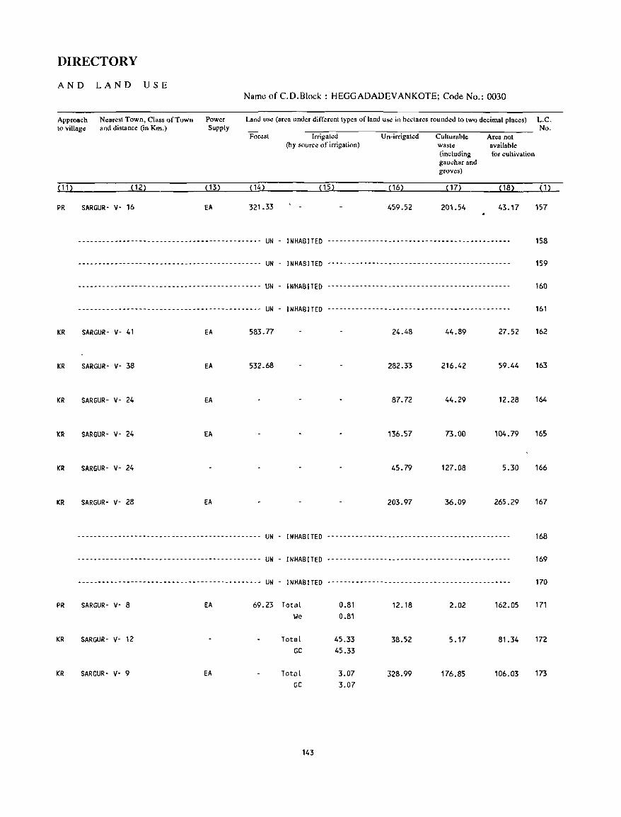
DIRECTORY
AND LAND USE Name of C.D.Block : HEGGADADEVANKOTE; Code No.: 0030
Approach to village
Nearest Town, Class of Town and distance (in Km.)
Power Supply
Land use (area under different types of land use in hectares rounded to two decimal places) L.C. No.
Forest Irrigated Un-irrigated Culturable Area not (by source of irrigation) waste available
(including for cultivation gauchar and groves)
(11) (12) ( 13) (14) (15) ( 16) ( 17) ( 18) ( 1)
PR SARGUR- v- 16 EA 321.33 459.52 201.54 43.17 157
--------------------------------------------- UN - INHABITED --------------------------------------------- 158
--------------------------------------------. UN - INHABITED .-.-- .. - ... - .... --- .. --.--.- .... -- .. - .. ----.. 159
-.-.----.-------------.-.------- ... - .. ----- .. UN INHABITED -- .. ------ .... --------------.------ .... ------ 160
-----.-- .. ------- ... --.----- .. -.--.-- .. - .. --. UN . INHABITED ... -----.-.----- .. ------.-------------.------ 161
KR SARGUR- v- 41 EA 583.77 24.48 44.89 27.52 162
KR SARGUR- v- 38 EA 532.68 282.33 216.42 59.44 163
KR SARGUR- v- 24 EA 87.72 44.29 12.28 164
KR SARGUR- V- 24 EA 136.57 73.00 104.79 165
KR SARGUR- v- 24 45.79 127.08 5.30 166
KR SARGUR- v- 28 EA 203.97 36.09 265.29 167
.. ----- ... ----------- .. -------------.-------. UN - INHABITED ---.- .. ----.-.-- ..... ---.-.-.----.--.---.---. 168
-------------------------.---.-.-.--- .. ---- .. UN . INHABITED .---.-----.--.--.-.-----.----.---.-.-........ 169
--- .. -.--.-----------.-------.---- ........ - .. UN - INHABITED .---- ...... --- ... - .... - .. ----- ...... -- ... --.. 170
PR SARGUR· V· 8 EA 69.23 Total 0.81 12.18 2.02 162.05 171 We 0.81
KR SARGUR· V· 12 Total 45.33 38.52 5.17 81.34 172
GC 45.33
KR SARGUR- V· 9 EA Total 3.07 328.99 176.85 106.03 173 GC 3.07
143
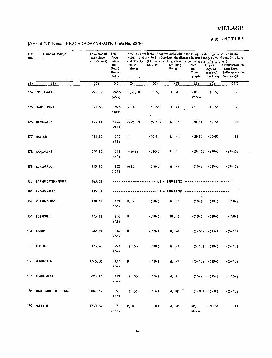
VILLAGE
AMENITIES Name of C.D.Block : HEGGADADEVANKOTE; Code No. :0030
L.C. Name of Village Total area of Total Amenities available (if not available within the village, a dash C-) is shown in the No. -:' the village Popu- column and n.:xt to it in brackets, the distance in broad ranges viz. -S krna, 5-10 kms,
(In hectares) lation and 10+ kms of the nearest I2lace where the facility is available is given). and Eduea- Medical Drinking Posl Day or Communication No.of tional Water and Days of [Bus Stop, House- Telc- market! Railway Station, holds graph hat ifany Waterway]
(1) (Z) (3) (4) (5) (6) (7) (8) (9) (10)
174 KOTIIAGAlA 1240.12 2636 P(3), M -(0-5) T, 1.1 PTO, -(0-5) BS (453) Phone
175 HANCHIPURA 75.65 973 P, M -(0-5) T, HP PO -(0-5) BS " (180)
176 MASAHAlll 494.44 1494 P(Z), M -(5-10) 1.1, liP -(0-5) -(0-5) BS (Z41)
1n NAllUR 131.50 Z44 P -(0-5) 1.1, HP -(0-5) -(0-5) BS (55)
178 KANDAlIKE 299.39 215 -(0-5) -(10+) 1.1, R -(5-10) -(10+) -(5-10) (44)
179 AlALAHAlll 715.15 803 P(Z) -(10+) 'III, HP -(10+) -(10+) -(5-10) (151)
180 MARABUGATHANAPURA 463.82 ---------.-~------------ UN - INHABITED -------------------------
181 CIIOWOAHAlll 185.01 ------------------------ UN - INIIABITEO -------------------------
182 CHANNAGUNOI 708.37 909 P, M -(10+) 1.1, HP -(10+) -(10+) -(10+) (156)
183 HOSAKOTE 173.41 258 P -(10+) HP, R -(10+) -(10+) - (10+) (43)
184 SEGUR 282.62 334 P -(10+) 1.1, liP -(5-10) -(10+) -(5-10) (68)
185 KUDIGI 173.46 293 -(0-5) -(10+) 1.1, liP -(5-10) -(10+) -(5-10) (64)
186 KURNAGAlA 1346.08 437 P -(10+) 1.1, liP -(5-10) -(10+) -(5-10) (84)
187 ALANAIIALlI 223.17 119 - (0-5) -(10+) 'III, R -(10+) -(10+) -(10+) (24)
188 INUR MARIGUDI JUNGLE 10082.73 51 -(0-5) - (10+) 'III, liP .
-(5-10) -(10+) -(5-10) (17)
189 MOlEYUR 1730.24 871 P, M -(10+) 1.1, liP PO, -(0-5) BS (162) Phone
144
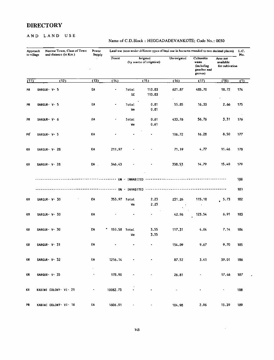
DIRECTORY
AND LAND USE
Approach Nearest Town, Class of Town Power to village and distance (in Km.) Supply
(11) (12) ( 13)
PR SARGUR· V- 5 EA
PR SARGUR- V- 5 EA
PR SARGUR- V- 6 fA
SARGUR- V- 5 EA
KR SARGUR- V- 28 EA
KR SARGUR- V- 28 EA
Name of C.D.Block : HEGGADADEV ANKOTE; Code No.: 0030
Land use (area under different types of land use in hectares rounded to two decimal places) L.C.
Forest
( 14)
211.97
346.43
Irrigated (by source of irrigation)
(15)
TotaL 113.83 GC 113.83
TotaL We
TotaL
0.81 0.81
0.61 We 0.61
Un-irrigated
(16)
621.87
55.85
433.76
106.72
71.19
338.53
No. Culturable Area not waste available (including for cultivation gauchar and groves)
( 17) (18) (1)
485.70 18.72 174
16.33 2.66 175
56.76 3.31 176
16.28 8.50
4.77 11.46 178
14.79 15.40 179
--.------------------------------------------ UN - INHABITED --------------------------------------------- 1~0
--------------------------------------------- UN - INHABITED --------------------------------------------- 181
KR SARGUR- V- 30 fA 353.97 TotaL 2.23 231.26 115.18 5.73 182 We 2.23
KR SARGUR- V- 30 fA 42.96 123.54 6.91 183
KR SARGUR- V- 30 fA • 150.58 TotaL 3.55 117.31 4.04 7.14 184
We 3.55
KR SARGUR- V- 31 EA 154.09 9.67 9.70 185
KR SARGUR- V- 32 EA 1216.14 87.52 3.41 39.01 186
KR SARGUR- V- 35 178.90 26.81 17.46 187
KR KABINI COLONY- VI- 21 10082.73 188
PR KABINI COLONY- VI- 16 EA 1606.91 104.98 2.96 15.39 189
145
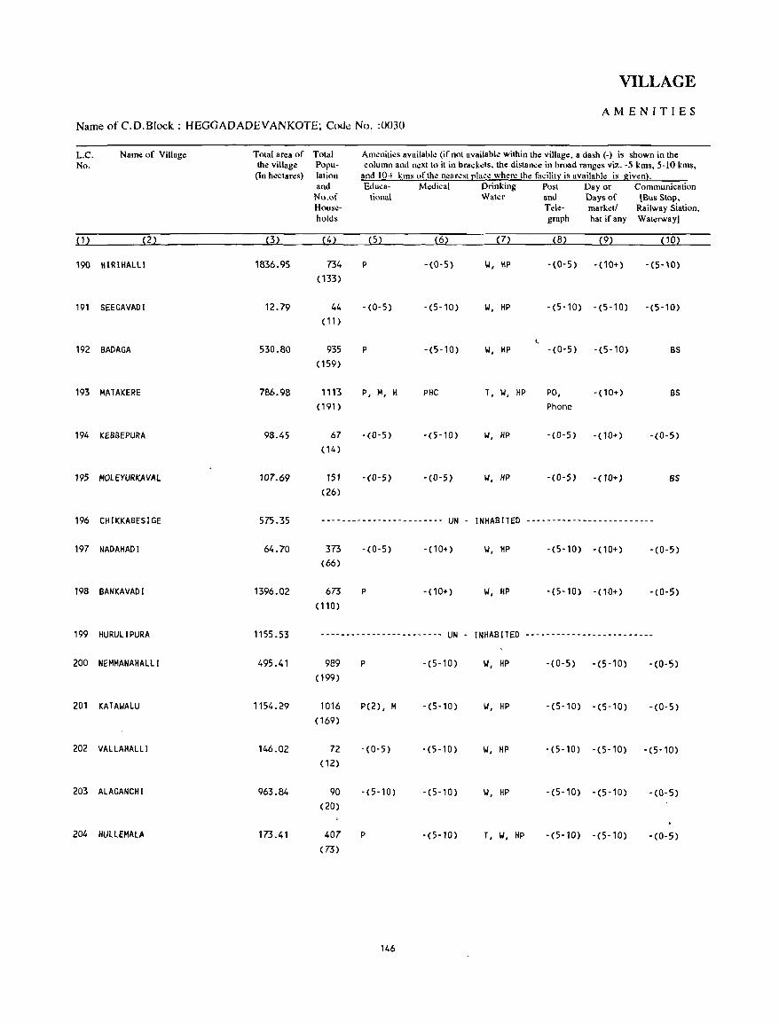
VILLAGE
AMENITIES Name ofC.D.Block: HEGGADADEVANKOTE; Code No. :0030
L.C. Name of Village Total area of Total Am.:niti.:s availabl.: (if not availabl.: within the village, a dash (-) is shown in the No. the villag.: Popu- column and n.:xt to it in brackets, th.: distance in broad ranges viz. -5 kms, 5-10 kms,
(In hectares) lation and 10+ kms of the n.:arest [!Iac.: where th.: facility is availahle is given}. and Educa- Medical Drinking Post Day or Communication No.of tional Water and Days of [Bus Stop, House- Tele- mark.:tl Railway Siation, holds graph hat if any Waterway]
(1) (2) (3) (4) (5) (6) (7) (8) (9) CiO)
190 IHRIHALLl 1836.95 754 P -(0-5) 'oj, HP -(0-5) -(10+) -(5-10) ( 133)
191 SEEGAVADI 12.79 44 -(0-5) -(5-10) 'oj, HP -(5-10) -(5-10) -(5-10) ( 1 1)
'. 192 BADAGA 530.80 935 P -(5-10) 'oj, HP -(0-5) -(5-10) BS
(159)
193 MATAKERE 786.98 1113 P, M, H PHC T, \.I, HP PO, - (10+) BS (191) Phone
194 KEBBEPURA 98.45 67 -(0-5) -(5-10) 10', HP -(0-5) -(10+) -(0-5) (14 )
195 MOL E YURKAVAl 107.69 lSl -(O-S) -(O-S) 10', HP -COoS) -(10+) BS (26)
196 CHIKKABESIGE 575.35 ------------------------ UN - INHABITED -------------------------
197 NADAHADI 64.70 375 -(0-5) - (10+) 10', HP -(5-10) -(10+) -(0-5) (66)
198 BANKAVADI 1396.02 673 P -(10+) 10', HP -(5-10) -(10+) -(0-5) (110)
199 HURULIPURA 1155.53 ------------------------ UN - INHABITED -------------------------
200 NEMMANAHAlll 495.41 989 P -(5-10) 'oj, HP -(0-5) -(5-10) -(0-5) (199)
201 KATAIoIALU "54.29 1016 P(2), M -(5,10) II, HP -(5-10) -(5-10) -(0-5) (169)
202 VALLAHALLl 146.02 72 -(0-5) -(5-10) 101, HP -(5-10) -(5-10) -(5-10) (12)
203 ALAGANCHI 963.84 90 -(5-10) -(5-10) 101, HP -(5-10) -(5-10) -(0-5) (20)
204 HUllEMALA 173.41 407 P -(5-10) T, 101, HP -(5-10) -(5-10) -(0-5) (73)
146
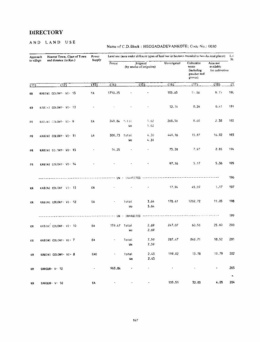
DIRECTORY
AND LAND USE Name of C. D. Block: HEGGADADEV ANKOTE; Code No.: 0030
Approach Nearest Town, Class of Town Power Land us~ (area undcr difl;;rcnttypcs of land us.: in hcctarc~ rounded to two dc .. imal plllccs) L.(
10 village and dislance (in Km.) Supply N. Forll!ol Irrigated Un·irrigat.:d Culturablc Area not
(by sou~ce of irrigation) waste availabk (including fix cultivation gauchar and grove~)
(11) (12) ( 13) (14) (15) (16) ( 17) (18) ___u_:
KR KABINI COLONY· VI· 13 EA 1710.25 105.65 1, .86 9.1"; 19(,
KR KABINI COLONY· VI· 13 12.14 0.24 0.41 191
PR KAS.NI COLONY· VI' 9 EA 248.84 Tr.-ta l 1.62 268.56 9.40 2.38 192
"'e 1.62
PR KABINI COLONY- VI- 11 EA 300.73 Total 4.30 449.16 15.87 16.92 193
'We 4.30
PR KABINI COLONY- VI- 13 14.25 73.38 7.97 2.85 194
PR KABINI COLONY- VI- 14 97.16 5.17 5.36 195
____________ w~ __ ~ _________________ • __________
UN . 1'1\,1\'1 liED --------.------------------------------~----- 196
KR KABINI COLONY Vf· 13 EA 17.94 45.59 1. 17 197
KR KABINI COLONY· VI· 12 EA Total 3.64 178.61 1202.72 11.05 198
\.Ie 3.64
--_ ... ----_----- ... --- ... --- .. -_ .......... _-_ ...... _- .. --_ ...... UN INHABITED .. _ ...... _---_ .. _------- .. _---------------- _. ----_ .. 199
KR KABINI COLONY· VI· 10 EA 159.47 Total 2.69 247.07 60.58 25.60 200
\.Ie 2.69
KR KABINI COLONY- VI- 7 EA Total 7.59 287.47 840.71 18.52 201
lJe 7.59
KR KABINI COLONY- VI- a EAG Total 2.43 119.02 13.78 10.79 202
loIe 2.43
KR SARGUR- V· 12 963.84 203
"-
KR SARGUR- V- 10 EA 135.51 33.85 4.05 204
147
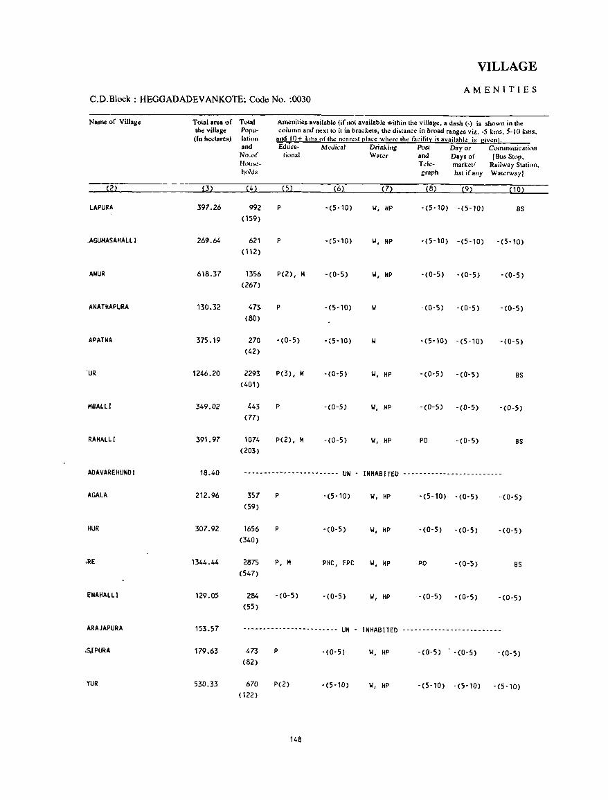
VILLAGE
AMENITIES C.D.Block : HEGGADADEV ANKOTE; Code No. :0030
Name of Village Total area of Total Amenitie.s available (if not available within the village, a dash (-) is sh<>wn in !he !he village Popu- column and n~xt to it in brackets, !he di~tance in broad ranges viz. -5 kms, 5-10 kms. (In hectares) lation and 10+ km~ of tile nearest claee where (he facilit:t is availahle is givenj.
and &lllca- Mcdical Drinking Post Dayoe Communication No.of (ional Water and Days of (Bus Stop. Hou!o<!- Tt:le- marketl Railway Station. holds graph hat if any Waterway]
(2) (3) (4) (5) (6) (7) (8) (9) (10)
LAPURA 397.26 992 P -(5-10) IJ, HP -(5-10) -(5-10) BS (159)
.AGUMASAHAlll 269.64 621 P -(5-10) IJ, HP -(5-10) -(5-10) -(5-10) (112)
ANUR 618.37 1356 P(2), Jot -(0-5) IJ, HP -(0-5) -(0-5) -(0-5) (267)
ANATHAPURA 130.32 473 P -(5-10) '01 -(0-5) -(0-5) -(0-5) (80)
,APATNA 375.19 270 - (0- 5) -(5-10) '01 -(5-10) - (5-10) - (0-5) (42)
'UR 1246.20 2293 P(3), M -(0-5) IJ, HP -(0-5) -(0-5) BS (401)
"'BALLI 349.02 443 P -(0-5) IJ, HP -(0-5) -(0-5) -(0-5) (77)
RAHALLI 391.97 1074 P(2), M -(0-5) '01, HP PO - (0- 5) BS (203)
ADAVAREHUNDI 18.40 ---------~----~--------- UN - INHABITED -------------------------
AGAlA 212.96 357 P -(5-10) '01, HP -(5-10) -(0-5) -(0-5) (59)
HUR 307.92 1656 P - (0- 5) '01, HP -(0-5) -(0-5) -(0-5) (340)
,RE 1344.44 2875 P, M PHC, FPC '01, HP PO -(0-5) BS (547)
ENAHALlI 129.05 284 -(0-5) -(0-5) IJ, HP -(0-5) - (0- 5) -(0-5) (55)
ARAJAPURA 153.57 ------------------------ UN - INHABITED -------------------------
,s,lPURA 179.63 473 P -(0-5) '01, HP -(0-5) -(0-5) -(0-5) (82)
YUR 530.33 670 P(2) -(5,10) '01, HP -(5-10) -(5-10) -(5-10) (122)
148
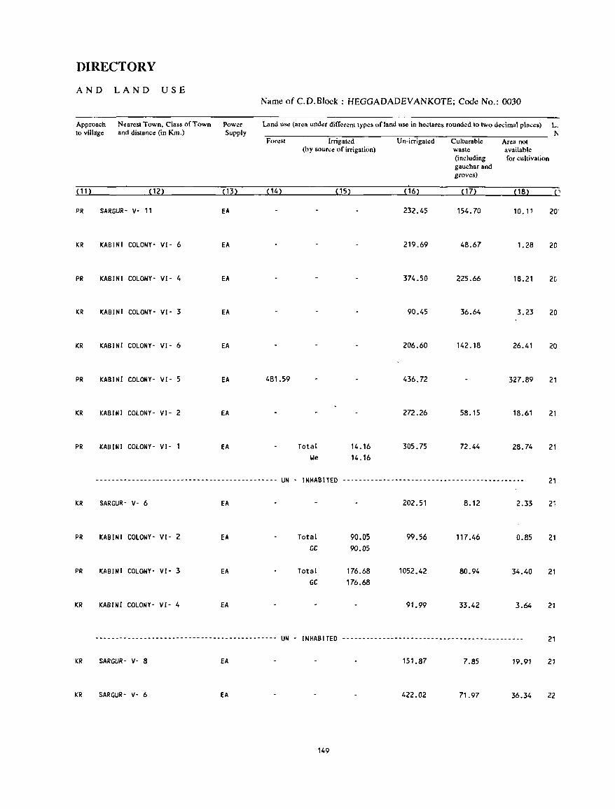
DIRECTORY
AND LAND USE Name ofC.D.Block: HEGGADADEVANKOTE; Code No.: 0030
Approach Nearest Town, Class of Town Power Land use (area under different types of land use in hectares rounded to two decimal places) L. to village and distance (in Km.) Supply I'<
Forest Irrigated U n-irrigat.:d Culturable Area not (by source of irrigation) waste available
(including for cultivation gaucharand groves)
( 11 ) (12) ( 13) (14) (15) ( 16) (17) (18) ( ,
PR SARGUR- v- II EA 232.45 154.70 10.11 20'
KR KABINI COLONY- VI- 6 EA 219.69 48.67 1.28 20
PR KABINI COLONY- VI- 4 EA 374.50 225.66 18.21 2C
KR KABINI COLONY- VI- 3 EA 90.45 36.64 3.23 20
KR KABINI COLONY- VI- 6 EA 206.60 142.18 26.41 20
PR KABINI COLONY- VI- 5 EA 481.59 436.72 327.89 21
KR KABINI COLONY- VI- 2 EA 272.26 58.15 18.61 21
PR KABINI COLONY- VI- I EA Total 14.16 305.75 72.44 28.74 21 !ole 14.16
--------------------------------------------- UN - INHABITED --------------------------------------------- 21
KR SARGUR- V- 6 EA 202.51 8.12 2.33 21
PR KABINI COLONY- VI- 2 EA Total 90.05 99.56 117.46 0.85 21 GC 90.05
PR KABINI COLONY- VI- 3 EA Total 176.68 1052.42 80.94 34.40 21 GC 176.68
KR KABINI COLONY- VI- 4 EA 91.99 33.42 3.64 21
-~------------------------------------------- UN - INHABITED --------------------------~------------------ 21
KR SARGUR- V- 8 EA 151.87 7.85 19.91 21
KR SARGUR- V- 6 EA 422.02 71.97 36.34 22
149
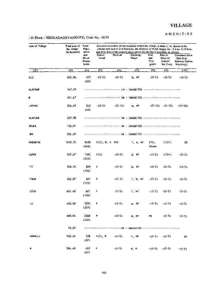
VILLAGE
AMENITIES ~.D.Block : HEGGADADEVANKOTE; Code No. :0030
.ame of Village
(2)
JDLU
,ALATHUR
LAPURA
ALAPURA
APURA
JRA
RASANTHE
(UPPE
,THUR
GILU
LU
~AHALLI
A
Total area of the village (In hecla!">!s)
(3)
242.96
147.79
451.47
256.49
227.78
113.91
230.49
1619.15
507.67
500.10
332.87
601.43
408.88
689.94
73.27
502.45
394.48
Total Population and No.of HOUSol
holds
(4 )
457 (83)
Am.:niti.:s availal>le (if not availahle within the village. a dlish (-) is shown in the ~olumn and n.:xtto it in brackets. tb.: distance in broad ranges viz. -5 kms. 5-10 kms,
and 10+ kms ofth.: n.:arest place where the facility i~ availahle is given). Educa· Medical Drinking Post Day or Communication
tional Water and Days of (Bus Stup, T ele- marketl Railway Station. graph hat if any Waterway]
(5) (6) (7) (8) (9) (10)
-(0-5) -(0-5) W, liP -(0-5) -(0-5) -(0-5)
-------------.---.------ UN - INHABITED --------.----------------
.----.-- .• --.- •.•••• -.-. UN • INHAB11ED ------ .•• -------- •• -.----
242 (40)
-(0-5) -(5-10) W, HP -(5-10) -(5-10) -(5-10)
---.-.- ... -.- ... - ..•. - .• UN - INHAallED '-'--"--"-"---'-"-'--
... - .......• -- ....•..•.. UN . INHABITED --.- ..... - .... -.- .... - •..
........................ UN . INHABITED .- ...................... -
3488 (648)
1384 (243)
890 (156)
661 (129)
621 (109)
1231 (227)
2368 (452)
P(3), M, H PHe
P(3) . C 0-5)
p . (0- 5)
P 'CO'S)
p -(0'5)
P ·CO·S)
P ,(0,5)
-------.-~---.---------- UN
528 P(2), M '(0,5) (87)
401 P ,(0,5)
(67)
150
.
T, II, HP
W, HP
1.1, HP
T, II, HP
T, HP
II, HP
W, HP
INHABITED
T, HP
II, R
PTO, Phone
'CO'S)
·(0,5)
·CO·S)
,(0'5)
·CO·S)
PO
. (10+) BS
- (10+) -(0'5)
'(0-5) -CO'S)
-(0'5) ·CO·S)
,(0,5) ,(0,5)
'(0'5) -CO'S)
-(0'5) 'CO'S)
-------------------------
. Ca· 5) ,(0'5) BS
·CO·S) ·(0'5) . CO· 5)
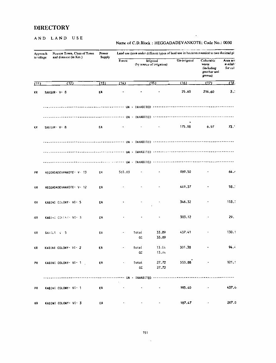
DIRECTORY
AND LAND USE Name ofC.D.Block: HEGGADADEVANKOTE; Code No.: 0030
Approa.:h to village
Nearest Town, Class of Town and distance (in Km.)
Power Supply
Land use (ar.:a under dil1i:rent types of land use in hectaro:s rounded to two decimal pi
Forest Irrigated Un-irrigated Culturable Area nOl (hy soul\:e of irrigation) waste availab'
(including for cui gauchar and groves)
(1l) (12) (13) (14 ) (15) (16) on <18,
KR SARGUR- V- 8 fA 25.60 214.60 2. :
-------------.--.----- •. ---.-----------.----- UN - INHABITED ---.-----------.-------.-------- .• -.---------
-------------.------- ...... -------.-----.---- UN INHABITED --.---------.-------------------------------.
KR SAf<.GUR- V- 8 EA 175.98 6.97 73.'
--.----------.-------.--------.-------------- UN INHABITED ---------------------------------------------
--------------------.------------------------ UN INHABITED -------------------- .. ------------------.--.-
---_ ...... - .. -- ---------_ ... -------- ...... _ .. --_ ... UN - INHABITED ---------------------------------------------
PR HEGGADADEVANKOTE- V- 13 EA 565.D3 989_50 64.(
KR HEGGADADEVANKOTE- v- 12 EA 449.37 58.:
KR KABINI COLONY- VI- S EA 346.32 153.7
·KR KABi"j COLC.~{- VI- 3 EA 303.12 29.
KR SA;;:::_8 ,;- 5 EA Total 33.89 437_41 130.1 GC 33.89
KR KABINI COLONY- VI- 2 EA Total 13.0/, 301.38 94./,
GC 13.04
PR KABINI COLONY- VI- 1 EA Total 27.72 553.88 121.1 GC 27.72
----------------------------.---------------- UN - INHABITED -----------------------------------------.---
PR KABINI COLONY- VI- 1 EA 193.40 437.4,
KR KABINI COLONY- VI- 3 EA 187.47 207.0
151
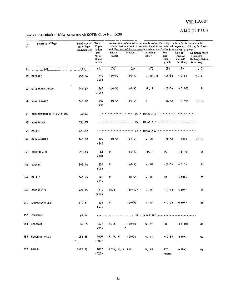
VILLAGE
AMENITIES .arne of C.D.Block : HEGGADADEV ANKOTE; Code No. :0030
C. Name of Village Total area of Total Am.:niti.:s availabk (if not available within the villag.:, a dash (-) is shown in the o. the village Poru- column and next to it in brad .. .:ts, the distance in broad ranges viz. -5 kms, 5-10 kms,
(In hectares) lation and 10+ km~ of the ncarc,t clae.:: whcre the facility i~ availahle is given). and Educa- M.:dtcal Drinl..ing Post Day or Communication No of tiona I Water and Days of [Bus Stop, Hous~- Tele- mark.:t! Railway Station, holds graph hatifany Waterway)
, ) (2) (3) (4) (5) (6) (7) (8) (9) (10)
38 MACHARE 453.84 210 -(0-5) -(0-5) \.I, HP, R - (0- 5) -(0-5) - (0-5)
(44)
)9 KRISHNARAJAPURA 446.35 588 - (0- 5) -(0-5) HP, R -(0-5) -(5-10) BS (104)
40 \1()i',>,JRKI.JPP£ '6().SS '99 -(0-5) -(0-5) II. -(0-5) -(5-'0) -(0-5)
(43)
41 ANTHARASANTHE PLANTATION 40.66 - .. --- - .. - ---- ----- .... -- .. -- UN - INHABITED ---------------- .. ---- .. - .. -
42 SUNDAPURA 136.75 ------------------------ UN - INHABITED --------------------- .. ---
43 HAGGE 422.32 ------------------------ UN - INHABITED --- .. --------- .. ----_ .. -----
'44 BADANAKUPPE 145.88 124 -(0-5) -(0-5) \.I, HP - (0-5) - (10+) -(0-5)
(24)
245 HOSAHOLALU 298_43 85 P -(0-5) HP, R PO -(5-10) BS (18)
'46 SOGAHAI 295.16 235 P -(0-5) \.I, HP -(0-5) -(0-5) BS (40)
247 MALALI 543.75 140 P -(0-5) II, HP PO - ( 1 0+) BS (21)
248 JAGA~A!CTE 425.15 1214 P(2) -(5-10) II, HP -(0-5) - (10+) BS (217)
249 KANAKANAHALLI 214.81 228 P -(0-5) II, HP - (0-5) -(10+) BS (47)
250 KARAVADI 65.44 --------------- .. -------- UN - INHABITED -------------------------
251 KAlASUR 36.25 51-7 P, M -(0-5) IJ, HP PO -(5-10) BS
(96)
252 KENCHANAHALlI 431. 15 1099 P, H, H -(0-5) II, HP -(0-5) - (10+) BS (200)
253 BEGUR 1407.55 2087 P(3), M, H PHC II, HP PTO, -(10+) BS (420) Phone
152
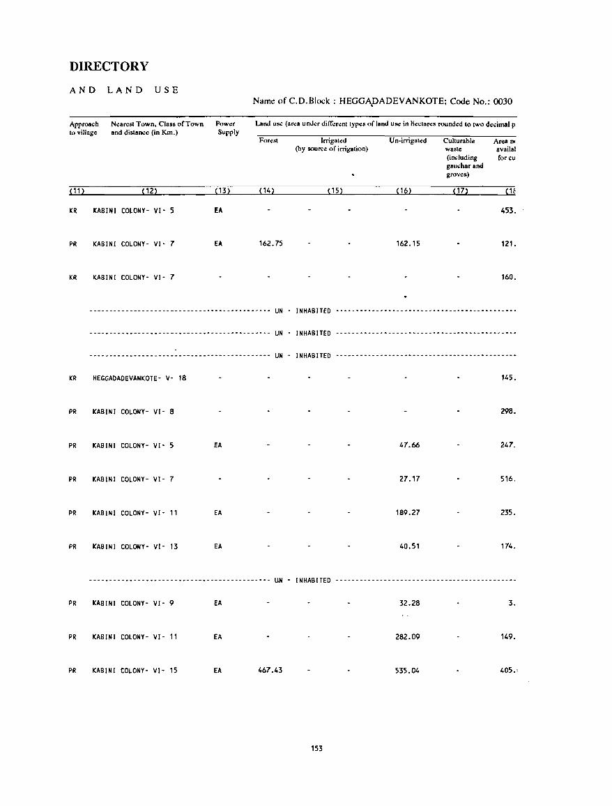
DIRECTORY
AND LAND USE
Approach to village
N.:an:st Town. Class of Town and distance (in Km.)
( 11 ) (12)
KR KABINI COLONY- VI- 5
PR KABINI COLONY- VI- 7
KR KABINI COLONY- VI- 7
Pow.:r Supply
(13)
EA
EA
Name of C.D.Block: HEGGApADEVANKOTE; Code No.: 0030
Land uS<! (ar.:a und.:r dilT.:r.:nttyp.:s of land us.: in H.:ctan:s round.:d 10 two decimal p
For.:st lrrigat.:d Un-irrigated Cullurable An:a n. (by source of irrigation) waste availal
(including for cu gauchar and groves)
(14) (15) (16) (17)
453.
162.75 162.15 121.
160.
--------------------------------------------- UN - INHABITED ---------------------------------------------
--------------------------------------------- UN - INHABITED ----------------------------------------0-_--
--------------------------------------------- UN - INHABITED ---------------- •• ---------------------------
KR HEGGAOAOEVANKOTE- V- 18 145.
PR KABINI COLONY- VI- 8 298.
PR KABINI COLONY- VI- 5 EA 47.66 247.
PR KABINI COLONY- VI- 7 27.17 516.
PR KABINI COLONY- VI- 11 EA 189.27 235.
PR KABINI COLONY- VI- 13 EA 40.51 174.
--------------------------------------------- UN - INHABITED ---------------------------------------------
PR KABINI COLONY- VI- 9 EA 32_28 3_
PR KABINI COLONY- VI- 11 EA 282.09 149.
PR KABINI COLONY- VI- 15 EA 467.43 535.04 405.1
153
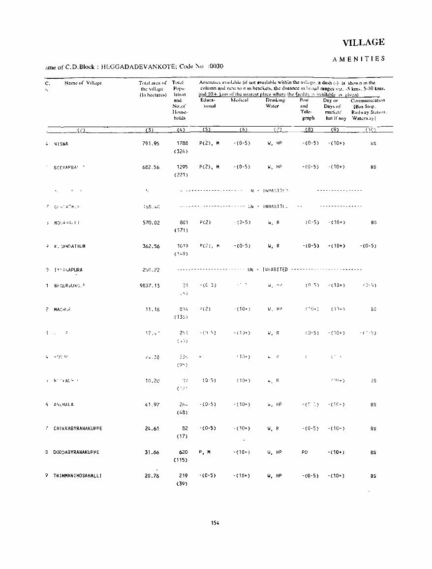
VILLAGE
AMENITIES ,lme of C.D.Block : Hl:GGADADEVANKOTE; Code r\o :0030
c. Name of V,II,,)!.: Tnt,11 al\!a of Tot.1i AIll~n'"~~ av"iI.,hl~ (d notltv8,l"hle within the vill"g". a da~h (-) is ,hnv. n 10 th.: I. \h~ vill.lg.: Popu- column and n~ ... i 10 11'11 bracldb. Ih.: dlblance III hr""el rangcb VI!. .• 5 kim.. 5-10 kills.
(In h~clar~~) lall<>n anti 10+ ktn' of Ihe near~st [!lacl! where th.: facd,t\ " 'Ivailahle " giv1.!n} and Educa- r-.kd,cal DnnLlng Po!<l Day or Communication No.of lInna) Wat~r and Day. of [Bus Stop. Hou!.~- Tcl.:· markel/ Rmlv.ay SI"I,on. holds graph hat if any Wat~I"'<l)l
(2) (3) (4) (5) (6) (7) (8) (9) ( 10)
4 NISNA 791.95 1788 P(2), M -(0-5) \.I, liP -(0-5) -(10+) as (324 )
BE(PAMBA' 682.56 1295 P(2) • M -(0-5) II, tiP -(0-5) -(10+) BS
(221)
~ c - .... -- - - - - - -- -- - - - - - - 'I, I"'~ASli!:C) -----------_-----
Gt,'4Tb. C ~bB.40 --_ ... --- - - - - - -- - - - - - - - - Ul; I NHAS j Tfl~ ---------------
J HO',A,IA, l i 570.02 801 P(2) - (0-5) \oJ, R (0-5) -(10+) BS
(171 )
K. ~A~DATHUR 362.56 10'9 P(2) , M -(0-5) 1.1, R -(0-5) - (10+) -(0-5)
(149)
') I yc t~.APURA 250.22 - - - - -- - - - - - -- - .. - - -- - -- - - UN - INHABITED ------------------- ..... ----
BEGURJUNG, 0 9837.13 ?5 -(0 5) (' w, ">' (n 5) - (10+) rCJ-:,)
\ .... )
2 MACKt~~ 11. 18 814 P(Z) . (10+) \oJ. H;:l 1'0+) (1n T ) BS
(136)
p '7.,,~ 2),) -(') ') -(n» II, R (0-5) - (10+) - ( "'»
( .J)
4 Hr)C,\I!) ,: ... 38 53"_, , 1;1+) I.. ., ' , ~ \
(9")
t-.-(~AL'1 10.20 or, IT (0-5) ( 10+) w R r 1n....-) oS
( 12'
6 P"lMALA 41.97 2b'-t -(0-5) - (10+) \oJ, HP -(C' ~ ) - (1C" ) BS
(48)
! CHIKKABYRANAKUpPE 24.61 82 -(0-5) - (10+) II, R -(0-5) - (10+) BS
( 17)
a DODDABYRANAKUPPE 31.66 620 P, M -(10+) IJ, HP PO - (10+) BS
(115)
? THIMMANIHOSAHAllI 20.76 219 -(0-5) -(10+) 1.1, HP -(0-5) - (10+) BS
(39)
154
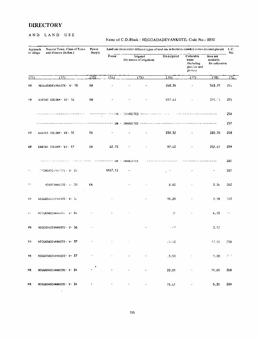
DIRECTORY
AND LAND USE
Approach to village
( 11 )
Nearest Town, Class of Town and distance (in Km.)
(12)
I'll. HEGGAOAOEVANKOTE- V- 18
PR KABINI COLONY- VI- 14
Power Supply
(13)
EA
fA
Name ofC.D.B[ock: HEGGADADEVANKOTE; Code No.: 0030
Land use (area undcr din;:rent types of land use in hectare!. rounded to two decimal plac.:s) L.C. No.
Forest Irrigated Un-irrigated Culturahll! An:a not (by source of irrigation) waste available:
(including for cultivation gauchar and grove,)
(14) (15) ( 16) ( 17) (18) e1}
248.24 543.71 2)';'
457.43 225. 'S 255
IJN iNHABITED -- .. ---.------ - - 256
-----.-.-.-.--- ... -----.--------- .. --- .. -.--. UN - INHABITED -- .. --.---- .. -.-.-----------.-.----.-.- ..•. -- 257
PR KABINI COLONY· VI· 15 EA 339.32 230.70 258
KR KABINI COLONY- VI- 17 EA 62.73 97.42 202.41 259
------------------ ----------- ---.------- UN - INHABITED 260
'-"'tGADADE'.,;t\~~ ')1£:- V- ~, L~· 9837.13 261
')~ ADADFVANt;.OTE- ,,- 30 EA 8.82 2.36 262
i(~ HEGGADADlV'~~OTE- V- 3, 15.29 2.18 ::'1,3
;., HEGGADADEVA~~QTc V- 34 4.13
PR HEGGADADEVANKOTE- V· 36 3.S;:
PR HEGGAOADEVANKOTE- V· 37 17,55 266
PR HEGGADADEVANKOTE- V· 37 ':3.53 1.08 ;>, "
PR HEGGADADEVANKOTE' V- 34 20.01 11.65 268
PR HEGGADADEVANKOTE- V- 34 15.41 5.35 269
155
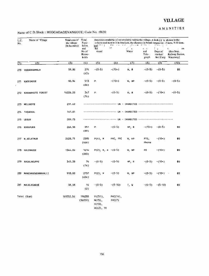
VILLAGE
AMENITIES Name of C.D.Block : HEGGADADEV ANKOTE; Code No. :0030
L.C. Name of Village Tolal area of Total Am~niti~s availahle (If not availahle within the village, a da&h (-) is shown in the
No. the village Poru- column and no:xtto it in bracl..~ts. the di&tance in broad rango:s viz. -5 kms, 5-10 kms. (In hectares) lation and ,A. : 1".1. . . '- .. , , . .... ., ',',
and Ed I ': .' on No.of tiona I Water and Days of [Sus Stop, Hou~e- Tel,;- market! Railway Station, holds graph hat if any Waterway I
( 1 ) (2) (3) ( 4) (5) (6) (7) (8) (92 ( 10)
270 VOOAKANAMALA 5Q.00 274 -(0-5) -(10+) W, R -(0-5) -(0-5) BS (43)
271 KAOEGADDE 90.94 513 P -(10+) W, HP -(0-5) -(0-5) -(0-5) (86)
272 KAKANAKOTE FOREST 14028.20 347 P - (0- 5) W, R -(0-5) -(10+) -(0-5)
(74)
273 MELUKOTE 231.62 ------------------------ UN - INHABITED -------------------------
274 THENEKAL 167.81 ------------------------ UN - INHABITED -------------------------
275 UDBUR 209.73 ------------------------ UN - I NHAB ITED -------------------------
276 KARAPURA 266.38 351 P -(0-5) HP, R - (10+) -(0-5) BS (89)
277 N.BELATHUR 2028.71 2395 P(4) , M PHC, FPC W, HP PTO, - (10+) BS (466) Phone
278 HALEMAGGE 1344.04 1614 P(2), H, H -(0-5) W, HP PO -(10+) BS (283)
279 RAGALAKUPPE 345.38 74 -(0-5) -(0-5) HP, R -(0-5) -(10+) BS (14)
280 MANCHAGOWDANAHALLI 918.00 2737 P(2), H -(0-5) W, HP -(0-5) -(10+) BS (454)
281 HALALAGADDE 38.08 14 -(0-5) -(5-10) T, W -(0-5) -(5-10) BS (2)
Total (Sum) 161352.56 196288 P(251), PHC(14), (36059) M(73), FPC(7)
H(13), AC(2) , TR
156
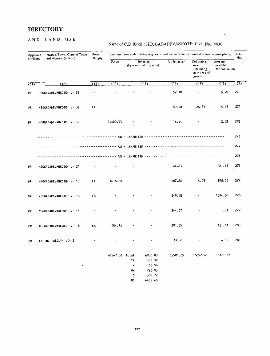
DIRECTORY
AND LAND USE
Approach N~aresl Town, Class of Town 10 village and distance (in Km.)
(11) (12)
PR HEGGADADEVANKOTE- V- 32
PR HEGGADADEVANKOTE- V- 32
PR HEGGADADEVANKOTE- V- 32
Power Supply
<B)
EA
Name ofC.D.B1ock: HEGGADADEVANKOTE; Code No.: 0030
Land u;c (arca under di n".:renl Iypes of land use in hectares rounded 10 two decimal places) L.C. No.
Foresl Irrigated Un-irrigated Cuhurable Area nol (by source of irrigation) wasle available
(including for cultivation gaucharand grov~s)
(14) (15) (16) < 17) (18) (1)
52.10 6.90 270
59.08 26.71 5.15 271
14009.33 16.44 2.43 272
--------------------------------------------- UN - INHABITED --------------------------------------------- 273
--------------------------------------------- UN - INHABITED --------------------------------------------- 274
--------------------------------------------- UN - INHABITED --------------------------------------------- 275
PR HEGGADADEVANKOTE- V- 24 44.83 221.55 276
PR HEGGADADEVANKOTE- V- 18 EA 1618.80 207.86 4.05 198.00 277
PR HEGGADACEVANKOTE- V- 18 EA 249.48 1094.56 278
PR HEGGADADEVANKOTE- V- 18 344.07 1.31 279
PR HEGGADADEVANKOTE- V- 18 EA 404.74 391.85 121.41 280
PR KABINI COLONY- VI- 8 33.56 4.52 281
60247.56 Total 6000.03 52585.85 16657.98 13121.57
Tk 386.32 w 36.56
We 726.93 0 367.77
GC 4482.45
157

HUNSUR C.D.BLOCK
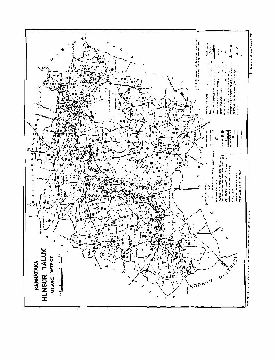
IX
4:
Z
:r: III
IX
)f n
)
1
1 1 :-~ . I':: I.b:© 1 I:: i i :_1
c,\l \\(.0 0 11-( ,
.'-'~ , I , I , I I I • .. ;;, .
• :IIC: ~ • ! : , , au
~ . E
o . . ,g
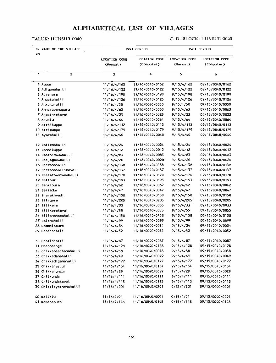
ALPlIABETICAL LIST OF VILLAGES
T ALUK: HUNSUR-0040
SL NAME OF THE VILLAGE NO
Abbur 2 Adiganahalli 3 Agrahar8 4 Angatahall i 5 Ankanahalli 6 Annaravanapura 7 Aspatnrekaval 8 Aswalu 9 Atthikuppe
10 Attiguppe 11 Ayarahalli
12 Ballenahalli 13 Bannikuppe
2
14 Basthimadahalli 15 Beejaganahalli 16 Beeranahalli 17 Beeranahallikaval 18 Beerathammanahalli 19 Belthur 20 Benkipura 21 Bettadur 22 Bharathvadi 23 Biligere 24 Bilikere 25 Bilikerekaval 26 Billanahosahalli 27 Bol anaha II i 28 BOIlIIla l apura 29 Boochahalli
30 Challahall i 31 Chennasoge 32 Chikkabeechanahalli 33 Chikkadanahalli 34 Chikkadiganahalli 3'5 Chikkahej jur 36 Chikkahunsur 37 Chilkunda 38 Chi Lkundakaval 39 Chittikyatnanahalli
40 Dallalu 41 Oasanapura
C.D.BLOCK:HUNSUR~O
1991 CENSUS 1981 CENSUS
LOCATION CODE (Manual)
3
11/16/4/162 11/16/4/122 11/16/4/190 11/16/4/126 11/16/460 11/16/4/63 11/16/4/23 11/16/4/64 11/16/4/112 11/16/4/179 11/16/4/40
11/16/4/24 11/16/4/12 11/16/4/83 11/16/4/20 11/16/4/138 11/16/4/137 11/16/4/170 11/16/4/193 11/16/4/62 11/16/4/47 11/16/4/150 11/16/4/205 11/16/4/33
11/16/4/55 11/16/4/158 11/16/4/99 11/16/4/34
11/16/4/52
11/16/4/87 11/16/4/128 11/16/4/58 11/16/4/49 11/16/4/177
11/16/4/154 11/16/4/29 ,'/16/4/11, 11/16/4/113
11/16/4/201
11/16/4/91 11/16/4/148
LOCATION CODE LOCATION CODE LOCATION CODE (Computer) (Manual) (Computer)
4
11/16/0040/0162 11/16/0040/0122 11/16/0040/0190 11/16/0040/0126 11/16/0040/0050 11/16/0040/0063 11/16/0040/0023 t 1/16/0040/0064 11/16/0040/0112 11/16/0040/0179 11/16/0040/0040
11/16/0040/0024 11/16/0040/0012 11/16/0040/0083 11/16/0040/0020 11/16/0040/0138 11/16/0040/0137 11/16/0040/0170 11/16/0040/0193 11/16/0040/0062 11/16/0040/0047 11/16/0040/0150 11/16/0040/0205 11/16/0040/0033
11/16/0040/0055 11/16/0040/0158 11/16/0040/0099 11/16/0040/0034 11/16/0040/0052
11/16/0040/0087 11/16/0040/0128 11/16/0040/0058 11/16/0040/0049 11/16/0040/0177
11/16/0040/0154 11/16/0040/0029 11/16/0040/0111 11/16/0040/0113 11/16/0040/0201
11/16/0040/0091 11/16/0040/0148
161
5
9/15/4/162 9/15/4/122 9/15/4/190 9/15/4/126 9/15/4/50 9/15/4/63 9/15/4/23 9/15/4/64 9/15/4/112 9/15/4/179 9/15/4/40
9/15/4/24 9/15/4/12 9/15/4/83 9/15/4/20 9/15/4/138 9/15/4/137 9/15/4/170 9/15/4/193 9/15/4/62 9/15/4/47 9/15/4/150 9/15/4/205 9/15/4/33 9/15/4/55 9/15/4/158 9/15/4/99 9/15/4/34 9/15/4/52
9/15/4/87 9/15/4/128 9/15/4/58 9/15/4/49 9/15/4/177
9/15/4/154 9/15/4/29 9/15/4/111 9/15/4/113
9/1.5/4/201
9/15/4/91 9/15/4/148
6
09/15/0040/0162 09/15/0040/0122 09/15/0040/0190 09/15/0040/0126 09/15/0040/0050 09/15/0040/0063 09/15/0040/0023 09/15/0040/0064 09/15/0040/0112 09/15/0040/0179 09/15/0040/0040
09/15/0040/0024 09/15/0040/0012 09/15/0040/0083 09/15/0040/0020 09/15/0040/0138 09/15/0040/0137 09/15/0040/0170 09/15/0040/0193 09/15/0040/0062 09/15/0040/0047 09/15/0040/0150 09/1 5/0040/0205 09/15/0040/0033
09/15/0040/0055 09/15/0040/0158 09/15/0040/0099 09/15/0040/0034 09/15/0040/0052
09/15/0040/0087 09/15/0040/0128 09/15/0040/0058 09/15/0040/0049 09/15/0040/0177
09/15/0040/0154 09/15/0040/0029 09/15/0040/0111 09/15/0040/0113 09/15/0040/0201
09/15/0040/0091 09/15/0040/0148
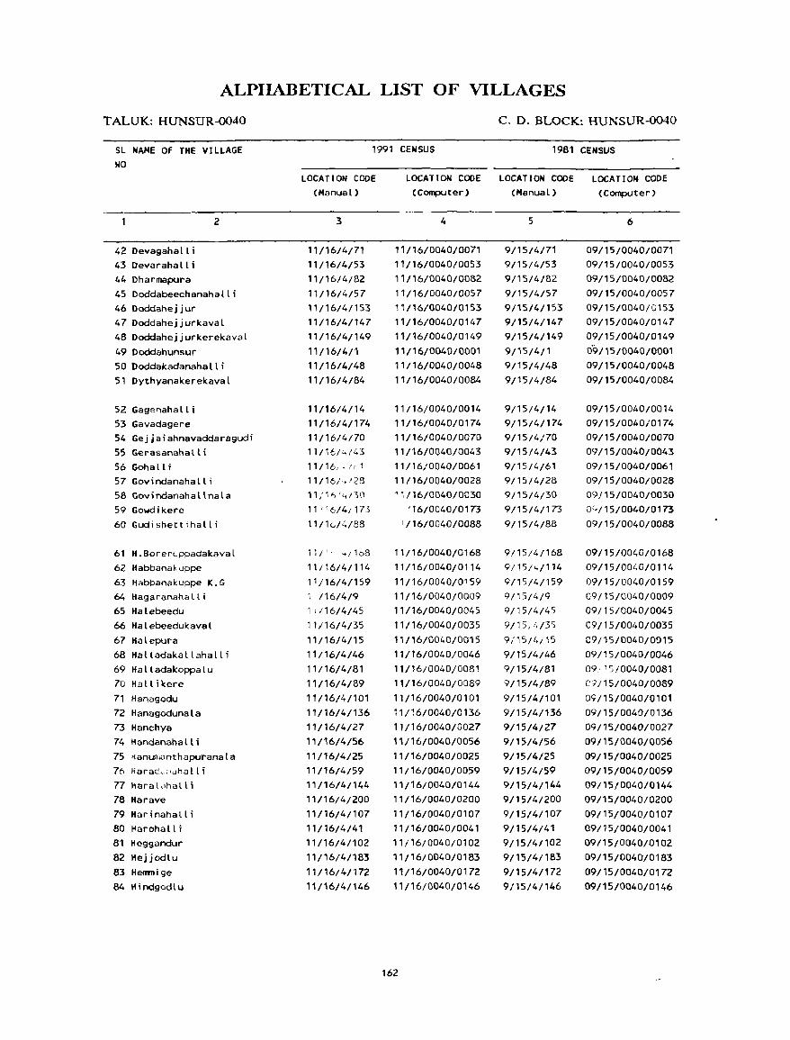
ALPIIABETICAL LIST OF VILLAGES
T ALUK: HUNSUR-0040
SL NAME OF THE VILLAGE NO
42 Oevagaha It i 43Devarahalli
2
44 Oharmapura 45Doddabeechanahalli 46 Doddahe j j ur 4700ddahejjurkaval 48DoddahejjurkerekavaL
49 Ooddahunsur 50 Doddakadanahalli 51 Dythyanakerekaval
52 Gagenahalli 53 Gavadagere 54 Gejjaiahnavaddaragudi 55 Gerasanahalli 56 Gohall i 57 Govindanahalli 58 Govindanahallnala 59 Gowdikere 60 Gudishettihalli
61 H.BorerL,ppadakaval 62 Habbanakllppe 63 Habbanakuppe K.G 64 Hagaranahall i 65 Halebeedu 66 Halebeedukaval 67 Halepura 68 Halladakallahalli 69 Halladakoppalu 70 HalLikere 71 Hanagodu 72 Hanagodunala 73 Hanchya 74 Handananall i 75 ,janumanthapuranala 76 Harac~:'dhall i 77 Itaraldhall i 78 Harave 79 Harinahalli 80 Harohalt; 81 Heggandur 82 Hejjodlu 83 Henmige 84 Hindgodlu
C. D. BLOCK: HUNSUR-0040
1991 CENSUS 1981 CENSUS
LOCATION CODE (Manual)
3
11/16/4/71 11/16/4/53 11/16/4/82
11/16/4/57 11/16/4/153 11/16/4/147 11/16/4/149
11/16/4/1 11/16/4/48
11/16/4/84
11/16/4/14 11/16/4/174 11/16/4/70 11/16/.:./43 11/16,,/r_1
11/16/,./28
11/11',1,,/30
11 1 '6/4{175
11/10/4/88
11/" 4/1b8
11/16/4/114
1 1 /16/4/159
i 116/4/9
1; 116/4/45
11;16/4/35
11/16/4/15 11/16/4/46
11/16/4/81 11/16/4/89
11/16/4/101 11/16/4/136
11/16/4/27 11/16/4/56
11/16/4/25 11/16/4/59 11/16/4/i44 11/16/4/200
11/16/4/107 11/16/4/41 11/16/4/102
11/16/4/183
11/16/4/172 11/16/4/146
LOCATION CODE LOCATION CODE LOCATION CODE (Computer) (Manual) (Computer)
4
11/16/0040/0071 11/16/0040/0053
11/16/0040/0082 11/16/0040/0057
11116/004010153
11/16/0040/0147 11/16/0040/0149
11/16/0040/0001 11/16/0040/0048
11/16/0040/0084
11/16/0040/0014 11/16/0040/0174 11/16/0040/0070 11/16/0040/0043
11/16/0040/0061 11/16/0040/0028 '1/16/0040/0030
'16/0040/0173
1/16/0040/0088
11/16/0040/0168 11/16/0040/0114
11/16/0040/0159 11/16/0040/0009
11/16/0040/0045 11/16/0040/0035
11/16/0040/0015
11/l6/0040/0046 11/16/0040/0081
11/16/0040/0089
11/16/0040/0101
11/:6/0040/0136 11/16/0040/0027
11/16/0040/0056
11/16/0040/0025 11/16/0040/0059 11/16/0040/0144
11/16/0040/0200
11/16/0040/0107 11/16/0040/0041 11/16/0040/0102 11/16/0040/0183
11/16/0040/0172 11/16/0040/0146
162
5
9/15/4171
9/15/4/53
9/15/4/82 9/15/4/57
9/15/4/153
9/15/4/147 9/15/4/149
9/15/4/1 9/15/4/48
9/15/4/84
9/15/4/14
9/15/4/174 9/15/4/70 9/15/4/43
9;15/4/61 9/15/4/28 9/15/4/30
9/1514/173
9/15/4/88
9/15;4;168
9/15/4/114
9/15/4/159
9/15/419
9/15/4/45
9/15/'~/35
9i15/4;i5
9/15/4/46 9/15/4/81 9/15/4/89
9/15/4/101
9/15/4/136 9/15/4/27 9/15/4/56
9/15/4/25 9/15/4/59
9/15/4/144
9/15/4/200
9/15/4/107 9/15/4/41 9/15/4/102
9/15/4/183
9/15/4/172 9/15/4/146
6
09/15/0040/0071 09/15/0040/0053 09/15/004010082
09/15/0040/0057 09/15/0040/(;153 09/15/0040/0147 09/15/0040/0149
0'9/15/0040/0001
09/15/0040/0048 09/15/0040/0084
09/15/0040/0014 09/15/0040/0174
09/15/0040/0070 09/15/0040/0043
09/15/0040/0061 09/15/0040/0028
09115/0040/0030 0(,,/15/0040/Q173
09/15/0040/0088
09{15/0040/0168
09/15/0040/0114
09/15/00t.0/0159
09/15/0040/0009
09/15/0040/0045
09/15/0040/0035
09/15/0040/0015
09/15/0040/0046
09: '5/0040/0081
C') i 15/0040/0089
09/15/0040/0101
09/15/0040/0136 09/15/0040/0027 09/15/0040/0056
09/15/0040/0025 09/15/0040/0059 09/15/0040/0144 09/15/0040/0200
09/15/0040/0107 09/15/0040/0041 09/15/0040/0102
09/15/0040/0183
09/15/0040/0172 09/15/0040/0146
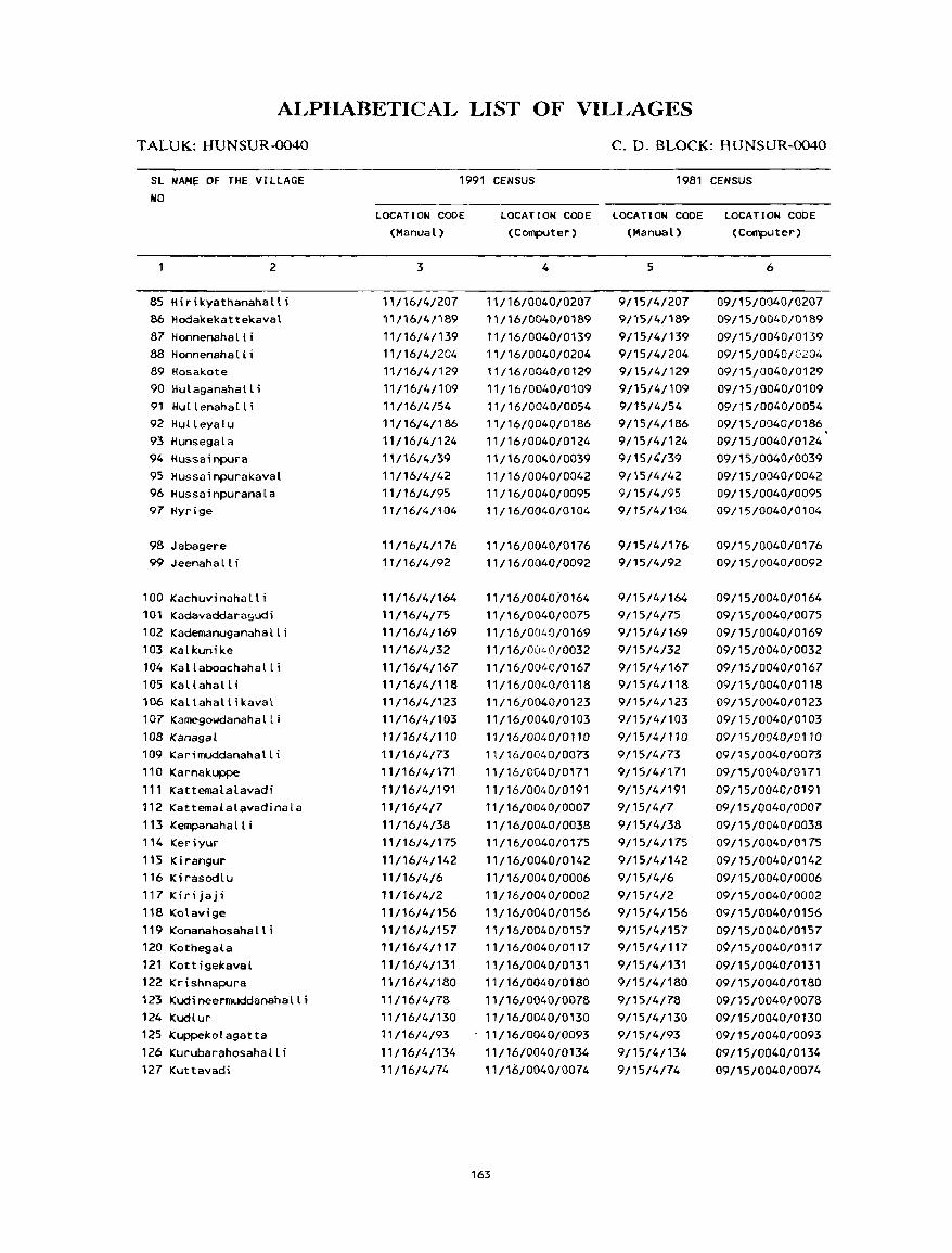
ALPIIABETICAL LIST OF VILLAGES
T ALUK: HUNSUR-0040
SL NAME OF THE VILLAGE NO
2
85 Hirikyathanahalli 86 Hodakekattekavat 87 HonnenahaLli 88 Honnenahal l i 89 Hosakote 90 Hulaganahalli 91 Hul lenahal l i 92 Hulleyalu 93 Hunsegala 94 Hussainpura 95 Hussainpurakaval 96 Hussainpuranala 97 Hyrige
98 Jabagere 99 Jeenaha II i
100 Kachuvinahalli 101 Kadavaddaragudi 102 Kademanuganahalli 103 Kalkunike 104 Kallaboochahalli 105 Kallahalli 106 Kallahallikaval 107 Kamegowdanahalli 108 Kanagal
109 Karimuddanahalli 110 Karnakuppe 111 Kattemalalavadi 112 Kattemalalavadinala 113 Kempanaha II i 114 Keriyur 115 Kirangur 116 Kirasodlu 117 Kid jaji 118 Kolavige 119 Konanahosahalli 120 Kothegala 121 Kottigekaval 122 Krishnapura 123 Kudineermuddanahalli 124 Kudlur 125 Kuppekolagatta 126 lCurubarahosahalli 127 Kuttavadi
C. D. BLOCK: HUNSUR-0040
1991 CENSUS 1981 CENSUS
LOCATION CODE (Manual)
3
11/16/4/207 11/16/4/189
11/16/4/139 11/16/4/204 11/16/4/129 11/16/4/109 11/16/4/54 11/16/4/186 11/16/4/124 11/16/4/39 11/16/4/42 11/16/4/95 11/16/4/104
11/16/4/176 11/16/4/92
11/16/4/164 11/16/4/75 11/16/4/169 11/16/4/32 11/16/4/167 11/16/4/118 11/16/4/123 11/16/4/103 11/16/4/110 11/16/4/73 11/16/4/171
11/16/4/191 11/16/4/7 11/16/4/38 11/16/4/175 11/16/4/142 11/16/4/6 11/16/4/2 11/16/4/156 11/16/4/157 11/16/4/117 11/16/4/131 11/16/4/180 11/16/4/78 11/16/4/130 11/16/4/93
11/16/4/134 11/16/4/74
LOCATION CODE LOCATION CODE LOCATION CODE (Computer) (Manual) (Computer)
4
11/16/0040/0207 11}16/0040/0189
11/16/0040/0139 11/16/0040/0204 11/16/0040/0129 11/16/0040/0109 11/16/0040/0054 11/16/0040/0186 11/16/0040/0124 11/16/0040/0039 11/16/0040/0042 11/16/0040/0095 11/16/0040/0104
11/16/0040/0176 11/16/0040/0092
11/16/0040io164 11/16/0040/0075 11/16/0040/0169 11/16/0040/0032
11/16/0040/0167 11/16/0040/0118 11/16/0040/0123 11/16/0040/0103
11/16/0040/0110
11/16/0040/0073 11/16/0040/0171
11/16/0040/0191 11/16/0040/0007 11/16/0040/0038 11/16/0040/0175 11/16/0040/0142 11/16/0040/0006 11/16/0040/0002 11/16/0040/0156 11/16/0040/0157 11/16/0040/0117 11/16/0040/0131 11/16/0040/0180 11/16/0040/0078 11/16/0040/0130 11/16/0040/0093
11/16/0040/0134 11/16/0040/0074
163
5
9/15/4/207 9/15/4/189 9/15/4/139 9/15/4/204 9/15/4/129 9/15/4/109 9/15/4/54 9/15/4/186 9/15/4/124
9/15/'/39 9/15/4/42 9/15/4/95 9/15/4/104
9/15/4/176 9/15/4/92
9/15/4/164 9/15/4/75 9/15/4/169 9/15/4/32 9/15/4/167 9/15/4/118 9/15/4/123 9/15/4/103
9/15/4/110 9/15/4/73 9/15/4/171
9/15/4/191 9/15/4/7 9/15/4/38 9/15/4/175 9/15/4/142 9/15/4/6 9/15/4/2 9/15/4/156 9/15/4/157 9/15/4/117 9/15/4/131 9/15/4/180 9/15/4/78 9/15/4/130 9/15/4/93
9/15/4/134 9/15/4/74
6
09/15/0040/0207 09/15/0040/0189
09/15/0040/0139 09/15/0040/0204 09/15/0040/0129 09/15/0040/0109 09/15/0040/0054 09/15/0040/0186 09/15/0040/0124 09/15/0040/0039 09/15/0040/0042 09/15/0040/0095 09/15/0040/0104
09/15/0040/0176 09/15/0040/0092
09/15/0040/0164 09/15/0040/0075 09/15/0040/0169 09/15/0040/0032 09/15/0040/0167 09/15/0040/0118 09/15/0040/0123 09/15/0040/0103
09/15/0040/0110 09/15/0040/0073 09/15/0040/0171
09/15/0040/0191 09/15/0040/0007 09/15/0040/0038 09/15/0040/0175 09/15/0040/0142 09/15/0040/0006 09/15/0040/0002 09/15/0040/0156 09/15/0040/0157 0¢/15/0040/0117 09/15/0040/0131 09/15/0040/0180 09/15/0040/0078 09/15/0040/0130 09/15/0040/0093 09/15/0040/0134 09/15/0040/0074
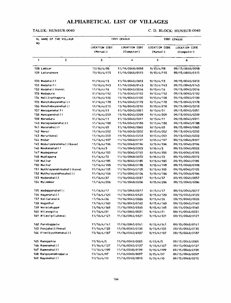
ALPIIABETICAL LIST OF VILLAGES
T ALUK: HUNSUR-0040
SL NAME OF THE VILLAGE NO
128 Lakkur 129 Lalanal<ere
130 Madaha II i 131 Madahalli 132 Madahallikaval 133 Madapura
2
134 Mallinathapura 135 Manchabayanahalli 136 Manchabayanahalli 137 Manuganahalli 138 Manuganahalli 139 Maraduru 140 Maragowdanahalli 141 Maranahalli 142 Marur '43 ftfarurkaval 144 Modur 145 Modursannenahallikaval 146 Mookanahalli 147 Mudagannur 148 Mudlapura 149 Mullur 150 Mullur 151 Muthrayanahosahallikaval 152 Muthurayanahosahalli 153 Mydanahalli 154 Mylambur
155 Nadappanahalli 156 Naganahalli 157 Nallurunala 158 Negathur 159 Heralakuppe 160 Ni lavagi lu 16' Ni(avigilukaval
162 Parekoppalu 163 Penjahallikaval 164 Pinnikyathanahalli
165 Ramapatna 166 Ramenahall i 167 Ramenahalli 168 RangayanakopPalu 169 Rayanahalli
C. D. BLOCK: HUNSUR-0040
1991 CENSUS 1981 CENSUS
LOCATION CODE (Manual)
3
11/16/4/98 11/16/4/115
11/16/4/13 11/16/4/143 11/16/4/16 11/16/4/192 11/16/4/100 11/16/4/178 11/16/4/210 11/16/4/51 11/16/4/209 11/16/4/11 ',/16/4/188 11/16/4/65 11/16/4/202 11/16/4/203 ,,/16/4/197 11/16/4/196 11/16/4/3 11/16/4/155 11/16/4/72 11/16/4/185 11/16/4/198 11/16/4/105 11/16/4/106 11/16/4/37 11/16/4/206
11/16/4/17 11/16/4/120 11/16/4/26 11/16/4/160 11/16/4/165 11/16/4/31 11/16/4/121
11/16/4/141 11/16/4/135 11/16/4/187
11/16/4/5 11/16/4/127 11/16/4/199 11/16/4/97 11/16/4/10
LOCATION CODE LOCATION CODE LOCATION CODE (Computer) (Manual) (Computer)
4
11/16/0040/0098 11/16/0040/0115
11/16/0040/0013 11/16/0040/0143 11/16/0040/0016 11/16/0040/0192 11/16/0040/0100 11/16/0040/0178 11/16/0040/0210 11/16/0040/0051 11/16/0040/0209 11/16/0040/0011 11/16/0040/0188 11/16/0040/0065 11/16/0040/0202 11/16/0040/0203 11/16/0040/0197 11/16/0040/0196 11/16/0040/0003 11/16/0040/0155 11/16/0040/0072 11/16/0040/0185 11/16/0040/0198 11/16/0040/0105 11/16/0040/0106 11/16/0040/0037 11/16/0040/0206
11/16/0040/0017 11/16/0040/0120 11/16/0040/0026 11/16/0040/0160 11/16/0040/0165 11/16/0040/0031 11/16/0040/0121
11/16/0040/0141 11/16/0040/0135 11/16/0040/0187
11/16/0040/0005 11/16/0040/0127 11/16/0040/0199 11/16/0040/0097 11/16/0040/0010
164
5
9/15/4/98 9/15/4/115
9/15/4/13 9/15/4/143 9/15/4/16 9/15/4/192 9/15/4/100 9/15/4/178 9/15/4/210 9/15/4/51 9/15/4/209 9/15/4/11 9/15/4/188 9/15/4/65 9/15/4/202 9/15/4/203 9/15/4/197 9/15/4/196 9/15/4/3 9/15/4/155 9/15/4/72 9/15/4/185 9/15/4/198 9/15/4/105 9/15/4/106 9/15/4/37 9/15/4/206
9115/4/17 9/15/4/120 9/15/4/26 9/15/4/160 9/15/4/165 9/15/4/31 9/15/4/121
9/15/4/141 9/15/4/135 9/15/4/187
9/15/4/5 9/15/4/127 9/15/4/199 9/15/4/97 9/15/4/10
6
09/15/0040/0098 09/15/0040/0115
09/15/0040/0013 09/15/0040/0143 09/15/0040/0016 09/15/0040/0192 09/15/0040/0100 09/15/0040/0178 09/15/0040/0210 09/15/0040/0051 09/15/0040/0209 09/15/0040/0011 09/15/0040/0188 09/15/0040/0065 09/15/0040/0202 09/15/0040/0203 09/15/0040/0197 09/15/0040/0196 09/15/0040/0003 09/15/0040/0155 09/15/0040/0072 09/15/0040/0185 09/15/0040/0198 09/15/0040/0105 09/15/0040/0106 09/15/0040/0037 09/15/0040/0206
09/15/004010017 09/15/0040/0120 09/15/0040/0026 09/15/0040/0160 09/15/0040/0165 09/15/0040/0031 09/15/0040/0121
09/15/0040/0141 09/15/0040/0135 09/15/0040/0187
09/15/0040/0005 09/15/0040/0127 09/15/0040/0199 09/15/0040/0097 09/15/0040/0010
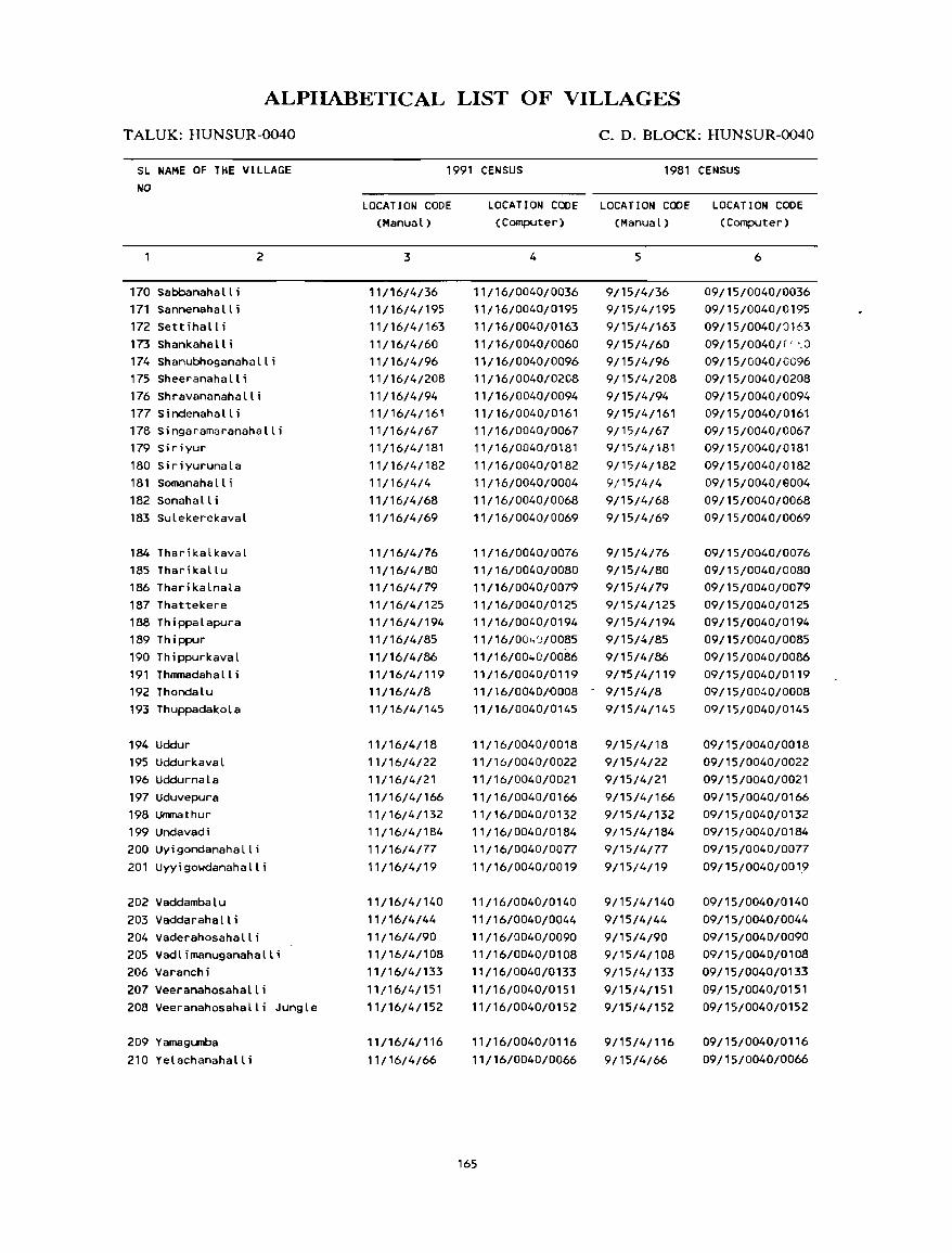
ALPHABETICAL LIST OF VILLAGES
T ALUK: HUNSUR-0040
SL NAME OF THE VILLAGE NO
170 Sabbanaha II i 171 Sannenahalli 172 Settihalli 173 Shankahall i
2
174 Shanubhoganahalli 175 Sheeranahalli 176 Shravananahalli 177 Sindenahalli 178 Singaramaranahalli 179 Siriyur 180 Siriyurunala 181 Somanahalli 182 Sonahalli 183 Sulekerekaval
184 Tharikalkaval 185 Tharikallu 186 Tharikalnala 187 Thattekere 188 Thippalapura 189 Thippur 190 Thippurkaval 191 Thnmadahalli 192 Thondalu 193 Thuppadakola
194 Uddur 195 Uddurkaval 196 Uddurnala 197 Uduvepura 198 Unmathur 199 Undavadi 200 Uyigondanahalli 201 Uyyigowdanahalli
202 Vaddambalu 203 Vaddarahalli 204 Vaderahosahalli 205 Vadlimanuganahalli 206 Varanchi 207 Veeranahosahalli 208 Veeranahosahalli Jungle
209 Yamagumba 210 Yelachanahalli
C. D. BLOCK: HUNSUR-0040
1991 CENSUS 1981 CENSUS
LOCATION CODE (Manual)
3
11/16/4/36 11/16/4/195
11/16/4/163 11/16/4/60 11/16/4/96 11/16/4/208
11/16/4/94 11/16/4/161 11/16/4/67 11/16/4/181
11/16/4/182 11/16/4/4
11/16/4/68 11/16/4/69
11/16/4/76 11/16/4/80 11/16/4/79 11/16/4/125
11/16/4/194 11/16/4/85
11/16/4/86 11/16/4/119 11/16/4/8 11/16/4/145
11/16/4/18 11/16/4/22 11/16/4/21
11/16/4/166 11/16/4/132 11/16/4/184 11/16/4/77
11/16/4/19
11/16/4/140
11/16/4/44 11/16/4/90 11/16/4/108 11/16/4/133
11/16/4/151 11/16/4/152
11/16/4/116
11/16/4/66
LOCATION CODE LOCATION CODE LOCATION CODE (Computer) (Manual) (Computer)
4
11/16/0040/0036 11/16/0040/0195
11/16/0040/0163 11/16/0040/0060 11/16/0040/0096 11/16/0040/0208
11/16/0040/0094 11/16/0040/0161 11/16/0040/0067 11/16/0040/0181
11/16/0040/0182 11/16/0040/0004
11/16/0040/0068 11/16/0040/0069
11/16/0040/0076 11/16/0040/0080 11/16/0040/0079 11/16/0040/0125 11/16/0040/0194 11/16/004')/0085
11/16/00 .. 0/0086 11/16/0040/0119 11/16/0040/-0008
11/16/0040/0145
11/16/0040/0018 11/16/0040/0022
11/16/0040/0021
11/16/0040/0166 11/16/0040/0132 11/16/0040/0184 11/16/0040/0077
11/16/0040/0019
11/16/0040/0140
11/16/0040/0044 11/16/0040/0090 11/16/0040/0108 11/16/0040/0133
11/16/0040/0151 11/16/0040/0152
11/16/0040/0116
11/16/0040/0066
165
5
9/15/4/36 9/15/4/195
9/15/4/163 9/15/4/60 9/15/4/96 9/15/4/208
9/15/4/94 9/15/4/161 9/15/4/67 9/15/4/181
9/15/4/182 9/15/4/4
9/15/4/68 9/15/4/69
9/15/4/76 9/15/4/80 9/15/4/79 9/15/4/125 9/15/4/194
9/15/4/85 9/15/4/86
9Jt5/4/119 9/15/4/8 9/15/4/145
9/15/4/18
9/15/4/22 9/15/4/21
9/15/4/166 9/15/4/132 9/15/4/184 9/15/4/77
9/15/4/19
9/15/4/140
9/15/4/44 9/15/4/90 9/15/4/108
9/15/4/133
9/15/4/151 9/15/4/152
9/15/4/116
9/15/4/66
6
09/15/0040/0036 09/15/0040/0195
09/15/0040/::l163 09/1 5/0040/(" <) 09/15/0040/0096 09/15/0040/0208
09/15/0040/0094 09/15/0040/0161 09/15/0040/0067 09/15/0040/0181
09/15/0040/0182
09/1 5/0040/9004 09/15/0040/0068 09/15/0040/0069
09/15/0040/0076 09/15/0040/0080 09/15/0040/0079
09/15/0040/0125 09/15/0040/0194 09/15/0040/0085
09/15/0040/0086 09/15/0040/0119 09/15/0040/0008 09/15/0040/0145
09/15/0040/0018
09/15/0040/0022 09/15/0040/0021
09/15/0040/0166 09/15/0040/0132 09/15/0040/0184 09/15/0040/0077
09/15/0040/001,9
09/15/0040/0140
09/15/0040/0044 09/15/0040/0090 09/15/0040/0108 09/15/0040/0133
09/15/0040/0151 09/15/0040/0152
09/15/0040/0116
09/15/0040/0066

VILLAGE
AMENITIES
C.D.Block: HUNSUR; Code No. :0040
Name of Village Total area of Total Am~niti.:s availabl.: (if not available within the village. a dash (-) is shown in the
the village Popu- column and n~xtto it in brackets. the distance in broad ranges viz. -5 kms. 5-10 kms,
(In hectares) lation and 10+ kms ofth~ nearest [!Ia-:e where the facilitl: is available is given). and &luea- Medical Drinking Post Day or Communication
No.of tional Water and Days of [Bus Stop.
HouS4!- Tele- marketf Railway Station.
holds graph hat if any Waterway)
(2) (3) (4) (5) (6) (7) (8) (9) (10)
lAHUNSUR 873.21 757 P -(0-5) II, HP -(0-5) - (0- 5) BS
( 122)
IJAJI 568.93 1123 P(2) - (0- 5) II, HP -(0-5) -(0-5) BS
(193)
ANAHALLI 473.54 1706 P -(0-5) T, II, HP -(0-5) -(0-5) BS
(305)
\NAHALLI 366.47 896 P -(0-5) II, HP PO -(5-10) BS
( 167)
I"\PATNA 417.95 815 P -(5-10) II, HP -(0-5) -(5-10) BS
( 124)
~SODLU 166.86 409 P -(0-5) w, HP - (0-5) -(5-10) BS
(65)
TEHALALAVADINALA 324.65 ----~------------------- UN - INHABITED -------------------------
..JDALU 359.99 921 p(2) -(0-5) w, HP PO -(5-10) BS
( 179)
\RANAHALLI 331.33 775 P, M -(5-10) w, HP - (0- 5) - (10+) BS
( 138)
\NAHALLI 159.20 459 P -(5-10) II, HP -(0-5) -(10+) BS
(84)
ADURU 870.37 2390 P(6), H -(0-5) II, HP PTO, -(5-10) BS
(432) Phone
~IKUPPE 1205.02 5210 P(8) , H, H PHC, FPC T, HP PTO, -(5-10) BS
(881) Phone
~HALL[ 509.81 356 P -(O-S) II, HP -(0-5) -(10+) BS
(59)
ENAHALLI 1018.49 1551 P(2) , H -(0-5) T, HP PTO, -(0-5) BS
(282) Phone
EPURA 711. 74 1040 P(3) -(5-10) w, HP -(0-5) -(10+) • (0-5)
(182)
166
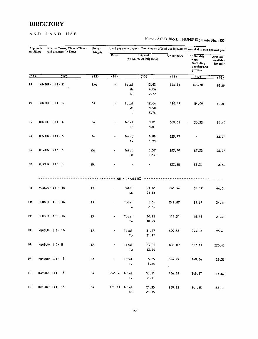
DIRECTORY
AND LAND USE
Name of C.D.Block : HUNSUR; Code No.: ()().
Approach Nearest Town, Class of Town Power Land use (area under ditTerent types of land UIIC in hectares rounded to Iwo decimal pia, 10 village and distance (in Km.) Supply
Forest Irrigated Un-Irrigated Culturable Area not (hy !o<.)urce of irrigation) waste available
(inclUding forcultb gauchar and groves)
( 11 ) (12) (13) ( 14) (15) (16) (17) (18)
PR HUNSUR- 111- 2 EAG Total 12.63 526.56 563.70 9S.81 We 4.86 GC 7.77
PR HUNSUR- 111- l fA Total 12.64 420.47 84.99 50.8-We 8.90
0 3.74
PR HUNSUR- III· 4 fA Total 8.01 369.81 36.32 59.4C GC 8.01
PR HUNSUR- 111- 6 fA Total 6.98 325.77 33.72 Tw 6.98
PR HUNSUR- 111- 6 fA Total 0.57 283.79 87.32 46.27 0 0.57
PR HUNSUR- 111- 8 fA 122.88 35.34 8.6<-
.... _---------------------------------------- UN - INHABITED ---------------------------------------------
. R HUN SUR- 111- 10 fA Total 21.86 261.94 32.19 44.0( GC 21.86
PR HUNSUR- 111- 16 EA Total 2.65 242.87 )1.67 34.1, Tw 2.65
PR HUNSUR- IlI- 16 EA Total 10.79 111.31 15.43 21.6~
Tw 10.79
PR HUNSUR- 111- 10 EA Total 31.17 499.55 243.03 96.6 Tw 31.17
PR HUN SUR- 111- 8 EA Total 23.20 828.09 127.11 226.6; Tw 23.20
PR HUN SUR- 111- 13 EA Total 5.85 324.77 149.84 29.3S Tw 5.85
PR HUNSUR- I11- 18 EA 252.86 Total 15.11 486.85 245.87 17.80 Tw 15.11
PR HUN SUR- I11- 16 EA 121.41 Total 21.35 289.22 141.65 138.11 GC 21.35
167
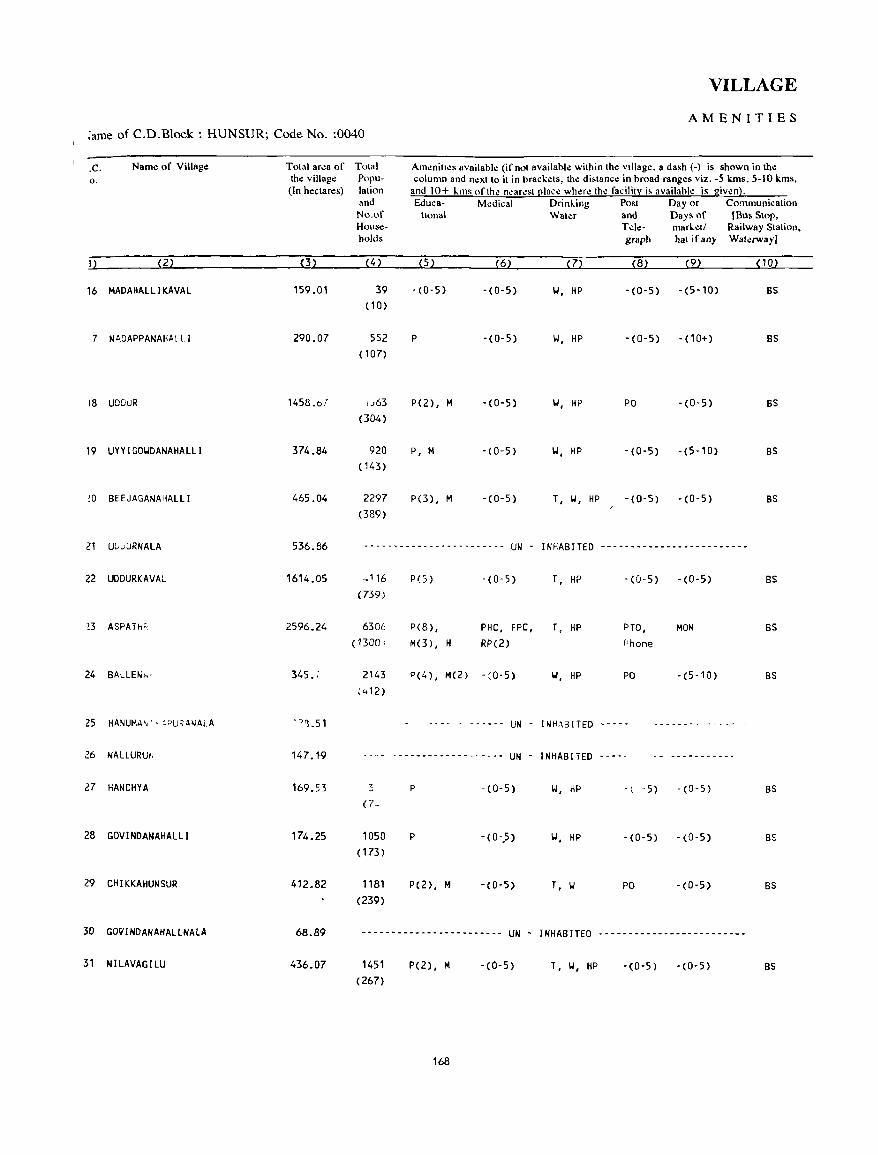
VILLAGE
AMENITIES ;ame of C.D.Block : HUNSUR; Code No. :0040
.c. Name of Village Total area of Total Ameniltes available (if not availahle within the village. a dash (-) is shown in the o. the village Popu- column and next 10 it in brackets, the di.lance in broad ranges viz. -5 kms, 5-10 kms,
(In hectares) lation and 10+ lms of the n~aro!st l!lace where the facility i, availahle is given}. and Educa- Medical Drinling Post Day or Communication No.of Ilonal Water and Days of IBus Stop. House- Telc- marletl Railway Station, holds graph hat ifany Wah:rway]
I) (2) (3) (4 ) (5) (6) (7) (8) (9) (10)
16 MAOAHALLIKAVAL 159.01 39 -(0-5) -(0-5) \oJ, HP - (0- 5) -(5-10) BS (10)
7 N~DAPPANAHAL LI 290.07 552 P -(0-5) \oJ, HP -(0-5) -(10+) BS (107)
18 UDOUR 1458.67 u63 P(2) , M -(0-5) \oJ, HP PO -(0-5) BS (304)
19 UYYIGO\oJDANAHALLI 374_84 920 P, M -(0-5) \oJ, HP -(0-5) -(5-10) BS (143)
!O BEEJAGANAHALLI 465.04 2297 P(3) , M -(0-5) T, 101, HP -(0-5) -(0-5) BS (389)
21 UG",URNALA 536.86 ----- .. _---_------------- UN . INHABITED -------------------------
22 UDOURKAVAL 1614.05 -116 P(5 ) -(0-5) T, HP -(0-5) -(0-5) BS (739)
~3 ASPATh'. 2596.24 6306 P(8) , PHC, FPC, T. HP PTO, MON BS (1300 I M(3) , H RP(2) Phone
24 BALLEN;.,· 345. ; 2143 P(4) , M(2) - :0-5) \oJ, HP PO -(5-10) BS ~,+12)
25 HANUMA~" :PU~ANALA ·-'~.51 - ... - - ............ UN - INHABITED .. .............. .. - - .. -
26 NAlLURUI, 147.1-9 -------- .. ---------- UN - INHABITED -----------
27 HANCHYA 169.53 3 P -(0-5) 101, HP -, -5) -(0-5) BS (7-
28 GOV I NDANAHAL LI 174.25 1050 P -(0-.5) 101, HP -(0-5) -(0-5) BS ( 173)
29 CHIKKAHUNSUR 412.82 1181 P(2), M -(0-5) T, 101 PO -(0-5) 8S (239)
30 GO~INOANAHALLNAlA 68.89 ----_._----------------- UN - INHABITED -------------------------
31 NILAVAGILU 436.07 1451 P(2), M - (0- 5) T, \oJ, HP -(0-5) -(0-5) BS (267)
168
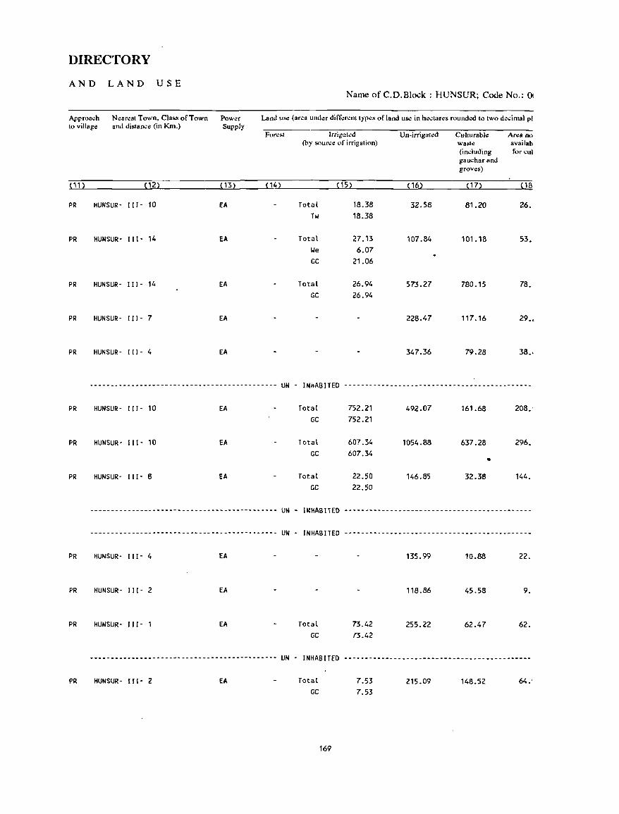
DIRECTORY
AND LAND USE Name of C.D.Block : HUNSUR; Code No.: Ot
Approach Nearest Town, Class of Town Power Land use (area under different types or land use in hectares rounded to two decimal pI to village and distancll (in Km.) Supply
Forc~1 lrrigatcd Un-irrigalcd Culturable Area no (by soun:e of irrigation) wasle availab
(including for cui gauchar and groves)
n1> (12) (13) (14) (15) (16) ( 17> ( 18
PR HUNSUR- (II - 10 EA Total 18.38 32.58 81.20 26. Tw 18.38
PR HUNSUR- 111- 14 EA Total 27.13 107.84 101.18 53. lJe 6.07 GC 21.06
PR HUN SUR- 111- 14 EA Total 26.94 573.27 780.15 78. GC 26.94
PR HUNSUR- 111- 7 EA 228.47 117.16 29.,
PR HUNSUR- (( 1- 4 EA 347.36 79.28 38.-
--------------------------------------------- UN - INHABITED ---------------------------------------------
PR HUNSUR- 111- 10 EA Total 752.21 492.07 161.68 208. GC 752.21
PR HUNSUR- 111- 10 EA Total 607.34 1054.88 637.28 296. GC 607.34
• PR HUNSUR- 111- 8 EA Total 22.50 146.85 32.38 144.
GC 22.50
--------------------------------------------- UN - IWHABITED ---------------------------------------------
--------------------------------------.------ UN - INHABITED ---------------------------------------.-----
PR HUNSUR- 111- 4 EA 135.99 10.88 22.
PR HUNSUR- 111- 2 EA 118.86 45.58 9.
PR HUNSUR- 111- 1 EA Total 73.42 255.22 62.47 62. GC 73.42
-----.- •••• - •••• -- ••••••••••• -- •• -- •••• ------ UN - INHABITED •••••• - •• - •••• - ••••• _.- •••••••• - •• -- •••••••••
PR HUNSUR- 111- 2 EA Total 7.53 215.09 148.52 64. GC 7.53
169
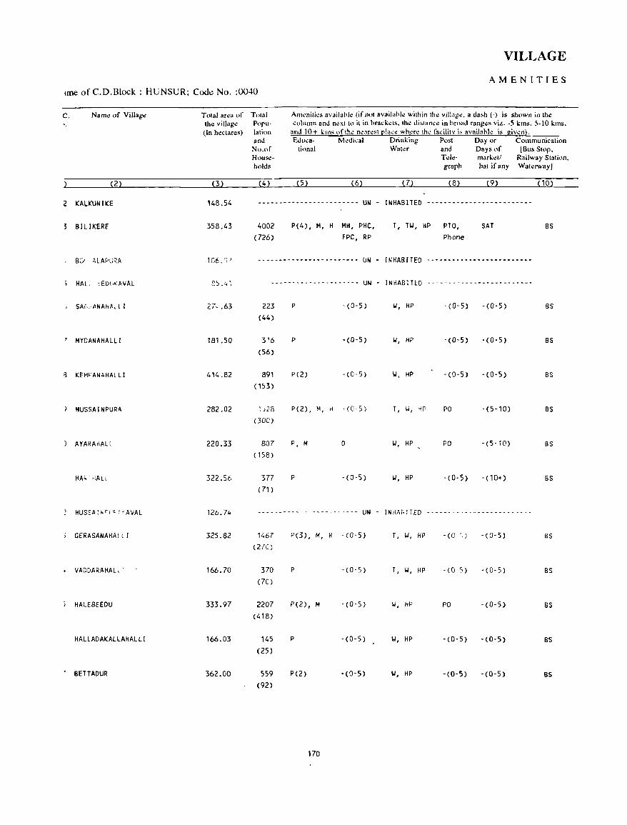
VILLAGE
AMENITIES tme of C.D.Block : HUNSUR; Code No. :0040
C. Name of Village
'.
(2)
2 KALKUNIKE
S BILIKERE
, MYDANAHALLI
g KEM>'ANAHALL I
~ HUSSAI NPURA
) AYARAHALl
HA"- ',IAL
HUSSA"C>I'C"AVAL
GERASANAHA( l r
• VADDARAHALl'
HAlEBEEDU
HALLADAKALLAHALLI
• BETTADUR
Tolal ar.:a of tho: village (In hectares)
(3)
148.54
358.43
106. 'J!
~5,,41
181.50
414.82
282.02
220.33
322.56
126.74
325.82
166.70
333.97
166.03
362.00
Tolal Populalion and No.of HOllseholds
(4)
AIll~nili.:s availa!>l.: (if nI)l availahle wilhinlh.: village, a da~h (-) is shown in Ihe column and nex110 it in hra,k.:ls. the di.tance in hroad ranges ViL_ -5 kms. 5-10 kms.
and 10+ kms "flhe nearest place where Ihe fadlity i, availahle is giv.:n). Edu,a- M.:dical Drinking Post Day or Communication
tional Water and Days of (Bus Stop. Tde- marketl Railway Station. grllph hat if any Waterway)
(5) (6) (7) (8) (9) (10)
.----------------------- UN - INHABITED -------------------------
4002
( 726)
P(4), M, H MH, PHC, FPC, RP
T, TW, HP PTO, Phone
SAT
-------- .. --------.----- UN - INHABITED -----.--.-.--.-.---- .. ---
--------------------- UN - INHABITED -------------------------
223 (44)
316
(56)
891 (153)
~j28
(300)
807 (158)
377 (71 )
P -(0-5)
P -(0-5)
P(2) -(0-5)
P(2), M, rl -(0'5)
P, M D
P -(0-5)
W, liP - (0-5) -(0-5)
W, HP - (0- 5) -(0-5)
101, HP -(0-5) -(0-5)
T, W, HP PO -(5-10)
W, HP PO - (5- iO)
101, HP -(0-5) -(10+)
- - - -- - - - - - . - -- - - -- - - -- -- UN - I N HAG IT ED - - - - - - - - -- - - - - - - - -- - - - - - -
1467
(270)
370 (70)
2207 (418)
145 (25)
559 (92)
P(3), M, fi -(0-5)
P - (0-5)
P(2), M -(0-5)
P -(0-5)
P(2) - (0- 5)
170
r, "', fiP - (0 ',} -(0-5)
T, W, HP -(0 5) -(0-5)
Ii, HP PO -(0-5)
\I, HP -(0-5) -(0-5)
101, HP -(0-5) -(0-5)
BS
BS
BS
BS
BS
BS
as
BS
as
8S
BS
BS
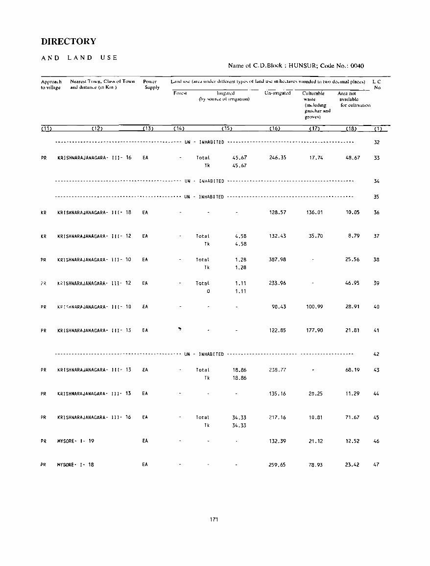
DIRECTORY
AND LAND USE
Approach to vlllago:
(11)
N.:ar.:.t Town. Cia,s 01 Town and dlstanc': (Ill Km )
(12)
Pow.:r Supply
(13) (14)
Name ot C.D.Block : HUNSUR; Code No.: 0040
No hngdh:d Un·lrngat.:d Cuhurahle Ar':3 not
(hy ,oure.: 01 Irngatlon) wa.t.: avallabl.: (Illdudlllg for cultlvalton gauchar and grov':'j
(15) ( 16) ( 17) ( 18) (1)
--------------------------------------------- UN - INHABITED --------------------------------------------- 32
PR
KR
KR
PR
PR
PR
PR
PR
PR
PR
PR
PR
KRISHNARAJANAGARA- 111- 16 EA
--------------------------------------------- UN
Total Tk
45.67 45.67
246.35 17.74 48.67
INHABITED -------.-------------------------------------
33
34
--------------------------------------------- UN - INHABITED --------------------------------------------- 35
KRISHNARAJANAGARA- 111- 18 EA 128.57 136.01 10.05 36
KRISHNARAJANAGARA- 111- 12 EA Total 4.58 132.43 35.70 8.79 37 Tk 4.58
KRISHNARAJANAGARA- III- 10 EA Total 1.28 387.98 25.56 38 Tk 1.28
K~ISHNARAJANAGARA' 111- 12 EA Total 1.11 233.96 46.95 39 0 1.11
KPISrlNARftJANAGARA- 111- 10 EA 90.43 100.99 28.91 40
KRISHNARAJANAGARA- 111- 13 EA ~ 122.85 177.90 21.81 41
---------_ ... ------------"'-------------- .. _----- UN - INHABITED ------------------------- ------------------- 42
KRISHNARAJANAGARA- I I 1- 13 EA Total 18.86 238.77 68.19 43 Tk 18.86
KRISHNARAJANAGARA- I I I - 13 EA 135.16 20.25 11.29 44
KRISHNARAJANAGARA- I I I - 16 EA Total 34.33 217.16 10.81 71.67 45 Tk 34.33
MYSORE- I- 19 EA 132.39 21.12 12.52 46
MYSORE- 1- 18 EA 259.65 78.93 23.42 47
171

VILLAGE
AMENITIES Name of C.D.Block : HUNSUR; Code No. :0040
LC. Namo: of Vtllago: Tolal ar.:a of Tolal Am~nlll~' avalldbl.: (If not aVdll.able wllhan Ihe villag~. 8 dash (-) is shown an tho: No tho: vllI.ago: Popu- column and n,:Xllo 11m hra .. l.:ls, Iho: dlslan .. .: m broad rang~s VIZ -, lms. 5-10 kms,
(In h.:ctar.:s) lahon and 10+ lim oflh~ n~ar.:q ~Ia .. e wh~re Ih.: faclhl:t I~ avatlablc IS glvcn) and Educa- M~dlCal Drtnlmg Po!>1 Ddyor Communlcallon
No of 1I0nai Wal.:r and Days of IBus SlOp. Huus!!- Tde- marl.:l/ Railway SIal ion. hold. graph hal If any Wal~JWayl
(1) (2) (3) (4) (5) (6) (7) (8) (9) ( 1 0)
48 DOODAKADANAHALLI 273.19 19 -(0-5) -(5-10) w, HP -(0-5) -(5-10) '(0-5) (6)
49 CH I KKADANAHAL LI 235.45 662 P(2) -(0-5) W, HP -(0-5) -(5-10) BS (128)
50 ANKANAHALLI 397.14 584 P(2), M -(0-5) W, HP -(0-5) -(0-5) BS (122)
51 MANUGANAHALLI 518.40 1013 P(2), M -(0-5) \01, HP PO -(0-5) BS (207)
52 BOOCHAHALLI 174.25 344 P -(0-5) IJ, HP -(0-5) -(0-5) -(0-5) (56)
53 DEVARAHALLI 176.59 SOl P(2) -(0-5) \01, HP -(0-5) -(0-5) BS (99)
54 HULLENAHALLI 263.54 918 P(2) -(0-5) 101, HP -(0-5) -(0-5) BS (169)
55 BILlKEREKAVAL 73.64 -------------.---------- UN - I NHAB !TED ~------------------------
56 HANDANAHALLI 753.93 1232 P(2) -(0-5) \01, HP -(0-5) -(0-5) BS ( 196)
57 DOODABEECHANAHALLI 303.88 517 P(2) -(0-5) \01, HP -(0-5) -(0-5) BS (95)
58 CHIKKABEECHANAHALLI 320.27 1770 P(2) -(0-5) 1..1, HP PTO, -(0-5) BS (320) Phone
59 HARADANAHALLI 158.17 356 P -(0-5) 1..1, HP -(0-5) -(5-10) BS (64)
60 SHANKAHAlLI 166.53 467 P -(0-5) 1..1, HP -(0-5) -(5-10) BS (87)
61 GOHALLI 219.24 347 P -(5-10) 1..1, HP -(0-5) - (10+) BS (65)
62 BENKIPURA 352.81 1658 P -(10+) 1..1, HP -(0-5) - (10+) BS (275)
172
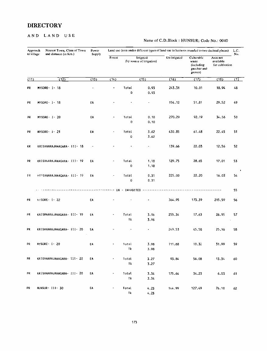
DIRECTORY
AND LAND USE Name of C.D.Block : HUNSUR; Code No.: 0040
Approach N~arest Town, Class of Town Power Land use (ar~a und..:r dini:r~nt types of land u~ in h~ctares rounded to two decimal places) L.C. to Village and distance (in Km.) Supply No.
Foresl Irrigal~d Un-irrigal~d Culturable Area nol (by source of irrigation) waste available
(including for c ullivation gauchar and groves)
(11) (12) (13) ( 14) ( 15) (16) (17) (18) (1)
PR MYSORE- )- 18 Total 0.93 243.31 10.01 18.94 48 0 0.93
PR MYSORE- )- 18 EA 154.12 51.81 29.52 49
PR MYSORE- )- 20 EA Total 0.10 270.29 92.19 34.56 50 0 0.10
PR HYSORE- 1- 21 EA Total 3.62 430.85 61.48 22.45 51 0 3.62
KR KRISHNARAJANAGARA' 111- 18 139.66 22.03 12.56 52
PR KRISHNARAJANAGARA- 111- 19 EA Total 1.18 129.75 28.65 17.01 53 0 1. 18
PR ~R1SHNARAJANAGARA- 111- 19 EA To~al 0.31 225.00 22.20 16.03 54 0 0.31
-- ------------------------------------------ UN - INHABITED ------------_ .. ------------------------------- 55
PR v,SORE- 1- 22 EA 364.95 173.39 215.59 56
PR KRISHNARAJANAGARA- 111- 19 EA Total 3.96 255.34 17.63 26.95 57 Tk 3.96
PR KRISHNARAJANAGARA- 111- 20 EA 249.53 45.58 25.16 58
PR MYSORE- 1- 20 EA Total 3.98 111.88 10.32 31.99 59 Tk 3.98
PR KRISHNARAJANAGARA- 111- 22 EA Total 3.27 93.84 56.08 13.34 60 Tk 3.27
PR KRISHNARAJANAGARA- 111- 20 EA Total 3.34 175.64 34.23 6.03 61 Tk 3.34
PR HUNSUR- III- 30 EA Total 4.23 144.99 127.49 76.10 62 Tk 4.23
173
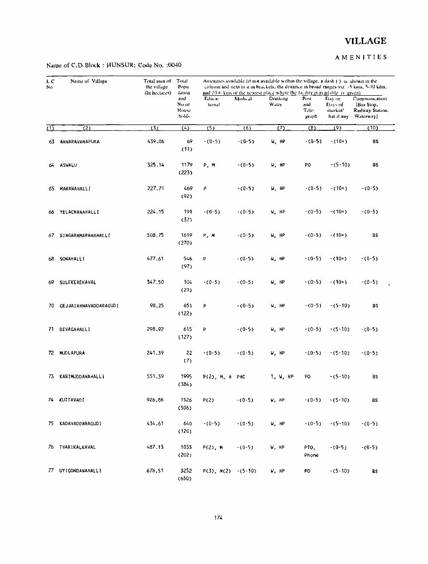
VILLAGE
AMENITIES Name of C.D.Block : HUNSUR; Code No. :0040
LC Nam~ of VIllage TOla! ar~a of Told! AI11~mll~' aval!dok (II nol aV8Jldhl~ 'l<llhm Ihe vllI'lg~. a da..o () I~ ,ho~n In Ihe No Ihe VIllage Popu column and n~)(llo II In brdd.d •. Ihe d"lance III broad ranges VIol .~ I..ITIs. ~-IO I..I'oS.
(In h~ddr.:~) Idllon and 10+ kill' (lllh.: n':3r.:,1 [!1,1c': \\h.:r.: thl! 1,1,,111): I~ a\ad 1111.: I~ glwn) and Educa- t-kdICdl Onnl.lIlg Po,1 0,,) or Commumcallon No ot lllllldl Wdl~r and 0.1)' of IBu, SlOp. Hou"l! Td~- m.lrI.~11 Railway Sidlion. hold, grdph h.lll! any Wdl~rwayJ
(1) (2) (3) (4) (5) (6) (7) (8) (9) ( 10)
63 ANNARAVANAPURA 439.06 69 -(0-5) -(0-5) 1.1, HP -(0-5) -(10+) as (11)
64 ASIJALU 325.14 1179 P, M -(0-5) 1.1, HP PO -(5-10) as (223)
65 MARANAHAlll 227.71 469 P -(0-5) 101, HP -(0-5) -(10+) -(0-5) (92)
66 YELACHANAHALLI 224.15 191 -(0-5) -(0-5) 1.1, HP -(0-5) -(10+) -(0-5) (37)
67 SINGARAMARANAHAlLI 508.75 1619 P, M -(0-5) 1.', HP -(0-5) -(10+) as (270)
68 SONAHALLl 477.61 546 P -(0-5) 1.1, HP -(0-5) - (10+) -(0-5) (97)
69 SULEKEREKAVAL 347.50 104 -(0-5) -(0-5) II, HP -(0-5) -(10+) -(0-5) (21)
70 GEJJAIAHNAVADDARAGUDI 98.25 651 P -(0-5) II, HP -(0-5) -(5-10) as (122)
71 DEVAGAHALLI 298.92 615 P -(0-5) 1.1, HP -(0-5) -(5-10) -(0-5) (127)
72 MUDLAPURA 241.39 22 -(0-5) -(0-5) II, HP -(0-5) -(5-10) -(0-5) (7)
73 KARIMUDDANAHALLI 551.39 1995 P(2), M, H PHC T, II, HP PO -(5-10) BS (384)
74 KUTTAVAOI 926.86 1526 P(2) -(0-5) 1.', HP -(0-5) -(5-10) BS (306)
75 KADAVADDARAGUO I 434.61 640 -(0-5) -(0-5) 1.1, HP -(0-5) -(5-10) -(0-5) (120)
76 THARIKALKAVAL 487.13 1033 P( 2), M -(0-5) 1.1, HP PTO, -(0-5) -(0-5) (202) Phone
77 UYIGONOANAHAlLI 676.51 3252 PO), /01(2) -(5-10) II, HP PO -(5-10) as (650)
174
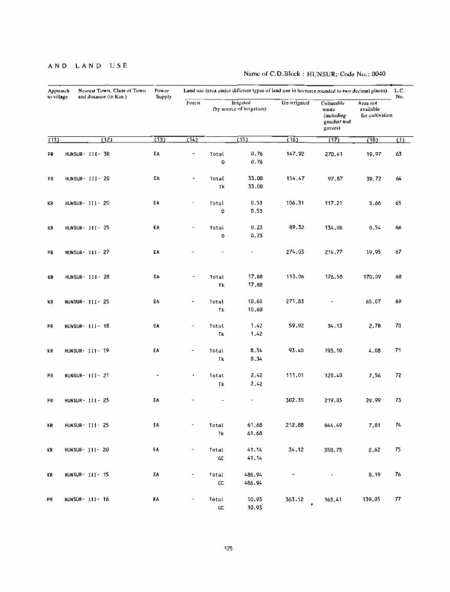
AND LAND USE Namt! of C.D.Block : HUNSUR; Code No.: 0040
Approach Nearest Town. Class of Town Power Land use (area under difli:renttypes of land us.: in hectares rounded to two decimal places} L.C. to village and distance (in Km.) Supply No.
Forest Irrigated U n-irrigat.:d Culturable Area not (by source of irrigation) waste available
(including for cultivation gauchar and groves)
( 11 ) (12) ( 13) ( 14) (15) ( 16) (17) ( 18) (1)
PR HUNSUR- 111- 30 EA Total 0.76 147.92 270.41 19.97 63 0 0.76
PR HUNSUR- 111- 20 EA Total 33.08 154.47 97.87 39.72 64
Tk 33.08
KR HUNSUR- II J - 20 EA Total 0.53 106.31 117.21 3.66 65 0 0.53
KR HUNSUR- 111- 25 EA Total 0.23 89.32 134.06 0.54 66
0 0.23
PR HUNSUR- 111- 27 EA 274.03 214.77 19.95 67
KR HUNSUR- 111- 28 EA Total 17.88 113.06 176.58 170.09 68
Tk 17.88
KR HUNSUR- 111- 25 EA Total 10.60 271.83 65.07 69
TI< 10.60
PR HUNSUR- I I I - 18 EA Total 1.42 59.92 34.13 2.78 70
TI< 1.42
KR HUNSUR- I J 1- 19 EA Total 8.34 93.40 193.10 4.08 71
Tk 8.34
PR HUNSUR- J 11- 21 Total 2.42 111 .01 120.40 7.56 72
Jk 2.42
PR HUNSUR- 111- 25 EA 302.35 219.05 29.99 73
KR HUNSUR- 111- 25 EA Total 61.68 212.88 644.49 7.81 74
Tk 61.68
KR HUNSUR- 111- 20 EA Total 41.14 34.12 358.73 0.62 75
GC 41.14
KR HUNSUR- I I I - 15 EA Total 486.94 0.19 76
GC 486.94
PR HUNSUR- 111- 16 EA Total 10.93 363.12 163.41 139.05 77
GC 10.93
175
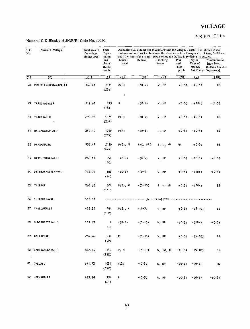
VILLAGE
AMENITIES Name of C.D.Block : HUNSUR; Code No. :0040
L.C. Name of Village Total area of Total Amenities available (if not available within the village, a dash (-) is shown in the No. the village Popu- column and next to it in brackets, the distance in broad ranges viz. -5 kms, 5-10 kms,
(In hectares) latil)n and 10+ kms of the nearest ~lace where the facility is availllhie is given}. and Educa- Medical Drinking Post Day or Communication No.of tional Water and Days of [Bus Stop, H(_)u~e- Tel.:- marketl Railway Station, holds graph hat ifany Wat.:rwayJ
(1) (2) (3) (4) (5) (6) (7) (8) (9) ( 10)
78 KUDINEERMUDDANAHALLI 362.41 1531 P(2) -(0-5) 101, HP -(0-5) - (0-5) BS (284)
.. 79 THARIKAlNAlA 712.61 913 P - (0-5) 101, HP -(0-5) -(10+) -(0-5)
( 183)
80 THARIKAllU 292.98 1175 P(2) -(0-5) II, HP -(0-5) -(0-5) BS (267)
81 HAllADAKOPPAlU 354.19 1056 P(2) -(0-5) 101, HP -(0-5) -(0-5) BS (215)
82 DHARMAPURA 958.47 2410 P(3), M PHC, FPC T, 101, HP PO -(0-5) BS (473)
83 BASTHIMADAHALlI 280.11 SO -(0-5) -(0-5) 101, HP -(0-5) -(0-5) -(0-5) (10)
84 DYTHYANAKEREKAVAL 702.90 103 -(0-5) -(0-5) 101, HP -(0-5) - (10+) -(0-5) (26)
85 THIPPUR 266.60 804 P(2), M -(5-10) T, 101, HP -(0-5) - ( 10+) BS (161)
86 THIPPURKAVAL 112.03 _ .. --------------------- UN - INHABITED -------------------------
87 CHALLAHALlI 408.20 984 P(2), M -(0-5) 101, HP -(0-5) -(5-10) BS ( 188)
88 GUO ISHETT 1 HALLl 183.63 4 -(0-5) -(5-10) 1.1, HP -(0-5) -(10+) -(0-5) (1)
89 HALlIKERE 265.76 230 P -(5-10) 101, HP -(0-5) -(5-10) BS (40)
90 VADERAHOSAHALLI 572.14 1250 P, M -(5-10) 101, TI.I, HP -(0-5) -(5-10) BS (222)
91 DALLALU 671.73 1054 P(3) -(0-5) 101, HP -(0-5) -(0-5) BS (192)
92 JEENAHAlLl 443.28 332 P -(0-5) 101, HP -(0-5) -(0-5) -(0-5) (61)
176
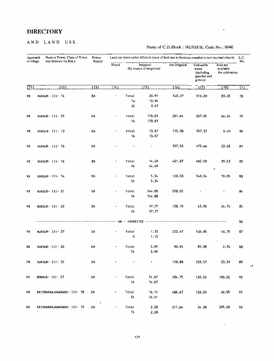
DIRECTORY
AND LAND USE Name of C.D.Block : HUNSUR; Code No.: 0040
Approach Nearest Town. Class of Town Pow.:r Land use (area under different types of land us.: in h.:ctar.:s rounded to two d.:cimal plac.:s) L.C. to village and distance (in Km.) Supply No.
Forest Irrigated Un-irrigated Cuhurable Area not (by sour.:e of irrigation) waste available
(including for cultivation gauchar.and groves)
(11) (12) (13) ( 14) (15) ( 16) ( 17) ( 18) (1)
PR HUN SUR- Il(- 14 EA Total 20.91 148.27 110.20 83.03 78 Tw 10.94 GC 9.97
PR HUNSUR- I" - 25 EA Total 178.81 201.64 267.92 64.24 79 Tk 178.81
PR HUNSUR- 1I1- 12 EA Total 13.87 115.38 157.33 6.40 80 Tk 13.87
PR HUNSUR- 111- 16 EA 157.50 173.66 23.03 81
PR HUNSUR- 1[1- 16 EA Total 14.49 421.87 482.58 39.53 82 Tk 14.49
KR HUNSUR- 111- 14 EA Total 5.34 108.38 148.34 18.05 83 Tk 5.34
PR HUNSUR- Ill- 21 EA Total 144.88 558.02 84 Tk 144.88
PR HUNSUR- 111- 22 EA Total 17.77 158.19 65.90 24.74 85 Tk 17.77
--------------------------------------------- UN - INHABITED --------------------------------------------- 86
PR HUNSUR- 111- 27 EA Total 1. 13 233.47 126.85 46.75 87 0 1.13
KR HUNSUR- 111- 28 EA Total 3.95 90.94 85.98 2.76 88 Tk 3.95
PR HUNSUR- 111- 25 EA 118.88 123.57 23.31 89 .-PR HUNSUR- 111- 27 EA Total 14.87 234.75 129.50 193.02 90
Tk 14.87
PR KRISHNARAJANAGARA- 111- 18 EA Total 16.11 486.67 128.00 40.95 91 Tk 16.11
KR KRISHNARAJANAGARA- (( I - 19 EA Total 2.28 211.64 24.28 205.08 92 Tk 2.28
177
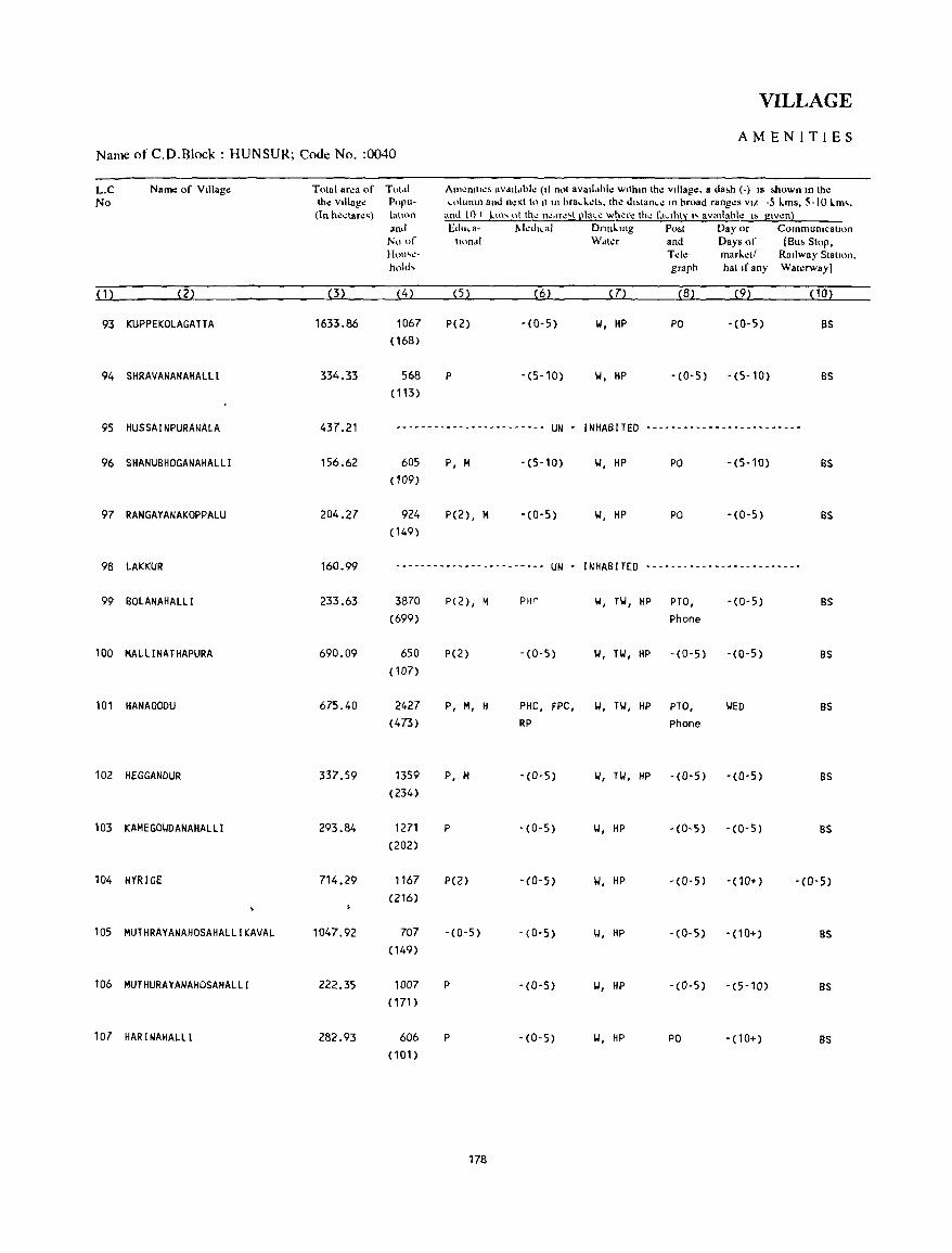
VILLAGE
AMENITIES Name of C.D.Block : HUNSUR; Code No. :0040
L.C Name of VIllago: Total ar.:a of Totdl Am~nllt~~ aVdll .. hl~ (II not avalldhl.: wtlhtO th.: villago:. a da&h (-) IS &hown In the No tho: village Popu- column and n~xt to It to hraci .. .:t&. th.: dl~tanc': to hroad rang.:s VIL -5 L.ms, 5-10 L.m'.
(In hectare,) lalton and 10+ lm' o( th~ n~"r.:'t [!Iac.: wher~ the ('.IClhty "avatlahle IS glV~nl
and Educa- l'.k<it,al Dnni..tOg Po .. t Day or CommunicatIOn No of lInnd! Wdl.:r and Days of (Bu .. Stop. H(.)ll'~- Tele- mari..et! Railway Stallon. hold, graph hal If any Wat.:rway)
( 1) (2) (3) (4) (5) (6) (7) (8) (9) (10)
93 KUPPEKOLAGA TT A 1633.86 1067 P(2) -(0-5) II, HP PO -(0-5) BS (168)
94 SHRAVANANAHALlI 334.33 568 P -(S-10) II, HP -(0-5) -(5-10) as ( 113)
95 HUSSAINPURANALA 437.21 ~w __ ~ __ , ________________
UN - INHABITED --------.----------------
96 SHANUBHOGANAHAlll 156.62 605 P, H -(5-10) II, HP PO -(5-10) BS (109)
97 RANGAYANAKOPPALU 204.27 924 P(2), M -(0-5) II, HP PO -(0-5) BS (149)
98 lAKKUR 160.99 ------------------_----- UN - INHABITED -------------------------
99 BOlANAHALLI 233.63 3870 P(2), M PHr II, Til, HP PTO, -(0-5) BS (699) Phone
100 MA l Ll NA T HAPURA 690.09 650 P(2) -(0-5) II, Til, HP -(0-5) -(0-5) BS (107)
101 HANAGOOU 675.40 2427 P, H, H PHC, FPC, II, HI, HP PTO, liED as (473) RP Phone
102 HEGGANDUR 337.59 1359 P, M -(0-5) II, Til, HP -(0-5) -(0-5) BS (234)
103 KAMEGOIIDANAHAlLI 293.84 1271 P -(0-5) II, HP - (0- 5) -(0-5) BS (202)
104 HYRIGE 714.29 1167 P(2) -(0-5) 1.', HP -(0-5) - (10+) -(0-5) (216)
105 MUTHRAYANAHOSAHAlLIKAVAl 1047.92 707 -(0-5) -(0-5) II, HP -(0-5) -(10+) BS (149)
106 MUTHURAYANAHOSAHALll 222.35 1007 P -(0-5) II, HP -(0-5) -(5-10) BS
(171 )
107 HAR I NAHALLI 282.93 606 P -(0-5) II, HP PO - (10+) BS (101)
178
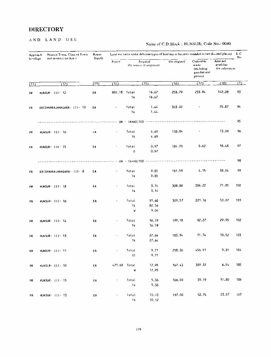
DIRECTORY
AND LAND USE Naill.: of C.D.Block : HUNSUR; Code No.: 0040
Approa.h N\!(trl.!!'ol Town. C'1,I!OO~ 01 T\}\.\ n PUW\!f LlIld I"~ (.Ir~d Illllkr dtlkr~1l1 I)p~> "fland "'~ III h~dar.:, rOllnJ.:d 10 IWO d.:,undl pla,~,) LC
tnvIUtl!;!\!' 31lli d"lan,.: (Ill Kill ) Supply No F('(I..· .. t Int!!dlc.J Un-,rngd{~d Culrurahl.: An:a 0(1'
(b) '"-)ur .... ..: ot lIn~.llItHl) \\a:-l\! ava,ldhk (1Il.llIdlng for I..uhlvalilln
gdll.har alld grov~»
( 11 ) (12) (13) ( 14) (15) (16) ( 17) (18) (1)
PR HUNSUR- 111- 12 EA 982 _ 18 Total 16.67 258.79 233.94 142.28 93
Tic 16.67
PR KRlSHNARAJANAGARA- 111- 10 EA Total 1.44 303.02 29.87 94
Tic 1.44
------------ .. ~------- .. -.. --------------------- UN - I NHAB !TED ---------------------------- .. _--------------- 95
PR HUNSUR- 111- 16 EA Total 4.69 138.84 13.09 96
Tic 4.69
PR HUNSUR- Ill' 15 EA Total 0.97 184.20 0.62 18.48 97
0 0.97
.... --- --- -- -_ .. _ .. -- .... -_ .......... -_ .... -- .......................... UN - I NHAB !TED --------------------------------------------- 98
PR KRISHNARAJANAGARA- 111- 8 EA Total 9.85 181.59 4.15 38.04 99
TIc 9.85
PR HUNSUR- III' 18 EA Total 3.14 308.88 306.22 71.85 100
Tic 3.14
PR HUNSUR- 111- 16 EA Total 91.60 309.57 221.16 53.07 101
TIc 82.56
II 9.04
PR HUNSUR' 111- 14 EA Total 16.19 199.18 92.27 29.95 102
Tk 16.19
PR HUN SUR- III - 13 EA Total 27.64 183.94 71.74 10.52 103
Tic 27.64
KR HUNSUR- 111- 11 EA Total 9.71 238.36 456.91 9.31 104
GC 9.71
PR HUNSUR- 111- 10 EA 471.68 Total 12.95 167.43 389.32 6.54 105
II 12.95
PR HUNSUR- III' 15 EA Total 5.36 166.00 39.19 11.80 106
TIc 5.36
PR HUNSUR- 111- 13 EA Total 10.12 197.00 52.74 23.07 107
Tic 10.12
179
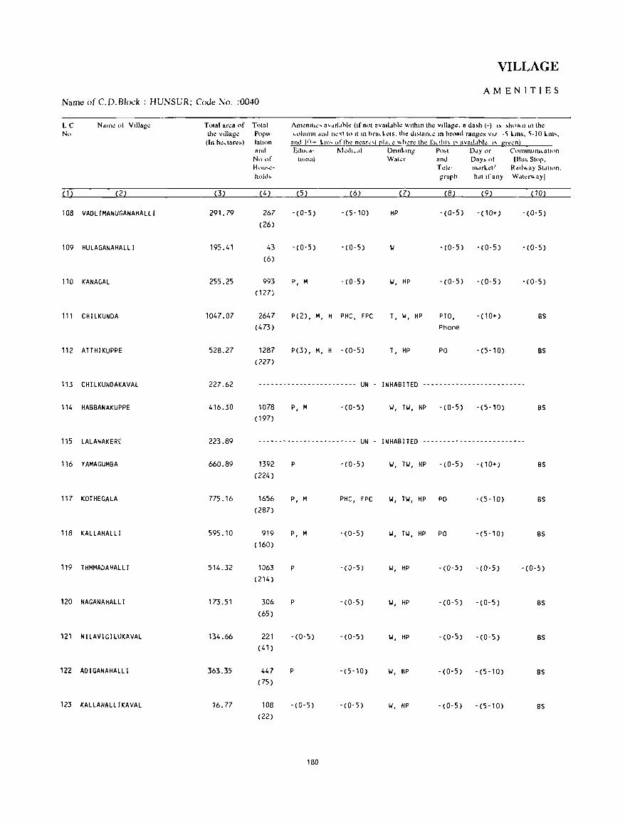
VILLAGE
AMENITIES Name of C. D. Block : HUNSUR; Code No. :0040
LC Ndlll': of Vlllag.: Total area of Total Am.:mll"' a'dll .. bk (If' not avall"bk wlthm th.: Village. a da,h (-) I' ,ho\\,n m the No the Village Popu- column dnd n.: ,t to It m hrad .. ':ls. the dl,tanc': m broad rang.:s VI" -~ kms. ~-I 0 km'.
(In heclar.:,) latlon and l()+ klll .... l)fth~ n..:ar\!<.,t [!I.\\.\! \\h":f\! lhl! f<h.ll1t~ I'" avaltlhll.! I" glvl.!n} and Educd- I\led",,1 Dnnklng Po.t Ddyor Conununl~atH)n
No of 1I0nai \\'aler and Day. of (Buo Stop. HOlh\!- T..:k- mMket! Rdt!\\.ay Station. hold. graph hdl If any Wdtel""ayl
( 1 ) (2) 0) (4 ) (5) (6) (7) (8) (9) (10)
108 VADlIMANUGANAHAllI 291.79 267 -(0-5) - (5- 10) HP -(0-5) - (10+) -(0-5) (26)
109 HUlAGANAHAlll 195.41 43 - (0-5) - (0-5) -(0-5) -(0-5) -(0-5) (6)
110 KANA GAL 255.25 993 P, M -(0-5) 101, HP -(0-5) -(0-5) -(0-5) ( 127)
111 CHIlKUNOA 1047.07 2647 P(2) , M, H PHC, FPC T, II, HP PTO, - (10+) BS
(473) Phone
112 ATTHIKUPPE 528.27 1287 P(3), M, H -(0-5) T, HP PO -(5-10) BS
(227)
113 CHllKUNDAKAVAl 227.62 - -- ---- - .. _ ---- --- .... ----- UN INHABITED -------------------------
114 HABBANAKUPPE 416.30 1078 P, M -(0-5) 101, Til, HP -(0-5) -(5-10) BS
( 197)
115 lAlANAKERE 223.89 ------------------------ UN - INHABITED --.----------------------
116 YAMAGUMBA 660.89 1392 P -(0-5) II, Til, HP -(0-5) -(10+) BS
(224)
117 KOTHEGAlA 775.16 1656 P, M PHC, FPC \.I, T\.I, HP PO -(5-10) BS
(287)
118 KAllAHAlll 595.10 919 P, M -(0-5) \.I, Til, HP PO '(5-10) BS
( 160)
119 THMMADAHAlll 514.32 1063 P -(0-5) \.I, HP -(0-5) '(0-5) -(0-5) (214)
120 NAGANAHAlLI 173.51 306 P -(0-5) \.I, HP -(0-5) -(0-5) BS
(65)
121 NI lAVI GlLUKAVAL 134.66 221 -(0-5) -(0-5) \.I, HP -(0-5) -(0-5) BS
(41)
122 ADIGANAHAllI 363.35 447 P -(5-10) \.I, HP -(0-5) -(5-10) BS (75)
123 KALLAHAllIKAVAL 16.77 108 -(0-5) -(0-5) \.I, HP -(0-5) -(5-10) BS
(22)
180
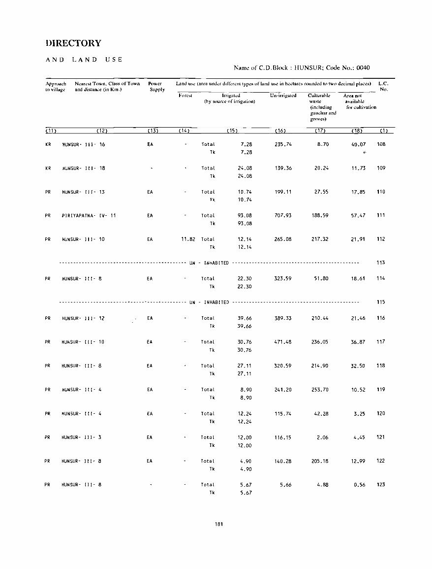
DIRECTORY
AND LAND USE Name of C.D.Block : HUNSUR; Code No.: 0040
Approach N"ar".1 Town. Class of Town Power Land l"" (af"a under ddlerent typ"s of land u.e in he.:lares rounded 10 two d"cimal pla.:es) L.C. III village and distance (in Km.) Supply No.
Fore't lrrigatlo!d Un-irrigat.:d Culturahle Area not (by source of irrigation) wa.te availabl.:
(including for cultivation gauchar and groves)
( 11 ) (12) ( 13) (14) (15) ( 16) ( 17) (18) (1)
KR IIUWSUR- II I - 16 EA Total 7.28 235.74 8.70 40.07 108 Tk 7.28 ~.
KR HUNSUR- 111- 18 Total 24.08 139.36 20.24 11. 73 109 Tk 24.08
PR IIUNSUR- 111- 13 EA Total 10.74 199.11 27.55 17.85 110 Tk 10.74
PR PIRIYAPATNA- IV- 11 EA Total 93_08 707.93 188.59 57.47 111 Tk 93.08
PR HUNSUR- II 1- 10 EA 11.82 Total 12.14 265.08 217.32 21.91 112 Tk 12.14
------------------_ ... ------------------------- UN - I NHAB !TED --------------------------------------------- 113
PR HUNSUR- II 1- 8 EA Tctal 22.30 323.59 51.80 18.61 114 Tk 22.30
-----------------------_ ... _--------_ ... --------- UN - I NHAB !TED --------------------------------------------- 115
PR HUNSUR- 111- 12 EA Total 39.66 389.33 210.44 21.46 116 Tk 39.66
PR HUNSUR- 111- 10 EA Total 30.76 471.48 236.05 36.87 117 Tk 30.76
PR HUNSUR- 111- 8 EA Total 27.11 320.59 214.90 32.50 118 Tk 27.11
PR HUNSUR- 111- 4 EA Total 8.90 241.20 253.70 10.52 119 Tk 8.90
PR HUNSUR- I I 1- 4 EA Total 12.24 115.74 42.28 3.25 120 Tk 12.24
PR HUN SUR- I I 1- 3 EA Total 12.00 116.15 2.06 4.45 121 Tk 12.00
PR IIUNSUR- I I 1- 8 EA Total 4.90 140.28 205.18 12.99 122 Tk 4.90
PR IIUNSUR- 111- 8 Total 5.67 5.66 4.88 0.56 123 Tk 5.67
181
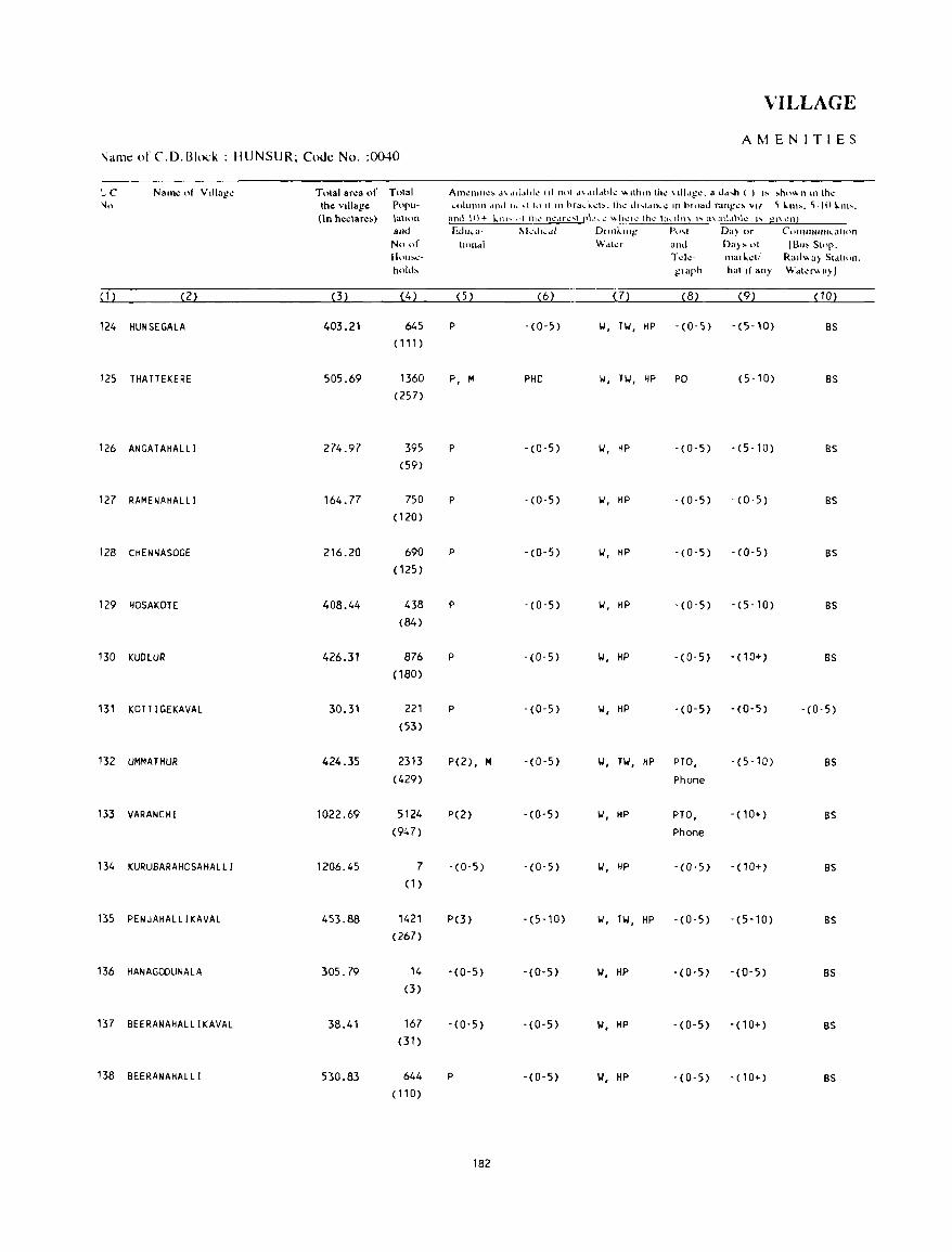
VILLAGE
AMENITIES 'lame of CD. Block : HUNSUR; Code No. :0040
'_ C Nal1l~ of V"lag~ Total ar~a of Total Alnl!1lI111.!~ d\-.Id~lhll.! (If not d\<III.thk "'111UIl th.: \11I<t~l.!. a Jd",h ( ) t~ ~ho"n \11 thl! \lo Ih~ vIllage: Pop,,· ... nlulllll <tod II<.. \1 In 11111 hra ... kl.!b. tht.: dl"'l.ulI..1! III hll)ad nlng'l!~ val 'i ~1II>. 'i·10 ~1II>.
(In hectare,,) \ahnn and \\)+ kill" ,1\ lh~ n~.lrl.!'''''\ rLhl.!' \\h":-II! thl.!' 1 a ... 111\\ 1'. a\:IIl.lhk I' gl\ I.!Tl1
and Ed",a· 1\1-:.1,,,11 Dllnklng Po ... ' Da) or ('(I'IJ'IlUIlI ... alHln
No of tH)l1di y,..fdkr and Da» 01 IBu> Stop. H\HJ~\!- T~k· lIIalt..~tl Rat!" a) SI~I"'n. hold, !!Iaph hat II any W~kf"a)J
( 1 ) (2) (3) (4) (5) (6) (7) (8) (9) (10)
124 HUNSEGALA 403.21 645 P -(0-5) '.I, TW, HP -(0-5) -(5-10) as ( 111)
125 THATTEKERE 505.69 1360 P, M PHC 1.1, TIJ , HP PO -(5-10) as (257)
126 ANGATAHALLI 274.97 395 P - (0 -5) '.I, HP -(0-5) - (5-10) as (59)
127 RAMENAHALLI 164.77 750 P -(0-5) '.I, HP - (0-5) - (0-5) as (120)
128 CHENNASOGE 216.20 690 P -(0-5) 1.1, HP -(0-5) -(0-5) as (125)
129 HOSAKOTE 408.44 438 P -(0-5) '.I, HP - (0-5) - (5-10) as (84)
130 KUDlUR 426.31 876 P -(0-5) '.I, HP -(0-5) -(10+) as (180)
131 KOTTIGEKAVAL 30.31 221 P - (0-5) '.I, HP -(0-5) -(0-5) -(0-5) (53)
132 UMMATHUR 424.35 2313 P(2) , M -(0-5) '.I, TW, HP PTO, -(5-10) as (429) Phone
133 VARANCHI 1022.69 5124 P(2) - (0-5) '.I, HP PTO, - (1 0+) as (947) Phone
134 KURUBARAHOSAHALLI 1206.45 7 -(0-5) - (0-5) '.I, HP -(0-5) -(10+) BS (1)
135 PENJAHALLI KAVAL 453.88 1421 PO) -(5-10) '.I, TW, HP - (0-5) -(5-10) BS (267)
136 HANAGODUNALA 305.79 14 -(0-5) -(0-5) '.I, HP -(0-5) -(0-5) BS (3)
137 BEERANAHALLIKAVAL 38.41 167 -(0-5) -(0-5) '.I, HP - (0- 5) -(10+) BS (31)
138 BEERANAHALLI 530.83 644 P -(0-5) 10', HP -(0-5) -(10+) as (110)
182
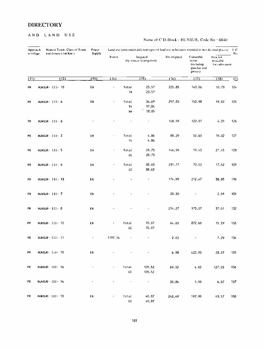
DIRECTORY
AND LAN D USE N.lmt:: ot C D.BI<x.k : HUNSUR, CoJt:: No . OO-tO
Approach N~ar~'t Town. Cld" 01 Town Powt!r Ll!ld 1I'~ ( .. r~a IInd~r d"kr~1I1 I)P~' olldlld U'': III h~ddr~' rolJnd~d 10 I .... " d~"l1\dl pldc':,j LC 10 \lllIal1~ and d"lan .. ~ (III Kill ) Supply No
Forl.! ... t Inlg~lll!d Un Ifngatl!d CIIIIlIrahl~ Arlo!d IHll
(hy ")urc~ 01 IrrlI1JllolI) wa ... h= aVdtl,lhlc (lIIdudlllg for \,.Uhl\OdlHln
gauchJr dlld grovc,)
( 11) ( 12) (13) (14) ( 15) ( 16) ( 17) (18) ( 1)
PR HUNSUR- I I I - 10 EA Total 23.57 225.85 143.06 10.73 124 Tk 23.57
PR HUNSUR- I I 1- 6 EA Total 36.69 297.00 152.98 19.02 125 Tk 17.84
lJe 18.85
PR HUNSUR- I I I - 6 148.59 122.07 4.31 126
PR HUNSUR- I I I - 3 EA Total 4.86 88.29 52.60 19.02 127 Tk 4.86
PR HUNSUR- 111- 5 EA Total 28.73 146.59 19.43 21.45 128 GC 28.73
PR HUNSUR- I I I - 6 EA Total 88.63 231. 77 70.52 17.52 129
GC 88.63
PR HUNSUR- I I I- 13 EA 174.99 212.47 38.85 no
PR HUNSUR- I I I - 7 EA 28.30 2.01 131
PR HUNSUR- I I I - 8 EA 214.27 173.07 37.01 132
PR HUNSUR- I I 1- 12 EA Total 70.07 64.63 872.60 15.39 133 GC 70.07
PR HUNSUR- I I I - 11 1197.14 2.02 7.29 134
PR HUNSUR- I I I - 10 EA 6.88 423.93 23.07 135
PR HUNSUR- I I I - 16 Total 105.52 69.02 4.02 127.23 136 GC 105.52
PR HUNSUR- I I I - 14 30.84 1.50 6.07 137
PR HUNSUR- 111- 13 EA Total 40.87 248.49 197.90 43.57 138 GC 40.87
183
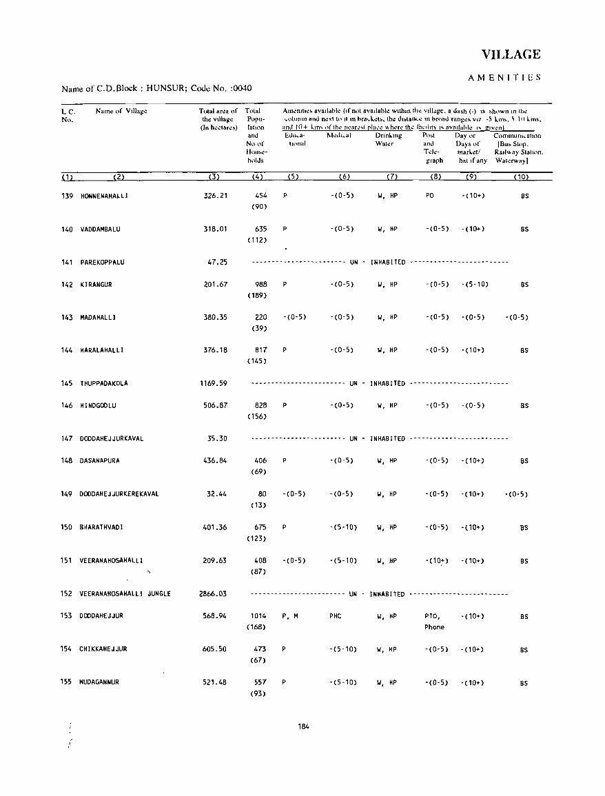
VILLAGE
AMENITIES Name of C.D.Block : HUNSUR; Code No. :0040
L C. Name of Village No.
( 1 ) (2)
139 HONNENAHAlll
140 VADDAMBALU
141 PAREKOPPALU
142 KIRANGUR
143 MADAHAlLl
144 HARALAHALLI
145 THUPPADAKOLA
146 HINDGOOLU
147 DOODAHEJJURKAVAL
148 DASANAPURA
149 DODDAHEJJURKEREKAVAL
150 BHARATHVADI
151 VEERANAHOSAHALLI
152 VEERANAHOSAHAlll JUNGLE
153 DODDAHEJJUR
154 CHIKKAHEJJUR
155 MUDAGANNUR
, ,
TOlal ar~a of the village (In heclar~s)
(3)
326.21
318.01
47.25
201.67
380.35
376.18
1169.59
506.87
35.30
436.84
32.44
401.36
209.63
2866_03
568.94
605.50
521.48
Tolal Am~mll~> avaIldhk (If nol avallahle Wllhln Ih~ vilidge. a dash (.) IS ~hown In Ih~ Popu- column and n.:xll" II In hracL.':I'_ Ihe d"lancl! In hroad range, VI7 -5 L.m!.. ~ III L.ms. lallon and 10+ ~m' ofth" n~ar~'t ~Ia,,~ I!.h~r.: th~ factllt~ "avatlahl~ I' glv.:n! and Edu.a- t-.kdl.al Dnnklng Po>t Day or ComlnUIlh .. alton No of Iional Wal~r and Days or (Bu> Slop. HOUloor.!- Td~- marr..~11 Ralll!.ay Siallon. holds graph hal If any Wal~rwayl
(4) (5) (6) (7) (8) (9) (10)
454 P -(0-5) 1.1, HP PO - (1 0+) BS
(90)
635 P -(0-5) 1.1, HP -(0-5) - ( 10+) BS
(112)
---- -_ .. ----------------- UN - INHABITED _------------------------
988 P -(0-5) II, HP -(0-5) -(5-10) BS
( 189)
220 - (0- 5) -(0-5) 1.1, HP -(0-5) -(0-5) -(0-5) (39)
817 P -(0-5) 1.1, HP -(0-5) - (10+) BS
(145)
--_.-------------------- UN - INHABITED _- -------- -- .. _- -_ .. -- .. ----
828 P -(0-5) II, HP -(0-5) -(0-5) BS
(156)
------------------------ UN INHABITED _------------------- .. _---
406 P -(0-5) 1.1, HP -(0-5) - (10+) BS
(69)
80 - (0- 5) -(0-5) II, HP - (0-5) -(10+) -(0-5) ( 13)
675 P - (5-10) \.I, HP -(0-5) -(10+) as (123)
408 - (0- 5) -(5-10) \.I, HP -(10+) - (10+) BS
(87)
------------------------ UN - INHABITED -------------------------
1014 (168)
473
(67)
557 (93)
P, M
P
P
PHe
-(5-10)
-(5-10)
184
1.1, HP PTO, • (10+) BS
Phone
II, HP '(0-5) '(10+) BS
1.1, HP -(0-5) '(10+) BS
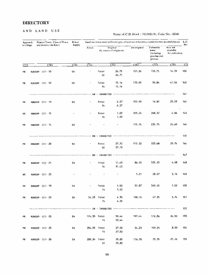
DIRECTORY
AND LAND USE
Approa~h N~ar.:'t Town. Cia" ofT""n 10 village and d"lan~~ (in Km )
( 11 ) (12)
PR HUNSUR- I I I - 10
PR HUNSUR- I I I - 12
Powl.!'r Supply
( 13)
EA
EA
Name of C.D.Block : HUNSUR; Code No.: 0040
Land u,\! (area under dllT.:rent t)re, of land ,,,.: III h.:..:lare, fOlInd.:d 10 two d':IO"nal pla"e') L.e. No.
Ifilgat..:J Un-Irngated ClIlturahle Area nol (h) ~l)llro,,;..: of IrngatlOIl) wasl~ avallabl~
(including for IOultivalion gaucharand grov.:s)
( 14) ( 15) (16) ( 17) ( 18) (1)
Total 26.71 151.36 133.75 14.39 139
GC 26.71
Total 15.14 170.95 90.86 41.06 140
Tk 15.14
------ -----_ ... -- ... - - - -- - - - - - - - - - - -..,. - - - - - - - - - - -- UN - INHABITED --------------------------------------------- 141
PR
KR
PR
PR
PR
KR
PR
PR
PR
PR
PR
HUNSUR- I I 1- 19 EA Total 6.37 152.90 16.81 25.59 142
Tk 6.37
HUNSUR- I I I - 15 Total 1.93 105.24 268.32 4.86 143 Tk 1.93
HUNSUR- I I 1- 14 EA 115.74 235.75 24.69 144
--------------------------------------------- UN - INHABITED .-----.---------- .. ---------------.-----.---. 145
HUNSUR- 111- 20 EA Total 37.13 115.32 333.68 20.74 146 GC 37.13
----------.----------------.------.-----.---. UN - INHABITED .----- ... -- .. ----.-----.--- .. -- .. -.--.--.---. 147
HUNSUR- 111- 21 EA
HUNSUR· I I I - 25
HUNSUR- 111- 19 EA
HUNSUR- 111- 20 EA
Total 11.43 Tk 11.43
Total 1.52 Tk 1.52
54.03 Total Tk
4.35 4.35
86.20 335.13 4.08 148
1.21 28.07 3.16 149
57.87 340.45 1.52 150
100.16 47.35 3.74 151
-------------------------------.-.----- .. ---- UN - INHABITED ------------.--------.----.-------- .. ---.---- 152
IIUIlSUR- 111- 23 fA 174.30 10tal 59.44 197.44 112.86 24.90 153
Tk 59.44
HUN SUR - 111- 25 EA 354.95 Total 27.92 54.23 159.90 8.50 154 Tk 27.92
HUN SUR - Ill' 26 EA 289.36 Total 20.85 116.76 73.35 21.16 155 GC 20.85
185

VILLAGE
AMENITIES Namt: of C.D.Block : HUNSUR; Coot: No. :0040
L.C. Name of Village Total area of Tnlal Anl~lllll"' avaIlable (If nol available wilhl" Ih~ villa~". a da,h (-) " 'h"", " In the No. the village P"ru- _"Iullln and n~\1 II' 11m hra,l..~t~. the di,tance III hroad range~ vi/.·~ lim. ~-IO 1..111'.
<In heetare~) lalum ami 10+ lIm "rlh~ ncar",1 ~Ia,e "here Ihe facililY i, aV:lilal>le is Slwnl and &Iu,a- Medl,al Dnnllllg P",I Day or Cnllllllullh.:atum No.of tilJnal Water and Days of IBu. SlOp. Hou~- Tde- marlel! Railway Sial ion. holds graph hal if any Wah!rwayJ
(1) (2) (3) (4) (5) (6) (7) (8) (9) (10)
156 KOLAVIGE 434.09 903 P(2) -(5-10) W, liP -(5-10) - no+) 8S ( 172)
157 KONANAIIOSAHAlLI 141.06 88 -(0-5) -(5-10) HP, R -(5-10) -(10+) BS ( 17)
158 8IL lANAHOSAHAL II 182.06 387 -(0-5) -(5-10) HP, R - (0- 5) -(10+) -(0-5) (90)
159 HABBANAKUPPE K.G 444.29 207 -(0-5) -(5-10) HP, R -(0-5) -(10+) -(5-10) (46)
160 NEGATIIUR 239.90 274 P -(5-10) w, HP -(0-5) - (10+) -(0-5) (48)
161 SINDENAHAlll 199.84 577 P -(5-10) 101, liP -(5-10) - ( 10+) BS (118)
162 ABBUR 278.44 696 p - (0- 5) 101, HP - (0- 5) -(10+) BS ( 117)
163 SETTIHAlLl 437.58 66 -(0-5) -(0-5) 101, HP -(0-5) -(0-5) BS (11)
164 KACHUVINAHALLI 154.59 688 P -(5-10) 101, HP - (5-10) -(10+) BS (112)
165 NERALAKUPPE 292.57 513 P, M -(5-10) W, HP PO -(10+) as (109)
166 UDUVEPURA 601.36 526 P -(10+) 101, liP -(0-5) - (10+) as (94)
167 KAlLABOOCHAHALLI 223.24 400 P - (10+) W, liP -(0-5) - (10+) as (63)
168 H.BOREROPPADAKAVAL 783.30 1288 P -(5-10) W, HP -(0-5) -(10+) -(0-5) (202)
169 KADEMANUGANAHAlll 625.60 1214 P -(5-10) 101, HP -(0-5) -(10+) BS (220)
186
DIRECTORY
AND LAND USE Nan'k! of C.D.Block : HUNSUR; Code No.: 0040
Apprtla.h Ncare~1 Town. Class of Town Power Land u'e (area under dlfli:rcnl I}PCS ofland use in heclares rounded 10 IWO decimal places) LC 10 vlllag,: and dl,lan.,: (10 Km ) Supply Nn
ForeM Irngah:d Un-irngaled Culturahlc Area not (h} ,our.c nf Irrigallnn) wa~h! avallahlc
(lIIdudmg Ii'r cultlvallOn gau.har and grnvc.)
(11) (12) < 13) (14) ( 15) (16) (17) (18) ( 1 )
PR HUNSUR- III' 28 EA 175.15 Total 19.22 121.92 93.50 24.30 156 GC 19.22
PR HUNSUR· 111- 29 Total 32.58 57.07 37.81 13.60 157 Tk 32.58
PR HUNSUR· "1- 29 Total 13.22 52.01 104.89 11.94 158 Tk 13.22
PR HUNSUR- "I - 27 Total 41.38 215.94 172.91 14.06 159 Tk 41.38
PR HUNSUR- 111- 22 Total 48.87 79.42 92.98 18.63 160 Tk 48.87
PR HUNSUR- 111- 21 EA Total 18.24 141.06 12.04 28.50 161 Tk 18.24
PR HUNSUR- 111- 18 EA Total 87.71 96.12 63.54 31.07 162 Tk 28.73 GC 58.98
PR HUNSUR- 111- 20 343.59 Total 0.81 42.19 45.33 5.66 163 GC 0.81
KR HUNSUR- 111- 23 EA Total 0.19 68.19 83.77 2.44 164 GC 0.19
PR HUNSUR- 111- 26 EA Total 8.95 68.90 210.97 3.75 165 Tk 8.95
KR HUNSUR- 111- 27 409.56 Total 0.90 99.74 79.12 12.04 166 Tk 0.90
PR HUNSUR- 111- 28 Total 8.19 91.26 117 .~7 5.92 167 Tk 8.19
KR HUNSUR- 111- 20 EA 25.09 757.80 0.41 168
PR HUNSUR- 111- 23 EA 269.13 Total 3.74 181.10 165.96 5.67 169 Tk 3.74
187

VILLAGE
AMENITIES Name of C.D.Block : HUNSUR; Code No. :0040
L.C Natne of Village Total area of Total AmeOitte, availahle (if not availahk WIthin the vIllage. a da,h (-) is .hown in the No. the village P"pu- column and ne~t to It III hra,l.:l,. th.: d"I.ln,c III "road ranges VI/. -5 lms. 5-10 ltns.
(In hedare,) latton and 10+ lm' oflhc neare'lela,e .... here the t:"'llol~" avaolahlc " glv~n2· and Educa- II.kdlcal DnnLlng Po,' Day or C()lnnlumcatl()n
No.of ttonal Waler and Days of IBu, SlOp. Hou.c- Tek- marL.:I/ Railway Slallon. hold, graph hal If any Walerway]
( 1 ) (2) (3) (4) (5) (6) (7) (8) (9) (10)
170 BEERATHAMMA~AHALLI 351.20 625 P -(10+) 101, HP - (0- 5) -(10+) -(0-5) (115)
171 KARNAKUPPE 485.69 734 P, M PHC, FPC TIoI, HP - (0-5) -(10+) BS ( 132)
172 H£MMIG£ 519.15 1247 P(2) -(0-5) 101, HP -(0-5) -(10+) -(0-5)
(227)
173 GOIJOIKERE 456.63 143 -(0-5) -(0-5) 101, HP - (0- 5) -(5-10) BS (24)
174 GAVADAGERE 382.59 2984 P(2), M, H PHC, FPC 101, TIoI, HP PTO, -(5-10) BS (653) Phone
175 KERIYUR 455.69 744 P(2) -(0-5) 101, TIoI, HP -(0-5) -(5-10) BS ( 126)
176 JABAGERE 564.86 2456 P(2) -(0-5) T, 101, HP -(0-5) -(5-10) BS (422)
177 CHIKKADIGANAHALLI 185.66 546 P, M -(0-5) 101, TIoI, HP PO -(5-10) BS (114)
178 MA~CHABAYANAHALll 496.07 804 P -(0-5) 101, HP -(0-5) -(5-10) -(0-5) (155)
179 ATTI GUPPE 374.25 725 P -(0-5) 101, HP PO -(0-5) - (0-5) ( 133)
180 KRISHNAPURA 696.87 1050 P(2), M -(0-5) TW, HP PO -(0-5) BS ( 172)
181 SIRIYUR 226.10 606 P -(0-5) 101, TIoI, HP PO -(5-10) -(0-5) (110)
182 SIR I YURUNALA 333.22 8 -(0-5) -(0-5) 101, HP -(0-5) -(5-10) -(0-5) (3)
183 HEJJODLU 110.05 386 P -(0-5) 101, HP -(0-5) -(5-10) -(5-10) (73)
184 UNDAVADI 328.70 690 P -(0-5) 101, TY, HP PO -(5-10) BS (138)
188
DIRECTORY
AND LAND USE Name ofC.D.Block: HUNSUR; Code No.: 0040
Approa.:h N.:ar.:st Town. Class of Town Pow.:r Land US\! (ar.:a unda din-':r.:nt typ.:s of land us.: in h.:.:tar.:s round.:d to two d.:.:imal plac.:s) L.C. to viUag.: and distan.:e (in Km.) Supply No.
For.:~t lrrigat.:d Un-irrigated Culturaoll! ANa not (oy soure.: of irrigation) wast\! availahll!
(induding for cultivation gauchar and " grov.:s)
( 11) (12) ( 13) ( 14) (15) (16) ( 17) (18) (1)
PR HUNSUR- 111- 22 EA Total 4.45 194_86 147.03 4.86 170 Tk 4.45
PR HUNSUR- I Ii- 16 EA Total 16.19 294.62 157.88 17.00 171 Tk 16.19
PR HUNSUR- III- 14 EA Total 3.14 182.14 323.76 10.11 172 Tk 3.14
PR HUNSUR- I II- 14 161.98 279.27 15.38 173
PR KRISHNARAJANAGARA- I I I- 6 EA Total 51.08 272.81 34_88 23.82 174 Tk 20.24 lJe 30.84
PR KRISHNARAJANAGARA- 111- 6 EA Total 19.02 362.21 46.54 27.92 175 lJe 19.02
PR KRISHNARAJANAGARA- II I - 7 EA Total 10.93 478.25 51.40 24.28 176 lJe 10.93
PR KRISHNARAJANAGARA- 111- 5 EA Total 12.78 145.49 11.13 16.26 177 lJe 12.78
PR KRISHNARAJANAGARA- III- 6 EA Total 21.51 321.38 135.17 18.01 178 lJe 21.51
PR KRISHNARAJANAGARA- III- 5 EA Total 33.99 318.09 10.83 11.34 179 GC 33.99
PR KRISHNARAJANAGARA- III- 5 EA Total 415.65 167.85 38.85 74.52 180 GC 415.65
PR KRISHNARAJANAGARA- 111- 8 EA Total 173.63 32.78 5.52 14.17 181 GC 173.63
KR KRISHNARAJANAGARA- 111- 8 Total 198.30 16.90 17.25 100.77 182 GC 198.30 ~
PR KRISHNARAJANAGARA- Ill- 8 EAG Total 9.30 82.53 8.90 9.32 183 lJe 1.21 GC 8.09
PR KRISHNARAJANAGARA- Ill- 7 EA Total 26.39 225.42 55.85 21.04 184 lJe 14.25 GC 12.14
189
VILLAGE
AMENITILS Name of C.D.Block : HUNSUR; Cooe No. :0040
L.C. Nal1k! of Village Total ar':8 of No. the village
(In h.:.:tar.:s)
(n (2) (3)
185 MULLUR 306.46
186 HULlEYALU 221.45
187 PINNIKYATHANAHALLI 224.48
188 MARAGOIIDANAHALLI 249.83
189 HODAKEKATTEKAVAL 227.59
190 AGRAHARA 314.52
191 KATTEMALALAVADI 911.54
192 MADAPURA 196.00
193 BELTHUR 306.29
194 THIPPALAPURA 163.81
195 SANNENAHAlLl 225_94
196 MOOURSANNENAHALLIKAVAL 248.77
197 MODUR 742.73
198 MULlUR 202.13
199 RAMENAHAlLl 702.17
Total Alnl!lllti~!'o avaalahll! (11 not avalif.lhll! Wllhlll thl! vallag!.!, a da ... h ( ) l~ ... hn",n In lh\!
Popu- ":OlUtlUl and Ih.:\\lo 1\ In hra":~l.!b. lhl!' d'~l.an~t.!' In ort)ad ran~I.!" VII -<; lm,. <;-10 lm,. latlnn and 1()+ kill" nfthl.! n\!ar~~t [!lal..'l! wh~rl.! thl.! f.h.lht, I" avadahk I'" gl\ ~n} and Edll,a ~11.!,-hl..al Dronl.lng p,),t Day Ilr Ct.llnnlulll..:alHln
Nonl hOl1<l1 \\atl!r and Day' of IBu, Stop. How .. \!- Tdl!- markdl Raol"ay Statum. hold, graph hal If any Watl!""ayl
(4) (5) (6) (7) (8) (9) (10)
1456 P(2) , M PHC, FPC 1.1, TIoI, HP PO '(5-10) BS (291)
825 P -(0-5) II, HP -(0-5) -(5-10) as (162)
10 -(0-5) -(0-5) -(5-10) -(0-5) -(0-5) (1)
746 P -(0-5) 1.1, HP -(0-5) -(5-10) as (128)
14 -(0-5) -(0-5) - (0-5) -(5-10) BS (3)
697 P -(0-5) 1.1, HP -(0-5) -(5-10) BS (110)
5054 P(5) • PHC 1.1, TIoI, HP PTO, -(5-10) as (920) M(2), H(2) Phone
-------- ------_ .. _ ---... --- UN - INHABITED --------------_ .. ---------
58 -(0-5) -(0-5) 1.1 -(0-5) -(0-5) (9)
825 P -(0-5) 1.1, HP -(0-5) -(0-5) (135)
323 P -(0-5) 1.1, HP -(0-5) -(5-10) (53)
------------------------ UN - INHABITED -------------------------
1979 (340)
P(2) -(0-5) 1.1, HP PO -(5-10)
------------------------ UN - INHABITED -------------------------
1689 (273)
P(2)
190
-(0-5) 1.1, HP -(0-5) -(10+)
BS
BS
BS
BS
BS
DIRECTORY
AND LAND USE Name of C.D.Block : HUNSUR; Code No.: 0040
Approach Nl!arl!!<ot Tov.n. Cla~!-o ufTown Pnw-.!r Land lI~\! {ar\!a undl!r Jin~r\!nt t)P\!!<o or land uS\! in h\!'\.:tan!!oo rOlllh..ll!J to two o\!\!ilnal pla\!lo!s) L.C. h\ ",nag\! and di,lan"" lin Km.) Supply No.
For\!~t Irri~ah!J Un-irrigal.:d Cuhurahl.: Ar.:a nol (hy ~OlJr~'\! of irrigation) wash! availahl.:
(induding (,)r .:ullivalion gau.:har and groves)
( 1 1 ) ( 12) ( 13) ( 14) (15) (16) ( 1 7) (18) < 1 )
PR KRISHNARAJANAGARA- " 1- 6 fA Total 13.94 244.52 35.45 12.55 185
GC 13.94
PR KRISHNARAJANAGARA- I I I· 6 fA Total 11.82 166.33 29.95 13.35 186
We 11.82
KR KRISHNARAJANAGARA- 111- 9 EAG Total 16.19 191. 77 8.55 7.97 187 lie 16.19
PR KRISHNARAJANAGARA- 111- 8 EA Total 8.09 218.26 10.52 12.96 188 We 8.09
PR HUNSUR- 111- 6 1.62 220.56 5.41 189
PR HUNSUR- " I· 8 EA Total 0.40 253.75 42.90 17.47 190
lie 0.40
PR HUNSUR· III· 7 EA Total 22.01 684.75 123.03 81.75 191 We 22.01
... -.---------- .. ----.--------- .. ----- .. -- .. - UN . INHABITED .. ------.-- ... --.- .. -.- ...... -.-.- .. - ....... - 192
PR HUNSUR· 111- 5 EAG Total 9.20 234.76 35.18 27.15 193 We 9.20
PR HUNSUR· I I I - 5 EA Total 2.06 84.45 69.20 8.10 194 We 2.06
PR HUNSUR· "I· 6 EAG Total 37.64 142.17 1.62 44.51 195 Tk 20.24
We 17.40
........ - ........ -.-.- ........... ----- ..... -- UN . INHABITED ..... - ... - ... -.- .... -.- ........ - ........ ----- 196
PR HUNSUR- III· 9 EA Total 76.89 435.19 210.81 19.84 197 Tk 40.47 We 36.42
.-- .. - ..... --- .. - .................. -.-------- UN - INHABITED -- ... -.-.- .. - ...... ---.- ... - ... - .......... -.. 198
PR HUNSUR· Ill- 18 EA Total 95.51 468.64 111.70 26.32 199
11< 40.47 We 55.04
191
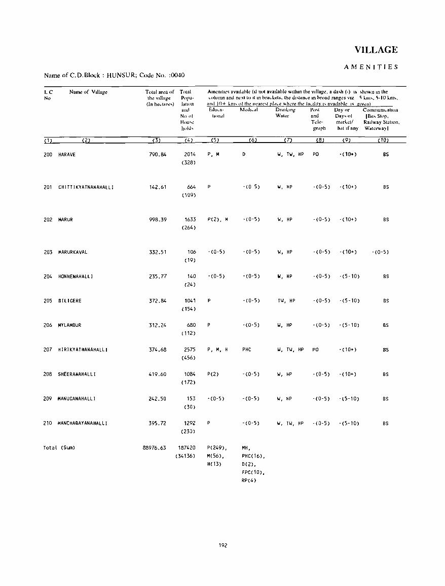
VILLAGE
AMENITIES Name of C.D.Block : HUNSUR; Code No. :0040
LC Name of Village Tolal arl!a of TOlal All11!Ollll!~ aV311.1bk (11 nol available wllhm Ihe village. 8 da~h (-) I~ ~hown m Ihe No Ihe Village Popu- ",Iumn and nexl 10 II 111 brad .. .:ts. thl! d"lan,e 111 broad ranges VIZ ~ I..m'. ~-IO I..m,.
(In hedarl!') lall<,n and 10+ 1..111' ollhe nl!arl!'l [!I,'I.I! ~hl!rl! Ihl! la,d1Ir" avallahll! I~ glvl!n) and Edu,a- l\Ied, ... dl Dnnl..lllg Po'l Day or CommuOl,alton No 01 hOl1.l1 Waler and Day' 01 [Bu, SlOp. Hml'1! Tde- m.lfl..l!ll Railway Siallon. hold, grdph hdllf any Walerwa}I
(1) (2) (3) (4) (5) (6) (7) (8) (9) (10)
200 HARAVE 790.84 2014 P, M 0 1.1, TIoI, HP PO -(10+) BS (328)
201 CHITTIKYATNANAHALLI 142.61 664 P - (0 5) 1.1, HP - (0-5) -(10+) BS (109)
202 MARUR 998_39 1633 P(2), M - (0-5) 1.1, HP -(0-5) - (10+) BS (264)
203 MARURKAVAL 332_51 106 -(0-5) -(0-5) 1.1, HP -(0-5) -(10+) -(0-5) (19)
204 HONNENAHAlLI 235.77 140 -(0-5) - (0- 5) W, HP -(0-5) -(5-10) as (24)
205 aILIGERE 372.84 1041 P -(0-5) TIJ, HP -(0-5) -(5-10) BS ( 154)
206 MYLAMBUR 312_24 680 P -(0-5) 1.1, HP -(0-5) -(5-10) BS (112 )
207 HIRIKYATHANAHALLI 374.68 2575 P, M, H PHC 1.1, TIJ, HP PO -(10+) as (456)
208 SHEERANAHALLI 419.60 1084 P(2) -(0-5) 1.1, HP -(0-5) - ( 10+) BS ( 172)
209 MANUGANAHALLI 242.50 153 - (0-5) -(0-5) 1.1, HP - (0-5) - (5-10) BS (30)
210 MANCHABAYANAHALLI 395.72 1292 P -(0-5) 1.1, TIJ, HP -(0-5) -(5-10) BS (230)
Total (Sum) 88976.63 187420 P(249), MH,
(34136) M(56), PHC(16), H( 13) 0(2),
FPC(10), RP(4)
192
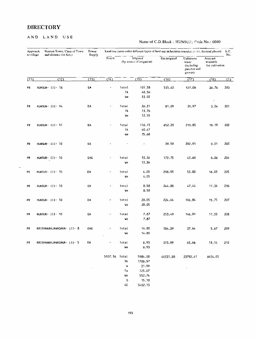
DIRECTORY
AND LAND USE Name of C.D.Block : HUNSU;':'; rode No.: 0040
Approach N"ar.:sl Town. Class of Town P"w.:r Land us.: (ar.:a und.:r dilTer.:nl Iyp.:s of land us.: in h.:clares rnund.:c ,', ,-"". d.:cimal plac.:s) L.C. 10 village and dislance (in Km.) Supply No.
For\!~l lrrigai>!J Un-irrigated Cultural>!': Area 0\>1
(hy '<'uree "r irrigali"n) wa~h! availahle (induJing for cultivati,in gau~har and grov\!~)
(11) (12) (13) (14) (15) (16) ( 17) (18) (1)
PR HUNSUR- 111- 16 EA Total 101.58 535.42 127.08 26.76 200 Tk 48.56 lJe 53.02
PR HUNSUR- 111- 14 EA Total 26.31 81.09 31.97 3.24 201 Tk 13.76 \.Ie 12.55
PR HUNSUR- I" - 11 EA Total 116.15 652.20 210.85 19.19 202 Tk 40.47 lJe 75.68
PR HUNSUR- I" - 10 EA 39.59 292.91 0.01 203
PR HUNSUR- "I - 10 EAG Total 13.36 172.75 43.60 6.06 204 lJe 13.36
PR HUNSlJ~ .. 111- 10 EA Total 4.05 298.93 53.83 16.03 205 \.Ie 4.05
PR HUNSUR- " 1- 10 EA Total 8.58 244.88 47.44 11.34 206 lJe 8.58
PR HUNSUR- I I I - 10 EA Total 28.05 224.04 106.84 15.75 207 lJe 28.05
PR HUNSUR- I I 1- 10 EA Total 7.87 253.49 146.91 11.33 208 lJe 7.87
PR KRISHNARAJANAGARA- I I 1- 8 EAG Total 14.80 184.39 37.64 5.67 209 lJe 14.80
PR KRISHNARAJANAGARA- 111- 5 EA Total 6.93 313.99 63.66 11. 14 210 lJe 6.93
5107.16 Total 5984.08 40331.80 23792.41 6454.05 Tk 1786.97
\.I 21.99 Tw 125.07 lJe 552.74
0 15.18 GC 34B2.13
193

KOLLEGAL C.D.BLOCK
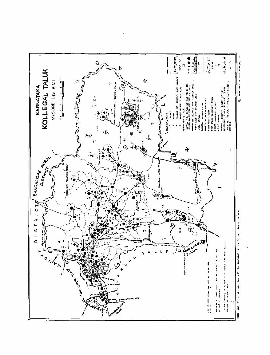
o
""\ A L U
I I
I i . I I i
!
~ • • !
"5 £
~
· f >
~ ;;
· s
~
;
~
. E ~
l!
~
~ g > ~
;; E
~ ~ .. .. c ~
! i . s
I ~ ~
< i
> , j
g, " i ~ .. i .
§ ! z
~ ~ ~ .. ! 0
"
'" '"
@
! 15
~ '"
! '" £'
<;
c 0 :: E ~
;; .c.
i
~ 0
~ '0
'" ~
~ u : 0
<D
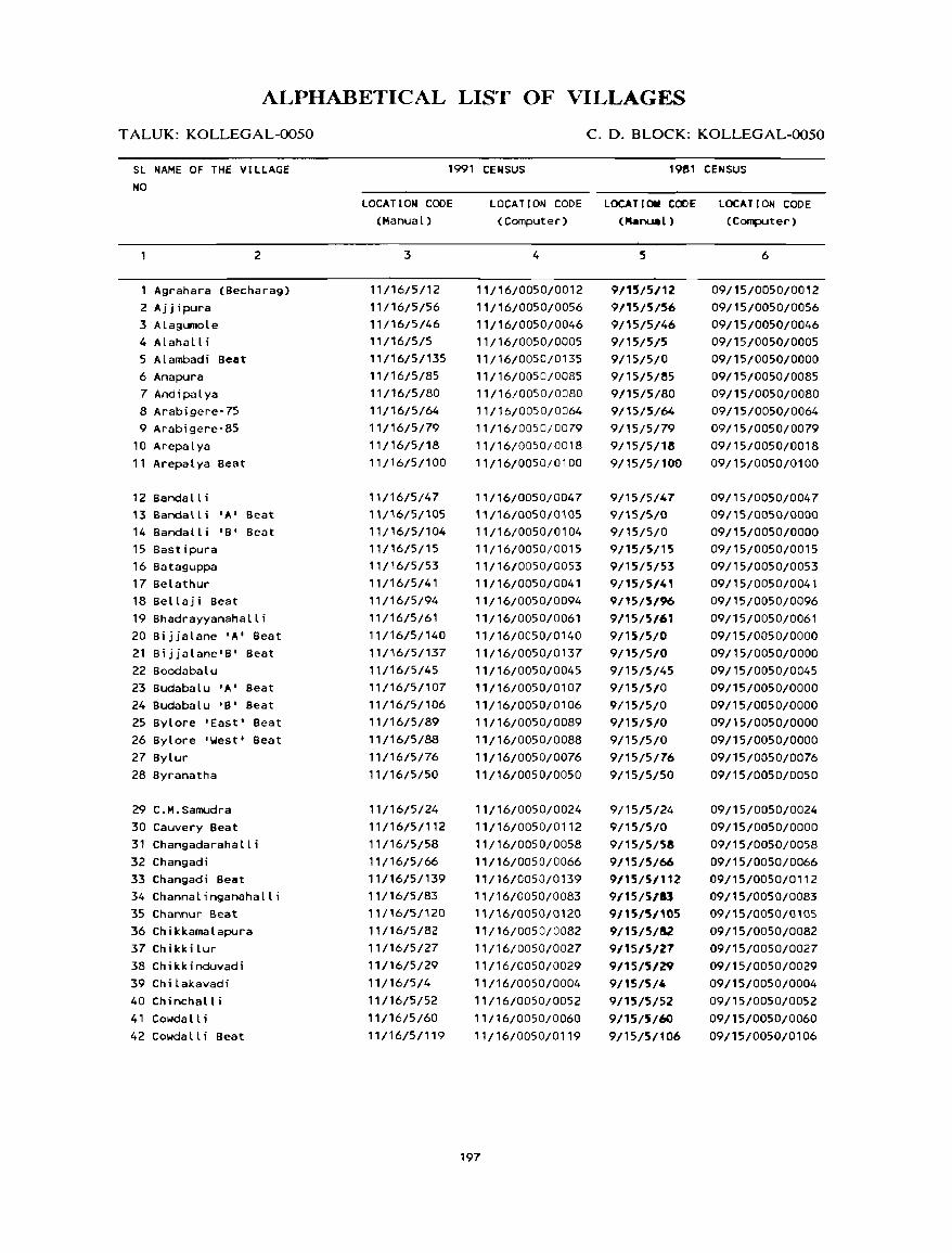
ALPHABETICAL LIST OF VILLAGES
T ALUK: KOLLEGAL-0050
SL NAME OF THE VILLAGE NO
2
Agranara (Becharag) 2 Aj j ipura 3 Alagumole 4 Alahalli 5 Alambadi Beat 6 Anapura 7 Andipalya 8 Arabigere-75 9 Arabigere-85
10 Arepalya 11 Arepalya Beat
12 Bandalli 13 Sanda II i ' A' Beat 14 Bandalli 'B' Beat 15 Bastipura 16 8ataguppa 17 Belathur 18 Bellaji Beat 19 Bhadrayyanahalli 20 Bijjalane 'A' Beat 21 Bijjalane'B' Beat 22 Boodabalu 23 Budabalu 'A' Beat 24 Budabalu 'B' Beat 25 Bylore 'East' Beat 26 Bylore 'West' Beat 27 Bylur 28 Byranatha
29 C.M.Samudra 30 Cauvery Beat 31 Changadarahall; 32 Changadi 33 Changadi Beat 34 Channalinganahalli 35 Channur Beat 36 Chikkamalapura 37 Chikkilur 38 Chikkinduvadi 39 Chilakavadi 40 Chinchalli 41 Cowdall; 42 Cowdall; Beat
C. D. BLOCK: KOLLEGAL-0050
1991 CENSUS 1981 CENSUS
LOCATION CODE (Manual)
3
11/16/5/12
11/16/5/56
11/16/5/46
11/16/5/5
11/16/5/135
11/16/5/85
11/16/5/80
11/16/5/64
11/16/5/79
11/16/5/18
11/16/5/100
11/16/5/47
11/16/5/105
11/16/5/104
11/16/5/15
11/16/5/53
11/16/5/41
11/16/5/94
11/16/5/61
11/16/5/140
11/16/5/137
11/16/5/45
11/16/5/107
11/16/5/106
11/16/5/89
11/16/5/88
11/16/5/76
11/16/5/50
11/16/5/24
11/16/5/112
11/16/5/58
11/16/5/66
11/16/5/139
11/16/5/83
"/16/5/120
11/16/5/82
11/16/5/27
11/16/5/29
11/16/5/4
11/16/5/52
11/16/5/60
11/16/5/119
LOCATION CODE LOCATIOM CODE LOCATION CODE (Computer) (Nanual) (Computer)
4
11/16/0050/0012
11/16/0050/0056
',/16/0050/0046
,'/16/0050/0005
',/,6/0050/0135
11/16/0050/0085
11/16/0050/0080
',/16/0050/0064
"/16/0050/0079
11/16/0050/0018
11/16/0050/0100
11/16/0050/0047
"/16/0050/0105
11/16/0050/0104
11/16/0050/0015
11/16/0050/0053
11/16/0050/0041
11/16/0050/0094
11/16/0050/0061
11/16/0050/0140
, 1/16/0050/0137
, 1 /16/0050/0045
11/16/0050/0107
11/16/0050/0106
11/16/0050/0089
11/16/0050/0088
11/16/0050/0076
11/16/0050/0050
11/16/0050/0024
11/16/0050/0112
11/16/0050/0058
11/16/0050/0066
11/16/0050/0139
11/16/0050/0083
11/16/0050/0120
11/16/0050/0082
11/16/0050/0027
11/16/0050/0029
11/16/0050/0004
11/16/0050/0052
11/16/0050/0060
11/16/0050/0119
197
5
9/15/5/12
9/15/5/56
9/15/5/46
9/15/5/5
9/15/5/0
9/15/5/!5
9/15/5/80
9/15/5/64
9/15/5/79
9/15/5/18
9/15/5/100
9/15/5/47
9/156/0
9/15/5/0
9/15/5/15
9/15/5/53
9/15/5/41
9/15/5/%
9/15/5/61
9/15/5/0
9/15/5/0 9/15/5/45
9/15/5/0
9/15/5/0
9/15/5/0
9/15/5/0
9/15/5/76
9/15/5/50
9/15/5/24
9/15/5/0
9/15/5/58
9/15/5/66
9/15/5/112
9/15/5113
9/15/5/'05 9/15/5/52 9/15/5/27
9/15/5/'l9 9/15/5/4
9/15/5/52
9/15/5/60 9/15/5/106
6
09/15/0050/0012
09/15/0050/0056
09/15/0050/0046
09/15/0050/0005
09/15/0050/0000
09/15/0050/0085
09/15/0050/0080
09/15/0050/0064
09/15/0050/0079
09/15/0050/0018
09/15/0050/0100
09/15/0050/0047
09/15/0050/0000
09/15/0050/0000
09/15/0050/0015
09/15/0050/0053
09/15/0050/0041
09/15/0050/0096
09/15/0050/0061
09/15/0050/0000
09/15/0050/0000
09/15/0050/0045
09/15/0050/0000
09/15/0050/0000
09/15/0050/0000
09/15/0050/0000
09/15/0050/0076
09/15/0050/0050
09/15/0050/0024
09/15/0050/0000
09/15/0050/0058
09/15/0050/0066
09/15/0050/0112
09/15/0050/0083
09/15/0050/0105
09/15/0050/0082
09/15/0050/0027
09/15/0050/0029
09/15/0050/0004
09/15/0050/0052
09/15/0050/0060
09/15/0050/0106
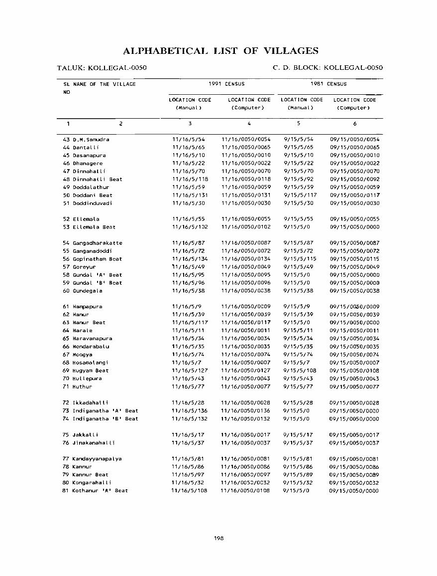
ALPHABETICAL LIST OF VILLAGES
T ALUK: KOLLEGAL-0050
SL NAME OF THE VILLAGE
NO
43 D.M.Samudra
44Dantalli
45 Dasanapura
46 Dhanagere
47 0 i nnah all i
2
48 Oinnahalli Beat
49 Doddalathur
50 Doddani Beat
51 Dodd i nduvad i
52 Ellemala
53 Ellemala Beat
54 Gangadharakatte
55 Ganganadoddi
56 Gopinatham Beat
57 Goreyur
58 Gundal 'A' Beat
59 Gundal 'B' Beat
60 Gundegala
61 Hampapura
62 Hanur
63 Hanur Beat
64 Harale
65 Haravanapura
66 Hondarabalu
67 Hoogya
68 Hosamalangi
69 Hugyam Beat
70 Hullepura
71 Huthur
72 Ikkadahalli
73 Indiganatha 'A' Beat
74 Indiganatha 'B' Beat
75 JakkaL L i
76 Jinakanahalli
77 KandayyanapaLya
78 Kannur
79 Kannur Beat
80 Kongarahalli
81 Kothanur 'A' Beat
1991 CENSUS
LOCATION CODE
(Manual)
3
11/16/5/54
11/16/5/65
11/16/5/10
11/16/5/22
11/16/5/70
11/16/5/118
11/16/5/59
11/16/5/131
11/16/5/30
11/16/5/55
11/16/5/102
11/16/5/87
11/16/5/72
11/16/5/134
'1/16/5/49
11/16/5/95
11/16/5/96
11/16/5/38
11/16/5/9
11116/5/39
11/16/5/117
11/16/5/1 1
11/16/5/34
11/16/5/35
11/16/5/74
11/16/5/7
11/16/5/127.
11/16/5/43
11/16/5/77
11/16/5/28
11/16/5/136
11/16/5/132
11/16/5/17
11/16/5/37
11/16/5/81
11/16/5/86
11/16/5/97
11/16/5/32
11/16/5/108
LOCATION CODE
(Computer)
4
11/16/0050/0054
11/16/0050/0065
11/16/0050/0010
11/16/0050/0022
11/16/0050/0070
11/16/0050/0118
11/16/0050/0059
11/16/0050/0131
11/16/0050/0030
11/16/0050/0055
11/16/0050/0102
11/16/0050/0087
11/16/0050/0072
11/16/0050/0134
11/16/0050/0049
11/16/0050/0095
11/16/0050/0096
11/16/0050/0038
11/16/0050/0009
11/16/0050/0039
11/16/0050/0117
11/16/0050/0011
11/16/0050/0034
11/16/0050/0035
11/16/0050/0074
11/16/0050/0007
11/16/0050/0127
11/16/0050/0043
11/16/0050/0077
11/16/0050/0028
11/16/0050/0136
11/16/0050/0132
11/16/0050/0017
11/16/0050/0037
11/16/0050/0081
11/16/0050/0086
11/16/0050/0097
11/16/0050/0032
11/16/0050/0108
198
C. D. BLOCK: KOLLEGAL-0050
1981 CENSUS
L OCA T ION CODE
(Manual)
5
9/15/5/54
9/15/5/65
9/15/5/10
9/15/5/22
9/15/5/70
9/15/5/92
9/15/5/59
9/15/5/117
9/15/5/30
9/15/5/55
9/15/5/0
9/15/5/87
9/15/5/72
9/15/5/115
9/15/5/49
9/15/5/0
9/15/5/0
9/15/5/38
9/15/5/9
9/15/5/39
9/15/5/0
9/15/5/11
9/15/5/34
9/15/5/35
9/15/5/74
9/15/5/7
9/15/5/108
9/15/5/43
9/15/5/77
9/15/5/28
9/15/5/0
9/15/5/0
9/15/5/17
9/15/5/37
9/15/5/81
9/15/5/86
9/15/5/89
9/15/5/32
9/15/5/0
LOCATION CODE
(Computer)
6
09/15/0050/0054
09/15/0050/0065
09/15/0050/0010
09/15/0050/0022
09/15/0050/0070
09/15/0050/0092
09/15/0050/0059
09/15/0050/0117
09/15/0050/0030
09/15/0050/0055
09/15/0050/0000
09/15/0050/0087
09/15/0050/0072
09/15/0050/0115
09/15/0050/0049
09/15/0050/0000
09/15/0050/0000
09/15/0050/0038
09/15/0nsO/0009
09/15/0050/0039
09/15/0050/0000
09/15/0050/0011
09/15/0050/0034
09/15/0050/0035
09/15/0050/0074
09/15/0050/0007
09/15/0050/0108
09/15/0050/0043
09/15/0050/0077
09/15/0050/0028
09/15/0050/0000
09/15/0050/0000
09/15/0050/0017
09/15/0050/0037
09/15/0050/0081
09/15/0050/0086
09/15/0050/0089
09/15/0050/0032
09/15/0050/0000
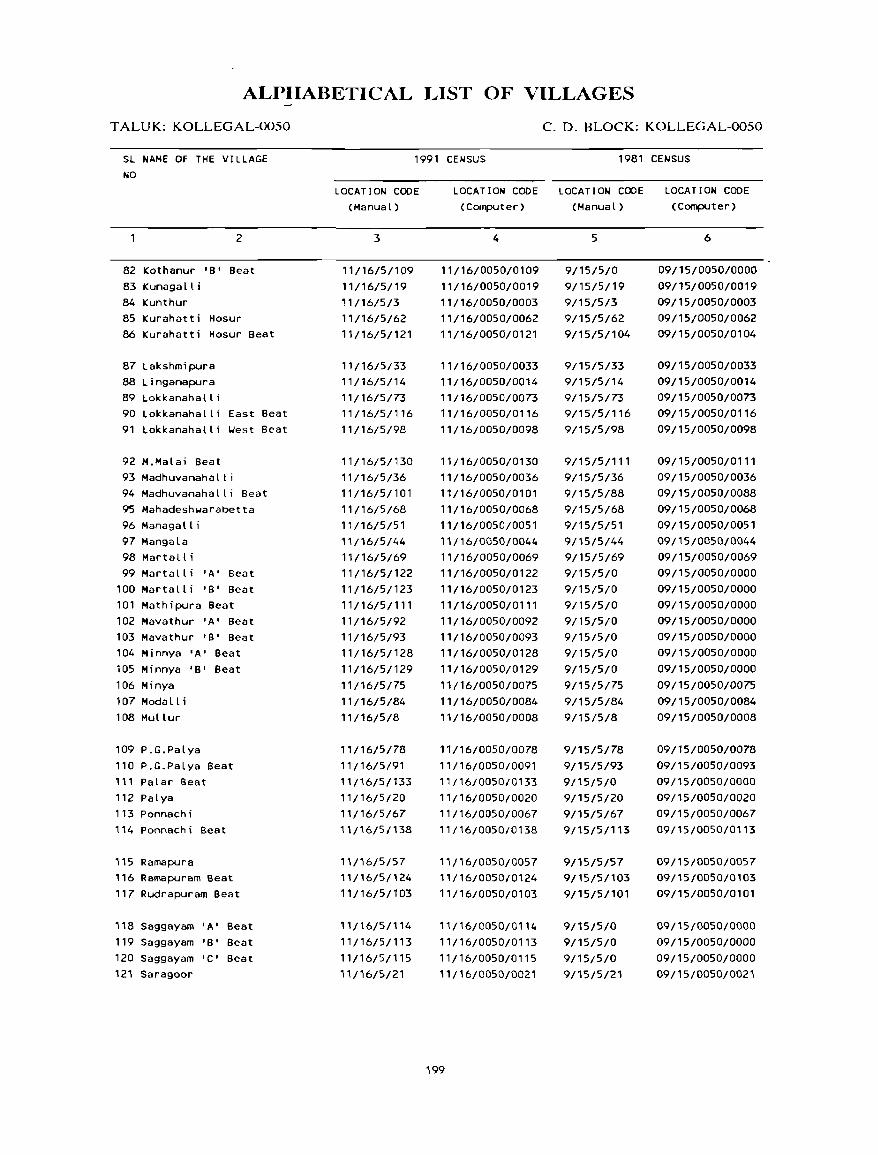
ALPIIABETICAL LIST OF VILLAGES
T ALUK: KOLLEGAL-0050
SL NAME OF THE VILLAGE
NO
2
82 Kothanur 'B' Beat
83 Kunaga II i
84 Kunthur
85 Kurahatti Hosur
86 Kurahatti Hosur Beat
87 Lakshmipura
88 L inganapura
89 Lokkanahall i
90 Lokkanahalli East Beat
91 Lokkanahalli ~est Beat
92 M.Malai Beat
93 Madhuvanahalli
94 Madhuvanahalli Beat
95 Mahadeshwarabetta
96 Managa It i 97 Mangala
98 Martall;
99 Martalli 'A' Beat
100 Martalli 'B' Beat
101 Mathipura Beat
102 Mavathur 'A' Beat
103 Mavathur 'B' Beat
104 Minnya 'A' Beat
105 Minnya 'B' Beat
106 Minya
107 Modall i
108 Mullur
109 P.G.Palya
110 P.G.Palya Beat
111 Palar Beat
112 Palya
113 Ponnach i
114 Ponnachi Beat
115 Ramapura
116 Ramapuram Beat
117 Rudrapuram Beat
118 Saggayam 'A' Beat
119 Saggayam 'B' Beat
120 Saggayam 'C' Beat
121 Saragoor
C. D. BLOCK: KOLLEGAL-0050
1991 CENSUS 1981 CENSUS
LOCATION CODE
(Manual)
3
11/16/5/109
11/16/5/19
11/16/5/3
11/16/5/62
11/16/5/121
11/16/5/33
11/16/5/14
11/16/5/73
11/16/5/116
11/16/5/98
11/16/5/130
11/16/5/36
11/16/5/101
11/16/5/68
11/16/5/51
11/16/5/44
11/16/5/69
11/16/5/122
11/16/5/123
11/16/5/111
11/16/5/92
11/16/5/93
11/16/5/128
11/16/5/129
11/16/5/75
11/16/5/84
11/16/5/8
11/16/5/78
11/16/5/91
11/16/5/133
11/16/5/20
11/16/5/67
11/16/5/138
11/16/5/57
"/16/5/124
11/16/5/103
11/16/5/114
11/16/5/113
11/16/5/115
11/16/5/21
LOCATION CODE LOCATION CODE
(Computer) (Manual)
4
11/16/0050/0109
11/16/0050/0019
11/16/0050/0003
11/16/0050/0062
11/16/0050/0121
11/16/0050/0033
11/16/0050/0014
11/16/0050/0073
11/16/0050/0116
11/16/0050/0098
11/16/0050/0130
11/16/0050/0036
11/16/0050/0101
11/16/0050/0068
11/16/0050/0051
11/16/0050/0044
11/16/0050/0069
11/16/0050/0122
11/16/0050/0123
11/16/0050/0111
11/16/0050/0092
11/16/0050/0093
11/16/0050/0128
11/16/0050/0129
11/16/0050/0075
11/16/0050/0084
11/16/0050/0008
11/16/0050/0078
11/16/0050/0091
11/16/0050/0133
11/16/0050/0020
11/16/0050/0067
11/16/0050/0138
11/16/0050/0057
11/16/0050/0124
11/16/0050/0103
11/16/0050/0114
11/16/0050/0113
11/16/0050/0115
11/16/0050/0021
199
5
9/15/5/0
9/15/5/19
9/15/5/3
9/15/5/62
9/15/5/104
9/15/5/33
9/15/5/14
9/15/5/73
9/15/5/116
9/15/5/98
9/15/5/111
9/15/5/36
9/15/5/88
9/15/5/68
9/15/5/51
9/15/5/44
9/15/5/69
9/15/5/0
9/15/5/0
9/15/5/0
9/15/5/0
9/15/5/0
9/15/5/0
9/15/5/0
9/15/5/75
9/15/5/84
9/15/5/8
9/15/5/78
9/15/5/93
9/15/5/0
9/15/5/20
9/15/5/67
9/15/5/113
9/15/5/57
9/15/5/103
9/15/5/101
9/15/5/0
9/15/5/0
9/15/5/0
9/15/5/21
LOCATION CODE
(Computer)
6
09/15/0050/0000
09/15/0050/0019
09/15/0050/0003
09/15/0050/0062
09/15/0050/0104
09/15/0050/0033
09/15/0050/0014
09/15/0050/0073
09/15/0050/0116
09/15/0050/0098
09/15/0050/0111
09/15/0050/0036
09/15/0050/0088
09/15/0050/0068
09/15/0050/0051
09/15/0050/0044
09/15/0050/0069
09/15/0050/0000
09/15/0050/0000
09/15/0050/0000
09/15/0050/0000
09/15/0050/0000
09/15/0050/0000
09/15/0050/0000
09/15/0050/0075
09/15/0050/0084
09/15/0050/0008
09/15/0050/0078
09/15/0050/0093
09/15/0050/0000
09/15/0050/0020
09/15/0050/0067
09/15/0050/0113
09/15/0050/0057
09/15/0050/0103
09/15/0050/0101
09!15/0050/0000
09/15/0050/0000
09/15/0050/0000
09/15/0050/0021
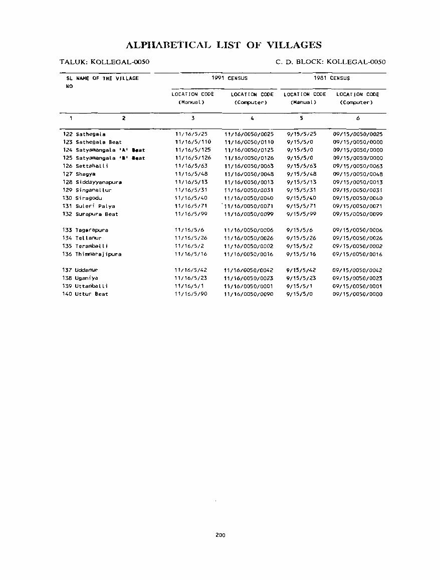
ALPIIARETICAL LIST OF VILLAGES
TALUK:KOLLEGAL~50
SL NAME OF THE VILLAGE NO
2
122 Sathegala 123 Sathegala Beat 124 Satyamangala 'A' .. at 125 Satyamangala 'I' .eat 126 Settahalli 127 Shagya 128 Siddayyanapura 129 Singanallur 130 S i ragodu 131 Suleri Palya 132 Surapura Beat
133 Tagarapura 134 Tellanur 135 Terarnball i 136 Thimmarajipura
137 Uddanur 138 Uganiya 139 Uttanballi 140 uttur Beat
C. D. BLOCK: KOLLEGAL-0050
1991 CENSUS 1981 CEWSUS
LOCATION CODE (Manual)
3
11/16/5/25 11/16/5/110 11/16/5/125 11/16/5/126 11/16/5/63 11/16/5/48 11/16/5/13 11/16/5/31 11/16/5/40 11/16/5/71 11/16/5/99
11/16/5/6 11/16/5/26 11/16/5/2 11/16/5/16
11/16/5/42 11/16/5/23 11/16/5/1 11/16/5/90
LOCATION CODE LOCATION CODE LOCATION CODE (Computer) (Manual) (Computer)
4
11/16/0050/0025 11/16/0050/0110 11116/0050/0125 11/16/0050/0126 11/16/0050/0063 11/16/0050/0048 11/16/0050/0013 11/16/0050/0031 11/16/0050/0040 11116/0050/0071 11/16/0050/0099
11/16/0050/0006 11/16/0050/0026 11/16/0050/0002 11/16/0050/0016
11/16/0050/0042 11/16/0050/0023 11/16/0050/0001 11/16/0050/0090
200
5
9/15/5/25 9/15/5/0 9/15/5/0 9/15/5/0 9/15/5/63 9/15/5/48 9/15/5/13 9/15/5/31 9/15/5/40 9/15/5/71 9/15/5/99
9/15/5/6 9/15/5/26 9/15/5/2 9/15/5/16
9{15/5/42 9/15/5/23 9/15/5/1 9/15/5/0
6
09/15/0050/0025 09115/0050/0000 09/15/0050/0000 09/15/0050/0000 09/15/0050/0063 09/15/0050/0048 09/15/0050/0013 09/15/0050/0031 09115/0050/0040 09/15/0050/0071 09/15/0050/0099
09/15/0050/0006 09115/0050/0026 09/15/0050/0002 09/15/0050/0016
09/15/0050/0042 09/15/0050/0023 09/15/0050/0001 09/15/0050/0000
KOLLEGAL C.D.BLOCK

VILLAGE
AMENITIES Name ofc.6.BIock: KOLLEGAL; Code No. :0050
L.C. Name of Village T<,tal area of Total AmeOitle; available (If not available within the village. a da,h (-) IS ;hown In the No. the village Popu- collimn and next to it In bracl.ets. the distan..:c in broad ranges VIZ -5 I.ms. 5-10 I.ms.
(In hectares) lallon and !(l+ kill, of the neare~t [!I"..:e where the faclllt}' "avallahle IS glvcnl and Edu,a- Medical Drinking Po,t Day or Communication No.of tional Water and Da) s of (Bu; Stop, HOll".e- Telc- market! Railway Station. hold, graph hat If any Waterway)
(1) (2) (3) (4) (5) (6) (7) (8) (9) (10)
UTTAMBALLI 319.92 1599 P, M -(0-5) IJ, liP PTO, -(0-5) BS
(303) Phone
2 TERAMBALLI 649.57 2037 P(3), M - (5-10) TIJ, HP -(5-10) -(5-10) BS (384)
3 KUNTHUR 917.67 4423 P(2) , M -(0-5) TIJ, HP PTO, -(10+) BS (848) Phone
4 CII I LAKAVAD I 390.54 1807 P(3) , PIIC, D, T, liP PTO, - (10+) BS (367) M(2), II FPC Phone
5 ALAIIALLI 457.53 2331 P, M -(0-5) T, liP PO, - (10+) BS (463) Phone
6 TAGARAPURA 998.14 3415 P(4) , M(2) -(0-5) T, TIJ, HP -(0-5) -(10+) BS (631)
7 IIOSAMALANGI 823.39 2500 P(2), M -(0'5) TIJ, liP PO, - (5- 10) -(0-5)
(461) Phone
8 MULLUR 729.99 5383 P(4), M(2) -(0-5) T, liP PTO, -(0-5) BS (956) Phone
9 HAMPAPURA 534.36 2499 P(2) -(0-5) TIJ, HP -(0-5) -(0-5) BS (416)
10 DASANAPURA 223.11 739 P(2) -(0-5) IJ, HP -(0-5) -(0-5) -(0-5) (146)
11 HARALE 255.18 2120 P(2) -(0-5) TIJ, HP -(0-5) -(0-5) -(0-5) (371)
12 AGRAIIARA (BECHARAG) 189.41 ------------------------ UN - I NHAB ITED -------------------------
13 SIDDAYYANAPURA 338.63 2316 P, M -(0-5) IJ, liP PTO, -(0-5) BS (430) Phone
202
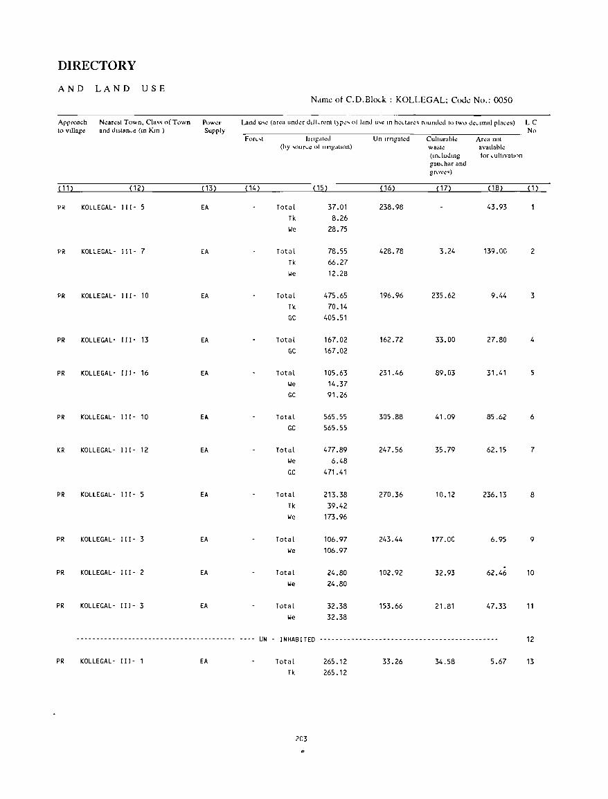
DIRECTORY
AND LAND USE Name ot C.D.Blo<.-k : KOLLEGAL; Code No.: 0050
Approach N~are~t Town, Cia" of Town Power Land u'~ (ar~a unda ddkr~nt t)pe' 01 Idnd u,e 10 hectdr~' rounded to two d~L1mal plac~s) LC to VIllage and dIstance (m Km ) Supply No
For"t Illlg.lh:d Un Irngated ClIltllrabl~ Area not (hy ,",oun.1! olllngdllOn) wa.te avallahle
(lOdudlOg tor cultlvalton gallchar and gf<lV~')
( 11 ) (12) (13) ( 14) ( 15) ( 16) ( 17) ( 18) (1)
PR KOLLEGAL- 111- 5 EA Total 37.01 238.98 43.93 Tk 8.26 lie 28.75
PR KOLLEGAL- I I I - 7 EA Total 78.55 428.78 3.24 139.00 2 Tk 66.27 lie 12.28
PR KOLLEGAL- I I I - 10 EA Total 475.65 196.96 235.62 9.44 3 Tk 70.14 GC 405.51
PR KOLLEGAL- I I I - 13 EA Total 167.02 162.72 33.00 27.80 4
GC 167.02
PR KOLLEGAL- I I I - 16 EA Total 105.63 231.46 89.03 31.41 5 lie 14.37 GC 91.26
PR KOLLEGAL- I I 1- 10 EA Total 565.55 305.88 41.09 85.62 6 GC 565.55
KR KOLLEGAL- I I 1- 12 EA Total 477.89 247.56 35.79 62.15 7 lie 6.48 GC 471.41
PR KOLLEGAL- 111- 5 EA Total 213.38 270.36 10.12 236.13 8 Tk 39.42 lie 173.96
PR KOLLEGAL - I I I - 3 EA Total 106.97 243.44 177.00 6.95 9 lie 106.97
PR KOLLEGAL- I I I - 2 EA Total 24.80 102.92 32.93 62.46 10 lie 24.80
PR KOLLEGAL- I I 1- 3 EA Total 32.38 153.66 21.81 47.33 11 lie 32.38
--------------------------~------------- ---- UN - INHABITED --------------------------------------------- 12
PR KOLLEGAL- I I I - 1 EA Total 265.12 33.26 34.58 5.67 13 Tk 265.12
203
"

VILLAGE
AMENITIES Name of C.D.Block : KOLLEGAL; Code No. :0050
L.C. Name of Village Tntal area of Total Amellitle .. avall.lble (If not avaIlable Wlthm the Village. a da .. h (.) IS shown 10 the No the VIllage Popu- column and next to ·,.n brad .. et ... the d"tan~e 10 hwad ranges viJ. -~ lm ... 'i-IO lm,.
(In hectare .. ) latu>n and 10+ In'' of the neare,t [!Ia,e "here the ",ullly" av,"lahle i, glV\!n} and Edu,a- ~kdll:al DllIIllng Po"t Day or Cl)lnlnulll\.-3llOn
No of (Jon.:)) Water and Days of IB", SlOp. How .. l!- Tde- marlell Railway StatulO. hollt.. graph hat If any WatelWayl
( 1 ) (2) (3) (4) (5) (6) (7) (8) (9) ( '0)
14 LINGANAPURA 356.99 2661 P(3) , M -(0-5) TW, HP PTO, -(0-5) -(0-5) (506) Phone
15 BASTIPURA 213.31 3453 P, M -(0-5) TW, HP -(0-5) -(0-5) -(0-5) (667)
16 THIMMARAJIPURA 409.52 1503 P -(0-5) TW, HP -(0-5) -(0-5) - (0-5) (288)
17 JAKKALLI 699.65 886 P, M -(5-10) W, HP -(5-10) -(5-10) BS ( 179)
18 AREPALYA 518.73 993 P -(5-10) W, HP -(0-5) -(5-10) BS ( 198)
19 KUNAGALLl 1380.35 4617 P(2) , M(2) -(5-10) T, TW, HP PTO, -(5-10) BS (919) Phone
20 PALYA 1262.38 5511 P, M, H PHC, 0, T, HP PTO, - (10+) BS (992) FPC Phone
21 SARAGOOR 468.35 1579 P(3) -(0-5) W, HP PTO, -(5-10) BS (298) Phone
22 DHANAGERE 660.83 1987 P(2), M - (0-5) TW, HP -(5-10) -(5-10) BS (383)
23 UGANIYA 1416.16 1898 P, M -(0-5) TW, HP -(0-5) - (10+) BS (327)
24 C.M.SAMUDRA 28.58 667 P -(0-5) T, HP -(0-5) - (5-10) BS ('21 )
25 SATHEGALA 8135.14 10315 P(4) , PHC, FPC T, HP PTO, - (10+) BS (2033) M(3) , H Phone
26 TELLANUR 1849.26 6686 PC?), M(3) -(5-10) T, HP PTO, -(5-10) BS (1354 ) Phone
204
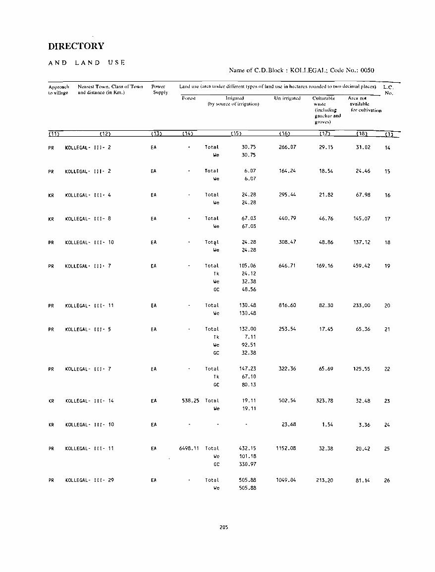
DIRECTORY
AND LAND USE Name of C.D.Block : KOLLEGAL; Code No.: 0050
Approach N~ar~st Town. Class of Town Pow~r Land usc (area under dilTerent types of land use in hectares rounded to two decimal plac.:.) L.C. to village and distance (in Km.) Supply No.
Forl!~t Irrigatlt!d Un-irrigated Culturahl.: Area not (hy ,ource of irrigation) wa~h! availahle
(includin:: for cultivation gauchar and grove,)
(11 ) (12) ( 13) (14) ( 15) ( 16) ( 1 7) (18) (1)
PR KOLLEGAL- "1- 2 EA Total 30.75 266.07 29.15 31.02 14 lJe 30.75
PR KOLLEGAL- 111- 2 EA Total 6.07 164.24 18.54 24.46 15 'We 6.07
KR KOLLEGAL - 111- 4 EA Total 24.28 295.44 21.82 67.98 16 lJe 24.28
KR KOLLEGAL- 111- 8 EA Total 67.03 440.79 46.76 145.07 17 lJe 67.03
PR KOLLEGAL- 111- 10 EA Tot~l 24.28 308.47 48.86 137.12 18 lJe 24.28
PR KOLLEGAL- 111- 7 EA Total 105.06 646.71 169.16 459.42 19 Tk 24.12 lJe 32.38 GC 48.56
PR KOLLEGAL- 111- 11 EA Total 130.48 816.60 82.30 233.00 20 lJe 130.48
PR KOLLEGAL- 111- 5 EA Total 132.00 253.54 17.45 65.36 21 Tk 7.11 lJe 92.51 GC 32.38
PR KOLLEGAL- 111- 7 EA Total 147.23 322.36 65.69 125.55 22 Tk 67.10
GC 80.13
KR KOLLEGAL- 111- 14 EA 538.25 Total 19.11 502.54 323.78 32.48 23 lJe 19.11
KR KOLLEGAL- 111- 10 EA 23.68 1.54 3.36 24
PR KOLLEGAL- I" - 11 EA 6498.11 Total 432.15 1152.08 32.38 20.42 25 lJe 101.18 GC 330.97
PR KOLLEGAL- 111- 29 EA Total 505.88 1049.04 213.20 81.14 26 lJe 505.88
205

VILLAGE
AMENITIES Name ot C.D.Block : KOLLEGAL; Code No. :0050
LC Name of Village Total area of Tot," Am~J1ll1e, ava"ahle (If not avalldhle wlthm the village a da,h (-) " .hown In the No the village Popu column and next to I'm hraclet •. the d"t,mce 10 broad range. vu -~ lm •• ~-10 lm ••
(In heddres) ldhon and l()+ kill' 01 the ne<ire't 121 "e "here the I"ulitl:" avail"hl.: " glv~n)
and Edllca I\kdlCal DnnllOg Po,! Ddyor Communlcallon No ,'f 11011«1 Wdter and Ddys of (Bu~ Stop. Hou'\!- Tdc: mark.:!! RaIlway S[allon. hold, graph hat If any Wdterway(
( 1) (2) (3} (4) (5) (6) (7) (8) (9) ( 1 0)
27 CHIKKILUR 3089.35 3274 ·P(4). M(3) -(10+) T, TI.I, HP PTO, -(10+) BS (702) Phone
28 I KKADAHAl LI 2985.90 2666 P(3), M - (5 -10) T, HP -(0-5) -(0-5) BS
(523)
29 CHIKKINDUVADI 478.90 781 P(2) -(5-10) 1.1, HP -(0-5) -(0-5) BS ( 157)
30 DODDINDUVADI 657.30 5312 P(2), M -(0-5) T, TI.I, HP PTO, -(0-5) BS (1013) Phone
31 SINGANALLUR 679.29 3112 P(2), -(0-5) T, HP PTO, FRI BS (573) M(2), H Phone
32 KO,..GARAHALLI 550.39 7954 P( 4), PHC, FPC T, HP PTO, -(0-5) BS ( 1469) M(3) , H Phone
33 LAKSHMIPURA 532.89 112 -(0-5) -(0-5) \.I, HP -(0-5) -(0-5) BS (22)
34 HARAVANAPURA 321.18 26 -(0-5) -(0-5) 1.1, HP -(0-5) -(0-5) BS (6)
35 HONDARABALU 721.33 2463 P(Z), M(2) -(5-10) TI.I, HP -(0-5) -(0-5) BS (437)
36 MADHUVANAHALL I 669.20 7809 P(2), -(5-10) T, HP PTa, -(5-10) BS (1436) M(2), H Phone
37 J INAKANAHALLI 307.68 1618 P(2) -(0-5) 1.1, HP -(0-5) - (5 -1 0) BS (291)
38 GUNDEGALA 404.06 1289 P -(0-5) TI.I, HP -(0-5) -(5-10) BS (250)
39 HANUR 1069.33 7871 P(5), PHC, FPC T, T\.I, HP PTO, -(10+) BS (1529) M(3) , H, Phone
PUC, AC
206
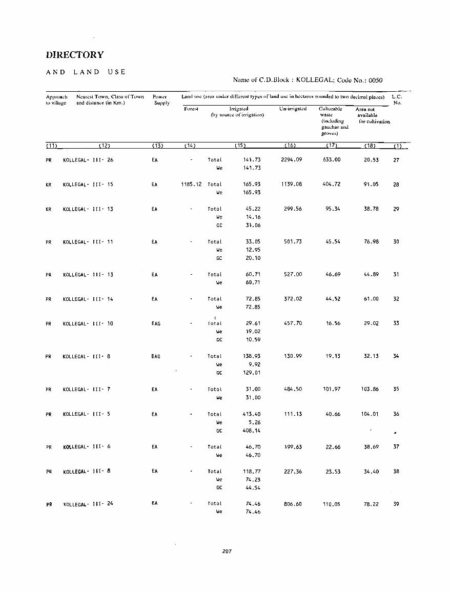
DIRECTORY
AND LAND USE Namc of C.D.Block : KOLLEGAL; Cooc No.: 0050
Approa~h N~ar~"1 Town. Class ofTnwn Powa Land lIS~ (ar~a lInd..:r ditT~r~nl Iyp~s of land lIS~ in h~clar~s round~d 10 IWO d~cimal plac~s) L.C. 10 village and dislanc~ (in Km.) Supply No.
For~"1 Irrigal~d Un-irrigal~d Cullurahle Area not (hy sourc~ of irrigation) wasl~ available
(including for cullivalion gauchar and grov~s)
( 11 ) (12) ( 13) ( 14) (15) ( 16) ( 17) ( 18) (1)
PR KOLLE GAL - 111- 26 EA Total 141.73 2294.09 633.00 20.53 27 We 141.73
KR KOLLEGAL- 111- 15 EA 1185.12 Total 165.93 1139.08 404.72 91.05 28 We 165.93
KR KOLLEGAL- 111- 13 EA Total 45.22 299.56 95.34 38.78 29 We 14.16 GC 31.06
PR KOLLEGAL- 111- 11 EA Total 33.05 501. 73 45.54 76.98 30 We 12.95 GC 20.10
PR KOLLEGAL- 111- 13 EA Total 60.71 527.00 46.69 44.89 31 We 60.71
PR KOLLEGAL- 111- 14 EA Total 72.85 372.02 44.52 61.00 32 We 72.85
(
PR KOLLEGAL- 111- 10 EAG Total 29.61 457.70 16.56 29.02 33 We 19.02 GC 10.59
PR KOLLEGAL- 111- 8 EAG Total 138.93 130.99 19.13 32.13 34 We 9.92 GC 129.01
PR KOLLEGAL- 111- 7 EA Total 31.00 484.50 101.97 103.86 35 We 31.00
PR KOLLEGAL- 111- 5 EA Total 413.40 111.13 40.66 104.01 36 We 5.26 GC 408.14
#
PR KOLLEGAL- 111- 6 EA Total 46.70 199.63 22.66 38.69 37 We 46.70
PR KOLLEGAL- 111- 8 EA Total 118.77 227.36 23.53 34.40 38 We 74.23 GC 44.54
PR KOLLEGAL- 111- 24 EA Total 74.46 806.60 110.05 78.22 39 We 74.46
207

VILLAGE
AMENITIES Name of C.D.Block : KOLLEGAL; Code No. :0050
LC Nam.: of Villago: Total ar"a of Total Am':lI.t • .:, av"ll"hl" (., 1I0t av"llahl" wlth.1I th.: v.JJag". a da,h (-) IS showllmlh" No the v.llage Popu cOIUIllII dnd n.:xt to It In hrdc"et,. the d"tance In hroad ranges VIJ; -~ "m,. 5-10 "ms.
(In hectare,) Idll"n and 10+ ... '" 01 the neMe,t [!1,1c': "here the '"uht~ "av"II"hle " given! and Educa- ~kdlC,,1 Dnn"lllg Po,t Ddyor Commulllcat"," No 01 1I0n,,1 Water and D,'ys of (8u, Swp. Hou ... 1o! Tdc- mar"et/ R""way StatIOn. hold, graph hat" any WatcrwdY]
(1) (2) (3) (4) (5) (6) (7) (8) (9) (10)
40 SIRAGODU 702.91 605 P, M -(0-5) TW, HP -(0-5) - (10+) -(0-5) ( 143)
t.1 BELAH(UR 70t..86 8t.9 P -(0-5) \,I, liP -(0-5) - (10+) -(0-5) (148)
42 UDDANUR 761.45 1251 P, M -(0-5) W, HP PTO, -(0-5) -(0-5) (242) Phone
43 HULLEPURA 1704.09 1402 P(4) -(5-10) \J, HP -(5-10) -(10+) BS (275)
44 MAN GALA 1578.97 3159 P(2), M(2) -(0-5) W, HP PTO, -(0-5) BS (575 ) Phone
45 BOODASALU 815.20 1622 P(2) -(5-10) T, HP -(5-10) -(0-5) BS (309)
46 ALAGUMOLE 758.36 697 P -(5-10) T, HP -(0-5) -(10+) -(0-5) (144)
47 SANDALL! 7010.35 BOll P(4) , PHC, FPC T, HP PTO, -(10+) as (1512) M(2) , H Phone
48 SHAGYA 2720.75 4946 P(2) , M -(5-10) TW, HP PTO, -(10+) as (892) Phone
49 GOREYUR 918.13 1347 P(2), M(2) -(5-10) II, HP PO -(10+) BS (292)
50 BYRANATHA 60B.96 2034 P(3) -(5-10) Til, HP -(0-5) - (10+) -(0-5) (352)
51 MANAGALLI 542.45 1896 P, M - (5-10) TW, HP PO - (10+) BS (356)
52 CHINCHALLI 450.20 1403 P(2), M - (5 -1 0) TW, HP -(0-5) - (10+) -(0-5) (224)
53 BATAGUPPA 692.34 157 - (0-5) -(0-5) 1.1, HP - (0-5) -(10+) -(0-5) (30)
54 D.M.SAMUDRA 1770.12 3060 P(4) - (10+) W, HP PO -(10+) -(0-5) (SSc)
208
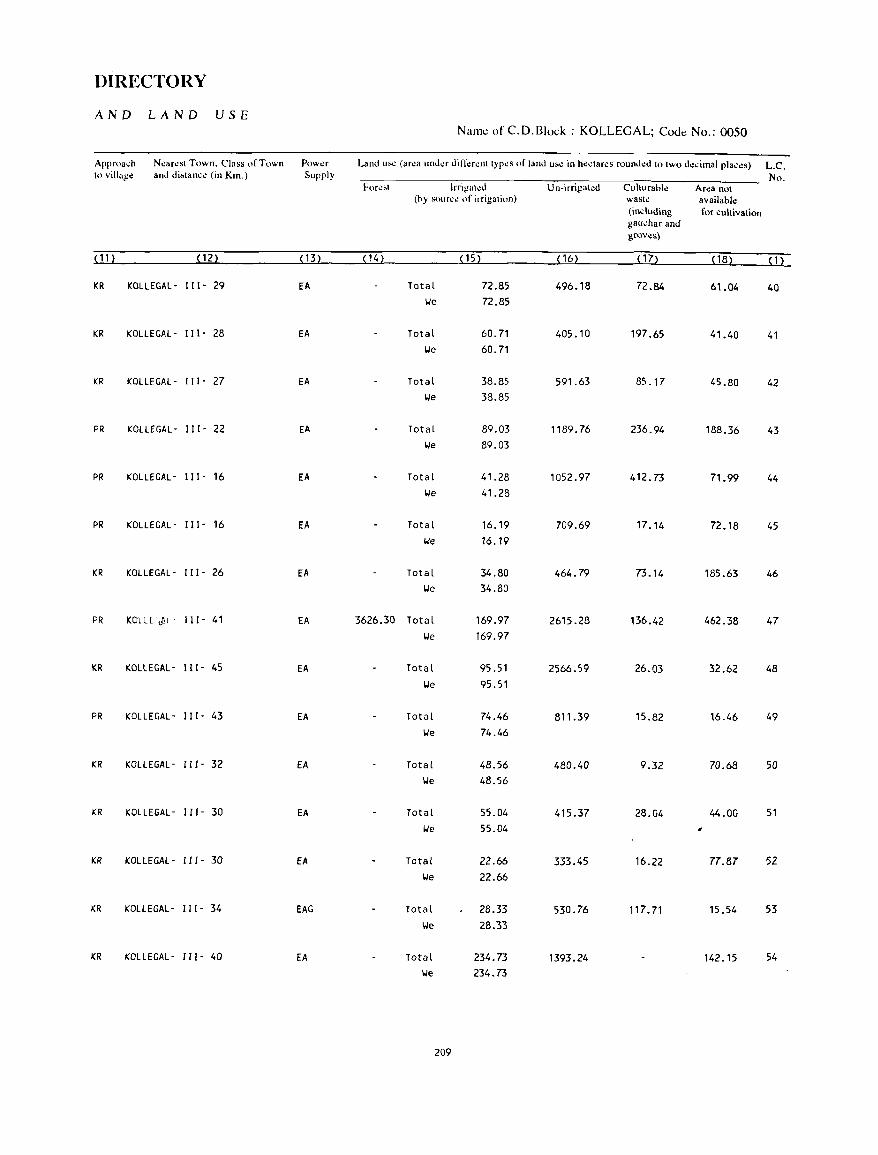
DIRECTORY
AND LAND USE Namt: of C.D.Block : KOLLEGAL; CoJt: No.: 0050
Approa,h N~ar~sl Town. Class of Town Pow~r Land us~ (ar~a und~r diIT~r~nl typ~s of land us~ in hectar~s rounded 10 Iwo de,imal plac~s) L.C. to village and di~lanc.: (in Km.) Supply No.
Fore;.t lrrigatl.!d Un-irrigakd Culturahl~ Area not (by source of irrigation) wast~ available
(including for cultivation g8udlar and grove~)
(11) (12) (13) (14) (15) ( 16) ( 17) ( 18) (1)
KR KOLLEGAL- 111- 29 EA Total 72.85 496.18 72.84 61.04 40 lie 72.85
KR KOLLEGAL- 111- 28 EA Total 60.71 405.10 197.65 41.40 41 lie 60.71
KR KOLLEGAL- 1 I I - 27 EA Total 38.85 591.63 85.17 45.80 42 lie 38.85
PR KOLLEGAL- 111- 22 EA Total 89.03 1189.76 236.94 188.36 43 lie 89.03
PR KOLLEGAL- I I I - 16 EA Total 41.28 1052.97 412.73 71.99 44 lie 41.28
PR KOLLEGAL- I I I - 16 EA Total 16.19 709.69 17.14 72.18 45 t.le 16.19
KR KOLLEGAL- I I I - 26 EA Total 34.80 464.79 73.14 185.63 46 lie 34.80
PR KOLLE',ftl' 111- 41 EA 3626.30 Total 169.97 2615.28 136.42 462.38 47 lie 169.97
KR KOLLEGAL- 111- 45 EA Total 95.51 2566.59 26.03 32.62 48 lie 95.51
PR KOLLEGAL- 111- 43 EA Total 74.46 81 1.39 15.82 16.46 49 lie 74.46
KR KOLLEGAL- 111- 32 EA Total 48.56 480.40 9.32 70.68 50 lie 48.56
KR KOLLEGAL- 111- 30 EA Total 55.04 415.37 28.04 44.00 51 lie 55.04 ,
KR KOLLEGAL- 111- 30 EA Total 22.66 333.45 16.22 77.87 52 lie 22.66
KR KOLLEGAL- 111- 34 EAG Total 28.33 530.76 117.71 15.54 53 lie 28.33
KR KOLLEGAL - 111- 40 EA Total 234.73 1393.24 142.15 54 lie 234.73
209
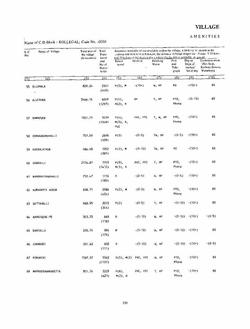
VILLAGE
I AMENITIES
Name of c. O. Block : KOLLEGAL; Code No. :0050
LC Name of Village Total area ()f Total Am~l1l11~' avaddhk (It not avaddble wtthln the vllldgC. a da,h (-) " 'hown In the
No the village Popu- column and nextt,) It III bracl.~t'. the dl,tdnc.: In broad range, Vlf -~ I..ms. ~-l 0 1..111'. (In hl!dar~.) IdtlOn and IO + kill' 01 Ih.: n':.If<"r l1'dc': "h.:r.: to.: hdltly "avatldhlc I' glv\!n!
and Educa l\kdlcal Dnnl.lllg Po,t Day or CommunIcation
No of \woal Wdl~r and Days of [Bu, Stop.
HOI"':- Telc- marlctl Radway Stdtlon.
hold, grdph hat If ~ny Wdlerway)
(1) (2) (3) (4) (5) (6) (7) (8) (9) (lD)
55 ELlEMAlA 829.24 2341 P(3) , M - (1 D .. ) 101, HP PO - (10+) as
(449)
56 AJJ lPURA 3466.15 6249 P(S) , RP T, HP PTO, -(5-10) as
(1297) M(2), H Phone
57 RAMAPURA 1221.15 5039 P(4) , PHC, FPC T, 101, HP PTO, -(10+) as
( 1048) M(3) , H, Phone
PUC
58 CHANGADARAHAllI 757.59 2696 P(3) -(0-5) Til, HP -(0-5) - (10+) as
(528)
59 DODDAlATHUR 686.03 1952 P(2), M -(5-10) Til, HP PO -(10+) as
(387)
60 COIJDAll I 2176.81 7759 P(9) , PHC, FPC T, HP PTO, - (10+) as
(1415) M(3) , H Phone
61 B~ADRAYYANAHAlLI 752.47 1116 P -(0-5) IJ, HP -(0-5) - (10+) BS
( 189)
62 KURAHATTI HOSUR 698.71 2086 P(2), M - (0-5) 101, HP PTO, - (10+) as
(424) Phone
63 SfTTAHAlLI 668.95 2013 P(2) 'fO-5) T, HP '(5-10) -(10+) as
(344)
64 ARAaIGERE-75 353.73 668 P -(5-10) 101, HP -(5-10) - (10+) -(0-5)
(118)
65 DANTALLI 210.74 984 P -(5'10) 101, HP -(5-10) -(10+) as
(171 )
66 CHANGADI 201.62 602 P -(5-10) 101, HP -(5-10) -(10+) - (0- 5)
(111)
67 PONNACHI 1587.07 5562 P(5), M(2) PHC. FPC 101, HP PTO, -(10+) as
(nOl) Phone
68 MAHADESHIJARABETTA 851. 74 3229 P(6) , PHC, FPC T, HP PTO, -(10+) BS
(621) M(2), H Phone
210
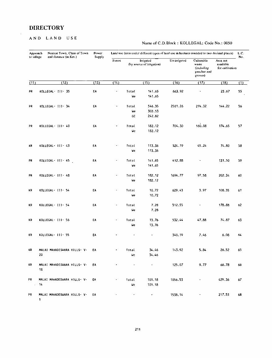
DIRECTORY
AND LAND USE Namt! of C. D. Block: KOLLEGAL; Coot! No.: 0050
Approach Nearest Town, Class of Town Power Land use (area under din;:rent types of land us.: in hedares rounded to two decimal places) L.C. to village and distance (in Km.) Supply No.
Forest Irrigal\!d Un-irrigated Culturable Area not (by source of irrigation) waste available
(induding for cultivation gauchar and grows)
(11) (12) ( 13) ( 14) ( 15) ( 16) ( 1 7) (18) (1)
PR KOLLEGAL- 111- 35 EA Total 141.65 663.92 23.67 55 IJe 141.65
PR KOLLEGAL- 111- 34 EA Total 546.35 2501.26 274.32 144.22 56 IJe 303.53 GC 242.82
PR KOLLEGAL- 111- 40 EA Total 182.12 704.30 160.08 174.65 57 IJe 182.12
KR KOLLEGAL- 111- 43 EA Total 113.36 524.19 45.24 74.80 58 'We 113.36
PR KOLLEGAL- 111- 45 EA Total 141.65 412.88 131.50 59 IJe 141.65
PR KOLLEGAL- 111- 48 EA Total 182.12 1694.77 97.58 202.34 60 IJe 182.12
KR KOLLEGAL- 111- 54 EA Total 10.72 629.43 3.97 108.35 61 IJe 10.72
KR KOLLEGAL- 111- 54 EA Total 7.28 512.55 178.88 62 IJe 7.28
KR KOLLEGAL- 111- 56 EA Total 13.76 532.44 47.88 74.87 63 IJe 13.76
KR KOLLEGAL- 111- 55 EA 340.19 7.46 6.08 hi.
KR MALAI MAHADESIJARA HILLS- V- EA Total 34.46 143.92 5.84 26.52 65 20 IJe 34.46
KR MALAI MAHADESIJARA HILLS- V- EA 125.07 9.77 66.78 66 18
PR MALAI MAHADESIJARA HILLS- V- EA Total 101. 18 1056.53 429.36 67 14 IJe 101.18
PR MALAI MAHADESIJARA HILLS- V- EA 1538.14 217.53 68 1
21'
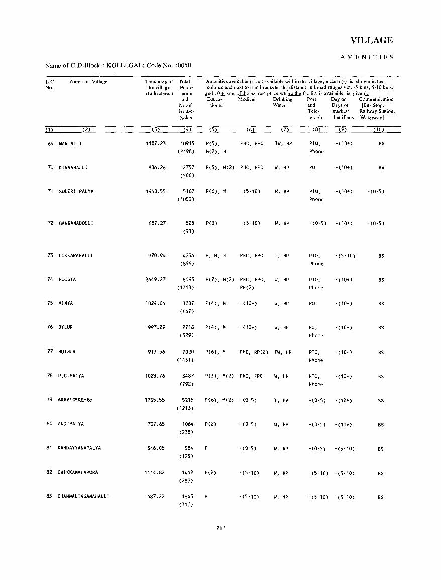
VILLAGE
AMENITIES Name of C.D.Block : KOLLEGAL; Code No. :0050
L.C. Name of Village Total area of Total Amenities available (if not available within the village, a dash (-) is shown in the No. the village Popu- column and next to it in brad;ets, th~ distanc.: in broad ranges viz. -5 kms, 5-10 kms,
(In hectar.:s) lalion and 10+ kms of the nearest [!lace where the f:1cilit~ is available is given}. and &luea· Medical Drinking Post Day or Communication
No.of tionaf Water and Days of [Bus Stop, Hou,"e- Tde- markdf Railway Station. holds graph hat if any Wakrway)
(1) (2) (3) (4) (5) (62 (12 (82 (92 (102
69 MARTALLI 1187.23 10915 P(5) , PHC, FPC Til, HP PTO, - (10+) BS (2198) M(2), H Phone
70 DINNAHALLI 886.26 2757 P( 5), M(2) PHC, FPC II, HP PO -(10+) BS (506)
71 SULERI PALYA 1940.55 5167 P(6), M -(5-10) II, HP PTO, - (10+) -(0-5) (1053) Phone
72 GANGANADOODI 687.27 525 P(3) -(5-10) II, HP -(0-5) - (10+) -(0-5) (91)
73 LOKKANAHALLI 970.94 4256 P, M, H PHC, FPC T, HP PTO, -(5-10) BS (896) Phone
74 HOOGYA 2649.27 8093 P(7), M(2) PHC, fPC, II, HP PTO, -(10+) BS ( 1718) RP(2) Phone
75 MINYA 1024.04 3207 P(4), M -(10+) II, HP PO . (10+) BS (647)
76 BYLUR 997.29 2718 P(4), M -(10+) II, HP PO, -(10+) BS (529) Phone
77 HUTHUR 913.56 7020 P(6), M PHC, RP(2) Til, HP PTO, -(10+) BS (1451) Phone
78 P.G.PALYA 1023.76 3487 P(3), M(2) PHC, FPC II, HP PTO, -(10+) BS (792) Phone
79 ARABIGERE-85 1755.55 5215 P(6}, M(2} -(0-5) T, HI' - (0-5) -(10+) as (1213)
80 ANDIPALYA 707.65 1064 P(2) -(0-5) II, HP -(0-5) -(10+) BS (?38)
81 KANDAYYANAPALYA 346.05 584 P -(0-5) II, HP -(0-5) -(5-10) BS (125 )
82 CHIKKAMALAPURA 1114.82 1412 P(2) -(5-10) II, HP -(5-10) -(5-10) BS (282)
83 CHANNALINGANAHALLI 687.22 1643 P -(5-10) II, HP -(5-10) -(5-10) BS (312)
212
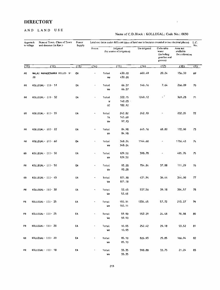
DIRECTORY
AND LAND USE Namt: of C.D.Block : KOLLEGAL; COOt: No.: 0050
Approach N.:ar,:sl Town. Class of Town Pow.:r Land us.: (ar':3 und.:r diIT.:r.:nl Iyp.:s of land uS<! in h.:clar.:s round.:d 10 Iwo d.:cimal plac.:s) L.C. 10 village and dislance (in Km.). Supply No.
Foresl Irrigat.:d Un-irrigat.:d Cultural>le Area not (l>y ~ource of irrigation) waste available
(including for cultivation gauchar and groves)
(11) (12) ( 13) (14) (15) ( 16) ( 17) (18) (1)
PR MALAI MAHADESIJARA HIllS- v- EA Total 430.20 600.49 20.24 136.30 69 20 loIe 430.20
PR KOLLEGAL- 111- 51 EA Total 66.37 546.16 7.64 266.09 70 loIe 66.37
PR KOLLEGAL- 111- 32 EA Total 322.15 1249.12 369.28 71 IJ 140.03
GC 182.12
KR KOLLEGAL- [11- 55 EA Total 242.82 242.10 202.35 72 Tk 145.69 lJe 97.13
PR KOLLEGAL- [11- 22 EA Total 84.98 645.16 68.80 172.00 73
lJe 84.98
PR KOLLEGAL- 111- 60 EA Total 348.24 1144.60 1156.43 74 lJe 348.24
KR KOLLEGAL- 111- 50 EA Total 129.50 398.78 495.76 75 We 129.50
PR KOLLEGAL- 111- 50 EA Total 93.28 754.84 37.88 111.29 76 We 93.28
KR KOLLEGAL- 111- 45 EA Total 101.18 431.94 36.44 344.00 77
We 101.18
PR KOLLEGAL- 111- 38 EA Total 52.45 537.56 39.18 394.57 78 We 52.45
PR KOLLEGAL- 111- 35 EA Total 150.11 1334.45 57.72 213.27" 79
We 150.11
PR KOLLEGAL- [11- 25 EA Total 59.90 552.29 24.48 70.98 80 We 59.90
PR KOLLEGAL- 111- 20 EA Total 10.93 252.42 29.18 53.52 81 We 10.93
KR KOLLEGAL- 111- 20 EA Total 95.10 826.93 25.85 166.94 82 We 95.10
PR KOLLEGAL- [ 11- 18 EA Total 33.35 598.88 33.75 21.24 83 We 33.35
213
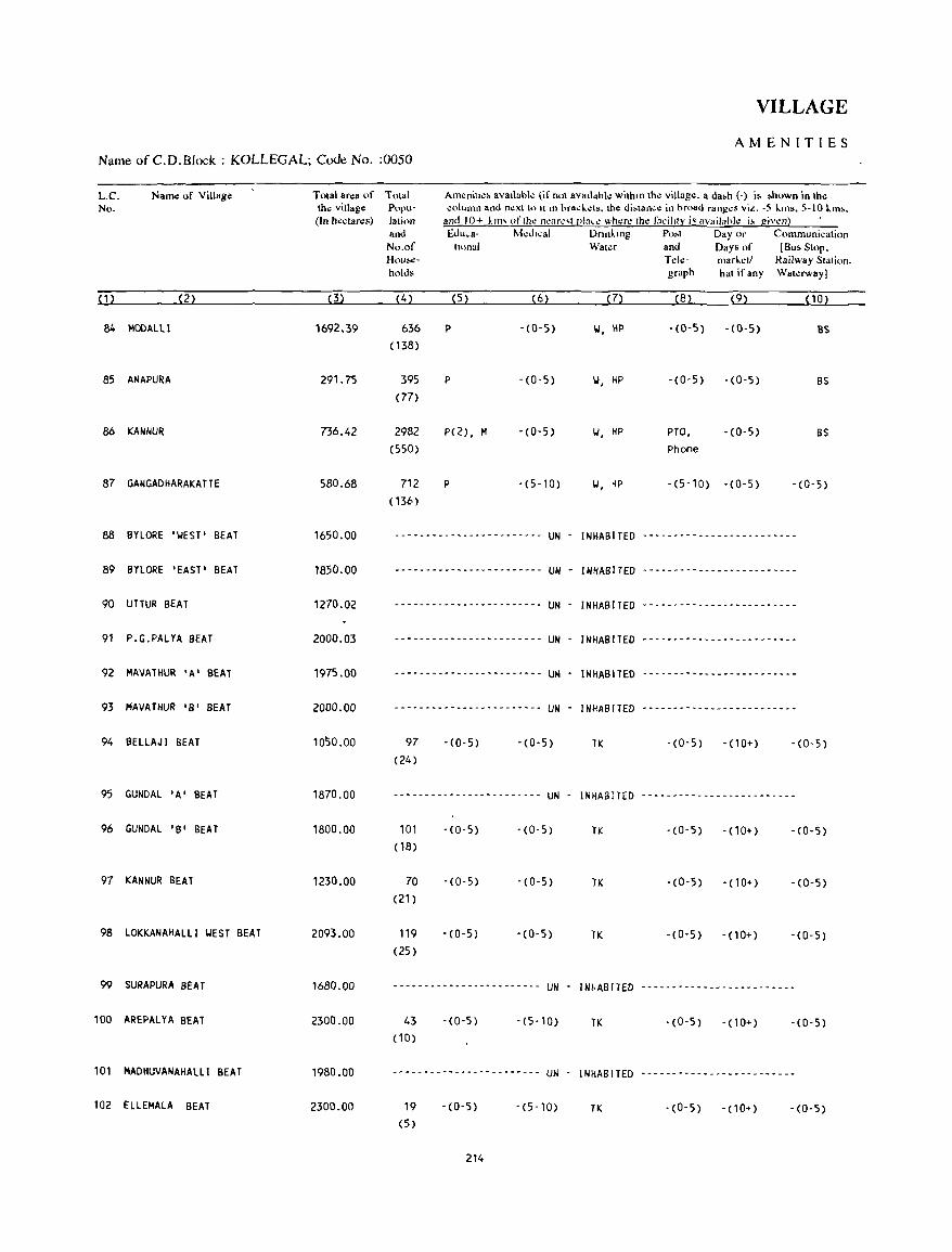
VILLAGE
AMENITIES Name ofC.D.Block : KOLLEGAL; Code No. :0050
L.C. No.
N8m.! of Village
(1) (2)
84 MODALli
85 ANAPU~A
86 KANNUR
87 GANGADHARAKATTE
88 BYLORE 'WEST' BEAT
89 BYlORE 'EAST' BEAT
90 UTTUR BEAT
91 P.G.PALYA BEAT
92 MAVATHUR 'A' BEAT
93 MAVATHUR 'B' BEAT
94 BELLAJI BEAT
95 GUNDAL 'A' BEAT
96 GUNDAL 'B' BEAT
97 KANNUR BEAT
98 lOKKANAHALli WEST BEAT
99 SURAPURA BEAT
100 AREPALYA BEAT
101 MADHUVANAHAlLI BEAT
102 ELLEMAlA BEAT
Total area of Total th~ village Popu-
(In hectares) latinll and
No.of How • .,holds
(4)
1692.39 636 ( 138)
291.75 395 (77)
736.42 2982 (550)
580.68 712 ( 136)
Am~nill~~ 8v811abk (if not 8v811"hk withm the village. a da.h (-) is .hown in the ~olumn and next t<) 1\ III hra~!..ets. the di'lan~e in hroad ranges vi". -5 !..ms, 5-10 I.m •.
and 10+ kill' "flhe n..:ar..:,1 pb<..: where Ihe faciltly i' availa"l~ i, giwn) • Edul-a- ~kJI~al Dnn"mg Po;t Day or Communication
tlOnal Wat"r and Days of (Bu. Slop. Ted,,- mar"ell Railway Stalion. graph hat if any Watl!fway)
(5) (6) (7) (8) (9) (10)
P -(0-5) \.I, HP -(0-5) -(0-5) BS
P - (0-5) \.I, HP -(0-5) -(0-5) BS
P(Z), M -(0-5) II, HP PTO, -(0-5) BS Phone
P -(5-10) 1.1, HP '(5-10) -(0-5) -(0-5)
1650.00 -------.--.------------- UN - INHABITED ----------.----.- .. --.---
1850.00
1270.02
2000.03
1975.00
2000.00
1050.00
1870.00
1800.00
1230.00
2093.00
1680.00
2300.00
1980.00
2300.00
-.------ ..•. - ...... --- .. UN - INHABITED - ... --.----.-_ .. -----.---
.-----.---.------.------ UN - INHABITED -----------.---.---------
.--------- .. -- .. -_.----- UN - INHABITED -----.--.- ..... --.- .. -.--
---------- .. -._ .. ----.-- UN - INHABITED .- .. ----.--.-------.--.--
---.--.---------.--.---- UN - INHABITED -----------.---.-----.---
97 (24)
-(0-5) -(0-5) TK
------_ .. -- .. ---_ ...... ----- .. UN - INHABITED
101 (18)
70 (21)
119 (25)
43 (10)
19 (5)
-(0,5)
-(0-5)
-(0-5)
-(0-5)
-(0-5)
214
-(0-5) TK
- (0-5) TK
-(0-5) TK
UN . INHABITED
-(5-10) TK
UN . INHABITED
-(5-10) TK
-(0'5) -(10+) -(0-5)
..................................................
-(0-5) - ( 10+) -(0,5)
-(0,5) - (10+) '(0-5)
·(0-5) -(10+) -(0-5)
-(0-5) -(10+) -(0-5)
-(0-5) -(10+) -(0-5)
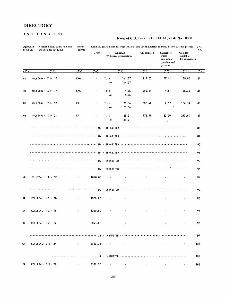
DIRECTORY
AND LAND USE Name of C.D.Block : KOLLEGAL; Cooe No.: 0050
Approach to villago:
Nearest Town, Class of Town and distance (in Km.)
Power Supply
Land use (area under different types of land use in hectares rounded to two decimal places) L.C. No.
Forest Irrigated Un-irrigated Culturable Area not (hy source of irrigation) waste availablo:
(including for cultivation gauchar and groves)
(11) (12) ( 13) (14) (15) ( 16) (17) ( 18) (1)
PR KOLLEGAL- I I I - 17 EAG Total 144.07 1211.05 177.41 159.86 84
We 144.07
PR KOLLEGAL- 11[- 17 EAG Total 4.86 253.89 4.67 28.33 85 We 4.86
PR KOLLEGAL- 111- 18 EA Total 21.04 606.40 4.67 104.31 86
We 21.04
KR KOLLEGAL- [11- 21 EA Total 25.21 278.88 22.99 253.60 87 We 25.21
--------------------------------------------- UN - INHABITEO --------------------------------------------- 88
--------------------------------------------- UN - INHABITED --------------------------------------------- 89
--------------------------------------------- UN - INHABITED --------------------------------------------- 90
--------------------------------------------- UN - INHABITED --------------------------------------------- 91
--------------------------------------------- UN - INHABITED --------------------------------------------- 92
--------------------------------------------- UN - INHABITED --------------------------------------------- 93
KR KOLLEGAL- 111- 62 1050.00 94
--------------------------------------------- UN - INHABITED --------------------------------------------- 95
KR KOLLEGAL- [[1- 38 1800.00 96
KR' KOLLEGAL- 111- 40 1230.00 97
KR KOLLEGAL- 111- 24 2093.00 98
--------------------------------------------- UN - INHABITED -.------------------------------------------- 99
KR KOLLEGAL- 111- 24 2300.00 100
--------------------------------------------- UN - INHABITED --------------------------------------------- 101
KR KOLLEGAL- 111- 22 2300.00 102
215
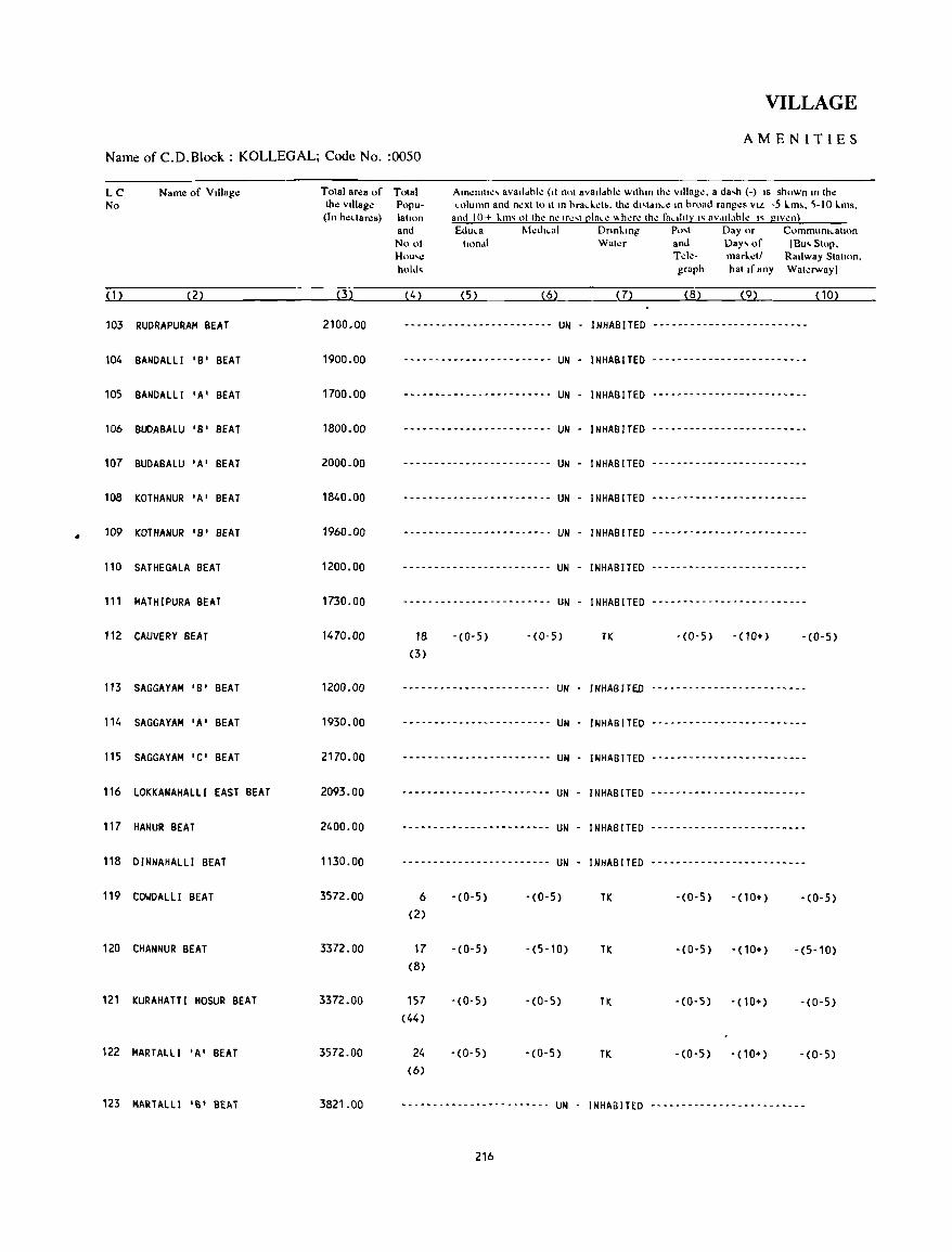
•
VILLAGE
AMENITIES Name of C.D.Block : KOLLEGAL; Code No. :0050
LC No
(1)
103
104
105
106
107
108
109
110
111
112
113
'14
115
116
117
118
119
120
121
122
123
Name of VIllage
(2)
RUDRAPURAM BEAT
BANDALlI 'B' BEAT
BANDALlI 'A' BEAT
BUDABALU 'B' BEAT
BUDABALU 'A' BEAT
KOTHANUR 'A' BEAT
KOTHANUR 'B' BEAT
SATHEGALA BEAT
MATHIPURA BEAT
CAUVERY BEAT
SAGGAYAM 'B' BEAT
SAGGAYAM 'A' BEAT
SAGGAYAM 'C' BEAT
lOKKANAHAlLl EAST BEAT
HANUR BEAT
DINNAHALLI BEAT
COWDALLI BEAT
CHANNUR BEAT
KURAHATTI HOSUR BEAT
MARTALLI 'A' BEAT
MARTALLI 'B' BEAT
Total area of Total Amenttte, avalldhle (ti not avalldhle wlthm the vIllage. a da,h (-) IS shown m the column and next to It m hrad .. eb. the d"tdnce m hruad ranges VIol -5 lm~. '-10 lms.
and 10+ kIm 01 the ne Ire,t plal.e "here the fa"ltty "avdll,lhle " gIven) the vIllage Popu-(In hedares) latton
ami Nool Hou'e hold,
&Iuca MedICal Dnnkmg Po ... t Day or Communtcatton ltondl Water and Day' of lEu, Stop.
T de- market! RaIlway Statton. graph hat If any Waterway]
(3) (4) (5) (6) (7) (8) (9) (10)
2100.00 ------------------------ UN - INHABITED -------------------------
1900.00 ------------------------ UN - INHABITED -------------------------
1700.00 ------------------------ UN - INHABITED -------------------------
1800.00 ------------------------ UN - INHABITED -------------------------
2000.00 ------------------------ UN - INHABITED -------------------------
1840.00 ------------------------ UN - INHABITED -------------------------
1960.00 ------------------------ UN - INHABITED -------------------------
1200.00 ------------------------ UN - INHABITED ----~-~------------------
1730.00 ..................... -_ ................... - .... UN - INHABITED -------------------------
1470.00 18 -(0-5) -(0-5) TK -(0-5) - ( 10+) -(0-5) (3)
1200.00 ......................... - ........................ UN - INHABITED .. .................................................
1930.00 ........................................... --- UN - INHABITED ---------------------~---
2170.00 ------------------------ UN - INHABITED -------------------------
2093.00 ------------------------ UN - INHABITED -------------------------
2400.00 ------------- .. ---------- UN - INHABITED ---------------------~---
1130.00 - .. --- .. ------------------ UN - INHABITED -------------------------
3572.00 6 -(0-5) -(0-5) TK -(0-5) - (10+) -(0-5) (2)
3372.00 17 -(0-5) -(5-10) TK -(0-5) - (10+) -(5-10) (8)
3372.00 157 -(0-5) -(0-5) TK -(0-5) - (10+) -(0-5) (44)
3572.00 24 -(0-5) -(0-5) TK -(0-5) - (10+) -(0-5) (6)
3821.00 ................................................. UN - I NHAB ITED .......................... -_ ....................
216
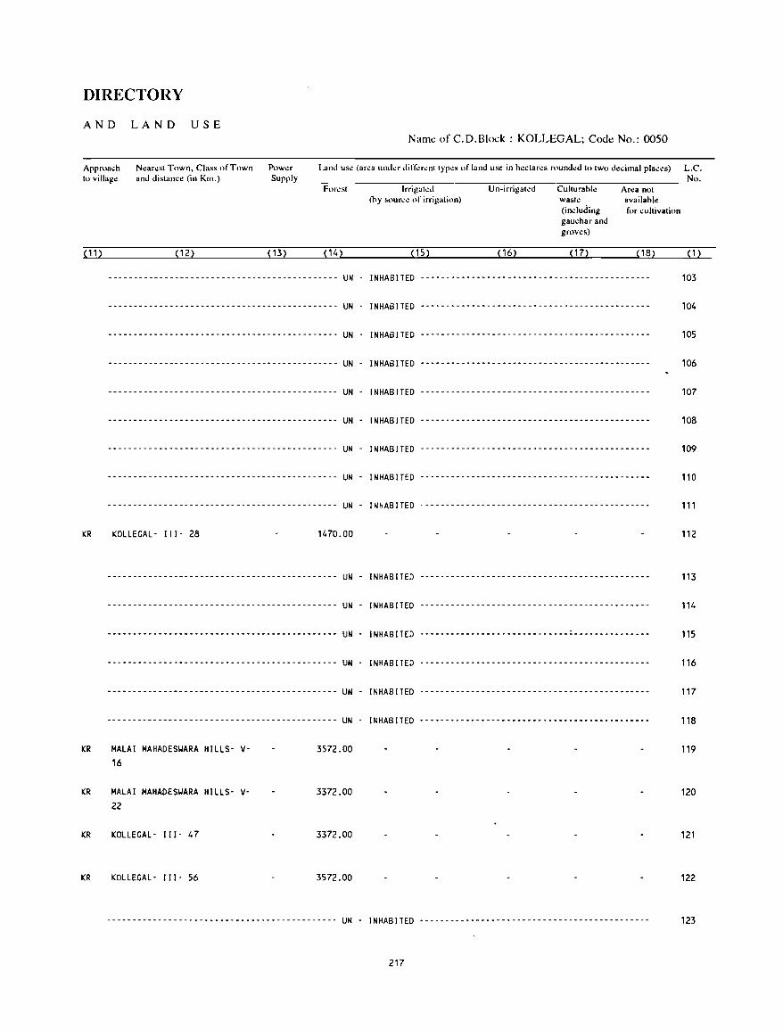
DIRECTORY
AND LAND USE Name of C.D.Block : KOLLEGAL; Code No.: 0050
Approach to village
N~ar~st Town, Class of Town and distance (in Km.)
Pow~r
Supply Land use (ar~a und~r din"'r~nt typ~s of land use in h.:ctar~s round~d to two decimal plac~s) L.C.
No. For~st Irrigat~d Un-irrigated Culturable Ar~a not
(by loourc~ of irrigation) waste available (indurling for cultivation gauchar and groves)
('1 ) (12) (13) (14) (15) ( 16) ( 17) ( 18) (1)
--------------------------------------------- UN INHABITED --------------------------------------------- 103
--------------------------------------------- UN - INHABITED --------------------------------------------- 104
--------------------------------------------- UN - INHABITED --------------------------------------------- 105
--------------------------------------------- UN - INHABITED --------------------------------------------- 106
--------------------------------------------- UN - INHABITED --------------------------------------------- 107
--------------------------------------------- UN - INHABITED --------------------------------------------- 108
--------------------------------------------- UN INHABITED --------------------------------------------- 109
--------------------------------------------- UN - INHABITED --------------------------------------------- 110
--------------------------------------------- UN - INHABITED --------------------------------------------- 111
KR KOLLEGAL- 111- 28 1470.00 112
--------------------------------------------- UN - INHABITED --------------------------------------------- 113
--------------------------------------------- UN INHABITED --------------------------------------------- 114
--------------------------------------------- UN - INHABITED --------------------------------------------- 115
--------------------------------------------- UN INHABITED --------------------------------------------- 116
--------------------------------------------- UN - INHABITED --------------------------------------------- 117
--------------------------------------------- UN - INHABITED --------------------------------------------- 118
KR MALAI MAHADESWARA HILLS- V- 3572.00 119 16
KR MALAI MAHADESWARA HILLS- V- 3372.00 120 22
KR KOLLEGAL - 111- 47 3372.00 121
KR KOLLEGAL- 111- 56 3572.00 122
--------------------------------------------- UN - INHABITED --------------------------------------------- 123
217
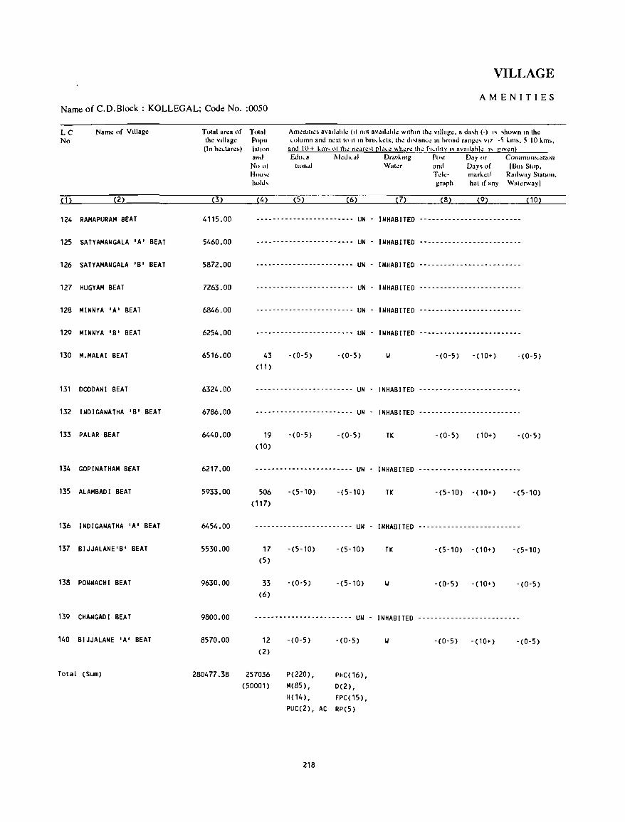
VILLAGE
AMENITIES Name of C.D.Block : KOLLEGAL; Code No. :0050
LC No
Nam.: of Village
(1) (2)
124 RAMAPURAM BEAT
125 SATYAMANGALA 'A' BEAT
126 SATYAMANGALA 'B' BEAT
127 HUG YAM BEAT
128 MINNYA 'A' BEAT
129 MINNYA 'B' BEAT
130 M.MALAI BEAT
131 DODD AN I BEAT
132 INDIGANATHA 'B' BEAT
133 PALAR BEAT
134 GOPINATHAM BEAT
135 ALAMBADI BEAT
136 INDIGANATHA 'A' BEAT
137 BIJJALANE'B' BEAT
138 PONNACHI BEAT
139 CHANGADI BEAT
140 BIJJALANE 'A' BEAT
Total (Sum)
Total area of Tolal Am.:ntll':' avatldhle (II nol aVdlldhk wllhtn Ih.: Village. a da,h (-) I~ ~hown tn the column and next to II tn hrad.els. the dt'lance tn hroad range, VI7 -~ I.m •• 5 10I.m ••
ami 10+ \..m' 01 Ihe neMe,1 pl,lee "here Ihe f"llIly l' aVaIlahle l' given) the Village Popu (In hedare~) lallon
(3)
4115.00
5460.00
5872.00
7263.00
6846.00
6254.00
6516.00
6324.00
6786.00
6440.00
6217.00
5933.00
6454.00
5530.00
9630.00
9800.00
8570.00
and Noo' Huu,\! hold,
Edula IIkdlCd) Dnnktng Po" Day or CommUntcalton Illmdl Waler and Day~ of IBu. Stop.
Telc- marLet! Railway Sialion. graph hal If any WaterwaYI
(4) (5) (6) (7) (8) (9) (10)
------------------------ UN - INHABITED -------------------------
------------------------ UN - INHABITED ---------.---------------
------------------------ UN - INHABITED -------------------------
------------------------ UN - INHABITED -------------------------
------------------------ UN - INHABITED -------------------------
------------------------ UN - INHABITED -------------------------
43 (11 )
-(0-5) -(0-5) II -(0-5) -(10+) -(0-5)
------------------------ UN - INHABITED -----------------------.-
------------------------ UN - INHABITED -------------------------
19 (10)
-(0-5) - (0-5) TK -(0-5) ( 10+) - (0- 5)
------------------------ UN - INHABITED -------------------------
506 ( 117)
-(5-10) -(5-10) TK - (5-10) - (10+) -(5-10)
------------------------ UN - INHABITED -------------------------
17 (5)
33
(6)
-(5-10)
-(0-5)
-(5-10)
-(5-10)
TK -(5-10) -(10+) -(5-10)
II -(0-5) -(10+) -(0-5)
------------------------ UN - INHABITED -------------------------
12 (2)
- (0- 5) -(0-5) II -(0-5) -(10+) -(0-5)
280477.38 257036 P(220) , M(85) , H( 14),
PHC( 16), D(2), FPC(15),
(50001)
PUC(2), AC RP(5)
218
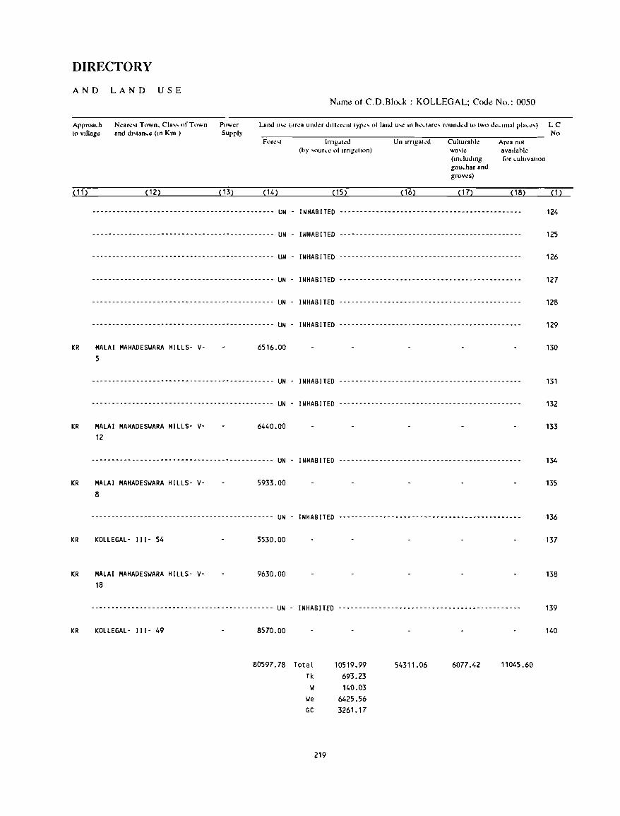
DIRECTORY
AND LAND USE N.lnlc ot C.D.Blo(_k : KOLLEGAL; Couc No.: 0050
Approa~h
10 vlllag~ N~ar~'1 Town. Cia" of Town and d"lan~e (In Km )
Pow~r
Supply No
( 11 )
KR
KR
KR
KR
KR
KR
IrngJI~d Un Irngal~d Cuhurahl~ Area not (hy ,oun.': ot IrngJllon) wa,le avallahle
(mdudmg for ~uhlvallon gau~har and groves)
(12) ( 13) (14) (15) ( 16) ( 17) (18) ( 1 )
--------------------------------------------- UN - INHABITED --------------------------------------------- 124
--------------------------------------------- UN - INHABITED --------------------------------------------- 125
--------------------------------------------- UN - INHABITED --------------------------------------------- 126
--------------------------------------------- UN - INHABITED --------------------------------------------- 127
--------------------------------------------- UN - INHABITED --------------------------------------------- 128
--------------------------------------------- UN - INHABITED --------------------------------------------- 129
MALAI MAHADESYARA HILLS- V-5
6516.00 130
--------------------------------------------- UN - INHABITED --------------------------------------------- 131
--------------------------------------------- UN - INHABITED --------------------------------------------- 132
MALAI MAHADESYARA HILLS- V-12
6440_00 133
--------------------------------------------- UN - INHABITED --------------------------------------------- 134
MALAI MAHADESYARA HILLS- V-8
5933.00 135
--------------------------------------------- UN - INHABITED --------------------------------------------- 136
KOLLEGAL- 111- 54
MALAI MAHADESYARA HILLS- V-18
5530.00 137
9630_00 138
--------------------------------------------- UN - INHABITED --------------------------------------------- 139
KOLLEGAL- 111- 49 8570.00 140
80597.78 Total 10519_99 5431 L06 6077_42 11045.60 Tk 693_23 W 140.03
Ye 6425_56 GC 326L 17
219

KRISHNARAJANAGARA C.D.BLOCK
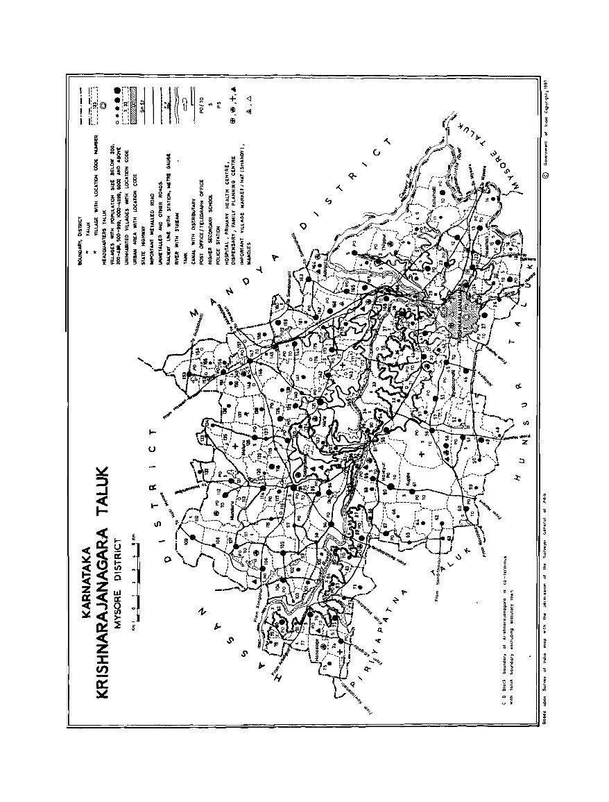
===============~~ = 1
"
"
u
. , c
§ I
3
,_
cJ)
i
e . c
'"
. s
" j
11 o E
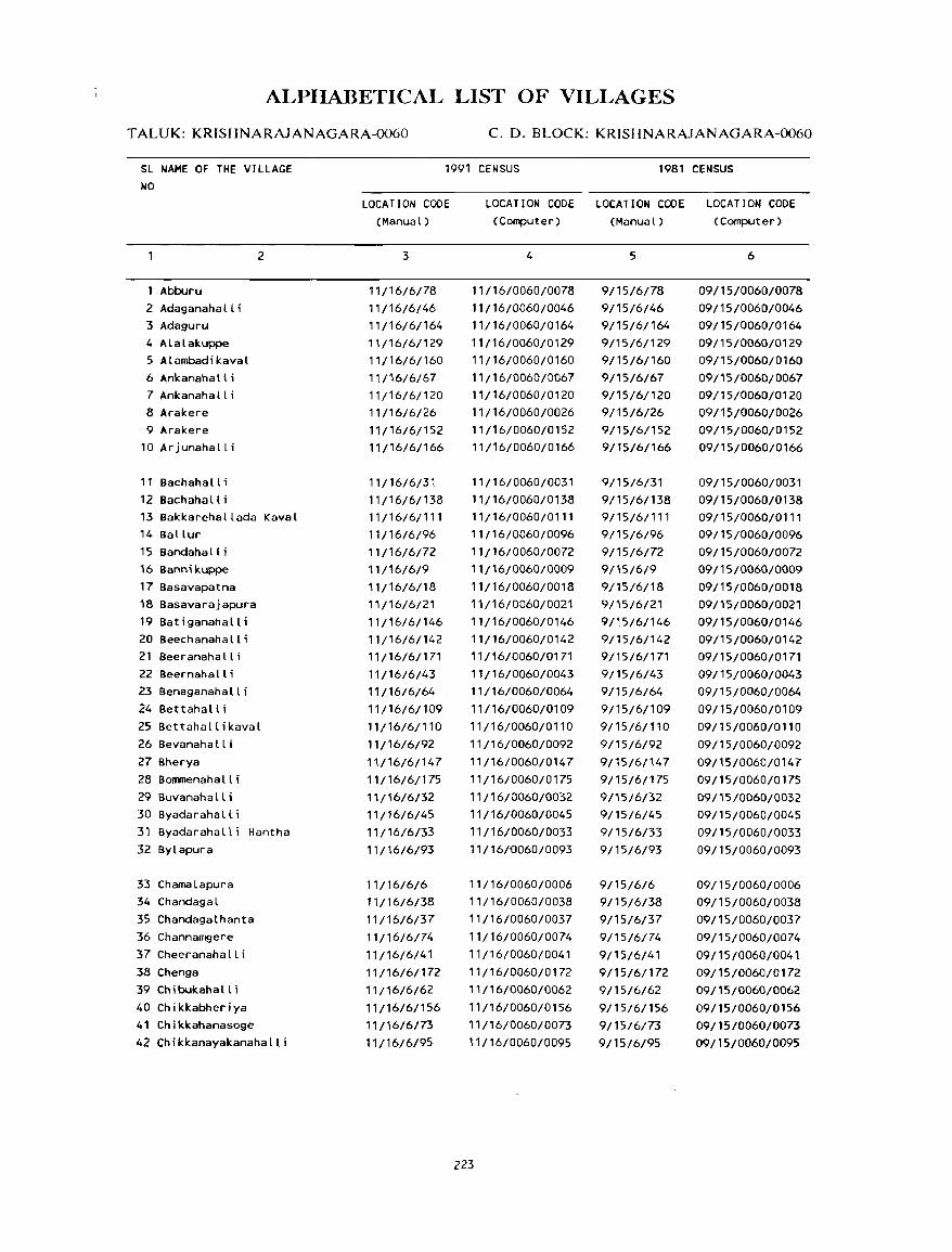
ALPlIABETICAL LIST OF VILLAGES
TALUK: KRISHNARAJANAGARA-0060 C. D. BLOCK: KRISHNARAJANAGARA-0060
SL NAME OF THE VILLAGE NO
Abburu 2 Adaganahalli 3 Adaguru 4 Alalakuppe 5 ALambadikaval 6 Ankanahalli 7 Ankanahall i 8 Arakere 9 Arakere
10 Ar junahall i
11 Bachahalli 12 Bachahall i
2
13 Bakkarehallada Kaval 14 Ballur 15 Bandahall i 16 Bannikuppe 17 Basavapatna 18 Basavarajapura 19 Batiganahalli 20 Beechanahalli 21 Beeranahalli 22 Beernahalli 23 Benaganahalli 24 Bettahalli 25 Bettahallikaval 26 Bevanahalli 27 Bherya 28 Bommenahalli 29 Buvanahalli 30 Byadarahalli 31 Byadarahalli Hantha 32 Bylapura
33 Chamalapura 34 Chandagal 35 Chandagalhanta 36 Channamgere 37 Cheeranahalli 38 Chenga 39 Chibukahalli 40 Chikkabheriya 41 Chikkahanasoge 42 Chikkanayakanahalli
1991 CENSUS 1981 CENSUS
LOCATION CODE (Manual)
3
11/16/6/78 11/16/6/46 11/16/6/164
11{16/61129
11/16/6/160 11/16/6/67 11/16/6/120
11/16/6/26 11/16/6/152 11/16/6/166
11/16/6/31
11/16/6/138 11/16/6/111 11/16/6/96
11/16/6/72 11/16/6/9
11/16/6/18 11/16/6/21
11/16/6/146 11/16/6/142 11/16/6/171 11/16/6/43
11/16/6/64
11/16/6/109 11/16/6/110
11/16/6/92
11/16/6/147 11/16/6/175
11/16/6/32 11/16/6/45
11/16/6/33
17/16/6/93
11/16/6/6 11/16/6/38
11/16/6/37 11/16/6/74
11/16/6/41
11/16/6/172
11/16/6/62
11/16/6/156 11/16/6/73
11/16/6/95
LOCATION CODE LOCATION CODE LOCATION CODE (Computer) (Manual) (Computer)
4
11/16/0060/0078 11/16/0060/0046 11/16/0060/0164
11/16/0060/0129 11/16/0060/0160
11/16/0060/0067 11/16/0060/0120
11/16/0060/0026 11/16/0060/0152 11/16/0060/0166
11/16/0060/0031
11/16/0060/0138 11/16/0060/0111
11{16/006010096
11/16/0060/0072 11/16/0060/0009
11/16/0060/0018 11 /16/0060/0021
11/16/0060/0146 11/16/0060/0142 11/16/0060/0171
11/16/0060/0043 11/16/0060/0064
11/16/0060/0109
11/16/0060/0110 11/16/0060/0092
11/16/0060/0147 11/16/0060/0175
11/16/0060/0032 11/16/0060/0045
11/16/0060/0033 11/16/{)060/0093
11/16/0060/0006 11/16/0060/0038
11/16/0060/0037
11/16/0060/0074
11/16/0060/0041
11/16/0060/0172
11/16/0060/0062
11/16/0060/0156 11/16/0060/0073
11/16/0060/0095
223
5
9/15/6/78 9/15/6/46 9/15/6/164
9/15/6/129 9/15/6/160
9/15/6/67 9/15/6/120 9/15/6/26
9/15/6/152 9/15/6/166
9/15/6/31
9/15/6/138 9/15/6/111 9/15/6/96
9/15/6/72 9/15/6/9
9/15/6/18 9/15/6/21
9/15/6/146 9/15/6/142 9/15/6/171
9/15/6/43 9/15/6/64
9/15/6/109
9/15/6/110
9/15/6/92
9/15/6/147 9/15/6/175
9/15/6/32 9/15/6/45
9/15/6/33
9/15/6/93
9/15/6/6 9/15/6/38
9/15/6/37 9/15/6/74
9/15/6/41
9/15/6/172 9/15/6/62
9/15/6/156
9/15/6/73
9/15/6/95
6
09/15/0060/0078 09/15/0060/0046 09/15/0060/0164
09/15/0060/0129 09/15/0060/0160
09/15/0060/0067 09/15/0060/0120
09/15/0060/0026 09/15/0060/0152 09/15/0060/0166
09/15/0060/0031
09/15/0060/0138 09/15/0060/0111 09/15/0060/0096 09/15/0060/0072
09/15/0060/0009
09/15/0060/0018 09/15/0060/0021
09/15/0060/0146 09/15/0060/0142 09/15/0060/0171
09/15/0060/0043 09/15/0060/0064
09/15/0060/0109
09/15/0060/0110
09/15/0060/0092
09/15/0060/0147
09/15/0060/0175
09/15/0060/0032 09/15/0060/0045
09/15/0060/0033 09/15/0060/0093
09/15/0060/0006 09/15/0060/0038
09/15/0060/0037
09/15/0060/0074
09/15/0060/0041 09/15/0060/0172
09/15/0060/0062
09/15/0060/0156
09/1510060/0073
09/15/0060/0095
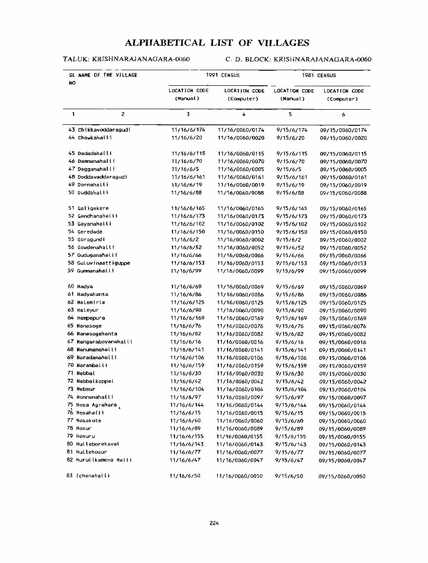
ALPHABETICAL LIST OF VILLAGES
T ALUK: KRISHNARAJANAGARA-0060 C. D. BLOCK: KR1SHNARAJANAGARA-0060
SL NAME OF THE VILLAGE NO
1991 CENSUS 1981 CENSUS
2
43 Chikkavoddaragudi 44 Chowkahall i
45Dadadahalli 46 DalllTJanahall i 47 Degganaha II i 48 Doddavaddaragudi 49Dornahalli 50 Duddahall i
51 Galigekere 52 Gandhanahalli 53 Gayanahalli 54 Geredada 55 Goragundi 56 Gowdenahalli 57 Guduganaha II i 58 Guluvinaattiguppe 59 GUIIIIlanahalli
60 Hadya 61 Hadyahanta 62 Halemirle 63 Haleyur 64 Hampapura 65 Hanasoge 66 Hanasogehanta 67 Hangaraboyanahalli 6B Hanumanahalli 69 Haradanahalli 70 Haramba II i 71 Hebbal 72 Hebba 1 koppa 1
73 Hebsur 74 Honnenaha II i 75 Hosa Agrahara , . 76 Hosahalli 77 Hosakote 78 Hosur 79 Hosuru 80 Hulleborekaval 81 Hullehosur 82 Hurulikamena Halli
83 Ichanahalli
LOCATION COOE (Manual)
3
11/16/6/174 11/16/6/20
11/16/6/115 11/16/6/70
11/1616/5 11/16/6/161 11/16/6/19 11/16/6/88
11/16/6/165 11/16/6/173 11/16/6/102 11/16/6/150 11/16/6/2 11/16/6/52 11/16/6/66 11/16/6/153 11/16/6/99
11/16/6/69 11/16/6/86 11/16/6/125 11/16/6/90 11/16/6/169 11/16/6/76 11/16/6/82 11/16/6/16 11/16/6/141
11/16/6/106 11/16/61159 11/16/6/30 11/16/6/42 11/16/6/104
11/16/6/97 11/16/6/144
11/16/6/15 11/16/6/60 11/16/6/89 11/16/6/155 11/16/6/143
11/16/6/77 11/16/6/47
11/16/6/50
LOCATION COOE LOCATION CODE LOCATION CODE (Computer) (Manual) (Computer)
4
11/16/0060/0174 11/16/0060/0020
11/16/0060/0115 11/16/0060/0070 11/16/0060/0005 11/16/0060/0161 11/16/0060/0019 11/16/0060/0088
11/16/0060/0165 11/16/0060/0173 11/16/0060/0102 11/16/0060/0150 11/16/0060/0002 11/16/0060/0052 11/16/0060/0066 11/16/0060/0153 11/16/0060/0099
11/16/0060/0069 11/16/0060/0086
11/16/0060/0125 11/16/0060/0090 11/16/0060/0169 11/16/0060/0076 11/16/0060/0082 11/16/0060/0016 11/16/0060/0141 11/16/0060/0106 11/16/0060/0159 11/ 16/0060/0030 11/16/0060/0042 11/16/0060/0104
11/16/0060/0097 11/16/0060/0144 11/16/0060/0015 11/16/0060/0060 11/16/0060/0089 11/16/0060/0155 11/16/0060/0143 11/16/0060/0077 11/16/0060/0047
,'/,6/0060/0050
224
5
9/15/6/174 9/15/6/20
9/15/6/115 9/15/6/70 9/15/6/5 9/15/6/161 9/15/6/19 9/15/6/88
9/15/6/165 9/15/6/173 9/15/6/102 9/15/6/150 9/15/6/2 9/15/6/52 9/15/6/66 9/15/6/153 9/15/6/99
9/15/6/69 9/15/6/86
9/15/6/125 9/15/6/90 9/15/6/169 9/15/6/76 9/15/6/82 9/15/6/16 9/15/6/141
9/15/6/106 9/15/6/159
9/15/6/30 9/15/6/42 9/15/6/104
9/15/6/97 9/15/6/144 9/15/6/15 9/15/6/60 9/15/6/89 9/15/6/155 9/15/6/143 9/15/6/77 9/15/6/47
9/15/6/50
6
09/15/0060/0174 09/15/0060/0020
09/15/0060/0115 09/15/0060/0070 09/15/0060/0005 09/15/0060/0161 09/15/0060/0019 09/15/0060/0088
09/15/0060/0165 09/15/0060/0173 09/15/0060/0102 09/15/0060/0150 09/15/0060/0002 09/15/0060/0052 09/15/0060/0066 09/15/0060/0153 09/15/0060/0099
09/15/0060/0069 09/15/0060/0086 09/15/0060/0125 09/15/0060/0090 09/15/0060/0169 09/15/0060/0076 09/15/0060/0082 09/15/0060/0016 09/15/0060/0141
09/15/0060/0106 09/15/0060/0159
09/15/0060/0030 09/15/0060/0042 09/15/0060/0104
09/15/0060/0097 09/15/0060/0144 09/15/0060/0015 09/15/0060/0060 09/15/0060/0089 09/15/0060/0155 09/15/0060/0143
09/15/0060/0077 09/15/0060/0047
09/15/0060/0050
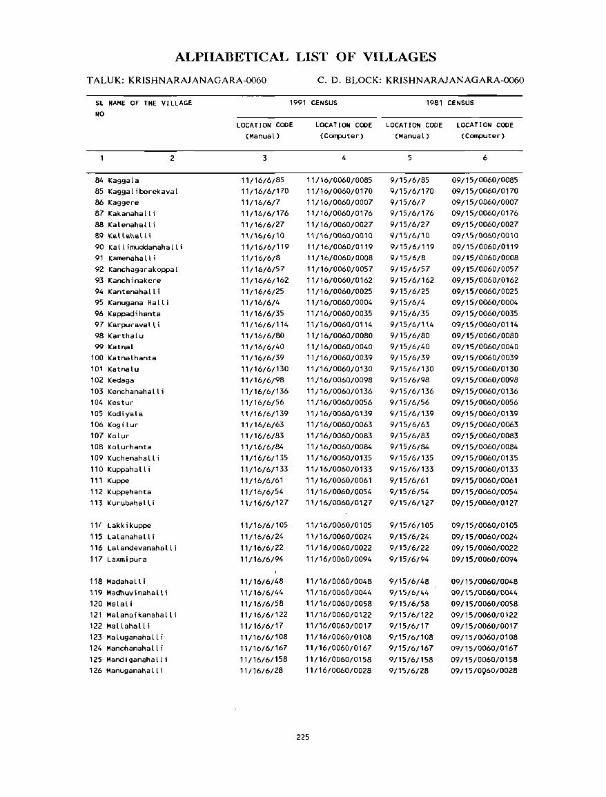
ALPIIABETICAL LIST OF VILLAGES
T ALUK: KRISHNARAJANAGARA-0060 C. D. BLOCK: KRISHNARAJANAGARA-0060
Sl NAME OF THE VILLAGE NO
2
84 Kaggala 85 Kaggaliborekaval 86 Kaggere 87 Kakanahalli 88 Kalenahalli 89 KaUahalU 90 Kallimuddanahalli 91 Kamenaha II i 92 Kanchag~rakoppal 93 Kanchinakere 94 Kantenahalli 95 Kanugana Halli 96 Kappadihanta 97 Karpuravall i 98 Karthalu 99 Katnal
100 Katnalhanta 101 Katnalu 102 Kedaga 103 Kenchanahalli 104 Kestur 105 Kodiyala 106 Kogilur 107 Kolur 108 Kolurhanta 109 Kuchenahalli 110 Kuppahall i 111 Kuppe 112 Kuppehanta 113 Kurubahall i
111 Lakk i kuppe 115 Lalanahalli 116 Lalandevanahalli 117 Laxmipura
118 Madahalli 119 Madhuvinahalli 120 Malali 121 Malanaikanahalli 122 Mallahall i 123 Maluganahalli 124 Manchanahalli 125 Mandiganahalli 126 Manuganahalli
1991 CENSUS 1981 CENSUS
LOCATION CODE (Manual)
3
11/16/6/85 11/16/6/170 11/16/6/7 11/16/6/176 11/16/6/27 11/16/6/10 11/16/6/119 11/16/6/8
11/16/6/57 11/16/6/162 11/16/6/25 11/16/6/4 11/16/6/35 11/16/6/114 11/16/6/80 11/16/6/40 11/16/6/39 11/16/6/130 11/16/6/98
11/16/6/136 11/16/6/56 11/16/6/139 11/16/6/63 11/16/6/83 ,'/16/6/84 11/16/6/135 11/16/6/133
11/16/6/61 11/16/6/54 11/16/6/127
11/16/6/105
11/16/6/24 11/16/6/22
11/16/6/94
11/16/6/48 11/16/6/44 11/16/6/58 11/16/6/122 11/16/6/17 11/16/6/108 11/16/6/167 11/16/6/158 11/16/6/28
LOCATION CODE LOCATION CODE LOCATION CODE (Computer) (Manual) (Computer)
4
11/l6/0060/0085 11/16/0060/0170 11/16/0060/0007 11/16/0060/0176 11/16/0060/0027 11/16/0060/0010 11/16/0060/0119 11/16/0060/0008
11/16/0060/0057 11/16/0060/0162 11/16/0060/0025 11/16/0060/0004 11/16/0060/0035 11/16/0060/0114 11/16/0060/0080 11/16/0060/0040 11/16/0060/0039
11/16/0060/0130 11/16/0060/0098 11/16/0060/0136 11/16/0060/0056 11/16/0060/0139 11/16/0060/0063 11/16/0060/0083 11/16/0060/0084 11/16/0060/0135 11/16/0060/0133 11/16/0060/0061 11/16/0060/0054 11/16/0060/0127
11/16/0060/0105
11/16/0060/0024 11/16/0060/0022
11/16/0060/0094
11/16/0060/0048 11/16/0060/0044 11/16/0060/0058 11/16/0060/0122 11/16/0060/0017 11/16/0060/0108 11/16/0060/0167 11/16/0060/0158 11/16/0060/0028
225
5
9/15/6/85 9/15/6/170 9/15/6/7 9/15/6/176 9/15/6/27 9/15/6/10 9/15/6/119 9/15/6/8
9/15/6/57 9/15/6/162 9/15/6/25 9/15/6/4 9/15/6/35 91'5/6/114 9/15/6/80 9/15/6/40 9/15/6/39 9/15/6/130 9/15/6/98 9/15/6/136 9/15/6/56 9/15/6/139 9/15/6/63 9/15/6/83 9/15/6/84 9/15/6/135 9/15/6/133
9/15/6/61 9/15/6/54 9/15/6/127
9/15/6/105
9/15/6/24 9/15/6/22
9/15/6/94
9/15/6/48 9/15/6/44 9/15/6/58 9/15/6/122 9/15/6/17 9/15/6/108 9/15/6/167
9/15/6/158 9/15/6/28
6
09/15/0060/0085 09/15/0060/0170 09/15/0060/0007 09/15/0060/0176 09/15/0060/0027 09/i5/0060/0010 09/15/0060/0119 09/15/0060/0008 09/15/0060/0057 09/15/0060/0162 09/15/0060/0025 09/15/0060/0004 09/15/0060/0035 09/15/0060/0114
09/15/0060/0080 09/15/0060/0040 09/15/0060/0039 09/15/0060/0130 09/15/0060/0098
09/15/0060/0136 09/15/0060/0056 09/15/0060/0139 09/15/0060/0063 09/15/0060/0083 09/15/0060/0084
09/15/0060/0135 09/15/0060/0133 09/15/0060/0061 09/15/0060/0054 09/15/0060/0127
09/15/0060/0105 09/15/0060/0024 09/15/0060/0022
09/15/0060/0094
09/15/0060/0048 09/15/0060/0044 09/15/0060/0058 09/15/0060/0122 09/15/0060/0017 09/15/0060/0108 09/15/0060/0167
09/15/0060/0158 09/15/0060/0028
ALPIIABETICAL LIST OF VILLAGES
TALUK: KRISHNARAJANAGARA-0060 c. D. BLOCK: KRISHNARAJANAGARA-0060
SL NAME OF THE VILLAGE NO
1991 CENSUS 1981 CENSUS
2
127 Maragowdanahalli 128 Maragowdanahalli 129 Marchahall i 130 Matadakaval 131 Mavanur 132 Mavathur 133 Mavathur Hantha 134 Mayigowdanahalli 135 Meluru 136 Hirle
137 Mudalabeedu 138 Mudalakoppal 139 Mud i guppe 140 Mulepetlu 141 Munduru 142 Munjanahalli
143 Nadappanahalli 144 Narachanahalli 145 Narayanapura 146 Natanahalli 147 Ni jaganahal Ii
148 Pashupathi
149 Rampura
150 Sakkare 151 Saligrama 15~ Sambarahalli 153 Sankanahalli 154 Sanyasipura 155 Saraguru 156 Sathigrama 157 Seegavalu
158 Shanabinakuppe 159 Shyabalu 160 Siddapura 161 Somanaha II i 162 Somanaha II i 163 Southanahalli 164 Sreerampura 165 Sugganahalli
LOCAT ION COOE (Manual)
3
11/16/6/49 11/16/6/163 11/16/6/13 11/16/6/154 11/16/6/100 11/16/6/51 11/16/6/34 11/16/6/68 11/16/6/128 11/16/6/121 11/16/6/118 11/16/6/29 11/16/6/134 11/16/6/14 11/16/6/112 11/16/6/151
11/16/6/71 11/16/6/140 11/16/6/23 11/16/6/124 11/16/6/59
11/16/6/101
11/16/6/117
11/16/6/87 11/16/6/91 11/16/6/157 11/16/6/137 11/16/6/168 11/16/6/103 11/16/6/12 11/16/6/107 11/16/6/113 11/16/6/123 11/16/6/53 11/16/6/65 11/16/6/148 11/16/6/11 11/16/6/55 11/16/6/145
LOCATION CODE LOCATION CODE LOCATION CODE (Computer) (Manual) (computer)
4
11/16/0060/0049 11/16/0060/0163 11/16/0060/0013 11/16/0060/0154 11/16/0060/0100 11/16/0060/0051 11/16/0060/0034 11/16/0060/0068 11/16/0060/0128 11/16/0060/0121 11/16/0060/0118 11/16/0060/0029 11/16/0060/0134 11/16/0060/0014 11/16/0060/0112 11/16/0060/0151
11/16/0060/0071 11/16/0060/0140 11/16/0060/0023
11/16/0060/0124 11/16/0060/0059
,,/16/0060/0101
11/16/0060/0117
11/16/0060/0087 11/16/0060/0091 11/16/0060/0157
11/16/0060/0137 11/16/0060/0168 11/16/0060/0103 11/16/0060/0012 11/16/0060/0107
11/16/0060/0113 11/16/0060/0123 11/16/0060/0053 11/16/0060/0065 11/16/0060/0148 11/16/0060/0011 11/16/0060/0055 11/16/0060/0145
226
5
9/15/6/49 9/15/6/163 9/15/6/13 9/15/6/154 9/15/6/100 9/15/6/51 9/15/6/34 9/15/6/68 9/15/6/128 9/15/6/121 9/15/6/118 9/15/6/29 9/15/6/134 9/15/6/14 9/15/6/112
9/15/6/151
9/15/6/71 9/15/6/140 9/15/6/23 9/15/6/124 9/15/6/59
9/15/6/101
9/15/6/117
9/15/6/87 9/15/6/91 9/15/6/157 9/15/6/137 9/15/6/168 9/15/6/103
9/15/6/12 9/15/6/107
9/15/6/113 9/15/6/123 9/15/6/53 9/15/6/65 9/15/6/148 9/15/6/11 9/15/6/55 9/15/6/145
6
09/15/0060/0049 09/15/0060/0163 09/15/0060/0013 09/15/0060/0154 09/15/0060/0100 09/15/0060/0051
09/15/0060/0034 09/15/0060/0068 09/15/0060/0128 09/15/0060/0121 09/15/0060/0118 09/15/0060/0029 09/15/0060/0134 09/15/0060/0014 09/15/0060/0112
09/15/0060/0151
09/15/0060/0071 09/15/0060/0140 09/15/0060/0023 09/15/0060/0124 09/15/0060/0059
09/15/0060/0101.
09/15/0060/0117
09/15/0060/0087 09/15/0060/0091 09/15/0060/0157 09/15/0060/0137 09/15/0060/0168 09/15/0060/0103 09/15/0060/0012 09/15/0060/0107
09/15/0060/0113 09/15/0060/0123 09/15/0060/0053 09/15/0060/0065 09/15/0060/0148 09/15/0060/0011 09/15/0060/0055 09/15/0060/0145
ALPIIABETICAL LIST OF VILLAGES
TALUK: KRISHNARAJANAGARA-0060 C. D. BLOCK: KRISHNARAJANAGARA-0060
SL NAME OF THE VILLAGE NO
1991 CENSUS 1981 CENSUS
166 Thandre 167 Thandre
2
168 Thandreankanahalli 169 Thippur
170 Valagerehalli 171 Vallambadi 172 Venkatapura
173 Yaladahalli 174 Yalemuddanahalli 175 Yaremanuganahalli 176 Yedathore
LOCATION CODE (Manual)
3
11/16/6/81 11/16/6/131 11/16/6/132 11/16/6/3
11/16/6/149 11/16/6/79 11/16/6/36
11/16/6/116 11/16/6/126 11/16/6/75 11/16/6/1
LOCATION CODE LOCATION CODE LOCATION CODE (Computer) (Manual) (Computer)
4
1 t/16/0060/0081 11/16/0060/0131 11/16/0060/0132 11/16/0060/0003
11/16/0060/0149 11/16/0060/0079 11/16/0060/0036
11/16/0060/0116 11/16/0060/0126 11/16/0060/0075 11/16/0060/0001
227
5
9/15/6/81 9/15/6/131 9/15/6/132 9/15/6/3
9/15/6/149 9/15/6/79 9/15/6/36
9/15/6/116 9/15/6/126 9/15/6/75 9/15/6/1
6
09/15/0060/0081 09/15/0060/0131 09/15/0060/0132 09/15/0060/0003
09/15/0060/0149 09/15/0060/0079 09/15/0060/0036
09/15/0060/0116 09/15/0060/0126 09/15/0060/Q075 09/15/0060/0001
VILLAGE
AMENITIES Name of C.D.Block : KRISHNARAlANAGARA; Code No. :0060
LC Name of Village Total area of Total Am~nalh:' available (If not available Withm the village, a da,h (-) IS shown 10 the No tho: village Popu ~olumn and nl!xt to It 10 bra~L.~ts. thl! d"tan~e 10 broad ranges VIZ -5 L.rns, '\-10 L.ms.
(In hedares) lallon and 10+ "m' of the neare,t [!lace where the fa'lltt}: .. aVailable I' gIven) and Educa- Medical DrlOL.mg Po.t Day or Commum,ahon
No of tlOnal Wal.:r and Days of (Bus Slop. HOllSl! Tek- markel! RaIlway Sial IOn hold. graph hat If any Wah:rway!
(1) (2) (3) (4 ) (5) (6) (7) (8) (9) (10)
YEDATHORE 99.37 ------------------------ UN - INHABITED -------------------------
2 GORAGUNDI 323.39 726 P • (0- 5) 1.', HP -(0'5) -(5-10) BS
(126)
3 THIPPUR 1Z68.54 3317 P(2), M, H PHC T, 1.', HP PO, -(5-10) BS
(655) Phone
4 KANUGANA HALLI 165.10 847 P -(0-5) 1.', TI.', HP - (0-5) -(5-10) BS
(177)
5 DEGGANAHALLI 662.46 1515 P(2), M -(0-5) \.I, T\.I, HP PO -(5-10) BS (225)
6 CHAMALAPURA 184.97 247 P ·(0-5) 1.1, HP -(0,5) -(5-10) BS
(50)
7 KAGGERE 342.60 1565 P, M, H -(0-5) 1.1, HP PO, - (5-1 0) BS (273) Phone
8 KAMENAHALll 357.11 856 P -(0-5) 1.', HP PO -(5-10) BS (156)
9 BANNIKUPPE 274.10 -.-----.----------.----- UN - INHABITED -- - - - - - - - - - - ... - - - _ ... - - -- - --
10 KALLAHALLI 582.34 2420 P(2), M -(5- 10) 1.', HP PO - (10+) BS (425)
11 SOUTHANAHALLI 347.07 453 P -(0-5) \.I, HP -(0-5) - (10+) BS (68)
12 SATHIGRAMA 354.59 1554 P, M -(5-10) 1.', HP -(0-5) -(5-10) BS (244)
13 MARCHAHALLI 413.14 1235 PO) -(5-10) 1.', HP PTO, -(5-10) BS (220) Phone
228
DIRECTORY
AND LAND USE Name of C.D.Block : KRISHNARAJANAGARA; Code No.: 0060
Approach Nearest Town, Class of Town Power Land use (area under different types of land use in hectares rounded to two d;cimal places) L.C. to village and distance (in Km.) Supply No.
FOf\!st Irrigated Un-irrigated Culturable Area not (by source of irrigalion) waste available
(including for cultivalion gauchar and groves)
(11) (12) (13) (14) (15) (16) ( 17) (18) (1)
.-------------------------------~------------ UN - INHABITED _-------------------------------------------_
PR KRISHNARAJANAGARA- 111- 4 EA Total 173.01 40.31 4.82 105.25 2 GC 173.01
PR KRISHNARAJANAGARA· III· 8 EA Total 412.22 73.95 11.73 770.64 3 \.Ie 7.61 GC 404.61
PR KRISHNARAJANAGARA· III· 11 EA Total 57.90 35.17 8.06 63.97 4
\.Ie 0.91 GC 56.99
PR KRISHNARAJANAGARA- III· 12 EA Total 146.54 107.09 408.83 5 \.Ie 0.10 GC 146.44
PR KRISHNARAJANAGARA· I II' 5 EA Total 88.02 8.47 88.48 6 \.Ie 5.20 GC 82.82
PR KRISHNARAJANAGARA- III' 4 EA Total 213.28 11. 16 2.85 115.31 7 \.Ie 0.67 GC 212.61
PR KRISHNARAJANAGARA· II I . 10 EA Total 120.83 86.22 13.28 136.78 8 \.Ie 0.48 GC 120.35
--------------------------------------------- UN . INHABITED --------------------------------------------_ 9
PR KRISHNARAJANAGARA- III· 8 EA Total 67.86 40.88 473.60 10 GC 67.86
PR KRISHNARAJANAGARA' 111- 10 EA Total 117.27 53.96 6.48 169.36 11 \.Ie 1.28 GC 115.99
KR KRISHNARAJANAGARA· III· 6 EA Total 208.15 39.49 4.64 102.31 12 \.Ie 1. 16 GC 206.99
KR KRISHNARAJANAGARA· III· 9 EA Total 156.92 32.01 9.84 214.37 13 \.Ie 0.56 GC 156.36
229

VILLAGE
I AMENITIES
Name of C.D.Block : KRISHNARAJANAGARA; CoJe No. :OO(lQ
L.C. Nam~ of ..... ,llage Total area of Tolal AlIlellllle. avalldble (II nol available wlthm the village. a da.h (.) " .hown in the No. the village Popu· ,01Llmll and next to II III nrad .. el •• the d"lan,e m hroad range, VII' .~ km>. 5-10 km ••
(In hectar.:,) lal">I' dlH.1 I~l+ kill .... (lfth~ n.:.lfl! ..... t [!Ia\,.\! "hl!fl! lhl.! faLlhtl:: 1'" avatl.thh: I~ glvl!nl and Edlh.d- IIkJ',dl Dnn!..lIIg Po.t DJyor Ct.Hl11nunh.:atHln
No 1'1' 1,1,'1\,\\ Water and Days I,f IB\!, Stop. Hou~~- Tele· mar!..etl Railway Station. holJ, graph hat If any Waterway)
(1) (2) (3) (4) (5) (6) (7) (8) (9) ( 1 0)
14 MULEPETLU 409.96 754 P · (10+) II, HP -(0-5) - ( 1 0+) BS
( 149)
15 HOSAHALLI 434.43 1570 P(?) , 101, H · (5,10) II, HP PO, ,(5,10) BS
(311) Phone
16 HANGARABOYANAHALLI 93.15 457 P · (10+) II, HP ,(0,5) · (10+) ,(0'5)
(86)
17 MALLAHALLI 97.09 -_ .. _-------- --------- UN INHABITED - -_ - - -- ----------- -------
18 BASAVAPATNA 208.58 313 P '(10+) II, HP ,(0,5) ·(10+) BS
(56)
19 DORNAHALLI 279.77 1656 P(3) , · (5,' 0) T, II, HP PO, · (5, 10) BS
(302) M(2) , H Phone
20 CHOIIKAHAL LI 259.35 980 P · (0,5) II, HP -(0-5) -(0-5) BS
( 194)
21 BASAVARAJAPURA 260.00 1328 P · (5,10) II, HP PO, '(5-10) BS
(258) Phone
22 LALANDEVANAHALL I 158.69 708 P · (5,10) T, II, HP -(0-5) -(5-10) BS, RS
(135 )
23 NARAYANAPURA 332.54 1010 P '(0-5) II, HP PO, -(5-10) BS
(187) Phone
24 lALANAHALLI 462.80 1085 P, M ,(0,5) T, II, HP - (0, 5) · (0-5) BS
(204)
25 KANTENAHALll 92.42 •••••••• -- ....•... -.--- UN . INHABITED --.---- •••• ----------.- ••
230
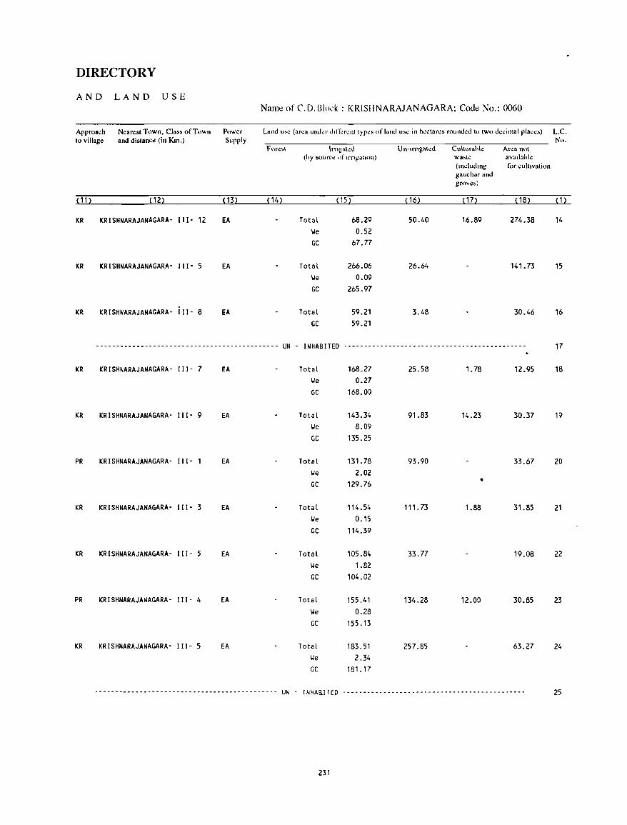
DIRECTORY
AND LAND USE Name of C.D.Block : KRISHNARAJANAGARA; Code No.: 0060
Approach Nearest Town, Class of Town Power Land u>~ (area under dliler.:nt t)PCS of land u;e in hectare; rounded to two decimal place;) L.C. to village and distance (in Km.) Supply No.
Fme\,\ lrngl\\'o!u U n-Irrlga\ed Cul\urahle Area no\ (hy source of IrngatJOn) wa~te avallahle
(mdudmg for cultivation gauchar and grove;)
(112 (122 (132 ( 142 (152 ~ 162 (172 ( 182 ~12
KR KRISHNARAJANAGARA- I II- 12 EA Total 68.29 50.40 16.89 274.38 14 lie 0.52 GC 67.77
KR KRISHNARAJANAGARA- 111- 5 EA Total 266.06 26.64 141. 73 15 lie 0.09 GC 265.97
KR KRISHNARAJANAGARA- 111- 8 EA Total 59.21 3.48 30.46 16 GC 59.21
--------------------------------------------- UN - INHABITED *-------------------------------------------- 17
KR KRISHNARAJANAGARA- 111- 7 EA Total 168.27 25.58 1. 78 12.95 18 lie 0.27 GC 168.00
KR KRISHNARAJANAGARA- 111- 9 EA Total 143.34 91.83 14.23 30.37 19 lie 8.09 GC 135.25
PR KRISHNARAJANAGARA- III· 1 EA Total 131. 78 93.90 33.67 20 \.Ie 2.02 GC 129.76 •
KR KRISHNARAJANAGARA- III· 3 EA Total 114.54 111.73 1.88 31.85 21 lie 0.15 GC 114.39
KR KRISHNARAJANAGARA- I I 1- 5 EA Total 105.84 33.77 19.08 22 lie 1.82 GC 104.02
PR KRISHNARAJANAGARA- 111- 4 EA Total 155.41 134.28 12.00 30.85 23 lie 0.28 GC 155.13
KR KRISHNARAJANAGARA- 111- 5 EA Total 183.51 257.85 63.27 24 \.Ie 2.34 GC 181.17
--------------------------------------------- UN - I NHA&I TED ---------------------------------------_ .. ---- 25
231
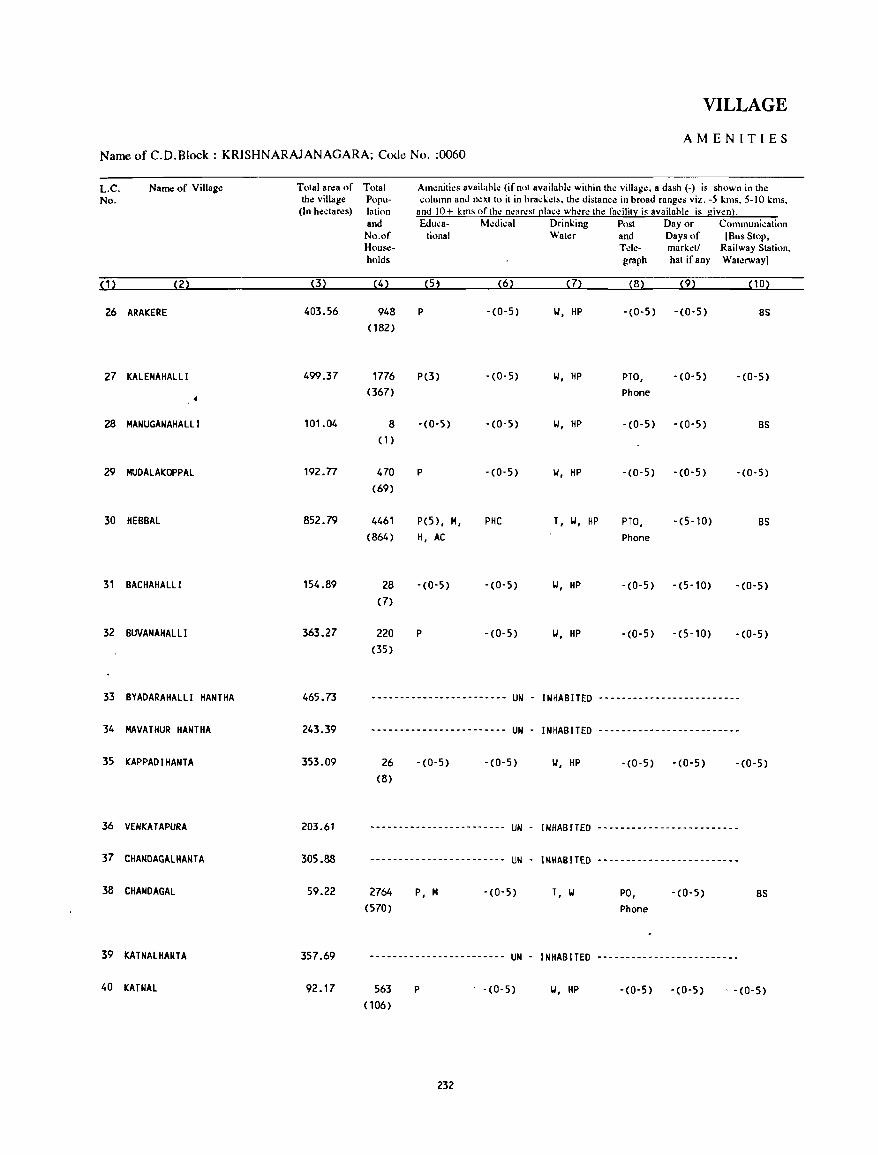
VILLAGE
AMENITIES Name of C.D.Block : KRISHNARAJANAGARA; Code No. :0060
L.C. Name of Village Total an:a of No. the village
(In hectares)
(1) (2) (3)
26 ARAICERE 403.56
27 ICAlENAHAlll 499.37
28 MANUGANAHAlll 101.04
29 MUDAlAKOPPAl 192.n
30 HEBBAl 852.79
31 BACHAHAlll 154.89
32 BUVANAHAlLI 363.27
33 BYADARAHAlll HANTHA 465.73
34 MAVATHUR HANTHA 243.39
35 ICAPPADIHANTA 353.09
36 VENKATAPURA 203.61
37 CHANDACALHANTA 305.88
38 CHANDAGAL 59.22
39 KATNAlHANTA 357.69
40 KATNAl 92.17
Total Am~niti~s availabl~ (if not availabl~ within th~ villag~. a dash (-) is shown in the Popu- column and n~xt to it in brack.:ts. the distance in broad ranges viz. -5 kms. 5-10 kms. latinn and 10+ kms ofth..: n..:ar..:st ~Iace wh..:r..: th.: facility is available is giwn). and Educa- M..:dkal Drinking Post Day or Communication No.of tional Water and Days of [Bus Stop. House- Tde- mark.:t! Railway Station. holds graph hat if any Waterway]
(4) (5, (6) (7) (8) (9) (10)
948 P -(0-5) IJ, HP -(0-5) -(0-5) BS (182)
1776 P(3) -(0-5) IJ, HP PTO, -(0-5) -(0-5) (367) Phone
8 - (0-5) -(0-5) IJ, HP -(0-5) -(0-5) BS (1 )
470 P -(0-5) IJ, HP -(0-5) -(0-5) -(0-5) (69)
4461 P(5), M, PHC T, IJ, HP PTO, -(5-10) BS (864) H, AC Phone
28 -(0-5) -(0-5) IJ, HP -(0-5) -(5-10) -(0-5) (7)
220 P -(0-5) IJ, HP -(0-5) -(5-10) -(0-5) (35)
-.---------------------- UN - INHABITED -.---- ... -.--------------
------------------------ UN - INHABITED -.-----------------------
26 (8)
-(0-5) -(0-5) IJ, HP -(0-5) -(0-5) -(0-5)
.----------------------- UN - INHABITED -------------------------
------------------------ UN - INHABITED -.-------.---------------
2764
(570) P, M -(0-5) T, IJ PO,
Phone - (0-5)
.----------------------- UN - INHABITED -------------------------
8S
563 (106)
P . -(0-5) \I, HP -(0-5) -(0-5) . -(0-5)
232
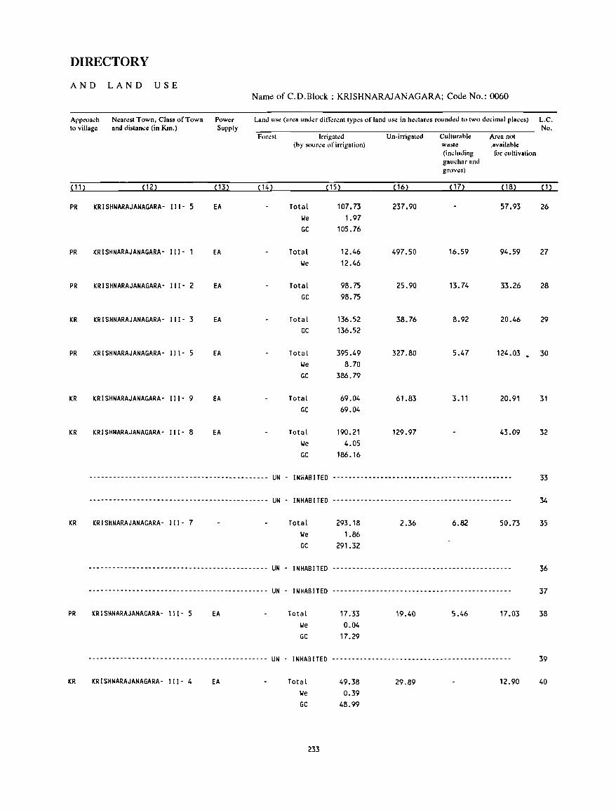
DIRECTORY
AND LAND USE Name of C.D.Block : KRISHNARAJANAGARA; Code No.: 0060
Arproach Nearest Town, Class of Town Power Land use (ar~a und~r din;"r~nt typ~s of land us~ in h~ctar~s rounded to two d~cimal places) L.C. to village and distance (in Km.) Supply No.
(11)
PR
PR
PR
KR
PR
KR
KR
KR
PR
KR
For~st Irrigat~d Un-irrigat~d Culturahle Ar~a not (hy source of irrigation) waste ,availahle
(including for cultivation gaucharand grov~s)
(12) (13) (14) (15) ( 16) ( 17) (18) (1)
KRISHNARAJANAGARA- 111- 5 EA Total 107.73 237.90 57.93 26 lJe 1.97 GC 105.76
KRISHNARAJANAGARA- 111- 1 EA Total 12.46 497.50 16.59 94.59 27 lJe 12.46
KRISHNARAJANAGARA- 111- 2 EA Total 98.75 25.90 13.74 33.26 28 GC 98.75
KRISHNARAJANAGARA- 111- 3 EA Total 136.52 38.76 8.92 20.46 29 GC 136.52
KRISHNARAJANAGARA- 111- 5 EA Total 395.49 327.80 5.47 124.03 • 30 lJe 8.70 GC 386.79
KRISHNARAJANAGARA- 111- 9 EA Total 69.04 61.83 3.11 20.91 31 GC 69.04
KRISHNARAJANAGARA- 111- 8 EA Total 190.21 129.97 43.09 32 lJe 4.05 GC 186.16
----------------------------------.---------- UN - INHABITED .---.--.-------------------.----------------- 33
-.------------------------------------- ... --- UN - INHABITED .- ..... -...................... - ........... --- 34
KRISHNARAJANAGARA- III· 7 Total 293.18 2.36 6.82 50.73 35 lJe 1.86 GC 291.32
-.----- .. ----.-.----- ........ -- .. --.-.---.--. UN . INHABITED .- ... - .. --.----.-.---- .....•.. -- ... -.-.- .. -.- 36
- .... - ..... - ... - .. -.-.------ ... -.- .. -----.- .. UN - INHABITED .. -.-- ... ----- .... -------- .... -- ... ----...... 37
KRISHNARAJANAGARA- 111- 5 EA Total
lJe
17.33 0.04
GC 17.29
19.40 5.46 17.03 38
... -.------ .. -- ... --- ....... -.--- ......... --- UN . INHABITED --- ............ --.-- ....... -.-.- .... --- .... -- 39
KRISHNARAJANAGARA· 111- 4 EA Total lJe
49.38 0.39
GC 48.99
233
29.89 12.90 40
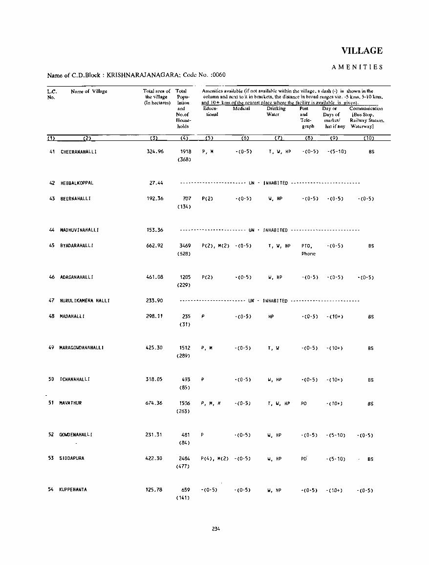
VILLAGE
AMENITIES Name of C.D.Block : KRISHNARAJANAGARA; Code No. :0060
L.C. No.
Name of Village
(2)
41 CHEERANAHAllI
42 HEBBAlKOPPAl
43 BEERNAHAlLI
44 MAOHUVINAHAllI
45 BYADARAHAllI
46 ADAGANAHAllI
47 HURUlIKAMENA HALLI
48 MADAHALll
49 MARAGOYDANAHALLI
50 I CHANAHALLI
51 MAVATHUR
52 GO\IOENAHALl I
53 SIODAPURA
54 I(UPPEHANTA
Total area of the village (In hectares)
(3)
324.96
27.44
192.36
153.36
662.92
461.08
233.90
298.11
425.30
318.05
674.36
231.31
422.30
125.78
Total Population and
No.of Households
(4)
1918 (368)
Am~nities available (if not available within the village. a dash (-) is shown in the column and n~xt to it in brackets, the distance in broad ranges viz. -5 kms. 5-10 kms.
and 10+ kms of the nearest place where the facility is availahle is given). Educa- Medical Drinking Post Day or Communication
tional Waler and Days of [Bus Stop. Tele- mark~ll Railway Stallon. graph hal if any Wat~rwayl
(5) (6) (7) (8) (9) (10)
P, M -(0-5) T, Y, HP -(0-5) -(5-10) BS
------------------------ UN - INHABITED -------------------------
707 (134)
P(2) - (0- 5) Y, HP -(0-5) -(0-5) -(0-5)
------------------------ UN INHABITED -------------------------
3469 (628)
1205 (229)
P(2), M(2) -(0-5)
P(2) -(0-5)
T, Y, HP
Y, HP
PTO, Phone
-(0-5)
-(0-5) -(0-5)
BS
-(0-5)
------------------------ UN - INHABITED -------------------------
235 (31)
1512 (289)
493 (85)
1506
(263)
481 (84)
2484 (477)
659 ( 141)
P -(0-5)
P, M -(0-5)
P -(0-5)
P, H, H -(0-5)
P -(0-5)
P(4), M(2) -(0-5)
-(0-5) -(0-5)
234
HP -(0-5) -(10+) BS
T, Y -(0-5) -(10+) BS
Y, HP -(0-5) -(10+) BS
T, IJ, HP PO -(10+) BS
Y, HP -(0-5) -(5-10) -(0-5)
Y, HP PO -(5-10) BS
Y, HP -(0-5) - (10+) -(0-5)
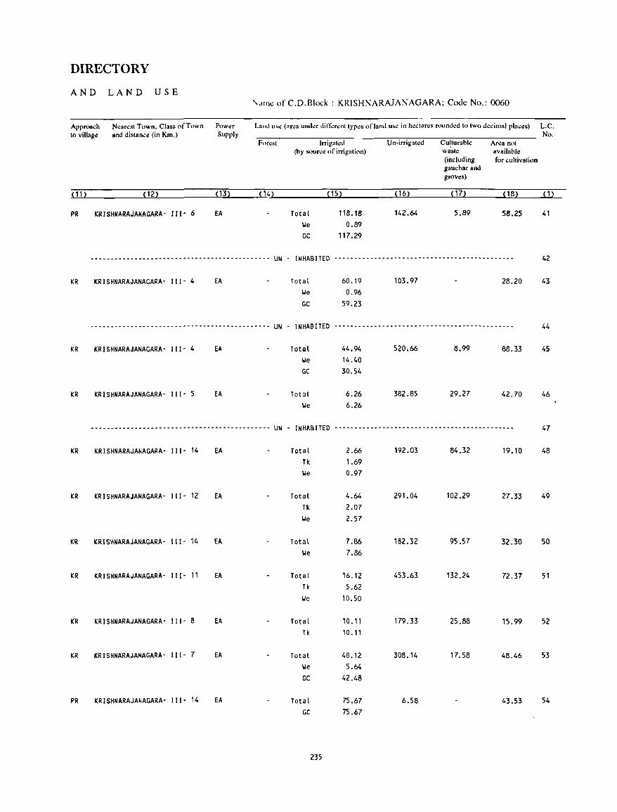
DIRECTORY
AND LAND USE \'.lInt: of C.D.Block : KRISHNARAJANAGARA; Code No.: 0060
Approach Nearest Town, Class of Town Power Land l"e (area under ditTerent types of land u .. e in hectares rounded to two decimal places) L.C. to village and distance (in Km.) Supply No.
Fore .. t Irrigated Un-irrigated Culturable Area not (by source of irrigation) waste available
(including for cultivation gauchar and groves)
(11) (12) (13) (14) (15) (16) ( 17) (18) (1)
PR KRISHNARAJANAGARA- 111- 6 fA Total 118.18 142.64 5.89 58.25 41 lie 0.89 GC 117.29
-----------------------~--------------------- UN - INHABITED --------------------------------------------- 42
KR KRISHNARAJANAGARA- I I I - 4 EA Total 60.19 103.97 28.20 43 lie 0.96 GC 59.23
-----------------------~--------------------- UN - INHABITED --------------------------------------------- 44
KR KRISHNARAJANAGARA- I II - 4 EA Total 44.94 520.66 8.99 88.33 45 lie 14.40 GC 30.54
KR KRISHNARAJANAGARA- I I 1- 5 EA Tot31 6.26 382.85 29.27 42.70 46 lie 6.26
-----------------------~--------------------- UN - INH"BlTED --------------------------------------------- 47
KR KRISHNARAJANAGARA- II 1- 14 EA Total 2.66 192.03 84.32 19.10 48 Tk 1.69 lie 0.97
KR KRISHNARAJANAGARA- I I I - 12 EA Total 4.64 291.04 102.29 27.33 49 Tk 2.07 lie 2.57
KR KRISHNARAJANAGARA- III- 14 EA Total 7.86 182.32 95.57 32.30 50 lie 7.86
KR KRISHNARAJANAGARA- I I I - 11 EA Total 16.12 453.63 132.24 72.37 51 Tk 5.62 lie 10.50
KR KRISHNARAJANAGARA- III- 8 EA Total 10.11 179.33 25.88 15.99 52 Tk 10.11
KR KRISHNARAJANAGARA- II I- 7 EA Total 48.12 308.14 17.58 48.46 53 lie 5.64 GC 42.48
PR KRISHNARAJANAGARA- I I I - 14 EA Total 75.67 6.58 43.53 54 GC 75.67
235
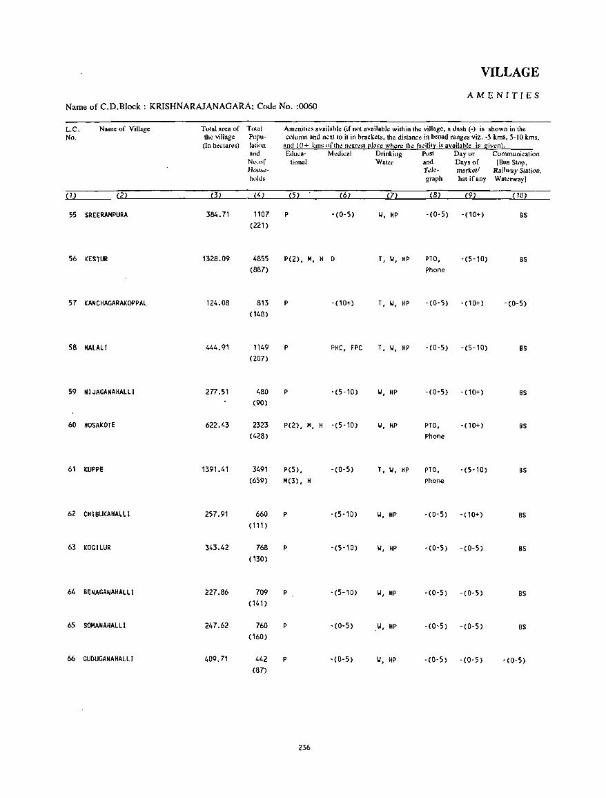
VILLAGE
AMENITIES Name of C.D.Block : KRISHNARAJANAGARA; Cooe No. :0060
L.C. Name of Village Total area of Total Amenities available (if not available within the village, a dash (-) is shown in the No. the village Popu- column and n.:xtto it in brackets, the distance in broad ranges viz. -5 kms, 5-10 kms,
(In hectares) lalion and 10+ krns of the n.:arestl!lace wh.:n: the facility is availahle is giwnl. and &luca- Medical Drinking Post Day or Communication No.of tional Water and Days of [Bus Stop, HOllt..:- T.;le- mark.;11 Railway Slalion. holds graph hat ifany Waterway)
(1) (2) (3) (4) (5) (6) (7) (8) (9) (10)
55 SREERAMPURA 384.71 1107 P -(0-5) II, HP -(0-5) - (10+) BS (221)
56 KESTUR 1328.09 4855 P(2), M, H 0 T, II, HP PTO, -(5-10) BS (887) Phone
57 KANCHAGARAKOPPAl 124.08 813 P -(10+) T, II, HP - (0- 5) -(10+) -(0-5)
(148)
58 MALALI 444.91 1149 P PIIC, FPC T, II, liP -(0-5) -(5-10) BS (207)
59 N I JAGANAHAlll 277.51 480 P -(5-10) II, liP -(0-5) -(10+) BS (90)
60 1I0SAKOTE 622.43 2323 P(2), M, H -(5-10) II, HP PTO, - (10+) BS (428) Phone
61 KUPPE 1391.41 3491 P(5) , - (0-5) T, II, HP PTO, -(5-10) BS (659) M(3) , H Phone
62 CHI BUKAHALL I 257.91 660 P -(5-10) II, HP -(0-5) - (10+) BS (111 )
63 KOGILUR 343.42 768 P -(5-10) II, HP -(0-5) -(0-5) BS ( 130)
64 BENAGANAHALll 227.86 709 P -(5-10) II, HP -(0-5) -(0-5) BS (141)
65 SOMANAIIALLI 247.62 760 P -(0-5) II, HP -(0-5) -(0-5) BS ( 160)
66 GUDUGANAHALLI 409.71 442 P -(0-5) II, HP -(0-5) - (0-5) -(0-5) (87)
236
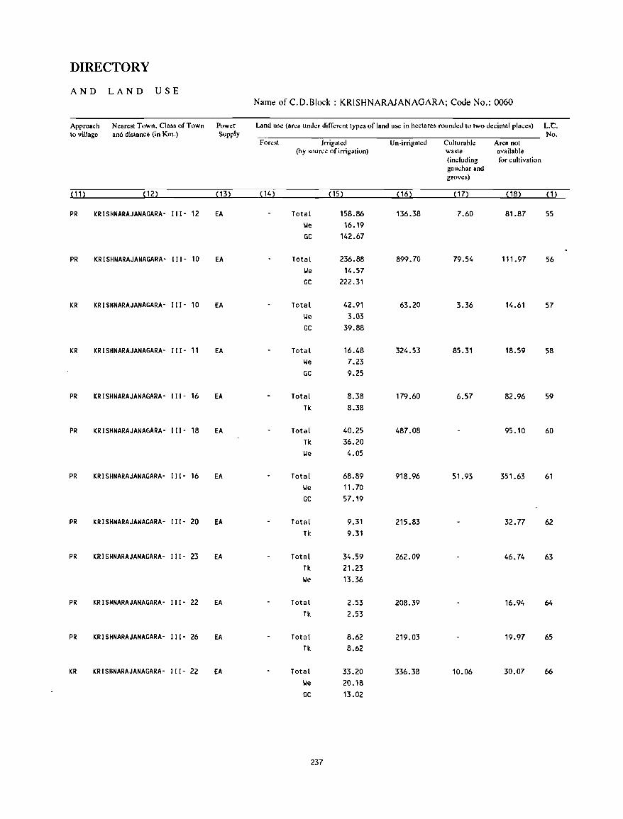
DIRECTORY
AND LAND USE Name of C.D.Block : KRISHNARAJANAGARA; Code No.: 0060
Approach N~arest Town, Class of Town Power Land us~ (area under different types of land u~ in hectares rounded to two d~cimal places) L.C. \0 village and distance (in Km.) Supply No.
Forest Irrigated Un-irrigated Cullurable Ar~a not (by sour~e of irrigation) waste available
(including for cultivation gauchar and grov~s)
(11) (12) (13) (14) (15) (16) ( 17) ( 18) (1)
PR KRISHNARAJANAGARA- 111- 12 EA Total 158.86 136.38 7.60 81.87 55 \.Ie 16.19 GC 142.67
PR KRISHNARAJANAGARA- 111- 10 EA Total 236.88 899.70 79.54 111.97 56 \.Ie 14.57 GC 222.31
KR KRISHNARAJANAGARA- 111- 10 EA Total 42.91 63.20 3.36 14.61 57 \.Ie 3.03 GC 39.88
KR KRISHNARAJANAGARA- 111- 11 EA Total 16.48 324.53 85.31 18.59 58 \.Ie 7.23 GC 9.25
PR KRISHNARAJANAGARA- III· 16 EA Total 8.38 179.60 6.57 82.96 59 Tk 8.38
PR KRISHNARAJANAGARA- III· 18 EA Total 40.25 487.08 95.10 60 Tk 36.20 \.Ie 4.05
PR KRISHNARAJANAGARA- 111- 16 EA Total 68.89 918.96 51.93 351.63 61 \.Ie 11. 70 GC 57.19
PR KRISHNARAJANAGARA- III· 20 EA Total 9.31 215.83 32.77 62 Tk 9.31
PR KRISHNARAJANAGARA- 111- 23 EA Total 34.59 262.09 46.74 63 Tk 21.23 \.Ie 13.36
PR KRISHNARAJANAGARA- 111- 22 EA Total 2.53 208.39 16.94 64
Tk 2.53
PR KRISHNARAJANAGARA- 111- 26 EA Total 8.62 219.03 19.97 65 Tk 8.62
KR KRISHNARAJANAGARA- 111- 22 EA Total 33.20 336.38 10.06 30.07 66
\.Ie 20.18 GC 13.02
237
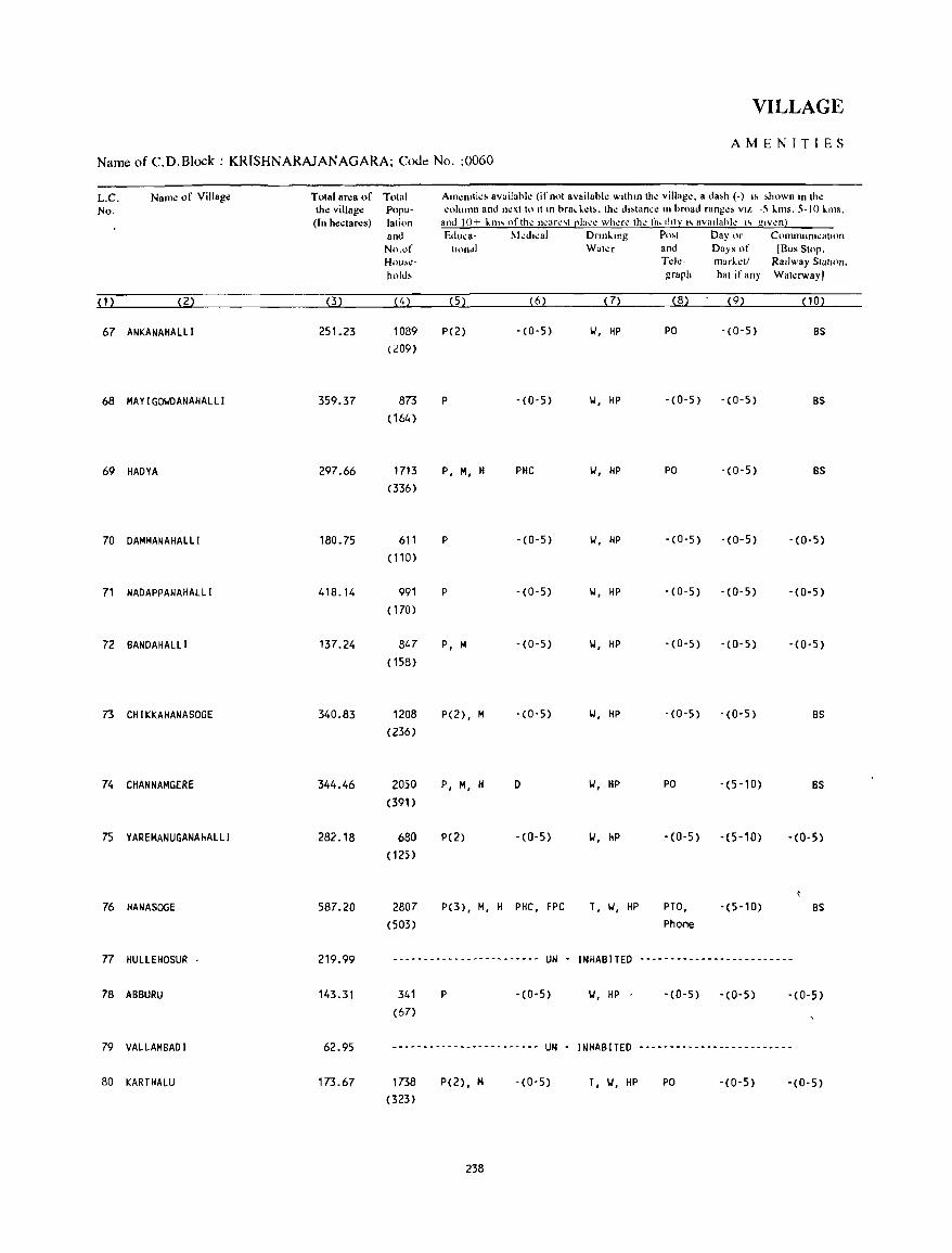
VILLAGE
AMENITIES Name of C.D.Block : KRISHNARAJANAGARA; Code No. :0060
L.C. Name of Village Total area of Total Am~JlIli~~ availahl~ (if not availahl.: with," Ih~ vilhlg~. a da,h (-) " ~hown In Ihe No. the village Popu- coluann and n~xt to II In hrackcl~. th.: di,tan,c an hroad ranl!':~ VII: -5 kms. 5-10 killS.
(In hectares) lalion and 10+ "an, oflhe ncarc,t [!Iacc where the j;I"llt~ "nvadahlc " glv.:n} and Educa- II.kdacal Drln"ang Po,t Day or COlnlnum~atH)n
No.of taon~1 Wat~r and Days of IBlls SlOp. Hou~c:- Td~- marl.t:tl Railway Slatum. hold, graph hat if any Watawayl
( 1 ) (2) (3) (4) (5) (6) (7) (8) (9) (10)
67 ANKANAHALLI 251.23 1089 P(2) -(0-5) 10', HP PO - (0- 5) BS (209)
68 MAYI GOIo'DANAHALL I 359.37 873 P -(0-5) 10', HP -(0-5) -(0-5) BS (164 )
69 HADYA 297.66 1713 P, M, H PHC 10', HP PO -(0-5) BS (336)
70 DAMMANAHALLI 180.75 611 P -(0-5) 10', HP -(0-5) -(0-5) -(0-5) (110)
71 NADAPPANAHALLI 418.14 991 P -(0-5) 10', HP -(0-5) -(0-5) -(0-5) ( 170)
72 BANDAHALLI 137.24 847 P, M -(0-5) 10', HP -(0-5) -(0-5) - (0- 5) (158)
73 CHIKKAHANASOGE 340.83 1208 P(2), M -(0-5) 10', HP -(0-5) -(0-5) BS (236)
74 CHANNAMGERE 344.46 2050 P, M, H D 10', HP PO -(5-10) BS
(391)
75 YAREMANUGANAHALLI 282.18 680 P(2) - (0- 5) 10', HP -(0-5) -(5-10) -(0-5) ( 125)
76 HANASOGE 587.20 2807 p(3) , M, H PHC, FPC T, 10', HP PTO, -(5-10) BS (503) Phone
77 HULLEHOSUR 219.99 -----------------~------ UN - INHABITED --------------~----------
78 ABBURU 143.31 341 P -(0-5) 10', HP -(0-5) -(0-5) -(0-5) (67)
79 VALLAMBADI 62.95 ------------------------ UN - INHABITED -------------------------
80 KARTHALU 173.67 1738 P(2), M -(0-5) T, 10', HP PO - (0- 5) -(0-5) (323)
238
DIRECTORY
AND LAND USE Name of C.D.Block : KRISHNARAJANAGARA; Code No.: 0060
Approach Nearest Town. Class of Town Power Land use (area under different types of land use in hectares rounded to two decimal.places) L.C. to village and distance (in Km.) Supply No.
Forest Irrigated Un-irrigated Cullurable Area not (by source of irrigation) waste available
(including for cultivation gaucharand groves)
(11) (12) (13) ( 14) ( 15) (16) (17) (18) (1)
PR KRISHNARAJANAGARA- II I - 21 EA Total 11.68 216.73 7.93 14.89 67
Tk 4.84 We 6.84
PR KRISHNARAJANAGARA- 111- 20 EA Total 44.18 261.22 53.97 68 Tk 29.69
I.'e 14.49
PR KRISHNARAJANAGARA- II I - 26 EA Total 16.39 238.12 15.33 27.82 69 Tk 6.27
I.'e 10.12
PR KRISHNARAJANAGARA- II I - 27 EA Total 6.07 141.49 20.30 12.89 70 I.'e 6.07
PR KRISHNARAJANAGARA- 111- 30 EA Total 7.35 362.37 48.42 71 Tk 7.35
PR KRISHNARAJANAGARA- 111- 30 EA Total 11.98 61.22 11.33 52.71 72 Tk 11.30 I.'e 0.68
PR KRISHNARAJANAGARA- III' 32 EA Total 31.30 237.43 72.10 73 Tk 27.69 I.'e 3.61
KR KRISHNARAJANAGARA· III· 38 EA Total 34.28 263.18 47.00 74 Tk 34.28
KR KRISHNARAJANAGARA- 111- 36 EA Total 15.05 231.49 35.64 75 Tk 11.00 lJe 4.05
PR KONANURU· v- 16 EA Total 10.12 472.85 10.12 94.11 76 lie 10.12 . ~
- -- - - - -- -------- - - - - - ---- ----- -- - -- -- - - - - - - -- UN - INHABITED --------------------------------------------- 77
PR KONANURU- v- 16 EA Total 2.02 122.80 18.49 78 \.Ie 2.02
- .. --- ... ----.----.--.---.-.---.----~--- .... - UN - INHABITED -------------------------------,-------------- 79
KR KONANURU- V- 13 EA Total 4.93 146.35 22.39 80
We 2.83 '" GC 2.10
239
VILLAGE
AMENITIES
Name of C.D.Block : KRISHNARAJANAGARA; Code No. :0060
L.C. No.
(1)
81
82
83
84
85
86
87
Name of Village
(2)
THANDRE
HANASOGEHANTA
KOLUR
KOLURHANTA
KAGGALA
HADYAHANTA
SAKKARE
88 DUDDAHAlLI
89 HOSUR
90 HALEYUR
91 SALIGRAMA
92 BEVANAHALLI
93 BYLAPURA
94 LAXMIPURA
Tolal area of Tolal the village Popu(In hectares) lation
and No.of Households
(3) (4)
72.89 443 (73)
Am.:niti~s availabl.: (ifnol available within th.: village, a dash (-) is shown in the column and next to it in brackets, the distance in broad ranges viz. -5 kms, 5-10 kms,
and 10+ kms of the nearest place whae the facility is availahle is given). Educa- Medi,al Drinking Post Day or Communication
lional Waler and Days of rBus SlOp, Tde- market/ Railway Station, graph hat if any Wat.:rway I
(5 ) (6) (7) (8) (9) (10)
P -(0-5) II, HP -(0-5) - (0-5) -(0-5)
675.90 ---- --_ ...... -_ ..... -_ ..................... UN - INHABITED ._-----------------------
223.95 848 P, M -(0-5) T, II, HP PO -(0-5) BS
(157)
390.23 ------------------------ UN - INHABllED ...... __ .... -_ .................. -- ...... -- ..
55.77 733 P, M -(0-5) II, HP -(0-5) -(0-5) -(0-5)
(136)
291.60 -- ...... -_ ..... --_ ... -- ................ -- UN - INHABITED ---------------- .. --------
122.66 379 P -(5-10) II, HP -(0-5) -(10+) BS
(63)
191.73 639 P -(0-5) T, II, HP -(0-5) -(5-10) -(0-5)
(107)
287.00 2264 P(3) , PHC, FPC T, II, HP PTO, -(5-10) BS
(476) 101(2), H Phone
881.96 5013 P(4), M(2) -(0-5) T, II, HP PTO, -(5-10) BS
( 1012) phone
1109.49 10879 P(8) , PHC, FPC T, II, HP PTO, SAT BS
(2210) M(3) , Phone H(2) , PUC
66.40 59 -(0-5) -(0-5) II, HP -(5-10) -(5-10) -(0-5) (11 )
88.55 143 -(0-5) -(0-5) II, HP -(0-5) -(0-5) BS (31)
228.99 2058 P(2), M -(0-5) II, HI, HP -(0-5) -(0-5) BS (391)
240
DIRECTORY
AND LAND USE Name of C.D.Block : KRISHNARAJANAGARA; Code No.: 0060
Approa,h to 'village
N~ar~st Town, Class of Town and distance (in Km.)
Pow.:r Supply
Land u~ «(lr~a und~r di fferent lypes of land usc in hedan:s round~d 10 Iwo decimal places) L.C. No.
Forest lrrigal~d Un-irrigated Culturahle Area not (by sour.:.: of irrigation) waste availahl.:
(including for cultivation gau.;har and groves)
(11) (12) ( 13) ( 14) ( 15) (16) ( 17) ( 18) (1)
PR KONANURU· v- 16 EA 61.84 11.05 81
--------------------------------------------- UN - INHABITED --------------------------------------------- 82
PR KRISHNARAJANAGARA- 111- 24 EA 198.21 25.74 83
--------------------------------------------- UN - INHABITED --------------------------------------------- 84
PR KRISHNARAJANAGARA- 111- 27 EA 33.70 22.07 85
--------------------------------------------- UN - INHABITED ...... -_ .................. -_ ...................................................................................... - 86
PR KRISHNARAJANAGARA- 111- 22 EA 83.28 24.33 15.05 87
KR KRISHNARAJANAGARA- 111- 18 EA Total 68.84 91.52 31.37 88 We 4.08 GC 64.76
PR KRISHNARAJANAGARA- I I 1- 18 fA Total 156.53 38.53 20.80 71. 14 89 Tk 2.32 We 1.21 GC 153.00
PR KRISHNARAJANAGARA- III· 19 EA Total 202.78 516.22 34.63 128.33 90 We 9.66 GC 193.12
PR KRISHNARAJANAGARA- III- 28 EA Total 541.09 351.92 20.26 196.22 91 We 31.33 GC 509.76
KR KRISHNARAJANAGARA- 111- 20 EA Total 20.22 21.97 24.21 92 I,je 6.06 GC 14.16
PR KRISHNARAJANAGARA- 111- 24 EA Total 8.88 61.18 3.99 14.50 93 We 8.88
KR KRISHNARAJANAGARA- 111- 27 EA Total 36.07 157.12 35.80 94 GC 36.07
241
VILLAGE
AMENITIES Name of C.D.Block : KRISHNARAJANAGARA; Code No. :0060
LC Name of Village T olal area of Tolal No the Village Popu-
(In hedares) lallon and No of Hou.~-
holds
(1) (2) (3) (4)
95 CHI KKANAYAKANAHAll I 538.35 1912 (371)
96 BAlLUR 857.38 1528 (313)
97 HONNENAHAlll. 410.01 849 (142)
98 KEDAGA 253.49 957 ( 172)
99 GUMMANAHAlll 130.77 331 (73)
100 MAVANUR 265.84 425 (81)
101 PASHUPATHI 313.15 844 (146)
102 GAYANAHAlll 241.06 667
(120)
103 SARAGURU 219.65 356 (64)
104 HEBSUR 400.51 1168 (245 )
105 lAKKIKUPPE 446.31 1272 (233)
106 HARADANAHALLI 594.98 2023 (383)
AIIl~nlll~& avalldbJ.: (If nol available wllhan Ih.: Village. a da&h (-) " ,hown an Ihe column and n~xl 10 II In bracL~I •• the dl.lance In broad ran~~' VI/ 5 Lms. ~-IO LlIls.
and 10+ kl11' "flhe ncarc,1 (!la,c ~hcrc the faella1y" aV,IlI,bk " given) Educa- MedIcal DnnkIng
Ilona I Wal~r
(5) (6) (7)
P, M -(O-S) II, Til, HP
P(2), M -(0-5) HI, HP
P(2) -(0-5) II, HP
P -(0-5) 10/, HP
P -(0-5) II, HP
P -(0-5) 1,1, HP
P -(0-5) 1,1, HP
P -(0-5) II, HP
P '(5'10) 1,1, HP
P, M -(0-5) II, HP
P -(0-5) II, Til, HP
P, M PHC, FPC T, 101, HP
242
Po,t D"yor and Day, of Td~ markell ~rdph b.lI II any
(8) (9)
PO -(0-5)
PO -(0-5)
PO - (0- 5)
-(0-5) (0-5)
-(0-5) -(0-5)
-(0-5) -(0-5)
-(0-5) -(5-10)
-(0-5) -(0'5)
-(0-5) -(5-10)
PO -(0-5)
-(0-5) -(0-5)
PO, -(0-5) Phone
Commumcallon [Bus SlOp.
Railway Sldllon. Walerwayl
• I
(10)
BS
BS
BS
BS
-(0-5)
BS
BS
BS
BS
BS
BS
BS
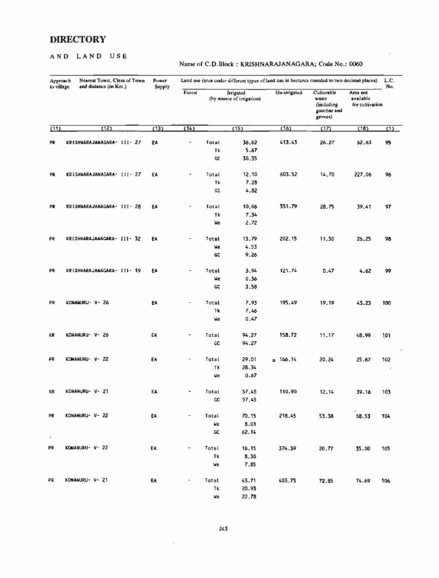
DIRECTORY
AND LAND USE Name of C.D.Block: KRISHNARAJANAGARA; Code No.: 0060
Approach Nearest Town. Class of Town Power Land u~ (ar~a und~r ditT~r~nt typ~s of land uS<! in hectar.:s rounded to two d.:cimal places) L.C. to village and distance (in Km.) Supply No.
Forest Irrigated Un-irrigated Culturable Area not (by source of irrigation) waste available
(including for cultivation gauchar and groves)
(11) (12) ( 13) ( 14) (15) (16) ( 17) ( 18) (1)
PR KRISHNARAJAHAGARA- J 11- 27 EA Total 36.02 413.43 26.27 62.63 95 Tk 5.67 GC 30.35
PR KRISHNARAJANAGARA- 111- 27 EA Total 12.10 603.52 14.70 227.06 96 Tk 7.28 GC 4.82
PR KRISHNARAJANAGARA- 111- 28 fA Total 10.06 331.79 28.75 39.41 97 Tk 7.34 \ole 2.72
PR KRISHNARAJANAGARA- 111- 32 EA Total 13.79 202.15 11.30 26.25 98 \ole 4.53 GC 9.26
PR KRISHNARAJANAGARA- 111- 19 EA Total 3.94 121..74 0.47 4.62 99 \ole 0.36 GC 3.58
PR KONAHURU- v- 26 EA Total 7.93 195.49 19.19 43.23 100 Tk 7.46 \ole 0.47
KR KONANURU- y- 26 EA Total 94.27 158.72 11.17 48.99 Wl GC 94.27
PR KONANURU- Y- 22 EA Total 29.01 Q 166.14 20.24 25.67 102 Tk 28.34 \ole 0.67
KR KONANURU- Y- 21 EA Total 57.45 110.90 12.14 39.16 103 GC 57.45
PR KONANURU- V- 22 EA Total 70.15 218.45 53.38 58.53 104 \ole 8.01 GC 62.14
PR KONANURU- V- 22 EA Total 16.15 374.39 20.77 35.00 105 Tk 8.30 \ole 7.85
PR KONANURU- V- 21 EA Total 43.71 403.73 72.85 74.69 106 Tk 20.93 \ole 22.78
243
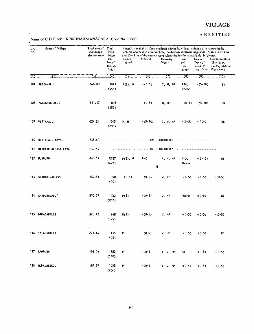
VILLAGE
AMENITIES Name of C.D.Block : KRISHNARAJANAGARA; Code No. :0060
L.C. Name of Village Tolal ar¢a of Total AlIl~oiti~s availablo: (ifonl availabl.: within Ih~ village, II dash (-) is shown in the No. the village Popu- column and next 10 it in brack.:ts, tho: distance ill' broad rang~s viz. -5 kms, 5-10 kms,
(In ho:clan:s) lation and 10+ kms of the neare~t [!l~ce where the facility is available is given). and Educa- t>kdical Drinking Po!>1 Day or Communicalion No.of tiona I Watcr and Days of (Bus Stop, H"u~- Tdll- mark.:!/ Railway Station, holds graph hat if any Watcrway)
(1) (2) (3) (4) (5) (6) (7) (8) (9) ( 10)
107 SEEGAVALU 646.89 3023 P(Z), M -(0-5) T, 101, HP PTO, -(5-10) as (555) Phone
108 MALUGANAHAlLl 551. 17 805 P -(0-5) 101, HP -(0-5) -(5-10) as (152)
109 BE TTAHALII 629.22 1095 P, M -(5-10) T, 101, HP -(0-5) - (10"') BS
(205)
110 BETTAHALlI KAVAL 235.44 ,.- •• -.---- ••••••••••••• UN - INHABITED --~.-.-~--.-_&_---.-~----
111 BAKKAREHALlADA KAVAL 235.19 ,-.--------------------- UN - INHABITED ---------------~---------
112 MUNDURU 865.14 2537 P(3), M PHC T, 101, HP PTO, -(5-10) as (473) Phone •
113 SHANABINAKUPPE 139.51 SO -(0-5) '(0-5) 101, HP -(0-5) -(0'5) • (0- 5)
(10)
114 KARPURAVAlLi 500.57 1132 P(2) -(0-5) 101, HP Phone '(0-5) BS
(207)
115 DADADAHALLI 378.43 948 P(Z) -(0-5) 101, HP -(0-5) -(0-5) -(0-5)
(175)
116 YALADAHAlLl 221.64 135 P -(0-5) 101, HP • (0- 5) -(0-5) BS
(23)
117 RAMPURA 198.64 782 P '(0-5) T, 101, HP PO -(0-5) -(0-5)
(158)
118 MUDALAaEEDU 199.69 1053 p -CO-5) T, 101, HP - (0' 5) -CO-5) -(0-5)
(204)
244
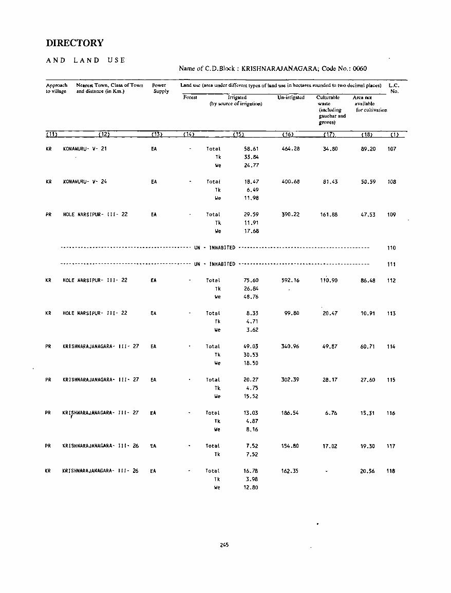
DIRECTORY
AND LAND USE Name of C.D.Block : KRISHNARAJANAGARA; Code No.: 0060
Approach Nearest Town, Class of Town Power Land us.: (area under different types of land us.: in h\lctares round\ld to two decimal plac\ls) L.C. to village and distance (in Km.) Supply No.
Forest Irrigated Un-irrigated Culturable Area not (by &<lurce of irrigation) waste available
(induding for cultivation 8auchar and groves)
( 11 ) ( 12) (13) (14) (15) ( 16) ( 17) (18) (1)
KR KONANURU- v- 21 EA Total 58.61 464.28 34.80 89.20 107 Tit 33.84 We 24.77
KR KONANURU- V- 24 fA Total 18.47 400.68 81.43 50.59 108 Tit 6.49 We 11.98
PR HOLE NARSIPUR- III - 22 EA Total 29.59 390.22 161.88 47.53 109 Tit 11.91 We 17.68
~----------.------------------~------------~- UN - INHABITED ---~----------------------------------------- 110
----------------------------------------.---- UN - INHABITED --------------------------------------------- 111
KR HOLE NARSIPUR- I I1- 22 EA Total 75.60 592.16 110.90 86.48 112 Tit 26.84 We 48.76
KR HOLE NARSIPUR- "1- 22 EA Total 8.33 99.80 20.47 10.91 113 Tit 4.71 We 3.62
PR KRISHNARAJANAGARA- 111- 27 EA Total 49.03 340.96 49.87 60.71 114 TIc: 30.53 We 18.50
PR KRISHNARAJANAGARA- III- 27 EA Total 20.27 302.39 28.17 27.60 115
Tit 4.75 We 15.52
PR KRISHNARAJANAGARA- 111- 27 EA Total , 13.03 186.54 6.76 15.31 116 Tit 4.87 We 8.16
PR KRISHNARAJANAGARA- 111- 26 EA Total 7.52 154.80 17.02 19.30 ',7 Tit 7.52
KR KRISHNARAJANAGARA- 111- 26 EA Total 16.78 162.35 20.56 118 Tit 3.98 We 12.80
245
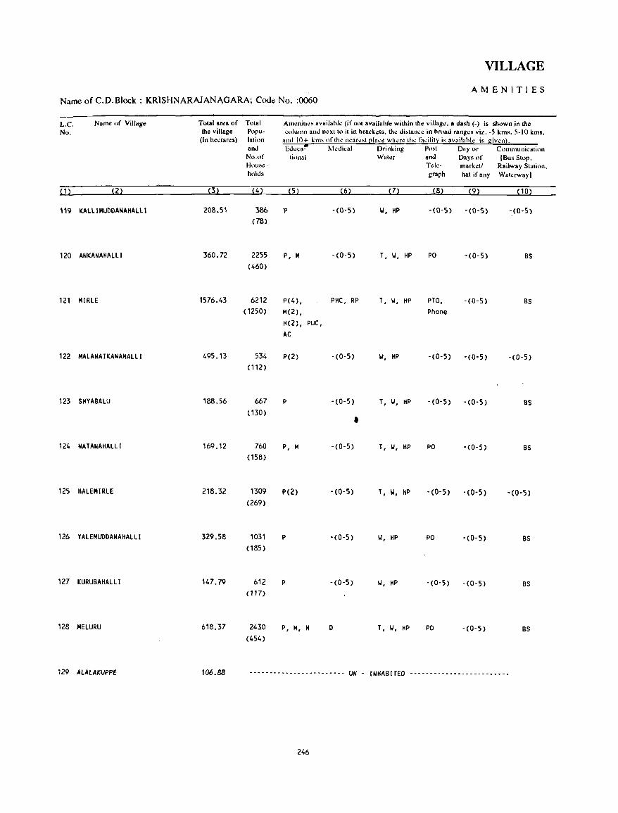
VILLAGE
AMENITIES Name of C.D. Block: KRISHNARAJANAGARA; Code No. :0060
L.C. Name of Village Total area of Tolal Am~nill~" availahl~ (ifnnt availahl.:: wilhin Ihe village. a dash (-) is Mown in th.:: No. the village Popu- ~"Iullln and nexlto it in hrad.els. the di"tance in hmad ranges viz. -5 kms. 5-10 kms,
(In heclare5) lalion and 10+ kill, of the neare'tl!la~e where the facilit:;( is availahle is givenl. and EJuca~ Medical Drinking Po"t Day or Comllluni~atil)n No.of ti<lll31 Water and Day. of (Bus Stop, Hou..:- Tde- marketl Railway Station. holds graph hat if any Wat~rwayl
(1) (2) (3) (4) (5) (6) (7) (8) (9) (10)
119 KALLIMUDDANAHALLI 208.5' 386 'P -(0-5) 101, HP - (0-5) - (0-5) -.(0-5)
(78)
120 ANKANAHALLl 360.72 2255 P, M -(0-5) T, II, HP PO -(0-5) BS
(460)
121 MIRLE 1576.43 6212 P(4) , PHC, RP T, II, HP PTO, -(0-5) BS
(1250) M(2) , Phone
H(2) , PUC,
AC
122 MALANAIKANAHALLI 495,13 534 P(2) -(0-5) w, HP -(0-5) -(0-5) -(0-5)
(112)
123 SHYABALU 188.56 667 P -(0-5) T, II, HP -(0-5) -(0-5) 8S (130) •
124 NATANAHALLI 169.12 760 P, M -(0-5) T, II, HP PO -(0-5) as (158)
125 HALEMIRLE 218,32 1309 P(Z) -(0-5) T, W, HP -(0-5) -(0-5) -(0-5)
(269)
126 YALEMUDDANAHALLI 329.58 1031 P -(0-5) W, HP PO - (0- 5) BS (185)
127 KURUBAHALLI 147.79 612 P - (0-5) W, HP - (0- 5) -(0-5) BS (117)
128 MELURU 618.37 2430 P, M, H 0 T, W, HP PO -(0-5) BS (454)
129 ALALAKUPPE 106.88 ------------------------ UN - INHABITED -------------------------
246
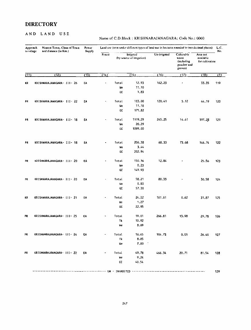
DIRECTORY
AND LAND USE Name of C.D.Blol:k : KRISHNARAJANAGARA; Code No.: 0060
Approach Nearest Town. Class of Town Power Land U!o.: (area undcr ditTcrcnt types of land uw in hectares rounded to two decimal places) L.C. to village and distance (in Km.) Supply No.
For~~t Irrigah:d U n-irrigat.:d Cuhuraole Area not (by ~urc.: of iITIgalion) wa~le available
(induding for cuhivation gaucharand grows)
(11) (12) (13) (14) (15) (16) ( 17) (18) (1)
KR KRISHNARAJANAGARA- I I I - 26 EA Total 12.93 162.23 33.35 119 lie 11.10 GC 1.83
PR KRISHNARAJANAGARA- 111- 22 EA Total 183.00 128.41 5.12 44.19 120 lie 11.18 GC 171.82
PR KRISHNARAJANAGARA- 111- 18 EA Total 1119.29 245.25 14.61 197.2,8 121 lie 20.29 GC 1099.00
PR KRISHNARAJANAGARA- I I 1- 18 EA Total 206.38 68.33 73.68 146.74 122 lie 3.44 GC 202.94
PR KRISHNARAJANAGARA- II I - 20 EA Total 150.16 12.84 25.56 123 lie 0.23 GC 149.93
PR KRISHNARAJANAGARA- II I - 20 EA Total 58.21 80.33 30.58 124 'ole 0.83 GC 57.38
KR KRISHNARAJANAGARA- 111- 21 EA Total 24.22 161.61 0.62 31.87 125 lie 1.27 GC 22.95
PR KRISHNARAJANAGARA- II I - 25 EA Total 19.01 266.81 13.98 29.78 126 Tk 10.92 lie 8.09
PR KRISHNARAJANAGARA- II 1- 24 EA Total 16.65 104.73 0.01 26.40 127 Tk 8.85 lie 7.80
PR KRISHNARAJANAGARA- 111- 22 EA Total 49.78 466.34 20.71 81.54 128 'ole 9.24 GC 40.54
--------------------------------------------- UN - INHABITED --------------------------------------------- 129
247
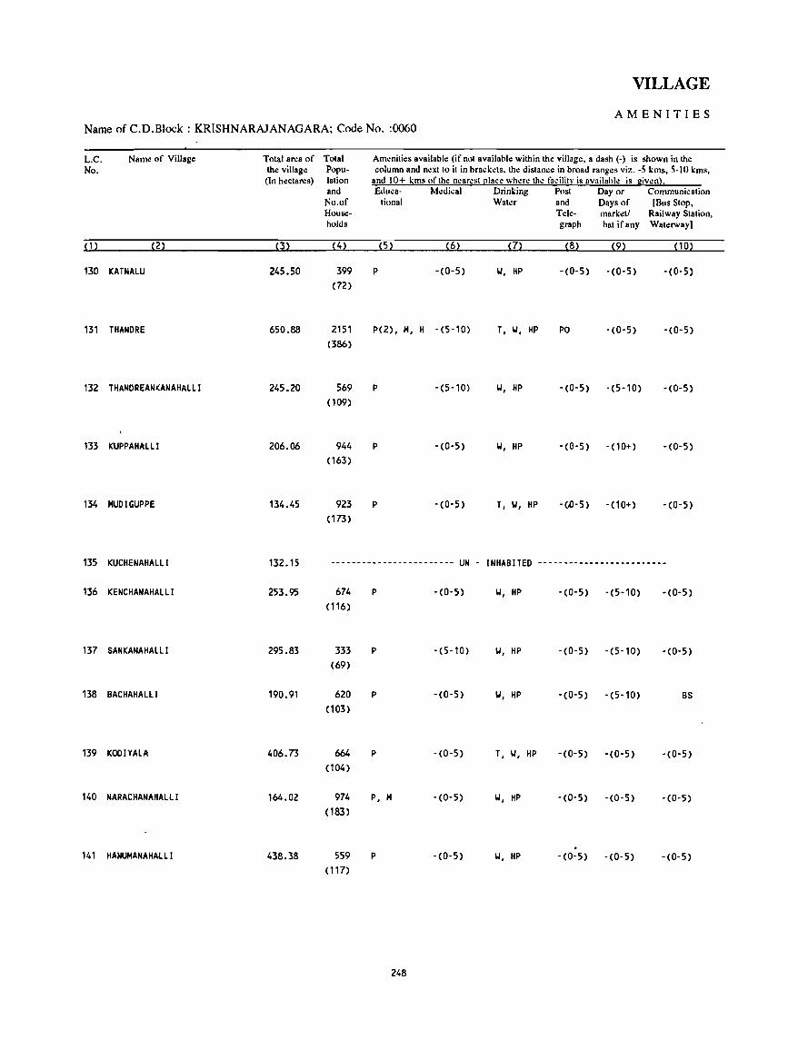
VILLAGE
AMENITIES Name of C.D.Block : KRISHNARAJANAGARA; Code No. :0060
L.C. Name of Village Total area of Total Am~nilies available (if not available within the village, a dash (-) is shown in the No. the village Popu- column and next to it in brackets, the distance in broad ranges viz. -5 kms, 5·10 kms,
(In hectares) lation and 10+ kms of the n~arest [!Iace where th~ facilit~ is availahle is giwn}. and Eduea- Medical Drinking Post Day or Communication
No.of tiona I Water and Days of [Bus Stop, House- Tele- marketl Railway Station, holds graph hat ifany Waterway)
(1) (2) (3) (4) (5) (6) (7) (8) (9) (10)
130 KATNAlU 245.50 399 P -(0-5) W, HP -(0-5) -(0-5) -(0-5) (72)
131 THANDRE 650.88 2151 P(2), M, H -(5-10) T, W, HP PO -(0-5) -(0-5) (386)
132 THANDREANKANAHAlll 245.20 569 P -(5-10) W, HP -(0-5) -(5-10) -(0-5) (109)
133 KUPPAHAlll 206.06 944 P - (0-5) W, HP -(G-5) -(10+) -(0-5) (163)
134 HUDIGUPPE 134.45 923 P -(0-5) T, W, HP -(.D-5) -(10+) -(0-5) (173)
135 KUCHENAHAlll 132.15 ------------------------ UN - INHABITED -------------------------
136 KENCHANAHAlll 253.95 674 P -(0-5) W, HP -(0-5) -(5-10) - (0-5) (116)
137 SANKANAHAlli 295.83 333 P -(5-10) W, HP -(0-5) -(5-10) -(0-5) (69)
138 BACHAHAlli 190.91 620 P -(0-5) W, HP -(0-5) -(5-10) BS (103)
139 KOOIYAlA 406.73 664 P -(0-5) T, W, HP - (0-5) -(0-5) -(0-5) (104)
140 NARACHANAHAlll 164.02 974 P, M -(0-5) W, HP -(0-5) -(0-5) -(0-5) (183)
. 141 HANUMANAHAllI 438.38 559 P -(0-5) W, HP - (0- 5) -(0-5) - (0- 5)
( 117)
248
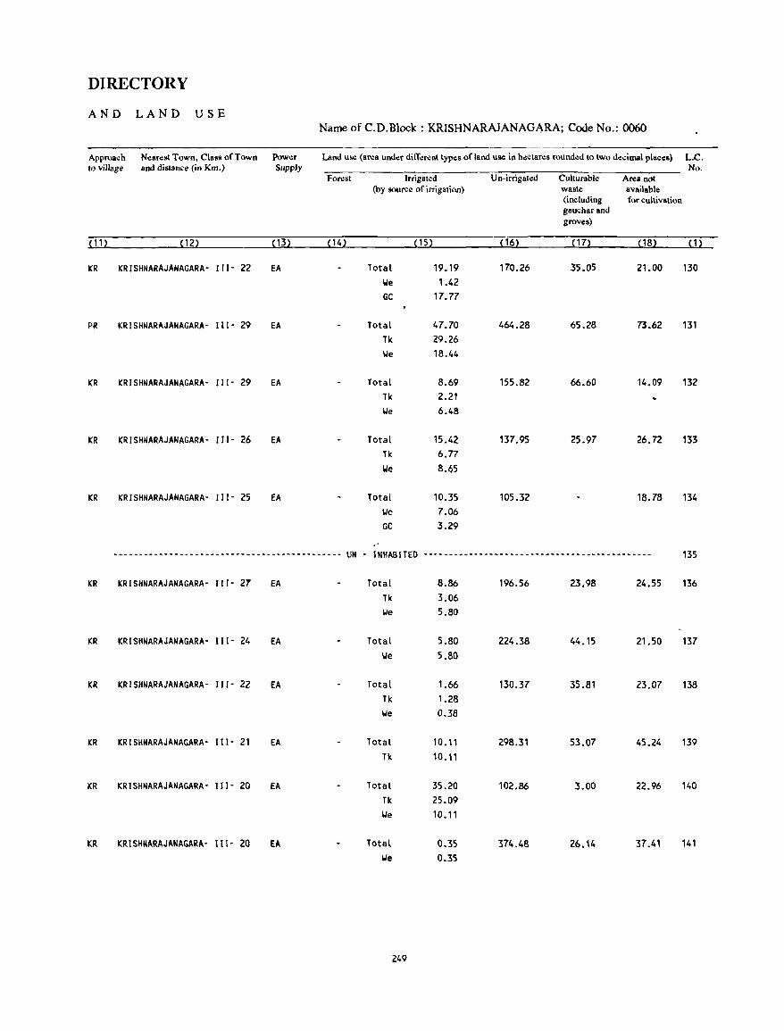
DIRECTORY
AND LAND USE Name of C.D.Block : KRISHNARAJANAGARA; Code No.: 0060
Approach Nearest Town. Class of Town Power Land us.: (ar.:a under ditT.:r.:nt typ\lS of land us.: in h\lctares round\ld to two d\lcimal places) L.C. to village and distance (in Km.) Supply No.
Forest Irrigated Un-irrigated Culturable Area not (by source of irrigation) waste available
(including for cultivation gauchar and groves)
(11) (12) ( 13) (14) (15) (16) (17) ( 18) (1)
KR KRISHNARAJANAGARA- 111- 22 EA Total 19.19 170.26 35.05 21.00 130 \,Ie 1.42 GC 17.77
PR KRISHNARAJANAGARA- 111- 29 EA Total 47.70 464.28 65.28 73.62 131 Tk 29.26 \,Ie 18.44
KR KRISHNARAJANAGARA- 111- 29 EA Total 8.69 155.82 66.60 14.09 132 Tk 2.21 \,Ie 6.48
KR KRISHNARAJANAGARA- III· 26 EA Total 15.42 137.95 25.97 26.72 133 Tk 6.77 \,Ie 8.65
KR KRISHNARAJANAGARA- 111- 25 fA Total 10.35 105.32 18.78 134 \,Ie 7.06 GC 3.29
--------------.--------------------------.--- UN - INHABITED --.-~--.----------------~-~-------~---------- 135
KR KRISHNARAJANAGARA- 111- 27 EA Total 8.86 196.56 23.98 24.55 136 Tk 3.06 We 5.80
KR KRISHNARAJANAGARA- 111- 24 EA Total 5.80 224.38 44.15 21.50 137 \,Ie 5.80
KR KRISHNARAJANAGARA- 111- 22 EA Total 1.66 130.37 35.81 23.07 138 Tk 1.28 We 0.38
KR KRlSHNARAJANAGARA' 111- 21 EA Total 10.11 298.31 53.07 45.24 139 Tk 10.11
KR KRISHNARAJANAGARA- 111- 20 EA Total 35.20 102.86 3.00 22.96 140 Tk 25.09 LJe 10.11
KR KRISHNARAJANAGARA- 111- 20 EA Total 0.35 374.48 26.14 37.41 141 loIe 0.35
249

VILLAGE
AMENITIES Name of C.D.Block : KRISHNARAJANAGARA; Code No. :0060
L.C. Name of Village Total area of TotaJ Am.:nitio:s available {ifnol availahle -within the village •• dash {-) is &hown in the No. the village Popu- column.nd nexlto it in bracko:ts. the distance in broad rango:s viz. -5 kms. 5-10 kms.
(In hectares) lation and 10+ kms of the nearo:st [!Iac.: where tho: facilit): i. availahlo: is I:ivenl. .nd Educa- Medical Drinking Post Day or Communication No.of tiona I Water and Days of [Bus Stop. House- Tele- markell RailWay Station. holds grapb hat ifany Walo:rway]
(1) (Z2 p> (4) (5) (6) (7) (8) (9) (10)
142 BEECHANAHALLI 209.37 1122 P(2) -(0-5 ) T, W, HP -(0-5) -(0-5) BS
(192)
143 HULLE80REKAVAL 105.64 31 -(0-5) -(0-5) - (0-5) -(10+) '(0-5)
(5)
144 HOSA AGRAHARA 447.76 1426 P(2), H, -(0-5) T, W, HP PTO, -(0-5) BS
(279) H, PUC Phone
145 SUGGANAKALLI 203.55 478 P -(0-5) 101, HP -(0-5) • (0-5) '(0,5)
(94)
146 BATIGANAHALLl 253.69 449 P - (0,5) 101, HP -{0'5) • (0, 5) '(0,5)
(80)
147 BHERYA 399.25 3936 P(3), PHC, FPC T, W, HP PTO, ,(0,5) BS
(685) M(2), H Phone
148 SOMANAHALLI 236.19 115 ,(0-5) - (0-5) • (0-5) ,(5,10) -(0'5)
(25)
149 VALAGERENALLI 101.93 •• ---- ••••••••••• - ••• --- UN • INHABITED ---.- .. -----------_------
150 GEREDADA 191.78 501 P ,(0,5) 101, HP ,(0,5) ,(5-10) ,(0,5)
(86)
151 MUNJANAHALll 151.33 1059 P, M -(0'5) 101, HP PO -(5,10) ,(0,5)
(196)
152 ARAKERE 243.81 93 '(0,5) '(5-10) W, lIP '(0-5) -(5-10) '(0,5)
(18)
153 GULUVINAATTIGUPPE 476.48 1682 p -(0-5) T, 101, HP ~. ,(0,5) '(0-5)
(309) Phone
154 MATADAKAVAL 452.38 3 ·(0,5)" ,(0,5) W '(0,5) ,(0,5) '(0-5)
(3)
250
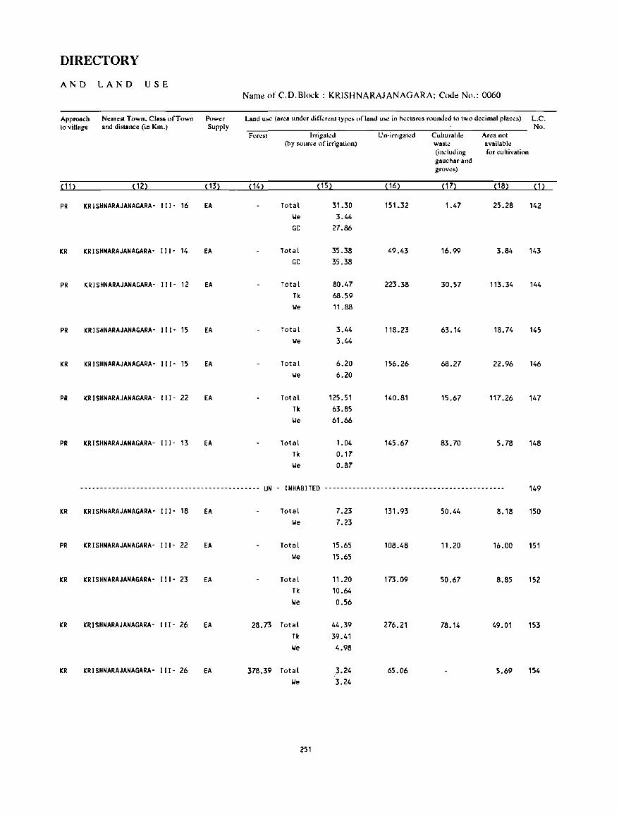
DIRECTORY
AND LAND USE Name of C.D.Block : KRISHNARAJANAGARA; Code No.: 0060
Approach Nearest Town. Class of Town Power Land Ulo<! (arl!a undl!r din;;rl!nttYPI!& ofland U&l! in hectarl!s rounded to Iwo decimal place&) L.C. to village and distance (in Km.) Supply No.
Foresl Irrigated Un-imgated Culturable Area nol (by source of irrigation) waste available
(including for cultivation gauchar and groves)
(11) (12) ( 13) ( 14) (15) ( 16) (17) (18) (1)
PR KRISHNARAJANAGARA- 111- 16 EA Total 31.30 151.32 1.47 25.28 142 We 3.44 GC 27.86
KR KRISHNARAJANAGARA- 111- 14 EA Total 35.38 49.43 16.99 3.84 143 GC 35.38
PR KRISHNARAJANAGARA- 111- 12 EA Total 80.47 223.38 30.57 113.34 144 Tk 68.59 We 11.88
PR KRISHNARAJANAGARA- Ill- 15 EA Total 3.44 118.23 63.14 18.74 145 We 3.44
KR KRISHNARAJANAGARA- 111- 15 EA Total 6.20 156.26 68.27 22.96 146 We 6.20
PR KRISHNARAJANAGARA- 111- 22 EA Total 125.51 140.81 15.67 117.26 147 Tk 63.85 \Ie 61.66
PR KRISHNARAJANAGARA- 111- 13 EA Total 1.04 145.67 83.70 5.78 148 Tk 0.17 \Ie 0.87
._-_.---------------------------------------- UN - INHABITED --------------------------------------------- 149
KR KRISHNARAJANAGARA- 111- 18 EA Total 7.23 131.93 50.44 8.18 150 \Ie 7.23
PR KRISHNARAJANAGARA- 111- 22 EA Total 15.65 108.48 11.20 16.00 151 \Ie 15.65
KR KRISHNARAJANAGARA- 111- 23 EA Total 11.20 173.09 50.67 8.85 152 Tk 10.64 \Ie 0.56
KR KRISHNARAJANAGARA- 111- 26 EA 28.73 Total 44.39 276.21 78.14 49.01 153 Tk 39.41 \Ie 4.98
KR KRISHNARAJANAGARA- Ill- 26 EA 378.39 Total 3.24 65.06 5.69 154 I
\Ie 3.24
251
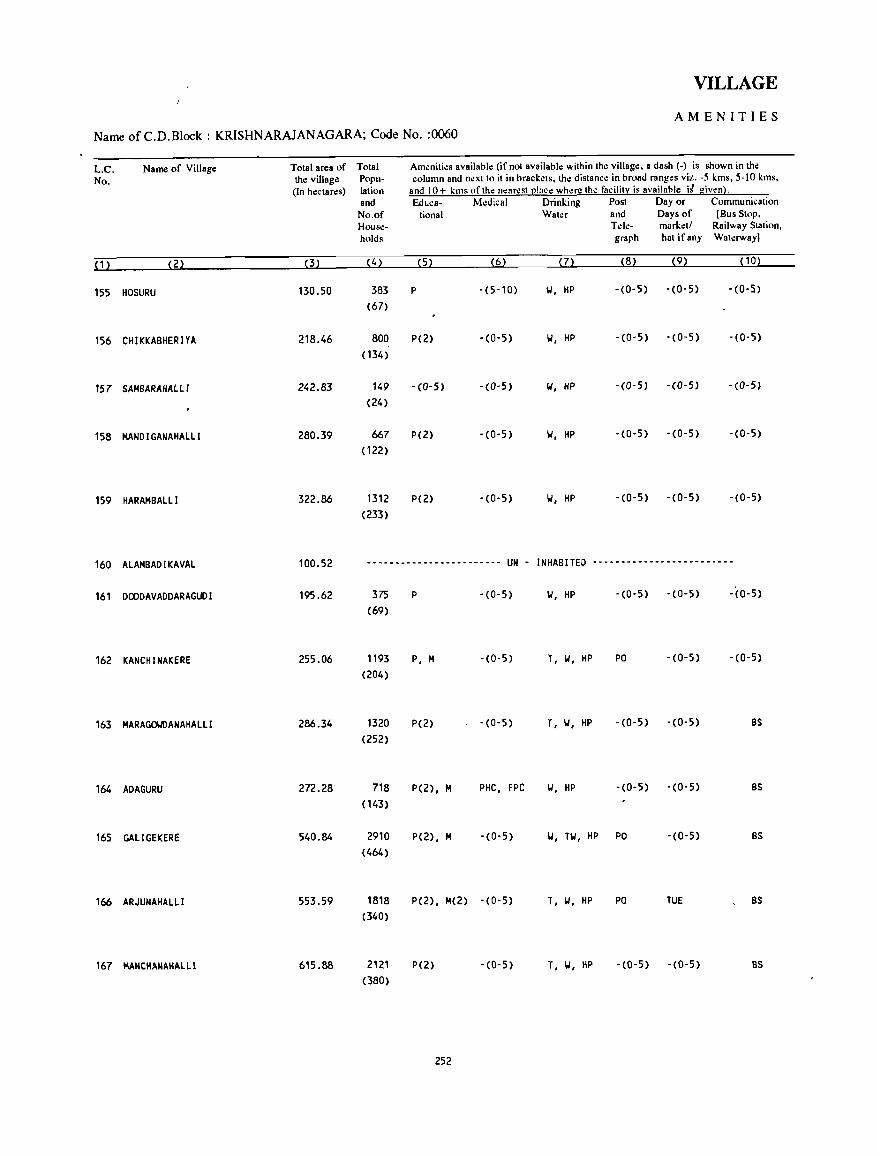
VILLAGE
AMENITIES
Name of C.D.Block : KRISHNARAJANAGARA; Code No. :0060
L.e. Name of Village Total area of Total Amenities available (if not available within the village. a dash (-) is shown in Ihe
No. Ihe village Popu- column and next 10 it in brackets. Ihe distance in broad ranges viz. -5 kms. 5-10 kms. (In hectares) iation and 10+ kms of the near.::st [!Iace where the facility is availahle i~ giwn}.
and Educa- Medical Drinking Post Day or Communication No.of tional Water and Days of [Bus Stop. House- Tele- market/ Railway Station. holds graph hat if any Waterway)
( 1 ) (2) (3) (4) (5) (6) (7) (8) (9) (10)
155 HOSURU 130.50 383 P -(5-10) ... , HP -(0-5) -(0-5) -(0-5)
(67)
156 CHIKKABHERIYA 218.46 800 P(2) -(0-5) W, HP -(0-5) -(0-5) -(0-5)
( 134)
157 SAHBARAHALLI 242.83 149 -(0-5) - (0- 5) W, HP -(0-5) -(0-5) -(0-5)
(24)
158 MAND I GANAHALLI 280.39 667 P(2) -(0-5) 'oJ, HP -(0-5) -(0-5) - (0-5)
( 122)
159 HARAMBAlll 322.86 1312 P(2) -(0-5) 'oJ, HP -(0-5) -(0-5) -(0-5)
(233)
160 AlAMBADI KAVAL 100.52 ------------------------ UN - INHABITED -.----~------------------
161 DOODAVADDARAGUDI 195.62 375 P -(0-5) 'oJ, HP -(0-5) -(0-5) -(0-5)
(69)
162 KANCHINAKERE 255.06 1193 P, M -(0-5) T, 'oJ, HP PO - (0-5) -(0-5)
(204)
163 MARAGO\.Il)ANAHALLI 286.34 1320 P(2) -(0-5) T, 'oJ, HP -(0-5) -(0-5) BS
(252)
164 ADAGURU 272.28 718 P(2), M PHC, FPC 'oJ, HP -(0-5) -(0-5) BS
(143)
165 GALIGEKERE 540.84 2910 P(2), M -(0-5) 'oJ, T'oJ, HP PO -(0-5) BS
(464)
166 ARJUNAHALLI 553.59 1818 P(2), M(2) -(0-5) T, 'oJ, HP PO TUE BS
(340)
167 MANCH"NAIIAlll 615.88 2121 P(2) -(0-5) T, 101, HP -(0-5) -(0-5) BS
(380)
252

DIRECTORY
AND LAND USE Name of C. D. Block : KRISHNARNANAGARA; Code No.: 0060
Approach Nearest Town. Class of Town Pow~r Land u~ (ar~a und~r din;:r~nt typ~s of land u~ in h~ctar~s round~d to two d~cimal plac~s) L.C. to village and distance (in Km.) Supply No.
For~st Irrigat~d U n-irrigat~d Culturabl~ Ar~a not (by sourc~ of irrigation) waMe available
I (including for cultivation gauchar ami grov~s)
(11) (12) (13) (14) (15) (16) (17) (18) (1)
PR KRISHNARAJANAGARA- 111- 24 EA Total 0.70 83.47 1.38 44.95 155 We 0.70
KR KRISHNARAJANAGARA- 111- 22 EA Total 11.65 136.28 50.54 19.99 156 We 11.65
KR KRISHNARAJANAGARA- 111- 20 EA Total 0.92 127.05 105.71 9.15 157 We 0.92
KR KRISHNARAJANAGARA- 111- 20 EA Total 4.07 165.49 103.24 7.59 158 Tk 1.47 We 2.60
PR KRISHNARAJANAGARA- 111- 15 EA Total 12.26 206.09 83.84 20.67 159 Tk 10.62 We 1.64
--------------~------------------------------ UN - INHABITED --------------------------------------------- 160
PR KRISHNARAJANAGARA- 111- 12 EA Total 59.31 38.46 10.58 87.27 161 We 1.62 GC 57.69
PR KRISHNARAJANAGARA- 111- 13 EA Total 128.93 89.26 14.20 22.67 162 We 0.90 GC 128.03
KR KRISHNARAJANAGARA- 111- 14 EA Total 237.17 21.41 27.76 163 We 0.58 GC 236.59
KR KRISHNARAJANAGARA- 111- 13 EA Total 134.72 3.00 3.38 131.18 164 GC 134.72
PR KRISHNARAJANAGARA- 111- 12 EA Total 312.36 7.33 13.20 207.95 165 We 1.66 GC 310.70
PR KRISHNARAJANAGARA- 111- 10 EA Totil l 404.88 93.40 1.09 54.22 166 We 2.56 GC 402.32
PR KRISHNARAJANAGARA- 111- 9 EA Total 363.65 19.09 1.43 231. 71 167 We 2.26 GC 361.39
253
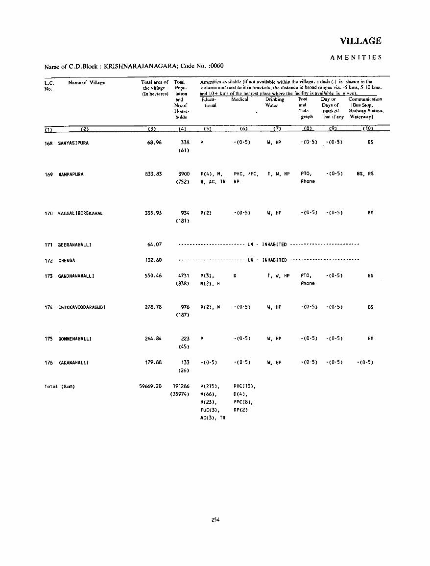
VILLAGE
AMENITIES Name of C.D.Block : KRISHNARAJANAGARA; Code No. :0060
L.C. Name of Village Total area of Total Amenities available (if not available within the village. a dash (-j is shown in the
No. the village p\>pu- column and neKt 10 il in brad; . .:ls, the distance in broad ranges viz. -5 lms, 5-10 kIllS, (In hectares) lalioo and 10+ kms of the near~st [!Iace where the fncilit::: is availahle is giwn).
and Educa- Medical Drinking Pllst Day or Communication No.of tional Wah:r and Days of (Bus SlOP, House- TeJ.:- markdl Railway Station. holds graph hat ifany Waterway)
(1) (2) (3) (4) (5) (6) (7) (8) (9) (10)
168 SANYASI PURA 68.96 338 P -(0-5) IJ, HP -(0-5) -(0-5) BS (61)
169 HAHPAPURA 833.83 3900 P(4), H, PHC, FPC, T, IJ, HP PTO, -(0-5) BS, RS (752) H, AC, TR RP Phone
170 KAGGALIBOREKAVAL 335.93 934 P(2) -(0-5) IJ, HP -(0-5) -(0-5) BS (181)
171 BEERANAHALLl 64.07 ~-.--.-----.~---------~- UN - INHABITED -------------------------
172 CHENGA 132.60 ------------------------ UN - INHABITED -------------------------
173 GANDHANAHALLl 550.46 4731 P(3), 0 T, IJ, HP PTO, -(0-5) BS (838) 14(2) , H Phone
174 CH 1 KKAVODDARAGUD I 278.78 976 P(2), M -(0-5) 'W, HP -(0-5) -(0-5) BS (187)
175 BOMMENAHALLl 264.84 223 P -(0-5) IJ, HP -(0-5) -(0-5) BS (45)
176 I(AKAMAHALLI 179.88 133 -(0-5) -(0-5) IJ, l:IP -(0-5) -(0-5) -(0-5) (26)
Total (SI.III) 59669.20 191286 P(215) , PHC(1~),
(35974) 14(66) , 0(4) , H(23) , FPC(8) , PUC(3), RP(2) AC(3), TR
254
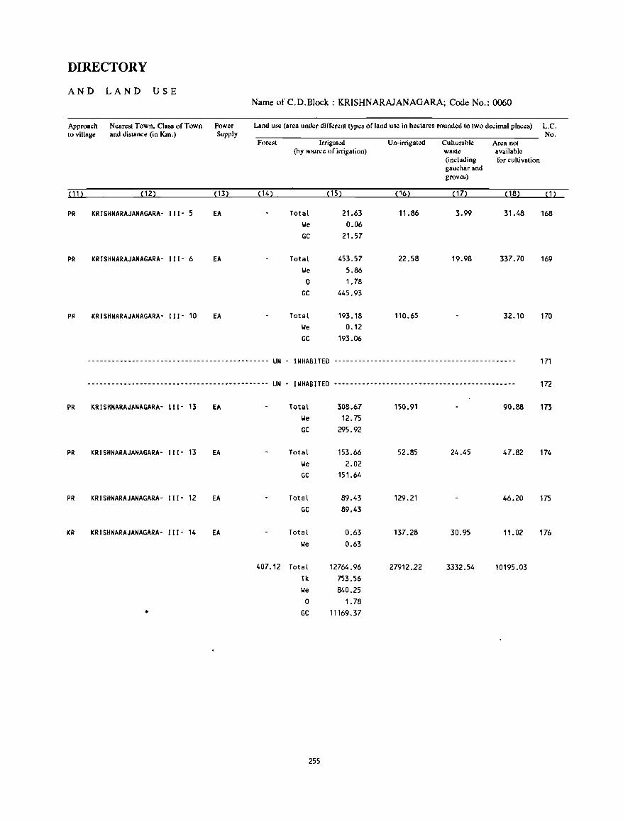
DIRECTORY
AND LAND USE Name of C.D.Block : KRISHNARAJANAGARA; Code No.: 0060
Approach to village
Nearest Town, Class of Town and distance (in Km.)
Power Supply
Land use (area und.:r difl".:n:nt types of land use in hectares rounded to two decimal places)
For.:st lrrigat.:d U n-irrigat.:d Culturable Area not (by source of irrigation) waste available
(including for cultivation gauchar and groves)
(11) (12) (13) ( 14) (15) (16) (17) ( 18)
PR KRISHNARAJANAGARA- 111- 5 EA Total 21.63 11.86 3.99 31.48 We 0.06 GC 21.57
PR KRISHNARAJANAGARA- 111- 6 EA Total 453.57 22.58 19.98 337.70 We 5.86 0 1.78
GC 445.93
PR KRISHNARAJANAGARA- 111- 10 EA Total 193.18 110.65 32.10 We 0.12 GC 193.06
----------------------------------.---------- UN - INHABITED ---------------------------------------------
---- .. ---.-~----------------------.---------- UN - INHABITED --------.---------------------_.-------------
PR KRISHNARAJANAGARA- 111- 13 EA Total 308.67 150.91 90.88 We 12.75 GC 295.92
PR KRISHNARAJANAGARA- " 1- 13 EA Total 153.66 52.85 24.45 47.82 We 2.02 GC 151.64
PR KRISHNARAJANAGARA- " 1- 12 EA Total 89.43 129.21 46.20 GC 89.43
KR KRISHNARAJANAGARA- " 1- 14 EA Total 0.63 137.28 30.95 11.02 We 0.63
407.12 Total 12764.96 27912.22 3332.54 10195.03 Tk 753.56 We 840.25 0 1.78
• GC 11169.37
255
L.C. No.
(1)
168
169
170
171
172
173
174
175
176

MYSORE C.D.BLOCK
NOTE:
The following revenue villages of Mysore taluk which had been assigned location code numbers have smce been classified as Outgrowths of Mysore Urban Agglomeration
L.C.No.
5. 7. 14. 16. 18. 21. 23. 30. 36. 38. 40.
Name of the Village L.C.No.
Nachanahalli 6. Srirampura 13 Malalavadi 15. Bhogadi 17. Maragaudanahalli 19. H utagalli 22. MClagalli 29. Iranagcrc 31. Alanahalli 37. Satagalli 39. Chamundibctta
Name of the Village
Chikkaharadanahalli Datagalli Kukkarahalli Vijayasripura Hinakal Hebbalu Belavata Dcvanur Yaraganahalli Kurubarahalli
Hence these villages do not find a mention in the Alphabetical List of Villages as well as in the Village Dircctory Statement. This explains the gap in location code numbers noticed in the List of Villages and the Village Directory Statement of Mysorc C.D.B1ock.
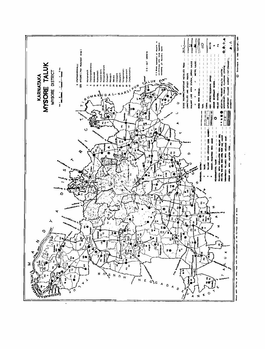
..J I r-' j"j ,'! !:l~: I I' • ~1~11 '0 If I':' { -, o. I LJ L~:
4-
-:z.
o A ()
} J ®
i .. ~ r .ll
l r ~ ., ~ 1;
! i i. ~ ~ • A · • · .,; £ .. i I v · :I
ALPHABETICAL LIST OF VILLAGES
T ALUK: MYSORE-0070 c. D. BLOCK: MYSORE-0070
SL NAME OF THE VILLAGE 1991 CENSUS 1981 CENSUS NO
LOCA TI ON CODE LOCATION CODE LOCATION CODE LOCATION CODE (Manual) (Computer) (Manual) (Computer)
1 2 3 4 5 6
1 Amacttawadi 11/1617/149 11/16/0070/0149 9/15/7/151 09/15/0070/0151 2 Anandur 11/16/7/156 11/16/0070/0156 9/15/7/158 09/15/0070/0158 3 Angalli 11/16/7/103 11/16/0070/0103 9/15/7/105 09/15/0070/0105 4 Aragowdanahalli 11/16/7/42 11/16/0070/0042 9/15/7/44 09/15/0070/0044 5 Arasinakere 11/16/7/87 1.1/16/0070/0087 9/15/7/89 09/15/0070/0089 6 Ayarahall i 11/16/7/45 11/16/0070/0045 9/15/7/47 09/15/0070/0047 7 Ayyajayyanahundi 11/16/7/12 11/16/0070/0012 9/15/7/13 09/15/0070/0013
8 Ballahalli 11/16/7/107 11/16/0070/0107 9/15/7/109 09/15/0070/0109 9 Bandipalya 11/16/7/1 11/16/0070/0001 9/15/7/2 09/15/0070/0002
10 Baradanapura 11/16/7/97 11/16/0070/0097 9/15/7/99 09/15/0070/0099 11 Basayanahalli 11/1617/20 11/16/0070/0020 9/15/7/21 09/15/0070/0021 12 Belayadi 11116/7/129 11/16/0070/0129 9/15/7/131 09/15/0070/0131 13 Bhugathagalli 11/16/7/61 11/16/0070/0061 9/15/7/63 09/15/0070/0063 14 Bonmenahall i 11/16/7/141 11/16/0070/0141 9/15/7/143 09/15/0070/0143 15 Byathahalli 11/1617/118 11/16/0070/0118 9/15/7/120 09/15/0070/0120
16 Chandrabeedu 11/16/7/136 11/16/0070/0136 9/15/7/138 09/15/0070/0138 17 Chatanahall i 11/16/7/66 11/16/0070/0066 9/15/7/68 09/15/0070/0068 18 Chikkahalli 11/16/7/60 11/16/0070/0Q60 9/15/7/62 09/15/0070/0062 19 Chikkakanya 11/16/7/120 11/16/0070/0120 9/15/7/122 09/15/0070/0122 20 Chikkakaturu 11/16/7/122 11/16/0070/0122 9/15/7/124 09/15/0070/0124 21 Chikkanahalli 11/16/7/95 11/16/0070/0095 9/15/7/97 09/15/0070/0097 22 Chikkanahalli 11/16/7/158 11/16/0070/0158 9/15/7/160 09/15/0070/0160 23 Choganahalli 11/1617/79 11/16/0070/0079 9/15/7/81 09/15/0070/0081 24 Cholenahalli 11/16/7/151 11/16/0070/0151 9/15/7/153 09/15/0070/0153 25 Choranahalli 11/16/7/59 11/16/0070/0059 9/15/7/61 09/15/0070/0061 26 Chowdahalli 11/16/7/9 11/16/0070/0009 9/15/7/10 09/15/0070/0010
27 Dadadakallahalli 11/16/7/144 11/16/0070/0144 9/15/7/146 09/15/0070/0146 28 Dadahall i 11/16/7/116 11/16/0070/01-16 9/15/7/118 09/15/0070/0118 29 Dandikere 11/16/7/81 11/16/0070/0081 9/15/7/83 09/15/0070/0083 30 'Daripura 11/16/7/98 11/16/0070/0098 9/15/7/100 09/15/0070/0100 31 Devagahall i 11/16/7/100 11/16/0070/0100 9/15/7/102 09/15/0070/0102 32 Dhanagall i 11/16/7/99 11/16/0070/0099 9/15/7/101 09/15/0070/0101 33 Doddakanya 11/16/7/121 11/16/0070/0121 9/1517/123 09/15/0070/0123 34 Doddakathru 11/16/7/123 11/16/0070/0123 9/15/7/125 09/15/0070/0125 35 Ooddamaragowdanahall i 11/16/71138 11/16/0070/0138 9/15/7/140 09/15/0070/014Q 36 Doora 11/16/7/85 11/16/0070/0085 9/15/7/87 09/15/0070/0087 37 Duddagere 11/16/7/75 11/16/0070/0075 9/15/7/77 09/15/0070/0077 38 Dyayalapura 11/16/7/54 11/16/0070/0054 9/15/7/56 09/15/0070/0056
39 Elwala 11/16/7/127 11/16/0070/0127 9/15/7/129 09/15/0070/0129
259
ALPIIABETICAL LIST OF VILLAGES
T ALUK: MYSORE-0070
SL NAME OF THE VILLAGE NO
2
40 Gohalli 41 Gopalapura 42 Gudumadanahalli 43 Gujjegowdanapura 44 Gumachanahalli 45 Gungralchatra 46 Gurur
47 Hadajana 48 Halalu 49 Hanchya 50 Haroha II i 51 Harohall i 52 Hongate 53 Hosaha t l j
54 Hosahundi 55 Hosakote 56 Hunnavalli 57 Hyi lalu
58 Inam-Uthanahalli
59 Jantagalli 60 Jattihundi 61 Javanahall i 62 Jayapura
63 K.Hemmanhalli 64 Kadakola 65 Kadanaha II i 66 Kalalavadi 67 Kalasthavadi 68 Ka It aha II i
69 Kallahalli 70 Kallinathanapura 71 Kallurnaganahalli 72 Kallurnaganahalli Kaval 73 Kamaravalli 74 Karakanhall i 75 Keelanapura 76 Kemmannupura 77 Kenchalagudi 78 Kergall i 79 Kesare 80 Kiralu
C. D. BLOCK: MYSORE-0070
1991 CENSUS 1981 CENSUS
LOCATION CODE
(Manual)
3
"/16/7/133
11/16/7/102
11/16/7/52
11/16/7/90
11/16/7/94
11/16/7/145
11/16/7/8
11/16/7/53
11/16/7/10
11/16/7/34
11/16/7/63
11'/16/7/91
11/16/7/74
11/16/7/71
11/16/712
11/16/7/152
11/16/7/147
11/16/7/128
11/16/7/68
11/16/7/44
11/16/7/132
11/16/7/105
11/1617/82
11/16/7/131
11/16/7/117
11/1617/88 11/16/7/115
11/1617127 11/1617/93 11/16/7/126
11/16/7/164
11/16/7/154
11/16/7/155
11/16/7/139
11/16/7/160
11/16/7/72
11/16/7/108
11/16/7/113
11/16/7/110
11/16/7/32
11/16/7/77
LOCATION CODE LOCATION CODE LOCATION CODE
(Computer) (Manual) (Computer)
4
11/16/0070/0133
11/16/0070/D102
11/16/0070/0052
11/16/0070/0090
11/16/0070/0094
11/16/0070/0145
11116/0070/0008
11/16/0070/0053
11/16/0070/0010
11/16/0070/0034
11/16/0070/0063
11/16/007010091
11/16/0070/0074
11/16/0070/0071
11/16/0070/0002
11/16/0070/0152
11/16/0070/0147
11/16/0070/0128
11/16/0070/0068
11/16/0070/0044
11/16/0070/0132
11/16/0070/0105
11/16/0070/0082
11/16/0070/0131
11/16/0070/0117
11/16/0070/0088
11/16/0070/0115
11/16/0070/0027
11/16/0070/0093
11/16/0070/0126
11/16/0070/0164
11/16/0070/0154
11/16/0070/0155
11/16/0070/0139
11/16/0070/0160
11/16/0070/0072
11/16/0070/0108
11/16/0070/0113
11/16/0070/0110
11/16/0070/0032
11/16/0070/0077
260
5
9/15/7/135
9/15/7/104
9/15/7/54
9/15/7/92
9/15/7/96
9/15/7/147
9/15/7/9
9/15/7/55
9/15/7/1 1
9/15/7/35
9/15/7/65
9/15/7/93
9/15/7/76
9/15/7/73
9/15/7/3
9/15/7/154
9/15/7/149
9/15/7/130
9/15/7/70
9/15/7/46
9/15/7/134
9/15/7/107
9/15/7/84
9/15/7/133
9/15/7/119
9/15/7/90
9/15/7/117
9/15/7/28
9/15/7/95
9/15/7/128
9/15/7/167
9/15/7/156
9/15/7/157
9/15/7/141
9/15/7/162
9/15/7/74
9/15/7/110
9/15/7/115
9/15/7/112
9/15/7/33
9/15/7/79
6
09/15/0070/0135
09/15/0070/0104
09/15/0070/0054
09/15/0070/0092
09/15/0070/0096
09/15/0070/0147
09/15/0070/0009
09/15/0070/0055
09/15/0070/0011
09/15/0070/0035
09/15/0070/0065
09/15/0070/0093
09/15/0070/0076
09/15/0070/0073
09/15/0070/0003
09/15/0070/0154
09/15/0070/0149
09/15/00lj/0130
09/15/0070/0070
09/15/0070/0046
09/15/0070/0134
09/15/0070/0107
09/15/0070/0084
09/15/0070/0133
09/15/0070/0119
09/15/0070/0090
09/15/0070/0117
09/15/0070/0028
09/15/0070/0095
09/15/0070/0128
09/15/0070/0167
09/15/0070/0156
09/15/0070/0157
09/15/0070/0141
09/15/0070/0162
09/15/0070/0074
09/15/0070/0110
09/15/0070/0115
09/15/0070/0112
09/15/0070/0033
09/15/0070/0079
ALPHABETICAL LIST OF VILLAGES
T ALUK: MYSORE-0070
SL NAME OF THE VILLAGE
NO
81 Kochanahalli 82 Komarabidu 83 Koodanahalli 84 Koorga II i 85 Kumbarahall i 86 Kuppaluru 87 Kuppegala 88 Kutanahalli
89 Lalithadripura 90 Laxmipura 91 Lingambudi
92 Madagalli 93 Madahalli 94 Madapura 95 Madaragall i 96 Maddur 97 Madhavagere 98 Mallahall i 99 Mandakalli
100 Mandanahalli 101 Manikyapura 102 Marase 103 Marasettihalli
2
104 Maratikyathanahalli 105 Marball i 106 Mavinahalli 107 Megalapura 108 Megalapura 109 Mosambayanahalli 110 Mullur 111 Murudagalli 112 Mydanahall i
113 Nadanahalli 114 Naganahalli 115 Nagarthahalli 116 Nagawala 117 Nandga L l ; 118 Nuggahal l i
119 Pillahatli 120 Puttegowdanahundi
C. D. BLOCK: MYSORE-0070
1991 CENSUS 1981 CENSUS
LOCATION CODE
(Manual)
3
11/16/7/48
11/16/7/134
11/16/7/49
11/16/7/165
11/16/7/46
11/16/7/4
11/16/7/69
11/16/7/78
11/1617/57
11/16/7/26
11/1617/11
11/16/7/130
11/16/7/104
11/16/7/43
11/16/7/50
11/16/7/92
11/16/7/67
11/16/7/106
11/16/7/3
11/16/7/89
11/16/7/140
11/16/7/51
11/16/7/55
11/16/7/109
11/16/7/84
11/16/7/96
11/16/7/73
11/16/7/161
11/16/7176
11/16/7/101
11/16/7/125
11/16/7/162
11/16/7/35
11/16/7/25
11/16/7/111
11/16/7/142
11/l6/7/86
11/16/7/137
11/16/7/80
11/16/7/65
LOCATION CODE LOCATION CODE LOCATION CODE
(Computer) (Manual) (Computer)
4
11/16/0070/0048
11/16/0070/0134
11/16/0070/0049
11/16/0070/0165
11/16/0070/0046
11/16/0070/0004
11/16/0070/0069
11/16/0070/0078
11/16/0070/0057
11/16/0070/0026
11/16/0070/0011
11/16/0070/0130
11/16/0070/0104
11/16/0070/0043
11/16/0070/0050
11/16/0070/0092
11/16/0070/0067
11/16/0070/0106
11/16/0070/0003
11/16/0070/0089
11/16/0070/0140
11/16/0070/0051
11/16/0070/0055
11/16/0070/0109
11/16/0070/0084
11/16/0070/0096
11/16/0070/0073
11/16/0070/0161
11/16/0070/0076
11/16/0070/0101
11/16/0070/0125
11/16/0070/0162
11/16/0070/0035
11/16/0070/0025
11/16/0070/0111
11/16/0070/0142
11/16/0070/0086
11/16/0070/0137
11/16/0070/0080
11/16/0070/0065
261
5
9/15/7/50
9/15/7/136
9/15/7/51
9/15/7/165
9/15/7/48
9/15/7/5
9/15/7/71
9/15/7/80
9/15/7/59
9/15/7/27
9/15/7/12
9/15/7/132
9/15/7/106
9/15/7/45
9/15/7/52
9/15/7/94
9/15/7/69
9/15/7/108
9115/7/4
9/15/7/91
9/15/7/142
9/15/7/53
9/15/7/57
9/1517/111
9/15/7/86
9/15/7/98
9/15/7/75
9/15/7/163
9/15/7/78
9/15/7/103
9/15/7/127
9/15/7/164
9/15/7/36
9/15/7/26
9/15/7/113
9/15/71144
9/l5/7/88
9/15/7/139
9/15/7/82
9/15/7/67
6
09/15/0070/0050
09/15/0070/0136
09/15/0070/0051
09/15/0070/0165
09/15/0070/0048
09/15/0070/0005
09/15/0070/0071
09/15/0070/0080
09/15/0070/0059
09/15/0070/0027
09/15/0070/0012
09/15/0070/0132
09/15/0070/0106
09/15/0070/0045
09/15/0070/0052
09/15/0070/0094
09/15/0070/0069
09/15/0070/0108
09/15/0070/0004
09/15/0070/0091
09/15/0070/0142
09/15/0070/0053
09/15/0070/0057
09/15/0070/0111
09/15/0070/0086
09/15/0070/0098
09/15/0070/0075
09/15/0070/0163
09/15/0070/0078
09/15/0070/0103
09/15/0070/0127
09/15/0070/0164
09/15/0070/0036
09/15/0070/0026
09/15/0070/0113
09/15/0070/0144
09/15/0070/0088
09/15/0070/0139
09/15/0070/0082
09/15/0070/0067
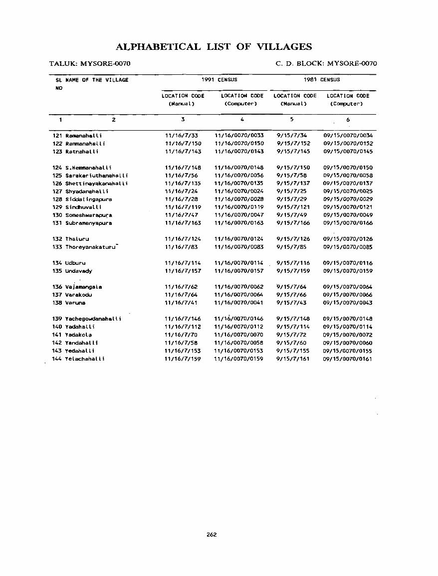
ALPHABETICAL LIST OF VILLAGES
T ALUK: MYSORE-0070
SL NAME OF THE VILLAGE NO
121 RamanahaL li 122 Ranmanahal t i 123 Ratnahal L i
124 S.Hemmanahalli
2
125 Sarakariuthanahalli 126 Shettinayakanahalli 127 Shyadanahalli 128 Siddalingapura 129 Sindhuvall i 130 Someshwarapura 131 Subramanyapura
132 Thaluru 133 Thoreyanakaturu·
134 Udburu 135 Undavady
136 Vajamangala 137 Varakodu 138 Varuna
139 Y achegowclanaha II i 140 Yadahall i 141 Y&dakola 142 Yandahall i 143 Yedahall i 144 Yelachahalli
C. D. BLOCK: MYSORE-0070
1991 CENSUS 1981 CENSUS
LOCATION CODE (ManuaL)
3
11/1617/33
11/16/7/150 11/16/7/143
11/16/7/148 11/1617/56
11/1617/135 11/16/7/24 11/1617/28
11/16/71119 11/16/7/47 11/16/7/163
11/16/71124
11/16/7/83
11/16/71114
11/16/7/157
11/16/7162 11/16/1/64 11/16/7141
11/16/1/146 11/16/7/112 11/16/7/70 11/16/7158
11/16/7/153 11/16/7/159
LOCATION CODE LOCATION CODE LOCATION CODE (Computer) (ManuaL) (Computer)
4
11/t6/0070/0033 11/16/0070/0150 11/16/0070/0143
11/16/0070/0148 11/16/0070/0056 11/16/0070/0135 11/16/0070/0024 11/16/0070/0028 11/16/0070/0119 11/16/0070/0047 11/16/0070/0163
11/16/0070/0124 11/16/0070/0083
11/1.6/0070/0114 11/16/0070/0157
11/16/0070/0062 11/16/0070/0064 11/16/0070/0041
11/16/0070/0146 11/16/0070/0112 11/16/0070/0070 11/16/0070/0058 11/16/0070/0153 11/16/0070/0159
262
5
9/15/7/34 9/15/7/152 9/15/7/145
9/15/7/150 9/15/7/58 9/15/7/137 9/15/7/25 9/15/7/29 9/15/1/121 9/15/7/49 9/15/7/166
9/15/7/126 9/1517/85
9/15/1/116 9/15/7/159
'9/15/7/64 9/15/7/66 9/15/1/43
9/1517/148
9/15/7/114 9/15/7/72 9/15/7/60 9/15/7/155 9/15/7/161
6
09/15/0070/0034 09/15/0070/0152 09/15/0070/0145
09/15/0070/0150 09/15/0070/0058 09/15/0070/0137 09/15/0070/0025 09/15/0070/0029 09/15/0070/0121 09/15/0070/0049 09/15/0070/0166
09/15/0070/0126 09/15/0070/0085
09/15/0070/0116 09/15/0070/0159
09/15/0070/0064 09/15/0070/0066 09/15/0070/0043
09/15/0070/0148 09/15/0070/0114 09/15/0070/0072 09/15/0070/0060 09/15/0070/0155 09/15/0070/0161
MYSORE C.D.BLOCK
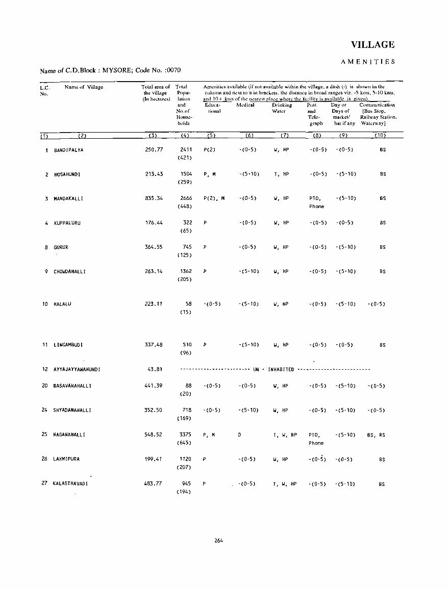
VILLAGE
AMENITIES Name of C.D.Block : MYSORE; Code No. :0070
L.C. Name of Village Total area of Total Amenities availab!l! (if not available within the village. a dash (-) is shown in the
No. the village Popu- column and next to it in brackets. the distance in broad ranges viz. -5 kms, 5-10 kms, (In hectares) lation and 10+ kills of the nearest ~Jace where the facility is availahle is given).
and &lllea- Medieal Drinking Post Day or COlnlnunication No.of tional Water and Days of [Bus Stop. House- Tde- market/ Railway Station. holds graph hat if any Waterway]
( 1 ) (2) (3) (4) (5) (6) (7) (8) (9) ( 1 0)
BANDIPALYA 250.77 2411 P(2) -(0-5) 'W. HP -(0-5) -(0-5) BS
(421)
2 HOSAHUNDI 213.43 1504 p. M -(5-10) T. HP -(0-5) -(5-10) BS
(259)
3 MANDAKALLI 835.34 2666 P(2) • M -(0-5) 'W. HP PTO. -(5-10) BS
(448) Phone
4 KUPPALURU 176.44 322 P -(0-5) 1.1. HP -(0-5) -(0-5) BS
(65)
8 GURUR 364.55 745 P -(0-5) 'W. HP -(0-5) -(5-10) BS
(125 )
9 CHO'WDAHALLI 263.14 1362 P -(5-10) 'W. HP -(0-5) -(5-10) BS
(205)
10 HALALU 223.11 58 -(0-5) -(5-10) 'W. HP -(0-5) -(5-10) -(0-5) (15)
11 LINGAMBUDI 337.48 510 P -(5-10) 'W. HP -(0-5) -(0-5) BS
(96)
12 AHAJAYYANAHUNDI 43.81 ------------------------ UN - INHABITED -------------------------
20 BASAVANAHALLI 441.39 88 -(0-5) -(0-5) 'W. HP -(0-5) -(5-10) -(0-5) (20)
24 SHYADANAHALLI 352.50 718 -(0-5) -(5-10) 'W. HP -(0-5) -(5-10) -(0-5) (169)
25 NAGANAHALLI 548.52 3375 p. M D T. 'W. HP PTO. -(5-10) BS. RS
(645) Phone
26 LAXMIPURA 199.41 1120 P -(0-5) 'W. HP -(0-5) -(0-5) BS
(207)
27 KALASTHAVADI 483.77 945 P -(0-5) T. 'W. HP -(0-5) -(5-10) BS
(194)
264
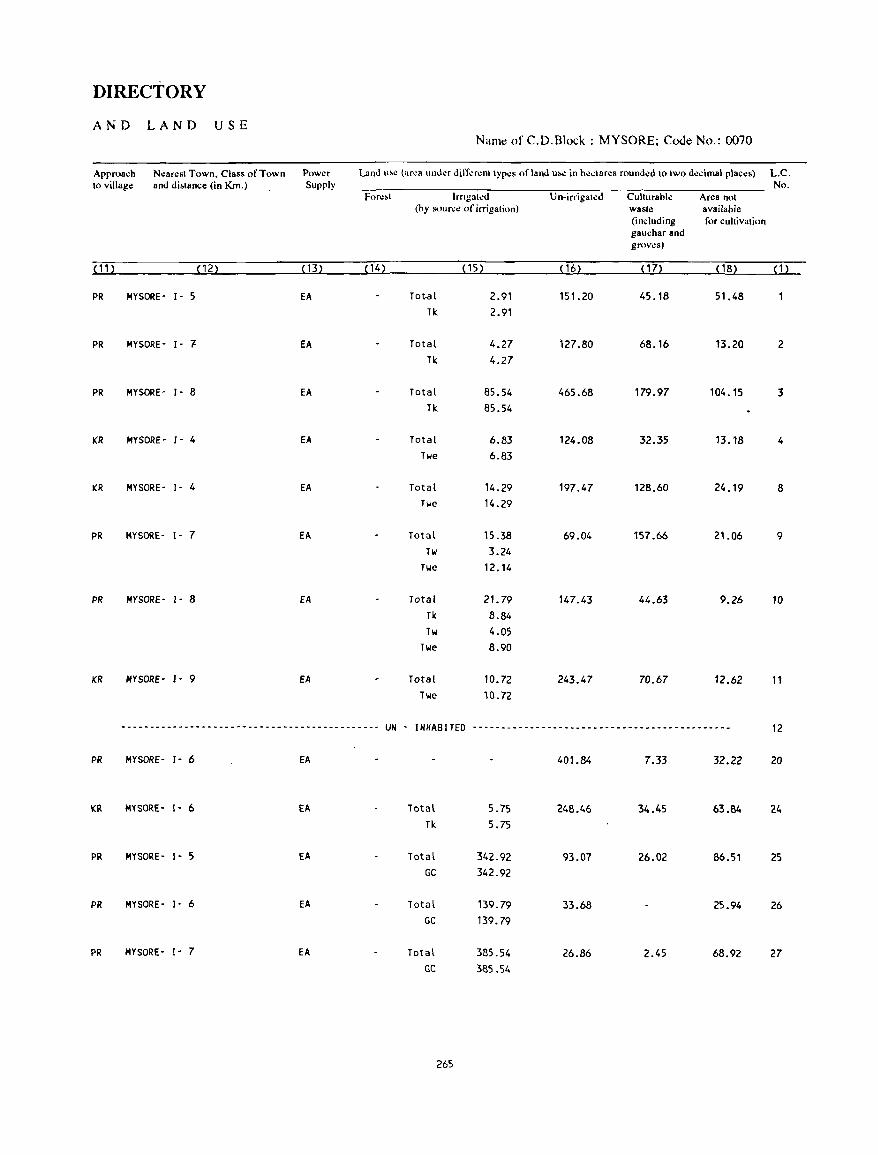
DIRECTORY
AND LAND USE Name of C.D.Block : MYSORE; Code No.: 0070
Approach Nearest Town. Class of Town Power Land u~e (area IInder differ"m types of land 11M! in hectares rounded 10 two decimal places) L.C. to village and di&tance ~in Km.) Supply No.
For",t lrngal..:d Un-irrigated Culturable Area not (by source of irrigation) waste available
(including for cultivation gauchar and groves)
(11) (12) (13) ( 14) (15) ( 16) (17) ( 18) (1)
PR MYSORE- 1- 5 EA Tot-a I 2.91 151.20 45.18 51.48 Tk 2.91
PR MYSORE- 1- .., EA Total 4.27 127.80 68.16 13.20 2 Tk 4.27
PR MYSORE- 1- 8 EA Total 85.54 465.68 179.97 104_15 3 Tk 85.54
KR MYSORE- J- 4 EA Total 6.83 124.08 32.35 13_18 4 Twe 6.83
KR MYSORE- 1- 4 EA Total 14.29 197.47 128.60 24.19 8 Twe 14.29
PR MYSORE- 1- 7 EA Total 15.38 69.04 157.66 21.06 9 Tw 3.24
Twe 12.14
PR MYSORE- 1- 8 EA Total 21. 79 147.43 44.63 9.26 10 Tk 8.84 Tw 4.05
Twe 8.90
KR MYSORE- J- 9 EA Total 10.72 243.47 70.67 12.62 11 Twe 10.72
.-------------------------------------------~ UN - INHABITED --------------------------------------------- 12
PR MYSORE- 1- 6 EA 401.84 7.33 32.22 20
KR MYSORE- 1- 6 Ell. Total 5.75 248.46 34.45 63.84 24 Tk 5.75
PR MYSORE- 1- 5 EA Total 342.92 93.07 26.02 86.51 25 GC 342.92
PR MYSORE- ]- 6 Ell. Total 139.79 33.68 25.94 26 GC 139.79
PR MYSORE- I- 7 EA Total 385.54 26.86 2.45 68.92 27 GC 385.54
265
VILLAGE
AMENITIES Name of C.D.Block : MYSORE; Code No. :0070
L.C. Name of Village Total area of Total Amenities available (if not available within the village, a dash (-) is shown in the No. the village Popu- column and next to it in brackets, the distance in broad ranges viz. -5 "'ms, 5-10 "'ms,
(In hectares) lation and 10+ kms of the nearest [!Iace where the facilitl: is availahle is given}. and Educa- Medical Drinking Post Day or Communication No.of tional Water and Days of [Bus Stop, House- Tele- marketl Railway Station, holds graph hat ifany Waterway)
(1 ) (2) (3) (4) (5) (6) (7) (8) (9) ( 10)
28 SIDDALlNGAPURA 73.06 2349 P(3) , H, H -(0-5) T, 101, HP PO, -(0-5) BS (476) Phone
32 KESARE 998.19 3950 P(2), -(0-5) T, HP PTO, -(5-10) BS (824) H(2), H Phone
33 RAHANAHALLI 576.53 6531 P(2), H -(5-10) T, HP PTO, -(5-10) BS (1145 ) Phone
34 HANCHYA 961.08 1660 P(2), H PHC, FPC T, HP -(5-10) -(5-10) as (297)
35 NADANAHALLI 254.05 1244 P -(5-10) 101, HP -(5-10) -(5-10) BS (243)
41 VARUNA 554.89 1826 P, H PHC 101, HP PO -(10+) BS (327)
42 ARAGOWDANAHALLI 142.88 ----~------------------- UN - INHABITED -------------------------
43 MADAPURA 178.46 ------------------------ UN - INHABITED -------------------------
44 JANTAGALLI 557.74 996 P(2) - (0-5) 101, HP -(0-5) - (10+) BS (197)
45 AYARAHALLI 1179.25 2996 P(3), H -(0-5) T, HP PO - (10+) BS (557)
46 f(UMBARAHALLI 267.84 122 P -(0-5) 101, HP -(0-5) -(10+) -(0-5) (26)
~
47 SOHESHYARAPURA 570.38 2748 P(3), M -(0-5) T, HP PTO, -00+) BS (512) Phone
48 KOCHANAHALLI 351.48 1163 P -(0-5) Y, HP -(0-5) -(10+) BS (184)
49 f(OOOANAHAllI 501..98 2180 P(2), H -(0-5) T, HP -(0-5) -(10+) 8S (384)
50 HADARAGALLI 307.06 129 -(0-5) -(0-5) 101, HP -(0-5) -(5-10) -(0-5) (27)
266
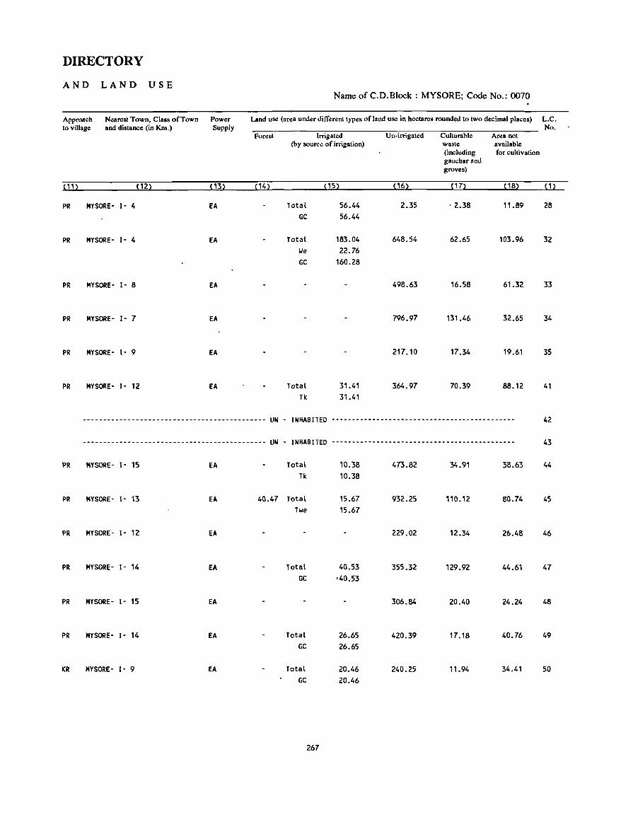
DIRECTORY
AND LAND USE Name of C.D.Block : MYSORE; Code No.: 0070
Approach Nearest Town, Class of Town Power Land use (area under different types of land use in hectares rounded to two decimal places) L.C. to village and distance (in Km.) Supply No.
Forest Irrigated Un-irrigated Cullurable Area not (by source of irrigation) waste available
(including for cultivation gauchar and groves)
(11) (12) <B) (14) OS) (16) (17) (18) (1)
PR MYSORE- 1- 4 EA Total 56.44 2.35 . 2.38 11.89 28 GC 56.44
PR MYSORE- 1- 4 EA Total 183.04 648.54 62.65 103.96 32 lJe 22.76 GC 160.28
PR MYSORE- 1- 8 EA 498.63 16.58 61.32 33
PR MYSORE- 1- 7 EA 796_97 131.46 32.65 34
PR MYSORE- 1- 9 EA 217.10 17.34 19.61 35
PR MYSORE- 1- 12 EA Total 31.41 364.97 70.39 88.12 41 Tk 31.41
--------------------------------------------- UN - INHABITED --------------------------------------------- 42
--------------------------------------------- UN - INHABITED --------------------------------------------- 43
PR MYSORE- 1- 15 EA Total 10.38 473.82 34.91 38.63 44 Tk 10.38
PR MYSORE- 1- 13 EA 40.47 Total 15.67 932.25 110.12 80.74 45 Twe 15.67
PR MYSORE- 1- 12 EA 229.02 12.34 26.48 46
PR MYSORE- 1- 14 EA Total 40.53 355.32 129.92 44.61 47 GC '40.53
PR MYSORE- 1- 15 EA 306.84 20.40 24.24 48
PR MYSORE- 1- 14 EA Total 26.65 420.39 17.18 40.76 49 GC 26.65
KR HYSORE- 1- 9 EA Total 20.46 240.25 11.94 34.41 50 GC 20.46
267
VILLAGE
AMENITIES Name of C.D.Block : MYSORE; Code No. :0070
LC Name of Village Tolal area of TOldl Am~nlll~~ avaIldhl~ (II nnl avaIlabk WllhIn Ih~ villag~. a da,h (-) 1& &hown In Ihe No. the villag.: Popu- <olumn and n~xll() II In hrad.~I&. Ihe dl'lan<.: 111 hroad ranges Vl.l: -5 lms. 5-10 lms.
(In hecla res) lallon and 10+ llll' oflh~ n~ar~'1 ~Ia,~ where the fauhl:t I' aVdIlahle " given) and Eduea- MedICal Dnnl11lg Po,1 Day or Commulllealion No of h,mdl Waler and Days of [Bus Slop. Hou~- Tele- marlet! Railway Slat IOn. hold& graph hal If any Waterway)
(1) (2) (3) (4) (5 ) (6) ( 7) (8) (9) (10)
51 MARASE 332.16 474 P -(0-5) 1.1, HP - (0- 5) -(10+) BS (93)
52 GUDUMADANAHALL! 179.71 615 P, M -(0-5) 1.1, HP -(0-5) - (10+) BS (112)
53 HADAJANA 522.21 1866 P(2) -(0-5) 1.1, HP PO - (10+) BS (331)
54 D'fAVALAPURA 344.20 1533 P(2), M, H 0 T, HP PO, - (10+) BS (259) Phone
55 MARASETT I HALL! 418.53 1143 P(2) - (0-5) 1.1, HP -(5-10) -(10+) BS (215)
56 SARAKARIUTHANAHAllI 581.61 1588 P, M -(0-5) 1.1, HP -(0-5) -(5-10) as (284)
57 LALITHADRIPURA 413.24 3114 P, M, H -(5-10) T, HP PTa, -(5-10) BS (541) Phone
58 'fANDAHALL! 336.67 671 P -(0-5) 1.1, HP -(0-5) - (10+) -(0-5) (125 )
59 CHORANAHALLI 226.11 1764 P -(0-5) T, HP -(0-5) -(5-10) -(0-5) (326)
60 CH I KKAHALL! 268.03 1493 P -(0-5) 1.1, HP -(0-5) -(5-10) as (257)
61 BHUGATHAGALLI 403.39 1384 P, M -(5-10) 1.1, HP -(5-10) -(5-10) BS (239)
62 VAJAMANGALA 959.31 3735 P(2), M ·(0-5) T, HP PTa, -(10+) as (662) Phone
63 HAROHALLI 2497.75 6835 P(4), M, H PHC, FPC T, HP PTa, -(10+) BS (1296) Phone
64 VARAKOOU 1632.16 3911 P(4), M - (0-5) T, HP PTO, -(10+) BS (710) Phone
65 PUTTEGOI.IDANAHUNDI 163.72 910 P, M -(0-5) 1.1, HP -(0-5) -(10+) BS ( 160)
268
DIRECTORY
AND LAND USE Namt: of C.D.Block : MYSORE; Code No.: 0070
Approach Nearest Town: Class of Town Power Land U'e (area under dift"':Nnt types of land use in heclares rounded 10 two decimal places) L.C. to village and distance (in Km.) Supply No.
Forest Irrigated Un-irrigated Culturahle Area not (by source of irrigation) waste available
(including for cultivation gaucnar and groves)
(11) (12) ( 13) ( 14) (15) (16) (17) ( 18) (1)
PR MYSORE- , - 12 EA Total 53.36 249.10 4.85 24.85 51 GC 53.36
PR MYSORE - ,- 10 EA Total 20.88 123.72 31.32 3.79 52 GC 20.88
PR MYSORE - ,- 10 EA Total 8.73 425.79 55.23 32.46 53 Tk 8.73
PR MYSORE- ,- 12 EA 310.16 0.60 33.45 54
PR MYSORE- 1- 12 EA 368.81 11.78 37.94 55
PR MYSORE- ,- 10 EA Total 2.02 422.74 109.33 47.52 56
Twe 2.02
PR MYSORE- ,- 8 EA 118.70 Total 7.95 311.00 9.06 107.13 57
Tw 7.95
PR MYSORE- ,- 13 EA Total 1.28 285.54 27.65 22.20 58
0 1.28
PR MYSORE- ,- 10 EA 178.19 29.08 18.84 59
PR MYSORE- ,- 8 EA Total 8.27 224.81 12.46 22.49 60
Twe 8.27
PR MYSORE - ,- 10 EA 336.26 27.42 39.71 61
PR MYSORE- ,- 12 EA Total 1.25 793.69 91.21 73.16 62
Twe 1.25
PR BMIWUR- 1'1- 10 EA lotal 401.36 1220.01 616.49 259.B9 63
GC 401.36
PR MYSORE- 1- 18 EA 57.53 Total 37.44 1193.68 217.39 126.12 64
Tk 37.44
PR MYSORE- 1- 18 EA 4.86 Total 2.20 95.29 61.37 65
Tiole 2.20
269

· VILLAGE
AMENITIES Name of C.D.Block : MYSORE; Code No. :0070
L.C. Name of Village Total area of Total Am.:niti.:s availabl.: (if not available within th.: village, a dash (.) is shown in the No. the village Popu· column and n.:xt to it in brackets, th.: distance in broad ranges viz. ·5 kms, 5-10 kms,
(In hectares) lation and 10+ kms of the nearest [!lace where the facility is available is given}. and &luca· M.:dical Drinking Post Day or . Communication No.of tiona I Wat.:r and Days of (Bus Stop, Hous.:· T.:le· marketl Railway Station, holds graph hat. if any Wat.:rwayJ
(1) (2) (3) (4) (5 ) (6) (7) (8) (9) (10)
66 CHATANAHALLI 729.85 1197 P(2), H -(0-5) W, HP -(0-5) -(10+) 8S (202)
67 HADHAVAGERE 322.56 616 P -(0-5) W, HP -(0-5) -(10+) BS ( 104)
68 I NAH-UTHANAHALL I 633.70 1137 P(2) -(0-5) w, HP -(0-5) -(5-10) BS ( 195)
69 KUPPEGALA 439.96 2587 P(2), H -(0-5) T, HP -(0-5) - etO+) BS (517)
70 YADAKOLA 708.07 4246 P(6), H, H PHC, FPC T, HP PTO, -(10+) BS (793) Phone
71 HOSAHALLI 488.03 698 P -(0-5) W, HP -(0-5) -(10+) BS (130)
72 KEELANAPURA 250.53 1028 P, H, H PHC, FPC W, HP fO -(10+) BS (181 )
73 HEGALAPURA 173.46 715 P -(0-5) W, HP -(0-5) -(10+) 'i>- BS (120)
74 HONGATE 94.10 69 -(0-5) -(0-5) W, HP -(0-5) -(0-5) -(0-5) ( 13)
75 DUDDAGERE 666.79 1638 P(2)"H -(0-5) T, HP PO -(10+) BS (300)
76 HOSAHBAYANAHALLI 218 •. 64 1280 P, H -(0-5) T, HP -(0-5) -(10+) BS (226)
77 KIRALU 501.70 1188 P -(0-5) W, HP -(0-5) -(10+) BS (219)
78 KUTANAHALLI 86.41 -------~----~----------- UN INHABITED -------------------------
79 CHOGANAHALLI 295.28 ------- •..... ---- ..•.• -- UN . INHABITED -------------------------
80 PILLAHALLI 276.29 894 P(2) -(0-5) W, HP -(0-5) '(10+) BS (167)
270
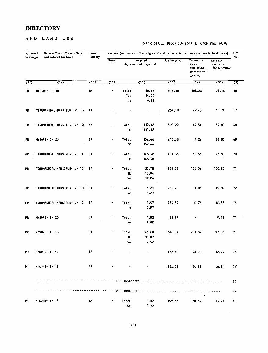
DIRECTORY
AND LAND USE Name of C.D.Block : MYSORE; Code No.: 0070
Approach Nearest Town, Class of Town Power Land use (area under dilT~rent types of land use in hectares rounded to two decimal places) L.C. to village and distance (in Km.) Supply No.
Forest Irrigated Un-irrigated Culturable Area not (by source of irrigation) waste available
(including for cultivation gauchar and groves)
(11) (12) (13) (14) =(15) (16) .( 17) ( 18) (1)
PR MYSORE- 1- 18 EA Total 20.18 516.26 168.28 25.13 66 Twe 14.00 \Ie 6.18
PR TIRUMAKUOAL-NARSIPUR' V· 13 EA 254.19 49.63 18.74 67
PR TIRUMAKUOAL·NARSIPUR· V' 10 EA Total 112.12 392.22 69.54 59.82 68 GC 112.12
PR MYSORE· I· 23 EA Total 152.46 216.38 4.26 66.86 69 GC 152.46
PR T~RUMAKUOAL'NARSIPUR- V· 14 EA Total 166.38 403.33 60.56 n.80 70 GC 166.38
PR TIRUMAKUDAL-NARSIPUR- V· 16 EA Total 30.78 251.39 105.06 100.80 71 Tk 10.94 \Ie 19.84
PR TIRUMAKUDAL·NARSIPUR· V- 10 EA Total 3.21 230.45 1.05 15.82 72 \Ie 3.21
PR TIRUMAKUDAL·NARSIPUR· V- 10 £A Total 2.57 153.59 0.73 16.57 73 \Ie 2.57
PR MYSORE· I· 20 EA 1ota[ 4.02 80.97 9.11 74 \Ie 4.02
PR MYSORE- I· 18 EA Total 43.49 344.34 251.89 27.07 75 Tk 33.87 \Ie 9.62
PR MYSORE- I· 15 EA 132.82 73.08 12.74 76
PR MYSORE' I· 18 EA 386.78 74.53 40.39 n
------------.-------------------------------- UN . INHABITED --- .... -- .... - .... -.-- ..... ----- .... - .. --.--. 78
--------------------------------------------- UN - INHABITED --------------------------------------------- 79
PR MYSORE- 1- 17 EA Total 2.02 199.67 60.89 13.71 80 Twe 2.02
271
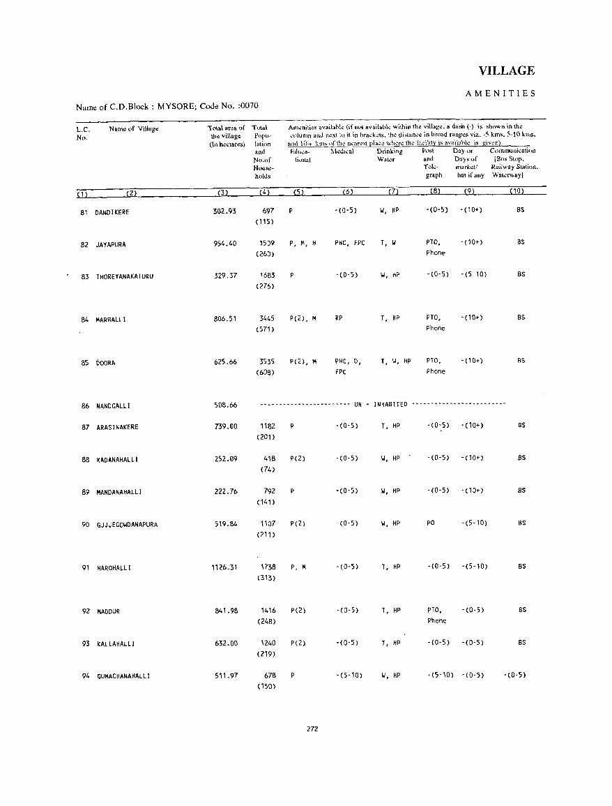
VILLAGE
AMENITIES
Name of C.D.Block : MYSORE; Code No. :0070
L.C. Name of Village lo\a\ arca of Tola\ Atn<nili<s availabk (if 0<>1 available wilhin Ihe village. a dash (-) is shown in the
No. Ihe village Popu- ,,,lu111n and n~xt to il in hra,k~ls. th~ di'lan,. in hroad rang.:s viz. -5 kms, 5-\0 kl1)s,
(In heclaNs) lalinn and I\)+ knh "flh. n.:nr.81 I!I,,~. whore tho r"cility is avaihthk ',s givon2. and Edu,.- Ivkdi,al Drinking Post Day or Cllmmuni~ali(lJ1
No.of lional Walu and Days of [Bus SlOp. Hous,,- Tel~· mar""l/ Railway Station,
holds graph hat if any Waterway]
( 1 ) (2) (3) (4) (5) (6) (7) (8) (9) (10)
81 DANDIKERE 302.93 697 P -(0-5) '.I, HP -(0-5) - (1 0+) BS
(115 )
82 JAYAPURA 954.40 1509 P, M, H Pile, fPC T, '"
PTO, - (10+) BS
(260) Phone
83 THOREYANAKATURU 329.37 1683 P -(O-S) '.I, KP -(0-5) -(5-10) BS
(276)
84 MAR BALLI 806.51 3445 P(2), M RP T, HP PTO, - (10+) BS
(571) Phone
85 DOORA 625.66 3535 P(2), M PHC, 0, T, II, HP PTO, - (1 0+) BS
(608) FPC Phone
86 NANDGAlLi 508.66 - - - - - - - - - - - - -- - -- -- - - . - - UN - INHABITED ......... -_ ..... - .. -_ ... _ ...... -- ...... --
87 ARASINAKERE 739.00 1182 P -(0-5) T, HP -(0-5) -(10+) BS
(201)
88 KADANAHAllI 252.09 418 P(2) -(0-5) '.I, HP -(0-5) -(10+) 5S (74)
89 MANDANAHALLI 222.76 792 p -(0-5) '.I, HP -(0-5) - (1 0.,.) as (141 )
90 GUJJEGOWDANAPURA 519.84 1107 pel) -(0-5) II, HP PO -(5-10) BS
(211)
91 HAROHAlLi 1126.31 1738 P, M -(0-5) T, HP -(0-5) -(5-10) BS
(313)
92 MADDUR 841.98 1416 p(2) -(0-5) T, HP PTO, -(0-5) BS
(248) Phone
93 KAlLAHALLI 632.00 1240 p(2) -(0-5) T, HP -(0-5) -(0-5) BS
(219)
94 GUMACHANAHALLI 511.97 678 P -(5-10) II, HP -(5'10) -(0-5) -(0-5)
(150)
272
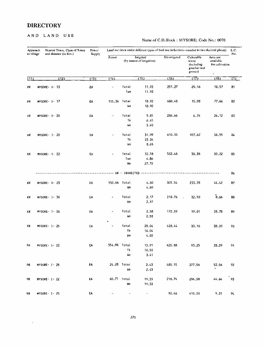
DIRECTORY
AND LAND USE Name of C.D.Block : MYSORE; Code No.: 0070
Approach Nearest Town, Class of Town Power Land u~e (arl!a under dd";;rent Iype~ of land u~e in h.:ctar.:~ roundl!d to two dl!cimal places) L.C. to village and distance (in Km.) Supply No.
Forl!~t Irrigah:d Un-irrigatl!d Culturable Area not (by source of irrigation) wa,te available
(including for cultivation gauchar and groves)
~ 1 1 ) (12) (13) (14) (15) ( 16) ( 17> (18) (1)
PR MYSORE- 1- 13 EA Total 11.93 251.27 29.16 10.57 81 Twe 11.93
PR MYSORE- 1- 17 EA 155.36 Total 18.92 686'.48 15.98 77.66 82 We 18.92
KR MYSORE- 1- 20 EA Total 9.85 286.66 6.74 26.12 83 Tk 6.45 IJe 3.40
KR MYSORE - 1- 20 EA Total 31.99 610.35 107.62 56.55 84 Tk 23.34 IJe 8.65
KR MYSORE- 1- 22 EA Total 32.58 532.48 30.38 30.22 85 Twe 4.86
We 27.72
--------------------------------------------- UN - INHABITED --------------------------------------------- 86
KR MYSORE - 1- 23 EA 150.66 Total 4.60 305.54 233.78 44.42 87 We 4.60
. KR MYSORE- 1- 30 EA Total 2.17 218.76 22.50 8.66 88
We 2.17
KR MYSORE- 1- 26 EA Total 2.58 172.39 19.01 28.78 89 We 2.58
PR MYSORE- 1- 25 EA Total 20.04 428.44 33.16 38.20 90 Tk 16.04 We 4.00
PR MYSORE- 1- 22 EA 354.98 Total 13.91 635.88 93.25 28.29 91 Tk 10.50 We 3.41
PR MYSORE- 1- 25 EA 24.28 Total 2.43 485.15 277.56 52.56 92 We 2.43
PR MYSORE- 1- 22 EA 60.71 Total 11.33 218.74 296.58 44.64 93 We 11.33
KR MYSORE- 1- 25 EA 92.46 410.2U 9.31 94
273
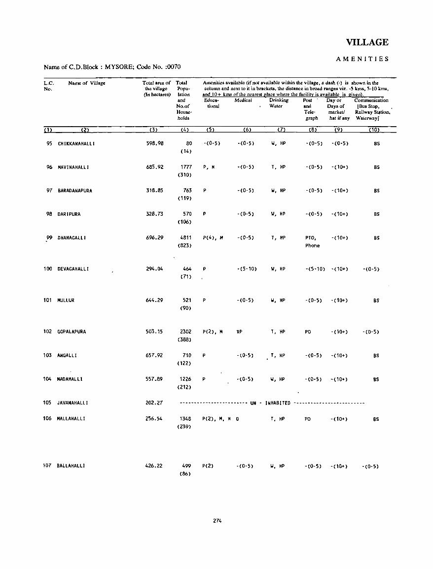
VILLAGE
AMENITIES Name of C.D.B1ock : MYSORE; Code No. :0070
L.C. Name of Village Total area of Total Amenities availablll (if no! availablll within the village, a dash (-) is shown in the No. the village Popu- column and neXllo il in brackllts, thll dislance in broad ranges viz. -5 kms, 5-10 kms,
(In hectares) lation and 10+ kms of the nearest (!Iace where the facility is available is given}. and Educa- Medical Drinking Post Day or Communication No.of tional Water and Days of (Bus Stop, House- Tele- marklltl Railway Station, holds graph hat ifany WaterwayI
(1) (2) (3) (4) (5) (6) (7) (8) (9) (10)
95 CH I KKANAHALLI 598.98 80 -(0-5) -(0-5) W, HP -(0-5) -(0-5) BS ( 14)
96 MAVI NAHALLI 685.92 1777 P, M -(0-5) T, HP -(0-5) -(10+) BS e310}
97 BARADANAPURA 318.85 763 P - (0- 5) W, HP -(0-5) -(10+) BS (119)
98 DARIPURA 328.73 570 P -(0-5) W, HP -(0-5) -(10+) BS (106)
99 DHANAGALl.l 696.29 4811 P(4), M -(0-5) T, HP PTO, -(10+) BS -(823) Phone
100 DEVAGAHAlLl 294.04 464 P -(5-10) W, HP -(5-10) -(10+) -(0-5) (71 )
101 MULLUR 644.29 521 P -(0-5) W, HP -(0-5) -(10+) BS (90)
102 GOPALAPURA 503.15 2302 p(2), M RP T, HP PO - (10+) -(0-5) (388)
103 ANGALLI 657.92 710 P -(0-5) T, HP -(0-5) -(10+) BS (122)
104 MADAHALll 557.89 1226 P -(0-5) W, HP -(0-5) -(10+) BS (212)
105 JAVANAHALLI 202.27 ----------~------------- UN - INHABITED -------------------------
106 MALLAHALLI 256.54
107 BALLAHAlLI 426.22
1348 (239)
499
(86)
P(2), 114, H
P(2)
274
D T, HP PO - (10+) BS
-(0-5) W, HP -(0-5) -(10+) -(0-5)
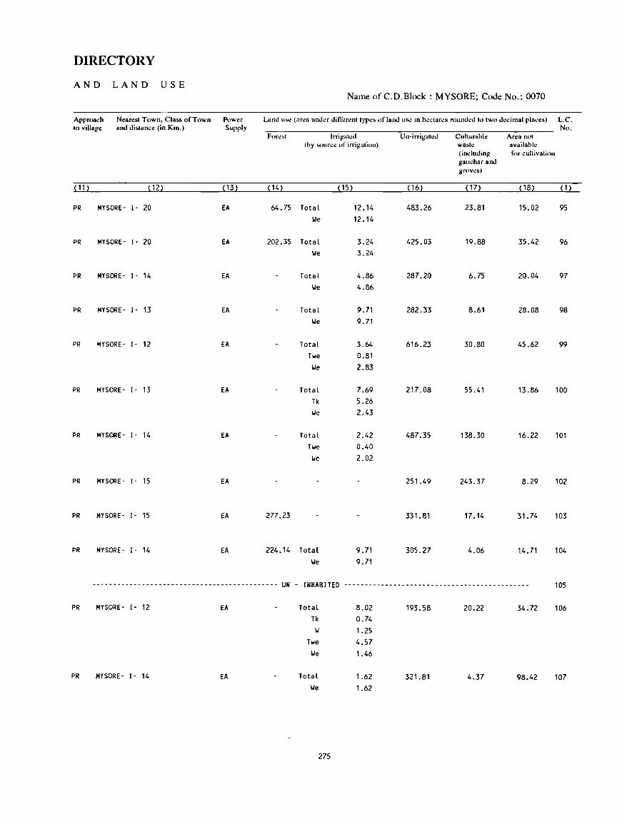
DIRECTORY
AND LAND USE Name of C.D.Block : MYSORE; Code No.: 0070
Approach Nearest Town, Class of Town Power Land u...: (area under different type~ of land usc In hectares rounded to two d.:dmal places) L.C. to villag~ and di~tance (in Km.) Supply No.
Fore,t Irrigated Un-irrigated Cuhurable Area not (by ~ource of irrigation) wa~t.: available
(including tl'r cultivation gauchar and groves)
( 11 ) ( 12) ( 13) (14) (15) ( 16) ( 17) (18) (1)
PR MYSORE- 1- 20 EA 64.75 Total 12.14 483.26 23.81 15.02 95 lie 12.14
PR MYSORE- i - 20 EA 202.35 Total 3.24 425.03 19.88 35.42 96 lie 3.24
PR MYSORE- 1- 14 EA Total 4.86 287.20 6.75 20.04 97 lie 4.86
PR MYSORE- 1- 13 EA Total 9.71 282.33 8.61 28.08 98 lie 9.71
PR MYSORE- 1- 12 EA Total 3.64 616.23 30.80 45.62 99
Twe 0.81 lie 2.83
PR MYSORE- I- n EA Total 7.69 217.08 55.41 13.86 100 Tk 5.26 We 2.43
PR MYSORE- 1- 14 EA Total 2.42 487.35 138.30 16.22 101 Twe 0.40 lie 2.02
PR MYSORE- [- 15 EA 251.49 243.37 8.29 102
PR MYSORE- [ - 15 EA 277.23 331.81 17.14 31.74 103
PR MYSORE- 1- 14 EA 224.14 Total 9.71 305.27 4.06 14.71 104 lie 9.71
--~------------------------------------------ UN - INHABITED --------------------------------------------- 105
PR MYSORE- 1- 12 EA Total 8.02 193.58 20.22 34.72 106 Tk 0.74 II 1.25
Twe 4.57 lie 1.46
PR MYSORE- 1- 14 EA Total 1.62 321.81 4.37 98.42 107 lie 1.62
275
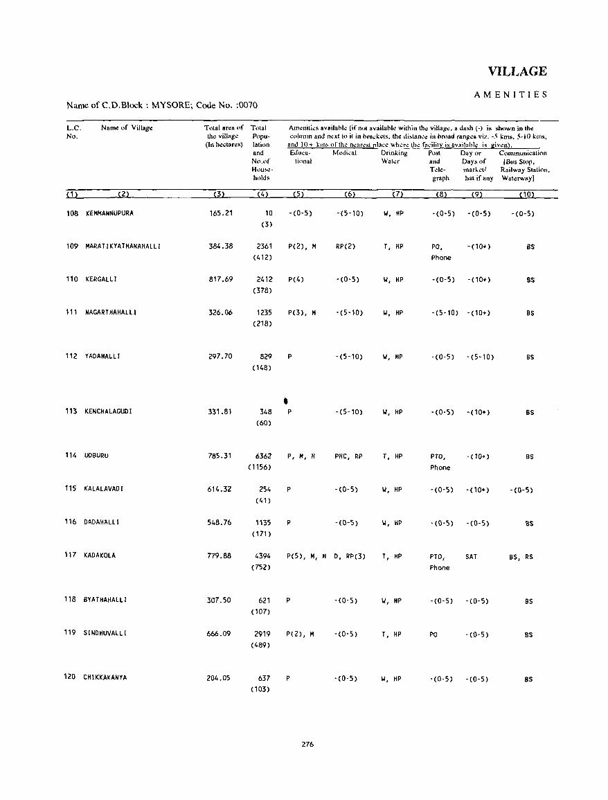
VILLAGE
AMENITIES Name of C.D.Block : MYSORE; Code No. :0070
L.C. Name of Village Total area of Tolal Am~nilies availahle (if nol availahle wilhin Ihe village, a dash (-) is shown in Ih,;: No. Ih,;: villag,;: Popu- column and nexllo il in hrad:els. Ih,;: di,lance in hroad ranges viz. -5 I:ms. 5-10 I:ms,
(In h,;:ctares) lalion and 10+ kill' nflh~ n~ar~sll!lace wh~r~ Ih~ facililY is availahl~ is given}. and &luea- Medical Drinl:ing Posl Day or Communicalion No.of lion31 Waler and Days of (Bus SlOp, Hou~\!- Tde- marketl Railway Sialion, holds graph hal if any Walerway)
(1) (2) (3) (4) (5) (6) ( 7) (8) (9) (10)
108 KEMMANNUPURA 165.21 10 -(0-5) -(5-10) w, HP -(0-5) -(0-5) -(0-5) (3)
109 HARATIKYATHANAHALLI 384.38 2361 P(2), H RP(2) T, HP PO, -(10+) BS (412) Phone
110 KERGALLI 817.69 2412 P(4) - (0-5) W, HP -(0-5) -(10+) BS (378)
111 NAGARTHAHALLl 326.06 1235 P(3), 101 -(5-10) 1.1, HP -(5-10) - (10+) BS (218)
112 YAOAHALLI 297.70 829 P -(5-10) 1.1, HP - (0- 5) -(5-10) BS (148)
• 113 KENCHALAGUOI 331.81 348 P -(5-10) W, HP -(0-5) -(10+) BS (60)
114 UDBUIW 785.31 6362 P, 101, H PHC, RP T, HP PTO, -(10+) as (1156) Phone
115 KAlALAVAOl 614.32 254 P -(0-5) w, HP -(0-5) -(10+) -(0-5) (41)
116 OAOAH1IlLI 548.76 1135 P -(0-5) W, HP -(0-5) -(0-5) BS (171 )
117 KAOAKOLA 779.88 4394 P(5), 101, H 0, RP(3) T, HP PTO, SAT as, RS (752) Phone
118 BYATHAHALLI 307.50 621 P -(0-5) 1.1, HP -(0-5) -(0-5) BS (107)
119 SINDHUVALLI 666.09 2919 P(2), M -(0-5) T, HP PO -(0-5) BS (489)
120 CHIKKAKANYA 204.05 637 P - (0-5) 1.1, HP -(0-5) -(0-5) BS (103)
276
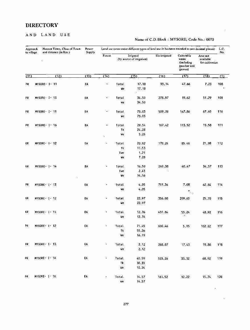
DIRECTORY
AND LAND USE Nam~ of C.D.Block : MYSORE; Code No.: 0070
Approach N.:arest Town. Class of Town Power Land uS<! (area under ditl<:rent typ.:s of land uS<! in hectares rounded to two decimal places) L.C. to village and distance (in Km.) Supply No.
Forest Irrigated Un·irrigated Culturable Area not (by Sllurce of irrigation) waste available
(including for cultivation gauchar and groves)
(11) ( 12) (13) ( 14) ( 15) ( 16) (17) ( 18) (1)
PR MYSORE· I- 11 EA Total 17.18 93.14 47.66 7.23 108 We 17.18
PR MYSORE - 1- 13 EA Total 34.50 278.97 19.62 51.29 109 We 34.50
PR MYSORE· 1- 11 EA Total 73.03 509.20 167.86 67.60 110 We 73.03
PR MYSORE· 1- 16 EA Total 29.54 167.42 113.52 15.58 111 Tk 24.28 We 5.26
KR MYSORE· 1- 12 EA Total 20.02 170.24 85.46 21.98 112 Tk 11.53
Twe 1.21 We 7.28
KR MYSORE- 1- 14 EA Total 16.59 240.38 40.47 34.37 113 Twe 2.43
We 14.16
PR MYSORE- 1- 13 EA Total 4.05 711.34 7.08 62.84 114 We 4.05
KR MYSORE- I· 12 EA Total 22.97 356.00 209.65 25.70 115 We 22.97
KR MYSORE- 1- 11 EA Total 12.76 431.84 55.24 48.92 116 We 12.76
PR MYSORE· 1- 12 EA Total 71.45 600.46 5.95 102.02 117 11< 55.26 We 16.19
PR MYSORE- 1- 13 EA Total 2.12 268.07 17.43 19.88 118 lJe 2.12
PR MYSORE- 1- 16 EA Total 40.59 523.26 33.32 68.92 119 Tk 30.35 lJe 10.24
PR MYSORE- l' 16 EA Total 14.57 161.52 12.22 15.74 120 lJe 14.57
2n
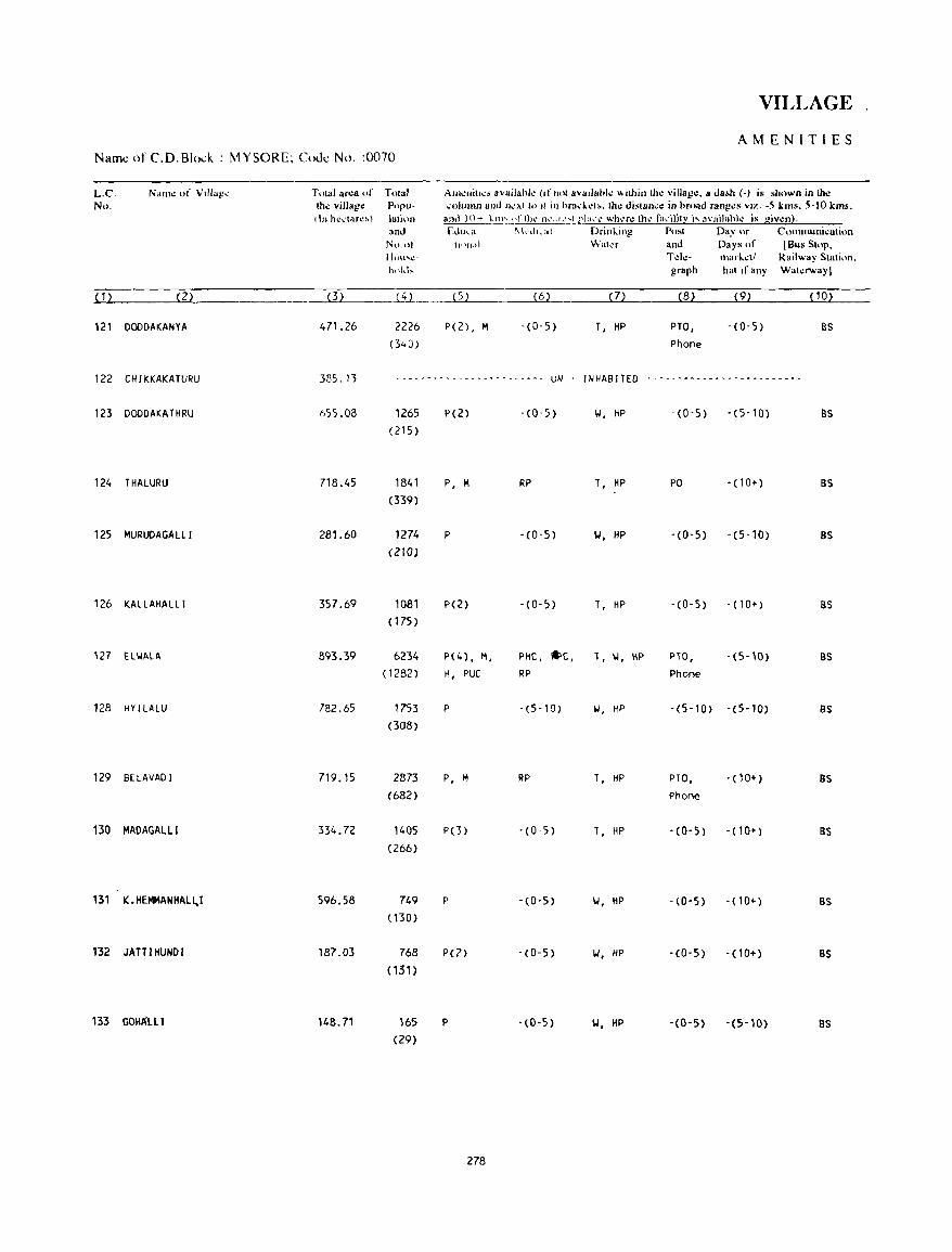
VILLAGE
AMENITIES Name of C.O.Blo.:k : MYSORE; Code No. :0070
L.c. Naill': of Vlllag~ Tolal aNa of TOlal AlIl""ilt~s availahk (,f "01 avadah!.: "ilhinlh.: villag.:. a dash (-) i. sh"wn in th.: No. Ih.: village: Popu- , .. Iumn and n~:>.1 10 II ill hra,k"t,. Ih.: disl.an,.: in hft"ld ran!!.:, viz. -5 ImIS. 5-10 kms.
{In hc\:lar~!-.) lali,)n ani} l{)-+ !-Ill'" ,Ifill!.' n'::lh.'''Lrl:t':1! wh~r\! thl! r"\'iljl~ i~ ayailahl~ i~ giv.:nl. and Ed",,· ~kd"al Drinl..ing Post Day or C()llllllUnil.!alion
No.of 11'\Il.d " .... alor and Days of (Bus SI"p, Ht)l1'l.!- T.:l.:- lila r 1...:11 Railway Station. ~h)kb graph hat If any Wat"rwaYI
( 1 ) (2) (3) {iL. ____ (5) (6) (7) (8) (9) (10)
121 DOODAKANYA 471.26 2226 P(2) , M -(0'5) T, HP PTa, - (0-5) as (340) Phone
122 CH I KKAKA TURU 385.13 - - -- ...... - .. - - - - ~ ..... - -.. -...... - UN INHABITED -.. - - - .... -........... --- --........ - -..
123 DOODAKATHRU 1>,)5.08 1265 P(2) -(0,5) w, HP -(0-5) - (5-10) as (215)
124 THALURU 718.45 1841 P, M RP T, HP po -(10+) as (339)
125 MURUDAGAlll 281.60 1274 P -(0-5) W, HP -(0-5) -(5-10) BS (ZIG)
126 KALLAHAlLl 357.69 1081 P(Z) -(0-5) T, HP -(0-5) -(10+) as ( 175)
127 tl\.jAlA 893.39 6234 P(4), M, PHC, *'C, T, \.j, HP PTO, -(5-10) as (1282) H, PUC RP Phone
128 HY I LALU 782.65 1753 P - (5 -1 0) 01, HP -(5-10) -(5-10) as (308)
129 BELAVADI 719.15 2873 P, M RP T, HP PTa, ·(10+) BS (682) Phone
130 MADAGALLI 334.72 1405 PO) '(0-5) T, HP -(0-5) -(10+) BS (266)
131 K. HEMMANHALL.I 596.58 749 P - (0- 5) Y, HP -(0-5) -(10+) BS (130)
132 JATTIHUNDI 187.03 768 P(2) -(0-5) Y, HP -(0-5) -(10+) BS (131)
133 GOH~lll 148.71 165 p - (0-5) 'W, HP -(0-5) -(5-10) 8S (29)
278
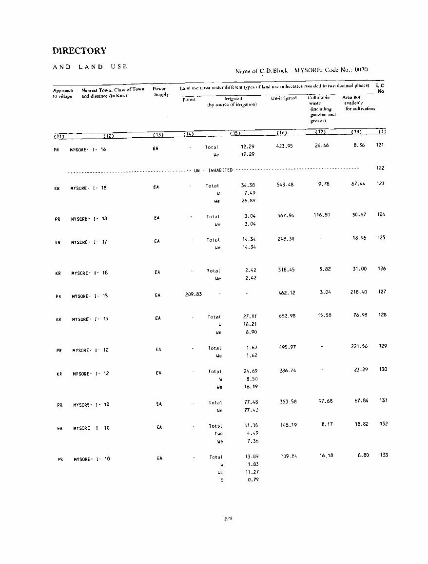
DIRECTORY
AND LAND USE Nal11~ of C.D.Blod. : MYSO!{E: CoJ~ No.: 0070
Approa..:h Nearesl Town. Class of Town Powa Land lI'': (ilr.:a lInd.:r diIT.:r.:nl typ~' "I' land u'~ 111 h.:.;tar.:, round.:d h) 1"'0 d~dmal plaas) ·L.C
10 villago: and distance (in Km.) Supply No
Fon:~t Irrigl't.:J Un-irrigat~d Culturahle Area nol
(hy soun:~ of irngal,on) w3.le available (including for cultivalion gallchar and gro~,,»
(11 ) (12) (13) (14) ( 15) (16) ( 17) (1B) (1)
PR MYSORE- 1- 16 EA Total 12.29 423.95 26.66 8.36 121
lie 12.29
----_ .. -- ... ---------_ .. ------------------------ UN - INHABITED ------- ... ------------------~------------------ 122
KR MYSORE- 1- 18 EA Total 34.38 543.48 9.78 67.44 123
Ii 7.49
lie 26.89
PR MYSORE- 1- 18 EA Total 3.04 567_94 116.80 30.67 124
lie 3.04
KR MYSORE- 1- 17 EA Total 14.34 248.30 18.96 125
lie 14.34
KR MYSORE- J - 18 EA Total 2.42 318.45 5.82 31.00 126
lie 2.42
PR MYSORE- J- 15 EA 209.83 462.12 3.04 218.40 127
KR MYSORE- 1- 15 EA Total 27.11 662.98 15.58 76.98 128
Ii 18.21
lie 8.90
PR MYSORE- 1- 12 EA Total 1.62 495.97 221.56 129
Ii::. 1.62
KR MYSORE- 1- 12 EA Total 24.69 286.74 23.29 130
Ii 8.50
lie 16.19
PR MYSORE- 1- 10 EA Total 77.4B 353.58 97.68 67.84 131
lie 77.4:5
PR MYSOR!:- 1- 10 EA Total 11. :}') 148.19 B.17 18.B2 132
TIoII: 4.49
lie 7.36
PR M'1S0RE- t- 10 EA Total 13.89 109.84 16.18 8.80 133
Ii 1.83
lie 11.27
0 0.79
279
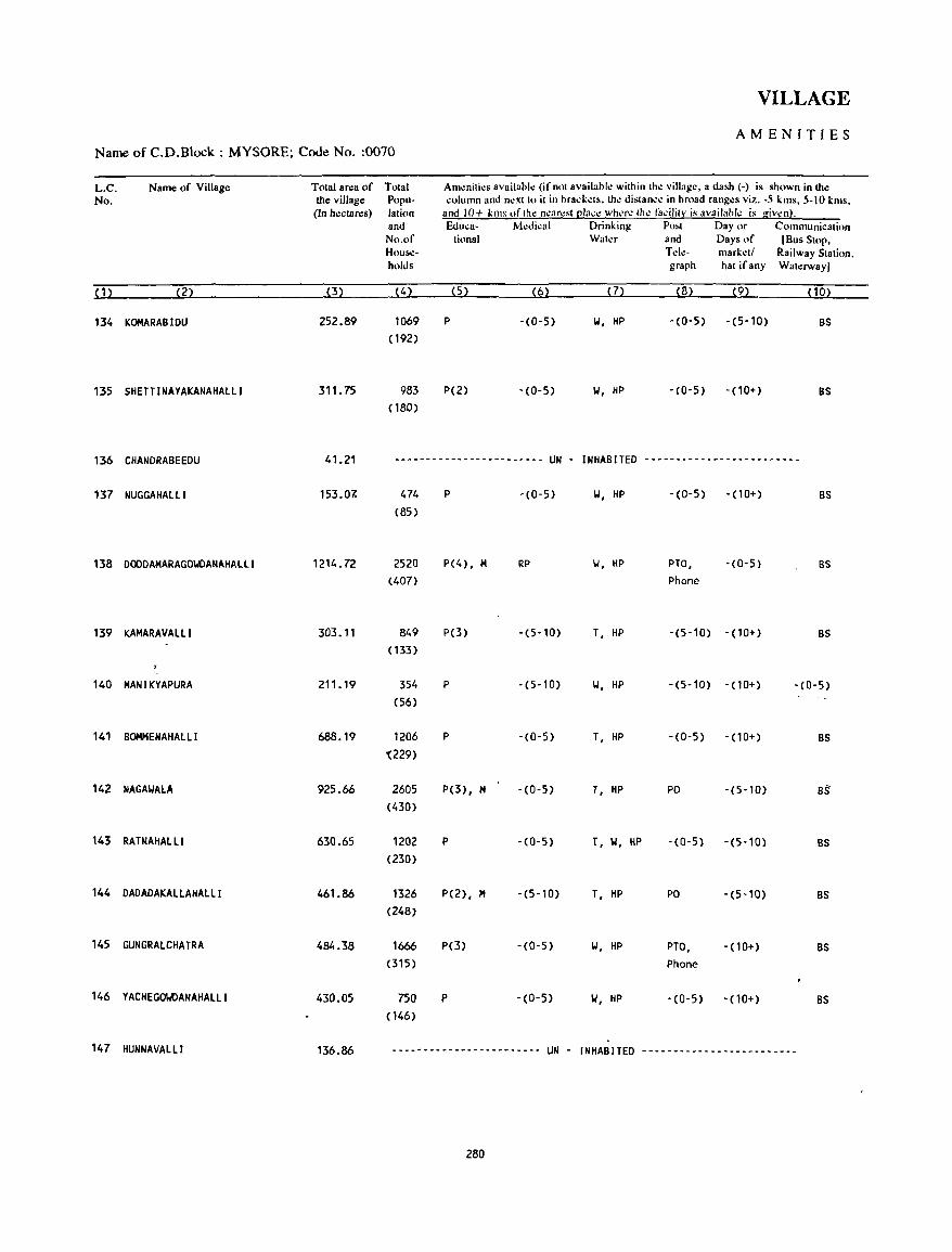
VILLAGE
AMENITIES Name of C.D.Block : MYSORE; Cooe No. :0070
L.C. Name of Village Total an:a of Total Am~niti~s availabl~ (if not IIvailabll! within th~ village, a dash (-) is shown in the No. the village Popu- column and next to it in brad;~ts. th~ distan.:e in broad ranges viz. -5 kms, 5-10 kms,
(In hectares) lation and 10+ kms "fthe n.:arest [!la..:.: where the facility is availa"!': is giwn). and &luca- M~dical Drinking PoM Day or Communication No.of tional Wat~r and Days of (Bus Stop, House- T~k- mark~t/ Railway Station. holds graph hat if any Wat~rway)
(1) (2) (3) (4) (5) (6) (7) (8) (9) (10)
134 KOMARABIDU 252.89 1069 P -(0-5) 101, HP -(0-5) -(5-10) BS (192)
135 SHETTINAYAKANAHAlll 311. 75 983 P(2) -(0-5) 101, HP -(0-5) - (10+) BS (180)
136 CHANDRABEEDU 41.21 ------.------.---------- UN - INHABITED -~-----------------------
137 NUGGAHAlll 153.07- 474 P -(0-5) 101, HP -(0-5) - (10+) BS (85)
138 DOODAMARAGOIolDANAHAlll 1214 _ 72 2520 P(4), M RP 101, HP PTO, -(0-5) BS (407) Phone
139 KAMARAVAlll 303.11 849 P(3) -(5-10) T, HP -(5-10) - (10+) BS ( 133)
140 MAN I KYAPURA 211. 19 354 P -(5-10) 101, HP -(5-10) - (10+) -(0-5) (56)
141 BOMMENAHAllI 688.19 1206 P -(0-5) T, HP -(0-5) -(10+) BS '(229)
142 NAGAIoIALA 925_66 2605 P(3), M -(0-5) T, HP PO -(5-10) B!: (430)
143 RATNAHALll 630.65 1202 P -(0-5) T, 101, HP -(0-5) -(5-10) BS (230)
144 DADADAKALLAHAlll 461.86 1326 P(2), M -(5-10) T, HP PO -(5-10) BS (248)
145 GUNGRAlCHATRA 484.38 1666 P(3) -(0-5) 101, HP PTO, - (10+) BS (315) Phone
146 YACHEGOWDANAHAlLI 430.05 750 P -(0-5) 101, HP -(0-5) - (10+) BS (146)
147 HUNNAVALlI 136.86 ------------------------ UN - INHABITED -------------------------
280
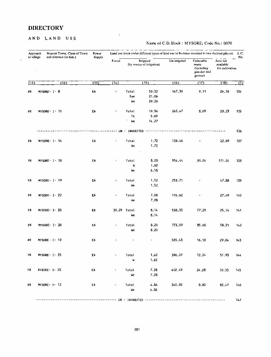
DIRECTORY
AND LAND USE Namt: of C.D.Block : MYSORE; Code No.: 0070
Approach Nearest Town, Class of Town Power Land use (ar.:a und.:r diffcrcnt typcs of land use in hcctares roundcd to two decimal places) L.C. to village and distance (in Km.) Supply No.
Furest lrrigatcd Un·irrigatcd Culturahle Area not (by source of irrigation) waste availahle
(including for cultivation gauchar and groves)
(11) ( 12) (13) (14) (15) ( 16) (17) ( 18) (1)
PR MYSO~' I' 8 EA Total 50.32 167.30 9.11 26.16 134
Twe 21.06 lJe 29.26
PR MYSORE- 1- 15 EA Total 19.96 263.47 8.09 20.23 135 Tk 5.69 lJe 14.27
-~------------------.------------------------ UN - INHABITED ----_-_-----------------------.-------_------ 136
PR MYSORE- I- ll. EA Total 1. 72 128.46 22.89 137 'We 1.72
PR MYSORE- 1- 18 EA Total 8.20 954.44 81.04 171.04 138 IJ 1.62
'We 6.58
PR MYSORE· 1- 19 EA Total 1.52 253.71 47.88 139 'We 1.52
PR MYSORE- 1- 22 EA Total 7.08 176.62 27.49 140 lJe 7.08
PR MYSORE- 1- 20 EA 39.29 Total 8.14 538.33 77.29 25.14 141 lJe 8.14
PR MYSORE- 1- 20 EA Total 8.20 773.59 85.66 58.21 142 lJe 8.20
PR MYSORE- 1- 10 EA 585.43 16.18 29.04 143
PR MYSORE- 1- 25 EA Total 1.62 396.07 12.24 51.93 144 IJ 1.62
PR MYSORE- 1- 25 EA Total 7.28 402.49 24.28 50.33 145 lJe 7.28
PR MYSORE- 1- 12 EA Total 4.86 340.92 0.80 83.47 146 'We 4.86
_ ... _ ........................................ UN . INHABITED --------------------------------------------- 147
281
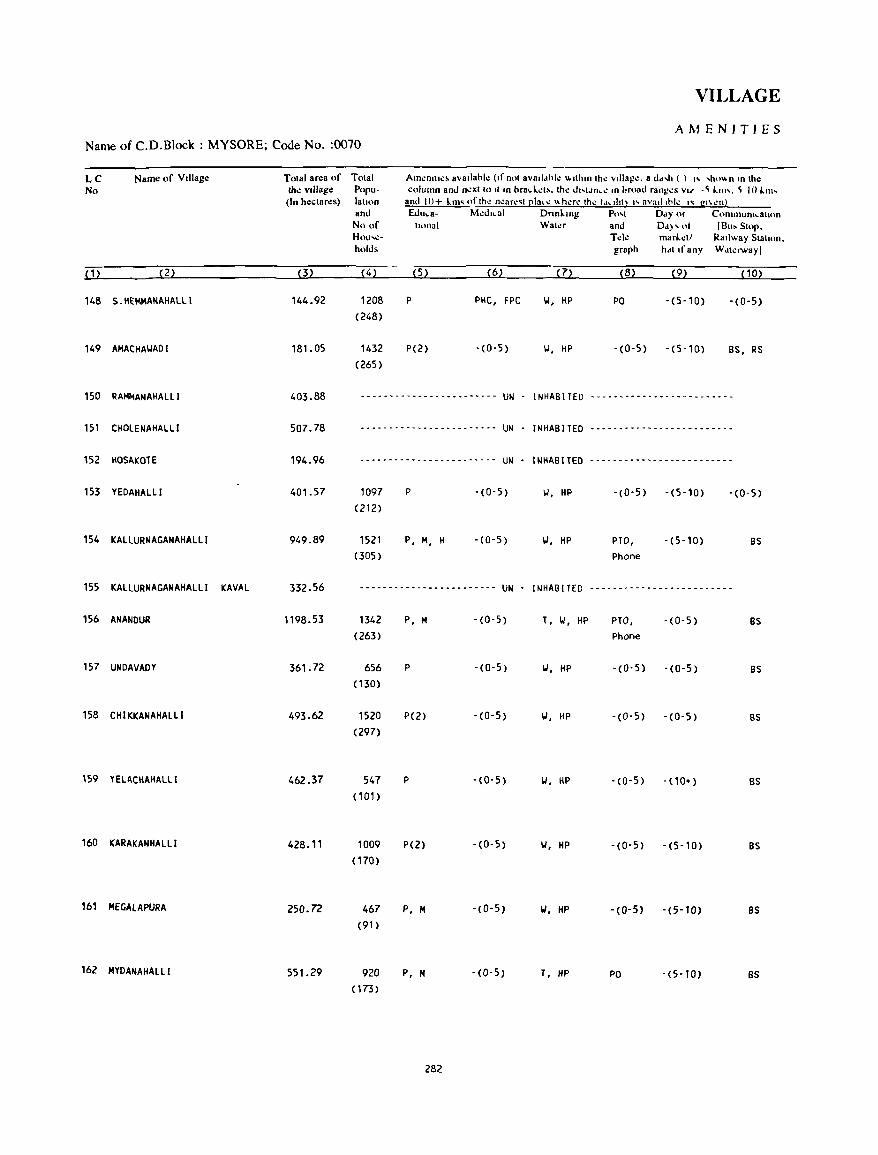
VILLAGE
AMENITIES Name of C.D.Block : MYSORE; Code No. :0070
LC Name of VIllage Total area of Total Am.:nllt.:~ avallabl.: (If not avalldhl.: ""Ihllllh.: vtllag.:. a dd,h ( ) " 'h,," n In the No the vIllage Popu- column and n.:xl 10 II In brad. . .:t~. th.: d"ldn • .: '" broad rang.:. VI.f -~ 1.11". ~ lO 1.111'
(In hectares) lah"n and 10+ kill' oflh.: n.:ar.:'I(!lac.: "h.:r.: Ih.: !"uhll "nvutl ,hi.: " gl\.:nl and &lu.a- M':I.hcal Dnnl.mg PO'1 Day or C(HnlnUOtfo..8lu)n
No of honal Wal.:r and Dd)' of (Bu. SlOp. Hou~- Td~ marl..:11 RaIlway Slahon. holds graph hdl If any Wat.:rwayl
( 1) (2) (3) (4) (5) (6) (7) (B) (9) (10)
146 S.HEMMANAHALLI 144.92 1208 P PHC, FPC 1.1, liP PO -(5-10) -(0-5) (248)
149 AMACHAI.IADI 181. 05 1432 P(2) - (0-5) II, HP - (0-5) - (5-10) BS, RS (265)
150 RAMMANAHALLI 403.88 --------------- .. __ ... -_ .. -- UN INHABITED ........ -_ .. -- - .. --_ .. ---- _- ----
151 CHOLENAHALLI 507.78 .................................................. UN INHABITED .. -_ ...... ,. .. -- .............. - .. --_ ......
152 HOSAKOTE 194.96 --------- .... -------_- .. --- UN - INHABITED ---_ .. -",,_ .. --_ -- -- .. --------
153 YEDAHALLI 401.57 1097 P -(0-5) 1.1, HP -(0-5) -(5-10) -(0-5) (212)
154 KALlURNAGANAHALLI 949.89 1521 P, M, H - (0-5) 1.1, HP PTO, -(5-10) BS (305) Phone
155 KALLURNAGANAHALLI KAVAL 332.56 ----_ ...... - ... ---_ ..... ------_ .. UN INHABITED -----_ ... ------------------
156 ANANDUR 1198.53 1342 P, M -(0-5) T, 1.1, HP PTO, -(0-5) as (263) Phone
157 UNDAVADY 361. 72 656 P -(0-5) 1.1, HP - (0- 5) -(0-5) BS ( 130)
158 CHIKKANAHALLI 493.62 1520 P(2) -(0-5) 1.1, HP -(0-5) -(0-5) BS (297)
159 YELACHAHALLI 462.37 547 P -(0-5) 1.1, HP - (0- 5) - (10") as (101)
160 KARAKANHALLI 428.11 1009 P(2) -(0-5) 1.1, HP -(0-5) -(5-10) BS (170)
161 MEGALAPURA 250.72 467 P, M -(0-5) IJ, HP -(0-5) -(5-10) as (91)
162 MYDANAHALLI 551.29 920 P, M -(0-5) T, HP PO -(5-10) BS (173)
282
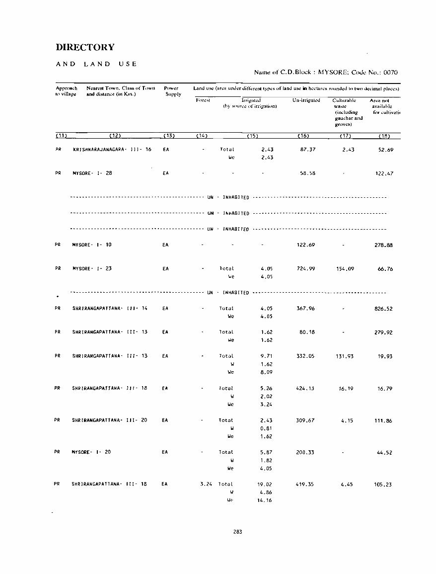
DIRECTORY
AND LAND USE N;Ullt! ()fC.D.8Io~k: MYSORE; Codt! No.: 0070
Approach 10 village
Nearesl Town. Class of Town and dislan.:e (in Km.)
Pow..:r Supply
Land Us.! (ar.:a under difl".:r.:nl Iypes of land Us.! in he.:lares rounded lolWo dcdmal places)
Forl.!~l
(11) (12) ( 13) (14)
PR KRISHNARAJANAGARA- 111- 16 fA
PR MYSORE· 1- 28 EA
------- .. ----- .... - .. --------.---- ..... -.-.-. UN
-------------------.---------.------.--.-.--- UN
Irri~aled (hy sOllr...:~ of irrigation)
Total \.Ie
( 15)
2.43 2.43
Un-irrigaled
( 16)
87.37
58.58
Cllhurahle Ar.:a nol \!ia,le availahl.: (indllding f"r ..:ultivali, gau.:har and grov.:s)
( 1 7) ( 18)
2.43 52.69
122.47
INHABITED .----.-.----------------.------ .. ----.----.--
INHABITED .. --- ..... -------.----.----.- .. -.-------- .. --
---------------------------.---------.-.----- UN . INHABITED ------.-------------------------.------------
PR
PR
PR
PR
PR
PR
PR
PR
PR
MYSORf - 1- 10
MYSORE- 1- 23
EA
EA Total \.Ie
4.05 4.05
122.69
724.99
278_88
154.09 66.76
---------------- .. --------.-.------.-- .. ----- UN . INHABITED ------- ... ----------------------------.------
SHRIRANGAPATTANA· 111- 14 EA Total 4.05 367.96 826.52 \.Ie 4.05
SHRIRANGAPATTANA- 111- 13 EA Total 1.62 SO.1S 279.92 \.Ie 1.62
SHRIRANGAPATTANA- 111- 13 EA Total 9.71 332.05 131.93 19.93 \.I 1.62
\.Ie 8.09
SHRIRANGAPATTANA- 111- 18 EA Total 5.26 424.13 16.19 16.79 \01 2.02
\.Ie 3.24
SHRIRANGAPATTANA- 111- 20 EA Total 2.43 309.67 4.15 111.86 \01 0.S1
\.Ie 1.62
MYSORE - 1- 20 EA Total 5.S7 200.33 44.52 \01 1.82
\ole 4.05
SHRIRANGAPATTANA- I I I - 1S EA 3.24 Total 19.02 419.35 4.45 105.23 \J 4.86
\.Ie 14.16
283
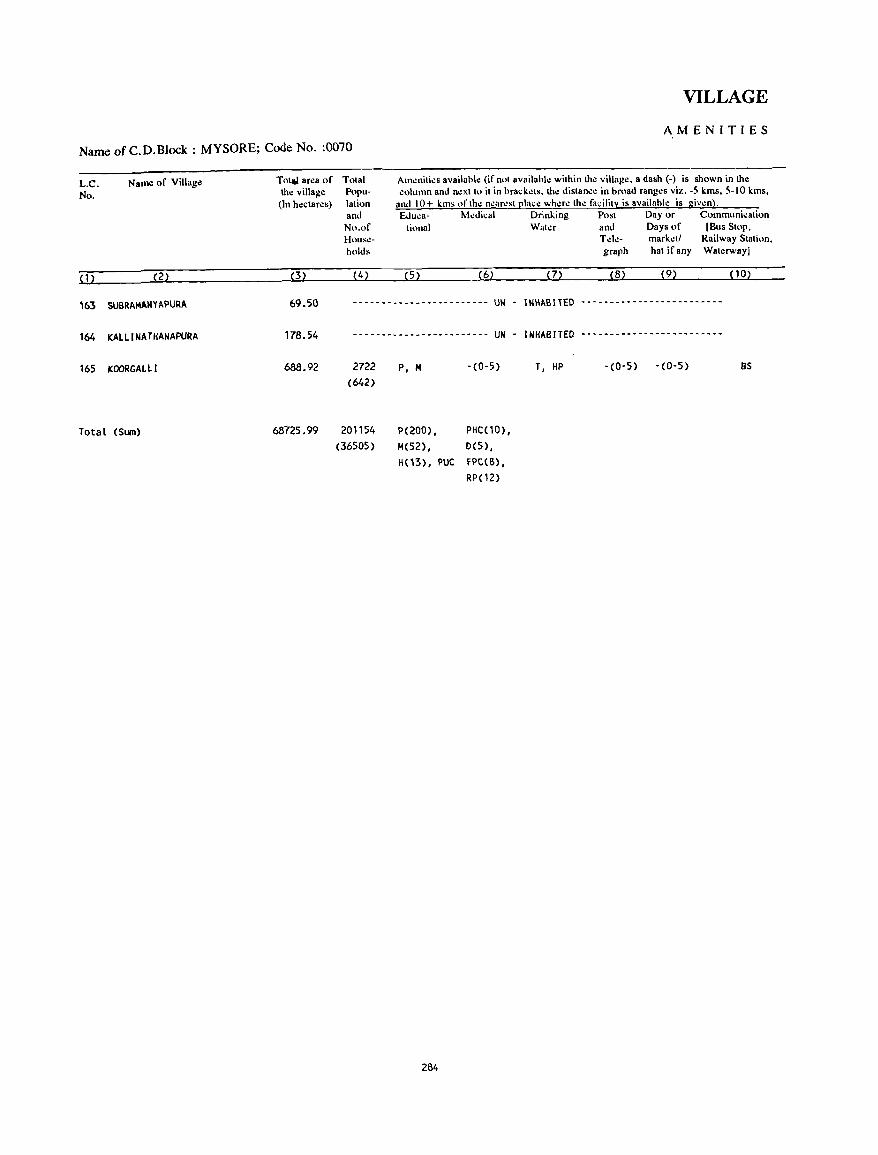
VILLAGE
AMENITIES
Name of C. D. Block : MYSORE; Code No. :0070
L.C. No.
Name of Village
(1) (2)
163 SUBRAMANYAPURA
164 KAllINATHANAPURA
165 KOORGAlll
Total (Sum)
Tot~ area of Total the village Popu
(In hectares) lation and No.of Hous\!holds
(3) (4)
Am~niti~s availabl~ (if not availabl~ within the village. a dash (-) is shown in the column and n~xtto it in brack.:ts.th~ distance in broad rang~s viz. -5 kms, 5-10 kms,
and 10+ kms ofth~ n~arcst place whcr~ the facility is availahle is giv~n). &Iuea- Medical Drinking Post Day or Communication
tiollal Water and Days of (Bus Stop, T de- mark.:t! Railway Station. graph hat if any Waterway!
(5) (6) (7) (8) (9) (10)
69.50 ------------------------ UN - INHABITED -------------------------
178.54
688.92
68725.99
------------------------ UN - INHABITED -------------------------
2722 (642)
201154 (36505)
P, M
P(200), M(52) ,
-(0-5)
PHC(10), 0(5),
H(13), PUC fPC(S}, RP(12)
284
T, HP -(0-5) -(0-5) as
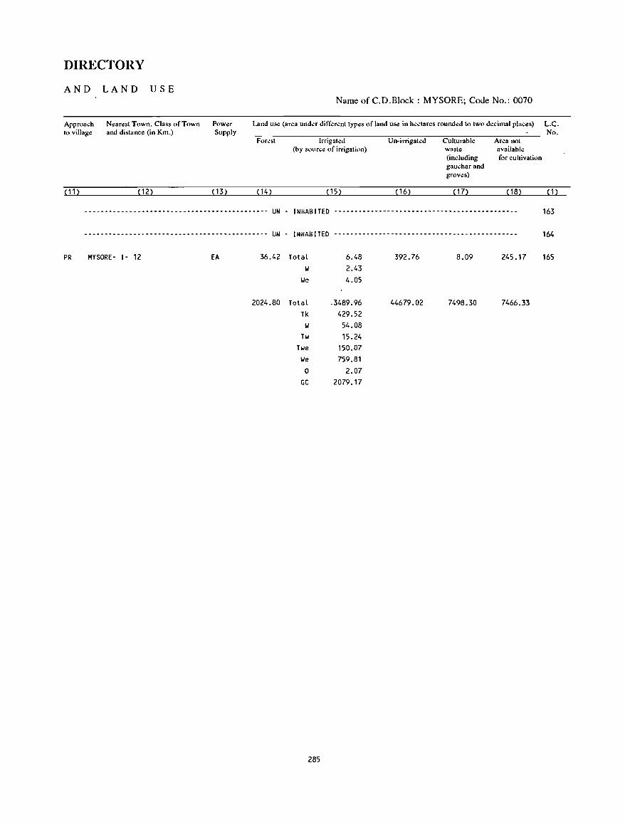
DIRECTORY
AND LAND USE
Approach to village
(11)
Nearest Town. Class of Town and distance (in Km.)
(12)
Power Supply
( 13)
Name of C.D.Block : MYSORE; Code No.: 0070
Land lise (area und..:r different types of land use in hectares rounded to two decimal places) L.C. No.
Forest Irrigated Un-irrigated Culturable Area not (by source of irrigation) waste available
(including for cultivation gauchar and groves)
( 14) ( 15) ( 16) (17) ( 18) (1)
--------------------------------------------- UN - INHABITED --------------------------------------------- 163
--------------------------------------------- UN - INHABITED --------------------------------------------- 164
PR MYSORE- 1- 12 EA 36.42 Total 6.48 392.76 8.09 245.17 165 IJ 2.43
IJe 4.05
2024.80 Total -3489.96 44679.02 7498.30 7466.33 Tk 429.52
IJ 54.08 Tw 15.24
Twe 150.07 IJe 759.81
0 2.07 GC 2079.17
285

NANJANGUD C.D.BLOCK
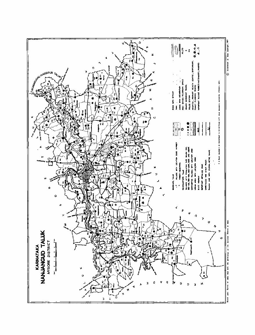
o
Irr": .: " : I. " , 1·:5:.~:O . " . . , ,
i U: : • '-'I~ i! • !-: ~ I:: • "C 1
• i 1 o '-_ H J ~ 3
• I i
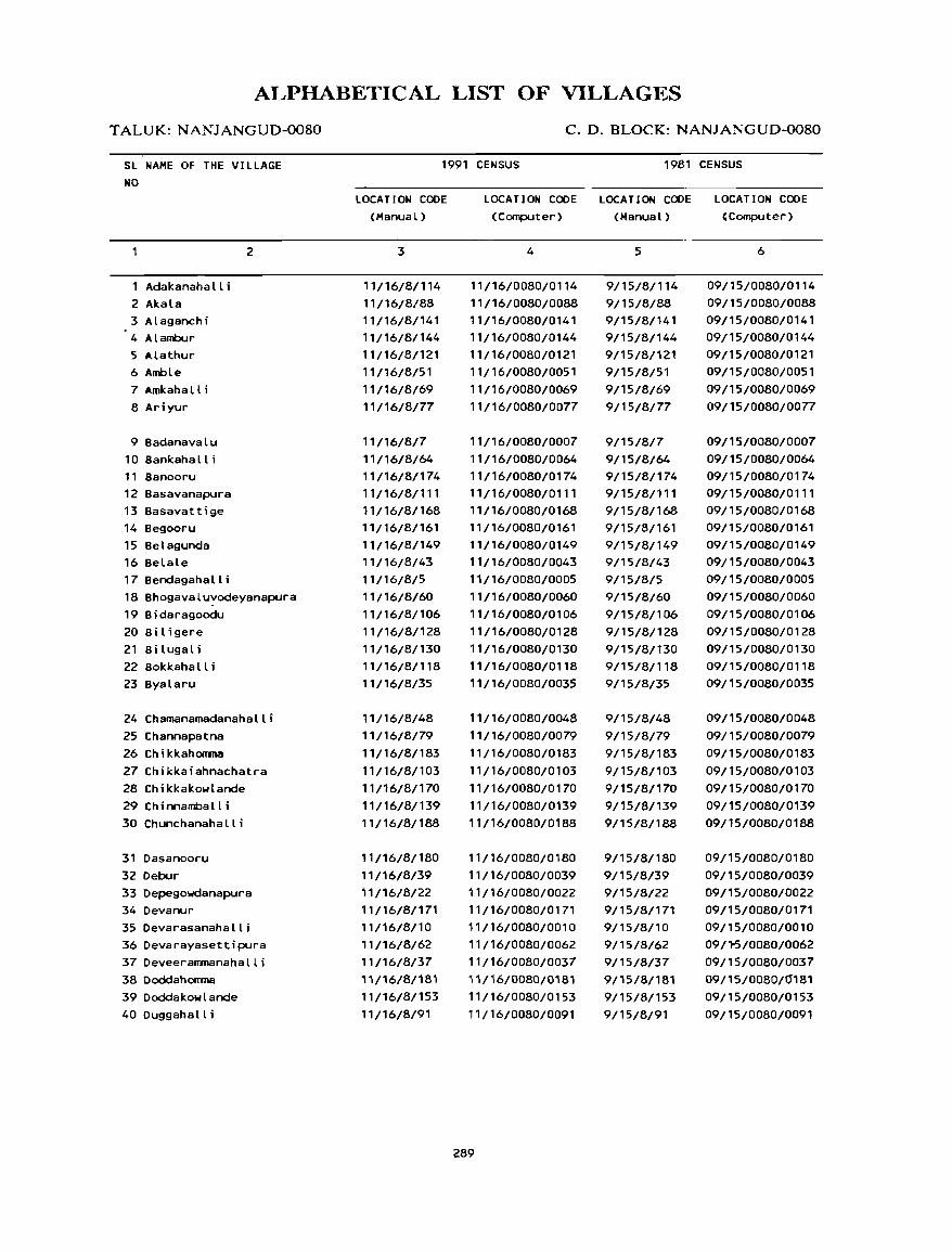
ALPHABETICAL LIST OF VILLAGES
TALUK: NANJANGUD-0080
SL NAME OF THE VILLAGE NO
Adakanahalli 2 Akala 3 Alaganchi 4 Alambur 5 Alathur 6 Amble 7 Amkahalt i 8 Ariyur
9 Badanavalu 10 Bankahall i 11 Banooru 12 Basavanapura 13 Basavattige 14 Begooru 15 Belagunda 16 Belale 17 Bendagaha II i
2
18 Bhogavalu~odeyanapura 19 Bidaragoodu 20 Biligere 21 Bi lugal i 22 Bokkahalli 23 Byalaru
24 Chamanamadanahalli 25 Channapatna 26 Chikkahooma 27 Chikkaiahnachatra 28 Chikkakowlande 29 Chinnamball j 30 Chunchanahalli
31 Dasanooru 32 Oebur 33 Depegowdanapura 34 Devanur 350evarasanahalli 36 Devarayasettipura 37Deveerammanahalli 38 Doddahooma 39 Doddakowlande 40Duggahalli
C. D. BLOCK: NANJANGUD-0080
1991 CENSUS 1981 CENSUS
LOCATION CODE (Manua l)
3
11/16/8/114 11/16/8/88 11/16/8/141 11/16/8/144 11/16/8/121 11/16/8/51 11/16/8/69 11/16/8/77
11/16/8/7 11/16/8/64 11/16/8/174 11/16/8/111 11/16/8/168 11/16/8/161 11/16/8/149 11/16/8/43 11/16/8/5 11/16/8/60 11/16/8/106 11/16/8/128 11/16/8/130 11/16/8/118 11/16/8/35
11/16/8/48 11/16/8/79 11/16/8/183 11/16/8/103 11/16/8/170 11/16/8/139 11/16/8/188
11/16/8/180 11/16/8/39 ',/16/8/22 11/16/8/171 11/16/8/10 11/16/8/62 11/16/8/37 11/16/8/181 11/16/8/153 11/16/8/91
LOCATION CODE LOCATION CODE LOCATION CODE (Computer) (Manual) 'Computer)
4
11/16/0080/0114 11/16/0080/0088 11/16/0080/0141 11/16/0080/0144 11/16/0080/0121 11/16/0080/0051 11/16/0080/0069 11/16/0080/0077
11/16/0080/0007 11/16/0080/0064 11/16/0080/0174 11/16/0080/0111 11/16/0080/0168 11/16/0080/0161 11/16/0080/0149 11/16/0080/0043 11/16/0080/0005 11/16/0080/0060 11/16/0080/0106 11/16/0080/0128 11/16/0080/0130 11/16/0080/0118 11/16/0080/0035
11/16/0080/0048 11/16/0080/0079 11/16/0080/0183 11/16/0080/0103 11/16/0080/0170 11/16/0080/0139 11/16/0080/0188
11/16/0080/0180 11/16/0080/0039 ',/16/0080/0022 11/16/0080/0171 11/16/0080/0010 11/16/0080/0062 11/16/0080/0037 11/16/0080/0181 11/16/0080/0153 ',/16/0080/0091
289
5
9/15/8/114 9/15/8/88 9/15/8/141 9/15/8/144 9/15/8/121 9/15/8/51 9/15/8/69 9/15/8/77
9/15/8/7 9/15/8/64 9/15/8/174 9/15/8/111 9/15/8/168 9/15/8/161 9/15/8/149 9/15/8/43 9/15/8/5 9/15/8/60 9/15/8/106 9/15/8/128 9/15/8/130 9/15/8/118 9/15/8/35
9/15/8/48 9/15/8/79 9/15/8/183 9/15/8/103 9/15/8/170 9/15/8/139 9/15/8/188
9/15/8/180 9/15/8/39 9/15/8/22 9/15/8/171 9/15/8/10 9/15/8/62 9/15/8/37 9/15/8/181 9/15/8/153 9/15/8/91
6
09/15/0080/0114 09/15/0080/0088 09/15/0080/0141 09/15/0080/0144 09/15/0080/0121 09/15/0080/0051 09/15/0080/0069 09/15/0080/0077
09/15/0080/0007 09/15/0080/0064 09/15/0080/0174 09/15/0080/0111 09/15/0080/0168 09/15/0080/0161 09/15/0080/0149 09/15/0080/0043 09/15/0080/0005 09/15/0080/0060 09/15/0080/0106 09/15/0080/0128 09/15/0080/0130 09/15/0080/0118 09/15/0080/0035
09/15/0080/0048 09/15/0080/0079 09/15/0080/0183 09/15/0080/0103 09/15/0080/0170 09/15/0080/0139 09/15/0080/0188
09/15/0080/0180 09/15/0080/0039 09/15/0080/0022 09/15/0080/0171 09/15/0080/0010 09/'1-5/0080/0062 09/15/0080/0037 09/15/0080/0181 09/15/0080/0153 09/15/0080/0091
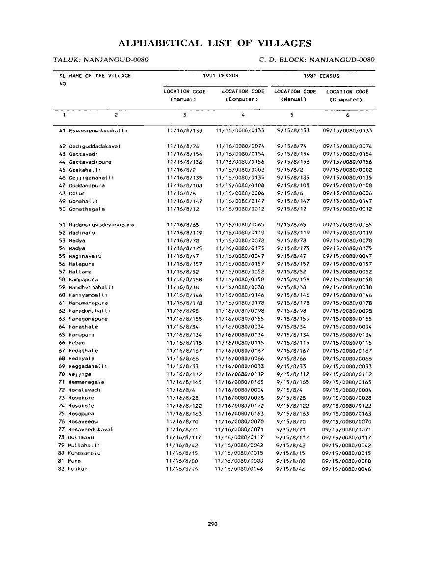
ALPIIABETICAL LIST OF VILLAGES
TALVK: NANJANGUD-0080
SL NAME OF THE VILLAGE
NO
2
41 Eswaragowdanahalll
42 Gadlguddadakaval 43 Gattavadl 44 Gattavadrpura
45 Geekahalll 46 GeJJlganahalll 47 Goddanapura 48 Golur 49 Gonahalll 50 Gonathagala
51 Hadanuruvodeyanapura 52 Had,naru
53 Hadya 54 Hadya
S5 Haglnavalu S6 Halepura 57 Hallare 58 Hampapura 59 Handhvlnahalll 60 Han! yamba III 61 Hanumanapura
62 Haradanahalll 63 Haraganapura
64 Harathale
65 Harupura
66 Hebya 67 Hedathale 68 Hedlyala 69 Heggadaha III
70 HeJJIge
71 HeJll1laragala
72 Horalavadl 73 Hosakote 74 Hosakote 75 Hosapura
76 Hosaveedu 77 Hosaveedukaval 78 Hullmavu 79 Hullahalll
80 Hunasanalu 81 Hura 82 Huskur
C. D. BLOCK: NANJANGUD-0080
1991 CENSUS 1981 CENSUS
LOCATION CODE (Manual)
3
11/16/8/133
11/16/8/74 11/16/8/154
11/16/81156
11/16/8/2 11/16/8/135 11/16/8/108 11/16/8/6
11/16/8/147 11/16/8/12
11/16/8/65
11/16/8/119 11/16/8/78
11/16/81175
11/16/8/47
11116/8/157 11/16/8/52 11/16/8/158 11/16/8/38 11/16/8/146
11/16/8/178 11/16/8/98
11/16/8/155
11/16/8/34
11/16/8/134
11/16/811 15 11/16/8/167 11/16/8/66 11/16/8/33
11/16/8/112 11/16/8/165 11/16/8/4
11/16/8/28 11/16/8/122 11/16/8/163 11/16/8/70
11/16/8/71 11/16{8/117
'1/16/8/42 11/16/8/15 11/16/8/80 11/16/8/1.6
LOCATION CODE LOCATION CODE (Computer) (Manual)
4
11/16/0080/0133
11/16/0080/0074 11/16/0080/0154
11/16/0080/0156
11/16/0080/0002 11/16/0080/0135 11/16/0080/0108 11/16/0080/0006 11/16/0080/0147 11/16/0080/0012
11/16/0080/006'5 11/16/0080/0119
11/16/0080/0078 11/16/0080/0175
11/16/0080/0047 11/16/0080/0157 11/16/0080/0052 11/16/0080/0158 11116/0080/0038 11116/0080/0146
11/16/0080/0178 11/16/0080/0098
11 ;16/0080/0155
11 ;16/0080/0034
11/16/0080/0134
11 /16/ 0080/0 115
11/16/0080/0167
11/16/0080/0066 11/16/0080/0033
11/16/0080/0112
11/16/0080/0165 11/16/0080/0004 11/16/0080/0028
11/16/0080/0122 11/16/0080/0163 11/16/0080/0070 11/16/0080/0Q71
11 {16/008o/0117 11/16/0080/0042 11/16/0080/0015 11/16/0080/0080 11/16/0080/0046
290
5
9/15/8/133
9/15/8/74 9/15/8/154
9/15/8/156 9/15/8/2 9/1518/135
9/15/8/108 9/15/8/6 9/15/8/147 9/15/8/12
9/1'5/8/65 9/15/8/119 9/15/8/78 9/15/8/175 9/15/8/47 9/15/8/157 9/15/8/52 9/15/8/158 9/15/8/38 9/15/8/146
9/15/8/178 9/15/8/98
9/15/8/155
9/1'5/8/34
9/15/8/134
9/1'5/8/115 9/15/8/167 9/15/8/66 9/15/8/33
9/15/B/112
9/15/8/165
9/15/8/4 9/15/8/28 9/15/8/122
9/15/8/163 9/15/8/70
9/15/8/71 9/15/8{117 9/15/8/42
9/15/8/15 9/15/8/80 9/15/8/46
LOCATION CODE (COIl'f)Uter)
6
09/15/0080/0133
09/15/0080/0074 09/15/0080/0154
09/15/0080/0156
09/15/0080/0002 09115/0080/0135 09/15/0080/0108 09/15/0080/0006 09/15/0080/0147
09/15/0080/0012
09/15/0080/0065
09/15/0080/0119
09115/0080/0078 09/15/0080/0175
09115/008010047 09/15/0080/0157
09/15/0080/0052 09/15/0080/0158 09/15/0080/0038
09115/0080/0146 09/15/0080/0178
09115/0080/0098 09/15/0080/0155
09/15/0080/0034
09/15/0080/0134
09/15/0080/0115 09/15/0080/0167 09/15/0080/0066 09/15/0080/0033 09/15/0080/0112
09/15/0080/0165 09/15/0080/0004 09/15/0080/0028
09/15/0080/0122 09/15/0080/0163 09/15/0080/0070
09/15/0080/0071 09/f5/0080/0Tt7 09/15/0080/0042
09/15/0080/0015 09/15/0080/0080 09/15/0080/0046
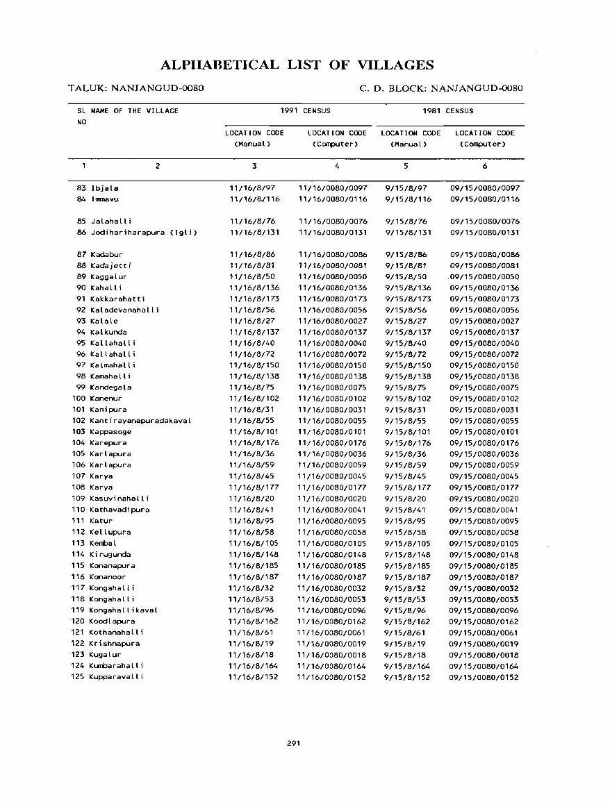
ALPllABETICAL LIST OF VILLAGES
T ALUK: NANJANGUD-0080
SL NAME OF THE VILLAGE
NO
83 Ibjala 84 Inmavu
85 Jalahalli
2
86 Jodihariharapura (Igli)
87 Kadabur 88 Kadajetti 89 Kaggalur 90 Kahall i 91 Kakkarahatti 92 Kaladevanahalli 93 Kalale 94 Kalkunda 95 Kallahall i 96 Kallahall i 97 Kalmahalli 98 Kamahall i 99 Kandegala
100 Kanenur 101 Kanipura 102 Kantirayanapuradakaval 103 Kappasoge 104 Karepura 105 Karlapura 106 Karlapura 107 Karya 108 Karya 109 Kasuvinahalli 110 Kathavadipura 111 Katur 112 Kellupura 113 Kembal 114 Kirugunda 115 Konanapura 116 Konanoor 117 Kongahalli 118 Kongahalli 119 Kongahallikaval 120 Koodlapura 121 Kothanahalli 122 Krishnapura 123 Kugalur 124 Kumbaraha II i
125 Kupparavalli
C. D. BLOCK: NANJANGUD-0080
1991 CENSUS 1981 CENSUS
LOCATION CODE
(Manual)
3
11/16/8/97
11/16/8/116
11/16/8/76
11/16/8/131
11/16/8/86
11/16/8/81
11/16/8/50
11/16/8/136
11/16/8/173
11/16/8/56
11/16/8/27
11/16/8/137
11/16/8/40
11/16/8/72
11/16/8/150
11/16/8/138
11/16/8/75
11/16/8/102
11/16/8/31
11/16/8/55
11/16/8/101
11/16/8/176
11/16/8/36
11/16/8/59
11/16/8/45
11/16/8/177
11/16/8/20
11/16/8/41
11/16/8/95
11/16/8/58
11/16/8/1 05
11/16/8/148
11/16/8/185
11/16/8/187
11/16/8/32
11/16/8/53
11/16/8/96
11/16/8/162
11/16/8/61
11/16/8/19
11/16/8/18
11/16/8/164
11/16/8/152
LOCATION CODE LOCATION CODE LOCATION CODE
(Computer) (Manual) (Computer)
4
11/16/0080/0097
11/16/0080/0116
11/16/0080/0076
11/16/0080/0131
11/16/0080/0086
11/16/0080/0081
11/16/0080/0050
11/16/0080/0136
11/16/0080/0173
11/16/0080/0056
11/16/0080/0027
11/16/0080/0137
11/16/0080/0040
11/16/0080/0072
11/16/0080/0150
11/16/0080/0138
11/16/0080/0075
11/16/0080/0102
11/16/0080/0031
11/16/0080/0055
11/16/0080/0101
11/16/0080/0176
11/16/0080/0036
11/16/0080/0059
11/16/0080/0045
11/16/0080/0177
11/16/0080/0020
11/16/0080/0041
11/16/0080/0095
11/16/0080/0058
11/16/0080/0105
11/16/0080/0148
11/16/0080/0185
11/16/0080/0187
11/16/0080/0032
11/16/0080/0053
11/16/0080/0096
11/16/0080/0162
11/16/0080/0061
11/16/0080/0019
11/16/0080/0018
11/16/0080/0164
11/16/0080/0152
291
5
9/15/8/97
9/15/8/116
9/15/8/76
9/15/8/131
9/15/8/86
9/15/8/81
9/15/8/50
9/15/8/136
9/15/8/173
9/15/8/56
9/15/8/27
9/15/8/137
9/15/8/40
9/15/8/72
9/15/8/150
9/15/8/138
9/15/8/75
9/15/8/102
9/15/8/31
9/15/8/55
9/15/8/101
9/15/8/176
9/15/8/36
9/15/8/59
9/15/8/45
9/15/8/177
9/15/8/20
9/15/8/41
9/15/8/95
9/15/8/58
9/15/8/105
9/15/8/148
9/15/8/185
9/15/8/187
9/15/8/32
9/15/8/53
9/15/8/96
9/15/8/162
9/15/8/61
9/15/8/19
9/15/8/18
9/15/8/164
9/15/8/152
6
09/15/0080/0097
09/15/0080/0116
09/15/0080/0076
09/15/0080/0131
09/15/0080/0086
09/15/0080/0081
.09/15/0080/0050
09/15/0080/0136
09/15/0080/0173
09/15/0080/0056
09/15/0080/0027
09/15/0080/0137
09/15/0080/0040
09/15/0080/0072
09/15/0080/0150
09115/0080/0138
09/15/0080/0075
09/15/0080/0102
09/15/0080/0031
09/15/0080/0055
09/15/0080/0101
09/15/0080/0176
09/15/0080/0036
09/15/0080/0059
09/15/0080/0045
09/15/0080/0177
09/15/0080/0020
09/15/0080/0041
09/15/0080/0095
09/15/0080/0058
09/15/0080/0105
09/15/0080/0148
09/15/0080/0185
09/15/0080/0187
09/15/0080/0032
09/15/0080/0053
09/15/0080/0096
09/15/0080/0162
09/15/0080/0061
09/15/0080/0019
09/15/0080/0018
09/15/0080/0164
09/15/0080/0152
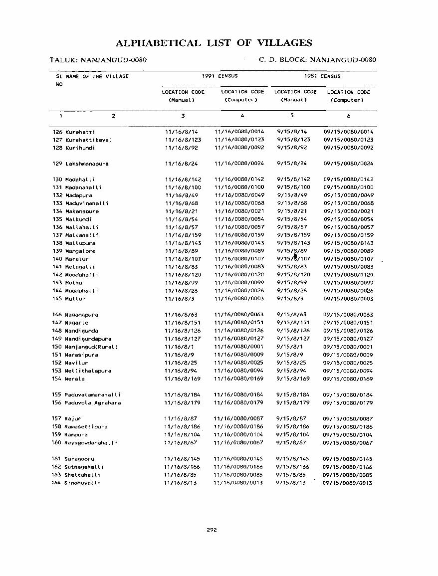
ALPIIABETICAL LIST OF VILLAGES
T ALUK: NANJANGUD-0080
SL NAME OF THE VILLAGE NO
126 Kurahatti 127 Kurahattikaval 128 Kurihundi
129 Lakshmanapura
130 Madahalli 13 1 Madanaha II i 132 Madapura 133 Maduvinahalli 134 Makanapura 135 Malkundi 136 Mallahall i 137 Mallahall i 138 Mallupura 139 Mangalore 140 Maralur 141 Metagalli 142 Moodahall i 143 Motha 144 Muddahall i 145 Mullur
146 Naganapura 147 Nagarle 148 Nandigunda
2
149 Nandigundapura 150 Nanjangud(Rural) 151 Narasipura 152 Navi lur 153 Nellithalapura 154 Nerale
155 Paduvalamarahalli 156 Paduvola Agrahara
157 Rajur 158 Ramasettipura 159 Rampura 160 Rayagowdanahalli
161 Saragooru 162 Sathagahalli 163 Shettahalli 164 SindhuvaU i
C. D. BLOCK: NANJANGUD-0080
1991 CENSUS 1981 CENSUS
LOCATION CODE (Manual)
3
11/16/8/14 11/16/8/123 11/16/8/92
11/16/8/24
11/16/8/142 11/16/8/100 11/16/8/49 11/16/8/68 11/16/8/21 11/16/8/54 11/16/8/57 11/16/8/159 11/16/8/143 11/16/8/89 11/16/8/107 11/16/8/83 11/16/8/120 11/16/B/99 11/16/8/26 11/16/B/3
11/16/8/63 11/16/8/151 11/16/8/126 11/16/8/127 11/16/8/1 '1/16/8/9 11/16/8/25 11/16/8/94 11/16/8/169
11/16/8/1B4 11/16/8/179
11/16/B/87
11/16/8/186 11/16/8/104 11/16/8/67
11/16/B/145
11/16/8/166 11/16/B/85 11/16/8/13
LOCATION CODE LOCATION CODE LOCATION CODE (Computer) (Manual) (Computer)
4
11/16/0080/0014 11/16/0080/0123 11/16/0080/0092
11/16/00BO/0024
11/16/0080/0142 11/16/0080/0100 11/16/0080/0049 11/16/0080/0068 11/16/0080/0021 11/16/0080/0054 11/16/0080/0057 11/16/0080/0159 11/16/0080/0143 11/16/0080/0089 11/16/0080/0107 11/16/0080/0083 11/16/0080/0120 11/16/0080/0099 11/16/0080/0026 11/16/0080/0003
11/16/0080/0063 11/16/0080/0151 11/16/0080/0126 11/16/0080/0127 11/16/00BO/000l
11/16/0080/0009 11/16/0080/0025 11/16/00BO/0094 11/16/0080/0169
11/16/0080/0184 11/16/0080/0179
11/16/0080/0087 11/16/0080/0186 11/16/0080/0104 11/16/0080/0067
11/16/00BO/0145
11/16/0080/0166 11/16/0080/0085 11/16/0080/0013
292
5
9/15/8/14 9/15/8/123 9/15/8/92
9/15/B/24
9/15/B/142 9/15/8/100 9/15/8/49 9/15/8/6B
9/15/8/21 9/15/8/54 9/15/8/57 9/15/8/159 9/15/8/143 9/15/8/89 9/15/~/107 9/15/8/B3 9/15/8/120 9/15/B/99 9/15/8/26 9/15/8/3
9/15/B/63 9/15/8/151 9/15/8/126 9115/8/127 9/15/8/1 9/15/8/9 9/15/8/25 9/15/8/94 9/15/8/169
9/15/8/184 9/15/8/179
9/15/8/87 9/15/8/186 9/15/8/104 9/15/8/67
9/15/8/145 9/15/8/166 9/15/8/85 9/15/8/13
6
09/15/0080/0014 09/15/0080/0123 09/15/0080/0092
09/15/0080/0024
09/15/0080/0142 09/15/0080/0100 09/15/0080/0049 09/15/0080/0068 09/15/0080/0021 09/15/0080/0054 09/15/0080/0057 09/15/0080/0159 09/15/0080/0143 09/15/0080/0089 09/15/0080/0107 09/15/0080/00B3 09/15/0080/0120 09/15/0080/0099 09/15/0080/0026 09/15/0080/0003
09/15/0080/0063 09/15/0080/0151 09/15/0080/0126 09/15/0080/0127 09/15/00BO/0001 09/15/00BO/0009 09/15/00BO/0025 09/15/0080/0094 09/15/0080/0169
09/15/0080/0184 09/15/0080/0179
09/15/0080/0087 09/15/0080/0186 09/15/0080/0104 09/15/0080/0067
09/15/00BO/0145
09/15/0080/0166 09/15/0080/00B5 09/15/0080/0013
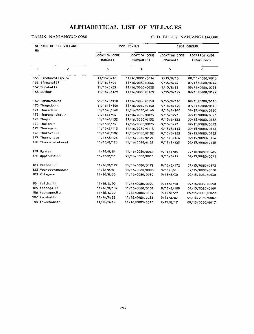
ALPIIABETICAL LIST OF VILLAGES
T ALUK: NANJANGUD-0080
SL NAME OF THE VILLAGE NO
2
165 Sindhuvallipura 166 Sirmahalli 167 Surahalli 168 Suthur
169 Tandavapura 170 Thagadooru 171 Tharadale 172 Tharaganahatti 173 Thayur 174 Thelanur 175 Thoramavu 176 Thorava II i 177 Thumnerale 178 Thumneralekaval
179 Ugniya
180 Uppinahall i
181 Varahalli
182 Veeredevanapura 183 Volagere
184 Yalehall i 185 Yechagalli 186 Yechagundlu
187 Yedahalli 188 Yelachagere
C. D. BLOCK: NANJANGUD-0080
1991 CENSUS 1981 CENSUS
LOCAT ION CODE (Manual)
3
11/16/8/16 11/16/8/44 11/16/8/23 11/16/8/129
11/16/8/110 11/16/8/140 11/16/8/160 11/16/8/93 11/16/8/132 11/16/8/73 11/16/8/113 11/16/8/182 11/16/8/1 24 11/16/8/125
11/16/8/84 11/16/8/11
11/16/8/172 11/16/8/8 11/16/8/30
11/16/8/90 11/16/8/109 11/16/8/29
11/16/8/82
11/16/8/17
LOCATION CODE LOCATION CODE LOCATION CODE (Computer) (Manual) (Computer)
4
11/16/0080/0016 11/16/0080/0044 11/16/0080/0023 11/16/0080/0129
11/16/0080/0110 11/16/0080/0140 11/16/0080/0160 11/16/0080/0093
11/16/0080/0132 11/16/0080/0073 11/16/0080/0113 11/16/0080/0182 11/16/008010124 ',/,6/0080/0125
11/16/0080/0084 11/16/0080/0011
11/16/0080/0172
11/16/0080/0008 11/16/0080/0030
11/16/0080/0090 11/16/0080/0109 11/16/0080/0029
11/16/0080/0082 11/16/0080/0017
293
5
9/15/8/16 9/15/8/44 9/15/8/23 9/15/8/129
9/15/8/110 9/15/8/140 9/15/8/160 9/15/8/93 9/15/8/132
9/15/8/73 9/15/8/113 9/15/8/182 9/15/8/124 9/15/8/125
9/15/8/84 9/15/8/11
9/15/8/172 9/15/8/8 9/15/8/30
9/15/8/90 9/15/8/109 9/15/8/29
9/15/8/82 9/15/8/17
6
09/15/0080/0016 09/15/0080/0044
09/15/0080/0023 09/15/0080/0129
09/15/0080/0110 09/15/0080/0140 09/15/0080/0160 09/15/0080/0093
09/15/0080/0132 09/15/0080/0073 09/15/0080/0113 09/15/0080/0182 09/15/0080/0124 09/15/0080/0125
09/15/0080/0084 09/15/0080/0011
09/15/0080/0172
09/15/0080/0008 09/15/0080/0030
09/15/0080/0090 09/15/0080/0109 09/15/0080/0029
09/15/0080/0082 09/15/0080/0017
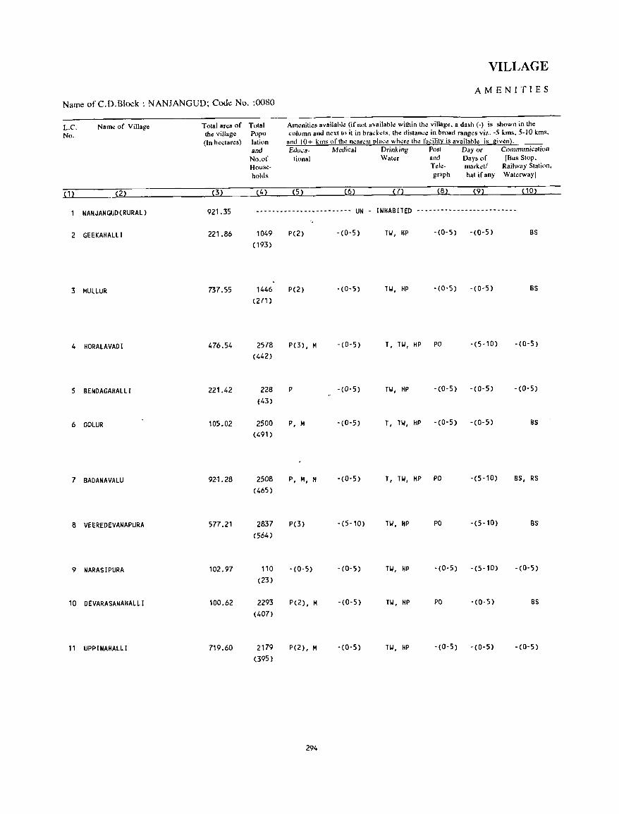
Name ofC.D.Block: NANJANGUD; Code No. :0080
L.C. No.
(1)
Name of Village
(2)
Total area of Total th~ village Poru-(In hectares) lation
(3)
and No.of Households
(4)
VILLAGE
AMENITIES
Amenities availahk (if not availahle within th~ villag~. a dash (-) is shown in the column and nl!xt tll it in hrad-::ds. the distanc.: in broad ranges viz. -5 kms. 5-10 kms,
and 10+ kms of the n..:ar..:st place wh..:re the facility is availahle is given). &Iuea- h1.:dieaJ Drinking Post Day or Communication
tiona I Water and Days of [Bus Stop, Tele- market/ Railway Station, graph hat if any Waterway]
(5) (6) (7) (8) (9) PO)
NANJANGUD(RURAL) 921.35 ------------------------ UN - INHABITED -------------------------
2 GEEKAHALLI 221.86
3 MULLUR 737.55
4 HORALAVADI 476.54
5 BENDAGAHALll 221.42
6 GOLUR 105.02
7 BADANAVALU 92·1.28
8 VEEREDEVANAPURA 577.21
9 NARASIPURA 102.97
10 DEVARASANAHAlll 100.62
11 UPPINAHAlLI 719.60
1049 (193)
1446 (271)
2578 (442)
228 (43)
2500 (491)
2508 (465)
2837 (564)
110 (23)
2293 (407)
2179 (395)
P(2)
P(2)
P(3), M
P
P, M
P, M, H
P(3)
-(0-5)
P(2), M
P(2), M
294
-(0-5) TW I HP -(0-5) -(0-5) BS
-(0-5) TW , HP -(0-5) -(0-5) BS
-(0-5) T, TW, HP PO -(5-10) -(0-5)
-(0-5) TW, HP -(0-5) -(0-5) -(0-5)
-(0-5) T, TW, HP -(0-5) -(0-5) BS
- (0- 5) T I TW, HP PO -(5-10) BS, RS
-(5-10) TW, HP PO -(5-10) BS
-(0-5) Til, HP -(0-5) -(5-10) -(0-5)
-(0-5) TW, HP PO -(0-5) BS
- (0- 5) Til, HP - (0- 5) - (0- 5) -(0-5)
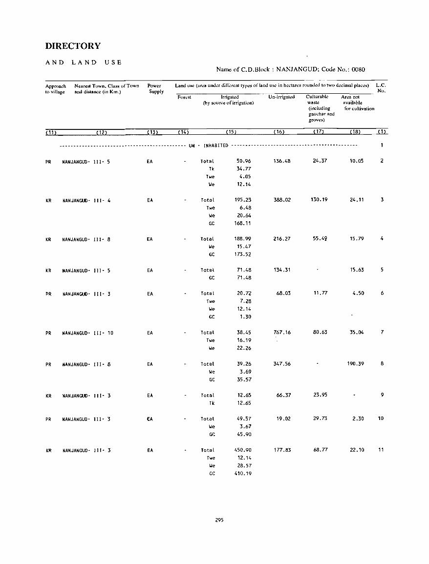
DIRECTORY
AND LAND USE Nam~ of C.D.Block : NANJANGUD; Code No.: 0080
Approach Nearest Town. Class of Town Power Land Us.! (ar~a und~r difl".!r~nt types of land us~ in h~.:Iar~s round~d to two decimal places) L.C. to village and distance (in Km.) Supply No.
For~st Irrigat~d Un-irrigated Cullurable Area not (by source of irrigation) waste available
(including for cultivation gauchar and grows)
(11) (12) (13) (14) (15) ( 16) ( 17) ( 18) (1)
--------------------------------------------- UN - [NHABITED ---------------------------------------------
PR NANJANGUD- 111- 5 EA Total 50.96 136.48 24.37 10.05 2
Tk 34.77
Twe 4.05
We 12.14
KR NANJANGUD- [[ [- 4 EA Total 195.23 388.02 130.19 24.11 3
Twe 6.48
We 20.64
GC 168.11
KR NANJANGUD- 11[- 8 EA Total 188.99 216.27 55.49 15.79 4
We 15.47
GC 173.52
KR NANJANGUD- 111- 5 EA Total 71.48 134.31 15.63 5
GC 71.48
PR NANJANGUD- II [- 3 EA Total 20.72 68.03 11.77 4.50 6
Twe 7.28
We 12.14
GC 1.30
PR NANJANGUD- 1 [ [ - 10 EA Total 38.45 767.16 80.63 35.04 7
Twe 16.19
We 22.26
PR NANJANGUD- 1 [1- 8 EA Total 39.26 347.56 190.39 8
We 3.69
GC 35.57
KR NANJANGUD- 11[- 3 EA Total 12.65 66.37 23.95 9
Tk 12.65
PR NANJANGUO- 111- 3 EA Total 49.57 19.02 29.73 2.30 10
We 3.67
GC 45.90
KR NANJANGUD- [11- 3 EA Total 450.90 177.83 68.77 22.10 11
Twe 12.14
We 28.57
GC 410.19
295

Name of C.D.Block : NANJANGUD; Code No. :0080
L.C. Name of Village No.
(1) (2)
12 GONA T HAGA LA
13 SINDHUVALLI
14 KURAHATTI
15 HUNASANALU
16 S I NDHUVALLI PURA
17 YELACHAGERE
18 KUGALUR
19 KRISHNAPURA
20 KASUVINAHALLI
21 MAKANAPURA
22 DEPEGOIolDANAPURA
Total ar.:a of th.: villag.: (In h.:clar.:s)
(3)
190.21
1011.53
511.99
746.17
429.40
577.72
408.29
367.38
1 Oq.?76
336.87
149.16
Total Popu-lalinn and
No.of House-holds
(4)
508 (94)
2914 (537)
1413 (273)
1781 (295)
1022 ( 177)
894 ( 144)
1791 (329)
586 (107)
2306 (416)
625 (101)
549 (99)
VILLAGE
AMEN·ITIES
Amenities available (if not availabk within the villago:. a dash (-) is shown in the ..:olumn and n.:xl 10 il in brad.:ls. tho: dislan..:.: in broad rango:s viz. -5 kms, 5-10 kms,
and 10+ kms "fth.: near.:st ~Ia.:.: wh.:re tho: fa.:ilit:): is availablo: is giv.:n). Educa- Medical Drinking Post Day or Communication
tional Wato:r and Days of IBus Stop, Tele- mark.:tl Railway Station, graph hat if any Wato:rway)
(5) (6) (7) (8) (9) (10)
P -(0-5) TW, HP -(0-5) -(0-5) -(0-5)
P(2.) , M -(0-5) TW, HP PO -(10+) BS
P, M -(0-5) T, TW, HP PO, - (1 0+) BS Phone
P - (10+) T, TW, HP - (0-5) -(10+) BS
P -(0-5) TW, HP -(0-5) -(10+) BS
P -(0-5) TW, HP -(0-5) -(5-10) BS
P, M -(0-5) HI, HP PO -(5-10) BS
P -(0-5) TW, HP -(0-5) -(5-10) -(0-5)
P, M, H PHC, FPC TW, HP PO -(10+) BS
P -(5-10) HI, HP -(0-5) -(10+) BS
P -(5-10) TW, HP -($-10) -(10+) -(0-5)
296
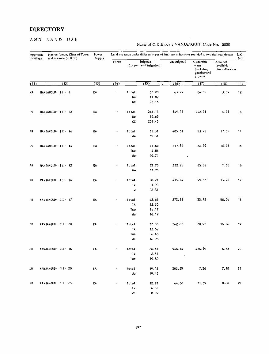
DIRECTORY
AND LAND USE Naml! of C.D.Block : NANJANGUD; Code No.: 0080
Approach Nearesl Town. Class of Town Power Land use (ar.:a und.:r dill".:r.:nl Iyp.:s of land use in hectar.:s rounded 10 IWO decimal places) L.C. to village and distance (in Km.) Supply No.
For~st Irrigat.:d Un·irrigat~d CulturabJ.: Area not (by source of irrigation) wasl~ available
(including for cultivation gauchar and grows)
(11) (12) (13) (14) ( 15) ( 16) ( 17) ( 18) (1)
ICR NANJANGUD- I I I - 4 EA Total 37.98 63.79 84.85 3.59 12
IoIe 11.82
GC 26.16
PR NANJANGUD- 111- 12 EA Total 216.14 549.13 242.21 4.05 13
IoIe 10.69
GC 205.45
PR NANJANGUD- 111- 16 EA Total 35.31 405.61 53.72 17.35 14
'We 35.31
PR NANJANGUD- 111- 14 EA Total 45.60 617.52 66.99 16.06 15
Twe 4.86
'We 40.74
PR NANJANGUD- I I I - 12 EA Total 33.75 322.25 65.82 7.58 16
'We 33.75
PR NANJANGUD- I I I - 16 EA Total 28.21 435.74 99.87 13.90 17
11< 1.90
W 26.31
PR NANJANGUD- I I 1- 17 EA Total 42.66 273.81 33.78 58.04 18
Tk 12.30
Twe 14.17
We 16.19
KR NANJANGUD- 111- 20 EA Total 37.08 242.82 70.92 16.56 19
Tk 13.62
Twe 6.48
IoIe 16.98
PR NANJI\NGUO- 111- 16 Ell. lotal 26.31 538.14 436.59 6.72 20
Tk 6.51
Twe 19.80
KR NANJANGUO- II I - 20 EA Total 19.48 302.85 7.36 7.18 21
'We 19.48
KR NANJANGUD- I11- 25 EA Total 12.91 64.36 71.09 0.80 22
Tk 4.82
lJe 8.09
297
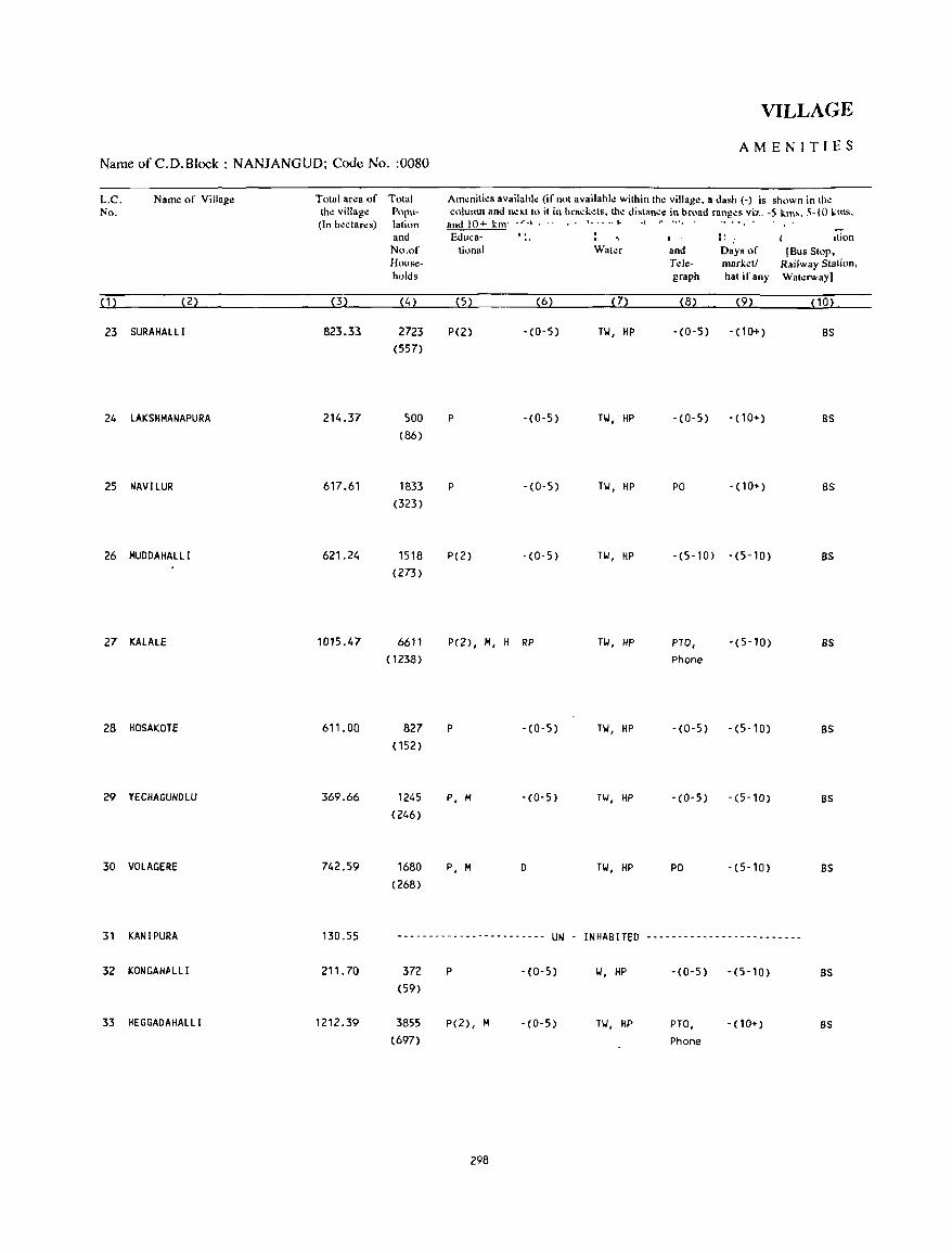
Name of C.D.Block : NANJANGUD; Code No. :0080
L.C. No.
(1)
Name of Village
(2)
23 SURAHALL I
24 LAKSHMANAPURA
25 NAVILUR
26 MUDDAHALLI
27 KALALE
28 HOSAKOTE
29 YECHAGUNDLU
30 VOLAGERE
Total area of Total lh\! village Popu-(In h~ctar~s) latinn
(3)
823.33
214.37
617.61
621.24
1015.47
611.00
369.66
742.59
and No.of Households
(4)
2723 (557)
500 (86)
1833 (323)
1518 (273)
6611 (1238)
827 (152)
1245 (246)
1680 (268)
VILLAGE
AMENITIES
Am~nities availab!.: (if not available within the village. a dash (-) is shown in the column and next to it in brad.ets. the distanc\! in broad ranges viz. -5 km,. 5-10 I;.ms.
and 10+ bn _r.l. ·1'
Educa-
(5) (6)
P(2) . (0-5)
P -(0-5)
P -(0-5)
P(2) - (0-5)
P(2), M, H RP
P -(0-5)
P, M -(0-5)
P, M D
Water
(7)
TI.', HP
TI.', HP
TI.', HP
TI.', HP
TI.', HP
TI.', HP
TI.', HP
TI.', HP
and Tele-graph
(8)
- (0-5)
-(0-5)
PO
-(5-10)
PTO, Phone
-(0-5)
-(0-5)
PO
I' Ition I. : Days of [Bus Stop, marketl Railway Station. hat if any Waterway)
(9) (10)
-(10+) BS
-(10+) BS
-(10+) BS
-(5-10) BS
-(5-10) BS
-(5-10) BS
-(5-10) BS
-(5-10) BS
31 KANIPURA 130.55 -------------.---.------ UN - INHABITED -~-----------------------
32 KONGAHALLI 211. 70 372 P -(0-5) 1.', HP -(0-5) -(5-10) BS (59)
33 HEGGADAHALLI 1212.39 3855 P(2), M -(0-5) TI.', HP PTO, -(10+) as (697) Phone
298
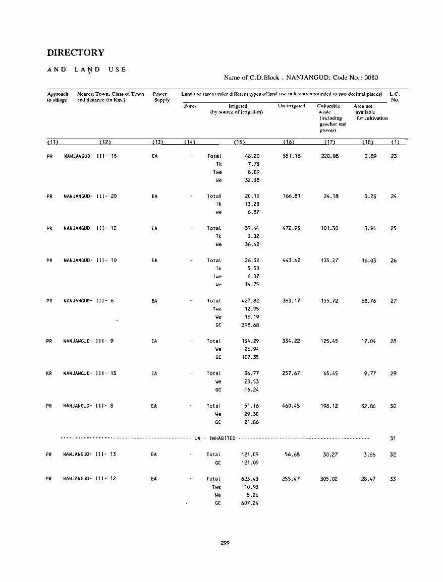
DIRECTORY
AND LA~D USE Name of C.D.Block : NANJANGUD; Code No.: 0080
Approach Nearest Town. Class of Town Power Land u.e (area under different types of land u~ in hectares rounded to two decimal places) L.C. to village and distance (in Km.) Supply No.
Fore.t Irrigated Un-irrigated Culturable Area not (by source of irrigation) waste available
(including for cultivation gauchar and groves)
( 11 ) ( 12) ( 13) (14) ( 15) ( 16) ( 17) ( 18) (1)
PR NANJANGUD- I I 1- 15 EA Total 48.20 551. 16 220.08 3.89 23 Tk 7.73
Twe 8.09 lJe 32.38
PR NANJANGUD- 111- 20 EA Total 20.15 166.81 24.18 3.23 24 Tk 13.28 lJe 6.87
PR NANJANGUD- I I 1- 12 EA Total 39.44 472.93 101.30 3.94 25 Tk 3.02 lJe 36.42
PR NANJANGUD- 111- 10 EA Total 26.32 443.62 135.27 16.03 26 Tk 5.50
Twe 6.07 lJe 14.75
PR NANJANGUD- I I 1- 6 EA Total 427.82 363.17 155.72 68.76 27 Twe 12.95 lJe 16.19 GC 398.68
PR NANJANGUD- II I - 9 EA Total 134.29 334.22 125.45 17.04 28 lJe 26.94 GC 107.35
KR NANJANGUD- I I I - 13 EA Total 36.77 257.67 65.45 9.77 29 lJe 20.53 GC 16.24
PR NANJANGUD- I I 1- 8 EA Total 51. 16 460.45 198.12 32.86 30 IJe 29.30 GC 21.86
--------------------------------------------- UN - I NHAB !TED -----------~--------------------------------- 31
PR NANJANGUD- II I - 13 EA Total 121.09 56.68 30.27 3.66 32 GC 121.09
PR NANJANGUD- I I I - 12 EA Total 623.43 255.47 305.02 28.47 33 Twe 10.93 lJe 5.26 GC 607.24
299
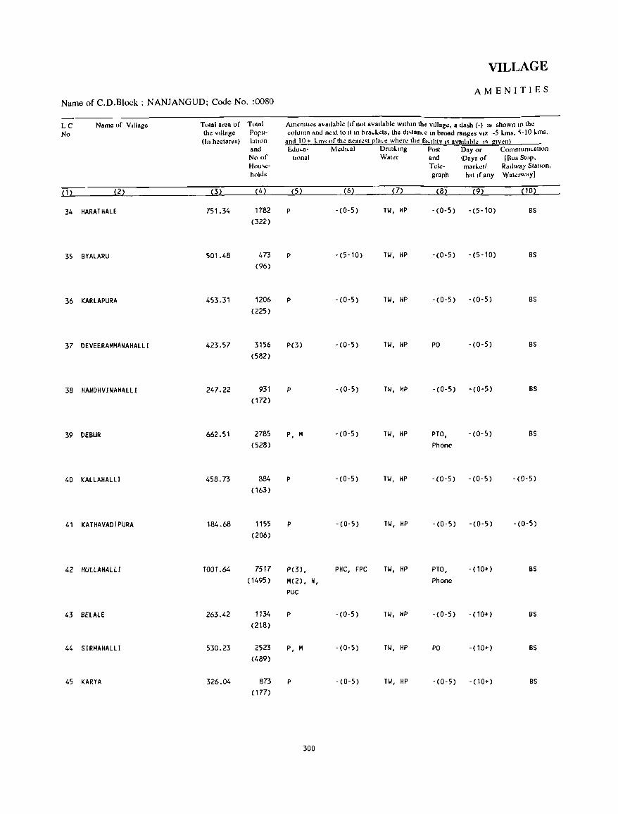
VILLAGE
AMENITIES Name of C.D.B1ock : NANJANGUD; Code No. :0080
LC Name of VIllage Tolal area of Tolal Am~n&lh:S avaIlable (If nol avaIlable wllhm the vIllage, a da~h (-) IS ~hown to the
No the village Popu- column and nexllo II In brad.els, the d"lance In broad ranges VIZ -5 L.ms. ~-IO L.ms, (In hectares) lallOn and 10+ km. of the neare.t l!luce where the faCility I' aVllllable •• g.ven)
and &luca- MedlCsl Dnnklng Post Day or Communlcallon No of Ilona I Water and 'Days of [Bus SlOP, Hou'e- T.:Ie- marL.etl RaIlway Stallon. holds graph hat If any Waterway]
(1) (2) (3) (4) (5) (6) (7) (8) (9) (10)
34 HARATHALE 751.34 1782 P - (0- 5) HI, HP -(0-5) -(5-10) BS
(322)
35 BYALARU 501.48 473 P -(5-10) TIJ, HP - (0- 5) -(5-10) BS
(96)
36 KARLAPURA 453.31 1206 P - (0- 5) TIJ, HP -(0-5) -(0-5) BS
(225)
37 DEVEERAMMANAHALLI 423.57 3156 P(3) -(0-5) TIJ, HP PO -(0-5) BS
(582)
38 HANDHV I NAHALLI 247.22 931 P - (0- 5) HI, HP - (0-5) - (0- 5) BS
( 172)
39 DEBUR 662.51 2785 P, M -(0'5) Til, HP PTO, -(0-5) BS
(528) Phone
40 KALLAHALLI 458.73 884 P - (0- 5) Til, HP -(0-5) -(0-5) -(0-5)
( 163)
41 KATHAVADIPURA 184.68 1155 P -(0-5) Til, HP -(0-5) -(0-5) - (0-5)
(206)
42 HUllAHAlLl 1001.64 7517 P(3) , PHC, FPC HI, HP PTO, -(10+) BS
(1495 ) M(2) , H, Phone
PUC
43 BHALE 263.42 1134 P -(0-5) HI, HP -(0-5) - (10+) BS
(218)
44 SIRMAHALLI 530.23 2523 P, M -(0-5) Til, HP PO -(10+) BS
(489)
45 KARYA 326.04 873 P -(0-5) Til, HP -(0-5) - (10+) BS
( 177)
300
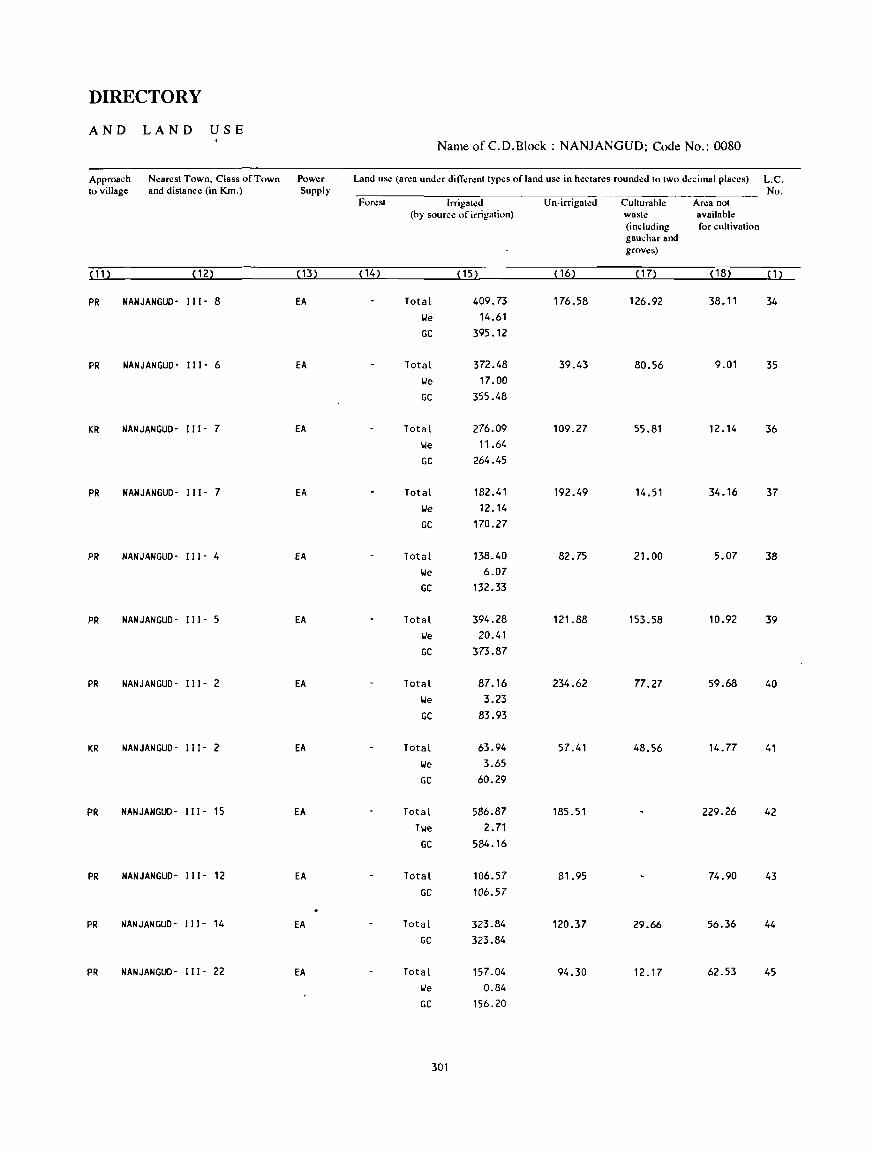
DIRECTORY
AND LAND USE Name ofC.D.Block : NANJANGUD; Code No.: 0080
Approach Nearest Town, Class of Town Power Land use (area under different types of land use in hectares rounded to two decimal places) L.C. to village and distance (in Km.) Supply No.
Forest Irrigated Un-irrigated Culturable Area not (by source of irrigation) waste available
(including for cultivation gauchar and groves)
(11) (12) ( 13) ( 14) (15) ( 16) ( 17) ( 18) ( 1 )
PR NANJANGUO- 11[- 8 EA Total 409.73 176.58 126.92 38.11 34
lie 14.61
GC 395.12
PR NANJANGUD- [[ [- 6 EA Total 372.48 39.43 80.56 9.01 35
lie 17.00
GC 355.48
KR NANJANGUD- I [[ - 7 EA Total 276.09 109.27 55.81 12.14 36
lie 11.64
GC 264.45
PR NANJANGUD- 111- 7 EA Total 182.41 192.49 14.51 34.16 37
lie 12.14
GC 170.27
PR NANJANGUD- 111- 4 EA Total 138.40 82.75 21.00 5.07 38
lie 6.07
GC 132.33
PR NANJANGUD- [11- 5 EA Total 394.28 121.88 153.58 10.92 39
lie 20.41
GC 373.87
PR NANJANGUD- [[ [- 2 EA Total 87.16 234.62 77.27 59.68 40
lie 3.23
GC 83.93
KR NANJANGUD- [[ [- 2 EA Total 63.94 57.41 48.56 14.77 41
lie 3.65
GC 60.29
PR NANJANGUD- [ I 1- 15 EA Total 586.87 185.51 229.26 42
Twe 2.71
GC 584.16
PR NANJANGUD- II I - 12 EA Total 106.57 81.95 74.90 43
GC 106.57
PR NANJANGUD- [ [ 1- 14 EA Total 323.84 120.37 29.66 56.36 44
GC 323.84
PR NANJANGUD- [[[- 22 EA Total 157.04 94.30 12.17 62.53 45
lie 0.84
GC 156.20
301

VILLAGE
AMENITIES Name of C.D.B1ock : NANJANGUD; Code No. :0080
L.C. Name of Village Total area of Total Amenities availahle (if not availahle within the village. a dash (-) is shown in the No. the village Popu- column and next to it in hrad;c1s. the distance in hroad ranges viz. -5 kms. 5-IO.kms.
(In hectares) lation and 10+ kms of the neare"t ~Iace where the facility is availahle is given). and Eduea- Mcdkal Drinking Post Day or Communication No."f tional Water and Days of [Bus Stop. How,e- Tde- marketl Railway Statiolj. holJ" graph hat if any Waterway)
(1) (2) (3) (4) (5) (6) (7) (8) (9) ( 1 0) .
46 HUSKUR 489.71 1561 P -(0-5) Hoi, HP -(0-5) - (10+) BS (287)
47 HAGINAVALU 674.31 3069 P, H, H -(0-5) TIoI, HP PO - (10+) BS (555)
48 CHAHANAHADANAHALLI 273.58 436 P -(0-5) 101, HP -(0-5) -(0-5) -(0-5) (121)
49 MADAPURA 345.53 879 P -(0-5) TIoI, HP PO - (10+) BS (180)
50 KAGGALUR 346.65 181 P -(0-5) TIoI, HP - (0- 5) - (10+) BS (38)
51 AMBLE 982.10 1763 P, H -(5-10) TIoI, HP -(0-5) -(5-10) BS (327)
52 HALLARE 1064.57 2995 P(2), H -(0-5) TIoI, HP PO -(10+) BS (526)
53 KONGAHALLI 266.21 563 P -(0-5) TIoI, HP -(0-5) -(0-5·) BS (103)
54 MALKUNDI 470.66 2435 P -(0-5) TIoI, HP -(0-5) - (10+) BS (413)
55 KANT I RAYANAPURADAKAVAL 360.54 3 -(0-5) -(0-5) 101, HP -(0-5) - (0- 5) -(0-5) (1)
56 KALADEVANAHALLI 216,26 ------------------------ UN - I NHAB !TED -------------------------
57 MlI,llll,lIl1,lU 2S0.94 1045 P, lit -(O-5) TI.I, liP -(C-5) - (10+) 'Os (241 )
58 KELLUPURA 364.33 511 P -(0-5) TIoI, HP -(0-5) -(10+) BS (96)
59 KARLAPURA 208.45 --------------- - - - ------ UN - INHABITED -------------------------
60 BHOGAVALUVODEYANAPURA 176.26 131 -(0-5) -(0-5) TIJ, HP -(0-5) - ( 10+ ) -(0-5) (22)
302
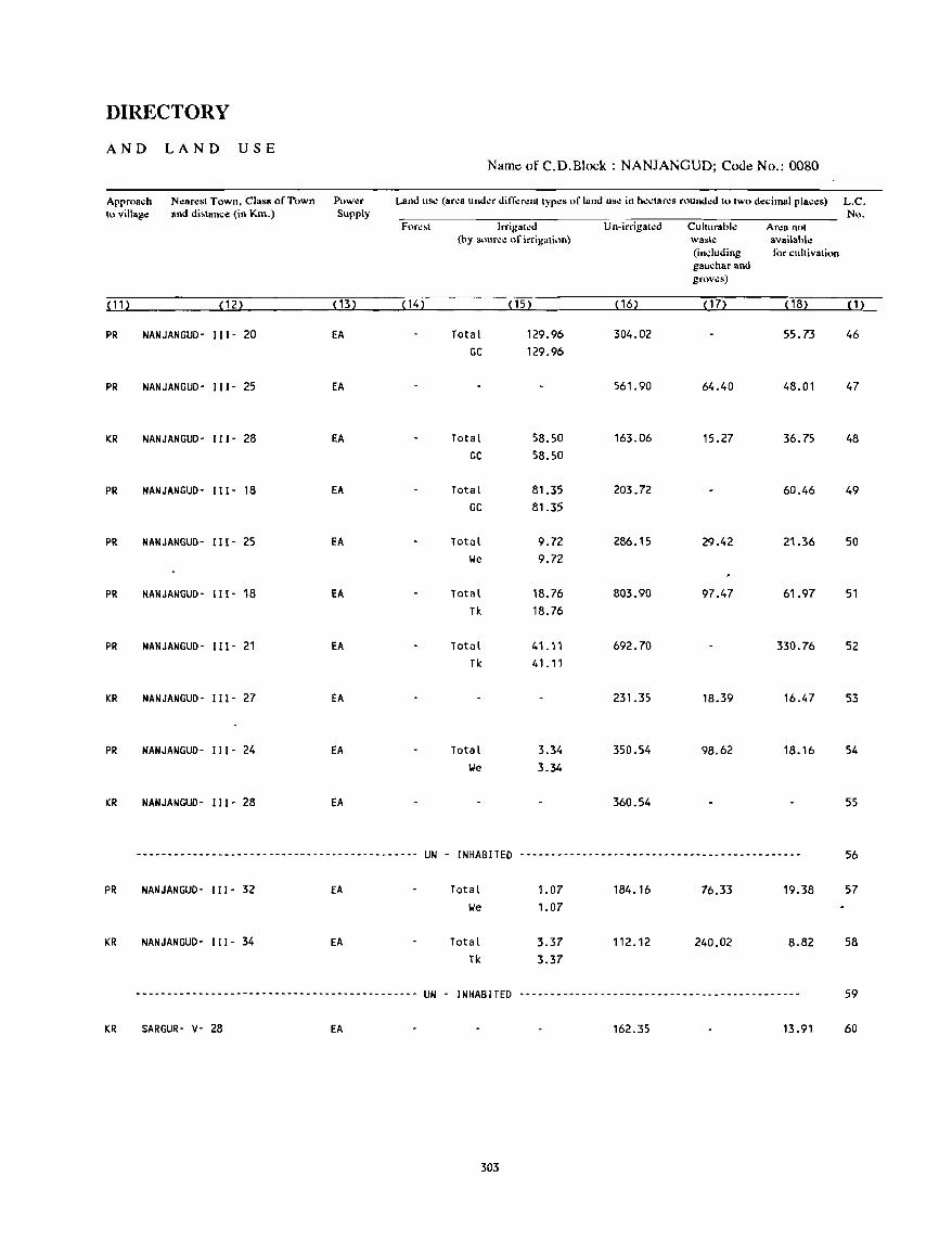
DIRECTORY
AND LAND USE Name of C.D.Block : NANJANGUD; Code No.: 0080
Approach Nl!ar.:st Town, Class ofl"own Powl!r Land usc (area under dit1-':rent types of land usc in hcctarcs rounded to two dl!cimal placl!s) L.C. to village and di~tancl! (in Km.) Supply No.
Fore~t Irrigated Un-irrigated CulturabJ.: Area not (by source of irrigation) waste available
(including for cultivation gauchar and groves)
( 1 1 ) (12) (13) ( 14) (15) (16) (17) ( 18) (1)
PR NANJANGUD- II I - 20 EA Total 129.96 304.02 55.73 46 GC 129.96
PR NANJANGUD- II 1- 25 EA 561.90 64.40 48.01 47
KR NANJANGUD- 111- 28 EA Total 58.50 163.06 15.27 36.75 48 GC 58.50
PR NANJANGUD- 111- 18 EA Total 81.35 203.72 60.46 49 GC 81.35
PR NANJANGUD- 111- 25 EA Total 9.72 286.15 29.42 21.36 50 lie 9.72
PR NANJANGUD- 111- 18 EA Total 18.76 803.90 97.47 61.97 51 Tk 18.76
PR NANJANGUD- 111- 21 EA Total 41.11 692.70 330.76 52 Tk 41.11
KR NANJANGUD- 111- 27 EA 231.35 18.39 16.47 53
PR NANJANGUD- 111- 24 EA Total 3.34 350.54 98.62 18.16 54 lie 3.34
KR NANJANGUD- 111- 28 EA 360.54 55
--------------------------------------------- UN - INHABITED --------------------------------------------- 56
PR NANJANGUD- 111- 32 EA Total 1.07 184.16 76.33 19.38 57 lie 1.07
KR NANJANGUD- " 1- 34 EA Total 3.37 112.12 240.02 8.82 58 Tk 3.37
--------------------------------------------- UN - INHABITED --------------------------------------------- 59
KR SARGUR- v- 28 EA 162.35 13.91 60
303

VILLAGE
AMENITIES Name of C.D.Block : NANJANGUD; Code No. :0080
L.C. Name of Village Tolal ar.:a of Tolal Am~nili.:s availahl.: (if nOI availahI.: within th.: villag.:, a dash (-) is shown in th.: No. the village Pupu- column and ncxtto it in brackds. the distanc.: in hr.,ad rang.:s viz. -5 kms, 5-10 kms.
(In hcctar.:s) lation and 10+ kms of the nearest [!Iae~ wha.: the facilit~ is avail:lblc is given}. and Eduea- M~dical Drinking Post Day or Communication
No.of tiona I Walcr and Days of [Sus Stop, House- Telc- mark.:ti Railway Station, holds graph hal if any Wal.:rway]
(1) (2) (3) (4) (5) (6) (7) (8) (9) PO)
61 KOTHANAHALLJ 389.46 461 P -(0-5) Til, HP -(0-5) - (10+) BS (87)
62 DEVARAYASETTIPURA 972.94 1869 P(3), M -(0-5) Til, HP PTO, -(10+) BS (305) Phone
63 NAGANAPURA 3814.07 1773 P(4) , M -(0-5) Til, HP - (0- 5) - (10+) BS (336)
64 BANKAHALLI 355.26 877 P -(5-10) Til, HP -(0-5) -(10+) BS ( 175)
65 HADANURUVODEYANAPURA 203.94 507 P -(0-5) n/, HP - (0- 5) - <1 0+) BS (98)
66 HEDIYAlA 1091.46 3760 P(4) , M, H -(0-5) 11.1, HP PO - (10+) BS (710)
67 RAYAGOWOANAHAllI 177.35 ------------------------ UN - INHABITED -------------------------
68 MADUVINAHALLI 583.83 2219 P(2), M PHC, FPC Til, HP PO -(10+) BS (423)
69 AMKAHALLI 154.80 17 -(0-5) -(0-5) HI, HP -(0-5) -(5-10) BS (4)
70 HOSAVEEDU 741.91 1454 P(2), M -(0-5) Til, HP -(0-5) - (10+) BS (252)
71 HOSAVEEDUKAVAL 129.55 -------------------~---- UN - I NHAB IlED -------------------------
72 KALlAHAlLl 353.19 --- .. - ..... _- ........... _--------- UN - INHABITED ........ -- --- --- .. ------ -----_
73 THELANUR 264.17 ----_ .... ---- -- _ .. _--- ... _--- UN - INHABITED -_ ---- .... -_ .... ------_ -_ ... - .. -
74 GAD I GUDDADAKAVAl 100.25 3 -(0-5) -(0-5) II -(0-5) -(0-5) -(0-5) (3)
75 KANDEGALA 522.17 982 P, M -(0-5) Til, HP -(0-5) - (10+) BS (176)
76 JAlAHAlll 127.37 241 P(2) -(5-10) Til, HP - (0- 5) - (10+) BS (48)
304
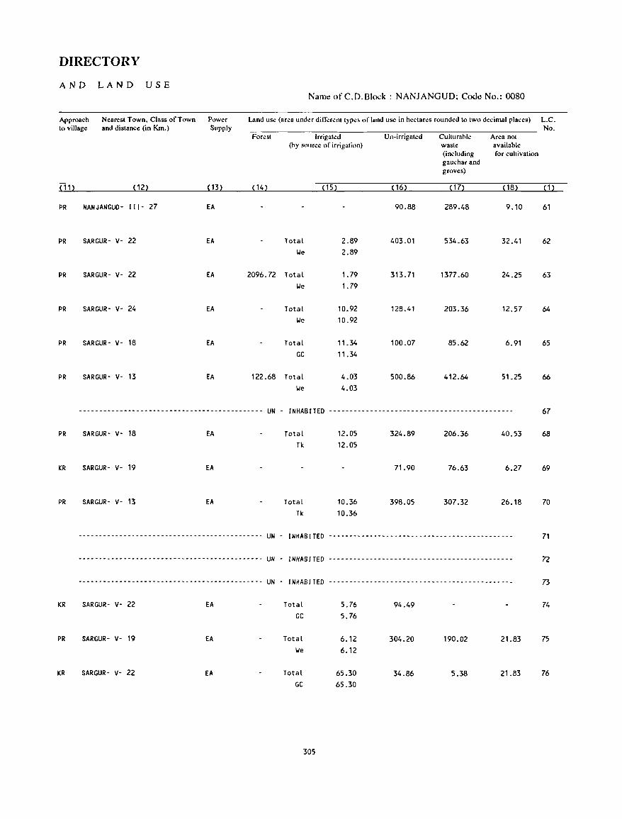
DIRECTORY
AND LA N D USE Namt! of C.D.Block : NANJANGUD; Coot! No.: 0080
Approach Nearest Town. Class of Town Power Land us.: (area under din-':rent type~ of land use in hectares rounded to two decimal places) L.C. to village and distance (in Km.) Supply No.
Forest Irrigated Un-irrigated Culturable Area not (hy source of irrigation) waste available
(including for cultivation gauchar and groves)
( 11) (12) ( 13) (14) (15) (16) ( 17) ( 18) (1)
PR NANJANGUD- 111- 27 EA 90.88 289.48 9.10 61
PR SARGUR- v- 22 EA Total 2.89 403.01 534.63 32.41 62 lie 2.89
PR SARGUR- V- 22 EA 2096.72 Total 1.79 313.71 1377.60 24.25 63 lie 1. 79
PR SARGUR' V- 24 EA Total 10.92 128.41 203.36 12.57 64 lie 10.92
PR SARGUR' V- 18 EA Total 11.34 100.07 85.62 6.91 65 GC 11.34
PR SARGUR' V- 13 EA 122.68 Total 4.03 500.86 412.64 51.25 66
lie 4.03
--------------------------------------------- UN - INHABCTED --------------------------------------------- 67
PR SARGUR' V- 18 EA Total 12.05 324.89 206.36 40.53 68 Tk 12.05
KR SARGUR' V- 19 EA 71.90 76.63 6.27 69
PR SARGUR· V- 13 EA Total 10.36 398.05 307.32 26.18 70 Tk 10.36
-------------------------.-----.------------- UN - INHABITED -.-----.-----.-----.-----.-----.------------- 71
-------.-----.-----.----.------.-- ... - .. ----- UN . INHABITED - .. -.----- .. -.-- .. -.---------------.-.- .. ---- 72
--------- .. -- ... --- .. ----.------- ..... ------- UN - INHABITED -------------.-----.-----------.------------. 73
KR SARGUR- V· 22 EA Total 5.76 94.49 74 GC 5.76
PR SARGUR· V· 19 EA Total 6.12 304.20 190.02 21.83 75 lie 6.12
KR SARGUR- V· 22 EA Total 65.30 34.86 5.38 21.83 76 GC 65.30
305

VILLAGE
AMENITIES Name of C.D.Block : NANJANGUD; Code No. :0080
L.e. Name of Village Total area of Total Amenities availahl.: (if not availahle within the village, a da,h (-) is shown in tho: No. the village Popu- column and next to it in hraclets, the distanco: in hroad rango:s viz. -5 kms, 5-10 kms,
(In hectares) lation and I () + kill' "f the nearc,t I2la("e where the facility is availahlc is giv.:n~.
and &lu..:a- Medi..:al Drinling PoM Day or Communi..:ation No.of tional Water and Days of [Bus Stop, Hou~t!- Tde- market! Railway Station, holds graph hat ifany Waterway)
(1) (2) (3) (4) (5) (6) (7) (8) (9) (10)
77 ARIYUR 416.52 847 P, M - (0- S) HI, HP -(0-5) -(10+) as (161 )
78 HADYA 430.92 1905 P(2), M -(O-S) Til, HP PTO, -(10+) as (34S) Phone
79 CHANNAPATNA 30S.23 1170 P -(0-5) Til, HP -(0-5) -(10+) as (218)
80 HURA 715.65 3244 P(2), M, H PHC Til, HP PTO, MON , as (612) Phone
81 KADAJETTI 563.61 1017 P(2), M -(0-5) Til, HP PO -(10+) as (215)
82 YEDAHALLI 201.69 103 -(0-5) -(0-5) Til, HP -(0-5) -(10+) as ( 17)
83 MELAGALLI 478.25 6 -(0-5) -(0-5) II -(0-5) -(0-5) - (0-5) (3)
84 UGNIYA 347.61 ------------------------ UN - I NHAa !TED -------------------------
85 SHETTAHAlLi 145.52 561 P - (0- S) Til, HP -(0-5) -(10+) as ( 100)
86 KADAaUR 443.54 1040 P, M -(0-5) Til, HP PO - ( 1 0+) as (204)
87 RAJUR 213.05 630 P - (0- 5) Til, HP -(0-5) -(10+) as ( 104)
88 AKAlA 491.63 750 P, M -(0-5) Til, HP -(0-5) - ( 10+) as (144)
89 MAN GALORE 286.14 12 -(0-5) -(0-5) Til, HP -(0-5) -(10+) - (0-5) (1 )
90 YAlEHALLI 305.08 531 P D Til, HP -(0-5) -(10+) as (97)
91 DUGGAHAlLI 479.99 1183 P -(5-10) Til, HP - (5 -10) - ( 10+) as (218)
306
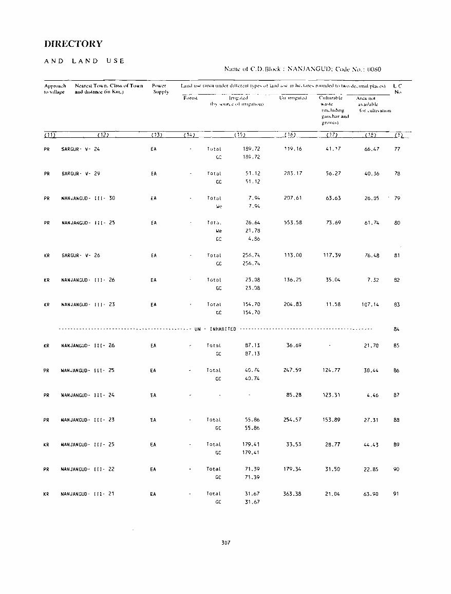
DIRECTORY
AND LAND USE !'\aJllc ot C.D.l3lo<:k : ;\;:\i':JA:\GUD: lllJe No.: OOSO
Apprua"h N~an."1 Town. Cia" o("Tuwn Powl!r Land u .... ...: tar..:a unJl..'f Jdkrl..'llll~r..:'" ot 1.1nd lhl..' III h..:...tdrl.." rnUIH .. kd to h"n l.k ... \llM{ pla .... ..:~) LC 10 vlII.go: and d"lan,o: (in Kill.) Supply N" ----~- -- --~--
For..::-.t Inl~,lkJ Un \fn~at..:d Cllllllrabk Ar..:a not (h~ .... 'Hlrl.~ ut Ifll,;!'atH)II) ~a ... l..: .\ adank
~\nl.ludH\~ f\}f \.ulhvalhHl ~all ... har and gr\)"c:-.)
(ll) (12) (13) (14) (15) ( 16) ( 17) (18) (1)
PR SARGUR- v- 24 EA Total 189.72 119.16 41. 17 66.47 77
GC 189.72
PR SARGUR- v· 29 EA Total 51.12 283.17 56.27 40.36 78
GC 51.12
PR NANJANGUD· III' 30 EA Total 7.94 207.61 63.63 26.05 79 We 7.94
PR NANJANGUD- 111- 2'S EA Total 26.64 553.58 73.69 61.74 80 We 21. 78
GC 4.86
KR SARGUR- v- 26 EA Total 256.74 113.00 117.39 76.48 81 GC 256.74
KR NANJANGUD· III' 26 EA Total 23.08 136.25 35.04 7.32 82 GC 23.08
KR NANJANGUD- III· 23 EA Total 154.70 204.83 11.58 107.14 83 GC 154.70
--------------------------------------------- UN - I NHAB I TED - --- - - - ----- - - -- - --- - - -- - - - - - - - - -- - -- - ---- --- 84
KR NANJANGUD- 111- 26 EA Total 87.13 36.69 21.70 85 GC 87.13
PR NANJANGUD- Ill- 25 EA Total 40.74 247.59 124.77 30.44 86 GC 40.74
PR NANJANGUD- Ill- 24 EA 85.28 123,31 4.46 87
PR NANJANGUD- Ill- 23 EA Total 55.86 254.57 153.89 27.31 88 GC 55.86
KR NANJANGUD- 111- 25 EA Total 179.41 33.53 28.77 44.43 89 GC 179.41
PR NANJANGUD- III- 22 EA Total 71.39 179.34 31.50 22.85 90 GC 71.39
KR NANJANGUD· 111- 21 EA Total 31.67 363.38 21.04 63.90 91 GC 31.67
307

VILLAGE
AMENITIES Name ot C.D.Block : NANJANGUD; Code No. :0080
LC Naill': of Vlliago: Tolal ar~a of Toldl AlII~IIIIt~. avall.lhk (11'11"1 avallahl.: Wllhlll Ih.: vlllag.:. a da,h (.) IS .hown In Iho: No Ih~ vlllago: Popu· .IlIUIl1I1 and n~xl 11111111 hrad .. ~ls. th~ dl,lon • .: m hroad rallg.:s VI'" .~ I..m •. ~ 101..111'.
(In h~dar~') lallOn and 11)+ ~III' Ilflhe n~.'r~q [!I.,,~ "h~re Ih~ f'hlhl~ "avall.lhk " glv.:n2 alld Edu.a· l\I~dl.al Dnnl..mg Po,1 Day or COlllmulII.altOn Nil III 1t,"",1 Wah!r a 11.1 DdY' of (Bu. Slop, Hou ... \!- Td.: marl..':l/ R.lllway SlalHln. hllld, graph hdl If any Wdl.:rway)
(1) (2) (3 ) (4) (S) (6) (7) (8) (9) ( 1 0)
92 KURIHUNDI 4S2.42 1530 P . (S'1 0) TW, HP PO . (10+) BS (296)
93 THARAGANAHALll 439.56 1465 P ·(O·S) TW, HP . (0, S) - (10+) BS (274 )
94 NELLI HIALAPURA SSO.43 1379 P(2) PHC, FPC TW, HP PO, - (10") BS (274) Phone
9S KATUR 869.98 1787 P(2), M -(5-10) TW, HP -(S'10) - (10+) BS (332)
96 KONGAHALllKAVAL 90.09 27 -(O-S) -(O-S) TW, HP -(O-S) -(10+) -(0-5) (3)
97 IBJALA 419,56 19S0 P -(0-5) TW, HP -(0-5) -(0-5) BS (328)
98 HARADANAHALLI 608.35 2737 P(2), M -(0-5) TW, HP PTO, - (0- 5) BS (485) Phone
99 MOTHA 637.45 353 P RP TW, HP - (0- 5) -(5-10) BS (62)
100 MADANAHALLI 177.71 682 P(2) -(0-5) TW, HP -(0-5) -(5-10) BS (116)
101 KAPPASOGE 308.82 1969 P - (0-5) TW, HP -(0-5) -(5-10) BS (371)
102 KANENUR 952.35 2238 P, M -(0-5) TW, HP PO -(5-10) BS (435)
103 CHIKKAIAHNACHATRA 7_24 694 P(2) -(S-10) TW, HP -(0-5) -(0-5) BS (125 )
104 RAMPURA 1460.72 4291 P(4), M -(0-5) TIJ, HP PO, - (10+) BS (747) Phone
105 KEMBAL 756.83 531 P -(5-10) TW, HP -(0-5) -(10+) BS (98)
106 BIDARAGOOOU 403.27 1842 P -(5-10) TW, HP -(0-5) - (10+) BS (328)
308
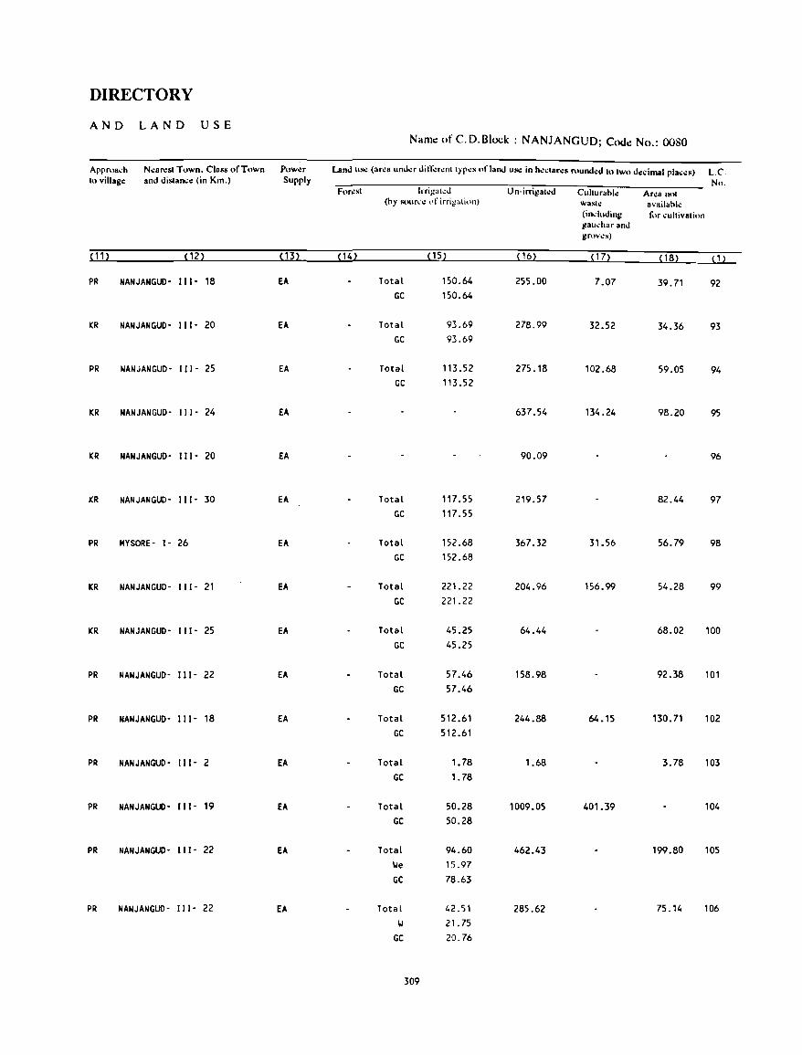
DIRECTORY
AND LAND USE Name of C. D. Block: NANJANGUD; Code No.: 0080
Approa~h N.:ar.:st Town. Class of Town Pllw.:r Land us.: (area und.:r din;':r.:nl Iyp.:s uf land us.: in h':~lar.:s rtlund.:d 10 IWo d.:.:imal pla~.:s) L.C 10 village: and disla~.: (in Kill,) Supply Nu,
For,:sl IrrilZah:d U n·irrigaled Cullurahl.: Ar.:a nul (hy sour"e of irrigation) wastt.! availahk
(induding fur ~ullivaliun gau~har and grov.:s)
(11) (12) (13) ( 14) (15) ( 16) ( 17) (18) (1)
PR NANJANGUD- 111- 18 EA Total 150.64 255.00 7.07 39.71 92 GC 150.64
KR NANJANGUD' III· 20 fA Total 93.69 278.99 32.52 34.36 93 GC 93.69
PR NANJANGUD· III' 25 EA Total 113.52 275.18 102.68 59.05 94 GC 113.52
KR NANJANGUD- 111- 24 EA 637.54 134.24 98.20 95
KR NANJANGUD- 111- 20 EA 90.09 96
KR NANJANGUD- 111- 30 EA Total 117.55 219.57 82.44 97 GC 117.55
PR MYSORE- 1- 26 EA Total 152.68 367.32 31.56 56.79 98 GC 152.68
KR NANJANGUD- 111- 21 EA Total 221.22 204.96 156.99 54.28 99 GC 221.22
KR NANJANGUD- 111- 25 EA Total 45.25 64.44 68.02 100 GC 45.25
PR NANJANGUD- 111- 22 EA Total 57.46 158.98 92.38 101 GC 57.46
PR NANJANGUD- 111- 18 EA Total 512.61 244.88 64.15 13D.71 102 GC 512.61
PR NANJANGUD- 111- 2 EA Total 1.78 1.68 3.78 103 GC 1.78
PR NANJANGUD- 111- 19 EA Total 50.28 1009.05 401.39 104 GC 50.28
PR NANJANGUD- 111- 22 EA Total 94.60 462.43 199.80 105 lie 15.97 GC 78.63
PR NANJANGUD- 111- 22 EA Total 42.51 285.62 75.14 106 II 21. 75
GC 20.76
309
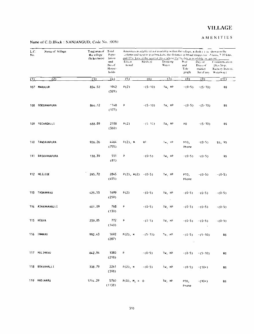
VILLAGE
AMEr..;ITIES Name of CD.Blod : NANJANGUD; Code No. :0080
L.e. Nam.: of Villag~ Tot'al ar.:a "f TIltal Aln~llIll..!~ a\.ld~lhh: Ilf not i.l\ad.lhk \.\Ilhllllh\! \III.I!!\!. a .. tl~h ( ) I~ .. )ttlVon !nlh\!
No. tho: vlllag.: Pop,,- I.olumn and '",:\1 1(1 II III hra ... l..:I!\. th~ lip.talk\! 111 hroad ran~I..·" VII -~ ~1I1'. ~ In ~1ll'. (In h.:dar.:') 1(.111(\11 ,IfH.t 1 () + k Ill' (II thl..' Ih::lr..: ... 1 pI:! ... ..: \\ h ..... '..: thl.." 1.1. .. dll \ '''' a\ .1 1I:lh 1,,-, .- gl\ 1.'(1)
and Edu .... a 111.:.1",,1 Dllllklllg PI)~( Da~ ()f (~t \1l1l1HHU ... at It H1
No.nr IIllnal Wakr and DoI~ ~ nf Ill", SI"I'. Ht.lu~,,> Tdc· tl1al~d R • .IIh, a~ ~1.ltlt Ill. hold, grarh hal ,f an~ WJk'''J~1
(1) (2) (3) (4) (5) (6) (7) (8) (9) (10)
107 MARALUR 834.52 1942 P(2) -(S-10) TW, HP -(O'S) -(S-10) BS (329)
108 GODOANAPURA 844.12 '148 P -(5-10) TW, HP -(0-5) . (5-10) BS ( 177)
109 YECHAGALLI 688.89 2188 P(2) - (5 10) Til, HP PO - (5-10) BS (360)
110 lANOAVAPURA 926.26 4464 P(2) , M RP hi, hP PTO, - (0-5) BS, RS (755) Phone
111 BASAVANAPURA 138.39 551 P -(0-5) TW, HP - (0-5) -(0-5) BS (8l)
112 HEJJIGE 295.72 2845 P(2) , M(2) -(0-5) Til, HP PTa, -(O-S) -(O-S) (4SS) Phone
113 THORAMAVU 425.53 1699 P(2) -(0-5) TW, HP -(O-S) - (0-5) - (0-5) (2S9)
114 AOAKANAHALLI 401.09 768 P -(0-5) Til, HP - (0-5) - (0-5) -(0,5) (130)
11S HEBYA 239.85 772 P -(0 5) Til, HP -(O-S) -(O-S) -(0-5) (140)
116 IMMAVU 992.43 1692 P(2) , M - (5-10) Til, HP -(0-5) - (5 -10) BS (287)
117 HULIMAVU 642.94 1380 P -(0-5) TW, HP -(0-5) - (5-10) BS (218)
118 BOKKAHALLI 308.79 2261 P(2), M ·(O-s) TW, HP -(0-5) - (10+) BS (398)
119 HAOINARU 1714.29 5760 P(3) , M, H 0 TW, HP PTa, - (1 0+) BS (1138) Phone
310
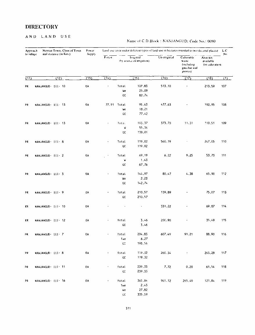
DIRECTORY
AND LAN D USE Naill': ot C.D.Bl(~·k : NANJAl\GUD; ('oJ.: No.: 0080
Approa,h N~arc.1 Town. Cia •• ofTol!.n P()""':f Land "'e (dlea linda I.hfkrenl t)pe. of ldllJ u~ III hcdJrc, round~d to t'H' d~, IIllal pia".:.) L.C II.) vlllagc and dl~lan..:\! (in Km.) Sllppl~ NI.)
For~'1 IJn,t!.'h:J Un-Irngat.:d Cuiturahl.: Arca n('t th) ~nur\.e of nngahnn) wa!oolt.! avallahk
(lII..:iudlllg t,'r ,uitl'atulil gau..:har and grovc.)
(11 ) (12) (13) ( 14) ( 15) ( 16) ( 17) (18) (1)
PR NANJANGUO- 111- 10 fA Total 107.83 513.10 213.59 107 lie 25.09
GC 82.74
PR NANJANGUD- 111- 13 fA 77.91 Total 95.63 477.63 192.95 108 lie 18.21
GC 77.42
PR NANJANGUD- 111- 13 EA Total 193.37 373.70 11.31 110.51 109 II 55.36
GC 138.01
PR NANJANGUD- 111- 8 EA Total 119.02 560.19 247.05 110
GC 119.02
PR NANJANGUD- 111- 2 EA Total 69.19 6.22 9.25 53.73 111
II 1.43
GC 67.76
PR NANJANGUD- 111- 3 EA Total 144.97 80.47 4.38 65.90 112
lie 2.23
GC 142.74
PR NANJANGUD- 111- 9 EA Total 210.57 139.89 75.07 113
GC 210.57
KR NANJANGUD- 111- 10 EA 331_22 69.87 114
KR NANJANGUD- 111- 12 EA Total 3.46 200.90 35.49 115
GC 3.46
PR NANJANGUO- Ill- 7 fA Total 204.83 607.49 91.21 88.90 116 Twe 6.27
GC 198.56
PR NANJANGUD- I I I - 8 fA Total 119.32 260.34 263.28 117
GC 119.32
PR NANJANGUD- III- 11 EA Total 239.33 7.72 0.20 61.54 118
GC 239.33
PR NANJANGUD- " I- 16 EA Total 365.84 961.12 265.49 121.84 119
Twe 2.43
lie 27.82
GC 335.59
311

VILLAGE
AMENITIES Name of C.D.BI<x:k : NANJANGUD; Cooe No. :0080
L.C No.
(1)
Nal11~ of Villag~
(2)
120 MOOOAHALLI
121 ALATHUR
122 HOSAKOTE
123 KURAHATTIKAVAL
124 THUMNERALE
125 THUMNERALEKAVAl
126 NANDIGUNDA
127 NANDIGUNDAPURA
128 BI LI CERE
129 SUTHUR
130 BllUCAll
131 JOOIHARIHARAPURA (IGLI)
132 THAYUR
133 ESWARAGOIJOANAHALLI
134 HARUPURA
Tolal ar~a or Total lh~ villaj,!~ P"I'II
(In h~~lar~s) 1:11,,, ..
(3)
461.98
442.23
620.01
and Ntlol
UllU .... ~
h,,\\.h,
1763
(333)
1606 (307)
4178
(788)
AIII~"'II~. a\ailahk (If nol availahl~ wilhin lh~ villaj,!~. a da,h (-) is shown in lh~ ,,,llIlIIn and n~'llo II in hrad .. ~b. lh~ di.lal":~ in hruad ranj,!~' vi/.. -5 ~llIs. 5-10 kills.
and It) + lm~ nf thl.!' l1~ah.· ... t pl:II.·~ v. hl.!'rt! Iht! f:h.:ilit) I!'- 8\ allahl\! is giv\!n). blll,a- 1\I",II,al DII"~lIIg Po.l Day or Communi,alinn
1I0nai Wal"r and Day. of IBu. SlOp. T "',,- lIIarl..~11 Rail" ay Slatlon. j,!fllph hat if any Wat~,""a) I
(5) (6) (7) (8) (9) (10)
P(2), M - (0-5) TW, HP -(0-5) - (10+) as
P, M - (0-5) TW, HP - (0-5) -(10+) BS
P(2), M PHC, FPC TW. HP PTO, - (10+) BS
Phone
346.37 - - - - - - - - -- - - - ----- ----- - UN INHABITED • # - - - - .. - - ................................
636.37 2G86 P(2) -(0-5) TW, HP PO - (10+) BS
<38~)
14.02 ------_ .. --. __ .,,---_.- .. _- UN INHABITED -------------------------
276.70 773 p -(0-5) HI, HP - (0-5) -(10+) BS
(1~) )
250.45 505 P -(0-5) TW, HP - (0-5) -(10+) BS (' 04)
296.53 1411 P -(0-5) TW, HP PO, -(10+) BS
(265 ) Phone
363.81 3432 P, M PHC, FPC TW, HP PTO, -(10+) BS (644) Phone
888.96 3771 P(2) , M - (0-5) TW, HP PTO, -(10+) BS (684 ) Phone
485.14 1011 p -(0-5) TW, HP -(0-5) - (5 -10) -(0-5) (190)
551.15 2933 P(2), M, H 0 TW, HP PTO, - (5 -10) BS (597) Phone
558.92 797 P(2) - (5- 10) TW, H? -(S-10) - (0-5) -(0-5) (150)
169.49 386 P - (5-10) TW, HP - (0-5) -(5-10) BS (71 )
312
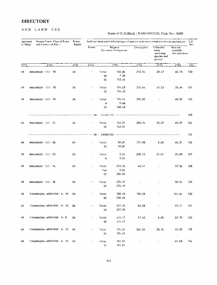
DIRECTORY
AND LA N D USE Name of C.D.Bh:k : NANJANGUD; Code No.: 0080
Approa.:h N.:ar.:~t Town. Cla,~ "fT"",n Pow.:r Land U'l! (ar.:a und.:r dlff.:r.:nt t)p.:, "I' land U'': In h.:dllr.:, round.:d to t",,, d.:.llnal pia • .:,) L.C. to villag.: and d"lan • .: (Ill Km ) Supply No.
For.:,t Irn~~lh:J U Il-U II~alI.!J Cuhurahl.: Ar.:a not (hy ,our.:.: "I' Irng"lll'n) wa~lt.! aVallahl.:
(Illdudlllg t,'r .:uIIIVall<ln gau.har and gr"v.:~)
(11) (12) ( 13) ( 14) (15) (16) ( 17) ( 18) ( 1 )
PR NANJANGUD· 111- 18 EA Total 160.84 212.54 28.47 60.13 120 \.Ie 7.39
GC 153.45
PR NANJANGUD- 111- 18 EA Total 154.63 215.44 45.52 26.64 121 GC 154.63
PR NANJANGUD- III' 19 EA Total 174.14 376.95 68.92 122 101 5.66
GC 168.48
----------- .. -... --------- ... -- ... --------------~--- UN - INHABITED --------- ... -- .. -- ... ----------------- .. --------_ ... _ 123
KR NANJANGUD- 111- 20 EA Total 142.01 383.74 50.07 60.55 124 GC 142.01
..................... -----_ ..... --- -- .. _- ... _-_ .... --_ ......... __ .. - .... UN . I NHAS !TED --------------- .. -----------------_----------- 125
KR NANJANGUD- III' 26 EA Total 59.81 171.98 0.60 44.31 126 GC 59.81
PR NANJANGUD- 111- 23 EA Total 3.24 200.12 21.41 25.68 127
101 3.24
PR NANJANGUO- 111- 14 EA Total 210.76 48.41 37.36 128 Twe 3.84
GC 206.92
PR NANJA"IGUD- 111- 16 EA Total 270.77 93.04 129
GC 270.77
KR TIRUMAKUDAL-NARSIPUR- v- 15 EA Total 588.09 139.23 161.64 130 GC 588.09
KR TIRUMAKUDAL-NARSIPUR- v- 10 EA Total 377.70 50.33 57.11 131
GC 377.70
PR TIRUMAKUDAl-NARSIPUR- v- 8 EA Total 41,5.17 17.40 0.85 87.73 132
GC 445.17
KR TIRUMAKUDAL-NARSIPUR- v- 10 EA Total 124.65 360.25 28.74 45.28 133
GC 124.65
KR TIRUMAKUDAL-NARSIPUR- v- 10 EA Total 101.81 67.68 134
GC 101.81
313

VILLAGE
AMENITIES ]\;amc of C.D.Blo.:k : NA~JA]\;GUD: Couc ]\;0. :OUxo
L.C Naill': of Viii"!!,, Total ar..:a of T"I,d AIIl""lIlt"', avallahk (if 1101 avallahle ",ilh'l1 Ih", villa,!!". a da,h (-) is ~huwn In thl!
N., rh\." \ illd!!~ P1llHJ column and n.:xl 1<) il in hrad.""'. Ih.: di,lil/l"': III "road ran,!!.:s viL. -5 lll1 •.. ~·I () 1..111 ••
(In h",dM"") lath In and 10+ l.1ll'" ofthl! n..:ar~~t [!1:h.'1! v.hl.!'rl! thl! fa\..'t1ltl' is availahll! is givl!n}. and &I""a- ~kd",al Dnnl.ll1g Po,1 Day or COl\\lnu(\i~ alH)O
Nn.of Ilona I Wal.:r and Days of IB", SlOp. H(HJ!'oI!- Td.:- marl':l/ Railway SIal Ion.
h.,ld, graph hal if any Wala""a)]
(1) (2) (3) (4) (5) (6) (7) (8) (9) ( 1 0)
135 GEJJIGANAHALLI 391.93 1488 P, M -(0-5) TI.', HP PO - (5- 10) BS (273)
136 KAHALll 137.47 262 P -(0-5) TI.', HP -(0-5) -(10+) BS (57)
137 KALKUNDA 884.77 1608 P(2), M -(0-5) TI.', HP PO - (10+) BS (342)
138 KAMAHALLI 185.16 835 P -(5-10) TI.', HP -(0-5) -(10+) BS (164 )
139 CH I NNAMBALL I 422.25 1155 P -(0'5) TI.', HP -(0-5) - (10+) BS (224 )
140 THAGADOORU 1900.15 7075 P(5), M, H PHC, FPC Til, HP PTO, -(10+) BS (1316) Phone
141 ALAGANCHI 1415.76 2863 P(2), M -(0-5) TI.', HP PTO, -(10+) BS (556) Phone
142 MADAHALLI 306.72 386 P -(0-5) TI.', HP -(0-5) - (10+) BS (79)
143 MALLUPURA 316.50 1167 P, M -(0-5) TI.', HP -(0-5) -(10+) - (0-5) (224)
144 ALAMBUR 234.62 1569 P(2) -(0-5) II, HP -(0-5) -(0-5) BS (285)
145 SARAGOORU 598.09 1941 P(3), M -(0-5) TI.', HP -(0-5) -(5-10) BS (392)
146 HAN I YAMBALLI 276.27 814 P(2) -(0-5) TI.', HP -(0-5) -(5-10) -(0-5) ( 166)
147 GONAHALLI 196.46 1085 P -(0-5) TI.', HP - (0-5) -(5-10) -(0-5) (218)
314
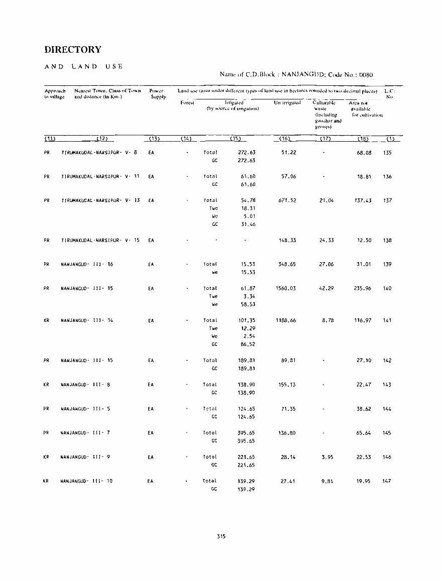
DIRECTORY
AN D LA N D USE Nallll: of C.D.B1ock : NANJANGUD; Code No.: 0080
Appr()a~h N~ar~sl Town. Class of Town Pow~r LaIH.1 u~.: (arl.!:1 ulh .. kr Jlrr..:r\!llll)p.:~ orland U~\! in h\!\..·taf\!!\ rOllruJ\!d to two dl.!~ilnal pla,t.!s) L.C. In villag~ and di,.lan.:<! (in Km.) Supply No.
Fnrl!~t Irrigat\!o Un-irrigal~d Cuhurahl~ Ar\!3 not (hy ~our~1! of irrigatiun) \A.'a~h! availahl~
(induding fi'r IOuhivalion gal,,;har and grov~s)
(11) (12) ( 13) (14) (15) ( 16) ( 17) (18) (1)
PR TIRUMAKUDAl-NARSIPUR- v- 8 fA Total 272.63 51.22 68.08 135 GC 272.63
PR TIRUMAKUDAl-NARS1PUR- v- 11 EA Total 61.60 57.06 18.81 136 GC 61.60
PR TIRUMAKUDAl-NARSIPUR- v- 13 fA Total 54.78 671.52 21.04 137.43 137 Twe 18.31 lie 5.01 GC 31.46
PR TIRUMAKUDAL-NARSIPUR- v- 15 EA 148.33 24.33 12.50 138
PR NANJANGUD- " 1- 16 EA Total 15.53 348.65 27.06 31.01 139 lie 15.53
PR NANJANGUD- " 1- 15 EA Total 61.87 1560.03 42.29 235.96 140 Twe 3.34 lie 58.53
KR NANJANGUD- " [- 14 EA Total 101.35 1188.66 8.78 116.97 141 Twe 12.29 lJe 2.54 GC 86.52
PR NANJANGUD- " I- 15 EA Total 189.81 89.81 27.10 142 GC 189.81
KR NANJANGUD- III· 8 EA Total 138.90 155.13 22.47 143 GC 138.90
PR NANJANGUD- 111- 5 EA Totill 124.65 71.35 38.62 144 GC 124.65
PR NANJANGUD- "1- 7 EA Total 395.65 136.80 65.64 145 GC 395.65
KR NANJANGUD- "I - 9 EA Total 221.65 28.14 3.95 22.53 146 GC 221.65
KR NANJANGUD- 111- 10 EA Total 139.29 27.41 9.81 19.95 147 GC 139.29
315

Name of C.D.Block : NANJANGUD; Coue No. '0080
LC No
( 1 ) (2)
148 KIRUGUNOA
149 BELAGUNDA
150 KALMAHALLI
151 NAGARLE
152 KUPPARAVALL I
153 OOODAKOIIlAWDE
154 GATT AVAD I
155 HARAGANAPURA
156 GATT AVAD I PURA
157 HALEPURA
158 HAMPAPURA
159 MAlLAHALLI
160 THARADALE
161 BEGOORU
Toldl 8r"8 01 Tol.d tho: v,II"!!,, POpll (In h"ddr",) Idllt III
amI Nt) t)!
Hl)u"~
hold,
(3)
960.99
317.69
161.46
398.54
265.87
623.85
574.53
188.21
542.41
605.60
150.32
252.56
441.88
280.34
(4)
2337 (473)
569 (111 )
972 ( 177)
3415 (610)
1156
(216)
3168 (580)
1734 (347)
563 (106)
1618
(316)
1860 (294)
362 (73)
2023 (354)
1243
(218)
286 (59)
VILLAGE
AMENITIES
AIIl","I,,,' aVdd.,hk (II 1101 ava,l~hk w,lhinlh.: vdl"!!,,, a da,h (-) IS ,hol!.n ",Ih" u)lumn alld n.:\1 I,· ,I III pracl...:I', Ih..: d"ldn • ..: lllPr<>ad rang'" v,l ~ 1..111'. 'i III 1.'11'.
,lIh.l Ifl+ kill' pf th~ n~.lr~ ... t rl.h.~ \\hl.!'r~ thl.! t.luhtv 1100 a\ad.lhk I' glv'\!'n) E"u,~ 111.:.1,,,,1 Dllnk,ng Po'l Dd) or C'"III11U'll",I'OIl
hnn..:!! W(lh!r dlUJ Dd}'" of I BlI" Sldp. T d.: I1ldr',,1 Rd,I",,} Slalulll, grdph hdl ,I all) Wdl.:""." I
(5) (6) (7) (8) (9) (10)
P(3) -(0-5) TI.I, HP PO - (10+) 8S
P (0-5 ) '.I, liP -(0 5) (5 -10) -(0 5)
P - (0-5) Til, HP -(0-5) -(5-10) (0-5)
PO), M 0 HI, HP PTO, -(5-10) BS Phone
P, M '(0-5) Til, HP PO -(10+) BS
P(4), 14(2) 0, RP Til, HP PTa, -(10+) BS, RS Phone
P, M -(0-5) T, HP PO - (10+) BS
P -(5-10) Til, HP - (5-10) - ( 10+ ) BS
P, M -(5-10) Hi, HP -(5-10) -(10+) BS
P -(0-5) Til, HP PO -(10+) BS
P -(0-5) TIJ, HP - (0-5) -(10+) -(0-5)
P, 14 - (0-5) TI.I, HP - (0-5) -(10+) BS
P '(0,5) Til, HP -(0-5) -(10+) BS
P - (0· 5) TIJ, HP (0 5) -(10+) -(0-5)
316
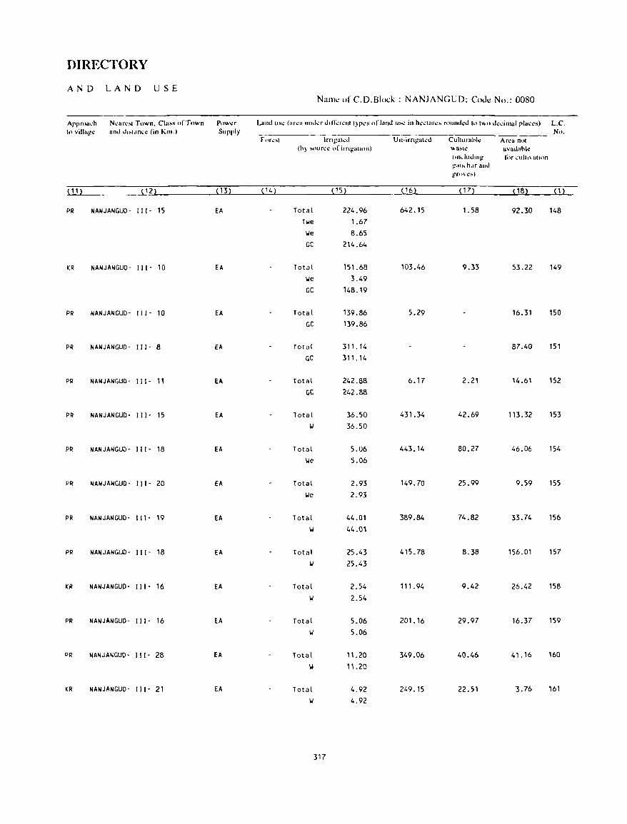
DIRECTORY
AND LAND USE N:IIlK' of C. D. Bioi:)..; : NANJANGUD; Code No.: 0080
Approa.:h N~ar~'1 Town. Cia" "fTown Pow~r Land US~ (af"" und.:r ,hfr.:r~lIll)p~S orland u~" in h""'ar,,, roumkd (111\1,0 Ik.:imaJ pJa.:.:s) L.C. 10 villa!!" and J"ldn.:.: (in Kill.) Supply No.
forl.!:-ot lrngat.:d U Il-irngah:d Cuhurabl~ Ar.:a nlll (b) "'llr,,~ of irng:,II'"I) "",a~\~ avallabk
(II"ludlll!! t(lr ~uhl"a(lon !!au~ h.lf and !!fU\I.!!oo)
(11) (12) (H) ( 14) ( 15) ( 16) ( 17) ( 18) (1)
PR NANJANGUD· Ill· 15 EA Total 224.96 642.15 1.58 92.30 148 Twe 1.67 \Ie 8.65 GC 214.64
KR NANJANGUD· III' 10 EA Total 151.68 103.46 9.33 53.22 149 \Ie 3.49
GC 148.19
PR NANJANGUD· Ill- 10 EA Total 139.86 5.29 16.31 150 GC 139.86
PR NANJANGUD· III- 8 EA Total 311. 14 87.40 151
GC 311.14
PR NANJANGUD- Ill- 11 EA Total 242.88 6.17 2.21 14.61 152
GC 242.88
PR NANJANGUD- Ill- 15 EA Total 36.50 431.34 42.69 113.32 153
II 36.50
PR NANJANGUD- Ill- 18 EA Total 5.06 443.14 80.27 46.06 154
\.Ie 5.06
PR NANJANGUD· III- 20 EA Total 2.93 149.70 25.99 9.59 155
lJe 2.93
PR NANJANGUD· Ill- 19 EA Total 44.01 389.84 74.82 33.74 156
'II 44.ln
PR NANJANGUD- III- 18 EA Total 25.43 415.78 8.38 156.01 157
IJ 25.43
KR NANJANGUD- Ill- 16 EA Total 2.54 111.94 9.42 26.42 158
II 2.54
PR NANJANGUD- Ill- 16 EA Total 5.06 201.16 29.97 16.37 159
IJ 5.06
PR NANJANGUD- 111- 28 EA Total 11.20 349.06 40.46 41.16 160
OW ".20
KR NANJANGUD- Ill- Z1 EA Total 4.92 249.15 22.51 3.76 161
IJ 4.92
317

VILLAGE
AMENITIES Name of C.D.Blo.:" : NANJANGUD; Code No. :0080
L.e. Nam.: of Villag~ Total ar.:a of Total AIll.:niti.:s availabl.: (if not a,uilabk "'ithlllth.: villag.:. a d".h (-) is shown in th.: No. th.: vill"g~ Popu- ~olullln and n.:xtlO it in bra.k.:t •. th.: d"lan • .: III "road rang.:' vi/,. -5 killS. 5-10 kill'.
(In h.:~tar.:s) latlt)Jl and 10+ lm:..tlfth\! ll\!'an::..t pl:h:": v.h..:r..: th..: t~h:dill' is availahl..: i:.. gi\..:n~.
and &Iu~a- J\'kdical Drinking Post Day or C()lnmul1i~atH)n
No.of tional Wat.:r and Days of IBus SI<>p. H()u!-o~- Td.:- mark.:t! Railway Stalum. holds graph hat if an)' Watawayl
( 1 ) (2) (3) (4) (5) (6) (1) (8) (9) ( 10)
162 KOOOLAPURA 631.35 2855 P, M, H PHC, FPC T, IJ, HP PTa, -(10+) BS (545) Phone
163 HOSAPURA 167.36 35 - (0- 5) -(0-5) HI, HP - (5-10) -(10+) - (0-5)
(8)
164 KUMBARAHALLI 481.41 716 P -(0-5) TIJ, HP -(0-5) - (10+) BS (125 )
165 HEMMARAGALA 333.35 3205 P(2), M, H D TIJ, HP PTa, - (10+) BS (598) Phone
166 SATHAGAHALLI 114.77 ...... - ........ --- ...... -_ ..... --_ ...... UN . INHABITED -------------_----_ .. _----
167 HEDATHALE 1073.19 5474 P(3) , M PHC, FPC TIJ, HP PTa, -(10+) BS ( 1072) Phone
168 BASAVATT I GE 608.88 1090 P -(0-5) TIJ, HP -(0-5) -(10+) BS ( 199)
169 NERALE 821.04 3033 P, M -(0-5) TiJ, HP PO, - (10+) BS (588) Phone
170 CHIKKAKOIJLANDE 532.62 1231 P - (0-5) TiJ, HP -(0-5) -(10+) BS (255)
171 DEVANUR 1041.99 3633 P(4), M, PHC, FPC HI, HP PTa, - (10") BS (688) H, puc, TR Phone
172 VARAHALLI 282.14 716 P . (0-5) TiJ, HP -(0-5) - (10+) BS ( 139)
173 KAKKARAHA TT I 563.02 208 P -(0-5) TIJ, HP -(0-5) -(10+) BS (41)
174 BANOORU 418.77 280 P -(5-10) TIJ, HP -(0-5) -(10+) BS (58)
175 HADYA 206.56 1084 P(2), M - (5-10) TIJ, HP PO, -(10+) BS (213) Phone
176 KAREPURA 536.50 1381 P -(5-10) TiJ, HP -(0-5) -(10+) BS (248)
318
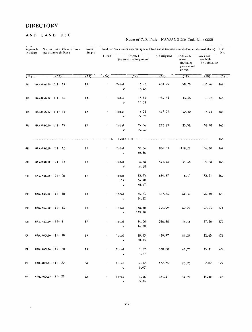
DIRECTORY
AND LAND USE Name of C.D.Block : NANJANGUD; COue No.: 0080
Arrroa,h N~lIr~" Town. Cla,~ of To" n ptlW\!r Land u,~ (ar~a und.:r difl;:r~nl IYr~s of land u~ in h~.:lar~~ round~d 10 IWo d~..:il1lal rla..:~,) L C. h) vlllaj!~ ami d"lan,'~ (in Kill ) Supply No.
For~'1 Irrij!al~d Un-irrigall!d Culturahk Ar..:a nol (hy soun':l! of irrigalion) wast!! availahl~
(induding li)r cultivation gauchar and groves)
( 11 ) ( 12) ( 13) (14) (15) (16) ( 17) (18) ( 1 )
PR NANJANGUD- III' 19 EA Total 7.52 481.29 59.78 82.76 162 i,J 7.52
ICR NANJANGUD- 111- 16 EA Total 17.53 134.45 13.36 2.02 163 i,J 17.53
ICR NANJANGUD- 111- 15 EA Tot a I 5.02 427.01 42.10 7.28 164 'W 5.02
PR NANJANGUD- 111- 15 EA Total 15.06 242.23 35.58 40.48 165 II 15.06
------------------- -_ ... --~- ............ - -- - - - - - - - - - --- UN INHABITED ------------------------ ... _------------------- 166
PR NANJANGUD- 111- 12 EA Total 60.86 836.83 119.20 56.30 167 i,J 60.86
PR NANJANGUD- 111- 11 EA Total 6.68 541.46 31.46 29.28 168 i,J 6.68
PR NANJANGUD- 111- 16 EA Total 82.75 659.67 6.41 72.21 169 11<. 64.48 II 18.27
PR NANJANGUD- 111- 18 EA Total 54.23 367.64 64.37 46.38 170 i,J 54.23
PR NANJANGUD- III· 13 EA Total 138.10 794.09 62.77 47.03 171 i,J 133_ 10
ICR NANJANGUD' 111- 21 EA Total 14.00 236.38 14.46 17.30 172 i,J 14.00
KR NANJANGUD- 111- 18 EA Total 28.13 430.97 81. 27 22.65 173 II 28.13
KR NANJANGUD- 111- 20 EA Total 1.67 360.08 41.71 15.31 174 \oj 1.67
PR NANJANGUD- III· 22 EA Total ..,.97 177.76 20.76 7.07 175 i,J 0.97
PR NANJANGUD- 111- 22 EA Total 3.36 483.31 34.97 14.86 176 i,J 3.36
319
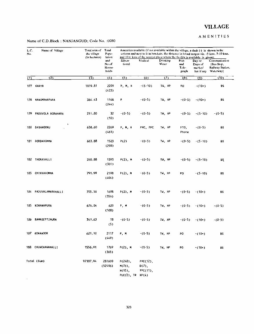
VILLAGE
AMENITIES Name of C.D.Block : NANJANGUD; COOl! No. :0080
L.e. Naill': of Villag.: Total ar.:a of Total Am.:niti.:s availahl.: (if not availahl.: within th.: villag.:. a dash (-) is shown in th.: No, th.: villag.: Popu- "olumn and n.:xtto it in hra..:t...:ts. th.: distan..:.: in hroad rdng.:~ vi)';. -5 lan~. 5-10 klns.
(In h.:.:tar.:s) lation and 10+ kills "fth.: ncar.:,t [!Ia.:.: whac the lil.:ility is availahl.: is giwn). and Ed u..: a- II.kdi..:al Drint..ing Post Day or Comll1unication No,of tiona I Wat.:r and Days of IBus Stop. Hous.:- Td.:- mark.:tl Railway Station. holds graph hat if any Waterway I
(1) (2) (3) (4) (5) (6) (7) (8) (9) ( 10)
177 KARYA 1019.81 2209 P, M, II -(5-10) nl, liP PO - ( 1 0+) 8S
(423)
178 IIANUMANAPURA 364.43 1168 P -(0-5) HI, HP -(0-5) - ( 10+) as (244)
179 PADUVOLA AGRAHARA 211.80 32 -(0-5) - (0- 5) Til, HP -(0-5) -(5-10) -(0-5) (10)
180 OASANOORU 638.60 2269 P, M, II PHC, FPC Til, HP PTO, -(0-5) BS (461 ) Phone
181 OODDAHOMMA 663.88 1523 P(2) -(0-5) Til, HP -(0-5) -(5-10) BS (298)
182 THORAVALLI 260.88 1393 P(2), M -(0-5) Til, liP -(0-5) -(5-10) as. (301)
183 CHIKKAHOMMA 791.99 2198 P(2), M -(0-5) Til, HP PO -(5-10) as (404)
184 PADUVALAMARAHALLI 705.56 1698 P(2), M -(0-5) Til, HP -(0-5) - ( 10+) BS (356)
185 KONANAPURA 676.04 620 P, 101 -(0-5) Til, HP -(0-5) - (10+) -(0-5) (108)
186 RAHASETTIPURA 341.63 18 -(0-5) -(0-5) Til, HP -(0-5) -(10+) -(0-5) (5)
187 KONANOOR 621.10 2117 P, 101 -(0-5) Til, HP PO -(10+) as (449)
188 CHUNCHANAIIALLI 1556.91 1769 P(2), M -(0-5) Til, tiP PO - ( 10+) as (365)
Total (Sl.fl1) 97187.94 281600 P(248) , PHC<'12) , (52496) 101(76) , 0(7),
H(1S), FPC(11), PUC('2), TR RP(4)
320
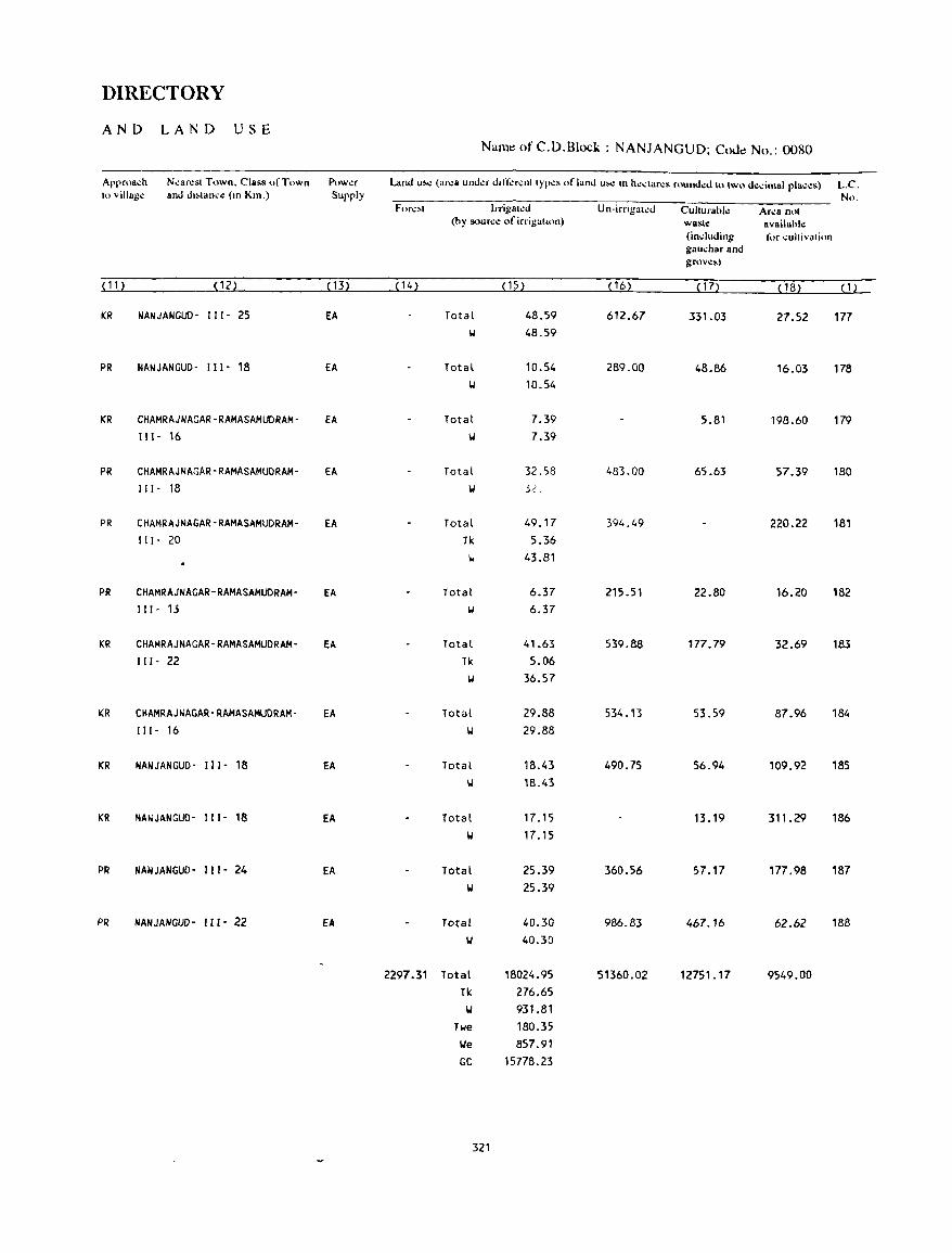
DIRECTORY
AND LAND USE Nam~ of C.D.Block : NANJANGUD; CoJ~ No.: 0080
Arprna~h N.:an:st Town. Class of Town P,)w.:r Land u,.: (ar.:a und.:r d,rr.:r.:nt Iypo:s of land u,.: III h':daro:s round..:d to two d..:dmal pla.:..:s) L.C. to village and dl>lan,e (10 Km.) Supply No.
For..:,1 Jrrigal.:d Un-irrigat.:d Cullurabl..: Ar.:a nOI (hy sour~e of irrigalllln) wa!<le availahl.:
(indllding for ":llhivalion gall~harand grov..:,)
( 11 ) (12) ( 13) ( 14) (15) (16) (17) (18) (1)
KR NANJANGUD- 111- 25 fA Total 48.59 612.67 331.03 27.52 177 IJ 48.59
PR NANJANGUD- ( 11- 18 fA Total 10.54 289.00 48.86 16.03 178 IJ 10.54
KR CHAMRAJNAGAR-RAMASAMUDRAM- EA Total 7.39 5.81 198.60 179 111- 16 W 7.39
PR CHAMRAJNAGAR-RAMASAMUDRAM- EA Total 32.58 483.00 65.63 57.39 180 "I - 18 II 32.
PR CHAMRAJNAGAR-RAMASAMUDRAM- EA Total 49.17 394.49 220.22 181 II 1- 20 Tk 5.36
II 43.81
PR CHAMRAJNAGAR-RAMASAMUDRAM- EA Total 6.37 215.51 22.80 16.20 182 II I- 13 W 6.37
KR CHAMRAJNAGAR-RAMASAMUDRAM- EA Total 41.63 539.88 177.79 32.69 183 "I - 22 Tk 5.06
II 36.57
KR CHAMRAJNAGAR-RAMASAMUDRAM- EA Total 29.88 534.13 53.59 87.96 184 II (- 16 II 29.88
KR NANJANGUD- III- 18 EA Total 18.43 490.75 56.94 109.92 185 w 18.43
KR NANJANGUD- I I I- 18 EA Total 17.15 13.19 311.29 186 '01 17.15
PR NANJANGUD- 111- 24 EA Total 25.39 360.56 57.17 177.98 187 '01 25.39
PR NANJANGUD- 111- 22 fA Total 40.30 986.83 467.16 62.62 188 '01 40.30
2297.31 Total 18024.95 51360.02 12751.17 9549.00 Tk 276.65
'01 931.81 Twe 180.35
We 857.91 GC 15778.23
321

PIRIYAPATNA ~.D.BLOCK
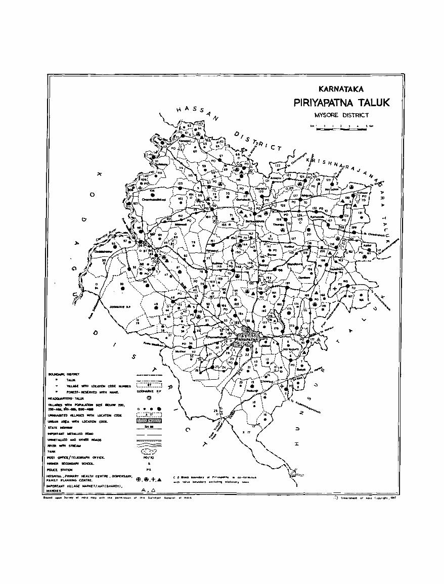
o
o
I
s
WJ.AGE .,.. LDC4T1DN CODE....,. c:=-=-~~!==-=] FOAEST- _RVED """ __ oODH.uwE ~ F
HEAIICIIJotIITQS· T .......
VI.UIGES WITH -.a.ATION sat: IlELOW 200. 200-......... _-_
..-m VIU.AGES _H lDCATOI COIlE
....... NOlA """ LOCATION CODE.
srAfE ....... __ 1IV.tU£D -..
IN<<T ALLED AND cmtER IIIlOOS lIIYER _ s_ T ....
POST --=e:/TELmMPtt OFFICE. __ 5E~ SCHOOL..
-.cE STATION
o •••
C:=:l:1f==J f%%!V@@J
SHea
PO(lO
S
~S
::=:AI..,~:=:' c::~~ CENTRE. OI5P£HSARr, ~ ••• +." IMPORTANT VILLAGE MAJlKET I H.A' (SHAND,,) •
W.NOIES
C [) 81 .. boYhdary fill P.rtJQflOlno IS co-te'm,nu.
_llh tolu.. tHt\lnlfGl'J •• dud"" stahltory town
KARNATAKA
PIRIYAPATNA TALUK MYSORE DISTRICT
"'", 1 0 1 2 1 4 5 """
""- """""" .................
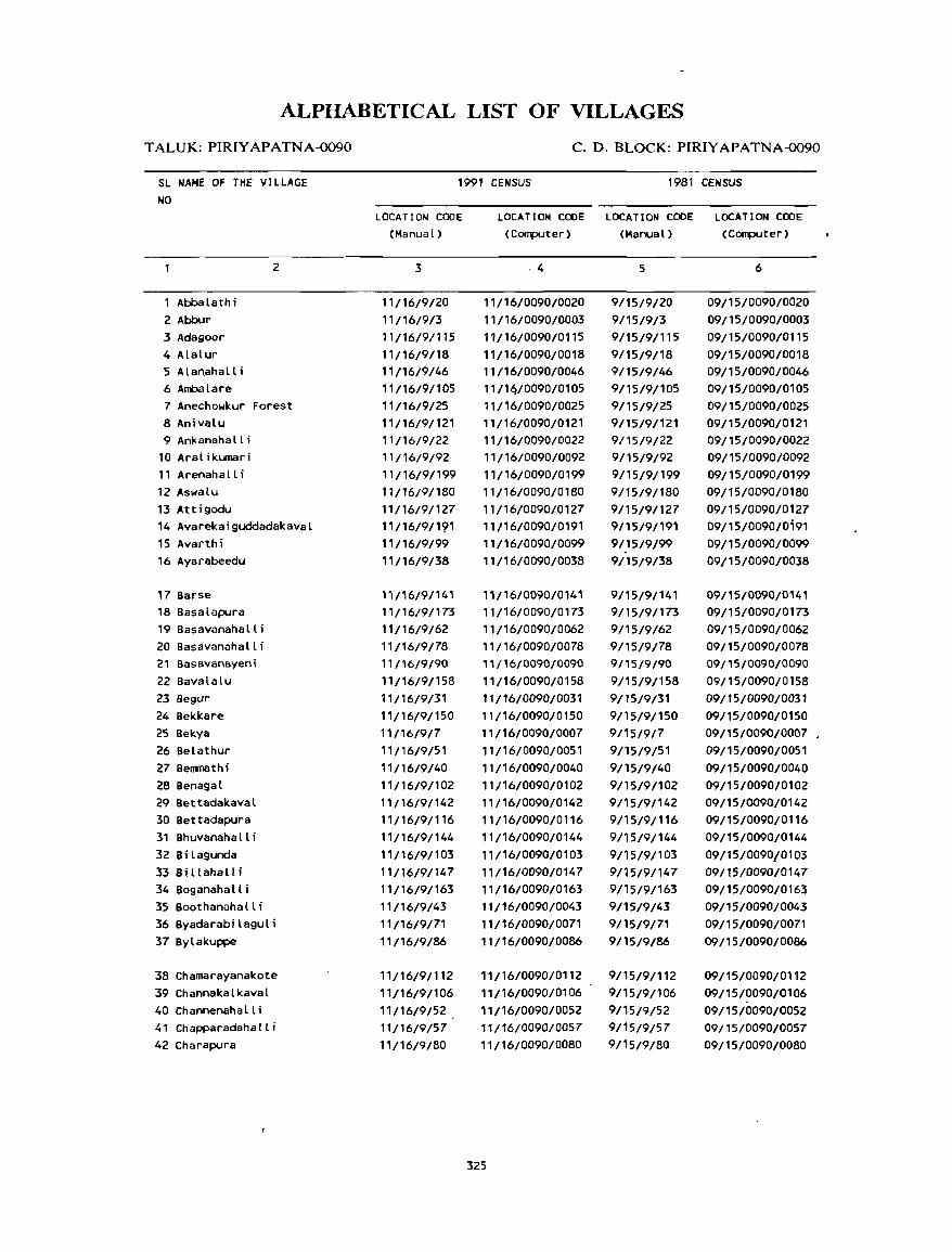
ALPHABETICAL LIST OF VILLAGES
TALUK: PIRIYAPATNA-0090
SL NAME OF THE VILLAGE NO
Abbalathi 2 Abbur 3 Adagoor 4 AlaLur 5 Alanahalli 6 Ambalare
2
7 Anechowkur Forest 8 Anivalu 9 Ankanahalli
10 Aral ikumari 11 Arenahall i 12 Aswalu 13 Attigodu 14 Avarekaiguddadakaval 15 Avarthi 16 Ayarabeedu
17 Barse 18 Basalapura 19 Basavanahalli 20 Basavanahalli 21 Basavanayeni 22 Bavalalu 23 8egur 24 Bekkare 25 Bekya 26 Belathur 27 BerJJl18thi 28 Benagal 29 Bettadakaval 30 Bettadapura 31 BhuvanahaLli 32 8; Lagunda 33 Sil Lahall; 34 BoganahaLli 35 Boothanahall; 36 ByadarabilaguLi 37 ByLakuppe
38 Chamarayanakote 39 ChannakalkavaL 40 ChannenahaLli 41 Chapparadahalli 42 Charapura
C. D. BLOCK: PIRIYAPATNA-0090
1991 CENSUS 1981 CENSUS
LOCATION CODE (Manual)
3
11/16/9/20 11/16/9/3 11/16/9/115 11/16/9/18 11/16/9/46 11/16/9/105 11/16/9/25 11/16/9/121 11/16/9/22 11/16/9/92 11/16/9/199 11/16/9/180 11/16/9/127 11/16/9/191 11/16/9/99 11/16/9/38
11/16/9/141 11/16/9/173 11/16/9/62 11/16/9/78 11/16/9/90 11116/9/158
11/16/9/31 11/16/9/150 11/16/9/7 11/16/9/51 11/16/9/40 11/16/9/102 11/16/9/142 11/16/9/116 11/16/9/144 11/16/9/103 11/16/9/147 11/16/9/163 11/16/9/43 11/16/9/71 11/16/9/86
11/16/9/112 11/16/9/106 11/16/9/52 11/16/9/57 11/16/9/80
LOCATION CODE LOCATION CODE LOCATION CODE (Computer) (Manual) (Computer)
·4
11/16/0090/0020 11/16/0090/0003 11/16/0090/0115 11/16/0090/0018 11/16/0090/0046 11/1 (j/0090/01 05 11/16/0090/0025 11/16/0090/0121 11/16/0090/0022 11/16/0090/0092 11/16/0090/0199 11/16/0090/0180 11/16/0090/0127 11/16/0090/0191 11/16/0090/0099 11/16/0090/0038
11/16/0090/0141 11/16/0090/0173 11/16/0090/0062 11/16/0090/0078 '1/16/0090/0090 11/16/0090/0158 11/16/0090/0031 11/16/0090/0150 11/16/0090/0007 11/16/0090/0051 11/16/0090/0040 11/16/0090/0102 11/16/0090/0142 11/16/0090/0116 11/16/0090/0144 11/16/0090/0103 11/16/0090/0147 11/16/0090/0163 11/16/0090/0043 11/16/0090/0071 11/16/0090/0086
11/16/0090/0112 11/16/0090/0106 11/16/0090/0052 11/16/0090/0057 11/16/0090/0080
325
5
9/15/9/20 9/15/9/3 9/15/9/115 9/15/9/18 9/15/9/46 9/15/9/105 9/15/9/25 9/15/9/121 9/15/9/22 9/15/9/92 9/15/9/199 9/15/91180
9/15/9/127 9/15/9/191 9/15/9/99 9/15/9/38
9/15/9/141 9/15/9/173 9/15/9/62 9/15/9/78 9/15/9/90 9/15/9/158 9/15/9/31 9/15/9/150 9/15/9/7 9/15/9/51 9/15/9/40 9/15/9/102 9/15/9/142 9/15/9/116 9/15/9/144 9/15/9/103 9/15/9/147 9/15/9/163 9/15/9/43 9/15/9/71 9/15/9/86
9/15/9/112 9/15/9/106 9/15/9/52 9/15/9/57 9/15/9/80
6
09/15/0090/0020 09/15/0090/0003 09/15/0090/0115 09/15/0090/0018 09/15/0090/0046 09/15/0090/0105 09/15/0090/0025 09/15/0090/0121 09/15/0090/0022 09/15/0090/0092 09/15/0090/0199 09/15/0090/0180 09/15/0090/0127 09/15/0090/0;91
09/15/0090/0099 09/15/0090/0038
09/15/0090/0141 09/15/0090/0173 09/15/0090/0062 09/15/0090/0078 09/15/0090/0090 09/15/0090/0158 09/15/0090/0031 09/15/0090/0150 09/15/0090/0007 09/15/0090/0051 09/15/0090/0040 09/15/0090/0102 09/15/0090/0142 09/15/0090/0116 09/15/0090/0144 09/15/0090/0103 09/15/0090/0147 09/15/0090/0163 09/15/0090/0043 09/15/0090/0071 09/15/0090/0086
09/15/0090/0112 09/15/0090/0106 09/15/0090/0052 09/15/0090/0057 09/15/0090/0080
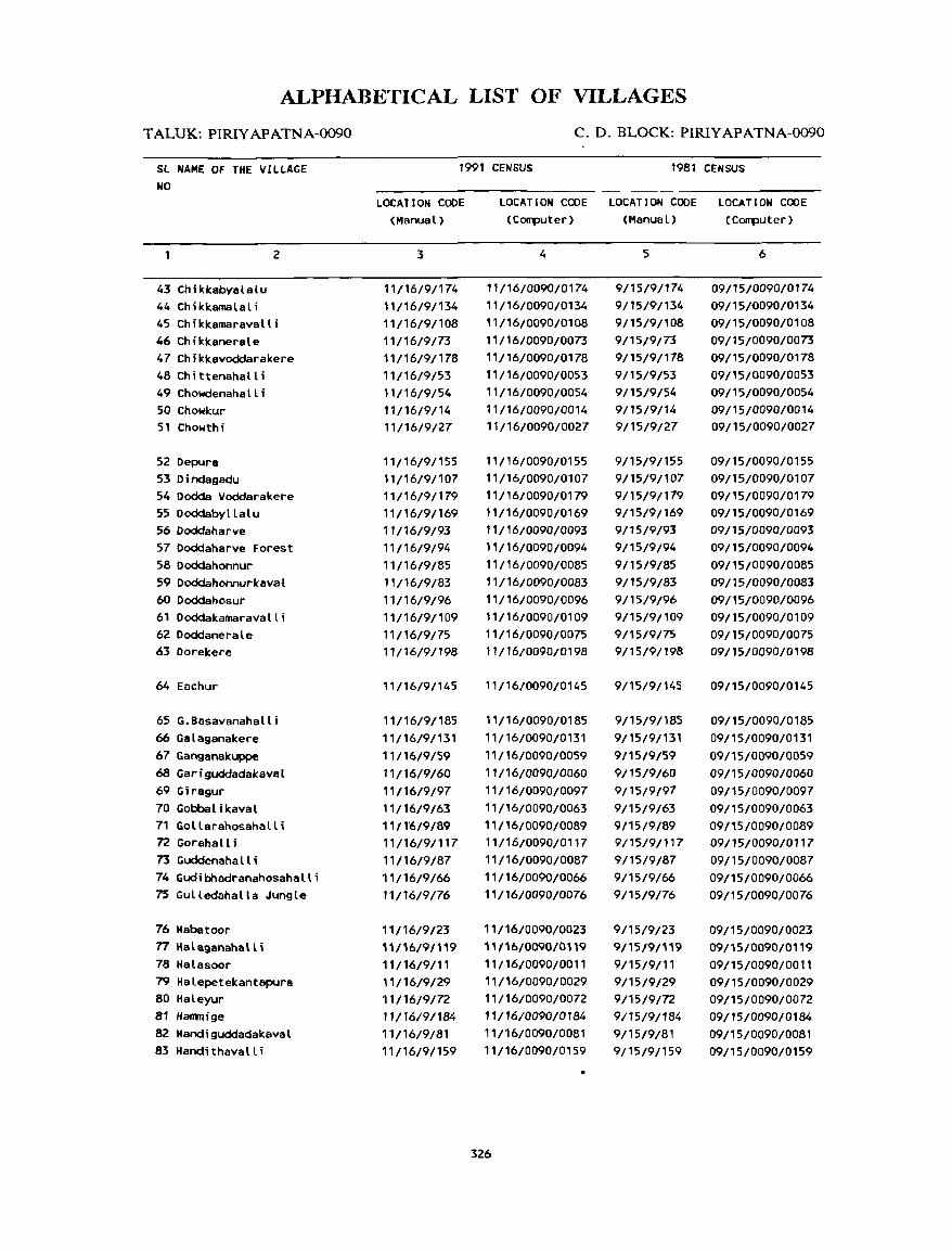
ALPHABETICAL LIST OF VILLAGES
TALUK: PIRIYAPATNA-0090
Sl NAME Of THE V[LLAGE NO
43 Chikkabyalalu 44 Chiklcamalali
2
45 Chiklcamaravalli 46 Chikkanerale 47 Chikkavoddarakere 48 Chittenahalli 49 Chowdenahalli 50 Chowkur 51 Chowthi
52 Depura 53 D j ndagadu 54 Dodda Voddarakere 55 Doddabyllalu 56 Doddaharve 57 Doddaharve Forest 58 Doddahonnur 59 Doddahonnurkaval 60 Doddahosur 61 Doddakamaravalli 62 Doddanerale 63 Dorelcere
64 Eachur
65 G.Basavanahalli 66 Galsganalcere 67 Ganganakuppe 6B Gariguddadakaval 69 Giragur 70 Gobbalikaval 71 Gollarahosahalli 72 Gorahal I ; 73 Guddenaha It i 74 Gudibhadranahosahalli 75 Gulledahatla Jungle
76 Habatoor 77 Halaganahalli 78 Halasoor 79 Halepetekantapura 80 Haleyur 81 Harrmige
82 Handiguddadakaval 83 Handithavalli
C. D. BLOCK: PIRIYAPATNA-0090
1991 CENSUS 1981 CENSUS
LOCATION CODE (Manual)
3
11/16/9/174 11/16/9/134 11/16/9/108 11/16/9/73 11/16/9/178 11/16/9/53 11/16/9/54 11/16/9/14 11/16/9/27
11/16/9/155 11/16/9/107 11/16/9/179 11/16/9/169 11/16/9/93 11/16/9/94 11/16/9/85 11/16/9/83 11/16/9/96 11/16/9/109 11/16/9/75 11/16/9/198
11/16/9/145
11/16/9/185 11/16/9/131 11/16/9/59 11/16/9/60 11/16/9/97 11/16/9/63 11/1'6/9/89 11/16/9/117 11/16/9/87 11/16/9/66 11/16/9/76
11/16/9/23 11116/91119 11/16/9/11 11/16/9/29 11/16/9/72 11/16/9/184 11/16/9/81 11/16/9/159
LOCATION CODE LOCATION CODE LOCATION CODE (Computer) (Manual) (Computer)
4
11/16/0090/0174 11/16/0090/0134 11/16/0090/0108 11/16/0090/0073 11/16/0090/0178 11/16/0090/0053 11/16/0090/0054 11/16/0090/0014 11/16/0090/0027
11/16/0090/0155 11/16/0090/0107 11/16/0090/0179 11/16/0090/0169 11/16/0090/0093 11/16/0090/0094 11/16/0090/0085 11/16/0090/0083 11/16/0090/0096 11/16/0090/0109 11/16/0090/0075 11/16/0090/0198
11/16/0090/0145
11/16/0090/0185 11/16/0090/0131 11/16/0090/0059 11/16/0090/0060 11/16/0090/0097 11/16/0090/0063 11/16/0090/0089 11/16/0090/0117 11/16/0090/0087 11/16/0090/0066 11/16/0090/0076
11/16/0090/0023 11/16/0090/0119 11/16/0090/0011 11/16/0090/0029 11/16/0090/0072 11/16/0090/0184 11/16/0090/0081 11/16/0090/0159
326
5
9/15/9/174 9/15/9/134 9/15/9/108 9/15/9/73 9/15/9/178 9/15/9/53 9/15/9/54 9/15/9/14 9/15/9/27
9/15/9/155 9/15/9/107 9/15/9/179 9/15/9/169 9/15/9/93 9/15/9/94 9/15/9/85 9/15/9/83 9/15/9/96 9/15/9/109 9/15/9/75 9/15/9/198
9/15/9/145
9/15/9/185 9/15/9/131 9/15/9/59 9/15/9/60 9/15/9/97 9/15/9/63 9/15/9/89 9/15/9/117 9/15/9/87 9/15/9/66 9/15/9/76
9/15/9/23 9/15/9/119 9/15/9/11 9/15/9/29 9/15/9/72 9/15/9/184 9/15/9/81 9/15/9/159
6
09/15/0090/0174 09/15/0090/0134 09/15/0090/0108 09/15/0090/0073 09/15/0090/0178 09/15/0090/0053 09/15/0090/0054 09/15/0090/0014 09/15/0090/0027
09/15/0090/0155 09/15/0090/0107 09/15/0090/0179 09/15/0090/0169 09/15/0090/0093 09/15/0090/0094 09/15/0090/0085 09/15/0090/0083 09/15/0090/0096 09/15/0090/0109 09/15/0090/0075 09/15/0090/0198
09/15/0090/0145
09/15/0090/0185 09/15/0090/0131 09{15/0090/0059 09/15/0090/0060 09/15/0090/0097 09/15/0090/0063 09/15/0090/0089 09/15/0090/0117 09/15/0090/0087 09/15/0090/0066 09/15/0090/0076
09/15/0090/0023 09/15/0090/0119 09/15/0090/0011 09/15/0090/0029 09/15/0090/0072 09/15/0090/0184 09/15/0090/0081 09/15/0090/0159
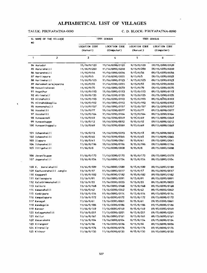
ALPHABETICAL LIST OF VILLAGES
TALUK: PIRIYAPATNA-0090
SL NAME OF THE VILtAGE NO
84 Haradur 85 Haralahalli 86 Haranahall i 87 Hari lapura 88 Harinahall i
2
89 Harvemallarajapatna 90 Hasuvinakaval 91 Hegathur 92 Hirimalali 93 Hitnahalli 94 Hitnahebbagilu 95 Honnenahalli 96 Hosahalli 97 Hosahalli 98 Hunasavadi 99 Hunasekuppe
100 Hunasethoppalu
101 Ichanahalli 102 Ichanahalli 103 Ilapura 104 I thanaha II i 105 Ittigehalli
106 Javanikuppe 107 Joganahall i
108 K. Haralahalli 109 Kachuvanahalli Jungle 110 Kaggundi 111 Kailasapura 112 Kalethirnmanahalli 113 Kalkere 114 Kamanahalli 115 Kambipura 116 Kampalapura 117 Kanagal 118 Kandegala 119 Kanoor 120 Kelaganahalli 121 Kellur 122 Kesarakere 123 Kirangoor 124 Kirenelly 125 Kithoor
C. D. BLOCK: PIRIYAPATNA-0090
1991 CENSUS 1981 CENSUS
LOCATION COOE (Manual)
3
11/16/9/120 11/16/9/200 11/16/9/56 11/16/9/5 11/16/9/123 11/16/9/55 11/16/9/70 11/16/9/113 11/16/9/135 11/16/9/193 11/16/9/192 11/16/9/157 11/16/9/77 11/16/9/164 11/16/9/49 11/16/9/12 11/16/9/69
11/16/9/13 11/16/9/65 11/16/9/41 11/16/9/196 11/16/9/8
11/16/9/170 11/16/9/154
11/16/911-89
11/16/9/17 11/16/9/182 11/16/9/91 11/16/9/33 ,'/16/9/168 11/16/9/42 11/16/9/114 11/16/9/172 11/16/9/61 11/16/9/186 11/16/9/149 11/16/9/201 11/16/9/161 11/16/9/104 11/16/9/36 11/16/9/176 11116/9/130
LOCATION COPE LOCATION CODE LOCATION CODE (Computer) (Manual) (Computer)
4
11/16/0090/0120 11/16/0090/0200 11/16/0090/0056 11/16/0090/0005 11/16/0090/0123 11/16/0090/0055 11/16/0090/0070 11/16/0090/0113 11/16/0090/0135 11/16/0090/0193 11/16/0090/0192 11/16/0090/0157 11/16/0090/0077 11/16/0090/0164 11/16/0090/0049 11/16/0090/0012 11/16/0090/0069
11/16/0090/0013 11/16/0090/0065 11/16/0090/0041 11/16/0090/0196 11/16/0090/0008
11/16/0090/0170 11/16/0090/0154
11/16/0090/0189 11/16/0090/0017 11/16/0090/0182 11/16/0090/0091 11/16/0090/0033 11/16/0090/0168 11/16/0090/0042 11/16/0090/0114 11/16/0090/0172 11/16/0090/0061 11/16/0090/0186 11/16/0090/0149 11/16/0090/0201 11/16/0090/0161 11/16/0090/0104 11/16/0090/0036 11/16/0090/0176 11/16/0090/0130
327
5
9/15/9/120 9/15/9/200 9/15/9/56 9/15/9/5 9/15/9/123 9/15/9/55 9/15/9/70 9/15/9/113 9/15/9/135 9/15/9/193 9/15/9/192 9/15/9/157 9/15/9/77 9/15/9/164 9/15/9/49 9/15/9/12 9/15/9/69
9/15/9/13 9/15/9/65 9/15/9/41 9/15/9/196 9/15/9/8
9/15/9/170 9/15/9/154
9/15/9/189 9/15/9/17 9/15/9/182 9/15/9/91 9/15/9/33 9/15/9/168 9/15/9/42 9/15/9/114 9/15/9/172 9/15/9/61 9/15/9/186 9/15/9/149 9/15/9/201 9/15/9/161 9/15/9/104 9/15/9/36 9/15/9/176 9/15/9/130
6
09/15/0090/0120 09/15/0090/0200 09/1S/D090/0056 09/15/0090/0005 09/15/0090/0123 09/15/0090/0055 09/15/0090/0070 09/15/0090/0113 09/15/0090/0135 09/15/0090/0193 D9/15/0090/0192 09/15/0090/0157 09/15/0090/0077 09/15/0090/0164 09/15/0090/0049 09/15/0090/0012 09/15/0090/0069
09/15/009{)/0013 09/15/0090/0065 09/15/0090/0041 09/15/0090/0196 09/15/0090/0008
09/15/0090/0170 09/15/0090/0154
09/15/0090/0189 09/15/0090/0017 09/15/0090/0182 09/15/0090/0091 09/1S/0090/D033 09/15/0090/0168 09/15/0090/0042 09/15/0090/0'14 09/15/0090/0172 09/15/0090/0061 09/15/0090/0186 09/15/0090/0149 09/15/0090/0201 09/15/0090/0161 09/15/0090/0104 09/15/0090/0036 09/15/0090/0176 09/15/0090/0130
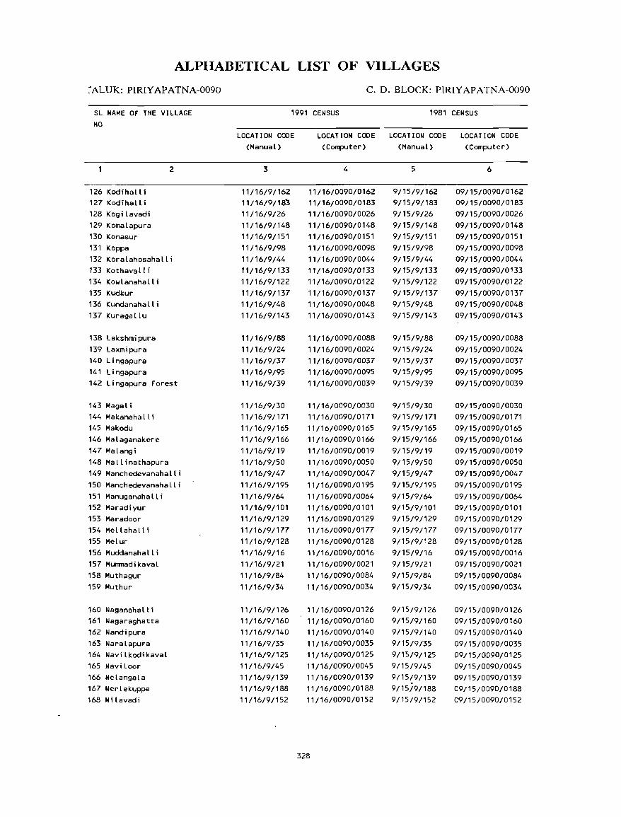
ALPIIABETICAL LIST OF VILLAGES
~ALUK: PIRIYAPATNA-0090
SL NAME OF THE VILLAGE NO
126 Kodihalli 127 Kodihalli 128 Kogi lavadi 129 Komalapura 130 Konasur 131 Koppa
2
132 Koralahosahalli 133 Kothaval t i 134 Kowlanahalli 135 Kudkur 136 Kundanahalli 137 Kuragallu
138 Lakshmipura 139 Laxmipura 140 Lingapura 141 Lingapura 142 Lingapura Forest
143 Magali 144 Makanahalli 145 Makodu
146 Malaganakere 147 Malangi
148 Mallinathapura 149 Manchedevanahalli
150 Manchedevanahalli 151 Manuganahalli 152 Maradiyur 153 Maradoor 154 Me II aha Il i
155 MeLur 156 Muddanahalli 157 MUITIl1adikaval
158 Muthagur
159 Muthur
160 Naganahall i 161 Nagaraghatta 162 Nandipura 163 Naralapura 164 Navilkodikaval
165 Naviloor 166 Nelangala
167 Nerlekuppe 168 Ni lavadi
C. D. BLOCK: PIRIYAPATNA-0090
1991 CENSUS 1981 CENSUS
LOCATION CODE (Manual)
3
11/16/9/162 11/16/9/185 11/16/9/26 11/16/9/148 11/16/9/151 11/16/9/98 11/16/9/44 11/16/9/133 11/16/9/122 11/16/9/137 11/16/9/48 11/16/91143
11/16/9/88 11/16/9/24 11116/9/37 11116/9/95 11/16/9/39
11/16/9/30 11/16/9/171 11/16/9/165 11/16/9/166
11/16/9/19 11/16/9/50 11/16/9/47
11/16/9/195 11/16/9/64 11/16/9/101 11/16/9/129 11/16/9/177 11116/91128 11/16/9/16
11/16/9/21 11/16/9/84
11/16/9/34
11/16/9/126 11/16/9/160 11/16/9/140 11/16/9/35 11/16/9/125 11/16/9/45 11/16/9/139 11/16/9/188 11/16/9/152
LOCATION CODE LOCATION CODE LOCATION CODE (Computer) (Manual) (Computer)
4
11/16/0090/0162 11/16/0090/0183
11116/0090/0026 11116/0090/0148 11/16/0090/0151 11116/0090/0098 11116/0090/0044 11/16/0090/0133 11/16/0090/0122 11/16/0090/0137 11/16/0090/0048 11/16/0090/0143
11/16/0090/0088
11/16/0090/0024 11/16/0090/0037
11/16/0090/0095 11/16/0090/0039
11/16/0090/0030 11/16/0090/0171 11/16/0090/0165 11/16/0090/0166
11/16/0090/0019 11/16/0090/0050 11/16/0090/0047
11/16/0090/0195 11/16/0090/0064 11/16/0090/0101 11/16/0090/0129 11/16/0090/0177 11/16/0090/0128 11/16/0090/0016 11/16/0090/0021
'1/16/0090/0084 11/16/0090/0034
11/16/0090/0126 11/16/0090/0160 11/16/0090/0140
11/16/0090/0035 11/16/0090/0125 11/16/0090/0045 11/16/0090/0139 11/16/0090/0188 11/16/0090/0152
328
5
9/15/9/162 9/15/9/183 9/15/9/26 9/15/9/148 9/15/9/151 9/15/9/98 9/15/9/44 9/15/9/133 9/15/9/122 9/15/9/137 9/15/9/48 9/15/9/143
9/15/9/88 9/15/9/24 9/15/9/37 9/15/9/95 9/15/9/39
9/15/9/30 9/15/9/171 9/15/9/165
9/15/9/166 9/15/9/19 9/15/9/50
9/15/9/47 9/15/9/195
9/15/9/64 9/15/9/101 9/15/9/129 9/15/9/177 9/15/9/128 9/15/9/16 9/15/9/21
9/15/9/84
9/15/9/34
9/15/9/126 9/15/9/160 9/15/9/140 9/15/9/35 9/15/9/125 9/15/9/45 9/15/9/139 9/15/9/188 9/15/9/152
6
09/15/0090/0162 09/15/0090/0183 09/15/0090/0026
09/15/0090/0148 09/15/0090/0151 09/15/0090/0098 09/15/0090/0044 09/15/0090/0 133 09/15/0090/0122 09/15/0090/0137 09/15/0090/0048 09/15/0090/0143
09/15/0090/0088
09/15/0090/0024 09/15/0090/0037
09/15/0090/0095 09/15/0090/0039
09/15/0090/0030 09/15/0090/0171 09/15/0090/0165
09/15/0090/0166 09/15/0090/0019 09/15/0090/0050 09/15/0090/0047
09/15/0090/0195 09/15/0090/0064 09/15/0090/0101 09/15/0090/0129 09/15/0090/0177 09/15/0090/0128 09/15/0090/0016 09/15/0090/0021
09/15/0090/0084
09/15/0090/0034
09/15/0090/0126 09/15/0090/0160 09/15/0090/0140
09/15/0090/0035 09/15/0090/0125 09/15/0090/0045 09/15/0090/0139 09/15/0090/0188 09/15/0090/0152
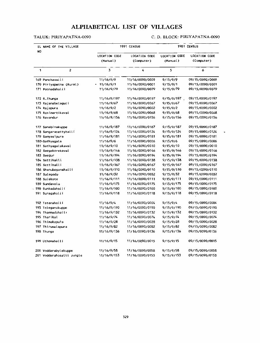
ALPHABETICAL LIST OF VILLAGES
TALUK: PIRIYAPATNA-0090
SL NAME OF THE VILLAGE NO
2
169 Panchavall i 170 Piriyapatna (Rural) 171 Poonadahalli
172 R.Thunga 173 Rajanabelaguli 174 Rajapura 175 Rasimartikaval 176 Ravandur
177 Sanabinakuppe 178 Sangarasettyhalli 179 Sanyasipura 18(); Sathyaga la 181 Sathyagalakaval 182 Seegekorekaval 183 Seegur 184 Settihalli 185 Settihalli 186 Shanuboganahalli 187 Sulagodu 188 Sulekote 189 Sundavalu 190 Sunkadahalli 191 Suragaha II i
192 Tatanahalli 193 Teleganakuppe 194 Thammadahalll 195 Tharikal 196 Thimakapura 197 Thirumalapura 198 Thunga
199 Uthenahall i
200 Voddarabylakuppe 201 Voddarahosalli Jungle
C. D. BLOCK: PIRIYAPATNA-0090
1991 CENSUS 1981 CENSUS
LOCATION CODE (Manual)
3
11/16/9/9 11/16/9/1 11/16/9/79
11/16/9/197 11/16/9/67 11/16/9/2 11/16/9/68 11/16/91156
11/16/9/187 11/16/9/124 11/16/9/181 11/16/9/6 11/16/9/10 11/16/9/146 11/16/9/194 11/16/9/138 11/16/9/167 11/16/9/110 11/16/9/32 11/16/9/111 11/16/9/175 11/16/9/100 11/16/9/118
11/16/9/4 11/16/9/i90 11/16/9/132 11/16/9/74 11/16/9/28 11/16/9/82 11/16/9/136
11/16/9/15
11/16/9/58 11/16/9/153
LOCATION CODE LOCATION CODE LOCATION CODE (Computer) (Manual) (Computer)
4
11116/0090/0009 11/16/0090/0001 11/16/0090/0079
11/16/0090/0197 11/16/0090/0067 11/16/0090/0002 11/16/0090/0068 11/16/0090/0156
11/16/0090/0187 11/16/0090/0124 11/16/0090/0181 11/16/0090/0006 11/16/0090/0010 11/16/0090/0146 11116/0090/0194 11/16/0090/0138 11/16/0090/0167 11/16.(0090/0110 11/16/0090/0032 11/16/0090/0111 11/16/0090/0175 11/16/0090/0100 11/16/0090/0118
11/16/0090/0004 11/16/0090/0190 11/16/0090/0132 11/16/0090/0074 11 / 16/0090/0028 11/16/0090/0082 11/16/0090/0136
11/16/0Q90/0015
11/16/0090/0058 11/16/0090/0153
329
5
9/15/9/9 9/15/9/1 9/15/9/79
9/15/9/197 , 9/15/9/67 9/15/9/2 9/15/9/68 9/15/9/156
9/15/9/187 9/15/9/124 9/15/9/181 9/15/9/6 9/15/9/10 9/15/9/146 9/15/9/194 9/15/9/138 9/15/9/167 9/15/9/110 9/15/9/32 9/15/9/111 9/15/9/175 9/15/9/100 9/15/9/118
9/15/9/4 9/15/9/190 9/15/9/132 9/15/9/74 9/15/9/28 9/15/9/82 9/15/9/136
9/15/9/15
9/15/9/58 9/15/9/153
6
09/15/0090/0009 09/15/0090/0001 09/15/0090/0079
09/15/0090/0197 09/1 5/0090/0067 09/15/0090/0002 09/15/0090/0068 09/15/0090/0156
09/15/0090/0187 09/1 5/0090/0124 09/15/0090/0181 09/15/0090/0006 09/15/0090/0010 09/15/0090/0146 09/15/0090/0194 09/15/0090/0138 09/15/0090/0167 09/15/0090/0110 09/15/0090/0032 09/15/0090/0111 09/15/0090/0175 09/15/0090/0100 09/15/0090/0118
09/15/0090/0004 09/15/0090/0190 09/15/0090/0132 09/15/0090/0074 09/15/0090/0028 09/15/0090/0082 09/15/0090/0136
09/15/0090/0015
09/15/0090/0058 09/15/0090/0153
VILLAGE
AMENITIES NameofC.D.Block: PIRIYAPATNA; Code No. :0090
L.C. Name of Village Total area of Total Allhlnitio:s available (irnnt availabl.: wilhin tho: vi1Jag.:, a da&h (-) is shown in the No. the village Popu, column and n.:xllo il in brae leis. tho: dislance in broad rang.:s viz. -5 kms, 5-10 Lms,
(In heClal\ls) lalion ahd 10+ kIm oflh.: n.:ar':~lllln~!: whCi:!: !h" [ncjlil:r: i~ av~ilnhl.: is giv!t!!l. and &luea- Medical Drinling POSI Day llt CommuOicalion
No.of tional WaleI' and Days of [Bus SlOp, House- T.:lo:- Rlarko!tl RailwllY Sialion, holds graph hal if any Waterway)
(1 ) (2) (3) (4) (5) (6) (7) (6) (9) (]O)
PIRIYAPATNA (RURAL) 119.46 ------------------------ UN - INHABITED _._--.--.--------. __ ._---
2 RAJAPURA 226.30 640 -(0-5) -(0-5) HP -(0-5) -(0-5) BS
( 110)
3 ABBUR 272.05 675 P -(0-5) HI, HP Phone -(0-5) BS
( 117)
4 TATANAHAlll 269.93 648 P -(0-5 ) w, HP -(0-5) -(O-~) - (0- 5) (113)
5 ItARIlAPURA 398.~' 569 P -(0-5) W, HP -(0-5) -(0-5) -(0-5) (84)
6 SAHfYAGAlA 507.08 1315 P(2), M -(0-5-) W, HP PO -(5-10) BS
(230) ,
7 BEKYA 290.34 735 P -(0-5) W, HP -(0-5) -(5-10) -(0-5) (118)
8 ITTIGEHAlLI 233.23 674 - (0-5) -(0-15) W, HP -(0-5) - (10+) -(0-5) (112)
9 PANCItAVAlLI 399.62 1382 P(2), M D 1.1, HP PO -(5-10) BS (234)
1& SATHYAGAlAKAVAl 330.48 376 P - (5-10) W, HP -(5-10) -(5-10) -(5-10) (65)
11 HAlASOOR 84.95 19 -(0-5) -(5-10) W, HP -(5-10) -(5-10) -(5-10) (4)
12 HUNASElCUPPE 230.11 596 p -(0-5) 1.1, HP -(0-5) -(0-5) - (0-5) (108)
13 I CHANA HAL LI 328.43 123 p - (0-5) W, HP - (0- 5) -(0-5) -(0-5) (18)
14 CHOWKUR 320.31 570 P -(5-10) W, HP -(5-10) -(5-10) -(5-10) (110)
330
DIRECTORY
AND LAND USE Namt! of C.D.Block : PIRIYAPATNA; COOt! No.: 0090
Approach Nearest Town. Class of Town Power Land usc (arca undcr din-':rcnllyp.:s of lantt us.: in heclarcs roundcd 10 Iwo decimal places) L.C. 10 village and dislance (in Km.) Supply No.
Forcsl Irrigaled Un-irrigatcd Cullum!>le Arca nol (by source of irrigatil>n) waste available
(including for cullivation gauchar and groves)
(11) (12) (13) (14) (15) (16) ( 17) ( 18) ( 1 )
.. ------------------------------------------- UN . INHABITED ---------------------------------------------
PR PIRIYAPATNA' IV· 2 EA Total 8.70 174.20 43.40 2 Tic 6.68 We 2.02
PR PIRIYAPATNA' IV' 1 EA Total 24.28 204.89 22.74 36.83 3 Tic 24.28
PR PIRIYAPATNA' IV· 3 EA Total 54.47 177.19 35.00 3.27 4 Tk 48.16 We 6.31
KR PIRIYAPATNA' IV' 5 EA Total 28.41 302.72 34.80 32.38 5 Tk 15.38
0 13.03
PR PIRIYAPATNA' IV' 6 EA Total 39.26 304.08 100.00 63.74 6 Tic 39.26
KR PIRIYAPATNA' IV· 7 EA Total 25.09 189.07 52.30 23.88 7 Tk. 25.09
PR PIRIYAPATNA' IV' 14 EA 167.55 Total 1.62 55.04 0.12 8.90 8 TIc 1.62
PR PIRIYAPATNA' IV' 10 EA Total 8.09 167.22 194.26 30.05 9 Tic 8.09
PR PIRIYAPATNA' IV' 6 EA 158.48 170.00 2.00 10
KR PIRIYAPATNA' IV· 10 EA Total 5.36 69.63 9.96 11 TIc 2.02 We 3.34
PR PIRIYAPATNA' IV' 5 EA Total 20.07 153.79 36.02 20.23 12 Tic 20.07
PR PIRIYAPATNA- IV· 3 EA Total 21.45 208.62 79.75 18.61 13
Tk 21.45
PR PIRIYAPATNA- IV· 6 EA Total 14.97 139.41 142.45 23.48 14 TIc 14.97
331
VILLAGE
AMENITIES Name ofC.D.Block: PIRIYAPATNA; Code No. :0090
L.C. Name of Village Total area of Total Amenities available (if not available within the village. a dash (-) is shown in the No. the village Popu- column and next to it in brack.:ts. the distance in broad ranges viz. -5 kms. 5-10 kms.
(In hectar.:s) lation and 10+ kills of the near~st [!Ia~~ wh~re the t:1Cility is availahle is given). and Educa- Mcdical Drinking Post Day or COlnmuni~aliun
No.of tiona I Water and Days of [Bus Stop. House· Tele- market/ Railway Station. holds graph hat if any Waterway)
(1) (2) (3) (4) (5) (6) (7) (8) (9) (10)
15 UTHENAHALLI 725.75 525 P -(0-5) II, HP -(0-5) -(5-10) -(0-5) (99)
16 MUDDANAHALLI 281.41 951 P -(0-5) II, HP -(0-5) -(5-10) -(0-5) ( 160)
17 KACHUVANAHALLI JUNGLE 1832.05 -- ----- -- --- ------ ---.-- UN - I NHAB ITED -------------------------
18 ALALUR 548.66 425 - (0-5) -(0-5) II, HP -(0-5) -(10+) -(0-5) (89)
19 MALANGI 517.68 1119 P, M -(5-10) II, HP -(5-10) -(5-10) -(0-5) (221)
20 ABBALATHI 349.93 430 P -(0-5) II, HP -(0-5) -(0-5) -(0-5) (91)
21 MUMMADI KAVAL 463.74 557 P -(0-5) II, HP - (0- 5) -(0-.5) -(0-5) (102)
22 ANKANAHALL I 283.44 1778 P(2) -(0-5) II, HP -(0-5) -(0-5) -(0-5) (281)
23 HABATOOR 709.73 1578 P(2) , M -(0-5) II, HP PO - (0-5) as (306)
24 LAXMIPURA 395.02 640 P -(5-10) II, HP -(0-5) -(5-10) BS (111 )
25 ANECHOIIKUR FOREST 3153.95 14 -(0-5) -(5-10) II, HP -(5-10) -(10+) BS (8)
26 KOGI LAVAD I 281.87 575 P, M -(5-10) II, HP -(0-5) -(5-10) BS (101)
27 CHOIITHI 408.34 1036 P -(5-10) II, HP -(0-5) -(5-10) BS (181)
28 THIMAKAPURA 268.58 749 P -(0-5) II, HP -(0-5) - (0- 5) ·(0-5) (138)
29 HALEPETEKANTAPURA 184.62 77 -(0-5) -(0-5) Til, HP -(0-5) -(0-5) -(0-5) ( 13)
332
DIRECTORY
AND LAND USE NameofC.D.Block: PIRIYAPATNA; Code No.: 0090
Approach Nearest Town. Class of Town Power Land U;c (area under different types of land use in hectares rounded to two decimal places) L.C. to village and distance (in Km.) Supply No.
Forest Irrigated Un-irrigated Culturable Area not (by source of irrigation) waMe available
(including for cultivation gauchar and groves)
( 11 ) (12) (13) (14) (15) (16) (17) (18) (1)
KR PIRIYAPATNA- IV- 14 EA Total 6.48 103.28 594.54 21.45 15 Tk 6.48
PR PIRl'tAPATNA- 1\1- 11 EA 14.71 262.25 4.45 16
--------------------------------------------~ UN - INHABITED ............ -oo ...... _ ............ __ .................... ______ .............. __ 17
PR PIRIYAPATNA- IV- 11 EA Total 21.85 108.35 403.08 15.38 18 Tk 21.85
PR PIRIYAPATNA- IV- 8 EA Total 18.62 132.56 350.07 16.43 19 Tk 18.62
PR PIRIYAPATNA- IV- 5 EA Total 42.95 42.95 76.02 188.01 20 Tk 14.71 lJe 28.24
PR PIRIYAPATNA- IV- 5 EA 462.00 1.74 21
PR PIRIYAPATNA- IV- 2 EA Total 26.31 ~87.88 39.69 29.56 22 Tk 26.31
PR PIRIYAPATNA- IV- 5 EA Total 37.64 294.11 334.28 43.70 23 Tk 37.64
PR PIRIYAPATNA- IV- 8 EA Total 8.50 113.32 259.82 13.38 24 Tk 8.50
PR PIRIYAPATNA- IV- 14 EA 3148.57 5.38 25
PR PIRIYAPATNA- 1\1- 10 EA Total 44.52 60.10 157.02 20.23 26 Tk 44.52
PR PIRIYAPATNA- IV- 5 EA Total 49.78 152.57 178.07 27.92 27 Tk 49.78
PR PIRIYAPATNA- IV- 3 EA Total 18.62 156.48 72.85 20.63 28 Tk 18.62
PR PIRIYAPATNA- IV- 2 EA Total 30.76 107.65 0.40 45.81 29 Tk 30.76
333

VILLAGE
AMENITIES
Name of C.D.Block : PIRIYAPATNA; Code No. :0090
L.C. Name of Village Total area of Total Amemth:~ avall .. hle (If not avallahl.: wlthlO th.: Village. a da~ (-) IS ~own In the
No. th~ Village Poru- column and nexi 10 II In hrad.cls. Ihe dl~lanc" In hr<>ad ranges vi; -5 lm •• 5-10 lms, (In h.:da n: s) lat,on and 10+ llll' <lIthe neare,t [!I"ce "here the 1:,,:,"ly i. avarl"hle ,. g,wn)
and Educa- MedlCdl Dnnltng Po.t Day or ConUnUnl4...alll)n
No of honal Water and Days of (BlIb SLOp. HUlI.':- Tel.:- marlel! RaIlway Siahon. holds graph hal If any Wal.:rway)
(1) (2) (3) (4) (5) (6) (7) (8) (9) (10)
30 MAGALI 177.61 670 P -(0-5) W, HP -(O-S) -(0-5) BS
(113)
31 BEGUR 228.98 298 -(0-5) - (0- 5) W, HP -(0-5) -(5-10) BS
(61)
32 SULAGOOU 218.06 309 P -(5-10) W, HP -(0-5) -(5-10) -(O-S)
(54)
33 KALETHIMMANAHALLI 371.21 232 -(0-5) -(0-5) W, HP -(0-5) - (10+) -(0-5)
(39)
34 MUTHUR 860.52 2088 P(2), M -(0-5) TW, HP PTa, -(5-10) BS
(389) Phone
35 NARALAPURA 275.18 618 P -(0-5) W, TW -(0-5) -(5-10) BS
(106)
36 KIRANGOOR 204.06 449 P -(0-5) W, HP - (0- 5) -(5-10) -(0-5)
(75)
37 LINGAPURA 347.01 397 P, M -(0-5) W, HP Phone - (10+) BS
(76)
38 AYARABEEDU 508.98 697 P -(5-10) TK, HP -(5-10) - (10+) -(0-5)
(129)
39 LI NGAPURA FOREST 380.24 163 -(0-5) -(0-5) W, TK -(0-5) - (0- 5) -(0-5)
(36)
40 BEMMATHI 232.63 488 P -(0-5) W, HP -(0-5) -(5-10) -(0-5)
(84)
41 IlAPURA 173.48 350 -(0-5) -(0-5) w, HP -(0-5>- -(5-10) -(0-5)
(63)
42 KAMANAHALLI 123.23 40 -(0-5) -(0-5) TK, HP -(0-5) -(5-10) BS
(7)
43 BOOTHANAHAlL I 160.95 768 P -(0-5) W, HP -(0-5) -(5-10) BS
( 132)
334
DIRECTORY
AND LAND USE Nam~ of C.D.Block : PIRIYAPATNA; Cod~ No.: 0090
"-
Approach Near.:st Town, Class of Town Power Land us.: (area under din;:rent types of land us.: in hectares rounded to two decimal places) L.C. to village and distance (in Km.) Supply No.
Forest Irrigated Un-irrigated Culturahle Area not (hy source of irrigation) waste available
(including for cultivation gauchar and groves)
~"2 ~122 ~ 132 ~ 142 ~152 ~ 162 ~172 ~182 ~12
PR PIRIYAPATNA- IV- 5 EA Total 10.93 87.01 56.61 23.06 30 Tic. 10.93
PR PIRIYAPATNA- IV- 5 EA Total 32.26 172.11 24.61 31 Tic. 32.26
PR PIRIYAPATNA- IV- 8 EA Total 29.95 91.80 82.56 13.75 32 Tic. 29.95
PR PIRIYAPATNA- IV- 9 EA 180.90 Total 31.57 88.22 41.38 29.14 33 Tic. 31.57
PR PIRIYAPATNA- IV- 10 EA 98.55 Total 64.82 651.07 46.08 34 Tic. 56.89 lie 7.93
PR PIRIYAPATNA- IV- 14 EA Total 33.33 212.32 29.53 35 Tic. 33.33
KR PIRIYAPATNA- IV- 14 EA Total 38.49 83.56 76.51 5.50 36 Tic. 36.41 lie 2.08
PR PIRIYAPATNA- IV- 13 EA Total 34.99 146.12 138.96 26.94 37 Tic. 32.38 lie 2.61
KR PIRIYAPATNA- IV- 12 EA 314.70 Total 18.34 95.51 66.39 14.04 38 Tic. 18.34
KR PIRIYAPATNA- IV- 14 EA 380.24 39
KR PIRIYAPATNA- IV- 14 EA Total 29.54 81.90 105.00 16.19 40 Tic. 29.54
KR PIRIYAPATNA- IV- 13 EA Total 20.79 85.38 17.35 49.96 41 Tic. 16.19 lie 4.60
KR PIRIYAPATNA- IV- 10 EA Total 33.59 52.61 17.00 20.03 42 Tic. 33.59
PR PIRIYAPATNA- IV- 9 EA Total 53.02 n.70 7.57 22.66 43
Tic. 53.02
335

VILLAGE
AMENITIES Name of C.D.Block : PIRIYAPATNA; Code No. :0090
L.C. Name of Village Total area of Total Amenities available (if not available within the village, a dash (-) is shown in the No. the village Popu- column and next to it in brackets, the distance in broad ranges viz. -5 kms, 5-10 kms,
(In hectares) lation and 10+ kms of the nearest I2lace where the facility is availahle is given}. and Eduea- Medical Drinking Post Day or Communication No.of tional Water and Days of [Bus Stop, House- Tele- market/ Railway Station, holds graph hat if any Waterway)
(1) (2) (3) (4) (5) (6) (7) (8) (9) (10)
44 KORALAHOSAHALLI 153.07 117 -(0-5) -(5-10) 101, HP -(0-5) -(5-10) -(0-5) (15)
45 NAVILOOR 666.15 1381 P -(5'10) TIJ, HP -(0-5) -(5-10) -(0-5) (240)
46 ALANAHALLI 405.08 2190 P, M - (5- 10) 101, TIJ, HP PO -(5-10) BS (361)
47 MANCHEDEVANAHALLI 616.10 695 P -(5-10) 101, HP -(5-10) -(0-5) BS (125)
48 KUNDANAHALLI 258.69 490 -(0-5) -(0-5) 101, HP -(0-5) -(5-10) BS (93)
49 HUNASAVADI 471. 78 1085 P(2), M, H PHC, FPC 101, TIJ PO -(5-10) BS (217)
50 MALLI NATHAPURA 292.95 417 P -(0-5) 101, TIJ -(0-5) -(5-10) BS (80)
51 BELATHUR 325.72 545 P -(0-5) 101, HP -(0-5) -(5-10) -(0-5) (91)
52 CHANNENAHALLI 397.20 643 P -(0-5) 101, HP -(0-5) -(0-5) -(0-5) ( 113)
53 CHITTENAHALLI 272.58 656 P -(0-5) 101, HP Phone -(0-5) BS (119)
54 CHOIJDENAHALLI 96.79 425 -(0-5) -(0-5) 101, HP -(0-5) -(0-5) BS (76)
55 HARVEMALLARAJAPATNA 359.84 549 P -(0-5) 101, HP -(0-5) -(0-5) BS (109)
56 HARANAHALLI 343.26 786 P, M, H -(0-5) 101, HP -(0-5) -(5-10) BS (120)
. 336
DIRECTORY
AND LAND USE Name of C.D.Block : PIRIYAPATNA; Code No.: 0090
Approach Nearest Town, Class of Town Power Land use (arl!a under different types of land use in hectares rounded to two decimal placlls) L.C. to village and distance (in Km.) Supply No.
Forest Irrigated Un-irrigated Culturable Area not (by source of irrigation) waste available
(induding for cultivation gauchar and groves)
(11) ( 12) (13) (14) (15) (16) ( 17) (18) (1)
KR KUSHALNAGAR- Y- 10 EA Total 19.43 105.31 14.57 13.76 44 Tk 19.43
PR KUSHALNAGAR- Y- 10 EA Total 55.04 441. 12 125.06 44.93 45 Tk 41.28 0 13.76
PR KUSHALNAGAR- Y- 10 EA Total 39.26 289.36 29.93 46.53 46 Tk 39.26
PR KUSHALNAGAR- Y- 7 EA Total 16.19 437.62 121.81 40.48 47 Tk 12.18 lJe 4.01
PR PIRIYAPATNA- IY- 8 EA Total 27.11 107.65 101.67 22.26 48 Tk 27.11
PR PIRIYAPATNA- IY- 8 EA Total 68.44 276.59 126.75 49 Tk 14.88 lJe 53.56
PR PIRIYAPATNA- IY- 8 EA Total 26.31 182.12 50.59 33.93 50 Tk 26.31
KR PIRIYAPATNA- IY- 5 EA Total 50.99 219.49 6.88 48.36 51 Tk 40.87 lJe 10.12
KR PIRIYAPATNA- IV- 5 EA Total 40. " 180.17 164.36 12.56 . 52 Tk 35.22 lJe 4.89
PR PIRIYAPATNA- IY- 3 EA Total 28.70 161.12 72.57 10.19 53 Tk 25.06 lJe 3.64
PR PIRIYAPATNA- IY- 3 EA Total 32.78 37.23 6.88 19.90 54 Tk 32.78
PR PIRIYAPATNA- IY- 2 EA Total 19.43 243.63 68.86 27.92 55 Tk 19.43
PR KUSHALNAGAR- Y- 17 EA Total 49.37 225.42 24.35 44.12 56 Tk 49.37
337

VILLAGE
AMENITIES Name of C.D.Block : PIRIYAPATNA; Code No. :0090
L.C. Name of Village Total ar.:a of Total Amenities available (if nn' available wilhinthe village. a dash (-) is shown in the No. the village Popu- column and next to it in brack.:ts. the distance in broad rang ... 'S viz. -5 kms. 5-10 kms,
(In h.:ctan:s) lation and 10+ kms nfthe nearest [!Iac.: where tho: radlit): is available is given}. and Educa- Medical Drinking P,)sI Day or Communication No.of tinnal Water and Days of IBus Stop. Hous.:- T.:Ie- mark.:!! Railway Slalion. holds graph hat if any Waterway)
( 1 ) (2) (3) (4) (5) (6) (7) (8) (9) (10)
57 CHAPPARADAHAllI 336.98 1796 P PHC T, HP PTO, -(5,10) BS (320) Phone
58 VOODARABYlAKUPPE 165.31 245 P -(0-5) Y, HP - (0- 5) -(5-10) -(0-5) (36)
59 GANGANAKUPPE 254.46 816 P -(0-5) Y, HP -(0-5) - (10+) -(0-5) (143)
60 GAR I GUDDADAKAVAl 557.30 247 -(0-5) - (0-5) Y, HP -(0-5) -(0-5) -(0-5) (41 )
61 KANAGAl 389.80 2327 P(2), M, PHC, FPC TY, R PTO, -(5-10) BS (432) H, PUC Phone
62 BASAVANAHALll 138.68 482 P -(0-5) Y, HP, R -(0-5) -(5-10) -(0-5) (79)
63 GOBBALIKAVAL 155.81 4 -(0-5) -(0-5) -(0-5) -(0-5) -(0-5) (1)
64 MANUGANAHAlLl 250.69 589 P -(0-5) Y, HP -(O-5) -(O-S) -(0-5) (108)
65 I CHANAHAlLl 168.89 304 P -(0-5) Y, HP -(0-5) -(0-5) -(0-5) (51)
66 . GUDIBHADRANAHOSAHAlLl 141.15 200 P -(5-10) Y, HP -(5-10) -(5-10) -(0-5) (39)
67 RAJANABELAGULI 636.79 2088 P(2), M -(0-5) T, HP PO -(0-5) BS (348)
68 RASIMARTIKAVAL 228.87 41 - (0- 5) -(0-5) Y, HP -(0-5) -(0-5) -(0-5) (8)
69 HUNASETHOPPALU 193.45 482 P -(0-5) Y, HP -(0-5) -(0-5) -(0-5) (92)
70 HASUVINAKAVAl 789.95 748 P -(0-5) Y, HP - (0- 5) -(0-5) BS (131)
338
DIRECTORY
AND LAND USE 1\.II11e of C D I3h:k: PIRIYAPATNA; CoJe No.: 0090
Appma"h N~ar~'1 Town. Cia", 01 Town Pow~r Land ll' .. ..: (,11":,1 ulh.l-:r Jllkr~1l1l\p..: ... niland u ... ..: III h..:dar\!\ rOllnd..:d In two d":l..Illldl pl .. h .. ..:') LC III vlllag~ and d"Ian,,~ (III Kill ) Supply No
For..: ... t [nlg.lt..:J Un Irn),!JI~d Cuhurahl~ Ar~d not <h} "'&)ur~..: nl Ifllg.IIHH1) ""a ... l..: aVdlldhl~
(m"'ud,n),! lor ,-ultlvallon
gau"h,'r dnd ),!rov~')
( 1 1 ) (12) (13) ( 14) ( 15) ( 16) (17) (18) ,1 )
PR KUSHALNAGAR- V- 19 EA Total 25_91 274.32 36_ 75 57 Tk 23.83 '.Je 2.08
KR KUSHAlNAGAR- V- 19 EA Total 9.71 138.88 1.34 15.38 58 Tk 9.71
KR KUSHAlNAGAR- V- 21 EA Total 16.19 207.21 5.56 25.50 59 Tk 16.19
KR KUSHAlNAGAR- V- 10 EA Total 27.11 209.23 303.53 17.43 60 Tk 27.11
PR KUSHAlNAGAR- V- 24 EA Total 165.21 142.46 82.13 61 Tk 147.00 '.Je 18.21
KR KUSHAlNAGAR- V- 26 EA Total 28.73 77.70 10.93 21.32 62 Tk 28.73
KR KUSHALNAGAR V 26 EA 155.81 63
KR KUSHAlNAGAR- V- 26 EA Total 35.14 186.51 29.04 6ft
Tk 33.89
'.Je 1.25
KR KUSHAlNAGAR- V- 24 EA Total 22.66 118.17 10.65 17.41 65 Tk 22.66
KR KUSHAlNAGAR- V- 25 EA Total 7.28 111.70 9.62 12.55 66 Tk 7.28
KR KUSHAlNAGAR- V- 24 EA Total 50.99 516.49 19.12 50.19 67 Tk 50.99
KR PIRIYAPATNA- IV- 23 EA 228.87 68
KR PIRIYAPATNA- IV- 25 EA Total 1.62 167.55 9.71 14.57 69 0 1.62
PR PIRIYAPATNA- IV- 21 EA 696.89 84.16 8.90 70
339
VILLAGE
AMENITIES
Name of C.D.Block : PIRIYAPATNA; Code No. :0090
L.C. Name of Village Total area of Total Am.:niti.:s availahl.: (if not availahle within the village. a dash (-) is shown in the
No. the village Popu- column and n.:xt to it in hrack.:t8. the distance in broad ranges viz. -5 kms. 5-10 kms. (In hectares) lation and 10+ kms of the nearest ~Iace wh.:r.: the facility is availahle is given).
and Educa- M.:dical Drinking Post Day or Communication No.of lional Wat.:r and Days of [Bus Stop. House- Tel.:- mark.:tl Railway Station. holds graph hat if any Wah:rway}
P) (2) (3) (4) (5) (6) (7) (8) (9) (10)
71 BYADARABllAGUll 405.97 941 P -(0-5) W, HP -(0-5) -(0-5) -(0-5)
(141)
72 HALEYUR 153.80 230 -(0-5) -(0-5) W, HP -(0-5) - (5-10) -(0-5)
(46)
73 CHIKKANERALE 175.18 789 P, M PHe, FPC '01, HP PO -(5-10) BS
(140)
74 THAR IKAl 463.82 lOll P -(0-5) W, HP -(0-5) -(5-10) -(0-5)
( 174)
75 DODDANERALE 484.39 805 p(2), M -(5-10) '01, HP -(0-5) -(5-10) BS
( 123)
76 GUlLEDAHALLA JUNGLE 407.37 253 P -(0-5) HP -(0-5) - (5-10) -(0-5)
(44)
71 HOSAHALLI 402.25 760 P -(0-5) W, HP • -(0-5) -(5-10) - (0-5)
(136)
78 BASAVANAHALLI 421.21 646 P -(0-5) W, HP -(0-5). -(5-10) BS
(118) ...
79 POONADAHAlLl 302.65 1087 P, M - (0- 5) TIJ, HP PO -(5-10) BS
(168)
80 CHARAPURA 69.42 71 -(0-5) - (0-5) HP -(0-5) ·(5-10) -(0-5)
(13)
81 HANDIGUDOADAKAVAL 802.77 1992 P, M - (0-5) HP -(0-5) -(0-5) -(0-5) (433)
82 THIRUMALAPURA 323.35 806 P -(0-5) 101, HP -(0-5) -(0-5) -(0-5)
(158)
83 DODDAHONNURKAVAL 549.05 135 -(0-5) -(0-5) 101, HP -(0-5) -(0-5) -(0-5)
(26)
84 MUTHAGUR 61.74 60 P -(0-5) HP -(0-5) -(0-5) - (0-5) ( 13)
340
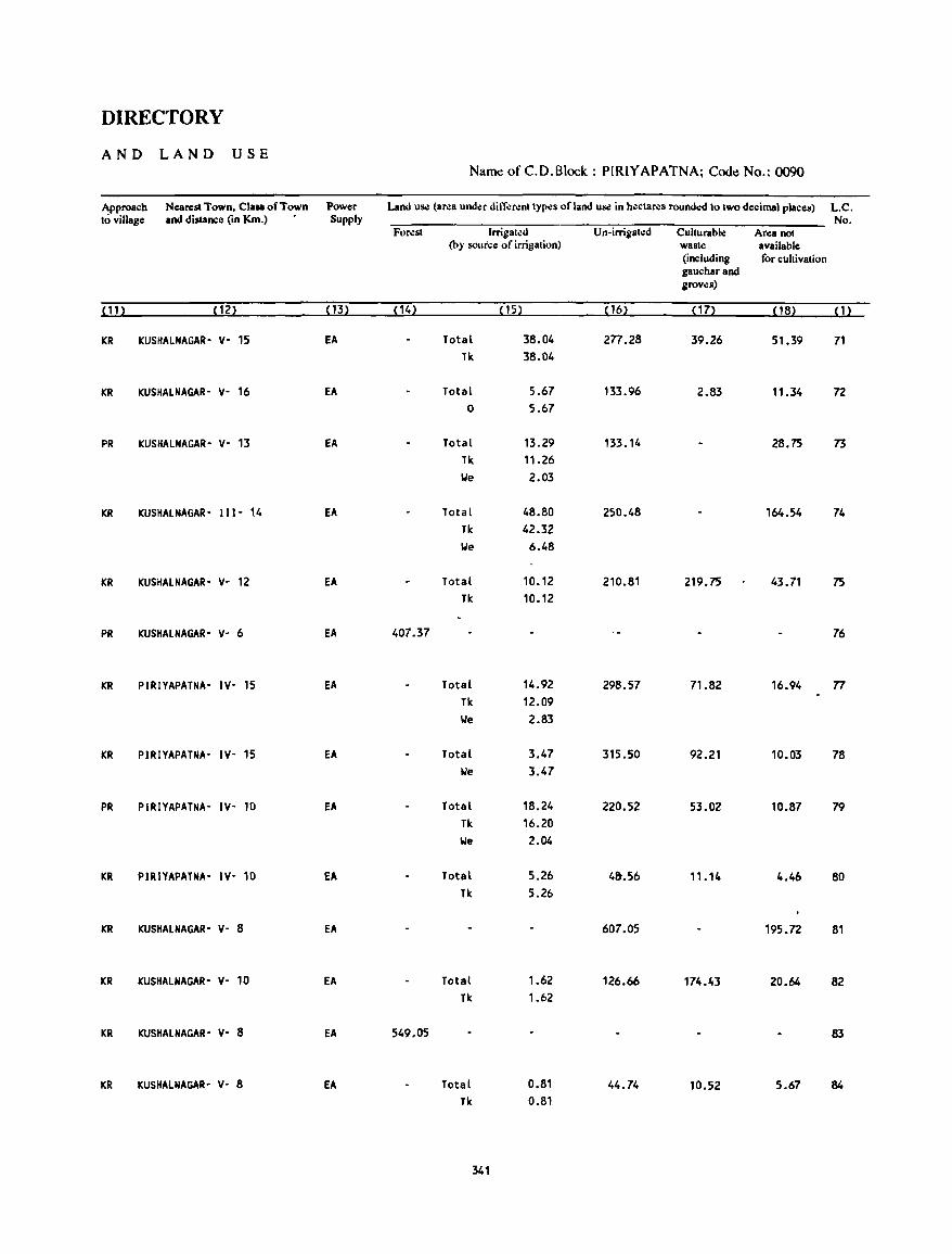
DIRECTORY
AND LAND USE Name of C.D.Block : PIRIYAPATNA; Code No.: 0090
Approach Nearest Town, ClaN of Town Power Land us.: (area und~r dil1"erenllypes of land us.: in hl!ctares rounded 10 Iwo decimal places) L.C. 10 village and distance (in Km.) Supply No.
Foresl Irrigalo:d U n-irrigllilld Cullurable Area noI (by sour'ce of irrigation) wasle available
(including for cultivation gaucharand groves)
(11) ( 12) (13) (14) (15) (16) (17) (18) (1)
ICR ICUSHALNAGAR- Y- 15 EA Total 38.04 2n.28 39.26 51.39 71 Tk 38.04
ICR KUSHALNAGAR- Y- 16 EA Total 5.67 133.96 2.83 11.34 72 0 5.67
PR KUSHAlNAGAR- Y- 13 EA Total 13.29 133.14 28.75 73 Tk 11.26 We 2.03
KR KUSHAlNAGAR- 111- 14 EA Total 48.80 250.48 164.54 74 Tk 42.32 We 6.48
KR KUSHAlNAGAR- Y- 12 EA Total 10.12 210.81 219.75 43.71 75 Tk 10.12
PR KUSHALNAGAR- Y- 6 EA 407.37 76
KR PIRIYAPATNA- IY- 15 EA Total 14.92 298.57 71.82 16.94 n Tk 12.09 We 2.83
KR PIRIYAPATNA- IY- 15 EA Total 3.47 315.50 92.21 10.03 78 We 3.47
PR PIRIYAPATNA- IY- 10 EA Total 18.24 220.52 53.02 10.87 79 Tk 16.20 We 2.04
KR PIRIYAPATNA- IY- 10 EA Total 5.26 4&.56 11.14 4.46 80 Tk 5.26
KR KUSHAlNAGAR- Y- 8 EA 607.05 195.72 81
KR KUSHALNAGAR- Y- 10 EA Total 1.62 126.66 174.43 20.64 82 Tk 1.62
KR KUSHALNAGAR- Y- 8 EA 549.05 83
KR KUSHALNAGAR- Y- 8 EA Total 0.81 44.74 10.52 5.67 84
Tk 0.81
341
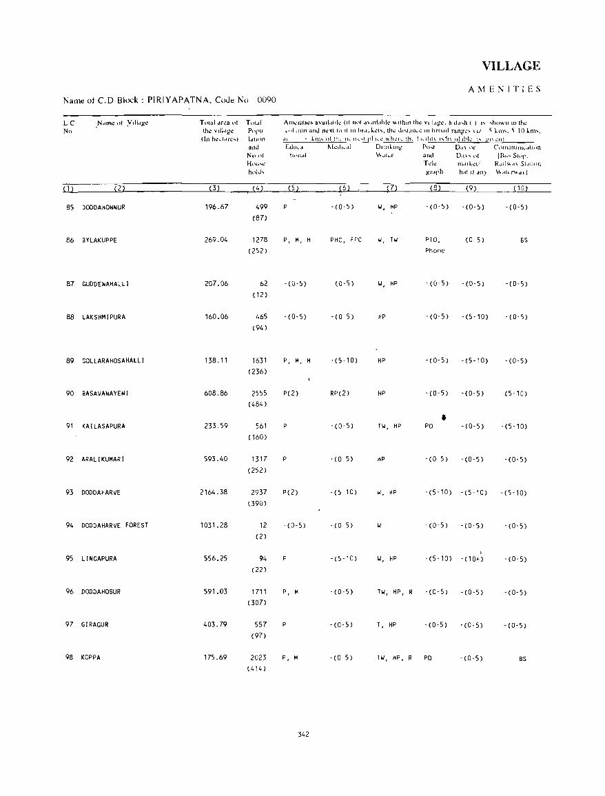
VILLAGE
AMENITIES Name of C.D Block: PIRIYAPATNA, CoJe No 0090
LC _N,lIne 01 Ylil"ge T DIal drea 01 Toldl AlllCllllh:> avatl,,"I~ (II flol d"nj"hk ",lh'll Ihe vlil,'ge. & d",h ( ) " ,hown In Ih~
No Ih~ vlildge POpll ... I!]llllln and nexi to 11 III hrd\..kl!l\. thl! OI\lJIR\! 10 hrchld rang'I!'" \1/ <; kill'. <; 10 i.1ll'. (In hedM~') Idllon '" k.m" of ttl .. 11-.. I! ... ",I pi h.1! ",hl!ll.. th~ I 1<..1111\ ""~1\ nllhtl.! \ .. g!\ L'n!
and Edt"" r-.kd,,,tl DI,ni.,ng Pu .... t D~I\ ()[ C'l)IllIllUl1k,dlhHl
Nn 01 Il<lo .. 1 \\."kr and 0,1\", 01 113", SlOp. H{)lI,1,! Td~ nMIi.d! R .. tl" ,,\ SI"I""I hold, grdph h". II ""} \'."1,,>+,,.1
( 1 ) (2) (3) (4) (5) (6) )7) (8) (9) (Hl)
85 DOODAHONNUR 196.67 499 P -(0-5) II, HP -(0-5) ·(0-5) -(0-5) (87)
86 BYLAKUPPE 269.04 1278 P, M, H PHC, FPC II, Til PTO, (0 5) BS (252) Phone
87 GUDDENAHALLI 207.06 62 -(0-5) (0-5) II, HP -(0-5) -(0-5) -(0-5) (12)
88 LAKSHMIPURA 160.06 465 - (0-5) - (0 5) HP -(0-5) -(5-10) - (0-5) (94 )
89 GOLLARAHOSAHALLI 138.11 1631 P, M, H -(5-10) HP -(0-5) - (5-10) -(0-5) (236)
90 BASAVANAYENI 608.86 2555 P(2) RP(2) HP -(0-5) -(0-5) (5-10) (484)
• 91 KAILASAPURA 233.59 561 P -(0-5) Til, HP PO -(0-5) -(5-10) ( 160)
92 ARALIKUMARI 593.40 1317 P - (0 5) HP -(0 5) -(0-5) -(0-5) (252)
93 DODDAHARVE 2164.38 2937 P(2) -(5 10) II, HP -(5-10) - (5 -1 0) - (5 -1 0) (390)
94 DODDAHARVE FOREST 1031.28 12 -(0-5) -(0 5) II - (0-5) -(0-5) - (0-5) (2)
95 L1NGAPURA S56.25 94 P -(5-10) II, HP -(5-10) - (10+) -(0-5) (22)
96 DODDAHOSUR 591.03 1711 P, M -(0-5) HI, HP, R -(0-5) - (0-5) -(0-5) (307)
97 GIRAGUR 403.79 557 P -(0-5) T, HP -(0-5) -(0-5) -(0-5) (97)
98 KOPPA 175.69 2023 P, M - (0 5) Til, HP, R PO -(0-5) BS (414)
342
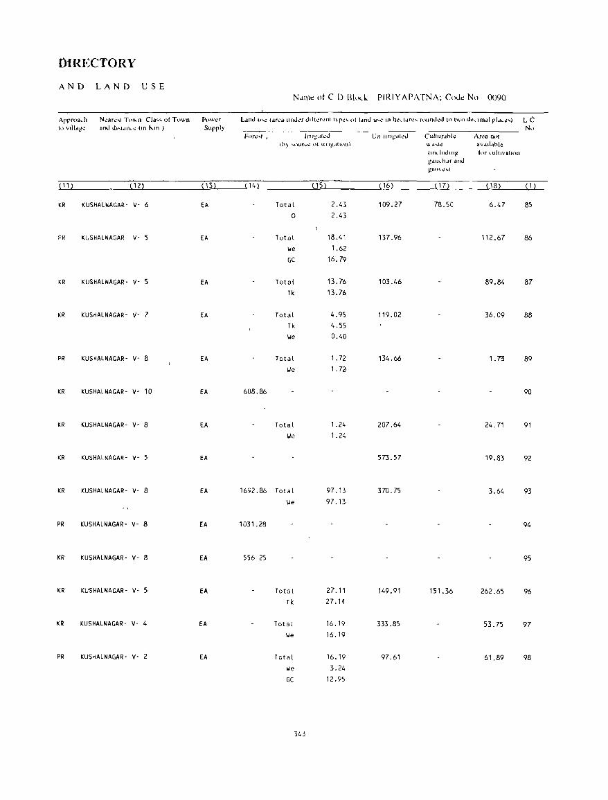
DIREctORY
AND LAND USE No.ll1le ot C D Blo,," PIRIYAPATNA; Cout! No 0090
Approach N~ar~'1 To",n CI." pI Town P()w~r lAnd U"C (drt:d unJI,.. .. r Jllkrcllt t\-pc' 01 (dnd ll' .. r: In hcd(lfc .... rnufltkd to two dCl..undl pldI..C,,",) LC 10 vllIdg~ aoJ d"ldnC~ (on J...m ) Supply No
F(?rc.:" ) Inl~.JkJ Un lln~.lh:J Clll!lIrd"l~ Ar,," nol (h~ ..... \ur..,..: 01 n1\~~lllnn) \\0 (l' ... l\! aVdll.,h!.!
(mduJIOg' tor I..ultlvallon g<llh. h.lr and gTO\I.! .... )
(11 ) (12) (13) { 11.} ( 1 5) (16) ( 17) ( 1 B) ( 1 )
KR KUSHAlNAGAR- v- 6 EA Total 2_43 109_27 78.50 6.47 85 0 2.43
PR KUSHAlNAGAR v- 5 EA Total 18_41 137 _96 112.67 86 lJe 1.62
GC 16,79
KR KUSHAlNAGAR- v- 5 EA Total 13.76 103.46 89_84 87 Tk 13.76
KR KUSHAlNAGAR- v- 7 EA Total 4.95 119.02 36.09 88 Tk 4.55
lJe 0.40
PR KUSHAlNAGAR- v- 8 EA Total 1. 72 134.66 1.73 89 lJe 1. 7~
KR KUSHALNAGAR- v- 10 EA 608.86 90
KR KUSHALNAGAR- v- 8 EA Total 1.24 207.64 24.71 91 lJe 1. 24
KR KUSHALNAGAR- v- 5 EA 573.57 19.83 92
KR KUSHALNAGAR- v- 8 EA 1692.86 Total 97.13 370.75 3.64 93 lJe 97.13
; ,
PR KUSHALNAGAR- v- 8 EA 1031.28 94
KR KUSHALNAGAR- v- 8 EA 556 25 95
KR KUSHALNAGAR- v- 5 EA Total 27.11 149.91 151.36 262.65 96 Tk 27. ,.,
KR KUSHALNAGAR- v- 4 EA Total 16.19 333.85 53.75 97 lJe 16.19
PR KUSHALNAGAR- v- 2 EA Total 16.19 97.61 61.89 98 \.Ie 3.24
GC 12.95
343
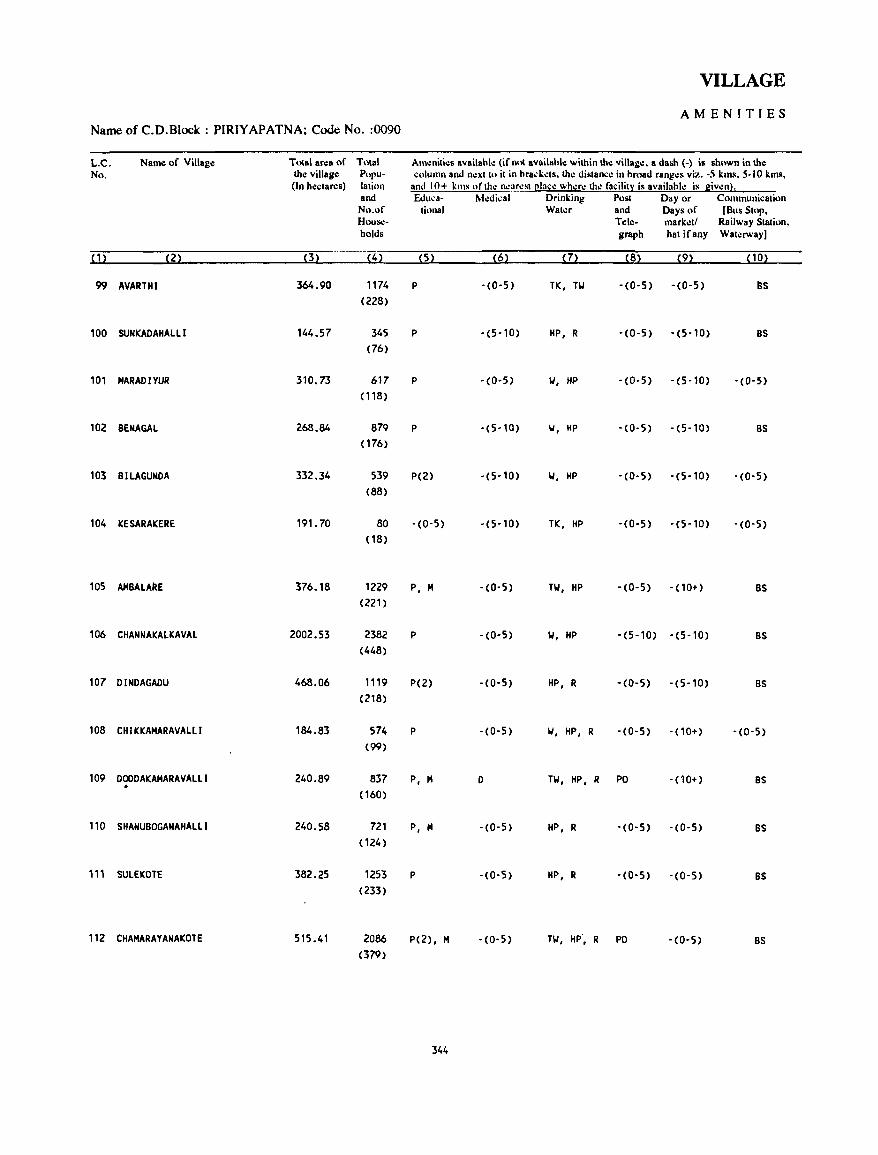
VILLAGE
AMENITIES Name of C.D.Block : PIRIYAPATNA; Code No. :0090
L.C. Name of Village Total area of Total Am.:niti..:s availahl..: (if nut availahle within th..: villag..:. a dash (-) is shown in the No. the village Popu- column and no: xl In il in hraci.:.:ls. th.: distan.:o: in broad rang.:s viz. -5 km.~. 5-10 kms,
(In hecla res) lalinn and 10+ killS of Iho: no:ar.:sl Claco: wh.:ro: Iho: facililX is availahle is giv.:n). and Educa- M.:di~al Drinking Post Day or Communicalion No.of lional Wal..:r and Days of (Bus 5101'. HouSol- Tele- markell Railway Slation. holds graph hal ifany Wal':JWay)
(1) (2) (3) (4) (5) (6) (7) (8) (9) (10)
99 AVARTHI 364.90 1174 P '(0-5) TK, TI.I -(0-5) -(0-5) as (228)
100 SUNKADAHALLI 144.57 345 P -(5-10) HP, R -(0-5) -(5-10) as (76)
101 MARADIYUR 310.73 617 P -(0-5) 1.1, HP -(0-5) -(5-10) -(0-5)
(118)
102 BENAGAL 268.84 879 P -(5-10) 1.1, HP - (0- 5) -(5-10) as ( 176)
103 BILAGUNDA 332.34 539 P(2) -(5-10) 1.1, HP -(0-5) -(5-10) - (0-5) (88)
104 KESARAKERE 191. 70 80 -(0-5) -(5-10) TK, HP -(0-5) -(5-10) -(0-5) (18)
105 AMBALARE 376.18 1229 P, M - (0-5) TI.I, HP -(0-5) - (10+) as (221)
106 CHANNAKAtKAVAL 2002.53 2382 P -(0-5) 1.1, HP -(5-10) -(5-10) BS (448)
107 DINDAGADU 468.06 1119 P(2) -(0-5) HP, R -(0-5) -(5-10) BS (218)
108 CHIKKAMARAVALLI 184.83 574 P -(0-5) 1.1, HP, R -(0-5) -(10+) -(0-5) (99)
109 DOODAKAMARAVALLI 240.89 837 P, M 0 HI, HP, R PO - (10+) as . (160)
110 SHANUBOGANAHALLI 240.58 721 P, M -(0-5) HP, R -(0-5) -(0-5) BS (124)
111 SULEKOTE 382.25 1253 P -(0·5) HP, R '(0-5) '(0-5) BS (233)
112 CHAMARAYANAKOTE 515.41 2086 P(2), M ·(0-5) TI.I, HP', R PO -(0-5) BS (379)
344
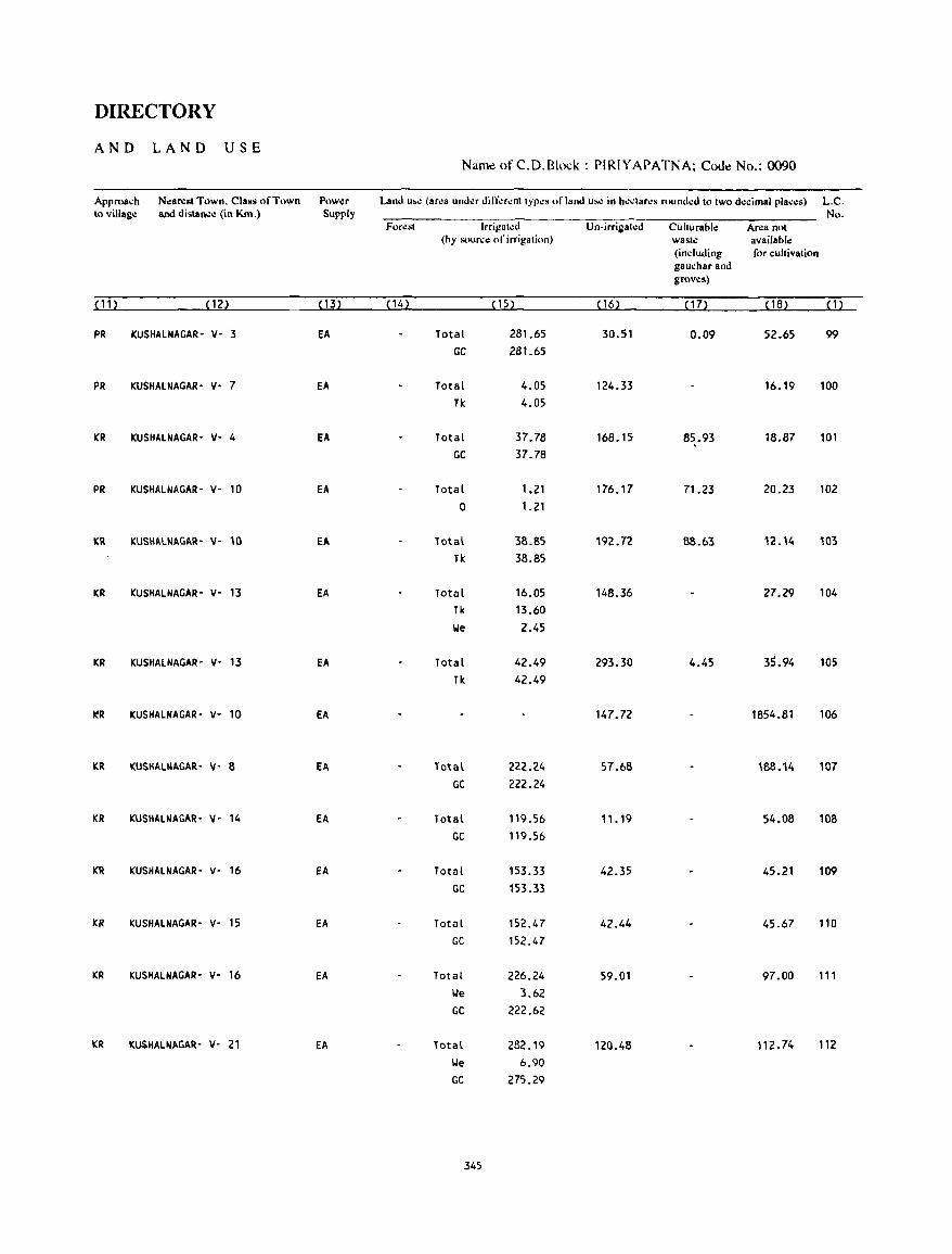
DIRECTORY
AND LAND USE Name of C.D.Block : PIRIYAPATNA; Code No.: 0090
Approach Nearesl Town, Class of Town Pow~r Land u...: (ar~a und~r din-':r~nllyp~s ofland u...: in h,:clar~s round.:d 10 two decimal pla.:~s) L.C. 10 villag,: and dislan.:,: (in Km.) Supply No.
For,:sl Irrigal.:d Un-irrigat.:d Culturable Area not (by sour.:e of irrigation) waste available
(including for cultivation gauchar and groves)
~11~ ~12~ ~13l ~14l ~15l ~ 16~ , 17~ , 18~ ~12
PR KUSHAlNAGAR- v- 3 EA Total 281.65 30.51 0.09 52.65 99
GC 281.65
PR KUSHAlNAGAR- v- 7 EA Total 4.05 124.33 16.19 100 Tk 4.05
KR KUSHAlNAGAR· V· 4 EA Total 37.78 168.15 85.93 18.87 101 GC 37.78
PR KUSHALNAGAR- V- 10 EA Total 1.21 176.17 71.23 20.23 102 0 1.21
KR KUSHALNAGAR- y- 10 fA Total 38.85 192.72 88.63 '2.14 103 Tk 38.85
KR KUSHAlNAGAR- v- 13 EA Total 16.05 148.36 27.29 104 Tk 13.60 We 2.45
KR KUSHAlNAGAR- V- 13 EA Total 42.49 293.30 4.45 3~.94 105 Tk 42.49
~R KUSHAlNAGAR' V- 10 EA 147.72 1854.81 106
KR KUSHALNAGAR- y- 8 EA Total 222.24 57.68 188.14 107 GC 222.24
KR KUSHALNAGAR- y- 14 EA Total 119.56 ".19 54.08 108 GC 119.56
KR KUSHAlNAGAR- V- 16 EA Total 153.33 42.35 45.21 109 GC 153.33
KR KUSHALNAGAR- V- 15 EA Total 152.47 42.44 45.67 110 GC 152.47
KR KUSHAlNAGAR- V- 16 EA Total 226.24 59.01 97.00 t" We 3.62 GC 222.62
KR KUSHAlNAGAR- Y- 21 EA Total 282.19 120.48 112.74 112
We 6.90 GC 275.29
345
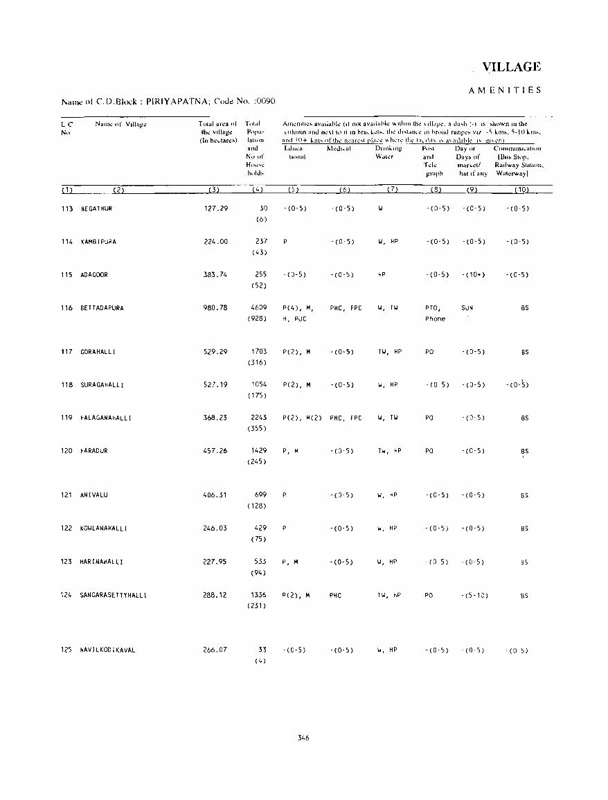
]\;am.: of CD.Block: PIRIYAPATNA; Cout! No, :0090
LC Nam~ of Village No
( 1 ) (2)
113 HEGATHUR
114 KAMBIPURA
115 ADAGOOR
116 BETTADAPURA
117 GORAHALLI
118 SURAGAHALLI
119 HALAGANAHALLI
120 HARADUR
121 ANIVALU
122 KOI.ILANAHAlll
123 HAR I NAHALLI
124 SANGARASETTYHAllI
125 NAVILKODIKAVAL
Towl area 01 the village (In heclan:,)
(3)
127.29
224.00
383.74
980.78
529.29
527.19
368.23
457.26
406.31
246.03
227.95
288.12
266.07
TlIt." p('pu· latilln and N() of Hnll"'~ hllld,
('; )
30 (6)
237 (43)
255
(52)
4609
(928)
1703 (316)
1054 ( 175)
2243
(355)
1429 (245)
699
( 128)
429
(75 )
533
(94)
1336 (231)
33 (4)
VILLAGE
AMENITIES
Al1ll.!llIhlo!~ avaliahh: (II not avadahllo! "'lllltlllhl.! \dl.I~\!. a da .... h {-) IS ~hownln lhf.!
"ohJlnn and fh!xt hl Il In hralo. ~d~. the dl' .. \,II1I..": III hroad rangl.!~ Vl/ .'i km,. 'i-IO ~m'. and 10+ l.dn ... ofth..: n,,-,arc ... t pl.h.'\.'" \\h~rc th...: 1:1 ... 1111\ '" a\adahk I'" gl\ ~n~
cdu"a· Medl,al Dllll~lllg P" .... t Day or C(HlllHuOIt.:atU)n
tUHlal Wdter and Day, of IBu, SLOp. Tde Inark.d/ Railway Statu)[J. graph hat If any WaklWa)1
(5 ) (6) (7) (8) (9) ( 10)
,(0,5) -(0-5) 1.1 -(0-5) -(0-5) -(0-5)
P . (0- 5) 1.1, HP - (0, 5) -(0'5) -(0-5)
-(0-5) -(0-5) HP - (0-5) -(10+) -(0-5)
P(4) , M, PHC, FPC 1.1, TI.I PTO, SUN BS H, PUC Phone
p(2) , M -(0-5) TI.I, HP PO -(0-5) BS
P(2) , M -(0-5) 1.1, HP · (0 5) -(0-5) ,
-(0-5)
P(2), M(2) PHC, FPC 1.1, TI.I PO - (0-5) BS
P, M -(0'5) TI.I, HP PO -(0'5) BS ,
P -(0-5) 1.1, HP · (0-5) -(0-5) BS
P -(0-5) II, HP -(0,5) - (0 -5) BS
P, M -(0-5) 1.1, HP · (0 5) - (0,5) BS
P(Z), M PHC fl. , HP PO - (5- 10) BS
-(0-5) - (0-5) 1.1, HP · (0-5) - (0- 5) -(0 5)
346
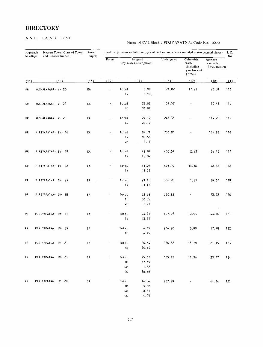
DIRECTORY
AND LA N D USE Name of C.D.Blo(k : PIRIYAPATNA; Coue No.: 0090
Approach N~ar~,1 Town. CIa" of Town Pow~r Land '''~ (ar~a lInd~r din;:r~nl Iyp~' of land 1I~ In h~"lar~s rollnd~d 10 IWO d~""nal plac~s) LC. 10 vil1ag.: and d"lan,.: (in Km.) Supply Nu.
Fore,,1 Irrigalcd Un-irngaled CuhllrahI.! Arl!a not (by sour~1! of irngalion) wa~h: availah!.!
(indllding for ~ultlvallon gHu~har and grov\!.\oo)
( 11 ) (12) (13) ( 14) ( 15) ( 16) ( 17) (18) ( 1 )
PR KUSHALNAGAR- V- 20 EA Total 8.90 74.87 17.21 26.31 113 Tk 8.90
KR KUSHALNAGAR- V- 21 EA Total 36.02 157.57 30.41 114 GC 36.02
KR KUSHALNAGAR- V- 20 EA Total 24.19 245.35 114.20 115 GC 24.19
PR PlRlYAPATNA- IV- 16 EA Total 84.71 730.81 165.26 116 Tk 82.56 lie 2.15
PR PlRlYAPATNA- lV- 19 EA Total 42.09 400.59 2.43 84.18 117 Tk 42.09
KR PlRlYAPATNA- lV- 22 EA Total 41.28 423.99 13.36 48.56 118 Tk 41.28
PR PlRlYAPATNA- lY- 23 EA Total 21.45 305.90 1.21 39.67 119 Tk 21.45
PR PlRlYAPATNA- IY- 18 EA Total 32.62 350.86 73.78 120 Tk 30.35 lie 2.27
PR PIRIYAPATNA- IV- 21 EA Total 43.71 307.97 10.93 43.70 121 Tk 43.71
PR PlRlYAPATNA- lV- 23 EA Total 4.45 214.90 8.90 17.78 122 Tk 4.45
PR PIRlYAPATNA- lV- 21 EA Total 20.64 170.38 15.78 21.15 123 Tk 20.64
PR PlRlYAPATNA- lY- 23 EA Total 75.67 165.22 13.36 33.87 124 Tk 17.39 lie 1.62
GC 56.66
KR PlRlYAPATNA- lV- 20 EA Total 14.54 207.29 44.24 125 Tk 9.68 lie 0.81 GC 4.05
347
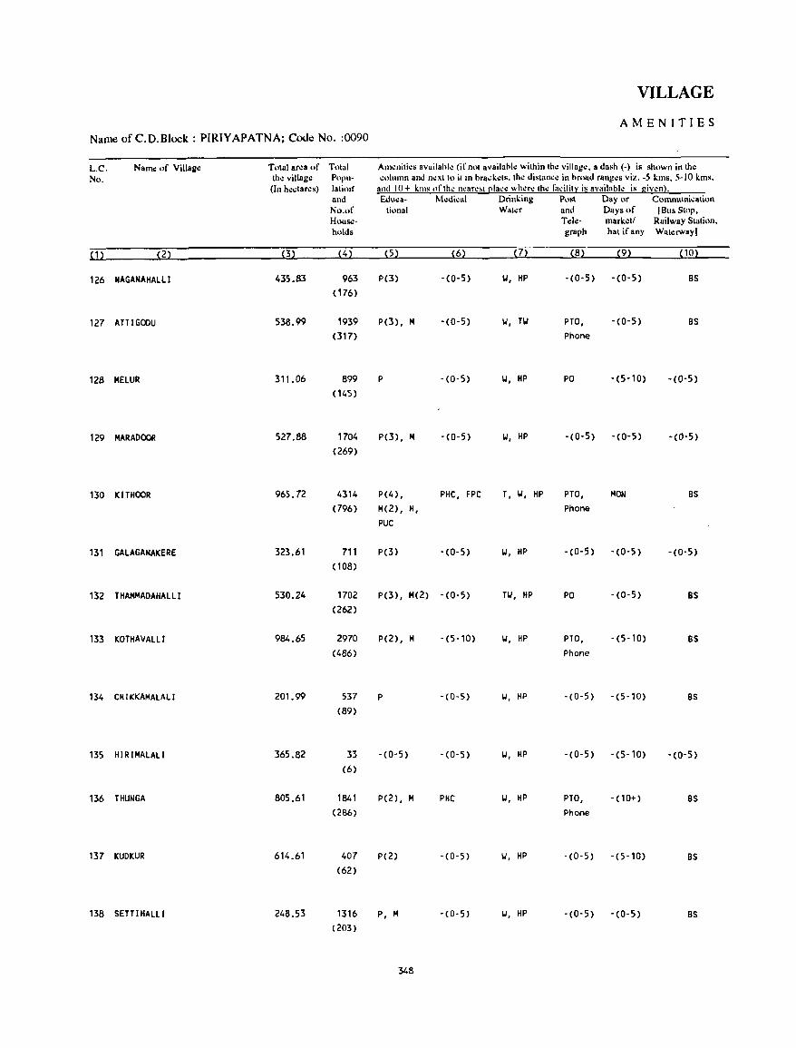
VILLAGE
AMENITIES Name of C.O.Block : PIRIYAPATNA; Code No. :0090
L.C. Nallle of Vi1lag~ Total ar.:a of Total Am.:nilies availahle (if nOI availahl.: wilhin Ihe villag.:. a dash (-) is shown in the No. the viUage Pupu- column and nexllo ilill hrad.ets. the distaru:e in hroad ranges viz. -5 kms. 5-10 kms.
(In h.:ctares) laliorf and 10+ killS of the near.:~t clace where Ihe ti";ilit~ is availahle is given). and &luea- Medical Drinking Post Day or Communication No.of lional Water and Days of [Bus SlOp. House- TeI~- mark.:tl Railway Station. holds graph hat if any Waterway)
(1) (2) (3) (4) (5) (6) (7) (8) (9) (10)
126 NAGANAHALLI 435.83 963 P(3) -(0-5) 101, HP -(0-5) -(0-5) BS (176)
127 ATT I GOOU 538.99 1939 P(3), M -(0-5) 101, Tlol PTO, -(0-5) BS (317) Phone
128 MELUR 311.06 899 P -(0-5) 101, HP PO -(5-10) -(0-5) (145)
129 MARADOOR 527.88 1704 P(3), M -(0-5) 101, HP -(0-5) -(0-5) -(0-5) (269)
130 KITHOOR 965.72 4314 P(4) , PHC, FPC T, 101, HP PTO, MON BS (796) M(2) , R, Phone
PUC
131 GALAGANAKERE 323.61 711 P(3) -(0-5) 101, HP -(0-5) -(0-5) -(0-5) (108)
132 THAMMADAHALLI 530.24 1702 P(3), M(2) - (0-5) Til, HP PO -(0-5) BS (262)
133 KOTHAVALLI 984.65 2970 P(2), M -(5-10) 101, HP PTO, -(5-10) BS (486) Phone
134 CHIKKAMALALI 201. 99 537 P - (0-5) 101, HP -(0-5) -(5-10) BS (89)
135 H IR IMALALI 365.82 33 -(0-5) -(0-5) 101, HP -(0-5) -(5-10) -(0-5) (6)
136 THUNGA 805.61 1841 P(2), M PHC 101, HP PTO, -(10+) BS (286) Phone
137 KUDKUR 614_61 407 P(2) -(0-5) 101, HP -(0-5) -(5-10) BS (62)
138 SETTIHALLI 248.53 1316 P, M -(0-5) 101, HP -(0-5) - (0-5) BS (203)
348

DIRECTORY
AND LAND USE Name of C.D.Block : PIRIYAPATNA; Code No.: 0090
Approach N.:ar,:sl Town. Class (,fTown Pow.:r Land us.: (ar.:a und.:r dirr.:r.:nl Iyp.:s of land us.: in h.:clar.:s round.:d 10 Iwo d.:cimal plac.:.) L.C. 10 village and dislance (in Km.) Supply No.
For.:st lrrigah:d U n-irrigat.:d Cullurable Area not (by source of irrigalion) wasle available
(including for cullivalion gauchar and groves)
(11) (12) (13) (14) (15) (16) ( 17) ( 18) (1)
PR PIRIYAPATNA- IV- 19 EA Total 39.26 348.04 1.99 46.54 126 Tk 39.26
PR PIRIYAPATNA- IV- 20 EA Total 84.21 368.85 23.95 61.98 127 Tk 75.24 We 8.97
KR PIRIYAPATNA- IV- 26 EA Total 12.53 264.62 33.91 128 Tk 11. 18 We '.35
KR PIRIYAPATNA- IV- 26 EA Total 25.06 448.64 54.18 129 Tk 12.76 We 12.30
PR PIRIYAPATNA- IV- 27 EA Total 77.70 769.15 118.87 130 Til 62.62 We 15.08
KR PIRIYAPATNA- IV- 26 EA Total 23.07 249.30 5'.24 131 Tk 23.07
KR PIRIYAPATNA- IV- 26 EA Total 25.90 435.13 69.21 132 TIr: 25.90
KR PIRIVAPATNA- IV- 24 EA Total 44.42 835.22 71.10 33.91 133 Tk 3"98 We 12.44
KR PIRIYAPATNA- IV- 21 EA Total 22.79 145.56 0.56 33.08 134 TIr: 20.26 We 2.53
KR PIRIYAPATNA- IV- 21 EA Total 50.18 271.52 6.48 37.64 135 Tk 50.18
l(.R pl~nIlP"1»1I- 1'11- '20 'Ell 1ota\ 30.75 391.45 20.13 363.28 B6 Tk 28.33 We 2.42
KR PIRIVAPATNA- IV- 16 EA Total 62.20 447.89 104.52 137 Tk 59.51 We 2.69
KR PIRIVAPATNA- IV- 19 EA Total 0.40 228.25 0.45 19.43 138 Tk 0.40
349
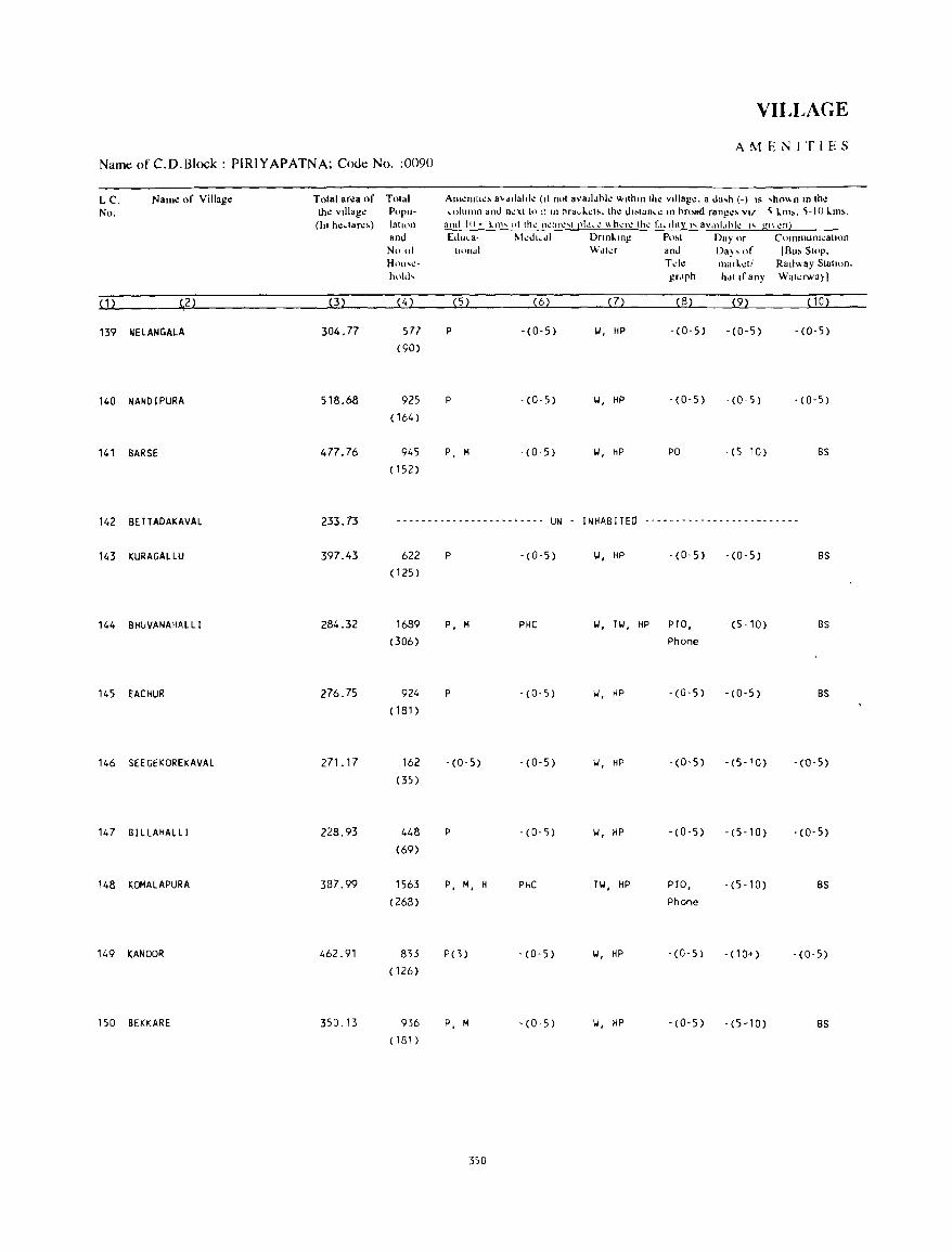
VILLAGE
AMENITIES Name of C.D.Block : PIRIYAPATNA; Code No. :0090
Le. Nam.: of Villag.: Tolal area of Tolal Amenlth:> 8vdllahk (II nol 8valldhl.: wlthm the vllluge. a da,h (-) IS ,h(\\", 10 Ihe No, the vIllage Popu- ",Iumn and neXI tp :: In hrad.d •. Ihe d"lan,e III hroad rongc> v" ~ 10m>. ~-I 0 10m"
(In hedare,) latH)n and I()+ kllh 01 Ih~ n~:lr~"'t ell'''\! \\h..:r~ th~ Cll.il1tl' I'" a\'~lIl.lhl..: I'" gl\ ..:ni and Edu,a- IIkd',dl Dnnl.lng Po,1 Day or CI'lllmun,,:allllll No 01 I"Hldl Wdler and Da), of (Bu> Stop. Hou..,\!- Tek- marl.dl RaIlway Slatlon_ hold, grdph hdl If any Walcrway)
(1) (,2 ) (3) (4) ( 5) (6) ( 7) (8) (9) (10)
139 NELANGALA 304.77 577 P -(0-5) 101, HP -(0-5) -(0-5) - (0-5) (90)
140 NANDIPURA 518.68 925 P -(0-5) 101, HP -(0-5) -(0-5) -(0-5)
( 164)
141 BARSE 477.76 945 P, M - (0-5) II. HP PO - (5 -1 0) BS
(152)
142 BETTADAKAVAL 233.73 ------ ... ----- .. --- .. _'----- UN INHABITEO .. '" -_ .... - .... - - ... - - -_ - _.__ - - ---
143 KURAGALLU 397.43 622 P -(0-5) 101, HP - (0-5) -(0-5) BS
(125 )
144 BHUVANAHALLI 284.32 1689 P, M PHC 101, n,', HP PTO, -(5-10) BS
(306) phone
145 EACHUR 276.75 924 P -(0-5) 101, HP -(0'5) -(0-5) BS (181)
146 SEEGEKOREKAVAL 271.17 162 -(0-5) . (0-5) 101, HP -(0-5) - (5- 10) - (0-5)
<35 )
147 BI LLAHALLI 228.93 448 P -(0'5) 101, HP -(0-5) - (5- 10) . (0-5)
(69)
148 KOMALAPURA 387.99 1563 P, M, H PHC T'oJ, HP PTO, - (5 - 10) BS (268) Phone
149 KANOOR 462.91 833 PO) '(0-5) 'oJ, HP . (0-5) - (10+) '(0-5) ( 126)
150 BEKKARE 350.13 936 P, M - (0· 5) 101, HP -(0-5) -(5-10) BS (181)
350
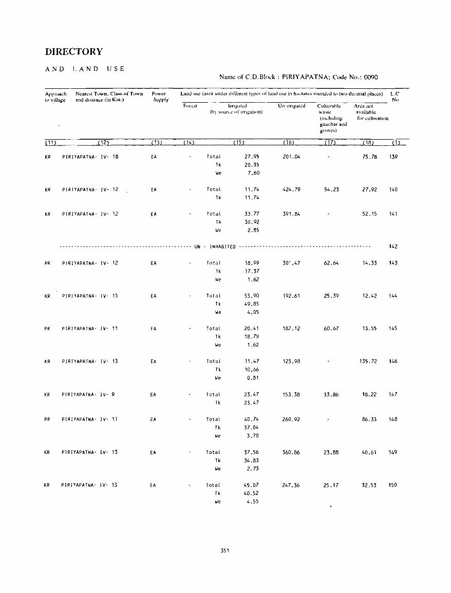
DIRECTORY
AND LAND USE Name of C.D.Blo-:k : PIRIYAPATNA; Code No.: 0090
Appro&~h N~ar~.1 Town. Cia". ofT,,"'n Pow~r Land u.~ (area und~r d"rcr~nl Iyp~. of land ",~ in hc"ar~. round~d 10 Iwo d~'"llal plac~,) L.C 10 vlllag~ and dl"lan~e (i,n Km.) Supply No
FOI ..... !oot Irng"lco Un-tfngal..:d Cultllrahk Area nol (h~ ~Olln_1.! of trngatl(ln) wa~h: availahl~
(Including I<>r cult,vall<," gauchar allo grov\!~)
(11 ) (12) (13) < 14) < 1 5) < 16) < 1 7) (18) (1)
KR PIRIYAPATNA- IY- 18 EA Total 27.95 201.04 75.78 139 Tk 20.35 lie 7.60
KR PIRIYAPATNA- IY- 12 EA Total 11.74 424.79 54.23 27.92 140 Tk 11.74
KR PIRIYAPATNA- IY- 12 EA Total 33.77 391.84 52.15 141 Tk 30.92 lie 2.85
-_.- --_ .. - - - - -- .... - - ~ - - - -- - _ .. -_ .. - -- -- - _ .. - ............ UN - I NHAB !TED ----.--------------------- ... ------------------ 142
PR PIRlYAPATNA- IY- 12 EA Total 18.99 301.47 62.64 14.33 143
Tk 17.37 lie 1.62
KR PIRlYAPATNA- IY- 15 EA Total 53.90 192.61 25.39 12.42 144 Tk 49.85 \Ie 4.05
PR PIRIYAPATNA- IY- 11 EA Total 20.41 182.12 60.67 13.55 145 Tk 18.79 \Ie 1.62
KR PIRIYAPATNA- IY- 13 EA Total 11.47 123.98 135.72 146 Tk 10.66 lie 0.81
KR PIRIYAPATNA- IY- 9 EA Total 23.47 153.38 33.86 18.22 147 Tk 23.47
PR PIRIYAPATNA- IY- 11 EA Total 40.74 260.92 86.33 148 Tk 37.04 lie 3.70
KR PIRIYAPATNA- IY- 13 EA Total 37.56 360.86 23.88 40.61 149 Tk 34.83 lJe 2.73
KR PIRIYAPATNA- IY- 13 EA Total 45.07 247.36 25.17 32.53 150 Tk 40.52 lie 4.55
351
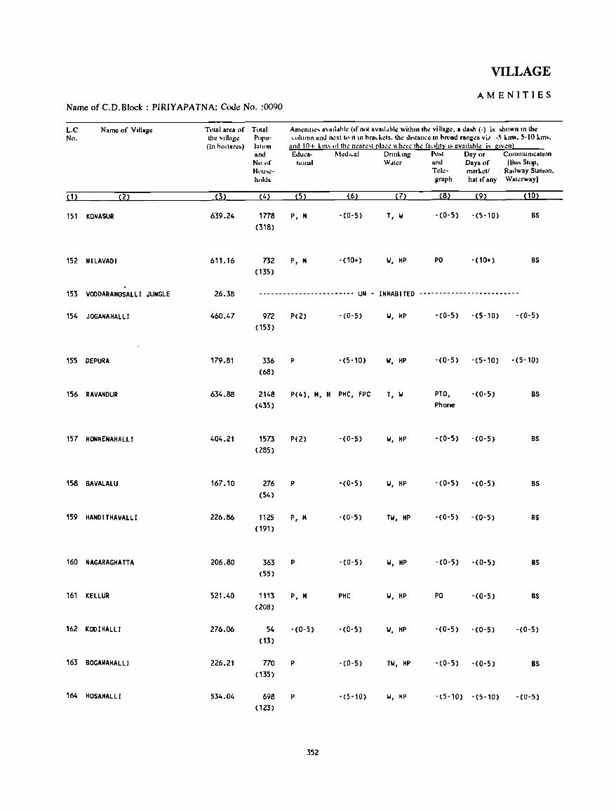
VILLAGE
AMENITIES Name ofC.D.Block: PIRIYAPATNA; Code! No. :0090
L.C Nam.: of VllIag.: Tolal arl!a of Tolal Am~IlII1I!' avalldhl~ (If nol avalldhll! wilhm Ihl! villago:. a daloh (-) is lohown m tho: No. th.: villago: Popu- column and n~xllo II In hracl':ls. Ih.: dl,lane.: III hroad rang.:s vii -5 lms. 5-10 lm&.
(In h.:.:lar.:,) lallon and 10+ 1.111' ,.llhl! nl!ar.:,1 ~lacl! "hl!r.: Ihl! faclltl:l: I' aV811:1hl.: i, glv.:nl and Eduea- t"kdlCal Dnnl.mg Po,1 Day or CommulllcallOn No of lIonal Wdl.:r and Days of (Bu,SIOp. Hou'l!- T.:lo:- marl.:11 Railway Siallon. holds graph hal If any Wal.:rway)
(1) (2) (3) (4) (5) (6) (7) (8) (9) (10)
151 KONASUR 639.24 1778 P, 14 -(0-5) T, 101 - (0-5) - (5-10) BS
(318)
152 NILAVADI 611. 16 732 P, 14 - (10+) 101, HP PO -(10+) BS
(135)
153 VODDARAHOSALLI JUNGLE 26.38 ------------------------ UN - INHABITED -------------------------
154 JOGANAHALL I 460.47 972 P(2) -(0-5) 101, HP -(0-5) -(5-10) -(0-5)
(153)
155 DEPURA 179.81 336 P -(5-10) 101, HP -(0-5) -(5-10) -(5-10)
(68)
156 RAVANDUR 634.88 2148 P(4), 14, H PHC, FPC T, 101 PTO, -(0-5) BS
(435) Phone
157 HONNENAHALLI 404.21 1573 P(2) -(0-5) 101, HP -(0-5) -(0-5) BS
(285)
158 BAVALALU 167.10 276 P -(0-5) 101, HP -(0-5) -(0-5) BS
(54)
159 HANDITHAVALLl 226.86 1125 P, M -(0-5) TW, HP -(0-5) - (0- 5) BS
(191)
160 NAGARAGHA TT A 206.80 363 P -(0-5) 101, HP -(0-5) -(0-5) BS
(55 )
161 KELLUR 521.40 1113 P, M PHC 101, HP PO -(0-5) BS
(208)
162 KODIHALLI 276.06 54 -(0-5) -(0-5) 101, HP -(0-5) -(0-5) -(0-5)
(13)
163 BOGANAHALLI 226.21 770 P -(0-5) TW, HP -(0-5) - (0-5) BS ( 135)
164 HOSAHALLI 534.04 698 P -(5-10) 101, HP -(5-10) -(5-10) -(0-5)
( 123)
352
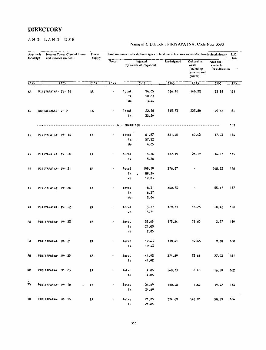
DIRECTORY
AND LAND USE Naml! of C.D.Block : PIRIYAPATNA; COOl! No.: 0090
Approach Nearest Town. Class of Town Power Land Ul'.: (arca under din;:renttypes of land us.: in h.:ctar.:s round.:d to two decimal places) L.C. to village and distance (in Km.) Supply No.
Forest Irrigated Un-irrigated Culturahle Ar.:a not (by SOlm;c Ill' irrigation) waste availahle
(including for cultivation gauchar and groves)
11"
1'2) (13) (14) (15) ( 16) (17) 11S) 0)
KR PIRIYAPATNA' IV' 16 EA Tota\ 54.05 386.16 146.22 S2.S1 151 Tk 50.61 We 3.44
KR KUSHAlNAGAR· y. 9 EA Total 22.26 315.73 223.80 49.37 152 Tk 22.26
.. --- .. -- .... ---------- .. ---- ... -.-.---.----. UN - INHABITED ---.-.-_._.-.-.------------------------------ 153
KR PIRIYAPATNA- IY· 14 EA Total 61.57 321.45 60.42 17.03 154 TK 57.52 We 4.05
KR PIRIYAPATNA' IY- 20 EA Total 5.26 137.19 23.19 14.17 155 Tk 5.26
PR PIRIYAPATNA' IY- 21 EA Total 109.19 376.87 148.82 156 Tk 89.36 We 19.83
ICR PIRIYAPATNA' IY- 26 EA Total 8.31 340.73 55.17 157 Tk 6.27 We 2.04
KR PIRIYAPATNA' IV- 22 fA Total 3.71 '29.71 13.26 2D.42 '58 We 3.71
PR PIRIYAPATNA' IY· 23 EA Total 33.05 175.24 15.60 2.97 159 Tk 31.00 We 2.05
PR PIRIYAPATNA- IY- 21 EA Total 19.43 138.41 39.66 9.30 160 Tk 19.43
PR PIRIYAPATHA- IY- 25 EA Total 44.92 374.89 73.66 27.93 161 Tic 44.92
KR PIRIYAPATHA- IY· 23 fA Total 4.86 248.13 6.48 16.59 162 Tk 4.86
?R PIRlYAPATNA' IV· 16 fA Total 24.69 1S0.48 1.62 19.42 'b3 Tk 24.69
KR PIRIYAPATNA' IY- 16 fA Total 21.S5 334.69 126.91 50.59 164 TIc 21.85
353
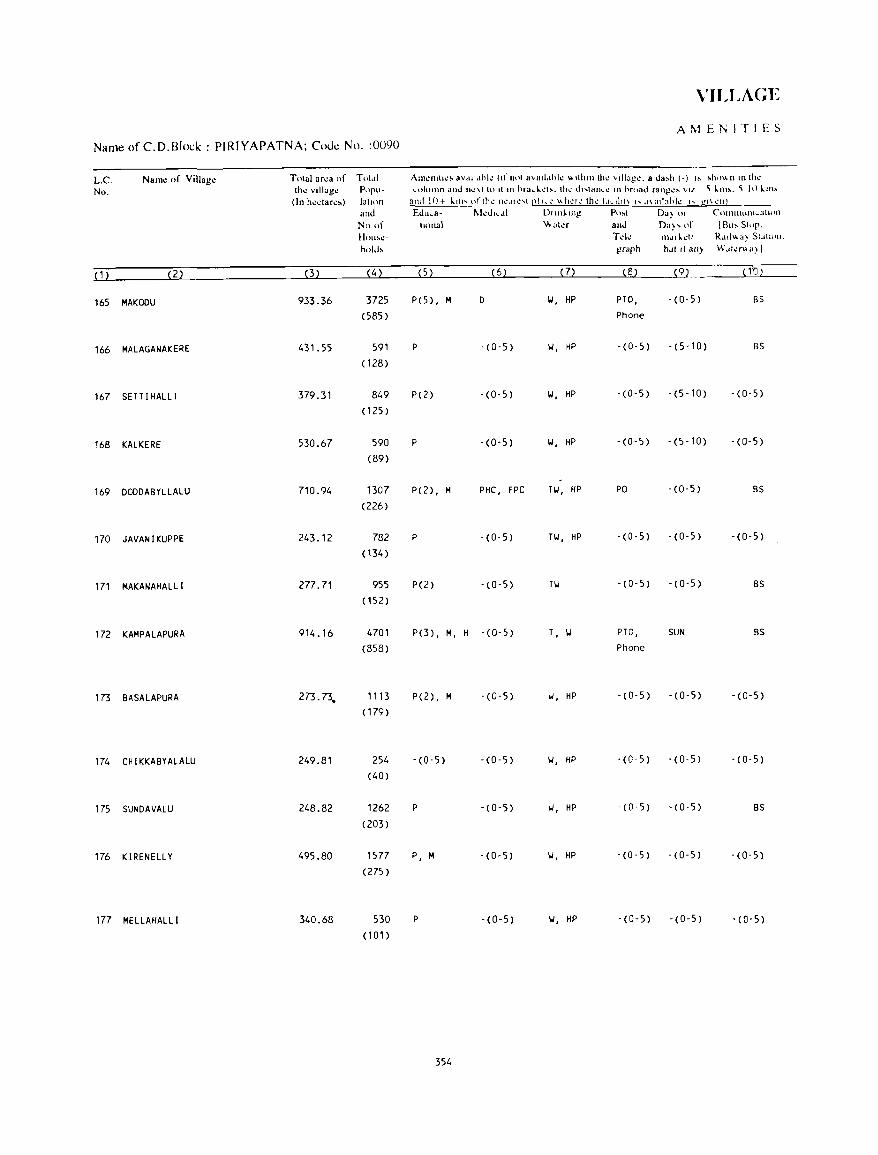
VILLAGE
AMEi"ITIES
Name ofC.D.Block : PIRIYAPATNA; Code No. :0090
L.C. Nam~ of Village Total ar~a of Tot,,1 AIll~llltl~' av,lIl"hk (If n,)1 ",all.lhk '" Ilhlll Ih~ '1IIa!!~. a d",h (-) " ,h"", II III Ih~
No. the villag\! P"p"- ("'uhllnn anJ Ih':\{ It) It In hra~J.. ..... t~. th .... dl .. lan ... c 10 hroad rangl!~ VII '\ lm,. '\ j() lim
(In h~"lar"') IOllon and 10+ klll"'llflh~ rh .. ·,II~ ... t [!! h..": \\hI..'TI..' thl...' I,h.d!t\ I'" .I\adahk I" gJ\ ,,:Iq and Edll,a- ~kJI"oI nllliluig p,)~t nil) or CtHlllllum ... atuHl
No of lIonal \'vala and Da)' of IBu, SlOp. HOll'~- Td~ nl.lrldl R .. Hl", (I) SI~tl\)ll.
hold, grllph h.lt "all} W,lla",a)/
( 1 ) (2) (3) (4) (5) (6) (7) (8) (9) ( 1D)
165 MAKODU 933.36 3725 P(5) , M 0 II, HP PTa, - (0,5) BS
(585) Phone
166 MALAGANAKERE 431.55 591 P - (0-5) II, HP -(0-5) - (5,10) BS
(128 )
167 SETT I HALL! 379.31 849 P(2) -(0-5) II, HP - (0-5) -(5-10) - (0-5)
(125 )
168 KALKERE 530.67 590 P -(0-5) II, HP -(0-5) -(5-10) - (0-5)
(89)
169 DODDABYLLALU 710.94 1307 P(2) , M PHC, FPC Til, HP PO - (0-5) BS
(226)
170 JAVANIKUPPE 243.12 782 P -(0-5) Til, HP -(0-5) -(0-5) - (0-5)
(134 )
171 MAKANAHALL! 277.71 955 P(2) -(0-5) Til -(0-5) - (0-5) BS
(152)
172 KAMPALAPURA 914.16 4701 P(3) , M, H - (0-5) T, II PTO, SUN BS
(858) Phone
173 BASALAPURA 273.73. 1113 P( 2), M - (0-5) II, HP - (0-5) -(0-5) - (0-5)
(179 )
174 CHIKKABYALALU 249.81 254 -(0-5) '(0,5) II, HP -(0-5) - (0- 5) - (0-5)
(40)
175 SUNDAVALU 248.82 1262 P -(0-5) II, HP -(0-5) -(0-5) BS
(203)
176 KIRENELLY 495.80 1577 P, M -(0-5) II, HP -(0-5) - (0-5) -(0-5)
(275 )
177 MELLAHALLI 340.68 530 P - (0-5) II, HP -(0-5) -(0-5) - (0-5)
(101 )
354
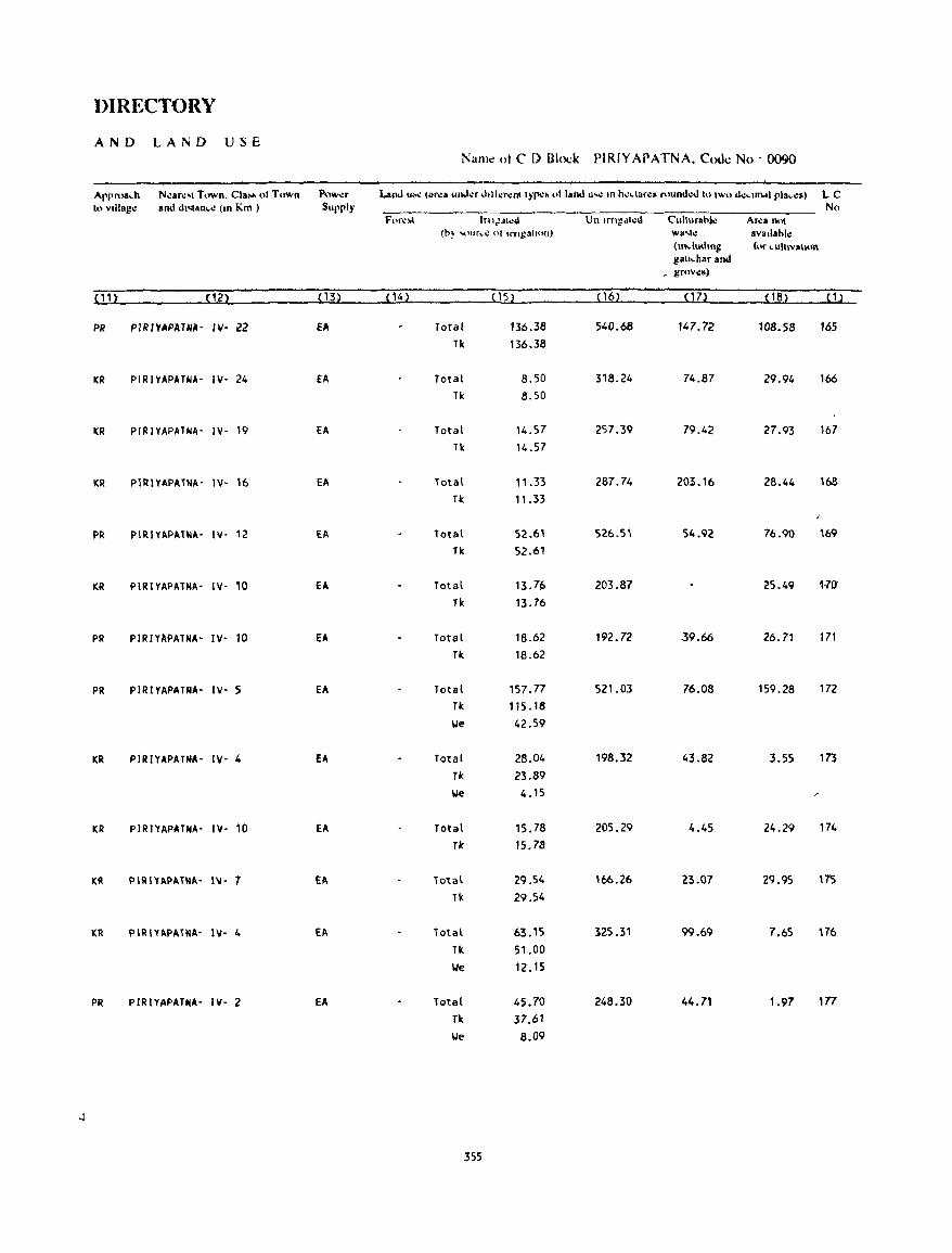
DIRECTORY
AND LAND USE Name nt C D Block PIRIYAPATNA. Cooe No' 0090
Apprnadl Ncare,' Town. Cta"" oj Town Pow.:r Laml ... -.: (area llnJ"f J'llcr"nlIYpc~ .,11811.1 "'" III h';,larc8 fuund,-d III two dc,IINI pla"C5) LC 10 vlltage and d.'<1an".: (10 Km ) Supply No
For,,'" In1JA1~d Un Ifflgdl"d Cullurah!.: Ar"a nOl (h} ,,'ur,c 01 .rngall"lI) wa .... : avallahle
(mdu.lIHg fur "Ull"'I""O gau"har and
_ groves)
,'n (2) (13) (ll,) (15) (16) on (1S) "l PR PIRIYAPATNA- IV- 22 fA Total 136.38 540.68 147.72 108.58 165
Tk 136.38
KR PIRIVAPATNA- IV' 24 EA Total 8.50 318.24 74.87 29.94 166 fk 8.50
I(R PIRIVAPATNA' IV- 19 EA Total 14.57 257.39 79.42 27.93 167 Tk 14.57
I(R P1RIYAPATMA- IV- 16 EA Total 11.33 287.74 203.16 28.44 168 fk 11.33
PR PIRIYAPAT~A- IV- 12 EA Total 52.61 526.51 54.92 76.90 169 fk 52.61
KR PIRIYAPATHA- IV' 10 EA Total 13.76 203.87 25.49 1e7l.t
Tk 13.76
PR PIRIYAPATNA- IV' 10 fA Total 18.62 192.72 39.66 26.71 171 Tk 18.62
PR PIRIYAPATNA- IV- 5 EA Total 157.77 521.03 76.08 159.28 172 fk 115.18
\Ie 42.59
KR PIRIVAPATNA- IV- 4 EA Total 28.04 198.32 43.82 3.55 173 TI< 23.89
lie 4.15 /'
I(R PIRIVAPATNA- IV- 10 EA Total 15.78 205.29 4.45 24.29 174 Tic 15.78
KR PIRIYAPAT~A- IV- 7 EA Total 29.54 '66.26 23.07 29.95 175 Tk 29.54
lCR PIRIYAPATNA- IV- 4 EA Total 63. '5 325.11 99.69 7.65 176 Tic. 51.00 We 12.15
PR PJRIYAPATHA- IV- 2 EA Total 45.70 248.30 44.71 1.97 177 Tic. 37.61 We 8.09
355
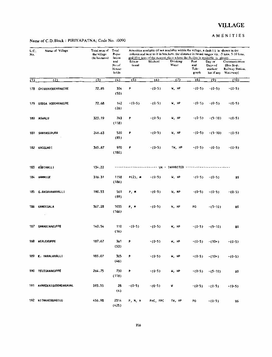
VILLAGE • I
AMENITIES NameofC.D.Block: PIRIYAPATNA; CoJe No. :0090
L.C. Nail\\! of Villag.: Tolal ar':8 Hr Tnlill Am.:nili.:s availahl.: (it'nol availahl.: wilhinlh.: villag.:. a dash (-) is shown in \11.: No. tho: villag.: Popu- colullln and n.:XIIO il in hrad:.:ls. Ih.: dislanc.: in hroad rang.:s viz. -S kills. 5-10 kills.
(In h':,laNs) lalion and Ifl+ kill' oflh.: n.:ar.:st [!I:l.:.: "h.:r.: th.: til.:ilitl' is availahl.: is giv.:nl. and [.J"ea- M.:d",al Drinking P .. st Day or C(Hnmuni~ati4..Ul
N ..... f li .. nal Wal.:r and Days of IBus Stop. Hou..:- Td.:- mark':ll Rail" ay Station. holds graph hat if any Wat.:rwayl
(1l (2) (3) (4) (5) (6) (7) (8) (9) (10)
178 CHIKKAVQODARAKERE 72.85 304 P -(0-5) IJ. HP -(0-5) -(0-5) -(0-5) (SO)
179 OOODA VQOOARAKERE 72.68 142 - (0-5) -(0-5) IJ. HP -(0-5) -(0-5) -(0-5) (26)
180 ASIJAlU 323_19 763 P -(0-5) IJ, HP -(0-5) -(5-10) -(O-S) ( 118)
181 SANYASIPURA 246.63 520 P -(0-5) IJ. HP -(0-5) -(5-10) -(0-5) (85)
182 KAGGUNDI 365.87 970 P -(0-5) TIJ, HP -(0-5) -(0-5) -COoS) (180)
183 "OOIHALll 134.22 ------------------------ UN - INHABITED -------------------------
184 HAMM1GE 316.31 1158 p(2). M - (0- 5) IJ. HP - (0- 5) -(0-5) BS
(186)
185 G.BASAVANAHAlLl 190_53 561 p. M -(0-5) IJ. HP -(0-5) -(0-5) -(0-5) (89)
186 KANDEGAlA 367.28 1035 p. M -(0-5) IJ. HP PO -(5-10) BS
(166)
187 SANABI NAKUPPE 140.54 110 -(0-5) -(0-5) IJ. HP -(0-5) -(5-10) BS
( 16)
188 NERlEKUPPE 187.67 361 p -(0-5) W. HP - (0-5) -(10+) -(0-5) (53)
189 K. HARAlAHAlll 185.07 305 P -(0-5) W, HP -(0-5) -(10+) -(0-5) (46)
190 TfLEGANAKUPPE 264.75 730 P -(0-5) 101, HP '(0-5) -(5-10) as (118)
191 AVAREKAIGUODADAKAVAl 593.55 28 -(0-5) -(0-5) -(0-5) - (0- 5) -(0-5) (4)
192 HITNAHEBBAGllU 456.98 2314 P, M. H PHC. FPC HI. HP PO -(0-5) as (425)
356
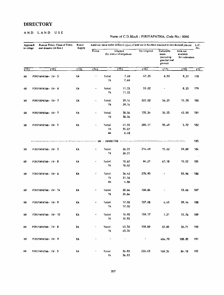
DIRECTORY
AND LAND USE Nartlc! of C.D.Block : PIRIYAPATNA; Code No.: 0090
Approa~h N.:arest Town. Clallll of Town Pow.:r Land UII.: (ar.:a und.:r din;:r.:nl t}'p.:~ of land u~ in h.:~lare$ found.:d to two d.:dmalplac.:s) L.C. lovillago: and distanco: (in Km.) Supply No.
Fore ... Irri1!at.:d Un-irrigah:d Cultural1l.: Ar.:a nol thy "'lUr..:.: "f irrigation) walilC availahle
(induding ror cultivatiun gau..:har and grows)
(11) (12) (13) (14) (15) (16) ( 1 7) ( 18) ( 1 )
KR PIRIYAPATNA- IV- 5 EA Total 7.69 47.35 B.50 9.31 17B
TIc. 7.69
KR PIRIYAPATNA- IV- 6 EA Total 11.33 53.02 8.33 179 Tk 11.33
KR PIRIYAPATNA- IV- 7 EA Total 29. " 222.02 56.25 15.78 180 Tk 29.14
KR PIRIYAPATNA- IV- 7 EA Total 38.04 135.34 30.35 42.90 181 Tk 38.04
KR PIRIYAPATNA- IV- 5 EA Total 41.55 285.11 35.49 3.72 182 Tk 35.07 We 6.48
-.---------------------------_--------------- UN - INHABITED --------------------------~------------------ 183
KR PIRIYAPATNA- IV- 3 EA Total 26.31 214.49 15.62 59.89 184
Tk 26.31
KR PIRIYAPATNA- IV- 8 EA Total 18.62 94.21 67.18 10.52 185 Tk 18.62
KR PIRIYAPATNA- IV- 6 EA Total 36.42 276.90 53.96 186 Tk 31.56 We 4.86
KR PIRIYAPATNA- IV- 14 EA Total 20.64 106.84 13.06 187 Tit 20.64
KR PIRIYAPATNA- IV- 9 EA Total 17.00 137.08 4.45 29.14 188 Tk 17.00
KR PIRIYAPATNA- IV- 10 EA Total 10.93 159.17 1.21 13.76 189 Tic 10.93
KR PIRIYAPATNA- IV- 8 EA Total 43.30 138.89 55.85 26.71 190 Tic 43.30
KR PI RJYAPATNA- IV- 9 EA 404.70 188.85 191
PR PIRIYAPATNA- IV- 5 EA Total 36.83 226.63 109.34 84.18 192 Tic 36.83
357
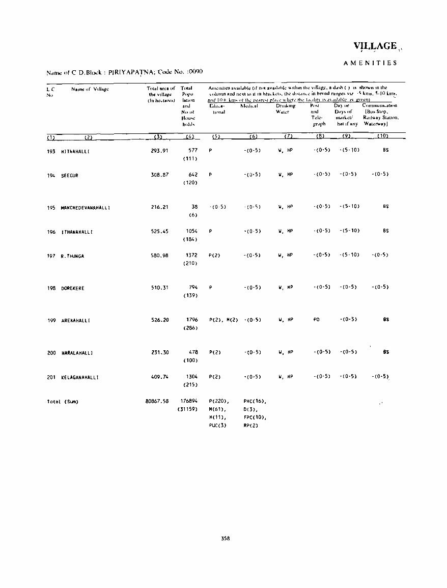
VILLAGE, >, ,
AMENITIES N,tnlC of C D.Blod: PIRIYAPATNA; Code No. :0090
LC Nalll~ of Villal!~ Tolal aNI of Tnlal AII1~'"II~R .v.li .. hl~ (I' nol avalldhl~ "'Ilh"llh~ v,nag,:. a d .. .Jl ( ) 10 .hown 10 Ih\!
No Ih~ VIII"!!,,, POI''' ,,,lull1n and n~\II" II m htad."". Ih~ d"I<,n,~ ill hroad ran!!~~ v" -~ llllo. ~-IO I..m~. (In h~"ar".) ,,"1<)11 and I () + lm' ot rh~ rh:.lfI:,r C'.tl. t: "h\.:'t\.' Ih~ 1.1~ "'f\ '''' ,n ,IIJ.lhh: (Col grv~nl
and L<lu,o- M.:d"al Dnn~lIlg p",( DB) or ClHnmunl\.atl(m
No "I tUHldt \\' dh:r and DdY' of (Bu,Sloll. H()u.....: Td.:- 111""1...:'/ R411 ... ay Sldlion. hold, gr'lph hal If any Wa,.:rwayJ
( 1 ~ (2) (3) J4) (5) (6) (7) (8) (9) (10)
193 HITNAHAlLl 293.91 577 P - (0-5) II, HP . (0-5) -(5-10) BS
( 1 1 1 )
194 SEEGUR 308.87 642 P -(0-5) II, HP -(0-5) - (0-5) -(0-5)
( 120)
195 MANCHEDEVANAHALLI 216.21 38 -(0-5) - (0- 5) II, HP - (0-5) - (5-10) BS
(6)
196 I THANA HALL I 525.45 1054 P -(0-5) II, HP -(0-5) -(5-10) BS
( 184)
197 R.THUNGA 580.98 1372 P(2) -(0-5) II, HP -(0-5) -(5-10) -(0-5 )
(210)
198 DOREKERE 510.31 794 P - (0-5) II, MP -(0-5) - (0-5) -(0-5)
(139)
199 ARENAMALll 526.20 1796 P(2), 14(2) -(0-5) II, MP PO -(0-5) BS
(286)
200 HARAlAHAlll 231.30 478 P(2) -(0-5) II, HP -(0-5) -(0-5) 8S
(100)
201 KELAGANAHAllI 409.74 1304 P(2) - (0- 5) II, HP -(0-5) - (0-5) - (0-5~, (215)
Total (SI.III) 80867.58 176894 P(220) , PHC(16), (31159) 14(61), 0(3) ,
H( 11), FPC(10), PUC(3) RP(2)
358
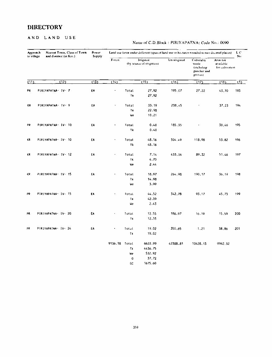
DIRECTORY
AND LAND USE Na/ll~ofC.D.Blod: PIRIYAPATNA; CoJ~ No.: 0090
Approa~h N~arl!st Town. Class of Town Puw..:r Land u..: (ar..:a und..:r d.n-':r..:nllyp..:s ,.1' land u": III h..:_lar..:' fIIund..:d IUlWI> d":dlllal pla,;..:s) lC 10 villag.: and di.lan.:..: (in Km.) Supply Nil
For\!~\ lrr'gah:d Un-Irn!!al..:d Cuhurahk An,a Il,>!
(h) ~our~-= of Irngatlon) \\'a~ll! avaddhl..: (.n.lud,")! for ... uitl\lallt)n
g8u"har and !!rl)"\!~)
(11 ) (12) ( 13) (14) (15) ( 16) ( 17) (1B) (1)
PR PIRIYAPAHIA- IV- 7 EA Total 27.92 195.07 27.22 43.70 193 Tk 27.92
KR PIRIYAPATNA- IV- 9 EA Total 33.19 238.45 37.23 194 Tk 22_98
lie 10.21
PR PIRIYAPATNA- IV- 10 EA Total 0.40 185.35 30.46 195 Tk 0.40
KR PIRIYAPATNA- IV- 10 EA Total 48.16 304.49 118.98 53.82 196 Tk 48.16
KR PIRIYAPATNA- IV- 12 EA Total 7.14 433.06 89.32 51.46 197 Tk 4.70 we 2.44
KR PIRIYAPATNA- IV- 15 EA Total 18.97 264.98 190.17 36.19 198 Tk 14.98
\ole 3.99
PR PIRIYAPATNA- IV- 15 EA Total 44.52 342.78 93.17 45.73 199 Tk 42.09 \ole 2.43
PR PIRIYAPATNA- IY- 20 EA Total 12.55 186.97 16.19 15.59 200 Tk 12.55
PR PIRIYAPATNA- IY- 24 EA Tot<ll 19.02 350.65 1.21 38.86 201 Tk 19.02
9136.18 Total 6622.99 42388.81 10428.13 9962.32 Tk 4436.7S
\ole 532.92
0 37.72
GC 1615.60
359

TIRU~1AKUDAL NARSIPUR C.D.BLOCK
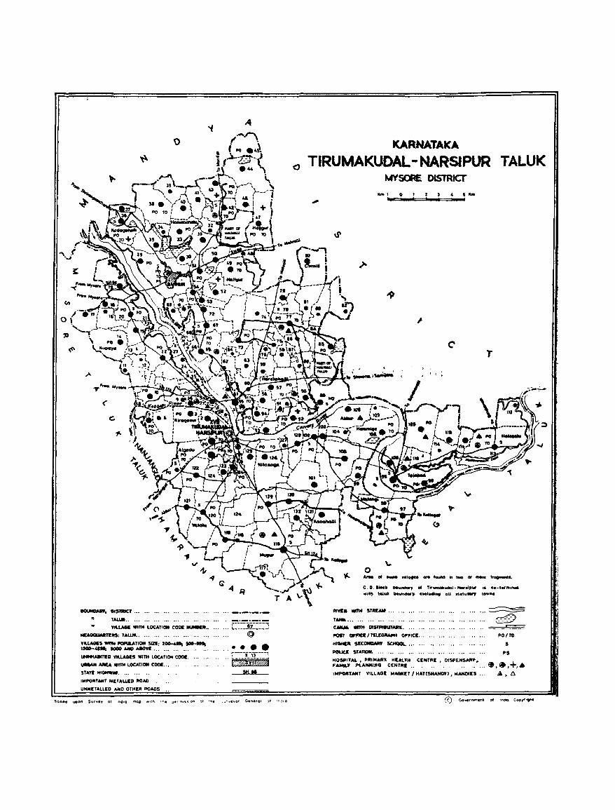
o
"
('
c:.
1IOtJIIOAIW. Dl$lRICT... ... .•. ... ... ... ... . .•
" ,. TALIM ••••••••..•••••••..•••..•• VILLAGE WlTK LOCATION CODE __ ••
1lUlllllMan:..s: T ... WII.. ... .•. .•. ... •.. .. . • .•
VILLAGES _ I'OI'UlJ,TION 5Izt:: zOCl-4ltJ 5Ot-III; 1OOO-4ISt; SOOO IMO MOVE '" ... ... ... .. . ..
_ED VIUAGI$ WITH LOCATION CODE.
_1I.uu. Wmt LOCATION CODE... ..
SUn: HlGHW"' ..•......
IMPORTANt METALLED ItOAD
UNMITALLED AND OTHER ROADS
. :.E3r~5 @
•••• 1----;;-'.'----1 .·:EmYiiH
SH"
!=!O •• 4 upon Surv.y ot .,d'Q -nop ."",,, ..... .,_r.,..,ss on Jt '''. _~·~.vor Ge".-rol 3' '";jog
o
KARNATAKA
TIRU'MAKUDAL - NARSIPUR TALUK MYSORE DISTRICT'
.'" I 4 5 ....
T
, ,
C . D. 1Ioc. MU"'_' of Tir-umaillotCkll- Nor"Pur •• Co-t.,mtnu • • fit)- told bctvn4Iar,. ucludh., aU statu." town •
_ • .,.. STIII_ '" ..•
T .......... , •••••• ' ••.••
e_ """" IIISfNeUT_.
I'05l 0FI'Ift I Tt:1.ECIRAI'K OPI'ICE ...
.._ SECONIWIY 5CIIOQI.... . ..
~ Sf ... T_ .... '" ..... , ... HOSPIT.t.I. • PAlt04 ... R, HIAUH ClMoTAI, DISPENSARY. F ... MILY Pt. ... NHlIIG CENT .....
... ~ ~ ~
= PO/TO
21
PS
I .... ORTANT VILLAGE I>fMKU I HAT(S_> ,MANDtIS ...
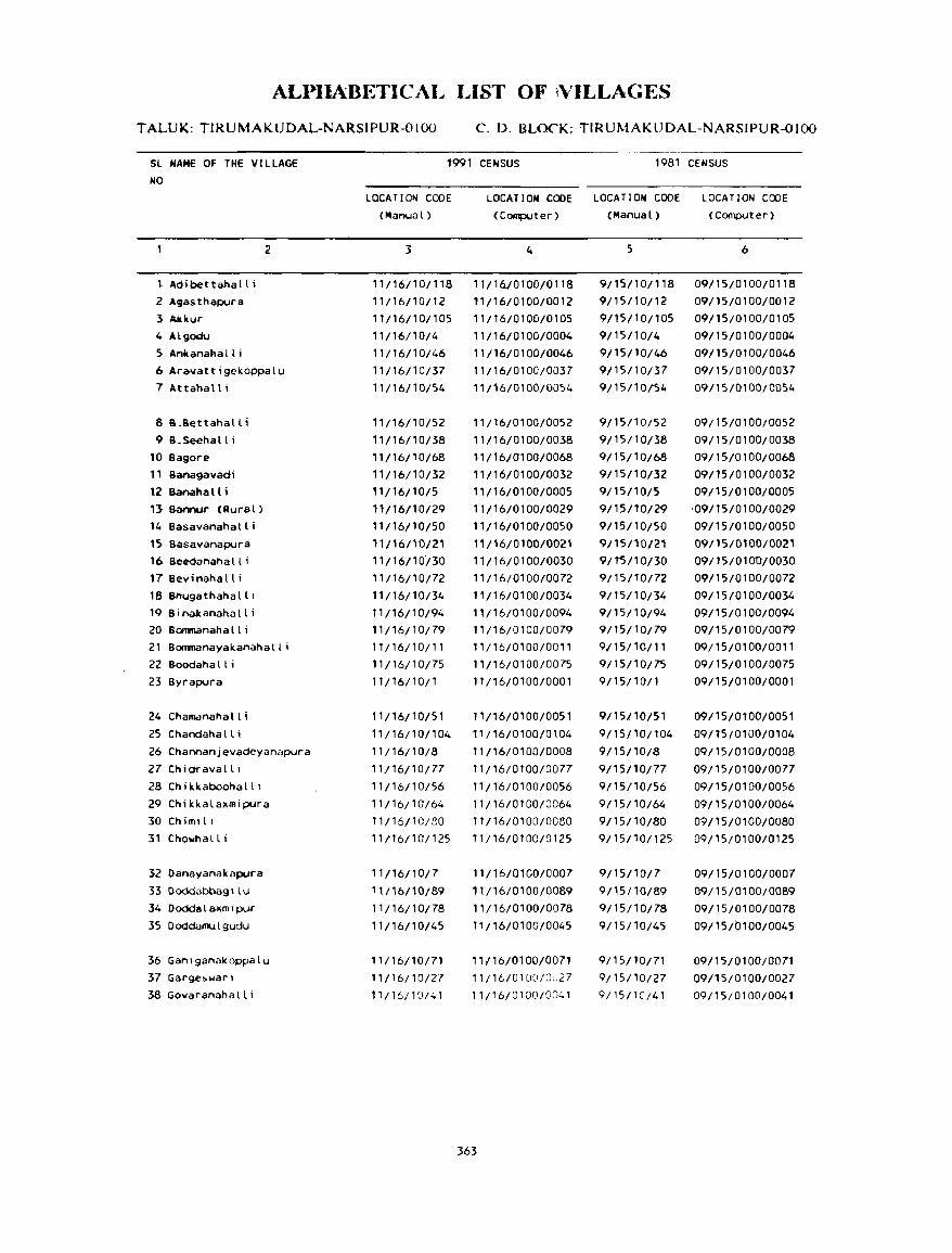
ALI)lIABETICAL LIST OF \VILLAGES
TALUK: TIRUMAKUDAL-NARSIPUR-OIOO C. D. BLOCK: TIRUMAKUDAL-NARSIPUR-OIOO
SL NAME OF THE VILLAGE NO
1991 CENSUS 1981 CENSUS
t Adibettanall i
2 A$asthapyra 1 A.kkur 4 Algodu
5 Ankanahall i
2
6 Ara~attigckoppalu
7 Attahalli
8 8.8ettahal L i
9 B.Seehall i 10 Bagore 11 Banagavadi 12 Bananall i 13 Bannur (Aural)
14 Basavanahalli 15 Basavanapura 16 Seedanahall i 17 Bevinahall i 188hugathahall 1
19 Binakanahalli 20 Bonmanaha II i 21 Bommanayakanahalli 22 Boodahall i 23 8yrapyra
24 Challklnahall i
25 Chandaha II i 26 Channanjevadcyanapura
27 Chidravalll 28 Chikkaboohalll
29 Chikkalaxmipura 30Chimt!1
31 Chowhall i
32 Danayanakapura
33 Doddabbagllu 34 Doddalaxmlpur 35 Ooddamulgudu
36 GanlganaKoppalu 37 Garg.e!>warl 38 Govaranahalli
LOCAT I ON CODE (Manual)
3
11/16/10/118 11/16/10/12
11/16/10/105
11/16/10/4
11/16/10/46
11/16/10/37 11/16/10/54
11/16/10/52
11/16/10/38
11/16/10/68
11/16/1 0/32 11/16/10/5
H/16/10/29 11/16/10/50
'11/16/10/21 11/16/10/30
11/16/10/72
11/16/10/34
11/16/10/94 11/16/10/79
11/16/10/11
11/16/10/75 11/16/10/1
11/16/10/51
11/16110/104
11/16/10/8
11/16/10/77
11/16/10/56
11/16/10/64
11/16/10/80
11/16/10/125
11/16/10/7
11/16/10/89
11/16/10/78
11/16/10/45
11/16110/71
11/16/10/27
11/16/lCJ/.:.1
LOCATION CODE LOCATION CODE LOCATION CODE (Computer) (Manual) (Computer)
{,
11/16/0100/0118
11/16/0100/0012 11/16/01QO/0105
11/16/0100/0004
11/16/0100/0046 11/16/0100/0037
11/16/0100/0054
11 {16/01 00/0052
11/16/0100/0038 ,,/16/0100/0068
11/16/0100/0032 11/16/0100/0005
11/16/0100/0029
11/16/0100/0050
11/16/0100/0021 11/16/0100/0030
11/16/0100/0072
11/16/0100/0034
11/16/0100/0094 11/16/0100/0079
"/16/0,00/0011
11/16/0100/0075
" /16/0100/0001
11/16/0100/0051
11/16/0100/0104
11/16/0100/0008
T1 /16/0100/0077
11/16/0100/0056
11/16/0100/0064
11/16/0100/0080
n /16/01 00/0 125
"/16/0100/0007
11/16/0100/0089
11/16/0100/0078
',/16/0100/0045
11/16/0100/0071 11/16/0100/0u27
11/16;0100/0041
363
5
9/15/10/118 9/15/10/12
9/l5/101105
9/15/10/4
9/15/10/4.6 9/15/10;37
9;15!10/S4
9/15110/52
9/15/10/38
9/15/10/68
9/15/10;32 9/15/10/5
9/15110/29
9/15/10/50
9/15/'10/21
9/t5/10/30
9/15/10/72
9/15;10/34
9/15;10/94 9/15/10/79
9/15;10/11
9/15;10/75 9/15/10/1
9/15/10/51
9115110/t04
9/15/10/8
9/15/10/77
9/15/10/56
9/15/10/64
9/15/10/80
9/15/T0/125
9/15/10/7
9/15110/89 9/15/10/78
9/15/10/45
9/15/10/71
9/15/10/27
9/15110/41
6
09/15/0100/0118
09/15/0100/0012
09/15/0100;0105
09/15/0100/0004
09/15/0100/0046
09/15/0100;0037
09/15/0100/0054
09/15/0100/0052 09/15/0100/0038
09/15/0100/0068
09/15/0100/0032
09/15/0100/0005
'09/ 15/01 00/0029
09/15/0100/0050
09/15/0100/0021
09/15/010'0/0030
09/15/0100/0072
09/15/0100/0034
09/15/0100/0094 09/15/0100/0079
09/15/0100/001' 09/15/0100/0075
09/15/0100/0001
09/15/0100/0051
09/l5/0100/0104
09/15/0100/0008
09/15/0100/0077
09/15/0100/0056
09/15/0100/0064
09/15;0100/0080
09/15/0100/0125
09/15/0100/0007
09/15/0100/0089
09/15/0100/0078
09/15;0100/0045
09/15/0100/0071 09/15/0100/0027
09/15;010010041
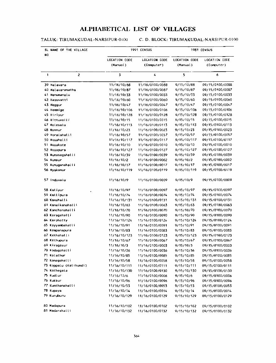
ALPHABETICAL LIST OF VILLAGES
TALUK: TlRUMAKUDAL-NARSIPUR-O 100 C. D. BLOCK: TIRUMAKUDAL-NARSIPUR-OIOO
SL NAME OF THE VILLAGE NO
1991 CENSUS 1981 CENSUS
39 Halavara 40 Halavaramatha 41 Hanumanalu 42 Hasuvatti 43 Heggur 44 Henrnige 45 Hiriyur 46 Hittuvall i 47 Holesalu 48 Honnur 49 Horalahall i 50 Hosahall i 51 Hosakote 52 Hosapura 53 Hunasagahalli 54 Hunsur 55 Hunuganahalli 56 Hyakanur
57 Induvalu
58 Kaliyur 59 Kallipura 60 Kanallall; 61 Kanaikanahalli 62 Kanchanahalli 63 Karagahalli 64 Karohatty 65 Kayyambahalli 66 Kempanapura 67 Kethahall i 68 Kethupura 69 Kiragasur 70 Kodagahall i 71 Kolathur 72 Konagaha II i
2
73 Koppalu (Kalihundi) 74 Kothegala 7S Kudlur 76 Kukkur 77 Kunthanahalli 78 Kupaya 79 Kuruburu
80 Madapura 81 Madarahalli
LOCATION CODE (Manual)
3
11/16/10/88
11/16/10/87
11/16/10/33 11/16/10/60
11/16/10/47
11/16/10/106
11/16/10/128 11/16/10/15
11/16/101113
11/16/10/23
11/16/10/57 11/16/10/117
11/16/10/10
11/16/101127
11/16/10/39 11/16/10/2
11/16/10/17
11/16/10/119
11/16/10/9
11/16/10/97
11/16/10/74
11116/10/131 11/16/10/63
11/16/10/70
11/16/10/90 11/16/10/124
11/16/10/91
11/16/10/83
11/16/10/123
"/16/,0/67 11/16/10/3
11/16/10/36
11/16/10/85
11/16/10/58 1 1 /16/ 10/111
11/16/10/130
11/16/10/6
11/16/10/96
11/16/10/53
11/16/10/14
11/16/10/129
11/16/10/1 02
11/16/10/132
LOCATION CODE LOCATION CODE LOCATION CODE (Computer) (Manual) (Computer)
4
11/16/0100/0088 11/16/0100/0087
11/16/0100/0033
11/16/0100/0060
11/16/0100/0047 11/16/0100/0106
11/16/0100/0128
11/16/0100/0015
11/16/0100/0113
11/16/0100/0023
11/16/0100/0057 11/16/0100/0117
11/16/0100/0010
11/16/0100/0127
11/16/0100/0039
11/16/0100/0002
11/16/0100/0017 \1/16/0100/0119
11/16/0100/0009
11/16/0100/0097 11/16/0100/0074
11/16/0100/0Bl
11/16/0100/0063
11116/0100/0070
11/16/0100/0090
11/16/0100/0124
11/16/0100/0091
11/16/0100/0083
11/16/0100/0123
11/16/0100/0067
11/16/0100/0003
11/16/0100/0036
11116/0100/0085
11/16/0100/0058
11/16/0100/0111
11/16/0100/0130
11/16/0100/0006
11/16/0100/0096
11/16/0100/0053
11/16/0100/0014
11/16/0100/0129
1.1/16/0100/0102 11/16/0100/0132
364
5
9/15/10/88
9/15/10/87
9/15/10/33
9/15/10/60 9/15/10/47
9/15/1011 06
9115/10/128
9/15/10/15
9/15/10/113
9/15/10/23 9/15/10/57
9/15110/117
9/15/10/10
9/15/10/127
9/15/10/39
9/15/10/2
9/15/10/17
9/15/10/119
9/15/10/9
9/15/10/97 9/15/10/74
9/15/10/131
9/15/10/63
9/15/10/70
9/15/10/90
9/15/10/124
9/15/10/91
9/15/10/83 9/15/10/123
9/15/10/67
9/15/10/3
9/15/10/36
9/15/10/85
9/15/10/58
9/15/10/1" 9/15/10/130
9/15/10/6
9/15/10/96
9/15/10/53
9/15/10/14
9/15/10/129
9/15/10/102
9/15/10/132
6
09/15/0100/0088
09/15/0100/0087 09/15/0100/0033
09/15/0100/0060
09/15/0100/0047
09/15/0100/0106
09/15/0100/0128
09/15/0100/00}5
09/15/0100/0113
09/15/0100/0023
09/15/0100/0057 09/15/0100/0117
09/15/0100/0010
09/15/0100/0127
09/15/0100/0039
09/15/0100/0002 09/15/0100/0017
09/15/0100/0119
09/15/0100/0009
09/15/0100/01)97
09/15/0100/0074
09/15/0100/0131
09/15/0100/0063
09/15/0100/0070
09/15/0100/0090
09/15/0100/0124
09/15/0100/0091
09/15/0100/0083 09/15-/0100/0123
09/15/0100/0067
09/15/0100/0003
09/15/0100/0036
09/15/0100/0085
09/15/0100/0058
09/15/0100/0111
09/15/0100/0130
09/15/0100/0006
09/15/0100/0096
09/15/0100/0053
09/15/0100/0014
09/15/0100/0129
09/15/0100/0102
09/15/0100/0132
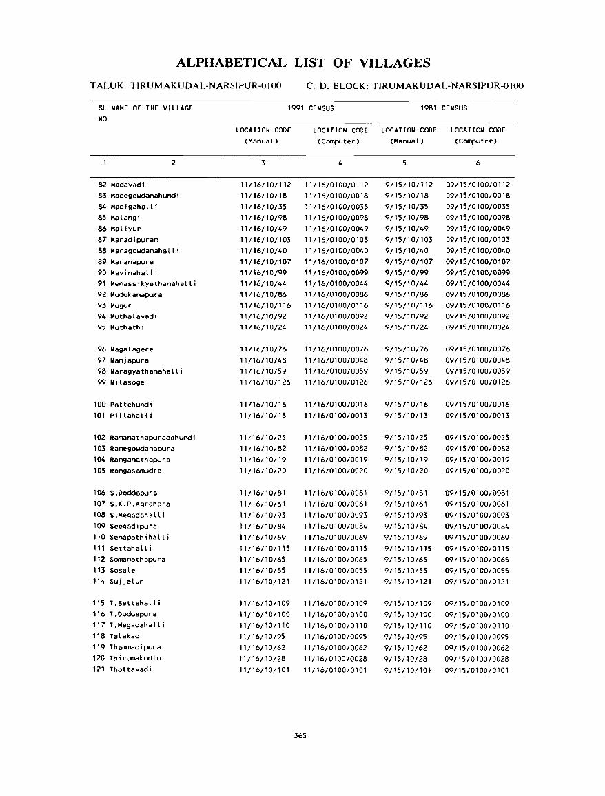
ALPIIABETICAL LIST OF VILLAGES
TALUK: TIRUMAKUDAL-NARSIPUR-OIOO c. D. BLOCK: TIRUMAKUDAL-NARSIPUR-OIOO
SL NAME OF THE VILLAGE NO
1991 CENSUS 1981 CENSUS
2
82 Madavadi 83 Hadegowdanahundi 84 Madigahalli 85 Halangi 86 Maliyur 87 Maradipuram B8 Maragowdanahalli 89 Maranapura 90 Mavinahalli 91 Menassikyathanahalli 92 Mudukanapura 93 Mugur 94 Muthalavadi 95 Muthathi
96 Nagalagere 97 Nanjapura 98 Naragyathanahalli 99 Nilasoge
100 Pattehundi 101 Pi llahall i
102 Ramanathapuradahundi 103 Ramegowdanapura 104 Ranganathapura
105 Rangasamudra
106 S.Ooddapura 107 S.K.P.Agrahara
108S.Mcgadahalli 109 Seegadlpura
110 Senapathihalli 111 Settahall i 112 Somanathapura
113 Sosale 114 Sujjalur
115 T.Bettahalli
"6 T.Doddapura 117 T.Megadahalli
118 Talakad 119 Thammadipura
120 Thirumakudlu 121 Thottavadi
LOCATION CODE (Manual)
3
11/16/10/1 12 11/16/10/18 11/16/10/35 11/16/10/98 11/16/10/49 11/16/10/103 11/16/10/40 11/16/10/107 11/16/10/99 ,'/16/10/44 11/16/10/86 11/16/10/116 11/16/1 0/92 11/16/10/24
11/16/10/76 11/16/10/48 11/16/10/59 11/16/10/126
11/16/10/16 11/16/10/13
11/16/10/25 11/16/10/82
11/16/10/19
11/16/1 0/20
11/16/10/81 11/16/10/61
11/16110/93
11/16/10/84 11/16/10/69 11/16/10/115 11/16/10/65 11/16/10/55 11/16/10/121
11/16/10/109
11/16/101100
11/16/10/110 11/16(10/95
11/16/10/62 11/16/10/28
11/16/10/101
LOCATION CODE LOCATION CODE LOCATION CODE (Computer) (Manual) (Computer)
4
11/16/0100/0112 11/16/0100/0018 11/16/0100/0035 11/16/0100/0098 11/16/0100/0049 11/16/0100/0103 11/16/0100/0040 11/16/0100/0107 11116/0100/0099 11/16/0100/0044 11/16/0100/0086 11/16/0100/0116 11/16/0100/0092 11/16/0100/0024
11/16/0100/0076 11/16/0100/0048 11/16/0100/0059 11/16/0100/0126
11/16/0100/0016 11/16/0100/0013
11/16/0100/0025 11/16/0100/0082
11/16/0100/0019 11/16/0100/0020
11/16/0100/0081 11/16/0100/0061
11/16/0100/0093 11/16/0100/0084
11/16/0100/0069 11/16/0100/0115
11/16/0100/0065 11/16/0100/0055 11/16/0100/0121
11/16/0100/0109
11/16/0100/0100 11/16/0100/0110 11/16/0100/0095
11/16/0100/0062 11/16/0100/0028 11/16/0100/0101
365
5
9/15/10/112 9/15/10/18
9/15/10/35 9/15/10/98 9/15/10/49 9/15/10/103 9/15/10/40 9/15/10/107
9/15/10/99
9/15/10/44 9/15/10/86 9/15/10/116 9/15/10/92 9/15/10/24
9/15/10;76 9/15/10/48 9/15/10/59
9/15/10/126
9/15/10/16 9/15/10/13
9/15/10/25 9/15/10/82
9/15/10/19 9/15/10/20
9/15/10/81 9/15/10/61
9/15110/93
9/15/10/84 9/15/10/69 9/15/10/115
9/15/10/65 9/15/10/55 9/15/10/121
9/15/10/109 9/15/10/100
9/15/10/110
9/15110/95
9/15/10/62
9/15/10/28 9/15/10/101
6
Q9/15/0100/0112 09/15/0100/0018 09/15/0100/0035
09/15/0100/0098 09/15/0100/0049 09/15/0100/0103 09/15/0100/0040 09/15/0100/0107 09/15/0100/0099 09/15/0100/0044 09/15/0100/0086 09/15/0100/0116 09/15/0100/0092
09/15/0100/0024
09/15/0100/0076 09/15/0100/0048
09/15/0100/0059
09/15/0100/0126
09/15/0100/0016
09/15/0100/0013
09/15/0100/0025 09/15/0100/0082
09/15/0100/0019
09/15/0100/0020
09/15/0100/0081
09/15/0100/0061
09/15/0100/0093 09/15/0100/0084
09/15/0100/0069 09/15/0100/0115 09/15/0100/0065 09/15/0100/0055 09/15/0100/0121
09/15/0100/0109
09115/0100/0100 09/15/0100/0110
09/15/0100/0095
09/15/0100/0062
09/15/0100/0028 09/15/0100/0101
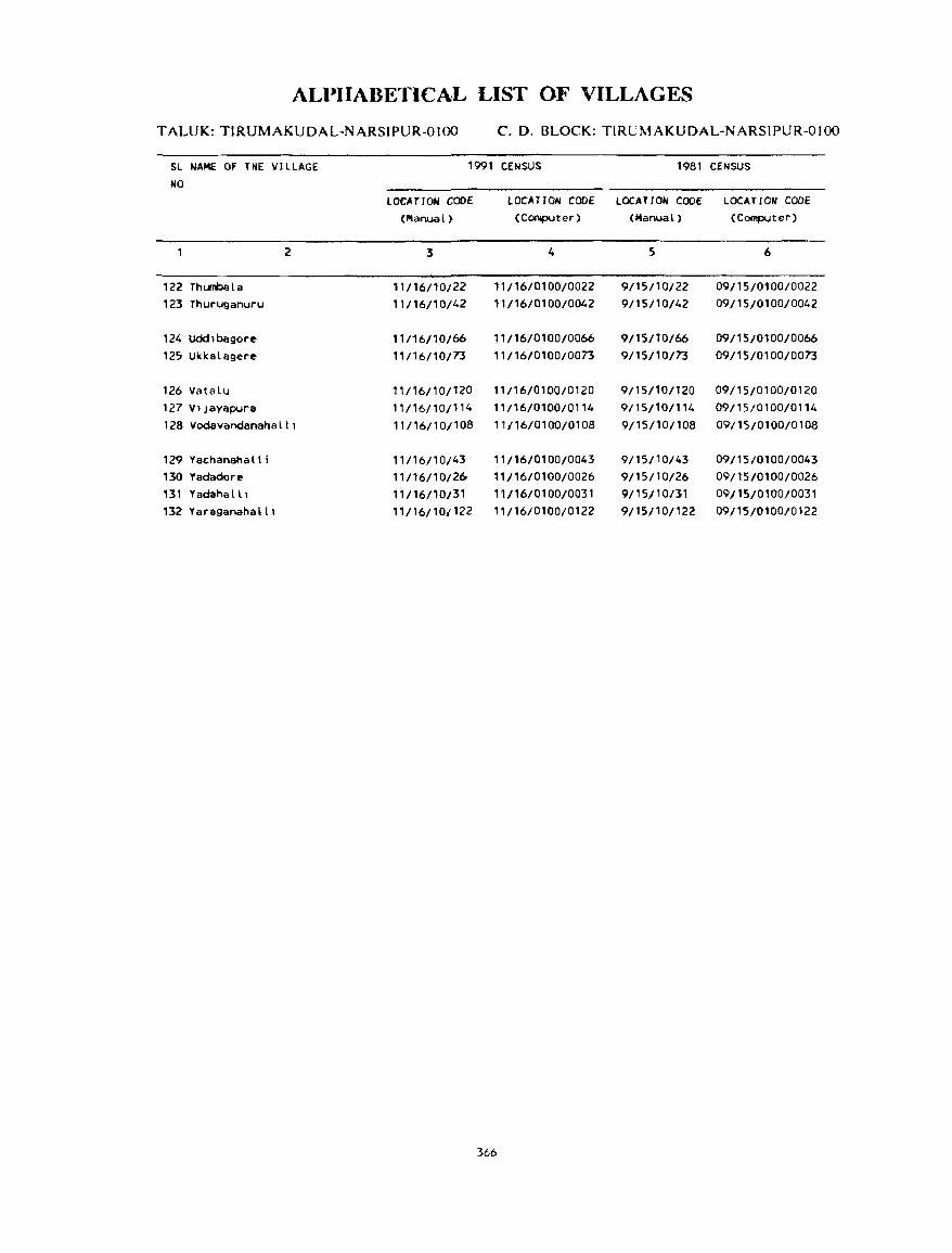
366
TIRUMAKUDAL NARSIPUR C.D.BLOCK
VILLAGE
AMENITIES Nam~ of C.D.Block : TIRUMAKUDAL NARSIPUR; CoJ~ No. :0100
L.C. Nam~ of Villag.: Tntal ar.:a of Tnt"l Am.:niti.:s availahl.: (ifnortvailahl.: within th.: village. a dash (-) is shown in tho: No. the villag~ p"pu- column and n':.xt to it in hrad:.:ts. tho: distan,e in broad rang.:s viz. -5 kms. 5-10 kms.
(In h.:,tar~s) lation allll 10+ kill, "fth.: n.:ar.:st [!lace wh.:re the facilit:t is availahle is giwn). and Edu~a- M.:di~al Drinking Post Day or Communication No.of tional Wat.:r and Days of [Bus Stop. Hnu~~· Tdc- marketl Railway Station. holds graph hat ifany Wal.:rway)
(1) (2) (3) (4) (5) (6) (7) (8) (9) (10)
BYRAPURA 291.55 7954 P(2), -(0-5) T, HP PTO, -(0-5) BS
(1511) M(2), Phone
H(2), PUC,
C
2 HUNSUR 273.60 1085 P '(O-5) 10', HP -(0-5) -(0-5) BS
( 199)
3 KIRAGASUR 577.25 2664 P(2), M(2) -(0-5) 10', HP PO -(0-5) BS (515)
4 ALGOOU 999.17 5126 P(4), M -(0-5) T, TW, HP PTO, -(0-5) BS (911) Phone
5 BANAHALLI 256.43 593 P(2) , M -(0-5) 10', TW, HP PO -(0-5) BS (107)
6 KUDLUR 379.81 764 P(2), M -(0-5) W, HP -(0-5) -(0-5)
(139)
7 DANAYANAKAPURA 221.71 1096 P, M -(O-5) W, TW, HP PTO, -(5-10) BS (204) Phone
8 CHANNANJEVADEYANAPURA 54.28 _ .. __ .. _---------------- UN - INHABITED -------------------------
9 INDUVAlU 413.55 824 P(2), M -(0-5) W, HP -(0-5) -(0-5) BS (133)
10 HOSAKOTE 482.94 3053 P(2), M -(0-5) w, TW, HP PO -(5-10) 8S (585)
11 80MMANAYAKANAHALLI 398.95 657 P -(0-5) W, HP -(0-5) - (10+) -(0-5)
( 123)
12 AGASTHAPURA 142.30 270 P -(0-5) w, HP - (0- 5) - (10+) - (0-5) (47)
13 PI LLAHALlI 120.94 ------------------------ UN - INHABITED ------------------------.
14 KUPAYA 615.82 2306 P, M -(5-10) w, HP PO -(5-10) BS (419)
15 HITTUVALLI 339.29 1675 P, M -(0-5) 10', HP - (0-5) -(5-10) BS (323)
368
DIRECTORY
AND LAND USE Name: ot C.D.Blo~k : TIRUMAKUDAL NARSIPUR; Code: No.: 0100
Approach Nearest Town. Clns "fT,)wn Puwlo!r Land""" l"r~a llJ),kr t1iffercnttype> of land uS\! 10 he"tares rounded It) two de"jmal places) L.e. t" village and t1i,tan.:e (in Kill.) Supply No.
F~tr\!~t Irrigllted Un-irrigated Cuhurahle Area not (hy !o"ur.:~ of irrigatiol1) wa~h! available
(mduding I()f cultivation gau.:har and grovl!s)
( 11 ) (12) (13) (14) (15) (16) (17) (18) (1)
PR TIRUHAKUDAl-NARSIPUR- v- 1 fA Totat 81.23 182.85 27.47 CC 81.23
PR TIRUMAKUDAL-NARSIPUR- v- 2 fA Total 219.87 15.56 38.17 2 GC 219.87
PR TIRUMAKUDAL-NARSIPUR- v- 5 fA Total 230.45 291.49 8.20 47.11 3
CC 230.45
PR TIRUMAKUDAL-NARSIPUR- v- 1 fA Total 253.61 511.28 87.84 165.22 4 GC 2~3.61
PR TIRUMAKUOAL-NARSIPUR- v- 5 fA 210.71 31.72 14.00 5
PR lIRUMAKUDAL-NARSIPUR- V- 6 EA Total 207.22 103.00 7.37 62.22 6 CC 207.22
PR TIRUMAKUDAl-NARSIPUR- V- 7 EA Total 166.04 36.54 7.39 11.74 7 GC 166.04
--------------------------------------------- UN - INHABITED -.--.----.----_------------------------------ 8
PR lIRUMAKUOAl-NARSIPUR- v- 5 EA Total 204.37 139.22 40.01 29.95 9 GC 204.37
PR TIRUMAKUDAl-NARSIPUR- v- 8 EA Totat 184.56 222.22 25.84 50.32 10
GC 184.56
KR TIRUMAKUDAl-NARSIPUR- V- 14 EA Totat 18.76 323.88 31.88 24.43 11 GC 18.76
Pj( TIRUMAKUOAL-NARSIPUR- v- 11 fA Tot"l 5.06 113.66 20.32 3.26 12 GC 5.06
--------~------------------------------------ UH . INHABITED -------------------------------------------~- 13
PR TIRUMAKUOAl-NARSIPUR- Y- 10 fA Total 1.93 471.84 96.26 45.79 14 GC 1.93
PR BAHHUR- IY- 13 EA Total 91.38 218.12 8.05 21.74 15 GC 91.38
369
VILLAGE
AMENITIES Name: of C.D.BlocK ~ TIRUMAKUDAL NARSIPUR; CoJe: No. :0100
LC Nanl<' of VIllage Total an:. "I Total Amolllt,o, avail.,Ilk (111101 ava,ldhk I!.,th,n the vlliago. 8 dahh (-) " ,hown til the No th.: v,lldg.: Popu- I.olumn and Ih.!'\' to It In hra\.l\!'h. thl! dl ... tJnl..~ Ifl hrHad raO-!!-::.. VII ~ I..lIlh. '-1 () lllllo.
(In h.:..tar.:,) lalHln and I()+ ~ln .... nt th\! 111.:',11..:..,1 CI.h.1.! V.h~TI.! th..: 1.1 ... 1111\ I' 3\:ul.lhlc: .'" gl\l.!l1!
and Ed",. "kd',,11 011 III Ill)! Po,t Duy llf C()T11f11Unl'\.alJ()fl
No of tllHld1 \\',Ih:r and Duy' 01 IBu, Slop. H(HJ'I! Td.: Olurl.:li Ralll!.ay Stdllon. hold, )!'''I'h hat ,I Ul) Wat':Na) I
(1) (2) (3) (4) (5) (6) (7) (8) (9) ( I 0)
16 PATTE HUtlD'I 307.08 839 pa) -(0-5) w, HP - (0-5) -(5-10) as ( 147)
17 HUNUGANAHALLI 348.84 1385 P(2), M -(5,10) T, W, HP - (0-5) -(5-10) as (275 )
18 MADEGO~ANAHUNDI 105.78 1024 P, M -(5-10) Hoi, HP -(0,5) -(5-10) 8S ( 178)
19 RANGANATHAPURA 1088.92 1512 P(2) -(0-5) W, HP - (0-5) -(5-10) 85 (260)
20 RANGASAMUDRA 634.10 2631 P(2), M, H -(0- 5) w, HP PTO, -(5-10) as (523) Phone
21 8ASAVANAPURA 40.78 ------------------------ UN - INHA8ITED ._------- ........ _- ............ -_ .. _
22 THUM8AlA 593.92 2104 P(2), M -(0-5) w, HP PO -(0-5) BS (381)
23 HONNUR 202.33 --- ----""------ --_ .. ------ UN I NHA8ITED ..... -- -_ ... -- -_ ... ---- ---_ ..... -_ ...
24 MUT IIATII I 481.31 848 P -(0-5) w, HP - (0-5) -(5-10) 8S (144)
25 RAMANATHAPURADAHUNDI 141.59 342 P -(0-5) W, liP -(0-5) -(5-10) 8S (60)
26 YADADORE 4t.2.87 2668 P, M -(0-5) w, HP -(0-5) -(0-5) 8S (500)
27 GARGESWARI 233.20 4247 P(4) , PHC, FPC W, HI, liP PTO, -(0-5) as (705) M(3) , II Phone
28 THIRUMAKUDlU 110.37 319 - (0-5) -(0-5) w, HP - (0-5) - (0- 5) 8S (62)
29 8ANNUR (RURAL) 2026.11 2505 P, M -(0-5) w, HP PO -(0-5) 8S (470)
30 BEEDANAHAlll 232.18 1541 P -(0-5) T, W, liP -(0-5) - (0-5) 8S (279)
370
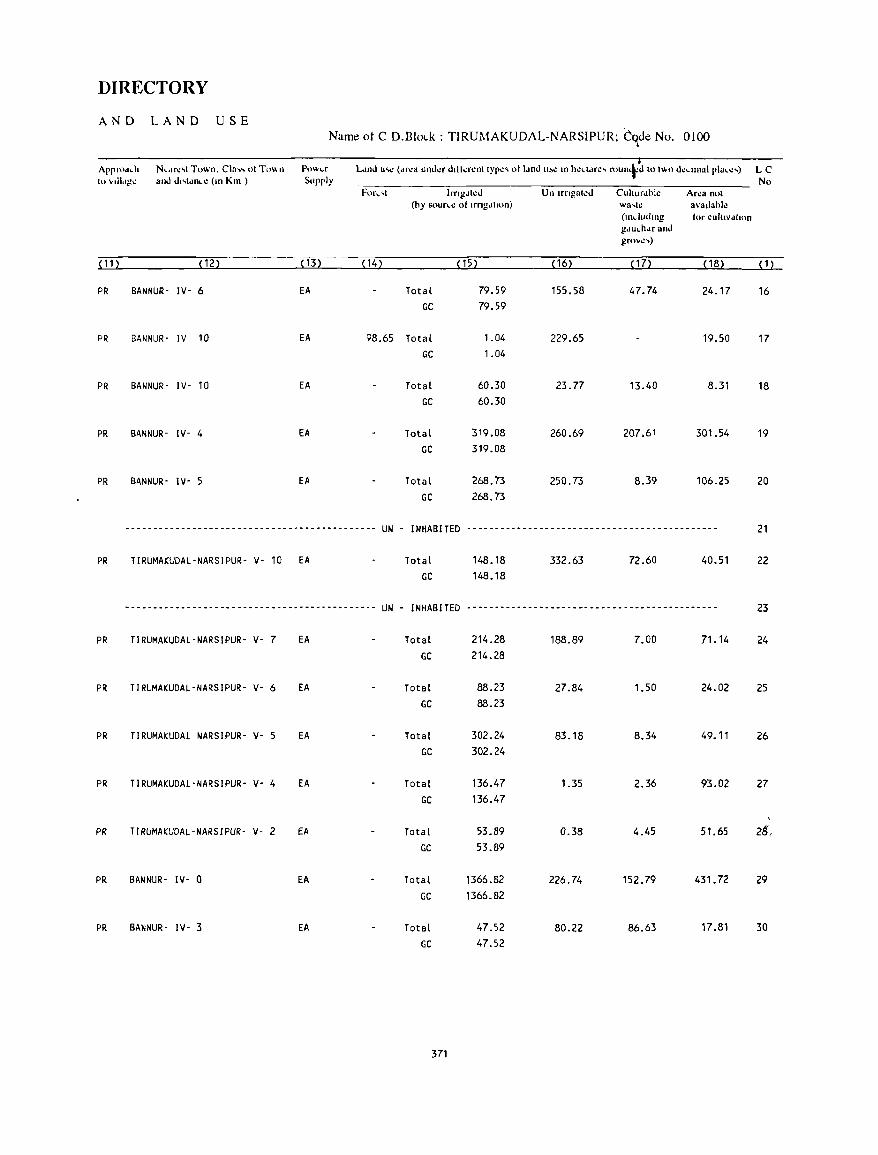
DIRECTORY
AND LAND USE Name ot C D.Blolk : TIRUMAKUDAL-NARSIPUR; CqJe No. 0100
Appflld<h N<df.:,l Town. CIa" 01 To" n Po",,,r L.md u'" (dr.:a uno.l.:r dllkr.:nllyp.:, 01 IdnJ lI~C In h.:ct.lrc, roun+d 10 (\Hl d':,II11al pIa • .:,) LC to vdl.'A!1! a'nJ dl,ldnC': (Ill Kill ) Supply No
For,'l Irng.Jl.:d Un Irngal\!d Cuhur.lhl.: Ar.:a nol (by sour.e 01 Irngdlltln) wa't~ avallahle
(lIIcluulng (or cuhlvdlJlln gdu<hdr and grove,)
P12 ~122 ~132 P4) ~152 ~ 16) ~ 172 ~182 ~ 1 )
PR BANNUR- IV- 6 EA Total 79.59 155.58 47.74 24.17 16 GC 79.59
PR BANNUR' IV 10 EA 98.65 Total 1.04 229.65 19.50 17 GC 1.04
PR BANNUR' IV- 10 EA Total 60.30 23.77 13.40 8.31 18 GC 60.30
PR BANNUR- IV- 4 EA Total 319.08 260.69 207.61 301.54 19 GC 319.08
PR BANNUR' IV- 5 EA Total 268.73 250.73 8.39 106.25 20 GC 268.73
_____________________________ ., _______ ft ______
UN - INHABITED --------------------------------------------- 21
PR TIRUMAKUDAL'NARSIPUR- V- 10 EA Total 148.18 332.63 72.60 40.51 22 GC 148_18
--------------------------------------~------ UN - INHABITED --------------------------------------------- 23
PR TIRUMAKUDAL-NARSIPUR- V- 7 EA Total 214.28 188.89 7.00 71.14 24 GC 214.28
PR TIRUMAKUDAL-NARSIPUR- V- 6 EA Total 88.23 27.84 1.50 24.02 25 GC 88.23
PR TIRUMAKUDAl NARSIPUR- V- 5 EA Total 302.24 83.18 8.34 49.11 26 GC 302.24
PR TIRUMAKUDAl-NARSIPUR- Vo 4 fA Total 136.47 1.35 2.36 93.02 27 GC 136.47
PR TIRUMAKUDAL-NARSIPUR- V- 2 EA Total 53.89 0.38 4.45 51.65 Z§,
GC 53.89
PR BANNUR- IV- a EA Total 1366.82 226.74 152.79 431.72 29 GC 1366.82
PR BANNUR- IV- 3 EA Total 47.52 80.22 86.63 17.81 30
GC 47.52
371
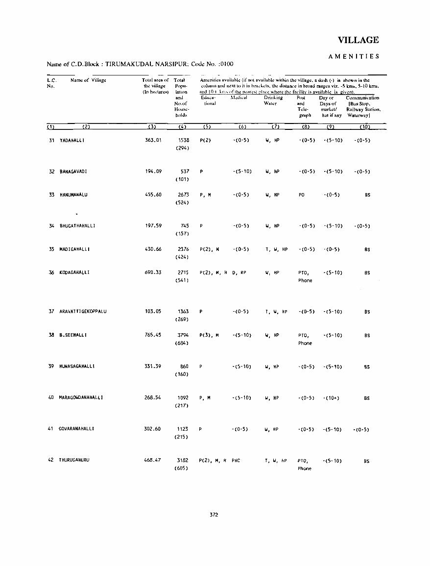
VILLAGE
AMENITIES Name of C.D.Block : T1RUMAKUDAL NARSIPUR; Cout: No. :0)00
L.C. Name of Village Total area of Tolal Amenili.:s availahle (if nol availahlo: within Iho: village. a dash (-) is shown in the No. tho: village Popu- column and n.:xtlo il in hrackds. Ihe diSlan~o: in hroad ranges viz. -5 kms. 5-10 kms.
(In hectares) lalinn and 10+ kith oflh.: neare'! ~Iace where Ih.: facililY is availllhie is given). and Eduea- l\I.:dical Drinking Post Day or Communicalion
No.of tional Wal.:r and Days of (Bus Stop, HOll~":- Tele- markell Railway Stalion. hold. graph hal if any Waterway)
(1) (2) (3) (4 ) (5) (6) (7) (8) (9) (10)
31 YAOAIIALLI 363.01 1538 P(2) -(0-5) W, liP -(0-5) -(5-10) -(0-5)
(294)
32 BANAGAVAOI 194.09 537 P -(5-10) W, HP -(0-5) -(5-10) -(0-5)
(101)
33 HANUMANALU 455.60 2673 P, M -(0-5) W, HP PO '(0-5) BS
(524)
34 BHUGATHAHALLI 197.59 745 P -(0-5) W, HP -(0-5) -(5-10) -(0-5)
( 157)
35 MADIGAHALLI 430.66 2376 P(2), H - (0- 5) T, W, HP -(0-5) -(0-5) BS
(424)
36 KOOAGAHALLI 690.33 2715 P(2) , H, H 0, RP W, HP PTO, -(5-10) 8S
(541) Phone
37 ARAVATTIGEKOPPALU 103.05 1363 P -(0-5) T, II, HP -(0-5) '(5-10) BS
(269)
38 B.SEEHAlLI 765.45 3794 P(3), H -(5-10) W, HP PTO, -(5-10) BS
(684) Phone
39 IIUNASAGAIIALlI 331.39 860 P - (5-10) W, HP -(0-5) -(5-10) BS (160)
40 HARAGOWDANAHALLI 268.54 1092 P, H -(5-10) II, HP -(0-5) -(10+) BS (217)
41 GOVARANAHALLI 302.60 1123 P -(0-5) II, HP -(0-5) -(5-10) -(0-5)
(215)
42 THURUGANURU 468.47 3182 P(2}, H, H PHe T, W, HP PTO, -(5-10) BS (605) Phone
372
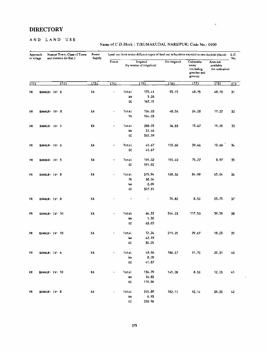
DIRECTORY
AND LAND USE Name of C.D.Block : TIRUMAKUDAL NARSIPUR; Code No.: 0100
Approach NcaNsl Town. Class of Town Pow~r Land lISC (area under difl;:renllypcs of land us.: in hcctarcs rounded 10 two decimal places) L.C. to village: and distance: (in Km.) Supply No.
Forcst Irrigatcd Un-irrigatcd Cuhurable ANa not (by source: of irrigation) waste: available:
(induding for cultivation gauchar and grovcs)
(11) (12) ( \3) (14) (15) ( 16) ( 17) (18) (1)
PR BANNUR- IV- 6 EA Total 172.41 93.15 48.75 48.70 31 lie 5.26
GC 167.15
KR BANNUR- IV- 8 EA Total 104.03 48.56 24.28 17.22 32 Tk 104.03
KR BANNUR- IV- 5 EA Total 388.05 36.83 15.67 15.05 33 \Ie 22.46
GC 365.59
PR BANNUR- IV- 6 EA Total 40.67 103.60 39.66 13.66 34
GC 40.67
PR BANNUR- IY- 5 EA Total 191.02 155.40 75.27 8.97 35
GC 191.02
PR BANNUR- IY- 8 EA Total 373.94 168.36 84.99 63.04 36
Tk 38.04
lie 8.09
GC 327.81
PR BANNUR- IY- 8 EA 70.82 8.50 23.73 37
PR BANNUR- IV- 10 EA Total 64.33 544.23 117.50 39.39 38
lie 1.30
GC 63.03
PR BANNUR- IY- 10 EA Total 72.24 211.25 29.67 18.23 39
lie 42.19
GC 30.05
PR BANNUR- IY- 6 EA Total 49.96 186.57 11. 70 20.31 40 lie 8.09
GC 41.87
KR BANNUR- IV' 10 EA Total 136.79 145.08 8.50 12.23 41
lie 16.83
GC 119_96
PR BANNUR- IY- 8 EA Total 245.89 182.11 12.14 28.33 42
lie 6.93
GC 238.96
373
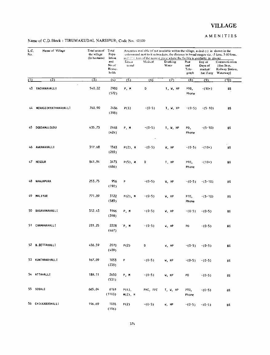
VILLAGE
AMENITIES Name of C.D.Block : TIRUMAKUDAL NARSIPUR; CoJ~ No. :0100
L.C. Name of Village Tolal area of Total AIll~nll.~, availahl~ (If not ava.lahle within Ihe village. a da,h (-) is shown in Ihe No. Ihe village Poru- ,olullln and I1I!xllo il.n hra,kels. Ihl! di,lan,e in hroad ranges viz. -5 kms. 5-10 kms.
(In he.lares) lalion alld 11) • k.lll' ofth.: o.:ar .. · ... t [!Ial.·': \\h.:r.: th.: fa~:ilit~ i~ availahle is giv\!n! and Ed",a I\kd ••• 1 Dnnl..ing Posl Day or C')Ill111uni.alion No.of tiona) Waler and Days of IBus SlOp. H()lI,,"C· Tele- markell Railway Slalion. hold, graph hal if any Walerwayl
(1) (2) (3) (4) (5) (6) (7) (8) (9) ( 1 0)
43 YACHANAHALLI 540.22 2980 P, M 0 T, 101, HP PTO, - (10+) BS (572) Phone
44 MENASSIKYATHANAHALLI 760.90 2486 P(3) -(0-5) T, 101, HP -(0-5) -(5-10) BS (398)
45 OOOOAMULGUOU 435.73 2448 P, M -(0-5) T, 101, HP PO, -(5-10) BS (424) Phone
46 ANKANAHALLI 317.68 1563 P(2), M -(0-5) 101, HP -(0-5) - (10+) BS (285)
47 HEGGUR 841.94 3473 P(5), M 0 T, HP PTO, - ( 1 0+) BS (686) Phone
48 NANJAPURA 253.75 956 P -(0-5) 101, HP -(0-5) - (5-10) BS ( 192)
49 MALIYUR 771.89 3122 P(2), M - (0-5) 101, HP PTO, - (5-10) BS (583) Phone
50 BASAVANAHALLI 312.43 1966 P, 1'4 -(0-5) 101, HP -(0-5) - (0-5) BS (398)
51 CHAMANAHALLI 281.25 2228 P, M -(0-5) II, HP PO -(0-5) BS (467)
52 B.BETTAHALLI 456.59 2070 P(2) 0 II, HP - (0- 5) -(0-5) BS (409)
53 KUNTHANAHALLI 167.09 1053 P -(0-5) 101, HP -(0-5) -(0-5) BS (233)
54 ATTAHALLI 189.11 2650 P, M -(0-5) II, HP PO -(0-5) BS (531)
55 SOSALE 665_04 6161 P(4) , PHC, FPC T, 1.1, HP PTO, -(0-5) BS (1103) M(2), H Phone
56 CHIKKABOOHALLI 196.69 lOSS P(2) -(0-5) II, HP -(0-5) -(0-5) BS ( 196)
374
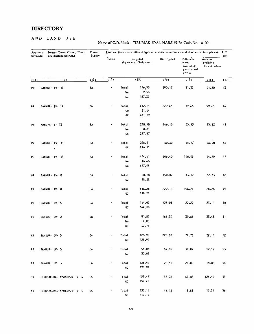
DIRECTORY
AND LAND USE Name of C.D.Block : TIRUMAKUDAL NARSIPUR; Code No.: 0100
Approach Near~st Town. Class of Town Power Und use (ar':8 und.:r.diff.:r.:nt types of land use in h.:ctar~s rounded to two decimal pla,e,) LC. to village and distance (in Km.) Supply No.
for.:st Irrigated Un-irrigated Culturahl.: Ar":8 not (hy source of irrigation) wa~h! 8vailahl.:
(including for cultivation gall,har and grme,)
(11) (12) ( 13) (14) (15) ('6) ( I 7) ( 18) (1)
PR BANNUR- IV- 10 EA Total 176.90 290.17 31.35 41.80 43 We 9.58 GC 167.32
PR BANNUR- IV- 12 EA Total 432.13 229.46 39.66 59.65 44 'We 2'.04 GC 411.09
PR MANDYA- 1- 13 EA Total 218.48 146.10 55.53 15.62 45 We 0.81 GC 217.67
PR BANNUR- IV- 13 EA Total 216.11 60.30 15.27 26.00 46 GC 216.11
PR BANNUR- IV- 13 EA Total 444.41 206.40 146.93 44.20 47 \ole 16.46
GC 427.95
PR BANNUR- IV- 8 EA Total 28.28 150.07 13.07 62.33 48 GC 28.28
PR BANNUR- IV- 8 EA Total 318.26 229.12 198.25 26.26 49 GC 318.26
PR BANNUR- IV- 5 EA Total 144.00 123.03 22.29 23.11 50 GC 144.00
PR BANNUR- IV- 2 EA Total 51.80 166.31 39.66 23.48 51 We 4.05
GC 47.75
KR BANNUR- IV- 5 EA Total 128.90 225.82 79.73 22.14 52 GC 128.90
PR BANNUR- IV- 5 Ell. Total 55.03 64.85 30.09 17.12 53 GC 55.03
PR BANNUR- IV- 3 EA Total 126.94 22.50 20.82 18.85 54 GC 126.94
PR TIRUMAKUDAL-NARSIPUR- v- 4 EA Total 459.47 38.26 40.87 126.44 55 GC 459.47
KR TIRUMAKUDAL-NARSIPUR- V- 4 Ell. Total 130.14 44.48 5.83 16.24 56 GC 130.14
375

VILLAGE
AMENITIES Name of C.D.Block : TIRUMAKUDAL NARSIPUR; Code No. :0100
L.C. NalTh! of Village Total area of Total Am~niti~s availahl~ (if not availahl~ within the vi"ag~. a dash (-) is shown in tho: No. the village Popu- column and n~xt to it in hra.:k~ts. th.: distan.:.: in hroad rang.:s viz. -5 kms. 5-10 kms.
(In hectares) lation and 10+ kms ofth~ n~ar~st Clac.: wh,!rl! the t:,.:ility is availahk is given). and Edu.:a- M.:dical Drinking Post Day or Communication No.of tional Water and Days of (Bus Stop. House- Tel.:- mark~tl Railway Station. holds graph hat if any Wato:rway)
(1) (2) (3) (4 ) (5) (6) (7) (8) (9) (10)
57 HORALAHALL( 573.16 1395 P(2), H -(0-5) w, HP PTO, -(5-10) BS (255) Phone
58 KONAGAHAlll 212.01 864 P -(5-10) w, HP -(0-5) -(5-10) -(0-5) (151)
59 NARAGYATHANAHALLI 364.46 960 P -(0-5) W, HP -(0-5) -(5-10) BS (187)
60 HASUVATTI 300.19 864 P -(0-5) W, HP -(0-5) -(5-10) BS (155)
61 S.K.P.AGRAHARA 100.53 531 P -(0-5) T, W, HP '(0-5) -(5-10) BS (91)
62 THAMMADIPURA 304.22 992 P - (10+) W, HP -(0-5) -(10+) -(0-5) (178)
63 KANA I KANA HAll I 287.58 806 P -(10+) W, HP -(0-5) -(10+) -(0-5J (156)
64 CHIKKALAXHIPURA 67.55 290 P -(5-10) W, HP -(0-5) -(5-10) -(0-5) (58)
65 SOMANATHAPURA 913.60 4516 P(4), H(2) PHC T, W, HP PTa, -(5-10) BS (832) Phone
66 UOOIBAGORE 45.73 -.------~--------------- UN - INHABITED -------------------------
67 KETHUPURA 190.99 2532 P, H, H -(0-5) T, W, HP po -(5-10) BS (490)
68 BAGORE 21.57 ------------------------ UN - INHABITED -------------------------
69 SENAPATHI HALL! 328.63 768 P -(0-5) W, HP -(0-5) -(0-5) -(0-5) ( 144)
70 KANCHANAHALLI 116.29 486 P -(0-5) W, HP -(0-5) - (0-5) -(0-5) (85)
71 GANIGANAKOPPALU 114.39 720 P, H -(0-5) W, HP -(0-5) -(0-5) -(0-5) (154)
72 BEV I NAHALLI 436.72 1257 P -(0-5) T, W, HP -(0-5) -(5-10) as (242)
376
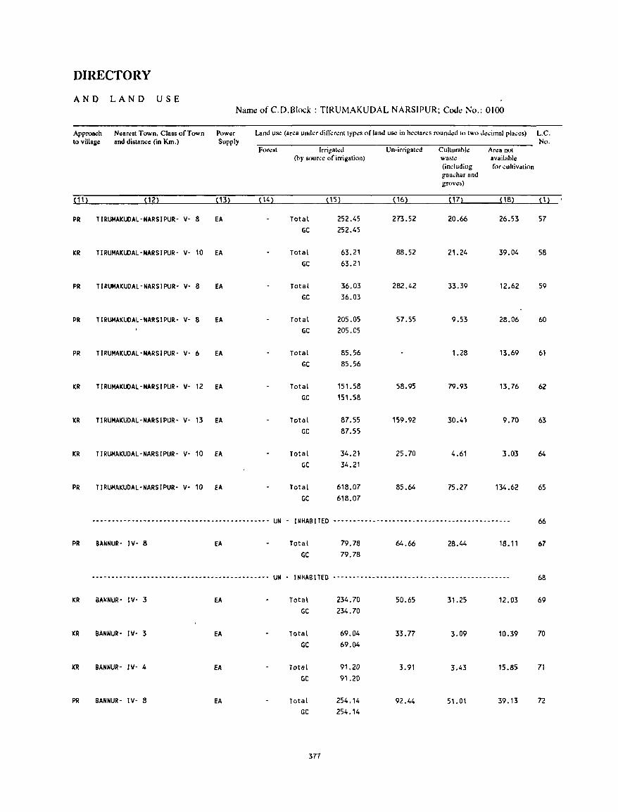
DIRECTORY
AND LAND USE Name of C.D.Block : TIRUMAKUDAL NARSIPUR; Code No.: 0100
Approach Nllarest Town. Class of Town Powllr Land uS<! (area under different types of land uS<! in hectares rounded to two de,imal places) L.C. to village and distance (in Km.) Supply No.
Forest Irrigated Un-irrigated Culturabl.: Area not (by source of irrigation) wa~te available
(induding for cultivation gau,har and grovc~)
(11) (12) (13) ( 14) (15) (16) (17) (18) ( 1 )
PR TIRUMAKUDAL-NARSIPUR- V- 8 EA Total 252.45 273.52 20.66 26.53 57 GC 252.45
KR TIRUMAKUDAL-NARSIPUR- V- 10 fA Total 63.21 88.52 21.24 39.04 58 GC 63.21
PR TIRUMAKUDAL-NARSIPUR- V- 8 fA Total 36.03 282.42 33.39 12.62 59 GC 36.03
PR TIRUMAKUDAL-NARSIPUR- V- 8 EA Total 205.05 57.55 9.53 28.06 60 GC 205.05
PR TIRUMAKUDAL-NARSIPUR- Y- 6 fA Total 85.56 1.28 13.69 61 GC 85.56
KR TIRUMAKUDAL-NARSIPUR- Y- 12 fA Total 151.58 58.95 79.93 13.76 62 GC 151.58
KR TIRUMAKUOAL-NARSIPUR- V- 13 fA Total 87.55 159.92 30.41 9.70 63 GC 87.55
KR TIRUMAKUDAL-NARSIPUR- Y- 10 EA Total 34.21 25.70 4.61 3.03 64 GC 34.21
PR TIRUMAKUDAL-NARSIPUR- Y- 10 EA Total 618.07 85.64 75.27 134.62 65 GC 618.07
.---------------------~---------------------- UN - INHABITED ----------------------------------.---~------ 66
PR BANNUR- IY- 8 fA Total 79.78 64.66 28.44 18.11 67 GC 79.78
--------------------------------------------- UN - INHABITED --------------------------------------------- 68
KR BANNUR - IV- 3 EA Total 234.70 50.65 31.25 12.03 69 GC 234.70
KR BANNUR- IV- 3 EA Total 69.04 33.77 3.09 10.39 70 GC 69.04
KR BANNUR- IY- 4 EA Total 91.20 3.91 3.43 15.85 71 GC 91.20
PR BANNUR- IY- 8 EA Total 254.14 92.44 51.01 39.13 72 GC 254.14
377
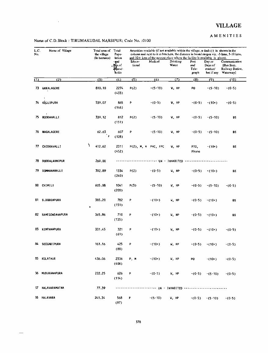
VILLAGE
AMENITIES Name of C.D.Block : TIRUMAKUDAL NARSIPUR; Code.! No. :0100
L.C. Name of Village Total area of Total Amenitie~ availahle (if not available within the village. a da&h (-) is shown in the No. the village Popu- column and next 10 it m brad.:.:ts, the distance in broad ranges viz. -5 kms. 5-10 kms,
(In hectares) lation and 10+ lms of the ncarc~t [!Iace where the facilitl: is availahle is given}.
f Eduea- Medical Drinling Post Day or Communication
,"' o.of tional Water and Days of [Bus Stop. lUSf!- Tele- marketl Railway Station. )Ids graph hat if any Waterway]
(1) (2) (3) (4) (5) (6) (7) (8) (9) (10)
73 "'KKALAGERE 810.10 2274 P(2) -(5-10) 101, HP PO -(5-10) -(0-5) (433)
74 K~LLlPURA 539.07 865 P -(0-5) 101, HP -(0-5) - (10+) -(0-5) (146)
75 BOOOAHALll 339.12 812 P(2) -(5-10) 101, HP -(0-5) - (5-10) BS (151)
76 NAGALAGERE 62.63 607 P -(5-10) 101, HP -(0-5) -(5-10) BS , (128)
77 CHIDRAVALLI ,
412.62 2311 P(2), M, H PHC, FPC 101, HP PTO, -00+) BS (452) Phone
78 DODDALAXMIPUR 269.00 .---------------------_- UN - INHABITED -------------------------
79 BOHMANAHALll 392.89 1334 P(2) -(0-5) 101, HP -(0-5) -(10+) BS (240)
80 CHIMl LI 605.08 1041 p(3) -(5-10) 101, HP -(0-5) -(5-10) -(0-5) (200)
81 S.DODDAPURA 385_20 782 P - (10+) 101, HP -(0-5) -(10+) BS
.. (151)
82 RAMEGOIJDANAPURA 365.96 710 P - (10+) 101, HP -(0-5) - (10+) BS (135 )
83 KEMPANAPURA 331.45 321 P - (10+) 101, HP -(0-5) -(10+) - (0-5) (61)
84 SEEGADIPURA 161.16 425 P -(10+) 101, HP -(0-5) - (10+) -(0-5) (88)
85 KOLATHUR 436.06 2336 P, M - (10+ ) 101, HP PO - (10+) -(0-5) (406)
36 MUDUKANAPURA 222.25 626 P -(0-5) 101, HP - (0- 5) -(5-10) -(0-5) (114)
37 HALAVARAMATHA 77.39 ------------------------ UN - INHABITED -------------------------
38 HALAVARA 241.34 568 P -(5-10) 101, HP - (0- 5) -(5-10) -(0-5) (97)
378
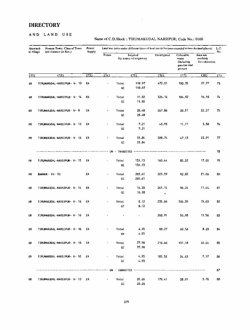
DIRECTORY
AND LAND USE Name of C.D.Block : TIRUMAKUDAL NARSIPUR; Code No.: 0100
Approa.~ Ncaresl Town. Class of Town Pow~r Lan.! us.: (ar.:a und.:r din;'r.:nllyp.:s of land us.: in h.:..:lar.:s round.:d 10 Iwo decimal places) L.C. to villag,: and dislan..:,: (in Km.) Supply No.
For.:sl Irrigated Un-irrigated Cuhurahle Area not (hy source of irrigation) wast~ available
(including I<)f cultivation gau.har and groves)
(11) (12) (13) (14) (15) (16) (17) (18) (1)
KR TIRUMAKUDAL-NARSIPUR- y- 10 EA Total 119.97 472.01 190.35 27.77 73
GC 119.97
KR TIRUMAKUDAL-NARSIPU~- y- 14 EA Total 11.82 326.14 184.92 16.19 74 GC 11.82
KR TIRUMAKUDAL-NARSIPUR- y- 9 EA Total 28.48 267.86 20.51 22.27 75
GC 28.48
PR TIRUMAKUDAL-NARSIPUR- y- 10 EA Total 7.21 40.93 11. 11 3.38 76 GC 7.21
PR TIRUMAKUDAL-NARSIPUR- Y- 16 EA Total 31.84 309.74 47.13 23.91 77
GC 31.84
--------------------------------------------- UN - INHABITED --------------------------------------------- 78
PR TIRUMAKUDAL-NARSIPUR- Y- 15 fA Total 133.13 160.44 82.32 17.00 79 GC 133.13
PR BANNUR- IY- 10 fA Total 265.61 225.59 92.82 21.06 80 GC 265.61
KR TIRUMAKUDAL-NARSIPUR- v- 14 EA Total 16.38 261.14 96.24 11.44 81 GC 16.38
KR TIRUMAKUDAl·NARSIPUR· y. 16 EA Total 8.12 235.66 106.55 15.63 82 GC 8.12
KR TIRUMAKUDAl-NARSIPUR- V· 16 EA 268.91 50.98 11.56 83
KR TIRUMAKUDAl-NARSIPUR- y. 16 EA Total 4.05 88.27 60.56 8.28 84 lJe 4.05
KR TIRUMAKUDAl·NARSIPUR- y. 16 EA Total 77.98 216.46 101.18 40.44 85 GC 77.98
KR TIRUMAKUDAL-NARSIPUR- Y- 10 EA Total 4.93 185.52 24.63 7.17 86 GC 4.93
------------_-------------------------------_ UN INHABITED --------------------------------------------- 87
KR TIRUMAKUDAl-NARSIPUR- Y- 10 EA Total 20.26 178.41 38.91 3.76 88 GC 20.26
379

VILLAGE
AMENITIES Name of C.D.Block : TlRUMAKUDAL NARSIPUR; Code! No. :0100
L.C. Name of Village Total area of Total Am~nities availahk (if nol available within the village. a dash (-) is shown in the No. the village p,'pu- column and n.:xlto it in bradets. the di!otanee in broad ranges viz. -5 kms. 5-10 kms.
(In hectares) lation and 10+ km' of Ih~ nearest ~Iace where the facility is availahle is giwn}. and Eduea- Medical Drinking Post Day or Communication
No.of tiona I Water and Days of (Bus Slop, Hous.:- Telc- market! Railway Station, holds graph hat if any Waterway]
(1) (2) (3) (4) (5) (6) (7) (8) (9) (10)
89 DOODABBAGILU 916.26 3706 P(5), H, H -(5-10) T, W, HP PO -(5-10) BS (677)
90 KARAGAHALLI 313.29 1833 P(2) -(10+) W, HP ·(0-5) -(10+) - (0-5)
(332)
91 KAYYAHBAHALLI 216.95 926 P PHC, FPC W, HP - (0-5) -(5-10) -(0-5)
( 169)
92 MUTHALAVADI 518.59 2940 P(2), H 0 W, HP PTO, -(5-10) -(0-5)
(494) Phone
93 S.HEGADAHALLI 379.28 1726 P(3) -(0-5) W, HP -(0-5) -(5-10) • (0-5)
(330)
94 BINAKANAHALLl 416.42 3593 P(2), M, H -(0-5) II, HP PTO, -(0-5) BS (637) Phone
95 TALAKAD 1484.03 8933 P(3), M, PHC, FPC T, W, HP PTO, -(0-5) BS ( 1903) H, PUC Phone
96 KUKKUR 129.88 2392 P(2), H -(0-5) II, HP PO - (10+) BS (448)
97 KALlYUR 752.21 3258 P, H - (0- 5) II, nl, HP PTO, - (10+) BS (601) Phone
98 HALANGI 696.15 2446 P(4), H PHC, FPC W, TW, HP PO, -(10+) BS (499) Phone
99 MAVI NAHALLI 586.12 2035 P(2), M -(0-5) W, HP PO, -(10+) BS (347) Phone
100 T.DOODAPURA 952.15 2123 P(3), M -(0-5) II, HP PO -(10+) BS (405)
101 THOTTAVADI 665.08 1175 P -(0-5) TW, HP -(0-5) -(5-10) -(0-5) (210)
102 HADAPURA 367.04 2089 P, H, H -(0-5) T, W, HP PO -(5-10) BS (393)
103 HARADI PURAH 173.01 1329 P(2) -(0-5) II, HP -(0-5) -(5-10) BS (237)
380
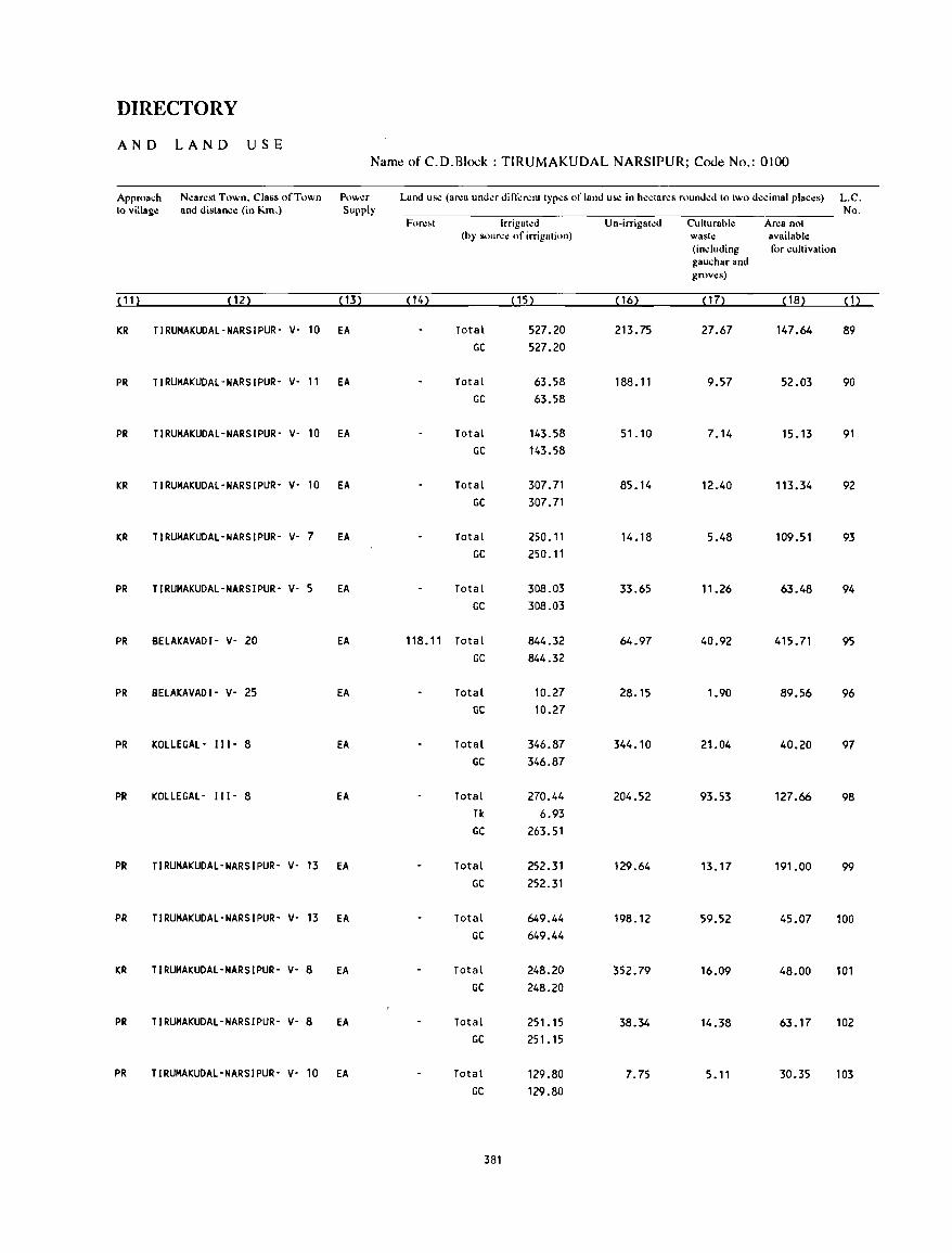
DIRECTORY
AND LAND USE Name of C.D.Block : TlRUMAKUDAL NARSIPUR; Code No.: 0100
Approach N~arcst Town. Class of Town Powcr Land us.: (arca undcr din;:rcnt types of land us.: in heclares rounded to two decimal plac~s) L.C. to village and distance (in Km.) Supply No.
Fore.t Irrigat~d Un-irrigated Culturahle Ar~a not (hy source of irrigation) waste available
(including for cultivation gauchar and grov~s)
( 11) (12) (13) (14) (15) (16) ( 17> (18) ( 1)
KR TIRUMAKUDAL-NARSIPUR- v- 10 EA Total 527.20 213.75 27.67 147.64 89 GC 527.20
PR TIRUMAKUDAL-NARSIPUR- V- 11 EA Total 63.58 188.11 9.57 52.03 90 GC 63.58
PR TIRUMAKUDAL-NARSIPUR- V- 10 EA Total 143.58 51.10 7.14 15.13 91 GC 143.58
KR TIRUMAKUDAL-NARSIPUR- V- 10 EA Total 307.71 85.14 12.40 113.34 92 GC 307.71
KR TIRUMAKUDAL-NARSIPUR- V- 7 EA Total 250.11 14.18 5.48 109.51 93 GC 250.11
PR TIRUMAKUDAL-NARSIPUR- V- 5 EA Total 308.03 33.65 11.26 63.48 94 GC 308.03
PR BELAKAVADI- V- 20 EA 118.11 Total 844.32 64.97 40.92 415.71 95 GC 844.32
PR BELAKAVADI- V- 25 EA Total 10.27 28.15 1.90 89.56 96 GC 10.27
PR KOLLEGAL- 111- 8 EA Total 346.87 344.10 21.04 40.20 97 GC 346.87
PR KOLLEGAL- 111- 8 EA Total 270.44 204.52 93.53 127.66 98 TIc 6.93 GC 263.51
PR TIRUMAKUDAL-NARSIPUR- V- 13 EA Total 252.31 129.64 13.17 191.00 99 GC 252.31
PR TIRUMAKUDAL-NARSIPUR- V- 13 EA Total 649.44 198.12 59.52 45.07 100 GC 649.44
KR TIRUMAKUDAL-NARSIPUR- V- 8 EA Total 248.20 352.79 16.09 48.00 101 GC 248.20
PR TIRUMAKUDAL-NARSIPUR- V- 8 EA Total 251.15 38.34 14.38 63.17 102 GC 251.15
PR TIRUMAKUDAL-NARSIPUR- V- 10 EA Total 129.80 7.75 5.11 30.35 103 GC 129.80
381
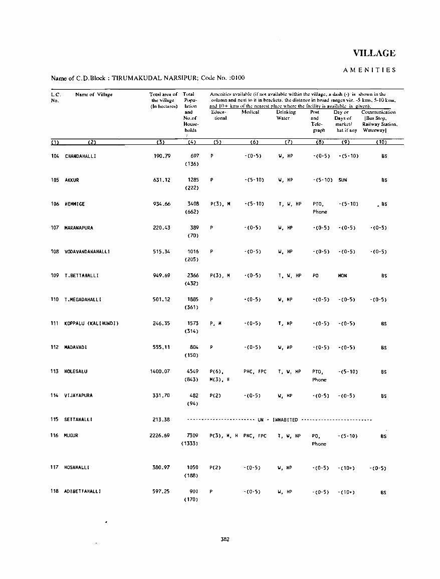
VILLAGE
AMENITIES Name of C.D.Block : TIRUMAKUDAL NARSIPUR; C<x1e No. :0100
l.C. Name of Village Tolal ar.:a of Tolal Am.:nili~s availahl~ (ifnolavailahl.: wilhin Iho:: villag.:. a dash (-) is shown in tho:: No. tho:: villago:: Popu- .:olumn and n.:xllo il in hrad':ls. Ih.: dislanc.: in hroad rang.:s viz. -5 km •• 5-10 km~.
(In ho::clar.:.) lalion and 10+ kill. orlhe nearesl[!lace where Ihe radii!}: is availahle is given). and EJuca- Medical Drinking Po~! Day or Communicalion No.of tiona I Wah:r and Days of (Bus Stop. House- T.:I.:- marketl Railway Stalion. holds graph hat if any Walerway)
(1) (2) (3) (4) (5) (6) m (8) (9) (10)
104 CHANDAHALLI 190.79 697 P - (0- 5) 101, HP -(0'5) -(5-10) BS (136)
105 AKKUR 631.12 1285 P -(5-10) 101, HP -(5-10) SUN BS (222)
106 HEMMIGE 934_66 3408 P(3), M -(5-10) T, 101, HP PTO, -(5-10) • BS (662) Phone
107 MARANAPURA 220.43 389 P -(0-5) 101, HP -(0-5) -(0-5) -(0-5) (70)
108 VODAVANDANAHALLI 515.34 1016 P -(0-5) 101, HP -(0-5) -(0-5) -(0-5) (205)
109 T .BETTAHALLI 949.69 2366 P(3), M -(0-5) T, 101, HP PO MON BS (432)
110 T.MEGADAHALLI 501. 12 1885 P -(0-5) 101, HP -(0-5) -(0-5) -(0-5) (361)
111 KOPPALU (KALIHUNDI) 246.35 1573 P, M -(0-5) T, HP -(0-5) -(0-5) BS (314)
112 MADAVADI 555.11 804 P -(0-5) 101, HP -(0-5) -(0-5) BS (150)
113 HOLESALU 1400.07 4549 P(6), PHC, FPC T, 101, HP PTO, -(5-10) BS (843) M(3) , H Phone
114 VIJAYAPURA 331. 70 482 P(2) -(0-5) 101, HP -(0-5) -(0-5) BS (94)
115 SETTAHALLI 213.38 ~--------------.------~- UN - INHABITED -----.-------------------
116 MUGUR 2226.69 7309 P(3), M, H PHC, FPC T, 101, HP PO, -(5-10) BS ( 1333) Phone
117 HOSAHALLI 380.97 1050 P(2) -(0-5) 101, HP -(0-5) - (10+) -(0-5) (188)
118 ADIBETTAHALLI 597.25 901 p -(0-5) w, HP -(0'5) - (10+) BS ( 170)
382
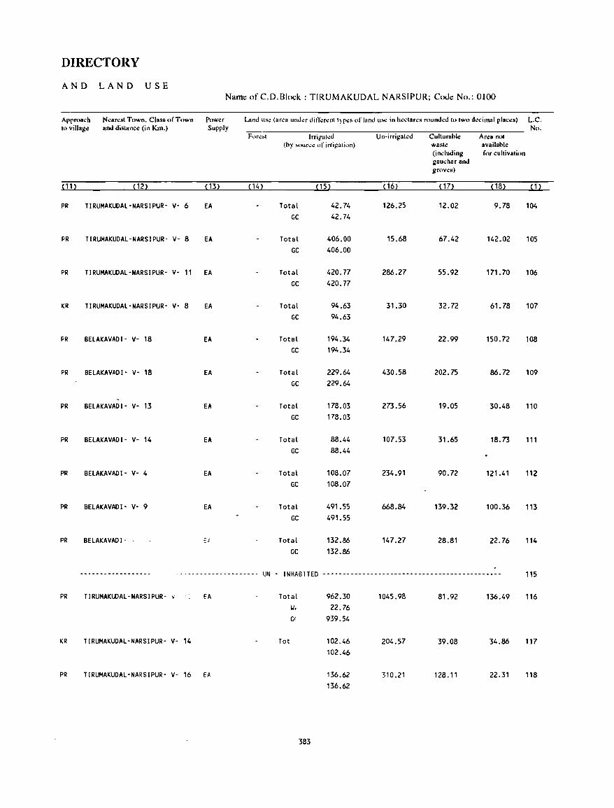
DIRECTORY
AND LAND USE Name of C.D.Block : TIRUMAKUDAL NARSIPUR; Coue No.: 0100
Approach Near.:st Town. Class of Town Pow.:r Land us~ (area under din;"renl I) p~s of land u...: in heclares rounded to two decimal places} L.C. to village and distance (in Km.) Supply No.
For.:~t Irrit!"led Un-irrigated Culturabl.: Area not (by ,.ouree of irrigation) wash: availablo:
(induding for cultivation gauchar and grows)
(11) (12) (13) (14) (15) (16) (17) (18) (1)
PR TIRUMAKUDAL-NARSIPUR- v- 6 EA Total 42.74 126.25 12.02 9.78 104 GC 42.74
PR TIRUMAKUDAL-NARSIPUR' V- 8 EA Total 406.00 15.68 67.42 142.02 105 GC 406.00
PR TIRUMAKUDAL-NARSIPUR- V- 11 EA Total 420.77 286.27 55.92 171.70 106 GC 420.77
I(R TIRUMAKUDAL-NARSIPUR- V- 8 EA Total 94.63 31.30 32.72 61.78 107 GC 94.63
PR BELAKAVADI- v- 18 EA Total 194.34 147.29 22.99 150.72 108 GC 194.34
PR BELAKAVADI- V- 18 EA Total 229.64 430.58 202.75 86.72 109 GC 229.64
PR BELAKAVADI- v- 13 EA Total 178.03 273.56 19.05 30.48 110 GC 178.03
PR BELAKAVADI- v- 14 EA Total 88.44 107.53 31.65 18.73 111 GC 88.44
PR BELAKAVADI- V- 4 EA Total 108.07 234.91 90.72 121.41 112 GC 108.07
PR BELAKAVADI- V- 9 EA Total 491.55 668.84 139.32 100.36 113 GC 491.55
PR BELAKAVADI- Et Total 132.86 147.27 28.81 22.76 114 GC 132.86
--.--------------- ... ----~-- ... ---------- UN - INHABITED -_._----------------------------------------- 115
PR TIRUMAKUDAL-NARSIPUR- v EA Total 962.30 1045.98 81.92 136.49 116 II< 22.76 G( 939.54
KR TIRUMAKUDAL-NARSIPUR- V- 14 Tot 102.46 204.57 39.08 34.86 117 102.46
PR TIRUMAKUDAL-NARSIPUR- V- 16 EA 136.62 310.21 128.11 22.31 118 136.62
383
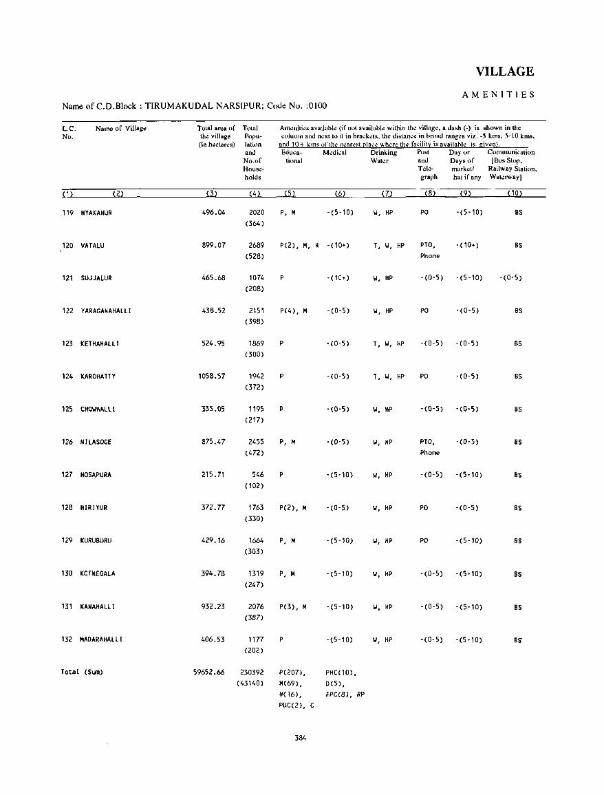
VILLAGE
AMENITIES Name of C.D.Block : TIRUMAKUDAL NARSIPUR; Code No. :0100
L.C. Name of Village Total area of Tolal Am~nili~s availabl~ (ifnol availabk wilhin lh~ village. a dash (-) is shown in the No. the village Popu- column and nexllo il in brack~ls. lhe dislance in broad ranges viz. -5 kms. 5-10 kms.
(In hectares) lalion and 10+ kms "flhe nearesll2lal.'e where lh~ fadlily is availabk is given). and Ed w.: a- M~d;';al Drinking Posl Day or Communicalion No.of lional Wal~r and Days of (Bus Slop, House- Tde- mark~ll Railway Slalion, holds graph hal if any Wal~rwaYl
(1) (2) (3) (4) (5) (6) (7) (8) (9) (10)
119 HYAKANUR 496.04 2020 P, M -(5-10) II, HP PO -(5-10) as (364)
120 VATALU 899.07 2689 P(2), M, H -(10+) T, II, HP PTO, -(10+) as (528) Phone
121 SUJJALUR 465.68 1074 P -(10+) II, HP -(0-5) -(5-10) -(0-5)
(208)
122 YARAGANAHALLI 438.52 2151 P(4), M -(0-5) II, HP PO -(0-5) as (398)
123 KETHAHALlI 524.95 1869 P -(0-5) T, II, HP -(0-5) -(0-5) as (300)
124 KAROHAlTY 1058.57 1942 P -(0-5) T, II, HP PO -(0-5) as (372)
125 CHOWHAlll 335.05 1195 p -(0-5) II, HP -(O-S) -(0-5) as (217)
126 NILASOGE 875.47 2455 P, M -(0-5) II, HP PTO, -(0-5) as (472) Phone
127 HOSAPURA 215.71 546 P -(5-10) II, HP -(0-5) -(5-10) as (102)
128 HIRIYUR 372.77 1763 P(2), M -(0-5) II, HP PO -(0-5) as (330)
129 KURUBURU 429.16 1664 P, M -(5-10) II, HP PO -(5-10) as (303)
130 KOTHEGALA 394.78 1319 P, M -(5-10) II, HP -(0-5) -(5-10) BS
(247)
131 KANAHALLI 932.23 2076 P(3), M -(5-10) II, HP -(0-5) -(5-10) BS
(387)
132 MADARAHAlLi 406.53 1177 P -(5-10) II, HP -(0-5) -(5-10) BS
(202)
Total (SlB) 59652.66 230392 P( 207), PHC(10),
(43140) M(69) , 0(5) ,
H(16) , FPC(8), RP PUC(2), C
384
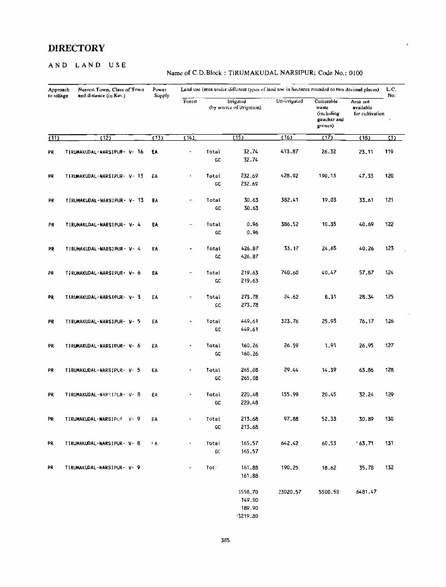
DIRECTORY
AND LAND USE Name of C.D.Block : TIRUMAKUDAL NARSIPUR; Code No.: 0100
Approach Nearest Town. Class of Town Power Land us~ (area under di n-':r.:nt typ.:s of land use in he.:tares rounded to two decimal places) L.C. to village and distance (in Km.) Supply No.
For~st Irrigated Un-irrigated Culturable Area not (by sour.:.: of irrigation) waste available
(including for cultivation gauchar and groves)
(11) (12) (13) (14) (15) ( 16) (17) ( 18) (1)
PR TlRUMAKUDAl-NARSIPUR- v- 16 EA Total 32.74 413.87 26.32 23.11 119 GC 32.74
PR TIRUMAKUDAL-NARSIPUR- v- 13 EA Total 232.69 428.92 190.13 47.33 120 GC 232.69
PR TIRUMAKUDAL'NARSIPUR- y- 13 EA Total 30.63 382.41 19.03 33.61 121
GC 30.63
PR TIRUMAKUDAl-NARSIPUR- V- 4 EA Total 0.96 386.52 10.35 40.69 122 GC 0.96
PR TIRUMAKUDAl-NARSIPUR- y- 4 EA Total 426.87 33.17 24.65 40.26 123 GC 426.87
PR TIRUMAKUDAL-NARSIPUR- y- 6 EA Total 219.63 740.60 40.47 57.87 124 GC 219.63
PR TIRUMAKUDAl-NARSIPUR- y- '3 EA Total 273.78 24.62 8.31 28.34 125
GC 273.78
PR TIRUMAKUDAl-NARSIPUR- y- 5 EA Total 449.61 323.76 25.93 76.17 126 GC 449.61
PR TIRUMAKUDAL-NARSIPUR- y- 6 EA Total 160.26 26.59 1.91 26.95 127 GC 160.26
PR TIRUMAKUDAL-NARSIPUR- y- 5 EA Total 265.08 29.44 14.39 63.86 128 GC 265.08
PR TIRUMAKUDAL-NARsIPUR- v- 8 EA Total 220.48 155.99 20.45 32.24 129 GC 220.48
PR TIRUMAKUDAL-NARSIPUQ v- 9 EA Total 213.68 97.88 52.33 30.89 130 GC 213.68
PR TIRUMAKUDAl-NARSIPUR- y- 8 , A Total 165.57 642.42 60.53 • 63.71 131 GC 165.57
PR TIRUMAKUDAL-NARSIPUR- v- 9 Tot; 161.88 190.25 18.62 35.78 132 161.88
5558.70 23020.57 5500.50 6481.47 149.00 189.90
'3219.80
385

YELANDUR C.D.BLOCK
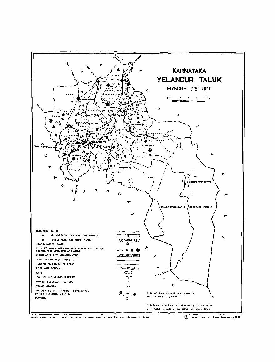
Fr"",
J N
IIOUNDIoRY, TALUK
" VILLIoGE WITH LOCATION CODE NUMBER
" FOREST-RESERVED WITH NIoI4E
HEADQUARTERS TALUK
VillAGES WITH POpULATION SIZE BELOW 200, 200-499, 500-999, 1000-4999, 5000 AND ABOVE
"'RBAN AREA WITH LOCATIO" CODE
IMPORTANT METALLED ROAD
U"METALLED A"D OTHER ROADS
RIVER WITH STREA'"
TANK
POST OFFICEI TELEGRAPH OFFICE
HIGHER SECONDARY SCHOOL
POLICE STATION
PRIMARY HEALTH CENTRE, DISPENSARY, FAMILY PLANNING CENTRE
I4ANDIES
G
[::'-'=1£::::::J 'IVI.~W#:t R.t='-'
©
o ••••
fWiMXvlJi~
~
~ PO/TO
S
PS
~,+,. /::,
KARNATAKA
YELANDUR TALUK MYSORE DISTRICT
Km 1 0 3 Km ... .c~! .. ~C=~ .... !
(
; ~"""''''''l-r,
r-
Area of sorne Villages ar.
two or more frogmcnts fOUnd In
C 0 Block boundQry of Vclandur IS co- hrmlnus
With toluk boundary excluding statutory town
c
8ased upon Survey of IndiO map With the permission of the Surveyor General of IndiO © Governmenl 01 IndIa CopyrJ9ht, 1991
ALPIIABETICAL LIST OF VILLAGES
T ALUK: YELANDUR-OllO
SL NAME OF THE VILLAGE NO
1 A.Devarahalli 2 Agara 3 Alkereagrahara 4 Ambale 5 Avalkandall i
6 Bannisarige
2
7 Siligiriranganabetta
8 Ouggahatti 9Duyamkandalli
10 Ganiganur 11 Gowdahalli 12 GlMllball i
13 Honnur
14 Jodimellahalli
15 K.Devarahalli 16 Katnavadi 17 Kesthur 18 Komaranapura
19 Maddur 20 Mallarapalya
21 Shivakahall i
22 Uppinamole
23 \ladagere
24 Yelandur 25 Yeragamball i 26 Yeriyur
C. D. BLOCK: YELANDUR-OllO
1991 CENSUS 1981 CENSUS
LOCATION CODE (Manual)
3
11/16/11/18 11/16/11/15 11/16/11/19 11/16/11/9 11/16/11/11
11/16/11/16 11/16/11/21
11/16/11/12 11/16/11/10
11/16/11/23 11/16/11/22 11/16/11/6
11/16111/14
11/16/11/13
11/16/11/7 11/16/11/26 11/16/11/25 11/16/11/4
11/16/11/24 11/16/11/20
11/16/11/17
11/16/11/3
11/16/11/5
11/16/11/1 11/16/11/8 11/16/11/2
LOCATION CODE LOCATION CODE LOCATION CODE (Computer) (Manual) (Computer)
4
11/16/0110/0018 11/16/0110/0015 11/16/0110/0019 11/16/0110/0009
11/16/0110/0011
11/16/0110/0016 11/16/0110/0021
11/16/0110/0012 11/16/0110/0010
11/16/0110/0023 11/16/0110/0022 11/16/0110/0006
11/16/0110/0014
11/16/0110/0013
11/16/0110/0007 11/16/0110/0026 11/16/0110/0025 11/16/0110/0004
11/16/0110/0024 11/16/0110/0020
11/16/0110/0017
11/16/0110/0003
"/,6/01'0/0005
11/16/0110/0001 11/16/0110/0008 11/16/0110/0002
389
5
9/15/11/18 9/15/11/15 9/15/11/19 9/15/11/9 9/15/11/11
9/15/11/16 9/15/11/21
9/15/11/12 9/15/11/10
9/15/11/23 9/15/11/22 9/15/11/6
9/15/11/14
9/15/11/13
9/15/11/7 9/15/11/26 9/15/'1/25 9/15/11/4
9/15/11/24 9/15/11/20
9/15/11/17
9/15/11/3
9/'5/11/5
9/15/11/1 9/15/11/8 9/15/11/2
6
09/15/0110/0018 09/15/0110/0015 09/15/0110/0019 09/15/0110/0009 09/15/0110/0011
09/15/0110/0016 09/15/0110/0021
09/15/0110/0012 09/15/0110/0010
09/15/0110/0023 09/15/0110/0022 09/15/0110/0006
09/15/0110/0014
09/15/0110/0013
09/15/0110/0007 09/15/0110/0026 09;15/0110/0025 09/15/0110/0004
09/15/0110/0024 09/15/0110/0020
09/15/0110/0017
09/15/0110/0003
09/15/0110/0005
09/15/0110/0001 09/15/0110/0008 09/15/0110/0002
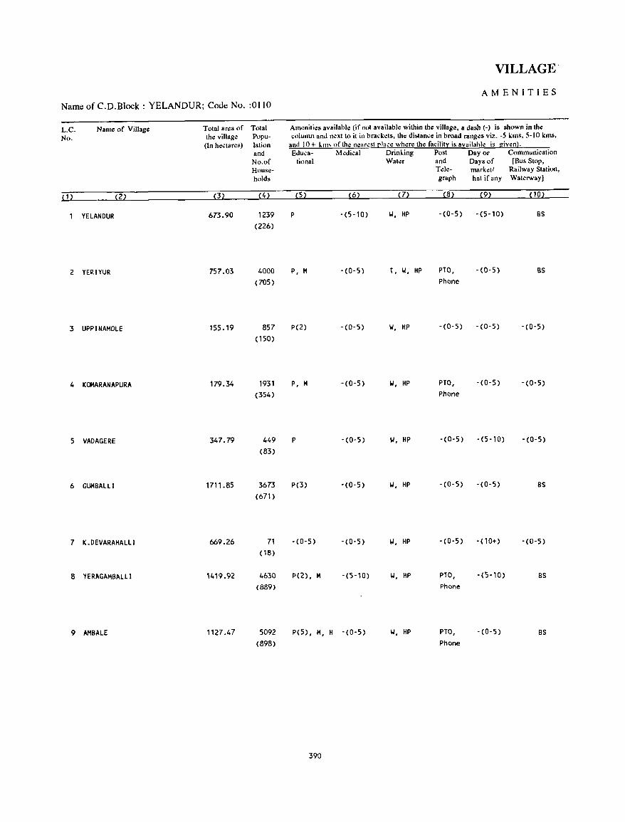
Name of C.D.Block : YELANDUR; Code No. :0110
L.C. No.
{D
Name of Village
{2)
YELANOUR
2 YERIYUR
3 UPPINAMOLE
4 KOMARANAPURA
5 VAOAGERE
6 GUMBALLI
7 K .OEVARAHALLI
8 YERAGAMBALLl
9 AMBAlE
Total area of Total thl! village Popu(In hl!ctarl!s) lalion
and No.of Households
(3)
673.90
757.03
155.19
179.34
347.79
1711.85
669.26
1127.47
(4)
1239 (226)
4000 (705)
857 (150)
1931 (354)
449 (83)
3673
(671)
71 ( 18)
4630
(889)
5092 (898)
VILLAGE·
AMENITIES
Am~nilies available (if not available within the village, a dash (-) is shown in the column and n.:xt to it in brackl!ts, the di&tance in broad rangl!s viz. -5 kms, 5-10 kms,
and 10+ ll11' "flhl! n.:ar.:st placl! wherl! thl! facility is available is given). &luca- Medical Drinling Post Day or Communication
tional Water and Days of [Bus Stop,
(5) (6) (7)
P -(5-10) W, HP
P, M - (0-5) T, W, HP
P(2) - (0- 5) W, HP
P, M -(0-5) W, HP
P - (0-5) W, HP
P(3) -(0-5) W, HP
-(0-5) -(0-5) W, HP
P(2), M -(5-10) W, HP
p(5), M, H -(0-5) W, HP
390
Tl!le- markl!t! Railway Station, graph hat ifany Watl!rway]
(8) (9)
-(0-5) -(5-10)
PTO, -(0-5) Phone
-(0-5) -(0-5)
PTO, -(0-5) Phone
-(0-5) -(5-10)
-(0-5) -(0-5)
-(0-5) -(10+)
PTO, Phone
PTO, Phone
-(5-10)
-(0-5)
(10)
BS
BS
-(0-5)
-(0-5)
-(0-5)
BS
-(0-5)
BS
BS
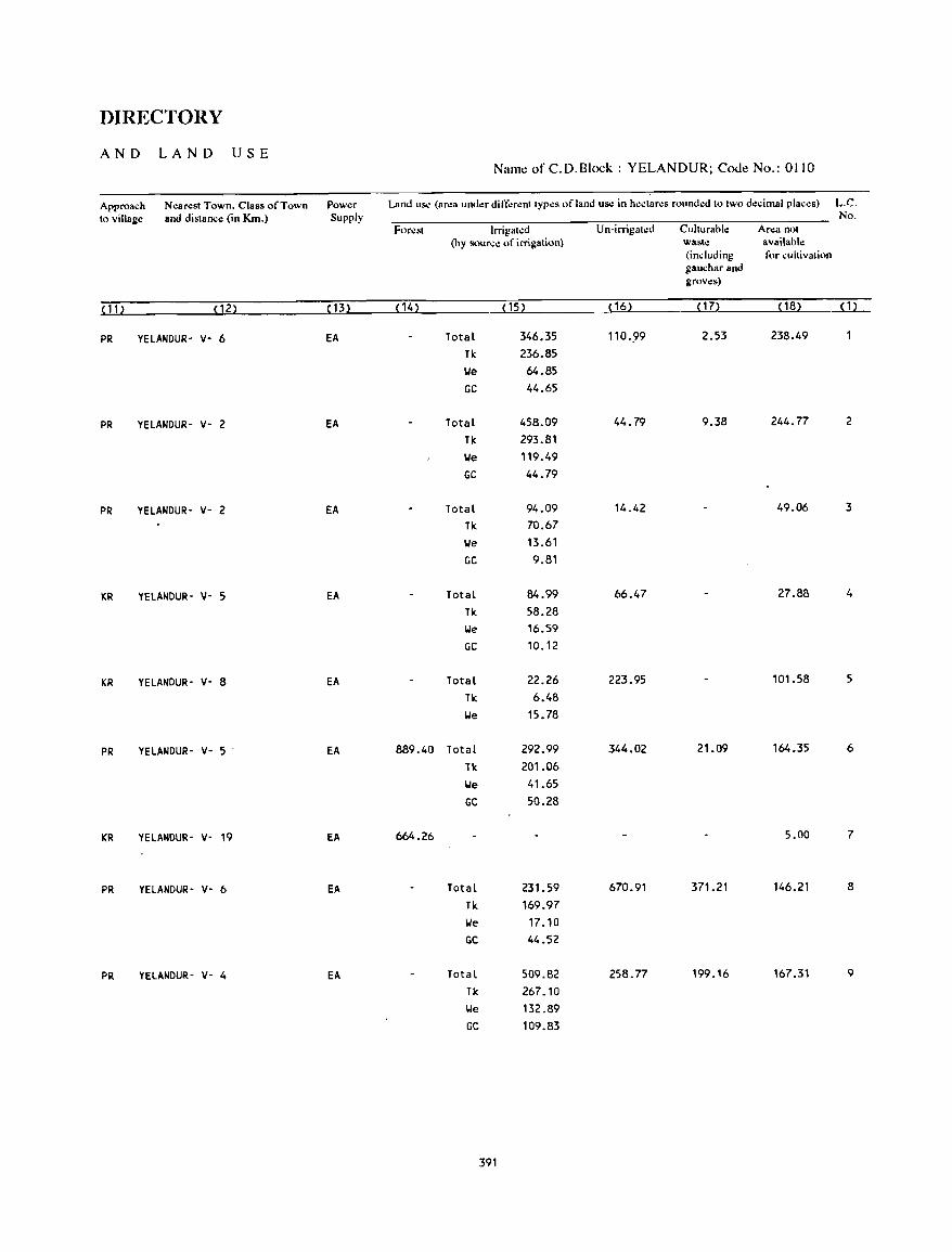
DIRECTORY
AND LAND USE Name of C.D.Block : YELANDUR; Code No.: 0110
Approa~h N<!arest Town. Class of Town Power Land US<! (area under different types of land use in hectares wunded to two d"cimal plac".) L.C. to village and distance (in Krn.) Supply No.
For".t Irrigat.:d Un-irrigat.:d Culturahle Area not (by sourc" of irrigalion) wasle availahle
(induding for cultivation gauchar and groves)
(11) (12) (13) (14) (15) ( 16) (17) ( 18) ( 1 )
PR YELANDUR- v- 6 EA Total 346.35 110·99 2.53 238.49
TI<. 236.85 IJe 64.85 GC 44.65
PR YELANDUR- v- 2 EA Total 458.09 44.79 9.38 244.77 2
TI<. 293.81 IJe 119.49 GC 44.79
PR YELANDUR- v- 2 EA Total 94.09 14.42 49_06 3
TIc 70.67 IJe 13.61 GC 9.81
KR YELANDUR- v- 5 EA Total 84.99 66.47 27.88 4
TI<. 58.28 IJe 16.59 GC 10.12
KR YELANDUR- V- 8 EA Total 22.26 223.95 101.58 5
TI<. 6.48 IJe 15.78
PR YELANDUR- V- 5 - EA 889.40 Total 292.99 344.02 21.09 164.35 6
TI<. 201.06 IJe 41.65 GC 50.28
KR YElANDUR- V- 19 EA 664.26 5.00 7
PR YELANDUR- V- 6 EA Total 231.59 670.91 371.21 146.21 8
TI<. 169.97 IJe 17.10 GC 44.52
PR YElANDUR- V- 4 EA Total 509.82 258.77 199.16 167.31 9
TI<. 267.10 IJe 132.89 GC 109.83
391
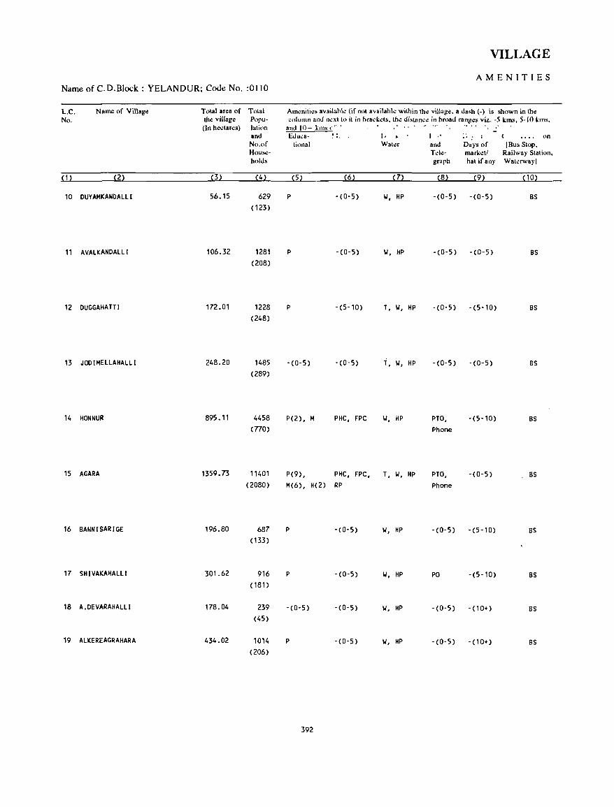
Name of C.D.Block : YELANDUR; Code No. :0110
L.C. No.
Name of Village
(2)
10 DUYAMKANDAlll
11 AVAlKANDALlI
12 DUGGAHA TT I
13 JOOIMELLAHALll
14 HONNUR
15 AGARA
16 BANNISARIGE
17 SHIVAKAHAlLI
18 A.DEVARAHALlI
19 ALKEREAGRAHARA
Total area of Total the village Popu-(In hectares) latinn
(3)
56.15
106.32
172.01
248.20
895.11
1359.73
196.80
301.62
178.04
434.02
and No.of Households
(4)
629 (123)
1281 (208)
1228 (248)
1485 (289)
4458 (770)
11401 (2080)
687 ( 133)
916 (181)
239 (45)
1014 (206)
VILLAGE
AMENITIES
Amenities availahle (if nnt availahle within the village. a dash (-) is shown in the column and next to it in brackets. the distance in Ilruad ranges viz. -5 kms. 5-10 kms.
and 10+ kills .. ·.. .... .' &1 , .. .: a·
tional Water
(5) (6) (7)
P -(0-5) 1.1, HP
P -(0-5) 1.1, HP
P -(5-10) T, 1.1, HP
-(0-5) -(0-5) i, \.I, HP
P(2), M PHC, FPC 1.1, HP
P(9), PHC, FPC, T, 1.1, HP M(6), H(2) RP
P -(0-5) 1.1, HP
P -(0-5) 1.1, HP
-(0-5) -(0-5) 1.1. HP
P -(0-5) 1.1, HP
392
I .' : , and Days of Tele- marketl graph hat ifany
(8) (9)
-(0-5) -(0-5)
-(0-5) '(0-5)
-(0-5) -(5-10)
-(0-5) -(0-5)
PTO, Phone
PTO, Phone
-(0-5)
PO
-(0-5)
- (0- 5)
-(5-10)
- (0-5)
-(5-10)
-(5-10)
-(10+)
-(10+)
... , on IBus Stop.
Railway Station. Waterway]
(10)
BS
BS
BS
BS
BS
BS
BS
BS
BS
BS
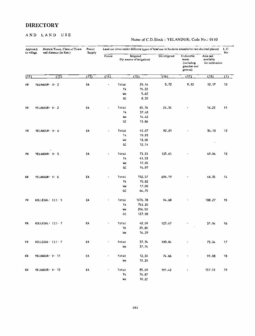
DIRECTORY
AND LAND USE Name of C.D.Block : YELANDUR; Code No.: 0110
Approach Nearest Town. Class of Town Powo:r Land us.: (ar.:a und.:r ditTerenl Iyp.:s of land use in h.:clan:s rounded 10 two d.:,;imal places) L.C. to village and distance (in Km.) Supply No
Forl!bI Irrigull!d Un-irrigall!d Culturabi.: Arl!a nol (by source of irrigation) wa~I': available
(induding for cultivation gaucharand groves)
< 11 ) (12) ( 13) (14) ( 15) ( 16) (17) (18) (1)
PR YElANDUR- V- 2 EA Total 29.14 5.72 9.12 12.17 10 Tk 15.22 We 5.62 GC 8.30
PR YElANDUR- v- 2 EA Total 65.76 24.34 16.22 11 Tk 37.48 We 14.42 GC 13.86
PR YElANDUR- V- 6 EA Total 45.07 92.81 34.13 12 Tk 19.93 We 13.00 GC 12.14
PR YELANDUR- V- 5 EA Total 73.55 125.61 49.04 13 Tk 41.53 We 17.05 GC 14.97
KR YElANDUR- V- 6 EA Total 152.57 696.19 46.35 14 Tk 70.82 We 17.00 GC 64.75
PR KOLLEGAl- 111- 5 EA Total 1076.78 94.68 188.27 15 Tk 743.20 We 206.50 GC 127.08
PR KOLLEGAL- 111- 7 EA. Total 42.09 123.67 31.04 16 Tk 25.80 We 16.29
PR KOLlEGAl- 111- 7 EA Total 37.74 190.84 73.04 17 We 37.74
KR YELANDUR- V- 11 EA Total 12.30 74.66 91.08 18 We 12.30
KR YELANDUR- V- 12 EA Total 85.09 191.42 157.51 19 Tk 74.87 We 10.22
393
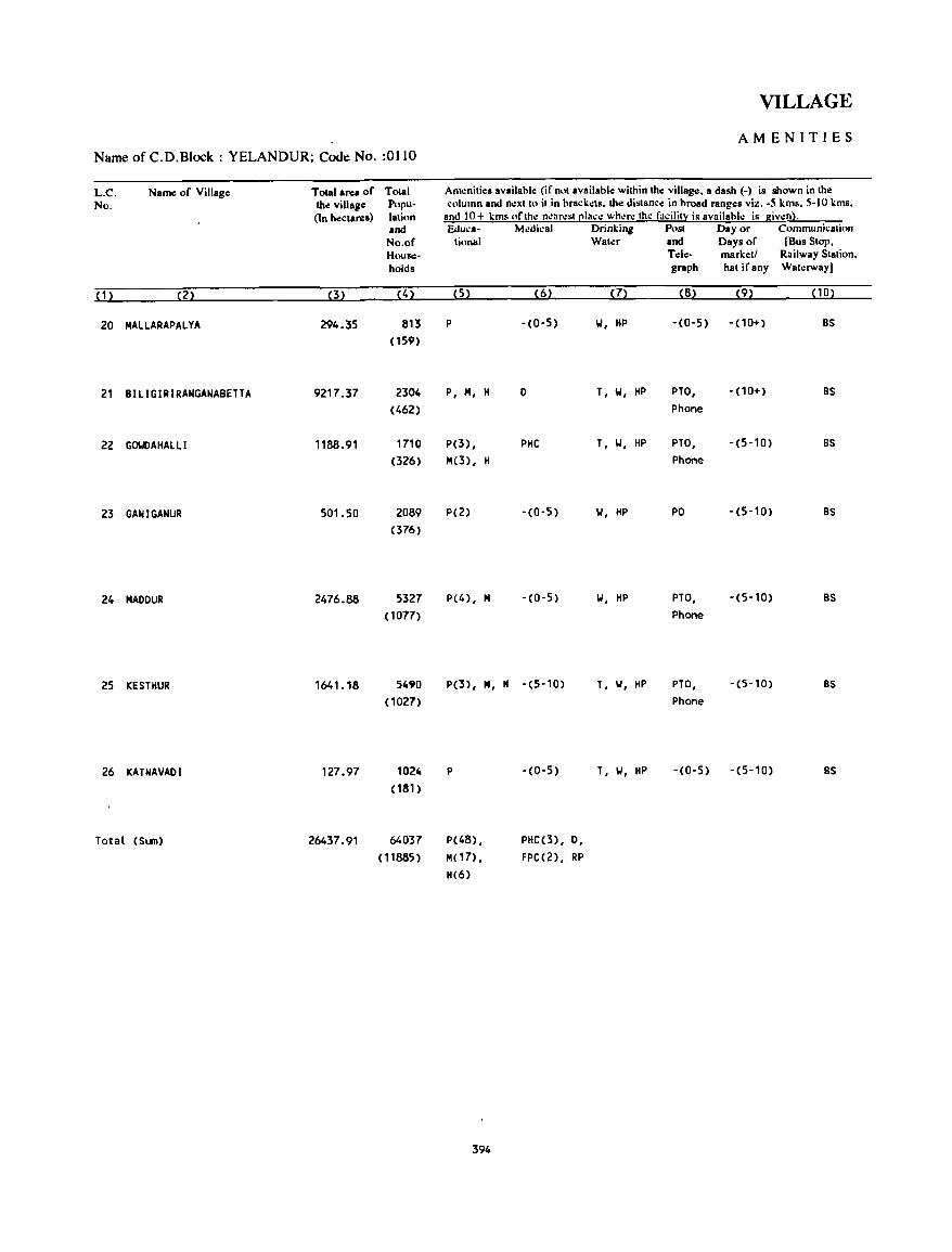
Name of C.D.Block : YELANDUR; Code No. :0110
L.C. No.
Name of Village
(1) (2)
20 MALlARAPALYA
21 BlllGIRIRANGANABETTA
22 GOWAIIAlll
23 GANI GANUR
24 MAOOUR
25 KESTIIUR
26 KATNAVAOI
Total (SlIn)
Total area of the village (1n hectares)
(3)
294.35
9217 .37
1188.91
501.50
2476.88
1641.18
127.97
26437.91
Total Population and No.of Households
(4)
813 (159)
2304 (462)
1710 (326)
2089 (376)
5327 (1077)
5490 (1027)
1024 (181 )
64037 (11885)
VILLAGE
AMENITIES
AI11.:nities available (if not available within the village, a dash (-) is shown in the column and n.:xtto it in brackets. the distance in broad rang.:s viz. -5 kms, 5-10 kms,
and 10+ kms of the n.:ar.:st place wher.: the facility is availabl.: is given). Educa- Medical Drinking Post Day or Communication
tional Water and Days of [Bus Stop,
(5) (6)
P -(0-5)
P, M, H 0
P(3) , PIIC M(3) , H
P(2) -(0-5)
P(4), M -(0-5)
P(3), M," -(5-10)
P -(0-5)
P(48) , M( 17) ,
11(6)
394
PIIC(3), 0,
FPC(2), RP
(7)
W, HP
T, W, liP
T, W, HP
W, liP
W, HP
T, W, liP
T, W, HP
Tele- market! Railway Station, graph hat ifany Wat.:rway)
(8) (9) (10)
-(0-5) -(10+) BS
PTO, -(10+) BS Phone
PTO, -(5-10) BS Phone
PO -(5-10) BS
PTO, -(5-10) BS Phone
PTO, -(5-10) BS Phone
-(0-5) -(5-10) BS
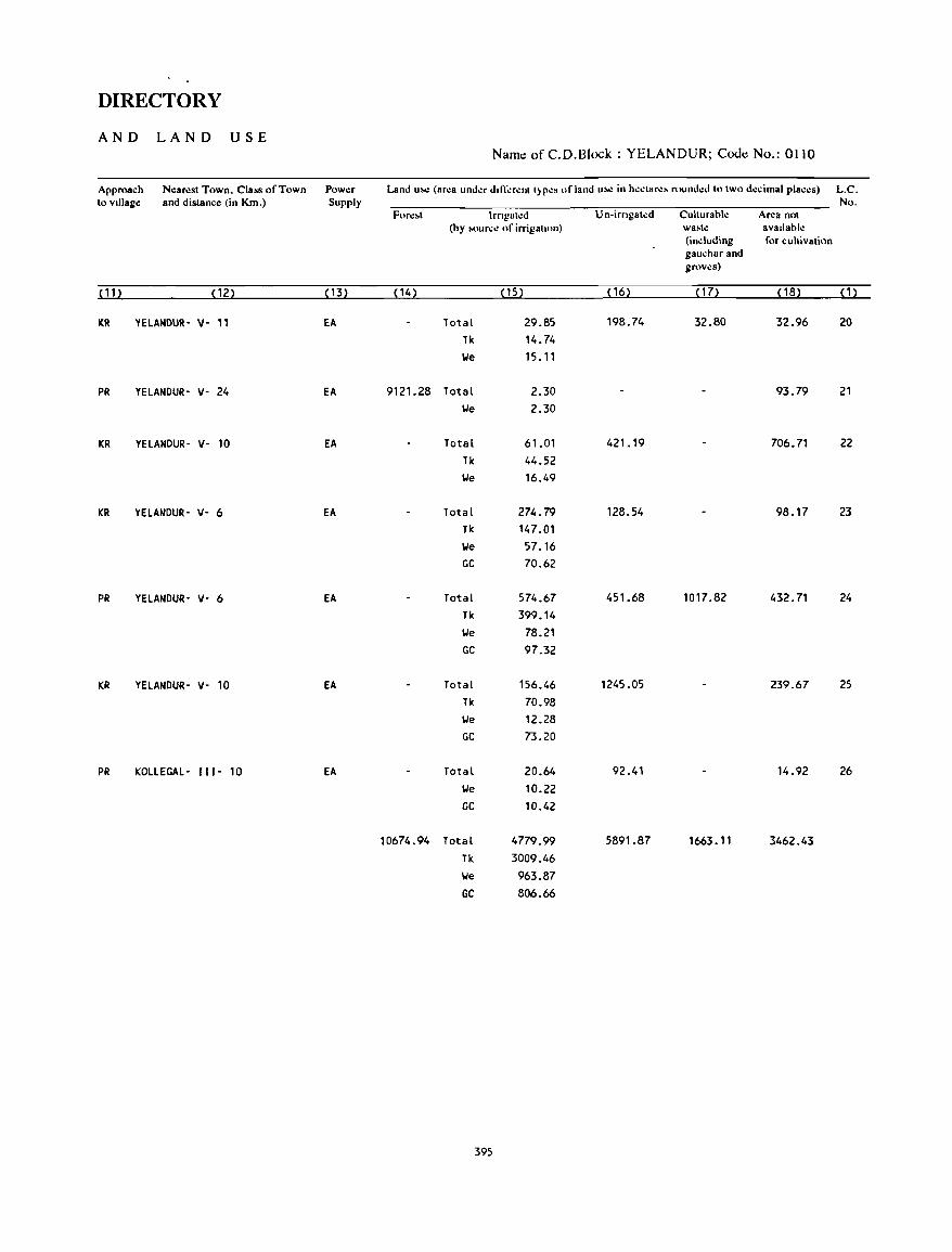
DIRECTORY
AND LAND USE Name of C.D.Block : YELANDUR; Cooe No.: 0110
Approach Nc:arc:st Town. Class of Town Power Land u~~ (ar~a und~r dln-':r~nt t)P~S of land u!><! in h~.:tar~~ round~d to two d~dmal pla.:.:s) L.C. to vIllage and distance (in KIn.) Supply No.
For~.t Irngal~d Un-irngated CuhurahI.: Area not (by MlUr.:.: of irrigalton) wa.tc: avallahl.:
(induding for cultivation gauchar and grov.:s)
(11) (12) ( 13) (14) (15) (16) ( 17) (18) (1)
ltR YELANDUR- v- 11 EA Total 29.85 198.74 32.80 32.96 20 Tk 14.74 \Ie 15.11
PR YELANDUR- v- 24 EA 9121.28 Total 2.30 93.79 21 \Ie 2.30
KR YELANDUR- v- 10 EA Total 61.01 421.19 706.71 22 Tk 44.52 \.Ie 16.49
KR YELANDUR- v- 6 EA Total 274.79 128.54 98.17 23 Tk 147.01 \Ie 57.16 GC 70.62
PR YELANDUR- V- 6 EA Total 574.67 451.68 1017.82 432.71 24 Tk 399.14 \.Ie 78.21 GC 97.32
KR YELANDUR- V- 10 EA Total 156.46 1245.05 239.67 25 Tk 70.98 \Ie 12.28 GC 73.20
PR KOLLEGAL- ( 11- 10 EA Total 20.64 92.41 14.92 26 \Ie 10.22 GC 10.42
10674.94 Total 4779.99 5891.87 1663.11 3462.43 Tk 3009.46 \Ie 963.87 GC 806.66
395

APPENDICES
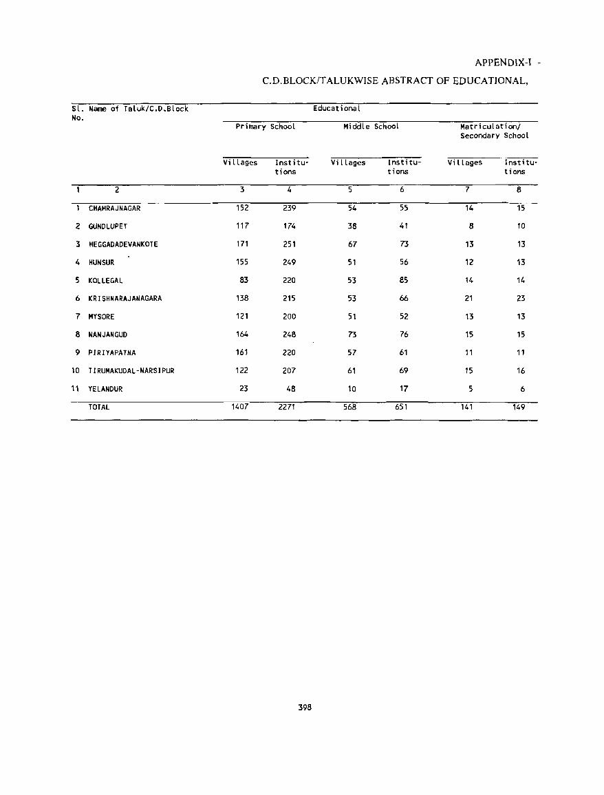
APPENDIX-I -
C.D.BLOCK/TALUKWISE ABSTRACT OF EDUCATIONAL,
Sl. Name of Taluk/C.D.Block Educational No.
Primary School Middle School Matriculation/ Secondary School
Vi llages Institu- Villages Institu- Villages Institu-tions tions tions
2 3 4 5 6 7 8
CHAMRAJNAGAR 152 239 54 55 14 15
2 GUNDLUPET 117 174 38 41 8 10
3 HEGGADADEVANKOTE 171 251 67 73 13 13
4 HUN SUR 155 249 51 56 12 13
5 KOLLEGAL 83 220 53 85 14 14
6 KRISHNARAJANAGARA 138 215 53 66 21 23
7 MYSORE 121 200 51 52 13 13
8 NANJANGUD 164 248 73 76 15 15
9 PIRIYAPATNA 161 220 57 61 11 11
10 TIRUMAKUDAL-NARSIPUR 122 207 61 69 15 16
11 YELANDUR 23 48 10 17 5 6
TOTAL 1407 2271 568 651 141 149
398
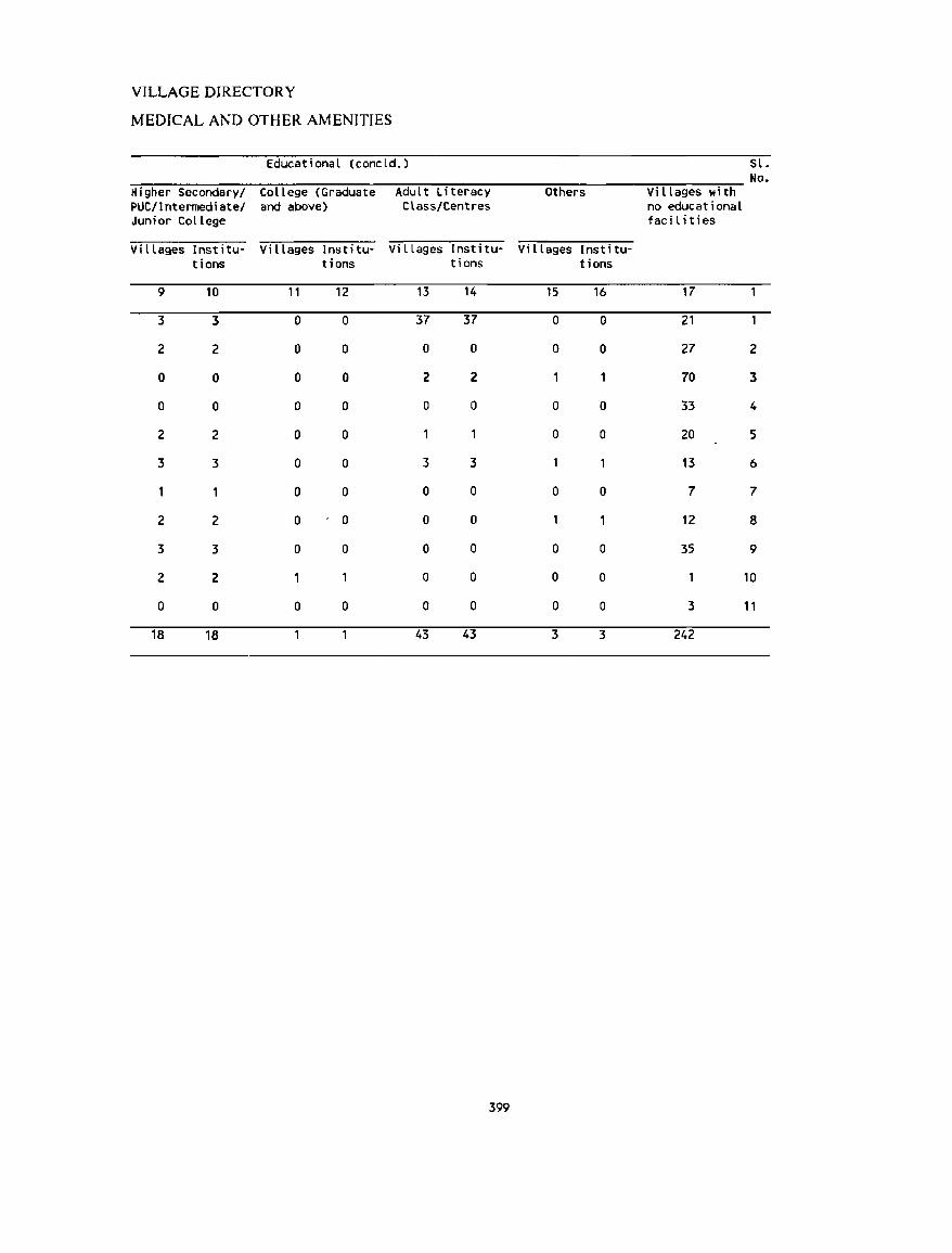
VILLAGE DIRECTORY
MEDICAL AND OTHER AMENITIES
Educational (concld.) Sl. No.
Higher Secondary! College (Graduate Adult Literacy Others Villages with PUC/Intermediate! and above) Class/Centres no educational Junior College facilities
Vi llages Institu· Villages Institu- Villages Institu- Villages Institu-tions tions tions tions
9 10 11 12 13 14 15 16 17
3 3 0 0 37 37 0 0 21
2 2 0 0 0 0 0 0 27 2
0 0 0 0 2 2 70 3
0 0 0 0 0 0 0 0 33 4
2 2 0 0 0 0 20 5
3 3 0 0 3 3 13 6
0 0 0 0 0 0 7 7
2 2 0 0 0 0 12 8
3 3 0 0 0 0 0 0 35 9
2 2 0 0 0 0 10
0 0 0 0 0 0 0 0 3 11
18 18 43 43 3 3 242
399
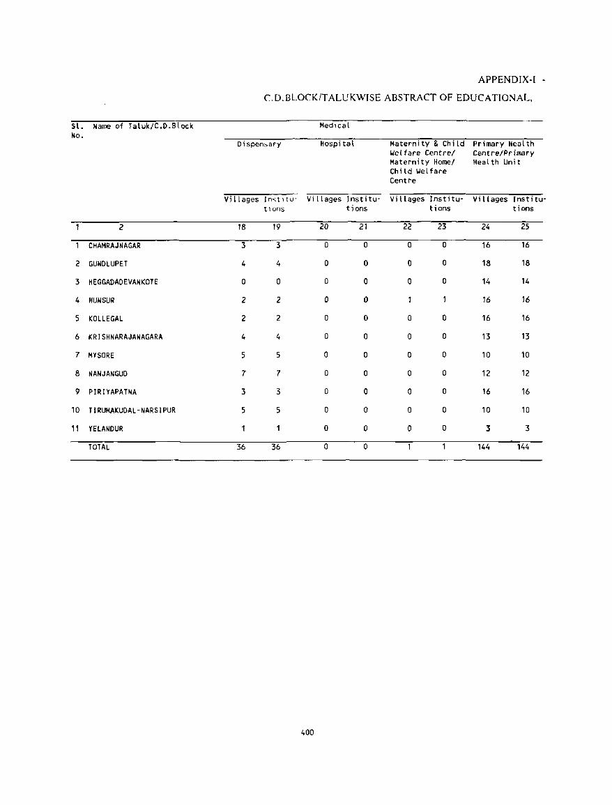
APPENDIX-I -
C.D.BLOCK/TALUKWISE ABSTRACT OF EDUCATIONAL,
Sl. Name of Tatuk/C.[).Slock Medical No.
Dispen~ary Hospital Maternity & Child Primary Health Welfare Centre/ Centre/Primary Maternity Homel Health Unit Child Welfare Centre
Vi llages Ino.;tl tu- Vi llages lnstitu- Villages Institu- Villages Institu· tlons tions tions tions
2 18 19 20 21 22 23 24 25
CHAMRAJNAGAR 3 3 0 0 0 0 16 16
2 GUNDLUPET 4 4 0 0 0 0 18 18
3 HEGGADADEVANKOTE 0 0 0 0 0 0 14 14
4 HUN SUR 2 2 0 0 16 16
5 KOLLEGAL 2 2 0 0 0 0 16 16
6 KRISHNARAJANAGARA 4 4 0 0 0 0 13 13
7 MYSORE 5 5 0 0 0 0 10 10
8 NANJANGUD 7 7 0 0 0 0 12 12
9 PIRIYAPATNA 3 3 0 0 0 0 16 16
10 TIRUMAKUDAL-NARSIPUR 5 5 0 0 0 0 10 10
11 YElANDUR 0 0 0 0 3 3
TOTAL 36 36 0 0 144 144
400
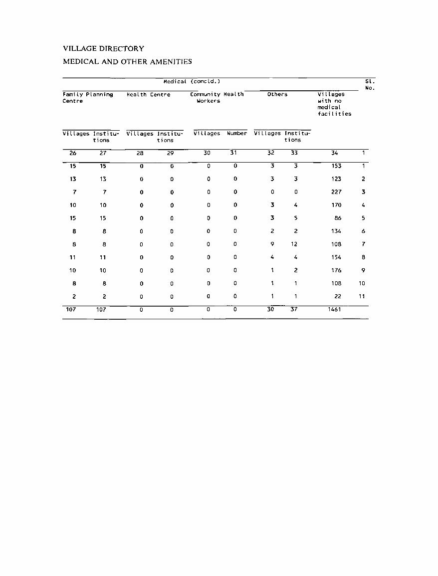
VILLAGE DIRECTORY
MEDICAL AND OTHER AMENITIES
Medical (concld. ) Sl. No.
Fami ly Planning Health Centre C OIIlTIun i tv Health Others Villages Centre Yorkers with no
medical faci l Hies
Villages Institu- Vi llages Institu- Villages Number Villages Institu-tions tions tions
26 27 28 29 30 31 32 33 34
15 15 0 0 0 0 3 3 153
13 13 0 0 0 0 3 3 123 2
7 7 0 0 0 0 0 0 227 3
10 10 0 0 0 0 3 4 170 4
15 15 0 0 0 0 3 5 86 5
8 8 0 0 0 0 2 2 134 6
8 8 0 0 0 0 9 12 108 7
11 , , 0 0 0 0 4 4 154 8
10 10 0 0 a a 2 176 9
8 8 0 0 a a 108 10
2 2 a 0 a 0 22 11
107 107 0 0 0 0 30 37 1461
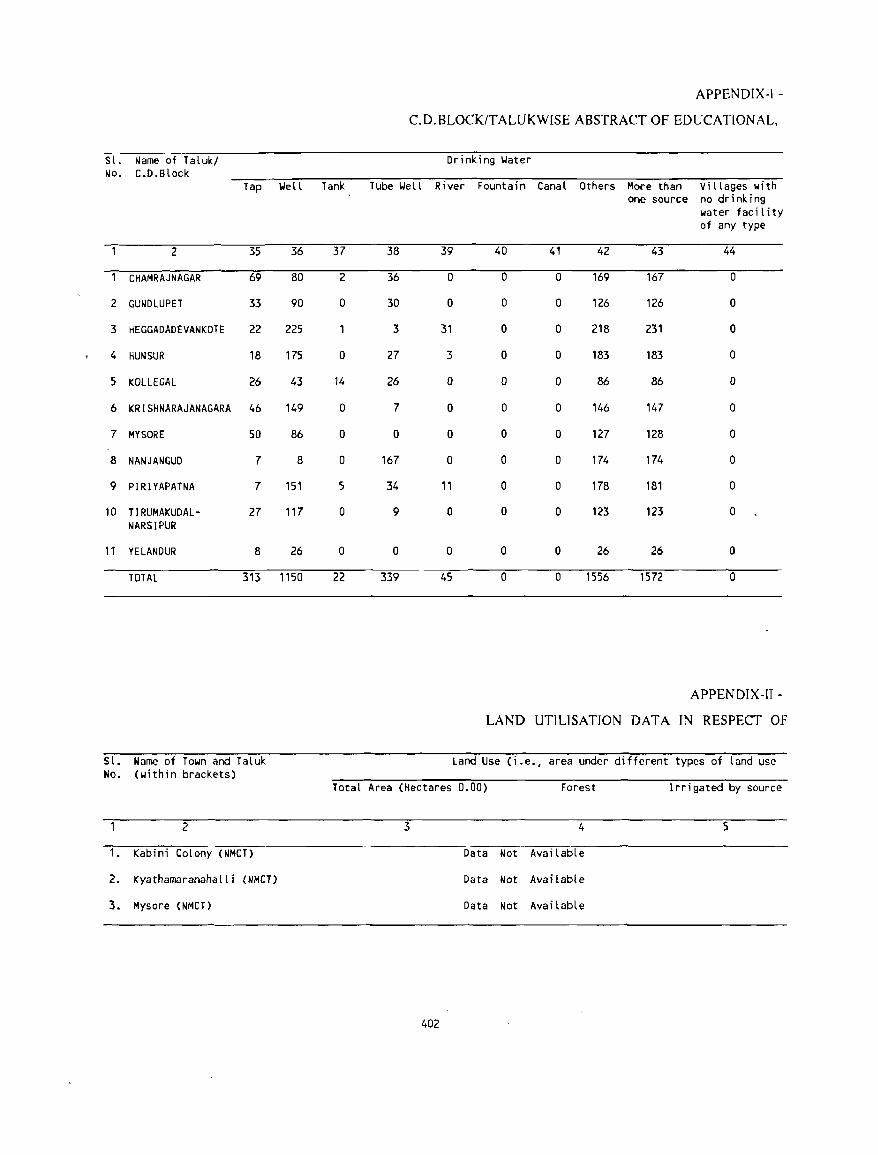
Sl. Name of Taluk/ No. C.D.Block
Tap
2 35
CHAMRAJNAGAR 69
2 GUNDLUPET 33
3 HEGGADADEVANKOTE 22
4 HUN SUR 18
5 KOLLEGAl 26
6 KRISHNARAJANAGARA 46
7 MYSORE 50
8 NANJANGUD 7
9 PIRIYAPATNA 7
10 rrRUMAKUDAl- 27 NARSIPUR
11 YElANDUR 8
TOTAL 313
Sl. Name of Town and Taluk No. (within brackets)
2
1. Kabini Colony (NMCT)
2. Kyathamaranahalli (NMCT)
3. Mysore CNMCT)
Well
36
80
90
225
175
43
149
86
8
151
117
26
1150
Tank
37
2
0
0
14
a
0
0
5
0
0
22
APPENDIX-! -
C.D.BLOCK/TALUKWISE ABSTRACT OF EDUCATIONAL,
Tube \.Iell
38
36
30
3
27
26
7
0
167
34
9
0
339
Drinking \.later
River
39
a
0
31
3
a
0
0
0
11
a
0
45
Fountain Canal Others Moce than Villages with one source no drinking
water facility of any type
40 41 42 43 44
0 0 169 167 0
0 0 126 126 0
0 0 218 231 0
0 0 183 183 0
a a 86 86 0
0 0 146 147 a
a 0 127 128 0
a a 174 174 a
a 0 178 181 a
a 0 123 123 0
0 0 26 26 0
0 a 1556 1572 0
APPENDIX-II -
LAND UTILISATION DATA IN RESPECT OF
land Use (i.e., area under different types of land use
Total Area (Hectares 0.00) Forest Irrigated by source
3 4 5
Data Not Available
Data Not Avai table
Data Not Available
402
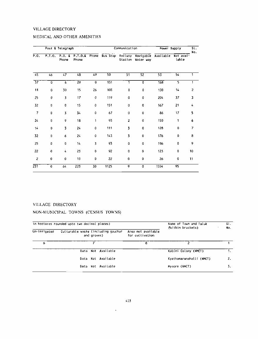
VILLAGE DIRECTORY
MEDICAL AND OTHER AMENITIES
Post & TeLegraph Comnuni cat ion
P.O. P. T.O. P.O. & P.T.O.& Phone Bus Stop RaiLway NavigabLe Phone Phone Station \.later way
45 46 47 48 49 50 51 52
37 0 6 29 0 131 0
11 0 30 15 26 103 0 0
25 0 3 17 0 119 0 0
32 0 0 15 0 151 0 0
7 0 3 34 0 67 0 0
24 0 9 18 93 2 0
14 0 3 24 0 111 3 0
32 0 6 24 0 143 3 0
25 0 0 14 3 93 0 0
22 0 4 23 0 92 0 0
2 0 0 10 0 22 0 0
231 0 64 223 30 1125 9 0
VILLAGE DIRECTORY
NON-MUNICIPAL TOWNS (CENSUS TOWNS)
in hectares rounded upto two decimaL places)
Power SuppLy SL. No.
Avai LabLe Not al/a;-
53
168
130
204
167
86
150
128
176
196
123
26
1554
Lable
54
5
14 2
37 3
21 4
17 5
6
0 7
0 8
0 9
0 10
0 11
95
Name of Town and TaLuk ~ithin brackets)
Un-irrigated CuLturabLe waste (including gauchar Area not available and groves) for cul til/ation
6 7 8 2
Data Not AvailabLe Kabini Colony (NMCT)
Data Not Available Kyathamaranahalli (NMCT)
Data Not AvailabLe Mysore (NMCT)
403
SL. No.
1.
2.
3.
APPE:\,DIX-III - VILLAGE DIRECTORY
LlST OF VILLAGES WIIERE NO AI\1ENITIES EXCEPT DRI]\. KI]'.;G W XI ER ARE AVAILABLE
Name of Taluk/c.::.-.Slock
CHAMRAJNAGAR
GUNDLUPET
HEGGADADEVANKOTE
HUN SUR
Sl.No.
2
1 2 3 4
1 2 3 4 5 6
1 2 3 4 5 6 7 8 9
10 11 12 13 14 15 16 17 18 19 20 21 22
1 2 3 4 5 6 7 8
Name of Vi llage
3
r;OMANAPURA THIMMEGO~DANAPALYA
KARADIHALLA KANIKERE
CHIKANI\PURA THODIPURA NARAYANAPURA MAIDANAHALLI LAKKIPURA BERAMBADI STATE FOREST
METIKUPPE FOREST METIKUPPEKAVAL BOMMALAPURA SOLLAPURA GUDUMANAHALLI CHOTNAHALLI ANKANAHALLI THOTAHI\LLI MALLAHALLI LAKKASOGE CHlllAHALLl HUN SUR JATAGATHIPURA ALANAHALLI INUR MARIGUDI JUNGLE SEEGAVADI KEBBEPURA ALAGANCHI HONNURKUPPE BADANAKUPPE BEGURJUNGlE GOLUR
DODDAKADANAHALL I MUDLAPURA HULAGANAHALLI MADAHALLI DODDAHEJJURKEREKAVAL BILlANAHOSAHALLI HABBANAKUPPE K.G SIRIYURUNALA
404
L .C. No.
4
79 126 184 185
61 81
105 122 148 153
11 12 21 25 44 74 94 96
102 155 156 166 172 187 188 191 194 203 240 244 261 263
48 72
H)9 143 149 158 159 182
APPENDIX-III - VILLAGE DIRECTORY
LIST OF VILLAGES WHERE NO AMENITIES EXCEPT DRINKING WATER ARE AVAILABLE
Name of Tatuk/C.D.Block SI.No. Name of Vi Ilage
2 3
KOLLE GAL 1 BELLAJJ BEAT 2 GUNDAL 'B' BEAT 3 KANNUR BEAT 4 LOKKANAHALLI WEST BEAT 5 AREPALYA BEAT 6 ELLEMALA BEAT 7 CAUVERY BEAT 8 COI,JDALL I BEA T 9 CHANNUR BEAT
10 KURAHA TT I HOSUR BEAT 11 HARTALLI 'A' BEAT 12 M.MALAI BEAT 13 PALAR BEAT 14 ALAMBADI BEAT 15 BIJJALANE'B' BEAT 16 PONNACHI BEAT 17 BIJJALANE 'A' BEAT
KRISHNARAJANAGARA KAPPADIHANTA
405
L.C. No.
4
94 96 97 98
100 102 112 119 120 121 122 130 133 135 137 138 140
35
APPENDIX-IV(A) - VILLAGE DIRECTORY
LIST OF VILLAGES ACCORDING TO PROPORTION OF SCHEDULED CASTES TO TOTAL POPULATION BY RANGES
Range of L.C. Name of vIllage L .C. Name of vIllage L.C. Name of vIllage Scheduled No. w No. Castes PopulatIon (Percentages)
2 3 4 5 6 7
C.D.BLOCK CHAMRAJNAGAR
o . 5 1 CHAMRAJNAGAR [R] 4 DODDAMOLE 8 MUDLAPURA 27 MASAGAPURA 38 HARADANAHALlI 40 BYADAMUDALU 55 LfNGANAPURA 59 VODDARAHALLI 74 KOTAGANAHALLI 75 HARAVE 77 NANJEDEVANAPURA 80 VEERANAPURA 85 UGANEDAHUNDI 100 MALEYUR 135 KANNEGALA
141 KESTHUR 143 MUDALA AGRAHARA 157 KODIMOLE 176 PUNAJANUR
6 . 10 39 BANDIGERE 48 BOMMANAHALLI 83 BADAGAlAPURA 86 KATHAVADY 87 KOTHALAVADY 94 KENGAKI 95 SAGADl 105 ARALlKATTE 113 GOVINDAVADY
127 MALMAlA 148 ALDUR
11 - 15 7 GALIPURA 14 MANAGANAHALLI 15 MUNACHANAHALLI 20 BENDARAVADY 21 BADANAGUPPE 24 MARIYALA 31 HANAHALll 43 VENKATAIAHNA CHATRA 52 YELACHAGERE 56 ARAKALAVADY 57 MANCHAGUNOlPURA 62 YERAGANHAlLI 66 YANAGAHALLl 71 HONNAHAlll 78 KALANAHUNOI 82 UDlGALA 90 THAMMADAHALLI 102 HIREBEGUR
116 GJLIPURA 117 BOODAMBALL I 133 KOTAMBALLI 134 HOMME 153 THELNUR
16 - 20 12 SHIVAPJRA 19 MUTHIGE 23 BEDARAPURA 32 YALAKKUR 33 MANGALA 34 MADAPURA 35 HANDARAKALLI 60 YENAGUMBA 63 MADALAVADY 64 KILAGERE 73 AMACHAVADY 101 KULAGANA
103 CHIKKABEGUR 118 IRASAVADY 144 UMMATHUR 156 CHANDAKAVADY 180 KUllURU 186 OOlLlPUR~
21 - 30 5 KARINANJANAPURA 6 SOMAVARPET 16 KATTEPURA 18 HEGGOTARA 26 KADAHALL I 28 KIRAGASUR 37 BOOD I TH I TTU 41 BASAVAPURA 42 ANKANASETTYPURA 50 BISALAVADY 53 VODDAGAlPURA 91 KETHAHALLI 99 MUDNAKODU 104 KEBBEPURA 115 KEMPANAPURA
132 RECHAMBALLI 136 SlNGANAPURA 137 DESHAVALLl 142 KUDERU 146 GANAGANUR 149 BAGALI 150 DEMAHALLl 151 KAMARAVADY 158 SARAGUR 160 ALUR 162 KAGALAVADY 164 NAGAVALL 1 166 JYOTHIGO~DANAPURA 171 lYYANAPURA 175 BEDAGUll 181 A TTUGULI PURA
31 + 3 BASAVA"APURA 9 MALLAINAPURA 10 UTHAVALLI 11 SANE GALA 13 YEDAPURA 17 SOMASAMUDRA 22 KELLAMBAlLl 29 BHOGAPJRA 30 SAPPAlAHNAPURA 36 KUDLUR 44 KODIUGANE 45 BEVINATHALAPURA 46 SRlRA~GAPURA 47 BASTHIPURA 51 CHANNAPPANAPURA 58 MUDALU HOSAHALLI 65 ACHATTIPURA 89 DEVALAPURA
106 K 1 LALI PURA 107 KEREHALLI 108 BHUJAGANAF'URA 109 HEGGAVADY 111 MUKKADAHALLI 114 SANTHEMARAHALLI
Note Exdudes vIllages wIth no Scheduled Castes PopulatIon.
406
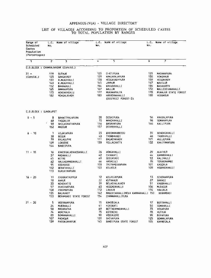
APPENDIX-IV(A) - VILLAGE DIRECTORY
LIST OF VILLAGES ACCORDING TO PROPORTION OF SCHEDULED CASTES TO TOTAL POPULATION BY RANGES
Range of L.C. Name of village L.C. Name of village L.C. Name of village Scheduled No. No. No. Castes Population (Percentages)
2 3 4 5 6 7
C.D.BLOCK CHAMRAJNAGAR (Concld. )
31 + 119 SUTHUR 120 CHATIPURA 121 MASANAPURA (Concld.) 123 GANGAVADY 129 NANJARAJAPURA 130 HONGANUR
131 H.MUKAHALLl 138 HEGGAVADYPURA 139 HEGGAVADY 140 K.MUKAHALLl 145 JANNUR 147 NAVI LUR 152 BANANALLI 154 KAVUDAVALLI 155 BASAVATTI 165 AMMANAPURA 167 NALLUR 172 MALlEDEVANAHALLI 173 HONDARABALU 177 MUKANAPALYA 178 PUNAJUR STATE FOREST 182 HONGALAVADY 183 HARADANAHALLI 188 HEBBASUR
(DISTRICT FOREST·2)
C.D.BLOCK GUNDLUPET
0-5 8 BAt-lNITHALAPURA 28 DESHIPURA 56 HAKKALAPURA 68 TAGGALUR 70 MANCHAHALLI 96 SOMANAPURA 98 SHILAVANTHAPURA 116 BASAVAPURA 146 KALLIPURA
152 MADDUR 157 DEVARAHALLl
6 . 10 1 VIJAYAPURA 23 BHEEMANABEEDU 35 BENDAGAHALLI 38 BEGUR 43 THONDAVADI 46 THORAVALLl 79 BYLAGUPPE 111 BALACHAVADY 121 HULLEPURA
129 LOKKERE 130 YELLACHATTI 132 KANIYANAPURA 144 BANDIPURA
11 - 15 16 KANDEGALADAHOSAHALLI 26 HONGAHALLI 29 ALATHUR 37 MADAHALLI 42 CHIKKATI 44 KAMARAHALLI 45 NITRE 49 SEEGAVADI 53 KALI HALLl 62 HALLADAMADAHALLI 66 HASAGULI 76 TERAKANAMBI 95 KOOASOGE 100 TRIYAMBIKAPURA 101 KAGGALA
102 BERATAHALLl 103 KELASUR 109 HOORADAHALLI 113 GURUVINAPURA
16 - 20 11 CHIKKATHUPPUR 12 KElASURPURA 13 SINDANAPURA 18 ANt-lUR 22 KUTHANUR 27 BARAGI 33 NEt-lEKATTE 39 BELACHALAVADY 51 KABBAHALLI 57 HUNSINAPURA 63 HEGGADAHALLI 106 MUDAGUR
108 PARAMAPURA 112 lAKKUR 114 HANGALA 135 BALAVADY 142 MAGUVINAHALLIMElA KAMANAHALLl 150 BERAMBADI 153 BERAMBADI STATE FOREST 154 CHANNAMALLIPURA
21 - 30 5 VEERANAPURA 15 KANDEGALA 17 BETTAHALLl 24 MUKAHALLI 41 HIRIKATI 50 SOMAHALLI 58 MADAPATNA 69 BETTADAMADAHALll 73 HOSAPURA 74 HOREYALA 75 KOTEKERE 78 HUTTUR 83 BOMMANAHAllI 90 VODDAGERE 99 DEPAPURA
107 PADAGUR 120 SHIVAPURA 125 BOMMALAPURA 139 PASSAIANAPUR 145 BANDIPURA STATE FOREST 155 KANNE GALA
407
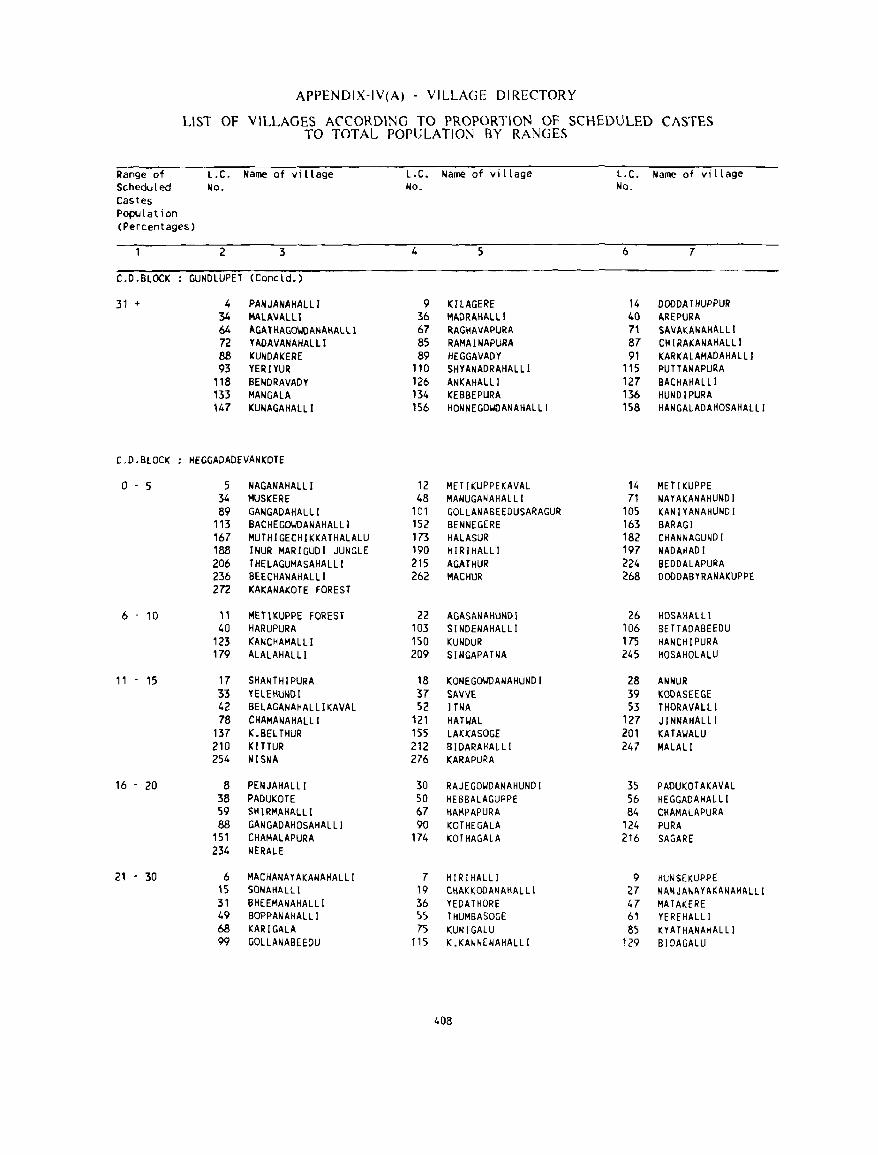
APPENDIX-IV(A) - VILLAGE DIRECTORY
LlST OF VILLAGES ACCORDING TO PROPORTION OF SCHEDULED CASTES TO TOTAL POPULATION BY RANGES
Range of L.C. Name of village l.C. Name of village L.C. Name of village Scheduled No. No. No. Castes Population (Percentages)
2 3 4 5 6 7
C.D.BLOCK GUNDlUPET (Cone ld.)
31 + 4 PANJANAHAllI 9 KIlAGERE 14 DODDATHUPPUR 34 MAlAVAlLl 36 MAORAHAlLl 40 AREPURA 64 AGAlHAGO~DANAHAlLl 67 RAGHAVAPURA 71 SAVAKANAHAlll 72 YADAVANAHAlLl 85 RAMAINAPURA 87 CII I RAKANAHAl Ll 88 KUNDAKERE 89 HEGGAVADY 91 KARKAlAMADAHAllI 93 YERIYUR 110 SHYANADRAHAlLl 115 PUTT ANAPURA
118 BENDRAVADY 126 ANKAHAlLI 127 BACHAHALLI 133 MAN GALA 134 KEBBEPURA 136 HUNDIPURA 147 KUNAGAIIALLI 156 HONNEGOUDANAIIALLI 158 HANGAlADAHOSAHAlLI
CD.BLOCK HEGGADADEVANKOTE
0-5 5 NAGANAHALLI 12 MET I KUPPEKAVAL 14 METlKUPPE 34 MUSKERE 48 MANUGANAHALLI 71 NAYAKANAHUNDI 89 GANGADAHAlLI 101 GOLLANABEEDUSAR:AGUR: 105 KANIYANAHUNDI
113 BACHEGOUDANAHALLI 152 BENNEGERE 163 BARAGI 167 MUTHIGECHIKKATHALALU 173 HAlASUR 182 CHANNAGUNDI 188 INUR MAR:IGUDI JUNGLE 190 HIRIHALLI 197 NADAHAD I 206 THELAGUMASAHALLI 215 AGATHUR 224 BEDDAlAPURA 236 BEECHANAHALLI 262 MACHUR 268 DODDABYRANAKUPPE 272 KAKANAKOTE FOREST
6 - 10 "
METIKUPPE FOREST 22 AGASANAHUNDI 26 HOSAHALLl 40 HARUPURA 103 SINDENAHALLI 106 BE TT ADABEEDU
123 KANCHAMALll 150 KUNDUR 175 HANCHIPURA 179 ALALAHAllI 209 SINGAPAHIA 245 HOSAHOLAlU
11 - 15 17 SHANTHlPURA 18 KONEGOUDANAHUNDI 28 ANNUR: 33 YElEHUNDl 37 SAVVE 39 KODASEEGE 42 BELAGANAHALllKAVAl 52 lTNA 53 THORAVAlLl 78 CHAMANAHAlLI 121 HATI.IAL 127 J I NNAHALLI
137 K.BELrHUR 155 lAKKASOGE 201 KATAUALU 210 KITTUR 212 BIDARAKALlI 247 MAlAlI 254 toIISNA 276 KARAPURA
16 - 20 8 PENJAHAlLI 30 RAJEGOUDANAHUNDI 35 PAOUKOTAKAVAl 38 PADUKOTE 50 HEBBALAGUPPE 56 HEGGAOAHALLI 59 SH IRMAHALLI 67 HAMPAPURA 84 CHAMALAPURA 88 GANGADAHOSAHALLI 90 KOTHE GALA 124 PUR A
151 CHAMALAPURA 174 KOTHAGALA 216 SAGARE 234 NERALE
21 - 30 6 MACHANAYAKANAHALlI 7 HIRIHALLI 9 HUNSEKUPPE 15 SONAHALLI 19 CHAI:KOOANAHALL I 27 NANJANAYAKANAHALLI 31 BHEEMANAHALLI 36 YEDATHORE 47 MAT AKERE 49 BOPPANAHALLI 55 THUMBASOGE 61 YEREHALLI 68 KARIGALA 75 KUNIGALU 85 KYAT HANAHAL LI 99 GOLlANABEEDU 115 K.KANNENAHALLI 129 BIDAGALU
408
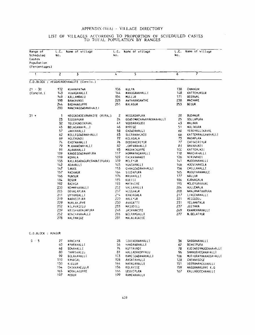
APPENDI\-IV(i\) - VILLAGE DIRECTORY
LIST OF VILLAGES ACCORDING TO PROPORTION OF SCHEDULED CASTES TO TOTAL POPULATION BY RANGES
Range of Scheduled Castes Population (Percentages)
L.C. Name of village No.
L.C. Name of village No.
2 3 4
C.D.BLOCK HEGGADADEVANKOTE (Concld.)
21 - 30 (Concld. )
31 +
C.D.BLOCK
0-5
132 KUNNAPATNA 136 143 HUNAGAHALLI 144 149 KALLAMBALU 154 198 SANKAVADI 228 244 BADANAKUPPE 251 280 MANCHAGO~DANAHAlLI
1 HEGGADADEVANAKOTE (RURAL) 2 23 S[OOAPURA 24 32 YElEHUNOIKAVAl 41 45 BELAGANAHALLI 46 57 JAKKAHALLI 58 62 KOlLEGOWDANAHALll 63 69 HOlEHUNOI 72 74 CHOTNAHALLI 76 79 M.KANNENAHALLI 82 91 AlANAHAlLr 93
109 KANDEGOWDANAPURA 117 119 KOHALA 122 133 KAlLASARAGUR(SHANTIPURA) 139 142 ADAHALLI 145 147 lANKE 153 157 HADANUR 164 166 HUNSUR 176 184 BEGUR 185 192 BAOAGA 193 200 NEMMANAHALLr 202 205 DEVALAPURA 207 211 UnAMBALLI 214 219 NARASIPURA 220 229 NURLAKUPPE 230 232 NILAVAGILU 233 239 KRISHNARAJAPURA 248 252 KENCHANAHALLI 255 278 HALEMAGGE 281
HUN SUR
27 HANCHYA 28 40 AYARAHALU 56 68 SONAHALLI 74 80 THARIKALLU 81 99 BOLANAHALLI 103
110 KANAGAL 126 130 KUOLUR 144 154 CHIKKAHEJJUR 156 165 NERALAKUPPE 166 197 MODUR 199
5
KULYA MANUGANAHALlJ MULLUR ANTHARASANTHE KALASUR
HEGGADAPURA GOWOIMACHANAYAKANAHALLI VOOOARAGUO I HYRIGE CHOWDAHALL I SEERANAHUNDI KOLAGALA OODDAKERrVUR JOMPANAHALLI MASANIKUPPE HOMMARAGAHALLJ 0\ 1 KK t.Nt.ND 1 MOLEYUR \\UNSAHALLI CHANGOWDANAHALlI SIOOAPURA MASAHALU KUDIGI MATAKERE VALLAHALLI HEGGANUR KANDAGALA HALEYUR ANAGA TT I MAGUDILU JAGANAKOTE BEERAMBALLI MALALAGADDE
-:'OVINOANAHALLI hANDANAHALLI KUTTAVADI HALLADAKOPPALU KAMEGOIJDANAHAllI ANGATAHALLI HARALAHALLI KOLAVIGE UDUVEPURA RAMENAHALLI
409
L.C. Name of village 1010.
6
138 148 171 238 253
20 25 43 51 60 66 73 77 83
100 118 126 141 146 156 165 177 186 195 204 208 217 221 231 237 249 277
36 62 78 96
106 128 151 159 167
7
CHAKKUR KATTEHUNSUR BEER\JAL MACHARE SEGUR
BUDANUR SOLLAPURA MALARA HULIKURA YEREHALLIKAVAL KATTEMANUGANAHALLI MADAPuRA CH I KKER J YUR BANNAVADI KATTEHUNDI MARCHAHALLI IlIRINANDl MUDDANAHAlLI HOOVINAKOlA CHILLAHAlll MUGUTHANAMULE NALLUR KURNAGALA MOLEYURKAVAL HULLEMALA NANJANATHAPURA LINGENAHAlLI HEGGUDLU YELAMATHUR JEEYARA KANAKANAHA L LI N.BELATHUR
SABBANAHAlL! BENKIPURA KUDINEERMUDDANAHALLI SHANUBHOGANAHALLI MUTHURAVANAHOSAHALLI CHENNASOGE VEERANAHOSAHALLI HABBANAKUPPE K.G KALLABOOCHAHALLI
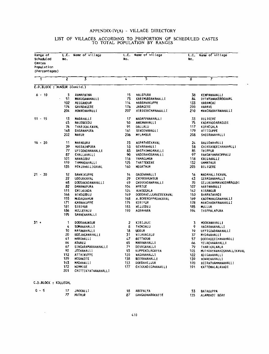
APPENDlX-IV(A) - VILLAGE DIRECTORY
LIST OF VILLAGES ACCORDING TO PROPORTION OF SCHEDULED CASTES TO TOTAL POPULATION BY RANGES
Range of L.C. Name of village L.C. Name of village l.C. Name of vi llage Scheduled No. tlo. ~o. CaStes Population (Percentages)
2 3 4 5 6 7
C.D.BLOCK HUNSUR (Concld.)
6 - 10 5 RAMAPATNA 15 HALEPURA 38 KEMPANAHALLI 51 MANUGANAHALLI 73 KARIMUDDANAHALLI 84 DYTHYANAKEREKAVAL
102 HEGGAHDUR 114 HABBANAKUPPE 133 VARANCHI 174 GAVADAGERE 176 JABAGERE 200 HARAVE 204 HONNENAHALLI 207 HIRIKYATHANAHAlll 210 MANCHABAYANAHAllI
11 - 15 13 MADAHAlL! 17 NADAPPANAHALI. I 33 BILIKERE 45 HAlEBEEDU 50 ANKANAHALLI 75 KADAVADDARAGUD I 76 THARIICALKAVAL 91 DALLALU 117 ICOTHEGALA
148 OASANAPURA 161 SINDENAHAlLI 179 ATTIGUPPE 202 MARUR 206 MYLAMBUR 208 SHEERANAHALLI
16 0 20 11 MARADURU 23 ASPATHREKAVAL 24 BALLENAHALLI 39 HUSSAINPURA S3 DEVARAHALll 58 CHI KKABEECHANAHALL I 77 UY I GONDANAHALLI 83 BASTHIMADAHAlLi 85 THIPPUR 87 CHALLAHALLI 90 VADERAHOSAHAlLI 97 RA~GAYANAKOPPAlU
101 HANAGOOU 116 YAMAGUMBA 118 KAlLAHALlI 119 THMMADAHALLI 125 THATTEKERE 132 UMMATHUR 135 PENJAHALllKAVAl 160 NEGATHUR 205 BHIGERE
21 - 30 12 BANNIKUPPE 14 GAGENAHALLI 16 MADAHALLIKAVAL 22 UDDURKAVAl 29 CHIKKAHUNSUR 43 GERASANAHAlll 48 DOODAKADANAHALLI 49 CHIKKADANAHALlI 70 GEJJAIAHNAVADDARAGUDI 82 DHARMAPURA 104 HYRIGE 107 HAR I NAHALLI
111 CtUlKUNDA 124 HUNSEGALA 142 KIRANGUR 146 HINDGODLU 149 DODDAHEJJURKEREKAVAl 150 BHARATHVAOI 155 HUDAGANNUR 168 H.BOREROPPADAKAVAL 169 KADEHANUGANAHALlI 171 KARNAKUPPE 175 KERIYUR 178 MANCHABAYANAHAlll 181 SIRIYUR 183 HEJJOOLU 185 MULLUR 186 HUllEYALU 190 AGRAHARA 194 THIPPALAPURA 195 SANNENAHALLI
31 + 1 DOODAHUNSUR 2 KIR!JAJ! 3 MOOKANAHALLI 4 SOMANAHAL LI 8 THONDALU 9 HAGARANAHALLI
10 RAYANAHALLI 18 UDOUR 19 un I GO'.JDANAHALlI 20 BEEJAGANAHALLI 31 NILAVAG!LU 37 MYDANAHALLI 41 HAROHAlLI 47 BETTAOUR 57 DODDABEECHANAHAlll 64 AS'.JAlU 65 MARANAHALL! 66 YELACHANAHALLI 67 SINGARAMARANAHALLI 71 DEVAGAHALLI 79 THARIKALNALA 92 JEENAHALLl 93 KUPPEKOLAGATTA 105 MUTHRAYANAHOSAHALlIKAVAL
"2 A'TIHIKUPPE 120 NAGANAHALll 122 ADIGANAHALLI 129 HOSAKOTE 138 BEERANAHALLI 139 HONNENAHAlLI 143 MADAHALL! 153 DODDAHEJJUR 170 BEERATHAMMANAHAlLJ 172 HEMMIGE 177 CHIKKADIGANAHAlLI 191 KA TTEMALALAVAD I 201 CHITTIKYATNANAHALLI
Coo.BLOCK KOlLEGAL
0 0 5 17 JAICKALL I 18 AREPALYA 53 BATAGUPPA 77 IIUTIIUR 87 GANGADHARAKA HE 135 ALAHSADI BEAT
410
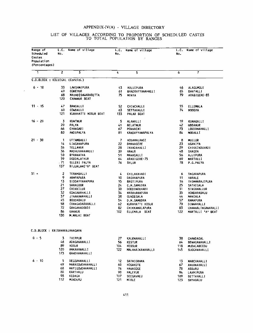
APPENDIX-IV(A) - VILLAGE DIRECTORY
LIST OF VILLAGES ACCORDING TO PROPORTION OF SCHEDULED CASTES TO TOTAL POPULATION BY RANGES
Range of l.C. Name of village l.C. Name of vi llage L.C. Name of vi llage Scheduled No. No. No. Castes Population {Percentages}
2 3 4 5 6 7
C.D.BLOCK KOLLE GAL {Concld.}
6 - 10 33 LAKSHMIPURA 43 HULLEPURA 46 ALAGUMOLE 49 GOREYUR 61 BHADRAYYANAHALLI 65 DANTALLI 68 MAHADESHYARABETTA 75 MINYA 79 ARABIGERE-85
120 CHANNUR BEAT
11 - 15 47 BANDALLI 52 CHINCHALLI 55 ELLEMALA 60 COI.'OALLI 63 SETTAHALLI 74 HOOGYA
121 KURAHATTI HOSUR BEAT 133 PALAR BEAT
16 - 20 3 f((JNTHUR 5 ALAHALLI 19 KUNAGALLI 20 PAlYA 41 8ElATHUR 42 UDDANUR 66 CHANGADI 67 PONNACHI 73 LOKKANAHALLI 80 ANDIPALYA 81 KANDAYYANAPALYA 84 MOOALLI
21 - 30 1 UTTAMBALLl 7 HOSAMALANGI 8 MULLUR 14 LINGANAPURA 22 DHANAGERE 23 UGANIYA 26 TELLANUR 28 IKKADAHALLI 29 CHIKKINDUVADI 36 MAD HUVANAHALLI 39 HANUR 48 SHAGYA 50 BYRANATHA 51 MANAGALLI 56 AJJIPURA 59 DOODALATHUR 64 ARABIGERE·75 69 MARTALLI
. 71 SULERI PALYA 76 BYLUR 78 P.G.PALYA 137 BIJJALANE'B' BEAT
31 + 2 TERAMBALLI 4 CHILAKAVADI 6 TAGARAPURA 9 HAMPAPURA 10 DASANAPURA 11 HARALE
13 SIDDAYYANAPURA 15 BASTIPURA 16 THIMMARAJIPURA 21 SARAGOOR 24 C.M.SAMUDRA 25 SATHEGALA 27 CHIKKILUR 30 DODDINDUVADI 31 SINGANALLUR 32 KONGARAHALLI 34 HARAVANAPURA 35 HONDARABALU 37 J I NAKANAHALLI 38 GUNDEGALA 44 MAN GALA 45 BOODABALU 54 D.M.SAMUDRA 57 RAMAPURA 58 CHANGADARAHALLI 62 KURAHA TT I HOSUR 70 DINNAHALLI 72 GANGANADODDI 82 CHIKKAMALAPURA 83 CHANNALINGANAHALLI 86 KANNUR 102 ELLEMALA BEAT 122 MARTALLI 'A' BEAT
130 M.MALAI BEAT
C.D.BLOCK KRISHNARAJANAGARA
0-5 3 THIPPUR 27 KALENAHALLI 38 CHANDAGAL 46 ADAGANAHALli 56 KESTUR 64 BENAGANAHALLI 89 HOSUR 104 HEBSUR 118 MUDALABEEDU
120 ANKANAHALlI 122 MALANAIKANAHALlI 145 SUGGANAHAlll 173 GANDHANAHALLI
6 - 10 5 DEGGANAHALLI 12 SATHIGRAMA 13 MARCHAHALLI 49 MARAGOWOANAHALLI 60 HQSAKOTE 67 ANKANAHALLI 68 MAYIGOWOANAHALLI 76 HANASOGE 78 ABBURU 80 KARTHALU 90 HALEYUR 94 LAXMlPURA 98 KEDAGA 107 SEEGAVALU 109 BETTAHALLI
112 MUNDURU 121 MIRLE 123 SHYABALU
411
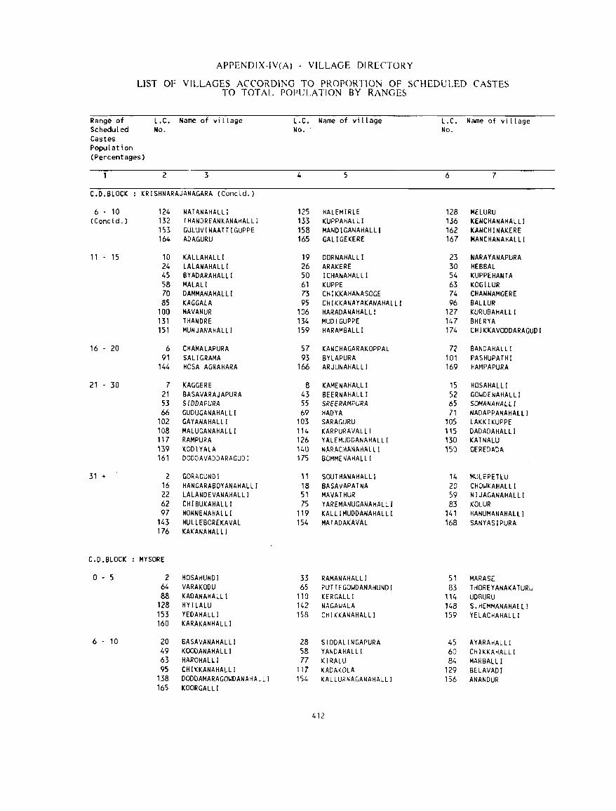
APPENDIX-IV(A) - VILLAGE DIRECTORY
LIST OF VILLAGES ACCORDI],;G TO PROPORTION OF SCHEDULED CASTES TO TOTAL POPULATION BY RANGES
Range of L.C. Name of vi llage L.C. Name of village L.C. Name of village Scheduled No. No. No. Castes Population (Percentages)
2 3 4 5 6 7
C.D.BLOCK KRISHNARAJANAGARA (Concld. )
6 . 10 124 NATANAHALLI 125 HALEMIRLE 128 MELURU (Cone l d. ) 132 TKANDREANKANAHALLI 133 KUPPAHALLI 136 KENCHANAHALLI
153 GULUVINAATTIGUPPE 158 MANDIGANAHALLl 162 KANCHINAKERE 164 ADAGURU 165 GALIGEKERE 167 MANCHANAHALLI
11 - 15 10 KALLAHALLI 19 DORNAHALLI 23 NARAYANAPURA 24 LALANAHALLI 26 ARAKERE 30 HEBBAL 45 BYADARAHALLI 50 I CHANA HAL LI 54 KUPPEHANTA 58 MALALI 61 KUPPE 63 KOGILUR 70 DAMMANAHALLI 73 CHIKKAHANASOGE 74 CHANNAMGERE 85 KAGGAlA 95 CHIKKANAYAKANAHALlI 96 BAlLUR
100 MAVANUR 106 HARADANAHALLI 127 KURUBAHAlLI 131 THANDRE 134 MUDIGUPPE 147 BHERYA 151 MUNJANAHALLI 159 HARAMBALLI 174 CHI KKAVODDARAGUD I
16 - 20 6 CHAMALAPURA 57 KANCHAGARAKOPPAL 72 BANDA HAL LI 91 SALIGRAMA 93 BYLAPURA 101 PASHUPATHI
144 HOSA AGRAHARA 166 ARJUNAHALLI 169 HAMPAPURA
21 - 30 7 KAGGERE 8 KAMENAHALLI 15 HOSAHALLI 21 BASAVARAJAPURA 43 BEERNAHALLI 52 GOIJDENAHAlLI 53 SIDDAPURA 55 SREERAMPURA 65 SOMANAHALLI 66 GUDUGANAHALLI 69 HADYA 71 NADAPPANAHALLI
102 GAYANAHALLI 103 SARA GURU 105 LAKKIKUPPE 108 MALUGANAHALLI 114 KARPURAVALLI 115 DADADAHAlLI 117 RAMPURA 126 YALEMUDDANAHALLI 130 KATNALU 139 KODIYALA 140 NARACHANAHALLI 150 GEREDADA 161 DODDAVADDARAGUDI 175 BOMMENAHALLI
31 + 2 GORAGUNDI 11 SOUTHANAHALLl 14 MULEPETlU 16 HANGARABOYANAHALLI 18 BASAVAPATNA 20 CHOIJKAHALLI 22 LALANDEVANAHALLI 51 MAVATHUR 59 NIJAGANAHALLI 62 CHIBUKAHAlll 75 YAREMANUGANAHAlLI 83 KOlUR 97 HONNENAHALLI 119 KALlIMUDDANAHALLI 141 HANUMANAHALLI
143 HULLEBOREKAVAL 154 MATADAKAVAL 168 SANYASIPURA 176 KAKANAHALLI
C.D.BLOCK MYSORE
0-5 2 HOSAHUNDI 33 RAMANAHAL LI 51 MARASE 64 VARAKODU 65 PUTTEGOIJDANAHUNDI 83 THOREYANAKATURU 88 KADANAHALL! 1'0 KERGALLI 114 UDSURU
128 HYILAlU 142 NAGAIJALA 148 S.HEMMANAHAlll 153 YEDAHALLI 158 CHIKKANAHALLI 159 YE LACHAHAL LI 160 KARAKANHALLI
6 - 10 20 BASAVANAHAlLI 28 SIDDALINGAPURA 45 AYARAHALLI 49 KOODANAHALLI 58 YANDAHALLI 60 CH I KKAHALLI 63 HAROHALLI 77 KIRALU 84 MARBALLI 95 CHIKKANAHALLI 117 KADAKOLA 129 BElAVADI
138 DODDAMARAGO~DANAHALLI 154 KALLURNAGANAHALlI 156 ANANDUR 165 KOORGAlLl
412
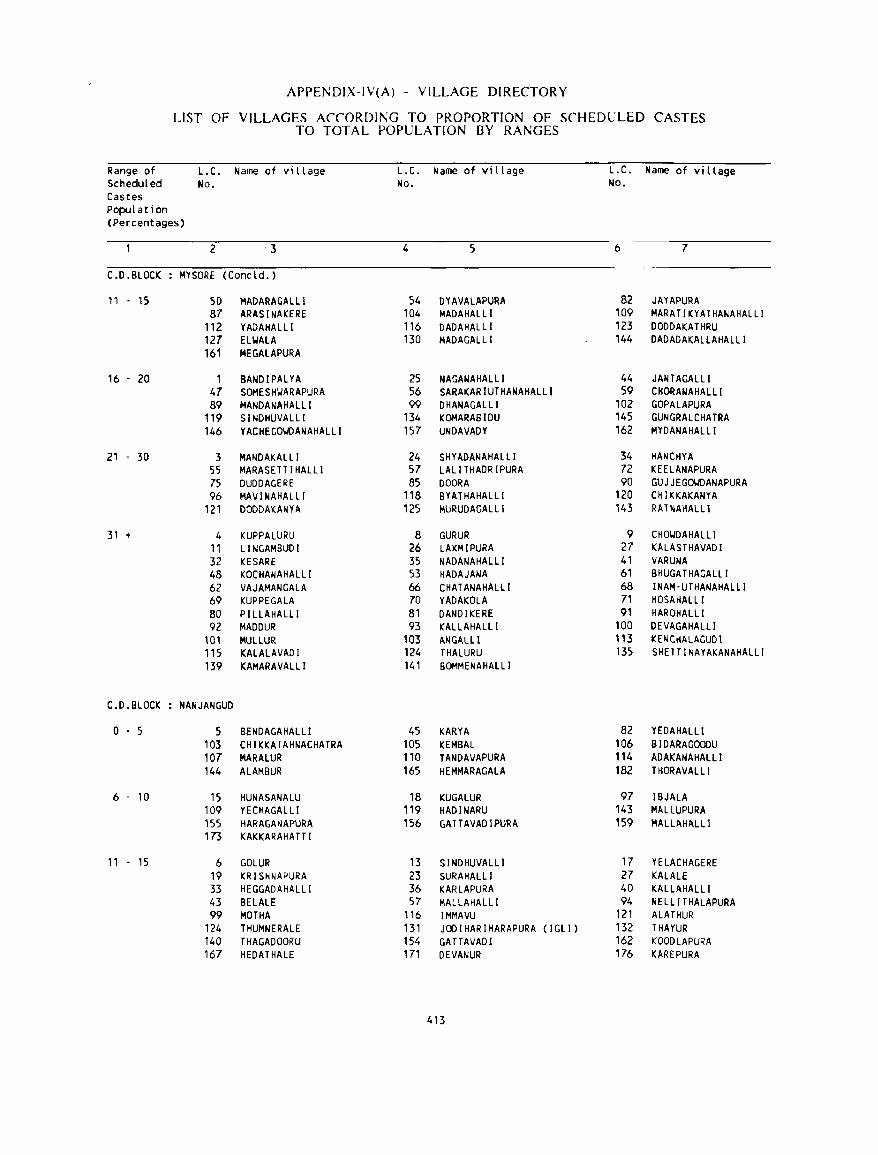
APPENDIX-IV(A) - VILLAGE DIRECTORY
LIST OF VILLAGES ACCORDING TO PROPORTION OF SCHEDULED CASTES TO TOTAL POPULATION BY RANGES
Range of L.C. Name of vi llage L.C. Name of village L.C. Name of vi llage Scheduled No. No. No. Castes Population (Percentages)
2 -3 4 5 6 7
C.D.BLOCK MYSORE (Concld. )
11 - 15 50 MADARA GAL LI 54 DVAVALAPURA 82 JAYAPURA 87 ARASINAKERE 104 MADAHALLI 109 MARATIKYATHANAHALLI
112 YADAHALLI 116 DADAHALLI 123 DODDAKATHRU 127 ELIoIALA 130 MADAGALLI 144 DADADAKALLAHALLI 161 MEGAlAPURA
16 - 20 1 BANDIPALYA 25 NAGANAHALLI 44 JANTAGALLI 47 SOMESHIJARAPURA 56 SARAKARIUTHANAHALLI 59 CHORANAHALll 89 MANDANAHALLI 99 DHANAGAlLI 102 GOPALAPURA
119 SINDHUVALLI 134 KOMARABIDU 145 GUNGRALCHATRA 146 YACHEGOlolDANAHALLI 157 UNDAVADY 162 MYDANAHALLI
21 - 30 3 MANDAKALL I 24 SHYADANAHALLI 34 HANCHYA 'is MARASETTIHALLI 57 LALITHADRIPURA 72 KEELANAPURA 75 DUDDAGERE 85 DOORA 90 GUJJEGOIolDANAPURA 96 MAVINAHALLI 118 BYATHAHALLI 120 CHII(KAKANYA
121 DODDAKANYA 125 MURUDAGAlLi 143 RAHIAHALLl
31 + 4 KUPPALURU 8 GURUR 9 CHOIJDAHALLI 11 LINGAMBUDI 26 LAXMIPURA 27 KALASTHAVADI 32 KESARE 35 NADANAHAlLI 41 VARUNA 48 KOCHANAHALLI 53 HADAJANA 61 BHUGATHAGALLI 62 VAJAMANGALA 66 CHATANAHALLI 68 INAM'UTHANAHALLI 69 KUPPEGALA 70 YADAKOLA 71 HOSAHALLI 80 PI LLAHALLI 81 DANDIKERE 91 HAROHALLI 92 MADDUR 93 KALLAHALLI 100 DEVAGAHALLI
101 MUllUR 103 ANGAlll 113 KENCHALAGUDI 115 KALALAVADI 124 THALURU 135 SHETTINAYAKANAHALLI 139 KAMARAVALLI 141 BOMMENAHALLI
C.D.BLOCK NANJANGUD
o . 5 5 BENDAGAHALLI 45 KARYA 82 VEDAHALLI 103 CHIKKAIAHNACHATRA 105 KEMBAL 106 BIDARAGOOOU 107 MARALUR 110 TANDAVAPURA 114 ADAKANAHALLI 144 ALAMBUR 165 HEMMARAGALA 182 T HORAVALLI
6 - 10 15 HUNASANALU 18 KUGALUR 97 IBJALA 109 YECHAGAL LI 119 HADINARU 143 MALLUPURA 155 HARAGANAPURA 156 GATTAVADIPURA 159 MAL LAHAlLl 173 KAKKARAHATTI
11 . 15 6 GOLUR 13 SINDHUVALLI 17 YELACHAGERE 19 KRISHNAPURA 23 SURAHALLI 27 KALALE 33 HEGGADAHALLI 36 KARLAPURA 40 KALLAHALLI 43 BELALE 57 MAL LAHALLI 94 NELLI THALAPURA 99 MOTHA 116 IMMAVU 121 ALATHUR
124 THUMNERALE 131 JODIHARIHARAPURA ( I GLI ) 132 THAYUR 140 THAGADOORU 154 GATTAVADI 162 KOOOLAPURA 167 HEDATHALE 171 DEVANUR 176 KAREPURA
413
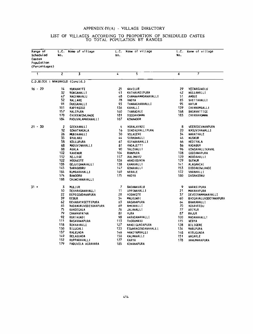
APPENDIX-IV(A) - VILLAGE DIRECTORY
LIST OF VILLAGES ACCORDING TO PROPORTION OF SCHEDULED CASTES TO TOTAL POPULATION BY RANGES
Range of L.C. Narne of village L.C. Name of village L.C. Name of village Scheduled No. No. No. Castes population (Percentages)
2 3 4 5 6 7
C.D.BLOCK NANJANGUD (Concld. )
16 • 20 14 KURAKATTl 25 NAVILUR 29 YECHAGUNDLU 32 KONGAHALLI 41 KATHAVADIPURA 42 HULLAHALLI 47 HAG I NAVALU 48 CHAMANAMADANAHALlI 51 AMBLE 52 HALLARE 78 HADYA 85 SHETT AHALL I 91 DUGGAHALLI 93 THARAGANAHALLI 95 KATUR
101 KAPPASOGE 136 KAHALLI 139 CHINNAMBALLl 157 HALEPURA 160 THARADALE 168 BASAVATTIGE 170 CHIKKAKOULANDE 181 DOODAHOMMA 183 CHIKKAHOMMA 184 PADUVALAMARAHALLI 187 KONANOOR
21 - 30 2 GEEKAHALLI 4 HORALAVADI 8 VEEREDEVANAPURA 12 GONATHAGALA 16 SINDHUVALLlPURA 20 KASUVI NAHALLl 26 MUDDAHALLI 30 VOLAGERE 34 HARATHALE 35 BYALARU 44 SIRMAHALLI 46 HUSKUR 58 KELLUPURA 61 KOTHANAHALLI 66 HEDIYALA 68 MADUVINAHALLI 81 KADAJETTI 86 KADABUR 88 AKALA 90 YALEHALLI 96 KONGAHALLI KAVAL
102 KANENUR 104 RAMPURA 108 GOODANAPURA 112 HEJJIGE 117 HUl1MAVU 120 MOODAHAlll 122 HOSAKOTE 126 NANDIGUNDA 129 SUTHUR 135 GEJJIGANAHALLI 138 KAMAHALLI 141 ALAGANCHI 145 SARAGOORU 147 GONAHALLI 153 DODDAKOULANDE 164 KUMBARAHALLI 169 NERALE 172 VARAHALLI 174 BANOORU 175 HADYA 180 DASANOORU 188 CHUNCHANAHALLI
31 + 3 MULLUR 7 BADANAVALU 9 NARASIPURA 10 DEVARASANAHALLI 11 UPPINAHALLI 21 MAKANAPURA 22 DEPEGOUDANAPURA 28 HOSAKOTE 37 DEVEERAMMANAHALLI 39 DEBUR 54 MALKUNDI 60 BHOGAVALUVOOEYANAPURA 62 DEVARAYASETTIPURA 63 NAGANAPURA 64 BANKAHALLI 65 HADANURUVOOEYANAPURA 69 AMKAHALLI 70 HOSAVEEDU 75 KANDEGALA 76 JALAHAlLi 77 ARIYUR 79 CHANNAPATNA 80 HURA 87 RAJUR 92 KURIHUNDI 98 HARADANAHAlll 100 MADANAHALLI
111 BASAVANAPURA 113 THORAMAVU 115 HEBYA 118 BOKKAHALLI 127 NANDIGUNDAPURA 128 BILIGERE 130 BILUGALI 133 ESUARAGO~ANAHALLI 134 HARUPURA 137 KALKUNDA 146 HANIYAMBALLI 148 KIRUGUNDA 149 BELAGUHDA 150 KALMAHALLI 151 NAGARlE 152 KUPPARAVALLI 177 KARYA 178 HANUMANAPURA 179 PADUVOLA AGRAHARA 185 KONANAPURA
414
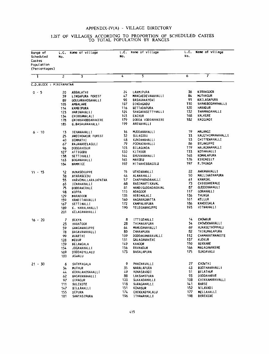
APPENDIX-IV(A) - VILLAGE DIRECTORY
LIST OF VILLAGES ACCORDING TO PROPORTION OF SCHEDULED CASTES TO TOTAL POPULATION BY RANGES
Range of L.C. Name of village l.C. Name of vi llage L.C. Name of village Scheduled No. No. No. Castes PopuLation (Percentages)
2 3 4 5 6 7
C.D.BLOCK PIRIYAPATNA
0-5 20 ABBALATHI 24 LAXMIPURA 36 KJRANGOOR 39 LlNGAPURA FOREST 47 MANCHEDEVANAHALLI 84 MUTHAGUR 89 GOLLARAHOSAHALLI 90 BASAVANAYEIH 91 KAILASAPURA
105 AMBALARE 107 DINDAGADU 110 SHANUBOGANAHALLI 114 KAMBIPURA 116 BETTADAPURA 120 HARADUR 123 HARINAHALLl 124 SANGARASETTYHALLI 132 THAMMADAHALLI 134 CHIKKAMALALI 145 EACHUR 168 KALKERE 178 CHIKKAVOODARAKERE 179 DODDA VODDARAKERE 182 KAGGUNDI 185 G.BASAVANAHALLI 199 ARENAHALLI
6 - 10 13 I CHANAHALLI 16 MUDDANAHALLI 19 MALANGI 25 ANECHO~KUR FOREST 32 SULAGODU 33 KALETHIMMANAHALLI 40 BEMMATHI 48 KUNDANAHALLI 53 CH I TTENAHALLI 67 RAJANABELAGULI 79 POONADAHALLI 86 BYLAKUPPE 96 DODDAHOSUR 103 BI LAGUNDA 119 HALAGANAHAllI
127 ATTIGODU 130 KITHOOR 133 KOTHAVAlLI 138 SEn I HALLI 144 BHUVANAHALLI 148 KOMAlAPURA 163 1l0GANAHALLI 165 MAKOOU 176 KIRENELlY 184 HAMMIGE 192 HITNAHEBBAGILU 197 R.THUNGA
11 - 15 12 HUNASEKUPPE 15 UTIIE~AIIALLI 22 A~KANAHAlll
38 AYARABEEDU 46 ALANAHALLI 50 MALl! NA T HAPURA 55 HARVEMALLARAJAPATNA 57 CHAPPARADAHALLI 61 KANA GAL 65 ICHANAHALLI 68 RASIMARTIKAVAL 73 CHIKKANERALE 75 DODDANERALE 81 HANDIGUDDADAKAVAL 87 GUDDENAHALLI 98 KOPPA 115 ADAGOOR 117 GORAHALLI
129 MARADOOR 135 HIRIMALALI 136 THUNGA 159 HAND I T HAVALLI 160 NAGARAGHATTA 161 KELLUR 167 SETT I HALLI 172 KAMPALAPURA 186 KANDEGALA 189 K. HARALAHALLI 190 TELEGANAKUPPE 193 HITNAHAlLl 201 KELAGANAHALLI
16 - 20 7 BEKYA 8 I TT I GEHALLI 14 CHO~KUR
23 HABATOOR 28 THIMAKAPURA 54 CHO~DENAHALL I 59 GANGANAKUPPE 64 MANUGANAHALLI 69 HUNASETHOPPALU 78 llASAVANAHALLI 80 CHARAPURA 82 THIRUMALAPURA 99 AVARTHI 109 DODDAKAMARAVAllI 112 CHAMARAYANAKOTE
128 MELUR 131 GALAGANAKERE 137 KUDKUR 139 NELANGALA 149 KANOOR 150 BEKKARE 154 JOGANAHALLI 156 RAVANDUR 166 MALAGANAKERE 169 OOODASYLlAlU 173 BASAlAPURA 175 SUNDAVALU 180 ASIJALU
21 - 30 6 SATHYAGALA 9 PANCHAVALLI 27 CHO~THI
34 MUTHUR 35 NARALAPURA 43 BOOTHANAHALLI 44 KORALAHOSAHALLI 49 HUNASAVADI 51 BELATHUR 62 BASAVANAHALLI 88 LAKSHMIPURA 93 DODDAHARVE 97 GIRAGUR 100 SUNKADAHALLI 108 CH I KKAMARAVALLI
111 $ULEKOTE 118 SURAGAHALLI 141 BARSE 147 BILLAHAlLI 151 KONASUR 152 NILAVADI 155 DEPURA 174 CHIKKABYALALU 177 MELLAHALLI 181 SANYASIPURA 196 I THAt.lAHALLI 198 DOREKERE
415
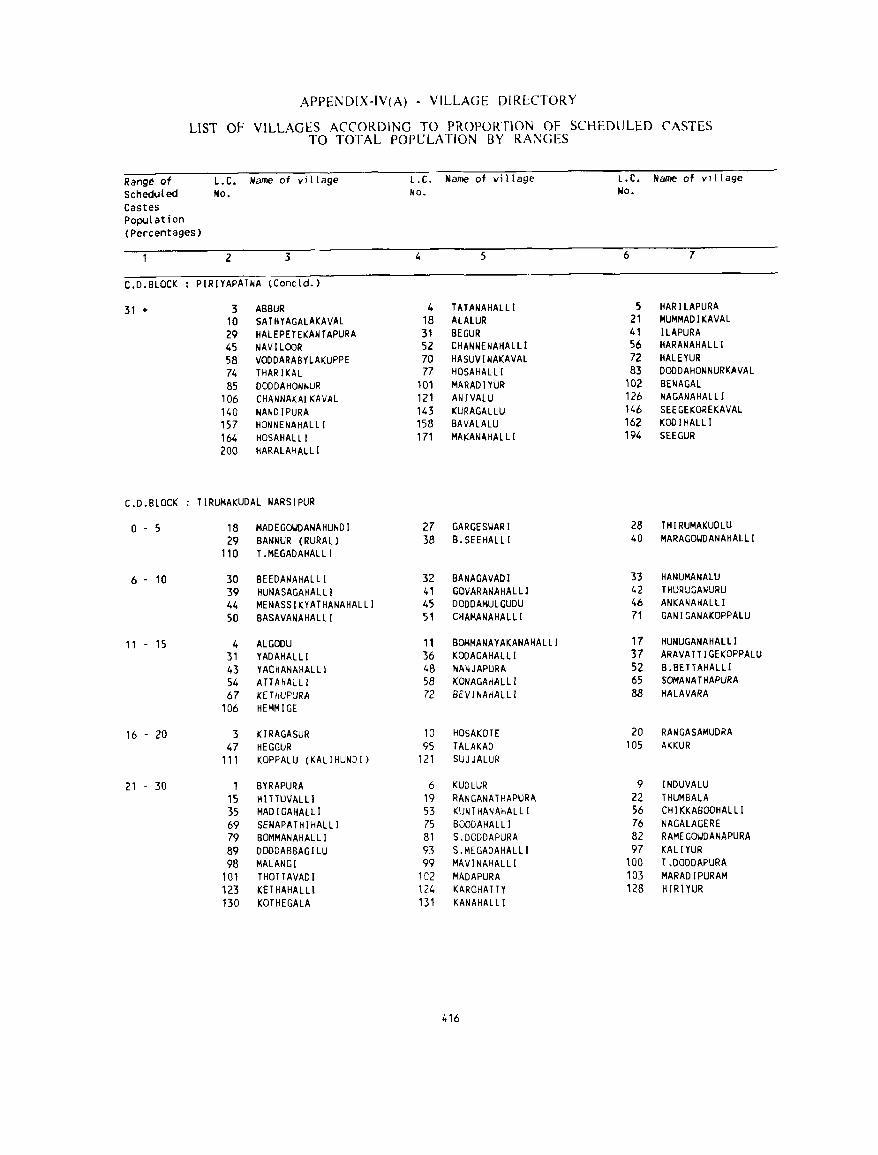
APPE]'.;DIX-IV(A) - VILLAGE DIRLCTORY
LIST OF VILLAGES ACCORDING TO PROPORTION OF SCHEDULED CASTES TO TOTAL POPULATION BY RA~GES
Range of L.C. Name of vi llage l.e. Name of village L.C. Name of vlliage ScheduLed No. No. No. Castes population (Percentages)
2 3 4 5 6 7
C.D.BLOCK PIRIYAPATNA (Concld. )
31 + 3 ASBUR 4 TATANAHALLI 5 HARILAPURA 10 SATHYAGALAKAVAL 18 ALALUR 21 MUMMADIKAVAL 29 HALEPElEKANTAPURA 31 SEGUR 41 ILAPURA 45 NAVILOOR 52 CHANNENAHALLI 56 HARANAHAL LI 58 VODDARABYLAKUPPE 70 HASUVINAKAVAL 72 HALEYUR 74 THARIKAL 77 HOSAHALLI 83 DODDAHONNURKAVAL 85 DODDAHONNUR 101 MARADIYUR 102 BEt.lAGAL
106 CHANNAKALKAVAL 121 ANIVAlU 126 NAGANAHALL J 140 NANDIPURA 143 KURAGALLU 146 SEEGEKOREKAVAL 157 HONNENAHALlI 158 BAVALALU 162 KODIHALLI 164 HOSAHALLI 171 MAKANAHALLI 194 SEEGUR 200 HARALAHALLI
C.D.BLOCK TIRUMAKUDAL NARSIPUR
0-5 18 MADEGO~DANAHUNDI 27 GARGESI.JARI 28 THIRUMAKUDLU 29 BANNUR (RURAL) 38 B.SEEHALLI 40 MARAGOWDANAHALLI
110 T.MEGADAHALLI
6 - 10 30 BEEDANAHALLI 32 BANAGAVADI 33 HANUMANALU 39 HUNASAGAHALll 4' GOVARANAHALLI 42 THURUGANURU 44 MENASSIKYATHANAHALLI 45 DODDAMULGUDU 46 ANKANAHALLJ 50 BASAVANAHALLI 51 CHAMANAHALLI 71 GANIGANAKOPPALU
11 - 15 4 ALGODU 11 BOMMANAYAKANAHALLI 17 HUNUGANAHALLI 31 YADAHALLI 36 KOOAGAHALLI 37 ARAVATTIGEKOPPALU 43 YACHANAHALLI 48 NA~JAPURA 52 B.BETTAHAlLi 54 ATTAHAlLi 58 KONAGAHALLI 65 SOMANATHAPURA 67 KETHUPURA 72 BEV I NAHALLI 88 HALAVARA
106 HEMMIGE
16 - 20 3 KIRAGASUR 10 HOSAKOTE 20 RANGASAMUDRA 47 HEGGUR 95 TALAKAD lOS AKKUR
111 KOPPALU (KALIHUNDI) 121 SUJJALUR
21 - 30 1 BYRAPURA 6 KUDLUR 9 INDUVALU 15 HITTUVALLI 19 RANGANATHAPURA 22 THUMBALA 35 MAD I GAHALLI 53 KUNTHANAHALLI 56 CHIKKABOOHALLI 69 SENAPATHIHALLI 75 BOOOAHALLI 76 NAGALAGERE 79 BOMMANAHALLI 81 S.DODDAPURA 82 RAMEGOI.JDANAPURA 89 DODDABBAGILU 93 S.MEGADAHALLI 97 KALIYUR 98 MALANGI 99 MAV I NAHALLI 100 T .DODDAPURA
101 THOTTAVADI 102 MADAPURA 103 MARADIPURAM 123 KETHAHALLl 124 KAROHA TTY 128 HIRIYUR 130 KOTHEGALA 131 KANAHALLI
416
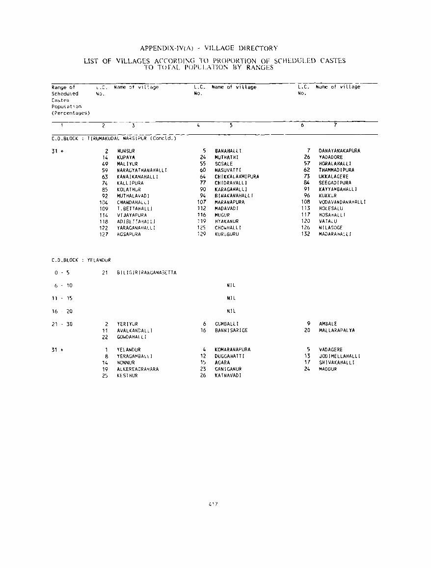
APPE~DIX-JV(A) - VILLAGE DIRECTORY
LIST Of VILLACES ACCOROI~G TO PROPORTION OF SCHLDULED (' ASTES TO T(> !":\L POPL: LArIO~ 8Y RANGES
Range of L. C. Name of village L.C. Name of vi llage L.C. Name of vi llage Scheduled No. No. No. Ca~tes
PopulatIon (Percentages)
2 3 4 6 7
C.D.BLOCK T[RUMAKUOAL NARSjPUR (Concld. )
31 + 2 HUN SUR 5 SANAHALLl 7 DANAYANAKAPURA 14 KUPAYA 24 MUTHATHI 26 YADADORE 49 MALlYUR 55 SOSALE 57 HORALAHALLI 59 NARAGYATHANAHALLI 60 HASUVAfTI 62 THAMMADIPURA 63 KANAIKANAHALLI 64 CHIKKALAXMlPURA 73 UKKALAGERE 74 KALLlPuRA 77 CHIDRAVALLI 84 SEEGADIPURA 85 KOLATHUR 90 KARAGAHALLI 91 KAYVAMBAHALLI 92 MUTHALAVADI 94 BINAKANAHALll 96 KUKKUR
104 CHANDAHAlLI 107 MARANAPURA lOB VODAVANDANAHALlI 109 T.BETTAHALLI 112 MADAVADI 113 HOlESALU 114 VIJAYAPURA 116 MUGUR 117 HOSAHAL Ll 118 AD I BE TT AHAL LI 119 HYAKANUR 120 VATAlU 122 YARAGANAHALLI 125 CHOI,JHALLI 126 NILASOGE 127 HOSAPURA 129 KURUBURU 132 MADARAHAlLI
C.D.BLOCK YELANDUR
0 5 21 BILIGIRIRANGANABETTA
6 10 NIL
11 15 NIL
16 20 NlL
21 - 30 2 YERIYUR 6 GUMBAL.Ll 9 AMBALE 11 AVALKANDALLI 16 BANNISARlGE 20 MALLARAPALYA 22 GOIJDAHALLI
31 + 1 YELAt-IDUR 4 KOMARAflAPURA 5 VADAGERE 8 YERAGAMBALLI 12 DUGGAHATTI 13 JODI MELLAHAl.lI
14 HOflNUR 15 AGARA 17 SHIVAKAf1ALlI 19 ALKEREAGRAHARA 23 GANIGANUR 24 MADDUR 25 KESTHUR 26 KATNAVADI
417
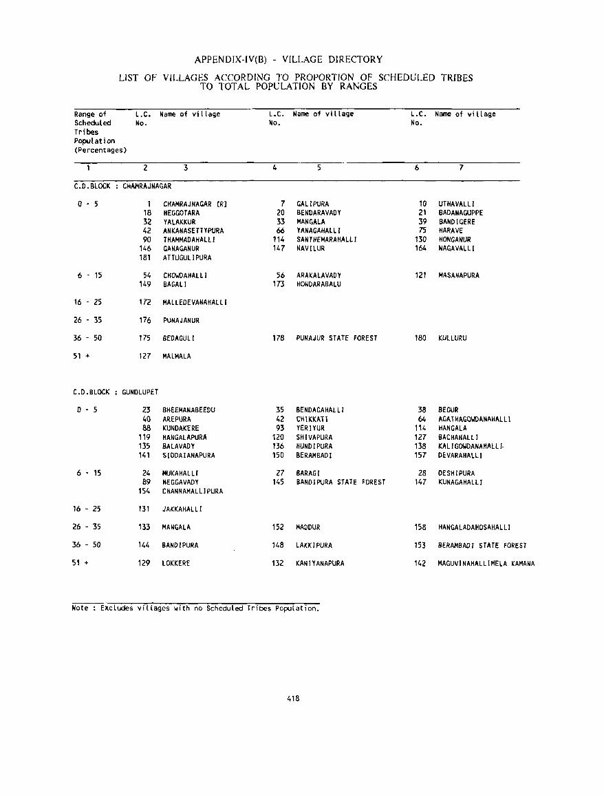
APPENDIX-IV(8) - VILLAGE DIRECTORY
LIST OF VILLAGES ACCORDING TO PROPORTION OF SCHEDULED TRIBES TO TOTAL POPULATION BY RANGES
Range of L.C. Name of village L.C. Name of village L.C. Name of village Scheduled No. No. No. Tribes Population (Percentages)
2 3 4 5 6 7
C.D.BLOCK CHAMRAJNAGAR
0-5 1 CHAMRAJNAGAR (R] 7 GALlPURA 10 UTHAVALLl 18 HEGGOTARA 20 BENOARAVADY 21 BADANAGUPPE 32 YALAKKUR 33 MAN GALA 39 BANOIGERE 42 ANKANASfTTYPURA 66 YANAGAHALLI 75 HARAVE 90 THAMMADAHAlll 114 SANTHEMARAHALlI 130 HONGANUR
146 GANAGANUR 147 NAVILUR 164 NACAVALLI 181 A TTUGULI PURA
6 - 15 54 CHOI.IDAHAlLI 56 ARAKALAVADY 121 MASANAPURA 149 BAGALI 173 HONDARABALU
16 - 25 172 MALLEOEVANAHAlLI
26 - 35 176 PUNAJANUR
36 - 50 175 BEDAGULI 178 PUNAJUR STATE FOREST 180 KUlLURU
51 + 127 MAlMAlA
C.D.BLOCK GUNDlUPET
o . 5 23 SHEEMANABEEDU 35 BENDACAHAl LJ 38 SEGUR 40 AREPURA 42 CHIKKATl 64 AGATHAGOYDANAHALLI 88 KUNDAKERE 93 YERIYUR 114 HANGALA
119 HANGALAPURA 120 SHIVAPURA 127 BACHAHALLI 135 BALAVADY 136 HUNDIPURA 138 KAl I GMANAItAlll-141 SIDDAIANAPURA 150 BERAMBADI 157 DEVARAHALLl
6 • 15 24 MUKAHALll 27 BARAGI 28 DESHIPURA 89 HEGGAVADY 145 BANDIPURA STATE FOREST 147 KUNAGAHALLI
154 CHANNAMALLIPURA
16 - 25 131 JAKKAHAlLl
26 . 35 133 MANGAlA 152 MADDUR 158 HANGALADAHOSAHAlLi
36 . 50 144 BAND I PURA 148 LAKKIPURA 153 BERAMBADI STATE FOREST
51 + 129 LOKKERE 132 KANIYANAPURA 142 MAGUVINAHALLIMElA KAMANA
Note Excludes villages with no Scheduled Tribes Population.
418
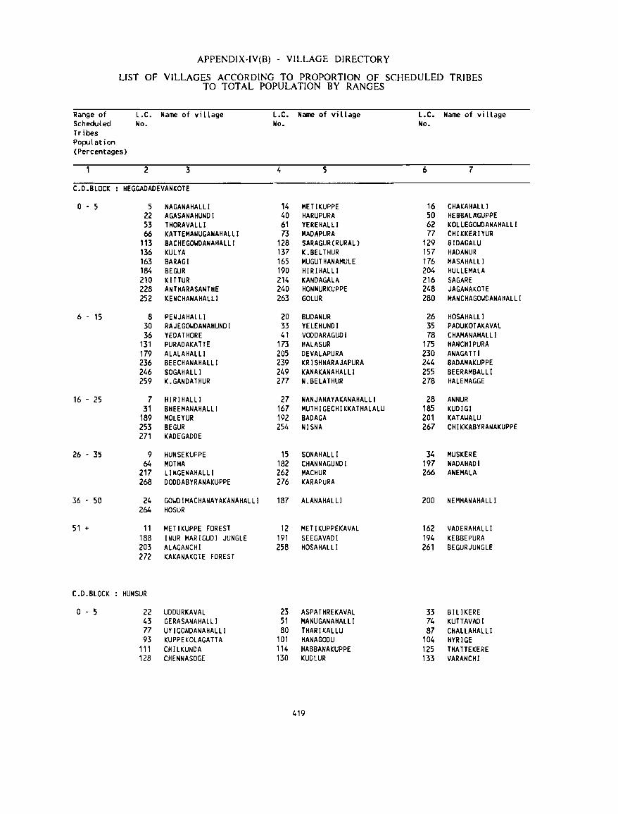
APPENDIX·IV(B) . VILLAGE DIRECTORY
LIST OF VILLAGES ACCORDING TO PROPORTION OF SCHEDULED TRIBES TO TOTAL POPULATION BY RANGES
Range of L.C. Name of vi t tage L.C. Name of village L.C. Name of village Scheduled No. No. No. Tribes Population (Percentages)
2 3 4 5 6 7
C.D.BLOCK HEGGAOADEVANKOTE
0-5 5 NAGANAHALLI 14 METIKUPPE 16 CHAKAHAlLI 22 AGASANAHUNDI 40 HARUPURA 50 HEBBALA'GUPPE 53 THORAVALLI 61 YEREKAlLl 62 KOllEG~ANAHALLI
66 KATTEMANUGANAHALLI 73 MADAPURA 77 CH I KKER IYUR 113 BACHEGOWDANAHALLI 128 SARAGUR(RURAl) 129 BIOAGALU 136 KULYA 137 K.BElTHUR 157 HADANUR 163 BARAGI 165 MUGUTHANAMUlE 176 MASAHALLI 184 SEGUR 190 HIRIHALLI 204 HUllEMAlA 210 KITTUR 214 KANOAGALA 216 SAGARE 228 ANTHARASANTHE 240 HONNURKUPPE 248 JAGANAKOTE 252 KENCHANAHALLI 263 GOlUR 280 HANCHAGOWDANAHAlLI
6 . 15 8 PENJAHALLI 20 BUDANUR 26 HOSAHi\LLI 30 RAJEGOWDANAHUNOI 33 YELEHUNDI 35 PADUKOTAKAVAl 36 YEDATHORE 41 VOODARAGUDI 78 CHAMANAHALLI
131 PURADAKATTE 173 HALASUR 175 HANCHIPURA 179 ALALAHAlLi 205 OEVALAPURA 230 ANAGATTI 236 BEECHANAHALLI 239 KRISHNARAJAPURA 244 BAOANAKUPPE 246 SOGAHALLI 249 KANAKANAHALLI 255 BEERAMBAL Ll 259 K.GANDATHUR 277 N.BELATHUR 278 HAlEMAGGE
16 . 25 7 HIRIHALLI 27 NANJANAYAKANAHAlLI 28 ANNUR 31 BHEEMANAHALll 167 MUTHIGECHIKKATHAlALU 185 KUDIGI
189 MOLEYUR 192 BADAGA 201 KATAIJALU 253 BEGUR 254 NISNA 267 CHIKKABYRANAKUPPE 271 KADEGAODE
26 - 35 9 HUNSEKUPPE 15 SONAHALLI 34 MUSKERE 64 MOTHA 182 CHANNAGUNOI 197 NADAHADI
217 LI NGENAHALLI 262 HACHUR 266 ANEMALA 268 DODDABYRANAKUPPE 276 KARAPURA
36 . 50 24 GOIJDIMACHANAYAKANAHAlLI 187 AlANAHALLI 200 NEMMANAHALLI 264 HOSUR
51 i- II METIKUPPE FOREST 12 MET I KUPPEKAVAL 162 VADERAHAlLl 188 INUR MARIGUDI JUNGLE 191 SEEGAVADI 194 KEBBEPURA 203 AlAGANCHI 258 HOSAHALLI 261 BEGURJUNGlE 272 KAKANAKOTE FOREST
C.D.BLOCK HUN SUR
o . 5 22 UDDURKAVAL 23 ASPATHREKAVAL 33 BILIKERE 43 GERASANAHAlLl 51 MANUGANAHAlLl 74 KUTTAVADI 77 UYIGONDANAHAlll 80 THARIKALLU 87 CHALLAHAlLl 93 KUPPEKOlAGATT A 101 HANAGODU 104 HYRIGE
111 CHllKUNDA 114 HABBANAKUPPE 125 THA TTEKERE 128 CHENNASOGE 130 KUDLUR 133 VARANCHI
419
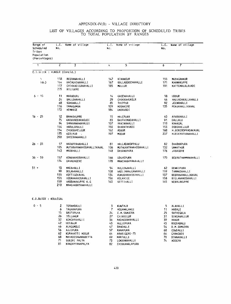
APPEi\DIX-IV(B) - VILLAGE DIRECTORY
LIST OF VILLAGES ACCORDING TO PROPORTION OF SCHEDULED TRIBES TO TOTAL POPULATION BY RANGES
Range of L.C. Name of viLLage L. C. Name of vIllage L.C. Name of viLLage ScheduLed No. No. No. Tribes Population (Percentages)
2 3 4 5 6 7
C.D.BLJCK HUN SUR (ConcLd. )
5 138 BEERANAHALLI 147 KIRANGUR 155 MUOAGANNUR ld. ) 164 KACHUVINAHALLl 167 KALLABOOCHAHALLI 171 KARNAKUPPE
177 CHIKKAOIGANAHALLI 185 MULLUR 191 KATTEMALALAVAOI 205 BILIC,ERE
6 . 15 11 MARADURU 14 GAGENAHALLI 18 UDOUR 24 BALLENAHALLI 29 CHIKKAHUNSUR 46 HALLAOAKALLAHALLI 68 SONAHALLI 85 THIPPUR 92 JEENAHALLI
116 YAMAGUMBA 129 HOSAKOTE 135 PENJAHAlLIKAVAL 172 HEMMIGE 184 UNOAVAOI
16 . 25 12 BANNIKUPPE 15 HALEPURA 40 AYARAHALLI 75 KADAVADDARAGUDI 83 BASTH IMADAHALLI 91 OALLALU 94 SHRAVANANAHALLI 107 HAR I NAHAL LI 110 KANAGAL
144 HARALAHALLI 150 BHARATHVADI 153 DODDAHEJJUR 154 CHIKKAHEJJUR 162 ABBUR 168 H.BOREROPPADAKAVAl 175 KERIYUR 197 MODUR 207 HIRIKYATHANAHALLI 208 SHEERANAHALLI
26 - 35 17 NADAPPANAHALLI 81 HALLADAKOPPALU 82 DHARMAPURA 105 MUTHRAYANAHOSAHALLIKAVAL 106 MUTHURAYANAHOSAHALLI 132 UMMATHUR 143 MADAHALLl 148 DASANAPURA 176 JABAGERE
36 - SO 157 KONANAHOSAHALLI 166 UDUVEPURA 170 BEERATHAMMANAHALLI 174 GAVADAGERE 178 MANCHABAYANAHALll
51 + 13 MADAHALLl 54 HULLENAHALLI 62 BENKIPURA 99 BOLANAHALLI 108 VADLIMANUGANAHALLI 119 THMMADAHALLI
131 KOTT I GEKAVAL 134 KURUBARAHOSAHALLI 137 BEERANAHALLIKAVAL 151 VEERANAHOSAHALLI 156 KOLAVIGE 158 BILLANAHOSAHALLI 159 HABBANAKUPPE K.G 163 SETT I HALLI 165 NERALAKUPPE 210 MANCHABAYANAHALLI
C.D.BLOCK KOLLEGAL
o . 5 2 TERAMBALLI 3 KUNTHUR 5 ALAHALLI 6 TAGARAPURA 7 HOSAMALANGI 11 HARALE
15 BASTIPURA 24 C.M.SAMUDRA 25 SATHEGAlA 26 TELLANUR 27 CHIKKILUR 31 SINGANAlLUR 32 KONGARAHAL LI 36 MADHUVANAHALlI 39 HANUR 42 UDDANUR 43 HULLEPURA 45 BOODABALU 46 ALAGUMOLE 47 BANDALLl 54 D.M.SAMUDRA 56 AJJIPURA 57 RAMAPURA 60 COI.JDALLl 62 KURAHATT I HOSUR 64 ARABIGERE·75 66 CHANGADI 68 MAHADESHI.JARABETTA 69 MARTALLl 70 DINNAHALLI 71 SULERI PALYA 73 LOKKANAHALLI 74 HOOGYA 81 KANDAYYANAPALYA 82 CHIKKAMALAPURA
420
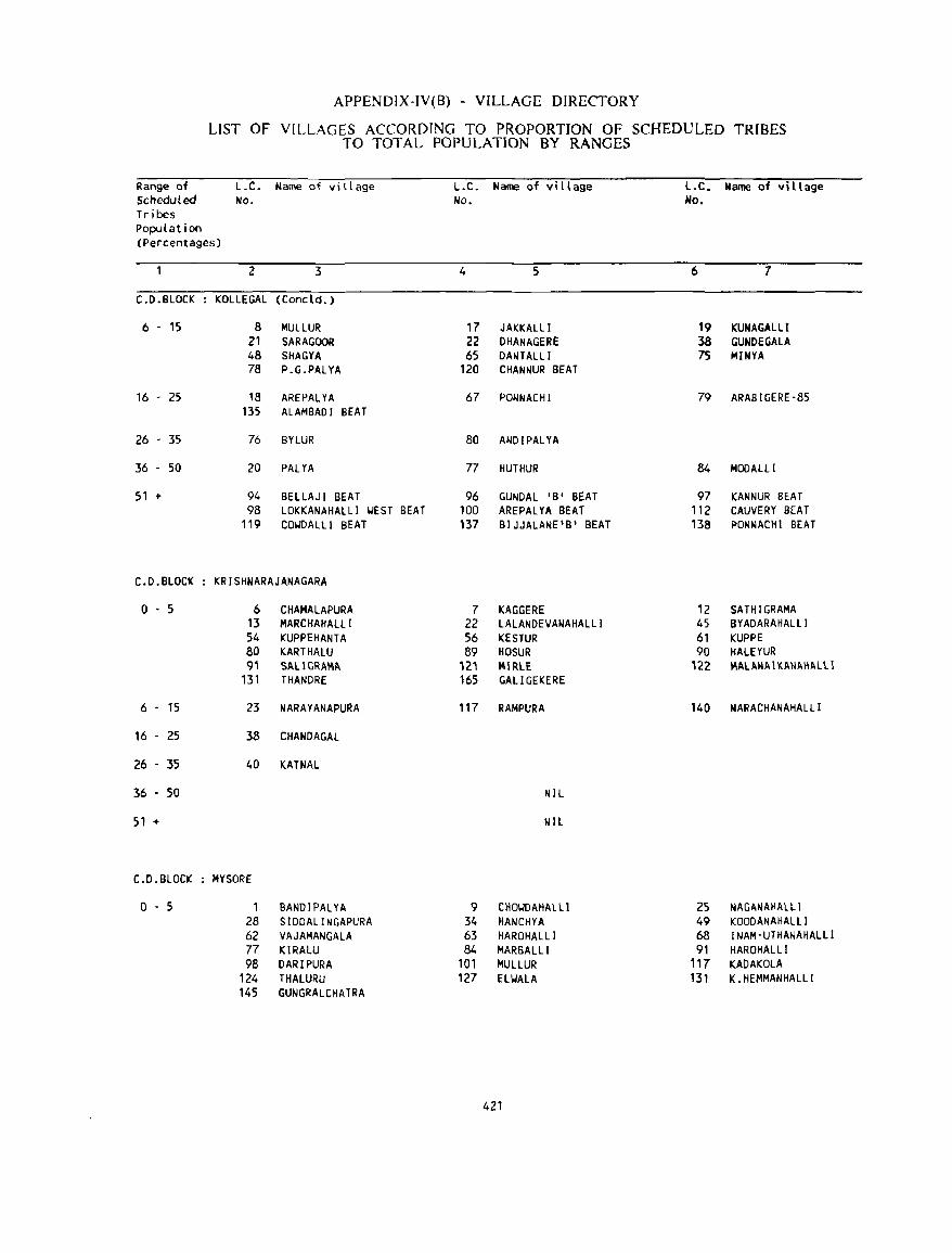
APPENDIX-IV(8) - VILLAGE DIRECTORY
LIST OF VILLAGES ACCORDING TO PROPORTION OF SCHEDULED TRIBES TO TOTAL POPULATION BY RANGES
Range of L.C. Name of village L.C. Name of vi II age L.C. Name of village Scheduled No. No. No. Tribes Population (Percentages)
2 3 4 5 6 7
C.O.BLOCK KOLLEGAL (Concld. )
6 - 15 8 MUlLUR 17 JAKKALLI 19 KUNAGALLI 21 SARAGOOR 22 OHANAGERE 38 GUNOEGALA 48 SHAGYA 65 DANTALLI 75 MINYA 78 P.G.PALYA 120 CHANNUR BEAT
16 - 25 18 AREPALYA 67 PONNACHI 79 ARABIGERE·85 135 ALAMBADI SEAT
26 - 35 76 BnUR 80 ANDIPALYA
36 - 50 20 PALYA 77 HUTHUR 84 MODALLI
51 + 94 BELLAJI BEAT 96 GUNDAL 'B' BEAT 97 KANNUR BEAT 98 LOKKANAHAlLI WEST BEAT 100 AREPALYA BEAT "2 CAUVERY BEAT
119 CO'WDAlli BEAT 137 BIJJALANE'B' BEAT 138 PONNACHI BEAT
C.D.BLOCK KRISHNARAJANAGARA
o . 5 6 CHAMALAPURA 7 KAGGERE 12 SATHIGRAMA 13 MARCHAHAlLI 22 LALANDEVANAHALLI 45 BYADARAHALLI 54 KUPPEHANTA 56 KESTUR 61 KUPPE 80 KARTHALU 89 HOSUR 90 HALEYUR 9' SAlIGRAMA 12' MIRlE 122 MAlANAIK.ANI>.HAlll
131 THANDRE 165 GALlGEKERE
6 . 15 23 NARAYANAPURA 117 RAMPURA 140 NARACHANAHALL[
16 - 25 38 CHANDAGAL
26 - 35 40 KATNAl
36 . 50 NIL
51 + NIL
C.D.BLOCK MYSORE
0-5 1 BANDIPALYA 9 CHO'WDAHAl LI 25 NAGANAHALll 28 SIDDAll NGAPURA 34 HANCHYA 49 KOODANAHALll 62 VAJAMANGALA 63 HAROHALLI 68 INAM·UTHANAHALLI 77 KIRALU 84 MARBALLI 91 HAROHALLI 98 DARIPURA 101 MUllUR 117 KAOAKOLA
124 THAlURU 127 EllJAlA 131 K. HEMMANHALlI 145 GUNGRALCHATRA
421
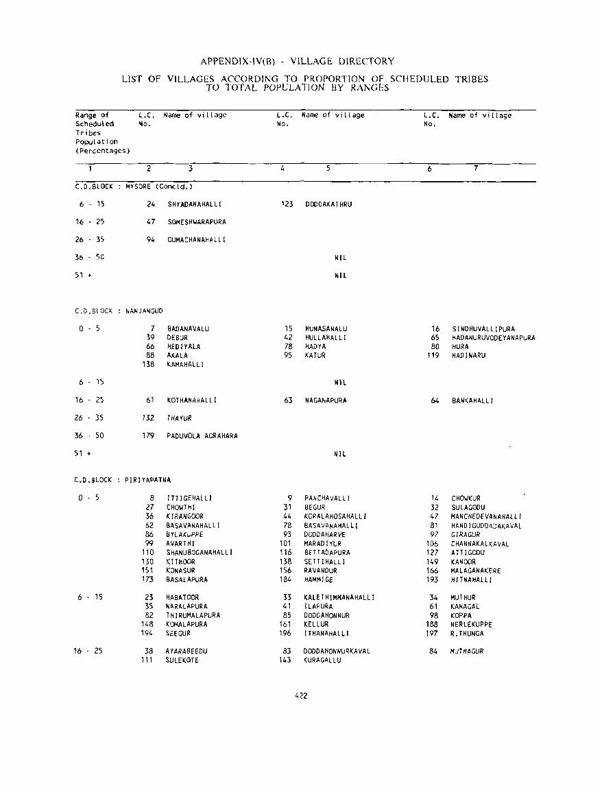
Range of Scheduled Tribes Population
APPENDIX-IV(B) - VILLAGE DIRECTORY
LIST OF VILLAGES ACCORDING TO PROPORTION OF SCHEDULED TRIBES TO TOTAL POPULATION BY RANGES
L.C. Name of village No.
L.C. Name of village No.
L.C. Name of village No.
(Percentages)
2 3 4 5 6 7
C.D.BLOCK MYSORE (Concld. )
6 - 15 24 SHYADANAHALL! 123 DODDAKATHRU
16 - 25 47 SOMESIlI<lARAPURA
26 35 94 GUMACHANAHALLI
36 50 NIL
51 + NIL
C.D.BLOCK NANJANGUD
0-5 7 BADANAVALU 15 HUNA.SANALU 16 SINDHUVALLIPURA 39 DEBUR 42 HULLAHALLl 65 HAOANURUVODEYANAPURA 66 HEDIYAlA 78 HADYA 80 HURA 88 AKALA 95 KATUR 119 HADINARU
138 KAMAHAlLl
6 15 tUl
16 25 61 KOTHANAHALLI 63 NAGANAPURA 64 BANKAHALLI
26 - 35 132 THAYUR
36 50 179 PADUVOLA AGRAHARA
51 + NIL
C.O.BLOCK PIRIYAPATNA
0-5 8 ITTIGEHALLI 9 PANCHAVALL I 14 CHOIJKUR 27 CHOIolTHI 31 SEGUR 32 SULAGODU 36 KIRANGOOR 44 KORALAHOSAHALLI 47 MANCHEDEVANAHALll 62 BASAVANAHALLI 78 BASAVANAHALLI 81 HANOI GUDDADAKAVAL 86 BYlAJ(UPPE 93 DODDAHARVE 97 GIRAGUR 99 AVARHII 101 MARADIYUR 106 CHANNAKALKAVAL
110 SHANUBOGANAHALLI 116 BE TT ADAPURA 127 ATT I GODU 130 KITHOOR 138 SETTIHALLl 149 KANOOR 151 KONASUR 156 RAVIl.t.lOUR 166 MAlll.GANAKERE 173 BASALAPURA 184 HAM,., 1 GE 193 HlTNAHALL 1
6 - 15 23 HABATOOR 33 KAlETHJMMANAHALLI 34 MUTHUR 35 NARALAPURA. 41 [LAPURA 61 KANA GAL 82 THIRUMALAPURA 85 DODDAHONNUR 98 KOPPA
148 KOMAlAPURA 161 KELLUR 188 NERlEKUPPE 194 SEEGUR 196 lTHANAHALL! 197 R.THUNGA
16 . 25 38 AYARASEEDU 83 DODDAHONNURKAVAl 84 MUH1AGUR '11 SULEKOTE 143 KURAGALLU
422
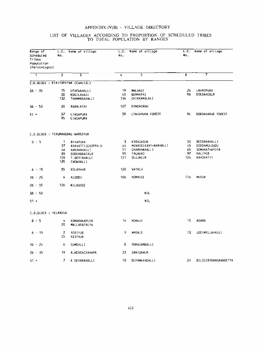
Range of Scheduled Tribes Population
APPENDIX-IV(B) - VILLAGE DIRECTORY
LIST OF VILLAGES ACCORDING TO PROPORTION OF SCHEDULED TRIBES TO TOTAL POPULATION BY RANGES
L.C. Name of vi L Lage L.C. Name of vi L L age L.C. Name of viLiage No. No. No.
(Percentages)
2 3 4 5 6 7
C.D.BLOCK PIRIYAPATNA (ConcLd.)
26 . 35 15 UTHENAHALLl 19 MALANGI 24 LAXMIPURA 26 KOGILAVADI 40 BEMMATHI 96 DODDAHOSUR
132 THAMMADAHALLI 134 CHIKKAMALALJ
36 . 50 20 ABBALATHI 107 DINDAGADU
51 + 37 LINGAPURA 39 LI NGAPURA FOREST 94 DODDAHARVE FOREST 95 LINGAPURA
C.D.BLOCK TIRUMAKUDAL-NARSIPUR
o . 5 1 SYRAPURA 3 KIRAGASUR 30 BEEDANAHALll 37 ARAVATTIGEKOPPALU 44 MENASSIKYATHANAHALLI 45 DODDAMULGUDU 46 ANKANAHALLI 51 CHAMANAHALLI 65 SOMANATHAPURA 89 DODDABBAGILU 95 TALAKAD 97 KAlIYUR
109 T .BETTAHALlI 121 SUJJALUR 124 KAROHATTY 125 CHOIJHALLl
6 - 15 85 KOLATHUR 120 VATALU
16 - 25 4 ALGODU 106 HEMMIGE 116 MUGUR
26 35 126 NILASOGE
36 - 50 NIL
51 + NIL
C.D.BLOCK YELANDUR
o - 5 4 KOMARANAPURA 14 HONNUR 15 AGARA 20 MALLARAPALYA
6 - 15 2 YER lYUR 9 AMBALE 13 JODIMELLAHALLI 25 KESTHUR
16 25 6 GUMBALLI 8 YERAGAMBALLI
26 35 19 ALKEREAGRAHARA 23 GANIGANUR
51 + 7 K.DEVARAHALLI 10 DUYAMKANDAL LI 21 BILIGIRIRANGANABETTA
423

SECTION-II TOWN DIRECTORY

TO\VN DIRECfORY
Explanatory Note
Town Din:ctory compri~es of six tabular
statements as applicable to all the towns and an
additional statement regarding'the !>Iums applicable
only in respect of towns with a population of 50,()(X)
and ahove. The six statements are numhered serially
from I to VI and the additional !>tiltcment bears the number IV A in view of the fact that it deals
with the same type of information \\.hich is coven:d
in Statement IV. These statements (:ontain several
columns, eaeh with a brid heading and for
presentation of the data, abbn:viations have also
heen made usc of in several columns. The title of
each statement, the seope or lhe informal ion
furnished under each column therein and the
abbreviations used, if any, arc indicated below.
STATEMENT HISTORY
STATUS AND (;ROWTH
Column 2 : Class, Name and Chic Administration Status of Town
The class to which a town belongs is ddcrmined
on the basis of its population at the 11)91 census
count and it is indicated in this column in roman
numerals. The classification critninn adnpted noW
is the same as that adopted for analysis and
explanation at the earlier censuses. The towns arc
divided into six classes
Class Population Size Class Population Size I 100,000 and above IV 10,000 to 11),999
II 50,000 to 99,f)<_)<) V 5,000 to (),<)I)f)
III 20,000 10 49,999 VI Bdow 5,000
For purposes of this classification, the total
population of the town inclusive of the population
of its outgrowths if any, is taken into consideration.
In the case of urban agglomerations which have twn
or more urban components (each of which mayor
may not be having outgrowths) each such urban
component (inclusive of its outgrowths) is regarded
as a separate unit and the population size class is
determined accordingly. An a~terisk mark placed
at the top right position after the name of the town
indicates that this town has one or more outgrowths
and that the 1991 c..:nsus popUlation and sueh other
427
data presented against it includes the details relating
to the outgrowths as we II.
The middle component of this column heading
rcfer~ tn name of the town which docs not need
elucidation. Name of the town, as adopted in the
official records, is reported here.
The civic administration status of the town as
on 1.1.1')1)0 is indicated immediately after the name
of the town, within brackct~. The ahhreviation~ used
for this purposl! arc as follows
MC CMC TMC CB NAC SB MP NMCI
Municipal Corporation, City Municipal Council, Town Municipal Council, Cantonment Board, Notified Area Committee, Sanitary Board, MandaI Panchayat, Non-municipal Census Town.
With a view to ensuring the fixity of boundaries
of various administrative units, that is, to ensure
that the frame for census taking once finalised with
reference to a cut-off date remains unchanged till
the completion of the census count, thl! St.lte (Jovnnment had been requested during )91N itself
not to order any jurisdictional changes and not to
give effect to any changl!s in the civic administration
status either.
Column 3 : Location Code Number
Thl! location code number assigned to the town
for purposes of eomputerisation of the 1 f)<)1 census
data is enterl!d in this column.
Column .a : Name of Taluk
In Karnataka, the term taluk IS very much in
vogue though the designation of the Revenue
Administrative Officer has for long been changed
from Amildar or Mamlatdar to Tahsildar. The
name of the taluk within the jurisdiction of which
the town is located is indicated in this column.
There arc a few instances wherein a particular town
strOlddlcs portions belonging to two adjacent taluks.
In such a case the town is considered to belong tll
the Taluk that contains a major portilln of the town.
In the statement, such cases are differenciated by
an index mark and a note at the bottom of the
page explains the correct situation.
Column 5: Name of Community Development Block
The name of the Community Development Block
within the jurisdiction of which the referent town
is located is indicated in this column. This column
does not apply to statutory towns since, in Karnataka,
all such towns arc outside the jurisdiction of the
Community Development Blocks i.e., the (Tal uk
Panchayat Samitis).
Column 6: Area (Sq.Km)
The geographical area of the town is furnished
here in squan: kilometres upto two places of decimal.
The figures for the urban areas are either those
supplied by the civic administration authorities of
the towns or compiled and supplied by the Director
of Survey, Settlement and Land Records or compiled
in the Census Directorate on the basis of the
available records pertaining to the delimitation of
urban units.
Column 7 : Number of Households (1991)
The total number of householus, incluuing those
consisting of institutional and house less population,
enumerated in the town at the 1991 censlls is
reproduced here from the Primary Census Abstract.
The purpose is to facilitate a better comprehension
of the demographic situation, especially with
reference to the population data presented in this
statement.
Columns 8 to 17: Population and Gr()~1h Rate of the Town at diiTerent Censuses from 11)01 to 1991
The population ligures for the town as returned
at the decennial census from 1901 through T()91 are
furnished under these columns in order to provide
an insight into the history of groMh of the town.
If in any particular census year the referent town
did not enjoy the urban status, that is, if that place
was reckoned as a village for that census, its
popUlation IS not reported under the column
concerned and a dash mark is inuicateu in»leau.
In oth(;r words, the population figures are given
here for the town only if it happened to be an
urban area at that particular census year.
Thus, a glance at these columns reveals whether
the referent town having been first classified as
'urban' has maintained that status continuously.
through the succeeding censuses or whether there
have been subsequent declassilications. From
column 9 onwards the decadal gro .... ·th rates for the
town are indicated within brackets below the
popUlation figures in order to permil an easier grasp
of the decadal growth trenus and to facilitate a
comparative analysis. Populatinn variations arc quite
often associated with changes in the jurisdiction of
the urban area anu suduen spurts are sometimes
due to incorporation of fast uevcloping fringe areas
to the town or amalgamation of adjacent towns
within the core town during the inter censa) period.
Column 18 : Density (1991)
A town may have one or more outgroMhs which
are not towns in their own right. In such a case
the density is worked out for the town inclusive of
the area and population of such outgrm\.th(s).
Columns 19 to 21 : S~X Ratio 1971 to 1991
Sex ratio is expressed as the number of females
for every thousand males anu is based on the sexwi»e'
distribution of the population returned al Ihe census.
For each town thest: figurt:s arc furnished for the
3 successive censuses. Thi» information wllulu prllvide
an in»ight into the changing pattern of sex ratio in
urban areas.
STATEMENT II : PHYSICAL ASPECTS AND LOCATION OF TOWNS, 19H9
Column 2 : Class and Name of Town
This column is the same as column 2 of Statement
and docs not need any explanation. Unlike 10
Statem(;nt 1, here the civic administration status of
the town is omitted.
Colullllls 3 tn 5 : Physical Aspects
These columns deal with the rainfall and
temperat ure data. It is (.·ommon kn()wkd~c that
meteorolllgical observatories have not been
established in each and every town, even though
most of thc towns do havc rain-gauges and due
arrangements have been made to record the rainfall
data all through the year. The Director General of
Observatories has furnished data on rainfall,
maximum and minimum temperature in respect of
towns having observatories. These figures arc
averages based on the data for 10 years from 1980
to 1989, and are distinguished in the statement by
placing an asterisk mark at the top right hand side
of the figure. Information on this aspect is available
only for a few towns.
In so for as (he data on rainfall for column 3
IS concerned, for most of the towns the particulars
have heen supplied by the Im:al officers. The rainfall
figures are in millimetres and represent the annual
average based on the actu.1I figures n;l;lting to thl:
preceding ten years i.e., from ]9Xn to ll)~9.
In case of non-availahility of information, the
particulars relating to the nearest town arc reported
under these columns with the Ji.qinguishing nutation
N being placed at the right hami side of the figure.
Column 6 to 12: Name or and Road Dbtance from State Hq., District Hq., Sub-Dhbionrraluk Hq., Nearest City with a popUlation IIf IOO.O()() and more; Railway Station; Bus Route; Na\oigable River or Canal (if within 10 killS)
The column headings arc sdf expl,lIlatory and
arc intended to indicate the location llf various
centres of importance with n:f...:rence til thl,.' rdCfI:nt
town. If the referent town itsdf happLlh to he
mentioned in these columns the distancc i:-, r~cordcd
as '0' (zero) and in all other cases the road distances
are given in kilometres. In column H the name of
the sub-division to which the taluk (in which the
town is located) belongs as well as the name of
the taluk to which the town belongs arc mentioned
along with road distances in the same order one
below the other. In column 9, the name of the
nearest city with a popUlation of }OO,OOO and more
according to 1991 census and the road distance
thereto is mentioned in respect of each and every
town even if the referent town itself has a population
of 100,000 and more. It may be reiterated here
that the 'town' includes its outgrowths as well. For
example, the }991 population of the area
incorporated in the municipal limits of Hassan is
1)(),~()3. However 10 places have heen recognised
429
as the outgrowths of I LI-.san. The "Kt!fegate
popUlation cxceeds one Iakh and thi~ urhan Cllllll'kx,
instead of Hassan CMC alone, is rcckonl'd as a
Class I town i.e. a city, for purposes of this column.
Though the aggregate population of an urb~ agglomeration which consists of two or m{;re
independent towns (with or without outgrowths)
exceeds one lakh mark it does not automatically
confer the status of a city to any of the constituent
towns. Of course, if any of these constituent towns
(including its outgrowths) has a population of wO,ooa or more then, in its own right, the place will enjoy
the status of a city. The KGF urban agglomeration
IS composed of three separate units viz.,
Rohertsollpet, Kolar Gold Fields and BEML Nagar.
The population of these three towns (inclusive of
Outgrowths) according to 11)<)1 census is (><,",,230,
72,..j.~5, and l(J,()3 1 respl:ctivcly. Obviously, none of
thc three cOllstituent units qualifies to be reckoned
as a city for purposes of this column.
The proximity hy road alone is taken into
consideration for filling up this column and as such
cities belonging to adjacent States also find an
occasional mention in this column.
Column 10 refers to the nearest railway station
and di!->tanee thereto. hy road. In a few cas~s, though
Ih~ name of Ihe railway station is Ihe sallie as lhat
of the refcrent to\',:o, the distance indicated is other
than ICro because of the fact that the stalion is
actually located heyond the jurisdiction of the referent
town.
In case the referent town is enjoying bus route
facility (i.e. road transport) the name of the town
is mentioned in column 11 and the distance is
recorded as zero. Names of hus routes passing
through or originating from the town are not
indicated here. If there is a navigable river or a
navigable canal at a distance of 10 kilometres or
less from the referent town then the name of the
river or the canal is indicated in column 12. To
differentiate between a river and a canal the
ahbreviations (R) and (C) arc made use of and the
distance from the town to the navigable waterway
is mentioned thereafter. It may incidentally be stated
that in Karnataka there arc very few navigable rivers
and practically no navig,ahlc canab.
STATEMENT III 1988-89
l\1lJNICIPAL FINAl\CE.
As the tille denotes, this sl<th:menl deals wilh
the actual income and expenditure of the civic htKly
administcring thc town. An attempt has heen made
to prescnt comparable data in the ca~c of
non-municipal towns like Panchayats and areas under
the administration of public sector umk:rtakings and
the like. The data rclate to the financial year
1988-89 and have heen furnished by thc cnncernccJ
local authorities on the basis of the relevant rl'eorJs
relating to 19H<'PN. It may abo he stated hne that
no prohing enquiries have heen made and the
parlk-ulars as rept)fh.:d by the civic hodies have
been presented hen:.
Column 2 : Class and Name or Town
This is same as column 2 of Statemenl II ami as such docs not require any explanation.
Column 3: Ch'ic Administration Status (in 19(0)
As explained und<.:r column 2 of Statement I,
the civic administration status of the lown as on
1.1.90 is indicated in this column using same scl of
ahbreviations.
Columns 4 to 10 : Receipts (in Rs.'OO)
Thc actual re\:eipt realised by thc.: (.'ivic b~)dy
uncJer varillus heads of income as well as the total
for the year 1<)88-89 arc indicated in hundrc.:ds in
thcse columns. The opening halance for the year
is not taken into account undc.:r any of these columns
including that for the 'total'.
Columns II to 17 : Expenditure (in Rs!OO)
The actual expenditure incurred during the year
1988-89 is furnished hc.:re in huncJrc.:ds. The various
heads of accounts arc grouped into 6 broad categories
for each of which a separate column is provided.
Public safety con:rs the expenses incurred for road
lighting, destruction of rabid and stray dogs, nesicJes
that on fire fighting service. Similarly, 'Public
Institutions' covers not merely the contribulions macJe
by the civic body to educational, medical and cultural
institutions in the town hut also the expenditure
incurred for the maintenance of educational anJ
sueh other institutions if any functioning undn its
direct control.
430
A~ in the case of receipt. in thc case of
cxpenditLJre al~o the do~ing babne..: at thc.: end of
the Yl.:ar is nut con..,iJunl. Therefore. in almo..,t
<til the cases the amount shown undcr "total reccipt"'
may not tally with the amount shown under "total
expenditure".
STATEl\IENT IV AJ\lE~ITIES. 19S9
ClYIC Al"'D OTHER
Ciliumn .2 : Cla~s and Name uf Town
This i.., samc.: as column 2 of Statc.:l1lcnts II and
III and does not ncc.:d further explanation.
Column 3 : Ch'ic Admilli:-.lration Status
Explanation f urnishc.:d earlier for column 2 of
Statement I and column 1 of Statement Ilf holds
good for this statcmc.:nt also.
Columll 4 : POI)ulalion
The total population of the lown (inclusive of
the outgrowths if any) an:nrding tn !I)<) 1 census is
mc.:ntioned here with a view to facilitate a comparalive
analysis of the data.
Column 5 : Scheduled Ca~tes and Sdledukd Tribes PopUlation
Thc.: aggre~alc.: population of the Scheduled
Clstl.:S <tnd the Scheduled Trihcs according to the
1991 Census is indicated in this column.
Column 6 : Road Length (in kilomC(res)
Generally in a town it is the civic aut horit y that
is responsihle for the construction and '!laintenance
of roads. The term 'road' as used 'here includes
streets also and while the unsurfacc.:d mud and gravel
roads an: categorised as Kachcha road§, the surfaced
roads arc c1assilicd as Pucea roacJs. District roads
and highways under the control of the Public Works
Department also pass through in the case of most
of the towns and cities. The roads situated within
the jurisdiction of the town ami under the
maintenance and control of the State PWD. Central
PWD, Zilla P<lri~had or any other ag.ency suc:h as
the Karnataka Power Corp\)( ,lli()Il. it public sector
llnderl;d,il1)!.. factory Managem.:nt. c.:tc., have also
hecn Liken inlD (.'llnsidnatinn while computing the
total road !cngt h. This tntal rnacJ length is shown
undl.:r the two categories of KR (Kachcha Road)
and PR (Pun:a Road) a~ ddincd above. In order
to havL' an idea ahout the total length of road~ in
the (Own therefore, thesc two ligun:!\ arc to he
added together. As it has not hecn possible to
ascertain the full details by type of mad and agency
respon!\ihle for maintenancc. the comhined road
length alone is furnished. The road length is given
in kilometrcs and fractions arc roumkd off to next
integer.
Column 7 : Sysll'm of Sewl'ragl'
Generally sewerage system implies Ihe nelwork
of mains and hranches of underground cOllduit~ f(lr
the conveyance of sewerage to the fin;11 p(linl of
disposal. Sewers thai carry only hllU.,L"iloIJ and
indu"trial wa"le" are L'alled "ep.lrale "e\~er" v·:hilc
tho~e Ih;11 carry storm waler from r(lob, ~Ireels and
other surfaces an.: known as s(Orm water drains and
those carrying both sewage and slorm water arc
calkd combined sewers. In towns provided with
such systems of underground sewerage abo Ihac
would in addition be a surface drainage sy~tem to
cover thc areas not served oy sewer;lge ~y~tem and
also to drain out cx<.:css rain watcr from all over
the (lW:n.
However, In towns that arc not pfll\'ided with
a sewerage sy!\tem - and such towns arc far nhlre
num~rou1-. in the Slate . there would generally h~
open drailla~e sy~tem. \\'hne cven thi:-. ,\'~tclll i!\
not prevalent the hou;-,...:holJns \ ... ·ould ILI\"': m.ld...:
their own arrangements such as 1-.oak pit~ and
ce!\!-.pools. In this column therefore illfllflT1atillfl i!\
pre1-.ented nol only on sewerage sy::-.lem, hUI al."o on
the draina~e sy;-,tem. Like sewnag,e system, the
drainagc system is abo of different types depending
upon the constru<.:lion material and also the ~h:lpe
of the drains. The Iwo most important types of
sewerage/drainage system prevailing in the lown arc
rcpnrtcd under this column in the order of their
importance. The follllwing abhrevialions arc used
S
OSD BSD
SO
CD Pt
o
Sewers
Open Surface Drains
Box Surface Drains
Sylk Pallern Drains
Cesspool met hod
Pit System
Others
.. UI
The hox surface drains are also open drains
but ;.lfe huilt of sii'c 1-.tone masonary and arc also
called Pucca gUllers. The sylk pallern drains too
arc open surface drains only. The open surface
drains category thus covers the Kachcha drains
involving mere earth-work and also the drains
constructcd from out of oblong granite slabs or, out
of pre·fabricatcd cement concrete blocks which need
only joining and cement pointing after being placed
in position.
ColUJIIIlS S. IJ and J(): Number of LatJ"illt's
I nformat inn on tot al n umber of latrim;s (i.e.
lavatllrics) of differcnt types as furnished by the
concerned civic authorities is reported undcr these
3 columns. Both private and public latrines arc
covercd hac and thc particulars in these columns
and in column 11 are closely interlinked. The
waler-hornc latrines includc all types of flush-out
latrines while service latrines refer to only those
that an: being serviced hy manual scavengers either
everyday or twice or thrice a week.
Column II : I\ldhod of Disposal of Night soil
The phrase disposal of night soil is generally
presumed to refer to the manner in which the
garhage i~ finally disposed of oy the civic body, i.e.,
sale by puhlic auction. u~cd as manure etc. However,
the main purpo~c of this column is to provide
information on the method oy which the night soil
is n;mon:d f((lm the latrines, that is, the primary
dispo;-,al of the human waslc. A litlle elaboration
on this aspect therefore appears 10 be necessary.
Therc afe thrce systems of disposal of human
waste, namely. (i) underground sewerage, (ii) sanitary
water l1u1-.h latrines with individual disposal systems
like septic tank, leaching cesspool and collecting
well, and (iii) dry type of latrines with manual
scavenging.
The system of underground scweragc provides
for the street sewerage with which arc connected
the sanitary latrines constructed in the houses having
water closets and filted with nushing Ci1-.lernS (or
hand JlLl~hing). Through this sewer the faeecal
mattn i;-, Ir~lIl"porled withoutlhe need for scavcnging.
Thi1-. sy"lcm generally exi!\ts in cities and Llrge towns
be~ides industrial town~hips huilt and controlled hy
puhlic sector undertakings and large companies and
till' like. \\'here the street ~l'Wer dlll'S nllt exi~t
these sanitary wakr Illl~h i:.Jtrines arc cllnlledcJ t<l
a local septic tank "ith a sub~oil dispersion ~ystem
or a leaching pi!. \\'here the liquid wasles fnlm
the water closet <.'IHlld he dispnscd off locally in a
leaching pit, a septic tank with a soil dispersion
system is constru\:led, This dispersion requires an
optimum travel through the pores of the \l)il which
render the harmful liquid hactl:rially innoUlou~ by
thl: slow process of fiheration through the soil
traversed. Where the soil is impermeable, collecting
wells are constructed and the sanitary water flush
latrines arc connected to sllch wells. These wells
arc cleared at periodic intervals by a suitahle dcvicl:.
The dry type latrines arc of service tYpl: from where
the human excreta has to be rl:moved hy scavengers
who move from house to house, in most c,lses
carrying the night soil as hcad loads on their head,
or shoulders or in ba"kets with handles or in wheel
barrows, This waste is then collected in hullock
carts or trucks and transported to dumping grounds
at the outskirts of the town,
It may be mentioned in passing that in Karnataka
the practice of carrying night soil by hcad Inads
has been discontinued v,·ith efkct from 15.~.1 (J73
consequent on the issuance of a (,o\'ernment (>rder
in this behalf. However in a few cities and towns
once the civic body cease to provide the services
of scavengers for lifting the night soil from the
latrines, the affected householders themselves entered
into private oral agreements with the scavengers
and have ensured the continuance of the scavenging
. services till date. As a result, even at present, dry
type service latrines are existing in a few towns and
the practice of carrying night soil as head loads
etc., is very much in existence. In ~()me nf the
towns, withdrawal of the services of the ~can:ngcrs
by the civic bodies has resulted in the practice of
erecting btrini,;s in such a way that thl: night soil
is Jinxlly l1u!>hed inlo the open drains (in which
the pigs freely ruam about) instead of erecting
<'<1nitary h;llld l1u>.h Iatrincs with ~eptic tanks.
If more than one >.y:-,tem is pre\ailill~ in the
tllwn, the two most important types are indicated
one after the ot her. The ahhreviations used III this
column arc the follnwing
S
IlL ST
PI \VB
B
o
Sewerage
I k"d I.odd:-, Septic Tank:-,
Pit S~:-.tell1
\\rheel [brrnws
Baskets (\\ith h;mdles)
Others
In ca:-,e the 1\)\\ n h;ls latrines of other types
that arl: neither of the sanitary type nor of the
service type, this l'olumn Jiles not apply at all and
therefore a dash is enkred.
Columns 12 and U: Pl'Ott'cted \-Vater Supply Soun:t' and Capal"it.y Ill' Storage S)·~lt'IllS
The "ources of water supply
arc indicateu by UStJ1g the
abbreviations :
T Tap
TK Tank \\' ate r
W Well
TW Tube Well, I Lind Pump
IJ1 the town
following four
Supply through the taps implies a primary snurce
of water supply such as a ri\'er, or a stream, or a
hnre well. llr a curb well, or a tank or a reservoir
etc., which is of course not mentioned in this column.
It may he incidentally !>tall..'d that the term protected
is used in a very liberal sense, and no attempt has
been made to gather d;lta on the mel hous of
filteration and water purificatnry treatment if any
resorted to by the agency supplying water ~hrough
pipes in the towns. The normal practice in most
of the town~ is to pump raw water inh) th~ storage
tank or resermir, treat it with hie aching powder
and then distrihute that water for consumption
through pipes.
If there are more than 2 sources of water supply
lI1 the town the first two which are regarded as
most important arc mentioned in that order separated
hy a Cllmma. In column 1.1, the ~ystems of water
storage arc cllnsidered and the tWI) that are most
important in the rcfl'fl:l1t to\\'n arc indicated in that
order and after each entry, the stmage capacity is
;ti,() lllenti()l1cd in lit re:-, \\ it hin brackch. Thl'
;1"hn.:\i~lti()n~ lJ.~L'd in thi" n,jlllllll ;lrL' :
OHT SR GLSR IG BWP PT
Overhead Tank Service Reservoir Ground Level Service Reservoir River Infilteration Gallery Borewell Pumping System Pressure Tank
The term capacity has its usual meaning, namely,
the capacity to store or contain. It may further be
clarified that the storage capacity docs f10t necessarily
indicate the quantity of water supplied daily to the
inhabitants of the town. In some of the (owns due
to the inadequacy of water supply at the primary
source for most part of the year the normal utilisation
of the storage capacity would he of the order of
50 to 6ll per cent only. On the contrary there arc
towns whl:re water is pumped into the storage system
and also distributed for consumption twice eVl:ry
day almost throughout thc year and there arc a few
towns where the inlets and outlets of the storage
systems would hoth be functioning simultaneously
for most part of the day making it somewhat difficult
to calculate thl: quantity of water supplied everyday
umlcr such a system.
Column 1 .. : Fire Fighting Service
If fire fighting service is available In the town
this fact is indicated by the word 'yes' recorded in
this column. In all other cases the name of the
nearest place if in the same district or the name
of the nearest district if in the same State or other
State where such services are availahle is indicated
along with the road distance in kilometres between
the referent town and the place with fire-fighting
service.
Columns 15 to 19 : Electrification (Number of connections) - Domestic, Industrial, COllllllercial, Road Lighting (points) and Others
In columns 15 to 19 information ahout the
numher of electrical connections (installation,,) for
different categories of consumers in the lown is
furnished. The definitions of the terms used in the
column headings arc as follows
(i) Domestic: Connections to residential houses,
bungalows, clubs, hostels and hospitals run on
non-commercial lines, charitable, educational and
religious institutions arc all included in the dOl11c,,[ic
category, A.E.H. i.e .• All Electric Home connections
arc also categorised as domestic.
(ii) Commercial : This category includes all
connections for the supply of electricity to
commercial estahlishments such as wholesale and
retail shops, officl:s and business houses, hotels,
restaurants, tea stalls, photographic studios, X-ray
installations, advertisements and exterior illumination,
railway station, hus station and the like.
(iii) Industrial: Power supply connections to
industrial establishments arc covered under this
column. This would include connections to small
establishments such as powerlooms, flour mills,
roasting, grinding, wet grinding, repair workshops using power operated tools and the like as well.
(iv) Road Lighting: The total number of street lights being maintained in the town is mentioned
hcre.
(v) Others: Connections to all categories i.e.,
other than those cited ahove, arc covered under
this heading. This would include temporary
connections, connections to pumpsets, water works
and such other installations.
STATEMENT IV-A CIVIC AND OTHER AMENITIES IN NOTIFIED SLUMS, 1989
This statement whieh may be regarded as an
appendix to Statement IV is confined to towns with
a population of 50,000 and more i.e., class I and
class II towns. Information as furnished by the
concl:rned civic hody (or the Slum Clearance Board)
on slums that ,Ire officially recognised as slums
(even if those arc not notified in some cases) is
presented under 14 columns apart from column 1
which relates to serial number and column 2 which
relates to name and class of town.
Column 3 : Name of Slum
The names of slums, if any, 10 the town arc
given in separate lines.
Column 4 : Area of Slum
The geographical area or each slum is given 111
square kilometres upto three placcs of decimal.
Column 5 : Population of Slum (apprllximutt')
The approximate population of the notified slum
(as in 1(89) as furni~hed hy thl.! concerned civic
authorities is reported in this column.
Column 6 : Paved Roads (in Km.)
The total length of paved roads, if any, in the
slum is reported here in kilometres (upto 2 decimal
places).
Column 7 to 12 : System of Sewerage, Number of Latrines and Mt'thod of disposal of Night soil
These column headings which are the same as
those appearing in statement IV above have already
been explained. The information is furnished here
for each slum separately. The main heading 'latrines'
is sub-divided into those that are privately owned
and those that are for common use of the community
i.e., puhlie latrines.
Column 13 : Numbt'r of Tap Points/Public l-IJdrunts installed fur Supply of Protected Water
The total number of puhlic taps or hydrants if
any in the slum is mentioned here. (llandpul11ps
if any are also regarded as equivalent to puhlie
taps).
Column 14 to 16 connections)
Electrification (Number of
Total number of electrical connections 10 each
slum provided for purposes of domestic usc, road
lighting and other than these two is repofted
separately under these three columns. The meaning
of the terms used in the column heading has already
heen explained. The information furni~hed umler
these columns is very approximate.
STATEMENT V : MEDICAL. EDlJCATIONAL. RECREATIONAL AJ'IOD CULTURAL FACILITIES, IIJXIJ
Column 2 : Class and Name of T~.wn
This column is same as column 2 of Statement
IV and therdore (."alb for no further explanation.
Column 3 : Populatioll
The total population of the town ac(""nrding tn
the 19')] Census is nntLd in this column.
Columns " and 5: Medical Facilities: lIusJlitals/Disl)CnsariesiT.H.Clinics/ Health Ct'ntres/Nur!oing lIolllt's etc., and Numbt'r of Reds in Mt'dical Institutions nolt'd in Column 4
The scope of these columns is confined to only
such of the facilities that arc offered hy institutions
run hy or aided hy government/semi-government or
local hudies and charitable institutions or social
service agencies like the missionaries. In other
words, data on the medical facilities provided in
the town hy private doctors i.e., registered medical
practictioncrs either individually or in estahli~hments
where they work m group~. are excluded from the
purview of these columns.
The abbreviations u~ed In column 4 arc
H Hospital
D Dispensary
HC Prim.try Health Centre/Health Centre/
Primary Health Unit/Primary Health Sub
Centre etc.
FPC
TB Family Planning Centre
T.B.Clinic
NH Nursing Home
o Other~
If there are two or mnrc number of institutions
of the same type, then the number of institutions
is abo indicated within hrackets immediately after
the relevant ahhreviation.
Maternity h(lme~, maternity and child welfare
centres, leprosy clinics, che:-.t clinics and venereal
diseases clinic etc., if any, arl.! all included under
the category of 'Others.'. But even when a Family
Pl<tnning Centre is attached to it hospital or a
Primary Health Centre it is treated as an independent
unit and is cllunted separately.
If the town has hospitals and dispensaries
providing facilities under different systems of
meuicines such a~ allopathic, ayurvedic, unani and
homoeopathic, then this detail too has been included
using ahhreviations such as 'Ay' for Ayurvedic, 'U'
fOf Unani and 'Hom' for Homoeopathic system.
IThe allnp3thic institutions do not have any additional
abbreviation. In presenting the information under
column 4 for H or D, first the total number of all
institutions unucr different ~y~tems is given within
brackets after 'H' or 'D, ~I~ the l',I,-e may he ami
thereafter the numher of in:-.titution:-. ullder c:tch
system IS given. For instance, H(I) (1) represents
one allopathic hospital, whereas H(12) (9, U-l, Ay-l, Hom-I) indicates availability of 12 hospitals, of
which, 9 are Allopathic, 1 Unani, 1 Ayurvedic and
1 Homoeopathy.]
If medical facility is not available in the town,
then the name of the nearest place where it is
available is mentioned here along with the distance
to that place in kilometres.
The number of beds with which the medical
institutions, noted in column 4, are equipped is
indicated in column 5.
Column 6 to 15
These columns provide information regarding
the educational facilities available in the town.
Columns 6 to 9 : Arts/Science/Commerce Colleges (of Degree Level and Above); Medi~al Colleges; Engineering Colleges; Polytechnics
Particulars of colleges in the town providing
general education facilities at degree level are
indicated in column 6 using the following
abbreviations :
A Arts only
S Science only
AS Arts and Science only
C Commerce only
AC Arts and Commerce only,
ASC Combined for all three categories Arts, Sciencf'.; ~.,d ~~erce,
L Law
U Univen4t'y
0 Others.
If the number 0.' c~~ . .,f &J'Y poarticular
category is more than 01:.6 ,:heft' th:lf ~'Jl~ ls also
given within brackets c.~ ;1\-') ""'_'W"~ion
concerned. It may incident 'tHy ~ t'I'I":hf"JN'!IJ !Jere
that the educational instituticlf' wfth [t 1')"':(J,ionai
and professional content such ar ~Ht<~ m~ry C,.,f1ege,
B.Ed. College, Agricultural Colk~f&ll {<I(', arc not
covered under this category but are shnwn induded in the category of "Others" in column In,
435
In columns 7, 8 and 9 the number of medical
colleges, the number of engineering colleges and
the numb~r of polytechnic institutions are indicated.
In case of medical colleges, the number of institutions,
if any, under different systems of medicine is
separately given against abbreviations representing
different systems of medicine. The abbreviations
used are A : Allopathy; Ay : Ayurvedic; U : Unani;
Hom : Homoeopathy and 0 : Others.
In case the town does not have any of the
colleges referred to in these 4 columns i.e., if the
entry were to be a dash in any of these columns
then the name of the nearest place with the facility
along with the distance thereto is mentioned. If such
a place is outside the district then the name and
the distance to that place and if such a place is
outside the State itself then the name of that State
is mentioned in these columns. The same procedure
is adopted regarding the other columns dealing with
educational facilities.
Column 10 : Recognised Shctrthand, Typewriting and Other Vocational Training Institutions
The term recognised would mean recognition
by some statutory authority like the Educational
Department, Commerce Department, Labour
Department etc., of the Government or
Semi-Government autonomous bodies or public
sector projects. The Teacher's Training College, the
Nursing College, the Pharmacy College, the College
imparting education in Physical Education, Applied
Art/Painting College, Music/Dancing Schools and
the like are also shown under this column against
the category of 'Others'.
SH Shorthand
Type Typewriting
Sh. Type Shorthand and Typewriting
o : -Others
If the number of institutions of any particular
type is more than one, then that number is also
indicated within brackets along with the abbreviation
concerned.
('IlIUIIlII" II to 1-' lIighl'r Secondur)/Il1tcrfIIcdiutl'/PlT (I)I'col 'ni\t'I'~it)' (,ollege! Junior ('01-Iq.!c!Secoudur). J\hlt.-inJluliou, Junior Sl'l'OI}(i<lr) and J\liddlc Schoob alld l'dnJar), Sdwob
Inforrn..t[lon ahllut the numhcr 01 \chool" of
Jilkrcn[ !ype" lunllillning in thc tov.n i" furrll'.,hul
unJer thc\c column,. All \chnob irrC"pec[l\e III
the 1lH.:Jium of eJuCd[IOIl and the t\PC 01
ddmini,tcrin[! tll!cnc~ I.e., all lhn'le run h~ or Jkkd
hy Gmcrnment or local hoJic", a~ \\ell <I., the
unaiJed in..,W ulioll\ run by pri\ dte man,lgcmcnt arc
c()midcrcu here for reporting. If thcre Me compo'>itc
in ... titution" "uch a ... d college prmiJmg cdmdlion at
degrcl' level dnd al..,o ..It Pre·L'ni\er~lt~ le\el thell
"uch in'-ll[ulioll" arc "plit up intI I dC1.'.rec lllllcges
dnJ Pll(, colh.:gc\ (i.e., Junior cnllcge) ,II1J "ep . .u,ltely
(llunled a ... if they tire independent uni[ .... LII,.:\\i,e,
..I (omp!l..,ite Junior C(\llcgc v.hidl h,I'" Idulltlc'o fllr
pfll\iding edU(dtl\lI1 ... dY from I tn XII ... tdnd.lrd (i.e.,
from Prim.lr) I ~tdnddrd Upl!l PUC) \\!luld be
n':~,lrdcd .I, repn.:\enting nne Junior Colleg.c, \ilK
III!-!h "chou!. one Mlddk Sdlll111 anJ (lnc I'rimdry
S(.hold and c.l~h III lhe,c unit" v.lluld he ('llunted
,lnJ rLporlL'J under thc rck\.Inl cl)lurnn d~ d c.tth
unit \\cI, clll Illlkpl'lllknl in~titlltlon in ]f', m\Il T1~hl.
~lmILI!I~, .I ,d1c)l,[ \\Ith I to X \!,mJ,lrd \\lluld gd
collnted undef Pfil1l,lr~, Middle and High ~d]l)()1
cd[egqrin ,lf1d d l Ilmpll ... ilc ~d]l)ol v.lIh I to \'11
~l dnd,lrd \\ lluld he Cllll"ldered under [he I'rillldry
\dwlli d ... 'lbo the l\.lldJk ~th(lIll C.i!C!-,(H~.
In Karn.ILlkJ the lefm middle ,(hll()1 I" no
longer In \ ()gU\~ a<; t hc pi im.1I ~ educ.t! inn con"i~t<;
of 7 ye,lr" of ,,("hooling Ie.lding 10 "l'("OIllLlf) Ic\d.
}lllv.e\Cr, the fir..,t four dd"e" (l 10 1\ "lanJard)
.ire ("alkd lov,cr prim,lry c1"""c<, cmd the nl'"\t three
cITe fegdfdcd .1<; higher primar) d.t""l'.... ThL'rL' .Ire
,;chool ... v.ith onl: I to IV <.,Iand.lld, c.llk'd 1.1'\ ,md
al<;o tho"e \\ilh V to VII only (Ill] IIlcrh middle
"ehnol,,) kll(mn .1\ IIP\ .illJ there 1\ nil drlillult ...
m ClHlnting ,",ud1 In..,!il~ltlllll'" d\ \Lpdr,ltc pr 1111,1[\
and nllJdlc ,,(t1(l,)k nU[ ther,.lrc UIllIlHhtlC ",ho,d..,
L.illcd fI igher f'rtl:1.Ir: ~ ... hOlll\ hd\ Ing I· \ I i ~u nJ,lrd ...
and "UlO ,,(hool~ h,I\t' IHl\\ heen ... pltt up "1[') (Inc
Primary ~l hl'ol <Ind onl' MIddle ',-hu(\l Il)r ['til l'j\~L"
of repOrlill~ under Ihe\e (olumn ... oj [he 1')\\11
lJlru:tory. Illh 1lll'lht'J III ..Iec()ul1ling I', thl'r,,:ll)fC
(lillefen! tn,m a ~impk courltin.l' 01 "'lhool ... If! [he
1"\\11.
Column 15 : Adult Litcloacy Cla ... .,e.,i('elllrc~ alld Olhl'r~ (Spt'cif'_))
II .Jdult literacy ctl,,~e~ arc hem!:; run .II reguLlr
(entre" In the tov.n, Ihe numher pi <.,ud1 cen[rc.., i.'l
IlIdle,lled 10 thi" culumn h_\ the side of [he
clhhre\idtlllD AC. (,urukuld, l\.1.td.lrd~d (Ardhic
\(hool) dnd ... ulh other qU,I'" feir)!.1I1u<; cum
cJut,ltiondl II1<,tiwtllln, it ,my in the tll\\n dfe al ... o
rcpm!ed in thl" column undcr the category nf
'Other,,'.
('illumn 16 : NumhtT nl' Worl-.ing \\'on1\'n'.., III1 ... td~ "illt ::\umbl'r of Scat.,
Though therc ,Ire ho...tcl" mc.lIlt for ';ludellt" in
dlmll ... t all the l()\~n", \cr~ kw h.l\c hll .... ld" mc.1Il1
for v.orking v.llf11Cn In [hI" column the numbcr of
only "lIlh ho...td<; th"t .lIl· c'\(:lu~i\eh rnedIl[ fur
\\urklng \\omcn only arc rep( \lIed dlollg v. il h thc
inlllrlll.ltllHl Ull [he numher of "'Cdt... i c., ih "trenglh.
COlllflllJ~ 17 to II) : Rt.'crcational and Cultural Lll'ililil'~. Stadia, Cint.'ma. -\uditol'ia, Dlouma!Colll-
1111111 i t) 11011 '"
Cllllll1Jn 17 reldte<., In thl' numher of ... t"diel. if
an), in the I<)\\'n. Ordin.1ry pl.lY gfl)UIllI ... \\hidl one
u<.,u,t!lv UlllJ(:\ dero"" in lll\\n" and citil'<" .Ire excluded
hom the PUf\IC\\ llf [hi" <,.'\)1umn The tcrm <;lallium
i" u ... ed in it" <,lrid \en"e to reler 10 tho ... e con ... lructcd
,Il cOlhlderdhlc ('l)'-,h and arc unJer plliper upkecp.
In clllumn lH the [oldl number of perm.menl
cinem.1 theatre" in the to\\n '" indic,ttcd. Touring
(,lil-ie" i,e., ClfJCll1d tent<; 01 I'II1Cly tL'I11IH)r.tr\ fl.tture,
arc nol t.ll-ell inlo dCCI)llnl for Ihl" column. If then:
dfe ,my dllLli[llfld, drdr11,1 h,tll ... and con1fl1ullit) h.lll ...
in the I\)\~n the 1',)Ld numher of <,ulh unih i~
re[lortcd In column 19.
COIUIIIII lO : Publk Lihraric~ illcllldin~ ({t.'adill~
({oom"
-Ihe Ilumher ,If public lihrelflc" ,lI1d
fl)\)m~ arc ... e[1.trdlcl y furni ... hcd by thl
"H ' re\l,lli\\I1 PL for Public Llhr.tT) ,ll1li
rc.lding
..,Ide of
RR 1\)[
Redding Room. ~ulh Llcilitie<' uttered i'Y CdUld!1> ,11,11 ,1I1J prl\.ttc in..,tilulillm lllduding th\)~l:
,h,11 .Ire LOmf11en i,tll\di (ldllcd circulating lihr,trIe~
m IOldl pdrldn(c) .Hl nut (l)\L[u.l lIn flpllrtmg
unJu thl" (olumn
~ f'\TI:.,\ll:.l'IT 'I TRADE, lO,\l\II:.RCI:., 11\ DllSl R\ A]\D BA'\h.IM., I<)M9
Column 2 : Cld'" "md Ndm~ or To"n
Till., lolumn I., lhl "dml d" Lolumn 2 of lhl..
l'fllldllll! "l.ltlmLlll ,md thudofl (dll" for no furlhu
l\I'I'IIlIlHlI1
(fllUlIlfJ 3 to X: ".IIUt., 01 lhrt'~ 1\10 .. t IlIIplllt.llll
(1II1lIllOdltlt'., IlIlportuj .llId I\.Ullt., III 1 hnt' 1\10.,1
ImJlort.lIlt (UlIIlIlodltll., .. \Jlut lld
F-or PUfPO"l" of thl"l llllUllln,> (Olllmlllhtil" fOf
",hllh thl tll",n "lnl" ol1h ,I'> d lrdlblt lLlltrl.. b\
JnlpOftlllg lor thl "pU.tlll purpO"l (II l \rhlrllllg thl
(OmmoJltll" "'ltholH ,tllv prOtl\'1n1! .Ill not
11111'>llkrlJ uthlf ,,'> lI11pOlh nr .I" l\porl',
Agfli.. UitUf,11 dnd ~Uth Othlf .llhu.l pfllLiull m,l\ hl
rlgutdrl), hfuught mtn lhl [lmn ffum lhl nlll!.hhollrIng
"11I"!!.l <; dnu .,old to LOIl1 1111' .. "1011 dglllh .IOU v. holt '>,tlL r" ..It thl.. rlglll.ltu.l m,lrkLl lor 11Irihu
l "pllrt to ,Ifld" Ollhldc thl tn"'l1 In '>lH.h ld"l~
Ihl ill "dUll I h,lt I" hfoul!hl 11110 I hl Ilm 11 I" 1101
llllhltilllJ I'> Import On lhl olhu h,ll1J, II thl"l
HUll'> Irl ll1.tlnl" lllll'>lIl1lld \\Ilhlll thl tll\\11 ulhlf
.I'> 1l1l1"UlIlpt1PI1 i..!.l)(ld,> III ,I" r.l\\ m Itln,tI., h\ .tI1Y
m,lIlul.lllllrtlll! Il1dll"tn lhll1 thl Ulllllllodltil'> lIndlf
r hll" lhl
(.(lmllluJltll" IlIlpOrtlJ ,Ill L1thlf 10l tlh (l)J1"lIll1lJ
III thl ... dl1ll Iprrn Of Ll"l prlKl ...... ld IUlIhlf .1I1J
lhlfl,tllLf ulhl..f (OlhUIllU.l IlK.lII\ Of l\PlllllJ III
olhlf (lnlfl" Thl" fl.."tflLllon ,1[),Irl Ihl n I" no
hlllll.lllOI1 (lllll..lflllllg Ihl n,llurl ,1Ild qUdntlt\ 01 thl
(OI1lIllIlJlth .... th,lt I1ld\ hl 11llbllkfld I.lf flPllltll1g
umkf Inl'>l (plumn... Jlllpllfldll(l III " lo\\n I"
fl"lrtLll..d h,I"lt,llI y tll tnl k'" Of "l\lf,llull11l11udltll'"
th,ll qu,dtl" 10f llllhllkr ItllHl L1thlf "" IlllpOfh Of
.. " l "pofh By .md LlfI!l t hl (lll1lmodllll" fl portu.l
ull(kr Lxporh \\(luld (Ollllllk \\Ith the (OITIIlHKlitll"
flportLd "" 11l,IllUJ,lllllfLd III lhl lo",n bl(,llI"l of
thl.. "'PlllJit l\tilhlllll oj tr,Ill"'11 !,!.uod ... A" ..I. fl ... ult,
thl Im"!,!.l th,lt "lll11\. \)1 thl lll\\ll., h,l\l Inllit up
(l\W dll.tdl" .I" If ILiltl.Hl II l "Pllrtlf" 01 (lrt,11Il
gUlld ... dlll\ nllt l',t..l rdll..\.LLd 1I1llkr thl.. ... l.. Udllllll1"
In thl "l llllllllll1" thL 1II1PO( t Inll ul ,I Ullllllllldity
1\ [lp.lIlLd III \lr\ l',llILI tI tum ... "Ild dllll.kd lIpllll
III lum'> ul Ihl 1',{11Il Illl! \lllllllll l I l IIllIllOLitlll'"
tf,IIl,>"Llld .tnJ I" "lIpro"I..J tn hl h.t","d on I.K.II
lnqulfll.." m.ldl b" thl lI\ll duthofltll" lllnllflll..J
lolullIllll 9 to II : 1\.lllIl·" ot Thnt' '\lo"t ImpOlt.lIlt Lomll1()ditj~lI l\1.wul.ldulld
The ordu of Il1lport.ll1ll I" JLlLfTllllllJ brll,ldh
hv t,.!kmg Inlo lllll"'IJlr",tlllll thl \\)iUl11l \)f thl Illl.1I
oUlpul of thl.. UHllllllldltll<; Of Ihl ,,(..Il III llPl r,ltlon
dnJ for thL"l lolUl11n" tllO It I., thl U\ll llIthll[ltv
th.tL h.t<; fUflll"hlJ Ihl lIllnrl1l,lllllll .tltlf IllL.II
(nqulfll'i All typL' .. llf 111,lllui.ll.lufllll!, ,Illd prllll.. ... \llll!,
trfl.,pLctlve of lhe "lltor l(l '" hll h t hl \ bLlllll!!. .tr\.
llllhlJlfld ,Uld of thl"l the Ihfll lh It Ifl nlo ... l
lll1 Pllrt,lllt dfl rl pI llLLd
(OIUIlIIl 12 . I\UlIlhlr 01 B.III(....,
Inl.lrlll,llhlll llll t hi" tlUll hi" hlll1 \lIpphl..d hy
thl U\I(. .tllthllfllil" ,tltu Illl tl Lnqllllll' lnd fllltl..' ..
11,1 binI.. hI'
ru.!. IHkd " ... ..I.
"l..p.lfdl( B,mJ.. lur (.lllllplIltll!!. thl llUlllh\. r (II h,lIlk"
111 thl Ilmll
Column 13 "Ullt tl~"
"'umlll r fli \gnlll It U 1.11 ( rtdll
Thl tllt.t! 11lll11hlf of "l!rllllltllr tl Lll 1l1)Lr Itl\1..
uldll "(lUllll" funLlllllll11!!. III Ihl tll\\11 Irrl\plLlI\l
of thl, t"pl.. tn ",hllh thL'v bdol1l! (I l pr Illl If\
"lnlll mllltlpufPO"l ,lgfluIltur.tI prudull Illllhtlll!!.
L1l ) 1\ rlpllrtld ul1lkr thl'" llllullln 111 qUILL "
Ilfl.!.l llUlllhlf llt lo",n., .tgfllultllfl I" ,Ill IInpllrt,lIlt
I1H . .II1'> III h\llthollJ Illr d IlUlllhlf lIt r~r"'lll1\ ,lllJ
,1!!.flUIilllfl"l" nf urh,tll .tfl.t" tUIl h.l\l Ill[ Illll!!. hllll
IIlI1Ullllld hy thl U10plLIl1h 11lll\lI11ll1t
(1IIUIII" l-t : ]\ullIb(.',. of '\OI1-.\grtllllflll,tI (Iullt ~lIudll'!'io
(on\lIl11lf (OOplr"tl\l "'OUltll." "Illdl l"LLnJ
([I.. Jlt 1.lulttlV., to Ihl mLlnbLf" ,lIld ,til III III r lfl Lilt
('OOplLltlve "DUllll" th,lt (..lIlnl.l1 III d l""tflld ""
,lgrtlUItUf,t1 drl (l)!l"ldlfld fllr lhl ... llllllllll1 \l\Lr.t1
gfOUp" of pUlpit hdOllglllg tll "lkl1tll l.tl I.. 1.!.\)f1l"
I11I!!ht h I\l flHlllld (.ll llIKf.ltl\l.. "llllL Ill" III lllltl\,ltl
thl h.thlt ut Ihlill ,lIld Ii) 111 Ih U"L III thl hLilLfil
"rt"llll! out llf thl lllllllJr.ti..!.l..Illlllt !!1\LIl 10 thl
(ll opu ,Itl\l.. 1l111\1l1ll..llt
\Oul.lll'" .Ifl ((l\\.fU.J lllllkr tIll" u,IUllln Till
Intllllll ItHl11

TOWN DIRECTORY STATEMENTS
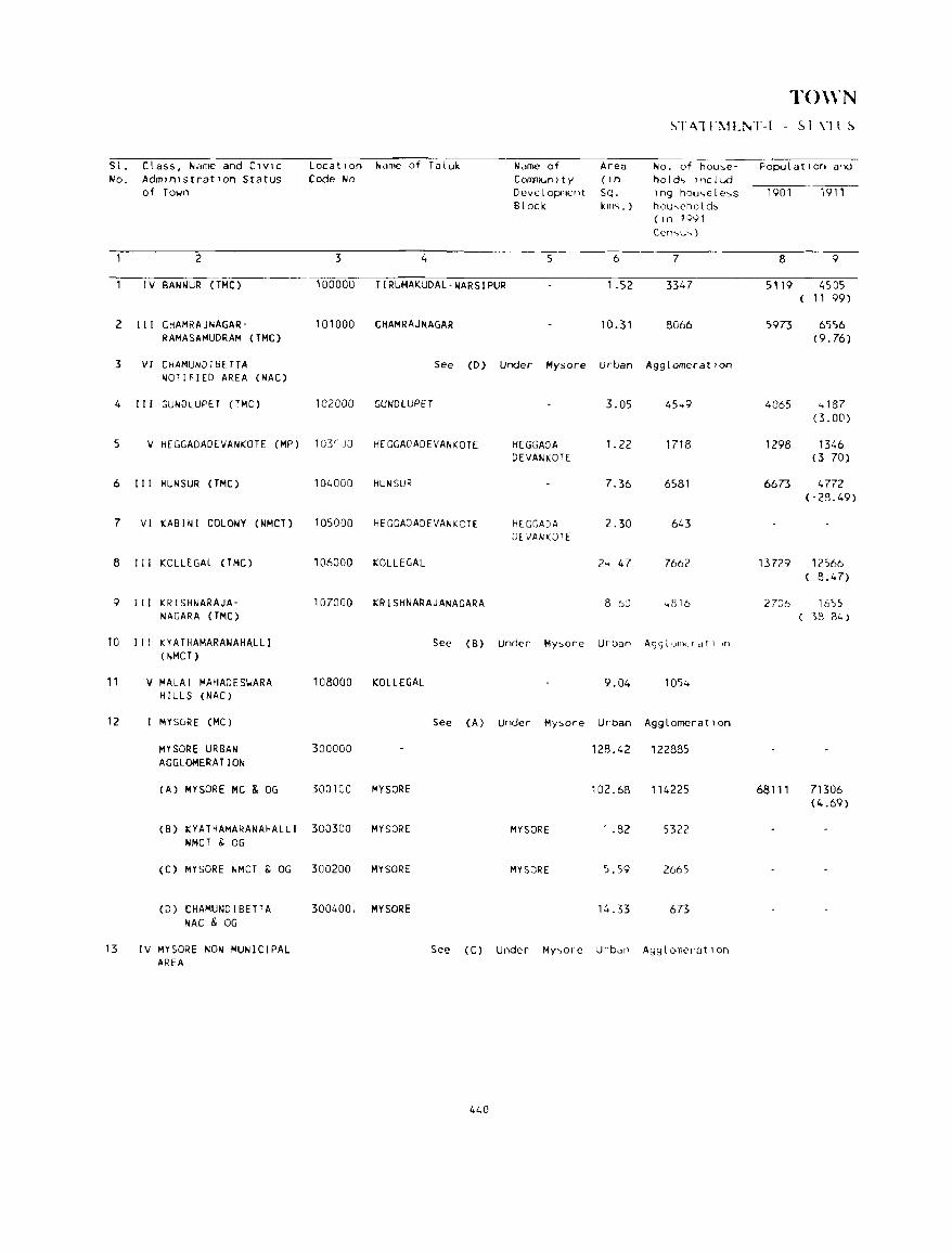
TO\\,N ~TA.ln .. 1Ll\.T-1 - ~I\lt~
S l. Class, Name and C,VIC LocatIon "arne of Taluk Name of Area No. of hou;,e- PopulatIon and No. AdmInIstratIon Status Code No C OMnun I t y ( In hold .. Inc l ud
of Town Deve l opncnt Sq. lng hou,>ele;,s 1901 1911 Block km<;. ) hou,>chold"
(In 1991 Cen'>u-.)
2 3 4 5 6 7 8 9
IV BANNUR (TMe) 100000 TIRUMAKUDAL-NARSIPUR 1.52 3347 5119 4505 11 99)
2 III CHAMRAJNAGAR- 101000 CHAMRAJNAGAR 10.31 8066 5973 6556 RAMASAMUDRAM (TMC) (9.76)
3 VI C HAMUND 1 SE TT A See (D) Under Mysore Urban Agg I omerat Ion NOTIFIED AREA (NAC)
4 III GUND LUPE T (TMC) 102000 GUNDLUPET 3.05 45 .. 9 4065 .. 187 (3.00)
5 V HEGGADADEVANKOTE (MP) 103-,)0 HfGGADAOEVANKOTE HEGGADA 1.22 1718 1298 1346 DEVANKOTE (3 70)
6 III HUNSUR (TMC) 104000 HUN SUR 7.36 6581 6673 4772 (-28.49)
7 VI KASINI COLONY (NMCT) 105000 HEGGADADEVANKOTE HECGADA 2.30 61.3 Of VANKOTE
8 III KOLlEGAL (TMC) 106000 KOLLEGAL 2 .. 47 7662 13729 12566 ( 8.47)
9 II I KRISHNARAJA- 107000 KRISHNARAJANAGARA 8 ioU .. 816 2706 1655 NAGARA (TMC) 18 84)
10 III KYATHAMARANAHALLI See (B) Under My"ore Urbiln AggtuIT"Ilfdt1 In
( NMCT)
11 V MALAI MAHADESIJARA 108000 KOLlEGAL 9.04 1054 HIltS (NAC)
12 MYSGRE (MC) See (A) Under My;,ore Urban AggLomeratIon
MYSORE URBAN 300000 128.42 122885 AGGLOMERATION
(A) MYSORE MC & OG 300100 MYSORE 102.68 114225 68111 71306 (4.69)
(B) KYATHAMARANAHALLI 300300 MYSORE MYSORE .82 5322 NMCT 8. OG
(C) MYSORE NMCT 8. OG 300200 MYSORE MYSORE 5.59 2665
(0 ) CHAMUt-lD I BETT A 300400. MYSORE 14.33 673 NAC & OG
13 IV MYSORE NON MUNICIPAL See (C) Under My,>ore Urbdn AgglomeratIon AREA
440
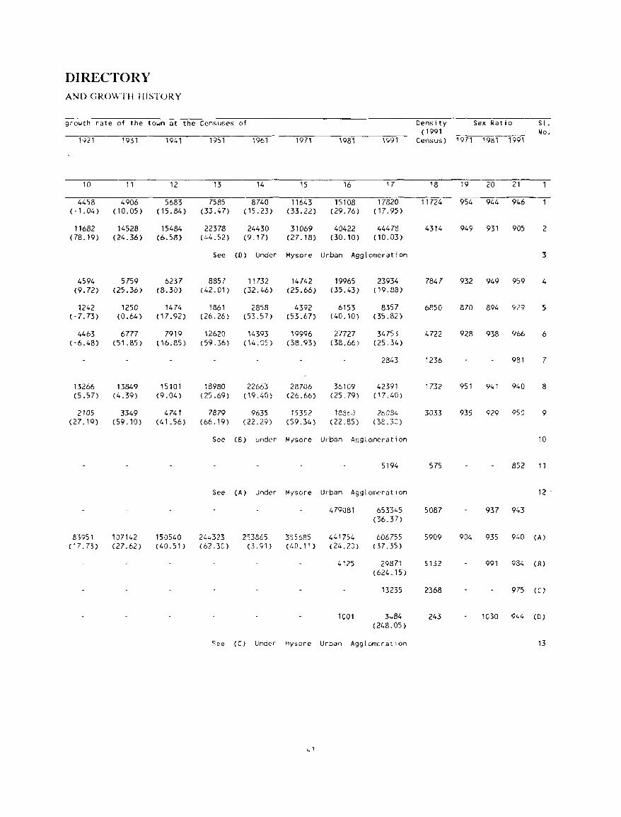
DIRECTOH.Y AND GROWTH HISTORY
growth rate of the town at the Censuses of
1921 1931 1941 1951 1961 1971
10 11 12 13 14 15
4458 4906 5683 7585 8740 11643 (·1.04 ) (10.05 ) (15.84) (33.47) (15.23) (33.22)
11682 14528 15484 22378 24430 31069 (78.19) (24.36) (6.58) (,,4.52) (9.17) (27.18)
See (0 ) Under Mysore
4594 5759 6237 8857 11732 14742 (9.72) (25.36) (8.30) (42.01) (32.46) (25.66)
1242 1250 1474 1861 2858 4392 ('7.73) (0.64 ) (17.92) (26.26) (53.57) (53.67)
4463 6777 7919 12620 14393 19996 ( '6.48) (51.85) ( 16.85) (59.36) (14. OS) (38.93)
13266 13849 15101 18980 22663 28706 (5.57) (4.39) (9.04) (25.69) <19.40) (26.66)
2105 3349 4741 7879 9635 15352 (27.10) (59.10) (41.56) (66.19) (22.29) (59.34)
See (B) under M/sore
See (A) Under Mysore
83951 107142 150540 21,,.323 253865 355685 (17.73) (27.62) (40.51) (62.30) (3. 91 ) (40.11 )
S2e (C) Under Mysore
L, 1
19B1 1991
16 17
15108 17820 (29.76) (17.95)
40422 44478 (30.10) ( 10.03)
Urban Agglomeration
19965 23934 (35.43) ( 19.88)
6153 8357 (40.10) (35.82)
27727 34753 (38.66) (25.34)
2843
36109 42391 (25.79) (H .40)
1886:3 26C84 (22.85 ) (3t.30)
Urban Agglomeration
5194
Urban AgglOITIeratlon
479081 653345 (36.37)
441754 606755 (24.20) (37.35)
4125 29871 (624.15)
13235
1001 3,,84 (248.05)
Urban Agglomcratlon
Dens i ty ( 1991
Sex Ratio
Census) 1971 19B1 1991
18 19 20 21
11724 954 944 946
4314 949 931 905
7847 932 949 959
6850 870 894 Y29
4722 928 938 966
1236 981
1732 951 941 940
3033 935 929 95CJ
575 852
5087 937 943
5909 904 935 940
5132 991 984
2368 975
243 1030 944
Sl. No.
2
3
4
5
6
7
8
9
10
11
12 .
(A)
(8)
(!:)
(D)
13
TOWN STATEMENT-I - STATUS
Sl. Class, Name and Civic Location Name of Talulc Name of Area No. of house- Population and No. Administration Status Code No. COITIWnity ( in holds includ-
of Town Development Sq. ing houseless 1901 1911 Block kms. ) households
(in 1991 Census)
2 3 4 S 6 7 8 9
14 III NANJANGUD (THC) 109000 NANJANGUD 9.69 8288 5991 7246 (20.95)
1S IV PIRIYAPATNA (MP) 110000 PIRIYAPATNA PIRIYAPATNA 5.99 2295 3872 3404 (-12.09)
16 V SARGUR (MP) 111000 HEGGADADEVANICOTE HEGGADA- 0.78 1800 2284 DEVANICOTE
17 V TlRUMAKUOAL- 112000 TIRUMAKUOAL- TIRUMAKUDAL- 1.00 1976 2406 4033 NARSlPUR (MP) NARSIPUR NARSIPUR (67.62)
18 V YELANDUR (MP) 113000 YELANDUR YELANDUR 0.34 1507 3803
442
DIRECTORY AND GROWTH HISTORY
growth rate of the town at the Censuses of
1921 1931 1941 1951 1961
10 11 12 13 14
7453 8215 10725 16737 17599 (2.86) (10.22) (30.55) (56.06) (5.15)
3108 3216 3957 4n8 6075 (-8.70) (3.47) (23.04) (20.75) (27.15)
2265 2069 3033 3634 4599 (-8.65) (46.59) (19.82) (26.55)
4768 2806 3587 5374 5868 (18.22) (-41.15) (27.83) (49.82) (9.19)
3453 3637 4056 4578 (5.33) (11.52) ( 12.87)
1971 1981 1991
15 16 17
22583 34939 42598 (28.32) (54.71) (21.92)
7411 10039 12008 (21.99) (35.46) (19.61)
5587 7541, 8911 (21.48) (35.03) (18.12)
6820 8910 9900 (16.22) (30.65) (11.11)
5132 6710 7678 (12.10) (30.75) (14.43)
443
Density ( 1991
, Sex Ratio Y Sl.
No. Census) 1971 1981 1991
18 19 20 21
4396 911 947 959 14
2005 928 920 946 15
11424 931 975 962 16
9900 928 914 960 17
22582 932 919 900 18
~ r ·\1 Li\II1\ r-II - PIII~ICA.[ ·\~PLCl ~
Sl. Class and Name of Town PhY~lcal A~pects Name of and No.
RaInfall Temperature State Head Quarters 01 strict Head Quarters (1 n fTITl.) (In CentIgrade)
Max lInum MInimum
2 3 4 5 6 7
IV BANNUR 667.2 34.6N 15.6N Bangalore-128 My..,ore·Z3
2 III CHAMRAJNAGAR- 748.1 34.6N 15.6N Bangalore-198 My..,ore-61 RAMASAMUDRAM
3 VI CHAMUND I BETTA See (D) Under My~ore Urban Agglom,ratlon NOTifiED AREA
4 III GUNDLUPET 690.9 34.6N 15.6N Bangalore-201 My<,orf'-62
5 V HEGGADADEVANKOTE 833.3 29.7N 18.31N B.:lngalore 193 My::.ore-52
6 III HUN SUR 791.0 29.74 13.31 Bang<llore-175 Mysore-43
7 VI KABINI COLONY 809.0 34.60N 15.6N Bangalore-200 Mysore-59
8 I II KOLLE GAL 732.1 34.6N 15.6N Bangalore-140 Mysore-64
9 III KRISHNARAJANAGARA 569.88 29.74N 18.31N Bangalore-179 Mysore-40
10 1 I r KYATHAMARANAHALLI See (B) Under Mysore Urban Agg I omerat lOn
11 V MALAI MAHAOESI.JARA 732.07N 34.6N 15.6'1 Bangalore-220 Mysore-140 HILLS
12 MYSORE See (A) Under Mysore Urban AgglomeratIon
MYSORE URBAN AGGLOMERATION See Constltuent Unl ts
(A) MYSORE MC & OG 591.01 34.6* 15.6* Bangalore-139 Mysore-O
(B) KYATHAMARANAHALLI 591.01N 34.6N 15.6N Bangalore-147 Mysore-8
(C) MYSORE NON' 591.01N 34 6N 15.6N Bilngalore-141 My::.ore-2 MUNICIPAL AREA
(0 ) CHAMUNDIBETTA 591 01N Bangalore 150 Mysore 13 NOTIfIED AREA
13 IV MYSORE NON-MUNICIPAL See (C) Under My~ore U rbi:ln AgglomeratIon AREA
444
Ar\[) LOCATION OF TO\\'NS. 1<}8Q
road di"tance (In Kin!>.) f rOIn
SUb-Olvlsion/Taluk Nearest Clty.,ith Rilll.,ay Statlon Bus Route Navigable River/ Sl. Head Quarters populatIon of one Canal ( i f .,ithin No.
lakh and more 10 Kms.)
8 9 10 11 12
Mysore·23 Mysore·23 Mysore-23 Bannur·O Tirumakudal-Narslpur-16
NanJangud-37 Mysore-61 Chamarajnagar-O Chamarajnagar-O 2 Chamrajnagar-O
See (D) Under Mysore Urban Agglomeration 3
Nanjangud-38 Mvsore-62 Nanjangud-38 Gundtupet-O 4 Gundlupet -0
Hunsur-29 Mysore-52 Mysore-52 Heggadadevankote-O 5 Hcggadadevankote-O
Hunsur-O Mysore-43 Krishnaraja- Hunsur-Q 6 Hun~ur-O nagara-24
Hunsur-44 My"ore-59 Mysore-59 Kabini -0 7 Heggadadevankote-15
Mysore-64 My»ore-64 Chi,rnilra j naga r - 30 KG! !egal-O B Kollegal-O
Hunsur-22 Mysore-40 Krishnaraja' KrishnaraJa- 9 KrlshnaraJanagara-O nagara-O nagara-Q
See (S) Under Mysore Urban Agglomeration 10
Mysore- 140 Mysore-140 Mysore-140 Malai Mahadeswara 11 Kollegal-BO Hi lls- 0
See (A) Under Mysore Urban Agglomeration 12
S£C!e Canst 1 tuent Uni ts
Mysore-O Mandya-42 Mysore-O Mysore-O (A) Mysore-O
My",ore-8 Mysore-B Mysore-B Kyathamanahalli-O (B) My,>ore-8
,
Mysore-2 My~ore-2 My"ofe'Z Mysore-Z CCl Mysore-2
Mysore-13 My"ore-13 M,,'-.cJre-13 Ch;>01undibctta-O (D) Mysore-13
See (C) Under My-,ore Urban Agg I olllcr'at ion 13
445
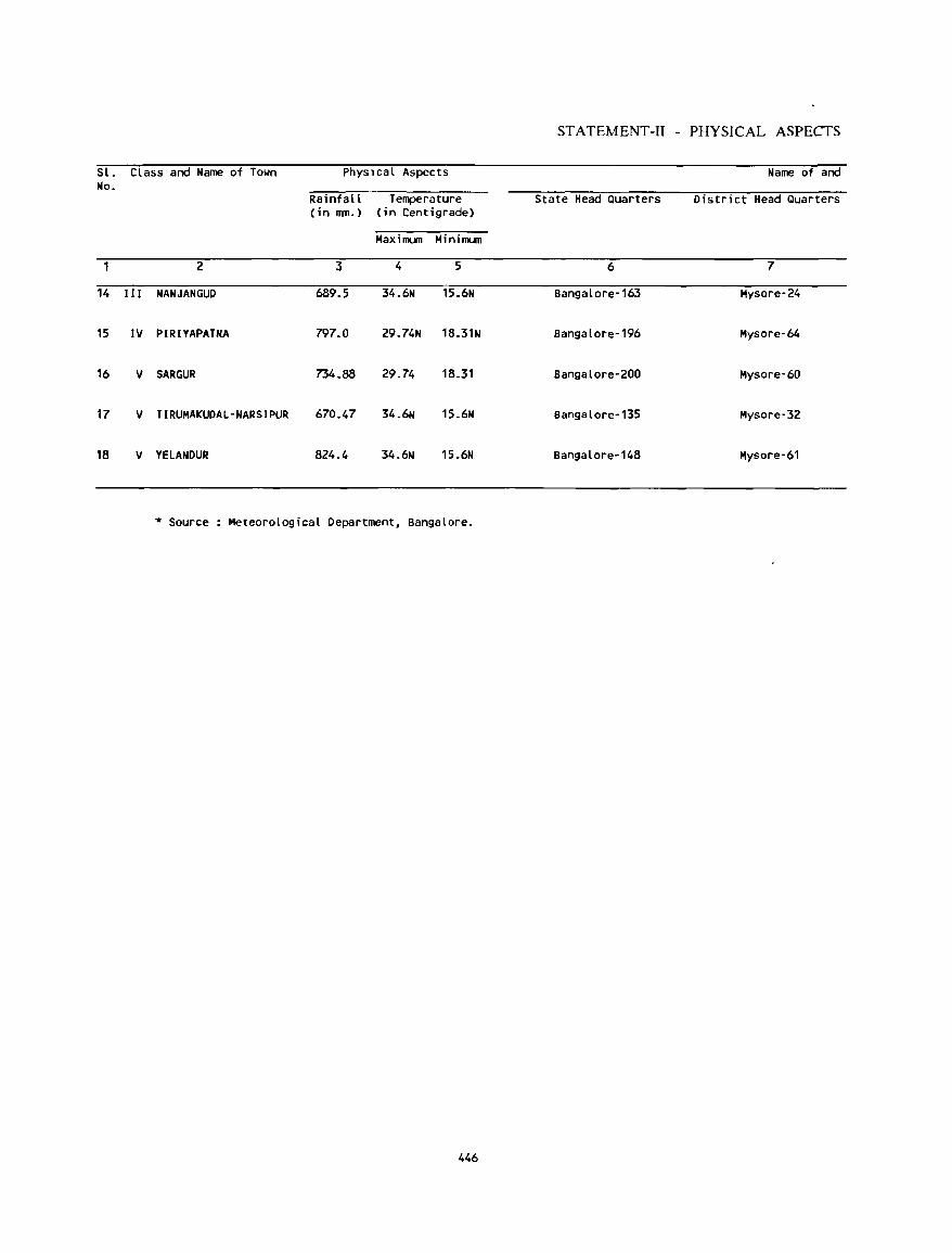
STATEMENT-II - PHYSICAL ASPECTS
Sl. Class and Name of Town Physlcal Aspects Name of and No.
Rainfall Temperature State Head Quarters District Head Quarters (in nm.) (in Centigrade)
HaxillUll Minillllln
2 3 4 5 6 7
14 II I NANJANGUD 689.5 34.6N 15.6N Bangalore-163 Mysore-24
15 IV PIRIYAPATNA 797.0 29.74N 18.31N Bangalore-196 Mysore-64
16 V SARGUR 734.88 29.74 18.31 Bangalore-200 Mysore-60
17 V TIRUMAKUDAl-NARSIPUR 670.47 34.6N 15.6N Bangalore-135 Mysore-32
18 V YElANDUR 824.4 34.6N 15.6N Bangalore-148 Mysore-61
* Source Meteorological Department, Bangalore.
446
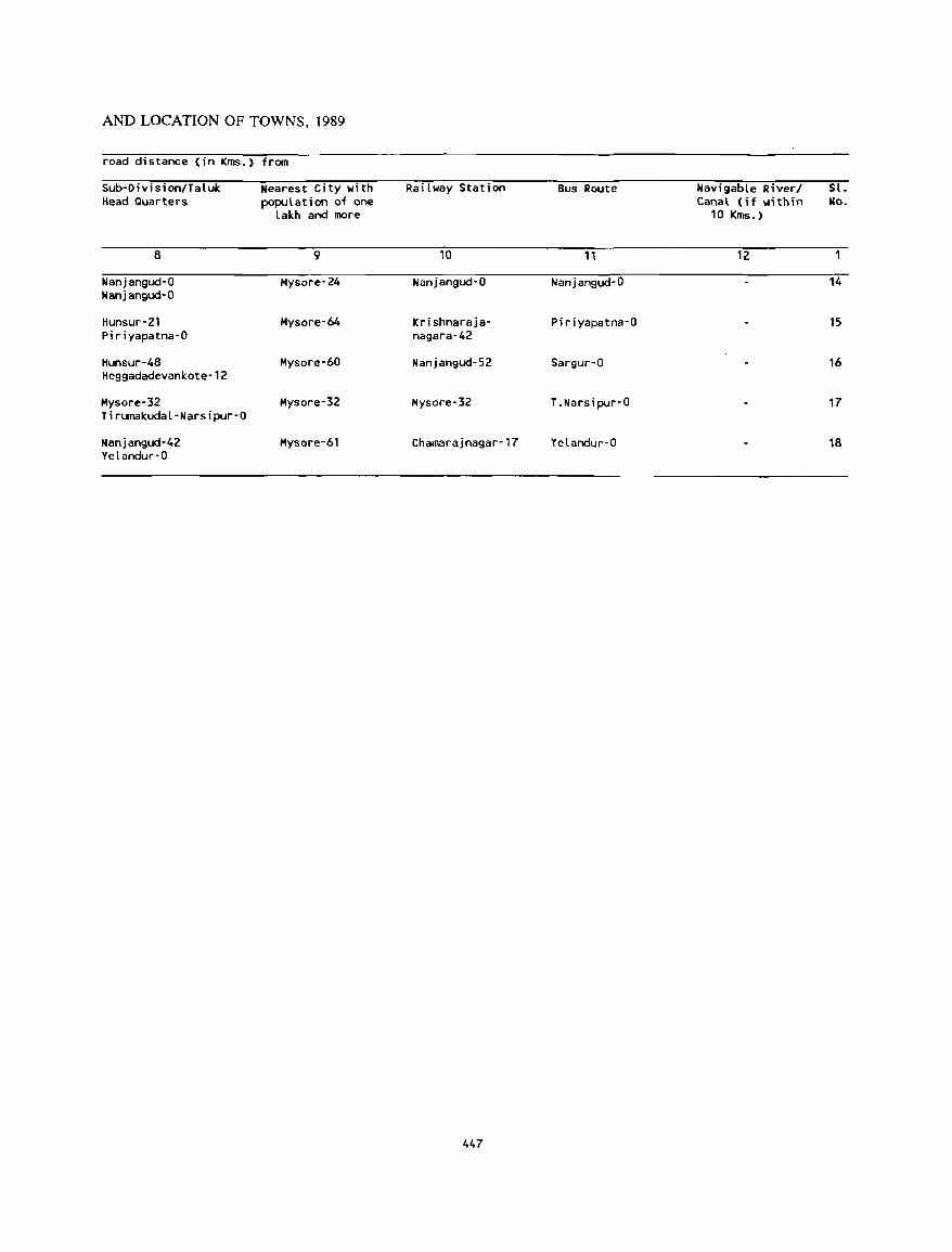
AND LOCATION OF TOWNS, 1989
road distance (in Kms.) from
Sub-Oivision/Taluk Nearest City with Railway Station Bus Route Navigable River/ Sl. Head Quarters population of one Canal (if within No.
lakh and more 10 Kms.)
8 9 10 11 12
Nanjangud-O Mysore-24 Nanjangud-O Nanjangud-O 14 Nanjangud-O
Hunsur-21 Mysore-64 Krishnaraja- Piriyapatna-O 15 Piriyapatna-O nagara·42
Hunsur-48 Mysore-60 Nanjangud-52 Sargur-O 16 Heggadadevankote-12
Mysore-32 Mysore-32 Mysore-32 T_Narsipur-O 17 Tirumakudal-Narsipur-O
Nanjangud-42 Mysore-61 Chamarajnagar-17 Yelandur-O 18 Yelandur-O
447
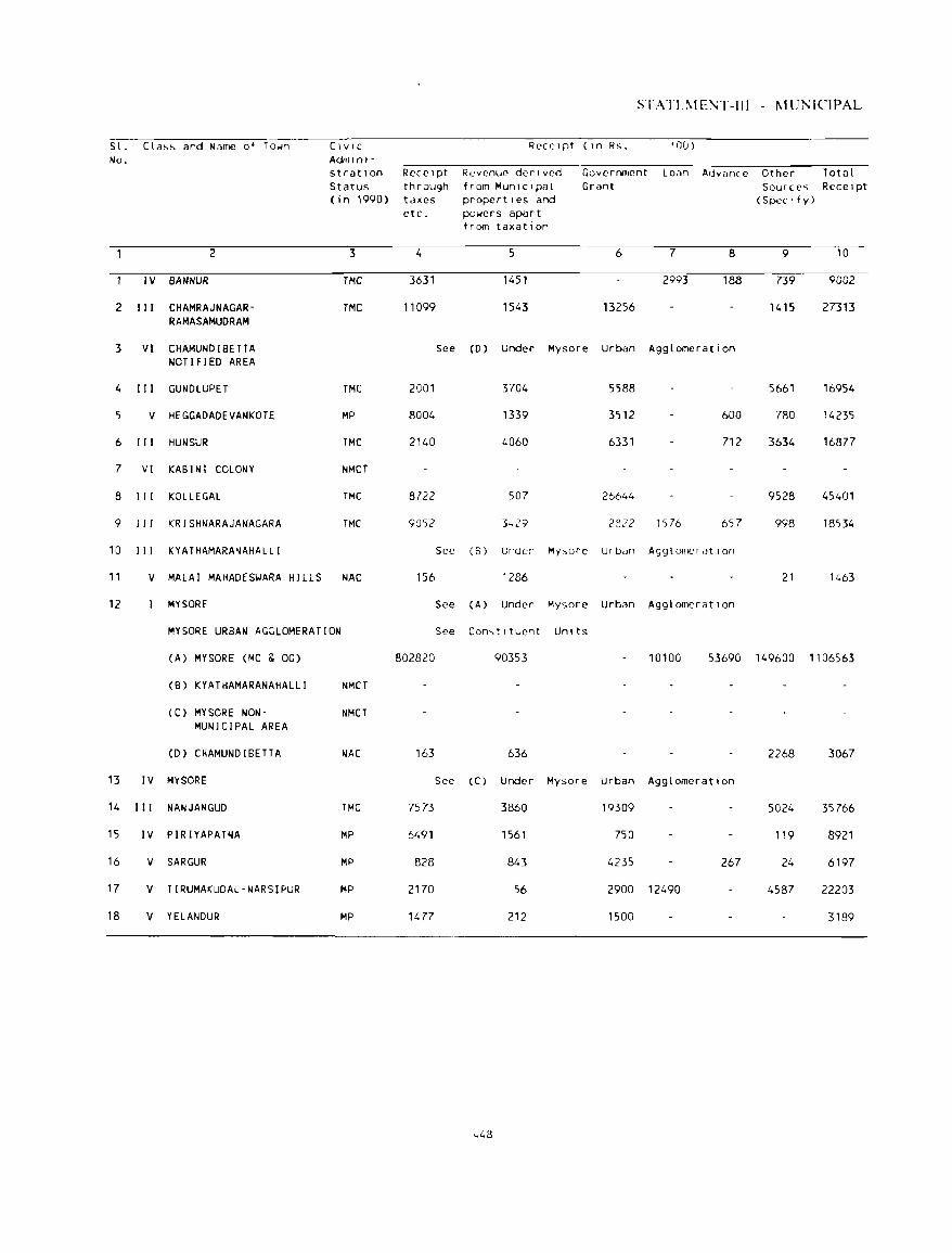
STAn.\! E!\4T-111 - 1--1 ur-.:ICIPAL
S l . Cla~~ and Name of To~n CIVIC ReceIpt C In Rs. 'OU) No. Adnllnl-
stratl0n ReceIpt Revenue derIved Government LOiln Advcmce Other Total Status through from MunIcIpal Grant Sources ReceIpt ( j n 1990) taxes propertIes and (SpeCIfy)
etc. po~ers apart from taxation
2 3 4 5 6 7 8 9 10
IV BANNUR TMC 3631 1451 2993 188 739 9002
2 III CHAMRAJNAGAR- TMC 11099 1543 13256 1415 27313 RAMASAMUDRAM
3 VI CHAMUNDIBETTA See (0 ) Under Mysore Urban Agglomeration NOTIFIED AREA
4 III GUNDLUPET TMC 2001 3704 5588 5661 16954
5 V HEGGADADEVANKOTE MP 8004 1339 3512 600 780 14235
6 III HUNSUR TMC 2140 4060 6331 712 3634 16877
7 VI KABINI COLONY NMCT
8 III KOLLEGAL TMC 8722 507 26644 9528 45401
9 II r KRISHNARAJANAGARA TMC 9052 3 .. 29 2822 1576 657 998 18534
10 III KYATHAMARANAHALLI See (B) Under Mysore Urban AgglomeratIon
11 V MALAI MAHADESWARA H1LLS NAC 156 1286 21 1463
12 MYSORE See CA) Under Mysore Urban AgglomeratIon
MYSORE URBAN AGGLOMERATION See Con..,tltuent Um ts
(A) MYSORE (MC & OG) 802820 90353 10100 53690 149600 '106563
(B) KYATHAMARANAHALLI NMCT
(C) MYSORE NON- NMCT MUNICIPAL AREA
(D) CHAMUNDIBETTA NAC 163 636 2268 3067
13 IV MYSORE See (C) Under Mysore Urban Agglomeration
14 III NANJANGUD TMC 7573 3860 19309 5024 35766
15 IV PIRIYAPATNA MP 6491 1561 750 119 8921
16 V SARGUR MP 828 843 4235 267 24 6197
17 V TIRUMAKUDAL·NARSIPUR MP 2170 56 2900 12490 4587 22203
18 V YELANDUR MP 1477 212 1500 3189
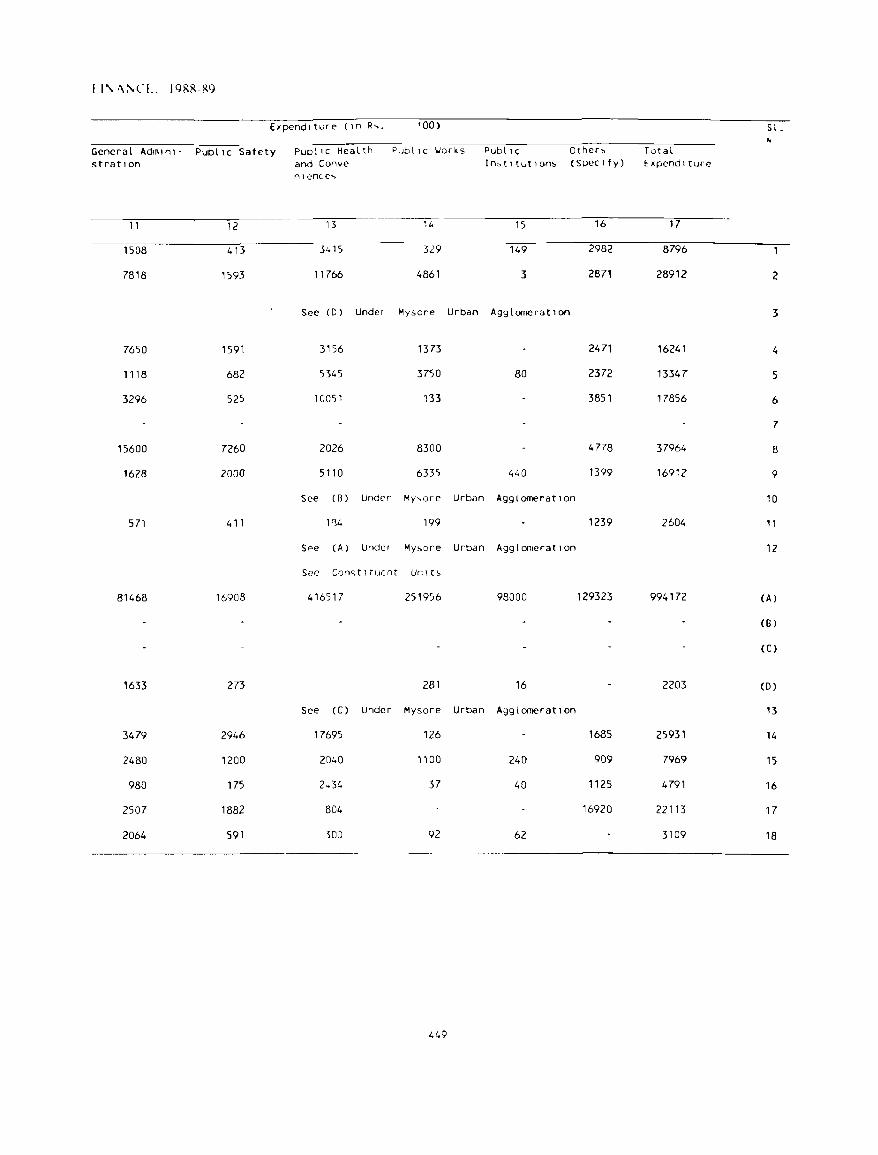
I I\, '\:'\CL. 1988-89
E1pendlture (In R~. '00) S l. ~
General Admln1- Public Safety PubliC Health Publl C l.Iorks PubliC Other" Total s trat! on and Conve In,tltutlon!> (Spec Ify) Expend I ture
nlence~
11 12 13 14 15 16 17
1508 413- 3415 329 149 2982 8796
7818 1593 11766 4861 3 2871 28912 2
See (D) Under Mysore Urban AgglomeratIon 3
7650 1591 3156 1373 2471 16241 4
1118 682 5345 3750 80 2372 13347 5
3296 525 10051 133 3851 17856 6
7
15600 7260 2026 8300 4778 37964 8
1628 2000 5110 6335 440 1399 16912 9
See (8) Under My,.,ore Urban Agglomeration 10
571 411 1'34 199 1239 2604 11
See (A) Under My!>ore Urban Agglomeration 12
See Con'> t I rue nr Unl t~
81468 16908 416517 251956 98000 129323 994172 (A)
(8)
(Cl
1633 273 281 16 2203 (0 )
See (C) Under Mysore Urban AgglomeratIon 13
3479 2946 17695 126 1685 25931 14
2480 1200 2040 1100 240 909 7969 15
980 175 2~34 37 40 1125 4791 16
2507 1882 804 16920 22113 17
2064 591 300 92 62 3109 18
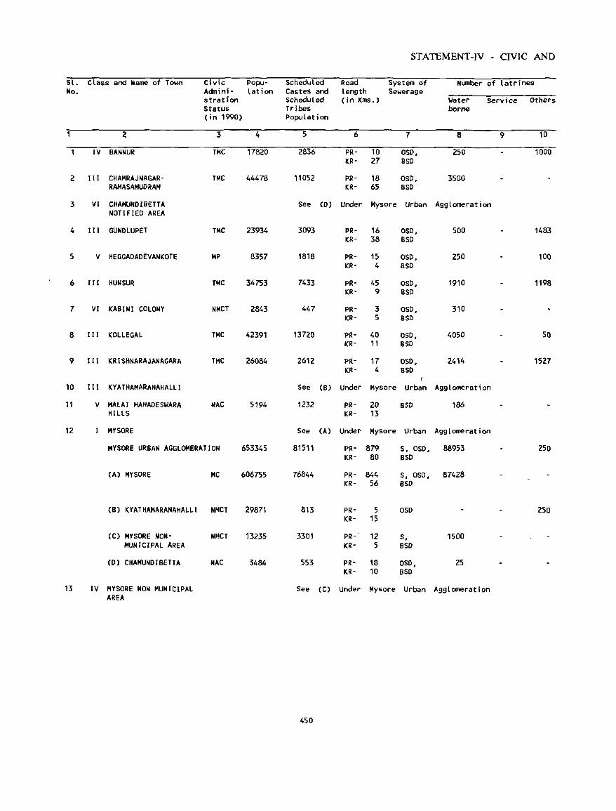
STATEMENT-IV - CIVIC AND
Sl. class and Name of Town Civic Popu- Scheduled Road System of Number of latrines No. Acinini - lation Castes and length Sewerage
stration scheduled (in KIllS.) Water Service Others Status Tribes borne (in 1990) population
2 3 4 5 6 7 8 9 10
IV BANNUR TMC 17820 2836 PR- 10 OSO, 250 1000 ICR- 27 aso
2 I II CHAMRAJNACAR- TMC 44478 11052 PR- 18 OSO, 3500 RAHASAHUDRAM ICR- 65 BSD
3 VI CHAHUHOIBETTA See (0 ) Under Mysore Urban Agglomeration NOTIFIED AREA
4 III GUNOLUPET TMC 23934 3093 PR- 16 050, 500 1483 KR- 38 BSO
5 V HEGGAOAOEVANKOTE MP 8357 1818 PR- 15 OSO, 250 lOa KR- 4 BSO
6 1I1 HUN SUR THC 34753 7433 PR- 45 OSO, 1910 1198 KR- 9 BSO
7 VI KABINI COLONY NMCT 2843 447 PR- 3 OSO, 310 KR- 5 BSO
8 III KOLLEGAL TMC 42391 13720 PR- 40 OSO, 4050 50 KR- 11 BSO
9 III ~RISHNARAJANAGARA TMC 26084 2612 PR- 17 OSO, 2414 1527 KR- 4 BSO
I
10 III KVATHAMARANAHALLI See (B) Under Mysore Urban A9g1omeration
11 V MALAI MAHADES~ARA HAC 5194 1232 PR- la SSD 186 HILLS KR- 13
12 MYSORE See CA) Under Mysore Urban Agglomeration
MVSORE URBAN AGGLOMERATION 653345 81511 PR- 879 S, 050, 88953 250 KR- 80 BSO
CA) HYSORE He 606755 76844 PR- 844 5, 050, 87428 KR- 56 BSO
(B) KYATHAMARANAHALLI NMCT 29871 813 PR- 5 050 250 KR- 15
CC) MYSORE NON- NMCT 13235 3301 PR- 12 5, 1500 MUNICIPAL AREA KR- 5 BSO
(D) CHAMUNO I BETTA NAC 3484 553 PR- 18 050, 25 KR- 10 BSO
13 IV MVSORE NON MUNICIPAL See CC) Under Mysore Urban Agglomeration AREA
450
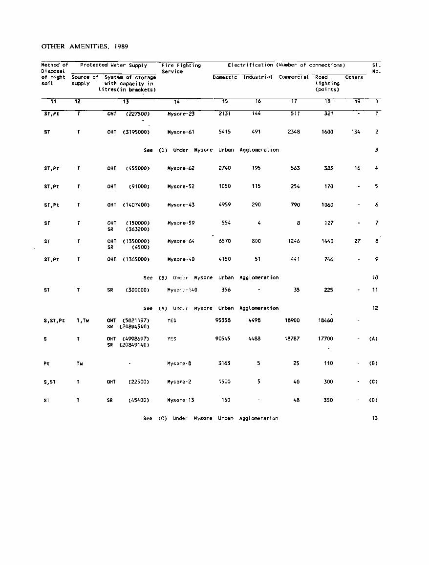
OTHER AMENITIES. 1989
Metho<! of Protected ~ater Supply Fire Fighting Electrification (Number of connections) Sl. Disposal Service No_ of night Source of System of storage Domestic Industrial Coomercial Road Others soil supply with capacity in lighting
litres{in brackets) (points)
11 12 13 14 15 16 17 18 19
ST,Pt T OHT (227500) Hysore-23 2131 144 511 321
ST T OHT (3195000) Mysore-61 5415 491 2348 1600 134 2
See (D) Under Mysore urban Agglomeration 3
ST,Pt T OHT (455000) Hysore-62 2740 195 563 385 16 4
ST,Pt T OHT (91000) Mysore-52 1050 115 254 170 5
ST,Pt T OHT ( 1407400) Mysore-43 4959 290 790 1060 6
ST T OHT (150000) Mysore-59 554 4 8 127 7 SR (363200)
ST T OHT (1350000) Mysore-64 6570 800 1246 1440 27 8 SR (4500)
ST,Pt T OHT ( 1365000) Mysore-40 4150 51 441 746 9
See (8) Under Mysore Urban Agglomeration 10
ST T SR (300000) Myson·-140 356 35 225 11
See (A) Un,l, r Mysore Urban Agglomeration 12
S,ST,Pt T,Tw OHT (5021197) YES 95358 4498 18900 18460 SR (20894540)
S T OHT (4998697) YES 90545 4488 18787 17700 (A)
SR (20849140)
Pt Tw Mysore-8 3163 5 25 110 (B)
S,ST T OHT (22500) Hysore-2 1500 5 40 300 (C)
ST T SR (45400) Mysore-13 150 48 350 (D)
See (C) Under Mysore Urban Agglomeration 13
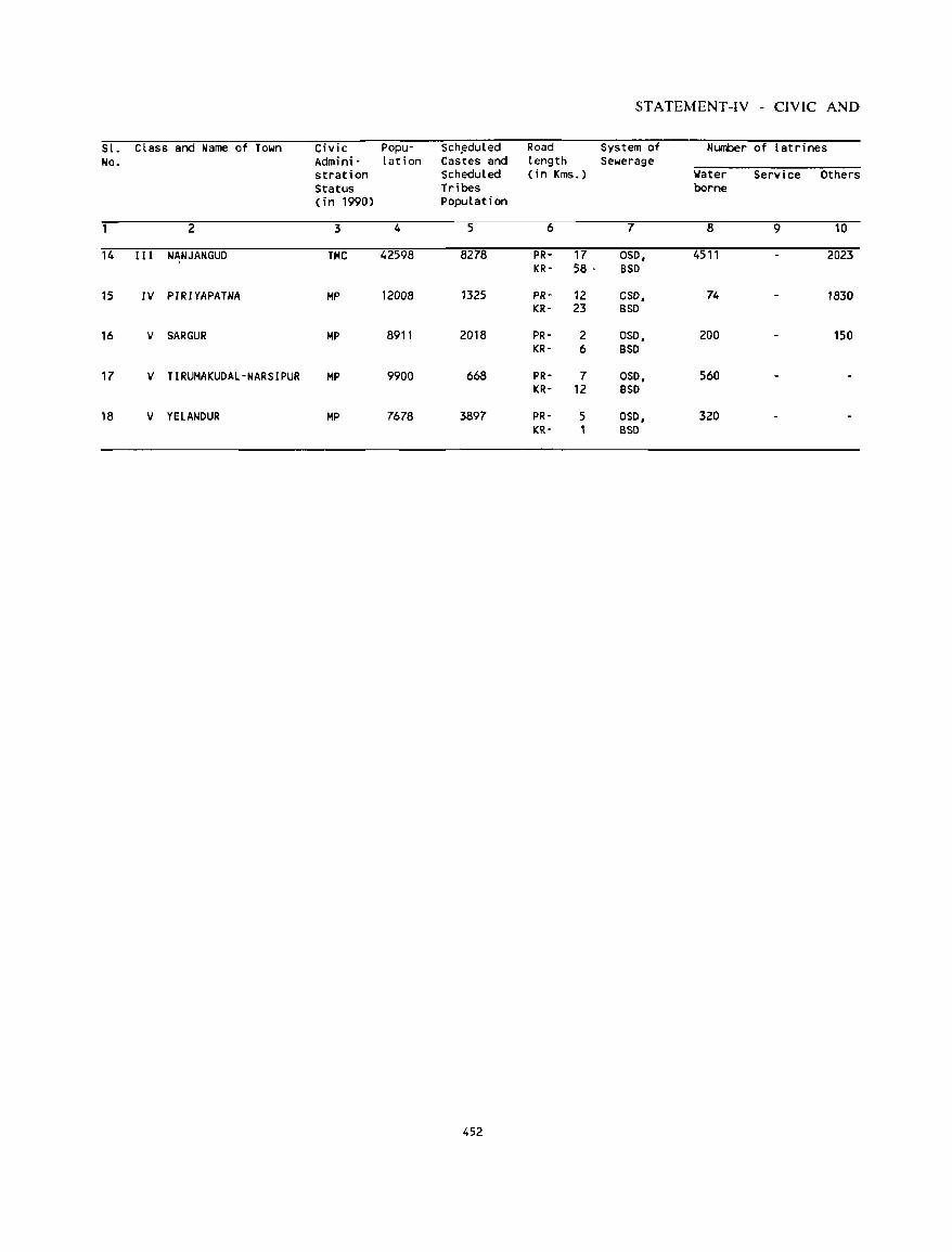
STATEMENT-IV - CIVIC AND
SI. Class and Name of Town Civic Popu- Scheduled Road System of Number of latrines No. Admini- lation Cas·tes and length Sewerage
stration Scheduled (i n Kms.) Water Service Others Status Tribes borne (in 1990) Population
2 3 4 5 6 7 8 9 10
14 III NANJANGUO TMC 42598 8278 PR- 17 OSO, 4511 2023 KR- 58 ' BSD
15 IV PIRIYAPATNA MP 12008 1325 PR- 12 CSD, 74 1830 KR- 23 BSD
16 V SARGUR MP 8911 2018 PR- 2 OSO, 200 150 KR- 6 BSO
17 V TIRUMAKUOAL-NARSIPUR MP 9900 668 PR- 7 OSO, 560 KR- 12 BSD
18 V YELANOUR MP 7678 3897 PR- 5 OSO, 320 KR- 1 BSO
452
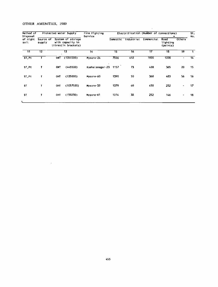
OTHER AMENITIES, 1989
Method of Protected Water Supply Fire Fighting Electrification (Nl.I11ber of connections) Sl. Disposal Service • No . of night Source of System of storage Domestic Industrial Coomercial Road Others soil supply with capacity in lighting
litres(in brackets) (points)
11 12 13 14 15 16 17 18 19
ST,Pt T OHT (135COOO) Hysore-24 7500 412 1920 1220 14
ST,Pt T OHT (445500) Kushalanagar-23 1157 73 400 365 20 15
ST,Pt T OHT (135000) Hysore-60 1390 50 360 483 56 16
ST T OHT (1057500) Hysore-32 1379 40 450 252 17
ST T OHT (159250) Hysore-61 1014 38 252 146 18
453
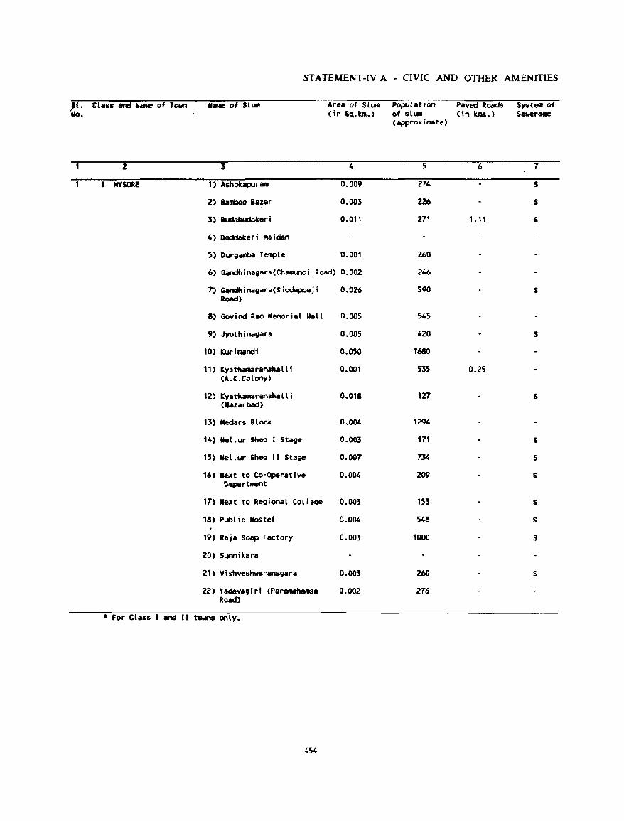
STATEMENT-IV A - CIVIC AND OTHER AMENITIES
1i. ClHa and hIRe of Town 11_ of illn Uo. .
2 1
IfYSORE 1) Ashobpuram
2) iamboo lazar
3) .&..dabucIaker i
4) OQddak.eri Maidan
S) Durgambil T~le
Area of SlLIR population Paved Roads Systelll of (in Sq.km.) of slum (in kms.) Sewerage
(approximate)
4 5 6 7
0.009 274 S
0.003 226 5
0.011 271 1.11 S
0.001 260
6) Gandhinagara(Chamundi Road) 0.002 246
7) Gandhinagara(5iddappaji 0.026 590 5 load)
8) GoYind lao Memorial Kall 0.005 545
9) Jvothinagara 0.005 420 5
10) (Uri_neli 0.050 T680
11) Kyathamaranahalli 0.001 535 0.25 (A.K.Colony)
12) Kyathamarananalli 0.018 121 S (Mazarbild)
13) Medars BLOC« 0.004 1294
14) Nellur Shed I Stage 0.003 171 5
15) Nellur Shed 11 Stage 0.007 734 S
16) Mext to Co-Operative 0.004 209 S nepartlllent
17) Next to Regional College 0.003 153 5
18) Public Wostel 0.004 548 S
19) Raja Soap Factory 0.003 1000 S
20) Sunnikara
21) Vishvesnwaranagara 0.003 260 S
22) Yadavagiri (Paramanamsa 0.002 276 Road)
* For Class 1 and II towns only_
454
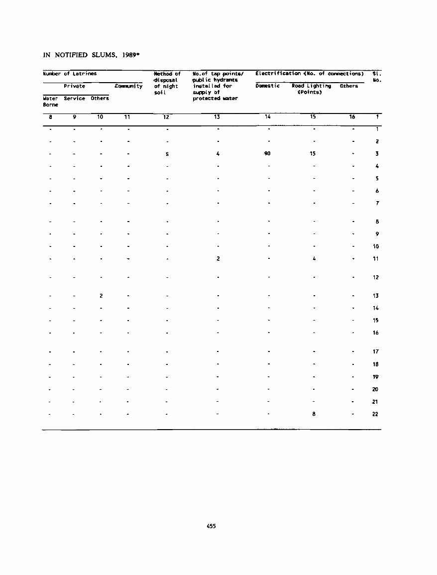
IN NOTIFIED SLUMS. 198'·
Number of latr~nes .drcd 01 'No~ of tap .pointsl <disposal <publ i~ "bydnR!tts
Private Connurtity of n.ight ins-taU ed for soil lWpPt., of
Water Service Others protected ..mer Borne
8 9 10 " 12 13
S 4
2
2
455
Electl'ific:ation (fiIo. of ccnnec::t10AS)
Domestic: Road lighting Othel's (~o>ints)
14 15 16
90 15
4
8
St. 110.
2
3
4
5
6
7
8
9
1G
11
12
13
14
15
16
17
18
19
20
.21
22
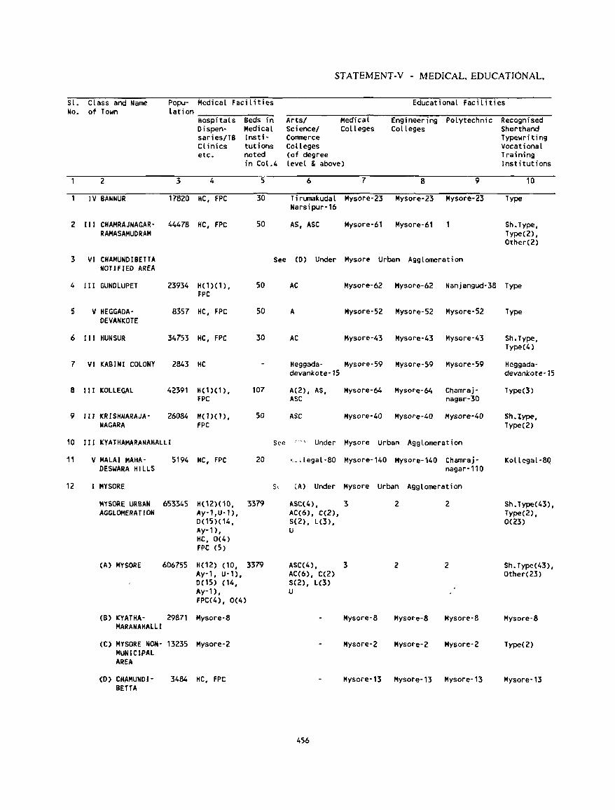
STATEMENT -V - MEDICAL. EDUCATIONAL,
SI. Class and Name Popu- Medical Facilities Educational Facilities No. of Town lation
Hospitals Beds in Artsl Medical Engineering Polytechnic Recognised Oispen- Medical Sciencel Colleges Colleges Shorthand saries/TB Insti- eomnerce Typewriting Cl inics tutions Colleges Vocational etc. noted (of degree Training
in Col.4 lellel & abolle) Institutions
2 3 4 5 6 7 8 9 10
IV BANNUR 17820 HC, FPC 30 Tirl.lllllkudal Mysore-23 Mysore-23 Mysore-23 Type Narsipur-16
2 III eHAMRAJNAGAR' 44478 He, FPC 50 AS, ASC Mysore-61 Mysore-61 Sh.Type, RAMASAMUORAM Type(2) ,
Other(2)
3 VI CHAMUNDIBETTA See (D) Under Mysore Urban Agglomeration NOTIfIED AREA
4 III GUNDLUPET 23934 H(1)(1 ), 50 AC Mysore-62 Mysore-62 Nanjangud-38 Type FPC
5 V HEGGADA- 8357 HC, FPC 50 A Mysore-52 Mysore-52 Mysore-52 Type OEVANKOTE
6 III HUN SUR 34753 HC, FPC 30 AC Mysore-43 Mysore-43 Mysore-43 Sh.Type, Type(4)
7 VI KABINI COLONY 2843 HC Heggada- Mysore-59 Mysore-59 Mysore-59 Heggada· devankote-15 dellankote-15
8 II I KOLLEGAL 42391 H(1)(1), 107 A(2) , AS, Mysore-64 Mysore-64 Chamraj· Type(3) fPC ASC nagar-30
9 III KRISHNARAJA' 26084 HO){l), 50 ASC Mysore-40 Mysore-40 Mysore-40 Sh.type, NAGAR A FPC Type(2)
10 I I I KYATHAMARANAHALLI See 1'1"'- Under Mysore Urban Agglomeration
11 V MALAI MAHA- 5194 HC, FPC 20 K-llegal-80 Mysore-140 Mysore-140 Chamraj- Kollegal-8Q DESWARA HILLS nagar-110
12 MYSORE s, (A) Under Mysore Urban Agglomeration
MYSORE URBAN 653345 H(1Z)(10, 3379 ASC(4), 3 2 2 Sh. Type(43), AGGLOMERATION Ay-1 ,U-1), AC(6), C(2), Type(2) ,
0(15)(14, S(Z), L(3), 0(23) Ay-n, U HC, 0(4) FPC (;)
(A) MYSORE 606755 He1Z) (10, 3379 ASC(4) , 3 Z 2 Sh. Type(43), Ay-t, U-1), AC(6), C(2) Other(23) 0(15) (14, 5(2), L(3) Ay-'), U FPC(4), 0(4)
(B) KYATHA- 29871 Mysore-8 Mysore-8 Mysol"e-8 Mysore-8 Mysore-8 MARANAHAlll
(C) MYSORE NON- 13235 Mysore-Z Mysore-2 Mysore-Z Mysore-2 Type(2) MUNICIPAL AREA
(D) CRAMUND I - 3484 HC, FPC Mysore-13 Mysore-13 Mysore-13 Mysore'13 BETTA
456
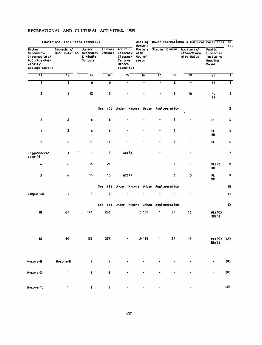
RECREATIONAL AND CULTURAL ACTIVITIES, 1989
Educational Facilities (concld.) Working Women's
Higher Secondary/ Junior Primary Adult Hostels Secondary/ Matriculation Secondary Schools Literacy wi th Intermediate/ & Middle Classes/ No. of PUC (Pre-Uni- Schools Centres seats versity Others College Level) (Specify)
11 12 13 14 15 16
2 6 6
2 6 12 15
See (D) Under Mysore Urban
2 2 6 16
3 6 6
2 2 11 17
He9gadadevan- 1 AC(3) kote-15
4 6 15 21
3 6 13 18 AC(1)
See (B) Under Mysore Urban
R~r-40 2
See CA) Under Mysore Urban
18 . 61 141 283 2-155
18 59 136 278 2-155
Mysore-8 Mysore-8 2 2
Mysore-2 2 2
Mysore-13
457
No.of Recreational & Cultural
Stadia Cinema Auditoria/ Drama/COITIW-nity Halls
17 18 19
2
3 10
Agglomeration
2
2
5
3 3
Agglomeration
Agglomeration
27 13
27 13
Faci l ities Sl. No.
Pool ic Libraries including Reading Rooms
20 1
RR
Pl 2 RR
3
Pl 4
PL 5 RR
PL 6
7
PL(2) 8 RR
Pl 9 RR
10
11
12
Pl(10) RR(3)
Pl( 10) (A) RR(3)
(8)
(C)
(0)
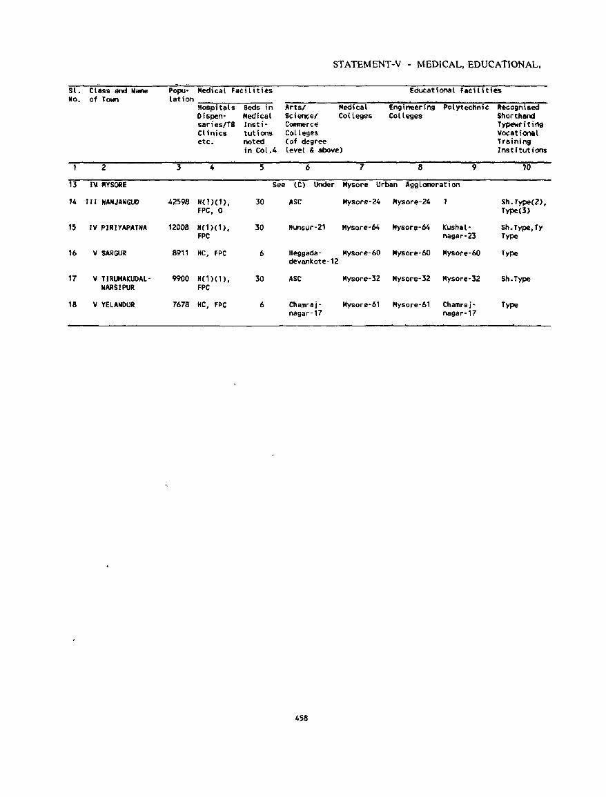
ST ATEMENT-V - MEDICAL, EDUCATIONAL,
. Sl. Class and Name Popu- Medical Facilities Educational Facilities No. of Town lation
Hospi tals Beds in Arts/ Medical !nginoeering P'olytecnnic Recogn\$ed Dispen· Medical Scien<;el Colleges Colleges Shorthand saries/TB lnsti- Conmerce Typewrltil'l9 Clinics tutlons Colleges Vocational etc. noted (of degree Tl'aining
in Col.4 level & above) Institutions
2 l 4 5 6 7 8 9 10
13 IV IIIYSORE See (C) Under Mysore Urban Agglomeration
14 III NANJANGUD 42598 H(1)(1), 30 ASC Mysore-24 Hysore-24 Sh.Type(Z), fPC, 0 Type{3)
15 IV PIRIYAPATNA 1200S "(1)(1), 30 Hunsur-21 Mysore-64 Mysore-64 Kushal- Sh.Type,Ty FPC nagar-23 Type
16 V SARGUR 8911 HC, FPC 6 Heggada- Mysore-60 Mysore-60 Mysore-60 Type devankote-12
17 V TlRUMAKUDAl- 9900 "(1)(1), 30 ASC Mysore-32 Mysore-32 Mysore-3Z Sh.Type NARSIPUR FPC
18 V YElANDUR 7678 HC, fPC 6 Chamraj- Mysore-61 Mysore-61 Chamraj- Type nagar-17 nag8r·17
458
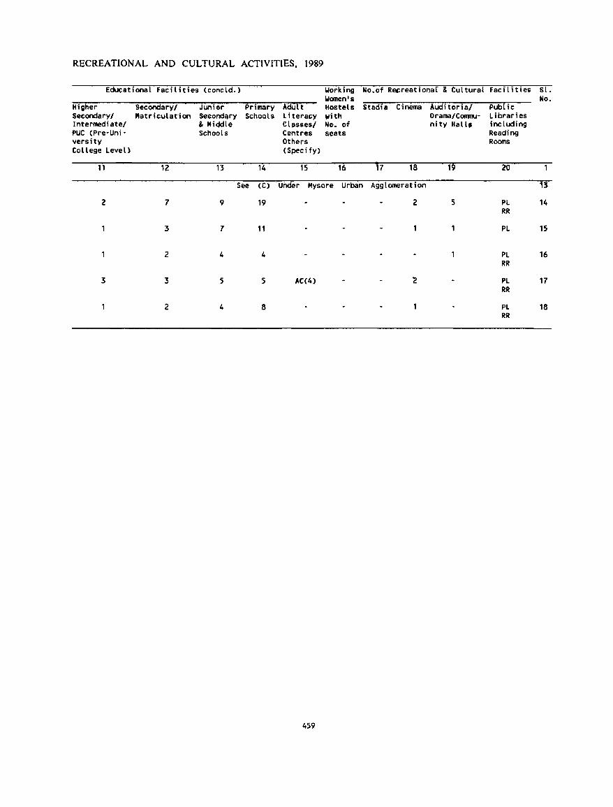
RECREATIONAL AND CULTURAL ACTIVITIES, 1989
Educational facilities (concld.) Working No.of Reereationar & Cultural Facil i ti es Sl. "'omen's No.
Higher SecOndaryl Junior Primary A£iUt t Hostels StadIa Cinema Auditorial POO[ ic Secondaryl Matriculation Secondary Schools Literacy with Drama/COIIJIlU- Libraries ll')termediatel & KiddIe Clllsses/ No. of nity Hall, including PUC (Pre-Uni- Schools Centres seats Reading versity Others Rooms College Level) (Specify)
11 12 13 14 15 16 17 18 19 20
See (C) UOder Kysore Urban Agglomeration 13
2 7 9 19 2 5 Pl 14 RR
3 7 11 Pl 15
2 4 4 Pl 16 RR
3 3 5 5 AC(4) '2 Pl 17 RR
2 4 8 PL 18 RR
459
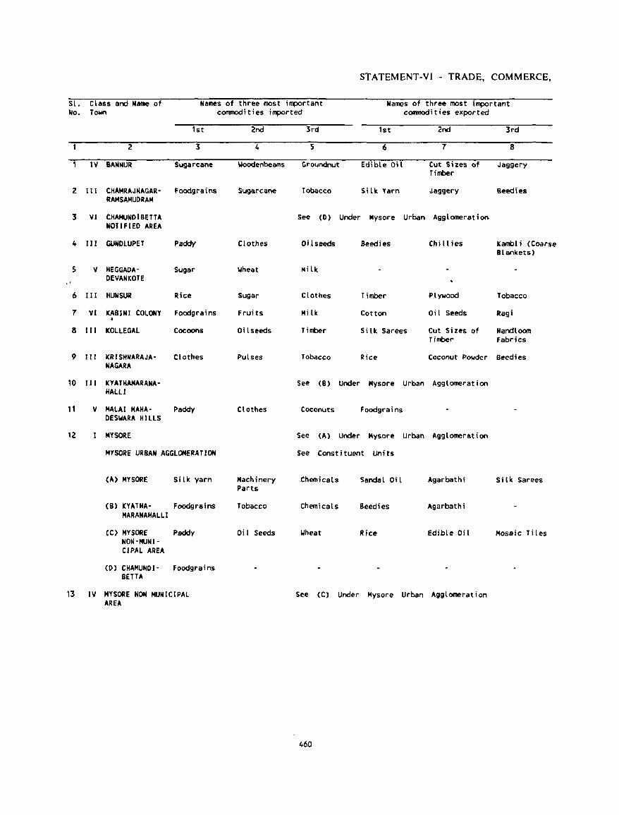
STATEMENT-VI - TRADE. COMMERCE.
Sl. Class and Name of Names of three most important Names of three most important No. Tc»Hl commodities imported commodities exported
1st 2nd 3rd 1st 2nd 3rd
2 3 4 5 6 7 8
1 IV BANNUR Sugarcane Woodenbeams Groundnut Edible Oil Cut Sizes of Jaggery Timber
Z III CHAMRAJNAGAR- Foodgrains Sugarcane Tobacco Silk. Yarn Jasgery Beeclies RAMSAMUDRAM
3 VI CHAMUNDIBETTA See (0) Under Mysore Urban Agglomeration NOTIFIED AREA
4 111 GUNDLUPfT Paddy Clothes Oi I seeds Beedies Chill ies I(anbl i (Coarse Blankets)
S V HEGGAOA- Sugar Wheat Milk DEVANI(OTE
" 6 IH HUNSUR Rice Sugar Clothes Timber Plywood Tobacco
7 VI KARINI COLONY Foodgrains Fruits Milk Cotton Oil Seeds Ragi •
8 III ICOLLEGAL Cocoons Oi I seeds Timber Silk Sarees Cut Sizes of Handloom Timber Fabdcs
9 III I(RISHNARAJA- Clothes Pulses Tobacco Rice Coconut Powder Beedies NAGARA
10 II I I(YATHAMARANA- See (8) Under Mysore Urban Agglomeration HAll I
11 V MALAI MAHA- Paddy Clothes Coconuts foodgrains DESWARA HILLS
12 MY SORE See (A) Under Mysore Urban Agglomeration
MYSORf URBAN AGGLOMERATION See Constituent Units
(A) MYSORE Si lk yarn Machinery .chemicals Sandal Oil Agarbath; Silk Sarees Parts
(8) KYATHA- Foodgrains Tobacco Chemicals Beedies Agarbathi MARANAHALLl
(C) MYSORf Paddy Oi I Seeds Wheat Rice Edible Oi I Mosaic Tiles NON-MUNI-CIPAL AREA
CD) CHAMUNDI- Foodgrains BETTA
13 IV MYSORE NON MUNICIPAL See (C) Under Mysore Urban Agglomeration AREA
460
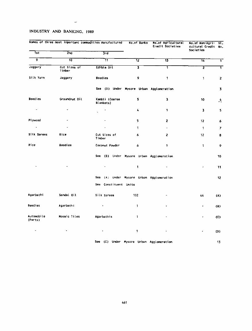
INDUSTRY AND BANKING, 1989
Hames of three most important commodities manufactured No.of Banks No.of Agricultural NQ.of Non-Agri- st. Credit Societies cul tural Credi t No.
Societies 1st 2nd 3rd
9 10 11 12 13 14
Jaggery Cut Sizes of edible Oi l 3 2 1 Timber
Silk Yarn Ja9gery Beedies 9 2
See (D) Under Mysore Urban Agglomeration 3
Beedies GroundnlJt Oi l lCambli (Coarse 5 3 10 4 Blankets)
4 3 5
Plywood 5 Z 12 6
7
Silk Sarees Rice Cut Sizes of 6 2 12 8 Timber
Rice Beeclies Coconut Powder 6 9
See (B) Under Mysore Urban Agglomeration 10
11
See (A) Under Mysore Urban Agglomeration 12
See Constituent Units
Agarbathi Sandal Oil Silk Sarees 102 44 (A)
Beedies Agarbathi (8)
Automobi le Mosaic Tiles Agarbathis (C) (Parts)
(D)
See (C) Under Mysore Urban Agglomeration 13
461
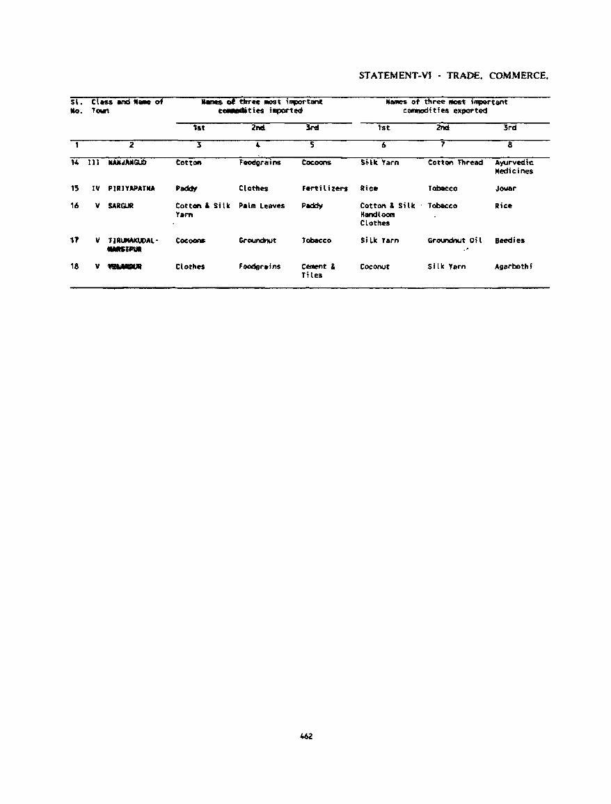
STATEMENT-Vi - TRADE. COMMERCE •
S'. Clus ar;d ... of ..... of tltne IIIOSt i,.,r~ant Ilames ot tbree-lIIOSt i~tant: Ito. Town ~t.ies llllf)Qf'teO c~ities exported
tst 2nd. 3nd ,.st. 2nd 3"d
2 3 4 5 6 7 8
'4 Ul ....... MlGUD Cotton- 'ooderains Cocoons SHit. Yarn CottQn Thread Ayurvecdic Medicines
15 I'll PIRIYAPATNA Paddy ctothes Fen it hers Ric. Tobac:co Jawa"
16 'II SARGUR Cotton & Silk Pal .. leaves Paddy Cotton & Silk Tobacco Rice Varn Handtoom
Clothes
11 'II TIRtJMAl(UDAl- Coc:oans l'Or~t Tobacco 51 Lk Varn Groundnut Oi l Beedies __ lftII
18 'II ".nrillf Clothes Foodgrains Cement & Coconut Si llc Yarn Agarbath; Tiles
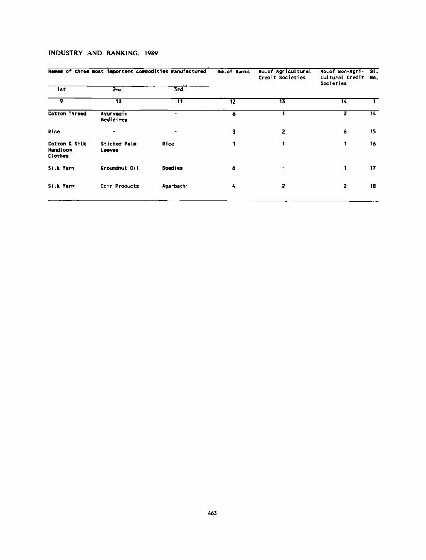
INDUSTRY AND BANKING, 1989
Names of three mos t iaportant cOlllllOdities manufactured ... of Banks No.of Agricultural No.of Non-Agr;- st. Credit Societies cultural Credit NG.
Societies 1st 2nd 3td
9 10 11 12 13 14 1
Cotton Thread Ayurvedic 6 2 14 Jltedi It ; nes
Rice 3 2 6 15
Cotton & Silk St; ched Palm Rice , 16 Handloan Leaves Clothes
Silk Yarn Groundnut Oil Beedies 6 17
S; lk Yarn Co; l' Products Agarbathi 4 2 2 18
463
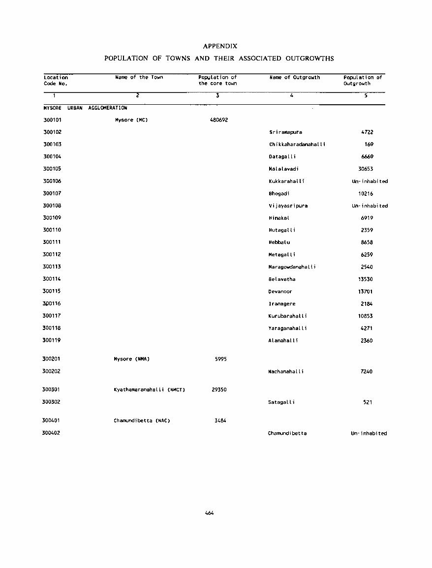
APPENDIX
POPULATION OF TOWNS AND THEIR ASSOCIATED OUTGROWTHS
Location Name of the Town POpUlation of Name of Outgrowth Population of Code No. the core town Outgrowth
2 3 4 5
MYSORE URBAN AGGLOMERATION
300101 Mysore (MC) 480692
300102 Sriramapura 4722
300103 Chikkaharadanahalli 169
300104 Datagall i 6669
300105 Malalavadi 30653
300106 Kukkarahall i Un- i nhabi ted
300107 Bhogedi 10216
300108 Vi jayasripura Un- i nhabi ted
300109 Hinakal 6919
300110 Hutagalli 2359
300111 Hebbalu 8658
300112 Metagall i 6259
300113 Maragowdanahalli 2540
300114 Belavatha 13530
300115 Oevanoor 13701
JD0116 Iranagere 2184
300117 Kurubarahalli 10853
300118 Yaraganahall i 4271
300119 Alanahall i 2360
300201 Mysore (NMA) 5995
300202 Nachanaha II i 7240
300301 Kyathamaranahalli (NMCT) 29350
300302 Satagalli 521
300401 Chamundibetta (NAC) 3484
300402 Chamundibetta Un- i nhabi ted
464
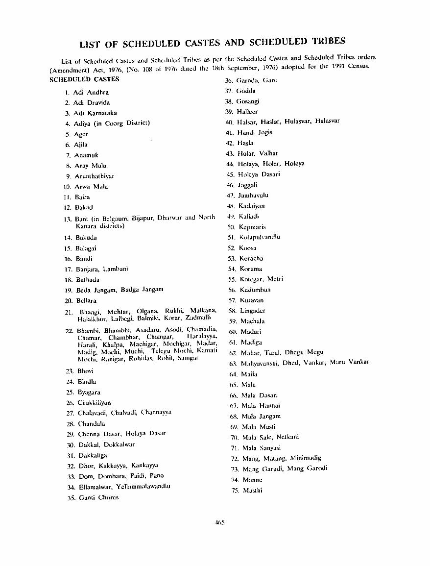
LIST OF SCHEDULED CASTES AND SCHEDULED TRIBES
List of Scheduled Castes and Scheduled Trines as per the Scheduled Castes and Scheduled Tribes orders
(Amendment) Act, 1976, (No. 108 of I'm, dated the IHth September, 1976) adopted for the 1991 Census.
SCHEDULED CASTES
1. Adi Andhra
2. Adi Dravida
3. Adi Karnataka
4. Adiya (in Coorg District)
5. Ager
6. Ajila
7. Anamuk
8. Aray Mala
9. Arunlhathiyar
10. Arwa Mala
11. Baira
]2. Bakad
13. Bant (in Belgaum, Bijapur. Dharwar and North Kanara district!.)
14. Bakuda
15. Balagai
](}. Bandi
17. Banjara. Lambani
18. Bathada
]9. Becla Jangam, Budga Jangam
20. Bellara
21. Bhangi, Mehtar, Olgana, Rukhi, Malkana, Halall...hor, Lalhegi, Balmiki, Korar, Zadmalli
22. Bhamhi, Bhamhhi. Asadaru. Asodi. Chamaclia, Chamar, Chambhar, Chamgar, Haralayya, Harali, Khalpa, Machigar. Mochigar. Madar, Madig. Mochi, Muchi, Tclcgu Mochi. Kamati Mochi. Ranigar, Rohidas. Rohit, Samgar
23. Bhovi
2..t. Bindla
25. Byagara
26. Chal...I...iliyan
27. Chalavadi, Chalvadi, Channayya
28. Chandala
29. Chenna Da!.ar, Holaya Dasar
30. Dakkal, Dokkalwar
31. Dakkaliga
32. Dhor, Kakkayya, Kankayya
33. Dom, Domhara, Paidi, Pano
34. ElIama\war, Yellammalawandlu
35. Ganti Chores
36. Garoda, Ciaw
37. Godda
38. Gosangi
39. Halleer
40. Halsar, Haslar, Hulasvar, Halasvar
41. Handi Jogis
42. Hasla
43. Holar, Valhar
44. Holaya, Holer, Holcya
45. Holcya Dasari
46. Jaggali
47. Jamhuvulu
48. Kadaiyan
·N. Kalladi
50. Kcpmaris
51. Kolupulvandlu
52. Koosa
53. Koracha
54. Korama
55. Kotcgar, Metri
56. Kudumban
57. Kuravan
5R Lingader
59. Machala
60. Madari
61. Madiga
62. Mahar, Taral, Dhcgu Mcgu
63. Mahyavanshi, Dhed, Vankar, Maru Vankar
M. Maila
65. Mala
6b. Mala Dasari
67. Mala Hannai
68. Mala Jangam
(,9. Mala Masti
70. Mala Sale, Netkani
71. Mala Sanyasi
72. Mang, Matang, Minimadig
73. Mang Garudi, Mang Garodi
74. Manne
75. Masthi
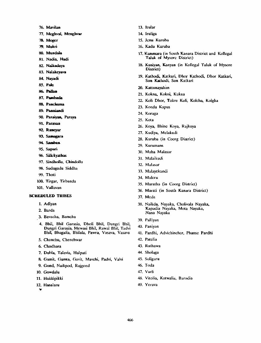
76. Mavilan
77. Megkval, Meoghvar
?S. Moser 79. Mum
so. Mundala
81. Nadia. Hadi
82. Nalbdaya
83. NaJakeyava
84. Nayadi
85. Pale
~ PaUaa
87.Pambada 88. Paacbama
89. Paaniandi
90. ~ Paraya
~1. Para.'VaB
92. Raneyar
93. Sa ..... l'a
94.Samhaa
95. Sapari
96. SiUckyatbas
97. Sindbollu, Chmdollu
98. Sudugadu Siddha
99. Tholi
100. Tirgar, Tirbanda
101. Valluvan
SCHEDULED TRIBES
1. Adiyan
2. Barda
3. Bavaeha, Bameha
4. Bhil, Bhil Garasia, Dholi Bhil, Dungri Bhil, Dungri Garasia, Mewasi Bhil, Rawal Bhil, Tadvi Bhil, Bhagalia, Bhilala, Pawra, Vasava, Vasave
5. Chenchu, Chenchwar
6. Chodhara
7. Dubla, Talavia, Halpati
8. Gamit, Gamta, Gavit, Mavchi, Padvi, Valvi
9. Gond, Naikpod, Rajgond
10. Gowdalu
11. Hakkipikki
12. Hasalaru
"
466
13. Jrular
14. Iruliga
15. leou Kuruba
16. Kadu Kuruba
17. Kammara (in South Kanara Dist.rict and Kollcgal Taluk of Mysore District)
18. Kaniyan, Kanyan (in Kollcgal Taluk of Mysore District)
19. Kathodi, Katkari, Dhor Kathodi, Dhor Katkari, SOD Kathodi, Son Katkari
20. Kattunayakan
21. Kokna, Kokni, Kukna
22. Koli Dhor, Tokre Koli, Kolcha, Koigha
23. Konda Kapus
24. Koraga
25. Kota
26. Koya, Bhine Koya, Rajkoya
27. Kudiya, Mclakudi
28. Kuruba (in Coorg District)
29. Kurumans
30. Maha Malasar
31. Malaikudi
32. Malasar
33. Malayckandi
34. Malcru
35. Maratha (in Coorg District)
36. Marati (in South Kanara District)
37. Mcda
38. Naikda, Nayaka, Cholivala Nayaka, Kapadia Nayaka, Mota Nayaka, Nana Nayaka
39. Palliyan
40. Paniyan
41. Pardhi, Advichinehcr, Phanse Pardhi
42. Patelia
43. Rathawa
44. Sholaga
45. Soligaru
46. Toda
47. Varli
48. Vitolia, Kotwalia, Barodia
49. Ycrava
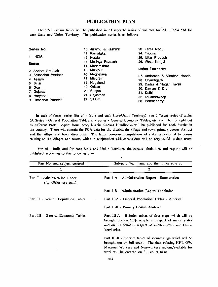
PUBLICATION PLAN
The 1991 Census tables will be published in 33 separate series of volumes for All - India and for each State and Union Territory. The publication series is as follows:
Series No. 10. Jammu & Kashmir 23. Tamil Nadu 11. Karnataka 24. Tripura
1. INDIA 12. Kerala 25. Uttar Pradesh
States 13. Madhya Pradesh 26. West Bengal 14. Maharashtra
2. Andhra Pradesh 15. Manlpur Union Territories
3. Arunachal Pradesh 16. Meghalaya 27. Andaman & Nicobar Islands 4. Assam 17. Mizoram 28. Chandigarh 5. Bihar 18. Nagaland 29. Dadra & Nagar Haveli 6. Goa 19. Orissa 30. Daman & Diu 7. Gujarat 20. Punjab 31. Delhi 8. Haryana 21. Rajasthan 32. Lakshadweep 9. Himachal Pradesh 22. Sikkim 33. Pondicherry
In each of these series (for all ~ India and each State/Union Territory) the different series of tables
(A Series - General Population Tables, B - Series ~ General Economic Tables, etc.,) wiIl be brought out as different Parts. Apart from these, District Census Handbooks will be published for each district in
the country. These will contain the peA data for the district, the village and town primary census abstract
and the village and town directories. The latter comprise compilations of statistics, external to census relating to the villages and towns, which in conjunction with census data will be very useful to data users.
For all - India and for each State and Union Territory, the census tabulations and reports will be published according to the following plan:
Part No. and subject covered
1
Part I - Administration Report
(for Office use only)
Part II - General Population Tables
Part III - General Economic Tables
Sub-part No. if any, and the topics covered
2
Part I-A - Administration Report Enumeration
Part I-B - Administration Report Tabulation
Part II-A - General Population Tables - A-Series
Part I1-B - Primary Census Abstract
Part III-A - B-Series tables of first stage which will be
brought out on 10% sample in respect of major States
and on full count iq respect of smaller States and Union
Territories.
Part III-B - B-Series tables of second stage which will be brought out on full count. The data relating HHI, OW,
Marginal Workers and Non-workers seeking/available for work wil1 be entered on full count basis.
467
Part IV - Social and Cultural Tables
Part V - Migration Tables
Part VI - Fertility Tables
Part VII Tables on Houses and
Household Amenities
Part VIII - Special Tables on Scheduled
Castes and Scheduled Tribes
Part IX - Town Directory, Survey Report
on Towns and Villages
Part IV-A - C-Series tables of first stage covering age, sex and marital status, composition of population, single year agl: rl:1 urn~, l:duealional Icvds, school attendance and hilinguali~m.
Part IV-B - C-Series tahles covering mother tongue, religion of popUlation and household composition.
Part V -A - D-Series tables of first stage covering tables based on 10% sample in respect of major States and on full count in respect of smaller States and Union Territories.
Part V-B - D-Series tables of second stage covering occupational classification of migrant workers. These
tables arc based on full count.
F-Scries tables of first stage which will be brought out on 10% sample in respect of major States and on full
count in respcct of smaller Slates and Union Territories.
H - Series lables covering census housl:s and the uses to which these arc put, construction material of wall, roof and floor of the census houses occupied by households, tenure status of the house. occupied and number of living
rooms, household size, housing facilities like drinking water, electricity and toilet available to households and the fuel used by the household for cooking. These tables will also
cover tables on Scheduled Castes and Scheduled Tribes. This volume will contain analytical notes also.
This part will contain SC and ST series of tables for
Scheduled Castes and Scheduled Tribes respectively. The data relating to Scheduled Castes and Scheduled Tribes will be entered on full count basis in the third stage and
SC/ST tables will be processed on the computer on full count. These will cover population of each Scheduled Casteffribe, industrial categories of main and marginal
workers, non-workers seeking/available for work and those who never worked before, educational level, school attendance, age, sex and marital status, composition of
Scheduled Castes and Scheduled Tribes. In addition to these, the fertility tables relating to SC/ST are also covered. These tables also cover for Scheduled Tribes, their
composition by religion, mother tongue and bilingualism.
Part IX - A - Town Directory
Part IX - B - Survey Report on sclcctcd Towns
Part IX - C - Survey Rcport on selected Villages
468
Part X
Part XI - Census Atlas
Part XII - District Census Handbook
Ethnographic notes and special studies on Scheduled Castes and Scheduled Tribes
Union and State/Union Territory Census Atlases
Part XII - A - Village and Town Directory
Part XII - B - Village and Town wise Primary Census Abstract
The following special papers are also planned and will be published as and when they are ready as 1991 Census papers :
(a) Special studies taken up by the Directors of Census Operations
(b) Special Areas Surveys
(c) SpeciaJ TabJes for Standard Urban Areas
(d) Language Survey Reports
(e) Post Enumeration Check Report
(I) Age Tables
(g) Life Tables
(h) Reports on estimates .of inter-censal birth and death rates using 1981-1991 life tables and age data
(i) Development of Vital Statistics in India
Besides these special papers, some monographs based on 1991 Census data on subjects of topical interest to be prepared by scholars will be brought out as 1991 Census monographs.
It is also proposed to carry out some special studies of 1991 Census data in collaboration with other organisations and the results of such studies will be published as occasional papers of the 1991 Census.
It is also proposed to disseminate coosus tabulations and the basic data in machine readable forms such as magnetic tapes, diskettes, floppies, etc.
The District Census Handbooks will be available for sale at the Government Central Press, Bangalore and the other publications at the Office of the Director of Census Operations, Karnataka. Bangalore and the Manager of Publications, Civil Lines, New Delhi - 6,
469