determining the property ownership on cadastral works in turkey
TRANSCRIPT
Land Use Policy 26 (2008) 112–120
Contents lists available at ScienceDirect
Land Use Policy
journa l homepage: www.e lsev ier .com/ locate / landusepol
Determining the property ownership on cadastralworks in Turkey�
Osman Demir, Yakup Emre Coruhlu ∗
Department of Geodesy and Photogrammetry, Karadeniz Technical University, 61080 Trabzon, Turkey
a r t i c l e i n f o
Article history:Received 30 March 2007Received in revised form 30 January 2008Accepted 31 January 2008
Keywords:Property rightsRegisterTitleCadastral work
a b s t r a c t
The transformation process from state to civil ownership in Turkey was started at the end of the OttomanEmpire and continued until after the formation of Turkish Republic. In this process, in accordance withthe Civil Code legislation, most land users who had been using state lands were regarded as owners ofthose lands. These parcels of real estate were used in various ways and it became necessary to registerthese properties by using a process called ‘written cadastre’. The initial process was slowed down duringWorld War II but an intensive cadastral program was begun after the war in both urban and rural areas,particularly in 1950s. The cadastre work had two components called technical and legal. The definition ofland ownership is the legal foundation of the cadastre. If properties have their titles, land ownership canbe defined based on the title; otherwise the ownership can be defined according to statements by experts
TechnicalLegal process
chosen from local people. However, without title or written evidence, determining the land ownership ismore problematic. In this context, this study explains how the ownership of properties, with or withouta title, is determined in cadastral work in Turkey.
I
Edtactdpealo
pc2wo
iast
oil(
i
0d
ntroduction
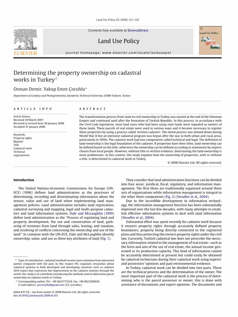
The United Nations-Economic Commissions for Europe (UN-CE) (1996) defines land administration as the processes ofetermining, recording and disseminating information about theenure, value and use of land when implementing land man-gement policies. Land administration includes land registration,adastral surveying and mapping, legal and multi-purpose cadas-res and land information systems. Dale and McLaughlin (1999)efine land administration as the “Process of regulating land androperty development, the use and conservation of land, gath-ring of revenues from land through sales, leasing, and taxation,
nd resolving of conflicts concerning the ownership and use of theand”. In common with the UN-ECE, Dale and McLaughlin identifywnership, value, and use as three key attributes of land (Fig. 1).� Type of contribution: cadastral methods receive more attention from interestedarties compared with the past. In this respect FIG organizes researches aboutadastral systems in both developed and developing countries such as cadastre014 report that represents the improvement in the cadastre systems through theorld. Our study is to contribute introducing the methods used to determine parcel
wnership on cadastre works in Turkey.∗ Corresponding author. Tel.: +90 4623773124; fax: +90 4623280918.
E-mail address: [email protected] (Y.E. Coruhlu).
bplstebba
amma
264-8377/$ – see front matter © 2008 Elsevier Ltd. All rights reserved.oi:10.1016/j.landusepol.2008.01.011
© 2008 Elsevier Ltd. All rights reserved.
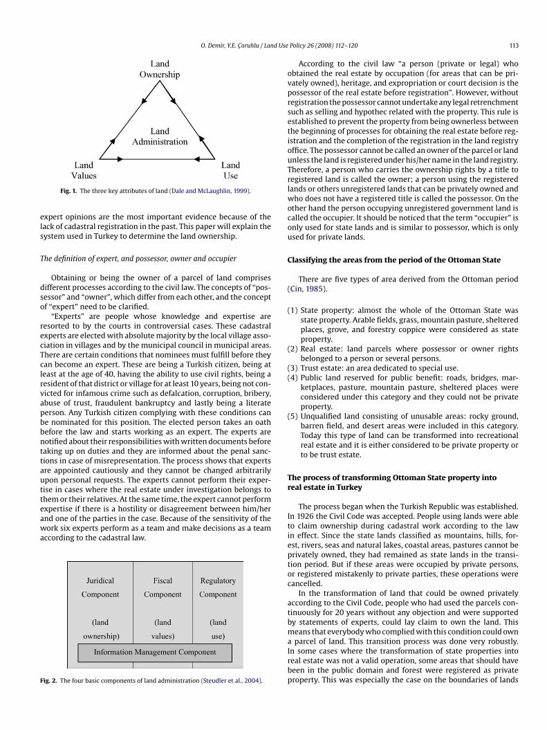
They consider that land administration functions can be dividednto four areas: juridical, fiscal, regulatory, and information man-gement. The first three are traditionally organized around threeets of organizations while information management is integral tohe other three components (Fig. 2) (Steudler et al., 2004).
Due to the incredible development in information technol-gy, the information management function has been substantiallymproved over the last few decades, with many attempts to estab-ish effective information systems to deal with land informationSteudler et al., 2004).
Substantial effort was spent recently for cadastre work becauset ensures property rights through accurately defined propertyoundaries, property being directly connected to the registeredlans and thus protecting the owners property rights under the civil
aw. Currently, Turkish cadastral law does not prescribe the neces-ary information related to the management of real estate—such ashe form and aim of the use of real estate, the annual income gen-rated or its production capacity. This kind of information cannote accurately determined at present but could easily be obtainedy cadastral technicians during their cadastral work using experts’nd possessors’ opinions and past environmental evidence.
In Turkey, cadastral work can be divided into two parts. Thesere the technical process and the determination of the owner. Theost important part of the cadastral work is the process of deter-ining who is the parcel possessor or owner, this is done with
ssistance of documents and expert opinions. The documents and
O. Demir, Y.E. Coruhlu / Land Use
els
T
dso
recTclrvapbbnttautteawa
F
ovprsetiouTrlwocou
C
(
(
(
((
(
Tr
Fig. 1. The three key attributes of land (Dale and McLaughlin, 1999).
xpert opinions are the most important evidence because of theack of cadastral registration in the past. This paper will explain theystem used in Turkey to determine the land ownership.
he definition of expert, and possessor, owner and occupier
Obtaining or being the owner of a parcel of land comprisesifferent processes according to the civil law. The concepts of “pos-essor” and “owner”, which differ from each other, and the conceptf “expert” need to be clarified.
“Experts” are people whose knowledge and expertise areesorted to by the courts in controversial cases. These cadastralxperts are elected with absolute majority by the local village asso-iation in villages and by the municipal council in municipal areas.here are certain conditions that nominees must fulfill before theyan become an expert. These are being a Turkish citizen, being ateast at the age of 40, having the ability to use civil rights, being aesident of that district or village for at least 10 years, being not con-icted for infamous crime such as defalcation, corruption, bribery,buse of trust, fraudulent bankruptcy and lastly being a literateerson. Any Turkish citizen complying with these conditions cane nominated for this position. The elected person takes an oathefore the law and starts working as an expert. The experts areotified about their responsibilities with written documents beforeaking up on duties and they are informed about the penal sanc-ions in case of misrepresentation. The process shows that expertsre appointed cautiously and they cannot be changed arbitrarilypon personal requests. The experts cannot perform their exper-ise in cases where the real estate under investigation belongs tohem or their relatives. At the same time, the expert cannot perform
xpertise if there is a hostility or disagreement between him/hernd one of the parties in the case. Because of the sensitivity of theork six experts perform as a team and make decisions as a teamccording to the cadastral law.
ig. 2. The four basic components of land administration (Steudler et al., 2004).
Itieptoc
atbmaIrbp
Policy 26 (2008) 112–120 113
According to the civil law “a person (private or legal) whobtained the real estate by occupation (for areas that can be pri-ately owned), heritage, and expropriation or court decision is theossessor of the real estate before registration”. However, withoutegistration the possessor cannot undertake any legal retrenchmentuch as selling and hypothec related with the property. This rule isstablished to prevent the property from being ownerless betweenhe beginning of processes for obtaining the real estate before reg-stration and the completion of the registration in the land registryffice. The possessor cannot be called an owner of the parcel or landnless the land is registered under his/her name in the land registry.herefore, a person who carries the ownership rights by a title toegistered land is called the owner; a person using the registeredands or others unregistered lands that can be privately owned and
ho does not have a registered title is called the possessor. On thether hand the person occupying unregistered government land isalled the occupier. It should be noticed that the term “occupier” isnly used for state lands and is similar to possessor, which is onlysed for private lands.
lassifying the areas from the period of the Ottoman State
There are five types of area derived from the Ottoman periodCin, 1985).
1) State property: almost the whole of the Ottoman State wasstate property. Arable fields, grass, mountain pasture, shelteredplaces, grove, and forestry coppice were considered as stateproperty.
2) Real estate: land parcels where possessor or owner rightsbelonged to a person or several persons.
3) Trust estate: an area dedicated to special use.4) Public land reserved for public benefit: roads, bridges, mar-
ketplaces, pasture, mountain pasture, sheltered places wereconsidered under this category and they could not be privateproperty.
5) Unqualified land consisting of unusable areas: rocky ground,barren field, and desert areas were included in this category.Today this type of land can be transformed into recreationalreal estate and it is either considered to be private property orto be trust estate.
he process of transforming Ottoman State property intoeal estate in Turkey
The process began when the Turkish Republic was established.n 1926 the Civil Code was accepted. People using lands were ableo claim ownership during cadastral work according to the lawn effect. Since the state lands classified as mountains, hills, for-st, rivers, seas and natural lakes, coastal areas, pastures cannot berivately owned, they had remained as state lands in the transi-ion period. But if these areas were occupied by private persons,r registered mistakenly to private parties, these operations wereancelled.
In the transformation of land that could be owned privatelyccording to the Civil Code, people who had used the parcels con-inuously for 20 years without any objection and were supportedy statements of experts, could lay claim to own the land. Thiseans that everybody who complied with this condition could own
parcel of land. This transition process was done very robustly.n some cases where the transformation of state properties intoeal estate was not a valid operation, some areas that should haveeen in the public domain and forest were registered as privateroperty. This was especially the case on the boundaries of lands
114 O. Demir, Y.E. Coruhlu / Land Use
F
tncws2
Cc
bobtisttnutptw
ascrm
bamTcgppcfll
rttawsTwp
aba(Pebtawanc
T
cDccLcpieetfcnpcT(
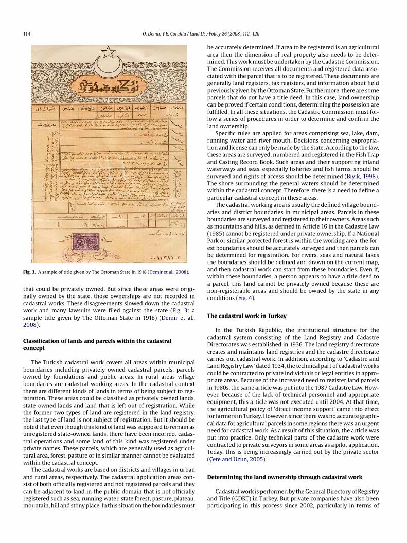
ig. 3. A sample of title given by The Ottoman State in 1918 (Demir et al., 2008).
hat could be privately owned. But since these areas were origi-ally owned by the state, those ownerships are not recorded inadastral works. These disagreements slowed down the cadastralork and many lawsuits were filed against the state (Fig. 3: a
ample title given by The Ottoman State in 1918) (Demir et al.,008).
lassification of lands and parcels within the cadastraloncept
The Turkish cadastral work covers all areas within municipaloundaries including privately owned cadastral parcels, parcelswned by foundations and public areas. In rural areas villageoundaries are cadastral working areas. In the cadastral contexthere are different kinds of lands in terms of being subject to reg-stration. These areas could be classified as privately owned lands,tate-owned lands and land that is left out of registration. Whilehe former two types of land are registered in the land registry,he last type of land is not subject of registration. But it should beoted that even though this kind of land was supposed to remain asnregistered state-owned lands, there have been incorrect cadas-ral operations and some land of this kind was registered underrivate names. These parcels, which are generally used as agricul-ural area, forest, pasture or in similar manner cannot be evaluatedithin the cadastral concept.
The cadastral works are based on districts and villages in urban
nd rural areas, respectively. The cadastral application areas con-ist of both officially registered and not registered parcels and theyan be adjacent to land in the public domain that is not officiallyegistered such as sea, running water, state forest, pasture, plateau,ountain, hill and stony place. In this situation the boundaries mustD
ap
Policy 26 (2008) 112–120
e accurately determined. If area to be registered is an agriculturalrea then the dimension of real property also needs to be deter-ined. This work must be undertaken by the Cadastre Commission.
he Commission receives all documents and registered data asso-iated with the parcel that is to be registered. These documents areenerally land registers, tax registers, and information about fieldreviously given by the Ottoman State. Furthermore, there are somearcels that do not have a title deed. In this case, land ownershipan be proved if certain conditions, determining the possession areulfilled. In all these situations, the Cadastre Commission must fol-ow a series of procedures in order to determine and confirm theand ownership.
Specific rules are applied for areas comprising sea, lake, dam,unning water and river mouth. Decisions concerning expropria-ion and license can only be made by the State. According to the law,hese areas are surveyed, numbered and registered in the Fish Trapnd Casting Record Book. Such areas and their supporting inlandaterways and seas, especially fisheries and fish farms, should be
urveyed and rights of access should be determined (Bıyık, 1998).he shore surrounding the general waters should be determinedithin the cadastral concept. Therefore, there is a need to define aarticular cadastral concept in these areas.
The cadastral working area is usually the defined village bound-ries and district boundaries in municipal areas. Parcels in theseoundaries are surveyed and registered to their owners. Areas suchs mountains and hills, as defined in Article 16 in the Cadastre Law1985) cannot be registered under private ownership. If a Nationalark or similar protected forest is within the working area, the for-st boundaries should be accurately surveyed and then parcels cane determined for registration. For rivers, seas and natural lakeshe boundaries should be defined and drawn on the current map,nd then cadastral work can start from these boundaries. Even if,ithin these boundaries, a person appears to have a title deed toparcel, this land cannot be privately owned because these are
on-registerable areas and should be owned by the state in anyonditions (Fig. 4).
he cadastral work in Turkey
In the Turkish Republic, the institutional structure for theadastral system consisting of the Land Registry and Cadastreirectorates was established in 1936. The land registry directoratereates and maintains land registries and the cadastre directoratearries out cadastral work. In addition, according to ‘Cadastre andand Registry Law’ dated 1934, the technical part of cadastral worksould be contracted to private individuals or legal entities in appro-riate areas. Because of the increased need to register land parcels
n 1980s, the same article was put into the 1987 Cadastre Law. How-ver, because of the lack of technical personnel and appropriatequipment, this article was not executed until 2004. At that time,he agricultural policy of ‘direct income support’ came into effector farmers in Turkey. However, since there was no accurate graphi-al data for agricultural parcels in some regions there was an urgenteed for cadastral work. As a result of this situation, the article wasut into practice. Only technical parts of the cadastre work wereontracted to private surveyors in some areas as a pilot application.oday, this is being increasingly carried out by the private sectorCete and Uzun, 2005).
etermining the land ownership through cadastral work
Cadastral work is performed by the General Directory of Registrynd Title (GDRT) in Turkey. But private companies have also beenarticipating in this process since 2002, particularly in terms of

O. Demir, Y.E. Coruhlu / Land Use Policy 26 (2008) 112–120 115
erable
pp
sdsd
(
((
Fig. 4. Registerable and non-regist
erforming the technical part of the work. However, determiningarcel ownership is performed by the GDRT.
The most important part of the cadastral work is “possession”ince parcel owner/owners are defined and registered on titleeeds. According to Civil Law, the title deed represents an owner-
hip of the parcel, which is secured with the state authority. Someocuments proving the parcel ownership are:1) Parcels may or may not have a title deed within working cadas-tre areas. In order to define the parcel ownership the cadastral
(((
(
land types in Cadastre work area.
team collects information, various documents such as tax reg-istration, and expert opinions.
2) Written mandates given to the owners by the Ottoman State.3) Title deeds from the army called “Sipahi” and “Multezim” given
by Ottoman State.
4) Title deeds without records belonging to the State.5) Uncertified title deed records.6) Parcel records named “Mulkname” and “muhasebati atika”given by the Ottoman State.7) Deeds of sale.
116 O. Demir, Y.E. Coruhlu / Land Use Policy 26 (2008) 112–120
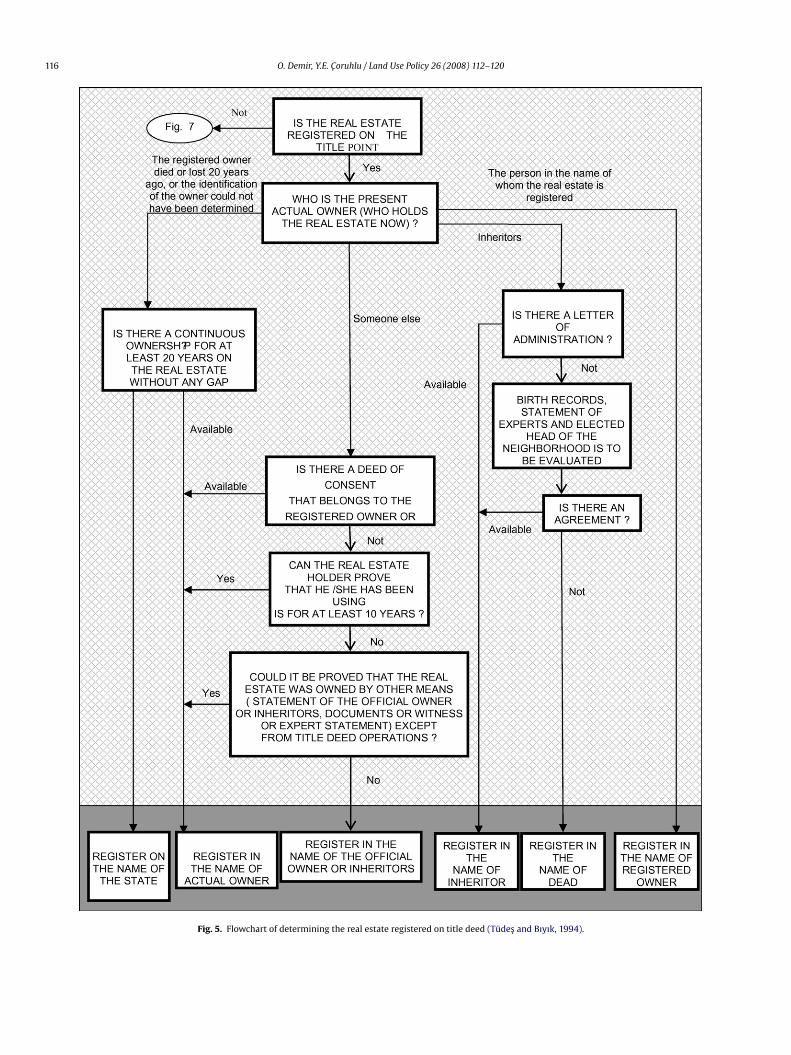
Fig. 5. Flowchart of determining the real estate registered on title deed (Tudes and Bıyık, 1994).
O. Demir, Y.E. Coruhlu / Land Use Policy 26 (2008) 112–120 117
not re
(
os
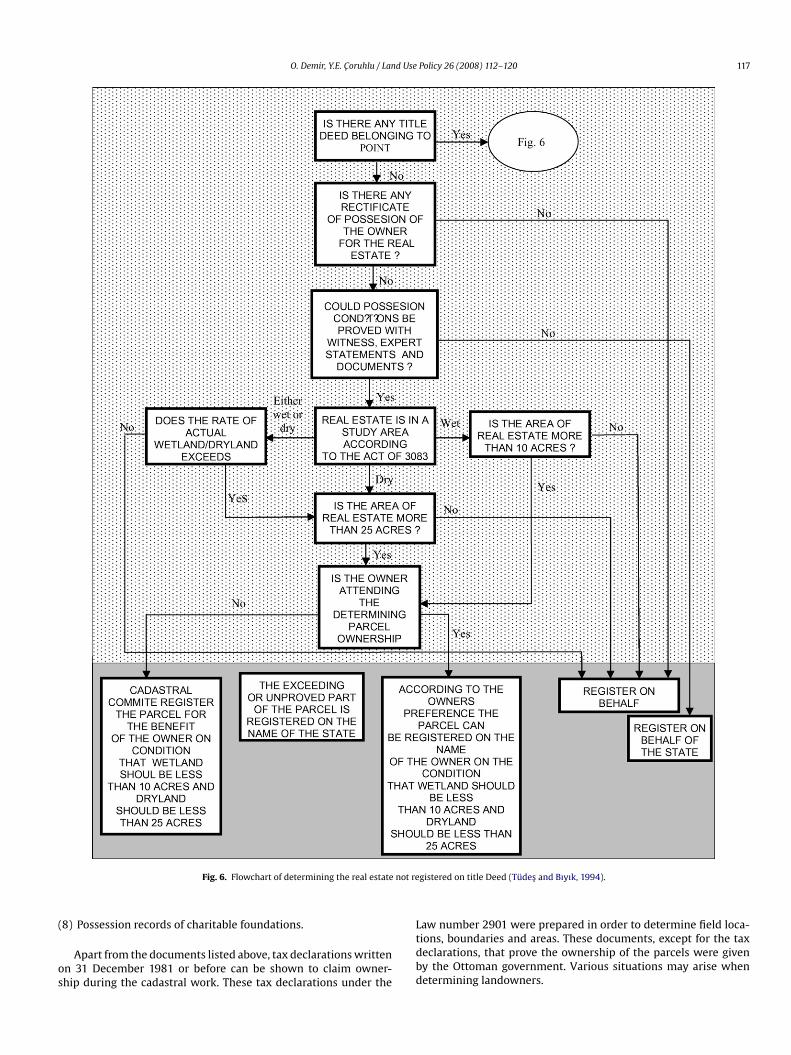
Fig. 6. Flowchart of determining the real estate
8) Possession records of charitable foundations.
Apart from the documents listed above, tax declarations writtenn 31 December 1981 or before can be shown to claim owner-hip during the cadastral work. These tax declarations under the
Ltdbd
gistered on title Deed (Tudes and Bıyık, 1994).
aw number 2901 were prepared in order to determine field loca-ions, boundaries and areas. These documents, except for the taxeclarations, that prove the ownership of the parcels were giveny the Ottoman government. Various situations may arise whenetermining landowners.
1 d Use
D
((
a
•••
uf
•
•
D
d
•
•
Fw
hocd(
“
tdHii1pc
iiooyswlsspw1tsail
Ca
dooHbrini
cpAtbamwmd
swt
18 O. Demir, Y.E. Coruhlu / Lan
There are two groups.
efining the officially registered real estate
Real properties registered on title deeds are in two groups:
1) Owners or inheritors may be holding the land.2) Another person or other persons except for inheritors or owner
may be the holder of the parcel.
For these registered lands:If owners or inheritors are holders, the real estate is registered
s follows:
If the owner is alive, it is registered to the owner.If owner is dead, it is registered to the inheritors.If inheritors cannot be found, it is registered to the owner by writ-ing on the official report that the parcel owner is not alive. Here,it should be stated that even though the real estate is registeredto the dead owner in the cadastre, inheritors may obtain the realestate as soon as they finish the official paper work for inheritancein the state office.
If a person, apart from the owners or their inheritors, has beensing the parcel for a long time the real estate can be registered asollows:
When the cadastral expert is available, if the owners or theirinheritors give their deed of consent, the parcel is registered onbehalf of the landholder.The parcel is registered on behalf of the landholder, if the holderproves that he or she had acquired the parcel from the parcelowner with an unofficial purchase, and has documents to provethat he or she has used the parcel continuously for 10 years withno objection. If the parcel use time (10 years) has not yet beencompleted by holder then the Cadastre Commission asks theowner whether he/she would like to give assent to the holder.If the assent is given the holder owns the parcel.
The details are given in Fig. 5.
etermining the real estate not registered on a title deed
The basis of acquisitions of real estates not registered on a titleeed is possession.
The required conditions for possession are:
There has to be no dissent to the claim of the existing possessorto the land/property.The existing possessor has to have continuously used the realestate for at least 20 years (Tudes and Bıyık, 1994). The detailsare given in Fig. 6.
ield restriction on determining the owner of a real estateith possession
There are area restrictions on acquisition of a real estate without
aving title deeds. 10 acres of land on watery field, and 25 acresf land on dry areas can be owned provided that the possessorontinuously used the parcel for more than 20 years without anyoubt according to the expert opinions or eyewitness declarationsThe Cadastre Law, 1985, article: 10).owoib
Policy 26 (2008) 112–120
Latest term” in cadastral work
As soon as cadastral works are completed, the old registers ofhe area are no longer valid. When there is a problem, the latestocuments or title deed giving the cadastral information is used.owever, the old documents may also be used in queries concern-
ng the owner of the parcel. After the completion of cadastral work,f there has been no dissent to actual ownership in the following0 years, no more ownership claims can be proposed by anothererson about that parcel. This is the concept of “latest term” inadastral work.
Obtaining the ownership by holding a private real estate reg-stered on the land records is only possible if its registrations cancelled and abandoned by the owner voluntarily. On thether hand, objection by the state is possible against the ownerf unregistered state lands owned with cadastral work after 10ears of occupation. In 10 years following the cadastral work, thetate can still take the real estate back from the private ownerith a court decision since the latest term is not valid for state
ands. However, the unregistered lands that are not naturallytate lands can be owned by private parties. The land posses-or who proves the beneficial time-out conditions (20 years ofossession) could obtain ownership of the land with cadastralorks. The objection to this ownership is also still possible in
0 years following the cadastral works. During this period ofime the objector can obtain the real estate with a court deci-ion as a result of the title action for nullity if the objection hasbase. The person occupying the unregistered government land
s called the occupier and can never become the owner of suchand.
adastre and ownership—problems caused by imprecisedministrative boundaries
Administrative boundaries of villages have not been preciselyetermined (Bıyık and Atasoy, 2003). For example the boundariesf a village may be a hill, river, bridge, road and these are shownn topographic maps with the scale of 1/25,000 (Baskoy, 2001).owever, there maybe differences in naming of these landmarksy local residents and this can result in problems for land/propertyegistration. Moreover, as there is no information about admin-strative boundaries, and there are not enough defined coordi-ates, problems in determining administrative boundaries are
ncreased.A parcel boundary, determined in cadastral works, may be a
ommon boundary with areas such as the district, village, province,asture, forest, and coastal area or may not officially be registered.lso, the administrative boundary and the boundaries of the cadas-
ral working area may not be in agreement. Therefore, there maye spaces between the administrative boundaries and the bound-ries of the cadastral working areas and thus these spaces, whichay be forest areas, coastal areas, and pasture areas would not beithin the cadastral working areas. In order to avoid the disagree-ents, the cadastral working boundaries to be used should be those
efined as the administrative boundaries.However, there are still problems that the Cadastre Commis-
ion could face if the area is unregistered and outside the cadastralorkspace. These areas are not to be registered according to Cadas-
re Law number 3402. This situation is derived from the deficiencies
f the cadastral concepts and contents. Moreover, the cadastralorks are negatively affected when the administrative boundariesf a village overlap the general cadastral boundaries and neighbor-ng villages have boundary conflictions. For these reasons, there cane disagreements over the administrative boundaries of villages in
d Use
crt
R
f–botottf
tItbtmnOlit2
m
•
•
••
•
D
thttraaaactiiewT
ptaioiEnlrtaclpbjl
C
rFsism
ptdsaffcibpcdLbT
cdibropicmalbt
O. Demir, Y.E. Coruhlu / Lan
onnection with the determining of ownership in these areas. Thisesults in many time-consuming lawsuits about the ownership ofhe parcels in these regions.
esolving problems on occupied state lands
During the cadastre work, if some areas such as stream bed,orest, pasture and coastal areas that are not subject of registrationareas whose ownership belongs to the state Treasury and shoulde left out in the registration process – are occupied as a resultf incorrect cadastral operations and registered under the name ofhose in occupation, the “latest term” is not valid. When these kindsf parcels are determined as being occupied, they are transferred tohe Treasury by filing a case called “title action for nullity” withoutaking the latest term in to account. Nobody can claim an ownershipor the areas occupied in such a way.
Illegal settlements on state lands, mentioned above, are one ofhe important problems in urbanization in developing countries.n the case of Turkey, this problem was first seen with migra-ion from rural areas to urban areas in 1950s. Today, 10% of theuildings are slums in Turkey. These slums are mostly in indus-rialized cities and in the areas where accessibility is easy and
ostly consist of state real estates. Because of the political, eco-omic and social reasons, removing these slums is very difficult.n the other hand, because the slums are not built according to the
aw and given the fact that 92% of the settlement area in Turkeys in a seismic belt, an innovative solution is necessary ratherhan protecting the slums to solve this problem (Uzun and Cete,005).
In 1984, the Turkish Parliament passed a law numbered 2981 toake the property rights of shanties legal. According to this law:
All the slums, built on the state lands before the law, are includedby this law.The value of land, occupied by the squatters, shall be paid in 12equal payments in 4 years.400 m2 of land could be assigned at most to each slum.The owner of the slum and the other family members must nothave any other properties or lands in the same municipalityregion to be cleared for the assignment of the land.For this aim, in the execution of the mentioned law, first of all theland certificate of title was given to each slum owner, showinghow much land and which state land they were being assignedby the municipality.
iscussion
Having been done since 1924 in Turkey, about 98% of cadas-re works in urban areas and 80% of cadastre work in rural areasave been completed so far. Especially after 2004, it was providedhat private sector companies could participate in cadastre work sohat it could be finished as early as possible. In this process all theegions, where cadastre work had not been done yet, were listeds bid areas and term of cadastre works with bids was started. Asresult of these works about 40 million parcels were measured
nd registered in the deed office (Demir et al., 2008). The bound-ries and owners of parcels were determined in the scope of thoseadastre works. But some of the cadastre works and deed regis-rations have been objected and some lawsuits have been filled
n the courts against those registrations. The number of lawsuitsn this context is about 5000 a year in Turkey (TR, 2006). Consid-ring that about 500,000 parcels a year is completed in cadastreorks, it can be seen that 1% of cadastre decisions is objected inurkey. This shows that the actual process used in determining the
roTsg
Policy 26 (2008) 112–120 119
arcel owner works perfectly in general. Nevertheless, housing inhe form of slums, despoiling and use of river banks and coastalreas except for their functions are being experienced because ofnsufficient scope of cadastre that results in not determining thewners of some parcels and lands. The most important reasonsndicated for this result is the scope of the actual cadastre works.specially coastal areas, river banks and mountainous areas that areot subject to registration are left out of cadastre works by cadastre
aw. Later on, these areas are occupied and used unlawfully, whichesults in unproper and unplanned urban and rural use and activi-ies. When the subject is approached in this respect, some problemsre faced, and even though the objection rate is very low againstadastre decisions the scope of cadastre is insufficient in terms ofand ownership and sustainable land management. To avoid theseroblems, it can be suggested that the scope of cadastre law shoulde revised and extended covering those areas which are not sub-
ect to cadastre work and registration under the current cadastreaw.
onclusion
Cadastral methods have received more and more attention inecent years. One incident proving this idea is that the Internationalederation of Surveyors (FIG) organizes researches about cadastralystems in both developed and developing countries represents themprovement in the cadastral systems throughout the world. Thistudy aims to contribute to this effort by introducing the cadastralethods used to determine parcel ownership in Turkey.Mainly used for taxation purposes, the Turkish cadastre is a
ublic record of area, value, ownership and other land informa-ion. In this paper, among that information, we mainly focused onetermining the land ownership in cadastral works in Turkey. Ashown, it is not currently possible to evaluate all the lands in Turkeyccording to the Cadastre Law (1985). There are many reasonsor this, including the problems of the contemporary registrationor land given by the Ottoman State. Undocumented ownershiplaims are complicated. There is a major problem in terms of def-nition of cadastral working areas in relation to the administrativeoundaries. There are also questions of determining land in theublic domain. The results of these problems are not only timeonsuming lawsuits but also the potential to prevent importantevelopments. Therefore, there is a legal deficiency in the Cadastreaw on this point. To end this, the concept of cadastral works is toe redefined and a full national land survey is to be carried out inurkey.
Possession is important in determining the land ownership inadastre works on lands with no title deed. The cadastral teametermines the owner of those kinds of lands or parcels accord-
ng to the possession conditions. Not being able to claim any rightased on the possession of occupied areas that are not subject ofegistration and areas that belong to the state treasury and subjectf registration especially makes the system work easily with noroblem. But, the difficulty in controlling areas left out of the reg-
stration process because of the insufficient scope of the cadastreauses those areas to be illegally occupied. This results in the for-ation of unhealthy and unplanned areas with no infrastructure
nd a lot of ownership problems. There are those kinds of prob-ematic areas left out of registration that belong to the Treasury,ut occupied and used for building slum houses in the metropoli-an cities of Turkey. But the occupiers can never claim ownership
ights to these areas. During the cadastral works on these kindsf regions the owner of the parcel is determined to be the Statereasury without any doubt. Where these areas are opened to con-truction or correction, the occupier can buy the parcels from theovernment.
1 d Use
A
t
R
B
B
B
C
C
D
D
S
T
T
50, 3. Baskı, KTU Matbaası, Trabzon (in Turkish).Uzun, B., Cete, M., 2005.Gelismekte Olan Ulkelerdeki Yasadısı Yerlesim Sorun-
larının Cozumu Icin Bir Model, TMMOB Harita ve Kadastro Muhendisleri
20 O. Demir, Y.E. Coruhlu / Lan
cknowledgement
We thank Cevat Ikibas for his valuable contributions in this studyo structure the paper with better and fluent English.
eferences
askoy, S., 2001. Sınır Anlasmazlıkları Mulki Ayrılma ve Birlesmeler Koy Kurulması,Kaldırılması ve Isimlerinin Degistirilmesi Belediye Kurulması ve IsimlerininDegistirilmesi Mahalle kurulması ve Isimlerinin Degistirilmesi Islemleri, Ankara(in Turkish).
ıyık, C., 1998, Dalyan ve Voli Yerlerinin Tespit ve Tescili, Mulkiyet, Sayı 26, s. 16-23,Tapu ve Kadastro Mufettisleri Dernegi, Ankara (in Turkish).
ıyık, C., Atasoy, M., 2003. Idari Sınırlar ve Bunların Tespitinden Dogan Sorun-lar” Dogu Karadeniz Bolgesinde Kırsal Alanda Ulasım, Yerlesim Sorunları veCozumleri Sempozyumu, Bildiriler kitabı, Trabzon (in Turkish).
¸ ete, M., Uzun, B. S, 2005. Proceedings of the Evolving Role of Private Sector inTurkish Cadastral System From Pharaohs to Geoinformatics FIG Working Week2005 and GSDI-8, Cairo, Egypt, April 16–21.
Policy 26 (2008) 112–120
in, H., 1985. Osmanlı Toprak Duzeni ve Bu Duzenin Bozulması 2, Baskı, Istanbul (inTurkish).
ale, P., McLaughlin, J.D., 1999. Land Administration Systems. Oxford UniversityPress, Oxford, p. 169, ISBN 0-19-823390-6.
emir, O., Uzun, B., Cete, M., January, 2008. Turkish cadastral system. Survey Review40 (307), 54–66.
teudler, D., Rajabifard, A., Williamson, I.P., 2004. Evaluation of land administrationsystems. Land Use Policy 21, 371–380.
R, 2006. Turkish Republic Statistics (Justice Ministry). Website: http://www.adli-sicil.gov.tr/Istatistikler/1996/huk11.htm.
udes, T., Bıyık, C., 1994. Kadastro Bilgisi, Karadeniz Teknik Universitesi,Muhendislik-Mimarlık Fakultesi Yayınları, Genel Yayın No 174, Fakulte Yayın No
Odası 10, Turkiye Harita Bilimsel ve Teknik Kurultayı 28 Mart-1 Nisan,Ankara (in Turkish), 3402 Sayılı Kadastro Kanunu (Cadastre Law)(in Turkish).