decoding last interglacial sea-level variations in the western mediterranean using speleothem...
TRANSCRIPT
at SciVerse ScienceDirect
Quaternary International 262 (2012) 56e64
Contents lists available
Quaternary International
journal homepage: www.elsevier .com/locate/quaint
Decoding last interglacial sea-level variations in the western Mediterraneanusing speleothem encrustations from coastal caves in Mallorca and Sardinia:A field data – model comparison
Paola Tuccimei a,*, Bogdan P. Onac b,*, Jeffrey A. Dorale c, Joaquin Ginés d, Joan J. Fornós d, Angel Ginés d,Giorgio Spada e, Gabriella Ruggieri e, Mauro Mucedda f
aDipartimento di Scienze Geologiche, “Roma Tre” University, Largo San Leonardo Murialdo 1, 00146 Roma, ItalybDepartment of Geology, University of South Florida, 4202 E. Fowler Ave., SCA 528, Tampa, FL 33620, USAcDepartment of Geoscience, University of Iowa, 121 Trowbridge Hall, Iowa City, IA 52242, USAdDepartament de Ciències de la Terra, Universitat de les Illes Balears, Ctra. Valldemossa km 7.5, 07122 Palma de Mallorca, SpaineDipartimento di Scienze di Base e Fondamenti, Urbino University “Carlo Bo”, Via Santa Chiara, 27, I-61029 Urbino, ItalyfGruppo Speleologico Sassarese, Via G. Leopardi 1, 07100 Sassari, Italy
a r t i c l e i n f o
Article history:Available online 29 October 2011
* Corresponding authors. Fax: þ1 8139742654.E-mail addresses: [email protected] (P.
(B.P. Onac).
1040-6182/$ e see front matter � 2011 Elsevier Ltd adoi:10.1016/j.quaint.2011.10.032
a b s t r a c t
UeTh ages of phreatic overgrowths on speleothems in coastal caves of the Western Mediterranean recordhigh sea level positions during marine isotope stage (MIS) 5e of the last interglacial. While relative sea level(RSL) on the southeastern coast of Mallorca stood w2.6 m above present sea level (apsl) during MIS 5e, itstood w4.3 m apsl at this time in northwestern Sardinia. The difference between the two sites during MIS5e and the deviation from the eustatic sea level trend during the Holocene was investigated using thenumerical code SELEN. The offset between the eustatic curve and those pertaining to the two sites prin-cipally reflect the vertical deformations and geoidal variations in response to meltwater loading. As Sar-dinia is closer to the center of the Mediterranean basin, the hydro-isostatic component of RSL is enhancedhere compared to Mallorca, which results in a modeled offset ofw60 cm between the two sites. This resultis qualitatively useful as it provides a partial reconciliation for the site differences. However, the need forrefinement in the model is also recognized, as it does not match the observation based on UeTh dating ofspeleothem overgrowths in Mallorca that sea level there has remained stable for the past 2800 years.Overall, the results of the study first suggest that both sites largely track the eustatic sea level curve, andsecond suggest that glacial isostatic adjustment is a viable mechanism to reconcile some, if not most, of therelatively small elevation difference of MIS 5e sea level observed at Mallorca and Sardinia, although minortectonic adjustments cannot be ruled out in explaining some low-amplitude local variations.
� 2011 Elsevier Ltd and INQUA. All rights reserved.
1. Introduction
Among the many impacts associated with impending climatechange, those related to rapid sea-level rise are of immediateconcern to society (Alley et al., 2005). Sea level variations involve thetransfer of water between ice sheets and oceans. To date, the primaryevidence of a close link between ice-sheet growth/melt, sea levelchange, and insolation forcing (Milankovitch, 1941) comes fromdeep-sea sediments, U/Th dated coral terraces, and submergedspeleothems (i.e., stalagmites, flowstones) (Shackleton, 2000; Gallupet al., 2002; Edwards et al., 2003; Antonioli et al., 2004; Alley et al.,
Tuccimei), [email protected]
nd INQUA. All rights reserved.
2005; Thomson and Goldstein, 2005, Cheng et al., 2009; Duttonet al., 2009; Siddall et al., 2009). The history of sea-level changecontains valuable information on the possible magnitudes and ratesof this transfer (Milne et al., 2009). Thus one approach for assessingfuture vulnerability to rapid sea level rise is to improve under-standing of the forcing mechanism and responses of past events.
Relative sea-level (RSL) change at a given site reflects not onlychanges in global ice volume, but also the response of the Earth tochanges in surface loading in the form of surface deformation andgeoid changes. This Earth response is referred to as “glacial isostaticadjustment” (GIA) (Lambeck and Chappell, 2001; Mitrovica andMilne, 2002), and has both glacio- and hydro- components (Milneand Mitrovica 2008; Pirazzoli, 2005). Eustatic (ice equivalent)sea-level reconstructions require accurate models of GIA, whichrequire prescriptions of ice sheet history (including distribution,
P. Tuccimei et al. / Quaternary International 262 (2012) 56e64 57
volume, and duration) and Earth’s rheological properties (e.g.,lithospheric and mantle heterogeneities, viscosity). Becauseuncertainties are inherent to all models (Spada et al., 2006), there isa continued need for additional, independent sources of sea-leveldata that might provide unique insight and cross-checks to theexisting framework of past changes in sea-level. The coastal cavesof Mallorca and Sardinia with their unique phreatic encrustationson speleothems provide one such source of additional sea level data(Tuccimei et al., 2006; Dorale et al., 2010) and can precisely docu-ment and potentially test the elevation and timing of varioussea-level stands in the western Mediterranean region.
This study examines the phreatic overgrowths on speleothems(POS) from several littoral caves in Mallorca and Sardinia thatrecord the MIS 5e high stand. The numerical code SELEN, with
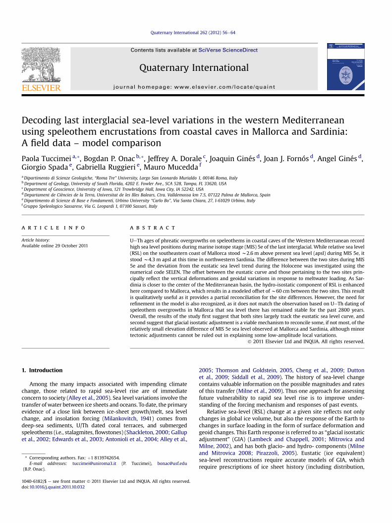
Fig. 1. Simplified tectonic map of the western Mediterranean an
different scenarios for the chronology of the remote ice sheets, isused to evaluate the relative sea level (RSL) history of the region.
2. Background
The islands of Mallorca (Spain) and Sardinia (Italy) sit in themicrotidal western Mediterranean Sea (Fig. 1), an intermediate-field basin, moderately distant from the former major glaciationcenters of the Northern Hemisphere (Stocchi and Spada, 2009).Further away from the ice sheets, regional differences in sea-levelchanges recorded in Mallorca and NW Sardinia are mainlycontrolled by the loading and unloading of the central basin of thewestern Mediterranean seafloor as ocean volumes change(Pirazzoli, 1996; Lambeck and Bard, 2000).
d geological sketch maps of Sardinia and Mallorca islands.
P. Tuccimei et al. / Quaternary International 262 (2012) 56e6458
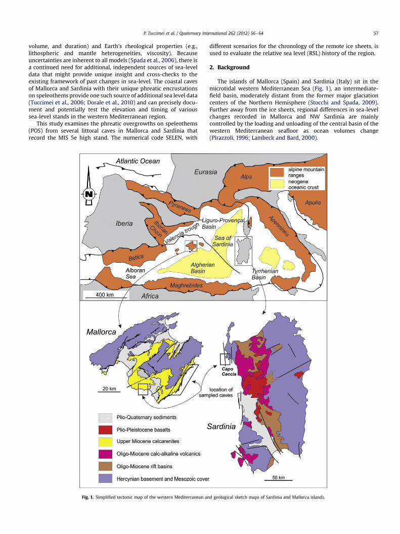
Along the coast of Mallorca and Sardinia, the interaction betweenfreshwater and seawater produces a geochemical environment thatallows caves and speleothems to develop in a unique manner whencompared to caves formed in more common inland settings. Most ofthe littoral caves at these two sites are well-decorated with vadosespeleothems that formed during early Quaternary time when thecaves were air-filled chambers. Throughout the middle and latePleistocene, the caves were repeatedly flooded due to glacio-eustaticsea level oscillations. The water level of each flooding event lefta clear mark as a distinct POS (encrustation of calcite or aragoniteover existing speleothems or along cave walls; Ginés et al., 1981;Vesica et al., 2000; Fornós et al., 2002). Several well-definedcarbonate overgrowth horizons below, at, and above the present-day sea level (corresponding to modern and older sea-level highand low stands) have been recognized (Fig. 2).
Over the past several decades speleothems (i.e., stalagmites andflowstones) have emerged as powerful proxy records for longperiods of Quaternary paleoclimate history. There are at least tworeasons for this. First, speleothems are well suited for U-seriesdating, so that a very precise chronology can be tied to their stra-tigraphy (Richards and Dorale, 2003). Second, the growth ofspeleothems is linked to the Earth’s atmosphere and hydrosphere ina number ofways,making them sensitive natural archives of climaticand environmental changes (Dorale et al., 1992, 1998; Lauritzen,1993; Fairchild et al., 2006; Onac et al., 2006; Lachniet, 2009).
The use of ordinary submerged speleothems as proxies for sea-level reconstruction was first explored by Spalding and Matthews(1972) in the Bahamas and subsequently by others in differentregions of the world (Harmon et al., 1978; Li et al., 1989; Richardset al., 1994; Antonioli et al., 2004; Dutton et al., 2009; Suri�c et al.,2009). While the U/Th dating of the materials can be very robustusing this technique, it really only documents the “moment” whena particular elevation within the cave became flooded or air-filled,not precisely when and where the water level was actuallylocated throughout the bulk of the rise-fall cycle (Richards et al.,1994; Bard et al., 2002; Dutton et al., 2009). Particularly in thecase of sea level drop, the “moment” may be significantlycompromised by unknown lags between the timing of sub-aerialexposure and the initiation of speleothem deposition.
Submerged speleothems that contain biogenic overgrowth crusts(e.g., serpulid worm tubes) refine this basic technique. Such studieshave been undertaken on the Tyrrhenian Sea (Bard et al., 2002;Antonioli et al., 2004; Dutton et al., 2009), Bermuda (Harmon et al.,1981), Bahamas (Lundberg and Ford, 1994; Richards et al., 1994),and the eastern seaboard of the Adriatic Sea (Suri�c et al., 2009). In
present sea-level
mean paleo-sealevels
Fig. 2. Schematic cross-section through a coastal cave in Mallorca and Sardini
comparison, the phreatic carbonate encrustations featured here,arguably provide a more precise and less ambiguous indicator of thetiming and the absolute elevation of any given low and high sea levelstand throughout the late Quaternary (Ginés and Ginés 1995; Vesicaet al., 2000; Tuccimei et al., 2006, 2010; Dorale et al., 2010).
3. Geological setting
The Western Mediterranean (Fig. 1), where the islands of Mal-lorca (Balearic Archipelago) and Sardinia are located, showsa complex geological structure which results from the interaction ofthe European and the African plates with a set of small plates(Iberian and Apulian) trapped in between them (Sàbat and Gelabert,2003). The NEeSW convergence between the plates of Africa andEurope originated the opening of the Valencia trough-Gulf of Lyonbasin (30e20 Ma) and led (20e10 Ma) to an eastward migration ofCorsica and Sardinia (Gueguen et al., 1997; Séranne, 1999).
3.1. Mallorca (Balearic archipelago)
The Balearic archipelago represents the emerged part of theprolongation into the Western Mediterranean of the SoutheastIberian Betic Range, which is separated from the Spanish coast bya submarine trough (Valencia trough). The carbonate lithologies,occurring almost continuously since the Middle Triassic to thepresent (Fornós and Gelabert, 1995; Gibbons and Moreno, 2002),feature a variety of karst landscapes.
The structural evolution occurred during Mesozoic and Tertiarytime and caused a very complex sequence of mainly extensionaland short compressive events (Banda and Santanach, 1992;Dañobeitia et al., 1992). The last two phases of these tectonicevents affected the island of Mallorca (the biggest island of thearchipelago) and shaped it to its present geomorphologic configu-ration. The first corresponds to a compressive phase, active fromthe Paleogene to Middle Miocene; the second, an extensional phaseUpper Miocene in age, which generated a structure composed ofhorsts and grabens bounded by Upper Miocene normal faults(Gelabert et al., 1992). The horsts correspond to the mountainranges (Serra de Tramuntana and Serres de Llevant) and consist ofan imbricate thrust sheet system facing NW. The grabens corre-spond to basins (Pla and Migjorn) that are now filled with sedi-ments (Upper Miocene to Quaternary). These sediments aregenerally considered post-orogenic and compressive structures arenot evident. Consequently, Mallorca could be considered tectoni-cally stable since the Upper Miocene. However, there is evidence of
mean paleo-sealevels
POS
tide amplitude
a showing multiple levels of phreatic overgrowths on speleothems (POS).
P. Tuccimei et al. / Quaternary International 262 (2012) 56e64 59
minor tectonic activity in the center of the island (Giménez, 2003),related to the Neogene NEeSW normal fault structures (Gelabert,1998) and fault-propagation folds trending NWeSE, perpendic-ular to the normal faults (Rohdenburg and Sabelberg, 1973). Fornóset al. (2002) point out a general tectonic tilting with a progressivelowering of the southwest part of the island at a rate of 0.02 mm/year.
A wide range of karst features (Ginés, 1995) in the form ofsolutional voids and caves develop in the Upper Miocene carbonateplatform limestones and calcarenite deposits (Pomar et al., 1990).Most littoral caves preserve the complex Pleistocene sea levelhistory (Ginés and Ginés, 1995) in both vadose and phreatic spe-leothems precipitated during successive periods of rising andlowering of the water level inside these caves, and also in theirsedimentary infillings, collapse, and breccia formation.
3.2. Capo Caccia area (NW Sardinia)
The Capo Caccia region is located along the northwestern edgeof Sardinia where extensive outcrops of the Hercynian basementrocks are covered by Mesozoic carbonates (Fig. 1; Carmignani et al.,1992). Sardinia is tectonically stable to locally slowly subsiding (dueto cooling of lithosphere; Burrus and Audebert, 1990), and formsa block almost coherent with mainland Europe (Gueguen et al.,1998). Within this generally stable setting, small vertical motionsare recognizable in areas were the MIS 5e sea high stand is accu-rately positioned and excellent lateral exposure of the upper tidalnotch are also available (Ulzega and Hearty, 1986; Kindler et al.,1997; Antonioli et al., 2006, 2007). The elevation of this markerdecreases from east to west across different rock promontoriesfrom 5.5 to 3.5 m apsl (Ferranti et al., 2006). The westward subsi-dence may record minor block motion, likely linked to the faultsystem occurring along the western continental margin of theMediterranean Sea (Carminati et al., in press). In addition, the MIS5e double notch is morphologically similar to the Late Holocenenotch at the observed sites, suggesting that the history of Holocenesea-level changes might be applied to the last interglacial highstand.
If these data are evaluated in the light of global sea-level historyduring the last interglacial period when sea level stood higher thanthe modern one (Shackleton, 2000;Waelbroeck et al., 2002; Siddallet al., 2003) and, in particular focusing on the NW Mediterraneancoasts, where the average level attained by the sea during MIS 5e isinferred to be w6� 3 m, relative to modern sea level (Lambecket al., 2004), it can be assumed that sea level changes at the CapoCaccia region nearly follow the eustatic curve.
Along the limestone cliffs of the Capo Caccia promontory a largenumber of littoral caves occur. Speleothem encrustations developalong cave walls or pre-existing supports. At Grotta di Nettuno(a very well-known showcave), a particular level of POS and a blackoxidation marks (consisting of iron and manganese oxides) along
Table 1Sample information and UeTh ages of speleothem encrustation formed during MIS 5e h
Cave Samplecode
E(
Cova des Pas de Vallgornera, Mallorca CPV-B6 2Cova d Pas de Vallgornera, Mallorca CPV-B9 2Cova del Dimoni, Mallorca DI-D1-2 2Cova del Dimoni, Mallorca DI-D3 2
Grotta di Nettuno, NW Sardinia GN-D3-2 4Grotta di Nettuno, NW Sardinia GN-D4 4
Errors are 2s of the mean and are based on the analytical precision. m apsl, metres abova Measured by Thermal Ionization Mass Spectrometry.b Measured by Inductively Coupled Plasma Mass Spectrometry.
the cave walls are evident and positioned at the same elevationwith the MIS 5e upper tidal notch (4.3 m apsl; Tuccimei et al.,2007), and a similar alignment of overgrowths form at thepresent sea level.
4. Material and methods
4.1. Speleothem encrustations
The littoral limestone areas of Mallorca and Sardinia hostnumerous caves, now partially drowned by brackish waters asa result of post-glacial sea level rise. Most caves formed bydissolution in the mixing zone between fresh water and marinewater. Subsequently, extensive collapse processes led to theirvolumetric enlargement (Ginés, 1995; Ginés and Ginés, 2007). Thepassages of all investigated caves are within 250 m from the coast.One of the most distinctive features of these coastal caves is thepresence of large pools, occupying their lower parts in connectionwith the present-day Mediterranean Sea level. The height of thewater in these pools is tightly controlled by sea level andundergoes daily fluctuations as a result of minor sea oscillations,tidal, and/or barometric pressure. At present, in such a microen-vironment, at or a few centimeters below and above the watertable where CO2 escapes the brackish water, precipitation ofcalcite or/and aragonite takes place as horizontal encrustationsthat overgrow existing speleothems or cave walls (Ginés et al.,1981).
In general terms, the investigated encrustations are crystallineovergrowths that define strictly horizontal bands some decimetersin width. These belt-like phreatic overgrowths on speleothems(POS) are formed at present-day sea level and are clearly post-glacial in age, as documented by UeTh and 14C dating (Tuccimeiet al., 2010, 2011). Usually, the thickest part of these encrusta-tions is located in the middle of the crystallization band, thengradually decreasing upward and downward. The maximumthickness of the overgrowth relates to the statistically mostfrequent position of the water table (i.e., the mean sea level duringthe deposition of the crystalline overgrowth).
From a mineralogical and crystallographical point of view, high-magnesium calcite and (to a lesser extent) aragonite are dominantin these phreatic overgrowths. Calcite deposits form encrustationswith rough or even macrocrystalline surfaces, whereas aciculararagonite deposits are characterized by smooth surfaces. Althoughless abundant, aragonite encrustations are reported from Mallorcaboth as post-glacial deposits or recording ancient high sea-stands(Dorale et al., 2010; Tuccimei et al., 2010).
A total of 4 samples from POS were collected atþ2.5 andþ2.6 mapsl, respectively in two different caves of southern Mallorca. FromSardinia, the only studied cave (Grotta di Nettuno) provided 2samples corresponding to POS alignments located at þ4.3 m apsl(Table 1).
igh stand in Mallorca and NW Sardinia.
levationm apsl)
Age (yr) Reference
.60 120.6� 0.9a Dorale et al. (2010)
.60 116.2� 0.6a Dorale et al. (2010)
.50 118.4� 0.9b Tuccimei et al. (2006)
.50 114.2� 0.9b Tuccimei et al. (2006)
.30 117� 2.0a Tuccimei et al. (2007)
.30 120� 2.0a Tuccimei et al. (2007)
e present sea level.
P. Tuccimei et al. / Quaternary International 262 (2012) 56e6460
4.2. UeTh dating method
Speleothem encrustations were dated using the UeTh method.This is themostwidely useddating technique applied to speleothemsand is based on the extreme fractionation of the parent isotopes (238Uand 234U) from their long-lived daughter 230Th in the hydrosphere.Uranium, markedly more soluble than Th in the surface and near-surface environments, is readily mobilized as highly soluble uranylion (UO2
2þ) and its complexes, whereas Th is readily precipitated oradsorbed ondetrital particles. Uranium is co-precipitatedwithCaCO3in the crystal lattice, while incorporation of Th is generally negligible.In the absence of detrital Th, 230Th only forms by in-situ radioactivedecay of co-precipitated U. If the crystal lattice remains a closedsystemwith respect to the loss or gain of U and Th, the age of a spe-leothem can be calculated through measurement of radioactiveproduction and decay of their isotopes in the system (Edwards et al.,1987; Richards and Dorale, 2003). Specific information on samplepreparation and measurement are reported in Tuccimei et al. (2006,2007) and Dorale et al. (2010).
4.3. Sea level modeling
Sea level variations driven by the melting of continental icesheets are modeled using the public-domain program SELEN(Spada and Stocchi, 2007), which solves the “Sea Level Equation”(SLE) in the form given by Farrell and Clark (1976) according toa pseudo-spectral iterative numerical scheme. All the phenomenaassociated with glacial isostatic adjustment (GIA), which includerelative sea level (RSL) variations, vertical movements and gravitychanges, can be modeled by means of the SLE. SELEN assumesa radially stratified, incompressible Earth and a linear Maxwellvisco-elastic rheology for the mantle (i.e., lateral viscosity varia-tions are not included in modeling). The reader is referred to Spadaand Stocchi (2007) for a detailed review of the theory backgroundof the SLE and to the home page of SELEN (http://www.fis.uniurb.it/spada/SELEN_minipage.html) for information about the numericalmethod and examples of applications.
In its basic form, the SLE reads:
Sðw; l; tÞ ¼ F
g� U þ SE þ
�F
g� U
�; (1)
where Sðw; l; tÞ is sea level change at a point of co-latitude w andlongitude l, t is time, g is the reference gravity acceleration,F ¼ Fðw; l; tÞ and U ¼ Uðw; l; tÞ are the total incremental gravi-tational potential and the vertical displacement of the solid surfaceof the Earth, respectively, the symbol h/i represents an averageover the surface of the oceans that ensures mass conservation, and
SE ¼ SEðtÞ; (2)
is the eustatic component of S, which represents the sea levelvariation that would be observed assuming F ¼ 0 and U¼ 0, i.e.,completely neglecting the gravity variations and assuming a rigidEarth. From Equation (1), the spatially uniform eustatic componentsimply represents the ocean-average of the actual sea level varia-tions, namely SE ¼ hSi. The explicit form of SE is
SE ¼ �DmðtÞrwAoc
; (3)
where Dm(t) is the variation of the mass of the ice sheets withrespect to a previous reference configuration, rw is the density ofwater and Aoc is the area of the surface of the oceans. Since here thehorizontal migration of shorelines is not modeled, Aoc is constant inEquation (3). However, F and U account for rotational effects
according to the formulation described by Milne and Mitrovica(1998). In the following, the RSL curve at a site of coordinatesðw; lÞ is obtained computing the difference
RSLðw; l; tBPÞ ¼ Sðw; l; tBPÞ � S�w; l; tp
�; (4)
where S is the solution of the SLE obtained from Equation (1), tBP istime before present (BP) and tp is present time.
To explicitly solve Equation (1), the history of the continental icesheets and the mantle rheology must be specified. These twofundamental inputs of the SLE are required to evaluate the incre-mental gravitational potential F and vertical displacement Uglobally bymeans of spatio-temporal convolutions that describe forthe delayed response of the Earth to surface loading and accountself-consistently for the associated gravity field variations (detailsare available in Spada and Stocchi, 2006). This work employs modelICE-5G, which describes the melting of the global continental icemasses during the last glacial-interglacial period, assuminga specific viscosity profile of the mantle (VM2) (see Peltier, 2004).ICE-5G does not include information about the details of the globalice history during the marine isotopic stages MIS5e. Becausea detailed reconstruction of the global distribution of the thicknessof continental ice sheets during these periods is not available todate, the RSL variations at the sites of interest during the meltingand the postglacial phases that have followed the Last GlacialMaximum are utilized as analogues, according to model ICE-5G.This allows for an evaluation of the deviations of the RSL curvesfrom the eustatic response, and enlightens differences in thehistories of sea level in the Sardinian and Mallorcan sites. A preciseassessment of the history of RSL at these sites could be possible onlyby a detailed knowledge of the amplitude of the hydro-isostaticcomponent during the whole time span since MIS 5e, but unfor-tunately this knowledge does not exist.
5. Results and discussion
5.1. Elevation of MIS 5e in Mallorca and NW Sardinia
Geomorphological andmorphostratigraphical studies combinedwith ages obtained through U/Th, amino-acid, and optically stim-ulated luminescence dating on emerged coastal deposits fromsouthernMallorca documented two high stands duringMIS 5e; oneoccurred at the beginning of the last interglacial period atw135 ka,and one centered around 117 ka (Hearty, 1987; Cuerda, 1989;Hillaire-Marcel et al., 1996; Zazo et al., 2003; Bardají et al., 2009).The elevation of the 117 ka sea stand is well documented byavailable U-series ages of carbonate encrustations collected atelevations between 2 and 3 m in the coastal caves of Mallorca(Table 1; Tuccimei et al., 2006; Dorale et al., 2010).
Coastal deposits of MIS 5a age were recorded in Mallorca byButzer and Cuerda (1962), Hearty (1987), and Cuerda (1989), and arepresent w1.5 m above present sea level. The ages obtained forcarbonate encrustations collected from five caves on eastern andsouthern part of the island cluster around 81 ka (Dorale et al., 2010).The elevations of MIS 5e coeval POS slightly increase northwards,along the eastern coast of the island (Fornós et al., 2002). Between120and117 ka, inCapoCacciaarea, theMediterraneansea level stoodat w þ4.3 m relative to present sea level (Table 1; Tuccimei et al.,2007), slightly less than 2 m higher than coeval records in Mallorca.
5.2. Modeling of regional deviations from the eustatic relative sealevel trend
The RSL curves associated with GIA deviate from the eustaticcurve of an amount that strongly depends upon the site location
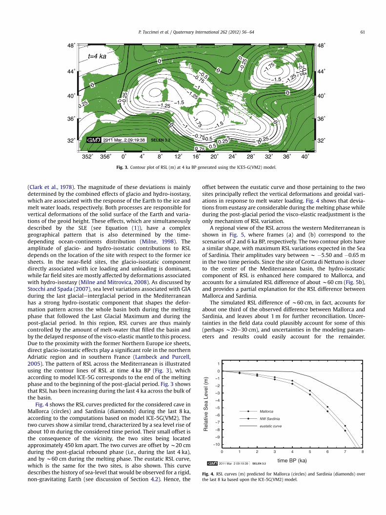
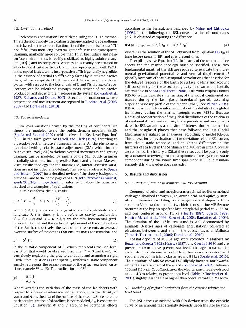
Fig. 3. Contour plot of RSL (m) at 4 ka BP generated using the ICE5-G(VM2) model.
Fig. 4. RSL curves (m) predicted for Mallorca (circles) and Sardinia (diamonds) overthe last 8 ka based upon the ICE-5G(VM2) model.
P. Tuccimei et al. / Quaternary International 262 (2012) 56e64 61
(Clark et al., 1978). The magnitude of these deviations is mainlydetermined by the combined effects of glacio and hydro-isostasy,which are associated with the response of the Earth to the ice andmelt water loads, respectively. Both processes are responsible forvertical deformations of the solid surface of the Earth and varia-tions of the geoid height. These effects, which are simultaneouslydescribed by the SLE (see Equation (1)), have a complexgeographical pattern that is also determined by the time-depending ocean-continents distribution (Milne, 1998). Theamplitude of glacio- and hydro-isostatic contributions to RSLdepends on the location of the site with respect to the former icesheets. In the near-field sites, the glacio-isostatic componentdirectly associated with ice loading and unloading is dominant,while far field sites are mostly affected by deformations associatedwith hydro-isostasy (Milne and Mitrovica, 2008). As discussed byStocchi and Spada (2007), sea level variations associated with GIAduring the last glacialeinterglacial period in the Mediterraneanhas a strong hydro-isostatic component that shapes the defor-mation pattern across the whole basin both during the meltingphase that followed the Last Glacial Maximum and during thepost-glacial period. In this region, RSL curves are thus mainlycontrolled by the amount of melt-water that filled the basin andby the delayed response of the visco-elastic mantle to this process.Due to the proximity with the former Northern Europe ice sheets,direct glacio-isostatic effects play a significant role in the northernAdriatic region and in southern France (Lambeck and Purcell,2005). The pattern of RSL across the Mediterranean is illustratedusing the contour lines of RSL at time 4 ka BP (Fig. 3), whichaccording to model ICE-5G corresponds to the end of the meltingphase and to the beginning of the post-glacial period. Fig. 3 showsthat RSL has been increasing during the last 4 ka across the bulk ofthe basin.
Fig. 4 shows the RSL curves predicted for the considered cave inMallorca (circles) and Sardinia (diamonds) during the last 8 ka,according to the computations based on model ICE-5G(VM2). Thetwo curves show a similar trend, characterized by a sea level rise ofabout 10 m during the considered time period. Their small offset isthe consequence of the vicinity, the two sites being locatedapproximately 450 km apart. The two curves are offset by w20 cmduring the post-glacial rebound phase (i.e., during the last 4 ka),and by w60 cm during the melting phase. The eustatic RSL curve,which is the same for the two sites, is also shown. This curvedescribes the history of sea-level that would be observed for a rigid,non-gravitating Earth (see discussion of Section 4.2). Hence, the
offset between the eustatic curve and those pertaining to the twosites principally reflect the vertical deformations and geoidal vari-ations in response to melt water loading. Fig. 4 shows that devia-tions from eustasy are considerable during the melting phase whileduring the post-glacial period the visco-elastic readjustment is theonly mechanism of RSL variation.
A regional view of the RSL across the western Mediterranean isshown in Fig. 5, where frames (a) and (b) correspond to thescenarios of 2 and 6 ka BP, respectively. The two contour plots havea similar shape, with maximum RSL variations expected in the Seaof Sardinia. Their amplitudes vary between w �5.50 and �0.65 min the two time periods. Since the site of Grotta di Nettuno is closerto the center of the Mediterranean basin, the hydro-isostaticcomponent of RSL is enhanced here compared to Mallorca, andaccounts for a simulated RSL difference of about w60 cm (Fig. 5b),and provides a partial explanation for the RSL difference betweenMallorca and Sardinia.
The simulated RSL difference of w60 cm, in fact, accounts forabout one third of the observed difference between Mallorca andSardinia, and leaves about 1 m for further reconciliation. Uncer-tainties in the field data could plausibly account for some of this(perhaps w20e30 cm), and uncertainties in the modeling param-eters and results could easily account for the remainder.
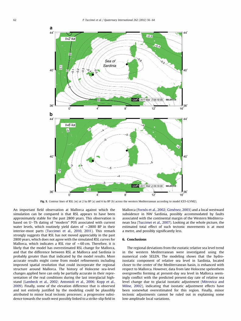
Fig. 5. Contour lines of RSL (m) at 2 ka BP (a) and 6 ka BP (b) across the western Mediterranean according to model ICE5-G(VM2).
P. Tuccimei et al. / Quaternary International 262 (2012) 56e6462
An important field observation at Mallorca against which thesimulation can be compared is that RSL appears to have beenapproximately stable for the past 2800 years. This observation isbased on UeTh dating of “modern” POS associated with currentwater levels, which routinely yield dates of w2800 BP in theirinterior-most parts (Tuccimei et al., 2010, 2011). This remarkstrongly suggests that RSL has not moved appreciably in the past2800 years, which does not agree with the simulated RSL curves forMallorca, which indicates a RSL rise of w60 cm. Therefore, it islikely that the model has overestimated RSL change for Mallorca,and that the difference between RSL at Mallorca and Sardinia isprobably greater than that indicated by the model results. Moreaccurate results might come from model refinements includingimproved spatial resolution that could incorporate the regionalstructure around Mallorca. The history of Holocene sea-levelchanges applied here can only be partially accurate in their repre-sentation of the real conditions during the last interglacial high-stand (Lambeck et al., 2002; Antonioli et al., 2006; Kopp et al.,2009). Finally, some of the elevation difference that is observedand not entirely justified by the modeling could be plausiblyattributed to minor local tectonic processes: a progressive subsi-dence towards the southwest possibly linked to a strike-slip field in
Mallorca (Fornós et al., 2002; Giménez, 2003) and a local westwardsubsidence in NW Sardinia, possibly accommodated by faultsassociated with the continental margin of the Western Mediterra-nean Sea (Tuccimei et al., 2007). Looking at the whole picture, theestimated total effect of such tectonic movements is at mosta metre, and possibly significantly less.
6. Conclusions
The regional deviations from the eustatic relative sea level trendin the western Mediterranean were investigated using thenumerical code SELEN. The modeling shows that the hydro-isostatic component of relative sea level in Sardinia, locatedcloser to the center of the Mediterranean basin, is enhanced withrespect to Mallorca. However, data from late Holocene speleothemovergrowths forming at present-day sea level in Mallorca seem-ingly conflict with the predicted present-day rate of relative sealevel change due to glacial isostatic adjustment (Mitrovica andMilne, 2002), indicating that isostatic adjustment effects havebeen somewhat overestimated for this region. Finally, minortectonic adjustments cannot be ruled out in explaining somelow-amplitude local variations.
P. Tuccimei et al. / Quaternary International 262 (2012) 56e64 63
Acknowledgements
These investigations are integrated within the research projectsCGL2010-18616 and CGL2009-07392 of the Spanish GovernmentMinisterio de Ciencia e Innovación e FEDER. Part of this work wassupported by COST Action ES0701 “Improved Constraints onModels of Glacial Isostatic Adjustment” and is a contribution to#0911 INQUA-CMP Project.BPO and JAD were supported by NSFgrants AGS-1103108 and AGS-1102947, respectively.
References
Alley, R.B., Clark, P.U., Huybrechts, P., Joughin, I., 2005. Ice-sheet and sea-levelchanges. Science 310, 456e460.
Antonioli, F., Bard, E., Potter, E.K., Silenzi, S., Improta, S., 2004. 215-ka history ofsea-level oscillations from marine and continental layers in Argentarola Cavespeleothems (Italy). Global and Planetary Change 43, 57e78.
Antonioli, F., Ferranti, L., Kershaw, S., 2006. A glacial isostatic adjustment origin fordouble MIS 5.5 and Holocene marine notches in the coastline of Italy. Quater-nary International 145-146, 19e29.
Antonioli, F., Anzidei, M., Lambeck, K., Auriemma, R., Gaddi, D., Furlani, S., Orrù, P.,Solinas, E., Gaspari, A., Karinja, S., Kovacic�c, V., Surace, L., 2007. Sea level changeduring the Holocene in Sardinia and in the North-eastern Adriatic (CentralMediterranean sea) from archaeological and geomorphological data. Quater-nary Science Reviews 26, 2463e2486.
Banda, E., Santanach, P., 1992. The Valencia trough (western Mediterranean): anoverview. Tectonophysics 208, 183e202.
Bard, E., Antonioli, F., Silenzi, S., 2002. Sea-level during the penultimate interglacialperiod based on a submerged stalagmite from Argentarola Cave (Italy). Earthand Planetary Science Letters 196, 135e146.
Bardají, T., Goy, J.L., Zazo, C., Hillaire-Marcel, C., Dabrio, C.J., Cabero, A., Ghaleb, B.,Silva, P.G., Lario, J., 2009. Sea level and climate changes during OIS 5e in theWestern Mediterranean. Geomorphology 104, 22e37.
Burrus, J., Audebert, F., 1990. Thermal and compaction processes in a young riftedbasin containing evaporites e Gulf of Lions, France. American Association ofPetroleum Geologists Bulletin 74, 1420e1440.
Butzer, K.W., Cuerda, J., 1962. Coastal stratigraphy of southern Mallorca and itsimplications for the Pleistocene chronology of the Mediterranean Sea. Journalof Geology 70, 398e416.
Carmignani, L., Barca, S., Cappelli, B., di Pisa, A., Gattiglio, M., Oggiano, G.,Pertusati, P.C., 1992. A tentative geodynamic model for the Hercynian basementof Sardinia. In: Carmignani, L., Sassi, F.P. (Eds.), Contribution to the Geology ofItaly with Special Regard to the Paleozoic Basement. IGCP 276, Newsletter, vol.5, pp. 61e82.
Carminati, E., Doglioni, C., Gelabert, B., Panza, G., Raykova, R.B., Roca, E., Sabat, F.,Scrocca, D. Evolution of the Western Mediterranean. In: Bally, A.W., Roberts, D.(Eds.), Phanerozoic Regional Geology of the World (vol. 1), Elsevier, in press.
Clark, J.A., Farrell, W.E., Peltier, W.R., 1978. Global changes in postglacial sea-level:a numerical calculation. Quaternary Research 9, 265e287.
Cheng, H., Edwards, R.L., Broecker, W.S., Denton, G.H., Kong, X., Wang, Y., Zhang, R.,Wang, X., 2009. Ice age terminations. Science 326, 248e252.
Cuerda, J., 1989. Los tiempos cuaternarios en Baleares (2nd ed.), Conselleria deCultura, Educació i Esports, Govern Balear, Palma de Mallorca, 310 pp.
Dañobeitia, J.J., Arguedas, M., Gallart, F., Banda, E., Makris, J., 1992. Deep crustalconfiguration of the Valencia trough and its Iberian and Balearic borders fromextensive refraction and wide-angle reflection profiling. Tectonophysics 203,37e55.
Dorale, J.A., González, L.A., Reagan, M.K., Pickett, D.A., Murrell, M.T., Baker, R.G.,1992. A high-resolution record of holocene climate change in speleothemcalcite from Cold Water Cave, Northeast Iowa. Science 258, 1626e1630.
Dorale, J.A., Edwards, R.L., Ito, M., González, L.A., 1998. Climate and vegetationhistory of the midcontinent from 75 to 25 ka: a speleothem record from CreviceCave, Missouri, USA. Science 282, 1871e1874.
Dorale, J.A., Onac, B.P., Fornós, J.J., Ginés, J., Ginés, A., Tuccimei, P., Peate, D.W., 2010.Sea-level 81,000 years ago in Mallorca. Science 327, 860e863.
Dutton, A., Bard, E., Antonioli, F., Esat, T.M., Lambeck, K., McCulloch, T., 2009.Phasing and amplitude of sea-level and climate change during the penultimateinterglacial. Nature Geoscience 2, 355e359.
Edwards, R.L., Cheng, J.H., Wasserburg, G.J., 1987. 238Ue234Ue230The232Th system-atics and the precise measurement of time over the past 500,000 years. Earthand Planetary Science Letters 81, 75e192.
Edwards, R.L., Cutler, K.B., Cheng, H., Gallup, C.D., 2003. Geochemical evidence forQuaternary sea-level changes. In: Elderfield, H. (Ed.), Treatise of Geochemistry,vol. 6. Elsevier-Pergamon, Oxford, pp. 343e364.
Fairchild, I.J., Smith, C.L., Baker, A., Fuller, L., Spotl, C., Mattey, D., McDermott, F.,2006. Modification and preservation of environmental signals in speleothems.Earth Science Reviews 75, 105e153.
Farrell, W.E., Clark, J.A., 1976. On postglacial sea level. Geophysical Journal of theRoyal Astronomical Society 46, 647e667.
Ferranti, L., Antonioli, F., Mauz, B., Amorosi, A., Dai Pra, G., Mastronuzzi, G.,Monaco, C., Orrù, P., Pappalardo, M., Radtke, U., Renda, P., Romano, P., Sansò, P.,
Verrubbi, V., 2006. Markers of the last interglacial sea-level high stand alongthe coast of Italy: tectonic implications. Quaternary International 145-146,30e54.
Fornós, J.J., Gelabert, B., 1995. Lithology and tectonics of the Majorcan karst. In:Ginés, A., Ginés, J. (Eds.), Karst and caves in Mallorca, Endins, 20 & Monografiesde la Societat d’Història Natural de les Balears, vol. 3, pp. 27e43.
Fornós, J.J., Gelabert, B., Ginés, A., Ginés, J., Tuccimei, P., Vesica, P.L., 2002. Phreaticovergrowths on speleothems: a useful tool in structural geology in littoralkarstic landscapes. The example of Eastern Mallorca (Balearic Islands).Geodinamica Acta 15, 113e125.
Gallup, C.D., Cheng, H., Taylor, F.W., Edwards, R.L., 2002. Direct determination of thetiming of sea level change during Termination II. Science 295, 310e313.
Gelabert, B., 1998. La estructura geológica de la mitad occidental de la Isla deMallorca, ITGE. Colección Memorias, Madrid, pp. 1e129.
Gelabert, B., Sàbat, F., Rodríguez-Perea, A., 1992. An structural outline of the Serra deTramuntana of Mallorca (Balearic Islands). Tectonophysics 203, 167e183.
Gibbons, W., Moreno, T (Eds.), 2002. The Geology of Spain, The Geological SocietyLondon, 649 pp.
Giménez, J., 2003. Nuevos datos sobre la actividad post-Neógena de la Isla deMallorca. Geogaceta 33, 79e82.
Ginés, A., Ginés, J., 2007. Eogenetic karst, glacioeustatic cave pools and anchialineenvironments on Mallorca Island: a discussion of coastal speleogenesis. Inter-national Journal of Speleology 36 (2), 57e67.
Ginés, J., 1995. Mallorca’s endokarst: the speleogenetic mechanisms. In: Ginés, A.,Ginés, J. (Eds.), Karst and caves in Mallorca. Endins, 20 & Monografies de laSocietat d’Història Natural de les Balears, vol. 3, pp. 71e86.
Ginés, J., Ginés, A., 1995. Speleochronological aspects of karst in Mallorca. In:Ginés, A., Ginés, J. (Eds.), Karst and caves in Mallorca. Endins, 20 & Monografiesde la Societat d’Història Natural de les Balears, vol. 3, pp. 99e112.
Ginés, J., Ginés, A., Pomar, L., 1981. Morphological and mineralogical features ofphreatic speleothems occurring in coastal caves of Majorca (Spain). In:Proceedings of the 8th International Congress of Speleology, Bowling Green,vol. 2, pp. 529e532.
Gueguen, E., Doglioni, C., Fernández, M., 1997. Lithospheric boudinage in WesternMediterranean back-arc basins. Terra Nova 9, 184e187.
Gueguen, E., Doglioni, C., Fernández, M., 1998. On the post-25 Ma geodynamicevolution of the western Mediterranean. Tectonophysics 298, 259e269.
Harmon, R.S., Schwarcz, H.P., Ford, D.C., 1978. Late Pleistocene sea level history ofBermuda. Quaternary Research 9, 205e218.
Harmon, R.S., Land, L.S., Mitterer, R.M., Garrett, P., Schwarcz, H.P., Larson, G.J., 1981.Bermuda sea level during the last interglacial. Nature 289, 481e483.
Hearty, P.J., 1987. New data on the Pleistocene of Mallorca. Quaternary ScienceReviews 6, 245e257.
Hillaire-Marcel, C., Gariépy, C., Ghaleb, B., Goy, J.L., Zazo, C., Cuerda Barcelo, J., 1996.U-series measurements in Tyrrhenian deposits from Mallorca e furtherevidence for two last-interglacial high sea levels in the Balearic islands.Quaternary Science Reviews 15, 53e62.
Kindler, P., Davaud, E., Strasser, A., 1997. Tyrrhenian coastal deposits from Sardinia(Italy): a petrographic record of high sea levels and shifting climate belts duringthe last interglacial (isotopic substage 5e). Palaeogeography, Palaeoclimatology,Palaeoecology 133, 1e25.
Kopp, R.E., Simons, F.J., Mitrovica, J.X., Maloof, A.C., Oppenheimer, M., 2009. Prob-abilistic assessment of sea level during the last interglacial stage. Nature 462,863e867.
Lachniet, M.S., 2009. Climatic and environmental controls on speleothem oxygen-isotope values. Quaternary Science Reviews 28, 412e432.
Lambeck, K., Bard, E., 2000. Sea-level change along the French Mediterranean coastfor the past 30000 years. Earth and Planetary Science Letters 175 (3e4),203e222.
Lambeck, K., Chappell, J., 2001. Sea level change through the last glacial cycle.Science 29, 679e686.
Lambeck, K., Purcell, A., 2005. Sea-level change in the Mediterranean Sea since theLGM: model predictions for tectonically stable areas. Quaternary ScienceReviews 24, 1969e1988.
Lambeck, K., Esat, T.M., Potter, E.K., 2002. Links between climate and sea levels forthe past three million years. Nature 419, 199e206.
Lambeck, K., Antonioli, F., Purcell, A., Silenzi, S., 2004. Sea level change along theItalian coast for the past 10,000 yrs. Quaternary Science Reviews 23,1567e1598.
Lauritzen, S.E., 1993. Natural environmental change in karst: the Quaternary record.Catena supplement 25, 21e40.
Li, W.X., Lundberg, J., Dickin, A.P., Ford, D.C., Schwarcz, H.P., McNutt, R., Williams, D.,1989. High-precision mass-spectrometric uranium-series dating of cavedeposits and implications for palaeoclimate studies. Nature 339, 534e536.
Lundberg, J., Ford, D.C., 1994. Late Pleistocene sea level change in the Bahamas frommass spectrometric U-series dating of submerged speleothem. QuaternaryScience Reviews 13, 1e14.
Milankovitch, M., 1941. Canon of Insolation and the Ice-age Problem. Royal SerbianAcademy, Belgrade, Yugoslavia.
Milne, G.A., 1998. Refining models of the glacial isostatic adjustment process, PhDthesis, University of Toronto, CA, 126 pp.
Milne, G.A., Mitrovica, J.X., 1998. Postglacial sea-level change on a rotating Earth.Geophysical Journal International 133, 1e19.
Milne, G.A., Mitrovica, J.X., 2008. Searching for eustasy in deglacial sea-levelhistories. Quaternary Science Reviews 27, 2292e2302.
P. Tuccimei et al. / Quaternary International 262 (2012) 56e6464
Milne, G.A., Gehrels, W.R., Hughes, C.W., Tamisiea, M.E., 2009. Identifying the causesof sea-level change. Nature Geoscience 2, 471e478.
Mitrovica, J.X., Milne, G.A., 2002. On the origin of late Holocene sea-level highstandswithin equatorial ocean basins. Quaternary Science Reviews 21, 2179e2190.
Onac, B.P., T�amas, T., Constantin, S., Persoiu, A., 2006. Archives of Climate Change inKarst. In: Karst Waters Institute Special Publications, vol. 10 Charles Town WV.
Peltier, W.R., 2004. Global glacial isostasy and the surface of the Ice-Age Earth: theICE-5G(VM2) model and GRACE. Annual Review of Earth and Planetary Sciences32, 111e149.
Pirazzoli, P.A.,1996. Sea-LevelChanges: the Last 20,000Years.Wiley, Chichester, 211pp.Pirazzoli, P.A., 2005. A review of possible eustatic, isostatic and tectonic contribu-
tions in eight late-Holocene relative sea-level histories from the Mediterraneanarea. Quaternary Science Reviews 24, 1989e2001.
Pomar, L., Rodríguez-Perea, A., Sàbat, F., Fornós, J.J., 1990. Neogene stratigraphy of Mal-lorca Island. In: Agustí, J., Domènec, R., Julià, R., Martinell, J. (Eds.), Iberian NeogeneBasins, Field Guidebook. Paleontología i Evolució (Mem. Esp.), vol. 2, pp. 271e320.
Richards, D.A., Dorale, J.A., 2003. Uranium-series chronology and environmentalapplications of speleothems. In: Bourdon, B., Henderson, G.M., Lundstrom, C.C.,Turner, S.P. (Eds.), Uranium-series Geochemistry. Reviews in Mineralogy &Geochemistry, vol. 52. Geochemical Society/Mineralogical Society of America,Washington, pp. 407e460.
Richards, D.A., Smart, P.L., Edwards, R.L., 1994. Maximum sea level for the last glacialperiod from U-series ages of submerged speleothems. Nature 367, 357e360.
Rohdenburg, H., Sabelberg, U., 1973. Quartäre Klimazyklen im Westlichen Medi-terraneangebiet und ihre Auswirkungen auf die Relief und Bodenentwicklung.Catena 1, 71e180.
Sàbat, F., Gelabert, B., 2003. Late Cenozoic Geodynamic evolution of the WesternMediterranean. A.A.P.G. Int. Conf., Barcelona, pp. A83.
Séranne, M., 1999. The Gulf of Lyon continental margin (NW Mediterranean)revisited by IBS: an overview. In: Geological Society, London, Special Publica-tions, vol. 156, pp. 15e36.
Shackleton, N.J., 2000. The 100,000-year ice-age cycle identified and found to lagtemperature, carbon dioxide, and orbital eccentricity. Science 289, 1897e1902.
Siddall, M., Rohling, E.J., Almogi-Labin, A., Hemleben, C.H., Meischner, D.,Schmelzer, I., Smeed, D.A., 2003. Sea levelfluctuations during the last glacialcycle. Nature 423, 853e858.
Siddall, M., Stocker, T.F., Clark, P.U., 2009. Constraints on future sea-level rise frompast sea-level change. Nature Geoscience 2, 571e575.
Spada, G., Antonioli, A., Cianetti, S., Giunchi, C., 2006. Glacial isostatic adjustment andrelative sea-level changes: the role of lithospheric and upper mantle heteroge-neities in a 3-D spherical Earth. Geophysical Journal International 165, 692e702.
Spada, G., Stocchi, P., 2006. The Sea Level Equation, Theory and Numerical Exam-ples. Aracne, Roma, 96 pp.
Spada, G., Stocchi, P., 2007. SELEN: a Fortran 90 program for solving the “Sea LevelEquation”. Computers & Geosciences 33. doi:10.1016/j.cageo.2006.08.006.
Spalding, R.F., Matthews, T.D., 1972. Submerged stalagmites from caves in theBahamas: indicators of low sea level stand. Quaternary Research 2, 470e472.
Stocchi, P., Spada, G., 2007. Post-glacial sea-level in the Mediterranean Sea: Clark’szones and role of remote ice sheets. Annals of Geophysics 50 (6), 741e761.
Stocchi, P., Spada, G., 2009. Influence of glacial isostatic adjustment upon currentsea level variations in the Mediterranean. Tectonophysics 474 (1e2), 56e68.
Suri�c, M., Richards, D.A., Hoffmann, D.L., Tibljas, D., Juracic, M., 2009. Sea-levelchange during MIS 5a based on submerged speleothems from the easternAdriatic Sea (Croatia). Marine Geology 262 (1e4), 62e67.
Thomson, W.G., Goldstein, S.L., 2005. Open-system coral ages reveal persistentsuborbital sea-level cycles. Science 308, 401e404.
Tuccimei, P., Ginés, J., Ginés, A., Gracía, F., Fornós, J.J., 2006. Last interglacial sea levelchanges in Mallorca island (Western Mediterranean). High precision U-seriesdata from phreatic overgrowths on speleothems. Zeitschrift für Geomorphologie50, 1e21.
Tuccimei, P., Fornós, J., Ginés, A., Ginés, J., Gràcia, F., Mucedda, M., 2007. Sea levelchange at Capo Caccia (NW Sardinia) and Mallorca (Balearic Islands) duringoxygen isotope substage 5e, based on Th/U datings of phreatic overgrowths onspeleothems. In: Pons, G.X., Vicens, D. (Eds.), Geomorfologia Litoral i Quaternari.Homenatge a Joan Cuerda Barcelo. Monografies de la Societat d’Historia Naturalde les Balears, vol. 14, pp. 121e136.
Tuccimei, P., Soligo, M., Ginés, J., Ginés, A., Fornós, J., Kramers, J., Villa, I.G., 2010.Constraining Holocene sea levels using UeTh ages of phreatic overgrowths onspeleothems from coastal caves in Mallorca (Western Mediterranean). EarthSurface Processes and Landforms 35 (7), 782e790.
Tuccimei, P., Van Strydonck, M., Ginés, A., Ginés, J., Soligo, M., Villa, I.M., Fornós, J.J.,2011. Comparison of 14C and UeTh ages on two Holocene phreatic overgrowthson speleothems from Mallorca (Western Mediterranean) Mediterranean):environmental implications. International Journal of Speleology 40 (1), 1e7.Available online at: www.ijs.speleo.it.
Ulzega, A., Hearty, P.J., 1986. Geomorphology, stratigraphy and geochronology ofLate Quaternary marine deposits in Sardinia. Zietschrift fur Geomorphologie,Suppl. Bd. 62, 119e129.
Vesica, P., Tuccimei, P., Turi, B., Fornós, J., Ginés, J., Ginés, A., 2000. Late Pleistocenepaleoclimates and sea-level change in the Mediterranean as inferred fromstable isotope and U-series studies of overgrowths on speleothems, Mallorca(Spain). Quaternary Science Reviews 19, 865e879.
Waelbroeck, C., Labeyrie, L., Michel, E., Duplessy, J.C., Lambeck, K., McManus, J.F.,Balbon, E., Labracherie, M., 2002. Sea-level and deep water temperaturechanges derived from benthic foraminifera isotopic records. Quaternary ScienceReviews 21, 295e305.
Zazo, C., Goy, J.L., Dabrio, C.J., Bardaji, T., Hillaire-Marcel, C., Ghaleb, B., Gonzalez-Delgado, J.A., Soler, V., 2003. Pleistocene raised marine terraces of the SpanishMediterranean and Atlantic coasts: records of coastal uplift, sea-level high-stands and climate changes. Marine Geology 194, 103e133.