data release report - science & technology review
TRANSCRIPT
DOE/NV/03624--0524
Data Release Report
Source Physics Experiments 5 and 6 (SPE-5 and SPE-6)
Nevada National Security Site
June 2019
Compiled by: Margaret Townsend and Curtis Obi
Mission Support and Test Services, LLC
With contributions from: Robert Abbott and Daniel Bowman, Sandia National Laboratories
Robert Mellors and Sonia Wharton, Lawrence Livermore National Laboratory Walter Schalk, NOAA Air Resources Laboratory/Special Operations and Research Division Ken Smith and Gabe Plank, Nevada Seismology Laboratory, University of Nevada, Reno
David Steedman, Los Alamos National Laboratory William Walter, Lawrence Livermore National Laboratory
Prepared by:
Lance Prothro
Geosciences Group, Nevada Operations Test and Evaluation Division, Mission Execution Directorate
Mission Support and Test Services, LLC

DISCLAIMER STATEMENT
Reference herein to any specific commercial product, process, or service by trade name, trademark, manufacturer, or otherwise, does not necessarily constitute or imply its endorsement, recommendation, or favoring by the U.S. Government or any agency thereof or its contractors or subcontractors.
AVAILABILITY STATEMENT
Available for sale to the public, in paper, from–
U.S. Department of Commerce National Technical Information Service 5301 Shawnee Road Alexandria, VA 22312 Telephone: 800.553.6847 Fax: 703.605.6900 E-mail: [email protected]; [email protected] Online ordering: http://classic.ntis.gov/search/
Available electronically (no charge) at http://www.osti.gov
Available for a processing fee to U.S. Department of Energy and its contractors, in paper, from–
U.S. Department of Energy Office of Scientific and Technical Information P.O. Box 62 Oak Ridge, TN 37831-0062 Telephone: 865.576.8401 Fax: 865.576.5728 E-mail: [email protected]
DOE/NV/03624--0524
Data Release Report for Source Physics Experiments 5 and 6
(SPE-5 and SPE-6) Nevada National Security Site
Compiled by:
Margaret Townsend and Curtis Obi Mission Support and Test Services, LLC
With contributions from:
Robert Abbott and Daniel Bowman, Sandia National Laboratories Robert Mellors and Sonia Wharton, Lawrence Livermore National Laboratory
Walter Schalk, Mission Support and Test Services, LLC Ken Smith and Gabe Plank, Nevada Seismology Laboratory, University of Nevada, Reno
David Steedman, Los Alamos National Laboratory William Walter, Lawrence Livermore National Laboratory
June 2019
Distributed by: Incorporated Research Institutions for Seismology
Data Management Center 1408 NE 45th Street, Suite 201 Seattle, Washington 98105 USA
www.iris.washington.edu
The near-field data for SPE-5 and SPE-6 are found in Assembled Data Sets 18-024 and 18-025. These data sets also include this report. The far-field data were submitted directly usingthe Nevada Seismological Laboratory’s “SN” network code and merged directly in the IRISarchive.
Citation Reference: Mission Support and Test Services, LLC, 2019. Data Release Report for Source Physics Experiments 5 and 6 (SPE-5 and SPE-6), Nevada National Security Site. Technical Report DOE/NV/03624--0524, 318 pages. Las Vegas, NV

Source Physics Experiment 5
Principal Investigators:
Lawrence Livermore National Laboratory
Tarabay Antoun William Walter
Los Alamos National Laboratory
Howard Patton Catherine Snelson David Steedman
Sandia National Laboratories
Robert Abbott Daniel Bowman Scott Broome
Defense Threat Reduction Agency
Kiran Shah
Air Force Technical Applications Center
Chandan Saikia
Nevada Seismological Laboratory, University of Nevada, Reno
Ken Smith Gabe Plank
Mission Support and Test Services, LLC
Jesse Bonner
Other Major Contributors:
Lawrence Livermore National Laboratory
Souheil Ezzedine Sean Ford Lew Glenn Phil Harben Teresa Hauk J. P. Lewis Ilya Lomov Robert Mellors Moira Pyle Artie Rodgers Oleg Vorbiev Jeff Wagoner Sonia Wharton
Los Alamos National Laboratory
Christopher Bradley Ting Chen David Coblentz Andrew Delorey Elaine Jacobs Earl Knight Carene Larmat Zhou Lei Elizabeth Miller Dea Musa W. Scott Phillips Esteban Rougier Charlotte Rowe Emily Schultz-Fellenz Richard Stead Aviva Sussman Rodney Whitaker Xiaoning Yang
Sandia National Laboratories
Dave Aldridge Nedra Bonal Avery “Zack” Cashion Kyle Jones Hunter Knox Leiph Preston David Yocky
Mission Support and Test Services, LLC
Sigmund Drellack Ryan Emmitt Heather Huckins-Gang Jennifer Larotonda Kale McLin Curtis Obi Lance Prothro Dawn Reed Margaret Townsend Robert White
NNSS Weather Forecast Air Resources Laboratory/Special Operations and Research Division
Walter Schalk
i
Executive Summary The fifth Source Physics Experiment test (SPE-5) was conducted in Nevada on April 26, 2016, at 20:49:00 Coordinated Universal Time (UTC). The explosive source was 4,288.7 kilograms (kg) of polymer-bonded explosive (PBXN) –110, equivalent to 5,035 kg of trinitrotoluene (TNT) detonated at a depth of 76.5 meters (m).
The sixth Source Physics Experiment test (SPE-6) was conducted in Nevada on October 12, 2016 at 18:36:00 UTC. The explosive source was 1,982.2 kg of PBXC-141, equivalent to 2,240.2 kg of TNT detonated at the depth of 31.4 m.
Both tests were recorded by an extensive set of instrumentation that includes sensors both at near-field (less than 100 m) and far-field (100 m or greater) distances.
The near-field instruments consisted of three-component accelerometers installed at various depths ranging from 4 to 99 m below ground surface in boreholes positioned around the shot, and a set of single-component vertical accelerometers on the surface. The far-field network was composed of a variety of seismic and acoustic sensors, including short-period geophones, broadband seismometers, and three-component accelerometers at distances of 100 m to 400 kilometers. In addition, both explosions were recorded in a temporary array of 996 geophones arranged in a densely spaced grid pattern (“large N”).
This report coincides with the release of these data for analysts and organizations that are not participants in this program. This report describes the fifth and sixth Source Physics Experiment tests and the various types of near-field and far-field data that are available.

ii
This page intentionally left blank.
iii
Table of Contents
Executive Summary ......................................................................................................................... i
List of Appendices ......................................................................................................................... iv
List of Attachments ........................................................................................................................ iv
List of Figures ................................................................................................................................. v
List of Acronyms and Abbreviations ............................................................................................. vi
1 Introduction ............................................................................................................................................. 1
2 Test Objectives ........................................................................................................................................ 1
2.1 SPE-5 3 .......................................................................................................................................... 3
2.2 SPE-6 3 .......................................................................................................................................... 3
2.3 Data Sets .......................................................................................................................................... 3
3 Site Description ....................................................................................................................................... 4
3.1 Test Bed Construction ..................................................................................................................... 4
3.1.1 Source Hole ........................................................................................................................ 4
3.1.2 Instrumentation Holes ........................................................................................................ 4
3.2 Geology ........................................................................................................................................... 7
3.2.1 Geologic Setting ................................................................................................................. 7
3.2.2 Geologic Characterization Data ......................................................................................... 7
4 Test Descriptions .................................................................................................................................... 9
4.1 Explosive Source for SPE-5 ............................................................................................................ 9
4.2 SPE-5 Detonation .......................................................................................................................... 11
4.3 Explosive Source for SPE-6 .......................................................................................................... 11
4.4 SPE-6 Detonation .......................................................................................................................... 13
5 Near-Field Instrumentation ................................................................................................................... 13
5.1 Borehole Accelerometers .............................................................................................................. 13
5.1.1 Installation Details ............................................................................................................ 13
5.1.2 Naming Convention for Borehole Accelerometers .......................................................... 15
5.1.3 As-Built Adjustments of Near-Field Gauge Positions...................................................... 18
5.2 Near-Field Surface Accelerometers ............................................................................................... 18
6 Far-Field Instrumentation ..................................................................................................................... 18
6.1 Seismic Instrumentation for SPE-5 and SPE-6 ............................................................................. 18
6.1.1 Geophone Lines ................................................................................................................ 19
6.1.2 Non-SPE Stations Operated on the NNSS, in Southern Nevada, and in Eastern California by NSL ............................................................................................................ 23
6.1.3 Large N Seismic Array for SPE-5 .................................................................................... 23
6.2 Infrasound Data Collected for SPE-5 and SPE-6 .......................................................................... 26
6.3 Weather Data Collected for SPE-5 and SPE-6 .............................................................................. 26
iv
Table of Contents (cont.) 6.4 Windcube Lidar Data Collected for SPE-6 ................................................................................... 29
7 Data Acquisition and Corrections ......................................................................................................... 29
7.1 Near Field ...................................................................................................................................... 29
7.2 Data Timing Issues Based on Extraction Method ......................................................................... 29
7.3 Far Field Data Features of Note .................................................................................................... 30
8 Post-Experiment Procedures ................................................................................................................. 30
8.1 Aggregation, Merging, and Archiving of SPE-5 and SPE-6 Data ................................................ 30
8.1.1 Data Aggregation.............................................................................................................. 30
8.1.2 Merging of Data Sets ........................................................................................................ 31
8.1.3 Data Archiving ................................................................................................................. 34
9 Summary ............................................................................................................................................... 35
10 Acknowledgements ............................................................................................................................... 35
11 References ............................................................................................................................................ 36
List of Appendices
1 Construction Data for Holes Drilled at the U-15n Site 2 Selected Metadata for SPE-5 Borehole Sensors 3 Instrument Metadata for SPE-5 4 Selected Metadata for SPE-6 Borehole Sensors 5 Instrument Metadata for SPE-6 6 Selected Metadata for SPE-5 Surface Stations 7 Selected Metadata for SPE-6 Surface Stations 8 Selected Metadata for SPE-6 Infrasound Sensors
List of Attachments 1. Smith, K., and G. Plank, 2019. Non-SPE Stations Operated on NNSS, in Southern Nevada and
in Eastern California by NSL. University of Nevada, Reno Nevada Seismological Laboratory.
2. Mellors, R. J., T. Chen, C. Snelson, A. Pitarka, E. Matzel, and R. Abbott, 2017. Data Report: The Source Physics Experiment Large N Array. Lawrence Livermore National Laboratory Report LLNL-TR-732520.
3. Schalk, Walter, 2018. Written Communication prepared by the NNSS Weather Forecast Air Resources Laboratory/Special Operations and Research Division. SPE-5 Weather Data Collection. Mercury, NV.
4. Schalk, Walter, 2018. Written Communication prepared by the NNSS Weather Forecast Air Resources Laboratory/Special Operations and Research Division. SPE-6 Weather Data Collection. Mercury, NV.
5. Wharton, Sonia, 2018. SPE6 Atmospheric Lidar Data User Guide. Lawrence Livermore National Laboratory Report LLNL-TR-764520.
v
List of Figures
Number Title Page
1 Map Showing Surface Geology and Location of the SPE Experiments at the Nevada National Security Site .......................................................................................................... 2
2 Aerial Photo of the SPE-5 and SPE-6 Test Bed Showing Locations of the Source Hole and Instrument Holes .......................................................................................................... 5
3 Aerial Photo of the SPE-5 and SPE-6 Test Bed Showing Locations of the Source Hole and Open Observation Holes ............................................................................................... 6
4 Sketch Showing Cut-Away View of Test Bed for SPE-5 and SPE-6 ................................. 6
5 Surface Geologic Map of the Climax Stock Area ............................................................... 8
6 Schematic Drawing Showing Placement of Explosives Canister and Stemming in the SPE-5 Source Hole ............................................................................................................ 10
7 Schematic Drawing Showing Placement of Explosives Canister and Stemming in the SPE-6 Source Hole ............................................................................................................ 12
8 Diagram Showing Typical Near-Field Gauge Package Arrangement for all SPE Tests .. 14
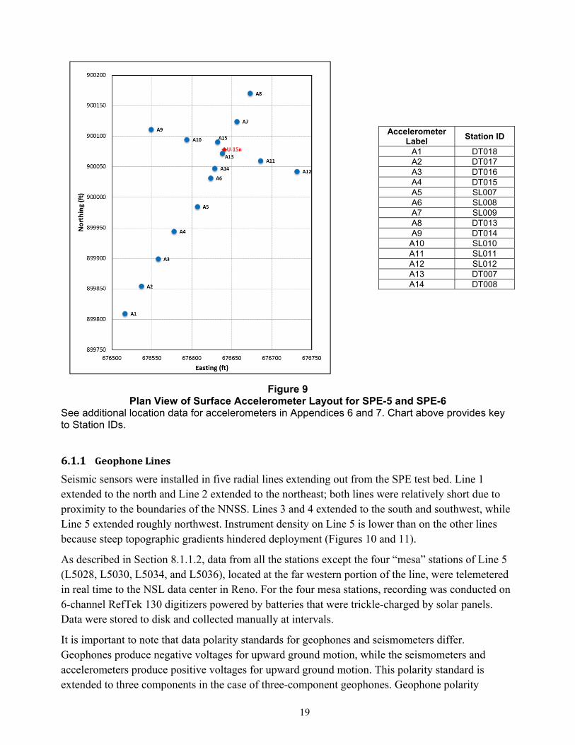
9 Plan View of Surface Accelerometer Layout for SPE-5 and SPE-6 ................................. 19
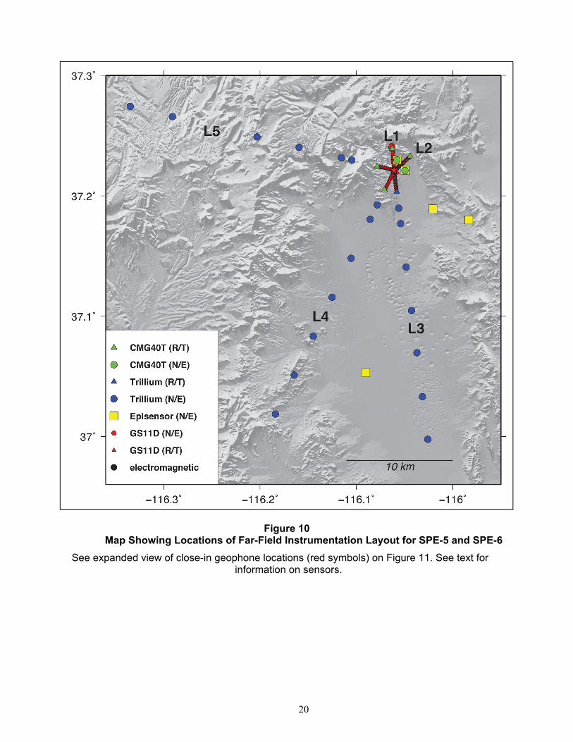
10 Map Showing Locations of Far-Field Instrumentation Layout for SPE-5 and SPE-6 ...... 20
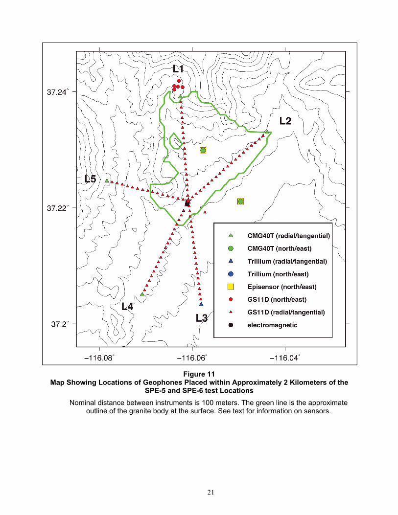
11 Map Showing Locations of Geophones Placed within Approximately 2 Kilometers of the SPE-5 and SPE-6 test Locations ................................................................................. 21
12 Map Showing Locations of Regional Seismic Stations in Place for SPE-5 and SPE-6 .... 24
13 Layout of Large N Array, Permanent Array (radial lines), and SPE-5 test (yellow star) . 25
14 Map Showing Infrasound Array Locations (triangles) around Surface Ground Zero (red) for SPE-5 and SPE-6 ................................................................................................ 27
15 Google Earth Image Showing the Location of NOAA SORD 10AA Meteorological Tower (south) and the Lidar (center; see next section) in Relation to the SPE-6 Test Location (north) ................................................................................................................. 28
List of Tables
Number Title Page
1 List of Near-Field Gauges Installed in Boreholes for the SPE-5 Test .................................... 16
2 List of Near-Field Gauges Installed in Boreholes for the SPE-6 Test .................................... 17
3 Seismic Stations in the Central and Southern Nevada Area Operated for SPE by the NSL ... 25
vi
List of Acronyms and Abbreviations AFTAC Air Force Technical Applications Center
DOI Digital Object Identifier
DTRA Defense Threat Reduction Agency
E east
Hz hertz
IRIS Incorporated Research Institutions for Seismology
kg kilogram(s)
km kilometer(s)
L lateral
Lidar Light Detection and Ranging
LANL Los Alamos National Laboratory
LLNL Lawrence Livermore National Laboratory
m meter(s)
m/kt⅓ meters per kiloton1/3
N north
NNSS Nevada National Security Site
NSL Nevada Seismological Laboratory
NSTec National Security Technologies, LLC
PASSCAL Program for Array Seismic Studies of the Continental Lithosphere
PBXN polymer-bonded explosive
R radial
sDOB scaled depth of burial
SEED Standard for the Exchange of Earthquake Data
SGZ surface ground zero
SNL Sandia National Laboratories
SORD NNSS Weather Forecast Air Resources Laboratory/Special Operations and Research Division
SPC State Plane Coordinates
SPE Source Physics Experiment
sps samples per second
T tangential
TNT trinitrotoluene
UNR University of Nevada, Reno
UTC Coordinated Universal Time
Z vertical

1
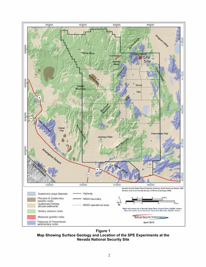
1 IntroductionThe Source Physics Experiment (SPE) was a series of chemical explosive tests. The SPE Phase I test bed was constructed in granitic rock of the Climax stock, in northern Yucca Flat at the Nevada National Security Site (NNSS; formerly known as the Nevada Test Site) in 2010–2011 (Figure 1). These tests were sponsored by the U.S. Department of Energy, National Nuclear Security Administration’s Office of Defense Nonproliferation Research and Development. The SPE test series was primarily designed to study the generation and propagation of seismic waves, and provided data that will improve the predictive capability of numerical models for detecting and characterizing underground explosions (e.g., Ford and Walter, 2013; Snelson et al., 2012; 2013). These validated, improved seismic-acoustic models and simulations will enhance the U.S. ability to detect and discriminate “low-yield” nuclear explosions.
The SPE tests were designed and conducted by a consortium of organizations, including Lawrence Livermore National Laboratory (LLNL), Los Alamos National Laboratory (LANL), Sandia National Laboratories (SNL), and the Defense Threat Reduction Agency (DTRA), in conjunction with Mission Support and Test Services, LLC (MSTS). (MSTS replaced National Security Technologies, LLC [NSTec] as the Management and Operations contractor at the NNSS in December 2017.) The University of Nevada, Reno (UNR) assisted in data acquisition and compilation. Other organizations, including the Air Force Technical Applications Center (AFTAC), also participated in data acquisition efforts.
The execution dates and data report references for the SPE tests are listed below.
SPE-1: May 3, 2011 (NSTec 2014)
SPE-2: October 25, 2011 (NSTec 2015)
SPE-3: July 24, 2012 (NSTec 2015)
SPE-4Prime: May 21, 2015 (NSTec 2017)
SPE-5: April 26, 2016 (this report)
SPE-6: October 12, 2016 (this report)
The vast majority of data acquired under the SPE program are unclassified/unlimited but subject to a 2-year hold, similar to the policy of the U.S. National Science Foundation. The SPE-5 and SPE-6 time-dependent data (strong motion and seismo-acoustic) have now been released for public access. This report presents information that will aid in the understanding and proper use of the SPE-5 and SPE-6 data sets.
Jesse Bonner, MSTS point of contact ([email protected]), can be contacted for further information, including information about other data collected at the SPE site.
2 TestObjectivesThe SPE-5 and SPE-6 tests provided data for research and development of simulation capability at both near- and far-field distances. In general, the near field is expected to include inelastic nonlinear effects, while the far field can be considered primarily elastic (or visco-elastic).
2
Figure 1
Map Showing Surface Geology and Location of the SPE Experiments at the Nevada National Security Site
3
2.1 SPE‐5The SPE-5 test was the largest in the series of tests at the Climax stock location, with a yield of 5,035 kilograms (kg) trinitrotoluene (TNT) equivalent set at the depth of 76.5 m in the same source hole as the previous four SPE tests. In particular the SPE-5 test was designed to provide a seismic signal at regional distances (Nevada, Utah, Arizona, and California), over the 0.5 to 10-herzt (Hz) band-width, where there are good recordings of historic nuclear test data for comparison. See a detailed description of the source in Section 4.1.
2.2 SPE‐6The SPE-6 test was conducted in the same source hole as the previous SPE tests, with a yield of 2,240 kg TNT equivalent set at the depth of 31.4 m. The objective of the SPE-6 test was to provide data for comparison of a “normal-depth” explosion, i.e., similar in scaled depth of burial to historic underground nuclear explosive tests, to the more deeply buried SPE tests (e.g., SPE-1 through SPE-4Prime) that produced minimal damage at the surface. See a detailed description of the source in Section 4.3.
2.3 DataSetsA comprehensive set of strong-motion and seismo-acoustic instrumentation was deployed for both tests. The near-field (< 100 meters [m] from the shot point) instrumentation included high-sample-rate, three-component accelerometers deployed in boreholes. A set of single-component accelerometers was also installed at the surface for each test. At distances at and beyond 100 m (far-field), a large number of seismic and acoustic sensors were deployed at distances up to 400 kilometers (km), including some of the exact locations at which the seismic signals from historic nuclear tests had been recorded. In addition to seismic data, the SPE team collected data from accelerometers, acoustic and infrasound sensors, high-speed video, and other instrumentation. For SPE-5, a temporary deployment of 996 geophones (LargeN), including a mix of vertical and three component sensors, was installed in a variably spaced grid array sited 400 to 3,000 m from the test location.
Following sections of this report provide more detailed information for these data sets. The data and metadata were compiled, archived, and distributed by the technical members of the Nevada Seismological Laboratory (NSL) at UNR. Records for stations at greater distances are available from the permanent UNR seismic network.
The full data sets for SPE-5 and SPE-6, along with associated metadata, are available from the Incorporated Research Institutions for Seismology (IRIS) Data Management Center. The near-field and far-field data sets were submitted separately because they are in different formats. The high sample rates for the near-field recordings are not compatible with the miniSEED format used for the far-field data, and so were submitted separately in SAC format. The near-field data for SPE-5 were assigned the assembled data set number 18-024, with the short name “SPE5.” The near-field data for SPE-6 were assigned the assembled data set number 18-025, with the short name “SPE6.” The LargeN data set was assigned the assembled data set number 18-029. The far-field data for both tests were submitted directly using NSL’s “SN” network code and were merged directly into the IRIS archive.
4
This report is intended to complement the data sets and provide ancillary information, including selected metadata. However, all data users should verify they are using the full current metadata, including the SN network dataless SEED volume from IRIS for the far-field data, and/or the CSS3.0 metadata from the assembled data sets for the near-field sites.
3 SiteDescriptionThe SPE test bed consists of a pad excavated and filled on the side of a hill that slopes to the southeast. The substrate is weathered granite with a thin but variable cover of unconsolidated soil over bedrock. A 0.91-m-diameter source hole was drilled in the center of the test bed, and is surrounded by rings of 0.20- to 0.25-m diameter instrument holes. The site is identified by the NNSS designator U-15n, with the source hole labeled U-15n, and instrument holes labeled U-15n#1, U-15n#2, and so on in the order they were drilled. See sections 3.1.2 and 5.1 for additional information about the instrument holes and sensors installed in them.
3.1 TestBedConstruction
3.1.1 SourceHole
The 0.91-m-diameter source hole was drilled from the surface to a depth of 60.7 m over a period of several months in late 2010 and early 2011, and used for the first three SPE tests. Following SPE-3, the hole was cleaned out and deepened to 103.3 m. The SPE-4Prime, SPE-5, and SPE-6 tests were conducted at increasingly shallow depths by cleaning out the stemming and cables following each test, with no additional deepening of the source hole.
3.1.2 InstrumentationHoles
Instrument holes of varying depths were positioned at various ranges around the SPE source hole for SPE-5 and SPE-6 for accelerometer installation. Some had been in place for all previous SPE tests; others were added following subsequent tests to replace damaged holes or to install sensors at different depths or distances from the source hole (Appendix 1).
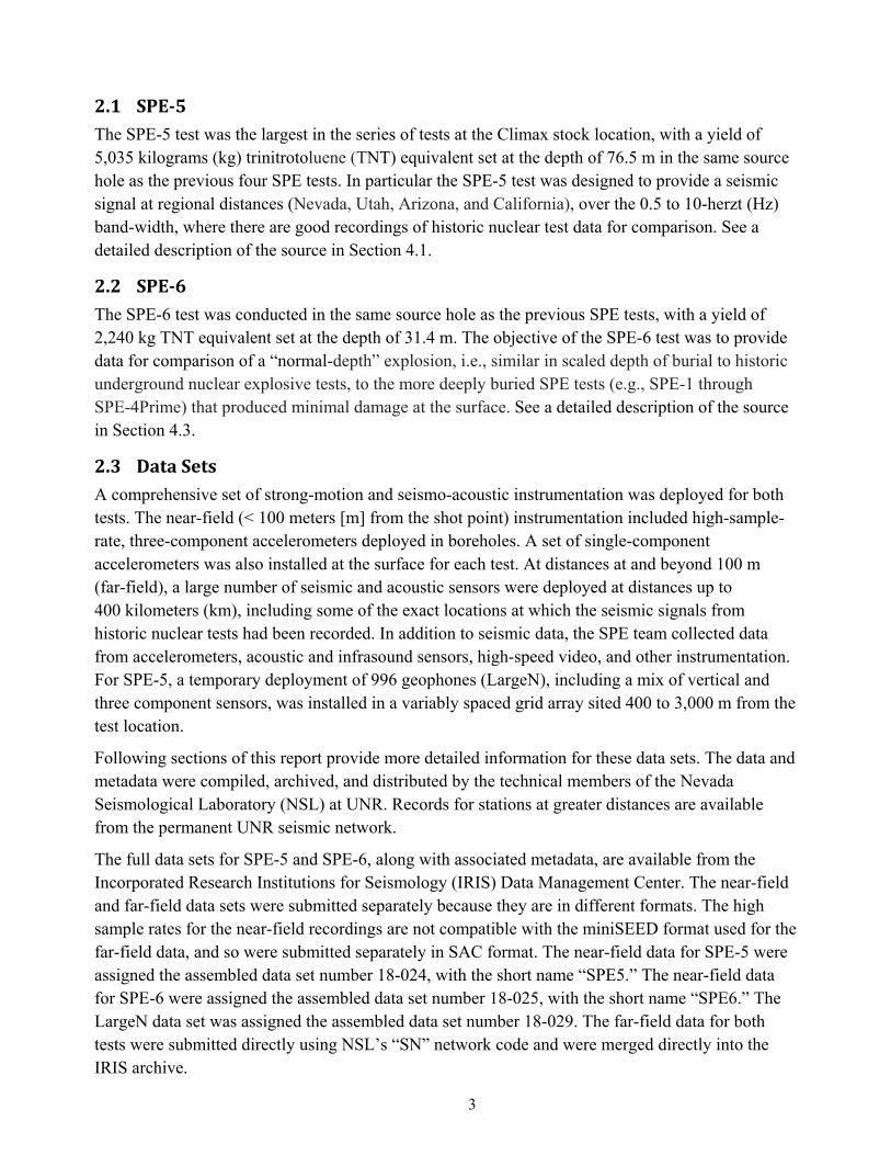
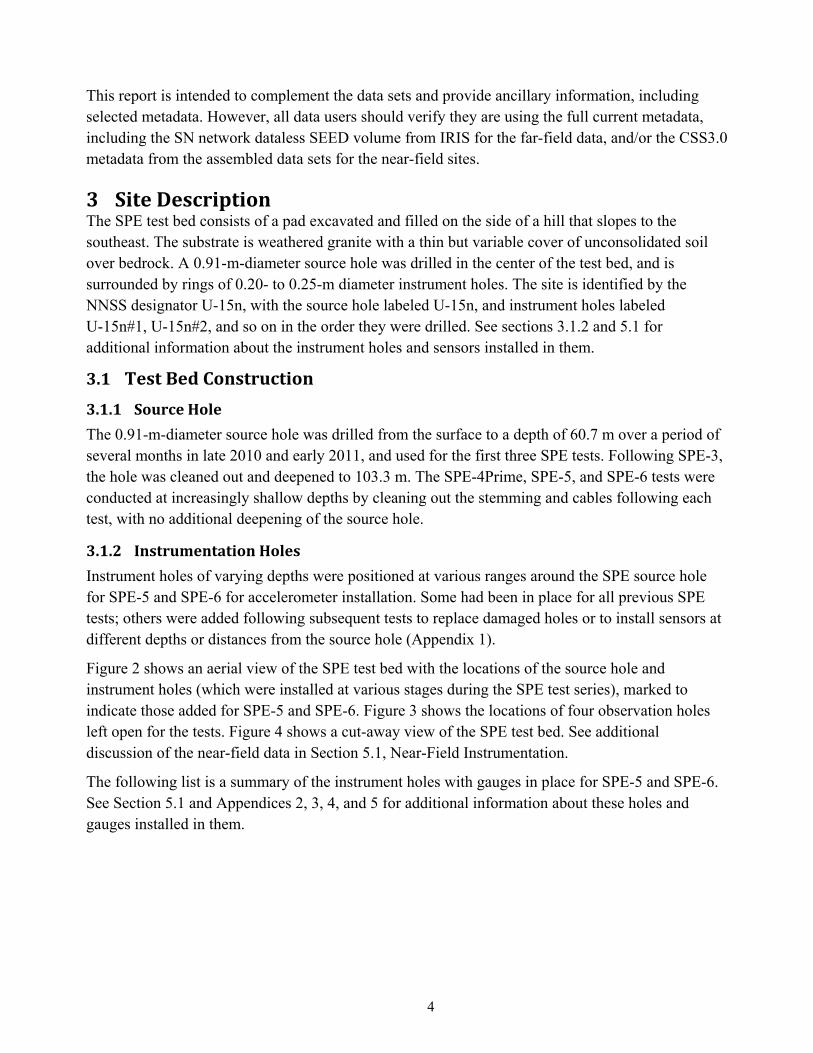
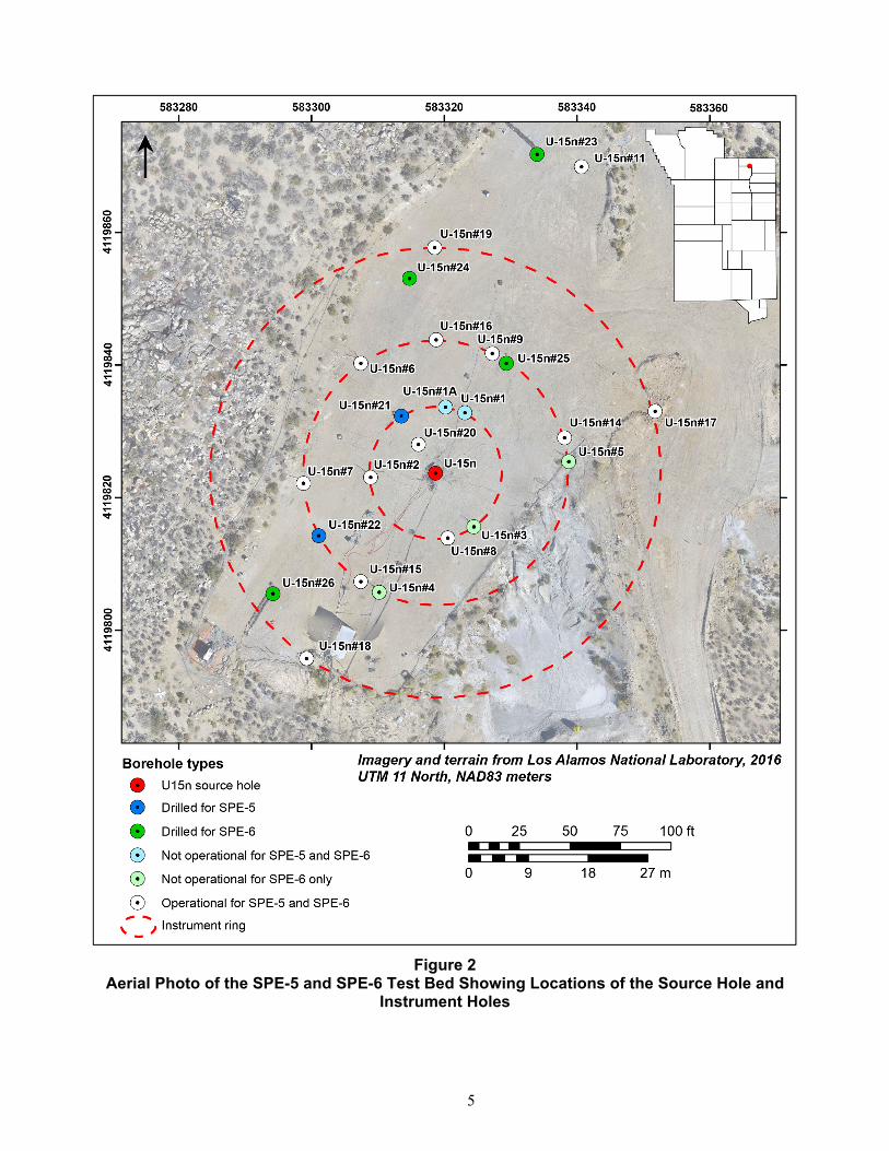
Figure 2 shows an aerial view of the SPE test bed with the locations of the source hole and instrument holes (which were installed at various stages during the SPE test series), marked to indicate those added for SPE-5 and SPE-6. Figure 3 shows the locations of four observation holes left open for the tests. Figure 4 shows a cut-away view of the SPE test bed. See additional discussion of the near-field data in Section 5.1, Near-Field Instrumentation.
The following list is a summary of the instrument holes with gauges in place for SPE-5 and SPE-6. See Section 5.1 and Appendices 2, 3, 4, and 5 for additional information about these holes and gauges installed in them.
5
Figure 2 Aerial Photo of the SPE-5 and SPE-6 Test Bed Showing Locations of the Source Hole and
Instrument Holes
6
Figure 3 Aerial Photo of the SPE-5 and SPE-6 Test Bed Showing Locations of the Source Hole and
Open Observation Holes
Figure 4 Sketch Showing Cut-Away View of Test Bed for SPE-5 and SPE-6
(All instrument holes not shown.)
7
Holes U-15n#1, #1A, #2, #3, #8, and #21 on a 10-m radius ring centered on U15n were all in place prior to SPE-5.
Holes U-15n#4, #5, #6, #7, #9, #14, #15, #16, and #22, on a 20-m radius ring centered on U-15n, were all in place prior to SPE-5. U-15n#25 was added to this ring prior to SPE-6.
Instrument hole U-15n#11 at 51.2 m from the source hole was in place prior to SPE-5.
A ring of three instrument holes (U-15n#17, #18, and #19) on a 34-m radius ring centered on U15n were all in place prior to SPE-5.
Instrument hole U-15n#20 at 5 m from the source hole was in place prior to SPE-5.
Instrument hole U-15n#23 at 50.5 m from the source hole was in place prior to SPE-5.
Instrument holes U-15n#24 and #26 on a 30-m radius ring centered on U15n were in place prior to SPE-6.
Appendix 1 provides construction data for the U-15n source hole and instrument holes.
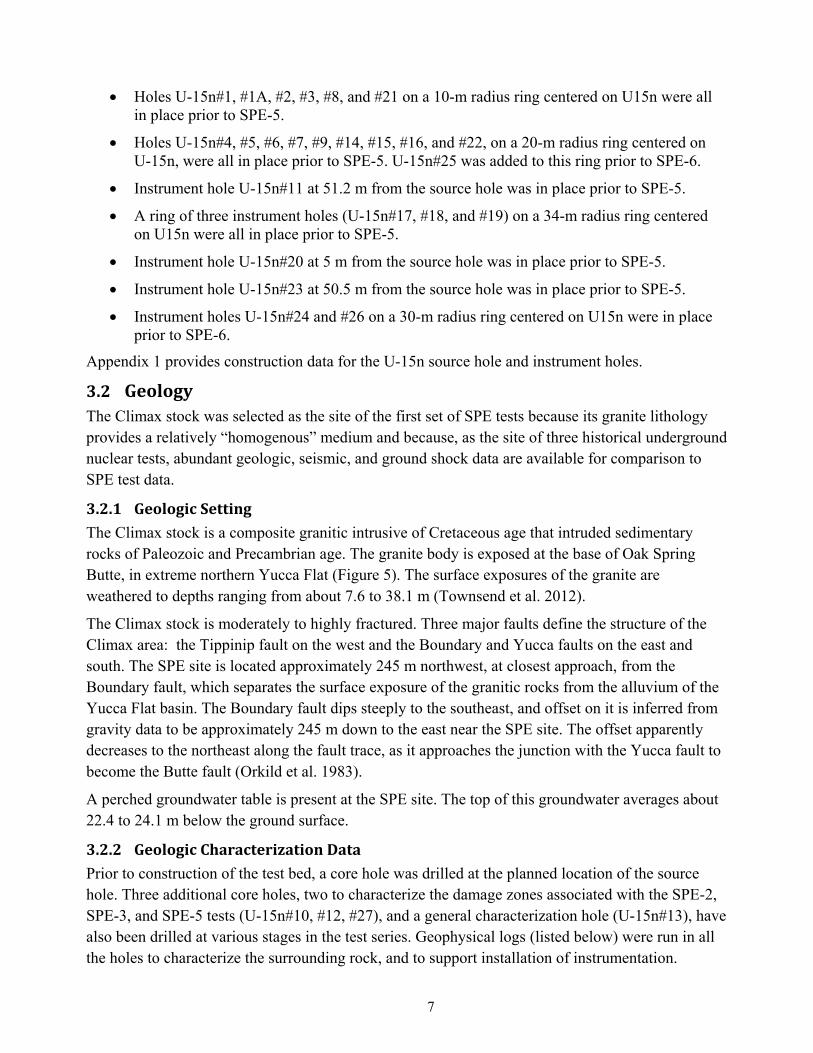
3.2 GeologyThe Climax stock was selected as the site of the first set of SPE tests because its granite lithology provides a relatively “homogenous” medium and because, as the site of three historical underground nuclear tests, abundant geologic, seismic, and ground shock data are available for comparison to SPE test data.
3.2.1 GeologicSetting
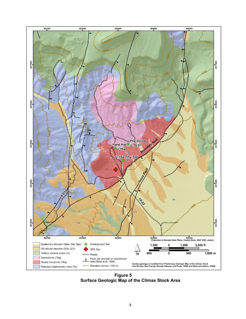
The Climax stock is a composite granitic intrusive of Cretaceous age that intruded sedimentary rocks of Paleozoic and Precambrian age. The granite body is exposed at the base of Oak Spring Butte, in extreme northern Yucca Flat (Figure 5). The surface exposures of the granite are weathered to depths ranging from about 7.6 to 38.1 m (Townsend et al. 2012).
The Climax stock is moderately to highly fractured. Three major faults define the structure of the Climax area: the Tippinip fault on the west and the Boundary and Yucca faults on the east and south. The SPE site is located approximately 245 m northwest, at closest approach, from the Boundary fault, which separates the surface exposure of the granitic rocks from the alluvium of the Yucca Flat basin. The Boundary fault dips steeply to the southeast, and offset on it is inferred from gravity data to be approximately 245 m down to the east near the SPE site. The offset apparently decreases to the northeast along the fault trace, as it approaches the junction with the Yucca fault to become the Butte fault (Orkild et al. 1983).
A perched groundwater table is present at the SPE site. The top of this groundwater averages about 22.4 to 24.1 m below the ground surface.
3.2.2 GeologicCharacterizationData
Prior to construction of the test bed, a core hole was drilled at the planned location of the source hole. Three additional core holes, two to characterize the damage zones associated with the SPE-2, SPE-3, and SPE-5 tests (U-15n#10, #12, #27), and a general characterization hole (U-15n#13), have also been drilled at various stages in the test series. Geophysical logs (listed below) were run in all the holes to characterize the surrounding rock, and to support installation of instrumentation.
8
Figure 5
Surface Geologic Map of the Climax Stock Area
9
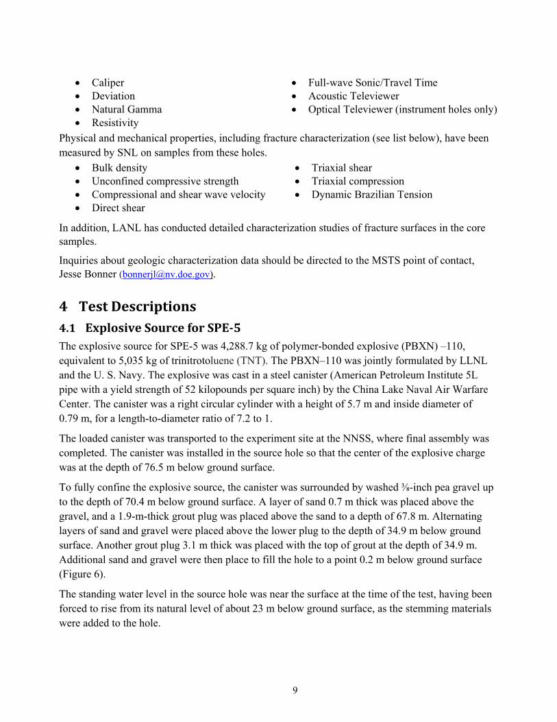
Caliper Deviation Natural Gamma Resistivity
Full-wave Sonic/Travel Time Acoustic Televiewer Optical Televiewer (instrument holes only)
Physical and mechanical properties, including fracture characterization (see list below), have been measured by SNL on samples from these holes.
Bulk density Unconfined compressive strength Compressional and shear wave velocity Direct shear
Triaxial shear Triaxial compression Dynamic Brazilian Tension
In addition, LANL has conducted detailed characterization studies of fracture surfaces in the core samples.
Inquiries about geologic characterization data should be directed to the MSTS point of contact, Jesse Bonner ([email protected]).
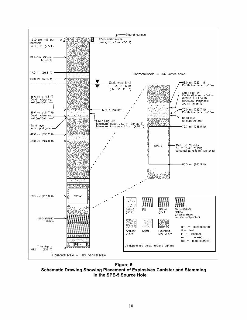
4 TestDescriptions4.1 ExplosiveSourceforSPE‐5The explosive source for SPE-5 was 4,288.7 kg of polymer-bonded explosive (PBXN) –110, equivalent to 5,035 kg of trinitrotoluene (TNT). The PBXN–110 was jointly formulated by LLNL and the U. S. Navy. The explosive was cast in a steel canister (American Petroleum Institute 5L pipe with a yield strength of 52 kilopounds per square inch) by the China Lake Naval Air Warfare Center. The canister was a right circular cylinder with a height of 5.7 m and inside diameter of 0.79 m, for a length-to-diameter ratio of 7.2 to 1.
The loaded canister was transported to the experiment site at the NNSS, where final assembly was completed. The canister was installed in the source hole so that the center of the explosive charge was at the depth of 76.5 m below ground surface.
To fully confine the explosive source, the canister was surrounded by washed ⅜-inch pea gravel up to the depth of 70.4 m below ground surface. A layer of sand 0.7 m thick was placed above the gravel, and a 1.9-m-thick grout plug was placed above the sand to a depth of 67.8 m. Alternating layers of sand and gravel were placed above the lower plug to the depth of 34.9 m below ground surface. Another grout plug 3.1 m thick was placed with the top of grout at the depth of 34.9 m. Additional sand and gravel were then place to fill the hole to a point 0.2 m below ground surface (Figure 6).
The standing water level in the source hole was near the surface at the time of the test, having been forced to rise from its natural level of about 23 m below ground surface, as the stemming materials were added to the hole.
10
Figure 6 Schematic Drawing Showing Placement of Explosives Canister and Stemming
in the SPE-5 Source Hole
11
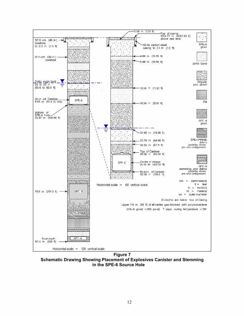
4.2 SPE‐5DetonationThe SPE-5 test was conducted on April 26, 2016 (day 117), at 20:49:00.000,011,680 ± 350 nanoseconds Coordinated Universal Time (UTC). The location was 37.221207, –116.0608674, at a centroid depth of 76.5 m.
Diagnostic instrumentation installed in the SPE-5 canister provided data on the detonation characteristics. Piezoelectric pins were installed in the booster assembly and piezoelectric pads were positioned on top of the explosive. The difference in shock arrival times between the two sets of sensors indicated that the detonation velocity was rapid and complete.
The explosion was well confined, with no prompt (<1 second) ejecta or gas release. Within a few minutes after detonation, however, water was ejected from three of the open observation holes, located 30 to 40 m from the source hole. No water was observed at the fourth open hole located about 48 m from the source hole. Pressurized gases from the detonation are presumed to have forced the natural groundwater through the extensive natural fracture system documented at the SPE site to the open observation wells.
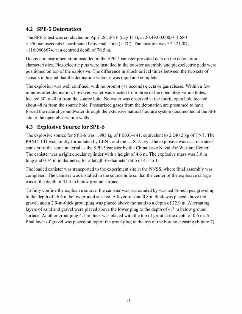
4.3 ExplosiveSourceforSPE‐6The explosive source for SPE-6 was 1,983 kg of PBXC–141, equivalent to 2,240.2 kg of TNT. The PBXC–141 was jointly formulated by LLNL and the U. S. Navy. The explosive was cast in a steel canister of the same material as the SPE-5 canister by the China Lake Naval Air Warfare Center. The canister was a right circular cylinder with a height of 4.6 m. The explosive mass was 3.0 m long and 0.74 m in diameter, for a length-to-diameter ratio of 4.1 to 1.
The loaded canister was transported to the experiment site at the NNSS, where final assembly was completed. The canister was installed in the source hole so that the center of the explosive charge was at the depth of 31.4 m below ground surface.
To fully confine the explosive source, the canister was surrounded by washed ⅜-inch pea gravel up to the depth of 26.6 m below ground surface. A layer of sand 0.8 m thick was placed above the gravel, and a 2.9-m-thick grout plug was placed above the sand to a depth of 22.9 m. Alternating layers of sand and gravel were placed above the lower plug to the depth of 4.7 m below ground surface. Another grout plug 4.1 m thick was placed with the top of grout at the depth of 0.6 m. A final layer of gravel was placed on top of the grout plug to the top of the borehole casing (Figure 7).
12
Figure 7 Schematic Drawing Showing Placement of Explosives Canister and Stemming
in the SPE-6 Source Hole
13
4.4 SPE‐6DetonationThe SPE-6 test was conducted on October 12, 2016 (day 286), at 18:36:00.000,010,904±300 nanoseconds UTC. The location was 37.221207, –116.0608674 at a centroid depth of 31.4 m.
Diagnostic instrumentation installed in the SPE-6 canister provided data on the detonation characteristics. Piezoelectric pins were installed in the booster assembly and piezoelectric pads were positioned on top of the explosive. The difference in shock arrival times between the two sets of sensors indicated that the detonation velocity was rapid and complete.
Videos showed mist, gas, and/or dust blowing out of several borehole shortly after the SPE-6 detonation. At an unknown time after this initial degassing, mist, dust, and/or gas could be seen coming out of the U-15n source hole. Prompt and continuing hydrologic effects from the SPE-6 test vary greatly among the four observation wells, suggesting different degrees of hydrologic connection between them and the U-15n source hole.
5 Near‐FieldInstrumentation Near-field instrumentation (defined as less than 100 m from the source) for SPE-5 and SPE-6 included accelerometers installed in boreholes and on the surface, as described in this section.
5.1 BoreholeAccelerometers
5.1.1 InstallationDetails
As described in Section 3.1.2, a number of boreholes were drilled to accommodate installation of near-field instrumentation packages. Many of the accelerometer packages placed to measure the near-field environments of earlier tests, SPE-1, SPE-2, SPE-3, and SPE-4Prime, were still operating at the time of the SPE-5 and SPE-6 tests. The emplacement details for these instruments are described in the data release reports (NSTec 2014, 2015, 2017) for those tests and are not repeated here.
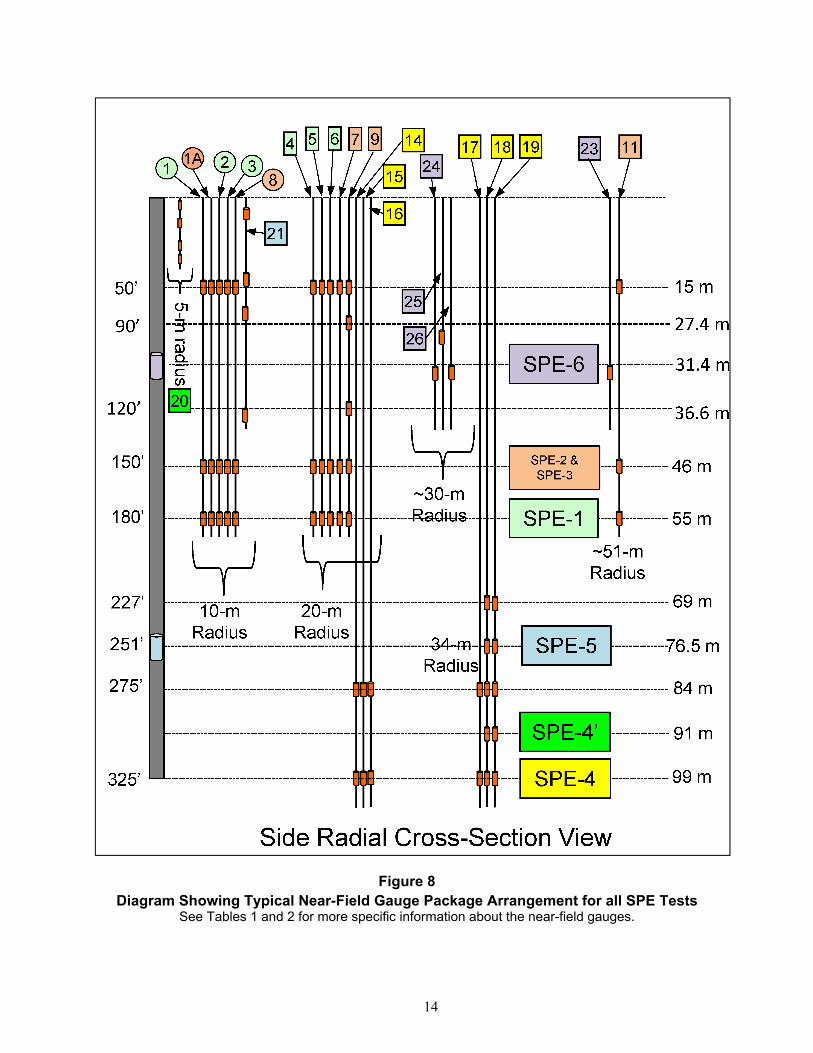
With the exception of holes #20 and #21, each package contained three accelerometers in “triaxial” orientations to help characterize the near-source shock environment. The packages in holes #20 and #21contained only single axis accelerometers. Figure 2 shows a plan view of those instrumentation boreholes. Figure 8 is a section view representation of the instrumentation with all holes projected onto a single plane. This section view indicates packages at various depths in the different holes as a function of when they were placed relative to the various tests.
The individual transducers (radial, or R-component; longitudinal, or L-component; and transverse, or T-component) within each triaxial set was oriented relative to the position of the canister:
For the packages at the15-m depth, the orientations were configured in a spherical coordinate system, with the R component being in the radial direction from the center point of the SPE-2/SPE-3 tests. The L component and T components were mutually orthogonal to each other and to the R component, and oriented tangential to a sphere centered on the SPE-2/SPE-3 center point.
14
Figure 8 Diagram Showing Typical Near-Field Gauge Package Arrangement for all SPE Tests
See Tables 1 and 2 for more specific information about the near-field gauges.
15
For all other depths the orientations were configured in a cylindrical coordinate system, with the R component being in the horizontal radial direction from axis of U15n. The L component is vertical. T component is horizontal and mutually orthogonal to the R component and the L component.
The single axis packages in holes #20 and #21 were all vertically sensing. These instruments were placed specifically to determine depth of spall related to interaction of the shock wave with the ground surface.
With respect to timing and emplacement of the individual packages, all transducers that were in place and which survived attrition due to loading and time, were recorded in all tests. However, we will note that in preparation for future testing SPE was used as testbed for new instrumentation. In the course of this work the responsible subject matter experts determined that the data in hole #22 indicated insufficient quality to be included in this SPE-5/SPE-6 data release.
Additionally, the new recording system introduced for SPE-6 was determined to be electronically incompatible with prior instrumentation installations. Consequently, the release for SPE-6 includes only those borehole gauges in #20, #21, #23, #24, #25, and #26.
Appendices 2, 3, 4, and 5 provide information about sensors in place for the SPE-5 and SPE-6 tests; however, all data users should verify they are using the full current metadata posted with the sensor data at IRIS.
5.1.2 NamingConventionforBoreholeAccelerometers
For all boreholes, the gauge packages are named with a three-character alphanumeric designation, with individual characters separated by a dash. The first character represents the borehole number as defined above. The second character represents the package depth relative to all packages in the individual borehole. Specifically, the depth begins at “1”, representing the deepest package in each respective hole, and counting up within the hole. Finally, the third character represents the orientation within the triaxial set of transducers. For example, the radial (R) transducer at the 91-m depth (depth “2”) in borehole #19 is 19-2-R; the longitudinal (L) transducer at the 99-m depth (depth “1”) in borehole #14 is 14-1-L.
Tables 1 and 2 list all near-field gauges that recorded data for the SPE-5 and SPE-6 tests, respectively. Figure 8 illustrates the gauge package arrangement for all the SPE tests.
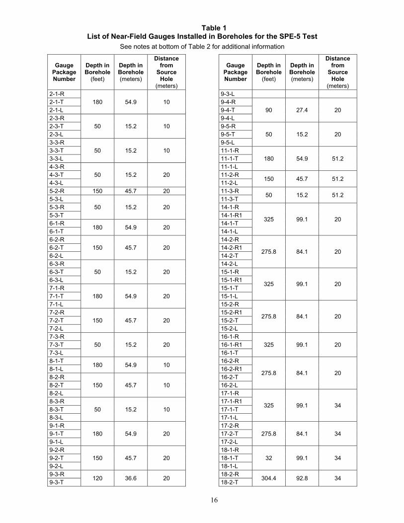
Table 1 List of Near-Field Gauges Installed in Boreholes for the SPE-5 Test
16
See notes at bottom of Table 2 for additional information
Gauge Package Number
Depth in Borehole
(feet)
Depth in Borehole (meters)
Distance from
Source Hole
(meters) 2-1-R
180 54.9 10 2-1-T 2-1-L 2-3-R
50 15.2 10 2-3-T 2-3-L 3-3-R
50 15.2 10 3-3-T 3-3-L 4-3-R
50 15.2 20 4-3-T 4-3-L 5-2-R 150 45.7 20 5-3-L
50 15.2 20 5-3-R 5-3-T 6-1-R
180 54.9 20 6-1-T 6-2-R
150 45.7 20 6-2-T 6-2-L 6-3-R
50 15.2 20 6-3-T 6-3-L 7-1-R
180 54.9 20 7-1-T 7-1-L 7-2-R
150 45.7 20 7-2-T 7-2-L 7-3-R
50 15.2 20 7-3-T 7-3-L 8-1-T
180 54.9 10 8-1-L 8-2-R
150 45.7 10 8-2-T 8-2-L 8-3-R
50 15.2 10 8-3-T 8-3-L 9-1-R
180 54.9 20 9-1-T 9-1-L 9-2-R
150 45.7 20 9-2-T 9-2-L 9-3-R
120 36.6 20 9-3-T
Gauge Package Number
Depth in Borehole
(feet)
Depth in Borehole (meters)
Distance from
Source Hole
(meters) 9-3-L 9-4-R
90 27.4 20 9-4-T 9-4-L 9-5-R
50 15.2 20 9-5-T 9-5-L 11-1-R
180 54.9 51.2 11-1-T 11-1-L 11-2-R
150 45.7 51.2 11-2-L 11-3-R
50 15.2 51.2 11-3-T 14-1-R
325 99.1 20 14-1-R1 14-1-T 14-1-L 14-2-R
275.8 84.1 20 14-2-R1 14-2-T 14-2-L 15-1-R
325 99.1 20 15-1-R1 15-1-T 15-1-L 15-2-R
275.8 84.1 20 15-2-R1 15-2-T 15-2-L 16-1-R
325 99.1 20 16-1-R1 16-1-T 16-2-R
275.8 84.1 20 16-2-R1 16-2-T 16-2-L 17-1-R
325 99.1 34 17-1-R1 17-1-T 17-1-L 17-2-R
275.8 84.1 34 17-2-T 17-2-L 18-1-R
32 99.1 34 18-1-T 18-1-L 18-2-R
304.4 92.8 34 18-2-T
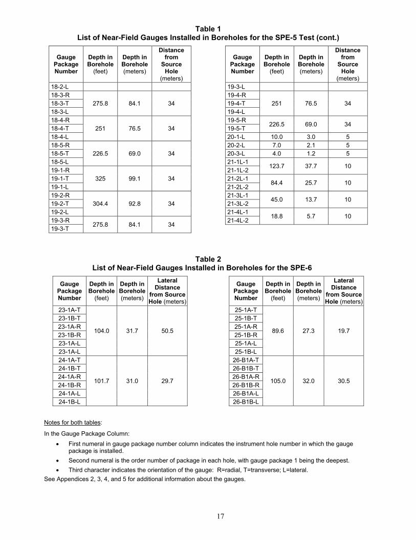
Table 1 List of Near-Field Gauges Installed in Boreholes for the SPE-5 Test (cont.)
17
Gauge Package Number
Depth in Borehole
(feet)
Depth in Borehole (meters)
Distance from
Source Hole
(meters) 18-2-L 18-3-R
275.8 84.1 34 18-3-T 18-3-L 18-4-R
251 76.5 34 18-4-T 18-4-L 18-5-R
226.5 69.0 34 18-5-T 18-5-L 19-1-R
325 99.1 34 19-1-T 19-1-L 19-2-R
304.4 92.8 34 19-2-T 19-2-L 19-3-R
275.8 84.1 34 19-3-T
Gauge Package Number
Depth in Borehole
(feet)
Depth in Borehole (meters)
Distance from
Source Hole
(meters) 19-3-L 19-4-R
251 76.5 34 19-4-T 19-4-L 19-5-R
226.5 69.0 34 19-5-T 20-1-L 10.0 3.0 5 20-2-L 7.0 2.1 5 20-3-L 4.0 1.2 5 21-1L-1
123.7 37.7 10 21-1L-2 21-2L-1
84.4 25.7 10 21-2L-2 21-3L-1
45.0 13.7 10 21-3L-2 21-4L-1
18.8 5.7 10 21-4L-2
Table 2 List of Near-Field Gauges Installed in Boreholes for the SPE-6
Gauge Package Number
Depth in Borehole
(feet)
Depth in Borehole (meters)
Lateral Distance
from Source Hole (meters)
23-1A-T
104.0 31.7 50.5
23-1B-T 23-1A-R 23-1B-R 23-1A-L 23-1A-L 24-1A-T
101.7 31.0 29.7
24-1B-T 24-1A-R 24-1B-R 24-1A-L 24-1B-L
Gauge Package Number
Depth in Borehole
(feet)
Depth in Borehole (meters)
Lateral Distance
from Source Hole (meters)
25-1A-T
89.6 27.3 19.7
25-1B-T 25-1A-R 25-1B-R 25-1A-L 25-1B-L
26-B1A-T
105.0 32.0 30.5
26-B1B-T 26-B1A-R 26-B1B-R 26-B1A-L 26-B1B-L
Notes for both tables:
In the Gauge Package Column:
First numeral in gauge package number column indicates the instrument hole number in which the gauge package is installed.
Second numeral is the order number of package in each hole, with gauge package 1 being the deepest.
Third character indicates the orientation of the gauge: R=radial, T=transverse; L=lateral.
See Appendices 2, 3, 4, and 5 for additional information about the gauges.
18
5.1.3 As‐BuiltAdjustmentsofNear‐FieldGaugePositions
The description above provides nominal distances and directions between the gauges and the source, as if the source hole and instrumentation boreholes were perfectly vertical. However, due to the nature of the drilling process, none of the boreholes on the SPE test bed is truly vertical. The orientation (“deviation” from vertical) of each hole was measured after drilling, and the deviation data are used to determine the exact position of each gauge position and its distance from the source. These data are included with the SPE-5 and SPE-6 data packages, and are also listed for each gauge in Appendices 2 and 4. These data should be used for determining as-built locations of both the charge and the accelerometers.
5.2 Near‐FieldSurfaceAccelerometers
An array of vertical single-axis accelerometers was placed on the ground surface to indicate extent, if any, of surface spall. Figure 9 shows two rings of accelerometers at the ranges of 15 m and 30 m from the source hole on various azimuths. Another line of accelerometers was placed along an azimuth southwest from the source hole at distances of 2, 10, 15, 30, 45, 60, 75, and 90 m from the source hole.
6 Far‐FieldInstrumentationFour primary types of far-field sensors, seismic, infrasound, and weather, were deployed for the SPE-5 and SPE-6 tests, as described in the following sections.
6.1 SeismicInstrumentationforSPE‐5andSPE‐6
To characterize the far-field seismic wavefield (defined as 100 m or more from the source), a number of different instrument arrays were deployed to distances as great as 400 km. The primary set of far-field seismic data collected for the SPE-5 and SPE-6 tests came from lines of geophones in place for all six of the SPE tests conducted at the Climax stock test bed. The Nevada Seismological Laboratory at UNR installed or reestablished 31 regional broadband stations in late 2015 for the SPE-5 and SPE-6 tests. For SPE-5 an additional set of data was collected from a grid of 996 closely spaced geophones placed 400 to 3,000 m southeast of the test bed. The following sections provide information about all three types of seismic arrays.
19
Accelerometer Label
Station ID
A1 DT018 A2 DT017 A3 DT016 A4 DT015 A5 SL007 A6 SL008 A7 SL009 A8 DT013 A9 DT014
A10 SL010 A11 SL011 A12 SL012 A13 DT007 A14 DT008
Figure 9 Plan View of Surface Accelerometer Layout for SPE-5 and SPE-6
See additional location data for accelerometers in Appendices 6 and 7. Chart above provides key to Station IDs.
6.1.1 GeophoneLines
Seismic sensors were installed in five radial lines extending out from the SPE test bed. Line 1 extended to the north and Line 2 extended to the northeast; both lines were relatively short due to proximity to the boundaries of the NNSS. Lines 3 and 4 extended to the south and southwest, while Line 5 extended roughly northwest. Instrument density on Line 5 is lower than on the other lines because steep topographic gradients hindered deployment (Figures 10 and 11).
As described in Section 8.1.1.2, data from all the stations except the four “mesa” stations of Line 5 (L5028, L5030, L5034, and L5036), located at the far western portion of the line, were telemetered in real time to the NSL data center in Reno. For the four mesa stations, recording was conducted on 6-channel RefTek 130 digitizers powered by batteries that were trickle-charged by solar panels. Data were stored to disk and collected manually at intervals.
It is important to note that data polarity standards for geophones and seismometers differ. Geophones produce negative voltages for upward ground motion, while the seismometers and accelerometers produce positive voltages for upward ground motion. This polarity standard is extended to three components in the case of three-component geophones. Geophone polarity
20
Figure 10
Map Showing Locations of Far-Field Instrumentation Layout for SPE-5 and SPE-6
See expanded view of close-in geophone locations (red symbols) on Figure 11. See text for information on sensors.
21
Figure 11 Map Showing Locations of Geophones Placed within Approximately 2 Kilometers of the
SPE-5 and SPE-6 test Locations
Nominal distance between instruments is 100 meters. The green line is the approximate outline of the granite body at the surface. See text for information on sensors.
22
follows a right-hand-rule standard with vertical pointing into the earth. The data in this collection are exactly as recorded by the sensors.
Characteristics of the instruments installed along the five geophone lines are summarized below. Exact details such as sensor type and response can be found in the metadata as well. Appendices 6 and 7 contain summaries of location and instrument information for each surface sensor site. However, all data users should verify they are using the full current metadata posted with the data.
Geospace GS-11D 4.5-Hz geophones were deployed in five linear arrays, radiating from SGZ from 100 m to 1.9 km. Nominal station spacing is 100 m, with some expected locations skipped due to steep topography (mostly along Line 5). All are three-component sensors oriented radial, transverse, and vertical to SGZ. The geophones are buried less than 0.5 m deep in native material, with sandbags placed on top. A small array of five Geospace GS-11D geophones was also deployed just north of the end of Line 1. Gains were set to unity on the Reftek instruments for the tests.
Guralp CMG 40T three-component seismometers are installed at the ends of the geophone lines 1, 2, 4, and 5, 2 km distant from SGZ, and a Nanometrics Trillium seismometer was installed at the 2-km distance on Line 4. The components are oriented radial, transverse, and vertical. All are installed on a concrete pad set less than 10 cm into the soil.
Lines 3, 4, and 5 are extended beyond 2 km (to a maximum of 25 km) by either six or seven Nanometrics Trillium Compact seismometers each, oriented radial north-south, east-west, and vertical (Figure 10). The instruments are installed on a concrete pad set less than 10 cm into the soil. Two stations on Line 5 (L5-28 and L5-34) were very close (centimeters) to bedrock, so at those locations the broadband instruments were covered by a sensor case in an ice chest (not barometrically sealed) covered with sandbags.
On the broadband Compact Trillium sensors on Lines 3, 4, and 5, channels 1, 2, and 3, were oriented positive, up, north, and east, respectively. Orientation was estimated visually in the field, and the error is estimated to be less than about 5 degrees, as checked by later precise orientation measurements. At the 2-km distance and beyond, sensor orientations are set with respect to cardinal directions and not radial/tangential. This difference is denoted in the channel names. Timing was established by Geographic Positioning System receivers at each cataloger/digitizer. RefTek logs were reviewed for timing errors during data compilation.
In addition to this instrumentation, AFTAC deployed instruments at five sites. Kinemetrics Episensors were located at all five sites, and Guralp CMG40T three-component seismometers were placed at the two sites closest to the source hole (Figure 10). All sites were equipped with Chaparral infrasound sensors. All sensors were oriented to north (N), east (E), and vertical (Z) and recorded on Reftek digitizers.
23
6.1.2 Non‐SPEStationsOperatedontheNNSS,inSouthernNevada,andinEasternCaliforniabyNSL
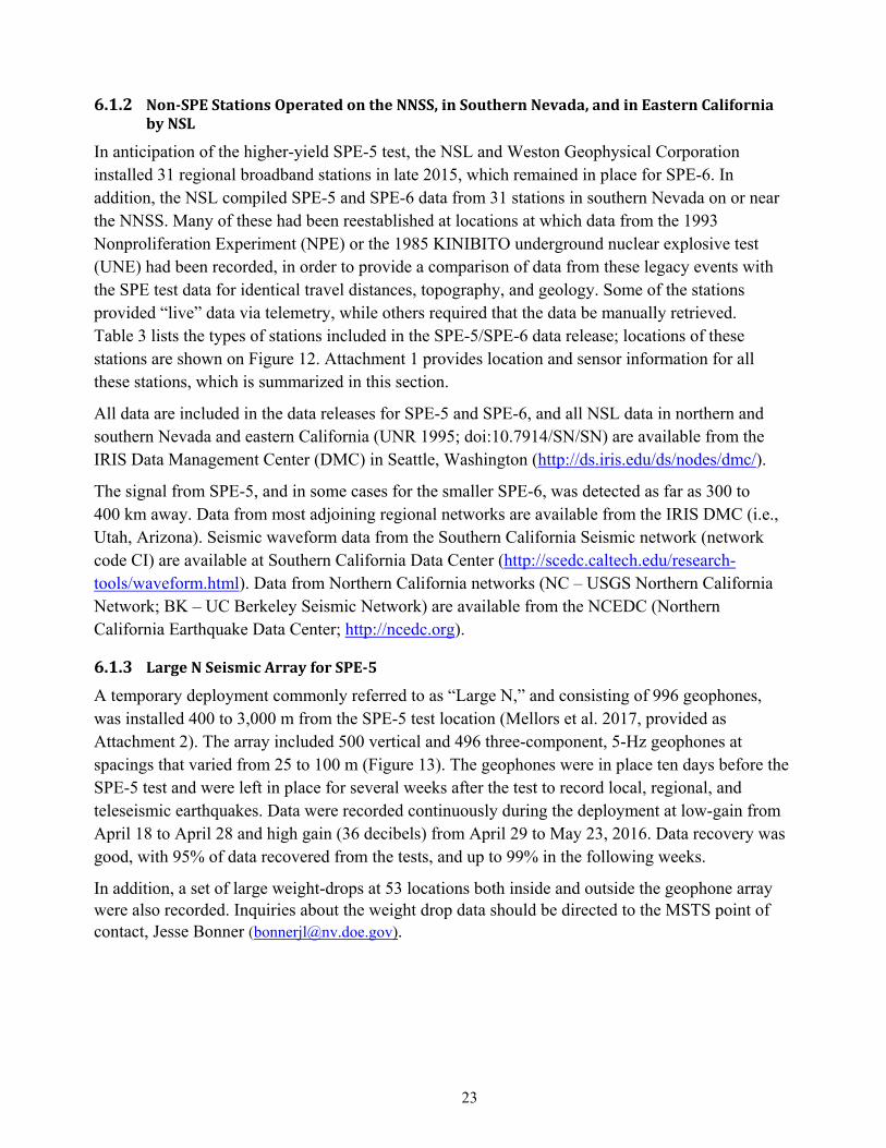
In anticipation of the higher-yield SPE-5 test, the NSL and Weston Geophysical Corporation installed 31 regional broadband stations in late 2015, which remained in place for SPE-6. In addition, the NSL compiled SPE-5 and SPE-6 data from 31 stations in southern Nevada on or near the NNSS. Many of these had been reestablished at locations at which data from the 1993 Nonproliferation Experiment (NPE) or the 1985 KINIBITO underground nuclear explosive test (UNE) had been recorded, in order to provide a comparison of data from these legacy events with the SPE test data for identical travel distances, topography, and geology. Some of the stations provided “live” data via telemetry, while others required that the data be manually retrieved. Table 3 lists the types of stations included in the SPE-5/SPE-6 data release; locations of these stations are shown on Figure 12. Attachment 1 provides location and sensor information for all these stations, which is summarized in this section.
All data are included in the data releases for SPE-5 and SPE-6, and all NSL data in northern and southern Nevada and eastern California (UNR 1995; doi:10.7914/SN/SN) are available from the IRIS Data Management Center (DMC) in Seattle, Washington (http://ds.iris.edu/ds/nodes/dmc/).
The signal from SPE-5, and in some cases for the smaller SPE-6, was detected as far as 300 to 400 km away. Data from most adjoining regional networks are available from the IRIS DMC (i.e., Utah, Arizona). Seismic waveform data from the Southern California Seismic network (network code CI) are available at Southern California Data Center (http://scedc.caltech.edu/research-tools/waveform.html). Data from Northern California networks (NC – USGS Northern California Network; BK – UC Berkeley Seismic Network) are available from the NCEDC (Northern California Earthquake Data Center; http://ncedc.org).
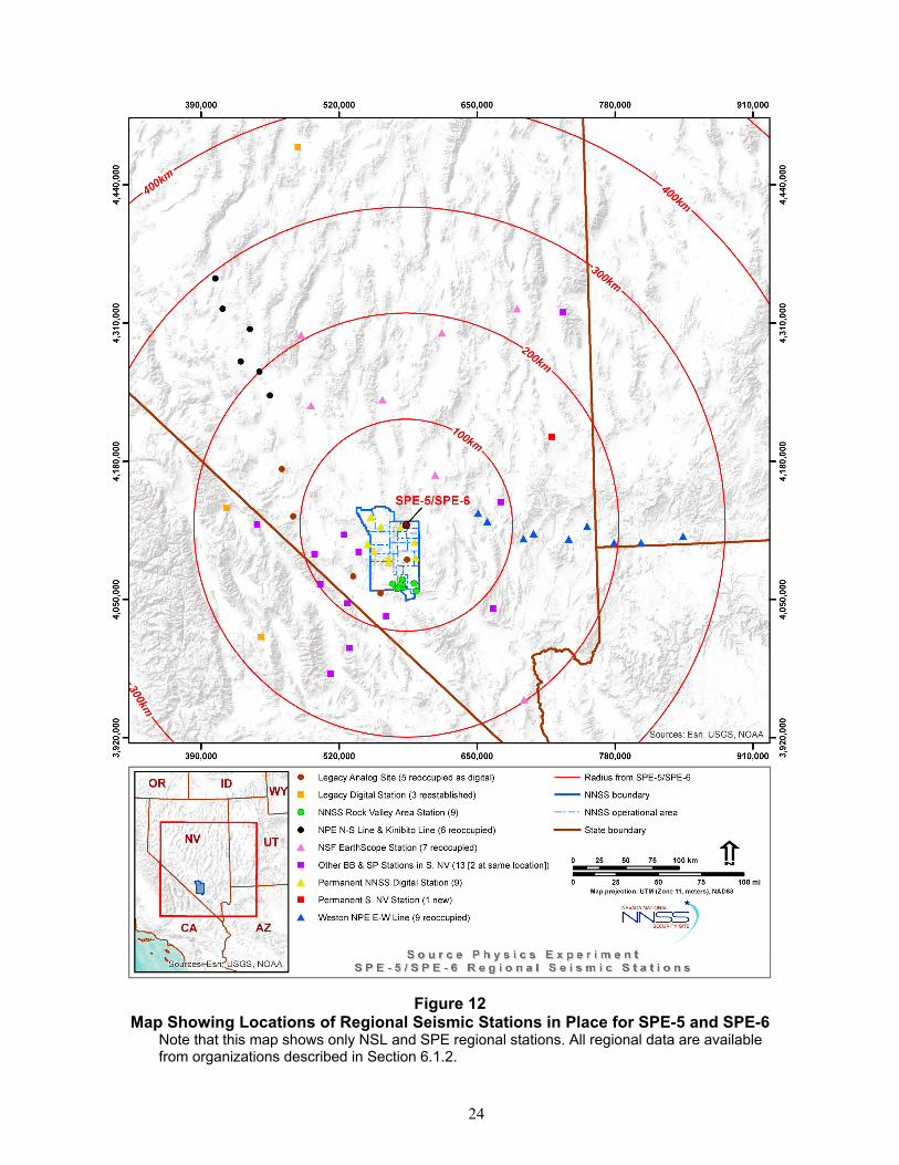
6.1.3 LargeNSeismicArrayforSPE‐5
A temporary deployment commonly referred to as “Large N,” and consisting of 996 geophones, was installed 400 to 3,000 m from the SPE-5 test location (Mellors et al. 2017, provided as Attachment 2). The array included 500 vertical and 496 three-component, 5-Hz geophones at spacings that varied from 25 to 100 m (Figure 13). The geophones were in place ten days before the SPE-5 test and were left in place for several weeks after the test to record local, regional, and teleseismic earthquakes. Data were recorded continuously during the deployment at low-gain from April 18 to April 28 and high gain (36 decibels) from April 29 to May 23, 2016. Data recovery was good, with 95% of data recovered from the tests, and up to 99% in the following weeks.
In addition, a set of large weight-drops at 53 locations both inside and outside the geophone array were also recorded. Inquiries about the weight drop data should be directed to the MSTS point of contact, Jesse Bonner ([email protected]).
24
Figure 12 Map Showing Locations of Regional Seismic Stations in Place for SPE-5 and SPE-6
Note that this map shows only NSL and SPE regional stations. All regional data are available from organizations described in Section 6.1.2.
25
Table 3 Seismic Stations in the Central and Southern Nevada Area Operated for SPE by the NSL
Category Number of Stations
Sensor Type 1
New digital broadband stations added prior to SPE-5 31 BB
Weston NPE E-W Line: Reoccupation of 1993 east-west geophone line from the Non-Proliferation Experiment
9 BB
National Science Foundation EarthScope Station Reoccupation of Transportable Array Network stations
7 BB
NPE N-S Line and KINIBITO Line Reoccupation of the north-south line originally in place for the 1993 Non-Proliferation Experiment (Zucca 1993) and for the 1985 KINIBITO UNE (Chavez and Priestly 1986)
6 BB
Legacy Analog Site – Digital Reoccupation with digital sensors of stations that recorded UNEs with analog sensors
5 BB
Legacy Digital Stations Reestablished at locations of stations that recorded UNEs
3 BB
Permanent southern Nevada station installed in 2015 1 BB
NNSS Rock Valley area stations 9 BB + 2 SP installed in boreholes
Permanent NNSS digital stations 9 SP
Other BB and SP stations operated by NSL in southern Nevada 13 BB Notes:
1. SP = Three-component S-13 sensors BB = Various broadband sensors, as described in the metadata for the experiment
Figure 13 Layout of Large N Array, Permanent Array (radial lines), and SPE-5 test (yellow star)
The green line is the approximate outline of the Climax stock granite at the surface. See definitions of map symbols right of map.
26
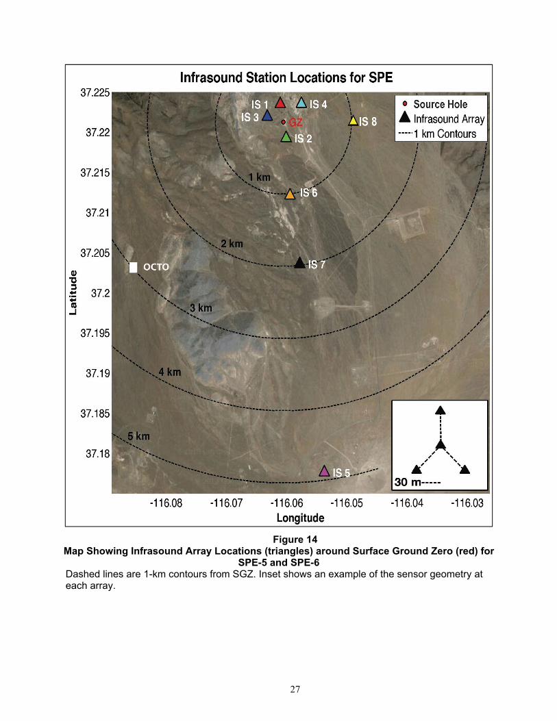
6.2 InfrasoundDataCollectedforSPE‐5andSPE‐6
Infrasound data were obtained by SNL for both the SPE-5 and SPE-6 tests, using the same array configuration for both, as described in the following paragraphs, and shown on Figure 14. Selected metadata for the sensors are provided in Appendix 8.
Eight infrasound arrays were deployed around SGZ prior to each test. Each array consisted of four Hyperion infrasound sensors with 100-Pascal full-scale range. The infrasound sensors were installed in a roughly triangular geometry with one sensor and the digitizer at the center and the other three sensors arranged azimuthally (∼120-degree increments) around the center element at a distance of about 30 m. Some sensors had four 15-m lengths of porous hoses and others had high frequency shrouds, for wind noise reduction. One sensor at each of the four arrays within 1 km of SGZ was seismically decoupled to reduce the effect of acceleration-induced signals. Four arrays were installed azimuthally around the explosives pad approximately 0.25 km from SGZ, and were at different elevations due to topography constraints. Three of the remaining arrays were located at 1, 2, and 5 km, respectively, linearly south-southeast of ground zero, and one additional array was installed 1 km east of ground zero. The data were recorded using Ref Tek 130 digitizers sampling at 200 Hz. Each station telemetered data in real time to the SNL trailer at the command center, located approximately 365 m southeast of SGZ. From there, it was transferred to the database at UNR in near real time.
For the SPE-6 test, an additional Hyperion sensor with a full-scale range of approximately 10 kilopascals was installed at the close arrays to mitigate the possibility of signal clipping. Also for SPE-6, one 6-element temporary ground infrasound array was deployed 3 km southeast of the SGZ to support an attempt at recording airborne infrasound. Sensor/digitizer combinations were a mixture of analog Hyperion sensors with RT-130 loggers, digital Hyperion sensors, and ultralight digital Hyperion sensors. One sensor failed to record data, giving a total of five active stations during the test. The airborne infrasound sensor was lofted using an octocopter to an elevation of 510 m above ground level. Results from this sensor are presently ambiguous due to poor signal recovery at low frequencies.
6.3 WeatherDataCollectedforSPE‐5andSPE‐6
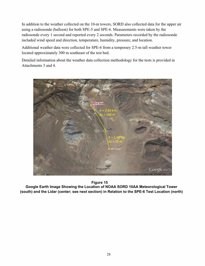
Weather data were collected for the SPE-5 and SPE-6 tests to provide information needed for analysis of surface acoustic measurements such as infrasound. Weather data for both tests were collected from a station in the network of weather stations managed by the NNSS Weather Forecast Air Resources Laboratory/Special Operations and Research Division. This network is known as the SORD/NNSS Weather Mesonet, and consists of 22 stations located all across the NNSS. The SPE-5 and SPE-6 data provided are from station M48/A10AA, a 10-m-tall tower located approximately 4 km south-southeast of the SPE test bed (Figure 15). Wind observations were taken for collection of 3-second averaged data; wind and other weather observations, including temperature, humidity, atmospheric pressure, and solar radiation, were also taken to provide 15-minute averaged data.
27
Figure 14 Map Showing Infrasound Array Locations (triangles) around Surface Ground Zero (red) for
SPE-5 and SPE-6 Dashed lines are 1-km contours from SGZ. Inset shows an example of the sensor geometry at each array.
28
In addition to the weather collected on the 10-m towers, SORD also collected data for the upper air using a radiosonde (balloon) for both SPE-5 and SPE-6. Measurements were taken by the radiosonde every 1 second and reported every 2 seconds. Parameters recorded by the radiosonde included wind speed and direction, temperature, humidity, pressure, and location.
Additional weather data were collected for SPE-6 from a temporary 2.5-m tall weather tower located approximately 300 m southeast of the test bed.
Detailed information about the weather data collection methodology for the tests is provided in Attachments 3 and 4.
Figure 15 Google Earth Image Showing the Location of NOAA SORD 10AA Meteorological Tower
(south) and the Lidar (center; see next section) in Relation to the SPE-6 Test Location (north)
29
6.4 WindcubeLidarDataCollectedforSPE‐6
In addition to collection of wind data by conventional meteorological methods, wind data for SPE-6 were also collected using the “Windcube” vertically profiling, remote sensing instrument (Wharton 2018; provided as Attachment 5). The Windcube collects data through use of pulsed Light Detection and Ranging (Lidar) technology, creating a “virtual” meteorological tower whereby the characteristics of the wind in the lower part of the planetary boundary layer are sampled.
The underlying principle of pulsed Lidar measurements of wind is the use of optical heterodyne (coherent) detection, in which laser pulses are transmitted into the atmosphere and scattered off naturally occurring small dust particles or aerosols entrained in the ambient flow field. Radial velocity is proportional to Doppler frequency shift. In simple to moderately complex terrain, wind speed accuracy is 0.1 m/s, wind direction accuracy is 1.5 degrees. The nearest SORD meteorological tower was M48/A10AA, located approximately 1.5 km south of the Lidar location.
The Windcube was deployed on the ground 2.8 km southeast of the SPE-6 test location, and 160 m lower in elevation. (Figure 15). The instrument was programmed to measure from 40 to 260 m above ground level, at 20-m intervals. Data with high signal-to-noise ratios covered the range of 40 to 160 m; the paucity of naturally occurring aerosols in the area reduced data availability above 160 m. Data were averaged over 4-second and 5-minute intervals to create “.rtd” and “.sta” datasets. See Attachment 5 (Wharton 2018) for additional information about the datasets.
7 DataAcquisitionandCorrections7.1 NearFieldThe data packages for SPE-5 and SPE-6 tests include the raw acceleration-time pairs recorded for all accelerometers. These data are in the form of time-acceleration pairs. The files are in comma space variables in ASCII text format. For all records, time is in seconds and acceleration is in g units.
See NSTec (2014, 2015, and 2017) for information about various corrections made on data sets obtained from borehole accelerometers for SPE-1, SPE-2, SPE-3, and SPE-4Prime. No corrections were made in the data sets obtained for SPE-5 and SPE-6.
7.2 DataTimingIssuesBasedonExtractionMethod
Timing issues exist for the SPE-5 and SPE-6 tests depending on how the data are extracted from the database. If the full miniseed file from the database is used, there is a timing discrepancy for some stations for sacfiles extracted with mseed2sac versus those extracted with rdseed. The stations with timing issues are as follows:
SPE-5 o L3002: Detonation time in rdseed-extracted sacfiles is shifted ~0.25 s later relative to
mseed2sac-extracted sacfiles
SPE-6
o L2013: Shot time in rdseed-extracted sacfiles is shifted ~0.15 s earlier relative to mseed2sac-extracted sacfiles
30
o L2014: Shot time in rdseed-extracted sacfiles is shifted ~0.1 s earlier relative to mseed2sac-extracted sacfiles
o L5009: Shot time in rdseed-extracted sacfiles is shifted ~0.75 s later relative to mseed2sac-extracted sacfiles
o L5010: Shot time in rdseed-extracted sacfiles is shifted ~0.8 s later relative to mseed2sac-extracted sacfiles
It is important to note, however, that this timing discrepancy ONLY occurs when the full miniseed file is used. If the data are extracted in any format from the database with a given time window (for instance, with trexcerpt or db2sac, etc.), the files are properly aligned in time.
7.3 FarFieldDataFeaturesofNote
A few features of the far field data should be noted:
Difference in polarity between geophones and other instruments
Data spikes (most obvious on data prior to shot); these were most likely due to issues with the cable power systems, although thunderstorms and lightning produce similar signals
Possible cross-talk causing low amplitude signals on non-functioning channels
8 Post‐ExperimentProcedures
8.1 Aggregation,Merging,andArchivingofSPE‐5andSPE‐6Data
Post-experiment aggregation, merging, archiving, and distribution of SPE-5 and SPE-6 data were conducted at UNR by the technical members of the NSL. The process employed the Antelope Real Time and data processing software system from Boulder Real Time Technologies (Boulder, Colorado); the data processing suite from the Program for Array Seismic Studies of the Continental Lithosphere (PASSCAL); the CSS 3.0 database format; and Ubuntu-Linux-based servers at NSL data centers.
8.1.1 DataAggregation
Data aggregation is the phase of acquiring raw metadata and time series data from project participants, reviewing the submissions, and conducting initial format conversions to standardize the media.
8.1.1.1 Metadata
Metadata were compiled prior to both tests and refined during the merging and archival process. For each sensor, NSL asked SPE participants to submit the following items:
Sensor make/model/type Sensor orientation Data logger bit weight
Sensor sensitivity factor Sensor on-time, off-time Data logger channel number
Sensor serial number Sensor Channel gain
Sensor lat/long, decimal degrees Data logger make/model Channel sample rate
Sensor frequency response file Data logger serial number Site name
Sensor depth Data logger response file Site description
31
SPE investigators submitted these initial metadata to NSL through electronic transfer of spreadsheets, figures, and scanned drawings, which were then made available to all participants via document archives on the NSL SPE data server.
8.1.1.2 Real‐TimeTelemetryandWaveformAggregationProcedure
Real-time telemetry was implemented for most geophone and broadband seismic stations in place for SPE-5 and SPE-6. Real-time telemetry eliminates the need to visit sites for data acquisition, allows real-time station diagnostics, provides capability to access stations remotely for parameter checks and adjustments, and ensures an overall increase in the level of data quality and data return rates, over stand-alone portable stations. Telemetered sites for SPE-5 and SPE-6 included all stations except the “mesa” stations of Line 5, which are those located on the far western portion of the line (L5028, L5030, L5034, and L5036). Data from these four stations were collected as in SPE-1 (NSTec 2014).
Data for SPE-5 and SPE-6 were transmitted via microwave and fiber link to the NSL Reno data center. Data acquisition rates, transmitted in a compressed format to reduce through-put, averaged 11.5 gigabytes per day, with Broadband channels transmitting at 250 samples per second (sps) and geophone channels at 500 sps.
The NSL/SPE data storage and distribution server, established at the Nevada System of Higher Education’s UNLV Systems Computing Services (SCS) data center, provided access to all SPE-5 and SPE-6 data for project scientists. This included real-time data from the SPE array, NSL’s Southern Nevada (SN) regional network, and three Leo Brady network stations; and daily updates from NSL’s entire Northern Nevada (NN) network. The data server functions not only as a distribution point for time series and other spatial data collected by the project, but also as a hub for project communication, light data analysis, and temporary and long-term data storage.
8.1.1.3 Near‐FieldWaveformDataAggregation
Near-field waveform data recorded on high-sample-rate multi-channel digitizers were recovered by project principal investigators and submitted to NSL by electronic file transfer. The data formats included (1) SAC, (2) four-byte integer, and (3) non-standard ASCII formats with accompanying scripts and other supporting metadata. For data received in SAC format, there was no required initial conversion procedure. Other formats required varying amounts of effort to convert to a common format.
8.1.2 MergingofDataSets
Data merging is the phase of generating a valid CSS 3.0 metadata volume and modifying waveform file headers so that they will synchronize with the CSS 3.0 metadata format.
8.1.2.1 MetadataMerging
Upon receipt of metadata submissions, NSL staff distilled and standardized the information into ASCII files, one per station, in an open format that provides the input to Antelope’s dbbuild program. The dbbuild format tracks station information changes through time (i.e., station histories), and allows for (1) rapid regeneration of an entire CSS 3.0 database as corrections and additions are required, (2) cross-institution database maintainability, (3) version control and revision
32
history, and (4) a distributable and readable station record that can be useful even without proprietary tools.
8.1.2.1.1 StationNamesandDescriptions
Upon submission, most metadata contained station descriptions and names that were meaningful only to the internal processes of the submitting institution. For the purpose of creating a single coherent volume, NSL technical staff created five-character station names that are compliant with the Standard for the Exchange of Earthquake Data (SEED). Where possible, the initial descriptions were preserved in the CSS 3.0 site descriptions to ensure new station names would be easily recognized by the various investigators.
8.1.2.1.2 ChannelCodes
NSL staff created SEED-compliant channel codes describing the sample rate (band), instrument type, and orientation of each data channel. However, a collective decision was made by NSL and project investigators to leave the band code unchanged, even though per-instrument sample rates fluctuated from 100, to 500, to 250, to 200 sps. This was done to avoid generating confusion for the large party of investigators who were not yet familiar with the CSS 3.0 database, which is sometimes terse and detailed and can become lengthy when many configuration changes are made across a large array during the course of recording. In addition, it was widely held as important that channel codes be tied to certain sensor types to facilitate rapid association of a channel’s code with the sensor’s location relative to the source.
8.1.2.1.3 PrecisionofSensorLocation
Sensor locations were submitted to NSL in State Plane Coordinates (SPC, feet) and geographic coordinates (decimal degrees). The submitted geographic coordinate submissions were merged directly into the CSS 3.0 metadata where station lat/long values were required. The SPC station locations were used to calculate northing and easting offsets in feet from the location of the SPE-5 and SPE-6 source hole (station SP-01, northing 900077.22, easting 676640.6), and these offsets were then converted to meters using the conversion factor 1 m = 3.28084 feet.
8.1.2.1.4 PrecisionofSensorOrientation
For the most part, measured sensor orientations were not submitted to NSL, with the exception of the vertical angles (in the radial direction) of the near-field borehole accelerometers. The remainder were submitted as orientation codes (N=North, E=East, Z=Vertical, R=Radial, T=Tangential, L=lateral), and NSL calculated the azimuths of the sensor axes from the geographic coordinates. All azimuthal calculations were based on the assumption that the particular axis of the sensor was correctly aligned, e.g., that a radial orientation was indeed radial, and that the geographic coordinates are accurate to <0.3 m. The estimated error on horizontal orientation is <5 degrees.
8.1.2.1.5 SensorSensitivities
Sensitivity values were submitted per sensor for the near-field borehole (stations BH) and surface accelerometers (stations DT and SL). Listed gauge sensitivities are measured, not nominal, as each accelerometer was tested at DTRA prior to deployment, with a tolerance of less than 2.4 percent. Far-field sensitivity values are nominal and were derived from manufacturer information sheets.
33
8.1.2.1.6 Gains
Pre-amplifier gains were also submitted per sensor for the near-field accelerometers. Accelerometer sensitivities varied by location in order to optimize response with respect to the estimated wavefield amplitudes. Where the gains were set larger (compared to predicted signal size) there will be a larger error due to increased amplification, which increases the signal-to-noise ratio. Gains for far-field RT130 seismic data were recovered from the logs generated from the raw RefTek to miniSEED by the data reduction process described above.
8.1.2.1.7 CalibrationFactors
Calibration factors for near-field accelerometers in the CSS3.0 metadata were calculated from pre-amplifier gains (as above), a digitizer constant (bit weight), and sensitivity values (as above). All of these components are listed in the CSS3.0 stage table for the assembled near-field data sets. SL-* sensor calibration factors for SPE-5 and SPE-6 also include a 10 percent cable-attenuation factor. Alternative calibration factors, supplied by DTRA for the near-field channels in boreholes U-15n#2 through #21, are included with the assembled data sets in the file calibrations.txt. These calibration factors employ the raw vertical bit weight for each channel, and include base line averaging over 512 samples, but differ less than 2.4 percent from calculated values.
8.1.2.1.8 InstrumentResponse
Numerical (e.g., pole-and-zero) frequency responses are not available for the near-field accelerometers. Frequency response is expected to be essentially flat for frequencies of interest (Winningham, 2011) and is represented as constant in the metadata. Response data for the far-field sensors are redistributed from the versions supplied with the Antelope data processing system, except in the case of the infrasound sensors, and those responses were supplied in pole-zero format by SNL.
8.1.2.2 MergingWaveformData
The procedure for merging waveforms included correcting waveform file headers to reflect the appropriate network-station-channel-location (net_sta_chan_loc) codes, and then using the Antelope miniseed2db or sac2db programs to generate a CSS 3.0 “wfdisc” table. The “wfdisc” table provides the mechanism to associate the time series data with the metadata set that describes the waveforms’ response, sensor parameters, etc.
For miniSEED files, header modification was done using the PASSCAL fixhdr program. By default, the station and channel names in miniSEED file headers are set to the data logger serial number and stream codes. The data logger and channel codes are then mapped to SEED net_sta_chan_loc. The net_sta_chan_loc code maps were derived from the site metadata for each data logger configuration.
For SAC files, the header modifications were done using the SAC analysis software, distributed through IRIS.
34
8.1.3 DataArchiving
Archiving is the phase of presenting final data products. It includes completion of quality control procedures and generation of final product formats.
8.1.3.1 MetadataFormats
8.1.3.1.1 CSS3.0
The CSS 3.0 metadata format is an industry/community standard and is the format supported by the Antelope system. It is a readable and open database system that allows for schema extensions and therefore is flexible, scalable, and adaptable to non-standard sensor array configurations.
8.1.3.1.2 DatalessSEED
The dataless SEED format is an industry/community standard for metadata that includes station histories as well as sensor and data logger response information. It is distributed as a single file, and can be read and imported by a wide variety of programs and applications. The volume distributed by NSL was generated from CSS 3.0 metadata using the Antelope application db2sd. The Lat/Lon values in the dataless SEED volume were then corrected to six-decimal-place precision to honor location information submitted by project participants.
8.1.3.1.3 Dbbuild
The dbbuild format is an ASCII-text-based format that tracks site parameters throughout all epochs, or periods of distinct recording configurations. The dbbuild-based metadata comprise one text file per station, and while the files by themselves do not include sensor frequency response or data logger response, they do include sensor sensitivity factors. As input to the Antelope dbbuild program, which builds CSS 3.0 metadata (and in turn is converted to dataless SEED), the dbbuild-format files are the fundamental metadata records maintained by NSL for all SPE stations.
8.1.3.2 TimeSeriesFormats
There are many time-series data formats, but for simplicity and for reusability of conversion and processing scripts, the technical staff at NSL resolved to create an archive based on either miniSEED or SAC formats. MiniSEED is the preferred format for data submissions to IRIS, and also the standard format for most Antelope-based programs and tools. SAC is the most widely known and used time-series format, and in some cases, such as with very high-sample-rate data (e.g., 1 million sps), it has capabilities that miniSEED does not.
8.1.3.3 QualityControlMeasures
While the quality control of time-series data is left to SPE investigators (the near-field and far-field data committees), NSL was charged with creating a coherent database that is up to date and accurate with respect to the data submissions. Four quality control measures were used to verify the data products for SPE-5 and SPE-6, as described below.
8.1.3.3.1 ManualInspectionofdbbuild‐FormatFiles
All metadata submissions are converted initially to the dbbuild-format. These files are reviewed for completeness and then checked in to the Concurrent Versioning System revision control system.
35
The use of revision control allows NSL to track completeness of array-wide edits, and is important for tracking metadata errors and corrections.
8.1.3.3.2 OutputWarningsandErrorsfromdbbuildProgram
The dbbuild-format files are used by the dbbuild program to generate the CSS 3.0 metadata. All runs of dbbuild are conducted with the use of verbose warnings, the standard output is captured in a log, and the log is reviewed after the run completes. This process allows NSL to find and fix inconsistencies, incomplete entries, and mistakes in the dbbuild-format metadata that are not caught during manual review.
8.1.3.3.3 AntelopedbverifyProgram
After generating a coherent CSS 3.0 metadata set that passes the first two levels of quality control, the data are examined for any additional problems using the Antelope dbverify program. This program performs consistency checks between database tables and is largely a tool for checking the validity of database schema and formats, rather than for finding omissions or typographic mistakes.
8.1.3.3.4 Outputfromdbjoinanddbfixids
The final step in each iterative generation of a CSS 3.0 metadata set is to synchronize the wfdisc table with the new channel identifiers, waveform identifiers, channel names, and calibration values that often change as metadata are refined and improved. This process not only corrects out-of-sync values in the wfdisc tables, but also warns when there are entries in the wfdisc table that do not join with the CSS 3.0 metadata. This reveals the case where waveforms have been submitted, but no metadata exist for the particular station. This situation can occur when new stations are added, or when data loggers are changed in the field without the updated information being submitted. Otherwise it can point up a case where NSL has missed a submission. This measure prompts staff to re-examine emails, contact field technicians, etc., to sort out why metadata are missing and contributes greatly to the completeness of the SPE archive.
9 SummaryThis report coincides with the official release of near- and far-field seismic station, gauge, and diagnostic data for SPE-5 and SPE-6. It describes the location of data and supporting documents on the IRIS site. The report includes a description of the experiment, the types of data and instruments, corrections made to the accelerometer data, and post-experiment data processing. This data release includes separate sets of these data, including the raw data as well as the data reflecting the application of the corrections.
10 AcknowledgementsSPE would not have been possible without the support of many people from several organizations. The authors wish to express their gratitude to the U.S. Department of Energy, National Nuclear Security Administration, Defense Nuclear Nonproliferation Research and Development and the SPE working group, a multi-institutional and interdisciplinary group of scientists and engineers. Deepest appreciation is given to Robert White and Ryan Emmitt
36
(NSTec) for their tireless work on the seismic array, and to the NSL at UNR for their support of the seismic network and for data aggregation. Thanks to U.S. Geological Survey, IRIS, PASSCAL Instrument Center, and Lawrence Berkeley National Laboratory, for instrumentation partnership. This work was done by MSTS under Contract No. DE‐NA0003624
11 ReferencesChavez, D. E., and K. F. Priestly, 1986. “Measurement of Frequency-Dependent L Attenuation in
the Great Basin,” Geophys. Res. Lett., 13, pp. 551–554.
Ford, S., and W. R. Walter, 2013. “An Explosion Model Comparison with Insights from the Source Physics Experiments,” Bull. Seism. Soc. Am., vol. 103, pp. 2937–2945, doi: 10.1785/0120130035.
Mellors, R. J., T. Chen, C. Snelson, A. Pitarka, E. Matzel, and R. Abbott, 2017. Data Report: The Source Physics Experiment Large N Array. Lawrence Livermore National Laboratory Report LLNL-TR-732520. Livermore, CA.
National Security Technologies, LLC, 2014. Data Release Report for Source Physics Experiment 1 (SPE-1), Nevada National Security Site. DOE/NV/25946--2018. Las Vegas, NV.
National Security Technologies, LLC, 2015. Data Release Report for Source Physics Experiments 2 and 3 (SPE-2 and SP-3), Nevada National Security Site. DOE/NV/25946--2282. Las Vegas, NV.
National Security Technologies, LLC, 2017. Data Release Report for Source Physics Experiment 4Prime (SPE-4Prime), Nevada National Security Site. DOE/NV/25946--3266, Rev. 1. Las Vegas, NV.
NSTec, see National Security Technologies, LLC.
Orkild, P. P., D. R. Townsend, M. J. Baldwin, D. L. Healey, G. D. Bath, C. E. Jahren, and J. G. Rosenbaum, 1983. Geologic and Geophysical Investigations of Climax Stock Intrusive, Nevada. Open-File Report 83-377. U. S. Geological Survey, Denver, CO.
Snelson, C. M., V. D. Chipman, R. L. White, R. F. Emmitt, M. J. Townsend, D. L. Barker, and P. Lee, 2012. “An Overview of the Source Physics Experiment at the Nevada National Security Site.” In: Proceedings of the 2012 Monitoring Research Review: Ground-Based Nuclear Explosion Monitoring Technologies, Volume I. Albuquerque, NM.
Snelson, C. M., R. Mellors, H. J. Patton, A. J. Sussman, M. J. Townsend, and W. R. Walter, 2013, “Source Physics Experiments to Validate a New Paradigm for Nuclear Test Monitoring,” Eos Trans., American Geophysical Union, vol. 94, no. 27, pp. 237–239.
Steedman, D. W., 2013. Review of Data from Shock Physics Experiments SPE-1, SPE-2, and SPE-3: Data Corrections and Phenomenology Analysis. Los Alamos National Laboratory Report LA-UR-13-22561. Los Alamos, NM.
Townsend, M., L. Prothro, and C. Obi, 2012. Geology of the Source Physics Experiment Site, Climax Stock, Nevada National Security Site. DOE/NV/25946--1448. Prepared by National Security Technologies, LLC, Las Vegas, NV.
University of Nevada (Reno), 1995. Southern Great Basin Network. International Federation of Digital Seismograph Networks. Other/Seismic Network. doi:10.7914/SN/SN
37
UNR, see University of Nevada (Reno)
Wharton, S., 2018. SPE6 Atmospheric Lidar Data User Guide. Lawrence Livermore National Laboratory Report LLNL-TR-764520. Livermore, CA.
Winningham, K., Defense Threat Reduction Agency, 2011. Personal communication to K. Smith, University of Nevada, Reno Seismological Laboratory, regarding frequency response of borehole sensors.
Zucca, J., 1993. DOE Non-Proliferation Experiment includes seismic data, v. 74, issue 45, 9 November 1993 Page 527, DOI: 10.1029/93EO00678.

List of Appendices
1 Construction Data for Holes Drilled at the U-15n Site
2 Selected Metadata for SPE-5 Borehole Sensors
3 Instrument Metadata for SPE-5
4 Selected Metadata for SPE-6 Borehole Sensors
5 Instrument Metadata for SPE-6
6 Selected Metadata for SPE-5 Surface Stations
7 Selected Metadata for SPE-6 Surface Stations
8 Selected Metadata for SPE-6 Infrasound Sensors
All data users should verify they are using the full current metadata, including the SN network dataless SEED volume from IRIS for the far-field data (surface sensors), and the CSS3.0 metadata from the assembled data sets for the near-field sites (boreholes).
Appendix 1
Construction Data for Holes Drilled at the U-15n Site
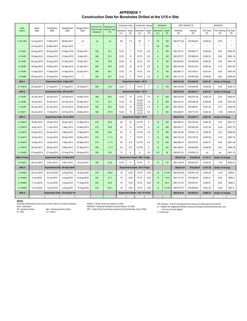
Diameter(in.)
Depth(ft)
Diameter(in)
Depth (ft)
Diameter(in.)
Depth(ft)
Northing(ft)
Easting(ft)
TOC Elev(ft)
TOC Stickup(ft)
GS Elev(ft)
U-15n 36in 13-Aug-2010 17-Mar-2011 28-Mar-2011 na na na 48 7.5 42 7 36 199 900,077.28 676,640.62 5,002.42 0.55 "
" 24-Jan-2013 22-Mar-2013 30-Apr-2013 " " " " " " " 36 339 " " " " "
U-15n#1 24-Aug-2010 25-Aug-2010 21-Sep-2010 20-Apr-2011 026 33.1 12.25 7 10.75 6.5 8 190 900,107.01 676,655.17 5,002.60 0.40 5002.20
U-15n#2 15-Sep-2010 16-Sep-2010 21-Sep-2010 16-Apr-2011 266 32.1 12.25 10 10.75 9.5 8 190 900,075.27 676,608.54 5,002.81 0.60 5002.16
U-15n#3 20-Aug-2010 23-Aug-2010 21-Sep-2010 19-Apr-2011 145 32.6 12.25 10 10.75 9.5 8 190 900,050.67 676,659.48 5,002.26 0.50 5001.76
U-15n#4 18-Sep-2010 18-Sep-2010 22-Sep-2010 21-Apr-2011 206 65.2 12.25 10 10.75 9.5 8 192 900,018.48 676,612.53 5,002.34 0.70 5001.64
U-15n#5 17-Sep-2010 17-Sep-2010 21-Sep-2010 22-Apr-2011 085 66.1 12.25 10 10.75 9.5 8 192 900,082.71 676,706.51 5,001.94 0.50 5001.44
U-15n#6 26-Aug-2010 27-Aug-2010 20-Sep-2010 ? 326 65.7 12.25 7 10.75 6.5 8 190 900,131.75 676,603.86 5,005.69 0.60 5005.09
SPE-1 900,074.48 676,640.67 4,821.87 Center of Charge
U-15n#1A 25-Aug-2011 27-Aug-2011 27-Aug-2011 30-Aug-2011 009 33.0 12.25 7 10.75 7 8 194 900,109.89 676,645.66 5,002.60 0.50 5002.10
SPE-2 900,075.32 676,640.71 4,851.87 Center of Charge
U-15n#7 18-Jan-2012 23-Jan-2012 23-Feb-2012 30-Mar-2012 266 65.4 12.25 10 10.75 7.5 8 305 900,072.50 676,575.36 5,003.19 0.32 5002.87
U-15n#8 8-Feb-2012 8-Feb-2012 23-Feb-2012 27-Mar-2012 170 32.7 12.25 1013.375/10.75
10 8 305 900,045.12 676,646.50 5,000.66 -0.93 5001.59
U-15n#9 24-Jan-2012 25-Jan-2012 23-Feb-2012 29-Mar-2012 026 65.5 12.25 1013.375/10.75
7.4 8 305 900,136.27 676,669.01 5,001.23 -0.77 5002.00
U-15n#11 30-Jan-2012 1-Feb-2012 23-Feb-2012 28-Mar-2012 026 167.9 12.25 1013.375/10.75
6.5 8 305 900,228.67 676,713.30 5,002.42 -1.06 5003.48
SPE-3 900,075.32 676,640.71 4,851.87 Center of Charge
U-15n#14 16-Apr-2013 18-Apr-2013 30-Apr-2013 31-May-2013 075 65.6 20 10 13.375 9 10 345 900,094.57 676,704.50 5,002.33 0.76 5001.57
U-15n#15 8-Apr-2013 11-Apr-2013 1-May-2013 15-May-2013 215 65.6 20 10 13.375 9 10 345 900,023.71 676,603.59 5,001.26 -0.49 5001.75
U-15n#16 23-Apr-2013 25-Apr-2013 2-May-2013 17-May-2013 000 65.6 20 8 13.375 4.5 10 345 900,143.26 676,641.16 5,002.34 -0.61 5002.95
U-15n#17 19-Apr-2013 23-Apr-2013 30-Apr-2013 23-May-2013 075 111.5 20 7 13.375 5 10 345 900,107.45 676,749.32 4,997.06 -0.70 4997.76
U-15n#18 12-Apr-2013 15-Apr-2013 1-May-2013 29-May-2013 215 111.5 20 9.5 13.375 8.5 10 345 899,985.74 676,576.57 5,002.07 0.59 5001.48
U-15n#19 26-Apr-2013 29-Apr-2013 2-May-2013 21-May-2013 000 111.5 20 6.5 13.375 5 10 345 900,189.01 676,640.69 5,005.95 0.67 5005.28
U-15n#20 27-Aug-2014 27-Aug-2014 27-Aug-2014 28-Aug-2014 329 16.5 12 4 8 3.6 6.5 38 900,091.50 676,632.18 na na 5001.70
SPE-4 Prime 900,073.09 676,639.42 4,715.77 Center of Charge
U-15n#21 28-Oct-2015 3-Nov-2015 4-Nov-2015 19-Jan-2016 329 32.8 12.25 11 10.75 8 10 137 900,105.49 676,623.87 5,003.61 1.39 5002.22
SPE-5 900,073.81 676,639.67 4,751.39 Center of Charge
U-15n#23 29-Jun-2016 30-Jun-2016 2-Aug-2016 18-Aug-2016 018 165.6 16 4.55 10.75 4.55 10 114.51 900,234.88 676,691.38 5,003.60 -0.30 5003.9
U-15n#24 5-Jul-2016 6-Jul-2016 3-Aug-2016 16-Aug-2016 353 97.3 16 4.40 10.75 4.40 10 115.6 900,173.74 676,628.04 5,005.41 0.00 5005.4
U-15n#25 11-Jul-2016 12-Jul-2016 2-Aug-2016 17-Aug-2016 033 64.6 16 5.00 10.75 5.00 10 99.2 900,131.44 676,675.81 5,002.01 0.00 5002.0
U-15n#26 13-Jul-2016 14-Jul-2016 3-Aug-2016 15-Aug-2016 234 100.1 16 4.85 10.75 4.85 10 115.29 900,017.97 676,559.95 5,001.45 -0.45 5001.9
SPE-6 900,076.40 676,640.47 4,899.41 Center of Charge
Distance Fm Source Hole
(ft)
HoleName
SpudDate
(NAVD27)Borehole SPC (NAD27) ftCompletion
Date
Azimuth Fm Source Hole
(degrees)
Conductor Hole
Experiment Date: 26-April-2016
Experiment Depth: 180 ft
Experiment Depth: 286.1 ft bgs
Experiment Depth: 251.0 ft bgs
Experiment Date: 3-May-2011
Conductor CasingGauge (Stem)
DateGeophysical
Date
Experiment Depth: 103.1 ft bTOC
Experiment Date: 24-Jul-2012 Experiment Depth: 150 ft
Experiment Date: 25-Oct-2011 Experiment Depth: 150 ft
Experiment Date: 21-May-2015
Experiment Date: 12-October-16
NOTESAzimuth and distance from source hole refers to surface locations.Elev = elevationGS ‐ ground surface bgs = below ground surfaceft = feet in = inches
NAD27 = North American Datum of 1927NGVD29 = National Geodetic Vertical Datum of 1929SPC = State Plane Coordinate system (Central Nevada, Zone 2702)
TOC Stickup = Top of Casing (positive values are above ground surface)( ) = Depths for angled boreholes measured along inclined borehole axis, are
not true vertical depths? = Unknown
APPENDIX 1Construction Data for Boreholes Drilled at the U15-n Site
Appendix 2
Selected Metadata for SPE-5 Borehole Sensors
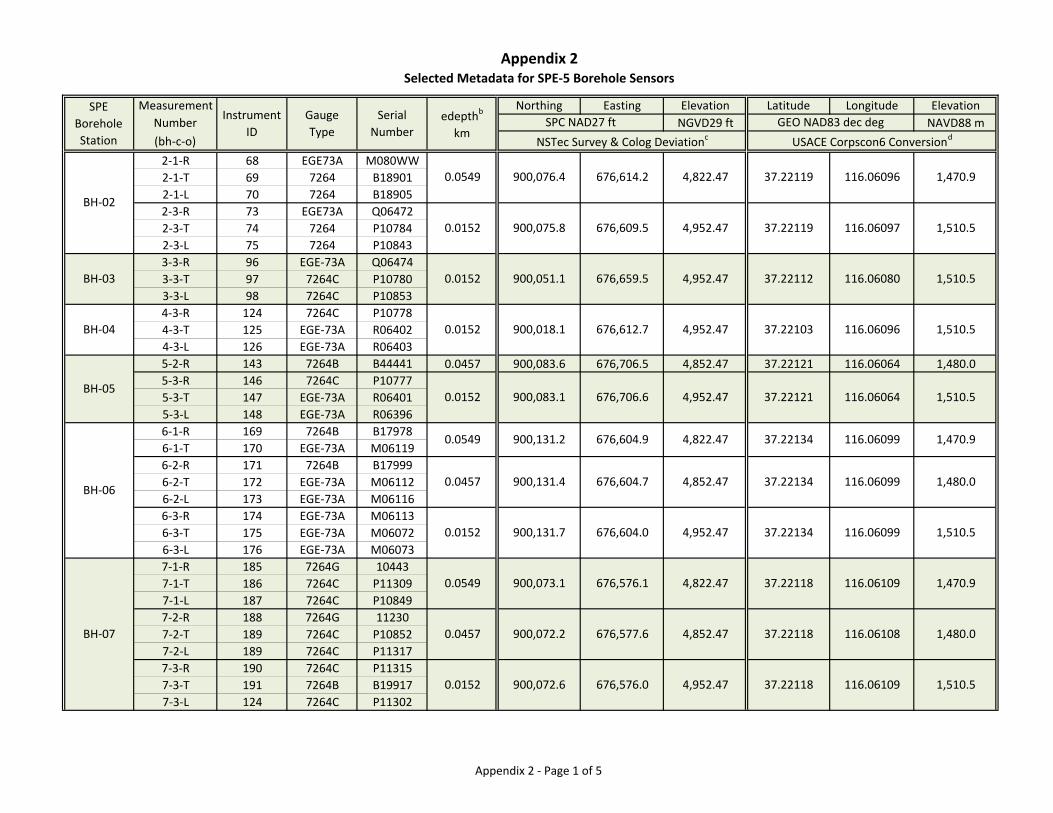
Appendix 2Selected Metadata for SPE‐5 Borehole Sensors
Measurement Northing Easting Elevation Latitude Longitude Elevation
Number NGVD29 ft NAVD88 m
(bh‐c‐o)
2‐1‐R 68 EGE73A M080WW
2‐1‐T 69 7264 B18901
2‐1‐L 70 7264 B18905
2‐3‐R 73 EGE73A Q06472
2‐3‐T 74 7264 P10784
2‐3‐L 75 7264 P10843
3‐3‐R 96 EGE‐73A Q06474
3‐3‐T 97 7264C P10780
3‐3‐L 98 7264C P10853
4‐3‐R 124 7264C P10778
4‐3‐T 125 EGE‐73A R06402
4‐3‐L 126 EGE‐73A R06403
5‐2‐R 143 7264B B44441 0.0457 900,083.6 676,706.5 4,852.47 37.22121 116.06064 1,480.0
5‐3‐R 146 7264C P10777
5‐3‐T 147 EGE‐73A R06401
5‐3‐L 148 EGE‐73A R06396
6‐1‐R 169 7264B B17978
6‐1‐T 170 EGE‐73A M06119
6‐2‐R 171 7264B B17999
6‐2‐T 172 EGE‐73A M06112
6‐2‐L 173 EGE‐73A M06116
6‐3‐R 174 EGE‐73A M06113
6‐3‐T 175 EGE‐73A M06072
6‐3‐L 176 EGE‐73A M06073
7‐1‐R 185 7264G 10443
7‐1‐T 186 7264C P11309
7‐1‐L 187 7264C P10849
7‐2‐R 188 7264G 11230
7‐2‐T 189 7264C P10852
7‐2‐L 189 7264C P11317
7‐3‐R 190 7264C P11315
7‐3‐T 191 7264B B19917
7‐3‐L 124 7264C P11302
BH‐07
BH‐06
BH‐05
BH‐04
BH‐03
0.0152 900,072.6 676,576.0 4,952.47 37.22118
116.06109
676,604.0
116.06109 1,510.5
0.0549 900,073.1 676,576.1
0.0457 900,072.2 676,577.6 4,852.47 37.22118 116.06108 1,480.0
37.22134
0.0152
1,510.5116.0606437.221214,952.47676,706.6
1,480.0
1,510.5116.0609937.221344,952.47
4,822.47 37.22119 116.06096 1,470.9
4,952.47 37.22119
37.221124,952.47
4,822.47 1,470.9116.06099
4,852.47 37.22134 116.06099
37.221034,952.47
SPE
Borehole
Station
GEO NAD83 dec degSPC NAD27 ft
NSTec Survey & Colog Deviationc USACE Corpscon6 Conversiond
edepthb
km
116.06097 1,510.5
0.0549 900,076.4 676,614.2
0.0152 900,075.8 676,609.5
Serial
Number
Gauge
Type
BH‐02
1,510.5116.06080676,659.5900,051.10.0152
676,604.9900,131.20.0549
0.0457 900,131.4 676,604.7
900,018.1
900,131.70.0152
37.221184,822.47 1,470.9
900,083.10.0152
1,510.5116.06096
Instrument
ID
676,612.7
Appendix 2 ‐ Page 1 of 5
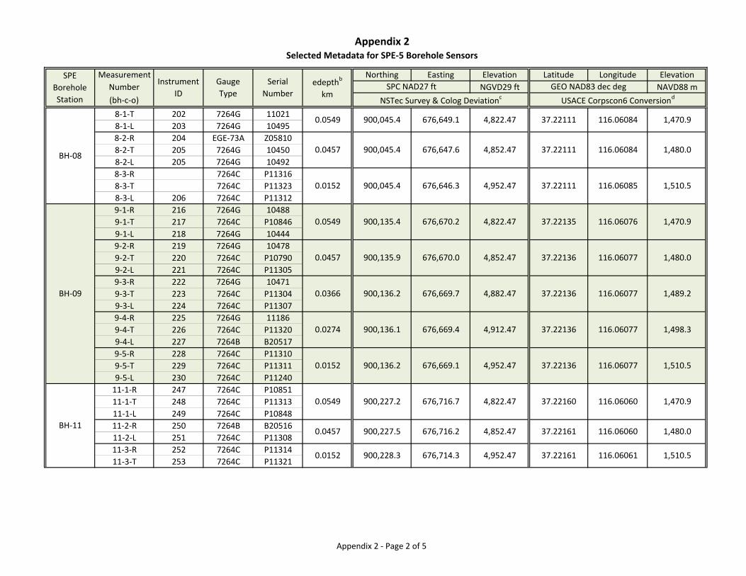
Appendix 2Selected Metadata for SPE‐5 Borehole Sensors
Measurement Northing Easting Elevation Latitude Longitude Elevation
Number NGVD29 ft NAVD88 m
(bh‐c‐o)
SPE
Borehole
Station
GEO NAD83 dec degSPC NAD27 ft
NSTec Survey & Colog Deviationc USACE Corpscon6 Conversiond
edepthb
km
Serial
Number
Gauge
Type
Instrument
ID
8‐1‐T 202 7264G 11021
8‐1‐L 203 7264G 10495
8‐2‐R 204 EGE‐73A Z05810
8‐2‐T 205 7264G 10450
8‐2‐L 205 7264G 10492
8‐3‐R 7264C P11316
8‐3‐T 7264C P11323
8‐3‐L 206 7264C P11312
9‐1‐R 216 7264G 10488
9‐1‐T 217 7264C P10846
9‐1‐L 218 7264G 10444
9‐2‐R 219 7264G 10478
9‐2‐T 220 7264C P10790
9‐2‐L 221 7264C P11305
9‐3‐R 222 7264G 10471
9‐3‐T 223 7264C P11304
9‐3‐L 224 7264C P11307
9‐4‐R 225 7264G 11186
9‐4‐T 226 7264C P11320
9‐4‐L 227 7264B B20517
9‐5‐R 228 7264C P11310
9‐5‐T 229 7264C P11311
9‐5‐L 230 7264C P11240
11‐1‐R 247 7264C P10851
11‐1‐T 248 7264C P11313
11‐1‐L 249 7264C P10848
11‐2‐R 250 7264B B20516
11‐2‐L 251 7264C P11308
11‐3‐R 252 7264C P11314
11‐3‐T 253 7264C P11321
BH‐11
BH‐09
BH‐08
116.06060 1,480.0
0.0152 900,228.3 676,714.3 4,952.47 37.22161 116.06061 1,510.5
0.0457 900,227.5 676,716.2 4,852.47 37.22161
116.06077 1,510.5
0.0549 900,227.2 676,716.7 4,822.47 37.22160 116.06060 1,470.9
0.0152 900,136.2 676,669.1 4,952.47 37.22136
900,136.1 676,669.4 4,912.47 37.22136 116.06077 1,498.3
0.0366 900,136.2 676,669.7 4,882.47 37.22136
37.22136 116.06077 1,480.0
0.0549 900,135.4 676,670.2 4,822.47 37.22135
116.06077 1,489.2
37.22111 116.06085 1,510.5
0.0457 900,045.4 676,647.6 4,852.47 37.22111
116.06076 1,470.9
37.22111 116.06084 1,470.9
116.06084 1,480.0
0.0549 900,045.4 676,649.1 4,822.47
0.0152 900,045.4 676,646.3 4,952.47
0.0457 900,135.9 676,670.0 4,852.47
0.0274
Appendix 2 ‐ Page 2 of 5
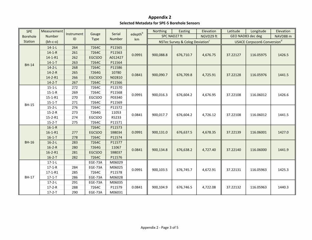
Appendix 2Selected Metadata for SPE‐5 Borehole Sensors
Measurement Northing Easting Elevation Latitude Longitude Elevation
Number NGVD29 ft NAVD88 m
(bh‐c‐o)
SPE
Borehole
Station
GEO NAD83 dec degSPC NAD27 ft
NSTec Survey & Colog Deviationc USACE Corpscon6 Conversiond
edepthb
km
Serial
Number
Gauge
Type
Instrument
ID
14‐1‐L 264 7264C P11565
14‐1‐R 261 7264C P11563
14‐1‐R1 262 EGCSDO A012427
14‐1‐T 263 7264C P11564
14‐2‐L 268 7264C P11586
14‐2‐R 265 7264G 10780
14‐2‐R1 266 EGCSDO N02810
14‐2‐T 267 7264C P11566
15‐1‐L 272 7264C P11570
15‐1‐R 269 7264C P11568
15‐1‐R1 270 EGCSDO P03340
15‐1‐T 271 7264C P11569
15‐2‐L 276 7264C P11572
15‐2‐R 273 7264G 11053
15‐2‐R1 274 EGCSDO R5233
15‐2‐T 275 7264C P11571
16‐1‐R 7264C P11573
16‐1‐R1 277 EGCSDO S98034
16‐1‐T 278 7264C P11574
16‐2‐L 283 7264C P11577
16‐2‐R 280 7264G 11067
16‐2‐R1 281 EGCSDO S98037
16‐2‐T 282 7264C P11576
17‐1‐L EGE‐73A M06029
17‐1‐R 284 EGE‐73A M06025
17‐1‐R1 285 7264C P11578
17‐1‐T 286 EGE‐73A M06028
17‐2‐L 291 EGE‐73A M06035
17‐2‐R 288 7264C P11579
17‐2‐T 290 EGE‐73A M06031
BH‐17
BH‐16
BH‐15
BH‐14
1440.3116.0596337.221324,722.08676,746.5900,104.90.0841
1425.3116.0596337.221314,672.91676,745.7900,103.50.0991
1441.9116.0600037.221404,727.40676,638.2
1427.0116.0600137.221394,678.35676,637.5900,131.00.0991
1441.5116.0601237.221084,726.12676,604.2
1426.6116.0601237.221084,676.95676,604.2900,016.30.0991
1441.5116.0597637.221284,725.91676,709.8
1426.5116.0597537.22127
900,134.80.0841
0.0991 900,088.8 4,676.75676,710.7
900,090.70.0841
900,017.70.0841
Appendix 2 ‐ Page 3 of 5
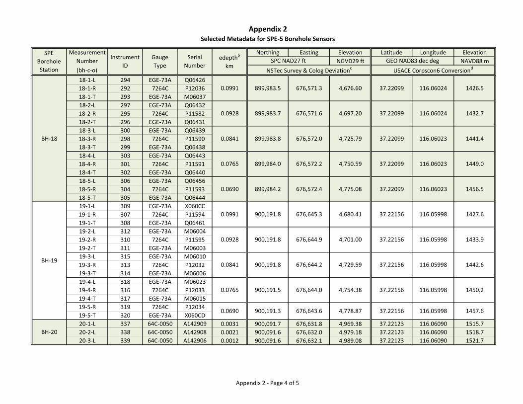
Appendix 2Selected Metadata for SPE‐5 Borehole Sensors
Measurement Northing Easting Elevation Latitude Longitude Elevation
Number NGVD29 ft NAVD88 m
(bh‐c‐o)
SPE
Borehole
Station
GEO NAD83 dec degSPC NAD27 ft
NSTec Survey & Colog Deviationc USACE Corpscon6 Conversiond
edepthb
km
Serial
Number
Gauge
Type
Instrument
ID
18‐1‐L 294 EGE‐73A Q06426
18‐1‐R 292 7264C P12036
18‐1‐T 293 EGE‐73A M06037
18‐2‐L 297 EGE‐73A Q06432
18‐2‐R 295 7264C P11582
18‐2‐T 296 EGE‐73A Q06431
18‐3‐L 300 EGE‐73A Q06439
18‐3‐R 298 7264C P11590
18‐3‐T 299 EGE‐73A Q06438
18‐4‐L 303 EGE‐73A Q06443
18‐4‐R 301 7264C P11591
18‐4‐T 302 EGE‐73A Q06440
18‐5‐L 306 EGE‐73A Q06456
18‐5‐R 304 7264C P11593
18‐5‐T 305 EGE‐73A Q06444
19‐1‐L 309 EGE‐73A X060CC
19‐1‐R 307 7264C P11594
19‐1‐T 308 EGE‐73A Q06461
19‐2‐L 312 EGE‐73A M06004
19‐2‐R 310 7264C P11595
19‐2‐T 311 EGE‐73A M06003
19‐3‐L 315 EGE‐73A M06010
19‐3‐R 313 7264C P12032
19‐3‐T 314 EGE‐73A M06006
19‐4‐L 318 EGE‐73A M06023
19‐4‐R 316 7264C P12033
19‐4‐T 317 EGE‐73A M06015
19‐5‐R 319 7264C P12034
19‐5‐T 320 EGE‐73A X060CD
20‐1‐L 337 64C‐0050 A142909 0.0031 900,091.7 676,631.8 4,969.38 37.22123 116.06090 1515.7
20‐2‐L 338 64C‐0050 A142908 0.0021 900,091.6 676,632.0 4,979.18 37.22123 116.06090 1518.7
20‐3‐L 339 64C‐0050 A142906 0.0012 900,091.6 676,632.1 4,989.08 37.22123 116.06090 1521.7
BH‐19
BH‐20
BH‐18
1457.6116.0599837.221564,778.87
116.05998 1450.2
1442.6116.0599837.22156
0.0765 37.22156
4,729.59676,644.2900,191.80.0841
37.221560.0928 900,191.8 676,644.9
676,644.0 4,754.38
116.05998 1433.9
1427.6116.0599837.221564,680.41
1456.5116.0602337.22099
1449.0116.0602337.220990.0765
676,645.3900,191.80.0991
4,775.08676,572.4899,984.20.0690
4,750.59
116.06023 1441.4
1432.7116.0602437.22099
0.0841 899,983.8 676,572.0 4,725.79 37.22099
4,697.20676,571.6899,983.70.0928
1426.5116.0602437.220994,676.60676,571.3899,983.50.0991
676,572.2899,984.0
4,701.00
676,643.6900,191.30.0690
900,191.5
Appendix 2 ‐ Page 4 of 5
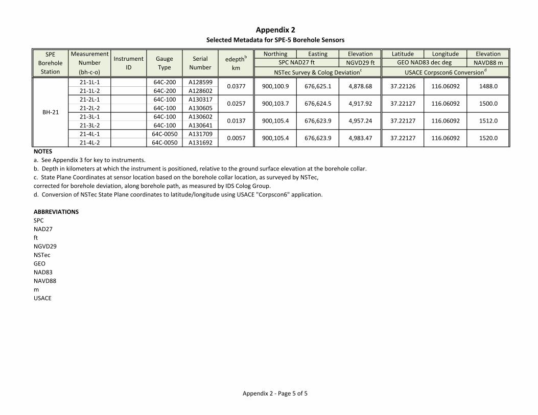
Appendix 2Selected Metadata for SPE‐5 Borehole Sensors
Measurement Northing Easting Elevation Latitude Longitude Elevation
Number NGVD29 ft NAVD88 m
(bh‐c‐o)
SPE
Borehole
Station
GEO NAD83 dec degSPC NAD27 ft
NSTec Survey & Colog Deviationc USACE Corpscon6 Conversiond
edepthb
km
Serial
Number
Gauge
Type
Instrument
ID
21‐1L‐1 64C‐200 A128599
21‐1L‐2 64C‐200 A128602
21‐2L‐1 64C‐100 A130317
21‐2L‐2 64C‐100 A130605
21‐3L‐1 64C‐100 A130602
21‐3L‐2 64C‐100 A130641
21‐4L‐1 64C‐0050 A131709
21‐4L‐2 64C‐0050 A131692
NOTESa. See Appendix 3 for key to instruments.
b. Depth in kilometers at which the instrument is positioned, relative to the ground surface elevation at the borehole collar.
c. State Plane Coordinates at sensor location based on the borehole collar location, as surveyed by NSTec,
corrected for borehole deviation, along borehole path, as measured by IDS Colog Group.
d. Conversion of NSTec State Plane coordinates to latitude/longitude using USACE "Corpscon6" application.
ABBREVIATIONSSPC
NAD27
ft
NGVD29
NSTec
GEO
NAD83
NAVD88
m
USACE
BH‐21
1488.0116.0609237.221264,878.68676,625.1900,100.90.0377
1500.0116.0609237.221274,917.92676,624.5900,103.70.0257
0.0057 900,105.4 676,623.9 4,983.47 37.22127 116.06092 1520.0
1512.0116.0609237.221274,957.24676,623.9900,105.40.0137
Appendix 2 ‐ Page 5 of 5

Appendix 3
Instrument Metadata for SPE-5
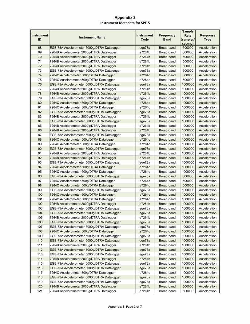
Appendix 3Instrument Metadata for SPE‐5
Instrument ID
Instrument NameInstrument
CodeFrequency
Band
Sample Rate
(samples/second)
Response Type
68 EGE-73A Accelerometer 5000g/DTRA Datalogger ege73a Broad-band 500000 Acceleration
69 7264B Accelerometer 2000g/DTRA Datalogger e7264b Broad-band 500000 Acceleration
70 7264B Accelerometer 2000g/DTRA Datalogger e7264b Broad-band 500000 Acceleration
71 7264B Accelerometer 2000g/DTRA Datalogger e7264b Broad-band 500000 Acceleration
72 7264B Accelerometer 2000g/DTRA Datalogger e7264b Broad-band 500000 Acceleration
73 EGE-73A Accelerometer 5000g/DTRA Datalogger ege73a Broad-band 500000 Acceleration
74 7264C Accelerometer 500g/DTRA Datalogger e7264c Broad-band 500000 Acceleration
75 7264C Accelerometer 500g/DTRA Datalogger e7264c Broad-band 500000 Acceleration
76 EGE-73A Accelerometer 5000g/DTRA Datalogger ege73a Broad-band 1000000 Acceleration
77 7264B Accelerometer 2000g/DTRA Datalogger e7264b Broad-band 1000000 Acceleration
78 7264B Accelerometer 2000g/DTRA Datalogger e7264b Broad-band 1000000 Acceleration
79 EGE-73A Accelerometer 5000g/DTRA Datalogger ege73a Broad-band 1000000 Acceleration
80 7264C Accelerometer 500g/DTRA Datalogger e7264c Broad-band 1000000 Acceleration
81 7264C Accelerometer 500g/DTRA Datalogger e7264c Broad-band 1000000 Acceleration
82 EGE-73A Accelerometer 5000g/DTRA Datalogger ege73a Broad-band 1000000 Acceleration
83 7264B Accelerometer 2000g/DTRA Datalogger e7264b Broad-band 1000000 Acceleration
84 EGE-73A Accelerometer 5000g/DTRA Datalogger ege73a Broad-band 1000000 Acceleration
85 7264B Accelerometer 2000g/DTRA Datalogger e7264b Broad-band 1000000 Acceleration
86 7264B Accelerometer 2000g/DTRA Datalogger e7264b Broad-band 1000000 Acceleration
87 EGE-73A Accelerometer 5000g/DTRA Datalogger ege73a Broad-band 1000000 Acceleration
88 7264C Accelerometer 500g/DTRA Datalogger e7264c Broad-band 1000000 Acceleration
89 7264C Accelerometer 500g/DTRA Datalogger e7264c Broad-band 1000000 Acceleration
90 EGE-73A Accelerometer 5000g/DTRA Datalogger ege73a Broad-band 1000000 Acceleration
91 7264B Accelerometer 2000g/DTRA Datalogger e7264b Broad-band 1000000 Acceleration
92 7264B Accelerometer 2000g/DTRA Datalogger e7264b Broad-band 1000000 Acceleration
93 EGE-73A Accelerometer 5000g/DTRA Datalogger ege73a Broad-band 1000000 Acceleration
94 7264C Accelerometer 500g/DTRA Datalogger e7264c Broad-band 1000000 Acceleration
95 7264C Accelerometer 500g/DTRA Datalogger e7264c Broad-band 1000000 Acceleration
96 EGE-73A Accelerometer 5000g/DTRA Datalogger ege73a Broad-band 500000 Acceleration
97 7264C Accelerometer 500g/DTRA Datalogger e7264c Broad-band 500000 Acceleration
98 7264C Accelerometer 500g/DTRA Datalogger e7264c Broad-band 500000 Acceleration
99 EGE-73A Accelerometer 5000g/DTRA Datalogger ege73a Broad-band 1000000 Acceleration
100 7264C Accelerometer 500g/DTRA Datalogger e7264c Broad-band 1000000 Acceleration
101 7264C Accelerometer 500g/DTRA Datalogger e7264c Broad-band 1000000 Acceleration
102 7264B Accelerometer 2000g/DTRA Datalogger e7264b Broad-band 1000000 Acceleration
103 EGE-73A Accelerometer 5000g/DTRA Datalogger ege73a Broad-band 1000000 Acceleration
104 EGE-73A Accelerometer 5000g/DTRA Datalogger ege73a Broad-band 1000000 Acceleration
105 7264B Accelerometer 2000g/DTRA Datalogger e7264b Broad-band 1000000 Acceleration
106 EGE-73A Accelerometer 5000g/DTRA Datalogger ege73a Broad-band 1000000 Acceleration
107 EGE-73A Accelerometer 5000g/DTRA Datalogger ege73a Broad-band 1000000 Acceleration
108 7264C Accelerometer 500g/DTRA Datalogger e7264c Broad-band 1000000 Acceleration
109 EGE-73A Accelerometer 5000g/DTRA Datalogger ege73a Broad-band 1000000 Acceleration
110 EGE-73A Accelerometer 5000g/DTRA Datalogger ege73a Broad-band 1000000 Acceleration
111 7264B Accelerometer 2000g/DTRA Datalogger e7264b Broad-band 1000000 Acceleration
112 EGE-73A Accelerometer 5000g/DTRA Datalogger ege73a Broad-band 1000000 Acceleration
113 EGE-73A Accelerometer 5000g/DTRA Datalogger ege73a Broad-band 1000000 Acceleration
114 7264B Accelerometer 2000g/DTRA Datalogger e7264b Broad-band 1000000 Acceleration
115 EGE-73A Accelerometer 5000g/DTRA Datalogger ege73a Broad-band 1000000 Acceleration
116 EGE-73A Accelerometer 5000g/DTRA Datalogger ege73a Broad-band 1000000 Acceleration
117 7264C Accelerometer 500g/DTRA Datalogger e7264c Broad-band 1000000 Acceleration
118 EGE-73A Accelerometer 5000g/DTRA Datalogger ege73a Broad-band 1000000 Acceleration
119 EGE-73A Accelerometer 5000g/DTRA Datalogger ege73a Broad-band 1000000 Acceleration
120 7264B Accelerometer 2000g/DTRA Datalogger e7264b Broad-band 500000 Acceleration
121 7264B Accelerometer 2000g/DTRA Datalogger e7264b Broad-band 500000 Acceleration
Appendix 3‐ Page 1 of 7
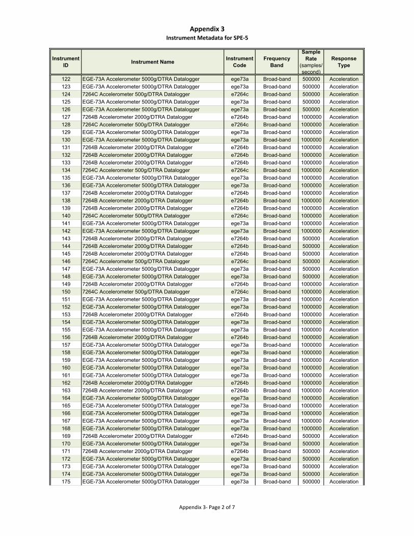
Appendix 3Instrument Metadata for SPE‐5
Instrument ID
Instrument NameInstrument
CodeFrequency
Band
Sample Rate
(samples/second)
Response Type
122 EGE-73A Accelerometer 5000g/DTRA Datalogger ege73a Broad-band 500000 Acceleration
123 EGE-73A Accelerometer 5000g/DTRA Datalogger ege73a Broad-band 500000 Acceleration
124 7264C Accelerometer 500g/DTRA Datalogger e7264c Broad-band 500000 Acceleration
125 EGE-73A Accelerometer 5000g/DTRA Datalogger ege73a Broad-band 500000 Acceleration
126 EGE-73A Accelerometer 5000g/DTRA Datalogger ege73a Broad-band 500000 Acceleration
127 7264B Accelerometer 2000g/DTRA Datalogger e7264b Broad-band 1000000 Acceleration
128 7264C Accelerometer 500g/DTRA Datalogger e7264c Broad-band 1000000 Acceleration
129 EGE-73A Accelerometer 5000g/DTRA Datalogger ege73a Broad-band 1000000 Acceleration
130 EGE-73A Accelerometer 5000g/DTRA Datalogger ege73a Broad-band 1000000 Acceleration
131 7264B Accelerometer 2000g/DTRA Datalogger e7264b Broad-band 1000000 Acceleration
132 7264B Accelerometer 2000g/DTRA Datalogger e7264b Broad-band 1000000 Acceleration
133 7264B Accelerometer 2000g/DTRA Datalogger e7264b Broad-band 1000000 Acceleration
134 7264C Accelerometer 500g/DTRA Datalogger e7264c Broad-band 1000000 Acceleration
135 EGE-73A Accelerometer 5000g/DTRA Datalogger ege73a Broad-band 1000000 Acceleration
136 EGE-73A Accelerometer 5000g/DTRA Datalogger ege73a Broad-band 1000000 Acceleration
137 7264B Accelerometer 2000g/DTRA Datalogger e7264b Broad-band 1000000 Acceleration
138 7264B Accelerometer 2000g/DTRA Datalogger e7264b Broad-band 1000000 Acceleration
139 7264B Accelerometer 2000g/DTRA Datalogger e7264b Broad-band 1000000 Acceleration
140 7264C Accelerometer 500g/DTRA Datalogger e7264c Broad-band 1000000 Acceleration
141 EGE-73A Accelerometer 5000g/DTRA Datalogger ege73a Broad-band 1000000 Acceleration
142 EGE-73A Accelerometer 5000g/DTRA Datalogger ege73a Broad-band 1000000 Acceleration
143 7264B Accelerometer 2000g/DTRA Datalogger e7264b Broad-band 500000 Acceleration
144 7264B Accelerometer 2000g/DTRA Datalogger e7264b Broad-band 500000 Acceleration
145 7264B Accelerometer 2000g/DTRA Datalogger e7264b Broad-band 500000 Acceleration
146 7264C Accelerometer 500g/DTRA Datalogger e7264c Broad-band 500000 Acceleration
147 EGE-73A Accelerometer 5000g/DTRA Datalogger ege73a Broad-band 500000 Acceleration
148 EGE-73A Accelerometer 5000g/DTRA Datalogger ege73a Broad-band 500000 Acceleration
149 7264B Accelerometer 2000g/DTRA Datalogger e7264b Broad-band 1000000 Acceleration
150 7264C Accelerometer 500g/DTRA Datalogger e7264c Broad-band 1000000 Acceleration
151 EGE-73A Accelerometer 5000g/DTRA Datalogger ege73a Broad-band 1000000 Acceleration
152 EGE-73A Accelerometer 5000g/DTRA Datalogger ege73a Broad-band 1000000 Acceleration
153 7264B Accelerometer 2000g/DTRA Datalogger e7264b Broad-band 1000000 Acceleration
154 EGE-73A Accelerometer 5000g/DTRA Datalogger ege73a Broad-band 1000000 Acceleration
155 EGE-73A Accelerometer 5000g/DTRA Datalogger ege73a Broad-band 1000000 Acceleration
156 7264B Accelerometer 2000g/DTRA Datalogger e7264b Broad-band 1000000 Acceleration
157 EGE-73A Accelerometer 5000g/DTRA Datalogger ege73a Broad-band 1000000 Acceleration
158 EGE-73A Accelerometer 5000g/DTRA Datalogger ege73a Broad-band 1000000 Acceleration
159 EGE-73A Accelerometer 5000g/DTRA Datalogger ege73a Broad-band 1000000 Acceleration
160 EGE-73A Accelerometer 5000g/DTRA Datalogger ege73a Broad-band 1000000 Acceleration
161 EGE-73A Accelerometer 5000g/DTRA Datalogger ege73a Broad-band 1000000 Acceleration
162 7264B Accelerometer 2000g/DTRA Datalogger e7264b Broad-band 1000000 Acceleration
163 7264B Accelerometer 2000g/DTRA Datalogger e7264b Broad-band 1000000 Acceleration
164 EGE-73A Accelerometer 5000g/DTRA Datalogger ege73a Broad-band 1000000 Acceleration
165 EGE-73A Accelerometer 5000g/DTRA Datalogger ege73a Broad-band 1000000 Acceleration
166 EGE-73A Accelerometer 5000g/DTRA Datalogger ege73a Broad-band 1000000 Acceleration
167 EGE-73A Accelerometer 5000g/DTRA Datalogger ege73a Broad-band 1000000 Acceleration
168 EGE-73A Accelerometer 5000g/DTRA Datalogger ege73a Broad-band 1000000 Acceleration
169 7264B Accelerometer 2000g/DTRA Datalogger e7264b Broad-band 500000 Acceleration
170 EGE-73A Accelerometer 5000g/DTRA Datalogger ege73a Broad-band 500000 Acceleration
171 7264B Accelerometer 2000g/DTRA Datalogger e7264b Broad-band 500000 Acceleration
172 EGE-73A Accelerometer 5000g/DTRA Datalogger ege73a Broad-band 500000 Acceleration
173 EGE-73A Accelerometer 5000g/DTRA Datalogger ege73a Broad-band 500000 Acceleration
174 EGE-73A Accelerometer 5000g/DTRA Datalogger ege73a Broad-band 500000 Acceleration
175 EGE-73A Accelerometer 5000g/DTRA Datalogger ege73a Broad-band 500000 Acceleration
Appendix 3‐ Page 2 of 7
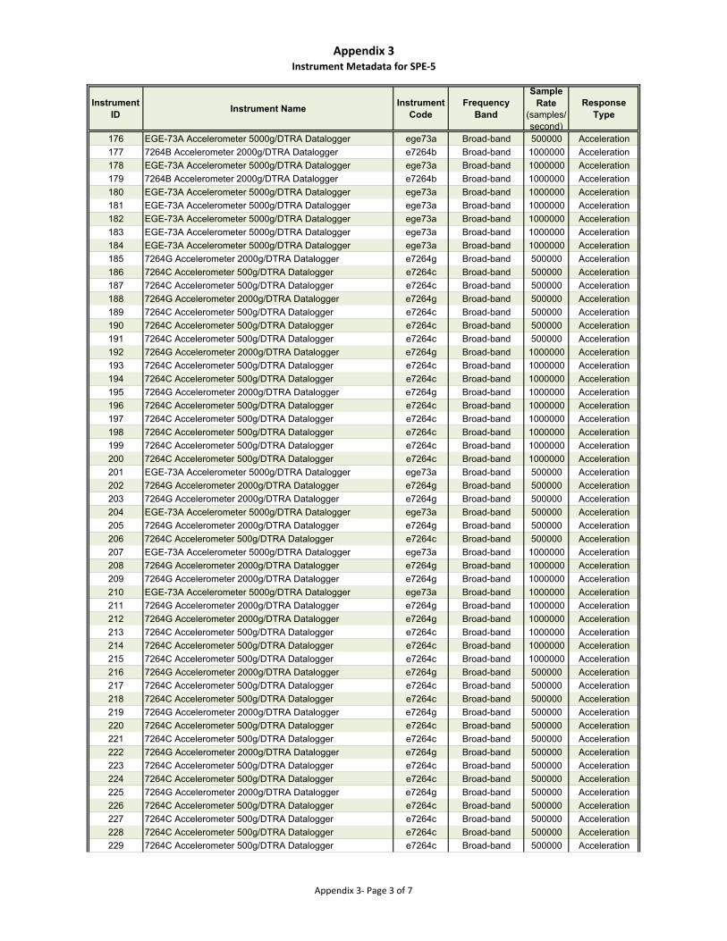
Appendix 3Instrument Metadata for SPE‐5
Instrument ID
Instrument NameInstrument
CodeFrequency
Band
Sample Rate
(samples/second)
Response Type
176 EGE-73A Accelerometer 5000g/DTRA Datalogger ege73a Broad-band 500000 Acceleration
177 7264B Accelerometer 2000g/DTRA Datalogger e7264b Broad-band 1000000 Acceleration
178 EGE-73A Accelerometer 5000g/DTRA Datalogger ege73a Broad-band 1000000 Acceleration
179 7264B Accelerometer 2000g/DTRA Datalogger e7264b Broad-band 1000000 Acceleration
180 EGE-73A Accelerometer 5000g/DTRA Datalogger ege73a Broad-band 1000000 Acceleration
181 EGE-73A Accelerometer 5000g/DTRA Datalogger ege73a Broad-band 1000000 Acceleration
182 EGE-73A Accelerometer 5000g/DTRA Datalogger ege73a Broad-band 1000000 Acceleration
183 EGE-73A Accelerometer 5000g/DTRA Datalogger ege73a Broad-band 1000000 Acceleration
184 EGE-73A Accelerometer 5000g/DTRA Datalogger ege73a Broad-band 1000000 Acceleration
185 7264G Accelerometer 2000g/DTRA Datalogger e7264g Broad-band 500000 Acceleration
186 7264C Accelerometer 500g/DTRA Datalogger e7264c Broad-band 500000 Acceleration
187 7264C Accelerometer 500g/DTRA Datalogger e7264c Broad-band 500000 Acceleration
188 7264G Accelerometer 2000g/DTRA Datalogger e7264g Broad-band 500000 Acceleration
189 7264C Accelerometer 500g/DTRA Datalogger e7264c Broad-band 500000 Acceleration
190 7264C Accelerometer 500g/DTRA Datalogger e7264c Broad-band 500000 Acceleration
191 7264C Accelerometer 500g/DTRA Datalogger e7264c Broad-band 500000 Acceleration
192 7264G Accelerometer 2000g/DTRA Datalogger e7264g Broad-band 1000000 Acceleration
193 7264C Accelerometer 500g/DTRA Datalogger e7264c Broad-band 1000000 Acceleration
194 7264C Accelerometer 500g/DTRA Datalogger e7264c Broad-band 1000000 Acceleration
195 7264G Accelerometer 2000g/DTRA Datalogger e7264g Broad-band 1000000 Acceleration
196 7264C Accelerometer 500g/DTRA Datalogger e7264c Broad-band 1000000 Acceleration
197 7264C Accelerometer 500g/DTRA Datalogger e7264c Broad-band 1000000 Acceleration
198 7264C Accelerometer 500g/DTRA Datalogger e7264c Broad-band 1000000 Acceleration
199 7264C Accelerometer 500g/DTRA Datalogger e7264c Broad-band 1000000 Acceleration
200 7264C Accelerometer 500g/DTRA Datalogger e7264c Broad-band 1000000 Acceleration
201 EGE-73A Accelerometer 5000g/DTRA Datalogger ege73a Broad-band 500000 Acceleration
202 7264G Accelerometer 2000g/DTRA Datalogger e7264g Broad-band 500000 Acceleration
203 7264G Accelerometer 2000g/DTRA Datalogger e7264g Broad-band 500000 Acceleration
204 EGE-73A Accelerometer 5000g/DTRA Datalogger ege73a Broad-band 500000 Acceleration
205 7264G Accelerometer 2000g/DTRA Datalogger e7264g Broad-band 500000 Acceleration
206 7264C Accelerometer 500g/DTRA Datalogger e7264c Broad-band 500000 Acceleration
207 EGE-73A Accelerometer 5000g/DTRA Datalogger ege73a Broad-band 1000000 Acceleration
208 7264G Accelerometer 2000g/DTRA Datalogger e7264g Broad-band 1000000 Acceleration
209 7264G Accelerometer 2000g/DTRA Datalogger e7264g Broad-band 1000000 Acceleration
210 EGE-73A Accelerometer 5000g/DTRA Datalogger ege73a Broad-band 1000000 Acceleration
211 7264G Accelerometer 2000g/DTRA Datalogger e7264g Broad-band 1000000 Acceleration
212 7264G Accelerometer 2000g/DTRA Datalogger e7264g Broad-band 1000000 Acceleration
213 7264C Accelerometer 500g/DTRA Datalogger e7264c Broad-band 1000000 Acceleration
214 7264C Accelerometer 500g/DTRA Datalogger e7264c Broad-band 1000000 Acceleration
215 7264C Accelerometer 500g/DTRA Datalogger e7264c Broad-band 1000000 Acceleration
216 7264G Accelerometer 2000g/DTRA Datalogger e7264g Broad-band 500000 Acceleration
217 7264C Accelerometer 500g/DTRA Datalogger e7264c Broad-band 500000 Acceleration
218 7264C Accelerometer 500g/DTRA Datalogger e7264c Broad-band 500000 Acceleration
219 7264G Accelerometer 2000g/DTRA Datalogger e7264g Broad-band 500000 Acceleration
220 7264C Accelerometer 500g/DTRA Datalogger e7264c Broad-band 500000 Acceleration
221 7264C Accelerometer 500g/DTRA Datalogger e7264c Broad-band 500000 Acceleration
222 7264G Accelerometer 2000g/DTRA Datalogger e7264g Broad-band 500000 Acceleration
223 7264C Accelerometer 500g/DTRA Datalogger e7264c Broad-band 500000 Acceleration
224 7264C Accelerometer 500g/DTRA Datalogger e7264c Broad-band 500000 Acceleration
225 7264G Accelerometer 2000g/DTRA Datalogger e7264g Broad-band 500000 Acceleration
226 7264C Accelerometer 500g/DTRA Datalogger e7264c Broad-band 500000 Acceleration
227 7264C Accelerometer 500g/DTRA Datalogger e7264c Broad-band 500000 Acceleration
228 7264C Accelerometer 500g/DTRA Datalogger e7264c Broad-band 500000 Acceleration
229 7264C Accelerometer 500g/DTRA Datalogger e7264c Broad-band 500000 Acceleration
Appendix 3‐ Page 3 of 7
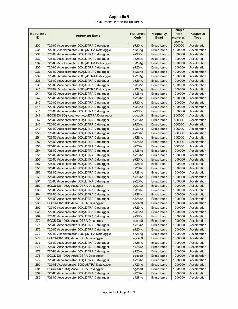
Appendix 3Instrument Metadata for SPE‐5
Instrument ID
Instrument NameInstrument
CodeFrequency
Band
Sample Rate
(samples/second)
Response Type
230 7264C Accelerometer 500g/DTRA Datalogger e7264c Broad-band 500000 Acceleration
231 7264G Accelerometer 2000g/DTRA Datalogger e7264g Broad-band 1000000 Acceleration
232 7264C Accelerometer 500g/DTRA Datalogger e7264c Broad-band 1000000 Acceleration
233 7264C Accelerometer 500g/DTRA Datalogger e7264c Broad-band 1000000 Acceleration
234 7264G Accelerometer 2000g/DTRA Datalogger e7264g Broad-band 1000000 Acceleration
235 7264C Accelerometer 500g/DTRA Datalogger e7264c Broad-band 1000000 Acceleration
236 7264C Accelerometer 500g/DTRA Datalogger e7264c Broad-band 1000000 Acceleration
237 7264G Accelerometer 2000g/DTRA Datalogger e7264g Broad-band 1000000 Acceleration
238 7264C Accelerometer 500g/DTRA Datalogger e7264c Broad-band 1000000 Acceleration
239 7264C Accelerometer 500g/DTRA Datalogger e7264c Broad-band 1000000 Acceleration
240 7264G Accelerometer 2000g/DTRA Datalogger e7264g Broad-band 1000000 Acceleration
241 7264C Accelerometer 500g/DTRA Datalogger e7264c Broad-band 1000000 Acceleration
242 7264C Accelerometer 500g/DTRA Datalogger e7264c Broad-band 1000000 Acceleration
243 7264C Accelerometer 500g/DTRA Datalogger e7264c Broad-band 1000000 Acceleration
244 7264C Accelerometer 500g/DTRA Datalogger e7264c Broad-band 1000000 Acceleration
245 7264C Accelerometer 500g/DTRA Datalogger e7264c Broad-band 1000000 Acceleration
246 EGCS-D0-50g Accelerometer/DTRA Datalogger egcsd0 Broad-band 500000 Acceleration
247 7264C Accelerometer 500g/DTRA Datalogger e7264c Broad-band 500000 Acceleration
248 7264C Accelerometer 500g/DTRA Datalogger e7264c Broad-band 500000 Acceleration
249 7264C Accelerometer 500g/DTRA Datalogger e7264c Broad-band 500000 Acceleration
250 7264C Accelerometer 500g/DTRA Datalogger e7264c Broad-band 500000 Acceleration
251 7264C Accelerometer 500g/DTRA Datalogger e7264c Broad-band 500000 Acceleration
252 7264C Accelerometer 500g/DTRA Datalogger e7264c Broad-band 500000 Acceleration
253 7264C Accelerometer 500g/DTRA Datalogger e7264c Broad-band 500000 Acceleration
254 7264C Accelerometer 500g/DTRA Datalogger e7264c Broad-band 1000000 Acceleration
255 7264C Accelerometer 500g/DTRA Datalogger e7264c Broad-band 1000000 Acceleration
256 7264C Accelerometer 500g/DTRA Datalogger e7264c Broad-band 1000000 Acceleration
257 7264C Accelerometer 500g/DTRA Datalogger e7264c Broad-band 1000000 Acceleration
258 7264C Accelerometer 500g/DTRA Datalogger e7264c Broad-band 1000000 Acceleration
259 7264C Accelerometer 500g/DTRA Datalogger e7264c Broad-band 1000000 Acceleration
260 7264C Accelerometer 500g/DTRA Datalogger e7264c Broad-band 1000000 Acceleration
261 7264C Accelerometer 500g/DTRA Datalogger e7264c Broad-band 1000000 Acceleration
262 EGCS-D0-1000g Accel/DTRA Datalogger egcsd0 Broad-band 1000000 Acceleration
263 7264C Accelerometer 500g/DTRA Datalogger e7264c Broad-band 1000000 Acceleration
264 7264C Accelerometer 500g/DTRA Datalogger e7264c Broad-band 1000000 Acceleration
265 7264C Accelerometer 500g/DTRA Datalogger e7264c Broad-band 1000000 Acceleration
266 EGCS-D0-1000g Accel/DTRA Datalogger egcsd0 Broad-band 1000000 Acceleration
267 7264C Accelerometer 500g/DTRA Datalogger e7264c Broad-band 1000000 Acceleration
268 7264C Accelerometer 500g/DTRA Datalogger e7264c Broad-band 1000000 Acceleration
269 7264C Accelerometer 500g/DTRA Datalogger e7264c Broad-band 1000000 Acceleration
270 EGCS-D0-1000g Accel/DTRA Datalogger egcsd0 Broad-band 1000000 Acceleration
271 7264C Accelerometer 500g/DTRA Datalogger e7264c Broad-band 1000000 Acceleration
272 7264C Accelerometer 500g/DTRA Datalogger e7264c Broad-band 1000000 Acceleration
273 7264G Accelerometer 2000g/DTRA Datalogger e7264g Broad-band 1000000 Acceleration
274 EGCS-D0-1000g Accel/DTRA Datalogger egcsd0 Broad-band 1000000 Acceleration
275 7264C Accelerometer 500g/DTRA Datalogger e7264c Broad-band 1000000 Acceleration
276 7264C Accelerometer 500g/DTRA Datalogger e7264c Broad-band 1000000 Acceleration
277 7264C Accelerometer 500g/DTRA Datalogger e7264c Broad-band 1000000 Acceleration
278 EGCS-D0-1000g Accel/DTRA Datalogger egcsd0 Broad-band 1000000 Acceleration
279 7264C Accelerometer 500g/DTRA Datalogger e7264c Broad-band 1000000 Acceleration
280 7264G Accelerometer 2000g/DTRA Datalogger e7264g Broad-band 1000000 Acceleration
281 EGCS-D0-1000g Accel/DTRA Datalogger egcsd0 Broad-band 1000000 Acceleration
282 7264C Accelerometer 500g/DTRA Datalogger e7264c Broad-band 1000000 Acceleration
283 7264C Accelerometer 500g/DTRA Datalogger e7264c Broad-band 1000000 Acceleration
Appendix 3‐ Page 4 of 7
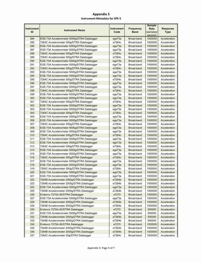
Appendix 3Instrument Metadata for SPE‐5
Instrument ID
Instrument NameInstrument
CodeFrequency
Band
Sample Rate
(samples/second)
Response Type
284 EGE-73A Accelerometer 5000g/DTRA Datalogger ege73a Broad-band 1000000 Acceleration
285 7264C Accelerometer 500g/DTRA Datalogger e7264c Broad-band 1000000 Acceleration
286 EGE-73A Accelerometer 5000g/DTRA Datalogger ege73a Broad-band 1000000 Acceleration
287 EGE-73A Accelerometer 5000g/DTRA Datalogger ege73a Broad-band 1000000 Acceleration
288 7264C Accelerometer 500g/DTRA Datalogger e7264c Broad-band 1000000 Acceleration
289 7264C Accelerometer 500g/DTRA Datalogger e7264c Broad-band 1000000 Acceleration
290 EGE-73A Accelerometer 5000g/DTRA Datalogger ege73a Broad-band 1000000 Acceleration
291 EGE-73A Accelerometer 5000g/DTRA Datalogger ege73a Broad-band 1000000 Acceleration
292 7264C Accelerometer 500g/DTRA Datalogger e7264c Broad-band 1000000 Acceleration
293 EGE-73A Accelerometer 5000g/DTRA Datalogger ege73a Broad-band 1000000 Acceleration
294 EGE-73A Accelerometer 5000g/DTRA Datalogger ege73a Broad-band 1000000 Acceleration
295 7264C Accelerometer 500g/DTRA Datalogger e7264c Broad-band 1000000 Acceleration
296 EGE-73A Accelerometer 5000g/DTRA Datalogger ege73a Broad-band 1000000 Acceleration
297 EGE-73A Accelerometer 5000g/DTRA Datalogger ege73a Broad-band 1000000 Acceleration
298 7264C Accelerometer 500g/DTRA Datalogger e7264c Broad-band 1000000 Acceleration
299 EGE-73A Accelerometer 5000g/DTRA Datalogger ege73a Broad-band 1000000 Acceleration
300 EGE-73A Accelerometer 5000g/DTRA Datalogger ege73a Broad-band 1000000 Acceleration
301 7264C Accelerometer 500g/DTRA Datalogger e7264c Broad-band 1000000 Acceleration
302 EGE-73A Accelerometer 5000g/DTRA Datalogger ege73a Broad-band 1000000 Acceleration
303 EGE-73A Accelerometer 5000g/DTRA Datalogger ege73a Broad-band 1000000 Acceleration
304 7264C Accelerometer 500g/DTRA Datalogger e7264c Broad-band 1000000 Acceleration
305 EGE-73A Accelerometer 5000g/DTRA Datalogger ege73a Broad-band 1000000 Acceleration
306 EGE-73A Accelerometer 5000g/DTRA Datalogger ege73a Broad-band 1000000 Acceleration
307 7264C Accelerometer 500g/DTRA Datalogger e7264c Broad-band 1000000 Acceleration
308 EGE-73A Accelerometer 5000g/DTRA Datalogger ege73a Broad-band 1000000 Acceleration
309 EGE-73A Accelerometer 5000g/DTRA Datalogger ege73a Broad-band 1000000 Acceleration
310 7264C Accelerometer 500g/DTRA Datalogger e7264c Broad-band 1000000 Acceleration
311 EGE-73A Accelerometer 5000g/DTRA Datalogger ege73a Broad-band 1000000 Acceleration
312 EGE-73A Accelerometer 5000g/DTRA Datalogger ege73a Broad-band 1000000 Acceleration
313 7264C Accelerometer 500g/DTRA Datalogger e7264c Broad-band 1000000 Acceleration
314 EGE-73A Accelerometer 5000g/DTRA Datalogger ege73a Broad-band 1000000 Acceleration
315 EGE-73A Accelerometer 5000g/DTRA Datalogger ege73a Broad-band 1000000 Acceleration
316 7264C Accelerometer 500g/DTRA Datalogger e7264c Broad-band 1000000 Acceleration
317 EGE-73A Accelerometer 5000g/DTRA Datalogger ege73a Broad-band 1000000 Acceleration
318 EGE-73A Accelerometer 5000g/DTRA Datalogger ege73a Broad-band 1000000 Acceleration
319 7264C Accelerometer 500g/DTRA Datalogger e7264c Broad-band 1000000 Acceleration
320 EGE-73A Accelerometer 5000g/DTRA Datalogger ege73a Broad-band 1000000 Acceleration
321 EGE-73A Accelerometer 5000g/DTRA Datalogger ege73a Broad-band 1000000 Acceleration
322 7264B Accelerometer 2000g/DTRA Datalogger e7264b Broad-band 1000000 Acceleration
323 7264B Accelerometer 2000g/DTRA Datalogger e7264b Broad-band 1000000 Acceleration
324 EGE-73A Accelerometer 5000g/DTRA Datalogger ege73a Broad-band 1000000 Acceleration
325 7264B Accelerometer 2000g/DTRA Datalogger e7264b Broad-band 1000000 Acceleration
326 Endevco 7270A-2K/DTRA Datalogger e7270 Broad-band 1000000 Acceleration
327 EGE-73A Accelerometer 5000g/DTRA Datalogger ege73a Broad-band 1000000 Acceleration
328 7264B Accelerometer 2000g/DTRA Datalogger e7264b Broad-band 1000000 Acceleration
329 7264B Accelerometer 2000g/DTRA Datalogger e7264b Broad-band 1000000 Acceleration
330 Endevco 7270A-2K/DTRA Datalogger e7270 Broad-band 500000 Acceleration
331 EGE-73A Accelerometer 5000g/DTRA Datalogger ege73a Broad-band 500000 Acceleration
332 7264B Accelerometer 2000g/DTRA Datalogger e7264b Broad-band 500000 Acceleration
333 7264B Accelerometer 2000g/DTRA Datalogger e7264b Broad-band 500000 Acceleration
334 Endevco 7270A-2K/DTRA Datalogger e7270 Broad-band 1000000 Acceleration
335 7264B Accelerometer 2000g/DTRA Datalogger e7264b Broad-band 1000000 Acceleration
336 7264B Accelerometer 2000g/DTRA Datalogger e7264b Broad-band 1000000 Acceleration
337 7264C Accelerometer 50g/DTRA Datalogger e7264c Broad-band 1000000 Acceleration
Appendix 3‐ Page 5 of 7
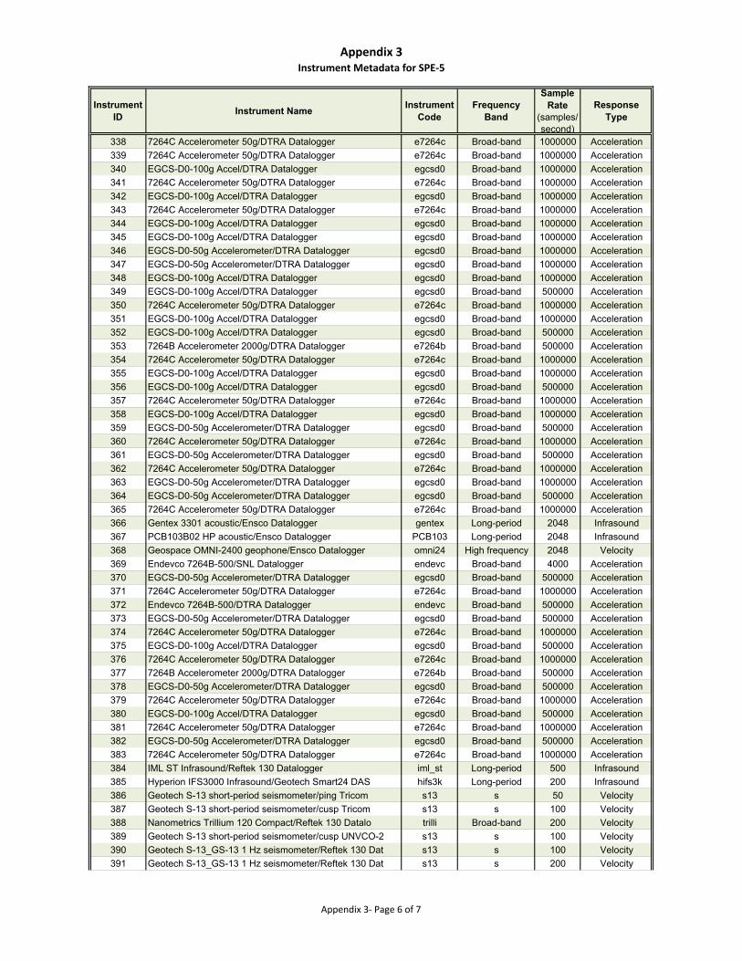
Appendix 3Instrument Metadata for SPE‐5
Instrument ID
Instrument NameInstrument
CodeFrequency
Band
Sample Rate
(samples/second)
Response Type
338 7264C Accelerometer 50g/DTRA Datalogger e7264c Broad-band 1000000 Acceleration
339 7264C Accelerometer 50g/DTRA Datalogger e7264c Broad-band 1000000 Acceleration
340 EGCS-D0-100g Accel/DTRA Datalogger egcsd0 Broad-band 1000000 Acceleration
341 7264C Accelerometer 50g/DTRA Datalogger e7264c Broad-band 1000000 Acceleration
342 EGCS-D0-100g Accel/DTRA Datalogger egcsd0 Broad-band 1000000 Acceleration
343 7264C Accelerometer 50g/DTRA Datalogger e7264c Broad-band 1000000 Acceleration
344 EGCS-D0-100g Accel/DTRA Datalogger egcsd0 Broad-band 1000000 Acceleration
345 EGCS-D0-100g Accel/DTRA Datalogger egcsd0 Broad-band 1000000 Acceleration
346 EGCS-D0-50g Accelerometer/DTRA Datalogger egcsd0 Broad-band 1000000 Acceleration
347 EGCS-D0-50g Accelerometer/DTRA Datalogger egcsd0 Broad-band 1000000 Acceleration
348 EGCS-D0-100g Accel/DTRA Datalogger egcsd0 Broad-band 1000000 Acceleration
349 EGCS-D0-100g Accel/DTRA Datalogger egcsd0 Broad-band 500000 Acceleration
350 7264C Accelerometer 50g/DTRA Datalogger e7264c Broad-band 1000000 Acceleration
351 EGCS-D0-100g Accel/DTRA Datalogger egcsd0 Broad-band 1000000 Acceleration
352 EGCS-D0-100g Accel/DTRA Datalogger egcsd0 Broad-band 500000 Acceleration
353 7264B Accelerometer 2000g/DTRA Datalogger e7264b Broad-band 500000 Acceleration
354 7264C Accelerometer 50g/DTRA Datalogger e7264c Broad-band 1000000 Acceleration
355 EGCS-D0-100g Accel/DTRA Datalogger egcsd0 Broad-band 1000000 Acceleration
356 EGCS-D0-100g Accel/DTRA Datalogger egcsd0 Broad-band 500000 Acceleration
357 7264C Accelerometer 50g/DTRA Datalogger e7264c Broad-band 1000000 Acceleration
358 EGCS-D0-100g Accel/DTRA Datalogger egcsd0 Broad-band 1000000 Acceleration
359 EGCS-D0-50g Accelerometer/DTRA Datalogger egcsd0 Broad-band 500000 Acceleration
360 7264C Accelerometer 50g/DTRA Datalogger e7264c Broad-band 1000000 Acceleration
361 EGCS-D0-50g Accelerometer/DTRA Datalogger egcsd0 Broad-band 500000 Acceleration
362 7264C Accelerometer 50g/DTRA Datalogger e7264c Broad-band 1000000 Acceleration
363 EGCS-D0-50g Accelerometer/DTRA Datalogger egcsd0 Broad-band 1000000 Acceleration
364 EGCS-D0-50g Accelerometer/DTRA Datalogger egcsd0 Broad-band 500000 Acceleration
365 7264C Accelerometer 50g/DTRA Datalogger e7264c Broad-band 1000000 Acceleration
366 Gentex 3301 acoustic/Ensco Datalogger gentex Long-period 2048 Infrasound
367 PCB103B02 HP acoustic/Ensco Datalogger PCB103 Long-period 2048 Infrasound
368 Geospace OMNI-2400 geophone/Ensco Datalogger omni24 High frequency 2048 Velocity
369 Endevco 7264B-500/SNL Datalogger endevc Broad-band 4000 Acceleration
370 EGCS-D0-50g Accelerometer/DTRA Datalogger egcsd0 Broad-band 500000 Acceleration
371 7264C Accelerometer 50g/DTRA Datalogger e7264c Broad-band 1000000 Acceleration
372 Endevco 7264B-500/DTRA Datalogger endevc Broad-band 500000 Acceleration
373 EGCS-D0-50g Accelerometer/DTRA Datalogger egcsd0 Broad-band 500000 Acceleration
374 7264C Accelerometer 50g/DTRA Datalogger e7264c Broad-band 1000000 Acceleration
375 EGCS-D0-100g Accel/DTRA Datalogger egcsd0 Broad-band 500000 Acceleration
376 7264C Accelerometer 50g/DTRA Datalogger e7264c Broad-band 1000000 Acceleration
377 7264B Accelerometer 2000g/DTRA Datalogger e7264b Broad-band 500000 Acceleration
378 EGCS-D0-50g Accelerometer/DTRA Datalogger egcsd0 Broad-band 500000 Acceleration
379 7264C Accelerometer 50g/DTRA Datalogger e7264c Broad-band 1000000 Acceleration
380 EGCS-D0-100g Accel/DTRA Datalogger egcsd0 Broad-band 500000 Acceleration
381 7264C Accelerometer 50g/DTRA Datalogger e7264c Broad-band 1000000 Acceleration
382 EGCS-D0-50g Accelerometer/DTRA Datalogger egcsd0 Broad-band 500000 Acceleration
383 7264C Accelerometer 50g/DTRA Datalogger e7264c Broad-band 1000000 Acceleration
384 IML ST Infrasound/Reftek 130 Datalogger iml_st Long-period 500 Infrasound
385 Hyperion IFS3000 Infrasound/Geotech Smart24 DAS hifs3k Long-period 200 Infrasound
386 Geotech S-13 short-period seismometer/ping Tricom s13 s 50 Velocity
387 Geotech S-13 short-period seismometer/cusp Tricom s13 s 100 Velocity
388 Nanometrics Trillium 120 Compact/Reftek 130 Datalo trilli Broad-band 200 Velocity
389 Geotech S-13 short-period seismometer/cusp UNVCO-2 s13 s 100 Velocity
390 Geotech S-13_GS-13 1 Hz seismometer/Reftek 130 Dat s13 s 100 Velocity
391 Geotech S-13_GS-13 1 Hz seismometer/Reftek 130 Dat s13 s 200 Velocity
Appendix 3‐ Page 6 of 7
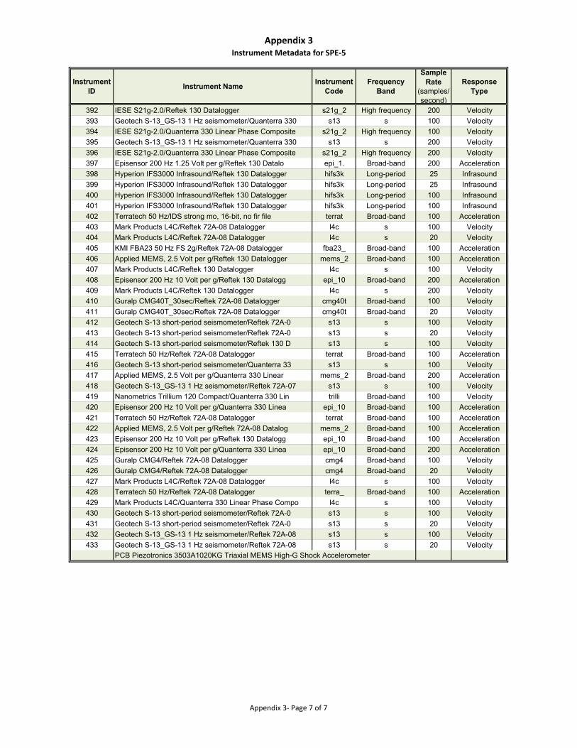
Appendix 3Instrument Metadata for SPE‐5
Instrument ID
Instrument NameInstrument
CodeFrequency
Band
Sample Rate
(samples/second)
Response Type
392 IESE S21g-2.0/Reftek 130 Datalogger s21g_2 High frequency 200 Velocity
393 Geotech S-13_GS-13 1 Hz seismometer/Quanterra 330 s13 s 100 Velocity
394 IESE S21g-2.0/Quanterra 330 Linear Phase Composite s21g_2 High frequency 100 Velocity
395 Geotech S-13_GS-13 1 Hz seismometer/Quanterra 330 s13 s 200 Velocity
396 IESE S21g-2.0/Quanterra 330 Linear Phase Composite s21g_2 High frequency 200 Velocity
397 Episensor 200 Hz 1.25 Volt per g/Reftek 130 Datalo epi_1. Broad-band 200 Acceleration
398 Hyperion IFS3000 Infrasound/Reftek 130 Datalogger hifs3k Long-period 25 Infrasound
399 Hyperion IFS3000 Infrasound/Reftek 130 Datalogger hifs3k Long-period 25 Infrasound
400 Hyperion IFS3000 Infrasound/Reftek 130 Datalogger hifs3k Long-period 100 Infrasound
401 Hyperion IFS3000 Infrasound/Reftek 130 Datalogger hifs3k Long-period 100 Infrasound
402 Terratech 50 Hz/IDS strong mo, 16-bit, no fir file terrat Broad-band 100 Acceleration
403 Mark Products L4C/Reftek 72A-08 Datalogger l4c s 100 Velocity
404 Mark Products L4C/Reftek 72A-08 Datalogger l4c s 20 Velocity
405 KMI FBA23 50 Hz FS 2g/Reftek 72A-08 Datalogger fba23_ Broad-band 100 Acceleration
406 Applied MEMS, 2.5 Volt per g/Reftek 130 Datalogger mems_2 Broad-band 100 Acceleration
407 Mark Products L4C/Reftek 130 Datalogger l4c s 100 Velocity
408 Episensor 200 Hz 10 Volt per g/Reftek 130 Datalogg epi_10 Broad-band 200 Acceleration
409 Mark Products L4C/Reftek 130 Datalogger l4c s 200 Velocity
410 Guralp CMG40T_30sec/Reftek 72A-08 Datalogger cmg40t Broad-band 100 Velocity
411 Guralp CMG40T_30sec/Reftek 72A-08 Datalogger cmg40t Broad-band 20 Velocity
412 Geotech S-13 short-period seismometer/Reftek 72A-0 s13 s 100 Velocity
413 Geotech S-13 short-period seismometer/Reftek 72A-0 s13 s 20 Velocity
414 Geotech S-13 short-period seismometer/Reftek 130 D s13 s 100 Velocity
415 Terratech 50 Hz/Reftek 72A-08 Datalogger terrat Broad-band 100 Acceleration
416 Geotech S-13 short-period seismometer/Quanterra 33 s13 s 100 Velocity
417 Applied MEMS, 2.5 Volt per g/Quanterra 330 Linear mems_2 Broad-band 200 Acceleration
418 Geotech S-13_GS-13 1 Hz seismometer/Reftek 72A-07 s13 s 100 Velocity
419 Nanometrics Trillium 120 Compact/Quanterra 330 Lin trilli Broad-band 100 Velocity
420 Episensor 200 Hz 10 Volt per g/Quanterra 330 Linea epi_10 Broad-band 100 Acceleration
421 Terratech 50 Hz/Reftek 72A-08 Datalogger terrat Broad-band 100 Acceleration
422 Applied MEMS, 2.5 Volt per g/Reftek 72A-08 Datalog mems_2 Broad-band 100 Acceleration
423 Episensor 200 Hz 10 Volt per g/Reftek 130 Datalogg epi_10 Broad-band 100 Acceleration
424 Episensor 200 Hz 10 Volt per g/Quanterra 330 Linea epi_10 Broad-band 200 Acceleration
425 Guralp CMG4/Reftek 72A-08 Datalogger cmg4 Broad-band 100 Velocity
426 Guralp CMG4/Reftek 72A-08 Datalogger cmg4 Broad-band 20 Velocity
427 Mark Products L4C/Reftek 72A-08 Datalogger l4c s 100 Velocity
428 Terratech 50 Hz/Reftek 72A-08 Datalogger terra_ Broad-band 100 Acceleration
429 Mark Products L4C/Quanterra 330 Linear Phase Compo l4c s 100 Velocity
430 Geotech S-13 short-period seismometer/Reftek 72A-0 s13 s 100 Velocity
431 Geotech S-13 short-period seismometer/Reftek 72A-0 s13 s 20 Velocity
432 Geotech S-13_GS-13 1 Hz seismometer/Reftek 72A-08 s13 s 100 Velocity
433 Geotech S-13_GS-13 1 Hz seismometer/Reftek 72A-08 s13 s 20 Velocity
PCB Piezotronics 3503A1020KG Triaxial MEMS High-G Shock Accelerometer
Appendix 3‐ Page 7 of 7
Appendix 4
Selected Metadata for SPE-6 Borehole Sensors
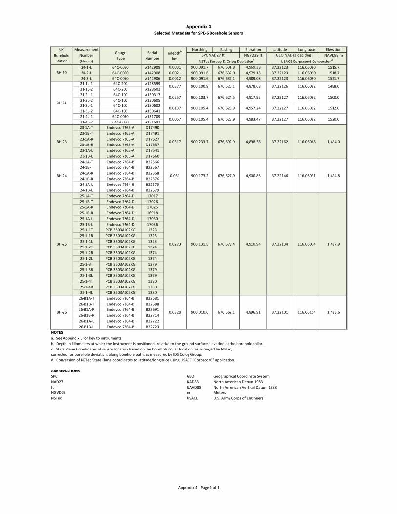
Appendix 4Selected Metadata for SPE‐6 Borehole Sensors
Measurement Northing Easting Elevation Latitude Longitude Elevation
Number NGVD29 ft NAVD88 m
(bh‐c‐o)
20‐1‐L 64C‐0050 A142909 0.0031 900,091.7 676,631.8 4,969.38 37.22123 116.06090 1515.7
20‐2‐L 64C‐0050 A142908 0.0021 900,091.6 676,632.0 4,979.18 37.22123 116.06090 1518.7
20‐3‐L 64C‐0050 A142906 0.0012 900,091.6 676,632.1 4,989.08 37.22123 116.06090 1521.7
21‐1L‐1 64C‐200 A128599
21‐1L‐2 64C‐200 A128602
21‐2L‐1 64C‐100 A130317
21‐2L‐2 64C‐100 A130605
21‐3L‐1 64C‐100 A130602
21‐3L‐2 64C‐100 A130641
21‐4L‐1 64C‐0050 A131709
21‐4L‐2 64C‐0050 A131692
23‐1A‐T Endevco 7265‐A D17490
23‐1B‐T Endevco 7265‐A D17491
23‐1A‐R Endevco 7265‐A D17527
23‐1B‐R Endevco 7265‐A D17537
23‐1A‐L Endevco 7265‐A D17541
23‐1B‐L Endevco 7265‐A D17560
24‐1A‐T Endevco 7264‐B B22566
24‐1B‐T Endevco 7264‐B B22567
24‐1A‐R Endevco 7264‐B B22568
24‐1B‐R Endevco 7264‐B B22576
24‐1A‐L Endevco 7264‐B B22579
24‐1B‐L Endevco 7264‐B B22679
25‐1A‐T Endevco 7264‐D 17017
25‐1B‐T Endevco 7264‐D 17026
25‐1A‐R Endevco 7264‐D 17025
25‐1B‐R Endevco 7264‐D 16918
25‐1A‐L Endevco 7264‐D 17030
25‐1B‐L Endevco 7264‐D 17036
25‐1‐1T PCB 3503A102KG 1323
25‐1‐1R PCB 3503A102KG 1323
25‐1‐1L PCB 3503A102KG 1323
25‐1‐2T PCB 3503A102KG 1374
25‐1‐2R PCB 3503A102KG 1374
25‐1‐2L PCB 3503A102KG 1374
25‐1‐3T PCB 3503A102KG 1379
25‐1‐3R PCB 3503A102KG 1379
25‐1‐3L PCB 3503A102KG 1379
25‐1‐4T PCB 3503A102KG 1380
25‐1‐4R PCB 3503A102KG 1380
25‐1‐4L PCB 3503A102KG 1380
26‐B1A‐T Endevco 7264‐B B22681
26‐B1B‐T Endevco 7264‐B B22688
26‐B1A‐R Endevco 7264‐B B22691
26‐B1B‐R Endevco 7264‐B B22714
26‐B1A‐L Endevco 7264‐B B22722
26‐B1B‐L Endevco 7264‐B B22723
NOTESa. See Appendix 3 for key to instruments.
b. Depth in kilometers at which the instrument is positioned, relative to the ground surface elevation at the borehole collar.
c. State Plane Coordinates at sensor location based on the borehole collar location, as surveyed by NSTec,
corrected for borehole deviation, along borehole path, as measured by IDS Colog Group.
d. Conversion of NSTec State Plane coordinates to latitude/longitude using USACE "Corpscon6" application.
ABBREVIATIONSSPC GEO Geographical Coordinate System
NAD27 NAD83 North American Datum 1983
ft NAVD88 North American Vertical Datum 1988
NGVD29 m Meters
NSTec USACE U.S. Army Corps of Engineers
BH‐21
BH‐20
BH‐26
BH‐25
BH‐24
BH‐23
0.0377
0.0257
0.0057
0.0137
116.0609237.221264,878.68676,625.1900,100.9
116.0609237.221274,917.92676,624.5900,103.7
900,105.4 676,623.9
SPE
Borehole
Station
GEO NAD83 dec degSPC NAD27 ft
NSTec Survey & Colog Deviationc USACE Corpscon6 Conversiond
edepthb
km
Serial
Number
Gauge
Type
0.031
0.0317
116.06114 1,493.6
1,497.9116.0607437.221344,910.94676,678.4900,131.5
0.0320
0.0273
1,494.0116.0606837.221624,898.38676,692.9900,233.7
1,494.8
900,010.6 676,562.1 4,896.91 37.22101
116.0609137.221464,900.86676,627.9900,173.2
676,623.9900,105.4
1488.0
1500.0
4,983.47 37.22127 116.06092 1520.0
1512.0116.0609237.221274,957.24
Appendix 4 ‐ Page 1 of 1

Appendix 5
Instrument Metadata for SPE-6
Appendix 5Instrument Metadata for SPE‐6
Instrument ID
Instrument NameInstrument
CodeFrequency Band
Sample Rate
(samples/second)
Response Type
1 Chapparral 2.5 microphone/Reftek 130 Datalogger chapar Long-period 250 Infrasound
2 Nanometrics Trillium 120 Compact/Reftek 130 Datalo trilli Broad-band 250 Velocity
3 Geospace GS-11D 380ohm/Reftek 130 Datalogger gs11d High frequency 500 Velocity
4 Geospace GS-11D 380ohm/Reftek 130 Datalogger gs11d High frequency 500 Velocity
5 Geospace GS-11D 380ohm/Reftek 130 Datalogger gs11d High frequency 250 Velocity
6 Geospace GS-11D 380ohm/Reftek 130 Datalogger gs11d High frequency 125 Velocity
7 IML ST Infrasound/Reftek 130 Datalogger iml_st Long-period 250 Infrasound
8 New Mexico Tech InfraNMT_xxC/Reftek 130 Datalogger infran Long-period 250 Infrasound
9 Chapparral 2.5 microphone/Reftek 130 Datalogger chapar Long-period 500 Infrasound
10 Geospace GS-11D 380ohm/Reftek 130 Datalogger gs11d High frequency 125 Velocity
11 EMI BF6 magnetometer/Reftek 130 Datalogger emi_bf Broad-band 500 N
12 Geospace GS-11D 380ohm/Reftek 130 Datalogger gs11d High frequency 250 Velocity
13 Geospace GS-11D 380ohm/Reftek 130 Datalogger gs11d High frequency 100 Velocity
14 Episensor 200 Hz 1.25 Volt per g/Reftek 130 Datalo epi_1. Broad-band 500 Acceleration
15 Eentec R1 Rotational Seismometer/Reftek 130 Datalo eentec Broad-band 500 Velocity
16 Episensor 200 Hz 1.25 Volt per g/Reftek 130 Datalo epi_1. Broad-band 250 Acceleration
17 Eentec R1 Rotational Seismometer/Reftek 130 Datalo eentec Broad-band 250 Velocity
18 Guralp CMG40T_30sec/Reftek 130 Datalogger cmg40t Broad-band 500 Velocity
19 Guralp CMG40T_30sec/Reftek 130 Datalogger cmg40t Broad-band 500 Velocity
20 Guralp CMG40T_30sec/Reftek 130 Datalogger cmg40t Broad-band 250 Velocity
21 Guralp CMG40T_30sec/Reftek 130 Datalogger cmg40t Broad-band 250 Velocity
22 Guralp CMG40T_30sec/Reftek 130 Datalogger cmg40t Broad-band 125 Velocity
23 Guralp CMG40T_30sec/Reftek 130 Datalogger cmg40t Broad-band 100 Velocity
24 Guralp CMG40T_30sec/Reftek 130 Datalogger cmg40t Broad-band 125 Velocity
25 Nanometrics Trillium 120 Compact/Reftek 130 Datalo trilli Broad-band 500 Velocity
26 Nanometrics Trillium 120 Compact/Reftek 130 Datalo trilli Broad-band 100 Velocity
27 Nanometrics Trillium 120 Compact/Reftek 130 Datalo trilli Broad-band 500 Velocity
28 Nanometrics Trillium 120 Compact/Reftek 130 Datalo trilli Broad-band 100 Velocity
Appendix 5 ‐ Page 1 of 16
Appendix 5Instrument Metadata for SPE‐6
Instrument ID
Instrument NameInstrument
CodeFrequency Band
Sample Rate
(samples/second)
Response Type
29 Nanometrics Trillium 120 Compact/Reftek 130 Datalo trilli Broad-band 250 Velocity
30 Episensor 200 Hz 1.25 Volt per g/Reftek 130 Datalo epi_1. Broad-band 500 Acceleration
31 Eentec R1 Rotational Seismometer/Reftek 130 Datalo eentec Broad-band 500 Velocity
32 Episensor 200 Hz 1.25 Volt per g/Reftek 130 Datalo epi_1. Broad-band 125 Acceleration
33 Eentec R1 Rotational Seismometer/Reftek 130 Datalo eentec Broad-band 125 Velocity
34 Chapparral 2.5 microphone/Reftek 130 Datalogger chapar Long-period 250 Infrasound
35 PMD SP400U3/Reftek 130 Datalogger SP400U Broad-band 250 Velocity
36 PMD SP400U3/Reftek 130 Datalogger SP400U Broad-band 250 Velocity
37 PMD SP400U3/Reftek 130 Datalogger SP400U Broad-band 250 Velocity
38 Episensor 200 Hz 1.25 Volt per g/Reftek 130 Datalo epi_1. Broad-band 250 Acceleration
39 EGE-73A Accelerometer 5000g/DTRA Datalogger ege73a Broad-band 1000000 Acceleration
40 7264B Accelerometer 2000g/DTRA Datalogger e7264b Broad-band 1000000 Acceleration
41 7264B Accelerometer 2000g/DTRA Datalogger e7264b Broad-band 1000000 Acceleration
42 EGE-73A Accelerometer 5000g/DTRA Datalogger ege73a Broad-band 1000000 Acceleration
43 7264C Accelerometer 500g/DTRA Datalogger e7264c Broad-band 1000000 Acceleration
44 7264C Accelerometer 500g/DTRA Datalogger e7264c Broad-band 1000000 Acceleration
45 7264B Accelerometer 2000g/DTRA Datalogger e7264b Broad-band 1000000 Acceleration
46 EGE-73A Accelerometer 5000g/DTRA Datalogger ege73a Broad-band 1000000 Acceleration
47 7264C Accelerometer 500g/DTRA Datalogger e7264c Broad-band 1000000 Acceleration
48 7264C Accelerometer 500g/DTRA Datalogger e7264c Broad-band 1000000 Acceleration
49 EGE-73A Accelerometer 5000g/DTRA Datalogger ege73a Broad-band 500000 Acceleration
50 7264C Accelerometer 500g/DTRA Datalogger e7264c Broad-band 500000 Acceleration
51 7264C Accelerometer 500g/DTRA Datalogger e7264c Broad-band 500000 Acceleration
52 EGE-73A Accelerometer 5000g/DTRA Datalogger ege73a Broad-band 1000000 Acceleration
53 7264B Accelerometer 2000g/DTRA Datalogger e7264b Broad-band 1000000 Acceleration
54 7264B Accelerometer 2000g/DTRA Datalogger e7264b Broad-band 1000000 Acceleration
55 EGE-73A Accelerometer 5000g/DTRA Datalogger ege73a Broad-band 1000000 Acceleration
56 7264B Accelerometer 2000g/DTRA Datalogger e7264b Broad-band 1000000 Acceleration
Appendix 5 ‐ Page 2 of 16
Appendix 5Instrument Metadata for SPE‐6
Instrument ID
Instrument NameInstrument
CodeFrequency Band
Sample Rate
(samples/second)
Response Type
57 7264B Accelerometer 2000g/DTRA Datalogger e7264b Broad-band 1000000 Acceleration
58 EGE-73A Accelerometer 5000g/DTRA Datalogger ege73a Broad-band 1000000 Acceleration
59 7264C Accelerometer 500g/DTRA Datalogger e7264c Broad-band 1000000 Acceleration
60 7264C Accelerometer 500g/DTRA Datalogger e7264c Broad-band 1000000 Acceleration
61 EGE-73A Accelerometer 5000g/DTRA Datalogger ege73a Broad-band 1000000 Acceleration
62 EGE-73A Accelerometer 5000g/DTRA Datalogger ege73a Broad-band 1000000 Acceleration
63 7264B Accelerometer 2000g/DTRA Datalogger e7264b Broad-band 1000000 Acceleration
64 7264B Accelerometer 2000g/DTRA Datalogger e7264b Broad-band 1000000 Acceleration
65 EGE-73A Accelerometer 5000g/DTRA Datalogger ege73a Broad-band 1000000 Acceleration
66 7264C Accelerometer 500g/DTRA Datalogger e7264c Broad-band 1000000 Acceleration
67 7264C Accelerometer 500g/DTRA Datalogger e7264c Broad-band 1000000 Acceleration
68 EGE-73A Accelerometer 5000g/DTRA Datalogger ege73a Broad-band 500000 Acceleration
69 7264B Accelerometer 2000g/DTRA Datalogger e7264b Broad-band 500000 Acceleration
70 7264B Accelerometer 2000g/DTRA Datalogger e7264b Broad-band 500000 Acceleration
71 7264B Accelerometer 2000g/DTRA Datalogger e7264b Broad-band 500000 Acceleration
72 7264B Accelerometer 2000g/DTRA Datalogger e7264b Broad-band 500000 Acceleration
73 EGE-73A Accelerometer 5000g/DTRA Datalogger ege73a Broad-band 500000 Acceleration
74 7264C Accelerometer 500g/DTRA Datalogger e7264c Broad-band 500000 Acceleration
75 7264C Accelerometer 500g/DTRA Datalogger e7264c Broad-band 500000 Acceleration
76 EGE-73A Accelerometer 5000g/DTRA Datalogger ege73a Broad-band 1000000 Acceleration
77 7264B Accelerometer 2000g/DTRA Datalogger e7264b Broad-band 1000000 Acceleration
78 7264B Accelerometer 2000g/DTRA Datalogger e7264b Broad-band 1000000 Acceleration
79 EGE-73A Accelerometer 5000g/DTRA Datalogger ege73a Broad-band 1000000 Acceleration
80 7264C Accelerometer 500g/DTRA Datalogger e7264c Broad-band 1000000 Acceleration
81 7264C Accelerometer 500g/DTRA Datalogger e7264c Broad-band 1000000 Acceleration
82 EGE-73A Accelerometer 5000g/DTRA Datalogger ege73a Broad-band 1000000 Acceleration
83 7264B Accelerometer 2000g/DTRA Datalogger e7264b Broad-band 1000000 Acceleration
84 EGE-73A Accelerometer 5000g/DTRA Datalogger ege73a Broad-band 1000000 Acceleration
Appendix 5 ‐ Page 3 of 16
Appendix 5Instrument Metadata for SPE‐6
Instrument ID
Instrument NameInstrument
CodeFrequency Band
Sample Rate
(samples/second)
Response Type
85 7264B Accelerometer 2000g/DTRA Datalogger e7264b Broad-band 1000000 Acceleration
86 7264B Accelerometer 2000g/DTRA Datalogger e7264b Broad-band 1000000 Acceleration
87 EGE-73A Accelerometer 5000g/DTRA Datalogger ege73a Broad-band 1000000 Acceleration
88 7264C Accelerometer 500g/DTRA Datalogger e7264c Broad-band 1000000 Acceleration
89 7264C Accelerometer 500g/DTRA Datalogger e7264c Broad-band 1000000 Acceleration
90 EGE-73A Accelerometer 5000g/DTRA Datalogger ege73a Broad-band 1000000 Acceleration
91 7264B Accelerometer 2000g/DTRA Datalogger e7264b Broad-band 1000000 Acceleration
92 7264B Accelerometer 2000g/DTRA Datalogger e7264b Broad-band 1000000 Acceleration
93 EGE-73A Accelerometer 5000g/DTRA Datalogger ege73a Broad-band 1000000 Acceleration
94 7264C Accelerometer 500g/DTRA Datalogger e7264c Broad-band 1000000 Acceleration
95 7264C Accelerometer 500g/DTRA Datalogger e7264c Broad-band 1000000 Acceleration
96 EGE-73A Accelerometer 5000g/DTRA Datalogger ege73a Broad-band 500000 Acceleration
97 7264C Accelerometer 500g/DTRA Datalogger e7264c Broad-band 500000 Acceleration
98 7264C Accelerometer 500g/DTRA Datalogger e7264c Broad-band 500000 Acceleration
99 EGE-73A Accelerometer 5000g/DTRA Datalogger ege73a Broad-band 1000000 Acceleration
100 7264C Accelerometer 500g/DTRA Datalogger e7264c Broad-band 1000000 Acceleration
101 7264C Accelerometer 500g/DTRA Datalogger e7264c Broad-band 1000000 Acceleration
102 7264B Accelerometer 2000g/DTRA Datalogger e7264b Broad-band 1000000 Acceleration
103 EGE-73A Accelerometer 5000g/DTRA Datalogger ege73a Broad-band 1000000 Acceleration
104 EGE-73A Accelerometer 5000g/DTRA Datalogger ege73a Broad-band 1000000 Acceleration
105 7264B Accelerometer 2000g/DTRA Datalogger e7264b Broad-band 1000000 Acceleration
106 EGE-73A Accelerometer 5000g/DTRA Datalogger ege73a Broad-band 1000000 Acceleration
107 EGE-73A Accelerometer 5000g/DTRA Datalogger ege73a Broad-band 1000000 Acceleration
108 7264C Accelerometer 500g/DTRA Datalogger e7264c Broad-band 1000000 Acceleration
109 EGE-73A Accelerometer 5000g/DTRA Datalogger ege73a Broad-band 1000000 Acceleration
110 EGE-73A Accelerometer 5000g/DTRA Datalogger ege73a Broad-band 1000000 Acceleration
111 7264B Accelerometer 2000g/DTRA Datalogger e7264b Broad-band 1000000 Acceleration
112 EGE-73A Accelerometer 5000g/DTRA Datalogger ege73a Broad-band 1000000 Acceleration
Appendix 5 ‐ Page 4 of 16
Appendix 5Instrument Metadata for SPE‐6
Instrument ID
Instrument NameInstrument
CodeFrequency Band
Sample Rate
(samples/second)
Response Type
113 EGE-73A Accelerometer 5000g/DTRA Datalogger ege73a Broad-band 1000000 Acceleration
114 7264B Accelerometer 2000g/DTRA Datalogger e7264b Broad-band 1000000 Acceleration
115 EGE-73A Accelerometer 5000g/DTRA Datalogger ege73a Broad-band 1000000 Acceleration
116 EGE-73A Accelerometer 5000g/DTRA Datalogger ege73a Broad-band 1000000 Acceleration
117 7264C Accelerometer 500g/DTRA Datalogger e7264c Broad-band 1000000 Acceleration
118 EGE-73A Accelerometer 5000g/DTRA Datalogger ege73a Broad-band 1000000 Acceleration
119 EGE-73A Accelerometer 5000g/DTRA Datalogger ege73a Broad-band 1000000 Acceleration
120 7264B Accelerometer 2000g/DTRA Datalogger e7264b Broad-band 500000 Acceleration
121 7264B Accelerometer 2000g/DTRA Datalogger e7264b Broad-band 500000 Acceleration
122 EGE-73A Accelerometer 5000g/DTRA Datalogger ege73a Broad-band 500000 Acceleration
123 EGE-73A Accelerometer 5000g/DTRA Datalogger ege73a Broad-band 500000 Acceleration
124 7264C Accelerometer 500g/DTRA Datalogger e7264c Broad-band 500000 Acceleration
125 EGE-73A Accelerometer 5000g/DTRA Datalogger ege73a Broad-band 500000 Acceleration
126 EGE-73A Accelerometer 5000g/DTRA Datalogger ege73a Broad-band 500000 Acceleration
127 7264B Accelerometer 2000g/DTRA Datalogger e7264b Broad-band 1000000 Acceleration
128 7264C Accelerometer 500g/DTRA Datalogger e7264c Broad-band 1000000 Acceleration
129 EGE-73A Accelerometer 5000g/DTRA Datalogger ege73a Broad-band 1000000 Acceleration
130 EGE-73A Accelerometer 5000g/DTRA Datalogger ege73a Broad-band 1000000 Acceleration
131 7264B Accelerometer 2000g/DTRA Datalogger e7264b Broad-band 1000000 Acceleration
132 7264B Accelerometer 2000g/DTRA Datalogger e7264b Broad-band 1000000 Acceleration
133 7264B Accelerometer 2000g/DTRA Datalogger e7264b Broad-band 1000000 Acceleration
134 7264C Accelerometer 500g/DTRA Datalogger e7264c Broad-band 1000000 Acceleration
135 EGE-73A Accelerometer 5000g/DTRA Datalogger ege73a Broad-band 1000000 Acceleration
136 EGE-73A Accelerometer 5000g/DTRA Datalogger ege73a Broad-band 1000000 Acceleration
137 7264B Accelerometer 2000g/DTRA Datalogger e7264b Broad-band 1000000 Acceleration
138 7264B Accelerometer 2000g/DTRA Datalogger e7264b Broad-band 1000000 Acceleration
139 7264B Accelerometer 2000g/DTRA Datalogger e7264b Broad-band 1000000 Acceleration
140 7264C Accelerometer 500g/DTRA Datalogger e7264c Broad-band 1000000 Acceleration
141 EGE-73A Accelerometer 5000g/DTRA Datalogger ege73a Broad-band 1000000 Acceleration
Appendix 5 ‐ Page 5 of 16
Appendix 5Instrument Metadata for SPE‐6
Instrument ID
Instrument NameInstrument
CodeFrequency Band
Sample Rate
(samples/second)
Response Type
142 EGE-73A Accelerometer 5000g/DTRA Datalogger ege73a Broad-band 1000000 Acceleration
143 7264B Accelerometer 2000g/DTRA Datalogger e7264b Broad-band 500000 Acceleration
144 7264B Accelerometer 2000g/DTRA Datalogger e7264b Broad-band 500000 Acceleration
145 7264B Accelerometer 2000g/DTRA Datalogger e7264b Broad-band 500000 Acceleration
146 7264C Accelerometer 500g/DTRA Datalogger e7264c Broad-band 500000 Acceleration
147 EGE-73A Accelerometer 5000g/DTRA Datalogger ege73a Broad-band 500000 Acceleration
148 EGE-73A Accelerometer 5000g/DTRA Datalogger ege73a Broad-band 500000 Acceleration
149 7264B Accelerometer 2000g/DTRA Datalogger e7264b Broad-band 1000000 Acceleration
150 7264C Accelerometer 500g/DTRA Datalogger e7264c Broad-band 1000000 Acceleration
151 EGE-73A Accelerometer 5000g/DTRA Datalogger ege73a Broad-band 1000000 Acceleration
152 EGE-73A Accelerometer 5000g/DTRA Datalogger ege73a Broad-band 1000000 Acceleration
153 7264B Accelerometer 2000g/DTRA Datalogger e7264b Broad-band 1000000 Acceleration
154 EGE-73A Accelerometer 5000g/DTRA Datalogger ege73a Broad-band 1000000 Acceleration
155 EGE-73A Accelerometer 5000g/DTRA Datalogger ege73a Broad-band 1000000 Acceleration
156 7264B Accelerometer 2000g/DTRA Datalogger e7264b Broad-band 1000000 Acceleration
157 EGE-73A Accelerometer 5000g/DTRA Datalogger ege73a Broad-band 1000000 Acceleration
158 EGE-73A Accelerometer 5000g/DTRA Datalogger ege73a Broad-band 1000000 Acceleration
159 EGE-73A Accelerometer 5000g/DTRA Datalogger ege73a Broad-band 1000000 Acceleration
160 EGE-73A Accelerometer 5000g/DTRA Datalogger ege73a Broad-band 1000000 Acceleration
161 EGE-73A Accelerometer 5000g/DTRA Datalogger ege73a Broad-band 1000000 Acceleration
162 7264B Accelerometer 2000g/DTRA Datalogger e7264b Broad-band 1000000 Acceleration
163 7264B Accelerometer 2000g/DTRA Datalogger e7264b Broad-band 1000000 Acceleration
164 EGE-73A Accelerometer 5000g/DTRA Datalogger ege73a Broad-band 1000000 Acceleration
165 EGE-73A Accelerometer 5000g/DTRA Datalogger ege73a Broad-band 1000000 Acceleration
166 EGE-73A Accelerometer 5000g/DTRA Datalogger ege73a Broad-band 1000000 Acceleration
167 EGE-73A Accelerometer 5000g/DTRA Datalogger ege73a Broad-band 1000000 Acceleration
168 EGE-73A Accelerometer 5000g/DTRA Datalogger ege73a Broad-band 1000000 Acceleration
Appendix 5 ‐ Page 6 of 16
Appendix 5Instrument Metadata for SPE‐6
Instrument ID
Instrument NameInstrument
CodeFrequency Band
Sample Rate
(samples/second)
Response Type
169 7264B Accelerometer 2000g/DTRA Datalogger e7264b Broad-band 500000 Acceleration
170 EGE-73A Accelerometer 5000g/DTRA Datalogger ege73a Broad-band 500000 Acceleration
171 7264B Accelerometer 2000g/DTRA Datalogger e7264b Broad-band 500000 Acceleration
172 EGE-73A Accelerometer 5000g/DTRA Datalogger ege73a Broad-band 500000 Acceleration
173 EGE-73A Accelerometer 5000g/DTRA Datalogger ege73a Broad-band 500000 Acceleration
174 EGE-73A Accelerometer 5000g/DTRA Datalogger ege73a Broad-band 500000 Acceleration
175 EGE-73A Accelerometer 5000g/DTRA Datalogger ege73a Broad-band 500000 Acceleration
176 EGE-73A Accelerometer 5000g/DTRA Datalogger ege73a Broad-band 500000 Acceleration
177 7264B Accelerometer 2000g/DTRA Datalogger e7264b Broad-band 1000000 Acceleration
178 EGE-73A Accelerometer 5000g/DTRA Datalogger ege73a Broad-band 1000000 Acceleration
179 7264B Accelerometer 2000g/DTRA Datalogger e7264b Broad-band 1000000 Acceleration
180 EGE-73A Accelerometer 5000g/DTRA Datalogger ege73a Broad-band 1000000 Acceleration
181 EGE-73A Accelerometer 5000g/DTRA Datalogger ege73a Broad-band 1000000 Acceleration
182 EGE-73A Accelerometer 5000g/DTRA Datalogger ege73a Broad-band 1000000 Acceleration
183 EGE-73A Accelerometer 5000g/DTRA Datalogger ege73a Broad-band 1000000 Acceleration
184 EGE-73A Accelerometer 5000g/DTRA Datalogger ege73a Broad-band 1000000 Acceleration
185 7264G Accelerometer 2000g/DTRA Datalogger e7264g Broad-band 500000 Acceleration
186 7264C Accelerometer 500g/DTRA Datalogger e7264c Broad-band 500000 Acceleration
187 7264C Accelerometer 500g/DTRA Datalogger e7264c Broad-band 500000 Acceleration
188 7264G Accelerometer 2000g/DTRA Datalogger e7264g Broad-band 500000 Acceleration
189 7264C Accelerometer 500g/DTRA Datalogger e7264c Broad-band 500000 Acceleration
190 7264C Accelerometer 500g/DTRA Datalogger e7264c Broad-band 500000 Acceleration
191 7264C Accelerometer 500g/DTRA Datalogger e7264c Broad-band 500000 Acceleration
192 7264G Accelerometer 2000g/DTRA Datalogger e7264g Broad-band 1000000 Acceleration
193 7264C Accelerometer 500g/DTRA Datalogger e7264c Broad-band 1000000 Acceleration
194 7264C Accelerometer 500g/DTRA Datalogger e7264c Broad-band 1000000 Acceleration
195 7264G Accelerometer 2000g/DTRA Datalogger e7264g Broad-band 1000000 Acceleration
196 7264C Accelerometer 500g/DTRA Datalogger e7264c Broad-band 1000000 Acceleration
Appendix 5 ‐ Page 7 of 16
Appendix 5Instrument Metadata for SPE‐6
Instrument ID
Instrument NameInstrument
CodeFrequency Band
Sample Rate
(samples/second)
Response Type
197 7264C Accelerometer 500g/DTRA Datalogger e7264c Broad-band 1000000 Acceleration
198 7264C Accelerometer 500g/DTRA Datalogger e7264c Broad-band 1000000 Acceleration
199 7264C Accelerometer 500g/DTRA Datalogger e7264c Broad-band 1000000 Acceleration
200 7264C Accelerometer 500g/DTRA Datalogger e7264c Broad-band 1000000 Acceleration
201 EGE-73A Accelerometer 5000g/DTRA Datalogger ege73a Broad-band 500000 Acceleration
202 7264G Accelerometer 2000g/DTRA Datalogger e7264g Broad-band 500000 Acceleration
203 7264G Accelerometer 2000g/DTRA Datalogger e7264g Broad-band 500000 Acceleration
204 EGE-73A Accelerometer 5000g/DTRA Datalogger ege73a Broad-band 500000 Acceleration
205 7264G Accelerometer 2000g/DTRA Datalogger e7264g Broad-band 500000 Acceleration
206 7264C Accelerometer 500g/DTRA Datalogger e7264c Broad-band 500000 Acceleration
207 EGE-73A Accelerometer 5000g/DTRA Datalogger ege73a Broad-band 1000000 Acceleration
208 7264G Accelerometer 2000g/DTRA Datalogger e7264g Broad-band 1000000 Acceleration
209 7264G Accelerometer 2000g/DTRA Datalogger e7264g Broad-band 1000000 Acceleration
210 EGE-73A Accelerometer 5000g/DTRA Datalogger ege73a Broad-band 1000000 Acceleration
211 7264G Accelerometer 2000g/DTRA Datalogger e7264g Broad-band 1000000 Acceleration
212 7264G Accelerometer 2000g/DTRA Datalogger e7264g Broad-band 1000000 Acceleration
213 7264C Accelerometer 500g/DTRA Datalogger e7264c Broad-band 1000000 Acceleration
214 7264C Accelerometer 500g/DTRA Datalogger e7264c Broad-band 1000000 Acceleration
215 7264C Accelerometer 500g/DTRA Datalogger e7264c Broad-band 1000000 Acceleration
216 7264G Accelerometer 2000g/DTRA Datalogger e7264g Broad-band 500000 Acceleration
217 7264C Accelerometer 500g/DTRA Datalogger e7264c Broad-band 500000 Acceleration
218 7264C Accelerometer 500g/DTRA Datalogger e7264c Broad-band 500000 Acceleration
219 7264G Accelerometer 2000g/DTRA Datalogger e7264g Broad-band 500000 Acceleration
220 7264C Accelerometer 500g/DTRA Datalogger e7264c Broad-band 500000 Acceleration
221 7264C Accelerometer 500g/DTRA Datalogger e7264c Broad-band 500000 Acceleration
222 7264G Accelerometer 2000g/DTRA Datalogger e7264g Broad-band 500000 Acceleration
223 7264C Accelerometer 500g/DTRA Datalogger e7264c Broad-band 500000 Acceleration
224 7264C Accelerometer 500g/DTRA Datalogger e7264c Broad-band 500000 Acceleration
Appendix 5 ‐ Page 8 of 16
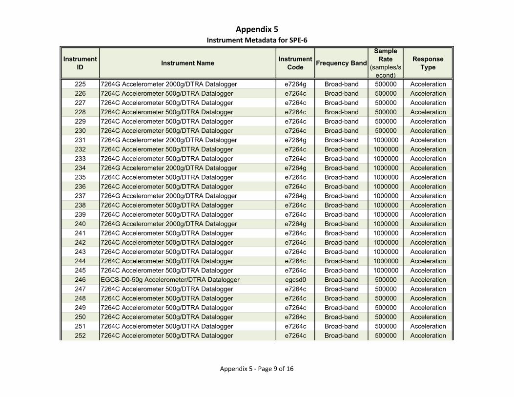
Appendix 5Instrument Metadata for SPE‐6
Instrument ID
Instrument NameInstrument
CodeFrequency Band
Sample Rate
(samples/second)
Response Type
225 7264G Accelerometer 2000g/DTRA Datalogger e7264g Broad-band 500000 Acceleration
226 7264C Accelerometer 500g/DTRA Datalogger e7264c Broad-band 500000 Acceleration
227 7264C Accelerometer 500g/DTRA Datalogger e7264c Broad-band 500000 Acceleration
228 7264C Accelerometer 500g/DTRA Datalogger e7264c Broad-band 500000 Acceleration
229 7264C Accelerometer 500g/DTRA Datalogger e7264c Broad-band 500000 Acceleration
230 7264C Accelerometer 500g/DTRA Datalogger e7264c Broad-band 500000 Acceleration
231 7264G Accelerometer 2000g/DTRA Datalogger e7264g Broad-band 1000000 Acceleration
232 7264C Accelerometer 500g/DTRA Datalogger e7264c Broad-band 1000000 Acceleration
233 7264C Accelerometer 500g/DTRA Datalogger e7264c Broad-band 1000000 Acceleration
234 7264G Accelerometer 2000g/DTRA Datalogger e7264g Broad-band 1000000 Acceleration
235 7264C Accelerometer 500g/DTRA Datalogger e7264c Broad-band 1000000 Acceleration
236 7264C Accelerometer 500g/DTRA Datalogger e7264c Broad-band 1000000 Acceleration
237 7264G Accelerometer 2000g/DTRA Datalogger e7264g Broad-band 1000000 Acceleration
238 7264C Accelerometer 500g/DTRA Datalogger e7264c Broad-band 1000000 Acceleration
239 7264C Accelerometer 500g/DTRA Datalogger e7264c Broad-band 1000000 Acceleration
240 7264G Accelerometer 2000g/DTRA Datalogger e7264g Broad-band 1000000 Acceleration
241 7264C Accelerometer 500g/DTRA Datalogger e7264c Broad-band 1000000 Acceleration
242 7264C Accelerometer 500g/DTRA Datalogger e7264c Broad-band 1000000 Acceleration
243 7264C Accelerometer 500g/DTRA Datalogger e7264c Broad-band 1000000 Acceleration
244 7264C Accelerometer 500g/DTRA Datalogger e7264c Broad-band 1000000 Acceleration
245 7264C Accelerometer 500g/DTRA Datalogger e7264c Broad-band 1000000 Acceleration
246 EGCS-D0-50g Accelerometer/DTRA Datalogger egcsd0 Broad-band 500000 Acceleration
247 7264C Accelerometer 500g/DTRA Datalogger e7264c Broad-band 500000 Acceleration
248 7264C Accelerometer 500g/DTRA Datalogger e7264c Broad-band 500000 Acceleration
249 7264C Accelerometer 500g/DTRA Datalogger e7264c Broad-band 500000 Acceleration
250 7264C Accelerometer 500g/DTRA Datalogger e7264c Broad-band 500000 Acceleration
251 7264C Accelerometer 500g/DTRA Datalogger e7264c Broad-band 500000 Acceleration
252 7264C Accelerometer 500g/DTRA Datalogger e7264c Broad-band 500000 Acceleration
Appendix 5 ‐ Page 9 of 16
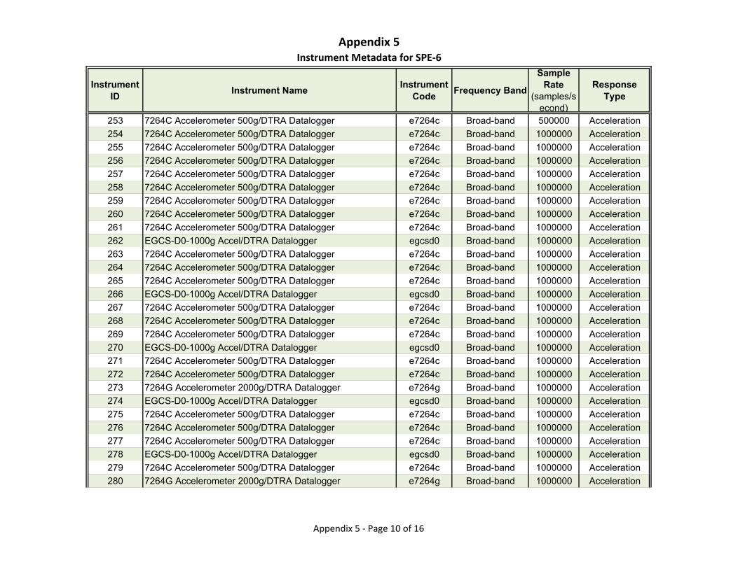
Appendix 5Instrument Metadata for SPE‐6
Instrument ID
Instrument NameInstrument
CodeFrequency Band
Sample Rate
(samples/second)
Response Type
253 7264C Accelerometer 500g/DTRA Datalogger e7264c Broad-band 500000 Acceleration
254 7264C Accelerometer 500g/DTRA Datalogger e7264c Broad-band 1000000 Acceleration
255 7264C Accelerometer 500g/DTRA Datalogger e7264c Broad-band 1000000 Acceleration
256 7264C Accelerometer 500g/DTRA Datalogger e7264c Broad-band 1000000 Acceleration
257 7264C Accelerometer 500g/DTRA Datalogger e7264c Broad-band 1000000 Acceleration
258 7264C Accelerometer 500g/DTRA Datalogger e7264c Broad-band 1000000 Acceleration
259 7264C Accelerometer 500g/DTRA Datalogger e7264c Broad-band 1000000 Acceleration
260 7264C Accelerometer 500g/DTRA Datalogger e7264c Broad-band 1000000 Acceleration
261 7264C Accelerometer 500g/DTRA Datalogger e7264c Broad-band 1000000 Acceleration
262 EGCS-D0-1000g Accel/DTRA Datalogger egcsd0 Broad-band 1000000 Acceleration
263 7264C Accelerometer 500g/DTRA Datalogger e7264c Broad-band 1000000 Acceleration
264 7264C Accelerometer 500g/DTRA Datalogger e7264c Broad-band 1000000 Acceleration
265 7264C Accelerometer 500g/DTRA Datalogger e7264c Broad-band 1000000 Acceleration
266 EGCS-D0-1000g Accel/DTRA Datalogger egcsd0 Broad-band 1000000 Acceleration
267 7264C Accelerometer 500g/DTRA Datalogger e7264c Broad-band 1000000 Acceleration
268 7264C Accelerometer 500g/DTRA Datalogger e7264c Broad-band 1000000 Acceleration
269 7264C Accelerometer 500g/DTRA Datalogger e7264c Broad-band 1000000 Acceleration
270 EGCS-D0-1000g Accel/DTRA Datalogger egcsd0 Broad-band 1000000 Acceleration
271 7264C Accelerometer 500g/DTRA Datalogger e7264c Broad-band 1000000 Acceleration
272 7264C Accelerometer 500g/DTRA Datalogger e7264c Broad-band 1000000 Acceleration
273 7264G Accelerometer 2000g/DTRA Datalogger e7264g Broad-band 1000000 Acceleration
274 EGCS-D0-1000g Accel/DTRA Datalogger egcsd0 Broad-band 1000000 Acceleration
275 7264C Accelerometer 500g/DTRA Datalogger e7264c Broad-band 1000000 Acceleration
276 7264C Accelerometer 500g/DTRA Datalogger e7264c Broad-band 1000000 Acceleration
277 7264C Accelerometer 500g/DTRA Datalogger e7264c Broad-band 1000000 Acceleration
278 EGCS-D0-1000g Accel/DTRA Datalogger egcsd0 Broad-band 1000000 Acceleration
279 7264C Accelerometer 500g/DTRA Datalogger e7264c Broad-band 1000000 Acceleration
280 7264G Accelerometer 2000g/DTRA Datalogger e7264g Broad-band 1000000 Acceleration
Appendix 5 ‐ Page 10 of 16
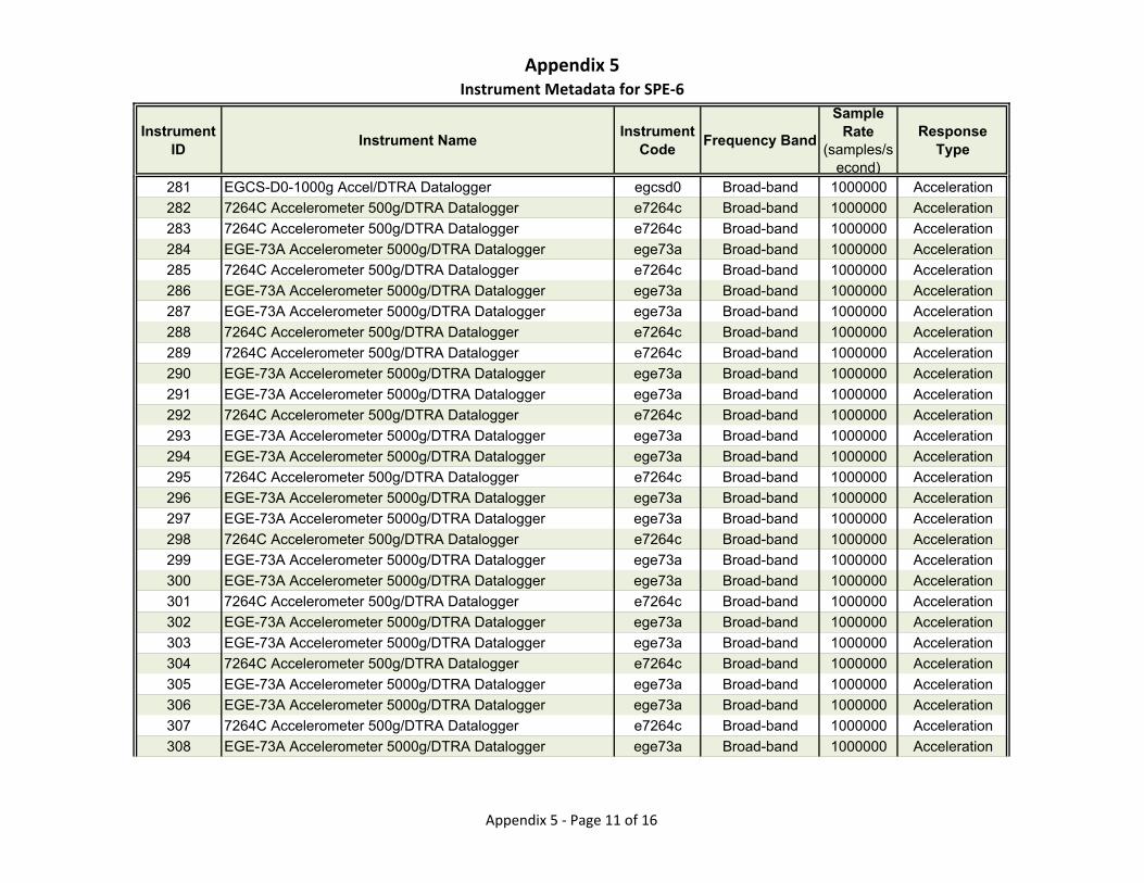
Appendix 5Instrument Metadata for SPE‐6
Instrument ID
Instrument NameInstrument
CodeFrequency Band
Sample Rate
(samples/second)
Response Type
281 EGCS-D0-1000g Accel/DTRA Datalogger egcsd0 Broad-band 1000000 Acceleration
282 7264C Accelerometer 500g/DTRA Datalogger e7264c Broad-band 1000000 Acceleration
283 7264C Accelerometer 500g/DTRA Datalogger e7264c Broad-band 1000000 Acceleration
284 EGE-73A Accelerometer 5000g/DTRA Datalogger ege73a Broad-band 1000000 Acceleration
285 7264C Accelerometer 500g/DTRA Datalogger e7264c Broad-band 1000000 Acceleration
286 EGE-73A Accelerometer 5000g/DTRA Datalogger ege73a Broad-band 1000000 Acceleration
287 EGE-73A Accelerometer 5000g/DTRA Datalogger ege73a Broad-band 1000000 Acceleration
288 7264C Accelerometer 500g/DTRA Datalogger e7264c Broad-band 1000000 Acceleration
289 7264C Accelerometer 500g/DTRA Datalogger e7264c Broad-band 1000000 Acceleration
290 EGE-73A Accelerometer 5000g/DTRA Datalogger ege73a Broad-band 1000000 Acceleration
291 EGE-73A Accelerometer 5000g/DTRA Datalogger ege73a Broad-band 1000000 Acceleration
292 7264C Accelerometer 500g/DTRA Datalogger e7264c Broad-band 1000000 Acceleration
293 EGE-73A Accelerometer 5000g/DTRA Datalogger ege73a Broad-band 1000000 Acceleration
294 EGE-73A Accelerometer 5000g/DTRA Datalogger ege73a Broad-band 1000000 Acceleration
295 7264C Accelerometer 500g/DTRA Datalogger e7264c Broad-band 1000000 Acceleration
296 EGE-73A Accelerometer 5000g/DTRA Datalogger ege73a Broad-band 1000000 Acceleration
297 EGE-73A Accelerometer 5000g/DTRA Datalogger ege73a Broad-band 1000000 Acceleration
298 7264C Accelerometer 500g/DTRA Datalogger e7264c Broad-band 1000000 Acceleration
299 EGE-73A Accelerometer 5000g/DTRA Datalogger ege73a Broad-band 1000000 Acceleration
300 EGE-73A Accelerometer 5000g/DTRA Datalogger ege73a Broad-band 1000000 Acceleration
301 7264C Accelerometer 500g/DTRA Datalogger e7264c Broad-band 1000000 Acceleration
302 EGE-73A Accelerometer 5000g/DTRA Datalogger ege73a Broad-band 1000000 Acceleration
303 EGE-73A Accelerometer 5000g/DTRA Datalogger ege73a Broad-band 1000000 Acceleration
304 7264C Accelerometer 500g/DTRA Datalogger e7264c Broad-band 1000000 Acceleration
305 EGE-73A Accelerometer 5000g/DTRA Datalogger ege73a Broad-band 1000000 Acceleration
306 EGE-73A Accelerometer 5000g/DTRA Datalogger ege73a Broad-band 1000000 Acceleration
307 7264C Accelerometer 500g/DTRA Datalogger e7264c Broad-band 1000000 Acceleration
308 EGE-73A Accelerometer 5000g/DTRA Datalogger ege73a Broad-band 1000000 Acceleration
Appendix 5 ‐ Page 11 of 16
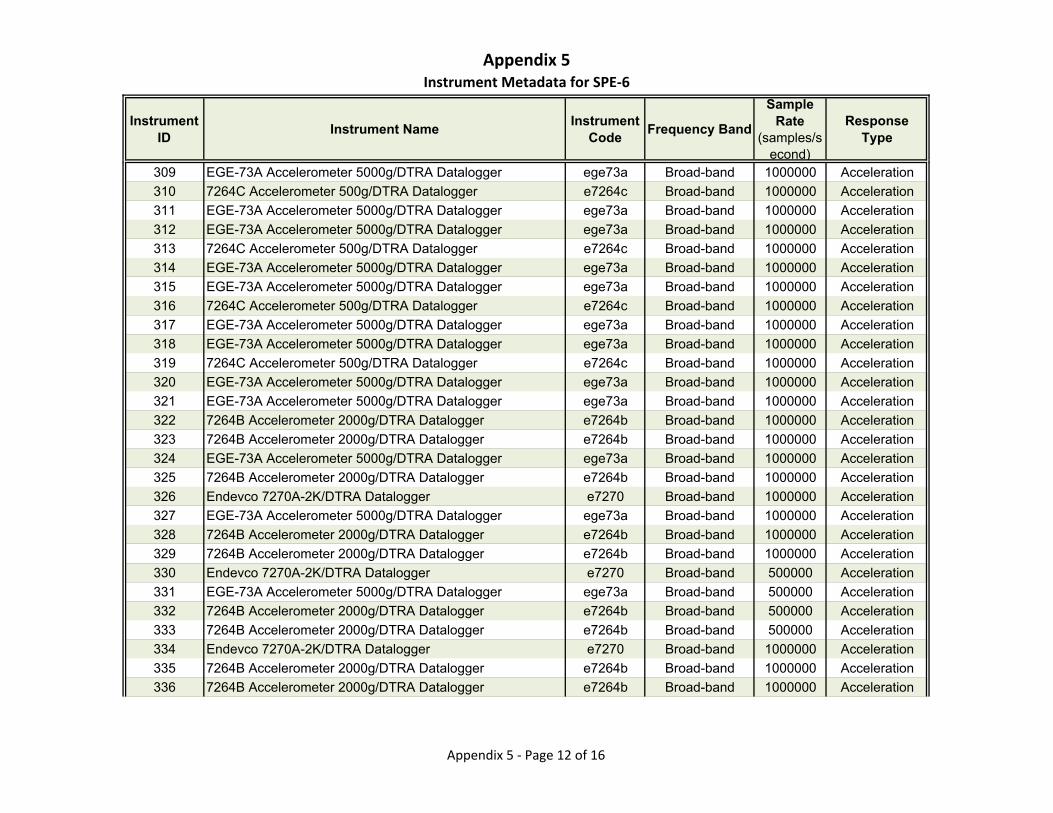
Appendix 5Instrument Metadata for SPE‐6
Instrument ID
Instrument NameInstrument
CodeFrequency Band
Sample Rate
(samples/second)
Response Type
309 EGE-73A Accelerometer 5000g/DTRA Datalogger ege73a Broad-band 1000000 Acceleration
310 7264C Accelerometer 500g/DTRA Datalogger e7264c Broad-band 1000000 Acceleration
311 EGE-73A Accelerometer 5000g/DTRA Datalogger ege73a Broad-band 1000000 Acceleration
312 EGE-73A Accelerometer 5000g/DTRA Datalogger ege73a Broad-band 1000000 Acceleration
313 7264C Accelerometer 500g/DTRA Datalogger e7264c Broad-band 1000000 Acceleration
314 EGE-73A Accelerometer 5000g/DTRA Datalogger ege73a Broad-band 1000000 Acceleration
315 EGE-73A Accelerometer 5000g/DTRA Datalogger ege73a Broad-band 1000000 Acceleration
316 7264C Accelerometer 500g/DTRA Datalogger e7264c Broad-band 1000000 Acceleration
317 EGE-73A Accelerometer 5000g/DTRA Datalogger ege73a Broad-band 1000000 Acceleration
318 EGE-73A Accelerometer 5000g/DTRA Datalogger ege73a Broad-band 1000000 Acceleration
319 7264C Accelerometer 500g/DTRA Datalogger e7264c Broad-band 1000000 Acceleration
320 EGE-73A Accelerometer 5000g/DTRA Datalogger ege73a Broad-band 1000000 Acceleration
321 EGE-73A Accelerometer 5000g/DTRA Datalogger ege73a Broad-band 1000000 Acceleration
322 7264B Accelerometer 2000g/DTRA Datalogger e7264b Broad-band 1000000 Acceleration
323 7264B Accelerometer 2000g/DTRA Datalogger e7264b Broad-band 1000000 Acceleration
324 EGE-73A Accelerometer 5000g/DTRA Datalogger ege73a Broad-band 1000000 Acceleration
325 7264B Accelerometer 2000g/DTRA Datalogger e7264b Broad-band 1000000 Acceleration
326 Endevco 7270A-2K/DTRA Datalogger e7270 Broad-band 1000000 Acceleration
327 EGE-73A Accelerometer 5000g/DTRA Datalogger ege73a Broad-band 1000000 Acceleration
328 7264B Accelerometer 2000g/DTRA Datalogger e7264b Broad-band 1000000 Acceleration
329 7264B Accelerometer 2000g/DTRA Datalogger e7264b Broad-band 1000000 Acceleration
330 Endevco 7270A-2K/DTRA Datalogger e7270 Broad-band 500000 Acceleration
331 EGE-73A Accelerometer 5000g/DTRA Datalogger ege73a Broad-band 500000 Acceleration
332 7264B Accelerometer 2000g/DTRA Datalogger e7264b Broad-band 500000 Acceleration
333 7264B Accelerometer 2000g/DTRA Datalogger e7264b Broad-band 500000 Acceleration
334 Endevco 7270A-2K/DTRA Datalogger e7270 Broad-band 1000000 Acceleration
335 7264B Accelerometer 2000g/DTRA Datalogger e7264b Broad-band 1000000 Acceleration
336 7264B Accelerometer 2000g/DTRA Datalogger e7264b Broad-band 1000000 Acceleration
Appendix 5 ‐ Page 12 of 16

Appendix 5Instrument Metadata for SPE‐6
Instrument ID
Instrument NameInstrument
CodeFrequency Band
Sample Rate
(samples/second)
Response Type
337 7264C Accelerometer 50g/DTRA Datalogger e7264c Broad-band 1000000 Acceleration
338 7264C Accelerometer 50g/DTRA Datalogger e7264c Broad-band 1000000 Acceleration
339 7264C Accelerometer 50g/DTRA Datalogger e7264c Broad-band 1000000 Acceleration
340 EGCS-D0-100g Accel/DTRA Datalogger egcsd0 Broad-band 1000000 Acceleration
341 7264C Accelerometer 50g/DTRA Datalogger e7264c Broad-band 1000000 Acceleration
342 EGCS-D0-100g Accel/DTRA Datalogger egcsd0 Broad-band 1000000 Acceleration
343 7264C Accelerometer 50g/DTRA Datalogger e7264c Broad-band 1000000 Acceleration
344 EGCS-D0-100g Accel/DTRA Datalogger egcsd0 Broad-band 1000000 Acceleration
345 EGCS-D0-100g Accel/DTRA Datalogger egcsd0 Broad-band 1000000 Acceleration
346 EGCS-D0-50g Accelerometer/DTRA Datalogger egcsd0 Broad-band 1000000 Acceleration
347 EGCS-D0-50g Accelerometer/DTRA Datalogger egcsd0 Broad-band 1000000 Acceleration
348 EGCS-D0-100g Accel/DTRA Datalogger egcsd0 Broad-band 1000000 Acceleration
349 EGCS-D0-100g Accel/DTRA Datalogger egcsd0 Broad-band 500000 Acceleration
350 7264C Accelerometer 50g/DTRA Datalogger e7264c Broad-band 1000000 Acceleration
351 EGCS-D0-100g Accel/DTRA Datalogger egcsd0 Broad-band 1000000 Acceleration
352 EGCS-D0-100g Accel/DTRA Datalogger egcsd0 Broad-band 500000 Acceleration
353 7264B Accelerometer 2000g/DTRA Datalogger e7264b Broad-band 500000 Acceleration
354 7264C Accelerometer 50g/DTRA Datalogger e7264c Broad-band 1000000 Acceleration
355 EGCS-D0-100g Accel/DTRA Datalogger egcsd0 Broad-band 1000000 Acceleration
356 EGCS-D0-100g Accel/DTRA Datalogger egcsd0 Broad-band 500000 Acceleration
357 7264C Accelerometer 50g/DTRA Datalogger e7264c Broad-band 1000000 Acceleration
358 EGCS-D0-100g Accel/DTRA Datalogger egcsd0 Broad-band 1000000 Acceleration
359 EGCS-D0-50g Accelerometer/DTRA Datalogger egcsd0 Broad-band 500000 Acceleration
360 7264C Accelerometer 50g/DTRA Datalogger e7264c Broad-band 1000000 Acceleration
361 EGCS-D0-50g Accelerometer/DTRA Datalogger egcsd0 Broad-band 500000 Acceleration
362 7264C Accelerometer 50g/DTRA Datalogger e7264c Broad-band 1000000 Acceleration
363 EGCS-D0-50g Accelerometer/DTRA Datalogger egcsd0 Broad-band 1000000 Acceleration
364 EGCS-D0-50g Accelerometer/DTRA Datalogger egcsd0 Broad-band 500000 Acceleration
Appendix 5 ‐ Page 13 of 16
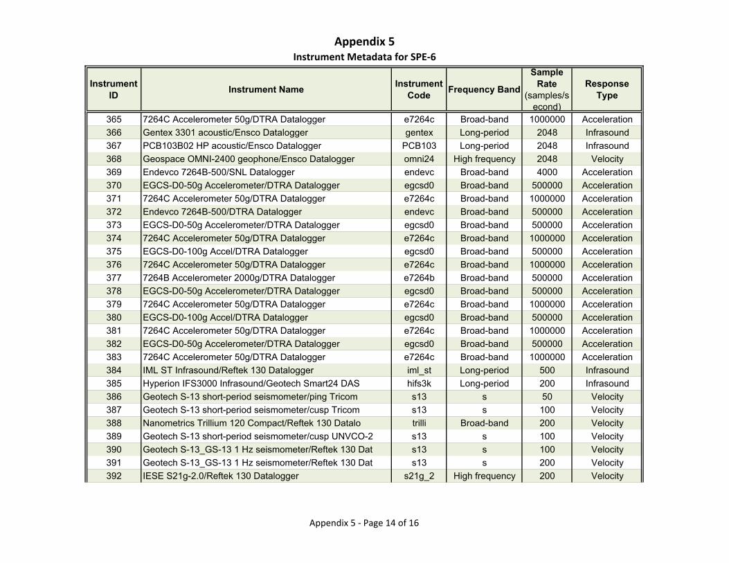
Appendix 5Instrument Metadata for SPE‐6
Instrument ID
Instrument NameInstrument
CodeFrequency Band
Sample Rate
(samples/second)
Response Type
365 7264C Accelerometer 50g/DTRA Datalogger e7264c Broad-band 1000000 Acceleration
366 Gentex 3301 acoustic/Ensco Datalogger gentex Long-period 2048 Infrasound
367 PCB103B02 HP acoustic/Ensco Datalogger PCB103 Long-period 2048 Infrasound
368 Geospace OMNI-2400 geophone/Ensco Datalogger omni24 High frequency 2048 Velocity
369 Endevco 7264B-500/SNL Datalogger endevc Broad-band 4000 Acceleration
370 EGCS-D0-50g Accelerometer/DTRA Datalogger egcsd0 Broad-band 500000 Acceleration
371 7264C Accelerometer 50g/DTRA Datalogger e7264c Broad-band 1000000 Acceleration
372 Endevco 7264B-500/DTRA Datalogger endevc Broad-band 500000 Acceleration
373 EGCS-D0-50g Accelerometer/DTRA Datalogger egcsd0 Broad-band 500000 Acceleration
374 7264C Accelerometer 50g/DTRA Datalogger e7264c Broad-band 1000000 Acceleration
375 EGCS-D0-100g Accel/DTRA Datalogger egcsd0 Broad-band 500000 Acceleration
376 7264C Accelerometer 50g/DTRA Datalogger e7264c Broad-band 1000000 Acceleration
377 7264B Accelerometer 2000g/DTRA Datalogger e7264b Broad-band 500000 Acceleration
378 EGCS-D0-50g Accelerometer/DTRA Datalogger egcsd0 Broad-band 500000 Acceleration
379 7264C Accelerometer 50g/DTRA Datalogger e7264c Broad-band 1000000 Acceleration
380 EGCS-D0-100g Accel/DTRA Datalogger egcsd0 Broad-band 500000 Acceleration
381 7264C Accelerometer 50g/DTRA Datalogger e7264c Broad-band 1000000 Acceleration
382 EGCS-D0-50g Accelerometer/DTRA Datalogger egcsd0 Broad-band 500000 Acceleration
383 7264C Accelerometer 50g/DTRA Datalogger e7264c Broad-band 1000000 Acceleration
384 IML ST Infrasound/Reftek 130 Datalogger iml_st Long-period 500 Infrasound
385 Hyperion IFS3000 Infrasound/Geotech Smart24 DAS hifs3k Long-period 200 Infrasound
386 Geotech S-13 short-period seismometer/ping Tricom s13 s 50 Velocity
387 Geotech S-13 short-period seismometer/cusp Tricom s13 s 100 Velocity
388 Nanometrics Trillium 120 Compact/Reftek 130 Datalo trilli Broad-band 200 Velocity
389 Geotech S-13 short-period seismometer/cusp UNVCO-2 s13 s 100 Velocity
390 Geotech S-13_GS-13 1 Hz seismometer/Reftek 130 Dat s13 s 100 Velocity
391 Geotech S-13_GS-13 1 Hz seismometer/Reftek 130 Dat s13 s 200 Velocity
392 IESE S21g-2.0/Reftek 130 Datalogger s21g_2 High frequency 200 Velocity
Appendix 5 ‐ Page 14 of 16
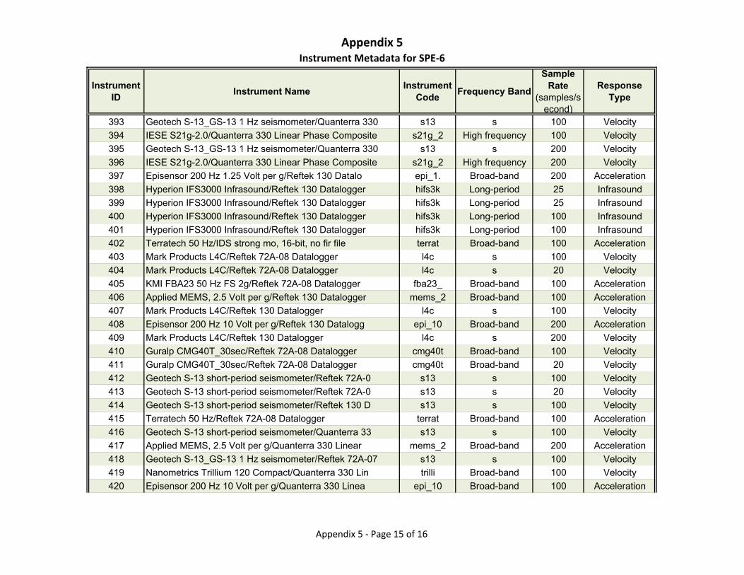
Appendix 5Instrument Metadata for SPE‐6
Instrument ID
Instrument NameInstrument
CodeFrequency Band
Sample Rate
(samples/second)
Response Type
393 Geotech S-13_GS-13 1 Hz seismometer/Quanterra 330 s13 s 100 Velocity
394 IESE S21g-2.0/Quanterra 330 Linear Phase Composite s21g_2 High frequency 100 Velocity
395 Geotech S-13_GS-13 1 Hz seismometer/Quanterra 330 s13 s 200 Velocity
396 IESE S21g-2.0/Quanterra 330 Linear Phase Composite s21g_2 High frequency 200 Velocity
397 Episensor 200 Hz 1.25 Volt per g/Reftek 130 Datalo epi_1. Broad-band 200 Acceleration
398 Hyperion IFS3000 Infrasound/Reftek 130 Datalogger hifs3k Long-period 25 Infrasound
399 Hyperion IFS3000 Infrasound/Reftek 130 Datalogger hifs3k Long-period 25 Infrasound
400 Hyperion IFS3000 Infrasound/Reftek 130 Datalogger hifs3k Long-period 100 Infrasound
401 Hyperion IFS3000 Infrasound/Reftek 130 Datalogger hifs3k Long-period 100 Infrasound
402 Terratech 50 Hz/IDS strong mo, 16-bit, no fir file terrat Broad-band 100 Acceleration
403 Mark Products L4C/Reftek 72A-08 Datalogger l4c s 100 Velocity
404 Mark Products L4C/Reftek 72A-08 Datalogger l4c s 20 Velocity
405 KMI FBA23 50 Hz FS 2g/Reftek 72A-08 Datalogger fba23_ Broad-band 100 Acceleration
406 Applied MEMS, 2.5 Volt per g/Reftek 130 Datalogger mems_2 Broad-band 100 Acceleration
407 Mark Products L4C/Reftek 130 Datalogger l4c s 100 Velocity
408 Episensor 200 Hz 10 Volt per g/Reftek 130 Datalogg epi_10 Broad-band 200 Acceleration
409 Mark Products L4C/Reftek 130 Datalogger l4c s 200 Velocity
410 Guralp CMG40T_30sec/Reftek 72A-08 Datalogger cmg40t Broad-band 100 Velocity
411 Guralp CMG40T_30sec/Reftek 72A-08 Datalogger cmg40t Broad-band 20 Velocity
412 Geotech S-13 short-period seismometer/Reftek 72A-0 s13 s 100 Velocity
413 Geotech S-13 short-period seismometer/Reftek 72A-0 s13 s 20 Velocity
414 Geotech S-13 short-period seismometer/Reftek 130 D s13 s 100 Velocity
415 Terratech 50 Hz/Reftek 72A-08 Datalogger terrat Broad-band 100 Acceleration
416 Geotech S-13 short-period seismometer/Quanterra 33 s13 s 100 Velocity
417 Applied MEMS, 2.5 Volt per g/Quanterra 330 Linear mems_2 Broad-band 200 Acceleration
418 Geotech S-13_GS-13 1 Hz seismometer/Reftek 72A-07 s13 s 100 Velocity
419 Nanometrics Trillium 120 Compact/Quanterra 330 Lin trilli Broad-band 100 Velocity
420 Episensor 200 Hz 10 Volt per g/Quanterra 330 Linea epi_10 Broad-band 100 Acceleration
Appendix 5 ‐ Page 15 of 16
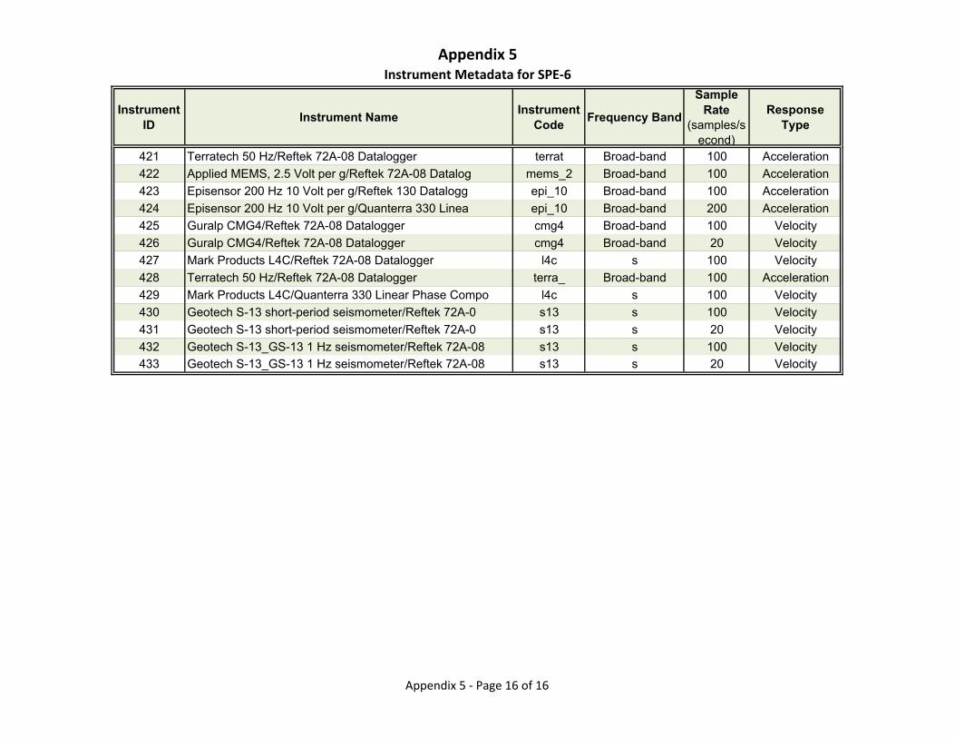
Appendix 5Instrument Metadata for SPE‐6
Instrument ID
Instrument NameInstrument
CodeFrequency Band
Sample Rate
(samples/second)
Response Type
421 Terratech 50 Hz/Reftek 72A-08 Datalogger terrat Broad-band 100 Acceleration
422 Applied MEMS, 2.5 Volt per g/Reftek 72A-08 Datalog mems_2 Broad-band 100 Acceleration
423 Episensor 200 Hz 10 Volt per g/Reftek 130 Datalogg epi_10 Broad-band 100 Acceleration
424 Episensor 200 Hz 10 Volt per g/Quanterra 330 Linea epi_10 Broad-band 200 Acceleration
425 Guralp CMG4/Reftek 72A-08 Datalogger cmg4 Broad-band 100 Velocity
426 Guralp CMG4/Reftek 72A-08 Datalogger cmg4 Broad-band 20 Velocity
427 Mark Products L4C/Reftek 72A-08 Datalogger l4c s 100 Velocity
428 Terratech 50 Hz/Reftek 72A-08 Datalogger terra_ Broad-band 100 Acceleration
429 Mark Products L4C/Quanterra 330 Linear Phase Compo l4c s 100 Velocity
430 Geotech S-13 short-period seismometer/Reftek 72A-0 s13 s 100 Velocity
431 Geotech S-13 short-period seismometer/Reftek 72A-0 s13 s 20 Velocity
432 Geotech S-13_GS-13 1 Hz seismometer/Reftek 72A-08 s13 s 100 Velocity
433 Geotech S-13_GS-13 1 Hz seismometer/Reftek 72A-08 s13 s 20 Velocity
Appendix 5 ‐ Page 16 of 16
Appendix 6
Selected Metadata for SPE-5 Surface Stations
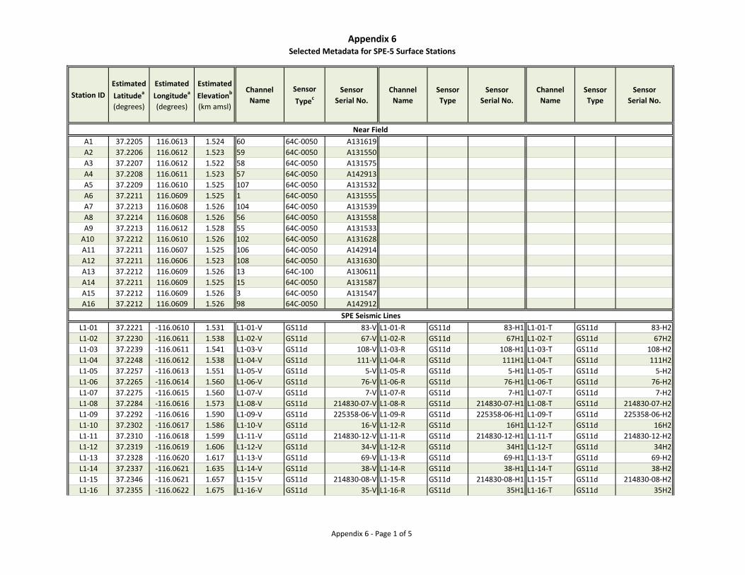
Appendix 6Selected Metadata for SPE-5 Surface Stations
Appendix 6 - Page 1 of 5
Station IDEstimated Latitudea
(degrees)
Estimated Longitudea
(degrees)
Estimated Elevationb
(km amsl)
Channel Name
Sensor Typec
SensorSerial No.
Channel Name
Sensor Type
SensorSerial No.
Channel Name
Sensor Type
SensorSerial No.
A1 37.2205 116.0613 1.524 60 64C-0050 A131619A2 37.2206 116.0612 1.523 59 64C-0050 A131550A3 37.2207 116.0612 1.522 58 64C-0050 A131575A4 37.2208 116.0611 1.523 57 64C-0050 A142913A5 37.2209 116.0610 1.525 107 64C-0050 A131532A6 37.2211 116.0609 1.525 1 64C-0050 A131555A7 37.2213 116.0608 1.526 104 64C-0050 A131539A8 37.2214 116.0608 1.526 56 64C-0050 A131558A9 37.2213 116.0612 1.528 55 64C-0050 A131533
A10 37.2212 116.0610 1.526 102 64C-0050 A131628A11 37.2211 116.0607 1.525 106 64C-0050 A142914A12 37.2211 116.0606 1.523 108 64C-0050 A131630A13 37.2212 116.0609 1.526 13 64C-100 A130611A14 37.2211 116.0609 1.525 15 64C-0050 A131587A15 37.2212 116.0609 1.526 3 64C-0050 A131547A16 37.2212 116.0609 1.526 98 64C-0050 A142912
L1-01 37.2221 -116.0610 1.531 L1-01-V GS11d 83-V L1-01-R GS11d 83-H1 L1-01-T GS11d 83-H2L1-02 37.2230 -116.0611 1.538 L1-02-V GS11d 67-V L1-02-R GS11d 67H1 L1-02-T GS11d 67H2L1-03 37.2239 -116.0611 1.541 L1-03-V GS11d 108-V L1-03-R GS11d 108-H1 L1-03-T GS11d 108-H2L1-04 37.2248 -116.0612 1.538 L1-04-V GS11d 111-V L1-04-R GS11d 111H1 L1-04-T GS11d 111H2L1-05 37.2257 -116.0613 1.551 L1-05-V GS11d 5-V L1-05-R GS11d 5-H1 L1-05-T GS11d 5-H2L1-06 37.2265 -116.0614 1.560 L1-06-V GS11d 76-V L1-06-R GS11d 76-H1 L1-06-T GS11d 76-H2L1-07 37.2275 -116.0615 1.560 L1-07-V GS11d 7-V L1-07-R GS11d 7-H1 L1-07-T GS11d 7-H2L1-08 37.2284 -116.0616 1.573 L1-08-V GS11d 214830-07-V L1-08-R GS11d 214830-07-H1 L1-08-T GS11d 214830-07-H2L1-09 37.2292 -116.0616 1.590 L1-09-V GS11d 225358-06-V L1-09-R GS11d 225358-06-H1 L1-09-T GS11d 225358-06-H2L1-10 37.2302 -116.0617 1.586 L1-10-V GS11d 16-V L1-12-R GS11d 16H1 L1-12-T GS11d 16H2L1-11 37.2310 -116.0618 1.599 L1-11-V GS11d 214830-12-V L1-11-R GS11d 214830-12-H1 L1-11-T GS11d 214830-12-H2L1-12 37.2319 -116.0619 1.606 L1-12-V GS11d 34-V L1-12-R GS11d 34H1 L1-12-T GS11d 34H2L1-13 37.2328 -116.0620 1.617 L1-13-V GS11d 69-V L1-13-R GS11d 69-H1 L1-13-T GS11d 69-H2L1-14 37.2337 -116.0621 1.635 L1-14-V GS11d 38-V L1-14-R GS11d 38-H1 L1-14-T GS11d 38-H2L1-15 37.2346 -116.0621 1.657 L1-15-V GS11d 214830-08-V L1-15-R GS11d 214830-08-H1 L1-15-T GS11d 214830-08-H2L1-16 37.2355 -116.0622 1.675 L1-16-V GS11d 35-V L1-16-R GS11d 35H1 L1-16-T GS11d 35H2
Near Field
SPE Seismic Lines
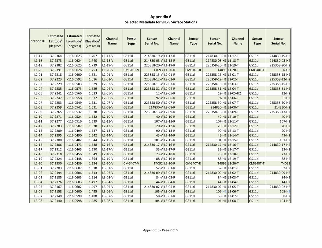
Appendix 6Selected Metadata for SPE-5 Surface Stations
Appendix 6 - Page 2 of 5
Station IDEstimated Latitudea
(degrees)
Estimated Longitudea
(degrees)
Estimated Elevationb
(km amsl)
Channel Name
Sensor Typec
SensorSerial No.
Channel Name
Sensor Type
SensorSerial No.
Channel Name
Sensor Type
SensorSerial No.
L1-17 37.2364 -116.0623 1.707 L1-17-V GS11d 214830-19-V L1-17-R GS11d 214830-19-H1 L1-17-T GS11d 214830-19-H2L1-18 37.2373 -116.0624 1.740 L1-18-V GS11d 214830-03-V L1-18-R GS11d 214830-03-H1 L1-18-T GS11d 214830-03-H2L1-19 37.2382 -116.0625 1.739 L1-19-V GS11d 225358-20-V L1-19-R GS11d 225358-20-H1 L1-19-T GS11d 225358-20-H2L1-20 37.2391 -116.0626 1.753 L1-20-V CMG40T-V T4093 L1-20-R CMG40T-R T4093 L1-20-T CMG40T-T T4093L2-01 37.2218 -116.0600 1.521 L2-01-V GS11d 225358-15-V L2-01-R GS11d 225358-15-H1 L2-01-T GS11d 225358-15-H2L2-02 37.2223 -116.0592 1.516 L2-02-V GS11d 225358-12-V L2-02-R GS11d 225358-12-H1 L2-02-T GS11d 225358-12-H2L2-03 37.2229 -116.0583 1.529 L2-03-V GS11d 225358-11-V L2-03-R GS11d 225358-15-H1 L2-03-T GS11d 225358-15-H2L2-04 37.2235 -116.0575 1.529 L2-04-V GS11d 225358-31-V L2-04-R GS11d 225358-31-H1 L2-04-T GS11d 225358-31-H2L2-05 37.2241 -116.0566 1.533 L2-05-V GS11d 12-V L2-05-R GS11d 12-H1 L2-05-H2 GS11d 12-H2L2-06 37.2247 -116.0558 1.532 L2-06-V GS11d 92-V L2-06-R GS11d 92H1 L2-06-T GS11d 92H2L2-07 37.2253 -116.0549 1.531 L2-07-V GS11d 225358-50-V L2-07-R GS11d 225358-50-H1 L2-07-T GS11d 225358-50-H2L2-08 37.2259 -116.0541 1.531 L2-08-V GS11d 214830-V L2-08-R GS11d 214830-H1 L2-08-T GS11d 214830-H2L2-09 37.2265 -116.0532 1.538 L2-09-V GS11d 225358-13-V L2-09-R GS11d 225358-13-H1 L2-09-T GS11d 225358-13-H2L2-10 37.2271 -116.0524 1.532 L2-10-V GS11d 40-V L2-10-R GS11d 40-H1 L2-10-T GS11d 40-H2L2-11 37.2277 -116.0516 1.539 L2-11-V GS11d 107-V L2-11-R GS11d 107-H1 L2-11-T GS11d 107-H2L2-12 37.2283 -116.0507 1.538 L2-12-V GS11d 20-V L2-12-R GS11d 20-H1 L2-12-T GS11d 20-H2L2-13 37.2289 -116.0499 1.537 L2-13-V GS11d 90-V L2-13-R GS11d 90-H1 L2-13-T GS11d 90-H2L2-14 37.2295 -116.0490 1.542 L2-14-V GS11d 43-V L2-14-R GS11d 43-H1 L2-14-T GS11d 43-H2L2-15 37.2300 -116.0482 1.544 L2-15-V GS11d 101-V L2-15-R GS11d 101-H1 L2-15-T GS11d 101-H2L2-16 37.2306 -116.0473 1.538 L2-16-V GS11d 214830-17-V L2-16-R GS11d 214830-17-H1 L2-16-T GS11d 214830-17-H2L2-17 37.2312 -116.0465 1.550 L2-17-V GS11d 33-V L2-17-R GS11d 33-H1 L2-17-T GS11d 33-H2L2-18 37.2318 -116.0456 1.549 L2-18-V GS11d 73-V L2-18-R GS11d 73-H1 L2-18-T GS11d 73-H2L2-19 37.2324 -116.0448 1.554 L2-19-V GS11d 88-V L2-19-R GS11d 88-H1 L2-19-T GS11d 88-H2L2-20 37.2330 -116.0439 1.534 L2-20-V CMG40T-V T4092 L2-20-R CMG40T-R T4092 L2-20-T CMG40T-T T4092L3-01 37.2203 -116.0607 1.518 L3-01-V GS11d 52-V L3-01-R GS11d 52-H1 L3-01-T GS11d 52-H2L3-02 37.2194 -116.0606 1.513 L3-02-V GS11d 214830-09-V L3-02-R GS11d 214830-09-H1 L3-02-T GS11d 214830-09-H2L3-03 37.2185 -116.0605 1.514 L3-03-V GS11d 84-V L3-03-R GS11d 84-H1 L3-03-T GS11d 84-H2L3-04 37.2176 -116.0603 1.497 L3-04-V GS11d 44-V L3-04-R GS11d 44-H1 L3-04-T GS11d 44-H2L3-05 37.2167 -116.0602 1.497 L3-05-V GS11d 214830-02-V L3-05-R GS11d 214830-02-H1 L3-05-T GS11d 214830-02-H2L3-06 37.2158 -116.0600 1.495 L3-06-V GS11d 105-V L3-06-R GS11d 105-H1 L3-06-T GS11d 105-H2L3-07 37.2149 -116.0599 1.488 L3-07-V GS11d 58-V L3-07-R GS11d 58-H1 L3-07-T GS11d 58-H2L3-08 37.2140 -116.0598 1.485 L3-08-V GS11d 104-V L3-08-R GS11d 104-H1 L3-08-T GS11d 104-H2
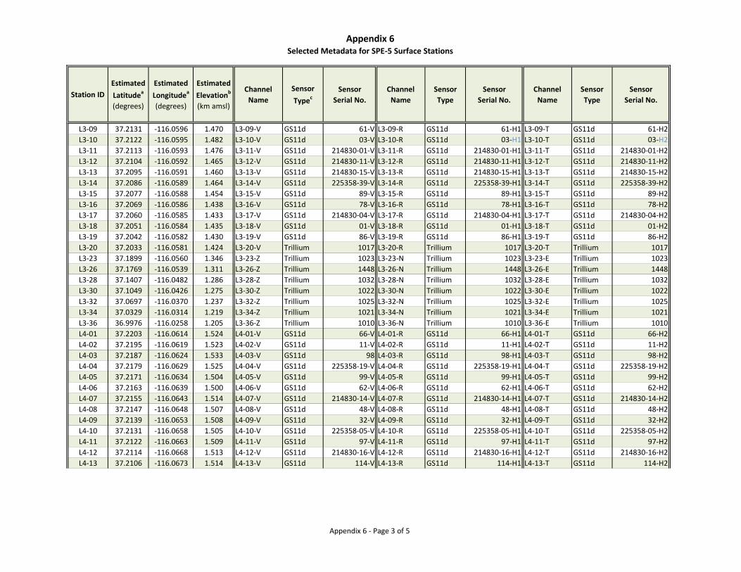
Appendix 6Selected Metadata for SPE-5 Surface Stations
Appendix 6 - Page 3 of 5
Station IDEstimated Latitudea
(degrees)
Estimated Longitudea
(degrees)
Estimated Elevationb
(km amsl)
Channel Name
Sensor Typec
SensorSerial No.
Channel Name
Sensor Type
SensorSerial No.
Channel Name
Sensor Type
SensorSerial No.
L3-09 37.2131 -116.0596 1.470 L3-09-V GS11d 61-V L3-09-R GS11d 61-H1 L3-09-T GS11d 61-H2L3-10 37.2122 -116.0595 1.482 L3-10-V GS11d 03-V L3-10-R GS11d 03-H1 L3-10-T GS11d 03-H2L3-11 37.2113 -116.0593 1.476 L3-11-V GS11d 214830-01-V L3-11-R GS11d 214830-01-H1 L3-11-T GS11d 214830-01-H2L3-12 37.2104 -116.0592 1.465 L3-12-V GS11d 214830-11-V L3-12-R GS11d 214830-11-H1 L3-12-T GS11d 214830-11-H2L3-13 37.2095 -116.0591 1.460 L3-13-V GS11d 214830-15-V L3-13-R GS11d 214830-15-H1 L3-13-T GS11d 214830-15-H2L3-14 37.2086 -116.0589 1.464 L3-14-V GS11d 225358-39-V L3-14-R GS11d 225358-39-H1 L3-14-T GS11d 225358-39-H2L3-15 37.2077 -116.0588 1.454 L3-15-V GS11d 89-V L3-15-R GS11d 89-H1 L3-15-T GS11d 89-H2L3-16 37.2069 -116.0586 1.438 L3-16-V GS11d 78-V L3-16-R GS11d 78-H1 L3-16-T GS11d 78-H2L3-17 37.2060 -116.0585 1.433 L3-17-V GS11d 214830-04-V L3-17-R GS11d 214830-04-H1 L3-17-T GS11d 214830-04-H2L3-18 37.2051 -116.0584 1.435 L3-18-V GS11d 01-V L3-18-R GS11d 01-H1 L3-18-T GS11d 01-H2L3-19 37.2042 -116.0582 1.430 L3-19-V GS11d 86-V L3-19-R GS11d 86-H1 L3-19-T GS11d 86-H2L3-20 37.2033 -116.0581 1.424 L3-20-V Trillium 1017 L3-20-R Trillium 1017 L3-20-T Trillium 1017L3-23 37.1899 -116.0560 1.346 L3-23-Z Trillium 1023 L3-23-N Trillium 1023 L3-23-E Trillium 1023L3-26 37.1769 -116.0539 1.311 L3-26-Z Trillium 1448 L3-26-N Trillium 1448 L3-26-E Trillium 1448L3-28 37.1407 -116.0482 1.286 L3-28-Z Trillium 1032 L3-28-N Trillium 1032 L3-28-E Trillium 1032L3-30 37.1049 -116.0426 1.275 L3-30-Z Trillium 1022 L3-30-N Trillium 1022 L3-30-E Trillium 1022L3-32 37.0697 -116.0370 1.237 L3-32-Z Trillium 1025 L3-32-N Trillium 1025 L3-32-E Trillium 1025L3-34 37.0329 -116.0314 1.219 L3-34-Z Trillium 1021 L3-34-N Trillium 1021 L3-34-E Trillium 1021L3-36 36.9976 -116.0258 1.205 L3-36-Z Trillium 1010 L3-36-N Trillium 1010 L3-36-E Trillium 1010L4-01 37.2203 -116.0614 1.524 L4-01-V GS11d 66-V L4-01-R GS11d 66-H1 L4-01-T GS11d 66-H2L4-02 37.2195 -116.0619 1.523 L4-02-V GS11d 11-V L4-02-R GS11d 11-H1 L4-02-T GS11d 11-H2L4-03 37.2187 -116.0624 1.533 L4-03-V GS11d 98 L4-03-R GS11d 98-H1 L4-03-T GS11d 98-H2L4-04 37.2179 -116.0629 1.525 L4-04-V GS11d 225358-19-V L4-04-R GS11d 225358-19-H1 L4-04-T GS11d 225358-19-H2L4-05 37.2171 -116.0634 1.504 L4-05-V GS11d 99-V L4-05-R GS11d 99-H1 L4-05-T GS11d 99-H2L4-06 37.2163 -116.0639 1.500 L4-06-V GS11d 62-V L4-06-R GS11d 62-H1 L4-06-T GS11d 62-H2L4-07 37.2155 -116.0643 1.514 L4-07-V GS11d 214830-14-V L4-07-R GS11d 214830-14-H1 L4-07-T GS11d 214830-14-H2L4-08 37.2147 -116.0648 1.507 L4-08-V GS11d 48-V L4-08-R GS11d 48-H1 L4-08-T GS11d 48-H2L4-09 37.2139 -116.0653 1.508 L4-09-V GS11d 32-V L4-09-R GS11d 32-H1 L4-09-T GS11d 32-H2L4-10 37.2131 -116.0658 1.505 L4-10-V GS11d 225358-05-V L4-10-R GS11d 225358-05-H1 L4-10-T GS11d 225358-05-H2L4-11 37.2122 -116.0663 1.509 L4-11-V GS11d 97-V L4-11-R GS11d 97-H1 L4-11-T GS11d 97-H2L4-12 37.2114 -116.0668 1.513 L4-12-V GS11d 214830-16-V L4-12-R GS11d 214830-16-H1 L4-12-T GS11d 214830-16-H2L4-13 37.2106 -116.0673 1.514 L4-13-V GS11d 114-V L4-13-R GS11d 114-H1 L4-13-T GS11d 114-H2
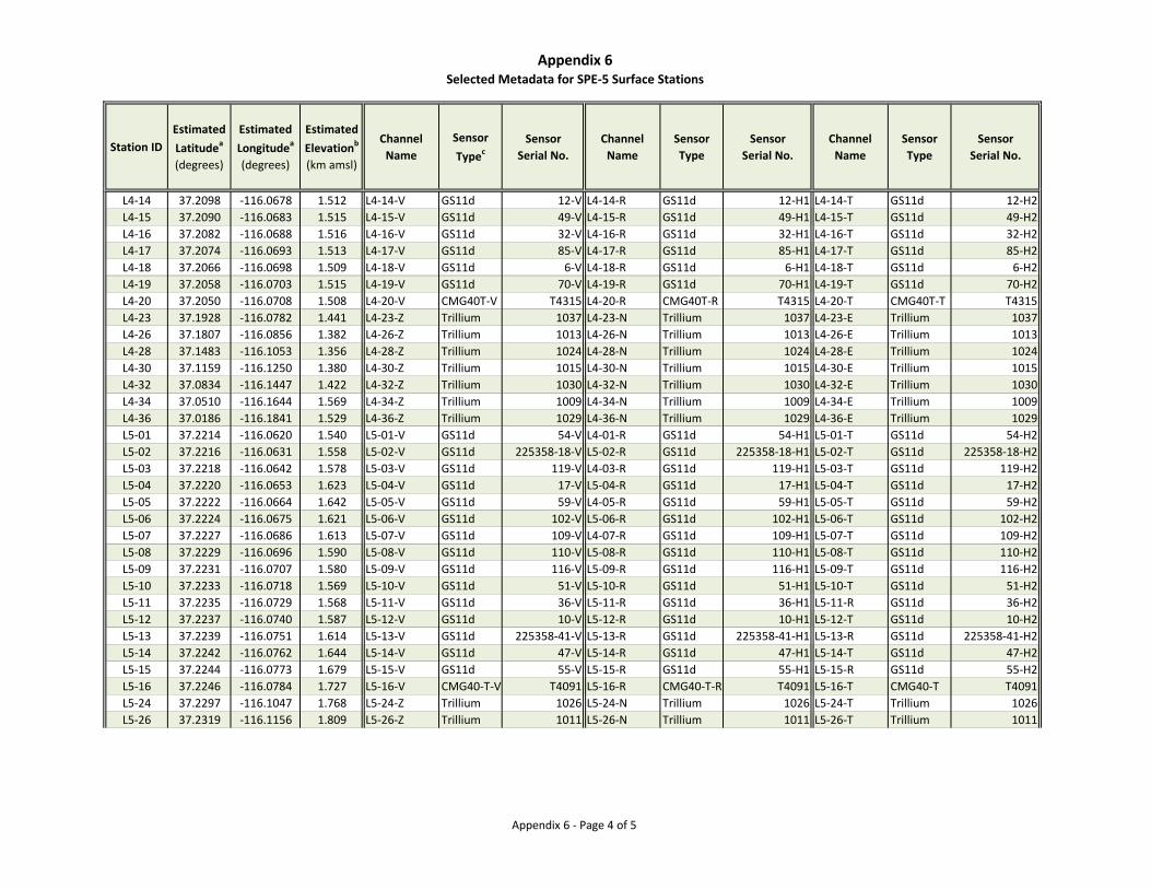
Appendix 6Selected Metadata for SPE-5 Surface Stations
Appendix 6 - Page 4 of 5
Station IDEstimated Latitudea
(degrees)
Estimated Longitudea
(degrees)
Estimated Elevationb
(km amsl)
Channel Name
Sensor Typec
SensorSerial No.
Channel Name
Sensor Type
SensorSerial No.
Channel Name
Sensor Type
SensorSerial No.
L4-14 37.2098 -116.0678 1.512 L4-14-V GS11d 12-V L4-14-R GS11d 12-H1 L4-14-T GS11d 12-H2L4-15 37.2090 -116.0683 1.515 L4-15-V GS11d 49-V L4-15-R GS11d 49-H1 L4-15-T GS11d 49-H2L4-16 37.2082 -116.0688 1.516 L4-16-V GS11d 32-V L4-16-R GS11d 32-H1 L4-16-T GS11d 32-H2L4-17 37.2074 -116.0693 1.513 L4-17-V GS11d 85-V L4-17-R GS11d 85-H1 L4-17-T GS11d 85-H2L4-18 37.2066 -116.0698 1.509 L4-18-V GS11d 6-V L4-18-R GS11d 6-H1 L4-18-T GS11d 6-H2L4-19 37.2058 -116.0703 1.515 L4-19-V GS11d 70-V L4-19-R GS11d 70-H1 L4-19-T GS11d 70-H2L4-20 37.2050 -116.0708 1.508 L4-20-V CMG40T-V T4315 L4-20-R CMG40T-R T4315 L4-20-T CMG40T-T T4315L4-23 37.1928 -116.0782 1.441 L4-23-Z Trillium 1037 L4-23-N Trillium 1037 L4-23-E Trillium 1037L4-26 37.1807 -116.0856 1.382 L4-26-Z Trillium 1013 L4-26-N Trillium 1013 L4-26-E Trillium 1013L4-28 37.1483 -116.1053 1.356 L4-28-Z Trillium 1024 L4-28-N Trillium 1024 L4-28-E Trillium 1024L4-30 37.1159 -116.1250 1.380 L4-30-Z Trillium 1015 L4-30-N Trillium 1015 L4-30-E Trillium 1015L4-32 37.0834 -116.1447 1.422 L4-32-Z Trillium 1030 L4-32-N Trillium 1030 L4-32-E Trillium 1030L4-34 37.0510 -116.1644 1.569 L4-34-Z Trillium 1009 L4-34-N Trillium 1009 L4-34-E Trillium 1009L4-36 37.0186 -116.1841 1.529 L4-36-Z Trillium 1029 L4-36-N Trillium 1029 L4-36-E Trillium 1029L5-01 37.2214 -116.0620 1.540 L5-01-V GS11d 54-V L4-01-R GS11d 54-H1 L5-01-T GS11d 54-H2L5-02 37.2216 -116.0631 1.558 L5-02-V GS11d 225358-18-V L5-02-R GS11d 225358-18-H1 L5-02-T GS11d 225358-18-H2L5-03 37.2218 -116.0642 1.578 L5-03-V GS11d 119-V L4-03-R GS11d 119-H1 L5-03-T GS11d 119-H2L5-04 37.2220 -116.0653 1.623 L5-04-V GS11d 17-V L5-04-R GS11d 17-H1 L5-04-T GS11d 17-H2L5-05 37.2222 -116.0664 1.642 L5-05-V GS11d 59-V L4-05-R GS11d 59-H1 L5-05-T GS11d 59-H2L5-06 37.2224 -116.0675 1.621 L5-06-V GS11d 102-V L5-06-R GS11d 102-H1 L5-06-T GS11d 102-H2L5-07 37.2227 -116.0686 1.613 L5-07-V GS11d 109-V L4-07-R GS11d 109-H1 L5-07-T GS11d 109-H2L5-08 37.2229 -116.0696 1.590 L5-08-V GS11d 110-V L5-08-R GS11d 110-H1 L5-08-T GS11d 110-H2L5-09 37.2231 -116.0707 1.580 L5-09-V GS11d 116-V L5-09-R GS11d 116-H1 L5-09-T GS11d 116-H2L5-10 37.2233 -116.0718 1.569 L5-10-V GS11d 51-V L5-10-R GS11d 51-H1 L5-10-T GS11d 51-H2L5-11 37.2235 -116.0729 1.568 L5-11-V GS11d 36-V L5-11-R GS11d 36-H1 L5-11-R GS11d 36-H2L5-12 37.2237 -116.0740 1.587 L5-12-V GS11d 10-V L5-12-R GS11d 10-H1 L5-12-T GS11d 10-H2L5-13 37.2239 -116.0751 1.614 L5-13-V GS11d 225358-41-V L5-13-R GS11d 225358-41-H1 L5-13-R GS11d 225358-41-H2L5-14 37.2242 -116.0762 1.644 L5-14-V GS11d 47-V L5-14-R GS11d 47-H1 L5-14-T GS11d 47-H2L5-15 37.2244 -116.0773 1.679 L5-15-V GS11d 55-V L5-15-R GS11d 55-H1 L5-15-R GS11d 55-H2L5-16 37.2246 -116.0784 1.727 L5-16-V CMG40-T-V T4091 L5-16-R CMG40-T-R T4091 L5-16-T CMG40-T T4091L5-24 37.2297 -116.1047 1.768 L5-24-Z Trillium 1026 L5-24-N Trillium 1026 L5-24-T Trillium 1026L5-26 37.2319 -116.1156 1.809 L5-26-Z Trillium 1011 L5-26-N Trillium 1011 L5-26-T Trillium 1011
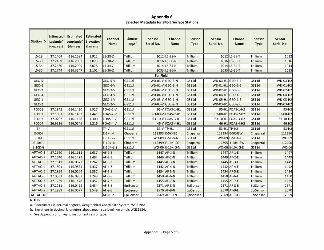
Appendix 6Selected Metadata for SPE-5 Surface Stations
Appendix 6 - Page 5 of 5
Station IDEstimated Latitudea
(degrees)
Estimated Longitudea
(degrees)
Estimated Elevationb
(km amsl)
Channel Name
Sensor Typec
SensorSerial No.
Channel Name
Sensor Type
SensorSerial No.
Channel Name
Sensor Type
SensorSerial No.
L5-28 37.2404 -116.1594 1.912 L5-28-Z Trillium 1012 L5-28-N Trillium 1012 L5-28-T Trillium 1012L5-30 37.2489 -116.2032 2.075 L5-30-Z Trillium 1016 L5-30-N Trillium 1016 L5-30-T Trillium 1016L5-34 37.2660 -116.2909 2.078 L5-34-Z Trillium 1014 L5-34-N Trillium 1014 L5-34-T Trillium 1014L5-36 37.2744 -116.3347 2.101 L5-36-Z Trillium 1033 L5-36-N Trillium 1033 L5-36-T Trillium 1033
GEO-5 GEO-5-V GS11d WD-03-V GEO-5-N GS11d WD-03-H1 GEO-5-E GS11d WD-03-H2GEO-6 GEO-6-V GS11d WD-01-V GEO-6-N GS11d WD-01-H1 GEO-6-E GS11d WD-01-H2GEO-3 GEO-3-V GS11d WD-02-V GEO-3-N GS11d WD-02-H1 GEO-3-E GS11d WD-02-H2GEO-4 GEO-4-V GS11d WD-04-V GEO-4-N GS11d WD-04-H1 GEO-4-E GS11d WD-04-H2GEO-1 GEO-1-V GS11d WD-05-V GEO-1-N GS11d WD-05-H1 GEO-1-E GS11d WD-05-H2GEO-2 GEO-2-V GS11d WD-03-V GEO-2-N GS11d WD-03-H1 GEO-2-E GS11d WD-03-H2FO001 37.1842 -116.1430 1.527 FOAS-1-V GS11d 95-V FOAS-1-H1 GS11d 95-H1 FOAS-1-H2 GS11d 95-H2FO002 37.1001 -116.1453 1.441 FOAS-2-V GS11d 63-08-V FOAS-2-H1 GS11d 63-08-H1 FOAS-2-H2 GS11d 63-08-H2FO003 37.0207 -116.1138 1.300 FOAS-3-V GS11d 63-10-V FOAS-3-H1 GS11d 63-10-H1 FOAS-3-H2 GS11d 63-10-H2FO004 36.9536 -116.0546 1.216 FOAS-4-V GS11d 46-V FOAS-4-H1 GS11d 46-H1 FOAS-4-H2 GS11d 46-H2
TP TP-V GS11d 53-V TP-H1 GS11d 53-H1 TP-H2 GS11d 53-H2E-5K-I E-5K-IN Chaparral 112393 E-5K-ISE Chaparral 112394 E-5K-ISW Chaparral 112396E-5K-G E-5K-G-Z GS11d WO-09 E-5K-G-N GS11d WO-09 E-5K-G-E GS11d WO-09E-10K-I E-10K-IN Chaparral 112399 E-10K-ISE Chaparral 112395 3-10K-ISW Chaparral 112400E-10K-G E-10K-G-Z GS11d WO-06 E-10K-G-N GS11d WO-06 E-10K-G-E GS11d WO-06AFTAC-1 37.2160 -116.1611 1.637 AF-1-Z Trillium 1447 AF-1-N Trillium 1447 AF-1-E Trillium 1447AFTAC-2 37.1640 -116.1423 1.494 AF-2-Z Trillium 1449 AF-2-N Trillium 1449 AF-2-E Trillium 1449AFTAC-3 37.1313 -116.0573 1.262 AF-3-Z Trillium 1445 AF-3-N Trillium 1445 AF-3-E Trillium 1445AFTAC-4 37.1801 -115.9834 1.437 AF-4-Z Trillium 1442 AF-4-N Trillium 1442 AF-4-E Trillium 1442AFTAC-5 37.1894 -116.0204 1.337 AF-5-Z Trillium 1454 AF-5-N Trillium 1454 AF-5-E Trillium 1454AFTAC-6 37.0531 -116.0903 1.248 AF-6-Z Trillium 1450 AF-6-N Trillium 1450 AF-6-E Trillium 1450AFTAC-7 37.1239 -116.1478 1.452 AF-7-Z Trillium 1455 AF-7-N Trillium 1455 AF-7-E Trillium 1455AFTAC-8 37.2211 -116.0496 1.454 AF-8-Z EpiSensor 2571 AF-8-N EpiSensor 2571 AF-8-E EpiSensor 2571AFTAC-9 37.2299 -116.0577 1.549 AF-9-Z EpiSensor 2570 AF-9-N EpiSensor 2570 AF-9-E EpiSensor 2570
AFTAC-10 AF-10-Z EpiSensor 2569 AF-10-N EpiSensor 2569 AF-10-E EpiSensor 2569NOTESa. Coordinates in decimal degrees, Geographical Coordinate System, WGS1984.b. Elevations in decimal kilometers above mean sea level (km amsl), WGS1984.c. See Appendix 3 for key to instrument sensor type.
Far Field

Appendix 7
Selected Metadata for SPE-6 Surface Stations
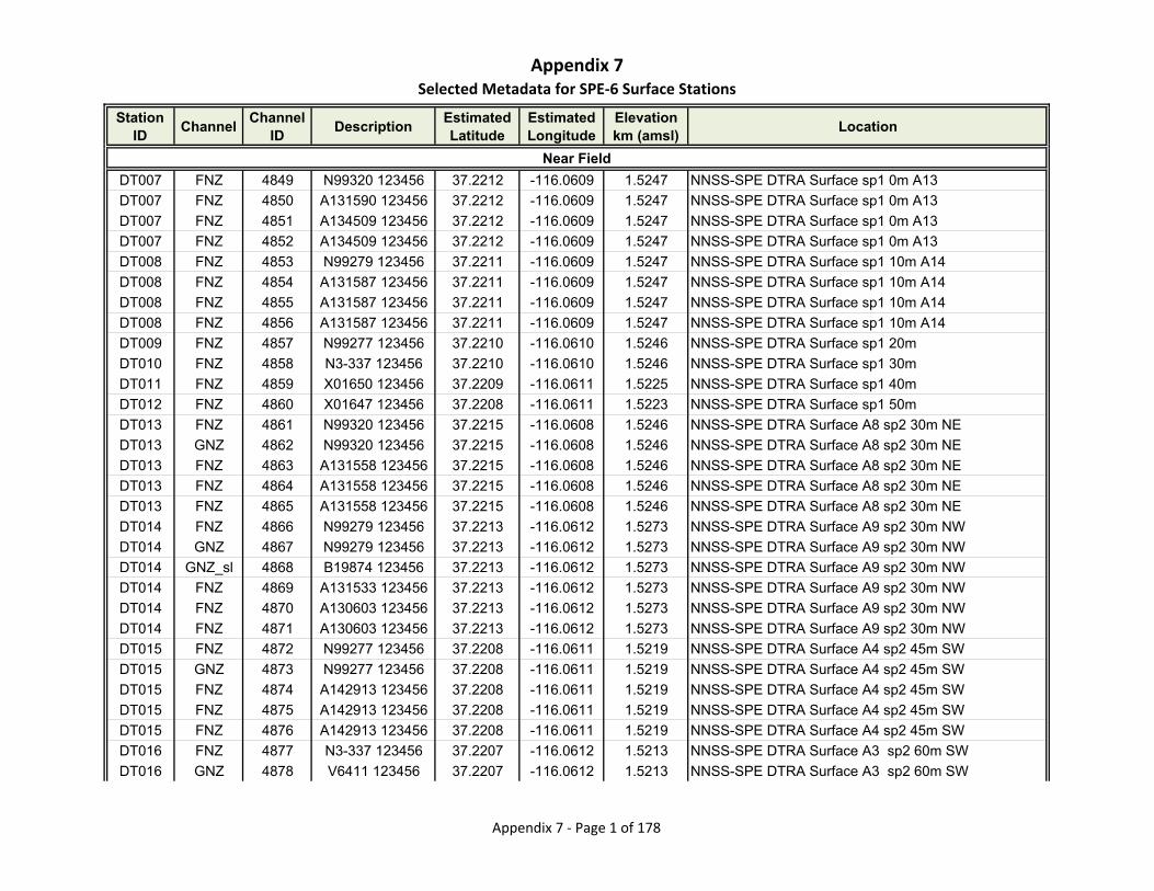
Appendix 7Selected Metadata for SPE‐6 Surface Stations
Station ID
ChannelChannel
IDDescription
Estimated Latitude
Estimated Longitude
Elevationkm (amsl)
Location
DT007 FNZ 4849 N99320 123456 37.2212 -116.0609 1.5247 NNSS-SPE DTRA Surface sp1 0m A13
DT007 FNZ 4850 A131590 123456 37.2212 -116.0609 1.5247 NNSS-SPE DTRA Surface sp1 0m A13
DT007 FNZ 4851 A134509 123456 37.2212 -116.0609 1.5247 NNSS-SPE DTRA Surface sp1 0m A13
DT007 FNZ 4852 A134509 123456 37.2212 -116.0609 1.5247 NNSS-SPE DTRA Surface sp1 0m A13
DT008 FNZ 4853 N99279 123456 37.2211 -116.0609 1.5247 NNSS-SPE DTRA Surface sp1 10m A14
DT008 FNZ 4854 A131587 123456 37.2211 -116.0609 1.5247 NNSS-SPE DTRA Surface sp1 10m A14
DT008 FNZ 4855 A131587 123456 37.2211 -116.0609 1.5247 NNSS-SPE DTRA Surface sp1 10m A14
DT008 FNZ 4856 A131587 123456 37.2211 -116.0609 1.5247 NNSS-SPE DTRA Surface sp1 10m A14
DT009 FNZ 4857 N99277 123456 37.2210 -116.0610 1.5246 NNSS-SPE DTRA Surface sp1 20m
DT010 FNZ 4858 N3-337 123456 37.2210 -116.0610 1.5246 NNSS-SPE DTRA Surface sp1 30m
DT011 FNZ 4859 X01650 123456 37.2209 -116.0611 1.5225 NNSS-SPE DTRA Surface sp1 40m
DT012 FNZ 4860 X01647 123456 37.2208 -116.0611 1.5223 NNSS-SPE DTRA Surface sp1 50m
DT013 FNZ 4861 N99320 123456 37.2215 -116.0608 1.5246 NNSS-SPE DTRA Surface A8 sp2 30m NE
DT013 GNZ 4862 N99320 123456 37.2215 -116.0608 1.5246 NNSS-SPE DTRA Surface A8 sp2 30m NE
DT013 FNZ 4863 A131558 123456 37.2215 -116.0608 1.5246 NNSS-SPE DTRA Surface A8 sp2 30m NE
DT013 FNZ 4864 A131558 123456 37.2215 -116.0608 1.5246 NNSS-SPE DTRA Surface A8 sp2 30m NE
DT013 FNZ 4865 A131558 123456 37.2215 -116.0608 1.5246 NNSS-SPE DTRA Surface A8 sp2 30m NE
DT014 FNZ 4866 N99279 123456 37.2213 -116.0612 1.5273 NNSS-SPE DTRA Surface A9 sp2 30m NW
DT014 GNZ 4867 N99279 123456 37.2213 -116.0612 1.5273 NNSS-SPE DTRA Surface A9 sp2 30m NW
DT014 GNZ_sl 4868 B19874 123456 37.2213 -116.0612 1.5273 NNSS-SPE DTRA Surface A9 sp2 30m NW
DT014 FNZ 4869 A131533 123456 37.2213 -116.0612 1.5273 NNSS-SPE DTRA Surface A9 sp2 30m NW
DT014 FNZ 4870 A130603 123456 37.2213 -116.0612 1.5273 NNSS-SPE DTRA Surface A9 sp2 30m NW
DT014 FNZ 4871 A130603 123456 37.2213 -116.0612 1.5273 NNSS-SPE DTRA Surface A9 sp2 30m NW
DT015 FNZ 4872 N99277 123456 37.2208 -116.0611 1.5219 NNSS-SPE DTRA Surface A4 sp2 45m SW
DT015 GNZ 4873 N99277 123456 37.2208 -116.0611 1.5219 NNSS-SPE DTRA Surface A4 sp2 45m SW
DT015 FNZ 4874 A142913 123456 37.2208 -116.0611 1.5219 NNSS-SPE DTRA Surface A4 sp2 45m SW
DT015 FNZ 4875 A142913 123456 37.2208 -116.0611 1.5219 NNSS-SPE DTRA Surface A4 sp2 45m SW
DT015 FNZ 4876 A142913 123456 37.2208 -116.0611 1.5219 NNSS-SPE DTRA Surface A4 sp2 45m SW
DT016 FNZ 4877 N3-337 123456 37.2207 -116.0612 1.5213 NNSS-SPE DTRA Surface A3 sp2 60m SW
DT016 GNZ 4878 V6411 123456 37.2207 -116.0612 1.5213 NNSS-SPE DTRA Surface A3 sp2 60m SW
Near Field
Appendix 7 ‐ Page 1 of 178
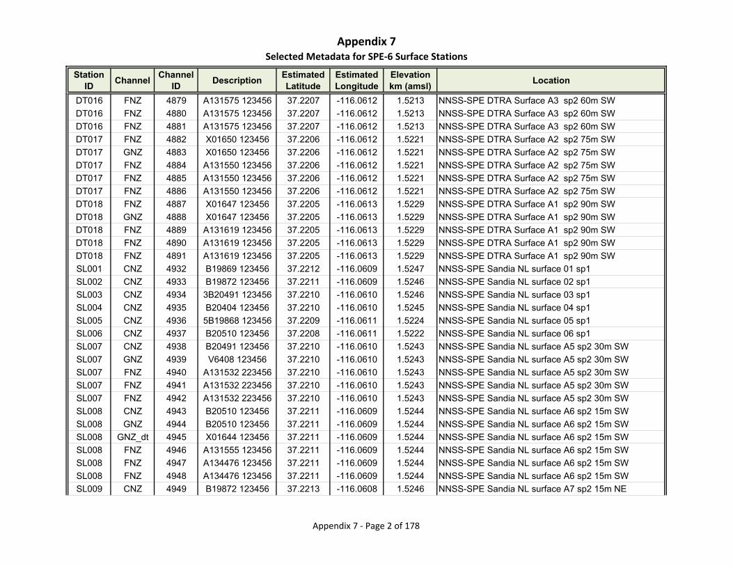
Appendix 7Selected Metadata for SPE‐6 Surface Stations
Station ID
ChannelChannel
IDDescription
Estimated Latitude
Estimated Longitude
Elevationkm (amsl)
Location
DT016 FNZ 4879 A131575 123456 37.2207 -116.0612 1.5213 NNSS-SPE DTRA Surface A3 sp2 60m SW
DT016 FNZ 4880 A131575 123456 37.2207 -116.0612 1.5213 NNSS-SPE DTRA Surface A3 sp2 60m SW
DT016 FNZ 4881 A131575 123456 37.2207 -116.0612 1.5213 NNSS-SPE DTRA Surface A3 sp2 60m SW
DT017 FNZ 4882 X01650 123456 37.2206 -116.0612 1.5221 NNSS-SPE DTRA Surface A2 sp2 75m SW
DT017 GNZ 4883 X01650 123456 37.2206 -116.0612 1.5221 NNSS-SPE DTRA Surface A2 sp2 75m SW
DT017 FNZ 4884 A131550 123456 37.2206 -116.0612 1.5221 NNSS-SPE DTRA Surface A2 sp2 75m SW
DT017 FNZ 4885 A131550 123456 37.2206 -116.0612 1.5221 NNSS-SPE DTRA Surface A2 sp2 75m SW
DT017 FNZ 4886 A131550 123456 37.2206 -116.0612 1.5221 NNSS-SPE DTRA Surface A2 sp2 75m SW
DT018 FNZ 4887 X01647 123456 37.2205 -116.0613 1.5229 NNSS-SPE DTRA Surface A1 sp2 90m SW
DT018 GNZ 4888 X01647 123456 37.2205 -116.0613 1.5229 NNSS-SPE DTRA Surface A1 sp2 90m SW
DT018 FNZ 4889 A131619 123456 37.2205 -116.0613 1.5229 NNSS-SPE DTRA Surface A1 sp2 90m SW
DT018 FNZ 4890 A131619 123456 37.2205 -116.0613 1.5229 NNSS-SPE DTRA Surface A1 sp2 90m SW
DT018 FNZ 4891 A131619 123456 37.2205 -116.0613 1.5229 NNSS-SPE DTRA Surface A1 sp2 90m SW
SL001 CNZ 4932 B19869 123456 37.2212 -116.0609 1.5247 NNSS-SPE Sandia NL surface 01 sp1
SL002 CNZ 4933 B19872 123456 37.2211 -116.0609 1.5246 NNSS-SPE Sandia NL surface 02 sp1
SL003 CNZ 4934 3B20491 123456 37.2210 -116.0610 1.5246 NNSS-SPE Sandia NL surface 03 sp1
SL004 CNZ 4935 B20404 123456 37.2210 -116.0610 1.5245 NNSS-SPE Sandia NL surface 04 sp1
SL005 CNZ 4936 5B19868 123456 37.2209 -116.0611 1.5224 NNSS-SPE Sandia NL surface 05 sp1
SL006 CNZ 4937 B20510 123456 37.2208 -116.0611 1.5222 NNSS-SPE Sandia NL surface 06 sp1
SL007 CNZ 4938 B20491 123456 37.2210 -116.0610 1.5243 NNSS-SPE Sandia NL surface A5 sp2 30m SW
SL007 GNZ 4939 V6408 123456 37.2210 -116.0610 1.5243 NNSS-SPE Sandia NL surface A5 sp2 30m SW
SL007 FNZ 4940 A131532 223456 37.2210 -116.0610 1.5243 NNSS-SPE Sandia NL surface A5 sp2 30m SW
SL007 FNZ 4941 A131532 223456 37.2210 -116.0610 1.5243 NNSS-SPE Sandia NL surface A5 sp2 30m SW
SL007 FNZ 4942 A131532 223456 37.2210 -116.0610 1.5243 NNSS-SPE Sandia NL surface A5 sp2 30m SW
SL008 CNZ 4943 B20510 123456 37.2211 -116.0609 1.5244 NNSS-SPE Sandia NL surface A6 sp2 15m SW
SL008 GNZ 4944 B20510 123456 37.2211 -116.0609 1.5244 NNSS-SPE Sandia NL surface A6 sp2 15m SW
SL008 GNZ_dt 4945 X01644 123456 37.2211 -116.0609 1.5244 NNSS-SPE Sandia NL surface A6 sp2 15m SW
SL008 FNZ 4946 A131555 123456 37.2211 -116.0609 1.5244 NNSS-SPE Sandia NL surface A6 sp2 15m SW
SL008 FNZ 4947 A134476 123456 37.2211 -116.0609 1.5244 NNSS-SPE Sandia NL surface A6 sp2 15m SW
SL008 FNZ 4948 A134476 123456 37.2211 -116.0609 1.5244 NNSS-SPE Sandia NL surface A6 sp2 15m SW
SL009 CNZ 4949 B19872 123456 37.2213 -116.0608 1.5246 NNSS-SPE Sandia NL surface A7 sp2 15m NE
Appendix 7 ‐ Page 2 of 178
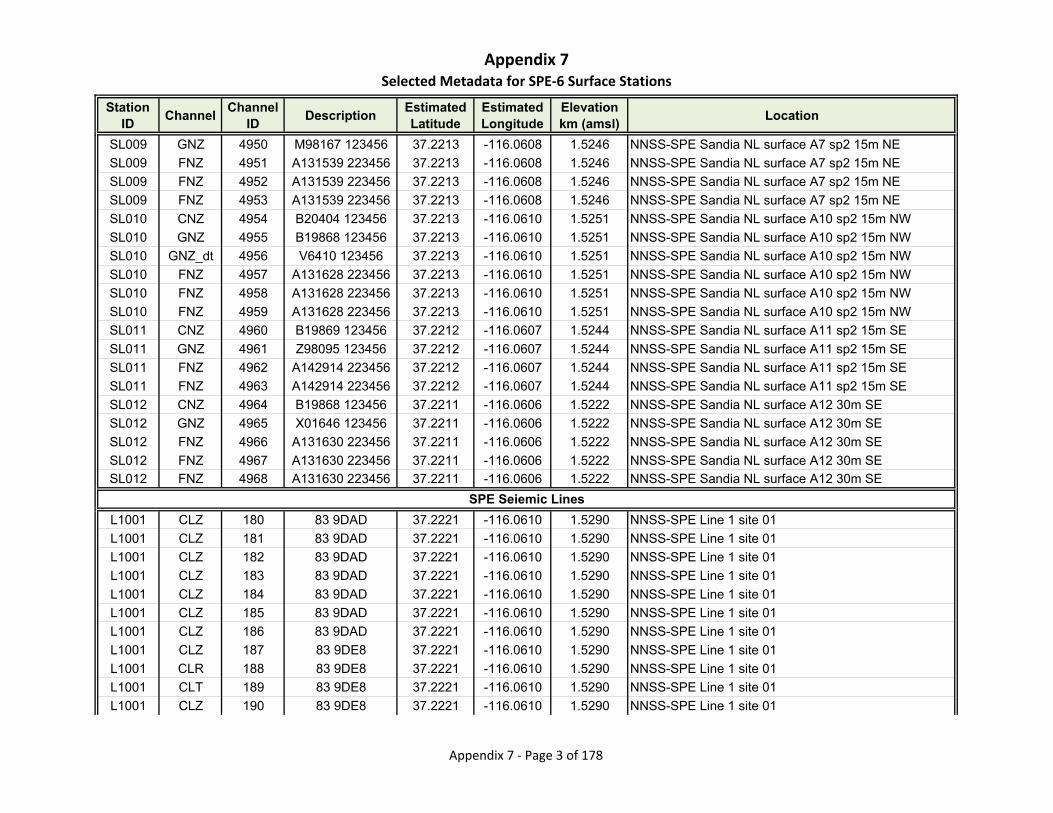
Appendix 7Selected Metadata for SPE‐6 Surface Stations
Station ID
ChannelChannel
IDDescription
Estimated Latitude
Estimated Longitude
Elevationkm (amsl)
Location
SL009 GNZ 4950 M98167 123456 37.2213 -116.0608 1.5246 NNSS-SPE Sandia NL surface A7 sp2 15m NE
SL009 FNZ 4951 A131539 223456 37.2213 -116.0608 1.5246 NNSS-SPE Sandia NL surface A7 sp2 15m NE
SL009 FNZ 4952 A131539 223456 37.2213 -116.0608 1.5246 NNSS-SPE Sandia NL surface A7 sp2 15m NE
SL009 FNZ 4953 A131539 223456 37.2213 -116.0608 1.5246 NNSS-SPE Sandia NL surface A7 sp2 15m NE
SL010 CNZ 4954 B20404 123456 37.2213 -116.0610 1.5251 NNSS-SPE Sandia NL surface A10 sp2 15m NW
SL010 GNZ 4955 B19868 123456 37.2213 -116.0610 1.5251 NNSS-SPE Sandia NL surface A10 sp2 15m NW
SL010 GNZ_dt 4956 V6410 123456 37.2213 -116.0610 1.5251 NNSS-SPE Sandia NL surface A10 sp2 15m NW
SL010 FNZ 4957 A131628 223456 37.2213 -116.0610 1.5251 NNSS-SPE Sandia NL surface A10 sp2 15m NW
SL010 FNZ 4958 A131628 223456 37.2213 -116.0610 1.5251 NNSS-SPE Sandia NL surface A10 sp2 15m NW
SL010 FNZ 4959 A131628 223456 37.2213 -116.0610 1.5251 NNSS-SPE Sandia NL surface A10 sp2 15m NW
SL011 CNZ 4960 B19869 123456 37.2212 -116.0607 1.5244 NNSS-SPE Sandia NL surface A11 sp2 15m SE
SL011 GNZ 4961 Z98095 123456 37.2212 -116.0607 1.5244 NNSS-SPE Sandia NL surface A11 sp2 15m SE
SL011 FNZ 4962 A142914 223456 37.2212 -116.0607 1.5244 NNSS-SPE Sandia NL surface A11 sp2 15m SE
SL011 FNZ 4963 A142914 223456 37.2212 -116.0607 1.5244 NNSS-SPE Sandia NL surface A11 sp2 15m SE
SL012 CNZ 4964 B19868 123456 37.2211 -116.0606 1.5222 NNSS-SPE Sandia NL surface A12 30m SE
SL012 GNZ 4965 X01646 123456 37.2211 -116.0606 1.5222 NNSS-SPE Sandia NL surface A12 30m SE
SL012 FNZ 4966 A131630 223456 37.2211 -116.0606 1.5222 NNSS-SPE Sandia NL surface A12 30m SE
SL012 FNZ 4967 A131630 223456 37.2211 -116.0606 1.5222 NNSS-SPE Sandia NL surface A12 30m SE
SL012 FNZ 4968 A131630 223456 37.2211 -116.0606 1.5222 NNSS-SPE Sandia NL surface A12 30m SE
L1001 CLZ 180 83 9DAD 37.2221 -116.0610 1.5290 NNSS-SPE Line 1 site 01
L1001 CLZ 181 83 9DAD 37.2221 -116.0610 1.5290 NNSS-SPE Line 1 site 01
L1001 CLZ 182 83 9DAD 37.2221 -116.0610 1.5290 NNSS-SPE Line 1 site 01
L1001 CLZ 183 83 9DAD 37.2221 -116.0610 1.5290 NNSS-SPE Line 1 site 01
L1001 CLZ 184 83 9DAD 37.2221 -116.0610 1.5290 NNSS-SPE Line 1 site 01
L1001 CLZ 185 83 9DAD 37.2221 -116.0610 1.5290 NNSS-SPE Line 1 site 01
L1001 CLZ 186 83 9DAD 37.2221 -116.0610 1.5290 NNSS-SPE Line 1 site 01
L1001 CLZ 187 83 9DE8 37.2221 -116.0610 1.5290 NNSS-SPE Line 1 site 01
L1001 CLR 188 83 9DE8 37.2221 -116.0610 1.5290 NNSS-SPE Line 1 site 01
L1001 CLT 189 83 9DE8 37.2221 -116.0610 1.5290 NNSS-SPE Line 1 site 01
L1001 CLZ 190 83 9DE8 37.2221 -116.0610 1.5290 NNSS-SPE Line 1 site 01
SPE Seiemic Lines
Appendix 7 ‐ Page 3 of 178

Appendix 7Selected Metadata for SPE‐6 Surface Stations
Station ID
ChannelChannel
IDDescription
Estimated Latitude
Estimated Longitude
Elevationkm (amsl)
Location
L1001 CLR 191 83 9DE8 37.2221 -116.0610 1.5290 NNSS-SPE Line 1 site 01
L1001 CLT 192 83 9DE8 37.2221 -116.0610 1.5290 NNSS-SPE Line 1 site 01
L1001 CLZ 193 83 9DE8 37.2221 -116.0610 1.5290 NNSS-SPE Line 1 site 01
L1001 CLR 194 83 9DE8 37.2221 -116.0610 1.5290 NNSS-SPE Line 1 site 01
L1001 CLT 195 83 9DE8 37.2221 -116.0610 1.5290 NNSS-SPE Line 1 site 01
L1001 CLZ 196 83 B3B0 37.2221 -116.0610 1.5290 NNSS-SPE Line 1 site 01
L1001 CLR 197 83 B3B0 37.2221 -116.0610 1.5290 NNSS-SPE Line 1 site 01
L1001 CLT 198 83 B3B0 37.2221 -116.0610 1.5290 NNSS-SPE Line 1 site 01
L1001 CLZ 199 83 B3B0 37.2221 -116.0610 1.5290 NNSS-SPE Line 1 site 01
L1001 CLR 200 83 B3B0 37.2221 -116.0610 1.5290 NNSS-SPE Line 1 site 01
L1001 CLT 201 83 B3B0 37.2221 -116.0610 1.5290 NNSS-SPE Line 1 site 01
L1001 CLZ 202 83 D1C7 37.2221 -116.0610 1.5290 NNSS-SPE Line 1 site 01
L1001 CLR 203 83 D1C7 37.2221 -116.0610 1.5290 NNSS-SPE Line 1 site 01
L1001 CLT 204 83 D1C7 37.2221 -116.0610 1.5290 NNSS-SPE Line 1 site 01
L1001 CNZ 205 4975 D1C7 37.2221 -116.0610 1.5290 NNSS-SPE Line 1 site 01
L1001 CNR 206 4975 D1C7 37.2221 -116.0610 1.5290 NNSS-SPE Line 1 site 01
L1001 CNT 207 4975 D1C7 37.2221 -116.0610 1.5290 NNSS-SPE Line 1 site 01
L1001 CLZ 208 83 D1C7 37.2221 -116.0610 1.5290 NNSS-SPE Line 1 site 01
L1001 CLR 209 83 D1C7 37.2221 -116.0610 1.5290 NNSS-SPE Line 1 site 01
L1001 CLT 210 83 D1C7 37.2221 -116.0610 1.5290 NNSS-SPE Line 1 site 01
L1001 CNZ 211 4975 D1C7 37.2221 -116.0610 1.5290 NNSS-SPE Line 1 site 01
L1001 CNR 212 4975 D1C7 37.2221 -116.0610 1.5290 NNSS-SPE Line 1 site 01
L1001 CNT 213 4975 D1C7 37.2221 -116.0610 1.5290 NNSS-SPE Line 1 site 01
L1001 CLZ 214 83 D1C7 37.2221 -116.0610 1.5290 NNSS-SPE Line 1 site 01
L1001 CLR 215 83 D1C7 37.2221 -116.0610 1.5290 NNSS-SPE Line 1 site 01
L1001 CLT 216 83 D1C7 37.2221 -116.0610 1.5290 NNSS-SPE Line 1 site 01
L1001 CLZ 217 83 D1C7 37.2221 -116.0610 1.5290 NNSS-SPE Line 1 site 01
L1001 CLR 218 83 D1C7 37.2221 -116.0610 1.5290 NNSS-SPE Line 1 site 01
L1001 CLT 219 83 D1C7 37.2221 -116.0610 1.5290 NNSS-SPE Line 1 site 01
L1001 CNZ 220 4975 D1C7 37.2221 -116.0610 1.5290 NNSS-SPE Line 1 site 01
L1001 CNR 221 4975 D1C7 37.2221 -116.0610 1.5290 NNSS-SPE Line 1 site 01
Appendix 7 ‐ Page 4 of 178

Appendix 7Selected Metadata for SPE‐6 Surface Stations
Station ID
ChannelChannel
IDDescription
Estimated Latitude
Estimated Longitude
Elevationkm (amsl)
Location
L1001 CNT 222 4975 D1C7 37.2221 -116.0610 1.5290 NNSS-SPE Line 1 site 01
L1001 CLZ 223 83 D163 37.2221 -116.0610 1.5290 NNSS-SPE Line 1 site 01
L1001 CLR 224 83 D163 37.2221 -116.0610 1.5290 NNSS-SPE Line 1 site 01
L1001 CLT 225 83 D163 37.2221 -116.0610 1.5290 NNSS-SPE Line 1 site 01
L1001 CNZ 226 4975 D163 37.2221 -116.0610 1.5290 NNSS-SPE Line 1 site 01
L1001 CNR 227 4975 D163 37.2221 -116.0610 1.5290 NNSS-SPE Line 1 site 01
L1001 CNT 228 4975 D163 37.2221 -116.0610 1.5290 NNSS-SPE Line 1 site 01
L1002 CLZ 229 6 9DAD 37.2230 -116.0611 1.5370 NNSS-SPE Line 1 site 02
L1002 CLZ 230 6 9DAD 37.2230 -116.0611 1.5370 NNSS-SPE Line 1 site 02
L1002 CLZ 231 6 9DAD 37.2230 -116.0611 1.5370 NNSS-SPE Line 1 site 02
L1002 CLZ 232 6 9DAD 37.2230 -116.0611 1.5370 NNSS-SPE Line 1 site 02
L1002 CLZ 233 6 9DAD 37.2230 -116.0611 1.5370 NNSS-SPE Line 1 site 02
L1002 CLZ 234 6 9DAD 37.2230 -116.0611 1.5370 NNSS-SPE Line 1 site 02
L1002 CLZ 235 6 9DAD 37.2230 -116.0611 1.5370 NNSS-SPE Line 1 site 02
L1002 CLZ 236 6 9DE8 37.2230 -116.0611 1.5370 NNSS-SPE Line 1 site 02
L1002 CLR 237 6 9DE8 37.2230 -116.0611 1.5370 NNSS-SPE Line 1 site 02
L1002 CLT 238 6 9DE8 37.2230 -116.0611 1.5370 NNSS-SPE Line 1 site 02
L1002 CLZ 239 67 9DE8 37.2230 -116.0611 1.5370 NNSS-SPE Line 1 site 02
L1002 CLR 240 67 9DE8 37.2230 -116.0611 1.5370 NNSS-SPE Line 1 site 02
L1002 CLT 241 67 9DE8 37.2230 -116.0611 1.5370 NNSS-SPE Line 1 site 02
L1002 CLZ 242 67 9DE8 37.2230 -116.0611 1.5370 NNSS-SPE Line 1 site 02
L1002 CLR 243 67 9DE8 37.2230 -116.0611 1.5370 NNSS-SPE Line 1 site 02
L1002 CLT 244 67 9DE8 37.2230 -116.0611 1.5370 NNSS-SPE Line 1 site 02
L1002 CLZ 245 67 B3B0 37.2230 -116.0611 1.5370 NNSS-SPE Line 1 site 02
L1002 CLR 246 67 B3B0 37.2230 -116.0611 1.5370 NNSS-SPE Line 1 site 02
L1002 CLT 247 67 B3B0 37.2230 -116.0611 1.5370 NNSS-SPE Line 1 site 02
L1002 CLZ 248 67 B3B0 37.2230 -116.0611 1.5370 NNSS-SPE Line 1 site 02
L1002 CLR 249 67 B3B0 37.2230 -116.0611 1.5370 NNSS-SPE Line 1 site 02
L1002 CLT 250 67 B3B0 37.2230 -116.0611 1.5370 NNSS-SPE Line 1 site 02
L1002 CNZ 251 167 B3B0 37.2230 -116.0611 1.5370 NNSS-SPE Line 1 site 02
L1002 CNR 252 167 B3B0 37.2230 -116.0611 1.5370 NNSS-SPE Line 1 site 02
Appendix 7 ‐ Page 5 of 178

Appendix 7Selected Metadata for SPE‐6 Surface Stations
Station ID
ChannelChannel
IDDescription
Estimated Latitude
Estimated Longitude
Elevationkm (amsl)
Location
L1002 CNT 253 167 B3B0 37.2230 -116.0611 1.5370 NNSS-SPE Line 1 site 02
L1002 CLZ 254 67 B3B0 37.2230 -116.0611 1.5370 NNSS-SPE Line 1 site 02
L1002 CLR 255 67 B3B0 37.2230 -116.0611 1.5370 NNSS-SPE Line 1 site 02
L1002 CLT 256 67 B3B0 37.2230 -116.0611 1.5370 NNSS-SPE Line 1 site 02
L1002 CNZ 257 167 B3B0 37.2230 -116.0611 1.5370 NNSS-SPE Line 1 site 02
L1002 CNR 258 167 B3B0 37.2230 -116.0611 1.5370 NNSS-SPE Line 1 site 02
L1002 CNT 259 167 B3B0 37.2230 -116.0611 1.5370 NNSS-SPE Line 1 site 02
L1002 CLZ 260 67 B3B0 37.2230 -116.0611 1.5370 NNSS-SPE Line 1 site 02
L1002 CLR 261 67 B3B0 37.2230 -116.0611 1.5370 NNSS-SPE Line 1 site 02
L1002 CLT 262 67 B3B0 37.2230 -116.0611 1.5370 NNSS-SPE Line 1 site 02
L1002 CLZ 263 67 B3B0 37.2230 -116.0611 1.5370 NNSS-SPE Line 1 site 02
L1002 CLR 264 67 B3B0 37.2230 -116.0611 1.5370 NNSS-SPE Line 1 site 02
L1002 CLT 265 67 B3B0 37.2230 -116.0611 1.5370 NNSS-SPE Line 1 site 02
L1002 CNZ 266 167 B3B0 37.2230 -116.0611 1.5370 NNSS-SPE Line 1 site 02
L1002 CNR 267 167 B3B0 37.2230 -116.0611 1.5370 NNSS-SPE Line 1 site 02
L1002 CNT 268 167 B3B0 37.2230 -116.0611 1.5370 NNSS-SPE Line 1 site 02
L1002 CLZ 269 67 B3B0 37.2230 -116.0611 1.5370 NNSS-SPE Line 1 site 02
L1002 CLR 270 67 B3B0 37.2230 -116.0611 1.5370 NNSS-SPE Line 1 site 02
L1002 CLT 271 67 B3B0 37.2230 -116.0611 1.5370 NNSS-SPE Line 1 site 02
L1003 CLZ 272 108 9DAD 37.2239 -116.0611 1.5400 NNSS-SPE Line 1 site 03
L1003 CLZ 273 108 9DAD 37.2239 -116.0611 1.5400 NNSS-SPE Line 1 site 03
L1003 CLZ 274 108 9DAD 37.2239 -116.0611 1.5400 NNSS-SPE Line 1 site 03
L1003 CLZ 275 108 9DAD 37.2239 -116.0611 1.5400 NNSS-SPE Line 1 site 03
L1003 CLZ 276 108 9DAD 37.2239 -116.0611 1.5400 NNSS-SPE Line 1 site 03
L1003 CLZ 277 108 9DAD 37.2239 -116.0611 1.5400 NNSS-SPE Line 1 site 03
L1003 CLZ 278 108 9DAD 37.2239 -116.0611 1.5400 NNSS-SPE Line 1 site 03
L1003 CLZ 279 108 9DAD 37.2239 -116.0611 1.5400 NNSS-SPE Line 1 site 03
L1003 CLR 280 108 9DAD 37.2239 -116.0611 1.5400 NNSS-SPE Line 1 site 03
L1003 CLT 281 108 9DAD 37.2239 -116.0611 1.5400 NNSS-SPE Line 1 site 03
L1003 CLZ 282 108 9DAD 37.2239 -116.0611 1.5400 NNSS-SPE Line 1 site 03
L1003 CLR 283 108 9DAD 37.2239 -116.0611 1.5400 NNSS-SPE Line 1 site 03
Appendix 7 ‐ Page 6 of 178
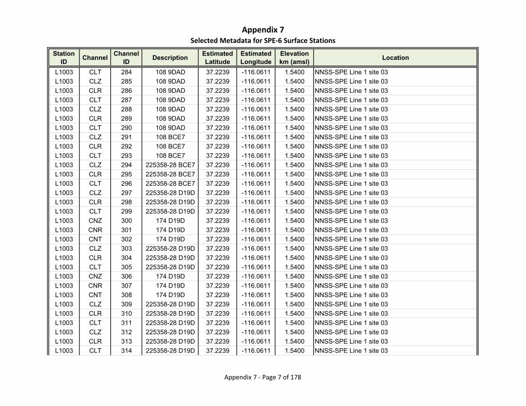
Appendix 7Selected Metadata for SPE‐6 Surface Stations
Station ID
ChannelChannel
IDDescription
Estimated Latitude
Estimated Longitude
Elevationkm (amsl)
Location
L1003 CLT 284 108 9DAD 37.2239 -116.0611 1.5400 NNSS-SPE Line 1 site 03
L1003 CLZ 285 108 9DAD 37.2239 -116.0611 1.5400 NNSS-SPE Line 1 site 03
L1003 CLR 286 108 9DAD 37.2239 -116.0611 1.5400 NNSS-SPE Line 1 site 03
L1003 CLT 287 108 9DAD 37.2239 -116.0611 1.5400 NNSS-SPE Line 1 site 03
L1003 CLZ 288 108 9DAD 37.2239 -116.0611 1.5400 NNSS-SPE Line 1 site 03
L1003 CLR 289 108 9DAD 37.2239 -116.0611 1.5400 NNSS-SPE Line 1 site 03
L1003 CLT 290 108 9DAD 37.2239 -116.0611 1.5400 NNSS-SPE Line 1 site 03
L1003 CLZ 291 108 BCE7 37.2239 -116.0611 1.5400 NNSS-SPE Line 1 site 03
L1003 CLR 292 108 BCE7 37.2239 -116.0611 1.5400 NNSS-SPE Line 1 site 03
L1003 CLT 293 108 BCE7 37.2239 -116.0611 1.5400 NNSS-SPE Line 1 site 03
L1003 CLZ 294 225358-28 BCE7 37.2239 -116.0611 1.5400 NNSS-SPE Line 1 site 03
L1003 CLR 295 225358-28 BCE7 37.2239 -116.0611 1.5400 NNSS-SPE Line 1 site 03
L1003 CLT 296 225358-28 BCE7 37.2239 -116.0611 1.5400 NNSS-SPE Line 1 site 03
L1003 CLZ 297 225358-28 D19D 37.2239 -116.0611 1.5400 NNSS-SPE Line 1 site 03
L1003 CLR 298 225358-28 D19D 37.2239 -116.0611 1.5400 NNSS-SPE Line 1 site 03
L1003 CLT 299 225358-28 D19D 37.2239 -116.0611 1.5400 NNSS-SPE Line 1 site 03
L1003 CNZ 300 174 D19D 37.2239 -116.0611 1.5400 NNSS-SPE Line 1 site 03
L1003 CNR 301 174 D19D 37.2239 -116.0611 1.5400 NNSS-SPE Line 1 site 03
L1003 CNT 302 174 D19D 37.2239 -116.0611 1.5400 NNSS-SPE Line 1 site 03
L1003 CLZ 303 225358-28 D19D 37.2239 -116.0611 1.5400 NNSS-SPE Line 1 site 03
L1003 CLR 304 225358-28 D19D 37.2239 -116.0611 1.5400 NNSS-SPE Line 1 site 03
L1003 CLT 305 225358-28 D19D 37.2239 -116.0611 1.5400 NNSS-SPE Line 1 site 03
L1003 CNZ 306 174 D19D 37.2239 -116.0611 1.5400 NNSS-SPE Line 1 site 03
L1003 CNR 307 174 D19D 37.2239 -116.0611 1.5400 NNSS-SPE Line 1 site 03
L1003 CNT 308 174 D19D 37.2239 -116.0611 1.5400 NNSS-SPE Line 1 site 03
L1003 CLZ 309 225358-28 D19D 37.2239 -116.0611 1.5400 NNSS-SPE Line 1 site 03
L1003 CLR 310 225358-28 D19D 37.2239 -116.0611 1.5400 NNSS-SPE Line 1 site 03
L1003 CLT 311 225358-28 D19D 37.2239 -116.0611 1.5400 NNSS-SPE Line 1 site 03
L1003 CLZ 312 225358-28 D19D 37.2239 -116.0611 1.5400 NNSS-SPE Line 1 site 03
L1003 CLR 313 225358-28 D19D 37.2239 -116.0611 1.5400 NNSS-SPE Line 1 site 03
L1003 CLT 314 225358-28 D19D 37.2239 -116.0611 1.5400 NNSS-SPE Line 1 site 03
Appendix 7 ‐ Page 7 of 178
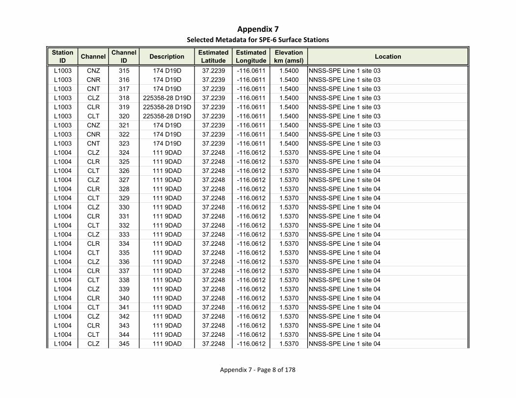
Appendix 7Selected Metadata for SPE‐6 Surface Stations
Station ID
ChannelChannel
IDDescription
Estimated Latitude
Estimated Longitude
Elevationkm (amsl)
Location
L1003 CNZ 315 174 D19D 37.2239 -116.0611 1.5400 NNSS-SPE Line 1 site 03
L1003 CNR 316 174 D19D 37.2239 -116.0611 1.5400 NNSS-SPE Line 1 site 03
L1003 CNT 317 174 D19D 37.2239 -116.0611 1.5400 NNSS-SPE Line 1 site 03
L1003 CLZ 318 225358-28 D19D 37.2239 -116.0611 1.5400 NNSS-SPE Line 1 site 03
L1003 CLR 319 225358-28 D19D 37.2239 -116.0611 1.5400 NNSS-SPE Line 1 site 03
L1003 CLT 320 225358-28 D19D 37.2239 -116.0611 1.5400 NNSS-SPE Line 1 site 03
L1003 CNZ 321 174 D19D 37.2239 -116.0611 1.5400 NNSS-SPE Line 1 site 03
L1003 CNR 322 174 D19D 37.2239 -116.0611 1.5400 NNSS-SPE Line 1 site 03
L1003 CNT 323 174 D19D 37.2239 -116.0611 1.5400 NNSS-SPE Line 1 site 03
L1004 CLZ 324 111 9DAD 37.2248 -116.0612 1.5370 NNSS-SPE Line 1 site 04
L1004 CLR 325 111 9DAD 37.2248 -116.0612 1.5370 NNSS-SPE Line 1 site 04
L1004 CLT 326 111 9DAD 37.2248 -116.0612 1.5370 NNSS-SPE Line 1 site 04
L1004 CLZ 327 111 9DAD 37.2248 -116.0612 1.5370 NNSS-SPE Line 1 site 04
L1004 CLR 328 111 9DAD 37.2248 -116.0612 1.5370 NNSS-SPE Line 1 site 04
L1004 CLT 329 111 9DAD 37.2248 -116.0612 1.5370 NNSS-SPE Line 1 site 04
L1004 CLZ 330 111 9DAD 37.2248 -116.0612 1.5370 NNSS-SPE Line 1 site 04
L1004 CLR 331 111 9DAD 37.2248 -116.0612 1.5370 NNSS-SPE Line 1 site 04
L1004 CLT 332 111 9DAD 37.2248 -116.0612 1.5370 NNSS-SPE Line 1 site 04
L1004 CLZ 333 111 9DAD 37.2248 -116.0612 1.5370 NNSS-SPE Line 1 site 04
L1004 CLR 334 111 9DAD 37.2248 -116.0612 1.5370 NNSS-SPE Line 1 site 04
L1004 CLT 335 111 9DAD 37.2248 -116.0612 1.5370 NNSS-SPE Line 1 site 04
L1004 CLZ 336 111 9DAD 37.2248 -116.0612 1.5370 NNSS-SPE Line 1 site 04
L1004 CLR 337 111 9DAD 37.2248 -116.0612 1.5370 NNSS-SPE Line 1 site 04
L1004 CLT 338 111 9DAD 37.2248 -116.0612 1.5370 NNSS-SPE Line 1 site 04
L1004 CLZ 339 111 9DAD 37.2248 -116.0612 1.5370 NNSS-SPE Line 1 site 04
L1004 CLR 340 111 9DAD 37.2248 -116.0612 1.5370 NNSS-SPE Line 1 site 04
L1004 CLT 341 111 9DAD 37.2248 -116.0612 1.5370 NNSS-SPE Line 1 site 04
L1004 CLZ 342 111 9DAD 37.2248 -116.0612 1.5370 NNSS-SPE Line 1 site 04
L1004 CLR 343 111 9DAD 37.2248 -116.0612 1.5370 NNSS-SPE Line 1 site 04
L1004 CLT 344 111 9DAD 37.2248 -116.0612 1.5370 NNSS-SPE Line 1 site 04
L1004 CLZ 345 111 9DAD 37.2248 -116.0612 1.5370 NNSS-SPE Line 1 site 04
Appendix 7 ‐ Page 8 of 178

Appendix 7Selected Metadata for SPE‐6 Surface Stations
Station ID
ChannelChannel
IDDescription
Estimated Latitude
Estimated Longitude
Elevationkm (amsl)
Location
L1004 CLR 346 111 9DAD 37.2248 -116.0612 1.5370 NNSS-SPE Line 1 site 04
L1004 CLT 347 111 9DAD 37.2248 -116.0612 1.5370 NNSS-SPE Line 1 site 04
L1004 CLZ 348 111 9DAD 37.2248 -116.0612 1.5370 NNSS-SPE Line 1 site 04
L1004 CLR 349 111 9DAD 37.2248 -116.0612 1.5370 NNSS-SPE Line 1 site 04
L1004 CLT 350 111 9DAD 37.2248 -116.0612 1.5370 NNSS-SPE Line 1 site 04
L1004 CLZ 351 111 9DAD 37.2248 -116.0612 1.5370 NNSS-SPE Line 1 site 04
L1004 CLR 352 111 9DAD 37.2248 -116.0612 1.5370 NNSS-SPE Line 1 site 04
L1004 CLT 353 111 9DAD 37.2248 -116.0612 1.5370 NNSS-SPE Line 1 site 04
L1004 CLZ 354 111 BCE7 37.2248 -116.0612 1.5370 NNSS-SPE Line 1 site 04
L1004 CLR 355 111 BCE7 37.2248 -116.0612 1.5370 NNSS-SPE Line 1 site 04
L1004 CLT 356 111 BCE7 37.2248 -116.0612 1.5370 NNSS-SPE Line 1 site 04
L1004 CLZ 357 111 BCE7 37.2248 -116.0612 1.5370 NNSS-SPE Line 1 site 04
L1004 CLR 358 111 BCE7 37.2248 -116.0612 1.5370 NNSS-SPE Line 1 site 04
L1004 CLT 359 111 BCE7 37.2248 -116.0612 1.5370 NNSS-SPE Line 1 site 04
L1004 CLZ 360 111 BCE7 37.2248 -116.0612 1.5370 NNSS-SPE Line 1 site 04
L1004 CLR 361 111 BCE7 37.2248 -116.0612 1.5370 NNSS-SPE Line 1 site 04
L1004 CLT 362 111 BCE7 37.2248 -116.0612 1.5370 NNSS-SPE Line 1 site 04
L1004 CLZ 363 111 BCE7 37.2248 -116.0612 1.5370 NNSS-SPE Line 1 site 04
L1004 CLR 364 111 BCE7 37.2248 -116.0612 1.5370 NNSS-SPE Line 1 site 04
L1004 CLT 365 111 BCE7 37.2248 -116.0612 1.5370 NNSS-SPE Line 1 site 04
L1004 CLZ 366 111 BCE7 37.2248 -116.0612 1.5370 NNSS-SPE Line 1 site 04
L1004 CLR 367 111 BCE7 37.2248 -116.0612 1.5370 NNSS-SPE Line 1 site 04
L1004 CLT 368 111 BCE7 37.2248 -116.0612 1.5370 NNSS-SPE Line 1 site 04
L1004 CLZ 369 111 BCE7 37.2248 -116.0612 1.5370 NNSS-SPE Line 1 site 04
L1004 CLR 370 111 BCE7 37.2248 -116.0612 1.5370 NNSS-SPE Line 1 site 04
L1004 CLT 371 111 BCE7 37.2248 -116.0612 1.5370 NNSS-SPE Line 1 site 04
L1005 CLZ 372 5 9318 37.2257 -116.0613 1.5500 NNSS-SPE Line 1 site 05
L1005 CLZ 373 5 9318 37.2257 -116.0613 1.5500 NNSS-SPE Line 1 site 05
L1005 CLZ 374 5 9318 37.2257 -116.0613 1.5500 NNSS-SPE Line 1 site 05
L1005 CLZ 375 5 9318 37.2257 -116.0613 1.5500 NNSS-SPE Line 1 site 05
L1005 CLZ 376 5 9318 37.2257 -116.0613 1.5500 NNSS-SPE Line 1 site 05
Appendix 7 ‐ Page 9 of 178

Appendix 7Selected Metadata for SPE‐6 Surface Stations
Station ID
ChannelChannel
IDDescription
Estimated Latitude
Estimated Longitude
Elevationkm (amsl)
Location
L1005 CLZ 377 5 9318 37.2257 -116.0613 1.5500 NNSS-SPE Line 1 site 05
L1005 CLZ 378 5 9318 37.2257 -116.0613 1.5500 NNSS-SPE Line 1 site 05
L1005 CLZ 379 5 9E34 37.2257 -116.0613 1.5500 NNSS-SPE Line 1 site 05
L1005 CLR 380 5 9E34 37.2257 -116.0613 1.5500 NNSS-SPE Line 1 site 05
L1005 CLT 381 5 9E34 37.2257 -116.0613 1.5500 NNSS-SPE Line 1 site 05
L1005 CLZ 382 5 9E34 37.2257 -116.0613 1.5500 NNSS-SPE Line 1 site 05
L1005 CLR 383 5 9E34 37.2257 -116.0613 1.5500 NNSS-SPE Line 1 site 05
L1005 CLT 384 5 9E34 37.2257 -116.0613 1.5500 NNSS-SPE Line 1 site 05
L1005 CLZ 385 5 9E34 37.2257 -116.0613 1.5500 NNSS-SPE Line 1 site 05
L1005 CLR 386 5 9E34 37.2257 -116.0613 1.5500 NNSS-SPE Line 1 site 05
L1005 CLT 387 5 9E34 37.2257 -116.0613 1.5500 NNSS-SPE Line 1 site 05
L1005 CLZ 388 5 9E34 37.2257 -116.0613 1.5500 NNSS-SPE Line 1 site 05
L1005 CLR 389 5 9E34 37.2257 -116.0613 1.5500 NNSS-SPE Line 1 site 05
L1005 CLT 390 5 9E34 37.2257 -116.0613 1.5500 NNSS-SPE Line 1 site 05
L1005 CLZ 391 5 D14D 37.2257 -116.0613 1.5500 NNSS-SPE Line 1 site 05
L1005 CLR 392 5 D14D 37.2257 -116.0613 1.5500 NNSS-SPE Line 1 site 05
L1005 CLT 393 5 D14D 37.2257 -116.0613 1.5500 NNSS-SPE Line 1 site 05
L1005 CLZ 394 5 D14D 37.2257 -116.0613 1.5500 NNSS-SPE Line 1 site 05
L1005 CLR 395 5 D14D 37.2257 -116.0613 1.5500 NNSS-SPE Line 1 site 05
L1005 CLT 396 5 D14D 37.2257 -116.0613 1.5500 NNSS-SPE Line 1 site 05
L1005 CLZ 397 5 D14D 37.2257 -116.0613 1.5500 NNSS-SPE Line 1 site 05
L1005 CLR 398 5 D14D 37.2257 -116.0613 1.5500 NNSS-SPE Line 1 site 05
L1005 CLT 399 5 D14D 37.2257 -116.0613 1.5500 NNSS-SPE Line 1 site 05
L1005 CLZ 400 5 D14D 37.2257 -116.0613 1.5500 NNSS-SPE Line 1 site 05
L1005 CLR 401 5 D14D 37.2257 -116.0613 1.5500 NNSS-SPE Line 1 site 05
L1005 CLT 402 5 D14D 37.2257 -116.0613 1.5500 NNSS-SPE Line 1 site 05
L1005 CLZ 403 5 D14D 37.2257 -116.0613 1.5500 NNSS-SPE Line 1 site 05
L1005 CLR 404 5 D14D 37.2257 -116.0613 1.5500 NNSS-SPE Line 1 site 05
L1005 CLT 405 5 D14D 37.2257 -116.0613 1.5500 NNSS-SPE Line 1 site 05
L1006 CLZ 406 19 9318 37.2266 -116.0614 1.5580 NNSS-SPE Line 1 site 06
L1006 CLZ 407 19 9318 37.2266 -116.0614 1.5580 NNSS-SPE Line 1 site 06
Appendix 7 ‐ Page 10 of 178
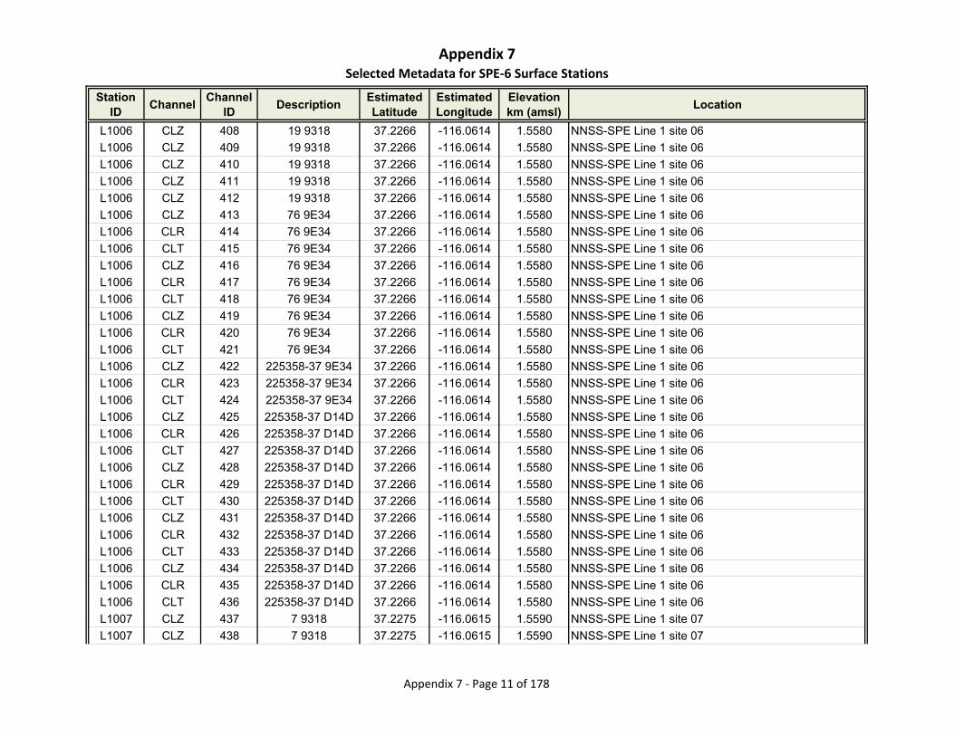
Appendix 7Selected Metadata for SPE‐6 Surface Stations
Station ID
ChannelChannel
IDDescription
Estimated Latitude
Estimated Longitude
Elevationkm (amsl)
Location
L1006 CLZ 408 19 9318 37.2266 -116.0614 1.5580 NNSS-SPE Line 1 site 06
L1006 CLZ 409 19 9318 37.2266 -116.0614 1.5580 NNSS-SPE Line 1 site 06
L1006 CLZ 410 19 9318 37.2266 -116.0614 1.5580 NNSS-SPE Line 1 site 06
L1006 CLZ 411 19 9318 37.2266 -116.0614 1.5580 NNSS-SPE Line 1 site 06
L1006 CLZ 412 19 9318 37.2266 -116.0614 1.5580 NNSS-SPE Line 1 site 06
L1006 CLZ 413 76 9E34 37.2266 -116.0614 1.5580 NNSS-SPE Line 1 site 06
L1006 CLR 414 76 9E34 37.2266 -116.0614 1.5580 NNSS-SPE Line 1 site 06
L1006 CLT 415 76 9E34 37.2266 -116.0614 1.5580 NNSS-SPE Line 1 site 06
L1006 CLZ 416 76 9E34 37.2266 -116.0614 1.5580 NNSS-SPE Line 1 site 06
L1006 CLR 417 76 9E34 37.2266 -116.0614 1.5580 NNSS-SPE Line 1 site 06
L1006 CLT 418 76 9E34 37.2266 -116.0614 1.5580 NNSS-SPE Line 1 site 06
L1006 CLZ 419 76 9E34 37.2266 -116.0614 1.5580 NNSS-SPE Line 1 site 06
L1006 CLR 420 76 9E34 37.2266 -116.0614 1.5580 NNSS-SPE Line 1 site 06
L1006 CLT 421 76 9E34 37.2266 -116.0614 1.5580 NNSS-SPE Line 1 site 06
L1006 CLZ 422 225358-37 9E34 37.2266 -116.0614 1.5580 NNSS-SPE Line 1 site 06
L1006 CLR 423 225358-37 9E34 37.2266 -116.0614 1.5580 NNSS-SPE Line 1 site 06
L1006 CLT 424 225358-37 9E34 37.2266 -116.0614 1.5580 NNSS-SPE Line 1 site 06
L1006 CLZ 425 225358-37 D14D 37.2266 -116.0614 1.5580 NNSS-SPE Line 1 site 06
L1006 CLR 426 225358-37 D14D 37.2266 -116.0614 1.5580 NNSS-SPE Line 1 site 06
L1006 CLT 427 225358-37 D14D 37.2266 -116.0614 1.5580 NNSS-SPE Line 1 site 06
L1006 CLZ 428 225358-37 D14D 37.2266 -116.0614 1.5580 NNSS-SPE Line 1 site 06
L1006 CLR 429 225358-37 D14D 37.2266 -116.0614 1.5580 NNSS-SPE Line 1 site 06
L1006 CLT 430 225358-37 D14D 37.2266 -116.0614 1.5580 NNSS-SPE Line 1 site 06
L1006 CLZ 431 225358-37 D14D 37.2266 -116.0614 1.5580 NNSS-SPE Line 1 site 06
L1006 CLR 432 225358-37 D14D 37.2266 -116.0614 1.5580 NNSS-SPE Line 1 site 06
L1006 CLT 433 225358-37 D14D 37.2266 -116.0614 1.5580 NNSS-SPE Line 1 site 06
L1006 CLZ 434 225358-37 D14D 37.2266 -116.0614 1.5580 NNSS-SPE Line 1 site 06
L1006 CLR 435 225358-37 D14D 37.2266 -116.0614 1.5580 NNSS-SPE Line 1 site 06
L1006 CLT 436 225358-37 D14D 37.2266 -116.0614 1.5580 NNSS-SPE Line 1 site 06
L1007 CLZ 437 7 9318 37.2275 -116.0615 1.5590 NNSS-SPE Line 1 site 07
L1007 CLZ 438 7 9318 37.2275 -116.0615 1.5590 NNSS-SPE Line 1 site 07
Appendix 7 ‐ Page 11 of 178

Appendix 7Selected Metadata for SPE‐6 Surface Stations
Station ID
ChannelChannel
IDDescription
Estimated Latitude
Estimated Longitude
Elevationkm (amsl)
Location
L1007 CLZ 439 7 9318 37.2275 -116.0615 1.5590 NNSS-SPE Line 1 site 07
L1007 CLZ 440 7 9318 37.2275 -116.0615 1.5590 NNSS-SPE Line 1 site 07
L1007 CLZ 441 7 9318 37.2275 -116.0615 1.5590 NNSS-SPE Line 1 site 07
L1007 CLZ 442 7 9318 37.2275 -116.0615 1.5590 NNSS-SPE Line 1 site 07
L1007 CLZ 443 7 9318 37.2275 -116.0615 1.5590 NNSS-SPE Line 1 site 07
L1007 CLZ 444 7 9318 37.2275 -116.0615 1.5590 NNSS-SPE Line 1 site 07
L1007 CLR 445 7 9318 37.2275 -116.0615 1.5590 NNSS-SPE Line 1 site 07
L1007 CLT 446 7 9318 37.2275 -116.0615 1.5590 NNSS-SPE Line 1 site 07
L1007 CLZ 447 7 9318 37.2275 -116.0615 1.5590 NNSS-SPE Line 1 site 07
L1007 CLR 448 7 9318 37.2275 -116.0615 1.5590 NNSS-SPE Line 1 site 07
L1007 CLT 449 7 9318 37.2275 -116.0615 1.5590 NNSS-SPE Line 1 site 07
L1007 CLZ 450 7 B3AF 37.2275 -116.0615 1.5590 NNSS-SPE Line 1 site 07
L1007 CLR 451 7 B3AF 37.2275 -116.0615 1.5590 NNSS-SPE Line 1 site 07
L1007 CLT 452 7 B3AF 37.2275 -116.0615 1.5590 NNSS-SPE Line 1 site 07
L1007 CLZ 453 7 B3AF 37.2275 -116.0615 1.5590 NNSS-SPE Line 1 site 07
L1007 CLR 454 7 B3AF 37.2275 -116.0615 1.5590 NNSS-SPE Line 1 site 07
L1007 CLT 455 7 B3AF 37.2275 -116.0615 1.5590 NNSS-SPE Line 1 site 07
L1007 CLZ 456 7 B3AF 37.2275 -116.0615 1.5590 NNSS-SPE Line 1 site 07
L1007 CLR 457 7 B3AF 37.2275 -116.0615 1.5590 NNSS-SPE Line 1 site 07
L1007 CLT 458 7 B3AF 37.2275 -116.0615 1.5590 NNSS-SPE Line 1 site 07
L1007 CLZ 459 7 B3AF 37.2275 -116.0615 1.5590 NNSS-SPE Line 1 site 07
L1007 CLR 460 7 B3AF 37.2275 -116.0615 1.5590 NNSS-SPE Line 1 site 07
L1007 CLT 461 7 B3AF 37.2275 -116.0615 1.5590 NNSS-SPE Line 1 site 07
L1007 CLZ 462 7 B3AF 37.2275 -116.0615 1.5590 NNSS-SPE Line 1 site 07
L1007 CLR 463 7 B3AF 37.2275 -116.0615 1.5590 NNSS-SPE Line 1 site 07
L1007 CLT 464 7 B3AF 37.2275 -116.0615 1.5590 NNSS-SPE Line 1 site 07
L1007 CLZ 465 7 B3AF 37.2275 -116.0615 1.5590 NNSS-SPE Line 1 site 07
L1007 CLR 466 7 B3AF 37.2275 -116.0615 1.5590 NNSS-SPE Line 1 site 07
L1007 CLT 467 7 B3AF 37.2275 -116.0615 1.5590 NNSS-SPE Line 1 site 07
L1008 CLZ 468 82 9318 37.2284 -116.0616 1.5720 NNSS-SPE Line 1 site 08
L1008 CLR 469 82 9318 37.2284 -116.0616 1.5720 NNSS-SPE Line 1 site 08
Appendix 7 ‐ Page 12 of 178
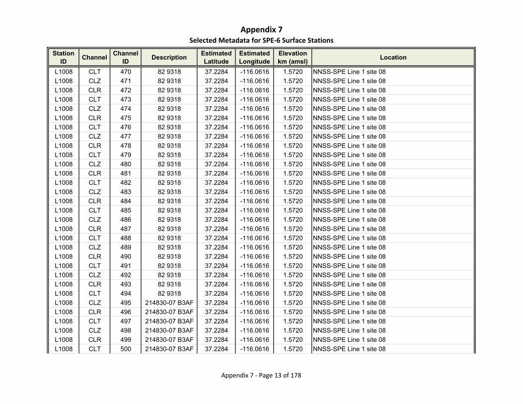
Appendix 7Selected Metadata for SPE‐6 Surface Stations
Station ID
ChannelChannel
IDDescription
Estimated Latitude
Estimated Longitude
Elevationkm (amsl)
Location
L1008 CLT 470 82 9318 37.2284 -116.0616 1.5720 NNSS-SPE Line 1 site 08
L1008 CLZ 471 82 9318 37.2284 -116.0616 1.5720 NNSS-SPE Line 1 site 08
L1008 CLR 472 82 9318 37.2284 -116.0616 1.5720 NNSS-SPE Line 1 site 08
L1008 CLT 473 82 9318 37.2284 -116.0616 1.5720 NNSS-SPE Line 1 site 08
L1008 CLZ 474 82 9318 37.2284 -116.0616 1.5720 NNSS-SPE Line 1 site 08
L1008 CLR 475 82 9318 37.2284 -116.0616 1.5720 NNSS-SPE Line 1 site 08
L1008 CLT 476 82 9318 37.2284 -116.0616 1.5720 NNSS-SPE Line 1 site 08
L1008 CLZ 477 82 9318 37.2284 -116.0616 1.5720 NNSS-SPE Line 1 site 08
L1008 CLR 478 82 9318 37.2284 -116.0616 1.5720 NNSS-SPE Line 1 site 08
L1008 CLT 479 82 9318 37.2284 -116.0616 1.5720 NNSS-SPE Line 1 site 08
L1008 CLZ 480 82 9318 37.2284 -116.0616 1.5720 NNSS-SPE Line 1 site 08
L1008 CLR 481 82 9318 37.2284 -116.0616 1.5720 NNSS-SPE Line 1 site 08
L1008 CLT 482 82 9318 37.2284 -116.0616 1.5720 NNSS-SPE Line 1 site 08
L1008 CLZ 483 82 9318 37.2284 -116.0616 1.5720 NNSS-SPE Line 1 site 08
L1008 CLR 484 82 9318 37.2284 -116.0616 1.5720 NNSS-SPE Line 1 site 08
L1008 CLT 485 82 9318 37.2284 -116.0616 1.5720 NNSS-SPE Line 1 site 08
L1008 CLZ 486 82 9318 37.2284 -116.0616 1.5720 NNSS-SPE Line 1 site 08
L1008 CLR 487 82 9318 37.2284 -116.0616 1.5720 NNSS-SPE Line 1 site 08
L1008 CLT 488 82 9318 37.2284 -116.0616 1.5720 NNSS-SPE Line 1 site 08
L1008 CLZ 489 82 9318 37.2284 -116.0616 1.5720 NNSS-SPE Line 1 site 08
L1008 CLR 490 82 9318 37.2284 -116.0616 1.5720 NNSS-SPE Line 1 site 08
L1008 CLT 491 82 9318 37.2284 -116.0616 1.5720 NNSS-SPE Line 1 site 08
L1008 CLZ 492 82 9318 37.2284 -116.0616 1.5720 NNSS-SPE Line 1 site 08
L1008 CLR 493 82 9318 37.2284 -116.0616 1.5720 NNSS-SPE Line 1 site 08
L1008 CLT 494 82 9318 37.2284 -116.0616 1.5720 NNSS-SPE Line 1 site 08
L1008 CLZ 495 214830-07 B3AF 37.2284 -116.0616 1.5720 NNSS-SPE Line 1 site 08
L1008 CLR 496 214830-07 B3AF 37.2284 -116.0616 1.5720 NNSS-SPE Line 1 site 08
L1008 CLT 497 214830-07 B3AF 37.2284 -116.0616 1.5720 NNSS-SPE Line 1 site 08
L1008 CLZ 498 214830-07 B3AF 37.2284 -116.0616 1.5720 NNSS-SPE Line 1 site 08
L1008 CLR 499 214830-07 B3AF 37.2284 -116.0616 1.5720 NNSS-SPE Line 1 site 08
L1008 CLT 500 214830-07 B3AF 37.2284 -116.0616 1.5720 NNSS-SPE Line 1 site 08
Appendix 7 ‐ Page 13 of 178
Appendix 7Selected Metadata for SPE‐6 Surface Stations
Station ID
ChannelChannel
IDDescription
Estimated Latitude
Estimated Longitude
Elevationkm (amsl)
Location
L1008 CLZ 501 214830-07 B3AF 37.2284 -116.0616 1.5720 NNSS-SPE Line 1 site 08
L1008 CLR 502 214830-07 B3AF 37.2284 -116.0616 1.5720 NNSS-SPE Line 1 site 08
L1008 CLT 503 214830-07 B3AF 37.2284 -116.0616 1.5720 NNSS-SPE Line 1 site 08
L1008 CLZ 504 214830-07 B3AF 37.2284 -116.0616 1.5720 NNSS-SPE Line 1 site 08
L1008 CLR 505 214830-07 B3AF 37.2284 -116.0616 1.5720 NNSS-SPE Line 1 site 08
L1008 CLT 506 214830-07 B3AF 37.2284 -116.0616 1.5720 NNSS-SPE Line 1 site 08
L1008 CLZ 507 214830-07 B3AF 37.2284 -116.0616 1.5720 NNSS-SPE Line 1 site 08
L1008 CLR 508 214830-07 B3AF 37.2284 -116.0616 1.5720 NNSS-SPE Line 1 site 08
L1008 CLT 509 214830-07 B3AF 37.2284 -116.0616 1.5720 NNSS-SPE Line 1 site 08
L1008 CLZ 510 214830-07 B3AF 37.2284 -116.0616 1.5720 NNSS-SPE Line 1 site 08
L1008 CLR 511 214830-07 B3AF 37.2284 -116.0616 1.5720 NNSS-SPE Line 1 site 08
L1008 CLT 512 214830-07 B3AF 37.2284 -116.0616 1.5720 NNSS-SPE Line 1 site 08
L1009 CLZ 513 115 9504 37.2293 -116.0616 1.5890 NNSS-SPE Line 1 site 09
L1009 CLZ 514 115 9504 37.2293 -116.0616 1.5890 NNSS-SPE Line 1 site 09
L1009 CLZ 515 115 9504 37.2293 -116.0616 1.5890 NNSS-SPE Line 1 site 09
L1009 CLZ 516 115 9504 37.2293 -116.0616 1.5890 NNSS-SPE Line 1 site 09
L1009 CLZ 517 115 9504 37.2293 -116.0616 1.5890 NNSS-SPE Line 1 site 09
L1009 CLZ 518 115 9504 37.2293 -116.0616 1.5890 NNSS-SPE Line 1 site 09
L1009 CLZ 519 115 9504 37.2293 -116.0616 1.5890 NNSS-SPE Line 1 site 09
L1009 CLZ 520 115 B3D7 37.2293 -116.0616 1.5890 NNSS-SPE Line 1 site 09
L1009 CLR 521 115 B3D7 37.2293 -116.0616 1.5890 NNSS-SPE Line 1 site 09
L1009 CLT 522 115 B3D7 37.2293 -116.0616 1.5890 NNSS-SPE Line 1 site 09
L1009 CLZ 523 115 B3D7 37.2293 -116.0616 1.5890 NNSS-SPE Line 1 site 09
L1009 CLR 524 115 B3D7 37.2293 -116.0616 1.5890 NNSS-SPE Line 1 site 09
L1009 CLT 525 115 B3D7 37.2293 -116.0616 1.5890 NNSS-SPE Line 1 site 09
L1009 CLZ 526 115 B3D7 37.2293 -116.0616 1.5890 NNSS-SPE Line 1 site 09
L1009 CLR 527 115 B3D7 37.2293 -116.0616 1.5890 NNSS-SPE Line 1 site 09
L1009 CLT 528 115 B3D7 37.2293 -116.0616 1.5890 NNSS-SPE Line 1 site 09
L1009 CLZ 529 115 BCD2 37.2293 -116.0616 1.5890 NNSS-SPE Line 1 site 09
L1009 CLR 530 115 BCD2 37.2293 -116.0616 1.5890 NNSS-SPE Line 1 site 09
L1009 CLT 531 115 BCD2 37.2293 -116.0616 1.5890 NNSS-SPE Line 1 site 09
Appendix 7 ‐ Page 14 of 178
Appendix 7Selected Metadata for SPE‐6 Surface Stations
Station ID
ChannelChannel
IDDescription
Estimated Latitude
Estimated Longitude
Elevationkm (amsl)
Location
L1009 CLZ 532 225358-06 BCD2 37.2293 -116.0616 1.5890 NNSS-SPE Line 1 site 09
L1009 CLR 533 225358-06 BCD2 37.2293 -116.0616 1.5890 NNSS-SPE Line 1 site 09
L1009 CLT 534 225358-06 BCD2 37.2293 -116.0616 1.5890 NNSS-SPE Line 1 site 09
L1009 CLZ 535 225358-06 BCD2 37.2293 -116.0616 1.5890 NNSS-SPE Line 1 site 09
L1009 CLR 536 225358-06 BCD2 37.2293 -116.0616 1.5890 NNSS-SPE Line 1 site 09
L1009 CLT 537 225358-06 BCD2 37.2293 -116.0616 1.5890 NNSS-SPE Line 1 site 09
L1009 CLZ 538 225358-06 BCD2 37.2293 -116.0616 1.5890 NNSS-SPE Line 1 site 09
L1009 CLR 539 225358-06 BCD2 37.2293 -116.0616 1.5890 NNSS-SPE Line 1 site 09
L1009 CLT 540 225358-06 BCD2 37.2293 -116.0616 1.5890 NNSS-SPE Line 1 site 09
L1009 CLZ 541 225358-06 BCD2 37.2293 -116.0616 1.5890 NNSS-SPE Line 1 site 09
L1009 CLR 542 225358-06 BCD2 37.2293 -116.0616 1.5890 NNSS-SPE Line 1 site 09
L1009 CLT 543 225358-06 BCD2 37.2293 -116.0616 1.5890 NNSS-SPE Line 1 site 09
L1009 CLZ 544 225358-06 BCD2 37.2293 -116.0616 1.5890 NNSS-SPE Line 1 site 09
L1009 CLR 545 225358-06 BCD2 37.2293 -116.0616 1.5890 NNSS-SPE Line 1 site 09
L1009 CLT 546 225358-06 BCD2 37.2293 -116.0616 1.5890 NNSS-SPE Line 1 site 09
L1010 CNZ 547 3690 9220 37.2302 -116.0617 1.5850 NNSS-SPE Line 1 site 10
L1010 CNR 548 3690 9220 37.2302 -116.0617 1.5850 NNSS-SPE Line 1 site 10
L1010 CNT 549 3690 9220 37.2302 -116.0617 1.5850 NNSS-SPE Line 1 site 10
L1010 DJZ 550 A201616 9220 37.2302 -116.0617 1.5850 NNSS-SPE Line 1 site 10
L1010 DJR 551 A201616 9220 37.2302 -116.0617 1.5850 NNSS-SPE Line 1 site 10
L1010 DJT 552 A201616 9220 37.2302 -116.0617 1.5850 NNSS-SPE Line 1 site 10
L1010 CNZ 553 3690 B3D0 37.2302 -116.0617 1.5850 NNSS-SPE Line 1 site 10
L1010 CNR 554 3690 B3D0 37.2302 -116.0617 1.5850 NNSS-SPE Line 1 site 10
L1010 CNT 555 3690 B3D0 37.2302 -116.0617 1.5850 NNSS-SPE Line 1 site 10
L1010 DJZ 556 A201616 B3D0 37.2302 -116.0617 1.5850 NNSS-SPE Line 1 site 10
L1010 DJR 557 A201616 B3D0 37.2302 -116.0617 1.5850 NNSS-SPE Line 1 site 10
L1010 DJT 558 A201616 B3D0 37.2302 -116.0617 1.5850 NNSS-SPE Line 1 site 10
L1010 CLZ 559 16 9504 37.2302 -116.0617 1.5850 NNSS-SPE Line 1 site 10
L1010 CLZ 560 16 9504 37.2302 -116.0617 1.5850 NNSS-SPE Line 1 site 10
L1010 CLZ 561 16 9504 37.2302 -116.0617 1.5850 NNSS-SPE Line 1 site 10
L1010 CLZ 562 16 9504 37.2302 -116.0617 1.5850 NNSS-SPE Line 1 site 10
Appendix 7 ‐ Page 15 of 178

Appendix 7Selected Metadata for SPE‐6 Surface Stations
Station ID
ChannelChannel
IDDescription
Estimated Latitude
Estimated Longitude
Elevationkm (amsl)
Location
L1010 CLZ 563 16 9504 37.2302 -116.0617 1.5850 NNSS-SPE Line 1 site 10
L1010 CLZ 564 16 9504 37.2302 -116.0617 1.5850 NNSS-SPE Line 1 site 10
L1010 CLZ 565 16 9504 37.2302 -116.0617 1.5850 NNSS-SPE Line 1 site 10
L1010 CLZ 566 16 B3D7 37.2302 -116.0617 1.5850 NNSS-SPE Line 1 site 10
L1010 CLR 567 16 B3D7 37.2302 -116.0617 1.5850 NNSS-SPE Line 1 site 10
L1010 CLT 568 16 B3D7 37.2302 -116.0617 1.5850 NNSS-SPE Line 1 site 10
L1010 CLZ 569 16 B3D7 37.2302 -116.0617 1.5850 NNSS-SPE Line 1 site 10
L1010 CLR 570 16 B3D7 37.2302 -116.0617 1.5850 NNSS-SPE Line 1 site 10
L1010 CLT 571 16 B3D7 37.2302 -116.0617 1.5850 NNSS-SPE Line 1 site 10
L1010 CLZ 572 16 B3D7 37.2302 -116.0617 1.5850 NNSS-SPE Line 1 site 10
L1010 CLR 573 16 B3D7 37.2302 -116.0617 1.5850 NNSS-SPE Line 1 site 10
L1010 CLT 574 16 B3D7 37.2302 -116.0617 1.5850 NNSS-SPE Line 1 site 10
L1010 CLZ 575 16 BCD2 37.2302 -116.0617 1.5850 NNSS-SPE Line 1 site 10
L1010 CLR 576 16 BCD2 37.2302 -116.0617 1.5850 NNSS-SPE Line 1 site 10
L1010 CLT 577 16 BCD2 37.2302 -116.0617 1.5850 NNSS-SPE Line 1 site 10
L1010 CLZ 578 16 BCD2 37.2302 -116.0617 1.5850 NNSS-SPE Line 1 site 10
L1010 CLR 579 16 BCD2 37.2302 -116.0617 1.5850 NNSS-SPE Line 1 site 10
L1010 CLT 580 16 BCD2 37.2302 -116.0617 1.5850 NNSS-SPE Line 1 site 10
L1010 CLZ 581 16 BCD2 37.2302 -116.0617 1.5850 NNSS-SPE Line 1 site 10
L1010 CLR 582 16 BCD2 37.2302 -116.0617 1.5850 NNSS-SPE Line 1 site 10
L1010 CLT 583 16 BCD2 37.2302 -116.0617 1.5850 NNSS-SPE Line 1 site 10
L1010 CLZ 584 16 BCD2 37.2302 -116.0617 1.5850 NNSS-SPE Line 1 site 10
L1010 CLR 585 16 BCD2 37.2302 -116.0617 1.5850 NNSS-SPE Line 1 site 10
L1010 CLT 586 16 BCD2 37.2302 -116.0617 1.5850 NNSS-SPE Line 1 site 10
L1010 CLZ 587 16 BCD2 37.2302 -116.0617 1.5850 NNSS-SPE Line 1 site 10
L1010 CLR 588 16 BCD2 37.2302 -116.0617 1.5850 NNSS-SPE Line 1 site 10
L1010 CLT 589 16 BCD2 37.2302 -116.0617 1.5850 NNSS-SPE Line 1 site 10
L1010 CLZ 590 16 BCD2 37.2302 -116.0617 1.5850 NNSS-SPE Line 1 site 10
L1010 CLR 591 16 BCD2 37.2302 -116.0617 1.5850 NNSS-SPE Line 1 site 10
L1010 CLT 592 16 BCD2 37.2302 -116.0617 1.5850 NNSS-SPE Line 1 site 10
L1011 CLZ 593 77 9504 37.2311 -116.0618 1.5970 NNSS-SPE Line 1 site 11
Appendix 7 ‐ Page 16 of 178
Appendix 7Selected Metadata for SPE‐6 Surface Stations
Station ID
ChannelChannel
IDDescription
Estimated Latitude
Estimated Longitude
Elevationkm (amsl)
Location
L1011 CLZ 594 77 9504 37.2311 -116.0618 1.5970 NNSS-SPE Line 1 site 11
L1011 CLZ 595 77 9504 37.2311 -116.0618 1.5970 NNSS-SPE Line 1 site 11
L1011 CLZ 596 77 9504 37.2311 -116.0618 1.5970 NNSS-SPE Line 1 site 11
L1011 CLZ 597 77 9504 37.2311 -116.0618 1.5970 NNSS-SPE Line 1 site 11
L1011 CLZ 598 77 9504 37.2311 -116.0618 1.5970 NNSS-SPE Line 1 site 11
L1011 CLZ 599 77 9504 37.2311 -116.0618 1.5970 NNSS-SPE Line 1 site 11
L1011 CLZ 600 77 9504 37.2311 -116.0618 1.5970 NNSS-SPE Line 1 site 11
L1011 CLR 601 77 9504 37.2311 -116.0618 1.5970 NNSS-SPE Line 1 site 11
L1011 CLT 602 77 9504 37.2311 -116.0618 1.5970 NNSS-SPE Line 1 site 11
L1011 CLZ 603 214830-12 B2E0 37.2311 -116.0618 1.5970 NNSS-SPE Line 1 site 11
L1011 CLR 604 214830-12 B2E0 37.2311 -116.0618 1.5970 NNSS-SPE Line 1 site 11
L1011 CLT 605 214830-12 B2E0 37.2311 -116.0618 1.5970 NNSS-SPE Line 1 site 11
L1011 CLZ 606 225358-43 B2E0 37.2311 -116.0618 1.5970 NNSS-SPE Line 1 site 11
L1011 CLR 607 225358-43 B2E0 37.2311 -116.0618 1.5970 NNSS-SPE Line 1 site 11
L1011 CLT 608 225358-43 B2E0 37.2311 -116.0618 1.5970 NNSS-SPE Line 1 site 11
L1011 CLZ 609 225358-43 D14F 37.2311 -116.0618 1.5970 NNSS-SPE Line 1 site 11
L1011 CLR 610 225358-43 D14F 37.2311 -116.0618 1.5970 NNSS-SPE Line 1 site 11
L1011 CLT 611 225358-43 D14F 37.2311 -116.0618 1.5970 NNSS-SPE Line 1 site 11
L1011 CLZ 612 225358-43 D14F 37.2311 -116.0618 1.5970 NNSS-SPE Line 1 site 11
L1011 CLR 613 225358-43 D14F 37.2311 -116.0618 1.5970 NNSS-SPE Line 1 site 11
L1011 CLT 614 225358-43 D14F 37.2311 -116.0618 1.5970 NNSS-SPE Line 1 site 11
L1011 CLZ 615 225358-43 D14F 37.2311 -116.0618 1.5970 NNSS-SPE Line 1 site 11
L1011 CLR 616 225358-43 D14F 37.2311 -116.0618 1.5970 NNSS-SPE Line 1 site 11
L1011 CLT 617 225358-43 D14F 37.2311 -116.0618 1.5970 NNSS-SPE Line 1 site 11
L1011 CLZ 618 225358-43 D14F 37.2311 -116.0618 1.5970 NNSS-SPE Line 1 site 11
L1011 CLR 619 225358-43 D14F 37.2311 -116.0618 1.5970 NNSS-SPE Line 1 site 11
L1011 CLT 620 225358-43 D14F 37.2311 -116.0618 1.5970 NNSS-SPE Line 1 site 11
L1011 CLZ 621 225358-43 B3B8 37.2311 -116.0618 1.5970 NNSS-SPE Line 1 site 11
L1011 CLR 622 225358-43 B3B8 37.2311 -116.0618 1.5970 NNSS-SPE Line 1 site 11
L1011 CLT 623 225358-43 B3B8 37.2311 -116.0618 1.5970 NNSS-SPE Line 1 site 11
L1012 CLZ 624 34 9504 37.2320 -116.0619 1.6040 NNSS-SPE Line 1 site 12
Appendix 7 ‐ Page 17 of 178

Appendix 7Selected Metadata for SPE‐6 Surface Stations
Station ID
ChannelChannel
IDDescription
Estimated Latitude
Estimated Longitude
Elevationkm (amsl)
Location
L1012 CLR 625 34 9504 37.2320 -116.0619 1.6040 NNSS-SPE Line 1 site 12
L1012 CLT 626 34 9504 37.2320 -116.0619 1.6040 NNSS-SPE Line 1 site 12
L1012 CLZ 627 34 9504 37.2320 -116.0619 1.6040 NNSS-SPE Line 1 site 12
L1012 CLR 628 34 9504 37.2320 -116.0619 1.6040 NNSS-SPE Line 1 site 12
L1012 CLT 629 34 9504 37.2320 -116.0619 1.6040 NNSS-SPE Line 1 site 12
L1012 CLZ 630 34 9504 37.2320 -116.0619 1.6040 NNSS-SPE Line 1 site 12
L1012 CLR 631 34 9504 37.2320 -116.0619 1.6040 NNSS-SPE Line 1 site 12
L1012 CLT 632 34 9504 37.2320 -116.0619 1.6040 NNSS-SPE Line 1 site 12
L1012 CLZ 633 34 9504 37.2320 -116.0619 1.6040 NNSS-SPE Line 1 site 12
L1012 CLR 634 34 9504 37.2320 -116.0619 1.6040 NNSS-SPE Line 1 site 12
L1012 CLT 635 34 9504 37.2320 -116.0619 1.6040 NNSS-SPE Line 1 site 12
L1012 CLZ 636 34 9504 37.2320 -116.0619 1.6040 NNSS-SPE Line 1 site 12
L1012 CLR 637 34 9504 37.2320 -116.0619 1.6040 NNSS-SPE Line 1 site 12
L1012 CLT 638 34 9504 37.2320 -116.0619 1.6040 NNSS-SPE Line 1 site 12
L1012 CLZ 639 34 9504 37.2320 -116.0619 1.6040 NNSS-SPE Line 1 site 12
L1012 CLR 640 34 9504 37.2320 -116.0619 1.6040 NNSS-SPE Line 1 site 12
L1012 CLT 641 34 9504 37.2320 -116.0619 1.6040 NNSS-SPE Line 1 site 12
L1012 CLZ 642 34 9504 37.2320 -116.0619 1.6040 NNSS-SPE Line 1 site 12
L1012 CLR 643 34 9504 37.2320 -116.0619 1.6040 NNSS-SPE Line 1 site 12
L1012 CLT 644 34 9504 37.2320 -116.0619 1.6040 NNSS-SPE Line 1 site 12
L1012 CLZ 645 34 9504 37.2320 -116.0619 1.6040 NNSS-SPE Line 1 site 12
L1012 CLR 646 34 9504 37.2320 -116.0619 1.6040 NNSS-SPE Line 1 site 12
L1012 CLT 647 34 9504 37.2320 -116.0619 1.6040 NNSS-SPE Line 1 site 12
L1012 CLZ 648 34 9504 37.2320 -116.0619 1.6040 NNSS-SPE Line 1 site 12
L1012 CLR 649 34 9504 37.2320 -116.0619 1.6040 NNSS-SPE Line 1 site 12
L1012 CLT 650 34 9504 37.2320 -116.0619 1.6040 NNSS-SPE Line 1 site 12
L1012 CLZ 651 34 B2E0 37.2320 -116.0619 1.6040 NNSS-SPE Line 1 site 12
L1012 CLR 652 34 B2E0 37.2320 -116.0619 1.6040 NNSS-SPE Line 1 site 12
L1012 CLT 653 34 B2E0 37.2320 -116.0619 1.6040 NNSS-SPE Line 1 site 12
L1012 CLZ 654 34 B2E0 37.2320 -116.0619 1.6040 NNSS-SPE Line 1 site 12
L1012 CLR 655 34 B2E0 37.2320 -116.0619 1.6040 NNSS-SPE Line 1 site 12
Appendix 7 ‐ Page 18 of 178

Appendix 7Selected Metadata for SPE‐6 Surface Stations
Station ID
ChannelChannel
IDDescription
Estimated Latitude
Estimated Longitude
Elevationkm (amsl)
Location
L1012 CLT 656 34 B2E0 37.2320 -116.0619 1.6040 NNSS-SPE Line 1 site 12
L1012 CLZ 657 34 D14F 37.2320 -116.0619 1.6040 NNSS-SPE Line 1 site 12
L1012 CLR 658 34 D14F 37.2320 -116.0619 1.6040 NNSS-SPE Line 1 site 12
L1012 CLT 659 34 D14F 37.2320 -116.0619 1.6040 NNSS-SPE Line 1 site 12
L1012 CLZ 660 34 D14F 37.2320 -116.0619 1.6040 NNSS-SPE Line 1 site 12
L1012 CLR 661 34 D14F 37.2320 -116.0619 1.6040 NNSS-SPE Line 1 site 12
L1012 CLT 662 34 D14F 37.2320 -116.0619 1.6040 NNSS-SPE Line 1 site 12
L1012 CLZ 663 34 D14F 37.2320 -116.0619 1.6040 NNSS-SPE Line 1 site 12
L1012 CLR 664 34 D14F 37.2320 -116.0619 1.6040 NNSS-SPE Line 1 site 12
L1012 CLT 665 34 D14F 37.2320 -116.0619 1.6040 NNSS-SPE Line 1 site 12
L1012 CLZ 666 34 D14F 37.2320 -116.0619 1.6040 NNSS-SPE Line 1 site 12
L1012 CLR 667 34 D14F 37.2320 -116.0619 1.6040 NNSS-SPE Line 1 site 12
L1012 CLT 668 34 D14F 37.2320 -116.0619 1.6040 NNSS-SPE Line 1 site 12
L1012 CLZ 669 34 D14F 37.2320 -116.0619 1.6040 NNSS-SPE Line 1 site 12
L1012 CLR 670 34 D14F 37.2320 -116.0619 1.6040 NNSS-SPE Line 1 site 12
L1012 CLT 671 34 D14F 37.2320 -116.0619 1.6040 NNSS-SPE Line 1 site 12
L1013 CLZ 672 69 AF0F 37.2329 -116.0620 1.6160 NNSS-SPE Line 1 site 13
L1013 CLZ 673 69 AF0F 37.2329 -116.0620 1.6160 NNSS-SPE Line 1 site 13
L1013 CLZ 674 69 AF0F 37.2329 -116.0620 1.6160 NNSS-SPE Line 1 site 13
L1013 CLZ 675 69 AF0F 37.2329 -116.0620 1.6160 NNSS-SPE Line 1 site 13
L1013 CLZ 676 69 B2D1 37.2329 -116.0620 1.6160 NNSS-SPE Line 1 site 13
L1013 CLR 677 69 B2D1 37.2329 -116.0620 1.6160 NNSS-SPE Line 1 site 13
L1013 CLT 678 69 B2D1 37.2329 -116.0620 1.6160 NNSS-SPE Line 1 site 13
L1013 CLZ 679 69 B2D1 37.2329 -116.0620 1.6160 NNSS-SPE Line 1 site 13
L1013 CLR 680 69 B2D1 37.2329 -116.0620 1.6160 NNSS-SPE Line 1 site 13
L1013 CLT 681 69 B2D1 37.2329 -116.0620 1.6160 NNSS-SPE Line 1 site 13
L1013 CLZ 682 69 B2D1 37.2329 -116.0620 1.6160 NNSS-SPE Line 1 site 13
L1013 CLR 683 69 B2D1 37.2329 -116.0620 1.6160 NNSS-SPE Line 1 site 13
L1013 CLT 684 69 B2D1 37.2329 -116.0620 1.6160 NNSS-SPE Line 1 site 13
L1013 CLZ 685 69 B2D1 37.2329 -116.0620 1.6160 NNSS-SPE Line 1 site 13
L1013 CLR 686 69 B2D1 37.2329 -116.0620 1.6160 NNSS-SPE Line 1 site 13
Appendix 7 ‐ Page 19 of 178

Appendix 7Selected Metadata for SPE‐6 Surface Stations
Station ID
ChannelChannel
IDDescription
Estimated Latitude
Estimated Longitude
Elevationkm (amsl)
Location
L1013 CLT 687 69 B2D1 37.2329 -116.0620 1.6160 NNSS-SPE Line 1 site 13
L1013 CLZ 688 69 D1B5 37.2329 -116.0620 1.6160 NNSS-SPE Line 1 site 13
L1013 CLR 689 69 D1B5 37.2329 -116.0620 1.6160 NNSS-SPE Line 1 site 13
L1013 CLT 690 69 D1B5 37.2329 -116.0620 1.6160 NNSS-SPE Line 1 site 13
L1013 CLZ 691 69 D1B5 37.2329 -116.0620 1.6160 NNSS-SPE Line 1 site 13
L1013 CLR 692 69 D1B5 37.2329 -116.0620 1.6160 NNSS-SPE Line 1 site 13
L1013 CLT 693 69 D1B5 37.2329 -116.0620 1.6160 NNSS-SPE Line 1 site 13
L1013 CLZ 694 69 D1B5 37.2329 -116.0620 1.6160 NNSS-SPE Line 1 site 13
L1013 CLR 695 69 D1B5 37.2329 -116.0620 1.6160 NNSS-SPE Line 1 site 13
L1013 CLT 696 69 D1B5 37.2329 -116.0620 1.6160 NNSS-SPE Line 1 site 13
L1013 CLZ 697 69 D1B5 37.2329 -116.0620 1.6160 NNSS-SPE Line 1 site 13
L1013 CLR 698 69 D1B5 37.2329 -116.0620 1.6160 NNSS-SPE Line 1 site 13
L1013 CLT 699 69 D1B5 37.2329 -116.0620 1.6160 NNSS-SPE Line 1 site 13
L1013 CLZ 700 225358-09 BEC9 37.2329 -116.0620 1.6160 NNSS-SPE Line 1 site 13
L1013 CLR 701 225358-09 BEC9 37.2329 -116.0620 1.6160 NNSS-SPE Line 1 site 13
L1013 CLT 702 225358-09 BEC9 37.2329 -116.0620 1.6160 NNSS-SPE Line 1 site 13
L1014 CLZ 703 39 AF0F 37.2338 -116.0621 1.6330 NNSS-SPE Line 1 site 14
L1014 CLZ 704 39 AF0F 37.2338 -116.0621 1.6330 NNSS-SPE Line 1 site 14
L1014 CLZ 705 39 AF0F 37.2338 -116.0621 1.6330 NNSS-SPE Line 1 site 14
L1014 CLZ 706 39 AF0F 37.2338 -116.0621 1.6330 NNSS-SPE Line 1 site 14
L1014 CLZ 707 39 B2D1 37.2338 -116.0621 1.6330 NNSS-SPE Line 1 site 14
L1014 CLR 708 39 B2D1 37.2338 -116.0621 1.6330 NNSS-SPE Line 1 site 14
L1014 CLT 709 39 B2D1 37.2338 -116.0621 1.6330 NNSS-SPE Line 1 site 14
L1014 CLZ 710 39 B2D1 37.2338 -116.0621 1.6330 NNSS-SPE Line 1 site 14
L1014 CLR 711 39 B2D1 37.2338 -116.0621 1.6330 NNSS-SPE Line 1 site 14
L1014 CLT 712 39 B2D1 37.2338 -116.0621 1.6330 NNSS-SPE Line 1 site 14
L1014 CLZ 713 39 B2D1 37.2338 -116.0621 1.6330 NNSS-SPE Line 1 site 14
L1014 CLR 714 39 B2D1 37.2338 -116.0621 1.6330 NNSS-SPE Line 1 site 14
L1014 CLT 715 39 B2D1 37.2338 -116.0621 1.6330 NNSS-SPE Line 1 site 14
L1014 CLZ 716 39 B2D1 37.2338 -116.0621 1.6330 NNSS-SPE Line 1 site 14
L1014 CLR 717 39 B2D1 37.2338 -116.0621 1.6330 NNSS-SPE Line 1 site 14
Appendix 7 ‐ Page 20 of 178
Appendix 7Selected Metadata for SPE‐6 Surface Stations
Station ID
ChannelChannel
IDDescription
Estimated Latitude
Estimated Longitude
Elevationkm (amsl)
Location
L1014 CLT 718 39 B2D1 37.2338 -116.0621 1.6330 NNSS-SPE Line 1 site 14
L1014 CLZ 719 39 D1B5 37.2338 -116.0621 1.6330 NNSS-SPE Line 1 site 14
L1014 CLR 720 39 D1B5 37.2338 -116.0621 1.6330 NNSS-SPE Line 1 site 14
L1014 CLT 721 39 D1B5 37.2338 -116.0621 1.6330 NNSS-SPE Line 1 site 14
L1014 CLZ 722 39 D1B5 37.2338 -116.0621 1.6330 NNSS-SPE Line 1 site 14
L1014 CLR 723 39 D1B5 37.2338 -116.0621 1.6330 NNSS-SPE Line 1 site 14
L1014 CLT 724 39 D1B5 37.2338 -116.0621 1.6330 NNSS-SPE Line 1 site 14
L1014 CLZ 725 39 D1B5 37.2338 -116.0621 1.6330 NNSS-SPE Line 1 site 14
L1014 CLR 726 39 D1B5 37.2338 -116.0621 1.6330 NNSS-SPE Line 1 site 14
L1014 CLT 727 39 D1B5 37.2338 -116.0621 1.6330 NNSS-SPE Line 1 site 14
L1014 CLZ 728 39 D1B5 37.2338 -116.0621 1.6330 NNSS-SPE Line 1 site 14
L1014 CLR 729 39 D1B5 37.2338 -116.0621 1.6330 NNSS-SPE Line 1 site 14
L1014 CLT 730 39 D1B5 37.2338 -116.0621 1.6330 NNSS-SPE Line 1 site 14
L1014 CLZ 731 65 D1B5 37.2338 -116.0621 1.6330 NNSS-SPE Line 1 site 14
L1014 CLR 732 65 D1B5 37.2338 -116.0621 1.6330 NNSS-SPE Line 1 site 14
L1014 CLT 733 65 D1B5 37.2338 -116.0621 1.6330 NNSS-SPE Line 1 site 14
L1015 CLZ 734 27 AF0F 37.2347 -116.0621 1.6560 NNSS-SPE Line 1 site 15
L1015 CLZ 735 27 AF0F 37.2347 -116.0621 1.6560 NNSS-SPE Line 1 site 15
L1015 CLZ 736 27 AF0F 37.2347 -116.0621 1.6560 NNSS-SPE Line 1 site 15
L1015 CLZ 737 27 AF0F 37.2347 -116.0621 1.6560 NNSS-SPE Line 1 site 15
L1015 CLZ 738 27 AF0F 37.2347 -116.0621 1.6560 NNSS-SPE Line 1 site 15
L1015 CLR 739 27 AF0F 37.2347 -116.0621 1.6560 NNSS-SPE Line 1 site 15
L1015 CLT 740 27 AF0F 37.2347 -116.0621 1.6560 NNSS-SPE Line 1 site 15
L1015 CLZ 741 27 AF0F 37.2347 -116.0621 1.6560 NNSS-SPE Line 1 site 15
L1015 CLR 742 27 AF0F 37.2347 -116.0621 1.6560 NNSS-SPE Line 1 site 15
L1015 CLT 743 27 AF0F 37.2347 -116.0621 1.6560 NNSS-SPE Line 1 site 15
L1015 CLZ 744 214830-08 AF0F 37.2347 -116.0621 1.6560 NNSS-SPE Line 1 site 15
L1015 CLR 745 214830-08 AF0F 37.2347 -116.0621 1.6560 NNSS-SPE Line 1 site 15
L1015 CLT 746 214830-08 AF0F 37.2347 -116.0621 1.6560 NNSS-SPE Line 1 site 15
L1015 CLZ 747 214830-08 AF0F 37.2347 -116.0621 1.6560 NNSS-SPE Line 1 site 15
L1015 CLR 748 214830-08 AF0F 37.2347 -116.0621 1.6560 NNSS-SPE Line 1 site 15
Appendix 7 ‐ Page 21 of 178

Appendix 7Selected Metadata for SPE‐6 Surface Stations
Station ID
ChannelChannel
IDDescription
Estimated Latitude
Estimated Longitude
Elevationkm (amsl)
Location
L1015 CLT 749 214830-08 AF0F 37.2347 -116.0621 1.6560 NNSS-SPE Line 1 site 15
L1015 CLZ 750 214830-08 AF0F 37.2347 -116.0621 1.6560 NNSS-SPE Line 1 site 15
L1015 CLR 751 214830-08 AF0F 37.2347 -116.0621 1.6560 NNSS-SPE Line 1 site 15
L1015 CLT 752 214830-08 AF0F 37.2347 -116.0621 1.6560 NNSS-SPE Line 1 site 15
L1015 CLZ 753 214830-08 AF0F 37.2347 -116.0621 1.6560 NNSS-SPE Line 1 site 15
L1015 CLR 754 214830-08 AF0F 37.2347 -116.0621 1.6560 NNSS-SPE Line 1 site 15
L1015 CLT 755 214830-08 AF0F 37.2347 -116.0621 1.6560 NNSS-SPE Line 1 site 15
L1015 CLZ 756 214830-08 AF0F 37.2347 -116.0621 1.6560 NNSS-SPE Line 1 site 15
L1015 CLR 757 214830-08 AF0F 37.2347 -116.0621 1.6560 NNSS-SPE Line 1 site 15
L1015 CLT 758 214830-08 AF0F 37.2347 -116.0621 1.6560 NNSS-SPE Line 1 site 15
L1015 CLZ 759 214830-08 AF0F 37.2347 -116.0621 1.6560 NNSS-SPE Line 1 site 15
L1015 CLR 760 214830-08 AF0F 37.2347 -116.0621 1.6560 NNSS-SPE Line 1 site 15
L1015 CLT 761 214830-08 AF0F 37.2347 -116.0621 1.6560 NNSS-SPE Line 1 site 15
L1016 CLZ 762 35 AF0F 37.2355 -116.0622 1.6740 NNSS-SPE Line 1 site 16
L1016 CLR 763 35 AF0F 37.2355 -116.0622 1.6740 NNSS-SPE Line 1 site 16
L1016 CLT 764 35 AF0F 37.2355 -116.0622 1.6740 NNSS-SPE Line 1 site 16
L1016 CLZ 765 35 AF0F 37.2355 -116.0622 1.6740 NNSS-SPE Line 1 site 16
L1016 CLR 766 35 AF0F 37.2355 -116.0622 1.6740 NNSS-SPE Line 1 site 16
L1016 CLT 767 35 AF0F 37.2355 -116.0622 1.6740 NNSS-SPE Line 1 site 16
L1016 CLZ 768 35 AF0F 37.2355 -116.0622 1.6740 NNSS-SPE Line 1 site 16
L1016 CLR 769 35 AF0F 37.2355 -116.0622 1.6740 NNSS-SPE Line 1 site 16
L1016 CLT 770 35 AF0F 37.2355 -116.0622 1.6740 NNSS-SPE Line 1 site 16
L1016 CLZ 771 35 AF0F 37.2355 -116.0622 1.6740 NNSS-SPE Line 1 site 16
L1016 CLR 772 35 AF0F 37.2355 -116.0622 1.6740 NNSS-SPE Line 1 site 16
L1016 CLT 773 35 AF0F 37.2355 -116.0622 1.6740 NNSS-SPE Line 1 site 16
L1016 CLZ 774 35 AF0F 37.2355 -116.0622 1.6740 NNSS-SPE Line 1 site 16
L1016 CLR 775 35 AF0F 37.2355 -116.0622 1.6740 NNSS-SPE Line 1 site 16
L1016 CLT 776 35 AF0F 37.2355 -116.0622 1.6740 NNSS-SPE Line 1 site 16
L1016 CLZ 777 35 AF0F 37.2355 -116.0622 1.6740 NNSS-SPE Line 1 site 16
L1016 CLR 778 35 AF0F 37.2355 -116.0622 1.6740 NNSS-SPE Line 1 site 16
L1016 CLT 779 35 AF0F 37.2355 -116.0622 1.6740 NNSS-SPE Line 1 site 16
Appendix 7 ‐ Page 22 of 178

Appendix 7Selected Metadata for SPE‐6 Surface Stations
Station ID
ChannelChannel
IDDescription
Estimated Latitude
Estimated Longitude
Elevationkm (amsl)
Location
L1016 CLZ 780 35 AF0F 37.2355 -116.0622 1.6740 NNSS-SPE Line 1 site 16
L1016 CLR 781 35 AF0F 37.2355 -116.0622 1.6740 NNSS-SPE Line 1 site 16
L1016 CLT 782 35 AF0F 37.2355 -116.0622 1.6740 NNSS-SPE Line 1 site 16
L1016 CLZ 783 35 AF0F 37.2355 -116.0622 1.6740 NNSS-SPE Line 1 site 16
L1016 CLR 784 35 AF0F 37.2355 -116.0622 1.6740 NNSS-SPE Line 1 site 16
L1016 CLT 785 35 AF0F 37.2355 -116.0622 1.6740 NNSS-SPE Line 1 site 16
L1016 CLZ 786 115 AF0F 37.2355 -116.0622 1.6740 NNSS-SPE Line 1 site 16
L1016 CLR 787 115 AF0F 37.2355 -116.0622 1.6740 NNSS-SPE Line 1 site 16
L1016 CLT 788 115 AF0F 37.2355 -116.0622 1.6740 NNSS-SPE Line 1 site 16
L1016 CLZ 789 115 AF0F 37.2355 -116.0622 1.6740 NNSS-SPE Line 1 site 16
L1016 CLR 790 115 AF0F 37.2355 -116.0622 1.6740 NNSS-SPE Line 1 site 16
L1016 CLT 791 115 AF0F 37.2355 -116.0622 1.6740 NNSS-SPE Line 1 site 16
L1016 CLZ 792 115 AF0F 37.2355 -116.0622 1.6740 NNSS-SPE Line 1 site 16
L1016 CLR 793 115 AF0F 37.2355 -116.0622 1.6740 NNSS-SPE Line 1 site 16
L1016 CLT 794 115 AF0F 37.2355 -116.0622 1.6740 NNSS-SPE Line 1 site 16
L1016 CLZ 795 115 AF0F 37.2355 -116.0622 1.6740 NNSS-SPE Line 1 site 16
L1016 CLR 796 115 AF0F 37.2355 -116.0622 1.6740 NNSS-SPE Line 1 site 16
L1016 CLT 797 115 AF0F 37.2355 -116.0622 1.6740 NNSS-SPE Line 1 site 16
L1016 CLZ 798 115 AF0F 37.2355 -116.0622 1.6740 NNSS-SPE Line 1 site 16
L1016 CLR 799 115 AF0F 37.2355 -116.0622 1.6740 NNSS-SPE Line 1 site 16
L1016 CLT 800 115 AF0F 37.2355 -116.0622 1.6740 NNSS-SPE Line 1 site 16
L1017 CLZ 801 45 9502 37.2364 -116.0623 1.7060 NNSS-SPE Line 1 site 17
L1017 CLZ 802 45 9502 37.2364 -116.0623 1.7060 NNSS-SPE Line 1 site 17
L1017 CLZ 803 45 9834 37.2364 -116.0623 1.7060 NNSS-SPE Line 1 site 17
L1017 CLZ 804 45 9502 37.2364 -116.0623 1.7060 NNSS-SPE Line 1 site 17
L1017 CLZ 805 45 9502 37.2364 -116.0623 1.7060 NNSS-SPE Line 1 site 17
L1017 CLZ 806 45 9502 37.2364 -116.0623 1.7060 NNSS-SPE Line 1 site 17
L1017 CLZ 807 45 9502 37.2364 -116.0623 1.7060 NNSS-SPE Line 1 site 17
L1017 CLZ 808 45 9502 37.2364 -116.0623 1.7060 NNSS-SPE Line 1 site 17
L1017 CLZ 809 45 B2D4 37.2364 -116.0623 1.7060 NNSS-SPE Line 1 site 17
L1017 CLR 810 45 B2D4 37.2364 -116.0623 1.7060 NNSS-SPE Line 1 site 17
Appendix 7 ‐ Page 23 of 178
Appendix 7Selected Metadata for SPE‐6 Surface Stations
Station ID
ChannelChannel
IDDescription
Estimated Latitude
Estimated Longitude
Elevationkm (amsl)
Location
L1017 CLT 811 45 B2D4 37.2364 -116.0623 1.7060 NNSS-SPE Line 1 site 17
L1017 CLZ 812 45 B2D4 37.2364 -116.0623 1.7060 NNSS-SPE Line 1 site 17
L1017 CLR 813 45 B2D4 37.2364 -116.0623 1.7060 NNSS-SPE Line 1 site 17
L1017 CLT 814 45 B2D4 37.2364 -116.0623 1.7060 NNSS-SPE Line 1 site 17
L1017 CLZ 815 214830-19 B2D4 37.2364 -116.0623 1.7060 NNSS-SPE Line 1 site 17
L1017 CLR 816 214830-19 B2D4 37.2364 -116.0623 1.7060 NNSS-SPE Line 1 site 17
L1017 CLT 817 214830-19 B2D4 37.2364 -116.0623 1.7060 NNSS-SPE Line 1 site 17
L1017 CLZ 818 214830-19 B2D4 37.2364 -116.0623 1.7060 NNSS-SPE Line 1 site 17
L1017 CLR 819 214830-19 B2D4 37.2364 -116.0623 1.7060 NNSS-SPE Line 1 site 17
L1017 CLT 820 214830-19 B2D4 37.2364 -116.0623 1.7060 NNSS-SPE Line 1 site 17
L1017 CLZ 821 214830-19 B2D4 37.2364 -116.0623 1.7060 NNSS-SPE Line 1 site 17
L1017 CLR 822 214830-19 B2D4 37.2364 -116.0623 1.7060 NNSS-SPE Line 1 site 17
L1017 CLT 823 214830-19 B2D4 37.2364 -116.0623 1.7060 NNSS-SPE Line 1 site 17
L1017 CLZ 824 214830-19 B2D4 37.2364 -116.0623 1.7060 NNSS-SPE Line 1 site 17
L1017 CLR 825 214830-19 B2D4 37.2364 -116.0623 1.7060 NNSS-SPE Line 1 site 17
L1017 CLT 826 214830-19 B2D4 37.2364 -116.0623 1.7060 NNSS-SPE Line 1 site 17
L1017 CLZ 827 214830-19 B2D4 37.2364 -116.0623 1.7060 NNSS-SPE Line 1 site 17
L1017 CLR 828 214830-19 B2D4 37.2364 -116.0623 1.7060 NNSS-SPE Line 1 site 17
L1017 CLT 829 214830-19 B2D4 37.2364 -116.0623 1.7060 NNSS-SPE Line 1 site 17
L1017 CLZ 830 2 D1BB 37.2364 -116.0623 1.7060 NNSS-SPE Line 1 site 17
L1017 CLR 831 2 D1BB 37.2364 -116.0623 1.7060 NNSS-SPE Line 1 site 17
L1017 CLT 832 2 D1BB 37.2364 -116.0623 1.7060 NNSS-SPE Line 1 site 17
L1018 CLZ 833 2 9502 37.2373 -116.0624 1.7390 NNSS-SPE Line 1 site 18
L1018 CLZ 834 2 9502 37.2373 -116.0624 1.7390 NNSS-SPE Line 1 site 18
L1018 CLZ 835 2 9834 37.2373 -116.0624 1.7390 NNSS-SPE Line 1 site 18
L1018 CLZ 836 2 9502 37.2373 -116.0624 1.7390 NNSS-SPE Line 1 site 18
L1018 CLZ 837 2 9502 37.2373 -116.0624 1.7390 NNSS-SPE Line 1 site 18
L1018 CLZ 838 2 9502 37.2373 -116.0624 1.7390 NNSS-SPE Line 1 site 18
L1018 CLZ 839 2 9502 37.2373 -116.0624 1.7390 NNSS-SPE Line 1 site 18
L1018 CLZ 840 2 9502 37.2373 -116.0624 1.7390 NNSS-SPE Line 1 site 18
L1018 CLZ 841 02 B2D4 37.2373 -116.0624 1.7390 NNSS-SPE Line 1 site 18
Appendix 7 ‐ Page 24 of 178
Appendix 7Selected Metadata for SPE‐6 Surface Stations
Station ID
ChannelChannel
IDDescription
Estimated Latitude
Estimated Longitude
Elevationkm (amsl)
Location
L1018 CLR 842 02 B2D4 37.2373 -116.0624 1.7390 NNSS-SPE Line 1 site 18
L1018 CLT 843 02 B2D4 37.2373 -116.0624 1.7390 NNSS-SPE Line 1 site 18
L1018 CLZ 844 02 B2D4 37.2373 -116.0624 1.7390 NNSS-SPE Line 1 site 18
L1018 CLR 845 02 B2D4 37.2373 -116.0624 1.7390 NNSS-SPE Line 1 site 18
L1018 CLT 846 02 B2D4 37.2373 -116.0624 1.7390 NNSS-SPE Line 1 site 18
L1018 CLZ 847 214830-03 B2D4 37.2373 -116.0624 1.7390 NNSS-SPE Line 1 site 18
L1018 CLR 848 214830-03 B2D4 37.2373 -116.0624 1.7390 NNSS-SPE Line 1 site 18
L1018 CLT 849 214830-03 B2D4 37.2373 -116.0624 1.7390 NNSS-SPE Line 1 site 18
L1018 CLZ 850 214830-03 B2D4 37.2373 -116.0624 1.7390 NNSS-SPE Line 1 site 18
L1018 CLR 851 214830-03 B2D4 37.2373 -116.0624 1.7390 NNSS-SPE Line 1 site 18
L1018 CLT 852 214830-03 B2D4 37.2373 -116.0624 1.7390 NNSS-SPE Line 1 site 18
L1018 CLZ 853 214830-03 B2D4 37.2373 -116.0624 1.7390 NNSS-SPE Line 1 site 18
L1018 CLR 854 214830-03 B2D4 37.2373 -116.0624 1.7390 NNSS-SPE Line 1 site 18
L1018 CLT 855 214830-03 B2D4 37.2373 -116.0624 1.7390 NNSS-SPE Line 1 site 18
L1018 CLZ 856 214830-03 B2D4 37.2373 -116.0624 1.7390 NNSS-SPE Line 1 site 18
L1018 CLR 857 214830-03 B2D4 37.2373 -116.0624 1.7390 NNSS-SPE Line 1 site 18
L1018 CLT 858 214830-03 B2D4 37.2373 -116.0624 1.7390 NNSS-SPE Line 1 site 18
L1018 CLZ 859 214830-03 B2D4 37.2373 -116.0624 1.7390 NNSS-SPE Line 1 site 18
L1018 CLR 860 214830-03 B2D4 37.2373 -116.0624 1.7390 NNSS-SPE Line 1 site 18
L1018 CLT 861 214830-03 B2D4 37.2373 -116.0624 1.7390 NNSS-SPE Line 1 site 18
L1018 CLZ 862 214830-03 D1BB 37.2373 -116.0624 1.7390 NNSS-SPE Line 1 site 18
L1018 CLR 863 214830-03 D1BB 37.2373 -116.0624 1.7390 NNSS-SPE Line 1 site 18
L1018 CLT 864 214830-03 D1BB 37.2373 -116.0624 1.7390 NNSS-SPE Line 1 site 18
L1019 CLZ 865 14 9502 37.2382 -116.0625 1.7380 NNSS-SPE Line 1 site 19
L1019 CLZ 866 14 9502 37.2382 -116.0625 1.7380 NNSS-SPE Line 1 site 19
L1019 CLZ 867 14 9834 37.2382 -116.0625 1.7380 NNSS-SPE Line 1 site 19
L1019 CLZ 868 14 9502 37.2382 -116.0625 1.7380 NNSS-SPE Line 1 site 19
L1019 CLZ 869 14 9502 37.2382 -116.0625 1.7380 NNSS-SPE Line 1 site 19
L1019 CLZ 870 14 9502 37.2382 -116.0625 1.7380 NNSS-SPE Line 1 site 19
L1019 CLZ 871 14 9502 37.2382 -116.0625 1.7380 NNSS-SPE Line 1 site 19
L1019 CLZ 872 14 9502 37.2382 -116.0625 1.7380 NNSS-SPE Line 1 site 19
Appendix 7 ‐ Page 25 of 178
Appendix 7Selected Metadata for SPE‐6 Surface Stations
Station ID
ChannelChannel
IDDescription
Estimated Latitude
Estimated Longitude
Elevationkm (amsl)
Location
L1019 CLZ 873 14 9502 37.2382 -116.0625 1.7380 NNSS-SPE Line 1 site 19
L1019 CLR 874 14 9502 37.2382 -116.0625 1.7380 NNSS-SPE Line 1 site 19
L1019 CLT 875 14 9502 37.2382 -116.0625 1.7380 NNSS-SPE Line 1 site 19
L1019 CLZ 876 14 9502 37.2382 -116.0625 1.7380 NNSS-SPE Line 1 site 19
L1019 CLR 877 14 9502 37.2382 -116.0625 1.7380 NNSS-SPE Line 1 site 19
L1019 CLT 878 14 9502 37.2382 -116.0625 1.7380 NNSS-SPE Line 1 site 19
L1019 CLZ 879 14 9502 37.2382 -116.0625 1.7380 NNSS-SPE Line 1 site 19
L1019 CLR 880 14 9502 37.2382 -116.0625 1.7380 NNSS-SPE Line 1 site 19
L1019 CLT 881 14 9502 37.2382 -116.0625 1.7380 NNSS-SPE Line 1 site 19
L1019 CLZ 882 14 9502 37.2382 -116.0625 1.7380 NNSS-SPE Line 1 site 19
L1019 CLR 883 14 9502 37.2382 -116.0625 1.7380 NNSS-SPE Line 1 site 19
L1019 CLT 884 14 9502 37.2382 -116.0625 1.7380 NNSS-SPE Line 1 site 19
L1019 CLZ 885 14 949C 37.2382 -116.0625 1.7380 NNSS-SPE Line 1 site 19
L1019 CLR 886 14 949C 37.2382 -116.0625 1.7380 NNSS-SPE Line 1 site 19
L1019 CLT 887 14 949C 37.2382 -116.0625 1.7380 NNSS-SPE Line 1 site 19
L1019 CLZ 888 14 949C 37.2382 -116.0625 1.7380 NNSS-SPE Line 1 site 19
L1019 CLR 889 14 949C 37.2382 -116.0625 1.7380 NNSS-SPE Line 1 site 19
L1019 CLT 890 14 949C 37.2382 -116.0625 1.7380 NNSS-SPE Line 1 site 19
L1019 CLZ 891 14 949C 37.2382 -116.0625 1.7380 NNSS-SPE Line 1 site 19
L1019 CLR 892 14 949C 37.2382 -116.0625 1.7380 NNSS-SPE Line 1 site 19
L1019 CLT 893 14 949C 37.2382 -116.0625 1.7380 NNSS-SPE Line 1 site 19
L1019 CLZ 894 14 949C 37.2382 -116.0625 1.7380 NNSS-SPE Line 1 site 19
L1019 CLR 895 14 949C 37.2382 -116.0625 1.7380 NNSS-SPE Line 1 site 19
L1019 CLT 896 14 949C 37.2382 -116.0625 1.7380 NNSS-SPE Line 1 site 19
L1019 CLZ 897 14 949C 37.2382 -116.0625 1.7380 NNSS-SPE Line 1 site 19
L1019 CLR 898 14 949C 37.2382 -116.0625 1.7380 NNSS-SPE Line 1 site 19
L1019 CLT 899 14 949C 37.2382 -116.0625 1.7380 NNSS-SPE Line 1 site 19
L1020 DHZ 900 T4093 9502 37.2391 -116.0626 1.7520 NNSS-SPE Line 1 site 20
L1020 DHR 901 T4093 9502 37.2391 -116.0626 1.7520 NNSS-SPE Line 1 site 20
L1020 DHT 902 T4093 9502 37.2391 -116.0626 1.7520 NNSS-SPE Line 1 site 20
L1020 DHZ 903 T4093 9502 37.2391 -116.0626 1.7520 NNSS-SPE Line 1 site 20
Appendix 7 ‐ Page 26 of 178

Appendix 7Selected Metadata for SPE‐6 Surface Stations
Station ID
ChannelChannel
IDDescription
Estimated Latitude
Estimated Longitude
Elevationkm (amsl)
Location
L1020 DHR 904 T4093 9502 37.2391 -116.0626 1.7520 NNSS-SPE Line 1 site 20
L1020 DHT 905 T4093 9502 37.2391 -116.0626 1.7520 NNSS-SPE Line 1 site 20
L1020 DHZ 906 T4093 9834 37.2391 -116.0626 1.7520 NNSS-SPE Line 1 site 20
L1020 DHR 907 T4093 9834 37.2391 -116.0626 1.7520 NNSS-SPE Line 1 site 20
L1020 DHT 908 T4093 9834 37.2391 -116.0626 1.7520 NNSS-SPE Line 1 site 20
L1020 DHZ 909 T4093 9502 37.2391 -116.0626 1.7520 NNSS-SPE Line 1 site 20
L1020 DHR 910 T4093 9502 37.2391 -116.0626 1.7520 NNSS-SPE Line 1 site 20
L1020 DHT 911 T4093 9502 37.2391 -116.0626 1.7520 NNSS-SPE Line 1 site 20
L1020 DHZ 912 T4093 9502 37.2391 -116.0626 1.7520 NNSS-SPE Line 1 site 20
L1020 DHR 913 T4093 9502 37.2391 -116.0626 1.7520 NNSS-SPE Line 1 site 20
L1020 DHT 914 T4093 9502 37.2391 -116.0626 1.7520 NNSS-SPE Line 1 site 20
L1020 DHZ 915 T4093 9502 37.2391 -116.0626 1.7520 NNSS-SPE Line 1 site 20
L1020 DHR 916 T4093 9502 37.2391 -116.0626 1.7520 NNSS-SPE Line 1 site 20
L1020 DHT 917 T4093 9502 37.2391 -116.0626 1.7520 NNSS-SPE Line 1 site 20
L1020 DHZ 918 T4093 9502 37.2391 -116.0626 1.7520 NNSS-SPE Line 1 site 20
L1020 DHR 919 T4093 9502 37.2391 -116.0626 1.7520 NNSS-SPE Line 1 site 20
L1020 DHT 920 T4093 9502 37.2391 -116.0626 1.7520 NNSS-SPE Line 1 site 20
L1020 DHZ 921 T4093 9502 37.2391 -116.0626 1.7520 NNSS-SPE Line 1 site 20
L1020 DHR 922 T4093 9502 37.2391 -116.0626 1.7520 NNSS-SPE Line 1 site 20
L1020 DHT 923 T4093 9502 37.2391 -116.0626 1.7520 NNSS-SPE Line 1 site 20
L1020 DHZ 924 T4093 9502 37.2391 -116.0626 1.7520 NNSS-SPE Line 1 site 20
L1020 DHR 925 T4093 9502 37.2391 -116.0626 1.7520 NNSS-SPE Line 1 site 20
L1020 DHT 926 T4093 9502 37.2391 -116.0626 1.7520 NNSS-SPE Line 1 site 20
L1020 DHZ 927 T4093 9502 37.2391 -116.0626 1.7520 NNSS-SPE Line 1 site 20
L1020 DHR 928 T4093 9502 37.2391 -116.0626 1.7520 NNSS-SPE Line 1 site 20
L1020 DHT 929 T4093 9502 37.2391 -116.0626 1.7520 NNSS-SPE Line 1 site 20
L1020 DHZ 930 T4093 9502 37.2391 -116.0626 1.7520 NNSS-SPE Line 1 site 20
L1020 DHR 931 T4093 9502 37.2391 -116.0626 1.7520 NNSS-SPE Line 1 site 20
L1020 DHT 932 T4093 9502 37.2391 -116.0626 1.7520 NNSS-SPE Line 1 site 20
L1020 DHZ 933 T4093 9502 37.2391 -116.0626 1.7520 NNSS-SPE Line 1 site 20
L1020 DHR 934 T4093 9502 37.2391 -116.0626 1.7520 NNSS-SPE Line 1 site 20
Appendix 7 ‐ Page 27 of 178
Appendix 7Selected Metadata for SPE‐6 Surface Stations
Station ID
ChannelChannel
IDDescription
Estimated Latitude
Estimated Longitude
Elevationkm (amsl)
Location
L1020 DHT 935 T4093 9502 37.2391 -116.0626 1.7520 NNSS-SPE Line 1 site 20
L1020 DHZ 936 T4093 9502 37.2391 -116.0626 1.7520 NNSS-SPE Line 1 site 20
L1020 DHR 937 T4093 9502 37.2391 -116.0626 1.7520 NNSS-SPE Line 1 site 20
L1020 DHT 938 T4093 9502 37.2391 -116.0626 1.7520 NNSS-SPE Line 1 site 20
L1020 DHZ 939 T4093 949C 37.2391 -116.0626 1.7520 NNSS-SPE Line 1 site 20
L1020 DHR 940 T4093 949C 37.2391 -116.0626 1.7520 NNSS-SPE Line 1 site 20
L1020 DHT 941 T4093 949C 37.2391 -116.0626 1.7520 NNSS-SPE Line 1 site 20
L1020 DHZ 942 T4093 949C 37.2391 -116.0626 1.7520 NNSS-SPE Line 1 site 20
L1020 DHR 943 T4093 949C 37.2391 -116.0626 1.7520 NNSS-SPE Line 1 site 20
L1020 DHT 944 T4093 949C 37.2391 -116.0626 1.7520 NNSS-SPE Line 1 site 20
L1020 DHZ 945 T4093 949C 37.2391 -116.0626 1.7520 NNSS-SPE Line 1 site 20
L1020 DHR 946 T4093 949C 37.2391 -116.0626 1.7520 NNSS-SPE Line 1 site 20
L1020 DHT 947 T4093 949C 37.2391 -116.0626 1.7520 NNSS-SPE Line 1 site 20
L1020 DHZ 948 T4093 949C 37.2391 -116.0626 1.7520 NNSS-SPE Line 1 site 20
L1020 DHR 949 T4093 949C 37.2391 -116.0626 1.7520 NNSS-SPE Line 1 site 20
L1020 DHT 950 T4093 949C 37.2391 -116.0626 1.7520 NNSS-SPE Line 1 site 20
L1020 DHZ 951 T4093 949C 37.2391 -116.0626 1.7520 NNSS-SPE Line 1 site 20
L1020 DHR 952 T4093 949C 37.2391 -116.0626 1.7520 NNSS-SPE Line 1 site 20
L1020 DHT 953 T4093 949C 37.2391 -116.0626 1.7520 NNSS-SPE Line 1 site 20
L1150 CNZ 954 180 D1CD 37.2225 -116.0610 1.5080 NNSS-SPE Line 1 150m
L1150 CNR 955 180 D1CD 37.2225 -116.0610 1.5080 NNSS-SPE Line 1 150m
L1150 CNT 956 180 D1CD 37.2225 -116.0610 1.5080 NNSS-SPE Line 1 150m
L1150 CNZ 957 180 D1CD 37.2225 -116.0610 1.5080 NNSS-SPE Line 1 150m
L1150 CNR 958 180 D1CD 37.2225 -116.0610 1.5080 NNSS-SPE Line 1 150m
L1150 CNT 959 180 D1CD 37.2225 -116.0610 1.5080 NNSS-SPE Line 1 150m
L160 CNZ 960 4975 D1AF 37.2217 -116.0609 1.5030 NNSS-SPE Line 1 60m
L160 CNR 961 4975 D1AF 37.2217 -116.0609 1.5030 NNSS-SPE Line 1 60m
L160 CNT 962 4975 D1AF 37.2217 -116.0609 1.5030 NNSS-SPE Line 1 60m
L160 CNZ 963 4975 D1AF 37.2217 -116.0609 1.5030 NNSS-SPE Line 1 60m
L160 CNR 964 4975 D1AF 37.2217 -116.0609 1.5030 NNSS-SPE Line 1 60m
L160 CNT 965 4975 D1AF 37.2217 -116.0609 1.5030 NNSS-SPE Line 1 60m
Appendix 7 ‐ Page 28 of 178
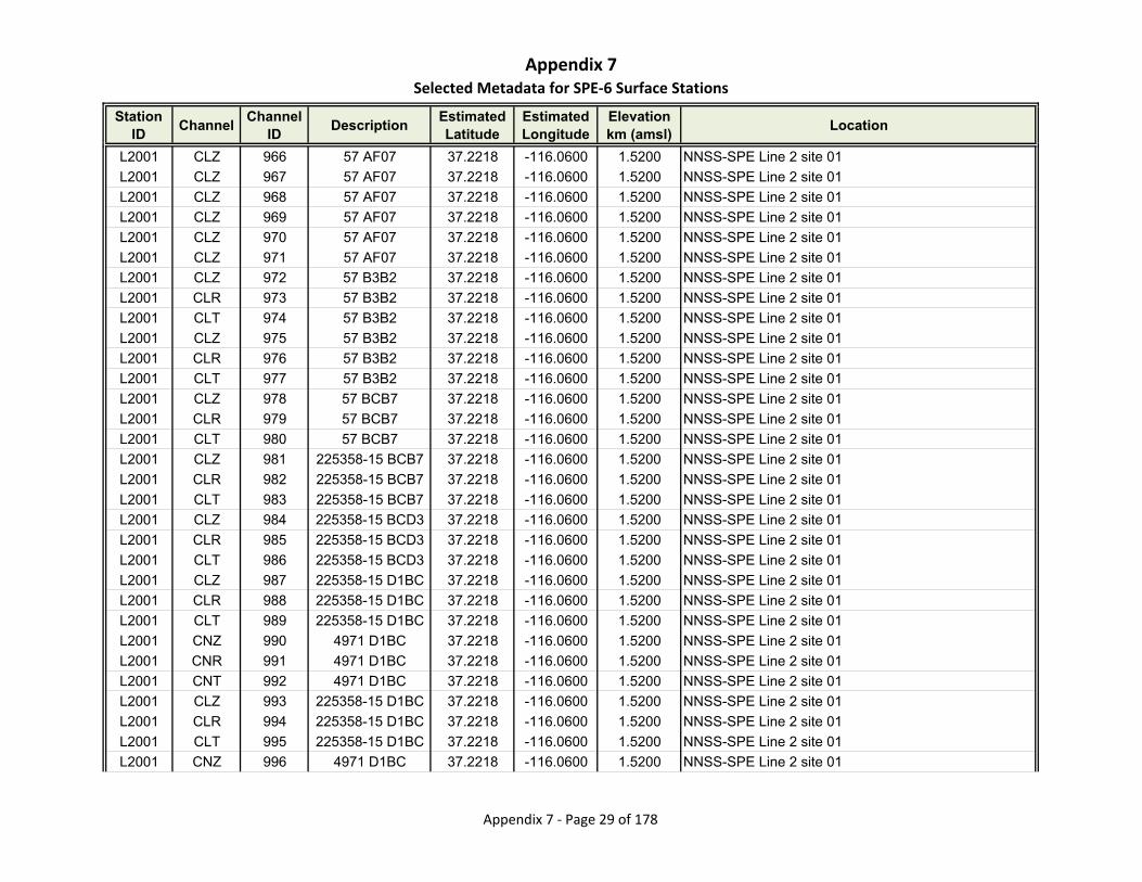
Appendix 7Selected Metadata for SPE‐6 Surface Stations
Station ID
ChannelChannel
IDDescription
Estimated Latitude
Estimated Longitude
Elevationkm (amsl)
Location
L2001 CLZ 966 57 AF07 37.2218 -116.0600 1.5200 NNSS-SPE Line 2 site 01
L2001 CLZ 967 57 AF07 37.2218 -116.0600 1.5200 NNSS-SPE Line 2 site 01
L2001 CLZ 968 57 AF07 37.2218 -116.0600 1.5200 NNSS-SPE Line 2 site 01
L2001 CLZ 969 57 AF07 37.2218 -116.0600 1.5200 NNSS-SPE Line 2 site 01
L2001 CLZ 970 57 AF07 37.2218 -116.0600 1.5200 NNSS-SPE Line 2 site 01
L2001 CLZ 971 57 AF07 37.2218 -116.0600 1.5200 NNSS-SPE Line 2 site 01
L2001 CLZ 972 57 B3B2 37.2218 -116.0600 1.5200 NNSS-SPE Line 2 site 01
L2001 CLR 973 57 B3B2 37.2218 -116.0600 1.5200 NNSS-SPE Line 2 site 01
L2001 CLT 974 57 B3B2 37.2218 -116.0600 1.5200 NNSS-SPE Line 2 site 01
L2001 CLZ 975 57 B3B2 37.2218 -116.0600 1.5200 NNSS-SPE Line 2 site 01
L2001 CLR 976 57 B3B2 37.2218 -116.0600 1.5200 NNSS-SPE Line 2 site 01
L2001 CLT 977 57 B3B2 37.2218 -116.0600 1.5200 NNSS-SPE Line 2 site 01
L2001 CLZ 978 57 BCB7 37.2218 -116.0600 1.5200 NNSS-SPE Line 2 site 01
L2001 CLR 979 57 BCB7 37.2218 -116.0600 1.5200 NNSS-SPE Line 2 site 01
L2001 CLT 980 57 BCB7 37.2218 -116.0600 1.5200 NNSS-SPE Line 2 site 01
L2001 CLZ 981 225358-15 BCB7 37.2218 -116.0600 1.5200 NNSS-SPE Line 2 site 01
L2001 CLR 982 225358-15 BCB7 37.2218 -116.0600 1.5200 NNSS-SPE Line 2 site 01
L2001 CLT 983 225358-15 BCB7 37.2218 -116.0600 1.5200 NNSS-SPE Line 2 site 01
L2001 CLZ 984 225358-15 BCD3 37.2218 -116.0600 1.5200 NNSS-SPE Line 2 site 01
L2001 CLR 985 225358-15 BCD3 37.2218 -116.0600 1.5200 NNSS-SPE Line 2 site 01
L2001 CLT 986 225358-15 BCD3 37.2218 -116.0600 1.5200 NNSS-SPE Line 2 site 01
L2001 CLZ 987 225358-15 D1BC 37.2218 -116.0600 1.5200 NNSS-SPE Line 2 site 01
L2001 CLR 988 225358-15 D1BC 37.2218 -116.0600 1.5200 NNSS-SPE Line 2 site 01
L2001 CLT 989 225358-15 D1BC 37.2218 -116.0600 1.5200 NNSS-SPE Line 2 site 01
L2001 CNZ 990 4971 D1BC 37.2218 -116.0600 1.5200 NNSS-SPE Line 2 site 01
L2001 CNR 991 4971 D1BC 37.2218 -116.0600 1.5200 NNSS-SPE Line 2 site 01
L2001 CNT 992 4971 D1BC 37.2218 -116.0600 1.5200 NNSS-SPE Line 2 site 01
L2001 CLZ 993 225358-15 D1BC 37.2218 -116.0600 1.5200 NNSS-SPE Line 2 site 01
L2001 CLR 994 225358-15 D1BC 37.2218 -116.0600 1.5200 NNSS-SPE Line 2 site 01
L2001 CLT 995 225358-15 D1BC 37.2218 -116.0600 1.5200 NNSS-SPE Line 2 site 01
L2001 CNZ 996 4971 D1BC 37.2218 -116.0600 1.5200 NNSS-SPE Line 2 site 01
Appendix 7 ‐ Page 29 of 178

Appendix 7Selected Metadata for SPE‐6 Surface Stations
Station ID
ChannelChannel
IDDescription
Estimated Latitude
Estimated Longitude
Elevationkm (amsl)
Location
L2001 CNR 997 4971 D1BC 37.2218 -116.0600 1.5200 NNSS-SPE Line 2 site 01
L2001 CNT 998 4971 D1BC 37.2218 -116.0600 1.5200 NNSS-SPE Line 2 site 01
L2001 CLZ 999 225358-15 D1BC 37.2218 -116.0600 1.5200 NNSS-SPE Line 2 site 01
L2001 CLR 1000 225358-15 D1BC 37.2218 -116.0600 1.5200 NNSS-SPE Line 2 site 01
L2001 CLT 1001 225358-15 D1BC 37.2218 -116.0600 1.5200 NNSS-SPE Line 2 site 01
L2001 CLZ 1002 225358-15 D1BC 37.2218 -116.0600 1.5200 NNSS-SPE Line 2 site 01
L2001 CLR 1003 225358-15 D1BC 37.2218 -116.0600 1.5200 NNSS-SPE Line 2 site 01
L2001 CLT 1004 225358-15 D1BC 37.2218 -116.0600 1.5200 NNSS-SPE Line 2 site 01
L2001 CNZ 1005 4971 D1BC 37.2218 -116.0600 1.5200 NNSS-SPE Line 2 site 01
L2001 CNR 1006 4971 D1BC 37.2218 -116.0600 1.5200 NNSS-SPE Line 2 site 01
L2001 CNT 1007 4971 D1BC 37.2218 -116.0600 1.5200 NNSS-SPE Line 2 site 01
L2001 CLZ 1008 214830-09 D1BC 37.2218 -116.0600 1.5200 NNSS-SPE Line 2 site 01
L2001 CLR 1009 214830-09 D1BC 37.2218 -116.0600 1.5200 NNSS-SPE Line 2 site 01
L2001 CLT 1010 214830-09 D1BC 37.2218 -116.0600 1.5200 NNSS-SPE Line 2 site 01
L2001 CNZ 1011 4971 D1BC 37.2218 -116.0600 1.5200 NNSS-SPE Line 2 site 01
L2001 CNR 1012 4971 D1BC 37.2218 -116.0600 1.5200 NNSS-SPE Line 2 site 01
L2001 CNT 1013 4971 D1BC 37.2218 -116.0600 1.5200 NNSS-SPE Line 2 site 01
L2002 CLZ 1014 79 AF07 37.2224 -116.0592 1.5150 NNSS-SPE Line 2 site 02
L2002 CLZ 1015 79 AF07 37.2224 -116.0592 1.5150 NNSS-SPE Line 2 site 02
L2002 CLZ 1016 79 AF07 37.2224 -116.0592 1.5150 NNSS-SPE Line 2 site 02
L2002 CLZ 1017 79 AF07 37.2224 -116.0592 1.5150 NNSS-SPE Line 2 site 02
L2002 CLZ 1018 79 AF07 37.2224 -116.0592 1.5150 NNSS-SPE Line 2 site 02
L2002 CLZ 1019 79 AF07 37.2224 -116.0592 1.5150 NNSS-SPE Line 2 site 02
L2002 CLZ 1020 79 B3B2 37.2224 -116.0592 1.5150 NNSS-SPE Line 2 site 02
L2002 CLR 1021 79 B3B2 37.2224 -116.0592 1.5150 NNSS-SPE Line 2 site 02
L2002 CLT 1022 79 B3B2 37.2224 -116.0592 1.5150 NNSS-SPE Line 2 site 02
L2002 CLZ 1023 79 B3B2 37.2224 -116.0592 1.5150 NNSS-SPE Line 2 site 02
L2002 CLR 1024 79 B3B2 37.2224 -116.0592 1.5150 NNSS-SPE Line 2 site 02
L2002 CLT 1025 79 B3B2 37.2224 -116.0592 1.5150 NNSS-SPE Line 2 site 02
L2002 CLZ 1026 79 BCB7 37.2224 -116.0592 1.5150 NNSS-SPE Line 2 site 02
L2002 CLR 1027 79 BCB7 37.2224 -116.0592 1.5150 NNSS-SPE Line 2 site 02
Appendix 7 ‐ Page 30 of 178
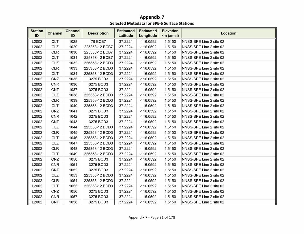
Appendix 7Selected Metadata for SPE‐6 Surface Stations
Station ID
ChannelChannel
IDDescription
Estimated Latitude
Estimated Longitude
Elevationkm (amsl)
Location
L2002 CLT 1028 79 BCB7 37.2224 -116.0592 1.5150 NNSS-SPE Line 2 site 02
L2002 CLZ 1029 225358-12 BCB7 37.2224 -116.0592 1.5150 NNSS-SPE Line 2 site 02
L2002 CLR 1030 225358-12 BCB7 37.2224 -116.0592 1.5150 NNSS-SPE Line 2 site 02
L2002 CLT 1031 225358-12 BCB7 37.2224 -116.0592 1.5150 NNSS-SPE Line 2 site 02
L2002 CLZ 1032 225358-12 BCD3 37.2224 -116.0592 1.5150 NNSS-SPE Line 2 site 02
L2002 CLR 1033 225358-12 BCD3 37.2224 -116.0592 1.5150 NNSS-SPE Line 2 site 02
L2002 CLT 1034 225358-12 BCD3 37.2224 -116.0592 1.5150 NNSS-SPE Line 2 site 02
L2002 CNZ 1035 3275 BCD3 37.2224 -116.0592 1.5150 NNSS-SPE Line 2 site 02
L2002 CNR 1036 3275 BCD3 37.2224 -116.0592 1.5150 NNSS-SPE Line 2 site 02
L2002 CNT 1037 3275 BCD3 37.2224 -116.0592 1.5150 NNSS-SPE Line 2 site 02
L2002 CLZ 1038 225358-12 BCD3 37.2224 -116.0592 1.5150 NNSS-SPE Line 2 site 02
L2002 CLR 1039 225358-12 BCD3 37.2224 -116.0592 1.5150 NNSS-SPE Line 2 site 02
L2002 CLT 1040 225358-12 BCD3 37.2224 -116.0592 1.5150 NNSS-SPE Line 2 site 02
L2002 CNZ 1041 3275 BCD3 37.2224 -116.0592 1.5150 NNSS-SPE Line 2 site 02
L2002 CNR 1042 3275 BCD3 37.2224 -116.0592 1.5150 NNSS-SPE Line 2 site 02
L2002 CNT 1043 3275 BCD3 37.2224 -116.0592 1.5150 NNSS-SPE Line 2 site 02
L2002 CLZ 1044 225358-12 BCD3 37.2224 -116.0592 1.5150 NNSS-SPE Line 2 site 02
L2002 CLR 1045 225358-12 BCD3 37.2224 -116.0592 1.5150 NNSS-SPE Line 2 site 02
L2002 CLT 1046 225358-12 BCD3 37.2224 -116.0592 1.5150 NNSS-SPE Line 2 site 02
L2002 CLZ 1047 225358-12 BCD3 37.2224 -116.0592 1.5150 NNSS-SPE Line 2 site 02
L2002 CLR 1048 225358-12 BCD3 37.2224 -116.0592 1.5150 NNSS-SPE Line 2 site 02
L2002 CLT 1049 225358-12 BCD3 37.2224 -116.0592 1.5150 NNSS-SPE Line 2 site 02
L2002 CNZ 1050 3275 BCD3 37.2224 -116.0592 1.5150 NNSS-SPE Line 2 site 02
L2002 CNR 1051 3275 BCD3 37.2224 -116.0592 1.5150 NNSS-SPE Line 2 site 02
L2002 CNT 1052 3275 BCD3 37.2224 -116.0592 1.5150 NNSS-SPE Line 2 site 02
L2002 CLZ 1053 225358-12 BCD3 37.2224 -116.0592 1.5150 NNSS-SPE Line 2 site 02
L2002 CLR 1054 225358-12 BCD3 37.2224 -116.0592 1.5150 NNSS-SPE Line 2 site 02
L2002 CLT 1055 225358-12 BCD3 37.2224 -116.0592 1.5150 NNSS-SPE Line 2 site 02
L2002 CNZ 1056 3275 BCD3 37.2224 -116.0592 1.5150 NNSS-SPE Line 2 site 02
L2002 CNR 1057 3275 BCD3 37.2224 -116.0592 1.5150 NNSS-SPE Line 2 site 02
L2002 CNT 1058 3275 BCD3 37.2224 -116.0592 1.5150 NNSS-SPE Line 2 site 02
Appendix 7 ‐ Page 31 of 178
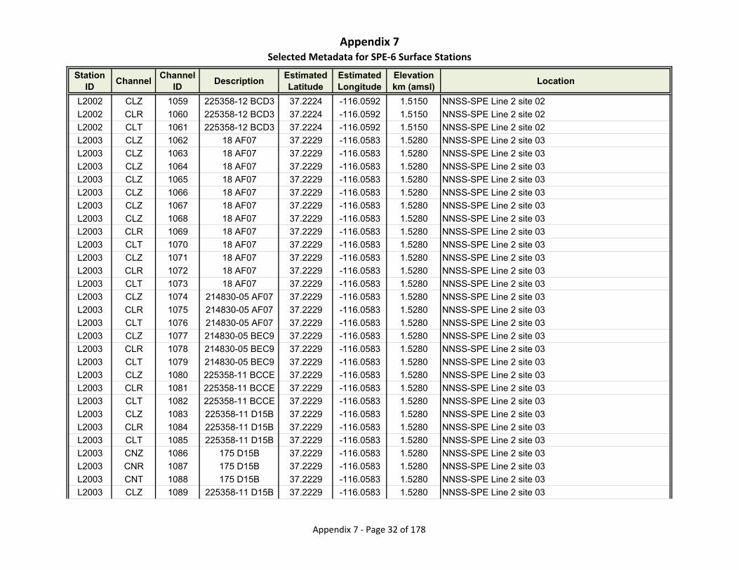
Appendix 7Selected Metadata for SPE‐6 Surface Stations
Station ID
ChannelChannel
IDDescription
Estimated Latitude
Estimated Longitude
Elevationkm (amsl)
Location
L2002 CLZ 1059 225358-12 BCD3 37.2224 -116.0592 1.5150 NNSS-SPE Line 2 site 02
L2002 CLR 1060 225358-12 BCD3 37.2224 -116.0592 1.5150 NNSS-SPE Line 2 site 02
L2002 CLT 1061 225358-12 BCD3 37.2224 -116.0592 1.5150 NNSS-SPE Line 2 site 02
L2003 CLZ 1062 18 AF07 37.2229 -116.0583 1.5280 NNSS-SPE Line 2 site 03
L2003 CLZ 1063 18 AF07 37.2229 -116.0583 1.5280 NNSS-SPE Line 2 site 03
L2003 CLZ 1064 18 AF07 37.2229 -116.0583 1.5280 NNSS-SPE Line 2 site 03
L2003 CLZ 1065 18 AF07 37.2229 -116.0583 1.5280 NNSS-SPE Line 2 site 03
L2003 CLZ 1066 18 AF07 37.2229 -116.0583 1.5280 NNSS-SPE Line 2 site 03
L2003 CLZ 1067 18 AF07 37.2229 -116.0583 1.5280 NNSS-SPE Line 2 site 03
L2003 CLZ 1068 18 AF07 37.2229 -116.0583 1.5280 NNSS-SPE Line 2 site 03
L2003 CLR 1069 18 AF07 37.2229 -116.0583 1.5280 NNSS-SPE Line 2 site 03
L2003 CLT 1070 18 AF07 37.2229 -116.0583 1.5280 NNSS-SPE Line 2 site 03
L2003 CLZ 1071 18 AF07 37.2229 -116.0583 1.5280 NNSS-SPE Line 2 site 03
L2003 CLR 1072 18 AF07 37.2229 -116.0583 1.5280 NNSS-SPE Line 2 site 03
L2003 CLT 1073 18 AF07 37.2229 -116.0583 1.5280 NNSS-SPE Line 2 site 03
L2003 CLZ 1074 214830-05 AF07 37.2229 -116.0583 1.5280 NNSS-SPE Line 2 site 03
L2003 CLR 1075 214830-05 AF07 37.2229 -116.0583 1.5280 NNSS-SPE Line 2 site 03
L2003 CLT 1076 214830-05 AF07 37.2229 -116.0583 1.5280 NNSS-SPE Line 2 site 03
L2003 CLZ 1077 214830-05 BEC9 37.2229 -116.0583 1.5280 NNSS-SPE Line 2 site 03
L2003 CLR 1078 214830-05 BEC9 37.2229 -116.0583 1.5280 NNSS-SPE Line 2 site 03
L2003 CLT 1079 214830-05 BEC9 37.2229 -116.0583 1.5280 NNSS-SPE Line 2 site 03
L2003 CLZ 1080 225358-11 BCCE 37.2229 -116.0583 1.5280 NNSS-SPE Line 2 site 03
L2003 CLR 1081 225358-11 BCCE 37.2229 -116.0583 1.5280 NNSS-SPE Line 2 site 03
L2003 CLT 1082 225358-11 BCCE 37.2229 -116.0583 1.5280 NNSS-SPE Line 2 site 03
L2003 CLZ 1083 225358-11 D15B 37.2229 -116.0583 1.5280 NNSS-SPE Line 2 site 03
L2003 CLR 1084 225358-11 D15B 37.2229 -116.0583 1.5280 NNSS-SPE Line 2 site 03
L2003 CLT 1085 225358-11 D15B 37.2229 -116.0583 1.5280 NNSS-SPE Line 2 site 03
L2003 CNZ 1086 175 D15B 37.2229 -116.0583 1.5280 NNSS-SPE Line 2 site 03
L2003 CNR 1087 175 D15B 37.2229 -116.0583 1.5280 NNSS-SPE Line 2 site 03
L2003 CNT 1088 175 D15B 37.2229 -116.0583 1.5280 NNSS-SPE Line 2 site 03
L2003 CLZ 1089 225358-11 D15B 37.2229 -116.0583 1.5280 NNSS-SPE Line 2 site 03
Appendix 7 ‐ Page 32 of 178
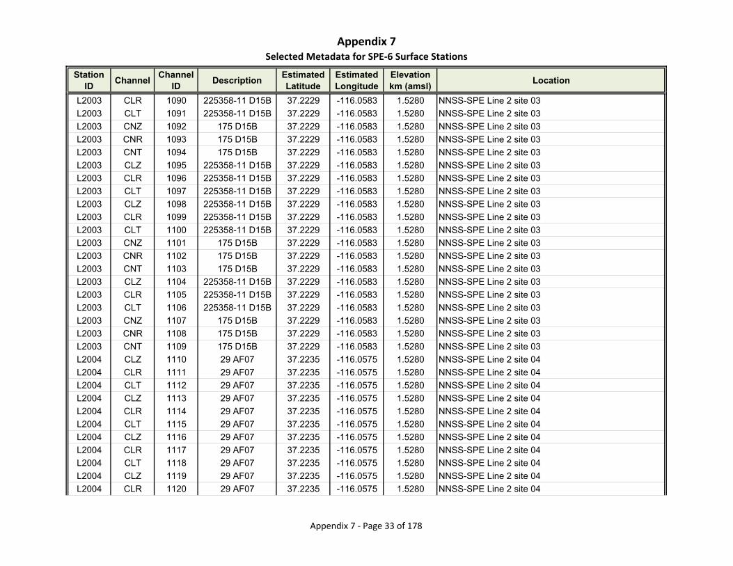
Appendix 7Selected Metadata for SPE‐6 Surface Stations
Station ID
ChannelChannel
IDDescription
Estimated Latitude
Estimated Longitude
Elevationkm (amsl)
Location
L2003 CLR 1090 225358-11 D15B 37.2229 -116.0583 1.5280 NNSS-SPE Line 2 site 03
L2003 CLT 1091 225358-11 D15B 37.2229 -116.0583 1.5280 NNSS-SPE Line 2 site 03
L2003 CNZ 1092 175 D15B 37.2229 -116.0583 1.5280 NNSS-SPE Line 2 site 03
L2003 CNR 1093 175 D15B 37.2229 -116.0583 1.5280 NNSS-SPE Line 2 site 03
L2003 CNT 1094 175 D15B 37.2229 -116.0583 1.5280 NNSS-SPE Line 2 site 03
L2003 CLZ 1095 225358-11 D15B 37.2229 -116.0583 1.5280 NNSS-SPE Line 2 site 03
L2003 CLR 1096 225358-11 D15B 37.2229 -116.0583 1.5280 NNSS-SPE Line 2 site 03
L2003 CLT 1097 225358-11 D15B 37.2229 -116.0583 1.5280 NNSS-SPE Line 2 site 03
L2003 CLZ 1098 225358-11 D15B 37.2229 -116.0583 1.5280 NNSS-SPE Line 2 site 03
L2003 CLR 1099 225358-11 D15B 37.2229 -116.0583 1.5280 NNSS-SPE Line 2 site 03
L2003 CLT 1100 225358-11 D15B 37.2229 -116.0583 1.5280 NNSS-SPE Line 2 site 03
L2003 CNZ 1101 175 D15B 37.2229 -116.0583 1.5280 NNSS-SPE Line 2 site 03
L2003 CNR 1102 175 D15B 37.2229 -116.0583 1.5280 NNSS-SPE Line 2 site 03
L2003 CNT 1103 175 D15B 37.2229 -116.0583 1.5280 NNSS-SPE Line 2 site 03
L2003 CLZ 1104 225358-11 D15B 37.2229 -116.0583 1.5280 NNSS-SPE Line 2 site 03
L2003 CLR 1105 225358-11 D15B 37.2229 -116.0583 1.5280 NNSS-SPE Line 2 site 03
L2003 CLT 1106 225358-11 D15B 37.2229 -116.0583 1.5280 NNSS-SPE Line 2 site 03
L2003 CNZ 1107 175 D15B 37.2229 -116.0583 1.5280 NNSS-SPE Line 2 site 03
L2003 CNR 1108 175 D15B 37.2229 -116.0583 1.5280 NNSS-SPE Line 2 site 03
L2003 CNT 1109 175 D15B 37.2229 -116.0583 1.5280 NNSS-SPE Line 2 site 03
L2004 CLZ 1110 29 AF07 37.2235 -116.0575 1.5280 NNSS-SPE Line 2 site 04
L2004 CLR 1111 29 AF07 37.2235 -116.0575 1.5280 NNSS-SPE Line 2 site 04
L2004 CLT 1112 29 AF07 37.2235 -116.0575 1.5280 NNSS-SPE Line 2 site 04
L2004 CLZ 1113 29 AF07 37.2235 -116.0575 1.5280 NNSS-SPE Line 2 site 04
L2004 CLR 1114 29 AF07 37.2235 -116.0575 1.5280 NNSS-SPE Line 2 site 04
L2004 CLT 1115 29 AF07 37.2235 -116.0575 1.5280 NNSS-SPE Line 2 site 04
L2004 CLZ 1116 29 AF07 37.2235 -116.0575 1.5280 NNSS-SPE Line 2 site 04
L2004 CLR 1117 29 AF07 37.2235 -116.0575 1.5280 NNSS-SPE Line 2 site 04
L2004 CLT 1118 29 AF07 37.2235 -116.0575 1.5280 NNSS-SPE Line 2 site 04
L2004 CLZ 1119 29 AF07 37.2235 -116.0575 1.5280 NNSS-SPE Line 2 site 04
L2004 CLR 1120 29 AF07 37.2235 -116.0575 1.5280 NNSS-SPE Line 2 site 04
Appendix 7 ‐ Page 33 of 178
Appendix 7Selected Metadata for SPE‐6 Surface Stations
Station ID
ChannelChannel
IDDescription
Estimated Latitude
Estimated Longitude
Elevationkm (amsl)
Location
L2004 CLT 1121 29 AF07 37.2235 -116.0575 1.5280 NNSS-SPE Line 2 site 04
L2004 CLZ 1122 29 AF07 37.2235 -116.0575 1.5280 NNSS-SPE Line 2 site 04
L2004 CLR 1123 29 AF07 37.2235 -116.0575 1.5280 NNSS-SPE Line 2 site 04
L2004 CLT 1124 29 AF07 37.2235 -116.0575 1.5280 NNSS-SPE Line 2 site 04
L2004 CLZ 1125 29 AF07 37.2235 -116.0575 1.5280 NNSS-SPE Line 2 site 04
L2004 CLR 1126 29 AF07 37.2235 -116.0575 1.5280 NNSS-SPE Line 2 site 04
L2004 CLT 1127 29 AF07 37.2235 -116.0575 1.5280 NNSS-SPE Line 2 site 04
L2004 CLZ 1128 29 AF07 37.2235 -116.0575 1.5280 NNSS-SPE Line 2 site 04
L2004 CLR 1129 29 AF07 37.2235 -116.0575 1.5280 NNSS-SPE Line 2 site 04
L2004 CLT 1130 29 AF07 37.2235 -116.0575 1.5280 NNSS-SPE Line 2 site 04
L2004 CLZ 1131 29 AF07 37.2235 -116.0575 1.5280 NNSS-SPE Line 2 site 04
L2004 CLR 1132 29 AF07 37.2235 -116.0575 1.5280 NNSS-SPE Line 2 site 04
L2004 CLT 1133 29 AF07 37.2235 -116.0575 1.5280 NNSS-SPE Line 2 site 04
L2004 CLZ 1134 29 AF07 37.2235 -116.0575 1.5280 NNSS-SPE Line 2 site 04
L2004 CLR 1135 29 AF07 37.2235 -116.0575 1.5280 NNSS-SPE Line 2 site 04
L2004 CLT 1136 29 AF07 37.2235 -116.0575 1.5280 NNSS-SPE Line 2 site 04
L2004 CLZ 1137 29 BEC9 37.2235 -116.0575 1.5280 NNSS-SPE Line 2 site 04
L2004 CLR 1138 29 BEC9 37.2235 -116.0575 1.5280 NNSS-SPE Line 2 site 04
L2004 CLT 1139 29 BEC9 37.2235 -116.0575 1.5280 NNSS-SPE Line 2 site 04
L2004 CLZ 1140 225358-26 BCCE 37.2235 -116.0575 1.5280 NNSS-SPE Line 2 site 04
L2004 CLR 1141 225358-26 BCCE 37.2235 -116.0575 1.5280 NNSS-SPE Line 2 site 04
L2004 CLT 1142 225358-26 BCCE 37.2235 -116.0575 1.5280 NNSS-SPE Line 2 site 04
L2004 CLZ 1143 225358-26 BCCE 37.2235 -116.0575 1.5280 NNSS-SPE Line 2 site 04
L2004 CLR 1144 225358-26 BCCE 37.2235 -116.0575 1.5280 NNSS-SPE Line 2 site 04
L2004 CLT 1145 225358-26 BCCE 37.2235 -116.0575 1.5280 NNSS-SPE Line 2 site 04
L2004 CLZ 1146 225358-26 BCCE 37.2235 -116.0575 1.5280 NNSS-SPE Line 2 site 04
L2004 CLR 1147 225358-26 BCCE 37.2235 -116.0575 1.5280 NNSS-SPE Line 2 site 04
L2004 CLT 1148 225358-26 BCCE 37.2235 -116.0575 1.5280 NNSS-SPE Line 2 site 04
L2004 CLZ 1149 225358-26 BCCE 37.2235 -116.0575 1.5280 NNSS-SPE Line 2 site 04
L2004 CLR 1150 225358-26 BCCE 37.2235 -116.0575 1.5280 NNSS-SPE Line 2 site 04
L2004 CLT 1151 225358-26 BCCE 37.2235 -116.0575 1.5280 NNSS-SPE Line 2 site 04
Appendix 7 ‐ Page 34 of 178
Appendix 7Selected Metadata for SPE‐6 Surface Stations
Station ID
ChannelChannel
IDDescription
Estimated Latitude
Estimated Longitude
Elevationkm (amsl)
Location
L2004 CLZ 1152 225358-31 BCCE 37.2235 -116.0575 1.5280 NNSS-SPE Line 2 site 04
L2004 CLR 1153 225358-31 BCCE 37.2235 -116.0575 1.5280 NNSS-SPE Line 2 site 04
L2004 CLT 1154 225358-31 BCCE 37.2235 -116.0575 1.5280 NNSS-SPE Line 2 site 04
L2005 CLZ 1155 12 9E1D 37.2241 -116.0566 1.5320 NNSS-SPE Line 2 site 05
L2005 CLZ 1156 12 9E1D 37.2241 -116.0566 1.5320 NNSS-SPE Line 2 site 05
L2005 CLZ 1157 12 9E1D 37.2241 -116.0566 1.5320 NNSS-SPE Line 2 site 05
L2005 CLZ 1158 12 9E1D 37.2241 -116.0566 1.5320 NNSS-SPE Line 2 site 05
L2005 CLZ 1159 12 9E1D 37.2241 -116.0566 1.5320 NNSS-SPE Line 2 site 05
L2005 CLZ 1160 12 9E1D 37.2241 -116.0566 1.5320 NNSS-SPE Line 2 site 05
L2005 CLZ 1161 12 9E2B 37.2241 -116.0566 1.5320 NNSS-SPE Line 2 site 05
L2005 CLR 1162 12 9E2B 37.2241 -116.0566 1.5320 NNSS-SPE Line 2 site 05
L2005 CLT 1163 12 9E2B 37.2241 -116.0566 1.5320 NNSS-SPE Line 2 site 05
L2005 CLZ 1164 12 9E2B 37.2241 -116.0566 1.5320 NNSS-SPE Line 2 site 05
L2005 CLR 1165 12 9E2B 37.2241 -116.0566 1.5320 NNSS-SPE Line 2 site 05
L2005 CLT 1166 12 9E2B 37.2241 -116.0566 1.5320 NNSS-SPE Line 2 site 05
L2005 CLZ 1167 12 AF0C 37.2241 -116.0566 1.5320 NNSS-SPE Line 2 site 05
L2005 CLR 1168 12 AF0C 37.2241 -116.0566 1.5320 NNSS-SPE Line 2 site 05
L2005 CLT 1169 12 AF0C 37.2241 -116.0566 1.5320 NNSS-SPE Line 2 site 05
L2005 CLZ 1170 12 AF0C 37.2241 -116.0566 1.5320 NNSS-SPE Line 2 site 05
L2005 CLR 1171 12 AF0C 37.2241 -116.0566 1.5320 NNSS-SPE Line 2 site 05
L2005 CLT 1172 12 AF0C 37.2241 -116.0566 1.5320 NNSS-SPE Line 2 site 05
L2005 CLZ 1173 12 AF0C 37.2241 -116.0566 1.5320 NNSS-SPE Line 2 site 05
L2005 CLR 1174 12 AF0C 37.2241 -116.0566 1.5320 NNSS-SPE Line 2 site 05
L2005 CLT 1175 12 AF0C 37.2241 -116.0566 1.5320 NNSS-SPE Line 2 site 05
L2005 CLZ 1176 12 AF0C 37.2241 -116.0566 1.5320 NNSS-SPE Line 2 site 05
L2005 CLR 1177 12 AF0C 37.2241 -116.0566 1.5320 NNSS-SPE Line 2 site 05
L2005 CLT 1178 12 AF0C 37.2241 -116.0566 1.5320 NNSS-SPE Line 2 site 05
L2005 CLZ 1179 12 AF0C 37.2241 -116.0566 1.5320 NNSS-SPE Line 2 site 05
L2005 CLR 1180 12 AF0C 37.2241 -116.0566 1.5320 NNSS-SPE Line 2 site 05
L2005 CLT 1181 12 AF0C 37.2241 -116.0566 1.5320 NNSS-SPE Line 2 site 05
L2005 CLZ 1182 225358-25 AF0C 37.2241 -116.0566 1.5320 NNSS-SPE Line 2 site 05
Appendix 7 ‐ Page 35 of 178

Appendix 7Selected Metadata for SPE‐6 Surface Stations
Station ID
ChannelChannel
IDDescription
Estimated Latitude
Estimated Longitude
Elevationkm (amsl)
Location
L2005 CLR 1183 225358-25 AF0C 37.2241 -116.0566 1.5320 NNSS-SPE Line 2 site 05
L2005 CLT 1184 225358-25 AF0C 37.2241 -116.0566 1.5320 NNSS-SPE Line 2 site 05
L2006 CLZ 1185 92 9E1D 37.2247 -116.0558 1.5310 NNSS-SPE Line 2 site 06
L2006 CLZ 1186 92 9E1D 37.2247 -116.0558 1.5310 NNSS-SPE Line 2 site 06
L2006 CLZ 1187 92 9E1D 37.2247 -116.0558 1.5310 NNSS-SPE Line 2 site 06
L2006 CLZ 1188 92 9E1D 37.2247 -116.0558 1.5310 NNSS-SPE Line 2 site 06
L2006 CLZ 1189 92 9E1D 37.2247 -116.0558 1.5310 NNSS-SPE Line 2 site 06
L2006 CLZ 1190 92 9E1D 37.2247 -116.0558 1.5310 NNSS-SPE Line 2 site 06
L2006 CLZ 1191 92 9E2B 37.2247 -116.0558 1.5310 NNSS-SPE Line 2 site 06
L2006 CLR 1192 92 9E2B 37.2247 -116.0558 1.5310 NNSS-SPE Line 2 site 06
L2006 CLT 1193 92 9E2B 37.2247 -116.0558 1.5310 NNSS-SPE Line 2 site 06
L2006 CLZ 1194 92 9E2B 37.2247 -116.0558 1.5310 NNSS-SPE Line 2 site 06
L2006 CLR 1195 92 9E2B 37.2247 -116.0558 1.5310 NNSS-SPE Line 2 site 06
L2006 CLT 1196 92 9E2B 37.2247 -116.0558 1.5310 NNSS-SPE Line 2 site 06
L2006 CLZ 1197 92 AF0C 37.2247 -116.0558 1.5310 NNSS-SPE Line 2 site 06
L2006 CLR 1198 92 AF0C 37.2247 -116.0558 1.5310 NNSS-SPE Line 2 site 06
L2006 CLT 1199 92 AF0C 37.2247 -116.0558 1.5310 NNSS-SPE Line 2 site 06
L2006 CLZ 1200 92 AF0C 37.2247 -116.0558 1.5310 NNSS-SPE Line 2 site 06
L2006 CLR 1201 92 AF0C 37.2247 -116.0558 1.5310 NNSS-SPE Line 2 site 06
L2006 CLT 1202 92 AF0C 37.2247 -116.0558 1.5310 NNSS-SPE Line 2 site 06
L2006 CLZ 1203 92 AF0C 37.2247 -116.0558 1.5310 NNSS-SPE Line 2 site 06
L2006 CLR 1204 92 AF0C 37.2247 -116.0558 1.5310 NNSS-SPE Line 2 site 06
L2006 CLT 1205 92 AF0C 37.2247 -116.0558 1.5310 NNSS-SPE Line 2 site 06
L2006 CLZ 1206 92 AF0C 37.2247 -116.0558 1.5310 NNSS-SPE Line 2 site 06
L2006 CLR 1207 92 AF0C 37.2247 -116.0558 1.5310 NNSS-SPE Line 2 site 06
L2006 CLT 1208 92 AF0C 37.2247 -116.0558 1.5310 NNSS-SPE Line 2 site 06
L2006 CLZ 1209 92 AF0C 37.2247 -116.0558 1.5310 NNSS-SPE Line 2 site 06
L2006 CLR 1210 92 AF0C 37.2247 -116.0558 1.5310 NNSS-SPE Line 2 site 06
L2006 CLT 1211 92 AF0C 37.2247 -116.0558 1.5310 NNSS-SPE Line 2 site 06
L2006 CLZ 1212 92 AF0C 37.2247 -116.0558 1.5310 NNSS-SPE Line 2 site 06
L2006 CLR 1213 92 AF0C 37.2247 -116.0558 1.5310 NNSS-SPE Line 2 site 06
Appendix 7 ‐ Page 36 of 178
Appendix 7Selected Metadata for SPE‐6 Surface Stations
Station ID
ChannelChannel
IDDescription
Estimated Latitude
Estimated Longitude
Elevationkm (amsl)
Location
L2006 CLT 1214 92 AF0C 37.2247 -116.0558 1.5310 NNSS-SPE Line 2 site 06
L2007 CLZ 1215 22 9E1D 37.2253 -116.0549 1.5300 NNSS-SPE Line 2 site 07
L2007 CLZ 1216 22 9E1D 37.2253 -116.0549 1.5300 NNSS-SPE Line 2 site 07
L2007 CLZ 1217 22 9E1D 37.2253 -116.0549 1.5300 NNSS-SPE Line 2 site 07
L2007 CLZ 1218 22 9E1D 37.2253 -116.0549 1.5300 NNSS-SPE Line 2 site 07
L2007 CLZ 1219 22 9E1D 37.2253 -116.0549 1.5300 NNSS-SPE Line 2 site 07
L2007 CLZ 1220 22 9E1D 37.2253 -116.0549 1.5300 NNSS-SPE Line 2 site 07
L2007 CLZ 1221 22 9E1D 37.2253 -116.0549 1.5300 NNSS-SPE Line 2 site 07
L2007 CLR 1222 22 9E1D 37.2253 -116.0549 1.5300 NNSS-SPE Line 2 site 07
L2007 CLT 1223 22 9E1D 37.2253 -116.0549 1.5300 NNSS-SPE Line 2 site 07
L2007 CLZ 1224 22 9E1D 37.2253 -116.0549 1.5300 NNSS-SPE Line 2 site 07
L2007 CLR 1225 22 9E1D 37.2253 -116.0549 1.5300 NNSS-SPE Line 2 site 07
L2007 CLT 1226 22 9E1D 37.2253 -116.0549 1.5300 NNSS-SPE Line 2 site 07
L2007 CLZ 1227 22 B3B5 37.2253 -116.0549 1.5300 NNSS-SPE Line 2 site 07
L2007 CLR 1228 22 B3B5 37.2253 -116.0549 1.5300 NNSS-SPE Line 2 site 07
L2007 CLT 1229 22 B3B5 37.2253 -116.0549 1.5300 NNSS-SPE Line 2 site 07
L2007 CLZ 1230 22 B3B5 37.2253 -116.0549 1.5300 NNSS-SPE Line 2 site 07
L2007 CLR 1231 22 B3B5 37.2253 -116.0549 1.5300 NNSS-SPE Line 2 site 07
L2007 CLT 1232 22 B3B5 37.2253 -116.0549 1.5300 NNSS-SPE Line 2 site 07
L2007 CLZ 1233 225358-48 B3B5 37.2253 -116.0549 1.5300 NNSS-SPE Line 2 site 07
L2007 CLR 1234 225358-48 B3B5 37.2253 -116.0549 1.5300 NNSS-SPE Line 2 site 07
L2007 CLT 1235 225358-48 B3B5 37.2253 -116.0549 1.5300 NNSS-SPE Line 2 site 07
L2007 CLZ 1236 225358-48 B3B5 37.2253 -116.0549 1.5300 NNSS-SPE Line 2 site 07
L2007 CLR 1237 225358-48 B3B5 37.2253 -116.0549 1.5300 NNSS-SPE Line 2 site 07
L2007 CLT 1238 225358-48 B3B5 37.2253 -116.0549 1.5300 NNSS-SPE Line 2 site 07
L2007 CLZ 1239 225358-48 B3B5 37.2253 -116.0549 1.5300 NNSS-SPE Line 2 site 07
L2007 CLR 1240 225358-48 B3B5 37.2253 -116.0549 1.5300 NNSS-SPE Line 2 site 07
L2007 CLT 1241 225358-48 B3B5 37.2253 -116.0549 1.5300 NNSS-SPE Line 2 site 07
L2007 CLZ 1242 225358-48 B3B5 37.2253 -116.0549 1.5300 NNSS-SPE Line 2 site 07
L2007 CLR 1243 225358-48 B3B5 37.2253 -116.0549 1.5300 NNSS-SPE Line 2 site 07
L2007 CLT 1244 225358-48 B3B5 37.2253 -116.0549 1.5300 NNSS-SPE Line 2 site 07
Appendix 7 ‐ Page 37 of 178

Appendix 7Selected Metadata for SPE‐6 Surface Stations
Station ID
ChannelChannel
IDDescription
Estimated Latitude
Estimated Longitude
Elevationkm (amsl)
Location
L2007 CLZ 1245 225358-18 B3B5 37.2253 -116.0549 1.5300 NNSS-SPE Line 2 site 07
L2007 CLR 1246 225358-18 B3B5 37.2253 -116.0549 1.5300 NNSS-SPE Line 2 site 07
L2007 CLT 1247 225358-18 B3B5 37.2253 -116.0549 1.5300 NNSS-SPE Line 2 site 07
L2008 CLZ 1248 4 9E1D 37.2259 -116.0541 1.5300 NNSS-SPE Line 2 site 08
L2008 CLR 1249 4 9E1D 37.2259 -116.0541 1.5300 NNSS-SPE Line 2 site 08
L2008 CLT 1250 4 9E1D 37.2259 -116.0541 1.5300 NNSS-SPE Line 2 site 08
L2008 CLZ 1251 4 9E1D 37.2259 -116.0541 1.5300 NNSS-SPE Line 2 site 08
L2008 CLR 1252 4 9E1D 37.2259 -116.0541 1.5300 NNSS-SPE Line 2 site 08
L2008 CLT 1253 4 9E1D 37.2259 -116.0541 1.5300 NNSS-SPE Line 2 site 08
L2008 CLZ 1254 4 9E1D 37.2259 -116.0541 1.5300 NNSS-SPE Line 2 site 08
L2008 CLR 1255 4 9E1D 37.2259 -116.0541 1.5300 NNSS-SPE Line 2 site 08
L2008 CLT 1256 4 9E1D 37.2259 -116.0541 1.5300 NNSS-SPE Line 2 site 08
L2008 CLZ 1257 4 9E1D 37.2259 -116.0541 1.5300 NNSS-SPE Line 2 site 08
L2008 CLR 1258 4 9E1D 37.2259 -116.0541 1.5300 NNSS-SPE Line 2 site 08
L2008 CLT 1259 4 9E1D 37.2259 -116.0541 1.5300 NNSS-SPE Line 2 site 08
L2008 CLZ 1260 4 9E1D 37.2259 -116.0541 1.5300 NNSS-SPE Line 2 site 08
L2008 CLR 1261 4 9E1D 37.2259 -116.0541 1.5300 NNSS-SPE Line 2 site 08
L2008 CLT 1262 4 9E1D 37.2259 -116.0541 1.5300 NNSS-SPE Line 2 site 08
L2008 CLZ 1263 4 9E1D 37.2259 -116.0541 1.5300 NNSS-SPE Line 2 site 08
L2008 CLR 1264 4 9E1D 37.2259 -116.0541 1.5300 NNSS-SPE Line 2 site 08
L2008 CLT 1265 4 9E1D 37.2259 -116.0541 1.5300 NNSS-SPE Line 2 site 08
L2008 CLZ 1266 4 9E1D 37.2259 -116.0541 1.5300 NNSS-SPE Line 2 site 08
L2008 CLR 1267 4 9E1D 37.2259 -116.0541 1.5300 NNSS-SPE Line 2 site 08
L2008 CLT 1268 4 9E1D 37.2259 -116.0541 1.5300 NNSS-SPE Line 2 site 08
L2008 CLZ 1269 4 9E1D 37.2259 -116.0541 1.5300 NNSS-SPE Line 2 site 08
L2008 CLR 1270 4 9E1D 37.2259 -116.0541 1.5300 NNSS-SPE Line 2 site 08
L2008 CLT 1271 4 9E1D 37.2259 -116.0541 1.5300 NNSS-SPE Line 2 site 08
L2008 CLZ 1272 214830-13 B3B5 37.2259 -116.0541 1.5300 NNSS-SPE Line 2 site 08
L2008 CLR 1273 214830-13 B3B5 37.2259 -116.0541 1.5300 NNSS-SPE Line 2 site 08
L2008 CLT 1274 214830-13 B3B5 37.2259 -116.0541 1.5300 NNSS-SPE Line 2 site 08
L2008 CLZ 1275 214830-13 B3B5 37.2259 -116.0541 1.5300 NNSS-SPE Line 2 site 08
Appendix 7 ‐ Page 38 of 178
Appendix 7Selected Metadata for SPE‐6 Surface Stations
Station ID
ChannelChannel
IDDescription
Estimated Latitude
Estimated Longitude
Elevationkm (amsl)
Location
L2008 CLR 1276 214830-13 B3B5 37.2259 -116.0541 1.5300 NNSS-SPE Line 2 site 08
L2008 CLT 1277 214830-13 B3B5 37.2259 -116.0541 1.5300 NNSS-SPE Line 2 site 08
L2008 CLZ 1278 13 B3B5 37.2259 -116.0541 1.5300 NNSS-SPE Line 2 site 08
L2008 CLR 1279 13 B3B5 37.2259 -116.0541 1.5300 NNSS-SPE Line 2 site 08
L2008 CLT 1280 13 B3B5 37.2259 -116.0541 1.5300 NNSS-SPE Line 2 site 08
L2008 CLZ 1281 13 B3B5 37.2259 -116.0541 1.5300 NNSS-SPE Line 2 site 08
L2008 CLR 1282 13 B3B5 37.2259 -116.0541 1.5300 NNSS-SPE Line 2 site 08
L2008 CLT 1283 13 B3B5 37.2259 -116.0541 1.5300 NNSS-SPE Line 2 site 08
L2008 CLZ 1284 13 B3B5 37.2259 -116.0541 1.5300 NNSS-SPE Line 2 site 08
L2008 CLR 1285 13 B3B5 37.2259 -116.0541 1.5300 NNSS-SPE Line 2 site 08
L2008 CLT 1286 13 B3B5 37.2259 -116.0541 1.5300 NNSS-SPE Line 2 site 08
L2008 CLZ 1287 62 B3B5 37.2259 -116.0541 1.5300 NNSS-SPE Line 2 site 08
L2008 CLR 1288 62 B3B5 37.2259 -116.0541 1.5300 NNSS-SPE Line 2 site 08
L2008 CLT 1289 62 B3B5 37.2259 -116.0541 1.5300 NNSS-SPE Line 2 site 08
L2009 CLZ 1290 15 9DE6 37.2265 -116.0533 1.5370 NNSS-SPE Line 2 site 09
L2009 CLZ 1291 15 9DE6 37.2265 -116.0533 1.5370 NNSS-SPE Line 2 site 09
L2009 CLZ 1292 15 9DE6 37.2265 -116.0533 1.5370 NNSS-SPE Line 2 site 09
L2009 CLZ 1293 15 9DE6 37.2265 -116.0533 1.5370 NNSS-SPE Line 2 site 09
L2009 CLZ 1294 15 9DE6 37.2265 -116.0533 1.5370 NNSS-SPE Line 2 site 09
L2009 CLZ 1295 15 9DE6 37.2265 -116.0533 1.5370 NNSS-SPE Line 2 site 09
L2009 CLZ 1296 15 90B0 37.2265 -116.0533 1.5370 NNSS-SPE Line 2 site 09
L2009 CLR 1297 15 90B0 37.2265 -116.0533 1.5370 NNSS-SPE Line 2 site 09
L2009 CLT 1298 15 90B0 37.2265 -116.0533 1.5370 NNSS-SPE Line 2 site 09
L2009 CLZ 1299 15 90B0 37.2265 -116.0533 1.5370 NNSS-SPE Line 2 site 09
L2009 CLR 1300 15 90B0 37.2265 -116.0533 1.5370 NNSS-SPE Line 2 site 09
L2009 CLT 1301 15 90B0 37.2265 -116.0533 1.5370 NNSS-SPE Line 2 site 09
L2009 CLZ 1302 15 90B0 37.2265 -116.0533 1.5370 NNSS-SPE Line 2 site 09
L2009 CLR 1303 15 90B0 37.2265 -116.0533 1.5370 NNSS-SPE Line 2 site 09
L2009 CLT 1304 15 90B0 37.2265 -116.0533 1.5370 NNSS-SPE Line 2 site 09
L2009 CLZ 1305 225358-13 90B0 37.2265 -116.0533 1.5370 NNSS-SPE Line 2 site 09
L2009 CLR 1306 225358-13 90B0 37.2265 -116.0533 1.5370 NNSS-SPE Line 2 site 09
Appendix 7 ‐ Page 39 of 178

Appendix 7Selected Metadata for SPE‐6 Surface Stations
Station ID
ChannelChannel
IDDescription
Estimated Latitude
Estimated Longitude
Elevationkm (amsl)
Location
L2009 CLT 1307 225358-13 90B0 37.2265 -116.0533 1.5370 NNSS-SPE Line 2 site 09
L2009 CLZ 1308 225358-13 90B0 37.2265 -116.0533 1.5370 NNSS-SPE Line 2 site 09
L2009 CLR 1309 225358-13 90B0 37.2265 -116.0533 1.5370 NNSS-SPE Line 2 site 09
L2009 CLT 1310 225358-13 90B0 37.2265 -116.0533 1.5370 NNSS-SPE Line 2 site 09
L2009 CLZ 1311 225358-13 90B0 37.2265 -116.0533 1.5370 NNSS-SPE Line 2 site 09
L2009 CLR 1312 225358-13 90B0 37.2265 -116.0533 1.5370 NNSS-SPE Line 2 site 09
L2009 CLT 1313 225358-13 90B0 37.2265 -116.0533 1.5370 NNSS-SPE Line 2 site 09
L2009 CLZ 1314 225358-13 90B0 37.2265 -116.0533 1.5370 NNSS-SPE Line 2 site 09
L2009 CLR 1315 225358-13 90B0 37.2265 -116.0533 1.5370 NNSS-SPE Line 2 site 09
L2009 CLT 1316 225358-13 90B0 37.2265 -116.0533 1.5370 NNSS-SPE Line 2 site 09
L2009 CLZ 1317 225358-17 90B0 37.2265 -116.0533 1.5370 NNSS-SPE Line 2 site 09
L2009 CLR 1318 225358-17 90B0 37.2265 -116.0533 1.5370 NNSS-SPE Line 2 site 09
L2009 CLT 1319 225358-17 90B0 37.2265 -116.0533 1.5370 NNSS-SPE Line 2 site 09
L2010 CNZ 1320 3688 90B4 37.2271 -116.0524 1.5310 NNSS-SPE Line 2 site 10
L2010 CNR 1321 3688 90B4 37.2271 -116.0524 1.5310 NNSS-SPE Line 2 site 10
L2010 CNT 1322 3688 90B4 37.2271 -116.0524 1.5310 NNSS-SPE Line 2 site 10
L2010 DJZ 1323 A200467 90B4 37.2271 -116.0524 1.5310 NNSS-SPE Line 2 site 10
L2010 DJR 1324 A200467 90B4 37.2271 -116.0524 1.5310 NNSS-SPE Line 2 site 10
L2010 DJT 1325 A200467 90B4 37.2271 -116.0524 1.5310 NNSS-SPE Line 2 site 10
L2010 CNZ 1326 3688 90B4 37.2271 -116.0524 1.5310 NNSS-SPE Line 2 site 10
L2010 CNR 1327 3688 90B4 37.2271 -116.0524 1.5310 NNSS-SPE Line 2 site 10
L2010 CNT 1328 3688 90B4 37.2271 -116.0524 1.5310 NNSS-SPE Line 2 site 10
L2010 CLZ_04 1329 105 90B4 37.2271 -116.0524 1.5310 NNSS-SPE Line 2 site 10
L2010 CLR_05 1330 105 90B4 37.2271 -116.0524 1.5310 NNSS-SPE Line 2 site 10
L2010 CLT_06 1331 105 90B4 37.2271 -116.0524 1.5310 NNSS-SPE Line 2 site 10
L2010 CNZ 1332 3688 90B4 37.2271 -116.0524 1.5310 NNSS-SPE Line 2 site 10
L2010 CNR 1333 3688 90B4 37.2271 -116.0524 1.5310 NNSS-SPE Line 2 site 10
L2010 CNT 1334 3688 90B4 37.2271 -116.0524 1.5310 NNSS-SPE Line 2 site 10
L2010 CLZ_04 1335 105 90B4 37.2271 -116.0524 1.5310 NNSS-SPE Line 2 site 10
L2010 CLR_05 1336 105 90B4 37.2271 -116.0524 1.5310 NNSS-SPE Line 2 site 10
L2010 CLT_06 1337 105 90B4 37.2271 -116.0524 1.5310 NNSS-SPE Line 2 site 10
Appendix 7 ‐ Page 40 of 178
Appendix 7Selected Metadata for SPE‐6 Surface Stations
Station ID
ChannelChannel
IDDescription
Estimated Latitude
Estimated Longitude
Elevationkm (amsl)
Location
L2010 CLZ 1338 40 9DE6 37.2271 -116.0524 1.5310 NNSS-SPE Line 2 site 10
L2010 CLZ 1339 40 9DE6 37.2271 -116.0524 1.5310 NNSS-SPE Line 2 site 10
L2010 CLZ 1340 40 9DE6 37.2271 -116.0524 1.5310 NNSS-SPE Line 2 site 10
L2010 CLZ 1341 40 9DE6 37.2271 -116.0524 1.5310 NNSS-SPE Line 2 site 10
L2010 CLZ 1342 40 9DE6 37.2271 -116.0524 1.5310 NNSS-SPE Line 2 site 10
L2010 CLZ 1343 40 9DE6 37.2271 -116.0524 1.5310 NNSS-SPE Line 2 site 10
L2010 CLZ 1344 40 90B0 37.2271 -116.0524 1.5310 NNSS-SPE Line 2 site 10
L2010 CLR 1345 40 90B0 37.2271 -116.0524 1.5310 NNSS-SPE Line 2 site 10
L2010 CLT 1346 40 90B0 37.2271 -116.0524 1.5310 NNSS-SPE Line 2 site 10
L2010 CLZ 1347 40 90B0 37.2271 -116.0524 1.5310 NNSS-SPE Line 2 site 10
L2010 CLR 1348 40 90B0 37.2271 -116.0524 1.5310 NNSS-SPE Line 2 site 10
L2010 CLT 1349 40 90B0 37.2271 -116.0524 1.5310 NNSS-SPE Line 2 site 10
L2010 CLZ 1350 40 90B0 37.2271 -116.0524 1.5310 NNSS-SPE Line 2 site 10
L2010 CLR 1351 40 90B0 37.2271 -116.0524 1.5310 NNSS-SPE Line 2 site 10
L2010 CLT 1352 40 90B0 37.2271 -116.0524 1.5310 NNSS-SPE Line 2 site 10
L2010 CLZ 1353 40 90B0 37.2271 -116.0524 1.5310 NNSS-SPE Line 2 site 10
L2010 CLR 1354 40 90B0 37.2271 -116.0524 1.5310 NNSS-SPE Line 2 site 10
L2010 CLT 1355 40 90B0 37.2271 -116.0524 1.5310 NNSS-SPE Line 2 site 10
L2010 CLZ 1356 40 90B0 37.2271 -116.0524 1.5310 NNSS-SPE Line 2 site 10
L2010 CLR 1357 40 90B0 37.2271 -116.0524 1.5310 NNSS-SPE Line 2 site 10
L2010 CLT 1358 40 90B0 37.2271 -116.0524 1.5310 NNSS-SPE Line 2 site 10
L2010 CLZ 1359 40 90B0 37.2271 -116.0524 1.5310 NNSS-SPE Line 2 site 10
L2010 CLR 1360 40 90B0 37.2271 -116.0524 1.5310 NNSS-SPE Line 2 site 10
L2010 CLT 1361 40 90B0 37.2271 -116.0524 1.5310 NNSS-SPE Line 2 site 10
L2010 CLZ 1362 40 90B0 37.2271 -116.0524 1.5310 NNSS-SPE Line 2 site 10
L2010 CLR 1363 40 90B0 37.2271 -116.0524 1.5310 NNSS-SPE Line 2 site 10
L2010 CLT 1364 40 90B0 37.2271 -116.0524 1.5310 NNSS-SPE Line 2 site 10
L2010 CLZ 1365 112 90B0 37.2271 -116.0524 1.5310 NNSS-SPE Line 2 site 10
L2010 CLR 1366 112 90B0 37.2271 -116.0524 1.5310 NNSS-SPE Line 2 site 10
L2010 CLT 1367 112 90B0 37.2271 -116.0524 1.5310 NNSS-SPE Line 2 site 10
L2011 CLZ 1368 107 9DE6 37.2277 -116.0516 1.5370 NNSS-SPE Line 2 site 11
Appendix 7 ‐ Page 41 of 178
Appendix 7Selected Metadata for SPE‐6 Surface Stations
Station ID
ChannelChannel
IDDescription
Estimated Latitude
Estimated Longitude
Elevationkm (amsl)
Location
L2011 CLZ 1369 107 9DE6 37.2277 -116.0516 1.5370 NNSS-SPE Line 2 site 11
L2011 CLZ 1370 107 9DE6 37.2277 -116.0516 1.5370 NNSS-SPE Line 2 site 11
L2011 CLZ 1371 107 9DE6 37.2277 -116.0516 1.5370 NNSS-SPE Line 2 site 11
L2011 CLZ 1372 107 9DE6 37.2277 -116.0516 1.5370 NNSS-SPE Line 2 site 11
L2011 CLZ 1373 107 9DE6 37.2277 -116.0516 1.5370 NNSS-SPE Line 2 site 11
L2011 CLZ 1374 107 9DE6 37.2277 -116.0516 1.5370 NNSS-SPE Line 2 site 11
L2011 CLR 1375 107 9DE6 37.2277 -116.0516 1.5370 NNSS-SPE Line 2 site 11
L2011 CLT 1376 107 9DE6 37.2277 -116.0516 1.5370 NNSS-SPE Line 2 site 11
L2011 CLZ 1377 107 9DE6 37.2277 -116.0516 1.5370 NNSS-SPE Line 2 site 11
L2011 CLR 1378 107 9DE6 37.2277 -116.0516 1.5370 NNSS-SPE Line 2 site 11
L2011 CLT 1379 107 9DE6 37.2277 -116.0516 1.5370 NNSS-SPE Line 2 site 11
L2011 CLZ 1380 107 B3B9 37.2277 -116.0516 1.5370 NNSS-SPE Line 2 site 11
L2011 CLR 1381 107 B3B9 37.2277 -116.0516 1.5370 NNSS-SPE Line 2 site 11
L2011 CLT 1382 107 B3B9 37.2277 -116.0516 1.5370 NNSS-SPE Line 2 site 11
L2011 CLZ 1383 107 B3B9 37.2277 -116.0516 1.5370 NNSS-SPE Line 2 site 11
L2011 CLR 1384 107 B3B9 37.2277 -116.0516 1.5370 NNSS-SPE Line 2 site 11
L2011 CLT 1385 107 B3B9 37.2277 -116.0516 1.5370 NNSS-SPE Line 2 site 11
L2011 CLZ 1386 107 B3B9 37.2277 -116.0516 1.5370 NNSS-SPE Line 2 site 11
L2011 CLR 1387 107 B3B9 37.2277 -116.0516 1.5370 NNSS-SPE Line 2 site 11
L2011 CLT 1388 107 B3B9 37.2277 -116.0516 1.5370 NNSS-SPE Line 2 site 11
L2011 CLZ 1389 107 B3B9 37.2277 -116.0516 1.5370 NNSS-SPE Line 2 site 11
L2011 CLR 1390 107 B3B9 37.2277 -116.0516 1.5370 NNSS-SPE Line 2 site 11
L2011 CLT 1391 107 B3B9 37.2277 -116.0516 1.5370 NNSS-SPE Line 2 site 11
L2011 CLZ 1392 107 B3B9 37.2277 -116.0516 1.5370 NNSS-SPE Line 2 site 11
L2011 CLR 1393 107 B3B9 37.2277 -116.0516 1.5370 NNSS-SPE Line 2 site 11
L2011 CLT 1394 107 B3B9 37.2277 -116.0516 1.5370 NNSS-SPE Line 2 site 11
L2011 CLZ 1395 21 B3D7 37.2277 -116.0516 1.5370 NNSS-SPE Line 2 site 11
L2011 CLR 1396 21 B3D7 37.2277 -116.0516 1.5370 NNSS-SPE Line 2 site 11
L2011 CLT 1397 21 B3D7 37.2277 -116.0516 1.5370 NNSS-SPE Line 2 site 11
L2012 CLZ 1398 112 9DE6 37.2283 -116.0507 1.5370 NNSS-SPE Line 2 site 12
L2012 CLR 1399 112 9DE6 37.2283 -116.0507 1.5370 NNSS-SPE Line 2 site 12
Appendix 7 ‐ Page 42 of 178

Appendix 7Selected Metadata for SPE‐6 Surface Stations
Station ID
ChannelChannel
IDDescription
Estimated Latitude
Estimated Longitude
Elevationkm (amsl)
Location
L2012 CLT 1400 112 9DE6 37.2283 -116.0507 1.5370 NNSS-SPE Line 2 site 12
L2012 CLZ 1401 112 9DE6 37.2283 -116.0507 1.5370 NNSS-SPE Line 2 site 12
L2012 CLR 1402 112 9DE6 37.2283 -116.0507 1.5370 NNSS-SPE Line 2 site 12
L2012 CLT 1403 112 9DE6 37.2283 -116.0507 1.5370 NNSS-SPE Line 2 site 12
L2012 CLZ 1404 112 9DE6 37.2283 -116.0507 1.5370 NNSS-SPE Line 2 site 12
L2012 CLR 1405 112 9DE6 37.2283 -116.0507 1.5370 NNSS-SPE Line 2 site 12
L2012 CLT 1406 112 9DE6 37.2283 -116.0507 1.5370 NNSS-SPE Line 2 site 12
L2012 CLZ 1407 112 9DE6 37.2283 -116.0507 1.5370 NNSS-SPE Line 2 site 12
L2012 CLR 1408 112 9DE6 37.2283 -116.0507 1.5370 NNSS-SPE Line 2 site 12
L2012 CLT 1409 112 9DE6 37.2283 -116.0507 1.5370 NNSS-SPE Line 2 site 12
L2012 CLZ 1410 112 9DE6 37.2283 -116.0507 1.5370 NNSS-SPE Line 2 site 12
L2012 CLR 1411 112 9DE6 37.2283 -116.0507 1.5370 NNSS-SPE Line 2 site 12
L2012 CLT 1412 112 9DE6 37.2283 -116.0507 1.5370 NNSS-SPE Line 2 site 12
L2012 CLZ 1413 112 9DE6 37.2283 -116.0507 1.5370 NNSS-SPE Line 2 site 12
L2012 CLR 1414 112 9DE6 37.2283 -116.0507 1.5370 NNSS-SPE Line 2 site 12
L2012 CLT 1415 112 9DE6 37.2283 -116.0507 1.5370 NNSS-SPE Line 2 site 12
L2012 CLZ 1416 112 9DE6 37.2283 -116.0507 1.5370 NNSS-SPE Line 2 site 12
L2012 CLR 1417 112 9DE6 37.2283 -116.0507 1.5370 NNSS-SPE Line 2 site 12
L2012 CLT 1418 112 9DE6 37.2283 -116.0507 1.5370 NNSS-SPE Line 2 site 12
L2012 CLZ 1419 112 9DE6 37.2283 -116.0507 1.5370 NNSS-SPE Line 2 site 12
L2012 CLR 1420 112 9DE6 37.2283 -116.0507 1.5370 NNSS-SPE Line 2 site 12
L2012 CLT 1421 112 9DE6 37.2283 -116.0507 1.5370 NNSS-SPE Line 2 site 12
L2012 CLZ 1422 20 B3B9 37.2283 -116.0507 1.5370 NNSS-SPE Line 2 site 12
L2012 CLR 1423 20 B3B9 37.2283 -116.0507 1.5370 NNSS-SPE Line 2 site 12
L2012 CLT 1424 20 B3B9 37.2283 -116.0507 1.5370 NNSS-SPE Line 2 site 12
L2012 CLZ 1425 20 B3B9 37.2283 -116.0507 1.5370 NNSS-SPE Line 2 site 12
L2012 CLR 1426 20 B3B9 37.2283 -116.0507 1.5370 NNSS-SPE Line 2 site 12
L2012 CLT 1427 20 B3B9 37.2283 -116.0507 1.5370 NNSS-SPE Line 2 site 12
L2012 CLZ 1428 20 B3B9 37.2283 -116.0507 1.5370 NNSS-SPE Line 2 site 12
L2012 CLR 1429 20 B3B9 37.2283 -116.0507 1.5370 NNSS-SPE Line 2 site 12
L2012 CLT 1430 20 B3B9 37.2283 -116.0507 1.5370 NNSS-SPE Line 2 site 12
Appendix 7 ‐ Page 43 of 178

Appendix 7Selected Metadata for SPE‐6 Surface Stations
Station ID
ChannelChannel
IDDescription
Estimated Latitude
Estimated Longitude
Elevationkm (amsl)
Location
L2012 CLZ 1431 20 B3B9 37.2283 -116.0507 1.5370 NNSS-SPE Line 2 site 12
L2012 CLR 1432 20 B3B9 37.2283 -116.0507 1.5370 NNSS-SPE Line 2 site 12
L2012 CLT 1433 20 B3B9 37.2283 -116.0507 1.5370 NNSS-SPE Line 2 site 12
L2012 CLZ 1434 20 B3B9 37.2283 -116.0507 1.5370 NNSS-SPE Line 2 site 12
L2012 CLR 1435 20 B3B9 37.2283 -116.0507 1.5370 NNSS-SPE Line 2 site 12
L2012 CLT 1436 20 B3B9 37.2283 -116.0507 1.5370 NNSS-SPE Line 2 site 12
L2012 CLZ 1437 43 B3B9 37.2283 -116.0507 1.5370 NNSS-SPE Line 2 site 12
L2012 CLR 1438 43 B3B9 37.2283 -116.0507 1.5370 NNSS-SPE Line 2 site 12
L2012 CLT 1439 43 B3B9 37.2283 -116.0507 1.5370 NNSS-SPE Line 2 site 12
L2013 CLZ 1440 20 9E2B 37.2289 -116.0499 1.5360 NNSS-SPE Line 2 site 13
L2013 CLZ 1441 20 9E2B 37.2289 -116.0499 1.5360 NNSS-SPE Line 2 site 13
L2013 CLZ 1442 20 9E2B 37.2289 -116.0499 1.5360 NNSS-SPE Line 2 site 13
L2013 CLZ 1443 20 B3D8 37.2289 -116.0499 1.5360 NNSS-SPE Line 2 site 13
L2013 CLZ 1444 20 B3D8 37.2289 -116.0499 1.5360 NNSS-SPE Line 2 site 13
L2013 CLZ 1445 20 B3D8 37.2289 -116.0499 1.5360 NNSS-SPE Line 2 site 13
L2013 CLZ 1446 20 B3D8 37.2289 -116.0499 1.5360 NNSS-SPE Line 2 site 13
L2013 CLZ 1447 90 B3D2 37.2289 -116.0499 1.5360 NNSS-SPE Line 2 site 13
L2013 CLR 1448 90 B3D2 37.2289 -116.0499 1.5360 NNSS-SPE Line 2 site 13
L2013 CLT 1449 90 B3D2 37.2289 -116.0499 1.5360 NNSS-SPE Line 2 site 13
L2013 CLZ 1450 90 B3D2 37.2289 -116.0499 1.5360 NNSS-SPE Line 2 site 13
L2013 CLR 1451 90 B3D2 37.2289 -116.0499 1.5360 NNSS-SPE Line 2 site 13
L2013 CLT 1452 90 B3D2 37.2289 -116.0499 1.5360 NNSS-SPE Line 2 site 13
L2013 CLZ 1453 90 B3D2 37.2289 -116.0499 1.5360 NNSS-SPE Line 2 site 13
L2013 CLR 1454 90 B3D2 37.2289 -116.0499 1.5360 NNSS-SPE Line 2 site 13
L2013 CLT 1455 90 B3D2 37.2289 -116.0499 1.5360 NNSS-SPE Line 2 site 13
L2013 CLZ 1456 225358-43 B3D2 37.2289 -116.0499 1.5360 NNSS-SPE Line 2 site 13
L2013 CLR 1457 225358-43 B3D2 37.2289 -116.0499 1.5360 NNSS-SPE Line 2 site 13
L2013 CLT 1458 225358-43 B3D2 37.2289 -116.0499 1.5360 NNSS-SPE Line 2 site 13
L2013 CLZ 1459 14 B3D2 37.2289 -116.0499 1.5360 NNSS-SPE Line 2 site 13
L2013 CLR 1460 14 B3D2 37.2289 -116.0499 1.5360 NNSS-SPE Line 2 site 13
L2013 CLT 1461 14 B3D2 37.2289 -116.0499 1.5360 NNSS-SPE Line 2 site 13
Appendix 7 ‐ Page 44 of 178

Appendix 7Selected Metadata for SPE‐6 Surface Stations
Station ID
ChannelChannel
IDDescription
Estimated Latitude
Estimated Longitude
Elevationkm (amsl)
Location
L2013 CLZ 1462 14 B3D2 37.2289 -116.0499 1.5360 NNSS-SPE Line 2 site 13
L2013 CLR 1463 14 B3D2 37.2289 -116.0499 1.5360 NNSS-SPE Line 2 site 13
L2013 CLT 1464 14 B3D2 37.2289 -116.0499 1.5360 NNSS-SPE Line 2 site 13
L2013 CLZ 1465 14 B3D2 37.2289 -116.0499 1.5360 NNSS-SPE Line 2 site 13
L2013 CLR 1466 14 B3D2 37.2289 -116.0499 1.5360 NNSS-SPE Line 2 site 13
L2013 CLT 1467 14 B3D2 37.2289 -116.0499 1.5360 NNSS-SPE Line 2 site 13
L2013 CLZ 1468 1 B3D2 37.2289 -116.0499 1.5360 NNSS-SPE Line 2 site 13
L2013 CLR 1469 1 B3D2 37.2289 -116.0499 1.5360 NNSS-SPE Line 2 site 13
L2013 CLT 1470 1 B3D2 37.2289 -116.0499 1.5360 NNSS-SPE Line 2 site 13
L2013 CLZ 1471 214830-19 AF07 37.2289 -116.0499 1.5360 NNSS-SPE Line 2 site 13
L2013 CLR 1472 214830-19 AF07 37.2289 -116.0499 1.5360 NNSS-SPE Line 2 site 13
L2013 CLT 1473 214830-19 AF07 37.2289 -116.0499 1.5360 NNSS-SPE Line 2 site 13
L2014 CLZ 1474 43 9E2B 37.2295 -116.0490 1.5410 NNSS-SPE Line 2 site 14
L2014 CLZ 1475 43 9E2B 37.2295 -116.0490 1.5410 NNSS-SPE Line 2 site 14
L2014 CLZ 1476 43 9E2B 37.2295 -116.0490 1.5410 NNSS-SPE Line 2 site 14
L2014 CLZ 1477 43 B3D8 37.2295 -116.0490 1.5410 NNSS-SPE Line 2 site 14
L2014 CLZ 1478 43 B3D8 37.2295 -116.0490 1.5410 NNSS-SPE Line 2 site 14
L2014 CLZ 1479 43 B3D8 37.2295 -116.0490 1.5410 NNSS-SPE Line 2 site 14
L2014 CLZ 1480 43 B3D8 37.2295 -116.0490 1.5410 NNSS-SPE Line 2 site 14
L2014 CLZ 1481 43 B3D2 37.2295 -116.0490 1.5410 NNSS-SPE Line 2 site 14
L2014 CLR 1482 43 B3D2 37.2295 -116.0490 1.5410 NNSS-SPE Line 2 site 14
L2014 CLT 1483 43 B3D2 37.2295 -116.0490 1.5410 NNSS-SPE Line 2 site 14
L2014 CLZ 1484 43 B3D2 37.2295 -116.0490 1.5410 NNSS-SPE Line 2 site 14
L2014 CLR 1485 43 B3D2 37.2295 -116.0490 1.5410 NNSS-SPE Line 2 site 14
L2014 CLT 1486 43 B3D2 37.2295 -116.0490 1.5410 NNSS-SPE Line 2 site 14
L2014 CLZ 1487 38 B3D2 37.2295 -116.0490 1.5410 NNSS-SPE Line 2 site 14
L2014 CLR 1488 38 B3D2 37.2295 -116.0490 1.5410 NNSS-SPE Line 2 site 14
L2014 CLT 1489 38 B3D2 37.2295 -116.0490 1.5410 NNSS-SPE Line 2 site 14
L2014 CLZ 1490 38 B3D2 37.2295 -116.0490 1.5410 NNSS-SPE Line 2 site 14
L2014 CLR 1491 38 B3D2 37.2295 -116.0490 1.5410 NNSS-SPE Line 2 site 14
L2014 CLT 1492 38 B3D2 37.2295 -116.0490 1.5410 NNSS-SPE Line 2 site 14
Appendix 7 ‐ Page 45 of 178
Appendix 7Selected Metadata for SPE‐6 Surface Stations
Station ID
ChannelChannel
IDDescription
Estimated Latitude
Estimated Longitude
Elevationkm (amsl)
Location
L2014 CLZ 1493 225358-27 B3D2 37.2295 -116.0490 1.5410 NNSS-SPE Line 2 site 14
L2014 CLR 1494 225358-27 B3D2 37.2295 -116.0490 1.5410 NNSS-SPE Line 2 site 14
L2014 CLT 1495 225358-27 B3D2 37.2295 -116.0490 1.5410 NNSS-SPE Line 2 site 14
L2014 CLZ 1496 225358-27 B3D2 37.2295 -116.0490 1.5410 NNSS-SPE Line 2 site 14
L2014 CLR 1497 225358-27 B3D2 37.2295 -116.0490 1.5410 NNSS-SPE Line 2 site 14
L2014 CLT 1498 225358-27 B3D2 37.2295 -116.0490 1.5410 NNSS-SPE Line 2 site 14
L2014 CLZ 1499 225358-27 B3D2 37.2295 -116.0490 1.5410 NNSS-SPE Line 2 site 14
L2014 CLR 1500 225358-27 B3D2 37.2295 -116.0490 1.5410 NNSS-SPE Line 2 site 14
L2014 CLT 1501 225358-27 B3D2 37.2295 -116.0490 1.5410 NNSS-SPE Line 2 site 14
L2014 CLZ 1502 225358-27 B3D2 37.2295 -116.0490 1.5410 NNSS-SPE Line 2 site 14
L2014 CLR 1503 225358-27 B3D2 37.2295 -116.0490 1.5410 NNSS-SPE Line 2 site 14
L2014 CLT 1504 225358-27 B3D2 37.2295 -116.0490 1.5410 NNSS-SPE Line 2 site 14
L2014 CLZ 1505 11 B3D2 37.2295 -116.0490 1.5410 NNSS-SPE Line 2 site 14
L2014 CLR 1506 11 B3D2 37.2295 -116.0490 1.5410 NNSS-SPE Line 2 site 14
L2014 CLT 1507 11 B3D2 37.2295 -116.0490 1.5410 NNSS-SPE Line 2 site 14
L2015 CLZ 1508 101 9E2B 37.2301 -116.0482 1.5430 NNSS-SPE Line 2 site 15
L2015 CLZ 1509 101 9E2B 37.2301 -116.0482 1.5430 NNSS-SPE Line 2 site 15
L2015 CLZ 1510 101 9E2B 37.2301 -116.0482 1.5430 NNSS-SPE Line 2 site 15
L2015 CLZ 1511 101 B3D8 37.2301 -116.0482 1.5430 NNSS-SPE Line 2 site 15
L2015 CLZ 1512 101 B3D8 37.2301 -116.0482 1.5430 NNSS-SPE Line 2 site 15
L2015 CLZ 1513 101 B3D8 37.2301 -116.0482 1.5430 NNSS-SPE Line 2 site 15
L2015 CLZ 1514 101 B3D8 37.2301 -116.0482 1.5430 NNSS-SPE Line 2 site 15
L2015 CLZ 1515 101 B3D8 37.2301 -116.0482 1.5430 NNSS-SPE Line 2 site 15
L2015 CLR 1516 101 B3D8 37.2301 -116.0482 1.5430 NNSS-SPE Line 2 site 15
L2015 CLT 1517 101 B3D8 37.2301 -116.0482 1.5430 NNSS-SPE Line 2 site 15
L2015 CLZ 1518 101 B3D8 37.2301 -116.0482 1.5430 NNSS-SPE Line 2 site 15
L2015 CLR 1519 101 B3D8 37.2301 -116.0482 1.5430 NNSS-SPE Line 2 site 15
L2015 CLT 1520 101 B3D8 37.2301 -116.0482 1.5430 NNSS-SPE Line 2 site 15
L2015 CLZ 1521 101 B3D8 37.2301 -116.0482 1.5430 NNSS-SPE Line 2 site 15
L2015 CLR 1522 101 B3D8 37.2301 -116.0482 1.5430 NNSS-SPE Line 2 site 15
L2015 CLT 1523 101 B3D8 37.2301 -116.0482 1.5430 NNSS-SPE Line 2 site 15
Appendix 7 ‐ Page 46 of 178
Appendix 7Selected Metadata for SPE‐6 Surface Stations
Station ID
ChannelChannel
IDDescription
Estimated Latitude
Estimated Longitude
Elevationkm (amsl)
Location
L2015 CLZ 1524 101 B3D8 37.2301 -116.0482 1.5430 NNSS-SPE Line 2 site 15
L2015 CLR 1525 101 B3D8 37.2301 -116.0482 1.5430 NNSS-SPE Line 2 site 15
L2015 CLT 1526 101 B3D8 37.2301 -116.0482 1.5430 NNSS-SPE Line 2 site 15
L2015 CLZ 1527 94 B3D8 37.2301 -116.0482 1.5430 NNSS-SPE Line 2 site 15
L2015 CLR 1528 94 B3D8 37.2301 -116.0482 1.5430 NNSS-SPE Line 2 site 15
L2015 CLT 1529 94 B3D8 37.2301 -116.0482 1.5430 NNSS-SPE Line 2 site 15
L2015 CLZ 1530 94 B3D8 37.2301 -116.0482 1.5430 NNSS-SPE Line 2 site 15
L2015 CLR 1531 94 B3D8 37.2301 -116.0482 1.5430 NNSS-SPE Line 2 site 15
L2015 CLT 1532 94 B3D8 37.2301 -116.0482 1.5430 NNSS-SPE Line 2 site 15
L2015 CLZ 1533 94 B3D8 37.2301 -116.0482 1.5430 NNSS-SPE Line 2 site 15
L2015 CLR 1534 94 B3D8 37.2301 -116.0482 1.5430 NNSS-SPE Line 2 site 15
L2015 CLT 1535 94 B3D8 37.2301 -116.0482 1.5430 NNSS-SPE Line 2 site 15
L2015 CLZ 1536 225358-35 BCCB 37.2301 -116.0482 1.5430 NNSS-SPE Line 2 site 15
L2015 CLR 1537 225358-35 BCCB 37.2301 -116.0482 1.5430 NNSS-SPE Line 2 site 15
L2015 CLT 1538 225358-35 BCCB 37.2301 -116.0482 1.5430 NNSS-SPE Line 2 site 15
L2016 CLZ 1539 21 9E2B 37.2307 -116.0473 1.5360 NNSS-SPE Line 2 site 16
L2016 CLR 1540 21 9E2B 37.2307 -116.0473 1.5360 NNSS-SPE Line 2 site 16
L2016 CLT 1541 21 9E2B 37.2307 -116.0473 1.5360 NNSS-SPE Line 2 site 16
L2016 CLZ 1542 21 9E2B 37.2307 -116.0473 1.5360 NNSS-SPE Line 2 site 16
L2016 CLR 1543 21 9E2B 37.2307 -116.0473 1.5360 NNSS-SPE Line 2 site 16
L2016 CLT 1544 21 9E2B 37.2307 -116.0473 1.5360 NNSS-SPE Line 2 site 16
L2016 CLZ 1545 21 9E2B 37.2307 -116.0473 1.5360 NNSS-SPE Line 2 site 16
L2016 CLR 1546 21 9E2B 37.2307 -116.0473 1.5360 NNSS-SPE Line 2 site 16
L2016 CLT 1547 21 9E2B 37.2307 -116.0473 1.5360 NNSS-SPE Line 2 site 16
L2016 CLZ 1548 21 B3D8 37.2307 -116.0473 1.5360 NNSS-SPE Line 2 site 16
L2016 CLR 1549 21 B3D8 37.2307 -116.0473 1.5360 NNSS-SPE Line 2 site 16
L2016 CLT 1550 21 B3D8 37.2307 -116.0473 1.5360 NNSS-SPE Line 2 site 16
L2016 CLZ 1551 21 B3D8 37.2307 -116.0473 1.5360 NNSS-SPE Line 2 site 16
L2016 CLR 1552 21 B3D8 37.2307 -116.0473 1.5360 NNSS-SPE Line 2 site 16
L2016 CLT 1553 21 B3D8 37.2307 -116.0473 1.5360 NNSS-SPE Line 2 site 16
L2016 CLZ 1554 21 B3D8 37.2307 -116.0473 1.5360 NNSS-SPE Line 2 site 16
Appendix 7 ‐ Page 47 of 178
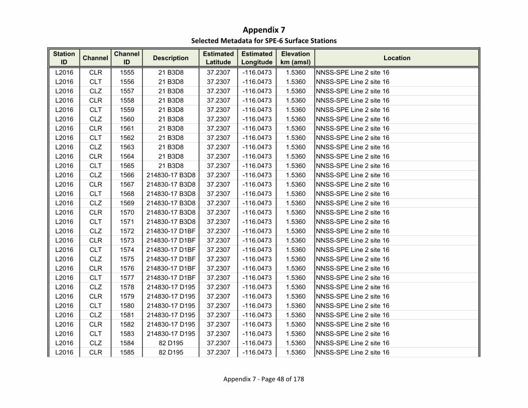
Appendix 7Selected Metadata for SPE‐6 Surface Stations
Station ID
ChannelChannel
IDDescription
Estimated Latitude
Estimated Longitude
Elevationkm (amsl)
Location
L2016 CLR 1555 21 B3D8 37.2307 -116.0473 1.5360 NNSS-SPE Line 2 site 16
L2016 CLT 1556 21 B3D8 37.2307 -116.0473 1.5360 NNSS-SPE Line 2 site 16
L2016 CLZ 1557 21 B3D8 37.2307 -116.0473 1.5360 NNSS-SPE Line 2 site 16
L2016 CLR 1558 21 B3D8 37.2307 -116.0473 1.5360 NNSS-SPE Line 2 site 16
L2016 CLT 1559 21 B3D8 37.2307 -116.0473 1.5360 NNSS-SPE Line 2 site 16
L2016 CLZ 1560 21 B3D8 37.2307 -116.0473 1.5360 NNSS-SPE Line 2 site 16
L2016 CLR 1561 21 B3D8 37.2307 -116.0473 1.5360 NNSS-SPE Line 2 site 16
L2016 CLT 1562 21 B3D8 37.2307 -116.0473 1.5360 NNSS-SPE Line 2 site 16
L2016 CLZ 1563 21 B3D8 37.2307 -116.0473 1.5360 NNSS-SPE Line 2 site 16
L2016 CLR 1564 21 B3D8 37.2307 -116.0473 1.5360 NNSS-SPE Line 2 site 16
L2016 CLT 1565 21 B3D8 37.2307 -116.0473 1.5360 NNSS-SPE Line 2 site 16
L2016 CLZ 1566 214830-17 B3D8 37.2307 -116.0473 1.5360 NNSS-SPE Line 2 site 16
L2016 CLR 1567 214830-17 B3D8 37.2307 -116.0473 1.5360 NNSS-SPE Line 2 site 16
L2016 CLT 1568 214830-17 B3D8 37.2307 -116.0473 1.5360 NNSS-SPE Line 2 site 16
L2016 CLZ 1569 214830-17 B3D8 37.2307 -116.0473 1.5360 NNSS-SPE Line 2 site 16
L2016 CLR 1570 214830-17 B3D8 37.2307 -116.0473 1.5360 NNSS-SPE Line 2 site 16
L2016 CLT 1571 214830-17 B3D8 37.2307 -116.0473 1.5360 NNSS-SPE Line 2 site 16
L2016 CLZ 1572 214830-17 D1BF 37.2307 -116.0473 1.5360 NNSS-SPE Line 2 site 16
L2016 CLR 1573 214830-17 D1BF 37.2307 -116.0473 1.5360 NNSS-SPE Line 2 site 16
L2016 CLT 1574 214830-17 D1BF 37.2307 -116.0473 1.5360 NNSS-SPE Line 2 site 16
L2016 CLZ 1575 214830-17 D1BF 37.2307 -116.0473 1.5360 NNSS-SPE Line 2 site 16
L2016 CLR 1576 214830-17 D1BF 37.2307 -116.0473 1.5360 NNSS-SPE Line 2 site 16
L2016 CLT 1577 214830-17 D1BF 37.2307 -116.0473 1.5360 NNSS-SPE Line 2 site 16
L2016 CLZ 1578 214830-17 D195 37.2307 -116.0473 1.5360 NNSS-SPE Line 2 site 16
L2016 CLR 1579 214830-17 D195 37.2307 -116.0473 1.5360 NNSS-SPE Line 2 site 16
L2016 CLT 1580 214830-17 D195 37.2307 -116.0473 1.5360 NNSS-SPE Line 2 site 16
L2016 CLZ 1581 214830-17 D195 37.2307 -116.0473 1.5360 NNSS-SPE Line 2 site 16
L2016 CLR 1582 214830-17 D195 37.2307 -116.0473 1.5360 NNSS-SPE Line 2 site 16
L2016 CLT 1583 214830-17 D195 37.2307 -116.0473 1.5360 NNSS-SPE Line 2 site 16
L2016 CLZ 1584 82 D195 37.2307 -116.0473 1.5360 NNSS-SPE Line 2 site 16
L2016 CLR 1585 82 D195 37.2307 -116.0473 1.5360 NNSS-SPE Line 2 site 16
Appendix 7 ‐ Page 48 of 178

Appendix 7Selected Metadata for SPE‐6 Surface Stations
Station ID
ChannelChannel
IDDescription
Estimated Latitude
Estimated Longitude
Elevationkm (amsl)
Location
L2016 CLT 1586 82 D195 37.2307 -116.0473 1.5360 NNSS-SPE Line 2 site 16
L2017 CLZ 1587 33 9498 37.2312 -116.0465 1.5490 NNSS-SPE Line 2 site 17
L2017 CLZ 1588 33 9498 37.2312 -116.0465 1.5490 NNSS-SPE Line 2 site 17
L2017 CLZ 1589 33 982C 37.2312 -116.0465 1.5490 NNSS-SPE Line 2 site 17
L2017 CLZ 1590 33 B3B7 37.2312 -116.0465 1.5490 NNSS-SPE Line 2 site 17
L2017 CLZ 1591 33 B3B7 37.2312 -116.0465 1.5490 NNSS-SPE Line 2 site 17
L2017 CLZ 1592 33 B3B7 37.2312 -116.0465 1.5490 NNSS-SPE Line 2 site 17
L2017 CLZ 1593 33 B3B7 37.2312 -116.0465 1.5490 NNSS-SPE Line 2 site 17
L2017 CLZ 1594 33 B3B7 37.2312 -116.0465 1.5490 NNSS-SPE Line 2 site 17
L2017 CLZ 1595 33 B3B7 37.2312 -116.0465 1.5490 NNSS-SPE Line 2 site 17
L2017 CLZ 1596 33 9823 37.2312 -116.0465 1.5490 NNSS-SPE Line 2 site 17
L2017 CLR 1597 33 9823 37.2312 -116.0465 1.5490 NNSS-SPE Line 2 site 17
L2017 CLT 1598 33 9823 37.2312 -116.0465 1.5490 NNSS-SPE Line 2 site 17
L2017 CLZ 1599 33 9823 37.2312 -116.0465 1.5490 NNSS-SPE Line 2 site 17
L2017 CLR 1600 33 9823 37.2312 -116.0465 1.5490 NNSS-SPE Line 2 site 17
L2017 CLT 1601 33 9823 37.2312 -116.0465 1.5490 NNSS-SPE Line 2 site 17
L2017 CLZ 1602 33 9823 37.2312 -116.0465 1.5490 NNSS-SPE Line 2 site 17
L2017 CLR 1603 33 9823 37.2312 -116.0465 1.5490 NNSS-SPE Line 2 site 17
L2017 CLT 1604 33 9823 37.2312 -116.0465 1.5490 NNSS-SPE Line 2 site 17
L2017 CLZ 1605 33 90B1 37.2312 -116.0465 1.5490 NNSS-SPE Line 2 site 17
L2017 CLR 1606 33 90B1 37.2312 -116.0465 1.5490 NNSS-SPE Line 2 site 17
L2017 CLT 1607 33 90B1 37.2312 -116.0465 1.5490 NNSS-SPE Line 2 site 17
L2017 CLZ 1608 33 BCC5 37.2312 -116.0465 1.5490 NNSS-SPE Line 2 site 17
L2017 CLR 1609 33 BCC5 37.2312 -116.0465 1.5490 NNSS-SPE Line 2 site 17
L2017 CLT 1610 33 BCC5 37.2312 -116.0465 1.5490 NNSS-SPE Line 2 site 17
L2017 CLZ 1611 33 BCC5 37.2312 -116.0465 1.5490 NNSS-SPE Line 2 site 17
L2017 CLR 1612 33 BCC5 37.2312 -116.0465 1.5490 NNSS-SPE Line 2 site 17
L2017 CLT 1613 33 BCC5 37.2312 -116.0465 1.5490 NNSS-SPE Line 2 site 17
L2017 CLZ 1614 33 BCC5 37.2312 -116.0465 1.5490 NNSS-SPE Line 2 site 17
L2017 CLR 1615 33 BCC5 37.2312 -116.0465 1.5490 NNSS-SPE Line 2 site 17
L2017 CLT 1616 33 BCC5 37.2312 -116.0465 1.5490 NNSS-SPE Line 2 site 17
Appendix 7 ‐ Page 49 of 178

Appendix 7Selected Metadata for SPE‐6 Surface Stations
Station ID
ChannelChannel
IDDescription
Estimated Latitude
Estimated Longitude
Elevationkm (amsl)
Location
L2017 CLZ 1617 33 BCC5 37.2312 -116.0465 1.5490 NNSS-SPE Line 2 site 17
L2017 CLR 1618 33 BCC5 37.2312 -116.0465 1.5490 NNSS-SPE Line 2 site 17
L2017 CLT 1619 33 BCC5 37.2312 -116.0465 1.5490 NNSS-SPE Line 2 site 17
L2017 CLZ 1620 33 BCC5 37.2312 -116.0465 1.5490 NNSS-SPE Line 2 site 17
L2017 CLR 1621 33 BCC5 37.2312 -116.0465 1.5490 NNSS-SPE Line 2 site 17
L2017 CLT 1622 33 BCC5 37.2312 -116.0465 1.5490 NNSS-SPE Line 2 site 17
L2018 CLZ 1623 49 9498 37.2318 -116.0456 1.5480 NNSS-SPE Line 2 site 18
L2018 CLZ 1624 49 9498 37.2318 -116.0456 1.5480 NNSS-SPE Line 2 site 18
L2018 CLZ 1625 49 982C 37.2318 -116.0456 1.5480 NNSS-SPE Line 2 site 18
L2018 CLZ 1626 49 B3B7 37.2318 -116.0456 1.5480 NNSS-SPE Line 2 site 18
L2018 CLZ 1627 49 B3B7 37.2318 -116.0456 1.5480 NNSS-SPE Line 2 site 18
L2018 CLZ 1628 49 B3B7 37.2318 -116.0456 1.5480 NNSS-SPE Line 2 site 18
L2018 CLZ 1629 49 B3B7 37.2318 -116.0456 1.5480 NNSS-SPE Line 2 site 18
L2018 CLZ 1630 49 B3B7 37.2318 -116.0456 1.5480 NNSS-SPE Line 2 site 18
L2018 CLZ 1631 49 B3B7 37.2318 -116.0456 1.5480 NNSS-SPE Line 2 site 18
L2018 CLZ 1632 65 9823 37.2318 -116.0456 1.5480 NNSS-SPE Line 2 site 18
L2018 CLR 1633 65 9823 37.2318 -116.0456 1.5480 NNSS-SPE Line 2 site 18
L2018 CLT 1634 65 9823 37.2318 -116.0456 1.5480 NNSS-SPE Line 2 site 18
L2018 CLZ 1635 65 9823 37.2318 -116.0456 1.5480 NNSS-SPE Line 2 site 18
L2018 CLR 1636 65 9823 37.2318 -116.0456 1.5480 NNSS-SPE Line 2 site 18
L2018 CLT 1637 65 9823 37.2318 -116.0456 1.5480 NNSS-SPE Line 2 site 18
L2018 CLZ 1638 65 9823 37.2318 -116.0456 1.5480 NNSS-SPE Line 2 site 18
L2018 CLR 1639 65 9823 37.2318 -116.0456 1.5480 NNSS-SPE Line 2 site 18
L2018 CLT 1640 65 9823 37.2318 -116.0456 1.5480 NNSS-SPE Line 2 site 18
L2018 CLZ 1641 73 90B1 37.2318 -116.0456 1.5480 NNSS-SPE Line 2 site 18
L2018 CLR 1642 73 90B1 37.2318 -116.0456 1.5480 NNSS-SPE Line 2 site 18
L2018 CLT 1643 73 90B1 37.2318 -116.0456 1.5480 NNSS-SPE Line 2 site 18
L2018 CLZ 1644 73 BCC5 37.2318 -116.0456 1.5480 NNSS-SPE Line 2 site 18
L2018 CLR 1645 73 BCC5 37.2318 -116.0456 1.5480 NNSS-SPE Line 2 site 18
L2018 CLT 1646 73 BCC5 37.2318 -116.0456 1.5480 NNSS-SPE Line 2 site 18
L2018 CLZ 1647 73 BCC5 37.2318 -116.0456 1.5480 NNSS-SPE Line 2 site 18
Appendix 7 ‐ Page 50 of 178

Appendix 7Selected Metadata for SPE‐6 Surface Stations
Station ID
ChannelChannel
IDDescription
Estimated Latitude
Estimated Longitude
Elevationkm (amsl)
Location
L2018 CLR 1648 73 BCC5 37.2318 -116.0456 1.5480 NNSS-SPE Line 2 site 18
L2018 CLT 1649 73 BCC5 37.2318 -116.0456 1.5480 NNSS-SPE Line 2 site 18
L2018 CLZ 1650 73 BCC5 37.2318 -116.0456 1.5480 NNSS-SPE Line 2 site 18
L2018 CLR 1651 73 BCC5 37.2318 -116.0456 1.5480 NNSS-SPE Line 2 site 18
L2018 CLT 1652 73 BCC5 37.2318 -116.0456 1.5480 NNSS-SPE Line 2 site 18
L2018 CLZ 1653 73 BCC5 37.2318 -116.0456 1.5480 NNSS-SPE Line 2 site 18
L2018 CLR 1654 73 BCC5 37.2318 -116.0456 1.5480 NNSS-SPE Line 2 site 18
L2018 CLT 1655 73 BCC5 37.2318 -116.0456 1.5480 NNSS-SPE Line 2 site 18
L2018 CLZ 1656 68 BCC5 37.2318 -116.0456 1.5480 NNSS-SPE Line 2 site 18
L2018 CLR 1657 68 BCC5 37.2318 -116.0456 1.5480 NNSS-SPE Line 2 site 18
L2018 CLT 1658 68 BCC5 37.2318 -116.0456 1.5480 NNSS-SPE Line 2 site 18
L2019 CLZ 1659 88 9498 37.2324 -116.0448 1.5520 NNSS-SPE Line 2 site 19
L2019 CLZ 1660 88 9498 37.2324 -116.0448 1.5520 NNSS-SPE Line 2 site 19
L2019 CLZ 1661 88 982C 37.2324 -116.0448 1.5520 NNSS-SPE Line 2 site 19
L2019 CLZ 1662 88 B3B7 37.2324 -116.0448 1.5520 NNSS-SPE Line 2 site 19
L2019 CLZ 1663 88 B3B7 37.2324 -116.0448 1.5520 NNSS-SPE Line 2 site 19
L2019 CLZ 1664 88 B3B7 37.2324 -116.0448 1.5520 NNSS-SPE Line 2 site 19
L2019 CLZ 1665 88 B3B7 37.2324 -116.0448 1.5520 NNSS-SPE Line 2 site 19
L2019 CLZ 1666 88 B3B7 37.2324 -116.0448 1.5520 NNSS-SPE Line 2 site 19
L2019 CLZ 1667 88 B3B7 37.2324 -116.0448 1.5520 NNSS-SPE Line 2 site 19
L2019 CLZ 1668 88 B3B7 37.2324 -116.0448 1.5520 NNSS-SPE Line 2 site 19
L2019 CLR 1669 88 B3B7 37.2324 -116.0448 1.5520 NNSS-SPE Line 2 site 19
L2019 CLT 1670 88 B3B7 37.2324 -116.0448 1.5520 NNSS-SPE Line 2 site 19
L2019 CLZ 1671 88 B3B7 37.2324 -116.0448 1.5520 NNSS-SPE Line 2 site 19
L2019 CLR 1672 88 B3B7 37.2324 -116.0448 1.5520 NNSS-SPE Line 2 site 19
L2019 CLT 1673 88 B3B7 37.2324 -116.0448 1.5520 NNSS-SPE Line 2 site 19
L2019 CLZ 1674 88 BCDB 37.2324 -116.0448 1.5520 NNSS-SPE Line 2 site 19
L2019 CLR 1675 88 BCDB 37.2324 -116.0448 1.5520 NNSS-SPE Line 2 site 19
L2019 CLT 1676 88 BCDB 37.2324 -116.0448 1.5520 NNSS-SPE Line 2 site 19
L2019 CLZ 1677 88 BCDB 37.2324 -116.0448 1.5520 NNSS-SPE Line 2 site 19
L2019 CLR 1678 88 BCDB 37.2324 -116.0448 1.5520 NNSS-SPE Line 2 site 19
Appendix 7 ‐ Page 51 of 178
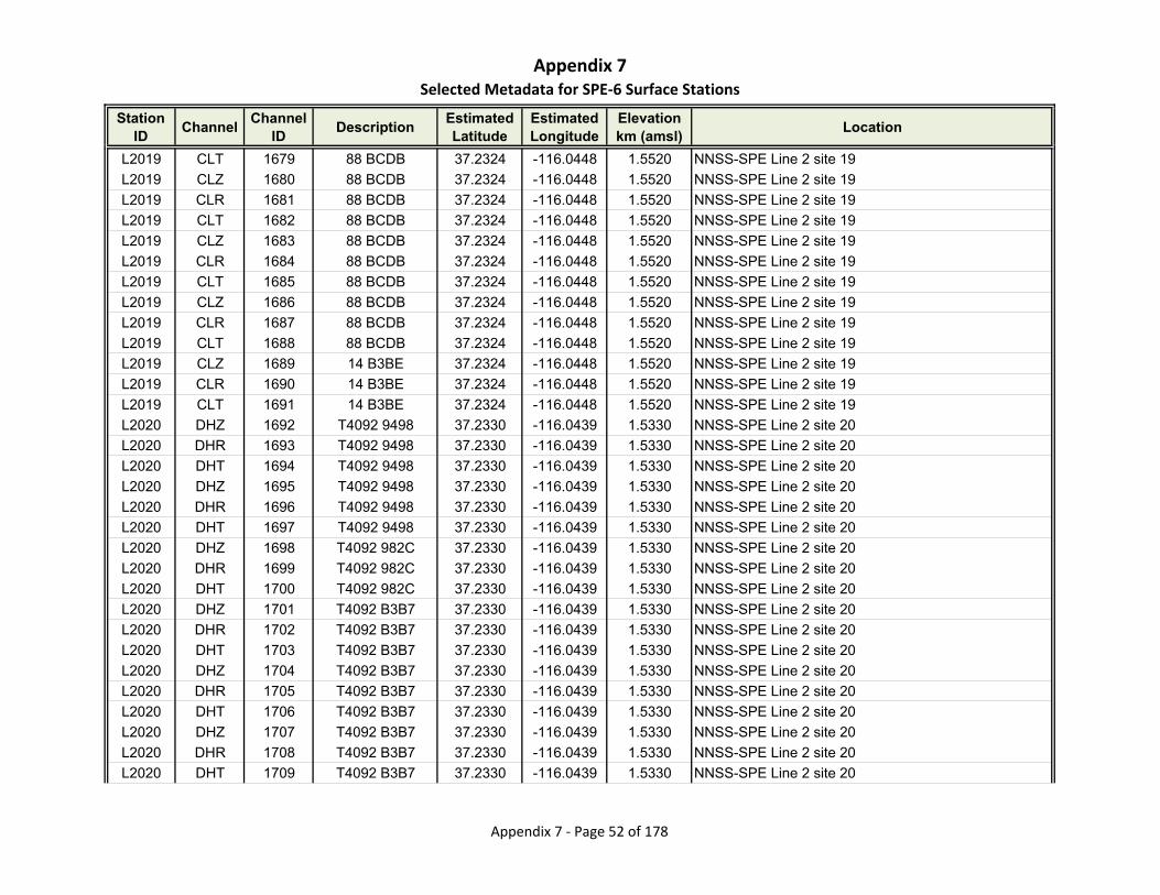
Appendix 7Selected Metadata for SPE‐6 Surface Stations
Station ID
ChannelChannel
IDDescription
Estimated Latitude
Estimated Longitude
Elevationkm (amsl)
Location
L2019 CLT 1679 88 BCDB 37.2324 -116.0448 1.5520 NNSS-SPE Line 2 site 19
L2019 CLZ 1680 88 BCDB 37.2324 -116.0448 1.5520 NNSS-SPE Line 2 site 19
L2019 CLR 1681 88 BCDB 37.2324 -116.0448 1.5520 NNSS-SPE Line 2 site 19
L2019 CLT 1682 88 BCDB 37.2324 -116.0448 1.5520 NNSS-SPE Line 2 site 19
L2019 CLZ 1683 88 BCDB 37.2324 -116.0448 1.5520 NNSS-SPE Line 2 site 19
L2019 CLR 1684 88 BCDB 37.2324 -116.0448 1.5520 NNSS-SPE Line 2 site 19
L2019 CLT 1685 88 BCDB 37.2324 -116.0448 1.5520 NNSS-SPE Line 2 site 19
L2019 CLZ 1686 88 BCDB 37.2324 -116.0448 1.5520 NNSS-SPE Line 2 site 19
L2019 CLR 1687 88 BCDB 37.2324 -116.0448 1.5520 NNSS-SPE Line 2 site 19
L2019 CLT 1688 88 BCDB 37.2324 -116.0448 1.5520 NNSS-SPE Line 2 site 19
L2019 CLZ 1689 14 B3BE 37.2324 -116.0448 1.5520 NNSS-SPE Line 2 site 19
L2019 CLR 1690 14 B3BE 37.2324 -116.0448 1.5520 NNSS-SPE Line 2 site 19
L2019 CLT 1691 14 B3BE 37.2324 -116.0448 1.5520 NNSS-SPE Line 2 site 19
L2020 DHZ 1692 T4092 9498 37.2330 -116.0439 1.5330 NNSS-SPE Line 2 site 20
L2020 DHR 1693 T4092 9498 37.2330 -116.0439 1.5330 NNSS-SPE Line 2 site 20
L2020 DHT 1694 T4092 9498 37.2330 -116.0439 1.5330 NNSS-SPE Line 2 site 20
L2020 DHZ 1695 T4092 9498 37.2330 -116.0439 1.5330 NNSS-SPE Line 2 site 20
L2020 DHR 1696 T4092 9498 37.2330 -116.0439 1.5330 NNSS-SPE Line 2 site 20
L2020 DHT 1697 T4092 9498 37.2330 -116.0439 1.5330 NNSS-SPE Line 2 site 20
L2020 DHZ 1698 T4092 982C 37.2330 -116.0439 1.5330 NNSS-SPE Line 2 site 20
L2020 DHR 1699 T4092 982C 37.2330 -116.0439 1.5330 NNSS-SPE Line 2 site 20
L2020 DHT 1700 T4092 982C 37.2330 -116.0439 1.5330 NNSS-SPE Line 2 site 20
L2020 DHZ 1701 T4092 B3B7 37.2330 -116.0439 1.5330 NNSS-SPE Line 2 site 20
L2020 DHR 1702 T4092 B3B7 37.2330 -116.0439 1.5330 NNSS-SPE Line 2 site 20
L2020 DHT 1703 T4092 B3B7 37.2330 -116.0439 1.5330 NNSS-SPE Line 2 site 20
L2020 DHZ 1704 T4092 B3B7 37.2330 -116.0439 1.5330 NNSS-SPE Line 2 site 20
L2020 DHR 1705 T4092 B3B7 37.2330 -116.0439 1.5330 NNSS-SPE Line 2 site 20
L2020 DHT 1706 T4092 B3B7 37.2330 -116.0439 1.5330 NNSS-SPE Line 2 site 20
L2020 DHZ 1707 T4092 B3B7 37.2330 -116.0439 1.5330 NNSS-SPE Line 2 site 20
L2020 DHR 1708 T4092 B3B7 37.2330 -116.0439 1.5330 NNSS-SPE Line 2 site 20
L2020 DHT 1709 T4092 B3B7 37.2330 -116.0439 1.5330 NNSS-SPE Line 2 site 20
Appendix 7 ‐ Page 52 of 178
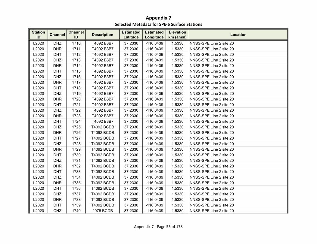
Appendix 7Selected Metadata for SPE‐6 Surface Stations
Station ID
ChannelChannel
IDDescription
Estimated Latitude
Estimated Longitude
Elevationkm (amsl)
Location
L2020 DHZ 1710 T4092 B3B7 37.2330 -116.0439 1.5330 NNSS-SPE Line 2 site 20
L2020 DHR 1711 T4092 B3B7 37.2330 -116.0439 1.5330 NNSS-SPE Line 2 site 20
L2020 DHT 1712 T4092 B3B7 37.2330 -116.0439 1.5330 NNSS-SPE Line 2 site 20
L2020 DHZ 1713 T4092 B3B7 37.2330 -116.0439 1.5330 NNSS-SPE Line 2 site 20
L2020 DHR 1714 T4092 B3B7 37.2330 -116.0439 1.5330 NNSS-SPE Line 2 site 20
L2020 DHT 1715 T4092 B3B7 37.2330 -116.0439 1.5330 NNSS-SPE Line 2 site 20
L2020 DHZ 1716 T4092 B3B7 37.2330 -116.0439 1.5330 NNSS-SPE Line 2 site 20
L2020 DHR 1717 T4092 B3B7 37.2330 -116.0439 1.5330 NNSS-SPE Line 2 site 20
L2020 DHT 1718 T4092 B3B7 37.2330 -116.0439 1.5330 NNSS-SPE Line 2 site 20
L2020 DHZ 1719 T4092 B3B7 37.2330 -116.0439 1.5330 NNSS-SPE Line 2 site 20
L2020 DHR 1720 T4092 B3B7 37.2330 -116.0439 1.5330 NNSS-SPE Line 2 site 20
L2020 DHT 1721 T4092 B3B7 37.2330 -116.0439 1.5330 NNSS-SPE Line 2 site 20
L2020 DHZ 1722 T4092 B3B7 37.2330 -116.0439 1.5330 NNSS-SPE Line 2 site 20
L2020 DHR 1723 T4092 B3B7 37.2330 -116.0439 1.5330 NNSS-SPE Line 2 site 20
L2020 DHT 1724 T4092 B3B7 37.2330 -116.0439 1.5330 NNSS-SPE Line 2 site 20
L2020 DHZ 1725 T4092 BCDB 37.2330 -116.0439 1.5330 NNSS-SPE Line 2 site 20
L2020 DHR 1726 T4092 BCDB 37.2330 -116.0439 1.5330 NNSS-SPE Line 2 site 20
L2020 DHT 1727 T4092 BCDB 37.2330 -116.0439 1.5330 NNSS-SPE Line 2 site 20
L2020 DHZ 1728 T4092 BCDB 37.2330 -116.0439 1.5330 NNSS-SPE Line 2 site 20
L2020 DHR 1729 T4092 BCDB 37.2330 -116.0439 1.5330 NNSS-SPE Line 2 site 20
L2020 DHT 1730 T4092 BCDB 37.2330 -116.0439 1.5330 NNSS-SPE Line 2 site 20
L2020 DHZ 1731 T4092 BCDB 37.2330 -116.0439 1.5330 NNSS-SPE Line 2 site 20
L2020 DHR 1732 T4092 BCDB 37.2330 -116.0439 1.5330 NNSS-SPE Line 2 site 20
L2020 DHT 1733 T4092 BCDB 37.2330 -116.0439 1.5330 NNSS-SPE Line 2 site 20
L2020 DHZ 1734 T4092 BCDB 37.2330 -116.0439 1.5330 NNSS-SPE Line 2 site 20
L2020 DHR 1735 T4092 BCDB 37.2330 -116.0439 1.5330 NNSS-SPE Line 2 site 20
L2020 DHT 1736 T4092 BCDB 37.2330 -116.0439 1.5330 NNSS-SPE Line 2 site 20
L2020 DHZ 1737 T4092 BCDB 37.2330 -116.0439 1.5330 NNSS-SPE Line 2 site 20
L2020 DHR 1738 T4092 BCDB 37.2330 -116.0439 1.5330 NNSS-SPE Line 2 site 20
L2020 DHT 1739 T4092 BCDB 37.2330 -116.0439 1.5330 NNSS-SPE Line 2 site 20
L2020 CHZ 1740 2976 BCDB 37.2330 -116.0439 1.5330 NNSS-SPE Line 2 site 20
Appendix 7 ‐ Page 53 of 178

Appendix 7Selected Metadata for SPE‐6 Surface Stations
Station ID
ChannelChannel
IDDescription
Estimated Latitude
Estimated Longitude
Elevationkm (amsl)
Location
L2020 CHR 1741 2976 BCDB 37.2330 -116.0439 1.5330 NNSS-SPE Line 2 site 20
L2020 CHT 1742 2976 BCDB 37.2330 -116.0439 1.5330 NNSS-SPE Line 2 site 20
L2020 CHZ 1743 2976 BCDB 37.2330 -116.0439 1.5330 NNSS-SPE Line 2 site 20
L2020 CHR 1744 2976 BCDB 37.2330 -116.0439 1.5330 NNSS-SPE Line 2 site 20
L2020 CHT 1745 2976 BCDB 37.2330 -116.0439 1.5330 NNSS-SPE Line 2 site 20
L2150 CNZ 1746 178 D1D1 37.2221 -116.0595 1.4924 NNSS-SPE Line 2 150m
L2150 CNR 1747 178 D1D1 37.2221 -116.0595 1.4924 NNSS-SPE Line 2 150m
L2150 CNT 1748 178 D1D1 37.2221 -116.0595 1.4924 NNSS-SPE Line 2 150m
L2150 CNZ 1749 178 D1D1 37.2221 -116.0595 1.4924 NNSS-SPE Line 2 150m
L2150 CNR 1750 178 D1D1 37.2221 -116.0595 1.4924 NNSS-SPE Line 2 150m
L2150 CNT 1751 178 D1D1 37.2221 -116.0595 1.4924 NNSS-SPE Line 2 150m
L260 CNZ 1752 4965 D1D0 37.2215 -116.0603 1.4959 NNSS-SPE Line 2 60m
L260 CNR 1753 4965 D1D0 37.2215 -116.0603 1.4959 NNSS-SPE Line 2 60m
L260 CNT 1754 4965 D1D0 37.2215 -116.0603 1.4959 NNSS-SPE Line 2 60m
L260 CNZ 1755 4965 D1D0 37.2215 -116.0603 1.4959 NNSS-SPE Line 2 60m
L260 CNR 1756 4965 D1D0 37.2215 -116.0603 1.4959 NNSS-SPE Line 2 60m
L260 CNT 1757 4965 D1D0 37.2215 -116.0603 1.4959 NNSS-SPE Line 2 60m
L3001 CLZ 1758 52 9495 37.2203 -116.0607 1.5160 NNSS-SPE Line 3 site 01
L3001 CLZ 1759 52 9833 37.2203 -116.0607 1.5160 NNSS-SPE Line 3 site 01
L3001 CLZ 1760 52 9495 37.2203 -116.0607 1.5160 NNSS-SPE Line 3 site 01
L3001 CLZ 1761 52 9495 37.2203 -116.0607 1.5160 NNSS-SPE Line 3 site 01
L3001 CLZ 1762 52 9495 37.2203 -116.0607 1.5160 NNSS-SPE Line 3 site 01
L3001 CLZ 1763 52 9495 37.2203 -116.0607 1.5160 NNSS-SPE Line 3 site 01
L3001 CLZ 1764 52 9495 37.2203 -116.0607 1.5160 NNSS-SPE Line 3 site 01
L3001 CLZ 1765 52 B3BA 37.2203 -116.0607 1.5160 NNSS-SPE Line 3 site 01
L3001 CLR 1766 52 B3BA 37.2203 -116.0607 1.5160 NNSS-SPE Line 3 site 01
L3001 CLT 1767 52 B3BA 37.2203 -116.0607 1.5160 NNSS-SPE Line 3 site 01
L3001 CLZ 1768 52 B3BA 37.2203 -116.0607 1.5160 NNSS-SPE Line 3 site 01
L3001 CLR 1769 52 B3BA 37.2203 -116.0607 1.5160 NNSS-SPE Line 3 site 01
L3001 CLT 1770 52 B3BA 37.2203 -116.0607 1.5160 NNSS-SPE Line 3 site 01
L3001 CLZ 1771 52 B3BA 37.2203 -116.0607 1.5160 NNSS-SPE Line 3 site 01
Appendix 7 ‐ Page 54 of 178
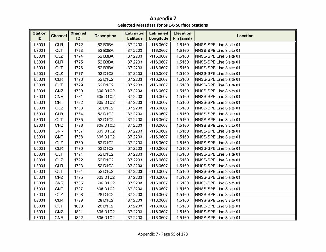
Appendix 7Selected Metadata for SPE‐6 Surface Stations
Station ID
ChannelChannel
IDDescription
Estimated Latitude
Estimated Longitude
Elevationkm (amsl)
Location
L3001 CLR 1772 52 B3BA 37.2203 -116.0607 1.5160 NNSS-SPE Line 3 site 01
L3001 CLT 1773 52 B3BA 37.2203 -116.0607 1.5160 NNSS-SPE Line 3 site 01
L3001 CLZ 1774 52 B3BA 37.2203 -116.0607 1.5160 NNSS-SPE Line 3 site 01
L3001 CLR 1775 52 B3BA 37.2203 -116.0607 1.5160 NNSS-SPE Line 3 site 01
L3001 CLT 1776 52 B3BA 37.2203 -116.0607 1.5160 NNSS-SPE Line 3 site 01
L3001 CLZ 1777 52 D1C2 37.2203 -116.0607 1.5160 NNSS-SPE Line 3 site 01
L3001 CLR 1778 52 D1C2 37.2203 -116.0607 1.5160 NNSS-SPE Line 3 site 01
L3001 CLT 1779 52 D1C2 37.2203 -116.0607 1.5160 NNSS-SPE Line 3 site 01
L3001 CNZ 1780 605 D1C2 37.2203 -116.0607 1.5160 NNSS-SPE Line 3 site 01
L3001 CNR 1781 605 D1C2 37.2203 -116.0607 1.5160 NNSS-SPE Line 3 site 01
L3001 CNT 1782 605 D1C2 37.2203 -116.0607 1.5160 NNSS-SPE Line 3 site 01
L3001 CLZ 1783 52 D1C2 37.2203 -116.0607 1.5160 NNSS-SPE Line 3 site 01
L3001 CLR 1784 52 D1C2 37.2203 -116.0607 1.5160 NNSS-SPE Line 3 site 01
L3001 CLT 1785 52 D1C2 37.2203 -116.0607 1.5160 NNSS-SPE Line 3 site 01
L3001 CNZ 1786 605 D1C2 37.2203 -116.0607 1.5160 NNSS-SPE Line 3 site 01
L3001 CNR 1787 605 D1C2 37.2203 -116.0607 1.5160 NNSS-SPE Line 3 site 01
L3001 CNT 1788 605 D1C2 37.2203 -116.0607 1.5160 NNSS-SPE Line 3 site 01
L3001 CLZ 1789 52 D1C2 37.2203 -116.0607 1.5160 NNSS-SPE Line 3 site 01
L3001 CLR 1790 52 D1C2 37.2203 -116.0607 1.5160 NNSS-SPE Line 3 site 01
L3001 CLT 1791 52 D1C2 37.2203 -116.0607 1.5160 NNSS-SPE Line 3 site 01
L3001 CLZ 1792 52 D1C2 37.2203 -116.0607 1.5160 NNSS-SPE Line 3 site 01
L3001 CLR 1793 52 D1C2 37.2203 -116.0607 1.5160 NNSS-SPE Line 3 site 01
L3001 CLT 1794 52 D1C2 37.2203 -116.0607 1.5160 NNSS-SPE Line 3 site 01
L3001 CNZ 1795 605 D1C2 37.2203 -116.0607 1.5160 NNSS-SPE Line 3 site 01
L3001 CNR 1796 605 D1C2 37.2203 -116.0607 1.5160 NNSS-SPE Line 3 site 01
L3001 CNT 1797 605 D1C2 37.2203 -116.0607 1.5160 NNSS-SPE Line 3 site 01
L3001 CLZ 1798 28 D1C2 37.2203 -116.0607 1.5160 NNSS-SPE Line 3 site 01
L3001 CLR 1799 28 D1C2 37.2203 -116.0607 1.5160 NNSS-SPE Line 3 site 01
L3001 CLT 1800 28 D1C2 37.2203 -116.0607 1.5160 NNSS-SPE Line 3 site 01
L3001 CNZ 1801 605 D1C2 37.2203 -116.0607 1.5160 NNSS-SPE Line 3 site 01
L3001 CNR 1802 605 D1C2 37.2203 -116.0607 1.5160 NNSS-SPE Line 3 site 01
Appendix 7 ‐ Page 55 of 178
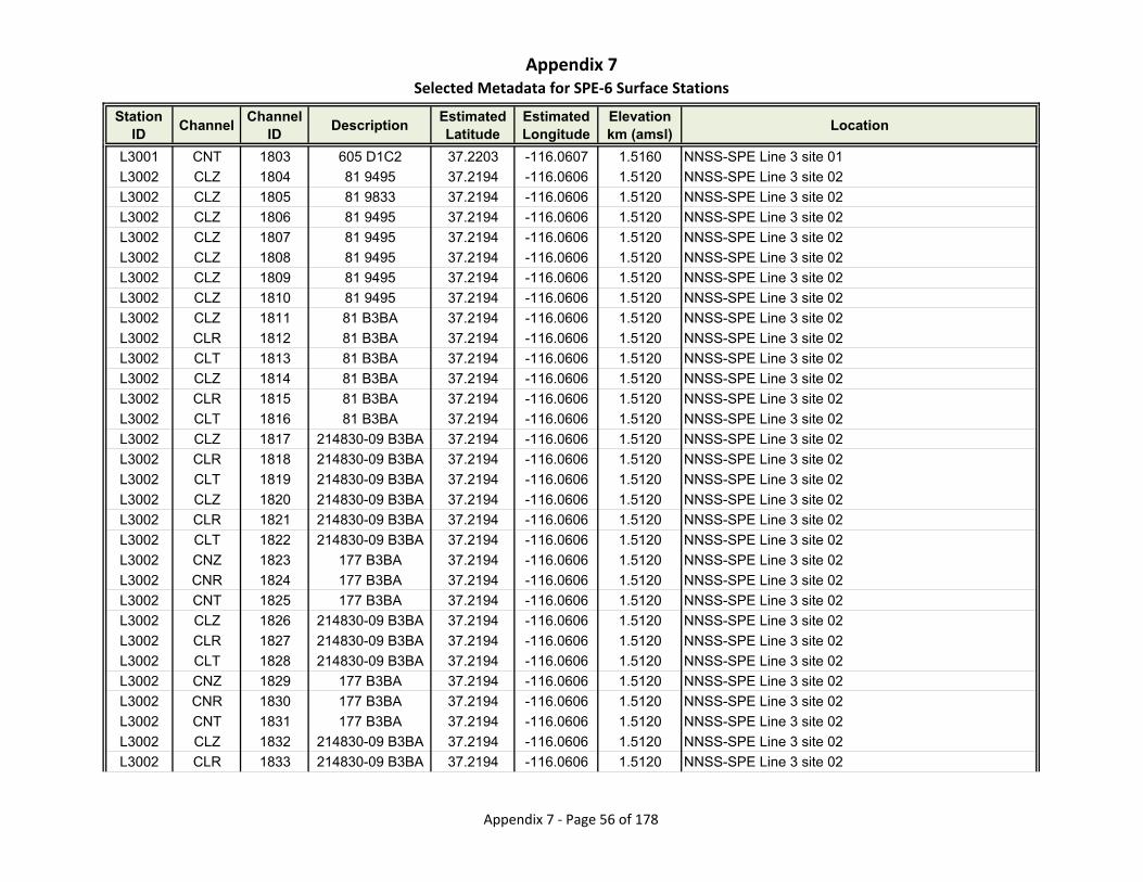
Appendix 7Selected Metadata for SPE‐6 Surface Stations
Station ID
ChannelChannel
IDDescription
Estimated Latitude
Estimated Longitude
Elevationkm (amsl)
Location
L3001 CNT 1803 605 D1C2 37.2203 -116.0607 1.5160 NNSS-SPE Line 3 site 01
L3002 CLZ 1804 81 9495 37.2194 -116.0606 1.5120 NNSS-SPE Line 3 site 02
L3002 CLZ 1805 81 9833 37.2194 -116.0606 1.5120 NNSS-SPE Line 3 site 02
L3002 CLZ 1806 81 9495 37.2194 -116.0606 1.5120 NNSS-SPE Line 3 site 02
L3002 CLZ 1807 81 9495 37.2194 -116.0606 1.5120 NNSS-SPE Line 3 site 02
L3002 CLZ 1808 81 9495 37.2194 -116.0606 1.5120 NNSS-SPE Line 3 site 02
L3002 CLZ 1809 81 9495 37.2194 -116.0606 1.5120 NNSS-SPE Line 3 site 02
L3002 CLZ 1810 81 9495 37.2194 -116.0606 1.5120 NNSS-SPE Line 3 site 02
L3002 CLZ 1811 81 B3BA 37.2194 -116.0606 1.5120 NNSS-SPE Line 3 site 02
L3002 CLR 1812 81 B3BA 37.2194 -116.0606 1.5120 NNSS-SPE Line 3 site 02
L3002 CLT 1813 81 B3BA 37.2194 -116.0606 1.5120 NNSS-SPE Line 3 site 02
L3002 CLZ 1814 81 B3BA 37.2194 -116.0606 1.5120 NNSS-SPE Line 3 site 02
L3002 CLR 1815 81 B3BA 37.2194 -116.0606 1.5120 NNSS-SPE Line 3 site 02
L3002 CLT 1816 81 B3BA 37.2194 -116.0606 1.5120 NNSS-SPE Line 3 site 02
L3002 CLZ 1817 214830-09 B3BA 37.2194 -116.0606 1.5120 NNSS-SPE Line 3 site 02
L3002 CLR 1818 214830-09 B3BA 37.2194 -116.0606 1.5120 NNSS-SPE Line 3 site 02
L3002 CLT 1819 214830-09 B3BA 37.2194 -116.0606 1.5120 NNSS-SPE Line 3 site 02
L3002 CLZ 1820 214830-09 B3BA 37.2194 -116.0606 1.5120 NNSS-SPE Line 3 site 02
L3002 CLR 1821 214830-09 B3BA 37.2194 -116.0606 1.5120 NNSS-SPE Line 3 site 02
L3002 CLT 1822 214830-09 B3BA 37.2194 -116.0606 1.5120 NNSS-SPE Line 3 site 02
L3002 CNZ 1823 177 B3BA 37.2194 -116.0606 1.5120 NNSS-SPE Line 3 site 02
L3002 CNR 1824 177 B3BA 37.2194 -116.0606 1.5120 NNSS-SPE Line 3 site 02
L3002 CNT 1825 177 B3BA 37.2194 -116.0606 1.5120 NNSS-SPE Line 3 site 02
L3002 CLZ 1826 214830-09 B3BA 37.2194 -116.0606 1.5120 NNSS-SPE Line 3 site 02
L3002 CLR 1827 214830-09 B3BA 37.2194 -116.0606 1.5120 NNSS-SPE Line 3 site 02
L3002 CLT 1828 214830-09 B3BA 37.2194 -116.0606 1.5120 NNSS-SPE Line 3 site 02
L3002 CNZ 1829 177 B3BA 37.2194 -116.0606 1.5120 NNSS-SPE Line 3 site 02
L3002 CNR 1830 177 B3BA 37.2194 -116.0606 1.5120 NNSS-SPE Line 3 site 02
L3002 CNT 1831 177 B3BA 37.2194 -116.0606 1.5120 NNSS-SPE Line 3 site 02
L3002 CLZ 1832 214830-09 B3BA 37.2194 -116.0606 1.5120 NNSS-SPE Line 3 site 02
L3002 CLR 1833 214830-09 B3BA 37.2194 -116.0606 1.5120 NNSS-SPE Line 3 site 02
Appendix 7 ‐ Page 56 of 178

Appendix 7Selected Metadata for SPE‐6 Surface Stations
Station ID
ChannelChannel
IDDescription
Estimated Latitude
Estimated Longitude
Elevationkm (amsl)
Location
L3002 CLT 1834 214830-09 B3BA 37.2194 -116.0606 1.5120 NNSS-SPE Line 3 site 02
L3002 CLZ 1835 214830-09 B3BA 37.2194 -116.0606 1.5120 NNSS-SPE Line 3 site 02
L3002 CLR 1836 214830-09 B3BA 37.2194 -116.0606 1.5120 NNSS-SPE Line 3 site 02
L3002 CLT 1837 214830-09 B3BA 37.2194 -116.0606 1.5120 NNSS-SPE Line 3 site 02
L3002 CNZ 1838 177 B3BA 37.2194 -116.0606 1.5120 NNSS-SPE Line 3 site 02
L3002 CNR 1839 177 B3BA 37.2194 -116.0606 1.5120 NNSS-SPE Line 3 site 02
L3002 CNT 1840 177 B3BA 37.2194 -116.0606 1.5120 NNSS-SPE Line 3 site 02
L3002 CLZ 1841 214830-09 B3BA 37.2194 -116.0606 1.5120 NNSS-SPE Line 3 site 02
L3002 CLR 1842 214830-09 B3BA 37.2194 -116.0606 1.5120 NNSS-SPE Line 3 site 02
L3002 CLT 1843 214830-09 B3BA 37.2194 -116.0606 1.5120 NNSS-SPE Line 3 site 02
L3002 CNZ 1844 177 B3BA 37.2194 -116.0606 1.5120 NNSS-SPE Line 3 site 02
L3002 CNR 1845 177 B3BA 37.2194 -116.0606 1.5120 NNSS-SPE Line 3 site 02
L3002 CNT 1846 177 B3BA 37.2194 -116.0606 1.5120 NNSS-SPE Line 3 site 02
L3002 CLZ 1847 214830-12 B3BA 37.2194 -116.0606 1.5120 NNSS-SPE Line 3 site 02
L3002 CLR 1848 214830-12 B3BA 37.2194 -116.0606 1.5120 NNSS-SPE Line 3 site 02
L3002 CLT 1849 214830-12 B3BA 37.2194 -116.0606 1.5120 NNSS-SPE Line 3 site 02
L3003 CLZ 1850 56 9495 37.2185 -116.0605 1.5120 NNSS-SPE Line 3 site 03
L3003 CLZ 1851 56 9833 37.2185 -116.0605 1.5120 NNSS-SPE Line 3 site 03
L3003 CLZ 1852 56 9495 37.2185 -116.0605 1.5120 NNSS-SPE Line 3 site 03
L3003 CLZ 1853 56 9495 37.2185 -116.0605 1.5120 NNSS-SPE Line 3 site 03
L3003 CLZ 1854 56 9495 37.2185 -116.0605 1.5120 NNSS-SPE Line 3 site 03
L3003 CLZ 1855 56 9495 37.2185 -116.0605 1.5120 NNSS-SPE Line 3 site 03
L3003 CLZ 1856 56 9495 37.2185 -116.0605 1.5120 NNSS-SPE Line 3 site 03
L3003 CLZ 1857 84 9495 37.2185 -116.0605 1.5120 NNSS-SPE Line 3 site 03
L3003 CLR 1858 84 9495 37.2185 -116.0605 1.5120 NNSS-SPE Line 3 site 03
L3003 CLT 1859 84 9495 37.2185 -116.0605 1.5120 NNSS-SPE Line 3 site 03
L3003 CLZ 1860 84 9495 37.2185 -116.0605 1.5120 NNSS-SPE Line 3 site 03
L3003 CLR 1861 84 9495 37.2185 -116.0605 1.5120 NNSS-SPE Line 3 site 03
L3003 CLT 1862 84 9495 37.2185 -116.0605 1.5120 NNSS-SPE Line 3 site 03
L3003 CLZ 1863 84 9495 37.2185 -116.0605 1.5120 NNSS-SPE Line 3 site 03
L3003 CLR 1864 84 9495 37.2185 -116.0605 1.5120 NNSS-SPE Line 3 site 03
Appendix 7 ‐ Page 57 of 178

Appendix 7Selected Metadata for SPE‐6 Surface Stations
Station ID
ChannelChannel
IDDescription
Estimated Latitude
Estimated Longitude
Elevationkm (amsl)
Location
L3003 CLT 1865 84 9495 37.2185 -116.0605 1.5120 NNSS-SPE Line 3 site 03
L3003 CLZ 1866 84 9495 37.2185 -116.0605 1.5120 NNSS-SPE Line 3 site 03
L3003 CLR 1867 84 9495 37.2185 -116.0605 1.5120 NNSS-SPE Line 3 site 03
L3003 CLT 1868 84 9495 37.2185 -116.0605 1.5120 NNSS-SPE Line 3 site 03
L3003 CLZ 1869 84 9E34 37.2185 -116.0605 1.5120 NNSS-SPE Line 3 site 03
L3003 CLR 1870 84 9E34 37.2185 -116.0605 1.5120 NNSS-SPE Line 3 site 03
L3003 CLT 1871 84 9E34 37.2185 -116.0605 1.5120 NNSS-SPE Line 3 site 03
L3003 CNZ 1872 179 9E34 37.2185 -116.0605 1.5120 NNSS-SPE Line 3 site 03
L3003 CNR 1873 179 9E34 37.2185 -116.0605 1.5120 NNSS-SPE Line 3 site 03
L3003 CNT 1874 179 9E34 37.2185 -116.0605 1.5120 NNSS-SPE Line 3 site 03
L3003 CLZ 1875 84 9E34 37.2185 -116.0605 1.5120 NNSS-SPE Line 3 site 03
L3003 CLR 1876 84 9E34 37.2185 -116.0605 1.5120 NNSS-SPE Line 3 site 03
L3003 CLT 1877 84 9E34 37.2185 -116.0605 1.5120 NNSS-SPE Line 3 site 03
L3003 CNZ 1878 179 9E34 37.2185 -116.0605 1.5120 NNSS-SPE Line 3 site 03
L3003 CNR 1879 179 9E34 37.2185 -116.0605 1.5120 NNSS-SPE Line 3 site 03
L3003 CNT 1880 179 9E34 37.2185 -116.0605 1.5120 NNSS-SPE Line 3 site 03
L3003 CLZ 1881 84 9E34 37.2185 -116.0605 1.5120 NNSS-SPE Line 3 site 03
L3003 CLR 1882 84 9E34 37.2185 -116.0605 1.5120 NNSS-SPE Line 3 site 03
L3003 CLT 1883 84 9E34 37.2185 -116.0605 1.5120 NNSS-SPE Line 3 site 03
L3003 CLZ 1884 84 9E34 37.2185 -116.0605 1.5120 NNSS-SPE Line 3 site 03
L3003 CLR 1885 84 9E34 37.2185 -116.0605 1.5120 NNSS-SPE Line 3 site 03
L3003 CLT 1886 84 9E34 37.2185 -116.0605 1.5120 NNSS-SPE Line 3 site 03
L3003 CNZ 1887 179 9E34 37.2185 -116.0605 1.5120 NNSS-SPE Line 3 site 03
L3003 CNR 1888 179 9E34 37.2185 -116.0605 1.5120 NNSS-SPE Line 3 site 03
L3003 CNT 1889 179 9E34 37.2185 -116.0605 1.5120 NNSS-SPE Line 3 site 03
L3003 CLZ 1890 104 9E34 37.2185 -116.0605 1.5120 NNSS-SPE Line 3 site 03
L3003 CLR 1891 104 9E34 37.2185 -116.0605 1.5120 NNSS-SPE Line 3 site 03
L3003 CLT 1892 104 9E34 37.2185 -116.0605 1.5120 NNSS-SPE Line 3 site 03
L3003 CNZ 1893 179 9E34 37.2185 -116.0605 1.5120 NNSS-SPE Line 3 site 03
L3003 CNR 1894 179 9E34 37.2185 -116.0605 1.5120 NNSS-SPE Line 3 site 03
L3003 CNT 1895 179 9E34 37.2185 -116.0605 1.5120 NNSS-SPE Line 3 site 03
Appendix 7 ‐ Page 58 of 178

Appendix 7Selected Metadata for SPE‐6 Surface Stations
Station ID
ChannelChannel
IDDescription
Estimated Latitude
Estimated Longitude
Elevationkm (amsl)
Location
L3004 CLZ 1896 44 9495 37.2176 -116.0603 1.4960 NNSS-SPE Line 3 site 04
L3004 CLR 1897 44 9495 37.2176 -116.0603 1.4960 NNSS-SPE Line 3 site 04
L3004 CLT 1898 44 9495 37.2176 -116.0603 1.4960 NNSS-SPE Line 3 site 04
L3004 CLZ 1899 44 9833 37.2176 -116.0603 1.4960 NNSS-SPE Line 3 site 04
L3004 CLR 1900 44 9833 37.2176 -116.0603 1.4960 NNSS-SPE Line 3 site 04
L3004 CLT 1901 44 9833 37.2176 -116.0603 1.4960 NNSS-SPE Line 3 site 04
L3004 CLZ 1902 44 9495 37.2176 -116.0603 1.4960 NNSS-SPE Line 3 site 04
L3004 CLR 1903 44 9495 37.2176 -116.0603 1.4960 NNSS-SPE Line 3 site 04
L3004 CLT 1904 44 9495 37.2176 -116.0603 1.4960 NNSS-SPE Line 3 site 04
L3004 CLZ 1905 44 9495 37.2176 -116.0603 1.4960 NNSS-SPE Line 3 site 04
L3004 CLR 1906 44 9495 37.2176 -116.0603 1.4960 NNSS-SPE Line 3 site 04
L3004 CLT 1907 44 9495 37.2176 -116.0603 1.4960 NNSS-SPE Line 3 site 04
L3004 CLZ 1908 44 9495 37.2176 -116.0603 1.4960 NNSS-SPE Line 3 site 04
L3004 CLR 1909 44 9495 37.2176 -116.0603 1.4960 NNSS-SPE Line 3 site 04
L3004 CLT 1910 44 9495 37.2176 -116.0603 1.4960 NNSS-SPE Line 3 site 04
L3004 CLZ 1911 44 9495 37.2176 -116.0603 1.4960 NNSS-SPE Line 3 site 04
L3004 CLR 1912 44 9495 37.2176 -116.0603 1.4960 NNSS-SPE Line 3 site 04
L3004 CLT 1913 44 9495 37.2176 -116.0603 1.4960 NNSS-SPE Line 3 site 04
L3004 CLZ 1914 44 9495 37.2176 -116.0603 1.4960 NNSS-SPE Line 3 site 04
L3004 CLR 1915 44 9495 37.2176 -116.0603 1.4960 NNSS-SPE Line 3 site 04
L3004 CLT 1916 44 9495 37.2176 -116.0603 1.4960 NNSS-SPE Line 3 site 04
L3004 CLZ 1917 44 9495 37.2176 -116.0603 1.4960 NNSS-SPE Line 3 site 04
L3004 CLR 1918 44 9495 37.2176 -116.0603 1.4960 NNSS-SPE Line 3 site 04
L3004 CLT 1919 44 9495 37.2176 -116.0603 1.4960 NNSS-SPE Line 3 site 04
L3004 CLZ 1920 44 9495 37.2176 -116.0603 1.4960 NNSS-SPE Line 3 site 04
L3004 CLR 1921 44 9495 37.2176 -116.0603 1.4960 NNSS-SPE Line 3 site 04
L3004 CLT 1922 44 9495 37.2176 -116.0603 1.4960 NNSS-SPE Line 3 site 04
L3004 CLZ 1923 44 9495 37.2176 -116.0603 1.4960 NNSS-SPE Line 3 site 04
L3004 CLR 1924 44 9495 37.2176 -116.0603 1.4960 NNSS-SPE Line 3 site 04
L3004 CLT 1925 44 9495 37.2176 -116.0603 1.4960 NNSS-SPE Line 3 site 04
L3004 CLZ 1926 44 9495 37.2176 -116.0603 1.4960 NNSS-SPE Line 3 site 04
Appendix 7 ‐ Page 59 of 178
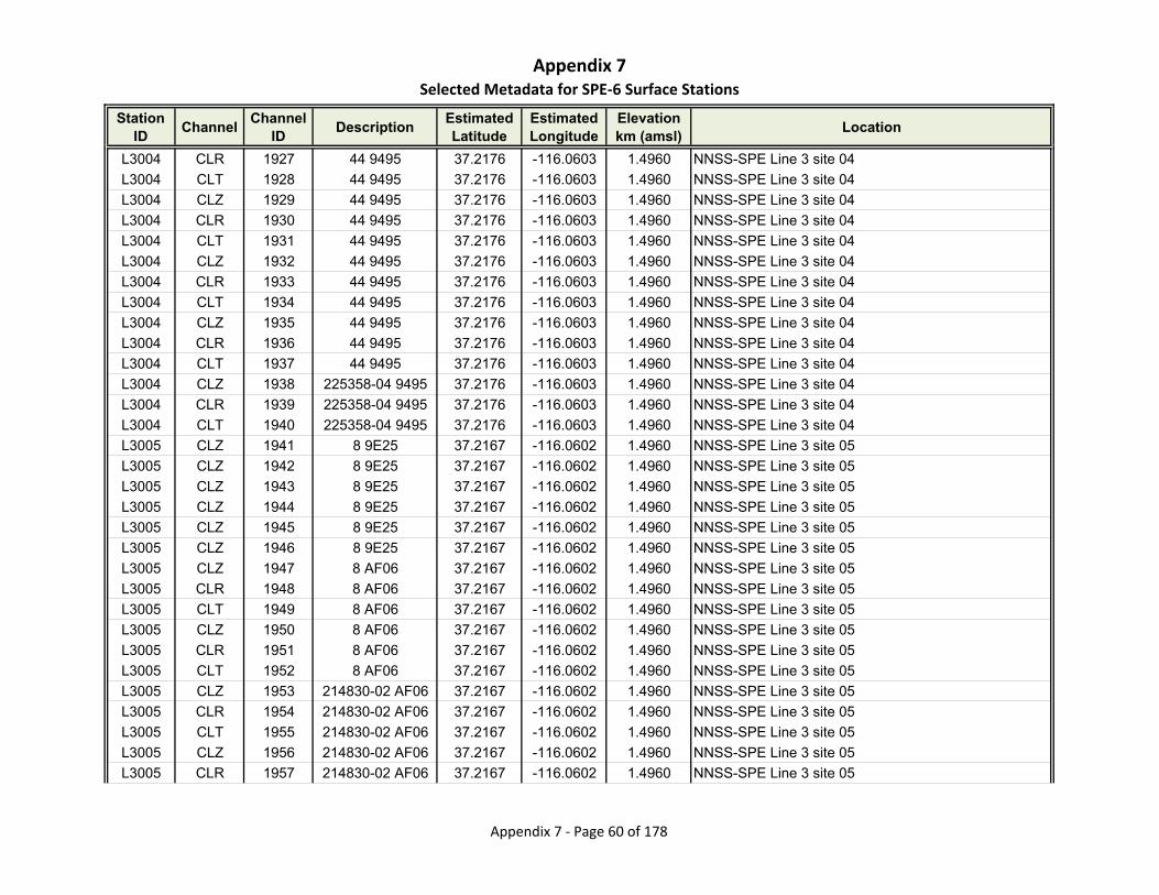
Appendix 7Selected Metadata for SPE‐6 Surface Stations
Station ID
ChannelChannel
IDDescription
Estimated Latitude
Estimated Longitude
Elevationkm (amsl)
Location
L3004 CLR 1927 44 9495 37.2176 -116.0603 1.4960 NNSS-SPE Line 3 site 04
L3004 CLT 1928 44 9495 37.2176 -116.0603 1.4960 NNSS-SPE Line 3 site 04
L3004 CLZ 1929 44 9495 37.2176 -116.0603 1.4960 NNSS-SPE Line 3 site 04
L3004 CLR 1930 44 9495 37.2176 -116.0603 1.4960 NNSS-SPE Line 3 site 04
L3004 CLT 1931 44 9495 37.2176 -116.0603 1.4960 NNSS-SPE Line 3 site 04
L3004 CLZ 1932 44 9495 37.2176 -116.0603 1.4960 NNSS-SPE Line 3 site 04
L3004 CLR 1933 44 9495 37.2176 -116.0603 1.4960 NNSS-SPE Line 3 site 04
L3004 CLT 1934 44 9495 37.2176 -116.0603 1.4960 NNSS-SPE Line 3 site 04
L3004 CLZ 1935 44 9495 37.2176 -116.0603 1.4960 NNSS-SPE Line 3 site 04
L3004 CLR 1936 44 9495 37.2176 -116.0603 1.4960 NNSS-SPE Line 3 site 04
L3004 CLT 1937 44 9495 37.2176 -116.0603 1.4960 NNSS-SPE Line 3 site 04
L3004 CLZ 1938 225358-04 9495 37.2176 -116.0603 1.4960 NNSS-SPE Line 3 site 04
L3004 CLR 1939 225358-04 9495 37.2176 -116.0603 1.4960 NNSS-SPE Line 3 site 04
L3004 CLT 1940 225358-04 9495 37.2176 -116.0603 1.4960 NNSS-SPE Line 3 site 04
L3005 CLZ 1941 8 9E25 37.2167 -116.0602 1.4960 NNSS-SPE Line 3 site 05
L3005 CLZ 1942 8 9E25 37.2167 -116.0602 1.4960 NNSS-SPE Line 3 site 05
L3005 CLZ 1943 8 9E25 37.2167 -116.0602 1.4960 NNSS-SPE Line 3 site 05
L3005 CLZ 1944 8 9E25 37.2167 -116.0602 1.4960 NNSS-SPE Line 3 site 05
L3005 CLZ 1945 8 9E25 37.2167 -116.0602 1.4960 NNSS-SPE Line 3 site 05
L3005 CLZ 1946 8 9E25 37.2167 -116.0602 1.4960 NNSS-SPE Line 3 site 05
L3005 CLZ 1947 8 AF06 37.2167 -116.0602 1.4960 NNSS-SPE Line 3 site 05
L3005 CLR 1948 8 AF06 37.2167 -116.0602 1.4960 NNSS-SPE Line 3 site 05
L3005 CLT 1949 8 AF06 37.2167 -116.0602 1.4960 NNSS-SPE Line 3 site 05
L3005 CLZ 1950 8 AF06 37.2167 -116.0602 1.4960 NNSS-SPE Line 3 site 05
L3005 CLR 1951 8 AF06 37.2167 -116.0602 1.4960 NNSS-SPE Line 3 site 05
L3005 CLT 1952 8 AF06 37.2167 -116.0602 1.4960 NNSS-SPE Line 3 site 05
L3005 CLZ 1953 214830-02 AF06 37.2167 -116.0602 1.4960 NNSS-SPE Line 3 site 05
L3005 CLR 1954 214830-02 AF06 37.2167 -116.0602 1.4960 NNSS-SPE Line 3 site 05
L3005 CLT 1955 214830-02 AF06 37.2167 -116.0602 1.4960 NNSS-SPE Line 3 site 05
L3005 CLZ 1956 214830-02 AF06 37.2167 -116.0602 1.4960 NNSS-SPE Line 3 site 05
L3005 CLR 1957 214830-02 AF06 37.2167 -116.0602 1.4960 NNSS-SPE Line 3 site 05
Appendix 7 ‐ Page 60 of 178

Appendix 7Selected Metadata for SPE‐6 Surface Stations
Station ID
ChannelChannel
IDDescription
Estimated Latitude
Estimated Longitude
Elevationkm (amsl)
Location
L3005 CLT 1958 214830-02 AF06 37.2167 -116.0602 1.4960 NNSS-SPE Line 3 site 05
L3005 CLZ 1959 214830-02 AF06 37.2167 -116.0602 1.4960 NNSS-SPE Line 3 site 05
L3005 CLR 1960 214830-02 AF06 37.2167 -116.0602 1.4960 NNSS-SPE Line 3 site 05
L3005 CLT 1961 214830-02 AF06 37.2167 -116.0602 1.4960 NNSS-SPE Line 3 site 05
L3005 CLZ 1962 214830-02 AF06 37.2167 -116.0602 1.4960 NNSS-SPE Line 3 site 05
L3005 CLR 1963 214830-02 AF06 37.2167 -116.0602 1.4960 NNSS-SPE Line 3 site 05
L3005 CLT 1964 214830-02 AF06 37.2167 -116.0602 1.4960 NNSS-SPE Line 3 site 05
L3005 CLZ 1965 214830-02 AF06 37.2167 -116.0602 1.4960 NNSS-SPE Line 3 site 05
L3005 CLR 1966 214830-02 AF06 37.2167 -116.0602 1.4960 NNSS-SPE Line 3 site 05
L3005 CLT 1967 214830-02 AF06 37.2167 -116.0602 1.4960 NNSS-SPE Line 3 site 05
L3005 CLZ 1968 214830-02 AF06 37.2167 -116.0602 1.4960 NNSS-SPE Line 3 site 05
L3005 CLR 1969 214830-02 AF06 37.2167 -116.0602 1.4960 NNSS-SPE Line 3 site 05
L3005 CLT 1970 214830-02 AF06 37.2167 -116.0602 1.4960 NNSS-SPE Line 3 site 05
L3006 CLZ 1971 80 9E25 37.2158 -116.0600 1.4940 NNSS-SPE Line 3 site 06
L3006 CLZ 1972 80 9E25 37.2158 -116.0600 1.4940 NNSS-SPE Line 3 site 06
L3006 CLZ 1973 80 9E25 37.2158 -116.0600 1.4940 NNSS-SPE Line 3 site 06
L3006 CLZ 1974 80 9E25 37.2158 -116.0600 1.4940 NNSS-SPE Line 3 site 06
L3006 CLZ 1975 80 9E25 37.2158 -116.0600 1.4940 NNSS-SPE Line 3 site 06
L3006 CLZ 1976 80 9E25 37.2158 -116.0600 1.4940 NNSS-SPE Line 3 site 06
L3006 CLZ 1977 80 AF06 37.2158 -116.0600 1.4940 NNSS-SPE Line 3 site 06
L3006 CLR 1978 80 AF06 37.2158 -116.0600 1.4940 NNSS-SPE Line 3 site 06
L3006 CLT 1979 80 AF06 37.2158 -116.0600 1.4940 NNSS-SPE Line 3 site 06
L3006 CLZ 1980 80 AF06 37.2158 -116.0600 1.4940 NNSS-SPE Line 3 site 06
L3006 CLR 1981 80 AF06 37.2158 -116.0600 1.4940 NNSS-SPE Line 3 site 06
L3006 CLT 1982 80 AF06 37.2158 -116.0600 1.4940 NNSS-SPE Line 3 site 06
L3006 CLZ 1983 80 AF06 37.2158 -116.0600 1.4940 NNSS-SPE Line 3 site 06
L3006 CLR 1984 80 AF06 37.2158 -116.0600 1.4940 NNSS-SPE Line 3 site 06
L3006 CLT 1985 80 AF06 37.2158 -116.0600 1.4940 NNSS-SPE Line 3 site 06
L3006 CLZ 1986 80 AF06 37.2158 -116.0600 1.4940 NNSS-SPE Line 3 site 06
L3006 CLR 1987 80 AF06 37.2158 -116.0600 1.4940 NNSS-SPE Line 3 site 06
L3006 CLT 1988 80 AF06 37.2158 -116.0600 1.4940 NNSS-SPE Line 3 site 06
Appendix 7 ‐ Page 61 of 178
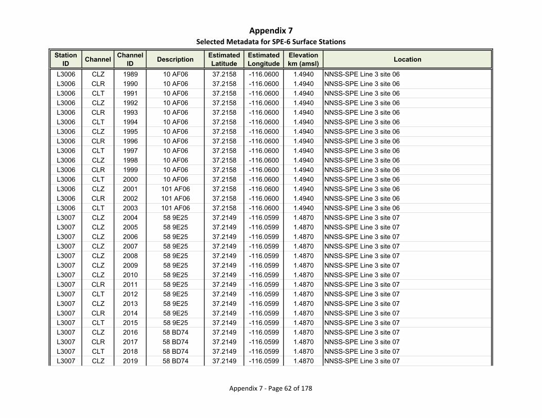
Appendix 7Selected Metadata for SPE‐6 Surface Stations
Station ID
ChannelChannel
IDDescription
Estimated Latitude
Estimated Longitude
Elevationkm (amsl)
Location
L3006 CLZ 1989 10 AF06 37.2158 -116.0600 1.4940 NNSS-SPE Line 3 site 06
L3006 CLR 1990 10 AF06 37.2158 -116.0600 1.4940 NNSS-SPE Line 3 site 06
L3006 CLT 1991 10 AF06 37.2158 -116.0600 1.4940 NNSS-SPE Line 3 site 06
L3006 CLZ 1992 10 AF06 37.2158 -116.0600 1.4940 NNSS-SPE Line 3 site 06
L3006 CLR 1993 10 AF06 37.2158 -116.0600 1.4940 NNSS-SPE Line 3 site 06
L3006 CLT 1994 10 AF06 37.2158 -116.0600 1.4940 NNSS-SPE Line 3 site 06
L3006 CLZ 1995 10 AF06 37.2158 -116.0600 1.4940 NNSS-SPE Line 3 site 06
L3006 CLR 1996 10 AF06 37.2158 -116.0600 1.4940 NNSS-SPE Line 3 site 06
L3006 CLT 1997 10 AF06 37.2158 -116.0600 1.4940 NNSS-SPE Line 3 site 06
L3006 CLZ 1998 10 AF06 37.2158 -116.0600 1.4940 NNSS-SPE Line 3 site 06
L3006 CLR 1999 10 AF06 37.2158 -116.0600 1.4940 NNSS-SPE Line 3 site 06
L3006 CLT 2000 10 AF06 37.2158 -116.0600 1.4940 NNSS-SPE Line 3 site 06
L3006 CLZ 2001 101 AF06 37.2158 -116.0600 1.4940 NNSS-SPE Line 3 site 06
L3006 CLR 2002 101 AF06 37.2158 -116.0600 1.4940 NNSS-SPE Line 3 site 06
L3006 CLT 2003 101 AF06 37.2158 -116.0600 1.4940 NNSS-SPE Line 3 site 06
L3007 CLZ 2004 58 9E25 37.2149 -116.0599 1.4870 NNSS-SPE Line 3 site 07
L3007 CLZ 2005 58 9E25 37.2149 -116.0599 1.4870 NNSS-SPE Line 3 site 07
L3007 CLZ 2006 58 9E25 37.2149 -116.0599 1.4870 NNSS-SPE Line 3 site 07
L3007 CLZ 2007 58 9E25 37.2149 -116.0599 1.4870 NNSS-SPE Line 3 site 07
L3007 CLZ 2008 58 9E25 37.2149 -116.0599 1.4870 NNSS-SPE Line 3 site 07
L3007 CLZ 2009 58 9E25 37.2149 -116.0599 1.4870 NNSS-SPE Line 3 site 07
L3007 CLZ 2010 58 9E25 37.2149 -116.0599 1.4870 NNSS-SPE Line 3 site 07
L3007 CLR 2011 58 9E25 37.2149 -116.0599 1.4870 NNSS-SPE Line 3 site 07
L3007 CLT 2012 58 9E25 37.2149 -116.0599 1.4870 NNSS-SPE Line 3 site 07
L3007 CLZ 2013 58 9E25 37.2149 -116.0599 1.4870 NNSS-SPE Line 3 site 07
L3007 CLR 2014 58 9E25 37.2149 -116.0599 1.4870 NNSS-SPE Line 3 site 07
L3007 CLT 2015 58 9E25 37.2149 -116.0599 1.4870 NNSS-SPE Line 3 site 07
L3007 CLZ 2016 58 BD74 37.2149 -116.0599 1.4870 NNSS-SPE Line 3 site 07
L3007 CLR 2017 58 BD74 37.2149 -116.0599 1.4870 NNSS-SPE Line 3 site 07
L3007 CLT 2018 58 BD74 37.2149 -116.0599 1.4870 NNSS-SPE Line 3 site 07
L3007 CLZ 2019 58 BD74 37.2149 -116.0599 1.4870 NNSS-SPE Line 3 site 07
Appendix 7 ‐ Page 62 of 178
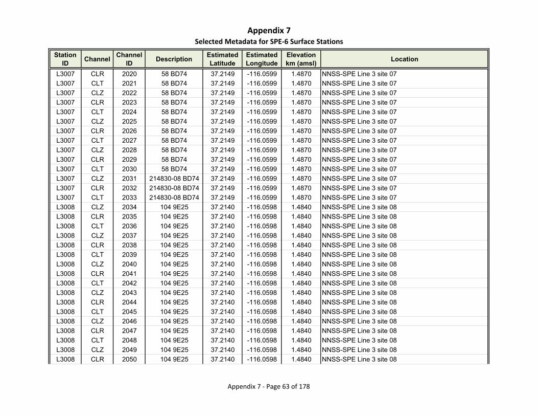
Appendix 7Selected Metadata for SPE‐6 Surface Stations
Station ID
ChannelChannel
IDDescription
Estimated Latitude
Estimated Longitude
Elevationkm (amsl)
Location
L3007 CLR 2020 58 BD74 37.2149 -116.0599 1.4870 NNSS-SPE Line 3 site 07
L3007 CLT 2021 58 BD74 37.2149 -116.0599 1.4870 NNSS-SPE Line 3 site 07
L3007 CLZ 2022 58 BD74 37.2149 -116.0599 1.4870 NNSS-SPE Line 3 site 07
L3007 CLR 2023 58 BD74 37.2149 -116.0599 1.4870 NNSS-SPE Line 3 site 07
L3007 CLT 2024 58 BD74 37.2149 -116.0599 1.4870 NNSS-SPE Line 3 site 07
L3007 CLZ 2025 58 BD74 37.2149 -116.0599 1.4870 NNSS-SPE Line 3 site 07
L3007 CLR 2026 58 BD74 37.2149 -116.0599 1.4870 NNSS-SPE Line 3 site 07
L3007 CLT 2027 58 BD74 37.2149 -116.0599 1.4870 NNSS-SPE Line 3 site 07
L3007 CLZ 2028 58 BD74 37.2149 -116.0599 1.4870 NNSS-SPE Line 3 site 07
L3007 CLR 2029 58 BD74 37.2149 -116.0599 1.4870 NNSS-SPE Line 3 site 07
L3007 CLT 2030 58 BD74 37.2149 -116.0599 1.4870 NNSS-SPE Line 3 site 07
L3007 CLZ 2031 214830-08 BD74 37.2149 -116.0599 1.4870 NNSS-SPE Line 3 site 07
L3007 CLR 2032 214830-08 BD74 37.2149 -116.0599 1.4870 NNSS-SPE Line 3 site 07
L3007 CLT 2033 214830-08 BD74 37.2149 -116.0599 1.4870 NNSS-SPE Line 3 site 07
L3008 CLZ 2034 104 9E25 37.2140 -116.0598 1.4840 NNSS-SPE Line 3 site 08
L3008 CLR 2035 104 9E25 37.2140 -116.0598 1.4840 NNSS-SPE Line 3 site 08
L3008 CLT 2036 104 9E25 37.2140 -116.0598 1.4840 NNSS-SPE Line 3 site 08
L3008 CLZ 2037 104 9E25 37.2140 -116.0598 1.4840 NNSS-SPE Line 3 site 08
L3008 CLR 2038 104 9E25 37.2140 -116.0598 1.4840 NNSS-SPE Line 3 site 08
L3008 CLT 2039 104 9E25 37.2140 -116.0598 1.4840 NNSS-SPE Line 3 site 08
L3008 CLZ 2040 104 9E25 37.2140 -116.0598 1.4840 NNSS-SPE Line 3 site 08
L3008 CLR 2041 104 9E25 37.2140 -116.0598 1.4840 NNSS-SPE Line 3 site 08
L3008 CLT 2042 104 9E25 37.2140 -116.0598 1.4840 NNSS-SPE Line 3 site 08
L3008 CLZ 2043 104 9E25 37.2140 -116.0598 1.4840 NNSS-SPE Line 3 site 08
L3008 CLR 2044 104 9E25 37.2140 -116.0598 1.4840 NNSS-SPE Line 3 site 08
L3008 CLT 2045 104 9E25 37.2140 -116.0598 1.4840 NNSS-SPE Line 3 site 08
L3008 CLZ 2046 104 9E25 37.2140 -116.0598 1.4840 NNSS-SPE Line 3 site 08
L3008 CLR 2047 104 9E25 37.2140 -116.0598 1.4840 NNSS-SPE Line 3 site 08
L3008 CLT 2048 104 9E25 37.2140 -116.0598 1.4840 NNSS-SPE Line 3 site 08
L3008 CLZ 2049 104 9E25 37.2140 -116.0598 1.4840 NNSS-SPE Line 3 site 08
L3008 CLR 2050 104 9E25 37.2140 -116.0598 1.4840 NNSS-SPE Line 3 site 08
Appendix 7 ‐ Page 63 of 178
Appendix 7Selected Metadata for SPE‐6 Surface Stations
Station ID
ChannelChannel
IDDescription
Estimated Latitude
Estimated Longitude
Elevationkm (amsl)
Location
L3008 CLT 2051 104 9E25 37.2140 -116.0598 1.4840 NNSS-SPE Line 3 site 08
L3008 CLZ 2052 104 9E25 37.2140 -116.0598 1.4840 NNSS-SPE Line 3 site 08
L3008 CLR 2053 104 9E25 37.2140 -116.0598 1.4840 NNSS-SPE Line 3 site 08
L3008 CLT 2054 104 9E25 37.2140 -116.0598 1.4840 NNSS-SPE Line 3 site 08
L3008 CLZ 2055 104 BD74 37.2140 -116.0598 1.4840 NNSS-SPE Line 3 site 08
L3008 CLR 2056 104 BD74 37.2140 -116.0598 1.4840 NNSS-SPE Line 3 site 08
L3008 CLT 2057 104 BD74 37.2140 -116.0598 1.4840 NNSS-SPE Line 3 site 08
L3008 CLZ 2058 104 BD74 37.2140 -116.0598 1.4840 NNSS-SPE Line 3 site 08
L3008 CLR 2059 104 BD74 37.2140 -116.0598 1.4840 NNSS-SPE Line 3 site 08
L3008 CLT 2060 104 BD74 37.2140 -116.0598 1.4840 NNSS-SPE Line 3 site 08
L3008 CLZ 2061 104 BD74 37.2140 -116.0598 1.4840 NNSS-SPE Line 3 site 08
L3008 CLR 2062 104 BD74 37.2140 -116.0598 1.4840 NNSS-SPE Line 3 site 08
L3008 CLT 2063 104 BD74 37.2140 -116.0598 1.4840 NNSS-SPE Line 3 site 08
L3008 CLZ 2064 104 BD74 37.2140 -116.0598 1.4840 NNSS-SPE Line 3 site 08
L3008 CLR 2065 104 BD74 37.2140 -116.0598 1.4840 NNSS-SPE Line 3 site 08
L3008 CLT 2066 104 BD74 37.2140 -116.0598 1.4840 NNSS-SPE Line 3 site 08
L3008 CLZ 2067 104 BD74 37.2140 -116.0598 1.4840 NNSS-SPE Line 3 site 08
L3008 CLR 2068 104 BD74 37.2140 -116.0598 1.4840 NNSS-SPE Line 3 site 08
L3008 CLT 2069 104 BD74 37.2140 -116.0598 1.4840 NNSS-SPE Line 3 site 08
L3008 CLZ 2070 104 BD74 37.2140 -116.0598 1.4840 NNSS-SPE Line 3 site 08
L3008 CLR 2071 104 BD74 37.2140 -116.0598 1.4840 NNSS-SPE Line 3 site 08
L3008 CLT 2072 104 BD74 37.2140 -116.0598 1.4840 NNSS-SPE Line 3 site 08
L3009 CLZ 2073 61 9E27 37.2131 -116.0596 1.4690 NNSS-SPE Line 3 site 09
L3009 CLZ 2074 61 9E27 37.2131 -116.0596 1.4690 NNSS-SPE Line 3 site 09
L3009 CLZ 2075 61 9E27 37.2131 -116.0596 1.4690 NNSS-SPE Line 3 site 09
L3009 CLZ 2076 61 9E27 37.2131 -116.0596 1.4690 NNSS-SPE Line 3 site 09
L3009 CLZ 2077 61 9E27 37.2131 -116.0596 1.4690 NNSS-SPE Line 3 site 09
L3009 CLZ 2078 61 9E27 37.2131 -116.0596 1.4690 NNSS-SPE Line 3 site 09
L3009 CLZ 2079 61 B3AA 37.2131 -116.0596 1.4690 NNSS-SPE Line 3 site 09
L3009 CLR 2080 61 B3AA 37.2131 -116.0596 1.4690 NNSS-SPE Line 3 site 09
L3009 CLT 2081 61 B3AA 37.2131 -116.0596 1.4690 NNSS-SPE Line 3 site 09
Appendix 7 ‐ Page 64 of 178

Appendix 7Selected Metadata for SPE‐6 Surface Stations
Station ID
ChannelChannel
IDDescription
Estimated Latitude
Estimated Longitude
Elevationkm (amsl)
Location
L3009 CLZ 2082 61 B3AA 37.2131 -116.0596 1.4690 NNSS-SPE Line 3 site 09
L3009 CLR 2083 61 B3AA 37.2131 -116.0596 1.4690 NNSS-SPE Line 3 site 09
L3009 CLT 2084 61 B3AA 37.2131 -116.0596 1.4690 NNSS-SPE Line 3 site 09
L3009 CLZ 2085 61 B3AA 37.2131 -116.0596 1.4690 NNSS-SPE Line 3 site 09
L3009 CLR 2086 61 B3AA 37.2131 -116.0596 1.4690 NNSS-SPE Line 3 site 09
L3009 CLT 2087 61 B3AA 37.2131 -116.0596 1.4690 NNSS-SPE Line 3 site 09
L3009 CLZ 2088 61 B3AA 37.2131 -116.0596 1.4690 NNSS-SPE Line 3 site 09
L3009 CLR 2089 61 B3AA 37.2131 -116.0596 1.4690 NNSS-SPE Line 3 site 09
L3009 CLT 2090 61 B3AA 37.2131 -116.0596 1.4690 NNSS-SPE Line 3 site 09
L3009 CLZ 2091 61 B3AA 37.2131 -116.0596 1.4690 NNSS-SPE Line 3 site 09
L3009 CLR 2092 61 B3AA 37.2131 -116.0596 1.4690 NNSS-SPE Line 3 site 09
L3009 CLT 2093 61 B3AA 37.2131 -116.0596 1.4690 NNSS-SPE Line 3 site 09
L3009 CLZ 2094 61 BCED 37.2131 -116.0596 1.4690 NNSS-SPE Line 3 site 09
L3009 CLR 2095 61 BCED 37.2131 -116.0596 1.4690 NNSS-SPE Line 3 site 09
L3009 CLT 2096 61 BCED 37.2131 -116.0596 1.4690 NNSS-SPE Line 3 site 09
L3009 CLZ 2097 61 BCED 37.2131 -116.0596 1.4690 NNSS-SPE Line 3 site 09
L3009 CLR 2098 61 BCED 37.2131 -116.0596 1.4690 NNSS-SPE Line 3 site 09
L3009 CLT 2099 61 BCED 37.2131 -116.0596 1.4690 NNSS-SPE Line 3 site 09
L3009 CLZ 2100 61 BCED 37.2131 -116.0596 1.4690 NNSS-SPE Line 3 site 09
L3009 CLR 2101 61 BCED 37.2131 -116.0596 1.4690 NNSS-SPE Line 3 site 09
L3009 CLT 2102 61 BCED 37.2131 -116.0596 1.4690 NNSS-SPE Line 3 site 09
L3009 CLZ 2103 61 BCED 37.2131 -116.0596 1.4690 NNSS-SPE Line 3 site 09
L3009 CLR 2104 61 BCED 37.2131 -116.0596 1.4690 NNSS-SPE Line 3 site 09
L3009 CLT 2105 61 BCED 37.2131 -116.0596 1.4690 NNSS-SPE Line 3 site 09
L3009 CLZ 2106 61 BCED 37.2131 -116.0596 1.4690 NNSS-SPE Line 3 site 09
L3009 CLR 2107 61 BCED 37.2131 -116.0596 1.4690 NNSS-SPE Line 3 site 09
L3009 CLT 2108 61 BCED 37.2131 -116.0596 1.4690 NNSS-SPE Line 3 site 09
L3010 CNZ 2109 00610 9187 37.2122 -116.0595 1.4810 NNSS-SPE Line 3 site 10
L3010 CNR 2110 00610 9187 37.2122 -116.0595 1.4810 NNSS-SPE Line 3 site 10
L3010 CNT 2111 00610 9187 37.2122 -116.0595 1.4810 NNSS-SPE Line 3 site 10
L3010 DJZ 2112 A201515 9187 37.2122 -116.0595 1.4810 NNSS-SPE Line 3 site 10
Appendix 7 ‐ Page 65 of 178

Appendix 7Selected Metadata for SPE‐6 Surface Stations
Station ID
ChannelChannel
IDDescription
Estimated Latitude
Estimated Longitude
Elevationkm (amsl)
Location
L3010 DJR 2113 A201515 9187 37.2122 -116.0595 1.4810 NNSS-SPE Line 3 site 10
L3010 DJT 2114 A201515 9187 37.2122 -116.0595 1.4810 NNSS-SPE Line 3 site 10
L3010 CNZ 2115 00610 B3D4 37.2122 -116.0595 1.4810 NNSS-SPE Line 3 site 10
L3010 CNR 2116 00610 B3D4 37.2122 -116.0595 1.4810 NNSS-SPE Line 3 site 10
L3010 CNT 2117 00610 B3D4 37.2122 -116.0595 1.4810 NNSS-SPE Line 3 site 10
L3010 DJZ 2118 A201515 B3D4 37.2122 -116.0595 1.4810 NNSS-SPE Line 3 site 10
L3010 DJR 2119 A201515 B3D4 37.2122 -116.0595 1.4810 NNSS-SPE Line 3 site 10
L3010 DJT 2120 A201515 B3D4 37.2122 -116.0595 1.4810 NNSS-SPE Line 3 site 10
L3010 CLZ 2121 60 9E27 37.2122 -116.0595 1.4810 NNSS-SPE Line 3 site 10
L3010 CLZ 2122 60 9E27 37.2122 -116.0595 1.4810 NNSS-SPE Line 3 site 10
L3010 CLZ 2123 60 9E27 37.2122 -116.0595 1.4810 NNSS-SPE Line 3 site 10
L3010 CLZ 2124 60 9E27 37.2122 -116.0595 1.4810 NNSS-SPE Line 3 site 10
L3010 CLZ 2125 60 9E27 37.2122 -116.0595 1.4810 NNSS-SPE Line 3 site 10
L3010 CLZ 2126 60 9E27 37.2122 -116.0595 1.4810 NNSS-SPE Line 3 site 10
L3010 CLZ 2127 60 B3AA 37.2122 -116.0595 1.4810 NNSS-SPE Line 3 site 10
L3010 CLR 2128 60 B3AA 37.2122 -116.0595 1.4810 NNSS-SPE Line 3 site 10
L3010 CLT 2129 60 B3AA 37.2122 -116.0595 1.4810 NNSS-SPE Line 3 site 10
L3010 CLZ 2130 60 B3AA 37.2122 -116.0595 1.4810 NNSS-SPE Line 3 site 10
L3010 CLR 2131 60 B3AA 37.2122 -116.0595 1.4810 NNSS-SPE Line 3 site 10
L3010 CLT 2132 60 B3AA 37.2122 -116.0595 1.4810 NNSS-SPE Line 3 site 10
L3010 CLZ 2133 60 B3AA 37.2122 -116.0595 1.4810 NNSS-SPE Line 3 site 10
L3010 CLR 2134 60 B3AA 37.2122 -116.0595 1.4810 NNSS-SPE Line 3 site 10
L3010 CLT 2135 60 B3AA 37.2122 -116.0595 1.4810 NNSS-SPE Line 3 site 10
L3010 CLZ 2136 60 B3AA 37.2122 -116.0595 1.4810 NNSS-SPE Line 3 site 10
L3010 CLR 2137 60 B3AA 37.2122 -116.0595 1.4810 NNSS-SPE Line 3 site 10
L3010 CLT 2138 60 B3AA 37.2122 -116.0595 1.4810 NNSS-SPE Line 3 site 10
L3010 CLZ 2139 60 B3AA 37.2122 -116.0595 1.4810 NNSS-SPE Line 3 site 10
L3010 CLR 2140 60 B3AA 37.2122 -116.0595 1.4810 NNSS-SPE Line 3 site 10
L3010 CLT 2141 60 B3AA 37.2122 -116.0595 1.4810 NNSS-SPE Line 3 site 10
L3010 CLZ 2142 60 BCED 37.2122 -116.0595 1.4810 NNSS-SPE Line 3 site 10
L3010 CLR 2143 60 BCED 37.2122 -116.0595 1.4810 NNSS-SPE Line 3 site 10
Appendix 7 ‐ Page 66 of 178
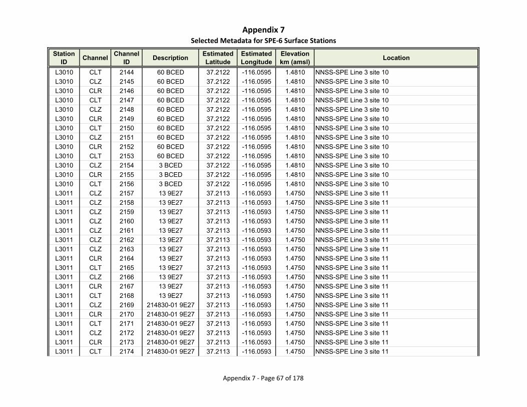
Appendix 7Selected Metadata for SPE‐6 Surface Stations
Station ID
ChannelChannel
IDDescription
Estimated Latitude
Estimated Longitude
Elevationkm (amsl)
Location
L3010 CLT 2144 60 BCED 37.2122 -116.0595 1.4810 NNSS-SPE Line 3 site 10
L3010 CLZ 2145 60 BCED 37.2122 -116.0595 1.4810 NNSS-SPE Line 3 site 10
L3010 CLR 2146 60 BCED 37.2122 -116.0595 1.4810 NNSS-SPE Line 3 site 10
L3010 CLT 2147 60 BCED 37.2122 -116.0595 1.4810 NNSS-SPE Line 3 site 10
L3010 CLZ 2148 60 BCED 37.2122 -116.0595 1.4810 NNSS-SPE Line 3 site 10
L3010 CLR 2149 60 BCED 37.2122 -116.0595 1.4810 NNSS-SPE Line 3 site 10
L3010 CLT 2150 60 BCED 37.2122 -116.0595 1.4810 NNSS-SPE Line 3 site 10
L3010 CLZ 2151 60 BCED 37.2122 -116.0595 1.4810 NNSS-SPE Line 3 site 10
L3010 CLR 2152 60 BCED 37.2122 -116.0595 1.4810 NNSS-SPE Line 3 site 10
L3010 CLT 2153 60 BCED 37.2122 -116.0595 1.4810 NNSS-SPE Line 3 site 10
L3010 CLZ 2154 3 BCED 37.2122 -116.0595 1.4810 NNSS-SPE Line 3 site 10
L3010 CLR 2155 3 BCED 37.2122 -116.0595 1.4810 NNSS-SPE Line 3 site 10
L3010 CLT 2156 3 BCED 37.2122 -116.0595 1.4810 NNSS-SPE Line 3 site 10
L3011 CLZ 2157 13 9E27 37.2113 -116.0593 1.4750 NNSS-SPE Line 3 site 11
L3011 CLZ 2158 13 9E27 37.2113 -116.0593 1.4750 NNSS-SPE Line 3 site 11
L3011 CLZ 2159 13 9E27 37.2113 -116.0593 1.4750 NNSS-SPE Line 3 site 11
L3011 CLZ 2160 13 9E27 37.2113 -116.0593 1.4750 NNSS-SPE Line 3 site 11
L3011 CLZ 2161 13 9E27 37.2113 -116.0593 1.4750 NNSS-SPE Line 3 site 11
L3011 CLZ 2162 13 9E27 37.2113 -116.0593 1.4750 NNSS-SPE Line 3 site 11
L3011 CLZ 2163 13 9E27 37.2113 -116.0593 1.4750 NNSS-SPE Line 3 site 11
L3011 CLR 2164 13 9E27 37.2113 -116.0593 1.4750 NNSS-SPE Line 3 site 11
L3011 CLT 2165 13 9E27 37.2113 -116.0593 1.4750 NNSS-SPE Line 3 site 11
L3011 CLZ 2166 13 9E27 37.2113 -116.0593 1.4750 NNSS-SPE Line 3 site 11
L3011 CLR 2167 13 9E27 37.2113 -116.0593 1.4750 NNSS-SPE Line 3 site 11
L3011 CLT 2168 13 9E27 37.2113 -116.0593 1.4750 NNSS-SPE Line 3 site 11
L3011 CLZ 2169 214830-01 9E27 37.2113 -116.0593 1.4750 NNSS-SPE Line 3 site 11
L3011 CLR 2170 214830-01 9E27 37.2113 -116.0593 1.4750 NNSS-SPE Line 3 site 11
L3011 CLT 2171 214830-01 9E27 37.2113 -116.0593 1.4750 NNSS-SPE Line 3 site 11
L3011 CLZ 2172 214830-01 9E27 37.2113 -116.0593 1.4750 NNSS-SPE Line 3 site 11
L3011 CLR 2173 214830-01 9E27 37.2113 -116.0593 1.4750 NNSS-SPE Line 3 site 11
L3011 CLT 2174 214830-01 9E27 37.2113 -116.0593 1.4750 NNSS-SPE Line 3 site 11
Appendix 7 ‐ Page 67 of 178

Appendix 7Selected Metadata for SPE‐6 Surface Stations
Station ID
ChannelChannel
IDDescription
Estimated Latitude
Estimated Longitude
Elevationkm (amsl)
Location
L3011 CLZ 2175 214830-01 9E27 37.2113 -116.0593 1.4750 NNSS-SPE Line 3 site 11
L3011 CLR 2176 214830-01 9E27 37.2113 -116.0593 1.4750 NNSS-SPE Line 3 site 11
L3011 CLT 2177 214830-01 9E27 37.2113 -116.0593 1.4750 NNSS-SPE Line 3 site 11
L3011 CLZ 2178 214830-01 9E27 37.2113 -116.0593 1.4750 NNSS-SPE Line 3 site 11
L3011 CLR 2179 214830-01 9E27 37.2113 -116.0593 1.4750 NNSS-SPE Line 3 site 11
L3011 CLT 2180 214830-01 9E27 37.2113 -116.0593 1.4750 NNSS-SPE Line 3 site 11
L3011 CLZ 2181 214830-01 9E27 37.2113 -116.0593 1.4750 NNSS-SPE Line 3 site 11
L3011 CLR 2182 214830-01 9E27 37.2113 -116.0593 1.4750 NNSS-SPE Line 3 site 11
L3011 CLT 2183 214830-01 9E27 37.2113 -116.0593 1.4750 NNSS-SPE Line 3 site 11
L3011 CLZ 2184 214830-01 9E27 37.2113 -116.0593 1.4750 NNSS-SPE Line 3 site 11
L3011 CLR 2185 214830-01 9E27 37.2113 -116.0593 1.4750 NNSS-SPE Line 3 site 11
L3011 CLT 2186 214830-01 9E27 37.2113 -116.0593 1.4750 NNSS-SPE Line 3 site 11
L3012 CLZ 2187 50 9E27 37.2104 -116.0592 1.4640 NNSS-SPE Line 3 site 12
L3012 CLR 2188 50 9E27 37.2104 -116.0592 1.4640 NNSS-SPE Line 3 site 12
L3012 CLT 2189 50 9E27 37.2104 -116.0592 1.4640 NNSS-SPE Line 3 site 12
L3012 CLZ 2190 50 9E27 37.2104 -116.0592 1.4640 NNSS-SPE Line 3 site 12
L3012 CLR 2191 50 9E27 37.2104 -116.0592 1.4640 NNSS-SPE Line 3 site 12
L3012 CLT 2192 50 9E27 37.2104 -116.0592 1.4640 NNSS-SPE Line 3 site 12
L3012 CLZ 2193 50 9E27 37.2104 -116.0592 1.4640 NNSS-SPE Line 3 site 12
L3012 CLR 2194 50 9E27 37.2104 -116.0592 1.4640 NNSS-SPE Line 3 site 12
L3012 CLT 2195 50 9E27 37.2104 -116.0592 1.4640 NNSS-SPE Line 3 site 12
L3012 CLZ 2196 50 9E27 37.2104 -116.0592 1.4640 NNSS-SPE Line 3 site 12
L3012 CLR 2197 50 9E27 37.2104 -116.0592 1.4640 NNSS-SPE Line 3 site 12
L3012 CLT 2198 50 9E27 37.2104 -116.0592 1.4640 NNSS-SPE Line 3 site 12
L3012 CLZ 2199 50 9E27 37.2104 -116.0592 1.4640 NNSS-SPE Line 3 site 12
L3012 CLR 2200 50 9E27 37.2104 -116.0592 1.4640 NNSS-SPE Line 3 site 12
L3012 CLT 2201 50 9E27 37.2104 -116.0592 1.4640 NNSS-SPE Line 3 site 12
L3012 CLZ 2202 50 9E27 37.2104 -116.0592 1.4640 NNSS-SPE Line 3 site 12
L3012 CLR 2203 50 9E27 37.2104 -116.0592 1.4640 NNSS-SPE Line 3 site 12
L3012 CLT 2204 50 9E27 37.2104 -116.0592 1.4640 NNSS-SPE Line 3 site 12
L3012 CLZ 2205 50 9E27 37.2104 -116.0592 1.4640 NNSS-SPE Line 3 site 12
Appendix 7 ‐ Page 68 of 178
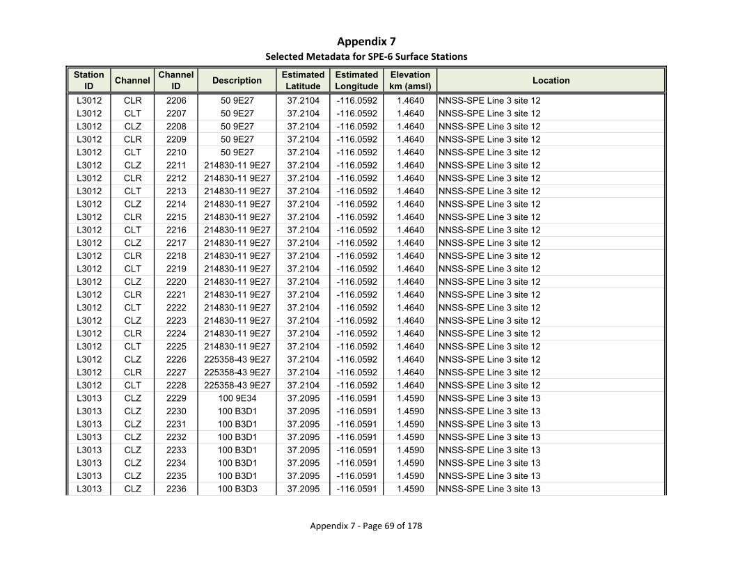
Appendix 7Selected Metadata for SPE‐6 Surface Stations
Station ID
ChannelChannel
IDDescription
Estimated Latitude
Estimated Longitude
Elevationkm (amsl)
Location
L3012 CLR 2206 50 9E27 37.2104 -116.0592 1.4640 NNSS-SPE Line 3 site 12
L3012 CLT 2207 50 9E27 37.2104 -116.0592 1.4640 NNSS-SPE Line 3 site 12
L3012 CLZ 2208 50 9E27 37.2104 -116.0592 1.4640 NNSS-SPE Line 3 site 12
L3012 CLR 2209 50 9E27 37.2104 -116.0592 1.4640 NNSS-SPE Line 3 site 12
L3012 CLT 2210 50 9E27 37.2104 -116.0592 1.4640 NNSS-SPE Line 3 site 12
L3012 CLZ 2211 214830-11 9E27 37.2104 -116.0592 1.4640 NNSS-SPE Line 3 site 12
L3012 CLR 2212 214830-11 9E27 37.2104 -116.0592 1.4640 NNSS-SPE Line 3 site 12
L3012 CLT 2213 214830-11 9E27 37.2104 -116.0592 1.4640 NNSS-SPE Line 3 site 12
L3012 CLZ 2214 214830-11 9E27 37.2104 -116.0592 1.4640 NNSS-SPE Line 3 site 12
L3012 CLR 2215 214830-11 9E27 37.2104 -116.0592 1.4640 NNSS-SPE Line 3 site 12
L3012 CLT 2216 214830-11 9E27 37.2104 -116.0592 1.4640 NNSS-SPE Line 3 site 12
L3012 CLZ 2217 214830-11 9E27 37.2104 -116.0592 1.4640 NNSS-SPE Line 3 site 12
L3012 CLR 2218 214830-11 9E27 37.2104 -116.0592 1.4640 NNSS-SPE Line 3 site 12
L3012 CLT 2219 214830-11 9E27 37.2104 -116.0592 1.4640 NNSS-SPE Line 3 site 12
L3012 CLZ 2220 214830-11 9E27 37.2104 -116.0592 1.4640 NNSS-SPE Line 3 site 12
L3012 CLR 2221 214830-11 9E27 37.2104 -116.0592 1.4640 NNSS-SPE Line 3 site 12
L3012 CLT 2222 214830-11 9E27 37.2104 -116.0592 1.4640 NNSS-SPE Line 3 site 12
L3012 CLZ 2223 214830-11 9E27 37.2104 -116.0592 1.4640 NNSS-SPE Line 3 site 12
L3012 CLR 2224 214830-11 9E27 37.2104 -116.0592 1.4640 NNSS-SPE Line 3 site 12
L3012 CLT 2225 214830-11 9E27 37.2104 -116.0592 1.4640 NNSS-SPE Line 3 site 12
L3012 CLZ 2226 225358-43 9E27 37.2104 -116.0592 1.4640 NNSS-SPE Line 3 site 12
L3012 CLR 2227 225358-43 9E27 37.2104 -116.0592 1.4640 NNSS-SPE Line 3 site 12
L3012 CLT 2228 225358-43 9E27 37.2104 -116.0592 1.4640 NNSS-SPE Line 3 site 12
L3013 CLZ 2229 100 9E34 37.2095 -116.0591 1.4590 NNSS-SPE Line 3 site 13
L3013 CLZ 2230 100 B3D1 37.2095 -116.0591 1.4590 NNSS-SPE Line 3 site 13
L3013 CLZ 2231 100 B3D1 37.2095 -116.0591 1.4590 NNSS-SPE Line 3 site 13
L3013 CLZ 2232 100 B3D1 37.2095 -116.0591 1.4590 NNSS-SPE Line 3 site 13
L3013 CLZ 2233 100 B3D1 37.2095 -116.0591 1.4590 NNSS-SPE Line 3 site 13
L3013 CLZ 2234 100 B3D1 37.2095 -116.0591 1.4590 NNSS-SPE Line 3 site 13
L3013 CLZ 2235 100 B3D1 37.2095 -116.0591 1.4590 NNSS-SPE Line 3 site 13
L3013 CLZ 2236 100 B3D3 37.2095 -116.0591 1.4590 NNSS-SPE Line 3 site 13
Appendix 7 ‐ Page 69 of 178
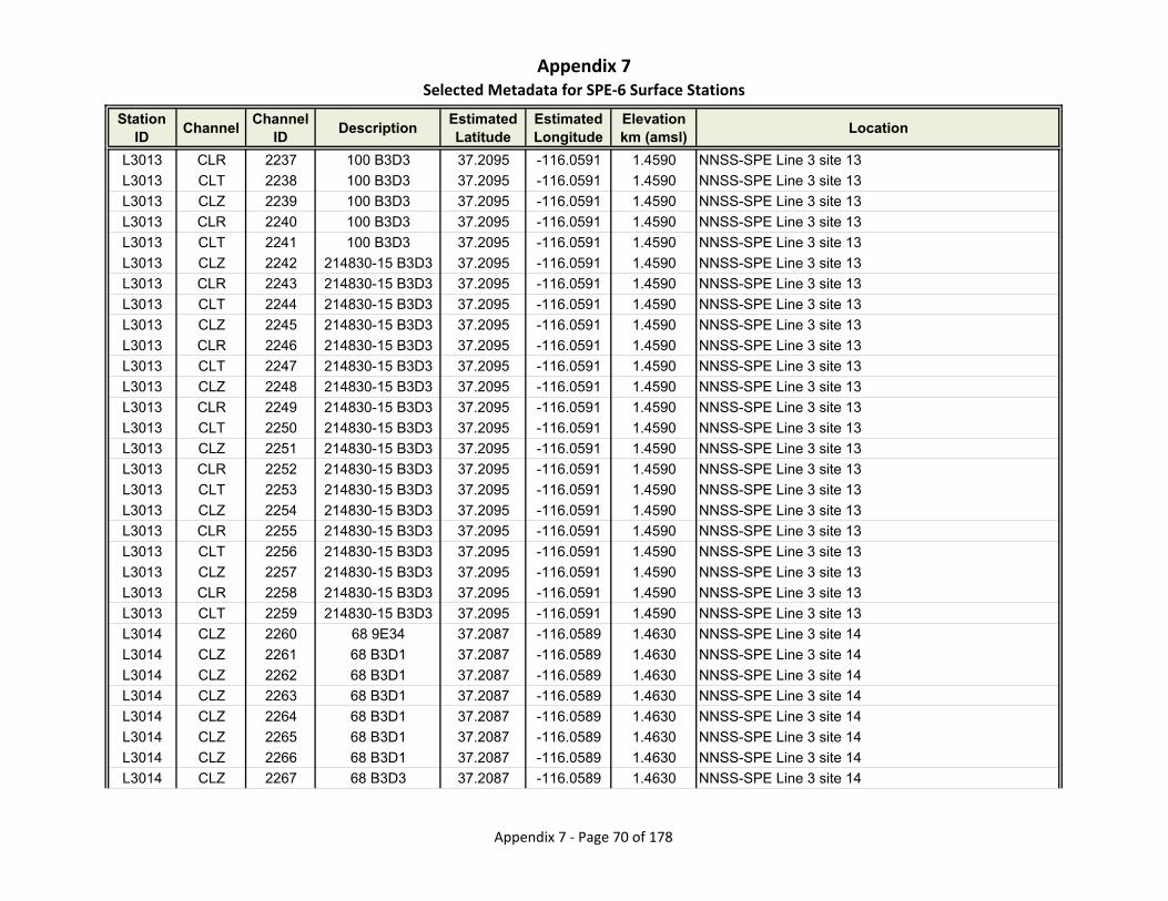
Appendix 7Selected Metadata for SPE‐6 Surface Stations
Station ID
ChannelChannel
IDDescription
Estimated Latitude
Estimated Longitude
Elevationkm (amsl)
Location
L3013 CLR 2237 100 B3D3 37.2095 -116.0591 1.4590 NNSS-SPE Line 3 site 13
L3013 CLT 2238 100 B3D3 37.2095 -116.0591 1.4590 NNSS-SPE Line 3 site 13
L3013 CLZ 2239 100 B3D3 37.2095 -116.0591 1.4590 NNSS-SPE Line 3 site 13
L3013 CLR 2240 100 B3D3 37.2095 -116.0591 1.4590 NNSS-SPE Line 3 site 13
L3013 CLT 2241 100 B3D3 37.2095 -116.0591 1.4590 NNSS-SPE Line 3 site 13
L3013 CLZ 2242 214830-15 B3D3 37.2095 -116.0591 1.4590 NNSS-SPE Line 3 site 13
L3013 CLR 2243 214830-15 B3D3 37.2095 -116.0591 1.4590 NNSS-SPE Line 3 site 13
L3013 CLT 2244 214830-15 B3D3 37.2095 -116.0591 1.4590 NNSS-SPE Line 3 site 13
L3013 CLZ 2245 214830-15 B3D3 37.2095 -116.0591 1.4590 NNSS-SPE Line 3 site 13
L3013 CLR 2246 214830-15 B3D3 37.2095 -116.0591 1.4590 NNSS-SPE Line 3 site 13
L3013 CLT 2247 214830-15 B3D3 37.2095 -116.0591 1.4590 NNSS-SPE Line 3 site 13
L3013 CLZ 2248 214830-15 B3D3 37.2095 -116.0591 1.4590 NNSS-SPE Line 3 site 13
L3013 CLR 2249 214830-15 B3D3 37.2095 -116.0591 1.4590 NNSS-SPE Line 3 site 13
L3013 CLT 2250 214830-15 B3D3 37.2095 -116.0591 1.4590 NNSS-SPE Line 3 site 13
L3013 CLZ 2251 214830-15 B3D3 37.2095 -116.0591 1.4590 NNSS-SPE Line 3 site 13
L3013 CLR 2252 214830-15 B3D3 37.2095 -116.0591 1.4590 NNSS-SPE Line 3 site 13
L3013 CLT 2253 214830-15 B3D3 37.2095 -116.0591 1.4590 NNSS-SPE Line 3 site 13
L3013 CLZ 2254 214830-15 B3D3 37.2095 -116.0591 1.4590 NNSS-SPE Line 3 site 13
L3013 CLR 2255 214830-15 B3D3 37.2095 -116.0591 1.4590 NNSS-SPE Line 3 site 13
L3013 CLT 2256 214830-15 B3D3 37.2095 -116.0591 1.4590 NNSS-SPE Line 3 site 13
L3013 CLZ 2257 214830-15 B3D3 37.2095 -116.0591 1.4590 NNSS-SPE Line 3 site 13
L3013 CLR 2258 214830-15 B3D3 37.2095 -116.0591 1.4590 NNSS-SPE Line 3 site 13
L3013 CLT 2259 214830-15 B3D3 37.2095 -116.0591 1.4590 NNSS-SPE Line 3 site 13
L3014 CLZ 2260 68 9E34 37.2087 -116.0589 1.4630 NNSS-SPE Line 3 site 14
L3014 CLZ 2261 68 B3D1 37.2087 -116.0589 1.4630 NNSS-SPE Line 3 site 14
L3014 CLZ 2262 68 B3D1 37.2087 -116.0589 1.4630 NNSS-SPE Line 3 site 14
L3014 CLZ 2263 68 B3D1 37.2087 -116.0589 1.4630 NNSS-SPE Line 3 site 14
L3014 CLZ 2264 68 B3D1 37.2087 -116.0589 1.4630 NNSS-SPE Line 3 site 14
L3014 CLZ 2265 68 B3D1 37.2087 -116.0589 1.4630 NNSS-SPE Line 3 site 14
L3014 CLZ 2266 68 B3D1 37.2087 -116.0589 1.4630 NNSS-SPE Line 3 site 14
L3014 CLZ 2267 68 B3D3 37.2087 -116.0589 1.4630 NNSS-SPE Line 3 site 14
Appendix 7 ‐ Page 70 of 178
Appendix 7Selected Metadata for SPE‐6 Surface Stations
Station ID
ChannelChannel
IDDescription
Estimated Latitude
Estimated Longitude
Elevationkm (amsl)
Location
L3014 CLR 2268 68 B3D3 37.2087 -116.0589 1.4630 NNSS-SPE Line 3 site 14
L3014 CLT 2269 68 B3D3 37.2087 -116.0589 1.4630 NNSS-SPE Line 3 site 14
L3014 CLZ 2270 68 B3D3 37.2087 -116.0589 1.4630 NNSS-SPE Line 3 site 14
L3014 CLR 2271 68 B3D3 37.2087 -116.0589 1.4630 NNSS-SPE Line 3 site 14
L3014 CLT 2272 68 B3D3 37.2087 -116.0589 1.4630 NNSS-SPE Line 3 site 14
L3014 CLZ 2273 68 B3D3 37.2087 -116.0589 1.4630 NNSS-SPE Line 3 site 14
L3014 CLR 2274 68 B3D3 37.2087 -116.0589 1.4630 NNSS-SPE Line 3 site 14
L3014 CLT 2275 68 B3D3 37.2087 -116.0589 1.4630 NNSS-SPE Line 3 site 14
L3014 CLZ 2276 68 B3D3 37.2087 -116.0589 1.4630 NNSS-SPE Line 3 site 14
L3014 CLR 2277 68 B3D3 37.2087 -116.0589 1.4630 NNSS-SPE Line 3 site 14
L3014 CLT 2278 68 B3D3 37.2087 -116.0589 1.4630 NNSS-SPE Line 3 site 14
L3014 CLZ 2279 68 B3D3 37.2087 -116.0589 1.4630 NNSS-SPE Line 3 site 14
L3014 CLR 2280 68 B3D3 37.2087 -116.0589 1.4630 NNSS-SPE Line 3 site 14
L3014 CLT 2281 68 B3D3 37.2087 -116.0589 1.4630 NNSS-SPE Line 3 site 14
L3014 CLZ 2282 68 B3D3 37.2087 -116.0589 1.4630 NNSS-SPE Line 3 site 14
L3014 CLR 2283 68 B3D3 37.2087 -116.0589 1.4630 NNSS-SPE Line 3 site 14
L3014 CLT 2284 68 B3D3 37.2087 -116.0589 1.4630 NNSS-SPE Line 3 site 14
L3014 CLZ 2285 68 B3D3 37.2087 -116.0589 1.4630 NNSS-SPE Line 3 site 14
L3014 CLR 2286 68 B3D3 37.2087 -116.0589 1.4630 NNSS-SPE Line 3 site 14
L3014 CLT 2287 68 B3D3 37.2087 -116.0589 1.4630 NNSS-SPE Line 3 site 14
L3014 CLZ 2288 12 B3D3 37.2087 -116.0589 1.4630 NNSS-SPE Line 3 site 14
L3014 CLR 2289 12 B3D3 37.2087 -116.0589 1.4630 NNSS-SPE Line 3 site 14
L3014 CLT 2290 12 B3D3 37.2087 -116.0589 1.4630 NNSS-SPE Line 3 site 14
L3015 CLZ 2291 89 9E34 37.2078 -116.0588 1.4530 NNSS-SPE Line 3 site 15
L3015 CLZ 2292 89 B3D1 37.2078 -116.0588 1.4530 NNSS-SPE Line 3 site 15
L3015 CLZ 2293 89 B3D1 37.2078 -116.0588 1.4530 NNSS-SPE Line 3 site 15
L3015 CLZ 2294 89 B3D1 37.2078 -116.0588 1.4530 NNSS-SPE Line 3 site 15
L3015 CLZ 2295 89 B3D1 37.2078 -116.0588 1.4530 NNSS-SPE Line 3 site 15
L3015 CLZ 2296 89 B3D1 37.2078 -116.0588 1.4530 NNSS-SPE Line 3 site 15
L3015 CLZ 2297 89 B3D1 37.2078 -116.0588 1.4530 NNSS-SPE Line 3 site 15
L3015 CLZ 2298 89 B3D1 37.2078 -116.0588 1.4530 NNSS-SPE Line 3 site 15
Appendix 7 ‐ Page 71 of 178

Appendix 7Selected Metadata for SPE‐6 Surface Stations
Station ID
ChannelChannel
IDDescription
Estimated Latitude
Estimated Longitude
Elevationkm (amsl)
Location
L3015 CLR 2299 89 B3D1 37.2078 -116.0588 1.4530 NNSS-SPE Line 3 site 15
L3015 CLT 2300 89 B3D1 37.2078 -116.0588 1.4530 NNSS-SPE Line 3 site 15
L3015 CLZ 2301 89 B3D1 37.2078 -116.0588 1.4530 NNSS-SPE Line 3 site 15
L3015 CLR 2302 89 B3D1 37.2078 -116.0588 1.4530 NNSS-SPE Line 3 site 15
L3015 CLT 2303 89 B3D1 37.2078 -116.0588 1.4530 NNSS-SPE Line 3 site 15
L3015 CLZ 2304 89 949E 37.2078 -116.0588 1.4530 NNSS-SPE Line 3 site 15
L3015 CLR 2305 89 949E 37.2078 -116.0588 1.4530 NNSS-SPE Line 3 site 15
L3015 CLT 2306 89 949E 37.2078 -116.0588 1.4530 NNSS-SPE Line 3 site 15
L3015 CLZ 2307 89 949E 37.2078 -116.0588 1.4530 NNSS-SPE Line 3 site 15
L3015 CLR 2308 89 949E 37.2078 -116.0588 1.4530 NNSS-SPE Line 3 site 15
L3015 CLT 2309 89 949E 37.2078 -116.0588 1.4530 NNSS-SPE Line 3 site 15
L3015 CLZ 2310 89 949E 37.2078 -116.0588 1.4530 NNSS-SPE Line 3 site 15
L3015 CLR 2311 89 949E 37.2078 -116.0588 1.4530 NNSS-SPE Line 3 site 15
L3015 CLT 2312 89 949E 37.2078 -116.0588 1.4530 NNSS-SPE Line 3 site 15
L3015 CLZ 2313 89 949E 37.2078 -116.0588 1.4530 NNSS-SPE Line 3 site 15
L3015 CLR 2314 89 949E 37.2078 -116.0588 1.4530 NNSS-SPE Line 3 site 15
L3015 CLT 2315 89 949E 37.2078 -116.0588 1.4530 NNSS-SPE Line 3 site 15
L3015 CLZ 2316 89 949E 37.2078 -116.0588 1.4530 NNSS-SPE Line 3 site 15
L3015 CLR 2317 89 949E 37.2078 -116.0588 1.4530 NNSS-SPE Line 3 site 15
L3015 CLT 2318 89 949E 37.2078 -116.0588 1.4530 NNSS-SPE Line 3 site 15
L3015 CLZ 2319 19 949E 37.2078 -116.0588 1.4530 NNSS-SPE Line 3 site 15
L3015 CLR 2320 19 949E 37.2078 -116.0588 1.4530 NNSS-SPE Line 3 site 15
L3015 CLT 2321 19 949E 37.2078 -116.0588 1.4530 NNSS-SPE Line 3 site 15
L3016 CLZ 2322 78 9E34 37.2069 -116.0586 1.4370 NNSS-SPE Line 3 site 16
L3016 CLR 2323 78 9E34 37.2069 -116.0586 1.4370 NNSS-SPE Line 3 site 16
L3016 CLT 2324 78 9E34 37.2069 -116.0586 1.4370 NNSS-SPE Line 3 site 16
L3016 CLZ 2325 78 B3D1 37.2069 -116.0586 1.4370 NNSS-SPE Line 3 site 16
L3016 CLR 2326 78 B3D1 37.2069 -116.0586 1.4370 NNSS-SPE Line 3 site 16
L3016 CLT 2327 78 B3D1 37.2069 -116.0586 1.4370 NNSS-SPE Line 3 site 16
L3016 CLZ 2328 78 B3D1 37.2069 -116.0586 1.4370 NNSS-SPE Line 3 site 16
L3016 CLR 2329 78 B3D1 37.2069 -116.0586 1.4370 NNSS-SPE Line 3 site 16
Appendix 7 ‐ Page 72 of 178

Appendix 7Selected Metadata for SPE‐6 Surface Stations
Station ID
ChannelChannel
IDDescription
Estimated Latitude
Estimated Longitude
Elevationkm (amsl)
Location
L3016 CLT 2330 78 B3D1 37.2069 -116.0586 1.4370 NNSS-SPE Line 3 site 16
L3016 CLZ 2331 78 B3D1 37.2069 -116.0586 1.4370 NNSS-SPE Line 3 site 16
L3016 CLR 2332 78 B3D1 37.2069 -116.0586 1.4370 NNSS-SPE Line 3 site 16
L3016 CLT 2333 78 B3D1 37.2069 -116.0586 1.4370 NNSS-SPE Line 3 site 16
L3016 CLZ 2334 78 B3D1 37.2069 -116.0586 1.4370 NNSS-SPE Line 3 site 16
L3016 CLR 2335 78 B3D1 37.2069 -116.0586 1.4370 NNSS-SPE Line 3 site 16
L3016 CLT 2336 78 B3D1 37.2069 -116.0586 1.4370 NNSS-SPE Line 3 site 16
L3016 CLZ 2337 78 B3D1 37.2069 -116.0586 1.4370 NNSS-SPE Line 3 site 16
L3016 CLR 2338 78 B3D1 37.2069 -116.0586 1.4370 NNSS-SPE Line 3 site 16
L3016 CLT 2339 78 B3D1 37.2069 -116.0586 1.4370 NNSS-SPE Line 3 site 16
L3016 CLZ 2340 78 B3D1 37.2069 -116.0586 1.4370 NNSS-SPE Line 3 site 16
L3016 CLR 2341 78 B3D1 37.2069 -116.0586 1.4370 NNSS-SPE Line 3 site 16
L3016 CLT 2342 78 B3D1 37.2069 -116.0586 1.4370 NNSS-SPE Line 3 site 16
L3016 CLZ 2343 78 B3D1 37.2069 -116.0586 1.4370 NNSS-SPE Line 3 site 16
L3016 CLR 2344 78 B3D1 37.2069 -116.0586 1.4370 NNSS-SPE Line 3 site 16
L3016 CLT 2345 78 B3D1 37.2069 -116.0586 1.4370 NNSS-SPE Line 3 site 16
L3016 CLZ 2346 78 B3D1 37.2069 -116.0586 1.4370 NNSS-SPE Line 3 site 16
L3016 CLR 2347 78 B3D1 37.2069 -116.0586 1.4370 NNSS-SPE Line 3 site 16
L3016 CLT 2348 78 B3D1 37.2069 -116.0586 1.4370 NNSS-SPE Line 3 site 16
L3016 CLZ 2349 78 949E 37.2069 -116.0586 1.4370 NNSS-SPE Line 3 site 16
L3016 CLR 2350 78 949E 37.2069 -116.0586 1.4370 NNSS-SPE Line 3 site 16
L3016 CLT 2351 78 949E 37.2069 -116.0586 1.4370 NNSS-SPE Line 3 site 16
L3016 CLZ 2352 78 949E 37.2069 -116.0586 1.4370 NNSS-SPE Line 3 site 16
L3016 CLR 2353 78 949E 37.2069 -116.0586 1.4370 NNSS-SPE Line 3 site 16
L3016 CLT 2354 78 949E 37.2069 -116.0586 1.4370 NNSS-SPE Line 3 site 16
L3016 CLZ 2355 78 949E 37.2069 -116.0586 1.4370 NNSS-SPE Line 3 site 16
L3016 CLR 2356 78 949E 37.2069 -116.0586 1.4370 NNSS-SPE Line 3 site 16
L3016 CLT 2357 78 949E 37.2069 -116.0586 1.4370 NNSS-SPE Line 3 site 16
L3016 CLZ 2358 78 949E 37.2069 -116.0586 1.4370 NNSS-SPE Line 3 site 16
L3016 CLR 2359 78 949E 37.2069 -116.0586 1.4370 NNSS-SPE Line 3 site 16
L3016 CLT 2360 78 949E 37.2069 -116.0586 1.4370 NNSS-SPE Line 3 site 16
Appendix 7 ‐ Page 73 of 178
Appendix 7Selected Metadata for SPE‐6 Surface Stations
Station ID
ChannelChannel
IDDescription
Estimated Latitude
Estimated Longitude
Elevationkm (amsl)
Location
L3016 CLZ 2361 78 949E 37.2069 -116.0586 1.4370 NNSS-SPE Line 3 site 16
L3016 CLR 2362 78 949E 37.2069 -116.0586 1.4370 NNSS-SPE Line 3 site 16
L3016 CLT 2363 78 949E 37.2069 -116.0586 1.4370 NNSS-SPE Line 3 site 16
L3016 CLZ 2364 114 949E 37.2069 -116.0586 1.4370 NNSS-SPE Line 3 site 16
L3016 CLR 2365 114 949E 37.2069 -116.0586 1.4370 NNSS-SPE Line 3 site 16
L3016 CLT 2366 114 949E 37.2069 -116.0586 1.4370 NNSS-SPE Line 3 site 16
L3017 CLZ 2367 93 949E 37.2060 -116.0585 1.4310 NNSS-SPE Line 3 site 17
L3017 CLZ 2368 93 949E 37.2060 -116.0585 1.4310 NNSS-SPE Line 3 site 17
L3017 CLZ 2369 93 949E 37.2060 -116.0585 1.4310 NNSS-SPE Line 3 site 17
L3017 CLZ 2370 93 949E 37.2060 -116.0585 1.4310 NNSS-SPE Line 3 site 17
L3017 CLZ 2371 93 949E 37.2060 -116.0585 1.4310 NNSS-SPE Line 3 site 17
L3017 CLZ 2372 93 949E 37.2060 -116.0585 1.4310 NNSS-SPE Line 3 site 17
L3017 CLZ 2373 93 949E 37.2060 -116.0585 1.4310 NNSS-SPE Line 3 site 17
L3017 CLZ 2374 93 B3C1 37.2060 -116.0585 1.4310 NNSS-SPE Line 3 site 17
L3017 CLR 2375 93 B3C1 37.2060 -116.0585 1.4310 NNSS-SPE Line 3 site 17
L3017 CLT 2376 93 B3C1 37.2060 -116.0585 1.4310 NNSS-SPE Line 3 site 17
L3017 CLZ 2377 93 B3C1 37.2060 -116.0585 1.4310 NNSS-SPE Line 3 site 17
L3017 CLR 2378 93 B3C1 37.2060 -116.0585 1.4310 NNSS-SPE Line 3 site 17
L3017 CLT 2379 93 B3C1 37.2060 -116.0585 1.4310 NNSS-SPE Line 3 site 17
L3017 CLZ 2380 214830-04 B3C1 37.2060 -116.0585 1.4310 NNSS-SPE Line 3 site 17
L3017 CLR 2381 214830-04 B3C1 37.2060 -116.0585 1.4310 NNSS-SPE Line 3 site 17
L3017 CLT 2382 214830-04 B3C1 37.2060 -116.0585 1.4310 NNSS-SPE Line 3 site 17
L3017 CLZ 2383 214830-04 B3C1 37.2060 -116.0585 1.4310 NNSS-SPE Line 3 site 17
L3017 CLR 2384 214830-04 B3C1 37.2060 -116.0585 1.4310 NNSS-SPE Line 3 site 17
L3017 CLT 2385 214830-04 B3C1 37.2060 -116.0585 1.4310 NNSS-SPE Line 3 site 17
L3017 CLZ 2386 214830-04 B3C1 37.2060 -116.0585 1.4310 NNSS-SPE Line 3 site 17
L3017 CLR 2387 214830-04 B3C1 37.2060 -116.0585 1.4310 NNSS-SPE Line 3 site 17
L3017 CLT 2388 214830-04 B3C1 37.2060 -116.0585 1.4310 NNSS-SPE Line 3 site 17
L3017 CLZ 2389 214830-04 B3C1 37.2060 -116.0585 1.4310 NNSS-SPE Line 3 site 17
L3017 CLR 2390 214830-04 B3C1 37.2060 -116.0585 1.4310 NNSS-SPE Line 3 site 17
L3017 CLT 2391 214830-04 B3C1 37.2060 -116.0585 1.4310 NNSS-SPE Line 3 site 17
Appendix 7 ‐ Page 74 of 178

Appendix 7Selected Metadata for SPE‐6 Surface Stations
Station ID
ChannelChannel
IDDescription
Estimated Latitude
Estimated Longitude
Elevationkm (amsl)
Location
L3017 CLZ 2392 214830-04 B3C1 37.2060 -116.0585 1.4310 NNSS-SPE Line 3 site 17
L3017 CLR 2393 214830-04 B3C1 37.2060 -116.0585 1.4310 NNSS-SPE Line 3 site 17
L3017 CLT 2394 214830-04 B3C1 37.2060 -116.0585 1.4310 NNSS-SPE Line 3 site 17
L3017 CLZ 2395 18 B3C1 37.2060 -116.0585 1.4310 NNSS-SPE Line 3 site 17
L3017 CLR 2396 18 B3C1 37.2060 -116.0585 1.4310 NNSS-SPE Line 3 site 17
L3017 CLT 2397 18 B3C1 37.2060 -116.0585 1.4310 NNSS-SPE Line 3 site 17
L3018 CLZ 2398 1 949E 37.2051 -116.0584 1.4340 NNSS-SPE Line 3 site 18
L3018 CLZ 2399 1 949E 37.2051 -116.0584 1.4340 NNSS-SPE Line 3 site 18
L3018 CLZ 2400 1 949E 37.2051 -116.0584 1.4340 NNSS-SPE Line 3 site 18
L3018 CLZ 2401 1 949E 37.2051 -116.0584 1.4340 NNSS-SPE Line 3 site 18
L3018 CLZ 2402 1 949E 37.2051 -116.0584 1.4340 NNSS-SPE Line 3 site 18
L3018 CLZ 2403 1 949E 37.2051 -116.0584 1.4340 NNSS-SPE Line 3 site 18
L3018 CLZ 2404 1 949E 37.2051 -116.0584 1.4340 NNSS-SPE Line 3 site 18
L3018 CLZ 2405 1 B3C1 37.2051 -116.0584 1.4340 NNSS-SPE Line 3 site 18
L3018 CLR 2406 1 B3C1 37.2051 -116.0584 1.4340 NNSS-SPE Line 3 site 18
L3018 CLT 2407 1 B3C1 37.2051 -116.0584 1.4340 NNSS-SPE Line 3 site 18
L3018 CLZ 2408 1 B3C1 37.2051 -116.0584 1.4340 NNSS-SPE Line 3 site 18
L3018 CLR 2409 1 B3C1 37.2051 -116.0584 1.4340 NNSS-SPE Line 3 site 18
L3018 CLT 2410 1 B3C1 37.2051 -116.0584 1.4340 NNSS-SPE Line 3 site 18
L3018 CLZ 2411 1 B3C1 37.2051 -116.0584 1.4340 NNSS-SPE Line 3 site 18
L3018 CLR 2412 1 B3C1 37.2051 -116.0584 1.4340 NNSS-SPE Line 3 site 18
L3018 CLT 2413 1 B3C1 37.2051 -116.0584 1.4340 NNSS-SPE Line 3 site 18
L3018 CLZ 2414 1 B3C1 37.2051 -116.0584 1.4340 NNSS-SPE Line 3 site 18
L3018 CLR 2415 1 B3C1 37.2051 -116.0584 1.4340 NNSS-SPE Line 3 site 18
L3018 CLT 2416 1 B3C1 37.2051 -116.0584 1.4340 NNSS-SPE Line 3 site 18
L3018 CLZ 2417 1 B3C1 37.2051 -116.0584 1.4340 NNSS-SPE Line 3 site 18
L3018 CLR 2418 1 B3C1 37.2051 -116.0584 1.4340 NNSS-SPE Line 3 site 18
L3018 CLT 2419 1 B3C1 37.2051 -116.0584 1.4340 NNSS-SPE Line 3 site 18
L3018 CLZ 2420 1 B3C1 37.2051 -116.0584 1.4340 NNSS-SPE Line 3 site 18
L3018 CLR 2421 1 B3C1 37.2051 -116.0584 1.4340 NNSS-SPE Line 3 site 18
L3018 CLT 2422 1 B3C1 37.2051 -116.0584 1.4340 NNSS-SPE Line 3 site 18
Appendix 7 ‐ Page 75 of 178
Appendix 7Selected Metadata for SPE‐6 Surface Stations
Station ID
ChannelChannel
IDDescription
Estimated Latitude
Estimated Longitude
Elevationkm (amsl)
Location
L3018 CLZ 2423 1 B3C1 37.2051 -116.0584 1.4340 NNSS-SPE Line 3 site 18
L3018 CLR 2424 1 B3C1 37.2051 -116.0584 1.4340 NNSS-SPE Line 3 site 18
L3018 CLT 2425 1 B3C1 37.2051 -116.0584 1.4340 NNSS-SPE Line 3 site 18
L3018 CLZ 2426 225358-50 B3C1 37.2051 -116.0584 1.4340 NNSS-SPE Line 3 site 18
L3018 CLR 2427 225358-50 B3C1 37.2051 -116.0584 1.4340 NNSS-SPE Line 3 site 18
L3018 CLT 2428 225358-50 B3C1 37.2051 -116.0584 1.4340 NNSS-SPE Line 3 site 18
L3019 CLZ 2429 86 949E 37.2042 -116.0582 1.4280 NNSS-SPE Line 3 site 19
L3019 CLZ 2430 86 949E 37.2042 -116.0582 1.4280 NNSS-SPE Line 3 site 19
L3019 CLZ 2431 86 949E 37.2042 -116.0582 1.4280 NNSS-SPE Line 3 site 19
L3019 CLZ 2432 86 949E 37.2042 -116.0582 1.4280 NNSS-SPE Line 3 site 19
L3019 CLZ 2433 86 949E 37.2042 -116.0582 1.4280 NNSS-SPE Line 3 site 19
L3019 CLZ 2434 86 949E 37.2042 -116.0582 1.4280 NNSS-SPE Line 3 site 19
L3019 CLZ 2435 86 949E 37.2042 -116.0582 1.4280 NNSS-SPE Line 3 site 19
L3019 CLZ 2436 86 949E 37.2042 -116.0582 1.4280 NNSS-SPE Line 3 site 19
L3019 CLR 2437 86 949E 37.2042 -116.0582 1.4280 NNSS-SPE Line 3 site 19
L3019 CLT 2438 86 949E 37.2042 -116.0582 1.4280 NNSS-SPE Line 3 site 19
L3019 CLZ 2439 86 949E 37.2042 -116.0582 1.4280 NNSS-SPE Line 3 site 19
L3019 CLR 2440 86 949E 37.2042 -116.0582 1.4280 NNSS-SPE Line 3 site 19
L3019 CLT 2441 86 949E 37.2042 -116.0582 1.4280 NNSS-SPE Line 3 site 19
L3019 CLZ 2442 86 9DE6 37.2042 -116.0582 1.4280 NNSS-SPE Line 3 site 19
L3019 CLR 2443 86 9DE6 37.2042 -116.0582 1.4280 NNSS-SPE Line 3 site 19
L3019 CLT 2444 86 9DE6 37.2042 -116.0582 1.4280 NNSS-SPE Line 3 site 19
L3019 CLZ 2445 86 9DE6 37.2042 -116.0582 1.4280 NNSS-SPE Line 3 site 19
L3019 CLR 2446 86 9DE6 37.2042 -116.0582 1.4280 NNSS-SPE Line 3 site 19
L3019 CLT 2447 86 9DE6 37.2042 -116.0582 1.4280 NNSS-SPE Line 3 site 19
L3019 CLZ 2448 11 9DE6 37.2042 -116.0582 1.4280 NNSS-SPE Line 3 site 19
L3019 CLR 2449 11 9DE6 37.2042 -116.0582 1.4280 NNSS-SPE Line 3 site 19
L3019 CLT 2450 11 9DE6 37.2042 -116.0582 1.4280 NNSS-SPE Line 3 site 19
L3019 CLZ 2451 11 9DE6 37.2042 -116.0582 1.4280 NNSS-SPE Line 3 site 19
L3019 CLR 2452 11 9DE6 37.2042 -116.0582 1.4280 NNSS-SPE Line 3 site 19
L3019 CLT 2453 11 9DE6 37.2042 -116.0582 1.4280 NNSS-SPE Line 3 site 19
Appendix 7 ‐ Page 76 of 178
Appendix 7Selected Metadata for SPE‐6 Surface Stations
Station ID
ChannelChannel
IDDescription
Estimated Latitude
Estimated Longitude
Elevationkm (amsl)
Location
L3019 CLZ 2454 11 9DE6 37.2042 -116.0582 1.4280 NNSS-SPE Line 3 site 19
L3019 CLR 2455 11 9DE6 37.2042 -116.0582 1.4280 NNSS-SPE Line 3 site 19
L3019 CLT 2456 11 9DE6 37.2042 -116.0582 1.4280 NNSS-SPE Line 3 site 19
L3019 CLZ 2457 11 9DE6 37.2042 -116.0582 1.4280 NNSS-SPE Line 3 site 19
L3019 CLR 2458 11 9DE6 37.2042 -116.0582 1.4280 NNSS-SPE Line 3 site 19
L3019 CLT 2459 11 9DE6 37.2042 -116.0582 1.4280 NNSS-SPE Line 3 site 19
L3019 CLZ 2460 25 9DE6 37.2042 -116.0582 1.4280 NNSS-SPE Line 3 site 19
L3019 CLR 2461 25 9DE6 37.2042 -116.0582 1.4280 NNSS-SPE Line 3 site 19
L3019 CLT 2462 25 9DE6 37.2042 -116.0582 1.4280 NNSS-SPE Line 3 site 19
L3020 DHZ 2463 T4346 949E 37.2033 -116.0581 1.4230 NNSS-SPE Line 3 site 20
L3020 DHR 2464 T4346 949E 37.2033 -116.0581 1.4230 NNSS-SPE Line 3 site 20
L3020 DHT 2465 T4346 949E 37.2033 -116.0581 1.4230 NNSS-SPE Line 3 site 20
L3020 DHZ 2466 T4346 949E 37.2033 -116.0581 1.4230 NNSS-SPE Line 3 site 20
L3020 DHR 2467 T4346 949E 37.2033 -116.0581 1.4230 NNSS-SPE Line 3 site 20
L3020 DHT 2468 T4346 949E 37.2033 -116.0581 1.4230 NNSS-SPE Line 3 site 20
L3020 DHZ 2469 T4346 949E 37.2033 -116.0581 1.4230 NNSS-SPE Line 3 site 20
L3020 DHR 2470 T4346 949E 37.2033 -116.0581 1.4230 NNSS-SPE Line 3 site 20
L3020 DHT 2471 T4346 949E 37.2033 -116.0581 1.4230 NNSS-SPE Line 3 site 20
L3020 DHZ 2472 T4346 949E 37.2033 -116.0581 1.4230 NNSS-SPE Line 3 site 20
L3020 DHR 2473 T4346 949E 37.2033 -116.0581 1.4230 NNSS-SPE Line 3 site 20
L3020 DHT 2474 T4346 949E 37.2033 -116.0581 1.4230 NNSS-SPE Line 3 site 20
L3020 DHZ 2475 T4346 949E 37.2033 -116.0581 1.4230 NNSS-SPE Line 3 site 20
L3020 DHR 2476 T4346 949E 37.2033 -116.0581 1.4230 NNSS-SPE Line 3 site 20
L3020 DHT 2477 T4346 949E 37.2033 -116.0581 1.4230 NNSS-SPE Line 3 site 20
L3020 DHZ 2478 T4346 949E 37.2033 -116.0581 1.4230 NNSS-SPE Line 3 site 20
L3020 DHR 2479 T4346 949E 37.2033 -116.0581 1.4230 NNSS-SPE Line 3 site 20
L3020 DHT 2480 T4346 949E 37.2033 -116.0581 1.4230 NNSS-SPE Line 3 site 20
L3020 DHZ 2481 T4346 949E 37.2033 -116.0581 1.4230 NNSS-SPE Line 3 site 20
L3020 DHR 2482 T4346 949E 37.2033 -116.0581 1.4230 NNSS-SPE Line 3 site 20
L3020 DHT 2483 T4346 949E 37.2033 -116.0581 1.4230 NNSS-SPE Line 3 site 20
L3020 DHZ 2484 T4346 949E 37.2033 -116.0581 1.4230 NNSS-SPE Line 3 site 20
Appendix 7 ‐ Page 77 of 178

Appendix 7Selected Metadata for SPE‐6 Surface Stations
Station ID
ChannelChannel
IDDescription
Estimated Latitude
Estimated Longitude
Elevationkm (amsl)
Location
L3020 DHR 2485 T4346 949E 37.2033 -116.0581 1.4230 NNSS-SPE Line 3 site 20
L3020 DHT 2486 T4346 949E 37.2033 -116.0581 1.4230 NNSS-SPE Line 3 site 20
L3020 DHZ 2487 T4346 949E 37.2033 -116.0581 1.4230 NNSS-SPE Line 3 site 20
L3020 DHR 2488 T4346 949E 37.2033 -116.0581 1.4230 NNSS-SPE Line 3 site 20
L3020 DHT 2489 T4346 949E 37.2033 -116.0581 1.4230 NNSS-SPE Line 3 site 20
L3020 DHZ 2490 T4346 9DE6 37.2033 -116.0581 1.4230 NNSS-SPE Line 3 site 20
L3020 DHR 2491 T4346 9DE6 37.2033 -116.0581 1.4230 NNSS-SPE Line 3 site 20
L3020 DHT 2492 T4346 9DE6 37.2033 -116.0581 1.4230 NNSS-SPE Line 3 site 20
L3020 CHZ 2493 1017 9DE6 37.2033 -116.0581 1.4230 NNSS-SPE Line 3 site 20
L3020 CHR 2494 1017 9DE6 37.2033 -116.0581 1.4230 NNSS-SPE Line 3 site 20
L3020 CHT 2495 1017 9DE6 37.2033 -116.0581 1.4230 NNSS-SPE Line 3 site 20
L3020 CHZ 2496 1017 9DE6 37.2033 -116.0581 1.4230 NNSS-SPE Line 3 site 20
L3020 CHR 2497 1017 9DE6 37.2033 -116.0581 1.4230 NNSS-SPE Line 3 site 20
L3020 CHT 2498 1017 9DE6 37.2033 -116.0581 1.4230 NNSS-SPE Line 3 site 20
L3020 CHZ 2499 1017 9DE6 37.2033 -116.0581 1.4230 NNSS-SPE Line 3 site 20
L3020 CHR 2500 1017 9DE6 37.2033 -116.0581 1.4230 NNSS-SPE Line 3 site 20
L3020 CHT 2501 1017 9DE6 37.2033 -116.0581 1.4230 NNSS-SPE Line 3 site 20
L3020 CHZ 2502 1017 9DE6 37.2033 -116.0581 1.4230 NNSS-SPE Line 3 site 20
L3020 CHR 2503 1017 9DE6 37.2033 -116.0581 1.4230 NNSS-SPE Line 3 site 20
L3020 CHT 2504 1017 9DE6 37.2033 -116.0581 1.4230 NNSS-SPE Line 3 site 20
L3020 CHZ 2505 1017 9DE6 37.2033 -116.0581 1.4230 NNSS-SPE Line 3 site 20
L3020 CHR 2506 1017 9DE6 37.2033 -116.0581 1.4230 NNSS-SPE Line 3 site 20
L3020 CHT 2507 1017 9DE6 37.2033 -116.0581 1.4230 NNSS-SPE Line 3 site 20
L3023 CHZ 2508 452 919B 37.1899 -116.0560 1.3450 NNSS-SPE Line 3 site 23
L3023 CH1 2509 452 919B 37.1899 -116.0560 1.3450 NNSS-SPE Line 3 site 23
L3023 CH2 2510 452 919B 37.1899 -116.0560 1.3450 NNSS-SPE Line 3 site 23
L3023 CHZ 2511 452 919B 37.1899 -116.0560 1.3450 NNSS-SPE Line 3 site 23
L3023 CH1 2512 452 919B 37.1899 -116.0560 1.3450 NNSS-SPE Line 3 site 23
L3023 CH2 2513 452 919B 37.1899 -116.0560 1.3450 NNSS-SPE Line 3 site 23
L3023 CHZ 2514 452 919B 37.1899 -116.0560 1.3450 NNSS-SPE Line 3 site 23
L3023 CH1 2515 452 919B 37.1899 -116.0560 1.3450 NNSS-SPE Line 3 site 23
Appendix 7 ‐ Page 78 of 178

Appendix 7Selected Metadata for SPE‐6 Surface Stations
Station ID
ChannelChannel
IDDescription
Estimated Latitude
Estimated Longitude
Elevationkm (amsl)
Location
L3023 CH2 2516 452 919B 37.1899 -116.0560 1.3450 NNSS-SPE Line 3 site 23
L3023 CHZ 2517 452 919B 37.1899 -116.0560 1.3450 NNSS-SPE Line 3 site 23
L3023 CH1 2518 452 919B 37.1899 -116.0560 1.3450 NNSS-SPE Line 3 site 23
L3023 CH2 2519 452 919B 37.1899 -116.0560 1.3450 NNSS-SPE Line 3 site 23
L3023 CHZ_04 2520 1023 919B 37.1899 -116.0560 1.3450 NNSS-SPE Line 3 site 23
L3023 CH1_05 2521 1023 919B 37.1899 -116.0560 1.3450 NNSS-SPE Line 3 site 23
L3023 CH2_06 2522 1023 919B 37.1899 -116.0560 1.3450 NNSS-SPE Line 3 site 23
L3023 CHZ 2523 1023 919B 37.1899 -116.0560 1.3450 NNSS-SPE Line 3 site 23
L3023 CH1 2524 1023 919B 37.1899 -116.0560 1.3450 NNSS-SPE Line 3 site 23
L3023 CH2 2525 1023 919B 37.1899 -116.0560 1.3450 NNSS-SPE Line 3 site 23
L3023 CHZ 2526 1023 919B 37.1899 -116.0560 1.3450 NNSS-SPE Line 3 site 23
L3023 CHN 2527 1023 919B 37.1899 -116.0560 1.3450 NNSS-SPE Line 3 site 23
L3023 CHE 2528 1023 919B 37.1899 -116.0560 1.3450 NNSS-SPE Line 3 site 23
L3023 CHZ 2529 1023 919B 37.1899 -116.0560 1.3450 NNSS-SPE Line 3 site 23
L3023 CHN 2530 1023 919B 37.1899 -116.0560 1.3450 NNSS-SPE Line 3 site 23
L3023 CHE 2531 1023 919B 37.1899 -116.0560 1.3450 NNSS-SPE Line 3 site 23
L3023 CHZ 2532 1023 919B 37.1899 -116.0560 1.3450 NNSS-SPE Line 3 site 23
L3023 CHN 2533 1023 919B 37.1899 -116.0560 1.3450 NNSS-SPE Line 3 site 23
L3023 CHE 2534 1023 919B 37.1899 -116.0560 1.3450 NNSS-SPE Line 3 site 23
L3023 CHZ 2535 1023 B3AF 37.1899 -116.0560 1.3450 NNSS-SPE Line 3 site 23
L3023 CHN 2536 1023 B3AF 37.1899 -116.0560 1.3450 NNSS-SPE Line 3 site 23
L3023 CHE 2537 1023 B3AF 37.1899 -116.0560 1.3450 NNSS-SPE Line 3 site 23
L3023 CHZ 2538 1023 9DB0 37.1899 -116.0560 1.3450 NNSS-SPE Line 3 site 23
L3023 CHN 2539 1023 9DB0 37.1899 -116.0560 1.3450 NNSS-SPE Line 3 site 23
L3023 CHE 2540 1023 9DB0 37.1899 -116.0560 1.3450 NNSS-SPE Line 3 site 23
L3023 CHZ 2541 1023 9DB0 37.1899 -116.0560 1.3450 NNSS-SPE Line 3 site 23
L3023 CHN 2542 1023 9DB0 37.1899 -116.0560 1.3450 NNSS-SPE Line 3 site 23
L3023 CHE 2543 1023 9DB0 37.1899 -116.0560 1.3450 NNSS-SPE Line 3 site 23
L3023 CHZ 2544 1023 9DB0 37.1899 -116.0560 1.3450 NNSS-SPE Line 3 site 23
L3023 CHN 2545 1023 9DB0 37.1899 -116.0560 1.3450 NNSS-SPE Line 3 site 23
L3023 CHE 2546 1023 9DB0 37.1899 -116.0560 1.3450 NNSS-SPE Line 3 site 23
Appendix 7 ‐ Page 79 of 178

Appendix 7Selected Metadata for SPE‐6 Surface Stations
Station ID
ChannelChannel
IDDescription
Estimated Latitude
Estimated Longitude
Elevationkm (amsl)
Location
L3026 CHZ 2547 503 908F 37.1770 -116.0539 1.3100 NNSS-SPE Line 3 site 26
L3026 CH1 2548 503 908F 37.1770 -116.0539 1.3100 NNSS-SPE Line 3 site 26
L3026 CH2 2549 503 908F 37.1770 -116.0539 1.3100 NNSS-SPE Line 3 site 26
L3026 CHZ 2550 503 908F 37.1770 -116.0539 1.3100 NNSS-SPE Line 3 site 26
L3026 CH1 2551 503 908F 37.1770 -116.0539 1.3100 NNSS-SPE Line 3 site 26
L3026 CH2 2552 503 908F 37.1770 -116.0539 1.3100 NNSS-SPE Line 3 site 26
L3026 CHZ 2553 503 908F 37.1770 -116.0539 1.3100 NNSS-SPE Line 3 site 26
L3026 CH1 2554 503 908F 37.1770 -116.0539 1.3100 NNSS-SPE Line 3 site 26
L3026 CH2 2555 503 908F 37.1770 -116.0539 1.3100 NNSS-SPE Line 3 site 26
L3026 CHZ 2556 1020 908F 37.1770 -116.0539 1.3100 NNSS-SPE Line 3 site 26
L3026 CH1 2557 1020 908F 37.1770 -116.0539 1.3100 NNSS-SPE Line 3 site 26
L3026 CH2 2558 1020 908F 37.1770 -116.0539 1.3100 NNSS-SPE Line 3 site 26
L3026 CHZ 2559 1020 908F 37.1770 -116.0539 1.3100 NNSS-SPE Line 3 site 26
L3026 CHN 2560 1020 908F 37.1770 -116.0539 1.3100 NNSS-SPE Line 3 site 26
L3026 CHE 2561 1020 908F 37.1770 -116.0539 1.3100 NNSS-SPE Line 3 site 26
L3026 CHZ 2562 1020 908F 37.1770 -116.0539 1.3100 NNSS-SPE Line 3 site 26
L3026 CHN 2563 1020 908F 37.1770 -116.0539 1.3100 NNSS-SPE Line 3 site 26
L3026 CHE 2564 1020 908F 37.1770 -116.0539 1.3100 NNSS-SPE Line 3 site 26
L3026 CHZ 2565 1020 B3B9 37.1770 -116.0539 1.3100 NNSS-SPE Line 3 site 26
L3026 CHN 2566 1020 B3B9 37.1770 -116.0539 1.3100 NNSS-SPE Line 3 site 26
L3026 CHE 2567 1020 B3B9 37.1770 -116.0539 1.3100 NNSS-SPE Line 3 site 26
L3026 CHZ 2568 1020 AAF6 37.1770 -116.0539 1.3100 NNSS-SPE Line 3 site 26
L3026 CHN 2569 1020 AAF6 37.1770 -116.0539 1.3100 NNSS-SPE Line 3 site 26
L3026 CHE 2570 1020 AAF6 37.1770 -116.0539 1.3100 NNSS-SPE Line 3 site 26
L3026 CHZ 2571 1020 9DE8 37.1770 -116.0539 1.3100 NNSS-SPE Line 3 site 26
L3026 CHN 2572 1020 9DE8 37.1770 -116.0539 1.3100 NNSS-SPE Line 3 site 26
L3026 CHE 2573 1020 9DE8 37.1770 -116.0539 1.3100 NNSS-SPE Line 3 site 26
L3026 CHZ 2574 1020 9DE8 37.1770 -116.0539 1.3100 NNSS-SPE Line 3 site 26
L3026 CHN 2575 1020 9DE8 37.1770 -116.0539 1.3100 NNSS-SPE Line 3 site 26
L3026 CHE 2576 1020 9DE8 37.1770 -116.0539 1.3100 NNSS-SPE Line 3 site 26
L3026 CHZ 2577 1020 9DE8 37.1770 -116.0539 1.3100 NNSS-SPE Line 3 site 26
Appendix 7 ‐ Page 80 of 178
Appendix 7Selected Metadata for SPE‐6 Surface Stations
Station ID
ChannelChannel
IDDescription
Estimated Latitude
Estimated Longitude
Elevationkm (amsl)
Location
L3026 CHN 2578 1020 9DE8 37.1770 -116.0539 1.3100 NNSS-SPE Line 3 site 26
L3026 CHE 2579 1020 9DE8 37.1770 -116.0539 1.3100 NNSS-SPE Line 3 site 26
L3028 CHZ 2580 511 9002 37.1407 -116.0482 1.2850 NNSS-SPE Line 3 site 28
L3028 CH1 2581 511 9002 37.1407 -116.0482 1.2850 NNSS-SPE Line 3 site 28
L3028 CH2 2582 511 9002 37.1407 -116.0482 1.2850 NNSS-SPE Line 3 site 28
L3028 CHZ 2583 511 9002 37.1407 -116.0482 1.2850 NNSS-SPE Line 3 site 28
L3028 CH1 2584 511 9002 37.1407 -116.0482 1.2850 NNSS-SPE Line 3 site 28
L3028 CH2 2585 511 9002 37.1407 -116.0482 1.2850 NNSS-SPE Line 3 site 28
L3028 CHZ 2586 511 9002 37.1407 -116.0482 1.2850 NNSS-SPE Line 3 site 28
L3028 CH1 2587 511 9002 37.1407 -116.0482 1.2850 NNSS-SPE Line 3 site 28
L3028 CH2 2588 511 9002 37.1407 -116.0482 1.2850 NNSS-SPE Line 3 site 28
L3028 CHZ 2589 511 9002 37.1407 -116.0482 1.2850 NNSS-SPE Line 3 site 28
L3028 CH1 2590 511 9002 37.1407 -116.0482 1.2850 NNSS-SPE Line 3 site 28
L3028 CH2 2591 511 9002 37.1407 -116.0482 1.2850 NNSS-SPE Line 3 site 28
L3028 CHZ_04 2592 1032 9002 37.1407 -116.0482 1.2850 NNSS-SPE Line 3 site 28
L3028 CH1_05 2593 1032 9002 37.1407 -116.0482 1.2850 NNSS-SPE Line 3 site 28
L3028 CH2_06 2594 1032 9002 37.1407 -116.0482 1.2850 NNSS-SPE Line 3 site 28
L3028 CHZ 2595 1032 9002 37.1407 -116.0482 1.2850 NNSS-SPE Line 3 site 28
L3028 CH1 2596 1032 9002 37.1407 -116.0482 1.2850 NNSS-SPE Line 3 site 28
L3028 CH2 2597 1032 9002 37.1407 -116.0482 1.2850 NNSS-SPE Line 3 site 28
L3028 CHZ 2598 1032 9002 37.1407 -116.0482 1.2850 NNSS-SPE Line 3 site 28
L3028 CHN 2599 1032 9002 37.1407 -116.0482 1.2850 NNSS-SPE Line 3 site 28
L3028 CHE 2600 1032 9002 37.1407 -116.0482 1.2850 NNSS-SPE Line 3 site 28
L3028 CHZ 2601 1032 9002 37.1407 -116.0482 1.2850 NNSS-SPE Line 3 site 28
L3028 CHN 2602 1032 9002 37.1407 -116.0482 1.2850 NNSS-SPE Line 3 site 28
L3028 CHE 2603 1032 9002 37.1407 -116.0482 1.2850 NNSS-SPE Line 3 site 28
L3028 CHZ 2604 1032 B3B0 37.1407 -116.0482 1.2850 NNSS-SPE Line 3 site 28
L3028 CHN 2605 1032 B3B0 37.1407 -116.0482 1.2850 NNSS-SPE Line 3 site 28
L3028 CHE 2606 1032 B3B0 37.1407 -116.0482 1.2850 NNSS-SPE Line 3 site 28
L3028 CHZ 2607 1032 AB03 37.1407 -116.0482 1.2850 NNSS-SPE Line 3 site 28
L3028 CHN 2608 1032 AB03 37.1407 -116.0482 1.2850 NNSS-SPE Line 3 site 28
Appendix 7 ‐ Page 81 of 178

Appendix 7Selected Metadata for SPE‐6 Surface Stations
Station ID
ChannelChannel
IDDescription
Estimated Latitude
Estimated Longitude
Elevationkm (amsl)
Location
L3028 CHE 2609 1032 AB03 37.1407 -116.0482 1.2850 NNSS-SPE Line 3 site 28
L3028 CHZ 2610 1032 9E2B 37.1407 -116.0482 1.2850 NNSS-SPE Line 3 site 28
L3028 CHN 2611 1032 9E2B 37.1407 -116.0482 1.2850 NNSS-SPE Line 3 site 28
L3028 CHE 2612 1032 9E2B 37.1407 -116.0482 1.2850 NNSS-SPE Line 3 site 28
L3028 CHZ 2613 1032 9E2B 37.1407 -116.0482 1.2850 NNSS-SPE Line 3 site 28
L3028 CHN 2614 1032 9E2B 37.1407 -116.0482 1.2850 NNSS-SPE Line 3 site 28
L3028 CHE 2615 1032 9E2B 37.1407 -116.0482 1.2850 NNSS-SPE Line 3 site 28
L3028 CHZ 2616 1032 9E2B 37.1407 -116.0482 1.2850 NNSS-SPE Line 3 site 28
L3028 CHN 2617 1032 9E2B 37.1407 -116.0482 1.2850 NNSS-SPE Line 3 site 28
L3028 CHE 2618 1032 9E2B 37.1407 -116.0482 1.2850 NNSS-SPE Line 3 site 28
L3030 CHZ 2619 462 9D94 37.1049 -116.0426 1.2740 NNSS-SPE Line 3 site 30
L3030 CH1 2620 462 9D94 37.1049 -116.0426 1.2740 NNSS-SPE Line 3 site 30
L3030 CH2 2621 462 9D94 37.1049 -116.0426 1.2740 NNSS-SPE Line 3 site 30
L3030 CHZ 2622 462 9D94 37.1049 -116.0426 1.2740 NNSS-SPE Line 3 site 30
L3030 CH1 2623 462 9D94 37.1049 -116.0426 1.2740 NNSS-SPE Line 3 site 30
L3030 CH2 2624 462 9D94 37.1049 -116.0426 1.2740 NNSS-SPE Line 3 site 30
L3030 CHZ 2625 462 9D94 37.1049 -116.0426 1.2740 NNSS-SPE Line 3 site 30
L3030 CH1 2626 462 9D94 37.1049 -116.0426 1.2740 NNSS-SPE Line 3 site 30
L3030 CH2 2627 462 9D94 37.1049 -116.0426 1.2740 NNSS-SPE Line 3 site 30
L3030 CHZ 2628 1022 9100 37.1049 -116.0426 1.2740 NNSS-SPE Line 3 site 30
L3030 CH1 2629 1022 9100 37.1049 -116.0426 1.2740 NNSS-SPE Line 3 site 30
L3030 CH2 2630 1022 9100 37.1049 -116.0426 1.2740 NNSS-SPE Line 3 site 30
L3030 CHZ 2631 1022 90B1 37.1049 -116.0426 1.2740 NNSS-SPE Line 3 site 30
L3030 CH1 2632 1022 90B1 37.1049 -116.0426 1.2740 NNSS-SPE Line 3 site 30
L3030 CH2 2633 1022 90B1 37.1049 -116.0426 1.2740 NNSS-SPE Line 3 site 30
L3030 CHZ 2634 1022 90B1 37.1049 -116.0426 1.2740 NNSS-SPE Line 3 site 30
L3030 CHN 2635 1022 90B1 37.1049 -116.0426 1.2740 NNSS-SPE Line 3 site 30
L3030 CHE 2636 1022 90B1 37.1049 -116.0426 1.2740 NNSS-SPE Line 3 site 30
L3030 CHZ 2637 1022 B2E0 37.1049 -116.0426 1.2740 NNSS-SPE Line 3 site 30
L3030 CHN 2638 1022 B2E0 37.1049 -116.0426 1.2740 NNSS-SPE Line 3 site 30
L3030 CHE 2639 1022 B2E0 37.1049 -116.0426 1.2740 NNSS-SPE Line 3 site 30
Appendix 7 ‐ Page 82 of 178
Appendix 7Selected Metadata for SPE‐6 Surface Stations
Station ID
ChannelChannel
IDDescription
Estimated Latitude
Estimated Longitude
Elevationkm (amsl)
Location
L3030 CHZ 2640 1022 9318 37.1049 -116.0426 1.2740 NNSS-SPE Line 3 site 30
L3030 CHN 2641 1022 9318 37.1049 -116.0426 1.2740 NNSS-SPE Line 3 site 30
L3030 CHE 2642 1022 9318 37.1049 -116.0426 1.2740 NNSS-SPE Line 3 site 30
L3030 CHZ 2643 1022 9318 37.1049 -116.0426 1.2740 NNSS-SPE Line 3 site 30
L3030 CHN 2644 1022 9318 37.1049 -116.0426 1.2740 NNSS-SPE Line 3 site 30
L3030 CHE 2645 1022 9318 37.1049 -116.0426 1.2740 NNSS-SPE Line 3 site 30
L3030 CHZ 2646 1022 9318 37.1049 -116.0426 1.2740 NNSS-SPE Line 3 site 30
L3030 CHN 2647 1022 9318 37.1049 -116.0426 1.2740 NNSS-SPE Line 3 site 30
L3030 CHE 2648 1022 9318 37.1049 -116.0426 1.2740 NNSS-SPE Line 3 site 30
L3030 CHZ_04 2649 3100 9318 37.1049 -116.0426 1.2740 NNSS-SPE Line 3 site 30
L3030 CHN_05 2650 3100 9318 37.1049 -116.0426 1.2740 NNSS-SPE Line 3 site 30
L3030 CHE_06 2651 3100 9318 37.1049 -116.0426 1.2740 NNSS-SPE Line 3 site 30
L3032 CHZ 2652 584 950B 37.0697 -116.0370 1.2360 NNSS-SPE Line 3 site 32
L3032 CH1 2653 584 950B 37.0697 -116.0370 1.2360 NNSS-SPE Line 3 site 32
L3032 CH2 2654 584 950B 37.0697 -116.0370 1.2360 NNSS-SPE Line 3 site 32
L3032 CHZ 2655 584 950B 37.0697 -116.0370 1.2360 NNSS-SPE Line 3 site 32
L3032 CH1 2656 584 950B 37.0697 -116.0370 1.2360 NNSS-SPE Line 3 site 32
L3032 CH2 2657 584 950B 37.0697 -116.0370 1.2360 NNSS-SPE Line 3 site 32
L3032 CHZ 2658 584 950B 37.0697 -116.0370 1.2360 NNSS-SPE Line 3 site 32
L3032 CH1 2659 584 950B 37.0697 -116.0370 1.2360 NNSS-SPE Line 3 site 32
L3032 CH2 2660 584 950B 37.0697 -116.0370 1.2360 NNSS-SPE Line 3 site 32
L3032 CHZ 2661 1025 950B 37.0697 -116.0370 1.2360 NNSS-SPE Line 3 site 32
L3032 CH1 2662 1025 950B 37.0697 -116.0370 1.2360 NNSS-SPE Line 3 site 32
L3032 CH2 2663 1025 950B 37.0697 -116.0370 1.2360 NNSS-SPE Line 3 site 32
L3032 CHZ 2664 1025 950B 37.0697 -116.0370 1.2360 NNSS-SPE Line 3 site 32
L3032 CHN 2665 1025 950B 37.0697 -116.0370 1.2360 NNSS-SPE Line 3 site 32
L3032 CHE 2666 1025 950B 37.0697 -116.0370 1.2360 NNSS-SPE Line 3 site 32
L3032 CHZ 2667 1025 950B 37.0697 -116.0370 1.2360 NNSS-SPE Line 3 site 32
L3032 CHN 2668 1025 950B 37.0697 -116.0370 1.2360 NNSS-SPE Line 3 site 32
L3032 CHE 2669 1025 950B 37.0697 -116.0370 1.2360 NNSS-SPE Line 3 site 32
L3032 CHZ 2670 1025 950B 37.0697 -116.0370 1.2360 NNSS-SPE Line 3 site 32
Appendix 7 ‐ Page 83 of 178

Appendix 7Selected Metadata for SPE‐6 Surface Stations
Station ID
ChannelChannel
IDDescription
Estimated Latitude
Estimated Longitude
Elevationkm (amsl)
Location
L3032 CHN 2671 1025 950B 37.0697 -116.0370 1.2360 NNSS-SPE Line 3 site 32
L3032 CHE 2672 1025 950B 37.0697 -116.0370 1.2360 NNSS-SPE Line 3 site 32
L3034 CHZ 2673 504 950F 37.0330 -116.0314 1.2180 NNSS-SPE Line 3 site 34
L3034 CH1 2674 504 950F 37.0330 -116.0314 1.2180 NNSS-SPE Line 3 site 34
L3034 CH2 2675 504 950F 37.0330 -116.0314 1.2180 NNSS-SPE Line 3 site 34
L3034 CHZ 2676 504 950F 37.0330 -116.0314 1.2180 NNSS-SPE Line 3 site 34
L3034 CH1 2677 504 950F 37.0330 -116.0314 1.2180 NNSS-SPE Line 3 site 34
L3034 CH2 2678 504 950F 37.0330 -116.0314 1.2180 NNSS-SPE Line 3 site 34
L3034 CHZ 2679 504 950F 37.0330 -116.0314 1.2180 NNSS-SPE Line 3 site 34
L3034 CH1 2680 504 950F 37.0330 -116.0314 1.2180 NNSS-SPE Line 3 site 34
L3034 CH2 2681 504 950F 37.0330 -116.0314 1.2180 NNSS-SPE Line 3 site 34
L3034 CHZ 2682 1021 950F 37.0330 -116.0314 1.2180 NNSS-SPE Line 3 site 34
L3034 CH1 2683 1021 950F 37.0330 -116.0314 1.2180 NNSS-SPE Line 3 site 34
L3034 CH2 2684 1021 950F 37.0330 -116.0314 1.2180 NNSS-SPE Line 3 site 34
L3034 CHZ 2685 1021 950F 37.0330 -116.0314 1.2180 NNSS-SPE Line 3 site 34
L3034 CHN 2686 1021 950F 37.0330 -116.0314 1.2180 NNSS-SPE Line 3 site 34
L3034 CHE 2687 1021 950F 37.0330 -116.0314 1.2180 NNSS-SPE Line 3 site 34
L3034 CHZ 2688 1021 950F 37.0330 -116.0314 1.2180 NNSS-SPE Line 3 site 34
L3034 CHN 2689 1021 950F 37.0330 -116.0314 1.2180 NNSS-SPE Line 3 site 34
L3034 CHE 2690 1021 950F 37.0330 -116.0314 1.2180 NNSS-SPE Line 3 site 34
L3034 CHZ 2691 1021 950F 37.0330 -116.0314 1.2180 NNSS-SPE Line 3 site 34
L3034 CHN 2692 1021 950F 37.0330 -116.0314 1.2180 NNSS-SPE Line 3 site 34
L3034 CHE 2693 1021 950F 37.0330 -116.0314 1.2180 NNSS-SPE Line 3 site 34
L3036 CHZ 2694 574 9D93 36.9976 -116.0258 1.2040 NNSS-SPE Line 3 site 36
L3036 CH1 2695 574 9D93 36.9976 -116.0258 1.2040 NNSS-SPE Line 3 site 36
L3036 CH2 2696 574 9D93 36.9976 -116.0258 1.2040 NNSS-SPE Line 3 site 36
L3036 CHZ 2697 574 9D93 36.9976 -116.0258 1.2040 NNSS-SPE Line 3 site 36
L3036 CH1 2698 574 9D93 36.9976 -116.0258 1.2040 NNSS-SPE Line 3 site 36
L3036 CH2 2699 574 9D93 36.9976 -116.0258 1.2040 NNSS-SPE Line 3 site 36
L3036 CHZ 2700 574 9D93 36.9976 -116.0258 1.2040 NNSS-SPE Line 3 site 36
L3036 CH1 2701 574 9D93 36.9976 -116.0258 1.2040 NNSS-SPE Line 3 site 36
Appendix 7 ‐ Page 84 of 178
Appendix 7Selected Metadata for SPE‐6 Surface Stations
Station ID
ChannelChannel
IDDescription
Estimated Latitude
Estimated Longitude
Elevationkm (amsl)
Location
L3036 CH2 2702 574 9D93 36.9976 -116.0258 1.2040 NNSS-SPE Line 3 site 36
L3036 CHZ 2703 1010 9839 36.9976 -116.0258 1.2040 NNSS-SPE Line 3 site 36
L3036 CH1 2704 1010 9839 36.9976 -116.0258 1.2040 NNSS-SPE Line 3 site 36
L3036 CH2 2705 1010 9839 36.9976 -116.0258 1.2040 NNSS-SPE Line 3 site 36
L3036 CHZ 2706 1010 9E21 36.9976 -116.0258 1.2040 NNSS-SPE Line 3 site 36
L3036 CH1 2707 1010 9E21 36.9976 -116.0258 1.2040 NNSS-SPE Line 3 site 36
L3036 CH2 2708 1010 9E21 36.9976 -116.0258 1.2040 NNSS-SPE Line 3 site 36
L3036 CHZ 2709 1010 9E21 36.9976 -116.0258 1.2040 NNSS-SPE Line 3 site 36
L3036 CHN 2710 1010 9E21 36.9976 -116.0258 1.2040 NNSS-SPE Line 3 site 36
L3036 CHE 2711 1010 9E21 36.9976 -116.0258 1.2040 NNSS-SPE Line 3 site 36
L3036 CHZ 2712 1010 9E21 36.9976 -116.0258 1.2040 NNSS-SPE Line 3 site 36
L3036 CHN 2713 1010 9E21 36.9976 -116.0258 1.2040 NNSS-SPE Line 3 site 36
L3036 CHE 2714 1010 9E21 36.9976 -116.0258 1.2040 NNSS-SPE Line 3 site 36
L3036 CHZ 2715 1010 9E21 36.9976 -116.0258 1.2040 NNSS-SPE Line 3 site 36
L3036 CHN 2716 1010 9E21 36.9976 -116.0258 1.2040 NNSS-SPE Line 3 site 36
L3036 CHE 2717 1010 9E21 36.9976 -116.0258 1.2040 NNSS-SPE Line 3 site 36
L3150 CNZ 2718 168 D1D2 37.2198 -116.0607 1.4874 NNSS-SPE Line 3 150m
L3150 CNR 2719 168 D1D2 37.2198 -116.0607 1.4874 NNSS-SPE Line 3 150m
L3150 CNT 2720 168 D1D2 37.2198 -116.0607 1.4874 NNSS-SPE Line 3 150m
L3150 CNZ 2721 168 D1D2 37.2198 -116.0607 1.4874 NNSS-SPE Line 3 150m
L3150 CNR 2722 168 D1D2 37.2198 -116.0607 1.4874 NNSS-SPE Line 3 150m
L3150 CNT 2723 168 D1D2 37.2198 -116.0607 1.4874 NNSS-SPE Line 3 150m
L360 CNZ 2724 610 D1C4 37.2206 -116.0608 1.4928 NNSS-SPE Line 3 60m
L360 CNR 2725 610 D1C4 37.2206 -116.0608 1.4928 NNSS-SPE Line 3 60m
L360 CNT 2726 610 D1C4 37.2206 -116.0608 1.4928 NNSS-SPE Line 3 60m
L360 CNZ 2727 610 D1C4 37.2206 -116.0608 1.4928 NNSS-SPE Line 3 60m
L360 CNR 2728 610 D1C4 37.2206 -116.0608 1.4928 NNSS-SPE Line 3 60m
L360 CNT 2729 610 D1C4 37.2206 -116.0608 1.4928 NNSS-SPE Line 3 60m
L4001 CLZ 2730 66 9DB0 37.2204 -116.0614 1.5230 NNSS-SPE Line 4 site 01
L4001 CLZ 2731 66 9DB0 37.2204 -116.0614 1.5230 NNSS-SPE Line 4 site 01
L4001 CLZ 2732 66 9DB0 37.2204 -116.0614 1.5230 NNSS-SPE Line 4 site 01
Appendix 7 ‐ Page 85 of 178
Appendix 7Selected Metadata for SPE‐6 Surface Stations
Station ID
ChannelChannel
IDDescription
Estimated Latitude
Estimated Longitude
Elevationkm (amsl)
Location
L4001 CLZ 2733 66 9DB0 37.2204 -116.0614 1.5230 NNSS-SPE Line 4 site 01
L4001 CLZ 2734 66 9DB0 37.2204 -116.0614 1.5230 NNSS-SPE Line 4 site 01
L4001 CLZ 2735 66 9DB0 37.2204 -116.0614 1.5230 NNSS-SPE Line 4 site 01
L4001 CLZ 2736 66 B3C8 37.2204 -116.0614 1.5230 NNSS-SPE Line 4 site 01
L4001 CLR 2737 66 B3C8 37.2204 -116.0614 1.5230 NNSS-SPE Line 4 site 01
L4001 CLT 2738 66 B3C8 37.2204 -116.0614 1.5230 NNSS-SPE Line 4 site 01
L4001 CLZ 2739 66 B3C8 37.2204 -116.0614 1.5230 NNSS-SPE Line 4 site 01
L4001 CLR 2740 66 B3C8 37.2204 -116.0614 1.5230 NNSS-SPE Line 4 site 01
L4001 CLT 2741 66 B3C8 37.2204 -116.0614 1.5230 NNSS-SPE Line 4 site 01
L4001 CLZ 2742 66 B3C8 37.2204 -116.0614 1.5230 NNSS-SPE Line 4 site 01
L4001 CLR 2743 66 B3C8 37.2204 -116.0614 1.5230 NNSS-SPE Line 4 site 01
L4001 CLT 2744 66 B3C8 37.2204 -116.0614 1.5230 NNSS-SPE Line 4 site 01
L4001 CLZ 2745 66 B3C8 37.2204 -116.0614 1.5230 NNSS-SPE Line 4 site 01
L4001 CLR 2746 66 B3C8 37.2204 -116.0614 1.5230 NNSS-SPE Line 4 site 01
L4001 CLT 2747 66 B3C8 37.2204 -116.0614 1.5230 NNSS-SPE Line 4 site 01
L4001 CLZ 2748 66 BE6C 37.2204 -116.0614 1.5230 NNSS-SPE Line 4 site 01
L4001 CLR 2749 66 BE6C 37.2204 -116.0614 1.5230 NNSS-SPE Line 4 site 01
L4001 CLT 2750 66 BE6C 37.2204 -116.0614 1.5230 NNSS-SPE Line 4 site 01
L4001 CNZ 2751 607 BE6C 37.2204 -116.0614 1.5230 NNSS-SPE Line 4 site 01
L4001 CNR 2752 607 BE6C 37.2204 -116.0614 1.5230 NNSS-SPE Line 4 site 01
L4001 CNT 2753 607 BE6C 37.2204 -116.0614 1.5230 NNSS-SPE Line 4 site 01
L4001 CLZ 2754 66 BE6C 37.2204 -116.0614 1.5230 NNSS-SPE Line 4 site 01
L4001 CLR 2755 66 BE6C 37.2204 -116.0614 1.5230 NNSS-SPE Line 4 site 01
L4001 CLT 2756 66 BE6C 37.2204 -116.0614 1.5230 NNSS-SPE Line 4 site 01
L4001 CNZ 2757 607 BE6C 37.2204 -116.0614 1.5230 NNSS-SPE Line 4 site 01
L4001 CNR 2758 607 BE6C 37.2204 -116.0614 1.5230 NNSS-SPE Line 4 site 01
L4001 CNT 2759 607 BE6C 37.2204 -116.0614 1.5230 NNSS-SPE Line 4 site 01
L4001 CLZ 2760 66 BE6C 37.2204 -116.0614 1.5230 NNSS-SPE Line 4 site 01
L4001 CLR 2761 66 BE6C 37.2204 -116.0614 1.5230 NNSS-SPE Line 4 site 01
L4001 CLT 2762 66 BE6C 37.2204 -116.0614 1.5230 NNSS-SPE Line 4 site 01
L4001 CLZ 2763 66 BE6C 37.2204 -116.0614 1.5230 NNSS-SPE Line 4 site 01
Appendix 7 ‐ Page 86 of 178
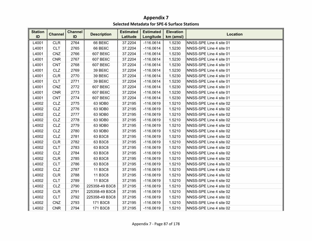
Appendix 7Selected Metadata for SPE‐6 Surface Stations
Station ID
ChannelChannel
IDDescription
Estimated Latitude
Estimated Longitude
Elevationkm (amsl)
Location
L4001 CLR 2764 66 BE6C 37.2204 -116.0614 1.5230 NNSS-SPE Line 4 site 01
L4001 CLT 2765 66 BE6C 37.2204 -116.0614 1.5230 NNSS-SPE Line 4 site 01
L4001 CNZ 2766 607 BE6C 37.2204 -116.0614 1.5230 NNSS-SPE Line 4 site 01
L4001 CNR 2767 607 BE6C 37.2204 -116.0614 1.5230 NNSS-SPE Line 4 site 01
L4001 CNT 2768 607 BE6C 37.2204 -116.0614 1.5230 NNSS-SPE Line 4 site 01
L4001 CLZ 2769 39 BE6C 37.2204 -116.0614 1.5230 NNSS-SPE Line 4 site 01
L4001 CLR 2770 39 BE6C 37.2204 -116.0614 1.5230 NNSS-SPE Line 4 site 01
L4001 CLT 2771 39 BE6C 37.2204 -116.0614 1.5230 NNSS-SPE Line 4 site 01
L4001 CNZ 2772 607 BE6C 37.2204 -116.0614 1.5230 NNSS-SPE Line 4 site 01
L4001 CNR 2773 607 BE6C 37.2204 -116.0614 1.5230 NNSS-SPE Line 4 site 01
L4001 CNT 2774 607 BE6C 37.2204 -116.0614 1.5230 NNSS-SPE Line 4 site 01
L4002 CLZ 2775 63 9DB0 37.2195 -116.0619 1.5210 NNSS-SPE Line 4 site 02
L4002 CLZ 2776 63 9DB0 37.2195 -116.0619 1.5210 NNSS-SPE Line 4 site 02
L4002 CLZ 2777 63 9DB0 37.2195 -116.0619 1.5210 NNSS-SPE Line 4 site 02
L4002 CLZ 2778 63 9DB0 37.2195 -116.0619 1.5210 NNSS-SPE Line 4 site 02
L4002 CLZ 2779 63 9DB0 37.2195 -116.0619 1.5210 NNSS-SPE Line 4 site 02
L4002 CLZ 2780 63 9DB0 37.2195 -116.0619 1.5210 NNSS-SPE Line 4 site 02
L4002 CLZ 2781 63 B3C8 37.2195 -116.0619 1.5210 NNSS-SPE Line 4 site 02
L4002 CLR 2782 63 B3C8 37.2195 -116.0619 1.5210 NNSS-SPE Line 4 site 02
L4002 CLT 2783 63 B3C8 37.2195 -116.0619 1.5210 NNSS-SPE Line 4 site 02
L4002 CLZ 2784 63 B3C8 37.2195 -116.0619 1.5210 NNSS-SPE Line 4 site 02
L4002 CLR 2785 63 B3C8 37.2195 -116.0619 1.5210 NNSS-SPE Line 4 site 02
L4002 CLT 2786 63 B3C8 37.2195 -116.0619 1.5210 NNSS-SPE Line 4 site 02
L4002 CLZ 2787 11 B3C8 37.2195 -116.0619 1.5210 NNSS-SPE Line 4 site 02
L4002 CLR 2788 11 B3C8 37.2195 -116.0619 1.5210 NNSS-SPE Line 4 site 02
L4002 CLT 2789 11 B3C8 37.2195 -116.0619 1.5210 NNSS-SPE Line 4 site 02
L4002 CLZ 2790 225358-49 B3C8 37.2195 -116.0619 1.5210 NNSS-SPE Line 4 site 02
L4002 CLR 2791 225358-49 B3C8 37.2195 -116.0619 1.5210 NNSS-SPE Line 4 site 02
L4002 CLT 2792 225358-49 B3C8 37.2195 -116.0619 1.5210 NNSS-SPE Line 4 site 02
L4002 CNZ 2793 171 B3C8 37.2195 -116.0619 1.5210 NNSS-SPE Line 4 site 02
L4002 CNR 2794 171 B3C8 37.2195 -116.0619 1.5210 NNSS-SPE Line 4 site 02
Appendix 7 ‐ Page 87 of 178
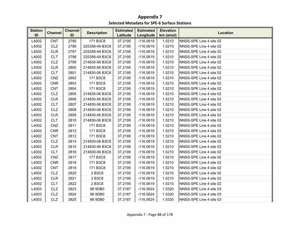
Appendix 7Selected Metadata for SPE‐6 Surface Stations
Station ID
ChannelChannel
IDDescription
Estimated Latitude
Estimated Longitude
Elevationkm (amsl)
Location
L4002 CNT 2795 171 B3C8 37.2195 -116.0619 1.5210 NNSS-SPE Line 4 site 02
L4002 CLZ 2796 225358-49 B3C8 37.2195 -116.0619 1.5210 NNSS-SPE Line 4 site 02
L4002 CLR 2797 225358-49 B3C8 37.2195 -116.0619 1.5210 NNSS-SPE Line 4 site 02
L4002 CLT 2798 225358-49 B3C8 37.2195 -116.0619 1.5210 NNSS-SPE Line 4 site 02
L4002 CLZ 2799 214830-06 B3C8 37.2195 -116.0619 1.5210 NNSS-SPE Line 4 site 02
L4002 CLR 2800 214830-06 B3C8 37.2195 -116.0619 1.5210 NNSS-SPE Line 4 site 02
L4002 CLT 2801 214830-06 B3C8 37.2195 -116.0619 1.5210 NNSS-SPE Line 4 site 02
L4002 CNZ 2802 171 B3C8 37.2195 -116.0619 1.5210 NNSS-SPE Line 4 site 02
L4002 CNR 2803 171 B3C8 37.2195 -116.0619 1.5210 NNSS-SPE Line 4 site 02
L4002 CNT 2804 171 B3C8 37.2195 -116.0619 1.5210 NNSS-SPE Line 4 site 02
L4002 CLZ 2805 214830-06 B3C8 37.2195 -116.0619 1.5210 NNSS-SPE Line 4 site 02
L4002 CLR 2806 214830-06 B3C8 37.2195 -116.0619 1.5210 NNSS-SPE Line 4 site 02
L4002 CLT 2807 214830-06 B3C8 37.2195 -116.0619 1.5210 NNSS-SPE Line 4 site 02
L4002 CLZ 2808 214830-06 B3C8 37.2195 -116.0619 1.5210 NNSS-SPE Line 4 site 02
L4002 CLR 2809 214830-06 B3C8 37.2195 -116.0619 1.5210 NNSS-SPE Line 4 site 02
L4002 CLT 2810 214830-06 B3C8 37.2195 -116.0619 1.5210 NNSS-SPE Line 4 site 02
L4002 CNZ 2811 171 B3C8 37.2195 -116.0619 1.5210 NNSS-SPE Line 4 site 02
L4002 CNR 2812 171 B3C8 37.2195 -116.0619 1.5210 NNSS-SPE Line 4 site 02
L4002 CNT 2813 171 B3C8 37.2195 -116.0619 1.5210 NNSS-SPE Line 4 site 02
L4002 CLZ 2814 214830-06 B3C8 37.2195 -116.0619 1.5210 NNSS-SPE Line 4 site 02
L4002 CLR 2815 214830-06 B3C8 37.2195 -116.0619 1.5210 NNSS-SPE Line 4 site 02
L4002 CLT 2816 214830-06 B3C8 37.2195 -116.0619 1.5210 NNSS-SPE Line 4 site 02
L4002 CNZ 2817 171 B3C8 37.2195 -116.0619 1.5210 NNSS-SPE Line 4 site 02
L4002 CNR 2818 171 B3C8 37.2195 -116.0619 1.5210 NNSS-SPE Line 4 site 02
L4002 CNT 2819 171 B3C8 37.2195 -116.0619 1.5210 NNSS-SPE Line 4 site 02
L4002 CLZ 2820 2 B3C8 37.2195 -116.0619 1.5210 NNSS-SPE Line 4 site 02
L4002 CLR 2821 2 B3C8 37.2195 -116.0619 1.5210 NNSS-SPE Line 4 site 02
L4002 CLT 2822 2 B3C8 37.2195 -116.0619 1.5210 NNSS-SPE Line 4 site 02
L4003 CLZ 2823 98 9DB0 37.2187 -116.0624 1.5320 NNSS-SPE Line 4 site 03
L4003 CLZ 2824 98 9DB0 37.2187 -116.0624 1.5320 NNSS-SPE Line 4 site 03
L4003 CLZ 2825 98 9DB0 37.2187 -116.0624 1.5320 NNSS-SPE Line 4 site 03
Appendix 7 ‐ Page 88 of 178

Appendix 7Selected Metadata for SPE‐6 Surface Stations
Station ID
ChannelChannel
IDDescription
Estimated Latitude
Estimated Longitude
Elevationkm (amsl)
Location
L4003 CLZ 2826 98 9DB0 37.2187 -116.0624 1.5320 NNSS-SPE Line 4 site 03
L4003 CLZ 2827 98 9DB0 37.2187 -116.0624 1.5320 NNSS-SPE Line 4 site 03
L4003 CLZ 2828 98 9DB0 37.2187 -116.0624 1.5320 NNSS-SPE Line 4 site 03
L4003 CLZ 2829 98 9DB0 37.2187 -116.0624 1.5320 NNSS-SPE Line 4 site 03
L4003 CLR 2830 98 9DB0 37.2187 -116.0624 1.5320 NNSS-SPE Line 4 site 03
L4003 CLT 2831 98 9DB0 37.2187 -116.0624 1.5320 NNSS-SPE Line 4 site 03
L4003 CLZ 2832 98 9DB0 37.2187 -116.0624 1.5320 NNSS-SPE Line 4 site 03
L4003 CLR 2833 98 9DB0 37.2187 -116.0624 1.5320 NNSS-SPE Line 4 site 03
L4003 CLT 2834 98 9DB0 37.2187 -116.0624 1.5320 NNSS-SPE Line 4 site 03
L4003 CLZ 2835 98 9498 37.2187 -116.0624 1.5320 NNSS-SPE Line 4 site 03
L4003 CLR 2836 98 9498 37.2187 -116.0624 1.5320 NNSS-SPE Line 4 site 03
L4003 CLT 2837 98 9498 37.2187 -116.0624 1.5320 NNSS-SPE Line 4 site 03
L4003 CLZ 2838 98 9498 37.2187 -116.0624 1.5320 NNSS-SPE Line 4 site 03
L4003 CLR 2839 98 9498 37.2187 -116.0624 1.5320 NNSS-SPE Line 4 site 03
L4003 CLT 2840 98 9498 37.2187 -116.0624 1.5320 NNSS-SPE Line 4 site 03
L4003 CLZ 2841 84 D147 37.2187 -116.0624 1.5320 NNSS-SPE Line 4 site 03
L4003 CLR 2842 84 D147 37.2187 -116.0624 1.5320 NNSS-SPE Line 4 site 03
L4003 CLT 2843 84 D147 37.2187 -116.0624 1.5320 NNSS-SPE Line 4 site 03
L4003 CNZ 2844 169 D147 37.2187 -116.0624 1.5320 NNSS-SPE Line 4 site 03
L4003 CNR 2845 169 D147 37.2187 -116.0624 1.5320 NNSS-SPE Line 4 site 03
L4003 CNT 2846 169 D147 37.2187 -116.0624 1.5320 NNSS-SPE Line 4 site 03
L4003 CLZ 2847 17 D147 37.2187 -116.0624 1.5320 NNSS-SPE Line 4 site 03
L4003 CLR 2848 17 D147 37.2187 -116.0624 1.5320 NNSS-SPE Line 4 site 03
L4003 CLT 2849 17 D147 37.2187 -116.0624 1.5320 NNSS-SPE Line 4 site 03
L4003 CLZ 2850 214830-03 D147 37.2187 -116.0624 1.5320 NNSS-SPE Line 4 site 03
L4003 CLR 2851 214830-03 D147 37.2187 -116.0624 1.5320 NNSS-SPE Line 4 site 03
L4003 CLT 2852 214830-03 D147 37.2187 -116.0624 1.5320 NNSS-SPE Line 4 site 03
L4003 CLZ 2853 214830-03 D147 37.2187 -116.0624 1.5320 NNSS-SPE Line 4 site 03
L4003 CLR 2854 214830-03 D147 37.2187 -116.0624 1.5320 NNSS-SPE Line 4 site 03
L4003 CLT 2855 214830-03 D147 37.2187 -116.0624 1.5320 NNSS-SPE Line 4 site 03
L4003 CLZ 2856 214830-03 D147 37.2187 -116.0624 1.5320 NNSS-SPE Line 4 site 03
Appendix 7 ‐ Page 89 of 178

Appendix 7Selected Metadata for SPE‐6 Surface Stations
Station ID
ChannelChannel
IDDescription
Estimated Latitude
Estimated Longitude
Elevationkm (amsl)
Location
L4003 CLR 2857 214830-03 D147 37.2187 -116.0624 1.5320 NNSS-SPE Line 4 site 03
L4003 CLT 2858 214830-03 D147 37.2187 -116.0624 1.5320 NNSS-SPE Line 4 site 03
L4003 CNZ 2859 169 D147 37.2187 -116.0624 1.5320 NNSS-SPE Line 4 site 03
L4003 CNR 2860 169 D147 37.2187 -116.0624 1.5320 NNSS-SPE Line 4 site 03
L4003 CNT 2861 169 D147 37.2187 -116.0624 1.5320 NNSS-SPE Line 4 site 03
L4003 CLZ 2862 105 D147 37.2187 -116.0624 1.5320 NNSS-SPE Line 4 site 03
L4003 CLR 2863 105 D147 37.2187 -116.0624 1.5320 NNSS-SPE Line 4 site 03
L4003 CLT 2864 105 D147 37.2187 -116.0624 1.5320 NNSS-SPE Line 4 site 03
L4003 CNZ 2865 169 D147 37.2187 -116.0624 1.5320 NNSS-SPE Line 4 site 03
L4003 CNR 2866 169 D147 37.2187 -116.0624 1.5320 NNSS-SPE Line 4 site 03
L4003 CNT 2867 169 D147 37.2187 -116.0624 1.5320 NNSS-SPE Line 4 site 03
L4004 CLZ 2868 96 9DB0 37.2179 -116.0629 1.5230 NNSS-SPE Line 4 site 04
L4004 CLR 2869 96 9DB0 37.2179 -116.0629 1.5230 NNSS-SPE Line 4 site 04
L4004 CLT 2870 96 9DB0 37.2179 -116.0629 1.5230 NNSS-SPE Line 4 site 04
L4004 CLZ 2871 96 9DB0 37.2179 -116.0629 1.5230 NNSS-SPE Line 4 site 04
L4004 CLR 2872 96 9DB0 37.2179 -116.0629 1.5230 NNSS-SPE Line 4 site 04
L4004 CLT 2873 96 9DB0 37.2179 -116.0629 1.5230 NNSS-SPE Line 4 site 04
L4004 CLZ 2874 96 9DB0 37.2179 -116.0629 1.5230 NNSS-SPE Line 4 site 04
L4004 CLR 2875 96 9DB0 37.2179 -116.0629 1.5230 NNSS-SPE Line 4 site 04
L4004 CLT 2876 96 9DB0 37.2179 -116.0629 1.5230 NNSS-SPE Line 4 site 04
L4004 CLZ 2877 96 9DB0 37.2179 -116.0629 1.5230 NNSS-SPE Line 4 site 04
L4004 CLR 2878 96 9DB0 37.2179 -116.0629 1.5230 NNSS-SPE Line 4 site 04
L4004 CLT 2879 96 9DB0 37.2179 -116.0629 1.5230 NNSS-SPE Line 4 site 04
L4004 CLZ 2880 96 9DB0 37.2179 -116.0629 1.5230 NNSS-SPE Line 4 site 04
L4004 CLR 2881 96 9DB0 37.2179 -116.0629 1.5230 NNSS-SPE Line 4 site 04
L4004 CLT 2882 96 9DB0 37.2179 -116.0629 1.5230 NNSS-SPE Line 4 site 04
L4004 CLZ 2883 96 9DB0 37.2179 -116.0629 1.5230 NNSS-SPE Line 4 site 04
L4004 CLR 2884 96 9DB0 37.2179 -116.0629 1.5230 NNSS-SPE Line 4 site 04
L4004 CLT 2885 96 9DB0 37.2179 -116.0629 1.5230 NNSS-SPE Line 4 site 04
L4004 CLZ 2886 96 9DB0 37.2179 -116.0629 1.5230 NNSS-SPE Line 4 site 04
L4004 CLR 2887 96 9DB0 37.2179 -116.0629 1.5230 NNSS-SPE Line 4 site 04
Appendix 7 ‐ Page 90 of 178
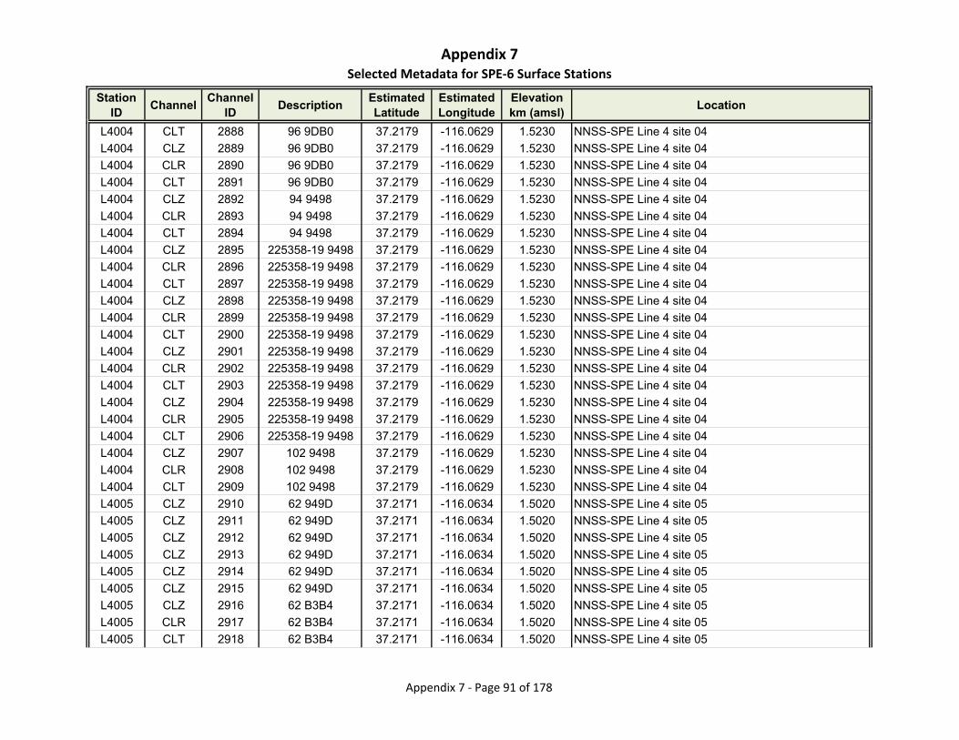
Appendix 7Selected Metadata for SPE‐6 Surface Stations
Station ID
ChannelChannel
IDDescription
Estimated Latitude
Estimated Longitude
Elevationkm (amsl)
Location
L4004 CLT 2888 96 9DB0 37.2179 -116.0629 1.5230 NNSS-SPE Line 4 site 04
L4004 CLZ 2889 96 9DB0 37.2179 -116.0629 1.5230 NNSS-SPE Line 4 site 04
L4004 CLR 2890 96 9DB0 37.2179 -116.0629 1.5230 NNSS-SPE Line 4 site 04
L4004 CLT 2891 96 9DB0 37.2179 -116.0629 1.5230 NNSS-SPE Line 4 site 04
L4004 CLZ 2892 94 9498 37.2179 -116.0629 1.5230 NNSS-SPE Line 4 site 04
L4004 CLR 2893 94 9498 37.2179 -116.0629 1.5230 NNSS-SPE Line 4 site 04
L4004 CLT 2894 94 9498 37.2179 -116.0629 1.5230 NNSS-SPE Line 4 site 04
L4004 CLZ 2895 225358-19 9498 37.2179 -116.0629 1.5230 NNSS-SPE Line 4 site 04
L4004 CLR 2896 225358-19 9498 37.2179 -116.0629 1.5230 NNSS-SPE Line 4 site 04
L4004 CLT 2897 225358-19 9498 37.2179 -116.0629 1.5230 NNSS-SPE Line 4 site 04
L4004 CLZ 2898 225358-19 9498 37.2179 -116.0629 1.5230 NNSS-SPE Line 4 site 04
L4004 CLR 2899 225358-19 9498 37.2179 -116.0629 1.5230 NNSS-SPE Line 4 site 04
L4004 CLT 2900 225358-19 9498 37.2179 -116.0629 1.5230 NNSS-SPE Line 4 site 04
L4004 CLZ 2901 225358-19 9498 37.2179 -116.0629 1.5230 NNSS-SPE Line 4 site 04
L4004 CLR 2902 225358-19 9498 37.2179 -116.0629 1.5230 NNSS-SPE Line 4 site 04
L4004 CLT 2903 225358-19 9498 37.2179 -116.0629 1.5230 NNSS-SPE Line 4 site 04
L4004 CLZ 2904 225358-19 9498 37.2179 -116.0629 1.5230 NNSS-SPE Line 4 site 04
L4004 CLR 2905 225358-19 9498 37.2179 -116.0629 1.5230 NNSS-SPE Line 4 site 04
L4004 CLT 2906 225358-19 9498 37.2179 -116.0629 1.5230 NNSS-SPE Line 4 site 04
L4004 CLZ 2907 102 9498 37.2179 -116.0629 1.5230 NNSS-SPE Line 4 site 04
L4004 CLR 2908 102 9498 37.2179 -116.0629 1.5230 NNSS-SPE Line 4 site 04
L4004 CLT 2909 102 9498 37.2179 -116.0629 1.5230 NNSS-SPE Line 4 site 04
L4005 CLZ 2910 62 949D 37.2171 -116.0634 1.5020 NNSS-SPE Line 4 site 05
L4005 CLZ 2911 62 949D 37.2171 -116.0634 1.5020 NNSS-SPE Line 4 site 05
L4005 CLZ 2912 62 949D 37.2171 -116.0634 1.5020 NNSS-SPE Line 4 site 05
L4005 CLZ 2913 62 949D 37.2171 -116.0634 1.5020 NNSS-SPE Line 4 site 05
L4005 CLZ 2914 62 949D 37.2171 -116.0634 1.5020 NNSS-SPE Line 4 site 05
L4005 CLZ 2915 62 949D 37.2171 -116.0634 1.5020 NNSS-SPE Line 4 site 05
L4005 CLZ 2916 62 B3B4 37.2171 -116.0634 1.5020 NNSS-SPE Line 4 site 05
L4005 CLR 2917 62 B3B4 37.2171 -116.0634 1.5020 NNSS-SPE Line 4 site 05
L4005 CLT 2918 62 B3B4 37.2171 -116.0634 1.5020 NNSS-SPE Line 4 site 05
Appendix 7 ‐ Page 91 of 178
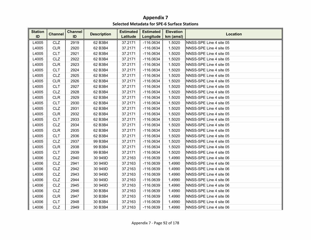
Appendix 7Selected Metadata for SPE‐6 Surface Stations
Station ID
ChannelChannel
IDDescription
Estimated Latitude
Estimated Longitude
Elevationkm (amsl)
Location
L4005 CLZ 2919 62 B3B4 37.2171 -116.0634 1.5020 NNSS-SPE Line 4 site 05
L4005 CLR 2920 62 B3B4 37.2171 -116.0634 1.5020 NNSS-SPE Line 4 site 05
L4005 CLT 2921 62 B3B4 37.2171 -116.0634 1.5020 NNSS-SPE Line 4 site 05
L4005 CLZ 2922 62 B3B4 37.2171 -116.0634 1.5020 NNSS-SPE Line 4 site 05
L4005 CLR 2923 62 B3B4 37.2171 -116.0634 1.5020 NNSS-SPE Line 4 site 05
L4005 CLT 2924 62 B3B4 37.2171 -116.0634 1.5020 NNSS-SPE Line 4 site 05
L4005 CLZ 2925 62 B3B4 37.2171 -116.0634 1.5020 NNSS-SPE Line 4 site 05
L4005 CLR 2926 62 B3B4 37.2171 -116.0634 1.5020 NNSS-SPE Line 4 site 05
L4005 CLT 2927 62 B3B4 37.2171 -116.0634 1.5020 NNSS-SPE Line 4 site 05
L4005 CLZ 2928 62 B3B4 37.2171 -116.0634 1.5020 NNSS-SPE Line 4 site 05
L4005 CLR 2929 62 B3B4 37.2171 -116.0634 1.5020 NNSS-SPE Line 4 site 05
L4005 CLT 2930 62 B3B4 37.2171 -116.0634 1.5020 NNSS-SPE Line 4 site 05
L4005 CLZ 2931 62 B3B4 37.2171 -116.0634 1.5020 NNSS-SPE Line 4 site 05
L4005 CLR 2932 62 B3B4 37.2171 -116.0634 1.5020 NNSS-SPE Line 4 site 05
L4005 CLT 2933 62 B3B4 37.2171 -116.0634 1.5020 NNSS-SPE Line 4 site 05
L4005 CLZ 2934 62 B3B4 37.2171 -116.0634 1.5020 NNSS-SPE Line 4 site 05
L4005 CLR 2935 62 B3B4 37.2171 -116.0634 1.5020 NNSS-SPE Line 4 site 05
L4005 CLT 2936 62 B3B4 37.2171 -116.0634 1.5020 NNSS-SPE Line 4 site 05
L4005 CLZ 2937 99 B3B4 37.2171 -116.0634 1.5020 NNSS-SPE Line 4 site 05
L4005 CLR 2938 99 B3B4 37.2171 -116.0634 1.5020 NNSS-SPE Line 4 site 05
L4005 CLT 2939 99 B3B4 37.2171 -116.0634 1.5020 NNSS-SPE Line 4 site 05
L4006 CLZ 2940 30 949D 37.2163 -116.0639 1.4990 NNSS-SPE Line 4 site 06
L4006 CLZ 2941 30 949D 37.2163 -116.0639 1.4990 NNSS-SPE Line 4 site 06
L4006 CLZ 2942 30 949D 37.2163 -116.0639 1.4990 NNSS-SPE Line 4 site 06
L4006 CLZ 2943 30 949D 37.2163 -116.0639 1.4990 NNSS-SPE Line 4 site 06
L4006 CLZ 2944 30 949D 37.2163 -116.0639 1.4990 NNSS-SPE Line 4 site 06
L4006 CLZ 2945 30 949D 37.2163 -116.0639 1.4990 NNSS-SPE Line 4 site 06
L4006 CLZ 2946 30 B3B4 37.2163 -116.0639 1.4990 NNSS-SPE Line 4 site 06
L4006 CLR 2947 30 B3B4 37.2163 -116.0639 1.4990 NNSS-SPE Line 4 site 06
L4006 CLT 2948 30 B3B4 37.2163 -116.0639 1.4990 NNSS-SPE Line 4 site 06
L4006 CLZ 2949 30 B3B4 37.2163 -116.0639 1.4990 NNSS-SPE Line 4 site 06
Appendix 7 ‐ Page 92 of 178
Appendix 7Selected Metadata for SPE‐6 Surface Stations
Station ID
ChannelChannel
IDDescription
Estimated Latitude
Estimated Longitude
Elevationkm (amsl)
Location
L4006 CLR 2950 30 B3B4 37.2163 -116.0639 1.4990 NNSS-SPE Line 4 site 06
L4006 CLT 2951 30 B3B4 37.2163 -116.0639 1.4990 NNSS-SPE Line 4 site 06
L4006 CLZ 2952 62 B3B4 37.2163 -116.0639 1.4990 NNSS-SPE Line 4 site 06
L4006 CLR 2953 62 B3B4 37.2163 -116.0639 1.4990 NNSS-SPE Line 4 site 06
L4006 CLT 2954 62 B3B4 37.2163 -116.0639 1.4990 NNSS-SPE Line 4 site 06
L4006 CLZ 2955 62 B3B4 37.2163 -116.0639 1.4990 NNSS-SPE Line 4 site 06
L4006 CLR 2956 62 B3B4 37.2163 -116.0639 1.4990 NNSS-SPE Line 4 site 06
L4006 CLT 2957 62 B3B4 37.2163 -116.0639 1.4990 NNSS-SPE Line 4 site 06
L4006 CLZ 2958 180063-02 B3B4 37.2163 -116.0639 1.4990 NNSS-SPE Line 4 site 06
L4006 CLR 2959 180063-02 B3B4 37.2163 -116.0639 1.4990 NNSS-SPE Line 4 site 06
L4006 CLT 2960 180063-02 B3B4 37.2163 -116.0639 1.4990 NNSS-SPE Line 4 site 06
L4006 CLZ 2961 180063-02 B3B4 37.2163 -116.0639 1.4990 NNSS-SPE Line 4 site 06
L4006 CLR 2962 180063-02 B3B4 37.2163 -116.0639 1.4990 NNSS-SPE Line 4 site 06
L4006 CLT 2963 180063-02 B3B4 37.2163 -116.0639 1.4990 NNSS-SPE Line 4 site 06
L4006 CLZ 2964 180063-02 B3B4 37.2163 -116.0639 1.4990 NNSS-SPE Line 4 site 06
L4006 CLR 2965 180063-02 B3B4 37.2163 -116.0639 1.4990 NNSS-SPE Line 4 site 06
L4006 CLT 2966 180063-02 B3B4 37.2163 -116.0639 1.4990 NNSS-SPE Line 4 site 06
L4006 CLZ 2967 41 B3B4 37.2163 -116.0639 1.4990 NNSS-SPE Line 4 site 06
L4006 CLR 2968 41 B3B4 37.2163 -116.0639 1.4990 NNSS-SPE Line 4 site 06
L4006 CLT 2969 41 B3B4 37.2163 -116.0639 1.4990 NNSS-SPE Line 4 site 06
L4007 CLZ 2970 28 949D 37.2155 -116.0643 1.5130 NNSS-SPE Line 4 site 07
L4007 CLZ 2971 28 949D 37.2155 -116.0643 1.5130 NNSS-SPE Line 4 site 07
L4007 CLZ 2972 28 949D 37.2155 -116.0643 1.5130 NNSS-SPE Line 4 site 07
L4007 CLZ 2973 28 949D 37.2155 -116.0643 1.5130 NNSS-SPE Line 4 site 07
L4007 CLZ 2974 28 949D 37.2155 -116.0643 1.5130 NNSS-SPE Line 4 site 07
L4007 CLZ 2975 28 949D 37.2155 -116.0643 1.5130 NNSS-SPE Line 4 site 07
L4007 CLZ 2976 91 949D 37.2155 -116.0643 1.5130 NNSS-SPE Line 4 site 07
L4007 CLR 2977 91 949D 37.2155 -116.0643 1.5130 NNSS-SPE Line 4 site 07
L4007 CLT 2978 91 949D 37.2155 -116.0643 1.5130 NNSS-SPE Line 4 site 07
L4007 CLZ 2979 91 949D 37.2155 -116.0643 1.5130 NNSS-SPE Line 4 site 07
L4007 CLR 2980 91 949D 37.2155 -116.0643 1.5130 NNSS-SPE Line 4 site 07
Appendix 7 ‐ Page 93 of 178
Appendix 7Selected Metadata for SPE‐6 Surface Stations
Station ID
ChannelChannel
IDDescription
Estimated Latitude
Estimated Longitude
Elevationkm (amsl)
Location
L4007 CLT 2981 91 949D 37.2155 -116.0643 1.5130 NNSS-SPE Line 4 site 07
L4007 CLZ 2982 91 949D 37.2155 -116.0643 1.5130 NNSS-SPE Line 4 site 07
L4007 CLR 2983 91 949D 37.2155 -116.0643 1.5130 NNSS-SPE Line 4 site 07
L4007 CLT 2984 91 949D 37.2155 -116.0643 1.5130 NNSS-SPE Line 4 site 07
L4007 CLZ 2985 214830-14 949D 37.2155 -116.0643 1.5130 NNSS-SPE Line 4 site 07
L4007 CLR 2986 214830-14 949D 37.2155 -116.0643 1.5130 NNSS-SPE Line 4 site 07
L4007 CLT 2987 214830-14 949D 37.2155 -116.0643 1.5130 NNSS-SPE Line 4 site 07
L4007 CLZ 2988 225358-08 D19B 37.2155 -116.0643 1.5130 NNSS-SPE Line 4 site 07
L4007 CLR 2989 225358-08 D19B 37.2155 -116.0643 1.5130 NNSS-SPE Line 4 site 07
L4007 CLT 2990 225358-08 D19B 37.2155 -116.0643 1.5130 NNSS-SPE Line 4 site 07
L4007 CLZ 2991 225358-08 D19B 37.2155 -116.0643 1.5130 NNSS-SPE Line 4 site 07
L4007 CLR 2992 225358-08 D19B 37.2155 -116.0643 1.5130 NNSS-SPE Line 4 site 07
L4007 CLT 2993 225358-08 D19B 37.2155 -116.0643 1.5130 NNSS-SPE Line 4 site 07
L4007 CLZ 2994 225358-08 D19B 37.2155 -116.0643 1.5130 NNSS-SPE Line 4 site 07
L4007 CLR 2995 225358-08 D19B 37.2155 -116.0643 1.5130 NNSS-SPE Line 4 site 07
L4007 CLT 2996 225358-08 D19B 37.2155 -116.0643 1.5130 NNSS-SPE Line 4 site 07
L4007 CLZ 2997 225358-08 D19B 37.2155 -116.0643 1.5130 NNSS-SPE Line 4 site 07
L4007 CLR 2998 225358-08 D19B 37.2155 -116.0643 1.5130 NNSS-SPE Line 4 site 07
L4007 CLT 2999 225358-08 D19B 37.2155 -116.0643 1.5130 NNSS-SPE Line 4 site 07
L4007 CLZ 3000 20 D164 37.2155 -116.0643 1.5130 NNSS-SPE Line 4 site 07
L4007 CLR 3001 20 D164 37.2155 -116.0643 1.5130 NNSS-SPE Line 4 site 07
L4007 CLT 3002 20 D164 37.2155 -116.0643 1.5130 NNSS-SPE Line 4 site 07
L4008 CLZ 3003 103 949D 37.2147 -116.0648 1.5050 NNSS-SPE Line 4 site 08
L4008 CLR 3004 103 949D 37.2147 -116.0648 1.5050 NNSS-SPE Line 4 site 08
L4008 CLT 3005 103 949D 37.2147 -116.0648 1.5050 NNSS-SPE Line 4 site 08
L4008 CLZ 3006 103 949D 37.2147 -116.0648 1.5050 NNSS-SPE Line 4 site 08
L4008 CLR 3007 103 949D 37.2147 -116.0648 1.5050 NNSS-SPE Line 4 site 08
L4008 CLT 3008 103 949D 37.2147 -116.0648 1.5050 NNSS-SPE Line 4 site 08
L4008 CLZ 3009 103 949D 37.2147 -116.0648 1.5050 NNSS-SPE Line 4 site 08
L4008 CLR 3010 103 949D 37.2147 -116.0648 1.5050 NNSS-SPE Line 4 site 08
L4008 CLT 3011 103 949D 37.2147 -116.0648 1.5050 NNSS-SPE Line 4 site 08
Appendix 7 ‐ Page 94 of 178
Appendix 7Selected Metadata for SPE‐6 Surface Stations
Station ID
ChannelChannel
IDDescription
Estimated Latitude
Estimated Longitude
Elevationkm (amsl)
Location
L4008 CLZ 3012 103 949D 37.2147 -116.0648 1.5050 NNSS-SPE Line 4 site 08
L4008 CLR 3013 103 949D 37.2147 -116.0648 1.5050 NNSS-SPE Line 4 site 08
L4008 CLT 3014 103 949D 37.2147 -116.0648 1.5050 NNSS-SPE Line 4 site 08
L4008 CLZ 3015 103 949D 37.2147 -116.0648 1.5050 NNSS-SPE Line 4 site 08
L4008 CLR 3016 103 949D 37.2147 -116.0648 1.5050 NNSS-SPE Line 4 site 08
L4008 CLT 3017 103 949D 37.2147 -116.0648 1.5050 NNSS-SPE Line 4 site 08
L4008 CLZ 3018 103 949D 37.2147 -116.0648 1.5050 NNSS-SPE Line 4 site 08
L4008 CLR 3019 103 949D 37.2147 -116.0648 1.5050 NNSS-SPE Line 4 site 08
L4008 CLT 3020 103 949D 37.2147 -116.0648 1.5050 NNSS-SPE Line 4 site 08
L4008 CLZ 3021 103 949D 37.2147 -116.0648 1.5050 NNSS-SPE Line 4 site 08
L4008 CLR 3022 103 949D 37.2147 -116.0648 1.5050 NNSS-SPE Line 4 site 08
L4008 CLT 3023 103 949D 37.2147 -116.0648 1.5050 NNSS-SPE Line 4 site 08
L4008 CLZ 3024 103 949D 37.2147 -116.0648 1.5050 NNSS-SPE Line 4 site 08
L4008 CLR 3025 103 949D 37.2147 -116.0648 1.5050 NNSS-SPE Line 4 site 08
L4008 CLT 3026 103 949D 37.2147 -116.0648 1.5050 NNSS-SPE Line 4 site 08
L4008 CLZ 3027 103 949D 37.2147 -116.0648 1.5050 NNSS-SPE Line 4 site 08
L4008 CLR 3028 103 949D 37.2147 -116.0648 1.5050 NNSS-SPE Line 4 site 08
L4008 CLT 3029 103 949D 37.2147 -116.0648 1.5050 NNSS-SPE Line 4 site 08
L4008 CLZ 3030 48 949D 37.2147 -116.0648 1.5050 NNSS-SPE Line 4 site 08
L4008 CLR 3031 48 949D 37.2147 -116.0648 1.5050 NNSS-SPE Line 4 site 08
L4008 CLT 3032 48 949D 37.2147 -116.0648 1.5050 NNSS-SPE Line 4 site 08
L4008 CLZ 3033 48 949D 37.2147 -116.0648 1.5050 NNSS-SPE Line 4 site 08
L4008 CLR 3034 48 949D 37.2147 -116.0648 1.5050 NNSS-SPE Line 4 site 08
L4008 CLT 3035 48 949D 37.2147 -116.0648 1.5050 NNSS-SPE Line 4 site 08
L4008 CLZ 3036 48 D19B 37.2147 -116.0648 1.5050 NNSS-SPE Line 4 site 08
L4008 CLR 3037 48 D19B 37.2147 -116.0648 1.5050 NNSS-SPE Line 4 site 08
L4008 CLT 3038 48 D19B 37.2147 -116.0648 1.5050 NNSS-SPE Line 4 site 08
L4008 CLZ 3039 48 D19B 37.2147 -116.0648 1.5050 NNSS-SPE Line 4 site 08
L4008 CLR 3040 48 D19B 37.2147 -116.0648 1.5050 NNSS-SPE Line 4 site 08
L4008 CLT 3041 48 D19B 37.2147 -116.0648 1.5050 NNSS-SPE Line 4 site 08
L4008 CLZ 3042 48 D19B 37.2147 -116.0648 1.5050 NNSS-SPE Line 4 site 08
Appendix 7 ‐ Page 95 of 178
Appendix 7Selected Metadata for SPE‐6 Surface Stations
Station ID
ChannelChannel
IDDescription
Estimated Latitude
Estimated Longitude
Elevationkm (amsl)
Location
L4008 CLR 3043 48 D19B 37.2147 -116.0648 1.5050 NNSS-SPE Line 4 site 08
L4008 CLT 3044 48 D19B 37.2147 -116.0648 1.5050 NNSS-SPE Line 4 site 08
L4008 CLZ 3045 48 D19B 37.2147 -116.0648 1.5050 NNSS-SPE Line 4 site 08
L4008 CLR 3046 48 D19B 37.2147 -116.0648 1.5050 NNSS-SPE Line 4 site 08
L4008 CLT 3047 48 D19B 37.2147 -116.0648 1.5050 NNSS-SPE Line 4 site 08
L4008 CLZ 3048 225358-22 D19B 37.2147 -116.0648 1.5050 NNSS-SPE Line 4 site 08
L4008 CLR 3049 225358-22 D19B 37.2147 -116.0648 1.5050 NNSS-SPE Line 4 site 08
L4008 CLT 3050 225358-22 D19B 37.2147 -116.0648 1.5050 NNSS-SPE Line 4 site 08
L4009 CLZ 3051 32 90B0 37.2139 -116.0653 1.5070 NNSS-SPE Line 4 site 09
L4009 CLZ 3052 32 9501 37.2139 -116.0653 1.5070 NNSS-SPE Line 4 site 09
L4009 CLZ 3053 32 982F 37.2139 -116.0653 1.5070 NNSS-SPE Line 4 site 09
L4009 CLZ 3054 32 B3AE 37.2139 -116.0653 1.5070 NNSS-SPE Line 4 site 09
L4009 CLZ 3055 32 B3AE 37.2139 -116.0653 1.5070 NNSS-SPE Line 4 site 09
L4009 CLZ 3056 32 B3AE 37.2139 -116.0653 1.5070 NNSS-SPE Line 4 site 09
L4009 CLZ 3057 32 B3AE 37.2139 -116.0653 1.5070 NNSS-SPE Line 4 site 09
L4009 CLZ 3058 32 B3AE 37.2139 -116.0653 1.5070 NNSS-SPE Line 4 site 09
L4009 CLZ 3059 32 B3B6 37.2139 -116.0653 1.5070 NNSS-SPE Line 4 site 09
L4009 CLR 3060 32 B3B6 37.2139 -116.0653 1.5070 NNSS-SPE Line 4 site 09
L4009 CLT 3061 32 B3B6 37.2139 -116.0653 1.5070 NNSS-SPE Line 4 site 09
L4009 CLZ 3062 32 B3B6 37.2139 -116.0653 1.5070 NNSS-SPE Line 4 site 09
L4009 CLR 3063 32 B3B6 37.2139 -116.0653 1.5070 NNSS-SPE Line 4 site 09
L4009 CLT 3064 32 B3B6 37.2139 -116.0653 1.5070 NNSS-SPE Line 4 site 09
L4009 CLZ 3065 32 B3B6 37.2139 -116.0653 1.5070 NNSS-SPE Line 4 site 09
L4009 CLR 3066 32 B3B6 37.2139 -116.0653 1.5070 NNSS-SPE Line 4 site 09
L4009 CLT 3067 32 B3B6 37.2139 -116.0653 1.5070 NNSS-SPE Line 4 site 09
L4009 CLZ 3068 32 B3B6 37.2139 -116.0653 1.5070 NNSS-SPE Line 4 site 09
L4009 CLR 3069 32 B3B6 37.2139 -116.0653 1.5070 NNSS-SPE Line 4 site 09
L4009 CLT 3070 32 B3B6 37.2139 -116.0653 1.5070 NNSS-SPE Line 4 site 09
L4009 CLZ 3071 225358-40 B3B6 37.2139 -116.0653 1.5070 NNSS-SPE Line 4 site 09
L4009 CLR 3072 225358-40 B3B6 37.2139 -116.0653 1.5070 NNSS-SPE Line 4 site 09
L4009 CLT 3073 225358-40 B3B6 37.2139 -116.0653 1.5070 NNSS-SPE Line 4 site 09
Appendix 7 ‐ Page 96 of 178
Appendix 7Selected Metadata for SPE‐6 Surface Stations
Station ID
ChannelChannel
IDDescription
Estimated Latitude
Estimated Longitude
Elevationkm (amsl)
Location
L4009 CLZ 3074 225358-40 B3B6 37.2139 -116.0653 1.5070 NNSS-SPE Line 4 site 09
L4009 CLR 3075 225358-40 B3B6 37.2139 -116.0653 1.5070 NNSS-SPE Line 4 site 09
L4009 CLT 3076 225358-40 B3B6 37.2139 -116.0653 1.5070 NNSS-SPE Line 4 site 09
L4009 CLZ 3077 225358-40 B3B6 37.2139 -116.0653 1.5070 NNSS-SPE Line 4 site 09
L4009 CLR 3078 225358-40 B3B6 37.2139 -116.0653 1.5070 NNSS-SPE Line 4 site 09
L4009 CLT 3079 225358-40 B3B6 37.2139 -116.0653 1.5070 NNSS-SPE Line 4 site 09
L4009 CLZ 3080 225358-40 B3B6 37.2139 -116.0653 1.5070 NNSS-SPE Line 4 site 09
L4009 CLR 3081 225358-40 B3B6 37.2139 -116.0653 1.5070 NNSS-SPE Line 4 site 09
L4009 CLT 3082 225358-40 B3B6 37.2139 -116.0653 1.5070 NNSS-SPE Line 4 site 09
L4009 CLZ 3083 27 D134 37.2139 -116.0653 1.5070 NNSS-SPE Line 4 site 09
L4009 CLR 3084 27 D134 37.2139 -116.0653 1.5070 NNSS-SPE Line 4 site 09
L4009 CLT 3085 27 D134 37.2139 -116.0653 1.5070 NNSS-SPE Line 4 site 09
L4010 CLZ 3086 75 90B0 37.2131 -116.0658 1.5040 NNSS-SPE Line 4 site 10
L4010 CLZ 3087 75 9501 37.2131 -116.0658 1.5040 NNSS-SPE Line 4 site 10
L4010 CLZ 3088 75 982F 37.2131 -116.0658 1.5040 NNSS-SPE Line 4 site 10
L4010 CLZ 3089 75 B3AE 37.2131 -116.0658 1.5040 NNSS-SPE Line 4 site 10
L4010 CLZ 3090 75 B3AE 37.2131 -116.0658 1.5040 NNSS-SPE Line 4 site 10
L4010 CLZ 3091 75 B3AE 37.2131 -116.0658 1.5040 NNSS-SPE Line 4 site 10
L4010 CLZ 3092 75 B3AE 37.2131 -116.0658 1.5040 NNSS-SPE Line 4 site 10
L4010 CLZ 3093 75 B3AE 37.2131 -116.0658 1.5040 NNSS-SPE Line 4 site 10
L4010 CLZ 3094 75 B3B6 37.2131 -116.0658 1.5040 NNSS-SPE Line 4 site 10
L4010 CLR 3095 75 B3B6 37.2131 -116.0658 1.5040 NNSS-SPE Line 4 site 10
L4010 CLT 3096 75 B3B6 37.2131 -116.0658 1.5040 NNSS-SPE Line 4 site 10
L4010 CLZ 3097 75 B3B6 37.2131 -116.0658 1.5040 NNSS-SPE Line 4 site 10
L4010 CLR 3098 75 B3B6 37.2131 -116.0658 1.5040 NNSS-SPE Line 4 site 10
L4010 CLT 3099 75 B3B6 37.2131 -116.0658 1.5040 NNSS-SPE Line 4 site 10
L4010 CLZ 3100 75 B3B6 37.2131 -116.0658 1.5040 NNSS-SPE Line 4 site 10
L4010 CLR 3101 75 B3B6 37.2131 -116.0658 1.5040 NNSS-SPE Line 4 site 10
L4010 CLT 3102 75 B3B6 37.2131 -116.0658 1.5040 NNSS-SPE Line 4 site 10
L4010 CLZ 3103 225358-05 B3B6 37.2131 -116.0658 1.5040 NNSS-SPE Line 4 site 10
L4010 CLR 3104 225358-05 B3B6 37.2131 -116.0658 1.5040 NNSS-SPE Line 4 site 10
Appendix 7 ‐ Page 97 of 178
Appendix 7Selected Metadata for SPE‐6 Surface Stations
Station ID
ChannelChannel
IDDescription
Estimated Latitude
Estimated Longitude
Elevationkm (amsl)
Location
L4010 CLT 3105 225358-05 B3B6 37.2131 -116.0658 1.5040 NNSS-SPE Line 4 site 10
L4010 CLZ 3106 225358-05 B3B6 37.2131 -116.0658 1.5040 NNSS-SPE Line 4 site 10
L4010 CLR 3107 225358-05 B3B6 37.2131 -116.0658 1.5040 NNSS-SPE Line 4 site 10
L4010 CLT 3108 225358-05 B3B6 37.2131 -116.0658 1.5040 NNSS-SPE Line 4 site 10
L4010 CLZ 3109 225358-05 B3B6 37.2131 -116.0658 1.5040 NNSS-SPE Line 4 site 10
L4010 CLR 3110 225358-05 B3B6 37.2131 -116.0658 1.5040 NNSS-SPE Line 4 site 10
L4010 CLT 3111 225358-05 B3B6 37.2131 -116.0658 1.5040 NNSS-SPE Line 4 site 10
L4010 CLZ 3112 225358-05 B3B6 37.2131 -116.0658 1.5040 NNSS-SPE Line 4 site 10
L4010 CLR 3113 225358-05 B3B6 37.2131 -116.0658 1.5040 NNSS-SPE Line 4 site 10
L4010 CLT 3114 225358-05 B3B6 37.2131 -116.0658 1.5040 NNSS-SPE Line 4 site 10
L4010 CLZ 3115 225358-32 B3B6 37.2131 -116.0658 1.5040 NNSS-SPE Line 4 site 10
L4010 CLR 3116 225358-32 B3B6 37.2131 -116.0658 1.5040 NNSS-SPE Line 4 site 10
L4010 CLT 3117 225358-32 B3B6 37.2131 -116.0658 1.5040 NNSS-SPE Line 4 site 10
L4011 CLZ 3118 97 90B0 37.2123 -116.0663 1.5080 NNSS-SPE Line 4 site 11
L4011 CLZ 3119 97 9501 37.2123 -116.0663 1.5080 NNSS-SPE Line 4 site 11
L4011 CLZ 3120 97 982F 37.2123 -116.0663 1.5080 NNSS-SPE Line 4 site 11
L4011 CLZ 3121 97 B3AE 37.2123 -116.0663 1.5080 NNSS-SPE Line 4 site 11
L4011 CLZ 3122 97 B3AE 37.2123 -116.0663 1.5080 NNSS-SPE Line 4 site 11
L4011 CLZ 3123 97 B3AE 37.2123 -116.0663 1.5080 NNSS-SPE Line 4 site 11
L4011 CLZ 3124 97 B3AE 37.2123 -116.0663 1.5080 NNSS-SPE Line 4 site 11
L4011 CLZ 3125 97 B3AE 37.2123 -116.0663 1.5080 NNSS-SPE Line 4 site 11
L4011 CLZ 3126 97 B3AE 37.2123 -116.0663 1.5080 NNSS-SPE Line 4 site 11
L4011 CLR 3127 97 B3AE 37.2123 -116.0663 1.5080 NNSS-SPE Line 4 site 11
L4011 CLT 3128 97 B3AE 37.2123 -116.0663 1.5080 NNSS-SPE Line 4 site 11
L4011 CLZ 3129 97 B3AE 37.2123 -116.0663 1.5080 NNSS-SPE Line 4 site 11
L4011 CLR 3130 97 B3AE 37.2123 -116.0663 1.5080 NNSS-SPE Line 4 site 11
L4011 CLT 3131 97 B3AE 37.2123 -116.0663 1.5080 NNSS-SPE Line 4 site 11
L4011 CLZ 3132 97 B3AE 37.2123 -116.0663 1.5080 NNSS-SPE Line 4 site 11
L4011 CLR 3133 97 B3AE 37.2123 -116.0663 1.5080 NNSS-SPE Line 4 site 11
L4011 CLT 3134 97 B3AE 37.2123 -116.0663 1.5080 NNSS-SPE Line 4 site 11
L4011 CLZ 3135 97 B3AE 37.2123 -116.0663 1.5080 NNSS-SPE Line 4 site 11
Appendix 7 ‐ Page 98 of 178
Appendix 7Selected Metadata for SPE‐6 Surface Stations
Station ID
ChannelChannel
IDDescription
Estimated Latitude
Estimated Longitude
Elevationkm (amsl)
Location
L4011 CLR 3136 97 B3AE 37.2123 -116.0663 1.5080 NNSS-SPE Line 4 site 11
L4011 CLT 3137 97 B3AE 37.2123 -116.0663 1.5080 NNSS-SPE Line 4 site 11
L4011 CLZ 3138 76 B3AE 37.2123 -116.0663 1.5080 NNSS-SPE Line 4 site 11
L4011 CLR 3139 76 B3AE 37.2123 -116.0663 1.5080 NNSS-SPE Line 4 site 11
L4011 CLT 3140 76 B3AE 37.2123 -116.0663 1.5080 NNSS-SPE Line 4 site 11
L4011 CLZ 3141 76 B3AE 37.2123 -116.0663 1.5080 NNSS-SPE Line 4 site 11
L4011 CLR 3142 76 B3AE 37.2123 -116.0663 1.5080 NNSS-SPE Line 4 site 11
L4011 CLT 3143 76 B3AE 37.2123 -116.0663 1.5080 NNSS-SPE Line 4 site 11
L4011 CLZ 3144 76 B3AE 37.2123 -116.0663 1.5080 NNSS-SPE Line 4 site 11
L4011 CLR 3145 76 B3AE 37.2123 -116.0663 1.5080 NNSS-SPE Line 4 site 11
L4011 CLT 3146 76 B3AE 37.2123 -116.0663 1.5080 NNSS-SPE Line 4 site 11
L4011 CLZ 3147 76 B3AE 37.2123 -116.0663 1.5080 NNSS-SPE Line 4 site 11
L4011 CLR 3148 76 B3AE 37.2123 -116.0663 1.5080 NNSS-SPE Line 4 site 11
L4011 CLT 3149 76 B3AE 37.2123 -116.0663 1.5080 NNSS-SPE Line 4 site 11
L4011 CLZ 3150 31 D13F 37.2123 -116.0663 1.5080 NNSS-SPE Line 4 site 11
L4011 CLR 3151 31 D13F 37.2123 -116.0663 1.5080 NNSS-SPE Line 4 site 11
L4011 CLT 3152 31 D13F 37.2123 -116.0663 1.5080 NNSS-SPE Line 4 site 11
L4012 CLZ 3153 106 90B0 37.2114 -116.0668 1.5110 NNSS-SPE Line 4 site 12
L4012 CLR 3154 106 90B0 37.2114 -116.0668 1.5110 NNSS-SPE Line 4 site 12
L4012 CLT 3155 106 90B0 37.2114 -116.0668 1.5110 NNSS-SPE Line 4 site 12
L4012 CLZ 3156 106 9501 37.2114 -116.0668 1.5110 NNSS-SPE Line 4 site 12
L4012 CLR 3157 106 9501 37.2114 -116.0668 1.5110 NNSS-SPE Line 4 site 12
L4012 CLT 3158 106 9501 37.2114 -116.0668 1.5110 NNSS-SPE Line 4 site 12
L4012 CLZ 3159 106 982F 37.2114 -116.0668 1.5110 NNSS-SPE Line 4 site 12
L4012 CLR 3160 106 982F 37.2114 -116.0668 1.5110 NNSS-SPE Line 4 site 12
L4012 CLT 3161 106 982F 37.2114 -116.0668 1.5110 NNSS-SPE Line 4 site 12
L4012 CLZ 3162 106 B3AE 37.2114 -116.0668 1.5110 NNSS-SPE Line 4 site 12
L4012 CLR 3163 106 B3AE 37.2114 -116.0668 1.5110 NNSS-SPE Line 4 site 12
L4012 CLT 3164 106 B3AE 37.2114 -116.0668 1.5110 NNSS-SPE Line 4 site 12
L4012 CLZ 3165 106 B3AE 37.2114 -116.0668 1.5110 NNSS-SPE Line 4 site 12
L4012 CLR 3166 106 B3AE 37.2114 -116.0668 1.5110 NNSS-SPE Line 4 site 12
Appendix 7 ‐ Page 99 of 178
Appendix 7Selected Metadata for SPE‐6 Surface Stations
Station ID
ChannelChannel
IDDescription
Estimated Latitude
Estimated Longitude
Elevationkm (amsl)
Location
L4012 CLT 3167 106 B3AE 37.2114 -116.0668 1.5110 NNSS-SPE Line 4 site 12
L4012 CLZ 3168 106 B3AE 37.2114 -116.0668 1.5110 NNSS-SPE Line 4 site 12
L4012 CLR 3169 106 B3AE 37.2114 -116.0668 1.5110 NNSS-SPE Line 4 site 12
L4012 CLT 3170 106 B3AE 37.2114 -116.0668 1.5110 NNSS-SPE Line 4 site 12
L4012 CLZ 3171 106 B3AE 37.2114 -116.0668 1.5110 NNSS-SPE Line 4 site 12
L4012 CLR 3172 106 B3AE 37.2114 -116.0668 1.5110 NNSS-SPE Line 4 site 12
L4012 CLT 3173 106 B3AE 37.2114 -116.0668 1.5110 NNSS-SPE Line 4 site 12
L4012 CLZ 3174 106 B3AE 37.2114 -116.0668 1.5110 NNSS-SPE Line 4 site 12
L4012 CLR 3175 106 B3AE 37.2114 -116.0668 1.5110 NNSS-SPE Line 4 site 12
L4012 CLT 3176 106 B3AE 37.2114 -116.0668 1.5110 NNSS-SPE Line 4 site 12
L4012 CLZ 3177 106 B3AE 37.2114 -116.0668 1.5110 NNSS-SPE Line 4 site 12
L4012 CLR 3178 106 B3AE 37.2114 -116.0668 1.5110 NNSS-SPE Line 4 site 12
L4012 CLT 3179 106 B3AE 37.2114 -116.0668 1.5110 NNSS-SPE Line 4 site 12
L4012 CLZ 3180 106 B3AE 37.2114 -116.0668 1.5110 NNSS-SPE Line 4 site 12
L4012 CLR 3181 106 B3AE 37.2114 -116.0668 1.5110 NNSS-SPE Line 4 site 12
L4012 CLT 3182 106 B3AE 37.2114 -116.0668 1.5110 NNSS-SPE Line 4 site 12
L4012 CLZ 3183 214830-16 B3AE 37.2114 -116.0668 1.5110 NNSS-SPE Line 4 site 12
L4012 CLR 3184 214830-16 B3AE 37.2114 -116.0668 1.5110 NNSS-SPE Line 4 site 12
L4012 CLT 3185 214830-16 B3AE 37.2114 -116.0668 1.5110 NNSS-SPE Line 4 site 12
L4012 CLZ 3186 214830-16 B3AE 37.2114 -116.0668 1.5110 NNSS-SPE Line 4 site 12
L4012 CLR 3187 214830-16 B3AE 37.2114 -116.0668 1.5110 NNSS-SPE Line 4 site 12
L4012 CLT 3188 214830-16 B3AE 37.2114 -116.0668 1.5110 NNSS-SPE Line 4 site 12
L4012 CLZ 3189 214830-16 B3AE 37.2114 -116.0668 1.5110 NNSS-SPE Line 4 site 12
L4012 CLR 3190 214830-16 B3AE 37.2114 -116.0668 1.5110 NNSS-SPE Line 4 site 12
L4012 CLT 3191 214830-16 B3AE 37.2114 -116.0668 1.5110 NNSS-SPE Line 4 site 12
L4012 CLZ 3192 214830-16 B3AE 37.2114 -116.0668 1.5110 NNSS-SPE Line 4 site 12
L4012 CLR 3193 214830-16 B3AE 37.2114 -116.0668 1.5110 NNSS-SPE Line 4 site 12
L4012 CLT 3194 214830-16 B3AE 37.2114 -116.0668 1.5110 NNSS-SPE Line 4 site 12
L4012 CLZ 3195 214830-16 B3AE 37.2114 -116.0668 1.5110 NNSS-SPE Line 4 site 12
L4012 CLR 3196 214830-16 B3AE 37.2114 -116.0668 1.5110 NNSS-SPE Line 4 site 12
L4012 CLT 3197 214830-16 B3AE 37.2114 -116.0668 1.5110 NNSS-SPE Line 4 site 12
Appendix 7 ‐ Page 100 of 178

Appendix 7Selected Metadata for SPE‐6 Surface Stations
Station ID
ChannelChannel
IDDescription
Estimated Latitude
Estimated Longitude
Elevationkm (amsl)
Location
L4012 CLZ 3198 225358-27 B3AE 37.2114 -116.0668 1.5110 NNSS-SPE Line 4 site 12
L4012 CLR 3199 225358-27 B3AE 37.2114 -116.0668 1.5110 NNSS-SPE Line 4 site 12
L4012 CLT 3200 225358-27 B3AE 37.2114 -116.0668 1.5110 NNSS-SPE Line 4 site 12
L4013 CLZ 3201 114 9DAF 37.2106 -116.0673 1.5120 NNSS-SPE Line 4 site 13
L4013 CLZ 3202 114 9DAF 37.2106 -116.0673 1.5120 NNSS-SPE Line 4 site 13
L4013 CLZ 3203 114 9DAF 37.2106 -116.0673 1.5120 NNSS-SPE Line 4 site 13
L4013 CLZ 3204 114 9DAF 37.2106 -116.0673 1.5120 NNSS-SPE Line 4 site 13
L4013 CLZ 3205 114 9DAF 37.2106 -116.0673 1.5120 NNSS-SPE Line 4 site 13
L4013 CLZ 3206 114 9DAF 37.2106 -116.0673 1.5120 NNSS-SPE Line 4 site 13
L4013 CLZ 3207 114 B3BE 37.2106 -116.0673 1.5120 NNSS-SPE Line 4 site 13
L4013 CLR 3208 114 B3BE 37.2106 -116.0673 1.5120 NNSS-SPE Line 4 site 13
L4013 CLT 3209 114 B3BE 37.2106 -116.0673 1.5120 NNSS-SPE Line 4 site 13
L4013 CLZ 3210 114 B3BE 37.2106 -116.0673 1.5120 NNSS-SPE Line 4 site 13
L4013 CLR 3211 114 B3BE 37.2106 -116.0673 1.5120 NNSS-SPE Line 4 site 13
L4013 CLT 3212 114 B3BE 37.2106 -116.0673 1.5120 NNSS-SPE Line 4 site 13
L4013 CLZ 3213 114 B3BE 37.2106 -116.0673 1.5120 NNSS-SPE Line 4 site 13
L4013 CLR 3214 114 B3BE 37.2106 -116.0673 1.5120 NNSS-SPE Line 4 site 13
L4013 CLT 3215 114 B3BE 37.2106 -116.0673 1.5120 NNSS-SPE Line 4 site 13
L4013 CLZ 3216 114 B3BE 37.2106 -116.0673 1.5120 NNSS-SPE Line 4 site 13
L4013 CLR 3217 114 B3BE 37.2106 -116.0673 1.5120 NNSS-SPE Line 4 site 13
L4013 CLT 3218 114 B3BE 37.2106 -116.0673 1.5120 NNSS-SPE Line 4 site 13
L4013 CLZ 3219 114 B3BE 37.2106 -116.0673 1.5120 NNSS-SPE Line 4 site 13
L4013 CLR 3220 114 B3BE 37.2106 -116.0673 1.5120 NNSS-SPE Line 4 site 13
L4013 CLT 3221 114 B3BE 37.2106 -116.0673 1.5120 NNSS-SPE Line 4 site 13
L4013 CLZ 3222 114 B3BE 37.2106 -116.0673 1.5120 NNSS-SPE Line 4 site 13
L4013 CLR 3223 114 B3BE 37.2106 -116.0673 1.5120 NNSS-SPE Line 4 site 13
L4013 CLT 3224 114 B3BE 37.2106 -116.0673 1.5120 NNSS-SPE Line 4 site 13
L4013 CLZ 3225 114 B3BE 37.2106 -116.0673 1.5120 NNSS-SPE Line 4 site 13
L4013 CLR 3226 114 B3BE 37.2106 -116.0673 1.5120 NNSS-SPE Line 4 site 13
L4013 CLT 3227 114 B3BE 37.2106 -116.0673 1.5120 NNSS-SPE Line 4 site 13
L4013 CLZ 3228 97 D193 37.2106 -116.0673 1.5120 NNSS-SPE Line 4 site 13
Appendix 7 ‐ Page 101 of 178

Appendix 7Selected Metadata for SPE‐6 Surface Stations
Station ID
ChannelChannel
IDDescription
Estimated Latitude
Estimated Longitude
Elevationkm (amsl)
Location
L4013 CLR 3229 97 D193 37.2106 -116.0673 1.5120 NNSS-SPE Line 4 site 13
L4013 CLT 3230 97 D193 37.2106 -116.0673 1.5120 NNSS-SPE Line 4 site 13
L4014 CLZ 3231 72 9DAF 37.2098 -116.0678 1.5110 NNSS-SPE Line 4 site 14
L4014 CLZ 3232 72 9DAF 37.2098 -116.0678 1.5110 NNSS-SPE Line 4 site 14
L4014 CLZ 3233 72 9DAF 37.2098 -116.0678 1.5110 NNSS-SPE Line 4 site 14
L4014 CLZ 3234 72 9DAF 37.2098 -116.0678 1.5110 NNSS-SPE Line 4 site 14
L4014 CLZ 3235 72 9DAF 37.2098 -116.0678 1.5110 NNSS-SPE Line 4 site 14
L4014 CLZ 3236 72 9DAF 37.2098 -116.0678 1.5110 NNSS-SPE Line 4 site 14
L4014 CLZ 3237 12 B3BE 37.2098 -116.0678 1.5110 NNSS-SPE Line 4 site 14
L4014 CLR 3238 12 B3BE 37.2098 -116.0678 1.5110 NNSS-SPE Line 4 site 14
L4014 CLT 3239 12 B3BE 37.2098 -116.0678 1.5110 NNSS-SPE Line 4 site 14
L4014 CLZ 3240 12 B3BE 37.2098 -116.0678 1.5110 NNSS-SPE Line 4 site 14
L4014 CLR 3241 12 B3BE 37.2098 -116.0678 1.5110 NNSS-SPE Line 4 site 14
L4014 CLT 3242 12 B3BE 37.2098 -116.0678 1.5110 NNSS-SPE Line 4 site 14
L4014 CLZ 3243 12 B3BE 37.2098 -116.0678 1.5110 NNSS-SPE Line 4 site 14
L4014 CLR 3244 12 B3BE 37.2098 -116.0678 1.5110 NNSS-SPE Line 4 site 14
L4014 CLT 3245 12 B3BE 37.2098 -116.0678 1.5110 NNSS-SPE Line 4 site 14
L4014 CLZ 3246 12 B3BE 37.2098 -116.0678 1.5110 NNSS-SPE Line 4 site 14
L4014 CLR 3247 12 B3BE 37.2098 -116.0678 1.5110 NNSS-SPE Line 4 site 14
L4014 CLT 3248 12 B3BE 37.2098 -116.0678 1.5110 NNSS-SPE Line 4 site 14
L4014 CLZ 3249 12 B3BE 37.2098 -116.0678 1.5110 NNSS-SPE Line 4 site 14
L4014 CLR 3250 12 B3BE 37.2098 -116.0678 1.5110 NNSS-SPE Line 4 site 14
L4014 CLT 3251 12 B3BE 37.2098 -116.0678 1.5110 NNSS-SPE Line 4 site 14
L4014 CLZ 3252 12 D15E 37.2098 -116.0678 1.5110 NNSS-SPE Line 4 site 14
L4014 CLR 3253 12 D15E 37.2098 -116.0678 1.5110 NNSS-SPE Line 4 site 14
L4014 CLT 3254 12 D15E 37.2098 -116.0678 1.5110 NNSS-SPE Line 4 site 14
L4014 CLZ 3255 12 D15E 37.2098 -116.0678 1.5110 NNSS-SPE Line 4 site 14
L4014 CLR 3256 12 D15E 37.2098 -116.0678 1.5110 NNSS-SPE Line 4 site 14
L4014 CLT 3257 12 D15E 37.2098 -116.0678 1.5110 NNSS-SPE Line 4 site 14
L4014 CLZ 3258 107 D15E 37.2098 -116.0678 1.5110 NNSS-SPE Line 4 site 14
L4014 CLR 3259 107 D15E 37.2098 -116.0678 1.5110 NNSS-SPE Line 4 site 14
Appendix 7 ‐ Page 102 of 178

Appendix 7Selected Metadata for SPE‐6 Surface Stations
Station ID
ChannelChannel
IDDescription
Estimated Latitude
Estimated Longitude
Elevationkm (amsl)
Location
L4014 CLT 3260 107 D15E 37.2098 -116.0678 1.5110 NNSS-SPE Line 4 site 14
L4015 CLZ 3261 74 9DAF 37.2090 -116.0683 1.5140 NNSS-SPE Line 4 site 15
L4015 CLZ 3262 74 9DAF 37.2090 -116.0683 1.5140 NNSS-SPE Line 4 site 15
L4015 CLZ 3263 74 9DAF 37.2090 -116.0683 1.5140 NNSS-SPE Line 4 site 15
L4015 CLZ 3264 74 9DAF 37.2090 -116.0683 1.5140 NNSS-SPE Line 4 site 15
L4015 CLZ 3265 74 9DAF 37.2090 -116.0683 1.5140 NNSS-SPE Line 4 site 15
L4015 CLZ 3266 74 9DAF 37.2090 -116.0683 1.5140 NNSS-SPE Line 4 site 15
L4015 CLZ 3267 74 9DAF 37.2090 -116.0683 1.5140 NNSS-SPE Line 4 site 15
L4015 CLR 3268 74 9DAF 37.2090 -116.0683 1.5140 NNSS-SPE Line 4 site 15
L4015 CLT 3269 74 9DAF 37.2090 -116.0683 1.5140 NNSS-SPE Line 4 site 15
L4015 CLZ 3270 74 9DAF 37.2090 -116.0683 1.5140 NNSS-SPE Line 4 site 15
L4015 CLR 3271 74 9DAF 37.2090 -116.0683 1.5140 NNSS-SPE Line 4 site 15
L4015 CLT 3272 74 9DAF 37.2090 -116.0683 1.5140 NNSS-SPE Line 4 site 15
L4015 CLZ 3273 49 9DAF 37.2090 -116.0683 1.5140 NNSS-SPE Line 4 site 15
L4015 CLR 3274 49 9DAF 37.2090 -116.0683 1.5140 NNSS-SPE Line 4 site 15
L4015 CLT 3275 49 9DAF 37.2090 -116.0683 1.5140 NNSS-SPE Line 4 site 15
L4015 CLZ 3276 49 9DAF 37.2090 -116.0683 1.5140 NNSS-SPE Line 4 site 15
L4015 CLR 3277 49 9DAF 37.2090 -116.0683 1.5140 NNSS-SPE Line 4 site 15
L4015 CLT 3278 49 9DAF 37.2090 -116.0683 1.5140 NNSS-SPE Line 4 site 15
L4015 CLZ 3279 49 9DAF 37.2090 -116.0683 1.5140 NNSS-SPE Line 4 site 15
L4015 CLR 3280 49 9DAF 37.2090 -116.0683 1.5140 NNSS-SPE Line 4 site 15
L4015 CLT 3281 49 9DAF 37.2090 -116.0683 1.5140 NNSS-SPE Line 4 site 15
L4015 CLZ 3282 49 9DAF 37.2090 -116.0683 1.5140 NNSS-SPE Line 4 site 15
L4015 CLR 3283 49 9DAF 37.2090 -116.0683 1.5140 NNSS-SPE Line 4 site 15
L4015 CLT 3284 49 9DAF 37.2090 -116.0683 1.5140 NNSS-SPE Line 4 site 15
L4015 CLZ 3285 49 9DAF 37.2090 -116.0683 1.5140 NNSS-SPE Line 4 site 15
L4015 CLR 3286 49 9DAF 37.2090 -116.0683 1.5140 NNSS-SPE Line 4 site 15
L4015 CLT 3287 49 9DAF 37.2090 -116.0683 1.5140 NNSS-SPE Line 4 site 15
L4015 CLZ 3288 108 D149 37.2090 -116.0683 1.5140 NNSS-SPE Line 4 site 15
L4015 CLR 3289 108 D149 37.2090 -116.0683 1.5140 NNSS-SPE Line 4 site 15
L4015 CLT 3290 108 D149 37.2090 -116.0683 1.5140 NNSS-SPE Line 4 site 15
Appendix 7 ‐ Page 103 of 178

Appendix 7Selected Metadata for SPE‐6 Surface Stations
Station ID
ChannelChannel
IDDescription
Estimated Latitude
Estimated Longitude
Elevationkm (amsl)
Location
L4016 CLZ 3291 42 9DAF 37.2082 -116.0688 1.5140 NNSS-SPE Line 4 site 16
L4016 CLR 3292 42 9DAF 37.2082 -116.0688 1.5140 NNSS-SPE Line 4 site 16
L4016 CLT 3293 42 9DAF 37.2082 -116.0688 1.5140 NNSS-SPE Line 4 site 16
L4016 CLZ 3294 42 9DAF 37.2082 -116.0688 1.5140 NNSS-SPE Line 4 site 16
L4016 CLR 3295 42 9DAF 37.2082 -116.0688 1.5140 NNSS-SPE Line 4 site 16
L4016 CLT 3296 42 9DAF 37.2082 -116.0688 1.5140 NNSS-SPE Line 4 site 16
L4016 CLZ 3297 42 9DAF 37.2082 -116.0688 1.5140 NNSS-SPE Line 4 site 16
L4016 CLR 3298 42 9DAF 37.2082 -116.0688 1.5140 NNSS-SPE Line 4 site 16
L4016 CLT 3299 42 9DAF 37.2082 -116.0688 1.5140 NNSS-SPE Line 4 site 16
L4016 CLZ 3300 42 9DAF 37.2082 -116.0688 1.5140 NNSS-SPE Line 4 site 16
L4016 CLR 3301 42 9DAF 37.2082 -116.0688 1.5140 NNSS-SPE Line 4 site 16
L4016 CLT 3302 42 9DAF 37.2082 -116.0688 1.5140 NNSS-SPE Line 4 site 16
L4016 CLZ 3303 42 9DAF 37.2082 -116.0688 1.5140 NNSS-SPE Line 4 site 16
L4016 CLR 3304 42 9DAF 37.2082 -116.0688 1.5140 NNSS-SPE Line 4 site 16
L4016 CLT 3305 42 9DAF 37.2082 -116.0688 1.5140 NNSS-SPE Line 4 site 16
L4016 CLZ 3306 42 9DAF 37.2082 -116.0688 1.5140 NNSS-SPE Line 4 site 16
L4016 CLR 3307 42 9DAF 37.2082 -116.0688 1.5140 NNSS-SPE Line 4 site 16
L4016 CLT 3308 42 9DAF 37.2082 -116.0688 1.5140 NNSS-SPE Line 4 site 16
L4016 CLZ 3309 42 9DAF 37.2082 -116.0688 1.5140 NNSS-SPE Line 4 site 16
L4016 CLR 3310 42 9DAF 37.2082 -116.0688 1.5140 NNSS-SPE Line 4 site 16
L4016 CLT 3311 42 9DAF 37.2082 -116.0688 1.5140 NNSS-SPE Line 4 site 16
L4016 CLZ 3312 42 9DAF 37.2082 -116.0688 1.5140 NNSS-SPE Line 4 site 16
L4016 CLR 3313 42 9DAF 37.2082 -116.0688 1.5140 NNSS-SPE Line 4 site 16
L4016 CLT 3314 42 9DAF 37.2082 -116.0688 1.5140 NNSS-SPE Line 4 site 16
L4016 CLZ 3315 32 9DAF 37.2082 -116.0688 1.5140 NNSS-SPE Line 4 site 16
L4016 CLR 3316 32 9DAF 37.2082 -116.0688 1.5140 NNSS-SPE Line 4 site 16
L4016 CLT 3317 32 9DAF 37.2082 -116.0688 1.5140 NNSS-SPE Line 4 site 16
L4016 CLZ 3318 32 9DAF 37.2082 -116.0688 1.5140 NNSS-SPE Line 4 site 16
L4016 CLR 3319 32 9DAF 37.2082 -116.0688 1.5140 NNSS-SPE Line 4 site 16
L4016 CLT 3320 32 9DAF 37.2082 -116.0688 1.5140 NNSS-SPE Line 4 site 16
L4016 CLZ 3321 32 9DAF 37.2082 -116.0688 1.5140 NNSS-SPE Line 4 site 16
Appendix 7 ‐ Page 104 of 178
Appendix 7Selected Metadata for SPE‐6 Surface Stations
Station ID
ChannelChannel
IDDescription
Estimated Latitude
Estimated Longitude
Elevationkm (amsl)
Location
L4016 CLR 3322 32 9DAF 37.2082 -116.0688 1.5140 NNSS-SPE Line 4 site 16
L4016 CLT 3323 32 9DAF 37.2082 -116.0688 1.5140 NNSS-SPE Line 4 site 16
L4016 CLZ 3324 32 9DAF 37.2082 -116.0688 1.5140 NNSS-SPE Line 4 site 16
L4016 CLR 3325 32 9DAF 37.2082 -116.0688 1.5140 NNSS-SPE Line 4 site 16
L4016 CLT 3326 32 9DAF 37.2082 -116.0688 1.5140 NNSS-SPE Line 4 site 16
L4016 CLZ 3327 32 9DAF 37.2082 -116.0688 1.5140 NNSS-SPE Line 4 site 16
L4016 CLR 3328 32 9DAF 37.2082 -116.0688 1.5140 NNSS-SPE Line 4 site 16
L4016 CLT 3329 32 9DAF 37.2082 -116.0688 1.5140 NNSS-SPE Line 4 site 16
L4016 CLZ 3330 225358-29 9DAF 37.2082 -116.0688 1.5140 NNSS-SPE Line 4 site 16
L4016 CLR 3331 225358-29 9DAF 37.2082 -116.0688 1.5140 NNSS-SPE Line 4 site 16
L4016 CLT 3332 225358-29 9DAF 37.2082 -116.0688 1.5140 NNSS-SPE Line 4 site 16
L4017 CLZ 3333 64 9493 37.2074 -116.0693 1.5120 NNSS-SPE Line 4 site 17
L4017 CLZ 3334 64 9493 37.2074 -116.0693 1.5120 NNSS-SPE Line 4 site 17
L4017 CLZ 3335 64 9493 37.2074 -116.0693 1.5120 NNSS-SPE Line 4 site 17
L4017 CLZ 3336 64 9493 37.2074 -116.0693 1.5120 NNSS-SPE Line 4 site 17
L4017 CLZ 3337 64 9493 37.2074 -116.0693 1.5120 NNSS-SPE Line 4 site 17
L4017 CLZ 3338 64 9493 37.2074 -116.0693 1.5120 NNSS-SPE Line 4 site 17
L4017 CLZ 3339 64 9493 37.2074 -116.0693 1.5120 NNSS-SPE Line 4 site 17
L4017 CLZ 3340 64 B3B8 37.2074 -116.0693 1.5120 NNSS-SPE Line 4 site 17
L4017 CLR 3341 64 B3B8 37.2074 -116.0693 1.5120 NNSS-SPE Line 4 site 17
L4017 CLT 3342 64 B3B8 37.2074 -116.0693 1.5120 NNSS-SPE Line 4 site 17
L4017 CLZ 3343 64 B3B8 37.2074 -116.0693 1.5120 NNSS-SPE Line 4 site 17
L4017 CLR 3344 64 B3B8 37.2074 -116.0693 1.5120 NNSS-SPE Line 4 site 17
L4017 CLT 3345 64 B3B8 37.2074 -116.0693 1.5120 NNSS-SPE Line 4 site 17
L4017 CLZ 3346 85 BC27 37.2074 -116.0693 1.5120 NNSS-SPE Line 4 site 17
L4017 CLR 3347 85 BC27 37.2074 -116.0693 1.5120 NNSS-SPE Line 4 site 17
L4017 CLT 3348 85 BC27 37.2074 -116.0693 1.5120 NNSS-SPE Line 4 site 17
L4017 CLZ 3349 85 BC27 37.2074 -116.0693 1.5120 NNSS-SPE Line 4 site 17
L4017 CLR 3350 85 BC27 37.2074 -116.0693 1.5120 NNSS-SPE Line 4 site 17
L4017 CLT 3351 85 BC27 37.2074 -116.0693 1.5120 NNSS-SPE Line 4 site 17
L4017 CLZ 3352 85 BC27 37.2074 -116.0693 1.5120 NNSS-SPE Line 4 site 17
Appendix 7 ‐ Page 105 of 178
Appendix 7Selected Metadata for SPE‐6 Surface Stations
Station ID
ChannelChannel
IDDescription
Estimated Latitude
Estimated Longitude
Elevationkm (amsl)
Location
L4017 CLR 3353 85 BC27 37.2074 -116.0693 1.5120 NNSS-SPE Line 4 site 17
L4017 CLT 3354 85 BC27 37.2074 -116.0693 1.5120 NNSS-SPE Line 4 site 17
L4017 CLZ 3355 85 BC27 37.2074 -116.0693 1.5120 NNSS-SPE Line 4 site 17
L4017 CLR 3356 85 BC27 37.2074 -116.0693 1.5120 NNSS-SPE Line 4 site 17
L4017 CLT 3357 85 BC27 37.2074 -116.0693 1.5120 NNSS-SPE Line 4 site 17
L4017 CLZ 3358 85 BC27 37.2074 -116.0693 1.5120 NNSS-SPE Line 4 site 17
L4017 CLR 3359 85 BC27 37.2074 -116.0693 1.5120 NNSS-SPE Line 4 site 17
L4017 CLT 3360 85 BC27 37.2074 -116.0693 1.5120 NNSS-SPE Line 4 site 17
L4017 CLZ 3361 22 D15C 37.2074 -116.0693 1.5120 NNSS-SPE Line 4 site 17
L4017 CLR 3362 22 D15C 37.2074 -116.0693 1.5120 NNSS-SPE Line 4 site 17
L4017 CLT 3363 22 D15C 37.2074 -116.0693 1.5120 NNSS-SPE Line 4 site 17
L4018 CLZ 3364 87 9493 37.2066 -116.0698 1.5080 NNSS-SPE Line 4 site 18
L4018 CLZ 3365 87 9493 37.2066 -116.0698 1.5080 NNSS-SPE Line 4 site 18
L4018 CLZ 3366 87 9493 37.2066 -116.0698 1.5080 NNSS-SPE Line 4 site 18
L4018 CLZ 3367 87 9493 37.2066 -116.0698 1.5080 NNSS-SPE Line 4 site 18
L4018 CLZ 3368 87 9493 37.2066 -116.0698 1.5080 NNSS-SPE Line 4 site 18
L4018 CLZ 3369 87 9493 37.2066 -116.0698 1.5080 NNSS-SPE Line 4 site 18
L4018 CLZ 3370 87 9493 37.2066 -116.0698 1.5080 NNSS-SPE Line 4 site 18
L4018 CLZ 3371 87 B3B8 37.2066 -116.0698 1.5080 NNSS-SPE Line 4 site 18
L4018 CLR 3372 87 B3B8 37.2066 -116.0698 1.5080 NNSS-SPE Line 4 site 18
L4018 CLT 3373 87 B3B8 37.2066 -116.0698 1.5080 NNSS-SPE Line 4 site 18
L4018 CLZ 3374 87 B3B8 37.2066 -116.0698 1.5080 NNSS-SPE Line 4 site 18
L4018 CLR 3375 87 B3B8 37.2066 -116.0698 1.5080 NNSS-SPE Line 4 site 18
L4018 CLT 3376 87 B3B8 37.2066 -116.0698 1.5080 NNSS-SPE Line 4 site 18
L4018 CLZ 3377 6 BC27 37.2066 -116.0698 1.5080 NNSS-SPE Line 4 site 18
L4018 CLR 3378 6 BC27 37.2066 -116.0698 1.5080 NNSS-SPE Line 4 site 18
L4018 CLT 3379 6 BC27 37.2066 -116.0698 1.5080 NNSS-SPE Line 4 site 18
L4018 CLZ 3380 6 BC27 37.2066 -116.0698 1.5080 NNSS-SPE Line 4 site 18
L4018 CLR 3381 6 BC27 37.2066 -116.0698 1.5080 NNSS-SPE Line 4 site 18
L4018 CLT 3382 6 BC27 37.2066 -116.0698 1.5080 NNSS-SPE Line 4 site 18
L4018 CLZ 3383 6 BC27 37.2066 -116.0698 1.5080 NNSS-SPE Line 4 site 18
Appendix 7 ‐ Page 106 of 178

Appendix 7Selected Metadata for SPE‐6 Surface Stations
Station ID
ChannelChannel
IDDescription
Estimated Latitude
Estimated Longitude
Elevationkm (amsl)
Location
L4018 CLR 3384 6 BC27 37.2066 -116.0698 1.5080 NNSS-SPE Line 4 site 18
L4018 CLT 3385 6 BC27 37.2066 -116.0698 1.5080 NNSS-SPE Line 4 site 18
L4018 CLZ 3386 6 BC27 37.2066 -116.0698 1.5080 NNSS-SPE Line 4 site 18
L4018 CLR 3387 6 BC27 37.2066 -116.0698 1.5080 NNSS-SPE Line 4 site 18
L4018 CLT 3388 6 BC27 37.2066 -116.0698 1.5080 NNSS-SPE Line 4 site 18
L4018 CLZ 3389 6 BC27 37.2066 -116.0698 1.5080 NNSS-SPE Line 4 site 18
L4018 CLR 3390 6 BC27 37.2066 -116.0698 1.5080 NNSS-SPE Line 4 site 18
L4018 CLT 3391 6 BC27 37.2066 -116.0698 1.5080 NNSS-SPE Line 4 site 18
L4018 CLZ 3392 63 BC27 37.2066 -116.0698 1.5080 NNSS-SPE Line 4 site 18
L4018 CLR 3393 63 BC27 37.2066 -116.0698 1.5080 NNSS-SPE Line 4 site 18
L4018 CLT 3394 63 BC27 37.2066 -116.0698 1.5080 NNSS-SPE Line 4 site 18
L4019 CLZ 3395 94 9493 37.2058 -116.0703 1.5130 NNSS-SPE Line 4 site 19
L4019 CLZ 3396 94 9493 37.2058 -116.0703 1.5130 NNSS-SPE Line 4 site 19
L4019 CLZ 3397 94 9493 37.2058 -116.0703 1.5130 NNSS-SPE Line 4 site 19
L4019 CLZ 3398 94 9493 37.2058 -116.0703 1.5130 NNSS-SPE Line 4 site 19
L4019 CLZ 3399 94 9493 37.2058 -116.0703 1.5130 NNSS-SPE Line 4 site 19
L4019 CLZ 3400 94 9493 37.2058 -116.0703 1.5130 NNSS-SPE Line 4 site 19
L4019 CLZ 3401 94 9493 37.2058 -116.0703 1.5130 NNSS-SPE Line 4 site 19
L4019 CLZ 3402 70 9493 37.2058 -116.0703 1.5130 NNSS-SPE Line 4 site 19
L4019 CLR 3403 70 9493 37.2058 -116.0703 1.5130 NNSS-SPE Line 4 site 19
L4019 CLT 3404 70 9493 37.2058 -116.0703 1.5130 NNSS-SPE Line 4 site 19
L4019 CLZ 3405 70 9493 37.2058 -116.0703 1.5130 NNSS-SPE Line 4 site 19
L4019 CLR 3406 70 9493 37.2058 -116.0703 1.5130 NNSS-SPE Line 4 site 19
L4019 CLT 3407 70 9493 37.2058 -116.0703 1.5130 NNSS-SPE Line 4 site 19
L4019 CLZ 3408 70 BCBC 37.2058 -116.0703 1.5130 NNSS-SPE Line 4 site 19
L4019 CLR 3409 70 BCBC 37.2058 -116.0703 1.5130 NNSS-SPE Line 4 site 19
L4019 CLT 3410 70 BCBC 37.2058 -116.0703 1.5130 NNSS-SPE Line 4 site 19
L4019 CLZ 3411 70 BCBC 37.2058 -116.0703 1.5130 NNSS-SPE Line 4 site 19
L4019 CLR 3412 70 BCBC 37.2058 -116.0703 1.5130 NNSS-SPE Line 4 site 19
L4019 CLT 3413 70 BCBC 37.2058 -116.0703 1.5130 NNSS-SPE Line 4 site 19
L4019 CLZ 3414 225358-07 D155 37.2058 -116.0703 1.5130 NNSS-SPE Line 4 site 19
Appendix 7 ‐ Page 107 of 178
Appendix 7Selected Metadata for SPE‐6 Surface Stations
Station ID
ChannelChannel
IDDescription
Estimated Latitude
Estimated Longitude
Elevationkm (amsl)
Location
L4019 CLR 3415 225358-07 D155 37.2058 -116.0703 1.5130 NNSS-SPE Line 4 site 19
L4019 CLT 3416 225358-07 D155 37.2058 -116.0703 1.5130 NNSS-SPE Line 4 site 19
L4019 CLZ 3417 225358-07 D155 37.2058 -116.0703 1.5130 NNSS-SPE Line 4 site 19
L4019 CLR 3418 225358-07 D155 37.2058 -116.0703 1.5130 NNSS-SPE Line 4 site 19
L4019 CLT 3419 225358-07 D155 37.2058 -116.0703 1.5130 NNSS-SPE Line 4 site 19
L4019 CLZ 3420 225358-07 D155 37.2058 -116.0703 1.5130 NNSS-SPE Line 4 site 19
L4019 CLR 3421 225358-07 D155 37.2058 -116.0703 1.5130 NNSS-SPE Line 4 site 19
L4019 CLT 3422 225358-07 D155 37.2058 -116.0703 1.5130 NNSS-SPE Line 4 site 19
L4019 CLZ 3423 225358-07 D155 37.2058 -116.0703 1.5130 NNSS-SPE Line 4 site 19
L4019 CLR 3424 225358-07 D155 37.2058 -116.0703 1.5130 NNSS-SPE Line 4 site 19
L4019 CLT 3425 225358-07 D155 37.2058 -116.0703 1.5130 NNSS-SPE Line 4 site 19
L4019 CLZ 3426 4 D1A6 37.2058 -116.0703 1.5130 NNSS-SPE Line 4 site 19
L4019 CLR 3427 4 D1A6 37.2058 -116.0703 1.5130 NNSS-SPE Line 4 site 19
L4019 CLT 3428 4 D1A6 37.2058 -116.0703 1.5130 NNSS-SPE Line 4 site 19
L4020 DHZ 3429 T4315 9493 37.2050 -116.0708 1.5070 NNSS-SPE Line 4 site 20
L4020 DHR 3430 T4315 9493 37.2050 -116.0708 1.5070 NNSS-SPE Line 4 site 20
L4020 DHT 3431 T4315 9493 37.2050 -116.0708 1.5070 NNSS-SPE Line 4 site 20
L4020 DHZ 3432 T4315 9493 37.2050 -116.0708 1.5070 NNSS-SPE Line 4 site 20
L4020 DHR 3433 T4315 9493 37.2050 -116.0708 1.5070 NNSS-SPE Line 4 site 20
L4020 DHT 3434 T4315 9493 37.2050 -116.0708 1.5070 NNSS-SPE Line 4 site 20
L4020 DHZ 3435 T4315 9493 37.2050 -116.0708 1.5070 NNSS-SPE Line 4 site 20
L4020 DHR 3436 T4315 9493 37.2050 -116.0708 1.5070 NNSS-SPE Line 4 site 20
L4020 DHT 3437 T4315 9493 37.2050 -116.0708 1.5070 NNSS-SPE Line 4 site 20
L4020 DHZ 3438 T4315 9493 37.2050 -116.0708 1.5070 NNSS-SPE Line 4 site 20
L4020 DHR 3439 T4315 9493 37.2050 -116.0708 1.5070 NNSS-SPE Line 4 site 20
L4020 DHT 3440 T4315 9493 37.2050 -116.0708 1.5070 NNSS-SPE Line 4 site 20
L4020 DHZ 3441 T4315 9493 37.2050 -116.0708 1.5070 NNSS-SPE Line 4 site 20
L4020 DHR 3442 T4315 9493 37.2050 -116.0708 1.5070 NNSS-SPE Line 4 site 20
L4020 DHT 3443 T4315 9493 37.2050 -116.0708 1.5070 NNSS-SPE Line 4 site 20
L4020 DHZ 3444 T4315 9493 37.2050 -116.0708 1.5070 NNSS-SPE Line 4 site 20
L4020 DHR 3445 T4315 9493 37.2050 -116.0708 1.5070 NNSS-SPE Line 4 site 20
Appendix 7 ‐ Page 108 of 178

Appendix 7Selected Metadata for SPE‐6 Surface Stations
Station ID
ChannelChannel
IDDescription
Estimated Latitude
Estimated Longitude
Elevationkm (amsl)
Location
L4020 DHT 3446 T4315 9493 37.2050 -116.0708 1.5070 NNSS-SPE Line 4 site 20
L4020 DHZ 3447 T4315 9493 37.2050 -116.0708 1.5070 NNSS-SPE Line 4 site 20
L4020 DHR 3448 T4315 9493 37.2050 -116.0708 1.5070 NNSS-SPE Line 4 site 20
L4020 DHT 3449 T4315 9493 37.2050 -116.0708 1.5070 NNSS-SPE Line 4 site 20
L4020 DHZ 3450 T4315 9493 37.2050 -116.0708 1.5070 NNSS-SPE Line 4 site 20
L4020 DHR 3451 T4315 9493 37.2050 -116.0708 1.5070 NNSS-SPE Line 4 site 20
L4020 DHT 3452 T4315 9493 37.2050 -116.0708 1.5070 NNSS-SPE Line 4 site 20
L4020 DHZ 3453 T4315 9493 37.2050 -116.0708 1.5070 NNSS-SPE Line 4 site 20
L4020 DHR 3454 T4315 9493 37.2050 -116.0708 1.5070 NNSS-SPE Line 4 site 20
L4020 DHT 3455 T4315 9493 37.2050 -116.0708 1.5070 NNSS-SPE Line 4 site 20
L4020 DHZ 3456 T4315 BCBC 37.2050 -116.0708 1.5070 NNSS-SPE Line 4 site 20
L4020 DHR 3457 T4315 BCBC 37.2050 -116.0708 1.5070 NNSS-SPE Line 4 site 20
L4020 DHT 3458 T4315 BCBC 37.2050 -116.0708 1.5070 NNSS-SPE Line 4 site 20
L4020 DHZ 3459 T4315 BCBC 37.2050 -116.0708 1.5070 NNSS-SPE Line 4 site 20
L4020 DHR 3460 T4315 BCBC 37.2050 -116.0708 1.5070 NNSS-SPE Line 4 site 20
L4020 DHT 3461 T4315 BCBC 37.2050 -116.0708 1.5070 NNSS-SPE Line 4 site 20
L4020 DHZ 3462 T4315 D155 37.2050 -116.0708 1.5070 NNSS-SPE Line 4 site 20
L4020 DHR 3463 T4315 D155 37.2050 -116.0708 1.5070 NNSS-SPE Line 4 site 20
L4020 DHT 3464 T4315 D155 37.2050 -116.0708 1.5070 NNSS-SPE Line 4 site 20
L4020 DHZ 3465 T4315 D155 37.2050 -116.0708 1.5070 NNSS-SPE Line 4 site 20
L4020 DHR 3466 T4315 D155 37.2050 -116.0708 1.5070 NNSS-SPE Line 4 site 20
L4020 DHT 3467 T4315 D155 37.2050 -116.0708 1.5070 NNSS-SPE Line 4 site 20
L4020 DHZ 3468 T4315 D155 37.2050 -116.0708 1.5070 NNSS-SPE Line 4 site 20
L4020 DHR 3469 T4315 D155 37.2050 -116.0708 1.5070 NNSS-SPE Line 4 site 20
L4020 DHT 3470 T4315 D155 37.2050 -116.0708 1.5070 NNSS-SPE Line 4 site 20
L4020 DHZ 3471 T4315 D155 37.2050 -116.0708 1.5070 NNSS-SPE Line 4 site 20
L4020 DHR 3472 T4315 D155 37.2050 -116.0708 1.5070 NNSS-SPE Line 4 site 20
L4020 DHT 3473 T4315 D155 37.2050 -116.0708 1.5070 NNSS-SPE Line 4 site 20
L4020 DHZ 3474 T4315 D155 37.2050 -116.0708 1.5070 NNSS-SPE Line 4 site 20
L4020 DHR 3475 T4315 D155 37.2050 -116.0708 1.5070 NNSS-SPE Line 4 site 20
L4020 DHT 3476 T4315 D155 37.2050 -116.0708 1.5070 NNSS-SPE Line 4 site 20
Appendix 7 ‐ Page 109 of 178

Appendix 7Selected Metadata for SPE‐6 Surface Stations
Station ID
ChannelChannel
IDDescription
Estimated Latitude
Estimated Longitude
Elevationkm (amsl)
Location
L4023 CHZ 3477 464 950A 37.1928 -116.0782 1.4400 NNSS-SPE Line 4 site 23
L4023 CH1 3478 464 950A 37.1928 -116.0782 1.4400 NNSS-SPE Line 4 site 23
L4023 CH2 3479 464 950A 37.1928 -116.0782 1.4400 NNSS-SPE Line 4 site 23
L4023 CHZ 3480 464 950A 37.1928 -116.0782 1.4400 NNSS-SPE Line 4 site 23
L4023 CH1 3481 464 950A 37.1928 -116.0782 1.4400 NNSS-SPE Line 4 site 23
L4023 CH2 3482 464 950A 37.1928 -116.0782 1.4400 NNSS-SPE Line 4 site 23
L4023 CHZ 3483 1017 950A 37.1928 -116.0782 1.4400 NNSS-SPE Line 4 site 23
L4023 CH1 3484 1017 950A 37.1928 -116.0782 1.4400 NNSS-SPE Line 4 site 23
L4023 CH2 3485 1017 950A 37.1928 -116.0782 1.4400 NNSS-SPE Line 4 site 23
L4023 CHZ 3486 1034 950A 37.1928 -116.0782 1.4400 NNSS-SPE Line 4 site 23
L4023 CHN 3487 1034 950A 37.1928 -116.0782 1.4400 NNSS-SPE Line 4 site 23
L4023 CHE 3488 1034 950A 37.1928 -116.0782 1.4400 NNSS-SPE Line 4 site 23
L4023 CHZ 3489 1037 BCAB 37.1928 -116.0782 1.4400 NNSS-SPE Line 4 site 23
L4023 CHN 3490 1037 BCAB 37.1928 -116.0782 1.4400 NNSS-SPE Line 4 site 23
L4023 CHE 3491 1037 BCAB 37.1928 -116.0782 1.4400 NNSS-SPE Line 4 site 23
L4023 CHZ 3492 1037 BCAB 37.1928 -116.0782 1.4400 NNSS-SPE Line 4 site 23
L4023 CHN 3493 1037 BCAB 37.1928 -116.0782 1.4400 NNSS-SPE Line 4 site 23
L4023 CHE 3494 1037 BCAB 37.1928 -116.0782 1.4400 NNSS-SPE Line 4 site 23
L4023 CHZ 3495 1037 BCAB 37.1928 -116.0782 1.4400 NNSS-SPE Line 4 site 23
L4023 CHN 3496 1037 BCAB 37.1928 -116.0782 1.4400 NNSS-SPE Line 4 site 23
L4023 CHE 3497 1037 BCAB 37.1928 -116.0782 1.4400 NNSS-SPE Line 4 site 23
L4026 CHZ 3498 599 9003 37.1807 -116.0856 1.3800 NNSS-SPE Line 4 site 26
L4026 CH1 3499 599 9003 37.1807 -116.0856 1.3800 NNSS-SPE Line 4 site 26
L4026 CH2 3500 599 9003 37.1807 -116.0856 1.3800 NNSS-SPE Line 4 site 26
L4026 CHZ 3501 599 9003 37.1807 -116.0856 1.3800 NNSS-SPE Line 4 site 26
L4026 CH1 3502 599 9003 37.1807 -116.0856 1.3800 NNSS-SPE Line 4 site 26
L4026 CH2 3503 599 9003 37.1807 -116.0856 1.3800 NNSS-SPE Line 4 site 26
L4026 CHZ 3504 1013 9003 37.1807 -116.0856 1.3800 NNSS-SPE Line 4 site 26
L4026 CH1 3505 1013 9003 37.1807 -116.0856 1.3800 NNSS-SPE Line 4 site 26
L4026 CH2 3506 1013 9003 37.1807 -116.0856 1.3800 NNSS-SPE Line 4 site 26
L4026 CHZ 3507 1013 9003 37.1807 -116.0856 1.3800 NNSS-SPE Line 4 site 26
Appendix 7 ‐ Page 110 of 178

Appendix 7Selected Metadata for SPE‐6 Surface Stations
Station ID
ChannelChannel
IDDescription
Estimated Latitude
Estimated Longitude
Elevationkm (amsl)
Location
L4026 CH1 3508 1013 9003 37.1807 -116.0856 1.3800 NNSS-SPE Line 4 site 26
L4026 CH2 3509 1013 9003 37.1807 -116.0856 1.3800 NNSS-SPE Line 4 site 26
L4026 CHZ 3510 1013 9003 37.1807 -116.0856 1.3800 NNSS-SPE Line 4 site 26
L4026 CHN 3511 1013 9003 37.1807 -116.0856 1.3800 NNSS-SPE Line 4 site 26
L4026 CHE 3512 1013 9003 37.1807 -116.0856 1.3800 NNSS-SPE Line 4 site 26
L4026 CHZ 3513 1013 B3B1 37.1807 -116.0856 1.3800 NNSS-SPE Line 4 site 26
L4026 CHN 3514 1013 B3B1 37.1807 -116.0856 1.3800 NNSS-SPE Line 4 site 26
L4026 CHE 3515 1013 B3B1 37.1807 -116.0856 1.3800 NNSS-SPE Line 4 site 26
L4026 CHZ 3516 1013 9E1D 37.1807 -116.0856 1.3800 NNSS-SPE Line 4 site 26
L4026 CHN 3517 1013 9E1D 37.1807 -116.0856 1.3800 NNSS-SPE Line 4 site 26
L4026 CHE 3518 1013 9E1D 37.1807 -116.0856 1.3800 NNSS-SPE Line 4 site 26
L4026 CHZ 3519 1013 9E1D 37.1807 -116.0856 1.3800 NNSS-SPE Line 4 site 26
L4026 CHN 3520 1013 9E1D 37.1807 -116.0856 1.3800 NNSS-SPE Line 4 site 26
L4026 CHE 3521 1013 9E1D 37.1807 -116.0856 1.3800 NNSS-SPE Line 4 site 26
L4026 CHZ 3522 1013 9E1D 37.1807 -116.0856 1.3800 NNSS-SPE Line 4 site 26
L4026 CHN 3523 1013 9E1D 37.1807 -116.0856 1.3800 NNSS-SPE Line 4 site 26
L4026 CHE 3524 1013 9E1D 37.1807 -116.0856 1.3800 NNSS-SPE Line 4 site 26
L4028 CHZ 3525 454 9004 37.1483 -116.1053 1.3550 NNSS-SPE Line 4 site 28
L4028 CH1 3526 454 9004 37.1483 -116.1053 1.3550 NNSS-SPE Line 4 site 28
L4028 CH2 3527 454 9004 37.1483 -116.1053 1.3550 NNSS-SPE Line 4 site 28
L4028 CHZ 3528 454 9004 37.1483 -116.1053 1.3550 NNSS-SPE Line 4 site 28
L4028 CH1 3529 454 9004 37.1483 -116.1053 1.3550 NNSS-SPE Line 4 site 28
L4028 CH2 3530 454 9004 37.1483 -116.1053 1.3550 NNSS-SPE Line 4 site 28
L4028 CHZ 3531 1024 9004 37.1483 -116.1053 1.3550 NNSS-SPE Line 4 site 28
L4028 CH1 3532 1024 9004 37.1483 -116.1053 1.3550 NNSS-SPE Line 4 site 28
L4028 CH2 3533 1024 9004 37.1483 -116.1053 1.3550 NNSS-SPE Line 4 site 28
L4028 CHZ 3534 1024 9004 37.1483 -116.1053 1.3550 NNSS-SPE Line 4 site 28
L4028 CHN 3535 1024 9004 37.1483 -116.1053 1.3550 NNSS-SPE Line 4 site 28
L4028 CHE 3536 1024 9004 37.1483 -116.1053 1.3550 NNSS-SPE Line 4 site 28
L4028 CHZ 3537 1024 B3D6 37.1483 -116.1053 1.3550 NNSS-SPE Line 4 site 28
L4028 CHN 3538 1024 B3D6 37.1483 -116.1053 1.3550 NNSS-SPE Line 4 site 28
Appendix 7 ‐ Page 111 of 178

Appendix 7Selected Metadata for SPE‐6 Surface Stations
Station ID
ChannelChannel
IDDescription
Estimated Latitude
Estimated Longitude
Elevationkm (amsl)
Location
L4028 CHE 3539 1024 B3D6 37.1483 -116.1053 1.3550 NNSS-SPE Line 4 site 28
L4028 CHZ 3540 1024 B3C5 37.1483 -116.1053 1.3550 NNSS-SPE Line 4 site 28
L4028 CHN 3541 1024 B3C5 37.1483 -116.1053 1.3550 NNSS-SPE Line 4 site 28
L4028 CHE 3542 1024 B3C5 37.1483 -116.1053 1.3550 NNSS-SPE Line 4 site 28
L4028 CHZ 3543 1024 B3C5 37.1483 -116.1053 1.3550 NNSS-SPE Line 4 site 28
L4028 CHN 3544 1024 B3C5 37.1483 -116.1053 1.3550 NNSS-SPE Line 4 site 28
L4028 CHE 3545 1024 B3C5 37.1483 -116.1053 1.3550 NNSS-SPE Line 4 site 28
L4028 CHZ 3546 1024 B3C5 37.1483 -116.1053 1.3550 NNSS-SPE Line 4 site 28
L4028 CHN 3547 1024 B3C5 37.1483 -116.1053 1.3550 NNSS-SPE Line 4 site 28
L4028 CHE 3548 1024 B3C5 37.1483 -116.1053 1.3550 NNSS-SPE Line 4 site 28
L4030 CHZ 3549 559 9001 37.1159 -116.1250 1.3780 NNSS-SPE Line 4 site 30
L4030 CH1 3550 559 9001 37.1159 -116.1250 1.3780 NNSS-SPE Line 4 site 30
L4030 CH2 3551 559 9001 37.1159 -116.1250 1.3780 NNSS-SPE Line 4 site 30
L4030 CHZ 3552 559 9001 37.1159 -116.1250 1.3780 NNSS-SPE Line 4 site 30
L4030 CH1 3553 559 9001 37.1159 -116.1250 1.3780 NNSS-SPE Line 4 site 30
L4030 CH2 3554 559 9001 37.1159 -116.1250 1.3780 NNSS-SPE Line 4 site 30
L4030 CHZ 3555 559 9001 37.1159 -116.1250 1.3780 NNSS-SPE Line 4 site 30
L4030 CH1 3556 559 9001 37.1159 -116.1250 1.3780 NNSS-SPE Line 4 site 30
L4030 CH2 3557 559 9001 37.1159 -116.1250 1.3780 NNSS-SPE Line 4 site 30
L4030 CHZ 3558 1015 9001 37.1159 -116.1250 1.3780 NNSS-SPE Line 4 site 30
L4030 CH1 3559 1015 9001 37.1159 -116.1250 1.3780 NNSS-SPE Line 4 site 30
L4030 CH2 3560 1015 9001 37.1159 -116.1250 1.3780 NNSS-SPE Line 4 site 30
L4030 CHZ 3561 1015 9001 37.1159 -116.1250 1.3780 NNSS-SPE Line 4 site 30
L4030 CHN 3562 1015 9001 37.1159 -116.1250 1.3780 NNSS-SPE Line 4 site 30
L4030 CHE 3563 1015 9001 37.1159 -116.1250 1.3780 NNSS-SPE Line 4 site 30
L4030 CHZ 3564 1015 9498 37.1159 -116.1250 1.3780 NNSS-SPE Line 4 site 30
L4030 CHN 3565 1015 9498 37.1159 -116.1250 1.3780 NNSS-SPE Line 4 site 30
L4030 CHE 3566 1015 9498 37.1159 -116.1250 1.3780 NNSS-SPE Line 4 site 30
L4030 CHZ 3567 1015 B3D1 37.1159 -116.1250 1.3780 NNSS-SPE Line 4 site 30
L4030 CHN 3568 1015 B3D1 37.1159 -116.1250 1.3780 NNSS-SPE Line 4 site 30
L4030 CHE 3569 1015 B3D1 37.1159 -116.1250 1.3780 NNSS-SPE Line 4 site 30
Appendix 7 ‐ Page 112 of 178
Appendix 7Selected Metadata for SPE‐6 Surface Stations
Station ID
ChannelChannel
IDDescription
Estimated Latitude
Estimated Longitude
Elevationkm (amsl)
Location
L4030 CHZ 3570 1015 B3D1 37.1159 -116.1250 1.3780 NNSS-SPE Line 4 site 30
L4030 CHN 3571 1015 B3D1 37.1159 -116.1250 1.3780 NNSS-SPE Line 4 site 30
L4030 CHE 3572 1015 B3D1 37.1159 -116.1250 1.3780 NNSS-SPE Line 4 site 30
L4030 CHZ 3573 1446 B3D1 37.1159 -116.1250 1.3780 NNSS-SPE Line 4 site 30
L4030 CHN 3574 1446 B3D1 37.1159 -116.1250 1.3780 NNSS-SPE Line 4 site 30
L4030 CHE 3575 1446 B3D1 37.1159 -116.1250 1.3780 NNSS-SPE Line 4 site 30
L4030 CHZ 3576 1446 B3D1 37.1159 -116.1250 1.3780 NNSS-SPE Line 4 site 30
L4030 CHN 3577 1446 B3D1 37.1159 -116.1250 1.3780 NNSS-SPE Line 4 site 30
L4030 CHE 3578 1446 B3D1 37.1159 -116.1250 1.3780 NNSS-SPE Line 4 site 30
L4032 CHZ 3579 591 AF06 37.0835 -116.1447 1.4210 NNSS-SPE Line 4 site 32
L4032 CH1 3580 591 AF06 37.0835 -116.1447 1.4210 NNSS-SPE Line 4 site 32
L4032 CH2 3581 591 AF06 37.0835 -116.1447 1.4210 NNSS-SPE Line 4 site 32
L4032 CHZ 3582 591 AF06 37.0835 -116.1447 1.4210 NNSS-SPE Line 4 site 32
L4032 CH1 3583 591 AF06 37.0835 -116.1447 1.4210 NNSS-SPE Line 4 site 32
L4032 CH2 3584 591 AF06 37.0835 -116.1447 1.4210 NNSS-SPE Line 4 site 32
L4032 CHZ 3585 1030 AF06 37.0835 -116.1447 1.4210 NNSS-SPE Line 4 site 32
L4032 CH1 3586 1030 AF06 37.0835 -116.1447 1.4210 NNSS-SPE Line 4 site 32
L4032 CH2 3587 1030 AF06 37.0835 -116.1447 1.4210 NNSS-SPE Line 4 site 32
L4032 CHZ 3588 1030 9D94 37.0835 -116.1447 1.4210 NNSS-SPE Line 4 site 32
L4032 CH1 3589 1030 9D94 37.0835 -116.1447 1.4210 NNSS-SPE Line 4 site 32
L4032 CH2 3590 1030 9D94 37.0835 -116.1447 1.4210 NNSS-SPE Line 4 site 32
L4032 CHZ 3591 1030 9D94 37.0835 -116.1447 1.4210 NNSS-SPE Line 4 site 32
L4032 CHN 3592 1030 9D94 37.0835 -116.1447 1.4210 NNSS-SPE Line 4 site 32
L4032 CHE 3593 1030 9D94 37.0835 -116.1447 1.4210 NNSS-SPE Line 4 site 32
L4032 CHZ 3594 1030 9D94 37.0835 -116.1447 1.4210 NNSS-SPE Line 4 site 32
L4032 CHN 3595 1030 9D94 37.0835 -116.1447 1.4210 NNSS-SPE Line 4 site 32
L4032 CHE 3596 1030 9D94 37.0835 -116.1447 1.4210 NNSS-SPE Line 4 site 32
L4032 CHZ 3597 1030 9D94 37.0835 -116.1447 1.4210 NNSS-SPE Line 4 site 32
L4032 CHN 3598 1030 9D94 37.0835 -116.1447 1.4210 NNSS-SPE Line 4 site 32
L4032 CHE 3599 1030 9D94 37.0835 -116.1447 1.4210 NNSS-SPE Line 4 site 32
L4034 CHZ 3600 495 9221 37.0510 -116.1644 1.5680 NNSS-SPE Line 4 site 34
Appendix 7 ‐ Page 113 of 178
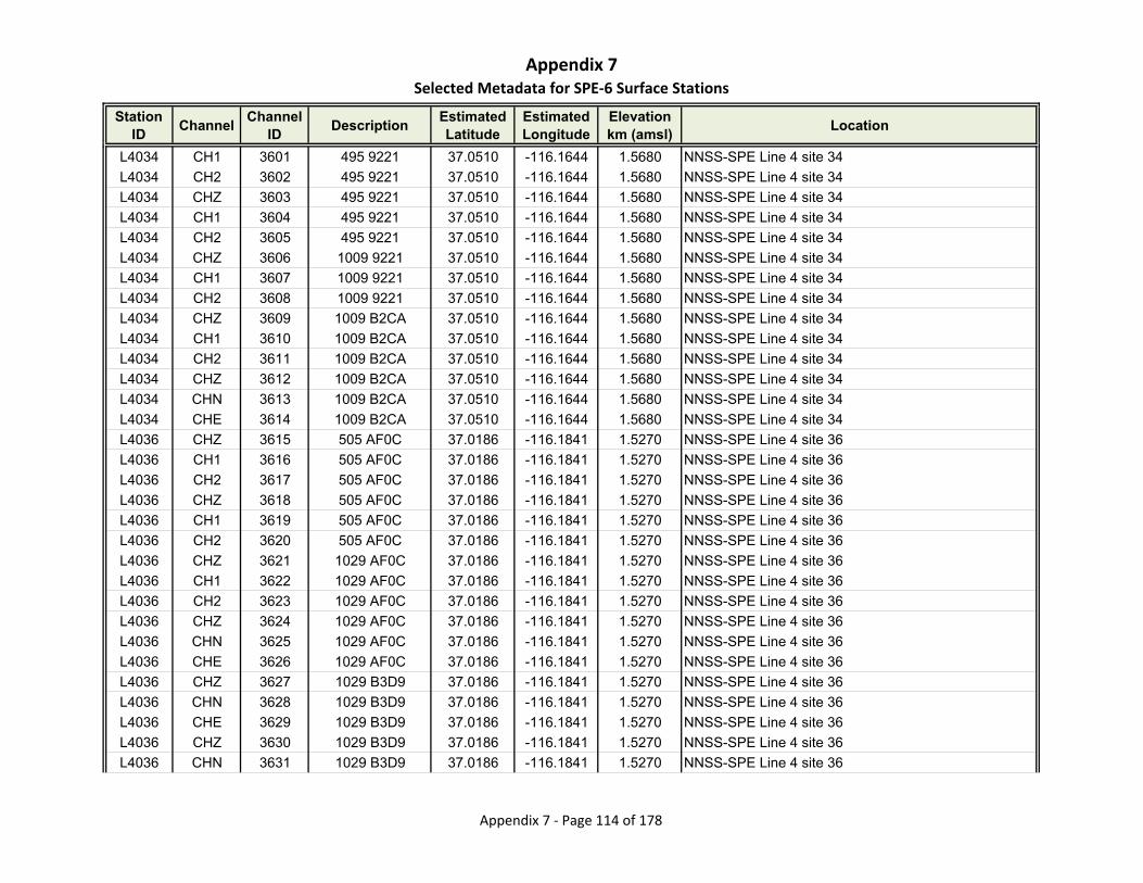
Appendix 7Selected Metadata for SPE‐6 Surface Stations
Station ID
ChannelChannel
IDDescription
Estimated Latitude
Estimated Longitude
Elevationkm (amsl)
Location
L4034 CH1 3601 495 9221 37.0510 -116.1644 1.5680 NNSS-SPE Line 4 site 34
L4034 CH2 3602 495 9221 37.0510 -116.1644 1.5680 NNSS-SPE Line 4 site 34
L4034 CHZ 3603 495 9221 37.0510 -116.1644 1.5680 NNSS-SPE Line 4 site 34
L4034 CH1 3604 495 9221 37.0510 -116.1644 1.5680 NNSS-SPE Line 4 site 34
L4034 CH2 3605 495 9221 37.0510 -116.1644 1.5680 NNSS-SPE Line 4 site 34
L4034 CHZ 3606 1009 9221 37.0510 -116.1644 1.5680 NNSS-SPE Line 4 site 34
L4034 CH1 3607 1009 9221 37.0510 -116.1644 1.5680 NNSS-SPE Line 4 site 34
L4034 CH2 3608 1009 9221 37.0510 -116.1644 1.5680 NNSS-SPE Line 4 site 34
L4034 CHZ 3609 1009 B2CA 37.0510 -116.1644 1.5680 NNSS-SPE Line 4 site 34
L4034 CH1 3610 1009 B2CA 37.0510 -116.1644 1.5680 NNSS-SPE Line 4 site 34
L4034 CH2 3611 1009 B2CA 37.0510 -116.1644 1.5680 NNSS-SPE Line 4 site 34
L4034 CHZ 3612 1009 B2CA 37.0510 -116.1644 1.5680 NNSS-SPE Line 4 site 34
L4034 CHN 3613 1009 B2CA 37.0510 -116.1644 1.5680 NNSS-SPE Line 4 site 34
L4034 CHE 3614 1009 B2CA 37.0510 -116.1644 1.5680 NNSS-SPE Line 4 site 34
L4036 CHZ 3615 505 AF0C 37.0186 -116.1841 1.5270 NNSS-SPE Line 4 site 36
L4036 CH1 3616 505 AF0C 37.0186 -116.1841 1.5270 NNSS-SPE Line 4 site 36
L4036 CH2 3617 505 AF0C 37.0186 -116.1841 1.5270 NNSS-SPE Line 4 site 36
L4036 CHZ 3618 505 AF0C 37.0186 -116.1841 1.5270 NNSS-SPE Line 4 site 36
L4036 CH1 3619 505 AF0C 37.0186 -116.1841 1.5270 NNSS-SPE Line 4 site 36
L4036 CH2 3620 505 AF0C 37.0186 -116.1841 1.5270 NNSS-SPE Line 4 site 36
L4036 CHZ 3621 1029 AF0C 37.0186 -116.1841 1.5270 NNSS-SPE Line 4 site 36
L4036 CH1 3622 1029 AF0C 37.0186 -116.1841 1.5270 NNSS-SPE Line 4 site 36
L4036 CH2 3623 1029 AF0C 37.0186 -116.1841 1.5270 NNSS-SPE Line 4 site 36
L4036 CHZ 3624 1029 AF0C 37.0186 -116.1841 1.5270 NNSS-SPE Line 4 site 36
L4036 CHN 3625 1029 AF0C 37.0186 -116.1841 1.5270 NNSS-SPE Line 4 site 36
L4036 CHE 3626 1029 AF0C 37.0186 -116.1841 1.5270 NNSS-SPE Line 4 site 36
L4036 CHZ 3627 1029 B3D9 37.0186 -116.1841 1.5270 NNSS-SPE Line 4 site 36
L4036 CHN 3628 1029 B3D9 37.0186 -116.1841 1.5270 NNSS-SPE Line 4 site 36
L4036 CHE 3629 1029 B3D9 37.0186 -116.1841 1.5270 NNSS-SPE Line 4 site 36
L4036 CHZ 3630 1029 B3D9 37.0186 -116.1841 1.5270 NNSS-SPE Line 4 site 36
L4036 CHN 3631 1029 B3D9 37.0186 -116.1841 1.5270 NNSS-SPE Line 4 site 36
Appendix 7 ‐ Page 114 of 178
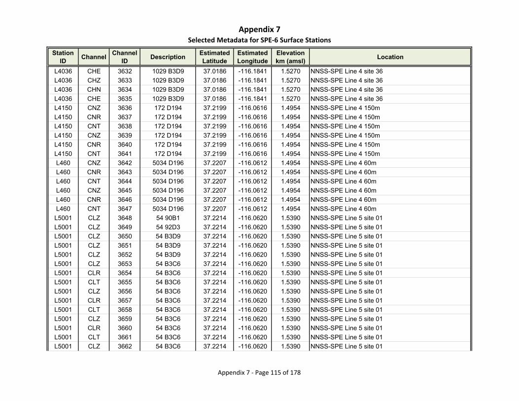
Appendix 7Selected Metadata for SPE‐6 Surface Stations
Station ID
ChannelChannel
IDDescription
Estimated Latitude
Estimated Longitude
Elevationkm (amsl)
Location
L4036 CHE 3632 1029 B3D9 37.0186 -116.1841 1.5270 NNSS-SPE Line 4 site 36
L4036 CHZ 3633 1029 B3D9 37.0186 -116.1841 1.5270 NNSS-SPE Line 4 site 36
L4036 CHN 3634 1029 B3D9 37.0186 -116.1841 1.5270 NNSS-SPE Line 4 site 36
L4036 CHE 3635 1029 B3D9 37.0186 -116.1841 1.5270 NNSS-SPE Line 4 site 36
L4150 CNZ 3636 172 D194 37.2199 -116.0616 1.4954 NNSS-SPE Line 4 150m
L4150 CNR 3637 172 D194 37.2199 -116.0616 1.4954 NNSS-SPE Line 4 150m
L4150 CNT 3638 172 D194 37.2199 -116.0616 1.4954 NNSS-SPE Line 4 150m
L4150 CNZ 3639 172 D194 37.2199 -116.0616 1.4954 NNSS-SPE Line 4 150m
L4150 CNR 3640 172 D194 37.2199 -116.0616 1.4954 NNSS-SPE Line 4 150m
L4150 CNT 3641 172 D194 37.2199 -116.0616 1.4954 NNSS-SPE Line 4 150m
L460 CNZ 3642 5034 D196 37.2207 -116.0612 1.4954 NNSS-SPE Line 4 60m
L460 CNR 3643 5034 D196 37.2207 -116.0612 1.4954 NNSS-SPE Line 4 60m
L460 CNT 3644 5034 D196 37.2207 -116.0612 1.4954 NNSS-SPE Line 4 60m
L460 CNZ 3645 5034 D196 37.2207 -116.0612 1.4954 NNSS-SPE Line 4 60m
L460 CNR 3646 5034 D196 37.2207 -116.0612 1.4954 NNSS-SPE Line 4 60m
L460 CNT 3647 5034 D196 37.2207 -116.0612 1.4954 NNSS-SPE Line 4 60m
L5001 CLZ 3648 54 90B1 37.2214 -116.0620 1.5390 NNSS-SPE Line 5 site 01
L5001 CLZ 3649 54 92D3 37.2214 -116.0620 1.5390 NNSS-SPE Line 5 site 01
L5001 CLZ 3650 54 B3D9 37.2214 -116.0620 1.5390 NNSS-SPE Line 5 site 01
L5001 CLZ 3651 54 B3D9 37.2214 -116.0620 1.5390 NNSS-SPE Line 5 site 01
L5001 CLZ 3652 54 B3D9 37.2214 -116.0620 1.5390 NNSS-SPE Line 5 site 01
L5001 CLZ 3653 54 B3C6 37.2214 -116.0620 1.5390 NNSS-SPE Line 5 site 01
L5001 CLR 3654 54 B3C6 37.2214 -116.0620 1.5390 NNSS-SPE Line 5 site 01
L5001 CLT 3655 54 B3C6 37.2214 -116.0620 1.5390 NNSS-SPE Line 5 site 01
L5001 CLZ 3656 54 B3C6 37.2214 -116.0620 1.5390 NNSS-SPE Line 5 site 01
L5001 CLR 3657 54 B3C6 37.2214 -116.0620 1.5390 NNSS-SPE Line 5 site 01
L5001 CLT 3658 54 B3C6 37.2214 -116.0620 1.5390 NNSS-SPE Line 5 site 01
L5001 CLZ 3659 54 B3C6 37.2214 -116.0620 1.5390 NNSS-SPE Line 5 site 01
L5001 CLR 3660 54 B3C6 37.2214 -116.0620 1.5390 NNSS-SPE Line 5 site 01
L5001 CLT 3661 54 B3C6 37.2214 -116.0620 1.5390 NNSS-SPE Line 5 site 01
L5001 CLZ 3662 54 B3C6 37.2214 -116.0620 1.5390 NNSS-SPE Line 5 site 01
Appendix 7 ‐ Page 115 of 178

Appendix 7Selected Metadata for SPE‐6 Surface Stations
Station ID
ChannelChannel
IDDescription
Estimated Latitude
Estimated Longitude
Elevationkm (amsl)
Location
L5001 CLR 3663 54 B3C6 37.2214 -116.0620 1.5390 NNSS-SPE Line 5 site 01
L5001 CLT 3664 54 B3C6 37.2214 -116.0620 1.5390 NNSS-SPE Line 5 site 01
L5001 CLZ 3665 54 D1A5 37.2214 -116.0620 1.5390 NNSS-SPE Line 5 site 01
L5001 CLR 3666 54 D1A5 37.2214 -116.0620 1.5390 NNSS-SPE Line 5 site 01
L5001 CLT 3667 54 D1A5 37.2214 -116.0620 1.5390 NNSS-SPE Line 5 site 01
L5001 CNZ 3668 5016 D1A5 37.2214 -116.0620 1.5390 NNSS-SPE Line 5 site 01
L5001 CNR 3669 5016 D1A5 37.2214 -116.0620 1.5390 NNSS-SPE Line 5 site 01
L5001 CNT 3670 5016 D1A5 37.2214 -116.0620 1.5390 NNSS-SPE Line 5 site 01
L5001 CLZ 3671 54 D1A5 37.2214 -116.0620 1.5390 NNSS-SPE Line 5 site 01
L5001 CLR 3672 54 D1A5 37.2214 -116.0620 1.5390 NNSS-SPE Line 5 site 01
L5001 CLT 3673 54 D1A5 37.2214 -116.0620 1.5390 NNSS-SPE Line 5 site 01
L5001 CNZ 3674 5016 D1A5 37.2214 -116.0620 1.5390 NNSS-SPE Line 5 site 01
L5001 CNR 3675 5016 D1A5 37.2214 -116.0620 1.5390 NNSS-SPE Line 5 site 01
L5001 CNT 3676 5016 D1A5 37.2214 -116.0620 1.5390 NNSS-SPE Line 5 site 01
L5001 CLZ 3677 54 D1A5 37.2214 -116.0620 1.5390 NNSS-SPE Line 5 site 01
L5001 CLR 3678 54 D1A5 37.2214 -116.0620 1.5390 NNSS-SPE Line 5 site 01
L5001 CLT 3679 54 D1A5 37.2214 -116.0620 1.5390 NNSS-SPE Line 5 site 01
L5001 CLZ 3680 54 D1A5 37.2214 -116.0620 1.5390 NNSS-SPE Line 5 site 01
L5001 CLR 3681 54 D1A5 37.2214 -116.0620 1.5390 NNSS-SPE Line 5 site 01
L5001 CLT 3682 54 D1A5 37.2214 -116.0620 1.5390 NNSS-SPE Line 5 site 01
L5001 CNZ 3683 5016 D1A5 37.2214 -116.0620 1.5390 NNSS-SPE Line 5 site 01
L5001 CNR 3684 5016 D1A5 37.2214 -116.0620 1.5390 NNSS-SPE Line 5 site 01
L5001 CNT 3685 5016 D1A5 37.2214 -116.0620 1.5390 NNSS-SPE Line 5 site 01
L5001 CLZ 3686 54 D1A5 37.2214 -116.0620 1.5390 NNSS-SPE Line 5 site 01
L5001 CLR 3687 54 D1A5 37.2214 -116.0620 1.5390 NNSS-SPE Line 5 site 01
L5001 CLT 3688 54 D1A5 37.2214 -116.0620 1.5390 NNSS-SPE Line 5 site 01
L5001 CNZ 3689 5016 D1A5 37.2214 -116.0620 1.5390 NNSS-SPE Line 5 site 01
L5001 CNR 3690 5016 D1A5 37.2214 -116.0620 1.5390 NNSS-SPE Line 5 site 01
L5001 CNT 3691 5016 D1A5 37.2214 -116.0620 1.5390 NNSS-SPE Line 5 site 01
L5002 CLZ 3692 37 90B1 37.2216 -116.0631 1.5560 NNSS-SPE Line 5 site 02
L5002 CLZ 3693 37 92D3 37.2216 -116.0631 1.5560 NNSS-SPE Line 5 site 02
Appendix 7 ‐ Page 116 of 178
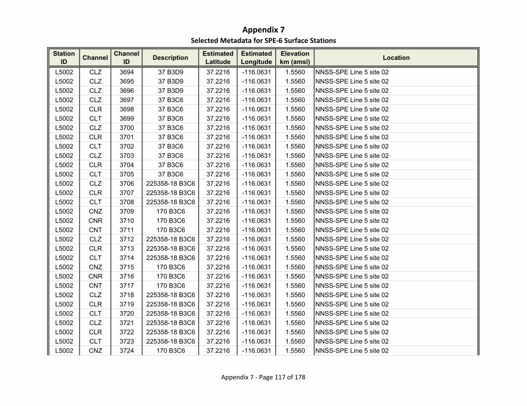
Appendix 7Selected Metadata for SPE‐6 Surface Stations
Station ID
ChannelChannel
IDDescription
Estimated Latitude
Estimated Longitude
Elevationkm (amsl)
Location
L5002 CLZ 3694 37 B3D9 37.2216 -116.0631 1.5560 NNSS-SPE Line 5 site 02
L5002 CLZ 3695 37 B3D9 37.2216 -116.0631 1.5560 NNSS-SPE Line 5 site 02
L5002 CLZ 3696 37 B3D9 37.2216 -116.0631 1.5560 NNSS-SPE Line 5 site 02
L5002 CLZ 3697 37 B3C6 37.2216 -116.0631 1.5560 NNSS-SPE Line 5 site 02
L5002 CLR 3698 37 B3C6 37.2216 -116.0631 1.5560 NNSS-SPE Line 5 site 02
L5002 CLT 3699 37 B3C6 37.2216 -116.0631 1.5560 NNSS-SPE Line 5 site 02
L5002 CLZ 3700 37 B3C6 37.2216 -116.0631 1.5560 NNSS-SPE Line 5 site 02
L5002 CLR 3701 37 B3C6 37.2216 -116.0631 1.5560 NNSS-SPE Line 5 site 02
L5002 CLT 3702 37 B3C6 37.2216 -116.0631 1.5560 NNSS-SPE Line 5 site 02
L5002 CLZ 3703 37 B3C6 37.2216 -116.0631 1.5560 NNSS-SPE Line 5 site 02
L5002 CLR 3704 37 B3C6 37.2216 -116.0631 1.5560 NNSS-SPE Line 5 site 02
L5002 CLT 3705 37 B3C6 37.2216 -116.0631 1.5560 NNSS-SPE Line 5 site 02
L5002 CLZ 3706 225358-18 B3C6 37.2216 -116.0631 1.5560 NNSS-SPE Line 5 site 02
L5002 CLR 3707 225358-18 B3C6 37.2216 -116.0631 1.5560 NNSS-SPE Line 5 site 02
L5002 CLT 3708 225358-18 B3C6 37.2216 -116.0631 1.5560 NNSS-SPE Line 5 site 02
L5002 CNZ 3709 170 B3C6 37.2216 -116.0631 1.5560 NNSS-SPE Line 5 site 02
L5002 CNR 3710 170 B3C6 37.2216 -116.0631 1.5560 NNSS-SPE Line 5 site 02
L5002 CNT 3711 170 B3C6 37.2216 -116.0631 1.5560 NNSS-SPE Line 5 site 02
L5002 CLZ 3712 225358-18 B3C6 37.2216 -116.0631 1.5560 NNSS-SPE Line 5 site 02
L5002 CLR 3713 225358-18 B3C6 37.2216 -116.0631 1.5560 NNSS-SPE Line 5 site 02
L5002 CLT 3714 225358-18 B3C6 37.2216 -116.0631 1.5560 NNSS-SPE Line 5 site 02
L5002 CNZ 3715 170 B3C6 37.2216 -116.0631 1.5560 NNSS-SPE Line 5 site 02
L5002 CNR 3716 170 B3C6 37.2216 -116.0631 1.5560 NNSS-SPE Line 5 site 02
L5002 CNT 3717 170 B3C6 37.2216 -116.0631 1.5560 NNSS-SPE Line 5 site 02
L5002 CLZ 3718 225358-18 B3C6 37.2216 -116.0631 1.5560 NNSS-SPE Line 5 site 02
L5002 CLR 3719 225358-18 B3C6 37.2216 -116.0631 1.5560 NNSS-SPE Line 5 site 02
L5002 CLT 3720 225358-18 B3C6 37.2216 -116.0631 1.5560 NNSS-SPE Line 5 site 02
L5002 CLZ 3721 225358-18 B3C6 37.2216 -116.0631 1.5560 NNSS-SPE Line 5 site 02
L5002 CLR 3722 225358-18 B3C6 37.2216 -116.0631 1.5560 NNSS-SPE Line 5 site 02
L5002 CLT 3723 225358-18 B3C6 37.2216 -116.0631 1.5560 NNSS-SPE Line 5 site 02
L5002 CNZ 3724 170 B3C6 37.2216 -116.0631 1.5560 NNSS-SPE Line 5 site 02
Appendix 7 ‐ Page 117 of 178
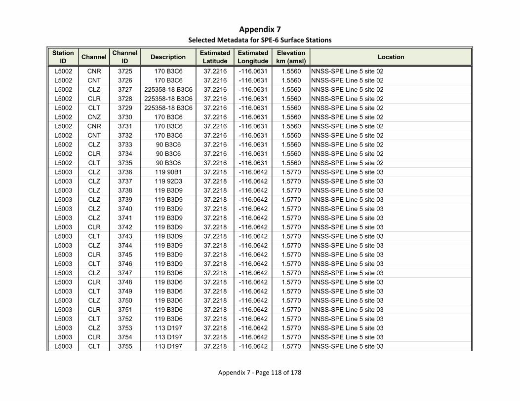
Appendix 7Selected Metadata for SPE‐6 Surface Stations
Station ID
ChannelChannel
IDDescription
Estimated Latitude
Estimated Longitude
Elevationkm (amsl)
Location
L5002 CNR 3725 170 B3C6 37.2216 -116.0631 1.5560 NNSS-SPE Line 5 site 02
L5002 CNT 3726 170 B3C6 37.2216 -116.0631 1.5560 NNSS-SPE Line 5 site 02
L5002 CLZ 3727 225358-18 B3C6 37.2216 -116.0631 1.5560 NNSS-SPE Line 5 site 02
L5002 CLR 3728 225358-18 B3C6 37.2216 -116.0631 1.5560 NNSS-SPE Line 5 site 02
L5002 CLT 3729 225358-18 B3C6 37.2216 -116.0631 1.5560 NNSS-SPE Line 5 site 02
L5002 CNZ 3730 170 B3C6 37.2216 -116.0631 1.5560 NNSS-SPE Line 5 site 02
L5002 CNR 3731 170 B3C6 37.2216 -116.0631 1.5560 NNSS-SPE Line 5 site 02
L5002 CNT 3732 170 B3C6 37.2216 -116.0631 1.5560 NNSS-SPE Line 5 site 02
L5002 CLZ 3733 90 B3C6 37.2216 -116.0631 1.5560 NNSS-SPE Line 5 site 02
L5002 CLR 3734 90 B3C6 37.2216 -116.0631 1.5560 NNSS-SPE Line 5 site 02
L5002 CLT 3735 90 B3C6 37.2216 -116.0631 1.5560 NNSS-SPE Line 5 site 02
L5003 CLZ 3736 119 90B1 37.2218 -116.0642 1.5770 NNSS-SPE Line 5 site 03
L5003 CLZ 3737 119 92D3 37.2218 -116.0642 1.5770 NNSS-SPE Line 5 site 03
L5003 CLZ 3738 119 B3D9 37.2218 -116.0642 1.5770 NNSS-SPE Line 5 site 03
L5003 CLZ 3739 119 B3D9 37.2218 -116.0642 1.5770 NNSS-SPE Line 5 site 03
L5003 CLZ 3740 119 B3D9 37.2218 -116.0642 1.5770 NNSS-SPE Line 5 site 03
L5003 CLZ 3741 119 B3D9 37.2218 -116.0642 1.5770 NNSS-SPE Line 5 site 03
L5003 CLR 3742 119 B3D9 37.2218 -116.0642 1.5770 NNSS-SPE Line 5 site 03
L5003 CLT 3743 119 B3D9 37.2218 -116.0642 1.5770 NNSS-SPE Line 5 site 03
L5003 CLZ 3744 119 B3D9 37.2218 -116.0642 1.5770 NNSS-SPE Line 5 site 03
L5003 CLR 3745 119 B3D9 37.2218 -116.0642 1.5770 NNSS-SPE Line 5 site 03
L5003 CLT 3746 119 B3D9 37.2218 -116.0642 1.5770 NNSS-SPE Line 5 site 03
L5003 CLZ 3747 119 B3D6 37.2218 -116.0642 1.5770 NNSS-SPE Line 5 site 03
L5003 CLR 3748 119 B3D6 37.2218 -116.0642 1.5770 NNSS-SPE Line 5 site 03
L5003 CLT 3749 119 B3D6 37.2218 -116.0642 1.5770 NNSS-SPE Line 5 site 03
L5003 CLZ 3750 119 B3D6 37.2218 -116.0642 1.5770 NNSS-SPE Line 5 site 03
L5003 CLR 3751 119 B3D6 37.2218 -116.0642 1.5770 NNSS-SPE Line 5 site 03
L5003 CLT 3752 119 B3D6 37.2218 -116.0642 1.5770 NNSS-SPE Line 5 site 03
L5003 CLZ 3753 113 D197 37.2218 -116.0642 1.5770 NNSS-SPE Line 5 site 03
L5003 CLR 3754 113 D197 37.2218 -116.0642 1.5770 NNSS-SPE Line 5 site 03
L5003 CLT 3755 113 D197 37.2218 -116.0642 1.5770 NNSS-SPE Line 5 site 03
Appendix 7 ‐ Page 118 of 178

Appendix 7Selected Metadata for SPE‐6 Surface Stations
Station ID
ChannelChannel
IDDescription
Estimated Latitude
Estimated Longitude
Elevationkm (amsl)
Location
L5003 CNZ 3756 112 D197 37.2218 -116.0642 1.5770 NNSS-SPE Line 5 site 03
L5003 CNR 3757 112 D197 37.2218 -116.0642 1.5770 NNSS-SPE Line 5 site 03
L5003 CNT 3758 112 D197 37.2218 -116.0642 1.5770 NNSS-SPE Line 5 site 03
L5003 CLZ 3759 113 D197 37.2218 -116.0642 1.5770 NNSS-SPE Line 5 site 03
L5003 CLR 3760 113 D197 37.2218 -116.0642 1.5770 NNSS-SPE Line 5 site 03
L5003 CLT 3761 113 D197 37.2218 -116.0642 1.5770 NNSS-SPE Line 5 site 03
L5003 CNZ 3762 112 D197 37.2218 -116.0642 1.5770 NNSS-SPE Line 5 site 03
L5003 CNR 3763 112 D197 37.2218 -116.0642 1.5770 NNSS-SPE Line 5 site 03
L5003 CNT 3764 112 D197 37.2218 -116.0642 1.5770 NNSS-SPE Line 5 site 03
L5003 CLZ 3765 113 D197 37.2218 -116.0642 1.5770 NNSS-SPE Line 5 site 03
L5003 CLR 3766 113 D197 37.2218 -116.0642 1.5770 NNSS-SPE Line 5 site 03
L5003 CLT 3767 113 D197 37.2218 -116.0642 1.5770 NNSS-SPE Line 5 site 03
L5003 CLZ 3768 113 D197 37.2218 -116.0642 1.5770 NNSS-SPE Line 5 site 03
L5003 CLR 3769 113 D197 37.2218 -116.0642 1.5770 NNSS-SPE Line 5 site 03
L5003 CLT 3770 113 D197 37.2218 -116.0642 1.5770 NNSS-SPE Line 5 site 03
L5003 CNZ 3771 112 D197 37.2218 -116.0642 1.5770 NNSS-SPE Line 5 site 03
L5003 CNR 3772 112 D197 37.2218 -116.0642 1.5770 NNSS-SPE Line 5 site 03
L5003 CNT 3773 112 D197 37.2218 -116.0642 1.5770 NNSS-SPE Line 5 site 03
L5003 CLZ 3774 113 D197 37.2218 -116.0642 1.5770 NNSS-SPE Line 5 site 03
L5003 CLR 3775 113 D197 37.2218 -116.0642 1.5770 NNSS-SPE Line 5 site 03
L5003 CLT 3776 113 D197 37.2218 -116.0642 1.5770 NNSS-SPE Line 5 site 03
L5003 CNZ 3777 112 D197 37.2218 -116.0642 1.5770 NNSS-SPE Line 5 site 03
L5003 CNR 3778 112 D197 37.2218 -116.0642 1.5770 NNSS-SPE Line 5 site 03
L5003 CNT 3779 112 D197 37.2218 -116.0642 1.5770 NNSS-SPE Line 5 site 03
L5004 CLZ 3780 17 90B1 37.2220 -116.0653 1.6220 NNSS-SPE Line 5 site 04
L5004 CLR 3781 17 90B1 37.2220 -116.0653 1.6220 NNSS-SPE Line 5 site 04
L5004 CLT 3782 17 90B1 37.2220 -116.0653 1.6220 NNSS-SPE Line 5 site 04
L5004 CLZ 3783 17 92D3 37.2220 -116.0653 1.6220 NNSS-SPE Line 5 site 04
L5004 CLR 3784 17 92D3 37.2220 -116.0653 1.6220 NNSS-SPE Line 5 site 04
L5004 CLT 3785 17 92D3 37.2220 -116.0653 1.6220 NNSS-SPE Line 5 site 04
L5004 CLZ 3786 17 B3D9 37.2220 -116.0653 1.6220 NNSS-SPE Line 5 site 04
Appendix 7 ‐ Page 119 of 178

Appendix 7Selected Metadata for SPE‐6 Surface Stations
Station ID
ChannelChannel
IDDescription
Estimated Latitude
Estimated Longitude
Elevationkm (amsl)
Location
L5004 CLR 3787 17 B3D9 37.2220 -116.0653 1.6220 NNSS-SPE Line 5 site 04
L5004 CLT 3788 17 B3D9 37.2220 -116.0653 1.6220 NNSS-SPE Line 5 site 04
L5004 CLZ 3789 17 B3D9 37.2220 -116.0653 1.6220 NNSS-SPE Line 5 site 04
L5004 CLR 3790 17 B3D9 37.2220 -116.0653 1.6220 NNSS-SPE Line 5 site 04
L5004 CLT 3791 17 B3D9 37.2220 -116.0653 1.6220 NNSS-SPE Line 5 site 04
L5004 CLZ 3792 17 B3D9 37.2220 -116.0653 1.6220 NNSS-SPE Line 5 site 04
L5004 CLR 3793 17 B3D9 37.2220 -116.0653 1.6220 NNSS-SPE Line 5 site 04
L5004 CLT 3794 17 B3D9 37.2220 -116.0653 1.6220 NNSS-SPE Line 5 site 04
L5004 CLZ 3795 17 B3D9 37.2220 -116.0653 1.6220 NNSS-SPE Line 5 site 04
L5004 CLR 3796 17 B3D9 37.2220 -116.0653 1.6220 NNSS-SPE Line 5 site 04
L5004 CLT 3797 17 B3D9 37.2220 -116.0653 1.6220 NNSS-SPE Line 5 site 04
L5004 CLZ 3798 17 B3D9 37.2220 -116.0653 1.6220 NNSS-SPE Line 5 site 04
L5004 CLR 3799 17 B3D9 37.2220 -116.0653 1.6220 NNSS-SPE Line 5 site 04
L5004 CLT 3800 17 B3D9 37.2220 -116.0653 1.6220 NNSS-SPE Line 5 site 04
L5004 CLZ 3801 17 B3D6 37.2220 -116.0653 1.6220 NNSS-SPE Line 5 site 04
L5004 CLR 3802 17 B3D6 37.2220 -116.0653 1.6220 NNSS-SPE Line 5 site 04
L5004 CLT 3803 17 B3D6 37.2220 -116.0653 1.6220 NNSS-SPE Line 5 site 04
L5004 CLZ 3804 17 B3D6 37.2220 -116.0653 1.6220 NNSS-SPE Line 5 site 04
L5004 CLR 3805 17 B3D6 37.2220 -116.0653 1.6220 NNSS-SPE Line 5 site 04
L5004 CLT 3806 17 B3D6 37.2220 -116.0653 1.6220 NNSS-SPE Line 5 site 04
L5004 CLZ 3807 17 B3D6 37.2220 -116.0653 1.6220 NNSS-SPE Line 5 site 04
L5004 CLR 3808 17 B3D6 37.2220 -116.0653 1.6220 NNSS-SPE Line 5 site 04
L5004 CLT 3809 17 B3D6 37.2220 -116.0653 1.6220 NNSS-SPE Line 5 site 04
L5004 CLZ 3810 17 B3D6 37.2220 -116.0653 1.6220 NNSS-SPE Line 5 site 04
L5004 CLR 3811 17 B3D6 37.2220 -116.0653 1.6220 NNSS-SPE Line 5 site 04
L5004 CLT 3812 17 B3D6 37.2220 -116.0653 1.6220 NNSS-SPE Line 5 site 04
L5004 CLZ 3813 17 B3D6 37.2220 -116.0653 1.6220 NNSS-SPE Line 5 site 04
L5004 CLR 3814 17 B3D6 37.2220 -116.0653 1.6220 NNSS-SPE Line 5 site 04
L5004 CLT 3815 17 B3D6 37.2220 -116.0653 1.6220 NNSS-SPE Line 5 site 04
L5004 CLZ 3816 37 B3D6 37.2220 -116.0653 1.6220 NNSS-SPE Line 5 site 04
L5004 CLR 3817 37 B3D6 37.2220 -116.0653 1.6220 NNSS-SPE Line 5 site 04
Appendix 7 ‐ Page 120 of 178
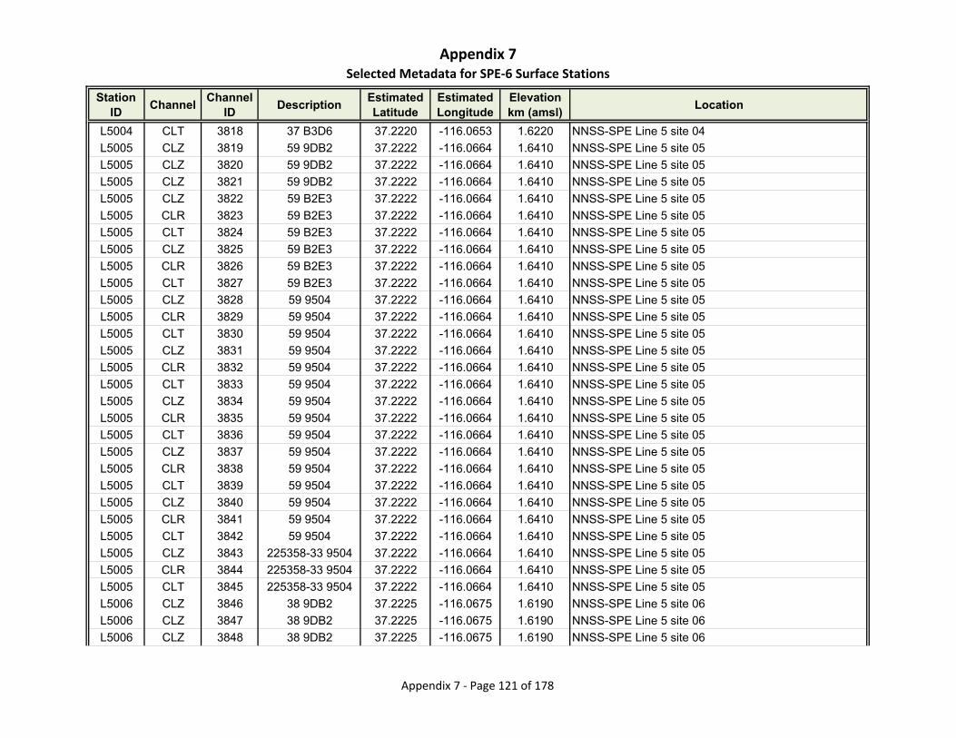
Appendix 7Selected Metadata for SPE‐6 Surface Stations
Station ID
ChannelChannel
IDDescription
Estimated Latitude
Estimated Longitude
Elevationkm (amsl)
Location
L5004 CLT 3818 37 B3D6 37.2220 -116.0653 1.6220 NNSS-SPE Line 5 site 04
L5005 CLZ 3819 59 9DB2 37.2222 -116.0664 1.6410 NNSS-SPE Line 5 site 05
L5005 CLZ 3820 59 9DB2 37.2222 -116.0664 1.6410 NNSS-SPE Line 5 site 05
L5005 CLZ 3821 59 9DB2 37.2222 -116.0664 1.6410 NNSS-SPE Line 5 site 05
L5005 CLZ 3822 59 B2E3 37.2222 -116.0664 1.6410 NNSS-SPE Line 5 site 05
L5005 CLR 3823 59 B2E3 37.2222 -116.0664 1.6410 NNSS-SPE Line 5 site 05
L5005 CLT 3824 59 B2E3 37.2222 -116.0664 1.6410 NNSS-SPE Line 5 site 05
L5005 CLZ 3825 59 B2E3 37.2222 -116.0664 1.6410 NNSS-SPE Line 5 site 05
L5005 CLR 3826 59 B2E3 37.2222 -116.0664 1.6410 NNSS-SPE Line 5 site 05
L5005 CLT 3827 59 B2E3 37.2222 -116.0664 1.6410 NNSS-SPE Line 5 site 05
L5005 CLZ 3828 59 9504 37.2222 -116.0664 1.6410 NNSS-SPE Line 5 site 05
L5005 CLR 3829 59 9504 37.2222 -116.0664 1.6410 NNSS-SPE Line 5 site 05
L5005 CLT 3830 59 9504 37.2222 -116.0664 1.6410 NNSS-SPE Line 5 site 05
L5005 CLZ 3831 59 9504 37.2222 -116.0664 1.6410 NNSS-SPE Line 5 site 05
L5005 CLR 3832 59 9504 37.2222 -116.0664 1.6410 NNSS-SPE Line 5 site 05
L5005 CLT 3833 59 9504 37.2222 -116.0664 1.6410 NNSS-SPE Line 5 site 05
L5005 CLZ 3834 59 9504 37.2222 -116.0664 1.6410 NNSS-SPE Line 5 site 05
L5005 CLR 3835 59 9504 37.2222 -116.0664 1.6410 NNSS-SPE Line 5 site 05
L5005 CLT 3836 59 9504 37.2222 -116.0664 1.6410 NNSS-SPE Line 5 site 05
L5005 CLZ 3837 59 9504 37.2222 -116.0664 1.6410 NNSS-SPE Line 5 site 05
L5005 CLR 3838 59 9504 37.2222 -116.0664 1.6410 NNSS-SPE Line 5 site 05
L5005 CLT 3839 59 9504 37.2222 -116.0664 1.6410 NNSS-SPE Line 5 site 05
L5005 CLZ 3840 59 9504 37.2222 -116.0664 1.6410 NNSS-SPE Line 5 site 05
L5005 CLR 3841 59 9504 37.2222 -116.0664 1.6410 NNSS-SPE Line 5 site 05
L5005 CLT 3842 59 9504 37.2222 -116.0664 1.6410 NNSS-SPE Line 5 site 05
L5005 CLZ 3843 225358-33 9504 37.2222 -116.0664 1.6410 NNSS-SPE Line 5 site 05
L5005 CLR 3844 225358-33 9504 37.2222 -116.0664 1.6410 NNSS-SPE Line 5 site 05
L5005 CLT 3845 225358-33 9504 37.2222 -116.0664 1.6410 NNSS-SPE Line 5 site 05
L5006 CLZ 3846 38 9DB2 37.2225 -116.0675 1.6190 NNSS-SPE Line 5 site 06
L5006 CLZ 3847 38 9DB2 37.2225 -116.0675 1.6190 NNSS-SPE Line 5 site 06
L5006 CLZ 3848 38 9DB2 37.2225 -116.0675 1.6190 NNSS-SPE Line 5 site 06
Appendix 7 ‐ Page 121 of 178
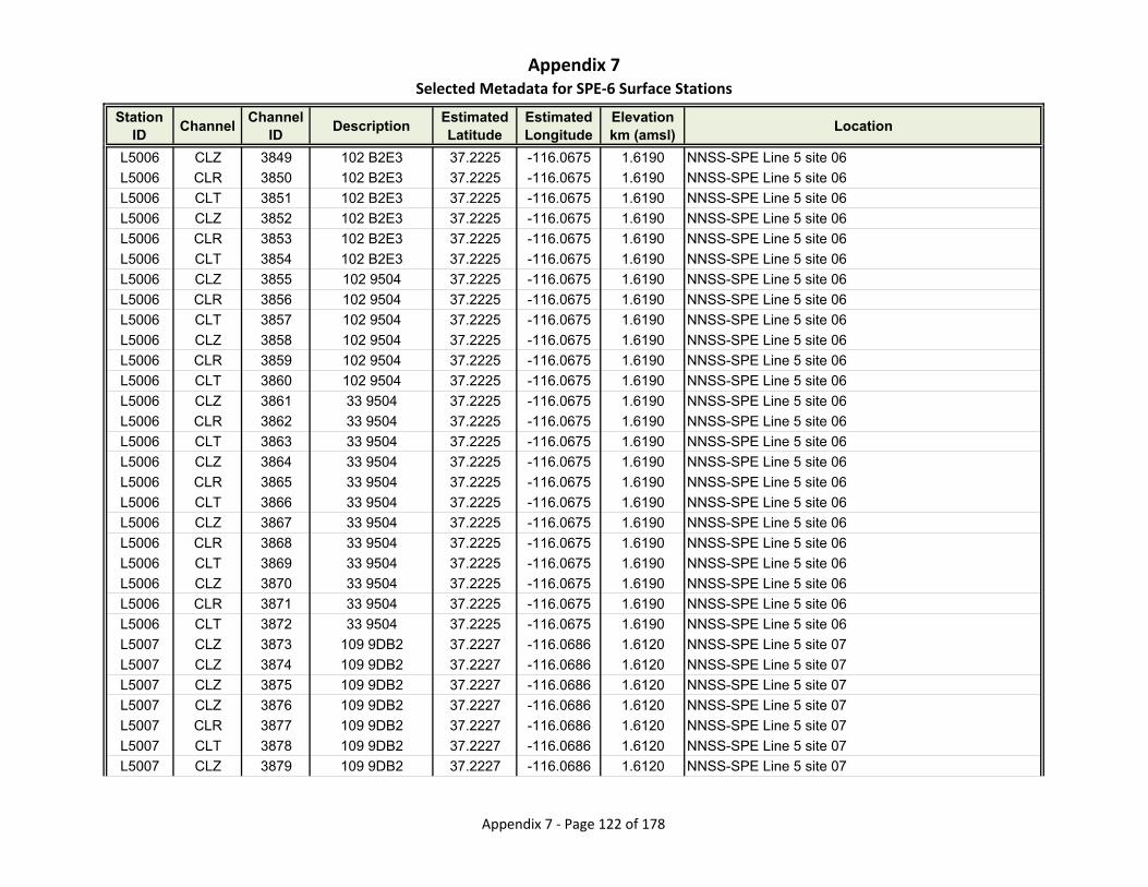
Appendix 7Selected Metadata for SPE‐6 Surface Stations
Station ID
ChannelChannel
IDDescription
Estimated Latitude
Estimated Longitude
Elevationkm (amsl)
Location
L5006 CLZ 3849 102 B2E3 37.2225 -116.0675 1.6190 NNSS-SPE Line 5 site 06
L5006 CLR 3850 102 B2E3 37.2225 -116.0675 1.6190 NNSS-SPE Line 5 site 06
L5006 CLT 3851 102 B2E3 37.2225 -116.0675 1.6190 NNSS-SPE Line 5 site 06
L5006 CLZ 3852 102 B2E3 37.2225 -116.0675 1.6190 NNSS-SPE Line 5 site 06
L5006 CLR 3853 102 B2E3 37.2225 -116.0675 1.6190 NNSS-SPE Line 5 site 06
L5006 CLT 3854 102 B2E3 37.2225 -116.0675 1.6190 NNSS-SPE Line 5 site 06
L5006 CLZ 3855 102 9504 37.2225 -116.0675 1.6190 NNSS-SPE Line 5 site 06
L5006 CLR 3856 102 9504 37.2225 -116.0675 1.6190 NNSS-SPE Line 5 site 06
L5006 CLT 3857 102 9504 37.2225 -116.0675 1.6190 NNSS-SPE Line 5 site 06
L5006 CLZ 3858 102 9504 37.2225 -116.0675 1.6190 NNSS-SPE Line 5 site 06
L5006 CLR 3859 102 9504 37.2225 -116.0675 1.6190 NNSS-SPE Line 5 site 06
L5006 CLT 3860 102 9504 37.2225 -116.0675 1.6190 NNSS-SPE Line 5 site 06
L5006 CLZ 3861 33 9504 37.2225 -116.0675 1.6190 NNSS-SPE Line 5 site 06
L5006 CLR 3862 33 9504 37.2225 -116.0675 1.6190 NNSS-SPE Line 5 site 06
L5006 CLT 3863 33 9504 37.2225 -116.0675 1.6190 NNSS-SPE Line 5 site 06
L5006 CLZ 3864 33 9504 37.2225 -116.0675 1.6190 NNSS-SPE Line 5 site 06
L5006 CLR 3865 33 9504 37.2225 -116.0675 1.6190 NNSS-SPE Line 5 site 06
L5006 CLT 3866 33 9504 37.2225 -116.0675 1.6190 NNSS-SPE Line 5 site 06
L5006 CLZ 3867 33 9504 37.2225 -116.0675 1.6190 NNSS-SPE Line 5 site 06
L5006 CLR 3868 33 9504 37.2225 -116.0675 1.6190 NNSS-SPE Line 5 site 06
L5006 CLT 3869 33 9504 37.2225 -116.0675 1.6190 NNSS-SPE Line 5 site 06
L5006 CLZ 3870 33 9504 37.2225 -116.0675 1.6190 NNSS-SPE Line 5 site 06
L5006 CLR 3871 33 9504 37.2225 -116.0675 1.6190 NNSS-SPE Line 5 site 06
L5006 CLT 3872 33 9504 37.2225 -116.0675 1.6190 NNSS-SPE Line 5 site 06
L5007 CLZ 3873 109 9DB2 37.2227 -116.0686 1.6120 NNSS-SPE Line 5 site 07
L5007 CLZ 3874 109 9DB2 37.2227 -116.0686 1.6120 NNSS-SPE Line 5 site 07
L5007 CLZ 3875 109 9DB2 37.2227 -116.0686 1.6120 NNSS-SPE Line 5 site 07
L5007 CLZ 3876 109 9DB2 37.2227 -116.0686 1.6120 NNSS-SPE Line 5 site 07
L5007 CLR 3877 109 9DB2 37.2227 -116.0686 1.6120 NNSS-SPE Line 5 site 07
L5007 CLT 3878 109 9DB2 37.2227 -116.0686 1.6120 NNSS-SPE Line 5 site 07
L5007 CLZ 3879 109 9DB2 37.2227 -116.0686 1.6120 NNSS-SPE Line 5 site 07
Appendix 7 ‐ Page 122 of 178

Appendix 7Selected Metadata for SPE‐6 Surface Stations
Station ID
ChannelChannel
IDDescription
Estimated Latitude
Estimated Longitude
Elevationkm (amsl)
Location
L5007 CLR 3880 109 9DB2 37.2227 -116.0686 1.6120 NNSS-SPE Line 5 site 07
L5007 CLT 3881 109 9DB2 37.2227 -116.0686 1.6120 NNSS-SPE Line 5 site 07
L5007 CLZ 3882 109 BB66 37.2227 -116.0686 1.6120 NNSS-SPE Line 5 site 07
L5007 CLR 3883 109 BB66 37.2227 -116.0686 1.6120 NNSS-SPE Line 5 site 07
L5007 CLT 3884 109 BB66 37.2227 -116.0686 1.6120 NNSS-SPE Line 5 site 07
L5007 CLZ 3885 109 BB66 37.2227 -116.0686 1.6120 NNSS-SPE Line 5 site 07
L5007 CLR 3886 109 BB66 37.2227 -116.0686 1.6120 NNSS-SPE Line 5 site 07
L5007 CLT 3887 109 BB66 37.2227 -116.0686 1.6120 NNSS-SPE Line 5 site 07
L5007 CLZ 3888 180063-04 BB66 37.2227 -116.0686 1.6120 NNSS-SPE Line 5 site 07
L5007 CLR 3889 180063-04 BB66 37.2227 -116.0686 1.6120 NNSS-SPE Line 5 site 07
L5007 CLT 3890 180063-04 BB66 37.2227 -116.0686 1.6120 NNSS-SPE Line 5 site 07
L5007 CLZ 3891 180063-04 BB66 37.2227 -116.0686 1.6120 NNSS-SPE Line 5 site 07
L5007 CLR 3892 180063-04 BB66 37.2227 -116.0686 1.6120 NNSS-SPE Line 5 site 07
L5007 CLT 3893 180063-04 BB66 37.2227 -116.0686 1.6120 NNSS-SPE Line 5 site 07
L5007 CLZ 3894 109 BB66 37.2227 -116.0686 1.6120 NNSS-SPE Line 5 site 07
L5007 CLR 3895 109 BB66 37.2227 -116.0686 1.6120 NNSS-SPE Line 5 site 07
L5007 CLT 3896 109 BB66 37.2227 -116.0686 1.6120 NNSS-SPE Line 5 site 07
L5007 CLZ 3897 180063-04 BB66 37.2227 -116.0686 1.6120 NNSS-SPE Line 5 site 07
L5007 CLR 3898 180063-04 BB66 37.2227 -116.0686 1.6120 NNSS-SPE Line 5 site 07
L5007 CLT 3899 180063-04 BB66 37.2227 -116.0686 1.6120 NNSS-SPE Line 5 site 07
L5008 CLZ 3900 102 9DB2 37.2229 -116.0696 1.5890 NNSS-SPE Line 5 site 08
L5008 CLR 3901 102 9DB2 37.2229 -116.0696 1.5890 NNSS-SPE Line 5 site 08
L5008 CLT 3902 102 9DB2 37.2229 -116.0696 1.5890 NNSS-SPE Line 5 site 08
L5008 CLZ 3903 102 9DB2 37.2229 -116.0696 1.5890 NNSS-SPE Line 5 site 08
L5008 CLR 3904 102 9DB2 37.2229 -116.0696 1.5890 NNSS-SPE Line 5 site 08
L5008 CLT 3905 102 9DB2 37.2229 -116.0696 1.5890 NNSS-SPE Line 5 site 08
L5008 CLZ 3906 102 9DB2 37.2229 -116.0696 1.5890 NNSS-SPE Line 5 site 08
L5008 CLR 3907 102 9DB2 37.2229 -116.0696 1.5890 NNSS-SPE Line 5 site 08
L5008 CLT 3908 102 9DB2 37.2229 -116.0696 1.5890 NNSS-SPE Line 5 site 08
L5008 CLZ 3909 110 9DB2 37.2229 -116.0696 1.5890 NNSS-SPE Line 5 site 08
L5008 CLR 3910 110 9DB2 37.2229 -116.0696 1.5890 NNSS-SPE Line 5 site 08
Appendix 7 ‐ Page 123 of 178
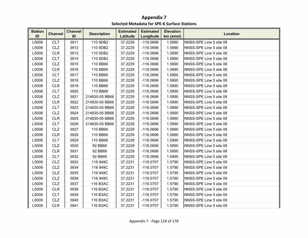
Appendix 7Selected Metadata for SPE‐6 Surface Stations
Station ID
ChannelChannel
IDDescription
Estimated Latitude
Estimated Longitude
Elevationkm (amsl)
Location
L5008 CLT 3911 110 9DB2 37.2229 -116.0696 1.5890 NNSS-SPE Line 5 site 08
L5008 CLZ 3912 110 9DB2 37.2229 -116.0696 1.5890 NNSS-SPE Line 5 site 08
L5008 CLR 3913 110 9DB2 37.2229 -116.0696 1.5890 NNSS-SPE Line 5 site 08
L5008 CLT 3914 110 9DB2 37.2229 -116.0696 1.5890 NNSS-SPE Line 5 site 08
L5008 CLZ 3915 110 BB66 37.2229 -116.0696 1.5890 NNSS-SPE Line 5 site 08
L5008 CLR 3916 110 BB66 37.2229 -116.0696 1.5890 NNSS-SPE Line 5 site 08
L5008 CLT 3917 110 BB66 37.2229 -116.0696 1.5890 NNSS-SPE Line 5 site 08
L5008 CLZ 3918 110 BB66 37.2229 -116.0696 1.5890 NNSS-SPE Line 5 site 08
L5008 CLR 3919 110 BB66 37.2229 -116.0696 1.5890 NNSS-SPE Line 5 site 08
L5008 CLT 3920 110 BB66 37.2229 -116.0696 1.5890 NNSS-SPE Line 5 site 08
L5008 CLZ 3921 214830-05 BB66 37.2229 -116.0696 1.5890 NNSS-SPE Line 5 site 08
L5008 CLR 3922 214830-05 BB66 37.2229 -116.0696 1.5890 NNSS-SPE Line 5 site 08
L5008 CLT 3923 214830-05 BB66 37.2229 -116.0696 1.5890 NNSS-SPE Line 5 site 08
L5008 CLZ 3924 214830-05 BB66 37.2229 -116.0696 1.5890 NNSS-SPE Line 5 site 08
L5008 CLR 3925 214830-05 BB66 37.2229 -116.0696 1.5890 NNSS-SPE Line 5 site 08
L5008 CLT 3926 214830-05 BB66 37.2229 -116.0696 1.5890 NNSS-SPE Line 5 site 08
L5008 CLZ 3927 110 BB66 37.2229 -116.0696 1.5890 NNSS-SPE Line 5 site 08
L5008 CLR 3928 110 BB66 37.2229 -116.0696 1.5890 NNSS-SPE Line 5 site 08
L5008 CLT 3929 110 BB66 37.2229 -116.0696 1.5890 NNSS-SPE Line 5 site 08
L5008 CLZ 3930 92 BB66 37.2229 -116.0696 1.5890 NNSS-SPE Line 5 site 08
L5008 CLR 3931 92 BB66 37.2229 -116.0696 1.5890 NNSS-SPE Line 5 site 08
L5008 CLT 3932 92 BB66 37.2229 -116.0696 1.5890 NNSS-SPE Line 5 site 08
L5009 CLZ 3933 116 949C 37.2231 -116.0707 1.5790 NNSS-SPE Line 5 site 09
L5009 CLZ 3934 116 949C 37.2231 -116.0707 1.5790 NNSS-SPE Line 5 site 09
L5009 CLZ 3935 116 949C 37.2231 -116.0707 1.5790 NNSS-SPE Line 5 site 09
L5009 CLZ 3936 116 949C 37.2231 -116.0707 1.5790 NNSS-SPE Line 5 site 09
L5009 CLZ 3937 116 B3AC 37.2231 -116.0707 1.5790 NNSS-SPE Line 5 site 09
L5009 CLR 3938 116 B3AC 37.2231 -116.0707 1.5790 NNSS-SPE Line 5 site 09
L5009 CLT 3939 116 B3AC 37.2231 -116.0707 1.5790 NNSS-SPE Line 5 site 09
L5009 CLZ 3940 116 B3AC 37.2231 -116.0707 1.5790 NNSS-SPE Line 5 site 09
L5009 CLR 3941 116 B3AC 37.2231 -116.0707 1.5790 NNSS-SPE Line 5 site 09
Appendix 7 ‐ Page 124 of 178
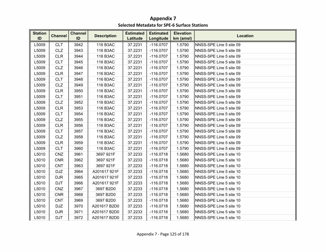
Appendix 7Selected Metadata for SPE‐6 Surface Stations
Station ID
ChannelChannel
IDDescription
Estimated Latitude
Estimated Longitude
Elevationkm (amsl)
Location
L5009 CLT 3942 116 B3AC 37.2231 -116.0707 1.5790 NNSS-SPE Line 5 site 09
L5009 CLZ 3943 116 B3AC 37.2231 -116.0707 1.5790 NNSS-SPE Line 5 site 09
L5009 CLR 3944 116 B3AC 37.2231 -116.0707 1.5790 NNSS-SPE Line 5 site 09
L5009 CLT 3945 116 B3AC 37.2231 -116.0707 1.5790 NNSS-SPE Line 5 site 09
L5009 CLZ 3946 116 B3AC 37.2231 -116.0707 1.5790 NNSS-SPE Line 5 site 09
L5009 CLR 3947 116 B3AC 37.2231 -116.0707 1.5790 NNSS-SPE Line 5 site 09
L5009 CLT 3948 116 B3AC 37.2231 -116.0707 1.5790 NNSS-SPE Line 5 site 09
L5009 CLZ 3949 116 B3AC 37.2231 -116.0707 1.5790 NNSS-SPE Line 5 site 09
L5009 CLR 3950 116 B3AC 37.2231 -116.0707 1.5790 NNSS-SPE Line 5 site 09
L5009 CLT 3951 116 B3AC 37.2231 -116.0707 1.5790 NNSS-SPE Line 5 site 09
L5009 CLZ 3952 116 B3AC 37.2231 -116.0707 1.5790 NNSS-SPE Line 5 site 09
L5009 CLR 3953 116 B3AC 37.2231 -116.0707 1.5790 NNSS-SPE Line 5 site 09
L5009 CLT 3954 116 B3AC 37.2231 -116.0707 1.5790 NNSS-SPE Line 5 site 09
L5009 CLZ 3955 116 B3AC 37.2231 -116.0707 1.5790 NNSS-SPE Line 5 site 09
L5009 CLR 3956 116 B3AC 37.2231 -116.0707 1.5790 NNSS-SPE Line 5 site 09
L5009 CLT 3957 116 B3AC 37.2231 -116.0707 1.5790 NNSS-SPE Line 5 site 09
L5009 CLZ 3958 116 B3AC 37.2231 -116.0707 1.5790 NNSS-SPE Line 5 site 09
L5009 CLR 3959 116 B3AC 37.2231 -116.0707 1.5790 NNSS-SPE Line 5 site 09
L5009 CLT 3960 116 B3AC 37.2231 -116.0707 1.5790 NNSS-SPE Line 5 site 09
L5010 CNZ 3961 3697 921F 37.2233 -116.0718 1.5680 NNSS-SPE Line 5 site 10
L5010 CNR 3962 3697 921F 37.2233 -116.0718 1.5680 NNSS-SPE Line 5 site 10
L5010 CNT 3963 3697 921F 37.2233 -116.0718 1.5680 NNSS-SPE Line 5 site 10
L5010 DJZ 3964 A201617 921F 37.2233 -116.0718 1.5680 NNSS-SPE Line 5 site 10
L5010 DJR 3965 A201617 921F 37.2233 -116.0718 1.5680 NNSS-SPE Line 5 site 10
L5010 DJT 3966 A201617 921F 37.2233 -116.0718 1.5680 NNSS-SPE Line 5 site 10
L5010 CNZ 3967 3697 B2D0 37.2233 -116.0718 1.5680 NNSS-SPE Line 5 site 10
L5010 CNR 3968 3697 B2D0 37.2233 -116.0718 1.5680 NNSS-SPE Line 5 site 10
L5010 CNT 3969 3697 B2D0 37.2233 -116.0718 1.5680 NNSS-SPE Line 5 site 10
L5010 DJZ 3970 A201617 B2D0 37.2233 -116.0718 1.5680 NNSS-SPE Line 5 site 10
L5010 DJR 3971 A201617 B2D0 37.2233 -116.0718 1.5680 NNSS-SPE Line 5 site 10
L5010 DJT 3972 A201617 B2D0 37.2233 -116.0718 1.5680 NNSS-SPE Line 5 site 10
Appendix 7 ‐ Page 125 of 178
Appendix 7Selected Metadata for SPE‐6 Surface Stations
Station ID
ChannelChannel
IDDescription
Estimated Latitude
Estimated Longitude
Elevationkm (amsl)
Location
L5010 CNZ 3973 3697 B2D0 37.2233 -116.0718 1.5680 NNSS-SPE Line 5 site 10
L5010 CNR 3974 3697 B2D0 37.2233 -116.0718 1.5680 NNSS-SPE Line 5 site 10
L5010 CNT 3975 3697 B2D0 37.2233 -116.0718 1.5680 NNSS-SPE Line 5 site 10
L5010 DJZ 3976 A201617 B2D0 37.2233 -116.0718 1.5680 NNSS-SPE Line 5 site 10
L5010 DJR 3977 A201617 B2D0 37.2233 -116.0718 1.5680 NNSS-SPE Line 5 site 10
L5010 DJT 3978 A201617 B2D0 37.2233 -116.0718 1.5680 NNSS-SPE Line 5 site 10
L5010 CNZ 3979 3697 B2D0 37.2233 -116.0718 1.5680 NNSS-SPE Line 5 site 10
L5010 CNR 3980 3697 B2D0 37.2233 -116.0718 1.5680 NNSS-SPE Line 5 site 10
L5010 CNT 3981 3697 B2D0 37.2233 -116.0718 1.5680 NNSS-SPE Line 5 site 10
L5010 DJZ 3982 A201617 B2D0 37.2233 -116.0718 1.5680 NNSS-SPE Line 5 site 10
L5010 DJR 3983 A201617 B2D0 37.2233 -116.0718 1.5680 NNSS-SPE Line 5 site 10
L5010 DJT 3984 A201617 B2D0 37.2233 -116.0718 1.5680 NNSS-SPE Line 5 site 10
L5010 CLZ 3985 51 949C 37.2233 -116.0718 1.5680 NNSS-SPE Line 5 site 10
L5010 CLZ 3986 51 949C 37.2233 -116.0718 1.5680 NNSS-SPE Line 5 site 10
L5010 CLZ 3987 51 949C 37.2233 -116.0718 1.5680 NNSS-SPE Line 5 site 10
L5010 CLZ 3988 51 949C 37.2233 -116.0718 1.5680 NNSS-SPE Line 5 site 10
L5010 CLZ 3989 51 B3AC 37.2233 -116.0718 1.5680 NNSS-SPE Line 5 site 10
L5010 CLR 3990 51 B3AC 37.2233 -116.0718 1.5680 NNSS-SPE Line 5 site 10
L5010 CLT 3991 51 B3AC 37.2233 -116.0718 1.5680 NNSS-SPE Line 5 site 10
L5010 CLZ 3992 51 B3AC 37.2233 -116.0718 1.5680 NNSS-SPE Line 5 site 10
L5010 CLR 3993 51 B3AC 37.2233 -116.0718 1.5680 NNSS-SPE Line 5 site 10
L5010 CLT 3994 51 B3AC 37.2233 -116.0718 1.5680 NNSS-SPE Line 5 site 10
L5010 CLZ 3995 51 B3AC 37.2233 -116.0718 1.5680 NNSS-SPE Line 5 site 10
L5010 CLR 3996 51 B3AC 37.2233 -116.0718 1.5680 NNSS-SPE Line 5 site 10
L5010 CLT 3997 51 B3AC 37.2233 -116.0718 1.5680 NNSS-SPE Line 5 site 10
L5010 CLZ 3998 51 B3AC 37.2233 -116.0718 1.5680 NNSS-SPE Line 5 site 10
L5010 CLR 3999 51 B3AC 37.2233 -116.0718 1.5680 NNSS-SPE Line 5 site 10
L5010 CLT 4000 51 B3AC 37.2233 -116.0718 1.5680 NNSS-SPE Line 5 site 10
L5010 CLZ 4001 51 B3AC 37.2233 -116.0718 1.5680 NNSS-SPE Line 5 site 10
L5010 CLR 4002 51 B3AC 37.2233 -116.0718 1.5680 NNSS-SPE Line 5 site 10
L5010 CLT 4003 51 B3AC 37.2233 -116.0718 1.5680 NNSS-SPE Line 5 site 10
Appendix 7 ‐ Page 126 of 178

Appendix 7Selected Metadata for SPE‐6 Surface Stations
Station ID
ChannelChannel
IDDescription
Estimated Latitude
Estimated Longitude
Elevationkm (amsl)
Location
L5010 CLZ 4004 51 B3AC 37.2233 -116.0718 1.5680 NNSS-SPE Line 5 site 10
L5010 CLR 4005 51 B3AC 37.2233 -116.0718 1.5680 NNSS-SPE Line 5 site 10
L5010 CLT 4006 51 B3AC 37.2233 -116.0718 1.5680 NNSS-SPE Line 5 site 10
L5010 CLZ 4007 51 B3AC 37.2233 -116.0718 1.5680 NNSS-SPE Line 5 site 10
L5010 CLR 4008 51 B3AC 37.2233 -116.0718 1.5680 NNSS-SPE Line 5 site 10
L5010 CLT 4009 51 B3AC 37.2233 -116.0718 1.5680 NNSS-SPE Line 5 site 10
L5010 CLZ 4010 73 B3AC 37.2233 -116.0718 1.5680 NNSS-SPE Line 5 site 10
L5010 CLR 4011 73 B3AC 37.2233 -116.0718 1.5680 NNSS-SPE Line 5 site 10
L5010 CLT 4012 73 B3AC 37.2233 -116.0718 1.5680 NNSS-SPE Line 5 site 10
L5011 CLZ 4013 36 949C 37.2235 -116.0729 1.5660 NNSS-SPE Line 5 site 11
L5011 CLZ 4014 36 949C 37.2235 -116.0729 1.5660 NNSS-SPE Line 5 site 11
L5011 CLZ 4015 36 949C 37.2235 -116.0729 1.5660 NNSS-SPE Line 5 site 11
L5011 CLZ 4016 36 949C 37.2235 -116.0729 1.5660 NNSS-SPE Line 5 site 11
L5011 CLZ 4017 36 949C 37.2235 -116.0729 1.5660 NNSS-SPE Line 5 site 11
L5011 CLR 4018 36 949C 37.2235 -116.0729 1.5660 NNSS-SPE Line 5 site 11
L5011 CLT 4019 36 949C 37.2235 -116.0729 1.5660 NNSS-SPE Line 5 site 11
L5011 CLZ 4020 36 949C 37.2235 -116.0729 1.5660 NNSS-SPE Line 5 site 11
L5011 CLR 4021 36 949C 37.2235 -116.0729 1.5660 NNSS-SPE Line 5 site 11
L5011 CLT 4022 36 949C 37.2235 -116.0729 1.5660 NNSS-SPE Line 5 site 11
L5011 CLZ 4023 36 949C 37.2235 -116.0729 1.5660 NNSS-SPE Line 5 site 11
L5011 CLR 4024 36 949C 37.2235 -116.0729 1.5660 NNSS-SPE Line 5 site 11
L5011 CLT 4025 36 949C 37.2235 -116.0729 1.5660 NNSS-SPE Line 5 site 11
L5011 CLZ 4026 36 949C 37.2235 -116.0729 1.5660 NNSS-SPE Line 5 site 11
L5011 CLR 4027 36 949C 37.2235 -116.0729 1.5660 NNSS-SPE Line 5 site 11
L5011 CLT 4028 36 949C 37.2235 -116.0729 1.5660 NNSS-SPE Line 5 site 11
L5011 CLZ 4029 36 D1CC 37.2235 -116.0729 1.5660 NNSS-SPE Line 5 site 11
L5011 CLR 4030 36 D1CC 37.2235 -116.0729 1.5660 NNSS-SPE Line 5 site 11
L5011 CLT 4031 36 D1CC 37.2235 -116.0729 1.5660 NNSS-SPE Line 5 site 11
L5011 CLZ 4032 36 D1CC 37.2235 -116.0729 1.5660 NNSS-SPE Line 5 site 11
L5011 CLR 4033 36 D1CC 37.2235 -116.0729 1.5660 NNSS-SPE Line 5 site 11
L5011 CLT 4034 36 D1CC 37.2235 -116.0729 1.5660 NNSS-SPE Line 5 site 11
Appendix 7 ‐ Page 127 of 178

Appendix 7Selected Metadata for SPE‐6 Surface Stations
Station ID
ChannelChannel
IDDescription
Estimated Latitude
Estimated Longitude
Elevationkm (amsl)
Location
L5011 CLZ 4035 36 D1CC 37.2235 -116.0729 1.5660 NNSS-SPE Line 5 site 11
L5011 CLR 4036 36 D1CC 37.2235 -116.0729 1.5660 NNSS-SPE Line 5 site 11
L5011 CLT 4037 36 D1CC 37.2235 -116.0729 1.5660 NNSS-SPE Line 5 site 11
L5011 CLZ 4038 36 D1CC 37.2235 -116.0729 1.5660 NNSS-SPE Line 5 site 11
L5011 CLR 4039 36 D1CC 37.2235 -116.0729 1.5660 NNSS-SPE Line 5 site 11
L5011 CLT 4040 36 D1CC 37.2235 -116.0729 1.5660 NNSS-SPE Line 5 site 11
L5012 CLZ 4041 10 949C 37.2237 -116.0740 1.5860 NNSS-SPE Line 5 site 12
L5012 CLR 4042 10 949C 37.2237 -116.0740 1.5860 NNSS-SPE Line 5 site 12
L5012 CLT 4043 10 949C 37.2237 -116.0740 1.5860 NNSS-SPE Line 5 site 12
L5012 CLZ 4044 10 949C 37.2237 -116.0740 1.5860 NNSS-SPE Line 5 site 12
L5012 CLR 4045 10 949C 37.2237 -116.0740 1.5860 NNSS-SPE Line 5 site 12
L5012 CLT 4046 10 949C 37.2237 -116.0740 1.5860 NNSS-SPE Line 5 site 12
L5012 CLZ 4047 10 949C 37.2237 -116.0740 1.5860 NNSS-SPE Line 5 site 12
L5012 CLR 4048 10 949C 37.2237 -116.0740 1.5860 NNSS-SPE Line 5 site 12
L5012 CLT 4049 10 949C 37.2237 -116.0740 1.5860 NNSS-SPE Line 5 site 12
L5012 CLZ 4050 10 949C 37.2237 -116.0740 1.5860 NNSS-SPE Line 5 site 12
L5012 CLR 4051 10 949C 37.2237 -116.0740 1.5860 NNSS-SPE Line 5 site 12
L5012 CLT 4052 10 949C 37.2237 -116.0740 1.5860 NNSS-SPE Line 5 site 12
L5012 CLZ 4053 10 949C 37.2237 -116.0740 1.5860 NNSS-SPE Line 5 site 12
L5012 CLR 4054 10 949C 37.2237 -116.0740 1.5860 NNSS-SPE Line 5 site 12
L5012 CLT 4055 10 949C 37.2237 -116.0740 1.5860 NNSS-SPE Line 5 site 12
L5012 CLZ 4056 10 949C 37.2237 -116.0740 1.5860 NNSS-SPE Line 5 site 12
L5012 CLR 4057 10 949C 37.2237 -116.0740 1.5860 NNSS-SPE Line 5 site 12
L5012 CLT 4058 10 949C 37.2237 -116.0740 1.5860 NNSS-SPE Line 5 site 12
L5012 CLZ 4059 10 949C 37.2237 -116.0740 1.5860 NNSS-SPE Line 5 site 12
L5012 CLR 4060 10 949C 37.2237 -116.0740 1.5860 NNSS-SPE Line 5 site 12
L5012 CLT 4061 10 949C 37.2237 -116.0740 1.5860 NNSS-SPE Line 5 site 12
L5012 CLZ 4062 10 949C 37.2237 -116.0740 1.5860 NNSS-SPE Line 5 site 12
L5012 CLR 4063 10 949C 37.2237 -116.0740 1.5860 NNSS-SPE Line 5 site 12
L5012 CLT 4064 10 949C 37.2237 -116.0740 1.5860 NNSS-SPE Line 5 site 12
L5012 CLZ 4065 10 D1CC 37.2237 -116.0740 1.5860 NNSS-SPE Line 5 site 12
Appendix 7 ‐ Page 128 of 178
Appendix 7Selected Metadata for SPE‐6 Surface Stations
Station ID
ChannelChannel
IDDescription
Estimated Latitude
Estimated Longitude
Elevationkm (amsl)
Location
L5012 CLR 4066 10 D1CC 37.2237 -116.0740 1.5860 NNSS-SPE Line 5 site 12
L5012 CLT 4067 10 D1CC 37.2237 -116.0740 1.5860 NNSS-SPE Line 5 site 12
L5012 CLZ 4068 10 D1CC 37.2237 -116.0740 1.5860 NNSS-SPE Line 5 site 12
L5012 CLR 4069 10 D1CC 37.2237 -116.0740 1.5860 NNSS-SPE Line 5 site 12
L5012 CLT 4070 10 D1CC 37.2237 -116.0740 1.5860 NNSS-SPE Line 5 site 12
L5012 CLZ 4071 10 D1CC 37.2237 -116.0740 1.5860 NNSS-SPE Line 5 site 12
L5012 CLR 4072 10 D1CC 37.2237 -116.0740 1.5860 NNSS-SPE Line 5 site 12
L5012 CLT 4073 10 D1CC 37.2237 -116.0740 1.5860 NNSS-SPE Line 5 site 12
L5012 CLZ 4074 235358-21 D1CC 37.2237 -116.0740 1.5860 NNSS-SPE Line 5 site 12
L5012 CLR 4075 235358-21 D1CC 37.2237 -116.0740 1.5860 NNSS-SPE Line 5 site 12
L5012 CLT 4076 235358-21 D1CC 37.2237 -116.0740 1.5860 NNSS-SPE Line 5 site 12
L5013 CLZ 4077 9 9DE8 37.2240 -116.0751 1.6120 NNSS-SPE Line 5 site 13
L5013 CLZ 4078 9 9D91 37.2240 -116.0751 1.6120 NNSS-SPE Line 5 site 13
L5013 CLR 4079 9 9D91 37.2240 -116.0751 1.6120 NNSS-SPE Line 5 site 13
L5013 CLT 4080 9 9D91 37.2240 -116.0751 1.6120 NNSS-SPE Line 5 site 13
L5013 CLZ 4081 9 9D91 37.2240 -116.0751 1.6120 NNSS-SPE Line 5 site 13
L5013 CLR 4082 9 9D91 37.2240 -116.0751 1.6120 NNSS-SPE Line 5 site 13
L5013 CLT 4083 9 9D91 37.2240 -116.0751 1.6120 NNSS-SPE Line 5 site 13
L5013 CLZ 4084 9 9D91 37.2240 -116.0751 1.6120 NNSS-SPE Line 5 site 13
L5013 CLR 4085 9 9D91 37.2240 -116.0751 1.6120 NNSS-SPE Line 5 site 13
L5013 CLT 4086 9 9D91 37.2240 -116.0751 1.6120 NNSS-SPE Line 5 site 13
L5013 CLZ 4087 225358-41 9D91 37.2240 -116.0751 1.6120 NNSS-SPE Line 5 site 13
L5013 CLR 4088 225358-41 9D91 37.2240 -116.0751 1.6120 NNSS-SPE Line 5 site 13
L5013 CLT 4089 225358-41 9D91 37.2240 -116.0751 1.6120 NNSS-SPE Line 5 site 13
L5013 CLZ 4090 225358-41 9D91 37.2240 -116.0751 1.6120 NNSS-SPE Line 5 site 13
L5013 CLR 4091 225358-41 9D91 37.2240 -116.0751 1.6120 NNSS-SPE Line 5 site 13
L5013 CLT 4092 225358-41 9D91 37.2240 -116.0751 1.6120 NNSS-SPE Line 5 site 13
L5013 CLZ 4093 225358-41 9D91 37.2240 -116.0751 1.6120 NNSS-SPE Line 5 site 13
L5013 CLR 4094 225358-41 9D91 37.2240 -116.0751 1.6120 NNSS-SPE Line 5 site 13
L5013 CLT 4095 225358-41 9D91 37.2240 -116.0751 1.6120 NNSS-SPE Line 5 site 13
L5013 CLZ 4096 225358-41 9D91 37.2240 -116.0751 1.6120 NNSS-SPE Line 5 site 13
Appendix 7 ‐ Page 129 of 178

Appendix 7Selected Metadata for SPE‐6 Surface Stations
Station ID
ChannelChannel
IDDescription
Estimated Latitude
Estimated Longitude
Elevationkm (amsl)
Location
L5013 CLR 4097 225358-41 9D91 37.2240 -116.0751 1.6120 NNSS-SPE Line 5 site 13
L5013 CLT 4098 225358-41 9D91 37.2240 -116.0751 1.6120 NNSS-SPE Line 5 site 13
L5013 CLZ 4099 225358-41 9D91 37.2240 -116.0751 1.6120 NNSS-SPE Line 5 site 13
L5013 CLR 4100 225358-41 9D91 37.2240 -116.0751 1.6120 NNSS-SPE Line 5 site 13
L5013 CLT 4101 225358-41 9D91 37.2240 -116.0751 1.6120 NNSS-SPE Line 5 site 13
L5014 CLZ 4102 47 9DE8 37.2242 -116.0762 1.6420 NNSS-SPE Line 5 site 14
L5014 CLZ 4103 47 9D91 37.2242 -116.0762 1.6420 NNSS-SPE Line 5 site 14
L5014 CLR 4104 47 9D91 37.2242 -116.0762 1.6420 NNSS-SPE Line 5 site 14
L5014 CLT 4105 47 9D91 37.2242 -116.0762 1.6420 NNSS-SPE Line 5 site 14
L5014 CLZ 4106 47 9D91 37.2242 -116.0762 1.6420 NNSS-SPE Line 5 site 14
L5014 CLR 4107 47 9D91 37.2242 -116.0762 1.6420 NNSS-SPE Line 5 site 14
L5014 CLT 4108 47 9D91 37.2242 -116.0762 1.6420 NNSS-SPE Line 5 site 14
L5014 CLZ 4109 47 9D91 37.2242 -116.0762 1.6420 NNSS-SPE Line 5 site 14
L5014 CLR 4110 47 9D91 37.2242 -116.0762 1.6420 NNSS-SPE Line 5 site 14
L5014 CLT 4111 47 9D91 37.2242 -116.0762 1.6420 NNSS-SPE Line 5 site 14
L5014 CLZ 4112 47 9D91 37.2242 -116.0762 1.6420 NNSS-SPE Line 5 site 14
L5014 CLR 4113 47 9D91 37.2242 -116.0762 1.6420 NNSS-SPE Line 5 site 14
L5014 CLT 4114 47 9D91 37.2242 -116.0762 1.6420 NNSS-SPE Line 5 site 14
L5014 CLZ 4115 47 9D91 37.2242 -116.0762 1.6420 NNSS-SPE Line 5 site 14
L5014 CLR 4116 47 9D91 37.2242 -116.0762 1.6420 NNSS-SPE Line 5 site 14
L5014 CLT 4117 47 9D91 37.2242 -116.0762 1.6420 NNSS-SPE Line 5 site 14
L5014 CLZ 4118 47 9D91 37.2242 -116.0762 1.6420 NNSS-SPE Line 5 site 14
L5014 CLR 4119 47 9D91 37.2242 -116.0762 1.6420 NNSS-SPE Line 5 site 14
L5014 CLT 4120 47 9D91 37.2242 -116.0762 1.6420 NNSS-SPE Line 5 site 14
L5014 CLZ 4121 47 9D91 37.2242 -116.0762 1.6420 NNSS-SPE Line 5 site 14
L5014 CLR 4122 47 9D91 37.2242 -116.0762 1.6420 NNSS-SPE Line 5 site 14
L5014 CLT 4123 47 9D91 37.2242 -116.0762 1.6420 NNSS-SPE Line 5 site 14
L5014 CLZ 4124 47 9D91 37.2242 -116.0762 1.6420 NNSS-SPE Line 5 site 14
L5014 CLR 4125 47 9D91 37.2242 -116.0762 1.6420 NNSS-SPE Line 5 site 14
L5014 CLT 4126 47 9D91 37.2242 -116.0762 1.6420 NNSS-SPE Line 5 site 14
L5015 CLZ 4127 55 9DE8 37.2244 -116.0773 1.6780 NNSS-SPE Line 5 site 15
Appendix 7 ‐ Page 130 of 178
Appendix 7Selected Metadata for SPE‐6 Surface Stations
Station ID
ChannelChannel
IDDescription
Estimated Latitude
Estimated Longitude
Elevationkm (amsl)
Location
L5015 CLZ 4128 55 B3C5 37.2244 -116.0773 1.6780 NNSS-SPE Line 5 site 15
L5015 CLR 4129 55 B3C5 37.2244 -116.0773 1.6780 NNSS-SPE Line 5 site 15
L5015 CLT 4130 55 B3C5 37.2244 -116.0773 1.6780 NNSS-SPE Line 5 site 15
L5015 CLZ 4131 55 B3C5 37.2244 -116.0773 1.6780 NNSS-SPE Line 5 site 15
L5015 CLR 4132 55 B3C5 37.2244 -116.0773 1.6780 NNSS-SPE Line 5 site 15
L5015 CLT 4133 55 B3C5 37.2244 -116.0773 1.6780 NNSS-SPE Line 5 site 15
L5015 CLZ 4134 55 B3B1 37.2244 -116.0773 1.6780 NNSS-SPE Line 5 site 15
L5015 CLR 4135 55 B3B1 37.2244 -116.0773 1.6780 NNSS-SPE Line 5 site 15
L5015 CLT 4136 55 B3B1 37.2244 -116.0773 1.6780 NNSS-SPE Line 5 site 15
L5015 CLZ 4137 55 B3B1 37.2244 -116.0773 1.6780 NNSS-SPE Line 5 site 15
L5015 CLR 4138 55 B3B1 37.2244 -116.0773 1.6780 NNSS-SPE Line 5 site 15
L5015 CLT 4139 55 B3B1 37.2244 -116.0773 1.6780 NNSS-SPE Line 5 site 15
L5015 CLZ 4140 77 B3B1 37.2244 -116.0773 1.6780 NNSS-SPE Line 5 site 15
L5015 CLR 4141 77 B3B1 37.2244 -116.0773 1.6780 NNSS-SPE Line 5 site 15
L5015 CLT 4142 77 B3B1 37.2244 -116.0773 1.6780 NNSS-SPE Line 5 site 15
L5015 CLZ 4143 77 B3B1 37.2244 -116.0773 1.6780 NNSS-SPE Line 5 site 15
L5015 CLR 4144 77 B3B1 37.2244 -116.0773 1.6780 NNSS-SPE Line 5 site 15
L5015 CLT 4145 77 B3B1 37.2244 -116.0773 1.6780 NNSS-SPE Line 5 site 15
L5015 CLZ 4146 77 B3B1 37.2244 -116.0773 1.6780 NNSS-SPE Line 5 site 15
L5015 CLR 4147 77 B3B1 37.2244 -116.0773 1.6780 NNSS-SPE Line 5 site 15
L5015 CLT 4148 77 B3B1 37.2244 -116.0773 1.6780 NNSS-SPE Line 5 site 15
L5015 CLZ 4149 77 B3B1 37.2244 -116.0773 1.6780 NNSS-SPE Line 5 site 15
L5015 CLR 4150 77 B3B1 37.2244 -116.0773 1.6780 NNSS-SPE Line 5 site 15
L5015 CLT 4151 77 B3B1 37.2244 -116.0773 1.6780 NNSS-SPE Line 5 site 15
L5016 DHZ 4152 T4091 9DE8 37.2246 -116.0784 1.7250 NNSS-SPE Line 5 site 16
L5016 DHR 4153 T4091 9DE8 37.2246 -116.0784 1.7250 NNSS-SPE Line 5 site 16
L5016 DHT 4154 T4091 9DE8 37.2246 -116.0784 1.7250 NNSS-SPE Line 5 site 16
L5016 DHZ 4155 T4091 B3C5 37.2246 -116.0784 1.7250 NNSS-SPE Line 5 site 16
L5016 DHR 4156 T4091 B3C5 37.2246 -116.0784 1.7250 NNSS-SPE Line 5 site 16
L5016 DHT 4157 T4091 B3C5 37.2246 -116.0784 1.7250 NNSS-SPE Line 5 site 16
L5016 DHZ 4158 T4091 B3C5 37.2246 -116.0784 1.7250 NNSS-SPE Line 5 site 16
Appendix 7 ‐ Page 131 of 178
Appendix 7Selected Metadata for SPE‐6 Surface Stations
Station ID
ChannelChannel
IDDescription
Estimated Latitude
Estimated Longitude
Elevationkm (amsl)
Location
L5016 DHR 4159 T4091 B3C5 37.2246 -116.0784 1.7250 NNSS-SPE Line 5 site 16
L5016 DHT 4160 T4091 B3C5 37.2246 -116.0784 1.7250 NNSS-SPE Line 5 site 16
L5016 DHZ 4161 T4091 B3B1 37.2246 -116.0784 1.7250 NNSS-SPE Line 5 site 16
L5016 DHR 4162 T4091 B3B1 37.2246 -116.0784 1.7250 NNSS-SPE Line 5 site 16
L5016 DHT 4163 T4091 B3B1 37.2246 -116.0784 1.7250 NNSS-SPE Line 5 site 16
L5016 DHZ 4164 T4091 B3B1 37.2246 -116.0784 1.7250 NNSS-SPE Line 5 site 16
L5016 DHR 4165 T4091 B3B1 37.2246 -116.0784 1.7250 NNSS-SPE Line 5 site 16
L5016 DHT 4166 T4091 B3B1 37.2246 -116.0784 1.7250 NNSS-SPE Line 5 site 16
L5016 DHZ 4167 T4091 B3B1 37.2246 -116.0784 1.7250 NNSS-SPE Line 5 site 16
L5016 DHR 4168 T4091 B3B1 37.2246 -116.0784 1.7250 NNSS-SPE Line 5 site 16
L5016 DHT 4169 T4091 B3B1 37.2246 -116.0784 1.7250 NNSS-SPE Line 5 site 16
L5016 DHZ 4170 T4091 B3B1 37.2246 -116.0784 1.7250 NNSS-SPE Line 5 site 16
L5016 DHR 4171 T4091 B3B1 37.2246 -116.0784 1.7250 NNSS-SPE Line 5 site 16
L5016 DHT 4172 T4091 B3B1 37.2246 -116.0784 1.7250 NNSS-SPE Line 5 site 16
L5016 DHZ 4173 T4091 B3B1 37.2246 -116.0784 1.7250 NNSS-SPE Line 5 site 16
L5016 DHR 4174 T4091 B3B1 37.2246 -116.0784 1.7250 NNSS-SPE Line 5 site 16
L5016 DHT 4175 T4091 B3B1 37.2246 -116.0784 1.7250 NNSS-SPE Line 5 site 16
L5016 CLZ 4176 214830-03 B3B1 37.2246 -116.0784 1.7250 NNSS-SPE Line 5 site 16
L5016 CLR 4177 214830-03 B3B1 37.2246 -116.0784 1.7250 NNSS-SPE Line 5 site 16
L5016 CLT 4178 214830-03 B3B1 37.2246 -116.0784 1.7250 NNSS-SPE Line 5 site 16
L5024 CHZ 4179 497 9D62 37.2297 -116.1047 1.7670 NNSS-SPE Line 5 site 24
L5024 CH1 4180 497 9D62 37.2297 -116.1047 1.7670 NNSS-SPE Line 5 site 24
L5024 CH2 4181 497 9D62 37.2297 -116.1047 1.7670 NNSS-SPE Line 5 site 24
L5024 CHZ 4182 497 9D62 37.2297 -116.1047 1.7670 NNSS-SPE Line 5 site 24
L5024 CH1 4183 497 9D62 37.2297 -116.1047 1.7670 NNSS-SPE Line 5 site 24
L5024 CH2 4184 497 9D62 37.2297 -116.1047 1.7670 NNSS-SPE Line 5 site 24
L5024 CHZ 4185 1026 9D62 37.2297 -116.1047 1.7670 NNSS-SPE Line 5 site 24
L5024 CH1 4186 1026 9D62 37.2297 -116.1047 1.7670 NNSS-SPE Line 5 site 24
L5024 CH2 4187 1026 9D62 37.2297 -116.1047 1.7670 NNSS-SPE Line 5 site 24
L5024 CHZ 4188 1026 9D62 37.2297 -116.1047 1.7670 NNSS-SPE Line 5 site 24
L5024 CHN 4189 1026 9D62 37.2297 -116.1047 1.7670 NNSS-SPE Line 5 site 24
Appendix 7 ‐ Page 132 of 178

Appendix 7Selected Metadata for SPE‐6 Surface Stations
Station ID
ChannelChannel
IDDescription
Estimated Latitude
Estimated Longitude
Elevationkm (amsl)
Location
L5024 CHE 4190 1026 9D62 37.2297 -116.1047 1.7670 NNSS-SPE Line 5 site 24
L5024 CHZ 4191 1026 9D93 37.2297 -116.1047 1.7670 NNSS-SPE Line 5 site 24
L5024 CHN 4192 1026 9D93 37.2297 -116.1047 1.7670 NNSS-SPE Line 5 site 24
L5024 CHE 4193 1026 9D93 37.2297 -116.1047 1.7670 NNSS-SPE Line 5 site 24
L5026 CHZ 4194 506 9E21 37.2319 -116.1156 1.8080 NNSS-SPE Line 5 site 26
L5026 CH1 4195 506 9E21 37.2319 -116.1156 1.8080 NNSS-SPE Line 5 site 26
L5026 CH2 4196 506 9E21 37.2319 -116.1156 1.8080 NNSS-SPE Line 5 site 26
L5026 CHZ 4197 506 9835 37.2319 -116.1156 1.8080 NNSS-SPE Line 5 site 26
L5026 CH1 4198 506 9835 37.2319 -116.1156 1.8080 NNSS-SPE Line 5 site 26
L5026 CH2 4199 506 9835 37.2319 -116.1156 1.8080 NNSS-SPE Line 5 site 26
L5026 CHZ 4200 1011 9835 37.2319 -116.1156 1.8080 NNSS-SPE Line 5 site 26
L5026 CH1 4201 1011 9835 37.2319 -116.1156 1.8080 NNSS-SPE Line 5 site 26
L5026 CH2 4202 1011 9835 37.2319 -116.1156 1.8080 NNSS-SPE Line 5 site 26
L5026 CHZ 4203 1011 9835 37.2319 -116.1156 1.8080 NNSS-SPE Line 5 site 26
L5026 CHN 4204 1011 9835 37.2319 -116.1156 1.8080 NNSS-SPE Line 5 site 26
L5026 CHE 4205 1011 9835 37.2319 -116.1156 1.8080 NNSS-SPE Line 5 site 26
L5026 CHZ 4206 1011 B3B2 37.2319 -116.1156 1.8080 NNSS-SPE Line 5 site 26
L5026 CHN 4207 1011 B3B2 37.2319 -116.1156 1.8080 NNSS-SPE Line 5 site 26
L5026 CHE 4208 1011 B3B2 37.2319 -116.1156 1.8080 NNSS-SPE Line 5 site 26
L5026 CHZ 4209 1011 B2D3 37.2319 -116.1156 1.8080 NNSS-SPE Line 5 site 26
L5026 CHN 4210 1011 B2D3 37.2319 -116.1156 1.8080 NNSS-SPE Line 5 site 26
L5026 CHE 4211 1011 B2D3 37.2319 -116.1156 1.8080 NNSS-SPE Line 5 site 26
L5028 CHZ 4212 582 9505 37.2404 -116.1594 1.9110 NNSS-SPE Line 5 site 28
L5028 CH1 4213 582 9505 37.2404 -116.1594 1.9110 NNSS-SPE Line 5 site 28
L5028 CH2 4214 582 9505 37.2404 -116.1594 1.9110 NNSS-SPE Line 5 site 28
L5028 CHZ 4215 582 9505 37.2404 -116.1594 1.9110 NNSS-SPE Line 5 site 28
L5028 CH1 4216 582 9505 37.2404 -116.1594 1.9110 NNSS-SPE Line 5 site 28
L5028 CH2 4217 582 9505 37.2404 -116.1594 1.9110 NNSS-SPE Line 5 site 28
L5028 CHZ 4218 1012 9505 37.2404 -116.1594 1.9110 NNSS-SPE Line 5 site 28
L5028 CH1 4219 1012 9505 37.2404 -116.1594 1.9110 NNSS-SPE Line 5 site 28
L5028 CH2 4220 1012 9505 37.2404 -116.1594 1.9110 NNSS-SPE Line 5 site 28
Appendix 7 ‐ Page 133 of 178

Appendix 7Selected Metadata for SPE‐6 Surface Stations
Station ID
ChannelChannel
IDDescription
Estimated Latitude
Estimated Longitude
Elevationkm (amsl)
Location
L5028 CHZ 4221 1012 9505 37.2404 -116.1594 1.9110 NNSS-SPE Line 5 site 28
L5028 CH1 4222 1012 9505 37.2404 -116.1594 1.9110 NNSS-SPE Line 5 site 28
L5028 CH2 4223 1012 9505 37.2404 -116.1594 1.9110 NNSS-SPE Line 5 site 28
L5028 CHN 4224 1012 9505 37.2404 -116.1594 1.9110 NNSS-SPE Line 5 site 28
L5028 CHE 4225 1012 9505 37.2404 -116.1594 1.9110 NNSS-SPE Line 5 site 28
L5028 CHZ 4226 1012 9505 37.2404 -116.1594 1.9110 NNSS-SPE Line 5 site 28
L5028 CHN 4227 1012 9505 37.2404 -116.1594 1.9110 NNSS-SPE Line 5 site 28
L5028 CHE 4228 1012 9505 37.2404 -116.1594 1.9110 NNSS-SPE Line 5 site 28
L5030 CHZ 4229 471 AF0D 37.2490 -116.2032 2.0740 NNSS-SPE Line 5 site 30
L5030 CH1 4230 471 AF0D 37.2490 -116.2032 2.0740 NNSS-SPE Line 5 site 30
L5030 CH2 4231 471 AF0D 37.2490 -116.2032 2.0740 NNSS-SPE Line 5 site 30
L5030 CHZ 4232 471 AF0D 37.2490 -116.2032 2.0740 NNSS-SPE Line 5 site 30
L5030 CH1 4233 471 AF0D 37.2490 -116.2032 2.0740 NNSS-SPE Line 5 site 30
L5030 CH2 4234 471 AF0D 37.2490 -116.2032 2.0740 NNSS-SPE Line 5 site 30
L5030 CHZ 4235 1016 AF0D 37.2490 -116.2032 2.0740 NNSS-SPE Line 5 site 30
L5030 CH1 4236 1016 AF0D 37.2490 -116.2032 2.0740 NNSS-SPE Line 5 site 30
L5030 CH2 4237 1016 AF0D 37.2490 -116.2032 2.0740 NNSS-SPE Line 5 site 30
L5030 CHZ 4238 1016 AF0D 37.2490 -116.2032 2.0740 NNSS-SPE Line 5 site 30
L5030 CHN 4239 1016 AF0D 37.2490 -116.2032 2.0740 NNSS-SPE Line 5 site 30
L5030 CHE 4240 1016 AF0D 37.2490 -116.2032 2.0740 NNSS-SPE Line 5 site 30
L5034 CHZ 4241 483 AF0A 37.2660 -116.2909 2.0770 NNSS-SPE Line 5 site 34
L5034 CH1 4242 483 AF0A 37.2660 -116.2909 2.0770 NNSS-SPE Line 5 site 34
L5034 CH2 4243 483 AF0A 37.2660 -116.2909 2.0770 NNSS-SPE Line 5 site 34
L5034 CHZ 4244 483 AF0A 37.2660 -116.2909 2.0770 NNSS-SPE Line 5 site 34
L5034 CH1 4245 483 AF0A 37.2660 -116.2909 2.0770 NNSS-SPE Line 5 site 34
L5034 CH2 4246 483 AF0A 37.2660 -116.2909 2.0770 NNSS-SPE Line 5 site 34
L5034 CHZ 4247 1014 AF0A 37.2660 -116.2909 2.0770 NNSS-SPE Line 5 site 34
L5034 CH1 4248 1014 AF0A 37.2660 -116.2909 2.0770 NNSS-SPE Line 5 site 34
L5034 CH2 4249 1014 AF0A 37.2660 -116.2909 2.0770 NNSS-SPE Line 5 site 34
L5034 CHZ 4250 1014 AF0A 37.2660 -116.2909 2.0770 NNSS-SPE Line 5 site 34
L5034 CHN 4251 1014 AF0A 37.2660 -116.2909 2.0770 NNSS-SPE Line 5 site 34
Appendix 7 ‐ Page 134 of 178
Appendix 7Selected Metadata for SPE‐6 Surface Stations
Station ID
ChannelChannel
IDDescription
Estimated Latitude
Estimated Longitude
Elevationkm (amsl)
Location
L5034 CHE 4252 1014 AF0A 37.2660 -116.2909 2.0770 NNSS-SPE Line 5 site 34
L5036 CHZ 4253 491 AF09 37.2745 -116.3347 2.1000 NNSS-SPE Line 5 site 36
L5036 CH1 4254 491 AF09 37.2745 -116.3347 2.1000 NNSS-SPE Line 5 site 36
L5036 CH2 4255 491 AF09 37.2745 -116.3347 2.1000 NNSS-SPE Line 5 site 36
L5036 CHZ 4256 491 AF09 37.2745 -116.3347 2.1000 NNSS-SPE Line 5 site 36
L5036 CH1 4257 491 AF09 37.2745 -116.3347 2.1000 NNSS-SPE Line 5 site 36
L5036 CH2 4258 491 AF09 37.2745 -116.3347 2.1000 NNSS-SPE Line 5 site 36
L5036 CHZ 4259 1033 AF09 37.2745 -116.3347 2.1000 NNSS-SPE Line 5 site 36
L5036 CH1 4260 1033 AF09 37.2745 -116.3347 2.1000 NNSS-SPE Line 5 site 36
L5036 CH2 4261 1033 AF09 37.2745 -116.3347 2.1000 NNSS-SPE Line 5 site 36
L5036 CHZ 4262 1033 AF09 37.2745 -116.3347 2.1000 NNSS-SPE Line 5 site 36
L5036 CHN 4263 1033 AF09 37.2745 -116.3347 2.1000 NNSS-SPE Line 5 site 36
L5036 CHE 4264 1033 AF09 37.2745 -116.3347 2.1000 NNSS-SPE Line 5 site 36
L5150 CNZ 4265 173 D1F2 37.2214 -116.0625 1.5231 NNSS-SPE Line 5 150m
L5150 CNR 4266 173 D1F2 37.2214 -116.0625 1.5231 NNSS-SPE Line 5 150m
L5150 CNT 4267 173 D1F2 37.2214 -116.0625 1.5231 NNSS-SPE Line 5 150m
L5150 CNZ 4268 173 D1F2 37.2214 -116.0625 1.5231 NNSS-SPE Line 5 150m
L5150 CNR 4269 173 D1F2 37.2214 -116.0625 1.5231 NNSS-SPE Line 5 150m
L5150 CNT 4270 173 D1F2 37.2214 -116.0625 1.5231 NNSS-SPE Line 5 150m
L560 CNZ 4271 608 D137 37.2213 -116.0615 1.5086 NNSS-SPE Line 5 60m
L560 CNR 4272 608 D137 37.2213 -116.0615 1.5086 NNSS-SPE Line 5 60m
L560 CNT 4273 608 D137 37.2213 -116.0615 1.5086 NNSS-SPE Line 5 60m
L560 CNZ 4274 608 D137 37.2213 -116.0615 1.5086 NNSS-SPE Line 5 60m
L560 CNR 4275 608 D137 37.2213 -116.0615 1.5086 NNSS-SPE Line 5 60m
L560 CNT 4276 608 D137 37.2213 -116.0615 1.5086 NNSS-SPE Line 5 60m
A7001 CDF_01 1 71983 916F 37.0996 -116.0416 1.2469 NNSS-SPE Area 7 Inf-N no.1
A7002 CDF_02 2 71984 916F 37.0993 -116.0412 1.2476 NNSS-SPE Area 7 Inf-E no.2
A7003 CDF_03 3 71985 916F 37.0989 -116.0417 1.2464 NNSS-SPE Area 7 Inf-S no.3
A7004 CDF_04 4 71986 916F 37.0993 -116.0421 1.2455 NNSS-SPE Area 7 Inf-W no.4
A7005 CDF_05 5 71987 916F 37.0993 -116.0416 1.2467 NNSS-SPE Area 7 Inf-C no.5
Far Field
Appendix 7 ‐ Page 135 of 178

Appendix 7Selected Metadata for SPE‐6 Surface Stations
Station ID
ChannelChannel
IDDescription
Estimated Latitude
Estimated Longitude
Elevationkm (amsl)
Location
AC001 CHZ 6 1446 B3B5 37.2213 -116.0603 1.5273 NNSS-SPE Area 12 sp4 loc 9
AC001 CHN 7 1446 B3B5 37.2213 -116.0603 1.5273 NNSS-SPE Area 12 sp4 loc 9
AC001 CHE 8 1446 B3B5 37.2213 -116.0603 1.5273 NNSS-SPE Area 12 sp4 loc 9
AF001 CDF 4315 51758 A883 37.2160 -116.1611 1.6371 NNSS-SPE AFTAC site 01
AF001 CHZ 4316 10649 A883 37.2160 -116.1611 1.6371 NNSS-SPE AFTAC site 01
AF001 CHN 4317 10649 A883 37.2160 -116.1611 1.6371 NNSS-SPE AFTAC site 01
AF001 CHE 4318 10649 A883 37.2160 -116.1611 1.6371 NNSS-SPE AFTAC site 01
AF001 CHZ 4319 1447 BB11 37.2160 -116.1611 1.6371 NNSS-SPE AFTAC site 01
AF001 CHN 4320 1447 BB11 37.2160 -116.1611 1.6371 NNSS-SPE AFTAC site 01
AF001 CHE 4321 1447 BB11 37.2160 -116.1611 1.6371 NNSS-SPE AFTAC site 01
AF002 CDF 4322 61839 98C4 37.1640 -116.1423 1.4941 NNSS-SPE AFTAC site 02
AF002 CHZ 4323 10130 98C4 37.1640 -116.1423 1.4941 NNSS-SPE AFTAC site 02
AF002 CHN 4324 10130 98C4 37.1640 -116.1423 1.4941 NNSS-SPE AFTAC site 02
AF002 CHE 4325 10130 98C4 37.1640 -116.1423 1.4941 NNSS-SPE AFTAC site 02
AF002 CHZ 4326 1449 BB9C 37.1640 -116.1423 1.4941 NNSS-SPE AFTAC site 02
AF002 CHN 4327 1449 BB9C 37.1640 -116.1423 1.4941 NNSS-SPE AFTAC site 02
AF002 CHE 4328 1449 BB9C 37.1640 -116.1423 1.4941 NNSS-SPE AFTAC site 02
AF003 CDF 4329 61778 A865 37.1313 -116.0573 1.2618 NNSS-SPE AFTAC site 03
AF003 CHZ 4330 10652 A865 37.1313 -116.0573 1.2618 NNSS-SPE AFTAC site 03
AF003 CHN 4331 10652 A865 37.1313 -116.0573 1.2618 NNSS-SPE AFTAC site 03
AF003 CHE 4332 10652 A865 37.1313 -116.0573 1.2618 NNSS-SPE AFTAC site 03
AF003 CHZ 4333 1445 BC07 37.1313 -116.0573 1.2618 NNSS-SPE AFTAC site 03
AF003 CHN 4334 1445 BC07 37.1313 -116.0573 1.2618 NNSS-SPE AFTAC site 03
AF003 CHE 4335 1445 BC07 37.1313 -116.0573 1.2618 NNSS-SPE AFTAC site 03
AF004 CDF 4336 51757 9D7F 37.1801 -115.9834 1.4370 NNSS-SPE AFTAC site 04
AF004 CHZ 4337 10655 9D7F 37.1801 -115.9834 1.4370 NNSS-SPE AFTAC site 04
AF004 CHN 4338 10655 9D7F 37.1801 -115.9834 1.4370 NNSS-SPE AFTAC site 04
AF004 CHE 4339 10655 9D7F 37.1801 -115.9834 1.4370 NNSS-SPE AFTAC site 04
AF004 CHZ 4340 1442 BC09 37.1801 -115.9834 1.4370 NNSS-SPE AFTAC site 04
AF004 CHN 4341 1442 BC09 37.1801 -115.9834 1.4370 NNSS-SPE AFTAC site 04
AF004 CHE 4342 1442 BC09 37.1801 -115.9834 1.4370 NNSS-SPE AFTAC site 04
Appendix 7 ‐ Page 136 of 178
Appendix 7Selected Metadata for SPE‐6 Surface Stations
Station ID
ChannelChannel
IDDescription
Estimated Latitude
Estimated Longitude
Elevationkm (amsl)
Location
AF005 CDF 4343 61773 9222 37.1894 -116.0204 1.3372 NNSS-SPE AFTAC site 05
AF005 CHZ 4344 10653 9222 37.1894 -116.0204 1.3372 NNSS-SPE AFTAC site 05
AF005 CHN 4345 10653 9222 37.1894 -116.0204 1.3372 NNSS-SPE AFTAC site 05
AF005 CHE 4346 10653 9222 37.1894 -116.0204 1.3372 NNSS-SPE AFTAC site 05
AF005 CHZ 4347 10653 9222 37.1894 -116.0204 1.3372 NNSS-SPE AFTAC site 05
AF005 CHN 4348 10653 9222 37.1894 -116.0204 1.3372 NNSS-SPE AFTAC site 05
AF005 CHE 4349 10653 9222 37.1894 -116.0204 1.3372 NNSS-SPE AFTAC site 05
AF005 CHZ 4350 10653 9222 37.1894 -116.0204 1.3372 NNSS-SPE AFTAC site 05
AF005 CHN 4351 10653 9222 37.1894 -116.0204 1.3372 NNSS-SPE AFTAC site 05
AF005 CHE 4352 10653 9222 37.1894 -116.0204 1.3372 NNSS-SPE AFTAC site 05
AF005 CHZ 4353 1454 BCB9 37.1894 -116.0204 1.3372 NNSS-SPE AFTAC site 05
AF005 CHN 4354 1454 BCB9 37.1894 -116.0204 1.3372 NNSS-SPE AFTAC site 05
AF005 CHE 4355 1454 BCB9 37.1894 -116.0204 1.3372 NNSS-SPE AFTAC site 05
AF006 CNZ 4356 2569 98AC 37.0531 -116.0903 1.2484 NNSS-SPE AFTAC site 06
AF006 CNN 4357 2569 98AC 37.0531 -116.0903 1.2484 NNSS-SPE AFTAC site 06
AF006 CNE 4358 2569 98AC 37.0531 -116.0903 1.2484 NNSS-SPE AFTAC site 06
AF006 CHZ 4359 1450 BB8B 37.0531 -116.0903 1.2484 NNSS-SPE AFTAC site 06
AF006 CHN 4360 1450 BB8B 37.0531 -116.0903 1.2484 NNSS-SPE AFTAC site 06
AF006 CHE 4361 1450 BB8B 37.0531 -116.0903 1.2484 NNSS-SPE AFTAC site 06
AF007 CDF 4362 61779 9508 37.1239 -116.1478 1.4521 NNSS-SPE AFTAC site 07
AF007 CHZ 4363 10651 9508 37.1239 -116.1478 1.4521 NNSS-SPE AFTAC site 07
AF007 CHN 4364 10651 9508 37.1239 -116.1478 1.4521 NNSS-SPE AFTAC site 07
AF007 CHE 4365 10651 9508 37.1239 -116.1478 1.4521 NNSS-SPE AFTAC site 07
AF007 CHZ 4366 1455 BB8B 37.1239 -116.1478 1.4521 NNSS-SPE AFTAC site 07
AF007 CHN 4367 1455 BB8B 37.1239 -116.1478 1.4521 NNSS-SPE AFTAC site 07
AF007 CHE 4368 1455 BB8B 37.1239 -116.1478 1.4521 NNSS-SPE AFTAC site 07
AF008 CNZ 4369 2571 AA2E 37.2211 -116.0496 1.4539 NNSS-SPE AFTAC site 08
AF008 CNN 4370 2571 AA2E 37.2211 -116.0496 1.4539 NNSS-SPE AFTAC site 08
AF008 CNE 4371 2571 AA2E 37.2211 -116.0496 1.4539 NNSS-SPE AFTAC site 08
AF008 DHZ 4372 T9349 AA2E 37.2211 -116.0496 1.4539 NNSS-SPE AFTAC site 08
AF008 DHN 4373 T9349 AA2E 37.2211 -116.0496 1.4539 NNSS-SPE AFTAC site 08
Appendix 7 ‐ Page 137 of 178
Appendix 7Selected Metadata for SPE‐6 Surface Stations
Station ID
ChannelChannel
IDDescription
Estimated Latitude
Estimated Longitude
Elevationkm (amsl)
Location
AF008 DHE 4374 T9349 AA2E 37.2211 -116.0496 1.4539 NNSS-SPE AFTAC site 08
AF008 CNZ 4375 2571 AA2E 37.2211 -116.0496 1.4539 NNSS-SPE AFTAC site 08
AF008 CNN 4376 2571 AA2E 37.2211 -116.0496 1.4539 NNSS-SPE AFTAC site 08
AF008 CNE 4377 2571 AA2E 37.2211 -116.0496 1.4539 NNSS-SPE AFTAC site 08
AF008 DHZ 4378 T9349 AA2E 37.2211 -116.0496 1.4539 NNSS-SPE AFTAC site 08
AF008 DHN 4379 T9349 AA2E 37.2211 -116.0496 1.4539 NNSS-SPE AFTAC site 08
AF008 DHE 4380 T9349 AA2E 37.2211 -116.0496 1.4539 NNSS-SPE AFTAC site 08
AF009 CNZ 4381 2570 AA0A 37.2299 -116.0577 1.5490 NNSS-SPE AFTAC site 09
AF009 CNN 4382 2570 AA0A 37.2299 -116.0577 1.5490 NNSS-SPE AFTAC site 09
AF009 CNE 4383 2570 AA0A 37.2299 -116.0577 1.5490 NNSS-SPE AFTAC site 09
AF009 DHZ 4384 T9347 AA0A 37.2299 -116.0577 1.5490 NNSS-SPE AFTAC site 09
AF009 DHN 4385 T9347 AA0A 37.2299 -116.0577 1.5490 NNSS-SPE AFTAC site 09
AF009 DHE 4386 T9347 AA0A 37.2299 -116.0577 1.5490 NNSS-SPE AFTAC site 09
AF009 CNZ 4387 2570 AA0A 37.2299 -116.0577 1.5490 NNSS-SPE AFTAC site 09
AF009 CNN 4388 2570 AA0A 37.2299 -116.0577 1.5490 NNSS-SPE AFTAC site 09
AF009 CNE 4389 2570 AA0A 37.2299 -116.0577 1.5490 NNSS-SPE AFTAC site 09
AF009 DHZ 4390 T9347 AA0A 37.2299 -116.0577 1.5490 NNSS-SPE AFTAC site 09
AF009 DHN 4391 T9347 AA0A 37.2299 -116.0577 1.5490 NNSS-SPE AFTAC site 09
AF009 DHE 4392 T9347 AA0A 37.2299 -116.0577 1.5490 NNSS-SPE AFTAC site 09
AF010 CNZ 4393 2569 98AC 37.2190 -116.0718 1.5551 NNSS-SPE AFTAC site 10 (6a)
AF010 CNN 4394 2569 98AC 37.2190 -116.0718 1.5551 NNSS-SPE AFTAC site 10 (6a)
AF010 CNE 4395 2569 98AC 37.2190 -116.0718 1.5551 NNSS-SPE AFTAC site 10 (6a)
AF010 CNZ 4396 2569 98AC 37.2190 -116.0718 1.5551 NNSS-SPE AFTAC site 10 (6a)
AF010 CNN 4397 2569 98AC 37.2190 -116.0718 1.5551 NNSS-SPE AFTAC site 10 (6a)
AF010 CNE 4398 2569 98AC 37.2190 -116.0718 1.5551 NNSS-SPE AFTAC site 10 (6a)
AL5 EHZ 5132 2087 1000 36.8596 -116.4556 1.0660 Alcove 5, ESF, NTS, Nevada w84
AL5 SHZ 5133 2087 1000 36.8596 -116.4556 1.0660 Alcove 5, ESF, NTS, Nevada w84
AL5 EHN 5134 2087 1000 36.8596 -116.4556 1.0660 Alcove 5, ESF, NTS, Nevada w84
AL5 SHN 5135 2087 1000 36.8596 -116.4556 1.0660 Alcove 5, ESF, NTS, Nevada w84
AL5 EHE 5136 2087 1000 36.8596 -116.4556 1.0660 Alcove 5, ESF, NTS, Nevada w84
AL5 SHE 5137 2087 1000 36.8596 -116.4556 1.0660 Alcove 5, ESF, NTS, Nevada w84
Appendix 7 ‐ Page 138 of 178
Appendix 7Selected Metadata for SPE‐6 Surface Stations
Station ID
ChannelChannel
IDDescription
Estimated Latitude
Estimated Longitude
Elevationkm (amsl)
Location
AL5 HGZ 5138 0000 1000 36.8596 -116.4556 1.0660 Alcove 5, ESF, NTS, Nevada w84
AL5 HGN 5139 0000 1000 36.8596 -116.4556 1.0660 Alcove 5, ESF, NTS, Nevada w84
AL5 HGE 5140 0000 1000 36.8596 -116.4556 1.0660 Alcove 5, ESF, NTS, Nevada w84
AL5 HGZ 5141 0006 09BDE 36.8596 -116.4556 1.0660 Alcove 5, ESF, NTS, Nevada w84
AL5 HGN 5142 0006 09BDE 36.8596 -116.4556 1.0660 Alcove 5, ESF, NTS, Nevada w84
AL5 HGE 5143 0006 09BDE 36.8596 -116.4556 1.0660 Alcove 5, ESF, NTS, Nevada w84
AL5 EHZ 5144 2108 09BDE 36.8596 -116.4556 1.0660 Alcove 5, ESF, NTS, Nevada w84
AL5 EHN 5145 2108 09BDE 36.8596 -116.4556 1.0660 Alcove 5, ESF, NTS, Nevada w84
AL5 EHE 5146 2108 09BDE 36.8596 -116.4556 1.0660 Alcove 5, ESF, NTS, Nevada w84
AL5 HGZ 5147 3245 09BDE 36.8596 -116.4556 1.0660 Alcove 5, ESF, NTS, Nevada w84
AL5 HGN 5148 3245 09BDE 36.8596 -116.4556 1.0660 Alcove 5, ESF, NTS, Nevada w84
AL5 HGE 5149 3245 09BDE 36.8596 -116.4556 1.0660 Alcove 5, ESF, NTS, Nevada w84
AL5 EHZ 5150 2108 09BDE 36.8596 -116.4556 1.0660 Alcove 5, ESF, NTS, Nevada w84
AL5 EHN 5151 2108 09BDE 36.8596 -116.4556 1.0660 Alcove 5, ESF, NTS, Nevada w84
AL5 EHE 5152 2108 09BDE 36.8596 -116.4556 1.0660 Alcove 5, ESF, NTS, Nevada w84
36.8596 -116.4556 1.3660 Alcove 5, Surface above ESF, NTS, NV w84
AMD HHZ 5153 4047 0516 36.4526 -116.2818 0.7754 Amargosa Desert, Nevada w84
AMD HHN 5154 4047 0516 36.4526 -116.2818 0.7754 Amargosa Desert, Nevada w84
AMD HHE 5155 4047 0516 36.4526 -116.2818 0.7754 Amargosa Desert, Nevada w84
AMD BHZ 5156 4047 0516 36.4526 -116.2818 0.7754 Amargosa Desert, Nevada w84
AMD BHN 5157 4047 0516 36.4526 -116.2818 0.7754 Amargosa Desert, Nevada w84
AMD BHE 5158 4047 0516 36.4526 -116.2818 0.7754 Amargosa Desert, Nevada w84
AMD HHZ 5159 4062 0516 36.4526 -116.2818 0.7754 Amargosa Desert, Nevada w84
AMD HHN 5160 4062 0516 36.4526 -116.2818 0.7754 Amargosa Desert, Nevada w84
AMD HHE 5161 4062 0516 36.4526 -116.2818 0.7754 Amargosa Desert, Nevada w84
AMD BHZ 5162 4062 0516 36.4526 -116.2818 0.7754 Amargosa Desert, Nevada w84
AMD BHN 5163 4062 0516 36.4526 -116.2818 0.7754 Amargosa Desert, Nevada w84
AMD BHE 5164 4062 0516 36.4526 -116.2818 0.7754 Amargosa Desert, Nevada w84
AMD HHZ 5165 4061 0516 36.4526 -116.2818 0.7754 Amargosa Desert, Nevada w84
AMD HHN 5166 4061 0516 36.4526 -116.2818 0.7754 Amargosa Desert, Nevada w84
AMD HHE 5167 4061 0516 36.4526 -116.2818 0.7754 Amargosa Desert, Nevada w84
Appendix 7 ‐ Page 139 of 178
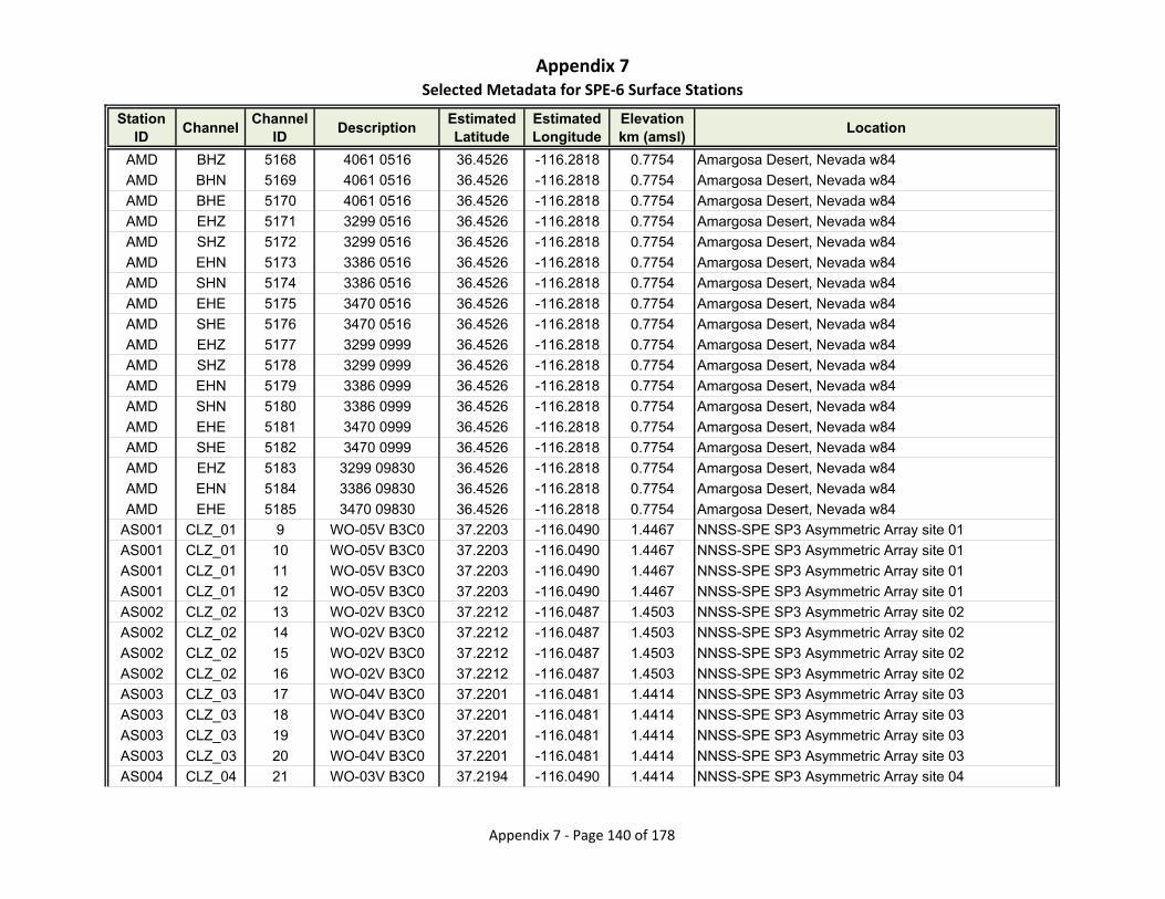
Appendix 7Selected Metadata for SPE‐6 Surface Stations
Station ID
ChannelChannel
IDDescription
Estimated Latitude
Estimated Longitude
Elevationkm (amsl)
Location
AMD BHZ 5168 4061 0516 36.4526 -116.2818 0.7754 Amargosa Desert, Nevada w84
AMD BHN 5169 4061 0516 36.4526 -116.2818 0.7754 Amargosa Desert, Nevada w84
AMD BHE 5170 4061 0516 36.4526 -116.2818 0.7754 Amargosa Desert, Nevada w84
AMD EHZ 5171 3299 0516 36.4526 -116.2818 0.7754 Amargosa Desert, Nevada w84
AMD SHZ 5172 3299 0516 36.4526 -116.2818 0.7754 Amargosa Desert, Nevada w84
AMD EHN 5173 3386 0516 36.4526 -116.2818 0.7754 Amargosa Desert, Nevada w84
AMD SHN 5174 3386 0516 36.4526 -116.2818 0.7754 Amargosa Desert, Nevada w84
AMD EHE 5175 3470 0516 36.4526 -116.2818 0.7754 Amargosa Desert, Nevada w84
AMD SHE 5176 3470 0516 36.4526 -116.2818 0.7754 Amargosa Desert, Nevada w84
AMD EHZ 5177 3299 0999 36.4526 -116.2818 0.7754 Amargosa Desert, Nevada w84
AMD SHZ 5178 3299 0999 36.4526 -116.2818 0.7754 Amargosa Desert, Nevada w84
AMD EHN 5179 3386 0999 36.4526 -116.2818 0.7754 Amargosa Desert, Nevada w84
AMD SHN 5180 3386 0999 36.4526 -116.2818 0.7754 Amargosa Desert, Nevada w84
AMD EHE 5181 3470 0999 36.4526 -116.2818 0.7754 Amargosa Desert, Nevada w84
AMD SHE 5182 3470 0999 36.4526 -116.2818 0.7754 Amargosa Desert, Nevada w84
AMD EHZ 5183 3299 09830 36.4526 -116.2818 0.7754 Amargosa Desert, Nevada w84
AMD EHN 5184 3386 09830 36.4526 -116.2818 0.7754 Amargosa Desert, Nevada w84
AMD EHE 5185 3470 09830 36.4526 -116.2818 0.7754 Amargosa Desert, Nevada w84
AS001 CLZ_01 9 WO-05V B3C0 37.2203 -116.0490 1.4467 NNSS-SPE SP3 Asymmetric Array site 01
AS001 CLZ_01 10 WO-05V B3C0 37.2203 -116.0490 1.4467 NNSS-SPE SP3 Asymmetric Array site 01
AS001 CLZ_01 11 WO-05V B3C0 37.2203 -116.0490 1.4467 NNSS-SPE SP3 Asymmetric Array site 01
AS001 CLZ_01 12 WO-05V B3C0 37.2203 -116.0490 1.4467 NNSS-SPE SP3 Asymmetric Array site 01
AS002 CLZ_02 13 WO-02V B3C0 37.2212 -116.0487 1.4503 NNSS-SPE SP3 Asymmetric Array site 02
AS002 CLZ_02 14 WO-02V B3C0 37.2212 -116.0487 1.4503 NNSS-SPE SP3 Asymmetric Array site 02
AS002 CLZ_02 15 WO-02V B3C0 37.2212 -116.0487 1.4503 NNSS-SPE SP3 Asymmetric Array site 02
AS002 CLZ_02 16 WO-02V B3C0 37.2212 -116.0487 1.4503 NNSS-SPE SP3 Asymmetric Array site 02
AS003 CLZ_03 17 WO-04V B3C0 37.2201 -116.0481 1.4414 NNSS-SPE SP3 Asymmetric Array site 03
AS003 CLZ_03 18 WO-04V B3C0 37.2201 -116.0481 1.4414 NNSS-SPE SP3 Asymmetric Array site 03
AS003 CLZ_03 19 WO-04V B3C0 37.2201 -116.0481 1.4414 NNSS-SPE SP3 Asymmetric Array site 03
AS003 CLZ_03 20 WO-04V B3C0 37.2201 -116.0481 1.4414 NNSS-SPE SP3 Asymmetric Array site 03
AS004 CLZ_04 21 WO-03V B3C0 37.2194 -116.0490 1.4414 NNSS-SPE SP3 Asymmetric Array site 04
Appendix 7 ‐ Page 140 of 178
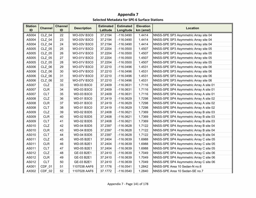
Appendix 7Selected Metadata for SPE‐6 Surface Stations
Station ID
ChannelChannel
IDDescription
Estimated Latitude
Estimated Longitude
Elevationkm (amsl)
Location
AS004 CLZ_04 22 WO-03V B3C0 37.2194 -116.0490 1.4414 NNSS-SPE SP3 Asymmetric Array site 04
AS004 CLZ_04 23 WO-03V B3C0 37.2194 -116.0490 1.4414 NNSS-SPE SP3 Asymmetric Array site 04
AS004 CLZ_04 24 WO-03V B3C0 37.2194 -116.0490 1.4414 NNSS-SPE SP3 Asymmetric Array site 04
AS005 CLZ_05 25 WO-01V B3C0 37.2204 -116.0500 1.4507 NNSS-SPE SP3 Asymmetric Array site 05
AS005 CLZ_05 26 WO-01V B3C0 37.2204 -116.0500 1.4507 NNSS-SPE SP3 Asymmetric Array site 05
AS005 CLZ_05 27 WO-01V B3C0 37.2204 -116.0500 1.4507 NNSS-SPE SP3 Asymmetric Array site 05
AS005 CLZ_05 28 WO-01V B3C0 37.2204 -116.0500 1.4507 NNSS-SPE SP3 Asymmetric Array site 05
AS006 CLZ_06 29 WO-07V B3C0 37.2210 -116.0496 1.4531 NNSS-SPE SP3 Asymmetric Array site 06
AS006 CLZ_06 30 WO-07V B3C0 37.2210 -116.0496 1.4531 NNSS-SPE SP3 Asymmetric Array site 06
AS006 CLZ_06 31 WO-07V B3C0 37.2210 -116.0496 1.4531 NNSS-SPE SP3 Asymmetric Array site 06
AS006 CLZ_06 32 WO-07V B3C0 37.2210 -116.0496 1.4531 NNSS-SPE SP3 Asymmetric Array site 06
AS007 CLZ 33 WD-03 B3C0 37.2409 -116.0631 1.7116 NNSS-SPE SP4 Asymmetric Array A site 01
AS007 CLR 34 WD-03 B3C0 37.2409 -116.0631 1.7116 NNSS-SPE SP4 Asymmetric Array A site 01
AS007 CLT 35 WD-03 B3C0 37.2409 -116.0631 1.7116 NNSS-SPE SP4 Asymmetric Array A site 01
AS008 CLZ 36 WD-01 B3C0 37.2419 -116.0629 1.7298 NNSS-SPE SP4 Asymmetric Array A site 02
AS008 CLR 37 WD-01 B3C0 37.2419 -116.0629 1.7298 NNSS-SPE SP4 Asymmetric Array A site 02
AS008 CLT 38 WD-01 B3C0 37.2419 -116.0629 1.7298 NNSS-SPE SP4 Asymmetric Array A site 02
AS009 CLZ 39 WD-02 B3D5 37.2408 -116.0621 1.7369 NNSS-SPE SP4 Asymmetric Array B site 03
AS009 CLR 40 WD-02 B3D5 37.2408 -116.0621 1.7369 NNSS-SPE SP4 Asymmetric Array B site 03
AS009 CLT 41 WD-02 B3D5 37.2408 -116.0621 1.7369 NNSS-SPE SP4 Asymmetric Array B site 03
AS010 CLZ 42 WD-04 B3D5 37.2397 -116.0628 1.7122 NNSS-SPE SP4 Asymmetric Array B site 04
AS010 CLR 43 WD-04 B3D5 37.2397 -116.0628 1.7122 NNSS-SPE SP4 Asymmetric Array B site 04
AS010 CLT 44 WD-04 B3D5 37.2397 -116.0628 1.7122 NNSS-SPE SP4 Asymmetric Array B site 04
AS011 CLZ 45 WD-05 B2E1 37.2404 -116.0639 1.6988 NNSS-SPE SP4 Asymmetric Array C site 05
AS011 CLR 46 WD-05 B2E1 37.2404 -116.0639 1.6988 NNSS-SPE SP4 Asymmetric Array C site 05
AS011 CLT 47 WD-05 B2E1 37.2404 -116.0639 1.6988 NNSS-SPE SP4 Asymmetric Array C site 05
AS012 CLZ 48 GE-03 B2E1 37.2410 -116.0639 1.7049 NNSS-SPE SP4 Asymmetric Array C site 06
AS012 CLR 49 GE-03 B2E1 37.2410 -116.0639 1.7049 NNSS-SPE SP4 Asymmetric Array C site 06
AS012 CLT 50 GE-03 B2E1 37.2410 -116.0639 1.7049 NNSS-SPE SP4 Asymmetric Array C site 06
AX001 CDF_01 51 1107038 AAF6 37.1776 -116.0541 1.2842 NNSS-SPE Area 10 Sedan-N no.6
AX002 CDF_02 52 1107028 AAF6 37.1772 -116.0540 1.2840 NNSS-SPE Area 10 Sedan-SE no.7
Appendix 7 ‐ Page 141 of 178
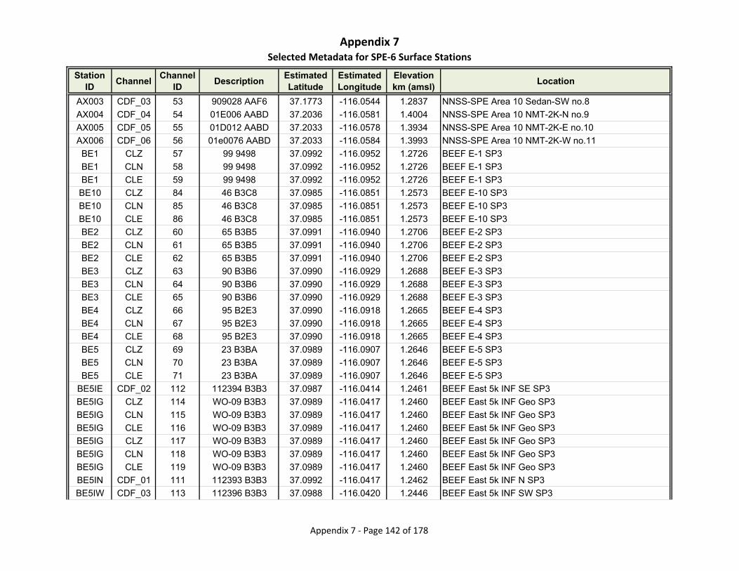
Appendix 7Selected Metadata for SPE‐6 Surface Stations
Station ID
ChannelChannel
IDDescription
Estimated Latitude
Estimated Longitude
Elevationkm (amsl)
Location
AX003 CDF_03 53 909028 AAF6 37.1773 -116.0544 1.2837 NNSS-SPE Area 10 Sedan-SW no.8
AX004 CDF_04 54 01E006 AABD 37.2036 -116.0581 1.4004 NNSS-SPE Area 10 NMT-2K-N no.9
AX005 CDF_05 55 01D012 AABD 37.2033 -116.0578 1.3934 NNSS-SPE Area 10 NMT-2K-E no.10
AX006 CDF_06 56 01e0076 AABD 37.2033 -116.0584 1.3993 NNSS-SPE Area 10 NMT-2K-W no.11
BE1 CLZ 57 99 9498 37.0992 -116.0952 1.2726 BEEF E-1 SP3
BE1 CLN 58 99 9498 37.0992 -116.0952 1.2726 BEEF E-1 SP3
BE1 CLE 59 99 9498 37.0992 -116.0952 1.2726 BEEF E-1 SP3
BE10 CLZ 84 46 B3C8 37.0985 -116.0851 1.2573 BEEF E-10 SP3
BE10 CLN 85 46 B3C8 37.0985 -116.0851 1.2573 BEEF E-10 SP3
BE10 CLE 86 46 B3C8 37.0985 -116.0851 1.2573 BEEF E-10 SP3
BE2 CLZ 60 65 B3B5 37.0991 -116.0940 1.2706 BEEF E-2 SP3
BE2 CLN 61 65 B3B5 37.0991 -116.0940 1.2706 BEEF E-2 SP3
BE2 CLE 62 65 B3B5 37.0991 -116.0940 1.2706 BEEF E-2 SP3
BE3 CLZ 63 90 B3B6 37.0990 -116.0929 1.2688 BEEF E-3 SP3
BE3 CLN 64 90 B3B6 37.0990 -116.0929 1.2688 BEEF E-3 SP3
BE3 CLE 65 90 B3B6 37.0990 -116.0929 1.2688 BEEF E-3 SP3
BE4 CLZ 66 95 B2E3 37.0990 -116.0918 1.2665 BEEF E-4 SP3
BE4 CLN 67 95 B2E3 37.0990 -116.0918 1.2665 BEEF E-4 SP3
BE4 CLE 68 95 B2E3 37.0990 -116.0918 1.2665 BEEF E-4 SP3
BE5 CLZ 69 23 B3BA 37.0989 -116.0907 1.2646 BEEF E-5 SP3
BE5 CLN 70 23 B3BA 37.0989 -116.0907 1.2646 BEEF E-5 SP3
BE5 CLE 71 23 B3BA 37.0989 -116.0907 1.2646 BEEF E-5 SP3
BE5IE CDF_02 112 112394 B3B3 37.0987 -116.0414 1.2461 BEEF East 5k INF SE SP3
BE5IG CLZ 114 WO-09 B3B3 37.0989 -116.0417 1.2460 BEEF East 5k INF Geo SP3
BE5IG CLN 115 WO-09 B3B3 37.0989 -116.0417 1.2460 BEEF East 5k INF Geo SP3
BE5IG CLE 116 WO-09 B3B3 37.0989 -116.0417 1.2460 BEEF East 5k INF Geo SP3
BE5IG CLZ 117 WO-09 B3B3 37.0989 -116.0417 1.2460 BEEF East 5k INF Geo SP3
BE5IG CLN 118 WO-09 B3B3 37.0989 -116.0417 1.2460 BEEF East 5k INF Geo SP3
BE5IG CLE 119 WO-09 B3B3 37.0989 -116.0417 1.2460 BEEF East 5k INF Geo SP3
BE5IN CDF_01 111 112393 B3B3 37.0992 -116.0417 1.2462 BEEF East 5k INF N SP3
BE5IW CDF_03 113 112396 B3B3 37.0988 -116.0420 1.2446 BEEF East 5k INF SW SP3
Appendix 7 ‐ Page 142 of 178
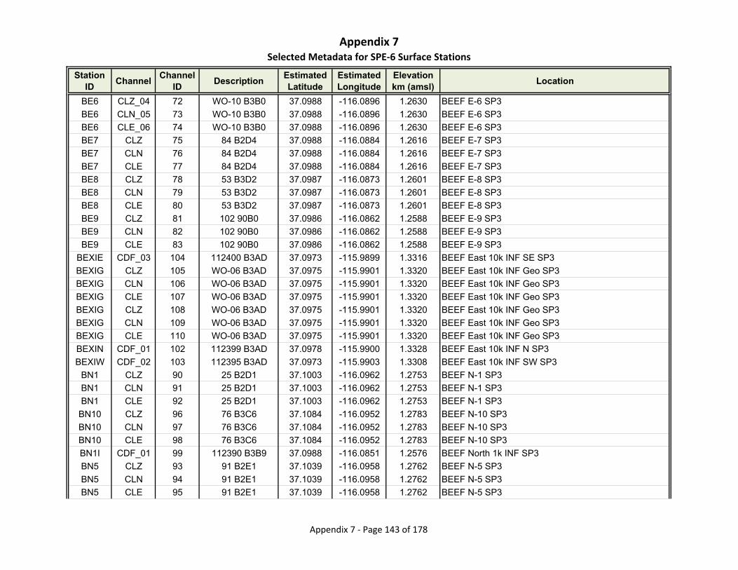
Appendix 7Selected Metadata for SPE‐6 Surface Stations
Station ID
ChannelChannel
IDDescription
Estimated Latitude
Estimated Longitude
Elevationkm (amsl)
Location
BE6 CLZ_04 72 WO-10 B3B0 37.0988 -116.0896 1.2630 BEEF E-6 SP3
BE6 CLN_05 73 WO-10 B3B0 37.0988 -116.0896 1.2630 BEEF E-6 SP3
BE6 CLE_06 74 WO-10 B3B0 37.0988 -116.0896 1.2630 BEEF E-6 SP3
BE7 CLZ 75 84 B2D4 37.0988 -116.0884 1.2616 BEEF E-7 SP3
BE7 CLN 76 84 B2D4 37.0988 -116.0884 1.2616 BEEF E-7 SP3
BE7 CLE 77 84 B2D4 37.0988 -116.0884 1.2616 BEEF E-7 SP3
BE8 CLZ 78 53 B3D2 37.0987 -116.0873 1.2601 BEEF E-8 SP3
BE8 CLN 79 53 B3D2 37.0987 -116.0873 1.2601 BEEF E-8 SP3
BE8 CLE 80 53 B3D2 37.0987 -116.0873 1.2601 BEEF E-8 SP3
BE9 CLZ 81 102 90B0 37.0986 -116.0862 1.2588 BEEF E-9 SP3
BE9 CLN 82 102 90B0 37.0986 -116.0862 1.2588 BEEF E-9 SP3
BE9 CLE 83 102 90B0 37.0986 -116.0862 1.2588 BEEF E-9 SP3
BEXIE CDF_03 104 112400 B3AD 37.0973 -115.9899 1.3316 BEEF East 10k INF SE SP3
BEXIG CLZ 105 WO-06 B3AD 37.0975 -115.9901 1.3320 BEEF East 10k INF Geo SP3
BEXIG CLN 106 WO-06 B3AD 37.0975 -115.9901 1.3320 BEEF East 10k INF Geo SP3
BEXIG CLE 107 WO-06 B3AD 37.0975 -115.9901 1.3320 BEEF East 10k INF Geo SP3
BEXIG CLZ 108 WO-06 B3AD 37.0975 -115.9901 1.3320 BEEF East 10k INF Geo SP3
BEXIG CLN 109 WO-06 B3AD 37.0975 -115.9901 1.3320 BEEF East 10k INF Geo SP3
BEXIG CLE 110 WO-06 B3AD 37.0975 -115.9901 1.3320 BEEF East 10k INF Geo SP3
BEXIN CDF_01 102 112399 B3AD 37.0978 -115.9900 1.3328 BEEF East 10k INF N SP3
BEXIW CDF_02 103 112395 B3AD 37.0973 -115.9903 1.3308 BEEF East 10k INF SW SP3
BN1 CLZ 90 25 B2D1 37.1003 -116.0962 1.2753 BEEF N-1 SP3
BN1 CLN 91 25 B2D1 37.1003 -116.0962 1.2753 BEEF N-1 SP3
BN1 CLE 92 25 B2D1 37.1003 -116.0962 1.2753 BEEF N-1 SP3
BN10 CLZ 96 76 B3C6 37.1084 -116.0952 1.2783 BEEF N-10 SP3
BN10 CLN 97 76 B3C6 37.1084 -116.0952 1.2783 BEEF N-10 SP3
BN10 CLE 98 76 B3C6 37.1084 -116.0952 1.2783 BEEF N-10 SP3
BN1I CDF_01 99 112390 B3B9 37.0988 -116.0851 1.2576 BEEF North 1k INF SP3
BN5 CLZ 93 91 B2E1 37.1039 -116.0958 1.2762 BEEF N-5 SP3
BN5 CLN 94 91 B2E1 37.1039 -116.0958 1.2762 BEEF N-5 SP3
BN5 CLE 95 91 B2E1 37.1039 -116.0958 1.2762 BEEF N-5 SP3
Appendix 7 ‐ Page 143 of 178
Appendix 7Selected Metadata for SPE‐6 Surface Stations
Station ID
ChannelChannel
IDDescription
Estimated Latitude
Estimated Longitude
Elevationkm (amsl)
Location
BRH5 HHZ 5849 2975 D124 39.0544 -118.0356 1.6030 Broken Hills, NV, USA
BRH5 HHN 5850 2975 D124 39.0544 -118.0356 1.6030 Broken Hills, NV, USA
BRH5 HHE 5851 2975 D124 39.0544 -118.0356 1.6030 Broken Hills, NV, USA
BRS2 HHZ 5852 2956 D11E 38.5264 -117.6306 1.7320 Black Rock Springs, NV, USA
BRS2 HHN 5853 2956 D11E 38.5264 -117.6306 1.7320 Black Rock Springs, NV, USA
BRS2 HHE 5854 2956 D11E 38.5264 -117.6306 1.7320 Black Rock Springs, NV, USA
BSE1I CDF_02 100 112391 B3B9 37.0984 -116.0848 1.2568 BEEF Southeast 1k INF SP3
BSW1I CDF_03 101 112389 B3B9 37.0984 -116.0854 1.2576 BEEF Southwest 1k INF SP3
BTW EHZ 5186 3347 0707 36.9978 -116.5674 1.3910 Beatty Wash, Nevada w84
BTW SHZ 5187 3347 0707 36.9978 -116.5674 1.3910 Beatty Wash, Nevada w84
BTW EHN 5188 3330 0707 36.9978 -116.5674 1.3910 Beatty Wash, Nevada w84
BTW SHN 5189 3330 0707 36.9978 -116.5674 1.3910 Beatty Wash, Nevada w84
BTW EHE 5190 3350 0707 36.9978 -116.5674 1.3910 Beatty Wash, Nevada w84
BTW SHE 5191 3350 0707 36.9978 -116.5674 1.3910 Beatty Wash, Nevada w84
BTW EHZ 5192 3347 0713 36.9978 -116.5674 1.3910 Beatty Wash, Nevada w84
BTW SHZ 5193 3347 0713 36.9978 -116.5674 1.3910 Beatty Wash, Nevada w84
BTW EHN 5194 3330 0713 36.9978 -116.5674 1.3910 Beatty Wash, Nevada w84
BTW SHN 5195 3330 0713 36.9978 -116.5674 1.3910 Beatty Wash, Nevada w84
BTW EHE 5196 3350 0713 36.9978 -116.5674 1.3910 Beatty Wash, Nevada w84
BTW SHE 5197 3350 0713 36.9978 -116.5674 1.3910 Beatty Wash, Nevada w84
BTW EHZ 5198 3347 0515 36.9978 -116.5674 1.3910 Beatty Wash, Nevada w84
BTW SHZ 5199 3347 0515 36.9978 -116.5674 1.3910 Beatty Wash, Nevada w84
BTW EHN 5200 3330 0515 36.9978 -116.5674 1.3910 Beatty Wash, Nevada w84
BTW SHN 5201 3330 0515 36.9978 -116.5674 1.3910 Beatty Wash, Nevada w84
BTW EHE 5202 3350 0515 36.9978 -116.5674 1.3910 Beatty Wash, Nevada w84
BTW SHE 5203 3350 0515 36.9978 -116.5674 1.3910 Beatty Wash, Nevada w84
BTW EHZ 5204 3347 1122 36.9978 -116.5674 1.3910 Beatty Wash, Nevada w84
BTW SHZ 5205 3347 1122 36.9978 -116.5674 1.3910 Beatty Wash, Nevada w84
BTW EHN 5206 3330 1122 36.9978 -116.5674 1.3910 Beatty Wash, Nevada w84
BTW SHN 5207 3330 1122 36.9978 -116.5674 1.3910 Beatty Wash, Nevada w84
BTW EHE 5208 3350 1122 36.9978 -116.5674 1.3910 Beatty Wash, Nevada w84
Appendix 7 ‐ Page 144 of 178
Appendix 7Selected Metadata for SPE‐6 Surface Stations
Station ID
ChannelChannel
IDDescription
Estimated Latitude
Estimated Longitude
Elevationkm (amsl)
Location
BTW SHE 5209 3350 1122 36.9978 -116.5674 1.3910 Beatty Wash, Nevada w84
BTW EHZ 5210 3347 0985C 36.9978 -116.5674 1.3910 Beatty Wash, Nevada w84
BTW EHN 5211 3330 0985C 36.9978 -116.5674 1.3910 Beatty Wash, Nevada w84
BTW EHE 5212 3350 0985C 36.9978 -116.5674 1.3910 Beatty Wash, Nevada w84
BW1 CLZ 87 3 B3AF 37.0994 -116.0974 1.2760 BEEF W-1 SP3
BW1 CLN 88 3 B3AF 37.0994 -116.0974 1.2760 BEEF W-1 SP3
BW1 CLE 89 3 B3AF 37.0994 -116.0974 1.2760 BEEF W-1 SP3
CAF EHZ 5213 3355 0704 36.8391 -116.3386 1.1100 Calico Fan, NTS, Nevada w84
CAF SHZ 5214 3355 0704 36.8391 -116.3386 1.1100 Calico Fan, NTS, Nevada w84
CAF EHN 5215 3356 0704 36.8391 -116.3386 1.1100 Calico Fan, NTS, Nevada w84
CAF SHN 5216 3356 0704 36.8391 -116.3386 1.1100 Calico Fan, NTS, Nevada w84
CAF EHE 5217 3357 0704 36.8391 -116.3386 1.1100 Calico Fan, NTS, Nevada w84
CAF SHE 5218 3357 0704 36.8391 -116.3386 1.1100 Calico Fan, NTS, Nevada w84
CAF EHZ 5219 3355 0513 36.8391 -116.3386 1.1100 Calico Fan, NTS, Nevada w84
CAF SHZ 5220 3355 0513 36.8391 -116.3386 1.1100 Calico Fan, NTS, Nevada w84
CAF EHN 5221 3356 0513 36.8391 -116.3386 1.1100 Calico Fan, NTS, Nevada w84
CAF SHN 5222 3356 0513 36.8391 -116.3386 1.1100 Calico Fan, NTS, Nevada w84
CAF EHE 5223 3357 0513 36.8391 -116.3386 1.1100 Calico Fan, NTS, Nevada w84
CAF SHE 5224 3357 0513 36.8391 -116.3386 1.1100 Calico Fan, NTS, Nevada w84
CAF HGZ 5225 0239 0513 36.8391 -116.3386 1.1100 Calico Fan, NTS, Nevada w84
CAF HGN 5226 0239 0513 36.8391 -116.3386 1.1100 Calico Fan, NTS, Nevada w84
CAF HGE 5227 0239 0513 36.8391 -116.3386 1.1100 Calico Fan, NTS, Nevada w84
CAF EHZ 5228 3383 0513 36.8391 -116.3386 1.1100 Calico Fan, NTS, Nevada w84
CAF SHZ 5229 3383 0513 36.8391 -116.3386 1.1100 Calico Fan, NTS, Nevada w84
CAF EHZ 5230 3383 0951E 36.8391 -116.3386 1.1100 Calico Fan, NTS, Nevada w84
CAF EHN 5231 3356 0951E 36.8391 -116.3386 1.1100 Calico Fan, NTS, Nevada w84
CAF EHE 5232 3357 0951E 36.8391 -116.3386 1.1100 Calico Fan, NTS, Nevada w84
CAF HGZ 5233 0074 0951E 36.8391 -116.3386 1.1100 Calico Fan, NTS, Nevada w84
CAF HGN 5234 0074 0951E 36.8391 -116.3386 1.1100 Calico Fan, NTS, Nevada w84
CAF HGE 5235 0074 0951E 36.8391 -116.3386 1.1100 Calico Fan, NTS, Nevada w84
CAF EHZ 5236 3383 Q3262 36.8391 -116.3386 1.1100 Calico Fan, NTS, Nevada w84
Appendix 7 ‐ Page 145 of 178
Appendix 7Selected Metadata for SPE‐6 Surface Stations
Station ID
ChannelChannel
IDDescription
Estimated Latitude
Estimated Longitude
Elevationkm (amsl)
Location
CAF EHN 5237 3356 Q3262 36.8391 -116.3386 1.1100 Calico Fan, NTS, Nevada w84
CAF EHE 5238 3357 Q3262 36.8391 -116.3386 1.1100 Calico Fan, NTS, Nevada w84
CAF HGZ 5239 0074 Q3262 36.8391 -116.3386 1.1100 Calico Fan, NTS, Nevada w84
CAF HGN 5240 0074 Q3262 36.8391 -116.3386 1.1100 Calico Fan, NTS, Nevada w84
CAF HGE 5241 0074 Q3262 36.8391 -116.3386 1.1100 Calico Fan, NTS, Nevada w84
CMK6 HHZ 5855 3126 D178 39.3102 -118.1193 1.3320 Chalk Mountain, Churchill County, NV, USA
CMK6 HHN 5856 3126 D178 39.3102 -118.1193 1.3320 Chalk Mountain, Churchill County, NV, USA
CMK6 HHE 5857 3126 D178 39.3102 -118.1193 1.3320 Chalk Mountain, Churchill County, NV, USA
CPYB HHZ 5858 2969 D1C9 36.9319 -116.0564 1.2760 Control Point Y NTS, NV,USA NN analog reactivation
CPYB HHN 5859 2969 D1C9 36.9319 -116.0564 1.2760 Control Point Y NTS, NV,USA NN analog reactivation
CPYB HHE 5860 2969 D1C9 36.9319 -116.0564 1.2760 Control Point Y NTS, NV,USA NN analog reactivation
CPYB HHZ 5861 3285 D1C9 36.9319 -116.0564 1.2760 Control Point Y NTS, NV,USA NN analog reactivation
CPYB HHN 5862 3285 D1C9 36.9319 -116.0564 1.2760 Control Point Y NTS, NV,USA NN analog reactivation
CPYB HHE 5863 3285 D1C9 36.9319 -116.0564 1.2760 Control Point Y NTS, NV,USA NN analog reactivation
CRF EHZ 5242 3549 0706 36.8118 -116.5349 1.0320 Crater Flat, Nevada w84
CRF SHZ 5243 3549 0706 36.8118 -116.5349 1.0320 Crater Flat, Nevada w84
CRF EHN 5244 3295 0706 36.8118 -116.5349 1.0320 Crater Flat, Nevada w84
CRF SHN 5245 3295 0706 36.8118 -116.5349 1.0320 Crater Flat, Nevada w84
CRF EHE 5246 3559 0706 36.8118 -116.5349 1.0320 Crater Flat, Nevada w84
CRF SHE 5247 3559 0706 36.8118 -116.5349 1.0320 Crater Flat, Nevada w84
CRF HGZ 5248 0238 0706 36.8118 -116.5349 1.0320 Crater Flat, Nevada w84
CRF HGN 5249 0238 0706 36.8118 -116.5349 1.0320 Crater Flat, Nevada w84
CRF HGE 5250 0238 0706 36.8118 -116.5349 1.0320 Crater Flat, Nevada w84
CRF EHZ 5251 3549 092D3 36.8118 -116.5349 1.0320 Crater Flat, Nevada w84
CRF EHN 5252 3295 092D3 36.8118 -116.5349 1.0320 Crater Flat, Nevada w84
CRF EHE 5253 3559 092D3 36.8118 -116.5349 1.0320 Crater Flat, Nevada w84
CRF HGZ 5254 0091 092D3 36.8118 -116.5349 1.0320 Crater Flat, Nevada w84
CRF HGN 5255 0091 092D3 36.8118 -116.5349 1.0320 Crater Flat, Nevada w84
CRF HGE 5256 0091 092D3 36.8118 -116.5349 1.0320 Crater Flat, Nevada w84
CRF EHZ 5257 3549 Q3238 36.8118 -116.5349 1.0320 Crater Flat, Nevada w84
CRF EHN 5258 3295 Q3238 36.8118 -116.5349 1.0320 Crater Flat, Nevada w84
Appendix 7 ‐ Page 146 of 178
Appendix 7Selected Metadata for SPE‐6 Surface Stations
Station ID
ChannelChannel
IDDescription
Estimated Latitude
Estimated Longitude
Elevationkm (amsl)
Location
CRF EHE 5259 3559 Q3238 36.8118 -116.5349 1.0320 Crater Flat, Nevada w84
CRF HGZ 5260 0091 Q3238 36.8118 -116.5349 1.0320 Crater Flat, Nevada w84
CRF HGN 5261 0091 Q3238 36.8118 -116.5349 1.0320 Crater Flat, Nevada w84
CRF HGE 5262 0091 Q3238 36.8118 -116.5349 1.0320 Crater Flat, Nevada w84
DAC HHZ 5945 1669 D15A 36.2770 -117.5937 1.8130 Inyo County, Darwin, CA, USA
DAC HHN 5946 1669 D15A 36.2770 -117.5937 1.8130 Inyo County, Darwin, CA, USA
DAC HHE 5947 1669 D15A 36.2770 -117.5937 1.8130 Inyo County, Darwin, CA, USA
DOM EHZ 5263 3576 0712 37.0021 -116.4095 1.7110 Dome Mountain, NTS, Nevada w84
DOM SHZ 5264 3576 0712 37.0021 -116.4095 1.7110 Dome Mountain, NTS, Nevada w84
DOM EHN 5265 3577 0712 37.0021 -116.4095 1.7110 Dome Mountain, NTS, Nevada w84
DOM SHN 5266 3577 0712 37.0021 -116.4095 1.7110 Dome Mountain, NTS, Nevada w84
DOM EHE 5267 3350 0712 37.0021 -116.4095 1.7110 Dome Mountain, NTS, Nevada w84
DOM SHE 5268 3350 0712 37.0021 -116.4095 1.7110 Dome Mountain, NTS, Nevada w84
DOM EHZ 5269 3576 1120 37.0021 -116.4095 1.7110 Dome Mountain, NTS, Nevada w84
DOM SHZ 5270 3576 1120 37.0021 -116.4095 1.7110 Dome Mountain, NTS, Nevada w84
DOM EHN 5271 3577 1120 37.0021 -116.4095 1.7110 Dome Mountain, NTS, Nevada w84
DOM SHN 5272 3577 1120 37.0021 -116.4095 1.7110 Dome Mountain, NTS, Nevada w84
DOM EHE 5273 3350 1120 37.0021 -116.4095 1.7110 Dome Mountain, NTS, Nevada w84
DOM SHE 5274 3350 1120 37.0021 -116.4095 1.7110 Dome Mountain, NTS, Nevada w84
DOM EHZ 5275 3576 09BE0 37.0021 -116.4095 1.7110 Dome Mountain, NTS, Nevada w84
DOM EHN 5276 3577 09BE0 37.0021 -116.4095 1.7110 Dome Mountain, NTS, Nevada w84
DOM EHE 5277 3350 09BE0 37.0021 -116.4095 1.7110 Dome Mountain, NTS, Nevada w84
DSP HHZ 5864 609 3236 37.3680 -117.9722 1.6920 Deep Springs, California w84gm
DSP HHN 5865 609 3236 37.3680 -117.9722 1.6920 Deep Springs, California w84gm
DSP HHE 5866 609 3236 37.3680 -117.9722 1.6920 Deep Springs, California w84gm
DY10N CNZ 120 152 D1CE 37.2163 -116.0638 1.4732 NNSS-SPE LLNL Episensor 10 SP5
DY10N CNN 121 152 D1CE 37.2163 -116.0638 1.4732 NNSS-SPE LLNL Episensor 10 SP5
DY10N CNE 122 152 D1CE 37.2163 -116.0638 1.4732 NNSS-SPE LLNL Episensor 10 SP5
DY1N CNZ 123 15 D1BD 37.2256 -116.0595 1.5230 NNSS-SPE LLNL Episensor 1 SP5
DY1N CNN 124 15 D1BD 37.2256 -116.0595 1.5230 NNSS-SPE LLNL Episensor 1 SP5
DY1N CNE 125 15 D1BD 37.2256 -116.0595 1.5230 NNSS-SPE LLNL Episensor 1 SP5
Appendix 7 ‐ Page 147 of 178
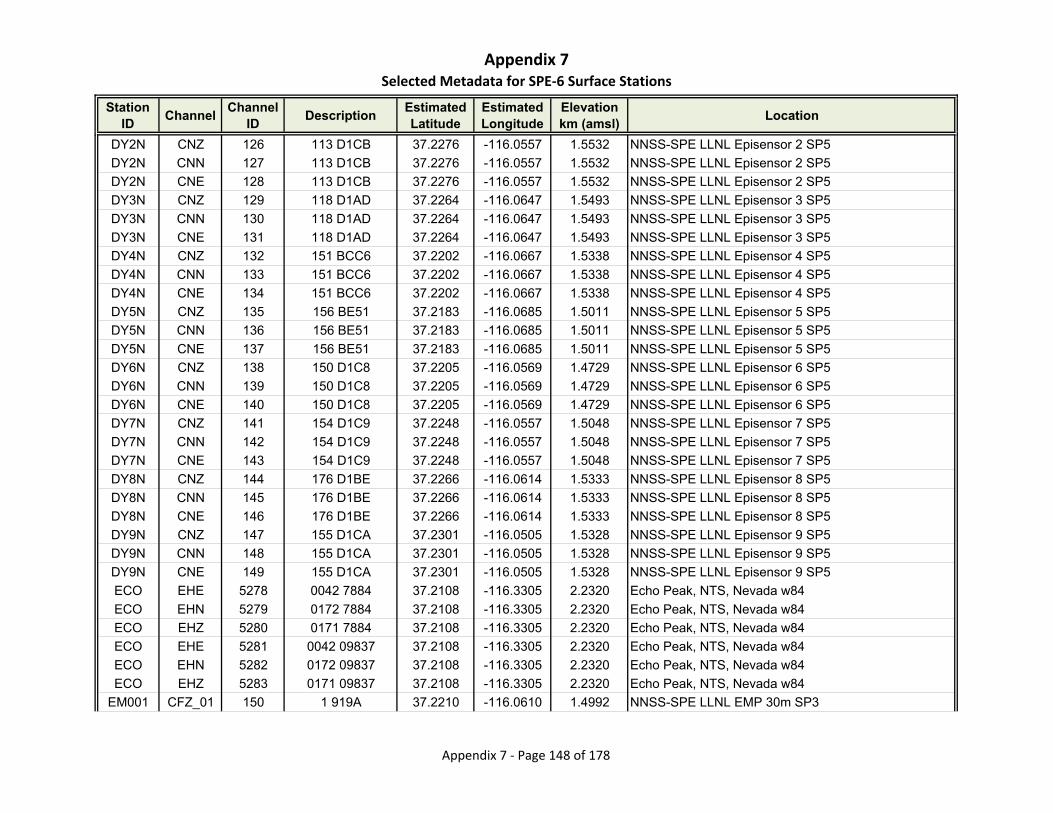
Appendix 7Selected Metadata for SPE‐6 Surface Stations
Station ID
ChannelChannel
IDDescription
Estimated Latitude
Estimated Longitude
Elevationkm (amsl)
Location
DY2N CNZ 126 113 D1CB 37.2276 -116.0557 1.5532 NNSS-SPE LLNL Episensor 2 SP5
DY2N CNN 127 113 D1CB 37.2276 -116.0557 1.5532 NNSS-SPE LLNL Episensor 2 SP5
DY2N CNE 128 113 D1CB 37.2276 -116.0557 1.5532 NNSS-SPE LLNL Episensor 2 SP5
DY3N CNZ 129 118 D1AD 37.2264 -116.0647 1.5493 NNSS-SPE LLNL Episensor 3 SP5
DY3N CNN 130 118 D1AD 37.2264 -116.0647 1.5493 NNSS-SPE LLNL Episensor 3 SP5
DY3N CNE 131 118 D1AD 37.2264 -116.0647 1.5493 NNSS-SPE LLNL Episensor 3 SP5
DY4N CNZ 132 151 BCC6 37.2202 -116.0667 1.5338 NNSS-SPE LLNL Episensor 4 SP5
DY4N CNN 133 151 BCC6 37.2202 -116.0667 1.5338 NNSS-SPE LLNL Episensor 4 SP5
DY4N CNE 134 151 BCC6 37.2202 -116.0667 1.5338 NNSS-SPE LLNL Episensor 4 SP5
DY5N CNZ 135 156 BE51 37.2183 -116.0685 1.5011 NNSS-SPE LLNL Episensor 5 SP5
DY5N CNN 136 156 BE51 37.2183 -116.0685 1.5011 NNSS-SPE LLNL Episensor 5 SP5
DY5N CNE 137 156 BE51 37.2183 -116.0685 1.5011 NNSS-SPE LLNL Episensor 5 SP5
DY6N CNZ 138 150 D1C8 37.2205 -116.0569 1.4729 NNSS-SPE LLNL Episensor 6 SP5
DY6N CNN 139 150 D1C8 37.2205 -116.0569 1.4729 NNSS-SPE LLNL Episensor 6 SP5
DY6N CNE 140 150 D1C8 37.2205 -116.0569 1.4729 NNSS-SPE LLNL Episensor 6 SP5
DY7N CNZ 141 154 D1C9 37.2248 -116.0557 1.5048 NNSS-SPE LLNL Episensor 7 SP5
DY7N CNN 142 154 D1C9 37.2248 -116.0557 1.5048 NNSS-SPE LLNL Episensor 7 SP5
DY7N CNE 143 154 D1C9 37.2248 -116.0557 1.5048 NNSS-SPE LLNL Episensor 7 SP5
DY8N CNZ 144 176 D1BE 37.2266 -116.0614 1.5333 NNSS-SPE LLNL Episensor 8 SP5
DY8N CNN 145 176 D1BE 37.2266 -116.0614 1.5333 NNSS-SPE LLNL Episensor 8 SP5
DY8N CNE 146 176 D1BE 37.2266 -116.0614 1.5333 NNSS-SPE LLNL Episensor 8 SP5
DY9N CNZ 147 155 D1CA 37.2301 -116.0505 1.5328 NNSS-SPE LLNL Episensor 9 SP5
DY9N CNN 148 155 D1CA 37.2301 -116.0505 1.5328 NNSS-SPE LLNL Episensor 9 SP5
DY9N CNE 149 155 D1CA 37.2301 -116.0505 1.5328 NNSS-SPE LLNL Episensor 9 SP5
ECO EHE 5278 0042 7884 37.2108 -116.3305 2.2320 Echo Peak, NTS, Nevada w84
ECO EHN 5279 0172 7884 37.2108 -116.3305 2.2320 Echo Peak, NTS, Nevada w84
ECO EHZ 5280 0171 7884 37.2108 -116.3305 2.2320 Echo Peak, NTS, Nevada w84
ECO EHE 5281 0042 09837 37.2108 -116.3305 2.2320 Echo Peak, NTS, Nevada w84
ECO EHN 5282 0172 09837 37.2108 -116.3305 2.2320 Echo Peak, NTS, Nevada w84
ECO EHZ 5283 0171 09837 37.2108 -116.3305 2.2320 Echo Peak, NTS, Nevada w84
EM001 CFZ_01 150 1 919A 37.2210 -116.0610 1.4992 NNSS-SPE LLNL EMP 30m SP3
Appendix 7 ‐ Page 148 of 178
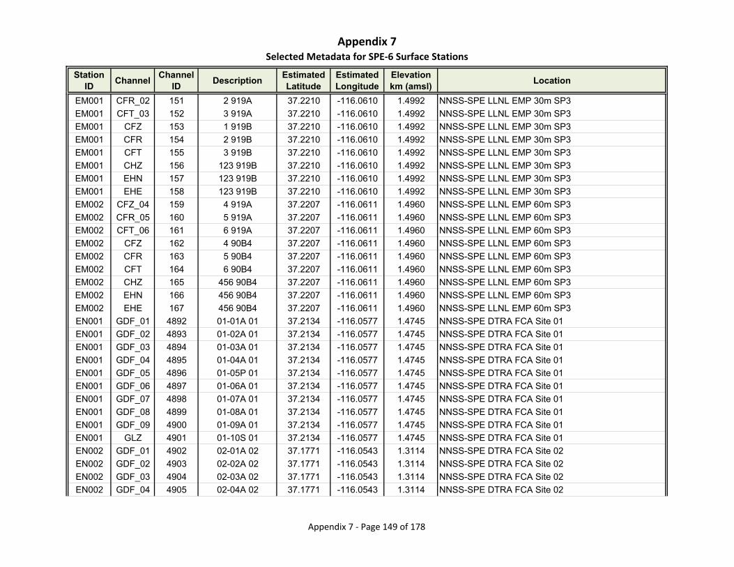
Appendix 7Selected Metadata for SPE‐6 Surface Stations
Station ID
ChannelChannel
IDDescription
Estimated Latitude
Estimated Longitude
Elevationkm (amsl)
Location
EM001 CFR_02 151 2 919A 37.2210 -116.0610 1.4992 NNSS-SPE LLNL EMP 30m SP3
EM001 CFT_03 152 3 919A 37.2210 -116.0610 1.4992 NNSS-SPE LLNL EMP 30m SP3
EM001 CFZ 153 1 919B 37.2210 -116.0610 1.4992 NNSS-SPE LLNL EMP 30m SP3
EM001 CFR 154 2 919B 37.2210 -116.0610 1.4992 NNSS-SPE LLNL EMP 30m SP3
EM001 CFT 155 3 919B 37.2210 -116.0610 1.4992 NNSS-SPE LLNL EMP 30m SP3
EM001 CHZ 156 123 919B 37.2210 -116.0610 1.4992 NNSS-SPE LLNL EMP 30m SP3
EM001 EHN 157 123 919B 37.2210 -116.0610 1.4992 NNSS-SPE LLNL EMP 30m SP3
EM001 EHE 158 123 919B 37.2210 -116.0610 1.4992 NNSS-SPE LLNL EMP 30m SP3
EM002 CFZ_04 159 4 919A 37.2207 -116.0611 1.4960 NNSS-SPE LLNL EMP 60m SP3
EM002 CFR_05 160 5 919A 37.2207 -116.0611 1.4960 NNSS-SPE LLNL EMP 60m SP3
EM002 CFT_06 161 6 919A 37.2207 -116.0611 1.4960 NNSS-SPE LLNL EMP 60m SP3
EM002 CFZ 162 4 90B4 37.2207 -116.0611 1.4960 NNSS-SPE LLNL EMP 60m SP3
EM002 CFR 163 5 90B4 37.2207 -116.0611 1.4960 NNSS-SPE LLNL EMP 60m SP3
EM002 CFT 164 6 90B4 37.2207 -116.0611 1.4960 NNSS-SPE LLNL EMP 60m SP3
EM002 CHZ 165 456 90B4 37.2207 -116.0611 1.4960 NNSS-SPE LLNL EMP 60m SP3
EM002 EHN 166 456 90B4 37.2207 -116.0611 1.4960 NNSS-SPE LLNL EMP 60m SP3
EM002 EHE 167 456 90B4 37.2207 -116.0611 1.4960 NNSS-SPE LLNL EMP 60m SP3
EN001 GDF_01 4892 01-01A 01 37.2134 -116.0577 1.4745 NNSS-SPE DTRA FCA Site 01
EN001 GDF_02 4893 01-02A 01 37.2134 -116.0577 1.4745 NNSS-SPE DTRA FCA Site 01
EN001 GDF_03 4894 01-03A 01 37.2134 -116.0577 1.4745 NNSS-SPE DTRA FCA Site 01
EN001 GDF_04 4895 01-04A 01 37.2134 -116.0577 1.4745 NNSS-SPE DTRA FCA Site 01
EN001 GDF_05 4896 01-05P 01 37.2134 -116.0577 1.4745 NNSS-SPE DTRA FCA Site 01
EN001 GDF_06 4897 01-06A 01 37.2134 -116.0577 1.4745 NNSS-SPE DTRA FCA Site 01
EN001 GDF_07 4898 01-07A 01 37.2134 -116.0577 1.4745 NNSS-SPE DTRA FCA Site 01
EN001 GDF_08 4899 01-08A 01 37.2134 -116.0577 1.4745 NNSS-SPE DTRA FCA Site 01
EN001 GDF_09 4900 01-09A 01 37.2134 -116.0577 1.4745 NNSS-SPE DTRA FCA Site 01
EN001 GLZ 4901 01-10S 01 37.2134 -116.0577 1.4745 NNSS-SPE DTRA FCA Site 01
EN002 GDF_01 4902 02-01A 02 37.1771 -116.0543 1.3114 NNSS-SPE DTRA FCA Site 02
EN002 GDF_02 4903 02-02A 02 37.1771 -116.0543 1.3114 NNSS-SPE DTRA FCA Site 02
EN002 GDF_03 4904 02-03A 02 37.1771 -116.0543 1.3114 NNSS-SPE DTRA FCA Site 02
EN002 GDF_04 4905 02-04A 02 37.1771 -116.0543 1.3114 NNSS-SPE DTRA FCA Site 02
Appendix 7 ‐ Page 149 of 178
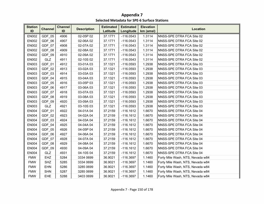
Appendix 7Selected Metadata for SPE‐6 Surface Stations
Station ID
ChannelChannel
IDDescription
Estimated Latitude
Estimated Longitude
Elevationkm (amsl)
Location
EN002 GDF_05 4906 02-05P 02 37.1771 -116.0543 1.3114 NNSS-SPE DTRA FCA Site 02
EN002 GDF_06 4907 02-06A 02 37.1771 -116.0543 1.3114 NNSS-SPE DTRA FCA Site 02
EN002 GDF_07 4908 02-07A 02 37.1771 -116.0543 1.3114 NNSS-SPE DTRA FCA Site 02
EN002 GDF_08 4909 02-08A 02 37.1771 -116.0543 1.3114 NNSS-SPE DTRA FCA Site 02
EN002 GDF_09 4910 02-09A 02 37.1771 -116.0543 1.3114 NNSS-SPE DTRA FCA Site 02
EN002 GLZ 4911 02-10S 02 37.1771 -116.0543 1.3114 NNSS-SPE DTRA FCA Site 02
EN003 GDF_01 4912 03-01A 03 37.1321 -116.0593 1.2938 NNSS-SPE DTRA FCA Site 03
EN003 GDF_02 4913 03-02A 03 37.1321 -116.0593 1.2938 NNSS-SPE DTRA FCA Site 03
EN003 GDF_03 4914 03-03A 03 37.1321 -116.0593 1.2938 NNSS-SPE DTRA FCA Site 03
EN003 GDF_04 4915 03-04A 03 37.1321 -116.0593 1.2938 NNSS-SPE DTRA FCA Site 03
EN003 GDF_05 4916 03-05P 03 37.1321 -116.0593 1.2938 NNSS-SPE DTRA FCA Site 03
EN003 GDF_06 4917 03-06A 03 37.1321 -116.0593 1.2938 NNSS-SPE DTRA FCA Site 03
EN003 GDF_07 4918 03-07A 03 37.1321 -116.0593 1.2938 NNSS-SPE DTRA FCA Site 03
EN003 GDF_08 4919 03-08A 03 37.1321 -116.0593 1.2938 NNSS-SPE DTRA FCA Site 03
EN003 GDF_09 4920 03-09A 03 37.1321 -116.0593 1.2938 NNSS-SPE DTRA FCA Site 03
EN003 GLZ 4921 03-10S 03 37.1321 -116.0593 1.2938 NNSS-SPE DTRA FCA Site 03
EN004 GDF_01 4922 04-01A 04 37.2159 -116.1612 1.6670 NNSS-SPE DTRA FCA Site 04
EN004 GDF_02 4923 04-02A 04 37.2159 -116.1612 1.6670 NNSS-SPE DTRA FCA Site 04
EN004 GDF_03 4924 04-03A 04 37.2159 -116.1612 1.6670 NNSS-SPE DTRA FCA Site 04
EN004 GDF_04 4925 04-04A 04 37.2159 -116.1612 1.6670 NNSS-SPE DTRA FCA Site 04
EN004 GDF_05 4926 04-05P 04 37.2159 -116.1612 1.6670 NNSS-SPE DTRA FCA Site 04
EN004 GDF_06 4927 04-06A 04 37.2159 -116.1612 1.6670 NNSS-SPE DTRA FCA Site 04
EN004 GDF_07 4928 04-07A 04 37.2159 -116.1612 1.6670 NNSS-SPE DTRA FCA Site 04
EN004 GDF_08 4929 04-08A 04 37.2159 -116.1612 1.6670 NNSS-SPE DTRA FCA Site 04
EN004 GDF_09 4930 04-09A 04 37.2159 -116.1612 1.6670 NNSS-SPE DTRA FCA Site 04
EN004 GLZ 4931 04-10S 04 37.2159 -116.1612 1.6670 NNSS-SPE DTRA FCA Site 04
FMW EHZ 5284 3334 0699 36.9021 -116.3697 1.1460 Forty Mile Wash, NTS, Nevada w84
FMW SHZ 5285 3334 0699 36.9021 -116.3697 1.1460 Forty Mile Wash, NTS, Nevada w84
FMW EHN 5286 3285 0699 36.9021 -116.3697 1.1460 Forty Mile Wash, NTS, Nevada w84
FMW SHN 5287 3285 0699 36.9021 -116.3697 1.1460 Forty Mile Wash, NTS, Nevada w84
FMW EHE 5288 3403 0699 36.9021 -116.3697 1.1460 Forty Mile Wash, NTS, Nevada w84
Appendix 7 ‐ Page 150 of 178
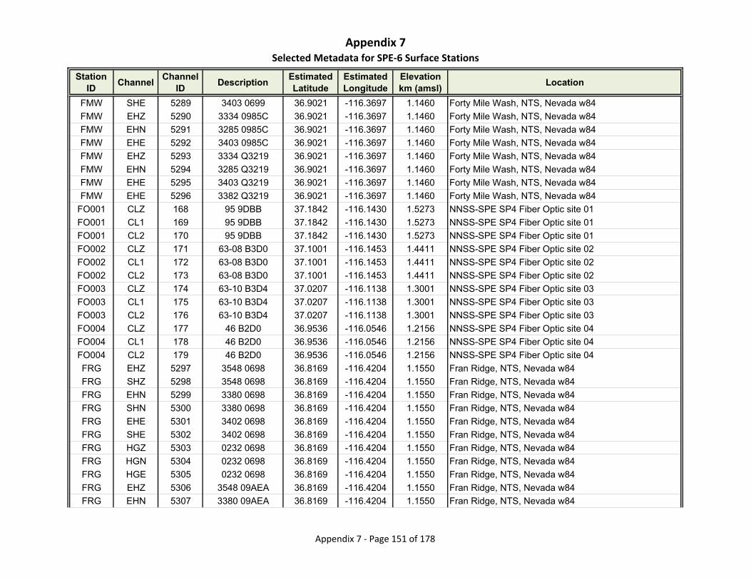
Appendix 7Selected Metadata for SPE‐6 Surface Stations
Station ID
ChannelChannel
IDDescription
Estimated Latitude
Estimated Longitude
Elevationkm (amsl)
Location
FMW SHE 5289 3403 0699 36.9021 -116.3697 1.1460 Forty Mile Wash, NTS, Nevada w84
FMW EHZ 5290 3334 0985C 36.9021 -116.3697 1.1460 Forty Mile Wash, NTS, Nevada w84
FMW EHN 5291 3285 0985C 36.9021 -116.3697 1.1460 Forty Mile Wash, NTS, Nevada w84
FMW EHE 5292 3403 0985C 36.9021 -116.3697 1.1460 Forty Mile Wash, NTS, Nevada w84
FMW EHZ 5293 3334 Q3219 36.9021 -116.3697 1.1460 Forty Mile Wash, NTS, Nevada w84
FMW EHN 5294 3285 Q3219 36.9021 -116.3697 1.1460 Forty Mile Wash, NTS, Nevada w84
FMW EHE 5295 3403 Q3219 36.9021 -116.3697 1.1460 Forty Mile Wash, NTS, Nevada w84
FMW EHE 5296 3382 Q3219 36.9021 -116.3697 1.1460 Forty Mile Wash, NTS, Nevada w84
FO001 CLZ 168 95 9DBB 37.1842 -116.1430 1.5273 NNSS-SPE SP4 Fiber Optic site 01
FO001 CL1 169 95 9DBB 37.1842 -116.1430 1.5273 NNSS-SPE SP4 Fiber Optic site 01
FO001 CL2 170 95 9DBB 37.1842 -116.1430 1.5273 NNSS-SPE SP4 Fiber Optic site 01
FO002 CLZ 171 63-08 B3D0 37.1001 -116.1453 1.4411 NNSS-SPE SP4 Fiber Optic site 02
FO002 CL1 172 63-08 B3D0 37.1001 -116.1453 1.4411 NNSS-SPE SP4 Fiber Optic site 02
FO002 CL2 173 63-08 B3D0 37.1001 -116.1453 1.4411 NNSS-SPE SP4 Fiber Optic site 02
FO003 CLZ 174 63-10 B3D4 37.0207 -116.1138 1.3001 NNSS-SPE SP4 Fiber Optic site 03
FO003 CL1 175 63-10 B3D4 37.0207 -116.1138 1.3001 NNSS-SPE SP4 Fiber Optic site 03
FO003 CL2 176 63-10 B3D4 37.0207 -116.1138 1.3001 NNSS-SPE SP4 Fiber Optic site 03
FO004 CLZ 177 46 B2D0 36.9536 -116.0546 1.2156 NNSS-SPE SP4 Fiber Optic site 04
FO004 CL1 178 46 B2D0 36.9536 -116.0546 1.2156 NNSS-SPE SP4 Fiber Optic site 04
FO004 CL2 179 46 B2D0 36.9536 -116.0546 1.2156 NNSS-SPE SP4 Fiber Optic site 04
FRG EHZ 5297 3548 0698 36.8169 -116.4204 1.1550 Fran Ridge, NTS, Nevada w84
FRG SHZ 5298 3548 0698 36.8169 -116.4204 1.1550 Fran Ridge, NTS, Nevada w84
FRG EHN 5299 3380 0698 36.8169 -116.4204 1.1550 Fran Ridge, NTS, Nevada w84
FRG SHN 5300 3380 0698 36.8169 -116.4204 1.1550 Fran Ridge, NTS, Nevada w84
FRG EHE 5301 3402 0698 36.8169 -116.4204 1.1550 Fran Ridge, NTS, Nevada w84
FRG SHE 5302 3402 0698 36.8169 -116.4204 1.1550 Fran Ridge, NTS, Nevada w84
FRG HGZ 5303 0232 0698 36.8169 -116.4204 1.1550 Fran Ridge, NTS, Nevada w84
FRG HGN 5304 0232 0698 36.8169 -116.4204 1.1550 Fran Ridge, NTS, Nevada w84
FRG HGE 5305 0232 0698 36.8169 -116.4204 1.1550 Fran Ridge, NTS, Nevada w84
FRG EHZ 5306 3548 09AEA 36.8169 -116.4204 1.1550 Fran Ridge, NTS, Nevada w84
FRG EHN 5307 3380 09AEA 36.8169 -116.4204 1.1550 Fran Ridge, NTS, Nevada w84
Appendix 7 ‐ Page 151 of 178
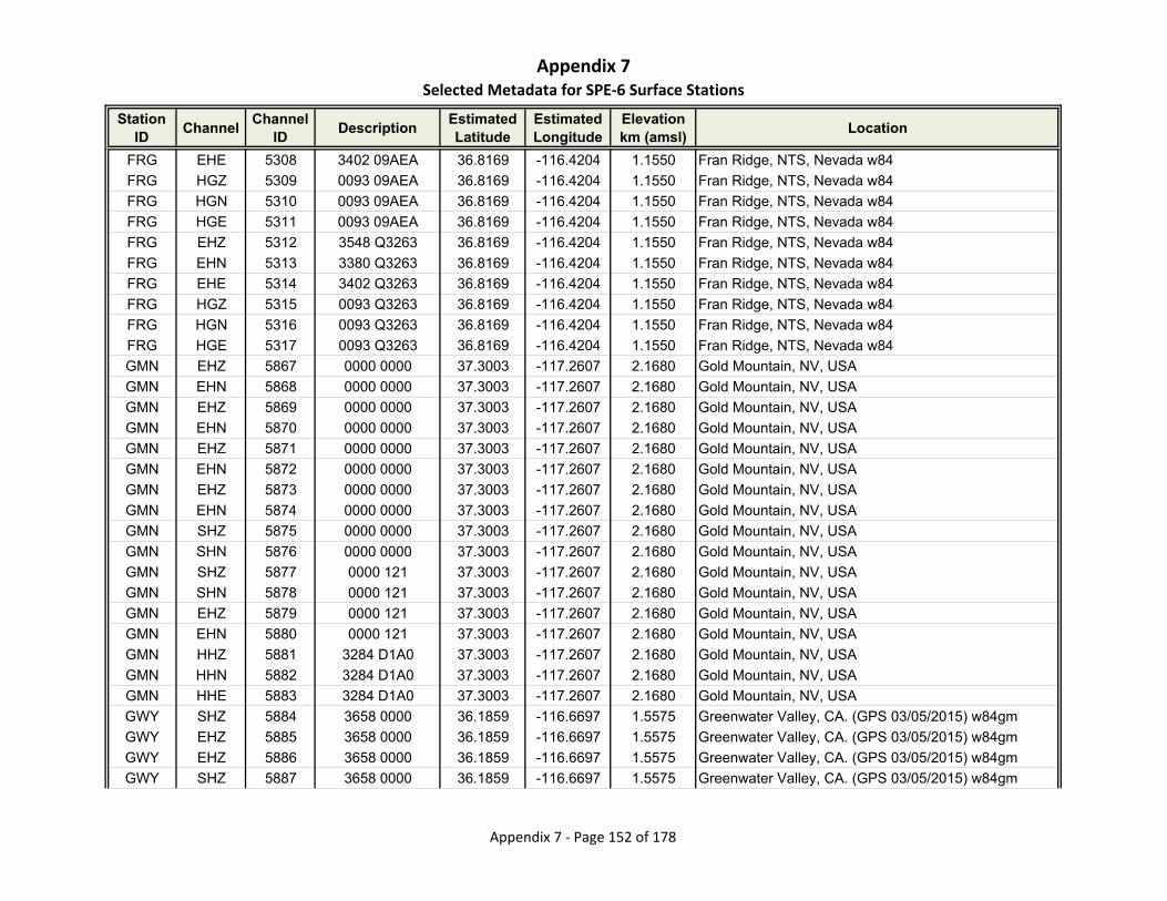
Appendix 7Selected Metadata for SPE‐6 Surface Stations
Station ID
ChannelChannel
IDDescription
Estimated Latitude
Estimated Longitude
Elevationkm (amsl)
Location
FRG EHE 5308 3402 09AEA 36.8169 -116.4204 1.1550 Fran Ridge, NTS, Nevada w84
FRG HGZ 5309 0093 09AEA 36.8169 -116.4204 1.1550 Fran Ridge, NTS, Nevada w84
FRG HGN 5310 0093 09AEA 36.8169 -116.4204 1.1550 Fran Ridge, NTS, Nevada w84
FRG HGE 5311 0093 09AEA 36.8169 -116.4204 1.1550 Fran Ridge, NTS, Nevada w84
FRG EHZ 5312 3548 Q3263 36.8169 -116.4204 1.1550 Fran Ridge, NTS, Nevada w84
FRG EHN 5313 3380 Q3263 36.8169 -116.4204 1.1550 Fran Ridge, NTS, Nevada w84
FRG EHE 5314 3402 Q3263 36.8169 -116.4204 1.1550 Fran Ridge, NTS, Nevada w84
FRG HGZ 5315 0093 Q3263 36.8169 -116.4204 1.1550 Fran Ridge, NTS, Nevada w84
FRG HGN 5316 0093 Q3263 36.8169 -116.4204 1.1550 Fran Ridge, NTS, Nevada w84
FRG HGE 5317 0093 Q3263 36.8169 -116.4204 1.1550 Fran Ridge, NTS, Nevada w84
GMN EHZ 5867 0000 0000 37.3003 -117.2607 2.1680 Gold Mountain, NV, USA
GMN EHN 5868 0000 0000 37.3003 -117.2607 2.1680 Gold Mountain, NV, USA
GMN EHZ 5869 0000 0000 37.3003 -117.2607 2.1680 Gold Mountain, NV, USA
GMN EHN 5870 0000 0000 37.3003 -117.2607 2.1680 Gold Mountain, NV, USA
GMN EHZ 5871 0000 0000 37.3003 -117.2607 2.1680 Gold Mountain, NV, USA
GMN EHN 5872 0000 0000 37.3003 -117.2607 2.1680 Gold Mountain, NV, USA
GMN EHZ 5873 0000 0000 37.3003 -117.2607 2.1680 Gold Mountain, NV, USA
GMN EHN 5874 0000 0000 37.3003 -117.2607 2.1680 Gold Mountain, NV, USA
GMN SHZ 5875 0000 0000 37.3003 -117.2607 2.1680 Gold Mountain, NV, USA
GMN SHN 5876 0000 0000 37.3003 -117.2607 2.1680 Gold Mountain, NV, USA
GMN SHZ 5877 0000 121 37.3003 -117.2607 2.1680 Gold Mountain, NV, USA
GMN SHN 5878 0000 121 37.3003 -117.2607 2.1680 Gold Mountain, NV, USA
GMN EHZ 5879 0000 121 37.3003 -117.2607 2.1680 Gold Mountain, NV, USA
GMN EHN 5880 0000 121 37.3003 -117.2607 2.1680 Gold Mountain, NV, USA
GMN HHZ 5881 3284 D1A0 37.3003 -117.2607 2.1680 Gold Mountain, NV, USA
GMN HHN 5882 3284 D1A0 37.3003 -117.2607 2.1680 Gold Mountain, NV, USA
GMN HHE 5883 3284 D1A0 37.3003 -117.2607 2.1680 Gold Mountain, NV, USA
GWY SHZ 5884 3658 0000 36.1859 -116.6697 1.5575 Greenwater Valley, CA. (GPS 03/05/2015) w84gm
GWY EHZ 5885 3658 0000 36.1859 -116.6697 1.5575 Greenwater Valley, CA. (GPS 03/05/2015) w84gm
GWY EHZ 5886 3658 0000 36.1859 -116.6697 1.5575 Greenwater Valley, CA. (GPS 03/05/2015) w84gm
GWY SHZ 5887 3658 0000 36.1859 -116.6697 1.5575 Greenwater Valley, CA. (GPS 03/05/2015) w84gm
Appendix 7 ‐ Page 152 of 178
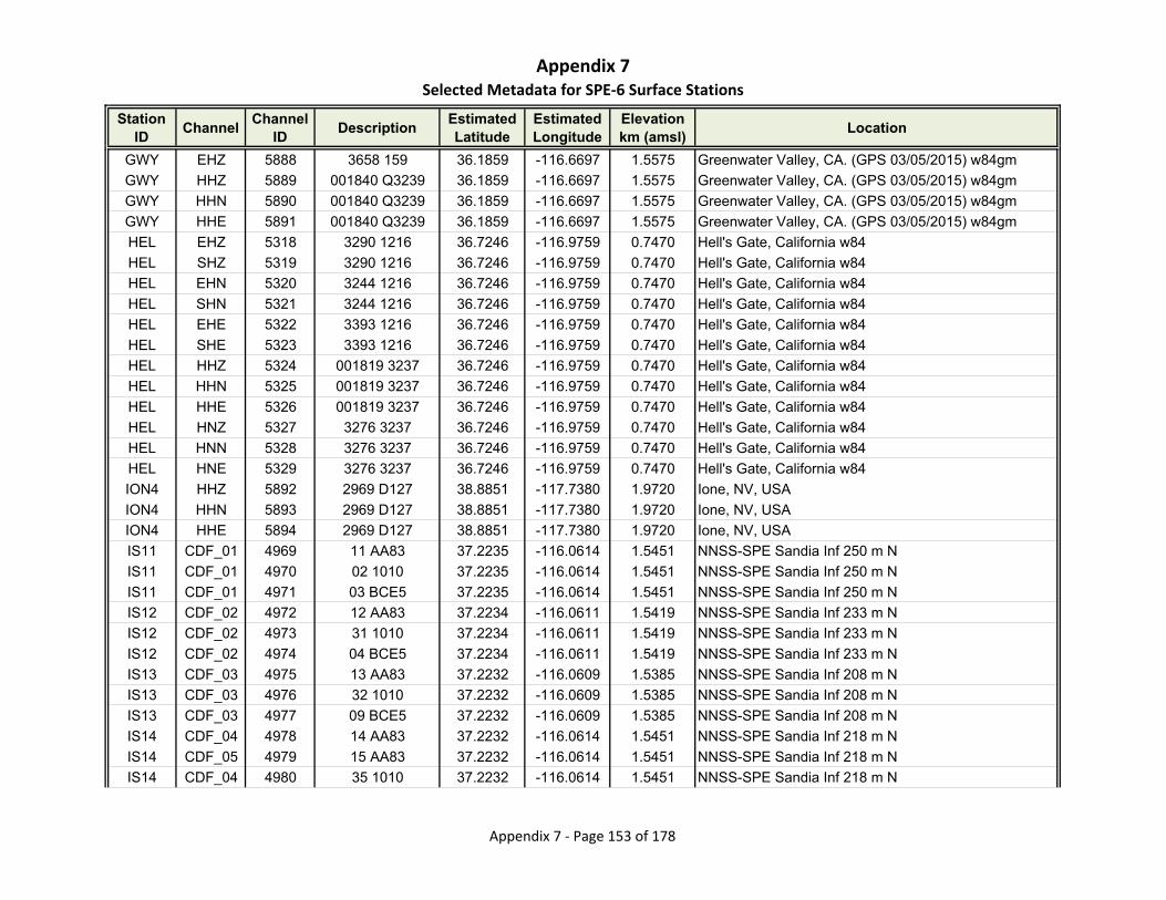
Appendix 7Selected Metadata for SPE‐6 Surface Stations
Station ID
ChannelChannel
IDDescription
Estimated Latitude
Estimated Longitude
Elevationkm (amsl)
Location
GWY EHZ 5888 3658 159 36.1859 -116.6697 1.5575 Greenwater Valley, CA. (GPS 03/05/2015) w84gm
GWY HHZ 5889 001840 Q3239 36.1859 -116.6697 1.5575 Greenwater Valley, CA. (GPS 03/05/2015) w84gm
GWY HHN 5890 001840 Q3239 36.1859 -116.6697 1.5575 Greenwater Valley, CA. (GPS 03/05/2015) w84gm
GWY HHE 5891 001840 Q3239 36.1859 -116.6697 1.5575 Greenwater Valley, CA. (GPS 03/05/2015) w84gm
HEL EHZ 5318 3290 1216 36.7246 -116.9759 0.7470 Hell's Gate, California w84
HEL SHZ 5319 3290 1216 36.7246 -116.9759 0.7470 Hell's Gate, California w84
HEL EHN 5320 3244 1216 36.7246 -116.9759 0.7470 Hell's Gate, California w84
HEL SHN 5321 3244 1216 36.7246 -116.9759 0.7470 Hell's Gate, California w84
HEL EHE 5322 3393 1216 36.7246 -116.9759 0.7470 Hell's Gate, California w84
HEL SHE 5323 3393 1216 36.7246 -116.9759 0.7470 Hell's Gate, California w84
HEL HHZ 5324 001819 3237 36.7246 -116.9759 0.7470 Hell's Gate, California w84
HEL HHN 5325 001819 3237 36.7246 -116.9759 0.7470 Hell's Gate, California w84
HEL HHE 5326 001819 3237 36.7246 -116.9759 0.7470 Hell's Gate, California w84
HEL HNZ 5327 3276 3237 36.7246 -116.9759 0.7470 Hell's Gate, California w84
HEL HNN 5328 3276 3237 36.7246 -116.9759 0.7470 Hell's Gate, California w84
HEL HNE 5329 3276 3237 36.7246 -116.9759 0.7470 Hell's Gate, California w84
ION4 HHZ 5892 2969 D127 38.8851 -117.7380 1.9720 Ione, NV, USA
ION4 HHN 5893 2969 D127 38.8851 -117.7380 1.9720 Ione, NV, USA
ION4 HHE 5894 2969 D127 38.8851 -117.7380 1.9720 Ione, NV, USA
IS11 CDF_01 4969 11 AA83 37.2235 -116.0614 1.5451 NNSS-SPE Sandia Inf 250 m N
IS11 CDF_01 4970 02 1010 37.2235 -116.0614 1.5451 NNSS-SPE Sandia Inf 250 m N
IS11 CDF_01 4971 03 BCE5 37.2235 -116.0614 1.5451 NNSS-SPE Sandia Inf 250 m N
IS12 CDF_02 4972 12 AA83 37.2234 -116.0611 1.5419 NNSS-SPE Sandia Inf 233 m N
IS12 CDF_02 4973 31 1010 37.2234 -116.0611 1.5419 NNSS-SPE Sandia Inf 233 m N
IS12 CDF_02 4974 04 BCE5 37.2234 -116.0611 1.5419 NNSS-SPE Sandia Inf 233 m N
IS13 CDF_03 4975 13 AA83 37.2232 -116.0609 1.5385 NNSS-SPE Sandia Inf 208 m N
IS13 CDF_03 4976 32 1010 37.2232 -116.0609 1.5385 NNSS-SPE Sandia Inf 208 m N
IS13 CDF_03 4977 09 BCE5 37.2232 -116.0609 1.5385 NNSS-SPE Sandia Inf 208 m N
IS14 CDF_04 4978 14 AA83 37.2232 -116.0614 1.5451 NNSS-SPE Sandia Inf 218 m N
IS14 CDF_05 4979 15 AA83 37.2232 -116.0614 1.5451 NNSS-SPE Sandia Inf 218 m N
IS14 CDF_04 4980 35 1010 37.2232 -116.0614 1.5451 NNSS-SPE Sandia Inf 218 m N
Appendix 7 ‐ Page 153 of 178

Appendix 7Selected Metadata for SPE‐6 Surface Stations
Station ID
ChannelChannel
IDDescription
Estimated Latitude
Estimated Longitude
Elevationkm (amsl)
Location
IS14 CDF_04 4981 35 BCE5 37.2232 -116.0614 1.5451 NNSS-SPE Sandia Inf 218 m N
IS14 CDF_05 4982 08 BCE5 37.2232 -116.0614 1.5451 NNSS-SPE Sandia Inf 218 m N
IS21 CDF_01 4983 21 AC19 37.2193 -116.0604 1.5138 NNSS-SPE Sandia Inf 226 m S
IS21 CDF_01 4984 38 1024 37.2193 -116.0604 1.5138 NNSS-SPE Sandia Inf 226 m S
IS21 CDF_01 4985 38 D14C 37.2193 -116.0604 1.5138 NNSS-SPE Sandia Inf 226 m S
IS22 CDF_02 4986 22 AC19 37.2190 -116.0605 1.5163 NNSS-SPE Sandia Inf 251 m S
IS22 CDF_02 4987 07 1024 37.2190 -116.0605 1.5163 NNSS-SPE Sandia Inf 251 m S
IS22 CDF_02 4988 07 D14C 37.2190 -116.0605 1.5163 NNSS-SPE Sandia Inf 251 m S
IS23 CDF_03 4989 23 AC19 37.2189 -116.0603 1.5120 NNSS-SPE Sandia Inf 271 m S
IS23 CDF_03 4990 24 1024 37.2189 -116.0603 1.5120 NNSS-SPE Sandia Inf 271 m S
IS23 CDF_03 4991 24 D14C 37.2189 -116.0603 1.5120 NNSS-SPE Sandia Inf 271 m S
IS24 CDF_04 4992 24 AC19 37.2188 -116.0608 1.5182 NNSS-SPE Sandia Inf 270 m S
IS24 CDF_05 4993 25 AC19 37.2188 -116.0608 1.5182 NNSS-SPE Sandia Inf 270 m S
IS24 CDF_04 4994 09 1024 37.2188 -116.0608 1.5182 NNSS-SPE Sandia Inf 270 m S
IS24 CDF_04 4995 09 D14C 37.2188 -116.0608 1.5182 NNSS-SPE Sandia Inf 270 m S
IS31 CDF_01 4996 31 90CF 37.2219 -116.0635 1.5704 NNSS-SPE Sandia Inf 249 m W
IS31 CDF_01 4997 33 1027 37.2219 -116.0635 1.5704 NNSS-SPE Sandia Inf 249 m W
IS32 CDF_02 4998 32 90CF 37.2217 -116.0636 1.5659 NNSS-SPE Sandia Inf 251 m W
IS32 CDF_02 4999 21 1027 37.2217 -116.0636 1.5659 NNSS-SPE Sandia Inf 251 m W
IS33 CDF_03 5000 33 90CF 37.2215 -116.0634 1.5597 NNSS-SPE Sandia Inf 229 m W
IS33 CDF_03 5001 43 1027 37.2215 -116.0634 1.5597 NNSS-SPE Sandia Inf 229 m W
IS34 CDF_04 5002 34 90CF 37.2215 -116.0638 1.5627 NNSS-SPE Sandia Inf 261 m W
IS34 CDF_05 5003 35 90CF 37.2215 -116.0638 1.5627 NNSS-SPE Sandia Inf 261 m W
IS34 CDF_04 5004 46 1027 37.2215 -116.0638 1.5627 NNSS-SPE Sandia Inf 261 m W
IS41 CDF_01 5005 41 AC1C 37.2235 -116.0579 1.5325 NNSS-SPE Sandia Inf 363 m E
IS41 CDF_01 5006 29 1035 37.2235 -116.0579 1.5325 NNSS-SPE Sandia Inf 363 m E
IS42 CDF_02 5007 42 AC1C 37.2233 -116.0580 1.5315 NNSS-SPE Sandia Inf 339 m E
IS42 CDF_02 5008 47 1035 37.2233 -116.0580 1.5315 NNSS-SPE Sandia Inf 339 m E
IS42 CDF_02 5009 001 1035 37.2233 -116.0580 1.5315 NNSS-SPE Sandia Inf 339 m E
IS43 CDF_03 5010 43 AC1C 37.2232 -116.0576 1.5301 NNSS-SPE Sandia Inf 353 m E
IS43 CDF_03 5011 03 1035 37.2232 -116.0576 1.5301 NNSS-SPE Sandia Inf 353 m E
Appendix 7 ‐ Page 154 of 178
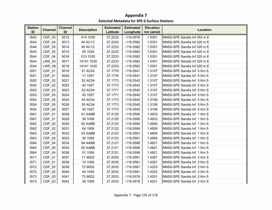
Appendix 7Selected Metadata for SPE‐6 Surface Stations
Station ID
ChannelChannel
IDDescription
Estimated Latitude
Estimated Longitude
Elevationkm (amsl)
Location
IS43 CDF_03 5012 014 1035 37.2232 -116.0576 1.5301 NNSS-SPE Sandia Inf 353 m E
IS44 CDF_04 5013 44 AC1C 37.2233 -116.0582 1.5301 NNSS-SPE Sandia Inf 320 m E
IS44 CDF_05 5014 45 AC1C 37.2233 -116.0582 1.5301 NNSS-SPE Sandia Inf 320 m E
IS44 CDF_04 5015 05 1035 37.2233 -116.0582 1.5301 NNSS-SPE Sandia Inf 320 m E
IS44 CDF_04 5016 013 1035 37.2233 -116.0582 1.5301 NNSS-SPE Sandia Inf 320 m E
IS44 LWS_05 5017 14141 1035 37.2233 -116.0582 1.5301 NNSS-SPE Sandia Inf 320 m E
IS44 LWD_06 5018 14141 1035 37.2233 -116.0582 1.5301 NNSS-SPE Sandia Inf 320 m E
IS51 CDF_01 5019 51 AC04 37.1776 -116.0541 1.3107 NNSS-SPE Sandia Inf 5 Km S
IS51 CDF_01 5020 11 1057 37.1776 -116.0541 1.3107 NNSS-SPE Sandia Inf 5 Km S
IS52 CDF_02 5021 52 AC04 37.1773 -116.0542 1.3107 NNSS-SPE Sandia Inf 5 Km S
IS52 CDF_02 5022 42 1057 37.1773 -116.0542 1.3107 NNSS-SPE Sandia Inf 5 Km S
IS53 CDF_03 5023 53 AC04 37.1771 -116.0540 1.3107 NNSS-SPE Sandia Inf 5 Km S
IS53 CDF_03 5024 45 1057 37.1771 -116.0540 1.3107 NNSS-SPE Sandia Inf 5 Km S
IS54 CDF_04 5025 54 AC04 37.1773 -116.0545 1.3106 NNSS-SPE Sandia Inf 5 Km S
IS54 CDF_05 5026 55 AC04 37.1773 -116.0545 1.3106 NNSS-SPE Sandia Inf 5 Km S
IS54 CDF_04 5027 40 1057 37.1773 -116.0545 1.3106 NNSS-SPE Sandia Inf 5 Km S
IS61 CDF_01 5028 61 AABB 37.2125 -116.0595 1.4833 NNSS-SPE Sandia Inf 1 Km S
IS61 CDF_01 5029 39 1058 37.2125 -116.0595 1.4833 NNSS-SPE Sandia Inf 1 Km S
IS62 CDF_02 5030 62 AABB 37.2122 -116.0594 1.4826 NNSS-SPE Sandia Inf 1 Km S
IS62 CDF_02 5031 04 1058 37.2122 -116.0594 1.4826 NNSS-SPE Sandia Inf 1 Km S
IS63 CDF_03 5032 63 AABB 37.2123 -116.0591 1.4809 NNSS-SPE Sandia Inf 1 Km S
IS63 CDF_03 5033 30 1058 37.2123 -116.0591 1.4809 NNSS-SPE Sandia Inf 1 Km S
IS64 CDF_04 5034 64 AABB 37.2121 -116.0598 1.4821 NNSS-SPE Sandia Inf 1 Km S
IS64 CDF_05 5035 65 AABB 37.2121 -116.0598 1.4821 NNSS-SPE Sandia Inf 1 Km S
IS64 CDF_04 5036 01 1058 37.2121 -116.0598 1.4821 NNSS-SPE Sandia Inf 1 Km S
IS71 CDF_01 5037 71 90D2 37.2035 -116.0581 1.4267 NNSS-SPE Sandia Inf 2 Km S
IS71 CDF_01 5038 10 1059 37.2035 -116.0581 1.4267 NNSS-SPE Sandia Inf 2 Km S
IS72 CDF_02 5039 72 90D2 37.2033 -116.0581 1.4253 NNSS-SPE Sandia Inf 2 Km S
IS72 CDF_02 5040 44 1059 37.2033 -116.0581 1.4253 NNSS-SPE Sandia Inf 2 Km S
IS73 CDF_03 5041 73 90D2 37.2033 -116.0578 1.4201 NNSS-SPE Sandia Inf 2 Km S
IS73 CDF_03 5042 36 1059 37.2033 -116.0578 1.4201 NNSS-SPE Sandia Inf 2 Km S
Appendix 7 ‐ Page 155 of 178
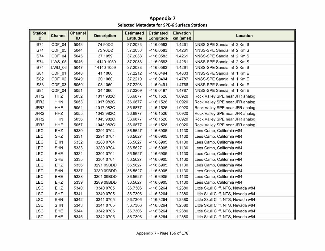
Appendix 7Selected Metadata for SPE‐6 Surface Stations
Station ID
ChannelChannel
IDDescription
Estimated Latitude
Estimated Longitude
Elevationkm (amsl)
Location
IS74 CDF_04 5043 74 90D2 37.2033 -116.0583 1.4261 NNSS-SPE Sandia Inf 2 Km S
IS74 CDF_05 5044 75 90D2 37.2033 -116.0583 1.4261 NNSS-SPE Sandia Inf 2 Km S
IS74 CDF_04 5045 37 1059 37.2033 -116.0583 1.4261 NNSS-SPE Sandia Inf 2 Km S
IS74 LWS_05 5046 14140 1059 37.2033 -116.0583 1.4261 NNSS-SPE Sandia Inf 2 Km S
IS74 LWD_06 5047 14140 1059 37.2033 -116.0583 1.4261 NNSS-SPE Sandia Inf 2 Km S
IS81 CDF_01 5048 41 1060 37.2212 -116.0494 1.4803 NNSS-SPE Sandia Inf 1 Km E
IS82 CDF_02 5049 20 1060 37.2210 -116.0494 1.4787 NNSS-SPE Sandia Inf 1 Km E
IS83 CDF_03 5050 08 1060 37.2208 -116.0491 1.4766 NNSS-SPE Sandia Inf 1 Km E
IS84 CDF_04 5051 34 1060 37.2209 -116.0497 1.4787 NNSS-SPE Sandia Inf 1 Km E
JFR2 HHZ 5052 1017 982C 36.6877 -116.1526 1.0920 Rock Valley SPE near JFR analog
JFR2 HHN 5053 1017 982C 36.6877 -116.1526 1.0920 Rock Valley SPE near JFR analog
JFR2 HHE 5054 1017 982C 36.6877 -116.1526 1.0920 Rock Valley SPE near JFR analog
JFR2 HHZ 5055 1043 982C 36.6877 -116.1526 1.0920 Rock Valley SPE near JFR analog
JFR2 HHN 5056 1043 982C 36.6877 -116.1526 1.0920 Rock Valley SPE near JFR analog
JFR2 HHE 5057 1043 982C 36.6877 -116.1526 1.0920 Rock Valley SPE near JFR analog
LEC EHZ 5330 3291 0704 36.5627 -116.6905 1.1130 Lees Camp, California w84
LEC SHZ 5331 3291 0704 36.5627 -116.6905 1.1130 Lees Camp, California w84
LEC EHN 5332 3280 0704 36.5627 -116.6905 1.1130 Lees Camp, California w84
LEC SHN 5333 3280 0704 36.5627 -116.6905 1.1130 Lees Camp, California w84
LEC EHE 5334 3301 0704 36.5627 -116.6905 1.1130 Lees Camp, California w84
LEC SHE 5335 3301 0704 36.5627 -116.6905 1.1130 Lees Camp, California w84
LEC EHZ 5336 3291 09BDD 36.5627 -116.6905 1.1130 Lees Camp, California w84
LEC EHN 5337 3280 09BDD 36.5627 -116.6905 1.1130 Lees Camp, California w84
LEC EHE 5338 3301 09BDD 36.5627 -116.6905 1.1130 Lees Camp, California w84
LEC EHZ 5339 3289 09BDD 36.5627 -116.6905 1.1130 Lees Camp, California w84
LSC EHZ 5340 3340 0705 36.7306 -116.3264 1.2380 Little Skull Cliff, NTS, Nevada w84
LSC SHZ 5341 3340 0705 36.7306 -116.3264 1.2380 Little Skull Cliff, NTS, Nevada w84
LSC EHN 5342 3341 0705 36.7306 -116.3264 1.2380 Little Skull Cliff, NTS, Nevada w84
LSC SHN 5343 3341 0705 36.7306 -116.3264 1.2380 Little Skull Cliff, NTS, Nevada w84
LSC EHE 5344 3342 0705 36.7306 -116.3264 1.2380 Little Skull Cliff, NTS, Nevada w84
LSC SHE 5345 3342 0705 36.7306 -116.3264 1.2380 Little Skull Cliff, NTS, Nevada w84
Appendix 7 ‐ Page 156 of 178
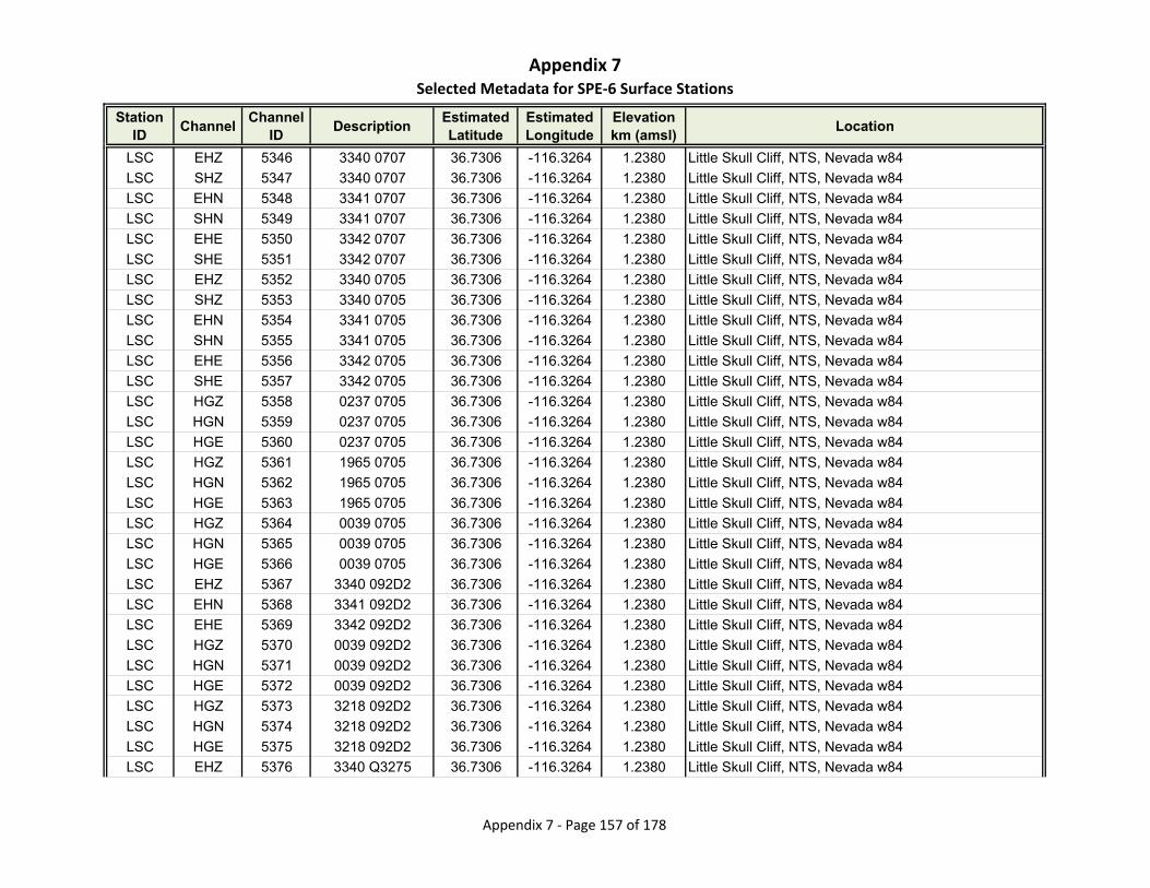
Appendix 7Selected Metadata for SPE‐6 Surface Stations
Station ID
ChannelChannel
IDDescription
Estimated Latitude
Estimated Longitude
Elevationkm (amsl)
Location
LSC EHZ 5346 3340 0707 36.7306 -116.3264 1.2380 Little Skull Cliff, NTS, Nevada w84
LSC SHZ 5347 3340 0707 36.7306 -116.3264 1.2380 Little Skull Cliff, NTS, Nevada w84
LSC EHN 5348 3341 0707 36.7306 -116.3264 1.2380 Little Skull Cliff, NTS, Nevada w84
LSC SHN 5349 3341 0707 36.7306 -116.3264 1.2380 Little Skull Cliff, NTS, Nevada w84
LSC EHE 5350 3342 0707 36.7306 -116.3264 1.2380 Little Skull Cliff, NTS, Nevada w84
LSC SHE 5351 3342 0707 36.7306 -116.3264 1.2380 Little Skull Cliff, NTS, Nevada w84
LSC EHZ 5352 3340 0705 36.7306 -116.3264 1.2380 Little Skull Cliff, NTS, Nevada w84
LSC SHZ 5353 3340 0705 36.7306 -116.3264 1.2380 Little Skull Cliff, NTS, Nevada w84
LSC EHN 5354 3341 0705 36.7306 -116.3264 1.2380 Little Skull Cliff, NTS, Nevada w84
LSC SHN 5355 3341 0705 36.7306 -116.3264 1.2380 Little Skull Cliff, NTS, Nevada w84
LSC EHE 5356 3342 0705 36.7306 -116.3264 1.2380 Little Skull Cliff, NTS, Nevada w84
LSC SHE 5357 3342 0705 36.7306 -116.3264 1.2380 Little Skull Cliff, NTS, Nevada w84
LSC HGZ 5358 0237 0705 36.7306 -116.3264 1.2380 Little Skull Cliff, NTS, Nevada w84
LSC HGN 5359 0237 0705 36.7306 -116.3264 1.2380 Little Skull Cliff, NTS, Nevada w84
LSC HGE 5360 0237 0705 36.7306 -116.3264 1.2380 Little Skull Cliff, NTS, Nevada w84
LSC HGZ 5361 1965 0705 36.7306 -116.3264 1.2380 Little Skull Cliff, NTS, Nevada w84
LSC HGN 5362 1965 0705 36.7306 -116.3264 1.2380 Little Skull Cliff, NTS, Nevada w84
LSC HGE 5363 1965 0705 36.7306 -116.3264 1.2380 Little Skull Cliff, NTS, Nevada w84
LSC HGZ 5364 0039 0705 36.7306 -116.3264 1.2380 Little Skull Cliff, NTS, Nevada w84
LSC HGN 5365 0039 0705 36.7306 -116.3264 1.2380 Little Skull Cliff, NTS, Nevada w84
LSC HGE 5366 0039 0705 36.7306 -116.3264 1.2380 Little Skull Cliff, NTS, Nevada w84
LSC EHZ 5367 3340 092D2 36.7306 -116.3264 1.2380 Little Skull Cliff, NTS, Nevada w84
LSC EHN 5368 3341 092D2 36.7306 -116.3264 1.2380 Little Skull Cliff, NTS, Nevada w84
LSC EHE 5369 3342 092D2 36.7306 -116.3264 1.2380 Little Skull Cliff, NTS, Nevada w84
LSC HGZ 5370 0039 092D2 36.7306 -116.3264 1.2380 Little Skull Cliff, NTS, Nevada w84
LSC HGN 5371 0039 092D2 36.7306 -116.3264 1.2380 Little Skull Cliff, NTS, Nevada w84
LSC HGE 5372 0039 092D2 36.7306 -116.3264 1.2380 Little Skull Cliff, NTS, Nevada w84
LSC HGZ 5373 3218 092D2 36.7306 -116.3264 1.2380 Little Skull Cliff, NTS, Nevada w84
LSC HGN 5374 3218 092D2 36.7306 -116.3264 1.2380 Little Skull Cliff, NTS, Nevada w84
LSC HGE 5375 3218 092D2 36.7306 -116.3264 1.2380 Little Skull Cliff, NTS, Nevada w84
LSC EHZ 5376 3340 Q3275 36.7306 -116.3264 1.2380 Little Skull Cliff, NTS, Nevada w84
Appendix 7 ‐ Page 157 of 178
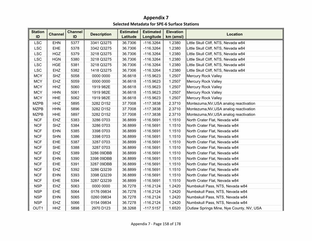
Appendix 7Selected Metadata for SPE‐6 Surface Stations
Station ID
ChannelChannel
IDDescription
Estimated Latitude
Estimated Longitude
Elevationkm (amsl)
Location
LSC EHN 5377 3341 Q3275 36.7306 -116.3264 1.2380 Little Skull Cliff, NTS, Nevada w84
LSC EHE 5378 3342 Q3275 36.7306 -116.3264 1.2380 Little Skull Cliff, NTS, Nevada w84
LSC HGZ 5379 3218 Q3275 36.7306 -116.3264 1.2380 Little Skull Cliff, NTS, Nevada w84
LSC HGN 5380 3218 Q3275 36.7306 -116.3264 1.2380 Little Skull Cliff, NTS, Nevada w84
LSC HGE 5381 3218 Q3275 36.7306 -116.3264 1.2380 Little Skull Cliff, NTS, Nevada w84
LSC EHZ 5382 1418 Q3275 36.7306 -116.3264 1.2380 Little Skull Cliff, NTS, Nevada w84
MCY SHZ 5058 0000 0000 36.6618 -115.9623 1.2507 Mercury Rock Valley
MCY EHZ 5059 0000 0000 36.6618 -115.9623 1.2507 Mercury Rock Valley
MCY HHZ 5060 1919 982E 36.6618 -115.9623 1.2507 Mercury Rock Valley
MCY HHN 5061 1919 982E 36.6618 -115.9623 1.2507 Mercury Rock Valley
MCY HHE 5062 1919 982E 36.6618 -115.9623 1.2507 Mercury Rock Valley
MZPB HHZ 5895 3282 D152 37.7008 -117.3838 2.3710 Montezuma,NV,USA analog reactivation
MZPB HHN 5896 3282 D152 37.7008 -117.3838 2.3710 Montezuma,NV,USA analog reactivation
MZPB HHE 5897 3282 D152 37.7008 -117.3838 2.3710 Montezuma,NV,USA analog reactivation
NCF EHZ 5383 3286 0703 36.8899 -116.5691 1.1510 North Crater Flat, Nevada w84
NCF SHZ 5384 3286 0703 36.8899 -116.5691 1.1510 North Crater Flat, Nevada w84
NCF EHN 5385 3398 0703 36.8899 -116.5691 1.1510 North Crater Flat, Nevada w84
NCF SHN 5386 3398 0703 36.8899 -116.5691 1.1510 North Crater Flat, Nevada w84
NCF EHE 5387 3287 0703 36.8899 -116.5691 1.1510 North Crater Flat, Nevada w84
NCF SHE 5388 3287 0703 36.8899 -116.5691 1.1510 North Crater Flat, Nevada w84
NCF EHZ 5389 3286 09DBB 36.8899 -116.5691 1.1510 North Crater Flat, Nevada w84
NCF EHN 5390 3398 09DBB 36.8899 -116.5691 1.1510 North Crater Flat, Nevada w84
NCF EHE 5391 3287 09DBB 36.8899 -116.5691 1.1510 North Crater Flat, Nevada w84
NCF EHZ 5392 3286 Q3239 36.8899 -116.5691 1.1510 North Crater Flat, Nevada w84
NCF EHN 5393 3398 Q3239 36.8899 -116.5691 1.1510 North Crater Flat, Nevada w84
NCF EHE 5394 3287 Q3239 36.8899 -116.5691 1.1510 North Crater Flat, Nevada w84
NSP EHZ 5063 0000 0000 36.7278 -116.2124 1.2420 Numbskull Pass, NTS, Nevada w84
NSP EHE 5064 0176 09834 36.7278 -116.2124 1.2420 Numbskull Pass, NTS, Nevada w84
NSP EHN 5065 0260 09834 36.7278 -116.2124 1.2420 Numbskull Pass, NTS, Nevada w84
NSP EHZ 5066 0154 09834 36.7278 -116.2124 1.2420 Numbskull Pass, NTS, Nevada w84
OUT1 HHZ 5898 2970 D123 38.3268 -117.5157 1.6520 Outlaw Springs Mine, Nye County, NV, USA
Appendix 7 ‐ Page 158 of 178

Appendix 7Selected Metadata for SPE‐6 Surface Stations
Station ID
ChannelChannel
IDDescription
Estimated Latitude
Estimated Longitude
Elevationkm (amsl)
Location
OUT1 HHN 5899 2970 D123 38.3268 -117.5157 1.6520 Outlaw Springs Mine, Nye County, NV, USA
OUT1 HHE 5900 2970 D123 38.3268 -117.5157 1.6520 Outlaw Springs Mine, Nye County, NV, USA
PIO HNZ 5901 0038 3248 37.9472 -114.4914 1.8870 Pioche, NV, USA - NN reactivation
PIO HNN 5902 0038 3248 37.9472 -114.4914 1.8870 Pioche, NV, USA - NN reactivation
PIO HNE 5903 0038 3248 37.9472 -114.4914 1.8870 Pioche, NV, USA - NN reactivation
PIO HHZ 5904 1751 3248 37.9472 -114.4914 1.8870 Pioche, NV, USA - NN reactivation
PIO HHN 5905 1751 3248 37.9472 -114.4914 1.8870 Pioche, NV, USA - NN reactivation
PIO HHE 5906 1751 3248 37.9472 -114.4914 1.8870 Pioche, NV, USA - NN reactivation
PIT EHZ 5395 3305 1120 36.6798 -116.4946 0.8500 Cinder Pit, Crater Flat, Nevada w84
PIT SHZ 5396 3305 1120 36.6798 -116.4946 0.8500 Cinder Pit, Crater Flat, Nevada w84
PIT EHN 5397 3477 1120 36.6798 -116.4946 0.8500 Cinder Pit, Crater Flat, Nevada w84
PIT SHN 5398 3477 1120 36.6798 -116.4946 0.8500 Cinder Pit, Crater Flat, Nevada w84
PIT EHE 5399 3282 1120 36.6798 -116.4946 0.8500 Cinder Pit, Crater Flat, Nevada w84
PIT SHE 5400 3282 1120 36.6798 -116.4946 0.8500 Cinder Pit, Crater Flat, Nevada w84
PIT EHZ 5401 3305 09BDF 36.6798 -116.4946 0.8500 Cinder Pit, Crater Flat, Nevada w84
PIT EHN 5402 3477 09BDF 36.6798 -116.4946 0.8500 Cinder Pit, Crater Flat, Nevada w84
PIT EHE 5403 3282 09BDF 36.6798 -116.4946 0.8500 Cinder Pit, Crater Flat, Nevada w84
PUV EHZ 5404 3189 0710 36.9494 -115.9642 1.2530 Plutonium Valley, NTS, Nevada w84
PUV SHZ 5405 3189 0710 36.9494 -115.9642 1.2530 Plutonium Valley, NTS, Nevada w84
PUV EHN 5406 3283 0710 36.9494 -115.9642 1.2530 Plutonium Valley, NTS, Nevada w84
PUV SHN 5407 3283 0710 36.9494 -115.9642 1.2530 Plutonium Valley, NTS, Nevada w84
PUV EHE 5408 3348 0710 36.9494 -115.9642 1.2530 Plutonium Valley, NTS, Nevada w84
PUV SHE 5409 3348 0710 36.9494 -115.9642 1.2530 Plutonium Valley, NTS, Nevada w84
PUV EHZ 5410 3189 09DBA 36.9494 -115.9642 1.2530 Plutonium Valley, NTS, Nevada w84
PUV EHN 5411 3283 09DBA 36.9494 -115.9642 1.2530 Plutonium Valley, NTS, Nevada w84
PUV EHE 5412 3348 09DBA 36.9494 -115.9642 1.2530 Plutonium Valley, NTS, Nevada w84
Q09A HHZ 5907 2260 3211 38.8340 -117.1816 1.7035 Carvers, NV, USA - NN reactivation
Q09A HHN 5908 2260 3211 38.8340 -117.1816 1.7035 Carvers, NV, USA - NN reactivation
Q09A HHE 5909 2260 3211 38.8340 -117.1816 1.7035 Carvers, NV, USA - NN reactivation
Q11A HHZ 5910 2957 D174 38.8455 -115.6541 1.5620 Duckwater, NV, USA - NN reactivation
Q11A HHN 5911 2957 D174 38.8455 -115.6541 1.5620 Duckwater, NV, USA - NN reactivation
Appendix 7 ‐ Page 159 of 178
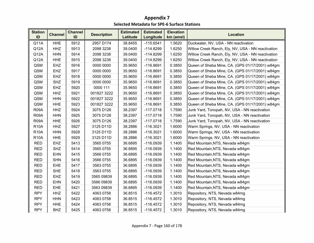
Appendix 7Selected Metadata for SPE‐6 Surface Stations
Station ID
ChannelChannel
IDDescription
Estimated Latitude
Estimated Longitude
Elevationkm (amsl)
Location
Q11A HHE 5912 2957 D174 38.8455 -115.6541 1.5620 Duckwater, NV, USA - NN reactivation
Q12A HHZ 5913 2098 3238 39.0400 -114.8299 1.6250 Willow Creek Ranch, Ely, NV, USA - NN reactivation
Q12A HHN 5914 2098 3238 39.0400 -114.8299 1.6250 Willow Creek Ranch, Ely, NV, USA - NN reactivation
Q12A HHE 5915 2098 3238 39.0400 -114.8299 1.6250 Willow Creek Ranch, Ely, NV, USA - NN reactivation
QSM EHZ 5916 0000 0000 35.9650 -116.8691 0.3850 Queen of Sheba Mine, CA. (GPS 01/17/2001) w84gm
QSM EHZ 5917 0000 0000 35.9650 -116.8691 0.3850 Queen of Sheba Mine, CA. (GPS 01/17/2001) w84gm
QSM EHZ 5918 0000 0000 35.9650 -116.8691 0.3850 Queen of Sheba Mine, CA. (GPS 01/17/2001) w84gm
QSM SHZ 5919 0000 0000 35.9650 -116.8691 0.3850 Queen of Sheba Mine, CA. (GPS 01/17/2001) w84gm
QSM EHZ 5920 0000 111 35.9650 -116.8691 0.3850 Queen of Sheba Mine, CA. (GPS 01/17/2001) w84gm
QSM HHZ 5921 001827 3222 35.9650 -116.8691 0.3850 Queen of Sheba Mine, CA. (GPS 01/17/2001) w84gm
QSM HHN 5922 001827 3222 35.9650 -116.8691 0.3850 Queen of Sheba Mine, CA. (GPS 01/17/2001) w84gm
QSM HHE 5923 001827 3222 35.9650 -116.8691 0.3850 Queen of Sheba Mine, CA. (GPS 01/17/2001) w84gm
R09A HHZ 5924 3075 D126 38.2397 -117.0718 1.7590 Junk Yard, Tonopah, NV, USA - NN reactivation
R09A HHN 5925 3075 D126 38.2397 -117.0718 1.7590 Junk Yard, Tonopah, NV, USA - NN reactivation
R09A HHE 5926 3075 D126 38.2397 -117.0718 1.7590 Junk Yard, Tonopah, NV, USA - NN reactivation
R10A HHZ 5927 3125 D11D 38.2886 -116.3021 1.6000 Warm Springs, NV, USA - NN reactivation
R10A HHN 5928 3125 D11D 38.2886 -116.3021 1.6000 Warm Springs, NV, USA - NN reactivation
R10A HHE 5929 3125 D11D 38.2886 -116.3021 1.6000 Warm Springs, NV, USA - NN reactivation
RED EHZ 5413 3565 0755 36.6895 -116.0939 1.1400 Red Mountain,NTS, Nevada w84gm
RED SHZ 5414 3565 0755 36.6895 -116.0939 1.1400 Red Mountain,NTS, Nevada w84gm
RED EHN 5415 3566 0755 36.6895 -116.0939 1.1400 Red Mountain,NTS, Nevada w84gm
RED SHN 5416 3566 0755 36.6895 -116.0939 1.1400 Red Mountain,NTS, Nevada w84gm
RED EHE 5417 3563 0755 36.6895 -116.0939 1.1400 Red Mountain,NTS, Nevada w84gm
RED SHE 5418 3563 0755 36.6895 -116.0939 1.1400 Red Mountain,NTS, Nevada w84gm
RED EHZ 5419 3565 09839 36.6895 -116.0939 1.1400 Red Mountain,NTS, Nevada w84gm
RED EHN 5420 3566 09839 36.6895 -116.0939 1.1400 Red Mountain,NTS, Nevada w84gm
RED EHE 5421 3563 09839 36.6895 -116.0939 1.1400 Red Mountain,NTS, Nevada w84gm
RPY HHZ 5422 4063 0758 36.8515 -116.4572 1.3010 Repository, NTS, Nevada w84mg
RPY HHN 5423 4063 0758 36.8515 -116.4572 1.3010 Repository, NTS, Nevada w84mg
RPY HHE 5424 4063 0758 36.8515 -116.4572 1.3010 Repository, NTS, Nevada w84mg
RPY BHZ 5425 4063 0758 36.8515 -116.4572 1.3010 Repository, NTS, Nevada w84mg
Appendix 7 ‐ Page 160 of 178
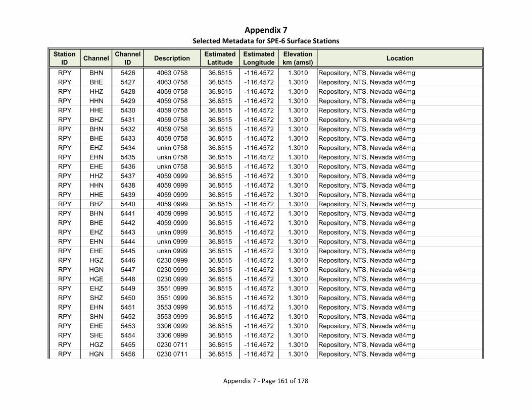
Appendix 7Selected Metadata for SPE‐6 Surface Stations
Station ID
ChannelChannel
IDDescription
Estimated Latitude
Estimated Longitude
Elevationkm (amsl)
Location
RPY BHN 5426 4063 0758 36.8515 -116.4572 1.3010 Repository, NTS, Nevada w84mg
RPY BHE 5427 4063 0758 36.8515 -116.4572 1.3010 Repository, NTS, Nevada w84mg
RPY HHZ 5428 4059 0758 36.8515 -116.4572 1.3010 Repository, NTS, Nevada w84mg
RPY HHN 5429 4059 0758 36.8515 -116.4572 1.3010 Repository, NTS, Nevada w84mg
RPY HHE 5430 4059 0758 36.8515 -116.4572 1.3010 Repository, NTS, Nevada w84mg
RPY BHZ 5431 4059 0758 36.8515 -116.4572 1.3010 Repository, NTS, Nevada w84mg
RPY BHN 5432 4059 0758 36.8515 -116.4572 1.3010 Repository, NTS, Nevada w84mg
RPY BHE 5433 4059 0758 36.8515 -116.4572 1.3010 Repository, NTS, Nevada w84mg
RPY EHZ 5434 unkn 0758 36.8515 -116.4572 1.3010 Repository, NTS, Nevada w84mg
RPY EHN 5435 unkn 0758 36.8515 -116.4572 1.3010 Repository, NTS, Nevada w84mg
RPY EHE 5436 unkn 0758 36.8515 -116.4572 1.3010 Repository, NTS, Nevada w84mg
RPY HHZ 5437 4059 0999 36.8515 -116.4572 1.3010 Repository, NTS, Nevada w84mg
RPY HHN 5438 4059 0999 36.8515 -116.4572 1.3010 Repository, NTS, Nevada w84mg
RPY HHE 5439 4059 0999 36.8515 -116.4572 1.3010 Repository, NTS, Nevada w84mg
RPY BHZ 5440 4059 0999 36.8515 -116.4572 1.3010 Repository, NTS, Nevada w84mg
RPY BHN 5441 4059 0999 36.8515 -116.4572 1.3010 Repository, NTS, Nevada w84mg
RPY BHE 5442 4059 0999 36.8515 -116.4572 1.3010 Repository, NTS, Nevada w84mg
RPY EHZ 5443 unkn 0999 36.8515 -116.4572 1.3010 Repository, NTS, Nevada w84mg
RPY EHN 5444 unkn 0999 36.8515 -116.4572 1.3010 Repository, NTS, Nevada w84mg
RPY EHE 5445 unkn 0999 36.8515 -116.4572 1.3010 Repository, NTS, Nevada w84mg
RPY HGZ 5446 0230 0999 36.8515 -116.4572 1.3010 Repository, NTS, Nevada w84mg
RPY HGN 5447 0230 0999 36.8515 -116.4572 1.3010 Repository, NTS, Nevada w84mg
RPY HGE 5448 0230 0999 36.8515 -116.4572 1.3010 Repository, NTS, Nevada w84mg
RPY EHZ 5449 3551 0999 36.8515 -116.4572 1.3010 Repository, NTS, Nevada w84mg
RPY SHZ 5450 3551 0999 36.8515 -116.4572 1.3010 Repository, NTS, Nevada w84mg
RPY EHN 5451 3553 0999 36.8515 -116.4572 1.3010 Repository, NTS, Nevada w84mg
RPY SHN 5452 3553 0999 36.8515 -116.4572 1.3010 Repository, NTS, Nevada w84mg
RPY EHE 5453 3306 0999 36.8515 -116.4572 1.3010 Repository, NTS, Nevada w84mg
RPY SHE 5454 3306 0999 36.8515 -116.4572 1.3010 Repository, NTS, Nevada w84mg
RPY HGZ 5455 0230 0711 36.8515 -116.4572 1.3010 Repository, NTS, Nevada w84mg
RPY HGN 5456 0230 0711 36.8515 -116.4572 1.3010 Repository, NTS, Nevada w84mg
Appendix 7 ‐ Page 161 of 178

Appendix 7Selected Metadata for SPE‐6 Surface Stations
Station ID
ChannelChannel
IDDescription
Estimated Latitude
Estimated Longitude
Elevationkm (amsl)
Location
RPY HGE 5457 0230 0711 36.8515 -116.4572 1.3010 Repository, NTS, Nevada w84mg
RPY EHZ 5458 3551 0711 36.8515 -116.4572 1.3010 Repository, NTS, Nevada w84mg
RPY SHZ 5459 3551 0711 36.8515 -116.4572 1.3010 Repository, NTS, Nevada w84mg
RPY EHN 5460 3553 0711 36.8515 -116.4572 1.3010 Repository, NTS, Nevada w84mg
RPY SHN 5461 3553 0711 36.8515 -116.4572 1.3010 Repository, NTS, Nevada w84mg
RPY EHE 5462 3306 0711 36.8515 -116.4572 1.3010 Repository, NTS, Nevada w84mg
RPY SHE 5463 3306 0711 36.8515 -116.4572 1.3010 Repository, NTS, Nevada w84mg
RPY EHZ 5464 3551 092D2 36.8515 -116.4572 1.3010 Repository, NTS, Nevada w84mg
RPY EHN 5465 3553 092D2 36.8515 -116.4572 1.3010 Repository, NTS, Nevada w84mg
RPY EHE 5466 3306 092D2 36.8515 -116.4572 1.3010 Repository, NTS, Nevada w84mg
RPY HGZ 5467 0082 092D2 36.8515 -116.4572 1.3010 Repository, NTS, Nevada w84mg
RPY HGN 5468 0082 092D2 36.8515 -116.4572 1.3010 Repository, NTS, Nevada w84mg
RPY HGE 5469 0082 092D2 36.8515 -116.4572 1.3010 Repository, NTS, Nevada w84mg
RPY EHZ 5470 3551 09BE0 36.8515 -116.4572 1.3010 Repository, NTS, Nevada w84mg
RPY EHN 5471 3553 09BE0 36.8515 -116.4572 1.3010 Repository, NTS, Nevada w84mg
RPY EHE 5472 3306 09BE0 36.8515 -116.4572 1.3010 Repository, NTS, Nevada w84mg
RPY HGZ 5473 0082 09BE0 36.8515 -116.4572 1.3010 Repository, NTS, Nevada w84mg
RPY HGN 5474 0082 09BE0 36.8515 -116.4572 1.3010 Repository, NTS, Nevada w84mg
RPY HGE 5475 0082 09BE0 36.8515 -116.4572 1.3010 Repository, NTS, Nevada w84mg
RPY HGZ 5476 3217 09BE0 36.8515 -116.4572 1.3010 Repository, NTS, Nevada w84mg
RPY HGN 5477 3217 09BE0 36.8515 -116.4572 1.3010 Repository, NTS, Nevada w84mg
RPY HGE 5478 3217 09BE0 36.8515 -116.4572 1.3010 Repository, NTS, Nevada w84mg
RPY EHZ 5479 3551 Q3237 36.8515 -116.4572 1.3010 Repository, NTS, Nevada w84mg
RPY EHN 5480 3553 Q3237 36.8515 -116.4572 1.3010 Repository, NTS, Nevada w84mg
RPY EHE 5481 3306 Q3237 36.8515 -116.4572 1.3010 Repository, NTS, Nevada w84mg
RPY HGZ 5482 3217 Q3237 36.8515 -116.4572 1.3010 Repository, NTS, Nevada w84mg
RPY HGN 5483 3217 Q3237 36.8515 -116.4572 1.3010 Repository, NTS, Nevada w84mg
RPY HGE 5484 3217 Q3237 36.8515 -116.4572 1.3010 Repository, NTS, Nevada w84mg
RTP2 EHE 5067 105 09101 36.7211 -116.1286 1.1560 Rock Valley portable site
RTP2 EHN 5068 099 09101 36.7211 -116.1286 1.1560 Rock Valley portable site
RTP2 EHZ 5069 097 09101 36.7211 -116.1286 1.1560 Rock Valley portable site
Appendix 7 ‐ Page 162 of 178
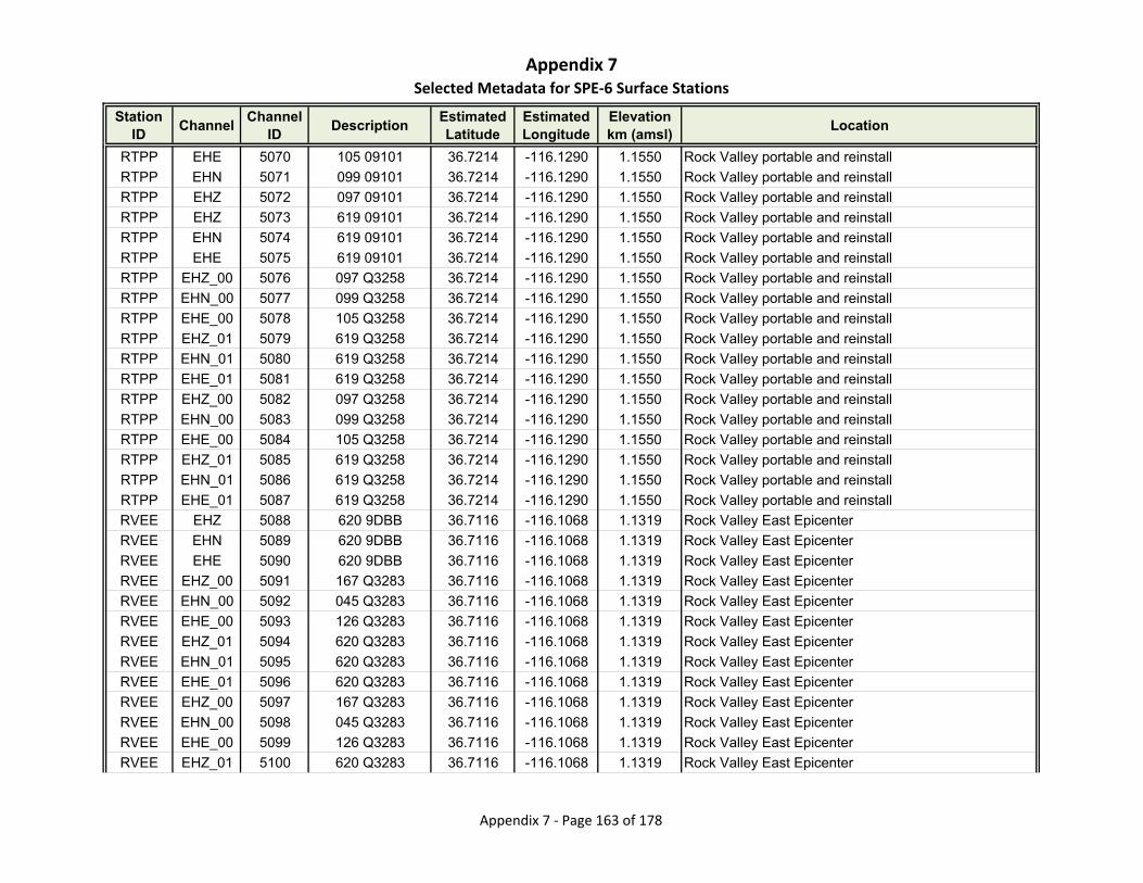
Appendix 7Selected Metadata for SPE‐6 Surface Stations
Station ID
ChannelChannel
IDDescription
Estimated Latitude
Estimated Longitude
Elevationkm (amsl)
Location
RTPP EHE 5070 105 09101 36.7214 -116.1290 1.1550 Rock Valley portable and reinstall
RTPP EHN 5071 099 09101 36.7214 -116.1290 1.1550 Rock Valley portable and reinstall
RTPP EHZ 5072 097 09101 36.7214 -116.1290 1.1550 Rock Valley portable and reinstall
RTPP EHZ 5073 619 09101 36.7214 -116.1290 1.1550 Rock Valley portable and reinstall
RTPP EHN 5074 619 09101 36.7214 -116.1290 1.1550 Rock Valley portable and reinstall
RTPP EHE 5075 619 09101 36.7214 -116.1290 1.1550 Rock Valley portable and reinstall
RTPP EHZ_00 5076 097 Q3258 36.7214 -116.1290 1.1550 Rock Valley portable and reinstall
RTPP EHN_00 5077 099 Q3258 36.7214 -116.1290 1.1550 Rock Valley portable and reinstall
RTPP EHE_00 5078 105 Q3258 36.7214 -116.1290 1.1550 Rock Valley portable and reinstall
RTPP EHZ_01 5079 619 Q3258 36.7214 -116.1290 1.1550 Rock Valley portable and reinstall
RTPP EHN_01 5080 619 Q3258 36.7214 -116.1290 1.1550 Rock Valley portable and reinstall
RTPP EHE_01 5081 619 Q3258 36.7214 -116.1290 1.1550 Rock Valley portable and reinstall
RTPP EHZ_00 5082 097 Q3258 36.7214 -116.1290 1.1550 Rock Valley portable and reinstall
RTPP EHN_00 5083 099 Q3258 36.7214 -116.1290 1.1550 Rock Valley portable and reinstall
RTPP EHE_00 5084 105 Q3258 36.7214 -116.1290 1.1550 Rock Valley portable and reinstall
RTPP EHZ_01 5085 619 Q3258 36.7214 -116.1290 1.1550 Rock Valley portable and reinstall
RTPP EHN_01 5086 619 Q3258 36.7214 -116.1290 1.1550 Rock Valley portable and reinstall
RTPP EHE_01 5087 619 Q3258 36.7214 -116.1290 1.1550 Rock Valley portable and reinstall
RVEE EHZ 5088 620 9DBB 36.7116 -116.1068 1.1319 Rock Valley East Epicenter
RVEE EHN 5089 620 9DBB 36.7116 -116.1068 1.1319 Rock Valley East Epicenter
RVEE EHE 5090 620 9DBB 36.7116 -116.1068 1.1319 Rock Valley East Epicenter
RVEE EHZ_00 5091 167 Q3283 36.7116 -116.1068 1.1319 Rock Valley East Epicenter
RVEE EHN_00 5092 045 Q3283 36.7116 -116.1068 1.1319 Rock Valley East Epicenter
RVEE EHE_00 5093 126 Q3283 36.7116 -116.1068 1.1319 Rock Valley East Epicenter
RVEE EHZ_01 5094 620 Q3283 36.7116 -116.1068 1.1319 Rock Valley East Epicenter
RVEE EHN_01 5095 620 Q3283 36.7116 -116.1068 1.1319 Rock Valley East Epicenter
RVEE EHE_01 5096 620 Q3283 36.7116 -116.1068 1.1319 Rock Valley East Epicenter
RVEE EHZ_00 5097 167 Q3283 36.7116 -116.1068 1.1319 Rock Valley East Epicenter
RVEE EHN_00 5098 045 Q3283 36.7116 -116.1068 1.1319 Rock Valley East Epicenter
RVEE EHE_00 5099 126 Q3283 36.7116 -116.1068 1.1319 Rock Valley East Epicenter
RVEE EHZ_01 5100 620 Q3283 36.7116 -116.1068 1.1319 Rock Valley East Epicenter
Appendix 7 ‐ Page 163 of 178
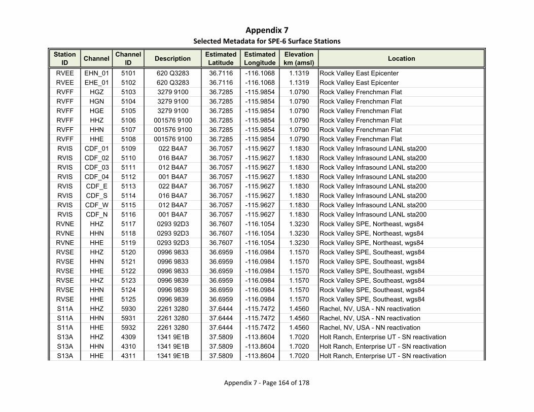
Appendix 7Selected Metadata for SPE‐6 Surface Stations
Station ID
ChannelChannel
IDDescription
Estimated Latitude
Estimated Longitude
Elevationkm (amsl)
Location
RVEE EHN_01 5101 620 Q3283 36.7116 -116.1068 1.1319 Rock Valley East Epicenter
RVEE EHE_01 5102 620 Q3283 36.7116 -116.1068 1.1319 Rock Valley East Epicenter
RVFF HGZ 5103 3279 9100 36.7285 -115.9854 1.0790 Rock Valley Frenchman Flat
RVFF HGN 5104 3279 9100 36.7285 -115.9854 1.0790 Rock Valley Frenchman Flat
RVFF HGE 5105 3279 9100 36.7285 -115.9854 1.0790 Rock Valley Frenchman Flat
RVFF HHZ 5106 001576 9100 36.7285 -115.9854 1.0790 Rock Valley Frenchman Flat
RVFF HHN 5107 001576 9100 36.7285 -115.9854 1.0790 Rock Valley Frenchman Flat
RVFF HHE 5108 001576 9100 36.7285 -115.9854 1.0790 Rock Valley Frenchman Flat
RVIS CDF_01 5109 022 B4A7 36.7057 -115.9627 1.1830 Rock Valley Infrasound LANL sta200
RVIS CDF_02 5110 016 B4A7 36.7057 -115.9627 1.1830 Rock Valley Infrasound LANL sta200
RVIS CDF_03 5111 012 B4A7 36.7057 -115.9627 1.1830 Rock Valley Infrasound LANL sta200
RVIS CDF_04 5112 001 B4A7 36.7057 -115.9627 1.1830 Rock Valley Infrasound LANL sta200
RVIS CDF_E 5113 022 B4A7 36.7057 -115.9627 1.1830 Rock Valley Infrasound LANL sta200
RVIS CDF_S 5114 016 B4A7 36.7057 -115.9627 1.1830 Rock Valley Infrasound LANL sta200
RVIS CDF_W 5115 012 B4A7 36.7057 -115.9627 1.1830 Rock Valley Infrasound LANL sta200
RVIS CDF_N 5116 001 B4A7 36.7057 -115.9627 1.1830 Rock Valley Infrasound LANL sta200
RVNE HHZ 5117 0293 92D3 36.7607 -116.1054 1.3230 Rock Valley SPE, Northeast, wgs84
RVNE HHN 5118 0293 92D3 36.7607 -116.1054 1.3230 Rock Valley SPE, Northeast, wgs84
RVNE HHE 5119 0293 92D3 36.7607 -116.1054 1.3230 Rock Valley SPE, Northeast, wgs84
RVSE HHZ 5120 0996 9833 36.6959 -116.0984 1.1570 Rock Valley SPE, Southeast, wgs84
RVSE HHN 5121 0996 9833 36.6959 -116.0984 1.1570 Rock Valley SPE, Southeast, wgs84
RVSE HHE 5122 0996 9833 36.6959 -116.0984 1.1570 Rock Valley SPE, Southeast, wgs84
RVSE HHZ 5123 0996 9839 36.6959 -116.0984 1.1570 Rock Valley SPE, Southeast, wgs84
RVSE HHN 5124 0996 9839 36.6959 -116.0984 1.1570 Rock Valley SPE, Southeast, wgs84
RVSE HHE 5125 0996 9839 36.6959 -116.0984 1.1570 Rock Valley SPE, Southeast, wgs84
S11A HHZ 5930 2261 3280 37.6444 -115.7472 1.4560 Rachel, NV, USA - NN reactivation
S11A HHN 5931 2261 3280 37.6444 -115.7472 1.4560 Rachel, NV, USA - NN reactivation
S11A HHE 5932 2261 3280 37.6444 -115.7472 1.4560 Rachel, NV, USA - NN reactivation
S13A HHZ 4309 1341 9E1B 37.5809 -113.8604 1.7020 Holt Ranch, Enterprise UT - SN reactivation
S13A HHN 4310 1341 9E1B 37.5809 -113.8604 1.7020 Holt Ranch, Enterprise UT - SN reactivation
S13A HHE 4311 1341 9E1B 37.5809 -113.8604 1.7020 Holt Ranch, Enterprise UT - SN reactivation
Appendix 7 ‐ Page 164 of 178
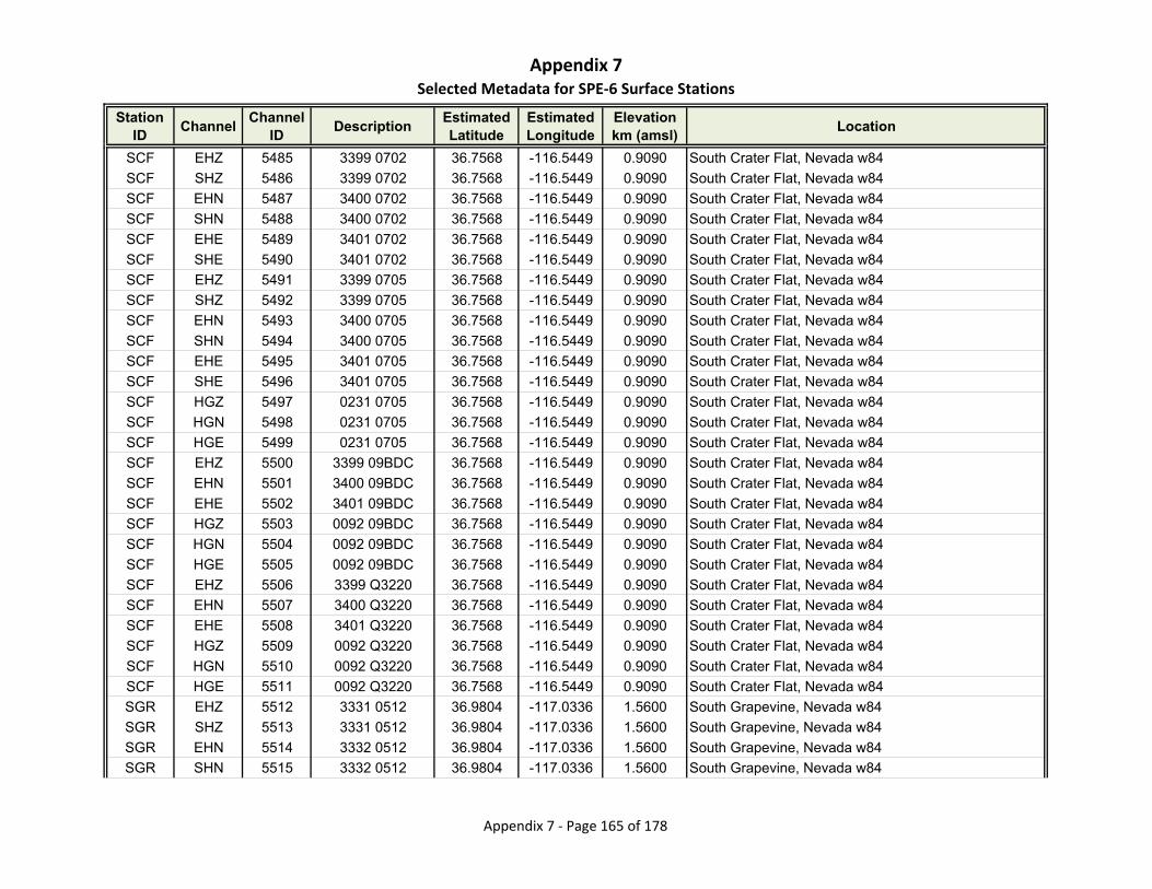
Appendix 7Selected Metadata for SPE‐6 Surface Stations
Station ID
ChannelChannel
IDDescription
Estimated Latitude
Estimated Longitude
Elevationkm (amsl)
Location
SCF EHZ 5485 3399 0702 36.7568 -116.5449 0.9090 South Crater Flat, Nevada w84
SCF SHZ 5486 3399 0702 36.7568 -116.5449 0.9090 South Crater Flat, Nevada w84
SCF EHN 5487 3400 0702 36.7568 -116.5449 0.9090 South Crater Flat, Nevada w84
SCF SHN 5488 3400 0702 36.7568 -116.5449 0.9090 South Crater Flat, Nevada w84
SCF EHE 5489 3401 0702 36.7568 -116.5449 0.9090 South Crater Flat, Nevada w84
SCF SHE 5490 3401 0702 36.7568 -116.5449 0.9090 South Crater Flat, Nevada w84
SCF EHZ 5491 3399 0705 36.7568 -116.5449 0.9090 South Crater Flat, Nevada w84
SCF SHZ 5492 3399 0705 36.7568 -116.5449 0.9090 South Crater Flat, Nevada w84
SCF EHN 5493 3400 0705 36.7568 -116.5449 0.9090 South Crater Flat, Nevada w84
SCF SHN 5494 3400 0705 36.7568 -116.5449 0.9090 South Crater Flat, Nevada w84
SCF EHE 5495 3401 0705 36.7568 -116.5449 0.9090 South Crater Flat, Nevada w84
SCF SHE 5496 3401 0705 36.7568 -116.5449 0.9090 South Crater Flat, Nevada w84
SCF HGZ 5497 0231 0705 36.7568 -116.5449 0.9090 South Crater Flat, Nevada w84
SCF HGN 5498 0231 0705 36.7568 -116.5449 0.9090 South Crater Flat, Nevada w84
SCF HGE 5499 0231 0705 36.7568 -116.5449 0.9090 South Crater Flat, Nevada w84
SCF EHZ 5500 3399 09BDC 36.7568 -116.5449 0.9090 South Crater Flat, Nevada w84
SCF EHN 5501 3400 09BDC 36.7568 -116.5449 0.9090 South Crater Flat, Nevada w84
SCF EHE 5502 3401 09BDC 36.7568 -116.5449 0.9090 South Crater Flat, Nevada w84
SCF HGZ 5503 0092 09BDC 36.7568 -116.5449 0.9090 South Crater Flat, Nevada w84
SCF HGN 5504 0092 09BDC 36.7568 -116.5449 0.9090 South Crater Flat, Nevada w84
SCF HGE 5505 0092 09BDC 36.7568 -116.5449 0.9090 South Crater Flat, Nevada w84
SCF EHZ 5506 3399 Q3220 36.7568 -116.5449 0.9090 South Crater Flat, Nevada w84
SCF EHN 5507 3400 Q3220 36.7568 -116.5449 0.9090 South Crater Flat, Nevada w84
SCF EHE 5508 3401 Q3220 36.7568 -116.5449 0.9090 South Crater Flat, Nevada w84
SCF HGZ 5509 0092 Q3220 36.7568 -116.5449 0.9090 South Crater Flat, Nevada w84
SCF HGN 5510 0092 Q3220 36.7568 -116.5449 0.9090 South Crater Flat, Nevada w84
SCF HGE 5511 0092 Q3220 36.7568 -116.5449 0.9090 South Crater Flat, Nevada w84
SGR EHZ 5512 3331 0512 36.9804 -117.0336 1.5600 South Grapevine, Nevada w84
SGR SHZ 5513 3331 0512 36.9804 -117.0336 1.5600 South Grapevine, Nevada w84
SGR EHN 5514 3332 0512 36.9804 -117.0336 1.5600 South Grapevine, Nevada w84
SGR SHN 5515 3332 0512 36.9804 -117.0336 1.5600 South Grapevine, Nevada w84
Appendix 7 ‐ Page 165 of 178
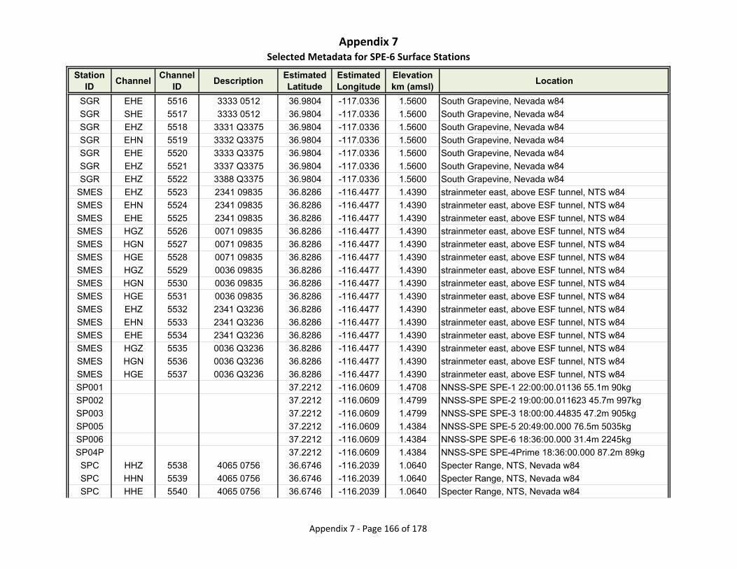
Appendix 7Selected Metadata for SPE‐6 Surface Stations
Station ID
ChannelChannel
IDDescription
Estimated Latitude
Estimated Longitude
Elevationkm (amsl)
Location
SGR EHE 5516 3333 0512 36.9804 -117.0336 1.5600 South Grapevine, Nevada w84
SGR SHE 5517 3333 0512 36.9804 -117.0336 1.5600 South Grapevine, Nevada w84
SGR EHZ 5518 3331 Q3375 36.9804 -117.0336 1.5600 South Grapevine, Nevada w84
SGR EHN 5519 3332 Q3375 36.9804 -117.0336 1.5600 South Grapevine, Nevada w84
SGR EHE 5520 3333 Q3375 36.9804 -117.0336 1.5600 South Grapevine, Nevada w84
SGR EHZ 5521 3337 Q3375 36.9804 -117.0336 1.5600 South Grapevine, Nevada w84
SGR EHZ 5522 3388 Q3375 36.9804 -117.0336 1.5600 South Grapevine, Nevada w84
SMES EHZ 5523 2341 09835 36.8286 -116.4477 1.4390 strainmeter east, above ESF tunnel, NTS w84
SMES EHN 5524 2341 09835 36.8286 -116.4477 1.4390 strainmeter east, above ESF tunnel, NTS w84
SMES EHE 5525 2341 09835 36.8286 -116.4477 1.4390 strainmeter east, above ESF tunnel, NTS w84
SMES HGZ 5526 0071 09835 36.8286 -116.4477 1.4390 strainmeter east, above ESF tunnel, NTS w84
SMES HGN 5527 0071 09835 36.8286 -116.4477 1.4390 strainmeter east, above ESF tunnel, NTS w84
SMES HGE 5528 0071 09835 36.8286 -116.4477 1.4390 strainmeter east, above ESF tunnel, NTS w84
SMES HGZ 5529 0036 09835 36.8286 -116.4477 1.4390 strainmeter east, above ESF tunnel, NTS w84
SMES HGN 5530 0036 09835 36.8286 -116.4477 1.4390 strainmeter east, above ESF tunnel, NTS w84
SMES HGE 5531 0036 09835 36.8286 -116.4477 1.4390 strainmeter east, above ESF tunnel, NTS w84
SMES EHZ 5532 2341 Q3236 36.8286 -116.4477 1.4390 strainmeter east, above ESF tunnel, NTS w84
SMES EHN 5533 2341 Q3236 36.8286 -116.4477 1.4390 strainmeter east, above ESF tunnel, NTS w84
SMES EHE 5534 2341 Q3236 36.8286 -116.4477 1.4390 strainmeter east, above ESF tunnel, NTS w84
SMES HGZ 5535 0036 Q3236 36.8286 -116.4477 1.4390 strainmeter east, above ESF tunnel, NTS w84
SMES HGN 5536 0036 Q3236 36.8286 -116.4477 1.4390 strainmeter east, above ESF tunnel, NTS w84
SMES HGE 5537 0036 Q3236 36.8286 -116.4477 1.4390 strainmeter east, above ESF tunnel, NTS w84
SP001 37.2212 -116.0609 1.4708 NNSS-SPE SPE-1 22:00:00.01136 55.1m 90kg
SP002 37.2212 -116.0609 1.4799 NNSS-SPE SPE-2 19:00:00.011623 45.7m 997kg
SP003 37.2212 -116.0609 1.4799 NNSS-SPE SPE-3 18:00:00.44835 47.2m 905kg
SP005 37.2212 -116.0609 1.4384 NNSS-SPE SPE-5 20:49:00.000 76.5m 5035kg
SP006 37.2212 -116.0609 1.4384 NNSS-SPE SPE-6 18:36:00.000 31.4m 2245kg
SP04P 37.2212 -116.0609 1.4384 NNSS-SPE SPE-4Prime 18:36:00.000 87.2m 89kg
SPC HHZ 5538 4065 0756 36.6746 -116.2039 1.0640 Specter Range, NTS, Nevada w84
SPC HHN 5539 4065 0756 36.6746 -116.2039 1.0640 Specter Range, NTS, Nevada w84
SPC HHE 5540 4065 0756 36.6746 -116.2039 1.0640 Specter Range, NTS, Nevada w84
Appendix 7 ‐ Page 166 of 178
Appendix 7Selected Metadata for SPE‐6 Surface Stations
Station ID
ChannelChannel
IDDescription
Estimated Latitude
Estimated Longitude
Elevationkm (amsl)
Location
SPC BHZ 5541 4065 0756 36.6746 -116.2039 1.0640 Specter Range, NTS, Nevada w84
SPC BHN 5542 4065 0756 36.6746 -116.2039 1.0640 Specter Range, NTS, Nevada w84
SPC BHE 5543 4065 0756 36.6746 -116.2039 1.0640 Specter Range, NTS, Nevada w84
SPC HHZ 5544 4049 0756 36.6746 -116.2039 1.0640 Specter Range, NTS, Nevada w84
SPC HHN 5545 4049 0756 36.6746 -116.2039 1.0640 Specter Range, NTS, Nevada w84
SPC HHE 5546 4049 0756 36.6746 -116.2039 1.0640 Specter Range, NTS, Nevada w84
SPC BHZ 5547 4049 0756 36.6746 -116.2039 1.0640 Specter Range, NTS, Nevada w84
SPC BHN 5548 4049 0756 36.6746 -116.2039 1.0640 Specter Range, NTS, Nevada w84
SPC BHE 5549 4049 0756 36.6746 -116.2039 1.0640 Specter Range, NTS, Nevada w84
SPC HHZ 5550 4047 0756 36.6746 -116.2039 1.0640 Specter Range, NTS, Nevada w84
SPC HHN 5551 4047 0756 36.6746 -116.2039 1.0640 Specter Range, NTS, Nevada w84
SPC HHE 5552 4047 0756 36.6746 -116.2039 1.0640 Specter Range, NTS, Nevada w84
SPC BHZ 5553 4047 0756 36.6746 -116.2039 1.0640 Specter Range, NTS, Nevada w84
SPC BHN 5554 4047 0756 36.6746 -116.2039 1.0640 Specter Range, NTS, Nevada w84
SPC BHE 5555 4047 0756 36.6746 -116.2039 1.0640 Specter Range, NTS, Nevada w84
SPC EHZ 5556 3289 0756 36.6746 -116.2039 1.0640 Specter Range, NTS, Nevada w84
SPC SHZ 5557 3289 0756 36.6746 -116.2039 1.0640 Specter Range, NTS, Nevada w84
SPC EHN 5558 3381 0756 36.6746 -116.2039 1.0640 Specter Range, NTS, Nevada w84
SPC SHN 5559 3381 0756 36.6746 -116.2039 1.0640 Specter Range, NTS, Nevada w84
SPC EHE 5560 3343 0756 36.6746 -116.2039 1.0640 Specter Range, NTS, Nevada w84
SPC SHE 5561 3343 0756 36.6746 -116.2039 1.0640 Specter Range, NTS, Nevada w84
SPC EHE 5562 3395 0756 36.6746 -116.2039 1.0640 Specter Range, NTS, Nevada w84
SPC SHE 5563 3395 0756 36.6746 -116.2039 1.0640 Specter Range, NTS, Nevada w84
SPC EHZ 5564 3289 0982A 36.6746 -116.2039 1.0640 Specter Range, NTS, Nevada w84
SPC EHN 5565 3381 0982A 36.6746 -116.2039 1.0640 Specter Range, NTS, Nevada w84
SPC EHE 5566 3395 0982A 36.6746 -116.2039 1.0640 Specter Range, NTS, Nevada w84
SPC HGZ 5567 0040 0982A 36.6746 -116.2039 1.0640 Specter Range, NTS, Nevada w84
SPC HGN 5568 0040 0982A 36.6746 -116.2039 1.0640 Specter Range, NTS, Nevada w84
SPC HGE 5569 0040 0982A 36.6746 -116.2039 1.0640 Specter Range, NTS, Nevada w84
SPC EHZ 5570 3289 Q3283 36.6746 -116.2039 1.0640 Specter Range, NTS, Nevada w84
SPC EHN 5571 3381 Q3283 36.6746 -116.2039 1.0640 Specter Range, NTS, Nevada w84
Appendix 7 ‐ Page 167 of 178
Appendix 7Selected Metadata for SPE‐6 Surface Stations
Station ID
ChannelChannel
IDDescription
Estimated Latitude
Estimated Longitude
Elevationkm (amsl)
Location
SPC EHE 5572 3395 Q3283 36.6746 -116.2039 1.0640 Specter Range, NTS, Nevada w84
SPC HGZ 5573 32xy Q3283 36.6746 -116.2039 1.0640 Specter Range, NTS, Nevada w84
SPC HGN 5574 32xy Q3283 36.6746 -116.2039 1.0640 Specter Range, NTS, Nevada w84
SPC HGE 5575 32xy Q3283 36.6746 -116.2039 1.0640 Specter Range, NTS, Nevada w84
SPRS HNZ 5126 0000 0000 36.6882 -116.1781 1.0920 Specter Range SM and Rock Valley SPE wgs84
SPRS HNN 5127 0000 0000 36.6882 -116.1781 1.0920 Specter Range SM and Rock Valley SPE wgs84
SPRS HNE 5128 0000 0000 36.6882 -116.1781 1.0920 Specter Range SM and Rock Valley SPE wgs84
SPRS HHZ 5129 1027 982F 36.6882 -116.1781 1.0920 Specter Range SM and Rock Valley SPE wgs84
SPRS HHN 5130 1027 982F 36.6882 -116.1781 1.0920 Specter Range SM and Rock Valley SPE wgs84
SPRS HHE 5131 1027 982F 36.6882 -116.1781 1.0920 Specter Range SM and Rock Valley SPE wgs84
STC EHE 5576 3252 0709 37.2938 -116.4367 1.9760 Silent Canyon, NTS, Nevada w84gm
STC SHE 5577 3252 0709 37.2938 -116.4367 1.9760 Silent Canyon, NTS, Nevada w84gm
STC EHN 5578 3371 0709 37.2938 -116.4367 1.9760 Silent Canyon, NTS, Nevada w84gm
STC SHN 5579 3371 0709 37.2938 -116.4367 1.9760 Silent Canyon, NTS, Nevada w84gm
STC EHZ 5580 3192 0709 37.2938 -116.4367 1.9760 Silent Canyon, NTS, Nevada w84gm
STC SHZ 5581 3192 0709 37.2938 -116.4367 1.9760 Silent Canyon, NTS, Nevada w84gm
STC EHE 5582 3252 Q3384 37.2938 -116.4367 1.9760 Silent Canyon, NTS, Nevada w84gm
STC EHN 5583 3371 Q3384 37.2938 -116.4367 1.9760 Silent Canyon, NTS, Nevada w84gm
STC EHZ 5584 3192 Q3384 37.2938 -116.4367 1.9760 Silent Canyon, NTS, Nevada w84gm
STH EHZ 5585 3568 1083 36.6457 -116.3384 1.0500 Striped Hills (old SDH), Nevada w84
STH SHZ 5586 3568 1083 36.6457 -116.3384 1.0500 Striped Hills (old SDH), Nevada w84
STH EHN 5587 3570 1083 36.6457 -116.3384 1.0500 Striped Hills (old SDH), Nevada w84
STH SHN 5588 3570 1083 36.6457 -116.3384 1.0500 Striped Hills (old SDH), Nevada w84
STH EHE 5589 3371 1083 36.6457 -116.3384 1.0500 Striped Hills (old SDH), Nevada w84
STH SHE 5590 3371 1083 36.6457 -116.3384 1.0500 Striped Hills (old SDH), Nevada w84
STH EHZ 5591 3568 09100 36.6457 -116.3384 1.0500 Striped Hills (old SDH), Nevada w84
STH EHN 5592 3570 09100 36.6457 -116.3384 1.0500 Striped Hills (old SDH), Nevada w84
STH EHE 5593 3371 09100 36.6457 -116.3384 1.0500 Striped Hills (old SDH), Nevada w84
STHB HHZ 5933 3281 D158 36.6454 -116.3388 1.0520 Striped Hills, NV, USA analog reactivation
STHB HHN 5934 3281 D158 36.6454 -116.3388 1.0520 Striped Hills, NV, USA analog reactivation
STHB HHE 5935 3281 D158 36.6454 -116.3388 1.0520 Striped Hills, NV, USA analog reactivation
Appendix 7 ‐ Page 168 of 178
Appendix 7Selected Metadata for SPE‐6 Surface Stations
Station ID
ChannelChannel
IDDescription
Estimated Latitude
Estimated Longitude
Elevationkm (amsl)
Location
STO EHZ 5594 3479 0700 36.8603 -116.4751 1.3590 Solitario Canyon, Nevada w84
STO SHZ 5595 3479 0700 36.8603 -116.4751 1.3590 Solitario Canyon, Nevada w84
STO EHN 5596 3562 0700 36.8603 -116.4751 1.3590 Solitario Canyon, Nevada w84
STO SHN 5597 3562 0700 36.8603 -116.4751 1.3590 Solitario Canyon, Nevada w84
STO EHE 5598 3404 0700 36.8603 -116.4751 1.3590 Solitario Canyon, Nevada w84
STO SHE 5599 3404 0700 36.8603 -116.4751 1.3590 Solitario Canyon, Nevada w84
STO HGZ 5600 0234 0700 36.8603 -116.4751 1.3590 Solitario Canyon, Nevada w84
STO HGN 5601 0234 0700 36.8603 -116.4751 1.3590 Solitario Canyon, Nevada w84
STO HGE 5602 0234 0700 36.8603 -116.4751 1.3590 Solitario Canyon, Nevada w84
STO EHZ 5603 3479 09DBC 36.8603 -116.4751 1.3590 Solitario Canyon, Nevada w84
STO EHN 5604 3562 09DBC 36.8603 -116.4751 1.3590 Solitario Canyon, Nevada w84
STO EHE 5605 3404 09DBC 36.8603 -116.4751 1.3590 Solitario Canyon, Nevada w84
STO HGZ 5606 0095 09DBC 36.8603 -116.4751 1.3590 Solitario Canyon, Nevada w84
STO HGN 5607 0095 09DBC 36.8603 -116.4751 1.3590 Solitario Canyon, Nevada w84
STO HGE 5608 0095 09DBC 36.8603 -116.4751 1.3590 Solitario Canyon, Nevada w84
STO EHZ 5609 3479 Q3222 36.8603 -116.4751 1.3590 Solitario Canyon, Nevada w84
STO EHN 5610 3562 Q3222 36.8603 -116.4751 1.3590 Solitario Canyon, Nevada w84
STO EHE 5611 3404 Q3222 36.8603 -116.4751 1.3590 Solitario Canyon, Nevada w84
STO HGZ 5612 0095 Q3222 36.8603 -116.4751 1.3590 Solitario Canyon, Nevada w84
STO HGN 5613 0095 Q3222 36.8603 -116.4751 1.3590 Solitario Canyon, Nevada w84
STO HGE 5614 0095 Q3222 36.8603 -116.4751 1.3590 Solitario Canyon, Nevada w84
SYM EHE 5615 3294 0701 36.7416 -116.4469 0.9950 South Yucca Mountain, NTS, Nevada w84
SYM SHE 5616 3294 0701 36.7416 -116.4469 0.9950 South Yucca Mountain, NTS, Nevada w84
SYM EHN 5617 3293 0701 36.7416 -116.4469 0.9950 South Yucca Mountain, NTS, Nevada w84
SYM SHN 5618 3293 0701 36.7416 -116.4469 0.9950 South Yucca Mountain, NTS, Nevada w84
SYM EHZ 5619 3292 0701 36.7416 -116.4469 0.9950 South Yucca Mountain, NTS, Nevada w84
SYM SHZ 5620 3292 0701 36.7416 -116.4469 0.9950 South Yucca Mountain, NTS, Nevada w84
SYM HGZ 5621 0236 0701 36.7416 -116.4469 0.9950 South Yucca Mountain, NTS, Nevada w84
SYM HGN 5622 0236 0701 36.7416 -116.4469 0.9950 South Yucca Mountain, NTS, Nevada w84
SYM HGE 5623 0236 0701 36.7416 -116.4469 0.9950 South Yucca Mountain, NTS, Nevada w84
SYM EHE 5624 3294 09101 36.7416 -116.4469 0.9950 South Yucca Mountain, NTS, Nevada w84
Appendix 7 ‐ Page 169 of 178
Appendix 7Selected Metadata for SPE‐6 Surface Stations
Station ID
ChannelChannel
IDDescription
Estimated Latitude
Estimated Longitude
Elevationkm (amsl)
Location
SYM EHN 5625 3293 09101 36.7416 -116.4469 0.9950 South Yucca Mountain, NTS, Nevada w84
SYM EHZ 5626 3292 09101 36.7416 -116.4469 0.9950 South Yucca Mountain, NTS, Nevada w84
SYM HGZ 5627 0090 09101 36.7416 -116.4469 0.9950 South Yucca Mountain, NTS, Nevada w84
SYM HGN 5628 0090 09101 36.7416 -116.4469 0.9950 South Yucca Mountain, NTS, Nevada w84
SYM HGE 5629 0090 09101 36.7416 -116.4469 0.9950 South Yucca Mountain, NTS, Nevada w84
SYM EHE 5630 3294 Q3279 36.7416 -116.4469 0.9950 South Yucca Mountain, NTS, Nevada w84
SYM EHN 5631 3293 Q3279 36.7416 -116.4469 0.9950 South Yucca Mountain, NTS, Nevada w84
SYM EHZ 5632 3292 Q3279 36.7416 -116.4469 0.9950 South Yucca Mountain, NTS, Nevada w84
SYM HGZ 5633 0090 Q3279 36.7416 -116.4469 0.9950 South Yucca Mountain, NTS, Nevada w84
SYM HGN 5634 0090 Q3279 36.7416 -116.4469 0.9950 South Yucca Mountain, NTS, Nevada w84
SYM HGE 5635 0090 Q3279 36.7416 -116.4469 0.9950 South Yucca Mountain, NTS, Nevada w84
TAR HHZ 5636 4060 0707 36.8680 -116.6331 1.2500 Tarantula Canyon, Nevada w84
TAR HHN 5637 4060 0707 36.8680 -116.6331 1.2500 Tarantula Canyon, Nevada w84
TAR HHE 5638 4060 0707 36.8680 -116.6331 1.2500 Tarantula Canyon, Nevada w84
TAR BHZ 5639 4060 0707 36.8680 -116.6331 1.2500 Tarantula Canyon, Nevada w84
TAR BHN 5640 4060 0707 36.8680 -116.6331 1.2500 Tarantula Canyon, Nevada w84
TAR BHE 5641 4060 0707 36.8680 -116.6331 1.2500 Tarantula Canyon, Nevada w84
TAR HHZ 5642 4057 0707 36.8680 -116.6331 1.2500 Tarantula Canyon, Nevada w84
TAR HHN 5643 4057 0707 36.8680 -116.6331 1.2500 Tarantula Canyon, Nevada w84
TAR HHE 5644 4057 0707 36.8680 -116.6331 1.2500 Tarantula Canyon, Nevada w84
TAR BHZ 5645 4057 0707 36.8680 -116.6331 1.2500 Tarantula Canyon, Nevada w84
TAR BHN 5646 4057 0707 36.8680 -116.6331 1.2500 Tarantula Canyon, Nevada w84
TAR BHE 5647 4057 0707 36.8680 -116.6331 1.2500 Tarantula Canyon, Nevada w84
TAR EHZ 5648 3345 0707 36.8680 -116.6331 1.2500 Tarantula Canyon, Nevada w84
TAR SHZ 5649 3345 0707 36.8680 -116.6331 1.2500 Tarantula Canyon, Nevada w84
TAR EHN 5650 3573 0707 36.8680 -116.6331 1.2500 Tarantula Canyon, Nevada w84
TAR SHN 5651 3573 0707 36.8680 -116.6331 1.2500 Tarantula Canyon, Nevada w84
TAR EHE 5652 3478 0707 36.8680 -116.6331 1.2500 Tarantula Canyon, Nevada w84
TAR SHE 5653 3478 0707 36.8680 -116.6331 1.2500 Tarantula Canyon, Nevada w84
TAR EHZ 5654 3345 09DBA 36.8680 -116.6331 1.2500 Tarantula Canyon, Nevada w84
TAR EHN 5655 3573 09DBA 36.8680 -116.6331 1.2500 Tarantula Canyon, Nevada w84
Appendix 7 ‐ Page 170 of 178
Appendix 7Selected Metadata for SPE‐6 Surface Stations
Station ID
ChannelChannel
IDDescription
Estimated Latitude
Estimated Longitude
Elevationkm (amsl)
Location
TAR EHE 5656 3478 09DBA 36.8680 -116.6331 1.2500 Tarantula Canyon, Nevada w84
TAR EHZ 5657 3345 Q3240 36.8680 -116.6331 1.2500 Tarantula Canyon, Nevada w84
TAR EHN 5658 3573 Q3240 36.8680 -116.6331 1.2500 Tarantula Canyon, Nevada w84
TAR EHE 5659 3478 Q3240 36.8680 -116.6331 1.2500 Tarantula Canyon, Nevada w84
TAR EHE 5660 3563 Q3240 36.8680 -116.6331 1.2500 Tarantula Canyon, Nevada w84
TAR EHN 5661 3559 Q3240 36.8680 -116.6331 1.2500 Tarantula Canyon, Nevada w84
TIM HHZ 5662 4064 0759 37.0667 -116.4703 1.8710 Timber Moutain, NAFB, Nevada w84
TIM HHN 5663 4064 0759 37.0667 -116.4703 1.8710 Timber Moutain, NAFB, Nevada w84
TIM HHE 5664 4064 0759 37.0667 -116.4703 1.8710 Timber Moutain, NAFB, Nevada w84
TIM BHZ 5665 4064 0759 37.0667 -116.4703 1.8710 Timber Moutain, NAFB, Nevada w84
TIM BHN 5666 4064 0759 37.0667 -116.4703 1.8710 Timber Moutain, NAFB, Nevada w84
TIM BHE 5667 4064 0759 37.0667 -116.4703 1.8710 Timber Moutain, NAFB, Nevada w84
TIM HHZ 5668 4056 0759 37.0667 -116.4703 1.8710 Timber Moutain, NAFB, Nevada w84
TIM HHN 5669 4056 0759 37.0667 -116.4703 1.8710 Timber Moutain, NAFB, Nevada w84
TIM HHE 5670 4056 0759 37.0667 -116.4703 1.8710 Timber Moutain, NAFB, Nevada w84
TIM BHZ 5671 4056 0759 37.0667 -116.4703 1.8710 Timber Moutain, NAFB, Nevada w84
TIM BHN 5672 4056 0759 37.0667 -116.4703 1.8710 Timber Moutain, NAFB, Nevada w84
TIM BHE 5673 4056 0759 37.0667 -116.4703 1.8710 Timber Moutain, NAFB, Nevada w84
TIM EHZ 5674 3388 0759 37.0667 -116.4703 1.8710 Timber Moutain, NAFB, Nevada w84
TIM SHZ 5675 3388 0759 37.0667 -116.4703 1.8710 Timber Moutain, NAFB, Nevada w84
TIM EHN 5676 1406 0759 37.0667 -116.4703 1.8710 Timber Moutain, NAFB, Nevada w84
TIM SHN 5677 1406 0759 37.0667 -116.4703 1.8710 Timber Moutain, NAFB, Nevada w84
TIM EHE 5678 3394 0759 37.0667 -116.4703 1.8710 Timber Moutain, NAFB, Nevada w84
TIM SHE 5679 3394 0759 37.0667 -116.4703 1.8710 Timber Moutain, NAFB, Nevada w84
TIM EHZ 5680 3388 09AEA 37.0667 -116.4703 1.8710 Timber Moutain, NAFB, Nevada w84
TIM EHN 5681 1406 09AEA 37.0667 -116.4703 1.8710 Timber Moutain, NAFB, Nevada w84
TIM EHE 5682 3394 09AEA 37.0667 -116.4703 1.8710 Timber Moutain, NAFB, Nevada w84
TIM EHN 5683 3244 09AEA 37.0667 -116.4703 1.8710 Timber Moutain, NAFB, Nevada w84
TP001 CLZ 4277 53 B3B5 37.2192 -116.0573 1.4961 NNSS-SPE SP4 Trailer Park
TP001 CLR 4278 53 B3B5 37.2192 -116.0573 1.4961 NNSS-SPE SP4 Trailer Park
TP001 CLT 4279 53 B3B5 37.2192 -116.0573 1.4961 NNSS-SPE SP4 Trailer Park
Appendix 7 ‐ Page 171 of 178
Appendix 7Selected Metadata for SPE‐6 Surface Stations
Station ID
ChannelChannel
IDDescription
Estimated Latitude
Estimated Longitude
Elevationkm (amsl)
Location
TPNVB DJZ_01 4280 001 D15D 36.9487 -116.2494 1.9590 TPNV Rotational Seismometers SP5
TPNVB DJN 4281 001 D15D 36.9487 -116.2494 1.9590 TPNV Rotational Seismometers SP5
TPNVB DJE 4282 001 D15D 36.9487 -116.2494 1.9590 TPNV Rotational Seismometers SP5
TPNVB DJZ 4283 0110 D15D 36.9487 -116.2494 1.9590 TPNV Rotational Seismometers SP5
TPNVB DJT 4284 0111 D15D 36.9487 -116.2494 1.9590 TPNV Rotational Seismometers SP5
TPW EHZ 5684 3190 0711 36.9016 -116.2528 1.5730 Topopah Wash, NTS, Nevada w84
TPW SHZ 5685 3190 0711 36.9016 -116.2528 1.5730 Topopah Wash, NTS, Nevada w84
TPW EHN 5686 3349 0711 36.9016 -116.2528 1.5730 Topopah Wash, NTS, Nevada w84
TPW SHN 5687 3349 0711 36.9016 -116.2528 1.5730 Topopah Wash, NTS, Nevada w84
TPW EHE 5688 3346 0711 36.9016 -116.2528 1.5730 Topopah Wash, NTS, Nevada w84
TPW SHE 5689 3346 0711 36.9016 -116.2528 1.5730 Topopah Wash, NTS, Nevada w84
TPW EHZ 5690 3190 0842 36.9016 -116.2528 1.5730 Topopah Wash, NTS, Nevada w84
TPW SHZ 5691 3190 0842 36.9016 -116.2528 1.5730 Topopah Wash, NTS, Nevada w84
TPW EHN 5692 3349 0842 36.9016 -116.2528 1.5730 Topopah Wash, NTS, Nevada w84
TPW SHN 5693 3349 0842 36.9016 -116.2528 1.5730 Topopah Wash, NTS, Nevada w84
TPW EHE 5694 3346 0842 36.9016 -116.2528 1.5730 Topopah Wash, NTS, Nevada w84
TPW SHE 5695 3346 0842 36.9016 -116.2528 1.5730 Topopah Wash, NTS, Nevada w84
TPW EHZ 5696 3190 0842 36.9016 -116.2528 1.5730 Topopah Wash, NTS, Nevada w84
TPW SHZ 5697 3190 0842 36.9016 -116.2528 1.5730 Topopah Wash, NTS, Nevada w84
TPW EHN 5698 3349 0842 36.9016 -116.2528 1.5730 Topopah Wash, NTS, Nevada w84
TPW SHN 5699 3349 0842 36.9016 -116.2528 1.5730 Topopah Wash, NTS, Nevada w84
TPW EHE 5700 3346 0842 36.9016 -116.2528 1.5730 Topopah Wash, NTS, Nevada w84
TPW SHE 5701 3346 0842 36.9016 -116.2528 1.5730 Topopah Wash, NTS, Nevada w84
TPW EHZ 5702 3190 092D2 36.9016 -116.2528 1.5730 Topopah Wash, NTS, Nevada w84
TPW EHN 5703 3349 092D2 36.9016 -116.2528 1.5730 Topopah Wash, NTS, Nevada w84
TPW EHE 5704 3346 092D2 36.9016 -116.2528 1.5730 Topopah Wash, NTS, Nevada w84
TWP EHZ 5705 3336 0714 37.2047 -116.1243 1.5760 Twin Peaks, NTS, Nevada w84
TWP SHZ 5706 3336 0714 37.2047 -116.1243 1.5760 Twin Peaks, NTS, Nevada w84
TWP EHN 5707 3284 0714 37.2047 -116.1243 1.5760 Twin Peaks, NTS, Nevada w84
TWP SHN 5708 3284 0714 37.2047 -116.1243 1.5760 Twin Peaks, NTS, Nevada w84
TWP EHE 5709 3560 0714 37.2047 -116.1243 1.5760 Twin Peaks, NTS, Nevada w84
Appendix 7 ‐ Page 172 of 178
Appendix 7Selected Metadata for SPE‐6 Surface Stations
Station ID
ChannelChannel
IDDescription
Estimated Latitude
Estimated Longitude
Elevationkm (amsl)
Location
TWP SHE 5710 3560 0714 37.2047 -116.1243 1.5760 Twin Peaks, NTS, Nevada w84
TWP EHZ 5711 3336 0951D 37.2047 -116.1243 1.5760 Twin Peaks, NTS, Nevada w84
TWP EHN 5712 3284 0951D 37.2047 -116.1243 1.5760 Twin Peaks, NTS, Nevada w84
TWP EHE 5713 3560 0951D 37.2047 -116.1243 1.5760 Twin Peaks, NTS, Nevada w84
TWP EHE 5714 3395 0951D 37.2047 -116.1243 1.5760 Twin Peaks, NTS, Nevada w84
TYM HHZ 5715 4058 0514 37.1440 -116.7217 1.4570 Thirsty Mountain, NAFB, Nevada w84gm
TYM HHN 5716 4058 0514 37.1440 -116.7217 1.4570 Thirsty Mountain, NAFB, Nevada w84gm
TYM HHE 5717 4058 0514 37.1440 -116.7217 1.4570 Thirsty Mountain, NAFB, Nevada w84gm
TYM BHZ 5718 4058 0514 37.1440 -116.7217 1.4570 Thirsty Mountain, NAFB, Nevada w84gm
TYM BHN 5719 4058 0514 37.1440 -116.7217 1.4570 Thirsty Mountain, NAFB, Nevada w84gm
TYM BHE 5720 4058 0514 37.1440 -116.7217 1.4570 Thirsty Mountain, NAFB, Nevada w84gm
TYM HHZ 5721 4062 0711 37.1440 -116.7217 1.4570 Thirsty Mountain, NAFB, Nevada w84gm
TYM HHN 5722 4062 0711 37.1440 -116.7217 1.4570 Thirsty Mountain, NAFB, Nevada w84gm
TYM HHE 5723 4062 0711 37.1440 -116.7217 1.4570 Thirsty Mountain, NAFB, Nevada w84gm
TYM BHZ 5724 4062 0711 37.1440 -116.7217 1.4570 Thirsty Mountain, NAFB, Nevada w84gm
TYM BHN 5725 4062 0711 37.1440 -116.7217 1.4570 Thirsty Mountain, NAFB, Nevada w84gm
TYM BHE 5726 4062 0711 37.1440 -116.7217 1.4570 Thirsty Mountain, NAFB, Nevada w84gm
TYM HHZ 5727 4058 0711 37.1440 -116.7217 1.4570 Thirsty Mountain, NAFB, Nevada w84gm
TYM HHN 5728 4058 0711 37.1440 -116.7217 1.4570 Thirsty Mountain, NAFB, Nevada w84gm
TYM HHE 5729 4058 0711 37.1440 -116.7217 1.4570 Thirsty Mountain, NAFB, Nevada w84gm
TYM BHZ 5730 4058 0711 37.1440 -116.7217 1.4570 Thirsty Mountain, NAFB, Nevada w84gm
TYM BHN 5731 4058 0711 37.1440 -116.7217 1.4570 Thirsty Mountain, NAFB, Nevada w84gm
TYM BHE 5732 4058 0711 37.1440 -116.7217 1.4570 Thirsty Mountain, NAFB, Nevada w84gm
TYM HHZ 5733 4062 0711 37.1440 -116.7217 1.4570 Thirsty Mountain, NAFB, Nevada w84gm
TYM HHN 5734 4062 0711 37.1440 -116.7217 1.4570 Thirsty Mountain, NAFB, Nevada w84gm
TYM HHE 5735 4062 0711 37.1440 -116.7217 1.4570 Thirsty Mountain, NAFB, Nevada w84gm
TYM BHZ 5736 4062 0711 37.1440 -116.7217 1.4570 Thirsty Mountain, NAFB, Nevada w84gm
TYM BHN 5737 4062 0711 37.1440 -116.7217 1.4570 Thirsty Mountain, NAFB, Nevada w84gm
TYM BHE 5738 4062 0711 37.1440 -116.7217 1.4570 Thirsty Mountain, NAFB, Nevada w84gm
TYM HHZ 5739 4062 1001 37.1440 -116.7217 1.4570 Thirsty Mountain, NAFB, Nevada w84gm
TYM HHN 5740 4062 1001 37.1440 -116.7217 1.4570 Thirsty Mountain, NAFB, Nevada w84gm
Appendix 7 ‐ Page 173 of 178
Appendix 7Selected Metadata for SPE‐6 Surface Stations
Station ID
ChannelChannel
IDDescription
Estimated Latitude
Estimated Longitude
Elevationkm (amsl)
Location
TYM HHE 5741 4062 1001 37.1440 -116.7217 1.4570 Thirsty Mountain, NAFB, Nevada w84gm
TYM BHZ 5742 4062 1001 37.1440 -116.7217 1.4570 Thirsty Mountain, NAFB, Nevada w84gm
TYM BHN 5743 4062 1001 37.1440 -116.7217 1.4570 Thirsty Mountain, NAFB, Nevada w84gm
TYM BHE 5744 4062 1001 37.1440 -116.7217 1.4570 Thirsty Mountain, NAFB, Nevada w84gm
TYM HHZ 5745 4062 0998 37.1440 -116.7217 1.4570 Thirsty Mountain, NAFB, Nevada w84gm
TYM HHN 5746 4062 0998 37.1440 -116.7217 1.4570 Thirsty Mountain, NAFB, Nevada w84gm
TYM HHE 5747 4062 0998 37.1440 -116.7217 1.4570 Thirsty Mountain, NAFB, Nevada w84gm
TYM BHZ 5748 4062 0998 37.1440 -116.7217 1.4570 Thirsty Mountain, NAFB, Nevada w84gm
TYM BHN 5749 4062 0998 37.1440 -116.7217 1.4570 Thirsty Mountain, NAFB, Nevada w84gm
TYM BHE 5750 4062 0998 37.1440 -116.7217 1.4570 Thirsty Mountain, NAFB, Nevada w84gm
TYM EHZ 5751 3387 0998 37.1440 -116.7217 1.4570 Thirsty Mountain, NAFB, Nevada w84gm
TYM SHZ 5752 3387 0998 37.1440 -116.7217 1.4570 Thirsty Mountain, NAFB, Nevada w84gm
TYM EHN 5753 3251 0998 37.1440 -116.7217 1.4570 Thirsty Mountain, NAFB, Nevada w84gm
TYM SHN 5754 3251 0998 37.1440 -116.7217 1.4570 Thirsty Mountain, NAFB, Nevada w84gm
TYM EHE 5755 3384 0998 37.1440 -116.7217 1.4570 Thirsty Mountain, NAFB, Nevada w84gm
TYM SHE 5756 3384 0998 37.1440 -116.7217 1.4570 Thirsty Mountain, NAFB, Nevada w84gm
TYM EHZ 5757 3387 09DBC 37.1440 -116.7217 1.4570 Thirsty Mountain, NAFB, Nevada w84gm
TYM EHN 5758 3251 09DBC 37.1440 -116.7217 1.4570 Thirsty Mountain, NAFB, Nevada w84gm
TYM EHE 5759 3384 09DBC 37.1440 -116.7217 1.4570 Thirsty Mountain, NAFB, Nevada w84gm
V12A HHZ 5936 1668 3211 35.7266 -114.8511 1.0980 Nelson, NV, USA - NN reactivation
V12A HHN 5937 1668 3211 35.7266 -114.8511 1.0980 Nelson, NV, USA - NN reactivation
V12A HHE 5938 1668 3211 35.7266 -114.8511 1.0980 Nelson, NV, USA - NN reactivation
WAR3 HHZ 5939 3283 D19E 38.6091 -117.8348 1.9010 Warrior Mine, Nye County, NV, USA
WAR3 HHN 5940 3283 D19E 38.6091 -117.8348 1.9010 Warrior Mine, Nye County, NV, USA
WAR3 HHE 5941 3283 D19E 38.6091 -117.8348 1.9010 Warrior Mine, Nye County, NV, USA
WG01 HHZ 4285 2837 9D8F 37.3144 -115.2940 1.7550 SN NNSS-SPE Weston relocation XA_AZ10
WG01 HHN 4286 2837 9D8F 37.3144 -115.2940 1.7550 SN NNSS-SPE Weston relocation XA_AZ10
WG01 HHE 4287 2837 9D8F 37.3144 -115.2940 1.7550 SN NNSS-SPE Weston relocation XA_AZ10
WG02 EHZ 4288 L41162 9DEA 37.2405 -115.1977 1.3570 SN NNSS-SPE Weston relocation XA_AZ09
WG02 EHN 4289 L41162 9DEA 37.2405 -115.1977 1.3570 SN NNSS-SPE Weston relocation XA_AZ09
WG02 EHE 4290 L41162 9DEA 37.2405 -115.1977 1.3570 SN NNSS-SPE Weston relocation XA_AZ09
Appendix 7 ‐ Page 174 of 178
Appendix 7Selected Metadata for SPE‐6 Surface Stations
Station ID
ChannelChannel
IDDescription
Estimated Latitude
Estimated Longitude
Elevationkm (amsl)
Location
WG03 HHZ 4291 1001 9E4B 37.0901 -114.8186 0.9830 SN NNSS-SPE Weston relocation XA_AZ08
WG03 HHN 4292 1001 9E4B 37.0901 -114.8186 0.9830 SN NNSS-SPE Weston relocation XA_AZ08
WG03 HHE 4293 1001 9E4B 37.0901 -114.8186 0.9830 SN NNSS-SPE Weston relocation XA_AZ08
WG04 HHZ 4294 2838 9E42 37.1314 -114.7126 1.0690 SN NNSS-SPE Weston relocation XA_AZ07
WG04 HHN 4295 2838 9E42 37.1314 -114.7126 1.0690 SN NNSS-SPE Weston relocation XA_AZ07
WG04 HHE 4296 2838 9E42 37.1314 -114.7126 1.0690 SN NNSS-SPE Weston relocation XA_AZ07
WG05 HHZ 4297 2831 9E17 37.0769 -114.3395 0.9400 SN NNSS-SPE Weston relocation XA_AZ06
WG05 HHN 4298 2831 9E17 37.0769 -114.3395 0.9400 SN NNSS-SPE Weston relocation XA_AZ06
WG05 HHE 4299 2831 9E17 37.0769 -114.3395 0.9400 SN NNSS-SPE Weston relocation XA_AZ06
WG06 HHZ 4300 2839 9D63 37.1813 -114.1420 1.1310 SN NNSS-SPE Weston relocation XA_AZ05
WG06 HHN 4301 2839 9D63 37.1813 -114.1420 1.1310 SN NNSS-SPE Weston relocation XA_AZ05
WG06 HHE 4302 2839 9D63 37.1813 -114.1420 1.1310 SN NNSS-SPE Weston relocation XA_AZ05
WG07 HHZ 4303 2845 9E18 37.0341 -113.8609 1.1410 SN NNSS-SPE Weston relocation XA_AZ04
WG07 HHN 4304 2845 9E18 37.0341 -113.8609 1.1410 SN NNSS-SPE Weston relocation XA_AZ04
WG07 HHE 4305 2845 9E18 37.0341 -113.8609 1.1410 SN NNSS-SPE Weston relocation XA_AZ04
WG08 EHZ 4306 L41169 9E4F 37.0277 -113.5772 0.8630 SN NNSS-SPE Weston relocation XA_AZ03
WG08 EHN 4307 L41169 9E4F 37.0277 -113.5772 0.8630 SN NNSS-SPE Weston relocation XA_AZ03
WG08 EHE 4308 L41169 9E4F 37.0277 -113.5772 0.8630 SN NNSS-SPE Weston relocation XA_AZ03
WG10 EHZ 4312 L41169 9DAA 37.0681 -113.1290 1.5040 SN NNSS-SPE Weston relocation XA_AZ01
WG10 EHN 4313 L41169 9DAA 37.0681 -113.1290 1.5040 SN NNSS-SPE Weston relocation XA_AZ01
WG10 EHE 4314 L41169 9DAA 37.0681 -113.1290 1.5040 SN NNSS-SPE Weston relocation XA_AZ01
WLD EHZ 5760 3335 0715 36.7927 -116.6266 0.9660 Wildcat Mountain, Nevada w84gm
WLD SHZ 5761 3335 0715 36.7927 -116.6266 0.9660 Wildcat Mountain, Nevada w84gm
WLD EHN 5762 3351 0715 36.7927 -116.6266 0.9660 Wildcat Mountain, Nevada w84gm
WLD SHN 5763 3351 0715 36.7927 -116.6266 0.9660 Wildcat Mountain, Nevada w84gm
WLD EHE 5764 3249 0715 36.7927 -116.6266 0.9660 Wildcat Mountain, Nevada w84gm
WLD SHE 5765 3249 0715 36.7927 -116.6266 0.9660 Wildcat Mountain, Nevada w84gm
WLD EHZ 5766 3335 0982F 36.7927 -116.6266 0.9660 Wildcat Mountain, Nevada w84gm
WLD EHN 5767 3351 0982F 36.7927 -116.6266 0.9660 Wildcat Mountain, Nevada w84gm
WLD EHE 5768 3249 0982F 36.7927 -116.6266 0.9660 Wildcat Mountain, Nevada w84gm
WLD HGZ 5769 0069 0982F 36.7927 -116.6266 0.9660 Wildcat Mountain, Nevada w84gm
Appendix 7 ‐ Page 175 of 178
Appendix 7Selected Metadata for SPE‐6 Surface Stations
Station ID
ChannelChannel
IDDescription
Estimated Latitude
Estimated Longitude
Elevationkm (amsl)
Location
WLD HGN 5770 0069 0982F 36.7927 -116.6266 0.9660 Wildcat Mountain, Nevada w84gm
WLD HGE 5771 0069 0982F 36.7927 -116.6266 0.9660 Wildcat Mountain, Nevada w84gm
WLD EHZ 5772 3335 Q3264 36.7927 -116.6266 0.9660 Wildcat Mountain, Nevada w84gm
WLD EHN 5773 3351 Q3264 36.7927 -116.6266 0.9660 Wildcat Mountain, Nevada w84gm
WLD EHE 5774 3249 Q3264 36.7927 -116.6266 0.9660 Wildcat Mountain, Nevada w84gm
WLD HGZ 5775 0069 Q3264 36.7927 -116.6266 0.9660 Wildcat Mountain, Nevada w84gm
WLD HGN 5776 0069 Q3264 36.7927 -116.6266 0.9660 Wildcat Mountain, Nevada w84gm
WLD HGE 5777 0069 Q3264 36.7927 -116.6266 0.9660 Wildcat Mountain, Nevada w84gm
WLDB HHZ 5942 3546 9833 36.7927 -116.6266 0.9550 Wildcat Mountain, NV, USA analog reactivation
WLDB HHN 5943 3546 9833 36.7927 -116.6266 0.9550 Wildcat Mountain, NV, USA analog reactivation
WLDB HHE 5944 3546 9833 36.7927 -116.6266 0.9550 Wildcat Mountain, NV, USA analog reactivation
YCW EHZ 5778 3243 0756 36.9224 -116.4765 1.4980 Yucca Wash, NTS, Nevada w84
YCW SHZ 5779 3243 0756 36.9224 -116.4765 1.4980 Yucca Wash, NTS, Nevada w84
YCW EHN 5780 3244 0756 36.9224 -116.4765 1.4980 Yucca Wash, NTS, Nevada w84
YCW SHN 5781 3244 0756 36.9224 -116.4765 1.4980 Yucca Wash, NTS, Nevada w84
YCW EHE 5782 3248 0756 36.9224 -116.4765 1.4980 Yucca Wash, NTS, Nevada w84
YCW SHE 5783 3248 0756 36.9224 -116.4765 1.4980 Yucca Wash, NTS, Nevada w84
YCW EHZ 5784 3243 0757 36.9224 -116.4765 1.4980 Yucca Wash, NTS, Nevada w84
YCW SHZ 5785 3243 0757 36.9224 -116.4765 1.4980 Yucca Wash, NTS, Nevada w84
YCW EHN 5786 3244 0757 36.9224 -116.4765 1.4980 Yucca Wash, NTS, Nevada w84
YCW SHN 5787 3244 0757 36.9224 -116.4765 1.4980 Yucca Wash, NTS, Nevada w84
YCW EHE 5788 3248 0757 36.9224 -116.4765 1.4980 Yucca Wash, NTS, Nevada w84
YCW SHE 5789 3248 0757 36.9224 -116.4765 1.4980 Yucca Wash, NTS, Nevada w84
YCW EHN 5790 3370 0757 36.9224 -116.4765 1.4980 Yucca Wash, NTS, Nevada w84
YCW SHN 5791 3370 0757 36.9224 -116.4765 1.4980 Yucca Wash, NTS, Nevada w84
YCW HGZ 5792 0232 0757 36.9224 -116.4765 1.4980 Yucca Wash, NTS, Nevada w84
YCW HGN 5793 0232 0757 36.9224 -116.4765 1.4980 Yucca Wash, NTS, Nevada w84
YCW HGE 5794 0232 0757 36.9224 -116.4765 1.4980 Yucca Wash, NTS, Nevada w84
YCW EHZ 5795 3243 0982C 36.9224 -116.4765 1.4980 Yucca Wash, NTS, Nevada w84
YCW EHN 5796 3370 0982C 36.9224 -116.4765 1.4980 Yucca Wash, NTS, Nevada w84
YCW EHE 5797 3248 0982C 36.9224 -116.4765 1.4980 Yucca Wash, NTS, Nevada w84
Appendix 7 ‐ Page 176 of 178
Appendix 7Selected Metadata for SPE‐6 Surface Stations
Station ID
ChannelChannel
IDDescription
Estimated Latitude
Estimated Longitude
Elevationkm (amsl)
Location
YCW HGZ 5798 0083 0982C 36.9224 -116.4765 1.4980 Yucca Wash, NTS, Nevada w84
YCW HGN 5799 0083 0982C 36.9224 -116.4765 1.4980 Yucca Wash, NTS, Nevada w84
YCW HGE 5800 0083 0982C 36.9224 -116.4765 1.4980 Yucca Wash, NTS, Nevada w84
YCW EHZ 5801 3243 Q3277 36.9224 -116.4765 1.4980 Yucca Wash, NTS, Nevada w84
YCW EHN 5802 3370 Q3277 36.9224 -116.4765 1.4980 Yucca Wash, NTS, Nevada w84
YCW EHE 5803 3248 Q3277 36.9224 -116.4765 1.4980 Yucca Wash, NTS, Nevada w84
YCW HGZ 5804 0083 Q3277 36.9224 -116.4765 1.4980 Yucca Wash, NTS, Nevada w84
YCW HGN 5805 0083 Q3277 36.9224 -116.4765 1.4980 Yucca Wash, NTS, Nevada w84
YCW HGE 5806 0083 Q3277 36.9224 -116.4765 1.4980 Yucca Wash, NTS, Nevada w84
YFT EHZ 5807 0447 7896 37.0762 -115.9744 1.3540 Yucca Flat, NTS, Nevada w84gm
YFT EHN 5808 0155 7896 37.0762 -115.9744 1.3540 Yucca Flat, NTS, Nevada w84gm
YFT EHE 5809 0170 7896 37.0762 -115.9744 1.3540 Yucca Flat, NTS, Nevada w84gm
YFT EHZ 5810 0447 0999 37.0762 -115.9744 1.3540 Yucca Flat, NTS, Nevada w84gm
YFT SHZ 5811 0447 0999 37.0762 -115.9744 1.3540 Yucca Flat, NTS, Nevada w84gm
YFT EHN 5812 0155 0999 37.0762 -115.9744 1.3540 Yucca Flat, NTS, Nevada w84gm
YFT SHN 5813 0155 0999 37.0762 -115.9744 1.3540 Yucca Flat, NTS, Nevada w84gm
YFT EHE 5814 0170 0999 37.0762 -115.9744 1.3540 Yucca Flat, NTS, Nevada w84gm
YFT SHE 5815 0170 0999 37.0762 -115.9744 1.3540 Yucca Flat, NTS, Nevada w84gm
YFT EHZ 5816 0447 7884 37.0762 -115.9744 1.3540 Yucca Flat, NTS, Nevada w84gm
YFT EHN 5817 0155 7884 37.0762 -115.9744 1.3540 Yucca Flat, NTS, Nevada w84gm
YFT EHE 5818 0170 7884 37.0762 -115.9744 1.3540 Yucca Flat, NTS, Nevada w84gm
YFT EHZ 5819 0447 0713 37.0762 -115.9744 1.3540 Yucca Flat, NTS, Nevada w84gm
YFT SHZ 5820 0447 0713 37.0762 -115.9744 1.3540 Yucca Flat, NTS, Nevada w84gm
YFT EHN 5821 0155 0713 37.0762 -115.9744 1.3540 Yucca Flat, NTS, Nevada w84gm
YFT SHN 5822 0155 0713 37.0762 -115.9744 1.3540 Yucca Flat, NTS, Nevada w84gm
YFT EHE 5823 0170 0713 37.0762 -115.9744 1.3540 Yucca Flat, NTS, Nevada w84gm
YFT SHE 5824 0170 0713 37.0762 -115.9744 1.3540 Yucca Flat, NTS, Nevada w84gm
YFT EHZ 5825 0447 0711 37.0762 -115.9744 1.3540 Yucca Flat, NTS, Nevada w84gm
YFT SHZ 5826 0447 0711 37.0762 -115.9744 1.3540 Yucca Flat, NTS, Nevada w84gm
YFT EHN 5827 0155 0711 37.0762 -115.9744 1.3540 Yucca Flat, NTS, Nevada w84gm
YFT SHN 5828 0155 0711 37.0762 -115.9744 1.3540 Yucca Flat, NTS, Nevada w84gm
Appendix 7 ‐ Page 177 of 178
Appendix 7Selected Metadata for SPE‐6 Surface Stations
Station ID
ChannelChannel
IDDescription
Estimated Latitude
Estimated Longitude
Elevationkm (amsl)
Location
YFT EHE 5829 0170 0711 37.0762 -115.9744 1.3540 Yucca Flat, NTS, Nevada w84gm
YFT SHE 5830 0170 0711 37.0762 -115.9744 1.3540 Yucca Flat, NTS, Nevada w84gm
YFT EHZ 5831 0447 0843 37.0762 -115.9744 1.3540 Yucca Flat, NTS, Nevada w84gm
YFT SHZ 5832 0447 0843 37.0762 -115.9744 1.3540 Yucca Flat, NTS, Nevada w84gm
YFT EHN 5833 0155 0843 37.0762 -115.9744 1.3540 Yucca Flat, NTS, Nevada w84gm
YFT SHN 5834 0155 0843 37.0762 -115.9744 1.3540 Yucca Flat, NTS, Nevada w84gm
YFT EHE 5835 0170 0843 37.0762 -115.9744 1.3540 Yucca Flat, NTS, Nevada w84gm
YFT SHE 5836 0170 0843 37.0762 -115.9744 1.3540 Yucca Flat, NTS, Nevada w84gm
YFT EHZ 5837 0447 7884 37.0762 -115.9744 1.3540 Yucca Flat, NTS, Nevada w84gm
YFT EHN 5838 0155 7884 37.0762 -115.9744 1.3540 Yucca Flat, NTS, Nevada w84gm
YFT EHE 5839 0170 7884 37.0762 -115.9744 1.3540 Yucca Flat, NTS, Nevada w84gm
YFT EHZ 5840 0447 1000 37.0762 -115.9744 1.3540 Yucca Flat, NTS, Nevada w84gm
YFT SHZ 5841 0447 1000 37.0762 -115.9744 1.3540 Yucca Flat, NTS, Nevada w84gm
YFT EHN 5842 0155 1000 37.0762 -115.9744 1.3540 Yucca Flat, NTS, Nevada w84gm
YFT SHN 5843 0155 1000 37.0762 -115.9744 1.3540 Yucca Flat, NTS, Nevada w84gm
YFT EHE 5844 0170 1000 37.0762 -115.9744 1.3540 Yucca Flat, NTS, Nevada w84gm
YFT SHE 5845 0170 1000 37.0762 -115.9744 1.3540 Yucca Flat, NTS, Nevada w84gm
YFT EHZ 5846 0447 0982A 37.0762 -115.9744 1.3540 Yucca Flat, NTS, Nevada w84gm
YFT EHN 5847 0155 0982A 37.0762 -115.9744 1.3540 Yucca Flat, NTS, Nevada w84gm
YFT EHE 5848 0170 0982A 37.0762 -115.9744 1.3540 Yucca Flat, NTS, Nevada w84gm
Appendix 7 ‐ Page 178 of 178
Appendix 8
Selected Metadata for SPE-6 Infrasound Sensors
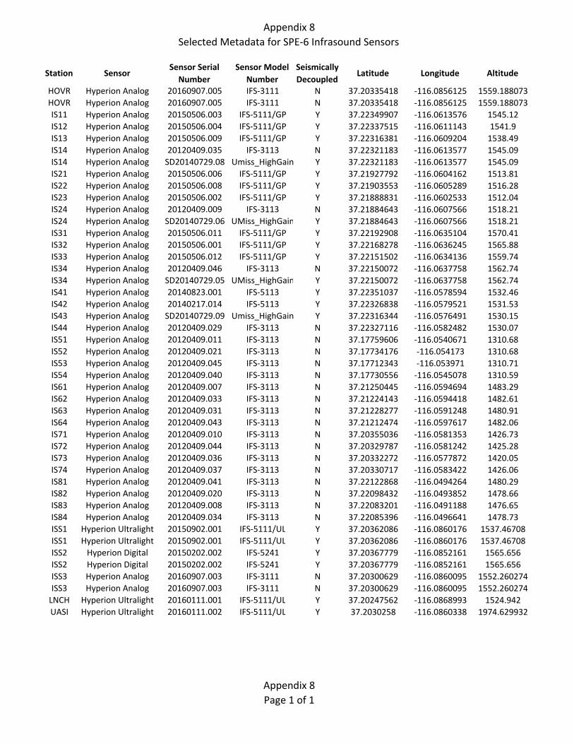
Appendix 8
Selected Metadata for SPE‐6 Infrasound Sensors
Station SensorSensor Serial Number
Sensor Model Number
Seismically Decoupled
Latitude Longitude Altitude
HOVR Hyperion Analog 20160907.005 IFS‐3111 N 37.20335418 ‐116.0856125 1559.188073
HOVR Hyperion Analog 20160907.005 IFS‐3111 N 37.20335418 ‐116.0856125 1559.188073
IS11 Hyperion Analog 20150506.003 IFS‐5111/GP Y 37.22349907 ‐116.0613576 1545.12
IS12 Hyperion Analog 20150506.004 IFS‐5111/GP Y 37.22337515 ‐116.0611143 1541.9
IS13 Hyperion Analog 20150506.009 IFS‐5111/GP Y 37.22316381 ‐116.0609204 1538.49
IS14 Hyperion Analog 20120409.035 IFS‐3113 N 37.22321183 ‐116.0613577 1545.09
IS14 Hyperion Analog SD20140729.08 Umiss_HighGain Y 37.22321183 ‐116.0613577 1545.09
IS21 Hyperion Analog 20150506.006 IFS‐5111/GP Y 37.21927792 ‐116.0604162 1513.81
IS22 Hyperion Analog 20150506.008 IFS‐5111/GP Y 37.21903553 ‐116.0605289 1516.28
IS23 Hyperion Analog 20150506.002 IFS‐5111/GP Y 37.21888831 ‐116.0602533 1512.04
IS24 Hyperion Analog 20120409.009 IFS‐3113 N 37.21884643 ‐116.0607566 1518.21
IS24 Hyperion Analog SD20140729.06 UMiss_HighGain Y 37.21884643 ‐116.0607566 1518.21
IS31 Hyperion Analog 20150506.011 IFS‐5111/GP Y 37.22192908 ‐116.0635104 1570.41
IS32 Hyperion Analog 20150506.001 IFS‐5111/GP Y 37.22168278 ‐116.0636245 1565.88
IS33 Hyperion Analog 20150506.012 IFS‐5111/GP Y 37.22151502 ‐116.0634136 1559.74
IS34 Hyperion Analog 20120409.046 IFS‐3113 N 37.22150072 ‐116.0637758 1562.74
IS34 Hyperion Analog SD20140729.05 UMiss_HighGain Y 37.22150072 ‐116.0637758 1562.74
IS41 Hyperion Analog 20140823.001 IFS‐5113 Y 37.22351037 ‐116.0578594 1532.46
IS42 Hyperion Analog 20140217.014 IFS‐5113 Y 37.22326838 ‐116.0579521 1531.53
IS43 Hyperion Analog SD20140729.09 Umiss_HighGain Y 37.22316344 ‐116.0576491 1530.15
IS44 Hyperion Analog 20120409.029 IFS‐3113 N 37.22327116 ‐116.0582482 1530.07
IS51 Hyperion Analog 20120409.011 IFS‐3113 N 37.17759606 ‐116.0540671 1310.68
IS52 Hyperion Analog 20120409.021 IFS‐3113 N 37.17734176 ‐116.054173 1310.68
IS53 Hyperion Analog 20120409.045 IFS‐3113 N 37.17712343 ‐116.053971 1310.71
IS54 Hyperion Analog 20120409.040 IFS‐3113 N 37.17730556 ‐116.0545078 1310.59
IS61 Hyperion Analog 20120409.007 IFS‐3113 N 37.21250445 ‐116.0594694 1483.29
IS62 Hyperion Analog 20120409.033 IFS‐3113 N 37.21224143 ‐116.0594418 1482.61
IS63 Hyperion Analog 20120409.031 IFS‐3113 N 37.21228277 ‐116.0591248 1480.91
IS64 Hyperion Analog 20120409.043 IFS‐3113 N 37.21212474 ‐116.0597617 1482.06
IS71 Hyperion Analog 20120409.010 IFS‐3113 N 37.20355036 ‐116.0581353 1426.73
IS72 Hyperion Analog 20120409.044 IFS‐3113 N 37.20329787 ‐116.0581242 1425.28
IS73 Hyperion Analog 20120409.036 IFS‐3113 N 37.20332272 ‐116.0577872 1420.05
IS74 Hyperion Analog 20120409.037 IFS‐3113 N 37.20330717 ‐116.0583422 1426.06
IS81 Hyperion Analog 20120409.041 IFS‐3113 N 37.22122868 ‐116.0494264 1480.29
IS82 Hyperion Analog 20120409.020 IFS‐3113 N 37.22098432 ‐116.0493852 1478.66
IS83 Hyperion Analog 20120409.008 IFS‐3113 N 37.22083201 ‐116.0491188 1476.65
IS84 Hyperion Analog 20120409.034 IFS‐3113 N 37.22085396 ‐116.0496641 1478.73
ISS1 Hyperion Ultralight 20150902.001 IFS‐5111/UL Y 37.20362086 ‐116.0860176 1537.46708
ISS1 Hyperion Ultralight 20150902.001 IFS‐5111/UL Y 37.20362086 ‐116.0860176 1537.46708
ISS2 Hyperion Digital 20150202.002 IFS‐5241 Y 37.20367779 ‐116.0852161 1565.656
ISS2 Hyperion Digital 20150202.002 IFS‐5241 Y 37.20367779 ‐116.0852161 1565.656
ISS3 Hyperion Analog 20160907.003 IFS‐3111 N 37.20300629 ‐116.0860095 1552.260274
ISS3 Hyperion Analog 20160907.003 IFS‐3111 N 37.20300629 ‐116.0860095 1552.260274
LNCH Hyperion Ultralight 20160111.001 IFS‐5111/UL Y 37.20247562 ‐116.0868993 1524.942
UASI Hyperion Ultralight 20160111.002 IFS‐5111/UL Y 37.2030258 ‐116.0860338 1974.629932
Appendix 8
Page 1 of 1

List of Attachments 1. Smith, K., and G. Plank, 2019. Non-SPE Stations Operated on NNSS, in Southern Nevada and
in Eastern California by NSL. University of Nevada, Reno Nevada Seismological Laboratory.
2. Mellors, R. J., T. Chen, C. Snelson, A. Pitarka, E. Matzel, and R. Abbott, 2017. Data Report: The Source Physics Experiment Large N Array. Lawrence Livermore National Laboratory Report LLNL-TR-732520.
3. Schalk, Walter, 2018. Written Communication prepared by the NNSS Weather Forecast Air Resources Laboratory/Special Operations and Research Division. SPE-5 Weather Data Collection. Mercury, NV.
4. Schalk, Walter, 2018. Written Communication prepared by the NNSS Weather Forecast Air Resources Laboratory/Special Operations and Research Division. SPE-6 Weather Data Collection. Mercury, NV.
5. Wharton, Sonia, 2018. SPE6 Atmospheric Lidar Data User Guide. Lawrence Livermore National Laboratory Report LLNL-TR-764520.
Attachment 1 Smith, K., and G. Plank, 2019. Non-SPE Stations Operated on NNSS, in Southern Nevada and in Eastern California by NSL. University of Nevada, Reno Nevada Seismological Laboratory.
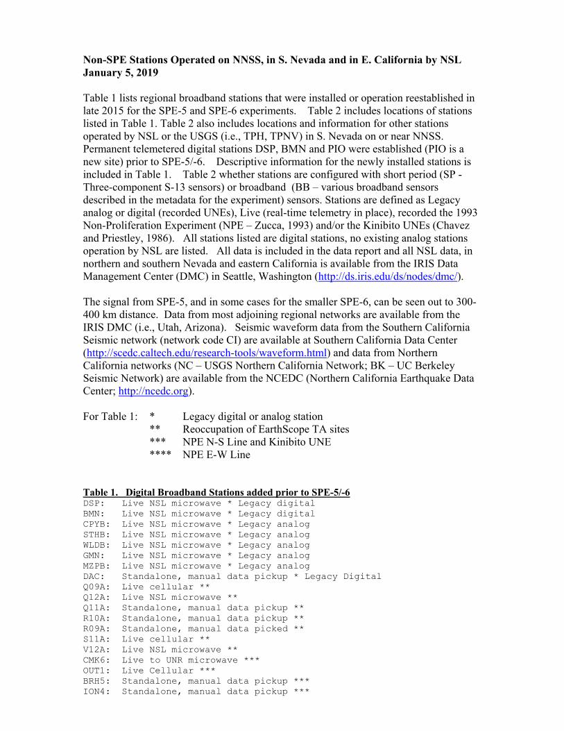
Non-SPE Stations Operated on NNSS, in S. Nevada and in E. California by NSL January 5, 2019 Table 1 lists regional broadband stations that were installed or operation reestablished in late 2015 for the SPE-5 and SPE-6 experiments. Table 2 includes locations of stations listed in Table 1. Table 2 also includes locations and information for other stations operated by NSL or the USGS (i.e., TPH, TPNV) in S. Nevada on or near NNSS. Permanent telemetered digital stations DSP, BMN and PIO were established (PIO is a new site) prior to SPE-5/-6. Descriptive information for the newly installed stations is included in Table 1. Table 2 whether stations are configured with short period (SP - Three-component S-13 sensors) or broadband (BB – various broadband sensors described in the metadata for the experiment) sensors. Stations are defined as Legacy analog or digital (recorded UNEs), Live (real-time telemetry in place), recorded the 1993 Non-Proliferation Experiment (NPE – Zucca, 1993) and/or the Kinibito UNEs (Chavez and Priestley, 1986). All stations listed are digital stations, no existing analog stations operation by NSL are listed. All data is included in the data report and all NSL data, in northern and southern Nevada and eastern California is available from the IRIS Data Management Center (DMC) in Seattle, Washington (http://ds.iris.edu/ds/nodes/dmc/). The signal from SPE-5, and in some cases for the smaller SPE-6, can be seen out to 300-400 km distance. Data from most adjoining regional networks are available from the IRIS DMC (i.e., Utah, Arizona). Seismic waveform data from the Southern California Seismic network (network code CI) are available at Southern California Data Center (http://scedc.caltech.edu/research-tools/waveform.html) and data from Northern California networks (NC – USGS Northern California Network; BK – UC Berkeley Seismic Network) are available from the NCEDC (Northern California Earthquake Data Center; http://ncedc.org). For Table 1: * Legacy digital or analog station ** Reoccupation of EarthScope TA sites *** NPE N-S Line and Kinibito UNE **** NPE E-W Line Table 1. Digital Broadband Stations added prior to SPE-5/-6 DSP: Live NSL microwave * Legacy digital BMN: Live NSL microwave * Legacy digital CPYB: Live NSL microwave * Legacy analog STHB: Live NSL microwave * Legacy analog WLDB: Live NSL microwave * Legacy analog GMN: Live NSL microwave * Legacy analog MZPB: Live NSL microwave * Legacy analog DAC: Standalone, manual data pickup * Legacy Digital Q09A: Live cellular ** Q12A: Live NSL microwave ** Q11A: Standalone, manual data pickup ** R10A: Standalone, manual data pickup ** R09A: Standalone, manual data picked ** S11A: Live cellular ** V12A: Live NSL microwave ** CMK6: Live to UNR microwave *** OUT1: Live Cellular *** BRH5: Standalone, manual data pickup *** ION4: Standalone, manual data pickup ***
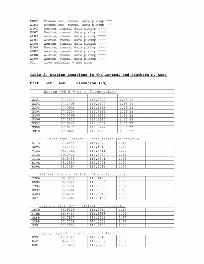
BRS2: Standalone, manual data pickup *** WAR3: Standalone, manual data pickup *** WG01: Weston, manual data pickup **** WG02: Weston, manual data pickup **** WG03: Weston, manual data pickup **** WG04: Weston, manual data pickup **** WG05: Weston, manual data pickup **** WG06: Weston, manual data pickup **** WG07: Weston, manual data pickup **** WG08: Weston, manual data pickup **** WG09: Weston, manual data pickup **** PIO: Live cellular – new site Table 2. Station Locations in the Central and Southern NV Area Stat. Lat. Lon. Elevation (km) Weston NPE E W Line Reoccupation WG01 37.3144 115.2940 1.75 BB WG02 37.2405 115.1977 1.35 BB WG03 37.0901 114.8186 0.98 BB WG04 37.1314 114.7126 1.06 BB WG05 37.0769 114.3395 0.94 BB WG06 37.1813 114.1420 1.13 BB WG07 37.0341 113.8609 1.14 BB WG08 37.0277 113.5772 0.86 BB WG10 37.0681 113.1290 1.50 BB NSF EarthScope Station - Reoccupation (TA network) S11A 37.6444 115.7472 1.45 Q09A 38.8340 117.1816 1.70 V12A 35.7266 114.8511 1.09 Q12A 39.0400 114.8299 1.62 Q11A 38.8455 115.6541 1.56 R10A 38.2886 116.3021 1.60 R09A 38.2397 117.0718 1.75 NPE N-S Line and Kinibito Line - Reoccupation CMK6 39.3102 118.1193 1.33 BRH5 39.0544 118.0356 1.60 ION4 38.8851 117.7380 1.97 BRS2 38.5264 117.6306 1.73 WAR3 38.6091 117.8348 1.90 OUT1 38.3268 117.5157 1.65 Legacy Analog Site – Digital - Reoccupation CPYB 36.9319 116.0564 1.27 STHB 36.6454 116.3388 1.05 WLDB 36.7927 116.6266 0.95 MZPB 37.7008 117.3838 2.37 GMN 37.3003 117.2607 2.16 Legacy Digital Stations - Reestablished BMN 40.4314 117.2210 1.59 DAC 36.2770 117.5937 1.81 DSP 37.3680 117.9722 1.69
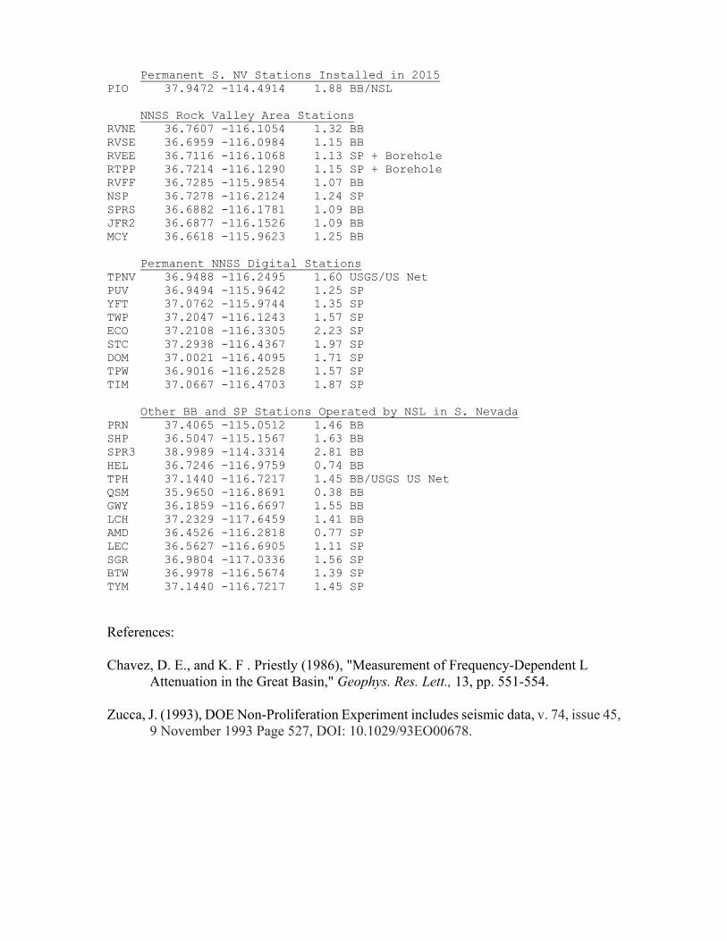
Permanent S. NV Stations Installed in 2015 PIO 37.9472 -114.4914 1.88 BB/NSL NNSS Rock Valley Area Stations RVNE 36.7607 -116.1054 1.32 BB RVSE 36.6959 -116.0984 1.15 BB RVEE 36.7116 -116.1068 1.13 SP + Borehole RTPP 36.7214 -116.1290 1.15 SP + Borehole RVFF 36.7285 -115.9854 1.07 BB NSP 36.7278 -116.2124 1.24 SP SPRS 36.6882 -116.1781 1.09 BB JFR2 36.6877 -116.1526 1.09 BB MCY 36.6618 -115.9623 1.25 BB Permanent NNSS Digital Stations TPNV 36.9488 -116.2495 1.60 USGS/US Net PUV 36.9494 -115.9642 1.25 SP YFT 37.0762 -115.9744 1.35 SP TWP 37.2047 -116.1243 1.57 SP ECO 37.2108 -116.3305 2.23 SP STC 37.2938 -116.4367 1.97 SP DOM 37.0021 -116.4095 1.71 SP TPW 36.9016 -116.2528 1.57 SP TIM 37.0667 -116.4703 1.87 SP Other BB and SP Stations Operated by NSL in S. Nevada PRN 37.4065 -115.0512 1.46 BB SHP 36.5047 -115.1567 1.63 BB SPR3 38.9989 -114.3314 2.81 BB HEL 36.7246 -116.9759 0.74 BB TPH 37.1440 -116.7217 1.45 BB/USGS US Net QSM 35.9650 -116.8691 0.38 BB GWY 36.1859 -116.6697 1.55 BB LCH 37.2329 -117.6459 1.41 BB AMD 36.4526 -116.2818 0.77 SP LEC 36.5627 -116.6905 1.11 SP SGR 36.9804 -117.0336 1.56 SP BTW 36.9978 -116.5674 1.39 SP TYM 37.1440 -116.7217 1.45 SP
References:
Chavez, D. E., and K. F . Priestly (1986), "Measurement of Frequency-Dependent L Attenuation in the Great Basin," Geophys. Res. Lett., 13, pp. 551-554.
Zucca, J. (1993), DOE Non-Proliferation Experiment includes seismic data, v. 74, issue 45, 9 November 1993 Page 527, DOI: 10.1029/93EO00678.

Attachment 2 Mellors, R. J., T. Chen, C. Snelson, A. Pitarka, E. Matzel, and R. Abbott, 2017. Data Report: The Source Physics Experiment Large N Array. Lawrence Livermore National Laboratory Report LLNL-TR-732520.
LLNL-TR-732520
Data Report: The Source PhysicsExperiment Large N Array
R. J. Mellors, T. Chen, C. Snelson, A. Pitarka, E.Matzel, R. Abbott
June 6, 2017
Disclaimer
This document was prepared as an account of work sponsored by an agency of the United States government. Neither the United States government nor Lawrence Livermore National Security, LLC, nor any of their employees makes any warranty, expressed or implied, or assumes any legal liability or responsibility for the accuracy, completeness, or usefulness of any information, apparatus, product, or process disclosed, or represents that its use would not infringe privately owned rights. Reference herein to any specific commercial product, process, or service by trade name, trademark, manufacturer, or otherwise does not necessarily constitute or imply its endorsement, recommendation, or favoring by the United States government or Lawrence Livermore National Security, LLC. The views and opinions of authors expressed herein do not necessarily state or reflect those of the United States government or Lawrence Livermore National Security, LLC, and shall not be used for advertising or product endorsement purposes.
This work performed under the auspices of the U.S. Department of Energy by Lawrence Livermore National Laboratory under Contract DE-AC52-07NA27344.
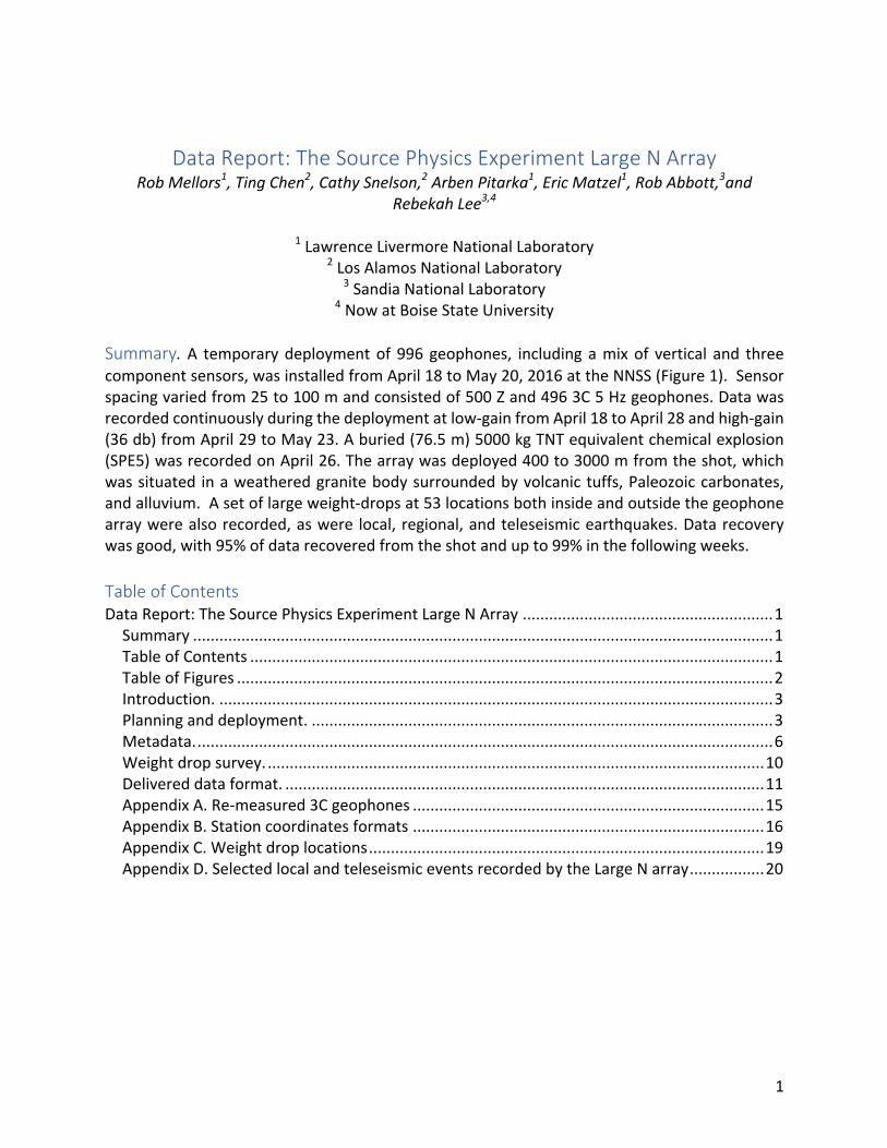
1
DataReport:TheSourcePhysicsExperimentLargeNArrayRobMellors1,TingChen2,CathySnelson,2ArbenPitarka1,EricMatzel1,RobAbbott,3and
RebekahLee3,4
1LawrenceLivermoreNationalLaboratory2LosAlamosNationalLaboratory
3SandiaNationalLaboratory4NowatBoiseStateUniversity
Summary. A temporarydeploymentof 996geophones, including amixof vertical and threecomponentsensors,wasinstalledfromApril18toMay20,2016attheNNSS(Figure1).Sensorspacingvariedfrom25to100mandconsistedof500Zand4963C5Hzgeophones.Datawasrecordedcontinuouslyduringthedeploymentatlow-gainfromApril18toApril28andhigh-gain(36db)fromApril29toMay23.Aburied(76.5m)5000kgTNTequivalentchemicalexplosion(SPE5)wasrecordedonApril26.Thearraywasdeployed400to3000mfromtheshot,whichwassituated inaweatheredgranitebodysurroundedbyvolcanictuffs,Paleozoiccarbonates,andalluvium.Asetoflargeweight-dropsat53locationsbothinsideandoutsidethegeophonearraywerealsorecorded,aswere local, regional,andteleseismicearthquakes.Datarecoverywasgood,with95%ofdatarecoveredfromtheshotandupto99%inthefollowingweeks.TableofContentsDataReport:TheSourcePhysicsExperimentLargeNArray.........................................................1Summary....................................................................................................................................1TableofContents.......................................................................................................................1TableofFigures..........................................................................................................................2Introduction...............................................................................................................................3Planninganddeployment..........................................................................................................3Metadata....................................................................................................................................6Weightdropsurvey..................................................................................................................10Delivereddataformat..............................................................................................................11AppendixA.Re-measured3Cgeophones................................................................................15AppendixB.Stationcoordinatesformats................................................................................16AppendixC.Weightdroplocations..........................................................................................19AppendixD.SelectedlocalandteleseismiceventsrecordedbytheLargeNarray.................20
2
TableofFiguresFigure1.LayoutofLargeNarray,permanentarray(radiallines),andlocationofSPE5shot
(yellowstar).Thegreenlinedenotestheapproximateoutlineofthegranite(ClimaxStock).................................................................................................................................................4
Figure2.(left)Exampleofgeophonedeployment,battery,anddigitizer.(right)Truckwithfieldcomputerandracksfordownloadingdataandchargingbatteries.......................................5
Figure3(left)Jigusedtoorienthorizontalgeophones.Acompassisinthehandle.(right)DeployedZcomponentgeophoneanddigitizer/diskstorageunit........................................5
Figure4.Viewofcomputerscreenintruckthattracksinstallationofarray.................................6Figure5.Mapsofarrayshowinglinesnumbers(left)andstationnumbers(right).3Cdata
statiosnbeginwith“3”andZonlystationsbeginwith“1”....................................................7Figure5.(top)Maximumamplitudefordatarecordedbyhorizontalgeophonesplottedversus
distance.(bottom)MaximumamplitudeforZcomponentgeophonesversusdistance.Afewclippedatthedigitizer.....................................................................................................8
Figure6.Examplewaveforms(Z)recordedforaroughlynorth/southline(left)andeast-west(right).Theeast-westlineliesingranitewhilethenorth-southisinalluvium......................8
Figure7.(left)OutlineofLargeNarrayandfirst-arrivaltraveltimesforthePwave.(right)ReducestraveltimeofSPE5shotbyazimuthfromGZ..........................................................9
Figure9.Localearthquakemeasuredacrossthearray................................................................10Figure10.Filtered(1Hzlowpass)teleseismicsignal.LeftisinYuccaFlatandrightisfromClimax
Stock.....................................................................................................................................10Figure11.Mapviewimagesofthewavefrontshowingevolutionofthewavefront...................9Figure12.ExampleofdifferenthammerstrikeswithtimingbasedonReftek(top)andproximal
geophone(bottom).TheoriginaldatawasbasedontheReftektimebutwaslaterrecutbasedontheproximalgeophone........................................................................................12
Figure13.Exampleshotgatherfromweightdropsurvey...........................................................12Figure14.Mapviewimageofwavefrontfromasingleweightdroprecordedacrossthearray.13Figure15.Exampleofsignalsgeneratedbythelargeweightdropneartheboundarywiththe
ClimaxStock.........................................................................................................................13Figure16.MapofLargeNarray...................................................................................................17
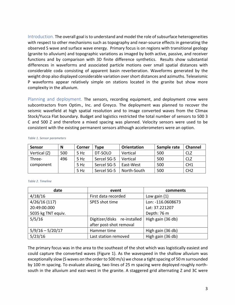
3
Introduction.Theoverallgoalistounderstandandmodeltheroleofsubsurfaceheterogeneitieswithrespecttoothermechanismssuchastopographyandnear-sourceeffectsingeneratingtheobservedSwaveandsurfacewaveenergy.Primaryfocusisonregionswithtransitionalgeology(granitetoalluvium)andtopographicvariationsasimagedbybothactive,passive,andreceiverfunctions and by comparison with 3D finite difference synthetics. Results show substantialdifferences in waveforms and associated particle motions over small spatial distances withconsiderable coda consisting of apparent basin reverberation.Waveforms generated by theweightdropalsodisplayedconsiderablevariationovershortdistancesandazimuths.TeleseismicP waveforms appear relatively simple on stations located in the granite but show morecomplexityinthealluvium.Planning and deployment. The sensors, recording equipment, and deployment crew weresubcontractors from Optim., Inc. and Greyco. The deployment was planned to recover theseismic wavefield at high spatial resolution and to image converted waves from the ClimaxStock/YuccaFlatboundary.Budgetandlogisticsrestrictedthetotalnumberofsensorsto5003C and 500 Z and therefore amixed spacing was planned. Velocity sensors were used to beconsistentwiththeexistingpermanentsensorsalthoughaccelerometerswereanoption.Table1.Sensorparameters
Sensor N Corner Type Orientation Samplerate ChannelVertical(Z) 500 5Hz DT-SOLO Vertical 500 CLZThree-component
496 5Hz SercelSG-5 Vertical 500 CLZ5Hz SercelSG-5 East-West 500 CH15Hz SercelSG-5 North-South 500 CH2
Table2.Timeline
date event comments4/18/16 Firstdatarecorded Lowgain(1)4/26/16(117)20:49:00.0005035kgTNTequiv.
SPE5shottime Lon:-116.0608673Lat:37.221207Depth:76m
5/5/16 Digitizer/disks re-installedafterpost-shotremoval
Highgain(36db)
5/9/16–5/20/17 Hammertime Highgain(36db)5/23/16 Laststationremoved Highgain(36db)Theprimaryfocuswasintheareatothesoutheastoftheshotwhichwaslogisticallyeasiestandcouldcapturetheconvertedwaves (Figure1).As thewavespeed in theshallowalluviumwasexceptionallyslow(Swavesontheorderto500m/s)wechoseatightspacingof50msurroundedby100mspacing.Toevaluatealiasing,twolinesof25mspacingweredeployedroughlynorth-southinthealluviumandeast-westinthegranite.AstaggeredgridalternatingZand3Cwere
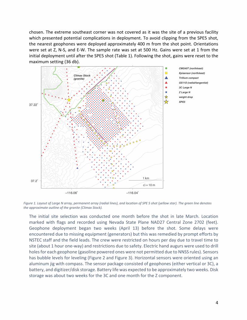
4
chosen. The extreme southeast corner was not covered as it was the site of a previous facility which presented potential complications in deployment. To avoid clipping from the SPE5 shot, the nearest geophones were deployed approximately 400 m from the shot point. Orientations were set at Z, N‐S, and E‐W. The sample rate was set at 500 Hz. Gains were set at 1 from the initial deployment until after the SPE5 shot (Table 1). Following the shot, gains were reset to the maximum setting (36 db).
The initial site selection was conducted one month before the shot in late March. Location marked with flags and recorded using Nevada State Plane NAD27 Central Zone 2702 (feet). Geophone deployment began two weeks (April 13) before the shot. Some delays were encountered due to missing equipment (generators) but this was remedied by prompt efforts by NSTEC staff and the field leads. The crew were restricted on hours per day due to travel time to site (about 1 hour one‐way) and restrictions due to safety. Electric hand augurs were used to drill holes for each geophone (gasoline powered ones were not permitted due to NNSS rules). Sensors has bubble levels for leveling (Figure 2 and Figure 3). Horizontal sensors were oriented using an aluminum jig with compass. The sensor package consisted of geophones (either vertical or 3C), a battery, and digitizer/disk storage. Battery life was expected to be approximately two weeks. Disk storage was about two weeks for the 3C and one month for the Z component.
Figure 1. Layout of Large N array, permanent array (radial lines), and location of SPE 5 shot (yellow star). The green line denotes the approximate outline of the granite (Climax Stock).
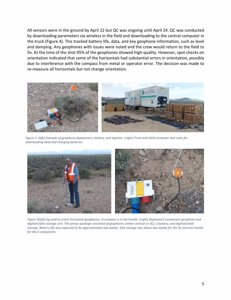
5
AllsensorswereinthegroundbyApril22butQCwasongoinguntilApril24.QCwasconductedbydownloadingparametersviawirelessinthefieldanddownloadingtothecentralcomputerinthetruck(Figure4).Thistrackedbatterylife,data,andkeygeophoneinformation,suchaslevelanddamping.Anygeophoneswithissueswerenotedandthecrewwouldreturntothefieldtofix.Atthetimeoftheshot95%ofthegeophonesshowedhigh-quality.However,spotchecksonorientationindicatedthatsomeofthehorizontalshadsubstantialerrorsinorientation,possiblyduetointerferencewiththecompassfrommetaloroperatorerror.Thedecisionwasmadetore-measureallhorizontalsbutnotchangeorientation.
Figure3(left)Jigusedtoorienthorizontalgeophones.Acompassisinthehandle.(right)DeployedZcomponentgeophoneanddigitizer/diskstorageunit.Thesensorpackageconsistedofgeophones(eitherverticalor3C),abattery,anddigitizer/diskstorage.Batterylifewasexpectedtobeapproximatelytwoweeks.Diskstoragewasabouttwoweeksforthe3CandonemonthfortheZcomponent.
Figure2.(left)Exampleofgeophonedeployment,battery,anddigitizer.(right)Truckwithfieldcomputerandracksfordownloadingdataandchargingbatteries.
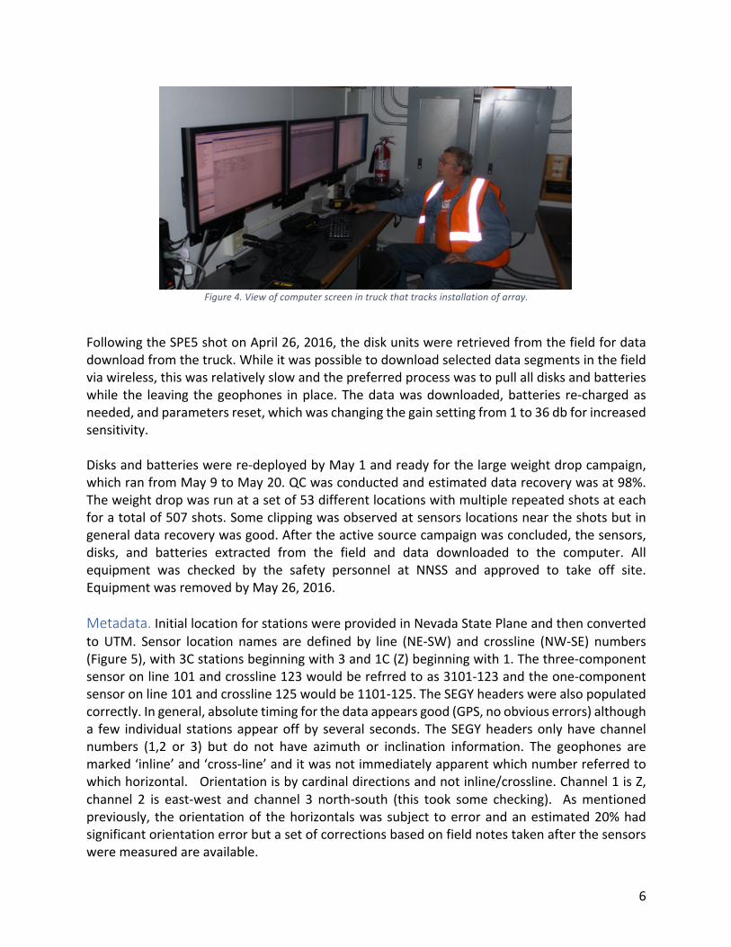
6
Figure4.Viewofcomputerscreenintruckthattracksinstallationofarray.
FollowingtheSPE5shotonApril26,2016,thediskunitswereretrievedfromthefieldfordatadownloadfromthetruck.Whileitwaspossibletodownloadselecteddatasegmentsinthefieldviawireless,thiswasrelativelyslowandthepreferredprocesswastopullalldisksandbatterieswhile the leaving thegeophones inplace.Thedatawasdownloaded,batteries re-chargedasneeded,andparametersreset,whichwaschangingthegainsettingfrom1to36dbforincreasedsensitivity.Disksandbatterieswerere-deployedbyMay1andreadyforthelargeweightdropcampaign,whichranfromMay9toMay20.QCwasconductedandestimateddatarecoverywasat98%.Theweightdropwasrunatasetof53differentlocationswithmultiplerepeatedshotsateachforatotalof507shots.Someclippingwasobservedatsensorslocationsneartheshotsbutingeneraldatarecoverywasgood.Aftertheactivesourcecampaignwasconcluded,thesensors,disks, and batteries extracted from the field and data downloaded to the computer. Allequipment was checked by the safety personnel at NNSS and approved to take off site.EquipmentwasremovedbyMay26,2016.Metadata.InitiallocationforstationswereprovidedinNevadaStatePlaneandthenconvertedtoUTM. Sensor location names are defined by line (NE-SW) and crossline (NW-SE) numbers(Figure5),with3Cstationsbeginningwith3and1C(Z)beginningwith1.Thethree-componentsensoronline101andcrossline123wouldberefrredtoas3101-123andtheone-componentsensoronline101andcrossline125wouldbe1101-125.TheSEGYheaderswerealsopopulatedcorrectly.Ingeneral,absolutetimingforthedataappearsgood(GPS,noobviouserrors)althougha few individual stationsappearoffby several seconds.TheSEGYheadersonlyhavechannelnumbers (1,2 or 3) but do not have azimuth or inclination information. The geophones aremarked‘inline’and‘cross-line’anditwasnotimmediatelyapparentwhichnumberreferredtowhichhorizontal.Orientationisbycardinaldirectionsandnotinline/crossline.Channel1isZ,channel 2 is east-west and channel 3 north-south (this took some checking). Asmentionedpreviously, theorientationof thehorizontalswassubject toerrorandanestimated20%hadsignificantorientationerrorbutasetofcorrectionsbasedonfieldnotestakenafterthesensorsweremeasuredareavailable.
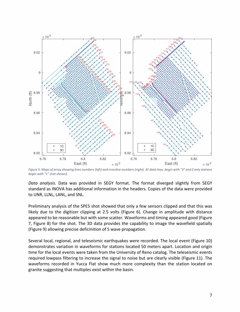
7
Figure5.Mapsofarrayshowinglinesnumbers(left)andcrosslinenumbers(right).3Cdatalinesbeginwith“3”andZonlystationsbeginwith“1”(notshown).
Data analysis. Data was provided in SEGY format. The format diverged slightly from SEGYstandardasINOVAhasadditionalinformationintheheaders.CopiesofthedatawereprovidedtoUNR,LLNL,LANL,andSNL.PreliminaryanalysisoftheSPE5shotshowedthatonlyafewsensorsclippedandthatthiswaslikely due to the digitizer clipping at 2.5 volts (Figure 6). Change in amplitudewith distanceappearedtobereasonablebutwithsomescatter.Waveformsandtimingappearedgood(Figure7,Figure8) fortheshot.The3Ddataprovidesthecapabilityto imagethewavefieldspatially(Figure9)allowingprecisedeficinitionofSwavepropagation.Severallocal,regional,andteleseismicearthquakeswererecorded.Thelocalevent(Figure10)demonstratesvariationinwaveformsforstationslocated50metersapart.LocationandorigintimeforthelocaleventsweretakenfromtheUniversityofRenocatalog.Theteleseismiceventsrequiredlowpassfilteringtoincreasethesignaltonoisebutareclearlyvisible(Figure11).Thewaveforms recorded in Yucca Flat showmuchmore complexity than the station located ongranitesuggestingthatmultiplesexistwithinthebasin.
East (ft) × 10 56.76 6.78 6.8 6.82
Nor
th (f
t)
× 10 5
8.92
8.94
8.96
8.98
9
9.02
101103
105107
109111
113115
116117
118119
120121
122123
124125
126
127
128129
130131
132133134
135136
137
138
139141
143
145
147
149
1511C3C
East (ft) × 10 56.76 6.78 6.8 6.82
Nor
th (f
t)× 10 5
8.92
8.94
8.96
8.98
9
9.02
101
103
104
105
106
107
108
109
110
111
112
113
114
115
116
117
118
119
120
121
122
123
124
125
126
127
128
129
130
131
132
133135
137139
141143
145147
149151
153
201
301
1C3C
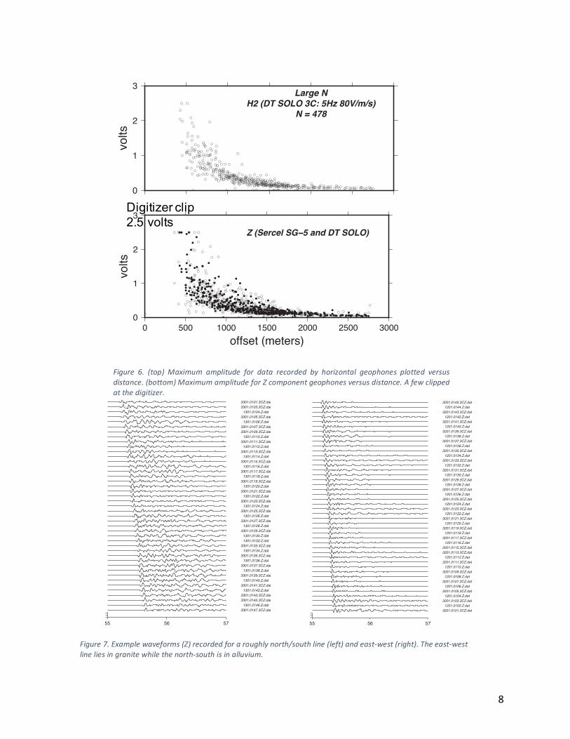
8
0
1
2
3
volts
0 500 1000 1500 2000 2500 3000offset (meters)
Z (Sercel SG−5 and DT SOLO)
0
1
2
3
volts
Large NH2 (DT SOLO 3C: 5Hz 80V/m/s)
N = 478
Digitizer clip2.5 volts
55 56 57
3301.0147.3CZ.dat1301.0146.Z.dat
3301.0145.3CZ.dat3301.0143.3CZ.dat1301.0142.Z.dat
3301.0141.3CZ.dat1301.0140.Z.dat
3301.0139.3CZ.dat1301.0138.Z.dat
3301.0137.3CZ.dat1301.0136.Z.dat
3301.0135.3CZ.dat1301.0134.Z.dat
3301.0133.3CZ.dat1301.0132.Z.dat1301.0130.Z.dat
3301.0129.3CZ.dat1301.0128.Z.dat
3301.0127.3CZ.dat1301.0126.Z.dat
3301.0125.3CZ.dat1301.0124.Z.dat
3301.0123.3CZ.dat1301.0122.Z.dat
3301.0121.3CZ.dat1301.0120.Z.dat
3301.0119.3CZ.dat1301.0118.Z.dat
3301.0117.3CZ.dat1301.0116.Z.dat
3301.0115.3CZ.dat1301.0114.Z.dat
3301.0113.3CZ.dat1301.0112.Z.dat
3301.0111.3CZ.dat1301.0110.Z.dat
3301.0109.3CZ.dat3301.0107.3CZ.dat1301.0106.Z.dat
3301.0105.3CZ.dat1301.0104.Z.dat
3301.0103.3CZ.dat3301.0101.3CZ.dat
dense line (25 m) from north to south
55 56 57
3201.0101.3CZ.dat1201.0102.Z.dat
3201.0103.3CZ.dat1201.0104.Z.dat
3201.0105.3CZ.dat1201.0106.Z.dat
3201.0107.3CZ.dat1201.0108.Z.dat
3201.0109.3CZ.dat1201.0110.Z.dat
3201.0111.3CZ.dat1201.0112.Z.dat
3201.0113.3CZ.dat3201.0115.3CZ.dat1201.0116.Z.dat
3201.0117.3CZ.dat1201.0118.Z.dat
3201.0119.3CZ.dat1201.0120.Z.dat
3201.0121.3CZ.dat1201.0122.Z.dat
3201.0123.3CZ.dat1201.0124.Z.dat
3201.0125.3CZ.dat1201.0126.Z.dat
3201.0127.3CZ.dat1201.0128.Z.dat
3201.0129.3CZ.dat1201.0130.Z.dat
3201.0131.3CZ.dat1201.0132.Z.dat
3201.0133.3CZ.dat1201.0134.Z.dat
3201.0135.3CZ.dat1201.0136.Z.dat
3201.0137.3CZ.dat1201.0138.Z.dat
3201.0139.3CZ.dat1201.0140.Z.dat
3201.0141.3CZ.dat1201.0142.Z.dat
3201.0143.3CZ.dat1201.0144.Z.dat
3201.0145.3CZ.dat
dense line (25 m) from west to east
Figure 6. (top) Maximum amplitude for data recorded by horizontal geophones plotted versusdistance.(bottom)MaximumamplitudeforZcomponentgeophonesversusdistance.Afewclippedatthedigitizer.
Figure7.Examplewaveforms(Z)recordedforaroughlynorth/southline(left)andeast-west(right).Theeast-westlineliesingranitewhilethenorth-southisinalluvium.
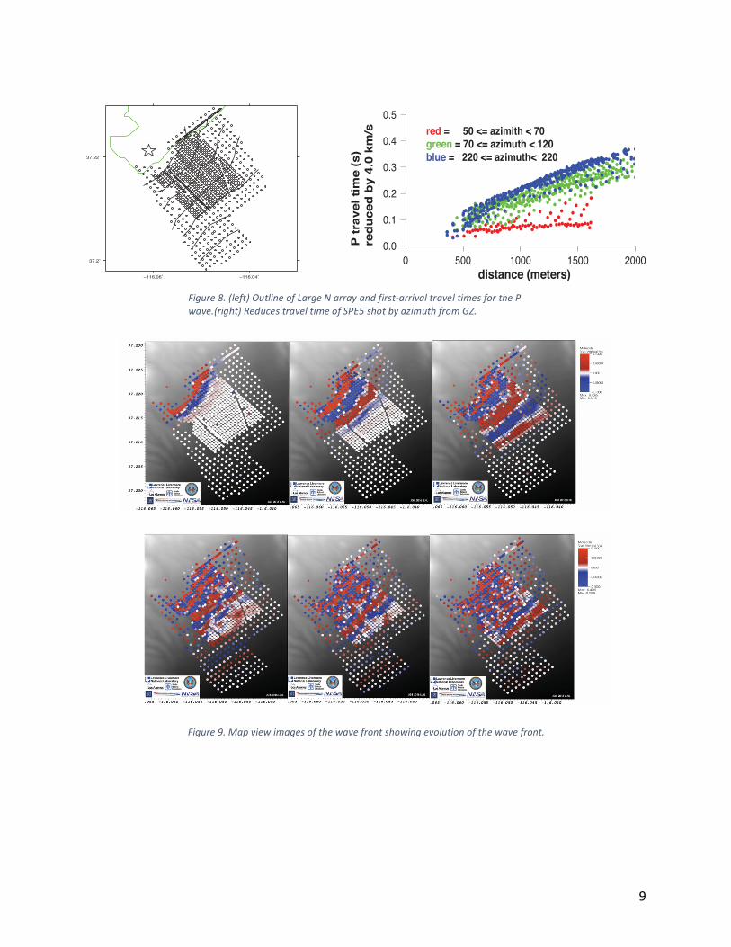
9
Figure9.Mapviewimagesofthewavefrontshowingevolutionofthewavefront.
−116.06˚ −116.04˚
37.2˚
37.22˚
0.0
0.1
0.2
0.3
0.4
0.5
0 500 1000 1500 2000distance (meters)
P t
rave
l tim
e (s
) re
du
ced
by
4.0
km/s red = 50 <= azimith < 70
green = 70 <= azimuth < 120blue = 220 <= azimuth< 220
Figure8.(left)OutlineofLargeNarrayandfirst-arrivaltraveltimesforthePwave.(right)ReducestraveltimeofSPE5shotbyazimuthfromGZ.
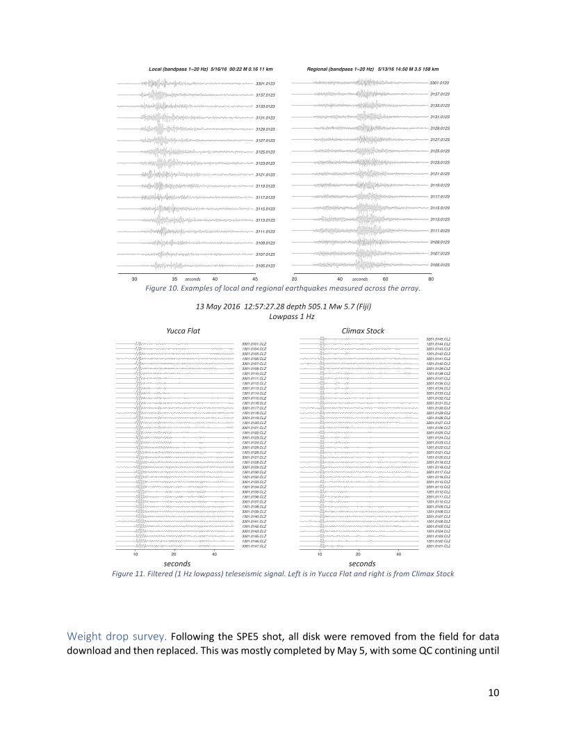
10
Figure10.Examplesoflocalandregionalearthquakesmeasuredacrossthearray.
Figure11.Filtered(1Hzlowpass)teleseismicsignal.LeftisinYuccaFlatandrightisfromClimaxStock
Weightdropsurvey. Following theSPE5shot,alldiskwere removed fromthe field fordatadownloadandthenreplaced.ThiswasmostlycompletedbyMay5,withsomeQCcontininguntil
30 35 40 45
3105.0123
3107.0123
3109.0123
3111.0123
3113.0123
3115.0123
3117.0123
3119.0123
3121.0123
3123.0123
3125.0123
3127.0123
3129.0123
3131.0123
3133.0123
3137.0123
3301.0123
Local (bandpass 1−20 Hz) 5/16/16 00:22 M 0.16 11 km
seconds 20 40 60 80
3105.0123
3107.0123
3109.0123
3111.0123
3113.0123
3115.0123
3117.0123
3119.0123
3121.0123
3123.0123
3125.0123
3127.0123
3129.0123
3131.0123
3133.0123
3137.0123
3301.0123
Regional (bandpass 1−20 Hz) 5/13/16 14:50 M 3.5 158 km
seconds
3301.0147.CLZ1301.0146.CLZ3301.0145.CLZ3301.0143.CLZ1301.0142.CLZ3301.0141.CLZ1301.0140.CLZ3301.0139.CLZ1301.0138.CLZ3301.0137.CLZ1301.0136.CLZ3301.0135.CLZ1301.0134.CLZ3301.0133.CLZ1301.0132.CLZ1301.0130.CLZ3301.0129.CLZ1301.0128.CLZ3301.0127.CLZ1301.0126.CLZ3301.0125.CLZ1301.0124.CLZ3301.0123.CLZ1301.0122.CLZ3301.0121.CLZ1301.0120.CLZ3301.0119.CLZ1301.0118.CLZ3301.0117.CLZ1301.0116.CLZ3301.0115.CLZ1301.0114.CLZ3301.0113.CLZ1301.0112.CLZ3301.0111.CLZ1301.0110.CLZ3301.0109.CLZ3301.0107.CLZ1301.0106.CLZ3301.0105.CLZ1301.0104.CLZ3301.0101.CLZ
10 20 40
seconds
Yucca Flat
3201.0101.CLZ1201.0102.CLZ3201.0103.CLZ1201.0104.CLZ3201.0105.CLZ1201.0106.CLZ3201.0107.CLZ1201.0108.CLZ3201.0109.CLZ1201.0110.CLZ3201.0111.CLZ1201.0112.CLZ3201.0113.CLZ3201.0115.CLZ1201.0116.CLZ3201.0117.CLZ1201.0118.CLZ3201.0119.CLZ1201.0120.CLZ3201.0121.CLZ1201.0122.CLZ3201.0123.CLZ1201.0124.CLZ3201.0125.CLZ1201.0126.CLZ3201.0127.CLZ1201.0128.CLZ3201.0129.CLZ1201.0130.CLZ3201.0131.CLZ1201.0132.CLZ3201.0133.CLZ1201.0134.CLZ3201.0135.CLZ3201.0137.CLZ1201.0138.CLZ3201.0139.CLZ1201.0140.CLZ3201.0141.CLZ1201.0142.CLZ3201.0143.CLZ1201.0144.CLZ3201.0145.CLZ
10 20 40
seconds
Climax Stock
13 May 2016 12:57:27.28 depth 505.1 Mw 5.7 (Fiji)
Lowpass 1 Hz
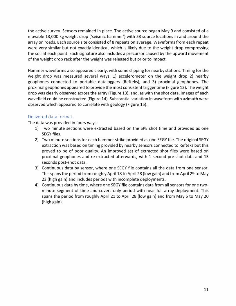
11
theactivesurvey.Sensorsremainedinplace.TheactivesourcebeganMay9andconsistedofamovable13,000kgweightdrop(‘seismichammer’)with53sourcelocationsinandaroundthearrayonroads.Eachsourcesiteconsistedof8repeatsonaverage.Waveformsfromeachrepeatwereverysimilarbutnotexactlyidentical,whichislikelyduetotheweightdropcompressingthesoilateachpoint.Eachsignaturealsoincludesaprecursorcausedbytheupwardmovementoftheweightdroprackaftertheweightwasreleasedbutpriortoimpact.Hammerwaveformsalsoappearedclearly,withsomeclippingfornearbystations.Timingfortheweight drop was measured several ways: 1) accelerometer on the weight drop 2) nearbygeophones connected to portable dataloggers (Refteks), and 3) proximal geophones. Theproximalgeophonesappearedtoprovidethemostconsistenttriggertime(Figure12).Theweightdropwasclearlyobservedacrossthearray(Figure13),and,aswiththeshotdata,imagesofeachwavefieldcouldbeconstructed(Figure14).Substantialvariationinwaveformwithazimuthwereobservedwhichappearedtocorrelatewithgeology(Figure15).Delivereddataformat.Thedatawasprovidedinfoursways:
1) TwominutesectionswereextractedbasedontheSPEshot timeandprovidedasoneSEGYfiles.
2) TwominutesectionsforeachhammerstrikeprovidedasoneSEGYfile.TheoriginalSEGYextractionwasbasedontimingprovidedbynearbysensorsconnectedtoRefteksbutthisproved to be of poor quality. An improved set of extracted shot fileswere based onproximalgeophonesand re-extractedafterwards,with1 secondpre-shotdataand15secondspost-shotdata.
3) Continuousdatabysensor,whereoneSEGYfilecontainsallthedatafromonesensor.ThisspanstheperiodfromroughlyApril18toApril28(lowgain)andfromApril29toMay23(highgain)andincludesperiodswithincompletedeployments.
4) Continuousdatabytime,whereoneSEGYfilecontainsdatafromallsensorsforonetwo-minute segmentof timeandcoversonlyperiodwithnear full arraydeployment. ThisspanstheperiodfromroughlyApril21toApril28(lowgain)andfromMay5toMay20(highgain).
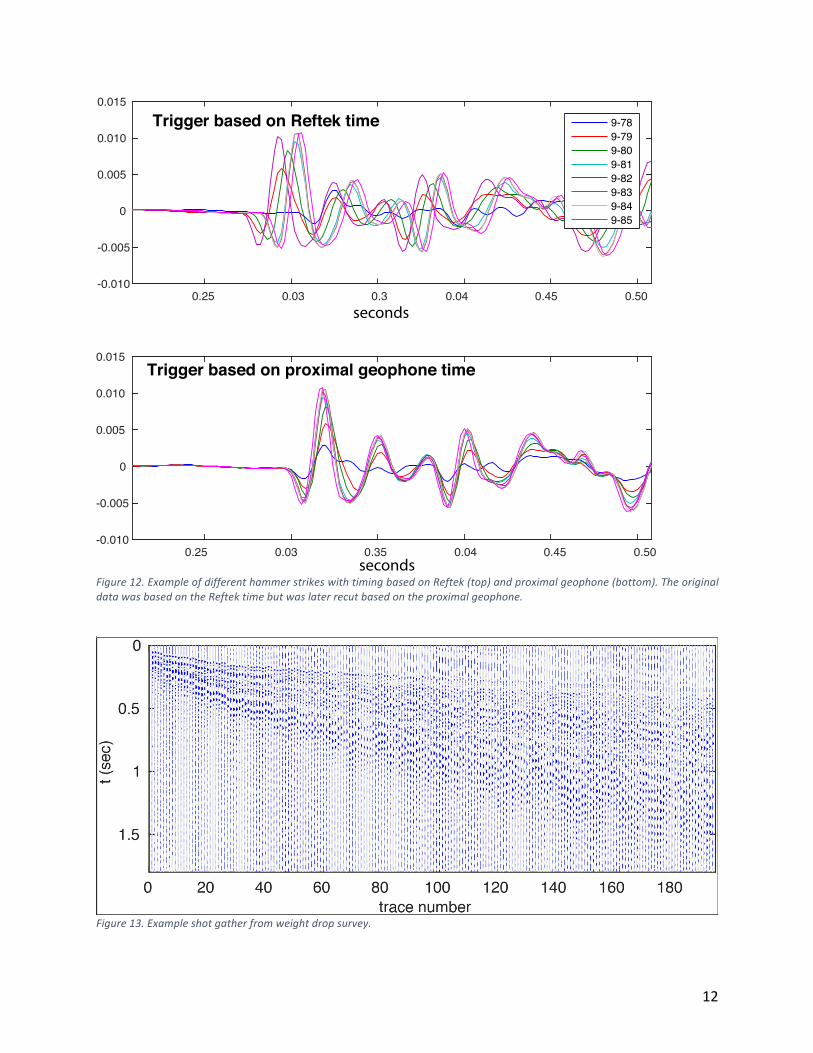
12
Figure12.ExampleofdifferenthammerstrikeswithtimingbasedonReftek(top)andproximalgeophone(bottom).TheoriginaldatawasbasedontheReftektimebutwaslaterrecutbasedontheproximalgeophone.
Figure13.Exampleshotgatherfromweightdropsurvey.
0.25 0.03 0.3 0.04 0.45 0.50-0.010
-0.005
0
0.005
0.010
0.015
Trigger based on Reftek time 9-789-799-809-819-829-839-849-85
seconds
0.25 0.03 0.35 0.04 0.45 0.50-0.010
-0.005
0
0.005
0.010
0.015Trigger based on proximal geophone time
seconds
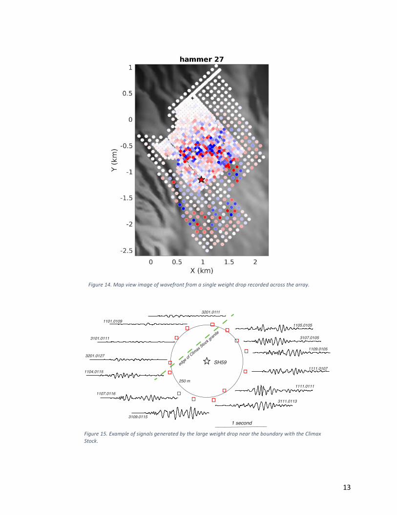
13
Figure14.Mapviewimageofwavefrontfromasingleweightdroprecordedacrossthearray.
SH59
1101.0109
3101.0111
3201.0127
1104.0115
1107.0116
3109.0115
3111.0113
1111.0111
1111.0107
1109.0105
3107.0105
1105.0105
1 second
edge of C
limax
Sto
ck g
ranite
250 m
3201.0111
Figure15.ExampleofsignalsgeneratedbythelargeweightdropneartheboundarywiththeClimaxStock.
14
Acknowledgements.Manypeoplecontributedtothisprojectandwegreatlyappreciatetheirefforts.Herewelistafew:W.Walter,S.Ford,S.Myers,S.Pullammanappallil,D.Naphan,R.Bayani,D.Huff,A.Pitarka,J.Bonner,F.Spenia,A.Isaacs,R.White,B.Dzenitis,andL.Berzins.PreparedbyLLNLunderContractDE-AC52-07NA27344.PreparedbyLLNLunderContractDE-AC52-07NA27344.
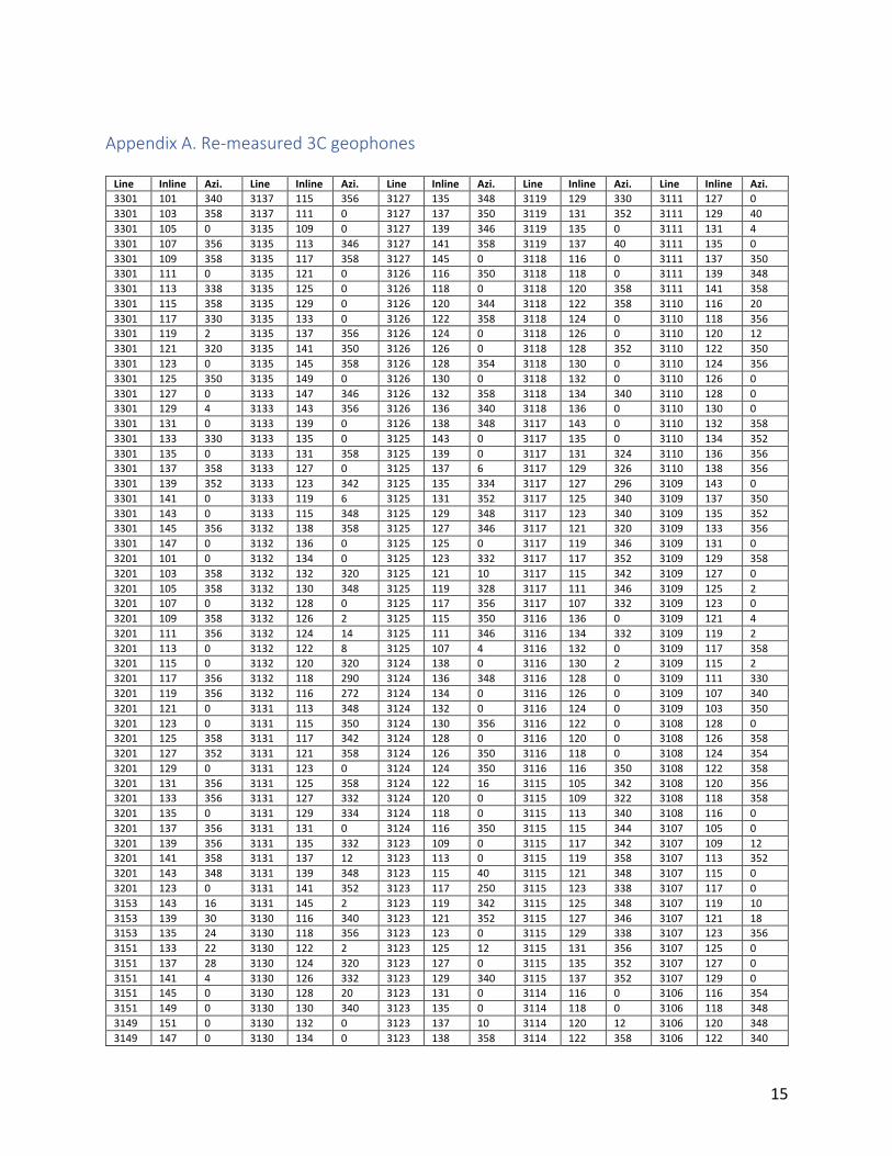
15
AppendixA.Re-measured3CgeophonesLine Inline Azi. Line Inline Azi. Line Inline Azi. Line Inline Azi. Line Inline Azi.3301 101 340 3137 115 356 3127 135 348 3119 129 330 3111 127 03301 103 358 3137 111 0 3127 137 350 3119 131 352 3111 129 403301 105 0 3135 109 0 3127 139 346 3119 135 0 3111 131 43301 107 356 3135 113 346 3127 141 358 3119 137 40 3111 135 03301 109 358 3135 117 358 3127 145 0 3118 116 0 3111 137 3503301 111 0 3135 121 0 3126 116 350 3118 118 0 3111 139 3483301 113 338 3135 125 0 3126 118 0 3118 120 358 3111 141 3583301 115 358 3135 129 0 3126 120 344 3118 122 358 3110 116 203301 117 330 3135 133 0 3126 122 358 3118 124 0 3110 118 3563301 119 2 3135 137 356 3126 124 0 3118 126 0 3110 120 123301 121 320 3135 141 350 3126 126 0 3118 128 352 3110 122 3503301 123 0 3135 145 358 3126 128 354 3118 130 0 3110 124 3563301 125 350 3135 149 0 3126 130 0 3118 132 0 3110 126 03301 127 0 3133 147 346 3126 132 358 3118 134 340 3110 128 03301 129 4 3133 143 356 3126 136 340 3118 136 0 3110 130 03301 131 0 3133 139 0 3126 138 348 3117 143 0 3110 132 3583301 133 330 3133 135 0 3125 143 0 3117 135 0 3110 134 3523301 135 0 3133 131 358 3125 139 0 3117 131 324 3110 136 3563301 137 358 3133 127 0 3125 137 6 3117 129 326 3110 138 3563301 139 352 3133 123 342 3125 135 334 3117 127 296 3109 143 03301 141 0 3133 119 6 3125 131 352 3117 125 340 3109 137 3503301 143 0 3133 115 348 3125 129 348 3117 123 340 3109 135 3523301 145 356 3132 138 358 3125 127 346 3117 121 320 3109 133 3563301 147 0 3132 136 0 3125 125 0 3117 119 346 3109 131 03201 101 0 3132 134 0 3125 123 332 3117 117 352 3109 129 3583201 103 358 3132 132 320 3125 121 10 3117 115 342 3109 127 03201 105 358 3132 130 348 3125 119 328 3117 111 346 3109 125 23201 107 0 3132 128 0 3125 117 356 3117 107 332 3109 123 03201 109 358 3132 126 2 3125 115 350 3116 136 0 3109 121 43201 111 356 3132 124 14 3125 111 346 3116 134 332 3109 119 23201 113 0 3132 122 8 3125 107 4 3116 132 0 3109 117 3583201 115 0 3132 120 320 3124 138 0 3116 130 2 3109 115 23201 117 356 3132 118 290 3124 136 348 3116 128 0 3109 111 3303201 119 356 3132 116 272 3124 134 0 3116 126 0 3109 107 3403201 121 0 3131 113 348 3124 132 0 3116 124 0 3109 103 3503201 123 0 3131 115 350 3124 130 356 3116 122 0 3108 128 03201 125 358 3131 117 342 3124 128 0 3116 120 0 3108 126 3583201 127 352 3131 121 358 3124 126 350 3116 118 0 3108 124 3543201 129 0 3131 123 0 3124 124 350 3116 116 350 3108 122 3583201 131 356 3131 125 358 3124 122 16 3115 105 342 3108 120 3563201 133 356 3131 127 332 3124 120 0 3115 109 322 3108 118 3583201 135 0 3131 129 334 3124 118 0 3115 113 340 3108 116 03201 137 356 3131 131 0 3124 116 350 3115 115 344 3107 105 03201 139 356 3131 135 332 3123 109 0 3115 117 342 3107 109 123201 141 358 3131 137 12 3123 113 0 3115 119 358 3107 113 3523201 143 348 3131 139 348 3123 115 40 3115 121 348 3107 115 03201 123 0 3131 141 352 3123 117 250 3115 123 338 3107 117 03153 143 16 3131 145 2 3123 119 342 3115 125 348 3107 119 103153 139 30 3130 116 340 3123 121 352 3115 127 346 3107 121 183153 135 24 3130 118 356 3123 123 0 3115 129 338 3107 123 3563151 133 22 3130 122 2 3123 125 12 3115 131 356 3107 125 03151 137 28 3130 124 320 3123 127 0 3115 135 352 3107 127 03151 141 4 3130 126 332 3123 129 340 3115 137 352 3107 129 03151 145 0 3130 128 20 3123 131 0 3114 116 0 3106 116 3543151 149 0 3130 130 340 3123 135 0 3114 118 0 3106 118 3483149 151 0 3130 132 0 3123 137 10 3114 120 12 3106 120 3483149 147 0 3130 134 0 3123 138 358 3114 122 358 3106 122 340
16
3149 143 0 3130 136 352 3123 139 350 3114 124 356 3106 124 3363149 139 350 3130 138 356 3123 141 0 3114 126 354 3105 127 3483149 135 0 3129 147 0 3123 145 352 3114 128 354 3105 125 03149 131 350 3129 143 18 3121 143 338 3114 130 352 3105 123 3583147 133 0 3129 139 356 3121 139 338 3114 132 356 3105 121 03147 137 350 3129 137 354 3121 137 340 3114 134 0 3105 119 03147 141 0 3129 135 352 3121 135 342 3114 136 354 3105 117 03147 145 0 3129 131 10 3121 131 320 3113 141 0 3105 115 3583147 149 0 3129 129 8 3121 129 328 3113 139 358 3105 111 03145 151 350 3129 127 10 3121 127 330 3113 137 356 3105 107 3003145 147 0 3129 125 350 3121 125 318 3113 135 354 3105 103 23145 143 0 3129 123 10 3121 123 10 3113 131 26 3104 124 03145 139 0 3129 121 0 3121 121 340 3113 129 8 3104 122 23145 135 5 3129 119 358 3121 119 290 3113 127 0 3104 120 03145 131 180 3129 117 358 3121 117 0 3113 125 6 3104 118 03143 133 0 3129 115 2 3121 115 318 3113 123 0 3103 125 3503143 137 0 3129 111 352 3121 111 332 3113 121 2 3101 103 03143 141 0 3128 138 348 3121 107 356 3113 119 2 3101 107 3563143 145 0 3128 136 0 3120 145 356 3113 117 2 3101 111 3523143 149 0 3128 134 354 3120 138 2 3113 115 0 3101 115 3503141 147 356 3128 132 352 3120 136 350 3113 111 0 3101 119 3583141 139 0 3128 130 352 3120 134 356 3113 107 354 3141 135 346 3128 128 2 3120 132 350 3112 138 0 3141 131 350 3128 126 352 3120 130 0 3112 136 352 3139 113 0 3128 124 354 3120 128 352 3112 132 354 3139 117 0 3128 122 350 3120 126 0 3112 130 358 3139 121 354 3128 120 0 3120 124 350 3112 128 354 3139 125 0 3128 118 356 3120 122 0 3112 126 352 3139 129 0 3128 116 350 3120 120 0 3112 124 354 3139 133 0 3127 145 0 3120 118 354 3112 122 356 3139 137 0 3127 141 358 3120 116 0 3112 120 350 3139 141 348 3127 109 358 3119 145 354 3112 118 0 3139 145 310 3127 113 336 3119 105 300 3112 116 356 3139 149 0 3127 115 358 3119 109 318 3111 105 344 3137 147 0 3127 117 356 3119 113 330 3111 109 8 3137 143 0 3127 119 0 3119 115 340 3111 113 0 3137 139 0 3127 121 350 3119 117 0 3111 115 334 3137 135 0 3127 123 352 3119 119 324 3111 117 0 3137 131 0 3127 125 348 3119 121 342 3111 119 2 3137 127 358 3127 127 348 3119 123 306 3111 121 2 3137 123 358 3127 129 350 3119 125 316 3111 123 0 3137 119 4 3127 131 356 3119 127 332 3111 125 2
AppendixB.StationcoordinatesformatsMetadatafortheLargeNarraywasprovidedintwoformats:TwoExcelspreadsheetsfromOptimthatwasgeneratedbytheoriginalflaggingteam,andthex,ycoordinatesintheheader.
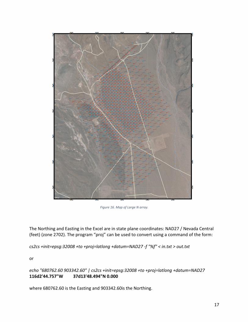
17
Figure16.MapofLargeNarray.
TheNorthingandEastingintheExcelareinstateplanecoordinates:NAD27/NevadaCentral(feet)(zone2702).Theprogram“proj”canbeusedtoconvertusingacommandoftheform:cs2cs+init=epsg:32008+to+proj=latlong+datum=NAD27-f"%f"<in.txt>out.txtorecho"680762.60903342.60"|cs2cs+init=epsg:32008+to+proj=latlong+datum=NAD27116d2'44.757"W 37d13'48.494"N0.000where680762.60istheEastingand903342.60istheNorthing.
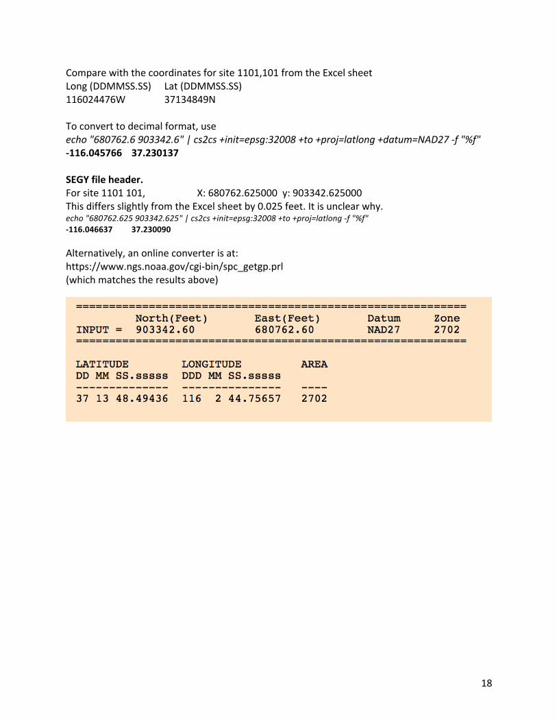
18
Comparewiththecoordinatesforsite1101,101fromtheExcelsheetLong(DDMMSS.SS) Lat(DDMMSS.SS) 116024476W 37134849N Toconverttodecimalformat,useecho"680762.6903342.6"|cs2cs+init=epsg:32008+to+proj=latlong+datum=NAD27-f"%f"-116.045766 37.230137SEGYfileheader.Forsite1101101, X:680762.625000y:903342.625000ThisdiffersslightlyfromtheExcelsheetby0.025feet.Itisunclearwhy.echo"680762.625903342.625"|cs2cs+init=epsg:32008+to+proj=latlong-f"%f"-116.046637 37.230090Alternatively,anonlineconverterisat:https://www.ngs.noaa.gov/cgi-bin/spc_getgp.prl(whichmatchestheresultsabove)
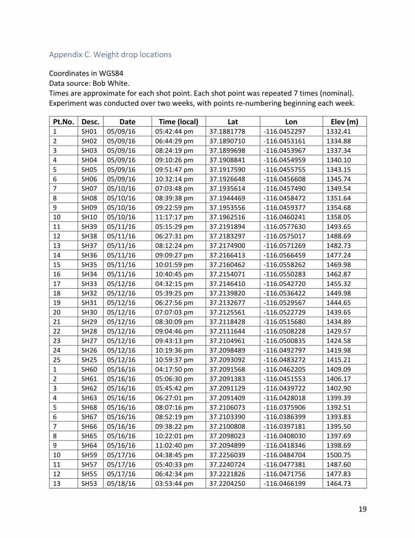
19
AppendixC.WeightdroplocationsCoordinatesinWGS84Datasource:BobWhite.Timesareapproximateforeachshotpoint.Eachshotpointwasrepeated7times(nominal).Experimentwasconductedovertwoweeks,withpointsre-numberingbeginningeachweek.Pt.No. Desc. Date Time(local) Lat Lon Elev(m)1 SH01 05/09/16 05:42:44pm 37.1881778 -116.0452297 1332.412 SH02 05/09/16 06:44:29pm 37.1890710 -116.0453161 1334.883 SH03 05/09/16 08:24:19pm 37.1899698 -116.0453967 1337.344 SH04 05/09/16 09:10:26pm 37.1908841 -116.0454959 1340.105 SH05 05/09/16 09:51:47pm 37.1917590 -116.0455755 1343.156 SH06 05/09/16 10:32:14pm 37.1926648 -116.0456608 1345.747 SH07 05/10/16 07:03:48pm 37.1935614 -116.0457490 1349.548 SH08 05/10/16 08:39:38pm 37.1944469 -116.0458472 1351.649 SH09 05/10/16 09:22:59pm 37.1953556 -116.0459377 1354.6810 SH10 05/10/16 11:17:17pm 37.1962516 -116.0460241 1358.0511 SH39 05/11/16 05:15:29pm 37.2191894 -116.0577630 1493.6512 SH38 05/11/16 06:27:31pm 37.2183297 -116.0575017 1488.6913 SH37 05/11/16 08:12:24pm 37.2174900 -116.0571269 1482.7314 SH36 05/11/16 09:09:27pm 37.2166413 -116.0566459 1477.2415 SH35 05/11/16 10:01:59pm 37.2160462 -116.0558262 1469.9816 SH34 05/11/16 10:40:45pm 37.2154071 -116.0550283 1462.8717 SH33 05/12/16 04:32:15pm 37.2146410 -116.0542720 1455.3218 SH32 05/12/16 05:39:25pm 37.2139820 -116.0536422 1449.9819 SH31 05/12/16 06:27:56pm 37.2132677 -116.0529567 1444.6520 SH30 05/12/16 07:07:03pm 37.2125561 -116.0522729 1439.6521 SH29 05/12/16 08:30:09pm 37.2118428 -116.0515680 1434.8922 SH28 05/12/16 09:04:46pm 37.2111644 -116.0508228 1429.5723 SH27 05/12/16 09:43:13pm 37.2104961 -116.0500835 1424.5824 SH26 05/12/16 10:19:36pm 37.2098489 -116.0492797 1419.9825 SH25 05/12/16 10:59:37pm 37.2093092 -116.0483272 1415.211 SH60 05/16/16 04:17:50pm 37.2091568 -116.0462205 1409.092 SH61 05/16/16 05:06:30pm 37.2091383 -116.0451553 1406.173 SH62 05/16/16 05:45:42pm 37.2091129 -116.0439722 1402.904 SH63 05/16/16 06:27:01pm 37.2091409 -116.0428018 1399.395 SH68 05/16/16 08:07:16pm 37.2106073 -116.0375906 1392.516 SH67 05/16/16 08:52:19pm 37.2103390 -116.0386399 1393.837 SH66 05/16/16 09:38:22pm 37.2100808 -116.0397181 1395.508 SH65 05/16/16 10:22:01pm 37.2098023 -116.0408030 1397.699 SH64 05/16/16 11:02:40pm 37.2094899 -116.0418346 1398.6910 SH59 05/17/16 04:38:45pm 37.2256039 -116.0484704 1500.7511 SH57 05/17/16 05:40:33pm 37.2240724 -116.0477381 1487.6012 SH55 05/17/16 06:42:34pm 37.2221826 -116.0471756 1477.8313 SH53 05/18/16 03:53:44pm 37.2204250 -116.0466199 1464.73
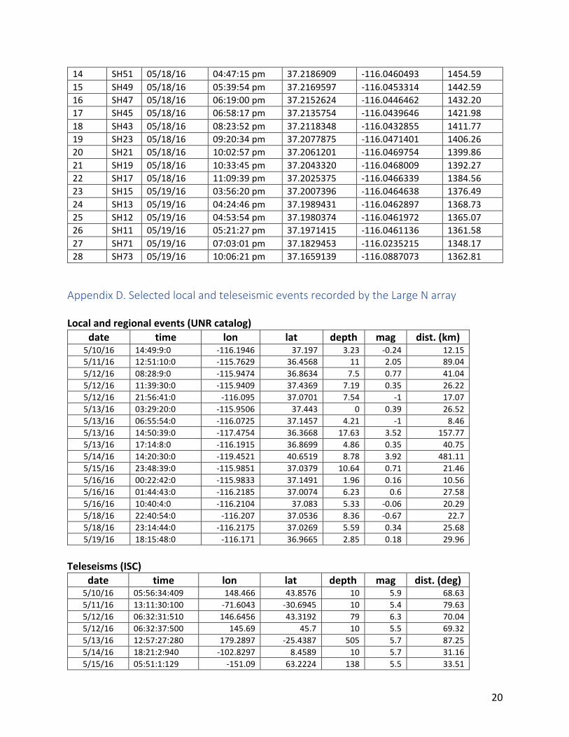
20
14 SH51 05/18/16 04:47:15pm 37.2186909 -116.0460493 1454.5915 SH49 05/18/16 05:39:54pm 37.2169597 -116.0453314 1442.5916 SH47 05/18/16 06:19:00pm 37.2152624 -116.0446462 1432.2017 SH45 05/18/16 06:58:17pm 37.2135754 -116.0439646 1421.9818 SH43 05/18/16 08:23:52pm 37.2118348 -116.0432855 1411.7719 SH23 05/18/16 09:20:34pm 37.2077875 -116.0471401 1406.2620 SH21 05/18/16 10:02:57pm 37.2061201 -116.0469754 1399.8621 SH19 05/18/16 10:33:45pm 37.2043320 -116.0468009 1392.2722 SH17 05/18/16 11:09:39pm 37.2025375 -116.0466339 1384.5623 SH15 05/19/16 03:56:20pm 37.2007396 -116.0464638 1376.4924 SH13 05/19/16 04:24:46pm 37.1989431 -116.0462897 1368.7325 SH12 05/19/16 04:53:54pm 37.1980374 -116.0461972 1365.0726 SH11 05/19/16 05:21:27pm 37.1971415 -116.0461136 1361.5827 SH71 05/19/16 07:03:01pm 37.1829453 -116.0235215 1348.1728 SH73 05/19/16 10:06:21pm 37.1659139 -116.0887073 1362.81
AppendixD.SelectedlocalandteleseismiceventsrecordedbytheLargeNarrayLocalandregionalevents(UNRcatalog)
date time lon lat depth mag dist.(km)5/10/16 14:49:9:0 -116.1946 37.197 3.23 -0.24 12.155/11/16 12:51:10:0 -115.7629 36.4568 11 2.05 89.045/12/16 08:28:9:0 -115.9474 36.8634 7.5 0.77 41.045/12/16 11:39:30:0 -115.9409 37.4369 7.19 0.35 26.225/12/16 21:56:41:0 -116.095 37.0701 7.54 -1 17.075/13/16 03:29:20:0 -115.9506 37.443 0 0.39 26.525/13/16 06:55:54:0 -116.0725 37.1457 4.21 -1 8.465/13/16 14:50:39:0 -117.4754 36.3668 17.63 3.52 157.775/13/16 17:14:8:0 -116.1915 36.8699 4.86 0.35 40.755/14/16 14:20:30:0 -119.4521 40.6519 8.78 3.92 481.115/15/16 23:48:39:0 -115.9851 37.0379 10.64 0.71 21.465/16/16 00:22:42:0 -115.9833 37.1491 1.96 0.16 10.565/16/16 01:44:43:0 -116.2185 37.0074 6.23 0.6 27.585/16/16 10:40:4:0 -116.2104 37.083 5.33 -0.06 20.295/18/16 22:40:54:0 -116.207 37.0536 8.36 -0.67 22.75/18/16 23:14:44:0 -116.2175 37.0269 5.59 0.34 25.685/19/16 18:15:48:0 -116.171 36.9665 2.85 0.18 29.96
Teleseisms(ISC)
date time lon lat depth mag dist.(deg)5/10/16 05:56:34:409 148.466 43.8576 10 5.9 68.635/11/16 13:11:30:100 -71.6043 -30.6945 10 5.4 79.635/12/16 06:32:31:510 146.6456 43.3192 79 6.3 70.045/12/16 06:32:37:500 145.69 45.7 10 5.5 69.325/13/16 12:57:27:280 179.2897 -25.4387 505 5.7 87.255/14/16 18:21:2:940 -102.8297 8.4589 10 5.7 31.165/15/16 05:51:1:129 -151.09 63.2224 138 5.5 33.51
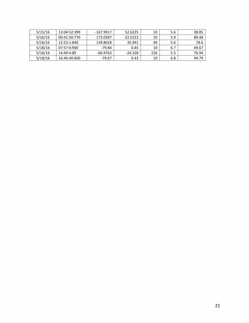
21
5/15/16 12:04:52:399 -167.9917 52.6225 10 5.6 38.855/16/16 00:41:50:770 173.0397 -22.5222 10 5.9 89.485/16/16 12:23:1:840 139.8018 35.941 49 5.6 78.65/18/16 07:57:4:900 -79.84 0.45 10 6.7 49.675/18/16 14:49:4:89 -66.9763 -24.328 156 5.5 76.945/18/16 16:46:40:600 -79.67 0.43 10 6.8 49.79
Attachment 3 Schalk, Walter, 2018. Written Communication prepared by the NNSS Weather Forecast Air Resources Laboratory/Special Operations and Research Division. SPE-5 Weather Data Collection. Mercury, NV.
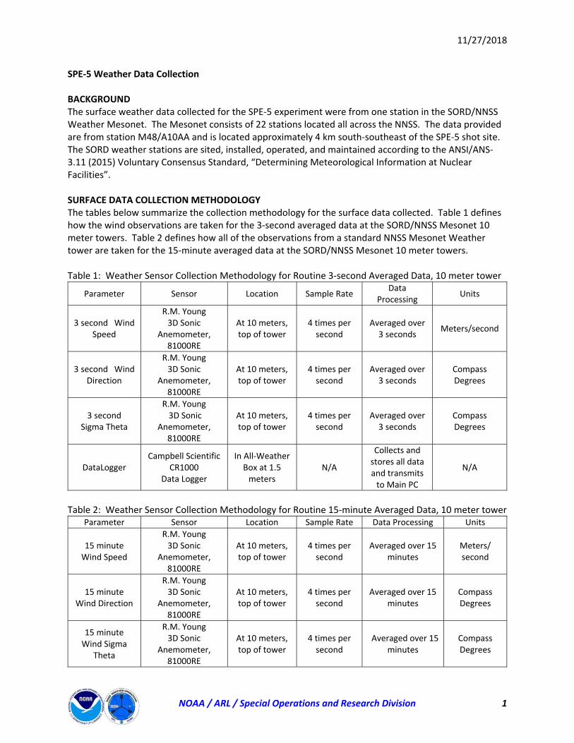
11/27/2018
NOAA / ARL / Special Operations and Research Division 1
SPE‐5 Weather Data Collection BACKGROUND The surface weather data collected for the SPE‐5 experiment were from one station in the SORD/NNSS Weather Mesonet. The Mesonet consists of 22 stations located all across the NNSS. The data provided are from station M48/A10AA and is located approximately 4 km south‐southeast of the SPE‐5 shot site. The SORD weather stations are sited, installed, operated, and maintained according to the ANSI/ANS‐3.11 (2015) Voluntary Consensus Standard, “Determining Meteorological Information at Nuclear Facilities”. SURFACE DATA COLLECTION METHODOLOGY The tables below summarize the collection methodology for the surface data collected. Table 1 defines how the wind observations are taken for the 3‐second averaged data at the SORD/NNSS Mesonet 10 meter towers. Table 2 defines how all of the observations from a standard NNSS Mesonet Weather tower are taken for the 15‐minute averaged data at the SORD/NNSS Mesonet 10 meter towers. Table 1: Weather Sensor Collection Methodology for Routine 3‐second Averaged Data, 10 meter tower
Parameter Sensor Location Sample Rate Data
Processing Units
3 second Wind Speed
R.M. Young 3D Sonic
Anemometer, 81000RE
At 10 meters, top of tower
4 times per second
Averaged over 3 seconds
Meters/second
3 second Wind Direction
R.M. Young 3D Sonic
Anemometer, 81000RE
At 10 meters, top of tower
4 times per second
Averaged over 3 seconds
Compass Degrees
3 second Sigma Theta
R.M. Young 3D Sonic
Anemometer, 81000RE
At 10 meters, top of tower
4 times per second
Averaged over 3 seconds
Compass Degrees
DataLogger Campbell Scientific
CR1000 Data Logger
In All‐Weather Box at 1.5 meters
N/A
Collects and stores all data and transmits to Main PC
N/A
Table 2: Weather Sensor Collection Methodology for Routine 15‐minute Averaged Data, 10 meter tower
Parameter Sensor Location Sample Rate Data Processing Units
15 minute Wind Speed
R.M. Young 3D Sonic
Anemometer, 81000RE
At 10 meters, top of tower
4 times per second
Averaged over 15 minutes
Meters/ second
15 minute Wind Direction
R.M. Young 3D Sonic
Anemometer, 81000RE
At 10 meters, top of tower
4 times per second
Averaged over 15 minutes
Compass Degrees
15 minute Wind Sigma
Theta
R.M. Young 3D Sonic
Anemometer, 81000RE
At 10 meters, top of tower
4 times per second
Averaged over 15 minutes
Compass Degrees
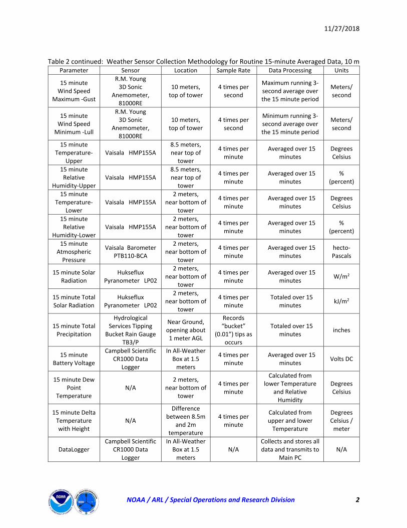
11/27/2018
NOAA / ARL / Special Operations and Research Division 2
Table 2 continued: Weather Sensor Collection Methodology for Routine 15‐minute Averaged Data, 10 m
Parameter Sensor Location Sample Rate Data Processing Units
15 minute Wind Speed
Maximum ‐Gust
R.M. Young 3D Sonic
Anemometer, 81000RE
10 meters, top of tower
4 times per second
Maximum running 3‐second average over the 15 minute period
Meters/ second
15 minute Wind Speed Minimum ‐Lull
R.M. Young 3D Sonic
Anemometer, 81000RE
10 meters, top of tower
4 times per second
Minimum running 3‐second average over the 15 minute period
Meters/ second
15 minute Temperature‐
Upper Vaisala HMP155A
8.5 meters, near top of
tower
4 times per minute
Averaged over 15 minutes
Degrees Celsius
15 minute Relative
Humidity‐Upper Vaisala HMP155A
8.5 meters, near top of
tower
4 times per minute
Averaged over 15 minutes
% (percent)
15 minute Temperature‐
Lower Vaisala HMP155A
2 meters, near bottom of
tower
4 times per minute
Averaged over 15 minutes
Degrees Celsius
15 minute Relative
Humidity‐Lower Vaisala HMP155A
2 meters, near bottom of
tower
4 times per minute
Averaged over 15 minutes
% (percent)
15 minute Atmospheric Pressure
Vaisala Barometer PTB110‐BCA
2 meters, near bottom of
tower
4 times per minute
Averaged over 15 minutes
hecto‐Pascals
15 minute Solar Radiation
Hukseflux Pyranometer LP02
2 meters, near bottom of
tower
4 times per minute
Averaged over 15 minutes
W/m2
15 minute Total Solar Radiation
Hukseflux Pyranometer LP02
2 meters, near bottom of
tower
4 times per minute
Totaled over 15 minutes
kJ/m2
15 minute Total Precipitation
Hydrological Services Tipping
Bucket Rain Gauge TB3/P
Near Ground, opening about 1 meter AGL
Records “bucket”
(0.01”) tips as occurs
Totaled over 15 minutes
inches
15 minute Battery Voltage
Campbell Scientific CR1000 Data
Logger
In All‐Weather Box at 1.5 meters
4 times per minute
Averaged over 15 minutes
Volts DC
15 minute Dew Point
Temperature N/A
2 meters, near bottom of
tower
4 times per minute
Calculated from lower Temperature
and Relative Humidity
Degrees Celsius
15 minute Delta Temperature with Height
N/A
Difference between 8.5m
and 2m temperature
4 times per minute
Calculated from upper and lower Temperature
Degrees Celsius / meter
DataLogger Campbell Scientific
CR1000 Data Logger
In All‐Weather Box at 1.5 meters
N/A Collects and stores all data and transmits to
Main PC N/A
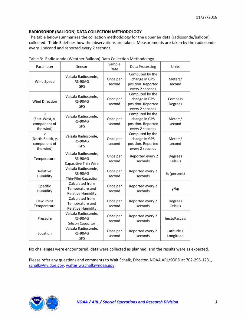
11/27/2018
NOAA / ARL / Special Operations and Research Division 3
RADIOSONDE (BALLOON) DATA COLLECTION METHODOLOGY The table below summarizes the collection methodology for the upper air data (radiosonde/balloon) collected. Table 3 defines how the observations are taken. Measurements are taken by the radiosonde every 1 second and reported every 2 seconds. Table 3: Radiosonde (Weather Balloon) Data Collection Methodology
Parameter Sensor Sample Rate
Data Processing Units
Wind Speed Vaisala Radiosonde,
RS‐90AG GPS
Once per second
Computed by the change in GPS
position. Reported every 2 seconds
Meters/ second
Wind Direction Vaisala Radiosonde,
RS‐90AG GPS
Once per second
Computed by the change in GPS
position. Reported every 2 seconds
Compass Degrees
u (East‐West, x, component of the wind)
Vaisala Radiosonde, RS‐90AG GPS
Once per second
Computed by the change in GPS
position. Reported every 2 seconds
Meters/ second
v (North‐South, y, component of the wind)
Vaisala Radiosonde, RS‐90AG GPS
Once per second
Computed by the change in GPS
position. Reported every 2 seconds
Meters/ second
Temperature Vaisala Radiosonde,
RS‐90AG Capacitive Thin Wire
Once per second
Reported every 2 seconds
Degrees Celsius
Relative Humidity
Vaisala Radiosonde, RS‐90AG
Thin‐Film Capacitor
Once per second
Reported every 2 seconds
% (percent)
Specific Humidity
Calculated from Temperature and Relative Humidity
Once per second
Reported every 2 seconds
g/kg
Dew Point Temperature
Calculated from Temperature and Relative Humidity
Once per second
Reported every 2 seconds
Degrees Celsius
Pressure Vaisala Radiosonde,
RS‐90AG Silicon Capacitor
Once per second
Reported every 2 seconds
hectoPascals
Location Vaisala Radiosonde,
RS‐90AG GPS
Once per second
Reported every 2 seconds
Latitude / Longitude
No challenges were encountered, data were collected as planned, and the results were as expected. Please refer any questions and comments to Walt Schalk, Director, NOAA ARL/SORD at 702‐295‐1231, [email protected], [email protected] .
Attachment 4 Schalk, Walter, 2018. Written Communication prepared by the NNSS Weather Forecast Air Resources Laboratory/Special Operations and Research Division. SPE-6 Weather Data Collection. Mercury, NV.
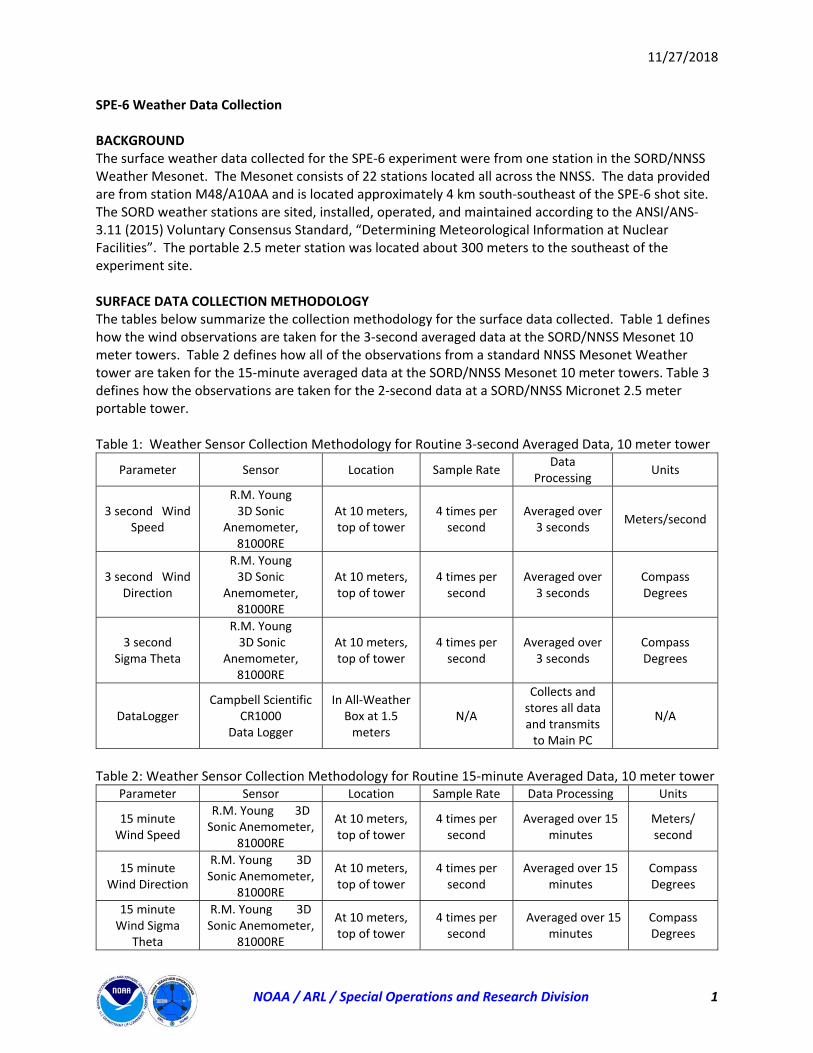
11/27/2018
NOAA / ARL / Special Operations and Research Division 1
SPE‐6 Weather Data Collection BACKGROUND The surface weather data collected for the SPE‐6 experiment were from one station in the SORD/NNSS Weather Mesonet. The Mesonet consists of 22 stations located all across the NNSS. The data provided are from station M48/A10AA and is located approximately 4 km south‐southeast of the SPE‐6 shot site. The SORD weather stations are sited, installed, operated, and maintained according to the ANSI/ANS‐3.11 (2015) Voluntary Consensus Standard, “Determining Meteorological Information at Nuclear Facilities”. The portable 2.5 meter station was located about 300 meters to the southeast of the experiment site. SURFACE DATA COLLECTION METHODOLOGY The tables below summarize the collection methodology for the surface data collected. Table 1 defines how the wind observations are taken for the 3‐second averaged data at the SORD/NNSS Mesonet 10 meter towers. Table 2 defines how all of the observations from a standard NNSS Mesonet Weather tower are taken for the 15‐minute averaged data at the SORD/NNSS Mesonet 10 meter towers. Table 3 defines how the observations are taken for the 2‐second data at a SORD/NNSS Micronet 2.5 meter portable tower. Table 1: Weather Sensor Collection Methodology for Routine 3‐second Averaged Data, 10 meter tower
Parameter Sensor Location Sample Rate Data
Processing Units
3 second Wind Speed
R.M. Young 3D Sonic
Anemometer, 81000RE
At 10 meters, top of tower
4 times per second
Averaged over 3 seconds
Meters/second
3 second Wind Direction
R.M. Young 3D Sonic
Anemometer, 81000RE
At 10 meters, top of tower
4 times per second
Averaged over 3 seconds
Compass Degrees
3 second Sigma Theta
R.M. Young 3D Sonic
Anemometer, 81000RE
At 10 meters, top of tower
4 times per second
Averaged over 3 seconds
Compass Degrees
DataLogger Campbell Scientific
CR1000 Data Logger
In All‐Weather Box at 1.5 meters
N/A
Collects and stores all data and transmits to Main PC
N/A
Table 2: Weather Sensor Collection Methodology for Routine 15‐minute Averaged Data, 10 meter tower
Parameter Sensor Location Sample Rate Data Processing Units
15 minute Wind Speed
R.M. Young 3D Sonic Anemometer,
81000RE
At 10 meters, top of tower
4 times per second
Averaged over 15 minutes
Meters/ second
15 minute Wind Direction
R.M. Young 3D Sonic Anemometer,
81000RE
At 10 meters, top of tower
4 times per second
Averaged over 15 minutes
Compass Degrees
15 minute Wind Sigma
Theta
R.M. Young 3D Sonic Anemometer,
81000RE
At 10 meters, top of tower
4 times per second
Averaged over 15 minutes
Compass Degrees
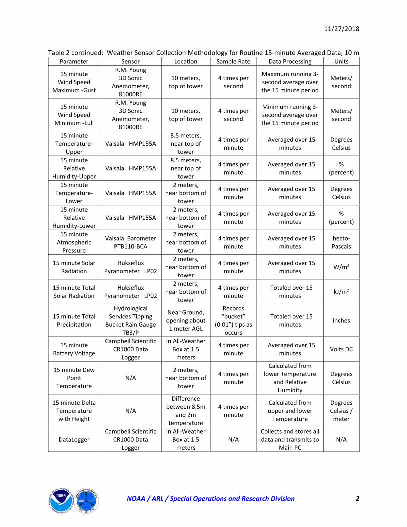
11/27/2018
NOAA / ARL / Special Operations and Research Division 2
Table 2 continued: Weather Sensor Collection Methodology for Routine 15‐minute Averaged Data, 10 m Parameter Sensor Location Sample Rate Data Processing Units
15 minute Wind Speed
Maximum ‐Gust
R.M. Young 3D Sonic
Anemometer, 81000RE
10 meters, top of tower
4 times per second
Maximum running 3‐second average over the 15 minute period
Meters/ second
15 minute Wind Speed Minimum ‐Lull
R.M. Young 3D Sonic
Anemometer, 81000RE
10 meters, top of tower
4 times per second
Minimum running 3‐second average over the 15 minute period
Meters/ second
15 minute Temperature‐
Upper Vaisala HMP155A
8.5 meters, near top of
tower
4 times per minute
Averaged over 15 minutes
Degrees Celsius
15 minute Relative
Humidity‐Upper Vaisala HMP155A
8.5 meters, near top of
tower
4 times per minute
Averaged over 15 minutes
% (percent)
15 minute Temperature‐
Lower Vaisala HMP155A
2 meters, near bottom of
tower
4 times per minute
Averaged over 15 minutes
Degrees Celsius
15 minute Relative
Humidity‐Lower Vaisala HMP155A
2 meters, near bottom of
tower
4 times per minute
Averaged over 15 minutes
% (percent)
15 minute Atmospheric Pressure
Vaisala Barometer PTB110‐BCA
2 meters, near bottom of
tower
4 times per minute
Averaged over 15 minutes
hecto‐Pascals
15 minute Solar Radiation
Hukseflux Pyranometer LP02
2 meters, near bottom of
tower
4 times per minute
Averaged over 15 minutes
W/m2
15 minute Total Solar Radiation
Hukseflux Pyranometer LP02
2 meters, near bottom of
tower
4 times per minute
Totaled over 15 minutes
kJ/m2
15 minute Total Precipitation
Hydrological Services Tipping
Bucket Rain Gauge TB3/P
Near Ground, opening about 1 meter AGL
Records “bucket”
(0.01”) tips as occurs
Totaled over 15 minutes
inches
15 minute Battery Voltage
Campbell Scientific CR1000 Data
Logger
In All‐Weather Box at 1.5 meters
4 times per minute
Averaged over 15 minutes
Volts DC
15 minute Dew Point
Temperature N/A
2 meters, near bottom of
tower
4 times per minute
Calculated from lower Temperature
and Relative Humidity
Degrees Celsius
15 minute Delta Temperature with Height
N/A
Difference between 8.5m
and 2m temperature
4 times per minute
Calculated from upper and lower Temperature
Degrees Celsius / meter
DataLogger Campbell Scientific
CR1000 Data Logger
In All‐Weather Box at 1.5 meters
N/A Collects and stores all data and transmits to
Main PC N/A
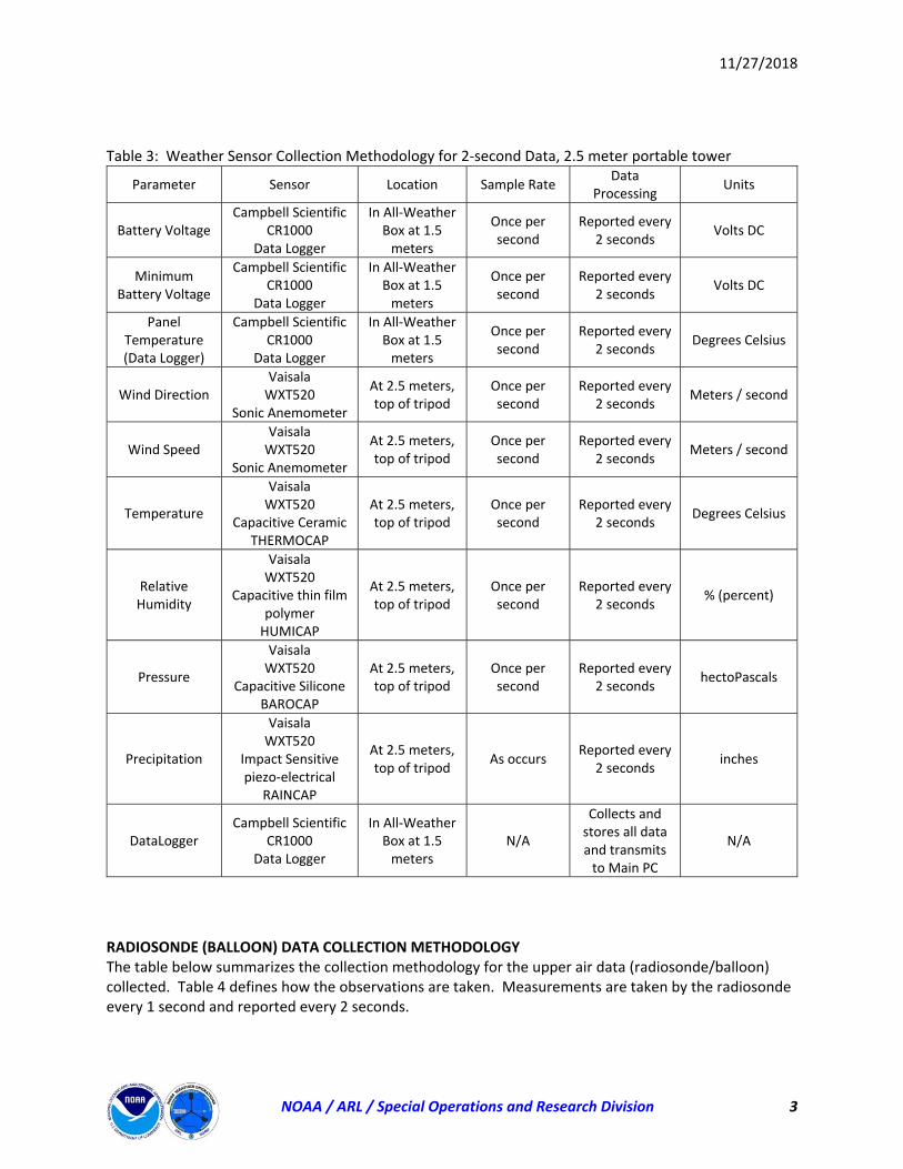
11/27/2018
NOAA / ARL / Special Operations and Research Division 3
Table 3: Weather Sensor Collection Methodology for 2‐second Data, 2.5 meter portable tower
Parameter Sensor Location Sample Rate Data
Processing Units
Battery Voltage Campbell Scientific
CR1000 Data Logger
In All‐Weather Box at 1.5 meters
Once per second
Reported every 2 seconds
Volts DC
Minimum Battery Voltage
Campbell Scientific CR1000
Data Logger
In All‐Weather Box at 1.5 meters
Once per second
Reported every 2 seconds
Volts DC
Panel Temperature (Data Logger)
Campbell Scientific CR1000
Data Logger
In All‐Weather Box at 1.5 meters
Once per second
Reported every 2 seconds
Degrees Celsius
Wind Direction Vaisala WXT520
Sonic Anemometer
At 2.5 meters, top of tripod
Once per second
Reported every 2 seconds
Meters / second
Wind Speed Vaisala WXT520
Sonic Anemometer
At 2.5 meters, top of tripod
Once per second
Reported every 2 seconds
Meters / second
Temperature
Vaisala WXT520
Capacitive Ceramic THERMOCAP
At 2.5 meters, top of tripod
Once per second
Reported every 2 seconds
Degrees Celsius
Relative Humidity
Vaisala WXT520
Capacitive thin film polymer HUMICAP
At 2.5 meters, top of tripod
Once per second
Reported every 2 seconds
% (percent)
Pressure
Vaisala WXT520
Capacitive Silicone BAROCAP
At 2.5 meters, top of tripod
Once per second
Reported every 2 seconds
hectoPascals
Precipitation
Vaisala WXT520
Impact Sensitive piezo‐electrical
RAINCAP
At 2.5 meters, top of tripod
As occurs Reported every
2 seconds inches
DataLogger Campbell Scientific
CR1000 Data Logger
In All‐Weather Box at 1.5 meters
N/A
Collects and stores all data and transmits to Main PC
N/A
RADIOSONDE (BALLOON) DATA COLLECTION METHODOLOGY The table below summarizes the collection methodology for the upper air data (radiosonde/balloon) collected. Table 4 defines how the observations are taken. Measurements are taken by the radiosonde every 1 second and reported every 2 seconds.
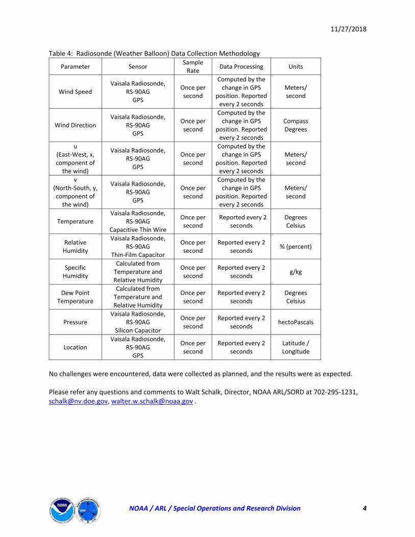
11/27/2018
NOAA / ARL / Special Operations and Research Division 4
Table 4: Radiosonde (Weather Balloon) Data Collection Methodology
Parameter Sensor Sample Rate
Data Processing Units
Wind Speed Vaisala Radiosonde,
RS‐90AG GPS
Once per second
Computed by the change in GPS
position. Reported every 2 seconds
Meters/ second
Wind Direction Vaisala Radiosonde,
RS‐90AG GPS
Once per second
Computed by the change in GPS
position. Reported every 2 seconds
Compass Degrees
u (East‐West, x, component of the wind)
Vaisala Radiosonde, RS‐90AG GPS
Once per second
Computed by the change in GPS
position. Reported every 2 seconds
Meters/ second
v (North‐South, y, component of the wind)
Vaisala Radiosonde, RS‐90AG GPS
Once per second
Computed by the change in GPS
position. Reported every 2 seconds
Meters/ second
Temperature Vaisala Radiosonde,
RS‐90AG Capacitive Thin Wire
Once per second
Reported every 2 seconds
Degrees Celsius
Relative Humidity
Vaisala Radiosonde, RS‐90AG
Thin‐Film Capacitor
Once per second
Reported every 2 seconds
% (percent)
Specific Humidity
Calculated from Temperature and Relative Humidity
Once per second
Reported every 2 seconds
g/kg
Dew Point Temperature
Calculated from Temperature and Relative Humidity
Once per second
Reported every 2 seconds
Degrees Celsius
Pressure Vaisala Radiosonde,
RS‐90AG Silicon Capacitor
Once per second
Reported every 2 seconds
hectoPascals
Location Vaisala Radiosonde,
RS‐90AG GPS
Once per second
Reported every 2 seconds
Latitude / Longitude
No challenges were encountered, data were collected as planned, and the results were as expected. Please refer any questions and comments to Walt Schalk, Director, NOAA ARL/SORD at 702‐295‐1231, [email protected], [email protected] .

Attachment 5 Wharton, Sonia, 2018. SPE6 Atmospheric Lidar Data User Guide. Lawrence Livermore National Laboratory Report LLNL-TR-764520.
SPE6 Atmospheric Lidar Data User Guide
Lawrence Livermore National Laboratory
Prepared by Sonia Wharton
15 November 2018
LLNL-TR-764520

Disclaimer
This document was prepared as an account of work sponsored by an agency of the United States government.
Neither the United States government nor Lawrence Livermore National Security, LLC, nor any of their
employees makes any warranty, expressed or implied, or assumes any legal liability or responsibility for the
accuracy, completeness, or usefulness of any information, apparatus, product, or process disclosed, or
represents that its use would not infringe privately owned rights. Reference herein to any specific commercial
product, process, or service by trade name, trademark, manufacturer, or otherwise does not necessarily
constitute or imply its endorsement, recommendation, or favoring by the United States government or
Lawrence Livermore National Security, LLC. The views and opinions of authors expressed herein do not
necessarily state or reflect those of the United States government or Lawrence Livermore National Security, LLC,
and shall not be used for advertising or product endorsement purposes.
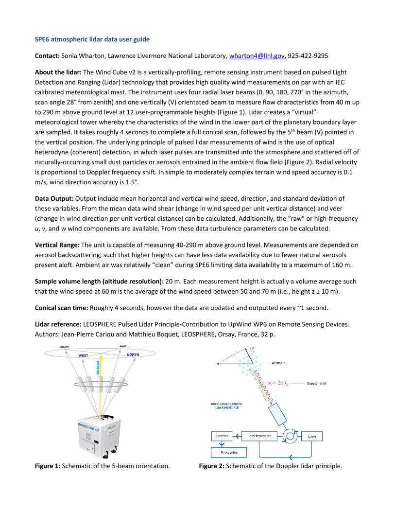
SPE6 atmospheric lidar data user guide
Contact: Sonia Wharton, Lawrence Livermore National Laboratory, [email protected], 925-422-9295
About the lidar: The Wind Cube v2 is a vertically-profiling, remote sensing instrument based on pulsed Light
Detection and Ranging (Lidar) technology that provides high quality wind measurements on par with an IEC
calibrated meteorological mast. The instrument uses four radial laser beams (0, 90, 180, 270° in the azimuth,
scan angle 28° from zenith) and one vertically (V) orientated beam to measure flow characteristics from 40 m up
to 290 m above ground level at 12 user-programmable heights (Figure 1). Lidar creates a “virtual”
meteorological tower whereby the characteristics of the wind in the lower part of the planetary boundary layer
are sampled. It takes roughly 4 seconds to complete a full conical scan, followed by the 5th beam (V) pointed in
the vertical position. The underlying principle of pulsed lidar measurements of wind is the use of optical
heterodyne (coherent) detection, in which laser pulses are transmitted into the atmosphere and scattered off of
naturally-occurring small dust particles or aerosols entrained in the ambient flow field (Figure 2). Radial velocity
is proportional to Doppler frequency shift. In simple to moderately complex terrain wind speed accuracy is 0.1
m/s, wind direction accuracy is 1.5°.
Data Output: Output include mean horizontal and vertical wind speed, direction, and standard deviation of
these variables. From the mean data wind shear (change in wind speed per unit vertical distance) and veer
(change in wind direction per unit vertical distance) can be calculated. Additionally, the “raw” or high-frequency
u, v, and w wind components are available. From these data turbulence parameters can be calculated.
Vertical Range: The unit is capable of measuring 40-290 m above ground level. Measurements are depended on
aerosol backscattering, such that higher heights can have less data availability due to fewer natural aerosols
present aloft. Ambient air was relatively “clean” during SPE6 limiting data availability to a maximum of 160 m.
Sample volume length (altitude resolution): 20 m. Each measurement height is actually a volume average such
that the wind speed at 60 m is the average of the wind speed between 50 and 70 m (i.e., height z ± 10 m).
Conical scan time: Roughly 4 seconds, however the data are updated and outputted every ~1 second.
Lidar reference: LEOSPHERE Pulsed Lidar Principle-Contribution to UpWind WP6 on Remote Sensing Devices.
Authors: Jean-Pierre Cariou and Matthieu Boquet, LEOSPHERE, Orsay, France, 32 p.
Figure 1: Schematic of the 5-beam orientation. Figure 2: Schematic of the Doppler lidar principle.
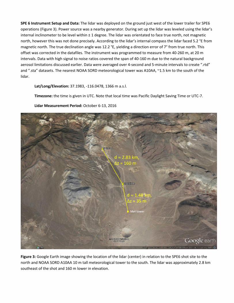
SPE 6 Instrument Setup and Data: The lidar was deployed on the ground just west of the lower trailer for SPE6
operations (Figure 3). Power source was a nearby generator. During set up the lidar was leveled using the lidar’s
internal inclinometer to be level within ± 1 degree. The lidar was orientated to face true north, not magnetic
north, however this was not done precisely. According to the lidar’s internal compass the lidar faced 5.2 °E from
magnetic north. The true declination angle was 12.2 °E, yielding a direction error of 7° from true north. This
offset was corrected in the datafiles. The instrument was programmed to measure from 40-260 m, at 20 m
intervals. Data with high signal to noise ratios covered the span of 40-160 m due to the natural background
aerosol limitations discussed earlier. Data were averaged over 4-second and 5-minute intervals to create “.rtd”
and “.sta” datasets. The nearest NOAA SORD meteorological tower was A10AA, ~1.5 km to the south of the
lidar.
Lat/Long/Elevation: 37.1983, -116.0478, 1366 m a.s.l.
Timezone: the time is given in UTC. Note that local time was Pacific Daylight Saving Time or UTC-7.
Lidar Measurement Period: October 6-13, 2016
Figure 3: Google Earth image showing the location of the lidar (center) in relation to the SPE6 shot site to the
north and NOAA SORD A10AA 10 m tall meteorological tower to the south. The lidar was approximately 2.8 km
southeast of the shot and 160 m lower in elevation.
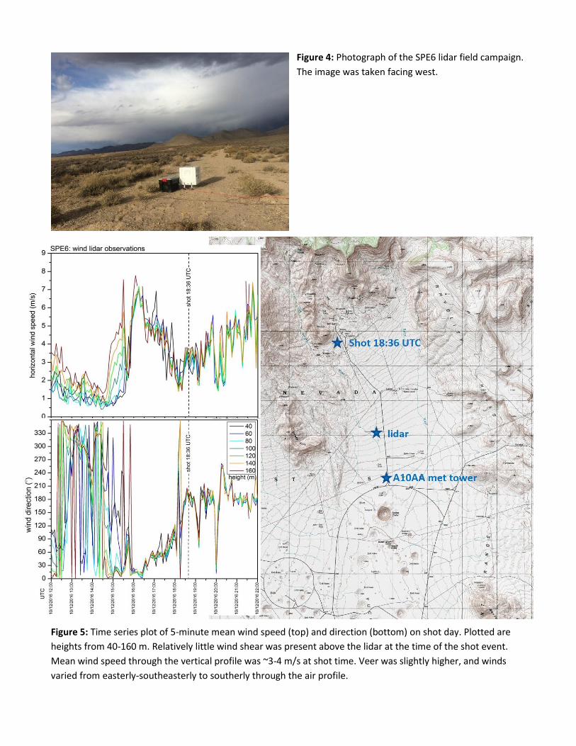
Figure 4: Photograph of the SPE6 lidar field campaign.
The image was taken facing west.
Figure 5: Time series plot of 5-minute mean wind speed (top) and direction (bottom) on shot day. Plotted are
heights from 40-160 m. Relatively little wind shear was present above the lidar at the time of the shot event.
Mean wind speed through the vertical profile was ~3-4 m/s at shot time. Veer was slightly higher, and winds
varied from easterly-southeasterly to southerly through the air profile.
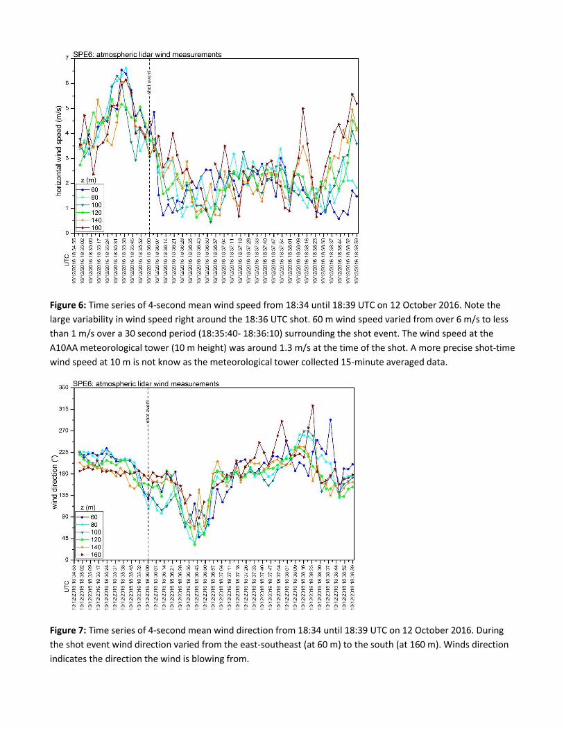
Figure 6: Time series of 4-second mean wind speed from 18:34 until 18:39 UTC on 12 October 2016. Note the
large variability in wind speed right around the 18:36 UTC shot. 60 m wind speed varied from over 6 m/s to less
than 1 m/s over a 30 second period (18:35:40- 18:36:10) surrounding the shot event. The wind speed at the
A10AA meteorological tower (10 m height) was around 1.3 m/s at the time of the shot. A more precise shot-time
wind speed at 10 m is not know as the meteorological tower collected 15-minute averaged data.
Figure 7: Time series of 4-second mean wind direction from 18:34 until 18:39 UTC on 12 October 2016. During
the shot event wind direction varied from the east-southeast (at 60 m) to the south (at 160 m). Winds direction
indicates the direction the wind is blowing from.
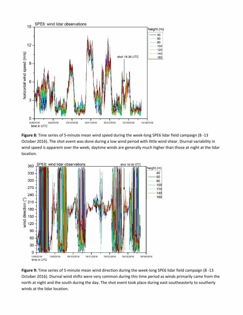
Figure 8: Time series of 5-minute mean wind speed during the week-long SPE6 lidar field campaign (8 -13
October 2016). The shot event was done during a low wind period with little wind shear. Diurnal variability in
wind speed is apparent over the week; daytime winds are generally much higher than those at night at the lidar
location.
Figure 9: Time series of 5-minute mean wind direction during the week-long SPE6 lidar field campaign (8 -13
October 2016). Diurnal wind shifts were very common during this time period as winds primarily came from the
north at night and the south during the day. The shot event took place during east-southeasterly to southerly
winds at the lidar location.
Data file Structure: Two types of daily data files are created by the Wind Cube v2. Both are ASCII files and can be
opened directly in Microsoft Excel. The first, .rtd, contains the high frequency measurements. The second, .sta,
contains the 5-minute averaged data. More details are given below.
(1) .rtd :
Filename structure: WLS7-284-YYYY-MM-DD-HH-MM-SS.rtd
Number of header lines: 42
Header details: A note on location. On header line 5 the location is listed as U20az. This is incorrect.
The scientist forgot to type in the new location during setup when the lidar was moved to SPE6. Except
for being incorrectly entered in the header, this reference has no bearing on the measurements in the
data file. The GPS location (on header 6) is generated by the instrument and shows the correct location
at SPE6.
Data Rows: the time interval is roughly every one second. A measurement is given at this frequency
even though it takes roughly 4 seconds to make a complete conical scan. In order to remove some of the
noise, the data were also averaged over the 4-second interval in post-processing. Remember that time is
in UTC.
Data Columns: Timestamp (MM:SS:DS), Timestamp HH:MM:SS, Position (laser beam position),
Temperature (internal temperature), Wiper count (ignore, not very accurate but supposed to be an
indicator of rain or poor data availability), CNR (carrier-to-noise ratio, dB), radial wind speed (m/s), radial
wind speed dispersion (this is standard deviation, m/s), wind speed (horizontal wind speed, m/s), wind
direction (°), x-wind (component of horizontal wind speed vector along axis north to south, m/s), y-wind
(component of horizontal wind speed along axis east to west, m/s), z-wind (vertical wind speed vector,
positive z corresponds to a down slope vector, m/s). Note that these coordinate associations are
different than what is typically used in meteorology.
Data flags: If the CNR ratio < -23, then the signal to noise ratio is considered too low and the data point
is flagged with a NaN.
(2) .sta :
Filename structure: WLS7-284-YYYY-MM-DD-HH-MM-SS.sta
Number of header lines: 42
Header details: A note on location. On header line 5 the location is listed as U20az. This is incorrect.
The scientist forgot to type in the new location during setup when the lidar was moved to SPE6. Except
for being incorrectly entered in the header, this reference has no bearing on the measurements in the
data file. The GPS location (on header 6) is generated by the instrument and shows the correct location
at SPE6.
Data Rows: the time interval is every five minutes. These are five minute averages of the high frequency
~1Hz data found in the .rtd files. The timestamp is at the end of the averaging period. Remember that
time is in UTC.
Data Columns: Timestamp, Internal Temperature (instrument temp, °C), External Temperature (NaN, no
sensor attached), Pressure (NaN, no sensor attached), Relative Humidity (NaN, no sensor attached),
wiper count (ignore, not very accurate but supposed to be an indicator of rain or poor data availability),
Vbatt (voltage of external battery, NaN), Wind Speed (average horz wind speed in 5 minute period, m/s),
Wind speed dispersion (standard deviation of horz wind speed in 5 minute period, m/s), Wind speed
min (minimum horz wind speed in 5 minute period, m/s), Wind speed max (maximum horz wind speed
in 5 minute period, m/s), Z-wind (average vertical wind speed in 5 minute period, m/s, positive is down
slope direction), Z-wind dispersion (standard deviation of vert wind speed in 5 minute period, m/s), CNR
(average carrier to noise ratio, dB), CNR min (minimum CNR during 5 minute period), Dopp Spect Broad
(Doppler spectral broadening, m/s), Data availability (% of data during 5 minute period with CNR > -23 ,
“percent of good data”).